carlisle southern link road - tag part 1 / dmrb stage 1
TRANSCRIPT
Commercial in Confidence
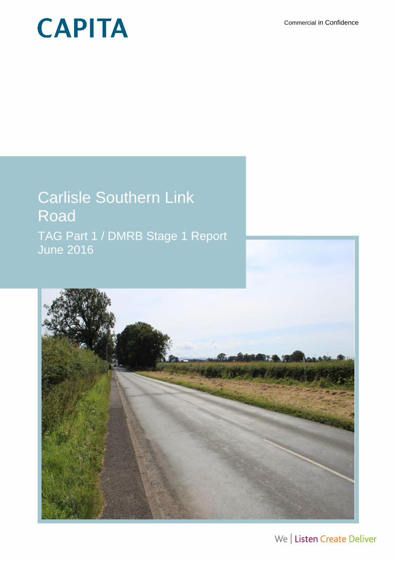
Carlisle Southern Link Road TAG Part 1 / DMRB Stage 1 Report June 2016
Carlisle Southern Link Road
Quality Management
Quality Management
Job No CS082396
Project Carlisle Southern Link Road
Location Carlisle, Cumbria
Title TAG Part 1 / DMRB Stage 1 Report
Document Ref CSDR-CAP-ZZ-00-RP-Z-0001 Issue / Revision P003
File reference T:\CS082396 Carlisle SLR\03 Delivery\ZZ MultipleLevels\04 Reports\CSDR-CAP-ZZ-
00-RP-Z-0001_P04 TAG P1 Report.docx
Date March 2016
Prepared by 1 David Knight Signature (for file)
Prepared by 2 Katie Jackson Signature (for file)
Prepared by 3 Stuart Clarke Signature (for file)
Prepared by 4 Neil Griffiths Signature (for file)
Prepared by 5 Paul Landreth Signature (for file)
Checked by Jayne Garbutt Signature (for file)
Authorised by Jayne Garbutt Signature (for file)
Revision Status / History
Rev Date Issue / Purpose/ Comment Prepared Checked Authorised
P01 18/09 Draft for client review DK/KJ/SC DK DK
P02 20/11 2nd draft for client review DK/KJ/SC DK DK
P03 31/03 3rd draft for client review NG/PL JG JG
P04 20/06 Final PL JG JG
Carlisle Southern Link Road
Contents
i
Contents
1. Executive summary 6
2. Study background and objectives 9
2.1 Study background 9
2.2 Objectives 10
3. Methodology 11
3.1 Introduction 11
4. Stakeholder consultation 12
5. Context and need for intervention 13
5.1 Introduction 13
5.2 Existing and interim context 13
5.3 Future context 18
5.4 Identified need for intervention 22
6. Intervention objectives 24
6.1 Objectives 24
6.2 Location 25
7. Option generation 26
7.1 Potential options 26
7.2 Option assumptions 27
7.3 Option description 28
8. Initial option sift 33
8.1 Introduction 33
8.2 Discarded options 33
8.3 Preferred option 34
9. Southern link road potential interventions 35
9.1 Introduction and context 35
9.2 Approach to option generation 35
9.3 Green/Red route 36
9.4 Green route 36
9.5 Blue route 36
9.6 Orange route 37
9.7 Pink route 37
10. Southern link road sifting exercise 38
10.1 Introduction 38
10.2 Sifting workshop 38
11. Southern link road discarded routes 40
11.1 Introduction 40
Carlisle Southern Link Road
Contents
ii
11.2 Nineties northern route 40
11.3 Nineties southern route 40
11.4 Green/Red route 40
11.5 Orange route 41
12. Southern link road engineering assessment 42
12.1 Routes taken to further appraisal 42
12.2 Design standards 42
12.3 Road cross section 43
12.4 Junctions and side roads 43
12.5 Engineering assessment of options 44
12.6 Relaxations and departures 46
12.7 Topography and land use 47
12.8 Geology, geomorphology and ground conditions 48
12.9 Hydrology and drainage 48
12.10 Public utilities 49
12.11 Structures 50
12.12 Other constraints 52
13. Southern link road environmental impact appraisal 53
13.1 Introduction and context 53
13.2 Noise and vibration 55
13.3 Air quality 60
13.4 Landscape and visual 63
13.5 Historic environment 80
13.6 Nature conservation 96
13.7 Road drainage and the water environment 110
13.8 Outdoor access and recreation 119
13.9 Summary 130
14. Southern link road traffic impact assessment 132
14.1 Review of traffic modelling 132
14.2 Indicative value for money 134
14.3 Options assessment by route 137
14.4 Next steps 137
15. Southern link road planning issues 138
15.1 Introduction 138
15.2 National Planning Policy Framework (NPPF) 138
15.3 Development Plan Policy 140
15.4 Summary of key planning issues 142
16. Southern link road deliverability 144
16.1 Impact on existing road users 144
16.2 Cost considerations 145
Carlisle Southern Link Road
Contents
iii
16.3 Delivery options 148
16.4 Delivery programme 149
17. Southern link road appraisal summary 151
17.1 Conclusions 151
17.2 Recommendations 152
17.3 Next steps 152
Figures Figure 2.1 Location plan 10 Figure 6.1 Area of intervention plan 25 Figure 13.1 Aerial image of Haydon Bridge Bypass, A69 77 Figure 13.2 Earthworks and mitigation planting on the Haydon Bridge
Bypass, A69 78 Figure 13.3 Natural stone used in new walls, Haydon Bridge Bypass
A69 78 Figure 13.4 Cumbria Way National Trail and NCN 7, Caldew Valley 123 Figure 13.5 Miller’s Way LDR, Petteril Valley 123 Figure 13.6 Mitigation for Non Motorised Users (NMUs) 129
Tables Table 5.1 Key Carlisle urban bus services 16 Table 5.2 2011 census journey to work data 16 Table 5.3 Botchergate traffic flows 16 Table 5.4 James Street traffic flows 17 Table 5.5 Currock Road traffic flows 17 Table 5.6 Upperby Road traffic flows 17 Table 5.7 Trafficmaster journey time results 17 Table 5.8 Carlisle district 2015 data 20 Table 5.9 Carlisle district changes from 2015–2030 21 Table 5.10 Carlisle Local Plan development sites in south of Carlisle 22 Table 5.11 Carlisle Local Plan south Carlisle development 22 Table 6.1 South Carlisle intervention objectives 24 Table 12.1 Existing utility equipment and impact 49 Table 12.2 Structures location and type 51 Table 13.1 Significance of environmental effect matrix 54 Table 13.2 TAG seven point qualitative scale 55 Table 13.3 Noise and vibration sensitive receptors 56 Table 13.4 Noise and vibration options assessment (option 1 blue) 57 Table 13.5 Noise and vibration options assessment (option 2 pink) 58 Table 13.6 Noise and vibration options assessment (option 3 green) 58 Table 13.7 Noise and vibration preferred option summary 59 Table 13.8 Air quality sensitive receptors 61 Table 13.9 Air quality options assessment (option 1 blue) 61 Table 13.10 Air quality options assessment (option 2 pink) 62 Table 13.11 Air quality options assessment (option 3 green) 62
Carlisle Southern Link Road
Contents
iv
Table 13.12 Air quality preferred option summary 63 Table 13.13 Landscape and visual sensitive receptors 67 Table 13.14 Landscape and visual options assessment (option 1
blue) 69 Table 13.15 Landscape and visual options assessment (option 2 pink) 71 Table 13.16 Landscape and visual options assessment (option 3
green) 73 Table 13.17 Landscape and visual preferred option summary 80 Table 13.18: Listed Buildings 83 Table 13.19 Historic environment sensitive receptors 85 Table 13.20 Historic Environment Options Assessment (option 1 blue) 89 Table 13.21 Historic environment options assessment (option 2 pink) 91 Table 13.22 Historic Environment Options Assessment (option 3
green) 93 Table 13.23 Historic environment preferred option summary 96 Table 13.24 Value of ecological receptors 102 Table 13.25 Nature conservation sensitive receptors 103 Table 13.26 Nature conservation options assessment (option 1 blue) 105 Table 13.27 Nature conservation options assessment (option 2 pink) 107 Table 13.28 Nature conservation options assessment (option 3 green)108 Table 13.29 Nature conservation preferred option summary 110 Table 13.30 Road drainage and water environment sensitive
receptors 112 Table 13.31 Road drainage and water environment options
assessment (option 1 blue) 113 Table 13.32 Road Drainage and Water Environment options
assessment (option 2 green) 115 Table 13.33 Road drainage and water environment options
assessment (option 3 pink) 116 Table 13.34 Road drainage and water environment preferred option
summary 118 Table 13.35 Outdoor access and recreation sensitive receptors 124 Table 13.36 Outdoor access and recreation options assessment,
severance (option 1 blue) 125 Table 13.37 Outdoor access and recreation options assessment,
severance (option 2 pink) 126 Table 13.38 Outdoor access and recreation options assessment,
severance (option 3 green) 127 Table 13.39 Outdoor access and recreation preferred option summary130 Table 13.40 Summary of option preferences for each environmental
topic 131 Table 14.1 2030 network statistics summary with south Carlisle 133 Table 14.2 2040 network statistics summary with south Carlisle 133 Table 14.3 2030 network statistics summary without south Carlisle 134 Table 14.4 2040 network statistics summary without south Carlisle 134 Table 14.5 Vehicle type proportions 135 Table 14.6 Southern link assumed spend profile 136 Table 14.7 Indicative cost benefit analysis 136 Table 15.1 Key strategic planning issues 143 Table 16.1 Required upgrade to existing infrastructure 144
Carlisle Southern Link Road
Contents
v
Table 16.2 Top ten risks 147 Table 16.3 Route cost estimates 148 Table 16.4 Delivery options 148
Appendices
Appendix A
Route Development Plans
Appendix B
Initial Option Sift
Appendix C
Southern Link Route Sift
Appendix D
Environmental Assessment Scale Descriptors
Appendix E
Environmental Assessment Plans
Appendix F
Landscape and Visual Photographs
Appendix G
Geotechnical Desktop Study
Appendix H
Indicative Value for Money
Appendix I
Delivery Programme
Appendix J
Appraisal Specification Report
Carlisle Southern Link Road
1/ Executive summary
6
1. Executive summary
1.1.1 Carlisle City Council is developing their Local Plan for the Carlisle district. The Local Plan
details the necessary development in the Carlisle district for the period from 2015 to 2030. To
meet its longer term requirements, the Local Plan identifies the need for a major mixed-use
development area in South Carlisle. This area would provide a supply of development land
beyond the end of the plan period and could accommodate as many as 10,000 new homes
alongside new community facilities, schools and strategic employment opportunities.
1.1.2 To accommodate forecast levels of trip demand from South Carlisle and to improve strategic
east to west connectivity, a transport infrastructure intervention will be necessary.
1.1.3 The methodology agreed with the Client in relation to this study combines the processes of
Stage 1 Transport Analysis Guidance (TAG) and study specific activities identified in the
Client’s Brief. The basic process follows closely the TAG recommendations and considers
current and future contexts, the need for intervention, confirms the intervention objectives,
generates and sifts potential options to produce a preferred option, and provides an
assessment of options for the delivery of the preferred option.
1.1.4 The key need for intervention is the need to consider additional transport infrastructure to
support the emerging and substantial growth proposals to the south of the current urban
boundary.
1.1.5 The existing and future contexts of travel in Carlisle have been reviewed. The existing transport
network in Carlisle shows some evidence of operating close to or over capacity at a number of
locations, and there are a number of air quality issues at various locations on the highway
network. Future demand for travel will be driven by proposals in the Carlisle Local Plan and
major proposed infrastructure schemes in West Cumbria.
1.1.6 The key intervention objectives are:
Enable development at Carlisle South
Reduce congestion on southern radial routes and in the city centre
Assist east/west movement
1.1.7 A number of schemes which could meet the intervention objectives have been considered in
recent history in Carlisle. Potential intervention options were produced by reviewing previous
studies and proposed schemes. The following options were proposed:
Carlisle Southern Link Road
On-line highway improvements on radial routes and in the city centre
Sustainable transport improvements
Park and ride
Light rail
Carlisle Southern Link Road
1/ Executive summary
7
1.1.8 A sifting exercise was undertaken to assess the generated scheme options. The schemes were
assessed using the Department for Transport’s Early Assessment and Sifting Tool (EAST). The
sifting exercise identified the Carlisle Southern Link Road as the preferred option as it would
meet all of the scheme objectives and would most successfully support development at south
Carlisle.
1.1.9 After the southern link road was identified as the preferred option, a range of possible route
corridors which are likely to achieve the scheme objectives were developed. These included
historical options previously developed by the then Highways Agency.
1.1.10 A second sifting exercise was then undertaken using EAST to identify any ‘showstoppers’ which
are likely to prevent an option progressing at a subsequent stage in the process. The workshop
identified three potential routes for further development and assessment, and indicative route
plans are included in Appendix A. These routes are identified by the following names:
Green route
Blue route
Pink route
1.1.11 The three potential routes were subjected to an engineering assessment. This considered
factors including potential design standards, junctions, topography, geology and ground
conditions, hydrology, utilities, structures and indicative route design. A number of constraints
for each route were identified, mainly related to the crossing of the railways and rivers.
1.1.12 The three potential routes were also subjected to an environmental assessment. This
considered factors including noise, air quality, landscape and visual, the historic environment,
nature conservation, the water environment and outdoor access and recreation. A number of
adverse impacts were identified for each route, with the crossing of the Caldew valley likely to
have the largest environmental impact which would need to be mitigated.
1.1.13 The traffic impacts of the southern link road were assessed. This considered the results of an
indicative modelling study of one route, and an indicative economic assessment of the scheme.
The results of this assessment concluded that the scheme could achieve good value for money.
1.1.14 The planning impacts of the preferred option were also considered. This considered relevant
national, regional and local planning policies and the key planning issues to be considered
when assessing the choice of route.
1.1.15 The deliverability of the potential route options were also considered. This considered indicative
costs, risks and delivery options, including a delivery programme, for the scheme.
1.1.16 The appraisal of the above impacts for all three route options is then summarised. All three
options have different impacts, strengths and weaknesses and no single option can be
considered to be preferred at this stage.
Carlisle Southern Link Road
1/ Executive summary
8
1.1.17 Given the limited nature of this assessment, the unknown outcome of the ongoing South
Carlisle masterplanning exercise and limited modelling proportionate to the stage of preparation
of Carlisle South and exploration of a link road has taken place it is recommended that all three
potential route options are taken forward for consideration at Stage 2. The routes identified
should be considered at this stage as route corridors and as such should be seen as being
flexible in their horizontal alignment except at tie-ins to existing infrastructure and pinch points.
1.1.18 A TAG Stage 2 and DMRB Stage 2 appraisal should commence following the acceptance of
this Stage 1 report by Cumbria County Council and Carlisle City Council. This should be aligned
as far as is possible with the ongoing masterplanning work for Carlisle South and would enable
the progression of the design and delivery of the scheme.
1.1.19 An Appraisal Specification Report has also been produced, which includes a proposed
methodology for the transport modelling to support the appraisal, as well as the methodologies
for appraising the economic, environmental and social impacts of the scheme. The acceptance
and agreement of the methodologies in this report by key stakeholders and potential scheme
funders is key to ensuring the scheme appraisal is appropriate. The report contains
recommendations for ensuring the transport modelling to support the appraisal of the scheme is
fit for purpose.
Carlisle Southern Link Road
2/ Study background and objectives
9
2. Study background and objectives
2.1 Study background
2.1.1 Carlisle City Council is in the process of developing their Local Plan for the Carlisle district. The
Local Plan details the sites which will deliver the necessary housing, employment, retail and
leisure development in the Carlisle district for the period from 2015 to 2030.
2.1.2 To meet its longer term requirements, the Local Plan identifies the need for a major mixed-use
development area in South Carlisle, the delivery of which would commence following the
production of a Development Plan Document including an infrastructure delivery strategy.
Delivery of development in this area would extend beyond the end of the plan period of 2030
and would provide longer term continuity in the supply of development land to enable the
growth of Carlisle. When completed it is anticipated that this major mixed-use development
could accommodate as many as 10,000 new homes alongside new community facilities,
schools and strategic employment opportunities.
2.1.3 This scale of development will have significant infrastructure implications, including increased
pressure on the existing road network. In particular, the existing southern radial routes are
forecast to suffer from congestion in the future. These routes are constrained, preventing further
improvements above what has been identified within the Carlisle Transport Improvements study
(Parsons Brinckerhoff, February 2015) without significant investment. In addition, the only
existing routes for traffic travelling between south Carlisle and the west are via the congested
city centre, or a long poor-quality rural route through Dalston. Access to the east and the
motorway is also constrained by poor quality junctions on Newbiggin Road which are unsuitable
for significant levels of development traffic. Providing improvements for travel between the
south of Carlisle and the city centre, as well as reducing forecast congestion on radial routes
and in the city centre will require further intervention. Appropriate mitigation is therefore required
to support the full realisation of development at Carlisle South.
2.1.4 Carlisle also fulfils an important role as a strategic transport hub for the wider sub-region. The
provision of a quality link between the east and west is important given the scale of the
nationally significant energy and employment proposals along the west coast of Cumbria. There
is a need to link these with the labour pool and supply chain, to support delivery of the
proposals and to ensure wider economic benefits are maximised.
2.1.5 To accommodate forecast levels of trip demand from South Carlisle and to improve strategic
east to west connectivity, a transport infrastructure intervention will be necessary.
Carlisle Southern Link Road
2/ Study background and objectives
10
2.2 Objectives
2.2.1 The intervention specific objectives are discussed further in the body of the report. However,
those initially provided by the Client are:
Enable development at Carlisle South;
Reduce congestion on southern radial routes and in the city centre; and
Assist east/west movement.
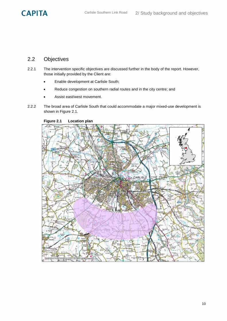
2.2.2 The broad area of Carlisle South that could accommodate a major mixed-use development is
shown in Figure 2.1.
Figure 2.1 Location plan
Carlisle Southern Link Road
3/ Methodology
11
3. Methodology
3.1 Introduction
3.1.1 The methodology agreed with the Client in relation to this study combines the processes of
Stage 1 Transport Analysis Guidance (TAG) and study specific activities identified in the
Client’s Brief.
3.1.2 The basic process follows closely the TAG recommendations and is set out below:
1) Understand current and interim contexts
2) Understand future context
3) Establish need for intervention
4) Confirm intervention specific objective
5) Confirm geographical location
6) Option generation
7) Initial option sift
8) Preferred option – potential solutions assessment including:
a. Generation of feasible options and solutions
b. Deliverability of scheme
c. Impacts
d. Delivery options
e. Potential funding sources
f. Land ownership patterns
3.1.3 Stage 1 Option Development involves identifying the need for intervention and developing
options to address a clear set of locally developed objectives which express desired outcomes.
These are then sifted for the better performing options to be taken on to further detailed
appraisal in Stage 2.
3.1.4 The methodology and scope of the appraisal to be undertaken in Stage 2 is outlined in the
accompanying draft Appraisal Specification Report (ASR) which is included as Appendix J to
this report. It is recommended that the ASR is reviewed and updated once further information is
available on the masterplan for Carlisle South.
Carlisle Southern Link Road
4/ Stakeholder consultation
12
4. Stakeholder consultation
4.1.1 At the request of the Client limited engagement with stakeholders took place during this study.
During the initial option generation process this involved Officers from Cumbria County Council
and Carlisle City Council.
4.1.2 During the preferred option assessment process engagement took three forms:
Information provision, which involved the collection of data from key stakeholders
including the Environment Agency, Natural England and Historic England;
Consultation, where the views of Officers from the County and City Council were sought
on existing highway infrastructure and planning policy; and
Participation, through workshops where Local Area Committee Members and Officers
from the County Council and Officers from the City Council were invited to have a direct
influence on the outcome of the study.
4.1.3 The outcomes of this preliminary stakeholder engagement were used to help define the spatial
extents of possible routes and intervention specific objectives.
Carlisle Southern Link Road
5/ Context and need for intervention
13
5. Context and need for intervention
5.1 Introduction
5.1.1 As discussed in Section 1, consideration of the need for additional transport improvements in
the city has stemmed from the emerging and substantial growth proposals to the south of the
current urban boundary. This major mixed-use development will form the basis of the next
phase of Carlisle’s growth opportunities beyond the site specific allocations provided within the
emerging new Local Plan. Whilst this is the future context of any intervention, it is also important
that the existing context is also considered in the appraisal process insofar as it will influence
any future proposals.
5.2 Existing and interim context
5.2.1 The emerging Carlisle District Local Plan, 2015–2030 excluding the strategic growth area in
Carlisle South, contains allocations designed to continue the managed growth of the city in a
sustainable manner. In order to facilitate the delivery of these allocations and move towards the
aspiration of a modal shift in travel modes away from the private car, additional transport and
movement improvements have been proposed. These are set out in the Carlisle Transport
Improvement Study 2015 and, in summary, comprise a suite of sustainable transport
improvements plus a number of improvements to highways and junctions which will improve the
traffic capacity of the existing network.
Existing policies
5.2.2 Cumbria County Council are the local highway authority for Cumbria. The aims of Cumbria
County Council are contained within the Council Plan, which sets out the council’s priorities. A
key priority of the council is to provide safe and well maintained roads and an effective transport
network by maximising new investment and working to improve infrastructure.
5.2.3 The Cumbria Local Transport Plan is the statutory document that sets out how travel within
Cumbria is to be managed. A key part of the current plan is the strategy for each area of
Cumbria for the period 2011 to 2026. For Carlisle, the key priority is to encourage development
that supports the city’s economy, including its role as a housing growth point and a key
employment area. Key transport outcomes detailed in the plan include reducing traffic
congestion and improving journey time reliability.
5.2.4 The Cumbria Local Enterprise Partnership (LEP) is a voluntary partnership between Cumbria’s
local authorities and businesses. The Cumbria LEP provides a strategic lead in all activities
contributing to the growth and vibrancy of Cumbria’s economy.
Carlisle Southern Link Road
5/ Context and need for intervention
14
5.2.5 As part of this, the Cumbria LEP launched its strategic economic plan, the Four pronged attack,
on how the county’s economy can deliver jobs, business growth, improved skills and
infrastructure, homes and other economic benefits over the next 10 years. One of the four
‘prongs’ recognises the strategic connectivity of the M6 corridor as key to securing economic
growth, with excellent transport links and key settlements, including Carlisle, along its length. It
highlights that the emerging Carlisle Local Plan could deliver 6,300 new homes in the district.
5.2.6 The strategic economic plan also identifies the key drivers which require investment to secure
economic growth across the region. One of these drivers is infrastructure improvements, a key
part of which is transport infrastructure improvements. The strategic economic plan therefore
details some of the transport infrastructure improvements required in the short term to secure
new housing and jobs in Carlisle.
5.2.7 The Cumbria LEP and Cumbria County Council have also produced the Cumbria Infrastructure
Plan. This plan is essential in identifying and prioritising major investment across the county,
and will help form the evidence base of required infrastructure to support and grow the
Cumbrian economy over the short, medium and long term. The plan identified the Carlisle
Southern Link Road as a medium term priority for delivery.
5.2.8 Carlisle City Council are responsible for air quality monitoring and pollution control within the
Carlisle district. Within the city of Carlisle, there are six Air Quality Management Areas
(AQMAs).
5.2.9 In the context of this study, the relevant AQMAs include:
Currock Street, between the Rome Street and Crown Street junctions
Bridge Street, between Bridge Lane and Melbourne Street
London Road, between the Close Street and Grey Street junctions
Dalston Road, between John Roberts Gardens and the old Thomas Armstrong access
Wigton Road, between Crummock Street and Ashley Street and Caldcotes between
Church Street and Port Road Industrial Estate
5.2.10 The 2014 progress report is the most recent report and provides updates on air quality
monitoring in Carlisle. The results in the report for nitrogen dioxide show that the Currock Road
site adjusted annual mean concentration results for 2012 and 2013 are just below the objective
level of 40 mug/m3. The results for the Dalston Road site show the site remaining over the
objective level from 2006–2013. The results for London Road also show levels just below the
objective for 2013, having previously exceeded it in 2012. There are various sites on Wigton
Road which show improved results, although still just below the objective level, in 2013. Results
for Bridge Street show exceedances of the objective level since 2006, although these have
shown a general decline. Recent improvements in air quality are almost certainly linked to the
opening of the Carlisle Northern Development Route (CNDR) in 2012, which has resulted in
reductions in traffic flow on Scotland Road and Wigton Road.
Carlisle Southern Link Road
5/ Context and need for intervention
15
Existing transport network
5.2.11 The city of Carlisle is Cumbria’s only city and is the region’s largest urban settlement as well as
an important employment centre. The city centre is a key attractor in retail and leisure terms,
and its regional catchment caters for almost half a million people.
5.2.12 The city has excellent strategic transport links, being located on the M6 motorway and A69
trunk road, as well as the West Coast Main Line and additional rail links to Edinburgh,
Newcastle, west Cumbria, Leeds and southwest Scotland.
5.2.13 The key radial route to the city centre from the south is along London Road. London Road is a
single carriageway road with one lane in each direction for the majority of its length. There are a
number of signalised junctions along London Road, and these are anecdotally known to be
operating close to capacity in the peak periods towards the city centre, causing queuing and
delays.
5.2.14 Currock and Upperby link to city centre along Currock Road and Blackwell Road. Currock Road
is a single carriageway road with on-street parking along both sides at its southern end. A major
constraint along this route is the railway bridge, which has a 90-degree turn immediately to its
north. Blackwell Road is also a single carriageway road with on-street parking along both sides.
5.2.15 Whilst there are no known capacity issues along most of these of these routes at present, the
on-street parking restricts traffic flow with traffic operating in informal priority arrangements.
Towards the northern end of these routes, at the Currock Road/Crown Street and London
Road/St Nicholas Street junctions, traffic flows become heavier and delays increase.
5.2.16 Travel between east and west, particularly for long-distance trips from the north and east, has
been greatly enhanced following the opening of the CNDR to the northwest of Carlisle.
However, within the city, travel between the east and west is greatly constrained by a limited
number of crossings of the river Caldew. The only existing crossings of this river within the
Carlisle urban area are on Bridge Street and Nelson Bridge.
5.2.17 Bridge Street is an urban dual carriageway running between the Hardwicke Circus signalised
roundabout and the large signalised junction with Shaddongate and Sainsbury’s supermarket,
and a roundabout with Wigton Road. Nelson Bridge is a single carriageway road with two lanes
in each direction. It provides a critical highway link between west Carlisle and the city centre
and south Carlisle. It has signalised junctions at either end, both of which are constrained by
steep uphill gradients and large traffic flows. The bridge was widened in 2005 to provide an
additional inbound lane of traffic.
5.2.18 There is one further crossing of the Caldew, via a rural route linking Durdar to Dalston to the
south of Carlisle. This rural route is inappropriate for significant volumes of traffic, has a weight
limit of 7.5 tonnes and the eastern junction with Durdar Road has very poor visibility for traffic
turning from the minor road.
Carlisle Southern Link Road
5/ Context and need for intervention
16
5.2.19 A number of bus routes run within Carlisle, with the majority of services provided by
Stagecoach. A summary of the main urban services is provided below in Table 5.1. The key
services between the city centre and south Carlisle are the 60/60A, 61/61A and 67.
Table 5.1 Key Carlisle urban bus services
Service Route Frequency
60 Sandsfield Park – Harraby Every 20 mins
61/61A Morton West – Harraby East Every 8 mins
62 Morton Park – Kingmoor Park Every 15 mins
67 Belle Vue – Upperby Every 10 mins
76 St Anns Hill - Durranhill Every 15 mins (source: Stagecoach)
5.2.20 Bus priority measures have been implemented in the inbound direction between the Eastern
Way and London Road Retail Park. These take the form of a dedicated bus lane, and a
signalised junction with bus priority at the retail park access.
Existing travel patterns
5.2.21 Data from the 2011 census illustrates the existing mode split for journeys to work in the Carlisle
district and is shown in Table 5.2. The results show that Carlisle has a high proportion of
walking trips compared to the English average, which is probably due to its relatively compact
geographic size. Rail usage is below average, and car use is around the average.
Table 5.2 2011 census journey to work data
Mode of travel Carlisle urban Carlisle district England
Work at home 7% 10% 5%
Metro / light rail 0% 0% 4%
Train 1% 1% 5%
Bus 8% 7% 7%
Taxi 0% 0% 1%
Motorcycle 1% 1% 1%
Car driver 54% 57% 57%
Car passenger 7% 6% 5%
Bicycle 3% 3% 3%
On foot 19% 15% 11%
Other 0% 0% 1% (source: Nomis)
5.2.22 Traffic data used in the validation of the Carlisle transport model is presented in tables to
provide a summary of peak hour traffic flows on key links to the south of Carlisle.
Table 5.3 Botchergate traffic flows
Time Northbound Southbound
Morning peak (08:00–09:00) 667 663
Evening peak (17:00–18:00) 605 935 (source: Carlisle transport model LMVR)
Carlisle Southern Link Road
5/ Context and need for intervention
17
5.2.23 The results for Botchergate highlight that this is a busy radial route. The southbound flow in the
evening peak is of the same order as the expected link capacity for a single carriageway urban
road.
Table 5.4 James Street traffic flows
Time Northbound Southbound
Morning peak (08:00–09:00) 813 804
Evening peak (17:00–18:00) 820 858 (source: Carlisle transport model LMVR)
5.2.24 The results for James Street highlight that this is a busy radial route. The traffic flow in both
peak periods is approaching the expected link capacity for a single carriageway urban road, and
highlights why there is an air quality management area in this location.
Table 5.5 Currock Road traffic flows
Time Northbound Southbound
Morning peak (08:00–09:00) 364 552
Evening peak (17:00–18:00) 626 443 (source: Carlisle transport model LMVR)
5.2.25 The results for Currock Road show it is a relatively busy road. The flows are approaching the
expected capacity of the Currock Road/Crown Street mini-roundabout at its northern end.
Table 5.6 Upperby Road traffic flows
Time Northbound Southbound
Morning peak (08:00–09:00) 312 250
Evening peak (17:00–18:00) 269 436 (source: Carlisle transport model LMVR)
5.2.26 The results for Upperby Road show that whilst the road is busy for a residential area, the route
is typically operating under capacity.
5.2.27 Trafficmaster data provides historical journey time data collected via a fleet of compatible GPS-
enabled vehicles. Trafficmaster data was used in the production of the Carlisle transport model
and summary journey times for key routes was provided in the associated Local Model
Validation Report. These results are summarised below in Table 5.7.
Table 5.7 Trafficmaster journey time results
Route Length
(km)
Morning peak
(08:00–09:00)
Evening peak
(17:00–18:00)
Time (s) Speed (kph) Time (s) Speed (kph)
CNDR northbound 8.38 562 53.7 507 59.5
CNDR southbound 7.95 491 58.3 503 56.9
Wigton Rd eastbound 3.97 471 30.3 451 31.7
Wigton Rd westbound 4.00 367 39.3 418 34.5
Scotland Rd northbound 3.55 413 30.9 381 33.6
Scotland Rd southbound 3.54 433 29.4 410 31.1
Carlisle Southern Link Road
5/ Context and need for intervention
18
Route Length
(km)
Morning peak
(08:00–09:00)
Evening peak
(17:00–18:00)
Time (s) Speed (kph) Time (s) Speed (kph)
Warwick Rd eastbound 2.88 348 29.8 463 22.4
Warwick Rd westbound 2.88 525 19.8 412 25.2
London Rd northbound 5.15 610 30.4 665 27.9
London Rd southbound 5.17 604 30.8 702 26.5 Source: Carlisle Transport Model LMVR, Cumbria County Council, February 2015
5.2.28 The journey times in Table 5.7 show that there is considerable delay on Warwick Road and
London Road, with peak hour speeds below 30 kph. The speeds on Wigton Road and Scotland
Road are higher, reflecting the impact of the opening of the CNDR.
5.3 Future context
Carlisle District Local Plan
5.3.1 The Carlisle District Local Plan 2001-2016 is the current adopted local plan for Carlisle.
However, the proposed delivery timetable for the major mixed use development and associated
supporting elements are beyond the life of this document and it is therefore the emerging
Carlisle District Local Plan 2015-2030 that will guide the consideration of the proposal. This
Plan has been submitted to the Government for Examination in Public and, at the time of
writing, this process is still ongoing. Through this process the broad policy basis of the proposal
will be tested as the Plan contains policies that support its development.
5.3.2 Strategic Policy SP3 within the draft plan gives a clear way forward in determining the scale and
content of the mixed use development and the supporting infrastructure required to deliver it. It
specifically refers to the need for “infrastructure including highways and transportation”. The
Policy, as it currently stands, contains few details and rather places emphasis on the production
of a comprehensive masterplan for the area which will include an infrastructure delivery plan.
5.3.3 The masterplan, in guiding the scale and content of the mixed use development, will determine
the type and number of new homes, the type and size of the employment land and need for
other uses. It will also determine the timing and phasing of all elements including the transport
infrastructure. The Local Plan is scheduled for adoption in autumn 2016 and the preparation of
the masterplan is anticipated to start early in 2017. Full consideration of the transport
implications and required improvements, as a fundamental element within the masterplan, will
need to inform and run in parallel with this process.
5.3.4 Therefore, the consideration of the major mixed use development and preparation of the
masterplan will be fundamental drivers in justifying the need for, and assessing the delivery
timescale of, any associated transport infrastructure changes and/or improvements.
Carlisle Southern Link Road
5/ Context and need for intervention
19
Proposed major developments in West Cumbria
5.3.5 There are a number of significant current and proposed developments in West Cumbria. The
major current employer is Sellafield, a nuclear fuel reprocessing and nuclear decommissioning
site, which employs over 10,000 people. There are a number of ongoing projects in Sellafield
and the nearby Low Level Waste Repository in Drigg.
5.3.6 The largest proposed development in west Cumbria is the proposed new 3.4 GW nuclear power
station at the Moorside site, located to the north of Sellafield, which could generate seven per
cent of the UK’s future electricity requirements. The Moorside project is a nationally significant
infrastructure project and is expected to cost around £16bn. Nugen is currently working on the
Moorside project for a new nuclear power station, along with associated development such as
transport infrastructure improvements, logistic facilities and worker accommodation. Project
construction is anticipated to generate up to 21,000 jobs in the UK, with up to 6,000 people
employed on site. Operation of the power station could employ over 1,000 people for around 60
years. The increase in local expenditure will also benefit the local and Cumbrian economy.
5.3.7 Linked to the Moorside project is National Grid’s proposed upgrade of the west Cumbria high
voltage lines, which is also a nationally significant infrastructure project. This will link the
Moorside power station to the wider grid, provide additional capacity of other energy generating
projects in Cumbria, and ensure a resilient electricity distribution network.
5.3.8 West Cumbria Mining is also currently exploring opportunities and investing in development
plans for the creation of a coking coal mine off the coast near Whitehaven in west Cumbria.
Future transport network
5.3.9 As part of the Carlisle Local Plan process, Cumbria County Council considered the transport
impacts of the local plan in a transport modelling study using the Carlisle transport model. The
study assesses the cumulative impacts of local plan development by considering the changes
to traffic flows, delays and congestion via the ratio of flow to capacity.
5.3.10 The study results show that the Carlisle Local Plan proposals would increase congestion in
Carlisle when compared to the existing operation of the network, with journey times increasing
on key routes in the city. Development at south Carlisle towards the end of the plan period was
forecast to further increase congestion and journey times, particularly on London Road.
5.3.11 As a follow on to the local plan modelling, as study was undertaken to identify necessary
infrastructure improvements to support the Carlisle Local Plan. The Carlisle Transport
Improvements study was based on output from the modelling study completed and forms a key
part of the local plan evidence base.
Carlisle Southern Link Road
5/ Context and need for intervention
20
5.3.12 The improvements study identified a package of sustainable transport and highway
improvements which would support the delivery of local plan development and mitigate the
transport impact of this development. The sustainable transport improvements include new
cycling routes linking development sites to the existing cycle network, and public transport
improvements to upgrade bus stops and service frequencies. The highway improvements
focussed on capacity upgrades at key junctions throughout the network to reduce congestion
and delay.
5.3.13 It is intended that the improvements package would be implemented over the course of the plan
period, with a number of prioritised improvements delivered sooner to encourage development.
The improvements would be funded through a combination of developer contributions and the
Cumbria LEP’s growth fund. The potential for investment in the improvements package is
clearly stated in the LEP’s strategic economic plan.
5.3.14 Cumbria County Council are currently progressing a number of major transport schemes
throughout the county through devolved major scheme funding provided by the Department for
Transport to the Cumbria Local Transport Body. One of these schemes is Currock Bridge in
Carlisle, which links the wards of Currock and Upperby to Denton Holme across the Cumbrian
Coast railway line. The bridge will replace an existing footbridge with an enhanced environment
for both pedestrians and cyclists and will link into the Caldew cycleway. This scheme will also
increase the sustainability of development at south Carlisle.
Future travel patterns
5.3.15 The TEMPRO software with the National Trip End Model (NTEM) dataset 6.2 (released 2011)
contains forecasts on changes in population, households and employment. The dataset has
been interrogated to determine reference case forecasts in the Carlisle district from 2015 to
2030 and is presented in Table 5.8 and Table 5.9.
Table 5.8 Carlisle district 2015 data
Name Population
HHs Jobs Workers < 16 16–64 65+ Total
Carlisle 17811 67355 20941 106107 50079 62002 5632
rural (Carlisle) 4929 18830 5832 29591 13041 11529 1602
Carlisle 12106 45794 14078 71979 34829 48979 38025
Brampton nr
Carlisle 776 2731 1031 4538 2209 1494 2276
Source: TEMPRO version 6, National Trip End Model version 6.2
Carlisle Southern Link Road
5/ Context and need for intervention
21
Table 5.9 Carlisle district changes from 2015–2030
Name Population
HHs Jobs Workers < 16 16–64 65+ Total
Carlisle 1038 599 7290 8926 7450 -1030 972
rural (Carlisle) 1076 2609 2779 6464 3778 -100 2220
Carlisle -152 -2315 4058 1591 3098 -930 -1525
Brampton nr
Carlisle 113 304 453 871 574 0 277
Source: TEMPRO version 6, National Trip End Model version 6.2
5.3.16 The data shows that there is a forecast increase in population across the Carlisle district,
although this is mainly due to an increase in the elderly population. There is a forecast decrease
in the working age population within Carlisle, but a significant increase in the rural Carlisle area.
There is also a corresponding forecast increase in the number of households across the district.
5.3.17 It should be noted that the Carlisle urban boundary in the NTEM dataset tightly follows the
existing urban boundary, and hence there are existing sites with planning permission, such as
South Morton, which would be classed as residing in the ‘rural’ area in the NTEM dataset.
Similarly, the whole of the South Carlisle area is also considered as ‘rural’.
5.3.18 The data shows that there is a forecast decrease in jobs across the Carlisle district, with the
majority of this decrease in Carlisle city itself. However, there is a forecast increase in workers
across the district, showing an increase in commuting trips outside of the district boundary.
5.3.19 It should be noted that the current NTEM dataset is old, having been released in 2011. The
population estimates are based on those made in 2008, and the distribution of employment and
workers has a base year of 2001. A new NTEM dataset is proposed to be released by the
Department for Transport in 2016, and the updated results from the new dataset should be
considered when it is released.
5.3.20 The sites identified in the local plan provide the potential for growth which is higher than
anticipated in the NTEM data forecasts. The local plan identifies a housing requirement of 565
dwellings per annum, based on the findings of the Carlisle Strategic Housing Market
Assessment.
5.3.21 The local plan has identified a number of sites in and around the south of Carlisle which are
anticipated to be completed by around 2025. A summary of these sites and an estimate of their
expected peak traffic generation is provided overleaf.
Carlisle Southern Link Road
5/ Context and need for intervention
22
Table 5.10 Carlisle Local Plan development sites in south of Carlisle
Ref Site Size Approx. peak
hour traffic
U3 Site of Pennine Way primary school 112 dwellings 70
U4 Land north of Moorside Drive/Valley
Drive 140 dwellings 90
U5 Land between Carleton Road and
Cumwhinton Road 204 dwellings 130
U13 Land east of Beverley Rise 30 dwellings 20
U14 Land north of Carleton Clinic 189 dwellings 120
Total 675 dwellings 430 Source: Carlisle Local Plan transport modelling report
5.3.22 The figures above show the forecast traffic generation from residential sites identified in the
plan to the south of Carlisle. The schemes identified in the improvements study should help to
mitigate the impact of this traffic, but the radial routes into the city from the south and east will
still remain constrained and congested.
5.3.23 In addition to these sites, a major mixed-use development is anticipated in south Carlisle. The
local plan identifies that delivery of this development could start following the adoption of a
Development Plan Document including a comprehensive infrastructure delivery strategy. For
the purposes of the preliminary transport modelling, development in south Carlisle was
assumed from 2025 at a rate of around 565 dwellings and 8,000 square metres of employment
per annum. This assumption will be further refined as the masterplanning process is completed.
5.3.24 It should be noted that not all of the trips detailed below will be new trips to the network, but it
gives an indication of the scale of development proposed at south Carlisle in traffic terms.
Table 5.11 Carlisle Local Plan south Carlisle development
Ref Site Size Approx. peak
hour traffic
S1 South Carlisle 2025–2030 residential 2,825 dwellings 1,775
S2 South Carlisle 2025–2030 employment 40,000 sqm 275
S3 South Carlisle 2030–2040 residential 5,650 dwellings 3,550
S4 South Carlisle 2030–2040 employment 80,000 sqm 550
Total 8,475 dwellings
120,000 sqm 6,150
Source: Carlisle Local Plan transport modelling report
5.4 Identified need for intervention
5.4.1 The review of the existing transport network and travel patterns show that there are a number of
constraints on the southern radial routes and in particular on London Road, with traffic flows at
levels around the usual link capacity and slow average speeds. In addition to this, there are a
number of AQMAs where air quality is poor due to traffic emissions.
Carlisle Southern Link Road
5/ Context and need for intervention
23
5.4.2 Travel between the east and west of the city is constrained by the river Caldew as there are
only two crossings of the river, on Bridge Street and Nelson Bridge. This means traffic has to
travel through congested junctions in and around the city centre. It also causes significant
resilience issues as the closure of one of the bridges would lead to severe impedances to
travel. The impact of such resilience issues was particularly evident after the significant flooding
in December 2015, where the closure of Eden Bridge due to safety concerns resulted in
significant diversions and delays and cut off pedestrian access between the north and the city
centre.
5.4.3 The Carlisle Local Plan identifies a number of development sites to the south of Carlisle, as well
as a broad location of growth for a major mixed-use development towards the end of the plan
period. Study work has shown that congestion is likely to increase as a result of the local plan
development, and whilst transport improvements have been identified to support this
development, there are still numerous constraints on routes from the south of the city.
5.4.4 The development of south Carlisle is to be guided by a Development Plan Document, which
would contain a site masterplan and infrastructure delivery strategy. A key part of the
masterplan will be ensuring the development is sustainable, for example by linking into existing
sustainable transport infrastructure like the Currock Bridge major scheme. However,
development would generate a significant amount of traffic and place significant pressures on
the already constrained southern radial routes.
5.4.5 If Carlisle wishes to see continued growth ambitions which ultimately lead towards the major
mixed-use development at south Carlisle, there is a need to provide the transport infrastructure
to deliver this development. This infrastructure should achieve this objective by alleviating the
congestion and improving both journey times and reliability on the southern radial routes and in
and around the city centre. The provision of improved links for east/west travel will also help
Carlisle take full advantage of the wider economic benefits that the proposed major
infrastructure projects in west Cumbria will bring to the rest of the county.
Carlisle Southern Link Road
6/ Intervention objectives
24
6. Intervention objectives
6.1 Objectives
6.1.1 In order to begin the option generation process a set of strategic objectives, along with their
associated predicted outcomes, were defined based on the Client’s brief and preceding
analysis. These are set out in Table 6.1 below.
Table 6.1 South Carlisle intervention objectives
Strategic Objective Strategic Outcomes
Delivery of major mixed-use development
at Carlisle South
Facilitate delivery of up to 10,000 homes
Facilitate development of strategic
employment site
Reduce travel to work journey times
Encourage more sustainable transport use
Create a sustainable community
Reduce congestion on southern radial
routes and in city centre
Increase use of more sustainable travel modes
Reduce all journey times
Improve air quality
Improve health and wellbeing
Assist east/west movement in Cumbria Improve journey times for people and freight
6.1.2 The first objective to support development at South Carlisle recognises the strategic importance
of this broad location for growth. There are few opportunities for new development in Carlisle
outside of the identified sites in the Local Plan, as land is constrained by the M6 motorway and
flood plains around the river Eden. Carefully planning for large mixed-use sustainable
development in South Carlisle therefore represents the best way to deliver the housing needed
for Carlisle in the long-term and to secure Carlisle’s economic prosperity.
6.1.3 The second objective to reduce congestion on southern radial routes and in the city centre
recognise that these routes are constrained and suffer from poor air quality in places. The local
plan study work has identified various junctions forecast to suffer with congestion. Whilst
improvements have been identified, there are a number of locations where further capacity
improvements are not possible within the existing highway boundary.
6.1.4 The third objective to support east-west movements recognises the constraints to travel by the
limited crossings of the river Caldew. Development at South Carlisle will increase the demand
for travel from east to west, particular to existing and proposed employment sites at Kingmoor
Park and Morton South, as well as to employment and other opportunities in West Cumbria.
This objective also recognises the need to improve the resilience of the transport network in
Carlisle, which was recently highlighted after the severe flooding in December 2015 which
resulted in the closure of a bridge and significant disruption to travel.
Carlisle Southern Link Road
6/ Intervention objectives
25
6.2 Location
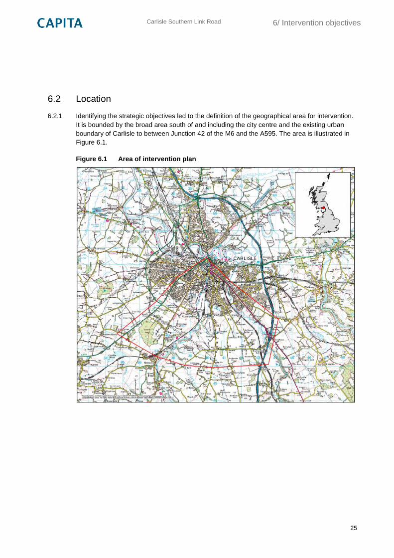
6.2.1 Identifying the strategic objectives led to the definition of the geographical area for intervention.
It is bounded by the broad area south of and including the city centre and the existing urban
boundary of Carlisle to between Junction 42 of the M6 and the A595. The area is illustrated in
Figure 6.1.
Figure 6.1 Area of intervention plan
Carlisle Southern Link Road
7/ Option generation
26
7. Option generation
7.1 Potential options
7.1.1 A number of schemes which could meet the intervention objectives have been considered in
recent history in Carlisle. Potential intervention options have therefore been produced by
reviewing previous studies and proposed schemes. A brief summary of the options considered
and their relevant history is provided below.
7.1.2 The concept of a southern bypass of Carlisle has a long history of feasibility considerations
reflecting the ongoing problems associated with the existing road network in Carlisle. A Carlisle
Southern Bypass was considered in the early 1990s by the Department for Transport and the
Highways Agency. At this time, the trunk road network was discontinuous across Carlisle, with
no direct link between the M6/A74/A69 and the A595. At the time, it was identified that nearly 25
per cent of traffic on the A595 was through traffic, so a bypass was proposed to remove this
traffic from the city centre and provide journey time benefits.
7.1.3 Route consultations were undertaken, and a preferred route was announced in 1994. The
preferred route was 9.4 km long and linked the M6 Junction 42 to the A595 north of
Caldewlees, around three kilometres southwest of Carlisle. It was noted at the time that the
county council preference was to have the junction with the A595 closer to Carlisle to provide
more benefits for local traffic. At the time, the scheme was considered to provide good value for
money. The scheme was withdrawn from the trunk road programme in 1995, and the A595 near
Carlisle was subsequently detrunked in 1998.
7.1.4 The Carlisle Local Plan Transport Modelling study and the Carlisle Transport Improvements
study considered the impact of the Carlisle Local Plan on the existing highway network, and
identified potential improvements to support local plan development. The improvements study
noted that a number of junctions where capacity issues are forecast were constrained, which
limited or prevented the scale of improvements.
7.1.5 Other highway improvements in and around the city centre have also been considered in recent
study work. These include access proposals for the Caldew Riverside and Carlisle Station Hub
sites around James Street, which would create new accesses for these junctions or increase
the capacity of the Victoria Viaduct/Nelson Bridge junction.
Carlisle Southern Link Road
7/ Option generation
27
7.1.6 The potential for park and ride in Carlisle has also been considered in the recent past. Three
park and ride schemes were listed as Priority Transport Improvement Schemes in the first Local
Transport Plan, involving public transport interchanges and bus priority measures. Cumbria
County Council cabinet resolved to remove park and ride schemes from the Local Transport
Plan in 2007. This reflected the fact that park and ride was no longer part of the council’s
immediate priorities due to uncertainty over their potential for success, although the council
stated they were still generally supportive of the concepts. Following this, two of the sites
previously reserved for park and ride sites were allocated for different purposes in the Carlisle
Local Plan; a residential development at Greymoorhill, which has received planning permission
for part of the site, and a food retail development at Morton.
7.1.7 London Road has a number of bus priority measures along its length, and is probably the route
with the best bus priority infrastructure provision in Carlisle. The road has an inbound bus lane
between Eastern Way and the London Road retail park, and bus priority signals are present at
the retail park site access. However, provision stops north of the retail park, as the existing
highway boundary is not wide enough to accommodate a continuous bus lane to the city centre,
and in particular along Botchergate.
7.1.8 Walking and cycling into the city centre from south Carlisle in general represents an attractive
proposition, due to the compact geographic nature of the city and the generally good
infrastructure provision. However, there exists a number of constraints along these routes which
may deter walking and cycling trips from south Carlisle. These constraints are mainly
inadequate provision over and around existing structures, and particularly across the railways.
For example, this has been recognised with the Currock Bridge scheme, which aims to replace
a substandard bridge over the Cumbrian Coast Line. Both walking and cycling trips will benefit
from the completion of this scheme which will provide a direct traffic-free route to the city centre.
7.1.9 The concept of utilising existing rail infrastructure to provide public transport services linking
south Carlisle to the city centre was briefly explored at a high-level in a visioning workshop for
south Carlisle. This existing rail infrastructure provides the opportunity to provide a quick,
reliable and high-quality rail/light rail service into the city centre from the south Carlisle
catchment, reducing the need to drive into the city and encouraging mode shift.
7.1.10 Two railway lines cross the broad search area for south Carlisle: the West Coast Main Line
between Brisco and the A6 Carleton Road, and the Cumbria Coast Line between the river
Caldew and Upperby. The West Coast Main Line is a major inter-city railway route for both
passengers and freight, linking the cities of London, Birmingham, Glasgow and Edinburgh, and
is double-tracked in this area. The Cumbria Coast Line is the only rail connection to West
Cumbria, linking Carlisle to Workington, Whitehaven and Sellafield, and onwards towards
Barrow-in-Furness and Ulverston, and is also double-tracked in this area.
7.2 Option assumptions
7.2.1 All of the options considered have been chosen based on the assumed ability to meet the
majority of the defined objectives for intervention in south Carlisle.
Carlisle Southern Link Road
7/ Option generation
28
7.2.2 The options detailed are considered at a high-level only, based on a combination of available
information, previous studies and local knowledge. No assumptions have been made regarding
fine details such as design standards and the options represent concept ideas.
7.2.3 No detail has been assumed regarding route corridors or the specific location of infrastructure;
rather, broad areas of intervention are considered which link in to existing infrastructure at
approximate locations where required.
7.2.4 Outline constraints for each scheme are noted where appropriate, but these are by no mean
exhaustive.
7.2.5 Approximate costs have been derived based on similar recent schemes either in Cumbria or
elsewhere in the country.
7.3 Option description
Carlisle Southern Link Road
7.3.1 It is proposed that this scheme would form a link between the M6 J42 and the A595/A689. This
is roughly in line with the previous preferred route option from the 1990s, with the A595 junction
moved closer to Carlisle.
7.3.2 The route would involve two river crossings, of the Petteril to the east and the Caldew to the
west, and two rail crossings, of the West Coast Main Line to the east and the Cumbria Coast
Line to the west. The route is approximately eight kilometres in length.
7.3.3 It is assumed the route would link in to the wider highway network via the existing roads of
Durdar Road, Scalegate Road, Brisco Road and Dalston Road. No detail is currently known on
the potential masterplan layouts for development but it is also assumed that development would
be adequately linked to the new link road either via existing roads or site-specific junctions.
7.3.4 The cost estimate of this scheme is around £100m. The schemes costs are based on the
known construction costs of the 8.25 km Carlisle Northern Development Route, which included
a new rail and river crossing was recently constructed with a total cost of £158m1.
On-line highway improvements on radial routes and in the city centre
7.3.5 It is proposed that this scheme would involve on-line link and junction improvements on the
southern radial routes and in the city centre. The improvements would be over and above those
proposed in the Carlisle Transport Improvements study.
1 This scheme was funded through a Private Finance Initiative scheme, and the costs include an additional contract
for the operation and maintenance of a further 150 km of roads in north Cumbria.
Carlisle Southern Link Road
7/ Option generation
29
7.3.6 The Carlisle Transport Improvement study identified a number of junctions along the London
Road corridor where it was concluded that significant capacity improvements would not be
possible within the existing highway boundary. Capacity improvements may therefore require
the purchase and demolition of some roadside properties, although there are a number of listed
buildings along London Road which would restrict road widening. Ideally, capacity
improvements would be provided at the following locations:
Botchergate/Crown Street/Tait Street
London Road/St Nicholas Street
London Road/St Nicholas Retail Park
Victoria Viaduct/James Street/Nelson Bridge
Upperby Road/St Ninian’s Road
Durdar Road/Newbiggin Road
7.3.7 Whilst there are few existing capacity issues on Currock Road and Blackwell Road outside of
the junctions previously identified, the on-street parking on these roads has the potential to
cause more significant delays when south Carlisle is developed. It is therefore proposed that
this scheme would consider reviewing the suitability of this on-street parking with consideration
to the potential future traffic flow on these routes, and identifying areas away from the radial
routes where cars could safely park.
7.3.8 Cumbria County Council has also undertaken study work which considers improvements at the
Victoria Viaduct/James Street/Nelson Bridge junction to increase vehicle capacity and improve
air quality on James Street. One potential improvement considered closing the Viaduct Estate
Road arm of this junction. A new route for traffic from this arm would be provided underneath
the Viaduct, via the rear of the current Pools site and joining James Street via Water Street.
This major improvement is also included in this scheme.
7.3.9 The cost estimate of this scheme is £25m. This is based on costs for recent major junction
improvements in Cumbria such as the Gilwilly pinch point scheme, and assumes a rough cost
of £2m per junction, plus costs of around £5m for various link improvements and traffic
management measures and £10m for major improvements the James Street junction.
Sustainable transport improvements
7.3.10 It is proposed that this scheme would involve improvements to the existing walking, cycling and
public transport networks to link south Carlisle to the city centre. These improvements would
take advantage of the compact nature of the city and encourage mode shift, reducing
congestion on radial routes.
7.3.11 For pedestrians and cyclists, new walking and cycling routes would be built to link in to existing
routes in the south of the city, and in particular the Currock bridge major scheme.
Carlisle Southern Link Road
7/ Option generation
30
7.3.12 Previous work on the potential for bus priority infrastructure improvements have been
considered. It is generally assumed that the radial routes in the south of the city lack the
available space to implement priority measures; measures on London Road have already been
implemented where space permits. However, vehicle detection technology would be
implemented by upgrading signalised junctions and installing transceivers within the buses. The
signal controller would then detect when a bus is queuing at the junction and prioritise that
green movement to minimise delay.
7.3.13 Infrastructure improvements to bus stops on London Road, Currock Road and Blackwell Road
would be implemented to improve the passenger experience, providing sheltered waiting areas.
Real-time bus information measures should also be provided at existing and new bus stops.
7.3.14 However, there is the potential to provide significant bus service improvements as part of
development at south Carlisle. The Carlisle Transport Improvements study considered various
infrastructure improvements, such as waiting facilities, along existing radial routes, and these
should be extended to Blackwell Road and Currock Road to link to south Carlisle. Service
frequency would also be improved, partially funded through developer contributions. It is
proposed to provide significant bus service frequency improvements as part of this scheme.
However, the timing of introducing bus frequency improvements is critical. The services should
only be provided when there is a large enough population available to make the services viable,
but the services should also be available before people get into the habit of driving by car.
7.3.15 The cost estimate of this scheme is £15m. The infrastructure costs are roughly based on those
provided in the Carlisle Transport Improvements study.
Park and ride
7.3.16 It is proposed that this scheme would involve the creation of up to three park and ride sites in
south Carlisle. The sites would be located around Wigton Road, Durdar Road and Carleton
Road, and would also provide a high-frequency bus link to the city centre. It is proposed the
sites would be located in the following areas:
The Wigton Road site would be located in the vicinity of the previous Wigton Road site
The Brisco Road site would be located around the southern edge of the existing Upperby
urban boundary
The Carleton Road site would be located around the southern end of the existing Harraby
urban boundary
7.3.17 The car parks would provide ample parking in a secure, well-lit and staffed environment.
7.3.18 It may be possible for the sites to link into the existing 62, 67 and 60 respectively, although the
routes would probably still require additional buses to provide a high-frequency service, and to
account for the longer route. It is assumed that up to an additional ten services would be
required.
Carlisle Southern Link Road
7/ Option generation
31
7.3.19 Alongside the park and ride sites themselves, additional or upgrades bus infrastructure would
also be provided to improve journey quality, reduce journey times and improve journey
reliability. These improvement would include:
Real-time bus information
Bus priority measures
Upgraded bus stops and waiting facilities
7.3.20 As part of the introduction of park and ride, a detailed study on revenue costs would need to be
undertaken. This would include estimates of income from car parking and bus tickets, staff
costs and other maintenance costs. There would also be a need to review the existing car
parking changes in the city centre, and consider whether these charges need to be altered to
discourage driving into the centre and to encourage bus use.
7.3.21 The cost estimate of this scheme is around £45m. The site cost for three sites is based on
estimate costs for the St Erth park and ride scheme near Penzance, which included a 700
space car park for a cost of around £10m. The bus service and infrastructure costs are
assumed to be around £15m. It is assumed the ongoing revenue costs would be around £1m
per annum.
Light rail
7.3.22 This scheme proposes two new stations would be constructed; one on the West Coast Main
Line around the Brisco area, and one on the Cumbria Coast Line around the Cummersdale
area, to provide a modern public transport service between these stations and the Carlisle
Citadel station in the city centre. The route from Brisco would be around 3.5 km in length, and
the route from Blackwell would be around 2.5 km in length.
7.3.23 It is proposed to re-use the existing track infrastructure where possible, to save costs. However,
it may be necessary to upgrade this infrastructure, particularly on the West Coast Main Line,
where additional track may be required to prevent delays to the inter-city route. New signalling
and points may also be required.
7.3.24 The stations themselves would take the form of mini-transport hubs where people can change
between travel modes. The hubs would include long-stay car parking, car drop-off facilities, bus
laybys and secure cycle parking. The stations would also provide automatic ticketing facilities,
sheltered waiting and suitable lighting to provide a safe, secure high-quality environment. It
would also be advantageous if the ticketing system could provide for the freedom to change
between light rail and bus services.
Carlisle Southern Link Road
7/ Option generation
32
7.3.25 New rolling stock would be required to provide a high-frequency shuttle service to the existing
Carlisle Citadel station. The Cumbria Coast Line operates on a roughly hourly service during
weekdays and Saturday, and a reduced Sunday service; this is unlikely to provide the service
frequency required to encourage mode shift. Whilst the West Coast Main Line has higher
frequency services, it is considered highly inappropriate for inter-city services to also serve a
station in this location, as an additional stop would add considerable delays. It is assumed that
four light rail vehicles would be required for this service.
7.3.26 The proposals would also need to consider line capacity details. No such details are readily
available, although it is considered that capacity issues should not exist on the Cumbrian Coast
Line. Issues are more likely to exist on the West Coast Main Line, where local services have the
potential to delay inter-city services. The capacity of the Carlisle Citadel station to support new
services is also unknown.
7.3.27 These proposals would also require associated works such as a new vehicle depot for the
rolling stock, potential upgrades to the Carlisle Citadel station and additional track where
required. A detailed look at revenue costs would also be required, including parking charges at
the hubs, staff and maintenance costs and a review of parking charges at car parks in and
around the city centre.
7.3.28 The estimated scheme costs are £100m. This estimate is based on research by UKTram on the
costs of light rail systems. This research gives costs of around £15m per km, although £12m
per km has been assumed for this scheme due to the potential to reuse existing infrastructure,
plus £20m for a new depot and £8m for rolling stock. It is assumed the ongoing revenue costs
would be around £6m per annum.
Carlisle Southern Link Road
8/ Initial option sift
33
8. Initial option sift
8.1 Introduction
8.1.1 A sifting exercise was undertaken to assess the generated scheme options. The schemes were
assessed using the Department for Transport’s Early Assessment and Sifting Tool (EAST).
EAST is a decision support tool to quickly summarise and present evidence on options in a
clear and consistent format. It does not make recommendations on preferred schemes, but
helps to refine options by highlighting the relative strengths and weaknesses of schemes, such
as how they meet objectives or inherent assumptions or uncertainties.
8.1.2 A copy of the output from the initial option sift EAST assessment is provided in Appendix B.
8.2 Discarded options
8.2.1 The on-line capacity improvements scheme has been discarded following the sifting process.
This is mainly due to deliverability concerns at certain junctions and because capacity
improvements could increase traffic flow to the city centre which would have negative impacts
for residents along this route. In addition, the scheme would not meet all of the objectives.
However, parts of the scheme could still be progressed independently to still provide benefits or
improved access in specific areas.
8.2.2 The sustainable improvements scheme has been discarded following the sifting process. This is
mainly due to the expected modest benefits of the scheme which would not support
development at south Carlisle without further intervention. In addition, the scheme would not
meet all of the objectives. However, it is recognised that the scheme would encourage
sustainable transport and has the potential to reduce congestion on the radial routes.
8.2.3 The park and ride scheme has been discarded following the sifting process. This is mainly due
to the uncertainty surrounding the potential effectiveness and commercial viability of the
scheme. In addition, the scheme would not meet all of the objectives. It is recognised that the
scheme would encourage sustainable transport and has the potential to reduce congestion on
the radial routes.
8.2.4 The light rail scheme has been discarded following the sifting process. This is mainly due to the
overwhelming uncertainty surrounding the scheme and the fact the scheme would not meet all
of the objectives. It is recognised that the scheme would encourage sustainable transport and
has the potential to reduce congestion on the radial routes. However, there is no available
evidence to support the effectiveness of the scheme, whether it would be affordable or
deliverable given the constraints of the existing rail infrastructure.
Carlisle Southern Link Road
8/ Initial option sift
34
8.3 Preferred option
8.3.1 The sifting exercise has identified the Carlisle Southern Link Road as the preferred option. This
option meets all of the scheme objectives and would most successfully support development at
south Carlisle.
8.3.2 However, it is recommended that the potential to implement some or all of the sustainable
improvements option should also be investigated to improve the sustainability and accessibility
of the development of south Carlisle. This scheme is very flexible, and could be implemented in
part or wholly through other funding sources. These improvements could therefore be funded
through developer contributions obtained through the planning process as well as maximising
the use of other funding sources such as those from the Cumbria LEP, growth deals or central
government funding opportunities.
8.3.3 It is also recommended that the potential for on-line capacity improvements in Carlisle is
investigated further. Whilst there is a large element of uncertainty regarding this scheme as a
whole, individual elements can and should be progressed independently of each other. For
example, improvements to the Victoria Viaduct/James Street junction would greatly benefit the
AQMA on James Street as well as providing access and capacity improvements for
development proposals in and around the Caldew Riverside and Water Street area.
Carlisle Southern Link Road
9/ Southern link road potential interventions
35
9. Southern link road potential interventions
9.1 Introduction and context
9.1.1 The southern link road has been identified as the preferred option to provide a basis to achieve
the scheme objectives. The purpose of option generation in this section is to develop a range of
possible route corridors which are likely to achieve the objectives. In a similar way to the
preceding exercise the process of considering and, if appropriate, eliminating proposed route
options has to be carried out in a logical, transparent and auditable manner.
9.1.2 During this study, both historical and new proposed routes were considered. A Carlisle southern
bypass has a long history of feasibility considerations reflecting the ongoing problems
associated with the existing road network south of the city. This historical work was given due
consideration, but without prejudice for any particular option, alongside any new route options
generated. All route options considered were assessed having both motorized and non-
motorised users in mind and includes a consideration of different link/junction standards.
9.1.3 The development of route options was focused on the ‘local study area’, as shown on Plan
CSDR-CAP-EGN-00-DR-V-0025 in Appendix A.
9.2 Approach to option generation
9.2.1 The generation of possible route options began with an internal team workshop. Although
promoting a ‘clean sheet’ open minded approach, without any preconceived solutions, the
starting point of the discussions was the recognition of previous feasibility work and therefore
the presentation and consideration of the historical routes from the 1990s developed by the
then Highways Agency as shown on Plan CSDR-CAP-EGN-00-DR-V-0026 in Appendix A.
9.2.2 These historical routes were carefully considered within the context of the current Objectives,
and in addition to these, the following route options were generated during the workshop taking
into account the constraints identified on the various environmental plans in Appendix E of this
report:
Green/Red route
Green route
Blue route
Orange route
Pink route
9.2.3 All routes, with the exception of the pink route, originated from Junction 42 of the M6, and
extend west to the junction of the CNDR with the A595. Further details in respect of each of the
above route options are provided below.
Carlisle Southern Link Road
9/ Southern link road potential interventions
36
9.3 Green/Red route
9.3.1 This route generally follows the line of the preferred route of the historical Carlisle Southern
Bypass over its first 4.8 kms. Leaving the M6 at Junction 42 it runs on a new alignment across
the river Petteril and towards the crossing of the West Coast Railway via the existing structure
(New Brisco Railway Bridge). The route then runs through open countryside parallel to
Newbiggin Road and offset to the south by approximately 300m. At a point 1.2km west of
Durdar the route turns sharply right passing just to the west of Blackhall Wood before crossing
the River Caldew and the West Cumbrian Railway on a single crossing some 280m in span.
The route then continues in a north westerly direction over the remaining 2.3km to join the
A595.
9.3.2 This route was developed to revisit as much of the alignment from the preferred route of the
Carlisle Southern Bypass.
9.3.3 At 8.5 km it is the longest of the identified routes.
9.4 Green route
9.4.1 This route is identical to the above Green/Red route over its first 3.6 kms. Once the route
reaches Durdar Road it utilises a proposed roundabout to allow it to change direction and run
through open countryside to the most optimum crossing point of the River Caldew. At the point
selected the river and the railway run directly alongside each other allowing for a single crossing
some 218m in span. The route then continues in a north westerly direction over the remaining
2.3km to join the A595.
9.4.2 This route was developed to reduce the environmental impact of the Green/Red route over its
westerly section by avoiding the deep cuttings required by the latter as it crosses the high
ground at Blackhall Wood and High Brownelson.
9.4.3 This route is 7.9 km long.
9.5 Blue route
9.5.1 This route leaves the M6 at Junction 42 and will utilise as much of the existing Newbiggin Road
corridor as possible until it reaches the eastern outskirts of Durdar. The route then runs to the
south of Durdar to allow the construction of a new roundabout on the Durdar Road without the
need to demolish any properties. The roundabout will allow a change of direction with the route
joining the same alignment as the Green route above as it runs through open countryside to the
optimum crossing point of the River Caldew. The route then diverges from the Green route and
connects directly to a proposed roundabout at the junction of Dalston Road and Peter Lane.
Over the remaining kilometre the route runs along Peter Lane and terminates at the existing
roundabout on the A595.
Carlisle Southern Link Road
9/ Southern link road potential interventions
37
9.5.2 This route was developed to maximise the reuse of existing infrastructure as specifically
requested in the Client’s Brief.
9.5.3 This route is 7.8 km long of which 3km and 0.8 km run along Newbiggin Road and Peter Lane
respectively.
9.6 Orange route
9.6.1 This route also leaves the M6 at Junction 42 but on a completely new westerly alignment with
new crossings of the River Petteril, span 200m, and then the West Coast Railway, span 50m.
The route then runs immediately south of Brisco before crossing Durdar Road at Holly House. It
passes south of the Carlisle Racecourse as it runs through open countryside to cross the River
Caldew slightly further downstream than the Green and Blue routes. At the point selected this
will require a single crossing some 250m in span. The route then follows the Green route over
its remaining 1.9km to join the A595.
9.6.2 This route was developed to connect the M6 at Junction 42 to the CNDR using the most direct
alignment possible without crossing the Carlisle Racecourse. It is 7 km long.
9.7 Pink route
9.7.1 This route leaves the A6 at a proposed new junction 0.5km to the west of Junction 42. Initially
the route runs roughly westerly with new crossings of the River Petteril, span 200m, and then
the West Coast Railway, span 50m, before skirting the northern side of Brisco village. The route
then runs in a south westerly direction through open countryside before crossing Durdar Road
at Holly House, i.e. at the same location as the Orange route. It passes south of the Carlisle
Racecourse as it runs through open countryside to cross the River Caldew slightly further
downstream than the Green and Blue routes. At the point selected this will require a single
crossing some 165m in span. It then follows a left hand curve through open countryside passing
just south of High Cummersdale and connects directly to a proposed roundabout at the junction
of Dalston Road and Peter Lane. The route then follows the Blue route over its remaining 1km
to join the A595.
9.7.2 This alignment was developed to provide a route which passed through the area of likely
development on the south east side of the city.
9.7.3 This route is 6.9 km long.
Carlisle Southern Link Road
10/ Southern link road sifting exercise
38
10. Southern link road sifting exercise
10.1 Introduction
10.1.1 At the end of the preferred options generation process a sifting workshop was held. This initial
sift was undertaken to identify any ‘showstoppers’ which are likely to prevent an option
progressing at a subsequent stage in the process.
10.2 Sifting workshop
10.2.1 The workshop involved the application of EAST to assist the identification of discarding options
that:
would clearly fail to meet the key objectives identified for intervention;
did not fit with existing local, regional and national programmes and strategies, and do
not fit with wider government priorities; and
would be unlikely to pass key viability and acceptability criteria (or represent significant
risk) in that they are unlikely to be:
o deliverable in a particular economic, environmental, geographical or social context
e.g. options which would result in severe adverse environmental impacts which
cannot be mitigated against or where the cost of doing so is too high;
o technically sound;
o financially affordable; and
o acceptable to stakeholders and the public.
10.2.2 During the workshop the views from the engineering, environmental, transport and planning
professionals were also sought to support or challenge the EAST assessment.
10.2.3 At the end of the Workshop the following unpromising options were discarded:
The nineties northern route;
The nineties southern route;
Green/Red route; and
Orange route.
Carlisle Southern Link Road
10/ Southern link road sifting exercise
39
10.2.4 With the following feasible (or potential) options identified for further development and
assessment:
Green route;
Blue route; and
Pink route.
10.2.5 A copy of the output from the EAST assessment is provided in Appendix C.
Carlisle Southern Link Road
11/ Southern link road discarded routes
40
11. Southern link road discarded routes
11.1 Introduction
11.1.1 Route options discarded during the sifting process, and reasons for dismissing an option, are
outlined below.
11.2 Nineties northern route
11.2.1 The main reasons for discarding this option, having carried out limited cost, environmental or
engineering assessments of the proposal ahead of the workshop, were noted as:
Significant conflict with the client’s objectives;
Negative environmental impact on the adjacent urban environment e.g. increased noise
and air pollution;
Perceived excessive land and compensation costs associated with acquiring properties
developed along the route since the 1990s; and
Likely low public acceptability.
11.3 Nineties southern route
11.3.1 The main reasons for discarding this option, having carried out limited cost, environmental or
engineering assessments of the proposal ahead of the workshop, were noted as:
Conflict with the client’s objectives; and
Inflexibility of the option i.e. the option is essentially a southern bypass of Carlisle for
trunk road traffic.
11.4 Green/Red route
11.4.1 The main reasons for discarding this option, having carried out limited cost, environmental or
engineering assessments of the proposal ahead of the workshop, were noted as the negative
environmental impact on the natural environment:
Visually intrusive crossing of Caldew Valley (proposal would not provide any benefits
over more northern route proposals with shorter crossings of the valley);
Excessive excavation in the vicinity of Blackhall Wood and High Brownleson; and
Damage to Brownleson Wood (designated County Wildlife site and Ancient Woodland).
Carlisle Southern Link Road
11/ Southern link road discarded routes
41
11.5 Orange route
11.5.1 The main reasons for discarding this option, having carried out limited cost, environmental or
engineering assessments of the proposal ahead of the workshop, were noted as:
Negative environmental impact on the adjacent communities of Brisco and Durdar e.g.
increased noise and air pollution and severance;
Inflexibility of the option as the route must pass through pinch point on Brisco Road and
Durdar Road; and
Likely low public acceptability.
Carlisle Southern Link Road
12/ Southern link road engineering assessment
42
12. Southern link road engineering assessment
12.1 Routes taken to further appraisal
12.1.1 The following remaining routes were then taken forward for further appraisal:
Green route;
Blue route; and
Pink route.
12.2 Design standards
12.2.1 Roads in the UK are designed to the requirements set out in the Design Manual for Roads and
Bridges (DMRB). These requirements include desirable minimum requirements and absolute
requirements. Designs can be below the desirable minimum requirements at the discretion of
the Designer, this is known as a Relaxation. If a design does not meet the absolute
requirements, a Departure from Standard is required and this must be approved by the
Overseeing Organisation, in this case, Cumbria County Council.
12.2.2 Road geometry is designed in accordance with DMRB Volume 6, Section 1, Part 1, TD 9/93
‘Highway Link Design’, which details the standards for horizontal and vertical geometry
dependant on the design speed of a road. Following discussion at the Progress Meeting held on
the 4th August it was agreed for the purposes of the study that the preliminary route options
would aim to have geometry appropriate for a design speed of 70 kph (around 44 mph). Due to
this relatively low design speed the only relaxations/departures in both the horizontal and
vertical geometry that are required occur on the existing section of Newbiggin Road between
Junction 42 and New Brisco Railway Bridge. At this preliminary stage stopping sight distance,
transitions and superelevation have not been assessed for the route option alignments. The
proposed design speed should be reviewed as study and design work progresses, and will be
dependent on factors such as the proximity of development and proposed accesses.
12.2.3 The desirable maximum gradient for an All Purpose Single Carriageway is 6% with a maximum
of 5% adopted for the route option alignments. However, in hilly terrain steeper gradients are
permitted, particularly where traffic volumes are at the lower end of the range. In such cases the
adoption of gradients steeper than the desirable maximum can make significant savings in
construction or environmental costs, but can also result in higher user costs, i.e. by delays,
increased fuel consumption and accidents. An economic assessment of the effects of adopting
a steeper gradient should be carried out during Stage 2 to determine the economic trade-off
between construction/environmental cost savings and disbenefits to traffic. However there is a
progressive decrease in safety with increasingly steeper gradients, and gradients steeper than
8% are considered as Departures from Standards.
Carlisle Southern Link Road
12/ Southern link road engineering assessment
43
12.2.4 Three dimensional outline designs have been developed for the options undergoing Stage 1
Assessment using Civils 3D computer software. It should be noted that the alignments are
appropriate to the level of design development that has been undertaken at this stage.
12.2.5 During TAG Stage 2 the Preferred Route Corridor options will be developed and assessed in
more detail towards recommending a Preferred Route Option. At Stage 3 the Preferred Route
Option will undergo detailed design, and applications for any Departures from Standard will be
sought from the relevant Overseeing Organisation.
12.3 Road cross section
12.3.1 Reference to TD 27/05 (Cross Sections and Headrooms) and TA46/97 (Traffic Flow Ranges for
use in the assessment of new rural roads) indicates:
An all purpose single carriageway is a 7.3m wide carriageway (2 x 3.65m lanes) with
1.0m hard strips and 2.5m verges. A single carriageway is permitted where the opening
year flow is 13,000 AADT or less;
An all purpose dual carriageway comprises of two 7.3m wide carriageways (2 x 3.65m
lanes) with 1.0m hard strips, 2.5m central reserve and 2.5m verges. A dual carriageway
is permitted where the opening year flow is between 11,000 and 39,000 AADT.
12.3.2 Following discussion at the Workshop held on the 14th August it was agreed that for the
purposes of this assessment the proposed road cross section should be a single carriageway
consisting of two 3.65m lanes, two 1m hard strips and 3m combined cycleway/footway. The
typical cross section is detailed in Appendix A.
12.4 Junctions and side roads
12.4.1 Junction locations and side roads will be considered in more detail at Stage 2, but it is
envisaged that:
At-grade roundabouts would be provided at interfaces with existing roads:
An additional roundabout between the River Caldew and Dalston Road be provided to
facilitate future development to the south of Cummersdale;
An additional roundabout to the west of Durdar be provided on the Green and Blue routes
to simplify connection to Newbiggin Road;
Where possible the number of existing frontages with direct access to the new link road be
kept to an absolute minimum with bypassed parallel sections of the existing road network
retained, at a reduced width, to provide continued access to the highway network; and
Opportunities are explored to stop up, reduce the road width, landscape or convert to
cycleway/footway redundant sections of the existing road network.
Carlisle Southern Link Road
12/ Southern link road engineering assessment
44
12.5 Engineering assessment of options
Green route
12.5.1 The green route leaves the M6 at Junction 42 and utilises a new alignment until it meets the
New Brisco Railway Bridge. Initially, the route runs south westerly on a 255m left hand curve
and crosses the River Petteril with a 50m span. The route then follows a 360m right hand curve
towards the existing New Brisco Railway Bridge. The 255m radius is one step below the
desirable minimum and the 360m radius is equivalent to the desirable minimum for a design
speed of 70A kph.
12.5.2 The route then runs south of and approximately parallel to Newbiggin Road until it reaches
Durdar Road. Utilising a 1440m right hand curve the route then heads north west passing under
the existing overhead electricity cables crossing Newbiggin Road just to the east of Oak Dene.
It then runs on a straight through open countryside passing between Park Fauld Farm and
Peastree before crossing the River Caldew and the Cumbrian Coastal Railway on a single
multi-span viaduct some 218m in total span. The route continues to run in a north west direction
passing just to the north of the reservoir and gas pumping stations at High Brownelson before
crossing Dalston Road mid way between its junction with Peter Lane and Brow Nelson. It then
connects to the existing CNDR roundabout on the A595 via a straight.
12.5.3 Unless stated otherwise the horizontal alignment of this route comprises straights or curves
which are greater than the minimum radii for the 70A kph design speed. The vertical alignment
of this route has been designed with crest K values greater or equal to the desirable minimum
value of 30. Likewise sag K values are greater or equal to the absolute minimum value of 20.
12.5.4 There will be large cuttings and embankments as the route crosses the Calder Valley, though it
should be noted that these slopes would be considered in more detail during Stage 2 and their
impact could be reduced.
Blue route
12.5.5 The blue route leaves the M6 at Junction 42 and utilises the existing Newbiggin Road until just
west of Red Cat Poultry Farm. It should be noted that initially the existing horizontal geometry
as far as the New Brisco Railway Bridge comprises of 65m, 255m and 900m radii. While the
latter exceeds the minimum radius for the 70A kph design speed, the 255m radius is one step
below the desirable minimum and the 65m radius is even lower than a 90m radius which is
considered as being two steps below the desirable minimum radii for a 50kph design speed.
12.5.6 The maximum gradient on this existing section is 5.35% which is below the desirable maximum
of 6%.
12.5.7 The route then runs just south of Newbiggin Road until it reaches Durdar Road. Properties
fronting the section of existing road between Park View and Red Cat are a constraint and may
be impacted due to the widened road, but this would be considered in more detail at Stage 2.
Carlisle Southern Link Road
12/ Southern link road engineering assessment
45
12.5.8 Utilising a 600 m right hand curve, which is just greater than the recommended radii of 520m
with 3.5% superelevation for the 70A kph design speed, the route then joins the Green Route
before crossing the River Caldew and the Cumbrian Coastal Railway. The route then diverges
from the Green route passing slightly further to the north of the reservoir and gas pumping
stations at High Brownelson and connects directly to a proposed roundabout at the junction of
Dalston Road and Peter Lane. Over the remaining kilometre the route runs along Peter Lane
and terminates at the existing roundabout on the A595. Properties fronting on to this section of
existing road are a constraint and may be impacted due to the widened road, however this
would be considered in more detail at Stage 2.
12.5.9 Unless stated otherwise the horizontal alignment of this route comprises straights or curves
which are greater than the minimum radii for the 70A kph design speed. The vertical alignment
of this route has been designed with crest K values greater or equal to the desirable minimum
value of 30. Likewise sag K values are greater or equal to the absolute minimum value of 20.
12.5.10 There will be large cuttings and embankments as the route crosses the Caldew Valley, though it
should be noted that these slopes would be considered in more detail during Stage 2 and their
impact could be reduced.
Pink route
12.5.11 This route leaves the A6 at a proposed new junction 0.5km to the west of Junction 42. Initially
the route runs roughly westerly on a 360m right hand curve with new crossings of the River
Petteril, total length 200m, and then the West Coast Railway, span 50m. The radius of 360m is
equivalent to the desirable minimum for a design speed of 70A kph with 5% superelevation.
12.5.12 The route continues west on 510m right and left hand curves passing just north of the disused
brickworks and skirting the northern side of Brisco village. The route then runs in a south
westerly direction through open countryside before turning west on a 510m right hand curve
and crossing Durdar Road at Holly House. Utilising another 510m right hand curve it passes
south of Floshes before running parallel to the Carlisle Racecourse as it runs on a straight
through open countryside to cross the River Caldew and the Cumbrian Coast Railway 600m
further downstream than the Green and Blue routes. At the point selected this will require a
single crossing with a multi span viaduct some 165m in length. It then follows a left hand curve
through open countryside passing just south of High Cummersdale and connects directly to a
proposed roundabout at the junction of Dalston Road and Peter Lane. The route then follows
the Blue route over its remaining 1km to join the A595. Properties fronting on to this section of
existing road are a constraint and may be impacted due to the widened road, however this
would be considered in more detail at Stage 2.
12.5.13 A radius of 510 m is equivalent to the minimum radii for a design speed of 70A kph with 3.5%
superelevation. Otherwise the horizontal alignment of this route comprises straights or curves
which are greater than the minimum radii for its design speed. The vertical alignment of this
route has been designed with crest K values greater or equal to the desirable minimum value of
30. Likewise sag K values are greater or equal to the absolute minimum value of 20.
Carlisle Southern Link Road
12/ Southern link road engineering assessment
46
12.5.14 There will be large cuttings and embankments as the route crosses the Petteril and Calder
valleys, though it should be noted that these slopes would be considered in more detail during
Stage 2 and their impact could be reduced.
12.6 Relaxations and departures
12.6.1 TD 9/93 defines a three tier hierarchy of geometric design criteria related to Design Speeds.
This three tier hierarchy enables a flexible approach to be applied to a range of situations where
the strict application of Desirable Minimum Standards would lead to disproportionately high
construction costs or severe environmental impact upon people, properties or landscapes.
Designs with at least Desirable Minimum Standards will produce a high standard of road safety
and should be the initial objective. However, the level of service may remain generally
satisfactory and a road may not become unsafe where these values are reduced. This second
tier of the hierarchy is termed a Relaxation.
12.6.2 The limit for Relaxations is defined by a given number of Design Speed steps below a specific
benchmark, usually the Desirable Minimum. Relaxations vary according to the type of road,
motorway or all purpose, and whether the Design Speed is band A or band B.
12.6.3 Relaxations may be introduced at the discretion of the Designer, having regard to the advice
given in TD 9/93 and all the relevant local factors. Careful consideration must be given to layout
options incorporating Relaxations, having weighed the benefits and any potential disbenefits.
Particular attention should be given to the safety aspects and environmental and/or cost
benefits which would result from the use of Relaxations.
12.6.4 In situations of exceptional difficulty which cannot be overcome by Relaxations, it may be
possible to overcome them by adoption of Departures, the third tier of the hierarchy. Proposals
to adopt Departures from Standard must be submitted to the Overseeing Department, in this
case the County Council and most likely Highways England regarding the approach to M6
junction 42, for approval.
12.6.5 From the engineering assessment directly above it can be seen that the only sections of any of
the proposed routes which would require a relaxation or a departure are the adjacent 255m and
65m radius horizontal curves on the existing approach to Junction 42.
12.6.6 When considering a relaxation TD 9/93 requires the Designer to consider whether, and to what
degree the location is:
Isolated from other Relaxations/Departures – in this case they would be adjacent
Isolated from junctions - in this case they would be adjacent to a junction
One where drivers have Desirable Minimum Stopping Sight Distance – although SSD has
yet to be calculated it is almost certain to be below the Desirable Minimum
Subject to momentary visibility impairment only – not the case
Carlisle Southern Link Road
12/ Southern link road engineering assessment
47
One that would affect only a small proportion of the traffic – in this case they would affect
all users
On straightforward geometry readily understandable to drivers – yes in this case
On a section of road with no frontage access – there are frontages in this case
One where traffic speeds would be reduced locally – yes in this case approaching the
junction
On a section of road carrying high traffic flows - in this case flows are likely to be at the
upper end for a single carriageway
12.6.7 Together with considering whether additional measures can be introduced in conjunction with
the relaxation, for example:
Accident prevention measures e.g. safety fencing, increased skid resistance etc
Warning signs and road markings
Speed limit
12.6.8 At this stage it is considered there are grounds for a relaxation being applied to the 255m
radius, with appropriate additional measures applied. While it is unlikely Highways England will
approve a relaxation or departure for the 65m radius (TD9/93 specifically states horizontal
curvature shall never be less than that for a 50kph design speed) it would still be feasible to
connect to J42 and reuse the existing railway bridge but a new crossing of the River Petteril
would be required. The additional cost of a new crossing is included in the risk register, and is
referred to in Table 16.2.
12.6.9 Relaxations and Departures will be considered in more detail during Stage 2.
12.7 Topography and land use
12.7.1 Considerations regarding the existing topography within the study area are included within the
Landscape and Visual section of Chapter 8, Environmental Impact Assessment, of this report.
The results of that assessment indicate that the option with the least adverse effects on the
identified landscape is Option 1: Blue, predominantly due to the fact that this route maximises
the reuse of existing road corridors. The least preferred option, following the assessment
criteria, would be Option 2: Pink. However, this is largely due to the eastern half of the route
through Greenfield land close to Brisco and Carelton; whereas the western half of the route
actually presents many benefits of being in close proximity to existing urban features.
12.7.2 Details of land ownership is indicated on Plan CSDR-CAP-EGN-00-DR-V-0020 within
Appendix A
Carlisle Southern Link Road
12/ Southern link road engineering assessment
48
12.8 Geology, geomorphology and ground conditions
12.8.1 A detailed geotechnical desk study has been undertaken to advise this Stage 1 appraisal, refer
to Appendix G. This desk study includes assessments of geology, geomorphology and ground
conditions, with recommendations for further detailed investigation work required prior to the
design of respective options and mitigation measures.
12.8.2 All of the alignment routes are expected to encounter similar geology. However where the Pink
Route crosses the River Caldew bedrock of the Mercia Mudstone group is present. The Green
and Blue Routes cross the River Caldew above bedrock of the Sherwood sandstone group.
Despite the variation in geology the choice of crossing point is not expected to have a negative
or positive impact on the geotechnical design of the scheme.
12.8.3 Outwith the River Caldew corridor it is probable that the majority of each route will be founded
on superficial deposits of glacial till. This would not vary dependant on which alignment is
selected, although the composition and engineering properties of the materials encountered will
vary.
12.8.4 If the Pink Route is selected then weak, unstable or voided ground related to a landfill site may
be present within the alignment boundary. Issues relating to soil strength and bearing capacity
could be resolved however this option may present the following risks to the project: increased
excavation and disposal of waste, additional earthworks and importation of an appropriate
engineered fill. Each of the potential risks would involve additional costs and implications in
relation to time-scales.
12.8.5 At this preliminary stage, design earthworks slopes of 1 in 2 have been provided for both cut
and fill slopes for the preliminary route options. The incline of the slopes can be steepened or
slackened as required during Stage 2 should more details be determined for the ground
conditions.
12.9 Hydrology and drainage
12.9.1 Considerations regarding hydrology and drainage within the study area are included within the
Road Drainage and Water Environment section of Chapter 8, Environmental Impact
Assessment, of this report. Proposals for road drainage should be considered in more detail in
Stages 2 and 3.
12.9.2 The Main Rivers in the study area are the Caldew and the Petteril. These water bodies are
discussed in more detailed in Section 13. Both of the above identified watercourses are
potential outfalls for the road drainage system.
12.9.3 The full extent of the study area is designated as a Major Aquifer by the Environment Agency.
Groundwater Vulnerability is primarily Low but increases to Intermediate adjacent to the River
Petteril and High adjacent to the River Caldew. There are no designated Groundwater
Protection Zones within or in the vicinity of the study area.
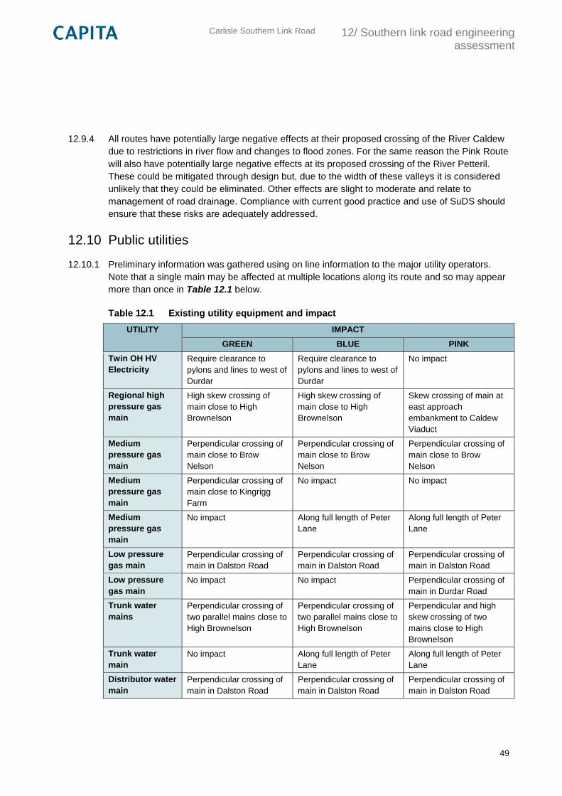
Carlisle Southern Link Road
12/ Southern link road engineering assessment
49
12.9.4 All routes have potentially large negative effects at their proposed crossing of the River Caldew
due to restrictions in river flow and changes to flood zones. For the same reason the Pink Route
will also have potentially large negative effects at its proposed crossing of the River Petteril.
These could be mitigated through design but, due to the width of these valleys it is considered
unlikely that they could be eliminated. Other effects are slight to moderate and relate to
management of road drainage. Compliance with current good practice and use of SuDS should
ensure that these risks are adequately addressed.
12.10 Public utilities
12.10.1 Preliminary information was gathered using on line information to the major utility operators.
Note that a single main may be affected at multiple locations along its route and so may appear
more than once in Table 12.1 below.
Table 12.1 Existing utility equipment and impact
UTILITY IMPACT
GREEN BLUE PINK
Twin OH HV
Electricity
Require clearance to
pylons and lines to west of
Durdar
Require clearance to
pylons and lines to west of
Durdar
No impact
Regional high
pressure gas
main
High skew crossing of
main close to High
Brownelson
High skew crossing of
main close to High
Brownelson
Skew crossing of main at
east approach
embankment to Caldew
Viaduct
Medium
pressure gas
main
Perpendicular crossing of
main close to Brow
Nelson
Perpendicular crossing of
main close to Brow
Nelson
Perpendicular crossing of
main close to Brow
Nelson
Medium
pressure gas
main
Perpendicular crossing of
main close to Kingrigg
Farm
No impact No impact
Medium
pressure gas
main
No impact Along full length of Peter
Lane
Along full length of Peter
Lane
Low pressure
gas main
Perpendicular crossing of
main in Dalston Road
Perpendicular crossing of
main in Dalston Road
Perpendicular crossing of
main in Dalston Road
Low pressure
gas main
No impact No impact Perpendicular crossing of
main in Durdar Road
Trunk water
mains
Perpendicular crossing of
two parallel mains close to
High Brownelson
Perpendicular crossing of
two parallel mains close to
High Brownelson
Perpendicular and high
skew crossing of two
mains close to High
Brownelson
Trunk water
main
No impact Along full length of Peter
Lane
Along full length of Peter
Lane
Distributor water
main
Perpendicular crossing of
main in Dalston Road
Perpendicular crossing of
main in Dalston Road
Perpendicular crossing of
main in Dalston Road
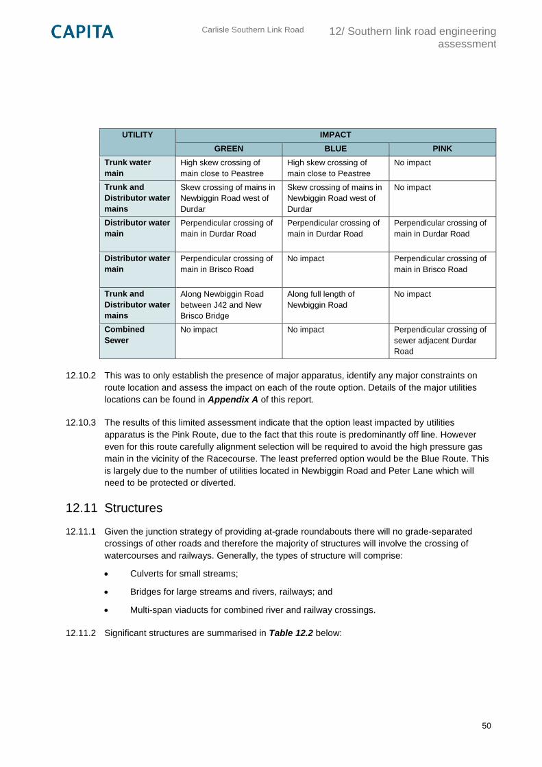
Carlisle Southern Link Road
12/ Southern link road engineering assessment
50
UTILITY IMPACT
GREEN BLUE PINK
Trunk water
main
High skew crossing of
main close to Peastree
High skew crossing of
main close to Peastree
No impact
Trunk and
Distributor water
mains
Skew crossing of mains in
Newbiggin Road west of
Durdar
Skew crossing of mains in
Newbiggin Road west of
Durdar
No impact
Distributor water
main
Perpendicular crossing of
main in Durdar Road
Perpendicular crossing of
main in Durdar Road
Perpendicular crossing of
main in Durdar Road
Distributor water
main
Perpendicular crossing of
main in Brisco Road
No impact Perpendicular crossing of
main in Brisco Road
Trunk and
Distributor water
mains
Along Newbiggin Road
between J42 and New
Brisco Bridge
Along full length of
Newbiggin Road
No impact
Combined
Sewer
No impact No impact Perpendicular crossing of
sewer adjacent Durdar
Road
12.10.2 This was to only establish the presence of major apparatus, identify any major constraints on
route location and assess the impact on each of the route option. Details of the major utilities
locations can be found in Appendix A of this report.
12.10.3 The results of this limited assessment indicate that the option least impacted by utilities
apparatus is the Pink Route, due to the fact that this route is predominantly off line. However
even for this route carefully alignment selection will be required to avoid the high pressure gas
main in the vicinity of the Racecourse. The least preferred option would be the Blue Route. This
is largely due to the number of utilities located in Newbiggin Road and Peter Lane which will
need to be protected or diverted.
12.11 Structures
12.11.1 Given the junction strategy of providing at-grade roundabouts there will no grade-separated
crossings of other roads and therefore the majority of structures will involve the crossing of
watercourses and railways. Generally, the types of structure will comprise:
Culverts for small streams;
Bridges for large streams and rivers, railways; and
Multi-span viaducts for combined river and railway crossings.
12.11.2 Significant structures are summarised in Table 12.2 below:
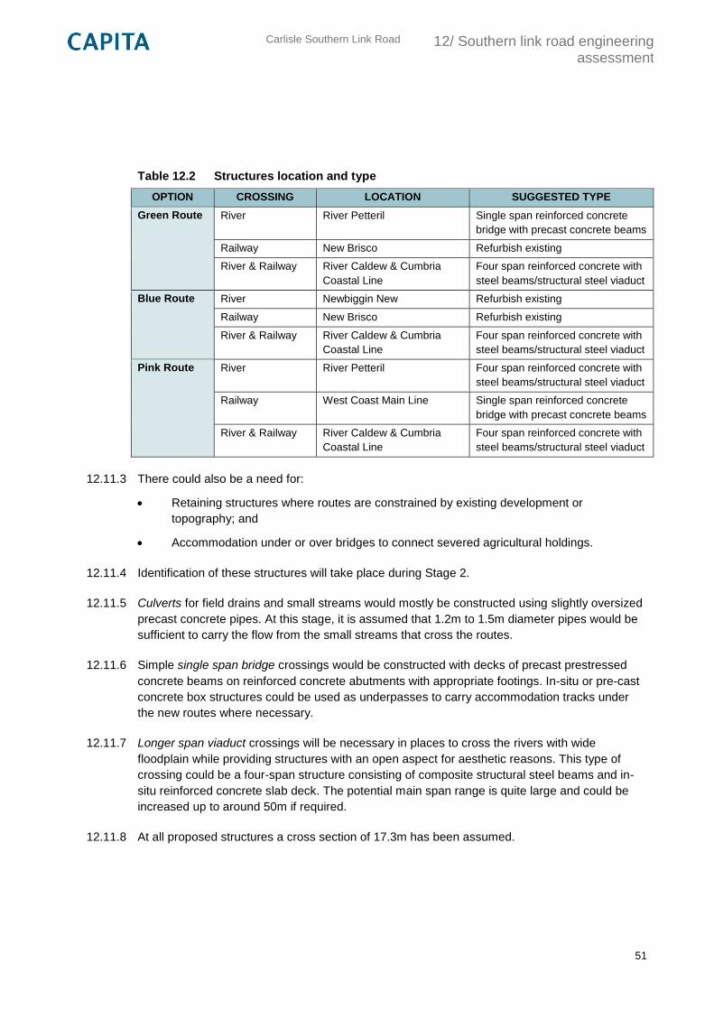
Carlisle Southern Link Road
12/ Southern link road engineering assessment
51
Table 12.2 Structures location and type
OPTION CROSSING LOCATION SUGGESTED TYPE
Green Route River River Petteril Single span reinforced concrete
bridge with precast concrete beams
Railway New Brisco Refurbish existing
River & Railway River Caldew & Cumbria
Coastal Line
Four span reinforced concrete with
steel beams/structural steel viaduct
Blue Route River Newbiggin New Refurbish existing
Railway New Brisco Refurbish existing
River & Railway River Caldew & Cumbria
Coastal Line
Four span reinforced concrete with
steel beams/structural steel viaduct
Pink Route River River Petteril Four span reinforced concrete with
steel beams/structural steel viaduct
Railway West Coast Main Line Single span reinforced concrete
bridge with precast concrete beams
River & Railway River Caldew & Cumbria
Coastal Line
Four span reinforced concrete with
steel beams/structural steel viaduct
12.11.3 There could also be a need for:
Retaining structures where routes are constrained by existing development or
topography; and
Accommodation under or over bridges to connect severed agricultural holdings.
12.11.4 Identification of these structures will take place during Stage 2.
12.11.5 Culverts for field drains and small streams would mostly be constructed using slightly oversized
precast concrete pipes. At this stage, it is assumed that 1.2m to 1.5m diameter pipes would be
sufficient to carry the flow from the small streams that cross the routes.
12.11.6 Simple single span bridge crossings would be constructed with decks of precast prestressed
concrete beams on reinforced concrete abutments with appropriate footings. In-situ or pre-cast
concrete box structures could be used as underpasses to carry accommodation tracks under
the new routes where necessary.
12.11.7 Longer span viaduct crossings will be necessary in places to cross the rivers with wide
floodplain while providing structures with an open aspect for aesthetic reasons. This type of
crossing could be a four-span structure consisting of composite structural steel beams and in-
situ reinforced concrete slab deck. The potential main span range is quite large and could be
increased up to around 50m if required.
12.11.8 At all proposed structures a cross section of 17.3m has been assumed.
Carlisle Southern Link Road
12/ Southern link road engineering assessment
52
12.11.9 The existing bridges on Newbiggin Road were designed for HA and 45 units HB loading and
previously assessed as capable of carrying full Construction and Use loading. They are:
Newbiggin New: The superstructure consists of 26 No. precast prestressed concrete
Dowmac ‘Eagle’ beams placed contiguously and in filled with concrete to form a solid
slab deck. The deck is simply supported on two reinforced concrete abutment walls which
cantilever vertically from reinforced concrete base slabs supported on piled foundations.
New Brisco Railway: A deck comprising 30 No. PSC beams with solid concrete infill
simply supported on two reinforced concrete abutment walls which cantilever vertically
from reinforced concrete base slabs.
12.11.10 They are likely to require an element of refurbishment or upgrade within the on-line sections of
the Green and Blue routes depending on their condition, load capacity and the selected road
cross section. Initial information provided by the County Council in the form of General and
Principal Inspection Reports for Newbiggin New and a General Inspection Report for New
Brisco indicate that both structures are in reasonable condition and stable with no significant
visible defects. Further more detailed assessment will be required at Stage 2.
12.12 Other constraints
12.12.1 The only other major constraint to route options is the location of the Carlisle Racecourse at
Durdar. Due to its location and the density of development immediately to the north of the race
course all three route options taken to further appraisal run to the south of the race course.
Carlisle Southern Link Road
13/ Southern link road environmental impact appraisal
53
13. Southern link road environmental impact appraisal
13.1 Introduction and context
13.1.1 This chapter presents findings of the Transport Analysis Guidance (TAG) Part 1 Environmental
Impact Appraisal which draws on guidance provided in the Design Manual for Roads and
Bridges (DMRB), Volume 11.
13.1.2 The aim of the TAG Part 1 Appraisal is to enable a comparison of alternative route options,
ensuring that those taken forward for detailed appraisal in Stage 2 have been initially sifted to
establish satisfactory value for money and/or deliverability. The Environmental Impact Appraisal
forms part of this process and focuses on the impact of the transport proposals on the built and
natural environment, and on people.
13.1.3 Three route options for the Carlisle Southern Link Road have been assessed and are presented
in this report. These options have been sifted down in number from a wide range of alternatives
through consultation with key stakeholders. Details of this process are provided in 10 of this
report.
Approach to assessment
13.1.4 The approach to assessment follows guidance outlined in TAG ‘The Transport Appraisal
Process’, TAG Unit A3 ‘Environmental Impact Appraisal’ and topic specific chapters in DMRB
Volume 11. Where appropriate other industry best practice guidance has been referred to and
commentary provided in the relevant sections of this report.
13.1.5 In accordance with the guidance and project brief provided by the Overseeing Organisation
(Cumbria County Council), the assessment considers impacts of the proposals under a number
of environmental topic areas. These are as follows:
Noise
Air quality
Landscape and visual
Historic environment
Nature conservation
Water environment
Outdoor access and recreation
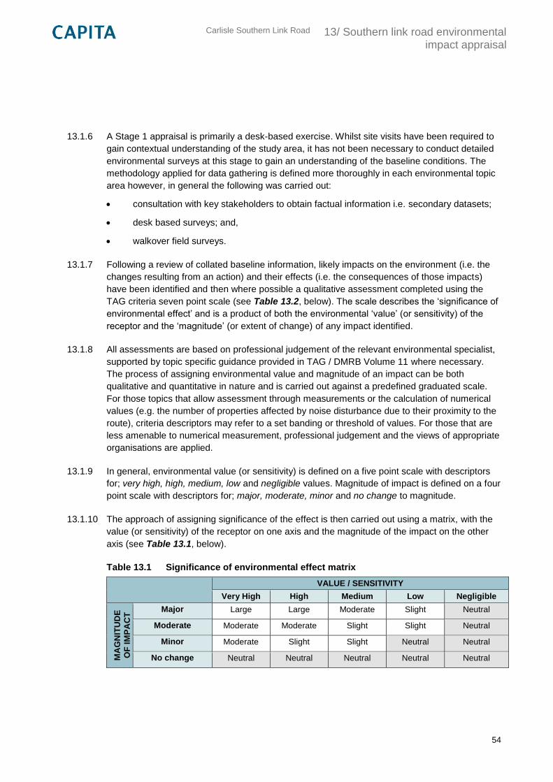
Carlisle Southern Link Road
13/ Southern link road environmental impact appraisal
54
13.1.6 A Stage 1 appraisal is primarily a desk-based exercise. Whilst site visits have been required to
gain contextual understanding of the study area, it has not been necessary to conduct detailed
environmental surveys at this stage to gain an understanding of the baseline conditions. The
methodology applied for data gathering is defined more thoroughly in each environmental topic
area however, in general the following was carried out:
consultation with key stakeholders to obtain factual information i.e. secondary datasets;
desk based surveys; and,
walkover field surveys.
13.1.7 Following a review of collated baseline information, likely impacts on the environment (i.e. the
changes resulting from an action) and their effects (i.e. the consequences of those impacts)
have been identified and then where possible a qualitative assessment completed using the
TAG criteria seven point scale (see Table 13.2, below). The scale describes the ‘significance of
environmental effect’ and is a product of both the environmental ‘value’ (or sensitivity) of the
receptor and the ‘magnitude’ (or extent of change) of any impact identified.
13.1.8 All assessments are based on professional judgement of the relevant environmental specialist,
supported by topic specific guidance provided in TAG / DMRB Volume 11 where necessary.
The process of assigning environmental value and magnitude of an impact can be both
qualitative and quantitative in nature and is carried out against a predefined graduated scale.
For those topics that allow assessment through measurements or the calculation of numerical
values (e.g. the number of properties affected by noise disturbance due to their proximity to the
route), criteria descriptors may refer to a set banding or threshold of values. For those that are
less amenable to numerical measurement, professional judgement and the views of appropriate
organisations are applied.
13.1.9 In general, environmental value (or sensitivity) is defined on a five point scale with descriptors
for; very high, high, medium, low and negligible values. Magnitude of impact is defined on a four
point scale with descriptors for; major, moderate, minor and no change to magnitude.
13.1.10 The approach of assigning significance of the effect is then carried out using a matrix, with the
value (or sensitivity) of the receptor on one axis and the magnitude of the impact on the other
axis (see Table 13.1, below).
Table 13.1 Significance of environmental effect matrix
VALUE / SENSITIVITY
Very High High Medium Low Negligible
MA
GN
ITU
DE
OF
IM
PA
CT
Major Large Large Moderate Slight Neutral
Moderate Moderate Moderate Slight Slight Neutral
Minor Moderate Slight Slight Neutral Neutral
No change Neutral Neutral Neutral Neutral Neutral
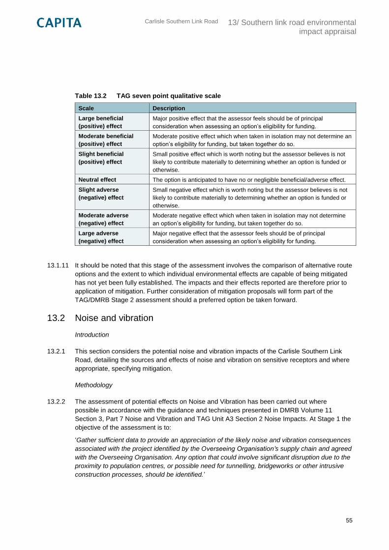
Carlisle Southern Link Road
13/ Southern link road environmental impact appraisal
55
Table 13.2 TAG seven point qualitative scale
Scale Description
Large beneficial
(positive) effect
Major positive effect that the assessor feels should be of principal
consideration when assessing an option’s eligibility for funding.
Moderate beneficial
(positive) effect
Moderate positive effect which when taken in isolation may not determine an
option’s eligibility for funding, but taken together do so.
Slight beneficial
(positive) effect
Small positive effect which is worth noting but the assessor believes is not
likely to contribute materially to determining whether an option is funded or
otherwise.
Neutral effect The option is anticipated to have no or negligible beneficial/adverse effect.
Slight adverse
(negative) effect
Small negative effect which is worth noting but the assessor believes is not
likely to contribute materially to determining whether an option is funded or
otherwise.
Moderate adverse
(negative) effect
Moderate negative effect which when taken in isolation may not determine
an option’s eligibility for funding, but taken together do so.
Large adverse
(negative) effect
Major negative effect that the assessor feels should be of principal
consideration when assessing an option’s eligibility for funding.
13.1.11 It should be noted that this stage of the assessment involves the comparison of alternative route
options and the extent to which individual environmental effects are capable of being mitigated
has not yet been fully established. The impacts and their effects reported are therefore prior to
application of mitigation. Further consideration of mitigation proposals will form part of the
TAG/DMRB Stage 2 assessment should a preferred option be taken forward.
13.2 Noise and vibration
Introduction
13.2.1 This section considers the potential noise and vibration impacts of the Carlisle Southern Link
Road, detailing the sources and effects of noise and vibration on sensitive receptors and where
appropriate, specifying mitigation.
Methodology
13.2.2 The assessment of potential effects on Noise and Vibration has been carried out where
possible in accordance with the guidance and techniques presented in DMRB Volume 11
Section 3, Part 7 Noise and Vibration and TAG Unit A3 Section 2 Noise Impacts. At Stage 1 the
objective of the assessment is to:
‘Gather sufficient data to provide an appreciation of the likely noise and vibration consequences
associated with the project identified by the Overseeing Organisation’s supply chain and agreed
with the Overseeing Organisation. Any option that could involve significant disruption due to the
proximity to population centres, or possible need for tunnelling, bridgeworks or other intrusive
construction processes, should be identified.’
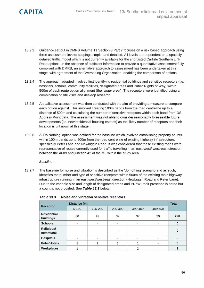
Carlisle Southern Link Road
13/ Southern link road environmental impact appraisal
56
13.2.3 Guidance set out in DMRB Volume 11 Section 3 Part 7 focuses on a risk based approach using
three assessment levels: scoping; simple; and detailed. All levels are dependent on a spatially
detailed traffic model which is not currently available for the shortlisted Carlisle Southern Link
Road options. In the absence of sufficient information to provide a quantitative assessment fully
compliant with DMRB, an alternative approach to assessment has been undertaken at this
stage, with agreement of the Overseeing Organisation, enabling the comparison of options.
13.2.4 The approach adopted involved first identifying residential buildings and sensitive receptors (i.e.
hospitals, schools, community facilities, designated areas and Public Rights of Way) within
500m of each route option alignment (the ‘study area’). The receptors were identified using a
combination of site visits and desktop research.
13.2.5 A qualitative assessment was then conducted with the aim of providing a measure to compare
each option against. This involved creating 100m bands from the road centreline up to a
distance of 500m and calculating the number of sensitive receptors within each band from OS
Address Point data. The assessment was not able to consider reasonably foreseeable future
developments (i.e. new residential housing estates) as the likely number of receptors and their
location is unknown at this stage.
13.2.6 A ‘Do Nothing’ option was defined for the baseline which involved establishing property counts
within 100m bands up to 500m from the road centreline of existing highway infrastructure,
specifically Peter Lane and Newbiggin Road. It was considered that these existing roads were
representative of routes currently used for traffic travelling in an east-west/ west-east direction
between the A689 and junction 42 of the M6 within the study area.
Baseline
13.2.7 The baseline for noise and vibration is described as the ‘do nothing’ scenario and as such,
identifies the number and type of sensitive receptors within 500m of the existing main highway
infrastructure running in an east-west/west-east direction (Newbiggin Road and Peter Lane).
Due to the variable size and length of designated areas and PRoW, their presence is noted but
a count is not provided. See Table 13.3 below.
Table 13.3 Noise and vibration sensitive receptors
Receptor Distance (m) Total
0-100 100-200 200-300 300-400 400-500
Residential
buildings 80 42 32 37 29 220
Schools - - - - - 0
Religious/
communal - - - - - 0
Hospitals - - - - - 0
Pubs/Hotels 2 1 1 1 - 5
Workplaces 1 - - 2 - 3
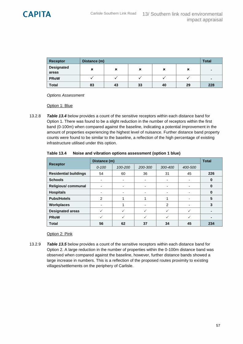
Carlisle Southern Link Road
13/ Southern link road environmental impact appraisal
57
Receptor Distance (m) Total
Designated
areas -
PRoW -
Total 83 43 33 40 29 228
Options Assessment
Option 1: Blue
13.2.8 Table 13.4 below provides a count of the sensitive receptors within each distance band for
Option 1. There was found to be a slight reduction in the number of receptors within the first
band (0-100m) when compared against the baseline, indicating a potential improvement in the
amount of properties experiencing the highest level of nuisance. Further distance band property
counts were found to be similar to the baseline, a reflection of the high percentage of existing
infrastructure utilised under this option.
Table 13.4 Noise and vibration options assessment (option 1 blue)
Receptor Distance (m) Total
0-100 100-200 200-300 300-400 400-500
Residential buildings 54 60 36 31 45 226
Schools - - - - - 0
Religious/ communal - - - - - 0
Hospitals - - - - - 0
Pubs/Hotels 2 1 1 1 - 5
Workplaces - 1 - 2 - 3
Designated areas -
PRoW -
Total 56 62 37 34 45 234
Option 2: Pink
13.2.9 Table 13.5 below provides a count of the sensitive receptors within each distance band for
Option 2. A large reduction in the number of properties within the 0-100m distance band was
observed when compared against the baseline, however, further distance bands showed a
large increase in numbers. This is a reflection of the proposed routes proximity to existing
villages/settlements on the periphery of Carlisle.
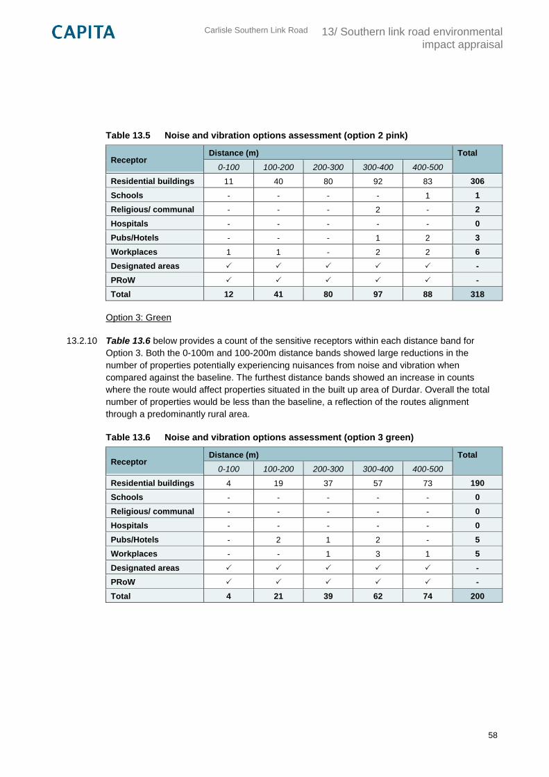
Carlisle Southern Link Road
13/ Southern link road environmental impact appraisal
58
Table 13.5 Noise and vibration options assessment (option 2 pink)
Receptor Distance (m) Total
0-100 100-200 200-300 300-400 400-500
Residential buildings 11 40 80 92 83 306
Schools - - - - 1 1
Religious/ communal - - - 2 - 2
Hospitals - - - - - 0
Pubs/Hotels - - - 1 2 3
Workplaces 1 1 - 2 2 6
Designated areas -
PRoW -
Total 12 41 80 97 88 318
Option 3: Green
13.2.10 Table 13.6 below provides a count of the sensitive receptors within each distance band for
Option 3. Both the 0-100m and 100-200m distance bands showed large reductions in the
number of properties potentially experiencing nuisances from noise and vibration when
compared against the baseline. The furthest distance bands showed an increase in counts
where the route would affect properties situated in the built up area of Durdar. Overall the total
number of properties would be less than the baseline, a reflection of the routes alignment
through a predominantly rural area.
Table 13.6 Noise and vibration options assessment (option 3 green)
Receptor Distance (m) Total
0-100 100-200 200-300 300-400 400-500
Residential buildings 4 19 37 57 73 190
Schools - - - - - 0
Religious/ communal - - - - - 0
Hospitals - - - - - 0
Pubs/Hotels - 2 1 2 - 5
Workplaces - - 1 3 1 5
Designated areas -
PRoW -
Total 4 21 39 62 74 200
Carlisle Southern Link Road
13/ Southern link road environmental impact appraisal
59
Mitigation
13.2.11 Possible mitigation measures to reduce noise and vibration effects and to be taken forward into
the next stages of design and assessment include:
Horizontal/Vertical alignment – move route away from sensitive receptors, keep route
low within the natural topography to exploit any natural screening and enhancing this by
the use of cuttings;
Environmental barriers – in the form of earth mounding or acoustic fencing or a
combination of the two;
Low noise surfaces – to reduce higher frequency noise generated by tyres at speeds in
excess of 75km/hr; and,
Speed and volume restrictions –above 40km/hr noise levels of travelling vehicles
increase with speed. Similarly, volume and composition of traffic will directly influence the
noise level.
Summary
13.2.12 The assessment of noise and vibration has considered possible nuisances on sensitive
receptors within 500m of the existing and proposed route alignments. In the absence of a
spatially detailed traffic model the assessment has been designed to allow a comparison of
route options through the calculation of property counts.
13.2.13 Option 2 showed the largest overall increase in the number of sensitive receptors potentially
affected by noise and vibration when compared against the baseline. This option has therefore
been identified as the least preferred.
13.2.14 Option 1 is identified as the intermediate option as only a small increase in the number of
properties was observed when compared against the baseline, with a reduction in the band up
to 100m.
13.2.15 Option 3 showed large reductions in the first two bands (0-100m and 100-200m), a reflection of
the routes alignment through a predominantly rural area. This option has been selected as the
preferred. See Table 13.7 below for a summary.
Table 13.7 Noise and vibration preferred option summary
Option Preferred Option Intermediate Option Least Preferred Option
1 (Blue)
2 (Pink)
3 (Green)
Carlisle Southern Link Road
13/ Southern link road environmental impact appraisal
60
13.3 Air quality
Introduction
13.3.1 This section considers the potential impacts of the Carlisle Southern Link Road on local air
quality, detailing likely sources and the effects on sensitive receptors and where appropriate,
specifying mitigation. Wider impacts on regional/national air quality are not considered as they
are beyond the scope of this assessment.
Methodology
13.3.2 The assessment of potential effects on local air quality has been carried out where possible in
accordance with the guidance and techniques presented in DMRB Volume 11 Section 3, Part 1
‘Air Quality’ and TAG Unit A3. At Stage 1 the objective of the assessment is to:
‘...indicate whether there are likely to be significant impacts associated with particular broadly
defined routes or corridors, as developed by the design organisation and the Overseeing
Organisation.’
13.3.3 Guidance set out in DMRB Volume 11 Section 3 Part 1 focuses on a risk based approach using
three assessment levels: scoping; simple; and detailed. All levels are dependent on a spatially
detailed traffic model which is not currently available for the shortlisted Carlisle Southern Link
options. In the absence of sufficient information to provide a quantitative assessment fully
compliant with DMRB, an alternative approach to assessment has been undertaken at this
stage with agreement of the Overseeing Organisation enabling the comparison of options.
13.3.4 The stage 1 assessment for local air quality includes:
The preparation of a map showing properties which may potentially experience a change
in local air quality within 200m of the existing and proposed alignments. Particularly
sensitive properties, such as those containing the young, elderly or vulnerable (i.e.
schools and hospitals) are highlighted. Designated nature conservation sites are also
marked due to their possible sensitivity to air pollutants (i.e. SACs, SPAs, and SSSIs);
and,
A count of the number of properties within 200m from the road centreline for the existing
and proposed alignments, separated into 50m incremental bands, using OS Address
Point data.
13.3.5 The assessment was not able to consider reasonably foreseeable future developments (i.e.
new residential housing estates) as the likely number of receptors and their location is unknown
at this stage.
Carlisle Southern Link Road
13/ Southern link road environmental impact appraisal
61
Baseline
13.3.6 The baseline condition is defined by establishing property counts within bands of 50m up to
200m from the road centreline of the existing highway infrastructure. This includes existing
routes which run generally in an east-west / west-east direction, specifically Peter Lane and
Newbiggin Road. Due to the variable size and length of designated areas, their presence is
noted but a count is not provided. See Table 13.8 below.
Table 13.8 Air quality sensitive receptors
Receptor Distance (m) Total
0-50 50-100 100-150 150-200
Residential buildings 52 31 23 22 128
Schools - - - - 0
Hospitals - - - - 0
Designated areas -
Total 52 31 23 22 128
Options Assessment
Option 1: Blue
13.3.7 Table 13.9 below provides a count of the sensitive receptors within each distance band for
Option 1. There was found to be a reduction in the number of receptors within the first band (0-
50m) when compared against the baseline, indicating a potential improvement in the amount of
properties experiencing the highest level of impact on air quality. Other distance band property
counts were found to be similar to, or slightly higher than the baseline, a reflection of the high
percentage of existing infrastructure utilised under this option.
Table 13.9 Air quality options assessment (option 1 blue)
Receptor Distance (m) Total
0-50 50-100 100-150 150-200
Residential buildings 17 39 30 34 120
Schools - - - - 0
Hospitals - - - - 0
Designated areas -
Total 17 39 30 34 120
Carlisle Southern Link Road
13/ Southern link road environmental impact appraisal
62
Option 2: Pink
13.3.8 Table 13.10 below provides a count of the sensitive receptors within each distance band for
Option 2. A large reduction in the number of properties within the 0-50m and 50-100m distance
bands was observed when compared against the baseline however, other distance bands
showed comparable counts. Overall there was a reduction in the number of existing properties
potentially affected by air quality issues.
Table 13.10 Air quality options assessment (option 2 pink)
Receptor Distance (m) Total
0-50 50-100 100-150 150-200
Residential buildings 5 7 14 27 53
Schools - - - - 0
Hospitals - - - -- 0
Designated areas -
Total 5 7 14 27 53
Option 3: Green
13.3.9 Table 13.11 below provides a count of the sensitive receptors within each distance band for
Option 3. There were reductions observed in the number of properties across all bands when
compared against the baseline, particularly at the 0-50m, 50-100m and 100-150m distances.
Overall the total number of properties would be much less than the baseline, a reflection of the
routes alignment through a predominantly rural area.
Table 13.11 Air quality options assessment (option 3 green)
Receptor Distance (m) Total
0-50 50-100 100-150 150-200
Residential buildings 1 3 6 15 25
Schools - - - - 0
Hospitals - - - - 0
Designated areas -
Total 1 3 6 15 25
Mitigation
13.3.10 Possible mitigation measures to reduce effects on local air quality and to be taken forward into
the next stages of design and assessment include:
Route alignment – move route away from sensitive receptors, orientate the road relative
to prevailing winds, locate junctions and intersections away from sensitive locations and
place the road in a cutting or on an embankment to increase the distance between the
road and a sensitive receptor;
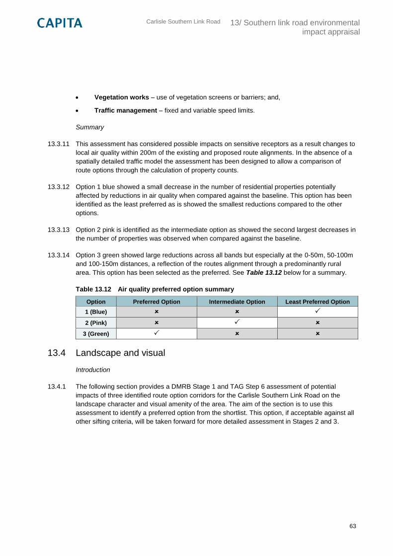
Carlisle Southern Link Road
13/ Southern link road environmental impact appraisal
63
Vegetation works – use of vegetation screens or barriers; and,
Traffic management – fixed and variable speed limits.
Summary
13.3.11 This assessment has considered possible impacts on sensitive receptors as a result changes to
local air quality within 200m of the existing and proposed route alignments. In the absence of a
spatially detailed traffic model the assessment has been designed to allow a comparison of
route options through the calculation of property counts.
13.3.12 Option 1 blue showed a small decrease in the number of residential properties potentially
affected by reductions in air quality when compared against the baseline. This option has been
identified as the least preferred as is showed the smallest reductions compared to the other
options.
13.3.13 Option 2 pink is identified as the intermediate option as showed the second largest decreases in
the number of properties was observed when compared against the baseline.
13.3.14 Option 3 green showed large reductions across all bands but especially at the 0-50m, 50-100m
and 100-150m distances, a reflection of the routes alignment through a predominantly rural
area. This option has been selected as the preferred. See Table 13.12 below for a summary.
Table 13.12 Air quality preferred option summary
Option Preferred Option Intermediate Option Least Preferred Option
1 (Blue)
2 (Pink)
3 (Green)
13.4 Landscape and visual
Introduction
13.4.1 The following section provides a DMRB Stage 1 and TAG Step 6 assessment of potential
impacts of three identified route option corridors for the Carlisle Southern Link Road on the
landscape character and visual amenity of the area. The aim of the section is to use this
assessment to identify a preferred option from the shortlist. This option, if acceptable against all
other sifting criteria, will be taken forward for more detailed assessment in Stages 2 and 3.
Carlisle Southern Link Road
13/ Southern link road environmental impact appraisal
64
Methodology
13.4.2 The assessment of potential effects on the landscape and visual amenity of the area has been
carried out in accordance with the guidance and techniques presented in DMRB Volume 11
Section 3 Part 5 “Landscape Effects” and TAG Unit A3. Other references used to inform this
section include: the Guidelines for Landscape and Visual Impact Assessment (Third Edition) by
the Landscape Institute and Institute of Environmental Management & Assessment; Natural
England’s National Character Area profile 6: Solway Basin; and Cumbria Landscape Character
Guidance.
13.4.3 The Study Boundary is highlighted on Plan CSDR-CAP-EGN-00-DR-V-0002 in Appendix E
and defines a broad corridor between the A595 and the M6 for route options to fall within. The
study boundary was identified at Step 4b in TAG process following identification of the scheme
objectives.
13.4.4 To begin the study, an understanding of the environmental baseline was achieved through a
combination of desk study research, collaborative workshops and a site visit. This enabled an
appreciation of landscape character, keys views and any constraints to development from a
landscape and visual perspective.
13.4.5 The key landscape and visual receptors within the study area identified through the desk study
and site were then assigned an environmental value, indicating their sensitivity. To ensure that
subjective decisions were undertaken in a consistent way and to clarify reasons for judgements,
these values were based upon descriptors provided in Appendix A, which have been
developed from Interim Advice Note 135/10 “Landscape and Visual Effects Assessment”,
November 2010.
13.4.6 A number of key visual receptors have been identified within the study area and include:
residents of the major settlements (Cummersdale, Durdar, Brisco and Carleton); residents of
isolated rural dwellings; recreational users of Public Rights of Way (PRoW), waterways, open
spaces and cycle routes. The photographs that illustrate these can be found in Appendix F.
13.4.7 Next, an options appraisal identified the impacts, effects, magnitude and the overall significance
of the effects resulting from each of the three options, using the matrix shown in Table 13.1.
This was supported by commentary text that have been summarised by a series of tables. The
TAG seven point qualitative scale was used to provide a consistent method of assessment.
13.4.8 Mitigation measures and recommendations have been outlined with the aim of reducing the
impacts of any significant effects resulting from the proposed development. This has largely
been influenced by the Guidelines produced by Cumbria County Council within their Landscape
Character Guidance documents, as well as considerations following the team site visit.
13.4.9 The Landscape and Visual Impact Appraisal concludes by providing a brief summary of the
findings within this section and provided an indication of the preferred option based on the
overall findings of the study.
Carlisle Southern Link Road
13/ Southern link road environmental impact appraisal
65
Baseline
Landscape character
13.4.10 The study area is located within National Character Area 6: Solway Basin, however, more
accurate descriptions of the landscape character types are summarised in Cumbria County
Council’s “Cumbria Landscape Character Guidance” (2011). The boundaries of these
Landscape Character Types can be found in CSDR-CAP-EGN-00-DR-V-0004 in Appendix E,
North Cumbria, Carlisle and The Borders, which shows the study area for the Carlisle Southern
Link Road to comprise of: “5a. Ridge and Valley” to the west of the study area around
Cummersdale; “5b. Low Farmland” which covers most of the study boundary around Durdar
and Brisco; and “5d. Urban Fringe” to the very north of the study area, around Carlisle
Racecourse.
13.4.11 The western portion of the study area is described as “5a. Ridge and Valley” landscape. The
key characteristics of this landscape character type are described as:
A series of ridges and valleys that rises gently toward the limestone fringes of the
Lakeland fells;
Well managed, regular shaped medium to large pasture fields;
Hedge bound pasture fields dominate, interspersed with native woodland, tree clumps
and plantations;
Scattered farms and linear villages found along ridges; and,
Large scale structures generally scarce.
13.4.12 The most valuable features of this landscape character type are the strong field patterns of the
well managed pastoral land; the species rich hedgerows that define these boundaries; the
pockets of interspersed native broadleaf woodland and shelterbelts, as well as conifer
plantations which provide important habitat for red squirrels; the dispersed farm settlements that
are modest in size and sit discretely within the landscape; linear settlements along ridge tops
that are sensitive to expansion; and the open and interrupted views from ridge tops to the
Solway Firth and Lakeland fells. The pleasant, peaceful atmosphere of the pastoral working
farmed landscape is a key characteristic of this local area and will be sensitive to change. This
character area has been identified to have a moderate sensitivity, due to the absence of any
landscape statutory designations but the strong landscape character that is apparent through
much of the study area, consequently meaning that the area would not adapt well to the
introduction of a major new road.
13.4.13 The eastern portion of the study area is described as “5b. Low Farmland” landscape. The key
characteristics of this landscape character type are described as:
Undulating and rolling topography;
Intensely farmed agricultural pasture dominates;
Carlisle Southern Link Road
13/ Southern link road environmental impact appraisal
66
Patchy areas of woodland provide contrast to the pasture;
Fields are large and rectangular; and,
Hedges, hedgerow trees and fences bound fields and criss-cross up and over the rolling
landscape.
13.4.14 The most valuable features of this landscape character type are the matrix of interlocking
hedgerows, woodlands and trees along rivers and fields that provide interest to the open views
of the relatively flat pastoral landscape; the traditional feel of villages and interspersed farms are
sensitive to village expansion and urbanisation. This character area has been identified to have
a moderate sensitivity, due to the absence of any landscape statutory designations but the
strong landscape character that is apparent through much of the study area, consequently
meaning that the area would not adapt well to the introduction of a major new road.
13.4.15 The only option likely to lie within area type “5d. Urban Fringe” to the very north of the study
area is Option 2, which is shown to be close to Carlisle Racecourse. The key characteristics of
this landscape character type are described as:
Long term urban influences on agricultural land;
Recreation, large scale buildings and industrial estates are common; and,
Wooded valleys, restored woodland and some semi-urbanised woodland provide interest.
13.4.16 The most valuable features of this landscape character type are the areas of woodland in
valleys, restored woodland and some semi urbanised woodland; the intact field patterns defined
by hedges and hedgerow trees; and fields close to settlement boundaries are sensitive to
development. This character area has been identified to have a low sensitivity, due to the
absence of any landscape statutory designations and the more urban characteristics of this
area meaning it would be more likely to adapt to the introduction of a major new road.
13.4.17 For all the landscape character areas mentioned in the sections above, however, it must be
recognised that mitigation could in part be achieved by developing the route in tandem for the
masterplan for the wider site, a key component of which will be an appropriate and effective
green infrastructure framework.
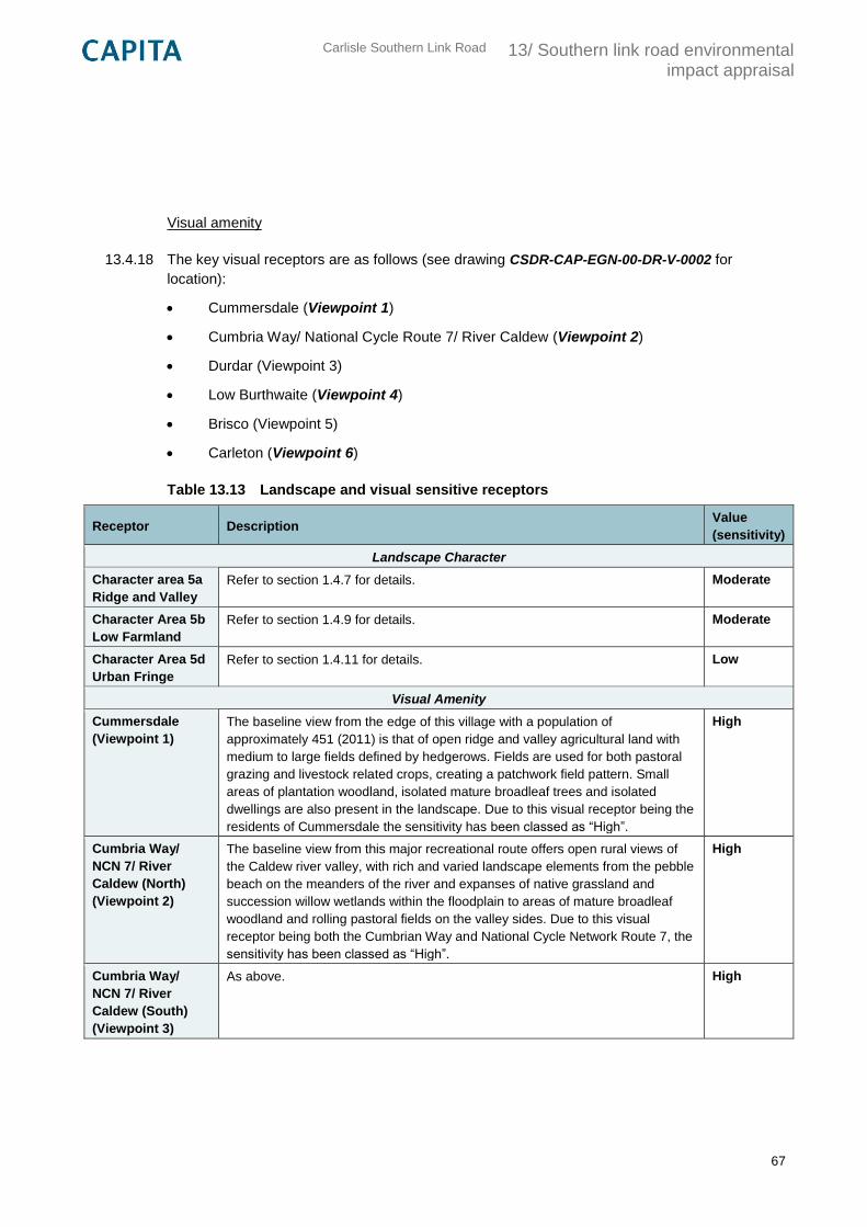
Carlisle Southern Link Road
13/ Southern link road environmental impact appraisal
67
Visual amenity
13.4.18 The key visual receptors are as follows (see drawing CSDR-CAP-EGN-00-DR-V-0002 for
location):
Cummersdale (Viewpoint 1)
Cumbria Way/ National Cycle Route 7/ River Caldew (Viewpoint 2)
Durdar (Viewpoint 3)
Low Burthwaite (Viewpoint 4)
Brisco (Viewpoint 5)
Carleton (Viewpoint 6)
Table 13.13 Landscape and visual sensitive receptors
Receptor Description Value
(sensitivity)
Landscape Character
Character area 5a
Ridge and Valley
Refer to section 1.4.7 for details. Moderate
Character Area 5b
Low Farmland
Refer to section 1.4.9 for details. Moderate
Character Area 5d
Urban Fringe
Refer to section 1.4.11 for details. Low
Visual Amenity
Cummersdale
(Viewpoint 1)
The baseline view from the edge of this village with a population of
approximately 451 (2011) is that of open ridge and valley agricultural land with
medium to large fields defined by hedgerows. Fields are used for both pastoral
grazing and livestock related crops, creating a patchwork field pattern. Small
areas of plantation woodland, isolated mature broadleaf trees and isolated
dwellings are also present in the landscape. Due to this visual receptor being the
residents of Cummersdale the sensitivity has been classed as “High”.
High
Cumbria Way/
NCN 7/ River
Caldew (North)
(Viewpoint 2)
The baseline view from this major recreational route offers open rural views of
the Caldew river valley, with rich and varied landscape elements from the pebble
beach on the meanders of the river and expanses of native grassland and
succession willow wetlands within the floodplain to areas of mature broadleaf
woodland and rolling pastoral fields on the valley sides. Due to this visual
receptor being both the Cumbrian Way and National Cycle Network Route 7, the
sensitivity has been classed as “High”.
High
Cumbria Way/
NCN 7/ River
Caldew (South)
(Viewpoint 3)
As above.
High
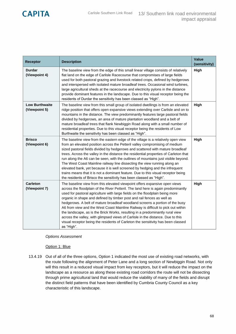
Carlisle Southern Link Road
13/ Southern link road environmental impact appraisal
68
Receptor Description Value
(sensitivity)
Durdar
(Viewpoint 4)
The baseline view from the edge of this small linear village consists of relatively
flat land on the edge of Carlisle Racecourse that compromises of large fields
used for both pastoral grazing and livestock related crops, defined by hedgerows
and interspersed with isolated mature broadleaf trees. Occasional wind turbines,
large agricultural sheds at the racecourse and electricity pylons in the distance
provide dominant features in the landscape. Due to this visual receptor being the
residents of Durdar the sensitivity has been classed as “High”.
High
Low Burthwaite
(Viewpoint 5)
The baseline view from this small group of isolated dwellings is from an elevated
ridge position that offers open expansive views extending over Carlisle and on to
mountains in the distance. The view predominantly features large pastoral fields
divided by hedgerows, an area of mature plantation woodland and a belt of
mature broadleaf trees that flank Newbiggin Road along with a small number of
residential properties. Due to this visual receptor being the residents of Low
Burthwaite the sensitivity has been classed as “High”.
High
Brisco
(Viewpoint 6)
The baseline view from the eastern edge of the village is a relatively open view
from an elevated position across the Petteril valley compromising of medium
sized pastoral fields divided by hedgerows and scattered with mature broadleaf
trees. Across the valley in the distance the residential properties of Carleton that
run along the A6 can be seen, with the outlines of mountains just visible beyond.
The West Coast Mainline railway line dissecting the view running along an
elevated bank, yet because it is well screened by hedging and the infrequent
trains means that it is not a dominant feature. Due to this visual receptor being
the residents of Brisco the sensitivity has been classed as “High”.
High
Carleton
(Viewpoint 7)
The baseline view from this elevated viewpoint offers expansive open views
across the floodplain of the River Petteril. The land here is again predominantly
used for pastoral agriculture with large fields on the floodplain being more
organic in shape and defined by timber post and rail fences as well as
hedgerows. A belt of mature broadleaf woodland screens a portion of the busy
A6 from view and the West Coast Mainline Railway is difficult to pick out within
the landscape, as is the Brick Works, resulting in a predominantly rural view
across the valley, with glimpsed views of Carlisle in the distance. Due to this
visual receptor being the residents of Carleton the sensitivity has been classed
as “High”.
High
Options Assessment
Option 1: Blue
13.4.19 Out of all of the three options, Option 1 indicated the most use of existing road networks, with
the route following the alignment of Peter Lane and a long section of Newbiggin Road. Not only
will this result in a reduced visual impact from key receptors, but it will reduce the impact on the
landscape as a resource as along these existing road corridors the route will not be dissecting
through prime agricultural land that would reduce the viability of many of the fields and disrupt
the distinct field patterns that have been identified by Cumbria County Council as a key
characteristic of this landscape.
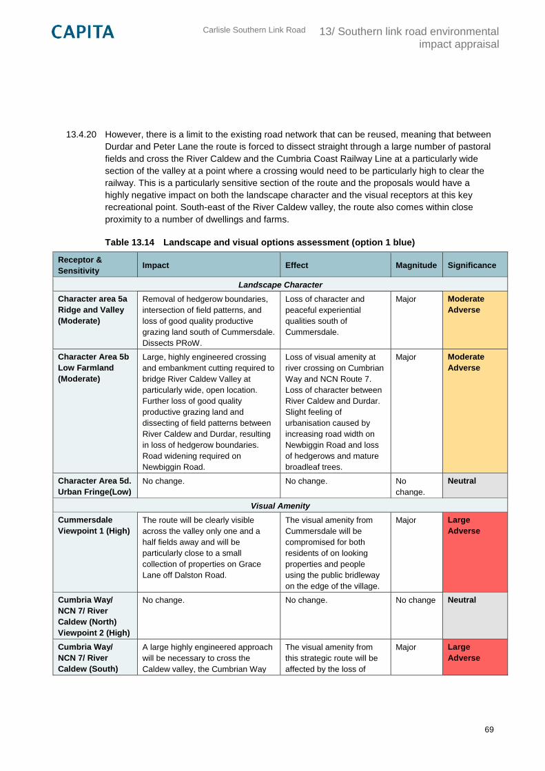
Carlisle Southern Link Road
13/ Southern link road environmental impact appraisal
69
13.4.20 However, there is a limit to the existing road network that can be reused, meaning that between
Durdar and Peter Lane the route is forced to dissect straight through a large number of pastoral
fields and cross the River Caldew and the Cumbria Coast Railway Line at a particularly wide
section of the valley at a point where a crossing would need to be particularly high to clear the
railway. This is a particularly sensitive section of the route and the proposals would have a
highly negative impact on both the landscape character and the visual receptors at this key
recreational point. South-east of the River Caldew valley, the route also comes within close
proximity to a number of dwellings and farms.
Table 13.14 Landscape and visual options assessment (option 1 blue)
Receptor &
Sensitivity Impact Effect Magnitude Significance
Landscape Character
Character area 5a
Ridge and Valley
(Moderate)
Removal of hedgerow boundaries,
intersection of field patterns, and
loss of good quality productive
grazing land south of Cummersdale.
Dissects PRoW.
Loss of character and
peaceful experiential
qualities south of
Cummersdale.
Major Moderate
Adverse
Character Area 5b
Low Farmland
(Moderate)
Large, highly engineered crossing
and embankment cutting required to
bridge River Caldew Valley at
particularly wide, open location.
Further loss of good quality
productive grazing land and
dissecting of field patterns between
River Caldew and Durdar, resulting
in loss of hedgerow boundaries.
Road widening required on
Newbiggin Road.
Loss of visual amenity at
river crossing on Cumbrian
Way and NCN Route 7.
Loss of character between
River Caldew and Durdar.
Slight feeling of
urbanisation caused by
increasing road width on
Newbiggin Road and loss
of hedgerows and mature
broadleaf trees.
Major Moderate
Adverse
Character Area 5d.
Urban Fringe(Low)
No change. No change. No
change.
Neutral
Visual Amenity
Cummersdale
Viewpoint 1 (High)
The route will be clearly visible
across the valley only one and a
half fields away and will be
particularly close to a small
collection of properties on Grace
Lane off Dalston Road.
The visual amenity from
Cummersdale will be
compromised for both
residents of on looking
properties and people
using the public bridleway
on the edge of the village.
Major Large
Adverse
Cumbria Way/
NCN 7/ River
Caldew (North)
Viewpoint 2 (High)
No change. No change. No change Neutral
Cumbria Way/
NCN 7/ River
Caldew (South)
A large highly engineered approach
will be necessary to cross the
Caldew valley, the Cumbrian Way
The visual amenity from
this strategic route will be
affected by the loss of
Major Large
Adverse
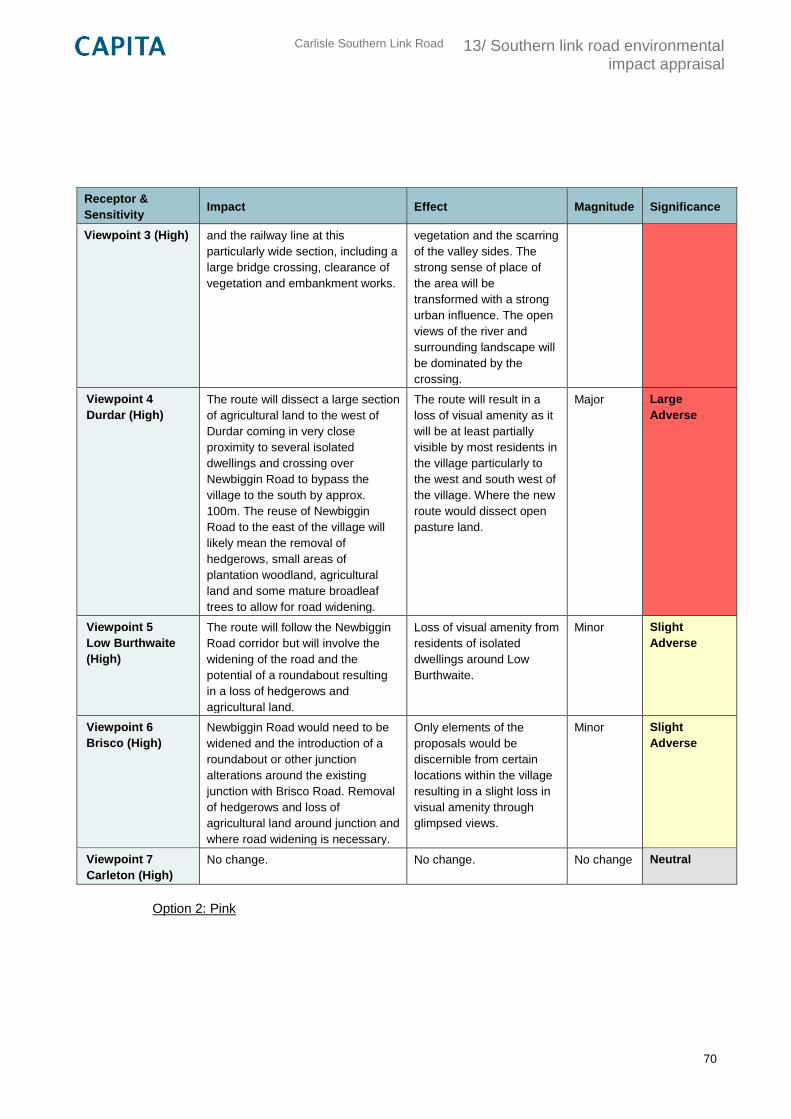
Carlisle Southern Link Road
13/ Southern link road environmental impact appraisal
70
Receptor &
Sensitivity Impact Effect Magnitude Significance
Viewpoint 3 (High) and the railway line at this
particularly wide section, including a
large bridge crossing, clearance of
vegetation and embankment works.
vegetation and the scarring
of the valley sides. The
strong sense of place of
the area will be
transformed with a strong
urban influence. The open
views of the river and
surrounding landscape will
be dominated by the
crossing.
Viewpoint 4
Durdar (High)
The route will dissect a large section
of agricultural land to the west of
Durdar coming in very close
proximity to several isolated
dwellings and crossing over
Newbiggin Road to bypass the
village to the south by approx.
100m. The reuse of Newbiggin
Road to the east of the village will
likely mean the removal of
hedgerows, small areas of
plantation woodland, agricultural
land and some mature broadleaf
trees to allow for road widening.
The route will result in a
loss of visual amenity as it
will be at least partially
visible by most residents in
the village particularly to
the west and south west of
the village. Where the new
route would dissect open
pasture land.
Major Large
Adverse
Viewpoint 5
Low Burthwaite
(High)
The route will follow the Newbiggin
Road corridor but will involve the
widening of the road and the
potential of a roundabout resulting
in a loss of hedgerows and
agricultural land.
Loss of visual amenity from
residents of isolated
dwellings around Low
Burthwaite.
Minor Slight
Adverse
Viewpoint 6
Brisco (High)
Newbiggin Road would need to be
widened and the introduction of a
roundabout or other junction
alterations around the existing
junction with Brisco Road. Removal
of hedgerows and loss of
agricultural land around junction and
where road widening is necessary.
Only elements of the
proposals would be
discernible from certain
locations within the village
resulting in a slight loss in
visual amenity through
glimpsed views.
Minor Slight
Adverse
Viewpoint 7
Carleton (High)
No change. No change. No change Neutral
Option 2: Pink
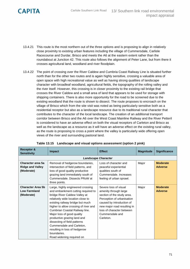
Carlisle Southern Link Road
13/ Southern link road environmental impact appraisal
71
13.4.21 This route is the most northern out of the three options and is proposing to align in relatively
close proximity to existing urban features including the village of Cummersdale, Carlisle
Racecourse and Durdar, Brisco and meets the A6 at the eastern extent rather than the
roundabout at Junction 42. This route also follows the alignment of Peter Lane, but from there it
crosses agricultural land, woodland and river floodplain.
13.4.22 The point of crossing over the River Caldew and Cumbria Coast Railway Line is situated further
north than for the other two routes and is again highly sensitive, crossing a valuable area of
open space with high recreational value as well as having strong qualities of landscape
character with broadleaf woodland, agricultural fields, the topography of the rolling valley and
the river itself. However, this crossing is in closer proximity to the existing rail bridge that
crosses the River Caldew and a small area of land that appears to be used for storage with
shipping containers. There is also more opportunity for the road to be screened due to the
existing woodland that the route is shown to dissect. The route proposes to encroach on the
village of Brisco which from the site visit was noted as being particularly sensitive both as a
residential receptor but also as a landscape resource due to its traditional rural character that
contributes to the character of the local landscape. The creation of an additional transport
corridor between Brisco and the A6 over the West Coast Mainline Railway and the River Petteril
is considered to have an adverse effect on both the visual receptors of Carleton and Brisco as
well as the landscape as a resource as it will have an adverse effect on the existing rural valley,
as the route is proposing to cross a point where the valley is particularly wide offering open
views of the river and surrounding pastoral land.
Table 13.15 Landscape and visual options assessment (option 2 pink)
Receptor &
Sensitivity Impact Effect Magnitude Significance
Landscape Character
Character area 5a
Ridge and Valley
(Moderate)
Removal of hedgerow boundaries,
intersection of field patterns, and
loss of good quality productive
grazing land immediately south of
Cummersdale. Dissects PRoW at
three points.
Loss of character and
peaceful experiential
qualities south of
Cummersdale. Increases
feeling of urban sprawl.
Major Moderate
Adverse
Character Area 5b
Low Farmland
(Moderate)
Large, highly engineered crossing
and embankment cutting required to
bridge River Caldew Valley at
relatively wide location close to
existing railway bridge but much
higher to allow crossing of river and
Cumbrian Coastal Railway line.
Major loss of good quality
productive grazing land and
dissecting of field patterns
Cummersdale and Carleton,
resulting in loss of hedgerow
boundaries.
Road widening required on
Severe loss of visual
amenity through large
section of the study area.
Perception of urbanisation
caused by introduction of
new major road resulting in
loss of character between
Cummersdale and
Carleton.
Major Moderate
Adverse
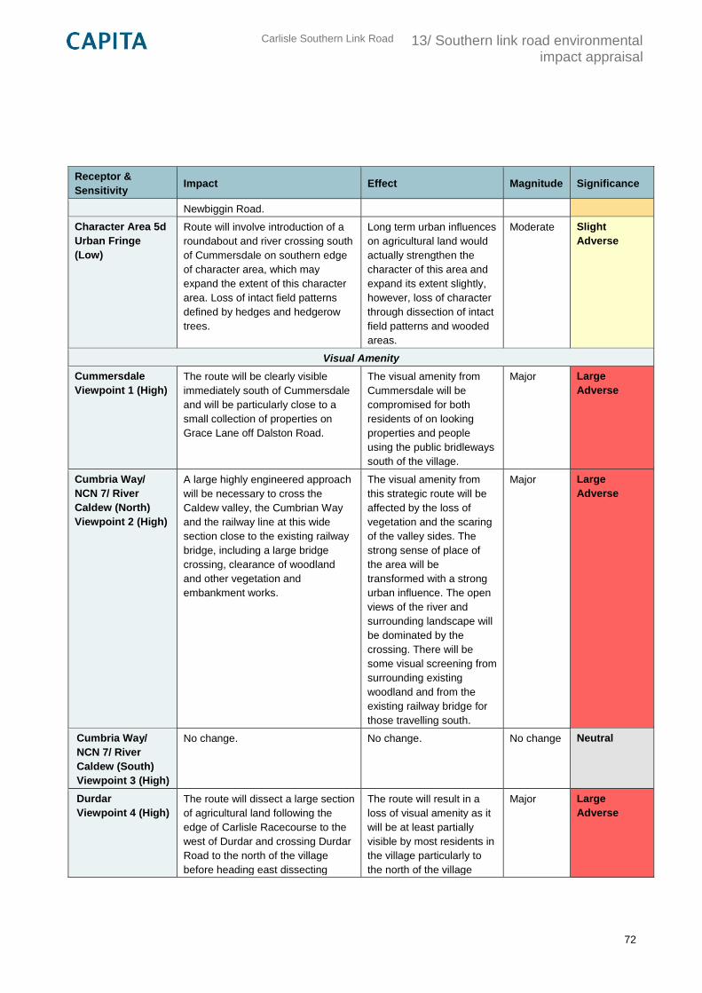
Carlisle Southern Link Road
13/ Southern link road environmental impact appraisal
72
Receptor &
Sensitivity Impact Effect Magnitude Significance
Newbiggin Road.
Character Area 5d
Urban Fringe
(Low)
Route will involve introduction of a
roundabout and river crossing south
of Cummersdale on southern edge
of character area, which may
expand the extent of this character
area. Loss of intact field patterns
defined by hedges and hedgerow
trees.
Long term urban influences
on agricultural land would
actually strengthen the
character of this area and
expand its extent slightly,
however, loss of character
through dissection of intact
field patterns and wooded
areas.
Moderate Slight
Adverse
Visual Amenity
Cummersdale
Viewpoint 1 (High)
The route will be clearly visible
immediately south of Cummersdale
and will be particularly close to a
small collection of properties on
Grace Lane off Dalston Road.
The visual amenity from
Cummersdale will be
compromised for both
residents of on looking
properties and people
using the public bridleways
south of the village.
Major Large
Adverse
Cumbria Way/
NCN 7/ River
Caldew (North)
Viewpoint 2 (High)
A large highly engineered approach
will be necessary to cross the
Caldew valley, the Cumbrian Way
and the railway line at this wide
section close to the existing railway
bridge, including a large bridge
crossing, clearance of woodland
and other vegetation and
embankment works.
The visual amenity from
this strategic route will be
affected by the loss of
vegetation and the scaring
of the valley sides. The
strong sense of place of
the area will be
transformed with a strong
urban influence. The open
views of the river and
surrounding landscape will
be dominated by the
crossing. There will be
some visual screening from
surrounding existing
woodland and from the
existing railway bridge for
those travelling south.
Major Large
Adverse
Cumbria Way/
NCN 7/ River
Caldew (South)
Viewpoint 3 (High)
No change. No change. No change Neutral
Durdar
Viewpoint 4 (High)
The route will dissect a large section
of agricultural land following the
edge of Carlisle Racecourse to the
west of Durdar and crossing Durdar
Road to the north of the village
before heading east dissecting
The route will result in a
loss of visual amenity as it
will be at least partially
visible by most residents in
the village particularly to
the north of the village
Major Large
Adverse
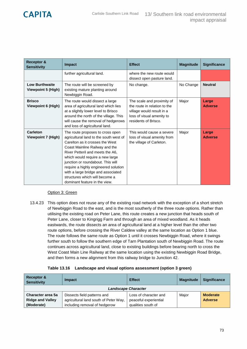
Carlisle Southern Link Road
13/ Southern link road environmental impact appraisal
73
Receptor &
Sensitivity Impact Effect Magnitude Significance
further agricultural land. where the new route would
dissect open pasture land.
Low Burthwaite
Viewpoint 5 (High)
The route will be screened by
existing mature planting around
Newbiggin Road.
No change. No Change Neutral
Brisco
Viewpoint 6 (High)
The route would dissect a large
area of agricultural land which lies
at a slightly lower level to Brisco
around the north of the village. This
will cause the removal of hedgerows
and loss of agricultural land.
The scale and proximity of
the route in relation to the
village would result in a
loss of visual amenity to
residents of Brisco.
Major Large
Adverse
Carleton
Viewpoint 7 (High)
The route proposes to cross open
agricultural land to the south west of
Carelton as it crosses the West
Coast Mainline Railway and the
River Petteril and meets the A6,
which would require a new large
junction or roundabout. This will
require a highly engineered solution
with a large bridge and associated
structures which will become a
dominant feature in the view.
This would cause a severe
loss of visual amenity from
the village of Carleton.
Major Large
Adverse
Option 3: Green
13.4.23 This option does not reuse any of the existing road network with the exception of a short stretch
of Newbiggin Road to the east, and is the most southerly of the three route options. Rather than
utilising the existing road on Peter Lane, this route creates a new junction that heads south of
Peter Lane, closer to Kingrigg Farm and through an area of mixed woodland. As it heads
eastwards, the route dissects an area of agricultural land at a higher level than the other two
route options, before crossing the River Caldew valley at the same location as Option 1 blue.
The route follows the same route as Option 1 until it crosses Newbiggin Road, where it swings
further south to follow the southern edge of Tarn Plantation south of Newbiggin Road. The route
continues across agricultural land, close to existing buildings before bearing north to cross the
West Coast Main Line Railway at the same location using the existing Newbiggin Road Bridge,
and then forms a new alignment from this railway bridge to Junction 42.
Table 13.16 Landscape and visual options assessment (option 3 green)
Receptor &
Sensitivity Impact Effect Magnitude Significance
Landscape Character
Character area 5a
Ridge and Valley
(Moderate)
Dissects field patterns and
agricultural land south of Peter Way,
including removal of hedgerow
Loss of character and
peaceful experiential
qualities south of
Major Moderate
Adverse
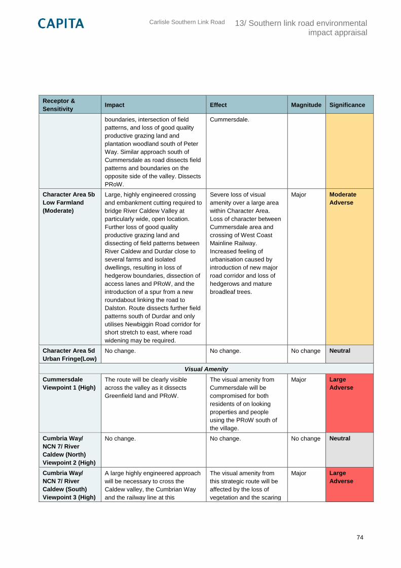
Carlisle Southern Link Road
13/ Southern link road environmental impact appraisal
74
Receptor &
Sensitivity Impact Effect Magnitude Significance
boundaries, intersection of field
patterns, and loss of good quality
productive grazing land and
plantation woodland south of Peter
Way. Similar approach south of
Cummersdale as road dissects field
patterns and boundaries on the
opposite side of the valley. Dissects
PRoW.
Cummersdale.
Character Area 5b
Low Farmland
(Moderate)
Large, highly engineered crossing
and embankment cutting required to
bridge River Caldew Valley at
particularly wide, open location.
Further loss of good quality
productive grazing land and
dissecting of field patterns between
River Caldew and Durdar close to
several farms and isolated
dwellings, resulting in loss of
hedgerow boundaries, dissection of
access lanes and PRoW, and the
introduction of a spur from a new
roundabout linking the road to
Dalston. Route dissects further field
patterns south of Durdar and only
utilises Newbiggin Road corridor for
short stretch to east, where road
widening may be required.
Severe loss of visual
amenity over a large area
within Character Area.
Loss of character between
Cummersdale area and
crossing of West Coast
Mainline Railway.
Increased feeling of
urbanisation caused by
introduction of new major
road corridor and loss of
hedgerows and mature
broadleaf trees.
Major Moderate
Adverse
Character Area 5d
Urban Fringe(Low)
No change. No change. No change Neutral
Visual Amenity
Cummersdale
Viewpoint 1 (High)
The route will be clearly visible
across the valley as it dissects
Greenfield land and PRoW.
The visual amenity from
Cummersdale will be
compromised for both
residents of on looking
properties and people
using the PRoW south of
the village.
Major Large
Adverse
Cumbria Way/
NCN 7/ River
Caldew (North)
Viewpoint 2 (High)
No change. No change. No change Neutral
Cumbria Way/
NCN 7/ River
Caldew (South)
Viewpoint 3 (High)
A large highly engineered approach
will be necessary to cross the
Caldew valley, the Cumbrian Way
and the railway line at this
The visual amenity from
this strategic route will be
affected by the loss of
vegetation and the scaring
Major Large
Adverse
Carlisle Southern Link Road
13/ Southern link road environmental impact appraisal
75
Receptor &
Sensitivity Impact Effect Magnitude Significance
particularly wide section, including a
large bridge crossing, clearance of
vegetation and embankment works.
of the valley sides. The
strong sense of place of
the area will be
transformed with a strong
urban influence. The open
views of the river and
surrounding landscape will
be dominated by the
crossing.
Viewpoint 4
Durdar (High)
The route will dissect a large section
of agricultural land to the west and
south of Durdar coming in very
close proximity to several isolated
dwellings and crossing over
Newbiggin Road to bypass the
village to the south. The removal of
hedgerows, small areas of
plantation woodland, agricultural
land and some mature broadleaf
trees would be necessary.
The route will result in a
severe loss of visual
amenity as it will be at least
partially visible by most
residents in the village.
Major Large
Adverse
Viewpoint 5
Low Burthwaite
(High)
The route will become a dominant
feature within the view with the
introduction of a major road
dissecting the large area of open
agricultural land and mature
hedgerows and the potential of a
roundabout.
Loss of visual amenity from
residents of isolated
dwellings around Low
Burthwaite.
Major Large
Adverse
Viewpoint 6
Brisco (High)
No change. No change. No change Neutral
Viewpoint 7
Carleton (High)
No change. No change. No change Neutral
Mitigation
13.4.24 The landscape and visual impacts and effects of the proposed options described in the previous
sections have been described without the consideration of any mitigation measures.
13.4.25 The following section includes recommendations for mitigation have been influenced by DMRB
Volume 11 Section 3 Part 5 “Landscape Effects” and aim to provide broad suggestions of how
the outlined significant effects on both the landscape as a resource and visual amenity can be
reduced through informed design.
13.4.26 To reduce the adverse effects on both landscape receptors the designer should look for
opportunities to:
utilise reuse of existing road corridors as much as possible;
Carlisle Southern Link Road
13/ Southern link road environmental impact appraisal
76
retain as much vegetation as possible to screen the route corridor and retain landscape
character;
achieve the best fit with the contours;
proposed on and offsite planting;
proposed subtle earthworks to screen wherever possible without excessive land take;
careful consideration of the form and finish of any proposed routes, features and
structures, including the use of local natural materials wherever possible; and,
minimal use of “street clutter” such as lighting columns, signage and gantries.
13.4.27 Such mitigation measures would help to reduce the adverse effects, particularly on the visual
receptors, as demonstrated in other projects of a similar nature, such as the A69 Haydon
Bridge Bypass, shown in Figure 13.1, Figure 13.2 and Figure 13.3 below.
13.4.28 Through use of the earthworks the road will appear less visible from surrounding settlements
and Public Rights of Way. Over time, as the vegetation establishes, this will also help to screen
the visual impact of the proposed route. Minimal street clutter has also been used, with the
exception of the overhead cables, which also helps to reduce the visual impact and to retain a
more rural character.
13.4.29 The use of natural stone for new walls, shown in Figure 13.3, also helps to reinforce a sense of
place and retain a rural character that helps to mitigate the effects of a major road.
13.4.30 Similar careful consideration of landform and cuttings using minimal land take could help to
reduce some of the large adverse effects described in the previous sections, together with
proposed on and offsite planting which would reduce the adverse effects after a number of
years once this had established.
13.4.31 As much existing vegetation should be retained as possible, as this will help to interrupt the
visual presence of the road making it a less dominant feature, for example, for Option 1: Blue at
Cummersdale, where the effect on the visual amenity could be Large Adverse. Where
hedgerows, individual trees, groups and woodland must be removed to reduce overall land
take, these should be replanted both to reduce the visual impacts and a loss of character after a
number of years.
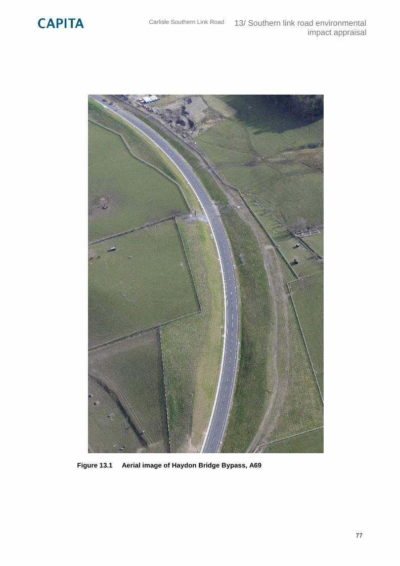
Carlisle Southern Link Road
13/ Southern link road environmental impact appraisal
77
Figure 13.1 Aerial image of Haydon Bridge Bypass, A69
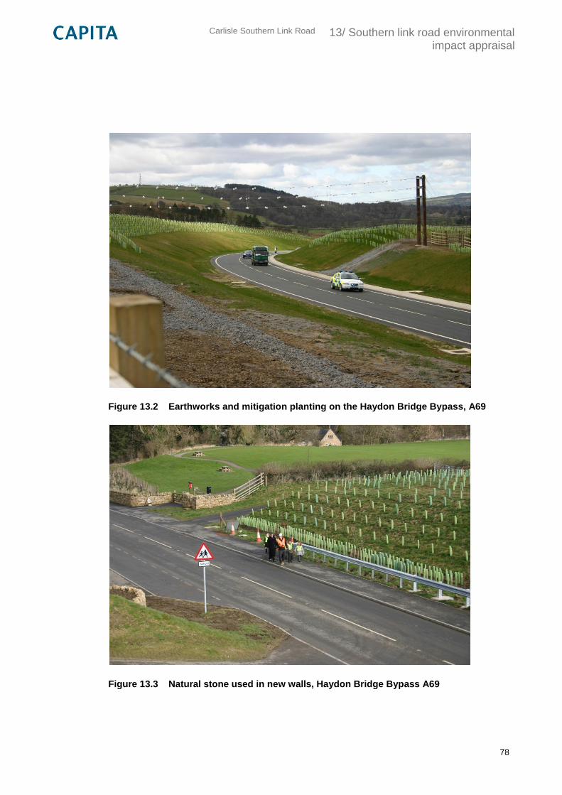
Carlisle Southern Link Road
13/ Southern link road environmental impact appraisal
78
Figure 13.2 Earthworks and mitigation planting on the Haydon Bridge Bypass, A69
Figure 13.3 Natural stone used in new walls, Haydon Bridge Bypass A69
Carlisle Southern Link Road
13/ Southern link road environmental impact appraisal
79
13.4.32 Another approach where several of these mitigation measures could be adopted is the
combination of certain sections of multiple route options. For example, it could be beneficial for
the western section of Option 2: Pink, from Peter Lane to Durdar, to be joined to Option 1, east
of Durdar along Newbiggin Road, to maximise the use of existing road corridors and
consequently further reduce the significant adverse effects of the proposals.
13.4.33 As Option 2: Pink, uses the existing road network on Peter Lane, compared to Option 3: Green,
which would require an entirely new junction on the A595 round about and dissects a large area
of agricultural land and plantation woodland. Option 2 also crosses the River Caldew at a
slightly more suitable location than the crossing point of Options 1 and 3 further south, due to
partial visual screening from surrounding existing woodland, a narrower valley, and the
grouping with the existing railway bridge. Whilst the effect is still likely to be considered Large
Adverse, it is likely that careful design and mitigation could ensure that this approach has less
of an impact than for the other two options. The route of Option 2: Pink is also more favourable
south of the racecourse, where it closely follows the edge of Carlisle Racecourse, therefore
creating a new edge to the Character Area 5d Urban Fringe, which could equally be screened
by proposed vegetation. At Durdar, the crossing of Durdar Road further north will have less of
an impact on landscape character as it is considered a slightly more urban setting. Here, a
using minimal landtake and avoiding encroachment on residential properties at Durdar, there is
an opportunity to then use the remainder of the Option 1: Blue Route, which is considered to
have the least adverse effects on landscape character due to the use of the existing road
network on Peter Lane.
Summary
13.4.34 The results of the landscape and visual effects assessment have not been conclusive in
indicating a clear preferred option. All three alternatives could potentially result in numerous
large adverse effects on the identified landscape and visual receptors without considered
implementation.
13.4.35 Despite this, it is believed that through careful design and the implementation of mitigation
methods covered above, the overall adverse effects of the proposed routes could be
significantly reduced over time.
13.4.36 The results of the assessment indicate that the option with the least adverse effects on the
identified landscape and visual receptors is Option 1: Blue, predominantly due to the fact that
this route maximises the reuse of existing road corridors. The least preferred option, following
the assessment criteria, would be Option 2: Pink. However, this is largely due to the eastern
half of the route through Greenfield land close to Brisco and Carelton; whereas, as described in
the mitigation section, the western half of the route actually presents many benefits of being in
close proximity to existing urban features and has a preferred crossing point of the River
Caldew, which is the most sensitive location within the study area.
13.4.37 It is, therefore, recommended that further investigation of the combination of a number of
options, as well as the other outlined mitigation measures, could be considered to minimise the
overall adverse effects on both the landscape and visual receptors.
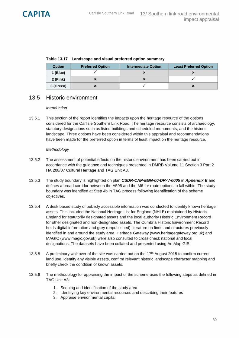
Carlisle Southern Link Road
13/ Southern link road environmental impact appraisal
80
Table 13.17 Landscape and visual preferred option summary
Option Preferred Option Intermediate Option Least Preferred Option
1 (Blue)
2 (Pink)
3 (Green)
13.5 Historic environment
Introduction
13.5.1 This section of the report identifies the impacts upon the heritage resource of the options
considered for the Carlisle Southern Link Road. The heritage resource consists of archaeology,
statutory designations such as listed buildings and scheduled monuments, and the historic
landscape. Three options have been considered within this appraisal and recommendations
have been made for the preferred option in terms of least impact on the heritage resource.
Methodology
13.5.2 The assessment of potential effects on the historic environment has been carried out in
accordance with the guidance and techniques presented in DMRB Volume 11 Section 3 Part 2
HA 208/07 Cultural Heritage and TAG Unit A3.
13.5.3 The study boundary is highlighted on plan CSDR-CAP-EGN-00-DR-V-0005 in Appendix E and
defines a broad corridor between the A595 and the M6 for route options to fall within. The study
boundary was identified at Step 4b in TAG process following identification of the scheme
objectives.
13.5.4 A desk based study of publicly accessible information was conducted to identify known heritage
assets. This included the National Heritage List for England (NHLE) maintained by Historic
England for statutorily designated assets and the local authority Historic Environment Record
for other designated and non-designated assets. The Cumbria Historic Environment Record
holds digital information and grey (unpublished) literature on finds and structures previously
identified in and around the study area. Heritage Gateway (www.heritagegateway.org.uk) and
MAGIC (www.magic.gov.uk) were also consulted to cross check national and local
designations. The datasets have been collated and presented using ArcMap GIS.
13.5.5 A preliminary walkover of the site was carried out on the 17th August 2015 to confirm current
land use, identify any visible assets, confirm relevant historic landscape character mapping and
briefly check the condition of known assets.
13.5.6 The methodology for appraising the impact of the scheme uses the following steps as defined in
TAG Unit A3:
1. Scoping and identification of the study area
2. Identifying key environmental resources and describing their features
3. Appraise environmental capital
Carlisle Southern Link Road
13/ Southern link road environmental impact appraisal
81
4. Appraise the proposal’s impact
5. Determine the overall assessment score
13.5.7 The key historic environment receptors within the study area identified through the desk study
and site were described using a series of features including: form; survival; condition;
complexity; context; and period. They were then assigned an environmental value, indicating
their sensitivity.
13.5.8 The evaluation of the asset has been considered in relation to the National Planning Policy
Framework (NPPF, 2012). The conservation of heritage assets in a manner appropriate to their
significance is a core planning principle of the NPPF. Section 132 of the NPPF states ‘when
considering the impact of a proposed development on the significance of a designated heritage
asset, great weight should be given to the asset’s conservation…As heritage assets are
irreplaceable, any harm or loss should require clear and convincing justification’.
13.5.9 The values (or sensitivity) of all the known and potential assets (‘receptors’) that may be
affected by the scheme are ranked according to the following scale (descriptors for this scale
are included in Appendix D):
Very High
High
Medium
Low
Negligible
13.5.10 An options appraisal identified the impacts, effects, magnitude and the overall significance of
the effects resulting from each of the three options. The magnitudes of impact of all known and
potential assets that may be affected by the scheme are ranked according to the following scale
(descriptors for this scale are included in Appendix D):
Major
Moderate
Minor
No Change
13.5.11 The significance of the effects of the scheme brings together the value of the resource and the
magnitude of the impact for each asset using the matrix identified in the approach to
assessment section of this report.
Carlisle Southern Link Road
13/ Southern link road environmental impact appraisal
82
Baseline
History and development
13.5.12 Despite evidence of human activity from the Prehistoric and Roman periods, the area around
Carlisle remained sparsely populated until the post-medieval period. The uncertainty of life on
the border between England and Scotland led many landowners to live in fortified houses. The
present Dalston Hall developed around a Pele tower of c.1500, and the scheduled site of
Bishop Dykes is believed to be a 14th century defensive earthwork.
13.5.13 Landscape and land use remained agricultural until the late 18th when new industry developed
along the fast flowing water of the River Caldew.
13.5.14 Blackwell Hall, now Race Course House was Bonnie Prince Charlie’s lodging when his army
attempted to besiege Carlisle in 1745. The race course moved to its present location in 1905.
13.5.15 The study area is bisected north to south with transport routes into Carlisle. Roman and later
roads and the River Caldew were joined in the 19th century by the railway and in 1970 by the
M6.
Scheduled Monuments
13.5.16 Scheduled Monuments are nationally important archaeological sites, which benefit from close
management. Scheduling derives from the Ancient Monuments and Archaeological Areas Act
1979.
13.5.17 Scheduled Monument Bishop’s Dyke (listing No.1007136) part falls within the study area and
the 500m buffer zone close to Dalston Hall Hotel at grid reference NY 361 507. Bishop’s Dyke
is believed to be a defensive earthwork constructed to protect the Manor of Dalston during the
Scottish wars of the 13th century and consists of a double ditch with a causeway between. It is
also said to mark the position of a medieval gate recorded as Dalston Barrs in the reign of
Edward IV (NY374518). Commencing near the River Caldew at Cummersdale, the dyke passes
to the north of Dalston Hall, crosses the Dalston-Carlisle road and later turns south-west
towards a strip of woodland (extract from PastScape (www.pastscape.org)).
13.5.18 Please refer to plan CSDR-CAP-EGN-00-DR-V-0005 in Appendix E.
Listed Buildings
13.5.19 When buildings are listed they are included on statutory lists of buildings of ‘special
archaeological or historic interest’ under the Planning (Listed Buildings and Conservation
Areas) Act 1990. The listing designation identifies only those buildings that are of national
architectural and historical interest. The listing includes any object or structure fixed to the
building, and any object or structure within the curtilage of the building forming part of the land
since before 1948. It is not intended to be a preservation order, simply a mark that celebrates a
building’s special architectural and historic interest and ensures its future is considered within
the planning system. The following grades apply to listings:
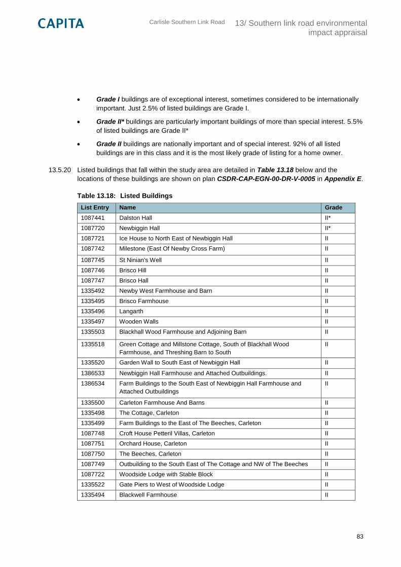
Carlisle Southern Link Road
13/ Southern link road environmental impact appraisal
83
Grade I buildings are of exceptional interest, sometimes considered to be internationally
important. Just 2.5% of listed buildings are Grade I.
Grade II* buildings are particularly important buildings of more than special interest. 5.5%
of listed buildings are Grade II*
Grade II buildings are nationally important and of special interest. 92% of all listed
buildings are in this class and it is the most likely grade of listing for a home owner.
13.5.20 Listed buildings that fall within the study area are detailed in Table 13.18 below and the
locations of these buildings are shown on plan CSDR-CAP-EGN-00-DR-V-0005 in Appendix E.
Table 13.18: Listed Buildings
List Entry Name Grade
1087441 Dalston Hall II*
1087720 Newbiggin Hall II*
1087721 Ice House to North East of Newbiggin Hall II
1087742 Milestone (East Of Newby Cross Farm) II
1087745 St Ninian's Well II
1087746 Brisco Hill II
1087747 Brisco Hall II
1335492 Newby West Farmhouse and Barn II
1335495 Brisco Farmhouse II
1335496 Langarth II
1335497 Wooden Walls II
1335503 Blackhall Wood Farmhouse and Adjoining Barn II
1335518 Green Cottage and Millstone Cottage, South of Blackhall Wood
Farmhouse, and Threshing Barn to South
II
1335520 Garden Wall to South East of Newbiggin Hall II
1386533 Newbiggin Hall Farmhouse and Attached Outbuildings. II
1386534 Farm Buildings to the South East of Newbiggin Hall Farmhouse and
Attached Outbuildings
II
1335500 Carleton Farmhouse And Barns II
1335498 The Cottage, Carleton II
1335499 Farm Buildings to the East of The Beeches, Carleton II
1087748 Croft House Petteril Villas, Carleton II
1087751 Orchard House, Carleton II
1087750 The Beeches, Carleton II
1087749 Outbuilding to the South East of The Cottage and NW of The Beeches II
1087722 Woodside Lodge with Stable Block II
1335522 Gate Piers to West of Woodside Lodge II
1335494 Blackwell Farmhouse II
Carlisle Southern Link Road
13/ Southern link road environmental impact appraisal
84
List Entry Name Grade
1087744 Blackwell House and Stables II
1335493 Brookside Cammock House II
Conservation Areas
13.5.21 Conservation Areas are areas of special architectural or historic interest, the character or
appearance of which is desirable to preserve or enhance. NPPF paragraph 137 states ‘local
planning authorities should look for opportunities for development within Conservation Areas
and... within the setting of heritage assets to enhance or better reveal their significance.’
13.5.22 The southern edge of the Holme Head conservation area (designated in 1968) touches the
Northern boundary of the buffer zone around the site area. Please refer to plan CSDR-CAP-
EGN-00-DR-V-0005 in Appendix E.
Historic Environment Record
13.5.23 Cumbria County Council holds an archive of information relating to the historic environment,
(the Historic Environment Record (HER)) records information regarding known archaeological
sites and other undesignated heritage assets in the borough. It also records non designated
archaeology.
13.5.24 HER records located within the study area (including the buffer zone) are predominantly of post
medieval origin relating to the infrastructure of the railways and mill activities within the area.
However there are also some interesting records of roman origin including the crop mark of
Cummersdale fort and excavated features of Thursby Roman road. St Ninian’s well located
near Brisco is of historical interest as it is believed to be the place that St Ninian baptised
Christians in AD 400.
13.5.25 Please refer to figure CSDR-CAP-EGN-00-DR-V-0005 which shows the location of all find
spots, lines and sites recorded on the HER.
Historic Landscape
13.5.26 The area west of the river Caldew including Cummersdale up to the A595 road consists of well
managed, regular shaped, medium to large pasture fields with hedge boundaries that reflect the
planned enclosure of open common pastures in the 19th century. The settlement pattern is of a
dispersed nature with the exception of Cummersdale village and Dalston (an ancient market
town) which are typical of a nucleated settlement type centred around the village green and
public buildings such as the church and local school.
13.5.27 The area east of the River Caldew up to the M6 motorway consists of an undulating and rolling
topography with agricultural pasture land. The fields are mainly large and rectangular bound by
hedges, trees and fences which also reflect the enclosure of former common arable land. The
settlement pattern is of small nucleated character with three small hamlets namely Brisco,
Durdar and Blackwell.
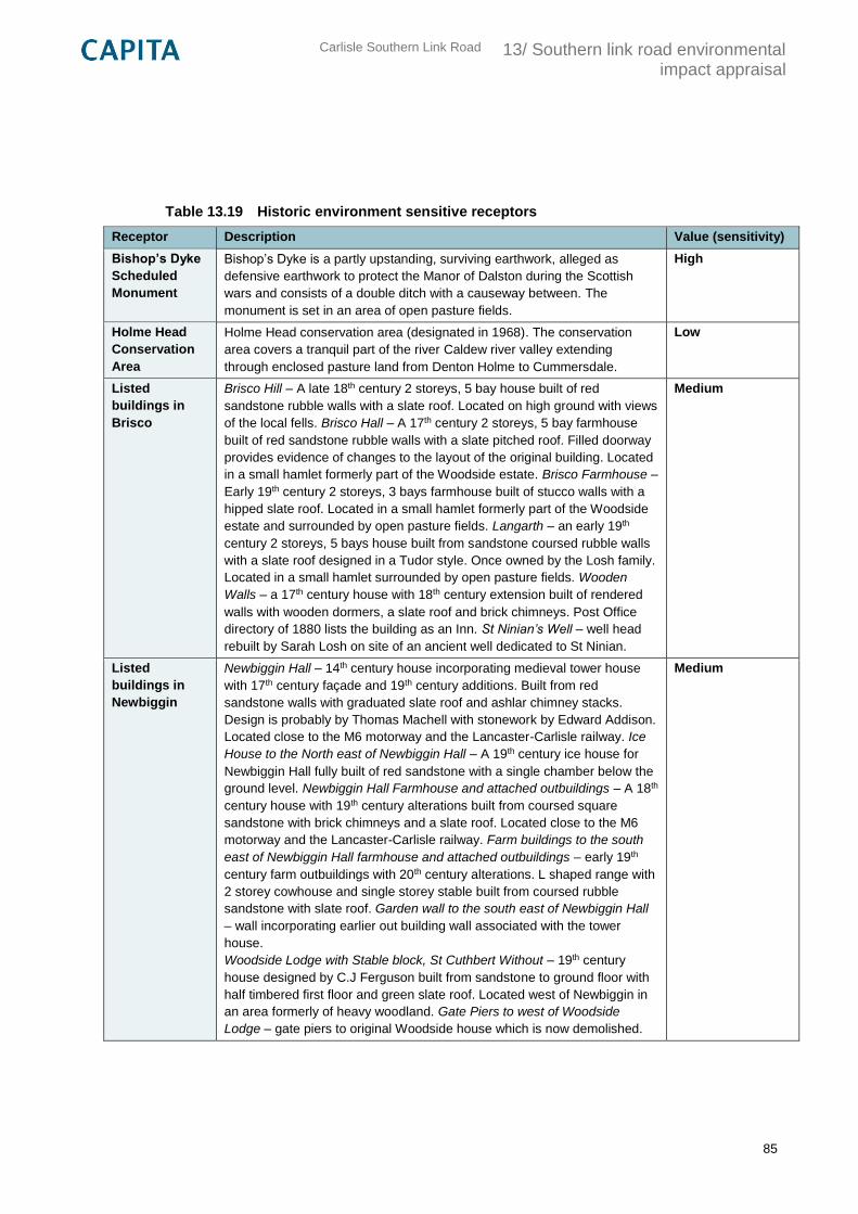
Carlisle Southern Link Road
13/ Southern link road environmental impact appraisal
85
Table 13.19 Historic environment sensitive receptors
Receptor Description Value (sensitivity)
Bishop’s Dyke
Scheduled
Monument
Bishop’s Dyke is a partly upstanding, surviving earthwork, alleged as
defensive earthwork to protect the Manor of Dalston during the Scottish
wars and consists of a double ditch with a causeway between. The
monument is set in an area of open pasture fields.
High
Holme Head
Conservation
Area
Holme Head conservation area (designated in 1968). The conservation
area covers a tranquil part of the river Caldew river valley extending
through enclosed pasture land from Denton Holme to Cummersdale.
Low
Listed
buildings in
Brisco
Brisco Hill – A late 18th century 2 storeys, 5 bay house built of red
sandstone rubble walls with a slate roof. Located on high ground with views
of the local fells. Brisco Hall – A 17th century 2 storeys, 5 bay farmhouse
built of red sandstone rubble walls with a slate pitched roof. Filled doorway
provides evidence of changes to the layout of the original building. Located
in a small hamlet formerly part of the Woodside estate. Brisco Farmhouse –
Early 19th century 2 storeys, 3 bays farmhouse built of stucco walls with a
hipped slate roof. Located in a small hamlet formerly part of the Woodside
estate and surrounded by open pasture fields. Langarth – an early 19th
century 2 storeys, 5 bays house built from sandstone coursed rubble walls
with a slate roof designed in a Tudor style. Once owned by the Losh family.
Located in a small hamlet surrounded by open pasture fields. Wooden
Walls – a 17th century house with 18th century extension built of rendered
walls with wooden dormers, a slate roof and brick chimneys. Post Office
directory of 1880 lists the building as an Inn. St Ninian’s Well – well head
rebuilt by Sarah Losh on site of an ancient well dedicated to St Ninian.
Medium
Listed
buildings in
Newbiggin
Newbiggin Hall – 14th century house incorporating medieval tower house
with 17th century façade and 19th century additions. Built from red
sandstone walls with graduated slate roof and ashlar chimney stacks.
Design is probably by Thomas Machell with stonework by Edward Addison.
Located close to the M6 motorway and the Lancaster-Carlisle railway. Ice
House to the North east of Newbiggin Hall – A 19th century ice house for
Newbiggin Hall fully built of red sandstone with a single chamber below the
ground level. Newbiggin Hall Farmhouse and attached outbuildings – A 18th
century house with 19th century alterations built from coursed square
sandstone with brick chimneys and a slate roof. Located close to the M6
motorway and the Lancaster-Carlisle railway. Farm buildings to the south
east of Newbiggin Hall farmhouse and attached outbuildings – early 19th
century farm outbuildings with 20th century alterations. L shaped range with
2 storey cowhouse and single storey stable built from coursed rubble
sandstone with slate roof. Garden wall to the south east of Newbiggin Hall
– wall incorporating earlier out building wall associated with the tower
house.
Woodside Lodge with Stable block, St Cuthbert Without – 19th century
house designed by C.J Ferguson built from sandstone to ground floor with
half timbered first floor and green slate roof. Located west of Newbiggin in
an area formerly of heavy woodland. Gate Piers to west of Woodside
Lodge – gate piers to original Woodside house which is now demolished.
Medium
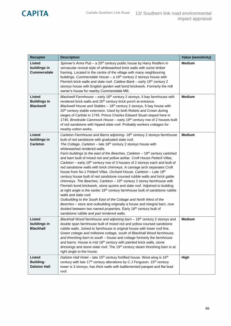
Carlisle Southern Link Road
13/ Southern link road environmental impact appraisal
86
Receptor Description Value (sensitivity)
Listed
buildings in
Cummersdale
Spinner’s Arms Pub – a 20th century public house by Harry Redfern in
vernacular revival style of whitewashed brick walls with some timber
framing. Located in the centre of the village with many neighbouring
buildings. Cummersdale House – a 19th century 2 storeys house with
Flemish brick walls and slate roof. Caldew Bank – early 19th century 2
storeys house with English garden wall bond brickwork. Formerly the mill
owner’s house for nearby Cummersdale Mill.
Medium
Listed
Buildings in
Blackwell
Blackwell Farmhouse – early 18th century 2 storeys, 5 bay farmhouse with
rendered brick walls and 20th century brick porch at entrance.
Blackwell House and Stables – 18th century 2 storeys, 5 bay house with
20th century stable extension. Used by both Rebels and Crown during
sieges of Carlisle in 1745. Prince Charles Edward Stuart stayed here in
1745. Brookside Cammock House – early 19th century row of 2 houses built
of red sandstone with hipped slate roof. Probably workers cottages for
nearby cotton works.
Medium
Listed
buildings in
Carleton
Carleton Farmhouse and Barns adjoining- 18th century 2 storeys farmhouse
built of red sandstone with graduated slate roof.
The Cottage, Carleton – late 18th century 2 storeys house with
whitewashed rendered walls.
Farm buildings to the east of the Beeches, Carleton – 19th century cartshed
and barn built of mixed red and yellow ashlar. Croft House Petteril Villas,
Carleton – early 19th century row of 3 houses of 2 storeys each and built of
red sandstone walls with brick chimneys. A carriage arch separates Croft
house from No.1 Petteril Villas. Orchard House, Carleton – Late 18th
century house built of red sandstone coursed rubble walls and brick gable
chimneys. The Beeches, Carleton – 19th century 2 storey farmhouse with
Flemish bond brickwork, stone quoins and slate roof. Adjoined to building
at right angle is the earlier 18th century farmhouse built of sandstone rubble
walls and slate roof.
Outbuilding to the South East of the Cottage and North West of the
Beeches – store and outbuilding originally a house and integral barn, now
divided between two named properties. Early 18th century built of
sandstone rubble and part rendered walls.
Medium
Listed
buildings in
Blackhall
Blackhall Wood farmhouse and adjoining barn – 18th century 2 storeys and
double span farmhouse built of mixed red and yellow coursed sandstone
rubble walls. Joined to farmhouse is original house with lower roof line.
Green cottage and millstone cottage, south of Blackhall Wood farmhouse,
and threshing barn to south – house and cottage formerly the farmhouse
and barns. House is mid 18th century with painted brick walls, stone
dressings and stone-slate roof. The 19th century steam threshing barn is at
right angle to the house.
Medium
Listed
Building-
Dalston Hall
Dalston Hall Hotel – late 15th century fortified house. West wing is 16th
century with late 17th century alterations by C.J Ferguson. 15th century
tower is 3 storeys, has thick walls with battlemented parapet and flat lead
roof.
High
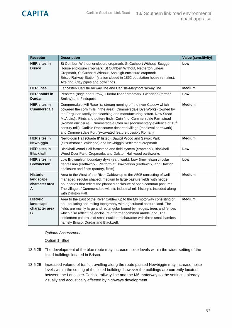
Carlisle Southern Link Road
13/ Southern link road environmental impact appraisal
87
Receptor Description Value (sensitivity)
HER sites in
Brisco
St Cuthbert Without enclosure cropmark, St Cuthbert Without, Scugger
House enclosure cropmark, St Cuthbert Without, Netherton Linear
Cropmark, St Cuthbert Without, Ashleigh enclosure cropmark
Brisco Railway Station (station closed in 1852 but station house remains),
Axe find, Clay pipes and bowl finds.
Low
HER lines Lancaster- Carlisle railway line and Carlisle-Maryport railway line Medium
HER points in
Durdar
Peastree (ridge and furrow), Durdar linear cropmark, Glendene (former
Smithy) and Findspots.
Low
HER sites in
Cummersdale
Cummersdale Mill Race- (a stream running off the river Caldew which
powered the corn mills in the area), Cummersdale Dye Works- (owned by
the Ferguson family for bleaching and manufacturing cotton. Now Stead
McAlpin.) , Flints and pottery finds, Coin find, Cummersdale Farmstead
(Roman enclosure), Cummersdale Corn mill (documentary evidence of 13th
century mill), Carlisle Racecourse deserted village (medieval earthwork)
and Cummersdale Fort (excavated feature possibly Roman)
Medium
HER sites in
Newbiggin
Newbiggin Hall (Grade II* listed), Sawpit Wood and Sawpit Park
(circumstantial evidence) and Newbiggin Settlement cropmark
Medium
HER sites in
Blackhall
Blackhall Wood Hall farmstead and field system (cropmark), Blackhall
Wood Deer Park, Cropmarks and Dalston Hall wood earthworks
Low
HER sites in
Brownelson
Low Brownelson boundary dyke (earthwork), Low Brownelson circular
depression (earthwork), Platform at Brownelson (earthwork) and Dalston
enclosure and finds (pottery, flints)
Low
Historic
landscape
character area
A
Area to the West of the River Caldew up to the A595 consisting of well
managed, regular shaped, medium to large pasture fields with hedge
boundaries that reflect the planned enclosure of open common pastures.
The village of Cummersdale with its industrial mill history is included along
with Dalston Hall.
Medium
Historic
landscape
character area
B
Area to the East of the River Caldew up to the M6 motorway consisting of
an undulating and rolling topography with agricultural pasture land. The
fields are mainly large and rectangular bound by hedges, trees and fences
which also reflect the enclosure of former common arable land. The
settlement pattern is of small nucleated character with three small hamlets
namely Brisco, Durdar and Blackwell.
Medium
Options Assessment
Option 1: Blue
13.5.28 The development of the blue route may increase noise levels within the wider setting of the
listed buildings located in Brisco.
13.5.29 Increased volume of traffic travelling along the route passed Newbiggin may increase noise
levels within the setting of the listed buildings however the buildings are currently located
between the Lancaster-Carlisle railway line and the M6 motorway so the setting is already
visually and acoustically affected by highways development.
Carlisle Southern Link Road
13/ Southern link road environmental impact appraisal
88
13.5.30 There is low potential for the development of the blue route to affect the views looking north-
northwest from the listed buildings located in Blackhall and vice versa which are currently
overlooking the Caldew river valley and pasture land.
13.5.31 The blue route uses existing infrastructure to cross the Lancaster-Carlisle railway line so will not
cause any physical impacts to the HER recognised asset. However for the route to cross the
Carlisle- Maryport railway line a new bridge will need to be constructed. This may cause
disturbance to the operation of the railway line during construction. The construction of this
bridge will create a new visual feature along both of the railway routes therefore impacting to a
degree on their setting. However the impact assessment takes into account that the bridge will
pass over only a small part of the railway line in comparison to its full recorded length which has
numerous bridges crossing at numerous points.
13.5.32 The route will cut through the northern end of the Durdar linear cropmark, as recorded on the
Cumbria HER
13.5.33 The route will be constructed through the middle of the HER site (Dalston enclosure) recorded
as where flints and pottery have been found which will reduce the potential for further physical
evidence of previous human activity being obtained. Trial trenching may be advisable to find out
if there is potential for unknown archaeological deposits.
13.5.34 The route will be constructed through the northern edge of the HER site recorded as Blackhall
Wood Deer Park.. The site is recorded as covering a large area of land between the River
Caldew and Durdar however this is based on documentary evidence, there is no ground
evidence. Also the route will only cross through a small section of the recorded area therefore
for those reasons there will be a low effect on this site as a result of the road construction.
13.5.35 The construction of a new bridge across the river Caldew valley will require physical and visual
alteration of the landscape within the area of the proposed crossing. This may be regarded as a
negative effect on the views across the river valley however the bridge construction will also
play a part in the future HLC assessment as evidence of how the area has been shaped by
human activity (HLC area A). The route will be developed through pasture fields and will alter
part of the enclosure pattern in a small area from the river until it joins existing road
infrastructure to join the A595.
13.5.36 The route will utilise existing road infrastructure from the M6 roundabout around Newbiggin road
until just before Durdar which will reduce the impact on the physical nature of the historic
landscape however from Durdar it then cuts through pasture fields to the point where it will
cross the river Caldew. In this area it will alter field boundaries and the enclosure pattern which
provides evidence of previous land use in the area.
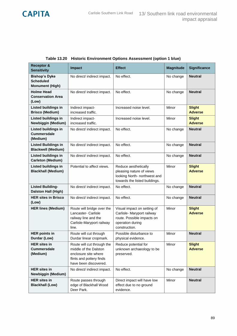
Carlisle Southern Link Road
13/ Southern link road environmental impact appraisal
89
Table 13.20 Historic Environment Options Assessment (option 1 blue)
Receptor &
Sensitivity Impact Effect Magnitude Significance
Bishop’s Dyke
Scheduled
Monument (High)
No direct/ indirect impact. No effect. No change Neutral
Holme Head
Conservation Area
(Low)
No direct/ indirect impact. No effect. No change Neutral
Listed buildings in
Brisco (Medium)
Indirect impact-
increased traffic.
Increased noise level. Minor Slight
Adverse
Listed buildings in
Newbiggin (Medium)
Indirect impact-
increased traffic.
Increased noise level. Minor Slight
Adverse
Listed buildings in
Cummersdale
(Medium)
No direct/ indirect impact. No effect. No change Neutral
Listed Buildings in
Blackwell (Medium)
No direct/ indirect impact. No effect. No change Neutral
Listed buildings in
Carleton (Medium)
No direct/ indirect impact. No effect. No change Neutral
Listed buildings in
Blackhall (Medium)
Potential to affect views. Reduce aesthetically
pleasing nature of views
looking North- northwest and
towards the listed buildings.
Minor Slight
Adverse
Listed Building-
Dalston Hall (High)
No direct/ indirect impact. No effect. No change Neutral
HER sites in Brisco
(Low)
No direct/ indirect impact. No effect. No change Neutral
HER lines (Medium) Route will bridge over the
Lancaster- Carlisle
railway line and the
Carlisle-Maryport railway
line.
Visual impact on setting of
Carlisle- Maryport railway
route. Possible impacts on
operation during
construction.
Minor Slight
Adverse
HER points in
Durdar (Low)
Route will cut through
Durdar linear cropmark.
Possible disturbance to
physical evidence.
Minor Neutral
HER sites in
Cummersdale
(Medium)
Route will cut through the
middle of the Dalston
enclosure site where
flints and pottery finds
have been discovered.
Reduce potential for
unknown archaeology to be
preserved.
Minor Slight
Adverse
HER sites in
Newbiggin (Medium)
No direct/ indirect impact. No effect. No change Neutral
HER sites in
Blackhall (Low)
Route passes through
edge of Blackhall Wood
Deer Park.
Direct impact will have low
effect due to no ground
evidence.
Minor Neutral
Carlisle Southern Link Road
13/ Southern link road environmental impact appraisal
90
Receptor &
Sensitivity Impact Effect Magnitude Significance
HER sites in
Brownelson (Low)
No direct/ indirect impact. No effect. No change Neutral
Historic landscape
character area A
(Medium)
Bridge will be constructed
over the River Caldew.
Physical and visual alteration
of the landscape.
Minor Slight
Adverse
Historic landscape
character area B
(Medium)
The route only uses
existing road
infrastructure for part of
the route only.
Alteration of enclosure
pattern.
Minor Slight
Adverse
Option 2: Pink
13.5.37 The pink route will pass within 100-200m of the listed buildings located in Brisco. The area is
currently made up of open fields however the development of the route will have a negative
impact on views looking north from the listed buildings by decreasing the aesthetic appeal of the
rolling landscape within the setting of the heritage asset. The close proximity will also increase
the noise level within the area around the buildings reducing its peaceful nature.
13.5.38 The pink route will have a direct impact on the northern edge of the HER site recorded as
Netherton Linear cropmark described as linear features of an enclosure system dating to the
prehistoric era. Destruction of the linear feature will reduce evidence to support the historic
landscape classification.
13.5.39 For the pink route to be developed bridges over the Lancaster- Carlisle railway line and the
Carlisle- Maryport railway line will need to be constructed; both of these railway lines are
recorded as HER recognised assets. The construction of these bridges will create a new visual
feature along both of the railway routes therefore impacting to a degree on their setting. The
construction of the bridges will also involve a considerable amount of earthworks in the vicinity
of the railway lines and may cause a disruption to operations. However the impact assessment
takes into account that the bridge will pass over only a tiny part of the railway lines in
comparison to their full recorded length which have numerous bridges crossing at numerous
points.
13.5.40 Earthworks for the bridge crossing the river Caldew and the Carlisle-Maryport railway line will
cut into the footprint of the Cummersdale Dye Works grounds and the Cummersdale mill race.
The disruption caused by the construction works will affect evidence of the industrial
development of the area and therefore have a negative impact on the value of the historic
landscape. The route will also cut through the edge of the site where flints and pottery finds
have been discovered which may reduce potential for further archaeological finds. Mitigation in
the form of a watching brief may be advisable.
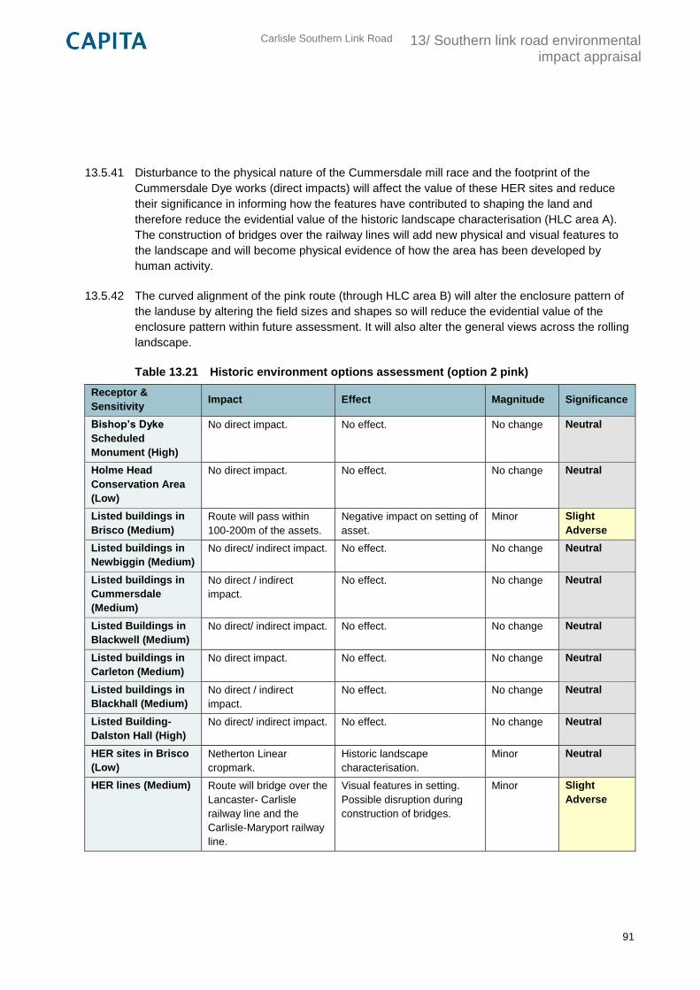
Carlisle Southern Link Road
13/ Southern link road environmental impact appraisal
91
13.5.41 Disturbance to the physical nature of the Cummersdale mill race and the footprint of the
Cummersdale Dye works (direct impacts) will affect the value of these HER sites and reduce
their significance in informing how the features have contributed to shaping the land and
therefore reduce the evidential value of the historic landscape characterisation (HLC area A).
The construction of bridges over the railway lines will add new physical and visual features to
the landscape and will become physical evidence of how the area has been developed by
human activity.
13.5.42 The curved alignment of the pink route (through HLC area B) will alter the enclosure pattern of
the landuse by altering the field sizes and shapes so will reduce the evidential value of the
enclosure pattern within future assessment. It will also alter the general views across the rolling
landscape.
Table 13.21 Historic environment options assessment (option 2 pink)
Receptor &
Sensitivity Impact Effect Magnitude Significance
Bishop’s Dyke
Scheduled
Monument (High)
No direct impact. No effect. No change Neutral
Holme Head
Conservation Area
(Low)
No direct impact. No effect. No change Neutral
Listed buildings in
Brisco (Medium)
Route will pass within
100-200m of the assets.
Negative impact on setting of
asset.
Minor Slight
Adverse
Listed buildings in
Newbiggin (Medium)
No direct/ indirect impact. No effect. No change Neutral
Listed buildings in
Cummersdale
(Medium)
No direct / indirect
impact.
No effect. No change Neutral
Listed Buildings in
Blackwell (Medium)
No direct/ indirect impact. No effect. No change Neutral
Listed buildings in
Carleton (Medium)
No direct impact. No effect. No change Neutral
Listed buildings in
Blackhall (Medium)
No direct / indirect
impact.
No effect. No change Neutral
Listed Building-
Dalston Hall (High)
No direct/ indirect impact. No effect. No change Neutral
HER sites in Brisco
(Low)
Netherton Linear
cropmark.
Historic landscape
characterisation.
Minor Neutral
HER lines (Medium) Route will bridge over the
Lancaster- Carlisle
railway line and the
Carlisle-Maryport railway
line.
Visual features in setting.
Possible disruption during
construction of bridges.
Minor Slight
Adverse
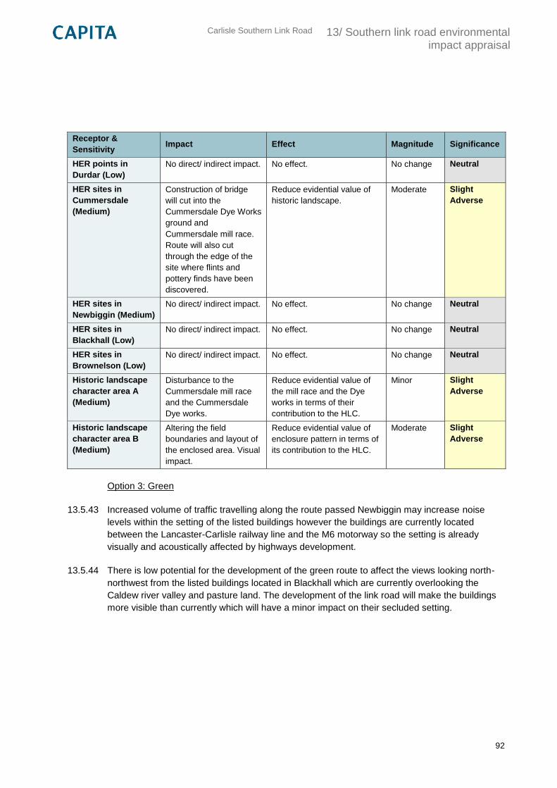
Carlisle Southern Link Road
13/ Southern link road environmental impact appraisal
92
Receptor &
Sensitivity Impact Effect Magnitude Significance
HER points in
Durdar (Low)
No direct/ indirect impact. No effect. No change Neutral
HER sites in
Cummersdale
(Medium)
Construction of bridge
will cut into the
Cummersdale Dye Works
ground and
Cummersdale mill race.
Route will also cut
through the edge of the
site where flints and
pottery finds have been
discovered.
Reduce evidential value of
historic landscape.
Moderate Slight
Adverse
HER sites in
Newbiggin (Medium)
No direct/ indirect impact. No effect. No change Neutral
HER sites in
Blackhall (Low)
No direct/ indirect impact. No effect. No change Neutral
HER sites in
Brownelson (Low)
No direct/ indirect impact. No effect. No change Neutral
Historic landscape
character area A
(Medium)
Disturbance to the
Cummersdale mill race
and the Cummersdale
Dye works.
Reduce evidential value of
the mill race and the Dye
works in terms of their
contribution to the HLC.
Minor Slight
Adverse
Historic landscape
character area B
(Medium)
Altering the field
boundaries and layout of
the enclosed area. Visual
impact.
Reduce evidential value of
enclosure pattern in terms of
its contribution to the HLC.
Moderate Slight
Adverse
Option 3: Green
13.5.43 Increased volume of traffic travelling along the route passed Newbiggin may increase noise
levels within the setting of the listed buildings however the buildings are currently located
between the Lancaster-Carlisle railway line and the M6 motorway so the setting is already
visually and acoustically affected by highways development.
13.5.44 There is low potential for the development of the green route to affect the views looking north-
northwest from the listed buildings located in Blackhall which are currently overlooking the
Caldew river valley and pasture land. The development of the link road will make the buildings
more visible than currently which will have a minor impact on their secluded setting.
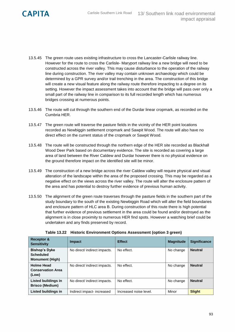
Carlisle Southern Link Road
13/ Southern link road environmental impact appraisal
93
13.5.45 The green route uses existing infrastructure to cross the Lancaster-Carlisle railway line.
However for the route to cross the Carlisle- Maryport railway line a new bridge will need to be
constructed across the river valley. This may cause disturbance to the operation of the railway
line during construction. The river valley may contain unknown archaeology which could be
determined by a GPR survey and/or trail trenching in the area. The construction of this bridge
will create a new visual feature along the railway route therefore impacting to a degree on its
setting. However the impact assessment takes into account that the bridge will pass over only a
small part of the railway line in comparison to its full recorded length which has numerous
bridges crossing at numerous points.
13.5.46 The route will cut through the southern end of the Durdar linear cropmark, as recorded on the
Cumbria HER.
13.5.47 The green route will traverse the pasture fields in the vicinity of the HER point locations
recorded as Newbiggin settlement cropmark and Sawpit Wood. The route will also have no
direct effect on the current status of the cropmark or Sawpit Wood.
13.5.48 The route will be constructed through the northern edge of the HER site recorded as Blackhall
Wood Deer Park based on documentary evidence. The site is recorded as covering a large
area of land between the River Caldew and Durdar however there is no physical evidence on
the ground therefore impact on the identified site will be minor.
13.5.49 The construction of a new bridge across the river Caldew valley will require physical and visual
alteration of the landscape within the area of the proposed crossing. This may be regarded as a
negative effect on the views across the river valley. The route will alter the enclosure pattern of
the area and has potential to destroy further evidence of previous human activity.
13.5.50 The alignment of the green route traverses through the pasture fields in the southern part of the
study boundary to the south of the existing Newbiggin Road which will alter the field boundaries
and enclosure pattern of HLC area B. During construction of this route there is high potential
that further evidence of previous settlement in the area could be found and/or destroyed as the
alignment is in close proximity to numerous HER find spots. However a watching brief could be
undertaken and any finds preserved by record.
Table 13.22 Historic Environment Options Assessment (option 3 green)
Receptor &
Sensitivity Impact Effect Magnitude Significance
Bishop’s Dyke
Scheduled
Monument (High)
No direct/ indirect impacts. No effect. No change Neutral
Holme Head
Conservation Area
(Low)
No direct/ indirect impacts. No effect. No change Neutral
Listed buildings in
Brisco (Medium)
No direct/ indirect impacts. No effect. No change Neutral
Listed buildings in Indirect impact- increased Increased noise level. Minor Slight
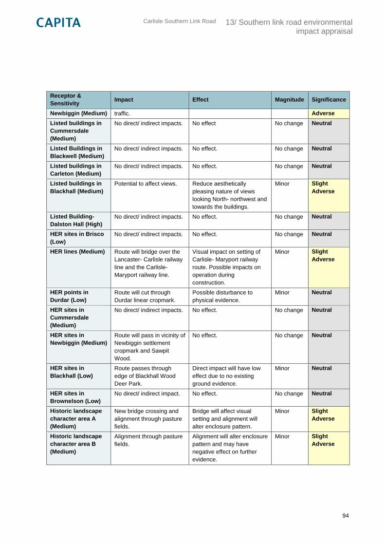
Carlisle Southern Link Road
13/ Southern link road environmental impact appraisal
94
Receptor &
Sensitivity Impact Effect Magnitude Significance
Newbiggin (Medium) traffic. Adverse
Listed buildings in
Cummersdale
(Medium)
No direct/ indirect impacts. No effect No change Neutral
Listed Buildings in
Blackwell (Medium)
No direct/ indirect impacts. No effect. No change Neutral
Listed buildings in
Carleton (Medium)
No direct/ indirect impacts. No effect. No change Neutral
Listed buildings in
Blackhall (Medium)
Potential to affect views. Reduce aesthetically
pleasing nature of views
looking North- northwest and
towards the buildings.
Minor Slight
Adverse
Listed Building-
Dalston Hall (High)
No direct/ indirect impacts. No effect. No change Neutral
HER sites in Brisco
(Low)
No direct/ indirect impacts. No effect. No change Neutral
HER lines (Medium) Route will bridge over the
Lancaster- Carlisle railway
line and the Carlisle-
Maryport railway line.
Visual impact on setting of
Carlisle- Maryport railway
route. Possible impacts on
operation during
construction.
Minor Slight
Adverse
HER points in
Durdar (Low)
Route will cut through
Durdar linear cropmark.
Possible disturbance to
physical evidence.
Minor Neutral
HER sites in
Cummersdale
(Medium)
No direct/ indirect impacts. No effect. No change Neutral
HER sites in
Newbiggin (Medium)
Route will pass in vicinity of
Newbiggin settlement
cropmark and Sawpit
Wood.
No effect. No change Neutral
HER sites in
Blackhall (Low)
Route passes through
edge of Blackhall Wood
Deer Park.
Direct impact will have low
effect due to no existing
ground evidence.
Minor Neutral
HER sites in
Brownelson (Low)
No direct/ indirect impact. No effect. No change Neutral
Historic landscape
character area A
(Medium)
New bridge crossing and
alignment through pasture
fields.
Bridge will affect visual
setting and alignment will
alter enclosure pattern.
Minor Slight
Adverse
Historic landscape
character area B
(Medium)
Alignment through pasture
fields.
Alignment will alter enclosure
pattern and may have
negative effect on further
evidence.
Minor Slight
Adverse
Carlisle Southern Link Road
13/ Southern link road environmental impact appraisal
95
Mitigation
13.5.51 ‘Options for reducing the harm arising from development may include the relocation of a
development or its elements, changes to its design, the creation of effective long term visual or
acoustic screening, or management measures. Good design may reduce or remove the harm,
or provide enhancement, and design quality may be the main consideration in determining the
balance of harm and benefit’ (Historic England, Good Practice Advice 3- Setting of heritage
assets).
13.5.52 The following mitigation measures are recommended to reduce the negative impacts on the
significance of the historic environment:
To reduce the impact of noise levels on the setting of listed buildings noise bunds (earth
bunds) could be provided around the parts of the road passing within the setting of listed
buildings, in Brisco and Newbiggin. Consideration should be given to the design of the
bunds so that they do not cause an adverse effect on the character and visual
appearance of the historic landscape.
To remove the impact of the road on the visual appearance of the setting of listed
buildings, vegetation screening should be provided around parts of the road passing
within the setting of listed buildings in Brisco and Blackhall. Consideration should also be
given to the design of the screening itself so that it does not cause an adverse effect on
the form and appearance of the historic landscape.
The design of the new bridge crossing over the River Caldew should be in-keeping with
the character of the historic landscape to reduce any potential impacts on views across
the historic landscape. The Building in Context toolkit prepared by CABE sets out eight
principles which should be taken into consideration when designing the new structure. If
designed appropriately then new views can be introduced which add to the public
experience and thereby enhancing the significance of the historic landscape.
Trial trenching and/ or a GPR survey may be carried out in areas where there is potential
for further evidence of previous human settlement activity. Depending on the results, a
watching brief may then be required. These methods of archaeological evaluation can
enhance the significance of the historic environment by revealing or restoring a lost
historic feature that that can be used to further explain the historic development of an
area.
Summary
13.5.53 With moderate impacts on the significance of HER sites in Cummersdale and the historic
landscape character the pink route will have the most negative impact on the historic
environment. This route will also have the most negative impact effect on the setting of listed
buildings in the study area. On the other hand the pink route also has the most neutral impacts
on receptors. Due to the relatively high number of negative impacts compared to the other route
options, the pink route is the least preferred option.
Carlisle Southern Link Road
13/ Southern link road environmental impact appraisal
96
13.5.54 The blue route has greater potential to increase noise levels and visual impacts on the setting of
listed buildings in the study area. The construction of a new bridge across the Caldew river
valley will have a negative impact the historic landscape character which will have a slight
impact on its significance.
13.5.55 The green route also has a high number of neutral impacts on the historic environment.
Negative impacts include direct effects on the significance of the historic landscape character
across the whole study area.
13.5.56 The blue and green route options are very similar in terms of their impacts due to the
alignments following a similar route, the main difference is that the blue route uses existing road
infrastructure so has a lower impact on the historic landscape. For this reason, the blue route
has been given higher preference over the green route.
Table 13.23 Historic environment preferred option summary
Option Preferred Option Intermediate Option Least Preferred Option
1 (Blue)
2 (Pink)
3 (Green)
13.6 Nature conservation
Introduction
13.6.1 This section of the report describes the assessment of the effects of the three route options on
nature conservation. The purpose of the assessment is to establish the nature conservation
baseline within the study area ensure that potential adverse effects on nature conservation and
need for mitigation measures are identified at an early stage.
Methodology
13.6.2 The assessment of potential effects on nature conservation has been carried out in accordance
with the guidance and techniques presented in DMRB Volume 11 Section 3, Part 4 ‘Ecology &
Nature Conservation’, TAG Unit A3, Interim Advice Note 130/01 – Ecology & Nature
Conservation Criteria for Impact Assessment and CIEEM Guidelines for Ecological Impact
Assessment in the United Kingdom.
13.6.3 A study area of 500m was established around each of the route options (a wider zone of
influence was investigated for statutory sites which may affected by watercourse or migratory
pathways).
Carlisle Southern Link Road
13/ Southern link road environmental impact appraisal
97
13.6.4 A desk study was undertaken to identify any statutory and non-statutory designated sites of
nature conservation interest, habitats present within each study area and to obtain information
on protected species or species of nature conservation interest. The desk study involved
collation and review of information from the following resources:
Cumbria Biodiversity Data Centre (CBDC) species and site data
The National Biodiversity Network (NBN) Gateway
Natural England’s Multi-Agency Geographical Information (MAGIC)
Joint Nature Conservation Committee (JNCC)
13.6.5 The assessment of value of nature conservation features (receptors) was undertaken following
guidance provided by DMRB Interim Advice Note 130/01 – Ecology & Nature Conservation
Criteria for Impact Assessment and CIEEM Guidelines for Ecological Impact Assessment in the
United Kingdom, Chapter 3 Determining Value. The criteria used to assess the value of nature
conservation features are shown in Appendix D.
13.6.6 It should be noted that legal protection is considered separately to value. The protection of a
particular nature conservation receptor may not necessarily be considered when determining
value. For example the presence of one receptor protected by national legislation would not be
assessed as being of national value. Legislation is however considered in terms of appropriate
mitigation.
13.6.7 The methods for assessing the effects of the Route options follows the IEEM EcIA Guidelines.
The effect of potential impacts depends upon:
Magnitude: ‘size’ or ‘amount’ of impact, determined on a quantitative basis where
possible, e.g. the numbers of a species that are influenced;
Extent: The area over which the impact occurs;
Duration: The time over which the impact is expected to last prior to recovery or
replacement of the resource or feature;
Reversibility: whether recovery is possible within a reasonable timescale; and
Timing and Frequency: Whether impacts coincide with critical life changes or seasons
(e.g. breeding bird season) and how frequent the impacts are likely to be.
13.6.8 These factors are brought together to assess the magnitude of the impacts on key nature
conservation receptors. Professional judgment is then used to assign the effects on the
receptors to one of four classes of magnitude, defined in Appendix A.
Carlisle Southern Link Road
13/ Southern link road environmental impact appraisal
98
Baseline
Statutory Designated Sites
13.6.9 The River Eden Special Area of Conservation (SAC) / Site of Special Scientific Interest (SSSI)
is an internationally and nationally designated site. It lies to the western extent of the study area
and is shown in CSDR-CAP-EGN-00-DR-V-0006 in Appendix E. The site is designated for the
following criteria:
Oligotrophic to mesotrophic standing waters with vegetation of the Littorelletea
uniflorae and/or of the Isoëto-Nanojuncetea
Alluvial forests with Alnus glutinosa and Fraxinus excelsior. (Alder woodland on
floodplains)
Water courses of plain to montane levels with floating vegetation often dominated by
watercrowfoot)
White-clawed (or Atlantic stream) crayfish Austropotamobius pallipes
Sea lamprey Petromyzon marinus
Brook lamprey Lampetra planeri
River lamprey Lampetra fluviatilis
Atlantic salmon Salmo salar
Bullhead Cottus gobio
Otter Lutra lutra
13.6.10 The conservation objectives for the site are to ensure that the integrity of the site is maintained
or restored as appropriate, and ensure that the site contributes to achieving the Favourable
Conservation Status of its Qualifying Features, by maintaining or restoring:
The extent and distribution of qualifying natural habitats and habitats of qualifying
species;
The structure and function (including typical species) of qualifying natural habitats;
The structure and function of the habitats of qualifying species;
The supporting processes on which qualifying natural habitats and the habitats of
qualifying species rely;
The populations of qualifying species; and,
The distribution of qualifying species within the site.
13.6.11 The River Caldew falls in unit 235 of the SSSI designation and was last assessed as being in
unfavourable recovering condition in 2010.
Non-statutory Designated Sites
Carlisle Southern Link Road
13/ Southern link road environmental impact appraisal
99
13.6.12 Five non-statutory designated sites of local importance were recorded within the study area.
These are:
Brownelson Wood County Wildlife Site;
Thurnam Wood County Wildlife Site;
Newbiggin Wood County Wildlife Site;
Cummersdale Shingle Banks Site of Invertebrate Significance;
Cummersdale Landslip & Blackhall Wood Site of Invertebrate Significance.
13.6.13 While ancient woodland is not afforded legal protection, National Planning Policy Framework
(NPPF) guidance (Paragraph 118) identifies it as a key biodiversity resource which should be
protected from development.
13.6.14 A number of areas of ancient woodland have been identified within the study area. These are
shown on drawing CSDR-CAP-EGN-00-DR-V-0006 in Appendix E.
Terrestrial Habitats
13.6.15 A review off satellite imagery and OS maps as well as a site walkover indicates that the majority
of the study area is dominated by improved or arable grassland bounded by native hedgerows
interspersed with areas of both plantation and semi-natural deciduous woodland.
13.6.16 The green route passes directly through a section of mixed (predominantly broadleaf) plantation
woodland. These areas of woodland are common on a national level and are considered of a
local importance.
13.6.17 To the west of the study area along the riparian corridor are extensive areas of woodland, scrub
and semi-improved grassland. Other habitats types such marshy grassland dominated by
Juncus sp. also occur adjacent to watercourses.
Aquatic Habitats
13.6.18 The River Caldew runs north / south at the western extent of the study area and is one of the
tributaries falling under the designation of River Eden SAC / SSSI. The River Petteril runs north
west / south east to the eastern extent of the site boundary and while not part of the
designation, is a tributary of the River Eden SSSI / SAC.
13.6.19 A number of other becks including Wire Mire Beck, Cammock Beck and Woodside Beck are
also present within the study area. One large pond (Hammond’s Pond) is present to the north
west of the study area with a smaller pond being visible to the south of Caldew Road.
13.6.20 The NBN Gateway shows records of a number of species within the study area which are listed
as both UK and Local BAP species. These are:
Basil Thyme Clinopodium acinos
Carlisle Southern Link Road
13/ Southern link road environmental impact appraisal
100
Tubular Water-dropwort Oenanthe fistulosa
Corn Buttercup Ranunculus arvensis
Annual Knawel Scleranthus annuus
Marsh Stitchwort Stellaria palustris
13.6.21 Records show that Japanese Knotweed Fallopuia japonica, Giant Hogweed Heracleum
mantegazzianum and Himalayan Balsam Impatiens glandulifera are all known to occur in the
study area. During the site walkover, Himalayan Balsam was noted to be abundant along the
banks of the River Caldew and other watercourses within the site boundary.
European Protected Species
13.6.22 Otter are considered to be widespread in Cumbria, and a number of records of otter exist within
the study area. While most of the existing records are associated with the River Caldew (which
is designated for the presence of otter) otters are known to travel long distances using minor
watercourses as connecting habitat.
13.6.23 Records exist for up to six species of bats within the study area including Daubentons Myotis
daubentonii, Whiskered Myotis mystacinus, Noctule Nyctalus noctula, Common Pipistrelle
Pipistrellus pipistrellus, Soprano Pipistrelle Pipistrellus pygmaeus and Brown long-eared
Plecotus auritus. The majority of the records relate to sightings or roosts along the River
Caldew and River Petteril however these species are likely to use a number of structures within
the study area for roosting and will forage in woodland and grassland habitats.
13.6.24 No CBDC records of Great Crested Newt exist within the study area, however NBN Gateway
data and presence of suitable habitat indicated the species is likely to be present.
Nationally Protected Species
13.6.25 A number of road casualty records of badger exist within the study area. It is considered highly
likely that badger setts and foraging habitat will exist within the wooded areas and areas of
grassland present within the study area. Badger are protected through the Protection of
Badgers Act, 1992.
13.6.26 A high number of red squirrel records exist throughout the study area. Given the extent of both
woodland within the study area and the presence of commuting features such are hedgerows
and individual trees it is highly likely that squirrel will be present.
13.6.27 Squirrel are protected under Schedule 5 of the Wildlife & Countryside Act as well as being a
species of principle importance both nationally and through the LBAP
13.6.28 No CBDC records exist for reptiles within the study area, however NBN Gateway records
suggest the following species are likely to occur:
Slow-worm Anguis fragilis
Carlisle Southern Link Road
13/ Southern link road environmental impact appraisal
101
Grass Snake Natrix natrix
Common Lizard Zootoca vivipara
Annex / Schedule 1 Birds
13.6.29 NBN Gateway and CBDC data records indicate that the following Annex 1 (Birds Directive
1979) and Schedule 1 (Wildlife & Countryside Act 1981) species are likely to occur within the
study area:
Kingfisher Alcedo atthis
Barn Owl Tyto alba
Species of Principle Importance
13.6.30 The study area lies within the Cumbria Local Biodiversity Action Plan (LBAP) area. The plan
has been prepared to implement national biodiversity targets at a local level, with a focus on
local priorities. It seeks to make people in Cumbria more aware of the issues and build wide
commitment to taking the necessary actions.
13.6.31 A number of species have been recorded within the study area which are a priority species on
the LBAP as well as the UK BAP, these include:
Grey Partridge Perdix perdix
Lapwing Vanellus vanellus
Curlew Numenius arquata
Grasshopper Warbler Locustella naevia
Wood Warbler Phylloscopus sibilatrix
Spotted Flycatcher Muscicapa striata
House Sparrow Passer domesticus
Tree Sparrow Passer montanus
Lesser Redpoll Carduelis cabaret
Yellowhammer Emberiza citronella
Reed Bunting Emberiza schoeniclus
13.6.32 In order to determine the likelihood of a significant effect, it is first necessary to identify whether
an ecological receptor is sufficiently valuable for a significant effect upon it to be material in
decision making. The values of features are described within a geographical frame of reference,
as described in Table 13.24 below.
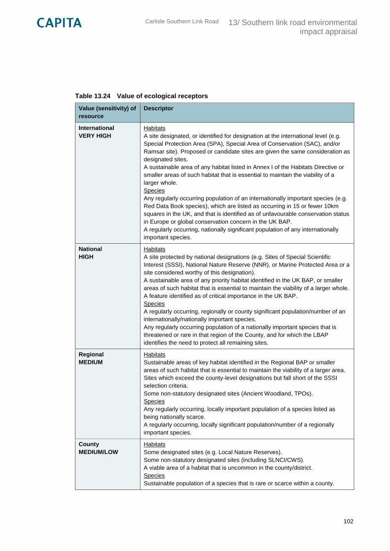
Carlisle Southern Link Road
13/ Southern link road environmental impact appraisal
102
Table 13.24 Value of ecological receptors
Value (sensitivity) of
resource
Descriptor
International
VERY HIGH
Habitats
A site designated, or identified for designation at the international level (e.g.
Special Protection Area (SPA), Special Area of Conservation (SAC), and/or
Ramsar site). Proposed or candidate sites are given the same consideration as
designated sites.
A sustainable area of any habitat listed in Annex I of the Habitats Directive or
smaller areas of such habitat that is essential to maintain the viability of a
larger whole.
Species
Any regularly occurring population of an internationally important species (e.g.
Red Data Book species), which are listed as occurring in 15 or fewer 10km
squares in the UK, and that is identified as of unfavourable conservation status
in Europe or global conservation concern in the UK BAP.
A regularly occurring, nationally significant population of any internationally
important species.
National
HIGH
Habitats
A site protected by national designations (e.g. Sites of Special Scientific
Interest (SSSI), National Nature Reserve (NNR), or Marine Protected Area or a
site considered worthy of this designation).
A sustainable area of any priority habitat identified in the UK BAP, or smaller
areas of such habitat that is essential to maintain the viability of a larger whole.
A feature identified as of critical importance in the UK BAP.
Species
A regularly occurring, regionally or county significant population/number of an
internationally/nationally important species.
Any regularly occurring population of a nationally important species that is
threatened or rare in that region of the County, and for which the LBAP
identifies the need to protect all remaining sites.
Regional
MEDIUM
Habitats
Sustainable areas of key habitat identified in the Regional BAP or smaller
areas of such habitat that is essential to maintain the viability of a larger area.
Sites which exceed the county-level designations but fall short of the SSSI
selection criteria.
Some non-statutory designated sites (Ancient Woodland, TPOs).
Species
Any regularly occurring, locally important population of a species listed as
being nationally scarce.
A regularly occurring, locally significant population/number of a regionally
important species.
County
MEDIUM/LOW
Habitats
Some designated sites (e.g. Local Nature Reserves).
Some non-statutory designated sites (including SLNCI/CWS).
A viable area of a habitat that is uncommon in the county/district.
Species
Sustainable population of a species that is rare or scarce within a county.
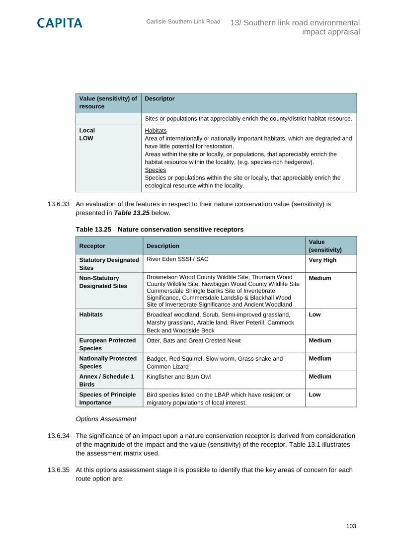
Carlisle Southern Link Road
13/ Southern link road environmental impact appraisal
103
Value (sensitivity) of
resource
Descriptor
Sites or populations that appreciably enrich the county/district habitat resource.
Local
LOW
Habitats
Area of internationally or nationally important habitats, which are degraded and
have little potential for restoration.
Areas within the site or locally, or populations, that appreciably enrich the
habitat resource within the locality, (e.g. species-rich hedgerow).
Species
Species or populations within the site or locally, that appreciably enrich the
ecological resource within the locality.
13.6.33 An evaluation of the features in respect to their nature conservation value (sensitivity) is
presented in Table 13.25 below.
Table 13.25 Nature conservation sensitive receptors
Receptor Description Value
(sensitivity)
Statutory Designated
Sites
River Eden SSSI / SAC Very High
Non-Statutory
Designated Sites
Brownelson Wood County Wildlife Site, Thurnam Wood County Wildlife Site, Newbiggin Wood County Wildlife Site Cummersdale Shingle Banks Site of Invertebrate Significance, Cummersdale Landslip & Blackhall Wood Site of Invertebrate Significance and Ancient Woodland
Medium
Habitats Broadleaf woodland, Scrub, Semi-improved grassland,
Marshy grassland, Arable land, River Peterill, Cammock
Beck and Woodside Beck
Low
European Protected
Species
Otter, Bats and Great Crested Newt Medium
Nationally Protected
Species
Badger, Red Squirrel, Slow worm, Grass snake and
Common Lizard
Medium
Annex / Schedule 1
Birds
Kingfisher and Barn Owl Medium
Species of Principle
Importance
Bird species listed on the LBAP which have resident or
migratory populations of local interest.
Low
Options Assessment
13.6.34 The significance of an impact upon a nature conservation receptor is derived from consideration
of the magnitude of the impact and the value (sensitivity) of the receptor. Table 13.1 illustrates
the assessment matrix used.
13.6.35 At this options assessment stage it is possible to identify that the key areas of concern for each
route option are:
Carlisle Southern Link Road
13/ Southern link road environmental impact appraisal
104
Mortality of species
Loss of habitat
Fragmentation of habitats or populations
Disturbance
Indirect impacts such as pollution, reduction in air or water quality etc.
Option 1: Blue
13.6.36 Of the three options, option 1 represents the most use of existing road networks, with the route
following the alignment of Peter Lane and along section of Newbiggin Road to connect to the
existing Junction 42 roundabout. This will result in minimal loss of vegetation and habitat
severance where new route sections are introduced.
13.6.37 Most significant is the crossing of the River Caldew which will result in a direct loss of a large
section of semi-improved grassland which forms part of the site of invertebrate significance as
well as loss of a number of trees within the riparian corridor. Introduction of lighting in to this
area is also likely to alter invertebrate behaviour. This direct loss of designated habitat is
considered a moderate adverse impact.
13.6.38 The crossing is likely to sever a key foraging and commuting route for bat species both in the
local and wider area and introduction of lighting in to this previously unlit area will change
foraging behaviour for a number of species, it is also possible that road traffic mortality will
occur where the road bisects the river. Otter foraging routes along the river corridor are also
likely to be fragmented by the removal of vegetation. Impacts on protected species are
considered to be moderated adverse.
13.6.39 Construction within the River Caldew may result in a direct loss of habitat which support the
qualifying features of River Eden SSSI / SAC which could result in significant changes to local
species abundance. There is also potential for the construction to result in disruption or
prevention of Atlantic Salmon migration. Pollution or sedimentation events may cause reduction
in water quality which will reduce habitat suitability for species such as lamprey and white
clawed crayfish. The potential impacts on the River Eden SSSI / SAC are considered major
adverse.
13.6.40 Between Peter Lane and the connection back to the existing road at Durdar there will be a loss
of agricultural land to facilitate the new route. While this habitat is of limited ecological value for
species, the hedgerows are likely to represent key commuting routes. It is likely that a number
of individual trees which may support species of nature conservation interest will need to be
removed to facilitate the development These habitats and habitat features are considered to be
replaceable and therefore this is considered to be a minor adverse impact.
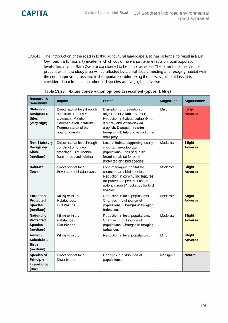
Carlisle Southern Link Road
13/ Southern link road environmental impact appraisal
105
13.6.41 The introduction of the road in to this agricultural landscape also has potential to result in Barn
Owl road traffic mortality incidents which could have short term effects on local population
levels. Impacts on Barn Owl are considered to be minor adverse. The other birds likely to be
present within the study area will be affected by a small loss of nesting and foraging habitat with
the semi-improved grassland in the riparian corridor being the most significant loss. It is
considered that impacts on other bird species are Negligible adverse.
Table 13.26 Nature conservation options assessment (option 1 blue)
Receptor &
Sensitivity Impact Effect Magnitude Significance
Statutory
Designated
Sites
(very high)
Direct habitat loss through
construction of river
crossings. Pollution /
Sedimentation incidents.
Fragmentation of the
riparian corridor.
Disruption or prevention of
migration of Atlantic Salmon.
Reduction in habitat suitability for
lamprey and white-clawed
crayfish. Disruption to otter
foraging habitats and reduction in
otter prey.
Major Large
Adverse
Non-Statutory
Designated
Sites
(medium)
Direct habitat loss through
construction of river
crossings. Disturbance
from introduced lighting.
Loss of habitat supporting locally
important invertebrate
populations. Loss of quality
foraging habitat for other
protected and bird species.
Moderate Slight
Adverse
Habitats
(low)
Direct habitat loss.
Severance of hedgerows.
Loss of foraging habitat for
protected and bird species.
Reduction in commuting features
for protected species. Loss of
potential roost / nest sites for bird
species.
Moderate Slight
Adverse
European
Protected
Species
(medium)
Killing or injury.
Habitat loss.
Disturbance.
Reduction in local populations.
Changes in distribution of
populations. Changes in foraging
behaviour.
Moderate Slight
Adverse
Nationally
Protected
Species
(medium)
Killing or injury.
Habitat loss.
Disturbance.
Reduction in local populations.
Changes in distribution of
populations. Changes in foraging
behaviour.
Moderate Slight
Adverse
Annex /
Schedule 1
Birds
(medium)
Killing or injury.
Reduction in local populations. Minor Slight
Adverse
Species of
Principle
Importance
(low)
Direct habitat loss.
Disturbance.
Changes in distribution of
populations.
Negligible Neutral
Carlisle Southern Link Road
13/ Southern link road environmental impact appraisal
106
Option 2: Pink
13.6.42 Option 2 also initially follows the alignment of Peter Lane with the new route sections crossing
agricultural land, woodland and both the River Caldew and River Petteril to join the A6 at the
eastern extent of the study area.
13.6.43 As with the other options, most significant is the crossing of the River Caldew which will result in
a direct loss of a smaller section of semi-improved grassland. Although this does not fall within
the designated site of invertebrate significance it is still likely functional habitat for the species.
The route then passes alongside the racecourse adjacent to an area of Ancient Woodland;
while none of the trees will be directly impacted by this route option, an increase in run off or
dust deposition in the area may have a negative impact on the trees. Impacts on non-statutory
designated sites are considered moderate adverse impact.
13.6.44 As with option 1 the crossing of the River Caldew is likely to sever a key foraging and
commuting route for bat species both in the local and wider area and introduction of lighting in
to this previously unlit area will change foraging behaviour for a number of bat species, it is also
possible that road traffic mortality will occur where the road bisects the river. Unlike option 1 the
road will bisect the river in close proximity to the exiting railway line, it is therefore considered
that severance impacts will be slightly lower as the railway corridor is also likely to be used by
foraging and commuting bats. Otter foraging routes along the river corridor are also likely to be
fragmented by the removal of vegetation. Impacts on protected species are considered to be
moderated adverse.
13.6.45 Construction within the River Caldew may result in a direct loss of habitat which support the
qualifying features of River Eden SSSI / SAC which could result in significant changes to local
salmon abundance. There is also potential for the construction to result in disruption or
prevention of Atlantic Salmon migration. Pollution or sedimentation events may cause reduction
in water quality which will reduce habitat suitability for species such as lamprey and white
clawed crayfish. The potential impacts on the River Eden SSSI / SAC are considered major
adverse.
13.6.46 There will be a loss of agricultural land to facilitate route option 2. As with option 1, these
habitats are of limited ecological value for foraging species, however the hedgerows are likely to
represent key commuting routes. To the eastern extent of this route option a number of
individual trees will need to be removed may support species of nature conservation interest.
Before joining the A6, this rout option will need to cross the River Petteril and Camnmock Beck
which will involve removal of trees and scrub from the riparian corridor as well as a loss of
marshy grassland in the flood plain. While the River Petteril is not designated, it is a tributary of
the River Eden / SAC, therefore and disturbance, pollution or sedimentation events which occur
in this section of the river have potential to impact upon the SSSI / SAC. Impacts on habitats
are therefore considered to be moderate.
13.6.47 As with option 1, the introduction of the road in to the agricultural landscape also has potential
to result in Barn Owl road traffic mortality incidents which could affect local population levels in
the short term. Impacts on Barn Owl are considered to be minor adverse.
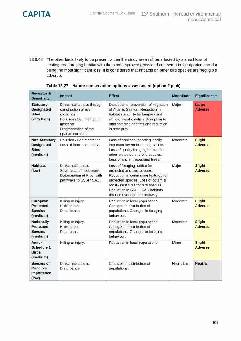
Carlisle Southern Link Road
13/ Southern link road environmental impact appraisal
107
13.6.48 The other birds likely to be present within the study area will be affected by a small loss of
nesting and foraging habitat with the semi-improved grassland and scrub in the riparian corridor
being the most significant loss. It is considered that impacts on other bird species are negligible
adverse.
Table 13.27 Nature conservation options assessment (option 2 pink)
Receptor &
Sensitivity Impact Effect Magnitude Significance
Statutory
Designated
Sites
(very high)
Direct habitat loss through
construction of river
crossings.
Pollution / Sedimentation
incidents.
Fragmentation of the
riparian corridor.
Disruption or prevention of migration
of Atlantic Salmon. Reduction in
habitat suitability for lamprey and
white-clawed crayfish. Disruption to
otter foraging habitats and reduction
in otter prey.
Major Large
Adverse
Non-Statutory
Designated
Sites
(medium)
Pollution / Sedimentation.
Loss of functional habitat.
Loss of habitat supporting locally
important invertebrate populations.
Loss of quality foraging habitat for
other protected and bird species.
Loss of ancient woodland trees.
Moderate Slight
Adverse
Habitats
(low)
Direct habitat loss.
Severance of hedgerows.
Deterioration of River with
pathways to SSSI / SAC.
Loss of foraging habitat for
protected and bird species.
Reduction in commuting features for
protected species. Loss of potential
roost / nest sites for bird species.
Reduction in SSSI / SAC habitats
through river corridor pathway.
Major Slight
Adverse
European
Protected
Species
(medium)
Killing or injury.
Habitat loss.
Disturbance.
Reduction in local populations.
Changes in distribution of
populations. Changes in foraging
behaviour.
Moderate Slight
Adverse
Nationally
Protected
Species
(medium)
Killing or injury.
Habitat loss.
Disturbanc
Reduction in local populations.
Changes in distribution of
populations. Changes in foraging
behaviour.
Moderate Slight
Adverse
Annex /
Schedule 1
Birds
(medium)
Killing or injury.
Reduction in local populations. Minor Slight
Adverse
Species of
Principle
Importance
(low)
Direct habitat loss.
Disturbance.
Changes in distribution of
populations.
Negligible Neutral
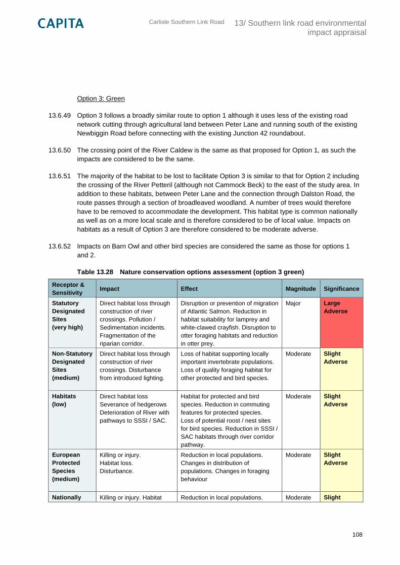
Carlisle Southern Link Road
13/ Southern link road environmental impact appraisal
108
Option 3: Green
13.6.49 Option 3 follows a broadly similar route to option 1 although it uses less of the existing road
network cutting through agricultural land between Peter Lane and running south of the existing
Newbiggin Road before connecting with the existing Junction 42 roundabout.
13.6.50 The crossing point of the River Caldew is the same as that proposed for Option 1, as such the
impacts are considered to be the same.
13.6.51 The majority of the habitat to be lost to facilitate Option 3 is similar to that for Option 2 including
the crossing of the River Petteril (although not Cammock Beck) to the east of the study area. In
addition to these habitats, between Peter Lane and the connection through Dalston Road, the
route passes through a section of broadleaved woodland. A number of trees would therefore
have to be removed to accommodate the development. This habitat type is common nationally
as well as on a more local scale and is therefore considered to be of local value. Impacts on
habitats as a result of Option 3 are therefore considered to be moderate adverse.
13.6.52 Impacts on Barn Owl and other bird species are considered the same as those for options 1
and 2.
Table 13.28 Nature conservation options assessment (option 3 green)
Receptor &
Sensitivity Impact Effect Magnitude Significance
Statutory
Designated
Sites
(very high)
Direct habitat loss through
construction of river
crossings. Pollution /
Sedimentation incidents.
Fragmentation of the
riparian corridor.
Disruption or prevention of migration
of Atlantic Salmon. Reduction in
habitat suitability for lamprey and
white-clawed crayfish. Disruption to
otter foraging habitats and reduction
in otter prey.
Major Large
Adverse
Non-Statutory
Designated
Sites
(medium)
Direct habitat loss through
construction of river
crossings. Disturbance
from introduced lighting.
Loss of habitat supporting locally
important invertebrate populations.
Loss of quality foraging habitat for
other protected and bird species.
Moderate Slight
Adverse
Habitats
(low)
Direct habitat loss
Severance of hedgerows
Deterioration of River with
pathways to SSSI / SAC.
Habitat for protected and bird
species. Reduction in commuting
features for protected species.
Loss of potential roost / nest sites
for bird species. Reduction in SSSI /
SAC habitats through river corridor
pathway.
Moderate Slight
Adverse
European
Protected
Species
(medium)
Killing or injury.
Habitat loss.
Disturbance.
Reduction in local populations.
Changes in distribution of
populations. Changes in foraging
behaviour
Moderate Slight
Adverse
Nationally Killing or injury. Habitat Reduction in local populations. Moderate Slight
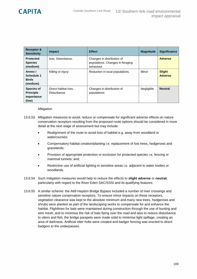
Carlisle Southern Link Road
13/ Southern link road environmental impact appraisal
109
Receptor &
Sensitivity Impact Effect Magnitude Significance
Protected
Species
(medium)
loss. Disturbance. Changes in distribution of
populations. Changes in foraging
behaviour.
Adverse
Annex /
Schedule 1
Birds
(medium)
Killing or injury
Reduction in local populations. Minor Slight
Adverse
Species of
Principle
Importance
(low)
Direct habitat loss.
Disturbance.
Changes in distribution of
populations.
Negligible Neutral
Mitigation
13.6.53 Mitigation measures to avoid, reduce or compensate for significant adverse effects on nature
conservation receptors resulting from the proposed route options should be considered in more
detail at the next stage of assessment but may include:
Realignment of the route to avoid loss of habitat e.g. away from woodland or
watercourses;
Compensatory habitat creation/planting i.e. replacement of lost trees, hedgerows and
grasslands;
Provision of appropriate protection or exclusion for protected species i.e. fencing or
mammal tunnels; and,
Restrictive use of artificial lighting in sensitive areas i.e. adjacent to water bodies or
woodlands.
13.6.54 Such mitigation measures would help to reduce the effects to slight adverse or neutral,
particularly with regard to the River Eden SAC/SSSI and its qualifying features.
13.6.55 A similar scheme: the A69 Haydon Bridge Bypass included a number of river crossings and
sensitive nature conservation receptors. To ensure minor impacts on these receptors,
vegetation clearance was kept to the absolute minimum and many new trees, hedgerows and
shrubs were planted as part of the landscaping works to compensate for and enhance the
habitat. Flightlines for bats were maintained during construction through the use of bunting and
wire mesh, and to minimise the risk of bats flying over the road and also to reduce disturbance
to otters and fish, the bridge parapets were made solid to minimise light spillage, creating an
area of darkness. Artificial otter holts were created and badger fencing was erected to direct
badgers to the underpasses.
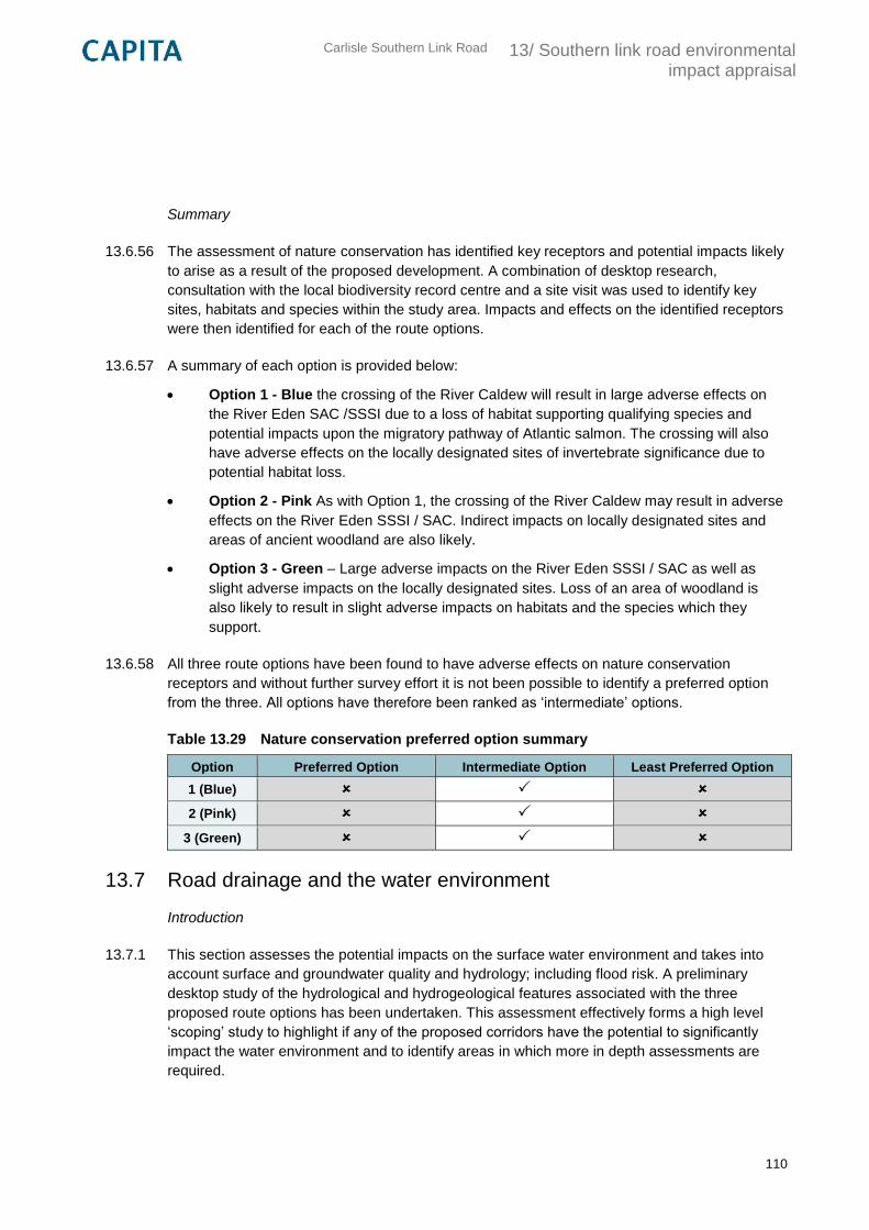
Carlisle Southern Link Road
13/ Southern link road environmental impact appraisal
110
Summary
13.6.56 The assessment of nature conservation has identified key receptors and potential impacts likely
to arise as a result of the proposed development. A combination of desktop research,
consultation with the local biodiversity record centre and a site visit was used to identify key
sites, habitats and species within the study area. Impacts and effects on the identified receptors
were then identified for each of the route options.
13.6.57 A summary of each option is provided below:
Option 1 - Blue the crossing of the River Caldew will result in large adverse effects on
the River Eden SAC /SSSI due to a loss of habitat supporting qualifying species and
potential impacts upon the migratory pathway of Atlantic salmon. The crossing will also
have adverse effects on the locally designated sites of invertebrate significance due to
potential habitat loss.
Option 2 - Pink As with Option 1, the crossing of the River Caldew may result in adverse
effects on the River Eden SSSI / SAC. Indirect impacts on locally designated sites and
areas of ancient woodland are also likely.
Option 3 - Green – Large adverse impacts on the River Eden SSSI / SAC as well as
slight adverse impacts on the locally designated sites. Loss of an area of woodland is
also likely to result in slight adverse impacts on habitats and the species which they
support.
13.6.58 All three route options have been found to have adverse effects on nature conservation
receptors and without further survey effort it is not been possible to identify a preferred option
from the three. All options have therefore been ranked as ‘intermediate’ options.
Table 13.29 Nature conservation preferred option summary
Option Preferred Option Intermediate Option Least Preferred Option
1 (Blue)
2 (Pink)
3 (Green)
13.7 Road drainage and the water environment
Introduction
13.7.1 This section assesses the potential impacts on the surface water environment and takes into
account surface and groundwater quality and hydrology; including flood risk. A preliminary
desktop study of the hydrological and hydrogeological features associated with the three
proposed route options has been undertaken. This assessment effectively forms a high level
‘scoping’ study to highlight if any of the proposed corridors have the potential to significantly
impact the water environment and to identify areas in which more in depth assessments are
required.
Carlisle Southern Link Road
13/ Southern link road environmental impact appraisal
111
Methodology
13.7.2 The assessment of potential effects on road drainage and water environment has been carried
out in accordance with the guidance and techniques presented in DMRB Volume 11 Section 3
Part 10 (HD 45/09 - Road Drainage and the Water Environment) and TAG Unit A3. At Stage 1
the objective of the assessment is to:
“Undertake sufficient assessment to provide an appreciation of the likely effects on
watercourses, groundwater and flood risk and to identify the relevant constraints associated
with particular broadly defined routes, or corridors as developed by the Design Organisation
and agreed with the Overseeing Departments Project Manager”
13.7.3 The steps taken were as follows:
Establishment of the baseline – identification of existing rivers, watercourses, flood
zones and aquifers which may be affected by a possible route corridor;
Assessment of potential effects – assessment in broad terms whether any of the
baseline features would potentially be positively or negatively impacted by each of the
proposed options;
Identification of potential mitigation measures – identification of primary measures
designed to prevent, reduce or compensate for potential effects of the proposals. The
requirement for secondary mitigation measures would need to be assessed at TAG
Assessment Stage 2 and 3 when an option(s) has been selected.
13.7.4 The ‘study area’ has been determined as a broad corridor between the A595 and M6 to the
south of Carlisle as identified at Step 4b in the TAG process (see Section 10). A buffer off
500m was also applied around this corridor to identify any key features within close proximity.
To establish the baseline, site visits were conducted along with a desktop review of the
following sources:
Ordnance Survey 1:25,000 maps;
Environment Agency map data for flooding, main rivers and groundwater;
Historic flood mapping;
Google Maps.
Baseline
Rivers and watercourses
13.7.5 Rivers and watercourses within the study area are shown on plan CSDR-CAP-EGN-00-DR-V-
0018 in Appendix E. Designated flood zones and historical flooding are shown on plan CSDR-
CAP-EGN-00-DR-V-0019 in Appendix E. Key features of the study area include:
River Caldew: Designated main river which crosses the study area from south to north
and is crossed by all proposed corridors. There are no identified flood defences
associated with this river within the study area.
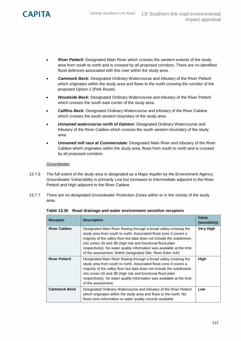
Carlisle Southern Link Road
13/ Southern link road environmental impact appraisal
112
River Petteril: Designated Main River which crosses the western extents of the study
area from south to north and is crossed by all proposed corridors. There are no identified
flood defences associated with this river within the study area.
Cammock Beck: Designated Ordinary Watercourse and tributary of the River Petteril
which originates within the study area and flows to the north crossing the corridor of the
proposed Option 2 (Pink Route).
Woodside Beck: Designated Ordinary Watercourse and tributary of the River Petteril
which crosses the south east corner of the study area.
Calflins Beck: Designated Ordinary Watercourse and tributary of the River Caldew
which crosses the south western boundary of the study area.
Unnamed watercourse north of Dalston: Designated Ordinary Watercourse and
tributary of the River Caldew which crosses the south western boundary of the study
area.
Unnamed mill race at Cummersdale: Designated Main River and tributary of the River
Caldew which originates within the study area, flows from south to north and is crossed
by all proposed corridors.
Groundwater
13.7.6 The full extent of the study area is designated as a Major Aquifer by the Environment Agency.
Groundwater Vulnerability is primarily Low but increases to Intermediate adjacent to the River
Petteril and High adjacent to the River Caldew.
13.7.7 There are no designated Groundwater Protection Zones within or in the vicinity of the study
area.
Table 13.30 Road drainage and water environment sensitive receptors
Receptor Description Value
(sensitivity)
River Caldew Designated Main River flowing through a broad valley crossing the
study area from south to north. Associated flood zone 3 covers a
majority of the valley floor but data does not include the subdivision
into zones 3A and 3B (high risk and functional flood plain
respectively). No water quality information was available at the time
of the assessment. Within Designated Site: River Eden SAC
Very High
River Petteril Designated Main River flowing through a broad valley crossing the
study area from south to north. Associated flood zone 3 covers a
majority of the valley floor but data does not include the subdivision
into zones 3A and 3B (high risk and functional flood plain
respectively). No water quality information was available at the time
of the assessment.
High
Cammock Beck Designated Ordinary Watercourse and tributary of the River Petteril
which originates within the study area and flows to the north. No
flood zone information or water quality records available
Low
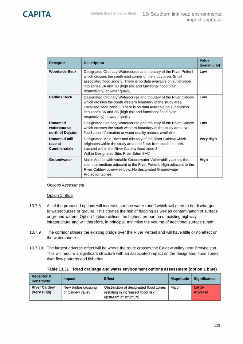
Carlisle Southern Link Road
13/ Southern link road environmental impact appraisal
113
Receptor Description Value
(sensitivity)
Woodside Beck Designated Ordinary Watercourse and tributary of the River Petteril
which crosses the south east corner of the study area. Small
associated flood zone 3. There is no data available on subdivision
into zones 3A and 3B (high risk and functional flood plain
respectively) or water quality.
Low
Calflins Beck Designated Ordinary Watercourse and tributary of the River Caldew
which crosses the south western boundary of the study area.
Localised flood zone 3. There is no data available on subdivision
into zones 3A and 3B (high risk and functional flood plain
respectively) or water quality.
Low
Unnamed
watercourse
north of Dalston
Designated Ordinary Watercourse and tributary of the River Caldew
which crosses the south western boundary of the study area. No
flood zone information or water quality records available
Low
Unnamed mill
race at
Cummersdale
Designated Main River and tributary of the River Caldew which
originates within the study area and flows from south to north.
Located within the River Caldew flood zone 3.
Within Designated Site: River Eden SAC
Very High
Groundwater Major Aquifer with variable Groundwater Vulnerability across the
site. Intermediate adjacent to the River Petteril, High adjacent to the
River Caldew otherwise Low. No designated Groundwater
Protection Zones.
High
Options Assessment
Option 1: Blue
13.7.8 All of the proposed options will increase surface water runoff which will need to be discharged
to watercourses or ground. This creates the risk of flooding as well as contamination of surface
or ground waters. Option 1 (blue) utilises the highest proportion of existing highway
infrastructure and will therefore, in principal, minimise the volume of additional surface runoff
13.7.9 The corridor utilises the existing bridge over the River Petteril and will have little or no effect on
the watercourse.
13.7.10 The largest adverse effect will be where the route crosses the Caldew valley near Brownelson.
This will require a significant structure with an associated impact on the designated flood zones,
river flow patterns and fisheries.
Table 13.31 Road drainage and water environment options assessment (option 1 blue)
Receptor &
Sensitivity Impact Effect Magnitude Significance
River Caldew
(Very High)
New bridge crossing
of Caldew valley.
Obstruction of designated flood zones
resulting in increased flood risk
upstream of structure.
Major Large
Adverse
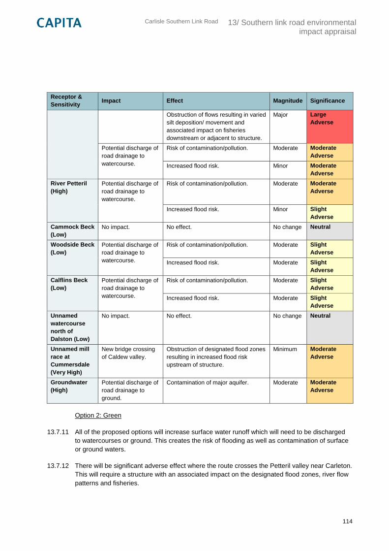
Carlisle Southern Link Road
13/ Southern link road environmental impact appraisal
114
Receptor &
Sensitivity Impact Effect Magnitude Significance
Obstruction of flows resulting in varied
silt deposition/ movement and
associated impact on fisheries
downstream or adjacent to structure.
Major Large
Adverse
Potential discharge of
road drainage to
watercourse.
Risk of contamination/pollution. Moderate Moderate
Adverse
Increased flood risk. Minor Moderate
Adverse
River Petteril
(High)
Potential discharge of
road drainage to
watercourse.
Risk of contamination/pollution. Moderate Moderate
Adverse
Increased flood risk. Minor Slight
Adverse
Cammock Beck
(Low)
No impact. No effect. No change Neutral
Woodside Beck
(Low)
Potential discharge of
road drainage to
watercourse.
Risk of contamination/pollution. Moderate Slight
Adverse
Increased flood risk. Moderate Slight
Adverse
Calflins Beck
(Low)
Potential discharge of
road drainage to
watercourse.
Risk of contamination/pollution. Moderate Slight
Adverse
Increased flood risk. Moderate Slight
Adverse
Unnamed
watercourse
north of
Dalston (Low)
No impact. No effect. No change Neutral
Unnamed mill
race at
Cummersdale
(Very High)
New bridge crossing
of Caldew valley.
Obstruction of designated flood zones
resulting in increased flood risk
upstream of structure.
Minimum Moderate
Adverse
Groundwater
(High)
Potential discharge of
road drainage to
ground.
Contamination of major aquifer. Moderate Moderate
Adverse
Option 2: Green
13.7.11 All of the proposed options will increase surface water runoff which will need to be discharged
to watercourses or ground. This creates the risk of flooding as well as contamination of surface
or ground waters.
13.7.12 There will be significant adverse effect where the route crosses the Petteril valley near Carleton.
This will require a structure with an associated impact on the designated flood zones, river flow
patterns and fisheries.
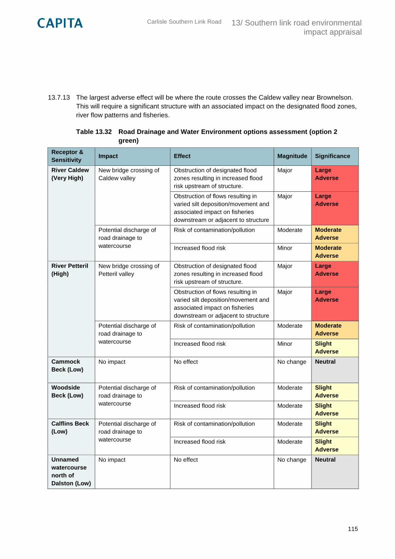
Carlisle Southern Link Road
13/ Southern link road environmental impact appraisal
115
13.7.13 The largest adverse effect will be where the route crosses the Caldew valley near Brownelson.
This will require a significant structure with an associated impact on the designated flood zones,
river flow patterns and fisheries.
Table 13.32 Road Drainage and Water Environment options assessment (option 2
green)
Receptor &
Sensitivity Impact Effect Magnitude Significance
River Caldew
(Very High)
New bridge crossing of
Caldew valley
Obstruction of designated flood
zones resulting in increased flood
risk upstream of structure.
Major Large
Adverse
Obstruction of flows resulting in
varied silt deposition/movement and
associated impact on fisheries
downstream or adjacent to structure
Major Large
Adverse
Potential discharge of
road drainage to
watercourse
Risk of contamination/pollution Moderate Moderate
Adverse
Increased flood risk Minor Moderate
Adverse
River Petteril
(High)
New bridge crossing of
Petteril valley
Obstruction of designated flood
zones resulting in increased flood
risk upstream of structure.
Major Large
Adverse
Obstruction of flows resulting in
varied silt deposition/movement and
associated impact on fisheries
downstream or adjacent to structure
Major Large
Adverse
Potential discharge of
road drainage to
watercourse
Risk of contamination/pollution Moderate Moderate
Adverse
Increased flood risk Minor Slight
Adverse
Cammock
Beck (Low)
No impact No effect No change Neutral
Woodside
Beck (Low)
Potential discharge of
road drainage to
watercourse
Risk of contamination/pollution Moderate Slight
Adverse
Increased flood risk Moderate Slight
Adverse
Calflins Beck
(Low)
Potential discharge of
road drainage to
watercourse
Risk of contamination/pollution Moderate Slight
Adverse
Increased flood risk Moderate Slight
Adverse
Unnamed
watercourse
north of
Dalston (Low)
No impact No effect No change Neutral
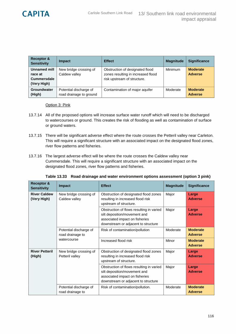
Carlisle Southern Link Road
13/ Southern link road environmental impact appraisal
116
Receptor &
Sensitivity Impact Effect Magnitude Significance
Unnamed mill
race at
Cummersdale
(Very High)
New bridge crossing of
Caldew valley
Obstruction of designated flood
zones resulting in increased flood
risk upstream of structure.
Minimum Moderate
Adverse
Groundwater
(High)
Potential discharge of
road drainage to ground
Contamination of major aquifer Moderate Moderate
Adverse
Option 3: Pink
13.7.14 All of the proposed options will increase surface water runoff which will need to be discharged
to watercourses or ground. This creates the risk of flooding as well as contamination of surface
or ground waters.
13.7.15 There will be significant adverse effect where the route crosses the Petteril valley near Carleton.
This will require a significant structure with an associated impact on the designated flood zones,
river flow patterns and fisheries.
13.7.16 The largest adverse effect will be where the route crosses the Caldew valley near
Cummersdale. This will require a significant structure with an associated impact on the
designated flood zones, river flow patterns and fisheries.
Table 13.33 Road drainage and water environment options assessment (option 3 pink)
Receptor &
Sensitivity Impact Effect Magnitude Significance
River Caldew
(Very High)
New bridge crossing of
Caldew valley
Obstruction of designated flood zones
resulting in increased flood risk
upstream of structure.
Major Large
Adverse
Obstruction of flows resulting in varied
silt deposition/movement and
associated impact on fisheries
downstream or adjacent to structure
Major Large
Adverse
Potential discharge of
road drainage to
watercourse
Risk of contamination/pollution Moderate Moderate
Adverse
Increased flood risk Minor Moderate
Adverse
River Petteril
(High)
New bridge crossing of
Petteril valley
Obstruction of designated flood zones
resulting in increased flood risk
upstream of structure.
Major Large
Adverse
Obstruction of flows resulting in varied
silt deposition/movement and
associated impact on fisheries
downstream or adjacent to structure
Major Large
Adverse
Potential discharge of
road drainage to
Risk of contamination/pollution. Moderate Moderate
Adverse
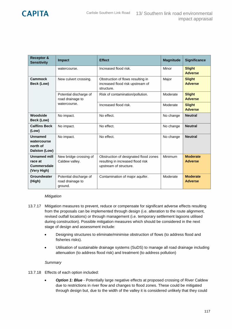
Carlisle Southern Link Road
13/ Southern link road environmental impact appraisal
117
Receptor &
Sensitivity Impact Effect Magnitude Significance
watercourse. Increased flood risk. Minor Slight
Adverse
Cammock
Beck (Low)
New culvert crossing. Obstruction of flows resulting in
increased flood risk upstream of
structure.
Major Slight
Adverse
Potential discharge of
road drainage to
watercourse.
Risk of contamination/pollution. Moderate Slight
Adverse
Increased flood risk. Moderate Slight
Adverse
Woodside
Beck (Low)
No impact. No effect. No change Neutral
Calflins Beck
(Low)
No impact. No effect. No change Neutral
Unnamed
watercourse
north of
Dalston (Low)
No impact. No effect. No change Neutral
Unnamed mill
race at
Cummersdale
(Very High)
New bridge crossing of
Caldew valley.
Obstruction of designated flood zones
resulting in increased flood risk
upstream of structure.
Minimum Moderate
Adverse
Groundwater
(High)
Potential discharge of
road drainage to
ground.
Contamination of major aquifer. Moderate Moderate
Adverse
Mitigation
13.7.17 Mitigation measures to prevent, reduce or compensate for significant adverse effects resulting
from the proposals can be implemented through design (i.e. alteration to the route alignment,
revised outfall locations) or through management (i.e. temporary settlement lagoons utilised
during construction). Possible mitigation measures which should be considered in the next
stage of design and assessment include:
Designing structures to eliminate/minimise obstruction of flows (to address flood and
fisheries risks).
Utilisation of sustainable drainage systems (SuDS) to manage all road drainage including
attenuation (to address flood risk) and treatment (to address pollution)
Summary
13.7.18 Effects of each option included:
Option 1: Blue - Potentially large negative effects at proposed crossing of River Caldew
due to restrictions in river flow and changes to flood zones. These could be mitigated
through design but, due to the width of the valley it is considered unlikely that they could
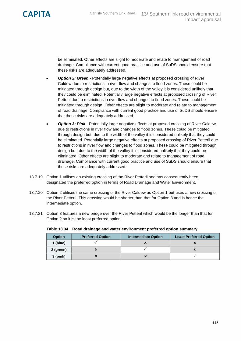
Carlisle Southern Link Road
13/ Southern link road environmental impact appraisal
118
be eliminated. Other effects are slight to moderate and relate to management of road
drainage. Compliance with current good practice and use of SuDS should ensure that
these risks are adequately addressed.
Option 2: Green - Potentially large negative effects at proposed crossing of River
Caldew due to restrictions in river flow and changes to flood zones. These could be
mitigated through design but, due to the width of the valley it is considered unlikely that
they could be eliminated. Potentially large negative effects at proposed crossing of River
Petteril due to restrictions in river flow and changes to flood zones. These could be
mitigated through design. Other effects are slight to moderate and relate to management
of road drainage. Compliance with current good practice and use of SuDS should ensure
that these risks are adequately addressed.
Option 3: Pink - Potentially large negative effects at proposed crossing of River Caldew
due to restrictions in river flow and changes to flood zones. These could be mitigated
through design but, due to the width of the valley it is considered unlikely that they could
be eliminated. Potentially large negative effects at proposed crossing of River Petteril due
to restrictions in river flow and changes to flood zones. These could be mitigated through
design but, due to the width of the valley it is considered unlikely that they could be
eliminated. Other effects are slight to moderate and relate to management of road
drainage. Compliance with current good practice and use of SuDS should ensure that
these risks are adequately addressed.
13.7.19 Option 1 utilises an existing crossing of the River Petteril and has consequently been
designated the preferred option in terms of Road Drainage and Water Environment.
13.7.20 Option 2 utilises the same crossing of the River Caldew as Option 1 but uses a new crossing of
the River Petteril. This crossing would be shorter than that for Option 3 and is hence the
intermediate option.
13.7.21 Option 3 features a new bridge over the River Petteril which would be the longer than that for
Option 2 so it is the least preferred option.
Table 13.34 Road drainage and water environment preferred option summary
Option Preferred Option Intermediate Option Least Preferred Option
1 (blue)
2 (green)
3 (pink)
Carlisle Southern Link Road
13/ Southern link road environmental impact appraisal
119
13.8 Outdoor access and recreation
Introduction
13.8.1 The assessment of outdoor access and recreation aims to identify impacts likely to arise as a
result of the proposed development on routes and community facilities used by pedestrians,
cyclists and equestrians (referred to jointly as ‘non-motorised users’ (NMUs)), including a
consideration of vulnerable groups whose needs may differ from other NMUs. If appropriate for
the site, water based NMUs (i.e. swimmers, canoeists, kayakers and anglers) are also taken
into account.
Methodology
13.8.2 The assessment of potential effects on outdoor access and recreation has been carried out in
accordance with DMRB Volume 11 Section 3 Part 8 (Pedestrians, Cyclists, Equestrians and
Community Effects) and TAG Unit A4 Section 5 (Severance Impacts). At Stage 1 the objective
of the assessment is to:
“Undertake sufficient assessment to provide an appreciation of the likely effects on pedestrians,
cyclists and equestrians and for people’s ability to move around their community, and to identify
the relevant constraints associated with particular broadly defined routes, or corridors as
developed by the Design Organisation and agreed with the Overseeing Departments Project
Manager”
13.8.3 The steps taken were as follows:
Establishment of the baseline – identification of existing Public Rights of Way (PRoW),
promoted national routes, cycleways, pedestrianised footways, waterways and
community facilities which may be affected by a possible route corridor;
Assessment of potential effects – assessment in broad terms whether NMU journeys
would be restricted (including severance), lengthened or reduced by a possible route,
whether the amenity value of such journeys would increase or diminish, and whether
some people would be deterred from making journeys which they currently make; and,
Identification of potential mitigation measures – identification of measures designed
to prevent, reduce or compensate for potential effects of the proposals.
13.8.4 In assessing potential effects it is assumed that the route options will be unsuitable for use by
NMUs and no new linkages will be created (i.e. the routes do not include multiuse footways to
the side or on-road cycle lanes).
Establishment of the baseline
Carlisle Southern Link Road
13/ Southern link road environmental impact appraisal
120
13.8.5 Baseline conditions were identified within the ‘study area’; a broad corridor between the A595
and M6 to the south of Carlisle as identified at Step 4b in the TAG process (see Section 10). A
buffer off 500m was also applied around this corridor to identify any key community facilities
and routes within close proximity. To establish the baseline, site visits were conducted along
with a desktop review of the following sources:
Ordnance Survey 1:25,000 maps;
Cumbria County Council 1976 Definitive Map digital (GIS) lines and post 1976 orders;
Sustran’s National Cycle Network (NCN) GIS layer;
Natural England’s National Trails GIS layer; and,
Google Maps.
13.8.6 A number of community facilities and routes (‘receptors’) were identified and included:
facilities within the local communities that are provided by public authorities, charities or
other Non-Governmental Organisations (i.e. public parks/greenspace, beaches, state
schools, community centres and public realm);
facilities within the local communities provided by private or commercial organisations for
the use of the whole community (i.e. shops, restaurants, B&Bs/hotels, bars, churches);
and,
land, water and routes available for use by the whole community, or particular groups
within the community (i.e. Public Rights of Way (PRoW), National Cycle Network Routes,
permitted routes, pedestrianised footways, long distance routes and main watercourses).
Assessment of potential effects
13.8.7 To identify the potential impacts of the scheme and their effects, the three shortlisted route
options (pink, blue and green) were overlaid onto a map showing the baseline conditions. The
impacts/effects identified included:
any permanent or temporary restriction or severance to public recreation amenities and
routes e.g. existing Public Rights of Way (PRoW), promoted routes and cycleways;
any effects on existing pedestrians, cyclists and equestrians resulting from changes to
journey lengths and times; and,
any changes in amenity, defined as ‘the relative pleasantness of a journey’. Note this
excludes changes to the landscape quality/visual intrusion impact elements which is dealt
with in Section 13.4 Landscape and Visual.
13.8.8 The relative importance of values influencing amenity is largely dependent upon the type of
activity being pursued and the type of NMU using the facility or route. It has therefore only been
possible to carry out a qualitative assessment for amenity at this stage.
Carlisle Southern Link Road
13/ Southern link road environmental impact appraisal
121
13.8.9 A quantitative assessment however was possible for effects on journey lengths/times and
severance. This was based upon scale descriptors for both ‘magnitude’ and resource
‘sensitivity’ as provided in Appendix D.
Identification of potential mitigation measures
13.8.10 Mitigation measures are designed to prevent or reduce the potential effects of the proposed
options. Where this is not possible then measures to offset/compensate for the effect can be
proposed.
13.8.11 A series of mitigation measures were identified following the assessment of potential effects.
These measures should be taken forward into the next design and assessment stages of the
scheme.
Baseline
13.8.12 The study area contains a network of PRoW (footpaths, bridleways and byways), linking small
villages located to the south of Carlisle (i.e. Brisco, Durdar) and the numerous dispersed farms
and small hamlets. The PRoW are predominantly rural in nature, crossing for the most part
agricultural land or following the course of the River Caldew and River Petteril.
13.8.13 Two separate sections of the PRoW network are promoted as a National Trail (Cumbria Way)
and Long Distance Route (Miller’s Way). The Cumbria Way, a 72 mile trail commencing in
Carlisle, follows PRoW through the Caldew valley before heading south towards the Lake
District fells. The Miller’s Way also commences in Carlisle but takes an alternative route south
through the Petteril valley.
13.8.14 National Cycle Network Route 7 (NCN 7), the Sea to Sea (C2C) and Reiver’s Route cycle trails
all run through the Caldew valley between Carlisle and Dalston. The section through the study
area is a popular, surfaced, traffic-free path.
13.8.15 A number of surfaced footways adjacent to the existing highway network provide additional
connectivity to community facilities. These include: a long section of footway along Durdar Road
providing pedestrian access to the Black Lion pub at Durdar, Carlisle Racecourse, Hammonds
Pond (park, boating lake and sports pitch) and Eden Valley Hospice; a section along the A6 at
Carleton providing pedestrian access to a primary school and the Bordergate pub and hotel;
and footways within the village of Cummersdale providing pedestrian access to a pub, primary
school, village hall, church and village green.
13.8.16 The River Caldew and River Petteril provide opportunities for water based recreation/travel i.e.
canoeing and kayaking, although there was no evidence of these activities taking place during
the site visit. Carlisle Angling Association also operates a permit scheme for game and course
angling on the River Eden and its tributaries (including the River Caldew). There are numerous
pools located along the stretch of river between Dalston and Cummersdale.
13.8.17 Plan CSDR-CAP-EGN-00-DR-V-0003 in Appendix E shows the location of baseline features of
relevance to outdoor access and recreation.

Carlisle Southern Link Road
13/ Southern link road environmental impact appraisal
122
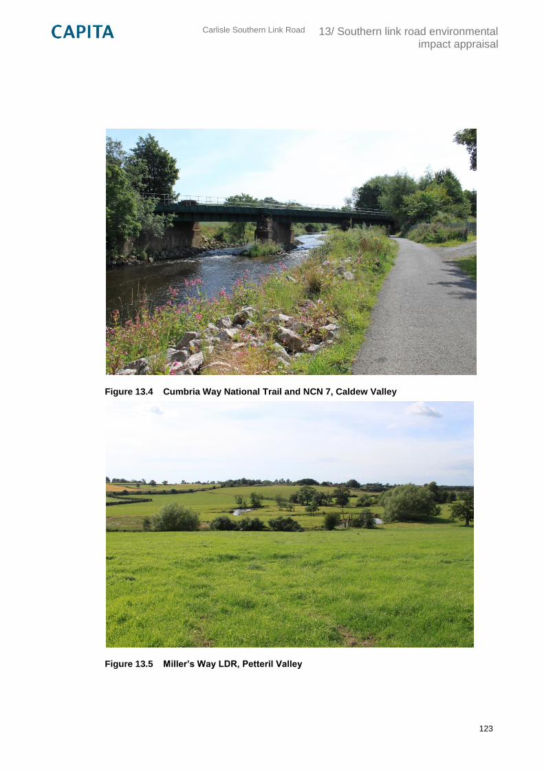
Carlisle Southern Link Road
13/ Southern link road environmental impact appraisal
123
Figure 13.4 Cumbria Way National Trail and NCN 7, Caldew Valley
Figure 13.5 Miller’s Way LDR, Petteril Valley
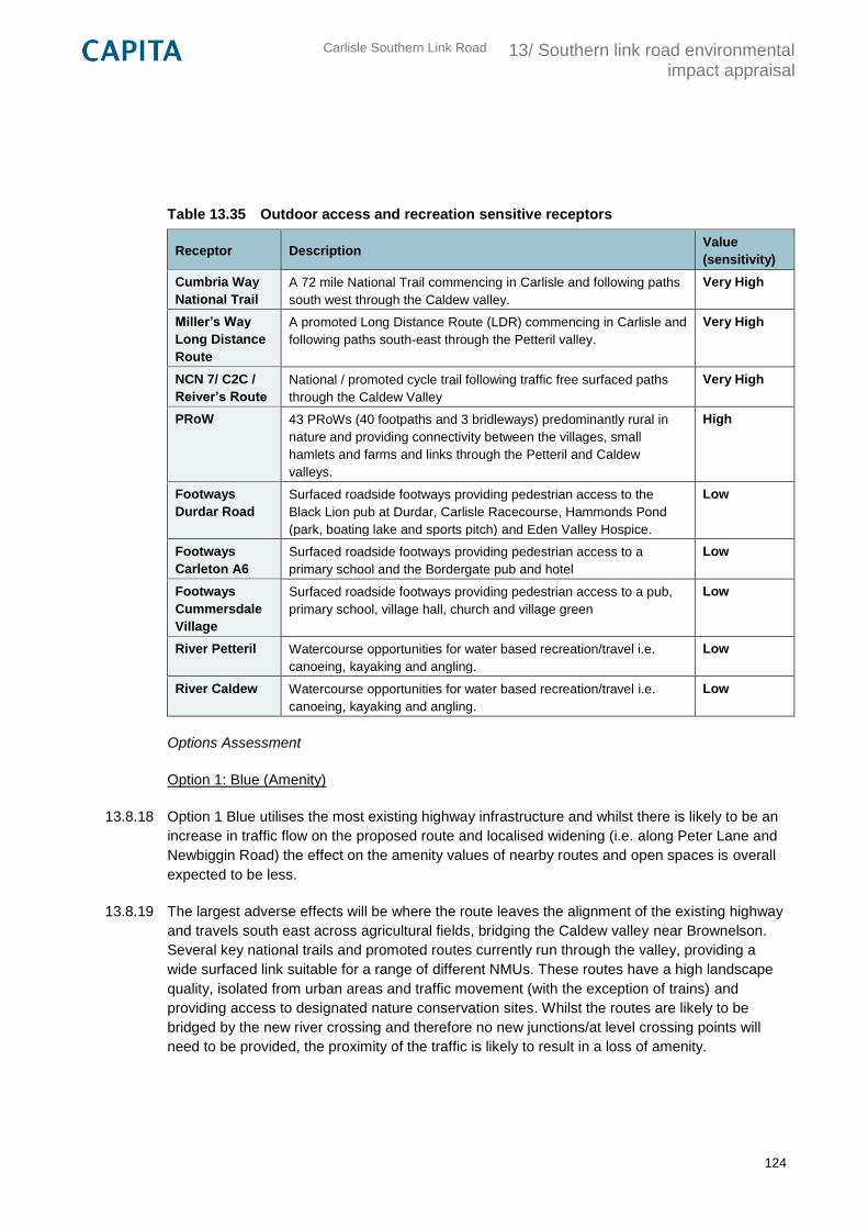
Carlisle Southern Link Road
13/ Southern link road environmental impact appraisal
124
Table 13.35 Outdoor access and recreation sensitive receptors
Receptor Description Value
(sensitivity)
Cumbria Way
National Trail
A 72 mile National Trail commencing in Carlisle and following paths
south west through the Caldew valley.
Very High
Miller’s Way
Long Distance
Route
A promoted Long Distance Route (LDR) commencing in Carlisle and
following paths south-east through the Petteril valley.
Very High
NCN 7/ C2C /
Reiver’s Route
National / promoted cycle trail following traffic free surfaced paths
through the Caldew Valley
Very High
PRoW 43 PRoWs (40 footpaths and 3 bridleways) predominantly rural in
nature and providing connectivity between the villages, small
hamlets and farms and links through the Petteril and Caldew
valleys.
High
Footways
Durdar Road
Surfaced roadside footways providing pedestrian access to the
Black Lion pub at Durdar, Carlisle Racecourse, Hammonds Pond
(park, boating lake and sports pitch) and Eden Valley Hospice.
Low
Footways
Carleton A6
Surfaced roadside footways providing pedestrian access to a
primary school and the Bordergate pub and hotel
Low
Footways
Cummersdale
Village
Surfaced roadside footways providing pedestrian access to a pub,
primary school, village hall, church and village green
Low
River Petteril Watercourse opportunities for water based recreation/travel i.e.
canoeing, kayaking and angling.
Low
River Caldew Watercourse opportunities for water based recreation/travel i.e.
canoeing, kayaking and angling.
Low
Options Assessment
Option 1: Blue (Amenity)
13.8.18 Option 1 Blue utilises the most existing highway infrastructure and whilst there is likely to be an
increase in traffic flow on the proposed route and localised widening (i.e. along Peter Lane and
Newbiggin Road) the effect on the amenity values of nearby routes and open spaces is overall
expected to be less.
13.8.19 The largest adverse effects will be where the route leaves the alignment of the existing highway
and travels south east across agricultural fields, bridging the Caldew valley near Brownelson.
Several key national trails and promoted routes currently run through the valley, providing a
wide surfaced link suitable for a range of different NMUs. These routes have a high landscape
quality, isolated from urban areas and traffic movement (with the exception of trains) and
providing access to designated nature conservation sites. Whilst the routes are likely to be
bridged by the new river crossing and therefore no new junctions/at level crossing points will
need to be provided, the proximity of the traffic is likely to result in a loss of amenity.
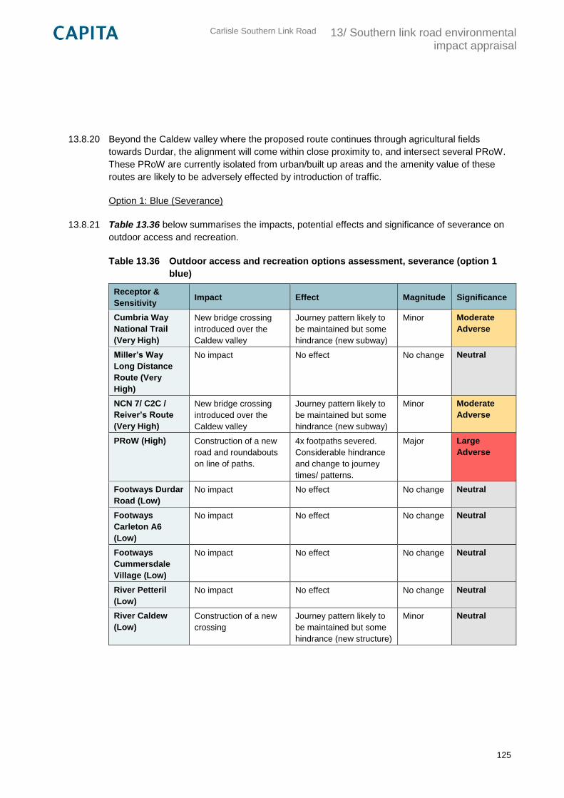
Carlisle Southern Link Road
13/ Southern link road environmental impact appraisal
125
13.8.20 Beyond the Caldew valley where the proposed route continues through agricultural fields
towards Durdar, the alignment will come within close proximity to, and intersect several PRoW.
These PRoW are currently isolated from urban/built up areas and the amenity value of these
routes are likely to be adversely effected by introduction of traffic.
Option 1: Blue (Severance)
13.8.21 Table 13.36 below summarises the impacts, potential effects and significance of severance on
outdoor access and recreation.
Table 13.36 Outdoor access and recreation options assessment, severance (option 1
blue)
Receptor &
Sensitivity Impact Effect Magnitude Significance
Cumbria Way
National Trail
(Very High)
New bridge crossing
introduced over the
Caldew valley
Journey pattern likely to
be maintained but some
hindrance (new subway)
Minor Moderate
Adverse
Miller’s Way
Long Distance
Route (Very
High)
No impact No effect No change Neutral
NCN 7/ C2C /
Reiver’s Route
(Very High)
New bridge crossing
introduced over the
Caldew valley
Journey pattern likely to
be maintained but some
hindrance (new subway)
Minor Moderate
Adverse
PRoW (High) Construction of a new
road and roundabouts
on line of paths.
4x footpaths severed.
Considerable hindrance
and change to journey
times/ patterns.
Major Large
Adverse
Footways Durdar
Road (Low)
No impact No effect No change Neutral
Footways
Carleton A6
(Low)
No impact No effect No change Neutral
Footways
Cummersdale
Village (Low)
No impact No effect No change Neutral
River Petteril
(Low)
No impact No effect No change Neutral
River Caldew
(Low)
Construction of a new
crossing
Journey pattern likely to
be maintained but some
hindrance (new structure)
Minor Neutral
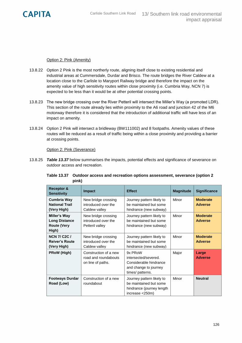
Carlisle Southern Link Road
13/ Southern link road environmental impact appraisal
126
Option 2: Pink (Amenity)
13.8.22 Option 2 Pink is the most northerly route, aligning itself close to existing residential and
industrial areas at Cummersdale, Durdar and Brisco. The route bridges the River Caldew at a
location close to the Carlisle to Maryport Railway bridge and therefore the impact on the
amenity value of high sensitivity routes within close proximity (i.e. Cumbria Way, NCN 7) is
expected to be less than it would be at other potential crossing points.
13.8.23 The new bridge crossing over the River Petteril will intersect the Miller’s Way (a promoted LDR).
This section of the route already lies within proximity to the A6 road and junction 42 of the M6
motorway therefore it is considered that the introduction of additional traffic will have less of an
impact on amenity.
13.8.24 Option 2 Pink will intersect a bridleway (BW111002) and 8 footpaths. Amenity values of these
routes will be reduced as a result of traffic being within a close proximity and providing a barrier
at crossing points.
Option 2: Pink (Severance)
13.8.25 Table 13.37 below summarises the impacts, potential effects and significance of severance on
outdoor access and recreation.
Table 13.37 Outdoor access and recreation options assessment, severance (option 2
pink)
Receptor &
Sensitivity Impact Effect Magnitude Significance
Cumbria Way
National Trail
(Very High)
New bridge crossing
introduced over the
Caldew valley
Journey pattern likely to
be maintained but some
hindrance (new subway)
Minor Moderate
Adverse
Miller’s Way
Long Distance
Route (Very
High)
New bridge crossing
introduced over the
Petteril valley
Journey pattern likely to
be maintained but some
hindrance (new subway)
Minor Moderate
Adverse
NCN 7/ C2C /
Reiver’s Route
(Very High)
New bridge crossing
introduced over the
Caldew valley
Journey pattern likely to
be maintained but some
hindrance (new subway)
Minor Moderate
Adverse
PRoW (High) Construction of a new
road and roundabouts
on line of paths.
9x PRoW
intersected/severed.
Considerable hindrance
and change to journey
times/ patterns.
Major Large
Adverse
Footways Durdar
Road (Low)
Construction of a new
roundabout
Journey pattern likely to
be maintained but some
hindrance (journey length
increase <250m)
Minor Neutral
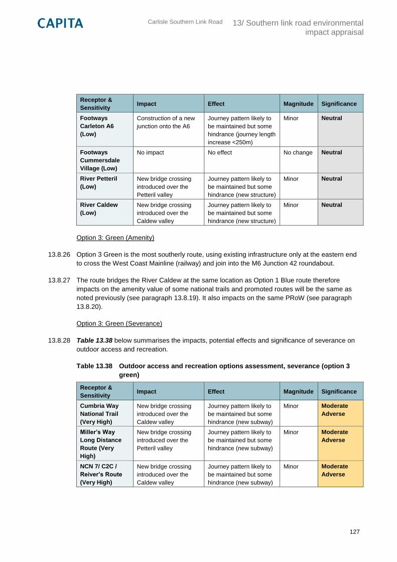
Carlisle Southern Link Road
13/ Southern link road environmental impact appraisal
127
Receptor &
Sensitivity Impact Effect Magnitude Significance
Footways
Carleton A6
(Low)
Construction of a new
junction onto the A6
Journey pattern likely to
be maintained but some
hindrance (journey length
increase <250m)
Minor Neutral
Footways
Cummersdale
Village (Low)
No impact No effect No change Neutral
River Petteril
(Low)
New bridge crossing
introduced over the
Petteril valley
Journey pattern likely to
be maintained but some
hindrance (new structure)
Minor Neutral
River Caldew
(Low)
New bridge crossing
introduced over the
Caldew valley
Journey pattern likely to
be maintained but some
hindrance (new structure)
Minor Neutral
Option 3: Green (Amenity)
13.8.26 Option 3 Green is the most southerly route, using existing infrastructure only at the eastern end
to cross the West Coast Mainline (railway) and join into the M6 Junction 42 roundabout.
13.8.27 The route bridges the River Caldew at the same location as Option 1 Blue route therefore
impacts on the amenity value of some national trails and promoted routes will be the same as
noted previously (see paragraph 13.8.19). It also impacts on the same PRoW (see paragraph
13.8.20).
Option 3: Green (Severance)
13.8.28 Table 13.38 below summarises the impacts, potential effects and significance of severance on
outdoor access and recreation.
Table 13.38 Outdoor access and recreation options assessment, severance (option 3
green)
Receptor &
Sensitivity Impact Effect Magnitude Significance
Cumbria Way
National Trail
(Very High)
New bridge crossing
introduced over the
Caldew valley
Journey pattern likely to
be maintained but some
hindrance (new subway)
Minor Moderate
Adverse
Miller’s Way
Long Distance
Route (Very
High)
New bridge crossing
introduced over the
Petteril valley
Journey pattern likely to
be maintained but some
hindrance (new subway)
Minor Moderate
Adverse
NCN 7/ C2C /
Reiver’s Route
(Very High)
New bridge crossing
introduced over the
Caldew valley
Journey pattern likely to
be maintained but some
hindrance (new subway)
Minor Moderate
Adverse
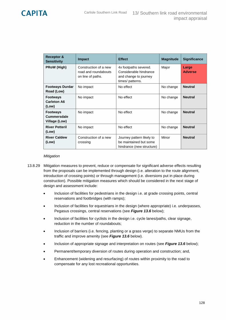
Carlisle Southern Link Road
13/ Southern link road environmental impact appraisal
128
Receptor &
Sensitivity Impact Effect Magnitude Significance
PRoW (High) Construction of a new
road and roundabouts
on line of paths.
4x footpaths severed.
Considerable hindrance
and change to journey
times/ patterns.
Major Large
Adverse
Footways Durdar
Road (Low)
No impact No effect No change Neutral
Footways
Carleton A6
(Low)
No impact No effect No change Neutral
Footways
Cummersdale
Village (Low)
No impact No effect No change Neutral
River Petteril
(Low)
No impact No effect No change Neutral
River Caldew
(Low)
Construction of a new
crossing
Journey pattern likely to
be maintained but some
hindrance (new structure)
Minor Neutral
Mitigation
13.8.29 Mitigation measures to prevent, reduce or compensate for significant adverse effects resulting
from the proposals can be implemented through design (i.e. alteration to the route alignment,
introduction of crossing points) or through management (i.e. diversions put in place during
construction). Possible mitigation measures which should be considered in the next stage of
design and assessment include:
Inclusion of facilities for pedestrians in the design i.e. at grade crossing points, central
reservations and footbridges (with ramps);
Inclusion of facilities for equestrians in the design (where appropriate) i.e. underpasses,
Pegasus crossings, central reservations (see Figure 13.6 below);
Inclusion of facilities for cyclists in the design i.e. cycle lanes/paths, clear signage,
reduction in the number of roundabouts;
Inclusion of barriers (i.e. fencing, planting or a grass verge) to separate NMUs from the
traffic and improve amenity (see Figure 13.6 below).
Inclusion of appropriate signage and interpretation on routes (see Figure 13.6 below);
Permanent/temporary diversion of routes during operation and construction; and,
Enhancement (widening and resurfacing) of routes within proximity to the road to
compensate for any lost recreational opportunities.
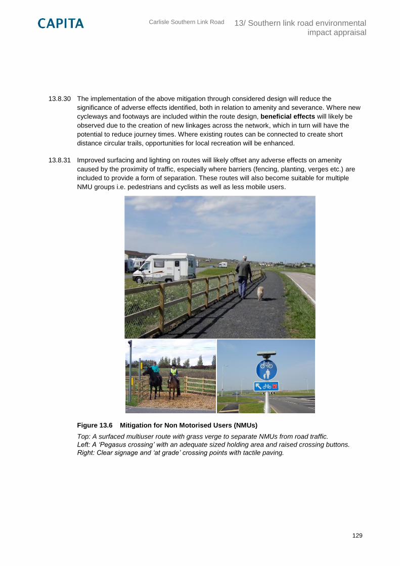
Carlisle Southern Link Road
13/ Southern link road environmental impact appraisal
129
13.8.30 The implementation of the above mitigation through considered design will reduce the
significance of adverse effects identified, both in relation to amenity and severance. Where new
cycleways and footways are included within the route design, beneficial effects will likely be
observed due to the creation of new linkages across the network, which in turn will have the
potential to reduce journey times. Where existing routes can be connected to create short
distance circular trails, opportunities for local recreation will be enhanced.
13.8.31 Improved surfacing and lighting on routes will likely offset any adverse effects on amenity
caused by the proximity of traffic, especially where barriers (fencing, planting, verges etc.) are
included to provide a form of separation. These routes will also become suitable for multiple
NMU groups i.e. pedestrians and cyclists as well as less mobile users.
Figure 13.6 Mitigation for Non Motorised Users (NMUs)
Top: A surfaced multiuser route with grass verge to separate NMUs from road traffic.
Left: A ‘Pegasus crossing’ with an adequate sized holding area and raised crossing buttons.
Right: Clear signage and ‘at grade’ crossing points with tactile paving.
Carlisle Southern Link Road
13/ Southern link road environmental impact appraisal
130
Summary
13.8.32 The assessment of outdoor access and recreation aimed to identify impacts likely to arise as a
result of the proposed development on routes and community facilities used by NMUs. It used a
combination of desktop research and site visits to identify key community facilities and routes
(receptors) within the study area including: National Trails, Long Distance Routes, promoted
routes, Cycle Networks, PRoW and other informal or permitted routes. Impacts and their effects
on both amenity and route severance were then identified for each of the shortlisted options and
assessed using a combination of both qualitative and quantitative methods.
13.8.33 Effects for each option included:
Option 1: Blue – potential effects on amenity are reduced by using the existing highway
network where possible however moderate effects are observed on sensitive routes
where the alignment bridges the River Caldew, both in terms of severance and loss of
amenity. There are large adverse effects on several PRoW due to severance and
changes to journey length/time. A general loss of amenity on rural routes due to the
introduction of traffic.
Option 2: Pink – effects on the amenity value of sensitive routes is lower than other
options due to the chosen bridging point over the Caldew. There are moderate impacts
on these routes however in terms of severance due to minor hindrances at intersections.
Large adverse effects are observed on PRoW due to severance and changes to journey
time/length. A general loss of amenity on some rural routes.
Option 3: Green – moderate adverse effects on sensitive routes and large adverse
effects on PRoW in terms of severance. A general loss of amenity on rural PRoW and
routes within the Caldew valley.
13.8.34 All options have been found to have adverse effects on outdoor access and recreation (without
the implementation of any suggested mitigation) and at this stage it has not been possible to
identify a preferred option from the three. All options have therefore been ranked evenly for the
assessment as ‘intermediate’ options.
Table 13.39 Outdoor access and recreation preferred option summary
Option Preferred Option Intermediate Option Least Preferred Option
1 (Blue)
2 (Pink)
3 (Green)
13.9 Summary
13.9.1 A summary of the preferred, intermediate and least preferred option selections for each
environmental topic considered is provided in Table 13.40 below.
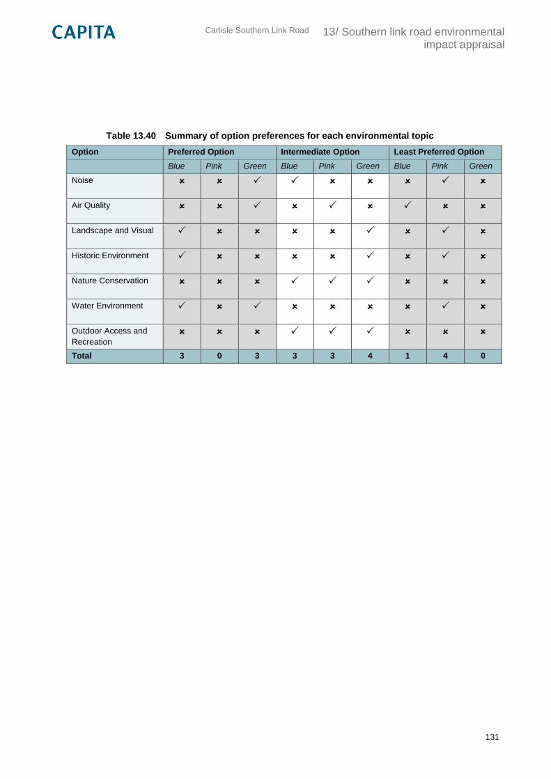
Carlisle Southern Link Road
13/ Southern link road environmental impact appraisal
131
Table 13.40 Summary of option preferences for each environmental topic
Option Preferred Option Intermediate Option Least Preferred Option
Blue Pink Green Blue Pink Green Blue Pink Green
Noise
Air Quality
Landscape and Visual
Historic Environment
Nature Conservation
Water Environment
Outdoor Access and
Recreation
Total 3 0 3 3 3 4 1 4 0
Carlisle Southern Link Road
14/ Southern link road traffic impact assessment
132
14. Southern link road traffic impact assessment
14.1 Review of traffic modelling
14.1.1 The Carlisle Southern Link Road transport modelling report considers the impact of traffic from
development at South Carlisle as well as the impact of a proposed southern link road. The
study uses the Carlisle transport model to forecast future year scenarios of 2030, at the end of
the Carlisle Local Plan period, and 10 years hence with further employment and residential
growth around south Carlisle.
14.1.2 The Carlisle transport model was originally developed in 2008, but underwent a major update in
2013 following the opening of the CNDR. The update was based on a comprehensive set of
traffic data collected following the opening of the CNDR, and origin-destination datasets
including Trafficmaster GPS data, the census and schools data.
14.1.3 The southern link road as tested in the Carlisle transport model is assumed to run from the M6
Junction 42 via Newbiggin Road to the A595/A689 junction via Peter Lane. The modelling
assumed the CSLR would be subject to a 50mph speed limit and with intermediate roundabout
junctions located at the following locations:
Newbiggin Road / Scalegate Road
Newbiggin Road / Brisco Road
Durdar Road / Newbiggin Road
Dalston Road / Peter Lane
14.1.4 Future year traffic demand was generated by considering committed developments and the
assumed phasing and trip generation of development at south Carlisle in line with assumptions
made for the local plan transport modelling. Development trips were distributed using a gravity
model developed for the local plan modelling. Growth factors were also calculated from the
National Trip End Model using the TEMPRO software, and were adjusted using fuel and income
factors.
14.1.5 Four scenarios were modelled in the study, as follows:
Do minimum (no link road) with no development at south Carlisle
Do something (link road) with no development at south Carlisle
Do minimum (no link road) with south Carlisle development
Do something (link road) with south Carlisle development
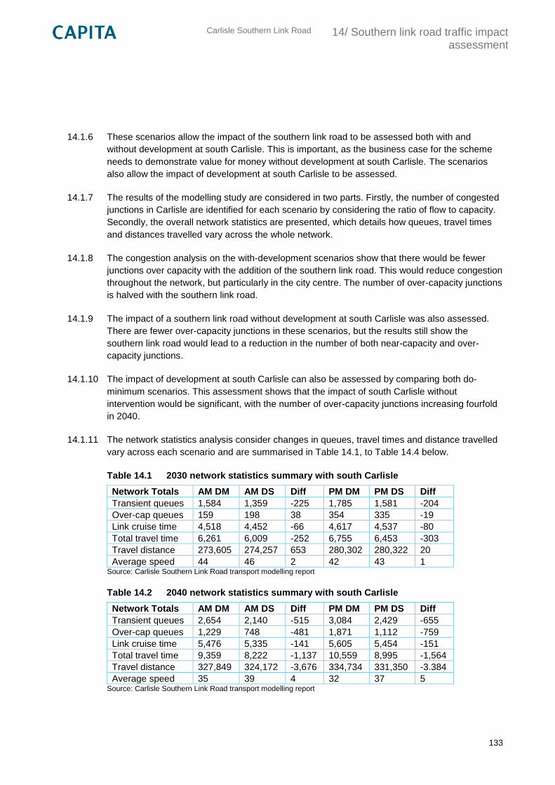
Carlisle Southern Link Road
14/ Southern link road traffic impact assessment
133
14.1.6 These scenarios allow the impact of the southern link road to be assessed both with and
without development at south Carlisle. This is important, as the business case for the scheme
needs to demonstrate value for money without development at south Carlisle. The scenarios
also allow the impact of development at south Carlisle to be assessed.
14.1.7 The results of the modelling study are considered in two parts. Firstly, the number of congested
junctions in Carlisle are identified for each scenario by considering the ratio of flow to capacity.
Secondly, the overall network statistics are presented, which details how queues, travel times
and distances travelled vary across the whole network.
14.1.8 The congestion analysis on the with-development scenarios show that there would be fewer
junctions over capacity with the addition of the southern link road. This would reduce congestion
throughout the network, but particularly in the city centre. The number of over-capacity junctions
is halved with the southern link road.
14.1.9 The impact of a southern link road without development at south Carlisle was also assessed.
There are fewer over-capacity junctions in these scenarios, but the results still show the
southern link road would lead to a reduction in the number of both near-capacity and over-
capacity junctions.
14.1.10 The impact of development at south Carlisle can also be assessed by comparing both do-
minimum scenarios. This assessment shows that the impact of south Carlisle without
intervention would be significant, with the number of over-capacity junctions increasing fourfold
in 2040.
14.1.11 The network statistics analysis consider changes in queues, travel times and distance travelled
vary across each scenario and are summarised in Table 14.1, to Table 14.4 below.
Table 14.1 2030 network statistics summary with south Carlisle
Network Totals AM DM AM DS Diff PM DM PM DS Diff
Transient queues 1,584 1,359 -225 1,785 1,581 -204
Over-cap queues 159 198 38 354 335 -19
Link cruise time 4,518 4,452 -66 4,617 4,537 -80
Total travel time 6,261 6,009 -252 6,755 6,453 -303
Travel distance 273,605 274,257 653 280,302 280,322 20
Average speed 44 46 2 42 43 1 Source: Carlisle Southern Link Road transport modelling report
Table 14.2 2040 network statistics summary with south Carlisle
Network Totals AM DM AM DS Diff PM DM PM DS Diff
Transient queues 2,654 2,140 -515 3,084 2,429 -655
Over-cap queues 1,229 748 -481 1,871 1,112 -759
Link cruise time 5,476 5,335 -141 5,605 5,454 -151
Total travel time 9,359 8,222 -1,137 10,559 8,995 -1,564
Travel distance 327,849 324,172 -3,676 334,734 331,350 -3.384
Average speed 35 39 4 32 37 5 Source: Carlisle Southern Link Road transport modelling report
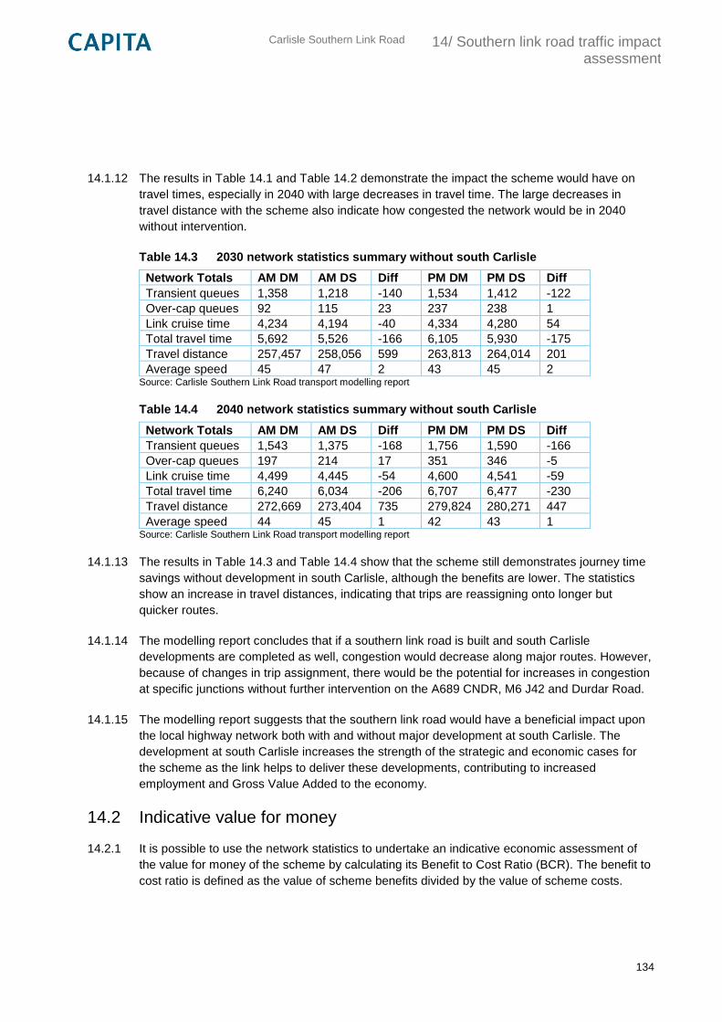
Carlisle Southern Link Road
14/ Southern link road traffic impact assessment
134
14.1.12 The results in Table 14.1 and Table 14.2 demonstrate the impact the scheme would have on
travel times, especially in 2040 with large decreases in travel time. The large decreases in
travel distance with the scheme also indicate how congested the network would be in 2040
without intervention.
Table 14.3 2030 network statistics summary without south Carlisle
Network Totals AM DM AM DS Diff PM DM PM DS Diff
Transient queues 1,358 1,218 -140 1,534 1,412 -122
Over-cap queues 92 115 23 237 238 1
Link cruise time 4,234 4,194 -40 4,334 4,280 54
Total travel time 5,692 5,526 -166 6,105 5,930 -175
Travel distance 257,457 258,056 599 263,813 264,014 201
Average speed 45 47 2 43 45 2 Source: Carlisle Southern Link Road transport modelling report
Table 14.4 2040 network statistics summary without south Carlisle
Network Totals AM DM AM DS Diff PM DM PM DS Diff
Transient queues 1,543 1,375 -168 1,756 1,590 -166
Over-cap queues 197 214 17 351 346 -5
Link cruise time 4,499 4,445 -54 4,600 4,541 -59
Total travel time 6,240 6,034 -206 6,707 6,477 -230
Travel distance 272,669 273,404 735 279,824 280,271 447
Average speed 44 45 1 42 43 1 Source: Carlisle Southern Link Road transport modelling report
14.1.13 The results in Table 14.3 and Table 14.4 show that the scheme still demonstrates journey time
savings without development in south Carlisle, although the benefits are lower. The statistics
show an increase in travel distances, indicating that trips are reassigning onto longer but
quicker routes.
14.1.14 The modelling report concludes that if a southern link road is built and south Carlisle
developments are completed as well, congestion would decrease along major routes. However,
because of changes in trip assignment, there would be the potential for increases in congestion
at specific junctions without further intervention on the A689 CNDR, M6 J42 and Durdar Road.
14.1.15 The modelling report suggests that the southern link road would have a beneficial impact upon
the local highway network both with and without major development at south Carlisle. The
development at south Carlisle increases the strength of the strategic and economic cases for
the scheme as the link helps to deliver these developments, contributing to increased
employment and Gross Value Added to the economy.
14.2 Indicative value for money
14.2.1 It is possible to use the network statistics to undertake an indicative economic assessment of
the value for money of the scheme by calculating its Benefit to Cost Ratio (BCR). The benefit to
cost ratio is defined as the value of scheme benefits divided by the value of scheme costs.
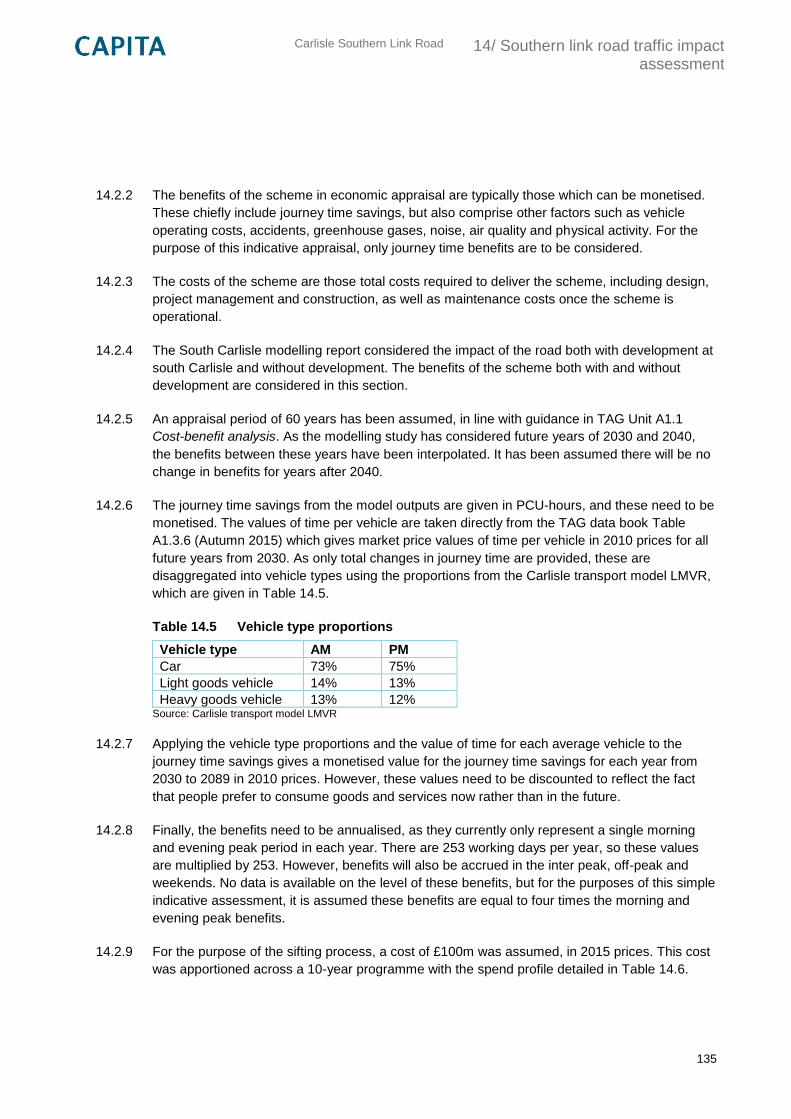
Carlisle Southern Link Road
14/ Southern link road traffic impact assessment
135
14.2.2 The benefits of the scheme in economic appraisal are typically those which can be monetised.
These chiefly include journey time savings, but also comprise other factors such as vehicle
operating costs, accidents, greenhouse gases, noise, air quality and physical activity. For the
purpose of this indicative appraisal, only journey time benefits are to be considered.
14.2.3 The costs of the scheme are those total costs required to deliver the scheme, including design,
project management and construction, as well as maintenance costs once the scheme is
operational.
14.2.4 The South Carlisle modelling report considered the impact of the road both with development at
south Carlisle and without development. The benefits of the scheme both with and without
development are considered in this section.
14.2.5 An appraisal period of 60 years has been assumed, in line with guidance in TAG Unit A1.1
Cost-benefit analysis. As the modelling study has considered future years of 2030 and 2040,
the benefits between these years have been interpolated. It has been assumed there will be no
change in benefits for years after 2040.
14.2.6 The journey time savings from the model outputs are given in PCU-hours, and these need to be
monetised. The values of time per vehicle are taken directly from the TAG data book Table
A1.3.6 (Autumn 2015) which gives market price values of time per vehicle in 2010 prices for all
future years from 2030. As only total changes in journey time are provided, these are
disaggregated into vehicle types using the proportions from the Carlisle transport model LMVR,
which are given in Table 14.5.
Table 14.5 Vehicle type proportions
Vehicle type AM PM
Car 73% 75%
Light goods vehicle 14% 13%
Heavy goods vehicle 13% 12% Source: Carlisle transport model LMVR
14.2.7 Applying the vehicle type proportions and the value of time for each average vehicle to the
journey time savings gives a monetised value for the journey time savings for each year from
2030 to 2089 in 2010 prices. However, these values need to be discounted to reflect the fact
that people prefer to consume goods and services now rather than in the future.
14.2.8 Finally, the benefits need to be annualised, as they currently only represent a single morning
and evening peak period in each year. There are 253 working days per year, so these values
are multiplied by 253. However, benefits will also be accrued in the inter peak, off-peak and
weekends. No data is available on the level of these benefits, but for the purposes of this simple
indicative assessment, it is assumed these benefits are equal to four times the morning and
evening peak benefits.
14.2.9 For the purpose of the sifting process, a cost of £100m was assumed, in 2015 prices. This cost
was apportioned across a 10-year programme with the spend profile detailed in Table 14.6.
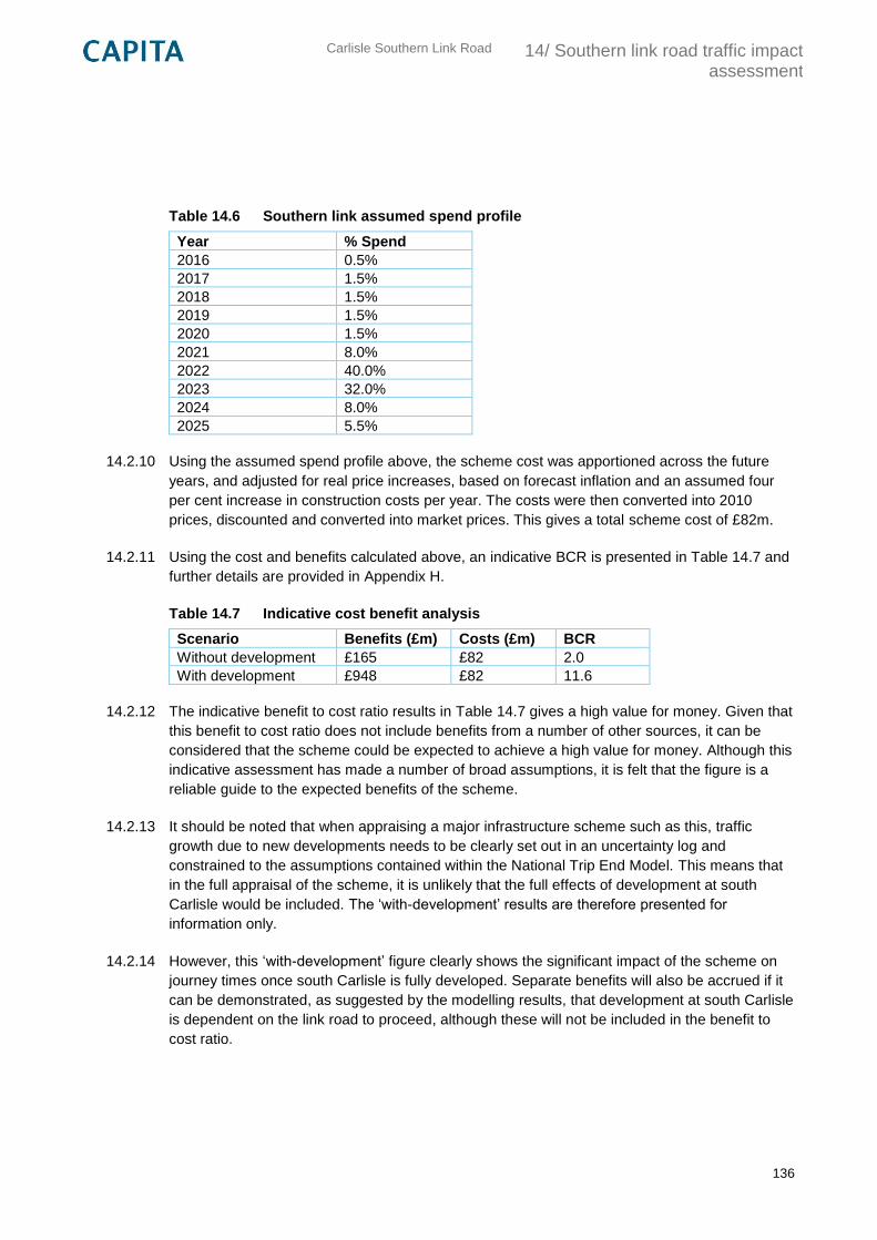
Carlisle Southern Link Road
14/ Southern link road traffic impact assessment
136
Table 14.6 Southern link assumed spend profile
Year % Spend
2016 0.5%
2017 1.5%
2018 1.5%
2019 1.5%
2020 1.5%
2021 8.0%
2022 40.0%
2023 32.0%
2024 8.0%
2025 5.5%
14.2.10 Using the assumed spend profile above, the scheme cost was apportioned across the future
years, and adjusted for real price increases, based on forecast inflation and an assumed four
per cent increase in construction costs per year. The costs were then converted into 2010
prices, discounted and converted into market prices. This gives a total scheme cost of £82m.
14.2.11 Using the cost and benefits calculated above, an indicative BCR is presented in Table 14.7 and
further details are provided in Appendix H.
Table 14.7 Indicative cost benefit analysis
Scenario Benefits (£m) Costs (£m) BCR
Without development £165 £82 2.0
With development £948 £82 11.6
14.2.12 The indicative benefit to cost ratio results in Table 14.7 gives a high value for money. Given that
this benefit to cost ratio does not include benefits from a number of other sources, it can be
considered that the scheme could be expected to achieve a high value for money. Although this
indicative assessment has made a number of broad assumptions, it is felt that the figure is a
reliable guide to the expected benefits of the scheme.
14.2.13 It should be noted that when appraising a major infrastructure scheme such as this, traffic
growth due to new developments needs to be clearly set out in an uncertainty log and
constrained to the assumptions contained within the National Trip End Model. This means that
in the full appraisal of the scheme, it is unlikely that the full effects of development at south
Carlisle would be included. The ‘with-development’ results are therefore presented for
information only.
14.2.14 However, this ‘with-development’ figure clearly shows the significant impact of the scheme on
journey times once south Carlisle is fully developed. Separate benefits will also be accrued if it
can be demonstrated, as suggested by the modelling results, that development at south Carlisle
is dependent on the link road to proceed, although these will not be included in the benefit to
cost ratio.
Carlisle Southern Link Road
14/ Southern link road traffic impact assessment
137
14.3 Options assessment by route
14.3.1 The indicative route options for the Southern Link Road show a link running between the M6
Junction 42 and the A595/A689. There are three route options for consideration, with deviations
in where they cross existing highway links as well as the rivers Caldew and Petteril, the West
Coast Main Line and the Cumbria Coast Line.
14.3.2 In terms of traffic appraisal there is currently little to differentiate between each route as the total
length of each option is comparable and should not lead to significant variations in total journey
times.
14.3.3 There is not yet enough information to determine detailed junction strategies for each route, and
hence each route currently assumes the same number of junctions. The number of junctions
and the form which these take may have an impact upon journey times along the road. When
considering the number and design of the junctions in more detail, consideration needs to be
given to forecast traffic flows and whether to give priority to through traffic or traffic travelling to
and from the south Carlisle development. This will depend on the layout of development and
hence the masterplan.
14.3.4 If the Carlisle Southern Link Road is to be successful in relieving congestion from central
Carlisle the route must provide journey time benefits. The South Carlisle modelling report
assumed a cruise speed of 50 mph along the route. However, this speed may not be
appropriate for areas close to development at south Carlisle. Again, this will depend on the
proposals included in the masterplan.
14.4 Next steps
14.4.1 In terms of traffic modelling, the South Carlisle modelling study represents a good starting point
for identifying the potential impacts of the scheme in terms of traffic flows and delays. The
results of the study already suggest that the scheme will represent good value for money.
However, an extensive and robust transport modelling study would be required to support the
appraisal of the scheme and the preparation of the economic case. It is considered that the
model would require updating to provide recent origin-destination data and to improve the
validation of the model towards the south and east of Carlisle. This would require a data
collection exercise, including traffic counts and journey time surveys, as well as origin-
destination surveys such as roadside interviews. Due to the size and scale of the scheme, it is
also likely that scheme forecasting would require a variable demand assessment. Further
details on the modelling methodology and data collection should be provided in the Appraisal
Specification Report and a Traffic Data Report.
Carlisle Southern Link Road
15/ Southern link road planning issues
138
15. Southern link road planning issues
15.1 Introduction
15.1.1 This section discusses the relevant national, regional and local planning policies to the route
option discussion and summarises the key planning issues that will need to be considered
further when assessing the choice of route.
15.1.2 The fundamental issue shaping the consideration of the route options is the strategic objective
of delivering a continued and increased supply of new sustainable housing in Carlisle. This is a
clearly stated primary objective within the emerging Carlisle District Local Plan 2015–2030
which expects the momentum of housing growth to be maintained for the full life of the Plan.
15.1.3 In order to maintain the district’s housing growth ambitions the Plan envisages a major mixed-
use development in south Carlisle, the delivery of which would commence following the
production of a Development Plan Document including an infrastructure delivery strategy.
15.1.4 The local housing growth ambitions within the emerging Plan are supported in national planning
policy through the National Planning Policy Framework (NPPF) and in particular Policy 47 that
encourages local authorities to “boost significantly the supply of housing.” In order to deliver
these ambitions the proposed new major mixed-use development has to be planned to be
sustainable. This requires full consideration of the appropriate scale and mix of uses plus the
essential infrastructure required to ensure it is deliverable. A comprehensive masterplanning
process is envisaged to achieve this and the consideration of the necessity of a southern link
road will be an integral part of the process.
15.2 National Planning Policy Framework (NPPF)
15.2.1 The NPPF (Department of Communities and Local Government, 2012) document sets out the
Government’s policy in relation to promoting the delivery of sustainable development through
the planning system. It makes it clear that the planning system has three roles to achieve in
order to deliver sustainable development - the economic, social and environmental and that:
“These roles should not be undertaken in isolation, because they are mutually dependent.
Economic growth can secure higher social and environmental standards, and well-designed
buildings and places can improve the lives of people and communities. Therefore, to achieve
sustainable development, economic, social and environmental gains should be sought jointly
and simultaneously through the planning system.” (Para. 8).
“At the heart of the National Planning Policy Framework is a presumption in favour of
sustainable development, which should be seen as a golden thread running through both plan-
making and decision-taking.” (Para. 14).
Carlisle Southern Link Road
15/ Southern link road planning issues
139
15.2.2 Within the NPPF the specific chapter concerned with “Delivering a wide choice of high quality
homes” contains Policy 47 which encourages local authorities to “boost significantly the supply
of housing” and within their plans to “identify a supply of specific developable sites or broad
locations for growth, for years 6-10 and, where possible, for years 11-15”. The proposed new
major mixed-use development fulfils the requirement for the second of these two time periods.
However, in order to be meaningful it needs to be developable and viable. This is why this
preliminary exercise, and ultimately the comprehensive masterplanning of the major mixed-use
development and its associated elements, are important.
15.2.3 The NPPF also has a specific policy section relating to sustainable transport matters and states
in Policy 29 that “Transport policies have an important role to play in facilitating sustainable
development” and in Policy 30 that “Encouragement should be given to solutions which support
reductions in greenhouse gas emissions and reduce congestion.”
15.2.4 Policy 34 requires that “developments that generate significant movement are located where
the need for travel will be minimised and the use of sustainable transport modes can be
maximised”. Policy 37 seeks a balanced approach to land use planning allocations thereby
enabling journey lengths to be minimised.
15.2.5 Large scale residential developments are specifically addressed in Policy 38 which reinforces
the above policy messages by encouraging that they contain a mix of uses including
employment, shopping and education.
15.2.6 Economic policy objectives in the NPPF feature strongly as part of the overall balanced
approach and are relevant as the economic priorities for Carlisle and Cumbria are a
consideration in the delivery of the Link Road. Planning positively to deliver infrastructure and
support economic regeneration are key objectives (Para. 21).
15.2.7 The NPPF places weight on the sustainability and viability of proposed development allocations,
with the need for supporting infrastructure to be fully considered and planned for as part of this
process. Emergence of a major mixed-use development will need additional highways and
transport infrastructure, the principal role of which will be to support the delivery of sustainable
housing growth and ensure that the growth ambitions are developable and deliverable in policy
terms.
15.2.8 This is the national policy context surrounding the route choice and potential delivery of the Link
Road. In addition to the principal housing objective the major mixed-use development and route
choice also have to address economic objectives, minimise environmental impact and make a
positive contribution towards environmental enhancements. These aspects are all reflected in
the existing and emerging local planning policies detailed below and discussed extensively
elsewhere in this report.
Carlisle Southern Link Road
15/ Southern link road planning issues
140
15.3 Development Plan Policy
15.3.1 The Carlisle District Local Plan 2001-2016 is the current adopted local plan for Carlisle.
However, the proposed delivery timetable for the major mixed-use development and associated
supporting elements are beyond the life of this document and it is therefore the emerging
Carlisle District Local Plan 2015-2030 that will guide the consideration of the proposal. This
Plan has been submitted to the Government for Examination in Public and, at the time of
writing, this process is still ongoing. Through this process the broad policy basis of the major
mixed-use development will be tested as the Plan contains policies that support its
development.
15.3.2 The strategic policies outlined below contain the approach being taken in the emerging Plan.
Please note following the close of the examination hearing sessions that Carlisle City Council
has submitted to the Inspector and consulted on a number of proposed modifications to the
Plan (March 2016). In terms of the proposed major mixed-use development they do not
fundamentally change the policy thrust, but rather seek to reinforce the need for a
comprehensive and co-ordinated approach to the development. They more clearly define the
area being considered and emphasise that the proposed masterplanning exercise for the area
is the principal mechanism through which the delivery and phasing of Carlisle South will be
examined and determined. In recognition of its importance to the realisation of Carlisle South,
the masterplan will include an infrastructure delivery strategy.
15.3.3 The masterplan, in guiding the scale and content of the mixed use development, will determine
the type and number of new homes, the type and size of the employment land and need for
other uses. It will also determine the timing and phasing of all elements including the transport
infrastructure. The Local Plan is scheduled for adoption in autumn 2016 and the preparation of
the masterplan is anticipated to start early in 2017. Full consideration of the transport
implications and required improvements, as a fundamental element within the masterplan, will
need to inform and run in parallel with this process.
15.3.4 In the context of the major mixed-use development the main modifications proposed relate to
Policy SP3 detailed below and are shown in bold and strikethrough deletions against the
Submission Draft Plan text.
15.3.5 Strategic Policy SP 3 - Broad Location for Growth: Carlisle South currently states, including
proposed modifications:
“A broad location for growth for a major mixed-use urban extension development, focusing on
housing, is identified on the Key Diagram at Carlisle South. The urban extension is expected to
be delivered from 2025 onwards. The release and phasing of Carlisle South will be
informed by a Development Plan Document inclusive of an infrastructure delivery
strategy.
To support the housing development, there will be a requirement for primary and secondary
schools, employment and retail sites, community facilities, open space, green and other
infrastructure including highways and transport.
Carlisle Southern Link Road
15/ Southern link road planning issues
141
To enable a comprehensive and co-ordinated development approach, Ppiecemeal or
unplanned development proposals within the area which are likely to prejudice its delivery
including the large scale infrastructure required for the area will not be permitted.
The development of this area will be in accordance with a masterplan which will be approved as
a Development Plan Document. The study area for the masterplan will include the whole of
the undeveloped extent beyond the city’s existing southern edge and any existing
allocations.
The purpose of the masterplan will be as follows:
1. to provide more detail on how and when the strategic requirements set out in this
policy will be delivered;
2. to set a framework to guide the preparation of future planning applications;
3. to provide a framework against which future planning applications will be assessed;
4. to enable and support the co-ordination and timely delivery of infrastructure provision;
and
5. to facilitate the delivery of land release to help address the imbalance of employment
land between the north and south of the City.
The potential for the future development of a southern relief road linking Junction 42 of the M6
with the southern end of the A689 will be an integral part of the masterplan.
To ensure that Carlisle South is deliverable when required, work on masterplanning the area
will commence in the early years of the plan period.”
15.3.6 The policy sets out a clear process through which delivery of the major mixed-use development
will be taken forward. The broad objective of achieving a sustainable mixed use, housing
focussed, major development is clearly stated. The preferred approach to delivering this
allocation is also clear and emphasised by the proposed modifications; the masterplan process
will take precedence in considering the future of the area and all aspects, including the potential
for a new Link Road, will be considered within the context of this comprehensive process.
15.3.7 Strategic Policy SP 5 - Strategic Connectivity states, in part, that:
“The City Council will support improvements to the transport network, in partnership with
delivery partners and operators, including the Highway Authority, in order to support the
District’s growth aspirations and Carlisle’s role as a strategic transport hub.
Proposals in line with the objectives of the 3rd Cumbria Local Transport Plan will be supported.
Interventions to facilitate growth as identified in the Infrastructure Delivery Plan will be
prioritised. Opportunities will also be taken to: …..
5. develop a southern relief road linking Junction 42 of the M6 with the southern end of the
A689 as part of developing the broad location of Carlisle South;…..”

Carlisle Southern Link Road
15/ Southern link road planning issues
142
15.3.8 This policy promotes the development of a southern link road (point 5) as part of the proposals
for a Carlisle South major mixed-use development. Therefore, the specific policy objective is set
within the context of the further detailed consideration of the extension through the
masterplanning process outlined in SP3 above.
15.3.9 In addition to the strategic policies supporting of the delivery of the major mixed-use
development and Link Road there are also individual topic area policies that support these
goals.
15.3.10 Policy EC1 - Employment Land Allocations recognises that the Carlisle South masterplanning
exercise will need to consider whether any additional employment land should be allocated over
and above the existing site allocations in the Plan and, if so, what type, amount and location of
such allocation/s would be appropriate. There are a number of reasons for this approach, not
least the need to bring into balance the bias of employment land towards the north of the city
and to ensure Carlisle maximises its location advantage of being close to the M6. The policy
commentary, however, cautions against any premature land release that might prejudice
existing allocations and estate improvement aspirations. The provision or prospective provision
of the southern link road would have an influence on these considerations and would be likely to
broaden the options available.
15.3.11 The above has clearly demonstrated that there is strong policy support within the emerging
development plan for Carlisle to pursue the provision of a housing focussed major mixed-use
development in Carlisle South, the delivery of which would commence following the production
of a Development Plan Document including an infrastructure delivery strategy, a pre-requisite of
which is the development of a comprehensive masterplan for the area. During this process all
aspects of delivering a sustainable development will be fully considered including supporting
infrastructure, of which consideration of a new Link Road will form a part.
15.4 Summary of key planning issues
15.4.1 The decisions made in relation to the delivery of the proposed major mixed-use development
through the masterplanning process will be fundamental to the future of Carlisle as a place to
live and work. The delivery of a new southern link road will be part of this process and as
detailed elsewhere in this report the initial sifting of potential route alignments has highlighted
three potential routes for the new road. The final route chosen is likely to have a significant
bearing on the potential nature of the extension and the development choices available.
15.4.2 The key strategic planning issues surrounding the choice of route are tabulated in Table 15.1
below. The list is supported by a brief commentary on the aspects of the individual routes where
they have a point of difference.
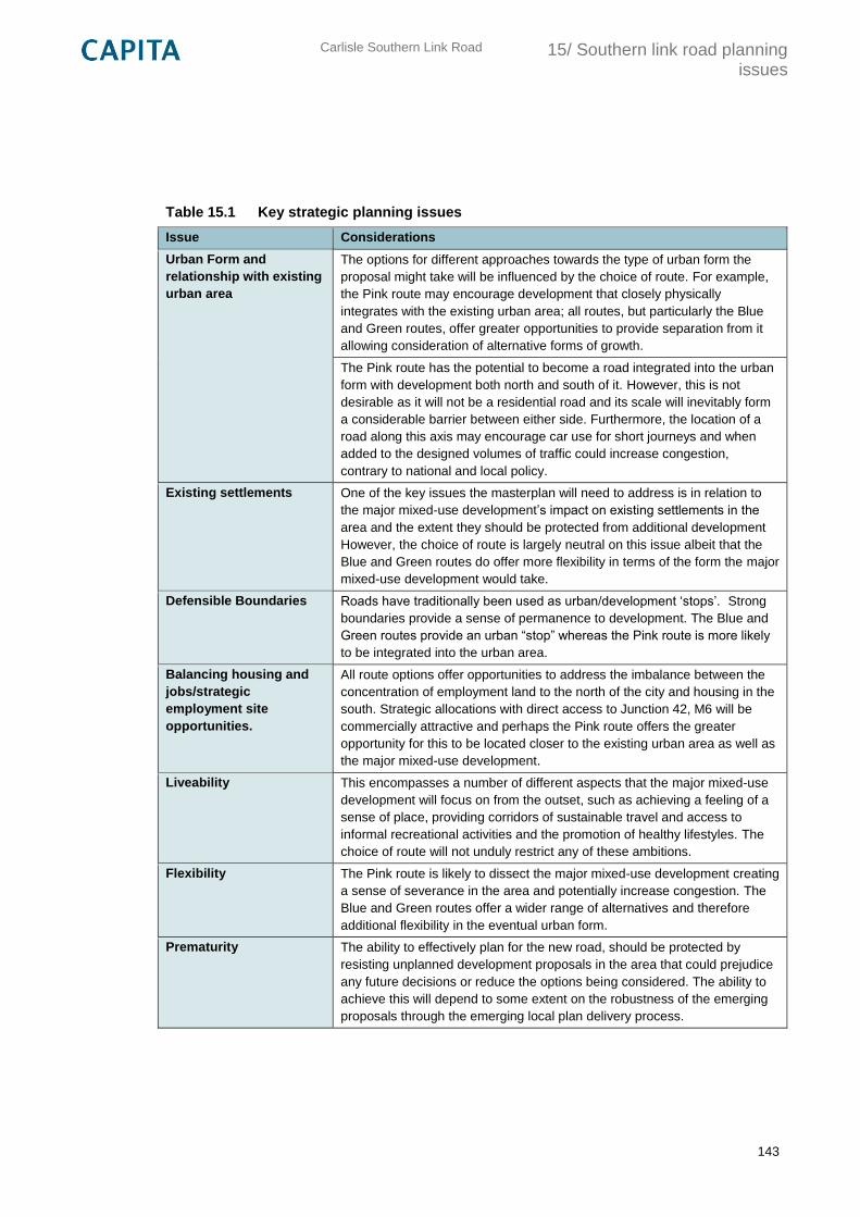
Carlisle Southern Link Road
15/ Southern link road planning issues
143
Table 15.1 Key strategic planning issues
Issue Considerations
Urban Form and
relationship with existing
urban area
The options for different approaches towards the type of urban form the
proposal might take will be influenced by the choice of route. For example,
the Pink route may encourage development that closely physically
integrates with the existing urban area; all routes, but particularly the Blue
and Green routes, offer greater opportunities to provide separation from it
allowing consideration of alternative forms of growth.
The Pink route has the potential to become a road integrated into the urban
form with development both north and south of it. However, this is not
desirable as it will not be a residential road and its scale will inevitably form
a considerable barrier between either side. Furthermore, the location of a
road along this axis may encourage car use for short journeys and when
added to the designed volumes of traffic could increase congestion,
contrary to national and local policy.
Existing settlements One of the key issues the masterplan will need to address is in relation to
the major mixed-use development’s impact on existing settlements in the
area and the extent they should be protected from additional development
However, the choice of route is largely neutral on this issue albeit that the
Blue and Green routes do offer more flexibility in terms of the form the major
mixed-use development would take.
Defensible Boundaries Roads have traditionally been used as urban/development ‘stops’. Strong
boundaries provide a sense of permanence to development. The Blue and
Green routes provide an urban “stop” whereas the Pink route is more likely
to be integrated into the urban area.
Balancing housing and
jobs/strategic
employment site
opportunities.
All route options offer opportunities to address the imbalance between the
concentration of employment land to the north of the city and housing in the
south. Strategic allocations with direct access to Junction 42, M6 will be
commercially attractive and perhaps the Pink route offers the greater
opportunity for this to be located closer to the existing urban area as well as
the major mixed-use development.
Liveability This encompasses a number of different aspects that the major mixed-use
development will focus on from the outset, such as achieving a feeling of a
sense of place, providing corridors of sustainable travel and access to
informal recreational activities and the promotion of healthy lifestyles. The
choice of route will not unduly restrict any of these ambitions.
Flexibility The Pink route is likely to dissect the major mixed-use development creating
a sense of severance in the area and potentially increase congestion. The
Blue and Green routes offer a wider range of alternatives and therefore
additional flexibility in the eventual urban form.
Prematurity The ability to effectively plan for the new road, should be protected by
resisting unplanned development proposals in the area that could prejudice
any future decisions or reduce the options being considered. The ability to
achieve this will depend to some extent on the robustness of the emerging
proposals through the emerging local plan delivery process.
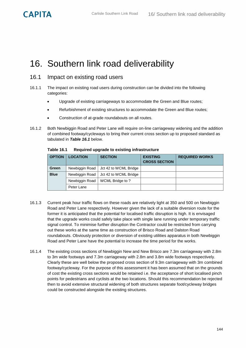
Carlisle Southern Link Road
16/ Southern link road deliverability
144
16. Southern link road deliverability
16.1 Impact on existing road users
16.1.1 The impact on existing road users during construction can be divided into the following
categories:
Upgrade of existing carriageways to accommodate the Green and Blue routes;
Refurbishment of existing structures to accommodate the Green and Blue routes;
Construction of at-grade roundabouts on all routes.
16.1.2 Both Newbiggin Road and Peter Lane will require on-line carriageway widening and the addition
of combined footway/cycleways to bring their current cross section up to proposed standard as
tabulated in Table 16.1 below.
Table 16.1 Required upgrade to existing infrastructure
OPTION LOCATION SECTION EXISTING
CROSS SECTION
REQUIRED WORKS
Green Newbiggin Road Jct 42 to WCML Bridge
Blue Newbiggin Road Jct 42 to WCML Bridge
Newbiggin Road WCML Bridge to ?
Peter Lane
16.1.3 Current peak hour traffic flows on these roads are relatively light at 350 and 500 on Newbiggin
Road and Peter Lane respectively. However given the lack of a suitable diversion route for the
former it is anticipated that the potential for localised traffic disruption is high. It is envisaged
that the upgrade works could safely take place with single lane running under temporary traffic
signal control. To minimise further disruption the Contractor could be restricted from carrying
out these works at the same time as construction of Brisco Road and Dalston Road
roundabouts. Obviously protection or diversion of existing utilities apparatus in both Newbiggin
Road and Peter Lane have the potential to increase the time period for the works.
16.1.4 The existing cross sections of Newbiggin New and New Brisco are 7.3m carriageway with 2.8m
to 3m wide footways and 7.3m carriageway with 2.8m and 3.8m wide footways respectively.
Clearly these are well below the proposed cross section of 9.3m carriageway with 3m combined
footway/cycleway. For the purpose of this assessment it has been assumed that on the grounds
of cost the existing cross sections would be retained i.e. the acceptance of short localised pinch
points for pedestrians and cyclists at the two locations. Should this recommendation be rejected
then to avoid extensive structural widening of both structures separate foot/cycleway bridges
could be constructed alongside the existing structures.
Carlisle Southern Link Road
16/ Southern link road deliverability
145
16.1.5 An initial assessment of Newbiggin New and New Brisco indicates that both will require an
upgrade of their parapets. These upgrade works could safely take place with single lane
running under temporary traffic signal control. Upgrading the parapet at New Brisco Railway
Bridge is likely to require two overnight possessions to erect and dismantle protective scaffold
over the railway. It is recommended discussions are held with Network Rail at Stage 2 to better
understand their views and requirements.
16.1.6 At this stage of the assessment it has been assumed that the majority of the proposed
roundabouts would be positioned on the line of the existing side roads. Such a strategy will
reduce construction costs and land take but will inevitably lead to some localised traffic
disruption during construction. It is recommended that at Stage 2 a more detailed assessment is
carried out to establish the most cost effective location for each roundabout. This assessment
will need to also take into account the need to divert or protect any utilities apparatus in the
existing side roads.
16.2 Cost considerations
16.2.1 In order to satisfy the requirements of TAG Stage 1, cost estimates for considered route options
should be prepared. However, it must be recognized that due to the preliminary nature of the
Stage 1 proposals considered at this stage, only broad-based estimates of cost can be made.
16.2.2 With regard to preparing these cost estimates at Stage 1 three factors have to be recognized:
Information available is limited with desk-top assessments being undertaken, and no
physical on-site survey works carried out;
At this stage the aim of looking at costs is principally to identify options which will be
unaffordable or which seem least likely to deliver good value for money; and
It is a requirement for TAG practitioners to consider the full range of selection criteria i.e.
Objectives, Environment, Safety, Economy, Integration, Accessibility & Social Inclusion,
Deliverability, Public Acceptance & Affordability. Focusing on cost alone at this stage
could over influence the selection process moving onto the Stage 2 work. It is therefore
essential, that the selection of routes going forward is based on the full range of criteria,
without cost influencing decision making too early in the process.
16.2.3 In preparing scheme cost estimates advice as been taken from TAG Unit A1.2 – Scheme Costs.
This recommends that there are three main elements of a scheme cost estimate that need to be
estimated and reported in scheme appraisals.
the base cost i.e. the basic costs of a scheme before allowing for risks;
adjustment for risk which should cover all the risks that can be identified, the majority of
which then need to be assessed and quantified through a Quantified Risk Assessment
(QRA) and included in the risk-adjusted cost estimate; and
adjustment for optimism bias to reflect the well established and continuing systematic
bias for estimated scheme costs and delivery times to be too low and too short,
respectively, and results in the risk and optimism bias-adjusted cost estimate.
Carlisle Southern Link Road
16/ Southern link road deliverability
146
Base costs
16.2.4 Base costs comprise of construction costs, utilities, land and property costs and preparation and
administration costs.
16.2.5 SPON’S Civil Engineering and Highway Works Price Book 2015 has been used as the basis of
the construction cost estimates and provides unit rates of:
Single 7.3 m carriageway all-purpose rural road £1,475 per metre top of the range given
the extensive earthworks. (no footways or cycle paths included)
Wide single 10 m carriageway with 3 m footway all-purpose rural road £1,900 per metre
top of the range given the extensive earthworks.
3 m cycle track £205 per metre
2.5 m footway £155 per metre
16.2.6 A nominal £300,000 per roundabout has been used for the purposes of estimating.
16.2.7 The width of each bridge has been taken as 17.3 m including 9.3 m carriageway, 3.0 m
combined footway/cycleways and parapets. The unit rate between abutments has been taken
as £4,600 per square metre this is top of the range for reinforced concrete bridges with steel
beams over 40m in span. This rate reflects the current unknown ground conditions and the
additional costs of working within Network Rail’s requirements.
16.2.8 For options utilising existing bridges an allowance has been included to reflect that
refurbishment may be required. The cost of refurbishment has been taken as nominally £1,000
per square metre.
16.2.9 An addition of 15 per cent has been added for Preliminaries.
16.2.10 A nominal 6 per cent has been added for utility diversions for the Pink route given the limited
information available to date. For the Green and Blue routes this has been increased to 8 per
cent and 12 per cent respectively to reflect the number of services within Newbiggin Road and
Peter Lane.
16.2.11 Land and property costs have been based on a unit price of £650 per metre provided by the
County Council and based on the CNDR.
16.2.12 20 per cent has been added for preparation and administration costs.
Risk costs
16.2.13 An initial, high level review of potential project delivery risks has been considered with regards
to significant technical, economical, environmental or statutory risks. Funding issues are not
considered at this stage. Table 16.2 below summarises the top ten risks identified. This list is
not exhaustive and will be reviewed during the Stage 2 appraisal.
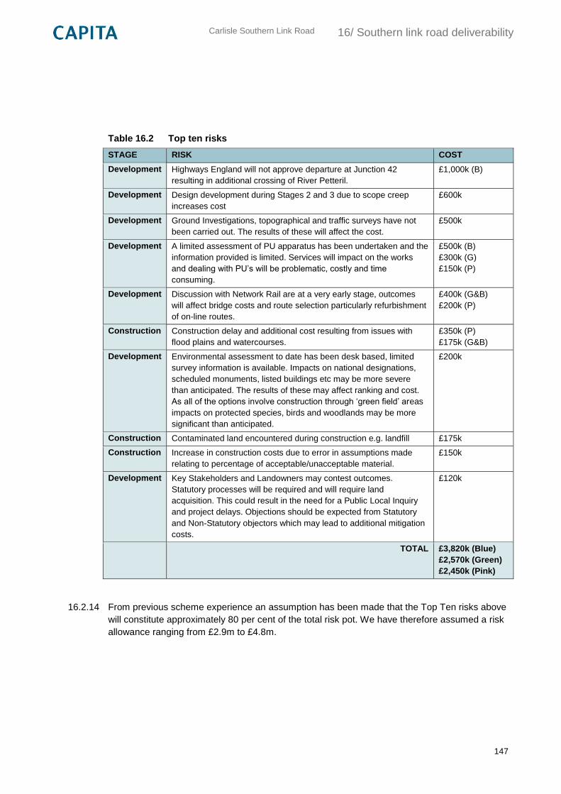
Carlisle Southern Link Road
16/ Southern link road deliverability
147
Table 16.2 Top ten risks
STAGE RISK COST
Development Highways England will not approve departure at Junction 42
resulting in additional crossing of River Petteril.
£1,000k (B)
Development Design development during Stages 2 and 3 due to scope creep
increases cost
£600k
Development Ground Investigations, topographical and traffic surveys have not
been carried out. The results of these will affect the cost.
£500k
Development A limited assessment of PU apparatus has been undertaken and the
information provided is limited. Services will impact on the works
and dealing with PU’s will be problematic, costly and time
consuming.
£500k (B)
£300k (G)
£150k (P)
Development Discussion with Network Rail are at a very early stage, outcomes
will affect bridge costs and route selection particularly refurbishment
of on-line routes.
£400k (G&B)
£200k (P)
Construction Construction delay and additional cost resulting from issues with
flood plains and watercourses.
£350k (P)
£175k (G&B)
Development Environmental assessment to date has been desk based, limited
survey information is available. Impacts on national designations,
scheduled monuments, listed buildings etc may be more severe
than anticipated. The results of these may affect ranking and cost.
As all of the options involve construction through ‘green field’ areas
impacts on protected species, birds and woodlands may be more
significant than anticipated.
£200k
Construction Contaminated land encountered during construction e.g. landfill £175k
Construction Increase in construction costs due to error in assumptions made
relating to percentage of acceptable/unacceptable material.
£150k
Development Key Stakeholders and Landowners may contest outcomes.
Statutory processes will be required and will require land
acquisition. This could result in the need for a Public Local Inquiry
and project delays. Objections should be expected from Statutory
and Non-Statutory objectors which may lead to additional mitigation
costs.
£120k
TOTAL £3,820k (Blue)
£2,570k (Green)
£2,450k (Pink)
16.2.14 From previous scheme experience an assumption has been made that the Top Ten risks above
will constitute approximately 80 per cent of the total risk pot. We have therefore assumed a risk
allowance ranging from £2.9m to £4.8m.
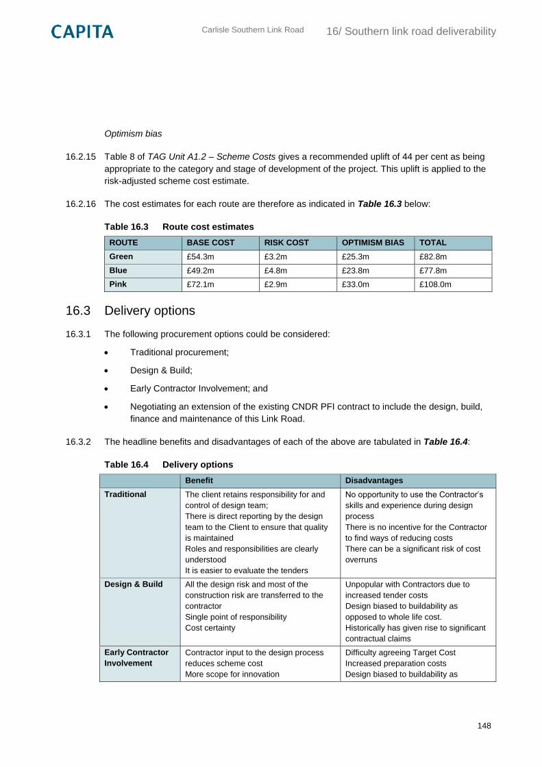
Carlisle Southern Link Road
16/ Southern link road deliverability
148
Optimism bias
16.2.15 Table 8 of TAG Unit A1.2 – Scheme Costs gives a recommended uplift of 44 per cent as being
appropriate to the category and stage of development of the project. This uplift is applied to the
risk-adjusted scheme cost estimate.
16.2.16 The cost estimates for each route are therefore as indicated in Table 16.3 below:
Table 16.3 Route cost estimates
ROUTE BASE COST RISK COST OPTIMISM BIAS TOTAL
Green £54.3m £3.2m £25.3m £82.8m
Blue £49.2m £4.8m £23.8m £77.8m
Pink £72.1m £2.9m £33.0m £108.0m
16.3 Delivery options
16.3.1 The following procurement options could be considered:
Traditional procurement;
Design & Build;
Early Contractor Involvement; and
Negotiating an extension of the existing CNDR PFI contract to include the design, build,
finance and maintenance of this Link Road.
16.3.2 The headline benefits and disadvantages of each of the above are tabulated in Table 16.4:
Table 16.4 Delivery options
Benefit Disadvantages
Traditional The client retains responsibility for and
control of design team;
There is direct reporting by the design
team to the Client to ensure that quality
is maintained
Roles and responsibilities are clearly
understood
It is easier to evaluate the tenders
No opportunity to use the Contractor’s
skills and experience during design
process
There is no incentive for the Contractor
to find ways of reducing costs
There can be a significant risk of cost
overruns
Design & Build All the design risk and most of the
construction risk are transferred to the
contractor
Single point of responsibility
Cost certainty
Unpopular with Contractors due to
increased tender costs
Design biased to buildability as
opposed to whole life cost.
Historically has given rise to significant
contractual claims
Early Contractor
Involvement
Contractor input to the design process
reduces scheme cost
More scope for innovation
Difficulty agreeing Target Cost
Increased preparation costs
Design biased to buildability as
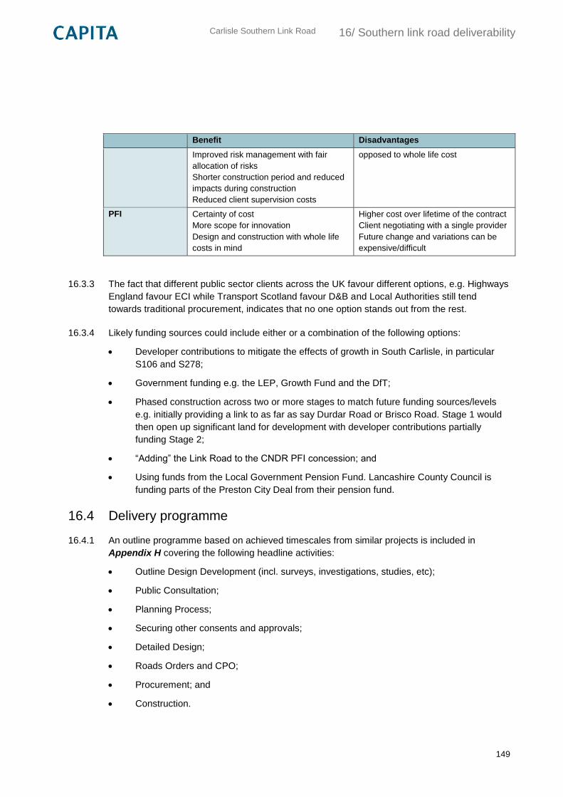
Carlisle Southern Link Road
16/ Southern link road deliverability
149
Benefit Disadvantages
Improved risk management with fair
allocation of risks
Shorter construction period and reduced
impacts during construction
Reduced client supervision costs
opposed to whole life cost
PFI Certainty of cost
More scope for innovation
Design and construction with whole life
costs in mind
Higher cost over lifetime of the contract
Client negotiating with a single provider
Future change and variations can be
expensive/difficult
16.3.3 The fact that different public sector clients across the UK favour different options, e.g. Highways
England favour ECI while Transport Scotland favour D&B and Local Authorities still tend
towards traditional procurement, indicates that no one option stands out from the rest.
16.3.4 Likely funding sources could include either or a combination of the following options:
Developer contributions to mitigate the effects of growth in South Carlisle, in particular
S106 and S278;
Government funding e.g. the LEP, Growth Fund and the DfT;
Phased construction across two or more stages to match future funding sources/levels
e.g. initially providing a link to as far as say Durdar Road or Brisco Road. Stage 1 would
then open up significant land for development with developer contributions partially
funding Stage 2;
“Adding” the Link Road to the CNDR PFI concession; and
Using funds from the Local Government Pension Fund. Lancashire County Council is
funding parts of the Preston City Deal from their pension fund.
16.4 Delivery programme
16.4.1 An outline programme based on achieved timescales from similar projects is included in
Appendix H covering the following headline activities:
Outline Design Development (incl. surveys, investigations, studies, etc);
Public Consultation;
Planning Process;
Securing other consents and approvals;
Detailed Design;
Roads Orders and CPO;
Procurement; and
Construction.

Carlisle Southern Link Road
16/ Southern link road deliverability
150
16.4.2 Based on a two year construction period and using realistic durations seven years is considered
to be a feasible timescale for delivery.
Carlisle Southern Link Road
17/ Southern link road appraisal summary
151
17. Southern link road appraisal summary
17.1 Conclusions
17.1.1 Considering the three individual routes against the key criteria as discussed in the preceding
chapters it can be seen in general terms:
The Blue route scores best on affordability and capital cost grounds because it
maximises the reuse of existing infrastructure. In contrast the Pink route scores worst
because of the need to provide additional expensive major crossings of the West Coast
Main Line and River Petteril;
The Blue route carries the greatest cost risk due to the number of existing utilities within
the existing highway that will require diverting and/or protecting coupled with the
uncertain cost of refurbishing the existing Newbiggin New and New Brisco bridges;
There is no difference between the Blue and Green routes on environmental grounds
with the Pink route scoring worst on noise, air quality, landscape & visual, historic
environment and the water environment;
The Green route is superior to the Blue route in terms of noise and air pollution due to the
much larger number of receptor sites fronting on to the sections of existing highway
incorporated into it;
The Blue route is less damaging to the landscape and the historic environment than the
Green route due to it maximising the length of the existing road corridor it follows;
The Pink route will cause the least disruption to existing road users and frontages during
construction;
The alignment of the Green and Pink routes are the most flexible in contrast the Blue
route provides limited flexibility due to be fixed along almost 50% of its length where it
follows existing highway corridors;
The Pink route may encourage development that closely physically integrates with the
existing urban area; all routes, but particularly the Blue and Green routes, offer greater
opportunities to provide separation from it allowing consideration of alternative forms of
growth;
While no public consultation as yet taken place it is likely that the Green route will be the
most acceptable to the public given its location;
No “show stoppers” have been identified for any of the three routes but further
development is obviously required to mitigate the environmental impact of crossing the
Caldew Valley. It is likely that where appropriate mitigation is included within the design,
any adverse effects will be reduced to a level that is more acceptable. Where residual
adverse effects remain, they are likely to be outweighed by other benefits of the scheme;
All three routes will support development at Carlisle South and assist east/west
movement;
Carlisle Southern Link Road
17/ Southern link road appraisal summary
152
In order to overcome affordability issues phased delivery of all options is possible.
17.2 Recommendations
17.2.1 Given the limited nature of this assessment, the unknown outcome of the ongoing South
Carlisle masterplanning exercise and limited modelling proportionate to the stage of preparation
of Carlisle South and exploration of a link road has taken place it is recommended that all three
routes are taken forward for consideration at Stage 2.
17.2.2 The routes identified should be considered at this stage as route corridors and as such should
be seen as being flexible in their horizontal alignment except at tie-ins to existing infrastructure
and pinch points.
17.3 Next steps
17.3.1 A TAG Stage 2 and DMRB Stage 2 appraisal should commence following the completion of the
Stage 1 assessment. The Stage 2 appraisal should be aligned as far as possible with ongoing
masterplanning work for Carlisle South. This would enable the progression of the design and
delivery of the scheme.
17.3.2 The next stage of scheme development should include the production of a strategic outline
business case. The purpose of this business case would be to define the scope of the project
and make the case for the project. It would essentially summarise the key information from this
report, along with further details on proposed project governance, key stakeholders and
assurance arrangements.
17.3.3 An Appraisal Specification Report has been produced and is included as Appendix J. The
Appraisal Specification Report includes a proposed methodology for the transport modelling to
support the appraisal, as well as the methodologies for appraising the economic, environmental
and social impacts of the scheme. The acceptance and agreement of the methodologies in this
report by key stakeholders and potential scheme funders is key to ensuring the scheme
appraisal is appropriate. The report contains recommendations for ensuring the transport
modelling to support the appraisal of the scheme is fit for purpose.
Carlisle Southern Link Road
Commercial in Confidence Appendix A
1
Appendix A
Route Development Plans
A.1 Location Plan
A.2 Local Study Area Plan
A.3 Carlisle Southern Bypass 1990s Routes Plan
A.4 Route Options
A.5 Proposed X Section
A.6 Existing Major Utilities Apparatus
A.7 Existing Landownership

Carlisle Southern Link Road
Commercial in Confidence Appendix B
2
Appendix B
Initial Option Sift
South Carlisle Infrastructure: EAST Summary
Five schemes:
1. Southern link road
2. On-line capacity improvements
3. Sustainable improvements
4. Park and ride
5. Light rail
Scale of impact
To what extent does the option alleviate the identified problem?
1 Very small overall impact
Would have a very small positive impact, possibly with undesirable consequences
2 Minor impact Would have a modest overall impact
On-line capacity improvements
Sustainable improvements
3 Moderate impact Expected to have a reasonably significant impact on the problem identified
Park and ride
Light rail
4 Significant impact Expected to significantly alleviate the problem
Southern link road
5 Fully addresses the identified problem
Expected to fully solve the identified problem, without any undesirable consequences
Fit with wider transport and government objectives
1 Poor fit There is significant conflict with other policies/options affecting the study area which needs to be resolved.
2 Low fit There is some conflict with other policies/options or modes.
3 Reasonable fit Overall the option fits well with other policies affecting the study area.
On-line capacity improvements
4 Good fit The option fits very well with other policies affecting the study area.
Southern link road
5 Excellent fit Option complements other policies/proposals affecting study area, has no negative impacts on other modes or outcomes and demonstrates ‘doing more with less’.
Sustainable improvements
Park and ride
Light rail
Fit with other objectives
These will vary depending on how the tool is being used. This is an opportunity to draw out and highlight any relevant network or regional objectives specific to an option and to outline how it performs against any local or modal objectives.
1 Poor fit There is significant conflict with the County and City’s Objectives affecting the study area which needs to be resolved.
2 Low fit There is some conflict with the County and City’s Objectives
3 Reasonable fit Overall the option fits well with the County and City’s Objectives affecting the study area.
Park and ride
Light rail
On-line capacity improvements
Sustainable improvements
4 Good fit The option fits very well with the County and City’s Objectives affecting the study area.
5 Excellent fit Option complements other the County and City’s Objectives affecting study area, has no negative impacts or outcomes and demonstrates ‘doing more with less’.
Southern link road
Degree of consensus over outcomes
What consultation has taken place with relevant stakeholders?
1 Little or no consultation has taken place yet, or consultation has revealed a high level of disagreement about the option’s ability to deliver the stated outcomes
Light rail
2 Little consultation and/or strong reasons to suggest the outcomes are controversial
Park and ride
3 Some consultation has taken place with some agreement Southern link road
On-line capacity improvements
Sustainable improvements
4 Wide consultation and broad agreement on the outcomes, possibly one or two areas of disagreement remaining
5 Extensive consultation has taken place with a high degree of consensus on the outcomes
Economic Growth
RED Negative
RED/AMBER
AMBER No change Sustainable improvements
GREEN/AMBER On-line capacity improvements
Park and ride
GREEN Positive Southern link road
Light rail
Carbon Emissions
RED Negative
RED/AMBER
AMBER No change Southern link road
On-line capacity improvements
GREEN/AMBER Park and ride
Light rail
GREEN Positive Sustainable improvements
Socio-distributional Impacts and the Regions
RED Negative
RED/AMBER
AMBER No change Southern link road
On-line capacity improvements
GREEN/AMBER Park and ride
Light rail
GREEN Positive Sustainable improvements
Local environment
RED Negative
RED/AMBER Southern link road
On-line capacity improvements
AMBER No change
GREEN/AMBER Sustainable improvements
Park and ride
Light rail
GREEN Positive
Well being
RED Negative
RED/AMBER
AMBER No change Southern link road
On-line capacity improvements
GREEN/AMBER Sustainable improvements
Park and ride
Light rail
GREEN Positive
Expected VfM category
1. Very high
2. High Southern link road
3. Medium Sustainable improvements
4. Low On-line capacity improvements
Park and ride
5. Poor Light rail
Implementation timetable from inception to delivery
4. 1–2 years
5. 2–5 years On-line capacity improvements
Sustainable improvements
6. 5–10 years Southern link road
Park and ride
7. 10+ years Light rail
Public acceptability
An assessment of whether there are likely to be any issues around public acceptability of the option. For example, will the option require a long period for public consultation?
0 Don’t know Light rail
1 Low
2
3 On-line capacity improvements
Park and ride
4 Southern link road
Sustainable improvements
5 High
Practical feasibility
Has the option been tested and proven to be practical and effective?
1 Low Light rail
2 On-line capacity improvements
Park and ride
3 Southern link road
4 Sustainable improvements
5 High
Quality of the supporting evidence
1 Low Park and ride
Light rail
2 On-line capacity improvements
Sustainable improvements
3 Southern link road
4
5 High
Affordability
The issue of affordability needs to be put in the context of the available budget and relevant budget period. Some options that are unaffordable in the immediate budget period may be affordable in later years.
1 Not affordable Light rail
2
3 Southern link road
Park and ride
4 On-line capacity improvements
5 Affordable Sustainable improvements
Capital Cost
Capital costs should include all the costs involved in setting up the option and getting it up
and running. In some cases cost information may be very uncertain. Respondents need to
provide their best estimate.
1. £0
2. £0m to £5m
3. £5m to £10m
4. £10m to £25m On-line capacity improvements
Sustainable improvements
5. £25m to £50 Park and ride
6. £50m to £100m Southern link road
Light rail
Revenue Costs
1. £0 Southern link road
On-line capacity improvements
Sustainable improvements
11. Don’t know Park and ride
Light rail
Overall Cost Risk
1 High Risk Light rail
2 Park and ride
3 Southern link road
On-line capacity improvements
4 Sustainable improvements
5 Low Risk
Flexibility of option
To what extent can the option be scaled up or down depending on the level of funding available? How easily could the scheme be amended to fit with changing circumstances?
1 Static Light rail
2 Park and ride
3 Southern link road
4 On-line capacity improvements
5 Dynamic Sustainable improvements
Summary
Scale
of
Impact
Govern
men
t
Obje
ctives
Local
Obje
ctives
Econo
mic
Gro
wth
Socio
Local
Enviro
nm
ent
We
ll B
ein
g
Valu
e f
or
Money
Pub
lic
Accepta
bili
ty
Pra
ctica
l
Feasib
ility
Afford
ab
ility
Capital C
ost
(£m
)
Cost R
isk
Fle
xib
ility
Southern link 4 4 5 5 3 2 3 High 4 3 3 50–100 3 3
On-line improvements 2 3 3 4 3 2 3 Low 3 2 4 10–25 3 4
Sustainable improvements
2 5 3 3 5 4 4 Med 4 4 5 10–25 4 5
Park and ride 3 5 3 4 4 4 4 Low 3 2 3 25–50 2 2
Light rail 3 5 3 5 4 4 4 Poor 1 1 50–100 1 1
Option Name/No.
Date Sep-15
Description
Identified problems and
objectives
Scale of impact 4 Supports development, provides a direct route to west Carlisle from
south Carlisle, would reduce congestion on radial routes and
provides new east-west link
Fit with wider transport
and government
objectives
4 Would boost economic growth and improve journeys
Fit with other objectives 5. High Should directly help all three main objectives
Key uncertainties
Degree of consensus
over outcomes
3 Potential scheme has previous been proposed in 1990s and is
referenced in local plan and examination in public
Economic growth 5. Green Would decrease journey times and improve reliability on radial
routes; provides significant improvement to infrastructure resilience,
especially in wake of Dec 2015 floods
Carbon emissions 3. Amber Scheme may increase veh-km as more traffic uses new route; may
have positive effects on radial routes and city centre by reducing
congestion
Socio-distributional
impacts and the regions
3. Amber Scheme is not within an identified regeneration area; scheme
impacts on accessibility etc are unknown
Local environment 2. Red/amber Road would increase noise and worsen air quality in local area of
road, but should improve air quality in AQMAs towards city centre;
scheme would have negative impact on environment, especially
when crossing Caldew valley, which needs to be mitigated
Well being 3. Amber Scheme should improve safety on radial routes by decreasing traffic.
Severance of scheme is unknown due to no detail on development
masterplan
Expected VfM category 2. High 2-4 Previous scheme in 1990s achieved good value for money
Implementation
timetable
6. 5-10 years
Public acceptability 4 Previous southern link scheme achieved generally good reaction in
public consultation, although this was 20 years ago
Practical feasibility 3 Concept of new road was explored in previous consultation and
there is unlikely to be major showstoppers
What is the quality of the
supporting evidence?
3 Transport modelling has assessed indicative impact of scheme, and
shown it would support local plan development
Key risks
Affordability 3 Scheme should be affordable through combination of developer
contributions, LEP growth fund and other funding sources
Capital Cost (£m) 06. 50-100 Indicative estimate based on CNDR costs
Revenue Costs (£m) 01. None
Early Assessment and Sifting Tool (EAST) - Expanded Print View
Strategic
Economic
Managerial
Southern Link
Carlisle Southern Link Road, linking M6 J42 to A595/A689, providing a new route for east-west
traffic and reducing congestion and delays on southern radial routes
Problem: Significantly increased congestion on constrained radial routes with development at
south Carlisle. Objectives: support delivery of major development at south Carlisle; reduce
congestion on southern radial routes and in city centre; assist east/west movements to/from
west Cumbria.
Expected layout of south Carlisle development will have significant influence on route options
Cost of structures; utilities; land costs
Financial

Cost profile
Overall cost risk 3
Other costs
Flexibility of option 3 Multiple route options but constrainted at various points e.g. existing
settlements, river and rail crossings
Where is funding coming
from?
Any income generated?
(£m)
No
Not currently known; assumed combination of developer contributions, Cumbria LEP and other
sources
Land purchase; utilities
Commercial
Unknown
Option Name/No.
Date Sep-15
Description
Identified problems and
objectives
Scale of impact 2 Supports development, would reduce congestion on radial routes;
may result in increased traffic on radial routes
Fit with wider transport
and government
objectives
3 Would boost economic growth and improve journeys but would
increase traffic in city centre
Fit with other objectives 3 Should directly help two of three main objectives (support
development and reduce congestion)
Key uncertainties
Degree of consensus
over outcomes
3 Principle of junction improvements has been considered in Carlisle
Transport Improvements study, which was consulted on as part of
local plan. Scheme will involve improvements over and above those
identified in study.
Economic growth 4. Amber/green Would help decrease journey times and improve reliability on radial
routes
Carbon emissions 3. Amber Capacity improvements may encourage more traffic to use radial
routes and travel towards city centre
Socio-distributional
impacts and the regions
3. Amber Scheme is not within an identified regeneration area; scheme
impacts on accessibility etc are unknown
Local environment 2. Red/amber Scheme should reduce noise and improve air quality, but
improvements may be lost if more traffic uses radial routes; scheme
would encourage traffic to drive to city centre
Well being 3. Amber Scheme will improve access to services, but will increase severance
on radial routes
Expected VfM category 4. Low 1-1.5
Implementation
timetable
5. 2-5 years
Public acceptability 3 Scheme involves upgrade of existing infrastructure; however,
scheme may require demolition of roadside properties
Practical feasibility 2 The Carlisle Transport Improvements study has already identified
potential improvements. Further improvements are likely to require
additional land purchase; review of on-street parking could be
controversial
What is the quality of the
supporting evidence?
2 The Carlisle Transport Improvements study suggests that capacity
improvements could be effective in reducing congestion. This
scheme would provide improvements over and above those
identified in the study
Key risks
Affordability 4
Early Assessment and Sifting Tool (EAST) - Expanded Print View
Strategic
Economic
Managerial
On-line capacity improvements
Link and junction improvements to London Road, Currock Road, Upperby Road and in the city
centre to reduce congestion and journey times on southern radial routes
Problem: Significantly increased congestion on constrained radial routes with development at
south Carlisle. Objectives: support delivery of major development at south Carlisle; reduce
congestion on southern radial routes and in city centre; assist east/west movements to/from
west Cumbria.
Feasibility of improvements at key junctions, as previous study indicates capacity improvements
are not possible within highway boundary
Land purchase; feasibility of significant capacity improvements at key junctions
Financial

Capital Cost (£m) 04. 10-25 Assumed £2m per junction at five junctions plus £5m for traffic
management and £10m for major improvements at Victoria
Viaduct/James Street
Revenue Costs (£m) 01. None
Cost profile
Overall cost risk 3
Other costs
Flexibility of option 4 Various constraints at critical junctions but improvements could be
delivered independantly of one another if one
Where is funding coming
from?
Any income generated?
(£m)
No
Not currently known; assumed combination of developer contributions, Cumbria LEP and other
sources
Land purchase, utilities
Commercial
Unknown
Option Name/No.
Date Sep-15
Description
Identified problems and
objectives
Scale of impact 2 Supports development, would reduce congestion on radial routes;
success of mode shift is unknown
Fit with wider transport
and government
objectives
5. High Will boost economic growth, improve journeys and promote
sustainable transport
Fit with other objectives 3 Should directly help two of three main objectives (support
development and reduce congestion)
Key uncertainties
Degree of consensus
over outcomes
3 Principle of sustainble improvements has been considered in Carlisle
Transport Improvements study, which was consulted on as part of
local plan. Scheme will involve improvements over and above those
identified in study.
Economic growth 3. Amber Effectiveness of measures in encouraging mode shift is not known,
and is unlikely to be significant; scheme would have no change in
resilience
Carbon emissions 5. Green Improvements should encourage mode shift away from single-
occupancy car trips
Socio-distributional
impacts and the regions
4. Amber/green Scheme would have positive impacts for accessibility
Local environment 4. Amber/green Scheme infrastructure would have marginal impact on environment
and would help encourage mode shift
Well being 4. Amber/green Scheme will have a small positive impact in reducing traffic flows via
mode shift
Expected VfM category 3. Medium 1.5-2 Scheme is expected to have a modest impact on reducing
congestion but is not expected to support development without
further intervention
Implementation
timetable
5. 2-5 years Infrastructure improvements could be delivered quickly;
improvements to service frequencies would take longer
Public acceptability 4 Scheme involves upgrade of existing infrastructure and is unlikely to
be controversial
Practical feasibility 4
What is the quality of the
supporting evidence?
2 The Carlisle Transport Improvements study suggests that
sustainability improvements could be effective in encouraging mode
shift. This scheme would provide improvements over and above
those identified in the study
Key risks
Affordability 5. Affordable
Capital Cost (£m) 04. 10-25 £15m based on rough costs from Carlisle Transport Improvements
study
Revenue Costs (£m) Don’t know Revenue costs likely to be met through developer contributions
Early Assessment and Sifting Tool (EAST) - Expanded Print View
Strategic
Economic
Managerial
Sustainable improvements
Walking, cycling and public transport improvements to encourage sustainable travel between
south Carlisle and the city centre
Problem: Significantly increased congestion on constrained radial routes with development at
south Carlisle. Objectives: support delivery of major development at south Carlisle; reduce
congestion on southern radial routes and in city centre; assist east/west movements to/from
west Cumbria.
Expected layout of south Carlisle development will have significant influence on intervention
options; specific location and nature of interventions still needs to be considered in detail
Working with bus operators to secure service frequency improvements
Financial

Cost profile
Overall cost risk 4
Other costs
Flexibility of option 5. Dynamic Dependent on scale and layout of development at South Carlisle but
not excessively tied to existing infrastructure
Where is funding coming
from?
Any income generated?
(£m)
Don't know
Not currently known; assumed combination of developer contributions, Cumbria LEP and other
sources
Commercial
Unknown
Option Name/No.
Date Sep-15
Description
Identified problems and
objectives
Scale of impact 3 Supports development, would reduce congestion on radial routes;
success of mode shift is unknown
Fit with wider transport
and government
objectives
5. High Will boost economic growth, improve journeys and promote
sustainable transport
Fit with other objectives 3 Should directly help two of three main objectives (support
development and reduce congestion)
Key uncertainties
Degree of consensus
over outcomes
2 Previous consultations regarding park and ride in Carlisle have
generally had a favourable public response (park and ride was
trialled in 2003)
Economic growth 4. Amber/green Should help decrease journey times on radial routes due to mode
shift; extent of mode shift is not currently known; no resilience
improvements
Carbon emissions 4. Amber/green Successful mode shift would reduce the number of car journeys and
reduce carbon emissions; new bus services would have associated
carbon emissions
Socio-distributional
impacts and the regions
4. Amber/green Scheme is not within an identified regeneration area; scheme should
improve accessibility
Local environment 4. Amber/green Improvements for noise and air quality due to mode shift; increases
in noise and reductions in air quality close to parking sites
Well being 4. Amber/green Scheme would improve access to a variety of services and improve
safety by reducing traffic flows; design of car parks need to carefully
consider security implications
Expected VfM category 4. Low 1-1.5 No evidence to support effectiveness of scheme, especially without
bus priority measures; trial of park and ride was undertaken in 2003
which did not meet revenue forecasts
Implementation
timetable
6. 5-10 years
Public acceptability 3
Practical feasibility 2
What is the quality of the
supporting evidence?
1. Low Evidence to support the effectiveness of the intervention does not
exist
Key risks
Affordability 3 Scheme should be affordable through combination of developer
contributions, LEP growth fund and other funding sources
Capital Cost (£m) 05. 25-50 Estimate based on similar schemes
Early Assessment and Sifting Tool (EAST) - Expanded Print View
Strategic
Economic
Managerial
Park and ride
Three park and ride sites in south Carlisle and a high-frequency bus service linking these sites
and the city centre
Problem: Significantly increased congestion on constrained radial routes with development at
south Carlisle. Objectives: support delivery of major development at south Carlisle; reduce
congestion on southern radial routes and in city centre; assist east/west movements to/from
west Cumbria.
Expected layout of south Carlisle development will have significant influence on site options;
commercial viability of park and ride; likely mode shift
Commercial viability of park and ride; land availability;
Financial

Revenue Costs (£m) Don’t know Around £1m per annum?
Cost profile
Overall cost risk 2
Other costs
Flexibility of option 2 Location dependent on available sites and masterplan layout
Where is funding coming
from?
Any income generated?
(£m)
Yes Don’t know
Not currently known; assumed combination of developer contributions, Cumbria LEP and other
sources
Land purchase; utilities
Commercial
Unknown
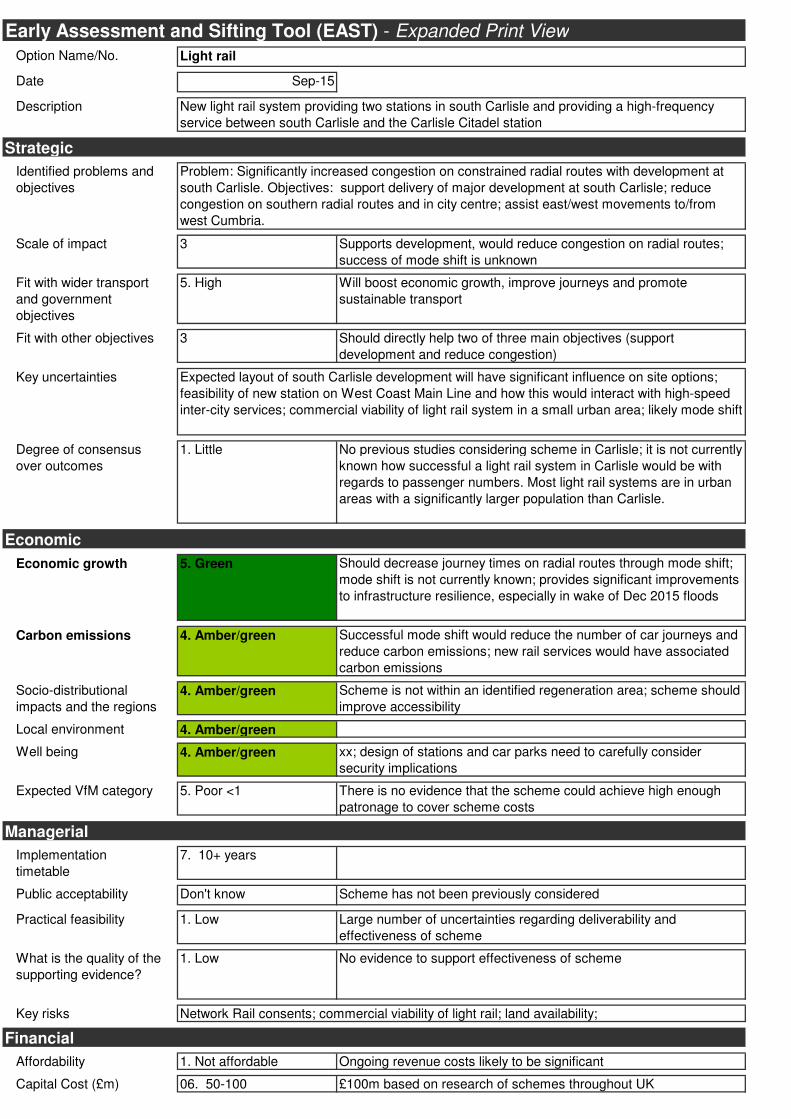
Option Name/No.
Date Sep-15
Description
Identified problems and
objectives
Scale of impact 3 Supports development, would reduce congestion on radial routes;
success of mode shift is unknown
Fit with wider transport
and government
objectives
5. High Will boost economic growth, improve journeys and promote
sustainable transport
Fit with other objectives 3 Should directly help two of three main objectives (support
development and reduce congestion)
Key uncertainties
Degree of consensus
over outcomes
1. Little No previous studies considering scheme in Carlisle; it is not currently
known how successful a light rail system in Carlisle would be with
regards to passenger numbers. Most light rail systems are in urban
areas with a significantly larger population than Carlisle.
Economic growth 5. Green Should decrease journey times on radial routes through mode shift;
mode shift is not currently known; provides significant improvements
to infrastructure resilience, especially in wake of Dec 2015 floods
Carbon emissions 4. Amber/green Successful mode shift would reduce the number of car journeys and
reduce carbon emissions; new rail services would have associated
carbon emissions
Socio-distributional
impacts and the regions
4. Amber/green Scheme is not within an identified regeneration area; scheme should
improve accessibility
Local environment 4. Amber/green
Well being 4. Amber/green xx; design of stations and car parks need to carefully consider
security implications
Expected VfM category 5. Poor <1 There is no evidence that the scheme could achieve high enough
patronage to cover scheme costs
Implementation
timetable
7. 10+ years
Public acceptability Don't know Scheme has not been previously considered
Practical feasibility 1. Low Large number of uncertainties regarding deliverability and
effectiveness of scheme
What is the quality of the
supporting evidence?
1. Low No evidence to support effectiveness of scheme
Key risks
Affordability 1. Not affordable Ongoing revenue costs likely to be significant
Capital Cost (£m) 06. 50-100 £100m based on research of schemes throughout UK
Early Assessment and Sifting Tool (EAST) - Expanded Print View
Strategic
Economic
Managerial
Light rail
New light rail system providing two stations in south Carlisle and providing a high-frequency
service between south Carlisle and the Carlisle Citadel station
Problem: Significantly increased congestion on constrained radial routes with development at
south Carlisle. Objectives: support delivery of major development at south Carlisle; reduce
congestion on southern radial routes and in city centre; assist east/west movements to/from
west Cumbria.
Expected layout of south Carlisle development will have significant influence on site options;
feasibility of new station on West Coast Main Line and how this would interact with high-speed
inter-city services; commercial viability of light rail system in a small urban area; likely mode shift
Network Rail consents; commercial viability of light rail; land availability;
Financial

Revenue Costs (£m) Don’t know Around £6m per annum (assumed £1m per km)?
Cost profile
Overall cost risk 1.High risk
Other costs
Flexibility of option 1. Static Stations locations are fixed by existing rail infrastructure
Where is funding coming
from?
Any income generated?
(£m)
Yes Don’t know
Not currently known; assumed combination of developer contributions, Cumbria LEP and other
sources
Land purchase
Commercial
Unknown
Carlisle Southern Link Road
Commercial in Confidence Appendix C
3
Appendix C
Southern Link Route Sift
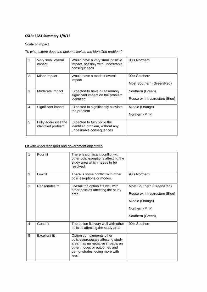
CSLR: EAST Summary 1/9/15
Scale of impact
To what extent does the option alleviate the identified problem?
1 Very small overall impact
Would have a very small positive impact, possibly with undesirable consequences
90’s Northern
2 Minor impact Would have a modest overall impact
90’s Southern
Most Southern (Green/Red)
3 Moderate impact Expected to have a reasonably significant impact on the problem identified
Southern (Green)
Reuse ex Infrastructure (Blue)
4 Significant impact Expected to significantly alleviate the problem
Middle (Orange)
Northern (Pink)
5 Fully addresses the identified problem
Expected to fully solve the identified problem, without any undesirable consequences
Fit with wider transport and government objectives
1 Poor fit There is significant conflict with other policies/options affecting the study area which needs to be resolved.
2 Low fit There is some conflict with other policies/options or modes.
90’s Northern
3 Reasonable fit Overall the option fits well with other policies affecting the study area.
Most Southern (Green/Red)
Reuse ex Infrastructure (Blue)
Middle (Orange)
Northern (Pink)
Southern (Green)
4 Good fit The option fits very well with other policies affecting the study area.
90’s Southern
5 Excellent fit Option complements other policies/proposals affecting study area, has no negative impacts on other modes or outcomes and demonstrates ‘doing more with less’.
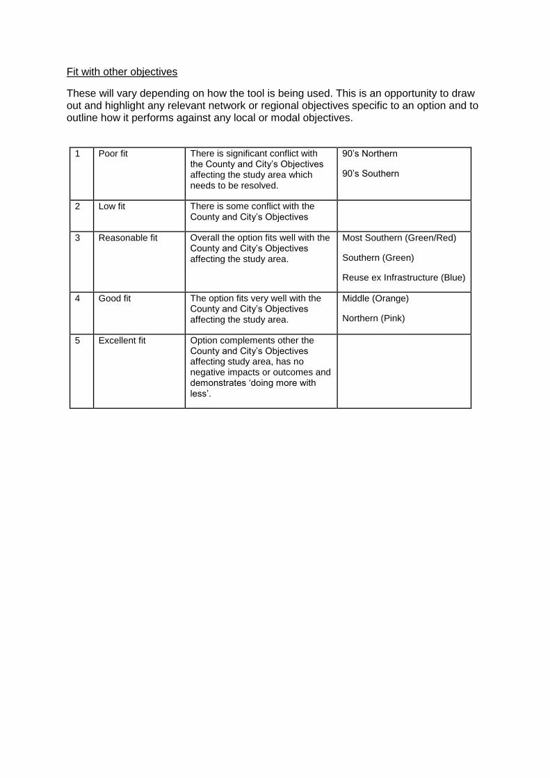
Fit with other objectives
These will vary depending on how the tool is being used. This is an opportunity to draw out and highlight any relevant network or regional objectives specific to an option and to outline how it performs against any local or modal objectives.
1 Poor fit There is significant conflict with the County and City’s Objectives affecting the study area which needs to be resolved.
90’s Northern
90’s Southern
2 Low fit There is some conflict with the County and City’s Objectives
3 Reasonable fit Overall the option fits well with the County and City’s Objectives affecting the study area.
Most Southern (Green/Red)
Southern (Green)
Reuse ex Infrastructure (Blue)
4 Good fit The option fits very well with the County and City’s Objectives affecting the study area.
Middle (Orange)
Northern (Pink)
5 Excellent fit Option complements other the County and City’s Objectives affecting study area, has no negative impacts or outcomes and demonstrates ‘doing more with less’.
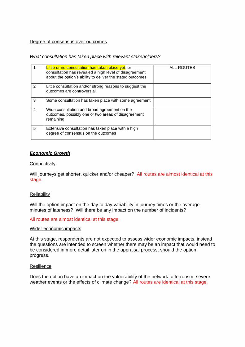
Degree of consensus over outcomes
What consultation has taken place with relevant stakeholders?
1 Little or no consultation has taken place yet, or consultation has revealed a high level of disagreement about the option’s ability to deliver the stated outcomes
ALL ROUTES
2 Little consultation and/or strong reasons to suggest the outcomes are controversial
3 Some consultation has taken place with some agreement
4 Wide consultation and broad agreement on the outcomes, possibly one or two areas of disagreement remaining
5 Extensive consultation has taken place with a high degree of consensus on the outcomes
Economic Growth
Connectivity
Will journeys get shorter, quicker and/or cheaper? All routes are almost identical at this stage.
Reliability
Will the option impact on the day to day variability in journey times or the average minutes of lateness? Will there be any impact on the number of incidents?
All routes are almost identical at this stage.
Wider economic impacts
At this stage, respondents are not expected to assess wider economic impacts, instead the questions are intended to screen whether there may be an impact that would need to be considered in more detail later on in the appraisal process, should the option progress. Resilience
Does the option have an impact on the vulnerability of the network to terrorism, severe weather events or the effects of climate change? All routes are identical at this stage.
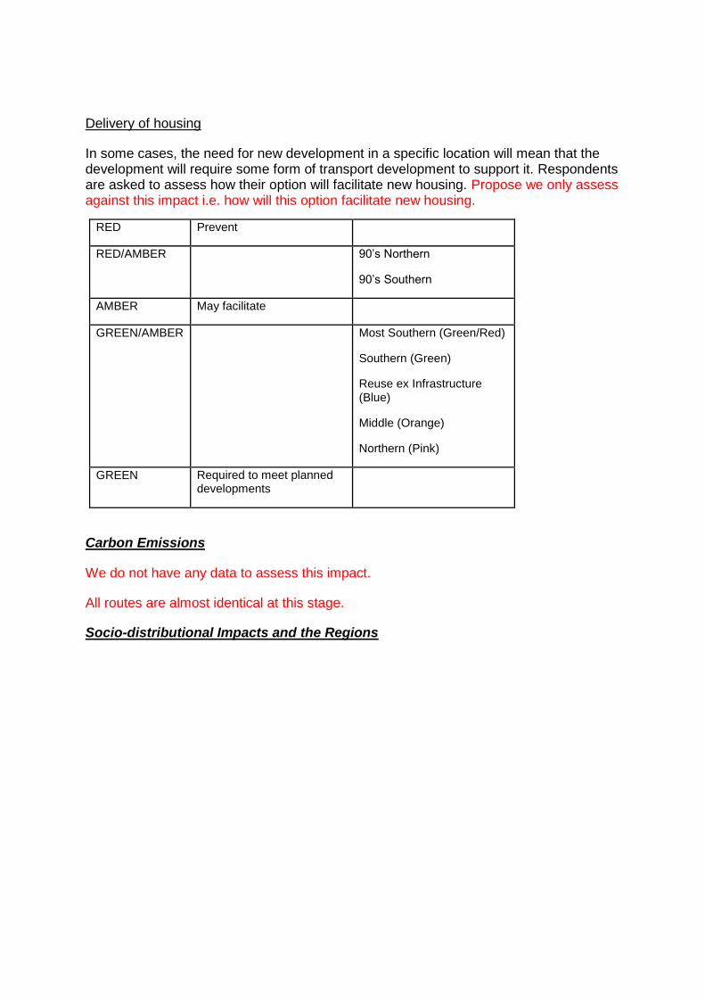
Delivery of housing
In some cases, the need for new development in a specific location will mean that the development will require some form of transport development to support it. Respondents are asked to assess how their option will facilitate new housing. Propose we only assess against this impact i.e. how will this option facilitate new housing.
RED Prevent
RED/AMBER 90’s Northern
90’s Southern
AMBER May facilitate
GREEN/AMBER Most Southern (Green/Red)
Southern (Green)
Reuse ex Infrastructure (Blue)
Middle (Orange)
Northern (Pink)
GREEN Required to meet planned developments
Carbon Emissions
We do not have any data to assess this impact.
All routes are almost identical at this stage.
Socio-distributional Impacts and the Regions
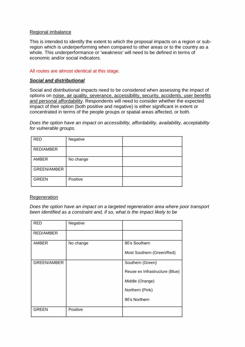
Regional imbalance
This is intended to identify the extent to which the proposal impacts on a region or sub-region which is underperforming when compared to other areas or to the country as a whole. This underperformance or 'weakness' will need to be defined in terms of economic and/or social indicators.
All routes are almost identical at this stage.
Social and distributional
Social and distributional impacts need to be considered when assessing the impact of options on noise, air quality, severance, accessibility, security, accidents, user benefits and personal affordability. Respondents will need to consider whether the expected impact of their option (both positive and negative) is either significant in extent or concentrated in terms of the people groups or spatial areas affected, or both. Does the option have an impact on accessibility, affordability, availability, acceptability for vulnerable groups.
RED Negative
RED/AMBER
AMBER No change
GREEN/AMBER
GREEN Positive
Regeneration
Does the option have an impact on a targeted regeneration area where poor transport been identified as a constraint and, if so, what is the impact likely to be
RED Negative
RED/AMBER
AMBER No change 90’s Southern
Most Southern (Green/Red)
GREEN/AMBER Southern (Green)
Reuse ex Infrastructure (Blue)
Middle (Orange)
Northern (Pink)
90’s Northern
GREEN Positive

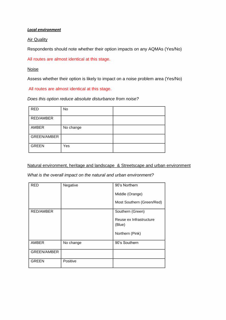
Local environment
Air Quality
Respondents should note whether their option impacts on any AQMAs (Yes/No) All routes are almost identical at this stage. Noise
Assess whether their option is likely to impact on a noise problem area (Yes/No) All routes are almost identical at this stage. Does this option reduce absolute disturbance from noise?
RED No
RED/AMBER
AMBER No change
GREEN/AMBER
GREEN Yes
Natural environment, heritage and landscape & Streetscape and urban environment
What is the overall impact on the natural and urban environment?
RED Negative 90’s Northern
Middle (Orange)
Most Southern (Green/Red)
RED/AMBER Southern (Green)
Reuse ex Infrastructure
(Blue)
Northern (Pink)
AMBER No change 90’s Southern
GREEN/AMBER
GREEN Positive
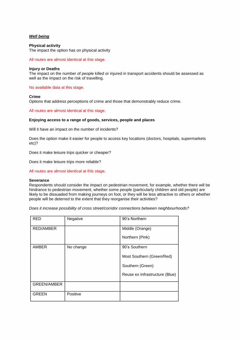
Well being Physical activity The impact the option has on physical activity All routes are almost identical at this stage. Injury or Deaths The impact on the number of people killed or injured in transport accidents should be assessed as well as the impact on the risk of travelling. No available data at this stage. Crime Options that address perceptions of crime and those that demonstrably reduce crime. All routes are almost identical at this stage. Enjoying access to a range of goods, services, people and places Will it have an impact on the number of incidents? Does the option make it easier for people to access key locations (doctors, hospitals, supermarkets etc)? Does it make leisure trips quicker or cheaper? Does it make leisure trips more reliable? All routes are almost identical at this stage. Severance Respondents should consider the impact on pedestrian movement, for example, whether there will be hindrance to pedestrian movement, whether some people (particularly children and old people) are likely to be dissuaded from making journeys on foot, or they will be less attractive to others or whether people will be deterred to the extent that they reorganise their activities? Does it increase possibility of cross street/corridor connections between neighbourhoods?
RED Negative 90’s Northern
RED/AMBER Middle (Orange)
Northern (Pink)
AMBER No change 90’s Southern
Most Southern (Green/Red)
Southern (Green)
Reuse ex Infrastructure (Blue)
GREEN/AMBER
GREEN Positive
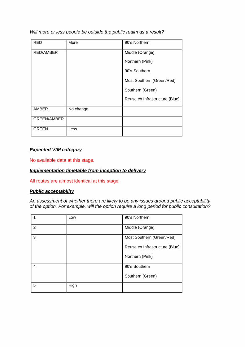
Will more or less people be outside the public realm as a result?
RED More 90’s Northern
RED/AMBER Middle (Orange)
Northern (Pink)
90’s Southern
Most Southern (Green/Red)
Southern (Green)
Reuse ex Infrastructure (Blue)
AMBER No change
GREEN/AMBER
GREEN Less
Expected VfM category
No available data at this stage.
Implementation timetable from inception to delivery
All routes are almost identical at this stage.
Public acceptability
An assessment of whether there are likely to be any issues around public acceptability of the option. For example, will the option require a long period for public consultation?
1 Low 90’s Northern
2 Middle (Orange)
3 Most Southern (Green/Red)
Reuse ex Infrastructure (Blue)
Northern (Pink)
4 90’s Southern
Southern (Green)
5 High
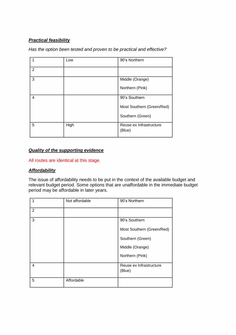
Practical feasibility
Has the option been tested and proven to be practical and effective?
1 Low 90’s Northern
2
3 Middle (Orange)
Northern (Pink)
4 90’s Southern
Most Southern (Green/Red)
Southern (Green)
5 High Reuse ex Infrastructure
(Blue)
Quality of the supporting evidence
All routes are identical at this stage.
Affordability
The issue of affordability needs to be put in the context of the available budget and relevant budget period. Some options that are unaffordable in the immediate budget period may be affordable in later years.
1 Not affordable 90’s Northern
2
3 90’s Southern
Most Southern (Green/Red)
Southern (Green)
Middle (Orange)
Northern (Pink)
4 Reuse ex Infrastructure
(Blue)
5 Affordable
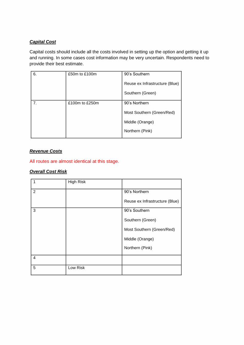
Capital Cost
Capital costs should include all the costs involved in setting up the option and getting it up
and running. In some cases cost information may be very uncertain. Respondents need to
provide their best estimate.
6. £50m to £100m 90’s Southern
Reuse ex Infrastructure (Blue)
Southern (Green)
7. £100m to £250m 90’s Northern
Most Southern (Green/Red)
Middle (Orange)
Northern (Pink)
Revenue Costs
All routes are almost identical at this stage.
Overall Cost Risk
1 High Risk
2 90’s Northern
Reuse ex Infrastructure (Blue)
3 90’s Southern
Southern (Green)
Most Southern (Green/Red)
Middle (Orange)
Northern (Pink)
4
5 Low Risk
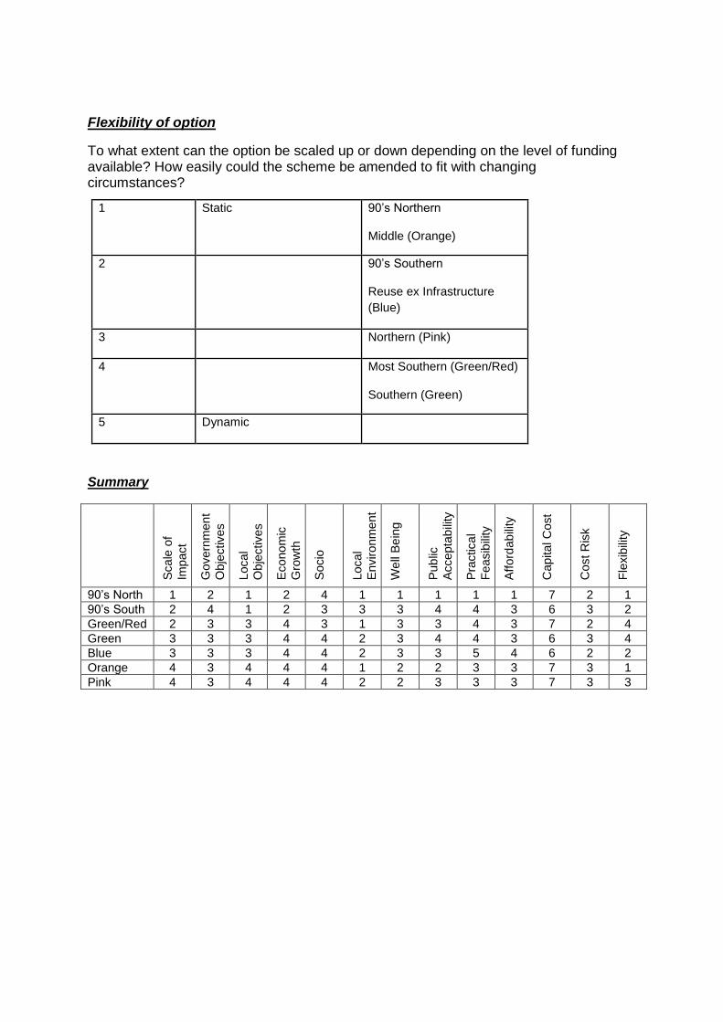
Flexibility of option
To what extent can the option be scaled up or down depending on the level of funding available? How easily could the scheme be amended to fit with changing circumstances?
1 Static 90’s Northern
Middle (Orange)
2 90’s Southern
Reuse ex Infrastructure
(Blue)
3 Northern (Pink)
4 Most Southern (Green/Red)
Southern (Green)
5 Dynamic
Summary
Scale
of
Impact
Govern
men
t
Obje
ctives
Local
Obje
ctives
Econo
mic
Gro
wth
Socio
Local
Enviro
nm
ent
We
ll B
ein
g
Pub
lic
Accepta
bili
ty
Pra
ctica
l
Feasib
ility
Afford
ab
ility
Capital C
ost
Cost R
isk
Fle
xib
ility
90’s North 1 2 1 2 4 1 1 1 1 1 7 2 1
90’s South 2 4 1 2 3 3 3 4 4 3 6 3 2
Green/Red 2 3 3 4 3 1 3 3 4 3 7 2 4
Green 3 3 3 4 4 2 3 4 4 3 6 3 4
Blue 3 3 3 4 4 2 3 3 5 4 6 2 2
Orange 4 3 4 4 4 1 2 2 3 3 7 3 1
Pink 4 3 4 4 4 2 2 3 3 3 7 3 3
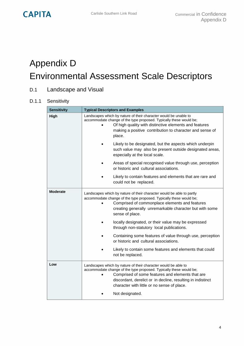
Carlisle Southern Link Road
Commercial in Confidence Appendix D
4
Appendix D
Environmental Assessment Scale Descriptors
D.1 Landscape and Visual
D.1.1 Sensitivity
Sensitivity Typical Descriptors and Examples
High Landscapes which by nature of their character would be unable to accommodate change of the type proposed. Typically these would be;
Of high quality with distinctive elements and features
making a positive contribution to character and sense of
place.
Likely to be designated, but the aspects which underpin
such value may also be present outside designated areas,
especially at the local scale.
Areas of special recognised value through use, perception
or historic and cultural associations.
Likely to contain features and elements that are rare and
could not be replaced.
Moderate Landscapes which by nature of their character would be able to partly
accommodate change of the type proposed. Typically these would be;
Comprised of commonplace elements and features
creating generally unremarkable character but with some
sense of place.
locally designated, or their value may be expressed
through non-statutory local publications.
Containing some features of value through use, perception
or historic and cultural associations.
Likely to contain some features and elements that could
not be replaced.
Low Landscapes which by nature of their character would be able to accommodate change of the type proposed. Typically these would be;
Comprised of some features and elements that are
discordant, derelict or in decline, resulting in indistinct
character with little or no sense of place.
Not designated.
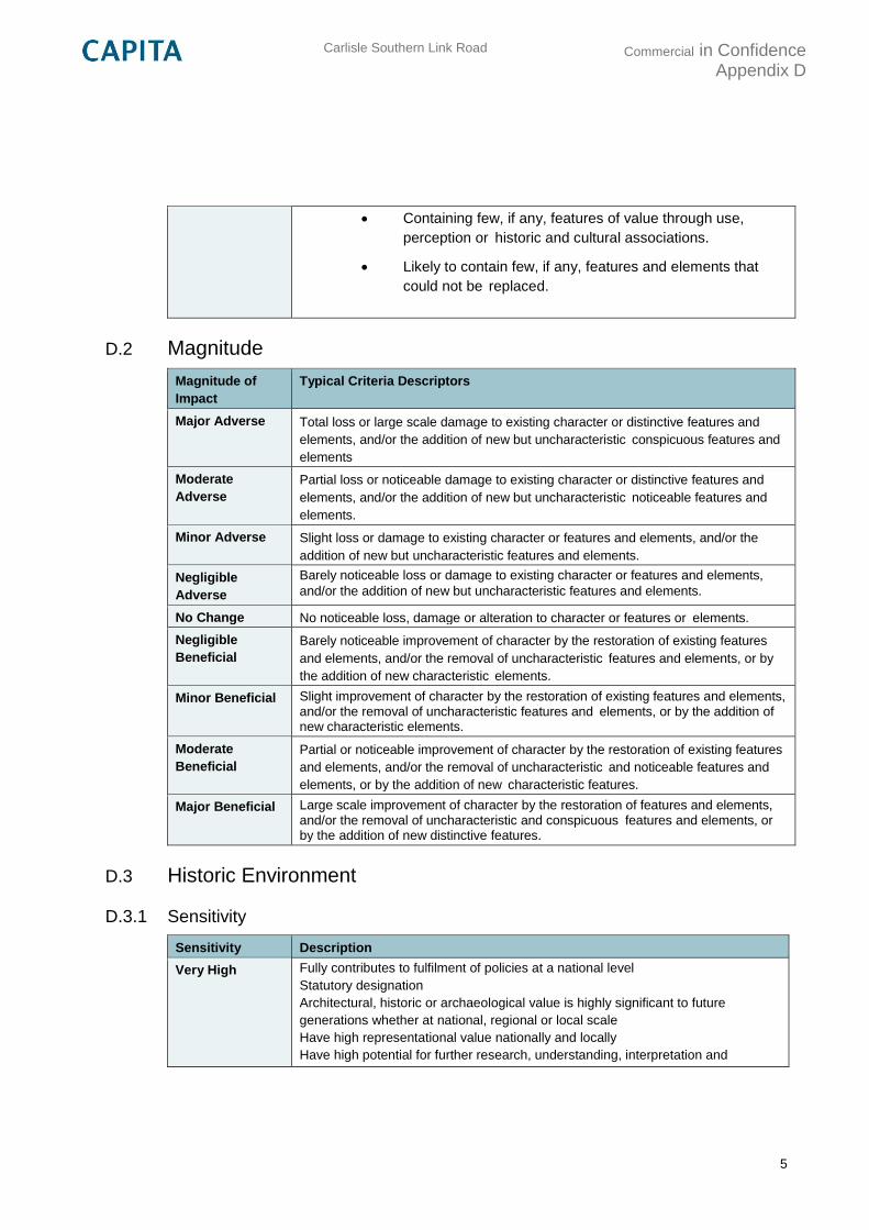
Carlisle Southern Link Road
Commercial in Confidence Appendix D
5
Containing few, if any, features of value through use,
perception or historic and cultural associations.
Likely to contain few, if any, features and elements that
could not be replaced.
D.2 Magnitude
Magnitude of
Impact
Typical Criteria Descriptors
Major Adverse Total loss or large scale damage to existing character or distinctive features and
elements, and/or the addition of new but uncharacteristic conspicuous features and
elements
Moderate
Adverse Partial loss or noticeable damage to existing character or distinctive features and
elements, and/or the addition of new but uncharacteristic noticeable features and
elements.
Minor Adverse Slight loss or damage to existing character or features and elements, and/or the
addition of new but uncharacteristic features and elements.
Negligible
Adverse
Barely noticeable loss or damage to existing character or features and elements,
and/or the addition of new but uncharacteristic features and elements.
No Change No noticeable loss, damage or alteration to character or features or elements.
Negligible
Beneficial Barely noticeable improvement of character by the restoration of existing features
and elements, and/or the removal of uncharacteristic features and elements, or by
the addition of new characteristic elements.
Minor Beneficial Slight improvement of character by the restoration of existing features and elements, and/or the removal of uncharacteristic features and elements, or by the addition of new characteristic elements.
Moderate
Beneficial
Partial or noticeable improvement of character by the restoration of existing features
and elements, and/or the removal of uncharacteristic and noticeable features and
elements, or by the addition of new characteristic features.
Major Beneficial Large scale improvement of character by the restoration of features and elements, and/or the removal of uncharacteristic and conspicuous features and elements, or by the addition of new distinctive features.
D.3 Historic Environment
D.3.1 Sensitivity
Sensitivity Description
Very High Fully contributes to fulfilment of policies at a national level
Statutory designation
Architectural, historic or archaeological value is highly significant to future
generations whether at national, regional or local scale
Have high representational value nationally and locally
Have high potential for further research, understanding, interpretation and
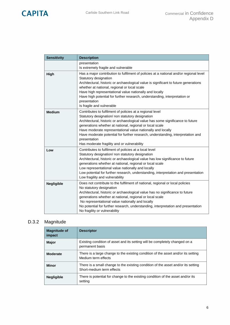
Carlisle Southern Link Road
Commercial in Confidence Appendix D
6
Sensitivity Description
presentation
Is extremely fragile and vulnerable
High Has a major contribution to fulfilment of policies at a national and/or regional level
Statutory designation
Architectural, historic or archaeological value is significant to future generations
whether at national, regional or local scale
Have high representational value nationally and locally
Have high potential for further research, understanding, interpretation or
presentation
Is fragile and vulnerable
Medium Contributes to fulfilment of policies at a regional level
Statutory designation/ non statutory designation
Architectural, historic or archaeological value has some significance to future
generations whether at national, regional or local scale
Have moderate representational value nationally and locally
Have moderate potential for further research, understanding, interpretation and
presentation
Has moderate fragility and or vulnerability
Low Contributes to fulfilment of policies at a local level
Statutory designation/ non statutory designation
Architectural, historic or archaeological value has low significance to future
generations whether at national, regional or local scale
Low representational value nationally and locally
Low potential for further research, understanding, interpretation and presentation
Low fragility and vulnerability
Negligible Does not contribute to the fulfilment of national, regional or local policies
No statutory designation
Architectural, historic or archaeological value has no significance to future
generations whether at national, regional or local scale
No representational value nationally and locally
No potential for further research, understanding, interpretation and presentation
No fragility or vulnerability
D.3.2 Magnitude
Magnitude of
impact
Descriptor
Major Existing condition of asset and its setting will be completely changed on a
permanent basis
Moderate There is a large change to the existing condition of the asset and/or its setting
Medium term effects
Minor There is a small change to the existing condition of the asset and/or its setting
Short-medium term effects
Negligible There is potential for change to the existing condition of the asset and/or its
setting
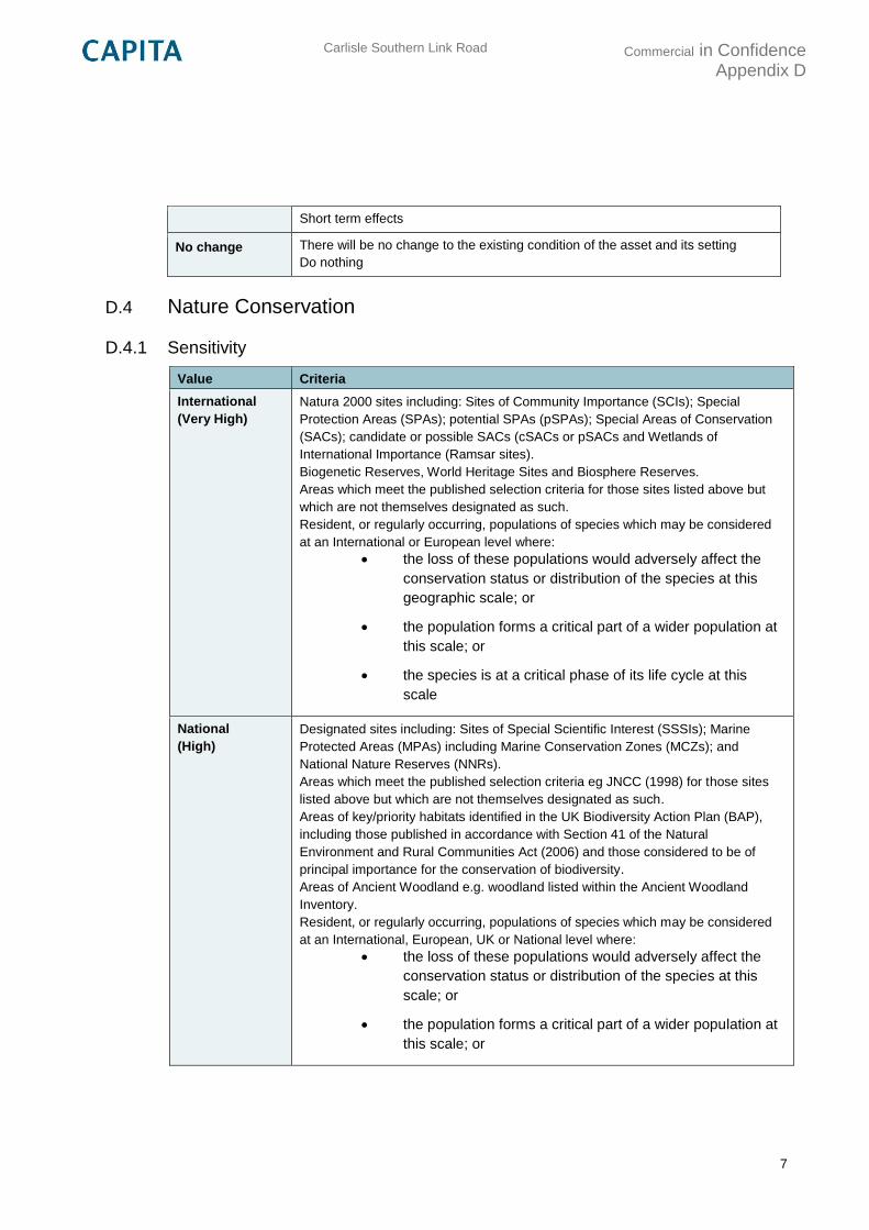
Carlisle Southern Link Road
Commercial in Confidence Appendix D
7
Short term effects
No change There will be no change to the existing condition of the asset and its setting
Do nothing
D.4 Nature Conservation
D.4.1 Sensitivity
Value Criteria
International
(Very High)
Natura 2000 sites including: Sites of Community Importance (SCIs); Special
Protection Areas (SPAs); potential SPAs (pSPAs); Special Areas of Conservation
(SACs); candidate or possible SACs (cSACs or pSACs and Wetlands of
International Importance (Ramsar sites).
Biogenetic Reserves, World Heritage Sites and Biosphere Reserves.
Areas which meet the published selection criteria for those sites listed above but
which are not themselves designated as such.
Resident, or regularly occurring, populations of species which may be considered
at an International or European level where:
the loss of these populations would adversely affect the
conservation status or distribution of the species at this
geographic scale; or
the population forms a critical part of a wider population at
this scale; or
the species is at a critical phase of its life cycle at this
scale
National
(High)
Designated sites including: Sites of Special Scientific Interest (SSSIs); Marine
Protected Areas (MPAs) including Marine Conservation Zones (MCZs); and
National Nature Reserves (NNRs).
Areas which meet the published selection criteria eg JNCC (1998) for those sites
listed above but which are not themselves designated as such.
Areas of key/priority habitats identified in the UK Biodiversity Action Plan (BAP),
including those published in accordance with Section 41 of the Natural
Environment and Rural Communities Act (2006) and those considered to be of
principal importance for the conservation of biodiversity.
Areas of Ancient Woodland e.g. woodland listed within the Ancient Woodland
Inventory.
Resident, or regularly occurring, populations of species which may be considered
at an International, European, UK or National level where:
the loss of these populations would adversely affect the
conservation status or distribution of the species at this
scale; or
the population forms a critical part of a wider population at
this scale; or
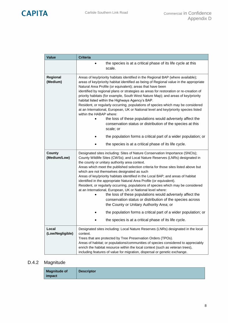
Carlisle Southern Link Road
Commercial in Confidence Appendix D
8
Value Criteria
the species is at a critical phase of its life cycle at this
scale.
Regional
(Medium)
Areas of key/priority habitats identified in the Regional BAP (where available);
areas of key/priority habitat identified as being of Regional value in the appropriate
Natural Area Profile (or equivalent); areas that have been
identified by regional plans or strategies as areas for restoration or re-creation of
priority habitats (for example, South West Nature Map); and areas of key/priority
habitat listed within the Highways Agency’s BAP.
Resident, or regularly occurring, populations of species which may be considered
at an International, European, UK or National level and key/priority species listed
within the HABAP where:
the loss of these populations would adversely affect the
conservation status or distribution of the species at this
scale; or
the population forms a critical part of a wider population; or
the species is at a critical phase of its life cycle.
County
(Medium/Low)
Designated sites including: Sites of Nature Conservation Importance (SNCIs);
County Wildlife Sites (CWSs); and Local Nature Reserves (LNRs) designated in
the county or unitary authority area context.
Areas which meet the published selection criteria for those sites listed above but
which are not themselves designated as such
Areas of key/priority habitats identified in the Local BAP; and areas of habitat
identified in the appropriate Natural Area Profile (or equivalent).
Resident, or regularly occurring, populations of species which may be considered
at an International, European, UK or National level where:
the loss of these populations would adversely affect the
conservation status or distribution of the species across
the County or Unitary Authority Area; or
the population forms a critical part of a wider population; or
the species is at a critical phase of its life cycle.
Local
(Low/Negligible)
Designated sites including: Local Nature Reserves (LNRs) designated in the local
context.
Trees that are protected by Tree Preservation Orders (TPOs).
Areas of habitat; or populations/communities of species considered to appreciably
enrich the habitat resource within the local context (such as veteran trees),
including features of value for migration, dispersal or genetic exchange.
D.4.2 Magnitude
Magnitude of
impact
Descriptor
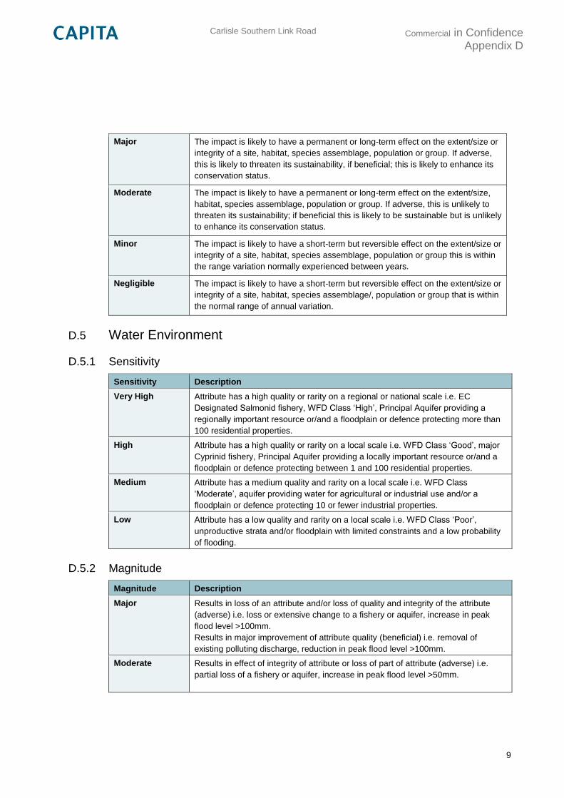
Carlisle Southern Link Road
Commercial in Confidence Appendix D
9
Major The impact is likely to have a permanent or long-term effect on the extent/size or
integrity of a site, habitat, species assemblage, population or group. If adverse,
this is likely to threaten its sustainability, if beneficial; this is likely to enhance its
conservation status.
Moderate The impact is likely to have a permanent or long-term effect on the extent/size,
habitat, species assemblage, population or group. If adverse, this is unlikely to
threaten its sustainability; if beneficial this is likely to be sustainable but is unlikely
to enhance its conservation status.
Minor The impact is likely to have a short-term but reversible effect on the extent/size or
integrity of a site, habitat, species assemblage, population or group this is within
the range variation normally experienced between years.
Negligible The impact is likely to have a short-term but reversible effect on the extent/size or
integrity of a site, habitat, species assemblage/, population or group that is within
the normal range of annual variation.
D.5 Water Environment
D.5.1 Sensitivity
Sensitivity Description
Very High Attribute has a high quality or rarity on a regional or national scale i.e. EC
Designated Salmonid fishery, WFD Class ‘High’, Principal Aquifer providing a
regionally important resource or/and a floodplain or defence protecting more than
100 residential properties.
High Attribute has a high quality or rarity on a local scale i.e. WFD Class ‘Good’, major
Cyprinid fishery, Principal Aquifer providing a locally important resource or/and a
floodplain or defence protecting between 1 and 100 residential properties.
Medium Attribute has a medium quality and rarity on a local scale i.e. WFD Class
‘Moderate’, aquifer providing water for agricultural or industrial use and/or a
floodplain or defence protecting 10 or fewer industrial properties.
Low Attribute has a low quality and rarity on a local scale i.e. WFD Class ‘Poor’,
unproductive strata and/or floodplain with limited constraints and a low probability
of flooding.
D.5.2 Magnitude
Magnitude Description
Major Results in loss of an attribute and/or loss of quality and integrity of the attribute
(adverse) i.e. loss or extensive change to a fishery or aquifer, increase in peak
flood level >100mm.
Results in major improvement of attribute quality (beneficial) i.e. removal of
existing polluting discharge, reduction in peak flood level >100mm.
Moderate Results in effect of integrity of attribute or loss of part of attribute (adverse) i.e.
partial loss of a fishery or aquifer, increase in peak flood level >50mm.
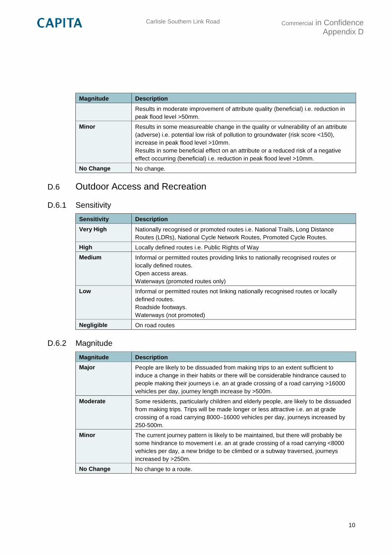
Carlisle Southern Link Road
Commercial in Confidence Appendix D
10
Magnitude Description
Results in moderate improvement of attribute quality (beneficial) i.e. reduction in
peak flood level >50mm.
Minor Results in some measureable change in the quality or vulnerability of an attribute
(adverse) i.e. potential low risk of pollution to groundwater (risk score <150),
increase in peak flood level >10mm.
Results in some beneficial effect on an attribute or a reduced risk of a negative
effect occurring (beneficial) i.e. reduction in peak flood level >10mm.
No Change No change.
D.6 Outdoor Access and Recreation
D.6.1 Sensitivity
Sensitivity Description
Very High Nationally recognised or promoted routes i.e. National Trails, Long Distance
Routes (LDRs), National Cycle Network Routes, Promoted Cycle Routes.
High Locally defined routes i.e. Public Rights of Way
Medium Informal or permitted routes providing links to nationally recognised routes or
locally defined routes.
Open access areas.
Waterways (promoted routes only)
Low Informal or permitted routes not linking nationally recognised routes or locally
defined routes.
Roadside footways.
Waterways (not promoted)
Negligible On road routes
D.6.2 Magnitude
Magnitude Description
Major People are likely to be dissuaded from making trips to an extent sufficient to
induce a change in their habits or there will be considerable hindrance caused to
people making their journeys i.e. an at grade crossing of a road carrying >16000
vehicles per day, journey length increase by >500m.
Moderate Some residents, particularly children and elderly people, are likely to be dissuaded
from making trips. Trips will be made longer or less attractive i.e. an at grade
crossing of a road carrying 8000–16000 vehicles per day, journeys increased by
250-500m.
Minor The current journey pattern is likely to be maintained, but there will probably be
some hindrance to movement i.e. an at grade crossing of a road carrying <8000
vehicles per day, a new bridge to be climbed or a subway traversed, journeys
increased by >250m.
No Change No change to a route.
Carlisle Southern Link Road
Commercial in Confidence Appendix E
11
Appendix E
Environmental Assessment Plans
E.1 Noise and Vibration
CSDR-CAP-EGN-00-DR-V-0008 Property Count Bandings (Baseline)
CSDR-CAP-EGN-00-DR-V-0009 Property Count Bandings (Pink Route)
CSDR-CAP-EGN-00-DR-V-0010 Property Count Bandings (Blue Route)
CSDR-CAP-EGN-00-DR-V-0011 Property Count Bandings (Green Route)
E.2 Air Quality
CSDR-CAP-EGN-00-DR-V-0014 Property Count Bandings (Baseline)
CSDR-CAP-EGN-00-DR-V-0015 Property Count Bandings (Pink Route)
CSDR-CAP-EGN-00-DR-V-0016 Property Count Bandings (Blue Route)
CSDR-CAP-EGN-00-DR-V-0017 Property Count Bandings (Green Route)
E.3 Landscape and Visual
CSDR-CAP-EGN-00-DR-V-0002 Landscape and Visual Viewpoints
CSDR-CAP-EGN-00-DR-V-0004 Landscape Character Areas
E.4 Historic Environment
CSDR-CAP-EGN-00-DR-V-0005 Historical Constraints
E.5 Nature Conservation
CSDR-CAP-EGN-00-DR-V-006 Designated Sites
CSDR-CAP-EGN-00-DR-V-007 Biodiversity Action Plan and Protected Species
E.6 Water Environment
CSDR-CAP-EGN-00-DR-V-0018 Water Environment Constraints
CSDR-CAP-EGN-00-DR-V-0019 Detailed Baseline Flood Extents
E.7 Outdoor Access and Recreation
CSDR-CAP-EGN-00-DR-V-0003 Outdoor Access and Recreation Sites
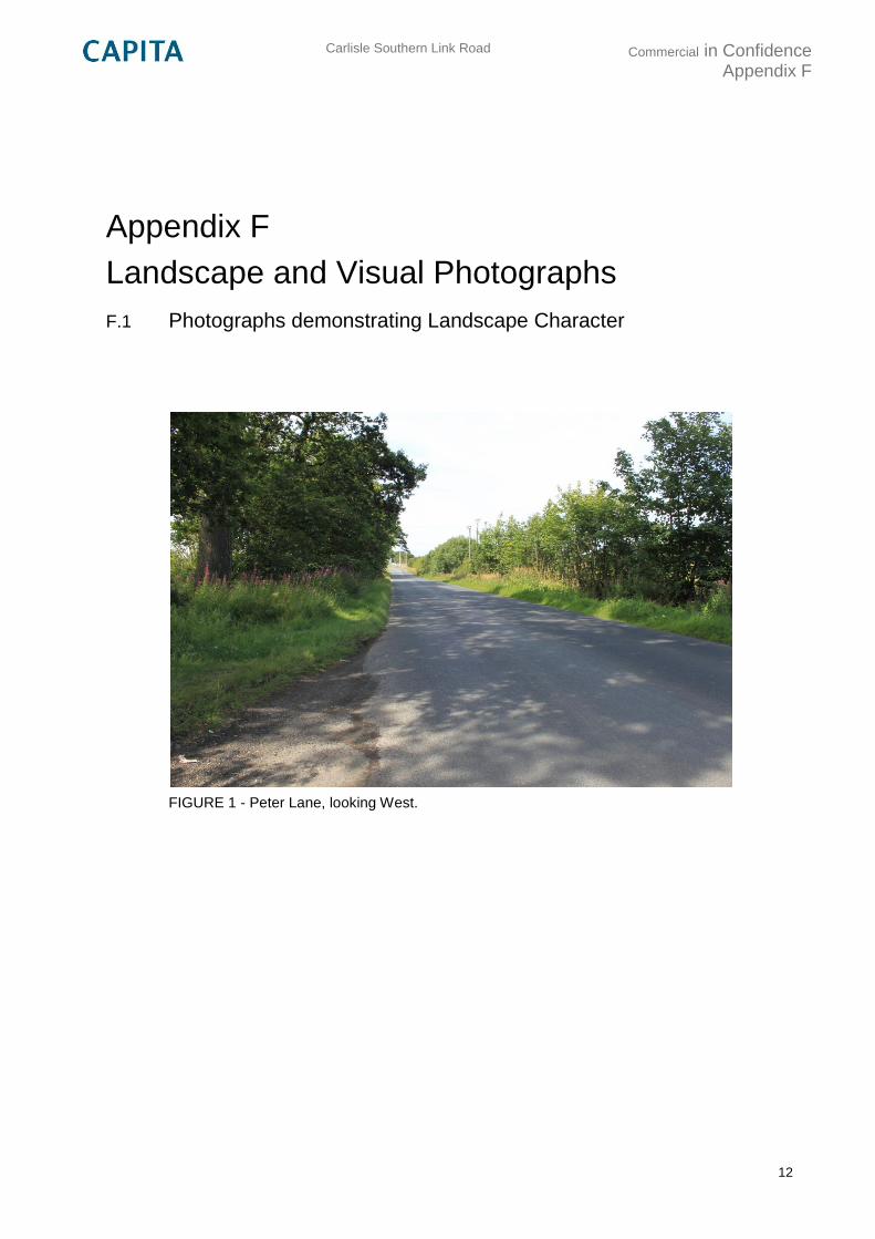
Carlisle Southern Link Road
Commercial in Confidence Appendix F
12
Appendix F
Landscape and Visual Photographs
F.1 Photographs demonstrating Landscape Character
FIGURE 1 - Peter Lane, looking West.
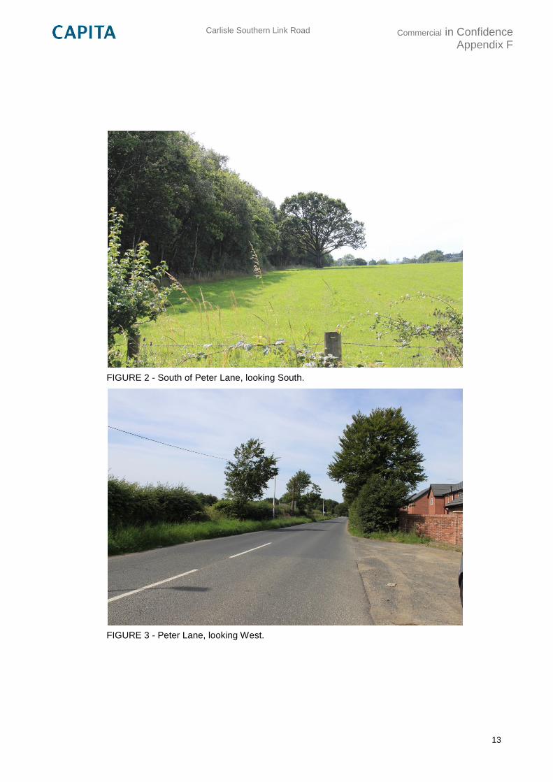
Carlisle Southern Link Road
Commercial in Confidence Appendix F
13
FIGURE 2 - South of Peter Lane, looking South.
FIGURE 3 - Peter Lane, looking West.
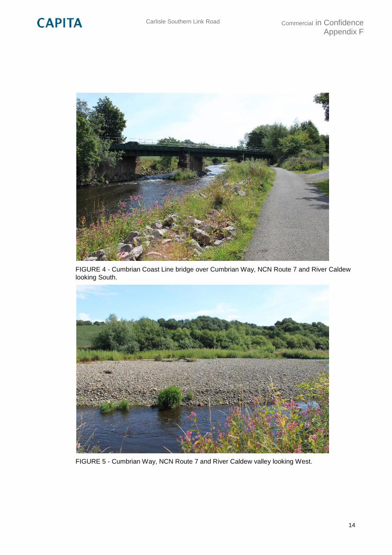
Carlisle Southern Link Road
Commercial in Confidence Appendix F
14
FIGURE 4 - Cumbrian Coast Line bridge over Cumbrian Way, NCN Route 7 and River Caldew
looking South.
FIGURE 5 - Cumbrian Way, NCN Route 7 and River Caldew valley looking West.
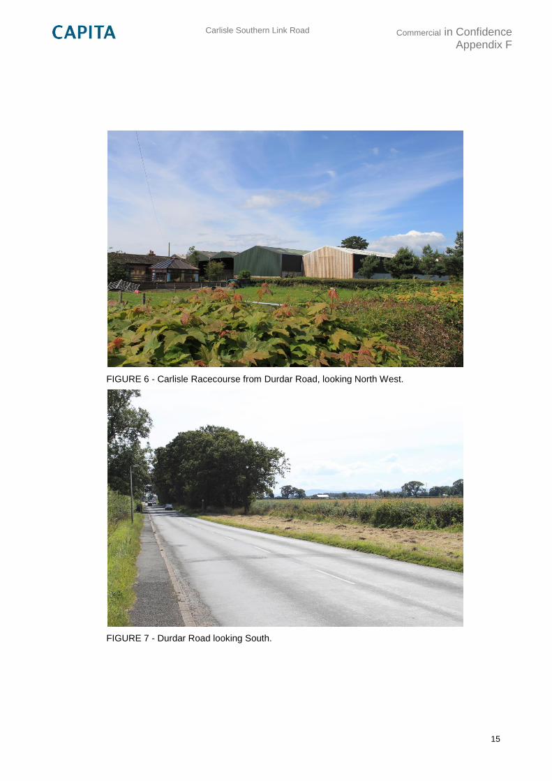
Carlisle Southern Link Road
Commercial in Confidence Appendix F
15
FIGURE 6 - Carlisle Racecourse from Durdar Road, looking North West.
FIGURE 7 - Durdar Road looking South.
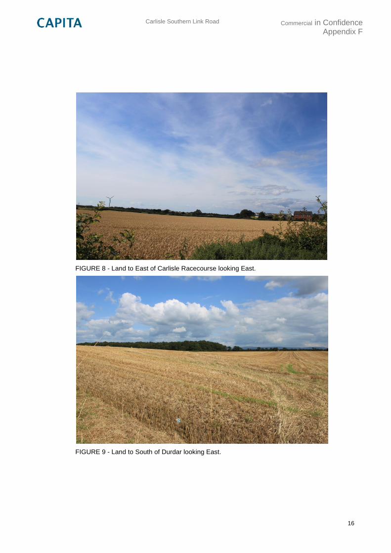
Carlisle Southern Link Road
Commercial in Confidence Appendix F
16
FIGURE 8 - Land to East of Carlisle Racecourse looking East.
FIGURE 9 - Land to South of Durdar looking East.
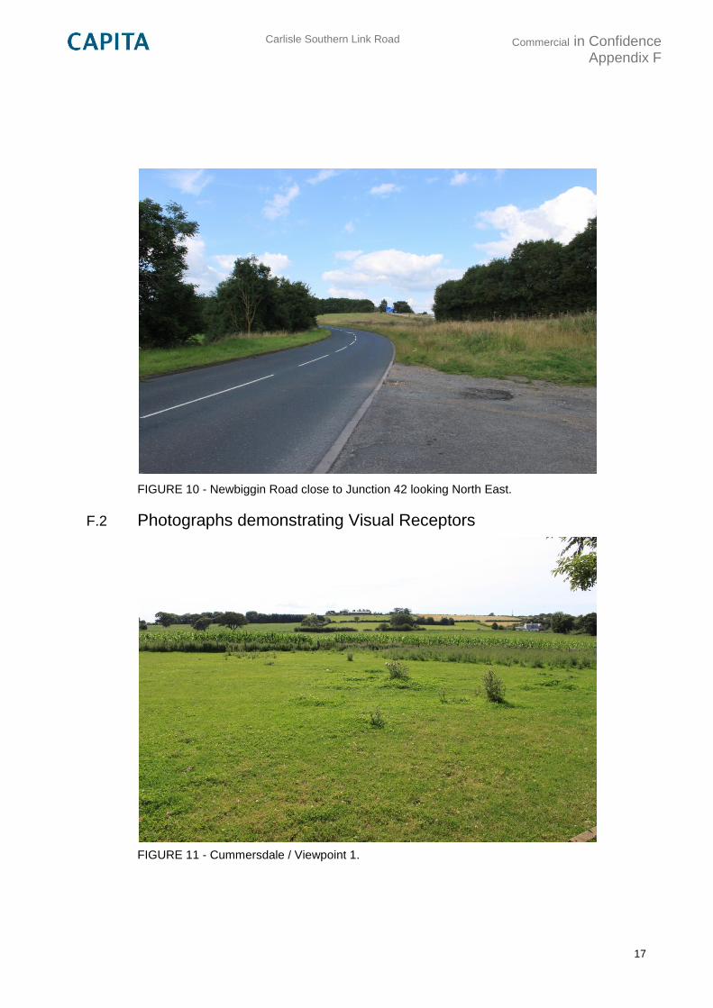
Carlisle Southern Link Road
Commercial in Confidence Appendix F
17
FIGURE 10 - Newbiggin Road close to Junction 42 looking North East.
F.2 Photographs demonstrating Visual Receptors
FIGURE 11 - Cummersdale / Viewpoint 1.
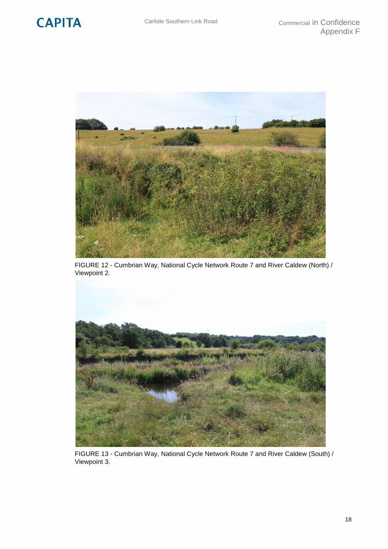
Carlisle Southern Link Road
Commercial in Confidence Appendix F
18
FIGURE 12 - Cumbrian Way, National Cycle Network Route 7 and River Caldew (North) /
Viewpoint 2.
FIGURE 13 - Cumbrian Way, National Cycle Network Route 7 and River Caldew (South) /
Viewpoint 3.
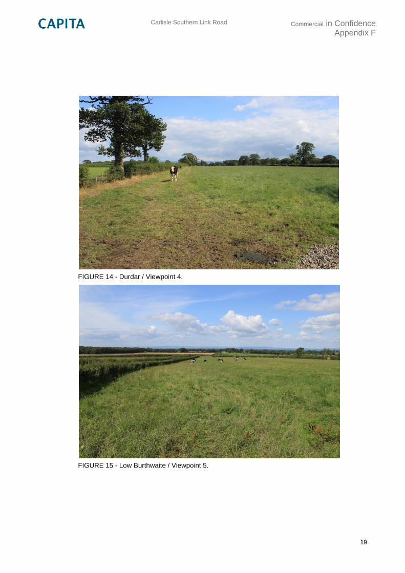
Carlisle Southern Link Road
Commercial in Confidence Appendix F
19
FIGURE 14 - Durdar / Viewpoint 4.
FIGURE 15 - Low Burthwaite / Viewpoint 5.
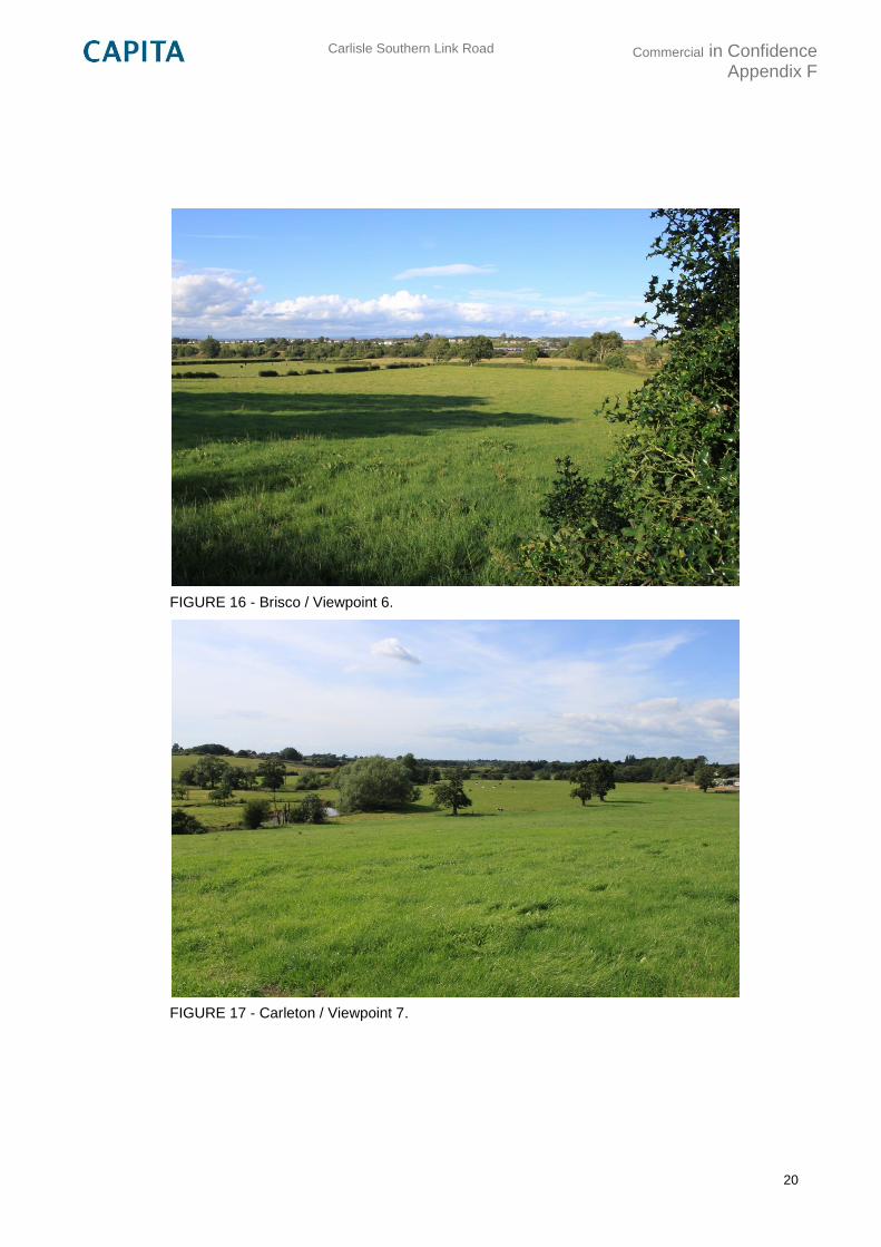
Carlisle Southern Link Road
Commercial in Confidence Appendix F
20
FIGURE 16 - Brisco / Viewpoint 6.
FIGURE 17 - Carleton / Viewpoint 7.
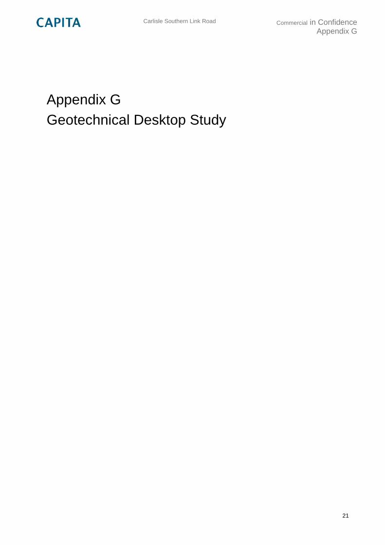
Carlisle Southern Link Road
Commercial in Confidence Appendix G
21
Appendix G
Geotechnical Desktop Study

Carlisle Southern Link Road
Commercial in Confidence Appendix H
22
Appendix H
Indicative Value for Money
Journey time savings (PCU-hrs)
Without South Carlisle Development AM/PM ->
AM PM Factor Annualisation IP/OP/Wkend
2030 166 175 1,012 253 4
2040 206 230
2089 206 230 Benefits (£m) Costs (£m)
£161 £82
BCR = 2.0
TOTALS 12,140 13,498 £412,957 £437,118 £77,514 £81,792
AM PM AM PM AM PM
2030 166 175 £2,825 £2,831 £1,420 £1,422.53
2031 170 181 £2,949 £2,976 £1,432 £1,444.95
2032 174 186 £3,077 £3,126 £1,444 £1,466.57
2033 178 192 £3,209 £3,281 £1,455 £1,487.40
2034 182 197 £3,350 £3,445 £1,467 £1,508.92
2035 186 203 £3,491 £3,612 £1,477 £1,528.22
2036 190 208 £3,637 £3,783 £1,487 £1,546.75
2037 194 214 £3,791 £3,965 £1,498 £1,566.05
2038 198 219 £3,951 £4,152 £1,508 £1,584.55
2039 202 225 £4,115 £4,345 £1,517 £1,602.25
2040 206 230 £4,284 £4,545 £1,526 £1,619.18
2041 206 230 £4,374 £4,641 £1,513 £1,605.20
2042 206 230 £4,467 £4,739 £1,500 £1,591.35
2043 206 230 £4,561 £4,839 £1,487 £1,577.61
2044 206 230 £4,657 £4,941 £1,474 £1,563.99
2045 206 230 £4,756 £5,045 £1,462 £1,550.49
2046 206 230 £4,862 £5,158 £1,451 £1,539.01
2047 206 230 £4,966 £5,268 £1,439 £1,526.12
2048 206 230 £5,072 £5,381 £1,427 £1,513.35
2049 206 230 £5,181 £5,496 £1,415 £1,500.68
2050 206 230 £5,291 £5,613 £1,403 £1,488.11
2051 206 230 £5,401 £5,730 £1,390 £1,474.69
2052 206 230 £5,513 £5,848 £1,378 £1,461.38
2053 206 230 £5,627 £5,969 £1,365 £1,448.19
2054 206 230 £5,743 £6,093 £1,353 £1,435.12
2055 206 230 £5,862 £6,219 £1,341 £1,422.17
2056 206 230 £5,985 £6,349 £1,329 £1,409.67
2057 206 230 £6,110 £6,482 £1,317 £1,397.27
2058 206 230 £6,244 £6,624 £1,307 £1,386.34
2059 206 230 £6,381 £6,770 £1,297 £1,375.50
2060 206 230 £6,528 £6,925 £1,288 £1,366.07
2061 206 230 £6,678 £7,084 £1,279 £1,356.78
2062 206 230 £6,831 £7,247 £1,270 £1,347.52
2063 206 230 £6,988 £7,414 £1,262 £1,338.33
2064 206 230 £7,142 £7,577 £1,252 £1,327.90
2065 206 230 £7,299 £7,743 £1,242 £1,317.55
2066 206 230 £7,458 £7,912 £1,232 £1,307.11
2067 206 230 £7,621 £8,085 £1,222 £1,296.75
2068 206 230 £7,787 £8,261 £1,213 £1,286.48
2069 206 230 £7,958 £8,442 £1,203 £1,276.28
2070 206 230 £8,131 £8,626 £1,194 £1,266.17
2071 206 230 £8,308 £8,813 £1,184 £1,255.95
2072 206 230 £8,488 £9,004 £1,174 £1,245.80
2073 206 230 £8,672 £9,200 £1,165 £1,235.74
2074 206 230 £8,860 £9,399 £1,155 £1,225.77
2075 206 230 £9,052 £9,603 £1,146 £1,215.87
PCU-hrs Monetised times Discounted
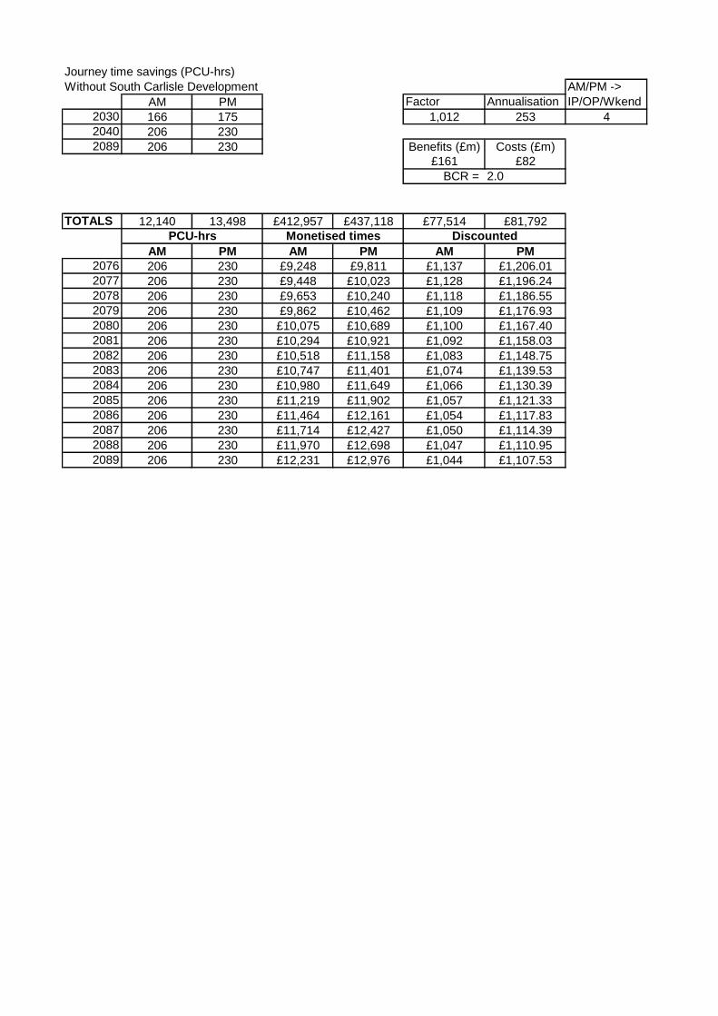
Journey time savings (PCU-hrs)
Without South Carlisle Development AM/PM ->
AM PM Factor Annualisation IP/OP/Wkend
2030 166 175 1,012 253 4
2040 206 230
2089 206 230 Benefits (£m) Costs (£m)
£161 £82
BCR = 2.0
TOTALS 12,140 13,498 £412,957 £437,118 £77,514 £81,792
AM PM AM PM AM PM
PCU-hrs Monetised times Discounted
2076 206 230 £9,248 £9,811 £1,137 £1,206.01
2077 206 230 £9,448 £10,023 £1,128 £1,196.24
2078 206 230 £9,653 £10,240 £1,118 £1,186.55
2079 206 230 £9,862 £10,462 £1,109 £1,176.93
2080 206 230 £10,075 £10,689 £1,100 £1,167.40
2081 206 230 £10,294 £10,921 £1,092 £1,158.03
2082 206 230 £10,518 £11,158 £1,083 £1,148.75
2083 206 230 £10,747 £11,401 £1,074 £1,139.53
2084 206 230 £10,980 £11,649 £1,066 £1,130.39
2085 206 230 £11,219 £11,902 £1,057 £1,121.33
2086 206 230 £11,464 £12,161 £1,054 £1,117.83
2087 206 230 £11,714 £12,427 £1,050 £1,114.39
2088 206 230 £11,970 £12,698 £1,047 £1,110.95
2089 206 230 £12,231 £12,976 £1,044 £1,107.53
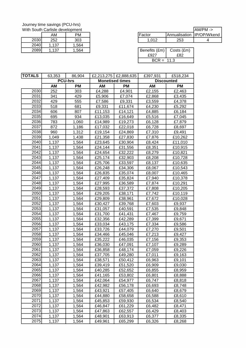
Journey time savings (PCU-hrs)
With South Carlisle development AM/PM ->
AM PM Factor Annualisation IP/OP/Wkend
2030 252 303 1,012 253 4
2040 1,137 1,564
2089 1,137 1,564 Benefits (£m) Costs (£m)
£927 £82
BCR = 11.3
TOTALS 63,353 86,904 £2,213,275 £2,888,635 £397,931 £518,234
AM PM AM PM AM PM
2030 252 303 £4,288 £4,901 £2,155 £2,463
2031 341 429 £5,906 £7,074 £2,868 £3,435
2032 429 555 £7,586 £9,331 £3,559 £4,378
2033 518 681 £9,331 £11,674 £4,230 £5,292
2034 606 807 £11,153 £14,121 £4,885 £6,184
2035 695 934 £13,035 £16,649 £5,516 £7,045
2036 783 1,060 £14,989 £19,273 £6,128 £7,879
2037 872 1,186 £17,032 £22,018 £6,728 £8,697
2038 960 1,312 £19,154 £24,869 £7,310 £9,491
2039 1,049 1,438 £21,358 £27,830 £7,876 £10,262
2040 1,137 1,564 £23,645 £30,904 £8,424 £11,010
2041 1,137 1,564 £24,144 £31,556 £8,351 £10,915
2042 1,137 1,564 £24,654 £32,222 £8,279 £10,821
2043 1,137 1,564 £25,174 £32,903 £8,208 £10,728
2044 1,137 1,564 £25,706 £33,597 £8,137 £10,635
2045 1,137 1,564 £26,248 £34,306 £8,067 £10,543
2046 1,137 1,564 £26,835 £35,074 £8,007 £10,465
2047 1,137 1,564 £27,409 £35,824 £7,940 £10,378
2048 1,137 1,564 £27,995 £36,589 £7,874 £10,291
2049 1,137 1,564 £28,593 £37,372 £7,808 £10,205
2050 1,137 1,564 £29,205 £38,171 £7,742 £10,119
2051 1,137 1,564 £29,809 £38,961 £7,672 £10,028
2052 1,137 1,564 £30,427 £39,768 £7,603 £9,937
2053 1,137 1,564 £31,057 £40,591 £7,535 £9,848
2054 1,137 1,564 £31,700 £41,431 £7,467 £9,759
2055 1,137 1,564 £32,356 £42,289 £7,399 £9,671
2056 1,137 1,564 £33,034 £43,175 £7,334 £9,586
2057 1,137 1,564 £33,726 £44,079 £7,270 £9,501
2058 1,137 1,564 £34,466 £45,046 £7,213 £9,427
2059 1,137 1,564 £35,222 £46,035 £7,156 £9,353
2060 1,137 1,564 £36,030 £47,091 £7,107 £9,289
2061 1,137 1,564 £36,858 £48,174 £7,059 £9,226
2062 1,137 1,564 £37,705 £49,280 £7,011 £9,163
2063 1,137 1,564 £38,571 £50,412 £6,963 £9,101
2064 1,137 1,564 £39,419 £51,520 £6,909 £9,030
2065 1,137 1,564 £40,285 £52,652 £6,855 £8,959
2066 1,137 1,564 £41,165 £53,802 £6,801 £8,888
2067 1,137 1,564 £42,064 £54,977 £6,747 £8,818
2068 1,137 1,564 £42,982 £56,178 £6,693 £8,748
2069 1,137 1,564 £43,921 £57,405 £6,640 £8,679
2070 1,137 1,564 £44,880 £58,658 £6,588 £8,610
2071 1,137 1,564 £45,853 £59,930 £6,534 £8,540
2072 1,137 1,564 £46,847 £61,229 £6,482 £8,471
2073 1,137 1,564 £47,863 £62,557 £6,429 £8,403
2074 1,137 1,564 £48,901 £63,913 £6,377 £8,335
2075 1,137 1,564 £49,961 £65,299 £6,326 £8,268
PCU-hrs Monetised times Discounted
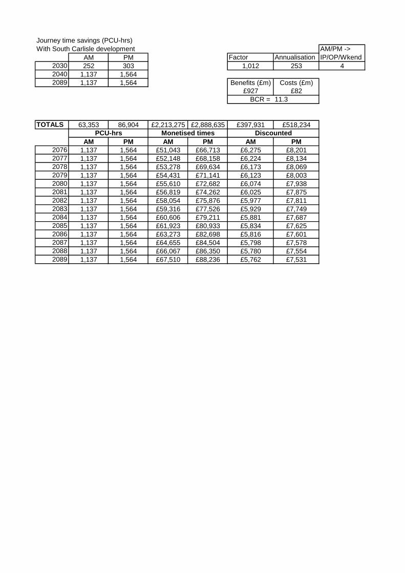
Journey time savings (PCU-hrs)
With South Carlisle development AM/PM ->
AM PM Factor Annualisation IP/OP/Wkend
2030 252 303 1,012 253 4
2040 1,137 1,564
2089 1,137 1,564 Benefits (£m) Costs (£m)
£927 £82
BCR = 11.3
TOTALS 63,353 86,904 £2,213,275 £2,888,635 £397,931 £518,234
AM PM AM PM AM PM
PCU-hrs Monetised times Discounted
2076 1,137 1,564 £51,043 £66,713 £6,275 £8,201
2077 1,137 1,564 £52,148 £68,158 £6,224 £8,134
2078 1,137 1,564 £53,278 £69,634 £6,173 £8,069
2079 1,137 1,564 £54,431 £71,141 £6,123 £8,003
2080 1,137 1,564 £55,610 £72,682 £6,074 £7,938
2081 1,137 1,564 £56,819 £74,262 £6,025 £7,875
2082 1,137 1,564 £58,054 £75,876 £5,977 £7,811
2083 1,137 1,564 £59,316 £77,526 £5,929 £7,749
2084 1,137 1,564 £60,606 £79,211 £5,881 £7,687
2085 1,137 1,564 £61,923 £80,933 £5,834 £7,625
2086 1,137 1,564 £63,273 £82,698 £5,816 £7,601
2087 1,137 1,564 £64,655 £84,504 £5,798 £7,578
2088 1,137 1,564 £66,067 £86,350 £5,780 £7,554
2089 1,137 1,564 £67,510 £88,236 £5,762 £7,531
Carlisle Southern Link Road
Commercial in Confidence Appendix I
23
Appendix I
Delivery Programme
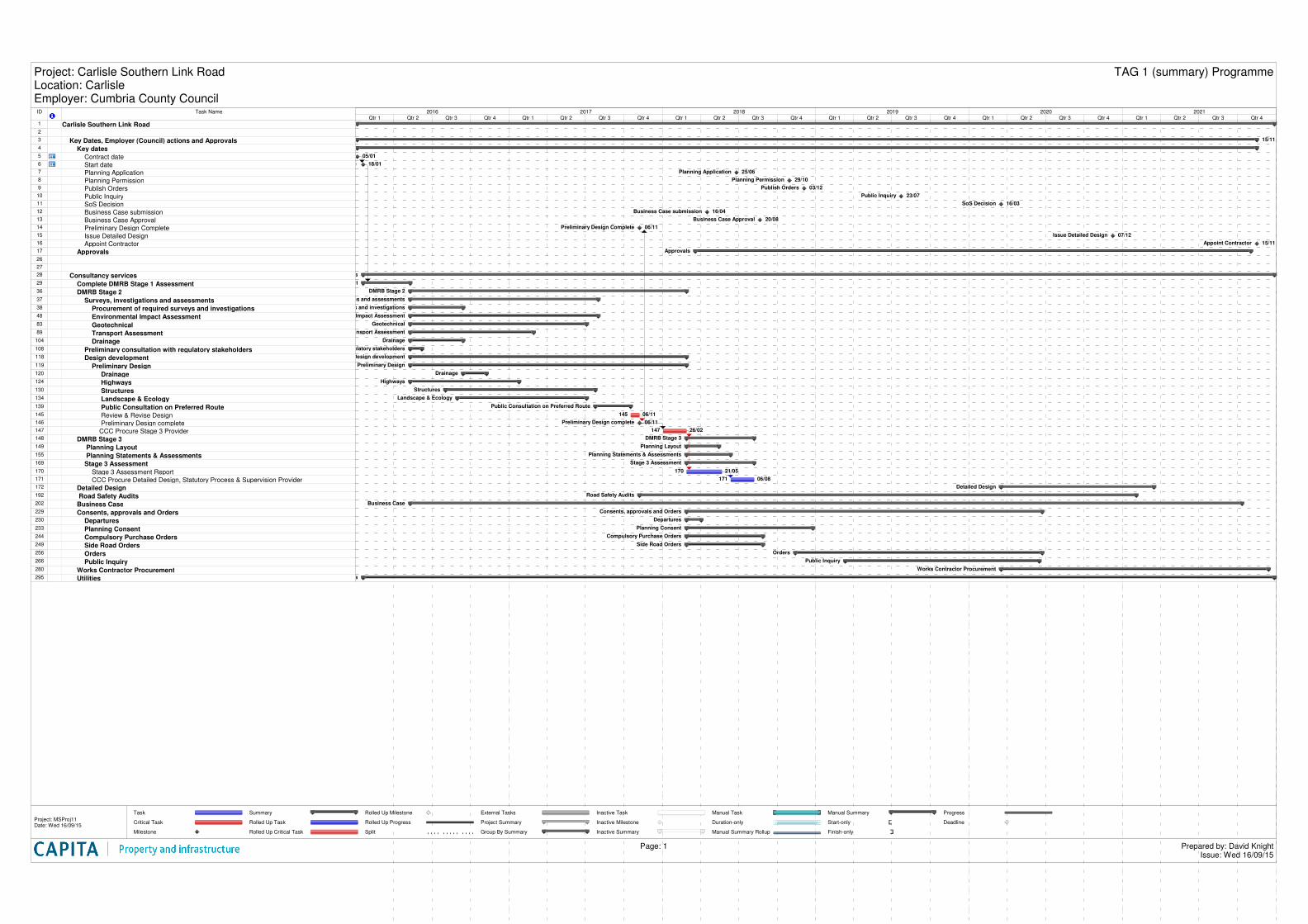
ID Task Name
1 Carlisle Southern Link Road2
3 Key Dates, Employer (Council) actions and Approvals4 Key dates5 Contract date6 Start date 7 Planning Application8 Planning Permission9 Publish Orders10 Public Inquiry11 SoS Decision12 Business Case submission13 Business Case Approval14 Preliminary Design Complete15 Issue Detailed Design16 Appoint Contractor17 Approvals26
27
28 Consultancy services29 Complete DMRB Stage 1 Assessment36 DMRB Stage 237 Surveys, investigations and assessments38 Procurement of required surveys and investigations48 Environmental Impact Assessment83 Geotechnical89 Transport Assessment104 Drainage108 Preliminary consultation with regulatory stakeholders118 Design development119 Preliminary Design120 Drainage124 Highways130 Structures134 Landscape & Ecology139 Public Consultation on Preferred Route145 Review & Revise Design146 Preliminary Design complete147 CCC Procure Stage 3 Provider148 DMRB Stage 3149 Planning Layout155 Planning Statements & Assessments169 Stage 3 Assessment170 Stage 3 Assessment Report171 CCC Procure Detailed Design, Statutory Process & Supervision Provider172 Detailed Design192 Road Safety Audits202 Business Case229 Consents, approvals and Orders230 Departures233 Planning Consent244 Compulsory Purchase Orders249 Side Road Orders256 Orders266 Public Inquiry280 Works Contractor Procurement295 Utilities
15/11
05/01
Start date 18/01
Planning Application 25/06
Planning Permission 29/10
Publish Orders 03/12
Public Inquiry 23/07
SoS Decision 16/03
Business Case submission 16/04
Business Case Approval 20/08
Preliminary Design Complete 06/11
Issue Detailed Design 07/12
Appoint Contractor 15/11
Approvals
Consultancy services
Complete DMRB Stage 1 Assessment
DMRB Stage 2
Surveys, investigations and assessments
Procurement of required surveys and investigations
Environmental Impact Assessment
Geotechnical
Transport Assessment
Drainage
Preliminary consultation with regulatory stakeholders
Design development
Preliminary Design
Drainage
Highways
Structures
Landscape & Ecology
Public Consultation on Preferred Route
145 06/11
Preliminary Design complete 06/11
147 26/02
DMRB Stage 3
Planning Layout
Planning Statements & Assessments
Stage 3 Assessment
170 21/05
171 06/08
Detailed Design
Road Safety Audits
Business Case
Consents, approvals and Orders
Departures
Planning Consent
Compulsory Purchase Orders
Side Road Orders
Orders
Public Inquiry
Works Contractor Procurement
Utilities
Qtr 1 Qtr 2 Qtr 3 Qtr 4 Qtr 1 Qtr 2 Qtr 3 Qtr 4 Qtr 1 Qtr 2 Qtr 3 Qtr 4 Qtr 1 Qtr 2 Qtr 3 Qtr 4 Qtr 1 Qtr 2 Qtr 3 Qtr 4 Qtr 1 Qtr 2 Qtr 3 Qtr 42016 2017 2018 2019 2020 2021
Task
Critical Task
Milestone
Summary
Rolled Up Task
Rolled Up Critical Task
Rolled Up Milestone
Rolled Up Progress
Split
External Tasks
Project Summary
Group By Summary
Inactive Task
Inactive Milestone
Inactive Summary
Manual Task
Duration-only
Manual Summary Rollup
Manual Summary
Start-only
Finish-only
Progress
Deadline
Project: Carlisle Southern Link RoadLocation: CarlisleEmployer: Cumbria County Council
TAG 1 (summary) Programme
Page: 1 Prepared by: David KnightIssue: Wed 16/09/15
Project: MSProj11Date: Wed 16/09/15
Carlisle Southern Link Road
Commercial in Confidence Appendix J
24
Appendix J
Appraisal Specification Report
Commercial in Confidence
Capita Property and Infrastructure Ltd
The Capita Building
Kingmoor Business Park
Carlisle
Cumbria
CA6 4SJ
Tel +44 (0)1228 673000
Fax +44 (0)1228 673111 www.capita.co.uk