using 137cs and 210pbex measurements and conventional surveys to investigate the relative...
TRANSCRIPT
Soil & Tillage Research 135 (2014) 18–27
Using 137Cs and 210Pbex measurements and conventional surveys toinvestigate the relative contributions of interrill/rill and gully erosionto soil loss from a small cultivated catchment in Sicily
Paolo Porto a,b,*, Desmond E. Walling a, Antonina Capra b
a Geography, College of Life and Environmental Sciences, University of Exeter, Exeter, UKb Dipartimento di Agraria, Universita degli Studi Mediterranea di Reggio Calabria, Agro-Forest and Environmental Sciences and Technologies, Contrada Feo di
Vito, Reggio Calabria 89122, Italy
A R T I C L E I N F O
Article history:
Received 19 March 2013
Received in revised form 21 August 2013
Accepted 31 August 2013
Keywords:137Cs ;210Pbex
Interrill and rill erosion
Ephemeral gully erosion
Sediment redistribution
Sicily
A B S T R A C T
In many cultivated areas in semiarid Mediterranean regions, soil erosion is responsible for problems
related to both on-site and off-site impacts, including reduced crop productivity, water quality, and
degradation of freshwater ecosystems. In some areas of Sicily, where intense short duration rainfall
events are common, soil erosion is a very serious problem, especially on land subjected to continuous
tillage operations. The rates of soil loss in these areas and their impact differ according to the dominant
type of erosion. Several existing studies have focused on the impacts of either linear (gully- or ephemeral
gully-erosion) or interrill–rill erosion, but to date the relative magnitude of these two different types of
erosion, has rarely been assessed. This paper reports the results of a study aimed at comparing the
relative contribution of interrill–rill erosion and gully erosion to soil loss from a small cultivated
catchment located in Sicily (Italy). Surveys of ephemeral gullies (EG) in the study catchment carried out
at the event scale since 1999 are used to quantify soil loss attributable to EG erosion. 137Cs and 210Pbex
measurements are used to quantify the net soil loss from the catchment attributable to interrill–rill (IRR)
erosion. The study demonstrates that EG formation occurred 7 years out of 10, with a mean soil loss
averaged over a 10-year period equal to 26.5 t ha�1 yr�1. The rates of IRR erosion estimated using 137Cs
and 210Pbex measurements provided values of mean annual net soil loss of 38.8 t ha�1 yr�1 and
34.2 t ha�1 yr�1, respectively. The resulting ratios of soil loss attributable to EG to total soil loss
(IRR + EG) were 0.41 and 0.44 for the 137Cs and 210Pbex measurements, respectively. The results suggest
that the contributions of EG and IRR erosion are of a similar magnitude in semiarid regions of Sicily,
although the precise value of the ratio is likely to vary both spatially and temporally in response to
catchment morphology, soil erodibility and land use and inter-annual variability of rainfall magnitude
and erosivity. The findings are consistent with those of other studies that have attempted to compare the
relative efficacy of the two erosion types. The use of 137Cs and 210Pbex measurements in the study area
provided important insights into the relative importance of IRR and EG erosion and the same approach
could be employed in other locations where both forms of erosion occur and there is a need to quantify
their relative importance.
� 2013 Elsevier B.V. All rights reserved.
Contents lists available at ScienceDirect
Soil & Tillage Research
jou r nal h o mep age: w ww.els evier . co m/lo c ate /s t i l l
1. Introduction
In recent decades, land degradation and soil erosion have beenincreasingly recognised as a serious environmental problem insemiarid Mediterranean regions. Recent studies carried out insouthern Italy have documented rates of soil erosion ranging from10–85 t ha�1 yr�1, on cultivated land (Porto and Walling, 2012a,b)
* Corresponding author. Tel.: +39096557481.
E-mail addresses: [email protected], [email protected] (P. Porto),
[email protected] (D.E. Walling), [email protected] (A. Capra).
0167-1987/$ – see front matter � 2013 Elsevier B.V. All rights reserved.
http://dx.doi.org/10.1016/j.still.2013.08.013
and from 100–150 t ha�1 yr�1, in areas covered by forests (Porto etal., 2011). These high erosion rates reflect both the nature of theenvironment and the long-term impact of human activity. Therainfall regime of Mediterranean areas, which is characterised byevents of extremely short duration and very high intensityfollowed by long dry periods, is particularly conducive to erosion.Human activity further increases the erosion risk through, forexample, creating bare surfaces on cultivated land after tillageoperations and land abandonment in marginal and improductiveareas. In Sicily, soil loss from cultivated lands reflects the generalsituation in Southern Italy, but rates of soil loss differ according toerosion type and land degradation processes. Erosion due to
P. Porto et al. / Soil & Tillage Research 135 (2014) 18–27 19
concentrated flow is very severe on many unprotected farm fieldsand the presence of various gully types can be observed in manyareas of the region. The initiation and development of channelsroutinely obliterated by tillage and other farm operations,commonly referred to as ephemeral gullies (EG), constitutes asevere problem (Capra, 2013). Growing crops can be removed byscour as these small gullies develop, the crops at the lower end ofthe gully can be buried by the sediment discharged from theephemeral gully and deposited in an alluvial fan. Furthermore,filling operations reduce the long-term productivity of thefarmland. Although the importance of EG erosion is wellrecognised, even at the local scale (Capra and Scicolone, 2002;Capra et al., 2005) little research has focused on this erosion typeand most soil erosion prediction studies have relied on generalisedempirical models (Capra et al., 2005; Capra et al., 2009a,b; DiStefano et al., 2013).
In contrast, IRR erosion rates are better understood in Sicily andover the last 50 years many different approaches have beenemployed to predict IRR erosion, in order to assess soil erosion riskand develop effective strategies to control erosion and sedimen-tation in these areas. These different approaches are based ondifferent types of models that range from empirical-parametricapproaches such as SEDD (Ferro, 1997; Ferro and Porto, 2000),through conceptual models, which correlate soil loss to physicalparameters depending on soil erodibility and land use (Novara etal., 2011), topography (Bagarello et al., 2011) or rainfall erosivity(Agnese et al., 2006), to recent physically-based models, such asWEPP (Nearing et al., 1989), which aim to simulate both thedetachment and transport of soil particles (Amore et al., 2004).The results provided by these studies demonstrate that IRRerosion is also an important problem in Sicily, although there is aneed for further calibration and validation of the modelsemployed for local conditions, in order to increase confidencein their output.
The use of fallout radionuclides and more particularly caesium-137 (137Cs) and excess lead-210 (210Pbex) to document rates of soiland sediment redistribution in the landscape has attractedincreasing attention in recent years (Mabit et al., 2008; Ritchieand Ritchie, 2007; Walling, 2010; Zapata, 2002) and the approachis now being successfully employed in Mediterranean areas (e.g.Benmansour et al., 2013; Estrany et al., 2010; Gaspar et al.,2013a,b; Navas et al., 2013; Porto et al., 2006, 2013). This approachis able to overcome several of the limitations associated with moretraditional methods of documenting erosion and soil redistribu-tion. Of particular importance is its potential to provide retrospec-tive information on medium-term average rates of soilredistribution on the basis of a single site visit and representativedistributed data for fields and larger areas, without the need todisturb the system by installing measuring equipment. For someapplications, particularly those requiring spatially distributedinformation on soil redistribution rates, fallout radionuclidesarguably provide an essentially unique means of assemblingdata that cannot be obtained using alternative approaches. Byvirtue of their different half-lives and fallout origins, 137Cs and210Pbex provide information relating to different periods of time.137Cs measurements are primarily used to generate informationon mean annual erosion rates over the past ca. 50 years and210Pbex measurements are able to provide information relating
Table 1Characteristics of the study catchment.
Drainage area (ha) Min altitude
(m asl)
Max altitude
(m asl)
Mean slope (%)
0.86 325 355 28
to a longer period of up to ca. 100 years (Walling and He,1999a,b).
The study reported here aims to quantify EG and IRR erosionrates in a small cultivated catchment located in Sicily (Italy), tocompare their relative contribution to the total soil loss from thecatchment and thereby provide important information on soilerosion rates in the study region. An empirical approach, based onfield measurements was used to quantify the erosion ratesassociated with EG erosion, while the rates IRR erosion wereestimated using 137Cs and 210Pbex measurements. To the authors’knowledge this is the first attempt to undertake such a comparisonin Italy.
2. The study area
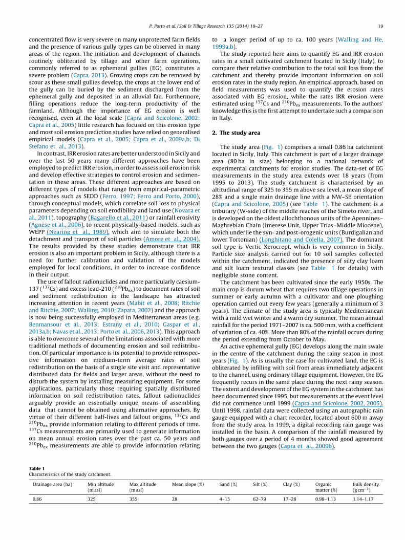
The study area (Fig. 1) comprises a small 0.86 ha catchmentlocated in Sicily, Italy. This catchment is part of a larger drainagearea (80 ha in size) belonging to a national network ofexperimental catchments for erosion studies. The data-set of EGmeasurements in the study area extends over 18 years (from1995 to 2013). The study catchment is characterised by analtitudinal range of 325 to 355 m above sea level, a mean slope of28% and a single main drainage line with a NW–SE orientation(Capra and Scicolone, 2005) (see Table 1). The catchment is atributary (W-side) of the middle reaches of the Simeto river, andis developed on the oldest allochthonous units of the Apennines–Maghrebian Chain (Imerese Unit, Upper Trias–Middle Miocene),which underlie the syn- and post-orogenic units (Burdigalian andlower Tortonian) (Longhitano and Colella, 2007). The dominantsoil type is Vertic Xerocrept, which is very common in Sicily.Particle size analysis carried out for 10 soil samples collectedwithin the catchment, indicated the presence of silty clay loamand silt loam textural classes (see Table 1 for details) withnegligible stone content.
The catchment has been cultivated since the early 1950s. Themain crop is durum wheat that requires two tillage operations insummer or early autumn with a cultivator and one ploughingoperation carried out every few years (generally a minimum of 3years). The climate of the study area is typically Mediterraneanwith a mild wet winter and a warm dry summer. The mean annualrainfall for the period 1971–2007 is ca. 500 mm, with a coefficientof variation of ca. 40%. More than 80% of the rainfall occurs duringthe period extending from October to May.
An active ephemeral gully (EG) develops along the main swalein the centre of the catchment during the rainy season in mostyears (Fig. 1). As is usually the case for cultivated land, the EG isobliterated by infilling with soil from areas immediately adjacentto the channel, using ordinary tillage equipment. However, the EGfrequently recurs in the same place during the next rainy season.The extent and development of the EG system in the catchment hasbeen documented since 1995, but measurements at the event leveldid not commence until 1999 (Capra and Scicolone, 2002, 2005).Until 1998, rainfall data were collected using an autographic raingauge equipped with a chart recorder, located about 600 m awayfrom the study area. In 1999, a digital recording rain gauge wasinstalled in the basin. A comparison of the rainfall measured byboth gauges over a period of 4 months showed good agreementbetween the two gauges (Capra et al., 2009b).
Sand (%) Silt (%) Clay (%) Organic
matter (%)
Bulk density
(g cm�3)
4–15 62–79 17–28 0.98–1.13 1.14–1.17
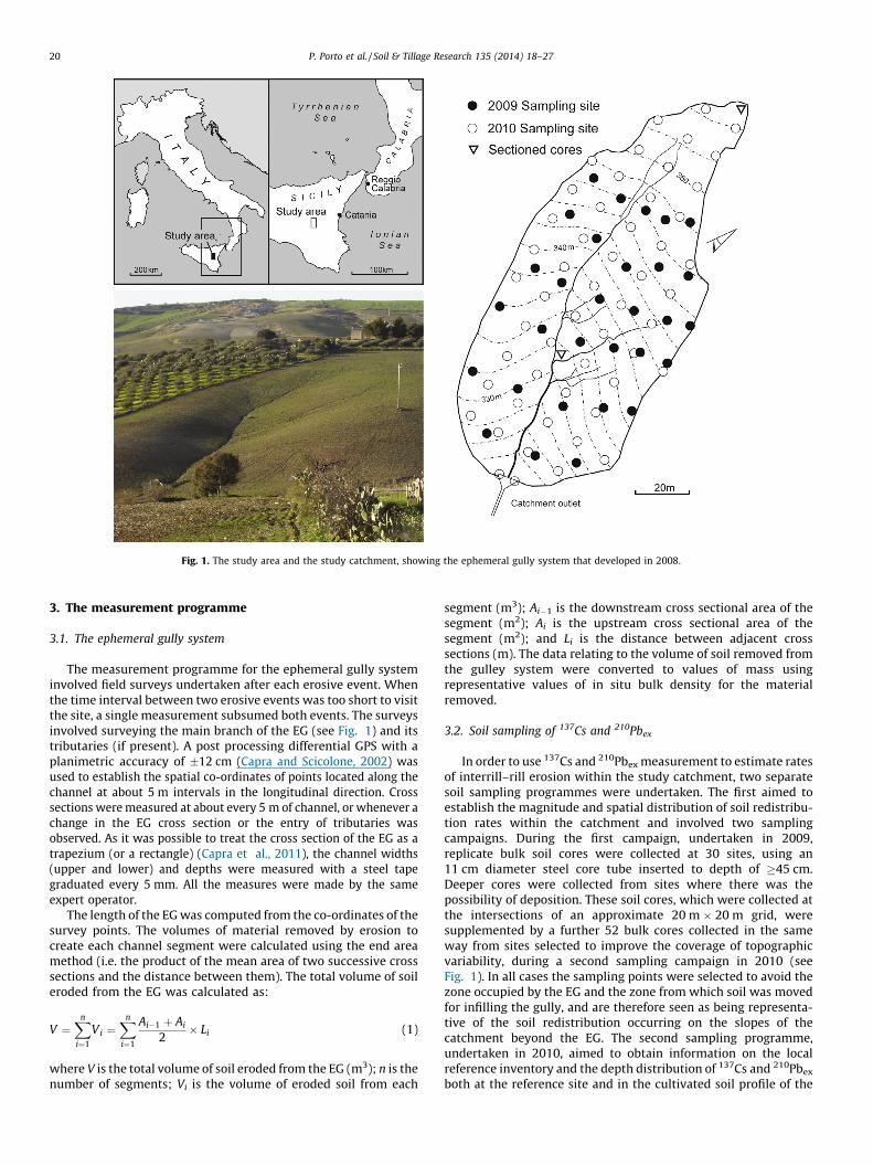
Fig. 1. The study area and the study catchment, showing the ephemeral gully system that developed in 2008.
P. Porto et al. / Soil & Tillage Research 135 (2014) 18–2720
3. The measurement programme
3.1. The ephemeral gully system
The measurement programme for the ephemeral gully systeminvolved field surveys undertaken after each erosive event. Whenthe time interval between two erosive events was too short to visitthe site, a single measurement subsumed both events. The surveysinvolved surveying the main branch of the EG (see Fig. 1) and itstributaries (if present). A post processing differential GPS with aplanimetric accuracy of �12 cm (Capra and Scicolone, 2002) wasused to establish the spatial co-ordinates of points located along thechannel at about 5 m intervals in the longitudinal direction. Crosssections were measured at about every 5 m of channel, or whenever achange in the EG cross section or the entry of tributaries wasobserved. As it was possible to treat the cross section of the EG as atrapezium (or a rectangle) (Capra et al., 2011), the channel widths(upper and lower) and depths were measured with a steel tapegraduated every 5 mm. All the measures were made by the sameexpert operator.
The length of the EG was computed from the co-ordinates of thesurvey points. The volumes of material removed by erosion tocreate each channel segment were calculated using the end areamethod (i.e. the product of the mean area of two successive crosssections and the distance between them). The total volume of soileroded from the EG was calculated as:
V ¼Xn
i¼1
Vi ¼Xn
i¼1
Ai�1 þ Ai
2� Li (1)
where V is the total volume of soil eroded from the EG (m3); n is thenumber of segments; Vi is the volume of eroded soil from each
segment (m3); Ai�1 is the downstream cross sectional area of thesegment (m2); Ai is the upstream cross sectional area of thesegment (m2); and Li is the distance between adjacent crosssections (m). The data relating to the volume of soil removed fromthe gulley system were converted to values of mass usingrepresentative values of in situ bulk density for the materialremoved.
3.2. Soil sampling of 137Cs and 210Pbex
In order to use 137Cs and 210Pbex measurement to estimate ratesof interrill–rill erosion within the study catchment, two separatesoil sampling programmes were undertaken. The first aimed toestablish the magnitude and spatial distribution of soil redistribu-tion rates within the catchment and involved two samplingcampaigns. During the first campaign, undertaken in 2009,replicate bulk soil cores were collected at 30 sites, using an11 cm diameter steel core tube inserted to depth of �45 cm.Deeper cores were collected from sites where there was thepossibility of deposition. These soil cores, which were collected atthe intersections of an approximate 20 m � 20 m grid, weresupplemented by a further 52 bulk cores collected in the sameway from sites selected to improve the coverage of topographicvariability, during a second sampling campaign in 2010 (seeFig. 1). In all cases the sampling points were selected to avoid thezone occupied by the EG and the zone from which soil was movedfor infilling the gully, and are therefore seen as being representa-tive of the soil redistribution occurring on the slopes of thecatchment beyond the EG. The second sampling programme,undertaken in 2010, aimed to obtain information on the localreference inventory and the depth distribution of 137Cs and 210Pbex
both at the reference site and in the cultivated soil profile of the

P. Porto et al. / Soil & Tillage Research 135 (2014) 18–27 21
catchment. Since it was not possible to identify a site that was bothundisturbed and unaffected by soil redistribution within the studycatchment, the samples used to establish the reference inventorywere collected from an area of permanent pasture with minimalslope adjacent to the study catchment. In this case, eight separatecores were collected from an area of ca. 25 m2 using an 11 cmdiameter steel core tube inserted to depth of 60 cm, in order to takeaccount of micro-scale variability in the reference inventory (cf.Owens and Walling, 1996). Each core was sectioned using the samedepth increments, which ranged from 1 to 4 cm, and the individualdepth increments from the eight cores were bulked. Bulking wasundertaken to reduce the mass of material that needed to betransported to the laboratory in the UK, where the samples wereassayed for 137Cs and 210Pbex, and because of limitations on thetotal number of samples that could be assayed. Additionalsectioned cores were also obtained from two sampling siteswithin the catchment selected to be representative of an erodingand a depositional site (see Fig. 1), using the same procedure asemployed at the reference site.
3.3. Laboratory analyses for 137Cs and 210Pbex
All bulk core and depth incremental samples collected from thecatchment and from the reference area were oven dried at 105 8Cfor 48 h, disaggregated and dry sieved to separate the <2 mmfraction. A representative sub-sample of this fraction was packedinto a 330 cm3 cylindrical plastic pot for determination of its 137Csand 210Pbex activity by gamma spectroscopy in the radiometrylaboratory of the Department of Geography at the University ofExeter. The samples were sealed for 21 days prior to assay, in orderto achieve equilibrium between 226Ra and its daughter 214Pb.Activities of both 137Cs and 210Pb in the soil and sediment sampleswere measured simultaneously by gamma-ray spectrometry,using a high-resolution low energy LOAX coaxial HPGe detector(relative efficiency �30%) coupled to an amplifier and PC-baseddata collection system. Count times were typically ca. 90000 s,providing results with an analytical precision of �10% at the 95%level of confidence. Detection limits for 137Cs and 210Pb were ca. 0.5and 5.0 Bq kg�1, respectively. The efficiency of the detectionsystem was calibrated using standard samples prepared by addingknown amounts of certified 137Cs, 210Pb and multi-elementstandards to a soil/sediment matrix representative of thesamples to be analysed. The 137Cs activities in the samples wereobtained from the counts at 662 keV. The total 210Pb activity ofthe samples was measured at 46.5 keV, and the 226Ra activity wasobtained by measuring the activity of 214Pb, a short-liveddaughter of 226Ra, at 351.9 keV. No self absorption correctionwas applied to the 210Pb measurements, since the detector wascalibrated with representative soil/sediment standards. The in
Table 2Characteristics of the erosive events responsible for EG formation and development durin
precipitation event; R = R-factor; A = mean EG cross-sectional area; D = mean EG depth)
Date H (mm) Imax (mm h�1) R (MJ mm
29/08/1999 24.6 20.0 111.7
03/09/1999 17.7 13.2 46.2
07/09/1999 34.9 20.9 157.1
09/09–13/11/1999 80.5 20.1 302.4
28/11–1/12/99 193.4 19.9 663.6
12–14/1/2000 75.3 12.3 376.8
15/10/2003 104.2 43.0 1130.5
03/03/2005 65.6 8.6 536.4
22/10/2005 60.4 60.4 1701.2
25/12/2006 82.2 16.0 876.0
3–4/11/2007 51.6 33.2 3372.2
13/11/2008 34.0 9.6 410.8
28/11/2008 41.0 14.4 1539.5
situ 226Ra-supported 210Pb concentration, associated withindividual soil and sediment samples, was derived from themeasured 226Ra concentration. In most terrestrial environments,the supported 210Pb will not be in equilibrium with the 226Ra,since some 222Rn will diffuse upwards through the soil or rockand escape to the overlying atmosphere. This loss is commonlyaccounted using a reduction factor based on the average ratio ofthe measured total 210Pb and 226Ra concentrations for samplescollected from the lower part of the soil profile, where fallout210Pb or 210Pbex can be assumed to be absent (cf. Graustein andTurekian, 1986; Wallbrink and Murray, 1996). A value of 0.8 wasobtained for the study site. Excess 210Pb concentrationsassociated with the samples were calculated by subtractingthe 226Ra-supported 210Pb concentrations from the total 210Pbconcentrations (cf. Joshi, 1987).
4. Results
4.1. Soil loss from the ephemeral gully system
The event-based monitoring of the ephemeral gully systemspanned 9 years and extended from August 1999 to November2008 (see Table 2 for details). As observed in many other studies,EG formation and expansion commonly occurs as a result of only avery limited number of precipitation events during a given year(e.g. Casalı et al., 1999, 2008). In the study area, the mean numberof rainy days per year is about 50, but EG formation anddevelopment generally occurs during only a single erosive event.In the study reported, the impact of 13 erosive events responsiblefor EG formation and development were documented and theserepresent effectively all of the erosive events resulting in EGdevelopment that occurred during the period covered by thedetailed EG surveys (1999–2008).
The rainfall totals associated with the different erosive eventsranged from a minimum of 17.7 mm to a maximum of 193.4 mm,with a mean of 66.6 mm. The minimum EG erosion was associatedwith the events of 29/8/1999 and 3/9/1999, when the soil loss fromthe catchment was only 0.03 t ha�1 and the maximum wasassociated with the last event that occurred in November 2008,when a soil loss of 82.1 t ha�1 was observed. Based on the 18 yearsof observation of EG development in the study catchment, EGformation occurred in 7 years out of 10, with a frequencycorresponding to 70% of the years covered by the survey. Thecumulative soil loss for the period covered by the detailed EGsurveys that commenced in 1999 was calculated, in order toquantify the total EG erosion for the period. The mean annual soilloss from the catchment from the EG, for the seven years when theEG was active, was 37.9 t ha�1 yr�1. Averaging the results over thenine years, including the years during which no EG erosion
g the study period (H = precipitation depth; Imax = maximum 30 min intensity for the
.
�1 ha�1 h�1) A (m2) D (m) EG erosion (t ha�1)
0.01 0.06 0.03
0.01 0.05 0.03
0.02 0.07 5.34
0.16 0.47 18.97
0.03 0.06 4.35
0.37 0.35 16.19
0.18 0.54 21.47
0.11 0.17 10.82
0.05 0.28 15.86
0.16 0.29 67.15
0.10 0.24 19.38
0.04 0.15 5.56
0.18 0.31 82.98
P. Porto et al. / Soil & Tillage Research 135 (2014) 18–2722
occurred, the mean annual soil loss from the catchment associatedwith the development of the EG was ca. 26.5 t ha�1 yr�1.
4.2. 137Cs and 210Pbex inventories and depth distributions at
the reference site
The estimates of the 137Cs and 210Pbex reference inventories forthe study area are based on assay of the composited sections fromeight cores. These are seen as providing representative values forthe local reference inventories, although their precision oruncertainty is not explicitly quantified, due to the bulking of thesamples. The uncertainty introduced by measurement precision(i.e. ca. � 10%) can be expected to be considerably reduced, relative tothat associated with an individual measurement of a bulk core,because the value represents the sum of the values of areal activitydensity obtained for the individual slices and positive and negativeprecision errors associated with those values are likely to cancel outto some degree. Equally, the averaging of the results from 8 coresthrough the use of composite samples means that the uncertaintyassociated with micro-scale, and sampling variability as well as localvariability of the reference inventory will also be significantlyreduced. Based on previous experience in the wider region, anuncertainty of �10% at the 95% level of confidence has been assumedfor the estimates of the 137Cs and 210Pbex reference inventoriesobtained (Porto et al., 2011).
The representative depth distributions of 137Cs and 210Pbex
documented for the reference site based on the composited slicesfrom the eight cores are presented in Fig. 2. These are typical of anundisturbed site (Walling and Quine, 1992; Porto et al., 2001,2003), with a well defined exponential reduction in activity withdepth and with �90% of the total inventory existing in the top
Fig. 2. The depth distribution of 137Cs (a)
Table 3The range of 137Cs and 210Pbex inventories associated with the sampling points in the stu
stable conditions.
Min (Bq m�2) Max (Bq m�2) Mean (Bq m�2) SD (
137Cs 0.25 1192 255 294210Pbex 0.6 14443 2285 264
15–20 cm. Values of 432 and 2800 Bq m�2 were obtained for the137Cs and 210Pbex reference inventories.
The reference inventory values obtained for both 137Cs and210Pbex must be seen as relatively low when compared withcorresponding inventories found at other sites in southern Italy(see Porto et al., 2001, 2006). However, they can be accounted forby the lower mean annual rainfall (ca. 500 mm) in this area.Similarly low values for the 137Cs reference inventory have alsobeen documented for another area of Sicily, where the meanannual rainfall is ca. 700 mm (Di Stefano et al., 2000). In this case, areference value of 944 Bq m�2 was reported (Di Stefano et al.,1999). Correction of this value to the same year as themeasurements made in the current study provides a value of717 Bq m�2, and this can be seen as consistent with the valuereported for the current study site.
4.3. 137Cs and 210Pbex inventories on the slopes of the study catchment
The values of 137Cs inventory associated with the 82 samplingpoints in the study catchment ranged from 0.25 to 1192 Bq m�2,with a mean value of 255 Bq m�2 (see Table 3 for details). In thecase of 210Pbex, the equivalent inventory values obtained for thesame sampling points ranged from 0.6 to 14443 Bq m�2, with amean value of 2285 Bq m�2.
Taking account of the �10% uncertainty associated with thereference inventories indicated above, comparison of the inventoryvalues for the individual sampling points with the reference valuesindicated that 67% of the 137Cs inventories were significantly lowerthan the reference value, indicating erosion, and 18% weresignificantly greater, indicating deposition. The results indicated alsothat 15% of the 137Cs inventory values were not significantly different
and 210Pbex (b) at the reference site.
dy catchment and the number of points showing evidence of erosion, deposition or
Bq m�2) Reference value (Bq m�2) Nerod Ndep Nstable
432 55 15 12
6 2800 62 16 4

Fig. 3. The 137Cs (a) and 210Pbex (b) depth distributions documented for a representative eroding site within the study catchment.
P. Porto et al. / Soil & Tillage Research 135 (2014) 18–27 23
from the reference value, indicating that the sampling points wereessentially stable, experiencing neither erosion nor deposition.Similar results were obtained for 210Pbex inventories, where 76% ofthe measured values provide evidence of erosion, 19% indicateddeposition and 5% experienced neither erosion nor deposition. It isclear that considerable soil redistribution has occurred within thestudy basin since the commencement of 137Cs fallout in the mid1950s, but erosion has dominated soil redistribution within thecatchment. In the case of 210Pbex, the period reflected by the reducedand increased inventories is less easy to define, since, unlike 137Cs, thefallout is essentially continuous from year to year. However, although210Pbex inventories may be sensitive to erosion occurring during thepast ca. 100 years, they will be particularly sensitive to soil
Fig. 4. The 137Cs (a) and 210Pbex (b) depth distributions documented f
redistribution occurring in the past 20 years, due to the relativelyshort half-life of 210Pb (22 years).
Fig. 3 presents depth profiles of the two radionuclides typical ofan eroding site. The total inventories of 349 Bq m�2 for 137Cs and1823 Bq m�2 for 210Pbex, are considerably lower than the referenceinventories. This sampling site is located in the upper part of thecatchment where erosion processes are expected to dominate (seeFig. 1). The depth profiles shown in Fig. 4 are characterised byinventory values of 4219 Bq m�2 for 137Cs and 7792 Bq m�2 for210Pbex, which are considerably higher than the reference values.These are typical of a depositional site. In this case, the sectionedcores were collected in the middle part of the catchment close tothe confluence of the main EG and one of its tributaries (see Fig. 1).
or a representative depositional site within the study catchment.
P. Porto et al. / Soil & Tillage Research 135 (2014) 18–2724
4.4. Using 137Cs and 210Pbex to estimate soil redistribution by interrill–
rill erosion on the catchment slopes
Estimation of rates of erosion and deposition from 137Cs and210Pbex measurements is generally based on the degree ofreduction or increase of the measured inventory, relative to thelocal reference inventory. For cultivated soils, the calibrationrelationship (or conversion model) required to convert themagnitude of the reduction in the radionuclide inventory to anestimate of the rate of soil loss commonly employs a mass balancemodel (e.g. Kachanoski and de Jong, 1984; Walling and He,1999a,b). Such models are based on the assumption that asampling point with a total radionuclide inventory A (Bq m�2) lessthan the local reference inventory Aref (Bq m�2) represents aneroding site, whereas a point with a total radionuclide inventorygreater than the local reference inventory is assumed to be adepositional site.
Following Walling and He (1999a,b), the activity of accumulat-ed 210Pbex or 137Cs A(t) (Bq m�2) per unit area with time t (yr) at aneroding site can be represented as:
AðtÞ ¼ Aðt0Þe
�
Zt
t0
ðPR=DþlÞ dt0
þZt
t0
ð1 � G ÞIðt0Þe�ðPR=DþlÞðt�t0 Þdt0 (2)
where R is the erosion rate (kg m�2 yr�1); D is the cumulative massdepth representing the average plough depth (kg m�2); l is thedecay constant for 137Cs or 210Pbex (yr�1); I(t) is the annual 137Cs or210Pbex deposition flux (Bq m�2 yr�1); G is the percentage of thefreshly deposited 137Cs or 210Pbex fallout removed by erosionbefore being mixed into the plough layer; P is the particle sizecorrection factor; t0 (yr) is the year when cultivation started; A(t0)(Bq m�2) = 210Pbex or 137Cs inventory at t0; A(t) is greater than thelocal reference inventory Aref at a sampling point, deposition maybe assumed. In this case, the mean soil deposition rate R0 can becalculated from the following equation:
R0 ¼R t
t0R0Cdðt0Þe�lðt�t0Þdt0
RS RdS
PP0R t
t0dt0R
S Iðt0Þgð1 � e�R=HÞ=R þ Aðt0Þ=Dð Þ dS(3)
where H is the relaxation mass depth of the initial depthdistribution of the fallout input. This represents the depth towhich the fresh fallout input penetrates the soil. Assuming that thedepth distribution is exponential, H is defined as the mass depth(kg m�2) at which the radionuclide concentration reduces to 1/e ofthe surface concentration (see He and Walling, 1997).
Cd(t0) reflects the radionuclide content of sediment mobilisedfrom all the eroding areas that converge on the aggrading point.Generally, Cd(t0) can be assumed to be represented by the weightedmean 137Cs or 210Pbex activity of the sediment mobilised from theupslope contributing area S (m2); P0 is a further particle sizecorrection factor reflecting differences in grain size compositionbetween mobilised and deposited sediment; g is the proportion ofthe annual fallout susceptible to be removed by erosion prior toincorporation into the soil profile by tillage.
4.5. Soil redistribution rates on the catchment slopes
The conversion model described above was used to deriveestimates of erosion and deposition rates for the sampling pointswithin the study catchment that showed inventories significantlydifferent from the reference inventory (67 and 78, respectively for137Cs and 210Pbex).
A computer-based routine which converts the percentage lossor gain in the 137Cs or 210Pbex inventory, relative to the local
reference value, to an equivalent rate of soil loss or deposition wasused to solve Eqs. (2) and (3), and to estimate the erosion ordeposition rates associated with the individual sampling pointswithin the study catchment. An average plough depth D of 200(kg m�2) was selected as being representative of cultivation in thecatchment, and an average value of 4 (kg m�2) was used to describethe relaxation mass depth H of the initial fallout input. A value of 1was assumed both for g, based on the relationship between thetiming of cultivation and the rainfall regime, and for the particlesize correction factor P, based on the lack of an appreciabledifference between the grain size composition of the soil and ofsamples of transported sediment collected during the study period.
The magnitude and spatial variability of the erosion anddeposition rates estimated for the individual sampling pointswithin the study catchment are presented in Fig. 5a, for 137Cs andin Fig. 5b for 210Pbex.
5. Discussion
5.1. Interrill/rill erosion on the slopes of the catchment
The results presented in Fig. 5 emphasise that the slopes of thestudy catchment are characterised by appreciable rates of soilredistribution, with a clear dominance of eroding sites. Estimatesof the gross erosion rate (t ha�1 yr�1) for the catchment associatedwith the 82 sampling points identified in Fig. 5 have been derivedas the product of the mean erosion rate for the points indicated bythe 137Cs or 210Pbex measurements to be characterised by erosionand the proportion of the catchment subject to erosion, asrepresented by the proportion of the sampled points thatdocumented erosion. The same approach was applied to estimatethe total deposition on the slopes of the catchment that wasderived as the product of the mean deposition rate for thesampled points in the catchment demonstrating deposition andthe proportion of the catchment subject to deposition. Subtrac-tion of the total deposition within the catchment from the grosserosion provides an estimate of the net erosion, which is hereinterpreted to represent the sediment delivered to the channelsystem.
Based on the 82 sampling points, the gross erosion from theslopes was estimated to be 49 and 60 t ha�1 yr�1, based on the137Cs and 210Pbex measurements, respectively. The net soil lossfrom the slopes of the study catchment estimated from the 137Csand 210Pbex measurements was 38.8 and 34.2 t ha�1 yr�1, respec-tively. These values provide a sediment delivery ratio of ca. 79%and 57% for 137Cs and 210Pbex, respectively. Net soil loss rates of thismagnitude, although very high when compared to those docu-mented for other regions of Italy, are relatively common in Sicily.For example, Bagarello et al. (2010) working on experimental plotsranging in length from 11 to 44 m, documented values of mean soilloss ranging from ca. 22 to 57 t ha�1 yr�1 in a similar location.
There are, however, a number of important differences betweenthe estimates of soil redistribution rate provided by the 137Cs and210Pbex measurements. The first is that the estimates of grosserosion rate provided by the 210Pbex measurements are higher thanthose provided by the 137Cs measurements. Secondly, the neterosion rate estimated from the 137Cs measurements is slightlyhigher than that obtained from the 210Pbex measurements. Thislatter contrast reflects the higher estimates of deposition ratesprovided by the 210Pbex measurements and the associatedreduction in the sediment delivery ratio. Although it is difficultto provide a definitive explanation for the different values of grossand net erosion provided by the two radionuclides, it is importantto recognise their different temporal sensitivities. In the case of137Cs, the measurements provide a time-integrated estimate ofsoil redistribution rates for the period extending from the
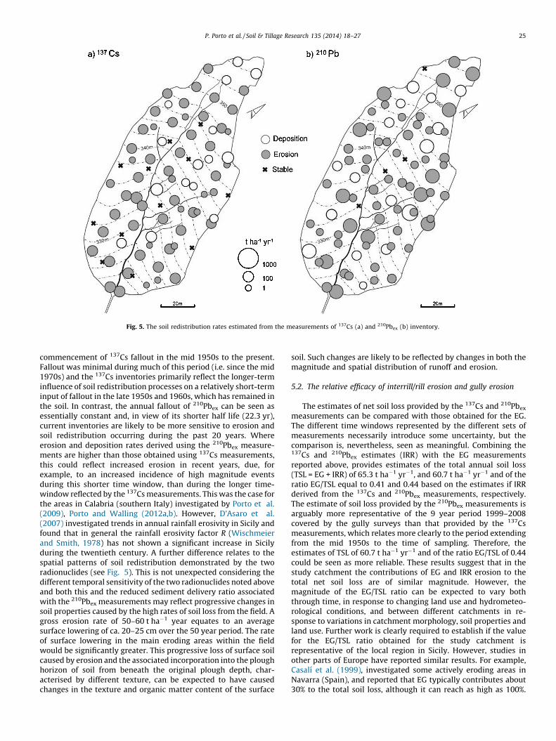
Fig. 5. The soil redistribution rates estimated from the measurements of 137Cs (a) and 210Pbex (b) inventory.
P. Porto et al. / Soil & Tillage Research 135 (2014) 18–27 25
commencement of 137Cs fallout in the mid 1950s to the present.Fallout was minimal during much of this period (i.e. since the mid1970s) and the 137Cs inventories primarily reflect the longer-terminfluence of soil redistribution processes on a relatively short-terminput of fallout in the late 1950s and 1960s, which has remained inthe soil. In contrast, the annual fallout of 210Pbex can be seen asessentially constant and, in view of its shorter half life (22.3 yr),current inventories are likely to be more sensitive to erosion andsoil redistribution occurring during the past 20 years. Whereerosion and deposition rates derived using the 210Pbex measure-ments are higher than those obtained using 137Cs measurements,this could reflect increased erosion in recent years, due, forexample, to an increased incidence of high magnitude eventsduring this shorter time window, than during the longer time-window reflected by the 137Cs measurements. This was the case forthe areas in Calabria (southern Italy) investigated by Porto et al.(2009), Porto and Walling (2012a,b). However, D’Asaro et al.(2007) investigated trends in annual rainfall erosivity in Sicily andfound that in general the rainfall erosivity factor R (Wischmeierand Smith, 1978) has not shown a significant increase in Sicilyduring the twentieth century. A further difference relates to thespatial patterns of soil redistribution demonstrated by the tworadionuclides (see Fig. 5). This is not unexpected considering thedifferent temporal sensitivity of the two radionuclides noted aboveand both this and the reduced sediment delivery ratio associatedwith the 210Pbex measurements may reflect progressive changes insoil properties caused by the high rates of soil loss from the field. Agross erosion rate of 50–60 t ha�1 year equates to an averagesurface lowering of ca. 20–25 cm over the 50 year period. The rateof surface lowering in the main eroding areas within the fieldwould be significantly greater. This progressive loss of surface soilcaused by erosion and the associated incorporation into the ploughhorizon of soil from beneath the original plough depth, char-acterised by different texture, can be expected to have causedchanges in the texture and organic matter content of the surface
soil. Such changes are likely to be reflected by changes in both themagnitude and spatial distribution of runoff and erosion.
5.2. The relative efficacy of interrill/rill erosion and gully erosion
The estimates of net soil loss provided by the 137Cs and 210Pbex
measurements can be compared with those obtained for the EG.The different time windows represented by the different sets ofmeasurements necessarily introduce some uncertainty, but thecomparison is, nevertheless, seen as meaningful. Combining the137Cs and 210Pbex estimates (IRR) with the EG measurementsreported above, provides estimates of the total annual soil loss(TSL = EG + IRR) of 65.3 t ha�1 yr�1, and 60.7 t ha�1 yr�1 and of theratio EG/TSL equal to 0.41 and 0.44 based on the estimates if IRRderived from the 137Cs and 210Pbex measurements, respectively.The estimate of soil loss provided by the 210Pbex measurements isarguably more representative of the 9 year period 1999–2008covered by the gully surveys than that provided by the 137Csmeasurements, which relates more clearly to the period extendingfrom the mid 1950s to the time of sampling. Therefore, theestimates of TSL of 60.7 t ha�1 yr�1 and of the ratio EG/TSL of 0.44could be seen as more reliable. These results suggest that in thestudy catchment the contributions of EG and IRR erosion to thetotal net soil loss are of similar magnitude. However, themagnitude of the EG/TSL ratio can be expected to vary boththrough time, in response to changing land use and hydrometeo-rological conditions, and between different catchments in re-sponse to variations in catchment morphology, soil properties andland use. Further work is clearly required to establish if the valuefor the EG/TSL ratio obtained for the study catchment isrepresentative of the local region in Sicily. However, studies inother parts of Europe have reported similar results. For example,Casalı et al. (1999), investigated some actively eroding areas inNavarra (Spain), and reported that EG typically contributes about30% to the total soil loss, although it can reach as high as 100%.

P. Porto et al. / Soil & Tillage Research 135 (2014) 18–2726
Vandaele et al. (1996) working in central Belgium documentvalues of the EG/TSL ratio ranging from 0.29 to 0.7. Cerdan et al.(2002), following two extreme rainfall events that occurred inNormandy (France), calculated that the EG/TSL ratios for the twoevents were 0.21 and 0.56. Looking more generally, Poesen et al.(2003) recognised that the rates of soil loss rates associated withdifferent kinds of gully could vary considerably, resulting in gullycontributions to the total sediment export from a catchmentranging from 10% to up 94% (i.e. a G/TSL ratio of 0.1–0.94).
6. Conclusions
Prediction of soil erosion is an important requirement formanaging land degradation processes in semiarid Mediterraneanareas. However, most prediction techniques require calibrationand/or validation, if they are to produce reliable results. The studyreported here has provided empirical confirmation of themagnitude of both EG and IRR erosion from a small cultivatedcatchment located in Sicily. The results obtained have permittedthe relative contribution of EG and IRR erosion to the totalsediment output from the catchment to be quantified and haveshown that the two erosion processes are of similar importance.The latter finding is consistent with results of other studies thathave attempted to establish the relative importance of EG and IRRerosion and emphasises that both forms of erosion need to beconsidered when planning catchment scale soil conservation andsediment control measures within the study region.
The study also demonstrates the potential for using 137Cs and210Pbex measurements to obtain information on medium-term soilerosion and soil redistribution rates within small catchments. Byvirtue of their different half-lives and fallout origins, 137Cs and210Pbex can provide information on land degradation processesrelating to different time windows. In this study the information onIRR erosion rates generated by the 137Cs and 210Pbex measurementswas combined with the results of a more traditional measurementprogramme aimed at assessing soil loss associated with EG erosionto assess the relative importance of the two erosion types to thetotal soil loss from the study catchment. As such 137Cs and 210Pbex
measurements should be seen as potentially providing animportant complement to more traditional measurements, ratherthan an alternative.
Acknowledgements
The study reported in this paper was supported by grants fromMIUR PRIN 2010–2011, and the IAEA (Technical Contract 15478).The assistance of Sue Rouillard in producing the figures and of JimGrapes in undertaking the gamma spectrometry measurementsare gratefully acknowledged.
References
Agnese, C., Bagarello, V., Corrao, C., D’Agostino, L., D’Asaro, F., 2006. Influence of therainfall measurement interval on the erosivity determinations in the Mediter-ranean area. Journal of Hydrology 329, 39–48.
Amore, E., Modica, C., Nearing, M.A., Santoro, V.C., 2004. Scale effect in USLE andWEPP application for soil erosion computation from three Sicilian basins.Journal of Hydrology 293, 100–114.
Bagarello, V., Ferro, V., Giordano, G., 2010. Misura dell’erodibilita del suolo nelleparcelle sperimentali di Sparacia, in Sicilia. In: XXXII Convegno Nazionale diIdraulica e Costruzioni Idrauliche. Palermo, (in Italian), pp. 1–10.
Bagarello, V., Di Stefano, C., Ferro, V., Kinnel, P.I.A., Pampalone, V., Porto, P., Todisco,F., 2011. Predicting soil loss on moderate slopes using an empirical model forsediment concentration. Journal of hydrology 400, 267–273.
Benmansour, M., Mabit, L., Nouira, A., Moussadek, R., Bouksirate, H., Duchemin, M.,Benkdad, A., 2013. Assessment of soil erosion and deposition rates in a Mor-occan agricultural field using fallout 137Cs and 210Pbex. Journal of EnvironmentalRadioactivity 115, 97–106.
Capra, A., Scicolone, B., 2002. Ephemeral gully erosion in a wheat-cultivated area inSicily (Italy). Biosystems Engineering 83 (1) 119–126.
Capra, A., Scicolone, B., 2005. Monitoraggio dell’erosione ephemeral gully in unpiccolo bacino siciliano. In: Atti del Convegno dell’Associazione Italiana diIngegneria Agraria (AIIA) 2005. Catania cod. 6010, (in Italian), pp. 1–12.
Capra, A., Mazzara, L.M., Scicolone, B., 2005. Application of the EGEM model topredict ephemeral gully erosion in Sicily (Italy). Catena 59, 133–146.
Capra, A., Di Stefano, C., Ferro, V., Scicolone, B., 2009. Similarity between morpho-logical characteristics of rills and ephemeral gullies in Sicily, Italy. HydrologicalProcesses 23, 3334–3341.
Capra, A., Porto, P., Scicolone, B., 2009. Relationships between rainfall character-istics and ephemeral gully erosion in a cultivated catchment in Sicily (Italy). Soil& Tillage Research 105, 77–87.
Capra, A., Di Stefano, C., Ferro, V., Scicolone, B., 2011. Morphological characteristicsof ephemeral gullies in Sicily, South Italy. Landform Analysis 17, 27–32.
Capra, A., 2013. Ephemeral gully and gully erosion in cultivated land: a review. In:Lannon, E.C. (Ed.), Drainage Basins and Catchment Management: Classification,Modelling and Environmental Assessment. Nova Science Publishers, Haup-pauge, NY.
Casalı, J., Gastesi, R., Alvarez-Mozos, J., De Santisteban, L.M., Lersundi, J., Del Valle deLersundi, R., Gimenez, A., Larranaga, M., Goni, U., Agirre, M.A., Campo, J.J.,Lopez, M., Donezar, M., 2008. Runoff, erosion, and water quality of agricul-tural watersheds in central Navarra (Spain). Agricultural Water Management95, 1111–1128.
Casalı, J., Lopez, J.J., Giraldez, J.V., 1999. Ephemeral gully erosion in SouthernNavarra (Spain). Catena 36, 65–84.
Cerdan, O., Le Bissonnais, Y., Couturier, A., Bourennane, H., Souchere, V., 2002. Rillerosion on cultivated hill slopes during two extreme rainfall events in Nor-mandy, France. Soil & Tillage Research 67, 99–108.
D’Asaro, F., D’Agostino, L., Bagarello, V., 2007. Assessing changes in rainfall erosivityin Sicily during the twentieth century. Hydrological Processes 21, 2862–2871.
Di Stefano, C., Ferro, V., Porto, P., 1999. Linking sediment yield and caesium-137spatial distribution at basin scale. Journal of Agricultural Engineering Research74 (1) 41–62.
Di Stefano, C., Ferro, V., Porto, P., 2000. Length slope factors for applying the reviseduniversal soil loss equation at basin scale in southern Italy. Journal of Agricul-tural Engineering Research 75 (4) 349–364.
Di Stefano, C., Ferro, V., Pampalone, V., Sanzone, F., 2013. Field investigation of rilland ephemeral gully erosion in the Sparacia experimental area, South Italy.Catena 101, 226–234.
Estrany, J., Garcia, C., Walling, D.E., 2010. An investigation of soil erosion andredistribution in a Mediterranean lowland agricultural catchment using caesi-um-137. International Journal of Sediment Research 25, 1–16.
Ferro, V., 1997. Further remarks on a distributed approach to sediment delivery.Hydrological Sciences Journal 42 (5) 633–648.
Ferro, V., Porto, P., 2000. Sediment Delivery Distributed (SEDD) Model. Journal ofHydrologic Engineering 5 (4) 411–422.
Gaspar, L., Navas, A., Walling, D.E., Machın, J., Gomez Arozamena, J., 2013. Using137Cs and 210Pbex to assess soil redistribution on slopes at different temporalscales. Catena 102, 46–54.
Gaspar, L., Navas, A., Machın, J., Walling, D.E., 2013. Using 210Pbex measurements toquantify soil redistribution along two complex toposequences in Mediterra-nean agroecosystems, northern Spain. Soil & Tillage Research 130, 81–90.
Graustein, W.C., Turekian, K.K., 1986. 210Pb and 137Cs in air and soils measure therate and vertical profile of aerosol scavenging. Journal of Geophysical Research91 (D13) 14355–14366.
He, Q., Walling, D.E., 1997. The distribution of fallout 137Cs and 210Pb in undisturbedand cultivated soils. Applied Radiation and Isotopes 48, 677–690.
Joshi, S.R., 1987. Nondestructive determination of Lead-210 and Radium-226 insediments by direct photon analysis. Journal of Radioanalytical and NuclearChemistry 116, 169–212.
Kachanoski, R.J., de Jong, E., 1984. Predicting the temporal relationship betweensoil cesium-137 and erosion rate. Journal of Environmental Quality 13,301–304.
Longhitano, S., Colella, A., 2007. Geomorphology, sedimentology and recent evolu-tion of the anthropogenically modified Simeto River delta system (easternSicily, Italy). Sedimentary Geology 194, 195–221.
Mabit, L., Benmansour, M., Walling, D.E., 2008. Comparative advantages and limita-tions of the fallout radionuclides 137Cs, 210Pbex and 7Be for assessing soil erosionand sedimentation. Journal of Environmental Radioactivity 99, 1799–1807.
Nearing, M.A., Foster, G.R., Lane, L.J., Finkner, S.C., 1989. A process based soil erosionmodel for USDA-water erosion prediction project technology. Transactions ofthe ASAE 32 (5) 1587–1593.
Navas, A., Lopez-Vicente, M., Gaspar, L., Machın, J., 2013. Assessing soil redistribu-tion in a complex karst catchment using fallout 137Cs and GIS. Geomorphology196, 231–241.
Novara, A., Gristina, L., Saladino, S.S., Santoro, A.C., Cerda, A., 2011. Soil erosionassessment on tillage and alternative soil managements in a Sicilian vineyard.Soil & Tillage Research 117, 140–147.
Owens, P.N., Walling, D.E., 1996. Spatial variability of caesium-137 inventories atreference sites: an example from two contrasting sites in England andZimbabwe. Applied Radiation and Isotopes 47, 699–707.
Poesen, J., Nachtergaele, J., Verstraeten, G., Valentin, C., 2003. Gully erosionand environmental change: importance and research needs. Catena 50 (2–4) 91–133.
Porto, P., Walling, D.E., 2012a. Validating the use of 137Cs and 210Pbex measurementsto estimate rates of soil loss from cultivated land in southern Italy. Journal ofEnvironmental Radioactivity 106, 47–57.

P. Porto et al. / Soil & Tillage Research 135 (2014) 18–27 27
Porto, P., Walling, D.E., 2012b. Using plot experiments to test the validity ofmass balance models employed to estimate soil redistribution ratesfrom 137Cs and 210Pbex measurements. Applied Radiation and Isotopes 70,2451–2459.
Porto, P., Walling, D.E., Callegari, G., 2011. Using 137Cs measurements to establishcatchment sediment budgets and explore scale effects. Hydrological Processes25, 886–900.
Porto, P., Walling, D.E., Callegari, G., 2013. Using 137Cs and 210Pbex measurements toinvestigate the sediment budget of a small forested catchment in southern Italy.Hydrological Processes 27, 795–806.
Porto, P., Walling, D.E., Callegari, G., Capra, A., 2009. Using caesium-137 andunsupported lead-210 measurements to explore the relationship betweensediment mobilisation, sediment delivery and sediment yield for a Calabriancatchment. Marine and Freshwater Research 60, 680–689.
Porto, P., Walling, D.E., Callegari, G., Catona, F., 2006. Using fallout lead-210measurements to estimate soil erosion in three small catchments in southernItaly. Water, Air, & Soil Pollution: Focus 6, 657–667.
Porto, P., Walling, D.E., Ferro, V., 2001. Validating the use of caesium-137 measure-ments to estimate soil erosion rates in a small drainage basin in Calabria,southern Italy. Journal of Hydrology 248, 93–108.
Porto, P., Walling, D.E., Ferro, V., Di Stefano, C., 2003. Validating erosionrate estimates by caesium-137 measurements for two small forested catch-ments in Calabria, Southern Italy. Land Degradation and Development 14,389–408.
Ritchie, J.C., Ritchie, C.A., 2007. Bibliography of publications of 137Cs studies relatedto erosion and sediment deposition. Agricultural Research Service. US Dept.Agriculture, Washington, DC.
Vandaele, K., Poesen, J., Marques de Silva, J.R., Desmet, P., 1996. Rates and predict-ability of ephemeral gully erosion in two contrasting environments. Geomor-phologie: Relief, Processes Environment 2 (2) 83–95.
Wallbrink, P.J., Murray, A.S., 1996. Determining soil loss using the inventory ratio ofexcess lead-210 to cesium-137. Soil Science Society of America Journal 60,1201–1208.
Walling, D.E., 2010. Using fallout radionuclides to investigate erosion and sedimentdelivery: some recent advances. In: IAHS Publ. 337. IAHS Press, Wallingford, pp.3–16.
Walling, D.E., He, Q., 1999a. Improved models for estimating soil erosion rates fromcesium-137 measurements. Journal of Environmental Quality 28 (2) 611–622.
Walling, D.E., He, Q., 1999b. Using fallout lead-210 measurements to estimate soilerosion on cultivated land. Soil Science Society of America Journal 63, 1404–1412.
Walling, D.E., Quine, T.A., 1992. The use of caesium-137 measurements in soilerosion surveys. In: IAHS Publ 210. IAHS Press, Wallingford, pp. 143–152.
Wischmeier, W.H., Smith, D.D., 1978. Predicting rainfall erosion losses: a guide toconservation planning. In: Agricultural Research Service Handbook 537. USDept. Agriculture, Washington, DC.
Zapata, F. (Ed.), 2002. Handbook for the Assessment of Soil Erosion and Sedi-mentation Using Environmental Radionuclides. Kluwer, Dordrecht, Nether-land, 219 pp.