modeling tidal currents and seasonal-mean circulation in the stable gully region
TRANSCRIPT

Seasonal-Mean Circulation and Tidal Currents in the The Gully
G. s an', P. ~ o u s s e l ~ and J. W. ~oder '
1 Ocean Sciences Division, Fisheries and Oceans Canada, Bedford Institute of Oceanography, P.O. Box 1006, Dartmouth, N.S. B2Y 4A2
Coastal Ocean Associates Inc., 7 Canal Street, Dartmouth, N.S. B2Y 2W1
Currents, mixing, temperature and other physical oceanographic conditions play important roles in the structure of The Gully ecosystem, its interconnections with adjacent regions, and the potential for interactions among various materials and organisms. Petrie et al. (1 998) provided a broad summary of physical oceanographic information for The Gully region, primarily drawing on water property data, short-term current meter measurements, and shelf-scale numerical modelling results. Notable features included the relatively-strong tidal currents over shallow banks versus weak tidal currents in deep areas according to a 2-D tidal model (de Margerie and Lank, 1986), internal tides and waves on The Gully flanks from Batfish survey data (Sandstrom and Elliott 1984), and a cyclonic partial gyre over The Gully fiom historical current meter data and circulation models (Han et al., 1997; Hannah et al., 2001). However, there were large information gaps including no current measurements in water depths greater than 200 m and no systematic studies of The Gully's circulation.
As part of the 1999-2001 Gully Ecosystem program, numerical modelling studies of currents on the Eastern Scotian Shelf (ESS) h d e d by the Panel for Energy Research and Development (PERD) were extended to include additional focus on The Gully. The objectives were to obtain improved quantitative descriptions of 3-D tidal currents and seasonal-mean circulation in The Gully region. This would support other Gully Ecosystem studies and Marine Protected Area evaluafions by DFO (OCMD).
Our approach is to do hydrodynamics modelling, initialized and constrained with observational temperature and salinity data, and evaluated against moored current measurements. Two 3-D finite-element (FE) circulation models were used: a linear diagnostic model (Naimie and Lynch, 1983) in a mode similar to that in Han et al. (1 999) to provide initial conditions; and a nonlinear prognostic model with advanced turbulence closure (Lynch et al. 1996). in a mode similar to that in Hannah et al. (2001). to provide dynamically self-consistent current, hydrographic and turbulence fields. The temperature and salinity fields in the diagnostic model were specified from seasonal climatologies. The prognostic model was initialized with barotropic tidal solutions and the seasonal- mean currents from the diagnostic model, and forced by the semidiurnal M2 (period 12.4 hr) and diurnal K1 (period 23.9 hr) tides, density gradients, boundary inflows and observed seasonal-mean wind stress.

Two variable-resolution triangular FE meshes were used, allowing increased spatial resolution in target areas as well as inclusion of influential adjacent regions. The base mesh (ss3) has a typical horizontal resolution of 5-1 0 km over the shelf and 2 1 vertical levels with highest resolution near the sea surface and seafloor. Studies were also initiated on a new high-resolution mesh (ss4) with typical horizontal resolution of 2 km for The Gully and its vicinity, and 61 vertical levels with increased resolution of the pycnocline to resolve internal tides. In the ss3 prognostic solutions, temperature and salinity were restored to the observational climatology with a time scale of half a day, whereas they were allowed to adjust fieely with dynamics and topography in the ss4 prognostic solutions. The prognostic simulations were run for 6-8 M2 cycles, with results presented here for cycles 3-4 (ss3) and 2-3 (a). The seasonal-mean model currents were compared with observational estimates fiom the Bedford Institute current meter archive using months with at least 15 days of data, while the tidal currents were compared with published tidal analyses and new 30-day analyses of archived current records. Further information on the approach will be provided in Han and Loder (2001).
Results
Tidal Currents
The horkontal structure of the M2 and K1 tidal currents is illustrated by the near-surface ellipses (Figure 1) h m the low-resolution prognostic model (ss3P). Both the M2 and KI currents are relatively strong over Banquereau and Sable Island Bank, and weaker in the deep Gully. Compared with observational estimates, there is approximate agreement for M2, but significant overestimation for KI. The base and high-resolution models show similar bamtropic patterm for M2, but the high-resolution solution has greater KI amplification on the flanks of The Gully (not shown). The strong sensitivity of the K1 solutions is attributable to the probable occurrence of near resonant continental shelf waves at (subinertial) diurnal fi=equencies (e.g. Crawford and Thomson, 1982) on the Eastern Scotian Shelf and to the proximity of a K1 amphidrome in Lawentian Channel (Han et al., 1996).
Prognostic solutions show more vertical structure, than their diagnostic counterparts, especially on the high-resolution mesh. The high-resolution prognostic solutions allow the generation of intemal tides over sloping bottom topography through coupled evolution of the density and current fields. An indication of the distribution and amplitude of the internal tides is provided in Figure 2 by the vertical displacements at 50 m (or mid-depth if the water depth is shallower than 100 m) associated with the M2 and KI vertical velocities in the summer solution. The largest displacements are in and around The Gully, including along the shelf-edge approaches to its mouth, over its main canyon and along the northern edge of Sable Island Bank. There are widespread displacements in excess of 10 m for the M2 tide and 15 m for the KI tide, pointing to a regular physical mechanism for transient vertical movement of water properties, organisms and near-buoyant materials in the interior water column.

The sensitivity of the tides in The Gully region to model dynamics, resolution and bottom topography is consistent with the strong, irregular and unusual temporal variability in observational data fkom the region. Current meter records from spring-fall generally do not have the slow and regular tidal amplitude modulations (e.g. fortnightly) typical of most shelf locations, but rather generally have irregular modulations and sometimes show intermittent shifts fiam diurnal dominance to semidiurnal dominance. Some records also show marked phase differences between the near-surface and near-bottom currents, indicating the presence of internal tides at the M2 and KI fkquencies. Harmonic analysis on successive 2-day blocks of a 12-day record from the eastern flank of The Gully in summer 1994 showed highly-variable amplitudes and phases of the M2 and KI tides, indicating a sensitive nonlinear tidal regime. The combination of spatial and temporal complexity in the tidal dynamics, including strong horizontal and vertical gradients, points to the potential for above-normal rates of energy transfer fkom tidal to smaller scales throughout the water column in The Gully region.
Seasonal Circulation
The horizontal structure of the seasonal-mean circulation in The Gully region is illustrated in Figure 3 which shows the currents at 25-m depth fkom the ss3P solutions for spring and summer. The primary shelf-scale circulation features (in all seasons) are the large shelf-edge flow carrying water fiom the Newfoundland SheWSlope and Gulf of St. Lawrence, and the Nova Scotian Current on the inner shelf, both of which are generally directed southwestward. These and other model solutions (e.g. Hannah et al. 2001) indicate that the Nova Scotian Current on the central Scotian Shelf off Halifax is supplied by both flow along the inner Eastem Scotian Shelf and onshore meanders of the shelf- edge flow particularly around the western end of SableNestern Bank. There is a cyclonic partial gyre over the Gully in summer (Figure 3, lower panel), fall and winter (not shown), associated with topographic steering of part of the shelf-edge flow onto the shelf around the southwestern edge of Banquereau and the northeastern (southwestward- flowing) limb of an anticyclonic gyre over Sable Island/Western Bank.
The ss3 and ss4 model solutions together with those from other recent studies (Han et al. 1997; Hannah et al. 2001) indicate that the strength and details of the circulation pattern vary with season. The shelf-edge flow and the Nova Scotian Current on the inner Eastern Scotian Shelf are strongest in winter and fall. The largest seasonal change in The Gully circulation is an increase in the strength and extent of onshore flow in spring, such that this flow (partly) supplies the Nova Scotian Current and disrupts the northeastern limb of the Sable gyre (Figure 3, upper panel). Recent analysis of SeaWiFs data by Harrison and Petrie (pers. comm.) indicates that the distribution of the spring phytoplankton bloom on the ESS has its offshore limit coinciding approximately with this spring flow path. In summer and the other seasons when much less of the shelf-edge flow penetrates into The Gully trough to the north and northeast of Sable Island, the cyclonic partial gyre is more prominent although its position and structure tend to vary with season and solution.
The structure and inter-relation of currents and water properties in The Gully is illustrated in Figure 4 which shows the normal component of the seasonal-mean current,

temperature and salinity on a southwest-to-northeast section across The Gully east of Sable Island. The increased extent and strength of the onshore flow in spring is apparent. The net (averaged over the entire section) transport in spring is 0.4 Sv which is about one-half of the spring transport of the Nova Scotian Current off Halifax. In contrast, the net transport across The Gully section is close to zero in summer and fall (associated with the partial gyre) when the subsurface-intensified onshore flow on The Gully's eastern (Banquereau) side is compensated (in volume but not necessarily in property fluxes) by surface-intensified offshore flow on the its western (Sable) side. The flow in these solutions is driven by horizontal density gmhents associated primarily with salinity variations and by sea surface slopes associated with the overall regional hydrodynamics. Strong salinity stratification is present year-round in The Gully. Lowest near-surface salinities occur in fall associated with the arrival of the Gulf of St. Lawrence outflow, and highest near-bottom salinities occur in summer and fall suggesting peak onshore penetration of Slope Water at depth in these seasons. The largest cross-channel salinity differences occur in spring, resulting in the intensified onshore flow. The temperature structure evolves from an approximate two-layer structure in winter to a pronounced three-layer structure in summer and fall, with the cold intermediate layer concentrated on the Banquereau side associated with the onshore flow of the shelf-edge current.
The main spatial structures in these model solutions are in approximate agreement with the available obsewationd data and existing knowledge. However, it should be emphasized that there are local discrepancies and some suspicious features in the model solutions, and the observational data are generally not adequate to provide a statistically reliable description of the circulation or to validate the model solutions. Available current meter records are generally of short (two months) duration and there are no moored current measurements in The Gully area of primary interest (water depth > 200 m).
Conclusions
The primary features of the model solutions for seasonal-mean circulation in The Gully region are: m n g southwestward flow along the shelf edge with greatest strength in M and winter, topographic steering of some of the shelfdge flow onshore in The Gully, a persistent tendency for anticyclonic circulation mund Sable Island/Westem Bank, a cyclonic partial gyre over The Gully with greatest pmminence in the summer-to-winter Mod, and intensified onshore flow in The Gully in spring.
Tidal c m t s in The Gully region have strong spatial variations and greater temporal variability than on most other parts of the eastern and central Scotian Shelt This is associated with the dual importance of the semidiurnal and diurnal tides, the complex topography of the Banquereau-Gully-Sable region, complex dynamics of the diurnal tide, and internal tides. As a result, discrepancies remain between models and observations particularly for the d i d tides, and there is the

potential for important influences of tides on mixing and exchange throughout the water column in The Gully.
The physical oceanography of The Gully region is complex, with pronounced spatial strucure associated with topography, highly variable tides, strong influences b m the adjacent shelf and slope dynamical regimes, and nonlinear interactions among currents, hydrographic pmperties and topography.
There are no observational data (eag. moored measmments) fbm the deeper parts of The Gully (water depth > 200 m) that resolve the spatial and m r a l variability in the currents and hydrography that are critical to the structure of its ecosystem. Such data in conjunction with improved models are needed to provide a basic description and understanding of The Gully's physical oceanography which would serve as a hmework for addressing various intenkiplinary and applied issues in the region.
References
Crawford, W.R. and Thomson, RE. 1982. Continental shelf waves of diurnal period along Vancouver Island. J. Geophys. Res. 87, pp. 95 16-9522.
de Margerie, S. and Lank, K.D. 1986. Tidal circulation of the Scotian Shelf and Grand Bank. Canadian Contractor Report of Hydrography and Ocean Science, 30,43pp.
Han, G., Hannah, C.G., Loder, J.W. and Smith, P.C. 1997. Seasonal variation of the three-dimensional mean circulation over the Scotian Shelf. J. Geophys. Res., 102(C1), pp. 101 1-1025.
Han, G., Ikeda, M. and Smith, P.C. 1996. Oceanic tides h m TOPEX/POSEIDON altimetry over the Scotian Shelf and Grand Banks, Atmosphere-Ocean, 34.
Han, G., Loder, J.W. and Smith, P.C. 1999. Seasonal-mean hydrography and circulation in the Gulf of St. Lawfence and eastern Scotian and southern Newfoundland Shelves. J . Phys. Oceanogr., 29(6), pp. 1279-1301.
Han, G. and Loder, J.W. 2001. Three-dimensional seasonal-mean circulation and hydrography on the eastern Scotian Shelf, in preparation.
Hannah, C.G, Shore, J., Loder, J.W. and Naimie, C.E. 2001. Seasonal circulation on western and central Scotian Shelf. J . Phys. Oceanogr., 3 1, pp. 59 1 -6 15.
Lynch, D.R., Ip, J.T.C., Naimie, C.E., and Werner, F.E. 1996. Comprehensive coastal circulation model with application to the Gulf of Maine, Continental SheZfResearch, 16, pp. 875-906.
Naimie, C.E., and Lynch, D R 1993. m D Y 5 Users' Manual. Numerid Methods Laboratory, Darhnouth College, N.H., 40 pp.

Petrie, B., Shore, J., Hannah, C. and Loder, J. 1998. Physical Oceanography, In: Harrison, W.G. and Fenton, D.G (eds.), The Gully: A Scientific Review of its Enwionrnent and Ecosystem, DFO Can. Stock Assessment Sec. Res Doc. 98/83, pp. 20-57.
Sandstrom, H. and Elliott, J. 1984. Inkanal tides and solitons on the Scotian Shelf: a nutrient pump at work J. Geophys. Res., 89, pp. 6415-6426.

s s p l5km grid at the surface
Figure I: Near-suifiace current ellipses (green) for (a) the M2 tide and 6) the K, ~idefiont tire base prognostic model for summer: interpolated to a 15-km grid. Ellipses (blue) .$-om tidal ana!vses on observed data are irrcluded for comparison.
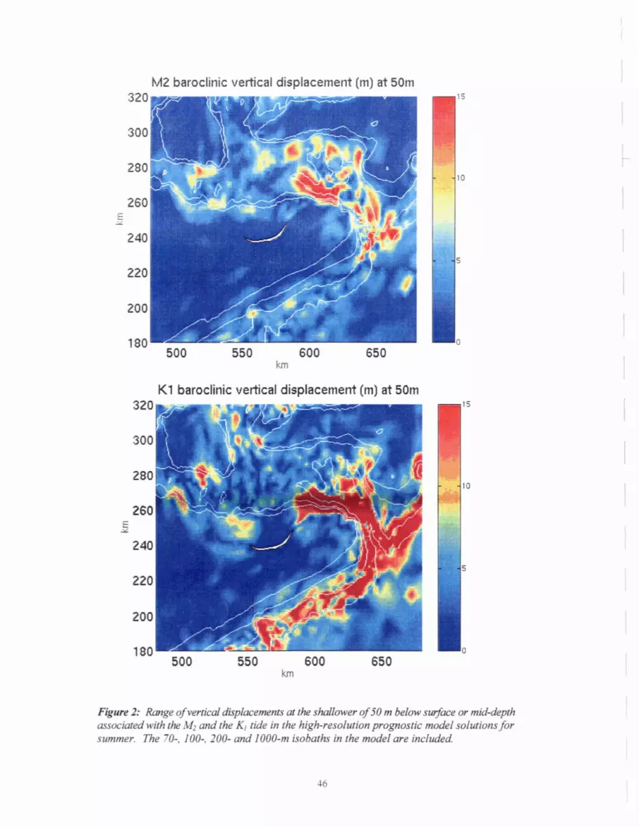
M2 baroclinic vertical displacement (m) at 50m
K1 baroclinic vertical displacement (m) at 50m
-2: R o g e o f ~ ~ d u k s ~ o f S O r n b e l o w ~ ~ a r n J I C d s y d , ma:htedwiiY~ tk M2 and the 4 ti& m the high-resolution prognartic &l solaitions for summer. l%e 770 lo@, 200- and 1000-m isobatk in the d l me includled

Spring Velocity at 25m below the surface ss3P resid 350
Summer Velocity at 25m below the surface ss3P resid
F@re 3: h o m l - aorenrr Wue) at 25 m beIw rhe su@bcefirspring ( u p p e r m ) and summer f l ~ p 0 n e ) f i m the base pognatic m&, interpoIatedto a lOkn grid Tk s~onaI- mean a m w s j i v m ntooredrtmmmmm (red), and ttse 70-, 100-, 200- and 1000-nr isobaihs (bIQck) orealso shaur.

Normal Velocity Salinity Temperature .
, Sable Bank
\
P~~ 4: V d chfs- of rhe nmnrd component of seasonal-- w e n t (lefi c h ) , salinity ( i column) and&- (right dm) on a setion acrol~s The GI@ surring abut 20 ktn east of a l e Island at (605, 240) km (Figwe 3) and extending nmthmsd to Banperem Bank at (645, 310) km tn vertical (depth) coordinate values are in meters. P m h valrces of cumnt ( d s ) indicate ofihore&v, a n d n e g h vahres (shtdixg ollshpow.