phases of gully erosion in the vicintiy of kazimerz dolny (doly podmularskie gully)
TRANSCRIPT

Institute of Earth Sciences, Maria Curie-Sktodowska University
Polish Geographical Society, Lublin Branch
HUMAN IMPACT ON UPLAND
LANDSCAPES OF THE LUBLIN REGION
Edited by
Justyna Warowna and Anne Schmitt
Lublin 2010

Reviewers
Institute
ISBN 978-83-89720-59-7

Reviewers
Institute
ISBN 978-83-89720-59-7
L

CONDITIONS OF
Oagmara Kociuba
OF LANDSCAPE
6
Ewa Skowronek 7
.............. 09
Section 3 OF HUMAN ACTIVITY
8 31
9
Justyna Warowna 10
Anne Schmitt Markus Dotterweich, Jan Wojciech

List
4 AGRICULTURAL IMPACT ON THE EROSIVE GEOSYSTEMS DEVELOPMENT
in Roztocze .................................................................... 81
95 Jan Rodzik
11
....................................................................... 233

8 Phases of gully erosion in the vicinity of Kazimierz Dolny (Doty Podmularskie gully)
MARKUS DOTTERWEICH 1, ANNE SCHMITT2, JAN RODZIK3
,
WOJCIECH ZGtOBICKP 1 Landau, Germany
2 GeoEcoP/an, Kemmern, Germany
3 Institute of Earth Sciences, Maria Curie-Sklodowska University in Lublin, Poland
INTRODUCTION
How did mankind influence the ecosystem in former times? What do we know about past land use and their effects to soil erosion and gullying? Are there correlations between sedimentation sequences and human activity as well as geomorphologically significant floods in occurrence with climate change?
We know that the anthropogenic formation of the central European landscape dates back to the Neolithic revolution, around 7500 years ago. Since then, many phases of agricultural expansion and regression occurred with land clearance and reforestation. As a result, in many areas of central European soil has been washed downslope by anthropogenic soil erosion and gullies have incised, leading to the development of colluvial and alluvial deposits (Lang 2003; Dreibrodt, Bork 2005, Lang, Bork 2006; Dotterweich et al. 2008). As a result the today's landscape and the soil cover in Europe as it appears today were strongly altered directly and indirectly by mankind/human activities.
The understanding of the scale and dynamics of soil erosion processes in the past allows help us to understand of impact of present land use systems. This is especially important for regions where traditional land use systems are changing rapidly as it is happening in south-east Poland. During the socialist regime only very small part of the land was collectivised and in south-east Poland traditional agricultural systems continued to exist until today. Due to the joining of Poland with the European Union significant changes in the agricultural structures are in progress.
The area around the Nalcrczow Plateau is one of the last areas in Europe where the traditional agricultural systems are still in use on loess sediments. Small field plots, often only a couple meters wide and less than hundred meters long are typical. Until today, farmers use horses or small tractors and machines like it was common in central Europe 50 years ago. As a result, the effects ofland collectivisation or the use of heavy machines to landscape structure respectively to soil degradation didn't take place. Additionally, the traditional field structure, sunken roads and gully systems

132 Markus Dotterweich, Anne Schmitt, Jan Rodzik, Wojciech Zglobicki
were not destroyed like at many other areas in central Europe during the last 50 years. Therefore historical soil and sediment sequences are well preserved on the Nal<(cz6w Plateau. This unique situation allows us to study the geoarchives reconstructing past land use and soil erosion in this area.
Between 2001 and 2004 several investigations on the past soil erosion at the western edge of the Nal<(cz6w Plateau were made. Here, we are focusing on the Doly Podmularskie gully system at the town of Kazimierz Dolny (Fig. 31, 32). The studies are described also in detail in Zamhofer (2002), Schmitt et al. (2004) and Schmitt et al. (2005).
Direction Poznafl I
22· oo·
'.[ rurcr:,;id
!\ Pulawy "1 29
22' 20' • m.a.s.I
_o __ -- lUm
51 ' 20'
Dffection ZamoSt
Fig. 31. Location of the gully system Doly Podmularskie on the Nalcrczow Plateau
MATERIAL AND METHODS
Natural conditions
The up to 30 m thick loess cover around the town of Kazimierz Dolny in southeast Poland is fertile . Heavily truncated Luvisols are typical. The area is famous for its deep road gullies and gully systems which show a high density of 11 km·km-2
(Maruszczak 1973). Situated at the margin of the Lublin Upland, local rainfalls of high intensities are common in this region. Due to the high relief gradients the
Phases of gully erosion in the vicinity of Kazimierz Oolny (Daly Podmularskie... 133
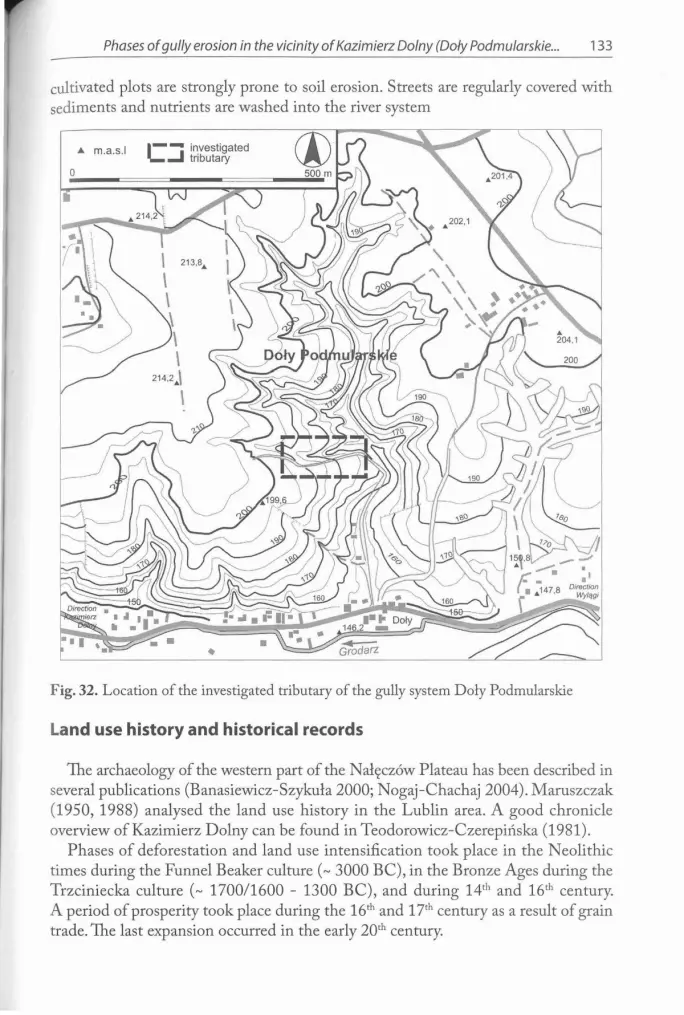
cultivated plots are strongly prone to soil erosion. Streets are regularly covered with sediments and nutrients are washed into the river system
• m.a.s.I
0 C -: investigated
- tributary
Fig. 32. Location of the investigated tributary of the gully system Doly Podmularskie
Land use history and historical records
The archaeology of the western part of the Nalcrcz6w Plateau has been described in several publications (Banasiewicz-Szykula 2000; Nogaj-Chachaj 2004) . Maruszczak (1950, 1988) analysed the land use history in the Lublin area. A good chronicle overview of Kazimierz Dolny can be found in Teodorowicz-Czerepinska (1981) .
Phases of deforestation and land use intensification took place in the Neolithic times during the Funnel Beaker culture (- 3000 BC), in the Bronze Ages during the Trzciniecka culture (- 1700/1600 - 1300 BC), and during 14'h and 16'h century. A period of prosperity took place during the 16'h and 17'h century as a result of grain trade. The last expansion occurred in the early 20'h century.

134 Markus Dotterweich, Anne Schmitt, Jan Rodzik, Wojciech Zglobicki
Extreme rainfall events and huge flash floods are mentioned twice in the historical records of Kazimierz Dolny. In the year 1633 and at the 20. May 1644. The 1644 event were scenarised into a poem, e.g. : "gdzie byly gory wysokie, tam teraz doly glfbokie" - hills were transformed into gullies (Montusiewicz 1991, Zamhofer 2002). The complete poem describes an extreme rainfall event with the effects of soil erosion, gullying and building devastations by floods and sediments.
Field investigations
The field investigations on the Nalcrcz6w Plateau have been focused on the strongly branched Doly Podmularskie gully system. The catchment of the total gully system has a size of about 0.35 km2 and the gully itself has a length of about 3 km including all main branches. Today the catchment is used for agriculture whereas the gully system itself is covered by forest.
Between 2001 and 2004 the field work was focused on the gully development of one of its sub-systems. This tributary gully is 200 m long, up to 30 m wide and has a maximum depth of 25 m. Along the tributary there are several steps formed by sedimentation, erosion and land slide processes (Fig. 33). The largest step is situated in the middle of the thalweg (Fig. 34). Here, the largest amphitheatre like step with a maximum depth of 3.8 m and a width of about 12 m was investigated. In addition, percussion and hand drillings along the thalweg and 10 supplementary exposures along the walls and shoulders of the recent gully system were made.
After cleaning the walls the soil features and sediment structures as well as other characteristics like embedded charcoal and artefacts were identified and documented in detail. The field description included colour, substrate, texture and chemical characteristics such as pH and the CaC0
3-content. The charcoals were dated by
the AMS method at the Leibniz-Labor, Kiel, Germany. The dating artefacts were done by Anna Tyniec and Tomasz Rodak of the Archeological Museum in Krakow, Poland, and Radoslaw M yszka of the University of Gottingen, Germany.
~ Exposu,es @ SOm
Fig. 33. Topography and locations of the investigated exposures

Phases of gully erosion in the vicinity of Kazimierz Dolny (Daly Podmularskie... 135
Fig. 34. View into the investigated tributary of the gully system Doly Podmularskie
RESULTS
The main exposure PAl has an amphitheatre like shape because of the gully heads position in the central part of the tributary. The exposure shows a complex structure of colluvial sediments, erosional and soil development features, cracks and roots (Fig. 35 and Fig. 36).
At the left side of the exposure PAlab (Fig. 35), the original loess with a carbonate content between 9. 7 and 11.4 % is exposed. In the upper meter parts of the leaching horizon and the clay enriched B t horizons of 1.5 m thickness remained on the top of the slope (layers lA - 4A). This is typical for a Luvisol developed in the original loess during the early and middle Holocene. Today, this soil profile is truncated and covered by more than 0.5 m of colluvial sediments (layer 5A). The embedded charcoal dates into Modern times (K1Al 7 46 7, Table 15). At the right side of the exposure PAlab a sediment sequence was found in a former gully with a width of 1m(Fig.37 left). The sediments are overprinted by clay bands of an in situ formed Luvisol. The embedded pottery fragments date into the Bronze Age while the charcoal dates into the early Middle Ages (K1A15258, Table 15).
In exposure PAlc the lower 4 m of the 11 m deep erosional form is filled with material sharply distinguished from the original loess (Fig. 36, layers 1 - 131). The material came from slope failures (chaotic structures, whole blocks collapsed) and from material transported by water down the slope and along the thalweg (stratified structure). The dark layers in the exposure indicate a higher content of organic matter and soil formation under vegetation cover. Table 14 shows a classified description of

136 Markus Dotterweich, Anne Schmitt, Jan Rodzik, Wojciech Zglobicki
the layers. The deepest part of the filling (Fig. 36, layers 1 - 41) is characterised by a quite narrow gully form with almost perpendicular walls (Fig. 37 right). The embedded charcoal (KIAl 7221, KIA 17222, KIA15256), a snail shell (KIA15927) and pottery fragments (archaeological age: 1700-1300 BC) date all into the Bronze Age (Table 15). Almost 1.5 m further up in the stratigraphic sequence the former erosion form broadens (Fig. 31, layers 42 - 131). This sequence could be divided into 2 sections. Layers 42 - 88 and 99 - 131 are composed by many small blocks, fine laminated sediments, relocated and rounded balls of loamy material derived from former A-, E and Et-material. This is typical for alternating of many smaller and some stronger sheet and gully erosion events in the catchment and along the thalweg. In this package layers 44 - 59a show the filling structure of a former pipe and layers 62- 67 show the sediments of the filling of a smaller gully. Layer 88 forms a humic horizon typical for an in situ soil formation. This indicates a longer period of geomorphic stability in this gully. Above this section, layers 89 - 98 show a different sediment structure. They are more homogeneous and have a higher content ofhumic material. In a closer view, they are typical for periodical sedimentation events caused by hillslope erosion. In addition, more dense vegetation in the gully retained the downwashed material. In these layers there are some pottery fragments date into the Bronze Age (2300-1300 BC) but there are also pottery fragments from early Middle Ages (800-1000 AD). The charcoal show ages from Middle Ages until the Modern Times (KIA 15257).
Exposure PA2 is located in the thalweg about 10 m east of exposure PAl. It shows a complex sediment structure with embedded modern artefacts. Exposure PA3 is also situated in the thalweg. It shows a Luvisol similar in exposure PAlab but the layers are tilted and shifted typical for a landslide. Exposures PA4 and PA6 are located at the upper meter of the northern edge of the gully. Exposure PA4 looks similar to the Luvisol in exposure PAlab. The charcoal KIAl 7225 dates into the modern Times (Table 15). It was taken from a colluvial layer on the top of this Luvisol. The situation in exposure PA6 is different. Here the Luvisol is strongly disturbed probably caused by gullying, sediments, artificial fillings and windbreaks. The charcoal here was taken from the central part of the disturbances. It dates between late Middle Ages and early Modern Times (KIAl 7223, Table 15).

PA 1a-HK2 (KIAl 7 467) 1 -0" cal AD 1518 - 1552. 1633 - 1669. 1781 - 1796 1946 - 1955 AD
\ ·-·-·-·-·, -·-·-\j "·-·-·-·-·-·-·--..- ·-· \
ENE ·-· \.._ -- -·-
1A
" -...
l_."'I border of the expos~j·-·:
~--, L 0 Ill lm
• So il sample • Pottery fragements .;, Pottery fragements (dated)
• Charcoa l o Charcoal_ elated
Fig. 35. Drawing of the exposure PAlab
'-•-:.
I K2 • PAlb \ Earl y Bronze Age L BC 2300 - 2100
1{ierzanowicka- Cttlhue
"'·-·---. i L.
wsw .... ....
PAlb_Kl Early Bronze Age. BOO - 1300 B C PA1b-HK4 (KIA15258) n ·zcinieck•-Cultme l -a c•l AD 887 - 983
~ ~ ~ 0 ....., \0 c:: ~
~ er :::i s· :;. <1)
§: ~-0 ....., s §· (i;• ;::: CJ 0
~ CJ 0 '-< d' ~ c:: 0-~
~
w '-I

.................... ....... , ·,. __
L1m \
\ ..... _
1 m Orn
I Top view sketch I
1--~1 I 6)0m 12 Ill
Orn
6,20 m
• Soil sample • Potte1y fragernem O Polte1y fragment , dated • a1:u·coal D Ch:ucoal, dated
8 Snail shell. dated
D Wood. dated
·-·-·-·-·-·-·-·-·-·-·-·-·-·-·-·-·-·-border of the exposure ·-·-·-·-·-·--. • ..._ ......
Fig. 36. Drawing of the exposure PAlc
12m 1
w 00
'S: 0 ~ c: "' tJ 0 ~ I'll .... ~ -~ )::,. ::l ::l I'll v. " :::,-3 ;:;: , .... '-0 ::l :::0 0
§: ,-;.;-
~ 6. I'll
" :::,-N 0 0 Q-;::;· ~

Phases of gully erosion in the vicinity of Kazimierz Dolny (Daly Podmularskie... 139
Table 14. Classification and layer description of soils and sediments in exposure PAlc
Type Describtion
A parent material (loess)
B
c
D
E
F
G
H
graviative relocated and disturbed parent material (loess)
fluvial relocated loess, very fine laminated
in situ humic Ah horizon (relict and recent)
fluvial relocated loess, disturbed-
fluvial relocated loess, laminated
fluvial relocated loess, cross-laminated
fluvial relocated loess, laminated, partly loamy and free of carbonate
Layer
not numbered
11,13-15, 18,30a,52, 71, 72, 77,99,104
1,8,17,27,30,43a,48,49,56, 57,82,84-86,103, 107,111, 114-116,120,121,125,126,130
97,98,88
5,12,20,21,23,25,29,30b,31,37,38,47, 74
10
3,4,16,22,42,44,45,51,53,54,60-62,64, 65, 78, 117
6, 7, 24,90
I fluvialrelocated loess, loamyand free ofcarbonate 9, 26, 27a, 28, 46, 68
J
K
L
M
fluvial relocated loess, loamy, coarse material incooperated (sand, aggregates)
fluvial relocated material from A- and Bhorizons, free of carbonate, homogenous
fluvial relocated material from A-horizons, free of carbonate, homogenous, high content ofhumic material
graviative relocated material from Et-horizons
2,19, 36,43,75, 99-102,106,118, 119
32,33,40,63,66,67, 76, 79,80,87,89,91, 93-95, 110, 131
34,35,39,41,41a, 50,55,92,96,105, 112, 113,128
69, 81,122
N fluvial relocated material from E-horizons, 109, 123, 128 free of carbonate
0 fluvial relocated material from E- and Bthorizons, free of carbonate
70, 73,83,108,109, 124
9
5
3
Fig. 37. Location structure of the side gully in exposure PAlab (left) and sedimentation structure at the bottom of the main gully in exposure PAlc (right)
140 Markus Dotterweich, Anne Schmitt, Jan Rodzik, Wojciech Zglobicki
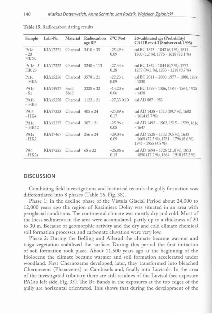
Table 15. Radiocarbon dating results
Sample Lab.-Nr. Material Radiocarbon cPC(%o) la-calibrated age (Probability) age BP CALIB rev 4.3 (Stuiver et al. 1998)
Pale KIA17221 Charcoal 3410 ± 35 -25.49 ± cal BC 1875 - 1842 (6.1 %), 1811 --20 0.09 1800 (1,2%),1776 -1618 (88.1 %) HK26
Pa le-5 KIA17222 Charcoal 3240 ± 113 -27.44 ± cal BC 1862 -1844 (0,7%), 1772 -HK23 0.28 1258 (94.1 %), 1233 - 1218 (0,7 %)
Pale KIA15256 Charcoal 3578 ± 21 -22.23 ± cal BC 2011- 2000, 1977 -1880, 1838 -HK6 0.09 - 1830
PAlc KIA15927 Snail 3228 ± 32 -14.20 ± cal BC 1599 - 1586, 1584 - 1564, 1530 - Sl Shell 0.06 -1428
PAlb KIA15258 Charcoal 1122 ± 21 -27,33 0.10 cal AD 887 - 983 -HK4
PA6 KIA17223 Charcoal 405 ± 24 -25.89 ± cal AD 1438 - 1513 (89.7 %), 1600 -HK4 0.17 - 1614 (5.7 %)
PAle KIA15257 Charcoal 307 ± 21 -25.96 ± cal AD 1492-1502,1515 -1599, 1616 -HK12 0.08 - 1647
PAla KIA17467 Charcoal 256 ± 24 -29.04 ± cal AD 1528 - 1552 (9.5%),1633 - HK2 0.09 - 1669 (72.5 %), 1781 - 1796 (8.6 %),
1946 - 1955 (4.8 %)
PA4 KIA17225 Charcoal 68 ±22 -26.86 ± cal AD 1694 - 1726 (21.0 %), 1813 -HK2a 0.15 - 1850 (17.2 %), 1864-1918 (57.2 %)
DISCUSSION
Combining field investigations and historical records the gully formation was differentiated into 8 phases (Table 16, Fig. 38).
Phase 1: In the decline phase of the Vistula Glacial Period about 24,000 to 12,000 years ago the region of Kazimierz Dolny was situated in an area with periglacial conditions. The continental climate was mostly dry and cold. Most of the loess sediments in the area were accumulated, partly up to a thickness of 20 to 30 m. Because of geomorphic activity and the dry and cold climate chemical soil formation processes and carbonate eluvation were very low.
Phase 2: During the B0lling and Allernd the climate became warmer and taiga vegetation stabilized the surface. During this period the first initiation of soil formation took place. About 11,500 years ago at the beginning of the Holocene the climate became warmer and soil formation accelerated under woodland. First Chernozems developed, later, they transformed into bleached Chernozems (Phaeozems) or Cambisols and, finally into Luvisols . In the area of the investigated tributary there are still residues of the Luvisol (see exposure PAlab left side, Fig. 35). The Bt-Bands in the exposures at the top edges of the gully are horizontal orientated. This shows that during the development of the

Phases of gully erosion in the vicinity of Kazimierz Dolny (Ooly Podmularskie... 141
Luvisol neither a deeper depression nor a gully existed. Maybe there was only a little depression in the direction of the recent gully
Table 16. Phases of gully erosion in Doly Podmularskie reconstructed from exposure PAl
Phase Time
Phase 1 22 OOO - 10 OOO BC
Phase 2 10 000-2 OOO BC
Phase 3 2 OOO - 1 300 BC
Phase 4 1 300 BC - 1 OOO AD
Phase 5 11'" century
Phase 6 12rh until 16rh century
Phase 7 17'" until 19'" century
Phase 7a mid 17'" century
Phase 7b mid 17'" century
Phase 7c mid 17'" century
Phase 7d mid 17'" century
Phase 7e mid 17'" century
Phase 7f 18'" until mid 19'" century
Phase 8 mid 19'" century until today
Phase 8a mid 19'" until early 20'" century
Phase 8b early 20'" century until - 1970
Phase 8c early 20'" century until - 1970
Phase 8d -1975 until today
Dominating processes
Loess accumulation in the perigacial during the Vistula Glacial period
Wood and soil formation
1" gullying and refilling
Wood and soil formation
2"d gullying and refilling of the small gully at PAlb
Wood and soil formation
3'd gullying and several smaller gullying and refilling stress in the sediments of the main gully
Gullying of the main gully
Partly refilling of the main gully with sediments
Lateral sediment transport by gravity
Erosion and refilling of a small gully in the main gully fill (layers 62, 63, 66, 67)
Transversal sediment transport by gravity
Geomorphic stability and soil development under forest
Youngest geomorphic activity of the gully
Hillslope erosion and sedimentation of humic rich material in the gully
Predominantly geomorphic stability and soil development under forest
Landslides
Sediment transport by gravity, soil erosion and accumulation of sediments
Phase 3: The first evidence of gully formation is indicated by the refilled gully form with steep walls at the bottom of the central part of exposure PAlc (Fig. 36, layer 1 - 41 and Fig. 37 right). The embedded charcoal and pottery fragments date into the Bronze Age. At this time, farmers settled on the fertile loess in the vicinity of Kazimierz Dolny. The steep gully walls and the absence of soil formation in the sediments show that the gully was filled immediately after its incision. Additionally, the found sediment structures are typical for fl.uvial transport processes. The material came mainly from the

142 Markus Dotterweich, Anne Schmitt, Jan Rodzik, Wojciech Zglobicki
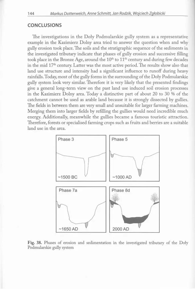
loess material at the former gully head. The location of the gully form indicates that the original gully was very deep and narrow. Today, only the lowest part of this old structure is still visible. In a synopsis, about 4000 years ago, the forest was changed into fields or pastures. During heavy rainfalls the water runs into the small depression or a sunken road. An intensive run-off took place and the first gully incised about 4 to 5 m deep into the loess sediments. The refilling took place just after the incision (Fig. 38, top left).
Phase 4: After the incision and refilling of the gully in phase 3, the fields in the surrounding of the investigated gully were abandoned. Woodland came back and soil erosion stopped. Over a period of about 3000 years no soil erosion took place in this area. Soil formation processes led to the development of Cambisols and Luvisols.
Phase 5: The next phase of a geomorphic activity is indicated by the small gully form and the refilling at the right side of exposure PAlab (Fig. 35 and Fig 37 left) . The fl.uvial transported sediments are overprinted by thin clay bands typical for a Et-horizon. The date of the youngest embedded material indicates that the refilling of this form took place not before the lO'h century. However, historical records show, that on the loess plateau intensive clearcuts started at the beginning of the 11 th century. In a short time the area changed from woodland into an intensive used cultural landscape Maruszczak (1973, p. 19). This situation indicates that the development and refilling of this gully took place during this period. The charcoal date shows only the growing date of the burned wood. Nevertheless, the clearcuts in the early Middle Ages stopped the soil formation under woodland and soil erosion could happen during heavy rainfalls. At the investigated site a small gully cut in and was refilled with sediments (Fig. 38, top right). Most likely also in the main form gullying took place. But the supporting indicators may have been destroyed by latter soil erosion events.
Phase 6: After the incision and refilling of the small gully in phase 5, woodland or forest came back and protected the surface against subsequent gully erosion. During this phase, the small clayey Et-bands in the sediments of the small gully developed in phase 5 were formed.
Phase 7: During this phase the forest was removed again and soil erosion took place. The main form of the investigated tributary was eroded and partly refilled with sediments (layers 42 - 88 and 99 - 131). Combining the age of the embedded material (youngest material in the oldest refilling, KIA 15257) and historical records about extreme rainfalls and soil erosion events (see above) the highest gully and sedimentation activity of this phase took place within few decades around the mid of the 17th century. Namely the extreme rainfall events in 1633 and 1644 were responsible. Probably the main part of the whole Doly Podmularskie gully system developed.
Phase 7a indicates the first gullying of the main form of exposure PAlc (Fig. 38, bottom left). This event might have been the most extreme soil erosion event in this area. At the end of the erosion events different layers of sediments were accumulated (Phase 7b).1he material came from different sites. Carbonate rich

Phases of gully erosion in the vicinity of Kazimierz Dolny (Doly Podmularskie... 143
material came from the former loess layer at the gully head. Reddish sediments with high clay content and light grayish carbonate free material came from former Et-horizons respectively £-horizons. Humic rich material was eroded from the hillslopes by sheet erosion. Also undercutting processes at the edges of the gully took place. The craining soil collapsed and rolled downlsope forming ball shaped sediments until a diameter of 30 cm. In phase 7 c the high erosion and accumulation dynamic decreased. Now, lateral transport processes dominated. Collapsing of crained parts at the edges of the gully and landsliding took place. Partly the material was very wet leading to mud-flow like processes (e.g. layer S2, 130, S7, and 6S in exposure PAlc, Fig. 36). Phase 7d is characterized by the forming and refilling of a small gully in the sediments accumulated before (layer 62, 63, 66, and 67 in exposure PAlc, Fig. 36). In phase 7e layer SS was accumulated. The humic rich and homogenous material indicates that at this time hillsope erosion by a mud-flow like process dominated. Finally, in phase 7f woodland came back and soil erosion and accumulation processes stopped. This is indicated by the forming of an Ah-horizon in layer SS.
Phase S represents the last soil erosion and accumulation complex in the investigated tributary of the Doly Podmularskie gully system. It started in the mid 19'h century and continued until today.
In Phase Sa soil erosion started again. In the catchment, hillslope erosion took place and humic rich sediments were accumulated along the edges of the gully (e.g. layer 5A in exposure PAlab, Fig. 35) and along the thalweg of the whole gully system. Also the sedimentation of the layers S9 - 9S in exposure PAlc took place (Fig. 36). The structure of the layers shows that in this part of the gully accumulation process were more dominant than erosion processes. This indicates, that in the some parts of a gully more or less dense vegetation could protect the surface by linear erosion processes. In phase Sb soil formation under a dense vegetation cover became more and more dominant. This process is still active until today while run off in the gully system decreased successively. The reason for the absence of fluvial geomorphic process can be found in the formation of the road system around the tributary. They run parallel to the gully system. Now, during rainfalls runoff flows downhill along the road structures. Road gullying became the dominant process and emerged into a more and more problematic situation for the land owners. Meanwhile some of the road gullies have a depth of over 5 meters. However, also in the investigated gully system geomorphic processes, in particular land slide processes and piping are still active (phase Sc). At steeper parts of the gully edges, large blocks broke apart and slipped downhill. Phase Sd represent the youngest soil erosion and accumulation activity along the thalweg. However, comparing with the erosion processes in phase 7 they are more or less negligible. Only in the years 1976, 19S1, and 1996 small erosion and sedimentation processes during heavy rainfall were observed.
144 Markus Dotterweich, Anne Schmitt, Jan Rodzik, Wojciech Zglobicki
CONCLUSIONS
The investigations in the Doly Podmularskie gully system as a representative example in the Kazimierz Dolny area tried to answer the question when and why gully erosion took place. The soils and the stratigraphic sequence of the sediments in the investigated tributary indicate that phases of gully erosion and successive filling took place in the Bronze Age, around the 1 O'h to 11 th century and during few decades in the mid 17th century. Latter was the most active period. The results show also that land use structure and intensity had a significant influence to runoff during heavy rainfalls. Today, most of the gully forms in the surrounding of the Doly Podmularskie gully system look very similar. Therefore it is very likely that the presented findings give a general long-term view on the past land use induced soil erosion processes in the Kazimierz Dolny area. Today a distinctive part of about 20 to 30 % of the catchment cannot be used as arable land because it is strongly dissected by gullies. The fields in between them are very small and unsuitable for larger farming machines. Merging them into larger fields by refilling the gullies would need incredible much energy. Additionally, meanwhile the gullies became a famous touristic attraction. Therefore, forests or specialised farming crops such as fruits and berries are a suitable land use in the area.
Phase 3 Phase 5
-1500 BC -1000AD
Phase ?a Phase 8d
-1650 AD 2000AD
Fig. 38. Phases of erosion and sedimentation in the investigated tributary of the Doly Podmularskie gully system