conservation management plan blackguard gully, young
TRANSCRIPT
Conservation
Management Plan
Blackguard Gully
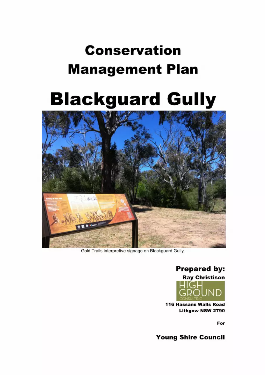
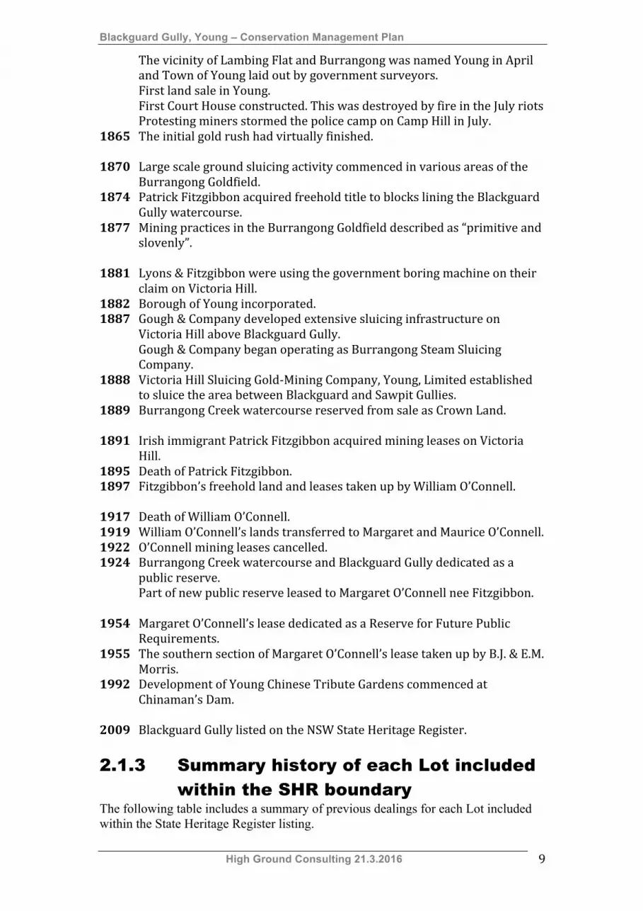
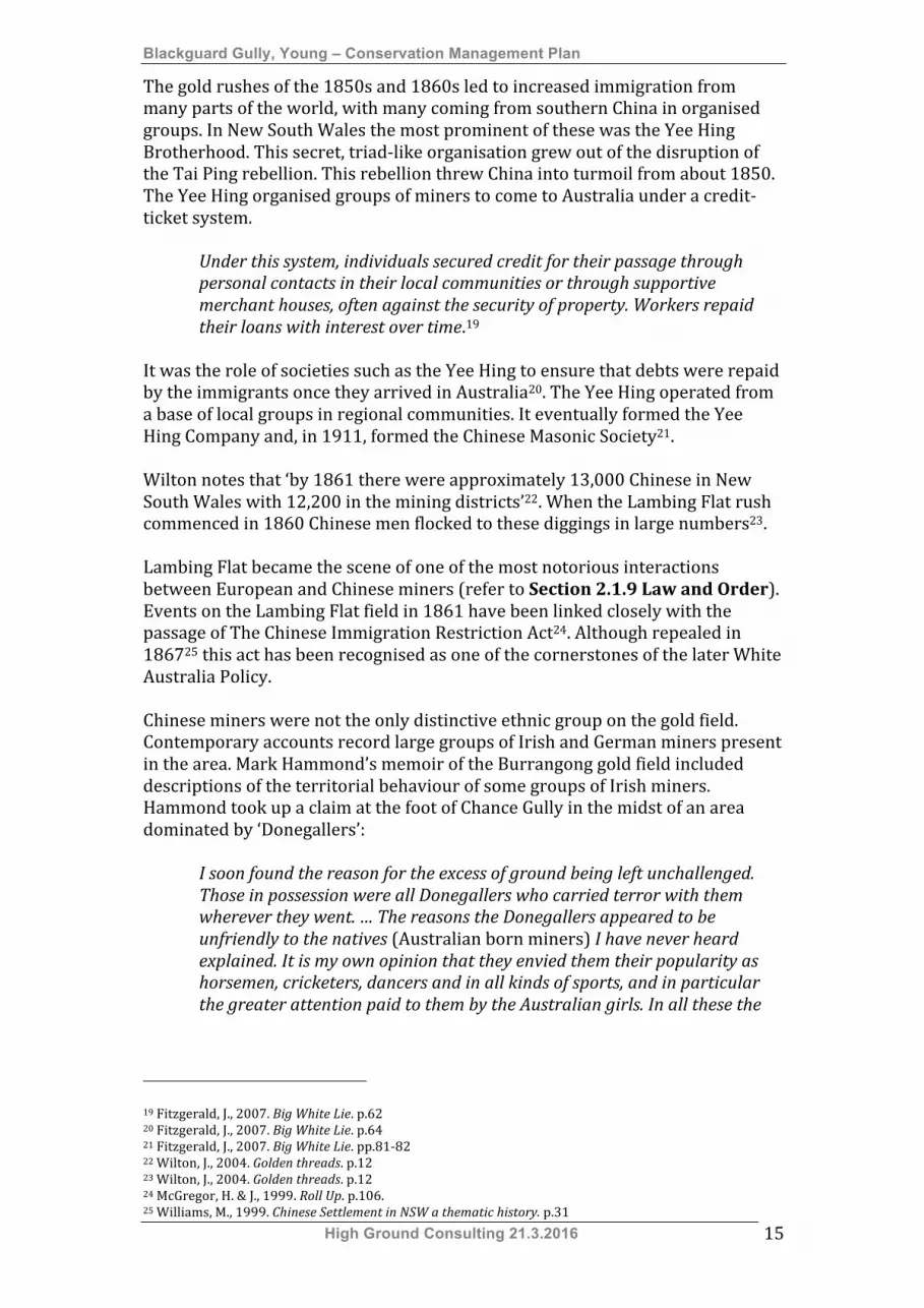
Gold Trails interpretive signage on Blackguard Gully.
Prepared by:
Ray Christison
116 Hassans Walls Road
Lithgow NSW 2790
For
Young Shire Council
Blackguard Gully, Young – Conservation Management Plan
High Ground Consulting 21.3.2016 2
Contents 1. Introduction 4 1.1 Outline of tasks required to be undertaken in brief 4
1.2 Definition of study area 4 1.3 Methodology 6 1.4 Limitations 7 1.5 Identification of authors 7 1.6 Acknowledgements 7
2 Documentary Evidence 8 2.1 Thematic History 8
2.1.1 Introduction - Key Themes 8 2.1.2 Timeline 8
2.1.3 Summary history of each lot included within the SHR boundary 9 2.1.4 Aboriginal culture and interactions with other cultures 10 2.1.5 Ethnic Influences 13 2.1.6 Migration 14 2.1.7 Environment: cultural landscape 17 2.1.8 Mining 21 2.1.8.1 Mining in Blackguard Gully 24 2.1.9 Law and order 32 2.1.8.1 The riots 32
2.2 Ability to Demonstrate 36 3. Physical Evidence 38 3.1 Introduction 38 3.2 Victoria Gully & Blackguard Gully watercourse 38 3.3 Main sluicing dams & associated races (Lot 4524 DP 46320) 41
3.3.1 Sluicing dams 42 3.3.2 Sluicing races 45 3.3.3 Puddling mills 49
3.4 Gold Lease GL73 51 3.2 Archaeological Potential 53 3.2.1 Archaeological zoning plan 53
4. Assessment of Cultural Significance 55 4.1 Comparative Analysis 55 4.1.1 Evidence of alluvial gold mining 55
4.1.2 Evidence of Chinese ethnic influence 60 4.1.3 Summary findings from comparative analysis 61
4.2 Statement of Significance 61 4.2.1 Existing Statements of Significance 61 4.2.2 Revised Statement of Significance 62
4.3 Gradings of Significance 64 5. Constraints and Opportunities 67 5.1 Constraints and opportunities arising from statement of significance 67 5.2 Statutory and non-statutory listings 67
5.2.1 NSW State Heritage Register 67 5.2.2 Young LEP Heritage Schedule 68 5.2.3 Young Shire Aboriginal Heritage Study, 2014 69
5.3 Responsibility for management 70 5.3.1 Development of a landscape management plan 70
5.3.2 Development of visitor carpark 71 5.3.2 Development of the proposed Abacus Centre 72 5.3.3 Communication 72 5.4 Fossicking area 72 6. Development of Conservation Policy 74 7. Conservation Policies and Guidelines 75
7.1 Definitions 75 7.2 Policies 76
7.2.1 Fabric 76 7.2.2 Management of the precinct 76

Blackguard Gully, Young – Conservation Management Plan
High Ground Consulting 21.3.2016 3
7.2.3 Access 77 7.2.4 Setting 77 7.2.5 Installation of services & amenities 77 7.2.6 Management of archaeological features 77 7.2.7 Fossicking 78 7.2.8 Approvals 78 7.2.9 Documentation of changes 78 7.2.10 Review of the Conservation Management Plan 79
7.3 Recommendations regarding management of fabric 79 7.3.1 Victoria Gully & Blackguard Gully Watercourse 79 7.3.2 Main sluicing dams & associated races (Lot 4524 DP 46320) 80 7.3.3 Gold Lease GL73 81
7.4 Conservation Action Plan 81 8. Interpretation 83 8.1 Interpretation themes 83
8.2 Development of interpretive pathways 83 8.3 Site based interpretations 83 8.4 Development of interpretations 85 8.4.1 Development of an interpretative platform 85 8.4.2 Development of an interpretive pathway 85
9. References 86 List of Plans Figure 1.1 Identification of the curtilage of the State Heritage Register listing
of Blackguard Gully. 5 Figure 2.1 Listed alluvial gold mining sites around Young. 19 Figure 2.2 The Lambing Flat (Young) Gold Field in 1862. 22 Figure 2.3 Plan of Portion 1138 purchased by Patrick Fitzgibbon in 1889. 27 Figure 2.4 Aerial view of Blackguard Gully showing the lots covered by Special
Lease 24.34 allocated to Margaret O’Connell in January 1925. 31 Figure 3.1 Aerial view showing the possible layout of sluicing infrastructure
described in 1922 and 1933. 42 Figure 3.2 Archaeological Zoning Plan – moderate to high archaeological potential. 54 Figure 3.3 Archaeological Zoning Plan – moderate archaeological potential. 54 Figure 3.4 Archaeological Zoning Plan – low archaeological potential. 54 Figure 5.1 Plan showing existing formal carpark & proposed carpark locations. 71 Appendix A The Burra Charter Appendix B Standard Exemptions for Works Requiring
Heritage Council Approval Appendix C Abacus (Suànpán) Centre Action Plan Appendix D Approvals for works flowchart Appendix E Fossicking: A guide to fossicking in New
South Wales
Blackguard Gully, Young – Conservation Management Plan
High Ground Consulting 21.3.2016 4
1. Introduction
1.1 Outline of tasks required to be undertaken in brief
A section of Blackguard Gully between Whiteman Avenue and Victoria Street, Young was included in the New South Wales State Heritage Register (SHR) on 13 March 2009 (Listing Number 01775). The listing includes the provision of Standard Exemptions for works gazetted for most sites included on the SHR. These Standard Exemptions are included as Appendix B to this Conservation Management Plan (CMP). An additional exemption allows the following:
Gold panning and fossicking. Purposes of grazing cattle limited to the area outlined with the heavy black line shown on the plan HC 2182.
The site is currently controlled by Young Shire Council. The Council has determined to prepare a Conservation Management Plan (CMP) to guide the future management of the part of Blackguard Gully included in the SHR. The Conservation Management Plan is required to:
• Provide an understanding of all heritage items on the site (archaeological, built, cultural and indigenous) through investigation of its historical and geographical context, its history, fabric, research potential, and importance to the community
• Include a statement of significance based on the existing assessments undertaken for listing on the State Heritage Register.
• Develop a conservation policy, arising out of the statement of heritage significance, to guide current and future owners of the items on the continued and future use of the site and its ongoing maintenance.
• Constraints and opportunities are to be examined. • Prepare an archaeological zoning plan for the site. • Recommend how the heritage items can best be managed bearing in
mind those responsible and interested in its ongoing conservation. It is to include proposals to review the conservation management plan and maintenance requirements.
• Identify areas where interpretation could occur and provide guidelines for such future initiatives.
• Identify areas in which the following facilities can be developed; o Visitor parking, o Interpretive pathways, o Picnic facilities and amenities, o An interpretive and research centre associated with the migration
history of Young and New South Wales.
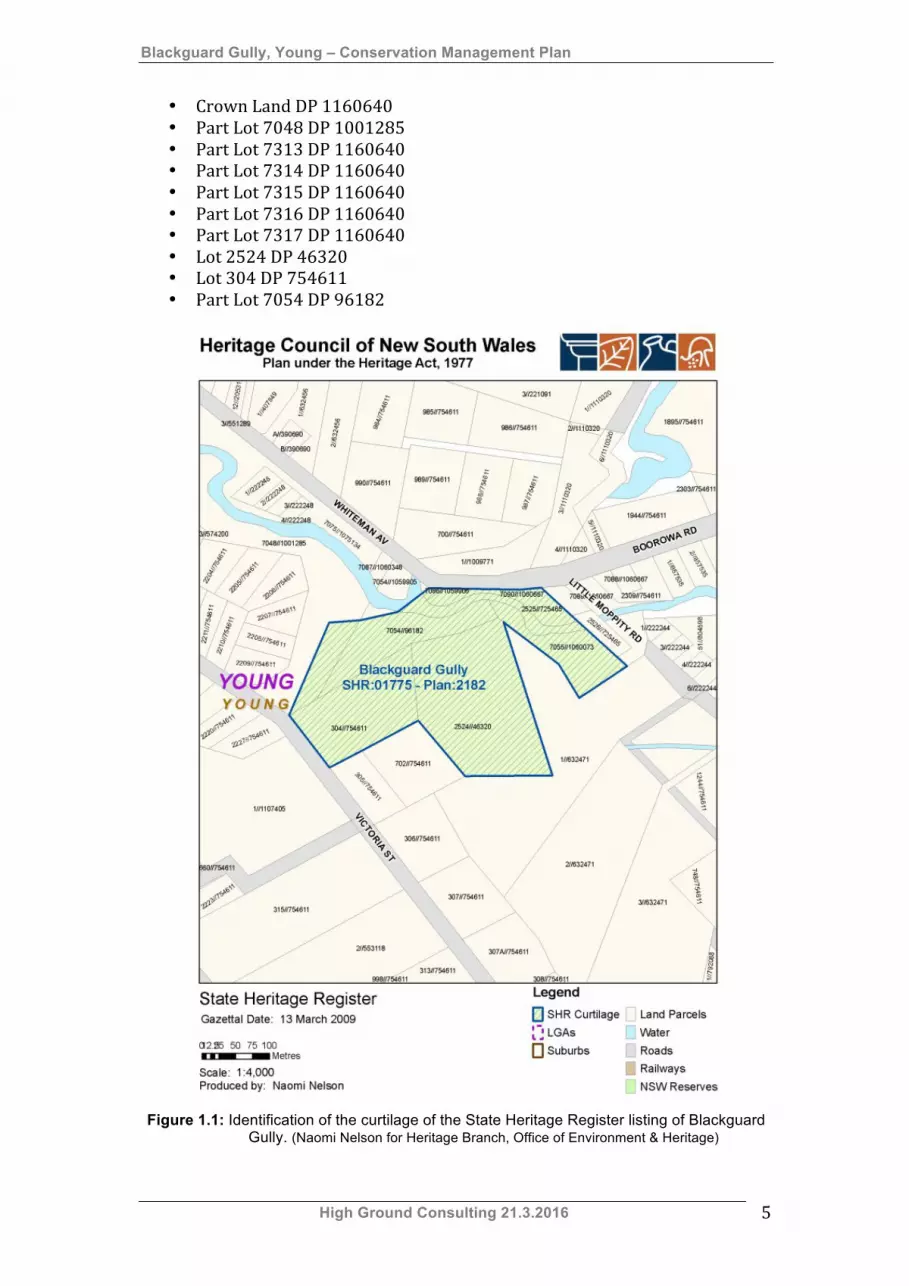
1.2 Definition of study area The SHR listing for Blackguard Gully is described as covering the following properties:
Blackguard Gully, Young – Conservation Management Plan
High Ground Consulting 21.3.2016 5
• Crown Land DP 1160640 • Part Lot 7048 DP 1001285 • Part Lot 7313 DP 1160640 • Part Lot 7314 DP 1160640 • Part Lot 7315 DP 1160640 • Part Lot 7316 DP 1160640 • Part Lot 7317 DP 1160640 • Lot 2524 DP 46320 • Lot 304 DP 754611 • Part Lot 7054 DP 96182
Figure 1.1: Identification of the curtilage of the State Heritage Register listing of Blackguard
Gully. (Naomi Nelson for Heritage Branch, Office of Environment & Heritage)

Blackguard Gully, Young – Conservation Management Plan
High Ground Consulting 21.3.2016 6
There appears to be a significant anomaly between the curtilage of the SHR listing shown on the map included as Figure 1.1 and the information available in current GIS databases. A search of the Six Maps database correlates the SHR listing area with the following lots:
• Crown Land DP 1160640 • Lot 7314 DP 1160640 • Lot 7315 DP 1160640 • Lot 7316 DP 1160640 • Lot 7317 DP 1160640 • Lot 2524 DP 46320 • Lot 304 DP 754611 • Part of the Victoria Gully/Blackguard Gully watercourse.
It is recommended that the SHR record be amended to identify the correct Lots included within the curtilage of the listing. Blackguard Gully is one of three gullies that converge near the eastern end of the Town of Young. At this point it joins Victoria Gully and Garibaldi Gully. The three gullies saw intensive alluvial mining activity from 1860 onwards.
1.3 Methodology This CMP was prepared in accordance with a brief prepared by Young Shire Council. Consultation and investigations have been undertaken with local stakeholders, including:
• Craig Filmer, Director Planning, Environmental and Strategic Services, Young Shire Council.
• Hugh Jackson, Asset Planning Officer Parks & Gardens, Young Shire Council.
• Young Shire Council Blackguard Gully Committee (Abacus Centre Working Party).
An administrative review was undertaken by Tanya Cullen, Town Planner, Young Shire Council. The CMP has been guided by:
• NSW Heritage Manual, 1999 • The Burra Charter, 1999 • Assessing Heritage Significance, 2000 • Model Brief for the Preparation of a Conservation Management
Plan • A Suggested Table of Contents for a Conservation Management
Plan that can be endorsed by the NSW Heritage Council The following actions were undertaken:
1. Preparation of a Thematic History based on the Thematic History prepared as part of the Young Shire Community Based Heritage Study 2008.

Blackguard Gully, Young – Conservation Management Plan
High Ground Consulting 21.3.2016 7
2. Site survey to identify the key landscape features undertaken on 23 November 2015.
3. Description of the place, including identification of key features and their condition.
4. Review of significance based on the condition of the area and comparative analysis with similar sites in New South Wales.
5. Discussion of constraints and opportunities associated with management of the significance of the place.
1.4 Limitations Sections of the precinct, particularly along the eastern gold races, were heavily overgrown with holly and blackberry, very difficult to access. This severely limited investigation of these areas.
1.5 Identification of authors This report was written by Ray Christison BA (Hons.), heritage consultant of High Ground Consulting, Lithgow.
1.6 Acknowledgements This Conservation Management Plan has been prepared with the support and assistance of a number of persons, including:
• Brian James, Young and District Historical Society, • Members of the Young Shire Council Blackguard Gully Committee;
o Councillor Brian Mullany, Young Shire Council. o Craig Filmer, Director Planning Environment & Strategic Services,
Young Shire Council. o Russell Healy, Chairman, Australian Rutile Pty Ltd.
• Jennifer Christison, High Ground Consulting.

Blackguard Gully, Young – Conservation Management Plan
High Ground Consulting 21.3.2016 8
2. Documentary Evidence
2.1 Thematic History This thematic history has been adapted from the Thematic History of Young Shire prepared by Ray Christison in 2008. Additional research on mining in Blackguard Gully was undertaken by Ray Christison. 2.1.1 Introduction – key themes Blackguard Gully is located within the country of the Wiradjuri people and in the 1820s it became part of the Burrangong pastoral run taken up by James White. The discovery of gold in Burrangong Creek in 1860 sparked a major gold rush, drawing hopeful prospectors of various nationalities. As the rush developed organised groups of miners, struggling to make a living in the difficult conditions, committed the most widely known and documented acts of violence against Chinese miners in the history of the Australian gold rushes. These attacks occurred in January 1861. Much of the Blackguard Gully area was subsequently allocated to Chinese miners who experienced a second series of attacks in June and July 1861. After the gold rush subsided in 1862 Blackguard Gully and its surrounds were worked by various groups of Irish miners using ground sluicing methods. Ground sluicing activity by Irish immigrant families continued well into the 20th century. The section of Blackguard Gully listed on the NSW State Heritage Register is typical of heavily sluiced alluvial gold mining areas. Key historic themes relevant to Blackguard Gully are:
• Aboriginal cultures and interactions with other cultures, • Ethnic influences, • Migration, • Environment: cultural landscape, • Mining, • Law and order.
2.1.2 Timeline This timeline records the land use history of Blackguard Gully in the context of the Lambing Flat Gold Rush and subsequent related events. 1820 Surveyor Meehan explored the country between Tarlo and Grabben
Gullen. 1824 Hume and Hovell explored the country between Yass Plains and Port
Phillip. 1826 James White settled on Burrangong Creek. 1860 Gold discovered on White’s lambing flat. Courts of petty sessions established at Lambing Flat and Stoney Creek. 1861 Anti-‐Chinese riots in January drove Chinese miners from the gold field. Blackguard Gully allocated for Chinese miners in February. Rioting on 30 June 1861 was largely focused on Blackguard Gully.
Blackguard Gully, Young – Conservation Management Plan
High Ground Consulting 21.3.2016 9
The vicinity of Lambing Flat and Burrangong was named Young in April and Town of Young laid out by government surveyors.
First land sale in Young. First Court House constructed. This was destroyed by fire in the July riots Protesting miners stormed the police camp on Camp Hill in July. 1865 The initial gold rush had virtually finished. 1870 Large scale ground sluicing activity commenced in various areas of the
Burrangong Goldfield. 1874 Patrick Fitzgibbon acquired freehold title to blocks lining the Blackguard
Gully watercourse. 1877 Mining practices in the Burrangong Goldfield described as “primitive and
slovenly”. 1881 Lyons & Fitzgibbon were using the government boring machine on their
claim on Victoria Hill. 1882 Borough of Young incorporated. 1887 Gough & Company developed extensive sluicing infrastructure on
Victoria Hill above Blackguard Gully. Gough & Company began operating as Burrangong Steam Sluicing
Company. 1888 Victoria Hill Sluicing Gold-‐Mining Company, Young, Limited established
to sluice the area between Blackguard and Sawpit Gullies. 1889 Burrangong Creek watercourse reserved from sale as Crown Land. 1891 Irish immigrant Patrick Fitzgibbon acquired mining leases on Victoria
Hill. 1895 Death of Patrick Fitzgibbon. 1897 Fitzgibbon’s freehold land and leases taken up by William O’Connell. 1917 Death of William O’Connell. 1919 William O’Connell’s lands transferred to Margaret and Maurice O’Connell. 1922 O’Connell mining leases cancelled. 1924 Burrangong Creek watercourse and Blackguard Gully dedicated as a
public reserve. Part of new public reserve leased to Margaret O’Connell nee Fitzgibbon. 1954 Margaret O’Connell’s lease dedicated as a Reserve for Future Public
Requirements. 1955 The southern section of Margaret O’Connell’s lease taken up by B.J. & E.M.
Morris. 1992 Development of Young Chinese Tribute Gardens commenced at
Chinaman’s Dam. 2009 Blackguard Gully listed on the NSW State Heritage Register.
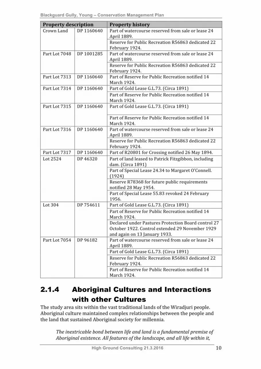
2.1.3 Summary history of each Lot included within the SHR boundary
The following table includes a summary of previous dealings for each Lot included within the State Heritage Register listing.
Blackguard Gully, Young – Conservation Management Plan
High Ground Consulting 21.3.2016 10
Property description Property history Part of watercourse reserved from sale or lease 24 April 1889.
Crown Land DP 1160640
Reserve for Public Recreation R56863 dedicated 22 February 1924. Part of watercourse reserved from sale or lease 24 April 1889.
Part Lot 7048 DP 1001285
Reserve for Public Recreation R56863 dedicated 22 February 1924.
Part Lot 7313 DP 1160640 Part of Reserve for Public Recreation notified 14 March 1924.
Part Lot 7314 Part of Gold Lease G.L.73. (Circa 1891)
DP 1160640 Part of Reserve for Public Recreation notified 14 March 1924. Part of Gold Lease G.L.73. (Circa 1891)
Part Lot 7315 DP 1160640
Part of Reserve for Public Recreation notified 14 March 1924. Part of watercourse reserved from sale or lease 24 April 1889.
Part Lot 7316 DP 1160640
Reserve for Public Recreation R56863 dedicated 22 February 1924.
Part Lot 7317 DP 1160640 Part of R20801 for Crossing notified 26 May 1894. Part of land leased to Patrick Fitzgibbon, including dam. (Circa 1891) Part of Special Lease 24.34 to Margaret O’Connell. (1924) Reserve R78368 for future public requirements notified 28 May 1954.
Lot 2524 DP 46320
Part of Special Lease 55.83 revoked 24 February 1956. Part of Gold Lease G.L.73. (Circa 1891) Part of Reserve for Public Recreation notified 14 March 1924.
Lot 304 DP 754611
Declared under Pastures Protection Board control 27 October 1922. Control extended 29 November 1929 and again on 13 January 1933. Part of watercourse reserved from sale or lease 24 April 1889. Part of Gold Lease G.L.73. (Circa 1891) Reserve for Public Recreation R56863 dedicated 22 February 1924.
Part Lot 7054 DP 96182
Part of Reserve for Public Recreation notified 14 March 1924.
2.1.4 Aboriginal Cultures and Interactions with other Cultures
The study area sits within the vast traditional lands of the Wiradjuri people. Aboriginal culture maintained complex relationships between the people and the land that sustained Aboriginal society for millennia.
The inextricable bond between life and land is a fundamental premise of Aboriginal existence. All features of the landscape, and all life within it,
Blackguard Gully, Young – Conservation Management Plan
High Ground Consulting 21.3.2016 11
were created during a creation period by ancestral creatures; some human, some animal, some neither. This period … is present in the landscape itself, and the stories and relationships form an integral part of the traditional law that guides all life. This relationship to the land extends to an in-depth knowledge of the incredible wealth of resources available in the local area, including foodstuffs and raw materials for tool and implement manufacture.1
The original people of the Young district appear to have ranged over a wide span of countryside and maintained links with groups in neighbouring regions. The rivers of the district provided a plentiful source of:
… shellfish and fish … and the plants, tubers and nuts of the country between the rivers provided seasonal food: there were yam daisies in spring summer and autumn, wattle-seeds in July and August, orchid tubers in August and September. Larger game such as possums, kangaroos and emus were captured by groups of hunters to make up a varied and nutritious diet.2
The Wiradjuri people have continued to retain a strong sense of identity despite persistent and repeated historical attempts to destroy them as a people. The loss of societal cohesion and impact of disease among Aboriginal people has been recorded in a number of places. As early as the 1790s, well before any Europeans ventured into the region, a small pox epidemic spread along traditional trade routes. A second epidemic occurred in the 1830s.
With no immunity to the virus, tribes were decimated. As the disease moved inland through the Wiradjuri region river system into South Australia it was interpreted as the result of the powerful magic of distant tribes who had unleashed the terrifying power of the Rainbow Serpent. … in the Wiradjuri region these times remained vivid for generations as a time of death. Fifty years later, the old people recalled how the sickness “Followed down the rivers … Burying bodies was no longer attempted and the atmosphere became tainted with decomposing bodies.3
As Europeans moved into the region they took up the prime grazing land along the river corridors and Aboriginal people were pushed onto marginal lands. Others lived on the fringes of European settlements ‘out of curiosity or from whence they could participate in reciprocal exchanges’4. Interactions with groups such as these were recorded by early settlers, including James White’s niece Sarah Musgrave. According to Sarah Musgrave thousands of Aboriginal people occupied the Young district at various times. She recounts some observed aspects of their lives, including preparation for a major feast where wallabies, kangaroo rats, paddy melons, possums and birds were cooked:
1 Fox, P., 1996. Warrumbungle National Park. p.48 2 NSW Heritage Office, 1996. Regional Histories. p.132 3 Kabaila, P., 1996. Wiradjuri Places. The Lachlan River Basin. p.10 4 Kabaila, P., 1996. Wiradjuri Places. The Lachlan River Basin. p.10

Blackguard Gully, Young – Conservation Management Plan
High Ground Consulting 21.3.2016 12
… in rude ovens made in the ground. Holes were dug out into which coals and hot ashes were raked from a big fire that had been made close by. The animals were put intact into the holes, and more hot ashes were raked in on top of them, the holes afterwards being filled up with ashes and dirt. By this process, the animals cooked quickly, and when taken out, they were skinned, opened up, cleaned, and then eaten.5
Musgrave also noted some Aboriginal ceremonial practices, including elaborate corroborees held at Burrangong and adulthood ceremonies held at a bora ground located in the vicinity of the existing town of Wyalong6. Early settlement in the district by Europeans appears to have succeeded largely as the consequence of a co-‐operative relationship between local Aboriginal people and early settlers. On entering the district James White apparently negotiated possession of the land with a leader of the local Burrowmunditory people who was given the name ‘Coborn Jackie’7. According to Musgrave Coborn Jackie chose the site of White’s Burrangong homestead8 and guided his relationship with the local Aboriginal people. Coborn Jackie and others also surveyed the routes of roads constructed by White to connect Burrangong to other nearby localities9. Groups of Aboriginal men also regularly applied their skills to cut and transport slabs of bark used for roofing by the Europeans10. This relationship appears to have been tempered by some distrust. Sarah Musgrave, White’s biographer, noted that the Aboriginal people were ‘afraid of firearms’. She wrote that ‘They knew no god but were always careful not to displease the devil’11. Her comments illustrate a relationship that appears to have been based on a mixture of kindness and harshness typical of many colonial relationships. In response to a situation of escalating violence on this and other frontiers of the colony Governor Gipps established the Native Police in 1839. Originally intended to protect all interests this force was allowed:
… to operate to protect settlers. White officers in charge of Aboriginal troopers, had substantial independence of the local magistracies and operated in accordance with the tradition of the punitive expedition, which was common enough in establishing colonies.12
Members of the Native Police often misused their position to visit atrocities against the other Aboriginal people. Sarah Musgrave recounted one incident in which an innocent Aboriginal man was speared to death by a group under the command of a Native Police officer known as ‘Commissioner’ Bobby. This crime
5 Musgrave, S., 1984. The Way Back. p.15 6 Musgrave, S., 1984. The Way Back. p.20 7 Musgrave, S., 1984. The Way Back. p.2 8 Musgrave, S., 1984. The Way Back. p.3 9 Musgrave, S., 1984. The Way Back. p.9 10 Musgrave, S., 1984. The Way Back. p.15 11 Bayley, W., 1977. Rich Earth. History of Young New South Wales. p.17 12 Rowley, C.D., 1978. The Destruction of Aboriginal Society. p.39

Blackguard Gully, Young – Conservation Management Plan
High Ground Consulting 21.3.2016 13
was perpetrated by Bobby after an unsuccessful expedition to capture the Namoi-‐based perpetrators of a kidnapping raid13. During the 19th century Aboriginal people were increasingly employed on pastoral stations working in shearing, droving, mustering, crutching, boundary riding, fencing, clearing and domestic work. During the gold rushes Aboriginal people provided much of the reliable labour on many properties. As the European population of New South Wales increased a system of Aboriginal reserves was put in place to provide living places for Aboriginal people. In 1909 the New South Wales government was empowered to take direct control of Aboriginal reserves under the provisions of the NSW Aborigines Protection Act. According to Faith Bandler this legislation:
… was an Act that denied equality to the Aboriginal people, that made them second-class citizens. It meant that their lives could be dominated by station managers, that their homes could be entered by police, that if a friend asked them to share a quiet drink they could be arrested and gaoled.14
The provisions of the Aborigines Protection Act included a ban on the supply or consumption of alcohol. This ban lasted until the 1960s and was one of many small injustices that created resentment among the Aboriginal community. In western areas of the state many Aboriginal people moved between the smaller reserves following seasonal work. The development of stone fruit industries around Young attracted seasonal Aboriginal labour from various areas, including the Erambie Mission at Cowra. Reliable workers were engaged on an ongoing basis and many worked in family units. Prune pickers employed at ‘Clonnel’, Maimuru in the 1960s were one such family unit15. During the 1950s the official policy of governments changed from protection to assimilation. From this time Aboriginal people moved away from government reserves and into towns. 2.1.5 Ethnic Influences The variety of ethnic groups, which have occupied or passed through the Young district have left little concrete evidence of their interaction with the place. A number of people of non-‐English speaking background have had a remarkable impact on the economic development of the area. Outstanding among these is the economic influence of Croatian born Nicole Jasprizza and Italian Carlo Marina in the development of the fruit growing industry. Also prominent is the role of the cohort of German migrants who, after the 1860s gold rushes, played an important role in the development of commerce within the town of Young. German miners were prominent among those who travelled to the Lambing Flat gold rush. Many stayed and built businesses that have left an impact on the town of Young. Young’s Chinese Tribute Gardens are built around a dam originally
13 Musgrave, S., 1984. The Way Back. pp.18-‐19 14 Bandler, F & Fox, L. (eds), 1983. The Time was Ripe. 15 Information supplied by Maree Lamb, February 2008.
Blackguard Gully, Young – Conservation Management Plan
High Ground Consulting 21.3.2016 14
constructed in the 1860s by Hermann and Johann Tiedemann and others to provide water for the Victoria Hill sluicing claim. Perhaps the most significant evidence of ethnic influence in Young lies in the substantial buildings created by the Catholic Church under the oversight of the Reverend Father Hennessy. St Mary’s Catholic Church and the complex of buildings surrounding it stand as a testament to the solidarity and faith of the district’s Roman Catholic community, which was largely drawn from Irish stock. The Chinese community has had an ongoing influence on the character of Young and its surrounds. The legacy of the old mining era includes the notoriety of the anti-‐Chinese riots of 1861 as symbolised in the ‘Roll Up’ flag. The ruins of Chinese single-‐jian dwellings, a style of venacular building over 1,000 years old, have been recorded on various rural properties around the Young district. Following World War II Australian Chinese people tended to move from market gardening to café operation as a source of income16. A number of Chinese cafés and restaurants exist in Young. In a bizarre irony the most notably Chinese site in Young, Chinaman’s Dam, was actually constructed by German gold miners. This site later became associated with Chinese market gardening and is now the location of an ornate Chinese garden. Other ethnic influences are covered in Section 2.1.6 Migration.
2.1.6 Migration The first migrations of Europeans into the Young region occurred from the 1820s. James White is the district’s most celebrated pioneer settler. By the 1830s squatters were moving mobs of sheep and cattle from the Sydney through the Goulburn and Yass districts. Much of the large-‐scale immigration of the 19th and 20th centuries was generated by wars, rebellions and economic distress in various parts of the world. In the 1840s and 1850s upheavals of various kinds affected Central Europe, including Germany, Italy and Ireland, and China was thrown into chaos by the Taiping Rebellion. It is not surprising that many of the people who ventured their fortunes on the Lambing Flat goldfields were from these places. Chinese workers were present in some parts of the New South Wales as early as the 1830s. The cessation of transportation of convicts in the 1840s created a shortage of cheap labour in New South Wales. This led to an increase in the numbers of Chinese people arriving as indentured labourers to work as shepherds and irrigation experts. It appears that all of these workers came from Fujian province and some may have been kidnapped from their home villages.17 Sarah Musgrave was quite shocked by the appearance of four Chinese men at Curraburrama Station west of Young some time around 1852. At the time she was unaware that there was ‘such a person in the whole of Australia’. These men were evidently fugitives from Thomas Icely’s property at Mudgee.18
16 Williams, M., 1999. Chinese Settlement in NSW a thematic history. p.10 17 Williams, M., 1999. Chinese Settlement in NSW a thematic history. p.4 18 Musgrave, S., 1984. The Way Back. p.44
Blackguard Gully, Young – Conservation Management Plan
High Ground Consulting 21.3.2016 15
The gold rushes of the 1850s and 1860s led to increased immigration from many parts of the world, with many coming from southern China in organised groups. In New South Wales the most prominent of these was the Yee Hing Brotherhood. This secret, triad-‐like organisation grew out of the disruption of the Tai Ping rebellion. This rebellion threw China into turmoil from about 1850. The Yee Hing organised groups of miners to come to Australia under a credit-‐ticket system.
Under this system, individuals secured credit for their passage through personal contacts in their local communities or through supportive merchant houses, often against the security of property. Workers repaid their loans with interest over time.19
It was the role of societies such as the Yee Hing to ensure that debts were repaid by the immigrants once they arrived in Australia20. The Yee Hing operated from a base of local groups in regional communities. It eventually formed the Yee Hing Company and, in 1911, formed the Chinese Masonic Society21. Wilton notes that ‘by 1861 there were approximately 13,000 Chinese in New South Wales with 12,200 in the mining districts’22. When the Lambing Flat rush commenced in 1860 Chinese men flocked to these diggings in large numbers23. Lambing Flat became the scene of one of the most notorious interactions between European and Chinese miners (refer to Section 2.1.9 Law and Order). Events on the Lambing Flat field in 1861 have been linked closely with the passage of The Chinese Immigration Restriction Act24. Although repealed in 186725 this act has been recognised as one of the cornerstones of the later White Australia Policy. Chinese miners were not the only distinctive ethnic group on the gold field. Contemporary accounts record large groups of Irish and German miners present in the area. Mark Hammond’s memoir of the Burrangong gold field included descriptions of the territorial behaviour of some groups of Irish miners. Hammond took up a claim at the foot of Chance Gully in the midst of an area dominated by ‘Donegallers’:
I soon found the reason for the excess of ground being left unchallenged. Those in possession were all Donegallers who carried terror with them wherever they went. … The reasons the Donegallers appeared to be unfriendly to the natives (Australian born miners) I have never heard explained. It is my own opinion that they envied them their popularity as horsemen, cricketers, dancers and in all kinds of sports, and in particular the greater attention paid to them by the Australian girls. In all these the
19 Fitzgerald, J., 2007. Big White Lie. p.62 20 Fitzgerald, J., 2007. Big White Lie. p.64 21 Fitzgerald, J., 2007. Big White Lie. pp.81-‐82 22 Wilton, J., 2004. Golden threads. p.12 23 Wilton, J., 2004. Golden threads. p.12 24 McGregor, H. & J., 1999. Roll Up. p.106. 25 Williams, M., 1999. Chinese Settlement in NSW a thematic history. p.31
Blackguard Gully, Young – Conservation Management Plan
High Ground Consulting 21.3.2016 16
Donegallers had to take a back seat, and this made them both sullen and spiteful.26
Immigrants from other places would also have an impact on the district. Carlo Marina, an Italian, former member of Garibaldi’s revolutionary army of 1848 and prisoner of the Austrians and Germans, set up a butchery in Main Street, Young in 1860 and subsequently ‘became a renowned pioneer fruit grower and orchardist’27. Nicole Jasprizza, an immigrant from the Austro-‐Hungarian Empire, is remembered as having established the commercial cherry orcharding industry in the district. Germans were a significant cohort of the gold miners drawn to Lambing Flat in the early 1860s. Many of these miners stayed in the district to become active and influential members of the business community and contributed to the development of the local economy. Among these were Hermann and Johann Tiedemann who, with others, established the Victoria Hill sluicing claim in the 1860s and constructed the reservoir now known as Chinaman’s Dam. After the gold rush era great effort was put into clearing large tracts of land to foster pasture growth. Gangs of Chinese labourers were employed across the west to ringbark trees and carry out the three to four years of sucker bashing required to ensure no regrowth occurred. These gangs travelled from property to property, generally camping near a source of water.28 Restrictions on land ownership by immigrants from China encouraged their pursuit of opportunities not dependent upon access to land and established a long association with retail and commercial enterprise. This trend was reinforced by a narrowing of employment opportunities for Chinese people after 1901 that saw a ‘dramatic collapse of the NSW rural (Chinese) population in the early years of the 20th century’29. In the late 19th and early 20th centuries some Chinese migrants established ‘stores and other businesses to supply … customers throughout’ New South Wales30. Many Chinese immigrants established market gardens that provided a valuable service to the European residents of the district. In her history of the Chinese in New South Wales Janis Wilton quoted the recollections of Young district resident Lyster Holland:
… after the gold pegged out, a lot of these Chinese stayed in the district. They had shops here in town. … every district had a Chinaman garden. Anywhere there was a dam or creek where they could get a bit of water, and they worked damned hard. They lived there under stressful conditions, living in little huts. I remember old Jimmy, an old neighbour of ours, a Chinaman, had his garden there and he’d load his cart overnight, before daylight in the morning walked his horse to go round all the farms, round the sawmills, round the road gangs, round the shearing sheds, and round
26 Hammond, M., 1988. Remembered With Pride. pp.76-‐77 27 Bayley, W., 1977. Rich Earth. History of Young New South Wales. p.95 28 Buxton, G., 1967. The Riverina 1861-1891 An Australian Regional Study, pp.247-‐248 29 Williams, M., 1999. Chinese Settlement in NSW a thematic history. p.36 30 Williams, M., 1999. Chinese Settlement in NSW a thematic history. p.20
Blackguard Gully, Young – Conservation Management Plan
High Ground Consulting 21.3.2016 17
the villages. ‘Cause in those days people didn’t have water to grow much vegetables, and these Chinamen they’d provide us with veg. They were our main supplier of vegetables … they were a great asset to the district.31
Other Chinese settlers established retail businesses in Young. Accounts of the 1861 riots indicate that Chinese traders were active in the town at this stage. Others settled in the town later in the 19th century and operated a variety of businesses. The law required that they be naturalised before they could officially own and operate a business. Park Yuk and Con Lee were two Chinese storekeepers who applied for naturalisation. Park Yuk had arrived in New South Wales from Canton in 1864 and applied for naturalisation in 1873. At that time he was trading as a storekeeper at Young. 32 Con Lee had arrived in New South Wales in 1857 at the age of 18. He was working as a storekeeper in Young when he applied for naturalisation in 1882.33 On Lee & Co was a major retailer in Young in 1875 and this company held a large parcel of shares in Young Cooperative Roller Flour Mill34. Young also hosted a relatively large Jewish community who arrived during the gold rushes. Lazarus Cohen arrived in Young in 1860 and was followed by others including the Meyers/Myers family and the Isaacs family. David Isaacs Myer was the son of Rabbi David Myer Isaacs, a renowned orator and the first Rabbi in England to deliver his sermons in English. David lived at Young in the 1860s where he worked for ‘The Miner and General Advertiser’. An able journalist and powerful orator, he served as secretary of the Burrangong Race Club and founded the Burrangong Amateur Dramatic Society. He was also President of the Burrangong Prospecting Association and the Diggers’ Mutual Society. In 1861 David organised a committee for the relief of the ‘Victims of the Recent Murderous Outrage’. He was also ‘active in pressing for better police protection of gold transports and for better roads in the area’.35 The Anglo-‐Celtic population of the area grew after certainty was applied to land titles from the late 1830s and station owners began to move into the district with their families. As development and trade increased people moved from other parts of New South Wales. Moves towards closer settlement ensured that this inward movement of population continued well into the 1950s. Free selection and later soldier settlement saw people moving into the area from other farming areas that were undergoing rural restructuring. 2.1.7 Environment: Cultural Landscape The Young Shire contains a number of cultural landscapes that represent varying phases of the development of the economy and communities of the shire. Three types of landscape represent important aspects of the local economy. These are:
• Remnant landscapes of alluvial gold mining, • Pastoral landscapes,
31 Wilton, J., 2004. Golden threads. pp.29-‐30 32 Chinese Naturalisation Database – Certificate No: 085 Park Yuk 33 Chinese Naturalisation Database – Certificate No: 035 Con Lee 34 Starrs, C., 1988. Gold Drop. p.51 35 Bergman, G., 1982. ‘Jacob Myer Isaacs’. p.244
Blackguard Gully, Young – Conservation Management Plan
High Ground Consulting 21.3.2016 18
• Fruit growing landscapes. Blackguard Gully contains a typical remnant landscape of alluvial gold mining. Such landscapes are difficult to interpret. The general characteristics of these landscapes are described below. It is often assumed by the casual observer that landscapes such as Blackguard Gully or the Krebs Lane gold diggings are the product of a single event or movement. This conception is commonly and often falsely applied to former mining landscapes. In 1991 Ritchie identified the problem presented to archaeologists in reading these areas: Those who are familiar with the mining history of specific regions will be aware of … examples of alluvial or hardrock mining sites which at first glance appear to be one interconnected contemporaneous system but in reality were not the product of single events or of one party’s activities. Rather they evolved as a result of a succession of mining operations on the same claim.36
A number of archaeological studies of long-‐lived alluvial gold mining areas have sought to describe the evidence of various types of gold mining activity. During the early 1990s Susan Lawrence undertook a detailed study of the alluvial workings at Dolly’s Creek southeast of Ballarat in Victoria. This area had been worked from 185737. During field surveys Lawrence and her associates recorded ‘hundreds of shafts … together with water races, dams, sluices and fireplaces’38. Like many other alluvial goldfields this area had been worked over an extended period of time with varying and increasingly sophisticated mining methods. These methods, and associated archaeological evidence, were described by Lawrence as follows:
Mullocky or hummocky ground – 1857 to 1860s Mullocky ground results from shallow sinkings where a number of shafts are sunk in close proximity and the paydirt is washed nearby in a cradle or sluice box. … Generally this landscape is characteristic of the earliest phase of mining where the richest ground can be worked at a profit in a relatively inefficient manner.39
Mullocky or hummocky ground is visible on high ground of the Little Spring Creek diggings near Krebs Lane in Young.
Sluicing (ground sluicing) – 1861 to c.1874 At Dolly’s Creek it was demonstrated that sluicing post-‐dated earlier shaft sinking. Lawrence noted that ‘later sluicing of such (hummocky) ground is often successful because of pockets of unexcavated wash dirt
36 Ritchie, N., 1991. ‘Is There an Optimum System? The Recording and Assessment of Historic Mining Sites.’ p.39 37 Lawrence, S., 2000. Dolly’s Creek: An Archaeology of a Victorian Goldfields Community. p.77 38 Lawrence, S., 2000. Dolly’s Creek: An Archaeology of a Victorian Goldfields Community. p.73 39 Lawrence, S., 2000. Dolly’s Creek: An Archaeology of a Victorian Goldfields Community. p.78

Blackguard Gully, Young – Conservation Management Plan
High Ground Consulting 21.3.2016 19
left between shafts and because of lost gold in the tailings’40. Sluices tended to cut through earlier worked hummocky ground41.
Blackguard Gully, Krebs Lane gold diggings and the banks of Milkmans Creek on the western outskirts of Young show evidence of ground sluicing activity.
Hydraulic sluicing – late 1870s to 1890s Hydraulic sluicing was introduced from California in the late 1870s. This process is described as ‘voracious: the strip mining of the nineteenth century, it destroyed everything in its path’42. Hydraulic sluicing could also leave remnants of previous alluvial workings in exposed ground.
The lower sections of the Little Spring Creek gold diggings in Krebs Lane demonstrate the dramatic impact of hydraulic sluicing on the landscape.
Figure 2.1: Listed alluvial gold mining sites around Young mentioned in the description of alluvual mining typologies.
Archaeologist Barry McGowan has undertaken extensive study of the Shoalhaven River goldfields and has used his experience in this region to define a typology of alluvial gold mining. The Shoalhaven goldfields were worked in four major phases of activity as follows:
• Phase 1: 1869 to about 1875 • Phase 2: 1888 to 1896
40 Lawrence, S., 2000. Dolly’s Creek: An Archaeology of a Victorian Goldfields Community. pp.78-‐79 41 Lawrence, S., 2000. Dolly’s Creek: An Archaeology of a Victorian Goldfields Community. p.79 42 Lawrence, S., 2000. Dolly’s Creek: An Archaeology of a Victorian Goldfields Community. p.87

Blackguard Gully, Young – Conservation Management Plan
High Ground Consulting 21.3.2016 20
• Phase 3: 1907 to about 191143 • Phase 4: 1930s44
Mining in this area included some reef mining but largely consisted of alluvial mining. McGowan has described six types of evidence of alluvial mining represented on the Shoalhaven goldfield.
Type A: Heavily scoured creek beds and banks This type generally represents pan and cradle working along watercourses. It comprises scoured creeks surrounded by shallow shafts or ‘rounded piles and hummocks of wash dirt and soil’45 and includes the mullocky ground described by Lawrence. Type B: Shallow surfacing Evidence of this type of working consists of ‘auriferous dirt stripped to bedrock … at a very shallow level.’ These areas have been ‘sometimes worked by common sluicing’ where possible.46 The landscapes of Krebs Lane and Blackguard Gully show evidence of shallow surfacing
Type C: Paddocking This method of alluvial mining was generally applied where the alluvial wash was boulder free. It consisted of ‘… a method of working a small area of alluvium by the excavation of the whole mass leaving a large pit.’47
Type D: Tailing mounds ‘… elongated mounds of river worn stone, piled there after working of the face and floor of the diggings.’ Stones stacked in this way were often, although not always, used to line the sides of races or small dams. They could also be arranged to act as sluices or hold sluice boxes. These types of mounds can either be piled randomly (Type D1) or stacked very neatly (Type D2).48 Type E: Narrow trench-like shafts These narrow shafts, otherwise known as drift shafts, ‘are characteristic of high level auriferous drifts’. They were worked with pan and cradle.49 Remnants of these types of workings are visible at Krebs Lane. These shafts can either be rectangular (Type E) or round (Type E2)50.
43 McGowan, B., 1992. ‘Aspects of Gold Mining and Mining Communities in the Shoalhaven Area of New South Wales: An Archaeological and Historical Study.’ pp.46-‐48 44 McGowan, B., 1992. ‘Aspects of Gold Mining and Mining Communities in the Shoalhaven Area of New South Wales: An Archaeological and Historical Study.’ p.43 45 McGowan, B., 1996. ‘The Typology and Techniques of Alluvial Mining.’ p.34 46 McGowan, B., 1996. ‘The Typology and Techniques of Alluvial Mining.’ p.35 47 McGowan, B., 1996. ‘The Typology and Techniques of Alluvial Mining.’ p.36 48 McGowan, B., 1996. ‘The Typology and Techniques of Alluvial Mining.’ p.36 49 McGowan, B., 1996. ‘The Typology and Techniques of Alluvial Mining.’ p.37 50 McGowan, B., 2003. ‘The archaeology of Chinese alluvial mining in Australia.’ p.16
Blackguard Gully, Young – Conservation Management Plan
High Ground Consulting 21.3.2016 21
Type F: Drift tunnels cut into the face of the workings These ‘occurred primarily in common sluicing claims where it was impractical to get at the wash by any other means.51
2.1.8 Mining Aboriginal people were engaged in mining for centuries before the European occupation of Australia. Minerals were extracted to make stone tools and in some places ochres and clays were also mined. Minerals commonly used for toolmaking were quartz, silcrete, flint, obsidian, chalcedony and quartzite52. Many of these minerals were traded over long distances. Young experienced a major gold rush when alluvial gold was discovered at Lambing Flat on Burrangong Station in 1860. According to Thomas White gold was first discovered “by a man called Portuguese Dick” and a stock keeper named Mick Sheedy53. The area of alluvial gold was soon found to be extensive, some 20 by 16 square kilometres. Miners flocked from other goldfields and by October 1860 1,500 men were working the area. By April 1861 this had grown to 10,000.54 This goldfield was the site of one of the most notorious incidents of the Australian gold rushes. The Lambing Flat anti-‐Chinese riots of 1861 led directly to the Colonial government passing Chinese immigration restriction legislation. (Refer to Section 2.1.6 Migration and Section 2.1.9 Law and Order.) The Lambing Flat gold field was an almost exclusively alluvial field with no substantial reef gold being found. Alluvial gold mining, in which quantities of gold are found in the silt of ancient river beds, required little capital investment and was classically referred to as ‘poor man’s diggings’. Alluvial gold rushes attracted large numbers of small prospectors who tried their luck then moved on to other rushes. Arriving at a new field these miners, often working in pairs or family groups, pegged out claims ten feet (approximately 3 metres) square ‘on any promising spot that was not already pegged’55.
The first job was to sink a hole – about four feet square. In a two-man party one worked below, digging and filling buckets. The other hauled up the buckets on a rope or, with less effort, by windlass, and tipped the mullock onto an ever-growing heap. When the hole eventually ‘bottomed’ the man below carefully shovelled up the wash dirt and sent it to the top. With his Bowie knife he scraped along small ridges and crevices in the bed of the rock for in them much of the gold could be deposited. On a one or two man claim the ‘washing stuff’ was stock piled. Saturday was the usual ‘washing-up’ day.56
51 McGowan, B., 1996. ‘The Typology and Techniques of Alluvial Mining.’ p.37 52 Mulvaney, J. & Kamminga, J., 1999. Prehistory of Australia, pp.213-‐214 53 “101 Not Out”, The Grenfell Record and Lachlan District Advertiser. 8 February 1918 54 NSW Heritage Office, 1996. Regional Histories. p.141 55 McGregor, H.&K., 1999. Roll Up. p.22 56 McGregor, H.&K., 1999. Roll Up. p.23
Blackguard Gully, Young – Conservation Management Plan
High Ground Consulting 21.3.2016 22
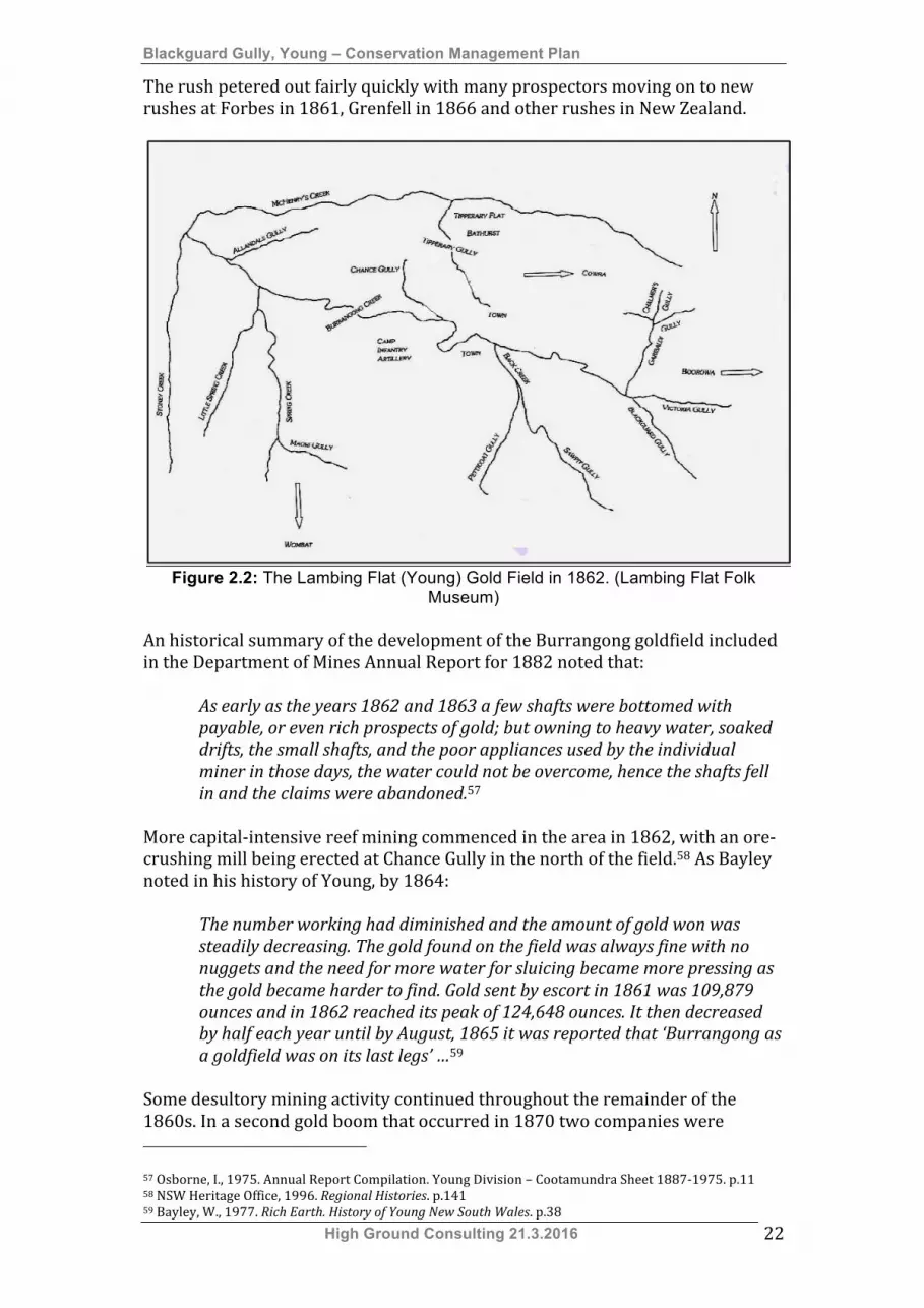
The rush petered out fairly quickly with many prospectors moving on to new rushes at Forbes in 1861, Grenfell in 1866 and other rushes in New Zealand.
Figure 2.2: The Lambing Flat (Young) Gold Field in 1862. (Lambing Flat Folk Museum)
An historical summary of the development of the Burrangong goldfield included in the Department of Mines Annual Report for 1882 noted that:
As early as the years 1862 and 1863 a few shafts were bottomed with payable, or even rich prospects of gold; but owning to heavy water, soaked drifts, the small shafts, and the poor appliances used by the individual miner in those days, the water could not be overcome, hence the shafts fell in and the claims were abandoned.57
More capital-‐intensive reef mining commenced in the area in 1862, with an ore-‐crushing mill being erected at Chance Gully in the north of the field.58 As Bayley noted in his history of Young, by 1864:
The number working had diminished and the amount of gold won was steadily decreasing. The gold found on the field was always fine with no nuggets and the need for more water for sluicing became more pressing as the gold became harder to find. Gold sent by escort in 1861 was 109,879 ounces and in 1862 reached its peak of 124,648 ounces. It then decreased by half each year until by August, 1865 it was reported that ‘Burrangong as a goldfield was on its last legs’ …59
Some desultory mining activity continued throughout the remainder of the 1860s. In a second gold boom that occurred in 1870 two companies were 57 Osborne, I., 1975. Annual Report Compilation. Young Division – Cootamundra Sheet 1887-‐1975. p.11 58 NSW Heritage Office, 1996. Regional Histories. p.141 59 Bayley, W., 1977. Rich Earth. History of Young New South Wales. p.38
Blackguard Gully, Young – Conservation Management Plan
High Ground Consulting 21.3.2016 23
formed to carry out larger scale alluvial mining operations. The Belmore Gold Mining Company worked Burrangong Creek and the Telegraph Gold Mining Company worked Oppossum Flat ‘one mile below the junction of Main and Spring Creeks’. Mining activity was heavily dependent on the availability of surface water and tended to drop off during dry periods. By the mid 1870s Mining Wardens and Registrars were reporting that most mining was undertaken as a part-‐time operation, with those engaged in the activity taking up other occupations to support themselves and their families. Some Chinese miners were eking out an existence fossicking in the old alluvial fields. In 1877 J.R. Edwards, Mining Registrar for the Young Division, described local mining methods in most derogatory terms, claiming that these practices resulted in the loss of much valuable ore.
… gold is extracted in the most primitive and slovenly manner, the earth being thrown into a race or ground-sluice, and the water allowed to rush over it, the gravity of the gold being wholly trusted to prevent its being washed away. When the water is turned off or ceases to run, the residuum is collected, cradled and panned off.60
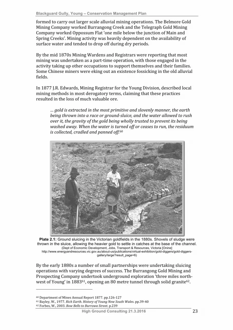
Plate 2.1: Ground sluicing in the Victorian goldfields in the 1880s. Shovels of sludge were
thrown in the sluice, allowing the heavier gold to settle in catches at the base of the channel. (Dept of Economic Development, Jobs, Transport & Resources, Victoria [Onine]
http://www.energyandresources.vic.gov.au/about-us/publications/virtual-exhibition/gold-diggers/gold-diggers-gallery/large?result_page=6)
By the early 1880s a number of small partnerships were undertaking sluicing operations with varying degrees of success. The Burrangong Gold Mining and Prospecting Company undertook underground exploration ‘three miles north-‐west of Young’ in 188361, opening an 80 metre tunnel through solid granite62. 60 Department of Mines Annual Report 1877. pp.126-‐127 61 Bayley, W., 1977. Rich Earth. History of Young New South Wales. pp.39-‐40 62 Forbes, W., 2003. Bow Bells to Burrowa Street. p.239
Blackguard Gully, Young – Conservation Management Plan
High Ground Consulting 21.3.2016 24
Around 1885 investors from the Victorian goldfields with experience in working alluvial fields injected new energy into mining operations. The North Burrangong Company and South Burrangong Company were formed and failed in the same decade. The Burrangong Steam Sluicing Company was formed in 1887 to carry out sluicing operations in Burrangong Creek and some sluicing was undertaken at Victoria Hill (refer to Section 2.1.8.1 Mining in Blackguard Gully). The ‘Day Dawn Gold Mining Company was active in 1892’.63 As in other parts of New South Wales the economic depression of the 1890s led to a resumption of small scale gold mining activity. The colonial government encouraged unemployed men to prospect for gold and many left Sydney to seek a meagre living on the colony’s otherwise abandoned gold fields. In 1895 men were prospecting on Spring Creek and by mid May of that year 300 miners were working on Tout’s Rush at Irish Jack’s Creek. This increase in activity encouraged investment in larger ventures and the South Burrangong Gold Mine was re-‐opened in 1895.64 This operation closed in 189665. In 1896 a partnership of local business people, including George Cranfield, formed the Garibaldi Gold Mining Company. This company acquired a lease at Stoney Creek ‘six miles (nearly 10km) south-‐west of Young’66. It had failed by 189767. By the end of the 1890s two companies were formed to undertake gold dredging in Burrangong Creek. These were the Travers Jones Gold Dredging and Sluicing Company and the Burrangong Gold Dredging and Sluicing Company.68 The latter company floated a large steam dredge, ‘The Burrangong’, on a purpose-‐built dredge pond constructed on a tributary of the creek 3.2 kilometres west of Young69. Steam dredges were introduced in the late 19th century to process large volumes of low yielding alluvial wash. They raised the wash from the floor of the pond ‘by continuous buckets or suction pipe’, and passed it through screens, jigs and sluice boxes to recover gold70. After some early success this venture failed in 1903. Another venture tried to revive dredging in 1906 but this also failed.71 There were some unsuccessful attempts to revive gold mining during the Great Depression of the 1930s under New South Wales Government unemployment relief programmes72. 2.1.8.1 Mining in Blackguard Gully During the 1860 gold rush one gully on the eastern side of Victoria Hill near the eastern end of the goldfield became the haunt of “shanty-‐keepers and bad characters”. For this reason it became known as Blackguard Gully.73 According to Ross Maroney many travellers had been held-‐up in the area74. It is logical that this area would attract those intent on seeking advantage from new arrivals as it
63 Bayley, W., 1977. Rich Earth. History of Young New South Wales. p.40 64 Forbes, W., 2003. Bow Bells to Burrowa Street. p.239 65 Forbes, W., 2003. Bow Bells to Burrowa Street. p.247 66 Forbes, W., 2003. Bow Bells to Burrowa Street. p.245 67 Forbes, W., 2003. Bow Bells to Burrowa Street. p.246 68 Forbes, W., 2003. Bow Bells to Burrowa Street. p.267-‐268 69 Forbes, W., 2003. Bow Bells to Burrowa Street. p.288 70 Pearson, M & McGowan, B., 2000. Mining Heritage Places Assessment Manual, p.93 71 Bayley, W., 1977. Rich Earth. History of Young New South Wales. p.40 72 Bayley, W., 1977. Rich Earth. History of Young New South Wales. p.40 73 “101 Not Out”, The Grenfell Record and Lachlan District Advertiser. 8 February 1918 74 Maroney, R., Undated. A Short History of the Lambing Flat Gold Rush 1860-1861. p.7
Blackguard Gully, Young – Conservation Management Plan
High Ground Consulting 21.3.2016 25
was the first part of the Lambing Flat Gold Field reached by those travelling from Boorowa. During the first rushes of 1860-‐1861 hopeful miners were drawn from goldfields south and east of Lambing Flat and entered the area through Boorowa and Murringo.
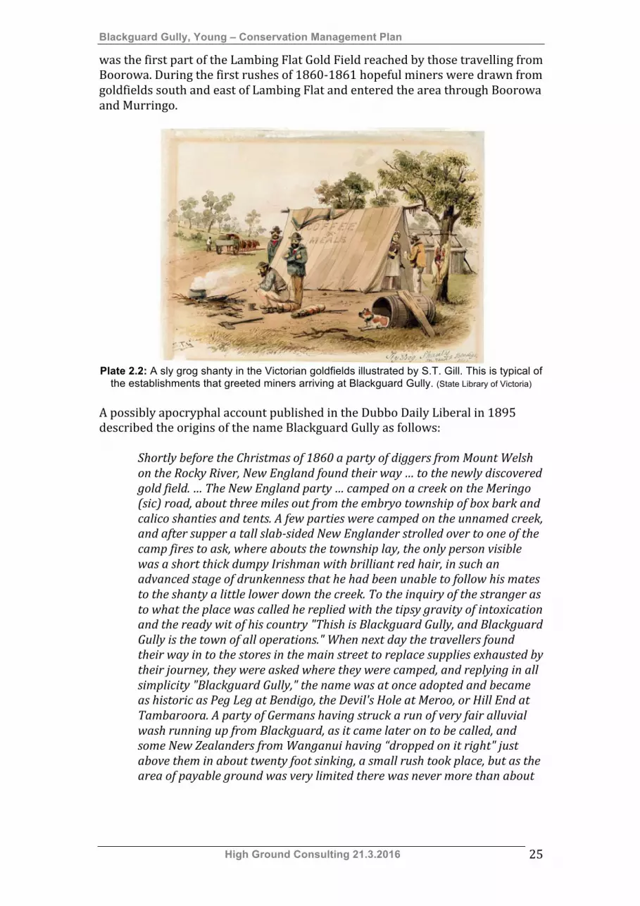
Plate 2.2: A sly grog shanty in the Victorian goldfields illustrated by S.T. Gill. This is typical of
the establishments that greeted miners arriving at Blackguard Gully. (State Library of Victoria) A possibly apocryphal account published in the Dubbo Daily Liberal in 1895 described the origins of the name Blackguard Gully as follows:
Shortly before the Christmas of 1860 a party of diggers from Mount Welsh on the Rocky River, New England found their way … to the newly discovered gold field. … The New England party … camped on a creek on the Meringo (sic) road, about three miles out from the embryo township of box bark and calico shanties and tents. A few parties were camped on the unnamed creek, and after supper a tall slab-sided New Englander strolled over to one of the camp fires to ask, where abouts the township lay, the only person visible was a short thick dumpy Irishman with brilliant red hair, in such an advanced stage of drunkenness that he had been unable to follow his mates to the shanty a little lower down the creek. To the inquiry of the stranger as to what the place was called he replied with the tipsy gravity of intoxication and the ready wit of his country "Thish is Blackguard Gully, and Blackguard Gully is the town of all operations." When next day the travellers found their way in to the stores in the main street to replace supplies exhausted by their journey, they were asked where they were camped, and replying in all simplicity "Blackguard Gully," the name was at once adopted and became as historic as Peg Leg at Bendigo, the Devil's Hole at Meroo, or Hill End at Tambaroora. A party of Germans having struck a run of very fair alluvial wash running up from Blackguard, as it came later on to be called, and some New Zealanders from Wanganui having “dropped on it right" just above them in about twenty foot sinking, a small rush took place, but as the area of payable ground was very limited there was never more than about
Blackguard Gully, Young – Conservation Management Plan
High Ground Consulting 21.3.2016 26
twenty claims.75 In his account of the gold rush Ross Maroney recorded that Commissioner Dixon had placed Chinese miners in this area ‘to keep them separate from the Europeans”. When news spread that a party of Chinese miners had obtained 80 ounces of gold “from the bottom of their shaft Europeans rushed in to stake their own claims. 76 According to contemporary accounts claims on the rich Victoria Hill section of the goldfield were heavily contested with allocated areas limited to “ten square feet per man” (approximately three square metres). “The sinking was from seven to thirteen feet (2m to 4m); these claims were worked out in three weeks; and from £300 to £400 a man netted.”77 The intense competition generated by these conditions exacerbated resentment of the Chinese miners working this part of the field. A memoir written for the Dubbo Daily Liberal in 1895 made it clear that, in Blackguard Gully, disputes over water increased the potential for violent conflict.78 Blackguard Gully was one of the localities in which systematic violence was visited on Chinese prospectors. According to Thomas White “a lot of Chinamen were murdered in Blackguard Gully”79. After the initial rioting of February 1861 (refer Section 2.1.9 Law and Order) Colonial Premier Cowper ordered that part of Blackguard Gully be allocated to Chinese miners. Much of the anti-‐Chinese violence that occurred in June 1861 was focused on Blackguard Gully and Victoria Hill. Like other parts of the goldfield Blackguard Gully was the scene of desultory mining activity throughout the 1860s. Mining Registrars’ reports of the 1870s and early 1880s make no mention of mining activity in the Blackguard Gully area, although mining was continuing on other parts of the field. It is possible that ground sluicing had commenced in the Blackguard Gully area in 1870. A report on mining on Victoria Hill published in 1887 indicated that mining claims in the gully had been “originally taken up in 1870 and worked by water races” 80. It is highly likely that that these water races belonged to Irish Immigrant Patrick Fitzgibbon. Patrick Fitzgibbon, a native of Tipperary, Ireland, arrived in Lambing Flat during the initial gold rush and continued alluvial mining for the remainder of his life. Greville’s Post Office Directory of 1872 listed Patrick as a farmer living at Victoria Hill, Young81. From around 1874 Fitzgibbon took up a number of mining tenements in Blackguard Gully “in the vicinity of Victoria Hill” and obtained freehold title to portions surrounding the leasehold area of Blackguard Gully. Fitzgibbon’s freehold land included blocks along the southern side of Victoria
75 “Lambing Flat Riots. The Real Story of Blackguard Gully”, The Dubbo Liberal and Macquarie Advocate. 27 February 1895 76 Maroney, R., Undated. A Short History of the Lambing Flat Gold Rush 1860-1861. p.7 77 “Mining News. Burrangong or Lambing Flat”, Evening News (Sydney). 19 April 1870 78 “Lambing Flat Riots. The Real Story of Blackguard Gully”, The Dubbo Liberal and Macquarie Advocate. 27 February 1895 79 “101 Not Out”, The Grenfell Record and Lachlan District Advertiser. 8 February 1918 80 “Australian Town and Country Journal 3 September 1887 81 Greville’s Post Office Directory 1872.[Online] http://archiver.rootsweb.ancestry.com/th/read/GENANZ/2003-‐01/1042107762
Blackguard Gully, Young – Conservation Management Plan
High Ground Consulting 21.3.2016 27
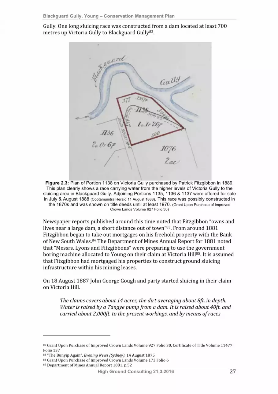
Gully. One long sluicing race was constructed from a dam located at least 700 metres up Victoria Gully to Blackguard Gully82.
Figure 2.3: Plan of Portion 1138 on Victoria Gully purchased by Patrick Fitzgibbon in 1889. This plan clearly shows a race carrying water from the higher levels of Victoria Gully to the
sluicing area in Blackguard Gully. Adjoining Portions 1135, 1136 & 1137 were offered for sale in July & August 1888 (Cootamundra Herald 11 August 1888). This race was possibly constructed in
the 1870s and was shown on title deeds until at least 1970. (Grant Upon Purchase of Improved Crown Lands Volume 927 Folio 30)
Newspaper reports published around this time noted that Fitzgibbon “owns and lives near a large dam, a short distance out of town”83. From around 1881 Fitzgibbon began to take out mortgages on his freehold property with the Bank of New South Wales.84 The Department of Mines Annual Report for 1881 noted that “Messrs. Lyons and Fitzgibbons” were preparing to use the government boring machine allocated to Young on their claim at Victoria Hill85. It is assumed that Fitzgibbon had mortgaged his properties to construct ground sluicing infrastructure within his mining leases. On 18 August 1887 John George Gough and party started sluicing in their claim on Victoria Hill.
The claims covers about 14 acres, the dirt averaging about 8ft. in depth. Water is raised by a Tangye pump from a dam. It is raised about 40ft. and carried about 2,000ft. to the present workings, and by means of races
82 Grant Upon Purchase of Improved Crown Lands Volume 927 Folio 30, Certificate of Title Volume 11477 Folio 137 83 “The Bunyip Again”, Evening News (Sydney). 14 August 1875 84 Grant Upon Purchase of Improved Crown Lands Volume 173 Folio 6 85 Department of Mines Annual Report 1881. p.52
Blackguard Gully, Young – Conservation Management Plan
High Ground Consulting 21.3.2016 28
brought back again to the dam, where it is filtered previous to being used again. Dirt taken from any portion of the claim gives excellent prospects.86
John George Gough had come to the Lambing Flat gold diggings with his widowed father in 1860. Only 13 when his father died in 1861 Gough started prospecting for gold on his own and worked on various fields around the region. During the 1870s he began working as a builder and began contracting in his own right. He was responsible for the construction of some of Young’s grand buildings, including the Court House and Railway Station. Gough was elected to the NSW Legislative Assembly in 1889 and served as MLA for Young until 1894.87 From around 1889 until 1897 he was Managing Director of the South Burrangong Gold Mining Company, which was working deep leads in another part of the goldfield. Department of Mines reports from 1887 indicate that:
On Victoria Hill, Messrs Gough & Company have placed a steam engine on their claim, of 18 acres, for pumping water from a level lower than their workings. The water is conveyed through 1,500 feet of box-race, and the same length of 4-inch piping. Only one pick employed, yet during the past five weeks’ labour 45 oz. of pure gold have been obtained.88
The Gough & Company operation was also referred to as the Burrangong Steam Sluicing Company. Reports on the company’s activities indicate that it was employing hydraulic sluicing methods, using a six-‐inch water jet89. In 1888 the Victoria Hill Sluicing Gold-‐Mining Company, Young, Limited was floated with a capital of £20,000 by John Gough and others to “develop an area of twenty acres now being profitably operated upon with limited sluicing machinery”. This area was described as “a low ridge between Sawpit and Blackguard Gullies, two of the main tributaries of Burrangong Creek”. The Directors listed in the prospectus included:
• Managing Director John George Gough, contractor, Young, • Provisional Directors
o John Ahearn, railway contractor, Sydney, o James Angus, railway contractor, Sydney, o Edward Taylor J.P., grazier, Young, o George Fishburn, railway contractor, Sydney, o John Forsyth J.P., merchant, Young.
The company’s Legal Manager and Broker was A. Armstrong of 70 Pitt Street, Sydney.90 Like Gough, Edward Taylor had worked on the Lambing Flat Gold 86 Sydney Morning Herald 19 August 1887 https://www.parliament.nsw.gov.au/prod/parlment/members.nsf/1fb6ebed995667c2ca256ea100825164/b3ed18d239331c5bca256e30007ff862?OpenDocument 87 “Mr J.G. Gough. M.L.A. for Young”, Australian Town & Country Journal 2 March 1889; Mr John George Gough (1848-‐1907) [Online] https://www.parliament.nsw.gov.au/prod/parlment/members.nsf/1fb6ebed995667c2ca256ea100825164/b3ed18d239331c5bca256e30007ff862?OpenDocument 88 Department of Mines Annual Report 1887. p.65 89 Australian Town and Country Journal 10 December 1887 90 Sydney Morning Herald 22 March 1888
Blackguard Gully, Young – Conservation Management Plan
High Ground Consulting 21.3.2016 29
diggings during the first gold rush. Taylor, a tough and independent man, was prospecting on Burrangong Creek in 1861 when anti-‐Chinese rioting began. Despite attempts at coercion by fellow diggers he refused to take any action against Chinese miners. After the riots Edward moved to McHenry’s Creek where he “started dairying and butchering”. By the 1880s he was farming land on McHenry’s Creek north of Young, was actively involved in civic affairs and had been a member of the Young Railway Committee.91 The Victoria Hill Sluicing Gold-‐Mining Company’s prospectus was accompanied by a report prepared by Robert Matteson Vaughn M.P., who “had many years’ experience in California and in the principal alluvial fields of the colony”. Vaughn described the proposed mining area as follows:
The claim is situated about three-quarters of a mile easterly from the town, upon a low ridge between Sawpit and Blackguard Gullies, two of the main branches of Burrangong Creek, which was worked for alluvial gold many years ago, and was then known as the Lambing Flat Goldfield, being one of the richest alluvial deposits ever worked in New South Wales. The property consists of 20 acres of granitic alluvial deposit, varying from 4ft. to 20ft. in depth, or an average of 12ft. over the whole area, resting upon a soft granite bed-rock, which, I may state, is peculiarly favourable for retaining gold, and calculated to facilitate ground-sluicing operations. Prospects were taken in my presence by panning from the surface to the bedrock, and good sluicing prospects obtained from all of them, and, from my experience in mining of this description, I have no doubt that when a sufficient stream of water is brought upon the ground to work it in an efficient manner, the result will justify the high opinion the public und yourselves have formed of the value of your property. About three acres of this ground has been superficially worked in the early days of the goldfield by sinking and driving. The whole of this will pay well for sluicing, as only the richest wash dirt was then taken out, leaving the pillars and headings in the ground. In confirmation of this, I may state that I saw a dwt. of gold washed out of one dish of washdirt taken from a piece of unworked ground in this part of the claim. ... The present working plant consists of a 22h.p. Cornish boiler and steam pump, with cylinder 12in. diameter and 24in. stroke, with 1500ft. of 4in. wrought iron gas piping laid from pump to the claim, all new and in good working order. The tail-race is about 1400ft. in length, cut to a depth of an average of 14ft., and boxed in with sawn timber; by extending this as the workings progress the whole of the ground can be worked through this race. There are six reservoirs now constructed, and water rights secured to each. I would recommend the construction of two others, one in Petticoat Gully and another in Sawpit Gully; if this were done and two of the existing ones raised upon there would be a sufficient supply of water conserved for a
91 “Mr Edward Taylor J.P. of Young (A character sketch by ‘Indaba’)”, Australian Town & Country Journal 19 July 1905

Blackguard Gully, Young – Conservation Management Plan
High Ground Consulting 21.3.2016 30
bigger plant for the whole of the year; in any case there is an abundant supply of underground water at the pumping station, which can be made available by sinking a sump or well-hole ; and by building a retaining dam across the creek below the pump the used water may be allowed "to settle, and then be returned to the pumping dam for re-use”. Water, during the winter months, might be supplied by gravitation by cutting a water-race about one and a half miles in length, with 500ft. of galvanised iron fluming, and 60ft. of 18in. cast-iron pipes. This can be done at a cost of about £150. The facilities for clearance of tailings are complete from the natural position of the claim; and the creek bed lying considerably lower than the claim, affords ample outlet for the clearance, even if required within half the time estimated to sluice the whole area. I would, however, recommend that a pump, large enough to supply three sluice-heads of water, be substituted for the present one, and an additional steam boiler, if necessary, with 9in. delivery pipe. If this were done, I have no doubt your property will give a handsome return for the outlay.
The infrastructure described by Vaughn appears to be the same as the infrastructure described on Messrs. Gough & Company’s lease in the 1887 Department of Mines Annual Report. These workings were most likely to have been located just west of Patrick Fitzgibbon’s claims on Blackguard Gully. According to the report provided for 1888 by Mining Warden S. Robinson “the Victoria Hill Sluicing Company, known as Gough’s claim, for one man working fifty days has given 60oz. of gold”. Operations were suspended in late 1888 “owing to the drought”92 and there is no mention of the Victoria Hill Sluicing Company in the Mines Department Annual Report for 1889. It appears that Patrick Fitzgibbon, owner of substantial freehold title around Blackguard Gully, took up the leases vacated by the Victoria Hill Sluicing Company from around 1891. In February 1895 he was appointed as a Trustee of the Young Commons93 (now the Young Showground). Patrick shot himself in April 1895 and, with a coroner’s finding of suicide, the Roman Catholic Church refused him burial in consecrated ground94. Fr. Jerome Kennedy of Albury, Roman Catholic Clergyman and John English, grazier of Young had been appointed executors of his will95, and took control of his freehold land. Following the discharge of a mortgage the property was transferred to Fitzgibbon’s son-‐in-‐law William Thomas O’Connell.96 Patrick Fitzgibbon’s leases were also taken up by William Thomas O’Connell around the same time. O’Connell, a native of County Clare, Ireland had come to New South Wales after having lived for some years in Cape Colony. He arrived in Lambing Flat “shortly after gold was discovered” and “worked several claims,
92 Department of Mines Annual Report 1888. pp.78, 79 93 NSW Government Gazette 15 February 1895-‐1004 94 The Evening News (Sydney) 26 April 1895 95 NSW Government Gazette No. 359 8 May 1896-‐2 96 Grant Upon Purchase of Improved Crown Lands Volume 173 Folio 6

Blackguard Gully, Young – Conservation Management Plan
High Ground Consulting 21.3.2016 31
principally at Tipperary Gully and Victoria Hill – where he afterwards acquired a fair sized area of land and made his home”. He married Patrick Fitzgibbon’s daughter Margaret and the couple raised 10 children.97 In 1897 William O’Connell acquired Conditional Purchases of five blocks located in Victoria Gully east of the Fitzgibbon holdings in Blackguard Gully98. William O’Connell died on 28 September 1917 and the property subsequently was worked by his widow Margaret and son Maurice. Margaret and Maurice were granted title to William’s freehold property in July 191999. According to evidence given to a court hearing in 1922:
One of the claims is a water race about 300 yards long from the dam in Blackguard Gully to Garribaldi (sic) Gully Creek; another a tail race about the same length and the third a sluicing claim of about 2 acres.
There was also a sluice dam on Victoria Hill. A shortage of water had made it almost impossible for Margaret and Maurice O’Connell to work the claims. They had also experienced great difficulty in maintaining dams and races. At various times sluice boxes and pumps were vandalised, and races blocked by carriers making roadways to cart sand from the creek. In 1921 miners named Murphy had cleaned out their dam further up the creek and spoil from this operation had blocked Patrick Fitzgibbon’s old races, making it impossible to work his former claims. Following an application made by Margaret’s son James O’Connell the leases were declared forfeit on 30 November 1922.100 On 4 March 1924 Patrick Fitzgibbon’s former leases in Blackguard Gully were declared as a Reserve for Public Recreation. Despite this Margaret O’Connell obtained occupancy of a large section of the gully area under Special Licence SpL 24.34. This was gazetted on 30 January 1925. Margaret O’Connell’s lease covered the existing Lot 2524 DP 46320, and parts of Lots 1 and 2 DP 632471. It contained four dams and associated infrastructure. Margaret died at her home on Victoria Hill in December 1942, having been directly associated with the Burrangong Goldfields since 1860101. In 1923 Young Municipal Council discussed the possibility of constructing a dam in Blackguard Gully to develop public baths. This plan was quickly abandoned as the Council did not have the resources to undertake such a project.102 In 1955 the southern section of the area previously held by Margaret O’Connell under Special Lease SpL 24.34 was leased to B.M. and E.J. Morris under SpL 55.80103. The area was identified in some reports as a water reserve and on 24 February 1956 the creek line of Blackguard Gully, including Fitzgibbons’ dams, was dedicated as a Reserve for Future Public Requirements.104
97 “A Pioneer’s Death – Mr. W. T. O’Connell”, Young Witness 28 September 1917 98 New South Wales Government Gazette 22 November 1897. p.8524 99 Grant Upon Purchase of Improved Crown Lands Volume 173 Folio 6 100 “Old Mining Claims – Dispute in Warden’s Court”, Young Witness 2 December 1922 101 “Link With Bushranging Days”, West Wyalong Advocate 24 December 1942 102 “Blackguard Gully – Site for Public Baths”, Young Witness 4 October 1923 103 Parish of Young County of Monteagle 1958 104 Young and Environs – Parish Map 1933
Blackguard Gully, Young – Conservation Management Plan
High Ground Consulting 21.3.2016 32
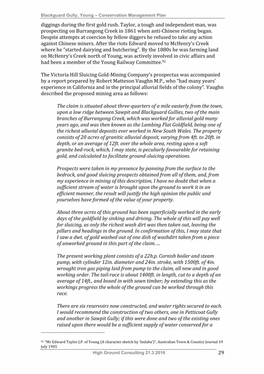
Figure 2.4: Aerial view of Blackguard Gully showing the lots covered by Special Lease 24.34 allocated to Margaret O’Connell in January 1925. Lot 2524 DP46320 is within the boundary
of the Blackguard Gully listing. At least four sluicing dams were located within the lease area. (Source SixMaps)
2.1.9 Law and Order A number of events and historical associations have given prominence to Young in the story of Australia. The Lambing Flat anti-‐Chinese riots are perhaps the most notorious of these. Contemporary accounts of the gold rush in Young record the activities of gangs of ‘rowdies’ and sly grog sellers. An initial absence of official law enforcement on the gold fields led to the creation of a ‘Vigilance Committee’ comprised of ‘well-‐disposed persons’. The members of this
Blackguard Gully, Young – Conservation Management Plan
High Ground Consulting 21.3.2016 33
committee set about tearing down shanties and smashing kegs of illegal liquor.105 These events occurred just after the arrival of the first police contingent in the district in December 1860. This party consisted of eight mounted police and two detectives under the command of Captain Zouch. Zouch and Gold Commissioner Dickson established a government Camp on the site of the present Young High School. A police barracks and ‘a very solid lock-‐up’ were constructed on this site.106 Mark Hammond described in detail the activities of the ‘Donegallers’ who seemed to be present on a number of the New South Wales gold fields and ‘carried terror with them wherever they went’107. According to Hammond:
They moved about at night in gangs, and if they had a set on anyone they would single him out for an attack. … One night they marched down to the residence of Crisp, the banker, a man who had refused them credit. He was in bed. They broke into the place, pulled him out and left him for dead, with a broken jawbone, from which he never properly recovered.108
2.1.9.1 The Riots Much has been written and conjectured about the Lambing Flat riots. A number of eyewitness accounts exist of events associated with the riots and tension and conflict between European and Chinese miners has been documented on other alluvial goldfields. Conflict came early to Lambing Flat when miners of European origin broke up the camp of a group of Chinese prospectors in November 1860. This appears to have been an isolated violent incident and organised agitation against the Chinese did not occur until early 1861.109 Numbers of miners increased dramatically and by January 1861 European miners felt sufficiently threatened by the numbers of Chinese miners arriving to call a meeting ‘to consider whether this is an European diggings or a Mongolian territory’110. The meeting, held near Golden Point on Sunday 27 January 1861, was attended by fifteen hundred diggers. Commissioner Dickson was also present with ‘seven troopers and detectives Carns and Scarlett. The meeting was chaired by Charles Allen who stated that: “All we want is to get rid of the Chinamen as quietly as possible”. J.B. Stewart, originally a weaver from Paisley in Scotland, gave a rousing and at times provocative speech in which he advocated expulsion of the Chinese from the field. At the same time he stated: “But, gentlemen, I would strongly advise you to keep within the bounds of the law and commit no breach of the peace”.111
105 McGregor, H. & J., 1999. Roll-Up. p.20 106 McGregor, H.&K., 1999. Roll Up. p.16 107 Hammond, M., 1988. Remembered With Pride. p.76 108 Hammond, M., 1988. Remembered With Pride. p.82 109 McGregor, H. & J., 1999. Roll Up. p.38 110 McGregor, H. & J., 1999. Roll Up. p.39 111 McGregor, H. & J., 1999. Roll Up. pp.39-‐40

Blackguard Gully, Young – Conservation Management Plan
High Ground Consulting 21.3.2016 34
Regardless of this and the cautionary words of Commissioner Dixon the diggers chose to take the law into their own hands.112 Mark Hammond regretfully described the actions of diggers in February 1861:
… the miners … rushed the Chinese camp at Oppossum Flat, and there brutally ill-used them. Without a minute’s notice they had to gather together whatever they could; their tents and stores were set fire to; their windlasses pitched into the shafts; and they themselves were driven before a howling mob like a flock of sheep. What the Chinese were unable to carry away, others did, who remained behind to plunder. They were followed by the miners through the town and up Blackguard Gully, and there for miles on the road to Burrawa. The rioters only returned from the hunt when the shades of evening began to come over them.113
He also described the ill-‐treatment of sick Chinese miners and the plunder of their possessions114. Many of the Chinese hunted from the field took refuge Burrangong, Currawong and Wambanumba stations. Lambing Flat remained in an agitated state for some weeks and Captain Zouch arrived with 15 extra mounted troopers to reinforce the police already on the diggings115. The miners gathered over 3,000 signatures for a petition seeking exclusion of the Chinese from Lambing Flat. This was given to Commissioner Cloete who forwarded it to Sydney. Two days after the presentation of the petition on 12 February 1861 the colonial Parliament considered a Bill to regulate Chinese immigration.116 Later in February, at a meeting held in Tom Walsh’s store, about 80 miners formed the Miners Protective League for ‘the mutual protection of … lives and property’ and to address miners’ grievances. J.B. Stewart as elected president and Charles Allen secretary. Meetings were held at Spring Creek and Stoney Creek to recruit members and the League published a manifesto of demands in March 1861. Members of the league, including James Torpy cautioned the government against allowing the Chinese to return.117 The government decided at the same time that Chinese miners should be allowed to return to the goldfield as, under the law, they had equal rights to the Europeans to prospect for gold. Commissioner Cloete decided to allow the Chinese to return to a section of Blackguard Gully. As Chinese miners began to return to Lambing Flat hysteria began to mount within the European community. A brawl developed between Europeans and Chinese in Blackguard Gully. When police arrived they arrested ‘fourteen or fifteen alleged rioters – all Europeans’, and gathered ‘some witnesses – all Chinese’. In response to the arrests European miners gathered in mobs and paraded through the streets of Young. It was estimated that up to 6,000 men, many of them armed, were involved in sporadic hooliganism and attempts to intimidate the police.118
112 Hammond, M., 1988. Remembered With Pride. pp.71-‐72 113 Hammond, M., 1988. Remembered With Pride. p.72 114 Hammond, M., 1988. Remembered With Pride. p.72 115 McGregor, H. & J., 1999. Roll Up. p.44 116 McGregor, H. & J., 1999. Roll Up. p.45 117 McGregor, H. & J., 1999. Roll Up. pp.47-‐48 118 McGregor, H. & J., 1999. Roll Up. pp.48-‐49
Blackguard Gully, Young – Conservation Management Plan
High Ground Consulting 21.3.2016 35
In response the colonial government, fearing a breakdown in law and order, ‘decided to dispatch a body of troops to the scene. A force of 120 men of the 12th Regiment of Foot, 43 artillerymen with two 12pound howitzers and 21 mounted police left Sydney in ten chartered omnibuses on 25 February 1861. This force was commanded by Captain Atkinson.119 Premier Cowper and John Robertson also travelled to Lambing Flat to enquire into the miners’ grievances and attempt to resolve the situation120. Prior to the arrival of the military Cowper held a number of meetings with the miners and the leaders of their League and he was generally very well received. Despite his oratory they were not moved in their opposition to the presence of Chinese miners on the field. Before his departure he instructed Gold Commissioner Cloete ‘to have a furrow ploughed around the richer areas of the field’. The Chinese were prohibited from crossing this furrow. One half of Blackguard Gully was made available to the Chinese miners.121 The field generally quietened and the military were withdrawn on 23 May 1861122. The situation was generally quiet until news arrived on Lambing Flat that a large group of Chinese miners at Native Dog Creek near Canowindra had attacked some Europeans who were trespassing on their claims. On 30 June 1861 a roll up of 1,000 to 2,000 miners, incensed by a further rumour that ‘fifteen hundred Mongolians had landed in Sydney, and armed with sticks, pick handles and guns, gathered to act against the Chinese. This mob moved towards Victoria Hill and Back Creek, destroying Chinese property in its path and severely beating many of the Chinese miners in the area.123 Initially the police did little to quell the violence but, following orders to arrest ‘everyone of the ringleaders … who could be apprehended’, arrested three men on Sunday 14 July. Late in the day a mob gathered in Tipperary Gully and the members of a brass band rounded up to lead up to 1,000 incensed miners towards the police camp on the southern side of Burrangong Creek.124 The miners, variously armed with ‘shot guns, horse pistols, revolvers, rifles, long knives’ and sticks125, carried before them the famous ‘Roll Up’ banner. The large mob reached the police camp in rain and gathering darkness and their leaders asked for the release of the three prisoners. After Captain Zouch refused the miners’ demand they rushed the police camp where Commissioner Griffen and police troopers had formed a protective line in front of the police lockup. According to some reports Griffen read the Riot Act as the crowd approached. The police fired above the advancing mob and in consequence two men were killed.126 These were ‘William Lupton, a miner and a Punch and Judy showman’ who was struck by a stray bullet127.
119 McGregor, H. & J., 1999. Roll Up. pp.52-‐53 120 McGregor, H. & J., 1999. Roll Up. p.54 121 McGregor, H. & J., 1999. Roll Up. p.64 122 McGregor, H. & J., 1999. Roll Up. p.66 123 McGregor, H. & J., 1999. Roll Up. pp.67-‐68 124 McGregor, H. & J., 1999. Roll Up. pp.76-‐78 125 Hammond, M., 1988. Remembered With Pride. p.78 126 McGregor, H. & J., 1999. Roll Up. p.78 127 Hammond, M., 1988. Remembered With Pride. p.79

Blackguard Gully, Young – Conservation Management Plan
High Ground Consulting 21.3.2016 36
Most of the crowd dispersed while some miners stayed behind logs and trees on the slopes of the hill and traded desultory fire with the police. This exchange went on for about two hours in very dark and wet conditions before the rioters finally withdrew. Three police and some miners were wounded in the exchanges.128 With only 50 officers and a number of special constables, and in the face of ongoing threats, Zouch felt vulnerable in his position. After sending a gold escort to Sydney he withdrew most of the police to Yass to await further orders. In the absence of the police miners’ leader William Spicer encouraged the maintenance of law and order, threatening to punish looting by death. A miners’ militia of up to 400 men was formed and a Vigilance Committee established to police the town.129 The government, fearing further unrest, dispatched as many police and military personnel from Sydney as it could muster. This contingent consisted of 112 men of the 12th Regiment of Foot under the command of Captain Wilkie, 60 sailors, marines and a field piece from HMS Fawn and additional foot police. They arrived on 31 July and order was restored to the gold field.130
2.2 Ability to Demonstrate This section seeks to identify the elements of Blackguard Gully that can be directly related to identified historical themes. Identifying the relationship of elements of the site to these themes assists in determining the way in which they contribute to the cultural heritage significance of the place. and assists with decision-‐making regarding management. A more complete understanding of the historic themes can be obtained by referring to Section 2.1 Thematic History. A number of features have no direct association with the historic themes.
Representative of Historical Theme Property Element Aboriginal cultures &
interactions with other cultures
Ethnic Influences/ Migration
Environment: Cultural
Landscape/ Mining
Law and
Order
Victoria Gully & Blackguard Gully watercourse Blackguard Gully sign Gold Trails interpretive signage Pondage (former sludge dam) X Concrete pedestrian bridge Victoria Gully watercourse X Remnant interpretive numbers Concrete ramp Access roadway Sluicing dams (Lot 4524 DP 46320) Sluicing Dam No.1 – earthen wall X Sluicing Dam No.1 - basin X Sluicing Dam No.2 – earthen wall X
128 McGregor, H. & J., 1999. Roll Up. pp.79-‐80 129 McGregor, H. & J., 1999. Roll Up. pp.80-‐86 130 McGregor, H. & J., 1999. Roll Up. pp.91-‐96
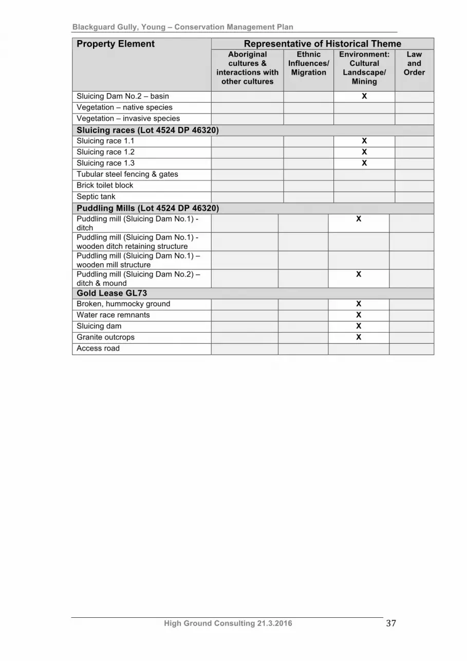
Blackguard Gully, Young – Conservation Management Plan
High Ground Consulting 21.3.2016 37
Representative of Historical Theme Property Element Aboriginal cultures &
interactions with other cultures
Ethnic Influences/ Migration
Environment: Cultural
Landscape/ Mining
Law and
Order
Sluicing Dam No.2 – basin X Vegetation – native species Vegetation – invasive species Sluicing races (Lot 4524 DP 46320) Sluicing race 1.1 X Sluicing race 1.2 X Sluicing race 1.3 X Tubular steel fencing & gates Brick toilet block Septic tank Puddling Mills (Lot 4524 DP 46320) Puddling mill (Sluicing Dam No.1) - ditch
X
Puddling mill (Sluicing Dam No.1) - wooden ditch retaining structure
Puddling mill (Sluicing Dam No.1) – wooden mill structure
Puddling mill (Sluicing Dam No.2) – ditch & mound
X
Gold Lease GL73 Broken, hummocky ground X Water race remnants X Sluicing dam X Granite outcrops X Access road
Blackguard Gully, Young – Conservation Management Plan
High Ground Consulting 21.3.2016 38
3. Physical Evidence
3.1 Introduction Blackguard Gully is located on the southern side of Victoria Gully and east of Sawpit Gully. The area included in the SHR contains the remains of an extensive ground sluicing operation, including the following features:
• Victoria Gully and Blackguard Gully watercourses and dam, • Mullocky or hummocky ground located on Lot 2524 DP 46320 and
Lot 304 DP 754611, • Sluicing channels located on Lot 2524 DP 46320 and Lot 304 DP
754611, • Two sluicing dams located on Lot 2524 DP 46320,
The archaeological features present within the SHR precinct were part of a far more extensive system of dams and races that extended at least 500 metres up Blackguard Gully and about 550 metres up Victoria Gully. This system connected properties either owned or leased by Patrick Fitzgibbon and his son-‐in-‐law William O’Connell, and may have been developed from the early 1870s. A separate water race appears to have traversed the western section of Lot 304 DP 754611, which was formerly Gold Lease GL73. The SHR precinct also contains the remains of two pug mills, one of which was reconstructed to demonstrate one aspect of early alluvial mining techniques. The reconstructed pug mill is located on Lot 2524 DP 46320. The elements of the site are described in the following sections. The condition of each element is defined in accordance with the following table.
Condition Definition Sound Complete, stable and structurally intact. The element appears to
be in a condition to sustain its current function for some time to come.
Fair condition for age
Displays a level of deterioration commensurate with the time it has been in use. Although not pristine it maintains a reasonable level of structural integrity.
Poor condition Heavily weathered or deteriorated. This may mean element is close to failing or has become detached from other elements.
3.2 Victoria Gully & Blackguard Gully watercourse
The main entry to the SHR area is from Whiteman Avenue and signage for the Blackguard Gully site is located the roadside. An extended area of rough road shoulder is available for parking. A concrete pedestrian bridge carries visitors across the pondage sitting at the confluence of Victoria and Blackguard Gullies. This pondage may have been a sludge dam associated with sluicing operations on Victoria Hill and Blackguard Gully. It is possibly the location considered for development of a public baths in 1923. An access roadway runs along the western side of the SHR area. This roadway is used by Council vehicles drawing

Blackguard Gully, Young – Conservation Management Plan
High Ground Consulting 21.3.2016 39
water from the pondage. This roadway also runs through the site to Victoria Lane.
Plate 3.1: View south from Whiteman Avenue towards the reserve. November
2015)
Plate 3.2: View southwest along the western side of the reserve. (November
2015)
Plate 3.3: Concrete bridge linking Whiteman Avenue to the reserve. (November 2015)
Plate 3.4: Pondage at the confluence of Blackguard & Victoria Gullies looking west from
below Sluicing Dam No.2. This may have been a sludge dam associated with the Fitzgibbon & O’Connell sluicing operations. Whiteman Avenue is on the right. (October 2013)
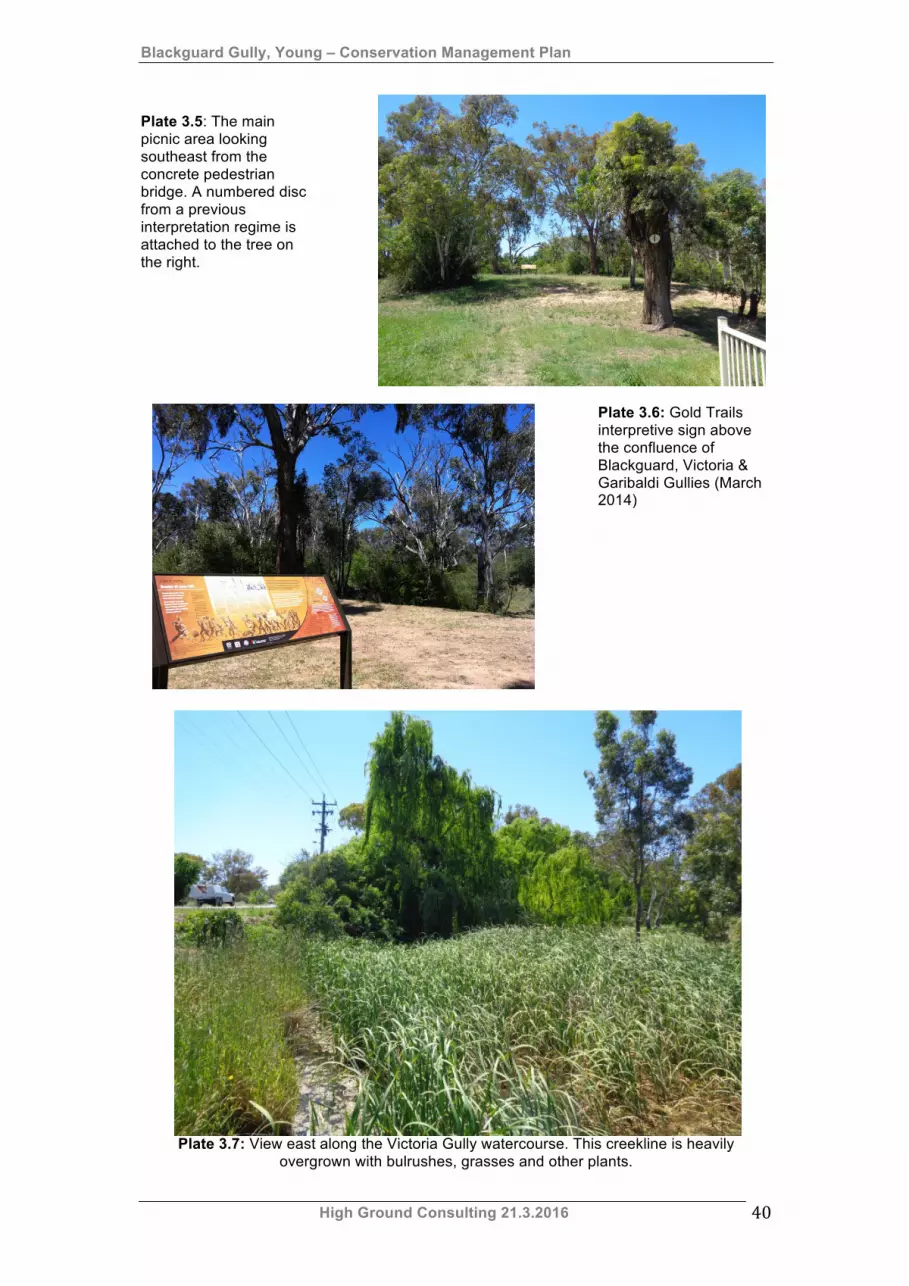
Blackguard Gully, Young – Conservation Management Plan
High Ground Consulting 21.3.2016 40
Plate 3.5: The main picnic area looking southeast from the concrete pedestrian bridge. A numbered disc from a previous interpretation regime is attached to the tree on the right.
Plate 3.6: Gold Trails interpretive sign above the confluence of Blackguard, Victoria & Garibaldi Gullies (March 2014)
Plate 3.7: View east along the Victoria Gully watercourse. This creekline is heavily
overgrown with bulrushes, grasses and other plants.
Blackguard Gully, Young – Conservation Management Plan
High Ground Consulting 21.3.2016 41
Feature Condition Blackguard Gully sign This sign is in fair condition for its age. Gold Trails interpretive signage This sign is sound. Pondage (former sludge dam) This pondage holds water and appears to be
generally sound. Concrete pedestrian bridge The bridge appears to be complete. Its
structural integrity should be assessed regularly by a qualified civil engineer.
Victoria Gully watercourse This watercourse is choked with grasses & reeds.
Remnant interpretive numbers These markers are in fair condition for their age.
Concrete ramp This ramp is used by Council trucks drawing water from Blackguard Gully. It appears to be sound.
Access roadway An unsealed roadway provides vehicular access to the concrete ramp and to Victoria Street. It is eroded but in fair condition.
3.3 Main sluicing dams & associated races (Lot 4524 DP 46320)
The eastern side of the SHR listed precinct covers Lot 4524 DP 46320. This block contains the remains of sluicing infrastructure, including two sluicing dams and at least three sluicing races that were noted by Margaret O’Connell when describing her leases in 1922. The channels would have directed water for ground sluicing. Ritchie and Hooker have described ground sluicing as follows:
… a basic method of alluvial mining whereby auriferous (gold bearing) terrace margins were broken down by directing low pressure water over them (free running water diverted from a headrace) to assist their breaking up with bar and pick. The dislodged material was then sluiced, ie directed through channels to sluice-boxes in which the gold was trapped in riffles.
Riffles were “bars or cleats on the bottom of a … sluice-‐box or tail-‐race for catching alluvial gold”.131 The sluicing infrastructure in Blackguard Gully is directed towards the pondage located at the convergence of the creek lines forming Blackguard, Victoria and Garibaldi Gullies (refer to Section 3.2). In 1922 Margaret O’Connell described her lease in the following terms:
One of the claims is a water race about 300 yards long from the dam in Blackguard Gully to Garribaldi (sic) Gully Creek; another a tail race about the same length and the third a sluicing claim of about 2 acres.132
131 Ritchie, N. & Hooker, R., 1997. “An Archaeologist’s Guide to Mining Terminology”. (pp.6,8) 132 “Old Mining Claims – Dispute in Warden’s Court”, Young Witness 2 December 1922

Blackguard Gully, Young – Conservation Management Plan
High Ground Consulting 21.3.2016 42
The 2 acre sluicing claim referred to appears to be Gold Lease GL73, which lay over the western side of the SHR listed precinct. Two sluicing dams are clearly shown on the 1933 Parish Map of Young. Historical records confirm that sluicing activities were undertaken in Blackguard Gully from about 1870 until the 1930s. Gold Lease GL73 is described in Section 3.4.
Figure 3.1: Aerial view showing the possible layout of sluicing infrastructure described in
1922 and 1933. (SixMaps) The eastern section of the SHR area is heavily infested with weeds and there is some native plant regrowth occurring. Invasive species noted within this area include:
• Fire Thorn –pyrocantha, • Hawthorn – cretageous, • Privet, • Cotoneaster, • Briar rose
• Box, • Elms, • Prunus, • celtis australis.
The area also hosts Sifton Bush. This native plant a considered an invasive weed on pastureland but is an excellent species for regeneration of bushland. Other native species include:
• Various varieties of eucalypts, • hakea.
It appears that the heavy vegetation growth has inhibited erosion, particularly along the two most easterly sluicing races.
3.3.1 Sluicing dams Two sluicing dams are located within the eastern section of the SHR area. These have been identified as follows:
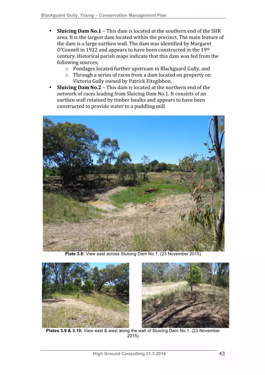
Blackguard Gully, Young – Conservation Management Plan
High Ground Consulting 21.3.2016 43
• Sluicing Dam No.1 – This dam is located at the southern end of the SHR
area. It is the largest dam located within the precinct. The main feature of the dam is a large earthen wall. The dam was identified by Margaret O’Connell in 1922 and appears to have been constructed in the 19th century. Historical parish maps indicate that this dam was fed from the following sources;
o Pondages located further upstream in Blackguard Gully, and o Through a series of races from a dam located on property on
Victoria Gully owned by Patrick Fitzgibbon. • Sluicing Dam No.2 – This dam is located at the northern end of the
network of races leading from Sluicing Dam No.1. It consists of an earthen wall retained by timber baulks and appears to have been constructed to provide water to a puddling mill.
Plate 3.8: View east across Sluicing Dam No.1. (23 November 2015)
Plates 3.9 & 3.10: View east & west along the wall of Sluicing Dam No.1. (23 November
2015)

Blackguard Gully, Young – Conservation Management Plan
High Ground Consulting 21.3.2016 44
Plate 3.11: Sluicing Dam No.2 viewed from the north. (23 November 2015)
Plate 3.12: Timber baulks retaining the northern face of Sluicing Dam No.2. (23 November 2015)
Plates 3.13 & 3.14: Track crossing the top of Sluicing Dam No.2. (23 November 2015)
Sluicing dams (Lot 4524 DP 46320) Feature Condition Sluicing Dam No.1 – earthen wall
This wall appears to be generally sound. The western end has been breached. The centre of the wall has been worn down by dirt bikes & 4x4 vehicles.
Sluicing Dam No.1 - basin
The basin is quite clearly defined and currently holds a small volume of water. A burnt out motor vehicle has been dumped in the basin. It appears to be in fair condition.
Sluicing Dam No.2 – This appears to be generally sound.

Blackguard Gully, Young – Conservation Management Plan
High Ground Consulting 21.3.2016 45
Sluicing dams (Lot 4524 DP 46320) Feature Condition earthen wall Sluicing Dam No.2 – basin
This appears to be intact but is heavily overgrown. It appears to be in fair condition.
Vegetation – native species
These occur throughout the site. They are assisting to maintain soil stability.
Vegetation – invasive species
These occur throughout the site & are particularly prominent in hollows. They are assisting to maintain soil stability.
3.3.2 Sluicing races Three sluicing races have been identified in the eastern section of the SHR precinct. All are located within Lot 2524 DP46320. The course of these races is shown in Figure 3.1. These have been identified as follows:
• Sluicing race 1.1 – This is possibly the 300 yard race identified by Margaret O’Connell in 1922. It runs from the eastern side of Sluicing Dam No.1 and connects to both Sluicing Dam 2 and the Victoria Gully watercourse. This is the most clearly defined race and appears to have stabilised by a combination of plant infestations and its relative inaccessibility. This race is quite deep and there is evidence that over time it has operated on at least five levels. It is highly likely that this is the oldest operational race within the precinct.
• Sluicing race 1.2 – This race appears to follow the original Blackguard Gully watercourse from the western end of Sluicing Dam No.1. It leads to the pondage located at the northern end of the site. This race has been eroded and damaged by motor vehicles.
• Sluicing race 1.3 – This race follows the western side of Lot 4524 DP 46320. It leads from the western end of Sluicing Dam No.1 to the pondage located at the northern end of the site. It is the most heavily degraded of the three races on this block.
Plate 3.15: View north along Sluicing Race 1.1 from the wall of Sluicing Dam No.1.
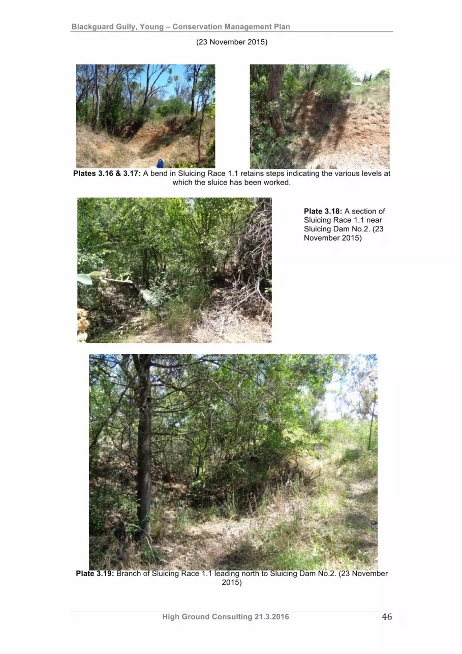
Blackguard Gully, Young – Conservation Management Plan
High Ground Consulting 21.3.2016 46
(23 November 2015)
Plates 3.16 & 3.17: A bend in Sluicing Race 1.1 retains steps indicating the various levels at
which the sluice has been worked.
Plate 3.18: A section of Sluicing Race 1.1 near Sluicing Dam No.2. (23 November 2015)
Plate 3.19: Branch of Sluicing Race 1.1 leading north to Sluicing Dam No.2. (23 November
2015)
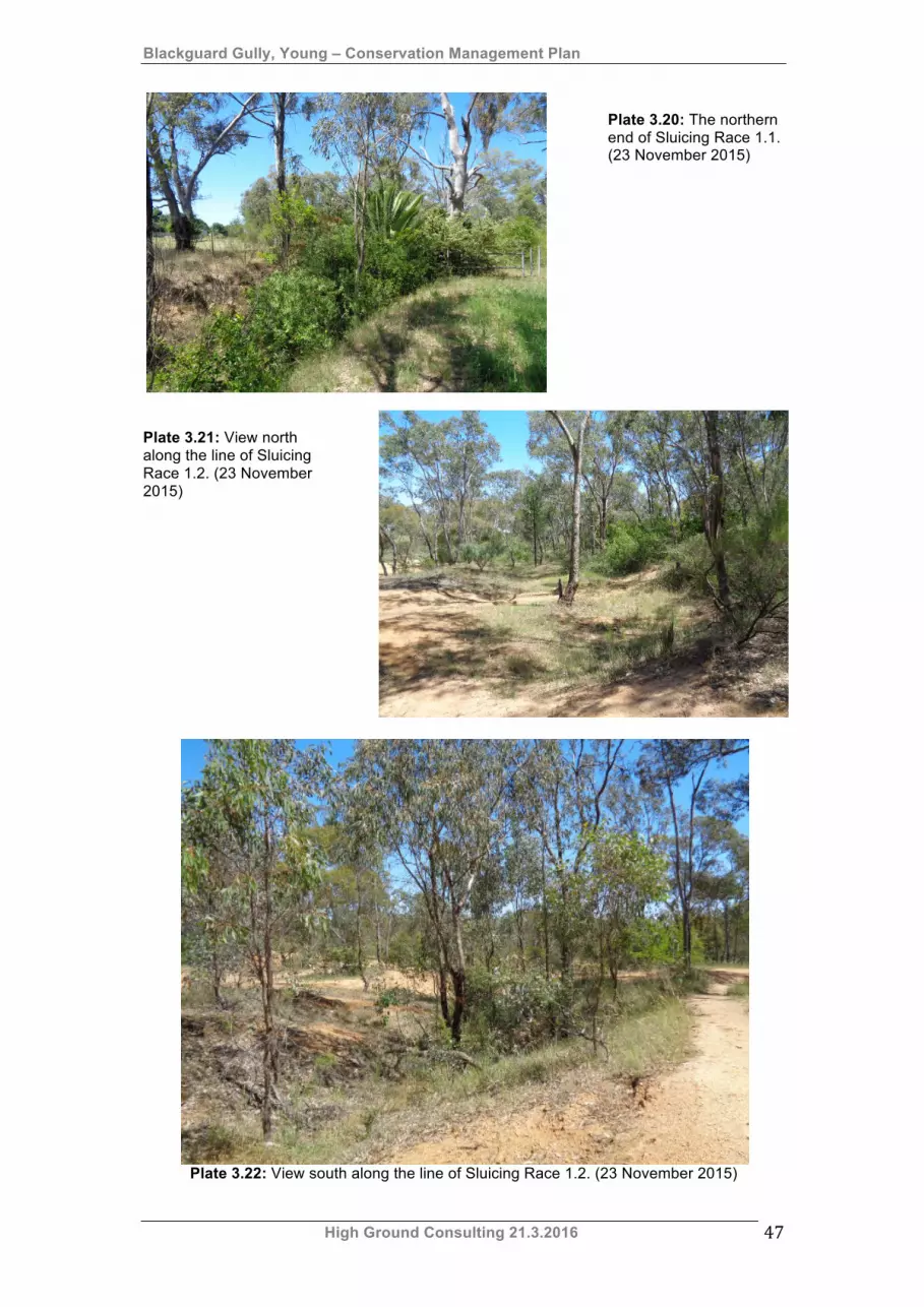
Blackguard Gully, Young – Conservation Management Plan
High Ground Consulting 21.3.2016 47
Plate 3.20: The northern end of Sluicing Race 1.1. (23 November 2015)
Plate 3.21: View north along the line of Sluicing Race 1.2. (23 November 2015)
Plate 3.22: View south along the line of Sluicing Race 1.2. (23 November 2015)
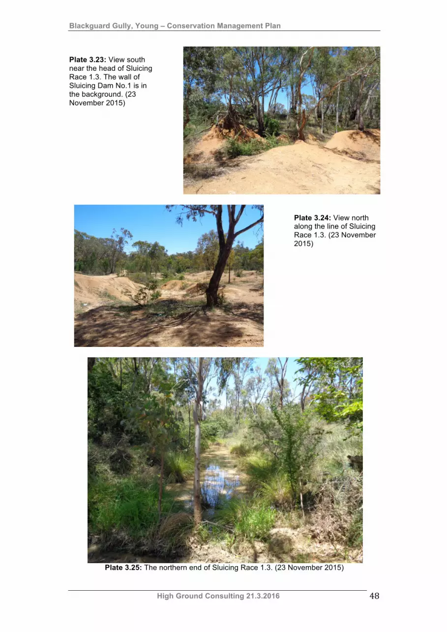
Blackguard Gully, Young – Conservation Management Plan
High Ground Consulting 21.3.2016 48
Plate 3.23: View south near the head of Sluicing Race 1.3. The wall of Sluicing Dam No.1 is in the background. (23 November 2015)
Plate 3.24: View north along the line of Sluicing Race 1.3. (23 November 2015)
Plate 3.25: The northern end of Sluicing Race 1.3. (23 November 2015)
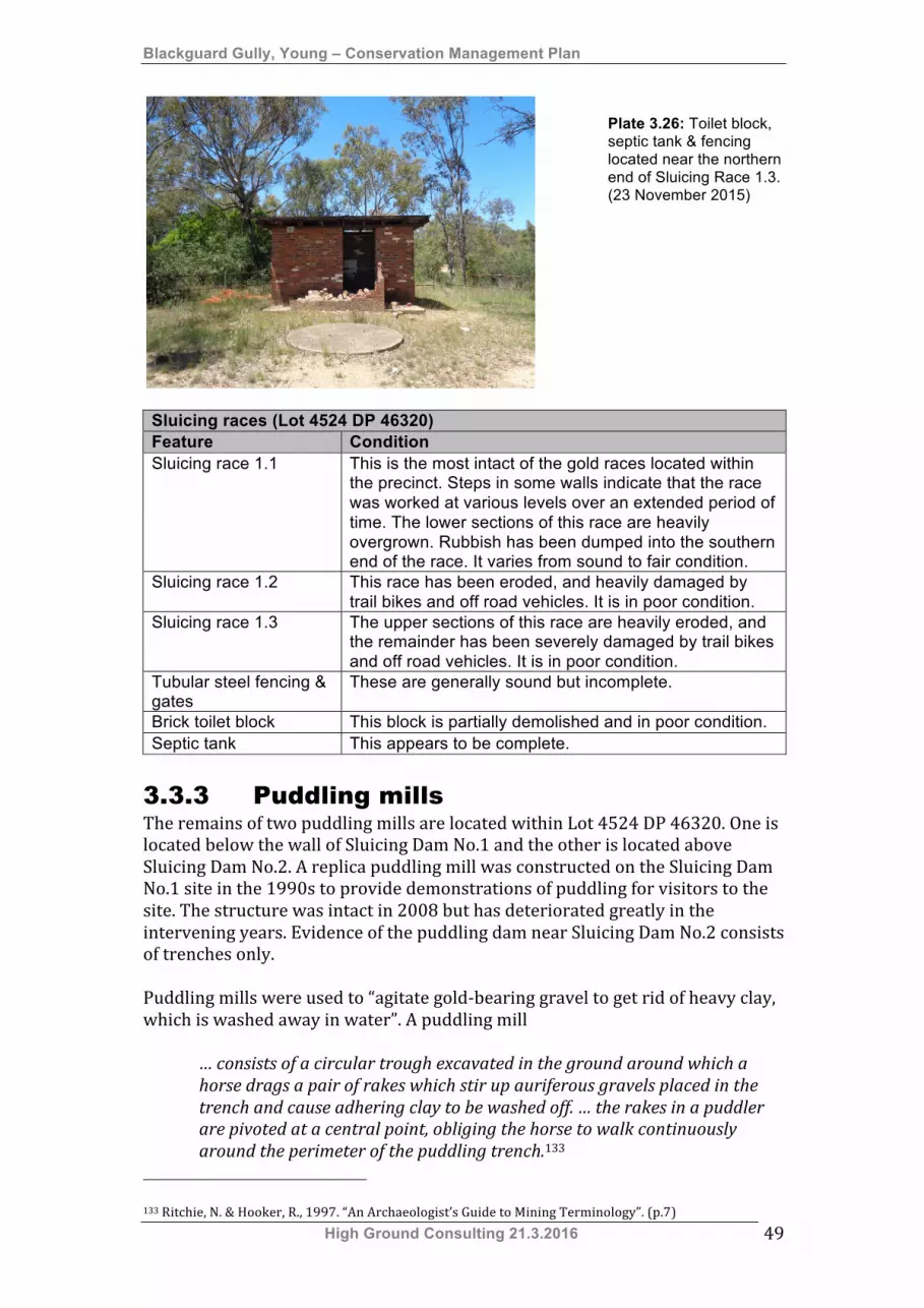
Blackguard Gully, Young – Conservation Management Plan
High Ground Consulting 21.3.2016 49
Plate 3.26: Toilet block, septic tank & fencing located near the northern end of Sluicing Race 1.3. (23 November 2015)
Sluicing races (Lot 4524 DP 46320) Feature Condition Sluicing race 1.1 This is the most intact of the gold races located within
the precinct. Steps in some walls indicate that the race was worked at various levels over an extended period of time. The lower sections of this race are heavily overgrown. Rubbish has been dumped into the southern end of the race. It varies from sound to fair condition.
Sluicing race 1.2 This race has been eroded, and heavily damaged by trail bikes and off road vehicles. It is in poor condition.
Sluicing race 1.3 The upper sections of this race are heavily eroded, and the remainder has been severely damaged by trail bikes and off road vehicles. It is in poor condition.
Tubular steel fencing & gates
These are generally sound but incomplete.
Brick toilet block This block is partially demolished and in poor condition. Septic tank This appears to be complete.
3.3.3 Puddling mills The remains of two puddling mills are located within Lot 4524 DP 46320. One is located below the wall of Sluicing Dam No.1 and the other is located above Sluicing Dam No.2. A replica puddling mill was constructed on the Sluicing Dam No.1 site in the 1990s to provide demonstrations of puddling for visitors to the site. The structure was intact in 2008 but has deteriorated greatly in the intervening years. Evidence of the puddling dam near Sluicing Dam No.2 consists of trenches only. Puddling mills were used to “agitate gold-‐bearing gravel to get rid of heavy clay, which is washed away in water”. A puddling mill
… consists of a circular trough excavated in the ground around which a horse drags a pair of rakes which stir up auriferous gravels placed in the trench and cause adhering clay to be washed off. … the rakes in a puddler are pivoted at a central point, obliging the horse to walk continuously around the perimeter of the puddling trench.133
133 Ritchie, N. & Hooker, R., 1997. “An Archaeologist’s Guide to Mining Terminology”. (p.7)

Blackguard Gully, Young – Conservation Management Plan
High Ground Consulting 21.3.2016 50
Plate 3.27: The replica puddling mill near Sluicing Dam No.1 in 2008.
Plate 3.28: The replica puddling mill site on 23 November 2013.
Plate 3.29: Site of the puddling mill near Sluicing Dam No.2. (23 November 2015)
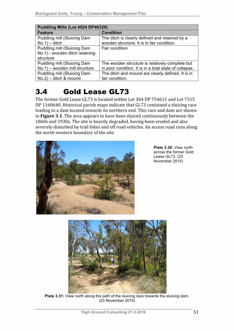
Blackguard Gully, Young – Conservation Management Plan
High Ground Consulting 21.3.2016 51
Puddling Mills (Lot 4524 DP46320) Feature Condition Puddling mill (Sluicing Dam No.1) – ditch
The ditch is clearly defined and retained by a wooden structure. It is in fair condition.
Puddling mill (Sluicing Dam No.1) - wooden ditch retaining structure
Fair condition.
Puddling mill (Sluicing Dam No.1) – wooden mill structure
The wooden structure is relatively complete but in poor condition. It is in a total state of collapse.
Puddling mill (Sluicing Dam No.2) – ditch & mound
The ditch and mound are clearly defined. It is in fair condition.
3.4 Gold Lease GL73 The former Gold Lease GL73 is located within Lot 304 DP 754611 and Lot 7315 DP 1160640. Historical parish maps indicate that GL73 contained a sluicing race leading to a dam located towards its northern end. This race and dam are shown in Figure 3.1. The area appears to have been sluiced continuously between the 1860s and 1930s. The site is heavily degraded, having been eroded and also severely disturbed by trail bikes and off road vehicles. An access road runs along the north-‐western boundary of the site.
Plate 3.30: View north across the former Gold Lease GL73. (23 November 2015)
Plate 3.31: View north along the path of the sluicing race towards the sluicing dam.
(23 November 2015)
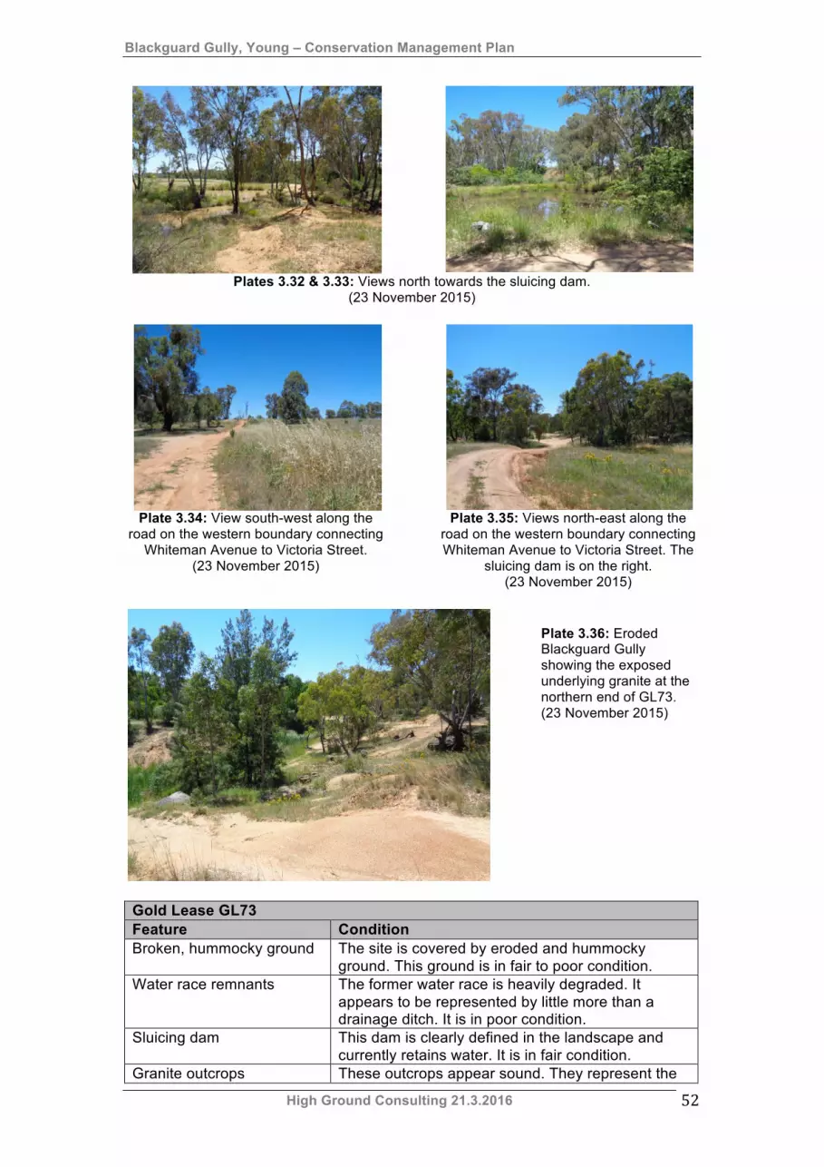
Blackguard Gully, Young – Conservation Management Plan
High Ground Consulting 21.3.2016 52
Plates 3.32 & 3.33: Views north towards the sluicing dam.
(23 November 2015)
Plate 3.34: View south-west along the
road on the western boundary connecting Whiteman Avenue to Victoria Street.
(23 November 2015)
Plate 3.35: Views north-east along the
road on the western boundary connecting Whiteman Avenue to Victoria Street. The
sluicing dam is on the right. (23 November 2015)
Plate 3.36: Eroded Blackguard Gully showing the exposed underlying granite at the northern end of GL73. (23 November 2015)
Gold Lease GL73 Feature Condition Broken, hummocky ground The site is covered by eroded and hummocky
ground. This ground is in fair to poor condition. Water race remnants The former water race is heavily degraded. It
appears to be represented by little more than a drainage ditch. It is in poor condition.
Sluicing dam This dam is clearly defined in the landscape and currently retains water. It is in fair condition.
Granite outcrops These outcrops appear sound. They represent the
Blackguard Gully, Young – Conservation Management Plan
High Ground Consulting 21.3.2016 53
Gold Lease GL73 Feature Condition
extreme depth to which the northern end of the lease has been worked.
Access road This road runs along the north-western boundary of the site and appears to be relatively sound.
3.5 Archaeological potential The Blackguard Gully SHR precinct is a heavily degraded alluvial gold mining area that contains elements of two related ground sluicing systems. The area was initially mined during the early 1860s using the gold rush practices of shaft sinking, panning and paddocking. The historical record indicates that, during the gold rush, it was worked by European and Chinese prospectors. From about 1865 Blackguard, Victoria and Garibaldi Gully complex was mostly mined by small, family-‐based syndicates employing fairly primitive ground sluicing methods. This regime of mining was interrupted in the late 1880s when the Victoria Hill Ground Sluicing Company commenced a more sophisticated mining regime. This was short-‐lived and by the early 1890s the entire area had been taken over by long-‐time gold miner Patrick Fitzgibbon. Fitzgibbon, his daughter Margaret and son-‐in-‐law William O’Connell and their children continued to work the lower end of Blackguard Gully until the 1930s. Since the 1930s the place has lain idle as it has no value for farming or grazing. It has been used as a dumping ground and a testing area for off-‐road driving enthusiasts. These activities and occasional flooding have led to high levels of site disruption and erosion. Regardless of this degradation the landscape can be interpreted by a trained eye and attempts have been made in the past to interpret the remaining evidence of alluvial mining. The eastern section of the precinct is the most inaccessible and hence the most intact. The archaeological potential of the precinct has been assessed as follows (This assessment is based on the description of the precinct included in Section 3.2, Section 3.3 and Section 3.4):
• Crown Land DP 1160640 – low archaeological potential. • Part Lot 7048 DP 1001285 – low archaeological potential. • Part Lot 7313 DP 1160640 – low archaeological potential. • Part Lot 7314 DP 1160640 – low archaeological potential. • Part Lot 7315 DP 1160640 – low archaeological potential. • Part Lot 7316 DP 1160640 – low archaeological potential. • Part Lot 7317 DP 1160640 – low archaeological potential. • Lot 2524 DP 46320
o Eastern side of block – moderate to high archaeological potential. o Western side of block – moderate archaeological potential.
• Lot 304 DP 754611 – low archaeological potential. • Part Lot 7054 DP 96182 – low archaeological potential.
3.5.1 Archaeological zoning plan The following archaeological zoning plans were developed on the basis of site recordings undertaken by Ray Christison.
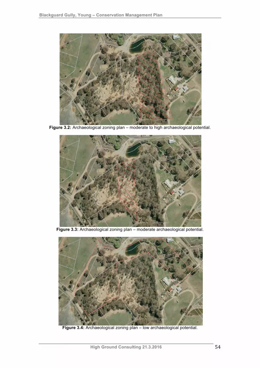
Blackguard Gully, Young – Conservation Management Plan
High Ground Consulting 21.3.2016 54
Figure 3.2: Archaeological zoning plan – moderate to high archaeological potential.
Figure 3.3: Archaeological zoning plan – moderate archaeological potential.
Figure 3.4: Archaeological zoning plan – low archaeological potential.
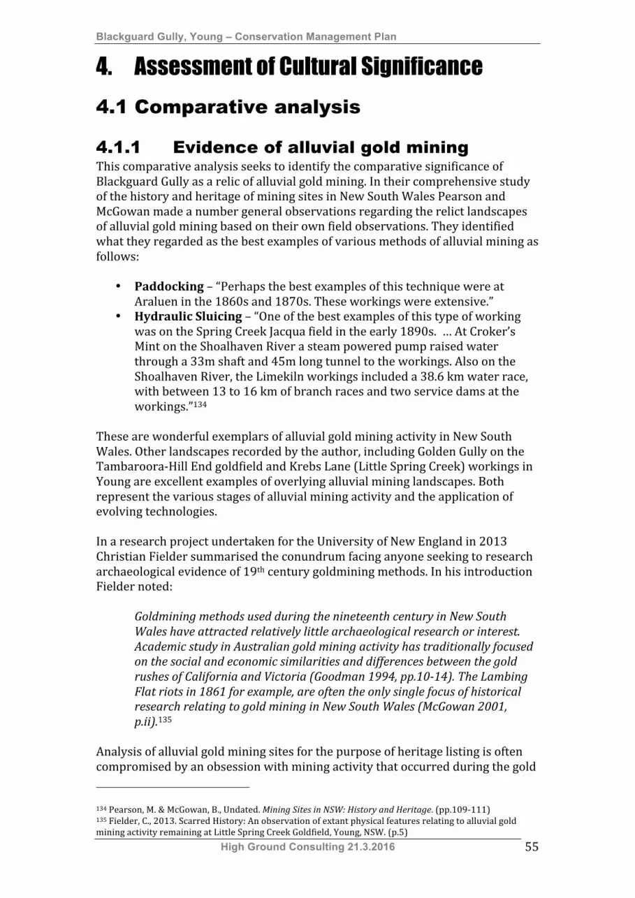
Blackguard Gully, Young – Conservation Management Plan
High Ground Consulting 21.3.2016 55
4. Assessment of Cultural Significance
4.1 Comparative analysis
4.1.1 Evidence of alluvial gold mining This comparative analysis seeks to identify the comparative significance of Blackguard Gully as a relic of alluvial gold mining. In their comprehensive study of the history and heritage of mining sites in New South Wales Pearson and McGowan made a number general observations regarding the relict landscapes of alluvial gold mining based on their own field observations. They identified what they regarded as the best examples of various methods of alluvial mining as follows:
• Paddocking – “Perhaps the best examples of this technique were at Araluen in the 1860s and 1870s. These workings were extensive.”
• Hydraulic Sluicing – “One of the best examples of this type of working was on the Spring Creek Jacqua field in the early 1890s. … At Croker’s Mint on the Shoalhaven River a steam powered pump raised water through a 33m shaft and 45m long tunnel to the workings. Also on the Shoalhaven River, the Limekiln workings included a 38.6 km water race, with between 13 to 16 km of branch races and two service dams at the workings.”134
These are wonderful exemplars of alluvial gold mining activity in New South Wales. Other landscapes recorded by the author, including Golden Gully on the Tambaroora-‐Hill End goldfield and Krebs Lane (Little Spring Creek) workings in Young are excellent examples of overlying alluvial mining landscapes. Both represent the various stages of alluvial mining activity and the application of evolving technologies. In a research project undertaken for the University of New England in 2013 Christian Fielder summarised the conundrum facing anyone seeking to research archaeological evidence of 19th century goldmining methods. In his introduction Fielder noted:
Goldmining methods used during the nineteenth century in New South Wales have attracted relatively little archaeological research or interest. Academic study in Australian gold mining activity has traditionally focused on the social and economic similarities and differences between the gold rushes of California and Victoria (Goodman 1994, pp.10-14). The Lambing Flat riots in 1861 for example, are often the only single focus of historical research relating to gold mining in New South Wales (McGowan 2001, p.ii).135
Analysis of alluvial gold mining sites for the purpose of heritage listing is often compromised by an obsession with mining activity that occurred during the gold 134 Pearson, M. & McGowan, B., Undated. Mining Sites in NSW: History and Heritage. (pp.109-‐111) 135 Fielder, C., 2013. Scarred History: An observation of extant physical features relating to alluvial gold mining activity remaining at Little Spring Creek Goldfield, Young, NSW. (p.5)

Blackguard Gully, Young – Conservation Management Plan
High Ground Consulting 21.3.2016 56
rush era of the 1850s and 1860s. These analyses often dismiss the impact of ongoing subsistence mining that was a feature of all goldfields from the 1870s until well after World War II. A number of archaeologists have undertaken area and regional studies that have provided useful typologies for comparing alluvial mining sites. These typologies have been summarised in Section 2.17 Environment: Cultural Landscape. Preparation of a useful comparative analysis is only possible if these typologies can be applied to all sites being analysed. The author has personally studied and recorded four different alluvial gold mining sites. The typologies available in Section 2.1.7 have been applied to each of these sites to prepare a comparative analysis. The subject sites are:
• Blackguard Gully, Young – SHR 01775, Young Shire LEP I82 • Golden Gully and Archway, Tambaroora -‐ SHR 00614 • Krebs Lane (Spring Creek) Gold Diggings, Young – Young Shire LEP I91 • Milkmans Gully Gold Diggings, Young.
Each of these places is briefly described in the following sections as a basis for a comparative analysis. Additional analysis is based on the extensive studies of the Shoalhaven Goldfields undertaken by Pearson and McGowan. 4.1.1.1 Blackguard Gully The Young Shire Community Based Heritage Study, 2008 identified the significance of the Blackguard Gully alluvial mining area as follows:
Blackguard Gully is a remaining element of the extensive alluvial workings that were the result of the 1860s gold rushes and subsequent hydraulic sluicing activity. The gully also saw the disturbances of February 1861 and was subsequently the area to which Chinese miners were restricted. The Blackguard Gully Gold Diggings are representative of the extensive gold workings that were developed around Young in the mid to late 19th century. The site has state historical and technical/research significance, rarity and representativeness. It also has a moderate level of integrity.
A more in depth analysis of the history of this area undertaken as part of the preparation of this CMP has confirmed that the area was extensively modified by ground sluicing from the mid 1860s until at least the late 1930s. 4.1.1.2 Golden Gully and Archway, Tambaroora SHR 00614 Golden Gully is the only place listed on the SHR as an alluvial mining archaeological site. The statement of significance for Golden Gully and Archway included with the SHR listing is:
Golden Gully and Archway is a major site on the Hill End-Tambaroora goldfield where large scale alluvial fossicking was undertaken by European and Chinese miners. The gully is evidence of the onset of the 1851 goldrush. It displays the difference between European and Chinese mining techniques during the 19th century. In particular the eroded gully has exposed the square European shafts and the round Chinese shafts in a dramatic and
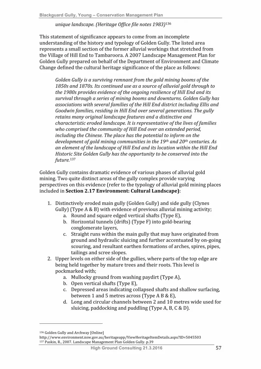
Blackguard Gully, Young – Conservation Management Plan
High Ground Consulting 21.3.2016 57
unique landscape. (Heritage Office file notes 1983)136 This statement of significance appears to come from an incomplete understanding of the history and typology of Golden Gully. The listed area represents a small section of the former alluvial workings that stretched from the Village of Hill End to Tambaroora. A 2007 Landscape Management Plan for Golden Gully prepared on behalf of the Department of Environment and Climate Change defined the cultural heritage significance of the place as follows:
Golden Gully is a surviving remnant from the gold mining booms of the 1850s and 1870s. Its continued use as a source of alluvial gold through to the 1980s provides evidence of the ongoing resilience of Hill End and its survival through a series of mining booms and downturns. Golden Gully has associations with several families of the Hill End district including Ellis and Goodwin families, residing in Hill End over several generations. The gully retains many original landscape features and a distinctive and characteristic eroded landscape. It is representative of the lives of families who comprised the community of Hill End over an extended period, including the Chinese. The place has the potential to inform on the development of gold mining communities in the 19th and 20th centuries. As an element of the landscape of Hill End and its location within the Hill End Historic Site Golden Gully has the opportunity to be conserved into the future.137
Golden Gully contains dramatic evidence of various phases of alluvial gold mining. Two quite distinct areas of the gully complex provide varying perspectives on this evidence (refer to the typology of alluvial gold mining places included in Section 2.17 Environment: Cultural Landscape):
1. Distinctively eroded main gully (Golden Gully) and side gully (Clynes Gully) (Type A & B) with evidence of previous alluvial mining activity;
a. Round and square edged vertical shafts (Type E), b. Horizontal tunnels (drifts) (Type F) into gold-‐bearing
conglomerate layers, c. Straight runs within the main gully that may have originated from
ground and hydraulic sluicing and further accentuated by on-‐going scouring, and resultant earthen formations of arches, spires, pipes, tailings and scree slopes.
2. Upper levels on either side of the gullies, where parts of the top edge are being held together by mature trees and their roots. This level is pockmarked with;
a. Mullocky ground from washing paydirt (Type A), b. Open vertical shafts (Type E), c. Depressed areas indicating collapsed shafts and shallow surfacing,
between 1 and 5 metres across (Type A B & E), d. Long and circular channels between 2 and 10 metres wide used for
sluicing, paddocking and puddling (Type A, B, C & D). 136 Golden Gully and Archway [Online] http://www.environment.nsw.gov.au/heritageapp/ViewHeritageItemDetails.aspx?ID=5045503 137 Paskin, R., 2007. Landscape Management Plan Golden Gully. p.39

Blackguard Gully, Young – Conservation Management Plan
High Ground Consulting 21.3.2016 58
4.1.1.3 Gold Diggings, Krebs Lane (Little Spring Creek), Young The Young Shire Community Based Heritage Study, 2008 identified the significance of the Krebs Lane Gold Diggings as follows:
The Krebs Lane Gold Diggings are a remaining element of the extensive alluvial workings that were the result of the 1860s gold rushes and subsequent hydraulic sluicing activity. The site represents the various phases of alluvial gold mining that were undertaken in Young. The site has state historical and technical/research significance, rarity and representativeness. It also has a high level of integrity.
Plate 4.1: A view over the Krebs Lane (Little Spring Creek) mining area showing the results
of hydraulic sluicing. (Ray Christison 2007) The Krebs Lane Gold Diggings, located on Little Spring Creek, contains evidence of three periods of alluvial gold mining that are represented by three landscape elements. The Krebs Lane area represents an extensively scoured landscape. (refer to Section 2.17 Environment: Cultural Landscape) This scouring is the result of pan and cradle working (Type A), surfacing (Type B) and shaft (Type E) and drift mining (Type F), accentuated by modern hydraulic sluicing. The western edge of the site along Krebs Lane contains numerous depressions and remnants of mullock heaps (Type A). The central and eastern sections of the site have been heavily sluiced. Much of this part of the site has been cleared of alluvium and shows evidence of hydraulic sluicing. Areas of shelving on the face between the mullocky ground and hydraulic sluicing area suggests that parts of the area were worked using ground sluicing in the 1860s and 1870s. Ground sluicing, also referred to as common sluicing, involved directing flows of water through a known gold-‐bearing site to remove alluvium. This practice was superseded by hydraulic sluicing.

Blackguard Gully, Young – Conservation Management Plan
High Ground Consulting 21.3.2016 59
4.1.1.4 Milkmans Gully Gold Diggings, Burrangong Hall Road, Young
The Young Shire Community Based Heritage Study, 2008 identified the significance of the Milkmans Gully Gold Diggings as follows:
The Milkmans Gully Gold Diggings represent an incomplete archaeological record of a former alluvial gold mining landscape that appears to have been worked using common sluicing techniques. They are a remaining element of the extensive alluvial workings that were the result of the 1860s gold rushes and subsequent sluicing activity. The site has local historical and technical/research significance, rarity and representativeness. It also has a moderate level of integrity.
Plate 4.2: Remnant water race following the bank of Milkmans Gully (Dairyman’s Gully), Young. (Ray Christison 2008)
Milkmans Creek flows from south of Temora Road to join Burrangong Creek near the site of the old Burrangong settlement. It is joined just south of Temora Road by Dairymans Creek. Water races appear to have been constructed along either side of Milkmans Creek from Dairymans Creek to Burrangong Creek. There is also evidence of a possible water storage having been constructed along the creek line below the confluence with Dairymans Creek. There is evidence in some places along both sides of the creek that suggests box sluices may have been serviced by the water races. Sections of the creek bed close to the box sluice locations also contain mullock heaps that appear to confirm the location of the sluices. Water races are present at the upper and lower levels of the creek banks suggesting that ground sluicing and box sluicing may have been carried out along the creek line. There is substantial evidence of paddocking (Type C) and some shaft (Type E) and drift shaft (Type F) mining activity along Burrangong Creek near its confluence with Milkmans Creek, and in the ground on the western side
Blackguard Gully, Young – Conservation Management Plan
High Ground Consulting 21.3.2016 60
of Burrangong Hall Road. (Refer to Section 2.17 Environment: Cultural Landscape) Comparative Schedule of Alluvial Gold Mining types
* Definition of the above typology is included in Section 2.17 Environment: Cultural Landscape 4.1.2 Evidence of Chinese ethnic influence In a paper published by the Australasian Society for Historical Archaeology in 2003 Barry McGowan defined the principal characteristics defining the archaeology of Chinese alluvial mining in Australia. In this paper McGowan noted:
In all …. instances … the mode of working, and the implements used, that is pan and cradle, short sluice or tom, water wheel or Californian pump, were similar. The European and Chinese sites are, therefore, for the most part theoretically indistinguishable, though there are several characteristics that may help the process of cultural identification.138
The characteristics identified by McGowan are:
1. “Elongated mounds of water worn stone piled up after working the face or floor of the diggings”. These are associated with Type D alluvial workings -‐ tailing mounds. Numerous examples of such workings have been identified on the Mongarlowe, North Araluen, Shoalhaven and Kiandra goldfields.
2. Round shafts (associated with Type E workings – narrow trench like shafts). There is a substantial body of myth regarding the association of round shafts with Chinese mining practice. This typically refers to Chinese superstitions and appears to stem from prejudices handed down from the gold rush era. Academic study has identified that round shafts may be more typical of Chinese mining practice for the following reasons;
a. Chinese use of hoes and baskets as digging implements. European miners tended to use pick and shovel,
b. Skills in well sinking brought to the goldfields by many Chinese miners and their sponsors.
138 McGowan, B., 2003. “The archaeology of Chinese alluvial mining in Australia”. (p.11)
Alluvial Mining Type Type Description
Blackguard Gully
Golden Gully
Krebs Lane (Spring Creek)
Milkmans Creek
A Heavily scoured creek beds & banks
X X X
B Shallow surfacing X X X C Paddocking X X X D Tailing mounds X E Narrow trench-like
shafts X X X
F Drift tunnels cut into the face of the workings
X X X
Evidence of ground sluicing X X X X Evidence of hydraulic sluicing X X
Blackguard Gully, Young – Conservation Management Plan
High Ground Consulting 21.3.2016 61
3. The presence of hut sites with low stone walls.139 Examples of the Chinese Single Jian dwelling have been recorded extensively at Kiandra and at least one example has been recorded at Tubbul in the Young Shire. Anecdotal evidence indicates that other Single Jian dwelling sites may occur in the Wombat area of Harden Shire.
None of these specific markers of Chinese ethnicity has been identified within the Blackguard Gully SHR listing boundary. 4.1.3 Summary of findings from Comparative
Analysis The comparative analysis undertaken in Section 4.1.1 and Section 4.1.2 of this report can be summarised as follows:
1. Blackguard Gully has less evidence of the alluvial gold mining techniques adopted by individual prospectors than other alluvial gold mining areas analysed by the author. This indicates that Blackguard Gully contains little evidence of techniques that were commonly used in the gold rushes of the 1850s and 1860s.
2. Blackguard Gully contains no discernible evidence of Chinese alluvial mining or Chinese domestic arrangements.
4.2 Statement of Significance NSW Heritage Assessment Criteria Criterion (a) An item is important in the course, or pattern, of NSW’s cultural or natural history
(or the cultural or natural history of the local area). Criterion (b) An item has strong or special association with the life or works of a person, or
group of persons, of importance in NSW’s cultural or natural history (or the cultural or natural history of the local area).
Criterion (c) An item is important in demonstrating aesthetic characteristics and/or a high degree of creative or technical achievement in NSW (or the local area).
Criterion (d) An item has a strong or special association with a particular community or cultural group in NSW (or the local area) for social, cultural or spiritual reasons.
Criterion (e) An item has potential to yield information that will contribute to an understanding of NSW’s cultural or natural history (or the cultural or natural history of the local area).
Criterion (f) An item possesses uncommon, rare or endangered aspects of NSW’s cultural or natural history (or the cultural or natural history of the local area).
Criterion (g) An item is important in demonstrating the principal characteristics of a class of NSW’s
• Cultural or natural places; or • Cultural or natural environments
(or a class of the local area’s • Cultural or natural places; or • Cultural or natural environments.)
4.2.1 Existing statements of significance The following statement of significance accompanies the 2009 SHR Listing for Blackguard Gully: 139 McGowan, B., 2003. “The archaeology of Chinese alluvial mining in Australia”. (p.11-‐17)

Blackguard Gully, Young – Conservation Management Plan
High Ground Consulting 21.3.2016 62
Blackguard Gully is of historical significance as the site of one of the worst riots against Chinese miners in Australian history. In late 1860 and early 1861 there were several attacks on Chinese miners. On 30 June 1861 some 3000 Europeans marched against Chinese miners on Lambing Flat goldfields, attacking their two main camps at Blackguard Gully and Back Creek. They carried a flag with the words 'Roll-up Roll-up No Chinese', which is now on display in the Lambing Flat Folk Museum. The riot led to the passing of legislation to restrict access to goldfields to aliens and to refuse miners' rights to aliens. The violence of these riots resulted in the government responding to community concern by passing a Chinese Immigration Restriction Act and at an Intercolonial Conference held in 1880 and 1881 uniform restrictive immigration laws were adopted. The march of the Europeans through the town on 30 June 1861 and the later declaration of the Riot Act were of immense significance to the history of the town of Young. In 1861 Lambing Flat had its name changed to Young. Blackguard Gully is associated with the Chinese who camped in the area in the early 1860s and who mined for gold at Lambing Flat. The events of the time are also remembered by the town of Young today with Lambing Flat Festival in April, which includes a re-enactment of the 'Roll Up' and reading of the Riot Act. It has potential to yield archaeological information on the use of the site in the 1860s and beyond. Although many gold fields experienced protests against the Chinese, Lambing Flat was unique in the level of organisation of the riots, the purpose made flag that was carried, and the fact that the site of the riot survives as a public space (Blackguard Gully).
This statement of significance is accompanied by the following caveat:
Note: There are incomplete details for a number of items listed in NSW. The Heritage Branch intends to develop or upgrade statements of significance and other information for these items as resources become available.
The statement of significance prepared for the Young Shire Community Based Heritage Study is as follows:
Blackguard Gully is a remaining element of the extensive alluvial workings that were the result of the 1860s gold rushes and subsequent hydraulic sluicing activity. The gully also saw the disturbances of February 1861 and was subsequently the area to which Chinese miners were restricted. The Blackguard Gully Gold Diggings are representative of the extensive gold workings that were developed around Young in the mid to late 19th century. The site has state historical and technical/research significance, rarity and representativeness. It also has a moderate level of integrity.
4.2.2 Revised statement of significance The following revised statement of significance has been prepared on the basis of additional historical and archaeological investigation of the site. Criterion Significance Reasons
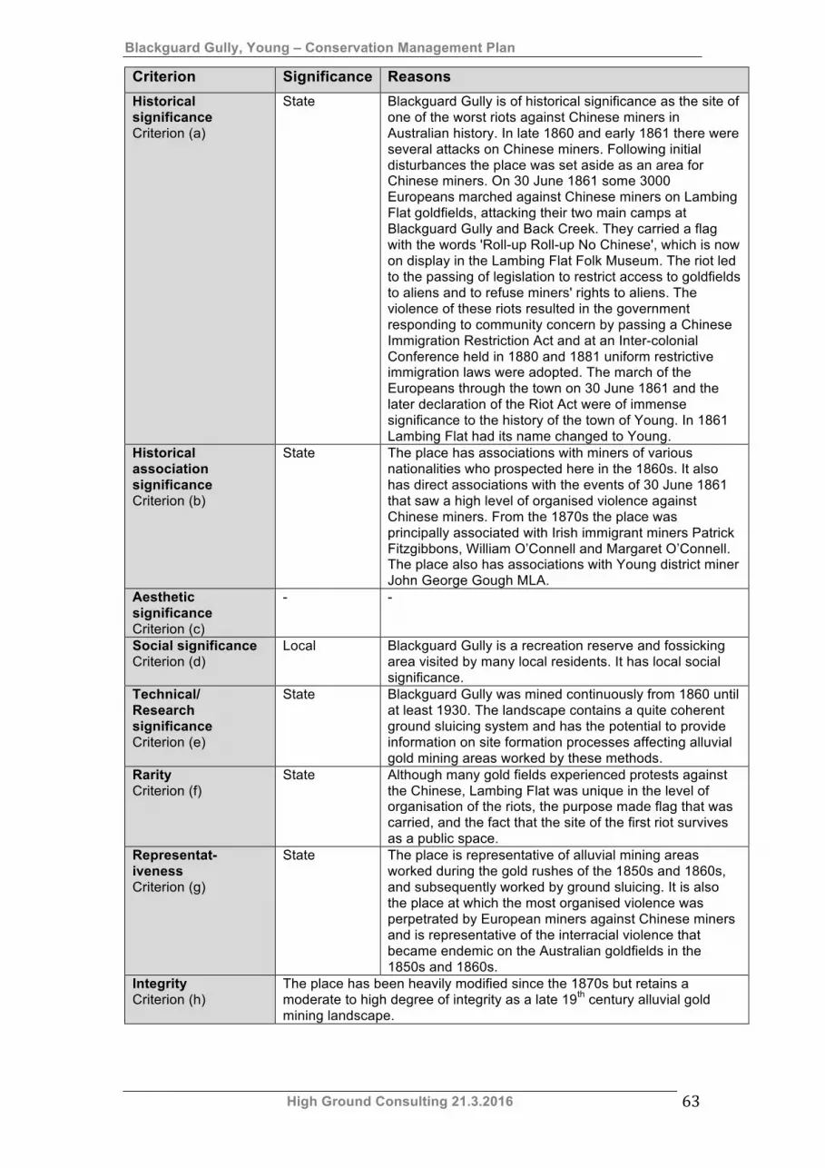
Blackguard Gully, Young – Conservation Management Plan
High Ground Consulting 21.3.2016 63
Criterion Significance Reasons Historical significance Criterion (a)
State Blackguard Gully is of historical significance as the site of one of the worst riots against Chinese miners in Australian history. In late 1860 and early 1861 there were several attacks on Chinese miners. Following initial disturbances the place was set aside as an area for Chinese miners. On 30 June 1861 some 3000 Europeans marched against Chinese miners on Lambing Flat goldfields, attacking their two main camps at Blackguard Gully and Back Creek. They carried a flag with the words 'Roll-up Roll-up No Chinese', which is now on display in the Lambing Flat Folk Museum. The riot led to the passing of legislation to restrict access to goldfields to aliens and to refuse miners' rights to aliens. The violence of these riots resulted in the government responding to community concern by passing a Chinese Immigration Restriction Act and at an Inter-colonial Conference held in 1880 and 1881 uniform restrictive immigration laws were adopted. The march of the Europeans through the town on 30 June 1861 and the later declaration of the Riot Act were of immense significance to the history of the town of Young. In 1861 Lambing Flat had its name changed to Young.
Historical association significance Criterion (b)
State The place has associations with miners of various nationalities who prospected here in the 1860s. It also has direct associations with the events of 30 June 1861 that saw a high level of organised violence against Chinese miners. From the 1870s the place was principally associated with Irish immigrant miners Patrick Fitzgibbons, William O’Connell and Margaret O’Connell. The place also has associations with Young district miner John George Gough MLA.
Aesthetic significance Criterion (c)
- -
Social significance Criterion (d)
Local Blackguard Gully is a recreation reserve and fossicking area visited by many local residents. It has local social significance.
Technical/ Research significance Criterion (e)
State Blackguard Gully was mined continuously from 1860 until at least 1930. The landscape contains a quite coherent ground sluicing system and has the potential to provide information on site formation processes affecting alluvial gold mining areas worked by these methods.
Rarity Criterion (f)
State Although many gold fields experienced protests against the Chinese, Lambing Flat was unique in the level of organisation of the riots, the purpose made flag that was carried, and the fact that the site of the first riot survives as a public space.
Representat-iveness Criterion (g)
State The place is representative of alluvial mining areas worked during the gold rushes of the 1850s and 1860s, and subsequently worked by ground sluicing. It is also the place at which the most organised violence was perpetrated by European miners against Chinese miners and is representative of the interracial violence that became endemic on the Australian goldfields in the 1850s and 1860s.
Integrity Criterion (h)
The place has been heavily modified since the 1870s but retains a moderate to high degree of integrity as a late 19th century alluvial gold mining landscape.
Blackguard Gully, Young – Conservation Management Plan
High Ground Consulting 21.3.2016 64
Summary statement of significance Blackguard Gully is of historical significance as the site of one of the worst riots against Chinese miners in Australian history. In late 1860 and early 1861 there were several attacks on Chinese miners. Following initial disturbances the place was set aside as an area for Chinese miners. On 30 June 1861 some 3000 Europeans marched against Chinese miners on Lambing Flat goldfields, attacking their two main camps at Blackguard Gully and Back Creek. They carried a flag with the words 'Roll-up Roll-up No Chinese', which is now on display in the Lambing Flat Folk Museum. The riot led to the passing of legislation to restrict access to goldfields to aliens and to refuse miners' rights to aliens. The violence of these riots resulted in the government responding to community concern by passing a Chinese Immigration Restriction Act and at an Intercolonial Conference held in 1880 and 1881 uniform restrictive immigration laws were adopted. The march of the Europeans through the town on 30 June 1861 and the later declaration of the Riot Act were of immense significance to the history of the town of Young. In 1861 Lambing Flat had its name changed to Young. The place has associations with miners of various nationalities who prospected here in the 1860s. It also has direct associations with the events of 30 June 1861 that saw a high level of organised violence against Chinese miners. From the 1870s the place was principally associated with Irish immigrant miners Patrick Fitzgibbons, William O’Connell and Margaret O’Connell. The place also has associations with Young district miner John George Gough MLA. The place is a recreation reserve and fossicking area visited by many local residents. It has local social significance. Blackguard Gully was mined continuously from 1860 until at least 1930. The landscape contains a quite coherent ground sluicing system and has the potential to provide information on site formation processes affecting alluvial gold mining areas worked by these methods. Although many gold fields experienced protests against the Chinese, Lambing Flat was unique in the level of organisation of the riots, the purpose made flag that was carried, and the fact that the site of first the riot survives as a public space. The place is representative of alluvial mining areas worked during the gold rushes of the 1850s and 1860s, and subsequently worked by sluicing. It is also the place at which the most organised violence was perpetrated by European miners against Chinese miners and is representative of the interracial violence that became endemic on the Australian goldfields in the 1850s and 1860s. The place has been heavily modified since the 1870s but retains high degree of integrity as a relic of late 19th century alluvial gold mining.
4.3 Gradings of significance The grading of significance of each element of the property has been assessed in accordance with its integrity, interpretations of its relationship to the identified historic themes, and its relationship with other features. Gradings of significance have been assessed using NSW Heritage Office criteria contained in the NSW Heritage Manual update Assessing Heritage Significance. According to this publication;
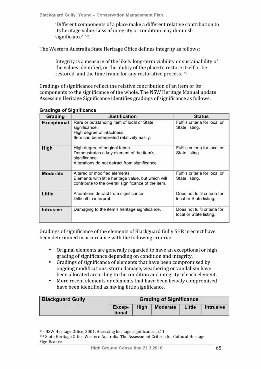
Blackguard Gully, Young – Conservation Management Plan
High Ground Consulting 21.3.2016 65
‘Different components of a place make a different relative contribution to its heritage value. Loss of integrity or condition may diminish significance’140.
The Western Australia State Heritage Office defines integrity as follows:
Integrity is a measure of the likely long-‐term viability or sustainability of the values identified, or the ability of the place to restore itself or be restored, and the time frame for any restorative process.141
Gradings of significance reflect the relative contribution of an item or its components to the significance of the whole. The NSW Heritage Manual update Assessing Heritage Significance identifies gradings of significance as follows: Gradings of Significance
Grading Justification Status Exceptional Rare or outstanding item of local or State
significance. High degree of intactness. Item can be interpreted relatively easily.
Fulfils criteria for local or State listing.
High High degree of original fabric. Demonstrates a key element of the item’s significance. Alterations do not detract from significance.
Fulfils criteria for local or State listing.
Moderate Altered or modified elements. Elements with little heritage value, but which will contribute to the overall significance of the item.
Fulfils criteria for local or State listing.
Little Alterations detract from significance. Difficult to interpret.
Does not fulfil criteria for local or State listing.
Intrusive Damaging to the item’s heritage significance. Does not fulfil criteria for local or State listing.
Gradings of significance of the elements of Blackguard Gully SHR precinct have been determined in accordance with the following criteria:
• Original elements are generally regarded to have an exceptional or high grading of significance depending on condition and integrity.
• Gradings of significance of elements that have been compromised by ongoing modifications, storm damage, weathering or vandalism have been allocated according to the condition and integrity of each element.
• More recent elements or elements that have been heavily compromised have been identified as having little significance.
Grading of Significance Blackguard Gully
Excep-tional
High Moderate Little Intrusive
140 NSW Heritage Office, 2001. Assessing heritage significance. p.11 141 State Heritage Office Western Australia. The Assessment Criteria for Cultural Heritage Significance.

Blackguard Gully, Young – Conservation Management Plan
High Ground Consulting 21.3.2016 66
Grading of Significance Blackguard Gully Excep-tional
High Moderate Little Intrusive
Victoria Gully & Blackguard Gully watercourse Blackguard Gully sign X Gold Trails interpretive signage X Pondage (former sludge dam) X Concrete pedestrian bridge X Victoria Gully watercourse X Remnant interpretive numbers X Concrete ramp X Access roadway X Sluicing dams (Lot 4524 DP 46320) Sluicing Dam No.1 – earthen wall
X
Sluicing Dam No.1 – basin X Sluicing Dam No.2 – earthen wall
X
Sluicing Dam No.2 – basin X Vegetation – native species X Vegetation – invasive species X Sluicing races (Lot 4524 DP 46320) Sluicing race 1.1 X Sluicing race 1.2 X Sluicing race 1.3 X Tubular steel fencing & gates X Brick toilet block X Septic tank X Puddling Mills (Lot 4524 DP 46320) Puddling mill (Sluicing Dam No.1) – ditch
X
Puddling mill (Sluicing Dam No.1) - wooden ditch retaining structure
X
Puddling mill (Sluicing Dam No.1) – wooden mill structure
X
Puddling mill (Sluicing Dam No.2) – ditch & mound
X
Gold Lease GL73 Broken, hummocky ground X Water race remnants X Sluicing dam X Granite outcrops X Access road X
Blackguard Gully, Young – Conservation Management Plan
High Ground Consulting 21.3.2016 67
5. Constraints and opportunities
5.1 Constraints and opportunities arising from statement of significance
Blackguard Gully is listed on the NSW State Heritage Register. The place has been assessed as having state historical, historical association, and technical/research significance, representativeness and rarity. The cultural heritage significance of Blackguard Gully derives from three principal sources:
1. The associations of the place with the Lambing Flat Gold Rush of 1860-‐1861, the segregation of Chinese miners that occurred here and the savage anti-‐Chinese rioting of January and July 1861.
2. The association of the place with the development of Australian immigration policy in the late 19th century.
3. Surviving physical evidence of late 19th century ground sluicing demonstrating important elements of a coherent alluvial mining system.
These three distinct sources of significance demand different priorities in terms of ongoing management of the place. These priorities are as follows:
1. Management of historical associations – Historical associations should be managed through development of;
a. Comprehensive in-‐situ interpretations of the stories relevant to the site, including a virtual guided tour,
b. Web and print based publications providing a clear and comprehensive appraisal of the importance of the place in Australian migration history,
c. An interpretive centre or facility located near the site. 2. Management of significant physical evidence – The physical evidence
of the extensive ground sluicing must be managed by; a. Restricting access by motor vehicles and motorcycles, b. Managing the site to minimise further damage to this
infrastructure, c. Clearly interpreting the layout and significance of the ground
sluicing system. Strategies and policies for managing these aspects of significance are included in Section 7 Conservation Policies & Guidelines.
5.2 Statutory and non-statutory listings
5.2.1 NSW State Heritage Register The place is currently listed on the State Heritage Register. This listing imposes specific obligations on the owners and managers of the property, including the following:
Blackguard Gully, Young – Conservation Management Plan
High Ground Consulting 21.3.2016 68
• Approval to alter the property Certain types of works require approval from the Heritage Council of NSW. A series of standard exemptions is available under the NSW Heritage Act. Recommended standard exemptions are listed in Appendix B of this Conservation Management Plan. Works not listed in the Conservation Management Plan that go beyond maintenance will require separate approval.
• Minimum standards of maintenance and repair The NSW Heritage Act requires that items listed on the NSW Heritage Register be maintained to a reasonable standard. This is a legal obligation placed on the owners of a listed property.
• Sale of the property A Section 167 certificate is required to accompany the sale of a property listed on the NSW State Heritage Register.
Benefits of State Heritage Register listing include:
Funding for conservation works Funding is available to private owners of properties listed on the State Heritage Register. Grant programs are announced annually.
5.2.2 Young LEP Heritage Schedule The place is listed on the Heritage Schedule (Schedule 5) of the Young Local Environmental Plan 2011. The following provisions apply to items listed on this schedule:
5.10 Heritage Conservation (2) Requirement for consent: Development consent is required for any of the following:
(a) demolishing or moving any of the following or altering the exterior of any of the following (including, in the case of a building, making changes to its detail, fabric, finish or appearance):
(i) a heritage item, (ii) an Aboriginal object, (iii) a building, work, relic or tree within a heritage conservation area,
(c) disturbing or excavating an archaeological site while knowing, or having reasonable cause to suspect, that the disturbance or excavation will or is likely to result in a relic being discovered, exposed, moved, damaged or destroyed, (d) disturbing or excavating an Aboriginal place of heritage significance, (e) erecting a building on land:
(i) on which a heritage item is located or that is within a heritage conservation area, or (ii) on which an Aboriginal object is located or that is within an Aboriginal place of heritage significance,
(f) subdividing land: (i) on which a heritage item is located or that is within a heritage conservation area, or
Blackguard Gully, Young – Conservation Management Plan
High Ground Consulting 21.3.2016 69
(ii) on which an Aboriginal object is located or that is within an Aboriginal place of heritage significance.
(3) When consent not required However, development consent under this clause is not required if:
(a) the applicant has notified the consent authority of the proposed development and the consent authority has advised the applicant in writing before any work is carried out that it is satisfied that the proposed development:
(i) is of a minor nature or is for the maintenance of the heritage item, Aboriginal object, Aboriginal place of heritage significance or archaeological site or a building, work, relic, tree or place within the heritage conservation area, and (ii) would not adversely affect the heritage significance of the heritage item, Aboriginal object, Aboriginal place, archaeological site or heritage conservation area, or
(b) the development is in a cemetery or burial ground and the proposed development:
(i) is the creation of a new grave or monument, or excavation or disturbance of land for the purpose of conserving or repairing monuments or grave markers, and (ii) would not cause disturbance to human remains, relics, Aboriginal objects in the form of grave goods, or to an Aboriginal place of heritage significance, or
(c) the development is limited to the removal of a tree or other vegetation that the Council is satisfied is a risk to human life or property, or (d) the development is exempt development.
(4) Effect of proposed development on heritage significance The consent authority must, before granting consent under this clause in respect of a heritage item or heritage conservation area, consider the effect of the proposed development on the heritage significance of the item or area concerned. This subclause applies regardless of whether a heritage management document is prepared under subclause (5) or a heritage conservation management plan is submitted under subclause (6). (5) Heritage assessment The consent authority may, before granting consent to any development:
(a) on land on which a heritage item is located, or (b) on land that is within a heritage conservation area, or (c) on land that is within the vicinity of land referred to in paragraph (a) or (b),
require a heritage management document to be prepared that assesses the extent to which the carrying out of the proposed development would affect the heritage significance of the heritage item or heritage conservation area concerned. (6) Heritage conservation management plans The consent authority may require, after considering the heritage significance of a heritage item

Blackguard Gully, Young – Conservation Management Plan
High Ground Consulting 21.3.2016 70
and the extent of change proposed to it, the submission of a heritage conservation management plan before granting consent under this clause. (7) Archaeological sites The consent authority must, before granting consent under this clause to the carrying out of development on an archaeological site (other than land listed on the State Heritage Register or to which an interim heritage order under the Heritage Act 1977 applies):
(a) notify the Heritage Council of its intention to grant consent, and (b) take into consideration any response received from the
Heritage Council within 28 days after the notice is sent. 5.2.3 Young Shire Council Aboriginal
Heritage Study, 2014 The Young Shire Council Aboriginal Heritage Study was undertaken in 2014. This study identified numerous watercourses within the Young Shire as having potential Aboriginal cultural heritage significance. These watercourses were identified in a series of Cultural Landscape Maps that were included as Appendix 5 to the report on this study. The Victoria Creek, Blackguard Gully, Sawpit Gully complex was not identified by this study as an area of significance. Regardless of this it is recommended that future developments within the Blackguard Gully SHR listing be made subject to the consultation process included Section 5.5 of the Young Shire Aboriginal Heritage Study.
5.3 Responsibility for management Blackguard Gully is Crown Land and Young Shire Council is responsible for managing the place as a public reserve. An opportunity exists to improve a number of aspects the management of the place, including implementation this Conservation Management Plan:
• Management of public access to the site, including; o Development of a public car park, o Development of accessible pathways and viewing areas, o Provision of amenities for visitors.
• Ongoing management of vegetation, including weed control. Relevant issues are defined below:
1. Development of a landscape management plan. 2. Development of an interpretive and research centre (Abacus Centre). 3. Communication of this CMP.
5.3.1 Development of a landscape management plan
The landscape of Blackguard Gully is currently in an unkempt condition with deposits of rubbish, soil erosion, vehicle damage and dumped rubbish prevalent.
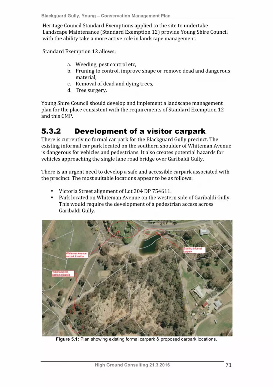
Blackguard Gully, Young – Conservation Management Plan
High Ground Consulting 21.3.2016 71
Heritage Council Standard Exemptions applied to the site to undertake Landscape Maintenance (Standard Exemption 12) provide Young Shire Council with the ability take a more active role in landscape management. Standard Exemption 12 allows;
a. Weeding, pest control etc, b. Pruning to control, improve shape or remove dead and dangerous
material, c. Removal of dead and dying trees, d. Tree surgery.
Young Shire Council should develop and implement a landscape management plan for the place consistent with the requirements of Standard Exemption 12 and this CMP.
5.3.2 Development of a visitor carpark There is currently no formal car park for the Blackguard Gully precinct. The existing informal car park located on the southern shoulder of Whiteman Avenue is dangerous for vehicles and pedestrians. It also creates potential hazards for vehicles approaching the single lane road bridge over Garibaldi Gully. There is an urgent need to develop a safe and accessible carpark associated with the precinct. The most suitable locations appear to be as follows:
• Victoria Street alignment of Lot 304 DP 754611. • Park located on Whiteman Avenue on the western side of Garibaldi Gully.
This would require the development of a pedestrian access across Garibaldi Gully.
Figure 5.1: Plan showing existing formal carpark & proposed carpark locations.
Blackguard Gully, Young – Conservation Management Plan
High Ground Consulting 21.3.2016 72
5.3.3 Development of the proposed Abacus Centre
Young Shire Council is currently considering the development of a centre to interpret the migration history of Young. The Vision Statement for this project is as follows:
To create a world class interpretive, research and recreational centre that engages visitors in the story of Australian agricultural and rural settlement, within the context of the 1861 Gold Rush at Lambing Flat, and the unfolding story of immigration from all parts of the world.
A copy of the Action Plan for this development is included as Appendix C. The centre is proposed to be located either:
• Within a suitable section of the Blackguard Gully SHR curtilage, or • On a site adjacent to the Blackguard Gully SHR precinct.
One objective of this CMP was to identify areas of low archaeological potential that may be appropriate for a development such as the Abacus (Suànpán) Centre. Analysis of the archaeological potential of the precinct indicates that the higher ground of Lot 304 DP 754611 may be suitable for the development of an interpretive centre. This section has a frontage to Victoria Street and overlooks much of the precinct. Alternately Council could consider the purchase of adjoining blocks on Victoria Street to host the proposed centre. 5.3.4 Communication The requirements of this Conservation Management Plan must be clearly communicated to all stakeholders. Stakeholders include:
• Young Shire Council staff, in the following areas; o Planning, Environment & Strategic Services, o Operations, o Utility Service.
• Abacus Centre Committee, Young Shire Council, • Department of Primary Industries – Lands.
5.4 Fossicking area Blackguard Gully is currently designated as a fossicking area. A Site Specific Exemption under the Heritage Act 1977 allowing “gold panning and fossicking” was gazetted on 13 March 2009. Fossickers accessing the SHR precinct regularly dig holes in the bases of former sluicing dams and races. This is quite intrusive and, if continued, could result in the destruction of areas of high or moderate archaeological potential. It is considered that the appropriate regulatory changes should be made to:
Blackguard Gully, Young – Conservation Management Plan
High Ground Consulting 21.3.2016 73
• Remove the Site Specific Exemption allowing fossicking, or restrict this to places of low archaeological potential, or
• Prohibit fossicking with the curtilage of the SHR. Alternately the relevant regulations regarding fossicking should be strictly enforced within the precinct by Young Shire Council. The guidelines for fossicking in New South Wales are included as Appendix E.
Blackguard Gully, Young – Conservation Management Plan
High Ground Consulting 21.3.2016 74
6. Development of conservation policy Conservation policies are required to guide the ongoing management of the cultural heritage significance of the place, including its fabric and setting. Blackguard Gully is unique. This uniqueness is largely derived from the fact that part of the gully was specifically allocated Chinese gold miners in February 1861 and this area was the focus of the vicious attacks on Chinese miners that occurred on 30 June 1861. The civil unrest that surrounded these events has been recognised as the most organised anti-‐Chinese rioting in the Australian goldfields. Regardless of this historical significance the landscape of the SHR listed section of the gully has been heavily modified by ground sluicing activity and reflects little, if anything, of the events of the initial gold rushes or anti-‐Chinese riots. The existing landscape is a good representative example of an alluvial area that has been heavily sluiced over an extended period and its accessibility makes it an ideal place for interpretation. The policies in Section 7 of this Conservation Management Plan have been developed to ensure that the cultural heritage values of the place and its fabric are managed in a way that is consistent with a NSW State Heritage Register listing of the place. Policies were developed after review of appropriate planning documents and discussions with stakeholders. In development of conservation policies the following issues have been considered:
• The need to protect the remaining evidence of alluvial goldmining. • The need to properly manage areas with high or moderate archaeological
potential are not disturbed. • The need to develop an ongoing management regime for the place. • Management of access and visitation to minimise negative impacts on the
place. • Management of the setting of the place. • The possible future need for services and amenities such as lighting and
toilet facilities. • The possibility of developing the Abacus Centre within the SHR curtilage.
Blackguard Gully, Young – Conservation Management Plan
High Ground Consulting 21.3.2016 75
7. Conservation policies and guidelines 7.1 Definitions The following Burra Charter (Appendix A) definitions apply to terms used in these conservation policies and guidelines:
7.1.1 Place means site, area land landscape, building or other work, group of buildings or other works, and may include components, contents, spaces and views.
7.1.2 Cultural significance means aesthetic, historic, scientific social or spiritual value for past, present or future generations. 7.1.3 Fabric means all the physical material of the place including components, fixtures, contents, and objects. 7.1.4 Conservation means all the processes of looking after a place so as to retain its cultural significance 7.1.5 Maintenance means the continuous protective care of the fabric and setting of a place, and is to be distinguished from repair. Repair involves restoration or reconstruction. 7.1.6 Preservation means maintaining the fabric of a place in its existing state and retarding deterioration. 7.1.7 Restoration means returning the existing fabric of a place to a known earlier state by removing accretions or by reassembling existing components without the introduction of new material. 7.1.8 Reconstruction means returning a place to a known earlier state and is distinguished from restoration by the introduction of new material into the fabric. 7.1.9 Adaptation means modifying a place to suit the existing use or proposed use. 7.1.10 Use means the functions of a place, as well as the activities and practices that may occur at the place. 7.1.11 Compatible use means a use which respects the cultural significance of a place. Such use involves no, or minimal, impact on cultural significance. 7.1.12 Setting means the area around a place, which may include the visual catchment. 7.1.13 Related place means a place that contributes to the cultural significance of another place.

Blackguard Gully, Young – Conservation Management Plan
High Ground Consulting 21.3.2016 76
7.1.14 Related object means an object that contributes to the cultural significance of a place but is not at the place. 7.1.15 Associations means the special connections that exist between people and a place. 7.1.16 Meanings denote what a place signifies, indicates, evokes or expresses. 7.1.17 Interpretation means all the ways of presenting the cultural significance of a place.
7.2 Policies The following conservation policies provide principles for the ongoing management of the Blackguard Gully SHR precinct. 7.2.1 Fabric Significant fabric of the landscape should be conserved in the following ways:
• Fabric with exceptional or high gradings of significance -‐ The fabric of the landscape identified as having exceptional or high gradings of significance (refer to Section 4.3) must be conserved and should not be damaged or interfered with.
• Fabric with moderate grading of significance -‐ The fabric of the landscape identified as having a moderate grading of significance (refer to Section 4.3) should be conserved but may be modified in accordance with the requirements of Section 7.4.
• Fabric with little or intrusive gradings of significance -‐ The fabric of the landscape identified as having little or intrusive gradings of significance (refer to Section 4.3) may be modified or removed.
• New work -‐ Any new work must not damage, or interfere with, existing fabric considered to have exceptional or high gradings of significance.
• Areas with high or moderate archaeological potential – Areas of the place and its setting that are considered to have high or moderate archaeological potential must not be disturbed without relevant approvals under the Heritage Act 1977.
The Heritage Council of NSW Standard Exemptions for Works Requiring Heritage Council Approval were applied to Blackguard Gully on 5 September 2008. These are included as Appendix B to this document. 7.2.2 Management of the precinct Young Shire Council is responsible for the management of the Blackguard Gully precinct and its surviving archaeological features. Young Shire Council should, at the earliest opportunity, develop a Plan of Management for the precinct covering the following matters:
• Responsibility for management, • Security and monitoring of the precinct, • Control of access by recreational vehicles, • Development of a formal car park for persons visiting the site,
Blackguard Gully, Young – Conservation Management Plan
High Ground Consulting 21.3.2016 77
• Development of amenities for persons visiting the site, • Management of pedestrian access, • Weed control, • Removal of rubbish, • Minimisation of soil erosion.
7.2.3 Access Management of access will be a significant issue to be covered by a Plan of Management. This is outlined in Section 7.2.2. All access must be planned to consider the following issues:
• Conservation of the significant fabric of the precinct. • Visitor safety. • Compliance with relevant legislation and standards.
A risk assessment of all proposed access and pathway arrangements should be undertaken. This should focus on the safety of public access and potential threats to the significant fabric of the precinct.
7.2.4 Setting The setting of the place should be conserved in the following ways:
• Preserving the remnant ground sluicing systems and their associated landscape features.
• Maintaining visual links between the various elements of the site. • Developing screening plantings along the southern side of Victoria Street
to obscure views to the Young Shire Council Waste Management Facility.
7.2.5 Installation of services & amenities Increasing visitation may require the installation of basic services such as a toilet and amenities in the form of a picnic shelter or covered seating. Such a building could serve as an outdoor educational centre. An electricity supply for lighting or other purposes could be provided by a solar panel array mounted onto the roof of any new structure. A composting toilet could possibly be installed. Any new structures or services must be located within areas of low archaeological potential identified in Section 3.5. 7.2.6 Management of archaeological features Where possible all present archaeological features should be retained in situ and future works planned to ensure minimal disturbance to the site. The following general principles should apply to management of archaeological features:
• If future are undertaken in areas of high archaeological potential (refer to Section 3.9), the appropriate excavation permit should be obtained under Section 60 of the NSW Heritage Act 1977 prior to the commencement of those works.
• In those areas with moderate archaeological potential (refer to Section 3.9), works involving ground disturbance should be monitored by a qualified archaeologist and resources made available for adequate

Blackguard Gully, Young – Conservation Management Plan
High Ground Consulting 21.3.2016 78
recording. The monitoring program should apply during the initial stages of construction, including during bulk excavation works and the digging of service, footing and pier trenches.
• Where possible all present archaeological features should be retained in situ and future works planned to ensure minimal disturbance to the site.
• It is highly unlikely that any Aboriginal artefacts or deposits likely to contain Aboriginal artefacts will be identified during archaeological investigation or otherwise. If this occurs it will be reported to the Director General of the Office of Environment & Heritage (National Parks & Wildlife Service) and the relevant permits should be obtained under section 91 of the National Parks and Wildlife Service Act 1974.
7.2.7 Fossicking In accordance with the recommendations of Section 5.4 the following actions should be taken:
• Remove the Site Specific Exemption allowing fossicking, or restrict this to places of low archaeological potential, or
• Prohibit fossicking with the curtilage of the SHR. This will require action by the following agencies:
• Department of Industry & Investment NSW, • Heritage Council of NSW.
If fossicking is allowed to continue within the precinct the regulations regarding this activity should be strictly enforced.
7.2.8 Approvals This Conservation Management Plan provides guidance for management of the precinct and makes specific recommendations regarding works. Regardless of this additional approvals will be required in the following circumstances:
• Specific works covered by Standard Exemptions For Works Requiring Heritage Council Approval. (Refer to Appendix B),
• New construction, • Modification of existing structures, • Works that involve ground disturbance.
A decision making flowchart is included as Appendix D. 7.2.9 Documentation of changes All changes to the precinct, including restoration, reconstruction or adaptation, are to be fully documented in accordance with the requirements of the Burra Charter. The Burra Charter is included as Appendix A.

Blackguard Gully, Young – Conservation Management Plan
High Ground Consulting 21.3.2016 79
7.2.10 Review of the Conservation Management Plan
This Conservation Management Plan must be reviewed by a heritage professional in five years. The review should include:
• Assessment of the condition of all mining systems, archaeological features and landscape features.
• Assessment of any remedial works undertaken in accordance with the recommendations of this Conservation Management Plan.
• Assessment of the adequacy of policies and guidelines for management of the place.
• Identification of the need for new management approaches in the light of changed circumstances.
7.3 Recommendations regarding
management of fabric 7.3.1 Victoria Gully & Blackguard Gully
Watercourse This area currently forms the entry to the precinct. It has been heavily modified and has been assessed as having low archaeological potential. Current parking and access arrangements are inadequate and works are required to improve public access and safety. Works must be undertaken in accordance with the requirements of the Burra Charter and the NSW Heritage Branch Maintenance Series. Victoria Gully & Blackguard Gully Watercourse Precinct element Recommendation Blackguard Gully sign This sign can be replaced with signage developed
according to a Blackguard Gully precinct style guide. Gold Trails interpretive signage
This may be retained or relocated to a new entry point for the precinct.
Pondage (former sludge dam)
May be retained or modified as required.
Concrete pedestrian bridge
May be retained or replaced as required.
Victoria Gully watercourse This watercourse should be kept free of rubbish & invasive weeds.
Remnant interpretive numbers
These may be retained or removed as required.
Concrete ramp May be retained, removed or replaced as required. Access roadway This roadway should provide permanent access to
the concrete ramp only. The roadway through the precinct to Victoria Street should be gated or blocked to prevent through traffic.
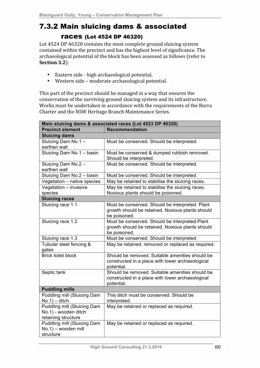
Blackguard Gully, Young – Conservation Management Plan
High Ground Consulting 21.3.2016 80
7.3.2 Main sluicing dams & associated races (Lot 4524 DP 46320)
Lot 4524 DP 46320 contains the most complete ground sluicing system contained within the precinct and has the highest level of significance. The archaeological potential of the block has been assessed as follows (refer to Section 3.2):
• Eastern side -‐ high archaeological potential, • Western side – moderate archaeological potential.
This part of the precinct should be managed in a way that ensures the conservation of the surviving ground sluicing system and its infrastructure. Works must be undertaken in accordance with the requirements of the Burra Charter and the NSW Heritage Branch Maintenance Series. Main sluicing dams & associated races (Lot 4523 DP 46320) Precinct element Recommendation Sluicing dams Sluicing Dam No.1 – earthen wall
Must be conserved. Should be interpreted.
Sluicing Dam No.1 – basin Must be conserved & dumped rubbish removed. Should be interpreted.
Sluicing Dam No.2 – earthen wall
Must be conserved. Should be interpreted.
Sluicing Dam No.2 – basin Must be conserved. Should be interpreted. Vegetation – native species May be retained to stabilise the sluicing races. Vegetation – invasive species
May be retained to stabilise the sluicing races. Noxious plants should be poisoned.
Sluicing races Sluicing race 1.1 Must be conserved. Should be interpreted. Plant
growth should be retained. Noxious plants should be poisoned.
Sluicing race 1.2 Must be conserved. Should be interpreted.Plant growth should be retained. Noxious plants should be poisoned.
Sluicing race 1.3 Must be conserved. Should be interpreted. Tubular steel fencing & gates
May be retained, removed or replaced as required.
Brick toilet block Should be removed. Suitable amenities should be constructed in a place with lower archaeological potential.
Septic tank Should be removed. Suitable amenities should be constructed in a place with lower archaeological potential.
Puddling mills Puddling mill (Sluicing Dam No.1) – ditch
This ditch must be conserved. Should be interpreted.
Puddling mill (Sluicing Dam No.1) - wooden ditch retaining structure
May be retained or replaced as required.
Puddling mill (Sluicing Dam No.1) – wooden mill structure
May be retained or replaced as required.
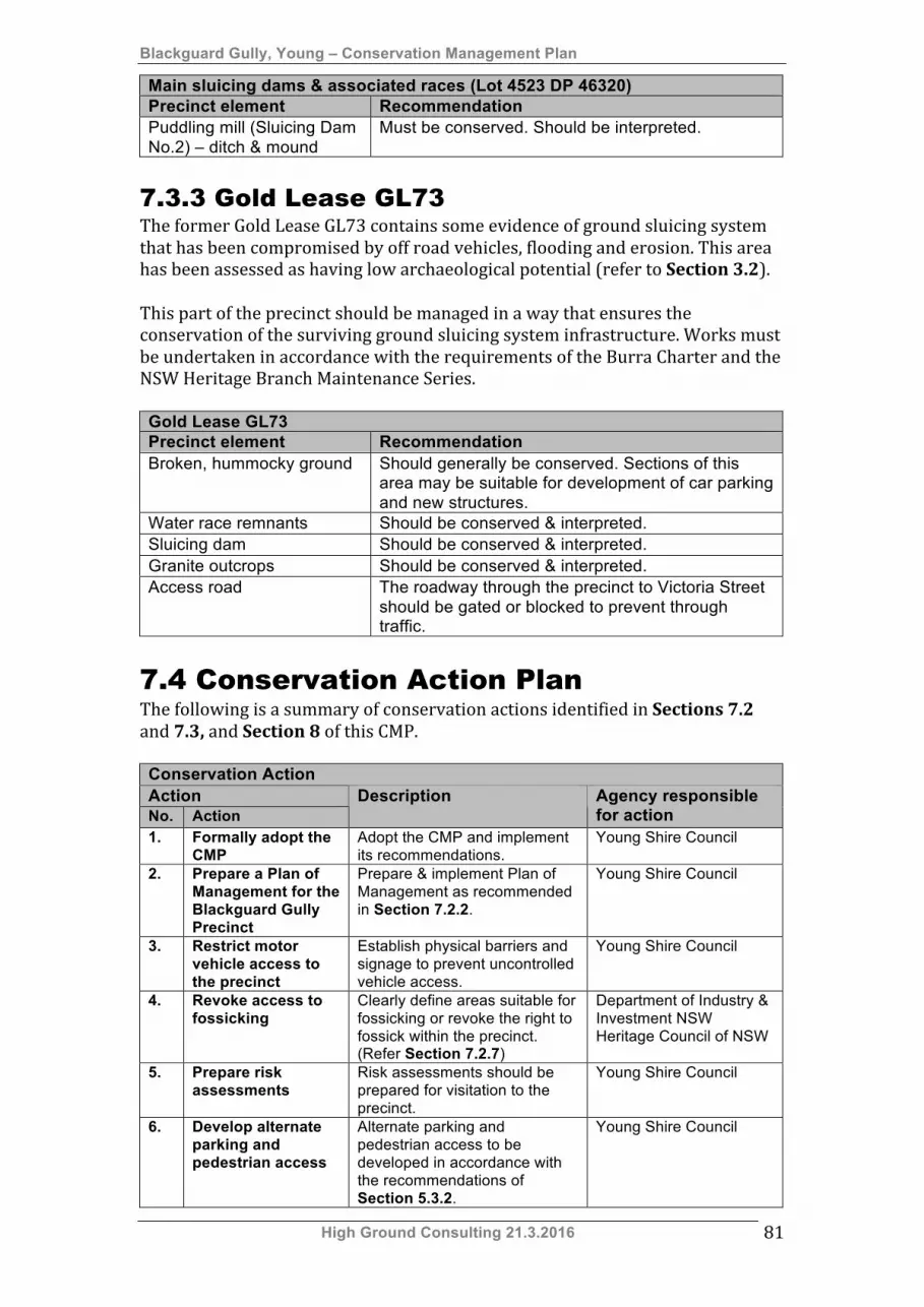
Blackguard Gully, Young – Conservation Management Plan
High Ground Consulting 21.3.2016 81
Main sluicing dams & associated races (Lot 4523 DP 46320) Precinct element Recommendation Puddling mill (Sluicing Dam No.2) – ditch & mound
Must be conserved. Should be interpreted.
7.3.3 Gold Lease GL73 The former Gold Lease GL73 contains some evidence of ground sluicing system that has been compromised by off road vehicles, flooding and erosion. This area has been assessed as having low archaeological potential (refer to Section 3.2). This part of the precinct should be managed in a way that ensures the conservation of the surviving ground sluicing system infrastructure. Works must be undertaken in accordance with the requirements of the Burra Charter and the NSW Heritage Branch Maintenance Series. Gold Lease GL73 Precinct element Recommendation Broken, hummocky ground Should generally be conserved. Sections of this
area may be suitable for development of car parking and new structures.
Water race remnants Should be conserved & interpreted. Sluicing dam Should be conserved & interpreted. Granite outcrops Should be conserved & interpreted. Access road The roadway through the precinct to Victoria Street
should be gated or blocked to prevent through traffic.
7.4 Conservation Action Plan The following is a summary of conservation actions identified in Sections 7.2 and 7.3, and Section 8 of this CMP. Conservation Action Action No. Action
Description Agency responsible for action
1. Formally adopt the CMP
Adopt the CMP and implement its recommendations.
Young Shire Council
2. Prepare a Plan of Management for the Blackguard Gully Precinct
Prepare & implement Plan of Management as recommended in Section 7.2.2.
Young Shire Council
3. Restrict motor vehicle access to the precinct
Establish physical barriers and signage to prevent uncontrolled vehicle access.
Young Shire Council
4. Revoke access to fossicking
Clearly define areas suitable for fossicking or revoke the right to fossick within the precinct. (Refer Section 7.2.7)
Department of Industry & Investment NSW Heritage Council of NSW
5. Prepare risk assessments
Risk assessments should be prepared for visitation to the precinct.
Young Shire Council
6. Develop alternate parking and pedestrian access
Alternate parking and pedestrian access to be developed in accordance with the recommendations of Section 5.3.2.
Young Shire Council
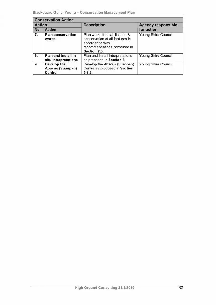
Blackguard Gully, Young – Conservation Management Plan
High Ground Consulting 21.3.2016 82
Conservation Action Action No. Action
Description Agency responsible for action
7. Plan conservation works
Plan works for stabilisation & conservation of all features in accordance with recommendations contained in Section 7.3.
Young Shire Council
8. Plan and install in situ interpretations
Plan and install interpretations as proposed in Section 8.
Young Shire Council
9. Develop the Abacus (Suànpán) Centre
Develop the Abacus (Suànpán) Centre as proposed in Section 5.3.3.
Young Shire Council
Blackguard Gully, Young – Conservation Management Plan
High Ground Consulting 21.3.2016 83
8. Interpretation This section provides a brief outline of potential interpretation strategies that could be applied to the Blackguard Gully precinct. Such strategies should include:
• Develop a logo specific to the interpretation of the site, • Development of escorted tours of the site, • Design and installation of on-‐site interpretive signage, • Erection of a new shelter structure to host interpretive and educational
activities. • Development of a web site and use of social media to share stories of
Blackguard Gully. In situ interpretations could be styled to complement the existing Gold Trails signage.
8.1 Interpretation themes The following interpretation themes should be used to guide the development of information sharing activities:
1. The Lambing Flat gold rush. 2. Conflict on the gold field – the Chinese miners 3. Alluvial mining methods. 4. Ground sluicing by the Fitzgibbon and O’Connell families – the Irish
miners
8.2 Development of interpretive pathways Interpretation should be planned to ensure that visitors obtain quality information on the historical context and archaeology of Blackguard Gully. Interpretation planning should establish a series of “pathways” through the precinct that encourage visitors to explore both the residual mining landscape and the process of ground sluicing. Tracks could be designed to provide clear views of, but avoid traversing, archaeological sites and ruins.
8.3 Site based interpretations Robust, well-‐designed signage should be developed to assist with providing an understanding of the story of Blackguard Gully. Such signs could be designed to speak to each of the interpretive themes identified in Section 8.1. National Parks and Wildlife standard signage is quite appropriate for use in outdoor and isolated settings such as Blackguard Gully. Locally designed signage consistent with the style of the current Gold Trails signage would also be most appropriate. Example of current Gold Trails signage are shown below.
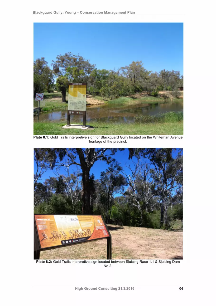
Blackguard Gully, Young – Conservation Management Plan
High Ground Consulting 21.3.2016 84
Plate 8.1: Gold Trails interpretive sign for Blackguard Gully located on the Whiteman Avenue frontage of the precinct.
Plate 8.2: Gold Trails interpretive sign located between Sluicing Race 1.1 & Sluicing Dam No.2.

Blackguard Gully, Young – Conservation Management Plan
High Ground Consulting 21.3.2016 85
8.4 Development of interpretations It is suggested that interpretations be developed in two phases. These are as follows:
Phase 1 – Development of an interpretive platform. Phase 2 – Development of interpretive pathways.
Each phase is described below.
8.4.1 Development of an interpretive platform
Proposals to develop parking and access from Victoria Street (refer to Section 5.3.2 Development of a visitor carpark) creates an opportunity to develop an interpretive platform on the high side of the Blackguard Gully SHR precinct. This platform could incorporate the following features:
• Visitor picnic shelter, • Interpretive panels providing the following;
o Overview of the physical features of the site, o Overview of the history of the place, including the anti-‐Chinese
riots and its subsequent history as a ground sluicing area. 8.4.2 Development of an interpretive
pathway An interpretive pathway could ideally follow Sluice Race 1.2 between Sluicing Dam No.1 and Sluicing Dam No.2. This should be illustrated with a plan showing the relationship of the dams and races with each other, and with the larger sluicing system developed by Patrick Fitzgibbon and William O’Connell. Interpretive points along this trail could include:
• Eastern end of Sluicing Dam No.1 – Overview of sluicing dam and Sluice Race 1.1, including interpretation of the varying levels of Sluice Race 1.1.
• Puddling Mill below Sluicing Dam No.1 – Interpretation of puddling. • Sluice Race 1.2 – Overview of the system of races and dams on the
Fitzgibbon/O’Connell leases. • Sluicing Dam No.2 – Interpretation of ground sluicing and puddling.
History of the Fitzgibbon and O’Connell families, and their association with the place.
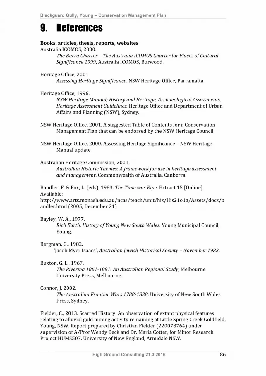
Blackguard Gully, Young – Conservation Management Plan
High Ground Consulting 21.3.2016 86
9. References Books, articles, thesis, reports, websites Australia ICOMOS, 2000.
The Burra Charter – The Australia ICOMOS Charter for Places of Cultural Significance 1999, Australia ICOMOS, Burwood.
Heritage Office, 2001 Assessing Heritage Significance. NSW Heritage Office, Parramatta. Heritage Office, 1996.
NSW Heritage Manual; History and Heritage, Archaeological Assessments, Heritage Assessment Guidelines. Heritage Office and Department of Urban Affairs and Planning (NSW), Sydney.
NSW Heritage Office, 2001. A suggested Table of Contents for a Conservation
Management Plan that can be endorsed by the NSW Heritage Council. NSW Heritage Office, 2000. Assessing Heritage Significance – NSW Heritage
Manual update Australian Heritage Commission, 2001.
Australian Historic Themes: A framework for use in heritage assessment and management. Commonwealth of Australia, Canberra.
Bandler, F. & Fox, L. (eds), 1983. The Time was Ripe. Extract 15 [Online]. Available: http://www.arts.monash.edu.au/ncas/teach/unit/his/His21o1a/Assets/docs/bandler.html (2005, December 21) Bayley, W. A., 1977.
Rich Earth. History of Young New South Wales. Young Municipal Council, Young.
Bergman, G., 1982. ‘Jacob Myer Isaacs’, Australian Jewish Historical Society – November 1982. Buxton, G. L., 1967.
The Riverina 1861-1891: An Australian Regional Study, Melbourne University Press, Melbourne.
Connor, J. 2002.
The Australian Frontier Wars 1788-1838. University of New South Wales Press, Sydney.
Fielder, C., 2013. Scarred History: An observation of extant physical features relating to alluvial gold mining activity remaining at Little Spring Creek Goldfield, Young, NSW. Report prepared by Christian Fielder (220078764) under supervision of A/Prof Wendy Beck and Dr. Maria Cotter, for Minor Research Project HUMS507. University of New England, Armidale NSW.

Blackguard Gully, Young – Conservation Management Plan
High Ground Consulting 21.3.2016 87
Fitzgerald, J., 2007. Big White Lie. Chinese Australians in White Australia. University of New South Wales Press, Sydney.
Flood, J., 1994.
Archaeology of the Dreamtime, Angus and Robertson, Sydney. Forbes, W., 2003.
Bow Bells to Burrowa Street. An early Australian life – the story of George Cranfield. D. W. Forbes, Leura.
Golden Gully and Archway [Online] Available: http://www.environment.nsw.gov.au/heritageapp/ViewHeritageItemDetails.aspx?ID=5045503 (2015, October 18) Hammond, M., 1988.
Remembered With Pride. The Recollections of an Australian Gold-digger. Cambaroora Star Publications & Ashfield Municipal Council, Lewisham.
Heritage Office and Department of Urban Affairs and Planning, 1996.
Regional Histories – Regional Histories of New South Wales. Crown Copyright, Sydney.
Irving, T. H., 1977.
‘1850-‐70’ in Crowley, F. K., ed. A New History of Australia, William Heinemann Australia, Melbourne.
Kabaila, P., 1996.
Wiradjuri Places. The Lachlan River Basin. Volume 2. Black Mountain Projects Pty Ltd., Jamison Centre.
Kass, T., 2003.
A Thematic History of the Central West. NSW Heritage Office, Parramatta. Kass, T., Liston, C. & McClymont, J., 1996.
Parramatta. A Past Revealed. Parramatta City Council, Parramatta. Lamb, M. & Hall, M., 2003.
Young: 120 Years of Local Government. 1882-2002. Maree E. Lamb & Margaret J. Hall, Young.
Langford-‐Smith, T., 1978.
Silcrete in Australia. Armidale, Department of Geography, University of New England.
Lawrence, S., 2000.
Dolly’s Creek: An Archaeology of a Victorian Goldfields Community. Melbourne University Press, South Carlton.
McGowan, B., 2003.

Blackguard Gully, Young – Conservation Management Plan
High Ground Consulting 21.3.2016 88
‘The archaeology of Chinese alluvial mining in Australia’ in Casey, M.& Ritchie, N. (eds.) Australasian Historical Archaeology Vol. 21. Australasian Society for Historical Archaeology, Sydney University.
McGowan, B., 1996.
‘The Typology and Techniques of Alluvial Mining’ in Birmingham, J. (ed.), Australasian Historical Archaeology Vol. 14. Australasian Society for Historical Archaeology, Sydney University.
McGowan, B., 1992.
‘Aspects of Gold Mining and Mining Communities in the Shoalhaven Area of New South Wales: An Archaeological and Historical Study’ in Birmingham, J. & Egloff, B. (eds.), Australasian Historical Archaeology Vol.10, Australasian Society for Historical Archaeology, Sydney University.
McGregor, H. & J., 1999.
Roll–Up. H.E. & J.K. McGregor, Dunedoo. Maroney, R., Undated. A Short History of the Lambing Flat Gold Rush 1860-‐1861. Mines, Department of, 1878.
Annual Report for the Department of Mines, New South Wales, for the Year 1877. Department of Mines, Sydney.
Mines, Department of, 1882.
Annual Report for the Department of Mines, New South Wales, for the Year 1881. Thomas Richards Government Printer, Sydney.
Mines, Department of, 1889. Annual Report for the Department of Mines, New South Wales, for the Year
1888. Charles Potter Government Printer, Sydney. Morrissey, S., 1978. ‘The Pastoral Economy 1821-‐1850’ in Griffin, J. (ed.), 1978,
Essays in Economic History of Australia, The Jacaranda Press, Milton. Mulvaney, J. & Kamminga, J., 1999.
Prehistory of Australia, Allen & Unwin, St Leonards. Musgrave, S., 1984.
The Wayback, Fred O’Reilly’s Printing Services, Young. Osborne, I., 1975. Annual Report Compilation. Young Division – Cootamundra Sheet. 1887-‐1975. Prepared for Department of Mineral Resources. Paskin, R., 2007. Landscape Management Plan Golden Gully. Prepared for Department of Environment and Climate Change, Parks & Wildlife Division. Pearson, M. & McGowan, B., Undated.
Mining Sites in NSW: History and Heritage – with guidelines for assessing heritage values and for taking actions on heritage mining places. NSW Government Industry & Investment, Sydney.
Blackguard Gully, Young – Conservation Management Plan
High Ground Consulting 21.3.2016 89
Pearson, M. & McGowan, B., 2000. Mining Heritage Places Assessment Manual. Australian Heritage Commission and National Trust, Canberra.
Preshaw, G., 1861?
‘Lambing Flat’ in Keesing, N. (ed.), 1971. History of the Australian Gold Rushes, Lloyd O’Neil, Hawthorn.
RPS Australia East Pty Ltd, 2014. Young Shire Council Aboriginal Heritage Study with Cultural Landscapes Mapping. Prepared for Young Shire Council. Ritchie, N., 1991.
‘Is There An Optimum System?: The Recording and Assessment of Historic Mining Sites.’ in Birmingham, J., Egloff, B. & Wilson, A.. (eds.) Australasian Historical Archaeology Vol.9. Australian Society for Historical Archaeology, Sydney University.
Ritchie, N. & Hooker, R., 1997.
‘An Archaeologist’s Guide to mining terminology’ in Lawrence, S. (ed.), Australasian Historical Archaeology Vol. 15. Australasian Society for Historical Archaeology, Sydney University.
Rowley, C. D., 1978.
The Destruction of Aboriginal Society, Penguin Books Ltd., Harmondsworth.
Smith, L., 2003.
‘Identifying Chinese ethnicity through material culture: archaeological excavations at Kiandra, NSW’ in Casey, M.& Ritchie, N. (eds.) Australasian Historical Archaeology Vol. 21. Australasian Society for Historical Archaeology, Sydney University.
Williams, M., 1999.
Chinese Settlement in NSW a thematic history. NSW Heritage Office, Parramatta. Wilton, J., 2004.
Golden threads: The Chinese in Regional New South Wales 1850-1950. New England Regional Art Museum, Armidale.
Young & District Family History Group Inc, 1988.
Pioneers of the Lachlan, Murrumbidgee and County King pre-1860. Young & District Family History Group Inc., Young.
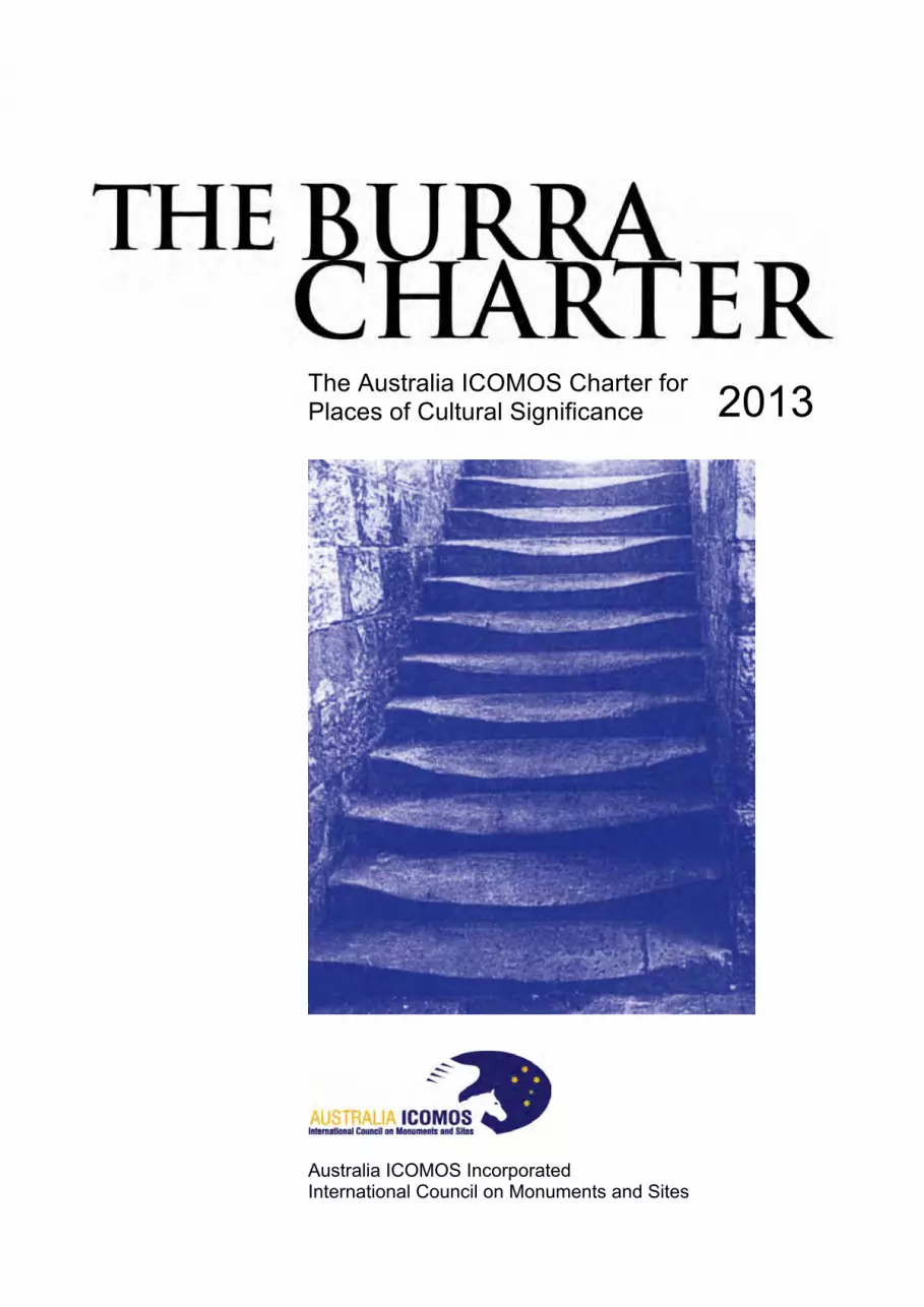
The Australia ICOMOS Charter for Places of Cultural Significance
Australia ICOMOS Incorporated International Council on Monuments and Sites
2013
ICOMOS
ICOMOS (International Council on Monuments and Sites) is a non-governmental professional organisation formed in 1965, with headquarters in Paris. ICOMOS is primarily concerned with the philosophy, terminology, methodology and techniques of cultural heritage conservation. It is closely linked to UNESCO, particularly in its role under the World Heritage Convention 1972 as UNESCO’s principal adviser on cultural matters related to World Heritage. The 11,000 members of ICOMOS include architects, town planners, demographers, archaeologists, geographers, historians, conservators, anthropologists, scientists, engineers and heritage administrators. Members in the 103 countries belonging to ICOMOS are formed into National Committees and participate in a range of conservation projects, research work, intercultural exchanges and cooperative activities. ICOMOS also has 27 International Scientific Committees that focus on particular aspects of the conservation field. ICOMOS members meet triennially in a General Assembly.
Australia ICOMOS
The Australian National Committee of ICOMOS (Australia ICOMOS) was formed in 1976. It elects an Executive Committee of 15 members, which is responsible for carrying out national programs and participating in decisions of ICOMOS as an international organisation. It provides expert advice as required by ICOMOS, especially in its relationship with the World Heritage Committee. Australia ICOMOS acts as a national and international link between public authorities, institutions and individuals involved in the study and conservation of all places of cultural significance. Australia ICOMOS members participate in a range of conservation activities including site visits, training, conferences and meetings.
Revision of the Burra Charter
The Burra Charter was first adopted in 1979 at the historic South Australian mining town of Burra. Minor revisions were made in 1981 and 1988, with more substantial changes in 1999.
Following a review this version was adopted by Australia ICOMOS in October 2013.
The review process included replacement of the 1988 Guidelines to the Burra Charter with Practice Notes which are available at: australia.icomos.org
Australia ICOMOS documents are periodically reviewed and we welcome any comments.
Citing the Burra Charter
The full reference is The Burra Charter: The Australia ICOMOS Charter for Places of Cultural Significance, 2013. Initial textual references should be in the form of the Australia ICOMOS Burra Charter, 2013 and later references in the short form (Burra Charter).
© Australia ICOMOS Incorporated 2013
The Burra Charter consists of the Preamble, Articles, Explanatory Notes and the flow chart.
This publication may be reproduced, but only in its entirety including the front cover and this page. Formatting must remain unaltered. Parts of the Burra Charter may be quoted with appropriate citing and acknowledgement.
Cover photograph by Ian Stapleton.
Australia ICOMOS Incorporated [ARBN 155 731 025]
Secretariat: c/o Faculty of Arts Deakin University Burwood, VIC 3125 Australia
http://australia.icomos.org/
ISBN 0 9578528 4 3
The Burra Charter, 2013 Australia ICOMOS Incorporated — 1
The Burra Charter (The Australia ICOMOS Charter for Places of Cultural Significance, 2013)
Preamble Considering the International Charter for the Conservation and Restoration of Monuments and Sites (Venice 1964), and the Resolutions of the 5th General Assembly of the International Council on Monuments and Sites (ICOMOS) (Moscow 1978), the Burra Charter was adopted by Australia ICOMOS (the Australian National Committee of ICOMOS) on 19 August 1979 at Burra, South Australia. Revisions were adopted on 23 February 1981, 23 April 1988, 26 November 1999 and 31 October 2013.
The Burra Charter provides guidance for the conservation and management of places of cultural significance (cultural heritage places), and is based on the knowledge and experience of Australia ICOMOS members.
Conservation is an integral part of the management of places of cultural significance and is an ongoing responsibility.
Who is the Charter for?
The Charter sets a standard of practice for those who provide advice, make decisions about, or undertake works to places of cultural significance, including owners, managers and custodians.
Using the Charter
The Charter should be read as a whole. Many articles are interdependent.
The Charter consists of:
• Definitions Article 1 • Conservation Principles Articles 2–13 • Conservation Processes Articles 14–25 • Conservation Practices Articles 26–34 • The Burra Charter Process flow chart.
The key concepts are included in the Conservation Principles section and these are further developed in the Conservation Processes and Conservation Practice sections. The flow chart explains the Burra Charter Process (Article 6) and is an integral part of
the Charter. Explanatory Notes also form part of the Charter.
The Charter is self-contained, but aspects of its use and application are further explained, in a series of Australia ICOMOS Practice Notes, in The Illustrated Burra Charter, and in other guiding documents available from the Australia ICOMOS web site: australia.icomos.org.
What places does the Charter apply to?
The Charter can be applied to all types of places of cultural significance including natural, Indigenous and historic places with cultural values.
The standards of other organisations may also be relevant. These include the Australian Natural Heritage Charter, Ask First: a guide to respecting Indigenous heritage places and values and Significance 2.0: a guide to assessing the significance of collections.
National and international charters and other doctrine may be relevant. See australia.icomos.org.
Why conserve?
Places of cultural significance enrich people’s lives, often providing a deep and inspirational sense of connection to community and landscape, to the past and to lived experiences. They are historical records, that are important expressions of Australian identity and experience. Places of cultural significance reflect the diversity of our communities, telling us about who we are and the past that has formed us and the Australian landscape. They are irreplaceable and precious.
These places of cultural significance must be conserved for present and future generations in accordance with the principle of inter-generational equity.
The Burra Charter advocates a cautious approach to change: do as much as necessary to care for the place and to make it useable, but otherwise change it as little as possible so that its cultural significance is retained.
2 — Australia ICOMOS Incorporated The Burra Charter, 2013
Articles Explanatory Notes
Article 1. Definitions
For the purposes of this Charter:
1.1 Place means a geographically defined area. It may include elements, objects, spaces and views. Place may have tangible and intangible dimensions.
Place has a broad scope and includes natural and cultural features. Place can be large or small: for example, a memorial, a tree, an individual building or group of buildings, the location of an historical event, an urban area or town, a cultural landscape, a garden, an industrial plant, a shipwreck, a site with in situ remains, a stone arrangement, a road or travel route, a community meeting place, a site with spiritual or religious connections.
1.2 Cultural significance means aesthetic, historic, scientific, social or spiritual value for past, present or future generations.
Cultural significance is embodied in the place itself, its fabric, setting, use, associations, meanings, records, related places and related objects.
Places may have a range of values for different individuals or groups.
The term cultural significance is synonymous with cultural heritage significance and cultural heritage value.
Cultural significance may change over time and with use.
Understanding of cultural significance may change as a result of new information.
1.3 Fabric means all the physical material of the place including elements, fixtures, contents and objects.
Fabric includes building interiors and sub-‐‑surface remains, as well as excavated material.
Natural elements of a place may also constitute fabric. For example the rocks that signify a Dreaming place.
Fabric may define spaces and views and these may be part of the significance of the place.
1.4 Conservation means all the processes of looking after a place so as to retain its cultural significance.
See also Article 14.
1.5 Maintenance means the continuous protective care of a place, and its setting.
Maintenance is to be distinguished from repair which involves restoration or reconstruction.
Examples of protective care include: • maintenance — regular inspection and cleaning of a place, e.g. mowing and pruning in a garden;
• repair involving restoration — returning dislodged or relocated fabric to its original location e.g. loose roof gutters on a building or displaced rocks in a stone bora ring;
• repair involving reconstruction — replacing decayed fabric with new fabric
1.6 Preservation means maintaining a place in its existing state and retarding deterioration.
It is recognised that all places and their elements change over time at varying rates.
1.7 Restoration means returning a place to a known earlier state by removing accretions or by reassembling existing elements without the introduction of new material.
1.8 Reconstruction means returning a place to a known earlier state and is distinguished from restoration by the introduction of new material.
New material may include recycled material salvaged from other places. This should not be to the detriment of any place of cultural significance.
1.9 Adaptation means changing a place to suit the existing use or a proposed use.
1.10 Use means the functions of a place, including the activities and traditional and customary practices that may occur at the place or are dependent on the place.
Use includes for example cultural practices commonly associated with Indigenous peoples such as ceremonies, hunting and fishing, and fulfillment of traditional obligations. Exercising a right of access may be a use.
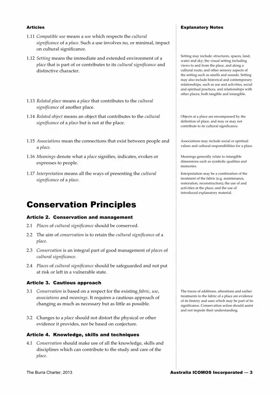
The Burra Charter, 2013 Australia ICOMOS Incorporated — 3
Articles Explanatory Notes
1.11 Compatible use means a use which respects the cultural significance of a place. Such a use involves no, or minimal, impact on cultural significance.
1.12 Setting means the immediate and extended environment of a place that is part of or contributes to its cultural significance and distinctive character.
Setting may include: structures, spaces, land, water and sky; the visual setting including views to and from the place, and along a cultural route; and other sensory aspects of the setting such as smells and sounds. Setting may also include historical and contemporary relationships, such as use and activities, social and spiritual practices, and relationships with other places, both tangible and intangible.
1.13 Related place means a place that contributes to the cultural significance of another place.
1.14 Related object means an object that contributes to the cultural significance of a place but is not at the place.
Objects at a place are encompassed by the definition of place, and may or may not contribute to its cultural significance.
1.15 Associations mean the connections that exist between people and a place.
Associations may include social or spiritual values and cultural responsibilities for a place.
1.16 Meanings denote what a place signifies, indicates, evokes or expresses to people.
Meanings generally relate to intangible dimensions such as symbolic qualities and memories.
1.17 Interpretation means all the ways of presenting the cultural significance of a place.
Interpretation may be a combination of the treatment of the fabric (e.g. maintenance, restoration, reconstruction); the use of and activities at the place; and the use of introduced explanatory material.
Conservation Principles
Article 2. Conservation and management
2.1 Places of cultural significance should be conserved.
2.2 The aim of conservation is to retain the cultural significance of a place.
2.3 Conservation is an integral part of good management of places of cultural significance.
2.4 Places of cultural significance should be safeguarded and not put at risk or left in a vulnerable state.
Article 3. Cautious approach
3.1 Conservation is based on a respect for the existing fabric, use, associations and meanings. It requires a cautious approach of changing as much as necessary but as little as possible.
The traces of additions, alterations and earlier treatments to the fabric of a place are evidence of its history and uses which may be part of its significance. Conservation action should assist and not impede their understanding.
3.2 Changes to a place should not distort the physical or other evidence it provides, nor be based on conjecture.
Article 4. Knowledge, skills and techniques
4.1 Conservation should make use of all the knowledge, skills and disciplines which can contribute to the study and care of the place.
4 — Australia ICOMOS Incorporated The Burra Charter, 2013
Articles Explanatory Notes
4.2 Traditional techniques and materials are preferred for the conservation of significant fabric. In some circumstances modern techniques and materials which offer substantial conservation benefits may be appropriate.
The use of modern materials and techniques must be supported by firm scientific evidence or by a body of experience.
Article 5. Values
5.1 Conservation of a place should identify and take into consideration all aspects of cultural and natural significance without unwarranted emphasis on any one value at the expense of others.
Conservation of places with natural significance is explained in the Australian Natural Heritage Charter. This Charter defines natural significance to mean the importance of ecosystems, biodiversity and geodiversity for their existence value or for present or future generations, in terms of their scientific, social, aesthetic and life-‐‑support value.
In some cultures, natural and cultural values are indivisible.
5.2 Relative degrees of cultural significance may lead to different conservation actions at a place.
A cautious approach is needed, as understanding of cultural significance may change. This article should not be used to justify actions which do not retain cultural significance.
Article 6. Burra Charter Process
6.1 The cultural significance of a place and other issues affecting its future are best understood by a sequence of collecting and analysing information before making decisions. Understanding cultural significance comes first, then development of policy and finally management of the place in accordance with the policy. This is the Burra Charter Process.
6.2 Policy for managing a place must be based on an understanding of its cultural significance.
6.3 Policy development should also include consideration of other factors affecting the future of a place such as the owner’s needs, resources, external constraints and its physical condition.
The Burra Charter Process, or sequence of investigations, decisions and actions, is illustrated below and in more detail in the accompanying flow chart which forms part of the Charter.
Understand Significance
ê
Develop Policy
ê
Manage in Accordance with Policy
6.4 In developing an effective policy, different ways to retain cultural significance and address other factors may need to be explored.
6.5 Changes in circumstances, or new information or perspectives, may require reiteration of part or all of the Burra Charter Process.
Options considered may include a range of uses and changes (e.g. adaptation) to a place.
Article 7. Use
7.1 Where the use of a place is of cultural significance it should be retained.
7.2 A place should have a compatible use. The policy should identify a use or combination of uses or constraints on uses that retain the cultural significance of the place. New use of a place should involve minimal change to significant fabric and use; should respect associations and meanings; and where appropriate should provide for continuation of activities and practices which contribute to the cultural significance of the place.

The Burra Charter, 2013 Australia ICOMOS Incorporated — 5
Articles Explanatory Notes
Article 8. Setting
Conservation requires the retention of an appropriate setting. This includes retention of the visual and sensory setting, as well as the retention of spiritual and other cultural relationships that contribute to the cultural significance of the place.
New construction, demolition, intrusions or other changes which would adversely affect the setting or relationships are not appropriate.
Setting is explained in Article 1.12.
Article 9. Location
9.1 The physical location of a place is part of its cultural significance. A building, work or other element of a place should remain in its historical location. Relocation is generally unacceptable unless this is the sole practical means of ensuring its survival.
9.2 Some buildings, works or other elements of places were designed to be readily removable or already have a history of relocation. Provided such buildings, works or other elements do not have significant links with their present location, removal may be appropriate.
9.3 If any building, work or other element is moved, it should be moved to an appropriate location and given an appropriate use. Such action should not be to the detriment of any place of cultural significance.
Article 10. Contents
Contents, fixtures and objects which contribute to the cultural significance of a place should be retained at that place. Their removal is unacceptable unless it is: the sole means of ensuring their security and preservation; on a temporary basis for treatment or exhibition; for cultural reasons; for health and safety; or to protect the place. Such contents, fixtures and objects should be returned where circumstances permit and it is culturally appropriate.
For example, the repatriation (returning) of an object or element to a place may be important to Indigenous cultures, and may be essential to the retention of its cultural significance.
Article 28 covers the circumstances where significant fabric might be disturbed, for example, during archaeological excavation.
Article 33 deals with significant fabric that has been removed from a place.
Article 11. Related places and objects
The contribution which related places and related objects make to the cultural significance of the place should be retained.
Article 12. Participation
Conservation, interpretation and management of a place should provide for the participation of people for whom the place has significant associations and meanings, or who have social, spiritual or other cultural responsibilities for the place.
Article 13. Co-existence of cultural values
Co-existence of cultural values should always be recognised, respected and encouraged. This is especially important in cases where they conflict.
For some places, conflicting cultural values may affect policy development and management decisions. In Article 13, the term cultural values refers to those beliefs which are important to a cultural group, including but not limited to political, religious, spiritual and moral beliefs. This is broader than values associated with cultural significance.
6 — Australia ICOMOS Incorporated The Burra Charter, 2013
Articles Explanatory Notes
Conservation Processes
Article 14. Conservation processes
Conservation may, according to circumstance, include the processes of: retention or reintroduction of a use; retention of associations and meanings; maintenance, preservation, restoration, reconstruction, adaptation and interpretation; and will commonly include a combination of more than one of these. Conservation may also include retention of the contribution that related places and related objects make to the cultural significance of a place.
Conservation normally seeks to slow deterioration unless the significance of the place dictates otherwise. There may be circumstances where no action is required to achieve conservation.
Article 15. Change
15.1 Change may be necessary to retain cultural significance, but is undesirable where it reduces cultural significance. The amount of change to a place and its use should be guided by the cultural significance of the place and its appropriate interpretation.
When change is being considered, including for a temporary use, a range of options should be explored to seek the option which minimises any reduction to its cultural significance.
It may be appropriate to change a place where this reflects a change in cultural meanings or practices at the place, but the significance of the place should always be respected.
15.2 Changes which reduce cultural significance should be reversible, and be reversed when circumstances permit.
Reversible changes should be considered temporary. Non-‐‑reversible change should only be used as a last resort and should not prevent future conservation action.
15.3 Demolition of significant fabric of a place is generally not acceptable. However, in some cases minor demolition may be appropriate as part of conservation. Removed significant fabric should be reinstated when circumstances permit.
15.4 The contributions of all aspects of cultural significance of a place should be respected. If a place includes fabric, uses, associations or meanings of different periods, or different aspects of cultural significance, emphasising or interpreting one period or aspect at the expense of another can only be justified when what is left out, removed or diminished is of slight cultural significance and that which is emphasised or interpreted is of much greater cultural significance.
Article 16. Maintenance
Maintenance is fundamental to conservation. Maintenance should be undertaken where fabric is of cultural significance and its maintenance is necessary to retain that cultural significance.
Maintaining a place may be important to the fulfilment of traditional laws and customs in some Indigenous communities and other cultural groups.
Article 17. Preservation
Preservation is appropriate where the existing fabric or its condition constitutes evidence of cultural significance, or where insufficient evidence is available to allow other conservation processes to be carried out.
Preservation protects fabric without obscuring evidence of its construction and use. The process should always be applied: • where the evidence of the fabric is of such significance that it should not be altered; or
• where insufficient investigation has been carried out to permit policy decisions to be taken in accord with Articles 26 to 28.
New work (e.g. stabilisation) may be carried out in association with preservation when its purpose is the physical protection of the fabric and when it is consistent with Article 22.
The Burra Charter, 2013 Australia ICOMOS Incorporated — 7
Articles Explanatory Notes
Article 18. Restoration and reconstruction
Restoration and reconstruction should reveal culturally significant aspects of the place.
Article 19. Restoration
Restoration is appropriate only if there is sufficient evidence of an earlier state of the fabric.
Article 20. Reconstruction
20.1 Reconstruction is appropriate only where a place is incomplete through damage or alteration, and only where there is sufficient evidence to reproduce an earlier state of the fabric. In some cases, reconstruction may also be appropriate as part of a use or practice that retains the cultural significance of the place.
Places with social or spiritual value may warrant reconstruction, even though very little may remain (e.g. only building footings or tree stumps following fire, flood or storm). The requirement for sufficient evidence to reproduce an earlier state still applies.
20.2 Reconstruction should be identifiable on close inspection or through additional interpretation.
Article 21. Adaptation
21.1 Adaptation is acceptable only where the adaptation has minimal impact on the cultural significance of the place.
Adaptation may involve additions to the place, the introduction of new services, or a new use, or changes to safeguard the place. Adaptation of a place for a new use is often referred to as ‘adaptive re-‐‑use’ and should be consistent with Article 7.2.
21.2 Adaptation should involve minimal change to significant fabric, achieved only after considering alternatives.
Article 22. New work
22.1 New work such as additions or other changes to the place may be acceptable where it respects and does not distort or obscure the cultural significance of the place, or detract from its interpretation and appreciation.
New work should respect the significance of a place through consideration of its siting, bulk, form, scale, character, colour, texture and material. Imitation should generally be avoided.
22.2 New work should be readily identifiable as such, but must respect and have minimal impact on the cultural significance of the place.
New work should be consistent with Articles 3, 5, 8, 15, 21 and 22.1.
Article 23. Retaining or reintroducing use
Retaining, modifying or reintroducing a significant use may be appropriate and preferred forms of conservation.
These may require changes to significant fabric but they should be minimised. In some cases, continuing a significant use, activity or practice may involve substantial new work.
Article 24. Retaining associations and meanings
24.1 Significant associations between people and a place should be respected, retained and not obscured. Opportunities for the interpretation, commemoration and celebration of these associations should be investigated and implemented.
For many places associations will be linked to aspects of use, including activities and practices.
Some associations and meanings may not be apparent and will require research.
24.2 Significant meanings, including spiritual values, of a place should be respected. Opportunities for the continuation or revival of these meanings should be investigated and implemented.

8 — Australia ICOMOS Incorporated The Burra Charter, 2013
Articles Explanatory Notes
Article 25. Interpretation
The cultural significance of many places is not readily apparent, and should be explained by interpretation. Interpretation should enhance understanding and engagement, and be culturally appropriate.
In some circumstances any form of interpretation may be culturally inappropriate.
Conservation Practice
Article 26. Applying the Burra Charter Process
26.1 Work on a place should be preceded by studies to understand the place which should include analysis of physical, documentary, oral and other evidence, drawing on appropriate knowledge, skills and disciplines.
The results of studies should be kept up to date, regularly reviewed and revised as necessary.
26.2 Written statements of cultural significance and policy for the place should be prepared, justified and accompanied by supporting evidence. The statements of significance and policy should be incorporated into a management plan for the place.
Policy should address all relevant issues, e.g. use, interpretation, management and change.
A management plan is a useful document for recording the Burra Charter Process, i.e. the steps in planning for and managing a place of cultural significance (Article 6.1 and flow chart). Such plans are often called conservation management plans and sometimes have other names.
The management plan may deal with other matters related to the management of the place.
26.3 Groups and individuals with associations with the place as well as those involved in its management should be provided with opportunities to contribute to and participate in identifying and understanding the cultural significance of the place. Where appropriate they should also have opportunities to participate in its conservation and management.
26.4 Statements of cultural significance and policy for the place should be periodically reviewed, and actions and their consequences monitored to ensure continuing appropriateness and effectiveness.
Monitor actions taken in case there are also unintended consequences.
Article 27. Managing change
27.1 The impact of proposed changes, including incremental changes, on the cultural significance of a place should be assessed with reference to the statement of significance and the policy for managing the place. It may be necessary to modify proposed changes to better retain cultural significance.
27.2 Existing fabric, use, associations and meanings should be adequately recorded before and after any changes are made to the place.
Article 28. Disturbance of fabric
28.1 Disturbance of significant fabric for study, or to obtain evidence, should be minimised. Study of a place by any disturbance of the fabric, including archaeological excavation, should only be undertaken to provide data essential for decisions on the conservation of the place, or to obtain important evidence about to be lost or made inaccessible.
The Burra Charter, 2013 Australia ICOMOS Incorporated — 9
Articles Explanatory Notes
28.2 Investigation of a place which requires disturbance of the fabric, apart from that necessary to make decisions, may be appropriate provided that it is consistent with the policy for the place. Such investigation should be based on important research questions which have potential to substantially add to knowledge, which cannot be answered in other ways and which minimises disturbance of significant fabric.
Article 29. Responsibility
The organisations and individuals responsible for management and decisions should be named and specific responsibility taken for each decision.
Article 30. Direction, supervision and implementation
Competent direction and supervision should be maintained at all stages, and any changes should be implemented by people with appropriate knowledge and skills.
Article 31. Keeping a log
New evidence may come to light while implementing policy or a plan for a place. Other factors may arise and require new decisions. A log of new evidence and additional decisions should be kept.
New decisions should respect and have minimal impact on the cultural significance of the place.
Article 32. Records
32.1 The records associated with the conservation of a place should be placed in a permanent archive and made publicly available, subject to requirements of security and privacy, and where this is culturally appropriate.
32.2 Records about the history of a place should be protected and made publicly available, subject to requirements of security and privacy, and where this is culturally appropriate.
Article 33. Removed fabric
Significant fabric which has been removed from a place including contents, fixtures and objects, should be catalogued, and protected in accordance with its cultural significance.
Where possible and culturally appropriate, removed significant fabric including contents, fixtures and objects, should be kept at the place.
Article 34. Resources
Adequate resources should be provided for conservation. The best conservation often involves the least work and can be inexpensive.
Words in italics are defined in Article 1.
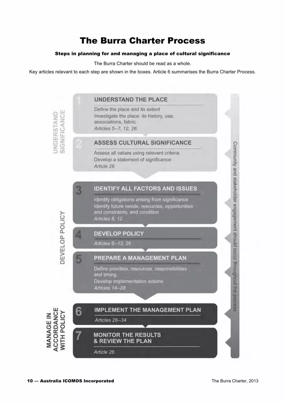
10 — Australia ICOMOS Incorporated The Burra Charter, 2013
The Burra Charter Process Steps in planning for and managing a place of cultural significance
The Burra Charter should be read as a whole.
Key articles relevant to each step are shown in the boxes. Article 6 summarises the Burra Charter Process.

HERITAGE INFORMATION SERIES
STANDARD EXEMPTIONS FOR WORKS REQUIRING HERITAGE COUNCIL
APPROVAL
DISCLAIMER Any representation, statement, opinion or advice, expressed or implied in this publication is made in good faith but on the basis that the State of New South Wales, its agents and employees are not liable (whether by reason of negligence, lack of care or otherwise) to any person for any damage or loss whatsoever which has occurred or may occur in relation to that person taking or not taking (as the case may be) action in respect of any representation, statement or advice referred to above. Heritage Branch, Department of Planning Locked Bag 5020 Parramatta NSW 2124 Ph: (02) 9873 8500 Fax: (02) 9873 8599 www.heritage.nsw.gov.au Crown copyright 1999 New edition 2003, revised 2004, 2005 New edition 2006, revised 2009 ISBN 1 921121 03 3 HO 06/04
2

3
CONTENTS
INTRODUCTION 4 WHY HAVE STANDARD EXEMPTIONS? 5
5
5
67
1011131517
18
1920212223242628
293031
HOW WILL EXEMPTIONS ALREADY IN PLACE BE AFFECTED BY THE NEW STANDARD EXEMPTIONS? WHAT OTHER APPROVALS ARE NECESSARY TO DO WORK ON A HERITAGE ITEM? HOW TO RELATE THE STANDARD EXEMPTION CLAUSES TO YOUR HERITAGE ITEM
SCHEDULE OF STANDARD EXEMPTIONS GENERAL CONDITIONS 8 STANDARD EXEMPTION 1: MAINTENANCE AND CLEANING STANDARD EXEMPTION 2: REPAIRS STANDARD EXEMPTION 3: PAINTING STANDARD EXEMPTION 4: EXCAVATION STANDARD EXEMPTION 5: RESTORATION STANDARD EXEMPTION 6:
DEVELOPMENT ENDORSED BY THE HERITAGE
COUNCIL OR DIRECTOR-GENERALSTANDARD EXEMPTION 7: MINOR ACTIVITIES WITH LITTLE OR NO ADVERSE IMPACT ON HERITAGE SIGNIFICANCE STANDARD EXEMPTION 8: NON-SIGNIFICANT FABRIC STANDARD EXEMPTION 9: CHANGE OF USE STANDARD EXEMPTION 10: NEW BUILDINGS STANDARD EXEMPTION 11: TEMPORARY STRUCTURES STANDARD EXEMPTION 12: LANDSCAPE MAINTENANCE STANDARD EXEMPTION 13: SIGNAGE STANDARD EXEMPTION 14: BURIAL SITES AND CEMETERIES STANDARD EXEMPTION 15: COMPLIANCE WITH MINIMUM STANDARDS AND ORDERS STANDARD EXEMPTION 16: SAFETY AND SECURITY STANDARD EXEMPTION 17: MOVABLE HERITAGE ITEMS
INTRODUCTION In NSW important items of our environmental heritage are listed on the State Heritage Register. Any changes to those items should respect and retain those qualities and characteristics that make the heritage place special. Any major works proposed for State Heritage Register items therefore need to be assessed and approved by the Heritage Council to ensure that the heritage significance of the item will not be adversely affected. However, the assessment process can waste the time and resources of both the owner and the Heritage Council if the works are only minor in nature and will have minimal impact on the heritage significance of the place. The Heritage Act allows the Minister for Planning, on the recommendation of the Heritage Council, to grant exemptions for certain activities which would otherwise require approval under the NSW Heritage Act. There are two types of exemptions which can apply to a heritage item listed on the State Heritage Register: 1. standard exemptions for all items on the State Heritage Register. Typical
activities that are exempted include building maintenance, minor repairs, alterations to certain interiors or areas and change of use.
2. site specific exemptions for a particular heritage item can be approved by
the Minister on the recommendation of the Heritage Council. These guidelines have been prepared to inform owners and managers of heritage items listed on the State Heritage Register about the standard exemptions. They also explain how to develop site specific exemptions for a heritage item. The State Heritage Register Heritage places and items of particular importance to the people of New South Wales are listed on the State Heritage Register. The Register was created in April 1999 by amendments to the Heritage Act 1977. The key to listing on the State Heritage Register is the level of significance. Only those heritage items which are of state significance in NSW are listed on the State Heritage Register. To check whether an item is listed on the register, check the online heritage database on the homepage of the Heritage Branch, Department of Planning: www.heritage.nsw.gov.au This online database lists all statutorily protected items in NSW. It may be accessed from the homepage, via the Listings tab, then Heritage databases.
4

WHY HAVE STANDARD EXEMPTIONS? The standard exemptions apply to all items listed on the State Heritage Register. These exemptions came into force on 5 September, 2008. They replace all previous standard exemptions. The current exemptions replace those gazetted on 4 April 2006 and as amended 28 April 2006. They relate to a broad range of minor development and will result in a more streamlined approval process. The purpose of the standard exemptions is to clarify for owners, the Heritage Branch and local councils what kind of maintenance and minor works can be undertaken without needing Heritage Council approval. This ensures that owners are not required to make unnecessary applications for minor maintenance and repair. The Heritage Council has prepared guidelines to help owners and managers to interpret and apply the standard exemptions. Those guidelines were first published in 2004 and have been incorporated into this document. HOW WILL EXEMPTIONS ALREADY IN PLACE BE AFFECTED BY THE NEW STANDARD EXEMPTIONS? 1. Standard Exemptions: The new standard exemptions replace all existing
standard exemptions. 2. Site Specific Exemptions: Some heritage items have site specific
exemptions for works other than those in the standard list. Site specific exemptions will continue to remain in force.
WHAT OTHER APPROVALS ARE NECESSARY TO DO WORK ON A HERITAGE ITEM? The exemptions only reduce the need to obtain approval from the Heritage Council, under section 60 of the Heritage Act, to carry out works to a heritage item listed on the State Heritage Register. You should check with your local council for information on additional development and building approvals, and with the Heritage Branch for other approvals which may be required under the Heritage Act, such as an Excavation Permit.
5

6
HOW TO RELATE THE STANDARD EXEMPTION CLAUSES TO YOUR HERITAGE ITEM The standard exemption clauses can be grouped under two headings:
maintenance and repairs; alterations.
Clauses have been kept as concise as possible to avoid ambiguities. The terminology used is consistent with the Australia ICOMOS Burra Charter. Australia ICOMOS is the Australian Chapter of International Council on Monuments and Sites, a UNESCO-affiliated international organisation of conservation specialists. The Burra Charter is a nationally accepted standard for assessing and managing change to heritage items. Before you develop firm proposals for changes to the heritage item, take the following actions: [ 1.] Check the boundaries of the item to which the State
Heritage Register listing applies; [ 2.] Check the exemptions which apply to your heritage item; [ 3.] Read these explanatory notes to ensure that the work you propose is exempted, and check if prior Heritage Council notification and endorsement is required before the works are commenced; [ 4.] If the work is not exempted, apply to the Heritage Council for approval under section 60 of the Heritage Act; [ 5.] Check with the local council concerning other approvals that may be required; [ 6.] Check with the Heritage Branch if the work you propose involves the disturbance of relics more than 50 years old.

SCHEDULE OF STANDARD EXEMPTIONS
HERITAGE ACT, 1977
NOTICE OF ORDER UNDER SECTION 57(2) OF THE HERITAGE ACT, 1977
I, the Minister for Planning, pursuant to subsection 57(2) of the Heritage Act 1977, on the recommendation of the Heritage Council of New South Wales, do by this Order:
1. revoke the Schedule of Exemptions to subsection 57(1) of the Heritage Act made under subsection 57(2) and published in the Government Gazette on 22 February 2008; and
2. grant standard exemptions from subsection 57(1) of the Heritage Act 1977, described in the Schedule attached.
FRANK SARTOR
Minister for Planning
Sydney, 11 July 2008
7
SCHEDULE OF EXEMPTIONS TO SUBSECTION 57(1) OF THE
HERITAGE ACT 1977
MADE UNDER SUBSECTION 57(2)
GENERAL CONDITIONS
1. These general conditions apply to all of the following Exemptions.
2. Anything done pursuant to the following Exemptions must be carried out in accordance with relevant Guidelines issued by the Heritage Branch including “The Maintenance of Heritage Assets: A Practical Guide” 1998, “Movable Heritage Principles” 2000 and “The Heritage Council Policy on Managing Change to Heritage Items”.
3. The following Standard Exemptions do not apply to anything affecting objects, places, items or sites of heritage significance to Aboriginal people or which affect traditional access by Aboriginal people.
4. The Director, and Managers employed by the Heritage Branch,-Department of Planning; the Executive Director, Tenant and Asset Management Services, employed by the Sydney Harbour Foreshore Authority; the Executive Director Culture & Heritage employed by the Department of Environment and Climate Change and the General Manager, Sustainability employed by the Sydney Water Corporation may perform any of the functions of the Director-General of the Department of Planning (Director-General) under these exemptions.
The authorisation to the Executive Director, Tenant and Asset Management Services of the Sydney Harbour Foreshore Authority is restricted to land for which it is the delegated approval body under section 169 of the Heritage Act, and the preparation and submission of information required to demonstrate that compliance with the criteria contained in these exemptions is satisfied, must not be carried out by the Executive Director, Tenant and Asset Management Services.
The authorisation to the Executive Director Culture & Heritage of the Department of Environment and Climate Change is restricted to land for which it is the delegated approval body under section 169 of the Heritage Act, and the preparation and submission of information required to demonstrate that compliance with the criteria contained in these exemptions is satisfied, must not be carried out by the Executive Director Culture & Heritage. The authorisation to the General Manager, Sustainability employed by the Sydney Water Corporation is restricted to land for which it is the delegated approval body under section 169 of the Heritage Act, and the preparation and submission of information required to demonstrate that compliance with the criteria contained in these exemptions is
8
satisfied, must not be carried out by the General Manager, Sustainability.
5. In these Exemptions, words shall be given the same meaning as in the Heritage Act 1977 (“the Act”) unless the contrary intention appears from the context of the exemption.
6. Anything done pursuant to the following Exemptions must be specified, supervised and carried out by people with knowledge, skills and experience appropriate to the work.
Guidelines
In addition to the above guidelines listed in paragraph two, the Heritage Council adopted further guidelines on 7 April 2004 (revised 2009) for use in interpreting and applying the standard exemptions.
If it is unclear whether proposed development satisfies the requirements of these exemptions, an application will be required under section 60 of the Heritage Act.
9

STANDARD EXEMPTION 1: MAINTENANCE AND CLEANING
1. The following maintenance and cleaning does not require approval under subsection 57(1) of the Act:
(a) the maintenance of an item to retain its condition or operation without the removal of or damage to the existing fabric or the introduction of new materials;
(b) cleaning including the removal of surface deposits, organic growths or graffiti by the use of low pressure water (less than 100 psi at the surface being cleaned) and neutral detergents and mild brushing and scrubbing.
NOTE 1: Traditional finishes such as oils and waxes must continue to be used for timber surfaces rather than modern alternative protective coatings such as polyurethane or acrylic which may seal the surface and can cause damage.
NOTE 2: Surface patina which has developed on the fabric may be an important part of the item's significance and if so needs to be preserved during maintenance and cleaning.
Guidelines
Maintenance is distinguished from repairs, restoration and reconstruction as it does not involve the removal of or damage to existing fabric or the introduction of new materials. It is a continuing process of protective care. Typical maintenance activity includes:
the removal of vegetation and litter from gutters and drainage systems;
resecuring and tightening fixings of loose elements of building fabric;
lubricating equipment and services which have moving parts;
the application of protective coatings such as limewash, polish, oils and waxes to surfaces which have previously had such coatings applied; and
cleaning by the removal of surface deposits using methods other than aggressive mechanical or chemical techniques such as high pressure, high temperature or strong solvents which may affect the substrate.
This standard exemption applies to the maintenance of all types of heritage items including buildings, works, landscapes, cemeteries and movable heritage. Reference should be made to other relevant standard exemptions (#12, 14 and 17) for particular types of items.
10

STANDARD EXEMPTION 2: REPAIRS
1. 1. Repair to an item which is of the type described in (a) or (b) below does not require approval under subsection 57(1) of the Act:
(a) the replacement of services such as cabling, plumbing, wiring and fire services that uses existing service routes, cavities or voids or replaces existing surface mounted services and does not involve damage to or the removal of significant fabric;
(b) the repair (such as refixing and patching) or the replacement of missing, damaged or deteriorated fabric that is beyond further maintenance, which matches the existing fabric in appearance, material and method of affixing and does not involve damage to or the removal of significant fabric.
NOTE 1: Repairs must be based on the principle of doing as little as possible and only as much as is necessary to retain and protect the element. Therefore replacement must only occur as a last resort where the major part of an element has decayed beyond further maintenance.
NOTE 2: Any new materials used for repair must not exacerbate the decay of existing fabric due to chemical incompatibility, obscure existing fabric or limit access to existing fabric for future maintenance.
NOTE 3: Repair must maximise protection and retention of fabric and include the conservation of existing detailing, such as vents, capping, chimneys, carving, decoration or glazing.
Guidelines
This standard exemption is not intended to allow the cumulative replacement of large amounts or a high proportion of the fabric of an item. If replacement of large amounts of fabric is necessary, an application will be required to be submitted under s. 60 of the Heritage Act. If there is uncertainty about whether the proposed extent of repair is exempt from approval, advice should be sought from the Heritage Branch, Department of Planning.
Repairs should have detailed specifications and carried out by licensed tradespeople with experience in the conservation of heritage buildings. It is essential that the composition of elements of the fabric such renders, mortars, timber species and metal types remain the same to assist with matching appearance and avoiding chemical incompatibility.
Repair may involve reconstruction which means returning an item to a known earlier state. This may involve the use of new or recycled materials.
11

Reconstruction must satisfy a four-part test to qualify for exemption from approval:
1. The nature of the earlier state being reconstructed must be known. Where there is conjecture about the earlier state of the fabric or where it is proposed to change the appearance, material or method of fixing of the fabric an application under s.60 of the Heritage Act will be required.
2. The replacement fabric must be matching in appearance and method of fixing. The use of salvaged or recycled fabric can be a valuable resource in matching appearance in preference to the use of new fabric which may appear obtrusive. However the damage to other heritage buildings by the salvaging of fabric for reuse is unacceptable. Salvaged materials must be judiciously sourced so as not to encourage secondary damage to other heritage resources. The use of artificial ageing techniques to assist the matching of new with original fabric is only advocated where there is an obtrusive mismatch of materials which negatively impacts on the heritage significance of the item. Ideally, new and original fabric should be subtly discernable on close examination to assist interpretation of the history of change to the building.
3. The fabric being replaced must be beyond further maintenance. The replacement of fabric may only occur where fabric is missing or it is so damaged or deteriorated that it is beyond further maintenance. In many cases the judgement about the level of deterioration and the effectiveness of further maintenance will require the advice of a person who is suitably experienced in similar heritage conservation projects. If it is unclear that the fabric is beyond further maintenance, its replacement will require the submission of an application under s. 60 of the Heritage Act.
4. Significant fabric must not be damaged or removed. In all cases of repair, the damage or removal of significant fabric is not permitted without approval. Significant fabric is that which contributes to the heritage significance of the item. The identification of the level of significance of fabric will usually require the advice of a person who is suitably experienced in similar heritage conservation projects. The damage or removal of significant fabric will require the submission of an application under s. 60 of the Heritage Act.
New material used in repairs should where possible be date stamped in a location which is not conspicuous but is legible on close examination. Archival recording of removed and replacement fabric is advocated and should be used in interpretive displays where practicable.
12
STANDARD EXEMPTION 3: PAINTING
1. Painting does not require approval under subsection 57(1) of the Act if the painting:
(a) does not involve the disturbance or removal of earlier paint layers other than that which has failed by chalking, flaking, peeling or blistering;
(b) involves over-coating with an appropriate surface as an isolating layer to provide a means of protection for significant earlier layers or to provide a stable basis for repainting; and
(c) employs the same colour scheme and paint type as an earlier scheme if they are appropriate to the substrate and do not endanger the survival of earlier paint layers.
2. Painting which employs a different colour scheme and paint type from an earlier scheme does not require approval under subsection 57(1) of the Act, provided that:
(a) the Director-General is satisfied that the proposed colour scheme, paint type, details of surface preparation and paint removal will not adversely affect the heritage significance of the item; and
(b) the person proposing to undertake the painting has received a notice advising that the Director-General is satisfied.
3. A person proposing to undertake repainting of the kind described in paragraph 2 must write to the Director-General and describe the proposed colour scheme, paint type, details of surface preparation and paint removal involved in the repainting. If the Director-General is satisfied that the proposed development meets the criteria set out in paragraph 2(a) the Director-General shall notify the applicant.
NOTE: Preference should be given to the re-establishment of historically significant paint schemes of the item that are appropriate to the significance of the building.
Guidelines
Painting of surfaces which have not previously been painted such as face brickwork, stone, concrete or galvanised iron is likely to adversely affect the heritage significance of the item and is not exempt from approval under this standard exemption. Likewise, the stripping of paint coatings which were intended to be protective may expose the substrate to damage and cause the loss of the historical record and significance of the building. In cases where surface preparation has revealed significant historic paint layers, repainting should facilitate the interpretation of the evolution of the building by displaying appropriately located sample patches of historic paint schemes. This
13
14
information should also be examined if it is proposed to recreate earlier finishes or paint schemes.
Paint removal of failed layers to achieve a stable base for repainting is exempt from approval but intervention should be minimised to avoid the loss of the significant historical record. Where old paint layers are sound they should be left undisturbed. The removal of paint with a high content of lead or other hazardous materials requires considerable care and use of experienced tradespeople as its disturbance can create health hazards. If the removal of such paint layers will adversely affect the heritage significance of the item, an application will be required under section 60 of the Heritage Act.
Reference should be made to The Maintenance Series, NSW Heritage Branch, particularly Information Sheets 6.2 Removing Paint from Old Buildings, 7.2 Paint Finishes and 7.3 Basic Limewash which are available online at www.heritage.nsw.gov.au.
STANDARD EXEMPTION 4: EXCAVATION
1. Excavation or disturbance of land of the kind specified below does not require approval under subsection 57(1) of the Act, provided that the Director-General is satisfied that the criteria in (a), (b) or (c) have been met and the person proposing to undertake the excavation or disturbance of land has received a notice advising that the Director-General is satisfied that:
(a) an archaeological assessment, zoning plan or management plan has been prepared in accordance with Guidelines published by the Heritage Council of NSW which indicates that any relics in the land are unlikely to have State or local heritage significance; or
(b) the excavation or disturbance of land will have a minor impact on archaeological relics including the testing of land to verify the existence of relics without destroying or removing them; or
(c) a statement describing the proposed excavation demonstrates that evidence relating to the history or nature of the site, such as its level of disturbance, indicates that the site has little or no archaeological research potential.
2. Excavation or disturbance of land of the kind specified below does not require approval under subsection 57(1) of the Act:
(a) the excavation or disturbance of land is for the purpose of exposing underground utility services infrastructure which occurs within an existing service trench and will not affect any other relics;
(b) the excavation or disturbance of land is to carry out inspections or emergency maintenance or repair on underground utility services and due care is taken to avoid effects on any other relics;
(c) the excavation or disturbance of land is to maintain, repair, or replace underground utility services to buildings which will not affect any other relics;
(d) the excavation or disturbance of land is to maintain or repair the foundations of an existing building which will not affect any associated relics;
(e) the excavation or disturbance of land is to expose survey marks for use in conducting a land survey
3. A person proposing to excavate or disturb land in the manner described in paragraph 1 must write to the Director-General and describe the proposed excavation or disturbance of land and set out why it satisfies the criteria set out in paragraph 1. If the Director-General is satisfied that the proposed development meets the criteria set out in paragraph 1 (a), (b) or (c) the Director-General shall notify the applicant.
15

16
NOTE 1: Any excavation with the potential to affect Aboriginal objects must be referred to the Director-General of the Department of Environment and Climate Change.
NOTE 2: If any Aboriginal objects are discovered on the site, excavation or
disturbance is to cease and the Department of Environment and Climate Change is to be informed in accordance with section 91 of the National Parks and Wildlife Act, 1974.
NOTE 3: This exemption does not allow the removal of State significant relics. NOTE 4: Where substantial intact archaeological relics of State or local
significance, not identified in the archaeological assessment, zoning plan, management plan or statement required by this exemption, are unexpectedly discovered during excavation, work must cease in the affected area and the Heritage Council must be notified in writing in accordance with section 146 of the Act. Depending on the nature of the discovery, additional assessment and possibly an excavation permit may be required prior to the recommencement of excavation in the affected area.
NOTE 5: Archaeological research potential of a site is the extent to which
further study of relics which are likely to be found is expected to contribute to improved knowledge about NSW history which is not demonstrated by other sites or archaeological resources.

STANDARD EXEMPTION 5: RESTORATION
1. Restoration of an item by returning significant fabric to a known earlier location without the introduction of new material does not require approval under subsection 57(1) of the Act.
2. The following restoration does not require approval under subsection 57(1) of the Act, provided that the Director-General is satisfied that the criteria in (a) have been met and the person proposing to undertake the restoration has received a notice advising that the Director-General is satisfied:
(a) the restoration of an item without the introduction of new material (except for fixings) to reveal a known earlier configuration by removing accretions or reassembling existing components which does not adversely affect the heritage significance of the item.
3. A person proposing to undertake restoration of the kind described in paragraph 2 must write to the Director-General and set out why there is a need for restoration to be undertaken and the proposed material and method of restoration. If the Director-General is satisfied that the proposed development meets the criteria set out in paragraph 2(a), the Director-General shall notify the applicant.
Guidelines
Restoration in accordance with clause 1 of this standard exemption does not involve the removal of fabric and only relates to the return of fabric which has been removed to storage or has been dislodged from its original location.
17
STANDARD EXEMPTION 6: DEVELOPMENT ENDORSED BY THE HERITAGE COUNCIL OR DIRECTOR-GENERAL
1. Minor development specifically identified as exempt development which does not materially impact on heritage significance, by a conservation policy or strategy within a conservation management plan which has been endorsed by the Heritage Council of NSW or by a conservation management strategy endorsed by the Director-General does not require approval under subsection 57(1) of the Act.
2. A person proposing to do anything of the kind described in paragraph 1 must write to the Director-General and describe the proposed development. If the Director-General is satisfied that the proposed development meets the criteria set out in paragraph 1, the Director-General shall notify the applicant.
Guidelines
This standard exemption does not exempt development that is consistent with a conservation policy or strategy contained in an endorsed conservation management plan or interim conservation management strategy other than development that is specifically identified as exempt development in that conservation plan or strategy.
18
STANDARD EXEMPTION 7: MINOR ACTIVITIES WITH LITTLE OR NO ADVERSE IMPACT ON HERITAGE SIGNIFICANCE
1. Anything which in the opinion of the Director-General is of a minor nature and will have little or no adverse impact on the heritage significance of the item does not require approval under subsection 57(1) of the Act.
2. A person proposing to do anything of the kind described in paragraph 1 must write to the Director-General and describe the proposed activity. If the Director-General is satisfied that the proposed activity meets the criteria set out in paragraph 1, the Director-General shall notify the applicant.
Guidelines
This standard exemption has the potential to relate to a wide range of minor development. In determining whether a proposed development is minor the Director may have regard to the context of the particular heritage item such as its size and setting. For instance a development may be considered to be minor in the context of Prospect Reservoir’s 1200ha curtilage whereas a similar proposal affecting an item on a smaller site may not be considered to be minor.
In order to assess whether a proposal has an adverse affect on heritage significance it is necessary to submit a clear and concise statement of the item’s heritage significance and an assessment of whether a proposal impacts on that significance.
19
STANDARD EXEMPTION 8: NON-SIGNIFICANT FABRIC
1. The following development does not require approval under subsection 57(1) of the Act, provided that the Director-General is satisfied that the criteria in (a) have been met and the person proposing to undertake the development has received a notice advising that the Director-General is satisfied:
(a) the alteration of a building involving the construction or installation of new fabric or services or the removal of building fabric which will not adversely affect the heritage significance of the item.
2. A person proposing to do anything of the kind described in paragraph 1 must write to the Director-General and describe the proposed development. If the Director-General is satisfied that the proposed development meets the criteria set out in paragraph 1(a), the Director-General shall notify the applicant.
Guidelines
In order to assess the level of significance of fabric it is necessary to submit a clear and concise statement of the item’s heritage significance and to grade the fabric of the place in accordance with its association with or impact on that significance. It may not always be concluded that more recent fabric is of less or no heritage significance.
20

STANDARD EXEMPTION 9: CHANGE OF USE
1. The change of use of an item or its curtilage or the commencement of an additional or temporary use does not require approval under subsection 57(1) of the Act, provided that the Director-General is satisfied that the criteria in (a) and (b) have been met and the person proposing to undertake the change of use has received a notice advising that the Director-General is satisfied:
(a) the use does not involve the alteration of the fabric, layout or setting of the item or the carrying out of development other than that permitted by other standard or site specific exemptions; and
(b) the use does not involve the cessation of the primary use for which the building was erected, a later significant use or the loss of significant associations with the item by current users;
2. A person proposing to change the use of an item or its curtilage or to commence an additional or temporary use of an item or its curtilage in the manner described in paragraph 1 must write to the Director-General and describe the changes proposed. If the Director-General is satisfied that the proposed development meets the criteria set out in paragraph 1(a) and (b), the Director-General shall notify the applicant.
.
Guidelines
For the purposes of this standard exemption any change of use which is inconsistent with specific conditions of any previous approval or consent such as hours of operation or nature of conduct of an activity requires approval under section 57(1) or the modification of an approval under section 65A of the Heritage Act.
21

STANDARD EXEMPTION 10: NEW BUILDINGS
1. Subdivision under the Strata Scheme (Freehold Development) Act or Strata Scheme (Leasehold Development) Act of the interior of a building that has been constructed since the listing of the item on the State Heritage Register or the publication of an interim heritage order in the Gazette which applies to the land does not require approval under subsection 57(1) of the Act.
2. Alteration to the interior of a building which has been constructed since the listing of the item on the State Heritage Register or the publication of an interim heritage order in the Gazette which applies to the land does not require approval under subsection 57(1) of the Act.
Guidelines
Subdivision to which clause 1 of this standard exemption applies must not subdivide the curtilage of the exterior of a building other than approved car spaces. A strata plan which otherwise proposes the subdivision of the curtilage of a heritage item requires approval under section 57(1) of the Heritage Act.
For the purposes of clause 2 of this standard exemption, alterations to the interior of a building:
do not include internal alterations to additions to buildings which existed prior to the listing of the site on the State Heritage Register or publication of the interim heritage order;
must not affect the external appearance of the building such as by balcony enclosure or window screening; and
must not be inconsistent with any specific conditions of a previous approval.
Such alterations require approval under section 57(1) of the Heritage Act.
22

STANDARD EXEMPTION 11: TEMPORARY STRUCTURES
1. The erection of temporary structures does not require approval under subsection 57(1) of the Act, provided that the Director-General is satisfied that the criteria in (a) and (b) have been met and the person proposing to erect the structure has received a notice advising that the Director-General is satisfied:
(a) the structure will be erected within and used for a maximum period of 4 weeks after which it will be removed within a period of 2 days and not erected again within a period of 6 months; and
(b) the structure is not to be located where it could damage or endanger significant fabric including landscape or archaeological features of its curtilage or obstruct significant views of and from heritage items.
2. A person proposing to erect a structure of the kind described in paragraph 1 must write to the Director-General and set out the nature of the structure, the use for the structure and how long it will remain in place and the next occasion on which it is anticipated that the structure will be erected. If the Director-General is satisfied that the proposed development meets the criteria set out in paragraphs 1(a) and 1(b) the Director-General shall notify the applicant.
Guidelines
The cumulative impact of the multiple use of this standard exemption will be considered by the Director in the assessment of the simultaneous construction of a number of temporary structures or a succession of temporary structures which may have a prolonged adverse impact on heritage significance of the item.
23
STANDARD EXEMPTION 12: LANDSCAPE MAINTENANCE
1. Landscape maintenance which is of the type described below does not require approval under subsection 57(1) of the Act:
(a) weeding, watering, mowing, top-dressing, pest control and fertilizing necessary for the continued health of plants, without damage or major alterations to layout, contours, plant species or other significant landscape features;
(b) pruning (to control size, improve shape, flowering or fruiting and the removal of diseased, dead or dangerous material), not exceeding 10% of the canopy of a tree within a period of 2 years;
(c) pruning (to control size, improve shape, flowering or fruiting and the removal of diseased, dead or dangerous material) between 10% and 30% of the canopy of a tree within a period of 2 years;
(d) removal of dead or dying trees which are to be replaced by trees of the same species in the same location; or
(e) tree surgery by a qualified arborist, horticulturist or tree surgeon necessary for the health of those plants.
2. A person proposing to undertake landscape maintenance in the manner described in paragraph 1(b) 1(c) or 1(d) must write to the Director-General and describe the maintenance proposed and provide certification by a qualified or experienced arborist, horticulturist or tree surgeon that the maintenance is necessary for the tree’s health or for public safety. If the Director-General is satisfied that the proposed maintenance meets these criteria, the Director-General shall notify the applicant.
NOTE 1: In relation to cemeteries, landscape features include monuments, grave markers, grave surrounds, fencing, path edging and the like.
NOTE 2: Other standard exemptions may apply to landscape maintenance such as #4 Excavation and #6 Development endorsed by the Heritage Council; and #7 Minor works with no adverse heritage impact.
24
Guidelines
Landscape features and gardens can be of heritage significance in their own right. They are often vital to the curtilage of a heritage item and fundamental to the setting of other (eg; built or archaeological) heritage items and important to the appreciation of their heritage significance. Landscape setting is by its nature evolving and often requires more regular maintenance than other elements of heritage fabric. Horticultural advice may be required to ensure a regime of maintenance appropriate to the retention of the heritage significance of a place.
General advice about landscape maintenance is provided by The Maintenance of Heritage Assets: A Practical Guide Information Sheet 9.1 Heritage Gardens and Grounds, printed versions available from the Heritage Branch, Department of Planning.
General advice about heritage gardens is also available on the Heritage Branch website at: http://www.heritage.nsw.gov.au/06_subnav_10.htm and at: www.gardenhistorysociety.org.au.
25

STANDARD EXEMPTION 13: SIGNAGE
1. The erection of signage which is of the types described in (a) or (b) below does not require approval under subsection 57(1) of the Act:
(a) temporary signage which is located behind or on the glass surface of a shop window which is not internally illuminated or flashing and is to be removed within eight weeks; or
(b) a real estate sign indicating that the place is for auction, sale or letting and related particulars and which is removed within 10 days of the sale or letting of the place;
2. The erection of signage which is of the types described in (a) or (b) below does not require approval under subsection 57(1) of the Act, provided that the Director-General is satisfied that the criteria in (a) and (b) respectively have been met and the person proposing to erect it has received a notice advising that the Director-General is satisfied:
(a) the erection of non-illuminated signage for the sole purpose of providing information to assist in the interpretation of the heritage significance of the item and which will not adversely affect significant fabric including landscape or archaeological features of its curtilage or obstruct significant views of and from heritage items; or
(b) signage which is in the form of a flag or banner associated with a building used for a purpose which requires such form of promotion such as a theatre or gallery, which is displayed for a maximum period of eight weeks and which will not adversely affect significant fabric including landscape or archaeological features of its curtilage;
3. A person proposing to erect signage of the kind described in paragraph 2 must write to the Director-General and describe the nature and purpose of the advertising or signage. If the Director-General is satisfied that the proposed development meets the criteria set out in paragraph 2(a) or 2(b), the Director-General shall notify the applicant.
4. Signage of the kind described in paragraphs 1 and 2 must:
(a) not conceal or involve the removal of signage which has an integral relationship with the significance of the item;
(b) be located and be of a suitable size so as not to obscure or damage significant fabric of the item;
(c) be able to be later removed without causing damage to the significant fabric of the item; and
(d) reuse existing fixing points or insert fixings within existing joints without damage to adjacent masonry.
26
Guidelines
In addition to the requirements of clause 4 of the standard exemptions, signage may be controlled by development control plans or signage policies prepared by the relevant local council. The operation of the standard exemptions do not affect the requirements for consent by local councils or the need to satisfy any signage policies which may have been adopted by them.
Additional forms of signage not addressed by this standard exemption may not require approval under section 57(1) of the Heritage Act if they satisfy the requirements of other standard exemptions such as Standard Exemption 7 (Minor Activities with no Adverse Impact on Heritage Significance) or Standard Exemption 8 (Non-significant Fabric).
Signage in accordance with clause 2(a) of the standard exemption for the purpose of assisting the interpretation of heritage significance:
requires approval under section 57(1) of the Heritage Act if additional information is provided which is unrelated to heritage interpretation such as commercial promotion or sponsorship; and
must be in accordance with Interpreting Heritage Places and Items published by the Heritage Council and available online.
27
STANDARD EXEMPTION 14: BURIAL SITES AND CEMETERIES
1. Development on land within a burial site or cemetery which is of the type described in (a), (b) or (c) below does not require approval under subsection 57(1) of the Act:
(a) the creation of a new grave;
(b) the erection of monuments or grave markers in a place of consistent character, including materials, size and form, which will not be in conflict with the character of the place; or
(c) an excavation or disturbance of land for the purpose of carrying out conservation or repair of monuments or grave markers;
provided that there will be no disturbance to human remains, to relics in the form of grave goods, associated landscape features or to a place of Aboriginal heritage significance.
2. A person proposing to carry out development in the manner described in paragraph 1(b) or (c) must write to the Director-General and describe the development proposed. If the Director-General is satisfied that the proposed development meets the criteria set out in paragraph 1, the Director-General shall notify the applicant.
3. This exemption does not apply to the erection of above-ground chambers, columbaria or vaults, or the designation of additional areas to be used as a burial place.
NOTE 1: Other standard exemptions apply to the maintenance, cleaning and repair of burial sites and cemeteries.
Guidelines
In addition to burial remains and artefacts, above ground cemetery elements may include headstones, footstones and other burial markers or monuments and associated elements such as grave kerbing, iron grave railings, grave furniture, enclosures and plantings. It is important that cemeteries listed on the State Heritage Register have a conservation policy or conservation management plan endorsed by the Heritage Council and that it records the history and significant fabric of the place with policies for conservation, relocation and the erection of new monuments and grave markers.
Additional advice about the management of heritage cemeteries is provided in:
Cemeteries: Guidelines for their Care and Conservation, Heritage Council of NSW and Department of Planning, 1992;
Skeletal Remains, NSW Heritage Council, 1998;
Guidelines for Cemetery Conservation, National Trust of Australia (NSW), 2002.
28

STANDARD EXEMPTION 15: COMPLIANCE WITH MINIMUM STANDARDS AND ORDERS
1. Development which is required for the purpose of compliance with the minimum standards set out in Part 3 of the Heritage Regulation 1999 or an order issued under either:
(a) section 120 of the Heritage Act 1977 regarding minimum standards of maintenance and repair; or
(b) section 121S of the Environmental Planning and Assessment Act 1979 regarding an order which is consistent with a submission by the Heritage Council under subsection 121S(6) of that Act;
does not require approval under subsection 57(1) of the Act.
Guidelines
This standard exemption is intended to facilitate and expedite compliance with orders and minimum standards of maintenance and repair.
The Minimum Standards of Maintenance and Repair replaced the “wilful neglect” provisions of the Heritage Act in 1999. The minimum standards are contained in Part 3 of the Heritage Regulation 2005 and are reproduced in the Heritage Information Series published by the Heritage Branch, Department of Planning. The minimum standards only apply to items listed on the State Heritage Register and relate to:
weather protection;
fire prevention and protection;
security; and
essential maintenance and repair to prevent serious or irreparable damage.
Maintenance and repair which exceed the minimum standards in the Regulation may be exempt from approval under other standard exemptions (refer to #1 and #2).
Orders under s.121S(6) of the EP&A Act are those given by a council or other consent authority in relation to an item listed on the State Heritage Register, land to which an interim heritage order applies or a heritage item listed under an environmental planning instrument. Orders must not be given in relation to items listed on the State Heritage Register or land to which an interim heritage order relates unless the consent authority has given notice of it to the Heritage Council and considered any submission made by it.
29

STANDARD EXEMPTION 16: SAFETY AND SECURITY
1. The following development does not require approval under subsection 57(1) of the Act, provided that the Director-General is satisfied that the criteria in (a) or (b) have been met and the person proposing to undertake the development has received a notice advising that the Director-General is satisfied:
(a) the erection of temporary security fencing, scaffolding, hoardings or surveillance systems to prevent unauthorised access or secure public safety which will not adversely affect significant fabric of the item including landscape or archaeological features of its curtilage; or
(b) development, including emergency stabilisation, necessary to secure safety where a building or work or part of a building or work has been irreparably damaged or destabilised and poses a safety risk to its users or the public.
2. A person proposing to undertake development of the kind described in paragraph 1 must write to the Director-General and describe the development and, if it is of the kind set out in 1(b), provide certification from a structural engineer having experience with heritage items confirming the necessity for the development with regard to the criteria set out in 1(b) and any adverse impact on significant fabric. If the Director-General is satisfied that the proposed development meets the criteria set out in paragraph 1(a) or (b), the Director-General shall notify the applicant.
Guidelines
Development exempt under this standard exemption must be for the temporary or emergency securing of safety for users or the public. Permanent upgrading of site or building security may be exempt under other standard exemptions such as #7 (Minor Activities with little or no Adverse Impact on Heritage Significance) or #8 (Non-significant Fabric). Development described in 1(b) of this exemption is intended to apply in circumstances where there has been damage caused by a sudden change in circumstances of the building such as a catastrophic event, rather than safety risks which may arise from ongoing neglect of maintenance.
Emergency maintenance and repairs such as required following a storm event may be exempt under other standard exemptions such as #1 (Maintenance and Cleaning) and #2 (Repairs). More intrusive means of upgrading security which may damage significant fabric will require the submission of an application under section 60 of the Heritage Act.
Development in accordance with this exemption must be undertaken with minimal intervention to significant fabric.
30
31
STANDARD EXEMPTION 17: MOVABLE HERITAGE ITEMS
1. The temporary relocation of movable heritage items, including contents, fixtures and objects, to ensure their security, maintenance and preservation, for conservation or exhibition, to ensure health or safety, the need for a controlled environment for those heritage items, or to protect the place, and which are to be returned to their present location within six months, does not require approval under subsection 57(1) of the Act.
2. A person proposing to relocate a movable heritage item as set out in paragraph 1 must advise the Director-General in writing of the proposed location and the reasons for its relocation. If the Director-General is satisfied that the temporary relocation meets the criteria set out in paragraph 1 the Director-General shall notify the applicant.
Guidelines Movable heritage items or objects which are listed on the State Heritage Register must be specifically referred to in the gazetted listing. Unless specifically listed, the movable content of buildings such as furniture, paintings and other decoration is not movable heritage for the purposes of the Heritage Act which triggers approval requirements to “move, damage or destroy it”. The permanent relocation of an item of movable heritage such as listed ships or railway rolling stock will require the submission of an application under section 60 of the Heritage Act. Additional advice regarding movable heritage is provided by:
Objects in Their Place: An Introduction to Movable Heritage, NSW Heritage Council, 1999; and
Movable Heritage Principles, NSW Heritage Council and Ministry for the Arts, 1999.
END

Appendix C Abacus (Suànpán) Centre
Blackguard Gully – Action Plan

Abacus (Suànpán) Centre, Blackguard Gully – Action Plan
Ray Christison 8 March 2016
Vision To create a world class interpretive, research and recreational centre that engages visitors in the story of Australian agricultural and rural settlement, within the context of the 1861 Gold Rush at Lambing Flat, and the unfolding story of immigration from all parts of the world. Concept Abacus is to be a large centre with architectural merit that houses a research centre for the study of Chinese migration to Australia, and Australian migration history generally. It is also to be a place for interpreting people stories relevant to the development of Young and its surrounds. The primary focus of the centre will be on the experience of Chinese people who have sought to make a home in Australia. Stories are intended to reflect a shared history of settlement and migration. The following general themes are to be considered:
• The Chinese experience of migration to Australia in the 19th century told through the lens of the Lambing Flat incident.
• The experience of Aboriginal people. • Law and order in a new country. • Ongoing migration to Young, including stories of all immigrant groups;
o Where are we from and what brought us here? o The contribution of Germans and other Central Europeans, o The contemporary experience of Young’s Lebanese community.
Interpretations and resources will be in English and Mandarin. Abacus will be linked to the centre of Young and the Chinese Tribute Gardens by dedicated shared pathways that provide access for pedestrians, cyclists and persons on mobility devices. Possible stakeholder groups/project partners It is important to identify possible stakeholders and key project partners who can advocate on behalf of the project, provide expertise and facilitate future development. These may include, but are not limited to:
• Government; o Australian and New South Wales Governments. o Chinese government. o Other governments with an interest in the migration history of
Young. • Tertiary institutions;
o University of Sydney o Australian National University o Charles Sturt University
• Tourism peak bodies and tourism stakeholders; o Government tourism networks, o Regional tourism operators,
Abacus (Suànpán) Centre, Blackguard Gully – Action Plan
Ray Christison 8 March 2016
o Tourism infrastructure managers. • Key museums interpreting similar stories;
o National Museum of Australia. o Australian National Maritime Museum. o Golden Dragon Museum (Dai Gum San), Bendigo.
• Chinese Heritage Association. Action Plan The following actions should be considered and undertaken within the 2015-‐2016 Financial Year:
1. Identify key stakeholders. 2. Identify funding sources, including funding opportunities for developing
concept and business plans. 3. Prepare a Conservation Management Plan for the Blackguard Gully State
Heritage Register listed area, including identification of places of high archaeological potential and possible areas for infrastructure development.
4. Identify the key interpretive themes for the Abacus Centre. 5. Develop a clear concept plan for the Abacus Centre. 6. Prepare a business case for the Abacus Centre, including a formal
business plan that can be used to market the concept to politicians, business leaders and bureaucrats.
7. Identify a site for the development of the centre, and investigate all relevant planning and servicing issues.
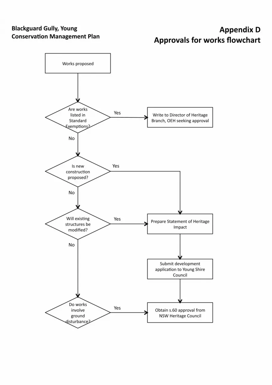
Appendix D Approvals for works flowchart
Blackguard Gully, Young Conserva?on Management Plan
Works proposed
Are works listed in Standard
Exemp5ons?
Yes
No
Write to Director of Heritage Branch, OEH seeking approval
Is new construc5on proposed?
Yes
Prepare Statement of Heritage Impact
Submit development applica5on to Young Shire
Council
Will exis5ng structures be modified?
Yes
Do works involve ground
disturbance?
Obtain s.60 approval from NSW Heritage Council
No
No
Yes

www.industry.nsw.gov.au
Fossicking:A guide to fossicking in New South Wales

Guidelines for Fossicking
Fossicking is the small scale search for and collection of, minerals, gemstones or mineral bearing
material from the surface (or by digging from the surface) with hand-held implements. This activity
may only be undertaken for recreational, tourist or educational purposes.
Fossicking offers an opportunity to discover the beauty and diversity of this state’s mineral wealth. It
combines leisure, pleasure and 'treasure' all in one. Best of all, no licence is required under the Mining
Act 1992.
However, some basic rules must be followed.
In these guidelines the NSW Department of Industry and Investment is referred to as Industry &
Investment NSW.
What legislation governs fossicking in NSW?
The main provisions that apply to fossicking are Section 12 of the Mining Act 1992 and Clause 12 of
the Mining Regulation 2010 (link).
Other relevant legislation
As a fossicker you must ensure that you comply with all relevant legislation.
Other Acts that apply to fossicking include: the Forestry Act 1916, Native Title Act 1993
(Commonwealth), Fisheries Management Act 1994, National Parks and Wildlife Act 1974 (in relation
to Aboriginal cultural heritage), Water Management Act 2000 and Protection of the Environment
Operations Act 1997.
See below for further information on the Forestry Act 1916 and the Fisheries Management Act 1994.
If you require further information about the National Parks and Wildlife Act 1974, Water Management
Act 2000 and the Protection of the Environment Operations Act 1997 (links) you should contact the
Department of Environment, Climate Change and Water.
What techniques can be used for fossicking?
Fossicking on land or waters that may be subject to native title is restricted by the terms of the Native
Title Act 1993 (Commonwealth). Land subject to native title can be taken to be any land other than
freehold land, land held under perpetual Western Lands leases and some specific leasehold and
reserved lands.

Fossicking can be done on land or waters subject to native title using hand held implements, which
include picks, shovels, hammers, sieves, shakers and gold pans. However, regardless of the
implements used, no excavation is permitted.
On land or waters that are not subject to native title, fossicking is not restricted to hand held
implements, but power-operated equipment cannot be used for the purpose of surface disturbance,
excavation or processing.
Metal detectors can be used in fossicking activities on any land where fossicking is permitted.
What techniques cannot be used for fossicking?
Neither explosives nor dredges can be used in fossicking.
Power-operated equipment cannot be used on land or in waters for surface disturbance, excavation or
processing. Power operated equipment includes mechanical, hydraulic, pneumatic, battery and
electrical equipment or machinery.
Where can fossicking take place?
As a general rule, fossicking in accordance with the legislation can take place on any land, provided
that permission is obtained from the landowner or land manager, except in National Parks where
fossicking is prohibited.
Note: To fossick in State forests you need permission from Forests NSW, in the form of a special
purpose permit.
What consents/permissions do I need?
• for private land – the permission of the landholder;
• for Crown land that is managed, controlled or under trusteeship - the permission of the
trustee or manager of that public or local authority. To fossick on these lands the consent of
the appropriate authority (e.g. Land and Property Management Authority, Forests NSW, local
council, Livestock Health and Pest Authorities, Trustees of Commons) is required.
Information about the ownership or status of land can be obtained from local councils or the
Land and Property Management Authority. You can contact Forests NSW (a division of
Industry & Investment NSW) for information about State forest land;
• for land held under a lease, licence or permissive occupancy under the Crown Lands Act
1989, the Crown Lands (Continued Tenures) Act 1989 or the Western Lands Act 1900 - the
permission of the lessee, licensee or occupant. Information about the ownership and status
of land may be sought from local councils or the Land and Property Management Authority;
2
• for land that is covered by an exploration licence, assessment lease, mining lease, mineral
claim or opal prospecting licence under the Mining Act 1992 – the permission of the
titleholder. However, permission is not required from the holder of an exploration licence
where the licence is affected by a Fossicking District. Information regarding the location of
titles and fossicking districts can be obtained from Industry & Investment NSW’s Maitland,
Orange and Lightning Ridge offices or by searching the TASMap facility:
http://www.minerals.nsw.gov.au/tasmap/;
• where native title rights and interests in land or waters have been determined to exist under
the Commonwealth’s Native Title Act 1993 - the permission of the relevant registered native
title body. For information about registered native title claims in NSW go to:
http://www.nntt.gov.au/Native-Title-In-Australia/Pages/ACT-New-South-Wales.aspx.
Fossickers must comply with any conditions or requirements of the landholder. These could include,
for example, which tracks to use, which paddocks to avoid, the use of gates, or periods of access.
Note: A landholder cannot permit the carrying out of activities that are prohibited under the Mining Act
1992, the Mining Regulation 2010 or under other legislation.
Who owns fossicked gems and minerals?
Any publicly owned mineral that is recovered in the course of lawful fossicking becomes the property
of the person who found it at the time it is removed from the land on which it was found.
Where minerals are privately owned, ownership of those minerals needs to be agreed between the
fossicker and the landholder.
How much can I take?
Fossicking is limited to taking no more than the amounts prescribed in the Mining Regulation 2009
during any single period of 48 hours. This includes 10 kg of mineral-bearing material, 5 kg of minerals
(other than gold or gemstones), 50 grams of gold (or 5 nuggets of 10 grams or greater) or 100 grams
of gemstones. Gemstones refer to Group 6 and Group 7 minerals listed in Schedule 2 of the Mining
Regulation 2010 and include diamond, sapphire, ruby, corundum and opal.
Other restrictions on fossicking
The Mining Regulation 2010 also prohibits:
• the damage or removal of any bushrock.
• the disturbance of more than 1 cubic metre of any soil, rock or other material during
any single period of 48 hours.
3

How should I leave a fossicking site?
Any fossicking site must be left in a clean and tidy condition. If you have disturbed the site you need to
restore it as close as possible to its pre-disturbed condition. Soil, rock or other material that has been
excavated must be replaced before you make any further excavations. You must remove all refuse,
including bottles, cans, etc from the site.
What happens if I breach fossicking requirements?
If you do not comply with the requirements of the Mining Act 1992 and the Mining Regulation 2010
(link), you are liable to a penalty of up to $5,500 on conviction for each breach.
For fossicking activities in waterways that result in breaches of the Fisheries Management Act 1994,
you may incur on-the-spot fines or court-awarded penalties of up to $110,000 for individuals or up to
$220,000 for corporations on conviction, as well as having to pay for aquatic habitat restoration works.
Please refer to ’How do I protect waterways when I fossick?’ below to ensure you comply with the
Fisheries Management Act 1994.
Personal Protection/Safety
While fossicking you should be aware of personal safety.
The following list highlights some potential safety risks, although it is not an exhaustive list of possible
risks or the measures that could be taken to avoid them.
• Appropriate clothing, including a broad-rimmed hat and/or a jumper or raincoat.
• An appropriate sun-protection cream.
• Appropriate eye protection, e.g. goggles or safety glasses when smashing rocks.
• Appropriate/protective sturdy footwear. Good soles provide a sound grip and can help
prevent you from slipping. Open footwear, such as sandals, is not appropriate.
• Appropriate hand protection. Gloves help protect your hands.
• Take extreme care when fossicking near old mine workings or pits, and do not enter these
sites.
• Avoid visiting isolated areas alone. Always let someone know of your plans.
• An adequate supply of water.
• A basic knowledge of first aid.
• Be aware of logging trucks and other heavy vehicles on some State forest roads.
4

Note: Personal safety (and the safety of others who might be impacted by fossicking activities) is the
responsibility of the persons undertaking fossicking. Industry & Investment NSW is not responsible for
the safety of people who are engaged in or impacted by fossicking activities.
How do I protect waterways when I fossick?
If you fossick, you must take steps to protect the environment, in particular any waterway (including
the bank of the waterway) that is likely to be habitat for native fish.
Sediments may be extracted in freshwater areas for the purpose of fossicking. Gemstones and
alluvial gold collect in crevices in stream beds and in gravel bars on the insides of stream bends.
These may be recovered by panning, but it is more common for the gem-seeker to use sieves made
especially for this purpose.
Disturbance to the bed of the waterway and in-stream washing and sorting of materials collected to
extract the gemstones can result in direct impacts on aquatic habitats or indirect impacts such as
siltation and smothering of in-stream gravel beds and aquatic vegetation. Siltation also reduces water
quality for in-stream fauna and can affect the gills of fish, causing respiratory distress or disease.
The Fisheries Management Act 1994 regulates a range of activities including those that harm the
habitat of native fish (including threatened species of fish) and recreational fishing. Following the
guidelines and avoiding the activities listed below will assist you in complying with this Act:
• removing or disturbing any material that is important habitat for fish (including threatened
species of fish) from the bed or banks of a waterway including woody debris (snags) greater
than 3m in length, large cobbles, rocks or boulders (greater than 500mm in diameter) or
aquatic vegetation; or
• placing or reshaping any material across a waterway that may obstruct the free passage of
fish.
If you wish to undertake recreational fishing while fossicking, please ensure you comply with the
fishing regulations as summarised in the Freshwater Fishing Guide (link).
You should avoid disturbing mud, clay or fine silt that causes significant turbidity in a waterway, as this
could lead to a breach of the Protection of the Environment Operations Act 1997.
5

Fossicking in NSW State forests
State forests are administered by Forests NSW. People wishing to fossick in a State forest must
obtain a special purpose permit (link to http://www.dpi.nsw.gov.au/forests/permits).
Fossicking is not permitted in the following areas in State forests:
• flora or timber reserves;
• areas zoned Forest Management Zone 1; and
• any areas held under lease under the Crown Lands (Continued Tenures) Act, without the
consent of the landholder.
Native title has not been extinguished in most State forests. Therefore in most cases excavation is not
allowed.
Where Native Title rights and interests have been determined under the Commonwealth’s Native Title
Act 1993 to exist in State forests, for example under an Indigenous Land Use Agreement, the
fossicking permit applicant is required to consult with the relevant registered native title body before a
permit can be issued by Forests NSW. This is particularly the case for fossicking activity in Forests
NSW North East Region. Applicants should first contact the North East Region on (02) 6652 0111 on
the need for consultation if seeking a permit in this Region.
Permits will not be issued for areas of State forests closed for harvesting, fire fighting or when the
forest is officially closed due to extreme weather conditions.
Permits are usually issued for a 12 month period and incur a fee.
Permit holders must:
a) ensure that the site of any fossicking is left in a clean and tidy condition and that any
permitted excavation is filled in before making any further excavations; and
b) indemnify Forests NSW against claims brought by any person against Forests NSW
resulting from any activity carried out by the permit holder.
While fossicking you must not interfere with the rights of other legitimate forest users such as
campers, swimmers, hunters or those with permits for organised recreational and research activities.
Information about events in State forests can be obtained from Forests NSW. Fossickers must not
interfere with and should heed the directions of Forests NSW staff or contactors.
6
Fossickers should note that some State Forests are open for conservation hunting. To obtain
information on these forests visit the Game Council at the following link (link to
http://www.gamecouncil.nsw.gov.au/).
Who do I contact about fossicking in State forests?
Special purpose permits for fossicking are administered by Forests NSW regional offices. Information
about regional offices can be obtained from http://www.dpi.nsw.gov.au/aboutus/about/office (link) or
by calling 1300 655 687.
Fossicking in Lightning Ridge and White Cliffs
The basic fossicking requirements apply to fossicking in Lightning Ridge, including the requirement to
obtain the titleholder’s consent to fossick in an area subject to an Opal Prospecting Licence (OPL)
granted under division 2, part 10 of the Mining Act 1992 or Mineral Claim granted under part 9 of the
Mining Act 1992 (insert links) at Lightning Ridge.
OPLs and mineral claims are handled by the Lightning Ridge office of Industry & Investment NSW.
The office is located at the NSW Miners Association Building, Lot 60 Morilla Street, Lightning Ridge,
telephone: 6829 9200. Staff from that office can tell you if there is an OPL or a mineral claim on a
particular parcel of land.
Legislative provisions under the Mining Act 1992 and the Mining
Regulation 2010
Mining Act 1992
Section 12 of the Mining Act 1992 states that:
(1) For the purposes of this or any other Act or law, it is declared that fossicking is a lawful activity.
(2) Subsection (1):
(a) does not affect any other Act or law that prohibits, regulates or restricts fossicking or that
has the effect of prohibiting, regulating or restricting fossicking and, in particular, does not
make fossicking a lawful authority or lawful excuse for the purposes of any such Act or law,
and
(b) does not confer on any person a right of entry on to land (other than land prescribed by
subsection (2A)) for fossicking purposes.
7

(2A) For the purposes of subsection (2)(b), the prescribed land is Crown land (within the meaning of
the Crown Lands Act 1989):
(a) that is not held under a lease, licence or permissive occupancy under the Crown Lands
Act 1989, the Crown Lands (Continued Tenures) Act 1989 or the Western Lands Act 1901,
and
(b) that is not under the management or control of a trustee or a public or local authority.
(3) Any publicly owned mineral that is recovered in the course of lawful fossicking becomes the
property of the person by whom it is found at the time it is severed from the land on which it is found.
(4) A person must not carry out fossicking on any land the subject of an authority, mineral claim or
opal prospecting licence except with the consent of the holder of the authority, claim or licence.
Maximum penalty: 50 penalty units.
(5) Subsection (4) does not apply to the carrying out of fossicking on land the subject of an
exploration licence if the land is within a fossicking district.
(6) A person must not carry out fossicking on any land that is, or in waters that are, the subject of an
approved determination of native title under the Commonwealth Native Title Act to the effect that
native title exists, except with the consent of the relevant registered native title body corporate with
respect to that native title.
Maximum penalty: 50 penalty units.
Mining Regulation 2010
Clause 12 of the Mining Regulation 2010 states that:
(1) Any soil, rock or other material that is disturbed in the course of work carried out for the purpose of
fossicking for minerals must:
(a) be removed and stockpiled separately, and
(b) after completion of the work, be replaced in order to reconstruct the original soil profile.
Maximum penalty: 50 penalty units.
(2) A person must not carry out work that includes any of the following activities for the purpose of
fossicking:
(a) the use of any equipment other than hand-held implements on any land or waters that are
subject to native title,
(b) the excavation or clearing of any land or waters that are subject to native title,
8
(c) the use of power-operated equipment for the purpose of surface disturbance, excavation
or on-site processing on any land,
(d) the use of explosives on any land,
(e) the damage or removal of any bushrock,
(f) the removal of more than the prescribed amount of material from any land during any
single period of 48 hours,
(g) the disturbance of more than 1 cubic metre of any soil, rock or other material during any
single period of 48 hours.
Maximum penalty: 50 penalty units.
Note. The language of part of this subclause mirrors the language of part of section 24LA (Low impact future acts)
of the Native Title Act 1993 of the Commonwealth. That section refers, in part, to an act (in relation to particular
land or waters) that does not consist of, authorise or otherwise involve "the excavation or clearing of any of the
land or waters" or "mining (other than fossicking by using hand-held implements)".
(3) In this clause:
gemstone means a Group 6 or Group 7 mineral.
Note. Group 6 and Group 7 minerals are listed in Schedule 2.
power-operated equipment means any equipment powered by mechanical or electrical means.
prescribed amount, in relation to material, means:
(a) 10 kilograms of mineral-bearing material (other than the material referred to in
paragraphs (b)–(e)), or
(b) 5 kilograms of minerals (other than gold or gemstones), or
(c) 50 grams of gold (except where found as nuggets of 10 grams or greater), or
(d) 5 nuggets of 10 grams or greater of gold, or
(e) 100 grams of gemstones.
9

www.industry.nsw.gov.au I&I N
SW 10
304_
OCT 2
010