planning & urban design rationale - 300 bloor street
TRANSCRIPT
BLOOR STREET WEST
T
75 P V C T C d it
1B
BLOOR STREET WEST
HURO
N STRE
ET
MAD
ISON AV
ENUE
322 King St W, 3rd FlToronto, ON, Canada M5V 1J2416.977.5104
Project No.ScalePlot Date
Project North True North
Copyright is that of the Architect.Any version of this drawing reproduced by any means from any media without prior written approval of the Architect is to be read for information only. The Architect is not liable for any loss or distortion of information
resulting from subsequent reproduction of the original drawing.
GENERAL NOTES: 1. Drawings are not to be scaled. Contractor will verify all existing conditions and dimensions required to perform the Work and will report any discrepancies with the Contract Documents to the Architect before commencing work.
2. The Architectural Drawings are to be read in conjunction with all other Contract Documents including the Project Manuals and the Structural, Mechanical and Electrical Drawings. In cases of difference between the Consultants' documents with respect to the quantity, sizes or scope of work, the greater shall apply.
3. Positions of exposed or finished Mechanical or Electrical devices, fittings and fixtures are indicated on the Architectural Drawings. Locations shown on the Architectural Drawings shall govern over Mechanical and Electrical Drawings. Mechanical and Electrical items not clearly located will be located as directed by the Architect.
4. Dimensions indicated are taken between the faces of finished surfaces unless otherwise noted.
5. The architect has not been retained for supervision of construction and assumes no responsibility for means, methods and techniques of construction.
6. These documents are not to be used for construction unless specifically noted for such purpose.
Rev. Date Issued
Project
12/21/2017
COVER SHEET
1645 1 : 1000
A0‐0
300 BLOOR STREET W &478 HURON STREET
SheetNumber Sheet Name
L1‐01 SITE PLANA0‐01 STATISTIC SUMMARYA0‐02 SITE SURVEYA2‐00 BASEMENT & GROUND LEVELSA2‐01 RESIDENTIAL AMENITY ‐ MEZZ 01 & BSUC, MARKET TENANT, MEZZ ‐ L02A2‐02 BSUC, MARKET TENANT, P1 PARKING ‐ L03 & P2 PARKINGA2‐03 MARKET TENANT, P3 PARKING ‐ L04 & P4 PARKINGA2‐04 BSUC TENANT ‐ L05 & L06‐L08A2‐05 RESIDENTIAL AMENITY ‐ L09 & RESIDENTIAL ‐ L10A2‐06 RESIDENTIAL ‐ L11‐L30 & L31‐L36A2‐07 RESIDENTIAL ‐ L37‐L38 & MECHANICAL PENTHOUSEA2‐08 ROOF PLANA5‐01 SOUTH & WEST ELEVATIONSA5‐02 NORTH & EAST ELEVATIONSA5‐11 E/W BUILDING SECTIONSA5‐12 N/S BUILDING SECTIONSA9‐00 RENDERINGS
300 BLOOR STREET WEST & 478 HURON STREETDRAWING LISTOWNER AND CONSULTANT LIST
CONTEXT PLAN
DEVELOPERCollecdev 20 Eglinton Ave. W, #1700Toronto, ONM4R 1K8T: 416‐640‐6000
Northrop Development Inc.6600 Goreway, Dr,Mississauga, ON L4V 1S6T: 416 231 2077
HERITAGE AND CONSERVATIONERA Architects Inc.10 St. Mary Street, #801Toronto, ONM4Y 1P9T: 416‐963‐4497
CIVIL ENGINEERINGCole Engineering Group Ltd70 Valleywood Dr,Markham, ONL3R 4T5T: 905‐940‐6161
NOISE AND VIBRATIONAercoustics Engineering Ltd1004 Middlegate Rd., #1100Mississauga, ONL4Y 1M4T: 416‐249‐3361
CODE CONSULTANTJensen Hughes2150 Islington Ave., #100Toronto, ONM9P 3V4T: 416‐762‐3808
ARCHITECTKPMB Architects322 King St W, 3rd FloorToronto, ONM5V 1J2T: 416‐977‐5104
LANDSCAPE ARCHITECTScott Torrance Landscape Architect219 Dufferin St., #100CToronto, ONM6K 3J1T: 416‐696‐8686
TRANSPORTATIONBA Consulting Group Ltd45 St.Clair Ave W, Toronto, ONM4V 1K9T: 416‐961‐7110
STRUCTURAL ENGINEERINGRJC Engineers144 Front St. W, #500Toronto, ONM5J 2L7T: 416‐977‐5335
SHORINGIsherwood Geostructural Engineers3100 Ridgeway Dr., #3Mississauga, ONL5L 5M5T: 905‐820‐3480
PLANNINGBousfields Inc.3 Church St., #200Toronto, ONM5E 1M2T: 416‐947‐9744
WINDNovus Environmental Inc.150 Research Ln, Guelph, ONN1G 4T2T: 226‐706‐8080
SOIL AND ENVIRONMENTALWSP Canada51 Constellation Ct, Toronto, ONM9W 1K4T: 416‐798‐0065
M&E ENGINEERINGSmith + Andersen4211 Yonge St,North York, ONM2P 2A9T: 416‐487‐8151
ENERGY STRATEGYFootprint4211 Yonge St., #500Toronto, ONM2P 2A9T: 416‐218‐7025
SCALE 1:1000
P R E PA R E D F O R :300 Bloor Street WeSt lP
(on Behalf of the Bloor Street united church)
PLANNING& URBAN DESIGNRATIONALE
3 0 0 B L O O R S T R E E T W E S T & 4 7 8 H U R O N S T R E E T
c i t Y o f t o r o n t o
17D E C E M B E R

Job Number - 16224
3 Church Street, Suite 200Toronto ONM5E 1M2T 416.947.9744F 416.947.0781www.bousfields.ca
PLANNING & URBAN DESIGN RATIONALE300 Bloor Street West & 478 Huron Street i
TA B L E O F C O N T E N T S[ 1 . 0 ] I N T R O D U C T I O N 1
[ 2 . 0 ] S I T E & S U R R O U N D I N G S 42 . 1 S I T E 52 . 2 A R E A C O N T E X T 82 . 3 S U R R O U N D I N G C O N T E X T 92 . 4 T R A N S P O R T A T I O N N E T W O R K 1 7
[ 3 . 0 ] P R O P O S A L 1 83 . 1 D E S C R I P T I O N O F T H E P R O P O S A L 1 93 . 2 K E Y S T A T I S T I C S 2 33 . 3 P L A N N I N G H I S T O R Y 2 33 . 4 R E Q U I R E D A P P R O V A L S 2 3
[ 4 . 0 ] P O L I C Y & R E G U L A T O R Y C O N T E X T 2 4
4 . 1 P R O V I N C I A L P O L I C Y S T A T E M E N T ( 2 0 1 4 ) 2 54 . 2 G R O W T H P L A N F O R T H E G R E A T E R G O L D E N H O R S E S H O E 2 64 . 3 C I T Y O F T O R O N T O O F F I C I A L P L A N 2 94 . 4 S I T E A N D A R E A S P E C I F I C P O L I C I E S 3 44 . 5 O F F I C I A L P L A N A M E N D M E N T N O . 3 5 2 3 64 . 6 O P A 3 6 5 A N D O P A 3 6 8 ( B L O O R C O R R I D O R /
A N N E X B L O C K P L A N N I N G S T U D Y ) 3 74 . 7 Z O N I N G 3 84 . 8 B L O O R C O R R I D O R U R B A N D E S I G N G U I D E L I N E S
( V I S I O N I N G S T U D Y ) 4 24 . 9 T A L L B U I L D I N G D E S I G N G U I D E L I N E S 4 44 . 1 0 T O C O R E P R O P O S E D D O W N T O W N S E C O N D A R Y P L A N 4 44 . 1 1 G R O W I N G U P : P L A N N I N G F O R C H I L D R E N I N
N E W V E R T I C A L C O M M U N I T I E S 4 84 . 1 2 M A D I S O N A V E N U E H E R I T A G E C O N S E R V A T I O N D I S T R I C T 4 9
[ 5 . 0 ] P L A N N I N G & U R B A N D E S I G N A N A L Y S I S 5 0
5 . 1 I N T E N S I F I C A T I O N 5 15 . 2 L A N D U S E 5 25 . 3 H E I G H T , M A S S I N G A N D D E N S I T Y 5 35 . 4 B U I L T F O R M I M P A C T S 6 05 . 5 U R B A N D E S I G N 6 25 . 6 V I E W C O R R I D O R A N A LY S I S 6 75 . 7 H E R I T A G E 6 85 . 8 T R A N S P O R T A T I O N A N D S E R V I C I N G 6 95 . 9 C O M M U N I T Y S E R V I C E S A N D F A C I L I T I E S 7 0
[ 6 . 0 ] C O N C L U S I O N 7 1
A P P E N D I X A: C O M M U N I T Y S E R V I C E S & F A C I L I T I E S S T U D Y A1
T O C


PLANNING & URBAN DESIGN RATIONALE300 Bloor Street West & 478 Huron Street 1
[1.0]I N T R O D U C T I O N

SUBJECTSITE
2
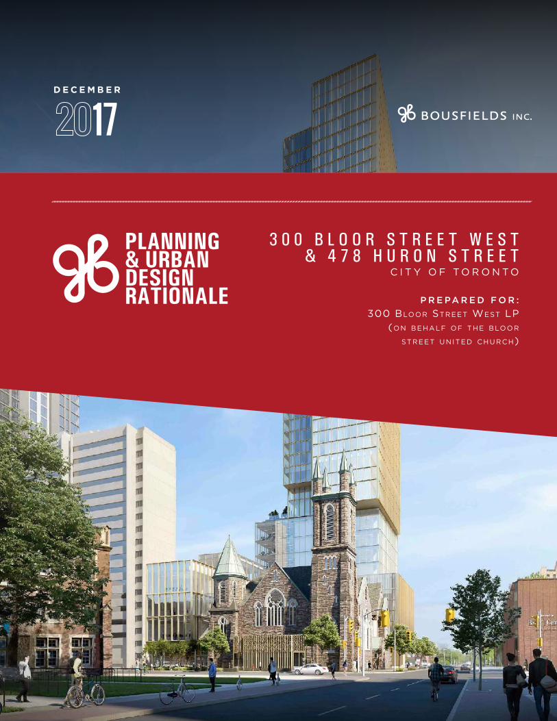
This Planning and Urban Design Rationale report has been prepared in support of an application by 300 Bloor Street West LP on behalf of the Bloor Street United Church to amend Zoning By-law 438-86, as amended, and Zoning By-law 569-2013 with respect to a 0.36 hectare site located at the northwest corner of Bloor Street West and Huron Street and municipally known as 300 Bloor Street West and 478 Huron Street (see Figure 1).
Figure 1 - Location Map
The application would include the retention of the majority of the existing Bloor Street United Church and the entirety of the Pidgeon House while permitting the redevelopment of the site for a truly mixed-use building containing office, retail/café, worship and community, and residential uses. The proposed 38-storey high-rise building would contribute to the ongoing revitalization of the Bloor Street corridor, while preserving and enhancing existing significant heritage resources, in one of the most transit-supportive locations in the City of Toronto. In addition to promoting mixed-use
PLANNING & URBAN DESIGN RATIONALE300 Bloor Street West & 478 Huron Street 3
supportive of the policy directions set out for both urban growth centres and “major transit station areas” in the Growth Plan. Moreover, the Official Plan contains heritage incentive policies, specifically allowing density increases as incentives for the conservation of heritage buildings.
In our opinion, the existing zoning applying to the subject site, which permits a maximum density of 3.0 FSI and a maximum height of 18.0 metres, is not consistent with the Provincial Policy Statement and does not conform with the Growth Plan or the Official Plan. The zoning is outdated and has not been updated to reflect the policies of the PPS (2014), the Growth Plan (2017) or the Toronto Official Plan (2006). As well, the zoning has not been updated to reflect either the Bloor Corridor Visioning Study (2008) or the Downtown Tall Building Guidelines (2012).
From a built form and urban design perspective, the proposed height and massing represents an appropriate design response to the location of the subject site within a designated urban growth centre within the Downtown and its proximity to existing, approved and proposed tall buildings, while balancing the various constraints including the existing heritage structures and the subway tunnel underneath the north portion of the site. The building will provide an appropriate street wall and landscape condition along both frontages, with well-defined podium elements and with all loading, parking and servicing activities located at the rear of the building, away from the public realm. A new promenade will wrap around the church and connect Bloor Street West and Huron Street, while providing opportunities to experience all four facades of the heritage building.
Accordingly, we recommend approval of the requested rezoning to permit the proposed development, from both a planning and urban design perspective.
intensification in furtherance of the high-level policy directions applying to the site, the proposed redevelopment will generate revenue for the Bloor Street United Church, which will help to fund both the much-needed restoration of the heritage church building and the church’s social services and community outreach activities, which are an important part of the broader community fabric.
The subject site has been the subject of public redevelopment discussions since 2009. Recently, Northrop Development Inc., CollecDev and the Bloor Street United Church entered into a partnership to redevelop the subject site. This partnership was created out of the Church’s need to find a solution for its long-term sustainability. Both the current owner of the site, the Bloor Street United Church, and its development partners, recognize and value the strong relationship that the Church has built with its faith-based and local community and have expressed their commitment to working collaboratively with the community as the project progresses.
This report concludes that the proposed development is in keeping with the planning and urban design framework established by the applicable planning documents, specifically the Provincial Policy Statement, the Growth Plan for the Greater Golden Horseshoe, the City of Toronto Official Plan and Site and Area Specific Policy 334, as well as the relevant urban design guidelines.
From a land use planning perspective, the proposal will contribute to the achievement of numerous policy objectives that promote intensification, a range of housing choices and “complete communities” within built-up urban areas, particularly in locations which are well served by municipal infrastructure, including public transit.
The proposal will result in desirable residential and non-residential intensification, including the retention of the majority of the existing community and place of worship uses, the introduction of new retail space and 5,573 square metres of new office space, and 259 new residential units, all within 190 and 225 metres (walking distance), respectively, of the Spadina and St. George subway interchange stations. Intensification of the subject site would be
4
[2.0]S I T E &
S U R R O U N D I N G S
SPADINA RD
BLOOR ST W
MADISON AVE
HURON ST
ST GEORGE ST
WALM
ER RD
ROBERT ST
PRINCE ARTHUR AVE
WASHINGTON AVE
ANNEX LANE
KATHERINE HOCKIN LN
BRUNSWICK AVE
MAJOR ST
DALTON RD
SUBJECTSITE
PLANNING & URBAN DESIGN RATIONALE300 Bloor Street West & 478 Huron Street 5
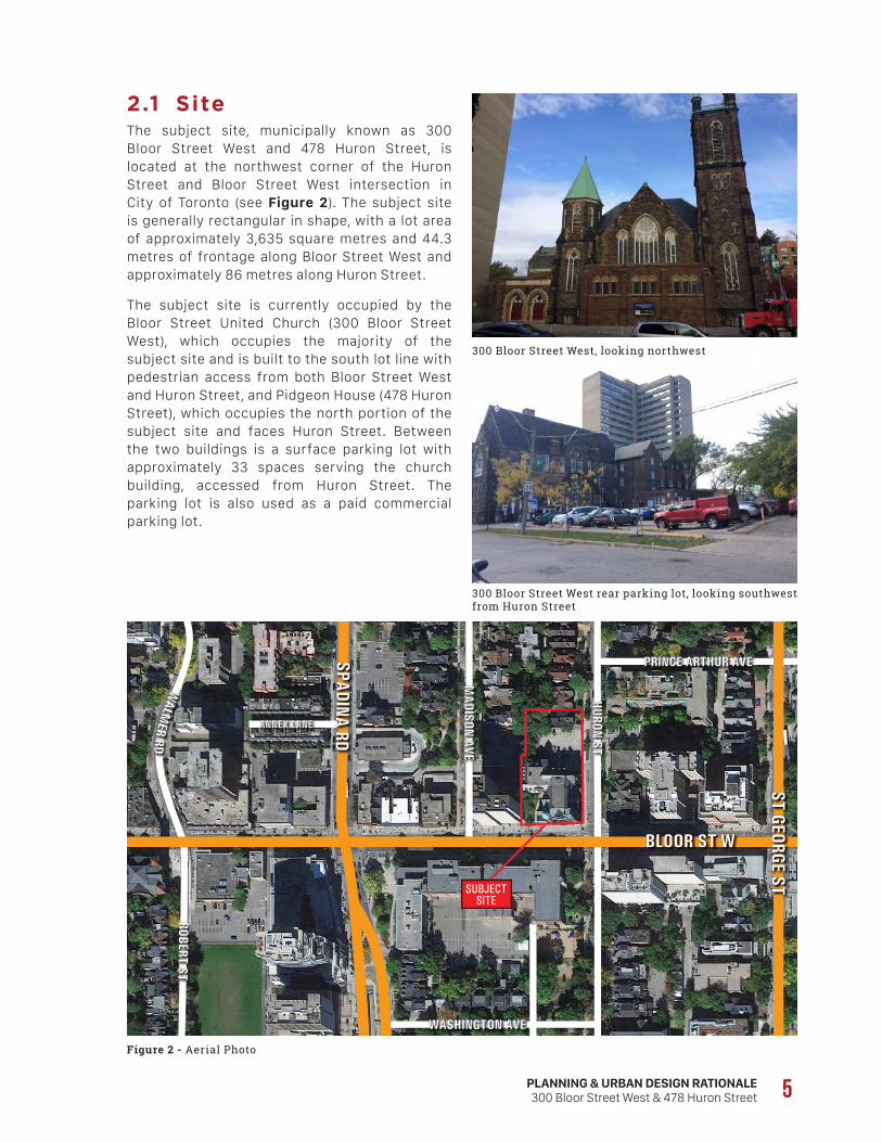
2.1 SiteThe subject site, municipally known as 300 Bloor Street West and 478 Huron Street, is located at the northwest corner of the Huron Street and Bloor Street West intersection in City of Toronto (see Figure 2). The subject site is generally rectangular in shape, with a lot area of approximately 3,635 square metres and 44.3 metres of frontage along Bloor Street West and approximately 86 metres along Huron Street.
The subject site is currently occupied by the Bloor Street United Church (300 Bloor Street West), which occupies the majority of the subject site and is built to the south lot line with pedestrian access from both Bloor Street West and Huron Street, and Pidgeon House (478 Huron Street), which occupies the north portion of the subject site and faces Huron Street. Between the two buildings is a surface parking lot with approximately 33 spaces serving the church building, accessed from Huron Street. The parking lot is also used as a paid commercial parking lot.
Figure 2 - Aerial Photo
300 Bloor Street West, looking northwest
300 Bloor Street West rear parking lot, looking southwest from Huron Street
DATE ARCHITECT CONSTRUCTION1886-1888 George W. E. Field Original Church1889 -1890 William R. Gregg Church Addition
1908 Wickson and Gregg Sunday School addition
1927 Wickson and Greggrenovations
1954Bruce Brown and
Brisley
late 1960 -One storey brick addition to the north elevation of the Sunday School addition
300 Bloor Street West (Google maps, 2017; annotation by ERA).DRAFT
6
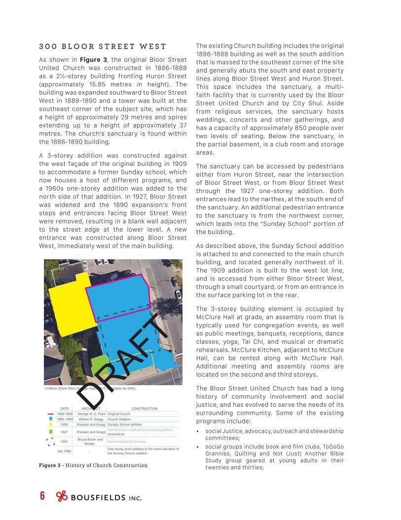
3 0 0 B L O O R S T R E E T W E S T As shown in Figure 3, the original Bloor Street United Church was constructed in 1886-1888 as a 2½-storey building fronting Huron Street (approximately 15.85 metres in height). The building was expanded southward to Bloor Street West in 1889-1890 and a tower was built at the southeast corner of the subject site, which has a height of approximately 29 metres and spires extending up to a height of approximately 37 metres. The church’s sanctuary is found within the 1886-1890 building.
A 3-storey addition was constructed against the west façade of the original building in 1909 to accommodate a former Sunday school, which now houses a host of different programs, and a 1960s one-storey addition was added to the north side of that addition. In 1927, Bloor Street was widened and the 1890 expansion’s front steps and entrances facing Bloor Street West were removed, resulting in a blank wall adjacent to the street edge at the lower level. A new entrance was constructed along Bloor Street West, immediately west of the main building.
The existing Church building includes the original 1886-1888 building as well as the south addition that is massed to the southeast corner of the site and generally abuts the south and east property lines along Bloor Street West and Huron Street. This space includes the sanctuary, a multi-faith facility that is currently used by the Bloor Street United Church and by City Shul. Aside from religious services, the sanctuary hosts weddings, concerts and other gatherings, and has a capacity of approximately 850 people over two levels of seating. Below the sanctuary, in the partial basement, is a club room and storage areas.
The sanctuary can be accessed by pedestrians either from Huron Street, near the intersection of Bloor Street West, or from Bloor Street West through the 1927 one-storey addition. Both entrances lead to the narthex, at the south end of the sanctuary. An additional pedestrian entrance to the sanctuary is from the northwest corner, which leads into the “Sunday School” portion of the building.
As described above, the Sunday School addition is attached to and connected to the main church building, and located generally northwest of it. The 1909 addition is built to the west lot line, and is accessed from either Bloor Street West, through a small courtyard, or from an entrance in the surface parking lot in the rear.
The 3-storey building element is occupied by McClure Hall at grade, an assembly room that is typically used for congregation events, as well as public meetings, banquets, receptions, dance classes, yoga, Tai Chi, and musical or dramatic rehearsals. McClure Kitchen, adjacent to McClure Hall, can be rented along with McClure Hall. Additional meeting and assembly rooms are located on the second and third storeys.
The Bloor Street United Church has had a long history of community involvement and social justice, and has evolved to serve the needs of its surrounding community. Some of the existing programs include:
• social Justice, advocacy, outreach and stewardship committees;
• social groups include book and film clubs, ToGoGo Grannies, Quilting and Not (Just) Another Bible Study group geared at young adults in their twenties and thirties;Figure 3 - History of Church Construction
300Bloor St. W
478Huron St.
Site
TTCSubwayR.O.W.
BSUC
Pidgeon House
Existing Site Conditions
View from Google Map of 300 Bloor St. W
PLANNING & URBAN DESIGN RATIONALE300 Bloor Street West & 478 Huron Street 7
• the “University Church”, aimed at University and College-aged young adults, adult study groups; and
• internet resources and social media, including a web page and active Facebook page.
The property was listed on the City of Toronto Heritage Register on October 26, 2005 as having cultural resource value or interest for its architectural, historical and contextual significance.
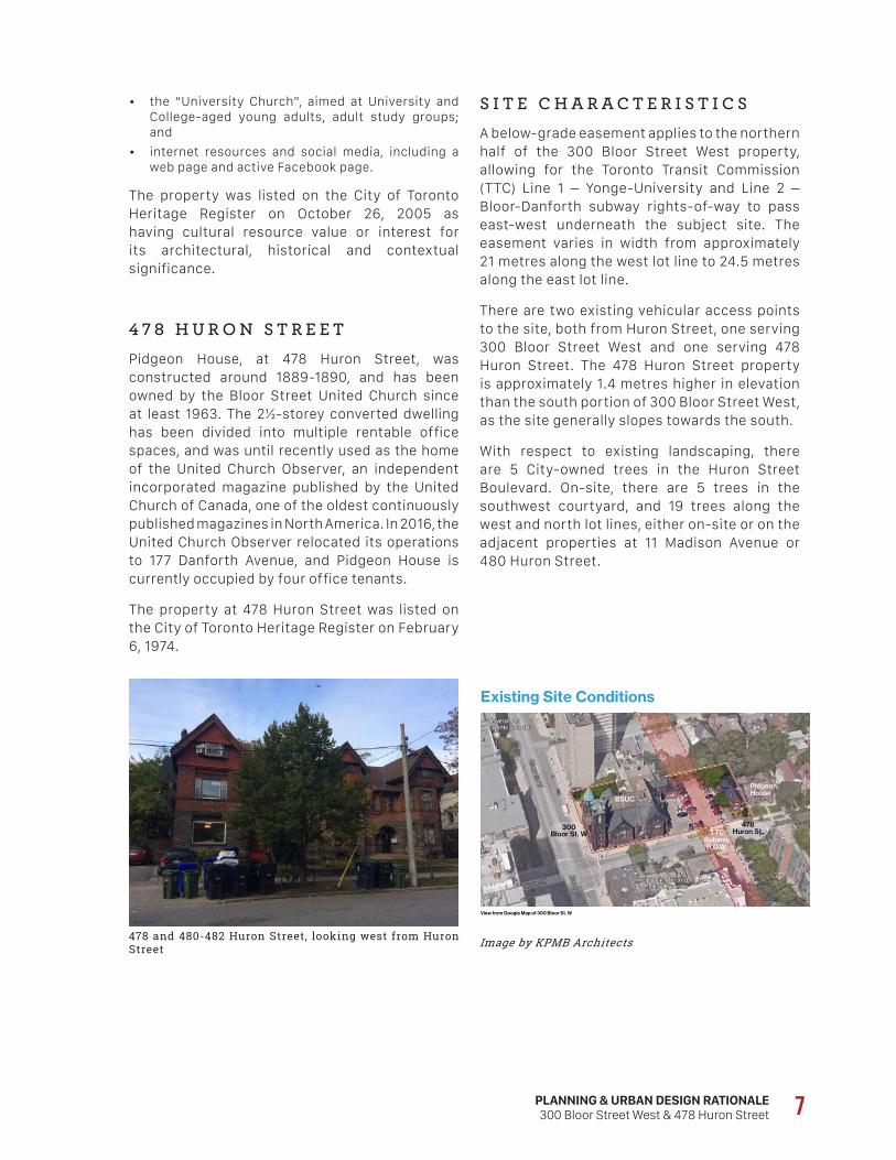
4 7 8 H U R O N S T R E E T Pidgeon House, at 478 Huron Street, was constructed around 1889-1890, and has been owned by the Bloor Street United Church since at least 1963. The 2½-storey converted dwelling has been divided into multiple rentable office spaces, and was until recently used as the home of the United Church Observer, an independent incorporated magazine published by the United Church of Canada, one of the oldest continuously published magazines in North America. In 2016, the United Church Observer relocated its operations to 177 Danforth Avenue, and Pidgeon House is currently occupied by four office tenants.
The property at 478 Huron Street was listed on the City of Toronto Heritage Register on February 6, 1974.
478 and 480-482 Huron Street, looking west from Huron Street Image by KPMB Architects
S I T E C H A R A C T E R I S T I C SA below-grade easement applies to the northern half of the 300 Bloor Street West property, allowing for the Toronto Transit Commission (TTC) Line 1 – Yonge-University and Line 2 – Bloor-Danforth subway rights-of-way to pass east-west underneath the subject site. The easement varies in width from approximately 21 metres along the west lot line to 24.5 metres along the east lot line.
There are two existing vehicular access points to the site, both from Huron Street, one serving 300 Bloor Street West and one serving 478 Huron Street. The 478 Huron Street property is approximately 1.4 metres higher in elevation than the south portion of 300 Bloor Street West, as the site generally slopes towards the south.
With respect to existing landscaping, there are 5 City-owned trees in the Huron Street Boulevard. On-site, there are 5 trees in the southwest courtyard, and 19 trees along the west and north lot lines, either on-site or on the adjacent properties at 11 Madison Avenue or 480 Huron Street.
8
The Annex neighborhood, located immediately north of the subject site, generally extends from Bloor Street West northward to Dupont Street and from Bathurst Street in the west to Avenue Road in the east. The Annex was predominantly a low-rise residential neighbourhood with Victorian and Edwardian homes and mansions built between the 1880s and early 1990s and a generous mature tree canopy. However, since the building of the Bloor-Danforth and Spadina subway lines and the identification of Bloor Street West as an Avenue in the City of Toronto’s Official Plan, the character of the neighbourhood has evolved. Multiple mid- and high-rise buildings have been developed, and multiple houses in the immediate surroundings of the subject site have been converted from single-family residential to a mix of predominantly institutional and other non-residential uses.
The subject site is served by two subway stations, as it is located approximately 190 metres walking distance east of the Spadina subway station and approximately 225 metres west of the St. George subway station.
Bloor Street West corridor, looking northwest from Spadina Avenue towards the subject site
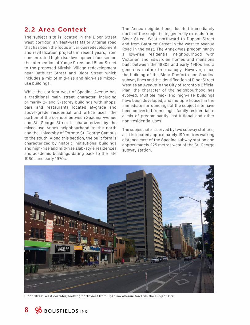
2.2 Area ContextThe subject site is located in the Bloor Street West corridor, an east-west Major Arterial road that has been the focus of various redevelopment and revitalization projects in recent years, from concentrated high-rise development focused on the intersection of Yonge Street and Bloor Street to the proposed Mirvish Village redevelopment near Bathurst Street and Bloor Street which includes a mix of mid-rise and high-rise mixed-use buildings.
While the corridor west of Spadina Avenue has a traditional main street character, including primarily 2- and 3-storey buildings with shops, bars and restaurants located at-grade and above-grade residential and office uses, the portion of the corridor between Spadina Avenue and St. George Street is characterized by the mixed-use Annex neighbourhood to the north and the University of Toronto St. George Campus to the south. Along this section, the built form is characterized by historic institutional buildings and high-rise and mid-rise slab-style residences and academic buildings dating back to the late 1960s and early 1970s.
PLANNING & URBAN DESIGN RATIONALE300 Bloor Street West & 478 Huron Street 9
2.3 Surrounding Context The following section provides a more detailed overview of the built form context surrounding the subject site.
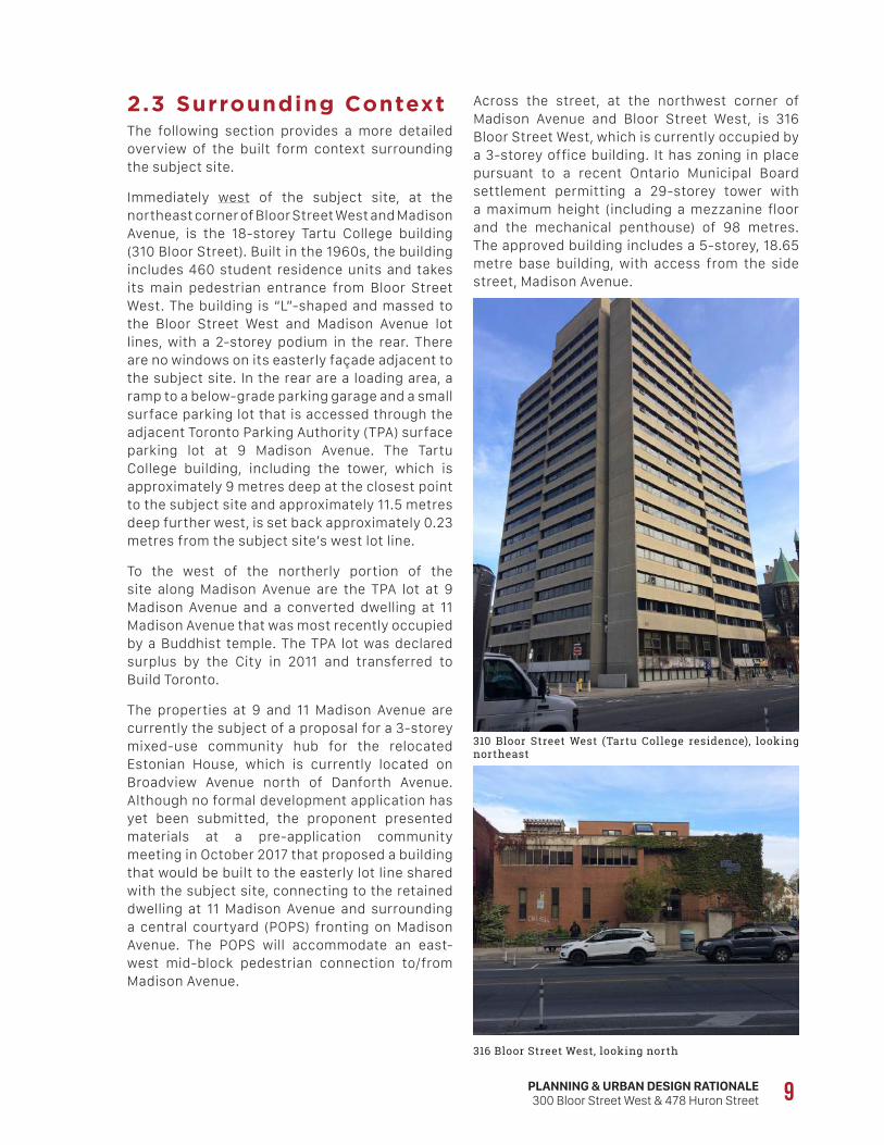
Immediately west of the subject site, at the northeast corner of Bloor Street West and Madison Avenue, is the 18-storey Tartu College building (310 Bloor Street). Built in the 1960s, the building includes 460 student residence units and takes its main pedestrian entrance from Bloor Street West. The building is “L”-shaped and massed to the Bloor Street West and Madison Avenue lot lines, with a 2-storey podium in the rear. There are no windows on its easterly façade adjacent to the subject site. In the rear are a loading area, a ramp to a below-grade parking garage and a small surface parking lot that is accessed through the adjacent Toronto Parking Authority (TPA) surface parking lot at 9 Madison Avenue. The Tartu College building, including the tower, which is approximately 9 metres deep at the closest point to the subject site and approximately 11.5 metres deep further west, is set back approximately 0.23 metres from the subject site’s west lot line.
To the west of the northerly portion of the site along Madison Avenue are the TPA lot at 9 Madison Avenue and a converted dwelling at 11 Madison Avenue that was most recently occupied by a Buddhist temple. The TPA lot was declared surplus by the City in 2011 and transferred to Build Toronto.
The properties at 9 and 11 Madison Avenue are currently the subject of a proposal for a 3-storey mixed-use community hub for the relocated Estonian House, which is currently located on Broadview Avenue north of Danforth Avenue. Although no formal development application has yet been submitted, the proponent presented materials at a pre-application community meeting in October 2017 that proposed a building that would be built to the easterly lot line shared with the subject site, connecting to the retained dwelling at 11 Madison Avenue and surrounding a central courtyard (POPS) fronting on Madison Avenue. The POPS will accommodate an east-west mid-block pedestrian connection to/from Madison Avenue.
310 Bloor Street West (Tartu College residence), looking northeast
316 Bloor Street West, looking north
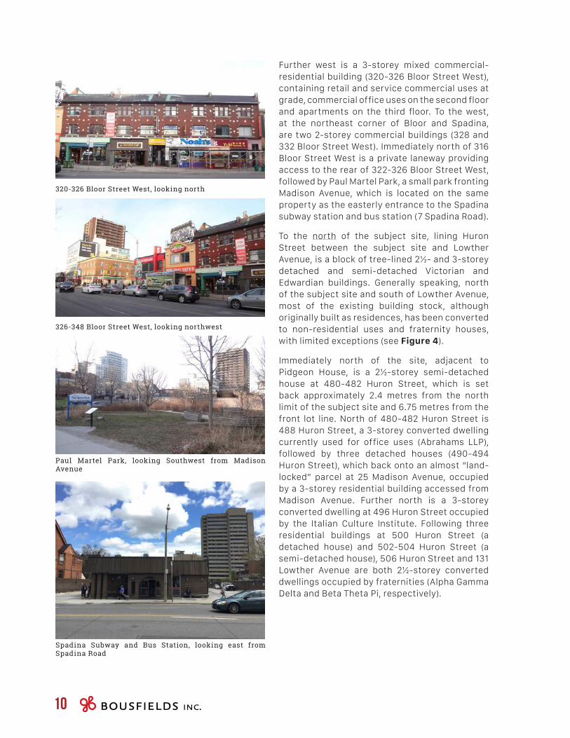
Across the street, at the northwest corner of Madison Avenue and Bloor Street West, is 316 Bloor Street West, which is currently occupied by a 3-storey office building. It has zoning in place pursuant to a recent Ontario Municipal Board settlement permitting a 29-storey tower with a maximum height (including a mezzanine floor and the mechanical penthouse) of 98 metres. The approved building includes a 5-storey, 18.65 metre base building, with access from the side street, Madison Avenue.
10
Further west is a 3-storey mixed commercial-residential building (320-326 Bloor Street West), containing retail and service commercial uses at grade, commercial office uses on the second floor and apartments on the third floor. To the west, at the northeast corner of Bloor and Spadina, are two 2-storey commercial buildings (328 and 332 Bloor Street West). Immediately north of 316 Bloor Street West is a private laneway providing access to the rear of 322-326 Bloor Street West, followed by Paul Martel Park, a small park fronting Madison Avenue, which is located on the same property as the easterly entrance to the Spadina subway station and bus station (7 Spadina Road).
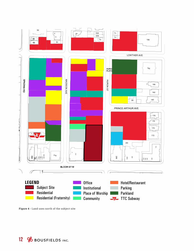
To the north of the subject site, lining Huron Street between the subject site and Lowther Avenue, is a block of tree-lined 2½- and 3-storey detached and semi-detached Victorian and Edwardian buildings. Generally speaking, north of the subject site and south of Lowther Avenue, most of the existing building stock, although originally built as residences, has been converted to non-residential uses and fraternity houses, with limited exceptions (see Figure 4).
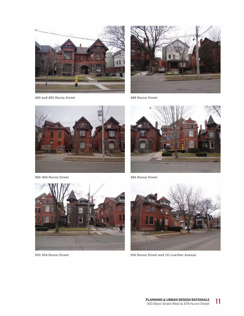
Immediately north of the site, adjacent to Pidgeon House, is a 2½-storey semi-detached house at 480-482 Huron Street, which is set back approximately 2.4 metres from the north limit of the subject site and 6.75 metres from the front lot line. North of 480-482 Huron Street is 488 Huron Street, a 3-storey converted dwelling currently used for office uses (Abrahams LLP), followed by three detached houses (490-494 Huron Street), which back onto an almost “land-locked” parcel at 25 Madison Avenue, occupied by a 3-storey residential building accessed from Madison Avenue. Further north is a 3-storey converted dwelling at 496 Huron Street occupied by the Italian Culture Institute. Following three residential buildings at 500 Huron Street (a detached house) and 502-504 Huron Street (a semi-detached house), 506 Huron Street and 131 Lowther Avenue are both 2½-storey converted dwellings occupied by fraternities (Alpha Gamma Delta and Beta Theta Pi, respectively).
320-326 Bloor Street West, looking north
326-348 Bloor Street West, looking northwest
Paul Martel Park, looking Southwest from Madison Avenue
Spadina Subway and Bus Station, looking east from Spadina Road
PLANNING & URBAN DESIGN RATIONALE300 Bloor Street West & 478 Huron Street 11
480 and 482 Huron Street
490-494 Huron Street
500-504 Huron Street
488 Huron Street
496 Huron Street
506 Huron Street and 131 Lowther Avenue
320
321
738
742
740
HU
RO
N W
AS
HIN
MA
TT C
OH
EN
PA
RK
333
335
351
339
337
341
328
160
75
725
371
713
327
162
100
158
409
407R407
BLOOR ST W
51
116
8B8A
332
55
53
39SPA
DIN
A R
D
HURON STREETPLAYGROUND
465
19
495
9
284
500
23
82
112
176
28
22
51
116
114
5452
80
86R 80A
86
8B8A
10
7
45
149
40
1618
41
264
262
268
468
270
280
300
470
284A
328.5328
326.5
310
3
320-326
324.5322.5
725
170
492
26
35
27
49025
24
33
174
25
488
21
172
482
20
19
480
17
15
478
13
14
11
455
1211
9
288
316332
505
196
503
530528
526
84
49
88
90
59
9296
9847
190
50
55
104
106
53
108110
131133
186
45
43
506
182
485
38
504
41
36
180
502
39
483
37
34
8894
35
32
496
33
178
30
39
31
494
37
29
95
SPA
DIN
A R
DBLOOR ST W
HU
RO
N S
T
MA
DIS
ON
AVE
LOWTHER AVE
Subject SiteResidentialResidential (Fraternity)
OfficeInstitutionalPlace of WorshipCommunity
LEGEND Hotel/RestaurantParkingParklandTTC Subway
PRINCE ARTHUR AVE
7
12
Figure 4 - Land uses north of the subject site
PLANNING & URBAN DESIGN RATIONALE300 Bloor Street West & 478 Huron Street 13
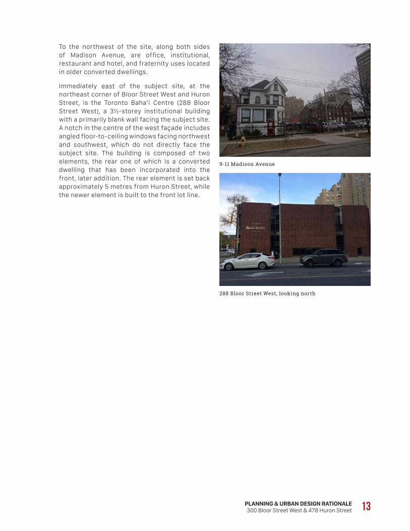
To the northwest of the site, along both sides of Madison Avenue, are office, institutional, restaurant and hotel, and fraternity uses located in older converted dwellings.
Immediately east of the subject site, at the northeast corner of Bloor Street West and Huron Street, is the Toronto Baha’i Centre (288 Bloor Street West), a 3½-storey institutional building with a primarily blank wall facing the subject site. A notch in the centre of the west façade includes angled floor-to-ceiling windows facing northwest and southwest, which do not directly face the subject site. The building is composed of two elements, the rear one of which is a converted dwelling that has been incorporated into the front, later addition. The rear element is set back approximately 5 metres from Huron Street, while the newer element is built to the front lot line.
9-11 Madison Avenue
288 Bloor Street West, looking north

14
North of the Baha’i Centre and attached to it is a 2½-storey place of worship occupied by the Light Korean Presbyterian Church and New Hope Fellowship Church (455 Huron Street), which is set back approximately 4.5 metres from Huron Street. A small City-owned surface parking lot is located immediately north (465 Huron Street), directly opposite Huron Street from Pidgeon House, followed by The Dunhill Club Condos, an 8-storey, 206-unit slab apartment building that is massed along the Prince Arthur frontage from Huron Street almost all the way to St. George Street (95 Prince Arthur Avenue). Although the apartment building has west-facing windows, they do not face the subject site, as 95 Prince Arthur is located to the north of the subject site.
Further north, across Prince Arthur Avenue, are a fraternity in a converted dwelling (Alpha Delta Phi, at 94 Prince Arthur Avenue), a converted dwelling used for office purposes (Ontario College of Pharmacists, at 483 Huron Street), and a 13-storey apartment building built in the “tower-in-the-park” style (485 Huron Street). Immediately north of 485 Huron Street is the Huron Street Playground, a fenced, densely-treed park with play structures and landscaped open space.
455 Huron Street, looking east
465 Huron Street, looking east
483 Huron Street, looking east
Huron Street Playground, looking east
485 Huron Street, looking east
95 Prince Arthur Avenue, looking east
PLANNING & URBAN DESIGN RATIONALE300 Bloor Street West & 478 Huron Street 15
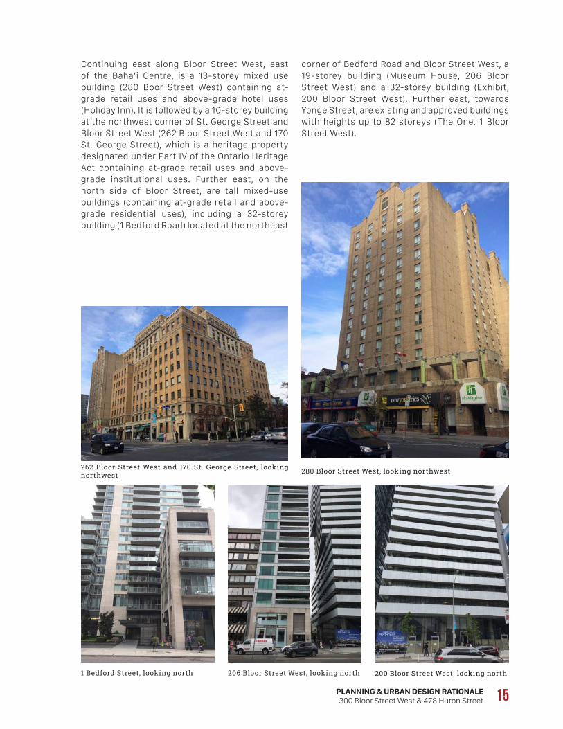
corner of Bedford Road and Bloor Street West, a 19-storey building (Museum House, 206 Bloor Street West) and a 32-storey building (Exhibit, 200 Bloor Street West). Further east, towards Yonge Street, are existing and approved buildings with heights up to 82 storeys (The One, 1 Bloor Street West).
Continuing east along Bloor Street West, east of the Baha’i Centre, is a 13-storey mixed use building (280 Boor Street West) containing at-grade retail uses and above-grade hotel uses (Holiday Inn). It is followed by a 10-storey building at the northwest corner of St. George Street and Bloor Street West (262 Bloor Street West and 170 St. George Street), which is a heritage property designated under Part IV of the Ontario Heritage Act containing at-grade retail uses and above-grade institutional uses. Further east, on the north side of Bloor Street, are tall mixed-use buildings (containing at-grade retail and above-grade residential uses), including a 32-storey building (1 Bedford Road) located at the northeast
262 Bloor Street West and 170 St. George Street, looking northwest 280 Bloor Street West, looking northwest
1 Bedford Street, looking north 206 Bloor Street West, looking north 200 Bloor Street West, looking north
16
To the immediate south of the subject site, at the southwest corner of Bloor Street and Huron Street, is the 4-storey University of Toronto Schools (UTS) building (371 Bloor Street West), built in 1910 (wings added in 1924, 1931 and 1949), which is listed on the City’s Heritage Register. The UTS building occupies the entire block on the south side of Bloor, from Huron Street to Spadina Avenue, with Matt Cohen Park located at the southeast corner of Bloor Street and Spadina Avenue. South of the UTS building are a number of 2½-storey detached and semi-detached dwellings fronting the east side of Spadina Avenue and the north side of Washington Avenue (703-713 Spadina Avenue and 2-20 Washington Avenue). Further east is the Huron-Washington Parkette, which occupies the northwest corner of Huron Street and Washington Avenue and contains a playground.
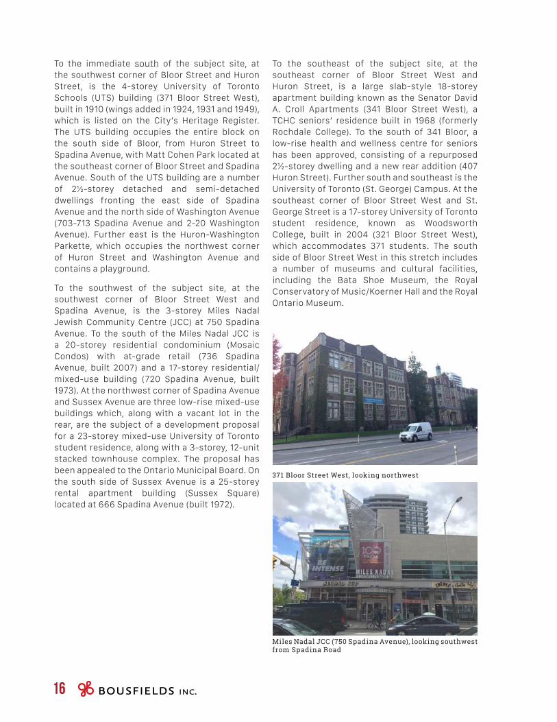
To the southwest of the subject site, at the southwest corner of Bloor Street West and Spadina Avenue, is the 3-storey Miles Nadal Jewish Community Centre (JCC) at 750 Spadina Avenue. To the south of the Miles Nadal JCC is a 20-storey residential condominium (Mosaic Condos) with at-grade retail (736 Spadina Avenue, built 2007) and a 17-storey residential/mixed-use building (720 Spadina Avenue, built 1973). At the northwest corner of Spadina Avenue and Sussex Avenue are three low-rise mixed-use buildings which, along with a vacant lot in the rear, are the subject of a development proposal for a 23-storey mixed-use University of Toronto student residence, along with a 3-storey, 12-unit stacked townhouse complex. The proposal has been appealed to the Ontario Municipal Board. On the south side of Sussex Avenue is a 25-storey rental apartment building (Sussex Square) located at 666 Spadina Avenue (built 1972).
371 Bloor Street West, looking northwest
Miles Nadal JCC (750 Spadina Avenue), looking southwest from Spadina Road
To the southeast of the subject site, at the southeast corner of Bloor Street West and Huron Street, is a large slab-style 18-storey apartment building known as the Senator David A. Croll Apartments (341 Bloor Street West), a TCHC seniors’ residence built in 1968 (formerly Rochdale College). To the south of 341 Bloor, a low-rise health and wellness centre for seniors has been approved, consisting of a repurposed 2½-storey dwelling and a new rear addition (407 Huron Street). Further south and southeast is the University of Toronto (St. George) Campus. At the southeast corner of Bloor Street West and St. George Street is a 17-storey University of Toronto student residence, known as Woodsworth College, built in 2004 (321 Bloor Street West), which accommodates 371 students. The south side of Bloor Street West in this stretch includes a number of museums and cultural facilities, including the Bata Shoe Museum, the Royal Conservatory of Music/Koerner Hall and the Royal Ontario Museum.
SUBJECTSITE
PLANNING & URBAN DESIGN RATIONALE300 Bloor Street West & 478 Huron Street 17
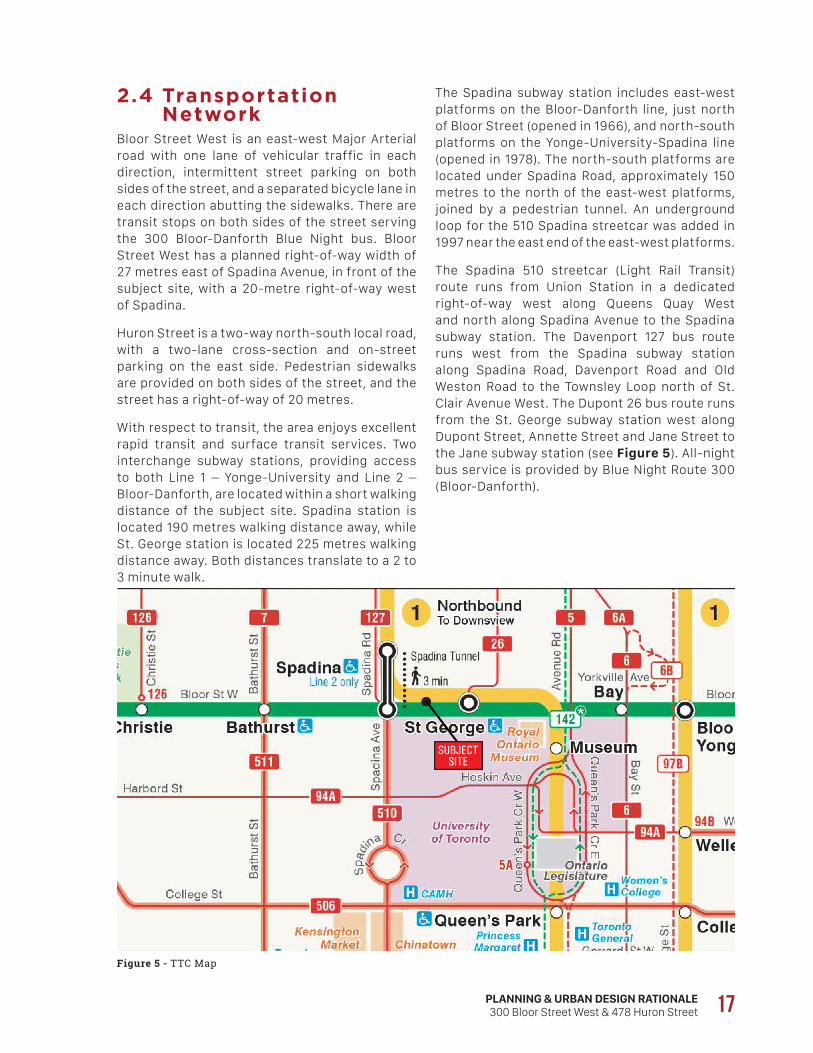
2.4 Transportation Network
Bloor Street West is an east-west Major Arterial road with one lane of vehicular traffic in each direction, intermittent street parking on both sides of the street, and a separated bicycle lane in each direction abutting the sidewalks. There are transit stops on both sides of the street serving the 300 Bloor-Danforth Blue Night bus. Bloor Street West has a planned right-of-way width of 27 metres east of Spadina Avenue, in front of the subject site, with a 20-metre right-of-way west of Spadina.
Huron Street is a two-way north-south local road, with a two-lane cross-section and on-street parking on the east side. Pedestrian sidewalks are provided on both sides of the street, and the street has a right-of-way of 20 metres.
With respect to transit, the area enjoys excellent rapid transit and surface transit services. Two interchange subway stations, providing access to both Line 1 – Yonge-University and Line 2 – Bloor-Danforth, are located within a short walking distance of the subject site. Spadina station is located 190 metres walking distance away, while St. George station is located 225 metres walking distance away. Both distances translate to a 2 to 3 minute walk.
The Spadina subway station includes east-west platforms on the Bloor-Danforth line, just north of Bloor Street (opened in 1966), and north-south platforms on the Yonge-University-Spadina line (opened in 1978). The north-south platforms are located under Spadina Road, approximately 150 metres to the north of the east-west platforms, joined by a pedestrian tunnel. An underground loop for the 510 Spadina streetcar was added in 1997 near the east end of the east-west platforms.
The Spadina 510 streetcar (Light Rail Transit) route runs from Union Station in a dedicated right-of-way west along Queens Quay West and north along Spadina Avenue to the Spadina subway station. The Davenport 127 bus route runs west from the Spadina subway station along Spadina Road, Davenport Road and Old Weston Road to the Townsley Loop north of St. Clair Avenue West. The Dupont 26 bus route runs from the St. George subway station west along Dupont Street, Annette Street and Jane Street to the Jane subway station (see Figure 5). All-night bus service is provided by Blue Night Route 300 (Bloor-Danforth).
Figure 5 - TTC Map

18
[3.0]P R O P O S A L
PLANNING & URBAN DESIGN RATIONALE300 Bloor Street West & 478 Huron Street 19
3.1 Description of the Proposal
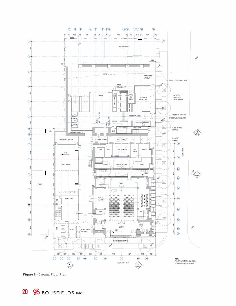
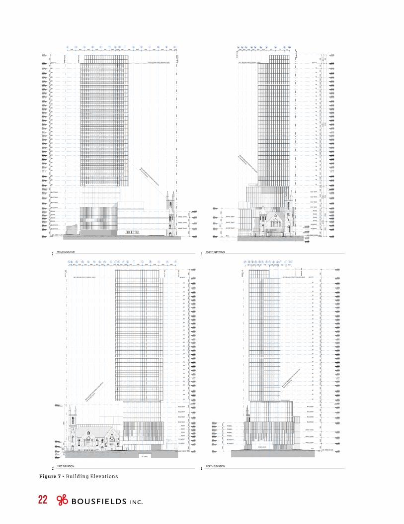
The proposed development retains the majority of the existing Bloor Street United Church and the Pidgeon House, while intensifying the site with a new mixed-use development consisting of new office, retail/café and residential uses. The worship, employment and community functions existing in the church building today are to be generally maintained. The design of the redevelopment proposal involved careful consideration of an appropriate relationship between uses and built forms, centred around the retention of the heritage-listed Bloor Street United Church and the Pidgeon House towards the rear of the site (see Figures 6 and 7 – Ground Floor Plan and Elevations).
The redevelopment of the site proposes a new building element that wraps around the west and north sides of the retained portion of the existing Bloor Street United Church. To accommodate the new building and to enhance the significant heritage resources on site, the following approach to the existing heritage structures is proposed:
• retention of the original two phases of the church in-situ;
• removal of the 3-storey “Sunday School” addition and later 1-storey brick addition to that addition, which are located northwest of the original building;
• removal of the one-storey entry vestibule that is located at the southwest edge of the building;
• removal of the south narthex, which turns the building away from Bloor Street West, and the introduction of new entrances and an enhanced façade;
• interior alterations;
• proposed promenade addition to surround the retained portion of the church building (see below);
• alterations to existing entrances; and
• retention and renovation of Pidgeon House in-situ.
In total, 5,573 square metres of new office space, 93 square metres of new retail/café space, and 26,071 square metres of new residential uses are proposed. Including the existing 3,736 square metres of the church to be retained, a total gross floor area of 35,473 square metres is proposed, resulting in an overall density of 9.76 times the
area of the lot (all gross floor area figures are based on By-law 569-2013). The redevelopment proposal is expected to house multiple new office tenants including the Bloor Street United Church, one new retail or café tenant at grade along Bloor Street West, and 259 new residential units.
The subject site also includes the Pidgeon House, which will be retained and renovated, but remain separated from the proposed mixed-use building.
For the purposes of discussing the mixed-use building, we have broken down the elements of the proposed building into three parts: the Bloor Street United Church; the 5-storey podium element west of the church, fronting Bloor Street West; and the 38-storey element north of the church, fronting Huron Street.
B L O O R S T R E E T U N I T E D C H U R C HThe renovated church is to be retained in-situ and incorporated into the proposed redevelopment by way of an enclosed, 3-storey, 14.0 metre tall atrium/promenade that surrounds the approximately 18.5 metre tall church building on its west and north facades. The atrium will connect Bloor Street West to Huron Street, while providing covered, weather-protected access to ground, 2nd and 3rd storey meeting rooms and office space in the church building and connecting to the vehicular drop-off area at the rear of the building.
The proposed entrances along Bloor Street West will act as the primary entrances to the church portion of the building, with additional entrances maintained from Huron Street and the internal promenade. The renovations will significantly improve accessibility to the church through the lowering of the church floor for direct entry off Bloor Street West and rectifying all levels to be barrier free.
The renovated church will include a flexible sanctuary space for worship by multiple faiths, as well as offices and community uses and meeting rooms.
1a 3a2a 4a 5a 6a 7a 8a 9a
F
E
D
C
B
A
OPEN TO ABOVE
EXISTING UNEXCAVATED
ORGAN BLOWER ROOM
EXISTING MECHANICAL
SUPPORT
OUTSIDE FACE OF WALL (TTC)
OUTSIDE FACE OF WALL (TTC)
SETBACK REQUIREMENT
SETBACK REQUIREMENT
POTENTIAL TO EXPAND OVER TUNNEL TO BE EXPLORED(TUNNEL DEPTH INFORMATION REQUIRED)
PIDGEON HOUSE
2.22.2
TO GRADE FROM BICYCLE PARKING
BICYCLEPARKINGSHOWERS
MECH ANDELEC
ELEVATOR PIT
INCOMING WATER/FIRE PROTECTION
STORMWATER MANAGEMENT TANK (50 m2)
ELEVATOR PIT
5 6 8 9 11 1221
I
J
K
L
M
N
O Ac
Bc
Cc
Dc
Fc
Ec
Gc
Hc
Ic
Jc
10a
G
H
3 4 7 10 13 14
3000 3000 4306 2854 4538 4182 7170 7170 3712
6500
6500
6500
6500
6500
6500
4300
2853
5080
6500
6500
6500
6500
6500
3864 750 5825 714 3016 3020 175 7489 175 3029 2638 550 5182
LONGTERM NON‐RES13 SPACES
LONG TERM RES157SPACES
LONG TERM RES103SPACES
LONG TERM RES20SPACES
STORMWATER MANAGEMENTTANK (25 m2)
6100
4908
3914
4310
4608
4576
4590
3870
2126
1a 3a2a 4a 5a 6a 7a 8a 9a
F
E
D
C
B
A
UP
UP
CHANCEL
OPEN TO BELOW
UP
A/V
NURSERYSTAFF LUNCH
STORAGE
MEDIUM MEETING
STORAGEMEDIUM MEETINGSTORAGE
W/CW/C
NARTHEX
OFFICE LOBBYTO TENANT OFFICES
PATIO BLOOR STREET ENTRANCE
LOADING
UCC OFFICE ENTRANCE
RESIDENTIAL ENTRANCE
ENTRANCE TO CAR COURT
RESIDENTIAL LOBBY
. 115
.27
. 115
.05
. 114
.80
. 115
.46
. 115
.50
. 115
.55
. 115
.63
. 115
.69
. 115
.77
. 114
.83
. 114
.81
. 116
.28
. 115
.67
. 114
.88
. 115
.16
. 114
.78
. 114
.78
BICYCLE PARKINGENTRANCE
1A5‐12
1A5‐11
2A5‐11
RESIDENTIAL AMENITY SPACE
2A5‐12
EGRESS STAIR
SERVICEELEVATOR
SERVICEELEVATOR
TYPE
C3.5
M x 6M
x 3M
TYPE
G4M
x 13
M x 6.1
M
PARKING PASSAGE
MOVE IN
ROOM
MAIL R
OOM
CACF
450.00
BOH
LAY BY
OUTDOOR RESIDENTIAL AMENITY SPACE
5 6 8 9 11 1221
I
J
K
L
M
N
O Ac
Bc
Cc
Dc
Fc
Ec
Gc
Hc
Ic
Jc
10a
G
H
3 4 7 10 13 14
3000 3000 4306 2854 4538 4182 7170 7170 3712 3814
6500
6500
6500
6500
6500
6500
4300
2853
5080
6500
6500
6500
6500
6500
469 1761 3864 750 5825 714 3016 3020 175 7489 175 3029 2638 550 5182 1010
6100
4908
3914
4310
4608
4576
4590
3870
2126
TYPE C3.5M x 6M x 3M
PACKAGES
MCCLURE HALL
COMMUNITY KITCHEN
RETAIL/ CAFE
BLOOR STREET ENTRANCE
NOTE: PROJECT ELEVATION 0.00M EQUALS GEODETIC ELEVATION 114.80M
EGRE
SS ST
AIR
OUTSIDE FACE OF WALL (TTC)
BLOOR STREET WEST
HURO
N STRE
ETTARTU
PIDGEON HOUSE
OUTSIDE FACE OF WALL (TTC)
7352
114
333
469
2332
0.00
0.00
322 King St W, 3rd FlToronto, ON, Canada M5V 1J2416.977.5104
Project No.ScalePlot Date
Project North True North
Copyright is that of the Architect.Any version of this drawing reproduced by any means from any media without prior written approval of the Architect is to be read for information only. The Architect is not liable for any loss or distortion of information
resulting from subsequent reproduction of the original drawing.
GENERAL NOTES: 1. Drawings are not to be scaled. Contractor will verify all existing conditions and dimensions required to perform the Work and will report any discrepancies with the Contract Documents to the Architect before commencing work.
2. The Architectural Drawings are to be read in conjunction with all other Contract Documents including the Project Manuals and the Structural, Mechanical and Electrical Drawings. In cases of difference between the Consultants' documents with respect to the quantity, sizes or scope of work, the greater shall apply.
3. Positions of exposed or finished Mechanical or Electrical devices, fittings and fixtures are indicated on the Architectural Drawings. Locations shown on the Architectural Drawings shall govern over Mechanical and Electrical Drawings. Mechanical and Electrical items not clearly located will be located as directed by the Architect.
4. Dimensions indicated are taken between the faces of finished surfaces unless otherwise noted.
5. The architect has not been retained for supervision of construction and assumes no responsibility for means, methods and techniques of construction.
6. These documents are not to be used for construction unless specifically noted for such purpose.
Rev. Date Issued
Project
2017 12 21
BASEMENT & GROUNDLEVELS
1645 1 : 200
A2‐00
300 BLOOR STREET W &478 HURON STREET
BASEMENT LEVEL1GROUND LEVEL2
20
Figure 6 - Ground Floor Plan
PLANNING & URBAN DESIGN RATIONALE300 Bloor Street West & 478 Huron Street 21
V E H I C U L A R A C C E S S A N D P A R K I N G / L O A D I N GThe loading and service area is proposed to be located internal to the site, at the rear of the building, accessed from but screened from Huron Street. A Type ‘G’ loading space and two Type ‘C’ loading spaces are to be provided, adjacent to the proposed moving room. The waste storage room will be located on the mezzanine floor above, with access to grade via two service elevators.
Two car elevators, also accessed from Huron Street, provide access to the above-grade parking garage, which has 4 levels and is fully automated. As described in Transportation Considerations report prepared by BA Group and submitted concurrently with this report, the fully automated parking system offers a “driver-less” parking of a vehicle within the above-grade parking levels. The garage will be equipped with a purpose-built facility that utilizes mechanical devices (shuttles and lifts) to take a vehicle between the transfer interface facility (i.e. two entry cabins located at grade) and a parking space within the above-grade parking system (P1 to P4). This system uses individually controlled “pallets” which manoeuver and “shuffle” each car independently to create a flexible and highly efficient parking and retrieval solution.
A total of 156 vehicle parking spaces are proposed on four above-grade parking levels, including 45 spaces for non-residential uses and 108 spaces for residential uses, along with 3 car-share spaces.
With respect to bicycle parking, a long-term bicycle parking storage area is proposed in the basement level, which is located under the 5-storey podium and accessed from Huron Street via a ramp. The bicycle parking rooms will include a total of 293 long-term bicycle parking spaces, as well as an on-site shower facility. No car parking is proposed below-grade.
P O D I U M E L E M E N TTo the west of the church, on the west side of the 3-storey atrium, a 5-storey addition is proposed with a 4-storey expression along Bloor Street West. At grade, the podium will include a small, approximately 61.3 square metre retail/café space fronting onto Bloor Street West, set back 7.35 metres from the front lot line, creating a small plaza in front of the building that will include outdoor patio space.
Behind the retail unit is a community kitchen connected to a double-height event space (the renovated McClure Hall and McClure Kitchen). Above the hall, at the second, third and fourth floors, new market-rent office space is proposed, each floor with a floor plate of approximately 461 metres.
Above the fourth storey, the building is proposed to step back approximately 19.5 metres from the main wall along Bloor Street West, allowing for a fifth storey green roof along the front of the building. The fifth and sixth storeys will house tenant office space related to the Bloor Street United Church with floor plates of between approximately 911 and 1,075 square metres.
T O W E R E L E M E N TThe proposed building will contain 259 residential units, including 1 one-bedroom unit, 108 one-bedroom and den units, 118 two-bedroom units, 16 two-bedroom and den units, and 16 three-bedroom units.
A total of 1,256 square metres of indoor amenity space is proposed on the first, mezzanine, 2nd and 9th floors. In addition, 368 square metres of outdoor amenity space is proposed on the first and 9th floors.
1a 3a2a 4a 5a 6a 7a 8a 9a
LEVEL 026.00
LEVEL 0310.50
GROUND0.00
GROUND0.00
P1 LEVEL11.48
P2 LEVEL14.05
P3 LEVEL16.62
P4 LEVEL19.19
LEVEL 0522.06
LEVEL 0522.06
LEVEL 0626.06
LEVEL 0730.06
LEVEL 0940.01
LEVEL 1043.76
LEVEL 1146.96
LEVEL 1251.26
LEVEL 1354.26
LEVEL 1457.26
LEVEL 1560.26
LEVEL 1663.26
LEVEL 1766.26
LEVEL 1869.26
LEVEL 1972.56
LEVEL 2075.56
LEVEL 2178.56
LEVEL 2281.56
LEVEL 2384.56
LEVEL 2487.56
LEVEL 2590.56
LEVEL 2693.56
LEVEL 2796.56
LEVEL 2899.56
LEVEL 29102.56
LEVEL 30105.56
LEVEL 31109.01
LEVEL 32112.01
LEVEL 33115.01
LEVEL 34118.01
LEVEL 35121.01
MECH P.H.135.16
LEVEL 0415.00
MEZZ 015.48
T/O ROOF141.66
4500
4500
6000
LEVEL 36124.01
LEVEL 37127.46
LEVEL 38130.96
MEZZ 028.48
6500
4200
3500
3450
3000
3000
3000
3000
3000
3450
3000
3000
3000
3000
3000
3000
3000
3000
3000
3000
3000
3300
3000
3000
3000
3000
3000
3000
4300
3200
3750
1950
4000
4000
4000
4000
2870
2570
2570
2570
3000
3000
6500
9515
017
950
1058
0
OFFICE ROOF38.06
LEVEL 02 (BSUC)3.69
LEVEL 03 (BSUC)7.60
B1 (BSUC)‐1.09
B2 (BSUC)‐3.00
LEVEL 0834.06
MARKET TENANT
MARKET TENANT
MARKET TENANT
BSUC
5480
7060
1148
06.5
0 m95
.90 m
16.60
m22
.66 m
10a
RES
RES
RES
RES
RES
RES
RES
RES
RES
RES
RES
RES
RES
RES
RES
RES
RES
RES
RES
RES
RES
RES
RES
RES
RES
RES
RES
RES
RES
RES
MECH P.H.
PARKING
RES AMENITY
RES AMENITY
BSUC TENANT
BSUC TENANT
BSUC TENANT
BSUC TENANT
PARKING
PARKING
PARKING
PROP
ERTY
LINE
PROP
ERTY
LINE
ANGULAR PLANE AS PER ZONING BY‐LAW 569‐2013
REF: 40.10.40.70 (2) (G)
371271707170418245382854430630003000
134.71 BUILDING HEIGHT FROM AVG. GRADE
AVG. GRADE: 115.235
0.5
FEDCBA
LEVEL 026.00
LEVEL 0310.50
GROUND0.00
GROUND0.00
P1 LEVEL11.48P2 LEVEL14.05P3 LEVEL16.62P4 LEVEL19.19
LEVEL 0522.06
LEVEL 0626.06
LEVEL 0730.06
LEVEL 0940.01
LEVEL 1043.76
LEVEL 1146.96
LEVEL 1251.26
LEVEL 1354.26
LEVEL 1457.26
LEVEL 1560.26
LEVEL 1663.26
LEVEL 1766.26
LEVEL 1869.26
LEVEL 1972.56
LEVEL 2075.56
LEVEL 2178.56
LEVEL 2281.56
LEVEL 2384.56
LEVEL 2487.56
LEVEL 2590.56
LEVEL 2693.56
LEVEL 2796.56
LEVEL 2899.56
LEVEL 29102.56
LEVEL 30105.56
LEVEL 31109.01
LEVEL 32112.01
LEVEL 33115.01
LEVEL 34118.01
LEVEL 35121.01
MECH P.H.135.16
LEVEL 0415.00
MEZZ 015.48
T/O ROOF141.66
6500
4200
3500
3450
3000
3000
3000
3000
3000
3450
3000
3000
3000
3000
3000
3000
3000
3000
3000
3000
3000
3300
3000
3000
3000
3000
3000
3000
4300
3200
3750
5950
4000
4000
4000
2870
2570
2570
2570
3000
3000
5480
4500
4500
6000
6500 6500 6500 6500 6500 5080 2853 4300 6500 6500 6500 6500 6500 6500 1307
LEVEL 36124.01
LEVEL 37127.46
LEVEL 38130.96
MEZZ 028.48
OFFICE ROOF38.06
LEVEL 0834.06
RES
RES
RES
RES
RES
RES
RES
RES
RES
RES
RES
RES
RES
RES
RES
RES
RES
RES
RES
RES
RES
RES
RES
RES
RES
RES
RES
RES
RES
RES
MECH P.H.
MARKET TENANT
PARKING
MARKET TENANT
MARKET TENANTPARKING
PARKING
PARKING
BSUC TENANT
BSUC TENANT
BSUC TENANT
BSUC TENANT
RES AMENITY
RES AMENITY
I J K L M N OG H
SOUTH ROOF19.50
PROP
ERTY
LINE
PROP
ERTY
LINE
ANGULAR PLANE AS PER ZONING BY‐LAW 569‐2013
REF: 40.10.40.70 (2) (G)
AVG. GRADE: 115.235
134.71 BUILDING HEIGHT FROM AVG. GRADE
0.5
PROP
ERTY
LINE
4500
322 King St W, 3rd FlToronto, ON, Canada M5V 1J2416.977.5104
Project No.ScalePlot Date
Project North True North
Copyright is that of the Architect.Any version of this drawing reproduced by any means from any media without prior written approval of the Architect is to be read for information only. The Architect is not liable for any loss or distortion of information
resulting from subsequent reproduction of the original drawing.
GENERAL NOTES: 1. Drawings are not to be scaled. Contractor will verify all existing conditions and dimensions required to perform the Work and will report any discrepancies with the Contract Documents to the Architect before commencing work.
2. The Architectural Drawings are to be read in conjunction with all other Contract Documents including the Project Manuals and the Structural, Mechanical and Electrical Drawings. In cases of difference between the Consultants' documents with respect to the quantity, sizes or scope of work, the greater shall apply.
3. Positions of exposed or finished Mechanical or Electrical devices, fittings and fixtures are indicated on the Architectural Drawings. Locations shown on the Architectural Drawings shall govern over Mechanical and Electrical Drawings. Mechanical and Electrical items not clearly located will be located as directed by the Architect.
4. Dimensions indicated are taken between the faces of finished surfaces unless otherwise noted.
5. The architect has not been retained for supervision of construction and assumes no responsibility for means, methods and techniques of construction.
6. These documents are not to be used for construction unless specifically noted for such purpose.
Rev. Date Issued
Project
12/21/2017
SOUTH & WESTELEVATIONS
16451 : 300
A5‐01
300 BLOOR STREET W &478 HURON STREET
SOUTH ELEVATION1WEST ELEVATION2
LEVEL 026.00
LEVEL 0310.50
GROUND0.00
GROUND0.00
P1 LEVEL11.48P2 LEVEL14.05P3 LEVEL16.62P4 LEVEL19.19
LEVEL 0522.06
LEVEL 0522.06
LEVEL 0626.06
LEVEL 0730.06
LEVEL 0940.01
LEVEL 1043.76
LEVEL 1146.96
LEVEL 1251.26
LEVEL 1354.26
LEVEL 1457.26
LEVEL 1560.26
LEVEL 1663.26
LEVEL 1766.26
LEVEL 1869.26
LEVEL 1972.56
LEVEL 2075.56
LEVEL 2178.56
LEVEL 2281.56
LEVEL 2384.56
LEVEL 2487.56
LEVEL 2590.56
LEVEL 2693.56
LEVEL 2796.56
LEVEL 2899.56
LEVEL 29102.56
LEVEL 30105.56
LEVEL 31109.01
LEVEL 32112.01
LEVEL 33115.01
LEVEL 34118.01
LEVEL 35121.01
MECH P.H.135.16
LEVEL 0415.00
MEZZ 015.48
T/O ROOF141.66
LEVEL 36124.01
LEVEL 37127.46
LEVEL 38130.96
MEZZ 028.48
6500
4200
3500
3450
3000
3000
3000
3000
3000
3450
3000
3000
3000
3000
3000
3000
3000
3000
3000
3000
3000
3300
3000
3000
3000
3000
3000
3000
4300
3200
3750
1950
4000
4000
4000
4000
7060
4500
4500
5480
3000
3000
2570
2570
2570
2870
6000
OFFICE ROOF38.06
LEVEL 0834.06
RES
RES
RES
RES
RES
RES
RES
RES
RES
RES
RES
RES
RES
RES
RES
RES
RES
RES
RES
RES
RES
RES
RES
RES
RES
RES
RES
RES
RES
MECH P.H.
RES
MARKET TENANT
MARKET TENANT
MARKET TENANT
BSUC TENANT
BSUC
PARKING 3
PARKING 4
PARKING 2
PARKING 1
RES AMENITY
RES AMENITY
BSUC TENANT
BSUC TENANT
BSUC TENANT
PIDGEON HOUSE
56891112 2 1347101314
PROP
ERTY
LINE
PROP
ERTY
LINE
PROP
ERTY
LINE
ANGULAR
PLANE AS PER ZONIN
G BY‐LAW
569‐2013
REF: 40
.10.40.70 (2) (G)
5182 550 2638 3029 175 7489 175 3020 3016 714 5825 750 3864
134.71 BUILDING HEIGHT FROM AVG. GRADE
AVG. GRADE: 115.235
0.5
F E D C B A
GROUND0.00
GROUND0.00
P1 LEVEL11.48
P2 LEVEL14.05
P3 LEVEL16.62
P4 LEVEL19.19
LEVEL 0522.06
LEVEL 0626.06
LEVEL 0730.06
LEVEL 0940.01
LEVEL 1043.76
LEVEL 1146.96
LEVEL 1251.26
LEVEL 1354.26
LEVEL 1457.26
LEVEL 1560.26
LEVEL 1663.26
LEVEL 1766.26
LEVEL 1869.26
LEVEL 1972.56
LEVEL 2075.56
LEVEL 2178.56
LEVEL 2281.56
LEVEL 2384.56
LEVEL 2487.56
LEVEL 2590.56
LEVEL 2693.56
LEVEL 2796.56
LEVEL 2899.56
LEVEL 29102.56
LEVEL 30105.56
LEVEL 31109.01
LEVEL 32112.01
LEVEL 33115.01
LEVEL 34118.01
LEVEL 35121.01
MECH P.H.135.16
MEZZ 015.48
T/O ROOF141.66
2126 3870 4590 4576 4608 4310 3914 4908 5582 518 3782 2853 5080 6500 6500 6500 6500 6500
LEVEL 36124.01
LEVEL 37127.46
LEVEL 38130.96
MEZZ 028.48
6500
4200
3500
3450
3000
3000
3000
3000
3000
3450
3000
3000
3000
3000
3000
3000
3000
3000
3000
3000
3000
3300
3000
3000
3000
3000
3000
3000
4300
3200
3750
9950
4000
4000
2870
2570
2570
2570
3000
3000
5480
OFFICE ROOF38.06
LEVEL 02 (BSUC)3.69
LEVEL 03 (BSUC)7.60
B1 (BSUC)‐1.09
T/O TOWER (BSUC)36.00
B2 (BSUC)‐3.00
LEVEL 0834.06
RES
RES
RES
RES
RES
RES
RES
RES
RES
RES
RES
RES
RES
RES
RES
RES
RES
RES
RES
RES
RES
RES
RES
RES
RES
RES
RES
RES
RES
RES
MECH P.H.
PARKING
RES AMENITY
RES AMENITY
BSUC TENANT
BSUC TENANT
BSUC TENANT
BSUC TENANT
PARKING
PARKING
PARKING
TTC TUNNEL
IAc Bc Cc Dc FcEc Gc Hc Ic Jc GH
PROP
ERTY
LINE
PROP
ERTY
LINE
ANGULAR
PLANE AS PER ZONIN
G BY‐LAW
569‐2013
REF: 40
.10.40.70 (2) (G)
2840
039
1037
2210
5819
10
AVG. GRADE: 115.235
134.71 BUILDING HEIGHT FROM AVG. GRADE
0.5
PROP
ERTY
LINE
322 King St W, 3rd FlToronto, ON, Canada M5V 1J2416.977.5104
Project No.ScalePlot Date
Project North True North
Copyright is that of the Architect.Any version of this drawing reproduced by any means from any media without prior written approval of the Architect is to be read for information only. The Architect is not liable for any loss or distortion of information
resulting from subsequent reproduction of the original drawing.
GENERAL NOTES: 1. Drawings are not to be scaled. Contractor will verify all existing conditions and dimensions required to perform the Work and will report any discrepancies with the Contract Documents to the Architect before commencing work.
2. The Architectural Drawings are to be read in conjunction with all other Contract Documents including the Project Manuals and the Structural, Mechanical and Electrical Drawings. In cases of difference between the Consultants' documents with respect to the quantity, sizes or scope of work, the greater shall apply.
3. Positions of exposed or finished Mechanical or Electrical devices, fittings and fixtures are indicated on the Architectural Drawings. Locations shown on the Architectural Drawings shall govern over Mechanical and Electrical Drawings. Mechanical and Electrical items not clearly located will be located as directed by the Architect.
4. Dimensions indicated are taken between the faces of finished surfaces unless otherwise noted.
5. The architect has not been retained for supervision of construction and assumes no responsibility for means, methods and techniques of construction.
6. These documents are not to be used for construction unless specifically noted for such purpose.
Rev. Date Issued
Project
2017 12 21
NORTH & EASTELEVATIONS
16451 : 300
A5‐02
300 BLOOR STREET W &478 HURON STREET
NORTH ELEVATION1EAST ELEVATION2
22
Figure 7 - Building Elevations
PLANNING & URBAN DESIGN RATIONALE300 Bloor Street West & 478 Huron Street 23
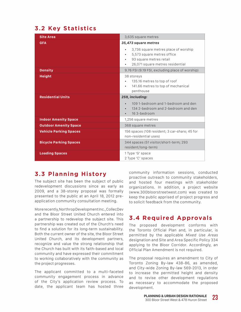
3.2 Key StatisticsSite Area 3,635 square metres
GFA 35,473 square metres
• 3,736 square metres place of worship
• 5,573 square metres office
• 93 square metres retail
• 26,071 square metres residential
Density 9.76 FSI (9.19 FSI, excluding place of worship)
Height 38 storeys
• 135.16 metres to top of roof
• 141.66 metres to top of mechanical
penthouse
Residential Units 259, including:
• 109 1-bedroom and 1-bedroom and den
• 134 2-bedroom and 2-bedroom and den
• 16 3-bedroom
Indoor Amenity Space 1,256 square metres
Outdoor Amenity Space 368 square metres
Vehicle Parking Spaces 156 spaces (108 resident; 3 car-share; 45 for
non-residential uses)
Bicycle Parking Spaces 344 spaces (51 visitor/short-term; 293
resident/long-term)
Loading Spaces 1 Type ‘G’ space
2 Type ‘C’ spaces
3.3 Planning HistoryThe subject site has been the subject of public redevelopment discussions since as early as 2009, and a 38-storey proposal was formally presented to the public at an April 18, 2012 pre-application community consultation meeting.
More recently, Northrop Development Inc., CollecDev and the Bloor Street United Church entered into a partnership to redevelop the subject site. This partnership was created out of the Church’s need to find a solution for its long-term sustainability. Both the current owner of the site, the Bloor Street United Church, and its development partners, recognize and value the strong relationship that the Church has built with its faith-based and local community and have expressed their commitment to working collaboratively with the community as the project progresses.
The applicant committed to a multi-faceted community engagement process in advance of the City’s application review process. To date, the applicant team has hosted three
community information sessions, conducted proactive outreach to community stakeholders, and hosted four meetings with stakeholder organizations. In addition, a project website (www.300bloorstreetwest.com) was created to keep the public apprised of project progress and to solicit feedback from the community.
3.4 Required ApprovalsThe proposed development conforms with the Toronto Official Plan and, in particular, is permitted by the applicable Mixed Use Areas designation and Site and Area Specific Policy 334 applying to the Bloor Corridor. Accordingly, an Official Plan Amendment is not required.
The proposal requires an amendment to City of Toronto Zoning By-law 438-86, as amended, and City-wide Zoning By-law 569-2013, in order to increase the permitted height and density and to revise other development regulations as necessary to accommodate the proposed development.

24
[4.0]P O L I C Y &
R E G U L A T O R Y C O N T E X T
PLANNING & URBAN DESIGN RATIONALE300 Bloor Street West & 478 Huron Street 25
or planned infrastructure and public service facilities. Policy 1.1.3.4 promotes appropriate development standards, which facilitate intensification, redevelopment and compact form, while avoiding or mitigating risks to public health and safety.
In the PPS, intensification means the development of a property, site or area at a higher density that currently exists through: a) redevelopment, including the reuse of brownfield sites; b) the development of vacant and/or underutilized lots within previously developed areas; c) infill development; and d) the expansion or conversion of existing buildings.
With respect to employment, Policy 1.3.1 states that authorities shall promote economic development and competitiveness by, among other approaches, providing for an appropriate mix and range of employment and institutional uses to meet long-term needs. It also promotes compact, mixed-use development that incorporates compatible employment uses to support liveable and resilient communities.
With respect to housing, Policy 1.4.3 requires provision to be made for an appropriate range of housing types and densities to meet projected requirements of current and future residents by, among other matters, facilitating all forms of residential intensification and redevelopment and promoting densities for new housing which efficiently use land, resources, infrastructure and public service facilities and support the use of active transportation and public transit.
The efficient use of infrastructure, particularly public transit, is a key element of the PPS (Section 1.6.7). With respect to transportation systems, Policy 1.6.7.4 promotes a land use pattern, density and mix of land uses that minimize the length and number of vehicle trips required and support the current and future use of public transit and active transportation.
4.1 Provincial Policy Statement (2014)
The current Provincial Policy Statement (2014) came into effect on April 30, 2014. The PPS provides policy direction on matters of Provincial interest related to land use planning and development. In accordance with Section 3(5)(a) of the Planning Act, all land uses planning decisions are required to be consistent with the PPS. Policy 4.4 states that the PPS “shall be read in its entirety and all relevant policies are to be applied to each situation.”
The proposal is consistent with the policy direction expressed in the PPS to build strong communities by promoting efficient development and land use patterns. To that end, the PPS contains a number of policies that promote intensification and compact built form, particularly in areas well served by public transit.
In particular, Policies 1.1.1(a) and 1.1.1(b) provide that healthy, liveable and safe communities are to be sustained by promoting efficient development and land use patterns and accommodating an appropriate range and mix of residential, employment (including industrial and commercial), institutional, recreation, park and open space, and other uses.
Policy 1.1.3.2 of the PPS promotes densities and a mix of land uses which efficiently use land, resources, infrastructure and public service facilities, and are transit-supportive, where transit is planned, exists or may be developed. Public service facilities are defined as “lands, buildings and structures for the provision of programs and services provided or subsidized by a government or other body, such as social assistance, recreation, policy and fire protection, health and educational programs and cultural services.”
Policy 1.1.3.3 provides that planning authorities shall identify appropriate locations and promote opportunities for redevelopment and intensification where this can be accommodated, taking into account existing building stock or areas, and the availability of suitable existing
26
4.2 Growth Plan for the Greater Golden Horseshoe
The Growth Plan for the Greater Golden Horseshoe (2017) came into effect on July 1, 2017, replacing the previous Growth Plan (2006). All decisions made on or after this date are required to conform with the Growth Plan (2017), subject to any legislative or regulatory provisions providing otherwise.
The Growth Plan policies have been strengthened as they apply to the integration of land use and infrastructure planning, and the importance of “optimizing” the use of the land supply and infrastructure. In this respect, the Growth Plan has been revised by adding more detail about the objectives of a “complete community” and requiring minimum density targets for major transit station areas along priority transit corridors and existing subways.
Similar to the PPS, the general framework in the Growth Plan 2017 seeks to reinforce the importance of integrating transportation and land use planning to achieve broader intensification objectives. As noted in the introductory text in Section 2.1:
“This Plan is about accommodating forecasted growth in complete communities. These are communities that are well designed to meet people’s needs for daily living throughout an entire lifetime by providing convenient access to an appropriate mix of jobs, local services, public service facilities, and a full range of housing to accommodate a range of incomes and household sizes… The Growth Plan, 2006 identified 25 urban growth centres and this Plan continues to recognize those urban growth centres as regional focal points for accommodating population and employment growth. The continued revitalization of urban growth centres as meeting places, locations for cultural facilities, public institutions, and major services and transit hubs with the potential to become more vibrant, mixed-use transit-supportive communities is particularly important.”
Policy 1.7.1 of the PPS states that long-term prosperity should be supported by optimizing the use of land, resources, infrastructure and public service facilities, maintaining and where possible, enhancing the vitality and viability of downtowns and main streets, and encouraging a sense of place by promoting well-designed built form and cultural planning, and by conserving features that help define character, including built heritage resources.
With respect to energy conservation, air quality and climate change, Policy 1.8.1 requires that planning authorities support energy conservation and efficiency, improved air quality, reduced greenhouse gas emissions, and climate change adaptation. This is to be achieved through land use and development patterns which: promote compact form and structure nodes and corridors; promote the use of active transportation and public transit in and between residential, employment and other areas and improve the mix of employment and housing uses to shorten commute journeys and decrease transportation congestion.
With respect to cultural heritage, Policy 2.6.1 indicates that significant built heritage resources and cultural heritage landscapes shall be conserved. Policy 2.6.3 indicates that planning authorities shall not permit development and site alteration on lands adjacent to heritage properties except where the proposed development and site alteration have been evaluated and it has been demonstrated that the heritage attributes of the protected heritage property will be conserved.
For the reasons set out in Sections 5.1 and 5.7 of this report, it is our opinion that the proposal and, more specifically the requested Zoning By-law Amendment, is consistent with the Provincial Policy Statement and, specifically, the policies relating to intensification, the efficient use of land and infrastructure and conservation of significant heritage buildings.
PLANNING & URBAN DESIGN RATIONALE300 Bloor Street West & 478 Huron Street 27
Policy 2.2.1(2)(c) provides that, within settlement areas, growth will be focused in delineated built-up areas, strategic growth areas, locations with existing or planned transit (with higher order transit being prioritized where it exists or is planned), and areas with existing or planned public service facilities. Accordingly, Schedule 3 of the Growth Plan forecasts a population of 3,190,000 and 1,660,000 jobs for the City of Toronto by 2031, increasing to 3,400,000 and 1,720,000, respectively by 2041.
The recently released 2016 Census indicates that population growth in Toronto is continuing to fall short of the Growth Plan forecasts. At a point that is now midway through the 2001-2031 forecast period, the 2016 population of 2,731,571 (which would translate to an estimated population of 2,825,123, using the same undercount percentage as determined for the 2011 Census) is only 39.2% of the way toward achieving the population forecast of 3,190,000 by 2031.
Policy 2.2.1(4) provides that applying the policies of the Growth Plan will support the achievement of “complete communities” that feature a diverse mix of land uses, including residential and employment uses, and convenient access to local stores, services, and “public service facilities” (same definition as PPS), improve social equity and overall quality of life, and provide a diverse range and mix of housing options. Moreover, it will expand convenient access to a range of transportation options, public service facilities, co-located and integrated in community hubs, publicly accessible open spaces and healthy, local and affordable food options.
Policy 2.2.2(4) requires municipalities to develop a strategy to achieve the minimum intensification target and intensification throughout delineated built-up areas which will, among other things, encourage intensification generally to achieve the desired urban structure, identify the appropriate type and scale of development and transition of built form to adjacent areas. It also requires municipalities to identify strategic growth areas to support achievement of the intensification target and recognize them as a key focus for development.
The introductory text goes on to provide as follows:
“This Plan recognizes transit as a first priority for major transportation investments. It sets out a regional vision for transit, and seeks to align transit with growth by directing growth to major transit station areas and other strategic growth areas, including urban growth centres, and promoting investments in these areas… It is important that we maximize the benefits of land use planning, as well as existing and future investments in infrastructure so that our communities are well-positioned to leverage economic change.”
The subject site would be part of a “strategic growth area” pursuant to the Growth Plan (i.e. a focus for accommodating intensification and higher-density mixed uses in a more compact built form), given that it is located within both the Downtown Toronto “urban growth centre” and a “major transit station area.” As provided in the Growth Plan, Downtown Toronto is planned to accommodate and support major transit infrastructure, as well as accommodate a significant share of population and employment growth [Policy 2.2.3(1)(d)].
The Growth Plan defines “strategic growth areas” as urban growth centres, major transit areas and other major opportunities that may include infill, redevelopment, brownfield sites, the expansion or conversion of existing buildings or greyfields. Furthermore, it defines a “major transit station area” as the area including and around any existing or planned higher order transit or stop within a settlement area and “generally defined as the area within an approximate 500 metre radius of a transit station, representing an approximate 10-minute walk.” In turn, “higher order transit” is defined as transit that generally operates in partially or completely dedicated rights-of-way, outside of mixed traffic, and therefore can achieve levels of speed and reliability greater than mixed-traffic transit. Higher order transit can include heavy rail (such as subways and inter-city rail), light rail, and buses in dedicated right-of-ways. As discussed in Section 2.4 of this report, the subject site is located within approximately 190 metres and 225 metres, respectively, of the Spadina and St. George subway stations.
28
the PPS, Policy 2.2.6(2) states that, in preparing a housing strategy, municipalities will support the achievement of complete communities by: planning to accommodate forecasted growth; planning to achieve the minimum intensification and density targets; considering the range and mix of housing options and densities of the existing housing stock; and planning to diversify the overall housing stock across the municipality.
Generally, the infrastructure policies set out in Chapter 3 of the Growth Plan (2017) place an enhanced emphasis on the need to integrate land use planning and investment in both infrastructure and transportation. The introductory text in Section 3.1 states that:
“The infrastructure framework in this Plan requires that municipalities undertake an integrated approach to land use planning, infrastructure investments, and environmental protection to achieve the outcomes of the Plan. Co-ordination of these different dimensions of planning allows municipalities to identify the most cost-effective options for sustainably accommodating forecasted growth to the horizon of this Plan to support the achievement of complete communities. It is estimated that over 30 per cent of infrastructure capital costs, and 15 per cent of operating costs, could be saved by moving from lower density development to a more compact built form. This Plan is aligned with the Province’s approach to long-term infrastructure planning as enshrined in the Infrastructure for Jobs and Prosperity Act, 2015, which established mechanisms to encourage principled, evidence based and strategic long-term infrastructure planning.”
Policies 3.2.3(1) and 3.2.3(2) state that public transit will be the first priority for transportation infrastructure planning and major transportation investments, and that decisions on transit planning and investment will be made according to a number of criteria, including prioritizing areas with existing or planned higher residential or employment densities to optimize return on investment and the efficiency and viability of existing and planned transit service levels, and increasing the capacity of existing transit systems to support strategic growth areas.
Policy 2.2.3(1) provides that urban growth centres will be planned to accommodate and support the transit network at the regional scale and to accommodate significant population and employment growth. In this regard, Policy 2.2.3(2) requires that each urban growth centre in the City of Toronto will be planned to achieve a minimum density target of 400 residents and jobs combined by 2031.
Section 2.2.4 of the Growth Plan provides policies related to transit corridors and station areas. Policy 2.2.4(2) requires the City of Toronto to delineate the boundaries of “major transit station areas” on subway lines “in a transit-supportive manner that maximizes the size of the area and the number of potential transit users that are within walking distance of the station”.
Policy 2.2.4(3)(a) goes on to require that “major transit station areas” on subway lines be planned for a minimum density target of 200 residents and jobs combined per hectare. Policy 2.2.4(6) states that, within “major transit station areas” on a subway line, land uses and built form that would adversely affect the achievement of the minimum density targets will be prohibited.
Policy 2.2.4(9) provides that, within all “major transit station areas”, development will be supported, where appropriate, by: planning for a diverse mix of uses to support existing and planned transit service levels; providing alternative development standards, such as reduced parking standards; and prohibiting land uses and built form that would adversely affect the achievement of transit-supportive densities.
Policy 2.2.4(10) provides that lands adjacent to or near to existing and planned “frequent transit” should be planned to be transit-supportive and supportive of active transportation and a range and mix of uses and activities.
The Growth Plan (2017) includes a new Section 2.2.6 that deals with housing. Policy 2.2.6(1) requires municipalities to develop a housing strategy that, among other matters, supports the achievement of the minimum intensification and density targets in the Growth Plan and identifies a diverse range and mix of housing options and densities to meet projected needs of current and future residents. Notwithstanding Policy 1.4.1 of
PLANNING & URBAN DESIGN RATIONALE300 Bloor Street West & 478 Huron Street 29
To that end, Policy 2.1(3), as amended by Official Plan Amendment No. 231, provides that Toronto is forecasted to accommodate 3.19 million residents and 1.66 million jobs by the year 2031. The marginal note regarding Toronto’s growth prospects makes it clear that these figures are neither targets nor maximums; they are minimums:
“The Greater Toronto Area … is forecast to grow by 2.7 million residents and 1.8 million jobs by the year 2031. The forecast allocates to Toronto 20 percent of the increase in population (537,000 additional residents) and 30 percent of the employment growth (544,000 additional jobs) … This Plan takes the current GTA forecast as a minimum expectation, especially in terms of population growth. The policy framework found here prepares the City to realize this growth, or even more, depending on the success of this Plan in creating dynamic transit oriented mixed use centres and corridors.”
The growth management policies of the Official Plan direct growth to identified areas on Map 2, which include Centres, Avenues, Employment Districts and the Downtown and Central Waterfront, where transit services and other infrastructure are available. On Map 2, the subject site is identified as part of the Downtown and the Central Waterfront (see Figure 8, Urban Structure).
In Chapter 2 (Shaping the City), one of the key policy directions is Integrating Land Use and Transportation (Section 2.2). The Official Plan states that:
“… future growth within Toronto will be steered to areas which are well served by transit, the existing road network and which have a number of properties with redevelopment potential. Generally, the growth areas are locations where good transit access can be provided along bus and streetcar routes and at rapid transit stations. Areas that can best accommodate this growth are shown on Map 2: Downtown, including the Central Waterfront, the Centres, the Avenues and the Employment Districts. A vibrant mix of residential and employment growth is seen for the Downtown and the Centres …” (Our emphasis.)
Policy 4.2.7(1) directs that ccultural heritage resources will be conserved in order to foster a sense of place and benefit communities, particularly in strategic growth areas, while Policy 4.2.7(2) provides that municipalities will work with stakeholders in developing and implementing official plan policies and strategies for the identification, wise use and management of cultural heritage resources.
For the reasons outlined in Section 5.1 of this report, it is our opinion that the proposed development and, more particularly, the requested Zoning By-law Amendment conforms with the Growth Plan and, in particular, the policies promoting growth and intensification within “urban growth centres” and “major transit station areas”.
4.3 City of Toronto Official Plan
The Official Plan for the amalgamated City of Toronto (the “Official Plan”) was adopted on November 26, 2002 and was approved by the Ontario Municipal Board on July 6, 2006. Numerous amendments have been approved and are now in effect, including amendments arising out of the Official Plan Review initiated in 2011.
G R O W T H M A N A G E M E N T P O L I C I E SChapter 2 (Shaping the City) outlines the City’s growth management strategy. It recognizes that:
“Toronto’s future is one of growth, of rebuilding, of re-urbanizing and of regenerating the City within an existing urban structure that is not easy to change. Population growth is needed to support economic growth and social development within the City and contribute to a better future for the Greater Toronto Area (GTA). A healthier Toronto will grow from a successful strategy to attract more residents and more jobs to the City.”
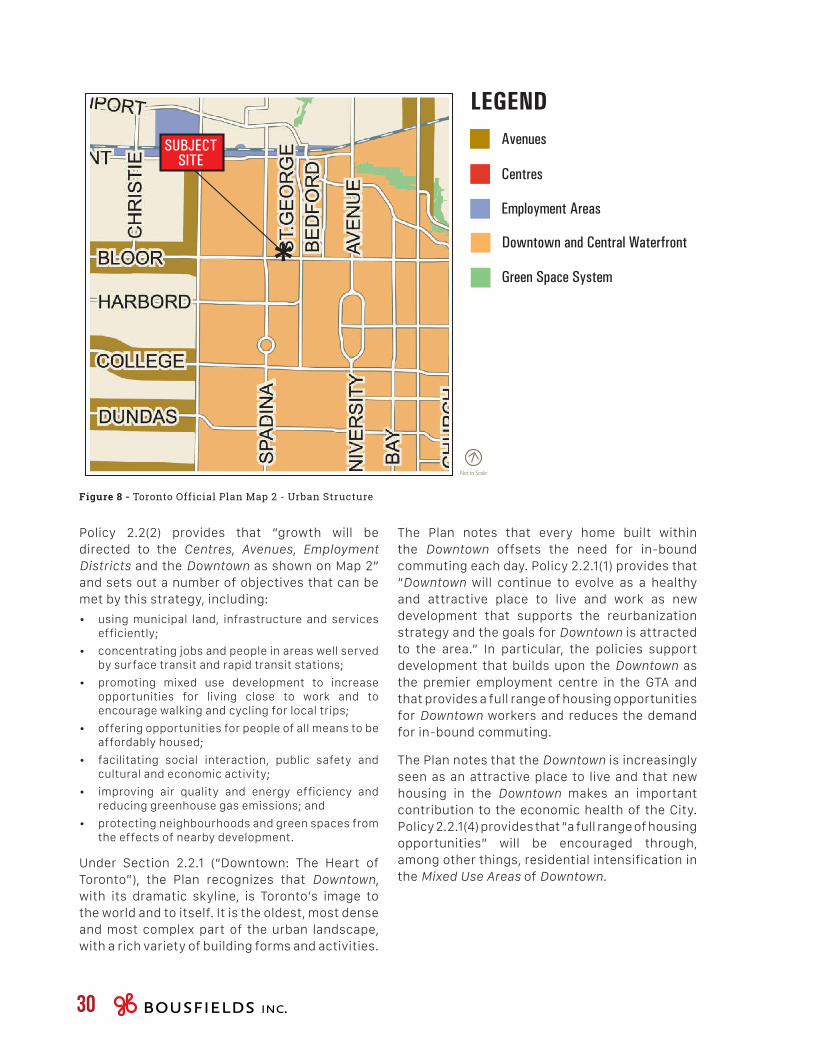
Green Space System
Downtown and Central Waterfront
Avenues
Centres
Not to Scale
LEGEND
Employment Areas
SUBJECTSITE
30
The Plan notes that every home built within the Downtown offsets the need for in-bound commuting each day. Policy 2.2.1(1) provides that “Downtown will continue to evolve as a healthy and attractive place to live and work as new development that supports the reurbanization strategy and the goals for Downtown is attracted to the area.” In particular, the policies support development that builds upon the Downtown as the premier employment centre in the GTA and that provides a full range of housing opportunities for Downtown workers and reduces the demand for in-bound commuting.
The Plan notes that the Downtown is increasingly seen as an attractive place to live and that new housing in the Downtown makes an important contribution to the economic health of the City. Policy 2.2.1(4) provides that “a full range of housing opportunities” will be encouraged through, among other things, residential intensification in the Mixed Use Areas of Downtown.
Policy 2.2(2) provides that “growth will be directed to the Centres, Avenues, Employment Districts and the Downtown as shown on Map 2” and sets out a number of objectives that can be met by this strategy, including:
• using municipal land, infrastructure and services efficiently;
• concentrating jobs and people in areas well served by surface transit and rapid transit stations;
• promoting mixed use development to increase opportunities for living close to work and to encourage walking and cycling for local trips;
• offering opportunities for people of all means to be affordably housed;
• facilitating social interaction, public safety and cultural and economic activity;
• improving air quality and energy efficiency and reducing greenhouse gas emissions; and
• protecting neighbourhoods and green spaces from the effects of nearby development.
Under Section 2.2.1 (“Downtown: The Heart of Toronto”), the Plan recognizes that Downtown, with its dramatic skyline, is Toronto’s image to the world and to itself. It is the oldest, most dense and most complex part of the urban landscape, with a rich variety of building forms and activities.
Figure 8 - Toronto Official Plan Map 2 - Urban Structure
PLANNING & URBAN DESIGN RATIONALE300 Bloor Street West & 478 Huron Street 31
In addition, Section 2.4 “Bringing the City Together: A Progressive Agenda of Transportation Change” notes that:
“The transportation policies, maps and schedules of the Plan make provision for the protection and development of the City’s road, rapid transit and inter-regional rail networks. The Plan provides complementary policies to make more efficient use of this infrastructure and to increase opportunities for walking, cycling, and transit use and support the goal of reducing car dependency throughout the City … Reducing car dependency means being creative and flexible about how we manage urban growth. We have to plan in ‘next generation’ terms to make walking, cycling, and transit increasingly attractive alternatives to using the car and to move towards a more sustainable transportation system…”
Following therefrom, Policy 2.4(4) states as follows:
“In targeted growth areas, planning for new development will be undertaken in the context of reducing auto dependency and the transportation demands and impacts of such new development assessed in terms of the broader social and environmental objectives of the Plan’s reurbanization strategy.”
Policy 2.4(7) further notes that, for sites in areas well served by transit (such as locations around rapid transit stations and along major transit routes), consideration will be given to establishing minimum density requirements (in addition to maximum density limits), establishing minimum and maximum parking requirements and limiting surface parking as a non-ancillary use. Furthermore, Policy 2.4(8)(a) directs that better use will be made of off-street parking by “encouraging the shared use of parking and developing parking standards for mixed use developments which reflect the potential for shared parking among uses that have different peaking characteristics”.
L A N D U S E P O L I C I E SThe Official Plan designates the subject site as Mixed Use Areas (see Figure 9, Map 18, Land Use). The Mixed Use Areas designation provides for a broad mix of commercial, residential and institutional uses, in single use or mixed use buildings, as well as parks and open spaces and utilities. The Plan envisions that development in Mixed Use Areas will create a balance of high quality commercial, residential, institutional and open space uses that reduces automobile dependency and meets the needs of the local community, while providing for new jobs and homes for Toronto’s growing population on underutilized lands in the Downtown and elsewhere.
Policy 4.5(2) contains a number of criteria for development within the Mixed Use Areas designation, including:
• locating and massing new buildings to provide a transition between areas of different development intensity and scale, through means such as providing appropriate setbacks and/or a stepping down of heights, particularly towards lower scale Neighbourhoods;
• locating and massing new buildings so as to adequately limit shadow impacts on adjacent Neighbourhoods, particularly during the spring and fall equinoxes;
• locating and massing new buildings to frame the edges of streets and parks with good proportion and maintaining sunlight and comfortable wind conditions for pedestrians on adjacent streets, parks and open spaces;
• providing an attractive, comfortable and safe pedestrian environment;
• taking advantage of nearby transit services;
• providing good site access and circulation and an adequate supply of parking for residents and visitors;
• locating and screening service areas, ramps and garbage storage to minimize the impact on adjacent streets and residence; and
• providing indoor and outdoor recreation space for building residents in every significant multi-unit residential development.
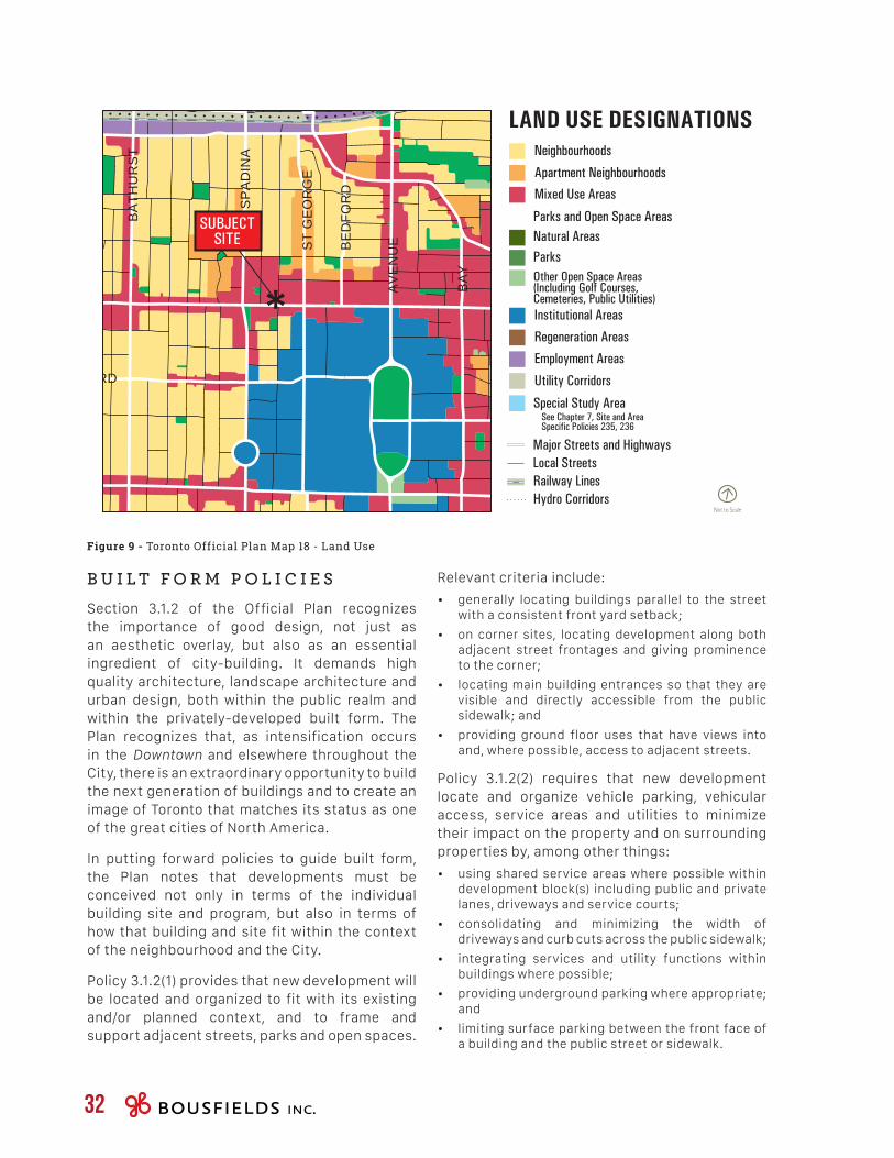
Not to Scale
LAND USE DESIGNATIONSNeighbourhoods
Mixed Use Areas
Regeneration Areas
Employment Areas
Utility Corridors
Institutional Areas
Apartment Neighbourhoods
Parks and Open Space AreasNatural AreasParksOther Open Space Areas(Including Golf Courses,Cemeteries, Public Utilities)
Railway Lines
Major Streets and HighwaysLocal Streets
Hydro Corridors
Special Study AreaSee Chapter 7, Site and AreaSpecific Policies 235, 236
ANNETTE
DUNDAS
GARDINER EX
LAN
SD
OW
NE
RO
NC
ES
VA
LLE
S
CARLTON
SHUTER
BLOOR
DUNDAS
BLOOR
DUPONT
DAVENPORT
OS
SIN
GTO
N
DO
VE
RC
OU
RT
LAN
SD
OW
NE
DU
FFE
RIN
KE
ELE
PA
RK
SID
E
PA
RLI
AM
EN
T
SH
ER
BO
UR
NE
BRO
ADVI
EW
BE
DFO
RD
BA
Y
CH
UR
CH
JAR
VIS
MT
PLE
AS
AN
T
ST
GE
OR
GE
CH
RIS
TIE
BA
THU
RS
TB
ATH
UR
ST
AV
EN
UE
YO
RK
BA
Y
YO
NG
EY
ON
GE
SP
AD
INA
SP
AD
INA
HARBORD
WELLESLEYWELLESLEY
ANNETTE
O'CONNOR
COSBURN
MORTIMER
DANFORTH
PA
PE
BAYV
IEW
COLLEGE
DUNDAS
QUEENQUEEN
KINGKING
GARDINER EX
LAKE SHORE
UN
IVE
RS
ITY
FRONT
FRONTWELLINGTON
QUEENS QUAY
RICHMOND
ADELAIDE
TORONTO INNER HARBOUR
TORONTO OUTER HARBOUR
STR
AC
HA
N
GERRARDGERRARD
DUNDAS
CA
RLA
W
BR
OA
DV
IEW
EASTERN
LAKE SHORE
POTTERY
GARDINER EX
LAKE ONTARIO
PA
PE
DO
NV
ALL
EYPK
WY
ROSEDALE VALLEY
Neighbourhoods
Mixed Use Areas
Land Use Designations
Regeneration Areas
Employment Areas
Utility Corridors
Institutional Areas
Apartment Neighbourhoods
Parks and Open Space Areas
Natural Areas
Parks
Other Open Space Areas(Including Golf Courses,Cemeteries, Public Utilities)
Key Map Not to Scale
MAP 18Land Use PlanJuly 2015
Railway Lines
Major Streets and Highways
Local Streets
Hydro Corridors
0 500 1000 1500m
13 16 19 22
14 17 20 23
15 18 21
City PlanningDivision
SUBJECTSITE
32
Relevant criteria include:
• generally locating buildings parallel to the street with a consistent front yard setback;
• on corner sites, locating development along both adjacent street frontages and giving prominence to the corner;
• locating main building entrances so that they are visible and directly accessible from the public sidewalk; and
• providing ground floor uses that have views into and, where possible, access to adjacent streets.
Policy 3.1.2(2) requires that new development locate and organize vehicle parking, vehicular access, service areas and utilities to minimize their impact on the property and on surrounding properties by, among other things:
• using shared service areas where possible within development block(s) including public and private lanes, driveways and service courts;
• consolidating and minimizing the width of driveways and curb cuts across the public sidewalk;
• integrating services and utility functions within buildings where possible;
• providing underground parking where appropriate; and
• limiting surface parking between the front face of a building and the public street or sidewalk.
B U I L T F O R M P O L I C I E SSection 3.1.2 of the Official Plan recognizes the importance of good design, not just as an aesthetic overlay, but also as an essential ingredient of city-building. It demands high quality architecture, landscape architecture and urban design, both within the public realm and within the privately-developed built form. The Plan recognizes that, as intensification occurs in the Downtown and elsewhere throughout the City, there is an extraordinary opportunity to build the next generation of buildings and to create an image of Toronto that matches its status as one of the great cities of North America.
In putting forward policies to guide built form, the Plan notes that developments must be conceived not only in terms of the individual building site and program, but also in terms of how that building and site fit within the context of the neighbourhood and the City.
Policy 3.1.2(1) provides that new development will be located and organized to fit with its existing and/or planned context, and to frame and support adjacent streets, parks and open spaces.
Figure 9 - Toronto Official Plan Map 18 - Land Use
PLANNING & URBAN DESIGN RATIONALE300 Bloor Street West & 478 Huron Street 33
Section 3.1.3 of the Plan recognizes that tall buildings, when properly located and designed, can draw attention to the city structure, visually reinforcing our civic centres and other areas of civic importance. Given Toronto’s relatively flat topography, tall buildings can become important city landmarks when the quality of architecture and site design is emphasized. Accordingly, the policies specify that tall buildings come with larger civic responsibilities and obligations than other buildings.
Among other matters, Policy 3.1.3(1) specifies that the design of tall buildings should consist of a base to define and support the street edge at an appropriate scale, a shaft that is appropriately sized and oriented in relation to the base building and adjacent buildings, and a top that contributes to the character of the skyline and integrates rooftop mechanical systems.
Policy 3.1.3(2) requires that tall building proposals address key urban design considerations, including: meeting the built form principles of the Plan; demonstrating how the proposed building and site design will contribute to and reinforce the overall city structure; demonstrating how the proposed building and site design relate to the existing and/or planned context; and taking into account the relationship of the site to topography and other tall buildings.
H E R I T A G E P O L I C I E SAs discussed in Section 2.1, both existing properties at 300 Bloor Street West and 478 Huron Street are listed on the City of Toronto Heritage Register.
Heritage conservation policies are included in Section 3.1.5 of the Official Plan. As amended by Official Plan Amendment No. 199 (approved by the Ontario Municipal Board on May 12, 2015), the Plan recognizes that the protection, wise use and management of Toronto’s cultural heritage will integrate the significant achievements of our people, their history, our landmarks and our neighbourhoods into a shared sense of place and belonging for its inhabitants.
Policy 3.1.2(3) sets out policies to ensure that new development will be massed and its exterior façade will be designed to fit harmoniously into its existing and/or planned context, and will limit its impact on neighbouring streets, parks, open spaces and properties by:
• massing new buildings to frame adjacent streets and open spaces in a way that respects the existing and/or planned street proportion;
• incorporating exterior design elements, their form, scale, proportion, pattern and materials, and their sustainable design, to influence the character, scale and appearance of the development;
• creating appropriate transitions in scale to neighbouring existing and/or planned buildings;
• providing for adequate light and privacy;
• adequately limiting any resulting shadowing of, and uncomfortable wind conditions on, neighbouring streets, properties and open spaces, having regard for the varied nature of such areas; and
• minimizing any additional shadowing and uncomfortable wind conditions on neighbouring parks as necessary to preserve their utility.
Policy 3.1.2(4) provides that new development will be massed to define the edges of streets, parks and open spaces at good proportion. Taller buildings will be located to ensure adequate access to sky view for the proposed and future use of these areas.
Policy 3.1.2(5) requires that new development will provide amenity for adjacent streets and open spaces to make these areas attractive, interesting, comfortable and functional for pedestrians by providing, among other things:
• improvements to adjacent boulevards and sidewalks respecting sustainable design elements, including trees, shrubs, hedges, plantings or other ground cover, permeable paving materials, street furniture, curb ramps, waste and recycling containers, lighting and bicycle parking facilities;
• co-ordinated landscape improvements in setbacks to create attractive transitions from the private to public realms;
• weather protection such as canopies and awnings; and
• landscaped open space within the development site.
Policy 3.1.2(6) requires that every significant new multi-residential development provide indoor and outdoor amenity space for residents, giving each resident access to outdoor amenity spaces such as balconies, terraces, courtyards, rooftop gardens and other types of outdoor spaces.
34
Avenue, where it wraps around the property, can be viewed clearly and in its entirety (including its spire) from College Street at the southwest and southeast corners of College at Spadina, as well as from the Spadina streetcar right of way, when traveling toward or from the property on the streetcar at College Street.”
H O U S I N G P O L I C I E SThe Plan’s housing policies support a full range of housing in terms of form, tenure and affordability, across the City and within Neighbourhoods, to meet the current and future needs of residents (Policy 3.2.1(1)). Policy 3.2.1(2) provides that new housing supply will be encouraged through intensification and infill that is consistent with the Plan.
I M P L E M E N T A T I O N P O L I C I E SPolicy 5.3.2(1) provides that implementation plans, strategies and guidelines, while they express Council policy, are not part of the Plan unless the Plan has been specifically amended to include them and do not have the status of the policies of the Official Plan adopted under the Planning Act.
4.4 Site and Area Specific Policies
The portion of the site at 300 Bloor Street West is subject to Site and Area Specific Policy 334 (SASP 334), which applies to the “Bloor Corridor” between Avenue Road and Bathurst Street. It was introduced by Official Plan Amendment No. 98, and resulted from the Bloor Corridor Visioning Study.
SASP 334 recognizes that the Bloor Corridor includes a variety of land uses, including residential, commercial, retail, institutional, cultural, and parks and open space. It notes that, in order to support the continued diversity of the Bloor Corridor population, a range of housing types and tenures will be encouraged, including a mix of unit sizes to provide housing opportunities for a range of households, including those with children.
Policy 3.1.5(3) states that heritage properties of cultural value or interest, including Heritage Conservation Districts, will be protected by being designated under the Ontario Heritage Act and/or included on the Heritage Register.
Policy 3.1.5(5) provides that proposed development on or adjacent to a property on the Heritage Register will ensure that the integrity of the heritage property’s cultural heritage value and attributes will be retained. Policy 3.1.5(26) provides that new construction on, or adjacent to, a property on the Heritage Register will be designed to conserve the cultural heritage values, attributes and character of that property and to mitigate visual and physical impact on it.
Under the sub-section addressing incentives, Policy 3.1.5(23) provides that additional gross floor area may be permitted in excess of what is permitted in the Zoning By-law for lands designated Mixed Use Areas for a heritage building or structure on a designated heritage property that is part of a new development, provided that: the application includes the conservation of a heritage building or structure on a property designated under the Ontario Heritage Act; additional gross floor area specifically provided through this policy will not exceed that of the heritage building or structure being retained; the additional floor area will not detract from the heritage property and will not conflict with any other Official Plan policies; excellence in the conservation of the values, attributes, character and three-dimensional integrity of the heritage property is achieved; and the conserved heritage building or structure is protected in a Heritage Easement Agreement.
Policy 3.1.5(44) provides that the view to a property on the Heritage Register as described in Schedule 4 will be conserved unobstructed where the view is included on Map 7A or 7B. In this respect, Schedule 4 describes Views A4 (Knox College Spire) and A5 (Knox College), as follows:
“The view of the Knox College Spire, as it extends above the roofline of the third floor, can be viewed from the north along Spadina Avenue at the southeast corner of Bloor Street West and at Sussex Avenue.”
“The view of Knox College, located in Spadina Circle north of College Street and between the north and southbound lanes of Spadina
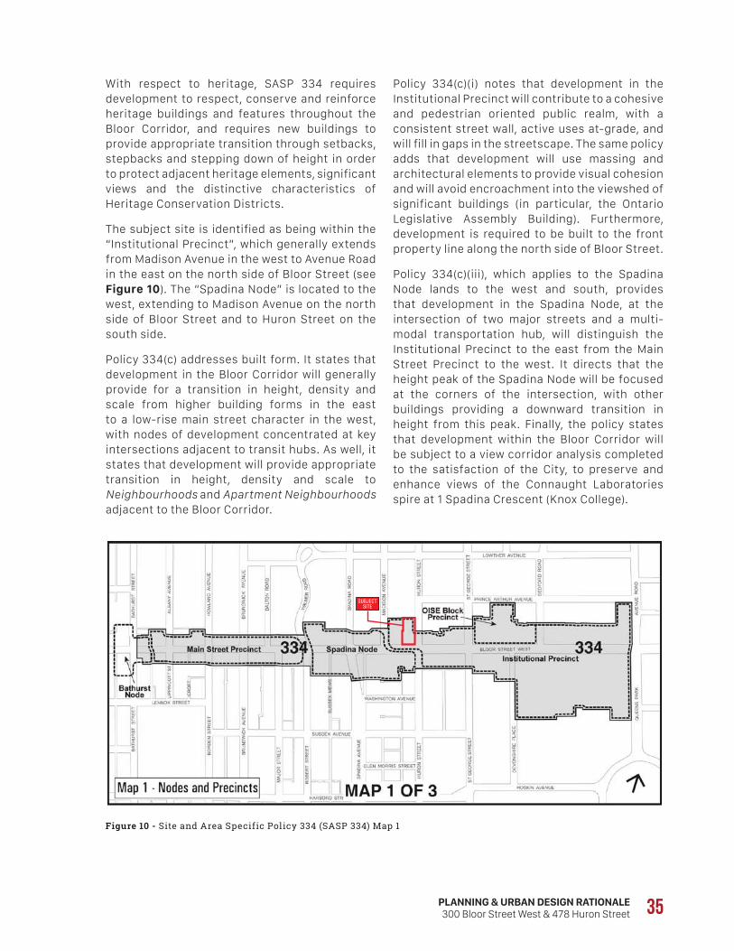
SUBJECTSITE
PLANNING & URBAN DESIGN RATIONALE300 Bloor Street West & 478 Huron Street 35
Policy 334(c)(i) notes that development in the Institutional Precinct will contribute to a cohesive and pedestrian oriented public realm, with a consistent street wall, active uses at-grade, and will fill in gaps in the streetscape. The same policy adds that development will use massing and architectural elements to provide visual cohesion and will avoid encroachment into the viewshed of significant buildings (in particular, the Ontario Legislative Assembly Building). Furthermore, development is required to be built to the front property line along the north side of Bloor Street.
Policy 334(c)(iii), which applies to the Spadina Node lands to the west and south, provides that development in the Spadina Node, at the intersection of two major streets and a multi-modal transportation hub, will distinguish the Institutional Precinct to the east from the Main Street Precinct to the west. It directs that the height peak of the Spadina Node will be focused at the corners of the intersection, with other buildings providing a downward transition in height from this peak. Finally, the policy states that development within the Bloor Corridor will be subject to a view corridor analysis completed to the satisfaction of the City, to preserve and enhance views of the Connaught Laboratories spire at 1 Spadina Crescent (Knox College).
With respect to heritage, SASP 334 requires development to respect, conserve and reinforce heritage buildings and features throughout the Bloor Corridor, and requires new buildings to provide appropriate transition through setbacks, stepbacks and stepping down of height in order to protect adjacent heritage elements, significant views and the distinctive characteristics of Heritage Conservation Districts.
The subject site is identified as being within the “Institutional Precinct”, which generally extends from Madison Avenue in the west to Avenue Road in the east on the north side of Bloor Street (see Figure 10). The “Spadina Node” is located to the west, extending to Madison Avenue on the north side of Bloor Street and to Huron Street on the south side.
Policy 334(c) addresses built form. It states that development in the Bloor Corridor will generally provide for a transition in height, density and scale from higher building forms in the east to a low-rise main street character in the west, with nodes of development concentrated at key intersections adjacent to transit hubs. As well, it states that development will provide appropriate transition in height, density and scale to Neighbourhoods and Apartment Neighbourhoods adjacent to the Bloor Corridor.
Figure 10 - Site and Area Specific Policy 334 (SASP 334) Map 1
36
4.5 Official Plan Amendment No. 352
On November 9, 2016, City Council adopted Official Plan Amendment No. 352 (OPA 352), which introduces Site and Area Specific Policy 517 (SASP 517) applying to the Downtown area, generally bounded by Bathurst Street, Lake Ontario, the Don River, Rosedale Valley Road and the CPR tracks. OPA 352 has been appealed to the Ontario Municipal Board by numerous parties and is therefore not in force.
The purpose of SASP 517 is to provide direction for Downtown tall building development with respect to setbacks from the building face of the tower to adjacent lot lines and an adequate separation distance between towers. These directions are intended to ensure that individual tall buildings on a site and the cumulative effect of multiple tall buildings within a block contribute to building strong healthy communities by fitting in with the existing and/or planned context.
In particular, SASP 517 provides that the Zoning By-law will contain minimum numerical standards with respect to tall building setbacks and separation distances (see Section 4.7 below) in order to achieve the following objectives:
• provide a high-quality, comfortable public realm;
• consider development potential, where appropriate, of other sites within the block;
• provide appropriate access to sunlight on surrounding streets, parks, open spaces, school yards, and other public or civic properties;
• provide appropriate access to natural light and a reasonable level of privacy for occupants of tall buildings;
• provide appropriate pedestrian-level views of the sky between towers as experienced from adjacent streets, parks and open spaces;
• encourage a reasonable level of views between towers for occupants of tall buildings; and
• limit the impacts of uncomfortable wind conditions on streets, parks, open spaces and surrounding properties to appropriate levels.
In addition, SASP 517 sets out the following directions:
• sites that are unable to accommodate a tall building that can achieve the intent of the tall building setback policies are not considered suitable for tall building development;
• as building heights increase, greater lot line setbacks may be required from the tower to the lot line;
Policy 334(e) provides that future streetscape improvements along Bloor Street West between Avenue Road and Bathurst Street will promote a healthy and vibrant pedestrian environment through the redesign of street cross-sections (e.g. sidewalk widening, street tree planting), accommodating cyclists and integrating lay-bys for drop-offs and delivery. Additionally, Policy 334(f) promotes advanced performance measures toward environmental sustainability for all new development.
Policy 334(g) requires that the design of rights-of-way in the Bloor Corridor will recognize and enhance the primacy of pedestrian safety and movement, and will reinforce and support transit use and cycling. Opportunities will be pursued to provide widened sidewalks, consolidated bicycle parking areas and enhanced pedestrian access to subway stations.
With respect to the Bloor Corridor Urban Design Guidelines (see Section 4.8 below), Policy 334(h) states that Council may adopt urban design guidelines to provide direction for reviewing development applications in the area in order to assist in meeting the objectives of the Official Plan and area specific policies. These guidelines are to be read in conjunction with the urban design policies in the Official Plan and the prevailing guidelines for the University of Toronto Secondary Plan (applying to the south side of Bloor Street).
The portion of the site at 478 Huron Street is subject to Site and Area Specific Policy 198 (Huron Madison). The policy provides that residential, institutional and commercial uses are permitted in house-form buildings and requires that development conserve the valued heritage buildings, reinforce the architectural unity that characterizes the area, and maintain the character of the heritage landscapes.
In our opinion, the proposed development conforms with the built form and urban design policies for the Bloor Corridor, as set out above, based on the detailed analysis set out in Sections 5.3 to 5.6 of this report.
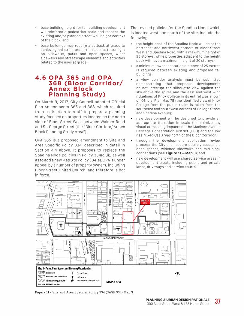
SUBJECTSITE
PLANNING & URBAN DESIGN RATIONALE300 Bloor Street West & 478 Huron Street 37
The revised policies for the Spadina Node, which is located west and south of the site, include the following:
• the height peak of the Spadina Node will be at the northeast and northwest corners of Bloor Street West and Spadina Road, with a maximum height of 25 storeys, while properties adjacent to the height peak will have a maximum height of 20 storeys;
• a minimum tower separation distance of 25 metres is required between existing and proposed tall buildings;
• a view corridor analysis must be submitted demonstrating that proposed developments do not interrupt the silhouette view against the sky above the spires and the east and west wing ridgelines of Knox College in its entirety, as shown on Official Plan Map 7B (the identified view of Knox College from the public realm is taken from the southeast and southwest corners of College Street and Spadina Avenue);
• new development will be designed to provide an appropriate transition in scale to minimize any visual or massing impacts on the Madison Avenue Heritage Conservation District (HCD) and the low rise Mixed Use Areas north of the Bloor Corridor;
• through the development application review process, the City shall secure publicly accessible open spaces, widened sidewalks and mid-block connections (see Figure 11 – Map 3); and
• new development will use shared service areas in development blocks including public and private lanes, driveways and service courts.
• base building height for tall building development will reinforce a pedestrian scale and respect the existing and/or planned street wall height context of the block; and
• base buildings may require a setback at grade to achieve good street proportion, access to sunlight on sidewalks, parks and open spaces, wider sidewalks and streetscape elements and activities related to the uses at grade.
4.6 OPA 365 and OPA 368 (Bloor Corridor/ Annex Block Planning Study)
On March 9, 2017, City Council adopted Official Plan Amendments 365 and 368, which resulted from a direction to staff to prepare a planning study focused on properties located on the north side of Bloor Street West between Walmer Road and St. George Street (the “Bloor Corridor/ Annex Block Planning Study Area”).
OPA 365 is a proposed amendment to Site and Area Specific Policy 334, described in detail in Section 4.4 above. It proposes to replace the Spadina Node policies in Policy 334(c)(ii), as well as to add a new Map 3 to Policy 334(e). OPA is under appeal by a number of property owners, including Bloor Street United Church, and therefore is not in force.
Figure 11 - Site and Area Specific Policy 334 (SASP 334) Map 3
38
4.7 ZoningThe in-force zoning by-law applying to the subject site is By-law 438-86, as amended, of the former City of Toronto. The new City-wide Zoning By-law No. 569-2013 was enacted by City Council on May 9, 2013; however, it was appealed to the Ontario Municipal Board in its entirety. While portions of the by-law have now been approved by the Board, it is not yet fully in force.
F O R M E R C I T Y O F T O R O N T O Z O N I N G B Y - L A W 4 3 8 - 8 6Under By-law 438-86, the majority of the subject site (300 Bloor Street West) is zoned MCR T3.0 C2.0 R2.5, with a maximum height of 18.0 metres. This zoning also applies to the properties immediately west and east of the subject site. The northerly portion of the subject site (478 Huron Street – Pidgeon House) is zoned CR T1.5 C1.5 R1.0, with a maximum height of 12.0 metres (see Figures 12 and 13).
The MCR (Mainstreets Commercial-Residential) Zone permits apartment building types, as well as office, retail and institutional uses, provided that the non-residential gross floor area for each retail store does not exceed 465 square metres. The T3.0 C2.0 R2.5 zoning permits a maximum gross floor area of 3.0 times the lot area, with a maximum non-residential density of 2.0 times the lot area and a maximum residential density of 2.5 times the lot area.
The CR (Commercial-Residential) Zone similarly permits a wide range of residential and non-residential uses including apartment buildings, retail stores, service shops, offices and places of worship, although 478 Huron Street is subject to Restrictive Exception Section 12(2)219, which limits the range of permitted commercial uses (see below). The T1.5 C1.5 R1.0 zoning designation permits a maximum gross floor area of 1.5 times the lot area, with a maximum non-residential density of 1.5 times the lot area and a maximum residential density of 1.0 times the lot area.
Map 3, which applies to lands both within the Spadina Node and within the study area generally, shows an east-west Midblock Connection across the property at 9 Madison Avenue, terminating at the westerly limit of the subject site. It also illustrates Existing Tower and Potential Tower locations; the subject site is not identified as a potential tower location.
OPA 368, also adopted on March 9, 2017, is a proposed amendment to the Official Plan policies applying to Knox College (1 Spadina Crescent). Again, it has been appealed to the Ontario Municipal Board by a number of parties, including Bloor Street United Church, and therefore is not in force.
OPA 368 proposes to delete the description of View A5 in Schedule 4 of the Official Plan regarding the former Knox College and replace it with the following:
“The Knox College building at 1 Spadina Crescent is a prominent Toronto landmark since its construction in 1875 and an excellent example of a High Victorian Gothic style college building. The views from the public realm at the southeast and southwest corners of College Street and Spadina Avenue as identified on Official Plan Map 7B (Identified Views from the Public Realm) will include the prevention of any further intrusion into the silhouette view against the sky above the spires and the east and west wing ridgeline of Knox College in its entirety. The views from the identified public realm of College Street to and beyond Knox College in its entirety will be conserved.”
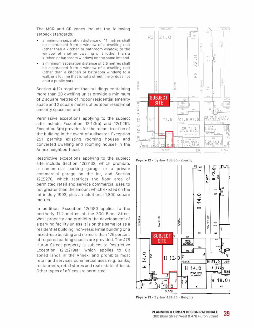
SUBJECTSITE
SUBJECTSITE
PLANNING & URBAN DESIGN RATIONALE300 Bloor Street West & 478 Huron Street 39
The MCR and CR zones include the following setback standards:
• a minimum separation distance of 11 metres shall be maintained from a window of a dwelling unit (other than a kitchen or bathroom window) to the window of another dwelling unit (other than a kitchen or bathroom window) on the same lot; and
• a minimum separation distance of 5.5 metres shall be maintained from a window of a dwelling unit (other than a kitchen or bathroom window) to a wall, or a lot line that is not a street line or does not abut a public park.
Section 4(12) requires that buildings containing more than 20 dwelling units provide a minimum of 2 square metres of indoor residential amenity space and 2 square metres of outdoor residential amenity space per unit.
Permissive exceptions applying to the subject site include Exception 12(1)3(b) and 12(1)251. Exception 3(b) provides for the reconstruction of the building in the event of a disaster. Exception 251 permits existing rooming houses and converted dwelling and rooming houses in the Annex neighbourhood.
Restrictive exceptions applying to the subject site include Section 12(2)132, which prohibits a commercial parking garage or a private commercial garage on the lot, and Section 12(2)270, which restricts the floor area of permitted retail and service commercial uses to not greater than the amount which existed on the lot in July 1993, plus an additional 1,800 square metres.
In addition, Exception 12(2)80 applies to the northerly 17.2 metres of the 300 Bloor Street West property and prohibits the development of a parking facility unless it is on the same lot as a residential building, non-residential building or a mixed-use building and no more than 125 percent of required parking spaces are provided. The 478 Huron Street property is subject to Restrictive Exception 12(2)219(a), which applies to CR zoned lands in the Annex, and prohibits most retail and services commercial uses (e.g. banks, restaurants, retail stores and real estate offices). Other types of offices are permitted.
Figure 12 - By-law 438-86 - Zoning
Figure 13 - By-law 438-86 - Heights
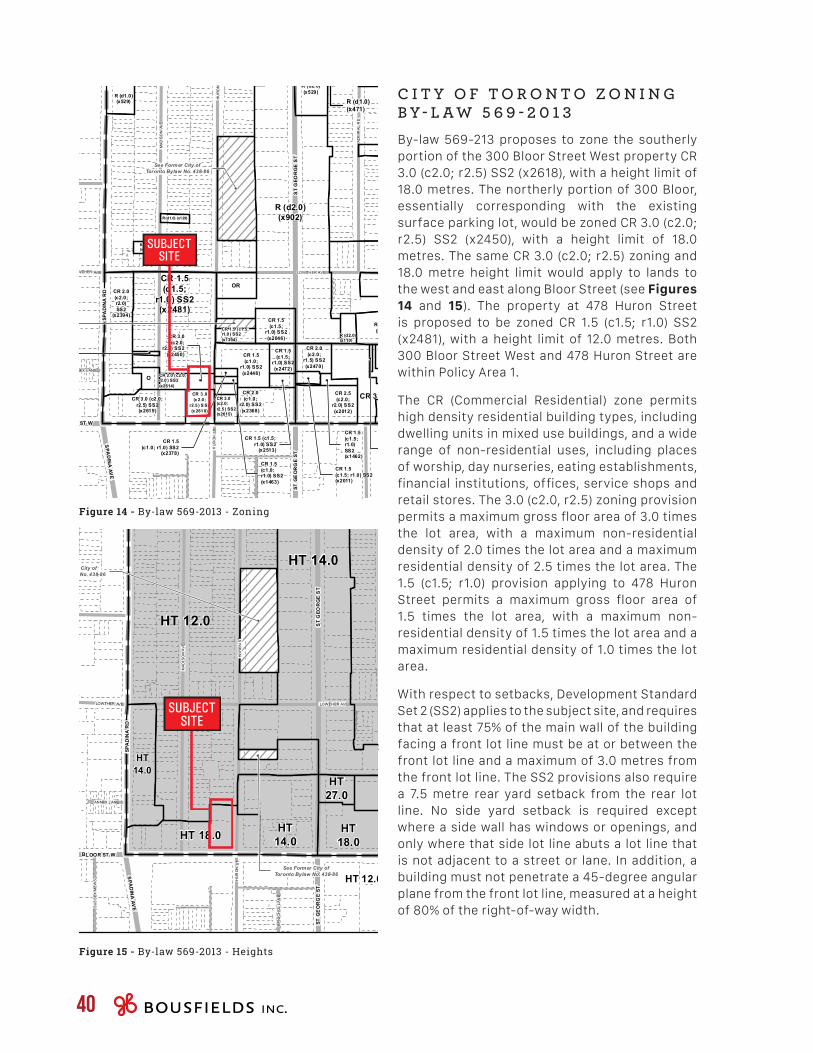
CR 2 .5 (c1 .5; r2 .0) S S2 (x 25 64)R (d2.0) (x891)
CR 1.5(c1.0;
r1.0) SS2(x1923)
R (d2.0) (x902)
CR 3.0 (c2.0; r2.5) SS2 (x2482)
CR 2.0 (c2.0; r1.0) SS2 (x2483)
CR 2.0(c2.0;r2.0)SS2
(x2394)
CR 1.5(c1.5;
r1.0) SS2(x2481)
CR 2.0(c2.0;
r1.5) SS2(x2357)
R (d1.0)(x903)
R (d2.0)(x902)
R (f10.5;d1.0)
(x714)
R (d1.0) (x471)
R (d1.0) (x900)
R (d1.0) (x129)
CR 2.0(c2.0; r1.0) SS2(x1395)
R (d1.0)(x115)
CR 1.5 (c1.0; r1.0)SS2 (x1768)
R (d1.0) (x113)
R (d1.0)(x115)
CR 2.0(c2.0; r1.5)SS2 (x1893)
CR 1.5(c1.5; r1.0) SS2(x2011)
R (d1.0)(x471)
R (d1.0)(x527)
CR 1.5(c1.0; r1.0) SS2
(x2378)
CR 1.5 (c1.0; r1.0)SS2 (x1923)
CR 1.5(c1.0;r1.0) SS2(x1463)
R (d1.0)(x526)
CR 1.5(c1.5;
r1.0) SS2(x2613)
CR 2.0(c2.0; r1.5)SS2 (x2612)
R (d1.0)(x11 5)
CR 2.5(c1.5;r2.0 )SS2(x1893)
R (d1.0)(x68)
CR 1.5(c1.5;r1.0)SS2(x1462)
CR 1.5 (c1.5;r1.0) SS2
(x2513)
CR 2.0(c2.0; r1.0)SS2 (x1926)
CR 1.5 (c1.5;r1.0 ) SS2(x1394)
R (d2.0)(x110)
CR 3.0(c2.0;
r2.5 )SS2
(x2048)
CR 2.0 (c2.0;r2.0 ) SS2(x2614)
CR 3.0(c2.0;r2.5 ) SS2(x2615)
CR 2 .5(c 1.5 ;
r2.0 ) S S2(x 177 8)
CR 1.5(c1.5;
r1.0) SS2(x2472)
CR 4.0(c1.0; r3.5)
SS2 (x2468)
CR 3.0(c2.0;
r2.5) SS2(x2450)
CR 2.0(c2.0;
r1.5) SS2(x2470)
CR 6.0(c0.5;
r6.0) SS2(x1652)
R (d1.0)(x529)
CR 1 .5(c1.0 ;
r1 .0) SS2(x18 95)
CR 3 .0(c 2.0 ;
r2.5 ) S S2(x 261 8)
CR 2.0 (c2.0;r1.5 ) SS2(x2616)
CR 6.0(c0 .5;
r6.0) SS2(x2 535 )
CR 2.0 (c2.0;r1.5 ) SS2(x1923)
CR 2.0(c2.0;
r1.0) SS2(x2483)
CR 2.0 (c2.0;r1.5) SS2(x2357)
CR 2.5(c2.0;
r2.0) SS2(x2012)
CR 1.5(c1.0;
r1.0) SS2(x2479)
R (d2.0)(x116)
CR 1.5(c1.5;
r1.0) SS2(x2046)
CR 3.0(c3.0;
r1.0 ) SS2(x2469)
R (d2.0)(x529)
CR 1.5(c1.0;
r1.0) SS2(x2448)
CR 6.5(c4.5;
r3.5) SS2(x2041)
CR 2.0(c1.0;
r2.0) SS2(x2368)
R (d0.6)(x899)
CR 2.0(c2.0; r1.0)
SS2 (x2393)
EL 2.5(x121)
R (d2.0)(x985)
R (d2.0)(x985)
CR 3.0 (c2.0;r2.5) SS2(x2615)
EL 2.0(x121)
OR OR
UT (x21) OR
UT
O
O
O
See Former City ofToronto Bylaw No. 438-86
See Former City ofToronto Bylaw No. 438-86
See Former City ofToronto Bylaw No. 438-86
See Former City ofToronto Bylaw No. 438-86
See Former City ofToronto Bylaw No. 438-86
See Former City ofToronto Bylaw No. 438-86
See Former City ofToronto Bylaw No. 438-86
See Former City ofToronto Bylaw No. 438-86
See Former City ofToronto Bylaw No. 438-86
See Former City ofToronto Bylaw No. 438-86
See Former City ofToronto Bylaw No. 438-86
B ERNARD AV E
RA
TH
NE
LLY
AV
E
KENDAL AVE
PEARS AVE
CHICOR A AV E
MACPHERSON AVE
M C MASTER AVE
ANNEX LANE
SID
NE
Y S
T
B ERNARD AV E
LOWTHER AVE
M ACPHERSON AVE
WA
L ME
R R
D
HU
RO
N S
T
SU
SS
E X
ME
WS
RO
BE
RT
ST
LOWTHER AVE
PRINCE ARTHUR AVE
WEBSTER AVE
MA
DIS
ON
AV
E
HU
RO
N S
T
ROXBOROUGH ST W
HA
ZE
LTO
N A
VE
MARLBOROUGH PL
BOSWELL AVE
WA
LMER
RD
ELGIN AV E
TRA NBY AVE
WA
LM
ER
RD
AD
MIR
AL
RD
MA
DIS
ON
AV
E
HU
RO
N S
T
COTTINGHA M RD
BED
FO
RD
RD
CUMBERLAND ST
YORKVILLE AVE
DAVENPOR T
RD
DUPONT ST
AVEN
U E
RD
MACPHERSON AVE
AVEN
UE
RD
ST GE
OR
GE
ST
DUPON T ST
ST
GEO
RG
E S
T
ST
GEO
RG
E S
T
DAVENPOR T RD
BE
DFO
RD
RD
QU
EEN
SPA
RK
SPA
DIN
A AV
E
BLOOR S T W BLOOR ST W
SPA
DIN
A R
DS
PAD
NIA
RD
404
404
404
390 391 392 393
402 403 405
414 415 416 417
591
603
615
Zoning By-law
Maps must be read together with Zon ing By-law text
May 2013
Pages with ZoningCurrent Page
0 50 100 Met ersMap Sheet Boundary
Railway
Hydro Line
Zoning
River
Property Boundary
SUBJECTSITE
HT 12.0
HT 12.0
See Former City ofToronto Bylaw No. 438-86
See Former City ofToronto Bylaw No. 438-86
See Former City ofToronto Bylaw No. 438-86
See Former City ofToronto Bylaw No. 438-86
See Former City ofToronto Bylaw No. 438-86
See Former City ofToronto Bylaw No. 438-86
See Former City ofToronto Bylaw No. 438-86
See Former City ofToronto Bylaw No. 438-86
See Former City ofToronto Bylaw No. 438-86
See Former City ofToronto Bylaw No. 438-86
See Former City ofToronto Bylaw No. 438-86
DUPONT ST
DAVENPORT RD
AVE
NU
E R
D
MACPHERSON AVE
AVEN
UE
RD
ST GE
OR
GE
ST
MACPHERSON AVE
DUPON T ST
S T G
EO
RG
E ST
ST
GEO
RG
E S
T
DAVENPOR TR D
BE
DFO
RD
RD
QU
EEN
SPA
RKS
PAD
INA
AVE
BL OOR S T W BLOOR S T W
SPA
DIN
A R
DS
PAD
NIA
RD
BED
FO
RD
RD
CUMBERLAND ST
BO
ULTON DR
YORKVILLE AVE
BERNARD AVE
RA
TH
NE
LLY
AV
E
KENDAL AVE
TS
NO
RU
H
PEAR S AVE
CHICOR A AVE
EVA NOSREHPCAM
COTTINGHA M RD
MC MASTER AVE
ANNEX LANE
BP
NIC
HO
L L
AN
E
SID
NE
Y S
T
LOWTHER AVE
BERNA RD AVE
MA CPHERS ON AV E
WA
L ME
R RD
HU
RO
N S
T
DE
VO
NS
HIR
EP
L
SU
SS
E X
ME
WS
RO
BE
RT
ST
LOWTHER AVE
EVA RUHTRA ECNIRP
WEBSTER AVE
MA
DIS
ON
AV
E
HU
RO
N S
T
ROXBOROUGH ST W
HA
ZE
LTO
N A
VE
MARLBOROUGH PL
BOSWELL AVE
WA
LMER
RD
ELGIN AVE
TRANBY AVE
A DMIRAL RD
WA
LM
ER
RD
EVA
NO
SID
AM
AD
MIR
AL
RD
MA
DIS
ON
AV
E
HU
RO
N S
T
HT 14.0
HT 12.0
HT 12.0
HT 14.0
HT14.0
HT14.0
HT 14.0
HT18.0
HT66.0
HT61.0
HT24.0
HT27.0
HT 18.0
HT14.0
HT34.0
HT 12.0
HT25.0
HT 24.0
HT 31.0
404
404
366
377 378 380 381
388 389 390 391 392 393
400 401 402 403 405
412 413 414 415 417
424 425 426 427 428 429 627 628
639
579
591 592
593
603 604 605
615 616
379
404Height Overlay Map
Maps must be read together with Zon ing By-law text
May 2013
Pages withHeight AreasCurrent Page
0 50 100 Met ersMap Sheet Boundary
Railway
Hydro Line
Height Areas
River
Property Boundary
SUBJECTSITE
40
C I T Y O F T O R O N T O Z O N I N G B Y - L A W 5 6 9 - 2 0 1 3By-law 569-213 proposes to zone the southerly portion of the 300 Bloor Street West property CR 3.0 (c2.0; r2.5) SS2 (x2618), with a height limit of 18.0 metres. The northerly portion of 300 Bloor, essentially corresponding with the existing surface parking lot, would be zoned CR 3.0 (c2.0; r2.5) SS2 (x2450), with a height limit of 18.0 metres. The same CR 3.0 (c2.0; r2.5) zoning and 18.0 metre height limit would apply to lands to the west and east along Bloor Street (see Figures 14 and 15). The property at 478 Huron Street is proposed to be zoned CR 1.5 (c1.5; r1.0) SS2 (x2481), with a height limit of 12.0 metres. Both 300 Bloor Street West and 478 Huron Street are within Policy Area 1.
The CR (Commercial Residential) zone permits high density residential building types, including dwelling units in mixed use buildings, and a wide range of non-residential uses, including places of worship, day nurseries, eating establishments, financial institutions, offices, service shops and retail stores. The 3.0 (c2.0, r2.5) zoning provision permits a maximum gross floor area of 3.0 times the lot area, with a maximum non-residential density of 2.0 times the lot area and a maximum residential density of 2.5 times the lot area. The 1.5 (c1.5; r1.0) provision applying to 478 Huron Street permits a maximum gross floor area of 1.5 times the lot area, with a maximum non-residential density of 1.5 times the lot area and a maximum residential density of 1.0 times the lot area.
With respect to setbacks, Development Standard Set 2 (SS2) applies to the subject site, and requires that at least 75% of the main wall of the building facing a front lot line must be at or between the front lot line and a maximum of 3.0 metres from the front lot line. The SS2 provisions also require a 7.5 metre rear yard setback from the rear lot line. No side yard setback is required except where a side wall has windows or openings, and only where that side lot line abuts a lot line that is not adjacent to a street or lane. In addition, a building must not penetrate a 45-degree angular plane from the front lot line, measured at a height of 80% of the right-of-way width.
Figure 14 - By-law 569-2013 - Zoning
Figure 15 - By-law 569-2013 - Heights
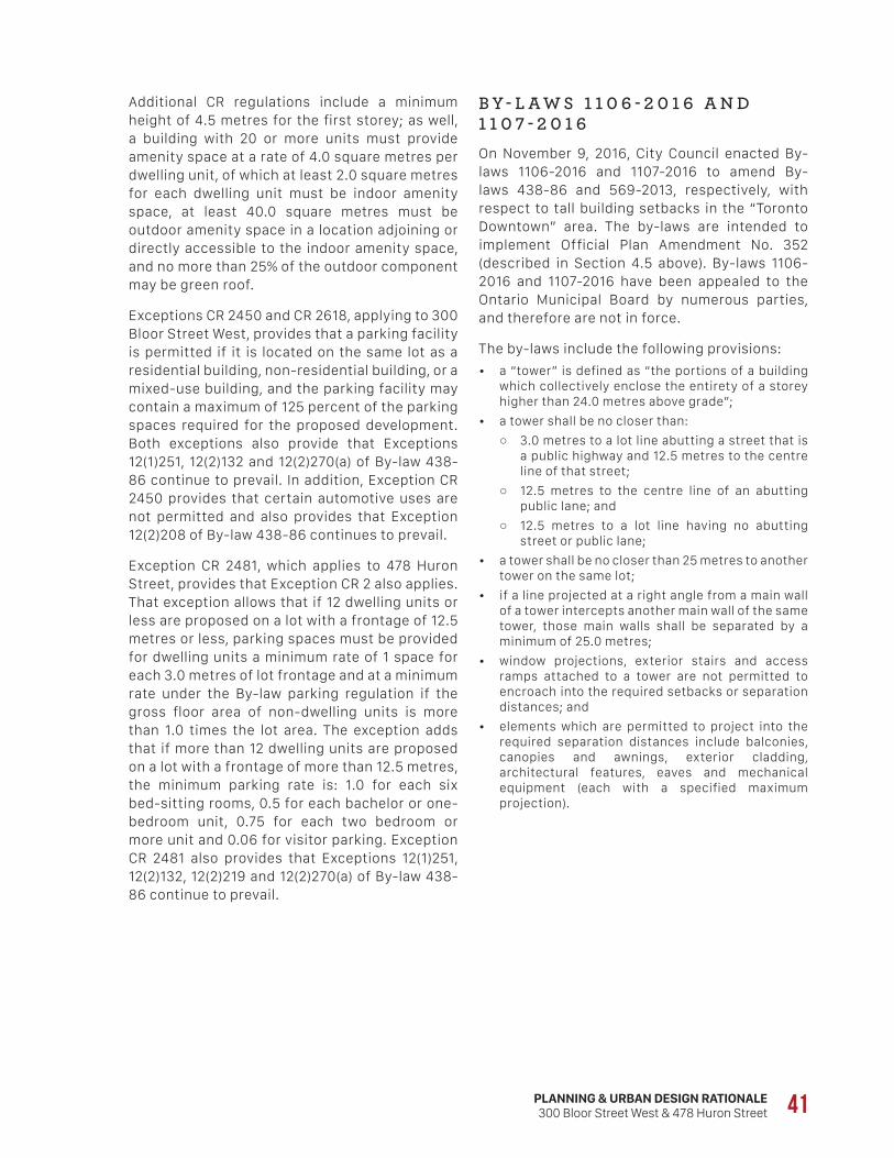
PLANNING & URBAN DESIGN RATIONALE300 Bloor Street West & 478 Huron Street 41
Additional CR regulations include a minimum height of 4.5 metres for the first storey; as well, a building with 20 or more units must provide amenity space at a rate of 4.0 square metres per dwelling unit, of which at least 2.0 square metres for each dwelling unit must be indoor amenity space, at least 40.0 square metres must be outdoor amenity space in a location adjoining or directly accessible to the indoor amenity space, and no more than 25% of the outdoor component may be green roof.
Exceptions CR 2450 and CR 2618, applying to 300 Bloor Street West, provides that a parking facility is permitted if it is located on the same lot as a residential building, non-residential building, or a mixed-use building, and the parking facility may contain a maximum of 125 percent of the parking spaces required for the proposed development. Both exceptions also provide that Exceptions 12(1)251, 12(2)132 and 12(2)270(a) of By-law 438-86 continue to prevail. In addition, Exception CR 2450 provides that certain automotive uses are not permitted and also provides that Exception 12(2)208 of By-law 438-86 continues to prevail.
Exception CR 2481, which applies to 478 Huron Street, provides that Exception CR 2 also applies. That exception allows that if 12 dwelling units or less are proposed on a lot with a frontage of 12.5 metres or less, parking spaces must be provided for dwelling units a minimum rate of 1 space for each 3.0 metres of lot frontage and at a minimum rate under the By-law parking regulation if the gross floor area of non-dwelling units is more than 1.0 times the lot area. The exception adds that if more than 12 dwelling units are proposed on a lot with a frontage of more than 12.5 metres, the minimum parking rate is: 1.0 for each six bed-sitting rooms, 0.5 for each bachelor or one-bedroom unit, 0.75 for each two bedroom or more unit and 0.06 for visitor parking. Exception CR 2481 also provides that Exceptions 12(1)251, 12(2)132, 12(2)219 and 12(2)270(a) of By-law 438-86 continue to prevail.
B Y - L A W S 1 1 0 6 - 2 0 1 6 A N D 1 1 0 7 - 2 0 1 6On November 9, 2016, City Council enacted By-laws 1106-2016 and 1107-2016 to amend By-laws 438-86 and 569-2013, respectively, with respect to tall building setbacks in the “Toronto Downtown” area. The by-laws are intended to implement Official Plan Amendment No. 352 (described in Section 4.5 above). By-laws 1106-2016 and 1107-2016 have been appealed to the Ontario Municipal Board by numerous parties, and therefore are not in force.
The by-laws include the following provisions:
• a “tower” is defined as “the portions of a building which collectively enclose the entirety of a storey higher than 24.0 metres above grade”;
• a tower shall be no closer than:
○ 3.0 metres to a lot line abutting a street that is a public highway and 12.5 metres to the centre line of that street;
○ 12.5 metres to the centre line of an abutting public lane; and
○ 12.5 metres to a lot line having no abutting street or public lane;
• a tower shall be no closer than 25 metres to another tower on the same lot;
• if a line projected at a right angle from a main wall of a tower intercepts another main wall of the same tower, those main walls shall be separated by a minimum of 25.0 metres;
• window projections, exterior stairs and access ramps attached to a tower are not permitted to encroach into the required setbacks or separation distances; and
• elements which are permitted to project into the required separation distances include balconies, canopies and awnings, exterior cladding, architectural features, eaves and mechanical equipment (each with a specified maximum projection).
42
S T R U C T U R E P L A NThe subject site is located within the Institutional Precinct, as are lands to the east. Lands to the south and lands west of Madison Avenue are located within the Spadina Node. Section 4.1.1 of the Guidelines provides that new buildings in the Institutional Precinct, which extends from immediately west of the subject site to just west of Avenue Road, should contribute towards the creation of a street wall with high quality materials and active at-grade uses. Buildings are expected to “infill gaps in the streetscape and provide visual cohesion through the use of massing and architectural elements including ground floor heights, podium heights, cornice lines, materials, and responsiveness to key views and locations”.
Buildings on the north side are encouraged to be built parallel to the setbacks of the existing street wall while buildings on the south side should be set back from the right-of-way to promote the concept of interconnected open spaces through the precinct, or a “green necklace.”
P U B L I C R E A L M A N D V I E W C O R R I D O R SSections 4.2 and 4.3 of the Guidelines provide direction for improving the public realm and for enhancing gateways and terminus sites, respectively. Key public realm initiatives include: enhancing existing parks and open spaces; establishing new and enhancing existing mid-block pedestrian connections; seeking opportunities to create and enhance “green fingers” on the boulevards of side streets extending north and south of Bloor; encouraging the contribution of at-grade publicly accessible open space in significant new developments; enhancing streetscaping and “promenade” treatments; and establishing new public spaces.
In this regard, the Structure Plan (Figure 5) identifies the southerly edge of the subject site, along Bloor Street, as an “Enhanced Green Streetscape”, while Figure 10 (Open Space Network) identifies it as a “Green or Enhanced Landscape”.
4.8 Bloor Corridor Urban Design Guidelines (Visioning Study)
The Bloor Corridor Urban Design Guidelines (November 2009) were approved by Council in December 2009, in conjunction with the adoption of Official Plan Amendment No. 98, which introduced Site and Area Specific Policy 334 (see Section 4.4 above). Both Official Plan Amendment No. 98 and the Bloor Corridor Urban Design Guidelines resulted from the Bloor Corridor Visioning Study, undertaken by Office for Urbanism (May 2008).
The goal of the Bloor Corridor Urban Design Guidelines is to improve the quality of the physical environment in the Bloor Corridor and to ensure that those elements which contribute to the special character of the diverse parts of the area are retained and enhanced.
The Guidelines recognize that the Bloor Corridor includes many key civic and institutional destinations such as the University of Toronto, Royal Conservatory of Music, Royal Ontario Museum, Bata Shoe Museum and Miles Nadal JCC, as well as numerous retail and office spaces at varying scales. It is acknowledged that the Bloor Corridor is a prime location within the City due to exceptional public transit access, with four subway stations providing access to both the Bloor-Danforth and Yonge-University-Spadina lines as well as access to the Light Rapid Transit line on Spadina Avenue. The Bloor Corridor also has some of the highest cycling volumes in the city.
Section 3 of the Guidelines sets out a number of development principles. Section 3.3 (Built Form) states that density will be directed to transit nodes, and that buildings along Bloor Street should provide a transition in height and built form: on a site-by-site basis; along the corridor between nodes; and to the north and south in order to protect existing stable residential neighbourhoods from the potential negative impacts of development. Section 3.4 (Public Realm) indicates that the street should provide active at-grade uses that are safe, accessible, and interconnected, and that surface parking areas should be redeveloped, while meeting parking demands through other creative solutions.
PLANNING & URBAN DESIGN RATIONALE300 Bloor Street West & 478 Huron Street 43
• at the Streetwall Scale:
○ buildings facing Bloor Street should have active uses at-grade with minimum 75% glazing and weather protection for pedestrians;
○ podium or street wall heights should generally be 4-5 storeys (13-16 metres) in the Spadina Node;
○ the fine-grained character should be reflected in vertical articulation generally in intervals of 9-12 metres;
○ at-grade retail should have a prominent presence on the street and a floor-to-ceiling height of at least 4.5 metres;
○ no significant blank at-grade street wall conditions should be permitted on any frontage;
○ above-grade building stepbacks are generally recommended; and
○ buildings should be oriented to and placed at the street edge with clearly defined primary entries that are directly accessible from the sidewalk;
• at the Urban Scale:
○ existing or approved building heights in the Bloor Corridor should follow a logical pattern that has peaks at strategic nodes and intersections (Bloor/Bedford, Bloor/Spadina, Bloor/Bathurst) which transition downward to lower heights that reflect the established built form in each of the Institutional Precinct and the Main Street Precinct; and
○ residential areas and the public realm must be protected from undue shadowing from proposed buildings.
The text of the Guidelines addressing the Urban Scale notes that the future built form along Bloor Street should generally maintain the transition dynamic in the Bloor Corridor, which reflects its position in the general city-wide pattern: higher and more intense toward the City centre in the east, and less so in the west, but with a distinct change in height and development intensity at Walmer Road. The Guidelines note that an additional consideration is the establishment of development nodes at St. George and at Spadina, and possibly at Bathurst Street, noting that “their locations at subway stops are ideal for intensification, and are appropriate locations for higher buildings”. Development should be designed to provide adequate transition toward these taller nodes.
The relevant Design Guidelines are addressed in Sections 5.5 and 5.6 of this report.
H E R I T A G ESection 4.4 states that preservation and enhancement of built and natural heritage is vital to the identity of the Bloor Corridor. Figure 14 illustrates the properties listed on the City’s Heritage Register, or designated under the Ontario Heritage Act, within the Bloor Corridor boundaries, including the Bloor Street United Church. It also shows adjacent Heritage Conservation Districts in “neighbourhood impact areas”, including the Madison Avenue HCD.
This section provides that heritage and landmark buildings should be celebrated in the streetscape wherever possible, through strategies that may include:
• providing a public space in front, such as a plaza or seating area;
• setting back adjacent buildings to provide a direct view of heritage buildings;
• designing adjacent buildings to respond to the massing, articulation and material of the heritage building; and
• ensuring redevelopment of heritage buildings preserves the heritage character of the building, through restoration of heritage elements and careful design of new elements.
G E N E R A L B U I L T F O R M G U I D E L I N E SSection 5 of the Guidelines proposes a hierarchy of built form standards that correspond to three scales: the Pedestrian Scale, the Street Wall Scale and the Urban Scale.
The Guidelines outline the following built form design considerations:
• at the Pedestrian Scale:
○ awnings and canopies for weather protection are encouraged, as well as transparent window treatments, to provide comfort and interest for the pedestrian;
○ narrower retail frontages are desirable and signage should be appropriately scaled to the pedestrian;
○ parking and loading areas should be placed below grade where possible; and
○ loading and parking areas should generally be hidden from view, and located on roads with the least amount of pedestrian traffic;
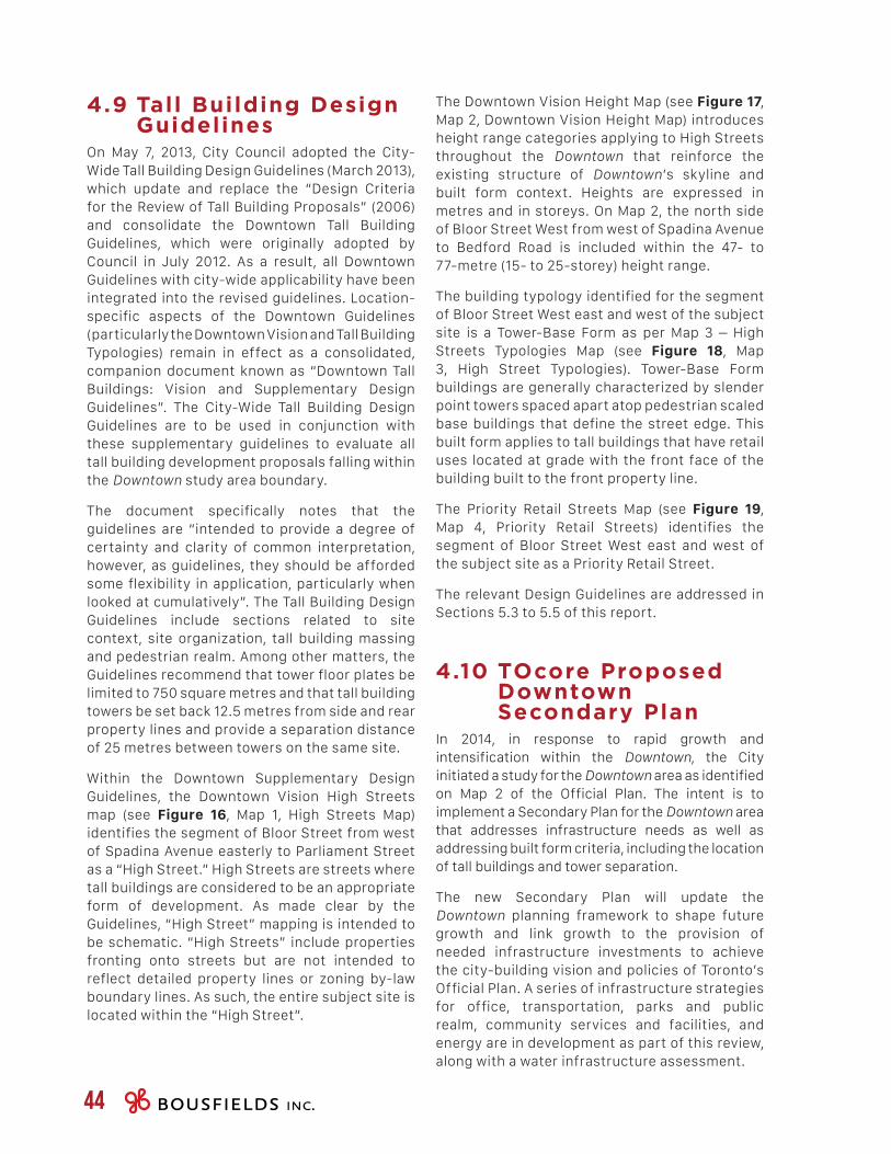
44
The Downtown Vision Height Map (see Figure 17, Map 2, Downtown Vision Height Map) introduces height range categories applying to High Streets throughout the Downtown that reinforce the existing structure of Downtown’s skyline and built form context. Heights are expressed in metres and in storeys. On Map 2, the north side of Bloor Street West from west of Spadina Avenue to Bedford Road is included within the 47- to 77-metre (15- to 25-storey) height range.
The building typology identified for the segment of Bloor Street West east and west of the subject site is a Tower-Base Form as per Map 3 – High Streets Typologies Map (see Figure 18, Map 3, High Street Typologies). Tower-Base Form buildings are generally characterized by slender point towers spaced apart atop pedestrian scaled base buildings that define the street edge. This built form applies to tall buildings that have retail uses located at grade with the front face of the building built to the front property line.
The Priority Retail Streets Map (see Figure 19, Map 4, Priority Retail Streets) identifies the segment of Bloor Street West east and west of the subject site as a Priority Retail Street.
The relevant Design Guidelines are addressed in Sections 5.3 to 5.5 of this report.
4.10 TOcore Proposed Downtown Secondary Plan
In 2014, in response to rapid growth and intensification within the Downtown, the City initiated a study for the Downtown area as identified on Map 2 of the Official Plan. The intent is to implement a Secondary Plan for the Downtown area that addresses infrastructure needs as well as addressing built form criteria, including the location of tall buildings and tower separation.
The new Secondary Plan will update the Downtown planning framework to shape future growth and link growth to the provision of needed infrastructure investments to achieve the city-building vision and policies of Toronto’s Official Plan. A series of infrastructure strategies for office, transportation, parks and public realm, community services and facilities, and energy are in development as part of this review, along with a water infrastructure assessment.
4.9 Tall Building Design Guidelines
On May 7, 2013, City Council adopted the City-Wide Tall Building Design Guidelines (March 2013), which update and replace the “Design Criteria for the Review of Tall Building Proposals” (2006) and consolidate the Downtown Tall Building Guidelines, which were originally adopted by Council in July 2012. As a result, all Downtown Guidelines with city-wide applicability have been integrated into the revised guidelines. Location-specific aspects of the Downtown Guidelines (particularly the Downtown Vision and Tall Building Typologies) remain in effect as a consolidated, companion document known as “Downtown Tall Buildings: Vision and Supplementary Design Guidelines”. The City-Wide Tall Building Design Guidelines are to be used in conjunction with these supplementary guidelines to evaluate all tall building development proposals falling within the Downtown study area boundary.
The document specifically notes that the guidelines are “intended to provide a degree of certainty and clarity of common interpretation, however, as guidelines, they should be afforded some flexibility in application, particularly when looked at cumulatively”. The Tall Building Design Guidelines include sections related to site context, site organization, tall building massing and pedestrian realm. Among other matters, the Guidelines recommend that tower floor plates be limited to 750 square metres and that tall building towers be set back 12.5 metres from side and rear property lines and provide a separation distance of 25 metres between towers on the same site.
Within the Downtown Supplementary Design Guidelines, the Downtown Vision High Streets map (see Figure 16, Map 1, High Streets Map) identifies the segment of Bloor Street from west of Spadina Avenue easterly to Parliament Street as a “High Street.” High Streets are streets where tall buildings are considered to be an appropriate form of development. As made clear by the Guidelines, “High Street” mapping is intended to be schematic. “High Streets” include properties fronting onto streets but are not intended to reflect detailed property lines or zoning by-law boundary lines. As such, the entire subject site is located within the “High Street”.
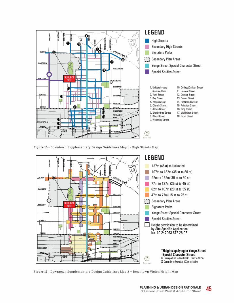
Not to Scale
LEGENDHigh Streets
Signature Parks
Yonge Street Special Character Street
1. University Ave /Avenue Road2. York Street3. Bay Street4. Yonge Street5. Church Street6. Jarvis Street7. Sherbourne Street8. Bloor Street9. Wellesley Street
10. College/Carlton Street11. Gerrard Street12. Dundas Street13. Queen Street14. Richmond Street15. Adelaide Street16. King Street17. Wellington Street18. Front Street
Secondary Plan Areas
Secondary High Streets
Special Studies StreetU
NIV
ERSI
TY
YOR
K
BAY
YON
GE
JAR
VIS
SPAD
INA
CHU
RCH
JAR
VIS
YON
GE
BAY
MT
PLEA
SAN
T
SHER
BO
UR
NE
AVEN
UE
BED
FOR
D
ST G
EOR
GE
SPAD
INA
BLOOR
HARBORD
WELLINGTON
FRONT
QUEEN
GARDINER EX
QUEEN
RICHMOND
ADELAIDEKINGFRONT
DUNDASDUNDAS
SHUTER
SHER
BO
UR
NE
PAR
LIAM
ENT
GERRARD
CARLTON
WELLESLEY
CHU
RCH
ROSEDALE VALLEY
COLLEGE
18
SUBJECTSITE
Not to Scale
LEGEND137m (45st) to Unlimited
92m to 152m (30 st to 50 st)
Signature Parks
Yonge Street Special Character Street
Special Studies Street
Height permission to be determined by Site Specific Application No. 10 247063 STE 28 OZ
Secondary Plan Areas
107m to 182m (35 st to 60 st)
77m to 137m (25 st to 45 st)62m to 107m (20 st to 35 st)
47m to 77m (15 st to 25 st)
*Heights applying to Yonge Street Special Character Street: � Davenport Rd to Hayden St: 62m to 107m� Queen St to Front St: 107m to 182mU
NIV
ERSI
TY
YOR
K
BAY
YON
GE
JAR
VIS
SPAD
INA
CHU
RCH
JAR
VIS
YON
GE
BAY
MT
PLEA
SAN
T
AVEN
UE
BED
FOR
D
ST G
EOR
GE
SPAD
INA
BLOOR
HARBORD
WELLINGTON
FRONT
QUEEN
GARDINER EX
QUEEN
RICHMOND
ADELAIDEKING
FRONT
DUNDASDUNDAS
SHUTER
SHER
BO
UR
NE
SHER
BO
UR
NE
P AR
LIAM
ENT
GERRARD
CARLTON
WELLESLEY
CHU
RCH
ROSEDALE VALLEY
COLLEGE SUBJECTSITE
PLANNING & URBAN DESIGN RATIONALE300 Bloor Street West & 478 Huron Street 45
Figure 16 - Downtown Supplementary Design Guidelines Map 1 - High Streets Map
Figure 17 - Downtown Supplementary Design Guidelines Map 2 – Downtown Vision Height Map
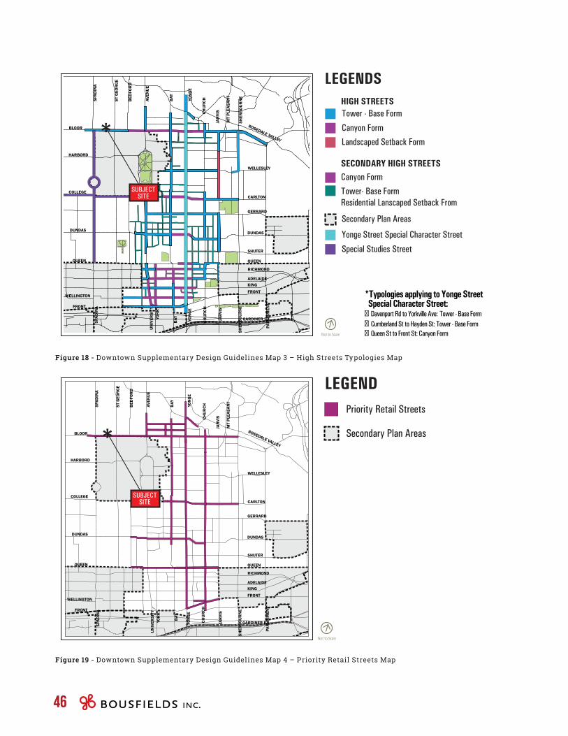
Not to Scale
LEGENDS
Tower - Base Form
Landscaped Setback Form
Yonge Street Special Character Street
Special Studies Street
Secondary Plan Areas
Canyon Form
SECONDARY HIGH STREETS
HIGH STREETS
Canyon Form
Tower- Base Form Residential Lanscaped Setback From
*Typologies applying to Yonge Street Special Character Street: � Davenport Rd to Yorkville Ave: Tower - Base Form
Cumberland St to Hayden St: Tower - Base Form
�Queen St to Front St: Canyon Form�
UN
IVER
SITY
YO
RK
BAY
YON
GE
JAR
VIS
SPAD
INA
CHU
RCH
JAR
VIS
YON
GE
BAY
MT
PLEA
SAN
T
AVEN
UE
BED
FOR
D
ST G
EOR
GE
SPAD
INA
BLOOR
HARBORD
WELLINGTON
FRONT
QUEEN
GARDINER EX
QUEEN
RICHMOND
ADELAIDEKING
FRONT
DUNDASDUNDAS
SHUTER
SHER
BO
UR
NE
SHER
BO
UR
NE
PAR
LIAM
ENT
GERRARD
CARLTON
WELLESLEY
CHU
RCH
ROSEDALE VALLEY
COLLEGE SUBJECTSITE
Priority Retail Streets
Secondary Plan Areas
Not to Scale
LEGEND
UN
IVER
SITY
YO
RK
BAY
YON
GE
JAR
VIS
SPAD
INA
CHU
RCH
JAR
VIS
YON
GE
BAY
MT
PLEA
SAN
T
AVEN
UE
BED
FOR
D
ST G
EOR
GE
SPAD
INA
BLOOR
HARBORD
WELLINGTON
FRONT
QUEEN
GARDINER EX
QUEEN
RICHMOND
ADELAIDEKING
FRONT
DUNDASDUNDAS
SHUTER
SHER
BO
UR
NE
PAR
LIAM
ENT
GERRARD
CARLTON
WELLESLEY
CHU
RCH
ROSEDALE VALLEY
COLLEGE SUBJECTSITE
46
Figure 18 - Downtown Supplementary Design Guidelines Map 3 – High Streets Typologies Map
Figure 19 - Downtown Supplementary Design Guidelines Map 4 – Priority Retail Streets Map
PLANNING & URBAN DESIGN RATIONALE300 Bloor Street West & 478 Huron Street 47
Map 2 (Areas of Focus for Growth) identifies the Mixed Use Areas 2 portion of the subject site as an area of focus for growth (Policy 4.2), but notes that Mixed Use Areas 4 are not areas of focus for growth (Policy 4.4).
Policies within Section 8 of the Proposed Downtown Secondary Plan are intended to guide development within Mixed Use Areas. Policy 8.23 provides that development in Mixed Use Areas 2 will include a variety of building typologies including low-rise, mid-rise and tall buildings. The same policy notes that the scale and massing of buildings will respect and remain consistent with the existing built character of the neighbourhood with consideration toward heights, massing, scale, density, and building types. Furthermore, Policy 8.24 indicates that Mixed Use Areas 2 are to be areas of transition between the low to mid-rise scale of Mixed Use Areas 3 and higher intensity development anticipated in Mixed Use Areas 1.
The Secondary Plan identifies the segment of Bloor Street West immediately abutting the subject site as a Great Street (Map 5 – Great Streets), which are streets that are to be prioritized for public realm improvements (Policy 7.22). In addition, Map 13 – Priority Retail Streets designates the segment of Bloor Street West including the subject site as a Priority Retail Street, where, according to Policy 8.33, retail and commercial spaces are to:
• provide generous floor-to-ceiling heights to allow flexible and useable retail space;
• provide increased setbacks at grade to provide space for enhancements to the public realm as required in this Plan;
• be of high quality design, with flexible spaces that allow for multiple uses over time;
• be informed by retail design guidelines; and
• include the entire ground floor of all new buildings, excluding the space required for entrances, parking entrances, servicing spaces and other service exits.
On October 2, 2017, the Proposed Downtown Secondary Plan was considered by City Council, which adopted staff recommendations to:
• direct City Planning to use the TOcore Proposed Downtown Plan as a basis for stakeholder and public consultation;
• direct City Planning, in association with staff from the appropriate City Divisions, to undertake stakeholder and public consultation, including public open houses, roundtable meetings, and other public meetings as necessary on the proposed Downtown Plan; and
• direct City Planning to report back with a final Recommendations Report and an Official Plan Amendment on the Downtown Plan to a Spring 2018 meeting of Planning and Growth Management Committee.
The following policies from the TOcore Proposed Downtown Secondary Plan would be relevant for the proposed development.
The proposed Secondary Plan establishes four sub-categories in the Mixed Use Areas designation. Policy 8.18 provides that building heights, massing and scale of development will transition between each of the Mixed Use Areas, with the tallest buildings located in Mixed Use Areas 1, stepping down through Mixed Use Areas 2 and Mixed Use Areas 3, to low-scale buildings in Mixed Use Areas 4.
The subject site is identified on Map 11 – Mixed Use Areas as being partially designated Mixed Use Areas 2 – Transitional along Bloor Street, a designation that is to include a diverse range of building typologies including low-rise, mid-rise and tall buildings, with the northerly portion of the site designated Mixed Use Areas 4 – Local, which provides for a mix of uses with a prevailing character of house form and other types of low-rise buildings.
48
Section 6.24 provides for transitions in building scale. Accordingly, Policy 6.24.2 indicates that development adjacent to Mixed Use Areas 4 will be required to demonstrate transition in scale.
4.11 Growing Up: Planning for Children in New Vertical Communities
In 2015, the City initiated a study entitled Growing Up: Planning for Children in New Vertical Communities, and produce draft guidelines to direct how new development can better function for larger households. A staff report summarizing the study process and draft guidelines was adopted by Planning and Growth Management Committee on May 31, 2017, and the report and recommendations were considered by City Council at its meeting on July 4, 2017 and adopted without amendments.
For the time being, the draft guidelines will be used as part of ongoing consultations with the design and development industries through the development approvals process, with a report expected back on any proposed modifications by the end of the first quarter of 2018. Staff are then expected to monitor implementation of the draft guidelines for a period of two years, and to report back on the results in 2019.
Generally, the draft guidelines are structured at three scales: the neighbourhood, the building, and the dwelling unit. At the neighbourhood scale, the draft guidelines focus on children’s experience in the city, promoting independent mobility, access to parks, schools and community infrastructure. At the building scale, the draft guidelines seek to increase the number of larger units, encouraging the design of functional and flexible amenity and common spaces that supports resident interaction (e.g. creating a “critical mass” of larger units to attract large households, potentially concentrated at lower levels). At the unit scale, the draft guidelines focus on size and functionality to ensure that each dwelling unit provides the space for the social functions of larger households.
Policy 8.34 provides that residential uses on the ground floor of a development on a Priority Retail Street are permitted when immediately adjacent to Neighbourhoods, fronting onto a local street, with the exception of those located in Mixed Use Areas 1. Policy 8.35 provides that, when the local context contains a fine-grain pattern of retail uses at grade, development that includes larger stores must locate and design these stores to protect the prevailing character.
The subject site is also identified as being along a High Intensity Pedestrian Area on Map 14. Policy 10.4 provides that pedestrian and public realm improvements will be prioritized on streets and in areas identified on Map 5 (Great Streets), Map 13 (Priority Retail Streets) and Map 14 (High Intensity Pedestrian Areas).
Map 16 (Cultural Precincts and Cultural Corridors) designates the segment of Bloor Street West including the subject site as a Cultural Corridor. Policy 12.7 provides that development on a Cultural Corridor will be encouraged to provide non-residential gross floor area for cultural spaces that support and strengthen the culture sector and creative artistic activity within that Corridor.
Section 6 of the Proposed Downtown Secondary Plan is intended to shape built form in the Downtown Secondary Plan Area. Policy 6.4 specifically sets out the location, massing, height and design of buildings in the study area, with Policy 6.4.2 indicating that tall buildings are not permitted on sites within Mixed Use Areas 4. Policy 6.4.3 states that tall buildings are not permitted on sites adjacent to Mixed Use Areas 4 where the size of the site limits the ability to provide appropriate transitions in scale.
Policy 6.11 provides that development in Mixed Use Areas 2 will be set back from any adjacent property line adjacent to a street to achieve at least 6 metres measured from the curb to building face, with Policy 6.13 noting that larger setbacks may be required where:
• high pedestrian volumes exist or are expected;
• the population generated by the development requires a greater amount of pedestrian circulation and access;
• a defining character of the street includes a larger setback; and
• development is located on a corner site.
PLANNING & URBAN DESIGN RATIONALE300 Bloor Street West & 478 Huron Street 49
4.12 Madison Avenue Heritage Conservation District
On September 30, 2015, City Council adopted staff recommendations to designate, under By-law 1329-2015 and Part V of the Ontario Heritage Act, the West Annex Phase 1 (Madison Avenue) as a Heritage Conservation District (HCD) and to adopt the West Annex Phase 1 (Madison Avenue) Heritage Conservation District Part II Plan, dated May 2015.
The Heritage Conservation District consists of both sides of Madison Avenue, from Dupont Street in the north to Bloor Street West in the south (excluding properties immediately fronting on Bloor Street West).
The subject site is located immediately east of the Madison Avenue HCD, as the abutting properties at 9-11 Madison Avenue are within the boundary of the HCD, with 11 Madison Avenue being identified as a contributing property. The designation gives City Council the legal authority to administer design guidelines that are intended to protect and enhance the distinct character (quality of buildings, streets and open spaces) of groups of properties as redevelopment occurs.
The West Annex HCD guidelines focus on protecting and enhancing the character of Madison Avenue through, among other things: building maintenance, landscaping, and streetscaping guidelines.
50
[5.0]P L A N N I N G &
U R B A N D E S I G N A N A L Y S I S
PLANNING & URBAN DESIGN RATIONALE300 Bloor Street West & 478 Huron Street 51
Furthermore, strong policy support is expressed in the Official Plan for mixed-use intensification in the Mixed Use Areas designation, in a form that is intended to make efficient use of existing infrastructure. The Plan notes that Mixed Use Areas will absorb much of the new housing anticipated in the coming decades, and that they will provide for new jobs and homes for Toronto’s growing population.
Residential intensification on the subject site can take advantage of the wide range of shops, services, restaurants, recreational facilities and cultural facilities along Bloor Street West and within the Annex neighbourhood, as well as the proximity of the subject site to significant employment opportunities and urban amenities in the University of Toronto area to the south and in the Financial District a short subway ride away to the south.
In our opinion, the current use of the subject site for a low-rise place of worship and a surface parking lot represents an underutilization of land and infrastructure within the Downtown Toronto Urban Growth Centre. The optimization of density on the subject site is consistent with both good planning practice and overarching Provincial and City policy direction, subject to achieving appropriate built form relationships. Additionally, mixed-use intensification will promote the continued revitalization of the Bloor Street corridor, providing support for local retail and service commercial uses. It will also generate revenues for the Bloor Street United Church, which will both support the continued operation of the church as a “public service facility” (see Section 5.2) and the restoration of the landmark heritage building (see Section 5.6).
Residential and employment intensification on the subject site will result in population and job growth that will contribute to the achievement of forecasts in the Growth Plan and the Official Plan. From a housing perspective, the proposal will support Provincial and City Policy to provide housing choices by expanding the range of housing types and densities through residential intensification.
5.1 IntensificationThe proposed mixed use intensification on the subject site is appropriate and desirable, and would contribute to the achievement of numerous policy directions articulated in the Provincial Policy Statement, the Growth Plan for the Greater Golden Horseshoe and the City of Toronto Official Plan, all of which promote intensification on sites that are well served by municipal infrastructure, including public transit.
In this regard, the proposed development has been designed to be transit-supportive and pedestrian-oriented. It will make efficient use of an underutilized parcel of land within a “major transit station area”, an “urban growth centre” and a “strategic growth area”, and will optimize the use of land and infrastructure. The subject site is located in one of the most transit-accessible locations in the city, approximately 190 metres from the Spadina subway station and 225 metres from the St. George subway station, both of which provide access to both Line 1 – Yonge-University and Line 2 – Bloor-Danforth. The Spadina and St. George stations are two of only four interchange stations in the city of Toronto (the others being Bloor-Yonge and Sheppard-Yonge).
The Growth Plan provides that increased densities should be promoted in “major transit station areas” to support the viability of existing and planned transit service levels, and also includes policies that seek to focus growth in strategic growth areas to support the achievement of intensification targets and recognize them as a key focus for development. Furthermore, Policy 2.4(7) of the Official Plan provides for intensified development, with minimum density requirements and limits on parking, for sites in areas such as this which are well serviced by transit. It also speaks to limiting non-ancillary parking lots in such locations.
The site is located in the Downtown, which has been identified as an Urban Growth Centre in the Growth Plan. Strong policy support is expressed in the Official Plan for new housing in the Downtown, which is intended to minimize in-bound commuting and provide homes for Downtown workers. The Official Plan specifically encourages residential intensification in Mixed Use Areas in the Downtown (Policy 2.2.1(4)).
52
5.2 Land UseThe proposed mix of uses, consisting of the retention and expansion of the existing place of worship and its religious and community spaces and the introduction of new retail, office and residential uses, conforms with the in-force Mixed Use Areas designation and the existing MCR and CR zoning, all of which permit residential, commercial and institutional uses on the subject site.
The Mixed Use Areas designation applying to the subject site provides for a broad range of commercial, residential and institutional uses, in single use or mixed-use buildings, as well as parks and open space. The MCR (Mainstreets Commercial-Residential) zoning reflects the Official Plan designation on the site and supports the mixed-use vision for these lands, in keeping with objectives set out for the Downtown.
The Mixed Use Areas designation is one of four land use designations intended to accommodate most of the increased jobs and population anticipated by the Official Plan’s growth strategy. The proposed mix of uses on the subject site will implement the overall planning objectives of the Mixed Use Areas designation and implement the development criteria set out in Policy 4.5(2) of the Official Plan by creating a balance of high quality commercial, institutional and residential uses in a manner that reduces automobile dependency and meets the needs of the local community, accommodating additional job opportunities through the proposed retail/commercial floor space on the site, and providing for new homes for Toronto’s growing population.
The objective of the Official Plan in intensifying Mixed Use Areas is that of reurbanization. It is anticipated that residents will be able to live, work and shop in the same area, giving people an opportunity to depend less on their cars and creating districts along transit routes that are animated, attractive and safe during the day and at night. The ground floor retail/café commercial use along Bloor Street West will help to create an animated street frontage along the frontage and will serve the needs of the local community, while the proposed office tenants, both the United Church of Canada, which proposes to move its offices to the subject site, and the market-rent tenants, will bring additional job opportunities
Within the explanatory text in Section 2.1 of the Official Plan, it is noted that, by making better use of existing urban infrastructure and services before introducing new ones on the urban fringe, reurbanization helps to reduce demands on nature and improves the liveability of the urban region by: reducing the pace at which the countryside is urbanized; preserving high quality agricultural lands; reducing reliance on the private automobile; reducing greenhouse gas emissions; and reducing consumption of non-renewable resources.
In our opinion, the existing zoning applying to the subject site is outdated. It was put in place through in 1993 through CityPlan by-law (By-law 425-93) and has not been updated to be consistent with the policies of the Provincial Policy Statement’s direction to “optimize” the use of land and public investment in infrastructure and public service facilities. In this regard, “optimization” means making something “as fully perfect, functional, or effective as possible”. In our opinion, the existing zoning does not make use of land and infrastructure in a way that is efficient or as effective as possible.
Furthermore, the zoning has not been updated to respond to the policy directions set out in the 2006 Official Plan and the 2006 and 2017 Growth Plans, specifically with respect to “major transit stations areas” and the Downtown Toronto “urban growth centre”. Nor has it been updated to reflect the built form directions set out in the Bloor Corridor Visioning Study (2008) and the Downtown Tall Building Guidelines (2012).
The existing zoning would permit only a low/mid-rise development form, up to 18.0 metres in height (approximately 5 storeys) with a maximum density of 3.0 FSI. In our experience, the permitted height and density would be in keeping with a location along a Minor Arterial served by surface transit only, rather than a location along a Major Arterial in the Downtown adjacent to two subway stations. The recommended height range in the Downtown Tall Building Guidelines (15-25 storeys) would translate into a density of up to approximately 8.4-12.3 FSI on ideal prototype sites (e.g. 40.5 metres by 45.5 metres), well in excess of current zoning permissions.
PLANNING & URBAN DESIGN RATIONALE300 Bloor Street West & 478 Huron Street 53
this respect, it is our opinion that the subject proposal satisfies the criteria established in Policy 3.1.3(2) of the Official Plan for the location of tall buildings.
The subject proposal represents an opportunity to reimagine the site, currently used as a place of worship with community uses and a surface parking lot, as a higher density mixed-use addition to the ongoing revitalization of the Bloor Street Corridor.
In evaluating the proposal for a tall building on the subject site, we have had regard for both “macro” (structural) and “micro” (site-specific) considerations. On a macro level, we have reviewed from a structural perspective how the proposed height fits within the overall structure of the city and within the Bloor Corridor. We also reviewed the height from a locational perspective, including considerations for the presence of transit, the site’s location on a Major Arterial road, and its proximity to Neighbourhoods, Parks and other sensitive land uses.
On a micro or site-specific level, we considered the proposed height in the context of site constraints and opportunities, including the existing heritage buildings and the below-grade subway structure. We have reviewed potential built form impacts that could result from the proposed height, including impacts on the heritage structures, shadowing and sky views, and mitigation measures taken to reduce the impact of the proposed height. Finally, we considered the proposed height in the context of the proponent team’s city-building commitment, to building a neighbourhood within a building, continuing the multi-faith space and existing community programs, protecting heritage resources and improving the surrounding public realm.
To begin, it is our opinion that the development of a tall building on the subject site is appropriate given that it is located along the Bloor Street corridor, in a Mixed Use Area, within a short walking distance of both the Spadina and St. George subway interchange stations, with access to the Bloor-Danforth and Yonge-University-Spadina lines, the Spadina LRT line and various bus routes.
to the neighbourhood. The proposed residential units will add population, which will promote transit ridership and support retail and service commercial facilities in the vicinity of the subject site.
As noted in Site and Area Specific Policy 334(d), the Bloor Street Corridor is home to a range of cultural institutions and activities of both local and regional significance, and existing and new uses that support and expand the vitality of cultural activity in the Bloor Corridor are encouraged. The existing place of worship and community functions of the Bloor Street United Church building will remain and add to the mix of institutional and cultural uses along Bloor Street West. In addition, the Growth Plan supports the role of “public service facilities”, such as the Bloor Street United Church, as part of a “complete community”. The proposed development will generate revenues that will help to ensure the continued operation of BSUC and its associated programs.
As discussed in the Halo Project report (Sphaera Research, March 2017), there are significant economic and social benefits associated with the existing services that the Bloor Street United Church has been providing to its surrounding community. The study identifies economic impacts such as direct spending, educational programs, community development, social capital and care. Through the redevelopment of the subject site, the economic and social benefits of the church can be retained and enhanced over the long term.
5.3 Height, Massing and Density
In our opinion, and as noted in Section 5.1, the subject site is an appropriate location for mixed-use intensification in land use policy terms. From a built form perspective, the subject site is a contextually appropriate location for a tall building given its location within the Downtown and its proximity to a number of other existing and approved tall buildings, as well as the existing and planned tall building context along Bloor Street between Yonge Street and Spadina Avenue. In
54
It is apparent that the currently applicable policies and guidelines establish a planned context for building heights in and around the Spadina Node that exceed the existing building heights, most of which reflect the lower but more massive slab-style buildings that were prevalent at the time that the buildings were built e.g. 666 Spadina Avenue (25 storeys, 1972), 360 Bloor Street West (19 storeys, 1965), 341 Bloor Street West (18 storeys, 1968), 310 Bloor Street West (18 storeys, 1969) and 720 Spadina Avenue (17 storeys, 1973). The 20-storey Mosaic Condos, although built much later (2007), also has a slab-style design, with floor plates of approximately 950 square metres up to the 15th floor.
Given these historical considerations, it would be inappropriate to “benchmark” the height of the proposed building to the heights of buildings built 40-50 years ago. In the current circumstances, taller heights would be appropriate, having regard for the area’s strategic location relative to the subway system, the significant separation distance from low-rise Neighbourhoods and the taller, but more slender, tower typologies that are prevalent today, including that which is proposed here.
Responding to these built form considerations, a 29-storey tower was recently approved at 316 Bloor Street West, located within the Spadina Node. In this regard, as noted above, there have been few recent redevelopment proposals along the nearby segment of Bloor Street for a variety of reasons, including municipal and University ownership, property fragmentation, heritage designations/listings and the existence of rental housing units.
However, as shown in the following table, there have been significant heights approved and built along the broader Bloor Street corridor (heights include mechanical penthouses). An accompanying height map is also included (see Figure 20, Height Map).
The proposed tower has a height of 38 storeys (135.16 metres to top of roof, 141.66 metres including mechanical penthouse). Official Plan Policy 3.1.2 directs that new development be massed and located to fit within the existing and planned context. In growth areas, such as Mixed Use Areas and in the Downtown, the planned context generally anticipates change.
The applicable built form provisions in Site and Area Specific Policy 334 state that development in the Bloor Corridor will generally provide for a transition in height, density and scale from higher building forms in the east to a low-rise mainstreet character in the west, with nodes of development concentrated at key intersections adjacent to transit hubs. In our opinion, the objective of providing a transition in height towards the low-rise mainstreet character in the west is maintained by the proposal. The mainstreet character along Bloor Street West begins west of Walmer Road, west of the Spadina Node where tall buildings up to 29 storeys are planned and approved. The proposal for 38 storeys on the subject site is located further east along the corridor and, as such, does not impact the transition in height to lands further west of Spadina Avenue. It is noted that Site and Area Specific Policy 334 does not establish a specific height limit for the subject site.
The Downtown Tall Building Guidelines identify the north side of Bloor Street as a High Street, which is shown as a location for tall buildings in the range of 15 to 25 storeys (47 to 77 metres). The 15-storey (47-metre) height is conceived of as an “as-of-right” height, with the maximum 25-storey (77-metre) height to be achieved through site-specific rezoning. In all cases, the absolute height excludes a 5 metre mechanical penthouse.
Although the Guidelines contemplate a height of up to 25 storeys, they are guidelines only, and are not intended to provide strict height maximums, nor do they take into account site-specific considerations. Consistent with the foregoing, the City has approved numerous tall buildings throughout the Downtown that have exceeded the applicable height ranges in the Downtown Tall Building Guidelines on a case-by-case basis.
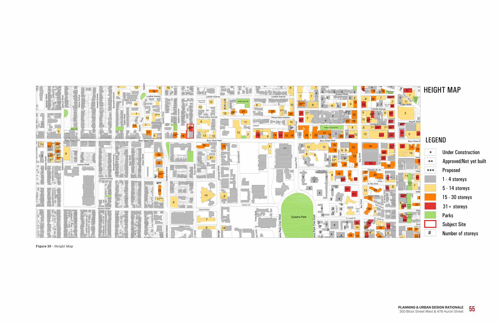
700
SR
ET
EP
E NAL
1 3737
1
488.5 37
372
368 36
50
Frank StolleryParkette
Town HallSquare
GeorgeHislopPark
St. MarysStreet
Parkette
Victoria CollegeStudent Residence
ElmsleyHall
VictoriaCollege
St Joseph'sCollege
HaroldTownPark
RavineLands
Clover Hill Park
Bloor Street West
May
fair
Mew
s
Cumberland StreetAsquith Avenue
Que
ens
Park
Village of Yorkville Park
Yorkville Avenue
Scollard Street Church Street
Collier Street
Davenport Road
Bella
ir St
reet
ROM
Lowther Avenue
Prince Arthur Avenue
Isabella Street
Charles St. E.
Yong
e St
reet
Hayden Street
St. Mary Street
Gloucester Street
Irwin Avenue
Dundonald Street
St. Joseph St.
St. N
icho
las
Stre
et
Inkerman Street
St. T
hom
as S
treet
Phipps
St. N
icho
las
Stre
et
Street
St. Joseph St.
Sultan St.
Balm
uto
Stre
et
Bay
Stre
et
Bloor Street East
Elm
sley
Pl
Que
ens
Park
Cre
s Ea
stQueens Park
Que
ens
Park
Cre
s W
est
St G
eorg
e St
Geo
rge
Stre
et
Hoskin Ave.
Prince Arthur Avenue
Bloor Street West
Hur
on S
treet
Huron Street Playground
Dev
onsh
ire P
l
Lowther Avenue
Hur
on S
treet
Harbord Street
Taddle Creek Park
Har
t Hou
se C
ircle
Tow
er R
oad
Mad
ison
Ave
nue
Spad
ina
Roa
d
Bay
Stre
et
Classic Avenue
Aven
ue R
oad
Spad
ina
Aven
ue
Harbord Street
Spad
ina
Aven
ue
Sussex Avenue
Lennox Street
Brun
swic
k Av
enue
Maj
or S
treet
Rob
ert S
treet
Lowther Avenue
Lowther Avenue
Dal
ton
Roa
d
Brun
swic
k Av
enue
How
land
Ave
nue
Alba
ny A
venu
e
Wal
mer
Bath
urst
Stre
et
Bloor Street WestBloor Street West
ANNE X LANE
Road
Wal
mer
DundonaldStreet
Parkette
NormanJewison
Park
Glo
uces
ter L
ane
Mar
kham
Stre
et
Bath
urst
Stre
et
Mar
kham
Stre
et
Seaton Park
3466***
7
5
2
3
10
12
8
9
18
12
18
25*
2 16
2
4
7
2
3
44
43
8
9
40**
3
717
8 36**
8
7
3 2
26
33
4
7**
10
7
5
14
8
22
8
6
1512
186
123
43
46
34
4
3
62**
44
54**
4
37
31
1
8
88
12 21
712
4
7**7**
7
15 18321921
26162026 7
24
11
40*
559 368
8
4
18
3
3
3 34 37
77
13
11
7
18
18 1013
18
58*
5**
32 71** 41
43***10
34
17
17
10
10
5
9
1215
8
6
7
7
5
48***51**
59***
30***
11*
23***
3**
15
3***
20
25
7
4***
11***
8
9
13
4***
29**
7** 23**
17**5**
9**
1**
25**
26**
17**
10**
8**3 3
7***29***
8***
15
5
22
Charles St. W.
29
20
6
6
8
18
1710
23
35
23
45
55
16
7
28
27
846
13 24
21
28
23
21
53
32
19
18
22
20
142017
9
11
18
6
6
27
35
48
32
22
11*
3
23*
4
3
3
4
3
3
3
3 444
3 3
443
3
3
32
9*
14 9
7
6 14
9
3614 26
78*
18*
40**
48
37*41*8*
8*
44*
34**
18*
46**
51**
82**
38***
******
#
LEGEND
Under Construction
Approved/Not yet built
Proposed
1 - 4 storeys
5 - 14 storeys
15 - 30 storeys
31+ storeys
Subject Site
HEIGHT MAP
Parks
Number of storeys
Project No. 16224 December 2017
PLANNING & URBAN DESIGN RATIONALE300 Bloor Street West & 478 Huron Street 55
Figure 20 - Height Map
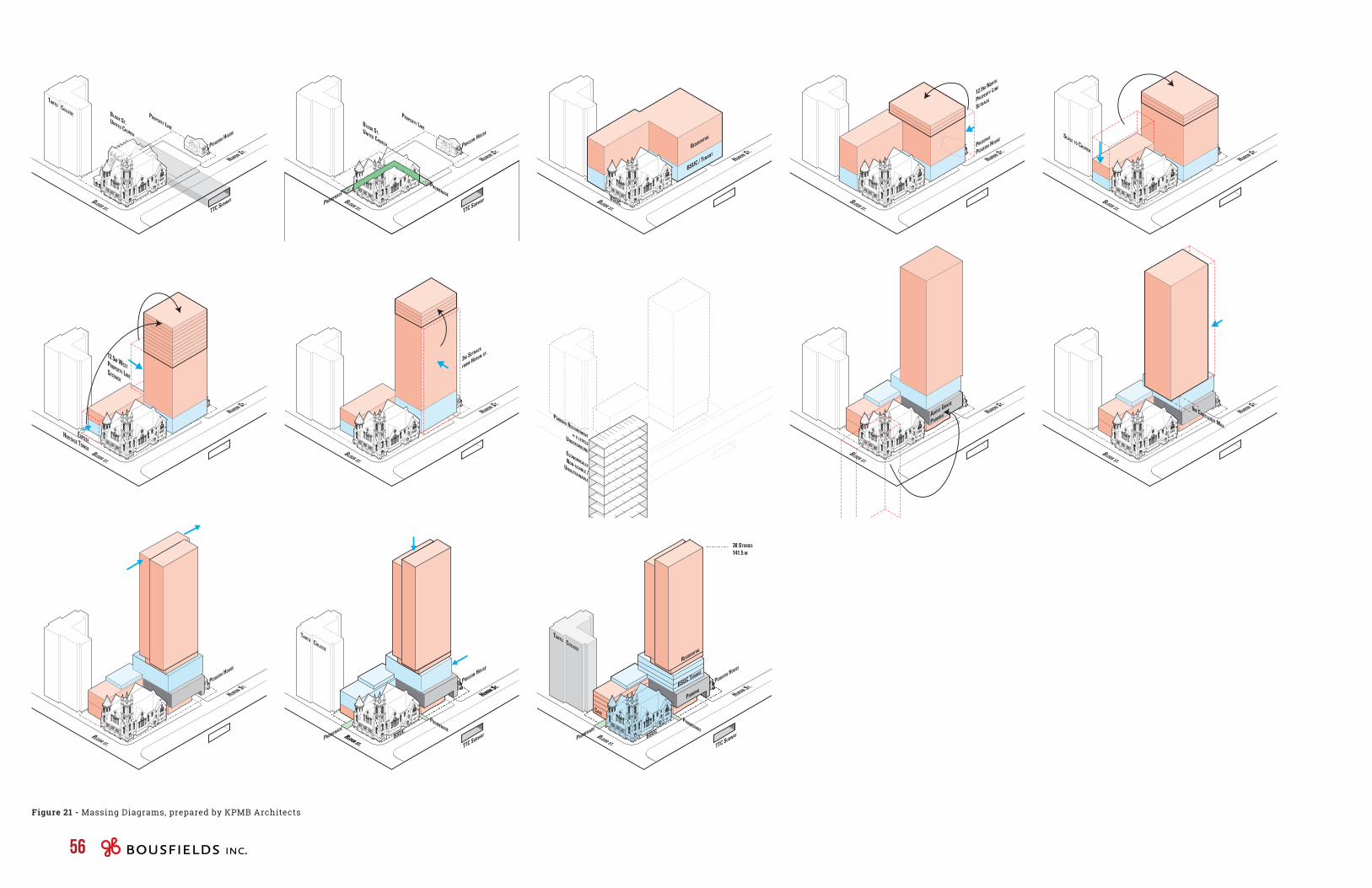
BLOOR ST.
HURON ST.
SCALE TO CHURCH
PROPERTY LINE
BLOOR ST. UNITED CHURCH
BLOOR ST.
HURON ST.
TARTU COLLEGE
TTC SUBWAY
PIDGEON HOUSE
BLOOR ST.
HURON ST.
3M SETBACK
FROM HURON ST.
BLOOR ST.
HURON ST.
BSUC
PIDGEON HOUSE
PROMENADE
PROMENADE
BLOOR ST.
HURON ST.
TARTU COLLEGE
TTC SUBWAY
BLOOR ST.
HURON ST.
12.5M WESTPROPERTY LINESETBACK
EXPOSEHERITAGE TOWER
BLOOR ST.
HURON ST.PIDGEON HOUSE
PROPERTY LINEBLOOR ST. UNITED CHURCH
BLOOR ST.
PIDGEON HOUSE
TTC SUBWAY
PROMENADE
PROMENADE
HURON ST.
PARKING REQUIREMENT= X LEVELSUNDERGROUNDECONOMICALLYNON-USABLE /
UNSUSTAINABLE
BLOOR ST.
HURON ST.
PARKINGBSUC TENANT
RESIDENTIAL
BSUC
PIDGEON HOUSE
PROMENADE
CAFE
PROMENADE
TARTU COLLEGE
TTC SUBWAY
38 STORIES
141.5 M
BLOOR ST.
HURON ST.
BSUC
BSUC / TENANT
RESIDENTIAL
BLOOR ST.
HURON ST.
ABOVE GRADE
PARKING
BLOOR ST.
HURON ST.PRESERVE
PIDGEON HOUSE
12.5M NORTH
PROPERTY LINE
SETBACK
BLOOR ST.
HURON ST.6M CANTILEVER MAX.
56
Figure 21 - Massing Diagrams, prepared by KPMB Architects
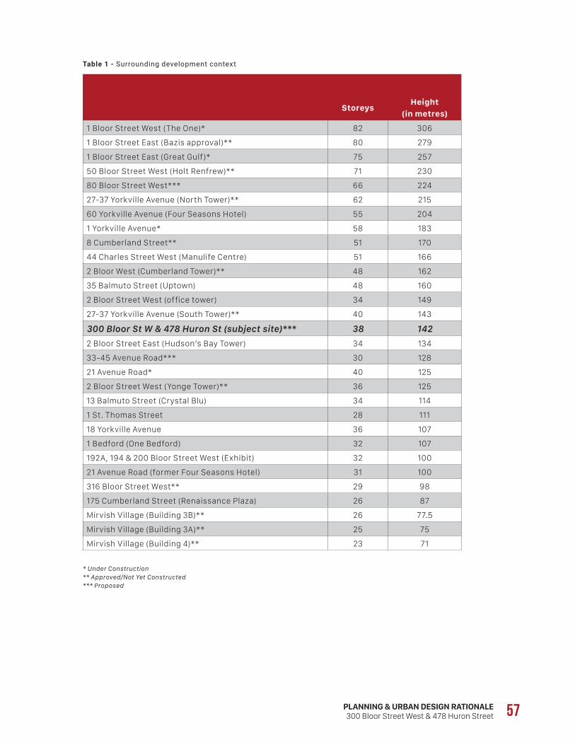
PLANNING & URBAN DESIGN RATIONALE300 Bloor Street West & 478 Huron Street 57
Table 1 - Surrounding development context
StoreysHeight
(in metres)
1 Bloor Street West (The One)* 82 306
1 Bloor Street East (Bazis approval)** 80 279
1 Bloor Street East (Great Gulf)* 75 257
50 Bloor Street West (Holt Renfrew)** 71 230
80 Bloor Street West*** 66 224
27-37 Yorkville Avenue (North Tower)** 62 215
60 Yorkville Avenue (Four Seasons Hotel) 55 204
1 Yorkville Avenue* 58 183
8 Cumberland Street** 51 170
44 Charles Street West (Manulife Centre) 51 166
2 Bloor West (Cumberland Tower)** 48 162
35 Balmuto Street (Uptown) 48 160
2 Bloor Street West (office tower) 34 149
27-37 Yorkville Avenue (South Tower)** 40 143
300 Bloor St W & 478 Huron St (subject site)*** 38 142
2 Bloor Street East (Hudson’s Bay Tower) 34 134
33-45 Avenue Road*** 30 128
21 Avenue Road* 40 125
2 Bloor Street West (Yonge Tower)** 36 125
13 Balmuto Street (Crystal Blu) 34 114
1 St. Thomas Street 28 111
18 Yorkville Avenue 36 107
1 Bedford (One Bedford) 32 107
192A, 194 & 200 Bloor Street West (Exhibit) 32 100
21 Avenue Road (former Four Seasons Hotel) 31 100
316 Bloor Street West** 29 98
175 Cumberland Street (Renaissance Plaza) 26 87
Mirvish Village (Building 3B)** 26 77.5
Mirvish Village (Building 3A)** 25 75
Mirvish Village (Building 4)** 23 71
* Under Construction** Approved/Not Yet Constructed*** Proposed
58
limiting the new development footprint. Finally, the retention of the heritage buildings limits the ability to excavate beneath two buildings, reducing the viability of underground parking, since the resulting parking levels would be small and inefficient.
In addition, the rear portion of the subject site is located above the Line 1 and Line 2 subway tunnels, which cross the north portion of the site in an east-west direction, further limiting the ability to excavate and requiring a tall above-grade “bridge” structure in order to build over the tunnel, thereby increasing the building height.
The design of the building, as illustrated in Figure 21 – Massing Diagrams prepared by KPMB Architects Inc., has been developed based of the following massing and design elements:
• a determination of which portions of the church building are appropriate to remove and which are to be retained;
• the delineation of a publicly accessible promenade surrounding the church to allow it to be experienced from all four sides;
• a reduction in the massing along the north side, at grade, in order to conserve Pidgeon House and, above grade, to provide a tower setback of approximately 12.5 metres to the north property line (it varies between 11.2 and 14.2 metres);
• the massing along Bloor Street West, which is maintained at a height that closely matches the existing church’s height and scale, and a front yard setback of approximately 7.4 metres at grade (and 5.8 metres to the 2nd to 4th floors) to give the church greater prominence, as viewed from the west; and
• a 12.5 metre tower setback to the west lot line (it is proposed to in fact be approximately 12.8 metres) and a setback of approximately 3 metres to Huron Street (2.1 metres at grade, 0 metres from the mezzanine to the 4th floor, and 5.5 metres above, with the balconies projecting to within metres 3.8 metres of the Huron Street lot line).
Since the only location available for underground parking (i.e. not constrained by heritage buildings or the subway tunnel) is narrow and would only allow for a small number of vehicles per floor, thereby requiring a significant and unfeasible excavation, the tower’s height was increased by the need to accommodate four above-grade parking levels. The tower height was further increased by 6 metres to accommodate the cantilever “bridge” structure over the tunnel. Finally, the tower massing was shifted southwards and offset in order to reduce the impact on the low-rise properties to the north.
As described in greater detail in Section 5.5 below, the subject site is well separated from the closest Neighbourhoods to the north and is therefore capable of accommodating a tall building of 38 storeys (141.66 metres) with minimal and acceptable built form impacts. The north limit of the subject site is located approximately 175 metres from the closest Neighbourhoods designation to the north, on the north side of Lowther Avenue, and the tower would be approximately 186 metres away (well within a 45-degree angular plane); accordingly, the proposed height would result in minimal shadow impacts and virtually no privacy or sky view impacts.
To the south, the closest Neighbourhoods designation is located on the south side of Nichol Lane, approximately 80 metres away. Given the site’s location to the north of that Neighbourhoods designation, there will be no shadow impacts. The building’s impact on privacy and sky view will be minimal given the greater proximity of the residential pocket to the Senator David Croll Apartments.
With respect to shadowing on parks, the detailed analysis included in Section 5.4 below demonstrates that, at the height proposed, there will be only minimal impacts on Paul Martel Park, the Huron Street Playground and Taddle Creek Park. Based on the foregoing analysis, the minimal shadowing on nearby Neighbourhoods and parks should not be a determinative factor in terms of establishing the appropriate height for the subject site.
From a height and massing perspective, the design of the building is largely a response to a number of constraints and opportunities presented by the existing site conditions. Unlike other sites located along the Bloor Street Corridor, the subject site is constrained by a number of factors, including the obligation to conserve the heritage-listed Bloor Street United Church and Pidgeon House buildings,. These existing buildings have three key impacts on the height of the building. First, they limit the ability to increase the new building footprint horizontally, as described further below. Second, in order to conserve the existing heritage resources and maintain their prominence on the site, the new development has provided for physical separation from the heritage buildings, further
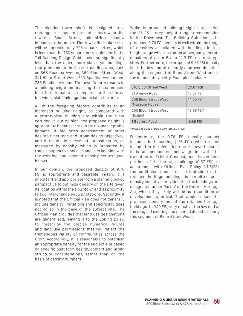
PLANNING & URBAN DESIGN RATIONALE300 Bloor Street West & 478 Huron Street 59
While the proposed building height is taller than the 15-25 storey height range recommended in the Downtown Tall Building Guidelines, the proposed 9.76 FSI density is well within the range of densities associated with buildings in this height range which, as noted above, can generate densities of up to 8.4 to 12.3 FSI on prototype sites. Furthermore, the proposed 9.76 FSI density is at the low end of recently approved densities along this segment of Bloor Street West and in the immediate vicinity. Examples include:
316 Bloor Street West 20.87 FSI
21 Avenue Road 15.67 FSI
208 Bloor Street West
(Museum House)
14.55 FSI
200 Bloor Street West
(Exhibit)
13.96 FSI*
1 Bedford Road 9.69 FSI
* Includes above-grade parking (3.29 FSI)
Furthermore, the 9.76 FSI density number includes both parking (1.16 FSI), which is not included in the densities noted above because it is accommodated below grade (with the exception of Exhibit Condos), and the retained portions of the heritage buildings (0.57 FSI). In accordance with Official Plan Policy 3.1.5(23), the additional floor area attributable to the retained heritage buildings is permitted as a density incentive, provided that the buildings are designated under Part IV of the Ontario Heritage Act, which they likely will be as a condition of development approval. That would reduce the proposed density, net of the retained heritage buildings, to 9.19 FSI, very much at the low end of the range of existing and planned densities along this segment of Bloor Street West.
The slender tower shaft is designed in a rectangular shape to present a narrow profile towards Bloor Street, minimizing shadow impacts to the north. The tower floor plate size will be approximately 725 square metres, which is less than the 750 square metre guideline in the Tall Building Design Guidelines and significantly less than the older, more slab-style buildings that predominate in the surrounding area, such as 666 Spadina Avenue, 360 Bloor Street West, 341 Bloor Street West, 720 Spadina Avenue and 736 Spadina Avenue. The tower’s form results in a building height and massing that has reduced built form impacts as compared to the shorter, but wider, slab buildings that exist in the area.
All of the foregoing factors contribute to an increased building height, as compared with a prototypical building site within the Bloor corridor. In our opinion, the proposed height is appropriate because it results in no unacceptable impacts, it facilitates achievement of other desirable heritage and urban design objectives, and it results in a level of intensification, as measured by density, which is promoted by transit-supportive policies and is in keeping with the existing and planned density context (see below).
In our opinion, the proposed density of 9.76 FSI is appropriate and desirable. Firstly, it is important and appropriate from a planning policy perspective to optimize density on the site given its location within the Downtown and its proximity to two interchange subway stations. Secondly, it is noted that the Official Plan does not generally include density limitations and specifically does not do so in the case of the subject site. The Official Plan provides that land use designations are generalized, leaving it to the Zoning Bylaw to “prescribe the precise numerical figures and land use permissions that will reflect the tremendous variety of communities across the City”. Accordingly, it is reasonable to establish an appropriate density for the subject site based on specific built form design, context and urban structure considerations, rather than on the basis of density numbers.
60
For the base building element, a minimum main window separation distance of 11 metres is typically recommended and is incorporated in the in-force MCR and CR zoning (i.e. a minimum window setback of 5.5 metres from side and rear lot lines or the centreline of a lane). For tower elements, the Tall Building Design Guidelines as well By-laws 1106-2016 and 1107-2016 (both under appeal) recommend a separation distance of 25 metres between tower faces and a tower setback of 12.5 metres from side and rear property lines, measured to the external walls of the building (i.e. balconies are permitted within the setback zone). In By-laws 1106-2016 and 1107-2016, a tower is defined as the portion of a building above 24 metres in height.
Within the context of the parameters outlined above, the units facing Huron Street will have adequate separation distance from any facing units on the other side of the street by virtue of the 20-metre width of the Huron Street right-of-way. The face of the tower is set back approximately 5.5 metres from the Huron Street lot line, and will be separated from any potential development on 455-465 Huron Street by approximately 28.5 metres, assuming a 3 metre setback on the other side.
To the south, there are no residential units above the church or within the 5-storey podium that extends towards Bloor Street West. As a result, the closest residential unit, located in the residential tower, is set well back (approximately 37 metres) from the south lot line. With respect to separation between windows within the subject site itself, residential uses only begin at the 9th storey (approximately 40 metres in height), and do not directly interface with the Bloor Street United Church, whose main roof reaches a height of approximately 19.19 metres.
To the west and to the north, there are again no residential units until the 9th storey, above which the face of the tower is set back approximately 12.8 metres from the west lot line and between approximately 11.2 and 14.2 metres from the north lot line, generally in line with the Tall Building Design Guidelines, as well as By-laws 1106-2016 and 1107-2016. While the existing Pidgeon House
5.4 Built Form ImpactsIn our opinion, the proposed development will not have unacceptable built form impacts on surrounding streets, open spaces or on lower-scale Neighbourhoods. The Official Plan designates the subject site and adjacent lands in all four directions as Mixed Use Areas.
The Official Plan development criteria applying to Mixed Use Areas designations focus on potential built form impacts on adjacent lower-scale Neighbourhoods. In particular, Policy 4.5(2)(c) requires buildings to be located and massed to provide a transition through appropriate setbacks and/or stepping down of heights towards lower-scale Neighbourhoods. The closest Neighbourhoods are located approximately 175 metres north of the subject site, on lands on the north side of Lowther Avenue, and approximately 80 metres to the south, on the south side of Nichol Lane. Due to the significant distance between the subject site and the closest Neighbourhoods, it is our opinion that any impacts on these areas would be minimal and acceptable.
As it relates to impacts on neighbouring streets and open spaces, the proposed development conforms with Policy 3.1.2(3) in that it will be massed to fit harmoniously into its existing and planned context. The building will frame Huron Street and Bloor Street West in a way that respects the street proportion, creates appropriate transitions in scale to neighbouring buildings and provides adequate sunlight conditions on the street, all while ensuring sufficient setbacks from, and deference to, the heritage buildings.
L I G H T , V I E W A N D P R I V A C Y ( L V P )Light, View and Privacy (LVP) impacts are generally dealt with through a combination of spatial separation, orientation and mitigating measures between buildings. In our opinion, the proposed development will not have unacceptable built form impacts on surrounding streets, open spaces or on lower-scale Neighbourhoods given the separation distances of the proposed building from neighbouring buildings and the wide range of non-residential uses in most of the closest buildings.
PLANNING & URBAN DESIGN RATIONALE300 Bloor Street West & 478 Huron Street 61
With respect to Parks and Open Space Areas, only a small sliver of Paul Martel Park, located west of the site on Madison Avenue, will be impacted, and only at 9:18 a.m. on March 21st, September 21st, and June 21st. There would be no impact on Paul Martel Park on December 21st, although there would be minimal incremental shadow impacts on the Huron Street Playground, north of the subject site at the southeast corner of Huron Street and Lowther Avenue, and on Taddle Creek Park, northeast of the site at the southwest corner of Bedford Road and Lowther Avenue. On the Huron Street Playground, some additional incremental shadowing would occur on the west portion of the park at 12:18 p.m. and on the east portion of the park at 1:18 p.m. On Taddle Creek Park, there would be small slivers of new shadowing at 3:18 p.m.
Based on the foregoing analysis, it is our opinion that the incremental shadow impact on neighbouring streets, properties and open spaces would be “adequately limited” in accordance with the applicable Official Plan policies, having regard for the site’s location within an urban context in the Downtown. With respect to the nearby parks, incremental shadowing would be minimal and would not affect the utility of the parks given the limited duration of the shadow impact.
W I N D I M P A C TA Preliminary Pedestrian Level Wind Study was completed by Novus Environmental, which concludes that:
• The wind safety criterion is met in all areas at grade and at the Level 9 terrace.
• Wind conditions at all entrances to the proposed building are suitable for the intended usage throughout the year.
• Wind conditions on the sidewalks surrounding the proposed development are suitable for the intended usage.
• To determine the efficacy of the mitigation described herein, Novus recommends conducting a wind tunnel study for the subsequent Site Plan Approval submission.
is located immediately north of the proposed building, separated from it by between 2.37 and 3.48 metres, the Pidgeon House is listed on the City’s Heritage Register and is proposed to be retained in its current form and renovated. Based on the foregoing, it is our opinion that the resulting LVP conditions to the west and north are acceptable given the urban context.
S H A D O W I M P A C T A shadow study was prepared by KPMB Architects in order to assess the shadow impacts at the equinoxes (March 21st/September 21st) and solstices (June 21st/December 21st). In this regard, the Official Plan provides that new development should adequately limit any resulting shadowing of neighbouring streets, properties and open spaces, having regard for the varied nature of such areas (Policy 3.1.2(3)(e)). The policies specific to Mixed Use Areas provide that new buildings will adequately limit shadow impacts on adjacent Neighbourhoods, particularly during the spring and fall equinoxes (Policy 4.5(2)(d)).
The closest Neighbourhoods-designated properties to the subject site that would potentially be affected by shadowing are located north of Lowther Avenue, approximately 175 metres away. The shadow study demonstrates that the March 21st/September 21st impacts will be adequately limited on Neighbourhoods properties north of Lowther Avenue, with only slivers of impact on the front yards of apartment buildings at 35, 40 and 44 Walmer Road at 9:18 a.m. On June 21st, the building will not cast shadows on any properties designated Neighbourhoods.
The proposal will result in some incremental shadowing on low-rise properties to the northwest, north and northeast of the subject site. However, as shown in Figure 8 of this report, this area is designated Mixed Use Areas, not Neighbourhoods, and, correspondingly, the properties within it are occupied by a mix of predominantly non-residential uses. Moreover, the shadows will move quickly across these mixed-use properties without any prolonged impacts on any single property due to the point tower design, which results in longer but narrow and fast-moving shadows.
62
residential portion of the proposed development includes an indoor amenity area at grade and on the mezzanine and 2nd storey, facing the street. A small outdoor residential amenity area is located at grade, abutting the indoor amenity area.
In our opinion, the proposed design conforms with the development criteria set out in Policies 3.1.2(1), 3.1.2(2), 3.1.2(3), 3.1.2(4), 3.1.2(5), 3.1.2(6), 3.1.3(1) and 4.5(2) of the Official Plan. In particular, the proposal will:
• locate the base podium building parallel to both frontages;
• locate and design the residential entrance and office lobby promenade entrance so that they are clearly visible and directly accessible from Huron Street, and provide new entrances to the Bloor Street United Church, promenade and retail/café use along Bloor Street West;
• provide ground floor uses, specifically the retail/café use along Bloor and the residential amenity areas along Huron Street, that will provide views to and from adjacent streets;
• locate and screen service areas, ramps and garbage storage by internalizing these functions within the interior of the building and locating them towards the rear of the site;
• eliminate one of the two existing curb cuts along the Huron Street frontage and consolidate them into a single driveway access at the northeast corner of the site;
• eliminate the surface parking lot on the north portion of the property;
• provide all parking in a fully automated above-grade parking structure integrated into the building as opposed to an underground garage due to constraints related to the conserved heritage buildings and the TTC subway tunnel that crosses the rear portion of the site;
• integrate the above-grade parking structure with the building design, including usable building space at grade facing Huron Street in the form of residential amenity space and designing the street-facing garage façade to integrate with the amenity space façade below;
• mass the base building to frame the adjacent streets with good proportion, while establishing a respectful built form relationship to the retained heritage buildings;
• provide a setback from Bloor Street West to allow for a potential patio/spill-out zone, and provide a setback from Huron Street to create a widened pedestrian zone;
• locate and orient the shaft of the tower appropriately in relation to the base building and adjacent buildings; and
• integrate the mechanical penthouse into the design of the building.
5.5 Urban Design From an urban design perspective, the proposed development will help animate the streetscape along Bloor Street West by demolishing the existing Sunday School addition and bringing the proposed 5-storey podium close to the street, adding active uses at grade. In addition, the 1927 addition to the church along Bloor Street, which now presents a blank wall to the street, will be removed to allow for a transparent entryway providing direct access from the street into the narthex and the sacred space beyond.
Along the Huron Street frontage, entrances to the residential and office lobbies are proposed along the new building façade, replacing the existing surface parking lot. The office entrance includes access to the promenade that will surround the existing church and provide a mid-block, weather-protected connection to Bloor Street West. The residential entrance is proposed to be located adjacent to the interior residential amenity area, spanning the ground, mezzanine and second storeys, and adjacent to an exterior amenity space to the front along Huron Street.
The proposed design is sensitive and responsive to the urban design directions set out in Site and Area Specific Policy 334, the existing and planned public realm within the surrounding area, and the heritage resources on-site. In particular, the proposed development retains the Bloor Street United Church building in its current location, built with essentially no setback to both adjacent street lines, helping to maintain a consistent street wall along Bloor. A setback of approximately 7.35 metres is proposed to the 5-storey podium building to Bloor Street West, promoting the prominence of the heritage building while activating the street with a patio serving the proposed café/retail use, and a small spill-out space and grand entrance to the proposed promenade.
Along Huron Street, in the location of the existing surface parking lot, the proposed new development is set back approximately 2.1 metres from the lot line, in excess of the existing church building’s approximate 1.0 metre setback, again allowing the heritage building to maintain its prominence. In order to activate the street, the
PLANNING & URBAN DESIGN RATIONALE300 Bloor Street West & 478 Huron Street 63
animation. Weather protection for pedestrians is encouraged through the use of awnings and canopies. Podium or street wall heights should generally be 19-25 metres or 6-8 storeys in the Institutional Precinct, east of Madison Avenue. At-grade retail should have a prominent presence on the street with a floor-to-ceiling height that is no less than 4.5 metres.
• Along Bloor Street, the proposal maintains the existing street wall by retaining the existing church building, while along Huron Street, the existing street condition is maintained by retaining the Pidgeon House, which provides a natural transition into the Annex neighbourhood to the north.
• The 5-storey podium facade will have a height of approximately 22.1 metres at the street (and a 26.1 metre height overall, with the 5th storey set back approximately 19.5 metres from the face of the building), in line with the recommended street wall heights. With respect to glazing, the podium building will have significant fenestration facing Bloor Street, as will the proposed promenade that surrounds the church building.
• Canopies are proposed along both facades, and an at-grade retail/café use is proposed along Bloor Street West, with a floor-to-ceiling height of 6 metres.
5.2.2 Building Elements provides that buildings should be composed of a base, middle and top to encourage continuity in the streetscape and to ensure horizontal ‘breaks’ in the façade.
• The proposed building presents a 4-storey base along Bloor Street West to respect the heritage church building and a 6-storey element along Huron Street using sensitive façade articulation and architectural treatment. The mechanical penthouse is integrated into the building, but is articulated by setting back from the north and west building faces.
5.2.3 Orientation and Placement provides that buildings should be oriented to and placed at the street edge with clearly defined primary entry points that directly access the sidewalk.
• The existing church building will be renovated to better relate to the street. The south narthex, originally constructed when Bloor Street was widened in 1927, will be removed and replaced with a more transparent façade including two new pedestrian entrances. Existing entrances along Huron Street will be maintained, and new access points will be provided into the promenade from both facades and for the retail/café use and residential uses.
As well, it is our opinion that the proposed development is generally in keeping with the applicable design guidelines set out in the Bloor Corridor Urban Design Guidelines. The relevant guidelines are addressed below:
5.1 Pedestrian Scale Design Considerations and 5.1.2 Interface with the Sidewalk require a comfortable public realm in terms of a building’s interface with the sidewalk, protection from the elements and creating visual interest.
• The proposed building retains and enhances the site’s existing cultural heritage features to create visual interest while providing additional pedestrian entrances on both facades, along with new at-grade uses, and an enclosed glass promenade wrapping around the church and connecting Bloor Street West with Huron Street. In addition, street furniture including bicycle parking rings and benches are proposed along the sidewalks.
5.1.3 Parking and Loading and 5.2.4 Parking and Servicing require that parking and loading areas be placed below grade where possible and, in general, hidden from view.
• The proposed building removes one of the existing access driveways to improve pedestrian continuity along Huron Street, and locates all parking, loading, garbage collection and moving activities at the rear of the building. The two proposed car elevators and the proposed Type G and two Type C loading spaces are located in the northwest corner of the building, hidden from view from Huron Street by the ground floor of the building.
5.1.4 Mid-Block Connections provides that mid-block connections and walkways encouraged where opportunities arise.
• A potential mid-block connection is being explored through the Pidgeon House property, which would connect to Madison Avenue through the proposed Estonian House development at 9-11 Madison Avenue.
5.2.1 Street Wall provides that the street wall of a new building should align with those of the neighbouring buildings or have the same setback as the predominant buildings on the block. The guideline also provides that the street wall should have the highest quality of architectural design and, and that buildings facing Bloor Street should have active uses at-grade with a minimum 75% glazing, provided that minimum energy performance targets are met, to achieve maximum visual transparency and
64
1.3 Fit and Transition in Scale seeks to ensure that tall buildings fit within the existing or planned context and provide an appropriate transition in scale down to lower-scaled buildings, parks and open space.
• The proposed tower height and siting will transition in scale down towards the lower-scaled properties to the north through the proposed tower setback of approximately 11.2 to 14.2 metres and the stepping down of heights to the Pidgeon House building, located on-site.
1.4 Sunlight and Sky View recommends locating and designing tall buildings to protect access to sunlight and sky view within the surrounding context of streets, parks, public and private open space, and other shadow sensitive areas.
• • The shadow and sky view impacts of the proposal are limited by the point tower design, its small floor plate size, and the floor plate’s north-south orientation. See Section 5.4 above.
1.5 Prominent Sites and Views from the Public Realm recommends an appropriate, high-quality design response for tall buildings on or adjacent to prominent sites, and when framing views from the public realm to prominent sites.
• • The existing Bloor Street United Church building is being retained in its entirety, with the bulk of the proposed development (the tower portion) set well back from the heritage building. The proposed 5-storey podium that will be built closer to Bloor Street West is set well back from the face of the church, and is below the height of the church’s towers.
1.6 Heritage Properties and Heritage Conservation Districts recommends that tall buildings be located and designed to respect and complement the scale, character, form and setting of on-site and adjacent heritage properties and Heritage Conservation Districts.
• The proposed tall building has been located well back from the Bloor Street United Church. Above the ninth floor, the tower will have a modest cantilever that will partially overhang the north end of the church by about 4 metres. The relatively slim floor plate of the tower, combined with its north-south profile, helps to further mitigate its visual impact on the conserved church.
• To the north, the building is set back approximately 2.4 metres from Pidgeon House, respecting the existing property line.
5.3.1 Building Height and Transition provides that building heights should generally be higher at the nodes and transition to lower heights in between. Development should be designed to provide adequate transition toward these taller nodes.
• Although the proposed 38-storey building height would be higher than the approved heights in the Spadina Node, the Institutional Precinct already includes taller buildings of 32 storeys at 200 Bloor Street West and 1 Bedford Road. The specific height proposed responds to a number of site-specific factors, as described in Section 5.3 above. The proposed tower height and siting will transition in scale down towards the lower-scaled properties to the north through the proposed tower setback of approximately 11.2 to 14.2 metres and the stepping down of heights to the Pidgeon House building.
5.3.2 Shadows and Pedestrian Comfort provides that applicants of projects which have a height above the existing context should provide drawings showing shadows cast by the proposed development on publicly accessible areas and on buildings surrounding it.
• A shadow study has been prepared by KPMB Architects Inc. and is addressed in Section 5.4 of this report.
5.4 Sustainable Design provides that development should exhibit leadership in environmentally sustainable planning and design, and that the performance measures of Tier 2 of the Toronto Green standard will be encouraged for all new development.
• The proposed development is intended to achieve the Tier 2 standards, with additional details to be provided at the Site Plan Approval stage.
Furthermore, it is our opinion that the proposed development is generally in keeping with the applicable design guidelines set out in the Tall Building Design Guidelines, as set out below:
1.1 Context Analysis requires evaluation of the existing and planned context and a design response taking into account the patterns, opportunities and challenges within the surrounding area.
• The proposed building fits into the existing and emerging pattern of high-rise development in the vicinity of the subject site.
PLANNING & URBAN DESIGN RATIONALE300 Bloor Street West & 478 Huron Street 65
3.1.1 Base Building Scale and Height recommends designing the base building to fit harmoniously within the existing context of neighbouring building heights at the street and to respect the scale and proportion of adjacent streets, parks, and public or private open space.
• The 5-storey (26.1 metre) base building on the west side of the church building includes a deep stepback above the 4th storey (22.1 metres) in order to more closely match the height of the church, and includes a double-height storey on the ground floor, 6 metres in height, emphasizing the pedestrian scale of the podium building and providing a comfortable public realm.
• Along Huron Street, the base building has a height of approximately 40.0 metres. The mass of the base building is broken up with a stepback of approximately 4.5 metres stepback above the 4th parking level, at a height of approximately 22.1 metres, and a change in materiality. The building then steps back an additional 1.0 metre at the 9th storey, but with 1.6 metre deep projecting balconies.
3.1.2 Street Animation encourages lining the base building with active, grade-related uses to promote a safe and animated public realm.
• • The proposed residential and office lobbies at the base of the tower podium will provide grade-related uses that contribute to street animation along Huron Street. The proposed promenade will promote connections between the two street frontages and new entrances to the church on both facades will increase permeability and animation. Along Bloor Street West, the proposed café/retail space at the southwest corner of the site, and associated patio, will help to animate the main street.
3.1.3 First Floor Height encourages the provision of a minimum first floor height of 4.5 metres, measured floor-to-floor from average grade.
• The proposed ground floor height along Bloor Street West is 6.0 metres, which exceeds the recommended guideline. Along Huron Street, a 5.5 metre high ground floor, exclusive of mezzanine levels, is proposed.
3.1.4 Façade Articulation and Transparency recommends articulating the base building with high-quality materials and design elements that fit with neighbouring buildings and contribute to a pedestrian scale; and providing clear, unobstructed views into and out from ground floor uses facing the public realm.
2.1 Building Placement recommends locating the base of tall buildings to frame the edges of streets, parks and open space, reinforce corners, to fit harmoniously with the existing context, and to provide opportunities for high-quality landscaped open space on-site.
• The base of the existing and proposed building elements will frame the edges of both Bloor Street West and Huron Street and will reinforce the corner by retaining the Bloor Street United Church building. The ground level will include a retail/café space along Bloor Street, new entrances to the church building from Bloor Street West, a new glass promenade connecting both streets, and residential amenity spaces.
2.2 Building Address and Entrances recommends organizing tall buildings to use existing or new public streets for address and building entrances, and ensuring that primary building entrances front onto public streets, and are well-defined, clearly visible, and universally accessible from the adjacent public sidewalk.
• The proposal is well designed in this regard. The main residential and office building entrances are clearly visible and accessible from the public sidewalk on Huron Street, while entrances for community, worship and retail/café uses are accessible from Bloor Street West, with a connection through the promenade to Huron Street.
2.3 Site Servicing, Access and Parking encourages locating “back of house” activities, such as loading, servicing, utilities and vehicle parking, underground or within the building mass, away from the public realm and public view.
• The servicing and loading areas and parking elevators are incorporated into the building envelope, away from view from Huron Street and Bloor Street West. They are located towards the rear of the site.
2.5 Private Open Space encourages the provision of high-quality, comfortable private and shared outdoor amenity space.
• Communal outdoor residential amenity space will be located at grade and on the 9th floor, totaling 368 square metres. In addition, all residential units will have access to private balconies on the east and west facades.
66
3.2.5 Balconies recommends that balconies be designed to maximize usability, comfort and building performance, while minimizing negative impacts on the building mass, public realm and natural environment.
• Balconies will generally be approximately 1.6 metres in depth to ensure usability.
3.3 Tower Top recommends that the top of tall buildings make an appropriate contribution to the quality and character of the city skyline.
• The mechanical penthouse has been designed to integrate into the design of the building, with a similar architectural treatment to the building façades below so that it makes a positive contribution to the skyline.
4.1 Streetscape and Landscape Design encourages the provision of high-quality, sustainable streetscape and landscape design between the tall building and adjacent streets, parks and open space.
• The proposal represents a significant improvement over the existing condition, in particular along Huron Street, where it enhances the streetscape by removing one of the two existing curb cuts and providing a single driveway access serving the entire site. Six new street trees are proposed along Huron Street, along with a landscaped strip along the curb, and 4 new trees are proposed along Bloor Street West with enhanced paving, bicycle spaces and street furniture.
4.2 Sidewalk Zone encourages the provision of adequate space between the front of the building and adjacent street curbs to safely and comfortably accommodate pedestrian movement, streetscape elements and uses at grade.
• The ground floor of the 5-storey podium will be set back approximately 7.35 metres from Bloor Street West, while the ground floor is set back approximately 2.1 metres from Huron Street.
4.3 Pedestrian Level Wind Effects recommends locating, orienting and designing tall buildings to promote air circulation and natural ventilation, while minimizing adverse wind conditions on their surroundings.
• This guideline will be addressed through detailed design at the Site Plan Approval stage.
• The base of the building uses a mix of materials to provide base elements that appropriately differentiate the new buildings from the heritage church and Pidgeon House. The ground floor on both frontages is designed to be highly transparent and is designed to provide views to overlook the street and outdoor spaces.
3.2.1 Floor Plate Size and Shape encourages limiting tower floor plates to 750 square metres, excluding balconies.
• The proposed tower is appropriately massed for the site, with a tower floor plate of approximately 725 square metres gross construction area (GCA), less than the recommended guideline. In addition, the tower mass has been oriented north-south to reduce its shadow impacts.
3.2.2 Tower Placement encourages placing towers away from streets, parks, open space and neighbouring properties to reduce visual and physical impacts.
• The tower is set back approximately 5.5 metres from the east lot line abutting Huron Street and is set back significantly from Bloor Street West, with a small cantilever (approximately 4 metres) above the Bloor Street United Church building. The tower is also set back from neighbouring properties to the north and west. Notably, no tower separation issues are anticipated to the west, since the 9-11 Madison Avenue property is proposed to be redeveloped with a 3-storey building and the Tartu College building presents a blank wall to the east.
3.2.3 Separation Distances recommends that tall buildings be set back 12.5 metres from side and rear property lines or centre lines of abutting lanes.
• The tower is set back between approximately 11.2 and 14.2 metres from the north lot line and 12.8 metres from the west lot line. Although the tower setback to the north is slightly less than the recommended 12.5 setback for a portion of the tower, the reduced setback is minor and the properties to the north are anticipated to remain low-rise.
3.2.4 Tower Orientation and Articulation recommends that tall buildings be organized and articulated to promote design excellence, innovation and sustainability.
• The tower’s design has been organized into a number of elements to create visual interest and articulate each façade differently. The proposed development is aiming to achieve Tier 2 TGS standards.
PLANNING & URBAN DESIGN RATIONALE300 Bloor Street West & 478 Huron Street 67
It is noted that the heritage designation for Knox College has been recently updated by By-law 91-2015, which amended the reasons for designation, in conjunction with the University of Toronto’s proposal for a new three-storey rear addition to house the Daniels Faculty of Architecture, Landscape and Design. The amended reasons for designation refer to the view corridor from Spadina Avenue but do not refer to the building silhouette or to any specific vantage point, as follows:
“Knox College is valued for its contribution to a distinctive and historic urban pattern in the City of Toronto by terminating the northern vista of an avenue and facing south towards Lake Ontario as do numerous other prominent institutions including Old City Hall, the Ontario Legislature Building and Upper Canada College. Terminating the northwards vista of Spadina Avenue, Knox College has been valued as a prominent Toronto landmark since its building was announced in the press in 1873 and it continues to be ‘an adornment for the City’.”
As noted in Section 4.6 of this report, Official Plan Amendment No. 368 proposes to delete and replace the description of the view of the Knox College with reference to “the silhouette view against the sky above the spires and the east and west wing ridgeline of Knox College in its entirety”. OPA 368 is under appeal and is not in force.
Within this context, a view corridor analysis was undertaken by KPMB Architects which shows views looking northward from Spadina Avenue at its intersection with College Street (see Figure 22). It should be noted that the views do not account for the streetcar wires, light poles, traffic lights and boulevard trees, which would partially or completely obstruct the view looking northward on Spadina Avenue. The analysis shows that, from the south side of College Street, the proposed building will be partially visible above the roof line of the new rear addition (School of Architecture) which extends above the east building wing. However, it will be substantially
4.4 Pedestrian Weather Protection seeks to ensure that weather protection elements, such as overhangs and canopies, are well-integrated into building design, carefully designed and scaled to support the street, and positioned to maximize function and pedestrian comfort.
• Pedestrian level wind impacts are addressed in Section 5.4 above.
5.6 View Corridor Analysis
In our opinion, the impact of the proposed building on views of the heritage-designated Knox College building (1 Spadina Crescent) from points along Spadina Avenue to the south would be minimal and acceptable, and would not materially affect the heritage attributes of the Knox College building.
In this regard, Site and Area Specific Policy 334 includes a general policy requiring that development within the Bloor Corridor “respect, protect and enhance significant views of key civic and/or historic buildings”. Although the subject site is not located in the Spadina Node, the policies applying to the Spadina Node provide that development will be subject to a view corridor analysis “to preserve and enhance views” of the Connaught Laboratories spire at 1 Spadina Crescent (more generally known as Knox College).
As noted in Section 4.3 above, the Official Plan’s Heritage Conservation policies have been updated to include the protection of views of historic buildings. The view of Knox College looking north on Spadina Avenue is described in terms of its visibility from the southwest and southeast corner of College Street at Spadina Avenue as well as from the Spadina streetcar right-of-way at College Street, from which the view is required to be conserved unobstructed. The proposed building will not obstruct views to Knox College from College Street. In contrast to other identified views (e.g. the views of the Legislative Assembly Building, Old City Hall and Toronto City Hall), which are defined by reference to their silhouettes as seen from specific vantage points, the silhouette of Knox College is not similarly identified.
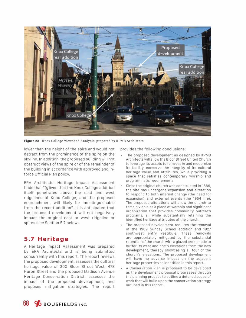
68
lower than the height of the spire and would not detract from the prominence of the spire on the skyline. In addition, the proposed building will not obstruct views of the spire or of the remainder of the building in accordance with approved and in-force Official Plan policy.
ERA Architects’ Heritage Impact Assessment finds that “[g]iven that the Knox College addition itself penetrates above the east and west ridgelines of Knox College, and the proposed encroachment will likely be indistinguishable from the recent addition”, it is anticipated that the proposed development will not negatively impact the original east or west ridgeline or spires (see Section 5.7 below).
5.7 HeritageA Heritage Impact Assessment was prepared by ERA Architects and is being submitted concurrently with this report. The report reviews the proposed development, assesses the cultural heritage value of 300 Bloor Street West, 478 Huron Street and the proposed Madison Avenue Heritage Conservation District, assesses the impact of the proposed development, and proposes mitigation strategies. The report
provides the following conclusions:
• The proposed development as designed by KPMB Architects will allow the Bloor Street United Church to leverage its assets to reinvest in and modernize its facility, conserve the integrity of its cultural heritage value and attributes, while providing a space that satisfies contemporary worship and programmatic requirements.
• Since the original church was constructed in 1886, the site has undergone expansion and alteration to respond to both internal change (the need for expansion) and external events (the 1954 fire). The proposed alterations will allow the church to remain viable as a place of worship and significant organization that provides community outreach programs, all while substantially retaining the identified heritage attributes of the church.
• The proposed development requires the removal of the 1909 Sunday School addition and 1927 southwest entry vestibule. These removals are appropriately mitigated by the substantial retention of the church with a glazed promenade to buffer its west and north elevations from the new development, thereby showcasing all four of the church’s elevations. The proposed development will have no adverse impact on the adjacent heritage properties as identified in this report.
• A Conservation Plan is proposed to be developed as the development proposal progresses through the planning process to outline a detailed scope of work that will build upon the conservation strategy outlined in this report.
Figure 22 - Knox College Viewshed Analysis, prepared by KPMB Architects
PLANNING & URBAN DESIGN RATIONALE300 Bloor Street West & 478 Huron Street 69
• The report finds that by-law requirements overstate the actual parking needs of the proposed residential portion of the building and proposed an effective resident parking supply of 0.42 spaces per unit, which is considered to be well within a range of parking demands, sales and approvals at similar buildings in the downtown Toronto area based on BA Group’s study. In addition, travel surveys of the two on-site congregations found that the place of worship use’s parking requirements are overstated.
• The 45 proposed non-residential spaces will accommodate residential visitors, office, retail and church users within the fully automated parking system on-site.
• With respect to loading, 1 Type G and 2 Type C spaces are proposed, whereas the by-law would also require a Type B space. A loading demand survey done as part of the BA report concludes that the proposed loading facility arrangement for the site appropriately accommodates the effective loading requirements.
• The proposal was found to exceed the required bicycle parking provisions.
A Functional Servicing and Stormwater Management Report was prepared by Cole Engineering Group Ltd. in support of the proposed development. The conclusions are summarized below:
• With respect to storm drainage, during the post-development scenario, flow from the Site is proposed to be split to Bloor Street West and Huron Street, with a maximum total discharge of 26 L/s during the post-development 100-year storm.
• The City’s water balance requirements are achieved by the provision of a sump that is capable of storing the required 9 m³ of water for reuse / irrigation of landscaped areas and building maintenance. The proposed development will achieve the minimum 80% TSS removal required prior to discharging into the municipal system.
• Based on the post-development analysis, the Cole report concludes that the proposed development will not adversely affect the combined sewer infrastructure downstream, and no improvements to the downstream municipal sewers are required.
• With respect to sanitary sewers, the site will discharge to the existing infrastructure along Bloor Street West. Based on the proposed conditions, the existing sewer legs in the tributary area were found to support the sanitary flows from the proposed redevelopment, under normal dry weather and extreme wet weather conditions No improvements are required to the existing municipal sewer system.
5.8 Transportation and Servicing
A Transportation Considerations report was prepared by BA Group in support of the proposed development. The conclusions are summarized below:
• The report includes a Mobility Travel Choice Plan that has been developed to guide the design, development and implementation of the proposed development, as well as the ultimate operation of the facilities over time to maximize the travel demand sustainability of the project and allow the development to leverage its location relative to the amenities and non-automobile travel options that are easily accessible within the neighbourhood;
• The adopted trip generation rates, in combination with the modal split, resulted in residential forecasts of approximately 25 two-way auto trips during the weekday morning and afternoon peak hours, respectively, and approximately 45 non-auto trips (2-way) during the weekday morning and afternoon periods. For office, a total of 15 new office trips (2-way) are projected for the morning and afternoon peak hours. The proposed retail space is anticipated to be ancillary in nature and will be served by pedestrian traffic. As such, BA does not anticipate that the retail component will add any new multi-modal trips to the area street network.
• The proposed development is expected to generate in the order of 40 new two-way vehicle trips in both the weekday morning and afternoon peak hours. Sustainable trips (i.e. transit, walking, cycling and other modes) are forecasted to be in the order of 73 and 69 two-way trips during the weekday morning and afternoon peak hours, respectively, and can be accommodated on the area road system under the proposed plan.
• The report finds that proposed development can be reasonably accommodated from a traffic operations perspective, with no mitigation measures or improvements necessary at the intersections in the study area.
• With respect to parking, proposed development would require 155 resident parking spaces, equivalent to an effective resident supply ratio of 0.60 spaces per unit, and 133 non-residential parking spaces.
• A total of 156 parking spaces are proposed for the site, including 108 resident parking spaces, 45 commercial parking spaces for the non-residential uses, and 3 car-share spaces.
70
• Likewise, nearly half the neighbourhood population (44.4 percent) spends more than 30 percent of their income on shelter costs, which is greater than both the Downtown Core and City of Toronto. Moreover, although the neighbourhood’s employment rates are higher than the averages reported for the Downtown Core and the City as a whole, the neighbourhood’s part-time employment rate is significantly higher than both the Downtown Core and City of Toronto.
• There are currently 14 recently proposed (within the last five years), approved or under construction developments in the Study Area, 7 of which have been approved and one of which is under construction.
• The future population for the area, inclusive of the proposed development, is estimated at 7,757 persons.
• The TOcore Community Services and Facilities Report identified two opportunities in the Study Area for minor capital improvements to existing facilities, including City Hall and Yorkville Public Library Branches.
• The Study Area contains a broad mix of community services and facilities that serve the existing community, and would be available to potential residents of the proposed development.
• The proposed development would yield 8 TDSB students, while the TCDSB did not respond to requests for pupil yield calculations. There is sufficient capacity to accommodate the anticipated TDSB students in existing schools.
• There are 24 childcare facilities in the Study Area, 13 of which may provide subsidized space, upon availability. The development is expected to result in a demand for 9 childcare spaces, for which there is sufficient space.
• Other community facilities in the area include 4 library branches, 23 parks and parkettes, 4 hospitals, 51 human service organizations and 31 places of worship.
• The study notes that while there are no publicly funded recreation centres operated by the City of Toronto’s Parks and Recreation Division in the Study Area, although there are two recreation centres in the vicinity of the subject site operated privately, including the Toronto Central Grosvenor St. YMCA Centre and the Miles Nadal Jewish Community Centre.
• With respect to service gaps, the study identified a need for park amenities beyond playground equipment and publicly funded recreation centres.
• With respect to water supply, the site will connect to existing watermains on both Bloor Street West and Huron Street, and have two fire service connections, with two Siamese connections for redundancy and fire safety. Based on the proposed conditions, the existing watermains on Huron Street and Bloor Street West were to found to support the water demand from the proposed development, with no necessary improvements.
• Finally, with respect to grading, the proposed grading of the site will match the existing grades where possible, and site flows are to be accommodated by the stormwater management system up to and including the 100-year design event, with emergency overland flow to be directed to the adjacent municipal roads.
• Under pre-development condition, there is no external drainage to the site, and the existing drainage patterns will be maintained during the post-development condition.
5.9 Community Services and Facilities
A Community Services and Facilities Study was prepared by Bousfields Inc. in support of the proposed development, which is attached to this report as Appendix A. The report concludes that:
• The subject site is located within the Annex neighbourhood, a neighbourhood that had a moderate increase in population between 2006 and 2011, albeit less than the growth rates of the Downtown Core and the City of Toronto as a whole.
• The neighbourhood population has a strong presence of “Working Age” adults, and a greater proportion of Youth residents than the City and the Core.
• Households in the neighbourhood predominantly contain single residents.
• Furthermore, according to the TOcore Profiles Report, rental is by far the most common form of housing tenure in the neighbourhood (74.2 percent of residents rent) and 59.1 percent of residents reported moving in the last five years.
• With respect to income, although the neighbourhood has a higher average household income than both the City of Toronto and Downtown Core, nearly a quarter of neighbourhood residents are considered low-income status, which is higher than the City of Toronto average.

PLANNING & URBAN DESIGN RATIONALE300 Bloor Street West & 478 Huron Street 71
[6.0]C O N C L U S I O N
72
From a land use planning perspective, there are a number of planning considerations that support intensification of the subject site. Intensification of the subject site is promoted by the Provincial Policy Statement, the Growth Plan, the Toronto Official Plan and Site and Area Specific Policy 334, given its location within the Downtown Toronto urban growth centre and within 190 and 225 metres, respectively, of the Spadina and St. George interchange subway stations.
From a built form and urban design perspective, the proposal represents an appropriate design response to the location of the subject site within a designated urban growth centre and its proximity to existing, approved and proposed towers, the existing heritage resources on-site to be retained, and the subway tunnel that crosses the north portion of the site. The building will provide an appropriate street wall with well-defined podium elements along both street frontages, and the new promenade surrounding the church building will provide a connection between Bloor Street West and Huron Street, while allowing the building to be experienced from all four sides.
From an urban structure perspective, the proposed tower height of 38 storeys (142 metres) represents an appropriate design response to the location of the subject site within a node of high-density development in and surrounding the Downtown urban growth centre, and its proximity to other tall buildings.
For all of the foregoing reasons, it is our opinion that the proposed development would be a desirable addition to the Downtown and, accordingly, we recommend approval of the requested rezoning application.

A P P E N D I X A :COMMUNITY SERVICES
& FACILITIES STUDY
A
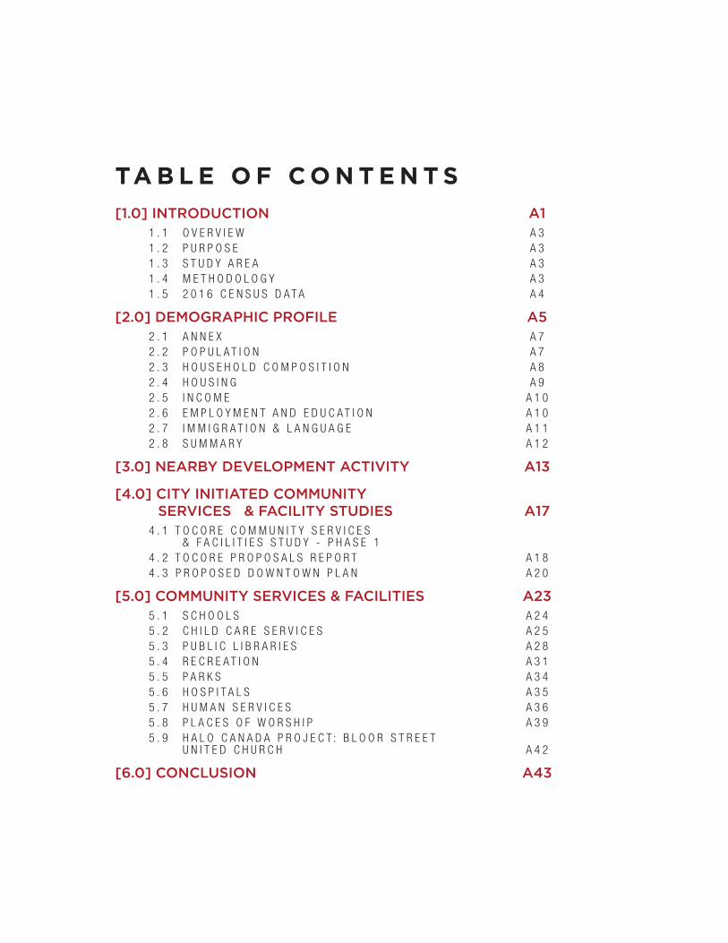
TA B L E O F C O N T E N T S[1.0] INTRODUCTION A1
1 . 1 O V E R V I E W A 31 . 2 P U R P O S E A 31 . 3 S T U D Y A R E A A 31 . 4 M E T H O D O L O G Y A 31 . 5 2 0 1 6 C E N S U S D A T A A 4
[2.0] DEMOGRAPHIC PROFILE A52 . 1 A N N E X A 72 . 2 P O P U L A T I O N A 72 . 3 H O U S E H O L D C O M P O S I T I O N A 82 . 4 H O U S I N G A 92 . 5 I N C O M E A 1 02 . 6 E M P L O Y M E N T A N D E D U C A T I O N A 1 02 . 7 I M M I G R A T I O N & L A N G U A G E A 1 12 . 8 S U M M A R Y A 1 2
[3.0] NEARBY DEVELOPMENT ACTIVITY A13
[4.0] CITY INITIATED COMMUNITY SERVICES & FACILITY STUDIES A17
4 . 1 T O C O R E C O M M U N I T Y S E R V I C E S & F A C I L I T I E S S T U D Y - P H A S E 1
4 . 2 T O C O R E P R O P O S A L S R E P O R T A 1 84 . 3 P R O P O S E D D O W N T O W N P L A N A 2 0
[5.0] COMMUNITY SERVICES & FACILITIES A235 . 1 S C H O O L S A 2 45 . 2 C H I L D C A R E S E R V I C E S A 2 55 . 3 P U B L I C L I B R A R I E S A 2 85 . 4 R E C R E A T I O N A 3 15 . 5 P A R K S A 3 45 . 6 H O S P I T A L S A 3 55 . 7 H U M A N S E R V I C E S A 3 65 . 8 P L A C E S O F W O R S H I P A 3 95 . 9 H A L O C A N A D A P R O J E C T : B L O O R S T R E E T
U N I T E D C H U R C H A 4 2
[6.0] CONCLUSION A43

COMMUNITY SERVICES & FACILITIES STUDY | 300 Bloor Street West and 478 Huron Street A1
[1.0] INTRODUCTION
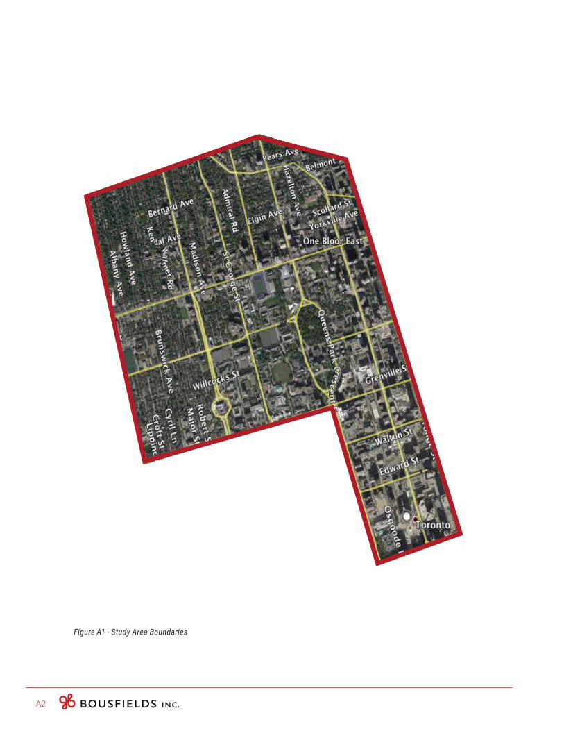
A2
Figure A1 - Study Area Boundaries
COMMUNITY SERVICES & FACILITIES STUDY | 300 Bloor Street West and 478 Huron Street A3
1.1 OverviewThis Community Services and Facilities report was prepared by Bousfields Inc. to provide a review of the community services and facilities that are available to residents in vicinity to 300 Bloor Street West and 478 Huron Street in the City of Toronto (the “subject site”). Key services include publicly funded schools, child care facilities, libraries, parks and community centres.
1.2 PurposeThe proposed development retains the existing Bloor Street United Church (300 Bloor Street West) and Pidgeon House (478 Huron Street) buildings, while intensifying the site with a new mixed-use development consisting of new office, retail/café and residential uses. A total of 259 units are being proposed, consisting of 68 one-bedroom units, 140 two-bedroom units and 27 three-bedroom units. The purpose of this report is to identify the range of existing resources that are available within the Study Area, and to identify any priorities that should be considered in connection with the proposed development.
1.3 Study AreaThe boundaries for this Community Services and Facilities inventory, as provided by City Staff, are Bathurst Street to the west, Dupont Street to the north, Yonge Street to the east, as well as College Street and Queen Street to the south as shown on Figure A1. In terms of the Demographic Profile, the study area incorporates the Annex neighbourhood as identified by the ‘TOcore Neighbourhood Population Profiles’ report’ (see Figure A2).
1.4 MethodologyThis report compiles an inventory of key publicly funded services and facilities, including schools, child care facilities, community centres, parks and libraries, using data such as enrolment, capacity, service boundaries and types of programs.
The demographic profile is based on the neighbourhood wide profile published in the ‘TOcore Neighbourhood Population Profiles’ Report’, prepared by the City of Toronto. The neighbourhood profiles were created using data from the 2006 and 2011 Census data, the 2011 National Household Survey (NHS), IntelliHEALTH ONTARIO and the City of Toronto Clerk’s Office. Neighbourhood characteristics such as population, household composition, housing, socioeconomic, immigration and language are highlighted in these profiles. According to the Neighbourhood Population Profiles report, the variables included were selected based on their relevance to the TOcore
Study.
A4
1.5 2016 Census DataIn February 2017, the Government of Canada began releasing data from the 2016 Census. The first topic, ‘Population and dwelling counts’, was released in February 2017. The second next set of data was released in May 2017. The topics included in this data set were ‘Age and sex’, ‘Type of dwelling’ and ‘Census of Agriculture’. Data related to families, households, income, and languages was released between August and September 2017). Finally, data related to housing, immigration, education and labour are expected to be released in late October-November 2017. Some of this data contains only municipal level data (e.g.: the City of Toronto as a whole), while other data contains census tract level data. Due to resource availability, this CS&F Study has based its demographic analysis on the 2006 and 2011 Census data sets. However, we acknowledge that neighbourhood characteristics and population trends may have changed between the 2011 and 2016 Censuses.

COMMUNITY SERVICES & FACILITIES STUDY | 300 Bloor Street West and 478 Huron Street A5
[2.0] DEMOGRAPHIC PROFILE
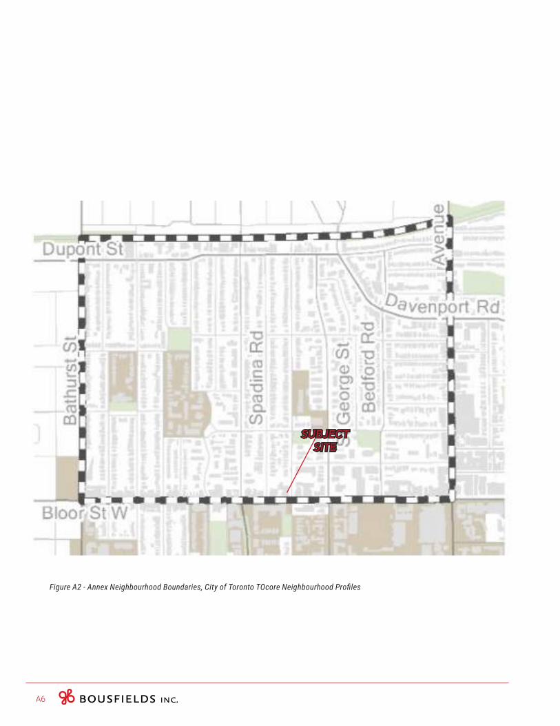
A6
Figure A2 - Annex Neighbourhood Boundaries, City of Toronto TOcore Neighbourhood Profiles
SUBJECTSITE
COMMUNITY SERVICES & FACILITIES STUDY | 300 Bloor Street West and 478 Huron Street A7
2.1 AnnexThe subject site is located within the Annex neighbourhood, as defined by the TOcore study (see Figure A2). The Annex neighbourhood is located north of the University of Toronto campus, west of the Yorkville neighbourhood and northwest of the Bay Corridor in Downtown Toronto. According to the TOcore Neighbourhood Profiles, the Annex neighbourhood is comprised of older housing, with primarily families and single person households. Relative to the Downtown Core, the neighbourhood has the lowest birth rate, a higher than average quantity of young adults in the 20 to 24 years age range, and a higher number of renters. The TOCore Neighbourhood Profiles Report notes that this population is possibly students, with nearly a quarter of employed residents maintaining part-time jobs and 84 percent of renters allocating more than 30 percent of their income to shelter costs.
The following demographic summary is based on the neighbourhood wide profile published in the ‘TOcore Neighbourhood Population Profiles’ report’, which was prepared in part by the City of Toronto in 2016. Neighbourhood characteristics such as population and family composition, housing variety and income are highlighted in these profiles.
The City’s TOcore neighbourhood profiles were built using data from the following data sources: the Census (2006 and 2011), 2011 NHS survey, IntelliHEALTH ONTARIO and the City of Toronto Clerk’s Office. These profiles, which vary slightly from those established by the City of Toronto’s neighbourhood classification system , have incorporated data from a larger network of sources. As the more recent document, the TOcore profile was more conducive to setting the context of the site.
2.2 PopulationThe total population in the Annex neighbourhood increased by approximately 6.0 percent between 2006 and 2011. Comparatively, the City of Toronto and the Downtown Core area grew approximately 4.4 and 19 percent during the same time period, respectively. According to the TOcore report, the Annex neighbourhood ranked twelth overall in terms of the greatest change (percent) in population relative to all Downtown Core neighbourhoods (see Table A1 below).
The vast majority of Annex residents are considered “Working Age” (63.2 percent), followed by “Youth” (16.8 percent) (see Table A2 below). The data indicates that there are fewer Seniors (13.1 percent) and Children (6.7 percent) living in the neighbourhood. When compared to the City of Toronto and the Downtown core, there are several key differences. For instance, the Annex neightbourhood has a higher proportion of youth (16.8 percent), with the City as a whole maintaining a youth population of 12.7 percent. Similar to the Annex, the City is largely made up of Working Age individuals (57.5 percent), however the proportion of Children (15.4 percent) and Seniors (14.4 percent) in the City is greater than which has been reported for the Annex neighbourhood. At the more local scale, the Downtown Core is also comprised of mostly Working Age individuals (67.5 percent). According to the TOcore Profiles report, the Annex neighbourhood has a higher than
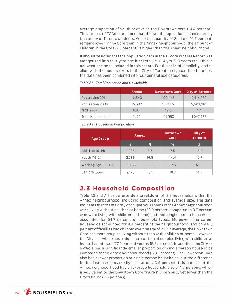
A8
average proportion of youth relative to the Downtown core (14.4 percent). The authors of TOCore presume that this youth population is dominated by University of Toronto students. While the quantity of Seniors (10.7 percent) remains lower in the Core than in the Annex neighbourhood, the amount of children in the Core (7.5 percent) is higher than the Annex neighbourhood.
It should be noted that the population data in the TOcore Profiles Report was categorized into four-year age brackets (i.e. 0-4 yrs, 5-9 years etc.); this is not what has been included in this report. For the sake of simplicity, and to align with the age brackets in the City of Toronto neighbourhood profiles, the data has been combined into four general age categories.
Table A1 - Total Population and Households
Annex Downtown Core City of Toronto
Population 2011 16,540 199,445 2,614,770
Population 2006 15,602 167,559 2,503,281
% Change 6.0% 19.0 4.4
Total Households 9,120 111,950 1,047,935
Table A2 - Household Composition
Age GroupAnnex
Downtown
Core
City of
Toronto
# % % %
Children (0-14) 1,095 6.7 7.5 15.4
Youth (15-24) 2,785 16.8 14.4 12.7
Working Age (25-64) 10,485 63.2 67.5 57.5
Seniors (65+) 2,175 13.1 10.7 14.4
2.3 Household CompositionTable A3 and A4 below provide a breakdown of the households within the Annex neighbourhood, including composition and average size. The data indicates that the majority of couple households in the Annex neighbourhood were living without children at home (20.0 percent compared to 9.7 percent who were living with children at home) and that single person households accounted for 54.7 percent of household types. Moreover, lone parent households accounted for 4.4 percent of the neighbourhood, and only 8.8 percent of families had children over the age of 25. On average, the Downtown Core has more couples living without than with children at home. However, the City as a whole has a higher proportion of couples living with children at home than without (27.5 percent versus 19.8 percent). In addition, the City as a whole has a significantly smaller proportion of single person households compared to the Annex neighbourhood (-23.1 percent). The Downtown Core also has a lower proportion of single person households, but the difference in this instance is markedly less, at only 0.9 percent. It is noted that the Annex neighbourhood has an average household size of 1.7 persons, which is equivalent to the Downtown Core figure (1.7 persons), yet lower than the City’s figure (2.5 persons).
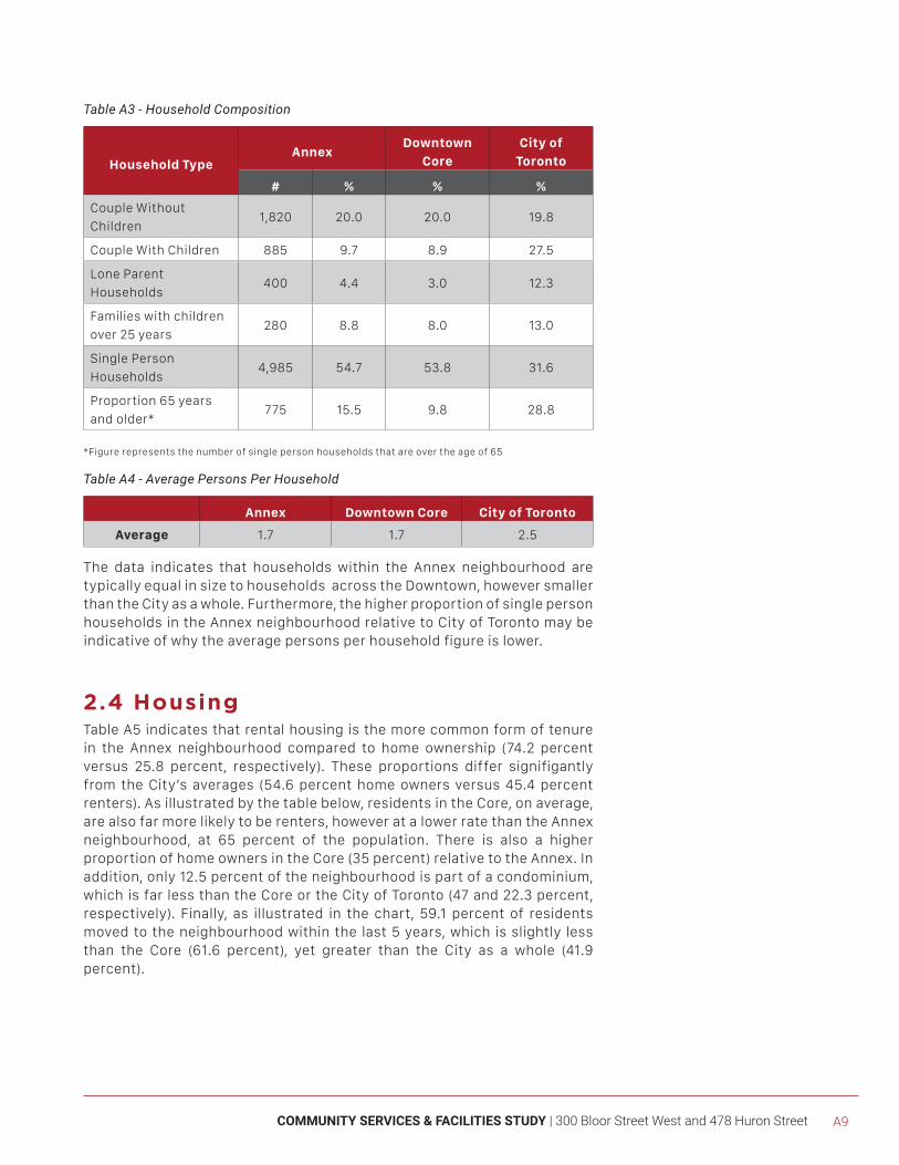
COMMUNITY SERVICES & FACILITIES STUDY | 300 Bloor Street West and 478 Huron Street A9
Table A3 - Household Composition
Household TypeAnnex
Downtown
Core
City of
Toronto
# % % %
Couple Without
Children1,820 20.0 20.0 19.8
Couple With Children 885 9.7 8.9 27.5
Lone Parent
Households400 4.4 3.0 12.3
Families with children
over 25 years280 8.8 8.0 13.0
Single Person
Households 4,985 54.7 53.8 31.6
Proportion 65 years
and older* 775 15.5 9.8 28.8
*Figure represents the number of single person households that are over the age of 65
Table A4 - Average Persons Per Household
Annex Downtown Core City of Toronto
Average 1.7 1.7 2.5
The data indicates that households within the Annex neighbourhood are typically equal in size to households across the Downtown, however smaller than the City as a whole. Furthermore, the higher proportion of single person households in the Annex neighbourhood relative to City of Toronto may be indicative of why the average persons per household figure is lower.
2.4 Housing Table A5 indicates that rental housing is the more common form of tenure in the Annex neighbourhood compared to home ownership (74.2 percent versus 25.8 percent, respectively). These proportions differ signifigantly from the City’s averages (54.6 percent home owners versus 45.4 percent renters). As illustrated by the table below, residents in the Core, on average, are also far more likely to be renters, however at a lower rate than the Annex neighbourhood, at 65 percent of the population. There is also a higher proportion of home owners in the Core (35 percent) relative to the Annex. In addition, only 12.5 percent of the neighbourhood is part of a condominium, which is far less than the Core or the City of Toronto (47 and 22.3 percent, respectively). Finally, as illustrated in the chart, 59.1 percent of residents moved to the neighbourhood within the last 5 years, which is slightly less than the Core (61.6 percent), yet greater than the City as a whole (41.9 percent).
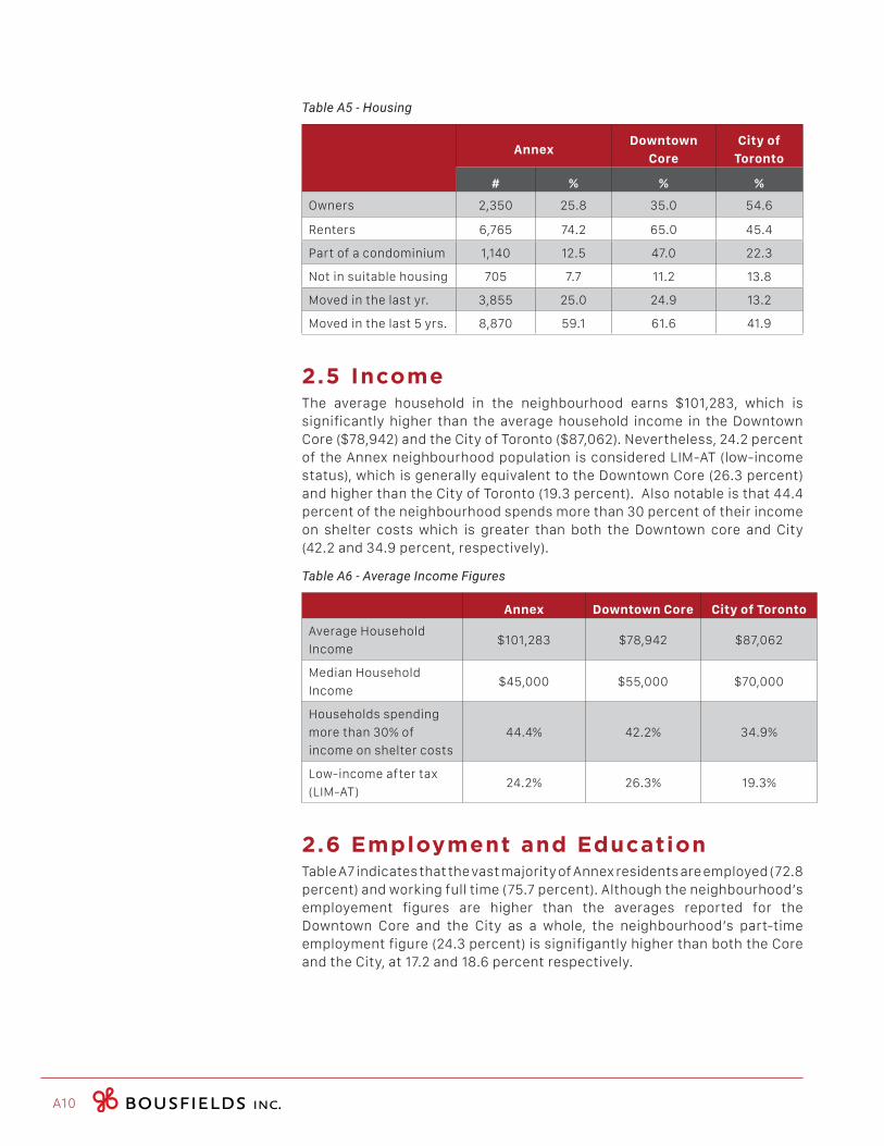
A10
Table A5 - Housing
AnnexDowntown
Core
City of
Toronto
# % % %
Owners 2,350 25.8 35.0 54.6
Renters 6,765 74.2 65.0 45.4
Part of a condominium 1,140 12.5 47.0 22.3
Not in suitable housing 705 7.7 11.2 13.8
Moved in the last yr. 3,855 25.0 24.9 13.2
Moved in the last 5 yrs. 8,870 59.1 61.6 41.9
2.5 IncomeThe average household in the neighbourhood earns $101,283, which is significantly higher than the average household income in the Downtown Core ($78,942) and the City of Toronto ($87,062). Nevertheless, 24.2 percent of the Annex neighbourhood population is considered LIM-AT (low-income status), which is generally equivalent to the Downtown Core (26.3 percent) and higher than the City of Toronto (19.3 percent). Also notable is that 44.4 percent of the neighbourhood spends more than 30 percent of their income on shelter costs which is greater than both the Downtown core and City (42.2 and 34.9 percent, respectively).
Table A6 - Average Income Figures
Annex Downtown Core City of Toronto
Average Household
Income$101,283 $78,942 $87,062
Median Household
Income $45,000 $55,000 $70,000
Households spending
more than 30% of
income on shelter costs
44.4% 42.2% 34.9%
Low-income after tax
(LIM-AT)24.2% 26.3% 19.3%
2.6 Employment and Education Table A7 indicates that the vast majority of Annex residents are employed (72.8 percent) and working full time (75.7 percent). Although the neighbourhood’s employement figures are higher than the averages reported for the Downtown Core and the City as a whole, the neighbourhood’s part-time employment figure (24.3 percent) is signifigantly higher than both the Core and the City, at 17.2 and 18.6 percent respectively.

COMMUNITY SERVICES & FACILITIES STUDY | 300 Bloor Street West and 478 Huron Street A11
Table A7 - Employment and Education
AnnexDowntown
Core
City of
Toronto
# % % %
Participating in the
labour force10,480 72.8 71.4 64.3
Unemployed 845 8.1 8.0 9.3
Worked full time 7,570 75.7 82.8 81.4
Worked part-time 2,430 24.3 17.2 18.6
Adults 25 - 64 without
high school diploma 270 2.7 5.6 10.6
2.7 Immigration & Language Table A8 and A9 indicates that 30.0 percent of the neighbourhood identify as immigrants, with 5.5 percent Annex residents arriving within the last 5 years. In the Annex neighbourhood, less than 14 percent of residents speak another language, other than English, at home.
Table A8 - Immigration Characteristics
AnnexDowntown
Core
City of
Toronto
# % % %
Immigrants 4,665 30.0 39.5 48.6
Recent immigrants
(last 5 years)850 5.5 8.6 8.4
Non-permanent
residents 685 4.4 6.1 2.5
Persons who speak
languages other than
English at home
2,160 13.4 25.8 35.8
Table A9 - Culture and Language Characteristics
Annex Downtown Core City of Toronto
Top 3 countries of origin
(Immigrants)
United States, United
Kingdom, China
China, Philippines,
Great Britain
China, Philippines,
India
Top 3 countries of origin
(Recent Immigrants)
China, Iran, United
States
China, Philippines,
India
Philippines, China,
India
Languages, other than
English, spoken at home
French, Mandarin
Chinese, n.o.s.
Mandarin, Chinese,
n.o.s., Cantonese
Cantonese, Chinese,
n.o.s., Mandarin
A12
2.8 SummaryThe following conclusions can be drawn from the analysis of the demographic information:
• The population of the Annex neighbourhood grew slightly between 2006 and 2011 (approximately 6.6 percent), making it the twelth fastest growing neighbourhood in the Downtown Core;
• Although the majority of Annex residents are of Working Age (63.2 percent), the neighbourhood maintains a greater proportion of Youth than both the Downtown Core and City of Toronto;
• Households are largely made up of single residents (54.7 percent);
• Rental housing is the most common form of tenure in the neighbourhood (74.2 percent) and approximately 59.1 percent of Annex households reported to have moved within the last 5 years;
• Although the average household income in the Annex is higher than the Downtown Core and the City as a whole, a larger proportion of Annex residents are spending more than 30 percent of their income on shelter costs, compared to the Core and the City. Moreover, the Annex neighbourhood has a greater amount of residents within the “low-income after-tax” category than the City of Toronto;
• 24.3 percent of Annex residents are employed on a part-time basis, which is greather than proportions in the Downtown Core and City of Toronto; and
• Fewer Annex residents identify as immigrants, relative to the Downtown Core and City of Toronto.
COMMUNITY SERVICES & FACILITIES STUDY | 300 Bloor Street West and 478 Huron Street A13
[3.0] NEARBY DEVELOPMENT
ACTIVITY
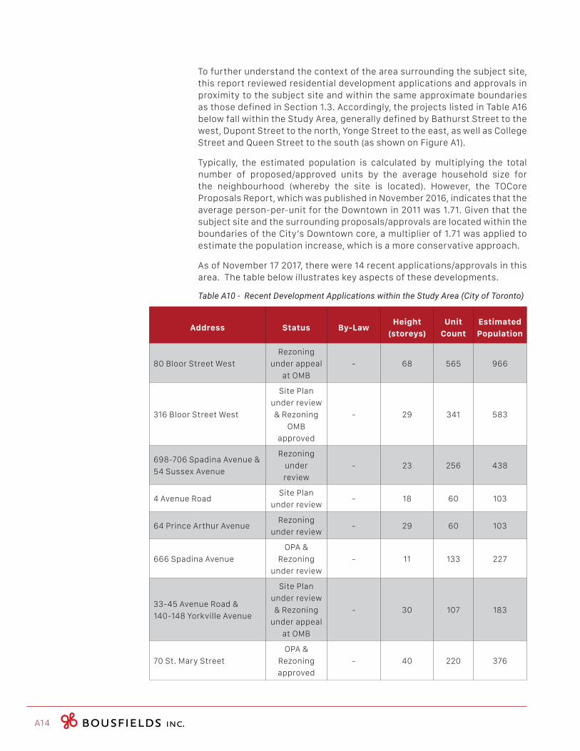
A14
To further understand the context of the area surrounding the subject site, this report reviewed residential development applications and approvals in proximity to the subject site and within the same approximate boundaries as those defined in Section 1.3. Accordingly, the projects listed in Table A16 below fall within the Study Area, generally defined by Bathurst Street to the west, Dupont Street to the north, Yonge Street to the east, as well as College Street and Queen Street to the south (as shown on Figure A1).
Typically, the estimated population is calculated by multiplying the total number of proposed/approved units by the average household size for the neighbourhood (whereby the site is located). However, the TOCore Proposals Report, which was published in November 2016, indicates that the average person-per-unit for the Downtown in 2011 was 1.71. Given that the subject site and the surrounding proposals/approvals are located within the boundaries of the City’s Downtown core, a multiplier of 1.71 was applied to estimate the population increase, which is a more conservative approach.
As of November 17 2017, there were 14 recent applications/approvals in this area. The table below illustrates key aspects of these developments.
Table A10 - Recent Development Applications within the Study Area (City of Toronto)
Address Status By-LawHeight
(storeys)
Unit
Count
Estimated
Population
80 Bloor Street West
Rezoning
under appeal
at OMB
- 68 565 966
316 Bloor Street West
Site Plan
under review
& Rezoning
OMB
approved
- 29 341 583
698-706 Spadina Avenue &
54 Sussex Avenue
Rezoning
under
review
- 23 256 438
4 Avenue RoadSite Plan
under review- 18 60 103
64 Prince Arthur AvenueRezoning
under review- 29 60 103
666 Spadina Avenue
OPA &
Rezoning
under review
- 11 133 227
33‐45 Avenue Road &
140‐148 Yorkville Avenue
Site Plan
under review
& Rezoning
under appeal
at OMB
- 30 107 183
70 St. Mary Street
OPA &
Rezoning
approved
- 40 220 376
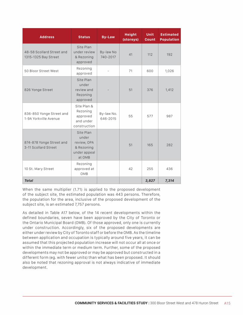
COMMUNITY SERVICES & FACILITIES STUDY | 300 Bloor Street West and 478 Huron Street A15
Address Status By-LawHeight
(storeys)
Unit
Count
Estimated
Population
48-58 Scollard Street and
1315-1325 Bay Street
Site Plan
under review
& Rezoning
approved
By-law No
740-201741 112 192
50 Bloor Street WestRezoning
approved- 71 600 1,026
826 Yonge Street
Site Plan
under
review and
Rezoning
approved
- 51 376 1,412
836-850 Yonge Street and
1-9A Yorkville Avenue
Site Plan &
Rezoning
approved
and under
construction
By-law No.
646-201555 577 987
874-878 Yonge Street and
3-11 Scollard Street
Site Plan
under
review, OPA
& Rezoning
under appeal
at OMB
51 165 282
10 St. Mary Street
Rezoning
approved at
OMB
42 255 436
Total 3,827 7,314
When the same multiplier (1.71) is applied to the proposed development of the subject site, the estimated population was 443 persons. Therefore, the population for the area, inclusive of the proposed development of the subject site, is an estimated 7,757 persons.
As detailed in Table A17 below, of the 14 recent developments within the defined boundaries, seven have been approved by the City of Toronto or the Ontario Municipal Board (OMB). Of those approved, only one is currently under construction. Accordingly, six of the proposed developments are either under review by City of Toronto staff or before the OMB. As the timeline between application and occupation is typically around five years, it can be assumed that this projected population increase will not occur all at once or within the immediate term or medium term. Further, some of the proposed developments may not be approved or may be approved but constructed in a different form (eg. with fewer units) than what has been proposed. It should also be noted that rezoning approval is not always indicative of immediate development.
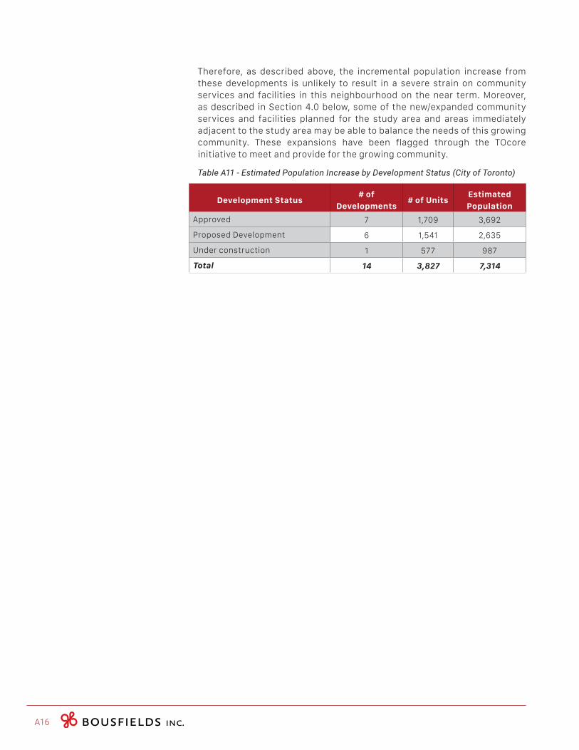
A16
Therefore, as described above, the incremental population increase from these developments is unlikely to result in a severe strain on community services and facilities in this neighbourhood on the near term. Moreover, as described in Section 4.0 below, some of the new/expanded community services and facilities planned for the study area and areas immediately adjacent to the study area may be able to balance the needs of this growing community. These expansions have been flagged through the TOcore initiative to meet and provide for the growing community.
Table A11 - Estimated Population Increase by Development Status (City of Toronto)
Development Status# of
Developments# of Units
Estimated
Population
Approved 7 1,709 3,692
Proposed Development 6 1,541 2,635
Under construction 1 577 987
Total 14 3,827 7,314
COMMUNITY SERVICES & FACILITIES STUDY | 300 Bloor Street West and 478 Huron Street A17
[4.0] CITY INITIATED
COMMUNITY SERVICES & FACILITY STUDIES
A18
4.1 TOcore Community Services & Facilities Study - Phase 1
In 2014, the City of Toronto lauched it’s comprehensive planning review of the Downtown Core, formally known as ‘TOcore’. The purpose of this exercise is to determine how future growth will be accommodated, shaped and managed in the Core, as well as what physical and social infrastructure will be needed to ensure a healthy and livable downtown. Furthermore, this investigation explores where this additional infrastructure will go, and how it will be secured by the City. The boundaries of TOcore are: the rail corridor and Rosedale Valley Road to the north, the Don River to the east, Lake Ontario to the south and Bathurst Street to the west.
The TOcore Community Services & Facilities Study, Phase 1 - Taking Stock, was issued in March of 2016. This study completed a comprehensive review and inventory of services available in and to the 16 neighbourhoods comprising Toronto’s Downtown core. The purpose of this review was to identify the service and facility needs and gaps in the Downtown core, and to suggest priorities and opportunities for securing new facilities or improvements to existing facilities.
The two priorities that emerged from Phase 1 of the CS&F include:
• The need for affordable, appropriate and accessible space; and
• The need to develop innovative partnerships and collaborations to meet the challenges of growth in the Downtown.
In addition to these key priorities, the report identified 27 opportunities for new facilities or improvements to existing facilities. Although two minor improvement areas were identified (see Figure A4), no major capital improvements or future opportunity sites were explored in the Study Area. A brief description of these minor capital improvements is provided below.
Minor Capital Improvements
City Hall and Yorkville Library branches: the Study indicates that minor capital improvements to these branches may include, among other things, barrier free and information technology upgrades, the creation of flexible spaces for additional programming and special event space to address increased community needs. The Study further indicates that these library facilities may have existing capital funding, however additional funding may also be required through such mechanisms as Section 37 development agreements.
4.2 TOcore Proposals Report The ‘TOcore Proposals Report’ was released in November 2016. The report included 128 proposed policy directions that are intended to contribute to the development of the Proposed Downtown Secondary Plan. During the Council meeting on December 13, 2016, Council authorized Planning Staff to start stakeholder and public consultation for the policy directions outlined in the report.
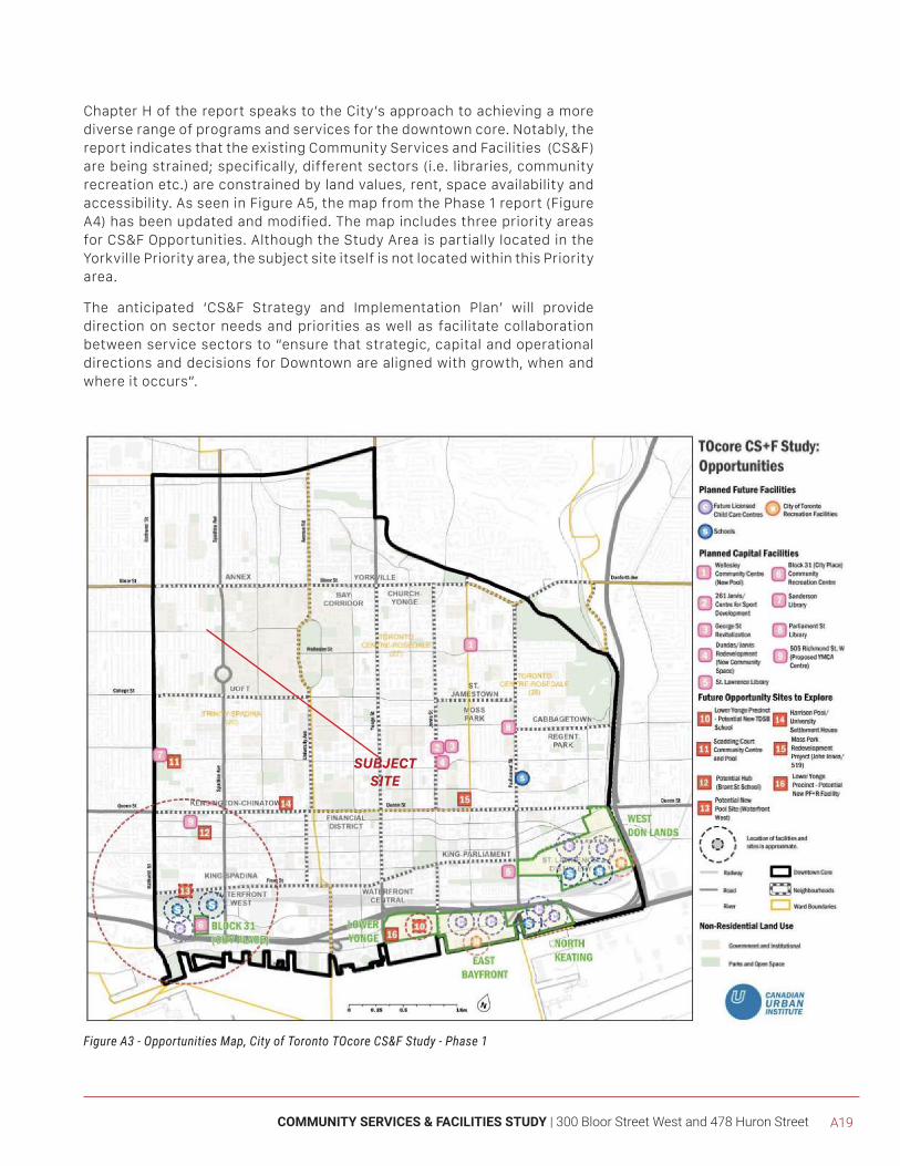
COMMUNITY SERVICES & FACILITIES STUDY | 300 Bloor Street West and 478 Huron Street A19
Figure A3 - Opportunities Map, City of Toronto TOcore CS&F Study - Phase 1
SUBJECTSITE
Chapter H of the report speaks to the City’s approach to achieving a more diverse range of programs and services for the downtown core. Notably, the report indicates that the existing Community Services and Facilities (CS&F) are being strained; specifically, different sectors (i.e. libraries, community recreation etc.) are constrained by land values, rent, space availability and accessibility. As seen in Figure A5, the map from the Phase 1 report (Figure A4) has been updated and modified. The map includes three priority areas for CS&F Opportunities. Although the Study Area is partially located in the Yorkville Priority area, the subject site itself is not located within this Priority area.
The anticipated ‘CS&F Strategy and Implementation Plan’ will provide direction on sector needs and priorities as well as facilitate collaboration between service sectors to “ensure that strategic, capital and operational directions and decisions for Downtown are aligned with growth, when and where it occurs”.
A20
4.3 Proposed Downtown PlanIn August 2017, City Planning released a draft of the Proposed Downtown Secondary Plan. Section 9 of the Plan speaks to the enhancement of Community Services and Facilities, which play a distinct and separate role from private amenity spaces that are required in any new development. As described, these publicly accessible facilities provide a wide range of programs and services for individuals and local community groups, and serve residents and workers from across the city and the GTA. Policy 9.1 notes that the Downtown CS&F Strategy will identify community space and facility needs, set priorities to support future growth by sector and geography, and guide development review and the allocation of capital funding. The Downtown CS&F will be reviewed every five years. Following therefrom, proposed Policy 9.3 states that development applications are to address the identified priorities for CS&Fs by providing new expanded or retrofitted space for a specific community facility on-site or off-site, or will make a contribution towards a specific CS&F that meets the neighbourhood’s identified needs. Proposed policies 9.4-9.10 provide the following:
• Development that will generate large numbers of residents and workers will be prioritized for on-site provision of community services and facilities infrastructure;
• Development will replace the total gross floor area of any existing community services and facilities to ensure no-net-loss of community space;
• Development that is phased should include required on-site facilities as part of the first phase of development;
• Development is encouraged to provide space for community-based, non-profit agencies that is eligible for the City’s Community Space Tenancy Policy;
• Development will include a child care centre where it can be accommodated on the site;
• Where existing community services and facilities are insufficient to serve the proposed population, a Holding By-law may be utilized to ensure that the facilities, as defined in the Downtown CS&F and Service and Facility Plans, are provided concurrently with growth; and
• Development may be required to provide temporary facilities that will serve the population until such time as permanent facilities are built, where appropriate.
The proposed Plan also encourages partnerships to provide community services and facilities to supplement the supply of City-owned facilities.
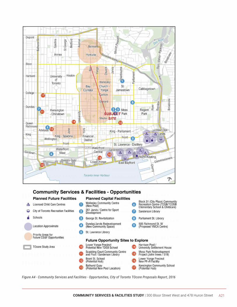
COMMUNITY SERVICES & FACILITIES STUDY | 300 Bloor Street West and 478 Huron Street A21
Figure A4 - Community Services and Facilities - Opportunities, City of Toronto TOcore Proposals Report, 2016
SUBJECTSITE
A22
Subsequest to the release of the Proposed Downtown Secondary Plan, on September 7, 2017, the Planning and Growth Management (PGM) Committee recommended that City Council direct the Chief Planner and Executive Director to use the Proposed Downtown Plan as a basis for stakeholder and public consultation. In addition to adopting PGM’s recommendations, during their October 2-4, 2017 meeting, Council adopted the following directives for the Chief Planner and Executive Director and Planning staff:
1) Undertake stakeholder and public consultation on the proposed Downtown Plan;
2) Report back with a final Recommendations Report and an Official Plan Amendment on the Downtown Plan at the Spring 2018 PGM meeting
3) As part of the final Recommendation Report, report on how to support the retention and expansion of the major health institutions, including, on institution outlined in Section 5.6 of this inventory (the Centre for Addiction and Mental Health (CAMH) on College Street)
4) Coordinate interdepartmentally with staff to make recommendations for future work to implement strategies, such as capital approvals;
5) Consider the Proposed Downtown Plan policies during the evaluation of current and future development applications in the Downtown Plan area and continue to refine the policies through stakeholder consultation
Accordingly, the subject site may benefit slightly from existing and planned CS&Fs in the Downtown Core, in particular the minor capital improvements identified in Section 4.1 above, as well as the existing CS&Fs on the subject site and the surrounding neighbourhood, as identified in Section 5.0.
COMMUNITY SERVICES & FACILITIES STUDY | 300 Bloor Street West and 478 Huron Street A23
[5.0] COMMUNITY SERVICES &
FACILITIES
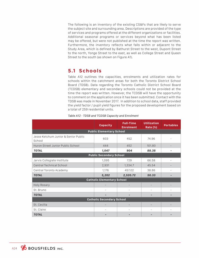
A24
The following is an inventory of the existing CS&Fs that are likely to serve the subject site and surrounding area. Descriptions are provided of the type of services and programs offered at the different organizations or facilities. Additional seasonal programs or services beyond what has been listed may be offered, but were not published at the time the report was written. Furthermore, the inventory reflects what falls within or adjacent to the Study Area, which is defined by Bathurst Street to the west, Dupont Street to the north, Yonge Street to the east, as well as College Street and Queen Street to the south (as shown on Figure A1).
5.1 SchoolsTable A12 outlines the capacities, enrolments and utilization rates for schools within the catchment areas for both the Toronto District School Board (TDSB). Data regarding the Toronto Catholic District School Board (TCDSB) elementary and secondary schools could not be provided at the time the report was written. However, the TCDSB will have the opportunity to comment on the application once it has been submitted. Contact with the TDSB was made in November 2017. In addition to school data, staff provided the yield factor / pupil yield figures for the proposed development based on a total of 259 residential units.
Table A12 - TDSB and TCDSB Capacity and Enrolment
CapacityFull-Time
Enrolment
Utilization
Rate (%)Portables
Public Elementary School
Jesse Ketchum Junior & Senior Public
School603 452 74.96 -
Huron Street Junior Public School 444 452 101.80 -
TOTAL 1,047 904 88.38 -
Public Secondary School
Jarvis Collegiate Institute 1,095 729 66.58 -
Central Technical School 2,931 1,334.7 45.54 -
Central Toronto Academy 1,176 457.02 38.86 -
TOTAL 5,202 2,520.72 50.33 -
Catholic Elementary School
Holy Rosary - - - -
St. Bruno - - - -
TOTAL - - - -
Catholic Secondary School
St. Cecilia - - - -
St. Claire - - - -
TOTAL - - - -
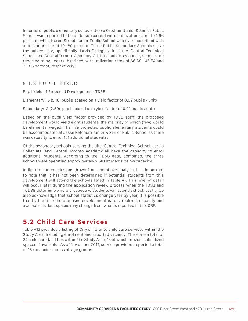
COMMUNITY SERVICES & FACILITIES STUDY | 300 Bloor Street West and 478 Huron Street A25
In terms of public elementary schools, Jesse Ketchum Junior & Senior Public School was reported to be undersubscribed with a utilization rate of 74.96 percent, while Huron Street Junior Public School was oversubscribed with a utilization rate of 101.80 percent. Three Public Secondary Schools serve the subject site, specifically Jarvis Collegiate Institute, Central Technical School and Central Toronto Academy. All three public secondary schools are reported to be undersubscribed, with utilization rates of 66.58, 45.54 and 38.86 percent, respectively.
5 . 1 . 2 P U P I L Y I E L D
Pupil Yield of Proposed Development - TDSB
Elementary: 5 (5.18) pupils (based on a yield factor of 0.02 pupils / unit)
Secondary: 3 (2.59) pupil (based on a yield factor of 0.01 pupils / unit)
Based on the pupil yield factor provided by TDSB staff, the proposed development would yield eight students, the majority of which (five) would be elementary-aged. The five projected public elementary students could be accommodated at Jesse Ketchum Junior & Senior Public School as there was capacity to enrol 151 additional students.
Of the secondary schools serving the site, Central Technical School, Jarvis Collegiate, and Central Toronto Academy all have the capacity to enrol additional students. According to the TDSB data, combined, the three schools were operating approximately 2,681 students below capacity.
In light of the conclusions drawn from the above analysis, it is important to note that it has not been determined if potential students from this development will attend the schools listed in Table A7. This level of detail will occur later during the application review process when the TDSB and TCDSB determine where prospective students will attend school. Lastly, we also acknowledge that school statistics change year by year, it is possible that by the time the proposed development is fully realized, capacity and available student spaces may change from what is reported in this CSF.
5.2 Child Care ServicesTable A13 provides a listing of City of Toronto child care services within the Study Area, including enrolment and reported vacancy. There are a total of 24 child care facilities within the Study Area, 13 of which provide subsidized spaces if available. As of November 2017, service providers reported a total of 15 vacancies across all age groups.
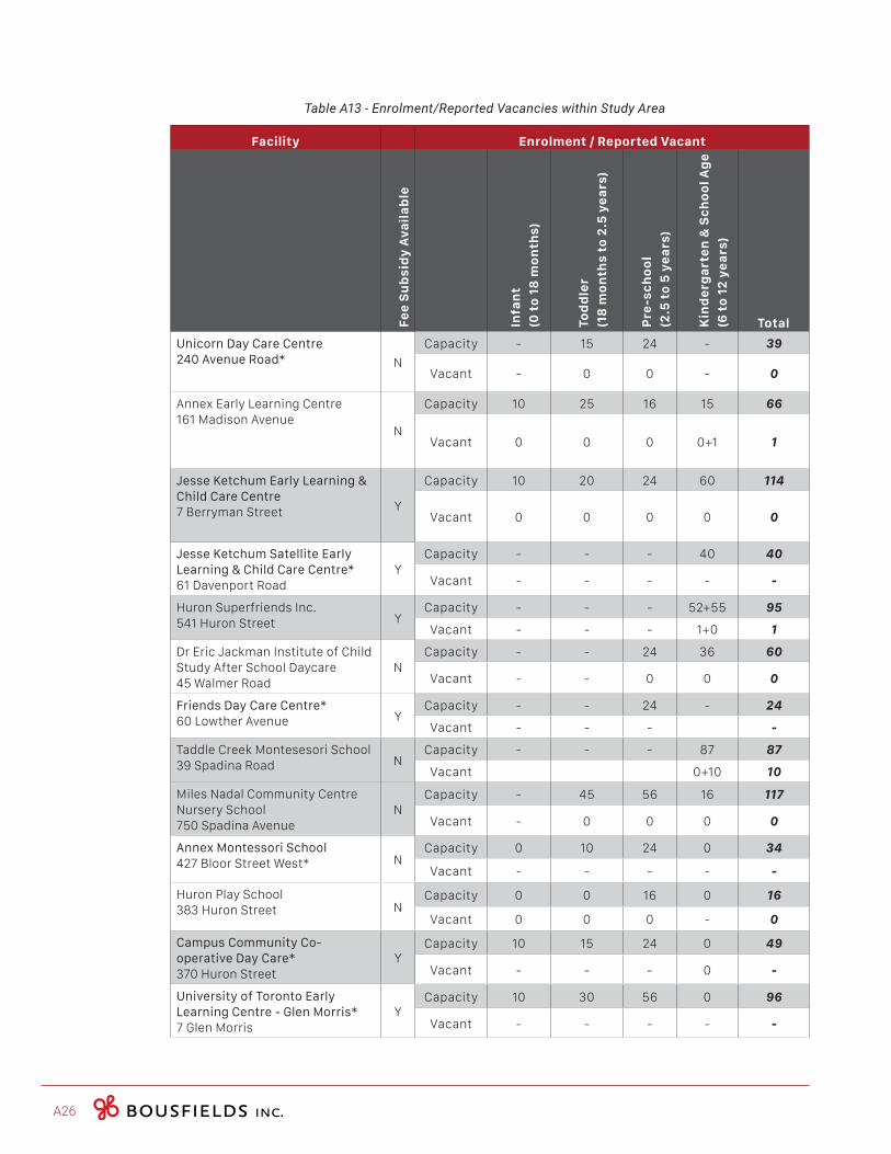
A26
Table A13 - Enrolment/Reported Vacancies within Study Area
Facility Enrolment / Reported Vacant
Fe
e S
ub
sid
y A
va
ila
ble
Infa
nt
(0 t
o 1
8 m
on
ths)
Tod
dle
r
(18
mo
nth
s to
2.5
ye
ars
)
Pre
-sc
ho
ol
(2.5
to
5 y
ea
rs)
Kin
de
rga
rte
n &
Sc
ho
ol A
ge
(6 t
o 1
2 y
ea
rs)
Total
Unicorn Day Care Centre240 Avenue Road* N
Capacity - 15 24 - 39
Vacant - 0 0 - 0
Annex Early Learning Centre161 Madison Avenue
N
Capacity 10 25 16 15 66
Vacant 0 0 0 0+1 1
Jesse Ketchum Early Learning & Child Care Centre7 Berryman Street Y
Capacity 10 20 24 60 114
Vacant 0 0 0 0 0
Jesse Ketchum Satellite Early Learning & Child Care Centre*61 Davenport Road
YCapacity - - - 40 40
Vacant - - - - -
Huron Superfriends Inc.541 Huron Street Y
Capacity - - - 52+55 95
Vacant - - - 1+0 1
Dr Eric Jackman Institute of Child Study After School Daycare45 Walmer Road
NCapacity - - 24 36 60
Vacant - - 0 0 0
Friends Day Care Centre*60 Lowther Avenue Y
Capacity - - 24 - 24
Vacant - - - -
Taddle Creek Montesesori School39 Spadina Road N
Capacity - - - 87 87
Vacant 0+10 10
Miles Nadal Community Centre Nursery School750 Spadina Avenue
NCapacity - 45 56 16 117
Vacant - 0 0 0 0
Annex Montessori School427 Bloor Street West* N
Capacity 0 10 24 0 34
Vacant - - - - -
Huron Play School383 Huron Street N
Capacity 0 0 16 0 16
Vacant 0 0 0 - 0
Campus Community Co-operative Day Care*370 Huron Street
YCapacity 10 15 24 0 49
Vacant - - - 0 -
University of Toronto Early Learning Centre - Glen Morris*7 Glen Morris
YCapacity 10 30 56 0 96
Vacant - - - - -
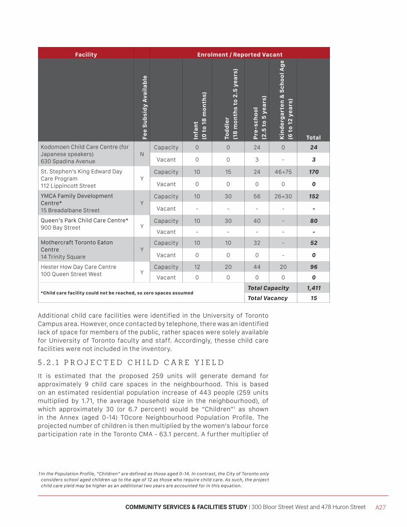
COMMUNITY SERVICES & FACILITIES STUDY | 300 Bloor Street West and 478 Huron Street A27
Facility Enrolment / Reported Vacant
Fe
e S
ub
sid
y A
va
ila
ble
Infa
nt
(0 t
o 1
8 m
on
ths)
Tod
dle
r
(18
mo
nth
s to
2.5
ye
ars
)
Pre
-sc
ho
ol
(2.5
to
5 y
ea
rs)
Kin
de
rga
rte
n &
Sc
ho
ol A
ge
(6 t
o 1
2 y
ea
rs)
Total
Kodomoen Child Care Centre (for Japanese speakers) 630 Spadina Avenue
NCapacity 0 0 24 0 24
Vacant 0 0 3 - 3
St. Stephen’s King Edward Day Care Program112 Lippincott Street
YCapacity 10 15 24 46+75 170
Vacant 0 0 0 0 0
YMCA Family Development Centre*15 Breadalbane Street
YCapacity 10 30 56 26+30 152
Vacant - - - - -
Queen’s Park Child Care Centre*900 Bay Street Y
Capacity 10 30 40 - 80
Vacant - - - - -
Mothercraft Toronto Eaton Centre14 Trinity Square
YCapacity 10 10 32 - 52
Vacant 0 0 0 - 0
Hester How Day Care Centre100 Queen Street West Y
Capacity 12 20 44 20 96
Vacant 0 0 0 0 0
*Child care facility could not be reached, so zero spaces assumedTotal Capacity 1,411
Total Vacancy 15
Additional child care facilities were identified in the University of Toronto Campus area. However, once contacted by telephone, there was an identified lack of space for members of the public, rather spaces were solely available for University of Toronto faculty and staff. Accordingly, thesse child care facilities were not included in the inventory.
5 . 2 . 1 P R O J E C T E D C H I L D C A R E Y I E L D
It is estimated that the proposed 259 units will generate demand for approximately 9 child care spaces in the neighbourhood. This is based on an estimated residential population increase of 443 people (259 units multiplied by 1.71, the average household size in the neighbourhood), of which approximately 30 (or 6.7 percent) would be “Children”1 as shown in the Annex (aged 0-14) TOcore Neighbourhood Population Profile. The projected number of children is then multiplied by the women’s labour force participation rate in the Toronto CMA - 63.1 percent. A further multiplier of
1InthePopulationProfile,“Children”aredefinedasthoseaged0-14.Incontrast,theCityofTorontoonlyconsidersschoolagedchildrenuptotheageof12asthosewhorequirechildcare.Assuch,theprojectchildcareyieldmaybehigherasanadditionaltwoyearsareaccountedforinthisequation.
A28
50 percent is used to approximate the number of children needing care at a child care centre. This is the level of service standard set out by the City’s Children’s Services Division and is consistently applied to development applications.
As compared with Table A7 above, the projected number of children generated from the proposed development who will require child care (9 children) may be accommodated by the existing facilities serving the area. Within the Study Area, there are 15 child care spaces available. However, it is acknowledged that the ages of the projected nine children is, at this time, unknown. As previously mentioned, the available child care spaces are unevenly distributed across all age groups, with some having more than others. For example, our sample of child care providers revealed that there are currently zero infant and toddler spaces available for the entire Study Area and while there are three pre-schools spaces vacant, these spaces are in a Japanese language Child Care Centre where English language services do not exist.
TOcore: Child Care & School Sector Services & Facilities
Despite the rapid development and population increase of the Downtown, many schools remain underutilized and can accommodate projected enrollments in the Downtown. In terms of emerging priorities, both the TDSB and TCDSB are finding it challenging to meet the diverse needs of students and families who require a range of services such as language education, settlement services, translation services, health care, food banks, mental health care and after school child care. In addition, the aging school facilities were also noted as a concern for both of the boards. Child care is becoming a critical issue for schools. Many of the community agencies surveyed raised the need to explore the opportunity to use underutilized schools as child care hubs to service a number of nearby schools.
In terms of the child care sector, the TOcore CS&F report found that there are not enough child care spaces in the Downtown to accommodate the children who need it, specifically infants and toddlers. In addition, it was reported that there are very few child care spaces in some neighbourhoods in the downtown. As a result, these neighbourhoods may require additional child care capacity. The report notes that the majority of babies born to parents living in the Downtown in the period between January 2011 and August 2014 were born to parents living in the Bay Corridor (1,030) which is part of the Study Area.
In terms of emerging priorities, increasing licensed child care capacity in Toronto is outlined as a priority for City of Toronto Children’s Services over the next five years.
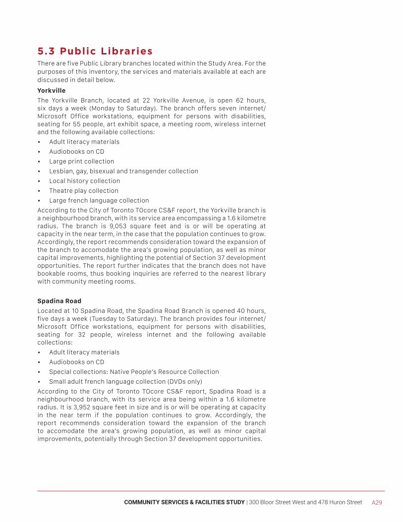
COMMUNITY SERVICES & FACILITIES STUDY | 300 Bloor Street West and 478 Huron Street A29
5.3 Public LibrariesThere are five Public Library branches located within the Study Area. For the purposes of this inventory, the services and materials available at each are discussed in detail below.
Yorkville
The Yorkville Branch, located at 22 Yorkville Avenue, is open 62 hours, six days a week (Monday to Saturday). The branch offers seven internet/ Microsoft Office workstations, equipment for persons with disabilities, seating for 55 people, art exhibit space, a meeting room, wireless internet and the following available collections:
• Adult literacy materials
• Audiobooks on CD
• Large print collection
• Lesbian, gay, bisexual and transgender collection
• Local history collection
• Theatre play collection
• Large french language collection
According to the City of Toronto TOcore CS&F report, the Yorkville branch is a neighbourhood branch, with its service area encompassing a 1.6 kilometre radius. The branch is 9,053 square feet and is or will be operating at capacity in the near term, in the case that the population continues to grow. Accordingly, the report recommends consideration toward the expansion of the branch to accomodate the area’s growing population, as well as minor capital improvements, highlighting the potential of Section 37 development opportunities. The report further indicates that the branch does not have bookable rooms, thus booking inquiries are referred to the nearest library with community meeting rooms.
Spadina Road
Located at 10 Spadina Road, the Spadina Road Branch is opened 40 hours, five days a week (Tuesday to Saturday). The branch provides four internet/ Microsoft Office workstations, equipment for persons with disabilities, seating for 32 people, wireless internet and the following available collections:
• Adult literacy materials
• Audiobooks on CD
• Special collections: Native People’s Resource Collection
• Small adult french language collection (DVDs only)
According to the City of Toronto TOcore CS&F report, Spadina Road is a neighbourhood branch, with its service area being within a 1.6 kilometre radius. It is 3,952 square feet in size and is or will be operating at capacity in the near term if the population continues to grow. Accordingly, the report recommends consideration toward the expansion of the branch to accomodate the area’s growing population, as well as minor capital improvements, potentially through Section 37 development opportunities.
A30
City Hall Branch
Located in Nathan Phillips Square (100 Queen Street West), City Hall Library Branch is open 40 hours, five days a week (Monday to Friday). The branch provides nine internet/ Microsoft Office workstations, equipment for persons with disabilities, seating for 50 people, wireless internet and the following available collections:
• Audiobooks on CD
• Large print collection
• Large collection in Chinese
• Small adult french language collection (DVDs only)
According to the City of Toronto TOcore CS&F report, the branch is co-located with City Hall and 5,074 square feet in size. Toronto Public Library (TPL) staff identified a high demand for select programs at the library since 2014, noting that this reflects the changing demographics in the Downtown. For instance, the report highlights that there are waitlists for the Babytime (Ready for Reading Preschool Program) and Brown Bag Lunch Time Book Club since 2014 at the City Hall Branch.
The report indicates that the branch is or will be operating at capacity in the near term if the population continues to grow. Accordingly, the report recommends consideration toward the expansion of the branch to accomodate the area’s growing population, as well as minor capital improvements through Section 37 development opportunities. The report adds that the branch does not have bookable rooms, thus booking inquiries are referred to the nearest library with community meeting rooms.
Lillian H. Smith Branch
Lillian H. Smith Branch, located at 239 College Street, is open 69 hours, seven days a week. The branch provides 34 internet/ Microsoft Office workstations, a Computer Learning Centre including 12 computers, a scanner, equipment for persons with disabilities, seating for 110 people, wireless internet and the following available collections:
• Adult literacy materials
• Audiobooks on CD
• Career information collection
• English as a Second Language (ESL) collection
• Large print collection
• Local history collection
• Newcomer information service
• Marguerite G. Bagshaw Special Collection for puppetry creative drama and theatre for children
• Osborne Collection of Early Children’s Books
• Large collection in Chinese
• Medium adult collection in French (DVDs only)
• Small collection in Vitenamese
COMMUNITY SERVICES & FACILITIES STUDY | 300 Bloor Street West and 478 Huron Street A31
According to the City of Toronto TOcore CS&F report, the branch provides meeting space. It is also the District branch for the Downtown, meaning that its role is to provide extensive collections and services to a diverse population by offering more in-depth resources than neighbourhood libraries, such as Yorkville or Spadina Road branches. Their service area is larger, at a 2.5 kilometre radius. The branch occupies the first, second and part of the third floor of a four-storey 38,935 square foot building.
The report indicates that TPL staff have identified a need for more space for collections, community and program spaces, collaborative learning and meeting spaces, quiet study/work areas and seating at this branch. It further notes that branch seating is heavily used, with an estimate of up to 75 percent of computer room seating occupied by vulnerable populations. The report recommends minor capital improvements to the branch, potentially through Section 37 development opportunities.
TOcore: Library Services & Facilities
Overall, the libraries within the Downtown Core were found to be well used, according to the TOCore CS&F report. The majority of residents within the Downtown Core were reported to be located within 1 kilometre of a library, or within the 1.6 kilometre service delivery catchment area established by the Toronto Public Library. According to the report, some of the challenges and pressures related to programming, services, facilities and space include:
• the need for additional resources for users with mental health issues and addictions;
• the need for more technology access in the libraries and in the greater community areas; and
• improvements to meeting spaces at some libraries to make them more appealing for community use.
The report also includes examples of programs that are in high demand. These include: Babytime (Ready for Reading Pre-school Program), Digital Innovation Hub programming and book clubs. For the Downtown as a whole, some of the emerging priorities with respect to libraries include:
• enhancement and expansion of community partnerships;
• expansion of library services beyond branch locations;
• integration of community services; and
• programs and spaces used by small business owners
2BasedonBousfiedsInc.Calculations
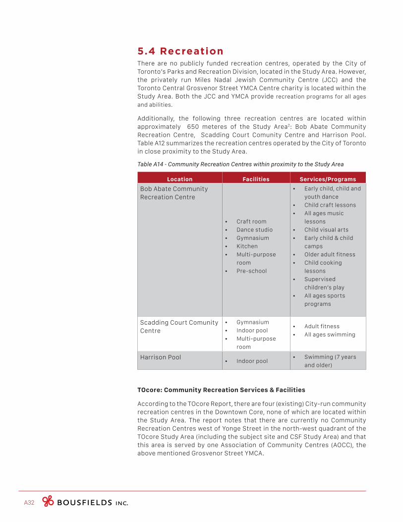
A32
5.4 Recreation There are no publicly funded recreation centres, operated by the City of Toronto’s Parks and Recreation Division, located in the Study Area. However, the privately run Miles Nadal Jewish Community Centre (JCC) and the Toronto Central Grosvenor Street YMCA Centre charity is located within the Study Area. Both the JCC and YMCA provide recreation programs for all ages
and abilities.
Additionally, the following three recreation centres are located within approximately 650 meteres of the Study Area2: Bob Abate Community Recreation Centre, Scadding Court Comunity Centre and Harrison Pool. Table A12 summarizes the recreation centres operated by the City of Toronto in close proximity to the Study Area.
Table A14 - Community Recreation Centres within proximity to the Study Area
Location Facilities Services/Programs
Bob Abate Community Recreation Centre
• Craft room
• Dance studio
• Gymnasium
• Kitchen
• Multi-purpose
room
• Pre-school
• Early child, child and
youth dance
• Child craft lessons
• All ages music
lessons
• Child visual arts
• Early child & child
camps
• Older adult fitness
• Child cooking
lessons
• Supervised
children’s play
• All ages sports
programs
Scadding Court Comunity Centre
• Gymnasium
• Indoor pool
• Multi-purpose
room
• Adult fitness
• All ages swimming
Harrison Pool• Indoor pool
• Swimming (7 years
and older)
TOcore: Community Recreation Services & Facilities
According to the TOcore Report, there are four (existing) City-run community recreation centres in the Downtown Core, none of which are located within the Study Area. The report notes that there are currently no Community Recreation Centres west of Yonge Street in the north-west quadrant of the TOcore Study Area (including the subject site and CSF Study Area) and that this area is served by one Association of Community Centres (AOCC), the above mentioned Grosvenor Street YMCA.
COMMUNITY SERVICES & FACILITIES STUDY | 300 Bloor Street West and 478 Huron Street A33
The report indicates AOCCs are larger multi-service centres, operated by independent, not-for-profit community-based organizations that provide a wide variety of human and social services to the local community. It adds that AOCCs are experiencing barriers to maintaining the same level of service and performance due to mounting pressure and demand for service. The report further notes that there is no long-term capital strategy for AOCCs, as their current funding practices only provides for state of good repair.
With respect to the broader Downtown Core, the report findings indicate that as of 2012, community centres were offering 995 programs, amounting to a total of 5,343 registrations. Moreover, there were approximately 2,205 people on wait lists for City-run programs in the Core. The programs with the fewest registrations were clubs, while swimming had the highest of all the programs (1,064 registrations). The majority of registrations were for children (aged 6-12), followed by early-child (0-5). Older adults (60+) had the lower registration rates of all age groups.
The report found that programs offered at the City-run centres in the Core often book up quickly, likely a result of the programs being free of charge. Programs such as the after-school learning, camps (+4 years old) and aquatics were identified as being in “very high demand” with long waiting lists. The report found that these centers could provide more therapeutic programs for the aging population, while finding the programming opportunities to attract youth including free Wi-Fi, TTC tokens, snacks and more arts and cultural programs.
The report notes that the Parks, Forestry and Recreation department strives to deliver services and facilities in areas of the Core that are highly visible, transit-oriented or can be integrated into existing or new developments. These facilities must have accessible amenities, offer flexible spaces that can be adapted to accommodate changing interests and trends, provide for a range of programming that appeal to all ages and abilities and provide functional space for targeted populations. Similarly, staff must continue to address opportunities to improve access and building comfort to existing assets through retrofits and programming. The report spoke to the potential for locations (existing or proposed new developments) within the TOcore Area to be renovated, redeveloped, and redesigned so that they may accommodate aquatic, gymnasiums and program spaces. With respect to emerging priorities, the report found that the Downtown is in need for a full range of City recreation spaces, such as gymnasiums, aquatic and ice facilities and community, programming, youth and after school spaces.
In regard to AOCC facilities, the report indicates that there is a need for AOCC specific programs, amenities and design considerations to accomodate older adults, youth, children and transgender clients, as well as vulnerable populations and new immigrants. The report highlights that AOCCs are challenged by the lack of affordable programmable space that can meet service pressures and changing local community needs. Moreover, high rents in the Downtown are preventing AOCCs from securing and establishing welcoming, usable and programmable space. It notes that although shared-space arrangements are used whenever possible, these spaces restrict AOCCs capacity to create flexible spaces to serve their client’s needs. Furthermore, the report finds that AOCC facilities need substantial retrofits and potential building expansions, in addition to measures to address increased demand for programs and services due to the growth their facilities are experiencing.
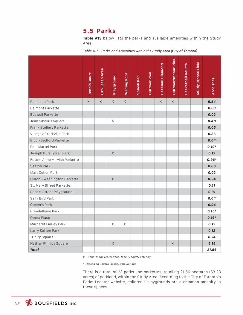
A34
5.5 ParksTable A13 below lists the parks and available amenities within the Study Area.
Table A15 - Parks and Amenities within the Study Area (City of Toronto)
Ten
nis
Co
urt
Off
-Le
as
h A
rea
Pla
yg
rou
nd
Wa
din
g P
oo
l
Sp
las
h P
ad
Ou
tdo
or
Po
ol
Ba
se
ba
ll D
iam
on
d
Ou
tdo
or/
Ind
oo
r R
ink
Ba
sk
etb
all
Co
urt
s
Mu
ltip
urp
os
e F
ield
Are
a (
ha
)
Ramsden Park X X X X X X 5.54
Belmont Parkette 0.03
Boswell Parkette 0.02
Jean Sibelius Square X 0.48
Frank Stollery Parkette 0.05
Village of Yorkville Park 0.36
Bloor-Bedford Parkette 0.04
Paul Martel Park 0.10*
Joseph Burr Tyrrell Park X 0.12
Ed and Anne Mirvish Parkette 0.96*
Seaton Park 0.06
Matt Cohen Park 0.02
Huron - Washington Parkette X 0.24
St. Mary Street Parkette 0.11
Robert Street Playground 0.01
Sally Bird Park 0.04
Queen’s Park 6.94
Breadalbane Park 0.15*
Opera Place 0.16*
Margaret Fairley Park X X 0.12
Larry Sefton Park 0.12
Trinity Square 0.74
Nathan Phillips Square X X 5.15
Total 21.56
X–Denotestherecreationalfacilityand/oramenity.
*-BasedonBousfieldsInc.Calculations
There is a total of 23 parks and parkettes, totalling 21.56 hectares (53.28 acres) of parkland, within the Study Area. According to the City of Toronto’s Parks Locator website, children’s playgrounds are a common amenity in these spaces.
COMMUNITY SERVICES & FACILITIES STUDY | 300 Bloor Street West and 478 Huron Street A35
5.6 Hospitals There are four hospitals located within the Study Area. The services provided are described below:
Centre for Addiction and Mental Health (CAMH) - College Street Site , located at 250 College Street, is both a mental health and addiction facility as well as a teaching hospital. CAMH offers comprehensive and accessible care which includes, but not limited to: clinical and rehabilitation programs, assessment and family support services, brief early intervention, day treatment and residential programs. As a teaching hospital, CAMH works with a wide range of professionals in the health care field to offer practical and clinical experience. The College Street location houses CAMH’s 24/7 ‘Psychiatric Emergency Department’, which provides emergency treatment and assessment services, as well as extended observation services for adults.
Women’s College Hospital is located at 76 Grenville Street. In addition to being a leading acadmic institution, it is an ambulatory hospital specialized in women’s health care research and treatment, delivering an integrated model of care.
Toronto General Hospital (TGH), located at 200 Elizabeth Street, has numerous medical and surgical program specialties including heart disease, kidney disease, transplantation, eating disorders, tropical disease, women’s health, nephrology, immunodeficiency and psychiatry. The Emergency Department at TGH treats more than 26,000 patients each year.
The Hospital for Sick Children (Sick Kids) is located at 555 University Avenue. Affiliated with the University of Toronto, it is Canada’s most research-intensive hospital and the largest centre dedicated to improving children’s health in the country. As innovators in child health, Sick Kids improves the health of children by integrating care, research and teaching. In 2011/2012 Sick Kids saw more than 218,000 clinic, medical day care and diagnostic visits, nearly 63,000 emergency visits, and performed nearly 12,000 operating room cases.
5.7 Human ServicesThe City of Toronto has a number of divisions devoted to human services, which would reasonably service areas such as the subject site, their offices are not directly located within the study boundaries. Often such services are run through a department at City Hall or the district Civic Centre. As such, the inventory in Table A14 contains information from the United Way (Toronto & York Region) and the City of Toronto Wellbeing Map. There are 51 human service locations within the Study Area.
The table outlines the title, type of services and location of each of these human service organizations (some of which receive City funding) open to the public within the area.
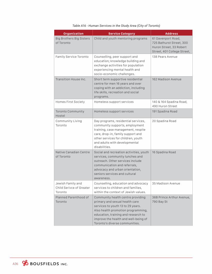
A36
Table A16 - Human Services in the Study Area (City of Toronto)
Organization Service Category Address
Big Brothers Big Sisters
of Toronto
Child and youth mentoring programs 61 Davenport Road,
725 Bathurst Street, 300
Huron Street, 33 Robert
Street, 401 College Street,
Family Service Toronto Counselling, peer support and
education; knowledge building and
exchange activities for population
experiencing mental health and
socio-economic challenges.
138 Pears Avenue
Transition House Inc. Short term supportive residential
centre for men 16 years and over
coping with an addiction, including
life skills, recreation and social
programs.
162 Madison Avenue
Homes First Society Homeless support services 140 & 164 Spadina Road,
490 Huron Street
Toronto Community
Hostel
Homeless support services 191 Spadina Road
Community Living
Toronto
Day programs, residential services,
community supports, employment
training, case management, respite
care, drop-in, family support and
other services for children, youth
and adults with developmental
disabilities.
20 Spadina Road
Native Canadian Centre
of Toronto
Social and recreation activities, youth
services, community lunches and
outreach. Other services include
communication and referrals,
advocacy and urban orientation,
seniors services and cultural
awareness.
16 Spadina Road
Jewish Family and
Child Serivce of Greater
Toronto
Counselling, education and advocacy
services to children and families,
within the context of Jewish values.
35 Madison Avenue
Planned Parenthood of
Toronto
Community health centre providing
primary and sexual health care
services to youth 13 to 29 years.
Also health promotion programming,
education, training and research to
improve the health and well-being of
Toronto’s diverse communities.
36B Prince Arthur Avenue,
790 Bay St
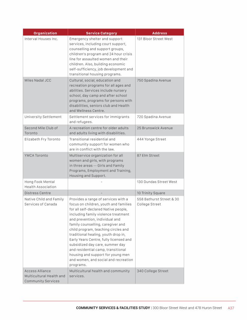
COMMUNITY SERVICES & FACILITIES STUDY | 300 Bloor Street West and 478 Huron Street A37
Organization Service Category Address
Interval Houses Inc. Emergency shelter and support
services, including court support,
counselling and support groups,
children’s program and 24 hour crisis
line for assaulted women and their
children. Also, building economic
self-sufficiency, job development and
transitional housing programs.
131 Bloor Street West
Miles Nadal JCC Cultural, social, education and
recreation programs for all ages and
abilities. Services include nursery
school, day camp and after school
programs, programs for persons with
disabilities, seniors club and Health
and Wellness Centre.
750 Spadina Avenue
University Settlement Settlement services for immigrants
and refugees.
720 Spadina Avenue
Second Mile Club of
Toronto
A recreation centre for older adults
and adults living with disabilities.
25 Brunswick Avenue
Elizabeth Fry Toronto Transitional residential and
community support for women who
are in conflict with the law.
444 Yonge Street
YMCA Toronto Multiservice organization for all
women and girls, with programs
in three areas -- Girls and Family
Programs, Employment and Training,
Housing and Support.
87 Elm Street
Hong Fook Mental
Health Association
- 130 Dundas Street West
Distress Centre - 10 Trinity Square
Native Child and Family
Services of Canada
Provides a range of services with a
focus on children, youth and families
for all self-declared Native people,
including family violence treatment
and prevention, individual and
family counselling, caregiver and
child program, teaching circles and
traditional healing, youth drop in,
Early Years Centre, fully licensed and
subsidized day care, summer day
and residential camp, transitional
housing and support for young men
and women, and social and recreation
programs.
558 Bathurst Street & 30
College Street
Access Alliance
Multicultural Health and
Community Services
Multicultural health and community
services.
340 College Street
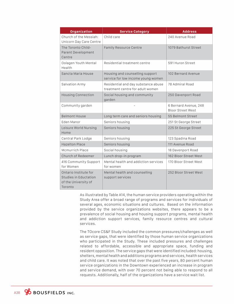
A38
Organization Service Category Address
Church of the Messiah:
Unicorn Day Care Centre
Child care 240 Avenue Road
The Toronto Child-
Parent Development
Centre
Family Resource Centre 1079 Bathurst Street
Oolagen Youth Mental
Health
Residential treatment centre 591 Huron Street
Sancta Maria House Housing and counselling support
service for low income young women
102 Bernard Avenue
Salvation Army Residential and day substance abuse
treatment centre for adult women
78 Admiral Road
Housing Connection Social housing and community
garden
250 Davenport Road
Community garden - 6 Bernard Avenue, 248
Bloor Street West
Belmont House Long term care and seniors housing 55 Belmont Street
Eden Manor Seniors housing 251 St George Street
Leisure World Nursing
Home
Seniors housing 225 St George Street
Central Park Lodge Seniors housing 123 Spadina Road
Hazelton Place Seniors housing 111 Avenue Road
Mcmurrich Place Social housing 18 Davenport Road
Church of Redeemer Lunch drop-in program 162 Bloor Street West
416 Community Support
for Women
Mental health and addiction services
for women
170 Bloor Street West
Ontario Institute for
Studies in Eductation
of the University of
Toronto
Mental health and counselling
support services
252 Bloor Street West
As illustrated by Table A14, the human service providers operating within the Study Area offer a broad range of programs and services for individuals of several ages, economic situations and cultures. Based on the information provided by the service organizations websites, there appears to be a prevalence of social housing and housing support programs, mental health and addiction support services, family resource centres and cultural services.
The TOcore CS&F Study included the common pressures/challenges as well as service gaps, that were identified by those human service organizations who participated in the Study. These included pressures and challenges related to affordable, accessible and appropriate space, funding and resident opposition. The service gaps that were identified included: housing, shelters, mental health and additions programs and services, health services and child care. It was noted that over the past five years, 80 percent human service organizations in the Downtown experienced an increase in program and service demand, with over 70 percent not being able to respond to all requests. Additionally, half of the organizations have a service wait list.
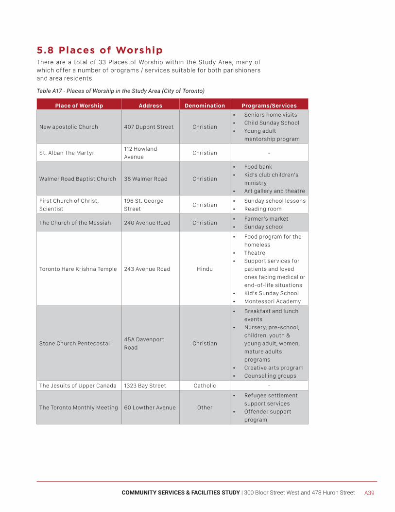
COMMUNITY SERVICES & FACILITIES STUDY | 300 Bloor Street West and 478 Huron Street A39
5.8 Places of WorshipThere are a total of 33 Places of Worship within the Study Area, many of which offer a number of programs / services suitable for both parishioners and area residents.
Table A17 - Places of Worship in the Study Area (City of Toronto)
Place of Worship Address Denomination Programs/Services
New apostolic Church 407 Dupont Street Christian
• Seniors home visits
• Child Sunday School
• Young adult
mentorship program
St. Alban The Martyr112 Howland
AvenueChristian -
Walmer Road Baptist Church 38 Walmer Road Christian
• Food bank
• Kid’s club children’s
ministry
• Art gallery and theatre
First Church of Christ,
Scientist
196 St. George
StreetChristian
• Sunday school lessons
• Reading room
The Church of the Messiah 240 Avenue Road Christian• Farmer’s market
• Sunday school
Toronto Hare Krishna Temple 243 Avenue Road Hindu
• Food program for the
homeless
• Theatre
• Support services for
patients and loved
ones facing medical or
end-of-life situations
• Kid’s Sunday School
• Montessori Academy
Stone Church Pentecostal45A Davenport
RoadChristian
• Breakfast and lunch
events
• Nursery, pre-school,
children, youth &
young adult, women,
mature adults
programs
• Creative arts program
• Counselling groups
The Jesuits of Upper Canada 1323 Bay Street Catholic -
The Toronto Monthly Meeting 60 Lowther Avenue Other
• Refugee settlement
support services
• Offender support
program
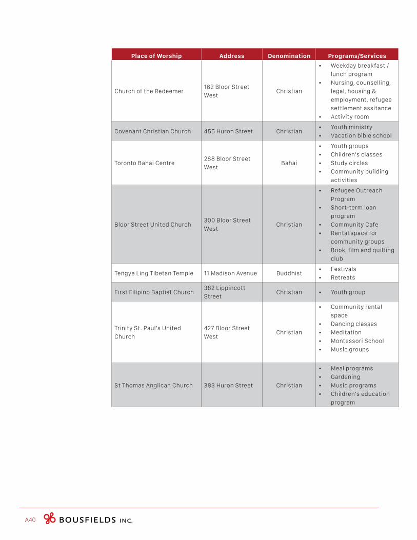
A40
Place of Worship Address Denomination Programs/Services
Church of the Redeemer162 Bloor Street
WestChristian
• Weekday breakfast /
lunch program
• Nursing, counselling,
legal, housing &
employment, refugee
settlement assitance
• Activity room
Covenant Christian Church 455 Huron Street Christian• Youth ministry
• Vacation bible school
Toronto Bahai Centre288 Bloor Street
WestBahai
• Youth groups
• Children’s classes
• Study circles
• Community building
activities
Bloor Street United Church300 Bloor Street
WestChristian
• Refugee Outreach
Program
• Short-term loan
program
• Community Cafe
• Rental space for
community groups
• Book, film and quilting
club
Tengye Ling Tibetan Temple 11 Madison Avenue Buddhist• Festivals
• Retreats
First Filipino Baptist Church382 Lippincott
StreetChristian • Youth group
Trinity St. Paul’s United
Church
427 Bloor Street
WestChristian
• Community rental
space
• Dancing classes
• Meditation
• Montessori School
• Music groups
St Thomas Anglican Church 383 Huron Street Christian
• Meal programs
• Gardening
• Music programs
• Children’s education
program
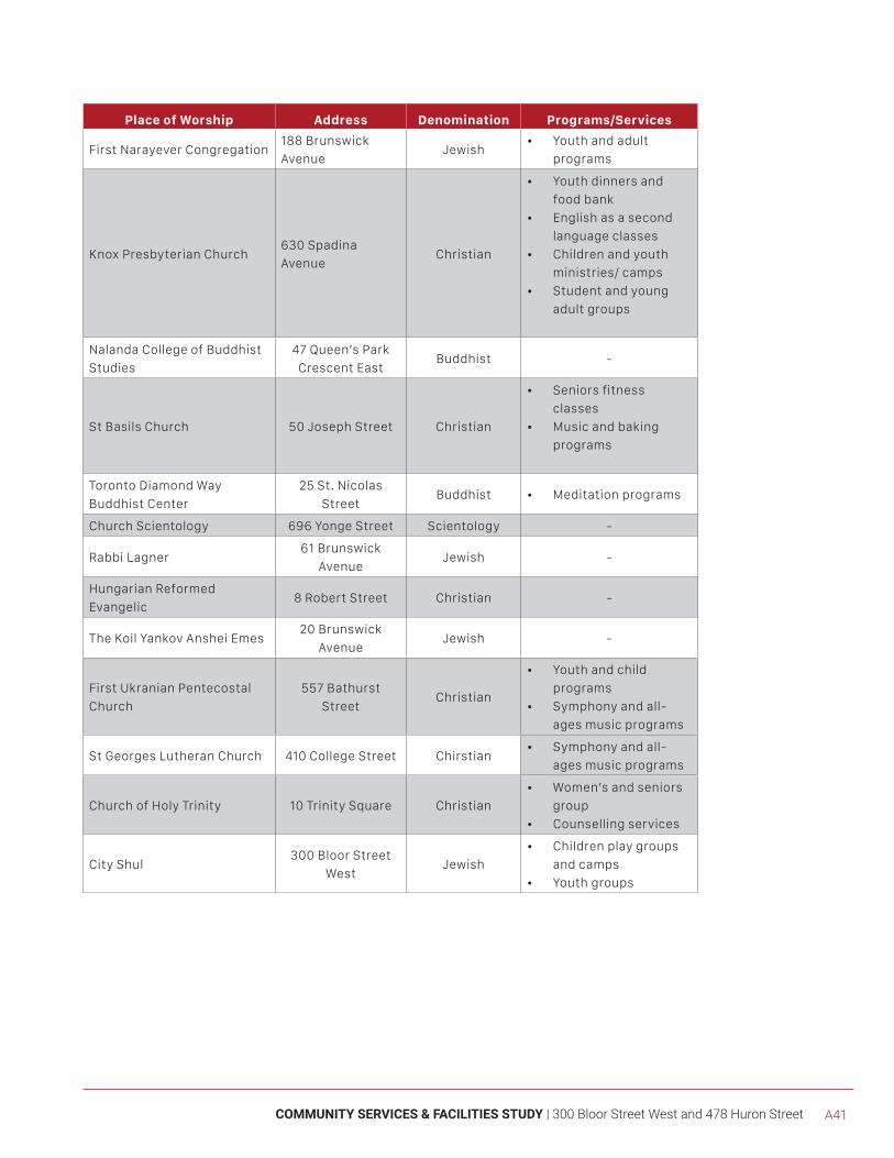
COMMUNITY SERVICES & FACILITIES STUDY | 300 Bloor Street West and 478 Huron Street A41
Place of Worship Address Denomination Programs/Services
First Narayever Congregation188 Brunswick
AvenueJewish
• Youth and adult
programs
Knox Presbyterian Church630 Spadina
AvenueChristian
• Youth dinners and
food bank
• English as a second
language classes
• Children and youth
ministries/ camps
• Student and young
adult groups
Nalanda College of Buddhist
Studies
47 Queen’s Park
Crescent EastBuddhist -
St Basils Church 50 Joseph Street Christian
• Seniors fitness
classes
• Music and baking
programs
Toronto Diamond Way
Buddhist Center
25 St. Nicolas
StreetBuddhist • Meditation programs
Church Scientology 696 Yonge Street Scientology -
Rabbi Lagner61 Brunswick
AvenueJewish -
Hungarian Reformed
Evangelic8 Robert Street Christian -
The Koil Yankov Anshei Emes20 Brunswick
AvenueJewish -
First Ukranian Pentecostal
Church
557 Bathurst
StreetChristian
• Youth and child
programs
• Symphony and all-
ages music programs
St Georges Lutheran Church 410 College Street Chirstian• Symphony and all-
ages music programs
Church of Holy Trinity 10 Trinity Square Christian
• Women’s and seniors
group
• Counselling services
City Shul300 Bloor Street
WestJewish
• Children play groups
and camps
• Youth groups
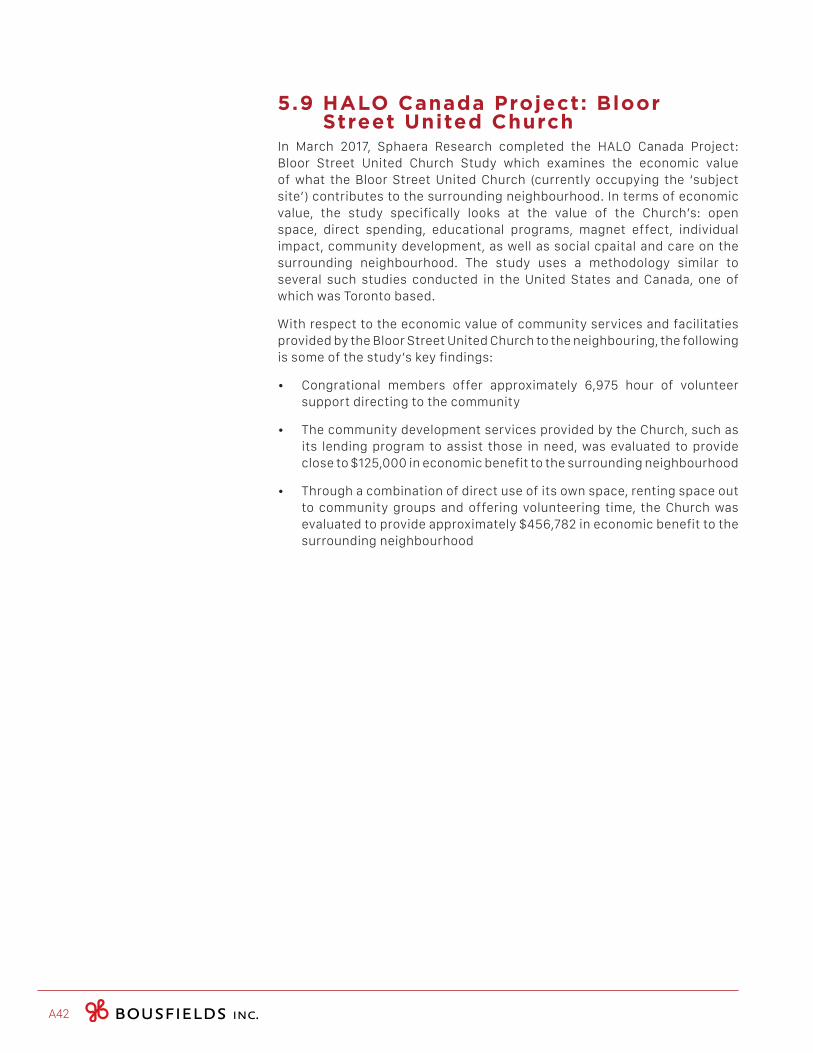
A42
5.9 HALO Canada Project: Bloor Street United Church
In March 2017, Sphaera Research completed the HALO Canada Project: Bloor Street United Church Study which examines the economic value of what the Bloor Street United Church (currently occupying the ‘subject site’) contributes to the surrounding neighbourhood. In terms of economic value, the study specifically looks at the value of the Church’s: open space, direct spending, educational programs, magnet effect, individual impact, community development, as well as social cpaital and care on the surrounding neighbourhood. The study uses a methodology similar to several such studies conducted in the United States and Canada, one of which was Toronto based.
With respect to the economic value of community services and facilitaties provided by the Bloor Street United Church to the neighbouring, the following is some of the study’s key findings:
• Congrational members offer approximately 6,975 hour of volunteer support directing to the community
• The community development services provided by the Church, such as its lending program to assist those in need, was evaluated to provide close to $125,000 in economic benefit to the surrounding neighbourhood
• Through a combination of direct use of its own space, renting space out to community groups and offering volunteering time, the Church was evaluated to provide approximately $456,782 in economic benefit to the surrounding neighbourhood

[6.0] CONCLUSION
COMMUNITY SERVICES & FACILITIES STUDY | 300 Bloor Street West and 478 Huron Street A43
A44
Neighbourhood Demographics
The Annex neighbourhood experienced a moderate increase in population between 2006 and 2011, at six percent (938 people) which is less than the growth rate in the the City of Toronto and Downtown Core during the same period. The neighbourhood population has a strong presence of “Working Age” adults, however it has a greater proportion of Youth residents than the City and the Core. Households in the neighbourhood predomminately contain single residents. Furthermore, according to the TOCore Profiles Report, rental is by far the most common form of housing tenure in the neighbourhood (74.2 percent of residents rent) and 59.1 percent of residents reported moving in the last five years.
With respect to income, although the neighbourhood has a higher average household income than both the City of Toronto and Downtown Core, nearly a quarter of neighbourhood residents are considered LIM-AT (Iow-income status), which is higher than City of Toronto. Likewise, nearly half of neighborhood residents (44.4 percent) spends more than 30 percent of their income on shelter costs, which is greater than both the Downtown Core and City of Toronto. Moreover, although the neighbourhood’s employment rates are higher than the averages reported for the Downtown Core and the City as a whole, the neighbourhood’s part-time employment rate is signifigantly higher than both the Downtown Core and City of Toronto.
Nearby Development Activity
There are currently 14 recently (within the last five years) proposed, approved or under construction developments in the Study Area. Of the 14 development identified, only one is under construction, while seven have been approved but yet to be build. Moreover, six developments have been proposed and are currently under review. The population for the area, inclusive of the proposed development is estimated at 7,757 persons. As many of these applications are under review, an increase in local population will likely occur over a number of years and not within the immediate term.
City Initiated TOCore Community Services and Facilities Report
There TOCore Community Services and Facilities Report identifies two opportunities in the Study Area for minor capital improvements to existing facilities, including City Hall and Yorkville Public Library Branches. These improvements may include, among other things, barrier free and information technology upgrades, as well as the creation of space for additional programming and special events. The report notes that such improvements will be dependant on the Branch’s existing capital funding or Section 37 development agreements. No opportunities for new facilities or major improvements to existing facilities in the Study Area were identified in the report.
COMMUNITY SERVICES & FACILITIES STUDY | 300 Bloor Street West and 478 Huron Street A45
Annex Community Services and Facilities
The Study Area contains a broad mix of community services and facilities that serve the existing community, and would be available to potential residents of the proposed development. A summary of these services is provided below.
In terms of school accommodation, the anticipated public-school students (8) could be accommodated by the schools serving the subject site. Data regarding the TCDSB elementary and secondary schools could not be provided at the time the report was written. However, the TCDSB will have the opportunity to comment on the application once it has been submitted.
There are 24 childcare facilities in the Study Area, 13 of which may provide subsidized space, upon availability. The development is expected to produce 9 child care spaces. Phone calls with facility staff in December 2017 revealed that there to be sufficient space to accomodate the nine projected children. Although, accommodation will be based on age and level of service required. The analysis included in this report is based of a sample survey with childcare providers, and the availability of child care space is subject to change. With this in mind, providing additional opportunities has been formally identified as a goal by the City’s TOcore study.
Four public library branches are situated in the Study Area, include the Yorkvile, Spadina Road, City Hall and Lillian H. Smith Branch. Each of these branches offer a moderate to large collection of materials. Accordingly, the subject site is well served by libraries, which is consistent with findings from the TOcore Community Services and Facilities Report pertaining to the Downtown Core.
There are no publicly funded recreation centres, operated by the City of Toronto’s Parks and Recreation Division, located in the Study Area. However, there are two privately operated recreation centres, the Grosvenor Street YMCA and the Miles Nadal Jewish Community Centre. In addition, the following three recreation centres are located within approximately 650 meteres of the Study Area3: Bob Abate Community Recreation Centre, Scadding Court Comunity Centre and Harrison Pool. According to the TOcore report, there is one Association of Community Centres (AOCC) located in the Study Area (the above mentioned Grosvenor Street YMCA). In terms of parkland, there are a total of 23 parks and parkettes, totalling 21.56 hectares (53.28 acres) of parkland in the Study Area. A common amenity found in these park spaces is children’s playground equipment.
There are four hospitals located within the Study Area, including the Centre for Addiction and Mental Health (CAMH) - College Street site, Women’s College Hospital, Toronto General Hospital (TGH) and the Hospital for Sick Children (Sick Kids). There are also 51 human service locations in the Study Area. The locations included in the inventory provide residents with access to additional community programs and services, particularl social housing and housing support programs, mental health and addiction support services, family resources and cultural services.
3BasedonBousfieldInc.’scalculations
A46
Lastly, there were 33 Places of Workship identified within the Study Area, serving the Christian, Hindu, and Jewish faiths. Many of these Places of Worship provide additional services to the community through outreach efforts and by providing community meeting space. Therefore, the Study Area is well served in terms of faith-based organizations, and benefits from the additional services and out-reach efforts provided at these locations.
Service Availability and Gaps Analysis
Data regarding the TCDSB elementary and secondary schools could not be provided at the time the report was written, therefore it is unknown if the School Board will have the capacity to serve the subject site. However, the TCDSB will have an opportunity to comment on the application once it has been submitted.
Park space availability, especially in the downtown core, is a known service gap and one that has been identified in the City’s TOcore Study. Although there are a total of 23 parks and parkettes, totalling 21.56 hectares (53.28 acres) in the Study Area, a lack of amenities beyond playground equipment has been identified and no expansion or improvements to parks was outlined in the TOCore study.
Within the immediate area, there were no outstanding gaps when it came to facility and program availability for libraries. The public library branches currently offer a wide spectrum of resources and programming and space concerns have been identified and planned for through the TOcore CS&F Study.
Through the TOCore Study, several service challenges, pressures and gaps were identified for the recreation sector. For the Subject Site, this appears to be true as there is an absence of publically funded recreation centres in the Study Area.
Conclusion
Based on the existing and planned community services and facilities summarized above, and the demographics of the Annex neighbourhood, this development, and the resulting population increase, is not anticipated to pose a significant strain on the community services and facilities in the Study Area.
While the resulting impacts that this, and other developments may have on neighbourhood community services and facilities is unknown, it is recognized that the City is currently investigating new ways in which to expand and improve community service and facility creation, distribution and access in the Downtown area.
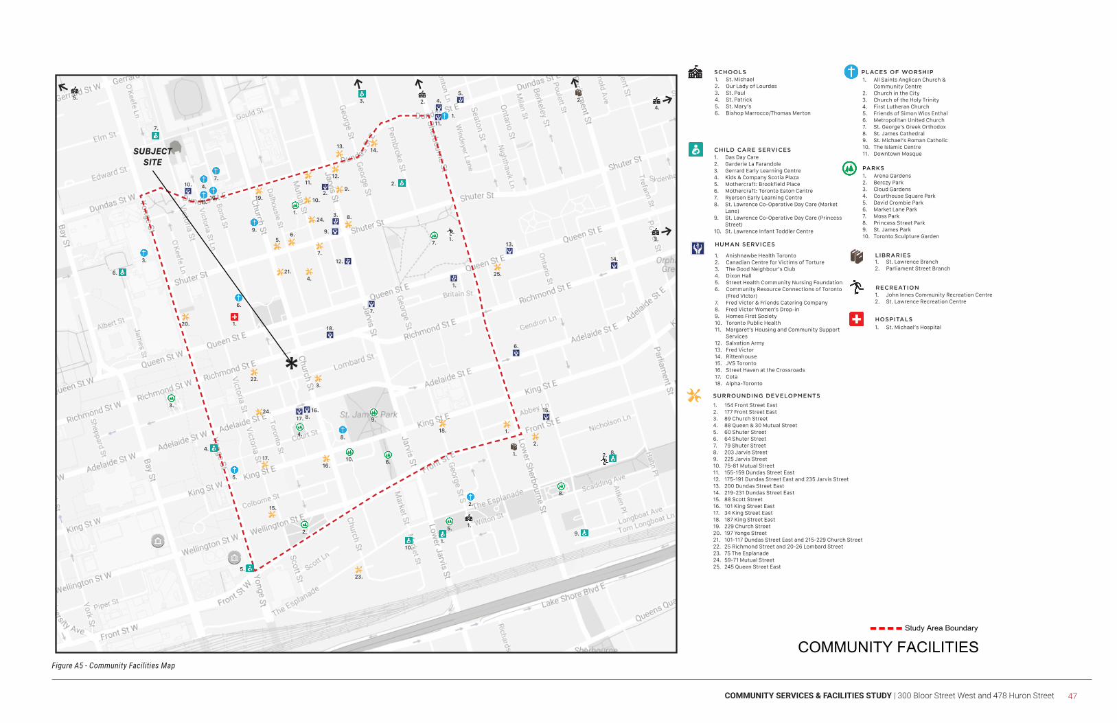
COMMUNITY SERVICES & FACILITIES STUDY | 300 Bloor Street West and 478 Huron Street 47
Figure A5 - Community Facilities Map
SCHOOLS
CHILD CARE SERVICES
LIBRARIES
RECREATION
PARKS
HOSPITALS
1. St. Michael2. Our Lady of Lourdes3. St. Paul4. St. Patrick5. St. Mary’s6. Bishop Marrocco/Thomas Merton
1. Das Day Care2. Garderie La Farandole3. Gerrard Early Learning Centre4. Kids & Company Scotia Plaza5. Mothercraft: Brookfield Place6. Mothercraft: Toronto Eaton Centre7. Ryerson Early Learning Centre8. St. Lawrence Co-Operative Day Care (Market
Lane)9. St. Lawrence Co-Operative Day Care (Princess
Street)10. St. Lawrence Infant Toddler Centre
1. St. Lawrence Branch2. Parliament Street Branch
1. John Innes Community Recreation Centre2. St. Lawrence Recreation Centre
1. Arena Gardens2. Berczy Park3. Cloud Gardens4. Courthouse Square Park5. David Crombie Park6. Market Lane Park7. Moss Park8. Princess Street Park9. St. James Park10. Toronto Sculpture Garden
1. St. Michael’s Hospital
1. All Saints Anglican Church & Community Centre
2. Church in the City3. Church of the Holy Trinity4. First Lutheran Church5. Friends of Simon Wics Enthal6. Metropolitan United Church7. St. George’s Greek Orthodox8. St. James Cathedral9. St. Michael’s Roman Catholic10. The Islamic Centre11. Downtown Mosque
HUMAN SERVICES
1. Anishnawbe Health Toronto2. Canadian Centre for Victims of Torture3. The Good Neighbour’s Club4. Dixon Hall5. Street Health Community Nursing Foundation6. Community Resource Connections of Toronto
(Fred VIctor)7. Fred Victor & Friends Catering Company8. Fred Victor Women’s Drop-in9. Homes First Society10. Toronto Public Health11. Margaret’s Housing and Community Support
Services12. Salvation Army13. Fred Victor14. Rittenhouse15. JVS Toronto16. Street Haven at the Crossroads17. Cota18. Alpha-Toronto
SURROUNDING DEVELOPMENTS
1. 154 Front Street East2. 177 Front Street East3. 89 Church Street4. 88 Queen & 30 Mutual Street5. 60 Shuter Street6. 64 Shuter Street7. 79 Shuter Street8. 203 Jarvis Street9. 225 Jarvis Street10. 75-81 Mutual Street11. 155-159 Dundas Street East12. 175-191 Dundas Street East and 235 Jarvis Street13. 200 Dundas Street East14. 219-231 Dundas Street East15. 88 Scott Street16. 101 King Street East17. 34 King Street East18. 187 King Street East19. 229 Church Street20. 197 Yonge Street21. 101-117 Dundas Street East and 215-229 Church Street22. 25 Richmond Street and 20-26 Lombard Street23. 75 The Esplanade24. 59-71 Mutual Street25. 245 Queen Street East
PLACES OF WORSHIP
1.
2.
1.
1.
2.4.
5.
3.
1.10.
8.
3.
4.
6.
7.
5.
9.
2.
1.
3.
6.
5.
8.
4.
7.
9.
10.11.
2.
1.
2.
3.
4.
5.
6.
9.
10.
8.
7.
1.
2.
1.
8.17.
7.
2.
11.
4.
5.
6.
9.
12.
3.
13.
14.
15.
18.
10.
1.
25.
3.
16.
23.
18.
4.
22.
20.
7.
19.
11.12.
14.
6.
13.
8.
9.
21.
24.
10.
24.
5.
15.
17.
2.
16.
*
SUBJECTSITE