davenport street, robe
TRANSCRIPT

Version: 12 February 2019
District Council of Robe
Davenport Street, Robe
For Consultation

Davenport Street, Robe District Council of Robe
Table of Contents
Version: 12 February 2019
Table of Contents
Have Your Say 1
Explanatory Statement 2
Introduction .................................................................................................................................. 2
Need for the Amendment ............................................................................................................. 2
Statement of Intent ....................................................................................................................... 3
Affected Area ................................................................................................................................ 3
Summary of Proposed Policy Changes ...................................................................................... 3
Proponent Funded DPA ............................................................................................................... 3
Legal Requirements ..................................................................................................................... 5
Consultation ................................................................................................................................. 5
The Final Stage ............................................................................................................................. 6
Analysis 7
1. Background ......................................................................................................................... 7
2. The Strategic Context and Policy Directions .................................................................... 7
2.1 Consistency with the Planning Strategy ................................................................................................................. 7
2.2 Consistency with other key strategic policy documents ........................................................................................ 8
2.2.1 Council’s Strategic Directions Report ......................................................................................................... 8
2.2.2 Council’s Strategic Plan 2014-2018 ............................................................................................................ 8
2.2.3 South East Natural Resources Management Plan .................................................................................... 10
2.2.4 Limestone Coast and Coorong Coastal Action Plan and Conservation Priority Study .............................. 10
2.2.5 Infrastructure Planning ............................................................................................................................. 11
2.2.6 Current Ministerial and Council DPAs ...................................................................................................... 11
2.2.7 Existing Ministerial Policy ......................................................................................................................... 11

Davenport Street, Robe District Council of Robe
Table of Contents
Version: 12 February 2019
3. Investigations .................................................................................................................... 12
3.1 Investigations undertaken prior to the SOI ................................................................................................ 12
3.2 Investigations undertaken to inform this DPA ............................................................................................ 12
3.2.1 Infrastructure Analysis .................................................................................................................. 13
3.2.2 Review of Flora and Fauna Advice .................................................................................................. 16
3.2.3 Response to Issues Raised by Department for Environment and Water (DEW) / Native Vegetation
Branch ......................................................................................................................................... 21
3.2.4 Response to Issues Raised by the Environment Protection Authority (EPA) ....................................... 27
4. Recommended Policy Changes ....................................................................................... 28
4.1 State Planning Policy Library Update ......................................................................................................... 28
5. Consistency with the Residential Code .......................................................................... 28
6. Statement of Statutory Compliance................................................................................. 28
6.1 Accords with the Planning Strategy ........................................................................................................... 28
6.2 Accords with the Statement of Intent ....................................................................................................... 28
6.3 Accords with other parts of the Development Plan .................................................................................... 28
6.4 Complements the Policies in the Development Plans for Adjoining Areas .................................................... 29
6.5 Accords with Relevant Infrastructure Planning ........................................................................................... 29
6.6 Satisfies the requirements Prescribed by the Regulations ........................................................................... 29
References/Bibliography 30
Schedule 4a Certificate 31
Appendices 32
Appendix A - Assessment of the Planning Strategy
The Amendment


Davenport Street, Robe
District Council of Robe Have Your Say
1
Version: 12 February 2019
Have Your Say
This Development Plan Amendment (DPA) will be available for inspection by the public on Council’s website at www.robe.sa.gov.au and at the front counter of Council’s office at Royal Circus, Robe, from 27 February until 29 April 2019.
During this time anyone may make a written submission about any of the changes the DPA is proposing.
Submissions should be sent to:
Chief Executive Officer District Council of Robe PO Box 1 ROBE SA 5276. Or via email at [email protected]
Submissions should indicate whether the author wishes to speak at a public meeting about the DPA. If no-one requests to be heard, no public meeting will be held.
If requested, a meeting will be held on Tuesday 7 May 2019, commencing at 6pm at the Council Chambers, Royal Circus, Robe.

Davenport Street, Robe
District Council of Robe Explanatory Statement
2
Version: 12 February 2019
Explanatory Statement
Introduction
The Development Act 1993 provides the legislative framework for undertaking amendments to a Development
Plan. The Development Act 1993 allows either the relevant council or, under prescribed circumstances, the
Minister responsible for the administration of the Development Act 1993 (the Minister), to amend a
Development Plan.
Before amending a Development Plan, a council must first reach agreement with the Minister regarding the
range of issues the amendment will address. This is called a Statement of Intent. Once the Statement of Intent is
agreed to, a Development Plan Amendment (DPA) (this document) is written, which explains what policy
changes are being proposed and why, and how the amendment process will be conducted.
A DPA may include:
An Explanatory Statement (this section)
Analysis, which may include:
- Background information
- Investigations
- Recommended policy changes
- Statement of statutory compliance
References/Bibliography
Certification by Council’s Chief Executive Officer
Appendices
The Amendment.
Need for the Amendment
The Area Affected is situated on the south-western fringe of the Robe township, with its northern boundary approximately 1.1 km from the Town Centre. The land is currently within the Coastal Conservation Zone, which extends further to the north and west. The Industry Zone is located immediately adjacent to the east across Davenport Street and the Rural Living Zone and Industry Zone is adjacent to the south across Evans Cave Road. The growth of Robe township is generally constrained to the north, east, south and west. In the immediate surrounding area to the subject land this is due to coastal landforms, native vegetation and proximity to the ponds associated with the town’s community waste management system (CWMS). While not discounting these constraints, from a strategic land use perspective the subject land has some advantages for future development. When considered in the wider context the land is well positioned to accommodate an expansion of the urban area, is adjacent to existing urban development, has no significant infrastructure impediments and has a landowner who is keen to realise some development potential for his land. Various proposals have been considered for the subject land (and surrounding land) over the last 12 years, but the current zoning has constrained opportunities.
Davenport Street, Robe
District Council of Robe Explanatory Statement
3
Version: 12 February 2019
In November 2017, Council endorsed a Statement of Intent proposing to investigate the future use of this land on the south-western fringe of the township for potential residential, tourist, industrial/commercial uses and conservation purposes. However, following subsequent discussions with the Department of Planning, Transport and Infrastructure, it was decided to focus on providing land for commercial/industrial development adjacent to the existing Industry Zone on Davenport Street and Evans Cave Road. The area affected has an area of approximately 3.2 ha and its rezoning will provide in the order of 20 additional allotments for commercial/industrial use, meeting short to medium term demand. In summary, this DPA will provide opportunities for investment through commercial and industrial development on a small parcel of land adjacent the existing Industry Zone in Robe.
Statement of Intent
The Statement of Intent relating to this DPA was agreed to by the Minister on 18 October 2018.
The issues and investigations agreed to in the Statement of Intent have been undertaken or addressed.
Affected Area
The area affected by the proposed DPA is located at Davenport Street and Evans Cave Road, Robe as shown on
the following Figure 1: Area Affected map.
Summary of Proposed Policy Changes
The DPA proposes the following changes:
Rezoning of the area affected from Coastal Conservation Zone to Industry Zone.
Inclusion of an additional statement in the Desired Character statement for the Industry Zone to reflect the particular need to provide safe access when considering development proposals (including land division) directly accessing Evans Cave Road.
Consequential map amendments to reflect the rezoning.
Proponent Funded DPA
This DPA process has been funded by the proponent, Mr Barry Bowyer of Robe in accordance with an agreement
with Council. However, Council and the Minister for Planning retain full control over the DPA process and
decision-making responsibilities in accordance with the Development Act 1993.

Davenport Street, Robe
District Council of Robe Explanatory Statement
4
Version: 12 February 2019
Figure 1: Area Affected
Davenport Street, Robe
District Council of Robe Explanatory Statement
5
Version: 12 February 2019
Legal Requirements
Prior to the preparation of this DPA, council received advice from a person or persons holding prescribed
qualifications pursuant to section 25(4) of the Development Act 1993.
The DPA has assessed the extent to which the proposed amendment:
accords with the Planning Strategy
accords with the Statement of Intent
accords with other parts of council’s Development Plan
complements the policies in Development Plans for adjoining areas
accords with relevant infrastructure planning
satisfies the requirements prescribed by the Development Regulations 2008.
Consultation
This DPA is now released for formal agency and public consultation. The following government agencies and
organisations are to be formally consulted:
Department of Environment and Water
Department for Health and Wellbeing (Wastewater Management) Department of Planning, Transport and Infrastructure Department of the Premier and Cabinet (Aboriginal Affairs and Reconciliation) Country Fire Service State Emergency Service Environment Protection Authority SA Power Networks SA Water South East NRM Kingston District Council Naracoorte Lucindale Council Wattle Range Council Mr Nick McBride, MP for MacKillop.
All written and verbal, agency and public submissions made during the consultation phase will be recorded,
considered, summarised and responses provided. Subsequent changes to the DPA may occur as a result of this
consultation process.

Davenport Street, Robe
District Council of Robe Explanatory Statement
6
Version: 12 February 2019
The Final Stage
When the council has considered the comments received and made any appropriate changes, a report on this
(the Summary of consultations and proposed amendments report) will be sent to the Minister.
The Minister will then either approve (with or without changes) or refuse the DPA.

Davenport Street, Robe
District Council of Robe Analysis
7
Version: 12 February 2019
Analysis
1. Background
The Area Affected is situated on the south-western fringe of the Robe township, with its northern boundary approximately 1.1 km from the Town Centre. The land is currently within the Coastal Conservation Zone, which extends further to the north and west. The Industry Zone is located immediately adjacent to the east across Davenport Street and the Rural Living Zone and Industry Zone is adjacent to the south across Evans Cave Road. The growth of Robe township is generally constrained to the north, east, south and west. In the immediate surrounding area to the subject land this is due to coastal landforms, native vegetation and proximity to the ponds associated with the town’s community waste management system (CWMS). While not discounting these constraints, from a strategic land use perspective the subject land has some advantages for future development. When considered in the wider context the land is well positioned to accommodate an expansion of the urban area, is adjacent to existing urban development, has no significant infrastructure impediments and has a landowner who is keen to realise some development potential for his land. Various proposals have been considered for the subject land (and surrounding land) over the last 12 years, but the current zoning has constrained opportunities. In November 2017, Council endorsed a Statement of Intent proposing to investigate the future use of this land on the south-western fringe of the township for potential residential, tourist, industrial/commercial uses and conservation purposes. However, following subsequent discussions with the Department of Planning, Transport and Infrastructure, it was decided to focus on providing land for commercial/industrial development adjacent to the existing Industry Zone on Davenport Street and Evans Cave Road. The area affected has an area of approximately 3.2 ha and its rezoning will provide in the order of 20 additional allotments for commercial/industrial use, meeting short to medium term demand. In summary, this DPA will provide opportunities for investment through commercial and industrial development on a small parcel of land adjacent the existing Industry Zone in Robe.
2. The Strategic Context and Policy Directions
2.1 Consistency with the Planning Strategy
The Planning Strategy presents current State Government planning policy for development in South Australia. In
particular, it seeks to guide and coordinate State Government activity in the construction and provision of
services and infrastructure that influence the development of South Australia. It also indicates directions for
future development to the community, the private sector and local government.
The following volume of the Planning Strategy is relevant to this DPA:
Limestone Coast Region Plan.
The DPA supports the policies of the Planning Strategy by:
Minimising the potential for adverse impacts on biodiversity
Designing and planning development to minimise impacts of hazards

Davenport Street, Robe
District Council of Robe Analysis
8
Version: 12 February 2019
Avoiding impacts on desired town character
Building on the region’s strategic infrastructure
Not impacting on primary production land
Not impacting on the region’s tourism industry
Providing well-sited industrial land to meet demand
Strategically managing the growth of Robe
Supporting the Robe township as an appealing environment.
A detailed assessment of the DPA against the Planning Strategy is contained in Appendices.
2.2 Consistency with other key strategic policy documents
This DPA accords with other key policy documents in the following manner:
2.2.1 Council’s Strategic Directions Report
While Council’s ‘Imagine Robe 2040’ Strategic Directions Report (SDR) has not identified the specific need for a
DPA for the area affected, some of the data provided in the SDR is considered of relevance in scoping the future
of the subject land. This includes:
Industrial Zone within the southern portion of town is the main employment land within the town.
Generally low demand for employment in industry/manufacturing but has potential to increase by
attracting more value adding/niche industries.
Additional industrial land will be required in the long term.
Consideration should be given to allowing some flexibility in zoning etc. to safeguard the potential to attract
large industry/employer in the future.
Consider 20-30 hectare future industrial site within the vicinity of the airfield.
The area affected has an area of approximately 3.2 ha and is located immediately adjacent to the existing
Industry Zone. Its rezoning will provide in the order of 20 additional allotments for commercial/industrial use,
meeting short to medium term demand. Such a proposal is not inconsistent with the SDR directions.
2.2.2 Council’s Strategic Plan 2014-2018
Council’s Vision set out in the Plan is:
‘The District Council of Robe will be a vibrant, harmonious and prosperous place to live work & visit’.
Data from the Plan considered of relevance to reviewing the future of the subject land includes:
Industry within the district is primarily tourism, commercial fishing, broad acre farming and viticulture.
Council’s vision for the economic well-being of the district is an economy that is diverse, innovative and
adaptable.
15 % of the district’s total population are aged 15 years or younger which is an increase from the 2006
census. The issue for the district and council is providing career and employment opportunities for these
young people to ensure they remain locally and contribute to the vitality of the town.
To achieve the Vision (discussed above) for the district, Council has identified four broad, but interlinked, goals.
Two of these are particularly relevant to this DPA as follows:

Davenport Street, Robe
District Council of Robe Analysis
9
Version: 12 February 2019
Goal: Economic Development
A strong, diverse economy that is innovative and adaptable
The four pillars of the Robe economy are agriculture, fishing, service industries and tourism. Council’s role in the
economic development of the district is that of an enabler and facilitator;
By ensuring that the planning zones allow development to occur in appropriate locations.
By facilitating the provision of infrastructure that is required for development.
The future of the district’s economy will partly depend upon the ability to maintain and grow current business
and industries with an emphasis on diversification of the economic base and the ability to attract new industries
and services to the district.
A primary consideration for the continued growth of the economy is the provision of appropriate infrastructure.
Council has roles as both a provider of infrastructure and an advocate on behalf of the community for additional
or improved infrastructure.
As outcomes, Council is seeking ‘A strong diverse tourism, primary production and commercial economy’ and
‘Infrastructure that supports the District’s economy’. It has developed a number of strategies to assist in
achieving these outcomes, including:
Support appropriate economic development projects.
Consult with business and industry to determine their future infrastructure requirements.
Advocate for and facilitate the provision of appropriate heavy transport routes and associated
infrastructure to assist agricultural producers and business to efficiently transport goods.
Advocate for the provision of appropriate power, water and telecommunication infrastructure to assist the
growth of the district’s economy.
Goal: Natural and Built Environment
Maintain and enhance our natural environment complimented by sympathetic buildings, infrastructure and
facilities
Robe has an attractive rural and natural character including vista’s comprising of white beaches, abundant lakes,
rugged coastline and productive farm land. Tracts of unspoilt natural vegetation and waterways still exist within
the district and its air and seas are clean and relatively free of pollution.
The community has expressed a desire to protect the existing natural and built environment to ensure that the
area largely retains its current ‘rural’ seaside ambience.
As outcomes, Council is seeking ‘Responsive Planning and Development that meets the community’s aspirations’
and ‘Protect and enhance the natural environs’. It has developed a number of strategies to assist in achieving
these outcomes, including:
Complete the Robe Township 2040 structure plan.
Undertake Development Plan Amendments as identified by the structure planning process that;

Davenport Street, Robe
District Council of Robe Analysis
10
Version: 12 February 2019
- Ensure that residential, commercial and industrial land uses do not adversely impact the natural
environment.
- Encourage appropriate industrial, commercial and residential developments that respects the best
aspects of the character of Robe.
- Establish distinct township boundaries through effective use of land use planning.
Advocate and facilitate the preservation and enhancement of native vegetation.
Advocate for the preservation and enhancement of natural marine and coastal assets.
Ensure land use planning policies are consistent with the Natural Resource Management Boards priorities
protecting ecological and environmental assets.
2.2.3 South East Natural Resources Management Plan
The South East Natural Resources Management Plan is a requirement of the Natural Resources Management Act 2004. Developed by the South East Natural Resources Management (SENRM) Board with the help of the regional community, the Plan sets the direction for natural resources management in the Region up to 2020. The Plan, which is at a high level, sets out four overarching goals and related targets and actions to assist in achieving the vision for the region – ‘Healthy landscapes for better living’. The goals are:
Goal A – Healthy landscapes supporting high value ecological systems.
Goal B – Regional communities active in natural resources management.
Goal C – Resilient industries taking responsibility for sustainable use and management of natural resources.
Goal D – Leadership, adaptability and partnerships for effective natural resources management. Of these goals, Goal A is considered of specific relevance in reviewing the future of the subject land. The aim of this goal is described as being: ‘about the protection and enhancement of our natural resources. It ensures that we as a community value the biological diversity of the region and recognise the high quality of our natural assets. Targets contributing to this goal include improving the extent and condition of native vegetation, management of threatened plant and animal species and reducing the impact of land based activities on coast and marine habitats.’ 2.2.4 Limestone Coast and Coorong Coastal Action Plan and Conservation Priority Study
This 2011 report was prepared for the South East Natural Resources Management Board and documented the findings of a conservation assessment for coastal areas between the Murray River Mouth and the South Australia / Victoria border. It also detailed a coastal action plan for the region. The aim of the study was to understand and facilitate the conservation, protection and maintenance of the region’s natural coastal resources and to establish conservation priorities for action for places and areas within the region. The subject land is contained within Cell SE10 Little Dip CP. This Cell extends south from the Robe township to south of Nora Creina and is described as an undulating coastal plain with aeolianite headlands and reefs, beaches and extensive dune systems.

Davenport Street, Robe
District Council of Robe Analysis
11
Version: 12 February 2019
Conservation layers show that areas outside of urban and agricultural lands and de-vegetated dunes show high values for vegetation associations and threatened plant and animal species. Existing development on the fringe of Robe is considered to contribute to the threat to these local areas via impacts on visual amenity, vegetation damage leading to dune movement/instability, garden escape species, weed invasion and habitat fragmentation. 2.2.5 Infrastructure Planning
Where relevant, a DPA must take into account relevant infrastructure planning (both physical and social infrastructure) as identified by Council (usually through the Strategic Directions Report), the Minister and/or other government agencies.
No specific infrastructure planning (social or physical) has been identified in Council’s Strategic Directions Report, by the Minister or by a relevant government agency for the Area Affected. However, based on the investigations undertaken by URPS in 2016 in preparing the Scoping Study - Morphett Street, Robe report for the Area Affected, some physical infrastructure requirements have been further considered in section 3.2.1.
2.2.6 Current Ministerial and Council DPAs
There are no Ministerial or Council DPAs which are currently being processed that have to be taken into account.
2.2.7 Existing Ministerial Policy
No change to existing Ministerial policy is proposed in this DPA.

Davenport Street, Robe
District Council of Robe Analysis
12
Version: 12 February 2019
3. Investigations
3.1 Investigations undertaken prior to the SOI
Previous investigations informing this DPA include the following:
Scoping Study - Morphett Street, Robe (URPS March 2016).
The Study included discussion under the following headings:
- Introduction
- The Subject Land
- Wider Locality
- South Australian Planning Strategy
- District Council of Robe Strategic Plan 2014-2018
- District Council of Robe ‘Imagine Robe 2040’ Strategic Directions Report
- South East Natural Resources Management Plan
- Development Plan Policy
- Native Flora and Fauna
- Environmental Matters (including potential odour impact from the CWMS lagoons)
- Infrastructure Assessment
- Interface Issues
- Conclusions.
In summary, the Study identified a number of options that could be further investigated, including the following
land uses (or combination of land uses):
- Tourist accommodation
- Limited residential/retirement development within a golf course or bushland setting - Quality commercial/industrial development.
It was also identified that integral to any development on the land was the need to protect and enhance
significant flora and fauna.
This Study was subsequently presented to both Council and the Department of Planning, Transport and
Infrastructure to inform future strategic and planning documents.
Robe Golf Course Expansion DPA (Approved December 2016).
Eco Village proposal (2008). Robe Golf Course Extension and Redevelopment proposal (2006).
3.2 Investigations undertaken to inform this DPA
In accordance with the Statement of Intent for this DPA the following investigations have been undertaken to
inform this DPA:

Davenport Street, Robe
District Council of Robe Analysis
13
Version: 12 February 2019
The provision of an infrastructure analysis that identifies all potential infrastructure issues that will have to
be addressed in any subsequent development application and provide a strategy which offers a funding
solution for each of these issues.
Review of previous flora and fauna advice.
Discussions with DEW/Native Vegetation Branch.
Discussions with the Environment Protection Authority.
The investigations are as follows:
3.2.1 Infrastructure Analysis
A Stormwater management plan and services assessment report has been undertaken by FMG Engineering.
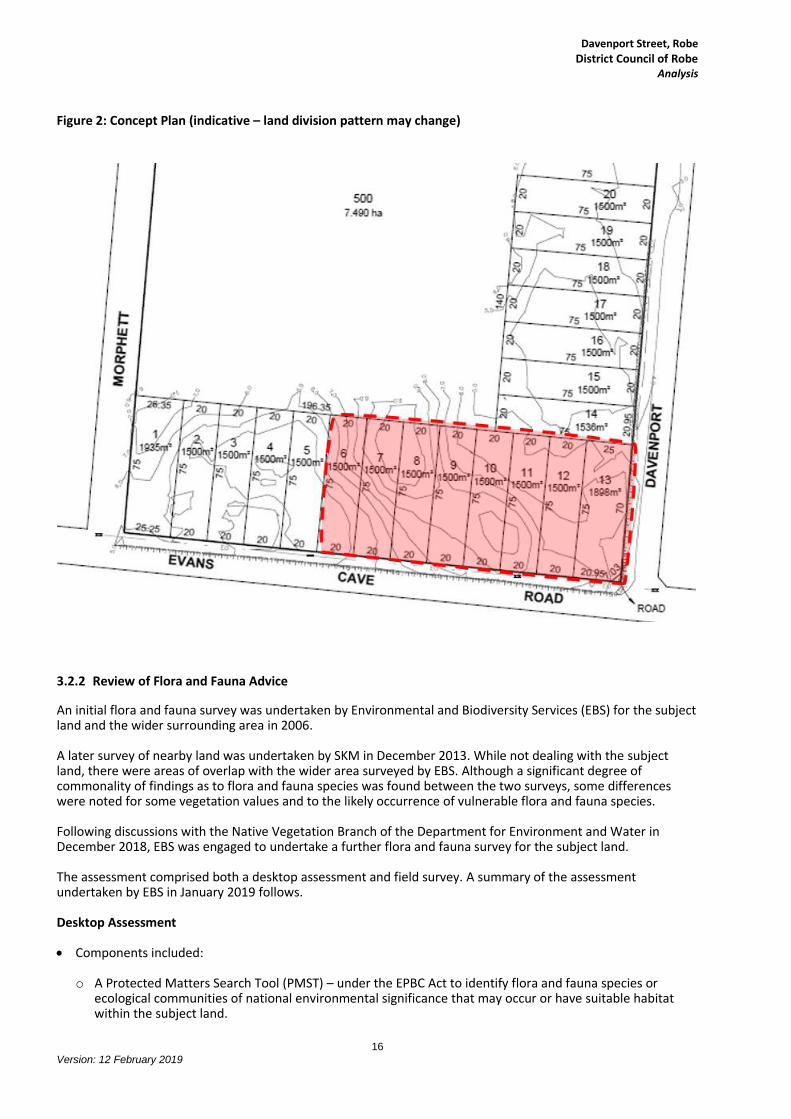
FMG noted that the subject land is undulating with maximum grades of 10% on allotments 1 – 8 (see Figure 2:
Concept Plan) which grade towards the south-west and allotments 9 – 20 which generally grade to the north-
east. The land is considered relatively sandy with high expected infiltration rates.
In terms of infrastructure provision the FMG report indicates:
Council has advised there is no currently available information on the capacity of the existing CWMS
infrastructure. However, there are plans in place to upgrade the existing system in 2019 and specifically the
treatment lagoons with aeration proposed to increase the treatment rate. Council has indicated that
wastewater generated by development on the land could be treated in the lagoons located approximately
120 metres to the south across Evans Cave Road and that lagoons should be able to manage any additional
BOD loading.
A 150mm diameter water main is located approximately 100 metres to the east of the subject land at the
intersection of Evans Cave Road and Denton Drive. SA Water has indicated that the existing potable water
supply has adequate capacity to supply the subject land via an extension of the service.
SA Power Networks has indicated there is a 7.6kV overhead line along Evans Cave Road and it is expected
that any development along this Road could be supplied via the provision of overhead transformers, either
directly from the poles or via service pits. Development adjacent to Davenport Street will require
underground services and the construction of padmount transformers and pits. Augmentation costs would
be subject to detailed design works determined at the Development Application stage.
Telstra optic fibre is located in Evans Cave Road and NBN fibre is located nearby. It is not anticipated there
would be any issues in connecting to these services.
Council has indicated there is limited stormwater infrastructure adjacent to the subject land and that disposal
by infiltration is encouraged. Within this context FMG has developed two options that will meet
Development Plan/WSUD requirements as follows:
o On-site stormwater detention and treatment by individual landowners - requiring an estimated 40m2 of
surface area for infiltration or alternatively an underground tank capable of infiltrating into the in-situ
material.

Davenport Street, Robe
District Council of Robe Analysis
14
Version: 12 February 2019
o A single stormwater detention and treatment area for the wider subject land – requiring an estimated 750
m2 of surface area (approximately 600mm deep) with treatment via a single Stormwater Quality
Improvement Device (SQID) or via a natural system (e.g. bio-retention basin).
The preferred option for stormwater management would be decided with Council at the Development
Application stage of a proposal on the land.
In summary, FMG’s assessment indicates that:
while there are limited services directly adjacent to the subject land, no significant augmentation works are required and that extension of the nearby services (at the proponent’s cost) will allow the land to be serviced.
the subject land is undulating and there will be a requirement for earthworks to grade any allotments created to the road reserve.
Council has indicated that wastewater generated by development on the land could be treated in the
CWMS lagoons located approximately 120 metres to the south.
on-site stormwater management options are available to provide satisfactory management outcomes. Traffic Impact Assessment A Traffic Impact Assessment (TIA) has been undertaken by GTA consultants providing an assessment of the anticipated transport implications that may result from the rezoning of the subject land and its subsequent development for industrial use. The assessment included consideration of the existing conditions surrounding the subject land, the traffic generation characteristics of the proposed development, the proposed access arrangements for the site and transport impact on the surrounding road network. The TIA acknowledged the rezoning of the subject land to Industry Zone would allow for a wide range of industrial, warehouse, storage and transport uses. These land uses are the same as can already be accommodated in the existing Industry Zone located immediately to the east of the subject land. GTA based its assessment on an indicative Concept Plan indicating potential division of the subject land into 20 industrial allotments of approximately 1,500 m2 each, with frontages to either Davenport Street or Evans Cave Road. This Plan is shown in Figure 2: Concept Plan following and has been included to better illustrate the TIA discussion. It should be noted this Concept Plan is indicative in nature and was provided to enable a higher level of service assessment to be undertaken – it does not necessarily indicate the final form of division to be sought, which will be based on a number of factors, including other investigations undertaken for this DPA. In summary, the key conclusions of the TIA and subsequent discussions with Council are:
Some of the subject land fronts Evans Cave Road, a local road under the care and control of Council, which is currently unsealed past the site. The existing sealed section to the east is anticipated to be suitable for the industrial uses that access this road and there appears to be sufficient width in the road reserve to continue this road width past the site, which would be appropriate for the proposed uses abutting it and the estimated traffic volumes.

Davenport Street, Robe
District Council of Robe Analysis
15
Version: 12 February 2019
Some of the subject land fronts Davenport Street, a local road under the care and control of Council. Until recently the southern portion of the road was unmade, with access only provided by a track within the road reserve. This track extended some 350 metres north from the intersection with Evans Cave Road. Based on discussions with Council it is understood some works on this southern portion of Davenport Street were undertaken in 2018, with a graded rubble ‘road’ now providing access for some 200 - 250 metres from its intersection with Evans Cave Road. It is expected that the subject land which is located on the western side of Davenport Street, extending some 215 metres north from the intersection with Evans Cave Road, will be accessed from this portion of Davenport Street. Given the current very low usage of this portion of Davenport Street and the estimated low traffic volumes from the subject land, further works to the road surface may not be required. It is expected that further consideration will be given to this matter should a land division proposal be lodged for the subject land.
The sight distance at the intersection of Davenport Street for drivers looking to the right (west) along Evans Cave Road may be restricted by a crest on Evans Cave Road. As such the sight distance available at the intersection will need to be confirmed and remedied if restricted.
The potential land division layout provided indicates direct allotment access to Evans Cave Road and Davenport Street. Due to a crest on Evans Cave Road (located approximately 60 metres west of Davenport Street - adjacent to allotment 11 on Figure 2), sight distances to some access points directly abutting Evans Cave Road may have some restrictions.
However, GTA has identified potential design strategies to mitigate the potential risks, including:
o Rotating allotments 11, 12 and 13 to be accessed from Davenport Street.
o Rotating or modifying allotments 6 to 10 and providing a consolidated access point to Evans Cave Road at the top of the crest, with these allotments gaining access via this accessway.
o Appropriate concealed driveway warning signage may be required to warn approaching drivers should any access points still be concealed by the crest.
Based on the RTA Guide industrial estate traffic generation, the subject site could generate in the order of 200 vehicles per day, which would be well within the capacity of the surrounding road network.
In summary, this advice indicates the road network is able to accommodate the additional traffic movements likely as a result of rezoning the land for industrial use.
Although only low traffic volumes are expected in Davenport Street, consideration may need to be given to the suitability of the existing road pavement. Should road works be required these will be subject to negotiations with Council to determine the extent of the works and how these are to be funded (i.e. what developer contribution may be sought).
Depending on the final form of any land division proposed for the subject land, further investigation of some access points, particularly on Evans Cave Road, may be required at the more detailed Development Application stage to ensure safe access can be provided to some allotments. Potential design strategies have been identified in this regard. While existing General Section Land Division policies cover this issue, it is proposed to also include reference to it in the Desired Character statement for the Industry Zone to ensure it is considered.
In terms of overall funding for the required infrastructure, it is expected that the proponent/future owners will provide it through:
o Agency agreements (i.e. augmentation costs to SAPN and SA Water) at the Development Application stage
o Council rates/levy to meet CWMS funding requirements o Negotiated agreements with Council (i.e. in relation to road works) o Meeting costs for on-site stormwater management systems.
Davenport Street, Robe
District Council of Robe Analysis
16
Version: 12 February 2019
Figure 2: Concept Plan (indicative – land division pattern may change)
3.2.2 Review of Flora and Fauna Advice
An initial flora and fauna survey was undertaken by Environmental and Biodiversity Services (EBS) for the subject land and the wider surrounding area in 2006. A later survey of nearby land was undertaken by SKM in December 2013. While not dealing with the subject land, there were areas of overlap with the wider area surveyed by EBS. Although a significant degree of commonality of findings as to flora and fauna species was found between the two surveys, some differences were noted for some vegetation values and to the likely occurrence of vulnerable flora and fauna species. Following discussions with the Native Vegetation Branch of the Department for Environment and Water in December 2018, EBS was engaged to undertake a further flora and fauna survey for the subject land. The assessment comprised both a desktop assessment and field survey. A summary of the assessment undertaken by EBS in January 2019 follows. Desktop Assessment Components included:
o A Protected Matters Search Tool (PMST) – under the EPBC Act to identify flora and fauna species or ecological communities of national environmental significance that may occur or have suitable habitat within the subject land.

Davenport Street, Robe
District Council of Robe Analysis
17
Version: 12 February 2019
o Database searches – BDBSA flora and fauna supertable overview - to identify any threatened species recorded within 5 km of the subject land.
o Literature review – review of previous flora and fauna surveys in or in proximity to the subject land - to
assist in determining the likelihood of occurrence of threatened species within the subject land.
o Vegetation survey performed in accordance with the Bushland Assessment Method (BAM) by an EBS ecologist accredited by the Native Vegetation Council.
o Recording of all fauna species observed opportunistically during the native vegetation survey.
o Assessment of the native vegetation in terms of its fauna habitat value.
Key findings were:
o While one Threatened Ecological Community (the Giant Kelp Marine Forests of South East Australia) was identified in the PMST report as potentially occurring within 5 km of the subject land, it was considered unlikely to have any interaction with the subject land in terms of potential increases in stormwater run-off or other secondary impacts. (This view is supported by discussion in Section 3.2.1 regarding on-site stormwater management for the subject land).
o While three nationally threatened flora species were identified in the PMST report as potentially occurring within 5 km of the subject land, two (Little Dip Spider Orchid and Clover Glycine) were deemed as unlikely to occur within the subject land, while one (Leafy Greenhood) was deemed to possibly occur (noting no recordings of Leafy Greenhood had occurred for Robe since 2010).
o While forty-five nationally threatened fauna species were highlighted in the PMST report as potentially occurring within 5 km of the subject land, many of these were marine related species so were not considered relevant. One species of marsupial, the Swamp Antechinus (mainland), was deemed to have a possible likelihood of occurrence within the subject land, but if it occurred was not considered likely to be present as a permanent resident.
o While eight State threatened flora species were identified in the BDBSA as being recorded within 5 km of the subject land, only four (Grass Daisy, Large-fruit Blue Gum, Eichler’s Rasport, Tall Blown-grass) were assessed as having a possible likelihood of occurrence on the subject land, noting that the latest date of recording of these species in the area varied from 1946 to 1988. (None of these species were observed during the 2019 survey of the subject land).
o While 22 State threatened fauna species were identified in the BDBSA as being recorded within 5 km of the subject land, only three (Rufous Bristlebird, Swamp Rat, Common Brushtail Possum) were assessed as being likely to occur on the subject land. (None of these species were observed during the 2019 survey of the subject land).
o Several Common Wombat (Vombatus ursinus) burrows were noted on the subject land in Sites RVA004 and RVA005 as shown on Figure 4 below. Progressive clearance of the vegetation in proximity to the burrows (without the use of heavy machinery) should result in the wombats leaving the area in preference of higher cover areas.
Field Survey
The field survey was conducted on the 17th January 2019. The area was traversed on foot with vegetation assessment sites undertaken based on changes in condition or overstorey structure. The entire block was a Leucopogon parvifolius (Coast Beard Heath) dominant community; however, the structures were assessed separately, largely as a result of either:

Davenport Street, Robe
District Council of Robe Analysis
18
Version: 12 February 2019
Historical disturbance – sections of the block had disturbance in the form of motor cross tracks and illegal rubbish dumping, including plant material.
The topography of the landscape – dependent on the aspect and elevation of the landscape the vegetation grew denser or lighter. Westerly facing slopes and rises were far more open and had higher sedge cover than the eastern facing slopes and depressions.
Five vegetation associations were observed within the subject land during the field survey. These varied largely in the overstorey cover and are summarised in Figure 3 below.
Figure 3: Description of the vegetation associations present within the subject land
Association Description
1 Exotic Grassland +/- emergent regenerating shrubs and understorey groundcover indigenous species
2 Acacia leiophylla (Coast Golden Wattle) / Acacia longifolia (Coastal Wattle) / Leucopogon parvifolius (Coast Bearded Heath) over Kunzea pomifera (Muntrie) Coastal Shrubland
3 Leucopogon parvifolius (Coast Beard Heath) Mixed Low Coastal Shrubland
4 Leucopogon parvifolius (Coast Beard Heath) over Lepidosperma gladiatum (Coast Sword Sedge) Low Coastal Shrubland
5 Acacia longifolia ssp. sophorae (Coastal Wattle) Mixed Shrubland over exotic herbaceous forbs and grass species
From a purely vegetation condition perspective, the overall state was assessed as low to moderate condition, largely due to the level of weed incursion. This was largely as annual herbaceous and grass species in the disturbed areas and the woody weeds Leptospermum laevigatum (Coast Tea-tree) and Polygala myrtifolia (Milkwort) in the less disturbed sites.
The vegetation associations, locations of the associations and the Bushland Assessment Sites (RVA001 to RVA006) are shown in Figure 4 below.
EBS has summarised the vegetation assessment for each site as follows:
RVA001
Site 1 was a highly degraded exotic grassland with some low level regeneration and ground cover mat plants remnant from disturbance. The site had high levels of historical illegal rubbish dumping and motorcycle tracks. The site was slowly regenerating; however, high cover of Buffalo Grass will mean that full recovery not likely without intervention.
RVA002
Site 2 was mapped as a regenerating coastal shrubland whereby all vegetation stratums were present; however, the understorey exotic cover was still present and being supplied by a number of exotic species and lifeforms. There were four regenerating species as well as the previously remnant mat and sedge plants. This community would eventually largely recover to level of surrounding vegetation with presence of woody weeds, particularly Leptospermum laevigatum (Coastal Tea Tree) and Polygala myrtifolia (Milkwort).

Davenport Street, Robe
District Council of Robe Analysis
19
Version: 12 February 2019
Figure 4: Location of vegetation associations and bushland assessment sites RVA 1-6

Davenport Street, Robe
District Council of Robe Analysis
20
Version: 12 February 2019
RVA003
This community occupied the north western section of the subject land and was on the lee side of the dune slope allowing very high cover of shrubs and climbing plants with a density that was almost impenetrable in places. There was a very high presence of Polygala myrtifolia (Milkwort) within this community, mostly as an understorey species in the more open sections; however, the species was also observed growing with a spindly habit through to the top of the shrub canopy. This community was the highest quality patch within the subject land.
RVA004
This community was present on the windward side of the dune and along the dominant dune ridge within the subject land. The shrub cover was sparser than surrounding areas and had a higher density of sedge species and Olearia axillaris (Coast Daisy) that was almost absent from the depression zones. This community had very little Polygala myrtifolia (Milkwort) but higher cover of Leptospermum laevigatum (Coast Tea Tree) than other sites, which increased with proximity to the roadside. Perennial grass species such as Austrostipa exilis (Heath spear grass) were also present.
RVA005
This community was regenerated from some modest disturbance and was present within a previously used motorcycle track area. The weed presence was lower than many other areas despite the open stratum type but had low cover of Polygala myrtifolia (Milkwort). The cover of Kunzea pomifera (Muntrie) was exceptionally high within this area and the bare ground was low. Species such as Kennedia prostrata (Scarlet Runner) and Rytidosperma sp. (Wallaby Grass) were unique to this site.
RVA006
This site was assessed as the zone of higher disturbance within the motorcycle track area. Primarily, the disturbance levels were higher at the fringes of the community where weed cover was higher than average and regeneration of indigenous species was lower.
Bushland Assessment Method
The Native Vegetation Act 1991 and Native Vegetation Regulations 2017 allow the clearance of native vegetation under certain circumstances. However, in order to prevent the further decline in native vegetation in South Australia, some clearance activities require the establishment of a Significant Environmental Benefit (SEB).
The Native Vegetation Council has endorsed three methodologies (depending on the location of the vegetation and the type of vegetation proposed to be cleared) for use in determining an appropriate SEB.
The Bushland Assessment Method is one of these methods and was used in this circumstance. It assesses each vegetation association by measuring attributes related to condition and composition of the vegetation (e.g. species and structural diversity, recruitment, presence and extent of weeds, tree health, ground cover and hollows), landscape context (e.g. connectivity and relationship to amount of vegetation within local vicinity) and conservation significance (e.g. the presence of rare or threatened species or communities, or habitat for such species).
The measurements of the different elements are combined to provide a biodiversity score for the vegetation under assessment. This is considered its relative value and enables comparison of the biodiversity value of vegetation of different types.
Each vegetation association is provided with a Unit Biodiversity Score (UBS) which represents a per hectare score. The six bushland assessments undertaken across the subject land ranged in UBS from RVA001 with 23.51 up to RVA003 at 66.30 as shown in Figure 5 below. While Site RVA006 was of moderate vegetation condition, it however had the state conservation listed vulnerable species Scaevola calendulacea (Dune Fanflower) regenerating on recently cleared areas and scored a higher conservation significance score than other sites.
Further to its role of providing a comparison of the biodiversity value of vegetation of different types, the UBS is used in the calculation of the Total Biodiversity Score which is then used in the calculation of the Significant Environmental Benefit (SEB) points required to offset the clearance of the vegetation.

Davenport Street, Robe
District Council of Robe Analysis
21
Version: 12 February 2019
Figure 5: Unit Biodiversity Scores for individual assessment sites
A flora and fauna assessment was undertaken for the subject land by EBS as requested by the Native Vegetation Branch of DEW. The vegetation survey was undertaken in accordance with the Bushland Assessment Method (BAM) by an EBS ecologist accredited by the Native Vegetation Council. While a desktop assessment indicated the potential for several flora and fauna species of National or State significance to have a likelihood of being found on the subject land, none were recorded during this survey (or the previous 2006 survey). From a purely vegetation condition perspective, the overall state of the subject land was assessed as low to moderate condition, largely due to the level of weed incursion. This was largely as annual herbaceous and grass species in the disturbed areas and the woody weeds Leptospermum laevigatum (Coast Tea-tree) and Polygala myrtifolia (Milkwort) in the less disturbed sites. Management measures are available to mitigate potential impacts on any Wombats located on the subject land should the clearance of native vegetation be approved. The potential clearance of native vegetation on the subject land will be subject to a separate application to the Native Vegetation Council. A copy of the 2019 EBS report was provided to the Native Vegetation Branch/DEW for interim comment, noting that the opportunity for further comment on the whole DPA will be provided during the statutory consultation period on the DPA.
3.2.3 Response to Issues Raised by Department for Environment and Water (DEW) / Native Vegetation Branch
The Department for Environment and Water (DEW) provided preliminary comment on the initial Statement of Intent (SOI) for this DPA, which at the time was to investigate the suitability of the subject land and surrounding land for potential residential, tourist, industrial/commercial and conservation purposes. DEW indicated it did not support the proposal to rezone the wider Affected Area “because it will lead to impacts on biodiversity and native vegetation.” It further advised its “preference is that the current coastal conservation zoning be retained over the Affected Area to support the conservation values of the area.”
23.51
43.19
66.3
55.26
64.29
55.61
RVA 001
RVA 002
RVA 003
RVA 004
RVA 005
RVA 006
Unit Biodiversity Score

Davenport Street, Robe
District Council of Robe Analysis
22
Version: 12 February 2019
Notwithstanding this position, DEW also suggested that should the Minister for Planning agree to the SOI for the DPA, the DPA investigations should be expanded.
As a result of this initial feedback and that from the Environment Protection Authority (EPA), and discussion with the Department of Planning, Transport and Infrastructure (DPTI), the scope of the SOI/DPA was substantially reduced to just seek a rezoning of some 3.2 ha of land adjacent to Davenport Street and Evans Cave Road for industry/commercial land uses.
The Minister for Planning subsequently agreed to the reduced scope of the DPA on the understanding that it “will seek to provide opportunities for investment through commercial and industrial development on a small area of land at Robe, adjacent to the existing Industry Zone.”
As the Area Affected has been reduced in size from 24.7 ha (noting that only a portion of this land was ever likely to be used for development) to 3.2 ha and is now proposed only to be rezoned for industry/commercial land uses and not more sensitive residential uses, some of the concerns expressed by DEW are no longer considered relevant.
In this context, consideration has been given to the expanded investigations requested by DEW as follows:
An assessment of the need/demand for this site to be rezoned to facilitate development.
As indicated, the DPA now only proposes to rezone some 3.2 ha for industrial/commercial uses. Based on the current 1500 m2 minimum allotment size in the existing Industry Zone, this land area could accommodate in the order of 20 allotments. However, the number of allotments ultimately created will depend on later detailed design taking into account factors such as optimal infrastructure provision, potential access constraints and industrial/commercial market requirements.
Estimating the demand for industrial land is not an exact science, but from a strategic perspective it is generally accepted that a 15 year supply of serviced land should be available.
While previous land take-up for industrial/commercial uses can provide one indicator of potential demand, other factors affecting take-up/supply include:
o General economic circumstances.
o Market demand/opportunities.
o Intentions of landowners holding industrial land.
o What other land is rezoned and development ready.
o Land price.
In 2013 Essential Economics Pty Ltd was engaged to undertake an economic assessment for the Robe township as input to Council’s review of its Development Plan.
Some of the issues identified in the assessment are considered of relevance to this DPA, including the need to:
o Manage urban expansion in a manner that does reinforce the unique character and liveability of Robe.
o Diversify the industry base to protect the local economy and create more opportunities for local investment and employment.
o Ensure that appropriate infrastructure is provided to support economic development, including sufficient appropriately zoned land to accommodate new commercial and industrial activities.
o Support local investment and employment opportunities that better retains young people in Robe.
With the exception of the Robe town centre, the current Industry Zone (then identified as the Robe Street employment area) was identified as the most important location for employment in Robe. A 2013 survey of the area concluded “that at present considerable capacity exists for additional light industrial uses to locate in this precinct, or the intensification of existing activities. Furthermore, discussions with local stakeholders indicate that at present demand for additional employment land in Robe is relatively limited.”

Davenport Street, Robe
District Council of Robe Analysis
23
Version: 12 February 2019
However, later comment in the assessment indicated that “Nonetheless, over time, continued growth in the demand for industrial/employment land in Robe is expected. This is particularly the case if current trends continue towards Robe accommodating food processing and other facilities that the support agriculture and fishing sectors.”
Actions identified in the assessment to facilitate economic development included:
o 3.1 Identify the general location and scale of a future employment area in proximity to Sandy Lane, Robe Airport and Southern Ports Highway (see also Action 1.4). This employment area can be activated once the Robe Street employment area approaches capacity or if a major new employer is seeking to locate in the region.
o 3.2 Consider the expansion of the Robe Street employment area to incorporate the rural residential area south of Evans Cave Road. This area is bounded by the existing employment area to the north, and the waste water facility to the west. Subject to more detailed technical assessment and community consultation in the future, the existing rural residential area south of Evans Cave Road may represent a natural extension of the existing employment area when it achieves full development capacity.
It is understood neither of these actions have been progressed at this time.
The following map (Figure 6) from the SA Government’s Property Location Browser indicates the current extent of the Industry Zone is largely developed with a range of industry/utilities (purple shading) and commercial land uses (blue shading). This information is taken from the Land Use Generalised 2017 overlay of the PLB. It is to be noted that some allotments indicated as vacant (no shading), also have development on them as can be seen from the underlying aerial image. It is estimated less than 15% of the current allotments available in the Zone are vacant.
While the rezoning proposed in this DPA was not identified in the 2013 economic assessment, it will fulfil a similar role to that proposed in action 3.2. discussed above.
Acknowledging that if the DPA is approved it will result in a clearance application for 3.2 ha of native vegetation, there are a number of factors that are considered to support the rezoning of the subject land as follows:
o The only designated Industry Zone servicing Robe and the surrounding area is located immediately to the east (across Davenport Street) and south (across Evans Cave Road) of the subject land. The proposed rezoning of the subject land forms a logical extension to that Zone.
o Key infrastructure services can be provided to the land (at the proponent’s expense).
o Access to the land can be provided from Evans Cave Road and Davenport Street (subject to more detailed access and road design considerations).
o Council’s CWMS (within the southern portion Industry Zone on the southern side of Evans Cave Road) can accommodate wastewater produced.
o The land does not abut residential zoned land and as a result no interfaces to sensitive residential land uses will be created.
o The landowner (proponent) is supportive of the rezoning.
o Unlike the proposal in action 3.2 which would involve the rezoning of Rural Living land, the subject land is held in one ownership, has no development on it and has a landowner who is known to support the rezoning.
Given the lead times required to undertake a land division proposal, provide infrastructure and required site works, it is considered timely that additional industrial/commercial land capacity is being considered now.
The existing adjacent Industry Zone, servicing the Robe township and surrounds, has few vacant allotments available. While it is acknowledged that a larger industry area, potentially catering for larger development forms/major employers, has been mooted in proximity to the Robe Airport this has not occurred. Development of the subject land as an extension to the existing Industry Zone will provide for future short to medium term industrial/commercial needs. Appropriate services and infrastructure are available/can be provided to the land.

Davenport Street, Robe
District Council of Robe Analysis
24
Version: 12 February 2019
Figure 6: 2017 Generalised land use

Davenport Street, Robe
District Council of Robe Analysis
25
Version: 12 February 2019
A flora and fauna survey – given the time that has lapsed since the last survey and the broader geographic scope of the EBS survey the Affected Area should be re-surveyed for flora and fauna of conservation significance.
The initial EBS flora and fauna survey was undertaken in 2006. It included a survey of the now Area Affected as well as the wider surrounding area. A later survey of nearby land was undertaken by SKM in December 2013. While not dealing with the now subject land, there were areas of overlap with the wider area surveyed by EBS. Following discussions with the Native Vegetation Branch in December 2018, EBS was engaged to re-survey the subject land for flora and fauna conservation significance. The updated EBS advice was discussed earlier in this report in section 3.2.2 Review of Flora and Fauna Advice.
An updated flora and fauna assessment has been undertaken as requested by DEW/Native Vegetation Branch as discussed in section 3.2.2. A copy of the 2019 EBS report was provided to the Native Vegetation Branch/DEW for interim comment, noting that the opportunity for further comment on the whole DPA will be provided during the statutory consultation period on the DPA.
An assessment of what is an appropriate buffer distance from the sand dunes so that future development is
not subject to drift hazards. The subject land occupies some 3.2 ha in the south-eastern and southern portions of wider allotment 2001 in DP 82834. The 2016 URPS Scoping Study Morphett Street, Robe, undertaken for the wider allotment, considered the susceptibility of the allotment to coastal dune hazard. Based on information provided by DENR (now DEW), Figure 10 in the Scoping Study (see following Figure 7) indicated the wider Area Affected was not within an identified actual drift area, potential drift hazard zone or an associated 100 metres wide coastal sand dunes buffer. The subject land is located some 200 metres east of the eastern boundary of the associated 100 metres wide coastal sand dunes buffer and some 100 metres north of the northern boundary of the associated 100 metres wide coastal sand dunes buffer. However, DEW has now advised that it considers “sand dune mapping could conceivably extend some distance inland” from Section 285 eastward to the industrial estate. This increased extent would include the subject land, which is immediately to the west of the Industry Zone. While appearing a “general” delineation, further consideration has been given to the issue below. The subject land is on the eastern extremity of the extended area identified by DEW and as such is some 200 – 300 metres distance from known areas or potential areas of drift hazards. It is considered less likely to be affected by dune drift than areas further to the west. In addition, the adjoining land parcels to the north and west (within other ownerships) will retain their native vegetation and remain within the Coastal Conservation Zone, reducing the potential for drift to occur. Land to the east and south has already been modified by urban development and so will not result in drift hazard. Within the subject land, the establishment of suitable sites for industrial/commercial development will require the removal of native vegetation and modification of the land form. While final site levels will be decided at the Development Application stage, it will be important that cut and fill is carefully managed to minimise impacts on the adjacent vegetation and land forms. Should the need to stabilise land forms be identified as a result of site works, the use of vegetation and other measures to trap/retain/stabilise drifting sand can be undertaken at that time. The use of vegetation species endemic to the area is preferred given they are well adapted to the local harsh coastal environment and are able to tolerate strong winds. In this circumstance there is considered minimal potential for dune drift hazard to impact the subject land or for future development to cause drift hazard.
The potential for the subject land to be impacted by dune drift, or its development to cause dune drift, is considered low. If the potential for such an issue was identified during the development proposal stage, there are a number of current policies in the Development Plan (under Coastal Areas, Industrial Development and Land Division) that enable mitigation measures to be imposed.

Davenport Street, Robe
District Council of Robe Analysis
26
Version: 12 February 2019
Figure 7: Coastal Dune Hazard (from 2016 URPS Scoping Study Morphett Street, Robe)

Davenport Street, Robe
District Council of Robe Analysis
27
Version: 12 February 2019
An assessment of bushfire risk of the Affected Area given the continuous vegetation to the Little Dip
Conservation Park. The subject land and land to the north and west is located within a Medium Bushfire Risk area as depicted on BPA Map Ro/11. The adjacent Industry Zone to the east is within an area excluded from bushfire protection provisions, while land to the south (encompassing the CWMS lagoons and rural living area) is within a General Bushfire Risk area. In terms of bushfire risk to the Area Affected and to the Little Dip Conservation Park, it will effectively remain unchanged with native vegetation (largely under the control of others) still being located between the subject land and the Park. Preliminary discussion with the CFS indicated its preference for the subject land continuing to be shown within the Medium Bushfire Risk area, with future development still needing to have regard to the Bushfire Protection provisions within the General Hazard section of the Development Plan.
In this context, the bushfire designation of the Area Affected is not proposed to be amended as part of the rezoning process.
3.2.4 Response to Issues Raised by the Environment Protection Authority (EPA)
The EPA also provided preliminary comment on the initial Statement of Intent for this DPA, which at the time was to investigate the suitability of land for potential residential, tourist, industrial/commercial and conservation purposes. However, as result of this initial feedback and that from DEW, and discussion with DPTI, the scope of the DPA was substantially reduced to just seek a rezoning of some 3.2 ha of land adjacent to Davenport Street and Evans Cave Road. The rezoning is now proposed to accommodate in the order of 20 allotments (at 1500 m2 each) for industry/commercial land uses as an extension of the Industry Zone located immediately to the east across Davenport Street. Council’s CWMS lagoons are located immediately to the south across Evans Cave Road. The Minister for Planning subsequently agreed to the reduced scope of the DPA on the understanding that it “will seek to provide opportunities for investment through commercial and industrial development on a small area of land at Robe, adjacent to the existing Industry Zone.” As the subject land is now proposed only to be rezoned for industry/commercial land uses, the concerns expressed in relation to locating “sensitive receivers” in proximity to the CWMS facilities/lagoons and the existing Industry Zone is no longer an issue for this DPA. Issues raised by the EPA in relation to the wastewater and stormwater management generated by development on the subject land have been previously discussed in section 3.2.1 Infrastructure Analysis.
On this basis, more detailed investigations on the issue of “sensitive receivers” was not considered warranted.
Discussion on wastewater and stormwater management occurs in section 3.2.1.
A draft copy of this DPA was provided to the EPA for interim comment, noting that the opportunity for further
comment will be provided during the statutory consultation period on the DPA.

Davenport Street, Robe
District Council of Robe Analysis
28
Version: 12 February 2019
4. Recommended Policy Changes
Following is a list of the recommended policy changes based on the investigations of this DPA:
Rezoning of the area affected from Coastal Conservation Zone to Industry Zone.
Inclusion of an additional statement in the Desired Character statement for the Industry Zone to reflect the particular need to provide safe access when considering development proposals (including land division) directly accessing Evans Cave Road.
Consequential map amendments to reflect the rezoning.
4.1 State Planning Policy Library Update
N/A
5. Consistency with the Residential Code
N/A
6. Statement of Statutory Compliance
Section 25 of the Development Act 1993 prescribes that the DPA must assess the extent to which the proposed amendment:
accords with the Planning Strategy
accords with the Statement of Intent
accords with other parts of council’s Development Plan
complements the policies in Development Plans for adjoining areas
accords with relevant infrastructure planning
satisfies the requirements prescribed by the Development Regulations 2008.
6.1 Accords with the Planning Strategy
Relevant strategies from the Planning Strategy are summarised in the Appendices of this document. This DPA is consistent with the direction of the Planning Strategy.
6.2 Accords with the Statement of Intent
The DPA has been prepared in accordance with the Statement of Intent agreed to on 18 October 2018. In particular, the proposed investigations outlined in the Statement of Intent have been addressed in section 3.2 of this document.
6.3 Accords with other parts of the Development Plan
The policies proposed in this DPA are consistent with the format, content and structure of the Robe Council Development Plan.

Davenport Street, Robe
District Council of Robe Analysis
29
Version: 12 February 2019
6.4 Complements the Policies in the Development Plans for Adjoining Areas
The DPA proposes to introduce the current Industry Zone policies in the Development Plan (which are SAPPL based) over the area affected.
The area affected is located some 15 kilometres from the Kingston District Council area, 20 kilometres from Wattle Range Council area and 30 kilometres from Naracoorte Lucindale Council area.
All of these Council’ Development Plans are based on the SAPPL.
Accordingly, the policies proposed in this DPA will not affect and will complement the policies of Development Plans for adjoining areas.
6.5 Accords with Relevant Infrastructure Planning
This DPA complements current infrastructure planning for the Council area, as discussed in sections 2.3.2 and 4.1.2 of this document.
6.6 Satisfies the requirements Prescribed by the Regulations
The requirements for public consultation (Regulation 11) and the public meeting (Regulation 12) associated with this DPA will be met.

Davenport Street, Robe District Council of Robe
References/Bibliography
30
Version: 12 February 2019
References/Bibliography
Discussion with Native Vegetation Branch/DEW; URPS (December 2018)
Economic Assessment – Robe Development Plan; Essential Economics Pty Ltd (2013)
Eco Village proposal; Nolan Rumsby Planners (2008)
Native Vegetation Assessment – Davenport Street, Robe; EBS ecology (January 2019)
Robe Golf Course Expansion DPA (Approved December 2016)
Robe Golf Course Extension and Redevelopment proposal (2006)
Scoping Study - Morphett Street, Robe; URPS (March 2016)
Stormwater management plan and services assessment; FMG Engineering (January 2019)
Traffic Impact Assessment Report – Robe Industrial DPA; GTA consulting (January 2019)


Davenport Street, Robe District Council of Robe
Appendices
32
Version: 12 February 2019
Appendices
Appendix A - Assessment of the Planning Strategy

Davenport Street, Robe District Council of Robe
Appendices Appendix A - Assessment of the Planning Strategy
33
Version: 12 February 2019
Appendix A - Assessment of the Planning Strategy
The Limestone Coast Region Plan, the relevant volume of the Planning Strategy for the subject land, identifies 13 principles to ensure the region is competitive, liveable, sustainable and resilient to climate change into the future. These principles have been taken into account in reviewing development options for the subject land, with those listed below considered of particular relevance. In addition, the DPA will assist in implementing aspects of the policies identified for each principle. While of a general nature, Map C1 in the Plan provides ‘An integrated vision for the Limestone Coast region’. In relation to the Robe township, Map C1 indicates:
It is a ‘major town’ within the region.
It is located on a secondary freight route.
It should be developed as a local and visitor commercial/service centre.
Coastal management is important.
Development should strengthen heritage/township character.
Principle 1: Recognise, protect and restore the region’s environmental assets.
1.3 Pursue best practice water use efficiency in the built form (at both individual dwelling and town scales) drawing on WSUD techniques.
Current Objectives and PDCs in the Development Plan (i.e. under Natural Resources and Industry Zone) already require the application of Water Sensitive Design policies in development proposals. They will also apply to new developments supported by the proposed DPA.
1.4 Ensure development retains natural watercourses and drainage patterns through the creation of appropriate buffers, the appropriate siting and design of development, and the application of WSUD principles.
There are a number of current Objectives and PDCs in the Development Plan (i.e. under Land Division and Natural Resources, etc) in relation to these matters. They will also apply to new developments supported by the proposed DPA.
1.10 Recognise areas of high biodiversity value, and locate and design development to prevent the loss, degradation and/or fragmentation of native vegetation and any loss of species and/or ecological communities.
A flora and fauna assessment was undertaken for the subject land by EBS as requested by the Native Vegetation Branch of DEW. The vegetation survey was undertaken in accordance with the Bushland Assessment Method (BAM) by an EBS ecologist accredited by the Native Vegetation Council. The assessment findings are discussed earlier in Section 3.2.2. Given the subject land is proposed to be rezoned to Industry Zone, it is likely that approval for clearance of native vegetation on all of its 3.2 ha area will be sought. As the subject land is located adjacent to existing formed roads and abuts an Industry Zone and Rural Living Zone, its potential clearance will not result in further fragmentation. While a desktop assessment indicated the potential for several flora and fauna species of National or State significance to have a likelihood of being found on the subject land, none were recorded during this survey (or the previous 2006 survey).

Davenport Street, Robe District Council of Robe
Appendices Appendix A - Assessment of the Planning Strategy
34
Version: 12 February 2019
From a purely vegetation condition perspective, the overall state of the subject land was assessed as low to moderate condition, largely due to the level of weed incursion.
1.12 Avoid any adverse impact on biodiversity, where possible. If such impact is unavoidable, it should be minimised and offset.
See discussion for 1.10 above. The potential clearance of native vegetation on the subject land will be subject to a separate application to the Native Vegetation Council. SEB offset requirements have been discussed in the EBS flora and fauna assessment. Management measures are available to mitigate potential impacts on any Wombats located on the subject land should the clearance of native vegetation be approved.
Principle 2: Protect people, property and the environment from exposure to hazards.
2.1 Design and plan development to prevent the creation of hazards and to minimise the impacts of naturally occurring hazards.
The potential for the subject land to be subject to bushfire risk has been considered and preliminary discussion held with the CFS. As a result of the discussion the land is to be retained within the Medium Bushfire Risk area. Further advice may be provided by the CFS during the formal agency consultation process. As discussed earlier in Section 3.2.3, the potential for the subject land to be impacted by dune drift, or its development to cause dune drift, is considered low. If the potential for such an issue was identified during the development proposal stage, there are a number of current policies in the Development Plan (under Coastal Areas, Industrial Development and Land Division) that enable mitigation measures to be imposed. The elevation of the subject land is generally higher than that of the adjacent, existing, developed Industry Zone to the east. Flooding of the land is considered unlikely.
2.5 Protect people, property and the environment from exposure to hazards (including flooding, erosion, dune drift and acid sulphate soils) by designing and planning for development in accordance with the following principles: - Avoidance - Adaptation - Protection.
See discussion for 2.1 above. In this context, the overall suitability of the subject land for industrial and commercial land uses is considered, on balance, to outweigh development not occurring on it due to potential hazard risks. As indicated above, mitigation measures could be imposed if required.
Principle 3: Identify and protect places of heritage and cultural significance, and desired town character.
3.2 Identify the desired character of towns and parts of towns, and ensure the design of
The District Council of Robe Strategic Plan 2014 – 2018 identifies Robe township as: a popular tourist destination; containing a large number of historic building and sites;

Davenport Street, Robe District Council of Robe
Appendices Appendix A - Assessment of the Planning Strategy
35
Version: 12 February 2019
buildings and public places such as streetscapes and entrances supports the desired character.
having a high proportion of holiday homes; containing a number of accommodation providers, restaurants and cafes, antique and gift shops, galleries, and fishing and diving charters and other tourist oriented businesses; being surrounded by agricultural grazing and cropping land. The future of Robe looks to build upon the history and culture of the town, to ensure it grows and develops in a way that celebrates its history while providing services and opportunities into the future. Being located on the southern boundary of the township, some distance from the character areas and key tourism facilities, it is not anticipated that the proposed rezoning will have an adverse impact on the town’s character. In addition, policies within the Industry Zone require development to have a high standard of presentation that will enhance the visual environment. The proposed rezoning will provide services and opportunities into the future as envisaged in the Strategic Plan.
3.3 Preserve and enhance the character of towns that are strongly valued for their unique design and character buildings, including Robe, Beachport and Penola.
In addition to the discussion in 3.2 above, it is understood part of the character of Robe township is considered by some, to be derived from its encircling coastal areas and native vegetation. While the DPA will require the removal of some native vegetation, it’s limited scope and location is not considered significantly prejudicial to retaining this aspect of the town’s character. Further its siting adjacent to existing industry development means its forms a logical extension to the urban area.
Principle 4: Create the conditions for the region to adapt to and become resilient to the impacts of climate change.
4.2 Provide buffer areas of sufficient width to separate development from the foreshore and coastal features and to accommodate long-term physical coastal processes.
There are a number of current Objectives and PDCs in the Development Plan (i.e. under Coastal Areas) in relation to these matters. They will also apply to new developments supported by the proposed DPA.
4.5 Support the incorporation of sustainable energy and water supply, conservation and efficiencies (for example, stormwater re-use, wind and solar technologies, green buffers, WSUD, building orientation to maximise solar access and shaded areas) in the design of residential, commercial and industrial developments and subdivisions.
There are a number of current Objectives and PDCs in the Development Plan (i.e. under Energy Efficiency, Land Division, Natural Resources, Transportation and Access, Industry Zone, etc) in relation to these matters. They will also apply to new developments supported by the proposed DPA.
4.6 Set building standards and design guidelines to create thermal- and energy-efficient buildings.
There are a number of current Objectives and PDCs in the Development Plan (i.e. under Energy Efficiency and Land Division) in relation to these matters. They will also apply to new developments supported by the proposed DPA.
4.7 Plan for effective wastewater disposal through mains sewer and community
There are a number of current Objectives and PDCs in the Development Plan (i.e. under Infrastructure, Land Division and Natural Resources, etc) in relation to these matters. They will

Davenport Street, Robe District Council of Robe
Appendices Appendix A - Assessment of the Planning Strategy
36
Version: 12 February 2019
wastewater management systems (CWMS) and maximise re-use opportunities.
also apply to new developments supported by the proposed DPA.
Principle 5: Protect and build on the region’s strategic infrastructure.
5.1 Encourage industry clusters (including mining, primary production and aquaculture value-adding processing and storage activities) in strategic locations such as freight transport nodes to maximise transport efficiencies and support development.
The subject land is adjacent to two areas within the existing Industry Zone in Robe and will provide an extension to these areas if developed for this purpose.
5.2 Establish appropriate buffers to protect existing strategic infrastructure and sites and corridors identified as potential locations for future infrastructure from encroachment that may compromise their operation or expansion.
The subject land is in proximity to the township’s wastewater treatment and storage lagoons. Its use for commercial/industrial purposes will not compromise the ongoing operation of the existing treatment plant.
Principle 6: Retain and strengthen the economic potential of the region’s primary production land.
6.1 Prevent loss of productive agricultural land and potential conflict with incompatible uses by: - focusing housing (including rural living allotments) and industrial development in and adjacent to towns and industrial estates, unless directly related to primary industry
The subject land is not conducive to agricultural use and is not used for agricultural pursuits. It is adjacent to the existing Industry Zone in the southern part of Robe.
Principle 8: Reinforce the region as a preferred tourism destination.
8.2 Reinforce the desired roles of various towns in the Limestone Coast tourist experience: - Kingston, Robe, Beachport and Port MacDonnell as premier coastal and recreational fishing destinations
Given the location of the Area Affected is on the south-western side of the Robe township, inland from the coast, (away from the prime tourist spots) and the nature of adjoining industrial activities, it is not a prime tourist spot.
Principle 9: Provide and protect serviced and well-sited industrial land to meet projected demand.
9.1 Provide a supply of well-sited and serviced industrial land …
The DPA will support the establishment of additional industrial and commercial uses adjacent to the existing Industry Zone.
9.2 Ensure an adequate supply of appropriately located industrial land to provide opportunities for small-scale and local industries that complement local agriculture, horticulture, fishing and aquaculture, livestock and dairying, and mining in towns throughout the region.
The DPA will support the establishment of additional industrial and commercial uses adjacent to the existing Industry Zone.
9.3 Site and locate industrial land to ensure: - management of interfaces with residential areas and other sensitive uses, and protection from encroachment - optimal use of existing and planned infrastructure (for example, wastewater re-use plants)
The DPA will support the establishment of additional industrial and commercial uses adjacent to the existing Industry Zone to the south and east. The Coastal Conservation Zone will be retained to the north and west. Within this context no direct interfaces will occur with residential areas or other sensitive uses.

Davenport Street, Robe District Council of Robe
Appendices Appendix A - Assessment of the Planning Strategy
37
Version: 12 February 2019
- provision for future expansion - an efficient road freight network that minimises the impacts of freight movements on neighbouring areas - access to required energy and water supplies.
As discussed in Section 3.2.1, the subject land is in close proximity to all required infrastructure services (power, water, telecommunications), including the CWMS lagoons which provide treated water for re-use for irrigation. The proposed rezoning is providing for future expansion of the existing Industry Zone located adjacent to the east. While some upgrading of local roads adjacent the site may be required, the surrounding road network has been assessed as capable of accommodating the low levels of traffic likely to be generated from the rezoning.
Principle 11: Strategically plan and manage the growth of towns.
11.2 The expansion of towns should: - ensure new areas are continuous with and form compact extensions of existing built-up areas, and prevent linear development along the coast and arterial roads - not encroach upon areas of importance to economic development - not encroach on environmentally sensitive Areas - allow for the incorporation of WSUD features to enable treatment and re-use of wastewater and stormwater
The subject land is considered to form a logical extension to the south-western portion of the township, being located immediately to the west and north of the Industry Zone. In addition to its locational characteristics, the Area Affected has been chosen for development based on its identification as poor quality shrubland - higher value native vegetation is to be retained. Current policies in the Development Plan already require consideration of WSUD features in new development. In addition, it is expected that development will be connected to the town CWMS which has its storage and treatment lagoons located immediately to the south of the Area Affected. Treated water is then re-used, primarily for irrigation purposes.
11.4 Retain the coastal living, fishing and holiday appeal of Kingston, Robe, Beachport and Port MacDonnell.
Given the location of the Area Affected on the south-west outskirts of the township, its development is considered unlikely to impact on the holiday appeal of Robe.
Principle 12: Design towns to provide safe, healthy, accessible and appealing environments.
12.6 Manage interfaces between residential, town centres and industrial areas to avoid potential conflicts.
As discussed in 9.3 above, the DPA will support the establishment of additional industrial and commercial uses adjacent to the existing Industry Zone to the south and east. The Coastal Conservation Zone will be retained to the north and west. Within this context no direct interfaces will occur with residential areas or other sensitive uses, noting that the town centre is some 1100 metres to the north and residential development some 250 metres to the north-east. The existing Industry Zone is much closer to the residential area than the subject land.
12.9 Design all developments to minimise their visual and physical intrusiveness and ensure they are sympathetic to cultural and landscape features and contribute to the desired character of the area.
There are a number of current Objectives and PDCs in the Development Plan (i.e. under Design and Appearance, Industrial Development, Interface between Land Uses, Siting and Visibility, Industry Zone, etc) in relation to these matters.

Davenport Street, Robe District Council of Robe
Appendices Appendix A - Assessment of the Planning Strategy
38
Version: 12 February 2019
They will also apply to new developments supported by the proposed DPA.
12.10 Apply WSUD principles to all new development and public open spaces and encourage their application in existing development.
Current policies in the Development Plan already require consideration of WSUD features in new development. In addition, it is expected that development will be connected to the town CWMS which has its storage and treatment lagoons located immediately to the south of the Area Affected. Treated water is then re-used, primarily for irrigation purposes.

1
Version: 12 February 2019
District Council of Robe
Davenport Street, Robe
The Amendment
For Consultation

Davenport Street, Robe District Council of Robe
Amendment Instructions Table
2
Version: 12 February 2019
Amendment Instructions Table
Name of Local Government Area: District Council of Robe
Name of Development Plan: Robe Council
Name of DPA: Davenport Street, Robe
The following amendment instructions (at the time of drafting) relate to the Council Development Plan
consolidated on 15 December 2016.
Where amendments to this Development Plan have been authorised after the aforementioned consolidation
date, consequential changes to the following amendment instructions will be made as necessary to give effect
to this amendment.
Am
en
dm
en
t In
stru
ctio
n N
um
be
r Method of
Change
Amend
Replace
Delete
Insert
Detail what in the Development Plan is to be amended, replaced,
deleted or inserted.
If applicable, detail what material is to be inserted and where. Use
attachments for large bodies of material.
Is
Re
nu
mb
eri
ng
req
uir
ed
(Y
/N) Subsequent
Policy cross-
references
requiring
update
(Y/N) if yes
please specify.
COUNCIL WIDE / GENERAL SECTION PROVISIONS (including figures and illustrations contained in the text)
Amendments required (Yes/No): No
ZONE AND/OR POLICY AREA AND/OR PRECINCT PROVISIONS (including figures and illustrations contained in the text)
Amendments required (Yes/No): Yes
1. Replace The second dot point in the second paragraph of the Desired Character statement with the following:
“providing safe access for a range of vehicles up to and including semi-trailers, particularly in that portion of the zone west of Davenport Street where direct access is proposed to Evans Cave Road”
No No
TABLES
Amendments required (Yes/No): No
Table

Davenport Street, Robe District Council of Robe
Amendment Instructions Table
3
Version: 12 February 2019
MAPPING (Structure Plans, Overlays, Enlargements, Zone Maps, Policy Area & Precinct Maps)
Amendments required (Yes/No): Yes
Map Reference Table: No
Map(s): Yes
2. Replace Zone Map Ro/4 with new Zone Map Ro/4 in Attachment A. No No
3. Replace Zone Map Ro/10 with new Zone Map Ro/10 in Attachment B. No No
4. Replace Concept Plan Map Ro/9 with new Concept Plan Map Ro/9 in Attachment C.
No No
5. Replace Concept Plan Map Ro/12 with new Concept Plan Map Ro/12 in Attachment D.
No No

Davenport Street, Robe District Council of Robe
Attachment A
4
Version: 12 February 2019
Attachment A

Davenport Street, Robe District Council of Robe
Attachment B
5
Version: 12 February 2019
Attachment B

Davenport Street, Robe District Council of Robe
Attachment C
6
Version: 12 February 2019
Attachment C

7
Version: 12 February 2019
Attachment D