portuguese underwater archaeological trails and preserves
TRANSCRIPT
Avenida de Berna, 26C | P 1069-061 Lisboa | Portugal | Telef. (+351) 21 790 83 00 | [email protected]
UNDERWATER ARCHAEOLOGICAL
TRAILS AND PRESERVES IN PORTUGAL
(MID-2013 STATUS)
Alexandre Monteiro
Instituto de Arqueologia e Paleociências
Faculdade de Ciências Sociais e Humanas - Universidade Nova de Lisboa
August 2013
Avenida de Berna, 26C | P 1069-061 Lisboa | Portugal | Telef. (+351) 21 790 83 00 | [email protected]
1.PURPOSE
UNESCO, under the supervision of the Secretariat of the Convention on the Protection of Underwater Cultural Heritage (2001), is presently identifying underwater archaeological projects which, regarding in situ conservation, public presentation, communication and education, can be considered as ‘best practices’ worldwide.
In that process, UNESCO is collecting information from State Parties on their projects (underwater parks and trails, underwater museums, managed diving sites, and so forth) that can be found suitable to such endeavor.
The present report, submitted as per UNESCO’s request, intends to characterize the Portuguese state of the art situation regarding such projects.
2.BACKGROUND
As responsible for the first contact of Europe with Africa and Asia via maritime routes, Portugal and Spain have left traces of their ships all around the 5 continents and the 7 seas, in a period of c. 300 years.
For the last 50 year, this thin slice of Humankind’s maritime history - corresponding to a time when Iberian ships transported gold, silver, Chinese porcelain and precious gems - has been under attack by commercial activities directed specifically at this underwater cultural heritage (UCH), with sunken Iberian ships being the main targets for plunder and destruction - as such, the decades-old archaeological adage that states that “we now know more about Roman shipbuilding than we do about the ships of Discoveries” still rings true.
Although this treasure hunting threat has led both Iberian countries to be some of first States to ratify the UNESCO Convention regarding the protection of the UCH, the attacks have not ceased. In May 2007, the largest and most valuable shipwreck treasure in history - a seventeen-ton haul of 500 thousand gold and silver coins, copper and tin ingots, and other commercially valuable objects - was raised by the US Company Odyssey Marine Exploration from the bottom of the sea of the Portuguese Contiguous Zone.
The cargo - later found out to have been recovered from the wreck site of the Spanish frigate Nuestra Señora de las Mercedes, sunk by the British in 1804 - was returned to the Spanish Crown after a legal battle in American courts.
Avenida de Berna, 26C | P 1069-061 Lisboa | Portugal | Telef. (+351) 21 790 83 00 | [email protected]
3.PORTUGAL’S UNDERWATER CULTURAL HERITAGE
Portugal has thousands of sites inscribed in its Underwater Archaeology Chart. The majority of these are related to shipwrecks, whose remains might be unique in their archaeological quality, constituting not only Portugal's heritage but also Humankind's cultural heritage.
Since archaeological resources are limited and non-renewable, it is thus adamant that they should be well managed and used within a sustainable development program that will contribute not only to acquisition of scientific knowledge but also to the economic, social, cultural and institutional development of the country in which they are located.
As such, these remains can serve to improve scientific knowledge of local and global history, lead community outreach programs and create a two-way communication highway between academia and the general public.
It was following these premises that - after overturning a so called “treasure hunting” legislation that was pushed through between 1993 and 1996 by a very active international treasure hunting lobby - Portugal has ratified in 2006 the UNESCO Convention for the Protection of Underwater Cultural Heritage (CPUCH).
Seven years later, the country - although now theoretically in a position capable of promoting the creation of state of the art practices in Nautical and Underwater Archaeology, including the preservation and valorization of its underwater cultural heritage – still lacks the human resources and the know-how necessary for such an endeavor to happen.
Lately, the conjugation of the economic crisis that has plagued the Western world from 2008 onwards with the accession to the country’s government of a school of thought that tends to look down on the heritage and the so called human sciences, such as archaeology, history and museology – has led to a downsize and an underfund of the Institutions in charge of heritage protection and study.
As of 2013, there is only one underwater archaeologist employed by the State for Portuguese mainland, one general archaeologist with the Azores autonomous government structure and not a single one attached the Madeira Islands autonomous government and region.
Avenida de Berna, 26C | P 1069-061 Lisboa | Portugal | Telef. (+351) 21 790 83 00 | [email protected]
4.PORTUGAL’S UNDERWATER ARCHAEOLOGICAL TRAILS AND PRESERVES At present, there are only 4 archaeological underwater preserves active in Portugal, with three more to be activated this year. Of this 7, two are to be found in Portugal’s mainland, with the remaining five to be found in the Azores Islands.
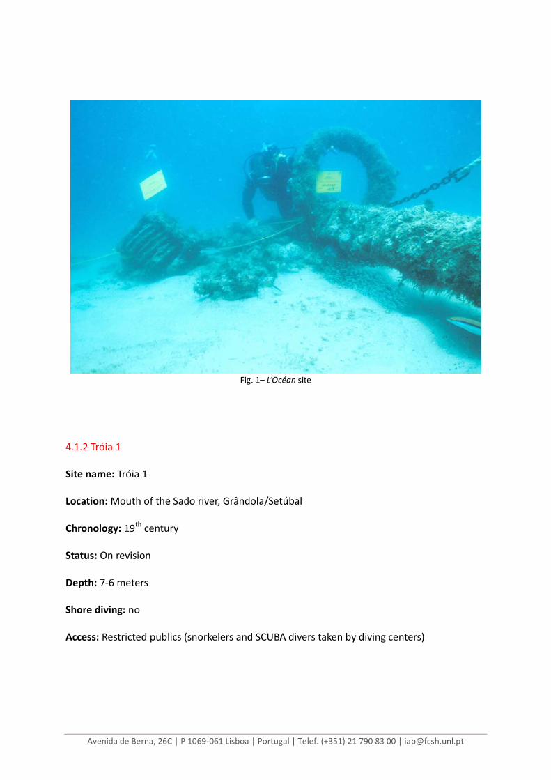
4.1.MAINLAND 4.1.1 L’Océan Site name: L’Océan Type: Ship of the line Location: Salema beach, Algarve Chronology: 1759 Status: Protected Depth: 6-9 meters Shore diving: yes Access: All publics (snorkelers and SCUBA divers) Background: The L’Océan was a60 meter long, 80-gun first rate French ship of the line, that, during the Seven Years War, was forced to beach at Praia da Salema, Algarve, by a an English fleet, on August, the 18th, 1759. Subsequently burned to the waterline, the wreck site, in very shallow water, was heavily salvaged during the 1960’s, with the bronze guns being recovered and sold for scrap. It’s remains were later rediscovered and, in the 1980’s, were subject to what is considered to be the first underwater archaeological project ever to be conducted in Portugal, a survey conducted under the direction of Francisco Alves, the then Portuguese National Archaeological Museum’s director. Some of the heavier item, such as cannons and anchors were left in situ and made the basis for the first underwater archaeological park. References: ALVES, Francisco (1992) “O itinerário arqueológico subaquático do ‘Océan’”, in Arqueólogo Português, vols 8-10, série IV; CATITA, Susana coord. (2010) “Guia de Mergulho do Algarve”. Portimão: Subnauta.
Avenida de Berna, 26C | P 1069-061 Lisboa | Portugal | Telef. (+351) 21 790 83 00 | [email protected]
Fig. 1– L’Océan site
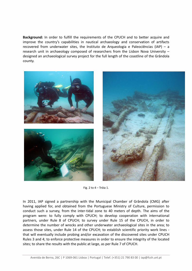
4.1.2 Tróia 1 Site name: Tróia 1 Location: Mouth of the Sado river, Grândola/Setúbal Chronology: 19th century Status: On revision Depth: 7-6 meters Shore diving: no Access: Restricted publics (snorkelers and SCUBA divers taken by diving centers)
Avenida de Berna, 26C | P 1069-061 Lisboa | Portugal | Telef. (+351) 21 790 83 00 | [email protected]
Background: In order to fulfill the requirements of the CPUCH and to better acquire and improve the country’s capabilities in nautical archaeology and conservation of artifacts recovered from underwater sites, the Instituto de Arqueologia e Paleociências (IAP) – a research unit in archaeology composed of researchers from the Lisbon Nova University – designed an archaeological survey project for the full length of the coastline of the Grândola county.
Fig. 2 to 4 – Tróia 1.
In 2011, IAP signed a partnership with the Municipal Chamber of Grândola (CMG) after having applied for, and obtained from the Portuguese Ministry of Culture, permission to conduct such a survey, from the inter-tidal zone to 40 meters of depth. The aims of the program were: to fully comply with CPUCH; to develop cooperation with international partners, under Rule 8 of CPUCH; to survey under Rule 15 of the CPUCH, in order to determine the number of wrecks and other underwater archaeological sites in the area; to assess those sites, under Rule 14 of the CPUCH; to establish scientific priority work lines - that will eventually include probing and/or excavation of the discovered sites under CPUCH Rules 3 and 4; to enforce protective measures in order to ensure the integrity of the located sites; to share the results with the public at large, as per Rule 7 of CPUCH.
Avenida de Berna, 26C | P 1069-061 Lisboa | Portugal | Telef. (+351) 21 790 83 00 | [email protected]
The program also included the documentation of written and oral sources that could help our understanding of the maritime history of the region. It was during that phase that a wreck site was reported by local spear fishermen and Tróia 1 – the remains of a wooden hull dating from 1770 to 1850 – entered the official historical wreck record. Its analysis and recording is being done by UAL/IPT for a MA student thesis, under the direction of Adolfo Miguel Silveira Martins. Conditioned access was granted for divers and snorkelers. References: MONTEIRO, Alexandre (2012) “The Archaeological Survey of the coast of Grândola. Preliminary results” in Proceedings of the 13th International Symposium on Boat and Ship Archaeology, ISBSA13. Amsterdam. 4.2.AZORES ISLANDS Starting from the first half of the 15th century, the Azores islands were gradually colonized, with Portugal obtaining in them the much needed wheat, always scarce for the ever expanding maritime empire. Only with the more frequent appearance of ships - which, on their way back from the Gulf of Guinea, had to head for these latitudes in order to find favorable winds for their return to Europe - did the archipelago's role switch from granary to watchful and protective mid-Atlantic trading post, forecasting what would happen years later, when Christopher Columbus passed through Santa Maria island, where he fought a little skirmish with the local islanders, on his way back from the Caribbean. Five years later, Vasco da Gama, returning from India, stopped over in Angra where he buried his brother, Paulo da Gama.
The resulting development of the Azores and mainly of Terceira island, led to the creation, in Angra, of several institutions that supported the transatlantic navigation's, most notably a hospital built to cure wounded and ill sailors and a Purveyor's Office for the Armadas from India. One of the main engines of the island’s economy was the provision of services to ships and travelers, with the archipelago reaching the peak of its development in 1583, when Philip II of Spain became King of Portugal. All the Iberian ships coming from overseas passed then through the Azores, making the islands a very attractive target for the northern European privateers that went rampant on the two last decades of the 16th century. The end of the Iberian union in 1641 significantly reduced the Azores islands role as a trading post. That event, together with the fierce competition from the Dutch and English East Indies companies, which had been growing since 1600, spelled the end of the role of the Azores as a trading post. With Azores's extensive maritime history and abundant coastline, shipwrecks are an important component of the region's underwater heritage. It was considering that the Azorean submerged cultural resources represent unique and valuable, publicly owned resources that have the potential to provide sustained cultural, recreational, and economic values and benefits, while significantly representing archaeological and historical values that are not renewable, that the Azorean Cultural Direction of the Regional Government (DRAC, actually DRC), the Institute of Nautical
Avenida de Berna, 26C | P 1069-061 Lisboa | Portugal | Telef. (+351) 21 790 83 00 | [email protected]
Archaeology from the Texas A&M University (INA) and the Portuguese Center for Nautical and Underwater Archaeology (CNANS) have developed, over time, isolated actions on this field, and promoted several initiatives in collaboration with the non-profit cultural association Arqueonautica, to locally create a group of interested and qualified people to develop the protection of the underwater cultural heritage.
One of these site investigations involved the execution of a pre-disturbance survey, prior to the construction of a yachting harbor, in Angra bay, Terceira island. And that because although Angra bay being no larger than 10 soccer fields, at least 96 shipwrecks have occurred there between 1522 and 1998, with the majority of them being Portuguese and Spanish ships coming back from India or the New World. As such, an underwater archaeological team, sponsored by the Regional Government of the Azores, the Portuguese Institute of Archaeology and the Angra Harbor Authority, developed a two-phase campaign, between September 1997 and July 1998. In the end, Angra bay - plundered by treasure hunters in 1972, threatened by salvage activities between 1993 and 1996, mutilated by a marina in 1998 - was turned into a classified underwater archaeological preserve in 2005. 4.2.1 The Anchor field Site name: Âncoras da Baía de Angra Location: Angra do Heroísmo bay, Terceira Island, Azores Chronology: post-medieval Status: Protected by special decree Depth: 15-30 meters Access: All publics (SCUBA divers) Background: Anchors of all sorts and ages, lost on the rocky eastern shores of the volcanic rock of Monte Brasil make a trail for intermediate to advanced divers. References: ALVES, Francisco, GARCIA, Catarina & MONTEIRO, Alexandre (1999) "Estratégias e metodologias da intervenção arqueológica subaquática no quadro do projecto da construção de uma marina na baía de Angra do Heroísmo (Terceira, Açores)" in Revista Portuguesa de Arqueologia, vol. 2, nº 2. Lisboa: Instituto Português de Arqueologia, pp. 199-210; CHOUZENOUX, Christelle (2011) “Caractérisation et Typologie du Cimetière des Ancres”. Tese de Mestrado, Universidade Fernando Pessoa.
Avenida de Berna, 26C | P 1069-061 Lisboa | Portugal | Telef. (+351) 21 790 83 00 | [email protected]
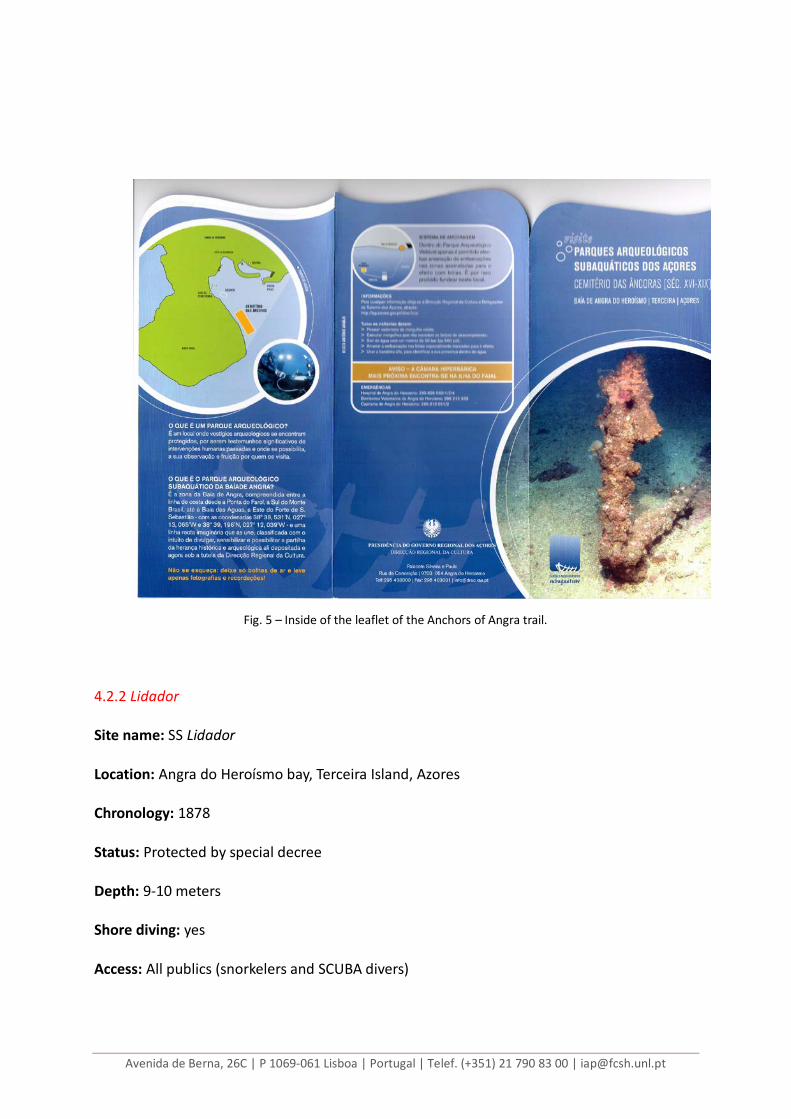
Fig. 5 – Inside of the leaflet of the Anchors of Angra trail. 4.2.2 Lidador Site name: SS Lidador Location: Angra do Heroísmo bay, Terceira Island, Azores Chronology: 1878 Status: Protected by special decree Depth: 9-10 meters Shore diving: yes Access: All publics (snorkelers and SCUBA divers)
Avenida de Berna, 26C | P 1069-061 Lisboa | Portugal | Telef. (+351) 21 790 83 00 | [email protected]
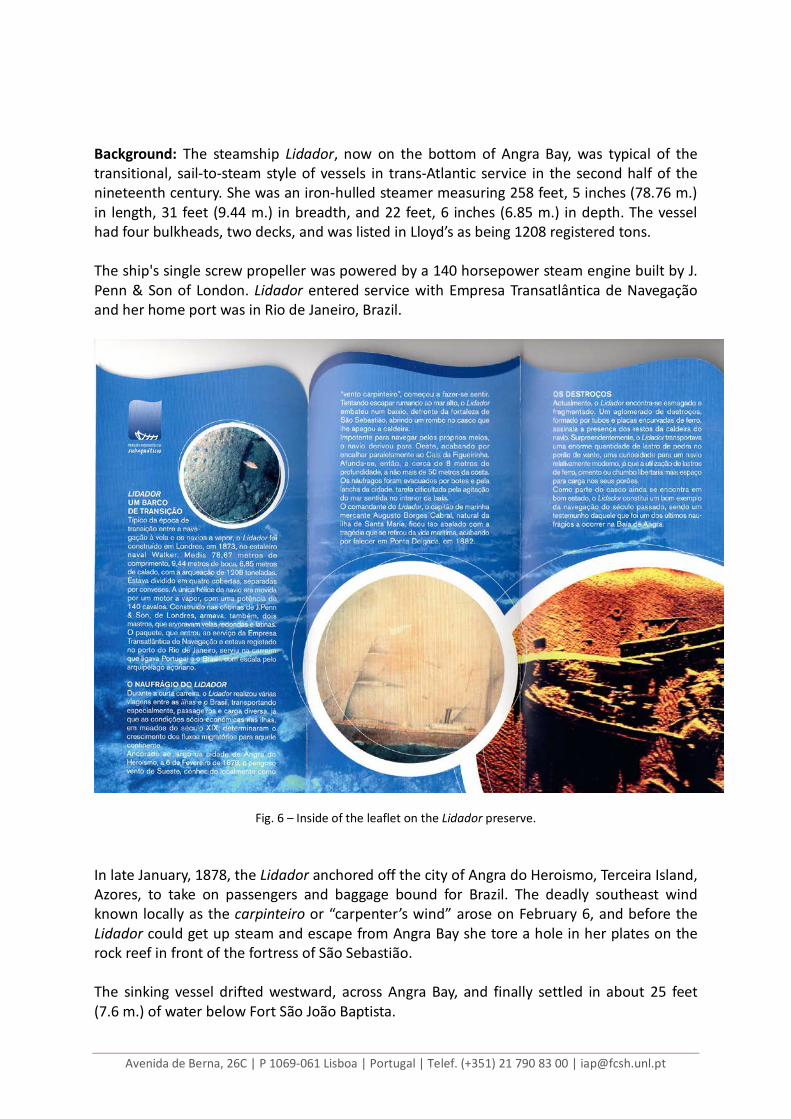
Background: The steamship Lidador, now on the bottom of Angra Bay, was typical of the transitional, sail-to-steam style of vessels in trans-Atlantic service in the second half of the nineteenth century. She was an iron-hulled steamer measuring 258 feet, 5 inches (78.76 m.) in length, 31 feet (9.44 m.) in breadth, and 22 feet, 6 inches (6.85 m.) in depth. The vessel had four bulkheads, two decks, and was listed in Lloyd’s as being 1208 registered tons. The ship's single screw propeller was powered by a 140 horsepower steam engine built by J. Penn & Son of London. Lidador entered service with Empresa Transatlântica de Navegação and her home port was in Rio de Janeiro, Brazil.
Fig. 6 – Inside of the leaflet on the Lidador preserve. In late January, 1878, the Lidador anchored off the city of Angra do Heroismo, Terceira Island, Azores, to take on passengers and baggage bound for Brazil. The deadly southeast wind known locally as the carpinteiro or “carpenter’s wind” arose on February 6, and before the Lidador could get up steam and escape from Angra Bay she tore a hole in her plates on the rock reef in front of the fortress of São Sebastião. The sinking vessel drifted westward, across Angra Bay, and finally settled in about 25 feet (7.6 m.) of water below Fort São João Baptista.
Avenida de Berna, 26C | P 1069-061 Lisboa | Portugal | Telef. (+351) 21 790 83 00 | [email protected]
Today, the Lidador lies crushed and flattened, her sides broken away and her bow twisted over to port. The engine and propeller are missing and were presumably salvaged, but the propeller shaft and the shaft alley are visible amongst the ballast stones in the after end of the vessel. Further forward, a pile of rusted iron pipes and curved iron plates are evidence of the boilers, Lidador carried a large mass of stone ballast in her forward hold, a somewhat surprising feature for a vessel of this type and recent vintage. References: MONTEIRO, Alexandre (2007), "O naufrágio do vapor Lidador na ilha Terceira, Açores (1878): relatório preliminar", in Al-madan, II série, nº 15, 2007, Adenda electrónica. Centro de Arqueologia de Almada, pp.1-2. 4.2.3 Dori Site name: Dori, ex-Edwin L. Drake Location: São Roque beach, Ponta Delgada, São Miguel Island, Azores Chronology: 1942-1961 Status: Protected by legal decree Depth: 20-15 meters Shore diving: no Access: All publics (SCUBA divers) Background: This tramp steamer - sunk in 1961 with a cargo of steel coils, while en route from Germany to the United States of America - turned out to be a former US Liberty ship that saw action on D-Day, and basically on any other sea theater of the World War Two: Murmansk, Gibraltar, Alexandria and the Pacific. Its legal protection was required from the Regional Government by local divers that had witnessed the success of the Lidador preserve, in nearby Terceira Island (see 3.2.2). A year after, that protection is still being worked out, much to the dismay of those said local divers.
Avenida de Berna, 26C | P 1069-061 Lisboa | Portugal | Telef. (+351) 21 790 83 00 | [email protected]
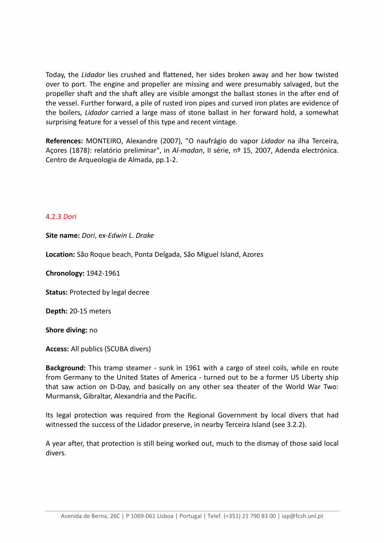
Fig. 7 – Article on a regional newspaper, narrating the issues between the local diving community and the
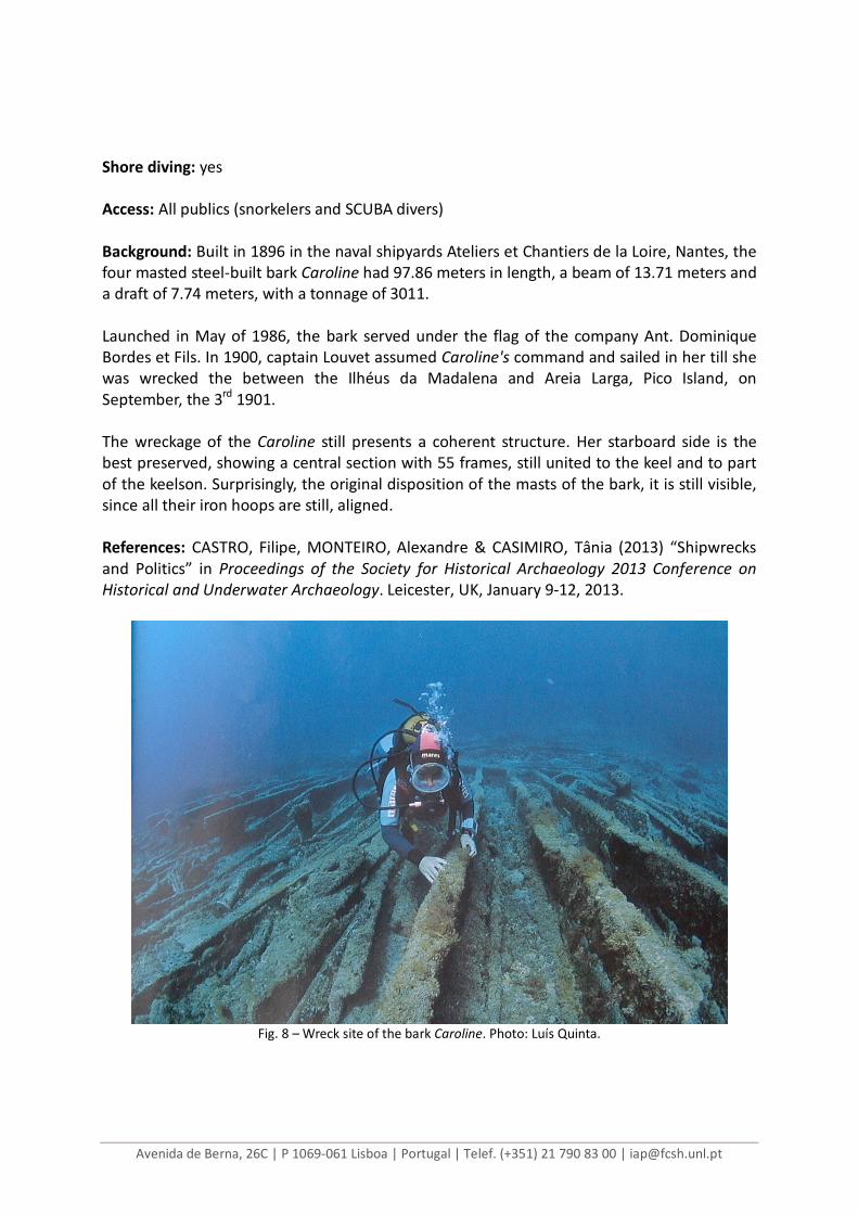
Azorean Government over the alleged slow pace on the protection conferred on the wreck site of the Dori. 4.6 Caroline Site name: Caroline Location: Meia Broa sea, Madalena, Pico Island, Azores Chronology: 1901 Status: On revision Depth: 8-10 meters
Avenida de Berna, 26C | P 1069-061 Lisboa | Portugal | Telef. (+351) 21 790 83 00 | [email protected]
Shore diving: yes Access: All publics (snorkelers and SCUBA divers) Background: Built in 1896 in the naval shipyards Ateliers et Chantiers de la Loire, Nantes, the four masted steel-built bark Caroline had 97.86 meters in length, a beam of 13.71 meters and a draft of 7.74 meters, with a tonnage of 3011. Launched in May of 1986, the bark served under the flag of the company Ant. Dominique Bordes et Fils. In 1900, captain Louvet assumed Caroline's command and sailed in her till she was wrecked the between the Ilhéus da Madalena and Areia Larga, Pico Island, on September, the 3rd 1901. The wreckage of the Caroline still presents a coherent structure. Her starboard side is the best preserved, showing a central section with 55 frames, still united to the keel and to part of the keelson. Surprisingly, the original disposition of the masts of the bark, it is still visible, since all their iron hoops are still, aligned. References: CASTRO, Filipe, MONTEIRO, Alexandre & CASIMIRO, Tânia (2013) “Shipwrecks and Politics” in Proceedings of the Society for Historical Archaeology 2013 Conference on Historical and Underwater Archaeology. Leicester, UK, January 9-12, 2013.
Fig. 8 – Wreck site of the bark Caroline. Photo: Luís Quinta.
Avenida de Berna, 26C | P 1069-061 Lisboa | Portugal | Telef. (+351) 21 790 83 00 | [email protected]
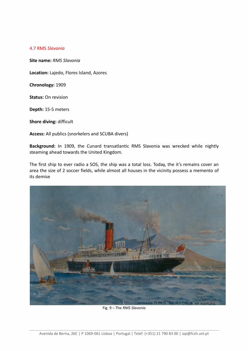
4.7 RMS Slavonia Site name: RMS Slavonia Location: Lajedo, Flores Island, Azores Chronology: 1909 Status: On revision Depth: 15-5 meters Shore diving: difficult Access: All publics (snorkelers and SCUBA divers) Background: In 1909, the Cunard transatlantic RMS Slavonia was wrecked while nightly steaming ahead towards the United Kingdom. The first ship to ever radio a SOS, the ship was a total loss. Today, the it’s remains cover an area the size of 2 soccer fields, while almost all houses in the vicinity possess a memento of its demise
Fig. 9 – The RMS Slavonia