detroit plan cover - rails-to-trails conservancy
TRANSCRIPT
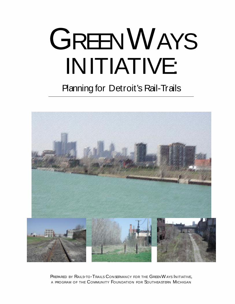
GREENWAYSINITIATIVE:
Planning for Detroit’s Rail-Trails
PREPARED BY RAILS-TO-TRAILS CONSERVANCY FOR THE GREENWAYS INITIATIVE,A PROGRAM OF THE COMMUNITY FOUNDATION FOR SOUTHEASTERN MICHIGAN
The purpose of Rails-to-Trails Conservancy
is to enrich America’s communities and countryside
by creating a nationwide network of public trails
from former rail lines and connecting corridors.
PROJECT TEAM MEMBERS
Kate Bickert
Jeff Ciabotti
Nancy Krupiarz
Hugh Morris
Darren Smith
This report was made possible by a generous grant from the GreenWays Initiative, a five-year programof the Community Foundation for Southeastern Michigan. Rails-to-Trails Conservancy and our manyMichigan partners extend our gratitude for the foundation’s support and vision to create a regionalgreenways system that will reconnect communities with parks and open space, walking and bicyclingfacilities, mass transit and cultural and historical resources. The GreenWays Initiative, launched in2001, is a comprehensive effort aimed at expanding and enhancing our region’s natural landscape.The GreenWays Initiative is about linkage, leverage and collaboration: linking communities...leveragingvision, resources and people...and collaborating to promote and protect the health and well being ofthe community for the present and the future.
SPECIAL ACKNOWLEDGEMENTS
The Rails-to-Trails Conservancy would like to recognize the work of several individuals that greatly
enhanced the accuracy and utility of this report: Tim Karl, City of Detroit Recreation Department,
Jared Fijalkowski, RTC intern, Andrea Ferster, RTC general counsel, Barbara Richey, RTC graphic
designer and Christie Carpenter, RTC editor.
Rails-to-Trails Conservancy • 1100 Seventeenth Street N.W., 10th Floor • Washington, D.C. 20036
Tel: 202-331-9696 • Fax: 202-331-9680 • www.railtrails.org
GREENWAYSINITIATIVE:
Planning for Detroit’s Rail-Trails
Abandoned Rail Corridor Inventory and Assessment
FINAL REPORTOctober 2002
TRAILDDDDDAAAAARRRRRTTTTTTRTRTRTRTRAILAILAILAILAIL DDDDDEVELOPMENT AAAAASSISTANCE RRRRRESPONSE TTTTTEAM
A Service of Rails-to-Trails Conservancy
TABLE OF CONTENTS
Preface ............................................................................................................................. 1
Introduction ....................................................................................................................... 2Overview of the Detroit Metropolitan Area ................................................................ 2The Value of Rail-Trails ................................................................................................ 3Technical Methodology ............................................................................................... 4
Phase IPhase IIGIS Base MapsPhoto Image Inventory
Phase I: Comprehensive Inventory .................................................................................... 6Interstate Commerce Commission and Surface Transportation Board ResearchInventory of Related Cultural and Natural Resources
Phase II: Assessment ......................................................................................................... 7Assessment of Abandoned Rail Corridors (including: inventory — ICC and STB research,corridor evaluation, ownership analysis and GIS maps)
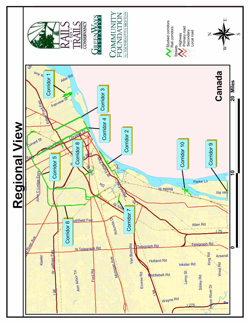
Regional Index Map ............................................................................................. 8Target Corridors Map ........................................................................................... 9Corridor 1: Conrail Superior Lead .......................................................................10Corridor 2: Target Conrail Exposition Spur .......................................................... 13Corridor 3: Target Detroit Belt Line and Transit Branch .......................................19Corridor 4: Target Grand Trunk Line .................................................................. 25Corridor 5: Target Conrail — Former Detroit Terminal ........................................ 32Corridor 6: West Belt and Spur Trackage ........................................................... 40Corridor 7: Conrail — Detroit, Dearborn and Delray Branch ............................... 43Corridor 8: Target CSX Union Belt ..................................................................... 45Corridor 9: Grosse Ile Railroad Grade ................................................................. 49Corridor 10: Wyandotte Terminal Railroad ......................................................... 51
Proposed Regional Loop SystemDescription ......................................................................................................... 54GIS Map ............................................................................................................. 55
Legal Analysis of Michigan Railroad Law ........................................................................ 56
Proposed Action Steps for Implementation ..................................................................... 59
Appendix A: Funding and Support Sources for Greenways and Trails .............................. 62
Appendix B: Photo Inventory ........................................................................................... 70
Appendix C: Concurrent Projects in Greater Detroit ........................................................ 77
Appendix D: Neighborhood Cluster Boundaries and Information .................................... 79
Appendix E: Database of Contact Information Related to Study ......................................81
Appendix F: About Rails-to-Trails Conservancy ................................................................. 83
1
PREFACE
Building on the farsighted blueprint provided by A Vision for Southeast Michigan Greenways, Septem-ber 1998, this regional assessment provides crucial information and analysis necessary to move thecompelling idea of an interconnected system of trails from vision to reality. Building on high initialexpectations for Detroit’s rail-trail conversion opportunities, this assessment demonstrates the exist-ence of a network of abandoned railroad corridors greater than our original projections.
The city of Detroit is fortunate that the area’s once vibrant railroad infrastructure remains available toform the basis of an interconnected regional network of greenways and trails. This network of greeninfrastructure would provide local residents with abundant opportunities for healthy recreation, openspace preservation, non-motorized transportation and economic and community revitalization. As anative of southeast Michigan, it is truly a privilege to be part of the renaissance of one of our nation’sgreat urban centers.
This assessment would not have been possible without the assistance of many people and organiza-tions. From the initial inventory and ground-truthing site visits to learning about the many plans andprojects currently underway, we at Rails-to-Trails Conservancy deeply appreciate the information andinsight provided by individuals, non-governmental organizations, city and county agencies and corpo-rations. Special thanks are due to the GreenWays Initiative, a program of the Community Foundationfor Southeastern Michigan for their commitment to making the greater Detroit region a nationalmodel for revitalization through the development of green infrastructure.
The vast amount of research and analysis revealed in GreenWays Initiative: Planning for Detroit’s Rail-Trails provides a solid foundation for the development of greenways and trails in southeast Michigan.These community assets will stand as a lasting legacy worthy of the committed individuals and organi-zations seeking to realize the vision of an interconnected system of greenways in their backyards.
Keith LaughlinPresidentRails-to-Trails Conservancy
2
INTRODUCTION
The greater Detroit region has an extensive network of railway corridors, many of which were builtaround the turn of the twentieth century as a means of transporting goods, materials and people bothin and out of state. However, during the later part of the century, as other means of overland trans-portation were developed, train service was discontinued and many of the lines abandoned. The regionnow has the opportunity to protect these abandoned corridors for potential future rail use and developa system of interconnected greenways providing recreational and non-motorized transportation corridors.This study is part of the landmark GreenWays Initiative that is expected to put a minimum of $75million to work from private industry, foundations and public agencies to create and expand greenwaysin Wayne, Oakland, Macomb, Monroe, Washtenaw, St. Clair and Livingston counties.
Across the United States, many abandoned rail corridors continue to be lost for public trail use toroads, parking lots or adjacent development. Public agencies, nonprofit organizations and privatecitizens now understand the value of these resources and are attempting to reclaim corridors beforethey are lost forever.
The following study of abandoned rail corridors provides a detailed look at the remaining corridors inDetroit and evaluates their prospects for rail-trail conversion. The study inventories and maps all railcorridors abandoned between 1962 and mid-2002 in order to assess their potential for developmentas recreational trails, non-motorized transportation connectors or other public uses.
OVERVIEW OF THE DETROIT METROPOLITAN AREA
The city of Detroit covers 139 square miles of land on the west bank of the Detroit River in southeast-ern Michigan. With a population of more than 950,000, Detroit is a major metropolis in the Midwestsituated on the Canadian border. Characterized by its rich history as one of the first cities west of theoriginal 13 colonies, Detroit is distinguished by its automotive legacy. Recent efforts have been estab-lished to revitalize the city and reinvent the prosperity of its past.
While Detroit existed before railroads reached the Midwest, rail service expedited its growth. Detroitsaw its first railroad and first steam engine in the mid-1830s. The city grew to become a major trans-portation link between the East, the West and parts of Canada. Railroads fueled the growth of indus-try, contributing to the conglomeration of the automobile industry in Detroit at the turn of the twenti-
PROJECT GOALS:
➊ Provide a comprehensive inventory and assessment ofabandoned railroad corridors in the greater Detroit region
➋ Select target corridors best suited for rail-to-trail conversion
➌ Develop the study as a vehicle to encourage and promotelocal organizations to pursue trail development
3
eth century. Ironically, however, it was the automobile that lead to the demise of much of the railservice across the country, including Detroit.
The automobile industry in Detroit spurred growth in freight service to the city, but lead to a declinein passenger rail service. The city’s streetcar system was replaced by diesel bus service. Railroad com-panies merged to avoid bankruptcy and closure. The automobile became the dominant form of trans-port to, from and around the city. Many railroad companies left the city, leaving abandoned corridorsbehind.
In recent decades, Detroit has been working to reclaim its status as a major economic center whileimproving the quality of life for its citizens. The automobile industry has made grand investments inthe city, developing brownfield sites into commercial buildings and parks. Major revitalization projects,such as the Renaissance Center project of the late 1970s and current Detroit Riverfront projects, havebegun to reverse the decay caused by the exit of job-producing and tax-paying corporations. Detroit isbeginning to realize its vision of a more beautiful and sustainable city.
Despite urban revitalization projects growing in the city, there is a lack of focus on the development ofnon-motorized or public transportation in Detroit. The departure of railroad companies throughoutthe twentieth century left linear footprints in the heart of the city. Miles of abandoned rail corridors inthe city have the potential to become rails-to-trails projects, linking residential neighborhoods, schools,commercial areas and parks. Rail-trails bring economic growth to the communities they traverse andraise property values of the land that surrounds the trails. Rail-trails would be a tremendous compli-ment to the economic development projects in Detroit.
The revitalization of Detroit continues to take shape in many projects and proves to be an extremelysuccessful endeavor. A system of networked trails would connect those projects with Detroit citizensby linking neighborhoods to transportation hubs, schools, public parks and centers of business. Citi-zens would become connected with the revitalization of their city through the development of a net-work of rail-trails traversing the city. Converting the existing abandoned rail corridors into a network ofpublic trails and greenways will lead to the reclamation of Detroit’s prestige as a world-class city.
THE VALUE OF RAIL-TRAILS
Trails and greenways positively impact individuals and improve communities by providing recreationand transportation opportunities and encouraging economic and community development. Trails andgreenways bring many benefits to the communities they traverse.
Multiple Recreation Opportunities. Rail corridors are flat or have gentle grades, making them perfectfor multiple users, including walkers, inline skaters, bicyclists and people with disabilities. Trails aremultimodal and versatile passageways.
Economic Renewal and Growth. Trail users spend money on products and services related to recre-ational activities. Bicycle and inline skate shops, food stores, hotels and tourist locations report anincrease in business as a result of trails. Trail-related businesses spring up in communities with trails,spurring economic growth in the area.
Increased Property Values. Studies have shown that properties on land adjacent to trails and greenwaysoften increase in value. People are willing to pay more to have a multi-use trail in their neighborhood.Trails have become an important amenity that many look for when choosing where to live.
4
Healthy Living. The U.S. Surgeon General estimates that 60 percent of American adults are not regu-larly active and 25 percent are not active at all. In communities across the country, people do nothave access to trails, parks or other recreation areas close to their homes. Trails and greenways providesafe, inexpensive avenues for regular exercise.
Environmental Protection. Trails and greenways help improve air and water quality. Communities withtrails provide enjoyable and safe options for clean transportation, which reduces air pollution. Byprotecting land along rivers and streams, greenways prevent soil erosion and filter pollution caused byagricultural and road runoff.
Connecting People and Communities. Trails serve as utilitarian transportation corridors betweenneighborhoods and workplaces. They connect congested urban areas with open space. By bringingpeople to greenways for their daily commutes, trails unite people and their natural surroundings.
Regional Systems. As trails begin to interconnect, regional systems emerge creating threads of greenlinkages within and between communities. Trails serve as the backbone for these systems, increasingthe value of the whole by connecting the parts. Regional trail systems cross political, social and eco-nomic barriers, allowing trail users to form new connections with neighboring communities. Theseribbons of green link schools, parks, commercial areas, neighborhoods and waterfronts, allowing trailusers to traverse the region solely and safely on trails. Trail networks form a more cohesive transporta-tion system, allowing people to travel to other communities or to work and to combine trail use withother forms of transit. Regional trail systems draw more riders from outside the community, contribut-ing to the economic growth of the region. Bringing trails together to form networks dramatically in-creases the positive effects that trails bring to their communities.
TECHNICAL METHODOLOGY
This project inventories and assesses abandoned rail corridors in order to identify opportunities fortrail development in Detroit and builds from the 1998 document, A Vision for Southeast MichiganGreenways. Rails-to-Trails Conservancy’s (RTC) trail planning team, in coordination with our Michiganfield office, researched, analyzed and produced the report. Information and guidance was gained fromthe City of Detroit Parks and Recreation Department, the Planning and Development Department,Southeast Michigan Council of Governments, Wayne County Tax Assessors Office, the American Heri-tage River Project and consultants Hamilton Anderson & Associates. Railroad companies includingConrail, Canadian National (CN), CSX and Norfolk Southern also were involved in this report.
This process of inventorying and analyzing abandoned rail corridors across the Detroit Region wascomposed of two phases:
■ Phase one developed a comprehensive inventory of all rail corridor abandonments in WayneCounty, Michigan recorded between 1962 and 2002, including available original ownershipinformation and was completed through:
(a) research of the Surface Transportation Board (STB) records and those of its predecessor,the Interstate Commerce Commission (ICC). The STB maintains a list of proposed and ap-proved corridor abandonments, which it updates on a continual basis. A total of 10 entries— some of which combined mulitple STB proceedings — were identified in a comprehensivesearch of this data (five corridors are more than two miles in length).
5
(b) findings of the Southeast Michigan Greenways: Wayne County Report, July 1994.
(c) A Vision for Southeast Michigan Greenways, September 1998.
(d) information gathered from local sources on the future disposition of area corridors in-cluding representatives from affected railroad companies.
■ Phase two assessed the inventoried corridors, completed an analysis of their merits for devel-opment as multi-use trails and developed a targeted list of five corridors which were given amore in-depth analysis. Current ownership information was assembled for these targetedcorridors, relying largely on information from the City of Detroit Tax Assessors office. Part ofthe assessment section called ”Finding the Corridor” provides detailed street directions withtrail access points to offer maximum usability when surveying the corridors. A legal analysisof Michigan law as it relates to abandoned corridors was completed. General informationsections such as proposed action steps and analysis of potential funding sources were in-cluded to provide guidance on next steps in the rail-trail conversion process.
GIS maps show a regional perspective on all inventoried corridors, an area view of targetedcorridors, individual maps of each corridor and a recommended loop system. The projectteam also used the format of the GIS map to illustrate ownership location while providingnarrative analysis associated with the map segments. Photo images are imbedded into indi-vidual corridor maps at significant crossroads for a realistic trail perspective.
The photo image inventory provides snapshot images at incremental points along each corri-dor. This view provides a street level representation of the opportunities and constraintsunique to each corridor. See appendix A for the complete inventory.
The following report describes the methodology undertaken in both phases of the project. Each corri-dor is represented individually with subsections including corridor inventory, assessment summaries,ownership analysis, GIS maps and photo images. An additional section describing a recommendedtrail loop system provides a conceptual representation of future potential connectivity of the targetedcorridors.
6
PHASE I:INVENTORY OF WAYNE COUNTY ABANDONED RAIL CORRIDORS
The corridor inventory information, which identifies each abandoned corridor, is included in eachcorridor section for this report. The database lists the corridors, STB docket numbers and submissionnumbers if applicable (necessary for locating the abandonment information on the corridor in the STBrecords). Also included is the date the railroad owner filed for abandonment. Further information onthe corridor includes its length and title, which is usually expressed by its location between two endpoints, and the county through which it passes. Finally, the inventory includes area resources thatintersect with specific corridors and a comments section derived from STB records and informationgained from local sources. See individual corridor assessments for inventory information.
CORRIDOR INVENTORY KEY
Label: Number used to identify the corridor on maps and in other assessment documentation.
Name: The railroad trackage name for the corridor (the line, branch or spur name).
Topographical Coordinates: The coordinates guide to corridor locations on the USGS topo-graphic quadrangle maps.
Old Ref.: The reference code(s) for corresponding corridors in the previous Wayne Countycorridor assessment.
Length: The total end-to-end length of the corridor (does not include spur trackage).
Endpoints: Potential beginning and end of the trail corridor.
Linkages (Schools): Schools in immediate proximity to the corridor.
Linkages (Parks): Parks in immediate proximity to, or connected by, the corridor.
Linkages (Other: Museums, Hospitals, Libraries, etc.): Other landmarks and civic destinationsin immediate proximity to the corridor.
Comments: General narrative about the status of the corridor.
Docket Numbers: The docket numbers of any STB/ICC proceedings pertaining to the corridor.
Contacts: Key contact person(s) for the corridor.
7
PHASE II:ASSESSMENT AND PRIORITIZATION OF INVENTORIED CORRIDORS
In phase II the project team identified target projects that represent the best opportunities for rail-trailconversion by analyzing the merits of each abandoned corridor. These corridors received in-depth landuse and ownership analysis and include a GIS map with segment identifiers for easy transition be-tween map and related narrative.
The phase II corridor analysis was based on information gathered during the inventory and specificcriteria including ownership status, adjacent land uses, access points, resource characteristics andphysical features. Targeted corridors also were evaluated for potential uses for transportation, recre-ation, economic development, natural resource protection, cultural interpretation, utility developmentand connectivity to community resources. Additionally, during site visits conducted to ground-truth thecorridors, the project team compared maps and associated research with the actual location and cir-cumstances of the corridor. The information gathered during these site visits is provided in the sec-tions identified as Corridor Evaluation and Ownership/Land Use Summary.
Both summary and detailed ownership analyses were developed for each targeted corridor by re-searching city of Detroit tax records and consulting with the appropriate railroad companies. Theownership information included in the Assessment section is essential for determining the availabilityof a corridor for trail conversion. In some cases, current information on the status of a corridor couldnot be obtained through the city records and was supplemented by input from railroad representativesand local contacts.
This phase II analysis clearly demonstrated the emergence of a potential regional trail loop system. Inoverlaying maps from Southeast Michigan Council of Governments and other area planning projects,the project team discovered connections between the targeted corridors and existing plans thatshowed promise as a loop system. As a result, an additional section to the report identifies the systemand gives a brief description of its potential.
Additionally, during the site visits, the project team compiled a photo inventory of the corridors (seeappendix B) to provide an accurate representation of their status at selected crossroads.
����
����
�����
����
���� ��
� ��
��������
��
�� ����� �
�
����� ��
������������
����������
��
����
����
�����
� ��
���������
���
������
������
!�"#�
���$
��%������� ��&� ��
���"#�
'����� ���$
���!���(�
����
���
&� !�$
�#���"
#�
)�'����� ���$ '����� ���$
�� *��$
"���!�$
�!*����$
����$
� �*�"#�
+�!��$
������$ ����,����$
- !�.
��!�$
�����
����$
"!!�"
�,���'��
� �!��$
��,��
��$
����� !�$
$��%!
���
����
�$
.������
"�����$
.����$
-��!����$
/%��!�$
�#����
�
��! !����
&�,� �� ��$
+�����$
��/%
��!�$
"��! ��$
0 �*��(!
���� !���
��#�����
�
���
/��� !�$
/�!����
�
+����
�
(������
�
1�����
�%���
���
����
��
������
�����
���
����
�
�
��
�
��������2
���������
��������3
���������
��������� ���������
��������4
���������
��������2
5
���������
������/���
� �
0��6 ����
�
����!
���
!���
!!����!���
�
(�� ����
� ��
��,�
��� ��
$ ����
����
��
��%
�����
����
�
����
��������
��
��� �����
��
���������
�������
��� ���
�����
�����������
�
������������
����
��������
��
����
��������
��
��� �����
���
����
�������
���������
�
�������
����
��������
��
�� ��
�!���
����
���"�
#$������
���
%����#�
&� �� '��#�
���� ������"�
!���� ������
���
���� ��
��
�� ����"�
���'���
�
� �"
�
���������
����
����
(�����
�"�
��)�
�����"�
�������
�� ����
����� ���
#�
#��������"�
! � �#�
�������"�
*���+���#�
��&�
� ��%
�
�����
��*���
%� ���#�!�
��#�
� � ��#
�
��������#
�
*����'�#
�
������� �#
�
,�'�
��*
���
���� ��� �#�
,$������
!������#
�
���
��%����
���#�
���
���#�
�� ����
�#�
�����
��
-� �
��#�
������� ���
�
�� �����#�
�����
���#�
./���#�
��+�
��#�
��%������
0� �$�' �#�
1�����#�
�������/
�������2
��������
�������3
�������.
����
�������
���
��
����
����
�
�
��
�
#������%���
��
1��+�� ��
��
#�� �
�� ��
���
���� ���
��
!�����
������
��4�
#����
"�����
����
��
#�$�
�����
����
��
10
CORRIDOR 1: CONRAIL SUPERIOR LEAD
I NVENTORY
LABEL: 1(1a-c)
NAME: Conrail Superior Lead
TOPOGRAPHICAL COORDINATES: 46.91-2, 3.38
OLD REFERENCE: RR-15
LENGTH: 1.5 miles
ENDPOINTS: Detroit River; Near Jefferson Avenue (parallel to Lycaste)
LINKAGES (SCHOOLS):
LINKAGES (PARKS): Waterworks Park (East Jefferson Avenue and Parkview Street); Portersfield Ma-rina Village and St. Jean Boat Ramp (Freud Street and St. Jean Street); Algonquin Recreation Playfield(East Jefferson Avenue and Conner Avenue); Zachariah Chandler Park (Dickerson Street and FrankfortStreet); Conner Playfield (Conner Avenue and Harper Street)
LINKAGES (OTHER: MUSEUMS, HOSPITALS, LIBRARIES, ETC.):
COMMENTS: Conrail abandoned 0.8 miles of this corridor in 1984. According to Pat Bosch, NortownCommunity Development Corporation, there is a seven-neighborhood, nonprofit group initiative todevelop the Conner Creek Greenway. This group plans to use only a portion of the railroad corridor tothe north of this abandoned segment (located near PVS Chemical Plant) from Harper Road to the I-94overpass. The rest of the trail follows roads. They were awarded $75,000 from the GreenWays Initia-tive in the last round of Transportation Enhancements funding to develop Phase I of the trail, theMillbank segment from the Detroit River to Van Dyke and Conner Streets. This portion follows an oldNative American trail to the creek. They have until September 2002 to raise a $150,000 local matchto commence the project. Phase II would be developed along Millbank to Gratiot. Phase III woulddevelop it from Harper to Mack. Each neighborhood group will assume leadership as the trail gets totheir location.
In STB FD-33950, Jefferson Terminal Railroad Company (Crown Enterprises, Inc.) filed for permissionto operate on this line. They purchased it from Chrysler Corporation in 1994. However, the filing wasa tactic to avoid foreclosure by the city. These 1.2 miles are now in city ownership.
STB DOCKET NUMBERS: (1a) AB-167 sub 814 [7/2/84 - 0.83 miles (1b) AB-167 sub 818 [7/13/84 -850 feet] (1c) FD 33950 [3/15/01 - 1.2 miles]
CONTACT: Roger Storm
11
ASSE S SMENT
Corridor Evaluation: This corridor section is not of significant length and does not serve any areasexcept heavily industrial areas. At the Chrysler plant north of Jefferson Avenue, the corridor is ob-structed from reaching any of the residential neighborhoods to the northwest, and the condition ofthe line is somewhat degraded with potential contamination issues. In addition, much of the corridoris no longer in railroad ownership, though some is now held by the city of Detroit. Some of this landowned by the city on and adjacent to one of the branches of the corridor is being developed for useas a sewage and water reclamation plant. Given the surrounding industrial land uses, both current andplanned, the project team does not recommend pursuing this corridor section as a rail-trail conversion.
This railroad line continues on the other side of the Chrysler facility to an eventual connection withthe #5 corridor. However, this portion of the line is believed to be active in its entirety, and ownedpartially by Chrysler and other shippers. It is also heavily industrial for its entire length. The NortownCommunity Development Corporation’s plan for the Conners Creek Greenway includes only a verysmall portion of this corridor, presumably for shared, rail-with-trail use. Its potential for much more isvery limited.
Finding the Corridor: The two main branches of this corridor can be picked up via Freud Avenue which roughlyparallels East Jefferson Avenue but is closer to the riverbank. One branch of the corridor intersects Freud Avenuebetween St. Jean Avenue and Lycaste Street. The other crossing is just east of Lycaste Street. Neither branch ofthe corridor can really be followed by car or on foot, but driving toward the river on Clairpointe Street affords aview of the eastern branches of the corridor from the other side of the canalway.
O W N E R S H I P / L A N D U S E S U M M A RY
The majority of this corridor appears to be in Conrail (via Detroit Terminal Railroad) ownership, al-though pieces that fully obstruct the corridor’s path from the river to Jefferson Avenue have been soldand in some cases built upon. Portions of the corridor were bought by Crown Enterprises fromChrysler Corporation in 1994. A subsidiary of Crown, Jefferson Terminal Railroad Company, appliedto the STB for permission to operate rail service on the line south of the Chrysler plant. As mentionedin the inventory, they did this to avoid foreclosure by the city, however. The petition was rejected bythe STB and the land is now in city control. Another part of the corridor near Freud Ave. was pur-chased by Gilreath Manufacturers. Land adjacent to the corridor and its various leads is held mostlyby Crown, at least for now, with the exception of the Detroit Edison power facility between two ofthe leads near the river. Some of land adjacent to and including the westernmost lead near the river isowned by the city of Detroit.
��������
�������
����
����������
�
��� ����
���
�� �����
�����������
���
�������
�
��������
��������
�����
��������
��
�� ����
����
���������
��!�� ��
���
���� "��
���
���������
��!������
�
��!#����
���
$������
%���� ���
�&�
�!�������
����� ��
�
��!��������
&�����
����#���
'� �����
���
&��"�����
���
�� �� �
������
%���������
�����$�
����� ����
�
��� �������
�������
���
�
��������
������
���
����
�����
����
�
�
��
�(
()*()+
&����
�
13
T A R G E T
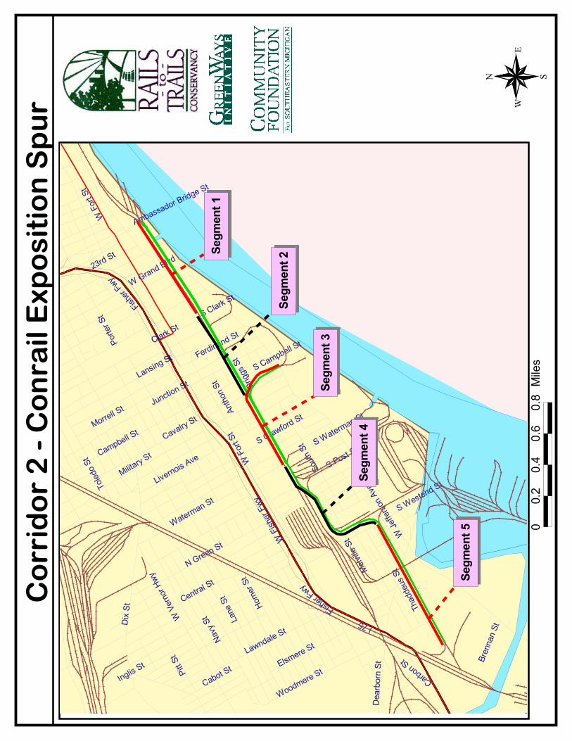
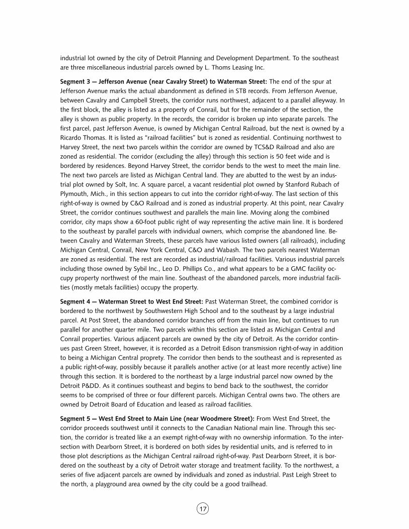
CORRIDOR 2: CONRAIL EXPOSITION SPUR
I NVENTORY
LABEL: 2 (2a-c)
NAME: Conrail Exposition Spur and Connecting Trackage
TOPOGRAPHICAL COORDINATES: 46.85, 3.26
OLD REFERENCE: RR-5(2a) RR-6(2b) RR-4(2c)
LENGTH: 3.5 miles
ENDPOINTS: Ambassador Bridge; near I-75 and Woodmere Street (considerable spur trackage)
LINKAGES (SCHOOLS): Southwestern High School (Waterman Street & W. Fort Street)
LINKAGES (PARKS): Riverside Park (West Jefferson Avenue & 24th Street - currently undergoing rede-velopment)
LINKAGES (OTHER: MUSEUMS, HOSPITALS, LIBRARIES, ETC.): Historic Fort Wayne (West JeffersonAvenue & Dragoo Street); Campbell Library (W. Fort Street & Crawford Street)
COMMENTS: A 2.3-mile segment was proposed for abandonment in 1981 (2a) and the MichiganDepartment of Transportation arranged financial assistance for the railroad for one year. The line wasabandoned in 1982 (valuation was $314,861). It is three tracks wide for most of the corridor, one ormore of which are active in some sections.
According to the old corridor assessment, the availability of suitable bridges across River Rouge toconnect this abandonment with the city of River Rouge and upstream destinations needs investiga-tion. The Rouge River Plan addresses this issue. There is a heavy industry area that leads into a quietresidential area as it proceeds southwest. At abandoned industrial sites such as Revere Copper, toxicsoils may be an issue.
STB DOCKET NUMBERS: (2a) AB-167 sub 121 [9/13/82 - 2.3 miles] (2b) AB-167 sub 836 [1/29/95 -0.24 miles] (2c) unknown
CONTACT: Bob Ryan, Conrail
Rick Hood, CSX
John Kelly, Norfolk Southern
14
ASSE S SMENT
Corridor Evaluation: This corridor is especially useful for its connections between elements of theSouthwest Detroit Riverfront Greenway Plan and the Rouge River Greenway. The Southwest DetroitRiverfront Greenway Plan outlines a system of enhanced sidewalks and bike lanes, while the RougeRiver Greenway would be an off-road facility. Corridor #2 interacts with both these projects and canserve as a link between the two.
Although the full use of this corridor would necessitate some rail-with-trail arrangements, the corridoris very wide in places where abandoned trackage parallels active trackage, and shared use would bepossible. Approval from CSX and Norfolk Southern, which share the active track, is unlikely. However,the portions of this corridor that are fully abandoned, including the spur to Fort Wayne and thebranch that continues all the way to the CN mainline near I-75, would be viable options for connect-ing the planned Southwest Riverfront bicycle and pedestrian paths with the Rouge River Greenway asan alternative to using Jefferson Ave. A greenway system that integrates all or part of corridor #2could provide safer separation from traffic, connections to Southwestern High School, McMillanSchool, St. John’s School, the athletic fields by I-75, Fort Wayne and Riverside Park with minimal on-road travel, as well as improve reach and access to the surrounding neighborhoods.
Finding the Corridor: The eastern portion of this corridor can be best viewed from intersecting streets. Theclosest parallel through streets are West Fort Street to the north and West Jefferson Avenue to the south, butthese are not close enough to allow a good view of the corridor. After the corridor curves southeast and thenback southwest, it can be paralleled fairly closely by following Thaddeus Street southwest from West End Street.The following access points afford good views of considerable lengths of the corridor:
A) The intersection of West Grand Boulevard and West Jefferson Avenue. The corridor passes through thisintersection, which is one long block south of West Fort Street.
B) Livernois Avenue just south of West Fort Street. This vantage point is particularly useful for seeing how thewidth of the corridor (and number of tracks) expands and contracts through this section.
C) West End Street just south of its intersection with Thaddeus Street, near McMillan School. There is an easyturn-off here from which to view the corridor just as it bends back to continue southeast, parallel to ThaddeusStreet.
����
������
������
�
��
�
��������
������
������
� ��
�����
�� �
�
�� ���� ��
���� ��
�� ��
���� ��
�� �����
�
��������
�����������
�� �����
�
�� �����!��
"�#��
� ��������
�
���$%
����
&������
���
"��'������
�(�)�����
��
*������
���������
��
���������
+������
&���$��
���
����%
�����
��������
��
&�����
��������
�
&����,��
�
��-���$
�.��$
/��$����
�0�$���
!�%����
*�������
�$����
$���
/��$$(���
��(�����
��,�����
����
�$���
��'����
�
���'�����
��*����
�����
�����$��
�
�%'��
$���.��$,
���
������%
�����
.�������
�
"��,,���
��%1'�
����
���������
����%1'
�����
2�%���
�
+�-��
���
���������
�
����
�����
����
�����
����
����
����
����
����
�����
16
O W N E R S H I P / L A N D U S E S U M M A RY
City tax maps do not consistently represent the abandoned portion of this corridor, but there appear tobe very few non-railroad landowners. Many of the remaining parcels are owned by the city of Detroit.The few parcels within the corridor that have been purchased by individuals are still listed as vacantproperties, and would not completely obstruct a trail even if they cannot be acquired. The railroad-owned land is mostly listed as Michigan Central property, but some parcels are listed as property ofConrail, C&O, Wabash and others. Most likely, all of these parcels are in Conrail control and cityrecords have not kept up with the railroad mergers that took place. Norfolk Southern and CSX sharethe active stretch from Cavalry Street east.
OWNERSH I P / LAND USE DETA I L S
*Note: The rail abandonment that makes up most of Target Corridor #2 begins at a point nearJefferson Avenue and Cavalry Street at the end of a spur that connects with the main line and runsparallel to Fort Street in a southwesterly direction before branching off from the main line again. Inaddition to this abandonment, we have also included in Target Corridor #2 (and in this ownershipsummary) the portion of that main line that extends northwest from the junction with the spur all theway to the rail yard near the Ambassador Bridge. This stretch is included because of its value as apotential rail-with-trail connection into Riverfront Park. The ownership summary begins with this section.
Segment 1 — Ambassador Bridge to Clark Street: Between the shadow of the Ambassador Bridge andGrand Boulevard, bordered on the northwest by Fort Street and on the southeast by the Detroit River,the corridor is either in public or railroad ownership. The parcel immediately west of the bridge isowned by CSX Transportation and marks the beginning of the active rail yard that extends beyond thebridge to the northeast. Corridor #2 proceeds southwest from this yard, and is represented on city taxmaps as an exempt right-of-way with no ownership information. Beyond the rail yard, the land adja-cent to the corridor is all owned by the city of Detroit, split between the Recreation Department(Riverfront Park), the Fire Department, the Sanitation Department, Public Works and Animal Control,with corresponding facilities located within each parcel. Moving southwest from Grand Boulevard, thecorridor continues to be represented as an exempt right-of-way of about 60 feet in width. Proceedingsouthwest to Clark Street, the corridor is flanked by railroad shipping/docking facilities, metals facto-ries and a Ford distribution center. This corridor features multiple tracks. Even though one or moreremain active there appears to be sufficient unused right-of-way for trail development.
Segment 2 — Clark Street to Cavalry Street (junction with spur): Beyond Clark Street, the corridor isabutted by various industrial properties, including parcels that were once spurs off of the main line.The land on the corridor’s southeast side is primarily occupied by warehouse and industrial office andstorage facilities that are in use and owned by various entities. An exception is the entire block betweenMcKinstry and Summit, which is owned by the city of Detroit and is vacant. The land on the northwestside leading up to Junction Street is much the same, though more parcels are vacant. Some parcels,one of which appears to extend into the 60-foot right-of-way width, are listed as being owned by C&Oor Pere Marquette Railroad. Another parcel of note is southwest of Ferdinand Street. It is a small vacantparcel that abuts the corridor and is zoned as residential. It is owned by Fort Summit Holdings, LLC.Between Junction and Cavalry Streets, the corridor is bordered to the northwest by two parcels. Oneis an industrial lot owned by Sax Realty and Investment Company of Detroit and the other is a vacant
17
industrial lot owned by the city of Detroit Planning and Development Department. To the southeastare three miscellaneous industrial parcels owned by L. Thoms Leasing Inc.
Segment 3 — Jefferson Avenue (near Cavalry Street) to Waterman Street: The end of the spur atJefferson Avenue marks the actual abandonment as defined in STB records. From Jefferson Avenue,between Cavalry and Campbell Streets, the corridor runs northwest, adjacent to a parallel alleyway. Inthe first block, the alley is listed as a property of Conrail, but for the remainder of the section, thealley is shown as public property. In the records, the corridor is broken up into separate parcels. Thefirst parcel, past Jefferson Avenue, is owned by Michigan Central Railroad, but the next is owned by aRicardo Thomas. It is listed as “railroad facilities” but is zoned as residential. Continuing northwest toHarvey Street, the next two parcels within the corridor are owned by TCS&D Railroad and also arezoned as residential. The corridor (excluding the alley) through this section is 50 feet wide and isbordered by residences. Beyond Harvey Street, the corridor bends to the west to meet the main line.The next two parcels are listed as Michigan Central land. They are abutted to the west by an indus-trial plot owned by Solt, Inc. A square parcel, a vacant residential plot owned by Stanford Rubach ofPlymouth, Mich., in this section appears to cut into the corridor right-of-way. The last section of thisright-of-way is owned by C&O Railroad and is zoned as industrial property. At this point, near CavalryStreet, the corridor continues southwest and parallels the main line. Moving along the combinedcorridor, city maps show a 60-foot public right of way representing the active main line. It is borderedto the southeast by parallel parcels with individual owners, which comprise the abandoned line. Be-tween Cavalry and Waterman Streets, these parcels have various listed owners (all railroads), includingMichigan Central, Conrail, New York Central, C&O and Wabash. The two parcels nearest Watermanare zoned as residential. The rest are recorded as industrial/railroad facilities. Various industrial parcelsincluding those owned by Sybil Inc., Leo D. Phillips Co., and what appears to be a GMC facility oc-cupy property northwest of the main line. Southeast of the abandoned parcels, more industrial facili-ties (mostly metals facilities) occupy the property.
Segment 4 — Waterman Street to West End Street: Past Waterman Street, the combined corridor isbordered to the northwest by Southwestern High School and to the southeast by a large industrialparcel. At Post Street, the abandoned corridor branches off from the main line, but continues to runparallel for another quarter mile. Two parcels within this section are listed as Michigan Central andConrail properties. Various adjacent parcels are owned by the city of Detroit. As the corridor contin-ues past Green Street, however, it is recorded as a Detroit Edison transmission right-of-way in additionto being a Michigan Central proprety. The corridor then bends to the southeast and is represented asa public right-of-way, possibly because it parallels another active (or at least more recently active) linethrough this section. It is bordered to the northeast by a large industrial parcel now owned by theDetroit P&DD. As it continues southeast and begins to bend back to the southwest, the corridorseems to be comprised of three or four different parcels. Michigan Central owns two. The others areowned by Detroit Board of Education and leased as railroad facilities.
Segment 5 — West End Street to Main Line (near Woodmere Street): From West End Street, thecorridor proceeds southwest until it connects to the Canadian National main line. Through this sec-tion, the corridor is treated like a an exempt right-of-way with no ownership information. To the inter-section with Dearborn Street, it is bordered on both sides by residential units, and is referred to inthose plot descriptions as the Michigan Central railroad right-of-way. Past Dearborn Street, it is bor-dered on the southeast by a city of Detroit water storage and treatment facility. To the northwest, aseries of five adjacent parcels are owned by individuals and zoned as industrial. Past Leigh Street tothe north, a playground area owned by the city could be a good trailhead.
�����������
�������
�����
���������
���
�����
��������
����
�����
�����
���
�����
����
�� ���
�
�����
� ���������
�
� �������
�
������ ��
����
���� �����
�!�"�� ��
��
#������
$�������
��
$����������
%�����
��������
���
��������
���
�������
��
�������
$ �������
�
������&��
�
��'�����(
���
) ���
���
*+�����
� ��
����
# ������
�
��������
����
)�����!����
� !��
���
�&������
�������
�����
�� ���
�
��� �
���
��# ����
�����
��� ����
�
�� ����
� ��(���&�
���
��������
�����
(��������
�
���&&
����
���, ��
����
����
����
�����,
������
-��������
�
%�'����
���
���������
�
��������
������
������
� ��
�����
�� �
�
�
��
�.
./*./0
./1./2
$����
������
�
�
�
19
T A RG E T
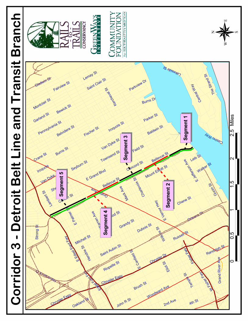
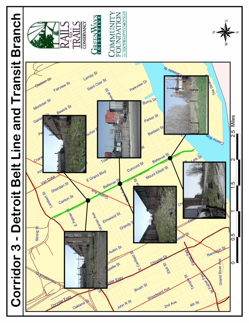
CORRIDOR 3: DETROIT BELT LINE AND TRANSIT BRANCH
I NVENTORY
LABEL: 3 (3a-c)
NAME: Detroit Belt Line and Detroit Transit Branch
TOPOGRAPHICAL COORDINATES: 46.89-94, 3.33-5
OLD REFERENCE: RR-14
LENGTH: 4.4 miles
ENDPOINTS: I-94 & Mt. Elliott Avenue; Detroit River at Mt. Elliott Avenue and west past Chene Street
LINKAGES (SCHOOLS): Whitney Young Middle School (Lafayette Street & Macomb Street); MartinLuther King High School (Lafayette Street & McDougall Street); Duffield Elementary School (BradbyDrive & Macomb Street); Miller Middle School (Maple Service & Chene Street); Bunche ElementarySchool (East Vernor Highway & Ellery Street)
LINKAGES (PARKS): Gabriel Richard (East Jefferson Avenue & E. Grand Boulevard); Chene Park &Amphitheater (Chene Street & Atwater Street); Coleman Young Recreation Center (Maple Service &Bradby Drive); Belle Isle (across bridge); Jean Boat Ramp (Freud Street & St. Jean Street); AlgonquinRec. Playfield (East Jefferson Avenue & Conner Street); Zachariah Chandler Park (Dickerson Street &Frankfort Street); Conner Playfield (Conner Street & Harper Street)
LINKAGES (OTHER: MUSEUMS, HOSPITALS, LIBRARIES, ETC.): Pewabic Pottery (East Jefferson Av-enue & Cadillac Boulevard); Doctor’s Hospital (East Jefferson Avenue & Joseph Campau Avenue); goesthrough “The Lofts” development on the north side of Jefferson Avenue.
COMMENTS: The old assessment stated that the line was abandoned in three pieces: Detroit TransitRailroad (1.3 mi.), abandoned 1981; Conrail (2.2 mi.), abandoned 1982 and 1984 (3a&b). The ’82and ’84 abandonments covered the trackage all the way to the river. The ’81 abandonment could bethe trackage parallel to the river, but it is uncertain. There is no ICC record for it because, apparently,it was a transit line. The one-mile section from Warren to I-94 was likely abandoned in 1995.
STB DOCKET NUMBERS: (3a) AB-167 sub 339 [2/25/82 - 1.6 miles] (3b) AB-167 sub 807 [7/13/84 -0.62 miles] (3c) unknown [1995 - one mile]
20
ASSE S SMENT
Corridor Evaluation: This corridor in particular is at a crucial juncture. Though a majority of it is stillowned by Conrail, Conrail has sold many sections and the buyers are starting to make alterations tothe corridor. Because none of these alterations has, as yet, permanently affected the continuity of thecorridor, there is still opportunity for a trail to be developed over its entire length. In addition, thiscorridor is remarkably wide in most sections, especially nearer to the river. It runs through the middleof city blocks, and open space from the corridor to Beaufait Street to the west creates nearly 150 feetof width for much of the corridor. This means that even in places near the river, where the corridorhas been altered to add parking lots and such, there is still remaining open space. However, as rede-velopment in this area continues, the opportunity to make use of this corridor as a trail could be lost.
The corridor also is appealing because of the neighborhoods it passes and the sites it connects. Mt.Elliott Park lies near the southern terminus of the corridor, as do several new loft apartment buildingsand other new housing developments. There also is a tremendous view of the river and the bridge toBelle Isle from the corridor at the Uniroyal site. As the corridor continues northwest, it passes withinblocks of at least a half dozen large churches, many with historic and architectural significance. Thecorridor is also valuable as a possible bicycle and pedestrian link from the river to the #5 corridor aspart of the loop system identified in this report.
Finding the Corridor: For most of its north-south length, this corridor is paralleled closely on either side by athrough street: Bellevue Street to the east and Beaufait Street to the west. Because much of the land betweenthe corridor and Beaufait Street is vacant, it is best to track the corridor from Beaufait. The corridor can be easilyaccessed from these three points:
A) The intersection of Wight Street and Mt. Elliott Avenue. Just one long block south of East Jefferson Avenue,this is a good intersection from which to view and follow the corridor along its short east-west length. In thissection it is within the Wight Street roadway, parallel to the river.
B) The intersection of East Jefferson Avenue and Beaufait Street. The corridor can be followed northwest fromthis point along Beaufait Street.
C) Gratiot Avenue between Beaufait and Bellevue Streets. From this point the corridor can be followed in eitherdirection using either Beaufait Street or Bellevue Street as a parallel through street.
The intersection of East Grand Avenue and Bellevue Street. The corridor can most easily be picked up from I-94by exiting for Mt. Elliott Ave., heading south on Mt. Elliott and then turning left on East Grand Boulevard. EastGrand Boulevard crosses the corridor in a long block, just before the intersection with Bellevue Street. The corri-dor can then be followed south by turning right on Bellevue Street.
����
����
����
����
�
��
�
�����������
��������
�� ��
����
������
����
����
�� ����
��
�� ����
���
��������������
����������
��������
������������
�� ������
�
����������
�
�������
�����
����� �
�
��������
!�
������
��������
��"�����
#�$��!�
��%�&&��������
��"����!
�
������!
�
��������
#���
������!�
'�����
��!�
%���� �!
�
����������!� ��$
�����������!
�
!������$(
���!�
)��"������!�
#��������
�!�
#���"��!
�
!�������
���!�
�$(���!�
���������*�
������������
���������!
�
����� �
��!�
#$���!�
��"����!
�
�����!�
����� �!
�
+��� ���
����!�
���"�����!
�
��+��,���!�
#�������!
�
!�������
�!�
-������
!�
!� ($���!
�
�$����!�
��������
!�
�������!�
���������
'���!������!�
+������!�
.��/$��
����&�����!�
����"���
��!�
#�����$��
!�
!����0�!�
�����!�
1���!�
.��/$���!
�
*�,���,
"����
2�,� �!
�
'�,����!�
��������!
�
��,�����
!�
+�������
���
2��(�!�
*�������!�
2�������
!�
$����!
�
������!�
#$�����
�������!�
��������
!�
������
�
�������
2�,(����!�
-�������
!�
#�����$��
!���
����
���
����
�����
����
����
����
����
����
�����
22
O W N E R S H I P / L A N D U S E S U M M A RY
This corridor has been abandoned for nearly a decade now. Since then, Conrail has succeeded infinding buyers for only a few pieces of it. These buyers have primarily been limited to owners of adja-cent parcels who wish to expand their enterprises in one way or another. It appears that the appeal ofthe corridor up to this point has been extra parking for residential and commercial users toward thesouth end and for storage tanks and vehicle parking for industrial users on the north end. Some ofthis temporary activity is taking place on parts of the corridor still owned by Conrail and constitutesan illegal encroachment upon the corridor. In any event, there is no evidence from the site visit, infor-mation from Conrail and the Detroit tax maps that the corridor has been irrevocably obstructed.
From Kercheval Street north to the end of the corridor at I-94, the corridor is almost completely inrailroad ownership. The only exception is a section between Sylvester Street and Warren Avenue thathas been sold to adjacent industrial interests. From Kercheval south to the river, the corridor is in theownership of various residential and commercial development interests and a brownfield section isowned by the city. The part of the corridor closest to the river is more in demand for development.
OWNERSH I P / LAND USE DETA I L S
Segment 1 – Detroit River to Lafayette Street: The southern portion of this corridor is very near theriverbank and adjacent to a large parcel owned by the city and managed by the city’s Economic Devel-opment Department. This parcel lies along the corridor to the south and east and is almost com-pletely vacant. It is the site of the former Uniroyal tire factory and is considered a brownfield site. Thecorridor passes through this site and continues southwest briefly in the roadway (tracks are stillpresent) until its termination at a new residential development along Mt. Elliott Avenue. This portionof the corridor is completely in city ownership, though some small adjacent parcels are owned byConrail and Michigan Central Railroad. Between Jefferson Avenue and Lafayette Street, the corridor isenveloped by a fairly new residential development, but it does not appear that any buildings obstructthe corridor. In this block, the corridor is a single, 80-foot wide parcel owned by B&D Property Man-agement. There are two adjacent, vacant parcels each about 100 feet wide between the corridor andthe street owned by Best Group, Inc., of Bloomfield Hills, and Jefferson Land, Inc., of Detroit. Thelatter is zoned as commercial.
Segment 2 — Lafayette Street to Vernor Street: Proceeding northwest from Lafayette Street, the corri-dor remains vacant and includes another 100 to 150 feet of open space to the west, facing BeaufaitStreet, which parallels the corridor. This is consistent to the intersection of Vernor Street and BeaufaitStreet, where the Gleaners Community Food Bank building is adjacent to, but does not obstruct, thecorridor. Between Lafayette Street and Kercheval Street, the corridor (remaining at approximately 80feet wide for most of the way) is owned by Phoenix Enterprises of Detroit and is zoned as industrial.The adjacent open parcels in this section to the west are owned by Phoenix, Beaufait Enterprises andStyle Craft Products, Inc., and are all zoned as industrial. One exception is a small parcel on KerchevalStreet owned by the Elmwood Congregation of Jehovah’s Witnesses, which is zoned as commercial.North of Kercheval Street to Vernor Street, the corridor and the adjacent open swath are listed asunder railroad ownership. Various parcels are listed as Conrail and Michigan Central properties. AtWaterloo Street, however, there is a parcel within the corridor owned by Chandler Sales Chapel andzoned as residential, but the lot remains vacant. The corridor is bordered to the east by various indus-trial facilities for the entirety of this section.
23
Segment 3 — Vernor Street to Mack Avenue: In the entire length between Vernor Street and MackAvenue, the corridor is marked in city records as a single vacant parcel, owned by Michigan CentralRailroad. Again, there is a parallel parcel facing Beaufait Street that is also owned by Michigan Cen-tral, creating a total vacant width of approximately 130 feet for most of this stretch. Interestingly,both parcels are zoned as residential. Just before Mack Avenue, however, an adjacent parcel on thesouthwest side of the corridor is owned by Frontera Brothers and is the site of industrial buildings.Parallel to the corridor on the northeast side are a series of industrial plots with various owners. Mostof these plots are in use.
Segment 4 — Mack Avenue to Warren Avenue: Continuing northwest beyond Mack Avenue, thecorridor continues to be listed as vacant and under railroad ownership up to just beyond SylvesterStreet. Michigan Central owns most parcels comprising the corridor width although some parcels haveConrail listed as the owner. Again, many of the parcels are zoned as residential rather than industrial,but all of them are vacant. The corridor, which narrows to about 40 feet near Sylvester Street, isflanked on both sides by various industrial parcels with several different owners. Most of these parcelsare in use. Beyond Sylvester Street, the parcel that encompasses the corridor has been purchased byMohammad Esfahanian of Ann Arbor, the owner of the gas station on the southeast corner of GratiotAvenue and Beaufait Street. It remains vacant and is zoned as industrial. This parcel is abutted to thenortheast by two tracts owned by the New Cavalry Baptist Church and used for printing/publishingfacilities. To the southwest are two industrial parcels owned by Beaufait Holdings of Detroit. North ofGratiot Avenue there is a small commercial parcel with buildings that appear to be adjacent to theoriginal corridor. Marwan and Nashwan Essa of Oak Park own this parcel. The rest of that block (bor-dered by Gratiot Avenue, Beaufait Street, Forest and Bellevue) is one parcel owned by Ajax MetalProcessing Inc. The corridor appears to be blocked by some structures in this space, but they don’tappear to be permanent structures. The corridor is still considered to be intact through this stretch.Continuing to Warren Avenue, the corridor is treated as a public right-of-way with no ownership infor-mation, though there is a parcel within the corridor (which is approximately 60 feet wide in this area)near Warren Avenue that is owned by Rice and Werthmann Co., of Detroit. The parcel is vacant andzoned as industrial. Adjacent to the corridor in this section are several industrial plots both vacant andbuilt-up. Near Warren Avenue to the northeast of the corridor there are also two parcels owned bythe city of Detroit.
Segment 5 — Warren Avenue to I-94: Just north of Warren Avnue, the corridor is again documentedin city records as a public right-of-way with no ownership information. However, the width of thatright-of-way narrows to about 20 feet and is flanked on the southwest by industrial property ownedby Faygo Beverage, Inc., and on the northeast by an industrial parcel owned by Lagrasso Bros. In thenext block, there is again a wide swath (over 150 feet) of vacant space encompassing the corridor.This width is still under railroad ownership (Michigan Central) all the way to Grand Boulevard. Thisparcel is bordered on the northeast by various industrial properties and on the southwest by the Trin-ity Cemetery (Beaufait Street ends at the cemetery). Between Grand Boulevard and I-94, the corridoris again represented as a public right-of-way with no ownership information except for a narrow parcelowned by Conrail and zoned as industrial. The property to the northeast of the corridor in this sec-tion is owned entirely by the city of Detroit and is referred to as the “Packard Properties.” To thesouthwest are two large industrial parcels that separate the corridor from Mount Elliott Avenue and I-94. Beyond I-94 to the northwest, the corridor is active, and is primarily indicated to be in Conrail andMichigan Central Railroad ownership.
���������
��
���������
��
������ �
��� �
�
�� ��
����
��
������
��
����� �
��� ��
���������
��
����������
�
����������
��
�������
�
���������
��
����
������
�����
�������
�
��������
� �!!���
�����
�
���������
�
��������
�
�������
����
�������
"������
����
�������
�
���������
��� �������
��������
��������#
�����
$����
�������
���������
���
��������
�
���������
�����
��#������
�����
���%�
�
�����
�����
� ����
������
�������
����
��������
��������
�
��������
��������
�
&��������
������
����������
�
�&��'
�����
���������
�
��������
���
(�������
��
���#�����
�
�����
���
��������
��
�������
���
�����
������
"����
�����
���
&��������
)��*����
���
�!����
���
��������
����
���������
��
�����+
���
��������
,�����
)��*������
�
%�'���'
�����
-�'����
�
"�'�
�����
���������
�
�'�����
��
&�������
���
-��#���
%���������
-��������
��
���������
�
�������
��������
���������
���������
��
��������
��
.������
-�'#
������
(�������
��
���������
��
�����������
��������
�� ��
����
������
����
����
�
��
�/
/012
201.
.01��
���
�
�
�
25
T A R G E T
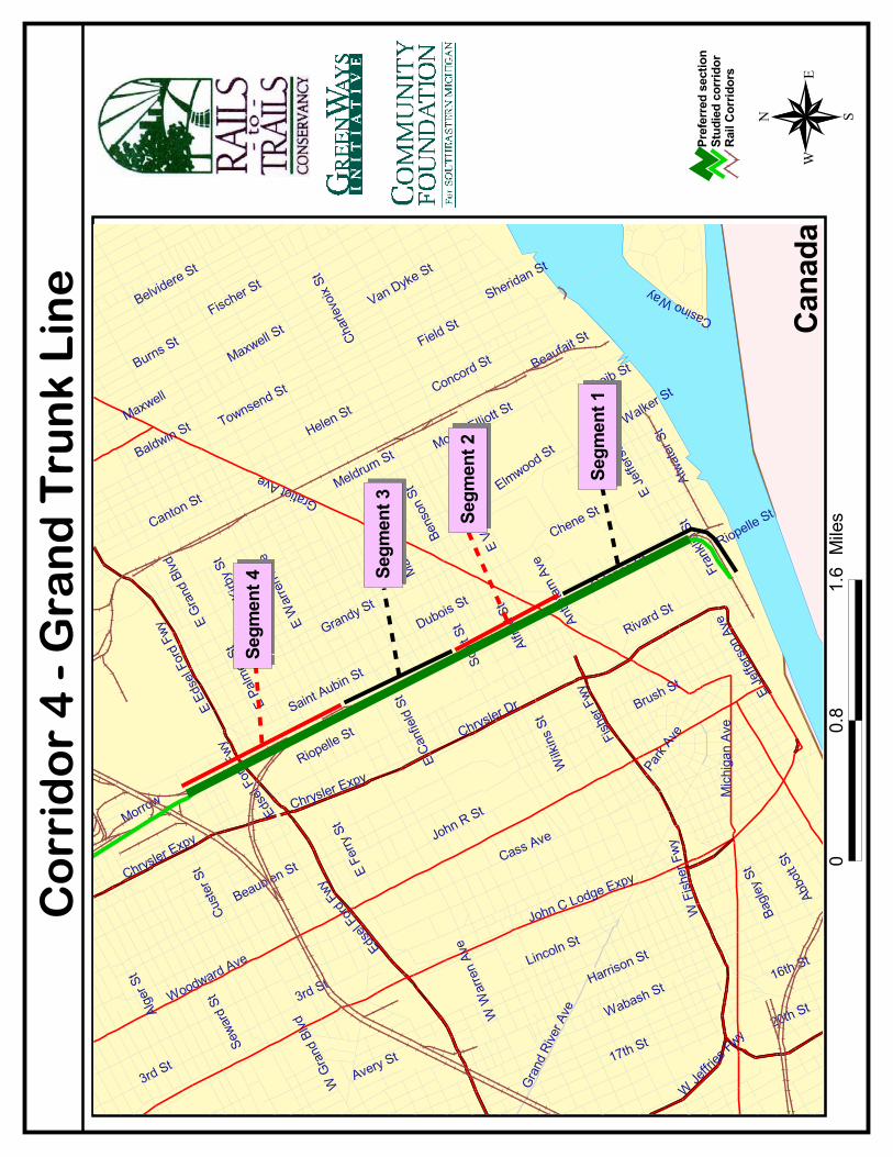
CORRIDOR 4: GRAND TRUNK LINE
I NVENTORY
LABEL: 4(4a-c)
NAME: Grand Trunk Western/CN Corridor (Dequindre Cut) and Norfolk & Western Russell Street Spur
TOPOGRAPHICAL COORDINATES: 46.88-93, 3.31-3
OLD REFERENCE: AC-1 RR-13 (4c)
LENGTH: 4.2 miles
Endpoints: Grand Boulevard to Detroit River; and St. Antoine Street to Rivard Street parallel to theriver. Includes stretch between Ferry Street and Brush Street (near I-94/I-75 Interchange)
LINKAGES (SCHOOLS): Chrysler Elementary (Lafayette Street & Rivard Street); Miller Middle School(Maple Service & Chene Street); Campbell Elementary School (Leland Street & St. Aubin Street); FerryElementary (East Grande Boulevard & East Palmer Street); College for Creative Studies (E. Kirby Street)
LINKAGES (PARKS): St. Aubin Park & Marina (Atwater Street & St. Aubin Street); Central Park (Be-tween Lafayette Street & E. Larned Street; between Orleans Street and Rivard Street); Plaisance(Russell Street & Maple Street); Elmwood Central Park (Maple Street & Bloombury Place); St. Aubin-Waterloo Playfield (Maple Street & Dubois Street)
LINKAGES (OTHER: MUSEUMS, HOSPITALS, LIBRARIES, ETC.): Detroit FD History Museum (St.Aubin Street & Adelaide Street); Eastern Market (Russell Street); Moross House/Detroit Garden Center(E. Jefferson Avenue); Alexander Blaine Memorial Hospital (East Jefferson Avenue & St. Aubin Street),Globe Building (on priority list for restoration by Automobile National Heritage Area program, whichhas considerable funds available for projects)
COMMENTS: The line passes underneath major roads. The corridor was discussed in a 1994 study asa rail-with-trail possibility. The line is now partially abandoned. 1.3 miles (Detroit River to GratiotAvenue) were abandoned in January 2000 and sold to Jefferson Holdings, LLC. 2.27 miles (GratiotAvenue to the GTW main line) were sold to Adrian & Blissfield Railroad Co., in 1998, then were soldto Detroit Connecting Railroad Co., in October 2000. It is unclear if there is any rail use on the linenow—most likely not. Jefferson Holdings, representing MGM Casinos, also acquired the west piecefrom Riopelle Street to Rivard Street, for a total of 4.5 miles. They acquired these miles for a majorroad that was planned to bring traffic to the riverfront casinos. The location of the casinos on theriverfront has been cancelled due to angry opposition from people who would rather see the riverfrontdeveloped for the public. Jefferson Holdings has directed that the land be turned over to the city, andthe deed paperwork is being prepared for that deal. General Motors acquired the eastern piece fromRiopelle Street to St. Antoine Street to construct a parking garage for the Renaissance Center. Detroithas an interest in this corridor for light rail as well. The line contains six fiber-optic lines, which willbecome the city’s. The lease for these was pre-paid to the railroad, but Detroit will get a share oncethe lease is renegotiated.
STB DOCKET NUMBERS: (4a) AB-31 sub 36 [10/12/99–.31 miles]; FD 33601 [7/26/98—spur trackage](4b) FD 33692 [12/28/98–2.27 miles]; FD 33935 [10/4/00 - 2.27 miles] (4c) unknown [1983 - 0.8 miles]
26
CONTACTS: Tim Karl, Akinya Khalfani, Dr. Kate Beebe (Director, Greater Detroit Downtown Partner-ship), Dr. Lilian Randolph (Victor Institute, Mich. St. U.), Bob Malone, Canadian National
ASSE S SMENT
Corridor Evaluation: This corridor is truly a unique urban asset, especially the section from GratiotAve. to the Detroit River which cuts through inner Detroit at a level about 50 feet below grade. Giventhat this section is already in the process of being acquired by the city of Detroit, it is an even morenatural candidate for trail conversion. In addition, this section of the corridor passes through a verydense residential area between Jefferson and Gratiot, and would provide easy access to the riverfrontand in the opposite direction to Eastern Market for a great many people. There is also enough right-of-way width in this section to allow for all kinds of possibilities for trailside features and amenities.Other trails have used such space for outdoor art galleries, concession stands, performance stages,and various artistic, cultural, and entrepreneurial endeavors.
North of Gratiot, the corridor reaches into an extremely depressed residential neighborhood withsingle-family homes that are mostly vacant. A trail along this corridor that leads downtown could beone way to encourage redevelopment in this area. Although the corridor is technically still activenorth of Gratiot, the likelihood that it will be abandoned soon is great.
The corridor also interacts with an area south of Jefferson Ave. that is already the focus of redevelop-ment efforts such as the effort to restore the Globe Building.
The project team strongly recommends that this corridor be a priority for trail conversion.
Finding the Corridor: Because of its depression below grade, the southern part of this corridor cannot be easilyfollowed from a parallel street. Though Orleans Street and St. Aubin Avenue parallel the corridor to the west andeast respectively, the corridor is well canopied and cannot be seen well from either street. However, there areseveral street bridges over the corridor that afford considerable views of the corridor in both directions. In thenorthern section, there are no through streets that closely parallel the corridor. The following places are goodcrossings from which to access and view the corridor:
A) Riopelle Street between Franklin and Atwater Streets. This point is just over two blocks south of EastJefferson Avenue. From here, the short east-west stretch of the corridor can be viewed, running between andparallel to Franklin and Atwater Streets.
B) East Larned Street between Orleans Street and St. Aubin Avenue. This point is a bridge over the corridor;from here the corridor can be tracked by following Orleans Street or St. Aubin Avenue and viewing the corridorfrom the bridges that connect the two streets.
C) East Forest Street near Orleans Street. This crossing provides a good vantage point for viewing the corridor inboth directions, but must be approached from the west as East Forest Street is a one-way street heading eastfrom Russell Street. In addition, this is where Orleans Street begins, so it is a good place to begin following thecorridor heading south.
D) Trombly Street near Orleans Street. This crossing is a good place from which to view the section of the corri-dor north of I-94.
����
�������
�
��
�
��������������
��
����
����
������
�����
��
���
� ����
�����
��� � �� ��
�����
�� ����
��
�� ����
���
�����
�����
��������������
��������
������������
��������
�����
�
���������
���
�������
�����
�� ������
�
����������
�
����������
��
������ ��
!�����
��"��!�
�����
������#
������
��
$�%��&�
�����#�&
�
'�����&�
��"(���
�
�����
��"����&
�
������&
�
������
��$���
������&�
)�����
��&�
��%�����
������&�
&������%*
���&����
�����
�����
�
$��%*���
�&�
�%*���&�
��+���
���'�
���������
�&�
�����%,�
&�
�����������
�
+���� (
��&�
����� �&
�
��-��,
���&�
$�������&
�
�.���&�
�����&�
��*���&�
������ �&
���"
����&�
����(����&�
/������
&�
&�������
�&�
������
��&�
$%���&�
$��%����
�&�
���
���������
$�!��
�&�
$�����&�
��0��* �&
�
���(��
�&�
$��������
�&�
��������
&�
���
������
�&�
1���&�
������
��$���
'�������&
�
&"����&�
��!���&�
%��
��&�
#������&�
�����&�
�������,
����
�������
������
�&�
�**����&
�
��,���
��&�
��"����&�
&���
���&�
-��(����
2����&�
��*�&�
���� �&�
������
���(���&�
#��������
&�
������
�
#��������
&�
1���&�
��
����
��
����
��
����
��
����
����
��
28
O W N E R S H I P / L A N D U S E S U M M A RY
This 4.2-mile corridor section is divided into two different parts with substantially different ownershipstatus. The 2.27 miles north of Gratiot Avenue to the Canadian Northern main line is still technicallyan active railroad line, though it does not appear to be in use. It is owned by Detroit ConnectingRailroad Company, which acquired it from Adrian & Blissfield Railroad Company in October 2000,which, in turn, had acquired it from Grand Trunk Western in 1998. The 1.3 miles from Gratiot Avenueto St. Antoine Street near the riverside was abandoned in January 2000. Jefferson Holdings, LLC,bought all but the very end of this segment upon abandonment. They represented the interests ofMGM Casinos, which hoped to use the corridor for roads accessing a new planned riverfront casino.The casino plan met with opposition and Jefferson Holdings now plans to turn that portion over tothe city of Detroit in a deal currently in progress. The very end of this portion, the two blocks be-tween Rivard Street and St. Antoine Street, was bought by General Motors in order to construct aparking garage for the Renaissance Center.
The way the corridor is represented in city of Detroit tax assessment maps also changes at GratiotAvenue because the corridor runs below surface grade until it is north of Gratiot Avenue. The segmentnorth of Gratiot Avenue is only a 60 to 100 foot exempt right-of-way with no railroad-owned out-parcels. However, the depressed segment south of Gratiot Avenue consisted of a 60-foot, exemptright-of-way with 40-foot strips of railroad-owned land on either side, comprising the “valley” throughwhich the corridor runs. It is unclear whether the purchase by Jefferson Holdings included these outerstrips or merely included the exempt right-of-way. Most likely, the acquisition included the entirecorridor, but the city of Detroit tax assessment maps still indicate that Canadian Northern owns theseouter strips.
Land use along the part of the corridor between Jefferson Avenue and the Detroit River is primarilyindustrial, with many vacant, deteriorating, industrial structures surrounding the corridor. Once itcrosses Jefferson Avenue and descends into the “valley,” however, the corridor is abutted by variousapartment and condominium developments until Gratiot Avenue. Between Gratiot Avenue and MackAvenue, the adjacent land use is light industrial, featuring meatpacking facilities associated with East-ern Market, a Pepsi Co. bottling facility and a Department of Public Works water and sewage facility.North of Mack Avenue the corridor passes through a few blocks worth of single-family, residentialparcels before reemerging in another area of light industrial use. Heavier industry dominates as thecorridor continues north and approaches I-94.
OWNERSH I P / LAND USE DETA I L S
Segment 1 — St. Antoine Street (near Detroit River) to Jefferson Avenue East: According to CanadianNational Railroad records, the abandoned corridor begins parallel to the river and proceeds northeastfrom St. Antoine Street. On the city of Detroit tax assessment map, the corridor is shown as a singleparcel, about 150 feet wide that stretches between St. Antoine and Rivard Streets. There is no owner-ship information for this parcel in city tax assessment records, though it has reportedly been pur-chased by General Motors for use as a parking garage serving the Renaissance Center. Immediately onthe other side of Rivard Street, there are two small parcels that make up the corridor and are ownedby Jefferson Holdings, which has a listed address of 1 Woodward Avenue. The parcels are vacant andzoned as industrial. From this point to Orleans Street, the corridor is portrayed as separate parcels
29
belonging to Canadian National. These parcels are fairly narrow, but gain in width as the corridorbegins to curve to the northwest. The line is bordered to the northwest by several industrial parcels,including a large one owned by Crain Communications. Others appear to be vacant and have beenbought by speculators. Guion Street borders the corridor to the south. Past Riopelle Street, there arerestaurants that abut the corridor to the north. Once past Orleans St., the corridor curves to parallelOrleans Street. Beginning here, two blocks south of Jefferson Avenue, the rail line (a narrow width of30 or 40 feet) is portrayed as an exempt right-of-way. There are adjacent industrial parcels owned byvarious realty companies and developers, including Jefferson Land, Inc., and Vigliotti Realty. The corri-dor passes underneath Jefferson Avenue and begins to descend further below grade as it continuesnorthwest.
Segment 2 – Jefferson Avenue to Antietam Avenue: Once the corridor passes under Jefferson Av-enue, the right-of-way widens considerably to accommodate the corridor, which becomes a “valley”below the surface grade. As the corridor continues northwest, it is shown to be about 150 feet wide,with a 60-foot strip down the middle represented as an exempt right-of-way (the actual space wherethe tracks are or, in some cases, were) with two strips on either side of about 40 feet each that repre-sent the additional land owned by the railroad. This representation continues in a similar fashion allthe way to Gratiot Avenue where the corridor returns to grade level. The parcels on both sides of theexempt right-of-way are shown to be property of Canadian National with one exception: A small par-cel on the west side of the line just south of Clinton Street is controlled by the Detroit Housing Com-mission. Between Jefferson Avenue and Lafayette Street, the corridor is bordered on both sides byapartment complexes, some of which are low-income housing developments. Between Lafayette Streetand Antietam Avenue, adjacent properties include St. John’s Presbyterian Church, Friends School, theTown Square Apartment complex and North Park cooperative to the northeast. To the southwest ofthe corridor are Lafayette Towers, Cherboneau Cooperative, Cherboneau Condominiums, ChataeufortPlace Cooperative and Parc-Lafayatte Condominiums.
Segment 3 — Antietam Avenue to Mack Avenue: As the corridor continues northwest past AntietamAvenue, it begins to return to grade level and subsequently narrows. The strip of exempt right-of-waydown the middle stays at about 60 feet, but the adjacent railroad-owned parcels narrow in the twoblocks between Antietam and Gratiot Avenues. In these two blocks, the corridor is border to thesouthwest by a Catholic church and to the northeast by a large vacant parcel owned by the city. Be-yond Gratiot Avenue, it is only the approximately 60-foot exempt right-of-way that encompasses thecorridor. There are no longer any side parcels owned by the railroad. Adjacent land use on both sidesis light industrial, with several small meat packing facilities including Berry & Sons, Chicago Beef andThorn Apple Valley. Farther north, toward Wilkins Street, there are two larger parcels on the east sideof the corridor owned by the city of Detroit and by Detroit Edison. On the other side of Wilkins onthe west side of the corridor are two large water/sewage facilities managed by the Department ofPublic Works. The parcels on the opposite side of the corridor are vacant industrial parcels owned byT and T Development Company. As the corridor approaches Mack Avenue, both sides feature sitesassociated with Eastern Market, including Eastern Market Beef and the Wholesale Center on the westside, and Pellerito Foods on the east side. Again, the corridor is shown as a continuous, exempt right-of-way of 60 feet in width through this entire section.
Segment 4 — Mack Avenue to Warren Avenue: The rail corridor continues to be represented as anexempt right-of-way through this section, but the width varies as it passes different land uses andgains and loses additional tracks. The PepsiCo. bottling facility sits just north of Mack Avenue on thewest side of the corridor. As the line passes the facility it gains extra tracks and the corridor widens to
30
approximately 100 feet. Directly opposite the Pepsi facility, the corridor is faced by a neighborhood ofsingle-family residences, most of which are vacant. Many of these are in city hands, as well. Once thecorridor passes the Pepsi facility, it is surrounded by single-family residential parcels on both sides andthe right-of-way narrows to about 80 feet. Once the corridor passes Canfield Street, it again narrowsto 60 feet and enters another area of light industrial use. The Boomer Company occupies the ware-house parcels on the east side. The parcels on the west side are vacant and managed by the city’sEconomic Development Department.
Segment 5 — Warren Avenue to East Grand Boulevard (CN main line): North of Warren Avenue, theland use adjacent to the corridor turns to heavier industrial and the parcels get larger on both sides.On the west side of the corridor there are four large parcels leading up to Ferry Street: Frigid FoodProducts Inc, a refrigeration company; High Rise Industrial Park; a GM parts facility; and OJ Transpor-tation. To the east of the corridor are two parcels owned by W-F, LLC, and then several parcels ownedby USL City Environmental Inc. which formerly constituted a rail yard adjacent to the corridor be-tween Warren and Frederick Streets. On the other side of Ferry Street, part of the corridor branchesoff to the west to meet the CN main line. The space between the two branches is owned by WasteManagement, which has offices on site and City Disposal Systems, which has a freight terminal. Thecity’s Department of Public Works owns the large site just southwest of the branch. The branch itselfis shown as an exempt right-of-way. As the main corridor proceeds northward past Ferry, it is bor-dered to the east by another rail yard shown as being in Grand Trunk Western (CN) ownership as wellas additional light industrial sites including Schlafer Iron. At this point the tracks pass underneath I-94and alongside a large parcel owned by Detroit Edison to the west and the facilities of the MichiganBox Company to the east. Leading up the Grand Boulevard, the corridor widens significantly on itsapproach to the CN main line and passes several more industrial parcels such as Union Toy, ArcoAlloys, Midwest Steel and Famous Furniture, the latter two being vacant and now owned by the city.
���������
��
���������
��
�� ���
��� ��
������ ���� �
�
������ ��
����������� ��
��������
�����
�
����� ���
� ��
����� �
��� ��
���������
��
����������
�
����������
��
����������
�����
�������
�����
�������
������
��
�� ���!�
�������!
�
"�����!�
���#���
�
��������
��������!
�
�������!
�
�����
������
�����!�
$������
��!�
�� ����
������!�
!������ %
���!���
������
�����
�
��� %���
�!�
� %����!�
�&���
���"�
�
���������
�!�
����� '�
!�
����������
�
&�����#
��!�
�������!
�
�(��'
���!�
��������!
�
)*���!�
)+���!�
��%����!�
� �����!
� ���
����!�
���#����!�
,�������
!�
!�������
�!�
������
��!�
� ����!�
��� ����
�!�
���
���������
�����
��!�
�������!�
�-��%��!
�
���#���
�!�
���������
�!�
�������
!�
���
������
�!�
.���!�
������
������
"��������!
�
!�����!�
������!�
� ���
��!�
�������!�
������!�
�������'
����
������
������
�!�
�%%����!
�
�'���
��!�
��������!�
!���
���!�
(��#����
/0���!�
���%�!�
������!�
������
���#���!�
���������
!�
��������
��
���������
!�
.���!�
������
�����
��
���
� ����
�����
���
� �� ��
�����
��������������
��
����
����
�
��
�
����
��
�
�
0012
)1+�����
�
32
T A RG E T
CORRIDOR 5: CONRAIL — FORMER DETROIT TERMINAL
I NVENTORY
LABEL: 5 (5a-k)
NAME: Conrail — Former Detroit Terminal RR (and Penn Central) and spur trackage
TOPOGRAPHICAL COORDINATES: 46.87-97, 3.21-8
OLD REFERENCE: RR-10 RR-8 RR-11 RR-12 (5k)
LENGTH: 9.3 miles
ENDPOINTS: Dearborn near Ford Road and junction of I-94 and US-12 (Michigan Avenue); ForestLawn Cemetery, east of Mt. Elliott Avenue and just south of East McNichols Road.
TARGET ENDPOINTS: Lonyo Avenue to Ryan Road
LINKAGES (SCHOOLS): Highland Park High School (Woodward Avenue & Candler Street); St.Benedict Catholic School (John Road & Stevens Street); Henry Ford Elementary (2nd Avenue & Mid-land Street); Field Elementary (Midland Street & 3rd Street); Glazer Elementary (Ford Street & 14th
Street); Joffe Elementary (Holmur Street & Kendall Street); Courtis Elementary (West Davison Avenue& Greenlawn Street); Tappan Elementary & Middle School (Ewald Circle & Webb Street); St. CeciliaCatholic School (Burlingame Street & Monica Street); Drew Middle School (Wisconsin Street & AsaAvenue); St. Johns Catholic School (Wisconsin Street & Asa Avenue); Barton Elementary (Joy Road &Ohio Street); Sherrill Elementary (Prairie Street & Alaska Street); Detroit Urban Luther Elementary(Ohio Street & Tireman Avenue); Priest Elementary (Wagner Street & Casper Street); St. Cunegunda(Kirkwood Street & McDonald Street); O.W. Holmes Elementary (Arnold Street & Trenton Street); St.Matthews Lutheran Elementary (Michigan Avenue & St. James Street); Atkinson Elementary (HildaleEast Street & Conley Street)
LINKAGES (PARKS): Hammerberg Playfield (Wyoming Street & Westfield Street); Little Playfield(Greenlawn Street & Ohio Street); Salsinger Playfield (Linwood Avenue & Fenkell Street); Ives Park(Hamilton Street & Midland Street); Woodrow Wilson Playfield (Lonyo Avenue & Arnold Street);Porath Park (Porath Street & Wyoming Street); Keilb Park (Wyoming Street & Porath Street); PalmerPark and State Fairgrounds; Krainz Park (Hildale East Street & Justine Street)
LINKAGES (OTHER: MUSEUMS, HOSPITALS, LIBRARIES, ETC.): Detroit Repertory Theater (13103Woodrow Wilson Street); Dearborn Medical Centre (Eugene Street & Michigan Avenue); HighlandPark Civic Center (Victor Street & Woodward Avenue); Detroit Fire Department (Dexter Street &Ewald Circle); near Palmer Park and State Fairgrounds. Automobile history tie-in: Highland Park (nearone end) was site of Ford plant with first assembly line in the world; Ford River Rouge Plant is nearother end. Ryan Correctional Facility & Mound Correctional Facility are between corridor and KrainzPark/Atkinson School.
COMMENTS: The northern seven miles were abandoned in 1984 and are mostly still owned byConrail. On the southern end, separated by a short gap, it appears (pending confirmation) that thereare two overlapping abandonments along the Oakman Spur: the 0.6-mile portion abandoned byConrail in 1984 (5c) and the 1.5-mile portion abandoned by Penn Central in 1976 (5d). There is also
33
a 0.6-mile extension to the south past Michigan Avenue to the Conrail main line, abandoned in 1984.
STB DOCKET NUMBER: (5a) AB-167 sub 816 [7/19/84 - 3.9 miles] (5b) unknown (5c) AB-167 sub835 [5/18/84 - 0.55 miles] (5d) unknown [1976 - 1.5 miles] (5e) AB-167 sub 815 [7/2/84 - 0.65miles] (5f) AB-167 sub 805 [5/25/84 - 0.55 miles] (5g) AB-167 sub 809 [6/13/84 - 0.27 miles] (5h)AB-167 sub 810 [6/28/84 - 0.2 miles] (5i) AB-167 sub 811 [6/28/84 - 0.21 miles] (5j) AB-167 sub808 [11/8/84 - 0.9 miles] (5k) AB-167 sub 817 [7/2/84 - 0.6 miles]
ASSE S SMENT
Corridor Evaluation: This corridor is significant because of its continuous length. Although portions atboth ends remain active, there are nearly eight miles of continuous abandoned corridor. This couldfeasibly make up the majority of a loop system of trails and on-road bicycle/pedestrian facilities thatwould circle the city. This is also a key moment in time for the public use of this corridor. Conrailwishes to sell and/or lease the entire corridor, has hired a consultant to look in to possible buyers andis actively pursuing this avenue. Conrail also indicates that it is willing to consider the possibility ofdonating the line to a public agency if such an option turns out to be financially favorable.
Although this corridor passes through some heavily industrialized areas, for the most part it remainswide open and, in some places, scenic. There are multiple opportunities for converting adjacent openspaces already in public ownership into trailside parks or other amenities. A trail along this corridorwould also serve to connect neighborhood residents with the commercial corridors of Livernois Avenue and Grand River Avenue, which are both preferred on-road bike routes as identified on the Detroit City Bike Map (see Regional Loop System Map).
Finding the Corridor: There is no road that consistently parallels this corridor for any great length, but it is stillrelatively easy to see in various places along its route. These are some of the most convenient access points:
A) The intersection of McNichols Road and Main Street. The corridor passes through this intersection, and canbe followed closely from here to the northeast along Jerome Street. It is also an easy access point from I-75; exiton McNichols Road and head east about a half-mile.
B) 2nd Avenue near Bartlett Street and the Ford Highland Park industrial complex. The corridor is difficult to getclose to through this heavily industrial section of Highland Park, but the crossing at 2nd Avenue allows for ex-tended views of the corridor in both directions as it curves. This is probably the easiest access point from Wood-ward Avenue; turn west from Woodward on to Bartlett Street and continue one block to approach this intersec-tion.
C) West Davison Avenue near Greenlawn Street. This is the quickest way to access the corridor from I-96 andaffords a view of how overgrown the corridor is through this stretch. Greenlawn Street parallels the corridor onthe west side for a block leaving this intersection.
Tireman Avenue between Greenlawn Avenue and Alpine Street. This crossing can be arrived at easily from I-94via Livernois Avenue and provides good views of the corridor in both directions as it passes through a residentialneighborhood to the north and an industrial area to the south.
����
����������
���
����
����
����
��������������
��� �������
�����
���
�����
�
����
���������
��������
����
���
�����
����
�����������
����
���
���
����
����
������
�
��� �� ���
�����������
����
���!�
����
���
����
�"�
#�����$
%�����&�$ %�����&
!����������
��� ���"�
�����"�
��'��
��"
�
���
���
����
�����"�$
(�&)
���*
��
*�+���$
����"
�
����
,���
���"
�
��'�
���
"�
��(+ ����
���&
���
���
�� �
$
-� ��$
������$ ��(
+ ���
�
!���
���$
�������
$��� ��"�
��%
�����#
��
������$
���)����$
����� �$
�������$
#���
����
��� ���$
-�����
��������*��
��+���"�
$ �� �)����$
.���+�� �$
���
����
���
��,
����
�$
�������$
��� ����$
.�)
�+ ��
"�
��������*��
*�����$
$��� ��+/���$
������)��+�$
!��
�$
$���
����
�$
.��&����$
�����$
����
��$
0���
��$
����"�
��� ���$
����$
0����$
������$
$��� ��#��
��
���
$
%�����&�$
�� �
���
$
���
���
1���
���
$
$ ���/+���$
���
�����
��$
�� ���$
�������$
�� ���$
�)�
��$
$ ���$
23� �$
�����$
$��� �����
%�)�� �$
��� �����$
����� ���$
�����$
$�!�
�)�$
*����$
$��� �������$
( ����$
3� ��$
(����$ "�/� �$
.�+�
$
$��� ��#��
����
��������
���������
����
�
��
�
�����������
�����
����
���
�������������
� ��
42
���
�
����
� ���
����
� ���
����
� ���
����
� ���
����
� ���
����
� ���
�� �
��
35
O W N E R S H I P / L A N D U S E S U M M A RY
This corridor was removed from service in several increments during the 1980s, but has remained, forthe most part, intact. The corridor is active from Ryan Road east and from Lonyo Avenue southwest.Private carriers operate both sections under leases from Conrail. The entire section in betweenamounts to nearly eight miles of continuous corridor with no permanent obstructions. City of Detroittax assessment maps do not represent the corridor in a consistent manner, but for its entire length it isshown as an exempt right-of-way (as if it were still active) or as vacant parcels owned by Detroit Ter-minal Railroad, Penn Railroad and Conrail. The assets of both Detroit Terminal and Penn Railroadswere divested to Conrail, so the entire corridor is essentially under Conrail control. According to taxrecords, there are no sections Conrail has sold that would obstruct the entire width of the corridor.Conrail has indicated interest in leasing and/or selling this entire corridor, and has hired a consultantto look in to possible buyers.
Obviously, a corridor of this length will pass through a variety of land uses. The corridor is primarilysurrounded by industrial facilities of varied sizes, with adjacent commercial parcels near intersectionswith major roads. However, the corridor also passes through some residential areas, such as justnortheast of Highland Park and I-75, between Fullerton Avenue and Oakman Boulevard near GrandRiver Avenue and between Joy Road and Tireman Avenue as the line approaches Dearborn. Encroach-ments and overgrowth are most prevalent in the section just south of Grand River Avenue. Severaladjacent parcels are owned by the city of Detroit, especially in the sections immediately west of High-land Park.
OWNERSH I P / LAND USE DETA I L S
Segment 1 — Ryan Road to I-75 (Highland Park municipal boundary): East of Ryan Road (not in-cluded in target corridor portion), the corridor is shown to be owned by Detroit Terminal Railroad andpasses alongside the prison complex bounded by Mound Road, Nevada Street, Ryan Road and therailroad track itself. The line appears to be active from this point east, so we start our overview head-ing west from Ryan Road. Beginning at Ryan Road heading west, the corridor is represented as anexempt right-of-way, of approximately 60 feet in width. It is bordered by four industrial parcels thatserve as warehouses and metal/auto salvage facilities (one or more of which may still be served peri-odically by the railroad from the east). However, of multiple tracks in this block, it appears only one isstill used, if at all. Moving west past Conant Avenue, the tracks are inactive. At this point, the corridoris bordered to the northwest by Jerome Street, which parallels the line all the way to its intersectionwith McNichols Road. On the other side of Jerome Street from the corridor, leading up to GallagherStreet, are various small industrial parcels and the First Community Baptist Church. The parcels adja-cent to the corridor to the southeast are an automotive store and several large industrial parcelsowned by Crown Enterprises, a trucking company. Beyond Gallager Street to McNichols Road, thepredominant land use on both sides is single-family residences. Some small industrial and commercialshops also occupy the land. The corridor in this section is broken into individual parcels as opposed tobeing an exempt right-of-way. This is usually a sign that the line is inactive. All of these parcels areowned by Detroit Terminal Railroad, but have various zoning recordation. As the corridor crossesMcNichols Road and continues southwest, it no longer has Jerome Street adjacent to it, but insteadwidens into that space to become just over 90 feet wide. South of this intersection, a large area ofopen space adjacent to the corridor is owned by Moon Warehousing and Distribution of Howell,
36
Michigan, but is shown on the map as under a state lien. This area could make a good trailside park.Through this section to Interstate 75, the line continues to be represented as individual, block-lengthparcels owned by Detroit Terminal Railroad and zoned as vacant residential land. The final corridorparcel in this section extends underneath I-75 to the Highland Park municipal boundary. There arefour large industrial parcels that border the corridor to the northwest between McNichols Road and I-75. They contain trucking facilities and metal works factories. To the southeast of the line are varioussmaller industrial tracts with warehouses and other facilities. There is also, just east of DequindreRoad, a large parcel owned by the city of Highland Park.
Segment 2 — I-75 (Highland Park Municipal Boundary) to near Lincoln Avenue (Detroit MunicipalBoundary): This section lies entirely within the municipality of Highland Park and no tax assessmentinformation could be obtained. However, topographic maps and site visits indicate that the land usesurrounding the corridor in this area is heavily industrial. Conrail asserts that they still own this sectionof the right-of-way.
Segment 3 — Near Lincoln Avenue (Detroit Municipal Boundary) to Livernois Avenue: As the corridorcomes back into the city of Detroit from Highland Park, the line continues to head through majorindustrial sites and has multiple tracks and considerable width — at least 80 feet. The entire corridor isrepresented as three strips through this section, the northernmost being owned by Detroit TerminalRailroad, the middle strip by Penn Railroad and the southernmost by Conrail. After the line crossesthe Lodge Freeway (Highway 10), however, the entire corridor is shown as a single parcel owned byConrail. This section extends to Linwood Avenue and is about 70 feet in width. There is a small parcelin the middle of the corridor (but not the entire width) near Linwood Avenue that is leased by Conrailto Borin Brothers. Through this section, the corridor is bordered on both sides by several active andvacant industrial tracts. The vacant parcels are nearly all owned by the city of Detroit and are part ofthe Focus: Hope Program. The active industrial parcels include Schrebner Corp., a metalworks com-pany, Linwood Pipe & Supply and Midwest Ice Corp. Past Linwood Avenue, the corridor is again di-vided in to separate strips. The largest of these narrow parcels extends all the way from LinwoodAvenue to Livernois Avenue, and looks to be about 40 feet in width. It is owned by Conrail and theparcel description refers to it as the abandoned former Detroit Terminal Railroad. Adjacent and paral-lel to this parcel to the southeast are several strips that are listed as owned by Penn Railroad andcomprise about 40 additional feet of corridor width. This remains consistent up to Livernois Avenue aswell. Some of the Penn Railroad parcels are zoned as residential, but the rest of the parcels that makeup the corridor are zoned as industrial. All are vacant, with the exception of a couple small strips thathave been leased to various adjacent industries. The predominant land use on either side of the corri-dor continues to be industrial up to the commercial corridor of Livernois Avenue. To the north of therail corridor, parcels include Associated Hospitals, a laundry facility, Caravan Technologies, a distribu-tor, a BASF wood products facility and a Value City grocery store at the intersection with LivernoisAvenue. Parcels to the south of the corridor include Kelly Windows, City Smoked Fish, a packingplant, Kircos Flour, Sun Valley Foods and Auto City Auto Recovery.
Segment 4 – Livernois Avenue to I-96: Just beyond Livernois Avenue Corridor #6 branches off from#5, and proceeds due west between and parallel to Lyndon Avenue and Intervale Street. Just past thisfork, corridor #5 turns to head due south. Within this area as the line makes its turn, it is shown asbeing owned in three distinct parcels by Detroit Terminal Railroad and Penn Railroad. Leading up towhere the corridor crosses Intervale Street, there are three large, vacant industrial parcels to the north-west, all owned by the city of Detroit. To the southwest of the corridor are a dozen or so smallerindustrial parcels, with facilities including warehouses, distribution plants, auto service garages, a
37
creamery and a beverage bottler. There is also a spur that comes off the line and extends for aboutone third of a mile parallel to and southwest of Intervale Street. Pioneer Steel Corporation has pur-chased this land. Past Intervale Street as the corridor approaches Schoolcraft Boulevard, it completesthe turn and heads due south. To the east is a large parcel owned by Chancellor Media Corp., the siteof WNIC Radio. To the west bordering the corridor is a large industrial site owned by Gilreath Associ-ates. In the space between Schoolcraft Boulevard and I-96 and as it proceeds under I-96, the corridoris documented as an exempt right-of-way of approximately 60 feet in width with no ownership infor-mation. The corridor was most likely active through this stretch more recently than the sections previ-ously discussed, but STB records indicate (and Conrail verifies) that this corridor is abandoned all theway to Lonyo Avenue. In this section between Schoolcraft Boulevard and Davison Avenue, the corri-dor is bordered to the east by a large industrial facility owned by Motor & Machine Casting. Abuttingthe line to the west are two parcels; the northernmost is the US Fastener Corp. facility, and the otheris a large parcel managed by the Wayne County Board of Education and listed as containing culturaland religious buildings. Finally, as it approaches I-96, the corridor is bordered on both sides by citypublic works buildings.
Segment 5 — I-96 to Joy Road: The corridor continues to be documented as an exempt right-of-waysouth of I-96 to Cortland Drive, where it again is displayed as taxable parcels. One single parcel ex-tends from Cortland Drive to Grand River Avenue and is shown as a vacant industrial parcel owned byConrail. The corridor is about 70 feet wide at this point. Through this section the corridor is borderedto the west, up to Oakman Boulevard, by small single-family residential lots. On the east are moresmall commercial and industrial parcels, which include a gas station, warehouses, industrial storagefacilities and parking lots. South of Oakman Boulevard, the corridor narrows to about 50 feet in widthas it approaches Grand River Avenue. After the line crosses Oakman Boulevard, the predominant landuse on the west side shifts from residential to commercial as the corridor approaches the main com-mercial thoroughfare of Grand River Avenue. This thoroughfare includes the Home Pride Market and alarge vacant parcel owned by the city. Parcels to the east include an auto repair shop, Starlight Metal,Brown Roofing Co., Detroit Cut Stone and parking for the Greater Faith Temple which is on the westside of the corridor past the intersection with Grand River Avenue. After it crosses Grand River Av-enue, the corridor, now more than 70 feet wide, is divided into two strips. The western-most strip isabout 50 feet in width and is shown as a vacant industrial parcel owned by Conrail. The other strip isshown as an exempt right-of-way with no ownership information. Aside from the church, the land useon both sides of the corridor south of Grand River Avenue becomes heavily industrial, with two largeparcels to the east owned by Usher Oil Co. and Kimmel Scrap Iron Co. and a large, unidentified indus-trial parcel to the west. These last two parcels extend along the rail corridor south to the junctionwith the CSX main line near West Chicago Street. The parcel comprising the corridor extends to WestChicago Street and widens by another 10 feet or so. Beyond West Chicago Street, the corridor isagain shown entirely as an exempt right-of-way with the occasional out-parcel or strip representingadditional trackage listed as Detroit Terminal Railroad. Between West Chicago Street and Joy Road onthe west side of the corridor are about 20 individual industrial parcels, including primarily metalworksand automotive facilities. To the east are five sizeable parcels: The first two are owned by ConsumersScrap Recycling, the third is a vacant parcel and the last two, leading up to Joy Road, are owned byBurns Fabricating. The corridor width is close to 100 feet through this area.
Segment 6 — Joy Road to Lonyo Avenue: At Joy Road, the land use type on both sides of the corridoragain changes back to single-family residential following a couple commercial lots facing Joy Road.The corridor width exceeds 100 feet in this stretch and is quite overgrown. It is consistently shown as
38
an exempt right-of-way for the remainder of the target section. Beginning at Tireman Avenue, thecorridor straddles the municipal boundary between Dearborn and Detroit, so it is difficult to deter-mine the width of the right-of-way through this section from Detroit tax maps. The land use on bothsides of the corridor is heavily industrial. The main line of the corridor also begins to bend to thesouthwest after it crosses Tireman Avenue, though a lead extends off the main line and proceeds duesouth to Warren Avenue. This forms a triangular parcel between the lead and the main line, which isshown as a Detroit Terminal Railroad parcel. South of Warren, a thin strip of industrial parcels liesbetween the corridor and a residential neighborhood to the east. Some of these parcels are owned bythe railroad, but the southernmost parcel is the Quality Bakery facility. To the west in Dearborn is alarge industrial tract that is still served by the active rail line, which is active beginning at Lonyo Av-enue. This is where the target section ends. Conrail does not operate on this active section but leasesit out to a private carrier.
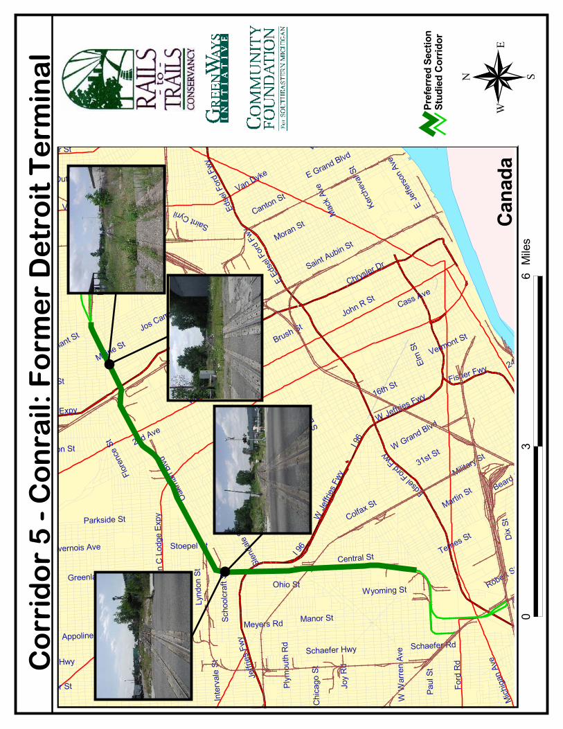
����
����������
���
����
����
����
��������������
��� �������
�����
���
�����
�
����
���������
��������
����
���
�����
����
�����������
����
���
���
����
����
������
�
��� �� ���
�����������
����
���!�
����
���
����
�"�
#�����$
%�����&�$ %�����&
!����������
��� ���"�
�����"�
��'��
��"
�
���
���
����
�����"�$
(�&)
���*
��
*�+���$
����"
�
����
,���
���"
�
��'�
���
"�
��(+ ����
���&
���
���
�� �
$
-� ��$
������$ ��(
+ ���
�
!���
���$
�������
$��� ��"�
��%
�����#
��
������$
���)����$
����� �$
�������$
#���
����
��� ���$
-�����
��������*��
��+���"�
$ �� �)����$
.���+�� �$
���
����
���
��,
����
�$
�������$
��� ����$
.�)
�+ ��
"�
��������*��
*�����$
$��� ��+/���$
������)��+�$
!��
�$
$���
����
�$
.��&����$
�����$
����
��$
0���
��$
����"�
��� ���$
����$
0����$
������$
$��� ��#��
��
���
$
%�����&�$
�� �
���
$
���
���
1���
���
$
$ ���/+���$
���
�����
��$
�� ���$
�������$
�� ���$
�)�
��$
$ ���$
23� �$
�����$
$��� �����
%�)�� �$
��� �����$
����� ���$
�����$
$�!�
�)�$
*����$
$��� �������$
( ����$
3� ��$
(����$ "�/� �$
.�+�
$
$��� ��#��
����
��
����
��������
���
� �������
����
�
��
�
�����������
�����
����
���
�������������
� ��
42
���
�
�
�
40
CORRIDOR 6: WEST BELT AND SPUR TRACKAGE
I NVENTORY
LABEL: 6 (6a-c)
NAME: West Belt and Spur Trackage
TOPOGRAPHICAL COORDINATES: 46.89-95, 3.20-4
OLD REFERENCE: RR-9
LENGTH: 5.7 miles
ENDPOINTS: Dearborn at CSX line near Schaefer Highway.; Livernois Road near Davison Avenue.
LINKAGES (SCHOOLS): Courtis Elementary (West Davison Avenue & Greenlawn Street); St. BrigidCatholic School (Schoolcraft Boulevard & Indiana Street); Monnier Elementary (Ward Street &Schoolcraft Boulevard); Parker Elementary (Meyers Street & Elmira Street); Ford Elementary (MarloweStreet & W. Chicago Avenue); McFarlane Elementary (Ward Street & Joy Road); Oakman Elementary(Chase Street & Gould Street); St. Alphonsus Catholic School (Schaefer Highway & Gould Street); H.Lowrey Elementary (Haggerty Street & Jonathon Street); Joffe Elementary (Kendall Street & HolmurStreet)
LINKAGES (PARKS): Hemlock Park (Hemlock Street & Schaefer Highway); Anthony Park (DiverseyStreet & Anthony Street); Belton-Mark Twain Playground (Belton Avenue & Mark Twain Street); SamGreene Playground (Ellis Street & Robson Street); Red M. Butzel Playfield (Lyndon Avenue & MeyersStreet)
LINKAGES (OTHER: MUSEUMS, HOSPITALS, LIBRARIES, ETC.): Links with major abandonment fromDearborn to Highland Park (5); Dearborn Public Library (West Warren Avenue & Hartwell Street);Detroit Fire Department (Oakland Street & Dexter Avenue); Detroit Police Department (SchaeferHighway & Schoolcraft Boulevard); Dearborn Fire Dept. (Schaefer Highway & Henson Street)
COMMENTS: The previous assessment identified this corridor as a potentially significant trail opportu-nity, but the status of the corridor needs investigation. The railroad is reported to be paved over atroads, but no abandonment record has been located aside from spur trackage. This corridor wasshown as a potential trail on a Project Pride redevelopment proposal for the area.
STB DOCKET NUMBERS: (6a) AB-167 sub 812 [6/13/84 - 0.2 miles] (6b) AB-167 sub 806 [6/28/84 -0.2 miles] (6c) AB-167 sub 813 [7/2/84 - 0.15 miles]
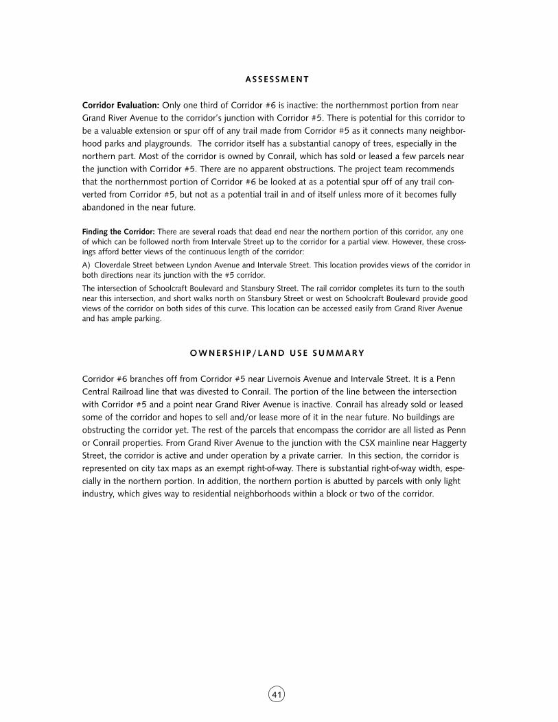
41
ASSE S SMENT
Corridor Evaluation: Only one third of Corridor #6 is inactive: the northernmost portion from nearGrand River Avenue to the corridor’s junction with Corridor #5. There is potential for this corridor tobe a valuable extension or spur off of any trail made from Corridor #5 as it connects many neighbor-hood parks and playgrounds. The corridor itself has a substantial canopy of trees, especially in thenorthern part. Most of the corridor is owned by Conrail, which has sold or leased a few parcels nearthe junction with Corridor #5. There are no apparent obstructions. The project team recommendsthat the northernmost portion of Corridor #6 be looked at as a potential spur off of any trail con-verted from Corridor #5, but not as a potential trail in and of itself unless more of it becomes fullyabandoned in the near future.
Finding the Corridor: There are several roads that dead end near the northern portion of this corridor, any oneof which can be followed north from Intervale Street up to the corridor for a partial view. However, these cross-ings afford better views of the continuous length of the corridor:
A) Cloverdale Street between Lyndon Avenue and Intervale Street. This location provides views of the corridor inboth directions near its junction with the #5 corridor.
The intersection of Schoolcraft Boulevard and Stansbury Street. The rail corridor completes its turn to the southnear this intersection, and short walks north on Stansbury Street or west on Schoolcraft Boulevard provide goodviews of the corridor on both sides of this curve. This location can be accessed easily from Grand River Avenueand has ample parking.
O W N E R S H I P / L A N D U S E S U M M A RY
Corridor #6 branches off from Corridor #5 near Livernois Avenue and Intervale Street. It is a PennCentral Railroad line that was divested to Conrail. The portion of the line between the intersectionwith Corridor #5 and a point near Grand River Avenue is inactive. Conrail has already sold or leasedsome of the corridor and hopes to sell and/or lease more of it in the near future. No buildings areobstructing the corridor yet. The rest of the parcels that encompass the corridor are all listed as Pennor Conrail properties. From Grand River Avenue to the junction with the CSX mainline near HaggertyStreet, the corridor is active and under operation by a private carrier. In this section, the corridor isrepresented on city tax maps as an exempt right-of-way. There is substantial right-of-way width, espe-cially in the northern portion. In addition, the northern portion is abutted by parcels with only lightindustry, which gives way to residential neighborhoods within a block or two of the corridor.
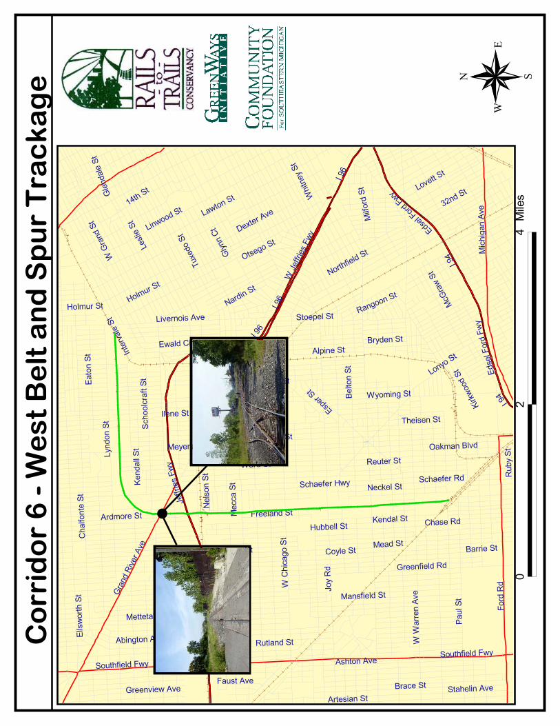
������������
���
������������
����������
����
������������
����
������������
���
���
����������
������������
�������
����������
��
���������������
�������
�
����
�
!�"#���$���
����������
��
%������������
�������������
&�����������
��������
'�(�����
��
)�#�������
��������
%�������
$������� ������������
%������
�
)������
�����������
��#������
%��������
���������
��������
����������
��������������
�������
��&��������
�
*�++������
������������
���������*
%������
��
������������
&�������
�����������
��������
������������
�����&��
,�(������
*��#�����
�����&�
�����������
��������
��������������
-������
���#������
���������
�����������
��+������ �������
%��������
����������
���������
��.�����
���������
����.�����
$��������
������������
&������
�����������
%�����
�
��������
/0�����
�����������
��.������$�������
��������
1���������
1��������
���������
!�������
�
1��"������
���������
�
��"�����
!������
����������
,���������
��+���
�+����������
�������
�
$�������
�
*��#�����
��������������
���
����
����
��������
�� �
��
�2
0������
�
43
CORRIDOR 7: CONRAIL — DETROIT, DEARBORN AND DELRAY BRANCH
I NVENTORY
LABEL: 7
NAME: Conrail Detroit, Dearborn, & Delray (DD&D) Branch
TOPOGRAPHICAL COORDINATES: 46.84, 3.20
OLD REFERENCE: RR-3
LENGTH: 1 mile
ENDPOINTS: Schaefer Road; Allen Road (in Melvindale)
LINKAGES (SCHOOLS):
LINKAGES (PARKS): DeLuca Field (Allen Road & Elizabeth Street); Barola Playfield (Oakwood Boule-vard & Sanders Street)
LINKAGES (OTHER: MUSEUMS, HOSPITALS, LIBRARIES, ETC.): Melvindale Fire Department(Oakwood Boulevard & Wall Street); Melvindale Municipal Bldg. (Oakwood Boulevard & Wall Street);Melvindale Post Office (Oakwood Boulevard & Flint Street)
COMMENTS: Conrail abandoned 0.8 miles of this stretch in 1982. Net liquidation value (1982)found to be $113,823. Conrail sold this segment to the city of Melvindale and others.
STB DOCKET NUMBER: (7) AB-167 sub 120 [2/9/82–.8 miles)
ASSE S SMENT
Corridor Evaluation: At just under a mile in end-to-end length, this corridor could be a nice neighbor-hood trail. De Luca Field, an athletic facility, is located at the western end. Otherwise, the corridordoes not offer much in the way of linkages to significant locations such as schools. The project teamdoes not recommend this corridor as a major priority for trail conversion.
Finding the Corridor: This corridor is not paralleled by any through streets, but the at-grade crossings at RauppRoad and Wall Street north of Homestead Street, as well as Prospect Avenue and Allen Road near MartelAvenue, provide good vantage points. All of these crossings can be accessed easily from Greenfield Road andSchaefer Highway.
O W N E R S H I P / L A N D U S E S U M M A RY
This section lies entirely within the municipality of Melvindale, for which no tax assessment informa-tion could be obtained. However, topographic maps and site visits indicate that the land use surround-ing the corridor in this area is residential, parkland, and light industrial. According to ICC documenta-tion, Conrail sold most of this segment to the city of Melvindale in 1982, and the city is likely thecurrent owner.
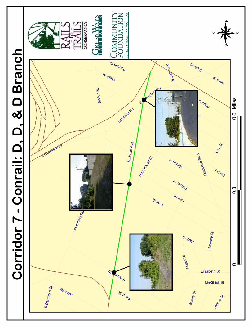
�
��
�
��������
������
������
� �� ��
�������
�
������� �����
���
�������
��
����
�� ��
��
�������
���
� ����
�
�������
�
������
������
���
�������
������ ��
�������
�
��������
�
�������
�� ����
�!�"
�����
� ����
���#�$�� ���
��������
�
��� ���
������
!���
���� ���
��%��������
��&����
'����
�
��(��
�� ������
�����
��
����(��
�
��"����
!������
����������
����
����
'�������
�� �����
�
����
�$�����
���� �
����!�
"
�����
��
))*+
)*,������
�
�
45
T A RG E T
CORRIDOR 8: CSX UNION BELT
I NVENTORY
LABEL: 8
NAME: CSX Union Belt
TOPOGRAPHICAL COORDINATES: 46.89, 3.25
OLD REFERENCE: RR-7
LENGTH: 1.06 miles
ENDPOINTS: Conrail Main line (at Junction Street); near I-94 (parallel to Livernois Avenue)
LINKAGES (SCHOOLS): Academy Americas Elementary School (Junction Street & St. Hedwig Street);Zion Elementary School (Livernois Avenue & Buchanan Avenue); St. Francis of Assisi Elementary (RichStreet & Wesson Street); Ellis Elementary School (Rich Street & 35th Street); Newberry ElementarySchool (30th Street & Buchanan Avenue)
LINKAGES (PARKS): St. Hedwig Playfield (Junction Street & Konkel Street)
LINKAGES (OTHER: MUSEUMS, HOSPITALS, LIBRARIES, ETC.): Michigan Osteopathic Medicine Cen-ter West Hospital (Cook Street & Military Street)
COMMENTS: CSX filed for abandonment in 1992. The right of way is 60 feet wide and was acquiredin 1917.
DOCKET NUMBER: (8) AB-55 sub 439 [9/29/92 - 1.06 miles]
ASSE S SMENT
Corridor Evaluation: The value of this corridor is the connection it could facilitate between the #5corridor and the #2 corridor. In addition, the corridor is tremendously valuable on the neighborhoodlevel because two city parks, Atkinson Park and Memorial Park, lie at its endpoints. Though it isbarely one mile in length, the corridor also passes within three blocks of three different schools and aplayground. This would have to move forward as a rail-with-trail project as there is an active CSX linealong the corridor. That would be the greatest hurdle to overcome. However, only one of the twotracks along the corridor is active, and there is easily sufficient width to accommodate a parallel path-way. Although CSX is reluctant to participate in any such arrangement, city tax maps indicate thatCSX has granted two different leases to an adjacent landowner that appear to allow for crossing ofthe corridor and travel along the corridor within the right-of-way and alongside the active track. Thecorridor is also wide open and fairly appealing visually.
Finding the Corridor: Hammond Street parallels this partly-active corridor very closely in two different sections,one north and one south of Michigan Avenue. North of Michigan Avenue, Hammond Street can be accessed byturning north on Livernois Avenue and then east on Buchanan Avenue. South of Michigan, it can be accessed byturning south on Livernois Avenue and then east on Otis Street. Both Buchanan Avenue and Otis Street alsocross the corridor, providing good continuous views in both directions.
����
��������
��
�������
�����
������� ��
�
�������
��������
���� ���������
�
�������
� �����
!�������
�
���������
�������
"�������
�������
�#�����
��������
$�����
�
%&������
��
!�� ����
�
%���'��(���
�������
)������
�
!��**���
���
+�!�,*
�������
!���(���
-�������
"�������)
���
�.�����
/��� �!
�
�������
��
����������
%��(����
�
0�&,�
����
0��(���
����
�����
����
0��&
1����
'*�����(���
���������
'&���(
���
������-�����
���
����
� ���
-�������
%����
2��������
-�,,�
����
��(��
���
���� ����
)&���������
������%
�����
��������
�
����(
���
����
���
$���*������
�������
���
2��������
�
!���(�!�
����$
���
�����
�����
)&���������
-�������
%&������
��
..3�
.3������
��������
������
���
�����
���
�
��
�
����
�����
����
�����
47
O W N E R S H I P / L A N D U S E S U M M A RY
This corridor contains two parallel tracks for most of its length. One of these tracks (the southwesttrack) is an active CSX line. The other has been abandoned. CSX controls the entire corridor width forthe length of the section with one exception — a small parcel that is leased to an adjacent weldingshop between Buchanan and Cook Streets. This may just be a lease arrangement for crossing of thecorridor as no structures are indicated. The corridor is more than 60 feet wide for most of its length, asufficient width for a rail-with-trail to be feasible.
OWNERSH I P / LAND USE DETA I L S
Segment 1 — Junction Street to Michigan Avenue: This corridor segment begins at the junction of theConrail and Canadian National mainlines, which occurs at Junction Street. As the Conrail main lineheads west from the junction, corridor #8 begins to branch off from it and head in a northwesterlydirection. The land is owned by Canadian National to the point where the line fully branches off nearHammond Street. The corridor is represented as a public right-of-way for the entire length of this section,which is indicative of the fact that it contains an active CSX line. It is bordered here immediately tothe north by Memorial Park. After the corridor bends around Memorial Park and continues north-west, it is paralleled to the southwest by Hammond Street for three blocks. Bordering the line to thenortheast (as well as to the southwest on the other side of Hammond Street) are single-family resi-dences. This remains the case until the line reaches Dennis Street. At this point, Hammond Street endsand the corridor is abutted immediately to the southwest by the Olympic Steel warehouse facility, aparcel that continues all the way up to Michigan Avenue. On the northeast side, the line continues tobe bordered by small residential lots until the Michigan Avenue block and the Pay and Save Market.
Segment 2 — Michigan Avenue to I-94: In the blocks immediately northwest of Michigan Avenue, thecorridor is bordered on both sides by various industrial enterprises, including Bulldog Steel and B&HMachine Sales to the southwest. To the northeast are Tiger Auto Repair, a bottling plant, and a weld-ing shop owned by Robert Carmack, who has lease agreements with CSX that allow for crossing ofthe corridor to Hammond Street and a connection from his property to Michigan Avenue. Continuingnorthwest, the corridor is again bordered by Hammond Street to the southwest. On the other side ofHammond is another warehouse facility and several individual residential lots, most of which are va-cant. Bordering the corridor immediately on the northeast side are more industrial parcels including afood warehouse and office building owned by Intermet, Ltd. Beyond this facility which ends at NowakStreet, the corridor is bordered on both sides by individual residential lots until it passes underneath I-94. Just on the other side of I-94, there is a vacant industrial parcel owned by the city of Detroit im-mediately northeast of the corridor that connects to Atkinson Park, a possible terminus/trailhead.
�
��
�
��������
������
���
�����
���
����
��������
��
�������
�����
������� ��
�
�������
��������
���� ���������
�
�������
� �����
!�������
�
���������
�������
"�������
�������
�#�����
��������
$�����
�
%&������
��
!�� ����
�
%���'��(���
�������
)������
�
!��**���
���
+�!�,*
�������
!���(���
-�������
"�������)
���
�.�����
/��� �!
�
�������
��
����������
%��(����
�
0�&,�
����
0��(���
����
�����
����
0��&
1����
'*�����(���
���������
'&���(
���
������-�����
���
����
� ���
-�������
%����
2��������
-�,,�
����
��(��
���
���� ����
)&���������
������%
�����
��������
�
����(
���
����
���
$���*������
�������
���
2��������
�
!���(�!�
����$
���
�����
�����
)&���������
-�������
%&������
��
..3�
.3������
�
�
�
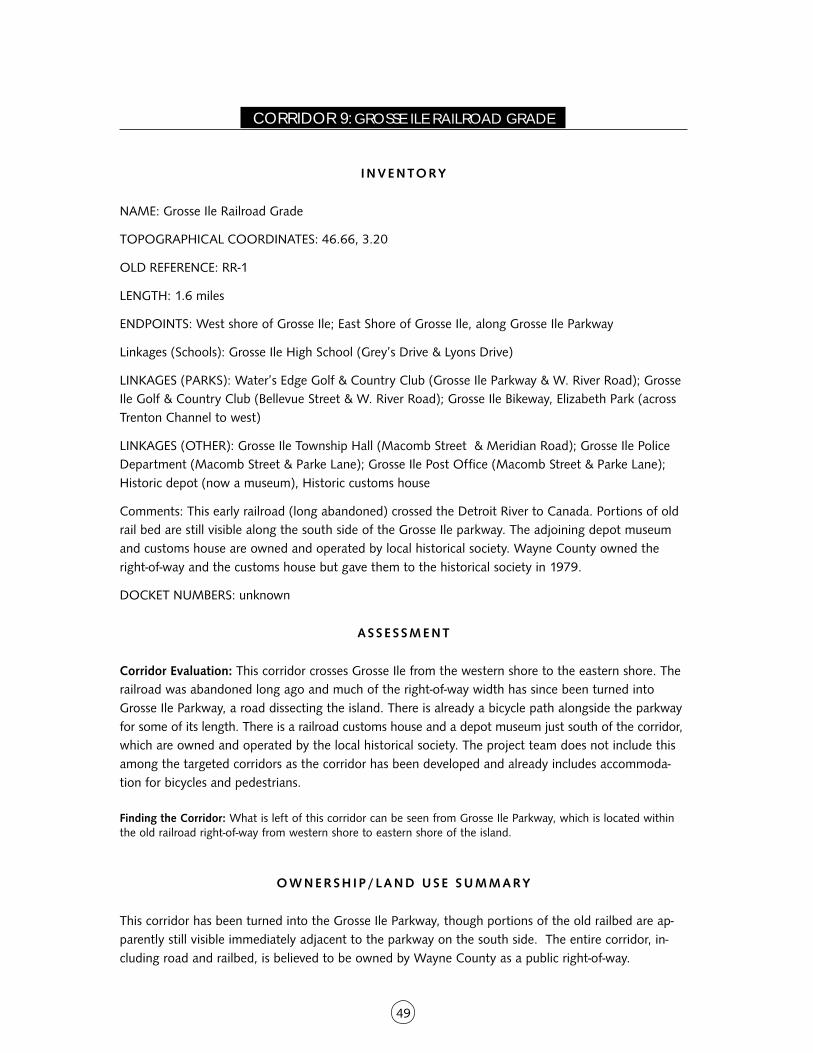
49
CORRIDOR 9: GROSSE ILE RAILROAD GRADE
I NVENTORY
NAME: Grosse Ile Railroad Grade
TOPOGRAPHICAL COORDINATES: 46.66, 3.20
OLD REFERENCE: RR-1
LENGTH: 1.6 miles
ENDPOINTS: West shore of Grosse Ile; East Shore of Grosse Ile, along Grosse Ile Parkway
Linkages (Schools): Grosse Ile High School (Grey’s Drive & Lyons Drive)
LINKAGES (PARKS): Water’s Edge Golf & Country Club (Grosse Ile Parkway & W. River Road); GrosseIle Golf & Country Club (Bellevue Street & W. River Road); Grosse Ile Bikeway, Elizabeth Park (acrossTrenton Channel to west)
LINKAGES (OTHER): Grosse Ile Township Hall (Macomb Street & Meridian Road); Grosse Ile PoliceDepartment (Macomb Street & Parke Lane); Grosse Ile Post Office (Macomb Street & Parke Lane);Historic depot (now a museum), Historic customs house
Comments: This early railroad (long abandoned) crossed the Detroit River to Canada. Portions of oldrail bed are still visible along the south side of the Grosse Ile parkway. The adjoining depot museumand customs house are owned and operated by local historical society. Wayne County owned theright-of-way and the customs house but gave them to the historical society in 1979.
DOCKET NUMBERS: unknown
ASSE S SMENT
Corridor Evaluation: This corridor crosses Grosse Ile from the western shore to the eastern shore. Therailroad was abandoned long ago and much of the right-of-way width has since been turned intoGrosse Ile Parkway, a road dissecting the island. There is already a bicycle path alongside the parkwayfor some of its length. There is a railroad customs house and a depot museum just south of the corridor,which are owned and operated by the local historical society. The project team does not include thisamong the targeted corridors as the corridor has been developed and already includes accommoda-tion for bicycles and pedestrians.
Finding the Corridor: What is left of this corridor can be seen from Grosse Ile Parkway, which is located withinthe old railroad right-of-way from western shore to eastern shore of the island.
O W N E R S H I P / L A N D U S E S U M M A RY
This corridor has been turned into the Grosse Ile Parkway, though portions of the old railbed are ap-parently still visible immediately adjacent to the parkway on the south side. The entire corridor, in-cluding road and railbed, is believed to be owned by Wayne County as a public right-of-way.
��������
���������
���������� �������������
���������
��������
���������
�
������������
�� ������
��������
����������
�� ������
����� �����
!������"����������
��������������
���#�������
�
��������$����
�����%�����
!���������
�����
������
"����������
�%�����
"�������
�
������"
�
��&������"
�
���������
'�����
���������
�(�����
)*�����+�����
��������������$�"
�
!�������"�
���������
����
����
��������
������
��
����
������
����
��
�
��
�*
*,-),.
����
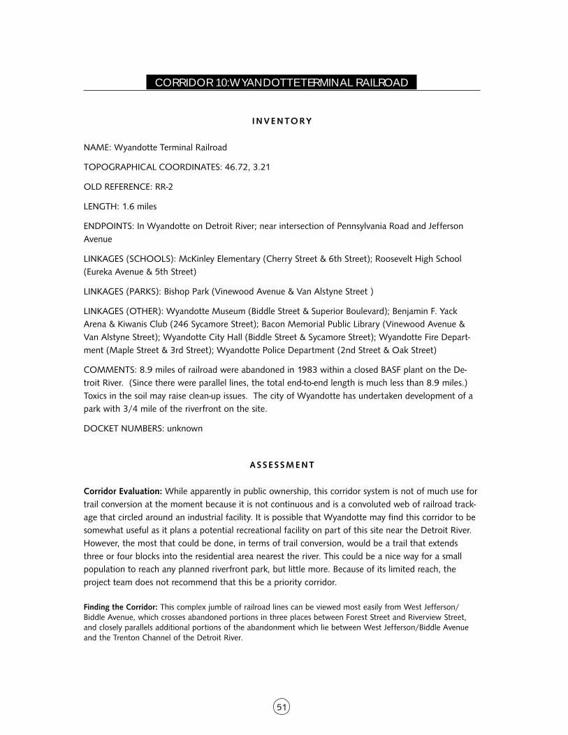
51
CORRIDOR 10: WYANDOTTE TERMINAL RAILROAD
I NVENTORY
NAME: Wyandotte Terminal Railroad
TOPOGRAPHICAL COORDINATES: 46.72, 3.21
OLD REFERENCE: RR-2
LENGTH: 1.6 miles
ENDPOINTS: In Wyandotte on Detroit River; near intersection of Pennsylvania Road and JeffersonAvenue
LINKAGES (SCHOOLS): McKinley Elementary (Cherry Street & 6th Street); Roosevelt High School(Eureka Avenue & 5th Street)
LINKAGES (PARKS): Bishop Park (Vinewood Avenue & Van Alstyne Street )
LINKAGES (OTHER): Wyandotte Museum (Biddle Street & Superior Boulevard); Benjamin F. YackArena & Kiwanis Club (246 Sycamore Street); Bacon Memorial Public Library (Vinewood Avenue &Van Alstyne Street); Wyandotte City Hall (Biddle Street & Sycamore Street); Wyandotte Fire Depart-ment (Maple Street & 3rd Street); Wyandotte Police Department (2nd Street & Oak Street)
COMMENTS: 8.9 miles of railroad were abandoned in 1983 within a closed BASF plant on the De-troit River. (Since there were parallel lines, the total end-to-end length is much less than 8.9 miles.)Toxics in the soil may raise clean-up issues. The city of Wyandotte has undertaken development of apark with 3/4 mile of the riverfront on the site.
DOCKET NUMBERS: unknown
ASSE S SMENT
Corridor Evaluation: While apparently in public ownership, this corridor system is not of much use fortrail conversion at the moment because it is not continuous and is a convoluted web of railroad track-age that circled around an industrial facility. It is possible that Wyandotte may find this corridor to besomewhat useful as it plans a potential recreational facility on part of this site near the Detroit River.However, the most that could be done, in terms of trail conversion, would be a trail that extendsthree or four blocks into the residential area nearest the river. This could be a nice way for a smallpopulation to reach any planned riverfront park, but little more. Because of its limited reach, theproject team does not recommend that this be a priority corridor.
Finding the Corridor: This complex jumble of railroad lines can be viewed most easily from West Jefferson/Biddle Avenue, which crosses abandoned portions in three places between Forest Street and Riverview Street,and closely parallels additional portions of the abandonment which lie between West Jefferson/Biddle Avenueand the Trenton Channel of the Detroit River.

52
O W N E R S H I P / L A N D U S E S U M M A RY
This trackage lies partly within Wyandotte and partly within Riverview, two suburban municipalitiessouthwest of Detroit. It consists of a web of tracks that served a BASF industrial facility along theDetroit River, connecting the facility with the main railroad line just to the west. The tracks and theindustrial complex are believed to be in the ownership of Wyandotte. Wyandotte hopes to convertsome of this riverfront area into parkland. The tracks circle through a maze of industrial buildings,with three or four short lines that extend to the main line through about four blocks of residences.There is also a sewage disposal facility west of the main concentration of tracks.
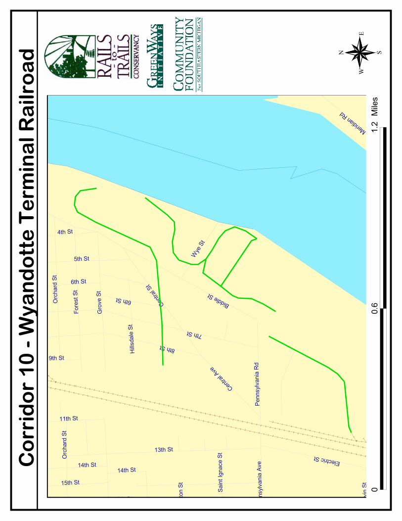
������
�������
�������
������
�������
�����
���������
����
����
������
����������
���������
�������
����
����
�
�������
������������
�������
�����
����
����
� ��
�����
! ���
�
�������"
��
#�������
�����
�
����
����
$���
����
����
� ��
����"��
%������
��
&'��
(�����
�
�����
�)(��
�����
����
����
�
�������
������
�����������
����
��� ���������
������
����
�
��
�*
*+��+,
����
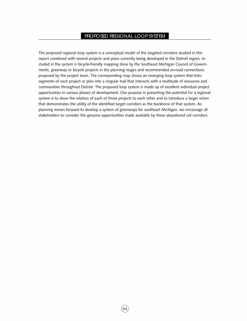
54
PROPOSED REGIONAL LOOP SYSTEM
The proposed regional loop system is a conceptual model of the targeted corridors studied in thisreport combined with several projects and plans currently being developed in the Detroit region. In-cluded in the system is bicycle-friendly mapping done by the Southeast Michigan Council of Govern-ments, greenway or bicycle projects in the planning stages and recommended on-road connectionsproposed by the project team. The corresponding map shows an emerging loop system that linkssegments of each project or plan into a singular trail that interacts with a multitude of resources andcommunities throughout Detroit. The proposed loop system is made up of excellent individual projectopportunities in various phases of development. Our purpose in presenting the potential for a regionalsystem is to show the relation of each of those projects to each other and to introduce a larger visionthat demonstrates the utility of the identified target corridors as the backbone of that system. Asplanning moves forward to develop a system of greenways for southeast Michigan, we encourage allstakeholders to consider the genuine opportunities made available by these abandoned rail corridors.
����
����������
��� �����
��
���������
�������
��� �������� ���������
���
������������
����
����������
����
����
�������
��� �������
�
��������������
�����������
���������
!�
"������ !
�
�����
�� !�
���#�
������$�������
"�����#
�!��� !�
%���� &����%��
�� &�
"����������#�
$�!������ !�
� �#
�
�� ����#�
��'��
����#�
(�&)���*�!�
��(���
����
*����#�
(�������+�
),�&�� !�
���&� !�
����������� !�
#��������
����-������#�
��'������#�
�����������
(�&���*�!�
���������#�
����������� !�
�������#�
.�����������
�������
�
��%�����/�
����������������&���
� )������
%���������
�����#�
0��� !�
��"�����*
�!�
"�����������
*����&��
� ����
�#�
/� ������
������� ��
�
�����)��
����
$��������
/�,,�����
�
���
������������
� �����
1� �����
��%�����/�
1�������
�
���� !�
��������� !�
�,�����
"�������
"� ����
�
�)�� ��
�
����������
$!������
����� �����%�������#�
"���!����
��$�
#������
/������
��������
������
��$�
��2���
����&����
�
#���,�����
��/������
�����
+��&� !�
.�����& ���
(��������
����
��)������
������
����
���� ���
��
����
����
�
�
��
�
1�������������
1�����
#�!�����&
�����������
������
#����#
�!���"
���
#1�3��
4���
����
("3�-�1
+
$�����
56
LEGAL ANALYSIS OF MICHIGAN RAILROAD LAW
I NTRODUCT ION
Where a railroad corridor cannot be railbanked under federal law (16 U.S.C. § 1247(d)), the ability toconvert a railroad corridor into a trail depends on the interpretation of the applicable deeds understate law, and the public policy (either statutory or common law) of the state concerning preservationof rail corridors. In general, in determining whether a rail corridor can be converted to trail use understate law, there are three basic questions that must be addressed: First, what is the nature of therailroad’s ownership interest (fee versus easement)? If it is easement, the next question is, has theeasement been abandoned? Third, are the terms of the easement sufficient to encompass trail use?
If the railroad acquired a fee simple, then the railroad has the right to transfer the corridor for anypurpose, including trail use. Trail interests are also protected if the corridor was acquired by therailroad through federal land grants. The railroad’s fee interest may also be construed as a defeasiblefee interest (i.e., a fee estate subject to a retained future interest by the grantor) provides for a rightof reentry or reverter if the corridor ceases to be used for railroad purposes. In the case of a defeasiblefee the question is whether such a right of re-entry has been extinguished by a marketable title law,designed to permit defeasible fees to ripen into full fee simple title upon the passage of time and/orthe failure of the holder of the reversionary interest to record that interest.
If the railroad acquires only an easement interest, the ability to convert the easement to a traildepends on whether the railroad has abandoned the easement, and whether the language of theeasement, interpreted in light of the applicable public policy of state, is broad enough to encompasstrail use.
As will be discussed below, the law in Michigan relating to the ownership of railroad corridors and useas trails is fairly well-developed and is generally favorable to interests of preserving railroad corridorsfor continued public use, including as trails.
D I SCUSS ION
I. Fee versus Easement
In Michigan, the language of the conveyance will determine whether a deed creates an estate in feeor an easement, but if the language of the deed is ambiguous then other evidence may be used todetermine the type of interest created. See Department of Natural Resources v. Carmody-Lahti RealEstate, Inc., No. 222645, 2001 Mich.App. LEXIS 1509, at *2 (Mich. Ct. App. June 5 2001) (findingthat a deed using the term “right of way” created an easement).
In Quinn v. Pere Marquette R Co, 239 N.W. 376, (Mich. 1931), the Michigan Supreme Courtarticulated the standard that is generally used to determine whether a conveyance creates an estate infee or an easement:
“Right of way” has two meanings in railroad parlance: the strip of land upon which the track is laid,and the legal right to use such strip. In the latter sense it may mean an easement. But in this State
57
and others the character of the title taken to the strip depends upon the language of the conveyance.
Where the grant is not of the land but is merely of the use or of the right of way, or, in some cases, ofthe land specifically for a right of way, it is held to convey an easement only.
Id. at 379 (Mich. 1931)). An interest in fee can still be found if the land itself is conveyed and use ofthe land is limited to a specific purpose, such as railway use. Id.
II. Possibility of Reverter and Rights of Entry
Generally, a deed will be construed as a defeasible fee interest if the deed contains a reverter clause.Quinn, 239 N.W. at 379. Absent a reverter clause, a statement limiting use, may be interpreted as anintention of the parties for a lawful conveyance without creating a future interest in the grantor. Id. Ifa deed is construed as a defeasible fee interest, Michigan state law provides for the possibleextinguishment of the future interest and conversion of defeasible fee into fee simple title pursuant tothe Possibilities of Reverter and Rights of Entry Act, MCLS §§ 554.61 et seq. (Law. Co-op. 2002).
Under this law, in order for a “terminable interest” to be enforceable, the “specific contingency” mustoccur within thirty years of the creation of the “terminable interest.” MCLS § 554.62. A “terminableinterest” is defined as “a possessory or ownership interest in real property which is subject totermination by a provision in a conveyance or other instrument which either creates a right orreversion to a grantor or his heirs, successors or assigns or creates a right of entry on the occurrenceof a specified contingency.” MCLS § 554.61(a). A “specified contingency” is defined as “the eventdescribed in a conveyance or other instrument creating a terminable interest, the occurrence of whichrequires or permits the divesting of the terminable interest.” MCLS § 554.61(b).
A “terminable interest” must be recorded within thirty years of its creation and re-recorded everythirty years to be preserved. MCLS § 554.65. Unless recorded, “terminable interests” created prior toMarch 29, 1968 are void unless the “specific contingency” which would terminate the interestoccurred within thirty years of the creation of the interest or prior to March 29, 1969, whichever islater. MCLS § 554.63.
III. Abandonment
Under Michigan law “[t]o prove abandonment, both an intent to relinquish the property and externalacts putting the intention into effect must be shown. Nonuse, by itself, is insufficient to showabandonment. Rather, nonuse must be accompanied by some act showing a clear intent to abandon.”Ludington & Northern Railway v. The Epworth Assembly, 468 N.W.2d 884, 888 (Mich. Ct. App.1991) (internal citations omitted) (reversing a lower court finding that a railroad had abandoned itsinterest in an easement created for railroad purposes by nonuse). See also Chester Belka v. PennCentral Corp., No. 1:92-CV-581, 1993 U.S. Dist. LEXIS 15836, at *17-18. (D.Mich. Oct. 14, 1993)(Easement was abandoned where, out of a total of 30.5 miles the defendants has sold 3 mileswithout making a “reservation of a right to use for railroad purposes . . . [and] broken up theremaining 27.5 miles of the former rail corridor into 5 disconnected segments 4 to 9 miles in length.”)
By contrast, in Cary Enterprises. v. CSX Transportation Inc., No. 195528, 1997 Mich.App. LEXIS 3056,at *1 (Mich. Ct. App. July 29, 1991), the court agreed that the payment of taxes on a railroadeasement was evidence of an intention not to abandon a railroad easement even though the railroadintended to discontinue rail service, had removed its tracks and sought a certificate of abandonment
58
from the Interstate Commerce Commission (“ICC”). The court also agreed that the ICC abandonmentcertificate only indicated an intent to cease rail service, but that the certificate did not necessarilyimply an intention to abandon property interests. Id. at *5-6.
In addition, a railroad easement can be extinguished by impossibility. Impossibility exists when thepurpose for which the easement was created is no longer possible. See Chester Belka at *19. InChester Belka, the court found that there was “no possibility of rail access” for the remainingsegments that the defendants possessed. Id. at *21. The court also concluded that since the policygoal behind rails-to-trails is to preserve “rail corridors for future rail use,” if an easement terminatesbecause of impossibility the public policy in favor of rails-to-trails no longer applies because theunderlying goal is no longer possibly. Id. at *21-22.
IV. Shifting Public Use Doctrine
Michigan is one of a handful of states in which the courts have expressly ruled that a railroadeasement is a form of public highway use that is sufficiently broad to encompass use as a trail, SeeCary Enterprise v. CSX Transformation, Inc., No. 95-03311-CH, slip op. at 9 (Mich. Cir. Ct. April 19,1996) (finding that recreational trail use “consistent with the original transportation purpose of theeasement.”). As the court explained, the term “right of way” in this case meant “the instrumentality tooperate upon the ‘right of way’” and that “[r]ailroads were the super highways and air routes of thelate 19th century. They were the primary method for transporting goods and people beyond theirlocal community.” Id. at 8.
The willingness of courts to adopt the shifting public use doctrine, in part, derives from the fact thatthe state of Michigan has adopted a clear state policy declaring trail use to be a public purpose. SeeCary, supra, at 9. The Michigan State Transportation Preservation Act of 1976, provides that: “Thepreservation of abandoned railroad rights of way for future rail use and their interim use as publictrails is declared to be a public purpose.” MCLS § 474.51 (3) See Chester Belka v. Penn Central Corp.,No. 1:92-CV-581, 1993 U.S. Dist. LEXIS 15836, at *17 (D.Mich. Oct. 14, 1993) (stating that thepublic policy of Michigan clearly supports using railbanking and the interim use of corridors for trails).
59
PROPOSED ACTION STEPS FOR IMPLEMENTATION
As community groups and public agencies pursue the conversion of Detroit’s rail corridors to multi-usetrails, some important steps must be followed to avoid common pitfalls, inform the public and assuresafe and enjoyable trail use.
DETERM INE SA L EAB I L I T Y
The first step for any corridor conversion will include meeting with the railroad company or corridorowner to determine their willingness to sell, a timeline for selling, conditions of sale and an estimateof the acquisition cost. The outcome of this step will determine how the process should proceed.
Useful resource: Rails-to-Trails Conservancy has published a how-to manual, Acquiring Rail Corridorsfor detailed guidance on this process.
S TAKEHOLDER INVOLVEMENT
If the sale appears to be imminent and feasible, the next step will be to determine who potentialstakeholders will be. Because stakeholders will be the organizing force behind trail implementation,they should be the first audience to receive information about the projected benefits, costs anddevelopment framework for the trail project. The following categories of stakeholders arerecommended for the Detroit railroad corridor projects:
■ Community reinvestment strategy cluster boards
■ Collaborative partners from similar and connected projects
■ Local user groups including bicycling, walking and youth groups
■ Local nonprofit groups such as Friends of the Detroit River, the Greening of Detroit, WildlifeHabit Council and Youth, Sports and Recreation Commission
■ Local governmental elected officials, especially Detroit City Council and Mayor KwameKilpatrick
■ Local government departments including Detroit Department of Parks and Recreation andDetroit Department of Planning and Development
■ Neighborhood associations and housing groups
■ Nearby businesses
The stakeholders should meet as one large, or several small, groups to discuss the project and receivefactual and anecdotal input on its potential, issues and opportunities. Their input can help customizethe rest of the steps. The lead stakeholders in the trail’s development should be determined at thesemeetings. The leaders who step forward to help with the trail project may be formed into a steeringcommittee to help with the implementation steps.
60
PRO J E C T I N T E G R AT I O N
If stakeholders agree to proceed with the trail project, the next step involves incorporating the projectas a priority in critical planning documents, such as the recreation plan, the community master planand the community zoning plan. In order for the project to be formally adopted by local electedplanning and recreation boards, trail project planners will have to advocate for the project and presentthe project plans and benefits to relevant boards and groups. The integration of the project intocommunity plans is a requirement of many public grant programs at the state and federal level.Stakeholders on the project steering committee can have a considerable influence by advocating forthe project to appropriate decision makers, lending professional expertise and notifying necessaryparties when the integration is official.
ENV IRONMENTAL A S S E S SMENT
Another requirement of many public grant programs, and the next step in the process, is a Phase Ienvironmental assessment. The assessment will include a visual inspection, examination of relevantpublic records and a sampling of possible problem areas. If the Phase I study identifies problem areas,a Phase II assessment may be required, including tests to determine contamination levels and clean-upsteps necessary before securing public funding. The Phase II assessment can be avoided if the corridorowner assumes responsibility for clean-up costs should problem areas need attention.
F E A S I B I L I T Y S T U DY A N D T R A I L C O S T E S T I M ATE
A feasibility study is the next step in the corridor conversion process. While this report details whichcorridors hold realistic potential as a trail projects, more detailed feasibility studies will guide theimplementation and development of the projects. A feasibility study involves a specific physical reviewof the corridor, including an analysis of treatment options for intersections, possible realignments ofthe corridor, surface alternatives, potential locations and design of trailheads and all other designissues and opportunities.
A feasibility study will also include potential trail management options and a determination ofmaintenance tasks to be undertaken regularly or on an as-needed basis. The administrative structurerequired to accomplish the trail maintenance will be discussed in the study. Specific questionsaddressed in the feasibility study will be:
■ Who will own and manage the trail?
■ How will the trail be maintained, including standards for vegetation management, snowremoval, trail surface repair, litter removal, graffiti cleanup and sweeping?
■ How will the trail be patrolled by police and volunteer citizens?
■ What provisions will exist for emergency vehicle access and citizen emergency phoneaccess?
Additionally, two or three sessions inviting public input on the feasibility study topics will helpcustomize the trail design for its potential users. Individual meetings with stakeholders as needed will
61
further help the steering committee arrive at a preliminary design. From this information, thecommunity group or public agency leading the project will create a trail cost estimate and a strategyfor funding, which will include a list of federal, state and private grants for which the project wouldbe most eligible. A trail cost estimate will indicate how much local match will be required, and thefeasibility study will explore possible ways of raising these dollars, tailored to the community.
I NC R E A S I N G P U B L I C A WA R E N E S S
A brochure depicting the vision for the trail project including who, what, where and why will drawpotential trail supporters to comment on design considerations, provide financial support andadvocate at public meetings. A marketing plan should accompany the development of the brochure todetermine how they will be distributed and how and when to contact the media for coverage of thetrail effort. Possible venues for a display booth should be explored by trail supporters to increasepublic awareness. The more places information can be disseminated, the more likely the trail will gainacceptance in the community.
Useful resource: Secrets of Successful Rail-Trails, An Acquisition and Organizing Manual forConverting Rails into Trails, Rails-to-Trails Conservancy, 1993.
62
APPENDIX A:FUNDING AND SUPPORT SOURCES FOR GREENWAYS AND TRAILS
FEDERAL FUNDING SOURCES
The Transportation Equity Act for the 21stCentury (TEA-21)
TEA-21 is federal transportation legislation thatprovides for funding to enhance communities includ-ing improvement of non-motorized transport, trailsand greenways. While TEA-21 is federal legislation, theMichigan Department of Transportation in Lansingmakes funding decisions for Michigan-based projects.
Through TEA-21’s Transportation EnhancementsProgram, about $22 million per year has been madeavailable to Michigan over the past 12 years. Theprogram, to be reauthorized in 2003 will provide forthe next 6 years. This program is a prime source ofgreenway funding for the following categories:
■ Building facilities for bicycles and pedestrians
■ Providing safety and educational activities forpedestrians and bicyclists
■ Converting abandoned railroad corridors intobicycle and pedestrian paths
■ Preserving historic sites
■ Acquiring scenic or historic sites
■ Sponsoring scenic or historic highway programs
■ Beautifying roadsides
■ Rehabilitating historic buildings or facilities toserve a transportation need
■ Performing archeological research, such asexcavations
■ Removing outdoor advertising signs
■ Mitigating water pollution caused by road runoff
■ Establishing transportation museums
Eligible project applicants include all governmentalentities that receive fuel tax revenues, such as city andvillage road agencies, road commissions, transit agen-cies, the state Department of Transportation andMichigan Department of Natural Resources for rail/bike path projects. The application procedure is beingrevised. Local units of government will be notified ofnew application deadlines. The project sponsor mustpay at least 20 percent of a project’s cost. Projectexpenses have ranged from a few thousand dollars to
$1 million.
Contacts:Office of Transportation, Economic Development andEnhancementsMichigan Department of Transportation425 West Ottawa, P.O. Box 30050Lansing, MI 48909
Mike EberleinEnhancements Program ManagerPhone: 517-335-3040 • Fax: 517-373-2687E-Mail:[email protected]
Bryan ArmstrongEnhancements Program CoordinatorPhone: 517-335-2918E-Mail: [email protected]
Todd KauffmanNon-motorized Transportation CoordinatorBureau of Transportation PlanningMichigan Department of TransportationPhone: 517-335-2918E-Mail: [email protected]
National Recreational Trails Funding Program
The Recreational Trails Program provides funds forboth motorized and non-motorized trail development.Through this program, federal gasoline taxes paid onnon-highway, recreation fuel for off-road and campingvehicles is transferred from the highway trust fund.This program is part of TEA-21 and has annual fund-ing of $30 million for FY 1998, $40 million for FY1999 and $50 million per year for each remainingyear of the bill.
States can grant these funds to private individuals,organizations, city and county governments andother government entities. Grant recipients aregenerally required to provide 20 percent of the totalproject cost. In Michigan, the Department of NaturalResources (MDNR) administers the program. There isno open application process and most of the moneyis used on DNR projects. A DNR division can sponsorlocal projects. Permissible uses of the fund include:
■ State administrative costs
■ Environmental and safety education programs
63
■ Development of urban trail linkages
■ Maintenance of existing trails
■ Restoration of areas damaged by trail use
■ Development of trail facilities
■ Provision of access for people with disabilities
■ Acquisitions of easements
■ Fee simple title for property and construction ofnew trails
Contact:Ed Hagen, State Trails Coordinator, Parks & RecreationBureau, Michigan Department of Natural ResourcesP.O. Box 30257Lansing, MI 48909Phone: 517-373-0367 • Fax: 517-241-0977E-mail: [email protected]
Scenic Byways Program
TEA-21 authorizes the use of federal funds to identifyand designate federal, state and local scenic byways.These byways, typically back roads, are intended toshowcase areas of great beauty and rich history.Funds may be spent on the construction of facilitiesfor pedestrians and bicyclists along these designatedhighways. Of 20 nationally recognized roads in thisprogram, Michigan has six.
Contact:Scenic America801 Pennsylvania Ave., Ste 300Washington, D.C. 20003Phone: 202-543-6200 • Fax: 202-543-9130E-mail: [email protected] site: www.scenic.org
Land and Water Conservation Fund (LWCF)
The Land and Water Conservation Fund is adminis-tered in Michigan by the Michigan Department ofNatural Resources and funds the planning, acquisitionand development of land for federal and non-federal(state-side) outdoor recreation. This program hasrecently been re-opened after a period of dormancy.Funding for 2003 and beyond is expected to reach atleast $4 million per year.
State agencies and municipalities are eligible for state-side LWCF funds which can generally be used toacquire land, build and repair recreation or parkfacilities, provide biking and hiking trails, enhance
recreational access and provide wildlife and huntingareas. The program matches up to 50 percent of thecost of a project.
Contact:James Wood, Manager, Resource Protection Section,Grants Administration DivisionMichigan Department of Natural ResourcesP.O. Box 30425Lansing, MI 48909Phone: 517-241-2480DNR Web site: www.michigan.gov/dnr
Michigan Coastal Management Program
Michigan’s Coastal Management Program, developedunder the Coastal Zone Management Act (CZMA)1972, is administered by the Land and Water CoastalZone Management Division of the State Departmentof Environmental Quality (DEQ). The DEQ distributesabout $800,000 per year to shoreline communitiesfor a variety of projects.
Michigan’s coastal zone boundary extends a minimumof 1,000 feet inland, and sometimes further to in-clude coastal lakes, river mouths and bays, flood-plains, coastal wetlands, sand dunes, parks naturalareas and urban areas.
CZMA Section 306 funds are used for planning activi-ties, site design, engineering, feasibility and naturalfeatures studies, historic preservation projects, coastaleducation materials, developing portions of localzoning ordinances, master planning of coastal signifi-cance and waterfront redevelopment studies. CZMASection 306A funds are used for low-cost construc-tion projects such as resource protection, trails, board-walks, scenic overlooks, education and/or interpretivedisplays, restoration of historic coastal structures andbarrier-free retrofitting. Under both sections, grantsrequire a local match in an amount equal to thegrant. About 40 projects up to $50,000 are approvedfor funding each year. Applications are due no laterthat April 1st.
Contact:Cathy CunninghamUnit ChiefLand and Water Coastal Zone Management UnitMichigan Department of Environmental QualityP.O. Box 30458Lansing, MI 48909
64
Phone: 517-335-3456DEQ Web site: www.michigan.gov/deq
Urban and Community Forestry Program
The Forest Mineral and Fire Management Division ofthe Michigan Department of Natural Resources (DNR)administers this program. The Department providesapproximately $130,000 for grants annually from thisU.S. Department of Agriculture program. Applicantsmust be local units of government or nonprofit orga-nizations. Grants up to $20,000 are awarded toprojects that develop or enhance urban and commu-nity forestry resources in Michigan. The applicationdeadline is in early spring. Project categories include:
■ Local government program development
■ Nonprofit program development
■ Demonstration projects
■ Information/education projects
■ Tree planting
Contact:Cara Boucher, Urban and Community ForesterForest Mineral and Fire Management DivisionMichigan Department of Natural ResourcesP.O. Box 30452Lansing, MI 48909Phone: 517-335-3354Web site: www.michigan.gov/dnr
OTHER FEDERAL FUNDING SOURCES
Non-point Source Pollution Control Grants
The Surface Water Quality Division’s Non-point SourceUnit in the Michigan Department of EnvironmentalQuality administers this Environmental ProtectionAgency Program. Grants are provided to county orlocal units of government, Cooperative ExtensionService agencies, soil conservation districts, regionalplanning commissions, lake boards and water manage-ment districts.
Program priorities are established for each fiscal year.Examples of previous priorities include projects thatdemonstrate new or innovative technical and institu-tional approaches, watershed restoration activities andgroundwater protection activities. A project on theHuron River (Washtenaw County) focused on infor-mation and education activities targeted toward localgovernmental units, land use planners, local businessesand large institutional landowners. Activities include
expansion of the Adopt-A-Stream program and devel-opment of partnerships with local businesses andlarge institutional landowners.
Since the inception of the program in 1988, $9.4million dollars have passed to local communities tofund projects in more than 35 watersheds statewide.
Contact:Non-point Source Unit, Water DivisionMichigan Dept. of Environmental QualityP.O. Box 30273Lansing, MI 48909Phone: 517-373-2867Web site: www.michigan.gov/deq
State Wetlands Protection Development GrantProgram
This Environmental Protection Agency Program pro-vides grants to state and local governments for devel-oping new or enhancing existing wetlands protectionprograms. Funding priority is focused on Wetland/Watershed Protection Approach DemonstrationProjects and River Corridor and Wetland RestorationProjects.
Contacts:Lori Williams, Wetlands DivisionOffice of WetlandsOceans and Watersheds (4502F)Environmental Protection Agency401 M Street, SWWashington, D.C. 230460Phone: 202-566-1376
Sue ElstonEPA, Region V77 West Jackson Blvd.Chicago, IL 60604Phone: 312-886-6115 • Email: [email protected] site: www.epa.gov.owow/watershed/wacademy/fundwet.html
Conservation Reserve Program (CRP)
The Department of Agriculture, through its FarmService Agency provides payments to farm ownersand operators to place highly erodible or environmen-tally sensitive cropland into a 10 to 15 year contract.The participant, in return for annual payments, agreesto implement a conservation plan approved by thelocal conservation district for converting these sensi-
65
tive lands to less intensive use. For example, croplandmust be planted with a vegetated cover that reducessoil erosion, improves water quality and enhances orestablishes wildlife habitat.
Contact:Shannon ZezulaNatural Resources Conservation Service3001 Coolidge Rd., Suite 250East Lansing, MI 48823Phone: 517-324-5259Web site: www.mi.ncrs.usda.gov
Wetlands Reserve Program (WRP)
The Department of Agriculture, through its Agricul-tural Stabilization and Conservation Service, providesdirect payments to private landowners who agree toplace sensitive wetlands under permanent or 30-yeareasements. This program could be used to perma-nently protect wetland areas as open space along agreenway corridor and would pay on a cost-sharebasis for restoration of a wetland.
Contact:Jim MarshallNatural Resources Conservation Service3001 Coolidge Rd., Suite 250East Lansing, MI 48823Phone: 517-324-5257
Watershed Protection and Flood Prevention(Small Watershed Protection Grants)
The Natural Resources Conservation Service (NRCS)provides funding to state and local agencies or non-profit organizations authorized to carry out, maintainand operate watershed improvements in watershedsof less than 250,000 acres. The NRCS provides finan-cial and technical assistance to eligible projects thatimprove watershed protection, flood prevention,sedimentation control, public water-based fish andwildlife enhancements and recreation planning. TheNRCS provides a 75 percent local match for publicrecreation, fish and wildlife improvements and floodprevention projects. Also, in-kind services may countas a match to this program.
Contact:Sean DuffeyNatural Resources Conservation Service3001 Coolidge Rd., Suite 250East Lansing, MI 48823
Phone: 517-324-5247
For all of the Natural Resources Conservation Serviceprograms listed above, you can also contact the localNRCS agent located in each county.
Brownfields Revitalization Grants
The Brownfields Revitalization and EnvironmentalRestoration Act, signed into law in early 2002, pro-vides $200 million nationwide for brownfields assess-ment and clean-up. Greenways, habitat restoration,parks and other “green activities” are eligible purposesfor these grants. The program is administered by theU.S. Environmental Protection Agency and has aninitial grant deadline of December 16, 2002. If re-viewed favorably, the final grant deadline is March 5,2003. Local governments and nonprofit organizationsare eligible to apply.
Contact:Deborah OrrEPA Region 5 Brownfields Coordinator77 West Jackson Blvd.Chicago, IL 60604-3507Phone: 312-886-7576E-mail: [email protected] site: www.epa.gov/brownfields
Watershed Grants
A new watershed initiative program has been an-nounced by the Environmental Protection Agency forfunding in 2003 (subject to the appropriations pro-cess). The program will focus on watershed coalitionsand innovative collaborative efforts for assessment,clean-up and mitigation of threats to water quality.Up to 20 watersheds will be selected for this $21million initiative. Grants will range from $300,000 to$1.3 million, and a 25 percent non-federal match isrequired. Nominations must be submitted through thegovernor or a tribal leader. State, local, communityand nonprofit groups are eligible to apply.
Contact:Robert Wayland, DirectorOffice of Wetlands, Oceans and WatershedsMail Code: 4501TU.S. Environmental Protection Agency1200 Pennsylvania Ave., NWWashington, D.C. 20640Phone: 202-566-1146Web site: www.epa.gov/owow/watershed/initiative
66
MICHIGAN FUNDING SOURCES
Michigan Natural Resources Trust Fund
This program, administered by the Grants Manage-ment Division of the Michigan Department of NaturalResources, makes some $20 million per year availablefor acquisition and development of lands and facilitiesfor outdoor recreation and environmental protection.Money for the fund is dependent on revenue andinterest accruing to the trust fund from oil and gasexploration and sales from state land.
Applications are evaluated on established criteria suchas resource protection, water access and communityrecreation. At least a 25 percent match on eitheracquisition or development projects is required fromlocal applicants. Any unit of government, includingschool districts, or any combination of units in whichauthority is legally constituted to provide recreation,is eligible to apply for funding.
Applications must be postmarked not later than April1st and August 1st of each year with decisions usuallymade by the end of the year. There is no minimum ormaximum limit on land acquisition grants. Develop-ment grants have a $15,000 minimum and a$500,000 maximum.
Contact:Sharon Edgar, ChiefGrants Management SectionMI Department of Natural ResourcesP.O. Box 30425Lansing, MI 48909-7925Phone: 517-241-3100 • Fax: 517-3366813Web site: www.michigan.gov/dnr
Recreation Improvement Fund
The Recreation Improvement Fund, administered bythe Forest Mineral and Fire Management Division ofthe Michigan Department of Natural Resources(MDNR), makes some $800,000 per year available forthe operation, maintenance and development ofrecreation trails, restoration of lands damaged by off-road vehicles and inland lake cleanup. There is noopen application process and most of the money isused on DNR projects. However, a DNR division cansponsor local projects. Projects are evaluated basedon the following criteria:
■ Special department initiative
■ Citizen/local government support
■ Contribution to economic development throughtourism
■ Linkages to parks, natural resources, communitiesand other major trails
■ Number and variety of uses to be accommodated
■ Year-round recreation opportunities
■ Resolution of issues and conflicts
Contact:Ed Hagen, State Trails CoordinatorParks and Recreation BureauMichigan Department of Natural ResourcesP.O. Box 30257Lansing, MI 48909Phone: 517-373-0367 • Fax: 517-241-0977E-mail: [email protected]
Millages and Bonds
Local, county or state millages and bond issues maybe passed by voters or governing bodies. A number ofSoutheast Michigan communities — Ann Arbor, Roch-ester Hills, Grosse Isle, Novi and West BloomfieldTownship — have millages for park operations, mainte-nance, development and land acquisition. This can beone of the most effective approaches for funding agreenway initiative.
Parks and Recreation Budgets
Greenway funding can come from willing agencies,which may include local and county parks and recre-ation departments or the Michigan Department ofNatural Resources Parks and Recreation Division.
PRIVATE FUNDING SOURCES
Kodak American Greenways Awards Program
Administered by the Conservation Fund, in partner-ship with Kodak and the National Geographic Society,the American Greenways Awards Program providesgrants of $500 to $2,500 to local greenways projects.These grants can be used for activities such as map-ping, conducting ecological assessments, surveyingland, hosting conferences, developing brochures,producing interpretive displays and audio-visual mate-rial, incorporating land trusts, building trails and trailfacilities or other creative projects. Grants cannot beused for academic research, general institutionalsupport, lobbying or political activities. The submis-
67
sion period for grant applications is March 1st to June1st with a final deadline of June 1st. Decisions areannounced in early fall.
Contact:Leigh Anne McDonaldAmerican Greenways CoordinatorThe Conservation Fund1800 North Kent Street, Suite 1120Arlington, VA 22209Phone: 703-525-6300Email: [email protected]
Recreational Equipment Incorporated (REI)Environmental Grants
REI awards grants to organizations for protection andenhancement of natural resources for use in outdoorrecreation. Grants of up to $5,000 are offered toaccomplish any of the following:
■ Preservation of wildlands and open space
■ Advocacy-oriented education for the generalpublic about conservation issues
■ Building a membership base of a conservationorganization
■ Direct citizen action (lobbying) campaigns onpublic land and water recreation issues
■ Projects working to organize a trail constituencyor to enhance the effectiveness of a trailorganization’s work as a trail advocate at the stateor local level
There is more than one deadline date for the submis-sion of grant applications. Grants are awardedthrough the local store.
Michigan contact:Allison WashburnREI17559 Haggerty Rd.Northville, MI 48167Phone: 248-347-2100 • E-mail: [email protected]
Bikes Belong Coalition
Comprised of members of the bicycle industry, BikesBelong is dedicated to putting more people on bikesmore often. Grants of up to $10,000 each are offeredto local organizations, agencies and communities fordeveloping bicycle facility projects. Grants are closelytied with furthering project readiness toward funding
by a TEA-21 enhancement grant (described above).Successor grants for continuing projects are consid-ered. Applications can be submitted anytime andfunding decisions are made on a rolling basis, with athree-month waiting period. Applicants should con-tact Bikes Belong before submitting an application.
Contact:Tim BaldwinGrants Program AdministratorPhone: 617-734-2111 • E-mail: [email protected]
Michigan Economic and EnvironmentalRoundtable (MEER)
The MEER grant was established six years ago byPublic Sector Consultants, a governmental consultingand research firm in Lansing. The roundtable is apartnership comprised of Michigan EnvironmentalCouncil, National Wildlife Federation, Dow ChemicalCompany, the Michigan State Chamber of Commerceand Public Sector Consultants. The conjecture ofenvironmental and economic issues, especially landuse, is the main focus of the program. The small grantprogram focuses on funding organizations working onland use issues from a collaborative perspective,involving the business, nonprofit and governmentsectors. Total funding per year is up to $20 millionand the maximum grant allowed is $4,000. Applica-tions are due in the spring and grant decisions aremade within one month of the deadline.
Contact:Conan SmithMichigan Environmental Council119 Pere Marquette, Suite 2ALansing, MI 48933Phone: 517-487-9539 • Fax: 517-487-9541E-mail: [email protected]
DALMAC Fund
Established in 1975 to promote bicycling in Michigan,the DALMAC Fund is administered by the Tri-CountyBicycle Association and supported by proceeds fromthe DALMAC (Dick Allen Lansing to Mackinaw)bicycle tour. The Fund has supported safety andeducation programs, bicycle trail development, state-wide bicycle organizations and route mapping projects.
Applications must be submitted between January 1stand April 1st. Grants are awarded between June andAugust.
68
Contact:Tom Hardenbergh, ChairDALMAC Fund CommitteeP.O. Box 22146Lansing, MI 48909-2146Phone: 517-485-7818Web site: www.biketcba.org
People and Land (PAL) Grants
PAL Grants have been funded by the People and Landgroup since 2001. The focus of these grants is toincrease the public’s understanding of land use man-agement and its impact on the state’s environmentalcondition, economy and overall quality of life, todevelop successful land use planning models and toaid in the development of effective state and localland use policies. In 2002, 10 projects were awardedgrants totaling one million dollars. Grants are awardedonly to projects which are multi-jurisdictional, consistof multiple stakeholders with diverse interests andpromote collaboration. Nonprofit groups, educationalinstitutions and local governments are eligible to apply.
Contact:Julie Metty BennettPAL Assistant Program Manager600 W. St. JosephLansing, MI 48933517-371-7467Web site: [email protected]
Michigander/Rails-to-Trails Conservancy Fund
The Michigan Field Office of Rails-to-Trails Conservancyhas a small grant program based on revenue from theannual Michigander Mountain Bike Tour. The purposeof the program is to aid the development of a con-nected trail initiative throughout the state of Michi-gan. The program goals are to develop new projects,assist with grassroots start-up costs and help provideleverage for additional funding. Grants are usually nomore than $5,000 and do not require local match.
Contact:Nancy Krupiarz, DirectorRails-to-Trails ConservancyMichigan Field Office416 S. Cedar, Suite CLansing, MI 48912Phone: 517-485-6022 • Fax: 517-485-9181E-mail: [email protected] site: www.railtrails.org/MI
The GreenWays Initiative
The GreenWays Initiative, a five-year program of theCommunity Foundation for Southeastern Michiganlaunched in 2001, is a comprehensive effort aimed atexpanding and enhancing our region’s natural land-scape. Funding provided by the GreenWays Initiativeprovides southeast Michigan with an opportunity toenhance the region’s natural environment while simul-taneously building and connecting its diverse commu-nities.
Contact:Tom Woiwode, Director, GreenWays InitiativeCommunity Foundation for Southeastern Michigan333 W. Fort Street, Suite 2010Detroit, MI 48226Phone: 313-961-6675
OTHER PRIVATE FUNDING SOURCES
Land Trusts
National, state, regional, county and local private landtrusts (or conservancies) can purchase land for resaleto public agencies, buy options to protect land tempo-rarily, receive land donations, put together land dealsand provide technical assistance. As private entities,land trusts can often act more quickly than publicagencies.
Foundations
Private foundations are nongovernmental, nonprofitorganizations having principal funds managed bytrustees and directors, and established to maintain oraid charitable, educational, religious or other activitiesserving the public good, primarily by making grants toother nonprofit organizations. The overwhelmingmajority of foundation grants are awarded to non-profit organizations that qualify for public charitystatus under Section 501(c)(3) of the Internal Rev-enue Code.
69
DIRECTORIES OF FOUNDATION
FUNDING SOURCES
Guide tGuide tGuide tGuide tGuide to Fo Fo Fo Fo Foundation Groundation Groundation Groundation Groundation Grants fants fants fants fants for Rivor Rivor Rivor Rivor Rivererererers, Ts, Ts, Ts, Ts, Trrrrrails andails andails andails andails andOpen Space ConserOpen Space ConserOpen Space ConserOpen Space ConserOpen Space Conservvvvvation,ation,ation,ation,ation, 2nd edition. Prepared byNational Center for Recreation and Conservation,National Park Service. June 1996.
Available from NPS (330-657-2378).
This guide lists information about selected founda-tions that may have interest in greenway projects.
MicMicMicMicMichighighighighigan Fan Fan Fan Fan Foundation Diroundation Diroundation Diroundation Diroundation Directectectectectorororororyyyyy..... Prepared by Coun-cil of Michigan Foundations and Michigan League forHuman Services.
Available from libraries and the Council of MichiganFoundations (616-842-7080). Web site: www.cmif.org.
This directory gives information about the programsof hundreds of Michigan foundations and numerouscorporations. It is updated biennially.
The FThe FThe FThe FThe Foundation Diroundation Diroundation Diroundation Diroundation Directectectectectorororororyyyyy, & The F, & The F, & The F, & The F, & The FoundationoundationoundationoundationoundationDirDirDirDirDirectectectectectororororory Py Py Py Py Pararararart 2.t 2.t 2.t 2.t 2. Prepared by the Foundation Center.
Available from libraries and the Foundation Center(212-620-4230). Web site: www.fdncenter.org.
These directories describe the programs of thousandsof large foundations throughout the U.S., and areupdated annually.
The FThe FThe FThe FThe Foundation Groundation Groundation Groundation Groundation Grants Indeants Indeants Indeants Indeants Index.x.x.x.x. Prepared by theFoundation Center.
Available from libraries and the Foundation Center(212) 620-4230. Web site: www.fdncenter.org.
This index lists recent foundation grants, and is up-dated annually.
BUSINESSES
Most towns have public-spirited companies. Thesefirms have a history of helping worthy projects byproviding meeting rooms in a company building,giving small grants, donating copying or rentingservices or giving free or reduced-fee use of thecompany’s special services. For example, a law firmmight provide pro bono legal advice or an accountingfirm might donate staff time to assist in developing asimple bookkeeping system.
FRIENDS GROUPS
We all need friends, and this holds true for greenwayprojects as well. In fact, the long-term success of aproject can well depend on the formation of an ongo-ing private Friends of the Trail organization. Friendsgroups can provide a number of services includingphysical labor through Adopt-a-Trail maintenance orconstruction activities, fundraising, user education,promotion and surveillance of the facility. Thesegroups are important in all project phases: planning,acquisition, development and operation.
OTHER ORGANIZATIONS
Civic groups and school groups can play an importantrole in support of a greenway project. They mighthelp with trail development and maintenance, fund-ing, promotion and hosting of events. These activitiescan be separate from, or in conjunction with, afriends group.
INDIVIDUALS
Willing individuals can donate money, land, ease-ments and services. The vast majority of moneydonated to trail and greenway projects in this countrycomes from individuals. In many cases, the financialcontribution of a single individual has meant thesuccess of a trail or greenway project.
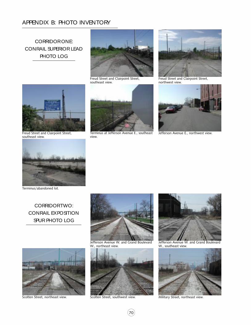
70
CORRIDOR ONE:
CONRAIL SUPERIOR LEAD
PHOTO LOG
Freud Street and Clairpoint Street,southeast view.
Freud Street and Clairpoint Street,northwest view.
Freud Street and Clairpoint Street,southeast view.
Terminus at Jefferson Avenue E., southeastview.
Jefferson Avenue E., northwest view.
Terminus/abandoned lot.
CORRIDOR TWO:
CONRAIL EXPOSITION
SPUR PHOTO LOG
Jefferson Avenue W. and Grand BoulevardW., northeast view.
Jefferson Avenue W. and Grand BoulevardW., southeast view.
Scotten Street, northeast view. Scotten Street, southwest view. Military Street, northeast view.
APPENDIX B: PHOTO INVENTORY
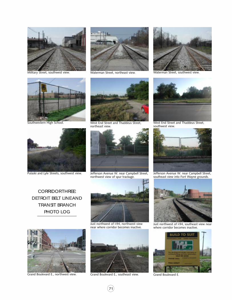
71
Military Street, southwest view. Waterman Street, northeast view. Waterman Street, southwest view.
Southwestern High School. West End Street and Thaddeus Street,northeast view.
West End Street and Thaddeus Street,southwest view.
Pulaski and Lyle Streets, southwest view. Jefferson Avenue W. near Campbell Street,northwest view of spur trackage.
Jefferson Avenue W. near Campbell Street,southeast view into Fort Wayne grounds.
CORRIDOR THREE:
DETROIT BELT LINE AND
TRANSIT BRANCH
PHOTO LOG
Just northwest of I-94, northwest viewnear where corridor becomes inactive.
Just northwest of I-94, southeast view nearwhere corridor becomes inactive.
Grand Boulevard E., northwest view. Grand Boulevard E., southeast view. Grand Boulevard E.
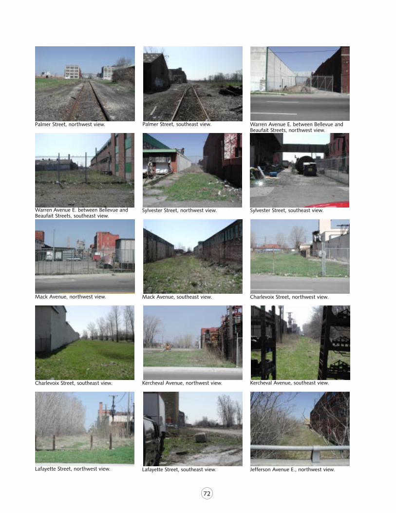
72
Palmer Street, northwest view. Palmer Street, southeast view. Warren Avenue E. between Bellevue andBeaufait Streets, northwest view.
Warren Avenue E. between Bellevue andBeaufait Streets, southeast view.
Sylvester Street, northwest view. Sylvester Street, southeast view.
Mack Avenue, northwest view. Mack Avenue, southeast view. Charlevoix Street, northwest view.
Charlevoix Street, southeast view. Kercheval Avenue, northwest view. Kercheval Avenue, southeast view.
Lafayette Street, northwest view. Lafayette Street, southeast view. Jefferson Avenue E., northwest view.
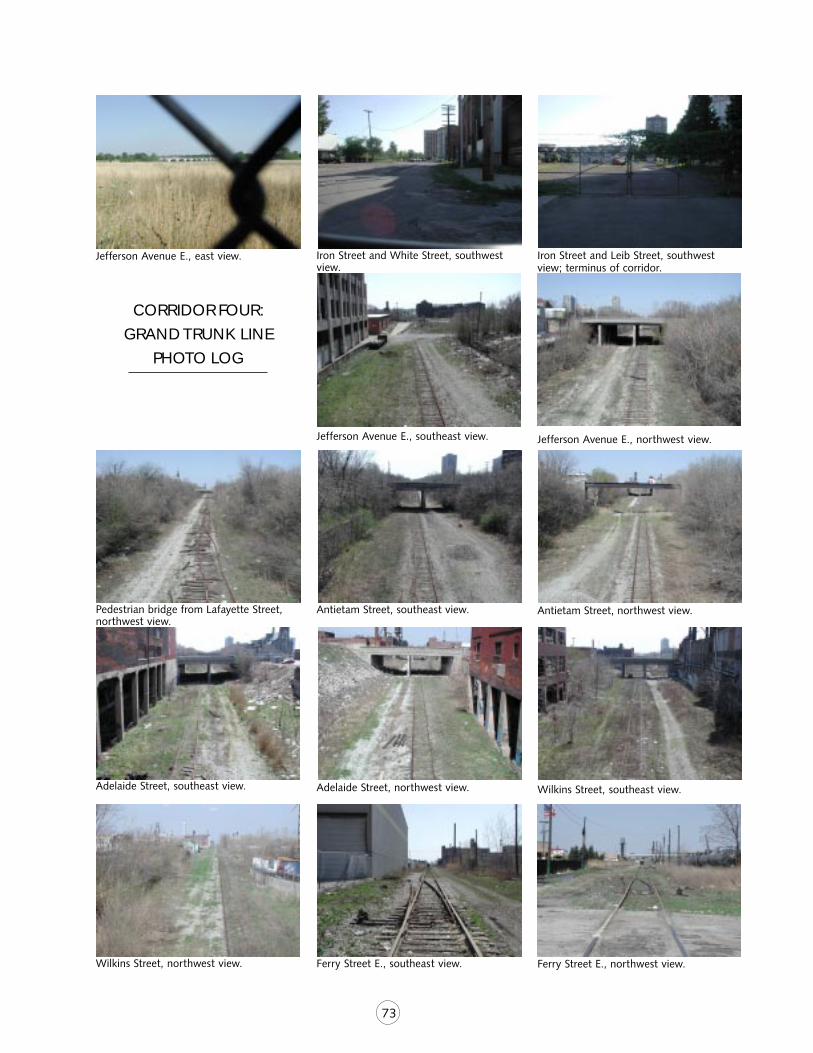
73
Jefferson Avenue E., east view. Iron Street and White Street, southwestview.
Iron Street and Leib Street, southwestview; terminus of corridor.
CORRIDOR FOUR:
GRAND TRUNK LINE
PHOTO LOG
Pedestrian bridge from Lafayette Street,northwest view.
Antietam Street, southeast view. Antietam Street, northwest view.
Adelaide Street, southeast view. Adelaide Street, northwest view. Wilkins Street, southeast view.
Wilkins Street, northwest view. Ferry Street E., southeast view.
Jefferson Avenue E., southeast view. Jefferson Avenue E., northwest view.
Ferry Street E., northwest view.
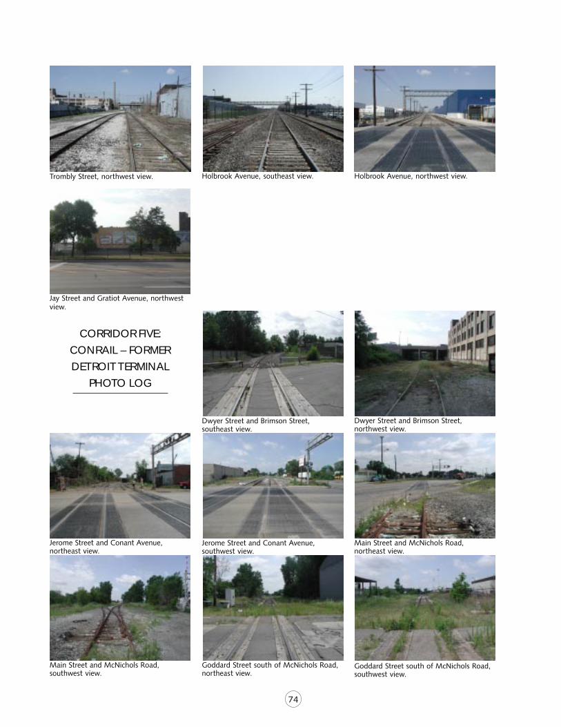
74
Trombly Street, northwest view. Holbrook Avenue, southeast view. Holbrook Avenue, northwest view.
Jay Street and Gratiot Avenue, northwestview.
CORRIDOR FIVE:
CONRAIL – FORMER
DETROIT TERMINAL
PHOTO LOG
Dwyer Street and Brimson Street,southeast view.
Dwyer Street and Brimson Street,northwest view.
Jerome Street and Conant Avenue,northeast view.
Jerome Street and Conant Avenue,southwest view.
Main Street and McNichols Road,northeast view.
Main Street and McNichols Road,southwest view.
Goddard Street south of McNichols Road,northeast view.
Goddard Street south of McNichols Road,southwest view.
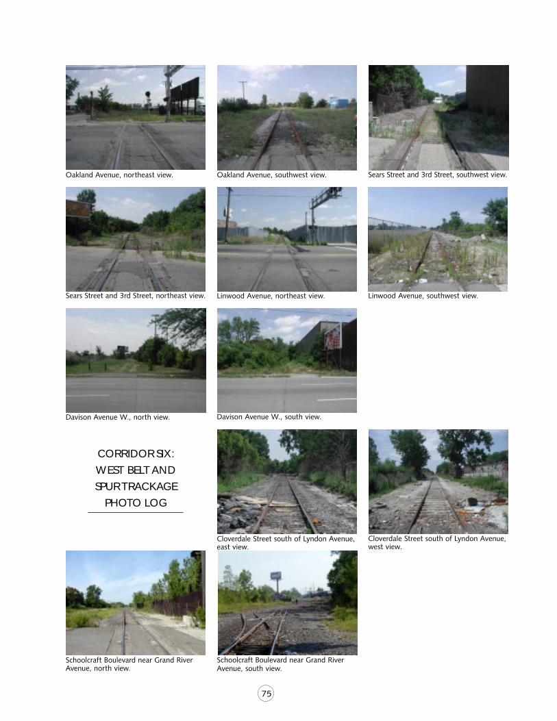
75
Oakland Avenue, northeast view. Oakland Avenue, southwest view. Sears Street and 3rd Street, southwest view.
Sears Street and 3rd Street, northeast view. Linwood Avenue, northeast view. Linwood Avenue, southwest view.
Davison Avenue W., north view. Davison Avenue W., south view.
CORRIDOR SIX:
WEST BELT AND
SPUR TRACKAGE
PHOTO LOG
Cloverdale Street south of Lyndon Avenue,east view.
Cloverdale Street south of Lyndon Avenue,west view.
Schoolcraft Boulevard near Grand RiverAvenue, north view.
Schoolcraft Boulevard near Grand RiverAvenue, south view.
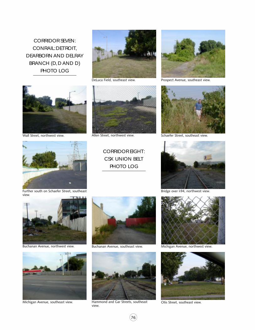
76
CORRIDOR SEVEN:
CONRAIL: DETROIT,
DEARBORN AND DELRAY
BRANCH (D, D AND D)
PHOTO LOG
DeLuca Field, southeast view. Prospect Avenue, southeast view.
Wall Street, northwest view. Allen Street, northwest view. Schaefer Street, southeast view.
Further south on Schaefer Street, southeastview.
CORRIDOR EIGHT:
CSX UNION BELT
PHOTO LOG
Bridge over I-94, northwest view.
Buchanan Avenue, northwest view. Buchanan Avenue, southeast view. Michigan Avenue, northwest view.
Michigan Avenue, southeast view. Hammond and Gar Streets, southeastview.
Otis Street, southeast view.
77
APPENDIX C: CONCURRENT PROJECTS IN GREATER DETROIT
A M E R I C A N H E R I TAG E R I V E R
In 1998, Congress designated the Detroit Riveran American Heritage River. The designationprompted a consortium of agencies and organi-zations in the Detroit area to focus on variousprojects for revitalization along the waterfront.One of the priorities for the American HeritageRiver Project group is to further develop a sys-tem of linked trails and greenways along theriver between Belle Isle and the AmbassadorBridge. Corridor #4, the Dequindre Cut, inter-faces with this project as it intersects with theriverfront at St. Aubin Park and Marina. Thepark and marina will be undergoing a $3 millionupgrade in order to provide recreational andeducational facilities as well as docking forcruise ships, tour boats and tall ships. TheDequindre Cut would provide a non-motorizedroute to the river for many nearby residents. Itwould also provide a connection for marinavisitors to get to Lafayette Park, Eastern Marketand other nearby attractions.
AUTO NAT ION AL HER I TAGE AREA
In 1988, Congress designated six corridors inMichigan as the Automotive National HeritageArea. These corridors are part of a landscapetelling the story of Michigan’s rich automotiveheritage. The corridors follow the Rouge, De-troit, Flint and Grand rivers. The goal of theAutomotive National Heritage project is to de-velop a management plan that will providerecreational and educational opportunities alongthese corridors. Such opportunities will celebratethe area’s rich automotive heritage and explainits impact on the culture and traditions of today.Greenways, museums, tours and festivals will allplay a role in this effort. The Globe Building, acritical project within the management plan,interfaces with Corridor #4, the Dequindre Cut,at the south end of the corridor. The DequindreCut will serve as a safe, attractive, non-motor-
ized facility for direct access to a newly restoredand revitalized Globe Building.
DETRO I T NON -MOTOR I Z ED P L AN
The city of Detroit received a transportationenhancement grant in 2001 to create a non-motorized transportation plan for the city. Workbegins on this plan in fall 2002. The plan willfocus on connecting bicycle routes betweenneighborhoods and along the river. At least sixof the targeted abandoned rail corridors, #2,#3, #4, #5, #6, #7 and #8, may serve as viablealternative transportation connectors to on-roadroutes.
T H E G R E E N W AY S I N I T I AT I V E
The GreenWays Initiative, a five-year program ofthe Community Foundation for SoutheasternMichigan launched in 2001, is a comprehensiveeffort aimed at expanding and enhancing theregion’s natural landscape. The GreenWaysInitiative is about linkage, leverage and collabo-ration: linking communities...leveraging vision,resources and people...and collaborating topromote and protect the health and well beingof the community for the present and the fu-ture. This landmark initiative is expected to puta minimum of $75 million to work to create andexpand greenways in Wayne, Oakland, Macomb,Monroe, Washtenaw, St. Clair and Livingstoncounties. Through up to $25 million in founda-tion and private contributions, the GreenWaysInitiative will help communities and organiza-tions develop and implement greenways plansand projects that will leverage another $50million of matching investments from govern-ment and other sources.
The GreenWays Initiative will:
■ physically link communities throughout theregion through the construction ofgreenways
78
■ bring communities together to collaborateon opportunities that cross jurisdictionallines
■ build the capacity of the institutions, bothpublic and private, that are responsible forthe development of greenways
■ increase public awareness, understandingand appreciation for the benefits ofgreenways to their communities and theirquality of life.
The GreenWays Initiative provides southeastMichigan with an opportunity to enhance theregion’s natural environment while simulta-neously building and connecting its diversecommunities.
N E W T R UC K T U N N E L
Planning is underway to convert the currentrailroad tunnel under the Detroit River to atrucks-only tunnel. A new railroad tunnel, whichwould accommodate double layers of boxcars,will be built nearby. The above ground surfaceright-of-way for the truck tunnel as it meets theshoreline and progresses to an intermodalfreight terminal could possibly be used as a non-motorized facility at the surface level. It couldserve as a connection to several of the targetedcorridors, namely corridor #2.
Michigan Department of Transportation is cur-rently studying the possibility of combiningseveral intermodal freight terminals into onelarge facility in southwest Detroit.
R I V E R F R O N T E A S T D E V E LO P M E N T
Detroit Mayor Kwame Kilpatrick recently formeda high-powered study group, co-chaired by Gen-eral Motors executive Matt Cullen and DerrickMiller, the city’s chief administrative officer, toreview possible development projects along theriverfront between Cobo Center and Belle Isle.Mayor Kilpatrick also has hired Cooper,Robertson & Partners, a renowned design firm,to design the improvements. The firm has de-
signed waterfront improvement for several cities,including New York, Boston and Chattanooga.A plan is expected within 90 days. The southend of corridor #4, the Dequindre Cut, termi-nates within this riverfront segment and is sureto receive some attention as an important routefor bringing bicyclists and pedestrians to therevitalized area.
R O U G E R I V E R G AT E WAY P R O J E C T
The Rouge River Gateway Project is a public-private partnership formed to restore life to theRouge River and its urban surroundings. Thepartnership is a diverse stakeholder group com-prised of municipal officials and leader fromcultural institutions and private business. Part-nership members include the cities of AllenPark, Dearborn, Detroit and Melvindale, EdwardC. Levy Company, Ford Motor Company, HenryFord Community College and Henry Ford Mu-seum. There are at least 36 improvementsplanned along the river corridor from the HinesDrive trail system at the north end to Zug Islandand the Detroit River at the south end. Natural-ization of the river bank, a river pathway, newinterpretive nature and historical exhibits, resto-ration of historical landmarks, business district“streetscaping” and “green” manufacturingfacilities with visitor interpretation are only afew highlights of this tremendous effort. Corri-dor #2 interfaces with this project at its extremewest end, just north of Zug Island, offering aneast-west rail-trail connection from the north-south Rouge River pathway to Historic FortWayne and other points east along the DetroitRiver.
S O U T H E A S T M I C H I G A N B I C YC L EM A P P I NG
Southeast Michigan Council of Governments(SEMCOG) is in the process of developing cy-clist-friendly maps for the entire region. Themaps show all trails and road routes that arecurrently regularly used by bicyclists or are safefor bicycle use. It also depicts the average daily
79
traffic flow of all major roads and shows wherethere are on-road bicycle facilities, such as bikelanes or wide paved shoulders. At this time,SEMCOG is assimilating the public input that hasbeen received over the past two months. Themaps are due to be printed by the end of 2002,but the extent of distribution to the public hasyet to be decided.
S O U T H W E S T D E T R O I T R I V E R F RO N TG R E E N WAY P R O J E C T
The City of Detroit Parks and Recreation Depart-ment was awarded a grant from The GreenWaysInitiative to plan an interconnected, non-motor-ized route linking neighborhoods and parks inthe northern section of the region with theDetroit riverfront, including Riverside Park onthe east end and Historic Fort Wayne on thewest. Hamilton-Anderson and Associates haveproposed a series of side paths and bike lanesalong major roads along with landscape im-provements. These improvements will providenon-motorized access and a greening of thearea. Corridor #2 cuts east to west through thesouthern third of the project, offering less bi-cycle and pedestrian interaction with automobiletraffic as well as possible historical interpretiveopportunities detailing the importance of railtransportation in the early industrial progress ofthe city.
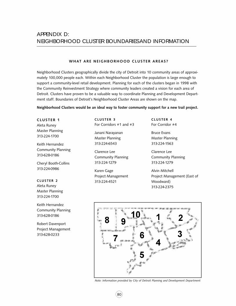
80
APPENDIX D:NEIGHBORHOOD CLUSTER BOUNDARIES AND INFORMATION
W H AT A R E N E I G H BO R H O O D C LU S T E R A R E A S ?
Neighborhood Clusters geographically divide the city of Detroit into 10 community areas of approxi-mately 100,000 people each. Within each Neighborhood Cluster the population is large enough tosupport a community-level retail development. Planning for each of the clusters began in 1998 withthe Community Reinvestment Strategy where community leaders created a vision for each area ofDetroit. Clusters have proven to be a valuable way to coordinate Planning and Development Depart-ment staff. Boundaries of Detroit’s Neighborhood Cluster Areas are shown on the map.
Neighborhood Clusters would be an ideal way to foster community support for a new trail project.
C LUS TER 1Aleta RuneyMaster Planning313-224-1700
Keith HernandezCommunity Planning313-628-0186
Cheryl Booth-Collins313-224-0986
C LU S T E R 2
Aleta RuneyMaster Planning313-224-1700
Keith HernandezCommunity Planning313-628-0186
Robert DavenportProject Management313-628-0233
CLUS TER 3
For Corridors #1 and #3
Janani NarayananMaster Planning313-224-6543
Clarence LeeCommunity Planning313-224-1279
Karen GageProject Management313-224-4521
CLUS TER 4
For Corridor #4
Bruce EvansMaster Planning313-224-1563
Clarence LeeCommunity Planning313-224-1279
Alvin MitchellProject Management (East ofWoodward)313-224-2375
Note: Information provided by City of Detroit Planning and Development Department
81
Chidi NyecheProject Management (West ofWoodward)313-628-5650
C LU S T E R 5
For Corridors #2, #5 and #8
Michael BoettcherMaster Planning313-224-1482
Alex PollockCommunity Planning313-224-1325
Lela AgeeProject Management313-224-3538
C LU S T E R 6
For Corridors #5, #6 and #7
Michael BoettcherMaster Planning313-224-1482
Tracee DavieCommunity Planning313-224-2374
Chidi NyecheProject Management313-628-5650
C LU S T E R 7
For Corridor #5
Michael BoettcherMaster Planning313-224-1482
Tracee DavieCommunity Planning313-224-2374
Dominic MarturanoProject Management313-224-3884
C LU S T E R 8
Janani NarayananMaster Planning313-224-6543
Alex PollockCommunity Planning313-224-1325
Dominic MarturanoProject Management313-224-3884
C LU S T E R 9
Bruce EvansMaster Planning313-224-1563
Donald-Ray SmithCommunity Planning313-224-1319
Sheryl Gray-DoddsProject Management313-628-0044
CLUS TER 10
Bruce EvansMaster Planning313-224-1563
Donald-Ray SmithCommunity Planning313-224-1319
Sheryl Gray-DoddsProject Management313-628-0044
82
APPENDIX E:DATABASE OF CONTACT INFORMATION RELATED TO STUDY
AMER IC AN HER I TAG ER I V E R P R O J E C T
John HartigRiver Navigator110 Mt. Elliott AveDetroit, MI 48207-4380313-568-9594
Mark Breederland(consultant to American Heri-tage River project)District Sea Grant ExtensionAgentMSU Extension Southeast200 Grand River Ave.Suite 102Port Huron, MI 48060-4016586-989-6935
M E T RO P O L I TANAFFA IR S COAL I T ION
535 Griswold, Suite 300Detroit, MI 48226
Susan J. PhillipsAssociate Director313-961-2270
Dave Sanders, AICPVice President313-324-3313
AUTO NAT ION ALH E R I TAG E A R E A
300 River Place, Suite 1600Detroit, MI 48207-4291
Constance BodurowExecutive Director313-259-3425
Barbara Nelson-JamesonNational Park Service(consultant)
C I T Y OF DETRO I TEXECUT IVE OFF IC E
Lucius VassarAssistant to Mayor KwameKilpatrick2 Woodward Ave., Ste. 1126Detroit, MI 48226313-224-3400
C I T Y OF DETRO I TPL A N N I N G D E PA RT M E N T
65 Cadillac Square, Suite 1300Detroit, MI 48226
John BaranMaster Planner313-224-9127
George DunbarCommunity Planning313-224-1291
Malinda JensenProject Management313-224-4472
O’Neal EdwardsProject Management313-224-6514
Janani NarayananPlanner313-224-6543
Michael BoettcherTransportation Planner313-224-1482
Jim MarusichPlanning & Development313-224-3517
Donald Ray SmithTransportation Planner313-224-1319
C I T Y OF DETRO I TR E C R E AT I O ND E PA RT M E N T
5 Cadillac Square, 40th FloorDetroit, MI 48226
Tim Karl, ASLAAssistant Chief LandscapeArchitect313-617-5013
Akinya KhalfaniSenior Planning & Develop-ment Specialist313-224-1409
Andrew HeffnerRecreation Specialist313-628-0255
D E T RO I T D O W N TO W ND E V E LO P M E N TAUTHOR I T Y
Will TammingaEconomic Growth Corp.211 W. Fort Street, Ste. 900Detroit, MI 48226313-963-2940
G R E E N W AY S I N I T I AT I V E
Tom Woiwode, Director,GreenWays InitiativeCommunity Foundation forSoutheastern Michigan333 W. Fort Street, Suite 201Detroit, MI 48226Phone: 313-961-6675
83
HAMI LTON , ANDERSON& A S S O C I AT E S
1435 Randolph, Suite 200Detroit, MI 48226
Sam LovallConsultant
Colleen FitzpatrickConsultant313-887-6286
RA I LROADS
CAN AD IAN NAT ION AL
Bob Malone888-888-5909
NORF OLK SOUTHERN
John Kelly614-438-6914
C S X
Mark Friedlin904-633-1110
C O N R A I L
Bob Ryan215-209-1351
S O U T H E A S T M I C H I G ANCOUNC I L OFGOV E R N M E N T S
535 Griswold, Suite 300Detroit, MI 48226
Alex BourgeauCoordinator,Intermodal PlanningTransportation Programs313-961-4266
W AYNE COUNT Y
Assessor’s OfficeCity-County Building8th Floor600 Randolph, Room #29Detroit, MI 48206
Register of DeedsCatherine Ann CzeneSupervisor of Tract Index
84
APPENDIX F: ABOUT RAILS-TO-TRAILS CONSERVANCY
Founded in 1986, Rails-to-Trails Conservancy was created to breathe new life into abandoned raillines by converting them to hiking and biking trails for public use nationwide. Prior to that time,there were only 200 open rail-trails in the country and more than half the nation’s 300,000-milerailroad network laid unused or abandoned.
Since its founding, RTC has helped convert more than 11,000 miles of abandoned railroad corridorsinto America’s newest parklands, enjoyed by more than 100 million users a year. Places like the CapeCod Rail-Trail, Nebraska’s Cowboy Trail, the San Diego Bay Shore Bikeway, the Illinois Prairie Path, theCapital Crescent Trail in Washington, D.C. and hundreds of others. Now 16 years old, Rails-to-TrailsConservancy has become the largest and most widely respected trails organization in America. Inaddition, Rail-to-Trails Conservancy is the only national group devoted to preserving railroad corridorsby converting them to multi-use trails.
RTC is a 501 c (3) nonprofit organization with:
■ 46 employees distributed among six regional offices in California, Florida, Massachusetts (servingNew England), Michigan, Ohio, Pennsylvania and headquarters in Washington, D.C.;
■ More than 100,000 members and supporters nationwide;
■ A 13-member board of directors that meets three times a year;
■ An operating budget of $6 million dedicated to trail building, corridor preservation, open spaceprotection, public education and advocacy;
■ Five national and three international Trails and Greenways Conferences to date, the most recent inSeptember 2001 in St. Louis attended by more than 500 trail activists; (the next conference isscheduled for June 2003 in Providence, Rhode Island);
■ A full-color quarterly magazine Rails to Trails and a highly visited constellation of linked Web sites• accessible through www.railtrails.org• addressing a broad range of information, from trail finder databases for the everyday user, totechnical counsel on trail purchase and construction;
■ Recognition from a diverse mix of interests, including health, environment, government andrecreation, such as:
• Lead private sector partner in the White House Millennium Trails Program that identified andcelebrated 16 National Millennium Trails, 51 Millennium Legacy Trails and more than 1,000Millennium Community Trails;
• The Presidential Award for Sustainable Development by The President’s Council of Sustain-able Development;
• The Biennial Trails Service Award from American Trails;
• Sponsorship from The Robert Wood Johnson Foundation to bring public health officials toour 2001 conference to create an exchange and address a common agenda between the trailsand health communities;
• The American Greenways Dupont Award from the Conservation Fund, Dupont Corporationand the National Geographic Society.
Rails-to-Trails Conservancy • 1100 Seventeenth Street N.W., 10th Floor • Washington, D.C. 20036
Tel: 202-331-9696 • Fax: 202-331-9680 • www.railtrails.org
TRAILDDDDDAAAAARRRRRTTTTTTRTRTRTRTRAILAILAILAILAIL DDDDDEVELOPMENT AAAAASSISTANCE RRRRRESPONSE TTTTTEAM
A Service of Rails-to-Trails Conservancy
THIS REPORT WAS FUNDED BY THE GREENWAYS INITIATIVE,A PROGRAM OF THE COMMUNITY FOUNDATION FOR SOUTHEASTERN MICHIGAN