16-42 skyline trails final environmental assessment
TRANSCRIPT
United States Department of the Interior
Bureau of Land Management
Environmental Assessment DOI-BLM-CO-SO10-2016-0042-EA
Skyline Trails Project
September 2017
U.S. Department of the Interior Bureau of Land Management
Southwest District Tres Rios field Office
29211 Colorado State Highway 184 Dolores, CO 81323
Phone: (970) 882.6808
Co
lorad
o •
Tres Rio
s Field O
ffice
New
Mexico
• Taos Field
Office
New
Mexico
• Taos Field
Office
New

It is the mission of the Bureau of Land Management to
sustain the health, diversity, and productivity of the public
lands for the use and enjoyment of present and future
generations.
TABLE OF CONTENTS
1. Purpose and Need for The Action .......................................................................................... 1
1.1. Background ..................................................................................................................... 1
1.2. Purpose of and Need for Action ...................................................................................... 1
1.3. Decision to be Made........................................................................................................ 2
1.4. Conformance with Applicable Land Use Plan(s) .............................................................. 2
1.5. Relationship to Statutes, Regulations or Other Plans ...................................................... 4
1.6. Scoping, Public Involvement, and Issues ........................................................................ 4
2. Proposed Action and Alternative(s) ........................................................................................ 2
2.1. Alternative A - No Action ................................................................................................. 5
2.2. Alternative B - Proposed Action ....................................................................................... 5
2.3. Alternative(s) Considered but Eliminated from Detailed Study ......................................... 9
3. Environmental Effects ...........................................................................................................10
3.1. Affected Environment .....................................................................................................10
3.2. Alternative A – No Action ...............................................................................................18
3.3. Alternative B – Proposed Action .....................................................................................20
4. Supporting Information ..........................................................................................................28
4.1. Tribes, Individuals, Organizations, or Agencies Consulted .............................................28
4.2. List of Preparers .............................................................................................................28
4.3. References .....................................................................................................................29
Appendix A. [Appendices] .........................................................................................................32

This page intentionally left blank.

1
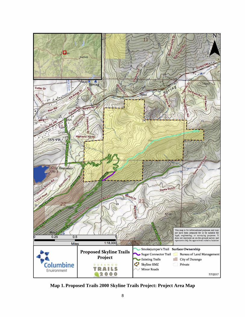
1. PURPOSE AND NEED FOR THE ACTION 1.1. Background This Environmental Assessment (EA) has been prepared to disclose and analyze the environmental effects of the Skyline Trails Project (proposed project) as proposed by Trails 2000 of Durango, Colorado. The Tres Rios Field Office (TRFO) has recognized distinct recreation niche opportunities and experiences that are available across the BLM lands of southwest Colorado and has established Special Recreation Management Areas (SRMAs) to guide the management of these areas. The Durango SRMA is managed to provide benefits to non-motorized recreation users that are drawn to the area due to the proximity of quality recreational opportunities to the City of Durango. The Durango SRMA is comprised of two Recreation Management Zones (RMZs): 1) Animas City Mountain, Skyline, and Grand View; and 2) East Animas and Turtle Lake climbing areas. The Animas City Mountain, Skyline, and Grand View (Skyline) RMZ is managed to primarily target mountain bikers, hikers, trail runners, and walkers wanting to participate in strenuous physical activity on trails that are easily accessible to the natural landscape within the Durango wildland urban interface. The Skyline RMZ is approximately 522 acres. The Skyline RMZ is bound by City of Durango lands to the west and private parcels to the north, east, and south. There are currently 25.1 miles of trails within the Durango SRMA, 2.4 miles of those within the Skyline RMZ. The City of Durango lands to the west of the Skyline RMZ are comprised of the Horse Gulch Trail System managed by the City of Durango and Trails 2000. There are currently approximately 23.5 miles of single-track trails in the Horse Gulch Trail System. The proposed Skyline Trails Project is located on the Skyline RMZ to include Sections 13, 14, 22, and 23 of Township 35 North, Range 9 West, New Mexico Principal Meridian, in La Plata County, Colorado. The project primarily lies on top of the extended Skyline Ridge between County Road 237 and County Road 240. Access to the proposed project is via the Skyline Trail from the north or the Sugar Trail from the south. The proposed Skyline Trails Project is comprised of two components: 1) construction of a new, approximately 1,000-foot trail to connect the Sugar Trail to the Skyline Trail (Sugar Connector Trail); and 2) designating the unnamed, existing portion of the ridge trail as the Smokejumper’s Trail (at the intersection of the Sugar Trail and Skyline Trail heading northeast along the existing ridge trail) as well as any maintenance or improvements required on this trail to make it sustainable (see Map 1). 1.2. Purpose of and Need for Action The purpose of the Skyline Trails Project is to provide a less technical trail for users between the Sugar and Skyline trails and to provide an “out and back” experience along the Smokejumper’s Trail. The project would enhance the public’s opportunity for quality recreational experiences within the Durango SRMA. The purpose of the Proposed Action is to provide a system of trails within the Skyline RMZ that is sustainable, ecologically sensitive, and meets the recreation objectives identified in the Tres Rios Resource Management Plan (RMP) (BLM 2015). These objectives include 1) expanding non-motorized trail opportunities; 2) dispersing use; 3) keeping
2
trails marked and maintained; and 4) implementing sustainable trail design and layout while retaining the area’s predominantly natural appearing landscape. The need for this action is established under the Federal Land Policy Management Act (FLPMA) to respond to requests for trail access and ensure the continued availability of outdoor recreation experiences through BLM’s ‘Connecting with Communities’ recreation vision.
1.3. Decision to be Made The decision to be made is whether or not the BLM will develop an additional trail (Sugar Connector); designate a currently unnamed, existing trail (Smokejumper’s Trail); and approve allowable maintenance activities for the proposed Smokejumper’s Trail within the BLM managed portion of Skyline RMZ.
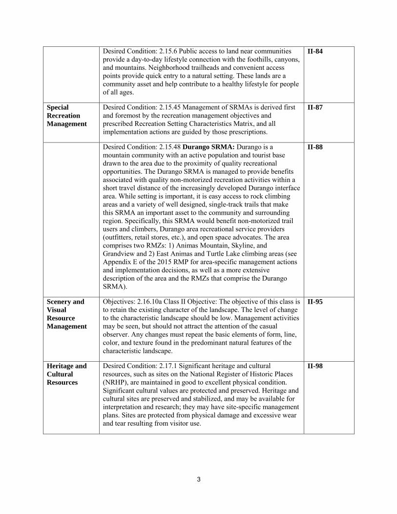
1.4. Conformance with Applicable Land Use Plan(s) The Proposed Action is in conformance with the February 2015 Tres Rios RMP with Record of Decision (ROD) (See Table 1: Applicable Desired Conditions, Goals, and Objectives):
Table 1. Applicable Desired Conditions, Goals, and Objectives
Resource Desired Condition/Goal/Objective Page #
The 2015 RMP identified the Skyline area as part of the Durango SRMA. The Proposed Action is consistent with the desired conditions, goals, and objectives in the SRMA guidance, as highlighted by the following:
N/A
Wildlife Guideline: 2.4.51 Ungulates: Projects or activities in big game critical winter range, winter concentration areas, severe winter range, production areas, and important migration corridors should be designed and conducted in a manner that preserves and does not reduce habitat effectiveness within those mapped areas.
II-30
Recreation Desired Condition: 2.15.1 Activities are regulated primarily in order to protect the quality of the recreation settings and benefits, as well as to protect natural and cultural resources. Managers monitor conditions and implement management strategies in order to maintain desired setting characteristics. Recreation users have opportunities to benefit from the diversity of varied terrain, scenery, and nature in the canyons, mountains, and mesas, as well as on the rivers.
II-83
Desired Condition: 2.15.5 Recreation tourism provides economic and social benefits to social communities and to the region; this is consistent with sustainable land practices, the protection of sense of place, and the market demand for TRFO-related values. The BLM collaborates with local communities, educational institutions, businesses, non-profit organizations, volunteers, and others interested in the planning area in order to market recreation opportunities effectively and appropriately, consistent with BLM goals.
II-84
3
Desired Condition: 2.15.6 Public access to land near communities provide a day-to-day lifestyle connection with the foothills, canyons, and mountains. Neighborhood trailheads and convenient access points provide quick entry to a natural setting. These lands are a community asset and help contribute to a healthy lifestyle for people of all ages.
II-84
Special
Recreation
Management
Desired Condition: 2.15.45 Management of SRMAs is derived first and foremost by the recreation management objectives and prescribed Recreation Setting Characteristics Matrix, and all implementation actions are guided by those prescriptions.
II-87
Desired Condition: 2.15.48 Durango SRMA: Durango is a mountain community with an active population and tourist base drawn to the area due to the proximity of quality recreational opportunities. The Durango SRMA is managed to provide benefits associated with quality non-motorized recreation activities within a short travel distance of the increasingly developed Durango interface area. While setting is important, it is easy access to rock climbing areas and a variety of well designed, single-track trails that make this SRMA an important asset to the community and surrounding region. Specifically, this SRMA would benefit non-motorized trail users and climbers, Durango area recreational service providers (outfitters, retail stores, etc.), and open space advocates. The area comprises two RMZs: 1) Animas Mountain, Skyline, and Grandview and 2) East Animas and Turtle Lake climbing areas (see Appendix E of the 2015 RMP for area-specific management actions and implementation decisions, as well as a more extensive description of the area and the RMZs that comprise the Durango SRMA).
II-88
Scenery and
Visual
Resource
Management
Objectives: 2.16.10a Class II Objective: The objective of this class is to retain the existing character of the landscape. The level of change to the characteristic landscape should be low. Management activities may be seen, but should not attract the attention of the casual observer. Any changes must repeat the basic elements of form, line, color, and texture found in the predominant natural features of the characteristic landscape.
II-95
Heritage and
Cultural
Resources
Desired Condition: 2.17.1 Significant heritage and cultural resources, such as sites on the National Register of Historic Places (NRHP), are maintained in good to excellent physical condition. Significant cultural values are protected and preserved. Heritage and cultural sites are preserved and stabilized, and may be available for interpretation and research; they may have site-specific management plans. Sites are protected from physical damage and excessive wear and tear resulting from visitor use.
II-98
4
1.5. Relationship to Statutes, Regulations or Other Plans The proposed project would conform to:
Federal Land Policy and Management Act of 1976 (43 USC 1701 et seq.); National Environmental Policy Act of 1969, as amended (42 USC 4321 et seq.); Archaeological and Historical Conservation Act of 1974 (PL 93-291); National Historic Preservation Act of 1966, Section 106 (36 CFR Part 800), as amended; National Indian Religious Freedom Act of 1978; Endangered Species Act of 1973, as amended; Migratory Bird Treaty Act of 1918 (16 USC 703-712).
1.6. Scoping, Public Involvement, and Issues 1.6.1. Scoping and Public Involvement
Internal scoping began on March 23, 2016 when the proposal was first brought before the Tres Rios Interdisciplinary Team (IDT) for consideration. The proposed project for the initial scoping included the two components of the proposed project (Sugar Connector Trail and Smokejumper’s Trail) as well as a loop trail that would extend from the Smokejumper’s Trail onto private property. Formal external scoping was initiated on July 29, 2016 when scoping letters were sent out to individuals who had expressed interest in the project, as well as the City of Durango Parks and Recreation Department. Two comments were received as a result of this scoping effort. The BLM Great Basin Smokejumpers in Boise, Idaho wrote a letter in support of the proposed project. The City of Durango Parks and Recreation Department requested that the BLM obtain written verifications from private landowners that would provide easements across their property. Due to the lack of private property easements, the proposed Smokejumper’s Trail was changed to be an out-and-back trail with a loop on the eastern end to prevent trespassing on neighboring private land. Internal scoping was finalized for the proposed project on June 29, 2017 when the IDT met to discuss the proposed Smokejumper’s Trail as an out-and-back trail.
1.6.2. Key Issues to be Analyzed
Internal scoping at the Tres Rios Field Office on March 23, 2016 and June 29, 2017 identified the following issues considered for further analysis in this EA:
1.6.2.1 Cultural Resources 1) How would cultural resources eligible for listing on the National Register of Historic
Places be affected by non-motorized trail construction and use?
1.6.2.2 Soils 1) Would trails built on steep slopes and sensitive soils result in increased erosion?
1.6.2.3 Wildlife 1) How would elk be affected? 1.6.2.4 Recreation
5
1) How would trail development and use enhance existing bicycle riding opportunities (new trails, views, challenge, connectivity)?
2) How would trail development and use affect amount of trash on landscape? 3) How would trail development and use affect personal and community benefits associated
with non-motorized trail use? 4) How would trail development and use affect use by other non-motorized single-track
users (hikers)? 1.6.2.5 Visual Resources 1) How would trail development and use affect the visual setting of the landscape?
1.6.3. Issues Considered but Not Analyzed
Impacts to several resources were mentioned, but eliminated from further analysis because either design features were incorporated into the Proposed Action which will address their impacts or it was determined that the resource would not be substantively impacted by the Proposed Action. The list below shows the resources eliminated from further analysis in this EA:
Air Quality Greenhouse Gas Emissions Native American Religious and
Other Concerns Paleontology Areas of Critical Environmental
Concern Lands with Wilderness
Characteristics Wild and Scenic Rivers Wilderness/Wilderness Study Areas Environmental Justice Fuels/Fire Management Geology Solid Mineral Resources Oil and Gas/Energy Production Lands/Access Wastes (hazardous or solid)
Livestock Grazing Public Land Health Standards Farmlands (Prime or Unique) Invasive Species/Noxious Weeds Vegetation Excluding USFWS
Designated Species Special Status Plant Species Threatened, Endangered or
Candidate Plant Species Wildlife – Aquatic Fish Habitat Wetlands/Riparian Zones Water Resources/Quality
(Drinking/Surface/Ground) Floodplains Wild Horses and Burros Socio-Economics
2
2. PROPOSED ACTION AND ALTERNATIVE(S) The BLM IDT takes a rigorous look and objectively analyzes alternatives which meet the underlying purpose and need “…to provide the benefits associated with a single-track trail system across the portion of the Skyline RMZ which does not currently provide these opportunities…(and)…to provide a system of trails within the RMZ that is sustainable, ecologically sensitive, and meets the recreation setting objectives identified in the RMP.” This section provides a description of Alternative A (the No-Action Alternative) and Alternative B (the Proposed Action). In response to issues identified during internal and external scoping, the following Design Criteria have been developed which would apply to all Action Alternatives. Design Criteria
1. Action: Trails would be designed to the International Mountain Bicycling Association’s (IMBA) standards: Trails would be designed to contour the terrain as much as possible; water drainage would be accomplished with grade reversals and drain dips rather than constructed features (water bars) as much as possible; trails would be designed for running slope not to exceed half the grade of the side slope; trails would be designed for a maximum 15 percent grade wherever possible (the sustainability of trail grades is largely dependent on surface durability: where trails segments cross bedrock, for instance, grades can exceed typical design standards and remain highly sustainable); trails would be designed for an average grade under 10 percent; trails would be routed using positive control points (viewpoints and other attractions) to minimize user-created trails; and climbing turns would be designed to facilitate bicycle use.
Final trail alignment and a variety of construction techniques would be utilized to maximize the sustainability of trails, particularly on steep slopes and erodible soils. These techniques could include, but are not limited to: routing trails onto bedrock; tread hardening with locally sourced native flagstone; engineered drainage features such as water bars and sediment traps; and frequent monitoring and trail maintenance.
As with all BLM managed trails, temporary emergency closures could be utilized to prevent trail damage due to wet conditions. Utilization of these types of closures are not anticipated as use of the existing trail system has been observed to be largely self-limiting during periods of wet conditions (for example, the Skyline Trail, which holds snow longer into the spring due to its northern aspect, is generally the last trail in the Horse Gulch Trail System to be utilized each spring).
Responsive to Issue: 1.6.2- Soils Rationale: IMBA standards are designed to produce sustainable trail systems and provide guidelines for running grades, cross drainage, grade reversals, etc.
2. Action: Final trail construction would align as close as possible to the trails depicted on the
maps for the Proposed Action. Final alignment may vary based on site specific conditions in
3
order to achieve a sustainable and enjoyable system of trails. However, trails would not 1) Encroach into areas identified for the Proposed Action as ‘unavailable for new trail development’; 2) Exceed by 10 percent the total miles of trails approved for the Proposed Action; 3) Adversely affect a National Register eligible or potentially eligible cultural resource site (trail construction will maintain a minimum 50-foot avoidance of these sites).
Responsive to Issue: 1.6.2.1- Cultural Resources, 1.6.2.2- Soils, 1.6.2.3- Wildlife, 1.6.2.4- Recreation (and Vegetation) Rationale: This strategy allows for the greatest flexibility in developing an enjoyable and sustainable trail alignment while identifying disturbance limits and respecting avoidance areas.
3. Action: A maximum 6-foot wide corridor would be cleared through undergrowth [Gambel
oak (Quercus gambelii), curl-leaf mountain mahogany (Cercocarpus ledifolius), etc.] unless additional clearing is necessary to provide safe sight lines on the inside corners (never to exceed 15 feet).
Responsive to Issue: 1.6.2.2- Soils, 1.6.2.4- Recreation, 1.6.2.5-Visual Resources (and Vegetation) Rationale: Limiting vegetation clearance maximizes the natural appearing setting, limits disturbance, maintains soils, and provides positive anchors when trails change direction. Sightlines and safety for trail users are maintained by providing adequate clearances through thick underbrush.
4. Action: Final trail width would be 18 to 24 inches wide. Construction disturbance would be
minimized as much as possible, with the greatest effect on severe side slopes where cut and fill trail design is necessary (never to exceed 20 feet).
Responsive to Issue: 1.6.2.2- Soils, 1.6.2.4- Recreation, 1.6.2.5- Visual Resources (and Vegetation) Rationale: Limiting ground disturbance maximizes the natural appearing setting and limits effects to vegetation, cultural resources, and soils.
5. Action: Single trees would need to be limbed or removed, but no clumps of trees would be
removed.
Responsive to Issue: 1.6.2.2- Soils, 1.6.2.4- Recreation, 1.6.2.5-Visual Resources (and Vegetation) Rationale: Limiting tree removal maximizes the natural appearing setting and limits effects to vegetation, and soils.
4
6. Action: Due to terrain, there may be some locations where ‘hike-a-bike’ (stepping off a bicycle and walking) would be required. Responsive to Issue: 1.6.2.4- Recreation, 1.6.2.5- Visual Resources Rationale: Allowing for ‘hike-a-bike’ sections of trails accomplishes two recreational goals: It allows for extremely challenging riding opportunities for those seeking that experience, and it also helps maintain a natural setting for all users rather than over-engineering a trail that might otherwise not conform to the landscape.
7. Action: Trail construction would be accomplished primarily by hand and with mechanical
advantage tools such as a grip hoists and come-alongs to move large rocks. Motorized trail building equipment such as a micro/mini excavator or SWECO may be used where such equipment would achieve the same results and remain within the trail building parameters defined. All such equipment would be thoroughly cleaned prior to entering public lands to minimize potential spread of noxious weeds/invasive species.
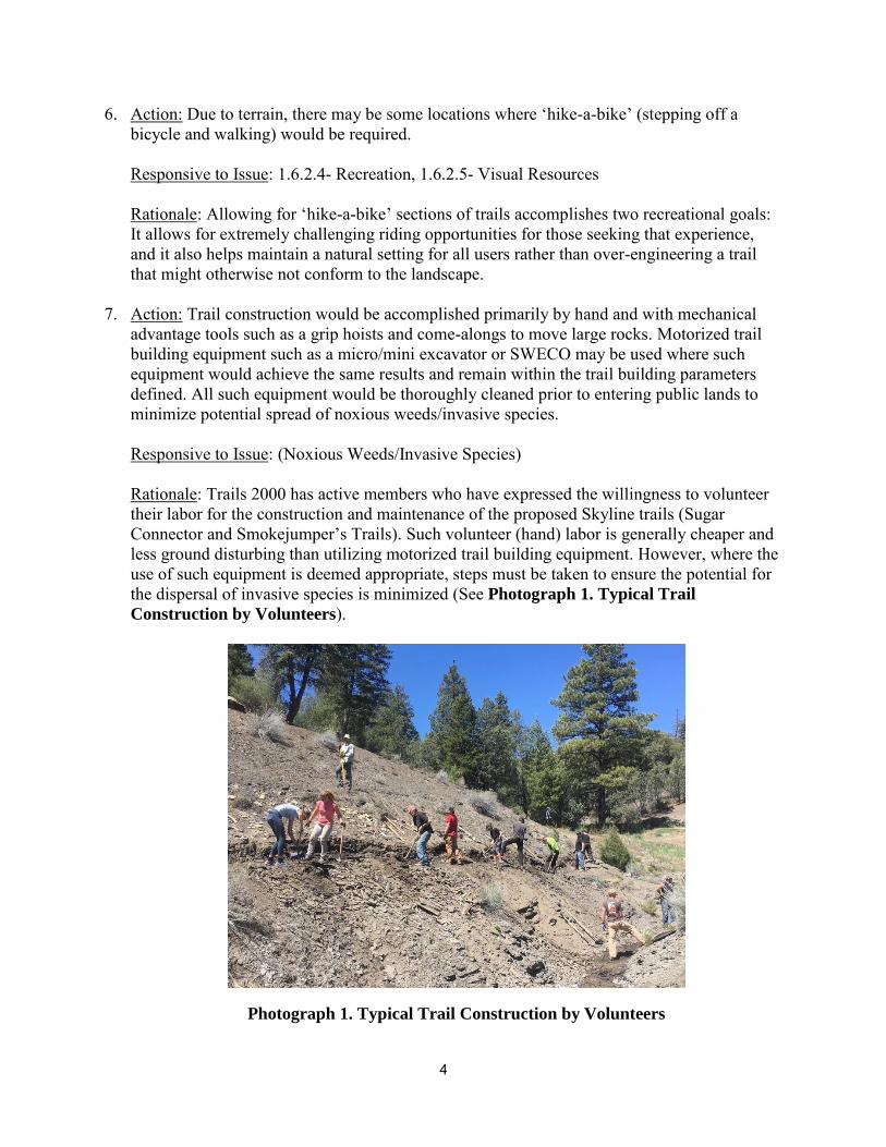
Responsive to Issue: (Noxious Weeds/Invasive Species) Rationale: Trails 2000 has active members who have expressed the willingness to volunteer their labor for the construction and maintenance of the proposed Skyline trails (Sugar Connector and Smokejumper’s Trails). Such volunteer (hand) labor is generally cheaper and less ground disturbing than utilizing motorized trail building equipment. However, where the use of such equipment is deemed appropriate, steps must be taken to ensure the potential for the dispersal of invasive species is minimized (See Photograph 1. Typical Trail
Construction by Volunteers).
Photograph 1. Typical Trail Construction by Volunteers
5
8. Action: All trail segments would be approved by a BLM and recreation specialist prior to
construction. The applicable BLM staff would be contacted with adequate lead time prior to any trail construction in order to allow for trail alignment oversight and approval. A signed agreement (i.e., Memorandum of Understanding and/or Volunteer Agreement) would be in place prior to construction efforts carried out by non-BLM entities outlining specific roles, limitations, and expectations. Responsive to Issue: 1.6.2.4- Recreation Rationale: To ensure eligible cultural resource site avoidance and sustainable design.
9. Action: Maintenance would be accomplished either by BLM staff or partners under written
agreement. Agreement documents would define allowable actions and limitations to ensure preservation of cultural resources while maximizing responsiveness and efficiency.
Responsive to Issue: 1.6.2.1- Cultural Resources
Rationale: To protect eligible cultural resources sites from damage caused by trail maintenance.
10. Action: Once any new trail is constructed and open to public use, the BLM and/or BLM partners would monitor the entire length of the trail at least once a year to identify the development of any unauthorized user-created trails. If unauthorized user-created trails are identified, the BLM would ensure actions are taken to obscure such trails as soon as possible to avoid continued unauthorized use. Responsive to Issue: 1.6.2.1- Cultural Resources, 1.6.2.2- Soils, 1.6.2.3- Wildlife, and 1.6.2.4- Recreation (and Invasive Species/Noxious Weeds and Vegetation) Rationale: Minimizing user-created trail development maximizes the natural appearing setting, limits disturbance to soils, wildlife, vegetation, and cultural resources.
2.1. Alternative A - No Action Under the No-Action Alternative, the Sugar Connector Trail would not be constructed. Trail users would not have an easier option around the technical Hyper Extended Ridge Trail. The proposed Smokejumper’s Trail extending north of the Skyline Ridge would not be designated, improved, nor maintained. Recreational trail use would most likely continue on the unimproved, existing trail.
2.2. Alternative B - Proposed Action Trails 2000 is proposing two inter-related components for the proposed Skyline Trails Project: 1) construction of a new, approximately 1,000-foot trail to connect the Sugar Trail to the Skyline Trail (Sugar Connector Trail); and 2) designating the unnamed, existing portion of the ridge trail as Smokejumper’s Trail (see Map 1). As part of the Smokejumper’s Trail, a trail sign would be
6
installed at the western end and a short, approximately 560-foot loop trail would be constructed at the eastern end of the trail. Short sections of the Smokejumper’s Trail (about 440 feet in length total) would be rerouted to make the existing trail more sustainable. For the Skyline Trails Project, Trails 2000 is proposing to construct and/or maintain a total of 1.8 miles of trail. About 1.4 miles of trail occur on an existing, undesignated trail. The remaining 0.4 mile would be newly constructed single-track trail. The Proposed Action also includes any trail maintenance or improvements required to make the trails sustainable. The proposed Sugar Connector Trail would connect the top of the Sugar Trail to the Skyline Trail (see Map 1). Currently, the Sugar Trail connects with the Hyper Extended Ridge Trail approximately 1,000 feet southwest of the top of the Skyline Trail. The Hyper Extended Ridge Trail is extremely rocky terrain intended for expert mountain bikers. The Sugar Trail was built with a 7 percent sustainable grade; the proposed Sugar Connector Trail would provide trail users (i.e., mountain bikers, trail runners, and hikers) with an easier option around the technical trail while minimizing the amount of maintenance required (e.g., rolling grade dips, nicks, etc.) to prevent future soil loss. The proposed Sugar Connector Trail would be approximately 1,000 feet in length and 2 feet wide for a long-term disturbance of approximately 0.05 acres. No more than a 4-foot wide corridor would be required for the trail construction for the length of the trail for an additional 0.05 acres of short-term disturbance; this additional area would be reclaimed following completion of the project. A shallow tread slope design would be implemented on this trail. This allows for frequent grade reversals to be built into the tread; water that gets on the trail can exit it frequently with this design. Full bench construction would be used with large trees anchoring the downhill side of the trail in many places and in the insides of ascending turns. The proposed Smokejumper’s Trail would provide an out-and-back experience along the existing ridge trail on BLM lands (see Map 1). The existing trail is not currently listed as a system trail but has been on the ground for at least 25 years. The Smokejumper’s Trail would be rated as an extreme trail due to the rocky, exposed nature of the majority of the trail. A trail sign would be placed at the intersection of the Skyline Trail and the existing ridge trail that heads northeast from the Skyline Trail. To discourage trespassing onto adjacent private land, a small, approximately 560-foot loop would be constructed at the eastern end of the trail and any remaining trail on public land beyond this loop (between the loop and the private land) would be reclaimed. The entire length of the trail would be approximately 1.6 miles in length and 2 feet wide for a long-term disturbance of approximately 0.4 acres. New ground disturbance would be required for the approximate 560-foot loop as well as in sections of the existing trail in order to create a more sustainable alignment than is currently represented by the user created trail. No more than a 4-foot wide corridor would be required for trail improvements at specified areas along the trail for an additional 0.4 acres of short-term disturbance; this additional area would be reclaimed following completion of the project. The IMBA’s sustainable trail building methods would be used for trail construction. New trail construction would be done by hand. Soil and vegetation would be cleared from the tread area, exposing mineral soil underneath. Excavated mineral soil can be incorporated in the tread as rollers, which are micro-grade reversals that increase the number of places water can drain from
7
the tread. The tread would require a minimum of 5 percent outslope and a maximum of 7 to 9 percent outslope to facilitate drainage; this can be measured by a digital level (a.k.a., a smart tool). Exposed roots larger than a pencil would be removed, as would loose rocks of any size. No culverts or other manmade material structures would be necessary during construction of the trail. The trails would be hand finished to include some back-slope shaping from 33 to 45 percent relative to the tread outslope, broadcasting of spoils, and masking of disturbed areas outside the tread with rocks and organic matter to include duff, leaves, needles, tree limbs, etc. Final preparation of the tread would consist of compacting the exposed mineral soil with MacLeods. The trails would be constructed following a sustainable design that includes a shallow tread alignment, frequent grade reversals, and minimal climbing turns. The Sugar Connector Trail and loop of the Smokejumper’s Trail are situated on east-facing slopes, allowing for earlier spring snow melt. User safety is enhanced in the design of the trail with frequent grade reversals that control speed and open lines of sight. Trail construction for the Sugar Connector Trail would take about 2 weeks. Trail construction and improvements on the Smokejumper’s Trail would also take about 2 weeks. The construction and trail improvements are proposed to begin in the fall of 2017.
8
Map 1. Proposed Trails 2000 Skyline Trails Project: Project Area Map

9
2.3. Alternative(s) Considered but Eliminated from Detailed Study No other alternatives that meet the purpose and need of the proposed project were considered for analysis in this EA.
10
3. ENVIRONMENTAL EFFECTS 3.1. Affected Environment 3.1.1. Cultural Resources
The proposed project area is located within the southern Colorado River Basin archaeological contextual area. This area divided into five major cultural/temporal periods: Paleoindian, Archaic, Formative, Protohistoric, and Historic. Cultural resources associated with these periods are present in the general region in which the project area is located.
A search of existing records indicates no cultural resources have been identified within the proposed project area. There is a low potential for cultural resources in the immediate vicinity of the proposed project due to the environmental factors present. A Class III archaeological survey was conducted in July 2017 to identify cultural resources within the project area. No cultural resources were found during the survey.
3.1.2. Soils
Both the Sugar Connector and Smokejumper’s trails are located in upper slope positions or on top of a rocky ridgeline. The ridge is composed of rocks from the Mesa Verde Formation and the Pictured Cliffs Sandstone (USGS 1979). The proposed Sugar Connector Trail would be constructed on the Archuleta-Sanchez Complex, 12 to 65 percent slopes soil unit (NRCS 1982). These soils are shallow and well drained with moderate permeability. The proposed Smokejumper’s Trail is located on the Archuleta-Sanchez Complex, 12 to 65 percent slopes and in Zyme-Rock Outcrop Complex, 12 to 65 percent slopes soil units. The Archuleta-Sanchez Complex, 12 to 65 percent slopes soil unit is located on the southern slopes while the Zyme-Rock Outcrop Complex, 12 to 65 percent slopes soil unit is located on the northern slopes. The demarcation of the two soil units is located approximately along the top of the ridge. The Zyme-Rock Outcrop Complex has shallow residual soils derived from shale and is comprised of about 30 percent rock outcrop. Because the soils are derived from shale, permeability is low and vegetation growth can be sparse. This soil easily erodes in steeper areas (NRCS 1982).
3.1.3. Wildlife
The Skyline Trails project area consists of the following vegetation communities: Gambel oak (Quercus gambelii) – mixed montane shrubland and Southern Rocky Mountain ponderosa pine (Pinus ponderosa) woodland (USGS 2011). Gambel oak shrublands are the predominant vegetation community in the proposed project area and near vicinity, located on both the north- and south-facing slopes.
The proposed Sugar Connector Trail is located in a Gambel oak – mixed montane shrubland. The slope is south-facing with thickets of Gambel oaks interspersed with piñon pine (Pinus edulis) and Rocky Mountain juniper (Juniperus scopulorum) trees, various forbs and grasses, and cacti.
11
Other deciduous shrubs common in a Gambel oak community that are found in the proposed project area, including curl-leaf mountain mahogany (Cercocarpus ledifolius), cliff fendlerbush (Fendlera rupicola), and Utah serviceberry (Amelanchier utahensis), among others.
The proposed Smokejumper’s Trail traverses through Southern Rocky Mountain ponderosa pine woodland, piñon-juniper woodland, and Gambel oak – mixed montane shrubland. Ponderosa pine woodlands, mixed conifer forests, and Gambel oak – mixed montane shrublands are scattered on the north-facing slopes in the near vicinity. Trees dominant in these vegetation communities include ponderosa pine, Douglas-fir (Pseudotsuga menziesii), and white fir (Abies
concolor). Common shrubs include Wood’s rose (Rosa woodsii), manzanita (Arctostaphylos spp.), and chokecherry (Prunus virginiana). A variety of forbs and grasses are also found within this vegetation community type.
A variety of wildlife use the area such as mule deer (Odocoileus hemionus), black bear (Ursus
americanus), red-tailed hawk (Buteo jamaicensis), lizards, snakes, small mammals, migratory birds, and other species.
Columbine Environment conducted raptor surveys to determine the presence of peregrine falcon (Falco peregrinus), sharp-shinned hawk (Accipiter striatus), and Cooper’s hawk (Accipiter
cooperii) in the proposed project area and within a ½-mile buffer in 2017. No peregrine falcon habitat occurs within the proposed project area or buffer; no sharp-shinned hawks or Cooper’s hawks were observed during the surveys conducted in 2017. The results of this survey were submitted to the BLM TRFO in July 2017 under a separate cover: Raptor Survey Report for the
Trails 2000 Skyline Trails Project, Durango, Colorado.
The following sensitive species were evaluated for presence in the proposed project area: U.S. Fish and Wildlife (USFWS) federally listed threatened and endangered species and designated critical habitat; Colorado BLM sensitive fish, plant, and wildlife species for the Tres Rios Field Office; and migratory birds listed as USFWS Birds of Conservation Concern in Region 16. The potential for each species to occur in the proposed project area or near vicinity was evaluated based on project-specific habitat analyses and the habitat associations of each species. Two reports were submitted to the BLM TRFO in July 2017 under separate covers: Fish and Wildlife
Clearance Report, BLM Tres Rios Field Office, Trails 2000 Skyline Trails Project; Threatened,
Endangered and Sensitive Plant Clearance Report, BLM Tres Rios Field Office, Trails 2000
Skyline Trails Project.
Given the results and analyses reported in the Raptor Survey Report, the Fish and Wildlife Clearance Report, and the Threatened, Endangered and Sensitive Plant Clearance Report, this EA analysis for the Skyline Trails project will focus on elk (Cervus canadensis). This species has the potential to be affected by the proposed project.
Affects to wildlife from the Skyline Trails Project can be divided into two categories: 1) trail construction, trail improvements, and maintenance; and 2) subsequent trail use. The latter is expected to generate the most meaningful disturbance to wildlife. Extensive disturbance by trail users can have an immediate and long-term effect on wildlife. Consequences of long-term disturbance can result in net energy loss, affects to animal behavior and fitness, and avoidance of otherwise suitable habitat.

12
Elk Elk range throughout the mountainous parts of Colorado, foraging in meadows and alpine tundra. Elk are habitat generalists with the ability to utilize various nutritional sources and can be found using a variety of forest habitats including spruce-fir forests, aspen woodlands, ponderosa pine forests, mixed-conifer forests, mountain grasslands, mountain shrublands, piñon-juniper woodlands, and sagebrush. Migrating elk typically follow the melting snowpack upslope in spring; fall migrations are tied to weather and forage availability. Elk tend to inhabit higher elevations during spring and summer and move to lower elevations for winter. Ponderosa pine and mountain shrubland vegetation communities are important habitats for wintering elk, providing forage and cover (USFS 2004). Existing Condition
The proposed project area occurs within the San Juan Basin Elk Management area, also known as Data Analysis Unit (DAU) E-31 (CPW 2006). DAU E-31 is approximately 1,789,011 acres
and includes portions of La Plata, San Juan, Hinsdale, Mineral, and Archuleta counties (see Map
2). The climate is a mountain climate, characterized by cool springs and falls, warm summers, and moderately cold winters. Elevations range from about 6,500 feet to above 12,000 feet. Snowfall increases significantly from the west to the east of E-31 with an average as low as 18.1 inches in Durango and around 300 inches in the high elevations. The elk population in E-31 experienced an approximate 36 percent population increase from about 14,000 individuals in 1980 to 19,000 individuals in 2006. The population objective in E-31 is 13,000 individuals (CPW 2006). The limiting factor for this elk herd is the amount of available winter range. Winter range occurs primarily on private lands (51 percent), while 28 percent occurs on public lands and 20 percent on lands owned by the Southern Ute Tribe. Fifteen percent of severe winter range occurs on public lands (CPW 2006). The Colorado Parks and Wildlife (CPW) Species Activity Mapping (SAM) provides information on wildlife distributions across the state. The proposed project area falls within elk winter range and elk severe winter range (CPW 2017) (see Map 2 and Map 3). Winter range is defined as part of the overall range where 90 percent of the individuals are located during the average five winters out of ten from the first heavy snowfall to spring green-up. Severe winter range is defined as a part of the range where 90 percent of the individuals are located when the annual snowpack is at its maximum and/or temperatures are at a minimum in the two worst winters out of ten (CPW 2017). The severe winter range at the proposed project location is approximately 263,040 acres and extends north and south along U.S. Highway 550 into Animas Valley and the New Mexico/Colorado state border, respectively; and east along U.S. Highway 160 past Bayfield and south to the state border. Several towns including La Plata, Ignacio, and Oxford are included within this mapped severe winter range, as are highways and county roads (CPW 2017). The entire Horse Gulch trail system falls within this severe winter range. A mapped elk winter concentration area occurs about 0.8 mile south of the proposed project area within the Horse Gulch recreation area. No other mapped areas for elk distribution falls within or near the proposed project area.
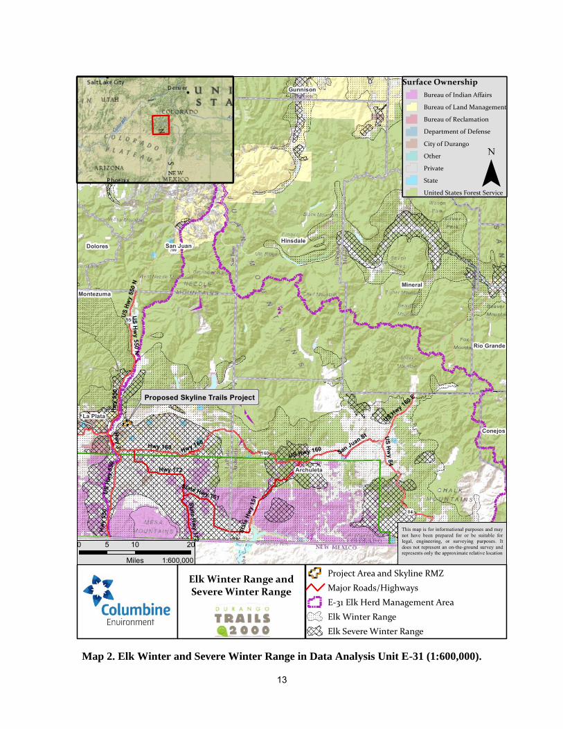
13
Map 2. Elk Winter and Severe Winter Range in Data Analysis Unit E-31 (1:600,000).
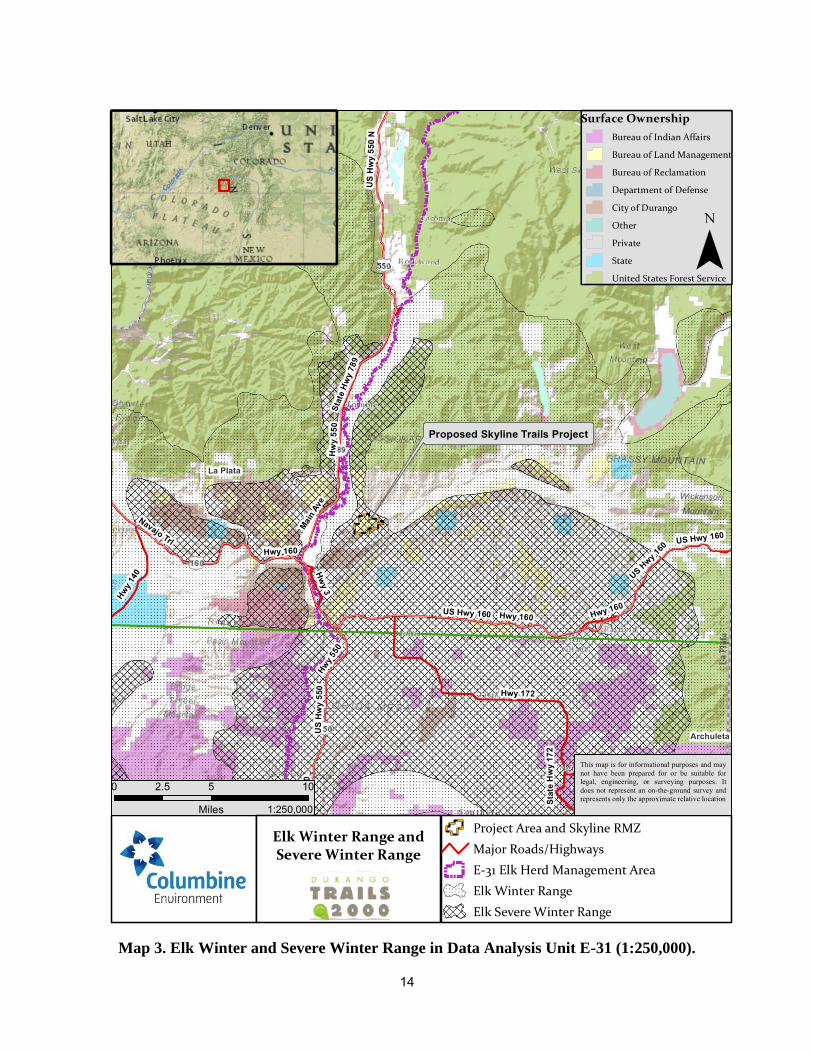
14
Map 3. Elk Winter and Severe Winter Range in Data Analysis Unit E-31 (1:250,000).
15
Elk would be most vulnerable to human-caused disturbances during the winter and early spring. Winter is a stressful time for elk when there is relatively little forage available and energy expenditures are higher for thermal regulation and movement in snow. Elk are typically at their lowest physical condition during early spring (Snetsinger and White 2009).
3.1.4. Recreation
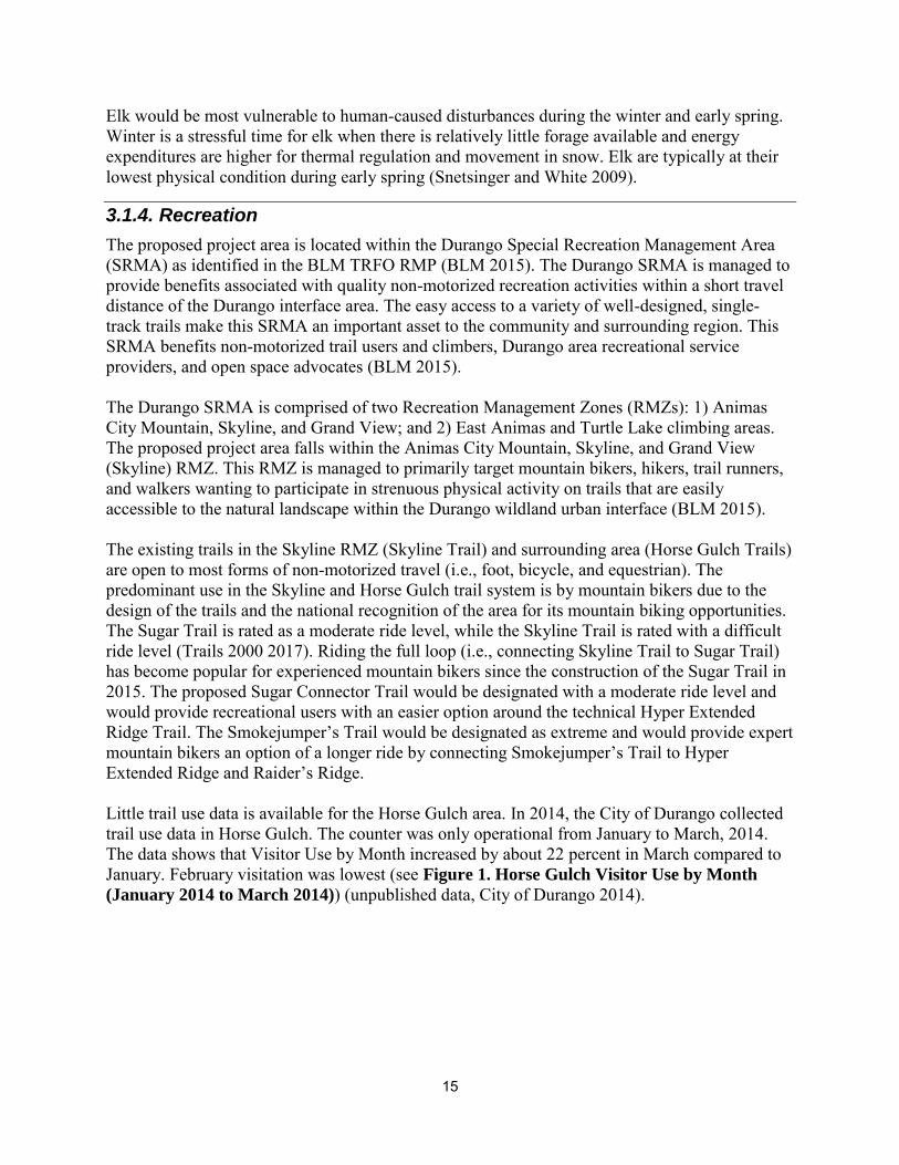
The proposed project area is located within the Durango Special Recreation Management Area (SRMA) as identified in the BLM TRFO RMP (BLM 2015). The Durango SRMA is managed to provide benefits associated with quality non-motorized recreation activities within a short travel distance of the Durango interface area. The easy access to a variety of well-designed, single-track trails make this SRMA an important asset to the community and surrounding region. This SRMA benefits non-motorized trail users and climbers, Durango area recreational service providers, and open space advocates (BLM 2015). The Durango SRMA is comprised of two Recreation Management Zones (RMZs): 1) Animas City Mountain, Skyline, and Grand View; and 2) East Animas and Turtle Lake climbing areas. The proposed project area falls within the Animas City Mountain, Skyline, and Grand View (Skyline) RMZ. This RMZ is managed to primarily target mountain bikers, hikers, trail runners, and walkers wanting to participate in strenuous physical activity on trails that are easily accessible to the natural landscape within the Durango wildland urban interface (BLM 2015). The existing trails in the Skyline RMZ (Skyline Trail) and surrounding area (Horse Gulch Trails) are open to most forms of non-motorized travel (i.e., foot, bicycle, and equestrian). The predominant use in the Skyline and Horse Gulch trail system is by mountain bikers due to the design of the trails and the national recognition of the area for its mountain biking opportunities. The Sugar Trail is rated as a moderate ride level, while the Skyline Trail is rated with a difficult ride level (Trails 2000 2017). Riding the full loop (i.e., connecting Skyline Trail to Sugar Trail) has become popular for experienced mountain bikers since the construction of the Sugar Trail in 2015. The proposed Sugar Connector Trail would be designated with a moderate ride level and would provide recreational users with an easier option around the technical Hyper Extended Ridge Trail. The Smokejumper’s Trail would be designated as extreme and would provide expert mountain bikers an option of a longer ride by connecting Smokejumper’s Trail to Hyper Extended Ridge and Raider’s Ridge. Little trail use data is available for the Horse Gulch area. In 2014, the City of Durango collected trail use data in Horse Gulch. The counter was only operational from January to March, 2014. The data shows that Visitor Use by Month increased by about 22 percent in March compared to January. February visitation was lowest (see Figure 1. Horse Gulch Visitor Use by Month
(January 2014 to March 2014)) (unpublished data, City of Durango 2014).
16
Figure 1. Horse Gulch Visitor Use by Month (January 2014 to March 2014)
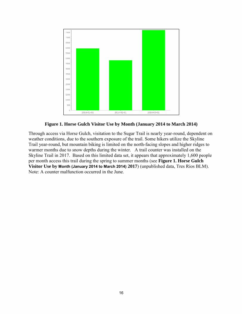
Through access via Horse Gulch, visitation to the Sugar Trail is nearly year-round, dependent on weather conditions, due to the southern exposure of the trail. Some hikers utilize the Skyline Trail year-round, but mountain biking is limited on the north-facing slopes and higher ridges to warmer months due to snow depths during the winter. A trail counter was installed on the Skyline Trail in 2017. Based on this limited data set, it appears that approximately 1,600 people per month access this trail during the spring to summer months (see Figure 1. Horse Gulch
Visitor Use by Month (January 2014 to March 2014) 2017) (unpublished data, Tres Rios BLM). Note: A counter malfunction occurred in the June.
17
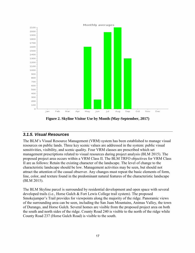
Figure 2. Skyline Visitor Use by Month (May-September, 2017)
3.1.5. Visual Resources
The BLM’s Visual Resource Management (VRM) system has been established to manage visual resources on public lands. Three key scenic values are addressed in the system: public visual sensitivities, visibility, and scenic quality. Four VRM classes are prescribed which set management prescriptions related to visual resources during project analysis (BLM 2015). The proposed project area occurs within a VRM Class II. The BLM TRFO objectives for VRM Class II are as follows: Retain the existing character of the landscape. The level of change to the characteristic landscape should be low. Management activities may be seen, but should not attract the attention of the casual observer. Any changes must repeat the basic elements of form, line, color, and texture found in the predominant natural features of the characteristic landscape (BLM 2015). The BLM Skyline parcel is surrounded by residential development and open space with several developed trails (i.e., Horse Gulch & Fort Lewis College trail system). The proposed Smokejumper’s Trail provides for viewpoints along the majority of the ridge. Panoramic views of the surrounding area can be seen, including the San Juan Mountains, Animas Valley, the town of Durango, and Horse Gulch. Several homes are visible from the proposed project area on both the south and north sides of the ridge. County Road 240 is visible to the north of the ridge while County Road 237 (Horse Gulch Road) is visible to the south.
18
The proposed Smokejumper’s Trail was user-created approximately 25 years ago and is currently used by local hikers and mountain bikers. The proposed Sugar Connector Trail would be constructed on previously undisturbed terrain. This proposed trail would connect two well-used trails; Sugar Trail to Skyline Trail. Because of the steep terrain, full bench construction would be used with large trees anchoring the downhill side of the trail in many places and in the insides of ascending turns. No other infrastructure or development occurs in the proposed project area.
3.2. Alternative A – No Action 3.2.1. Cultural Resources
Direct and Indirect Effects Under the No-Action Alternative, the Sugar Connector Trail would not be constructed. The proposed Smokejumper’s Trail extending north of the Skyline Ridge would not be designated, improved, nor maintained. As no cultural resources are present within or near the proposed project area, there would be no direct or indirect impacts to cultural resources under the No Action Alternative.
Cumulative Effects As the No Action alternative would not result in any direct or indirect impacts to cultural resources, it would not contribute to any cumulative impacts to cultural resources.
Mitigation Measures and Residual Effects No mitigation measures are necessary for Cultural Resources.
3.2.2. Soils
Direct and Indirect Effects No new trails would be constructed. Sections of the existing, user-created trail on the ridge (proposed Smokejumper’s Trail) would not be rerouted, increasing erosion potential in those sections as trail users continue to visit the trail.
Cumulative Effects Past recreational use on the existing trails has impacted soils as a result of trail construction, soil compaction, erosion, and runoff. Future recreational activities would continue to impact soil resources. Unauthorized user created trails are a common problem in the area; however, these trails can increase soil erosion due to poor design.
Mitigation Measures and Residual Effects No mitigation measures are recommended for Soils Resources.
3.2.3. Wildlife
Direct and Indirect Effects Under the No-Action Alternative, no new recreation trails would be built or designated by the BLM. This alternative would have the least effect on wildlife species. Because of the existing, user-created trail on the ridge (proposed Smokejumper’s Trail), wildlife are currently

19
experiencing human-caused disturbances due to trail use. Current disturbance levels would continue under this alternative.
Cumulative Effects The No-Action Alternative would not cumulatively affect wildlife species. The affects that are a result of this alternative represent baseline and would not be additive to any existing or reasonably certain to occur future projects. For past, present and reasonably foreseeable impacts in the area see Cumulative Effects in Section 3.3.3.
Mitigation Measures and Residual Effects No mitigation measures are recommended for Wildlife.
3.2.4. Recreation
Direct and Indirect Effects Under the No-Action Alternative, no new trails would be built or authorized by the BLM. Recreational use would continue in the area, though without the benefit of signage and well-designed trails. There would be no easier route around the Hyper Extended Ridge Trail; only expert mountain bikers would be able to ride while others would have to hike their bike around that section. There would be no enhancement of existing riding opportunities. Currently, trail users on the existing, user-created ridge trail (proposed Smokejumper’s Trail) may inadvertently trespass onto private lands simply by following the trail (the existing trail does not loop back before crossing onto private land).
The Skyline RMZ is located adjacent to Durango. As such, there are a myriad of personal and community benefits which arise from easy access to non-motorized trail systems. Personal benefits include improved health, improved development of skills and abilities, greater personal confidence, and an improved understanding of the community’s dependence and effect on Public Lands and adjoining private lands. Community benefits include an enhanced outdoor-oriented lifestyle, increased economic activity, and an increased desirability of Durango as a place to live, visit, or retire. While the existing trail system affords these benefits already, without the development of new trail opportunities within the Skyline RMZ, the ability for these benefits to continue to expand becomes limited. Future use and enjoyment of the parcel could continue to see increased use, increased injuries (due to limited skills), increased trespassing onto adjacent private lands, and/or increased congestion due to limited trail options in the RMZ.
Cumulative Effects The cumulative effects analysis area for recreation for this project would be the Skyline RMZ of the Durango SRMA. There are currently 25.1 miles of designated, non-motorized single trail in the SRMA, 2.4 miles of those in the Skyline RMZ. The Skyline RMZ is approximately 522 acres and bound by City of Durango and private land. The City of Durango land adjacent to the Skyline RMZ provides non-motorized recreational opportunities in the Horse Gulch trail system. The Horse Gulch trail system has approximately 23.5 miles of single-track trails that are accessed from town. Under the No-Action Alternative, there would be no new trails built or designated and thus no cumulative effects as a result of this project.
20
Mitigation Measures and Residual Effects No mitigation measures are recommended for Recreation.
3.2.5. Visual Resources
Direct and Indirect Effects Under the No-Action Alternative, no new trails would be built or designated. There would be no changes to the visual setting of the landscape as no new trails would be constructed.
Cumulative Effects The cumulative effects analysis area for visual resources for this project would be the Skyline RMZ. This analysis area would include the foreground, middle ground, and background of the visible landscape. Due to the isolated nature of the BLM managed lands in the area (relatively small blocks of BLM lands which are separated by city and private land), activities occurring in nearby BLM parcels are not visible and thus not part of the cumulative analysis area for visual resources.
Under the No-Action Alternative, there would be no new trails and thus no cumulative effects to the visual characteristic landscape as a result of this project.
Mitigation Measures and Residual Effects No mitigation measures are recommended for Visual Resources.
3.3. Alternative B – Proposed Action 3.3.1. Cultural Resources
Direct and Indirect Effects No cultural resources are present within or near the proposed project area; therefore, there would be no direct or indirect impacts to cultural resources from the implementation of the Proposed Action.
Cumulative Effects Because the proposed action would not directly or indirectly impact cultural resources, it would not contribute to any cumulative impacts to cultural resources.
Mitigation Measures and Residual Effects No mitigation measures are necessary for Cultural Resources.
3.3.2. Soils
Direct and Indirect Effects Under the Proposed Action, about 1.8 miles of trail would be designated and maintained, approximately 0.4 miles of which would be constructed as new single-track trail. The proposed trails are located on moderately steep slopes which have moderate to severe erosion capabilities.
21
The construction of the proposed trails would permanently alter these soils and the removal of vegetation on them could lead to accelerated erosion. Building trails on steep slopes that have high erosion potential greatly increases the likelihood that trail surfaces may erode and may become entrenched. Building trails on soils that have high erosion hazard could also increase either the cost of construction or the cost and frequency of required monitoring and trail maintenance.
For the Sugar Connector Trail and a portion of the Smokejumper’s Trail, the main limitations to trail construction on the Archuleta-Sanchez Complex, 12 to 65 percent slopes soil type are the potential for steep slopes and large rocks; both soil limitations can be mitigated with careful trail location. The slope of the proposed Sugar Connector Trail would be built at a similar grade as the Sugar Trail near 7 percent. For portions of the Smokejumper’s Trail found in Zyme-Rock Outcrop Complex, 12 to 65 percent slopes, the primary concerns for trail construction are that this soil erodes easily. However, the majority of the trail is planned to be constructed on the ridgeline and the slopes are generally moderate. The existing Sugar Trail and Skyline Trail were built on the same soil types (Archuleta-Sanchez Complex, 12 to 65 percent slopes and Zyme-Rock Outcrop Complex, 12 to 65 percent slopes, respectively). A field review conducted in June 2017 showed that high erosion was not occurring on these trails.
The proposed building guidelines as recommended by the IMBA would effectively limit the water collection and route runoff quickly from the trail tread resulting in limited erosion. Also, soil loss and erosion would be reduced by utilizing the existing, sustainable portions of the Smokejumper’s Trail and rerouting unsustainable sections. With careful trail location and construction and implementation of mitigation, erosion on the proposed trails could be minimized or reduced. Overall, the impacts to soils and subsequent long-term erosion is anticipated to be minimal.
Cumulative Effects The existing trails within the Skyline RMZ (Skyline Trail) and immediate vicinity (Sugar Trail, Hyper Extended Ridge Trail, Raiders Ridge) are located on the same two soil units as the proposed trails. The existing trails were built with careful planning, construction, and mitigation measures; thus, erosion and frequent maintenance has been minimized. Approximately 1.8 miles of new trail would be designated in the Skyline RMZ under the Proposed Action, with about 0.4 miles of that as new construction. Past recreational use on the existing trails has impacted soils as a result of trail construction, soil compaction, erosion, and runoff. Future recreational activities would continue to impact soil resources. The proposed new trail construction may result in temporary soil disturbance but would result in long-term benefits by reducing erosion to proper trail design, drainage improvement, and soil erosion control. Unauthorized user created trails are a common problem in the area; however, these trails can increase soil erosion due to poor design. New trails that are well-designed can replace user created trails by being placed in desirable areas; thereby reducing soil erosion. Erosion potential could be a continuous problem and require frequent maintenance to keep trails to standard and fix erosion problems. However, implementation of mitigation measures could be effective in reducing the risk of erosion and the need for long-term maintenance.
22
Mitigation Measures and Residual Effects The Sugar Trail was built with a 7 percent sustainable grade; the proposed Sugar Connector Trail and the proposed lollipop and reroutes on the Smokejumper’s Trail would be built in a similar manner to minimize the amount of maintenance required (e.g., rolling grade dips, nicks, etc.) to prevent future soil loss and reduce maintenance costs. By constructing the proposed trails to IMBA standards, no further mitigation measures for soils would be required.
3.3.3. Wildlife
Direct and Indirect Effects Elk
Effects to elk would primarily occur as a result of trail use during spring and fall migration. Approximately 1.8 miles of trail would be designated and maintained as a result of the Proposed Action. About 0.4 mile of trail would be new construction. The Proposed Action would result in decreased habitat effectiveness in elk winter range in the Skyline Trails area.
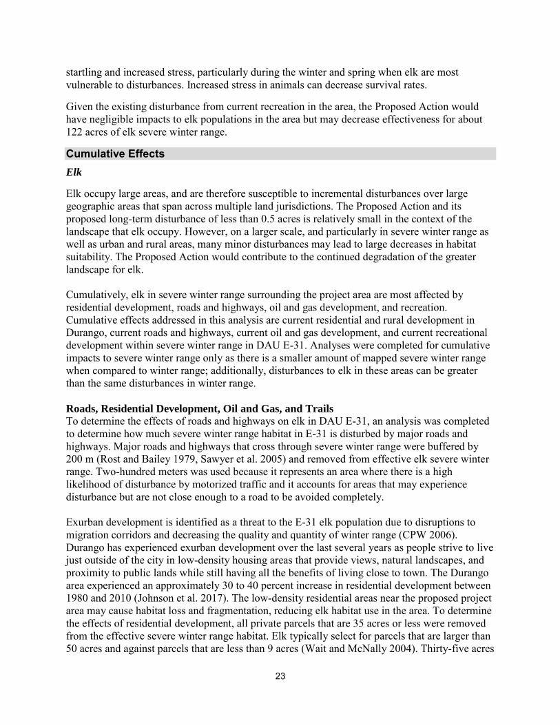
Non-motorized, off-road activities have been shown to have a substantial effect on elk behavior by increasing flight responses and movement out of an area. Movement rates and flight responses were found to be higher for mountain biking than for hiking. Animal energy budgets may be adversely affected by the loss of foraging opportunities while animals respond to off-road activities, both from increased movements, and from displacement from foraging habitat. If disturbances happen in the fall, elk may use extra energy to flee from an off-road activity, decreasing their body fat and reducing their probability of surviving a severe winter (Wisdom et al. 2005). Trail use by mountain bikers and hikers has a disruptive influence within approximately 100 meters of a trail (Taylor and Knight 2003). When buffered by 100 meters (m), the proposed Skyline Trails project would decrease elk severe winter range habitat effectiveness by approximately 122 acres. This approximate 122 acres accounts for only about 0.05 percent of the entire 263,040-acre elk severe winter range mapped at the proposed project location.
Elk have been reported to avoid coniferous forests (i.e., ponderosa pine, pine/oak, and mixed conifer) and possibly mountain shrub communities during the winter months due to snow depths. However, these areas are important for elk migration and also when available in the winter (Wait and McNally 2004). The coniferous forests and mountain shrub communities found in the project area and near vicinity may limit elk movements during the winter months when snow is present.
Limited data is available for the Skyline Trails project area, but the majority of use in the Skyline trails occurs in the summer and fall (Monroe-Brown, pers. comm., 2017). Snow cover and wet, muddy trail conditions keep visit use low during winter and spring months. Thus, elk/trail user interactions may be highest during the summer and fall months when visitor use is highest.
The limited trail use data available for the adjacent Horse Gulch area shows visitation occurring during the winter and spring months (see Figure 1). The Horse Gulch area also falls within the elk severe winter range; thus, further limiting the habitat effectiveness for elk in the area. Due to the existing disturbance, elk may already avoid areas when user rates are high. However, for elk that do not avoid areas, their body condition could be negatively affected due to repeated
23
startling and increased stress, particularly during the winter and spring when elk are most vulnerable to disturbances. Increased stress in animals can decrease survival rates.
Given the existing disturbance from current recreation in the area, the Proposed Action would have negligible impacts to elk populations in the area but may decrease effectiveness for about 122 acres of elk severe winter range.
Cumulative Effects Elk
Elk occupy large areas, and are therefore susceptible to incremental disturbances over large geographic areas that span across multiple land jurisdictions. The Proposed Action and its proposed long-term disturbance of less than 0.5 acres is relatively small in the context of the landscape that elk occupy. However, on a larger scale, and particularly in severe winter range as well as urban and rural areas, many minor disturbances may lead to large decreases in habitat suitability. The Proposed Action would contribute to the continued degradation of the greater landscape for elk. Cumulatively, elk in severe winter range surrounding the project area are most affected by residential development, roads and highways, oil and gas development, and recreation. Cumulative effects addressed in this analysis are current residential and rural development in Durango, current roads and highways, current oil and gas development, and current recreational development within severe winter range in DAU E-31. Analyses were completed for cumulative impacts to severe winter range only as there is a smaller amount of mapped severe winter range when compared to winter range; additionally, disturbances to elk in these areas can be greater than the same disturbances in winter range. Roads, Residential Development, Oil and Gas, and Trails
To determine the effects of roads and highways on elk in DAU E-31, an analysis was completed to determine how much severe winter range habitat in E-31 is disturbed by major roads and highways. Major roads and highways that cross through severe winter range were buffered by 200 m (Rost and Bailey 1979, Sawyer et al. 2005) and removed from effective elk severe winter range. Two-hundred meters was used because it represents an area where there is a high likelihood of disturbance by motorized traffic and it accounts for areas that may experience disturbance but are not close enough to a road to be avoided completely. Exurban development is identified as a threat to the E-31 elk population due to disruptions to migration corridors and decreasing the quality and quantity of winter range (CPW 2006). Durango has experienced exurban development over the last several years as people strive to live just outside of the city in low-density housing areas that provide views, natural landscapes, and proximity to public lands while still having all the benefits of living close to town. The Durango area experienced an approximately 30 to 40 percent increase in residential development between 1980 and 2010 (Johnson et al. 2017). The low-density residential areas near the proposed project area may cause habitat loss and fragmentation, reducing elk habitat use in the area. To determine the effects of residential development, all private parcels that are 35 acres or less were removed from the effective severe winter range habitat. Elk typically select for parcels that are larger than 50 acres and against parcels that are less than 9 acres (Wait and McNally 2004). Thirty-five acres
24
was used as a weighted median, favoring larger sized parcels as refuge. Parcel data was not available for San Juan, Hinsdale, Mineral, and Conejos counties. To determine the effects of oil and gas development, producing oil and gas wells that are within the elk severe winter range in E-31 were buffered by 600 m and removed from effective elk severe winter range habitat. Six-hundred meters was used as it represents an area where there is a high likelihood of disturbance by oil and gas producing activities; big game have been recorded avoiding producing well pads regularly at a 600-m buffer (Northrup et al. 2015). To determine the effects of all recreational trails located in the severe winter range in E-31, each trail was buffered by 100 m. This area was removed from the effective severe winter range habitat. The disturbance buffers from each cumulative effect were merged and removed from the total area of the severe winter range in E-31. The remaining areas were then stratified by ownership. This analysis is not intended to be a perfect model of disturbance, rather a landscape scale assessment of habitats that are likely degraded. Actual disturbance varies by vegetation, topography, human densities, and road traffic numbers. Table 2 shows the amount of elk severe winter range mapped in E-31 and the percentages of the severe winter range habitat that has been disturbed by roads, residential development, oil and gas development, and recreational trails. Table 2. Amount of elk severe winter range disturbed in E-31 by land jurisdiction.
Ownership E-31
(acres)
E-31 Severe
Winter
Range
(acres)
Disturbed
Acres in E-31
Severe
Winter Range
(acres)1
% of Habitat Disturbed in E-31
Severe Winter Range
Bureau of Indian
Affairs 211,280 56,838 40,513 71%
Bureau of Land
Management 39,333 10,029 6,153 61%
Bureau of
Reclamation 3,743 0 0 0%
Local
Municipalities 9,630 3,292 2,075 63%
Other 310 161 161 100% Private 531,751 213,369 180,025 84% State 5,273 2,386 1,853 78% U.S. Forest
Service
987,691 63,083 14,590 23%
Total 1,789,011 349,159 245,371 70% 1Disturbed acres in severe winter range were calculated by subtracting areas within 200m of major roads and highways, 600m of producing oil and gas wells, 100m of trails, and all private parcels less than or equal to 35 acres from total severe winter range areas in E-31.
25
An estimated 245,371 acres (70 percent) of the E-31 severe winter range have been previously disturbed by cumulative effects (i.e., roads, oil and gas development, residential development, and recreational development). In addition to current disturbance, the Proposed Action would add 122 acres of disturbance to severe winter range, or an increase of about 0.3 percent. On BLM land alone, disturbance from the Proposed Action would increase by 1 percent. Conclusion
The cumulative effects analysis area for the elk is the severe winter range in E-31. Disturbance levels on elk severe winter range on BLM lands are moderate when compared with other jurisdictions (Table 2). The Proposed Action would increase anthropogenic disturbance to the E-31 severe winter range by about 122 acres. Although minimal when compared to current disturbances, it contributes to the general habitat fragmentation occurring in the area. Residential development is expected to continue to increase as people move into the region; many private lands vary in habitat quality for elk. There are two proposed BLM projects within E-31, the Grand View Ridge gravel pit expansion, and the Smart 160 trail. The gravel pit expansion would contribute to the decrease in habitat effectiveness for elk in E-31. The Smart 160 trail would not likely contribute to the decrease in habitat effectiveness for elk, due to proximity of the project to existing development. Oil and gas development is expected to continue on private and tribal lands in E-31 and may contribute to impacts to elk in E-31. The Proposed Action’s disturbance to winter and severe winter range would further contribute to the degradation of elk winter habitat. However, given the existing disturbance within a majority of the proposed project area (about 1.5 miles of the proposed project occurs on an existing trail) and the project’s close proximity to other existing, designated trails (e.g., Skyline Trail, Sugar Trail), the Proposed Action would have a minimal impact to elk winter and severe winter range.
Mitigation Measures and Residual Effects No mitigation measures are recommended for Wildlife.
3.3.4. Recreation
Direct and Indirect Effects Under the Proposed Action, approximately 1.8 miles of trail would be designated and maintained as a result of the Proposed Action. About 0.4 mile of trail would be new construction. Design features such as developing an enjoyable and sustainable trail alignment depicted on maps, limiting vegetation clearing while still providing safe sightlines on the inside corners, limiting ground disturbance, allowing for ‘hike-a-bike sections, and minimizing user-created trail development would accomplish the purpose and goals of the trails: allow for a range of challenging riding experiences (moderate to extreme); maintain a natural setting for the users; provide for safer riding experiences; and create sustainable trails. Trespassing onto private land east of the proposed Smokejumper’s Trail currently happens. Due to the existing trail on the ridge, users continue following the ridge to the northeast and onto private land. The loop constructed on the eastern end of the Smokejumper’s Trail, in combination with reclaiming any remaining trail beyond the loop, would keep users on the established trail and help prevent trespassing onto the neighboring private parcels.

26
Different user groups would benefit by the two proposed trails. Trail users with less technical skills would benefit from the proposed Sugar Connector Trail. The Sugar Trail was built with a 7 percent sustainable grade; the Sugar Connector Trail would be built in the same manner. This trail would provide trail users with an easier option around the technical Hyper Extended Ridge Trail. The Hyper Extended Ridge Trail would still be an option for those who want to have a more challenging experience. The Smokejumper’s Trail would provide an extreme experience for those who want the challenge. This trail offers a good extension from the existing Skyline Trail and Raiders Ridge Trail. The proposed Smokejumper’s Trail may limit users who have less technical skills due to the extreme terrain. Given the fitness levels required to reach the proposed trails from either the Sugar Trail or the Skyline Trail, the Proposed Action would provide the following personal benefits to users: improved health, improved development of skills and abilities, and greater personal confidence. Some users may not be able to benefit from the new trails due to lack of fitness or skills; however, the new trails may motivate them to gain fitness and skills. Social/community benefits include an enhanced outdoor-oriented lifestyle, increased economic activity, and an increased desirability of Durango as places to live, visit, or retire. While the existing trail system affords these benefits already, the addition of the proposed trails would result in the expansion of these benefits. Trail users who tire of ‘riding the same trails over and over again’ would have new and varied opportunities. Trail users seeking new viewsheds, challenges, or diversity would have more terrain available to meet their needs. The Smokejumper’s Trail would provide users with 360 degree views of the San Juan Mountains, City of Durango, and the Horse Gulch area.
Cumulative Effects The cumulative effects analysis area for recreation for this project would be the Skyline RMZ of the Durango SRMA. There are currently 25.1 miles of designated, non-motorized single trail in the SRMA, 2.4 miles of those in the Skyline RMZ. The Skyline RMZ is approximately 522 acres and bound by City of Durango and private land. The City of Durango land adjacent to the Skyline RMZ provides non-motorized recreational opportunities in the Horse Gulch trail system. The Horse Gulch trail system has approximately 23.5 miles of single-track trails that are accessed from town. The proposed project would add approximately 1.8 miles (75% increase) of single-track trail to the Skyline RMZ that could be accessed by the Horse Gulch trail system. These would be in addition to the 2.4 miles of single-track already available within the RMZ. There are no other federal actions in the cumulative analysis area. The cumulative effect to trail users is an overall increase in length and diversity of trail opportunities in the Skyline area.
Mitigation Measures and Residual Effects No mitigation measures are recommended for Recreation.
3.3.5. Visual Resources
Direct and Indirect Effects Under the Proposed Action, approximately 1.8 miles of trail would be designated and maintained as a result of the Proposed Action. About 0.4 mile of trail would be new construction. Design features such as minimizing vegetation removal and soil disturbance would make the trails
27
nearly impossible to see from any likely viewing points including overlook points along the proposed trails themselves. The varied topography and dense Gambel oak and piñon-juniper overstory common through most of the project area would screen the effects of both trail construction and usage. Trail construction and usage would be visible within the open ponderosa pine woodlands on the Smokejumper’s Trail; however, these sections only make up a short portion of the trail. People stopped on the ridge on the Smokejumper’s Trail may be visible from residential developments below, but the trails would not be visible from any residential developments or roads. All of the developments proposed under this alternative would be consistent with the management objectives listed for a VRM Class II area.
Cumulative Effects The cumulative effects analysis area for visual resources for this project would be the Skyline RMZ of the Durango SRMA. This analysis area would include the foreground, middle ground, and background of the visible landscape. Due to the isolated nature of the BLM managed lands in the area (relatively small blocks of BLM lands which are separated by city and private land), activities occurring in nearby BLM parcels are not visible and thus not part of the cumulative analysis area for visual resources. Existing trails within the Skyline RMZ (i.e., the Skyline Trail) can be seen from areas along the Smokejumper’s Trail. There are no other federal actions in the cumulative analysis area.
The limited scope of the weak contrasts associated with the Proposed Action would not result in any cumulative affects to the visual characteristic landscape which would be incompatible with the VRM Class II objectives for this area.
Mitigation Measures and Residual Effects No mitigation measures are recommended for Visual Resources.
28
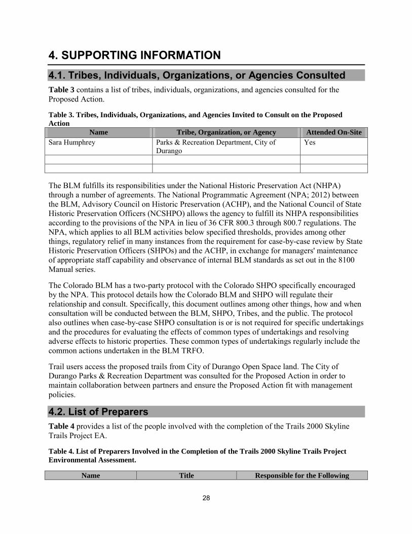
4. SUPPORTING INFORMATION 4.1. Tribes, Individuals, Organizations, or Agencies Consulted Table 3 contains a list of tribes, individuals, organizations, and agencies consulted for the Proposed Action.
Table 3. Tribes, Individuals, Organizations, and Agencies Invited to Consult on the Proposed
Action
Name Tribe, Organization, or Agency Attended On-Site
Sara Humphrey Parks & Recreation Department, City of Durango
Yes
The BLM fulfills its responsibilities under the National Historic Preservation Act (NHPA) through a number of agreements. The National Programmatic Agreement (NPA; 2012) between the BLM, Advisory Council on Historic Preservation (ACHP), and the National Council of State Historic Preservation Officers (NCSHPO) allows the agency to fulfill its NHPA responsibilities according to the provisions of the NPA in lieu of 36 CFR 800.3 through 800.7 regulations. The NPA, which applies to all BLM activities below specified thresholds, provides among other things, regulatory relief in many instances from the requirement for case-by-case review by State Historic Preservation Officers (SHPOs) and the ACHP, in exchange for managers' maintenance of appropriate staff capability and observance of internal BLM standards as set out in the 8100 Manual series.
The Colorado BLM has a two-party protocol with the Colorado SHPO specifically encouraged by the NPA. This protocol details how the Colorado BLM and SHPO will regulate their relationship and consult. Specifically, this document outlines among other things, how and when consultation will be conducted between the BLM, SHPO, Tribes, and the public. The protocol also outlines when case-by-case SHPO consultation is or is not required for specific undertakings and the procedures for evaluating the effects of common types of undertakings and resolving adverse effects to historic properties. These common types of undertakings regularly include the common actions undertaken in the BLM TRFO.
Trail users access the proposed trails from City of Durango Open Space land. The City of Durango Parks & Recreation Department was consulted for the Proposed Action in order to maintain collaboration between partners and ensure the Proposed Action fit with management policies.
4.2. List of Preparers Table 4 provides a list of the people involved with the completion of the Trails 2000 Skyline Trails Project EA.
Table 4. List of Preparers Involved in the Completion of the Trails 2000 Skyline Trails Project
Environmental Assessment.
Name Title Responsible for the Following
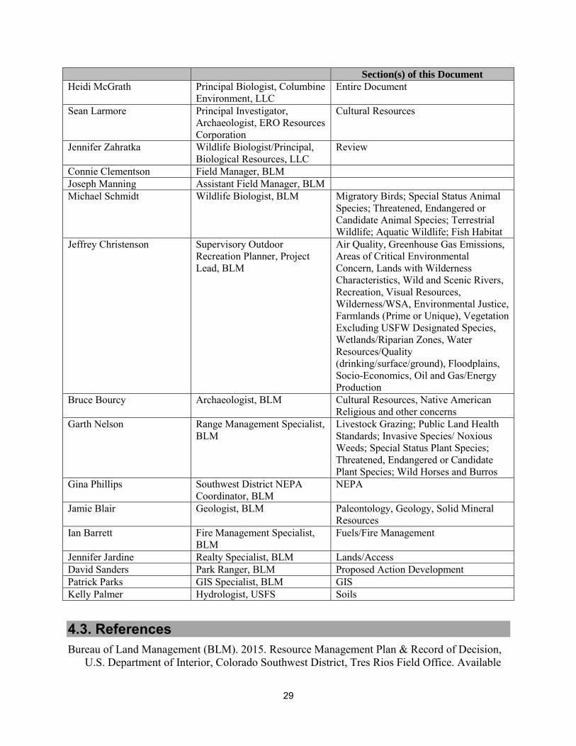
29
Section(s) of this Document
Heidi McGrath Principal Biologist, Columbine Environment, LLC
Entire Document
Sean Larmore Principal Investigator, Archaeologist, ERO Resources Corporation
Cultural Resources
Jennifer Zahratka Wildlife Biologist/Principal, Biological Resources, LLC
Review
Connie Clementson Field Manager, BLM Joseph Manning Assistant Field Manager, BLM Michael Schmidt Wildlife Biologist, BLM Migratory Birds; Special Status Animal
Species; Threatened, Endangered or Candidate Animal Species; Terrestrial Wildlife; Aquatic Wildlife; Fish Habitat
Jeffrey Christenson Supervisory Outdoor Recreation Planner, Project Lead, BLM
Air Quality, Greenhouse Gas Emissions, Areas of Critical Environmental Concern, Lands with Wilderness Characteristics, Wild and Scenic Rivers, Recreation, Visual Resources, Wilderness/WSA, Environmental Justice, Farmlands (Prime or Unique), Vegetation Excluding USFW Designated Species, Wetlands/Riparian Zones, Water Resources/Quality (drinking/surface/ground), Floodplains, Socio-Economics, Oil and Gas/Energy Production
Bruce Bourcy Archaeologist, BLM Cultural Resources, Native American Religious and other concerns
Garth Nelson Range Management Specialist, BLM
Livestock Grazing; Public Land Health Standards; Invasive Species/ Noxious Weeds; Special Status Plant Species; Threatened, Endangered or Candidate Plant Species; Wild Horses and Burros
Gina Phillips Southwest District NEPA Coordinator, BLM
NEPA
Jamie Blair Geologist, BLM Paleontology, Geology, Solid Mineral Resources
Ian Barrett Fire Management Specialist, BLM
Fuels/Fire Management
Jennifer Jardine Realty Specialist, BLM Lands/Access David Sanders Park Ranger, BLM Proposed Action Development Patrick Parks GIS Specialist, BLM GIS Kelly Palmer Hydrologist, USFS Soils
4.3. References Bureau of Land Management (BLM). 2015. Resource Management Plan & Record of Decision,
U.S. Department of Interior, Colorado Southwest District, Tres Rios Field Office. Available
30
at: https://eplanning.blm.gov/epl-front-office/eplanning/planAndProjectSite.do?methodName=dispatchToPatternPage¤tPageId=92880.
City of Durango (COD). 2014. Visitor Use by Month in the Horse Gulch Trail System. Unpublished data; Parks and Recreation Department.
Colorado Parks and Wildlife (CPW). 2017. Species Activity Data. Available at: http://www.arcgis.com/home/group.html?owner=rsacco&title=Colorado%20Parks%20and%20Wildlife%20-%20Species%20Activity%20Data. Accessed May 2017.
Colorado Parks and Wildlife (CPW). 2006. San Juan Basin Elk Herd E-31 Data Analysis Unit Plan, Game Management Units 75, 751, 77, 771, and 78. Available at: http://cpw.state.co.us/Documents/Hunting/BigGame/DAU/Elk/E31DAUPlan_SanJuanBasinElk.pdf
Johnson, H.E., J.R. Sushinsky, A. Holland, E.J. Bergman, T. Balzer, J. Garner, and S.E. Reed. 2017. Increases in residential and energy development are associated with reductions in recruitment for a large ungulate. Global Change Biology 23:578-591
Monroe-Brown, Mary (Executive Director, Trails 2000). Personal communication with Heidi McGrath (Principal, Columbine Environment, LLC) regarding trail use in the Skyline Trails system. May 23, 2017.
Natural Resources Conservation Service (NRCS). 1982. Soil Survey of La Plata County Area, Colorado by James Pannell, Soil Conservation Service. https://www.nrcs.usda.gov/Internet/FSE_MANUSCRIPTS/colorado/CO669/0/laplata.pdf
Northrup, J.M., C.R. Anderson, Jr., and G. Wittemyer. 2015. Quantifying spatial habitat loss from hydrocarbon development through assessing habitat selection patterns of mule deer. Global Change Biology 21: 3961-3970.
Reed, A.D. and M.D. Metcalf. 1999. Colorado Prehistory: A Context for the Northern Colorado
River Basin. Colorado Council of Professional Archaeologist, Denver, CO.
Rost, G.R., and J.A. Bailey. 1979. Distribution of Mule Deer and Elk in Relation to Roads. Journal of Wildlife Management 43(3): 634-641.
Sawyer, H., Lindzey, F., and D. McWhirter. 2005. Mule deer and pronghorn migration in western Wyoming. Wildlife Society Bulletin 33(4): 1266-1273.
Snetsinger, S.D. and K. White. 2009. Recreation and Trail Impacts on Wildlife Species of Interest in Mount Spokane State Park. Pacific Biodiversity Institute, Winthrop, Washington. 60 pp.
Taylor, A.R., and R.L. Knight. 2003. Wildlife Response to Recreation and Associated Visitor Perceptions. Ecological Society of America 13(4): 2003.
Trails 2000. 2017. Horse Gulch/Telegraph Trails. Available at: http://www.trails2000.org/trails/horse-gulch/. Accessed May 2017.

31
U.S. Forest Service (USFS). 2004. American Elk Species Assessment. San Juan National Forest.
U.S. Geological Survey (USGS). 2011. National Gap Analysis Program, National Land Cover, Version 2. Available at: http://gis1.usgs.gov/csas/gap/viewer/land_cover/Map.aspx. Accessed April 2017.
U.S. Geological Survey (USGS). 1979. Geologic Map of Colorado Compiled by Ogden Tweto. Branch of Distribution, US Geological Survey, Denver, CO.
Wait, S., and H. McNally. 2004. Selection of habitats by wintering elk in a rapidly subdividing area of La Plata County, Colorado. Proceedings of the 4th International Urban Wildlife Symposium.
Wisdom, M.J., A.A. Ager, H.K. Preisler, N.J. Cimon, and B.K. Johnson. 2005. Effects of Off-Road Recreation on Mule Deer and Elk. Pages 67-80 in Wisdom, M.J., technical editor, The Starkey Project: a synthesis of long-term studies of elk and mule deer. Reprinted from the 2004 Transactions of the North American Wildlife and Natural Resources Conference, Alliance Communications Group, Lawrence, Kansas, USA.

32
APPENDIX A. [APPENDICES] A.1. A.1.1.