initial environmental examination - 41220-013: integrated
TRANSCRIPT
i
Initial Environmental Examination
December 2018
Philippines: Integrated Natural Resources and Environmental Management Project Rehabilitation of Tawang Farm to Market Road
Prepared by Municipality of Balbalan, Province of Kalinga for the Asian Development Bank.
ii
CURRENCY EQUIVALENTS (as of 26 November 2018)
The date of the currency equivalents must be within 2 months from the date on the cover. Currency unit – peso (PhP)
PhP 1.00 = $ 0.01904 $1.00 = PhP 52.5132
ABBREVIATIONS
ADB Asian Development Bank BDC Barangay Development Council BUB Bottom-Up Budgeting CHARM2 Second Cordillera Highland Agricultural Resources Management
Project CNC CSC
Certificate of Non-Coverage Construction Supervision Consultant
CSO Civil Society Organization DA Department of Agriculture DED Detail Engineering Design DENR Department of Environment And Natural Resources DILG Department of Interior and Local Government DSWD Department of Social Welfare and Development ECA Environmentally Critical Area ECC Environmental Compliance Certificate ECP Environmentally Critical Project EHSM Environmental Health and Safety Manager EIA Environmental Impact Assessment EIS Environmental Impact Statement EMB ESS
Environmental Management Bureau Environmental Safeguards Specialist
FMR Farm to Market Road GAD Gender and Development IEE Initial Environmental Examination INREMP Integrated Natural Resources and Environment Management Project IP Indigenous People IROW Infrastructure Right of Way LGU Local Government Unit MDC Municipal Development Council MPN Most Probable Number NAAQ National Ambient Air Quality Guidelines NCB National Competitive Bidding NECA Non-Environmental Critical Area NECP Non-Environmental Critical Project NIA National Irrigation Administration NOL No Objection Letter NPCO National Project Coordinating Office NRIMP National Road Improvement And Management Program NRM Natural Resources Management OMC Overhead, Contingencies and Miscellaneous and Contractor’s
PDR Project Description Report PMIC Project Management Implementation Consultant

iii
PMO Project Management Office PMU Project Management Unit POs Peoples’ Organizations PSA Philippine Statistics Authority PWD Persons with Disability RC Reinforced Concrete RCPC Reinforced Concrete Pipe Culvert RPCO Regional Project Coordinating Offices REA Rapid Environmental Assessment ROW Right of Way SB Sangguniang Bayan SBD Standard Bidding Document SEMS Social and Environmental Management Systems SPMU Subproject Management Unit SPS SSS
Safeguard Policy Statement Social Safeguards Specialist
TA Technical Assistance TDS Total Dissolved Solids TOR Terms Of Reference TSP Total Suspended Particulates WMA WMC
Watershed Management Area Watershed Management Council
WMPCO Watershed Management And Project Coordination Offices
iv
WEIGHTS AND MEASURES
˚C – degree centigrade ha – hectare km – kilometer m – meter
m asl – meter above sea level mm – millimeter
mg/L – milligram per liter mg/Nm3 – milligram per normal cubic meter
ppt – parts per thousand μg/Nm3 – microgram per normal cubic meter
µS/cm – microSiemens/cm % – percent
NOTE
In this report, "$" refers to US dollars unless otherwise stated. This initial environmental examination is a document of the borrower. The views expressed herein do not necessarily represent those of ADB's Board of Directors, Management, or staff, and may be preliminary in nature. Your attention is directed to the “terms of use” section on ADB’s website.
In preparing any country program or strategy, financing any project, or by making any designation of or reference to a particular territory or geographic area in this document, the Asian Development Bank does not intend to make any judgments as to the legal or other status of any territory or area.
v
TABLE OF CONTENTS
I. EXECUTIVESUMMARY ................................................................................................... 1 II. POLICY, LEGAL, AND ADMINISTRATIVE FRAMEWORK .............................................. 2 A. Environmental Clearance Requirements .......................................................................... 2 III. DESCRIPTION OF THE PROJECT ................................................................................. 6 A. Overview ........................................................................................................................... 6 B. Project Location ................................................................................................................ 6 C. Project Rationale .............................................................................................................. 7 D. Project Development Plan ................................................................................................ 8 E. Manpower Requirements ................................................................................................ 11 F. Project Cost .................................................................................................................... 11 G. Project Duration and Schedule ....................................................................................... 12 IV. DESCRIPTION OF THE ENVIRONMENT ...................................................................... 13 A. Elevation and Slope ........................................................................................................ 13 B. Climate ............................................................................................................................ 13 C. Soils ................................................................................................................................ 14 D. Land Suitability and Use ................................................................................................. 14 E. Hydrology ........................................................................................................................ 15 F. Water Sources ................................................................................................................ 16 G. Mining ............................................................................................................................. 16 H. Flora and Fauna Diversity ............................................................................................... 17 I. Socio-Economic Conditions ............................................................................................ 17 V. ANTICIPATED ENVIRONMENTAL IMPACTS AND MITIGATION MEASURES ........... 21 A. Pre-Construction ............................................................................................................. 23
1. Confirmation of no required resettlement, relocations, and compensation ................ 23 2. Identification and prioritization of road section where concrete paving will be done .. 23 3. Preparation of detailed engineering designs and programs of work .......................... 23 4. Recruitment of workers .............................................................................................. 23
B. Construction .................................................................................................................... 24 1. Construction materials acquisition, transport access, and storage system ................ 24 2. Clearing and removal of obstructions ......................................................................... 24 3. Soil erosion................................................................................................................. 24 4. Ground surface leveling and concrete paving of existing roads ................................. 25 5. Civil works .................................................................................................................. 25 6. Implementation of noise and dust control measure .................................................... 25 7. Dust and noise from borrow pits ................................................................................. 25 8. Implementation of spoil management and control measure ....................................... 26 9. Solid and liquid construction waste management system .......................................... 26 10. Water quality ........................................................................................................... 26 11. Construction drainage system ................................................................................ 26 12. Workers health, safety and hygiene ....................................................................... 26 13. Traffic safety and management .............................................................................. 27 14. Ecological environment (Flora and Fauna) ............................................................. 27 15. Damaged to properties ........................................................................................... 27 16. Concrete washout ................................................................................................... 27 17. Use of Hazardous Substances ............................................................................... 28 18. Public safety ........................................................................................................... 28
C. Operation and Maintenance (O&M) Phase ..................................................................... 28 1. Operation of upgraded access road ........................................................................... 28
VI. INFORMATION DISCLOSURE, CONSULTATION, AND PARTICIPATION .................. 29 A. Stakeholder Consultations .............................................................................................. 29
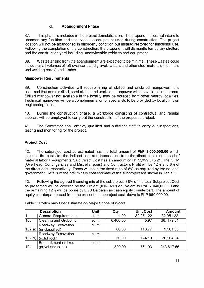
vi
B. Information Disclosure .................................................................................................... 30 VII. GRIEVANCE REDRESS MECHANISM ......................................................................... 31 VIII. ENVIRONMENTAL MANAGEMENT PLAN .................................................................... 33 A. Implementation Arrangements ........................................................................................ 33 B. Environmental Mitigation ................................................................................................ 34 C. Environmental Monitoring ............................................................................................... 40 IX. CONCLUSION AND RECOMMENDATION ................................................................... 42 A. Conclusion ...................................................................................................................... 43 B. Recommendation ............................................................................................................ 43
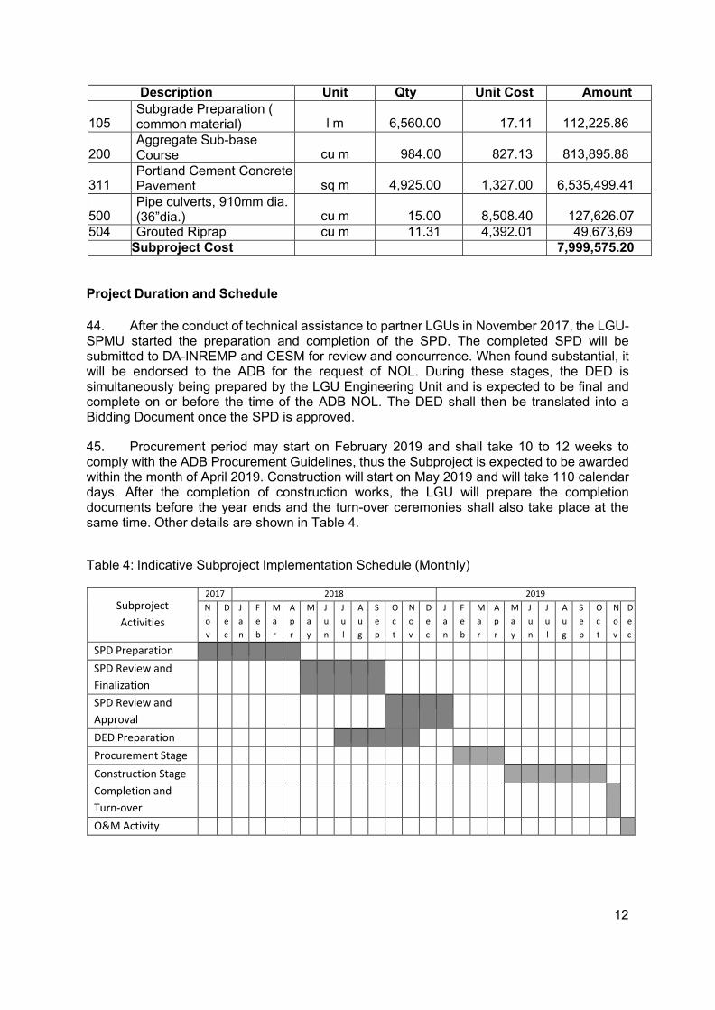
LIST OF FIGURES
Figure 1: Municipality of Balbalan Location Map ..................................................................... 7
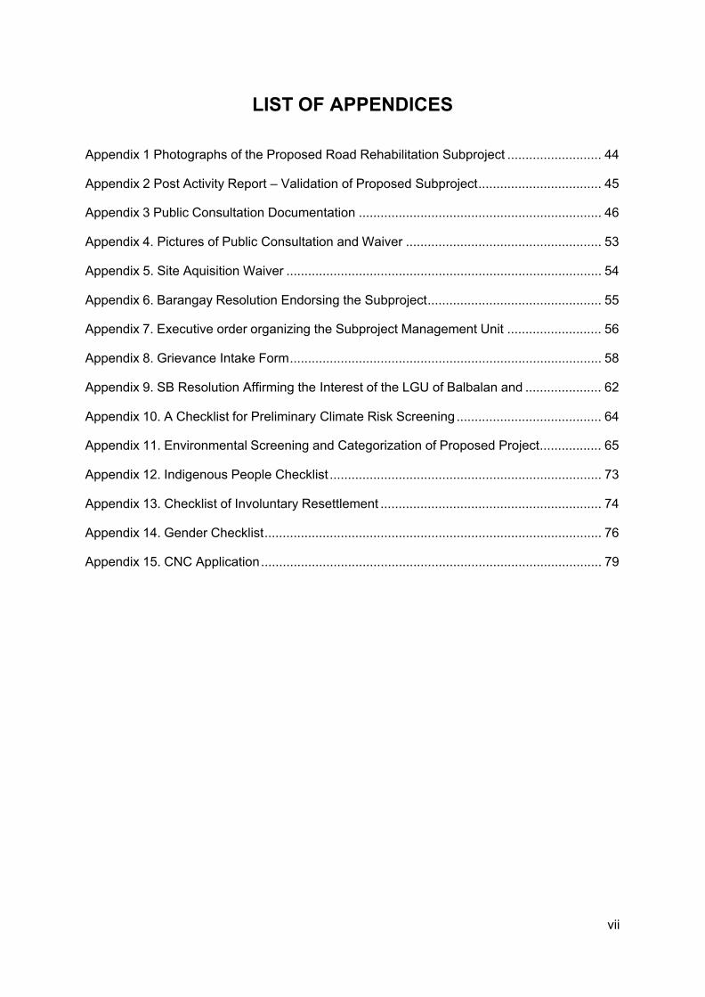
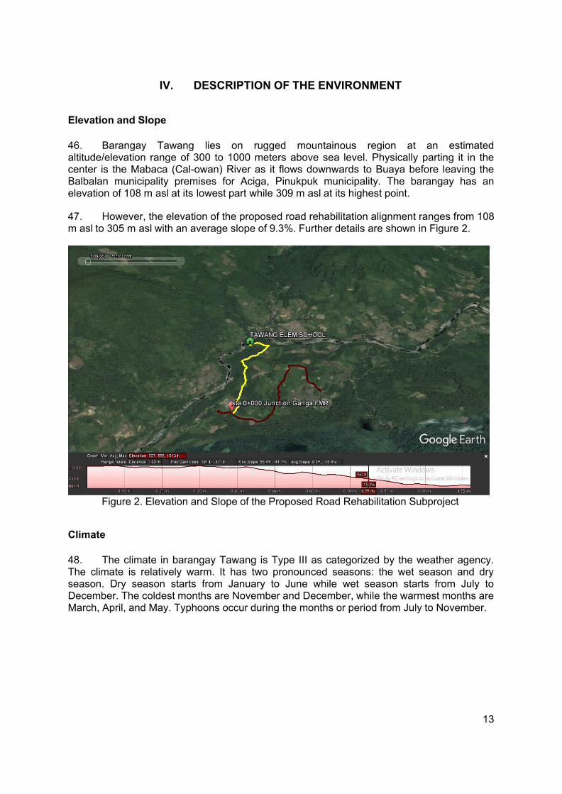
Figure 2. Elevation and Slope of the Proposed Road Rehabilitation Subproject .................. 13
Figure 3. Land Cover Distribution in Balbalan, Kalinga ......................................................... 15
Figure 4: Water Resource Map ............................................................................................. 16
LIST OF TABLES
Table 1: Summary List of ECP Types and ECA Categories ................................................... 2
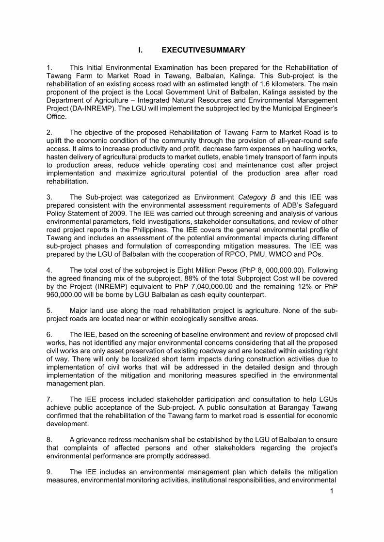
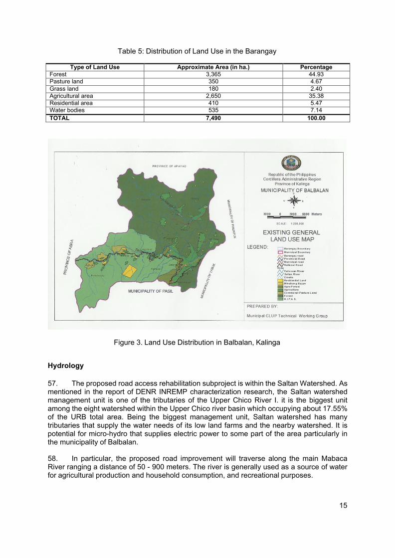
Table 2: Revised Guidelines for Coverage Screening and Standardized Requirements ........ 4
Table 3: Preliminary Cost Estimate on Major Scope of Works .............................................. 11
Table 4: Indicative Subproject Implementation Schedule (Monthly) ..................................... 12
Table 5: Distribution of Land Use in the Barangay ................................................................ 15
Table 6. 2016 Population per Sex per Sitios ........................................................................ 17
Table 7: Educational Facilities in Barangay Tawang ............................................................ 18
Table 8. Income Distribution by Household .......................................................................... 20
Table 9. Household Expenditures ......................................................................................... 20
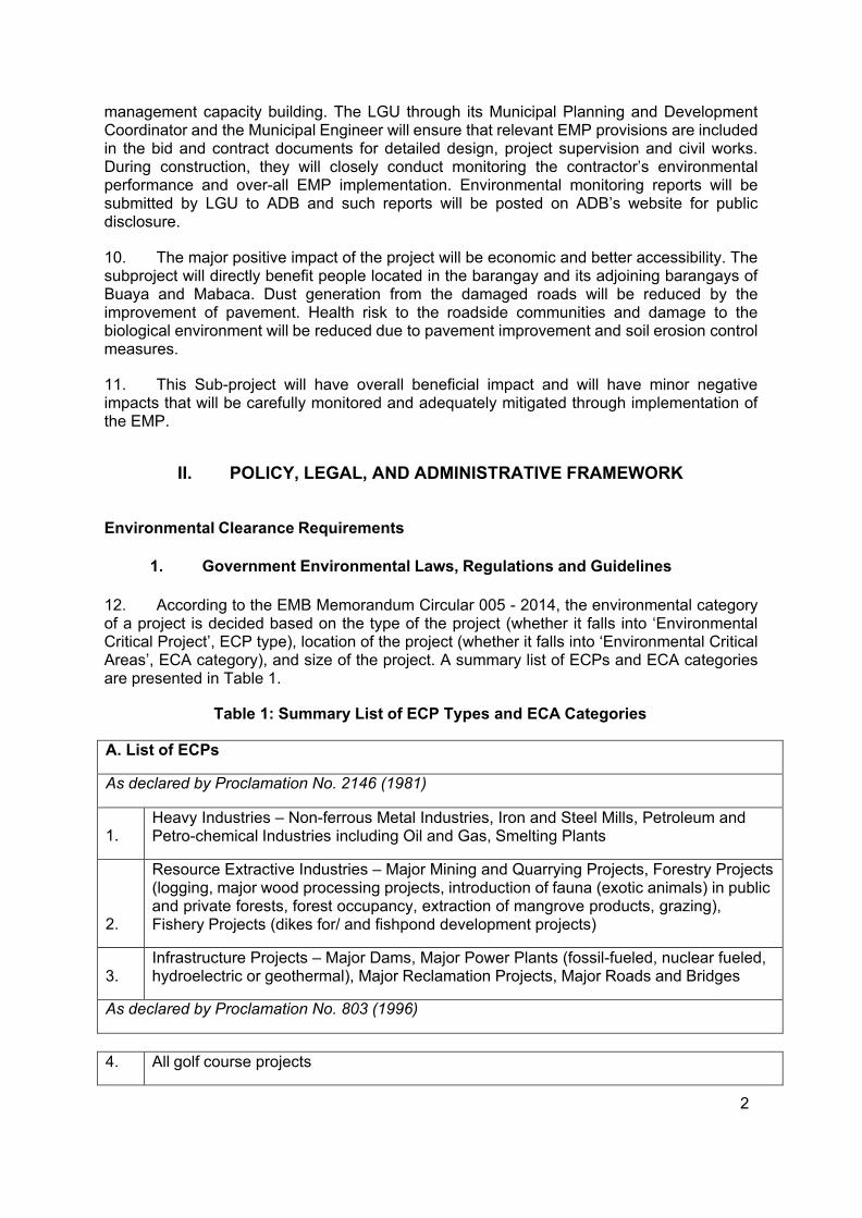
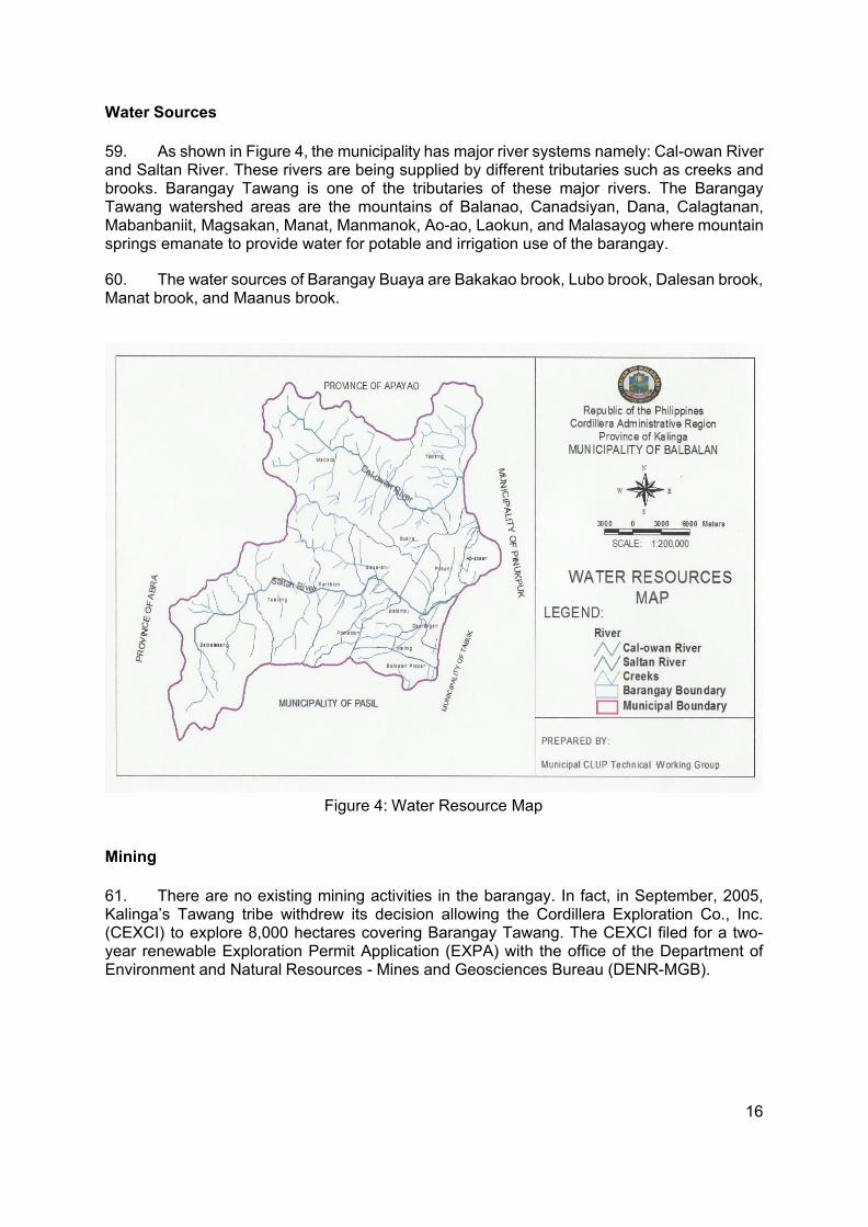
Table 10: Assessment of Potential Environmental Impacts .................................................. 22
Table 11. Responsibilities for EMP Implementation .............................................................. 33
Table 12. Environmental Impact Mitigation Plan ................................................................... 34
Table 13. Environmental Monitoring Plan ............................................................................. 41
vii
LIST OF APPENDICES
Appendix 1 Photographs of the Proposed Road Rehabilitation Subproject .......................... 44
Appendix 2 Post Activity Report – Validation of Proposed Subproject .................................. 45
Appendix 3 Public Consultation Documentation ................................................................... 46
Appendix 4. Pictures of Public Consultation and Waiver ...................................................... 53
Appendix 5. Site Aquisition Waiver ....................................................................................... 54
Appendix 6. Barangay Resolution Endorsing the Subproject ................................................ 55
Appendix 7. Executive order organizing the Subproject Management Unit .......................... 56
Appendix 8. Grievance Intake Form ...................................................................................... 58
Appendix 9. SB Resolution Affirming the Interest of the LGU of Balbalan and ..................... 62
Appendix 10. A Checklist for Preliminary Climate Risk Screening ........................................ 64
Appendix 11. Environmental Screening and Categorization of Proposed Project ................. 65
Appendix 12. Indigenous People Checklist ........................................................................... 73
Appendix 13. Checklist of Involuntary Resettlement ............................................................. 74
Appendix 14. Gender Checklist ............................................................................................. 76
Appendix 15. CNC Application .............................................................................................. 79
1
I. EXECUTIVESUMMARY
1. This Initial Environmental Examination has been prepared for the Rehabilitation of Tawang Farm to Market Road in Tawang, Balbalan, Kalinga. This Sub-project is the rehabilitation of an existing access road with an estimated length of 1.6 kilometers. The main proponent of the project is the Local Government Unit of Balbalan, Kalinga assisted by the Department of Agriculture – Integrated Natural Resources and Environmental Management Project (DA-INREMP). The LGU will implement the subproject led by the Municipal Engineer’s Office.
2. The objective of the proposed Rehabilitation of Tawang Farm to Market Road is to uplift the economic condition of the community through the provision of all-year-round safe access. It aims to increase productivity and profit, decrease farm expenses on hauling works, hasten delivery of agricultural products to market outlets, enable timely transport of farm inputs to production areas, reduce vehicle operating cost and maintenance cost after project implementation and maximize agricultural potential of the production area after road rehabilitation.
3. The Sub-project was categorized as Environment Category B and this IEE was prepared consistent with the environmental assessment requirements of ADB’s Safeguard Policy Statement of 2009. The IEE was carried out through screening and analysis of various environmental parameters, field investigations, stakeholder consultations, and review of other road project reports in the Philippines. The IEE covers the general environmental profile of Tawang and includes an assessment of the potential environmental impacts during different sub-project phases and formulation of corresponding mitigation measures. The IEE was prepared by the LGU of Balbalan with the cooperation of RPCO, PMU, WMCO and POs.
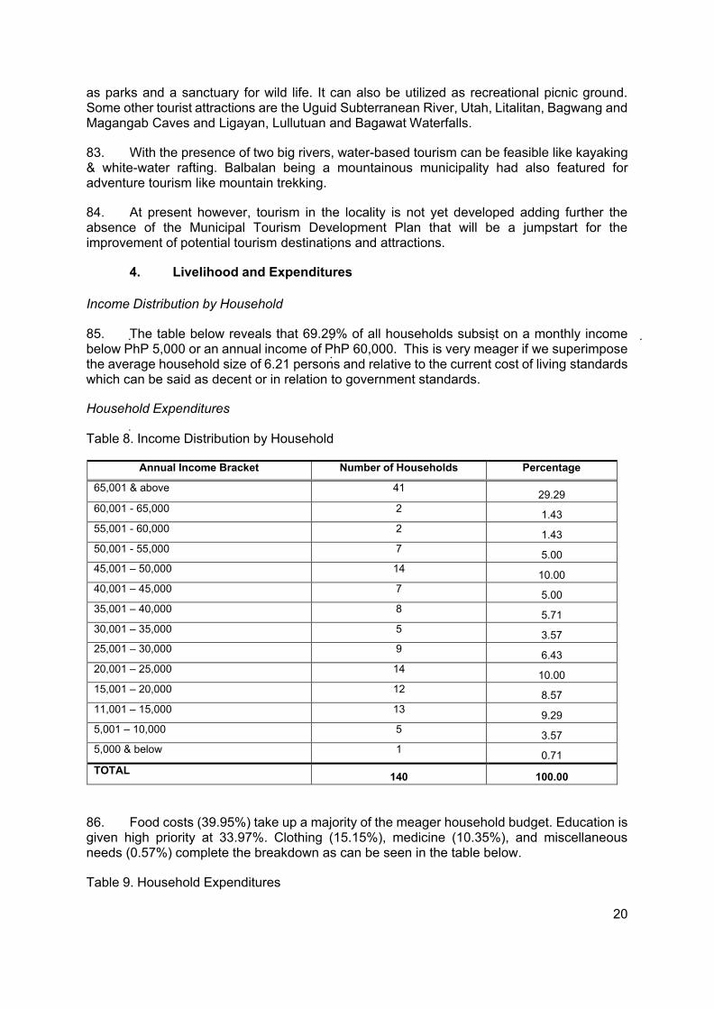
4. The total cost of the subproject is Eight Million Pesos (PhP 8, 000,000.00). Following the agreed financing mix of the subproject, 88% of the total Subproject Cost will be covered by the Project (INREMP) equivalent to PhP 7,040,000.00 and the remaining 12% or PhP 960,000.00 will be borne by LGU Balbalan as cash equity counterpart.
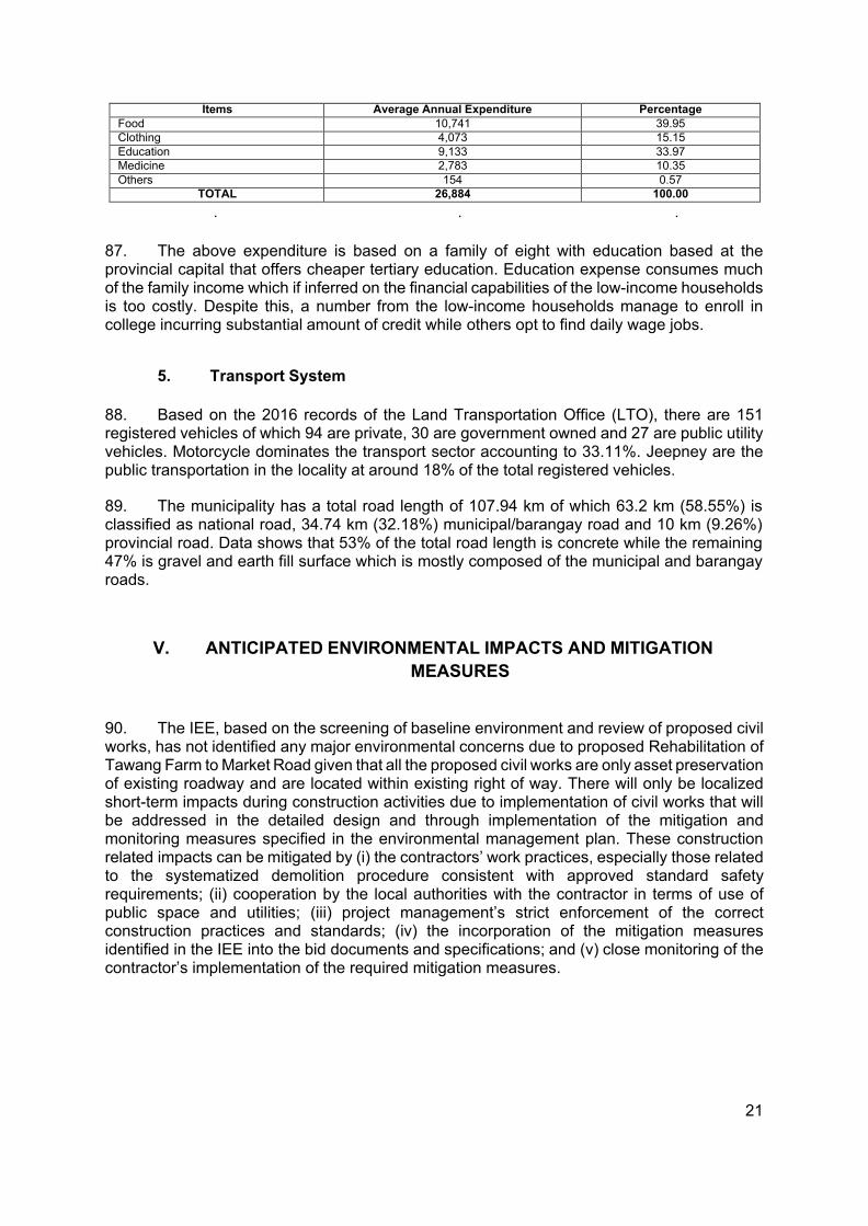
5. Major land use along the road rehabilitation project is agriculture. None of the sub- project roads are located near or within ecologically sensitive areas.
6. The IEE, based on the screening of baseline environment and review of proposed civil works, has not identified any major environmental concerns considering that all the proposed civil works are only asset preservation of existing roadway and are located within existing right of way. There will only be localized short term impacts during construction activities due to implementation of civil works that will be addressed in the detailed design and through implementation of the mitigation and monitoring measures specified in the environmental management plan.
7. The IEE process included stakeholder participation and consultation to help LGUs achieve public acceptance of the Sub-project. A public consultation at Barangay Tawang confirmed that the rehabilitation of the Tawang farm to market road is essential for economic development.
8. A grievance redress mechanism shall be established by the LGU of Balbalan to ensure that complaints of affected persons and other stakeholders regarding the project’s environmental performance are promptly addressed.
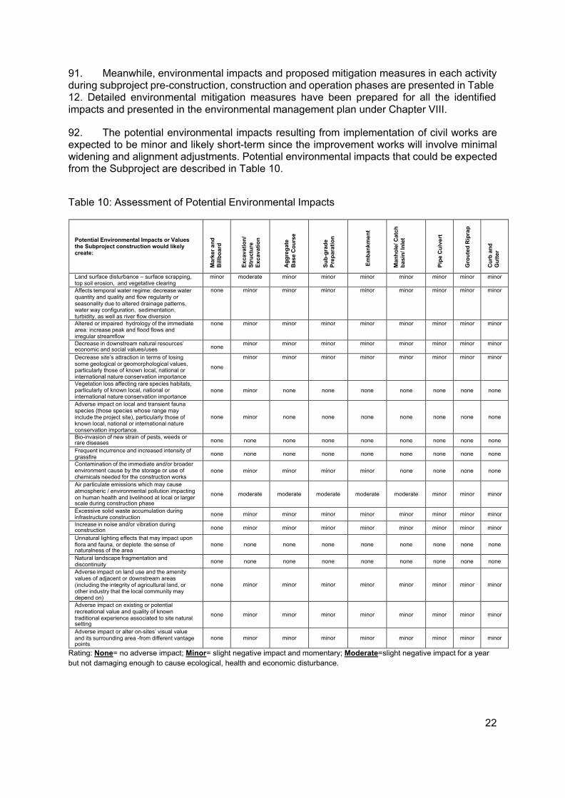
9. The IEE includes an environmental management plan which details the mitigation measures, environmental monitoring activities, institutional responsibilities, and environmental
2
management capacity building. The LGU through its Municipal Planning and Development Coordinator and the Municipal Engineer will ensure that relevant EMP provisions are included in the bid and contract documents for detailed design, project supervision and civil works. During construction, they will closely conduct monitoring the contractor’s environmental performance and over-all EMP implementation. Environmental monitoring reports will be submitted by LGU to ADB and such reports will be posted on ADB’s website for public disclosure.
10. The major positive impact of the project will be economic and better accessibility. The subproject will directly benefit people located in the barangay and its adjoining barangays of Buaya and Mabaca. Dust generation from the damaged roads will be reduced by the improvement of pavement. Health risk to the roadside communities and damage to the biological environment will be reduced due to pavement improvement and soil erosion control measures.
11. This Sub-project will have overall beneficial impact and will have minor negative impacts that will be carefully monitored and adequately mitigated through implementation of the EMP.
II. POLICY, LEGAL, AND ADMINISTRATIVE FRAMEWORK
Environmental Clearance Requirements
1. Government Environmental Laws, Regulations and Guidelines
12. According to the EMB Memorandum Circular 005 - 2014, the environmental category of a project is decided based on the type of the project (whether it falls into ‘Environmental Critical Project’, ECP type), location of the project (whether it falls into ‘Environmental Critical Areas’, ECA category), and size of the project. A summary list of ECPs and ECA categories are presented in Table 1.
Table 1: Summary List of ECP Types and ECA Categories
A. List of ECPs
As declared by Proclamation No. 2146 (1981)
1.
Heavy Industries – Non-ferrous Metal Industries, Iron and Steel Mills, Petroleum and Petro-chemical Industries including Oil and Gas, Smelting Plants
2.
Resource Extractive Industries – Major Mining and Quarrying Projects, Forestry Projects (logging, major wood processing projects, introduction of fauna (exotic animals) in public and private forests, forest occupancy, extraction of mangrove products, grazing), Fishery Projects (dikes for/ and fishpond development projects)
3.
Infrastructure Projects – Major Dams, Major Power Plants (fossil-fueled, nuclear fueled, hydroelectric or geothermal), Major Reclamation Projects, Major Roads and Bridges
As declared by Proclamation No. 803 (1996)
4. All golf course projects
3
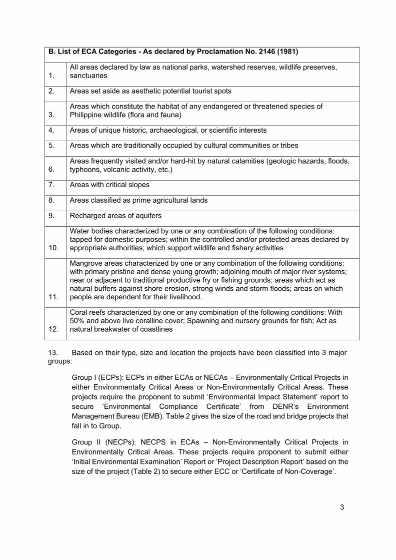
B. List of ECA Categories - As declared by Proclamation No. 2146 (1981)
1.
All areas declared by law as national parks, watershed reserves, wildlife preserves, sanctuaries
2. Areas set aside as aesthetic potential tourist spots
3.
Areas which constitute the habitat of any endangered or threatened species of Philippine wildlife (flora and fauna)
4. Areas of unique historic, archaeological, or scientific interests
5. Areas which are traditionally occupied by cultural communities or tribes
6.
Areas frequently visited and/or hard-hit by natural calamities (geologic hazards, floods, typhoons, volcanic activity, etc.)
7. Areas with critical slopes
8. Areas classified as prime agricultural lands
9. Recharged areas of aquifers
10.
Water bodies characterized by one or any combination of the following conditions: tapped for domestic purposes; within the controlled and/or protected areas declared by appropriate authorities; which support wildlife and fishery activities
11.
Mangrove areas characterized by one or any combination of the following conditions: with primary pristine and dense young growth; adjoining mouth of major river systems; near or adjacent to traditional productive fry or fishing grounds; areas which act as natural buffers against shore erosion, strong winds and storm floods; areas on which people are dependent for their livelihood.
12.
Coral reefs characterized by one or any combination of the following conditions: With 50% and above live coralline cover; Spawning and nursery grounds for fish; Act as natural breakwater of coastlines
13. Based on their type, size and location the projects have been classified into 3 major groups:
Group I (ECPs): ECPs in either ECAs or NECAs – Environmentally Critical Projects in either Environmentally Critical Areas or Non-Environmentally Critical Areas. These projects require the proponent to submit ‘Environmental Impact Statement’ report to secure ‘Environmental Compliance Certificate’ from DENR’s Environment Management Bureau (EMB). Table 2 gives the size of the road and bridge projects that fall in to Group.
Group II (NECPs): NECPS in ECAs – Non-Environmentally Critical Projects in Environmentally Critical Areas. These projects require proponent to submit either ‘Initial Environmental Examination’ Report or ‘Project Description Report’ based on the size of the project (Table 2) to secure either ECC or ‘Certificate of Non-Coverage’.
4
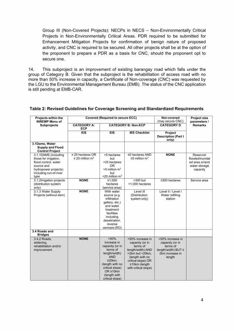
Group III (Non-Covered Projects): NECPs in NECS – Non-Environmentally Critical Projects in Non-Environmentally Critical Areas. PDR required to be submitted for Enhancement Mitigation Projects for confirmation of benign nature of proposed activity, and CNC is required to be secured. All other projects shall be at the option of the proponent to prepare a PDR as a basis for CNC, should the proponent opt to secure one.
14. This subproject is an improvement of existing barangay road which falls under the group of Category B. Given that the subproject is the rehabilitation of access road with no more than 50% increase in capacity, a Certificate of Non-coverage (CNC) was requested by the LGU to the Environmental Management Bureau (EMB). The status of the CNC application is still pending at EMB-CAR.
Table 2: Revised Guidelines for Coverage Screening and Standardized Requirements
Projects within the INREMP Menu of
Subprojects
Covered (Required to secure ECC) Not covered (may secure CNC)
Project size parameters /
Remarks CATEGORY A: ECP
CATEGORY B: Non-ECP CATEGORY D
EIS EIS IEE Checklist Project Description (Part I
only) 3.1Dams, Water
Supply and Flood Control Project
3.1.1DAMS (including those for irrigation, flood control, water source and hydropower projects) including run-of-river type
≥ 25 hectares OR ≥ 20 million m3
>5 hectares but
<25 hectares OR
>5 million m3 but
<20 million m3
≤5 hectares AND ≤5 million m3
NONE Reservoir flooded/inundat ed area or/and water storage
capacity
3.1.2Irrigation projects (distribution system only)
NONE ≥1,000 hectares
(service area)
>300 but <1,000 hectares
≤300 hectares Service area
3.1.3 Water Supply Projects (without dam)
NONE With water source (e.g. infiltration
gallery, etc.) and water treatment facilities including
desalination, reverse
osmosis (RO)
Level III (Distribution system only)
Level II / Level I Water refilling
station
3.4 Roads and Bridges
3.4.2 Roads, widening, rehabilitation and/or improvement
NONE >50% increase in
capacity (or in terms of
length/width) AND
≥20km, (length with no critical slope) OR ≥10km (length with
critical slope)
>50% increase in capacity (or in
terms of length/width) AND >2km but <20km,
(length with no critical slope) OR
≥10km (length with critical slope)
>50% increase in capacity (or in
terms of length/width) BUT ≤
2km increase in length
5
Projects within the INREMP Menu of
Subprojects
Covered (Required to secure ECC) Not covered (may secure CNC)
Project size parameters /
Remarks CATEGORY A: ECP
CATEGORY B: Non-ECP CATEGORY D
EIS EIS IEE Checklist Project Description (Part I
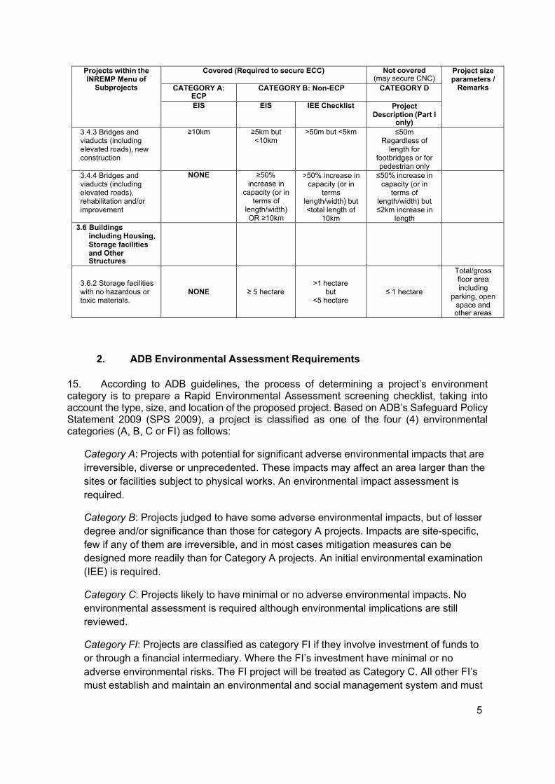
only) 3.4.3 Bridges and viaducts (including elevated roads), new construction
≥10km ≥5km but <10km
>50m but <5km ≤50m Regardless of
length for footbridges or for pedestrian only
3.4.4 Bridges and viaducts (including elevated roads), rehabilitation and/or improvement
NONE ≥50% increase in
capacity (or in terms of
length/width) OR ≥10km
>50% increase in capacity (or in
terms length/width) but <total length of
10km
≤50% increase in capacity (or in
terms of length/width) but ≤2km increase in
length
3.6 Buildings including Housing, Storage facilities and Other Structures
3.6.2 Storage facilities with no hazardous or toxic materials.
NONE
≥ 5 hectare
>1 hectare
but <5 hectare
≤ 1 hectare
Total/gross floor area including
parking, open space and other areas
2. ADB Environmental Assessment Requirements
15. According to ADB guidelines, the process of determining a project’s environment category is to prepare a Rapid Environmental Assessment screening checklist, taking into account the type, size, and location of the proposed project. Based on ADB’s Safeguard Policy Statement 2009 (SPS 2009), a project is classified as one of the four (4) environmental categories (A, B, C or FI) as follows:
Category A: Projects with potential for significant adverse environmental impacts that are irreversible, diverse or unprecedented. These impacts may affect an area larger than the sites or facilities subject to physical works. An environmental impact assessment is required.
Category B: Projects judged to have some adverse environmental impacts, but of lesser degree and/or significance than those for category A projects. Impacts are site-specific, few if any of them are irreversible, and in most cases mitigation measures can be designed more readily than for Category A projects. An initial environmental examination (IEE) is required.
Category C: Projects likely to have minimal or no adverse environmental impacts. No environmental assessment is required although environmental implications are still reviewed.
Category FI: Projects are classified as category FI if they involve investment of funds to or through a financial intermediary. Where the FI’s investment have minimal or no adverse environmental risks. The FI project will be treated as Category C. All other FI’s must establish and maintain an environmental and social management system and must
6
comply with the environmental safeguard requirements specified in SPS 2009 if the FI’s subprojects have the potential for significant adverse environmental impacts.
16. According to Philippines environmental guidelines, the Project or Subproject can be considered as either under Group II or III while ADB has categorized the Project as environment Category B. Hence, this IEE has been prepared to meet the requirements of both the ADB and the government. Upon ADB’s receipt of the final IEE from the proponent, this will be publicly disclosed through posting on ADB’s website.
III. DESCRIPTION OF THE PROJECT
Overview
17. The general objective of the proposed Rehabilitation of Tawang Farm to Market Road is to uplift the economic condition of the community through the provision of all-year-round safe access. Specifically, it aims to increase productivity and profit, decrease farm expenses on hauling works, hasten delivery of agricultural products to market outlets, enable timely transport of farm inputs to production areas, reduce vehicle operating cost and maintenance cost after project implementation and maximize agricultural potential of the production area after road rehabilitation.
18. To ensure accessibility of communities of basic social services delivery, repair and maintenance of roads, spillways and drainage systems are among the infrastructure concerns identified by the community for funding assistance.
Project Location
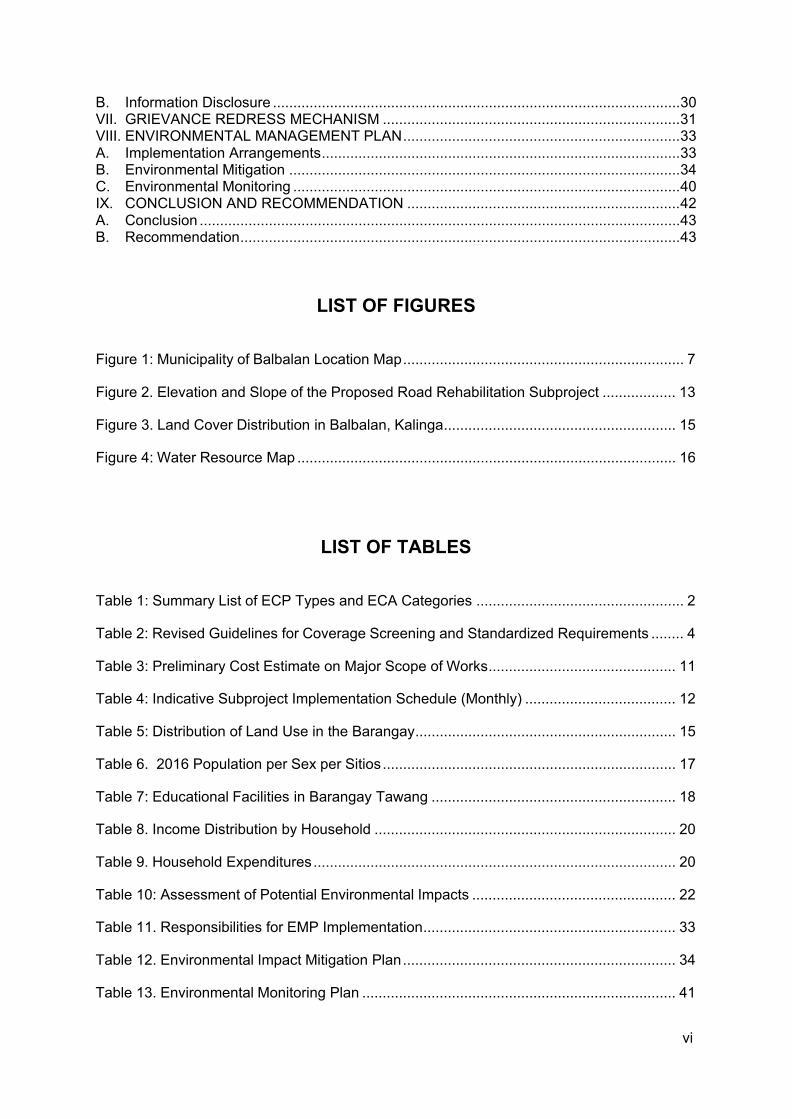
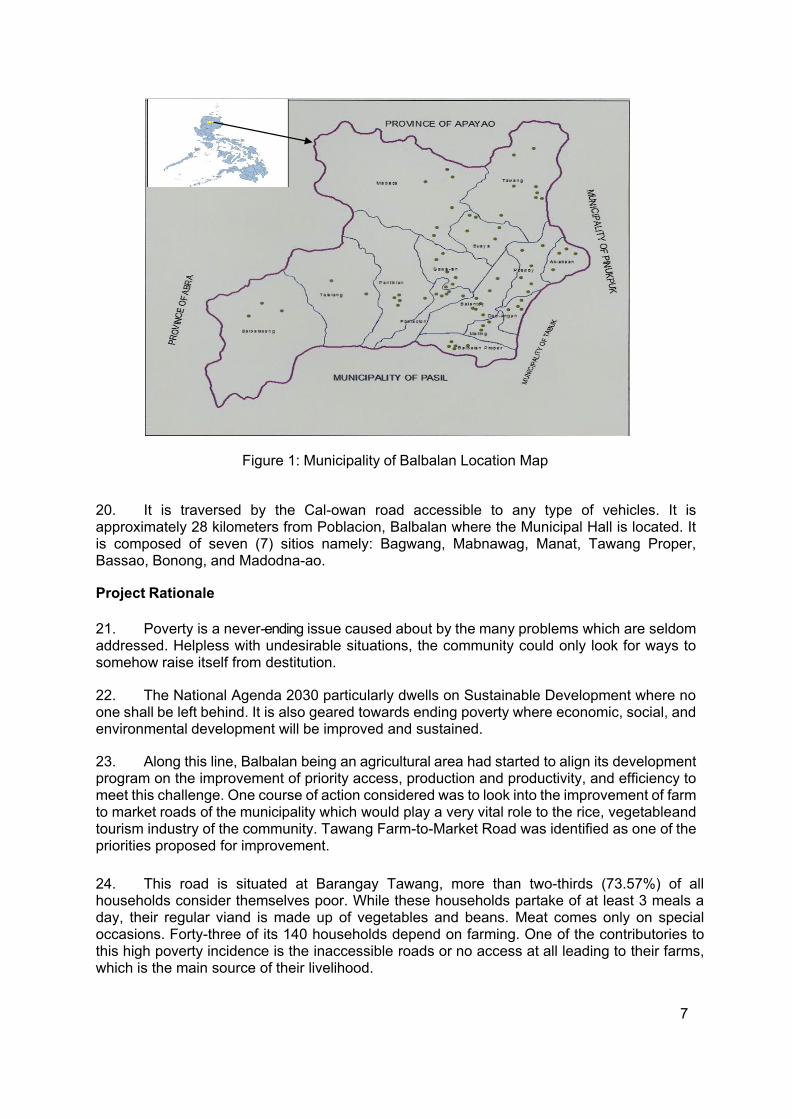
19. The project is located at Barangay Tawang, Balbalan, Kalinga. The said barangay is one of the 14 barangays of Balbalan municipality. It has a total land area of 7,490 hectares classified into forest land, agricultural land, and residential land. Barangay Tawang is situated on the north eastern part of the municipality. It is bounded on the North by Conner Municipality, Apayao; on the west by barangay Buaya; on the northeast by Conner Municipality; on the southeast by Pinukpuk Municipality; and, on the south by barangays Poswoy and Ab-abaan. (Figure 1).
7
Figure 1: Municipality of Balbalan Location Map
20. It is traversed by the Cal-owan road accessible to any type of vehicles. It is approximately 28 kilometers from Poblacion, Balbalan where the Municipal Hall is located. It is composed of seven (7) sitios namely: Bagwang, Mabnawag, Manat, Tawang Proper, Bassao, Bonong, and Madodna-ao.
Project Rationale
21. Poverty is a never-ending issue caused about by the many problems which are seldom addressed. Helpless with undesirable situations, the community could only look for ways to somehow raise itself from destitution.
22. The National Agenda 2030 particularly dwells on Sustainable Development where no one shall be left behind. It is also geared towards ending poverty where economic, social, and environmental development will be improved and sustained.
23. Along this line, Balbalan being an agricultural area had started to align its development program on the improvement of priority access, production and productivity, and efficiency to meet this challenge. One course of action considered was to look into the improvement of farm to market roads of the municipality which would play a very vital role to the rice, vegetable and tourism industry of the community. Tawang Farm-to-Market Road was identified as one of the priorities proposed for improvement.
24. This road is situated at Barangay Tawang, more than two-thirds (73.57%) of all households consider themselves poor. While these households partake of at least 3 meals a day, their regular viand is made up of vegetables and beans. Meat comes only on special occasions. Forty-three of its 140 households depend on farming. One of the contributories to this high poverty incidence is the inaccessible roads or no access at all leading to their farms, which is the main source of their livelihood.
8
25. Despite the absence of safe and reliable road, the barangay remains to be one among the rice and vegetable producers in the municipality. A substantial number of households (85.38%) produces rice. However, the production area for rice, as staple food, only takes up a small portion (35.76%) of the average household farm size of 0.74 hectare. Most of the household farm area is devoted to the production of fruits.
26. At present, the road condition of the Cal-owan FMR can be described as fair, good, poor and inaccessible in various sites. The main road starts at Barangay Wagod of Pinukpuk and traverses the Mabaca River of which bridge construction is on-going. The river is not passable by vehicles during rainy season, motorcycles are only the mode of transportation being ferried by manually operated bancas traversing the river. The proposed road is the feeder road going to Tawang Elementary School, less than a kilometer from Bagwang, Tawang which is the center of the barangay.
27. The influence area of the proposed road improvement covers 2,650 hectares of production area for rice, and potential area for vegetables and livestock raising which can be a real source of wealth to the farmers if maximized. Because of poor accessibility though, agricultural activity is limited. Manual hauling is done during harvest. Produce are brought by foot to the nearest paved road where these are loaded in trucks. In rice farming, rice grains that were not hauled during the rainy season and are left overnight could lead to possible germination if not attended the following day. Needless to say, said access road play important roles in the quality of the harvest and the livelihood of the community.
28. This subproject proposal then focuses in improving the economic condition of affected farmers at the same time targets to maximize the use of the rest of the production area in addition to the benefits it will provide to students, senior citizens, women and children, and to the community as a whole.
29. Aiming to maximize the agricultural potential of the area, the community clamours for the rehabilitation of this farm to market road. This is the only economic potential which is foreseen to end their poverty and advance for a better or best quality of life, hence this proposal.
Project Development Plan
1. Project Components
30. The proposed subproject is the Rehabilitation of Tawang Farm-to-Market Road. It has a total length of 1.6 km with a design width of 3.10 m of Portland Concrete Cement Pavement (PCCP) with a thickness of 200 mm. The route will start in Junction Ganga, Bonong at station 0+000 at the area of the load platform and it will end at Elementary School junction.
31. There will be a minimal road widening in the proposed subproject improvement at stations 0+740 to 0+750. Nonetheless, a portion of the right of way of the proposed subproject located in Sitio Bonong will affect a minimal section of lands of four (4) claimants. These affected persons have already been waived their rights to any claims and/or compensations.
32. Construction works and specification of materials shall comply with engineering and construction standards set-forth by the Department of Public Works and Highways (DPWH).
9
Materials as quantified and estimated (cost) are assumed to be available in the locality. Prevailing market price is used to achieve the approved agency estimate which subsequently will be used as basis for the anticipated evaluation of bids, since the construction of the subproject will be through national competitive bidding (NCB).
33. Specified hereunder are the items of works, to wit:
Marker and Billboard. Fabrication and installation of project billboard shall be strictly complied prior to start of project, and a permanent market after completion of the project.
Roadway Excavation. This item shall consist of roadway excavation and the disposal of materials in accordance with the specification and in conformity with the line, grades and dimensions shown on the plans or established by the Engineer.
Roadway excavation will include excavation and grading for roadways, parking areas, intersections, approaches, slope rounding, benching, waterways and ditches; removal of unsuitable material from the roadbed and beneath embankment areas; and excavating selected material found in the roadway as ordered by the Engineer for specific use in the improvement. Roadway excavation will be classified as “unclassified excavation”, “rock excavation”, “common excavation”, or “muck excavation”.
All suitable material removed from the excavation shall be used in the formation of the embankment, subgrade, shoulders, slopes, bedding and backfill for structures and for other purposes shown on the plans or as directed.
Only approved materials shall be used in the construction of embankments and backfills. Material encountered in the excavation and determined by the Engineer as suitable for topping, road finishing, slope protection, or other purposes shall be conserved and utilized as directed by the Engineer. All materials excavated from side ditches and gutters, channel changes, irrigation ditches, inlet and outlet ditches, doe ditches, furrow ditches, and such other ditches as may be designed on the plans or staked by the Engineer.
Sub-grade Preparation. Sub-grade preparation shall be fully accomplished as to compaction, line and grade. Sub-grade preparation shall be extended to full width of the roadway.
Aggregate Base Coarse. Spreading of aggregate base coarse shall be made with conformity with the thickness and width as indicated on plan. Oversize materials, if present, shall be removed at the pit or stockpiled. To obtain uniformity, additional filler shall be blended by mixing on the roadway. Immediately following the final spreading and smoothening, each layer shall be compacted to full width.
Portland Cement Concrete Pavement. Concrete mixture shall be class ‘A’, 1:2:3 with a compressive strength of 3500 psi.l @ 28 days curing period. Provide 6mm x 75 mm hot asphalt filler on every expansion and construction joint. Expansion joints shall be spaced at every 4.50 m span. Concrete cutting for the construction joints and expansion joints shall be done twenty-four (24) hours after concrete pouring.
Forms shall be formed in contact with the foundation and shall not deviate from the true line by more than one cm at any point. Forms shall remain in place undisturbed
10
for not less than 24 hours after concrete pouring. Application of ‘permit to pour’ form the implementing agency shall be complied before pouring. Payment for pavement with deficient thickness and strength shall be based on DPWH standard and specifications.
Pipe Culvert, 910 mm diameter (36”). All reinforced concrete pipe culverts shall be 910 mm diameter and of good quality and free from any defects and imperfections.
Grouted Riprap. Stone boulders and aggregates must be hard, durable, free form dirt and other foreign materials that are injurious to concrete. Stone weight must be ranging from 15-25 kilograms with at least 50% of the stones weighing more than 20 kilograms.
Provide 4” diameter PVC weepholes at 1.00 m O.C. Mortar mixture shall be one part of cement to three parts sand.
Embankment. Embankment/ fill shall be placed and thoroughly compacted at every 0.30 height.
2. Description of the Project Phases
a. Pre-Construction Phase/Pre-Development Phase
34. The pre-construction phase involves the social preparation (to include organizational strengthening, planning, identification and prioritization of community needs) of the community for the entry of the project to the site, conduct of pre-engineering activities covering detailed survey works to determine alignment of roads and canal systems, preparation of the detailed engineering plans and programs of work, ROW negotiation, recruitment of work force and initial sourcing and procurement of construction materials. These activities will be conducted by the proponent technical staff, partner line agencies, NGO service providers, community beneficiaries especially the Peoples’ organizations and contractors.
b. Construction/Development Phase
35. The construction phase involves the mobilization of construction equipment, construction workers and materials to the specific project site after which the longer period of actual construction work will commence. The construction phase will end with the demobilization of construction equipment, workers and other construction paraphernalia from the construction site. Majority of these activities will be undertaken by the contractor and community residents under the close supervision of the Subproject Management Unit.
c. Operation Phase and Maintenance Phase
36. This phase involves the actual maintenance of the rehabilitated access road during its expected economic life. Monitoring tools and parameters will be set forth in the MOA that the LGU and DA will sign to ensure sustainability of the constructed facility. The specific monitoring items and parameters, location and frequency, monitoring responsibilities and sources of budget are presented in the EIAMMP.
11
d. Abandonment Phase
37. This phase is included in the project demobilization. The proponent does not intend to abandon any facilities and unserviceable equipment used during construction. The project location will not be abandoned in disorderly condition but instead restored for functional use. Following the completion of the construction, the proponent will dismantle temporary shelters and the construction yard including unserviceable vehicles and equipment.
38. Wastes arising from the abandonment are expected to be minimal. These wastes could include small volumes of left-over sand and gravel, re-bars and other steel materials (i.e., nails and welding roads) and lumber.
Manpower Requirements
39. Construction activities will require hiring of skilled and unskilled manpower. It is assumed that some skilled, semi-skilled and unskilled manpower will be available in the area. Skilled manpower not available in the locality may be sourced from other nearby localities. Technical manpower will be a complementation of specialists to be provided by locally known engineering firms.
40. During the construction phase, a workforce consisting of contractual and regular laborers will be employed to carry out the construction of the proposed project.
41. The Contractor shall employ qualified and sufficient staff to carry out inspections, testing and monitoring for the project.
Project Cost
42. The subproject cost as estimated has the total amount of PhP 8,000,000.00 which includes the costs for the indirect cost and taxes aside from the direct cost (composed of material labor + equipment). Said Direct Cost has an amount of PhP7,999,575.21. The OCM (Overhead, Contingencies and Miscellaneous) and Contractor’s Profit will be 12% and 8% of the direct cost, respectively. Taxes will be in the fixed ratio of 5% as required by the national government. Details of the preliminary cost estimate of the subproject are shown in Table 3.
43. Following the agreed financing mix of the subproject, 88% of the total Subproject Cost as presented will be covered by the Project (INREMP) equivalent to PhP 7,040,000.00 and the remaining 12% will be borne by LGU Balbalan as cash equity counterpart. The amount of equity counterpart based from the presented subproject cost above is PhP 960,000.00.
Table 3: Preliminary Cost Estimate on Major Scope of Works
Description Unit Qty Unit Cost Amount
1 General Requirements cu m 1.00 32,951.22 32,951.22 100 Clearing and Grubbing sq m 6,400.00 5.97 38, 179.01 102(a)
Roadway Excavation (unclassified)
cu m 80.00
118.77
9,501.66
102(b)
Roadway Excavation (solid rock)
cu m 50.00
724.10
36,204.84
104
Embankment ( mixed gravel and sand)
cu m 320.00
761.93
243,817.56
12
Description Unit Qty Unit Cost Amount 105
Subgrade Preparation ( common material)
l m
6,560.00
17.11
112,225.86
200
Aggregate Sub-base Course
cu m
984.00
827.13
813,895.88
311
Portland Cement Concrete Pavement
sq m
4,925.00
1,327.00
6,535,499.41
500
Pipe culverts, 910mm dia. (36”dia.)
cu m
15.00
8,508.40
127,626.07
504 Grouted Riprap cu m 11.31 4,392.01 49,673,69 Subproject Cost 7,999,575.20
Project Duration and Schedule
44. After the conduct of technical assistance to partner LGUs in November 2017, the LGU- SPMU started the preparation and completion of the SPD. The completed SPD will be submitted to DA-INREMP and CESM for review and concurrence. When found substantial, it will be endorsed to the ADB for the request of NOL. During these stages, the DED is simultaneously being prepared by the LGU Engineering Unit and is expected to be final and complete on or before the time of the ADB NOL. The DED shall then be translated into a Bidding Document once the SPD is approved.
45. Procurement period may start on February 2019 and shall take 10 to 12 weeks to comply with the ADB Procurement Guidelines, thus the Subproject is expected to be awarded within the month of April 2019. Construction will start on May 2019 and will take 110 calendar days. After the completion of construction works, the LGU will prepare the completion documents before the year ends and the turn-over ceremonies shall also take place at the same time. Other details are shown in Table 4.
Table 4: Indicative Subproject Implementation Schedule (Monthly)
Subproject Activities
2017 2018 2019 N o v
D e c
J a n
F e b
M a r
A p r
M a y
J u n
J u l
A u g
S e p
O c t
N o v
D e c
J a n
F e b
M a r
A p r
M a y
J u n
J u l
A u g
S e p
O c t
N o v
D e c
SPD Preparation SPD Review and Finalization
SPD Review and Approval
DED Preparation Procurement Stage Construction Stage Completion and Turn-over
O&M Activity
13
IV. DESCRIPTION OF THE ENVIRONMENT
Elevation and Slope
46. Barangay Tawang lies on rugged mountainous region at an estimated altitude/elevation range of 300 to 1000 meters above sea level. Physically parting it in the center is the Mabaca (Cal-owan) River as it flows downwards to Buaya before leaving the Balbalan municipality premises for Aciga, Pinukpuk municipality. The barangay has an elevation of 108 m asl at its lowest part while 309 m asl at its highest point.
47. However, the elevation of the proposed road rehabilitation alignment ranges from 108 m asl to 305 m asl with an average slope of 9.3%. Further details are shown in Figure 2.
Figure 2. Elevation and Slope of the Proposed Road Rehabilitation Subproject
Climate
48. The climate in barangay Tawang is Type III as categorized by the weather agency. The climate is relatively warm. It has two pronounced seasons: the wet season and dry season. Dry season starts from January to June while wet season starts from July to December. The coldest months are November and December, while the warmest months are March, April, and May. Typhoons occur during the months or period from July to November.
14
Soils
49. The soil type in the barangay is partly clay, clay loam, sandy loam for areas located along the river, and unclassified mountain soil for steep and unexplored areas. Observations proved that the soil is suitable to many varieties of agricultural crops, especially high value commercial crops like cabbage, Baguio beans, carrots, and Legumes and fruit trees like Arabica coffee and citrus.
50. The forested area is made up of tree species which have a rooting depth of 3.7 meters and a moderate to rapid water holding capacity. Rooting depth for crop is from 50 – 60 cm.
Land Use
51. Barangay Tawang lies on rugged mountainous region at an estimated altitude/elevation range of 300 to 1000 meters above sea level. It has a total land area of 7,490 hectares. Forest land has the biggest share with an area of 3,365 ha or 45% followed by the agricultural land with an area of 2,650 ha or 35%. The barangay’s vegetation is lush due to pristine forests which are classified as tropical montane rainforest. Major agricultural crops are native rice, coffee, banana, coconut, root crops and legumes.
52. The land use for Barangay Tawang can be seen in the table below. Residential use (5.47%) pertains to areas where the cluster of dwellings which comprise the village is located. The residential areas are relatively of flat terrain Clustering of houses is made imperative by security reasons and this explains why only a small area of barangay land is used for the purpose. It must be noted that no houses present within the 5-10 meters range on both sides of the proposed road improvement. The location is an open area and road will not traverse any structures. There are also no trees, crops and other assets encroachment at the easement and right of way. The proposed road subproject mostly passes through an agricultural land and woodland. There will be no agricultural or forest crops to be affected. Common species seen along the ROW are grasses and shrubs such as cogon, hagonoy, gumamela, lantana, and others.
53. In particular, the forest (44.93%) pertains to areas inclusive of mountain ranges, ridges, and wood lots which provide the village with forest products and, are, therefore basically of lush vegetation. However, within the barangay’s forest are production areas: the swidden farms (uma) for kaingin production where farmers grow cash crops such as legumes, upland rice, vegetables, and root crops; the woodlot and watershed source catchment area.
54. The agricultural area (35.38%) pertains to manually-constructed rice paddies along the mountain sides, exclusive of swidden farms (uma), where irrigated crops grow such as upland rice, legumes, and vegetables.
55. The grassland area (2.40%) pertains to open/denuded areas of either rolling or gentle slopes suitable for grazing of animals where grass grows in abundance.
56. Water bodies (7.14%) pertain to rivers, streams and creeks or those usedas source of freshwater fish and irrigation.
15
Table 5: Distribution of Land Use in the Barangay
Type of Land Use Approximate Area (in ha.) Percentage Forest 3,365 44.93 Pasture land 350 4.67 Grass land 180 2.40 Agricultural area 2,650 35.38 Residential area 410 5.47 Water bodies 535 7.14 TOTAL 7,490 100.00
Figure 3. Land Use Distribution in Balbalan, Kalinga
Hydrology
57. The proposed road access rehabilitation subproject is within the Saltan Watershed. As mentioned in the report of DENR INREMP characterization research, the Saltan watershed management unit is one of the tributaries of the Upper Chico River I. it is the biggest unit among the eight watershed within the Upper Chico river basin which occupying about 17.55% of the URB total area. Being the biggest management unit, Saltan watershed has many tributaries that supply the water needs of its low land farms and the nearby watershed. It is potential for micro-hydro that supplies electric power to some part of the area particularly in the municipality of Balbalan.
58. In particular, the proposed road improvement will traverse along the main Mabaca River ranging a distance of 50 - 900 meters. The river is generally used as a source of water for agricultural production and household consumption, and recreational purposes.
16
Water Sources
59. As shown in Figure 4, the municipality has major river systems namely: Cal-owan River and Saltan River. These rivers are being supplied by different tributaries such as creeks and brooks. Barangay Tawang is one of the tributaries of these major rivers. The Barangay Tawang watershed areas are the mountains of Balanao, Canadsiyan, Dana, Calagtanan, Mabanbaniit, Magsakan, Manat, Manmanok, Ao-ao, Laokun, and Malasayog where mountain springs emanate to provide water for potable and irrigation use of the barangay.
60. The water sources of Barangay Buaya are Bakakao brook, Lubo brook, Dalesan brook, Manat brook, and Maanus brook.
Figure 4: Water Resource Map
Mining
61. There are no existing mining activities in the barangay. In fact, in September, 2005, Kalinga’s Tawang tribe withdrew its decision allowing the Cordillera Exploration Co., Inc. (CEXCI) to explore 8,000 hectares covering Barangay Tawang. The CEXCI filed for a two- year renewable Exploration Permit Application (EXPA) with the office of the Department of Environment and Natural Resources - Mines and Geosciences Bureau (DENR-MGB).
17
Flora and Fauna Diversity
62. The proposed subproject falls within the Saltan Watershed. The watershed used to have a diverse population of flora and fauna. Several terrestrial vertebrate species were known to thrive in the watershed but many are threatened to extinction because of uncontrolled hunting, conversion of wildlife habitat to agricultural purposes and frequent forest fires in the pine forest. The uncontrolled hunting is best exemplified by the air rifles usually carried by farmers and workers alike when they go to the work place.
63. DA-INREMP, DENR-INREMP and its consultants have evaluated that there are no trees at the easement and right of way, and no endangered and critically endangered species of flora and fauna within the proposed road rehabilitation project during the field validation in May 2018 (Appendix 2). However, there will only be a small portion of the crops that may be affected due to a minor land encroachment along the right of way of the proposed rehabilitation of the access road.
64. Mountains of Barangay Tawang are covered with thick forests with different species of trees, shrub and grasses, ornamental wild orchids, and species of trees grounded are considered as hard wood. The tree species are Narra, Yakal, Palayon, Buog, Sagat, White Lawan, and Red Lawan. Grasses found therein are Bamboo, Wild bamboo, and Bugao. Tiger grass also is found between trees and steep portions of the forest.
65. The common fauna include the Philippine brown deer or ugsa, wild (warty) pig, motit (civet), wild chicken, fox, lizard, horn bill, Serpent Cresent Eagle, Philippine owl, and other species.
Socio-Economic Conditions
1. Demographic Characteristics
66. Based on data gathered, Barangay Tawang has a total population of 870 spread among 140 households in 7 sitios. This population exhibited an increasing pattern: 831 in 2014, 870 in 2016, and 870 as at survey date. This trend shows a population growth rate of [(870-831)/831/3 years] or 1.56%. Population density is at 11.62 persons per square kilometer. The male to female ratio is at 1.01:1. The average household size is 6.21.
67. Of the total population which is 870 for 2016, 438 are males while 432 are females. Likewise, it is composed of 140 households. This total population are distributed in the 7 sitios earlier mentioned. Hereunder is the breakdown of 2016 population per sitio (Table 7).
Table 6. 2016 Population per Sex per Sitios
Sitio No. of HH Percentage Population Percentage Bagwang 43 30.71 277 31.88 Mabnawag 17 12.14 117 13.46 Manat 3 2.14 19 2.19 Tawang Proper 12 8.57 68 7.83 Bassao 30 21.43 169 19.45 Bonong 21 15.00 138 15.88 Madodna-oa 14 10.00 81 9.32
TOTAL 140 100.00 869 100.00 Source: 2016 BHS
18
68. With regard to tribe affiliation, Majority (82.14%) of the barangay population is composed of the ethno-linguistic Buaya sub-tribe of the ethnic Kalinga. The minority in the populace are Tagalog (3.57%), Ilocano (10.71%), and Caggui (3.57%). Entry of other ethnic groups is due to intermarriage.
2. Basic Social Services
Health Services
69. Health and sanitation are widely implemented in the municipality. The LGU has a yearly program on the implementation of cleanest and greenest barangay. The LGU is also providing toilet bowls as assistance to the indigenous families who have no toilets. In terms of garbage disposal, each barangay has a Material Recovery Facility (MRF) for recyclable materials. Furthermore, households dispose their biodegradable waste in compost pits and practice burning. Food and agricultural waste are used as feed ration for their pigs.
70. The Municipality has one government District Hospital with 25 bed capacity, 1 Main Health Center and 17 Barangay Health Stations.
71. The district hospital and main health center are all located at barangay Poblacion, the seat of the municipal government. All barangays have barangay health stations that are manned by Rural Health Midwives. Three barangays however have satellite barangay health stations, these are barangays Balbalasang, Gawa-an and Buaya.
Water
72. The main source of water that caters to the needs of the populace is from springs that are piped to the households. As of 2015, there are 153 households with level I, 1,348 households with level II and 769 households with level III totalling to 2,270 households. At present, common problem is the insufficient water supply to some barangays due to decreased water source and damaged water works hence, most water systems need rehabilitation.
Education
73. The municipality has 14 elementary schools, 9 primary schools, 6 community schools, 5 Secondary schools & 30 Day Care Centers respectively. All elementary level schools are public while in the secondary level 3 are public and 2 are private. For school year 2016-2017, elementary and secondary enrolment was 1,966 and 1,033 respectively (SEP 2016).
74. The barangay has only elementary educational facilities through 3 public schools in as many sitios as can be seen in the table below.
Table 7: Educational Facilities in Barangay Tawang
Educational Facility Offering Location Tawang Elementary School Grade I – VI Sito Bagwang Bassao Primary School Grade I – IV Sitio Bassao Bonong Community School Grade I – II Sitio Bonong
3. Economic Situation Agricultural Area, Agroforestry and Plantation Areas
19
75. Farming is the main source of income of the locality, some engage as self-employed and labor force participation. Table 3 below shows the utilization of agricultural land areas. Coffee, banana and citrus are the common crops planted in agroforestry areas and some are intercropped with vegetables. Diversified crops include different fruit bearing trees planted in certain areas.
76. In the Road Influence Area (RIA), farmers also rely on forest products such as rattan and bamboo to augment their farm income. These are made into basket and soft broom and sold to the urban barangays and at Tabuk City.
77. Rice production area in the municipality covers 841 hectares with an average yield of 3 MT/hectare. Most farmers practice two croppings per year for areas that have sufficient water supply. Some also limit their rice production in one cropping because of climate effects that causes low production. Rice production at present is however minimal because of lack of irrigation system to most areas. Based on available data, there are fifty existing Communal Irrigation System (CIS) in the municipality but most of themneed rehabilitation.
78. Aside from some backyards planted in the concept of agroforestry in the barangay, significant Agroforestry Plantation areas in the barangay are DENR NGP and INREMP Agroforestry Projects. Based on data gathered, there is a 10-hectare NGP Coffee/Fruit Tree plantation and a 13.5-hectare INREMP Agroforestry area. The MLGU is also assisting the farmers in fruit tree production as an additional income generating activity.
Fisheries
79. The communal/open area of Barangay Buaya is the following natural water bodies: Cal-owan River, Timud Brook, Bakakao Brook, Lubo Brook, Dalesan Creek, Proper Tawang Brook, and Manat Brooks. Tawang Barangay Officials impose a barangay ordinance prohibiting the use of an illegal fishing method in all natural bodies of water.The people of the Barangay usually use environmentally-safe methods of catching fish, such as mosquito nets, fishing nets, hooks, traps, improvised pointed rod with rubber and the salop method wherein villagers block the main waterway of a brook thus segregating it from the river. No households in Barangay Tawang operate fishponds.
Commerce and Industry
80. Almost all registered business in the municipality are sari-sari stores.Small form of industry is the small scale mining. The “minahang bayan” being located at barangay Talalang is being managed by the Banao Bodong Tribal Association (BBTA). Gold is being mined through tunneling. At present, there is no available data on how much gold the minahang bayan is producing annually. However, mining plays a vital role in the economic condition of the municipality which is secondary major source of income aside from farming.
81. Another form of small industry is the softbroom production which is identified in the market for its good quality compared to other softbroom products of the other municipalities of the province. However, its production is seasonal and mostly concentrated at barangays Poswoy, Buaya and Tawang. Products are being brought to Poblacion during municipal occasions and others are marketed at Tabuk City, the capital town of the province.
Tourism
82. The municipality of Balbalan has many potentials for tourist spots and attractions. Barangay Balbalasang can be considered an eco-tourism belt because this can be developed
20
as parks and a sanctuary for wild life. It can also be utilized as recreational picnic ground. Some other tourist attractions are the Uguid Subterranean River, Utah, Litalitan, Bagwang and Magangab Caves and Ligayan, Lullutuan and Bagawat Waterfalls.
83. With the presence of two big rivers, water-based tourism can be feasible like kayaking & white-water rafting. Balbalan being a mountainous municipality had also featured for adventure tourism like mountain trekking.
84. At present however, tourism in the locality is not yet developed adding further the absence of the Municipal Tourism Development Plan that will be a jumpstart for the improvement of potential tourism destinations and attractions.
4. Livelihood and Expenditures
Income Distribution by Household
85. The table below reveals that 69.29% of all households subsist on a monthly income below PhP 5,000 or an annual income of PhP 60,000. This is very meager if we superimpose the average household size of 6.21 persons and relative to the current cost of living standards which can be said as decent or in relation to government standards.
Household Expenditures
Table 8. Income Distribution by Household
Annual Income Bracket Number of Households Percentage
65,001 & above 41 29.29 60,001 - 65,000 2 1.43 55,001 - 60,000 2 1.43 50,001 - 55,000 7 5.00 45,001 – 50,000 14 10.00 40,001 – 45,000 7 5.00 35,001 – 40,000 8 5.71 30,001 – 35,000 5 3.57 25,001 – 30,000 9 6.43 20,001 – 25,000 14 10.00 15,001 – 20,000 12 8.57 11,001 – 15,000 13 9.29 5,001 – 10,000 5 3.57 5,000 & below 1 0.71 TOTAL 140 100.00
86. Food costs (39.95%) take up a majority of the meager household budget. Education is given high priority at 33.97%. Clothing (15.15%), medicine (10.35%), and miscellaneous needs (0.57%) complete the breakdown as can be seen in the table below.
Table 9. Household Expenditures
21
Items Average Annual Expenditure Percentage Food 10,741 39.95 Clothing 4,073 15.15 Education 9,133 33.97 Medicine 2,783 10.35 Others 154 0.57
TOTAL 26,884 100.00
87. The above expenditure is based on a family of eight with education based at the provincial capital that offers cheaper tertiary education. Education expense consumes much of the family income which if inferred on the financial capabilities of the low-income households is too costly. Despite this, a number from the low-income households manage to enroll in college incurring substantial amount of credit while others opt to find daily wage jobs.
5. Transport System
88. Based on the 2016 records of the Land Transportation Office (LTO), there are 151 registered vehicles of which 94 are private, 30 are government owned and 27 are public utility vehicles. Motorcycle dominates the transport sector accounting to 33.11%. Jeepney are the public transportation in the locality at around 18% of the total registered vehicles.
89. The municipality has a total road length of 107.94 km of which 63.2 km (58.55%) is classified as national road, 34.74 km (32.18%) municipal/barangay road and 10 km (9.26%) provincial road. Data shows that 53% of the total road length is concrete while the remaining 47% is gravel and earth fill surface which is mostly composed of the municipal and barangay roads.
V. ANTICIPATED ENVIRONMENTAL IMPACTS AND MITIGATION MEASURES
90. The IEE, based on the screening of baseline environment and review of proposed civil works, has not identified any major environmental concerns due to proposed Rehabilitation of Tawang Farm to Market Road given that all the proposed civil works are only asset preservation of existing roadway and are located within existing right of way. There will only be localized short-term impacts during construction activities due to implementation of civil works that will be addressed in the detailed design and through implementation of the mitigation and monitoring measures specified in the environmental management plan. These construction related impacts can be mitigated by (i) the contractors’ work practices, especially those related to the systematized demolition procedure consistent with approved standard safety requirements; (ii) cooperation by the local authorities with the contractor in terms of use of public space and utilities; (iii) project management’s strict enforcement of the correct construction practices and standards; (iv) the incorporation of the mitigation measures identified in the IEE into the bid documents and specifications; and (v) close monitoring of the contractor’s implementation of the required mitigation measures.
22
91. Meanwhile, environmental impacts and proposed mitigation measures in each activity during subproject pre-construction, construction and operation phases are presented in Table 12. Detailed environmental mitigation measures have been prepared for all the identified impacts and presented in the environmental management plan under Chapter VIII.
92. The potential environmental impacts resulting from implementation of civil works are expected to be minor and likely short-term since the improvement works will involve minimal widening and alignment adjustments. Potential environmental impacts that could be expected from the Subproject are described in Table 10.
Table 10: Assessment of Potential Environmental Impacts
Potential Environmental Impacts or Values the Subproject construction would likely create:
M
arke
r and
B
illbo
ard
Exca
vatio
n/
Stru
ctur
e Ex
cava
tion
A
ggre
gate
Ba
se C
ours
e
Su
b-gr
ade
Prep
arat
ion
Em
bank
men
t
M
anho
le/ C
atch
ba
sin/
Inle
t
Pipe
Cul
vert
Gro
uted
Rip
rap
Cu
rb a
nd
Gut
ter
Land surface disturbance – surface scrapping, top soil erosion, and vegetative clearing
minor moderate minor minor minor minor minor minor minor
Affects temporal water regime: decrease water quantity and quality and flow regularity or seasonality due to altered drainage patterns, water way configuration, sedimentation, turbidity, as well as river flow diversion
none minor minor minor minor minor minor minor minor
Altered or impaired hydrology of the immediate area: increase peak and flood flows and irregular streamflow
none minor minor minor minor minor minor minor minor
Decrease in downstream natural resources’ economic and social values/uses none minor minor minor minor minor minor minor minor
Decrease site’s attraction in terms of losing some geological or geomorphological values, particularly those of known local, national or international nature conservation importance
none
minor minor minor minor minor minor minor minor
Vegetation loss affecting rare species habitats, particularly of known local, national or international nature conservation importance
none
minor
none
none
none
none
none
none
none
Adverse impact on local and transient fauna species (those species whose range may include the project site), particularly those of known local, national or international nature conservation importance.
none
minor
none
none
none
none
none
none
none
Bio-invasion of new strain of pests, weeds or rare diseases none none none none none none none none none
Frequent incurrence and increased intensity of grassfire none none none none none none none none none
Contamination of the immediate and/or broader environment cause by the storage or use of chemicals needed for the construction works
none
minor
minor
minor
minor
none
none
none
none
Air particulate emissions which may cause atmospheric / environmental pollution impacting on human health and livelihood at local or larger scale during construction phase
none
moderate
moderate
moderate
moderate
moderate
minor
minor
minor
Excessive solid waste accumulation during infrastructure construction none minor minor minor minor minor minor minor minor
Increase in noise and/or vibration during construction none minor minor minor minor minor minor minor minor
Unnatural lighting effects that may impact upon flora and fauna, or deplete the sense of naturalness of the area
none
none
none
none
none
none
none
none
none
Natural landscape fragmentation and discontinuity none none none none none none none none none
Adverse impact on land use and the amenity values of adjacent or downstream areas (including the integrity of agricultural land, or other industry that the local community may depend on)
none
minor
minor
minor
minor
minor
minor
minor
minor
Adverse impact on existing or potential recreational value and quality of known traditional experience associated to site natural setting
none
minor
minor
minor
minor
minor
minor
minor
minor
Adverse impact or alter on-sites’ visual value and its surrounding area -from different vantage points
none
minor
minor
minor
minor
minor
minor
minor
minor
Rating: None= no adverse impact; Minor= slight negative impact and momentary; Moderate=slight negative impact for a year but not damaging enough to cause ecological, health and economic disturbance.
23
93. During operation, the project is expected to benefit the environment and socio- economic conditions of the subproject areas through increased delivery of agricultural products, increased tourism, improved access and economic development, reduced dust due to asset preservation, improved road safety due to installation of safety signs, and others.
94. Environmental impacts and proposed mitigation measures during subproject pre- construction, construction and operation phases are described under Chapter VIII. Detailed environmental mitigation measures have been prepared for all the identified impacts and presented in the environmental management plan.
Pre-Construction
1. Confirmation of no required resettlement, relocations, and compensation
95. This will be undertaken prior to the commencement of any civil works. The proponent shall conduct consultation meetings with directly affected barangays and concerned POs’, and information awareness campaign regarding subproject location.
2. Identification and prioritization of road section where concrete paving
will be done
96. Identification and prioritization of road sections will give information and participation of the community, particularly women and marginalized sectors. A subproject site validation will be facilitated to ensure that the INREMP validation process on subproject implementation is being complied with and hold consultative meetings with balanced representation of men and women and affected persons on the subproject components and management plan.
3. Preparation of detailed engineering designs and programs of work
97. The detailed engineering designs and programs of work for the subproject will be prepared by the LGU for the completion of the proposed upgraded access road. The detailed designs shall include the identification of spill management prevention and emergency response plans for all construction sites, locate aggregate borrow pits and rock supply areas away from human settlements with fencing and access barriers, and specific plan to notify and provide them schedule to minimize disruption to normal commercial and residential activities.
98. The LGU with assistance from TA-PMIC will ensure that relevant provisions of the EMP in terms of implementation of environmental mitigation measures, monitoring activities, supervision and reporting are included for civil works and construction supervision.
4. Recruitment of workers
99. The potential impact of the subproject will be hiring of skilled local workers and other unskilled jobs. A robust “local first” hiring policy will be designed and be implemented in coordination with local officials and community leaders especially at the barangay and municipal levels. The Contractor will be required to follow the “local first” hiring policy.
24
Construction
5. Construction materials acquisition, transport access, and storage system
100. The contractors will source construction materials under their own arrangements. Uncontrolled sourcing of such materials could lead to environmental impacts such as the loss of topsoil or the disfigurements of the landscape from borrow pits. Earthen embankments and material stockpiles will be susceptible to erosion, particularly during the rains and re- suspension of dust during the dry seasons.
101. Local roads will be damaged during transportation of borrow materials and by the construction equipment. These roads include those which are leading to the project site. In order to reduce impact on all borrow sites, contractors will water the local roads close to the settlements used by the borrow trucks. As much as possible, contractors will not make use of productive agricultural land. In case this is unavoidable, the contractor will obtain consent from the land owner and will restore the site to its original condition after completion of civil works.
6. Clearing and removal of obstructions
102. There are no trees to be removed from the area for the repair and rehabilitation of the Farm to Market Road.
103. There are no encroachments of any residential houses or dwellings, businesses, or institutional structures found along the right of way of the proposed rehabilitation of access road. There are no house/ dwelling structures found on these areas other than fences made of light indigenous materials, mostly of bamboo sticks. The owner had waived his right to any claim and/ or compensation as evidenced in the signed waiver.
104. The contractor will not use or permit the use of wood as a fuel for the execution of any part of the works, including but not limited to the extent practicable shall ensure that fuels other than wood are used for cooking.
105. The contractor will not use or permit the use of wood as a fuel for the execution of any part of the works, including but not limited to the extent practicable shall ensure that fuels other than wood are used for cooking.
7. Soil erosion
106. Soil erosion and unstable side slopes susceptible to landslides are noticed along subproject road. The impact of soil erosion and unstable side slope are increased run off and sedimentation causing a greater flood hazard to the downstream, loss of topsoil affects the growth of vegetation that causes ecological imbalances, and development of unsightly cuts and fills that have been riddled by uncontrolled erosion and gullying. Construction activities should be taken up only during dry season.
107. During operation, silt load in the river is expected to be minor due to slope protection structures installed. The contractor will also be required to make additional measures to minimize erosion and landslides during construction phase such as 1) minimize damage and cutting of surrounding vegetation during slope formation, 2) prevent erosion and protect the cut slope with temporary drainage as soon as practicable after cutting, and 3) If new erosion occurs accidentally, back fill immediately to restore original contours.
25
8. Ground surface leveling and concrete paving of existing roads
108. During ground surface levelling and concrete paving of existing road, the potential impacts would be minor and short-termed to the terrestrial resources as well as to the quality of surface water in the river. The contractor will be required to do the following: 1) the construction site should be located away from forested or plantation areas, 2) all construction fluids such as oils, and fuels should be stored and handled away from forested and plantation areas, 3) no waste of any kind is to be discarded on land or in forests/plantations, 4) erosion channels must be built around aggregate stockpile areas to contain rain-induced erosion, 5) earthworks should be conducted during dry periods, 6) no waste of any kind is to be thrown in surface waters, 7) no washing or repair of machinery near surface waters, 8) pit latrines to be located away from surface waters, 9) no unnecessary earthworks in or adjacent to water courses, 10) no aggregate mining from rivers or lakes, and 11) minimize the use of heavy equipment at steep slopes.
9. Civil works
109. There will be a minimal road widening in the proposed subproject improvement at stations 0+740 to 0+750. However, the potential environmental impacts resulting from implementation of civil works are expected to be minor and likely short-term since the improvement works will involve minimal widening adjustments. Main impacts on land during construction are from air pollution, land and water contamination, and traffic and access problems. The contractor will apply stated mitigating measures during concrete pavement and stone masonry activities such as 1) piling of aggregates at sites should be used/or removed promptly, or covered and placed in non-traffic areas, and 2) all spills should be cleaned immediately and handled as per hazardous waste management plan, and according to government regulations.
10. Implementation of noise and dust control measure
110. During construction, air quality is likely to be degraded by exhaust emissions from the operation of construction equipment, and dust generated from haul roads, unpaved roads, exposed soils and material stock piles.
111. In order to mitigate these, the following will be implemented: 1) regularly apply wetting agents to exposed soil and construction roads, 2) cover or keep moist all stockpiles of construction aggregates, and all truckloads of aggregates, 3) minimize the time for excavations and exposed soil are left open or exposed, 4) backfill immediately after work is completed, 5) restrict working time between 7:00 am and 5:00 pm, 6) maintain equipment in proper working condition, 7) replace unnecessarily noisy vehicles and machinery, 8) vehicles and machinery to be turned off when not in use, and 9) construct temporary noise barriers around excessively noisy activity areas if possible.
11. Dust and noise from borrow pits
112. Noise and dust may be generated from borrow pits. The contractor will ensure the following mitigating measures: 1) provision of noise control measures to comply with national standards, watering of the earth roads close to the settlements, use covered truck, 2) secure appropriate environmental permits, 3) the borrow and material dumping sites must be access controlled to keep away unauthorized entry of people, grazing cattle and any other stray animals, and 4) protective gear like ear plugs will be provided to operating personnel if they are exposed to noise levels beyond threshold limits.
26
12. Implementation of spoil management and control measure
113. The contractor will ensure that there will be no contamination of land and surface waters from excavated spoils, and construction wastes. The uncontaminated spoils will be disposed of in municipal or provincial designated sites, which must never be in or adjacent surface water. On the other hand, suspicious contaminated soil will be tested, and disposed of in designated sites identified as per government regulations.
13. Solid and liquid construction waste management system
114. Solid and liquid construction wastes management system will be facilitated to avoid contamination of land and surface water from the construction wastes. The management of general solid and liquid wastes of construction will follow government regulations to include covering, collecting, handling, transporting, recycling, and disposing waste created from construction activities and the work force. A schedule of solid and liquid waste pickup and disposal will be established and followed to ensure construction sites are as clean as possible. All solid wastes will be separated and recyclables be donated to the barangay. There will be no site-specific landfills established by the contractors. All solid waste will be collected and removed from the work camps and disposed in local waste disposal sites.
14. Water quality
115. The subproject has potential impacts on water quality due to washing of equipment (i.e. vehicles and concrete mixers), and leakage and spills from discharge from worker camps to the water resources. To mitigate, there should be a 1) set up proper and adequate sanitary facilities, 2) ensure strict observance of proper waste handling and disposal and proper sanitation including by the contractors and its workers, 3) provide wastewater treatment facility (e.g., septic tank), and 4) trucks and other vehicle maintenance should be strictly controlled to prevent the discharge of waste into the river system. Wastewater from the construction works containing high concentration of suspended solids should be treated through sedimentation tanks.
15. Construction drainage system
116. The contractor shall construct drainage systems to facilitate drainage and rain water natural channels. The contractor will also provide adequate short-term drainage away from construction sites to prevent ponding and flooding.
16. Worker’s health, safety and hygiene
117. Construction sites are likely to have public health impacts. Contractors will ensure that no untreated wastewater is discharged in the river and that no site-specific landfills will be established at the construction camps. There will be a potential for diseases to be transmitted, exacerbated by inadequate health and safety practices. The contractor will therefore be required to recruit or designate a health and safety officer to address such concerns in the work sites and liaise/work with the nearby communities.
118. Mitigation measures include: 1) proper fencing, protective barriers, and buffer zones should be provided around all construction sites, 2) sufficient signage and information disclosure, and supervisors and night guards should be placed, 3) worker and public safety guidelines should be followed, 4) provide adequate sanitation and waste disposal at construction sites, 5) the contractor will not hire children and pregnant women, 6) standing water suitable for disease vector breeding should be filled in, 7) worker education and
27
awareness seminars for construction hazards should be given at the beginning of the construction phase. A construction site safety program should be developed and distributed to workers, 8) appropriate safety clothing, footwear, gloves, hard hats, eye protection and other PPE should be mandatory for all construction workers, 9) adequate medical services must be on site or nearby all construction site, 10) drinking water must be provided at all construction sites, 11) sufficient lighting be used during necessary night work, and 12) all construction sites should be examined daily to ensure unsafe conditions are removed.
17. Traffic safety and management
119. Throughout the construction period, the contractor should ensure that affected people are provided adequate and safe access to properties (structures, land, etc.). The contractor is responsible for ensuring that all construction vehicles observe speed limits on the construction sites and to provide adequate signage, barriers, and flag persons for traffic control. Sign postings such as ‘men working’, ‘Keep left/right’, ‘construction ahead’, and ‘speed limit’, should be used for traffic management and road safety. As much as possible, road works will be confined to one half of the road width at each section to provide access to pedestrian and vehicles during construction works.
18. Ecological environment (Flora and Fauna)
120. Access road rehabilitation work will directly cause minor degradation of the local ecology through the clearance of small areas of vegetation (mainly ipil-ipil and coconut) at major work sites. A short-term impact on ecology along the rehabilitated road is likely to occur in worksites during the construction period due to minor vegetation clearance. Vegetative cover stripped from the locations described above will be kept for slope protection.
121. Meanwhile, the potential impacts from construction worker camps are poaching of edible animals and birds of the locality in spite of prohibitions. The contractors’ will be responsible for providing adequate knowledge to the workers regarding the protection of fauna. In short, all workers will be prohibited from hunting wild animals.
19. Damaged to properties
122. Another potential impact during construction is damaged to properties (structures, irrigation, farmland) and access roads due to civil works, transport of materials and other project-related activities. To address this impact, the contractor will immediately repair and/or compensate for any damage that it causes to properties (houses, farmlands, aquaculture ponds, irrigation canals, and others), community facilities such as water supply, power supply, communication facilities and the like. Access roads used for transport of construction materials and other construction-related activities will be maintained by the Contractor in at least in their pre-project condition for the duration of construction.
20. Concrete washout
123. The discharge of cement-laden water and slurry during concrete mixing may contaminate water resources and damage productive land in the surrounding areas. To mitigate possible effects of cement-laden water and slurry, the Contractor shall 1) collect and retain all the concrete washout water and solids in leak proof containers, so that this does not reach the soil surface and then migrate to surface waters or into the ground water, 2) recycle the collected concrete washout water and solids, and/or 3) use of a washout pit made with a plastic lining that can be dug into the ground or 12built above grade.
28
21. Use of Hazardous Substances
124. Storage and use of fuel, lubricant and other toxic and hazardous chemicals will have potential impacts on soil surface and groundwater contamination. To address this impact, vehicle maintenance and refueling will be confined to areas in construction sites designed (with concrete flooring, drainage leading to oil and water separator, etc.) to contain spilled lubricants and fuels. Spill waste will be disposed to sites approved by the concerned government agency and following national regulations. Adequate precaution will be taken to prevent oil/lubricant/ hazardous substances contamination of channel beds. Spillage if any will be immediately cleared with utmost caution to leave no traces. All areas intended for storage of hazardous materials will be quarantined and provided with adequate facilities to combat emergency situations such as fire, spills, etc. in compliance with all the applicable statutory stipulation. The personnel in-charge of these sites will be properly trained and these areas will be access controlled and entry will be allowed only under authorization. Hazardous wastes will be collected, stored, transported and disposed consistent with national regulations to ensure that these will not cause pollution of surrounding areas.
22. Public safety
125. Some of the mitigation measures that should be implemented are as follows: To mitigate this impact, the following should be addressed by the Contractor: 1) installation of sturdy fencing around excavation areas and construction sites, 2) provision of proper signage and lighting at night at the periphery of the construction site to warn and direct traffic and pedestrians, 3) deployment of security personnel in hazardous areas to restrict public access, 4) imposition of speed limits for construction vehicles along residential areas and where there are other sensitive receptors, and 5) orientation of drivers on safe driving practices to minimize accidents and to prevent spill of hazardous substances and other construction materials during transport.
Operation and Maintenance (O&M) Phase
23. Operation of upgraded access road
126. The operation of the Rehabilitation Tawang FMR Access Road will have potentials impacts both positive and negative to the area. The negative impacts will directly involve the increased risk of accident or injury, air pollution and noise, and unplanned urbanization. However, the positive impacts will mainly focus on increased delivery of agricultural products, provide access to natural resources management project sites, and open for tourism businesses. To mitigate these impacts, the LGU of Balbalan and other concerned agencies shall initiate and implement the following: 1) set speed limit when passing through populated area, 2) provide appropriate warning signs and lighting, 3) regular removal of debris, logs and other materials along drainage canals to avoid clogging, 4) regular vegetation control along run-off area to ensure free flow, 5) ensure that existing environmental management policies are effectively implemented and proper coordination involves different agencies, 6) adherence to land use and zoning regulations, and 7) promote tourism in the area through advertisement from the local and nationwide venue.
29
VI. INFORMATION DISCLOSURE, CONSULTATION, AND PARTICIPATION
Stakeholder Consultations
127. The IEE process included stakeholder participation and consultation to help LGUs achieve public acceptance of the Sub-project. A barangay consultation to include neighboring beneficiary barangays conducted wherein they manifested support for the Rehabilitation of the Tawang Farm to Market Road.
128. During this consultation, the proponent has made presentation of the Sub-project describing the objective of the consultations, project description, proposed civil works, and anticipated environmental impacts and their mitigation measures. The consultations went very well and effective and the discussions were documented. The results of the consultation were positive, with local people considering that the road will bring significant economic benefits to the barangays and increase trade flows. Concerns on the subproject mainly revolved on its construction phase which can be mitigated. No long term negative environmental impact assessed by the participants. Majority of the respondents cited ease of transport as one of the direct benefits of the road; majority of them as well are not anticipating any negative impact of the subproject. It would provide easy access in responding to forest fire instead (Table 11).
129. As a result of the consultation meeting conducted, the barangay council expressed their acceptance and support to the project by executing a resolution endorsing the Rehabilitation of Tawang Farm to Market Road (Appendices 3, 4 and 5).
130. The LGU of Balbalan expressly showed their interest in all the subprojects of INREMP starting from the pre-implementation phase up to implementation stage. This is manifested in their cooperation and participation during orientation, consultation, planning and training activities. A barangay resolution was issued endorsing DA-INREMP rural infrastructure improvement/rehabilitation road access in Barangay Tawang, Balbalan (Appendix 5). Support from the LGU further heightened with the passing of SB resolution endorsing the Rural Infrastructure (RI) and Natural Resources Management (NRM) component of the project (Appendix 9).
Table 11: Summary of Stakeholder Views of the Road Rehabilitation in Tawang
Date: December 13, 2017 Venue: Tawang Barangay Hall Tawang, Balbalan, Kalinga Number of Participants: 45 Participating agencies/institutions: DENR, NCIP, MLGU Balbalan, BLGU Tawang Questions Responses Benefits from the road rehabilitation expressed by on-site and off-site stakeholders
• Easier access to markets for raw materials and finished products.
• Provide convenience for women, PWDs, Senior Citizens, teachers and children in going to public premises like school, health station, and barangay hall, among others.
• Increase farm produce and number of cultivated lands within the road influence area.
• Minimize time travel. • Generate employment for both men and women and improve
economic condition in the influence area. • Improve access to basic social services.
Date: December 13, 2017
30
Venue: Tawang Barangay Hall Tawang, Balbalan, Kalinga Number of Participants: 45 Participating agencies/institutions: DENR, NCIP, MLGU Balbalan, BLGU Tawang Questions Responses Pre- construction phase issues
Beneficiaries Response Project Management Team Response
• The contractor may accidentally spill diesel in nearby lots while refueling their heavy vehicles.
• The contractor embanking the excavated soil anywhere by the road.
• The contractor embanking the excavated soil anywhere by the road.
• Contractor washing their equipment on the nearby water surface.
Engr. Duggoy emphasized on the necessity of anticipating the impacts of the road improvement as well as the needed mitigations.
Construction phase issues
No issues raised since the community supports the project
NA
Operation and maintenance phase issues
No issues raised since the community supports the project
NA
Suggested impact mitigation measures
- An agreement must be done between LGU and the contractor on the proper dispose of waste and to put up signage for proper waste disposal.
- Request the contractor, whoever it may be, to excavate slowly and cautiously and embank the soil immediately to road sections that need to be filled.
- PO, MLGU and BLGU would ensure that the contractor will not mix cement near the farm lot or near water surface nearby. Contractor should be advised to have their own mixing board.
- Contractor should also be advised to pour concrete one line at a time, so as not to hinder transport of goods and services; or delay commute of students and daily business of the rest of the community.
Information Disclosure
131. After study completion, the IEE documenting the mitigation measures and consultation process will be submitted to ADB for posting on their website, DA, the Municipality of Balbalan, Kalinga and the affected Barangay offices, the Provincial Environmental and Natural Resource Officer, and DENR regional office, which will make them available to the public. More informal and vigorous level of disclosure and consultation will be done during implementation through:
132. The preparation and dissemination of a brochure in local languages, explaining the affected peoples’ entitlements and the procedures for obtaining compensation for temporary disturbances, trees, crops, and land for construction camps and recording grievances; and
133. Setting up a formal grievance redress committee with a representation from the affected people. Field consultant in association with the Contractor will be responsible for managing the effective grievance redress program.
31
VII. GRIEVANCE REDRESS MECHANISM
134. The Local Government Unit of Balbalan has properly conducted the consultations with the different stakeholders of the sub-project site. However, it still has to make room for possible issues, concerns, or grievances and disputes arising from the communities in relation to the project implementation. Thus, it sets up a Grievance Redress Mechanism to provide a venue for resolving grievances and disputes even at the lowest level. This will be done to resolve disputes as early and as quickly as possible before it escalates to an unmanageable level.
135. Since, the community consultations were conducted smoothly and no adverse or violent reactions have been noted, there are only minor grievances that are anticipated which may arise due to the project implementation, which are listed below:
• Road accessibility related grievances – This may include complaints from
communities using the roads under repair or construction due to temporary obstruction, which may cause delay in travel time and other inconveniences of the travelling public.
• Construction related grievances – Community members may demand to be hired
as part of the labor force in the project construction/implementation. This may also include complaints of community members regarding noise, drainage, and etc.
• Indigenous Peoples related grievances – may come from IPs residing within the
influence areas concerned with potential effects to ecological and social resources of their area/abode.
136. In case grievances and disputes do arise, there are existing groups in the area which can be tapped to form part of the GRM. In fact, different active groups exist in the area such as the Barangay Development Council (BDC) with its Lupon which is mainly in-charge of settling disputes related to barangay administration.
137. The BDC then and the Punong Barangay will be the first people/group to be approached by the aggrieved party for any complaint. Both groups may then resolve the issues at their level. In case, either group cannot resolve the matters at their level, they shall make proper documentation of the case and submit the same to the Municipal Development Council (MDC). The MDC is composed of the different barangay chairman of the city, and they are mainly the policy-making body especially with regard to barangay affairs. Thus, the MDC will be the body to resolve the grievances endorsed to them by the BDC. In case, the MDC is not able to resolve the disputes, it will then be endorsed to the Sangguniang Pambayan, which shall the body to finally resolve the disputes.
138. The grievance redress committee (GRC) will be chaired by the PPCO head. Members will include the following: (i) designated GRM officer of PPCO, (ii) contractor’s highest official at the site such as the Construction Manager or the Construction Superintendent; and (iii) barangay chairperson. For the quick filing of complaints, the GRC will use the attached grievance intake form (Appendix 8). The PPCO's GRM officer will be responsible for registration of grievances and communication with the aggrieved party.
32
139. The steps to be followed in filing complaints and the procedures for redress are the following:
(i) complainant will provide the background and file the complaint verbally or in
writing to the PPCO, and the PPCO's GRM officer will assist the complainant in filling-up the grievance intake form;
(ii) within 2 working days, the GRM Officer, contractor’s representative, and complainant will discuss if the complaint can be resolved without calling for a GRC meeting;
(iii) within 3 days of lodging the complaint, the PPCO's GRM officer will provide the complainant written feedback on the process, steps and timeframe for resolving the complaint.
(iv) if the complaint cannot be resolved, a GRC meeting with the complainant will be called within 5 working days;
(v) the GRC will have 15 working days to resolve the complaint;
(vi) the complainant will receive feedback from the PPCO's GRM officer within 5 working days after the various steps of the GRM are completed; and
(vii) if unsatisfied with the decision, the existence of the GRC will not impede the complainant's access to the Government's judicial, administrative remedies or through concerned government agencies (e.g., DA-INREMP, Community Environment and Natural Resources Office and Provincial Environment and Natural Resources Office of DENR, Regional offices of the Environmental Management Bureau, etc.)
140. The GRC will receive, follow-up and prepare monthly reports regarding all complaints, disputes or questions received about the Project and corresponding actions taken to resolve the issues. These reports will be included in the semi-annual environmental monitoring reports to be submitted to ADB.
Grievance Among IPs
141. Giving primacy to the traditional conflict resolution system, grievances will be handled following the procedure outlined below. In resolving disputes among the indigenous peoples, the determination or decision is usually reached through dialogue and consensus. There may be several conflict resolution sessions according to the specific tribe’s customary laws before the dispute may be resolve. Thus, there is no clear definite timeline on when the conflict or dispute should be settled at the level of the clan and the Council of Elders.
1. Dispute/grievance will be resolved first among the members of the clan;
2. If the said grievance/dispute is not resolved at the clan level, this will be brought to the level of the Council of Elders (COE); and
3. If still unresolved at the COE level, the said dispute/grievance will be submitted to the NCIP Regional Hearing Officer (RHO), for resolution, where the decision will be

33
final and executory. The dispute/ grievance will be heard and adjudicated in accordance with the Rules on Pleadings, Practice and Procedures before the NCIP.
VIII. ENVIRONMENTAL MANAGEMENT PLAN
Implementation Arrangements
133. Institutions responsible for executing and monitoring the implementation of the EMP are presented in Table 12.
Table 12: Responsibilities for EMP Implementation
Agency Responsibilities LGU of Balbalan, Kalinga • Executing agency with overall responsibility for project construction and
operation • Ensure that sufficient funds are available to properly implement the EMP • Ensure that Project implementation complies with Government
environmental policies and regulations • Ensure that the Project, regardless of financing source, complies with the
provisions of the EMP and ADB Safeguard Policy Statement 2009 • Obtain necessary environmental approval(s) from the Environmental
Management Bureau and/or other concerned government agencies prior to commencement of civil works
• Ensure that tender and contract documents for design, supervision and civil works include the relevant EMP requirements
• Establish an environmental grievance redress mechanism, as described in the IEE, to receive and facilitate resolution of affected peoples’ concerns
• Submit semi-annual monitoring reports on EMP implementation to ADB. PPMO and WMPCO • Closely monitor contractor’s environmental performance and over-all
implementation of the EMP • Prepare semi-annual environmental monitoring reports on status of EMP
implementation for submission to ADB • Based on the results of EMP monitoring, identify environmental corrective
actions and prepare a corrective action plan, as necessary, for submission to ADB
• Responsible for coordinating with EMB, Local Government Units (LGU), and other concerned agencies related to environmental aspects for maintaining project`s compliance with environmental permits.
TA – PMIC and DA-INREMP • Engage environment specialists who will undertake supervision and monitoring of EMP implementation and contractor’s environmental performance
• As part of day-to-day project supervision, closely supervise and monitor the contractor’s implementation of mitigation measures specified in the EMP
• Assist PMU and WMPCO in preparing semi-annual environmental monitoring reports on status of EMP implementation. Such report will
Agency Responsibilities include results of ambient environmental monitoring to be conducted by
the contractors.
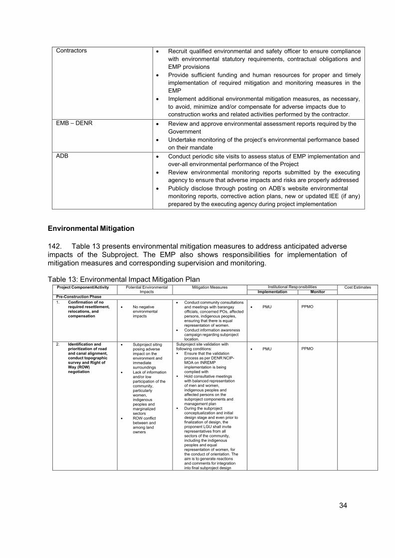
34
Contractors • Recruit qualified environmental and safety officer to ensure compliance with environmental statutory requirements, contractual obligations and EMP provisions
• Provide sufficient funding and human resources for proper and timely implementation of required mitigation and monitoring measures in the EMP
• Implement additional environmental mitigation measures, as necessary, to avoid, minimize and/or compensate for adverse impacts due to construction works and related activities performed by the contractor.
EMB – DENR • Review and approve environmental assessment reports required by the Government
• Undertake monitoring of the project’s environmental performance based on their mandate
ADB • Conduct periodic site visits to assess status of EMP implementation and over-all environmental performance of the Project
• Review environmental monitoring reports submitted by the executing agency to ensure that adverse impacts and risks are properly addressed
• Publicly disclose through posting on ADB’s website environmental monitoring reports, corrective action plans, new or updated IEE (if any) prepared by the executing agency during project implementation
Environmental Mitigation
142. Table 13 presents environmental mitigation measures to address anticipated adverse impacts of the Subproject. The EMP also shows responsibilities for implementation of mitigation measures and corresponding supervision and monitoring.
Table 13: Environmental Impact Mitigation Plan
Project Component/Activity Potential Environmental Impacts
Mitigation Measures Institutional Resp onsibilities Cost Estimates Implementation Monitor
Pre-Construction Phase 1. Confirmation of no
required resettlement, relocations, and compensation
• No negative
environmental impacts
• Conduct community consultations and meetings with barangay officials, concerned POs, affected persons, indigenous peoples, ensuring that there is equal representation of women.
• Conduct information awareness campaign regarding subproject location.
• PMU
PPMO
2. Identification and prioritization of road and canal alignment, conduct topographic survey and Right of Way (ROW) negotiation
• Subproject siting posing adverse impact on the environment and immediate surroundings
• Lack of information and/or low participation of the community, particularly women, indigenous peoples and marginalized sectors
• ROW conflict between and among land owners
Subproject site validation with following conditions: Ensure that the validation
process as per DENR NCIP- MOA on INREMP implementation is being complied with
Hold consultative meetings with balanced representation of men and women, indigenous peoples and affected persons on the subproject components and management plan
During the subproject conceptualization and initial design stage and even prior to finalization of design, the proponent LGU shall invite representatives from all sectors of the community, including the indigenous peoples and equal representation of women, for the conduct of orientation. The aim is to generate reactions and comments for integration into final subproject design
• PMU
PPMO
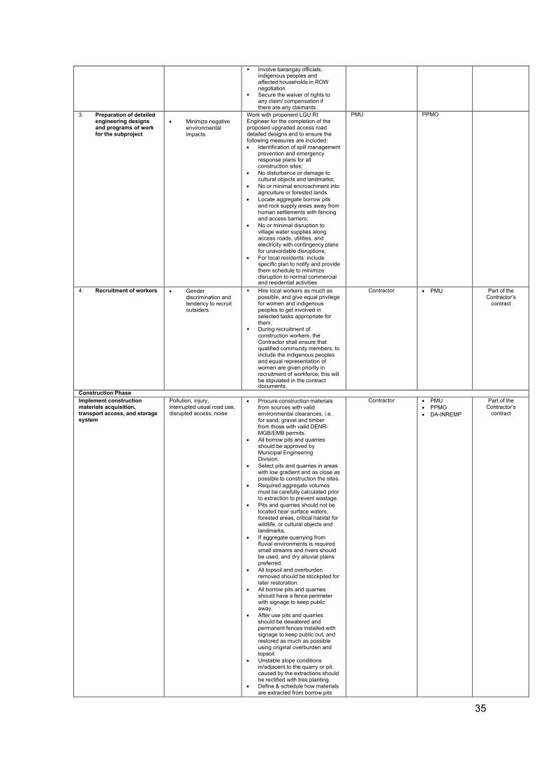
35
Involve barangay officials, indigenous peoples and affected households in ROW negotiation
Secure the waiver of rights to any claim/ compensation if there are any claimants.
3. Preparation of detailed engineering designs and programs of work for the subproject
• Minimize negative
environmental impacts
Work with proponent LGU RI Engineer for the completion of the proposed upgraded access road detailed designs and to ensure the following measures are included: • Identification of spill management
prevention and emergency response plans for all construction sites;
• No disturbance or damage to cultural objects and landmarks;
• No or minimal encroachment into agriculture or forested lands.
• Locate aggregate borrow pits and rock supply areas away from human settlements with fencing and access barriers;
• No or minimal disruption to village water supplies along access roads, utilities, and electricity with contingency plans for unavoidable disruptions;
• For local residents: include specific plan to notify and provide them schedule to minimize disruption to normal commercial and residential activities
PMU PPMO
4. Recruitment of workers • Gender discrimination and tendency to recruit outsiders
Hire local workers as much as possible, and give equal privilege for women and indigenous peoples to get involved in selected tasks appropriate for them.
During recruitment of construction workers, the Contractor shall ensure that qualified community members, to include the indigenous peoples and equal representation of women are given priority in recruitment of workforce; this will be stipulated in the contract documents.
Contractor • PMU Part of the Contractor’s
contract
Construction Phase Implement construction materials acquisition, transport access, and storage system
Pollution, injury, interrupted usual road use, disrupted access, noise
• Procure construction materials from sources with valid environmental clearances, i.e. for sand, gravel and timber from those with valid DENR- MGB/EMB permits.
• All borrow pits and quarries should be approved by Municipal Engineering Division.
• Select pits and quarries in areas with low gradient and as close as possible to construction the sites.
• Required aggregate volumes must be carefully calculated prior to extraction to prevent wastage.
• Pits and quarries should not be located near surface waters, forested areas, critical habitat for wildlife, or cultural objects and landmarks.
• If aggregate quarrying from fluvial environments is required small streams and rivers should be used, and dry alluvial plains preferred.
• All topsoil and overburden removed should be stockpiled for later restoration.
• All borrow pits and quarries should have a fence perimeter with signage to keep public away.
• After use pits and quarries should be dewatered and permanent fences installed with signage to keep public out, and restored as much as possible using original overburden and topsoil.
• Unstable slope conditions in/adjacent to the quarry or pit caused by the extractions should be rectified with tree planting.
• Define & schedule how materials are extracted from borrow pits
Contractor • PMU • PPMO • DA-INREMP
Part of the Contractor’s
contract
36
and rock quarries, transported, and handled & stored at sites.
• Define and schedule how fabricated materials such as steel, wood structures, and scaffolding will be transported and handled.
• All aggregate loads on trucks should be covered.
Clearing and removal of obstructions
Damage or loss of vegetation and landscape
• Contact PENRO/CENRO for advice on how to minimize damage to vegetation
• Restrict vegetation removal to within RoWs.
• Within RoWs, minimize land cover removals, and install protective physical barriers around trees.
• All RoWs to be re-vegetated and landscaped after construction completed.
• Consult PENRO/CENRO to determine the most successful restoration strategy and techniques.
• Secure tree cutting permit from DENR and PCA.
• Secure waiver of right to any claim and/ or compensation from claimants.
Contractor • PMU • PPMO • DA-INREMP
Part of the Contractor’s
contract
Implement soil erosion control measures
Land erosion • Berms, and plastic sheet fencing should be placed around all excavations and earthwork areas.
• Earthworks should be conducted during dry periods.
• Maintain a stockpile of topsoil for immediate site restoration following backfilling.
• Protect exposed or cut slopes with planted vegetation and have a slope stabilization protocol ready.
• Re-vegetate all soil exposure areas immediately after work is completed.
• minimize damage and cutting of surrounding vegetation during slope formation,
• prevent erosion and protect the cut slope with temporary drainage as soon as practicable after cutting, and
• If new erosion occurs accidentally, back fill immediately to restore original contours.
Contractor • PMU • PPMO • DA-INREMP
Part of the Contractor’s
contract
Civil works: ground surface levelling and concrete paving of existing road
Degradation of terrestrial and aquatic resources and decreased water quality
• All construction sites should be located away from forested or plantation areas as much as possible.
• All construction fluids such as oils, and fuels should be stored and handled away from forested and plantation areas.
• No waste of any kind is to be discarded on land or in forests/plantations.
• Protective berms, plastic sheet fencing, or silt curtains should be placed between all earthworks and nearby surface waters.
• Erosion channels must be built around aggregate stockpile areas to contain rain-induced erosion.
• Earthworks should be conducted during dry periods.
• All construction fluids such as oils, and fuels should be stored and handled with extra care away from surface waters.
• No waste of any kind is to be thrown in surface waters.
• No washing or repair of machinery near surface waters.
• Pit latrines to be located away from surface waters.
• No unnecessary earthworks in or adjacent to water courses.
• No aggregate mining from rivers or lakes.
Contractor • PMU • PPMO • DA-INREMP
Part of the Contractor’s
contract
Implement noise and dust control
Dust and noise • Regularly apply wetting agents to exposed soil and construction roads.
• Cover or keep moist all stockpiles of construction aggregates, and all truckloads of aggregates.
Contractor • PMU • PPMO • DA-INREMP
Part of the Contractor’s
contract
37
• Minimize the time for excavations and exposed soil are left open or exposed. Backfill immediately after work is completed.
• As much as possible, restrict working time between 07:00 and 17:00, in particular, activities such as pile driving, etc.
• Maintain equipment in proper working condition
• Replace unnecessarily noisy vehicles and machinery.
• Vehicles and machinery to be turned off when not in use.
• Construct temporary noise barriers.
Dust and noise from borrow pits
Air and noise • provision of noise control measures to comply with national standards, watering of the earth roads close to the settlements, use covered truck,
• secure appropriate environmental permits,
• the borrow and material dumping sites must be access controlled to keep away unauthorized entry of people, grazing cattle and any other stray animals, and
• protective gear like ear plugs will be provided to operating personnel if they are exposed to noise levels beyond threshold limits.
Contractor • PMU • PPMO • DA-INREMP
Part of the Contractor’s
contract
Implement spoil management and control measure
Contamination of land and surface waters from excavated spoil, and construction waste
• Uncontaminated spoil to be disposed of in government – designated sites, which must never be in or adjacent surface waters. Designated sites must be clearly marked and identified.
• Spoil must not be disposed of on sloped land, near cultural property or values, ecologically important areas, or on/near any other socially or ecologically sensitive feature.
• Where possible spoil should be used at other construction sites, or disposed in spent quarries or borrow pits.
• A record of type, estimated volume, and source of disposed spoil must be recorded.
• Contaminated spoil disposal must follow government regulations including handling, transport, treatment (if necessary), and disposal.
• Suspected contaminated soil must be tested, and disposed of in designated sites identified as per government regulations.
• Before treatment or disposal contaminated spoil must be covered with plastic and isolated from all human activity.
Contractor • PMU • PPMO • DA-INREMP
Part of the Contractor’s
contract
Implement solid and liquid construction waste management system
Contamination of land and surface waters from construction waste
• Management of general solid and liquid waste of construction will follow government regulations to include covering, collecting, handling, transporting, recycling, and disposing waste created from construction activities and the work force.
• Disposal areas for solid and liquid waste must be determined by the government.
• Disposal of waste should be
Contractor • PMU • PPMO • DA-INREMP
Part of the Contractor’s
contract
38
catalogued for type, estimated weigh, and source.
• Construction sites should have large garbage bins.
• A schedule of solid and liquid waste pickup and disposal must be established and followed that ensures construction sites are as clean as possible.
• Solid waste should be separated and recyclables be sold to buyers in the community.
Hazardous Waste • Collection, storage, transport,
and disposal of hazardous waste such as used oils, gasoline, paint, and other toxics must follow government regulations.
• Wastes should be separated (e.g., hydrocarbons, batteries, paints, organic solvents)
• Wastes must be stored above ground in closed, well labeled, ventilated plastic bins in good condition, away from construction activity areas, all surface water, water supplies, and cultural and ecological sensitive receptors.
• All spills must be cleaned up completely with all contaminated soil removed and handled with by contaminated spoil sub-plan.
Water quality Water and soil • set up proper and adequate sanitary facilities,
• ensure strict observance of proper waste handling and disposal and proper sanitation including by the contractors and its workers,
• provide wastewater treatment facility (e.g., septic tank), and
• trucks and other vehicle maintenance should be strictly controlled to prevent the discharge of waste into the river system. Wastewater from the construction works containing high concentration of suspended solids should be treated through sedimentation tanks.
Contractor • PMU • PPMO • DA-INREMP
Part of the Contractor’s
contract
Implement construction drainage system
Loss of drainage and rain water natural channels
• Provide adequate short-term drainage away from construction sites to prevent ponding and flooding.
• Prevent borrow pits and quarries to be filled with water. Pump periodically to infiltration areas or nearby water courses.
• Install temporary storm drains or ditches for construction sites
• Ensure connections among surface waters (ponds, streams) are maintained or enhanced to sustain existing storm water storage capacity.
• Protect surface waters from silt and eroded soil.
Contractor • PMU • PPMO • DA-INREMP
Part of the Contractor’s
contract
Workers health, safety and hygiene
Land and people • proper fencing, protective barriers, and buffer zones should be provided around all construction sites,
• sufficient signage and information disclosure, and supervisors and night guards should be placed,
• worker and public safety guidelines should be followed,
• provide adequate sanitation and waste disposal at construction sites,
• the contractor will not hire children and pregnant women,
• standing water suitable for disease vector breeding should be filled in,
• worker education and awareness seminars for construction hazards should be given at the beginning of the construction phase. A construction site safety program should be developed and distributed to workers,
• appropriate safety clothing, footwear, gloves, hard hats, eye protection and other PPE should be mandatory for all construction workers,
Contractor • PMU • PPMO • DA-INREMP
Part of the Contractor’s
contract
39
• adequate medical services must be on site or nearby all construction site,
• drinking water must be provided at all construction sites,
• sufficient lighting be used during necessary night work, and
• all construction sites should be examined daily to ensure unsafe conditions are removed.
Traffic safety and management
Land and people All construction vehicles observe speed limits on the construction sites and to provide adequate signage, barriers, and flag persons for traffic control. Sign postings such as ‘men working’, ‘Keep left/right’, ‘construction ahead’, and ‘speed limit’, should be used for traffic management and road safety. As much as possible, road works will be confined to one half of the road width at each section to provide access to pedestrian and vehicles during construction works.
Contractor • PMU • PPMO • DA-INREMP
Part of the Contractor’s
contract
Ecological environment (Flora and Fauna)
Land • poaching of edible animals and birds of the locality in spite of prohibitions.
• providing adequate knowledge to the workers regarding the protection of fauna.
• all workers will be prohibited from hunting wild animals.
Contractor • PMU • PPMO • DA-INREMP
Part of the Contractor’s
contract
Damaged to properties Land The contractor will immediately repair and/or compensate for any damage that it causes to properties (houses, farmlands, aquaculture ponds, irrigation canals, and others), community facilities such as water supply, power supply, communication facilities and the like. Access roads used for transport of construction materials and other construction- related activities will be maintained by the Contractor in at least in their pre- project condition for the duration of construction.
Contractor • PMU • PPMO • DA-INREMP
Part of the Contractor’s
contract
Concrete washout Soil and water contamination
The Contractor shall 1) collect and retain all the concrete washout water and solids in leak proof containers, so that this does not reach the soil surface and then migrate to surface waters or into the ground water, 2) recycle the collected concrete washout water and solids, and/or 3) use of a washout pit made with a plastic lining that can be dug into the ground or built above grade.
Contractor • PMU • PPMO • DA-INREMP
Part of the Contractor’s
contract
Use of Hazardous Substances People, land and water Vehicle maintenance and refueling will be confined to areas in construction sites designed (with concrete flooring, drainage leading to oil and water separator, etc.) to contain spilled lubricants and fuels. Spill waste will be disposed to sites approved by the concerned government agency and following national regulations. Adequate precaution will be taken to prevent oil/lubricant/ hazardous substances contamination of channel beds. Spillage if any will be immediately cleared with utmost caution to leave no traces. All areas intended for storage of hazardous materials will be quarantined and provided with adequate facilities to combat emergency situations such as fire, spills, etc. in compliance with all the applicable statutory stipulation. The personnel in-charge of these sites will be properly trained and these areas will be access controlled and entry will be allowed only under authorization. Hazardous wastes will be collected, stored, transported and disposed consistent with national regulations to ensure that these will not cause pollution of surrounding areas.
Contractor • PMU • PPMO • DA-INREMP
Part of the Contractor’s
contract
Public safety People • installation of sturdy fencing around excavation areas and construction sites,
• provision of proper signage and lighting at night at the periphery of the construction site to warn and direct traffic and pedestrians,
• deployment of security personnel in hazardous areas to restrict public access,
• DA-INREMP
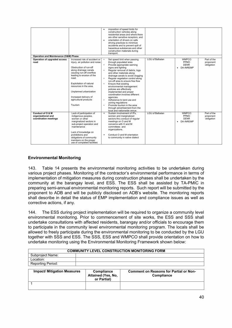
40
• imposition of speed limits for construction vehicles along residential areas and where there are other sensitive receptors, and
• orientation of drivers on safe driving practices to minimize accidents and to prevent spill of hazardous substances and other construction materials during transport.
Operation and Maintenance (O&M) Phase Operation of upgraded access road
Increased risk of accident or injury, air pollution and noise.
Obstruction of run-off along drainage canals causing run-off overflow leading to erosion of the road.
Exploitation of natural resources in the area.
Unplanned urbanization
Increased delivery of agricultural products
Tourism
• Set speed limit when passing through populated area
• Provide appropriate warning signs and lighting
• Regular removal of debris, logs and other materials along drainage canals to avoid clogging
• Regular vegetation control along run-off area to ensure free flow
• Ensure that existing environmental management policies are effectively implemented and proper coordination involves different agencies.
• Adherence to land use and zoning regulations
• Promote tourism in the area through advertisement from the local and nationwide venue.
LGU of Balbalan WMPCO PPMO DENR
• DA-INREMP
Part of the proponent obligation
Conduct of O & M organizational and coordination meetings
Lack of participation of indigenous peoples, women or other marginalized sectors in sub-project operation and maintenance
Lack of knowledge on prohibitions and obligations of community members on the proper use of completed facilities
Sustain involvement of IPs, women and marginalized sectors thru conduct of regular meetings on O and M concerns with O and M committees and organizations.
Conduct O and M orientation
to community in native dialect
LGU of Balbalan WMPCO PPMO DENR
• DA-INREMP
Part of the proponent obligation
Environmental Monitoring
143. Table 14 presents the environmental monitoring activities to be undertaken during various project phases. Monitoring of the contractor’s environmental performance in terms of implementation of mitigation measures during construction phases shall be undertaken by the community at the barangay level, and ESS. The ESS shall be assisted by TA-PMIC in preparing semi-annual environmental monitoring reports. Such report will be submitted by the proponent to ADB and will be publicly disclosed on ADB’s website. The monitoring reports shall describe in detail the status of EMP implementation and compliance issues as well as corrective actions, if any.
144. The ESS during project implementation will be required to organize a community level environmental monitoring. Prior to commencement of site works, the ESS and SSS shall undertake consultations with affected residents, barangay and/or officials to encourage them to participate in the community level environmental monitoring program. The locals shall be allowed to freely participate during the environmental monitoring to be conducted by the LGU together with SSS and ESS. The SSS, ESS and WMPCO shall provide orientation on how to undertake monitoring using the Environmental Monitoring Framework shown below:
COMMUNITY LEVEL CONSTRUCTION MONITORING FORM
Subproject Name:
Location: Reporting Period:
Impact/ Mitigation Measures Compliance Attained (Yes, No,
or Partial)
Comment on Reasons for Partial or Non- Compliance
1
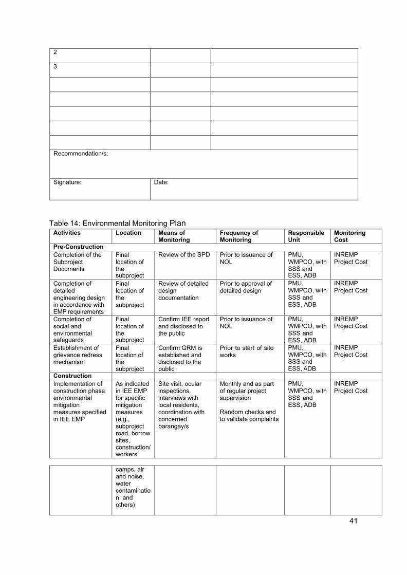
41
2
3
Recommendation/s:
Signature: Date:
Table 14: Environmental Monitoring Plan Activities Location Means of
Monitoring Frequency of Monitoring
Responsible Unit
Monitoring Cost
Pre-Construction Completion of the Subproject Documents
Final location of the subproject
Review of the SPD Prior to issuance of NOL
PMU, WMPCO, with SSS and ESS, ADB
INREMP Project Cost
Completion of detailed engineering design in accordance with EMP requirements
Final location of the subproject
Review of detailed design documentation
Prior to approval of detailed design
PMU, WMPCO, with SSS and ESS, ADB
INREMP Project Cost
Completion of social and environmental safeguards
Final location of the subproject
Confirm IEE report and disclosed to the public
Prior to issuance of NOL
PMU, WMPCO, with SSS and ESS, ADB
INREMP Project Cost
Establishment of grievance redress mechanism
Final location of the subproject
Confirm GRM is established and disclosed to the public
Prior to start of site works
PMU, WMPCO, with SSS and ESS, ADB
INREMP Project Cost
Construction
Implementation of construction phase environmental mitigation measures specified in IEE EMP
As indicated in IEE EMP for specific mitigation measures (e.g., subproject road, borrow sites, construction/ workers’
Site visit, ocular inspections, interviews with local residents, coordination with concerned barangay/s
Monthly and as part of regular project supervision
Random checks and to validate complaints
PMU, WMPCO, with SSS and ESS, ADB
INREMP Project Cost
camps, air and noise, water contaminatio n and others)
42
145. The NPCO shall submit the following environmental reporting documentation to ADB:
Environmental Monitoring Reports: Semi-annual environmental monitoring reports will be submitted by NPCO to ADB. The report, which will be prepared by ESS with assistance for TA-PMIC, will provide the following information:
(i) Background/Context of the monitoring report (adequate information on the
project, including physical implementation progress of project activities, scope of monitoring report, reporting period, and the monitoring requirements including frequency of submission as agreed upon);
(ii) Compliance with applicable government laws, regulations and requirements; (iii) Changes in project scope and adjusted safeguard measures, if applicable; (iv) Monitoring parameters/indicators and methods based on the monitoring
plan/program in the EMP; (v) Monitoring results compared against the objectives of safeguards or desired
outcomes documented (e.g. environmental impacts avoided or minimized, etc.);
(vi) If noncompliance or any major gaps identified, include a corrective action plan; (vii) Records on disclosure of monitoring information to affected communities; (viii) Summary of environmental mitigations and compensation measures
implemented; (ix) Identification of key issues, or complaints from affected people, or
recommendations for improvement; (x) Monitoring adjustment measures recommended based on monitoring
experience/trends and stakeholder’s response; (xi) Information about actual institutional arrangement for implementing the
monitoring program/plan provided or adjusted, as may be required; (xii) Proposed items of focus for the next report and due date.
Project Completion Report: One (1) year after completion of the construction, the NPCO through its ESS shall submit a Project Completion Report which will include the overall environmental performance of the Subproject.
IX. CONCLUSION AND RECOMMENDATION
43
Conclusion
146. The present IEE reviewed the general environmental profile of the subproject, covering about 1.6 kilometers road and screened them to assess potential impacts. The IEE reveals that no major negative environmental impacts are likely to occur due to the construction activities and normal operations after the proposed rehabilitation. Implementation of appropriate mitigation measures during construction and operation phases will minimize the negative impacts of the project to acceptable levels. To ensure that these mitigation measures are implemented and negative impacts avoided, the measures will be included in the civil works bid and contract specifications of the project.
147. Rural infrastructures like roads and water supply projects, arguably are vital structures needed to spur economic development in Balbalan, Kalinga, with full potentials and opportunities owing to its varied development zones and natural resources.
148. The Rehabilitation of Tawang Farm to Market Road project for one shall be a crucial infrastructure for uplifting the quality of life of the people by providing an all-year-round easy and affordable access, improving the prompt delivery of basic services and increasing economic opportunities, thus supporting the developing economy of the barangay and eventually the entire municipality.
149. Hence, the Project will have overall beneficial impact and will have minor negative impacts that will be carefully monitored and adequately mitigated through the implementation of the EMP.
Recommendation
150. The end goal of the proposed Rehabilitation of Tawang Farm to Market Road is to uplift the economic condition of the community through the provision of all-year-round safe access. It aims to increase productivity and profit, decrease farm expenses on hauling works, hasten delivery of agricultural products to market outlets, enable timely transport of farm inputs to production areas, reduce vehicle operating cost and maintenance cost after project implementation and maximize agricultural potential of the production area after road rehabilitation.
151. The proposed rehabilitation of Tawang Road will boost the economic activities of the influence area. With the subproject, socio-economic services will be easier not only for the public sector but also to private and semi-private providers. Considering the many benefits this subproject provides, implementing the subproject is recommended.
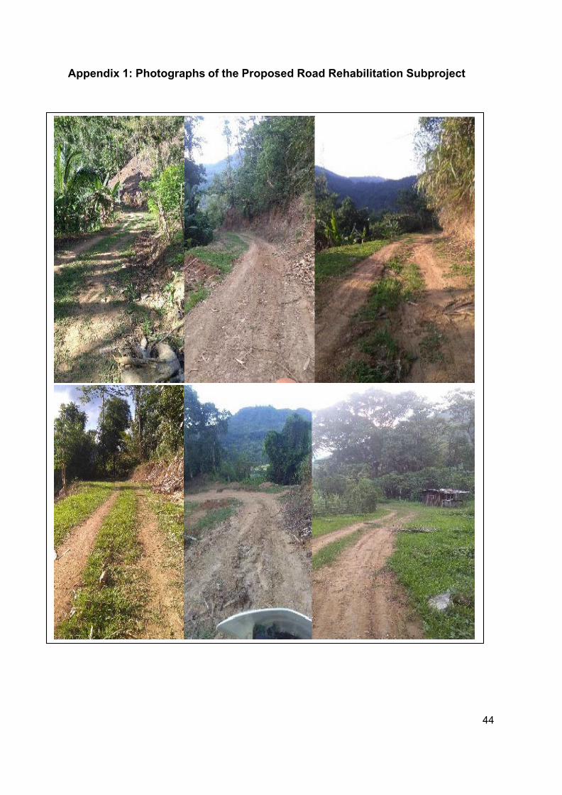
44
Appendix 1: Photographs of the Proposed Road Rehabilitation Subproject
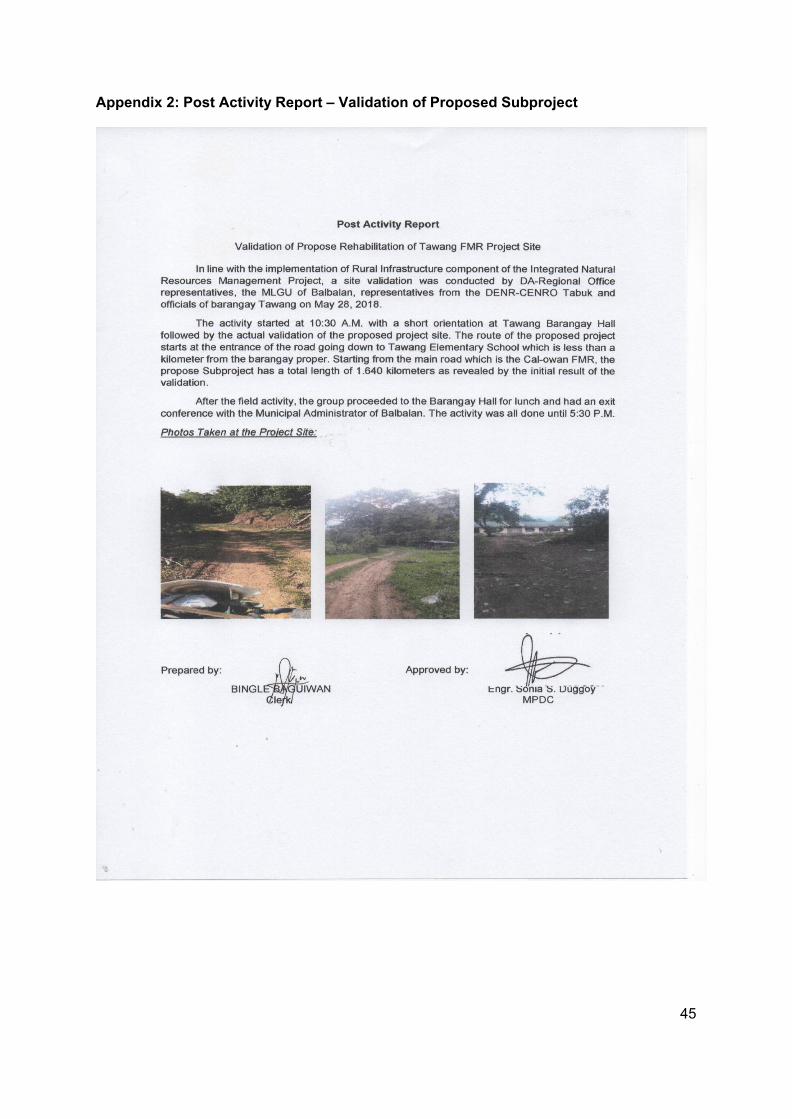
45
Appendix 2: Post Activity Report – Validation of Proposed Subproject
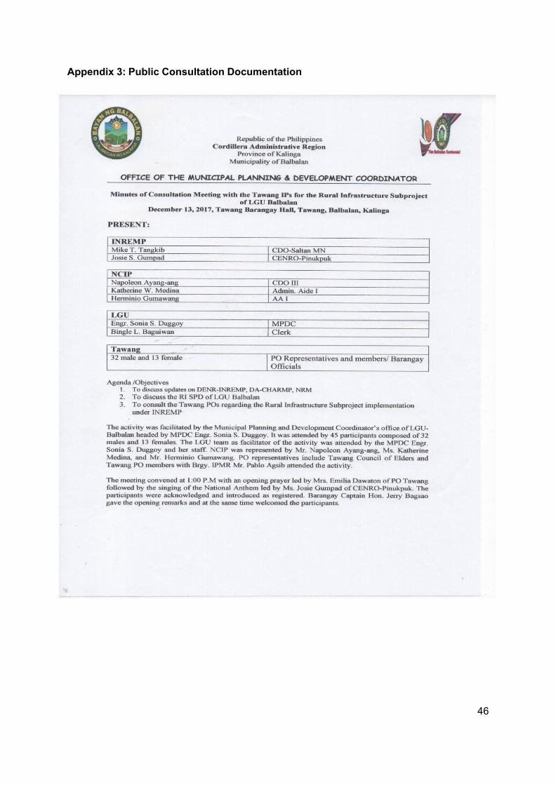
46
Appendix 3: Public Consultation Documentation
47
48
49
50
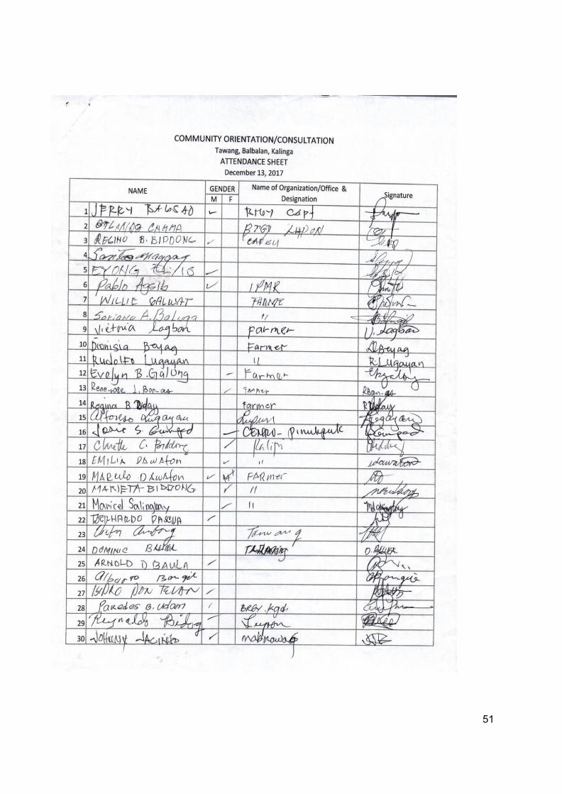
51
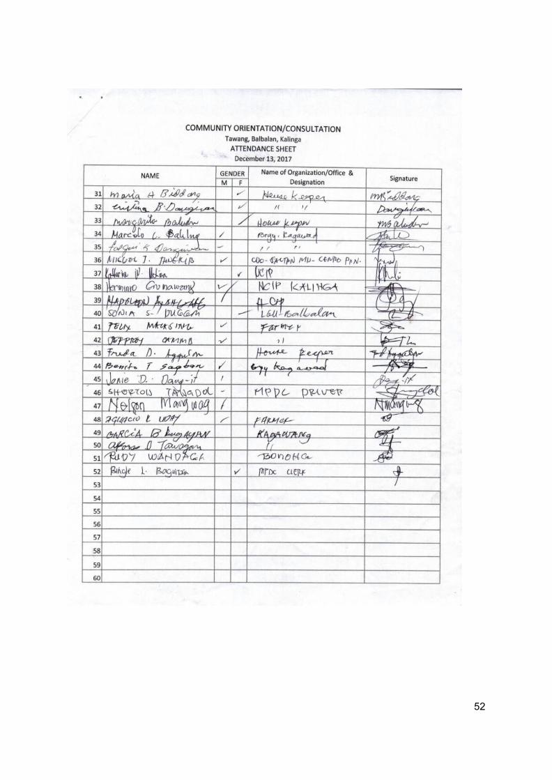
52
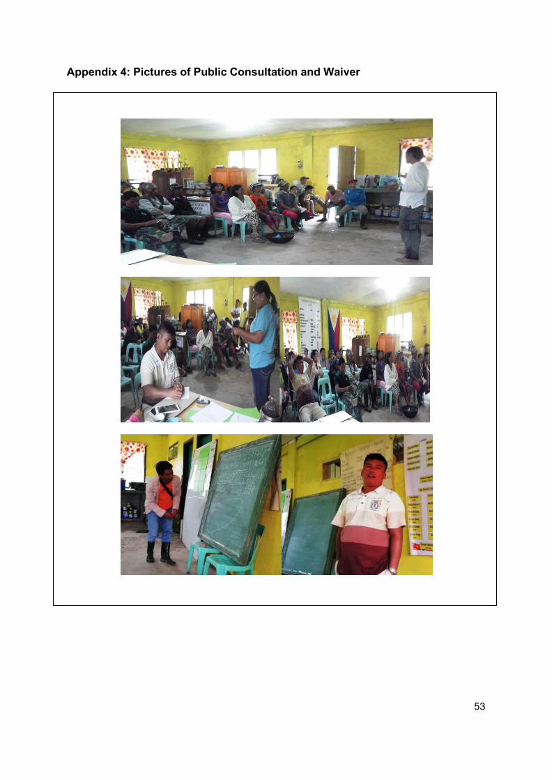
53
Appendix 4: Pictures of Public Consultation and Waiver
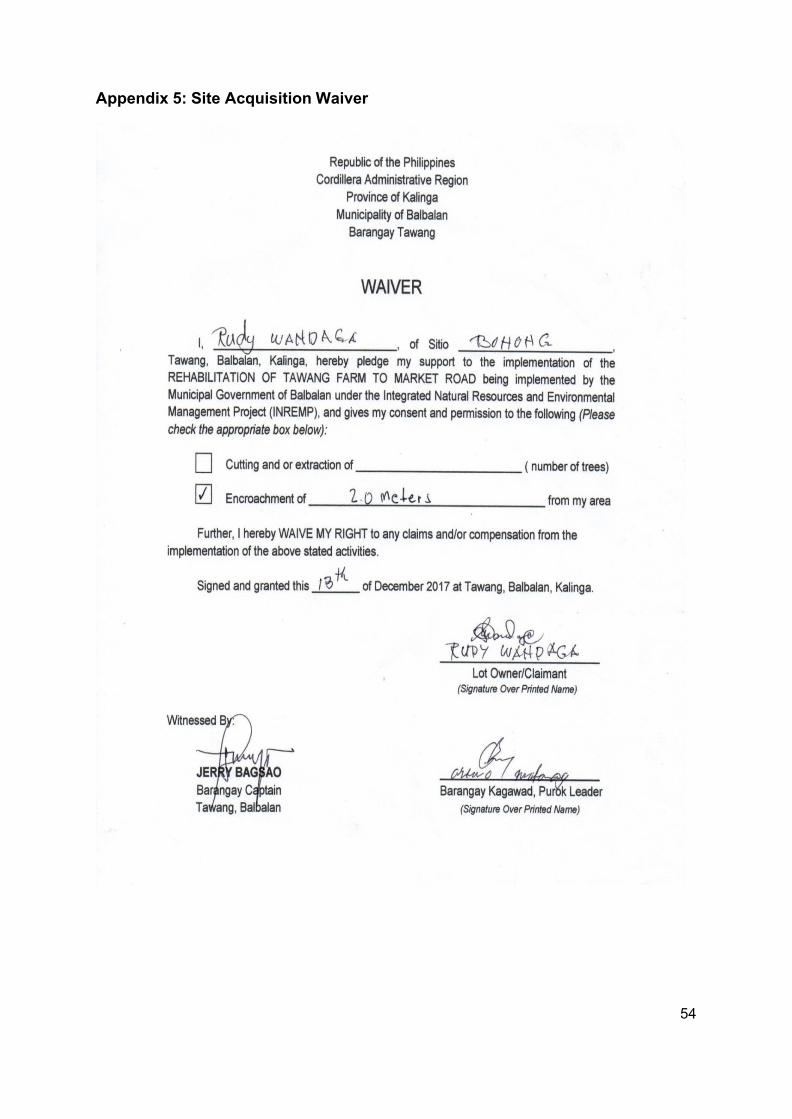
54
Appendix 5: Site Acquisition Waiver
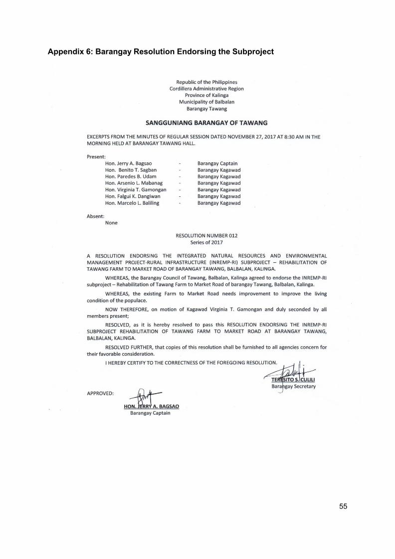
55
Appendix 6: Barangay Resolution Endorsing the Subproject
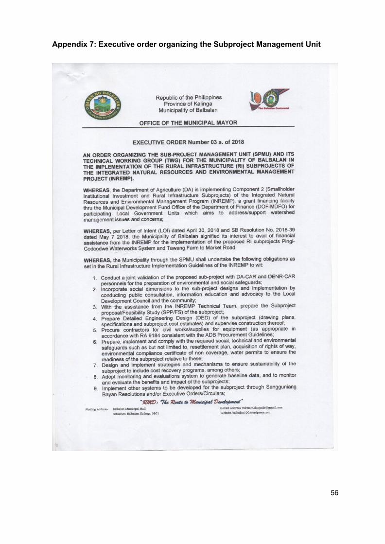
56
Appendix 7: Executive order organizing the Subproject Management Unit
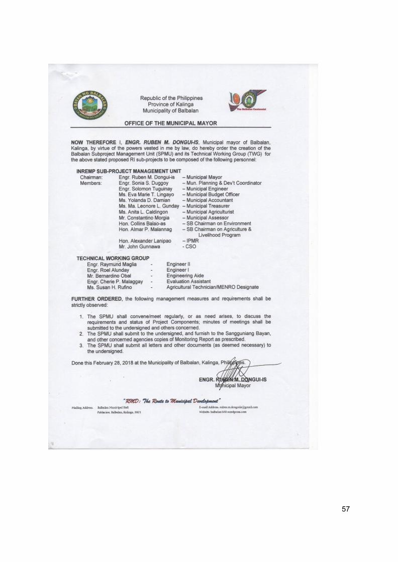
57
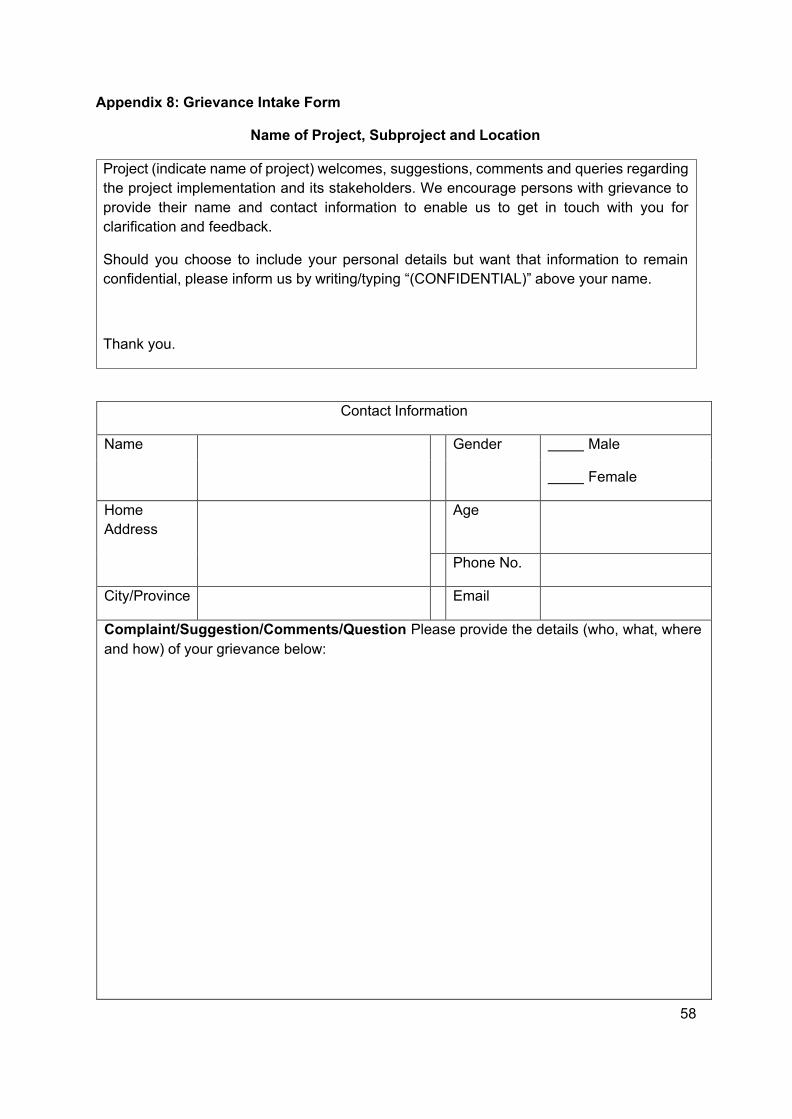
58
Appendix 8: Grievance Intake Form
Name of Project, Subproject and Location
Contact Information
Name Gender Male
Female
Home Address
Age
Phone No.
City/Province Email
Complaint/Suggestion/Comments/Question Please provide the details (who, what, where and how) of your grievance below:
Project (indicate name of project) welcomes, suggestions, comments and queries regarding the project implementation and its stakeholders. We encourage persons with grievance to provide their name and contact information to enable us to get in touch with you for clarification and feedback.
Should you choose to include your personal details but want that information to remain confidential, please inform us by writing/typing “(CONFIDENTIAL)” above your name.
Thank you.
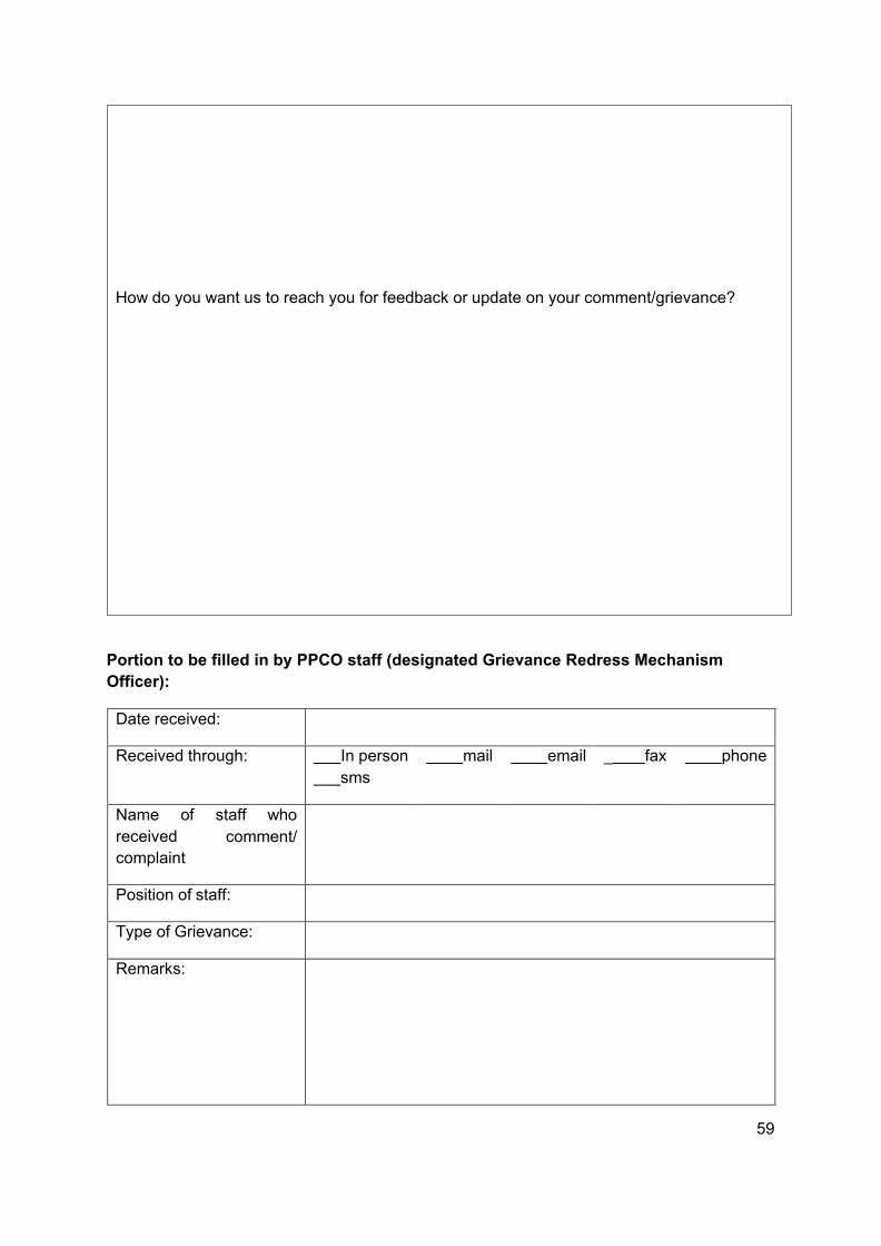
59
Portion to be filled in by PPCO staff (designated Grievance Redress Mechanism Officer):
Date received:
Received through: In person sms
mail email _ fax phone
Name of received complaint
staff who comment/
Position of staff:
Type of Grievance:
Remarks:
How do you want us to reach you for feedback or update on your comment/grievance?

60
Signature
Updates on the case:
Date: Update Updated by (Name, Signature and Designation)

61
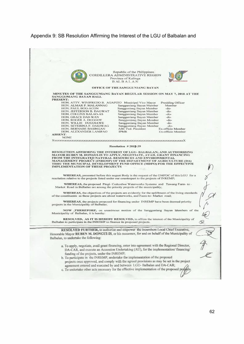
62
Appendix 9: SB Resolution Affirming the Interest of the LGU of Balbalan and
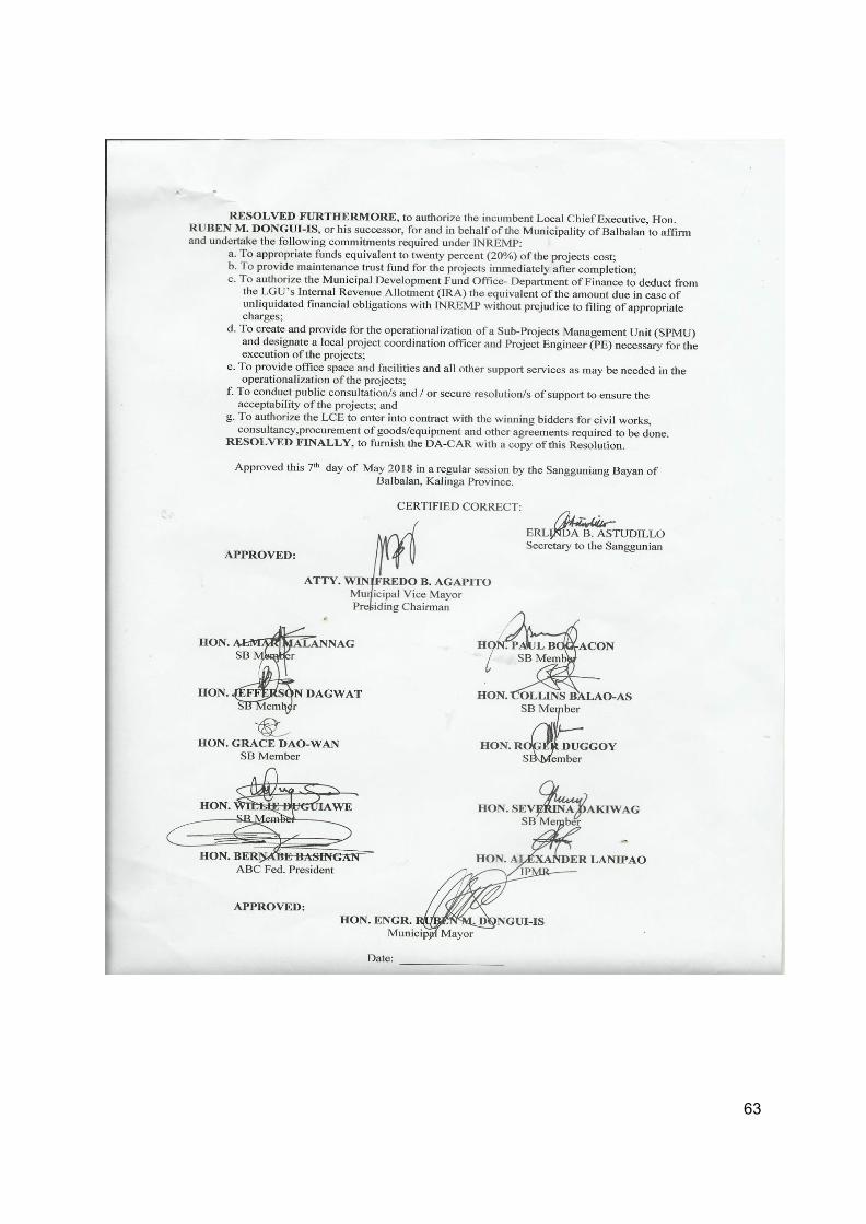
63
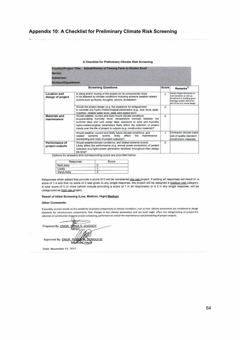
64
Appendix 10: A Checklist for Preliminary Climate Risk Screening
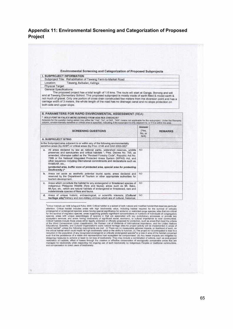
65
Appendix 11: Environmental Screening and Categorization of Proposed Project
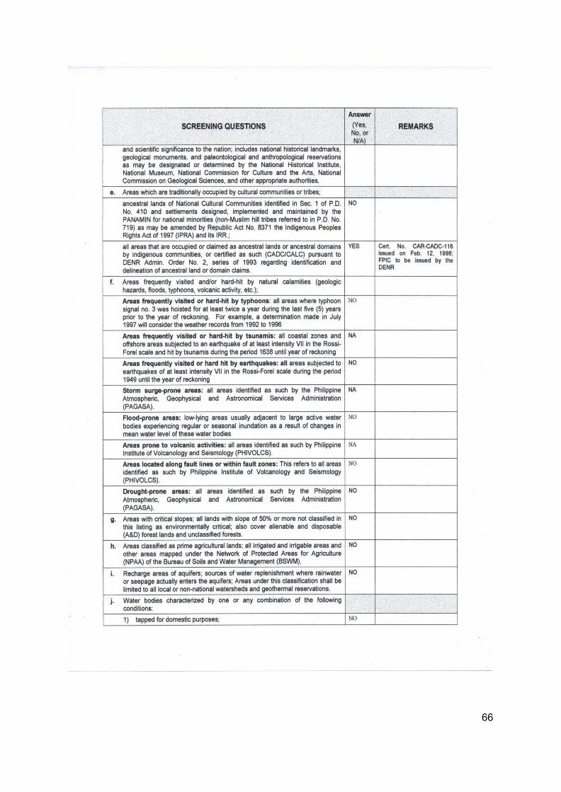
66
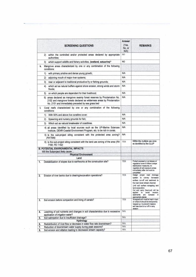
67
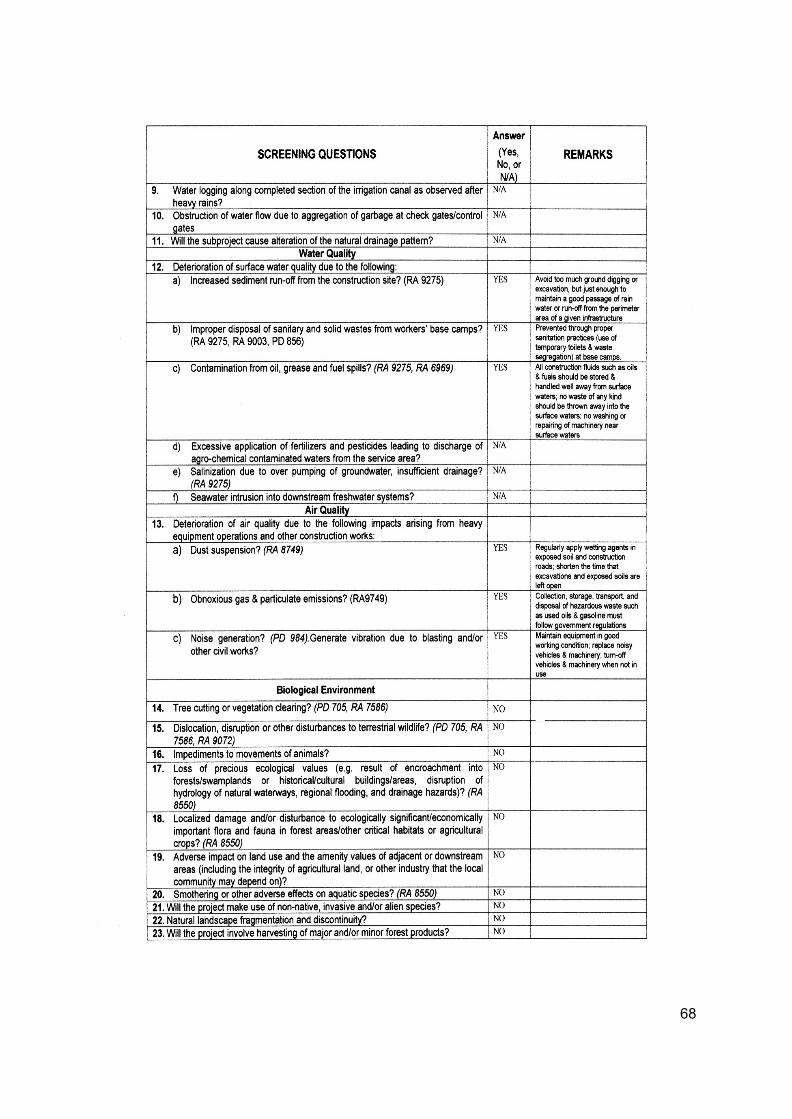
68
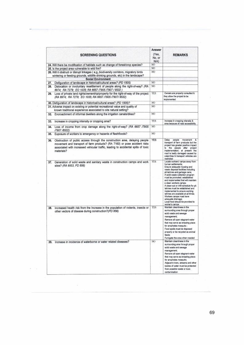
69
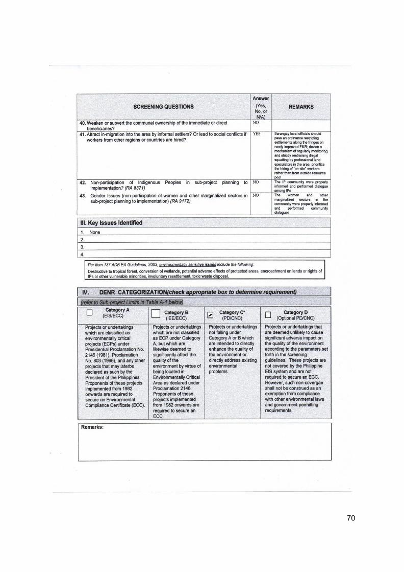
70
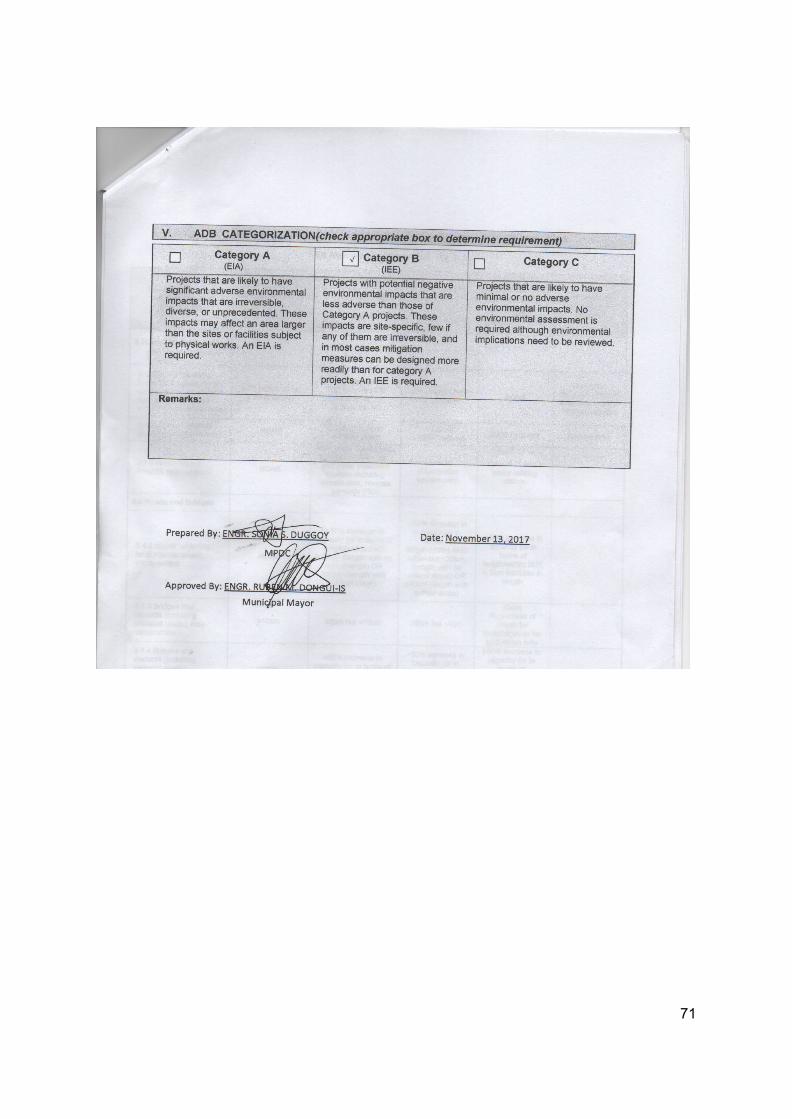
71
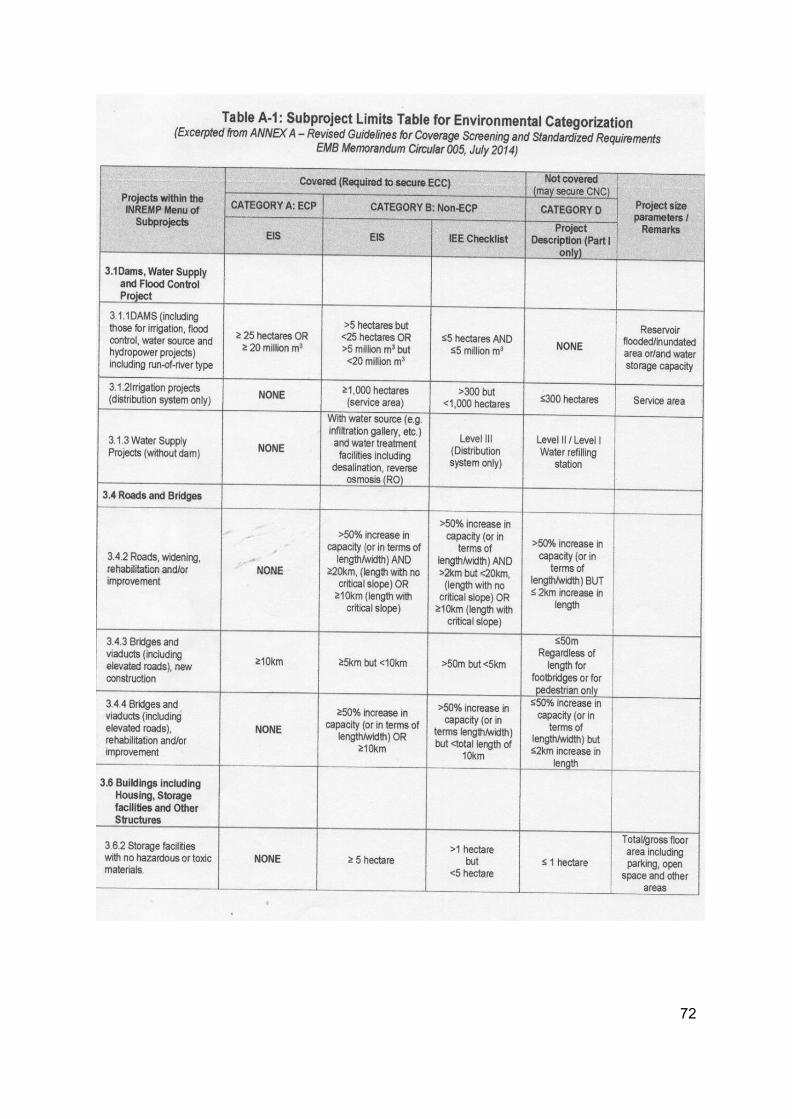
72
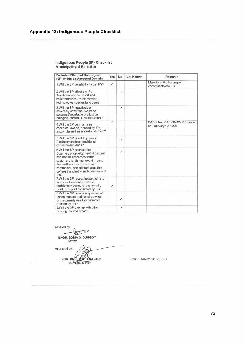
73
Appendix 12: Indigenous People Checklist
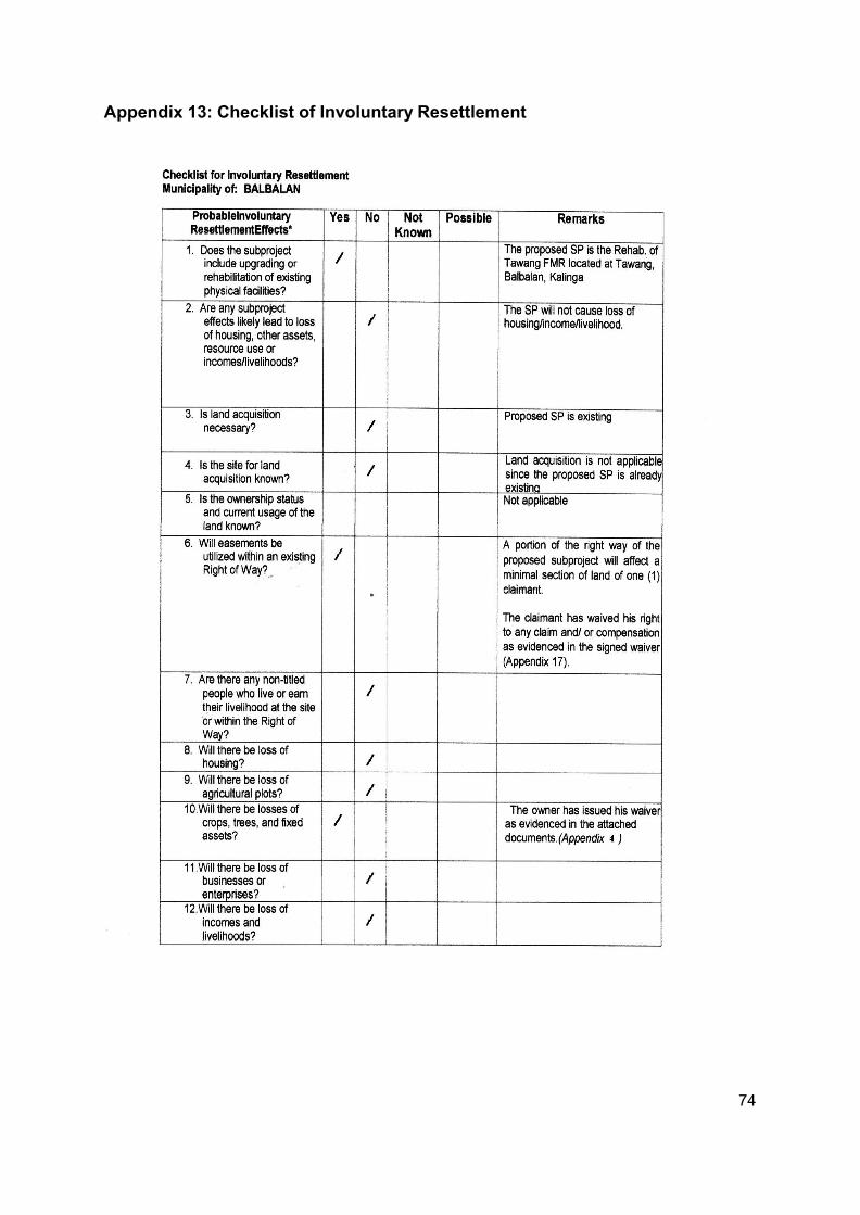
74
Appendix 13: Checklist of Involuntary Resettlement
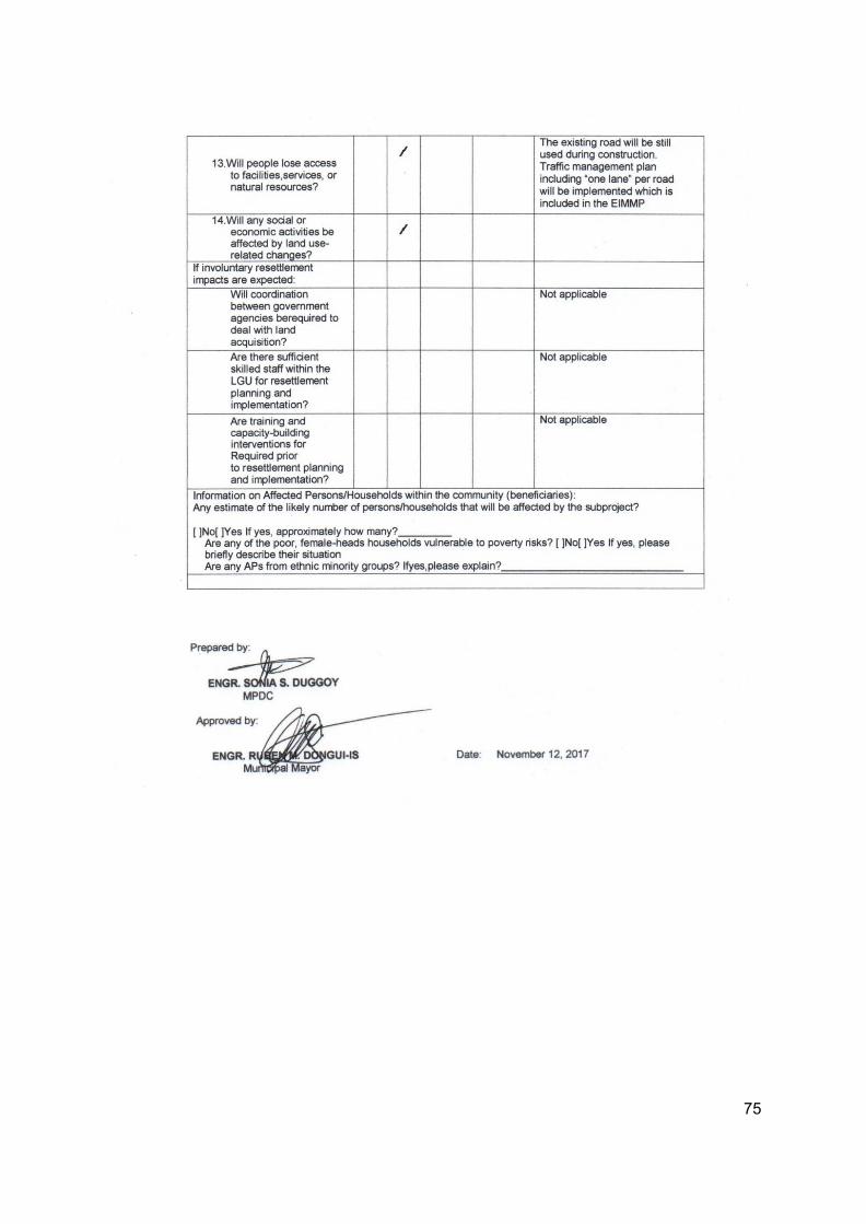
75
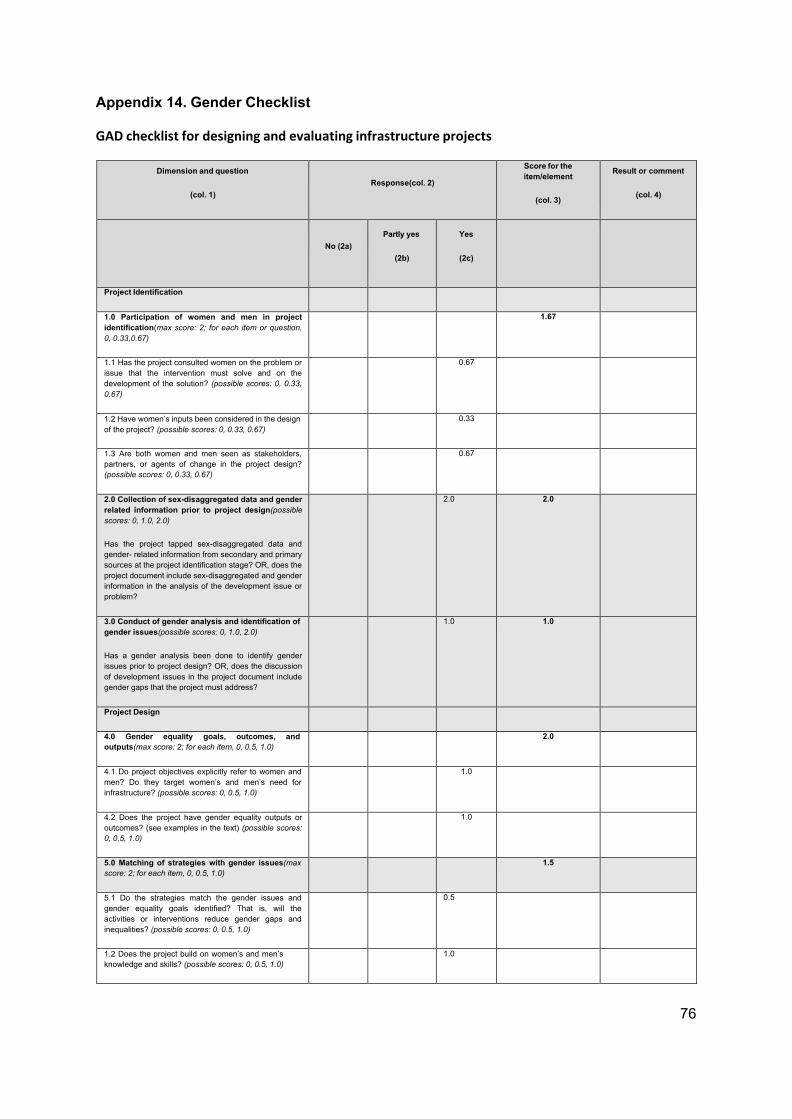
76
Appendix 14. Gender Checklist
GAD checklist for designing and evaluating infrastructure projects
Dimension and question
(col. 1)
Response(col. 2)
Score for the item/element
(col. 3)
Result or comment
(col. 4)
No (2a)
Partly yes
(2b)
Yes
(2c)
Project Identification
1.0 Participation of women and men in project identification(max score: 2; for each item or question, 0, 0.33,0.67)
1.67
1.1 Has the project consulted women on the problem or issue that the intervention must solve and on the development of the solution? (possible scores: 0, 0.33, 0.67)
0.67
1.2 Have women’s inputs been considered in the design of the project? (possible scores: 0, 0.33, 0.67)
0.33
1.3 Are both women and men seen as stakeholders, partners, or agents of change in the project design? (possible scores: 0, 0.33, 0.67)
0.67
2.0 Collection of sex-disaggregated data and gender related information prior to project design(possible scores: 0, 1.0, 2.0)
Has the project tapped sex-disaggregated data and gender- related information from secondary and primary sources at the project identification stage? OR, does the project document include sex-disaggregated and gender information in the analysis of the development issue or problem?
2.0 2.0
3.0 Conduct of gender analysis and identification of gender issues(possible scores: 0, 1.0, 2.0)
Has a gender analysis been done to identify gender issues prior to project design? OR, does the discussion of development issues in the project document include gender gaps that the project must address?
1.0 1.0
Project Design
4.0 Gender equality goals, outcomes, and outputs(max score: 2; for each item, 0, 0.5, 1.0)
2.0
4.1 Do project objectives explicitly refer to women and men? Do they target women’s and men’s need for infrastructure? (possible scores: 0, 0.5, 1.0)
1.0
4.2 Does the project have gender equality outputs or outcomes? (see examples in the text) (possible scores: 0, 0.5, 1.0)
1.0
5.0 Matching of strategies with gender issues(max score: 2; for each item, 0, 0.5, 1.0)
1.5
5.1 Do the strategies match the gender issues and gender equality goals identified? That is, will the activities or interventions reduce gender gaps and inequalities? (possible scores: 0, 0.5, 1.0)
0.5
1.2 Does the project build on women’s and men’s knowledge and skills? (possible scores: 0, 0.5, 1.0)
1.0
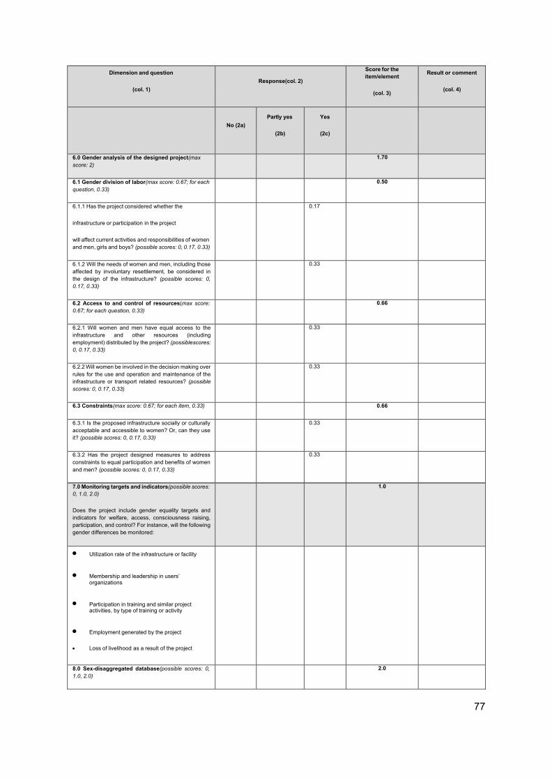
77
Dimension and question
(col. 1)
Response(col. 2)
Score for the item/element
(col. 3)
Result or comment
(col. 4)
No (2a)
Partly yes
(2b)
Yes
(2c)
6.0 Gender analysis of the designed project(max score: 2)
1.70
6.1 Gender division of labor(max score: 0.67; for each question, 0.33)
0.50
6.1.1 Has the project considered whether the
infrastructure or participation in the project
will affect current activities and responsibilities of women and men, girls and boys? (possible scores: 0, 0.17, 0.33)
0.17
6.1.2 Will the needs of women and men, including those affected by involuntary resettlement, be considered in the design of the infrastructure? (possible scores: 0, 0.17, 0.33)
0.33
6.2 Access to and control of resources(max score: 0.67; for each question, 0.33)
0.66
6.2.1 Will women and men have equal access to the infrastructure and other resources (including employment) distributed by the project? (possible scores: 0, 0.17, 0.33)
0.33
6.2.2 Will women be involved in the decision making over rules for the use and operation and maintenance of the infrastructure or transport related resources? (possible scores: 0, 0.17, 0.33)
0.33
6.3 Constraints(max score: 0.67; for each item, 0.33) 0.66
6.3.1 Is the proposed infrastructure socially or culturally acceptable and accessible to women? Or, can they use it? (possible scores: 0, 0.17, 0.33)
0.33
6.3.2 Has the project designed measures to address constraints to equal participation and benefits of women and men? (possible scores: 0, 0.17, 0.33)
0.33
7.0 Monitoring targets and indicators(possible scores: 0, 1.0, 2.0)
Does the project include gender equality targets and indicators for welfare, access, consciousness raising, participation, and control? For instance, will the following gender differences be monitored:
1.0
• Utilization rate of the infrastructure or facility
• Membership and leadership in users’ organizations
• Participation in training and similar project activities, by type of training or activity
• Employment generated by the project
• Loss of livelihood as a result of the project
8.0 Sex-disaggregated database(possible scores: 0, 1.0, 2.0)
2.0
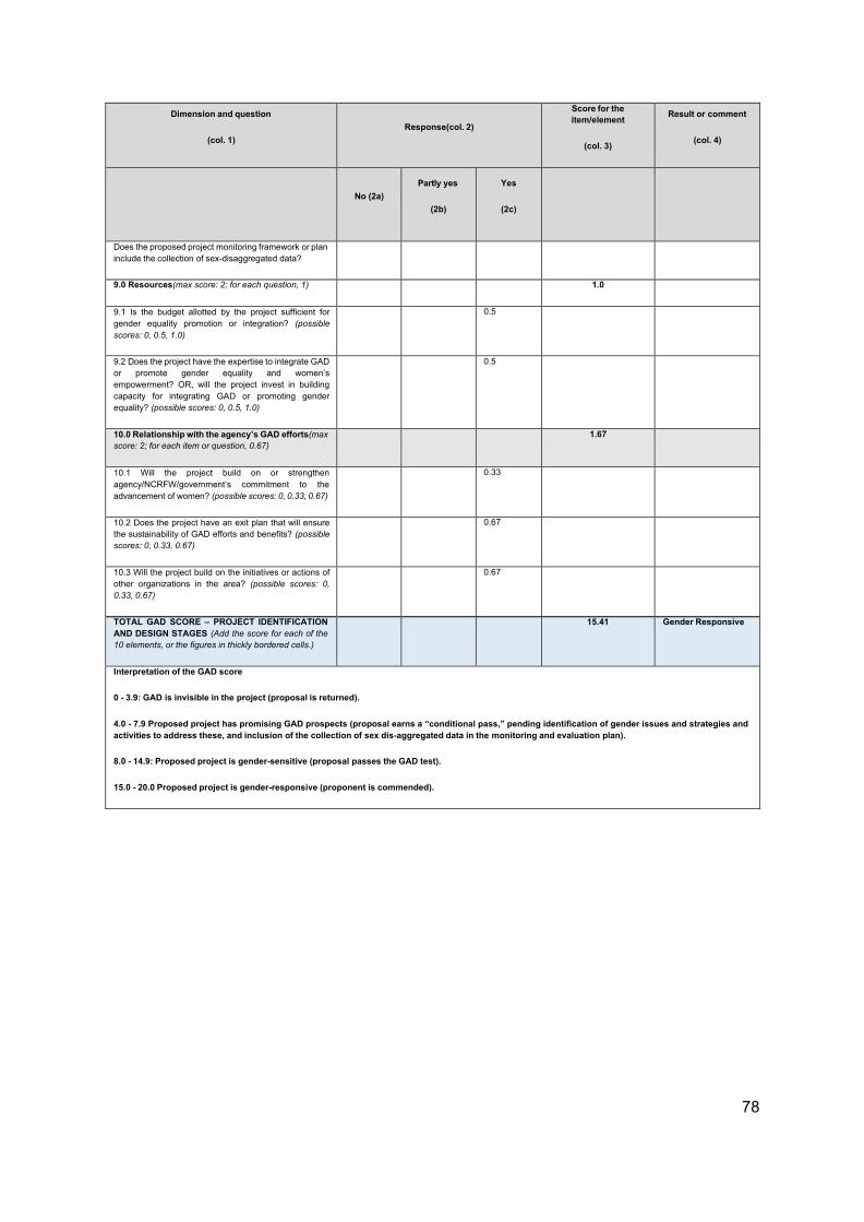
78
Dimension and question
(col. 1)
Response(col. 2)
Score for the item/element
(col. 3)
Result or comment
(col. 4)
No (2a)
Partly yes
(2b)
Yes
(2c)
Does the proposed project monitoring framework or plan include the collection of sex-disaggregated data?
9.0 Resources(max score: 2; for each question, 1) 1.0
9.1 Is the budget allotted by the project sufficient for gender equality promotion or integration? (possible scores: 0, 0.5, 1.0)
0.5
9.2 Does the project have the expertise to integrate GAD or promote gender equality and women’s empowerment? OR, will the project invest in building capacity for integrating GAD or promoting gender equality? (possible scores: 0, 0.5, 1.0)
0.5
10.0 Relationship with the agency’s GAD efforts(max score: 2; for each item or question, 0.67)
1.67
10.1 Will the project build on or strengthen agency/NCRFW/government’s commitment to the advancement of women? (possible scores: 0, 0.33, 0.67)
0.33
10.2 Does the project have an exit plan that will ensure the sustainability of GAD efforts and benefits? (possible scores: 0, 0.33, 0.67)
0.67
10.3 Will the project build on the initiatives or actions of other organizations in the area? (possible scores: 0, 0.33, 0.67)
0.67
TOTAL GAD SCORE – PROJECT IDENTIFICATION AND DESIGN STAGES (Add the score for each of the 10 elements, or the figures in thickly bordered cells.)
15.41 Gender Responsive
Interpretation of the GAD score
0 - 3.9: GAD is invisible in the project (proposal is returned).
4.0 - 7.9 Proposed project has promising GAD prospects (proposal earns a “conditional pass,” pending identification of gender issues and strategies and activities to address these, and inclusion of the collection of sex dis-aggregated data in the monitoring and evaluation plan).
8.0 - 14.9: Proposed project is gender-sensitive (proposal passes the GAD test).
15.0 - 20.0 Proposed project is gender-responsive (proponent is commended).
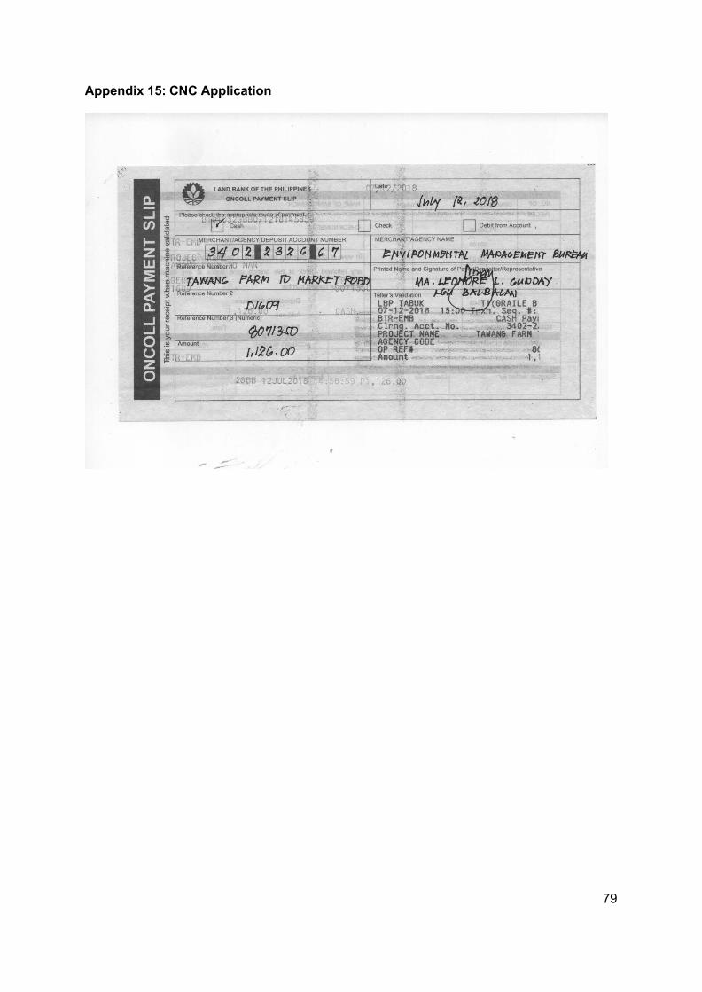
79
Appendix 15: CNC Application