infrastructure management and construction in urban areas with a different approach from traditional...
TRANSCRIPT
© by PSP Volume 17 – No 6. 2008 Fresenius Environmental Bulletin
767
INFRASTRUCTURE MANAGEMENT AND
CONSTRUCTION IN URBAN AREAS WITH A
DIFFERENT APPROACH FROM TRADITIONAL GIS DESIGN
Tarik Turk* and Mustafa Umit Gumusay
Yildiz Technical University, Civil Engineering Faculty, 34349, Besiktas, Istanbul, Turkey
ABSTRACT
Infrastructure services, such as wastewater, water, natu-
ral gas, electricity and telecommunication services are the
major application areas of UIS (Urban Information System).
In Turkey, since the population in urban areas has been in-
creasing rapidly and uncontrollably, infrastructure services
have been extremely insufficient. After the destructive earth-
quake which happened in the Marmara region on 17th Au-
gust 1999, the infrastructure system was seriously dam-
aged. Use of GIS (Geographical Information System) has
been an indispensable tool to control the infrastructure
services more efficiently in case of such emergencies.
The study area, to solve the problems of these services,
was selected in the Sakarya province of the Marmara re-
gion. Since it is very difficult to control and manage these
services damaged by the earthquake via conventional me-
thods, an IIS (Infrastructure Information System) was
de-
signed and implemented. During the conceptual and logi-
cal design of the IIS, UML (Unified Modeling Language)
was used which is the most important difference between
traditional GIS and the IIS design. The created system has
been tested with selected data to provide more economic,
faster and more efficient infrastructure services in the prov-
ince.
Consequently, the IIS has been used to implement
many processes, such as various spatial and non-spatial
queries, and has been used in the solving of available in-
frastructure problems due to rapid population increase in
the settlement areas, controlling and planning of the exist-
ing infrastructure systems, and contributing to e-Municipal-
ity for the infrastructure services. As UML diagrams were
used in the conceptual and logical design of the IIS, geo-
graphical objects, non-geographical objects, as well as the
relationships among them were shown visually. Hence, the
IIS has been organized more easily.
KEYWORDS: GIS, infrastructure management, spatial database design, UML, wastewater, water
INTRODUCTION
Over the years, the concept of geographic information
infrastructure has provided a crucial revolution in the de-
velopment of GIS. As in other countries, GIS has been an
indispensable gateway for government offices to manage
land and natural resources, monitor the environment, for-
mulate economic and community development strategies
and deliver social services [1].
A network consists of linear features which are inter-
connected in GIS. Examples such as highways, railways,
streets, transportation routes, rivers and utility distribution
systems can be given for the networks. They form the in-
frastructure of modern society. Moreover, they are modeled
as networks in GIS [2].
From the early 1990s, the world has been aware of the
significant role of economics in water management. Ac-
cording to the United Nations Conference on Environment
and Development in Rio de Janeiro in 1992, integrated
water resources management principles were adopted. In
addition, they have to be taken into account in the imple-
mentation of any strategic water policy. These principles
have been supported by international communities as they
guide the management of water and promote equity, effi-
ciency and sustainability [3].
The management and foundation of infrastructure sys-
tems are very important for local administrations due to
their high cost and operation processes. Therefore, GIS
technologies are significant in establishing and operating
these infrastructure services. Organizations responsible for
the infrastructure services should handle the problems tak-
ing into account recent developments in the information
technologies. GIS is inevitable in providing functions, such
as the appropriate usage of existing sources and manage-
ment, as well as the planning and controlling of the organi-
zations responsible for the infrastructure services. The fun-
damental duties of water supply organizations in urban
areas are as follows:
• Protecting water resources in their responsibility area,
• Supplying the water requirements of the city,

© by PSP Volume 17 – No 6. 2008 Fresenius Environmental Bulletin
768
• Constructing wastewater and rain water lines,
• Maintenance of the old lines, planning and building of
new lines,
• Improving the lines reaching the rivers, streams and
seas [4].
The municipalities are normally responsible for the
development of the urban infrastructure. Due to the fact
that most of them have poor credit performances, the Iller
Bank (IB) (Bank of the Provinces, related to the Ministry
of Reconstruction and Resettlements, a development and
investment bank) is responsible for developing urban plans,
supplying municipal water, constructing sewerage systems
and treatment plants, and providing loans to municipali-
ties for the financing of such projects. The selected study
area is the Sakarya province which is within the boundary
of the first regional directorship of the IB.
After the earthquake in the Sakarya province on 17th
August 1999 (Fig. 1), the infrastructure, transportation and
communication systems were seriously damaged. Rebuild-
ing of the infrastructure services, such as water and waste-
water lines, was conducted by the first regional director-
ship of the IB.
During the conceptual and logical design of the data-
bases, various software packages, such as Microsoft Visio
and IBM Rational Rose, can be used. After logical design
of the geographical layers and tabular data with the UML
class diagrams, it is possible to save the XML (Extensible
Markup Language) file in the software. Moreover, geo-
graphical layers, tables and relationships are created fully-
automatically through the XML file in the GIS software in-
cluding CASE (Computer Aided System Engineering) tools.
However, relationships between geographical and non-
geographical objects can be defined via the UML class dia-
grams. A database design implemented with the UML dia-
grams is more understandable than entity-relationship
schemes. The UML is a standard language for specifying,
visualizing, constructing, and documenting the artifacts of
software systems, as well as for business modeling and
other non-software systems. In addition, it represents a
collection of the best engineering practices that have proven
to be successful in the modeling of large and complex sys-
tems. It is a very important part of developing objects-
oriented software and the software development process.
Furthermore, it uses mostly graphical notations to express
the design of software projects. The UML helps project
teams to communicate, explore potential designs, and vali-
date the architectural design of the software. In addition,
conceptual and logical designs of the database can be
created visually via UML diagrams. Thus, the designed
system can be easily documented [4].
FIGURE 1 – Approximate boundary of the earthquake of August 17, 1999 and the study area.
© by PSP Volume 17 – No 6. 2008 Fresenius Environmental Bulletin
769
NECESSITY OF IIS (INFRASTRUCTURE INFORMATION SYSTEM)
The infrastructure services have several drawbacks due
to rapid growth in urban population, unplanned urbaniza-
tion, and defects in management and control mechanisms.
Therefore, the IIS is proposed to overcome these problems.
The IIS is necessary to perform the tasks of the first
regional directorship of the IB more economically, easily,
and fast. Hence, the IIS was generated for the require-
ments of the IB. However, the IIS handles not only the
problems of the IB, but also those of other infrastructure
institutions, such as municipalities and organizations re-
sponsible for water and wastewater.
Many processes, such as • Analyzing of existing water and wastewater lines,
• Economical planning of the new water and wastewater
lines,
• Obtaining necessary information for the changes in
existing water and wastewater lines,
• Taking the necessary economical measures in the short-
est time while detecting probable defects in water and
wastewater lines,
• Controlling of the existing water and wastewater lines
via maps,
• Accessing the necessary data for the application of the
planned water and wastewater lines,
• Accessing the current data in the system,
• Querying of the data in the system,
• Preparing reports, and
• Producing maps and updating the system
have been conducted through the IIS [6].
MATERIALS AND METHODS
Study Area
After the earthquake in the Sakarya province of Tur-
key on 17th
August 1999, most of the infrastructure systems
had to be renewed. An area of approximately 220 hectares
was selected as the study area (Fig. 1).
Methodology for IIS
As a result of analysis of the existing system, neces-
sary geographical data were determined for the IIS. Non-
geographical data and geographical data 1/1000-scaled in
DXF (Data Exchange Format) file were obtained from the
first regional directorship of the IB. Necessary geographi-
cal objects and their geometric types for the IIS are given
in Table 1.
The existing situation of the services in the first re-
gional directorship of the IB, work flow, structure of the
organization, problems and existing data in the organiza-
tion, responsibilities and requirements of the organization
were determined for the IIS. Geographical and nongeo-
graphical data, such as diameter and the type of pipes, were
obtained from the organization in digital forms.
The UML was used for conceptual and logical design
of the IIS. The visual modeling can be made with the UML.
Microsoft Visio software including CASE tools was used
to generate these models in the system design. Arc GIS
8.3 software was also used to perform the system.
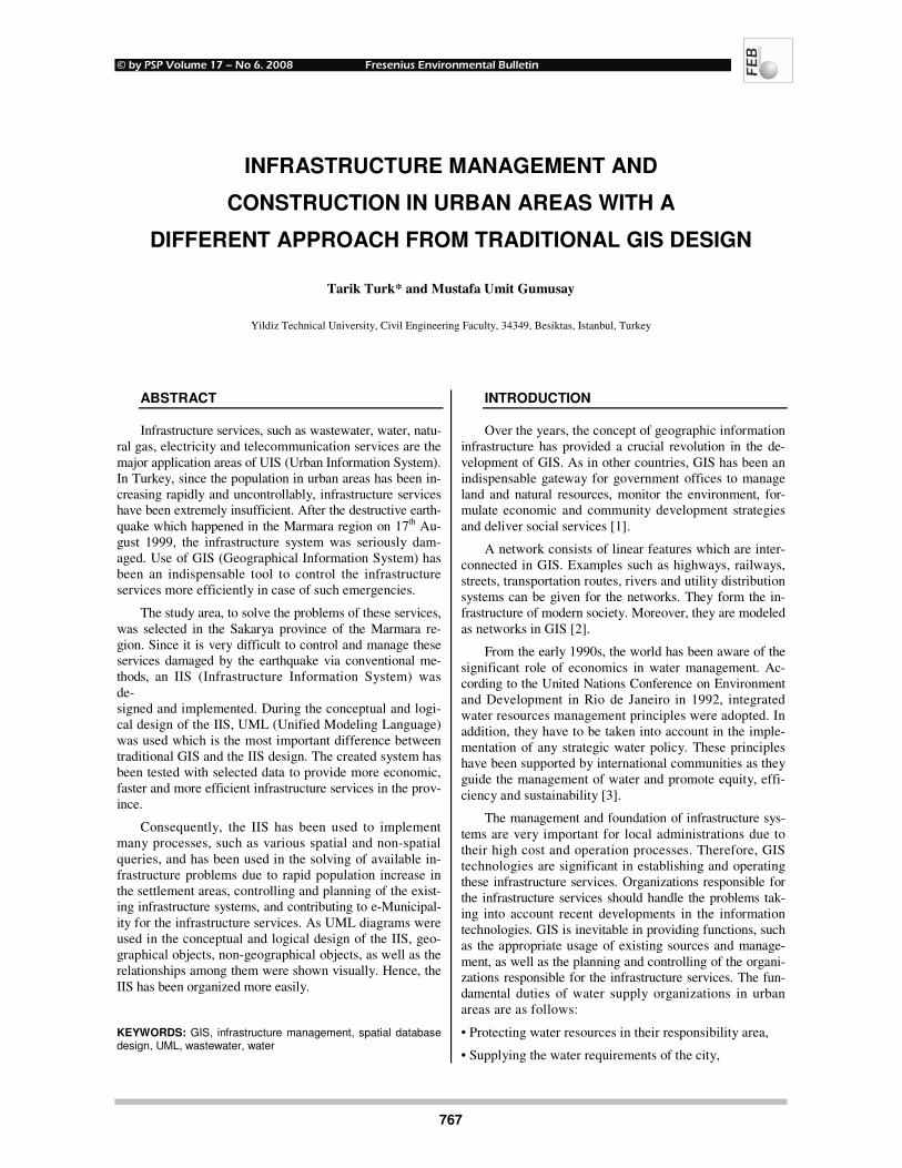
The water line feature dataset was designed by means
of UML, which is one of the designed feature datasets for
the IIS. Attributes of the geographical layers in the water
line feature dataset, and relationships among the layers are
given in Fig. 2.
TABLE 1 – The necessary geographical data for IIS.
RESULTS AND DISCUSSIONS
It is possible to obtain information about the infra-
structure services by IIS. It may also be necessary to take
measures in case of any damaged water and wastewater
lines, or when maintenance is needed. The IIS allows ne-
cessary information to be obtained about them.
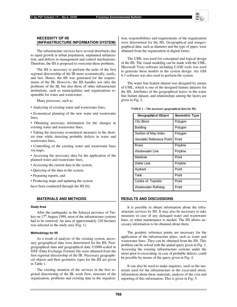
The geodetic reference points are necessary for the
application of the infrastructure plans, such as water and
wastewater lines. They can be obtained from the IIS. This
problem can be solved with the spatial query given in Fig. 3.
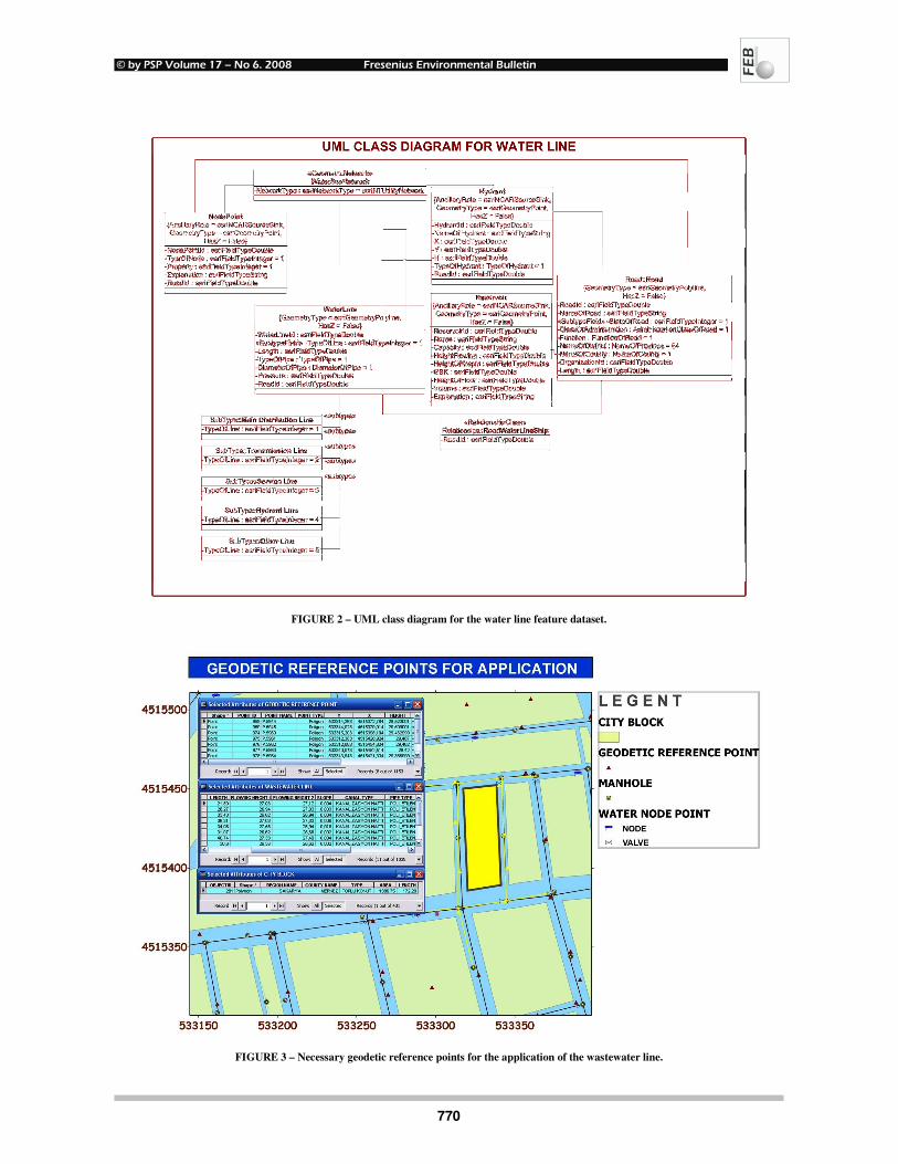
Accessing the existing infrastructure systems under the
street prior to excavating, in case of probable defects, could
be possible by means of the query given in Fig. 4.
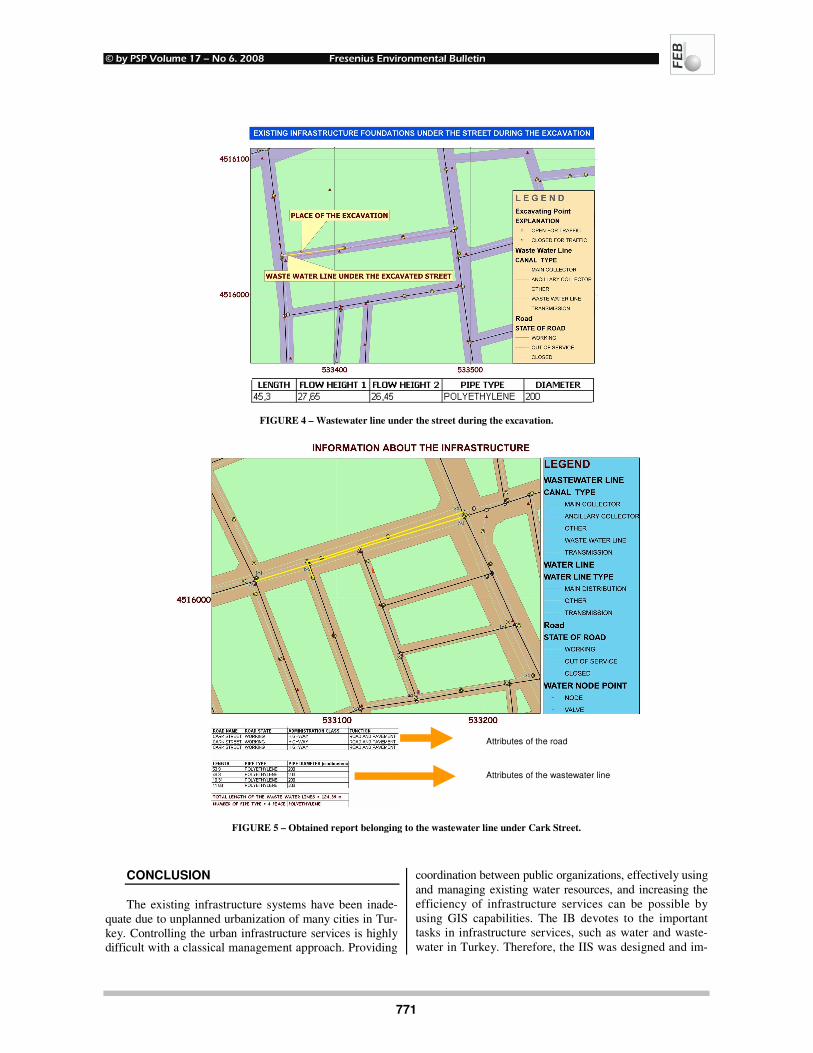
It can also be used to make inquiries, such as the ma-
terials used for the infrastructure in the excavated street,
information about these materials, analysis of the cost and
reporting of this information. This is given in Fig. 5.
© by PSP Volume 17 – No 6. 2008 Fresenius Environmental Bulletin
770
FIGURE 2 – UML class diagram for the water line feature dataset.
FIGURE 3 – Necessary geodetic reference points for the application of the wastewater line.
© by PSP Volume 17 – No 6. 2008 Fresenius Environmental Bulletin
771
FIGURE 4 – Wastewater line under the street during the excavation.
FIGURE 5 – Obtained report belonging to the wastewater line under Cark Street.
CONCLUSION
The existing infrastructure systems have been inade-
quate due to unplanned urbanization of many cities in Tur-
key. Controlling the urban infrastructure services is highly
difficult with a classical management approach. Providing
coordination between public organizations, effectively using
and managing existing water resources, and increasing the
efficiency of infrastructure services can be possible by
using GIS capabilities. The IB devotes to the important
tasks in infrastructure services, such as water and waste-
water in Turkey. Therefore, the IIS was designed and im-
Attributes of the road
Attributes of the wastewater line
© by PSP Volume 17 – No 6. 2008 Fresenius Environmental Bulletin
772
plemented for the infrastructure services in the first re-
gional directorship of the IB. In both the IB and municipali-
ties, the IIS has provided active, productive, efficient and
well-qualified infrastructure services.
UML is both a relational modeling and scheme draw-
ing language which was used for this study. A lot of func-
tions, such as presenting the solution of complex prob-
lems, emphasizing the solution clearly and creating the
system document later, can be implemented by UML.
Moreover, post-editing of a design, documented by
UML is easier.
Consequently, the IIS provides some advantages; such
as
• Obtaining current and accurate information about the
infrastructure systems,
• Taking economical measures within the shortest time and
producing maps of the region in case of possible defects in
the region,
• Searching for the solutions of the infrastructure problems
due to rapid population growth in the settlement areas,
• Controlling, maintaining and planning of the existing
infrastructure systems,
• Querying all kinds of infrastructure data in the system
and spatial analysis of them,
• Contributing to e-municipality services,
• Obtaining reports and map output in the system, and
• Updating the existing data in the system.
ACKNOWLEDGEMENTS
The authors would like to thank the directors of the
first regional directorship of the IB and their employees
for providing the data for the IIS.
REFERENCES
[1] Lo, C. P. and Yeung, A. K. W. (2002) The age of geographic
information infrastructure started in the mid-1990s. Concepts
and Techniques of Geographic Information Systems. Prentice
Hall, New Jersey, p.9.
[2] Lo, C. P. and Yeung, A. K. W. (2002) Network analysis. Concepts and Techniques of Geographic Information Sys-
tems. Prentice Hall, New Jersey, p.212.
[3] Report of the United Nations Conference on Environment and Development, Rio de Janeiro, 3-14 June 1992, vol. I,
Resolutions Adopted by the Conference (United Nations pub-
lication, Sales No. E.93.I.8 and corrigendum), resolution 1, annex I.
[4] Turk, T. (2004) GIS Design and Application for Infrastruc-
ture, Yildiz Technical University, Civil Engineering Faculty,
Istanbul (Master Thesis in Turkish).
[5] ESRI (2002) Using CASE for schema design and generation.
Building Geodatabase with CASE Tools. ESRI Press, Red-
lands, pp. 2-55.
[6] Kresse, W. and Fadaie, K. (2004) Non-geometry standards.
ISO Standards for Geographic Information. Springer-Verlag Berlin Heidelberg, New York, pp. 55-63.
[7] Nasser, M. (2003) UML dynamic diagrams. General Intro-
duction Object Oriented Technology and UML. BILDEM, Is-tanbul, chapter 2, pp. 1-52.
[8] Nasser, M. (2003) Class design. Object Oriented Analysis
and Design with UML. BILDEM, Istanbul, Chapter 5, pp. 1-69.
[9] Pressman, R. (2001) Object-Oriented concepts and principles.
Software Engineering. The McGraw-Hill Companies, Singa-
pore, pp. 542-566.
[10] Yomralioglu, T. (2000) Information System Applications on
Urban and Infrastructure. Principal Concepts of GIS and its
Applications. Secil Ofset, Istanbul (in Turkish).
[11] Zeiler, M. (1999) Modeling infrastructure. Modeling Our
World. ESRI Press, Redlands, pp. 128-142.
Received: June 09, 2006 Revised: November 14, 2006; April 16, 2007 Accepted: May 07, 2007
CORRESPONDING AUTHOR
Tarik Turk Yildiz Technical University
Civil Engineering Faculty
34349 Besiktas Istanbul
TURKEY
Phone : +90 212 383 30 20
Fax : +90 212 261 07 67
E-mail: [email protected]
FEB/ Vol 17/ No 6/ 2008 – pages