introduction to gis
TRANSCRIPT
Introduction to Geographic Information SystemsDanny M. Vaughn, Ph.D., CMS

Tell Me, I Forget,Show Me, I Remember,
Involve Me, I UnderstandChinese Proverb

GIS - a dynam ic means of conveying spatial & tabularinformation through thematic layers (themes or coverages). Queries may be addressed in a GIS through databasemanagement. New data is combined with other coverages to generate acompletely new thematic map. Logical & mathematical operators are employed providingenhanced modeling capabilities for spatial analysis. Rem ote Sensing (sensing remotely) – a measure of selectedwavelengths of the EM S as an analog signal. The signal is transformed into discrete or digital form forvisual enhancement, interpretation, and analysis of imagery.
Cartography: the science, art, and technology of makingmaps. Hard Copy Maps (traditional cartographic process) arestatic, & can not be changed since they are a single printedrepresentation of selected spatial elements & locationscapturing spatial events at one instance in time. Dynamic Maps are derived from a database stored in acomputer, & are accessible for upgrade and change. Theoutput map product can be redesigned through anautomated process that is generally termed com puter-assisted cartography.
Spatial analysis – a fundamental principle of geographic inquiry.Links associations of likeness, difference, or uniqueness of the physical,social, and societal phenomena operating in our world.An operational approach in spatial analysis is to identify problems thatdeal with space and location throughout time.A GIS provides the necessary platform to perform spatial analysis, andfunctions as the thread linking raw data to information, and ultimately toknowledge which may be further employed in a decision-making capacity.
Analysis is predicated around the following basicquestions:
1) W hat (Object)?2) W here (Location)?3) W hen (Time)?4) How (Process)?5) W hy (Explanation)?
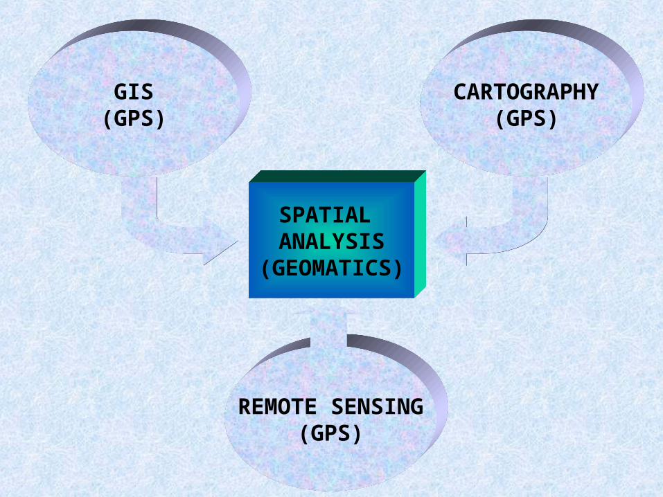
SPATIAL ANALYSIS
(GEOMATICS)
GIS(GPS)
CARTOGRAPHY(GPS)
REMOTE SENSING(GPS)
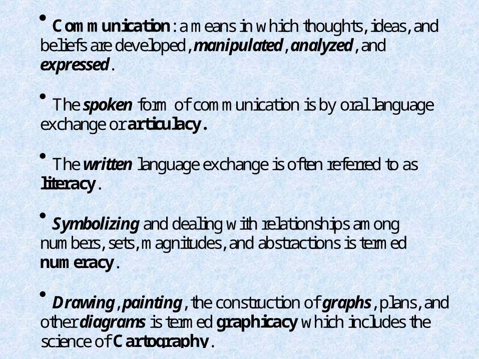
Com m unication: a means in which thoughts, ideas, andbeliefs are developed, manipulated, analyzed, andexpressed. The spoken form of communication is by oral languageexchange or articulacy. The written language exchange is often referred to asliteracy. Symbolizing and dealing with relationships amongnumbers, sets, magnitudes, and abstractions is termednum eracy. Drawing, painting, the construction of graphs, plans, andother diagrams is termed graphicacy which includes thescience of Cartography.
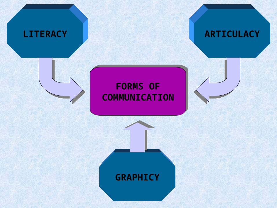
LITERACY ARTICULACY
GRAPHICY
FORMS OFCOMMUNICATION

Geographic: Geo = Earth, Graphic = a map or drawing. Data - numeric values or statistics. Inform ation - word-based or graphic & derived fromdata elements through a process of thought. Inform ation is data with explanation, or data in anapplied sense. W hen information is linked to physical, cultural, andsocietal entities, it may be employed as a decision supportsystem . Data & inform ation are processed & used to understand& explain phenomena about our world as knowledge.

GIS is a system of software & computer hardware. Collectively provide a mechanism for a data base(structured and stored data). Consists of selected natural and/or societal processes. Spatial & tabular data may be input & stored (as a database system ), captured, retrieved, updated, manipulated,deleted, analyzed, & output in graphic and tabular format. As a means of identifying trends and anomalies in spatialanalysis.
GIS: An automated system applied to geographic data.
System : An assemblege of connected entities andactivities which interact together as a functional unit.
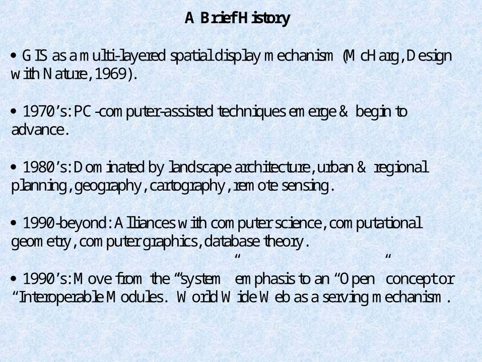
A Brief History GIS as a multi-layered spatial display mechanism (M cHarg, Design with Nature, 1969). 1970’s: PC-com puter-assisted techniques em erge & begin to advance. 1980’s: Dom inated by landscape architecture, urban & regional planning, geography, cartography, remote sensing. 1990-beyond: Alliances with computer science, computational geometry, computer graphics, database theory. 1990’s: M ove from the “system” em phasis to an “Open” concept or “Interoperable M odules.” W orld W ide W eb as a serving mechanism.
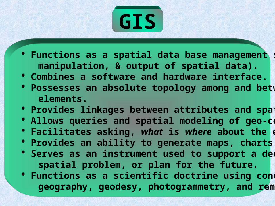
GIS Functions as a spatial data base management system (input, manipulation, & output of spatial data). Combines a software and hardware interface. Possesses an absolute topology among and between spatial elements. Provides linkages between attributes and spatial elements. Allows queries and spatial modeling of geo-corrected elements. Facilitates asking, what is where about the earth? Provides an ability to generate maps, charts, and tables. Serves as an instrument used to support a decision, solve a spatial problem, or plan for the future. Functions as a scientific doctrine using concepts derived from geography, geodesy, photogrammetry, and remote sensing.

GIS
GEOGRAPHY ANTHROPOLOGYGEOLOGY
Natural Resource Assessment.Wildlife Habitat Analysis.Rural/Urban Planning.Wetlands Assessment.View Shed Analysis.Environmental Impact.Recreation & Tourism.Network Analysis.Terrain Analysis.Agricultural Management.Facilities Management.Legal & Ethical Issues.Energy & Climatic Modeling.Marketing Analysis.Boundary Assessment.Time Change Analysis.
Drainage Basin Analysis.Floodplain Management.Mineral Exploration.Groundwater Modeling.Terrain Analysis.Hazards Assessment.Contaminant Transport. Time Change Analysis: Paleogeography. Depositional Environments. Surface Displacements.Geology, Soils, & Climate. Surface Processes Analysis. Engineering Geology.Water Quality.
Trade and Migration Routes.Multiple Occupancy Uses.Local Settlement Patterns: Proximity Analysis. Pattern Analysis. Density Analysis.Site Analysis for ModernLand Use Practices.Prehistoric Land Use.Materials Distribution.Distance Modeling.Agricultural Practices.Hunting & Gathering Areas.Time Change Analysis &Paleo-gentrification of sites.
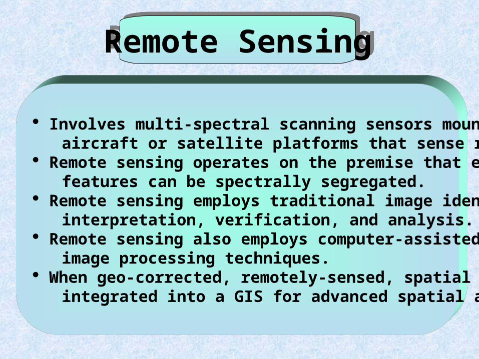
Remote Sensing
Involves multi-spectral scanning sensors mounted on board aircraft or satellite platforms that sense remotely. Remote sensing operates on the premise that earth surface features can be spectrally segregated. Remote sensing employs traditional image identification, interpretation, verification, and analysis. Remote sensing also employs computer-assisted, digital image processing techniques. When geo-corrected, remotely-sensed, spatial data may be integrated into a GIS for advanced spatial analysis.
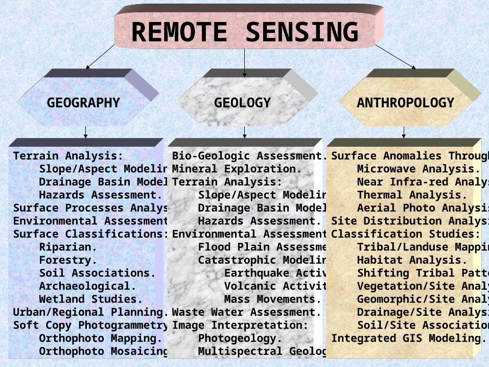
REMOTE SENSING
GEOGRAPHY ANTHROPOLOGYGEOLOGY
Terrain Analysis: Slope/Aspect Modeling. Drainage Basin Modeling. Hazards Assessment.Surface Processes Analysis.Environmental Assessment.Surface Classifications: Riparian. Forestry. Soil Associations. Archaeological. Wetland Studies.Urban/Regional Planning.Soft Copy Photogrammetry: Orthophoto Mapping. Orthophoto Mosaicing.
Bio-Geologic Assessment.Mineral Exploration.Terrain Analysis: Slope/Aspect Modeling. Drainage Basin Modeling. Hazards Assessment.Environmental Assessment: Flood Plain Assessment. Catastrophic Modeling: Earthquake Activity. Volcanic Activity. Mass Movements.Waste Water Assessment.Image Interpretation: Photogeology. Multispectral Geology.
Surface Anomalies Through: Microwave Analysis. Near Infra-red Analysis. Thermal Analysis. Aerial Photo Analysis.Site Distribution Analysis.Classification Studies: Tribal/Landuse Mapping. Habitat Analysis. Shifting Tribal Patterns. Vegetation/Site Analysis. Geomorphic/Site Analysis. Drainage/Site Analysis. Soil/Site Associations.Integrated GIS Modeling.

Cartography
Functions: As a technology employed to design and construct maps. As an art-form used to convey graphical information. As a science following a doctrine of design rules and laws from geography, photogrammetry, and geodesy. As a means of conveying higher order graphical information derived from a GIS or remotely sensed data.

CARTOGRAPHY
GEOGRAPHY ANTHROPOLOGYGEOLOGY
Thematic Mapping: Population Distributions. Geomorphic Patterns. Climate Patterns.Classification Maps: Equal Interval. Standard Deviation. Equal Area. Natural Breaks.Terrain Mapping: Shaded Relief. Block Diagrams. Statistical Surfaces.Choropleth Maps.Isarithmic Maps.Cadastral Maps.
Terrain Mapping: Shaded Relief. Block Diagrams. Statistical Surfaces.Isarithmic Maps: Topography. Gravity Surveys. Structure.Mapping Surface Geology.Mapping Glacial Deposits.Mapping Tectonic Activity.Sub-surface 3-D Maps.Choropleth Maps: Elevation Ranges. Slope/Aspect Ranges. Rock Units.
Prehistoric Settlement Maps.Proximity to Resources Maps.Site Distribution Maps.Map of Migration Patterns.3-D Maps of Excavated Sites.Maps of Cultural Diversity.Grid Mapping Techniques.Site Classification Maps.Hunting & Gathering Maps.Trade/Transportation Maps.Isarithmic Maps of a Site.Spectral Anomaly Maps.Spatial Anomaly Maps.Artifact Distribution Maps.Multiple Occupied Sites.Land Use Change.
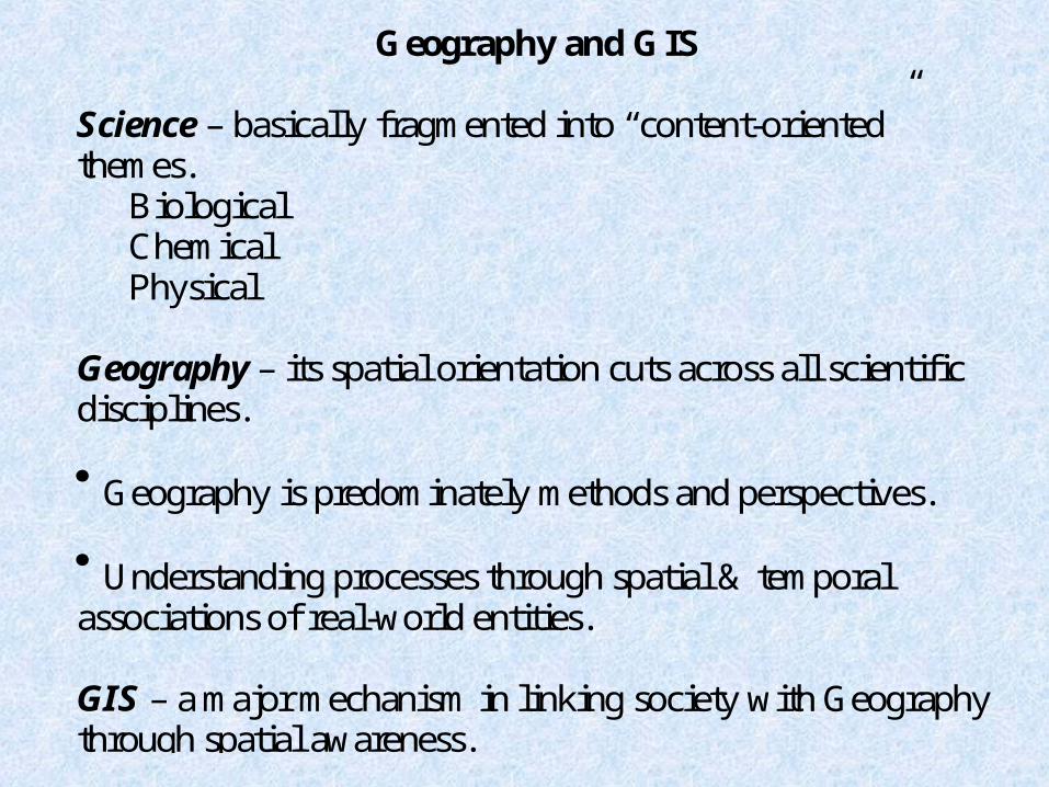
Geography and G IS
Science – basically fragmented into “content-oriented”themes.
BiologicalChemicalPhysical
Geography – its spatial orientation cuts across all scientificdisciplines. Geography is predominately methods and perspectives. Understanding processes through spatial & temporalassociations of real-world entities.
GIS – a major mechanism in linking society with Geographythrough spatial awareness.
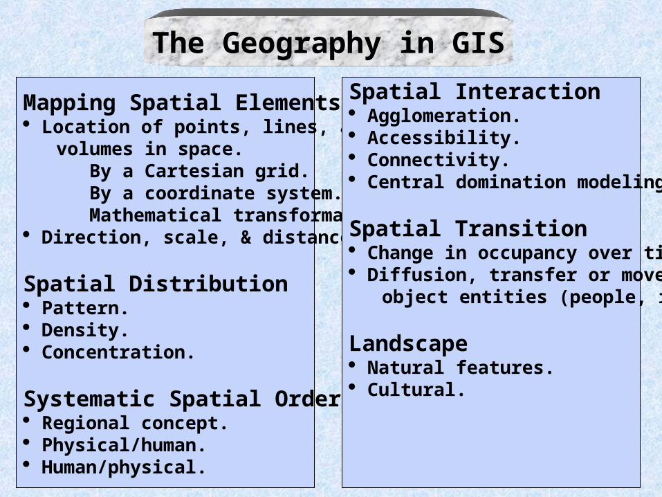
The Geography in GISMapping Spatial Elements Location of points, lines, areas, & volumes in space. By a Cartesian grid. By a coordinate system. Mathematical transformations. Direction, scale, & distance.
Spatial Distribution Pattern. Density. Concentration.
Systematic Spatial Order Regional concept. Physical/human. Human/physical.
Spatial Interaction Agglomeration. Accessibility. Connectivity. Central domination modeling.
Spatial Transition Change in occupancy over time. Diffusion, transfer or movement of object entities (people, ideas, etc.).
Landscape Natural features. Cultural.
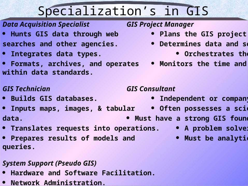
Specialization’s in GISData Acquisition Specialist GIS Project Manager Hunts GIS data through web Plans the GIS project. searches and other agencies. Determines data and software needs. Integrates data types. Orchestrates the GIS project. Formats, archives, and operates Monitors the time and budget. within data standards.
GIS Technician GIS Consultant Builds GIS databases. Independent or company employed. Inputs maps, images, & tabular Often possesses a science background.data. Must have a strong GIS foundation. Translates requests into operations. A problem solver. Prepares results of models and Must be analytical in thought.queries.
System Support (Pseudo GIS) Hardware and Software Facilitation. Network Administration.
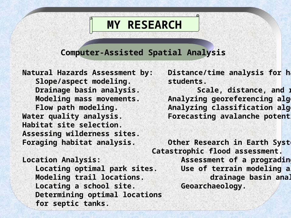
Natural Hazards Assessment by: Distance/time analysis for handicapped Slope/aspect modeling. students. Drainage basin analysis. Scale, distance, and relief displacement. Modeling mass movements. Analyzing georeferencing algorithms. Flow path modeling. Analyzing classification algorithms.Water quality analysis. Forecasting avalanche potential.Habitat site selection.Assessing wilderness sites.Foraging habitat analysis. Other Research in Earth System’s Science:
Catastrophic flood assessment. Location Analysis: Assessment of a prograding delta. Locating optimal park sites. Use of terrain modeling algorithms in Modeling trail locations. drainage basin analysis. Locating a school site. Geoarchaeology. Determining optimal locations for septic tanks.
MY RESEARCH
Computer-Assisted Spatial Analysis