the morphology and sedimentology of landforms created by subglacial megafloods
TRANSCRIPT

6 The morphology andsedimentology of landformscreated by subglacialmegafloods
MANDY J. MUNRO-STASIUK,JOHN SHAW, DARREN B. SJOGREN,TRACY A. BRENNAND,TIMOTHY G. FISHER, DAVID R.SHARPE, PHILIP S.G. KOR, CLAIRE L.BEANEY and BRUCE B. RAINS
SummarySubglacial landforms across various scales preserve
the history of movement, deposition and erosion by the lastgreat ice sheets and their meltwater. The origin of manyof these landforms is, however, contentious. In this chapterthese forms are described both individually and as suitesthat make up entire landscapes. Their interpretations arediscussed with reference to the megaflood hypothesis. Adescription is provided of individual forms via their size,shape, landform associations, sedimentology and the rela-tionship between landform surfaces and internal sediments.The possible origins of each are then discussed. To sim-plify the chapter the landforms are categorised by their size(micro, meso, macro and mega), although, importantly,it should be noted that several landforms show similari-ties across scales. Also discussed is the relevant subglacialhydrology associated with the described forms, especiallythe volume and discharge rates of megaflood flows, andwhere water may have been stored prior to the megafloodevents.
6.1 IntroductionAs early as 1812, Sir James Hall interpreted the
famous Castle Rock in Edinburgh, Scotland, a crag and tail,as a landform created by immense, turbulent floods. Liken-ing the hill to features carved in snow by wind, he couldonly hypothesise that water was responsible; probably gianttidal waves, as, at that time, he knew of no other mecha-nism that could conceivably create such streamlining. It isnow very clear that the streamlined forms first noted byHall are part of a continuum containing landforms of manyshapes and sizes. While many researchers have attributedtheir formation to subglacial processes involving deforma-tion of the glacier bed, in the last few decades attention hasmoved back to water as a major landforming agent.
This shift in ideas began when Shaw (1983) notedthat drumlins were similar in form to inverted erosional
marks produced by turbulently flowing water. He there-fore proposed that they may have been formed by melt-water erosion and deposition. Since the publication of thispaper an enormous volume of research has been under-taken addressing a meltwater genesis for a broad suite ofsubglacial landforms including: s-forms, drumlins, fluting,hummocky terrain, Rogen moraine, megaripples, tunnelchannels, eskers, streamlined hills, rises and re-entrant val-leys. As a continuum, these landforms define broad land-scape unconformities which on the largest scale indicatemeltwater flowpaths. Adding credence to the meltwaterhypothesis is the recognition of other erosional landformsof similar form that are produced by turbulent flow. Theseinclude: yardangs (Figure 6.1a), which are widely acceptedas the work of wind (Greeley and Iversen, 1985); sastrugiin snow and ice, which also result from wind sculpting(e.g. Herzfeld et al., 2003) (Figure 6.1b); erosional marksproduced by tsunami waves (Bryant and Young, 1996)(Figure 6.1c); and the loess hills of the Channeled Sca-blands (Figure 6.1d), which were formed by enormousoutpourings of water from glacial Lake Missoula and theCordilleran Ice Sheet system (Bretz, 1959; Baker, 1978;Shaw et al., 2000). Common to the forms illustrated in Fig-ure 6.1, and the majority of the subglacial forms discussedin this paper, is that they are considered as the productsof turbulent flow that contained vortices. For the formsdescribed here the inferred turbulent flow is subglacialmeltwater.
In this chapter, a synopsis is provided of the sub-glacial landforms that are interpreted to be producedby meltwater, and together they document evidence formegafloods. Their size, shape, landform associations, sedi-mentology, and the relationship between landform surfacesand internal sediments are all described. It is argued herethat all the features described, except for Livingstone drum-lins, Rogen moraine and eskers, are exclusively the productof subglacial meltwater erosion. Livingstone drumlins and
78
Megaflooding on Earth and Mars, ed. Devon M. Burr, Paul A. Carling and Victor R. Baker.Published by Cambridge University Press. C© Cambridge University Press 2009.

Morphology and sedimentology of landforms 79
Figure 6.1. Examples of landforms produced by turbulent flows. (a) Yardangs, Chad, beginning at prominent, bedrock escarpments. Note thestrong linearity of the bedforms (image from Google Earth); (b) Sastrugi in snow (courtesy the Royal Geographical Society); (c) Erosionalmarks produced by tsunami waves (courtesy of E. Bryant); (d) Streamlined loess hill in the Channeled Scablands.
Rogen moraine are related to erosion; however, the erosionwas up into the base of the ice rather than down into thesubstratum. The eroded cavities were filled subsequentlywith sediment during waning flows. Eskers are believed torepresent the final phases of floods. Because several of thefeatures discussed cross the boundaries of erosional ver-sus depositional, they are categorised by size (micro, meso,macro and mega) (Table 6.1). Importantly, though, some ofthese landforms show similarities across several orders ofmagnitude in scale and this fact is noted where appropriate.All of the described forms are observed as surface or buriedfeatures in formerly glaciated areas.
6.1.1 The megaflood controversyBefore discussing megaflood landforms, it is
pointed out that the megaflood hypothesis is not accepteduniversally. There is a significant debate in the literature
Table 6.1. Classification of subglacial landformscreated by meltwater flows (D: depositional,E: erosional)
Scale Landform
Microforms s-forms (E)
Mesoforms Drumlins (E & D)Fluting (E)Hummocky terrain (E)Rogen moraine (E & D)Megaripples (E)Tunnel channels (E)Eskers (D)
Macroforms Streamlined hills (E)
Megaforms Landscape unconformities (E)Flowpaths (E)

80 Mandy J. Munro-Stasiuk et al.
as to whether many of the features described herein wereformed by ice or by water. Arguments in opposition to themeltwater theory has been summarised by Benn and Evans(2006) and Evans et al. (2006). In particular, Evans et al.(2006) state, ‘It is regrettable that (the megaflood hypoth-esis) has not been subject to systematic scrutiny or testingat local scales of field based enquiry.’ This statement is amisrepresentation of the megaflood research as the major-ity of evidence, in the form of dozens of studies, is fromfield-based work.
Perhaps the biggest cause for concern among criticsof the meltwater hypothesis is the use of form analogy (e.g.Benn and Evans, 2006), one of the original lines of evi-dence that Shaw (1983) used to develop his hypothesis. Forinstance, Benn and Evans (1998, p. 446) wrote, ‘The useof sole marks beneath turbidites as analogues for drumlinsinvolves a major leap of faith, given the huge difference inthe scale of the features.’ This assertion is simply wrong.The analogy between drumlins and erosional marks doesnot always involve huge differences in scale. For instance:Normark et al. (1979) described 500 m wide crescenticscour marks on the Navy Submarine Fan; Fildani et al.(2006) described scours along the Monterey East Channelthat are up to 4.5 km wide, 6 km long and 200 m deep;and Piper et al. (2007) described a turbidity current scouron the Laurentian Fan, 2 km long and 100 m deep. Moreimportantly, the analogy is strong because there are a largenumber of points of similarity between Livingstone drum-lins (the ones originally compared to the scour marks) andinverted sole marks. Lorenz (1974) stated that the improb-ability of coincidental similarity is 1:2 (1−n), where n is thenumber of points of similarity. In this case, there are con-servatively eight points of similarity: (1) orientation withflow; (2) appearance in fields of similar form; (3) steeperat the upstream end; (4) spindle form; (5) parabolic form;(6) transverse asymmetrical form; (7) barchanoid form; and(8) infilling by current-bedded sediment. Thus the improb-ability of coincidental similarity is 1:128, strongly sug-gesting that the Livingtone drumlins and scours marks arerelated.
In addition, Gilbert (1896) noted, ‘Hypotheses arealways suggested through analogy’. He made it clearthat analogy is just a starting point for a hypothesis andexplained that additional features to those already observedare necessary before a hypothesis can be considered satis-factory. Much of this chapter concerns additional featuresthat support the original drumlin hypothesis. Also thesefeatures expand the scope from the origin of drumlins tothe much broader topic of subglacial outburst floods.
6.2 MicroformsMicroforms are the smallest of all the landforms that
are discussed in this chapter. They typically range from
a few millimetres in size to a few tens of metres (e.g.Kor et al., 1991; Munro-Stasiuk et al., 2005). Ljungner(1930) first described and classified these features, nowcommonly referred to as s-forms (sculpted forms) afterKor et al. (1991) (Figure 6.2). Many microforms, espe-cially muschelbruche, sichelwannen, spindle flutes, andother scour marks have been reproduced in flumes (e.g.Allen, 1971; Shaw and Sharpe, 1987) and identical formshave been noted in fluvial environments (e.g. Maxson,1940; Karcz, 1968; Baker and Pickup, 1987; Wohl, 1992;Tinkler, 1993; Baker and Kale, 1998; Hancock et al., 1998;Wohl and Ikeda, 1998; Gupta et al., 1999; Whipple et al.,2000; Richardson and Carling, 2005). It is known, there-fore, that these can be eroded by water. Also, the presenceof sharp upper rims on many of these forms typically isrepresentative of flow separation (e.g. Allen, 1982; Sharpeand Shaw, 1989) and the ever-present crescentic and hair-pin furrows represent the generation of horseshoe vorticesaround obstacles encountered by the flow (Peabody, 1947;Dzulynski and Sanders, 1962; Karcz, 1968; Baker, 1973;Allen, 1982; Sharpe and Shaw, 1989; Shaw, 1994; Lorencet al., 1994).
A recent thorough synopsis of sculpted forms byRichardson and Carling (2005) divides strictly fluvial formsinto three topological types: (1) concave features thatinclude potholes and furrows; (2) convex and undulatingforms such as hummocky and undulating forms; and (3)composite forms such as compound obstacle marks. How-ever, here a simpler classification is used, based on Kor et al.(1991), that groups forms into three types (Table 6.2) basedon their orientation relative to the flow direction: (1) trans-verse s-forms are usually wider than they are long, wherelength is measured parallel to the formative flow direction;(2) longitudinal forms are generally longer than they arewide, with their long axes lying parallel to the flow direc-tion; and (3) non-directional forms have no obvious rela-tionship to flow direction, although their location amongstother s-forms may indicate their origin. Importantly, theseforms typically occur en echelon (Figure 6.3a).
6.2.1 Transverse s-formsTransverse s-forms that originate transverse to
the flow direction include muschelbruche, sichelwannen,comma forms and transverse troughs.
Muschelbruche (singular muschelbruch) are shal-low depressions that resemble the inverted casts of the shellsof mussels, with sharp, convex upflow rims and indistinct,downflow margins merging imperceptibly with the adjacentrock surface (Figure 6.3b). The proximal slope is steeperthan the distal slope.
Sichelwannen (singular sichelwanne) are sickle-shaped marks (Figure 6.3c) that resemble the classi-cal transverse erosional marks (flutes) of Allen (1971,

Morphology and sedimentology of landforms 81
Table 6.2. Classification of s-forms based on Kor et al. (1991)
Group Type Description
Transverse forms Muschelbruche Mussel-shell-shaped depressions with sharp, convex upflow rimsSichelwannen Sickle-shaped convex upflow marks, with arms extending around medial ridgeComma forms Similar to sichelwannen, but with one armTransverse troughs Relatively straight troughs perpendicular to flow
Longitudinal forms Spindle flutes Narrow, long, shallow spindle-shaped marks with sharp rims on upflow sideCavettos Curvilinear undercut channelsStoss-side furrows Shallow linear depressions on stoss side of bedrock risesFurrows Long linear troughs adorned by many smaller s-forms
Non-directional forms Undulating surfaces Non-directional bed undulationsPotholes Near-circular depressions with spiralling flow patterns on walls
Transverse forms Non-directional forms
Longitudinal forms
a. Muschelbrüch
d. Transverse trough
h. Undulating surface
i. Pothole
transverse
troughb. Sichelwanne
c. Comma form
e. Spindle flutes
f. Cavetto
g. FurrowOpen spindle
Closed spindle
Figure 6.2. S-forms identified and sketched from the French River Complex. Flow direction is from left to right except for the non-directionalforms. (Modified from Kor et al. (1991).)

82 Mandy J. Munro-Stasiuk et al.
Figure 6.3. Photographs of each s-form type. All images are from the French River Complex, Georgian Bay, Ontario, unless otherwise noted.(a) S-forms typically occur in suites; (b) sichelwanne; (c) muschelbruche; (d) comma form; (e) transverse troughs; (f) rat-tails at Marysville,Ontario, Canada; (g) closed spindles; (h) cavetto at Kelleys Island, Ohio; (i) stoss-side trough; (j) the large furrow at Kelleys Island –contained within it are many other types of s-forms; (k) undulating surface; (l) large pothole at Key River, Georgian Bay.

Morphology and sedimentology of landforms 83
Figure 6.3. (cont.)

84 Mandy J. Munro-Stasiuk et al.
Figure 1). They have sharp, convex upflow rims and a cres-centic main furrow, extending downflow into arms wrappedaround a median ridge. Lateral furrows may flank themain furrow. In an en-echelon system, the ‘arms’ mergeand bifurcate downflow into other sichelwannen, or mayextend downflow into comma forms. Munro-Stasiuk et al.(2005) noted that these forms sometimes occur as multiple-trough forms having as many as ten individual semi-paralleltroughs.
Sichelwannen sometimes blend into comma formsor vice versa and they are thus part of a continuum. Morpho-logically they are almost identical to sichelwannen exceptthere is only one well-developed ‘arm’, or exit furrow; theother arm is either missing or poorly formed (Figure 6.3d)(Shaw and Kvill, 1984).
Transverse troughs are relatively straight troughsarranged perpendicular to flow, with widths much greaterthan lengths (Figure 6.3e). They commonly have a steep,relatively planar upflow slope or lee face below a rel-atively straight rim. Potholes often occupy this upflowslope. The downflow or riser slope is gentler and nor-mally eroded by shallow, stoss-side furrows, which producesinuous slope contours. Large transverse troughs are nor-mally compound forms enclosing numerous, smaller-scales-forms.
6.2.2 Longitudinal s-formsLongitudinal s-forms have a distinct orientation in
the direction of the forming flow. They include rat-tails,spindle flutes, cavettos, stoss-side furrows and furrows.
Rat-tails are positive residual bedforms defined byhairpin scours (crescentic scours with arms extendingdownflow) wrapped around their stoss ends (Figure 6.3f ).They extend in the downflow direction from resistant obsta-cles. As the lateral scours widen and shallow downflow,the rat-tail tapers and becomes lower. Rat-tails occur at themillimetre scale up to several kilometres around seamountsand islands in tidal estuaries (Allen, 1982). Gilbert et al.(2003) drew the same analogy between small-scale featuresin Ontario and kilometre-scale rat-tails on the Antarcticshelf.
Spindle flutes are narrow, shallow, spindle-shapedmarks much longer than they are wide and with sharp rimsbounding the upflow side and, in some cases, the down-flow margins (Figure 6.3g) (Allen, 1971). They are pointedin the upflow direction and broaden downflow. Whereasopen spindle flutes merge indistinctly downflow with theadjacent rock surface, closed spindles have sharp rims clos-ing at both the upflow and downflow ends. Spindle flutesmay be asymmetrical, with one rim more curved than theother.
Cavettos are curvilinear, undercut channels erodedinto steep, commonly vertical or near-vertical rock faces
(Figure 6.3h) (Johnsson, 1956; Kor et al., 1991; Munro-Stasiuk et al., 2005). The upper lip is usually sharper thanthe lower one, although both may be sharp. Cavetto formsvary greatly in size. Small-scale, long sinuous channelsare seen on the flanks of bedrock promontories alreadysculpted with other s-forms (Figure 6.3h). Others adornlarge vertical rock promontories making them difficult todetect in the field.
Stoss-side furrows are shallow, linear depressionson the stoss side of bedrock rises, giving a regular, gentlycurving, sinuous contour to the slope (Figure 6.3i). Theyhave rounded rims and are open at both ends. These furrowscommonly form on the distal slopes of transverse troughs.
Furrows are linear troughs, much longer than wide,that carry a variety of s-forms and remnant ridges on theirbeds and walls (Figure 6.3j). Rims are remarkably straightwhen viewed over the full length of furrows but are usuallysinuous in detail, due to sculpting into the trough walls bysmaller s-forms. These forms vary greatly in size. Com-monly they are recognised easily at outcrop scale but maybe so large that they are only recognised from the air or ontopographic maps. Remarkable examples of furrows at thisscale are the huge re-entrant valleys that mark the northernportion of the Niagara Escarpment (Straw, 1968; Kor andCowell, 1998). Munro-Stasiuk et al. (2005) suggested thatsome furrows may be longitudinal troughs that lie betweenlarger-scale fluting ridges (see section on fluting).
6.2.3 Non-directional s-formsNon-directional s-forms record no discernable flow
direction and include undulating surfaces and potholes.Undulating surfaces are smooth, non-directional,
low-amplitude undulations found on gentle lee slopes ofrock rises (Figure 6.3k). These low-amplitude features arevery common to broad areas of low-relief terrain, usuallylocated peripheral to the main sheetflow events, and in asso-ciation with the other s-forms described above.
Potholes are near-circular, deep depressions thatmay show spiralling, descending flow elements inscribedon their walls (Figure 6.3l) (Gilbert, 1906; Alexander,1932). Potholes typically occur in bedrock terrains on thesummits, flanks and, notably, on the lee sides of bedrockknolls and ridges. They range in size (diameter and depth)from a few centimetres to many metres and commonlyhave a circular to slightly oval surface expression. The mostspectacular potholes occur in the lee of bedrock obstaclesor obstructions and are often missing their distal walls. Pot-holes may occur singly or in small groups, or may occur inlarge concentrations, often showing an en echelon pattern.Some potholes contain a lag of boulders or other debris.
When potholes occur on the lee side of obstructionsand they are associated with abundant sculpted forms onbedrock surfaces, they may be interpreted as resulting from

Morphology and sedimentology of landforms 85
Figure 6.4. Vortices responsible for some s-forms. (a) Low-angle plunging vortex responsible for creating spindle flutes; (b) high-angleplunging vortex responsible for creating muschelbruche; (c) vortices generated by a bed defect responsible for creating sichelwannen.
catastrophic flood release of meltwater from beneath anactive ice sheet (e.g. Embleton and King, 1975; Sugden andJohn, 1976; Kor et al., 1991). In this association, potholesare considered to be a type of s-form (Kor et al., 1991).
6.2.4 Flow characteristics related to s-formsS-forms are typically formed by preferential erosion
by vortices. Muschelbruche and spindle forms are consid-ered to result from vortex impingement on the rock bed (Koret al., 1991). Spindle forms result when the vortex impinge-ment is at a low angle (Figure 6.4a) and muschelbrucheform when impingement is at a high angle (Figure 6.4b).By contrast, sichelwannen result from separation at a con-vex upstream rim creating counter-rotating vortices, whicherode longitudinal troughs that wrap around medial ridges(Figure 6.4c). In some cases the primary vortices generatesecondary, lateral vortices that erode lateral furrows.
Transverse troughs also involve flow separation thatgives rise to rollers along the upstream slope. It is probablethat rollers become counter-rotating longitudinal vortices,which are swept over the stoss side of downstream ridges(Pollard et al., 1996). If this happens with regular spacinga series of stoss-side furrows would form. Furrows wouldgrow as they captured vortex pairs. This process is analo-gous with the formation of re-entrant valleys at escarpmentsto be discussed. Longitudinal forms (furrows and cavettos)are formed by longitudinal vortices although the flow is fre-quently complex, resulting in the formation of transversefeatures as ornamentation (Munro-Stasiuk et al., 2005).Potholes are formed by vortices spiralling down the wallsand stretched vortices emerging from the core of the flow.Undulating surfaces are not related clearly to a particularstructure, though a three-dimensional wave structure in theflow may be responsible for this bedform type.
Observations in flumes show that rat-tails are erodedby horseshoe vortices generated by an interaction betweenthe obstacle and the boundary layer. Flow separation givesrise to two counter-rotating vortices wrapping around theupstream sides of obstacles and extending down the flanks
Figure 6.5. The classical streamlined drumlin with blunt stoss sideand tapered lee side.
of the rat-tail. As the vortices increase in diameter andweaken, the hairpin scours on either side of the rat-tailbecome wider and shallower so that it is pointed down-stream and merges with the bed. The flow structure for theformation of rat-tails is scale independent.
6.3 MesoformsMesoforms are perhaps the most widely recognised
yet least understood of all the landforms discussed in thischapter. They are on the scale of tens of metres to tens ofkilometres in length and tens to hundreds of metres in width.Despite a larger scale, their common erosional origins meanthat they have much in common with s-forms.
6.3.1 DrumlinsClassical drumlins (Figure 6.5) are streamlined and
are arranged in fields, some containing tens of thousands ofindividual landforms. They are asymmetrical in plan, high-est at their proximal blunt ends and taper in a downflowdirection on their lee sides. There have been several theoriesof drumlin formation proposed including but not limited to:subglacial deformation (Boulton, 1987), the dilatancy the-ory (Smalley and Unwin, 1968) and subglacial meltwater

86 Mandy J. Munro-Stasiuk et al.
Figure 6.6. Landform formation by broad, subglacial meltwaterflow. Note erosional and depositional features.
erosion and deposition (Shaw et al., 1989). As shown inFigure 6.6 the meltwater hypothesis for drumlin formationholds that drumlins are created either by direct fluvial ero-sion of the bed (Beverleys), or by fluvial infilling of cavitiesformed as erosional marks in glacier beds (Livingstones)(e.g. Shaw, 1996).
It is generally thought that drumlin streamlining rep-resents minimum resistance to flow but this is only truefor flows of high Reynolds numbers, i.e., turbulently flow-ing water (Shapiro, 1961). Hairpin furrows or horseshoe-shaped scours commonly are wrapped around the proxi-mal ends of Beverleys (Figure 6.7) and crag and tails (e.g.Shaw, 1994), in a similar fashion to the s-forms previouslydescribed. Analogous forms in turbulent flow are producedby vortex erosion around bridge piers (Dargahi, 1990) andon the upstream side of scour remnant ridges (Allen, 1982).Thus, streamlining and hairpin troughs support the hypoth-esis of drumlin formation by turbulent meltwater.
The classical drumlin shape is represented by Bev-erleys (Figure 6.7). Beverleys are erosional remnants com-posed of pre-existing material. They, therefore, can con-tain sorted and stratified sediment, diamicton (till or debrisflow deposits), soil horizons and even bedrock (e.g. Habbe,1989).
Livingstones have distinctive forms that are differ-ent from Beverleys: spindle, parabolic and transverse asym-metrical forms (Figure 6.8) (Shaw 1983). When inverted,these three types have analogues in erosional marks pro-duced by turbulently flowing water and air (e.g. Shaw,1983). Livingstones are mainly composed of fluvial sedi-ment, some of which may have been resedimented by massmovement on steep, primary slopes. Exposures in Living-stones in the Livingstone Lake drumlin field in northern
Figure 6.7. Erosional drumlins, Nechako Plateau, BritishColumbia. Flow from the southwest. Individual drumlins areoutlined by narrow, hairpin troughs (dark) wrapped around theirstoss ends.
Saskatchewan show mainly sorted and stratified sedimentswith large boulders (Shaw et al., 1989). Boulder and cob-ble gravels interbedded with graded and bedded sand giveway distally to fine, graded sand with pebbly diamicton,although there are striated boulders in proximal and dis-tal positions. Bedding in all excavations is conformablewith the land surface. Gravel clasts in the LivingstoneLake drumlins are predominantly from the local AthabascaSandstone, indicating a short distance of transport (Shawet al., 1989).
Deposition of Livingstones is explained best as acombination of fluvial sedimentation and mass movementin cavities eroded into the underside of ice sheets withintermittent emplacement of boulders released from cavityroofs.
Drumlins and their relationships with adjacent land-forms Because Beverleys occur on interfluves betweentunnel channels and both are part of an unconformity(Sharpe et al., 2004), it is suggested that they are productsof erosion by the same agent. The channels are regardedwidely as meltwater forms (see section on tunnel channels)and it has been argued above that drumlins are formed bya turbulent fluid, probably meltwater. Drumlins and flutingcommonly extend from forward-facing steps where turbu-lent fluids form streamwise zones of high and low velocityrelated to longitudinal vortices (e.g. Tinkler and Stenson,1992; Pollard et al., 1996; Wilhelm et al., 2003). Down-flow walls of tunnel channels lying oblique or transverse

Morphology and sedimentology of landforms 87
Figure 6.8. (a) Parabolic and spindle-shaped Livingstones, Livingstone Lake area, northern Saskatchewan. A tunnel channel containingeskers is accentuated. Flow from northeast. (b) Transverse asymmetrical drumlins, Livingstone Lake area, northern Saskatchewan. Flow fromnortheast. (c) Forms of Livingstone drumlins. To view these as erosional marks, turn the page upside down.

88 Mandy J. Munro-Stasiuk et al.
Figure 6.9. Landsat TM image of fluting initiated on aforward-facing slope at Dubawnt Lake, Northwest Territories,Canada. Flow from southeast.
to the regional flow are forward-facing steps along whichdrumlins and flutings are typically clustered (Shaw et al.,2000; Munro-Stasiuk and Shaw, 2002).
The close association of drumlins and tunnel chan-nels and eskers points to a sequence: formation of drumlinsby broad meltwater flows; flow concentration in channelsand the formation of tunnel channels; followed by concen-tration of flow into conduits eroded upwards into the icebed and the formation of eskers. Together, these make upthe broader landscape.
6.3.2 Large-scale flutingSometimes called megascale glacial lineations,
large-scale fluting can be tens of kilometres long and afew hundred metres wide. Fluted terrain comprises ridgeswith lateral troughs. Crescentic troughs commonly wraparound the leading edges of ridges (Figure 6.9). Flutingoccurs together with drumlins in the same field and theyare part of a continuum. High ground downstream fromforward-facing slopes or steps is commonly fluted (Pol-lard et al., 1996; Shaw et al., 2000; Munro-Stasiuk andShaw, 2002). This characteristic is shared with yardangs(Figure 6.1a) and furrows associated with volcanic blasts,and is explained by the formation of streamwise vorticesin turbulent flow in those locations (Pollard et al., 1996;Wilhelm et al., 2003). The internal structure of fluting istypically truncated by the land surface and a boulder lagcommonly lies on this surface (Shaw et al., 2000; Munro-Stasiuk and Shaw, 2002), indicating erosional formation
by turbulent fluid. For subglacial environments, this fluidwould have been meltwater.
6.3.3 Hummocky terrainUnlike drumlins and fluting, hummocky terrain,
known traditionally as hummocky moraine, was longthought to be interpreted easily. Although its origin hasbeen attributed to many glacial processes, it is generallythought to have originated by supraglacial deposition dur-ing let-down at, or near, ice margins (e.g. Gravenor andKupsch, 1959). Therefore this terrain has been used todelineate recessional stages of glaciation (e.g. Clayton andMoran, 1974; Dyke and Prest, 1987). While this interpre-tation may hold true in some regions, observations in thesouthwest sector of the Laurentide Ice Sheet demonstratethat hummocky terrain was formed by erosion, specifically,subglacial meltwater erosion (Munro and Shaw, 1997).
The major north–south trending hummocky beltsin Alberta and Saskatchewan specifically have been identi-fied previously as hummocky moraines. Munro-Stasiuk andSjogren (2006) grouped hummocks into six types based onshape (both plan and cross-section): I – mounds with nodiscernable orientations or patterns; II – mounds with cen-tral depressions; III – linked mounds with central depres-sions; IV – ridged mounds; V – elongate mounds; and VI –moraine plateaux (Figure 6.10). Materials in the hummocksinclude lodgement and melt-out till, in-situ and disturbedlake sediments, and in-situ and thrust local bedrock andpreglacial sediments (e.g. Kulig, 1985; Tsui et al., 1989;Munro and Shaw, 1997; Sjogren, 1999; Munro-Stasiuk,2003; Evans et al., 2006).
The presence of in-situ bedrock in some of theseforms demonstrates conclusively that they are the prod-ucts of erosion rather than deposition. In addition, expo-sures clearly show that intact regional lithostratigraphiesand local sedimentary beds are truncated by hummock sur-faces (Figure 6.11). Hummock surfaces, therefore, form alandscape unconformity (see section on landscape uncon-formities). Sedimentary observations point to a subglacialorigin for the erosion: (1) subglacial eskers overlie thehummocks (Munro and Shaw, 1997); and (2) the youngestrecorded unit in the hummocks is a subglacial melt-out tillwith strongly oriented clast fabrics, which are up to 70◦ atvariance from the alignments noted in hummocks (Munro-Stasiuk, 2000). Thus, erosion of the hummock surfaceswas not related directly to the processes that deposited theunderlying till; it clearly occurred after till deposition.
While the dynamics of flow for hummocky terraincurrently are poorly understood, several lines of evidencesuggest erosion by fluvial processes that removed sedimentgrain by grain, thus scouring underlying sediment but leav-ing beds undisturbed: (1) surface boulders at many loca-tions are best explained as fluvial lags resulting from lower

Morphology and sedimentology of landforms 89
Figure 6.10. Hummock types observed in central and southern Alberta.
flow competence in some areas; (2) sorting of the lags sug-gests fluvial transport; (3) many boulders are heavily pittedwith percussion marks attesting to clast on clast collisions;(4) type IV hummocks (ridged mounds) resemble fluvialbedforms (see Allen, 1982), erosional marks produced onthe underside of river ice (Ashton and Kennedy, 1972)and may in fact be a type of Rogen moraine (see sectionon Rogen moraine); and (5) horseshoe-shaped troughs arewrapped around the upstream sides of some mounds sug-gesting scouring by horseshoe vortices generated at obsta-cles in the flow (e.g., Shaw, 1994), as for some drumlinsand s-forms.
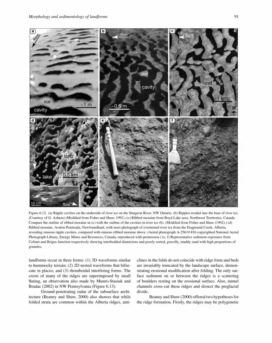
6.3.4 Rogen moraineRogen moraine, also known as ribbed moraine, con-
sists of transverse ridges that formed perpendicular to flow.They form a continuum with drumlins and are accepted bymost researchers as having formed subglacially, althoughthere is still debate as to their specific origin. Based onboth form analogy and sedimentology, Fisher and Shaw(1992) preferred a meltwater origin for forms that theyobserved on the Avalon Peninsula, Newfoundland. Rogenmoraine ridges were held to have formed in cavities erodedupwards into the glacier bed. Identical-shaped cavities ofsmaller scale are produced by turbulent water flowingunder river ice (Fisher and Shaw, 1992). These transversecavities (Figures 6.12a, b and d) when inverted displayall the geometric aspects of Rogen ridges including broadcrescentic shapes, convex upflow, anastomosing patterns of
ridges, and individual hummocks between ridges. Ashtonand Kennedy (1972), who also examined river ice, noted afluted morphology with small scallops aligned perpendic-ular to flow making up asymmetrical ripples that resembledrumlins in form.
Sediments in the Rogen ridges are typical of bothglaciofluvial deposition and debris flows (Figures 6.12eand f) (Fisher, 1989; Fisher and Shaw, 1992). Clasts over-lying granule beds record cut and fill by flows, and the siltand sand stringers probably were elutriated during type Iand II debris flows (see Lawson, 1979). Gravel and sandbeds may record meltwater deposition between debris flowevents. All sediments appear to record primary depositionwith only minor shearing. This observation is consistentwith deposition in subglacial cavities. Similar descriptionsand interpretations have been provided for Swedish Rogenmoraine by Moller (2006).
Fisher and Shaw (1992) presented a model wherebytransverse cavities were eroded into the base of a glacier bya broad sheet flow, similar to the transverse cavities notedby Ashton and Kennedy (1972). These cavities then filledwith glaciofluvial sediment, some of which was reworkedby debris flows. There is similarity in both the environ-ment and processes of deposition for Rogen ridges andLivingstones.
6.3.5 MegaripplesFeatures identified as megaripples have rarely been
described although they appear prominently on DEMs of

90 Mandy J. Munro-Stasiuk et al.
Figure 6.11. Representative exposures along Travers and McGregor Lake Reservoirs that illustrate the erosional nature of hummock surfaces.
previously glaciated regions (Figure 6.13). Megaripples areidentical in form to regular sand ripples except they areorders of magnitude larger. Beaney and Shaw (2000) iden-tified erosional megaripples on the preglacial Milk Riverdrainage divide in southeast Alberta. These were previ-ously interpreted as glaciotectonic thrust ridges of Cre-taceous Shale (see Shetsen, 1987). Megaripples are partof a suite of landforms, including fluted terrain, scouredbedrock and tunnel channels, all interpreted to be the prod-
uct of meltwater erosion. Beaney and Shaw noted the simi-larity between the ridge forms and transverse s-forms (Koret al., 1991), erosional megaripples on the Laurentian Fan(Hughes Clarke et al., 1990), and antidunes formed onriver beds (Shaw and Kellerhals, 1977; Allen, 1982). Theridges have crests up to 10 km long, with wavelengths rang-ing from 400 m to 1300 m, and heights ranging from 2 mto 15 m (Figure 6.13). The ridges have a well-developedasymmetric profile, with steeper downflow sides. These
Morphology and sedimentology of landforms 91
Figure 6.12. (a) Ripple cavities on the underside of river ice on the Sturgeon River, NW Ontario. (b) Ripples eroded into the base of river ice.(Courtesy of G. Ashton) (Modified from Fisher and Shaw, 1992.) (c) Ribbed moraine from Boyd Lake area, Northwest Territories, Canada.Compare the outline of ribbed moraine in (c) with the outline of the cavities in river ice (b). (Modified from Fisher and Shaw (1992).) (d)Ribbed moraine, Avalon Peninsula, Newfoundland, with inset photograph of overturned river ice from the Dogpound Creek, Alberta,revealing sinuous ripple cavities, compared with sinuous ribbed moraine above. (Aerial photograph A-25619 #16 copyrighted National AerialPhotograph Library, Energy Mines and Resources, Canada, reproduced with permission.) (e, f) Representative sediment exposures fromColinet and Brigus Junction respectively showing interbedded diamictons and poorly sorted, gravelly, muddy sand with high proportions ofgranules.
landforms occur in three forms: (1) 3D waveforms similarto hummocky terrain; (2) 2D nested waveforms that bifur-cate in places; and (3) rhomboidal interfering forms. Thecrests of many of the ridges are superimposed by smallfluting, an observation also made by Munro-Stasiuk andBradac (2002) in NW Pennsylvania (Figure 6.13).
Ground-penetrating radar of the subsurface archi-tecture (Beaney and Shaw, 2000) also showes that whilefolded strata are common within the Alberta ridges, anti-
clines in the folds do not coincide with ridge form and bedsare invariably truncated by the landscape surface, demon-strating erosional modification after folding. The only sur-face sediment on or between the ridges is a scatteringof boulders resting on the erosional surface. Also, tunnelchannels cross-cut these ridges and dissect the preglacialdivide.
Beaney and Shaw (2000) offered two hypotheses forthe ridge formation. Firstly, the ridges may be polygenetic

92 Mandy J. Munro-Stasiuk et al.
Figure 6.13. Transverse ridges on the Ohio–Pennsylvania borderwith superimposed fluting.
with structure inherited from glaciotectonic processes andthen modified by subglacial meltwater. Glaciotectonicthrusting likely resulted from increased basal shear stresses,where ice grounded on the preglacial divide as a resultof subglacial meltwater ponding upflow. Once the pondedwater was released it would have flowed across the drainagedivide eroding the thrust terrain and forming megaripples.Alternatively, the ridges may represent erosional featuresassociated with internal stationary waves related to abruptdensity gradients in hyperconcentrated subglacial meltwa-ter flows.
6.3.6 Tunnel valleys/channelsThere is little debate that valleys or scoured corri-
dors that truncate subglacial bedforms such as drumlins andmegaripples (see above), that contain eskers and/or underfitstreams and have upslope paths, are the geomorphologicalexpression of large subglacial meltwater flows that effi-ciently evacuated meltwater and sediment from beneathpast ice sheets (e.g. Wright, 1973; Rampton, 2000). Thetunnel valleys/channels are generally long (tens of kilo-metres), wide (kilometres), flat-bottomed, over-deepened(tens to hundreds of metres), radial or anabranched valleysystems. They can be incised into bedrock or sediment, ter-minate in ice marginal fans and be empty, partially filled orburied by sediments. In recent years, there has been con-siderable debate as to the precise mechanism(s) by whichsuch large valleys formed (e.g. O’Cofaigh, 1996) and theirimplications for ice sheet dynamics and hydrology. Twodominant hypotheses for their formation have emerged.(1) The piping (bed deformation) hypothesis (e.g. Boul-ton and Hindmarsh, 1987) states that tunnel valleys formedat below bankfull conditions in a headward progression
as a saturated substrate dewatered and formed pipes atthe ice margin. As sediment was flushed from thesepipes and with ice margin retreat, tunnel valleys gradu-ally evolved, growing deeper and longer. (2) The chan-nelised underburst hypothesis (e.g. Brennand and Shaw,1994) states that tunnel channels were incised under bank-full conditions by channelised underbursts (jokulhlaups ormegafloods) draining a subglacial or supraglacial meltwa-ter reservoir. Thermal conditions at the glacier sole mayhave facilitated reservoir growth and drainage (Cutler etal., 2002). While the piping hypothesis may hold true forsome sediment-walled tunnel valleys formed at the icemargin, many observations from tunnel channels/valleysassociated with the Laurentide and Cordilleran ice sheetssupport the channelised underburst hypothesis (e.g. Bren-nand and Shaw, 1994; Sjogren and Rains, 1995; Beaneyand Shaw, 2000; Cutler et al., 2002; Fisher et al., 2005).This assertion is illustrated by exploring the characterof the central southern Ontario (Canada) tunnel channelnetwork.
Central southern Ontario exhibits a regional LateWisconsinan unconformity (see section on landscapeunconformities) that truncates Palaeozoic bedrock and athick Quaternary sediment cover (e.g. Sharpe et al., 2004).This unconformity is composed of drumlins, s-forms andvalleys. The valleys form a dense, anabranched NE–SW-oriented network (Figure 6.14). The valleys are assignedto five classes based on their geomorphology, and theirabsolute and stratigraphic depth of incision. Bedrock val-leys are structurally controlled, steep-sided, ornamented bys-forms (Shaw 1988) and occur headward (north andeast) of sediment-walled valleys. Sediment-walled valleys(classes 1–4) (Figure 6.14) extend from bedrock valleys anddissect drumlinised terrain. Classes 1–4 identify progres-sively smaller and/or shallower sediment-walled valleys(Brennand et al., 2006). Valley fills are up to ∼150 mthick and generally fine upward and sometimes they includeeskers (e.g. Russell et al., 2003).
This integrated, anabranched valley network isinferred to record a tunnel channel system that washydromechanically eroded and/or re-utilised by a chan-nelised turbulent, meltwater underburst in the Late Wiscon-sinan. This is because valleys: (1) are incised into and con-tain Late Wisconsinan sediment; (2) have undulating floorsand upslope paths; (3) locally contain eskers and are filledby sediments indicative of rapid sedimentation (e.g. sandyhyperconcentrated flow deposits); (4) exhibit no evidenceof convergent sediment deformation along their margins;(5) are cut to elevations below Lake Ontario base level andfail to terminate in deltas or fans at proglacial or modernshorelines; and (6) contain modern underfit streams up toan order of magnitude narrower than valleys (e.g. Brennandand Shaw, 1994; Russell et al., 2003).

Morphology and sedimentology of landforms 93
Figure 6.14. Central southern Ontario tunnel channels. (a) Hill-shaded digital elevation model (DEM) showing dissected drumlinised terrain,the Oak Ridges Moraine, escarpments and eskers. (b) Distribution of five tunnel channel classes, buried valleys, seismic lines and drill holesbetween the Precambrian–Palaeozoic boundary and the Niagara escarpment. (c) Simplified stratigraphy of central southern Ontario showingrelative depths of incision of the five tunnel channel classes (C1–4, CR). Newmarket till is a regional Late Wisconsinan till sheet. Wiggly linesdenote piping. (Modified from Brennand et al. (2006).)

94 Mandy J. Munro-Stasiuk et al.
The spatial variation in valley character sug-gests progressive channelisation of the underburst froma regional shallow channel network (class 3) to progres-sively fewer, larger channels (class 2 then 1) as flow con-centrated and waned; the bedrock channels may have beenantecedent and re-utilised. Bedrock structure, the gap widthbetween the basal ice and the bed (Brennand and Shaw,1994), enhanced scour at thread confluences and hydraulicjumps (Russell et al., 2003), and reservoir location (e.g.Evatt et al., 2006) likely controlled tunnel channel loca-tion. Groundwater flow and piping at depth through sandybeds of the lower sediment (Figure 6.14) (Russell et al.,2003) may explain the depth of class 1 valleys. Channel fillsrecord rapid and voluminous sedimentation as flow waned(e.g. Brennand and Shaw, 1994; Russell et al., 2003).
The regional extent, density and character of tun-nel channels in central southern Ontario and their intimateassociation with drumlins ascribed to sheet-flow underbursterosion (Shaw and Sharpe, 1987) strongly suggest that thesevalleys record the channelised, waning flow phase of thesame underburst (the Algonquin event; Shaw and Gilbert,1990). This inference is supported by recent observationsat Skeiðararjokull, where the channelisation of a sheet-flowunderburst feeding the November 1996 jokulhlaup resultedin tunnel channels (Russell et al., 2007).
6.3.7 EskersEskers are sinuous ridges of stratified sand and
gravel: the casts of past ice-walled streams (Banerjee andMcDonald, 1975). They occur in a range of sizes (up to tensof metres high, hundreds of metres wide, and hundreds ofkilometres long). They can be located in valleys or followupslope paths. They may occur in isolation or in groupsforming subparallel, de-ranged (not aligned with regionalice flow) or dendritic patterns. The presence and distribu-tion of eskers is determined by a combination of factors:(1) meltwater supply (location of crevasses, moulins, reser-voirs); (2) sediment supply; (3) the nature of the basal sub-strate as it controls the style of the subglacial plumbing sys-tem (Clark and Walder, 1994); and (4) the presence and/ordrainage of proglacial water bodies (Brennand, 2000). It isalso possible that antecedent underbursts may have reorgan-ised ice surface slopes and hydrology sufficiently to dictateR-channel, and hence esker, location (Brennand and Shaw,1996).
Eskers associated with past ice sheets mainly recordsubglacial streams or ice-walled streams close to the glaciersole and/or margin, because these environments contain aready sediment supply and allow for ridge preservation dur-ing ice melt (Brennand, 2000). The fact that many eskersexhibit upslope paths and occur within tunnel channels fur-ther suggests that such eskers record closed-conduit (waterfilled) conditions (Brennand, 1994).
Figure 6.15. Rhythmic sand and gravel couplets, Norwood esker,Ontario, Canada. Metre rod for scale. (From Brennand (1994).)
Some eskers may record ‘normal’ melt-relatedflows, others flood events of various scales; some mayrecord both. Where eskers terminate in subaqueous fans thatcontain varves they likely record an integrated plumbingsystem (with supraglacial to subglacial connection) in themelt zone with seasonal flows through a persistent conduit.The presence of proglacial water bodies may have facil-itated conduit maintenance over multiple seasons (Bren-nand, 2000). Such conduits may have experienced bothnormal melt-related flows and floods associated with pre-cipitation events and/or drainage of meltwater reservoirs.Yet the eskers resulting from such flows may record only thelast few flow events through the conduit due to the flushingeffects of floods; the fans record a more continuous recordof flow variation (Brennand, 1994).
Pleistocene esker sediments provide significant evi-dence of flood flows through conduits (e.g. Brennand,1994; Brennand and Shaw, 1996). Eskers are composedof sand and gravel lithofacies (Figure 6.15), which fre-quently contain cobbles and boulders and exhibit structures

Morphology and sedimentology of landforms 95
indicative of deposition from both fluidal and hypercon-centrated flows. High flow velocities (floods) are inferredfrom boulder size (up to 1 m b-axis) and shape (round-ing and sphericity), and the presence of gravelly hyper-concentrated flow deposits. Esker lithofacies are arrangedinto identifiable architectural elements or macroforms (bar-forms). The sediments in these macroforms conform toridge shape: composite macroforms occur at wider higherportions of the ridge, and pseudo-anticlinal macroformsoccur at ridge constrictions. The presence of macroformssuggests that conduit filling was a dynamic process drivenby powerful flows down non-uniform conduits. Withinmacroforms, sand and gravel lithofacies often form rhyth-mic couplets (up to four to five couplets within anyexposure) (Figure 6.15). These couplets may record auto-cyclic or allocyclic processes. Autocyclicity may resultfrom episodic storage and transport of sediment in anon-uniform conduit. Allocyclicity may result from sea-sonal or episodic changes in water supply and henceflow velocity. Flood hydrographs related to precipitationevents, or the drainage of subglacial or supraglacial reser-voirs, can readily explain the rhythmic couplets. Gravelmacroforms and rhythmic couplets have been observedwithin a recently exposed esker in Iceland, the productof deposition in an ice-walled channel during the waningflow of the November 1996 jokulhlaup at Skeiðararjokull(Russell et al., 2001).
Although eskers may form under active ice (Shreve,1972), the preservation of extensive and long dendriticnetworks of Laurentide eskers suggests their formation inassociation with stagnant ice (Brennand, 2000). Meltwaterunderbursts may have resulted in a thin, stagnant ice sheetmore likely to disappear by backwasting and downwastingin the absence of regional ice flow ice, thus favouring eskerpreservation.
6.4 MacroformsMacroforms tend to be larger, typically on the order
of at least tens of kilometres long, by tens of kilometreswide. Here the streamlined hills and bedrock rises are dis-cussed. These are often present in the centre of flowpaths(see section on megaforms) and re-entrant valleys, whichcommonly cut into large escarpment slopes.
6.4.1 Streamlined hillsLarge streamlined hills lie within, or at the junction
between, swales (elongated depressions) within fluted ter-rain in many regions. A good example is the Hand Hillsin Alberta. Young et al. (2003) refer to the Hand Hills asa megadrumlin because the hills, as a complex, resemblea drumlin in shape and profile (Figure 6.16). In this casethe megadrumlin rises 70 m above the prairie land surfaceand has a length of approximately 3 km (smaller than most
Figure 6.16. Digital elevation model of the streamlined Hand Hills,central Alberta.
streamlined hills but significantly larger than drumlins).Like many drumlins of usual dimensions this megadrum-lin even has a large horseshoe-shaped scour at the base ofits upflow-facing side. While many streamlined hills havesomewhat flattened tops, indicating that water likely neverovertopped them, the Hand Hills likely were submergedfully in the flow. This supposition does not indicate thatwater was 70 m deep, merely that water was following asteep hydraulic pressure gradient causing it to be drivenover the hills between the ice and its bed. A hanging tunnelvalley on top of the Hand Hills contains an esker complex.This channel was formed subglacially, probably during thewaning stages of a flood that overtopped the Hand Hillsand sculpted them into a streamlined megadrumlin.
6.4.2 Bedrock risesRises are erosional forms, much larger than flut-
ing. They are narrow and relatively clearly defined at theirupstream ends and splay downstream where they mergegradually with the surrounding land surface. They may beas much as 100 km long and 10–20 km wide. They rise toheights of about 20 m which give them such low relief thatthey are barely discernable from the ground. However, theyshow up very clearly on DEMs (Figure 6.17).
6.4.3 Re-entrant valleysWhere escarpments faced into the inferred flows
they are commonly cut by re-entrant valleys that often con-tain lakes (Gilbert and Shaw, 1994). The Finger Lakesin northern New York State are good examples (Shaw,1996). In a detailed survey of re-entrant valleys along thesouthern margin of the Canadian Shield, Gilbert and Shaw(1994) showed that these overdeepened valleys narrow anddeepen towards escarpments and they commonly have aridge running along their axes.

96 Mandy J. Munro-Stasiuk et al.
Figure 6.17. Hill-shade from the Shuttle Radar Topography Mission(SRTM) of Alberta, Canada, showing bedrock rises that sit withinthe eastern flowpath of the inferred Livingstone Lake Event.
Tributaries are rare and those that do occur hangabove the re-entrant valley floors. The valleys usuallyare oriented in approximately the same direction and areequally spaced. Although some valleys are associated withstructural lineations, not all of them are.
The absence of lineations in some valleys rules outvalley formation under structural control. Overdeepening,hanging tributaries and the medial ridges make a fluvialgenesis for the valleys unlikely. A glacial origin is con-tradicted by the medial ridges and the equal spacing ofthe valleys. However, they are well explained in terms ofvortex action in turbulent flow over forward-facing steps(escarpments) as described by Pollard et al. (1996) and Wil-helm et al. (2003). In this explanation, periodic distortionof flow structures generated along scarp slopes producescounter-rotating longitudinal vortices that erode valleys.This periodicity explains the equal spacing. In time, val-leys funnel vortices and concentrate erosion. Vortices areexpected to be most erosive where they curve into valleys,which explains the maximum depth at this point. Zones
of rising flowlines along valley axes, which would expe-rience relatively low rates of erosion, are sites of medialridges. Rare or hanging tributaries indicate that the re-entrant valleys were cut in the absence of tributaries orwhen they were inactive. This arrangement, which is notexpected for subaerial drainage systems, is in keeping withsubglacial meltwater flow. The broad flow structures pro-ducing re-entrant valleys and stoss-side furrows were prob-ably very similar and this is a further example of scaleindependence.
6.5 MegaformsMegaforms are the largest of all the features dis-
cussed in this chapter. They typically cover hundredsof square kilometres and make up entire landscapes(Figure 6.17). Consequently, they can be a single largeform or a complex series of smaller forms that, together,make the larger landscape.
6.5.1 Landscape unconformities: regionalerosion surfacesLandforms and associated flow patterns are used
to reconstruct regional erosion surfaces or unconformities,particularly on land (Sharpe et al., 2004) and recently inoffshore terrain (e.g. Fulthorpe and Austin, 2004). Thistechnique has been used to infer either subglacial defor-mation resulting from ice-induced shear stress (e.g. Boyceand Eyles, 1991), or meltwater (e.g. Shaw and Gilbert,1990; Sharpe et al., 2004) as the primary agent of ero-sion. Mapped landform relationships and analysis of eventsequences derived from seismic and drillcore data allow asystematic field test of unconformities and inferred regionalmeltwater processes. For example, a late-glacial uncon-formity is identified across the Great Lakes region basedon evidence of scoured bedrock tracts, upland drumlinfields, channel networks, boulder lags and coarse-sedimentchannel fills (Figure 6.18). This evidence constrains infer-ences on landscape-forming processes: (i) ice surging, (ii)deforming beds (e.g. Boyce and Eyles, 1991), and (iii)large meltwater discharges (e.g. Shaw and Gilbert, 1990;Brennand and Shaw, 1994; Mullins et al., 1996). Seismicprofiles linked to cored boreholes define erosion surfacesmarked by the surfaces of erosional drumlins, the inter-vening troughs and adjacent meltwater channels. Sculptedsediment and bedrock, the presence of boulder lags andcoarse-grained deposits on erosional surfaces, as well asundulating channel profiles provide decisive support formeltwater erosion of unconformities. Inter-regional extentcan be inferred from mapping contiguous elements (e.g.local: s-forms, drumlins; to mid range: scoured bedrock,transverse features, channels; to regional: mega-lineationand flowpaths) (Figure 6.18).

Morphology and sedimentology of landforms 97
Figure 6.18. Landscape transect along three flowlines (T1, T2, T3)in erosional terrain, Great Lakes basin, e.g. T1: (A) s-forms, stubbyrock drumlins (rd) in Canadian Shield rocks; (B) streamlined forms,spindle rock drumlins in Shield rocks; (C) s-forms, escarpmentnoses (en) and crescentic furrows, channels on Palaeozoic scarps;(D) streamlined sediment drumlins (sd) cross-cut by tunnel channels(tc). (From Sharpe et al. (2004).)
Similarly, regional erosion surfaces have beenidentified in the prairies (e.g. Rains et al., 2003; Munro-Stasiuk and Sjogren, 2006). The collective pattern is illus-trated by flowpaths dominated by drumlins or fluting cross-cutting hummocky terrain (Figs. 6.17 and 6.19) (e.g. Rainset al., 1993) (see discussion below).
6.5.2 FlowpathsDistinct flowpaths are associated with the Lauren-
tide Ice Sheet. These paths are hundreds of kilometres longand up to one hundred kilometres wide. They are recognisedas tracts of low relief, typically dominated by bedrock,bordered by higher relief, commonly hummocky terrain(Rains et al., 1993; Shaw et al., 1989). Flowpaths are char-acterised by two types of landform: large-scale fluting andrises (Figure 6.17). Detailed observations on fluting sedi-mentology show that fluting ridges are erosional remnants,following the removal of material from the intervening
troughs. Flutings are found most commonly downstreamfrom upstream-facing slopes within flowpaths (Shaw etal., 2000; Munro-Stasiuk and Shaw, 2002) (Figure 6.9).Longitudinal vortices in this location are predicted fromfluid mechanics (Pollard et al., 1996: Wilhelm et al., 2003)and such vortices explain the erosional pattern for flutingformation.
6.6 Subglacial hydrologyGiven that the topic of this volume is megafloods,
it is important to discuss the relevant subglacial hydrologyassociated with bedforms described in this chapter. Recon-structed hydrology from these bedforms is controversialand has attracted a lot of attention recently (e.g. Sharpe,2005; Clarke et al., 2005; Benn and Evans, 2006).
Murray (1988) first concluded that subglacial melt-water bedforms indicate broad meltwater flows extendingin width over tens of kilometres. Kor et al. (1991) mapped acoherent pattern of bedrock erosional marks (s-forms) overa distance of about 75 km across the flow in the FrenchRiver area, Ontario. There, s-forms about 20 m in heightwere submerged in broad flows, and boulders averaging0.3 m in diameter accumulated in depressions and shel-tered positions. The maximum height of the erosional bed-forms suggests a depth of flow of about 20 m, and the sizeof boulders on the bed suggests a flow velocity of about5 m s−1 (Sundborg, 1956). Using the continuity equation:
Q = wdv, (6.1)
where Q is discharge (m3 s−1), w is width (m), d is depth (m)and v is mean velocity (m s−1), and substituting the abovevalues, gives a discharge of 7.5 × 10⁶ m3 s−1. Drumlin-forming flows were wider and deeper than flows erodings-forms. It is, however, more difficult to estimate the dis-charge of drumlin-forming flows.
Clearly, the discharge magnitude presented abovecould not have been sustained in a steady state by rates ofice melting. The sources of landscape-forming floods musthave been large subglacial or supraglacial reservoirs. In theabsence of direct evidence on reservoir volumes or of flowduration, Shaw et al. (1989) estimated the volume of iceablated from the ice bed during the formation of invertederosional marks at three times the volume of cavity-filldrumlins in the Livingstone Lake field. The average vol-ume of individual drumlins is 1.57 × 10 m3, and the drum-lin density 0.6 km−2. Nye (1976) presented the dischargeequation:
q[(1 − γ )dp/dx] = Lm, (6.2)
where q (m2 s−1) is discharge per unit width, dp/dx (Pa/m)is the pressure gradient, x is the distance down glacier inmetres, m is the mass of ice melted by meltwater in kg,γ is a dimensionless constant, and L (J kg−1) is the latent

98 Mandy J. Munro-Stasiuk et al.
Figure 6.19. Landscape transect (flowpath) across erosional terrain in central Alberta: (A) bedrock ridge with escarpment noses, furrowsand elongate rises; (B) subdued escarpment noses, crescentic furrows, elongate rises and drumlins; (C) downflow evolution to elongatestreamlined forms with crescentic furrows and incipient hummocks; (D) flow path is transitional from streamlined forms to hummockyforms in places, and truncates hummocky terrain in others.
heat of melting for ice. Using low estimates of the icesurface slope (Mathews, 1974) to obtain dp/dx, the totalflow for formation of the Livingstone lake drumlin fieldis estimated at 84 000 km3. This volume is problematical:Shoemaker (1995) argued that it is probably too large byan order of magnitude and Clarke et al. (2005) pointed outthat it is difficult to produce and store that volume of water.These problems are compounded when it is realised that theLivingstone Lake drumlin field is one of many occupyingdifferent flow paths.
Shoemaker (1995) noted that Equation (6.2) doesnot take into account abrasion of ice by suspended solidsand suggested that the above estimate could be reducedby a factor of 10. Shoemaker (1995) and Clarke et al.
(2005) considered the potential sources of meltwater andshowed that subglacial melting was inadequate to feed sucha large reservoir. However, Shoemaker (1995) and Clarkeet al. (2005) pointed out that supraglacial melting wouldhave been more than adequate to feed such reservoirs, andZwally et al. (2002) presented observations on the Green-land Ice Sheet demonstrating that surface meltwater canpenetrate to the bed through more than one thousand metresof ice. Clarke et al. (2005) showed that supraglacial meltwould take 724 years to fill a reservoir, drainage of whichwould be capable of raising sea level by 2 m and of sustain-ing drumlin-forming floods.
Clarke et al. (2005) pointed out that the find-ings of Zwally et al. (2002) make it highly unlikely that

Morphology and sedimentology of landforms 99
large volumes of water could be stored in supraglacialreservoirs – the reservoirs would drain long before theybecame large enough to sustain flows of 106 m3/s. Con-sequently, if these flows were to be sustained, the reser-voirs must have been subglacial. Clarke et al. (2005) notedseveral difficulties with this suggestion. The principal onecomes from an analysis of potential gradient in an ice sheet,which dictates the following relationship for the existenceof a subglacial lake:
dZB/dx > −8dZS/dx, (6.3)
where ZB is the height of the bed above an arbitrary datumand ZS is the height of the ice surface above the datum.Clarke et al. (2005) claimed that this relationship prohibitsthe formation of large subglacial lakes other than thoseenclosed in basins because it requires much steeper bedslopes than surface slopes and that steep-sided subglaciallake basins are unlikely. However, low glacier surfaceslopes would be expected for floating ice, and bed slopessuch as those in the Hudson Bay catchment, enhanced byisostatic depression, would be steep enough for the for-mation of large subglacial lakes if the ice surface slopewas on the order of 1/1000 (Alley et al., 2006). Clarke etal. (2005) also dismissed large-scale subglacial lakes eventhough they presented captured lakes as a plausible mech-anism for creating them. Erlingsson (1994), Alley et al.(2006) and Domack et al. (2006) independently providedthe case for large lakes originating by ‘capture’ as an iceshelf advances across a proglacial lake. During advance ofthe Laurentide Ice Sheet, such lakes would have been farlarger than Lake Superior, which is the size of capturedlakes proposed by Clarke et al. (2005). Erlingsson (1994)and Alley et al. (2006) explained how grounding of the iceat the far side of the lake causes a rise on the ice surface witha reverse slope on the up-ice side of the rise. This rise damsthe lake. Alley et al. (2006) suggested that freeze-on at thebed of grounded ice could act as a further damming mecha-nism. If the floating ice becomes thicker, the water becomespressurised and deepens until it is sufficiently deep to liftthe ice off the bed, at which point a jokulhlaup occurs. BothErlingsson (1994) and Alley et al. (2006) refer to erosionallandforms as evidence of such an outburst. Such drainageof subglacial megalakes is exactly what is required for theformation of the subglacial flood landscapes described inthis chapter.
Perhaps the most telling aspect of the debate on sub-glacial hydrology comes from observed lakes beneath theAntarctic ice sheets. Wingham et al. (2006) noted that sub-glacial lakes drained rapidly from one to the other. Frickeret al. (2007) noted similar behaviour of lakes beneathAntarctic ice streams and Bell et al. (2007) observed largelakes at the onset of an East Antarctic ice stream. Theimportance of these lakes is that they support inferences of
intermittently draining lakes beneath Pleistocene ice sheets.Munro-Stasiuk (1999, 2003) inferred the presence of sub-glacial reservoirs in small basins under the western portionsof the Laurentide Ice Sheet but also noted they predatedany megaflood events. Bell et al. (2007) also showed thatlakes may grow anywhere along the paths of ice streams.This observation indicates that meltwater reservoirs may fillalong flood paths and their release as outburst floods wouldthen produce the suites of landforms described in this chap-ter. However, larger subglacial lakes may have been cap-tured by glacial ice overriding proglacially dammed lakes.This capture is most likely to have occurred in places likeHudson Bay, an already well-established basin and all ofthe Great Lakes basins, as these all trapped water against theuphill advancing ice-sheet. If the water was deep enough,the ice may have started floating but continued to advance,therefore trapping the water subglacially.
6.7 Concluding remarksIn summary, there is a wide range of landforms at a
range of scales, containing a variety of internal materials.These internal materials include till, glaciofluvial deposits,glaciolacustrine deposits and bedrock. The landforms canbe entirely in situ, can be slightly modified by glaciotec-tonism, or can be pervasively deformed. It is argued herethat all features described, except for Livingstone drum-lins, Rogen moraine and eskers, are exclusively the prod-uct of subglacial meltwater erosion. These erosional formsrecord erosion over broad surfaces by highly turbulent,high-velocity and, for the most part, sediment-laden melt-water flows. Livingstones and Rogen moraine are also theinitial product of erosion. However, the erosion was up intothe base of the ice rather than down into the substratum.Sorted sediments filled up the basal cavities as the ice low-ered back down onto the bed. As flows started to channelise,tunnel channels were formed, and eskers represent the finalstages of flood events when the ice had recoupled with allother areas of its bed.
While there is no doubt that many of these landformsare erosional in nature and there is significant evidencepointing to subglacial meltwater erosion, more research onthe dynamics and nature of the erosion is required. Forinstance, the exact mechanisms for hummocky terrain for-mation are poorly understood. There are many differenthummock types, yet it is known only that each is the productof erosion. However, the velocity, flow depth, duration andvorticity of the formative flows are all poorly constrained.Flume experiments may help determine flow characteris-tics.
It is also clear that steady-state flow conditions can-not account for the magnitude of events associated with theerosional landforms here described; there must have beenreservoir storage and release. However, the nature of the
100 Mandy J. Munro-Stasiuk et al.
water storage is unknown at this time. Direct observationson modern ice sheets is a promising approach to explain-ing the hydrology of past subglacial lakes (Wingham et al.,2006; Fricker et al., 2007).
Regardless of questions that must still be answered,it is suggested here that the geomorphological and sedimen-tological evidence presented in this chapter for megafloodsis compelling. Thus a radical revision of the contemporaryview of Pleistocene ice sheets will be necessary to provideunderstanding of the glacial hydrology that gave rise tothese floods.
AcknowledgementsWe thank Keith Richardson and Robert Gilbert for
their reviews which greatly improved this chapter.
ReferencesAlexander, H. S. (1932). Pothole erosion. Journal of Geology, 40,
305–337.Allen, J. R. L. (1971). Transverse erosional marks of mud and
rock: their physical basis and geological significance. Sed-imentary Geology, 5, 167–385.
Allen, J. R. L. (1982). Sedimentary Structures: Developments inSedimentology, Volume 2. Amsterdam: Elsevier.
Alley, R. B., Dupont, T. K., Parizek, K. B. R. et al. (2006). Out-burst flooding and the initation of ice-stream surges inresponse to climate cooling: an Hypothesis. Geomorphol-ogy, 75, 76–89.
Ashton, G. D. and Kennedy, M. J. F. (1972). Ripples on undersideof river ice covers. Journal of the Hydraulics Division,Proceedings of the American Society of Civil Engineers,98, 1603–1624.
Baker, V. R. (1973). Erosional forms and processes for the catas-trophic Pleistocene Missoula floods in Eastern Wash-ington. In Fluvial Geomorphology, ed. M. Morisawa.Proceedings volume of the 4th annual geomorphologysymposia series held at Binghamton, New York.
Baker, V. R. (1978). The Spokane Flood controversy and theMartian outflow channels. Science, 202, 1249–1256.
Baker, V. R. and Kale, V. S. (1998). The role of extreme floods inshaping bedrock channels. In Rivers Over Rock: FluvialProcesses in Bedrock Channels, eds. K. J. Tinkler andE. E. Wohl. American Geophysical Union, GeophysicalMonograph 107.
Baker, V. R. and Pickup, G. (1987). Flood geomorphology of theKatherine Gorge, Northern Territory, Australia. Geologi-cal Society of America Bulletin, 98, 635–646.
Banerjee, I. and McDonald, B. C. (1975). Nature of esker sed-imentation. In Glaciofluvial and Glaciolacustrine Sedi-mentation, eds. A. V. Jopling and B. C. McDonald. Soci-ety of Economic Paleontologists and Mineralogists Spe-cial Publication 23, pp. 304–320.
Beaney, C. L. and Shaw, J. (2000). The subglacial geomorphologyof southeast Alberta: evidence for subglacial meltwatererosion. Canadian Journal of Earth Sciences, 37, 51–61.
Bell, R. E., Studinger, M., Shuman, C., Fahnestock, M. A. andJoughin, I. (2007). Large subglacial lakes in East Antarc-tica at the onset of fast-flowing ice streams. Nature, 445,904–907.
Benn, D. I. and Evans, D. J. A. (1998). Glaciers and Glaciation.London: Arnold.
Benn, D. I. and Evans, D. J. A. (2006). Subglacial megafloods:outrageous hypothesis or just outrageous? In GlacierScience and Environmental Change, ed. P. G. Knight.Oxford: Blackwell Publishing Ltd, pp. 42–50.
Boulton, G. S. (1987). A theory of drumlin formation by sub-glacial sediment deformation. In Drumlin Symposium, ed.J. Rose. Leiden: Balkema, pp. 25–80.
Boulton, G. S. and Hindmarsh, R. C. A. (1987). Sediment defor-mation beneath glaciers: rheology and geological con-sequences. Journal of Geophysical Research, 92, 9059–9082.
Boyce, J. I. and Eyles, N. (1991). Drumlins carved by deformingtill streams below the Laurentide ice sheet. Geology, 19,787–790.
Brennand, T. A. (1994). Macroforms, large bedforms and rhyth-mic sedimentary sequences in subglacial eskers, south-central Ontario: implications for esker genesis and melt-water regime. Sedimentary Geology, 91, 9–55.
Brennand, T. A. (2000). Deglacial meltwater drainage and glacio-dynamics: inferences from Laurentide eskers, Canada.Geomorphology, 32, 263–293.
Brennand, T. A. and Shaw, J. (1994). Tunnel channels and associ-ated landforms: their implications for ice sheet hydrol-ogy. Canadian Journal of Earth Sciences, 31, 502–522.
Brennand, T. A. and Shaw, J. (1996). The Harricana glaciofluvialcomplex, Abitibi region, Quebec: its genesis and implica-tions for meltwater regime and ice-sheet dynamics. Sedi-mentary Geology, 102, 221–262.
Brenannd, T. A., Russell, H. A. J. and Sharpe, D. R. (2006). Tun-nel channel character and evolution in central southernOntario. In Glacier Science and Environmental Change,ed. P. G. Knight. Oxford: Blackwell Publishing Ltd,pp. 37–39.
Bretz, J H. (1959). Washington’s Channeled Scabland. Washing-ton Department of Conservation, Division of Mines andGeology Bulletin, 45.
Bryant, E. A. and Young, R. W. (1996). Bedrock-sculpturing bytsunami, South Coast of New South Wales, Australia.Journal of Geology, 104, 565–582.
Clark, P. U. and Walder, J. S. (1994). Subglacial drainage, eskers,and deforming beds beneath the Laurentide and Eurasianice sheets. Geological Society of America Bulletin, 106,304–314.
Clarke, G. K. C., Leverington, D. W., Teller, J. T., Dyke, A. S. andMarshall, S. J. (2005). Fresh arguments against the Shawmegaflood hypothesis. A reply to comments by D. Sharpe,Correspondence. Quaternary Science Reviews, 24, 1533–1541.
Clayton, S. L. and Moran, S. R. (1974). A glacial process-formmodel. In Glacial Geomorphology, ed. D. R. Coates. NewYork: University of New York, pp. 89–119.

Morphology and sedimentology of landforms 101
Cutler, P. M., Colgan, P. M. and Mickelson, D. M. (2002). Sed-imentologic evidence for outburst floods from the Lau-rentide Ice Sheet in Wisconsin, USA: implications fortunnel-channel formation. Quaternary International, 90,23–40.
Dargahi, B. (1990). Controlling mechanism of local scour-ing. Journal of Hydraulic Engineering, 116, 1197–1214.
Domack, E., Amblas, D., Gilbert, R. et al. (2006). Subglacial mor-phology and glacial evolution of the Palmer deep outletsystem, Antarctic Peninsula. Geomorphology, 75, 125–142.
Dyke, A. S. and Prest, V. K. (1987). Late Wisconsinan andHolocene history of the Laurentide ice sheet. Geographiephysique et Quaternaire, 41, 237–263.
Dzulynski, S. and Sanders, J. E. (1962). Current marks on firmmud bottoms. Transactions of the Connecticut Academyof Arts and Sciences, 42, 57–96.
Embleton, C. and King, C. A. M. (1975). Glacial Geomorphology.London: Edward Arnold.
Erlingsson, U. (1994). The ‘captured ice shelf’ hypothesis and itsapplicability to the Weichselian Glaciation. GeografiskaAnnaler, 76A, 1–12.
Evans, D. J. A., Rea, B. R., Hiemstra, J. F. and O‘Cofaigh, C.(2006). A critical assessment of subglacial mega-floods:a case study of glacial sediments and landforms in south-central Alberta, Canada. Quaternary Science Reviews, 25,1638–1667.
Evatt, G. W., Fowler, A. C., Clark, C. D. and Hulton, N. R. J.(2006). Subglacial floods beneath ice sheets. Philosoph-ical Transactions of the Royal Society A, 364, 1769–1794.
Fildani, A., Normark, W. R., Kostic, S. and Parker, G. (2006).Channel formation of flow-stripping large-scale scour fea-tures along the Monterey East Channel and their relationto sediment waves. Sedimentology, 53, 1265–1287.
Fisher, T. G. (1989). Rogen moraine formation examples fromthree distinct areas within Canada. Unpublished M.Sc.thesis, Queen’s University at Kingston, Ontario, Canada.
Fisher, T. G. and Shaw, J. (1992). A depositional model for Rogenmoraine, with examples from the Avalon Peninsula, New-foundland. Canadian Journal of Earth Sciences, 29, 669–686.
Fisher, T. G., Jol, H. M. and Boudreau, A. M. (2005). SaginawLobe tunnel channels (Laurentide Ice Sheet) and theirsignificance in south-central Michigan, USA. QuaternaryScience Reviews, 24, 2375–2391.
Fricker, H. A., Scambos, T., Bindschadler, R. and Padman, L.(2007). An active subglacial water system in West Antarc-tica mapped from space. Science, 315, 1544–1548.
Fulthorpe, C. and Austin, Jr. J. A. (2004). Shallowly buried, enig-matic seismic stratigraphy on the New Jersey outer shelf:evidence for latest Pleistocene catastrophic erosion? Geol-ogy, 32, 1013–1016.
Gilbert, G. K. (1896). The origin of hypotheses, illustrated by thediscussion of a topographic problem. Science, 3, 1–13.
Gilbert, G. K. (1906). Crescentic gouges on glaciated surfaces.Geological Society of America Bulletin, 72, 303–316.
Gilbert, R. and Shaw, J. (1994). Inferred subglacial meltwaterorigin of lakes on the southern border of the CanadianShield. Canadian Journal of Earth Sciences, 31, 1630–1637.
Gilbert, R., Chong, A., Domack, E. W. and Dunbar, R. B. (2003).Sediment trap records of glacimarine sedimentation atMueller Ice Shelf, Lallemand Fjord, Antarctic Peninsula.Arctic, Antarctic, and Alpine Research, 35, 24–33.
Gravenor, C. P. and Kupsch, W. O. (1959). Ice-disintegration fea-tures in western Canada. Journal of Geology, 67, 48–64.
Greeley, R. and Iversen, R. E. (1985). Wind as a Geological Pro-cess. Cambridge: Cambridge University Press.
Gupta, A., Kale, V. S. and Rajaguru, S. N. (1999). The NarmadaRiver, India, through space and time. In Varieties of Flu-vial Form, eds. A. J. Miller and A. Gupta. Chichester:Wiley and Sons Ltd.
Habbe, K. A. (1989). The origin of drumlins of the south Ger-man Alpine Foreland. Sedimentary Geology, 62, 357–369.
Hancock, G. S., Anderson, R. S. and Whipple, K. X. (1998).Beyond power: bedrock river incision process and form. InRivers over Rock: Fluvial Processes in Bedrock Channels,eds. K. J. Tinkler and E. E. Wohl. American GeophysicalUnion, Geophysical Monograph 107.
Herzfeld, U. C., Caine, N., Erbrecht, T., Losleben, M. and Mayer,H. (2003). Morphogenesis of typical winter and summersnow surface patterns in a continental alpine environment.Hydrological Processes, 17, 619–649.
Hughes Clarke, J. E., Short, A. N., Piper, D. J. W. and Mayer, L. A.(1990). Large-scale current-induced erosion and deposi-tion in the path of the 1929 Grand Banks turbidity current.Sedimentology, 37, 631–646.
Johnsson, G. (1956). Glacialmorfologiska studier i soedraSverige, med saerskild haensyn till glaciala riktningsele-ment och periglaciala frostfenomen. [Glacial morphologyin southern Sweden, with special reference to glacial ori-entation elements and periglacial cryoturbation.] LundUniversity Geographical Institute Meddelanden.
Karcz, I. (1968). Fluviatile obstacle marks from the wadis of theNegev (southern Israel). Journal of Sedimentary Petrol-ogy, 38, 1000–1012.
Kor, P. S. G. and Cowell, W. (1998). Evidence for catastrophic sub-glacial meltwater sheetflood events on the Bruce Penin-sula, Ontario. Canadian Journal of Earth Sciences, 35,1180–1202.
Kor, P. S. G., Shaw, J. and Sharpe, D. R. (1991). Erosion ofbedrock by subglacial meltwater, Georgian Bay, Ontario:a regional view. Canadian Journal of Earth Sciences, 28,623–642.
Kulig, J. J. (1985). A sedimentation model for the deposition ofglacigenic deposits in west-central Alberta: a single (LateWisconsinan) event. Canadian Journal of Earth Sciences,26, 266–274.
Lawson, D. E. (1979). Sedimentological analysis of the westernterminus region of the Matanuska Glacier, Alaska. UnitedStates Army, Corps of Engineers, Cold Regions Researchand Engineering Laboratory, Report 79–9, Hanover,NH.

102 Mandy J. Munro-Stasiuk et al.
Ljungner, E. (1930). Spaltektonik und morphologie derschwedishen Skagerakk-Kusts, Tiel III, Die erosienfor-men. Bulletin of the Geological Society of the Universityof Uppsala, 21, 255–475.
Lorenc, M. W., Barco, P. M. and Saavedra, J. (1994). The evolutionof potholes in granite bedrock, western Spain. Catena, 22,265–274.
Lorenz, K. (1974). Analogy as a source of knowledge. Science,185, 229–234.
Mathews, W. H. (1974). Surface profiles of the Laurentide icesheet in its marginal area, Journal of Glaciology, 13, 37–44.
Maxson, J. H. (1940). Fluting and faceting of rock fragments.Journal of Geology, 48, 717–751.
Moller, P. (2006). Rogen moraine; an example of glacial reshapingof pre-existing landforms. Quaternary Science Reviews,25, 362–389.
Mullins, H. T., Anderson, W. T., Dwyer, T. R. et al. (1996). Seis-mic stratigraphy of the Finger Lakes: a continental recordof Heinrich event H-1 and Laurentide ice sheet instabil-ity. Special Paper, Geological Society of America, 311,1–35.
Munro, M. and Shaw, J. (1997). Erosional origin of hum-mocky terrain, south-central Alberta, Canada. Geology,25, 1027–1030.
Munro-Stasiuk, M. J. (1999). Evidence for storage and release atthe base of the Laurentide Ice Sheet, south-central Alberta.Annals of Glaciology, 28, 175–180.
Munro-Stasiuk, M. J. (2000). Rhythmic till sedimentation: evi-dence for repeated hydraulic lifting of a stagnant ice mass.Journal of Sedimentary Research, 70, 94–106.
Munro-Stasiuk, M. J. (2003). Subglacial Lake McGregor, south-central Alberta, Canada. Sedimentary Geology, 160,325–350.
Munro-Stasiuk, M. and Bradac, M. (2002). Digital elevation mod-els and satellite imagery as tools for examining glaciatedlandscapes: examples from Alberta, Ohio, and Pennsyl-vania. Abstracts with Programs, Geological Society ofAmerica, 34, Boulder, CO.
Munro-Stasiuk, M. J. and Shaw, J. (2002). The Blackspring RidgeFlute Field, south-central Alberta, Canada: evidence forsubglacial sheetflow erosion. Quaternary International,90, 75–86.
Munro-Stasiuk, M. J. and Sjogren, D. B. (2006). The erosionalorigin of hummocky terrain, Alberta, Canada. In Glaciersand Earth’s Changing Environment, ed. P. G. Knight.Oxford: Blackwell Publishing.
Munro-Stasiuk, M. J., Fisher, T. G. and Nitzsche, C. R. (2005).The origin of the western Lake Erie grooves, Ohio: impli-cations for reconstructing the subglacial hydrology of theGreat Lakes sector of the Laurentide ice sheet. Quater-nary Science Reviews, 24, 2392–2409.
Murray, E. A. (1988). Subglacial erosional marks in the Kingston,Ontario, Canada region: their distribution, form andgenesis. Unpublished M.Sc. thesis, Queen’s University,Canada.
Normark, W. R., Piper, D. J. W. and Hess, G. R. (1979). Distribu-tary channels, sand lobes and mesotopography of NavySubmarine Fan, California Borderland with application toancient sediments. Sedimentology, 26, 749–774.
Nye, J. (1976). Water flow in glaciers: jokulhlaups, tunnels andveins. Journal of Glaciology, 17, 181–205.
O’Cofaigh, C. (1996). Tunnel valley genesis. Progress in PhysicalGeography, 20, 1–19.
Peabody, F. E. (1947). Current crescents in the Triassic MoenkopiFormation. Journal of Sedimentary Petrology, 17, 73–76.
Piper, D. J. W., Shaw, J. and Skene, K. I. (2007). Stratigraphicand sedimentological evidence for late Wisconsinansub-glacial outburst floods to Laurentian Fan. Palaeo-geography, Palaeoclimatology, Palaeoecology, 246, 101–119.
Pollard, A., Wakarini, N. and Shaw, J. (1996). Genesis and mor-phology of erosional shapes associated with turbulent flowover a forward-facing step. In Coherent Flow Structuresin Open Channels, eds. P. J. Ashworth, S. Bennett, J. L.Best and S. McLelland. New York: Wiley.
Rains, B., Kvill, D., Shaw, J., Sjogren, D. and Skoye, R. (1993).Late Wisconsin subglacial megaflood paths in Alberta.Geology, 21, 323–326.
Rampton, V. N. (2000). Large-scale effects of subglacial waterflow in southern Slave Province, Northwest Territories,Canada. Canadian Journal of Earth Sciences, 37, 81–93.
Richardson, K. and Carling, P. A. (2005). A Typology of SculptedForms in Open Bedrock Channels. Geological Society ofAmerica Special Publication 392.
Russell, A. J., Gregory, A. R., Large, A. R. G., Fleisher, P. J. andHarris, T. D. (2007). Tunnel channel formation duringthe November 1996 jokulhlaup, Skeiðararjokull, Iceland.Annals of Glaciology, 45, 95–103.
Russell, A. J., Knudsen, O., Fay, H. et al. (2001). Morphologyand sedimentology of a giant supraglacial, ice-walled,jokulhlaup channel, Skeiðararjokull, Iceland: implica-tions for esker genesis. Global and Planetary Change,28, 193–216.
Russell, H. A. J., Arnott, R. W. C. and Sharpe, D. R. (2003). Evi-dence for rapid sedimentation in a tunnel channel, OakRidges Moraine, southern Ontario, Canada. SedimentaryGeology, 160, 33–55.
Shapiro, A. H. (1961). Shape and Flow: The Fluid Dynamics ofDrag. London: Heineman.
Sharpe, D. R. (2005). Comments on “Paleohydrology of the lastoutburst flood from glacial Lake Agassiz and the 8200B. P. cold event.” Quaternary Science Reviews, 28, 1529–1532.
Sharpe, D. R. and Shaw, J. (1989). Erosion of bedrock by sub-glacial meltwater, Cantley, Quebec. Geological Society ofAmerica Bulletin, 101, 1011–1020.
Sharpe, D., Pugin, A., Pullan, S. and Shaw, J. (2004). Regionalunconformities and the sedimentary architecture of theOak Ridges Moraine area, Southern Ontario. CanadianJournal of Earth Sciences, 41, 183–198.

Morphology and sedimentology of landforms 103
Shaw, J. (1983). Drumlin formation related to inverted melt-watererosional marks. Journal of Glaciology, 29, 461–479.
Shaw, J. (1988). Subglacial erosional marks, Wilton Creek,Ontario. Canadian Journal of Earth Sciences, 25, 1442–1459.
Shaw, J. (1994). Hairpin erosional marks, horseshoe vortices andsubglacial erosion. Sedimentary Geology, 91, 269–283.
Shaw, J. (1996). A meltwater model for Laurentide subglaciallandscapes. In Geomorphology sans frontiers, eds. S. B.McCann and D. C. Ford. Chichester: Wiley, pp. 181–236.
Shaw, J. and Gilbert, R. (1990). Evidence for large-scale sub-glacial meltwater flood events in southern Ontario andnorthern New York State. Geology, 18, 1169–1172.
Shaw, J. and Kellerhals, R. (1977). Paleohydraulic interpretationof antidune bedforms with applications to antidunes ingravel. Journal of Sedimentary Petrology, 47, 257–266.
Shaw, J. and Kvill, D. R. (1984). A glaciofluvial origin for drum-lins of the Livingstone Lake area, Saskatchewan. Cana-dian Journal of Earth Sciences, 12, 1426–1440.
Shaw, J. and Sharpe, D. R. (1987). Drumlin formation by sub-glacial meltwater erosion. Canadian Journal of Earth Sci-ences, 24, 2316–2322.
Shaw, J., Kvill, D. and Rains, B. (1989). Drumlins and catas-trophic subglacial floods. Sedimentary Geology, 62, 177–202.
Shaw, J., Munro-Stasiuk, M. J., Sawyer, B. et al. (1999). TheChanneled Scabland: back to Bretz? Geology, 27, 605–608.
Shaw, J., Faragini, D. M., Kvill, D. R. and Rains, R. B. (2000). TheAthabasca fluting field: implications for the formationof large-scale fluting (erosional lineations). QuaternaryScience Reviews, 19, 959–980.
Shetsen, I. (1987). Quaternary Geology of Southern Alberta. Mapscale 1:500 000. Edmonton: Alberta Research Council.
Shoemaker, E. M. (1995). On the meltwater genesis of drumlins.Boreas, 24, 3–10.
Shreve, R. L. (1972). Movement of water in glaciers. Journal ofGlaciology, 11, 205–214.
Sjogren, D. B. (1999). Formation of the Viking Moraine, East-central Alberta: Geomorphic and Sedimentary Evidence.Unpublished Ph.D. thesis, University of Alberta.
Sjogren, D. B. and Rains, R. B. (1995). Glaciofluvial erosion mor-phology and sediments of the Coronation-Spondin Sca-bland, east-central Alberta. Canadian Journal of EarthSciences, 32, 565–578.
Smalley, I. J. and Unwin, D. J. (1968). The formation and shape ofdrumlins and their distribution and orientation in drumlinfields. Journal of Glaciology, 7, 377–390.
Straw, A. (1968). Late Pleistocene glacial erosion along the Nia-gara Escarpment of southern Ontario. Geological Societyof America Bulletin, 79, 889–910.
Sugden, D. E. and John, B. S. (1976). Glaciers and landscape; ageomorphological approach. London: Edward Arnold.
Sundborg, A. (1956). The river Klaralven. A study of fluvialprocesses. Geografiska Annaler, 38, 127–316.
Tinkler, K. J. (1993). Fluvially sculpted rock bedforms in TwentyMile Creek, Niagara Peninsula, Ontario. Journal ofGeology, 105, 263–274.
Tinkler, K. J. and Stenson, R. E. (1992). Sculpted bedrockforms along the Niagara Escarpment, Niagara Peninsula,Ontario. Geographie Physique et Quaternaire, 46, 195–207.
Tsui, P. C., Cruden, D. M. and Thomson, S. (1989). Ice-thrust ter-rains in glaciotectonic settings in central Alberta. Cana-dian Journal of Earth Science, 6, 1308–1318.
Whipple, K. X., Hancock, G. S. and Anderson, R. S. (2000). Riverincision into bedrock: mechanics and relative efficacy ofplucking, abrasion and cavitation. Geological Society ofAmerica Bulletin, 112, 490–503.
Wilhelm, D., Hartel, C. and Kleiser, L. (2003). Computationalanalysis of the two-dimensional to three-dimensionaltransition in forward-facing step flow. Journal of FluidMechanics, 489, 1–27.
Wingham, D. J., Marshall, G. J., Muir, A. and Sammonds, P.(2006). Mass balance of the Antarctic ice sheet. Philo-sophical Transactions of the Royal Society. Mathemat-ical, Physical and Engineering Sciences, 364, 1627–1635.
Wohl, E. E. (1992). Bedrock benches and boulder bars: floods inthe Burdekin Gorge of Australia. Geological Society ofAmerica Bulletin, 104, 770–778.
Wohl, E. E. and Ikeda, H. (1998). Patterns of bedrock channelerosion on the Boso Peninsula, Japan. Journal of Geology,106, 331–345.
Wright Jr., H. E. (1973). Tunnel valleys, glacial surges and sub-glacial hydrology of the Superior Lobe, Minnesota. In TheWisconsinan Stage, eds. R. F. Black, R. P. Goldthwait andH. B. Williams. Geological Society of America, Memoir36.
Young, R. R., Sjogren, D. B., Shaw, J., Rains, B. R. andMonroe-Stasiuk, M. (2003). A hanging tunnel chan-nel/esker/megadrumlin/hummodcy terrain complex onthe high plains of Alberta. XVI INQUA Congress, Reno,Nevada.
Zwally, H. J., Adalati, W., Herring, T. et al. (2002). Surface melt-induced acceleration of Greenland ice-sheet flow. Science,297, 218–222.