seasonal reorganization of subglacial drainage inferred from measurements in boreholes
TRANSCRIPT

Seasonal reorganization of subglacial drainage inferredfrom measurements in boreholes
Shulamit Gordon,1 Martin Sharp,1;� Bryn Hubbard,2 Chris Smart,3
Brad Ketterling3 and Ian Willis41Department of Earth and Atmospheric Sciences, University of Alberta, Edmonton, Alberta, T6G 2E3, Canada2Centre for Glaciology, Institute of Earth Studies, University of Wales, Aberystwyth, Dyfed, SY23 3DB, UK
3Department of Geography, University of Western Ontario, London, Ontario, N6A 5C2, Canada4Department of Geography, University of Cambridge, Downing Place, Cambridge, CB2 3EN, UK
Abstract:The e�ect of the formation of a major subglacial drainage channel on the behaviour of the subglacial drainagesystem of Haut Glacier d'Arolla, Switzerland, was investigated using measurements of borehole water level andthe electrical conductivity and turbidity of basal meltwaters. Electrical conductivity pro®les were also measured
within borehole water columns to identify the water sources driving water level changes, and to determinepatterns of water circulation in boreholes. Prior to channel formation, boreholes showed idiosyncratic andpoorly coordinated behaviour. Diurnal water level ¯uctuations were small and driven by supraglacial/englacialwater inputs, even when boreholes were connected to a subglacial drainage system. This system appeared to
consist of hydraulically impermeable patches interspersed with storage spaces, and transmitted a very low water¯ux. Drainage reorganization, which occurred around 31 July, 1993, in response to rapidly rising meltwater andrainfall inputs, seems to have involved the creation of a connection between an incipient channel and a well-
established channelized system located further down-glacier. Once a major channel existed within the area ofthe borehole array, borehole water level ¯uctuations were forced by discharge-related changes in channel waterpressure, although a diversity of responses was observed. These included (i) synchronous, (ii) damped and
lagged, (iii) inverse, and (iv) alternating inverse/lagged responses. Synchronous responses occurred in boreholesconnected directly to the channel, while damped and lagged responses occurred in boreholes connected to it bya more resistive drainage system. Pressure variations within the channel resulted in diurnal transfer of
mechanical support for the ice overburden between connected and unconnected areas of the bed, producinginverse and alternating patterns of water level response. # 1998 John Wiley Sons, Ltd.
Hydrol. Process., Vol. 12, 105±133 (1998)
KEY WORDS glacier hydrology; subglacial drainage; boreholes; water quality
INTRODUCTION
Since 1989, we have conducted a detailed study of the hydrology and dynamics of Haut Glacier d'Arolla,Switzerland (Richards et al., 1996). Our aim has been to determine the structure of the subglacial drainagesystem and its evolution over an annual cycle (Nienow, 1993; Sharp et al., 1993; Hubbard et al., 1995), toidentify the in¯uence of subglacial drainage conditions on meltwater quality (Tranter et al., 1993; Brownet al., 1994; Lamb et al., 1995; Tranter et al., 1997), and to understand how the hydrological behaviour of the
CCC 0885±6087/98/010105±29$17�50 Received 9 January 1997# 1998 John Wiley & Sons, Ltd. Accepted 15 January 1997
HYDROLOGICAL PROCESSES, VOL. 12, 105±133 (1998)
� Correspondence to: Martin Sharp, Department of Earth and Atmospheric Sciences, University of Alberta, Edmonton, Alberta,T6G 2E3, Canada.
Contract grant sponsor: NERC.Contract grant number: GR3/8114.

glacier in¯uences its ¯ow dynamics (Harbor et al., 1997). Since subglacial water pressure is known to exert amajor in¯uence on glacier ¯ow mechanics (Iken, 1981; Bindschadler, 1983; Iken and Bindschadler, 1986;Boulton and Hindmarsh, 1987), it is particularly important to understand the relationship between waterpressure and seasonal changes in the con®guration of the subglacial drainage system. In this paper, wepresent measurements of borehole water level (WL) ¯uctuations over the period 22 July to 21 August 1993.We utilize in situ measurements of water quality [electrical conductivity (hereafter EC) and turbidity (here-after t)] from the base of the boreholes, together with results from EC pro®ling of borehole water columns, tointerpret these observations in terms of seasonal changes in the con®guration and behaviour of the subglacialdrainage system. The results allow us to evaluate and re®ne a model of seasonal drainage evolution based oninterpretations of the results of dye tracing experiments (Nienow, 1993; Richards et al., 1996).
FIELD SITE AND METHODS
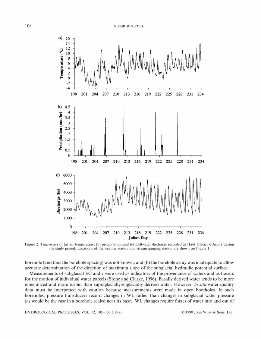
Haut Glacier d'Arolla is located at the head of the Val d'He rens, Valais, Switzerland (Figure 1). It has anarea of 6.3 km2, spans an elevation range of 2560 to c. 3500 m a.s.l., and is believed to be warm based.Observations in subglacial cavities (Hubbard, 1992) and by borehole video (Copland et al., 1997), togetherwith interpretations of borehole water level measurements (Hubbard et al., 1995), suggest that the glacier isunderlain, at least in part, by unconsolidated sediments. During the summer of 1993, hourly meteorologicaldata were collected at an automatic weather station located on the glacier, and meltwater discharge wasmonitored hourly at a hydroelectric intake structure located approximately 1 km from the snout (Figure 1).Some of the resulting time-series are plotted in Figure 2.
Twenty four boreholes were drilled in an area 250 m by 50 m close to the eastern margin of the glacier,some 1.5 km from the glacier snout (Figure 1). Average borehole spacing was about 25 m. The drill sitelocation was chosen because a major channel was predicted to exist in this area during the melt season (Sharpet al., 1993). Boreholes were drilled using high pressure, hot water, and varied in depth from 23 m (H38) to142 m (H46). Sensors similar to those described by Stone et al. (1993) and Stone and Clarke (1996) wereplaced a few decimetres above the bed in 12 holes (H27, H29, H30, H34, H35, H36, H37, H40a and b, H41,H42, H43) to measure WL, EC and t. Measurements were logged as means of 30 readings every 10 minutesusing Campbell Scienti®c CR-10 dataloggers. For the purposes of this paper, the records were resampled athourly intervals. Hubbard et al. (1995) provide details of the drilling and sensor calibration procedures.EC is presented as measured in water at c. 08C, and t as relative turbidity:
t � �t�c� ÿ t�s��=t�c� �1�where t�c� and t�s� are voltage signals recorded in clear water and sample, respectively. Since voltage dropsas turbidity increases, clear water has t � 0 and opaque water has t � 1. Hubbard et al. (1995) give anapproximate calibration of turbidity in terms of suspended sediment concentration. Measurements of ECand t made during periods when a borehole was dry have been excised from the records.
Measurements of borehole WL are used to characterize the behaviour of the subglacial drainage system,and calculations of the di�erence in elevation of the water surface between adjacent pairs of boreholes (headdi�erence; HD) are used to infer the likely pattern of water ¯ow at the glacier bed. Although we presume thatborehole WL is related in some way to the water pressure in the subglacial drainage system, it is likely that therelationship is neither simple, consistent between boreholes, nor constant over time (Engelhardt, 1978).Instead, it will be mediated by the magnitude and timing of supraglacial/englacial water inputs to eachborehole, and by the nature of the hydraulic link between each borehole base and the subglacial drainagesystem. We therefore consciously use the term `borehole WL' to describe our measurements, rather than theterm `basal water pressure'. At times when a borehole was dry, the elevation of the underlying bed was usedin HD calculations since this determines the hydraulic potential at the base of the hole. Hydraulic gradientsbetween adjacent boreholes were not calculated for two reasons: (a) the true position of the base of each
HYDROLOGICAL PROCESSES, VOL. 12, 105±133 (1998) # 1998 John Wiley & Sons, Ltd.
106 S. GORDON ET AL.

Figure 1. Map of Haut Glacier d'Arolla, showing the location of the drill site on the eastern side of the glacier tongue some 1500 mfrom the snout. Inset shows the 1993 borehole array. Symbols denote the status of the borehole water level (see text) which is classi®edas: unconnected ; HIGH-LOW ; LOW±LOW ; LOW±HIGH ; DRY±LOW ; DRY±HIGH . Where several symbols areplotted for a single hole, this indicates a change in status over time. The number below the symbol denotes the Julian day on which the
hole achieved the status indicated by the symbol
# 1998 John Wiley & Sons, Ltd. HYDROLOGICAL PROCESSES, VOL. 12, 105±133 (1998)
REORGANIZATION OF SUBGLACIAL DRAINAGE 107
borehole (and thus the borehole spacing) was not known, and (b) the borehole array was inadequate to allowaccurate determination of the direction of maximum slope of the subglacial hydraulic potential surface.
Measurements of subglacial EC and t were used as indicators of the provenance of waters and as tracersfor the motion of individual water parcels (Stone and Clarke, 1996). Basally derived water tends to be moremineralized and more turbid than supraglacially/englacially derived water. However, in situ water qualitydata must be interpreted with caution because measurements were made in open boreholes. In suchboreholes, pressure transducers record changes in WL rather than changes in subglacial water pressure(as would be the case in a borehole sealed near its base). WL changes require ¯uxes of water into and out of
Figure 2. Time-series of (a) air temperature, (b) precipitation and (c) meltwater discharge recorded at Haut Glacier d'Arolla duringthe study period. Locations of the weather station and stream gauging station are shown on Figure 1
HYDROLOGICAL PROCESSES, VOL. 12, 105±133 (1998) # 1998 John Wiley & Sons, Ltd.
108 S. GORDON ET AL.

the borehole. These can be supplied by any combination of basal, englacial and supraglacial sources, andcomplex patterns of water circulation can therefore develop within boreholes. Waters of di�erent provenancecan be mixed within the borehole, and individual parcels of water may leave the borehole by pathwaysdi�erent from those by which they entered it. When water drains from the base of a borehole (which canoccur even when WL is rising), in situ sensors record the character of the water leaving the borehole, ratherthan that of water draining through the local subglacial system.
To determine the water sources that contributed to WL changes in individual boreholes, and the patternsof circulation that developed within them, the technique of borehole EC pro®ling was developed. Thisinvolves repeatedly measuring vertical EC pro®les within a borehole (at 5 m depth intervals), and usingtemporal changes in water quality strati®cation (Tranter et al., 1997) as a tracer for circulation within theborehole (Ketterling, 1995). When described at 5 m resolution, the strati®cation within a borehole is notsigni®cantly altered by di�usion or turbulent mixing, or by the action of repeatedly raising and lowering thepro®ling instrument through the water column. If used regularly through a melt season, the EC pro®lingtechnique allows the identi®cation of changes in the strati®cation and pattern of water circulation within aborehole. These suggest changes in the way in which a borehole is connected to the glacier drainage system,and can be used to assist interpretation of changes taking place within that system.
The analysis presented in this paper is based on data from seven boreholes: H29, H34, H35, H36, H40a,H41 and H42 (Figure 1). H34 and H41 have continuous in situ WL, EC and t records spanning theentire observation period [Julian days (JD 203±233)], and they also have good EC pro®ling coverage. WLmeasurements alone are analysed from H36, H40a and H42 because insu�cient pro®ling data are availableto allow reliable interpretation of the in situ water quality measurements. WL measurements for H40a areavailable only for the period JD 203±220. The WL record for H35 is continuous, but water qualitymeasurements from this hole cannot be used since the base of the hole is believed to have been blind(see below). Records for H29 are patchy, but in the later part of the observation period WL records from thishole are indistinguishable from those from H35 (Hubbard et al., 1995). Records from H29 are therefore usedinstead of those from H35 whenever possible to allow examination of water quality behaviour.
THE DISTRIBUTION OF CONNECTED AND UNCONNECTED HOLES
All boreholes were initially classi®ed as `connected' or `unconnected' to the glacier drainage system. Inconnected holes, WL fell during or after drilling and subsequently ¯uctuated. Unconnected holes remainedfull of water after drilling. Of the 24 holes drilled in 1993, nine (H31, H33, H38, H44, H45, H46, H52, H53,H54) were unconnected. Five of the connected holes (H27, H30, H40a, H41 and H42) initially connectedto an englacial drainage system during the course of drilling, while two (H26 and H36) connected when thedrill reached the bed. The other eight connected sometime after drilling was completed. Three of the initiallyenglacially connected holes (H30, H40a andH41) subsequently developed basal connections (Gordon, 1996).Connected holes were further classi®ed on the basis of the height of their daily minimum water level and
amplitude of diurnal water level ¯uctuation, using a modi®ed version of the scheme proposed by Smart(1996). Daily minimum water levels were termed DRY (hole drains completely), LOW (550% of iceoverburden pressure) or HIGH (450% of ice overburden pressure). Diurnal amplitudes were taken as thedi�erence between daily minimum and maximum water levels, and were termed ZERO (no ¯uctuation),LOW (¯uctuation 550% of ice overburden pressure) or HIGH (¯uctuation 450% of ice overburdenpressure). Individual holes were thus classi®ed as DRY±HIGH and so on.
Figure 1 shows the distribution of hole types within the borehole array, and indicates where the classi®ca-tion of an individual hole changed over time. At the end of the observation period, there was a clear spatialpattern to the distribution of borehole types. A 120 m wide, NE±SW trending swathe of connected holes cutthrough the centre of the borehole array, de®ning what Hubbard et al. (1995) termed a variable pressure axis(VPA). Within the connected area, there was an outward transition from a central core zone of DRY±HIGHholes to holes with higher base WLs and lower amplitude diurnal WL ¯uctuations, and ®nally to
# 1998 John Wiley & Sons, Ltd. HYDROLOGICAL PROCESSES, VOL. 12, 105±133 (1998)
REORGANIZATION OF SUBGLACIAL DRAINAGE 109
unconnected holes. This pattern suggests that there was a major drainage pathway in the centre of theconnected area which drew down water pressures in surrounding areas of the bed, and which was the sourceof a discharge-related diurnal pressure forcing (cf. Hantz and Lliboutry, 1983; Fountain, 1994; Hubbardet al., 1995; Alley, 1996). Henceforth, we refer to this pathway as the `major drainage path', while the term`subglacial drainage system' is used in a more general sense to include both the path and hydraulic linksbetween it and adjacent areas of the glacier bed.
Eight holes (H29, H32, H34, H35, H36, H40a, H41 and H43) changed classi®cation during the observa-tion period. With the exception of H40a and H43, all of these holes showed increases in the amplitude ofdiurnal WL ¯uctuations over time. Between JD 204 and 217, there was a trend towards a decrease in baseWL and/or an increase in the amplitude of diurnal WL ¯uctuations in boreholes located towards the centreof the array. By contrast, H40a evolved from a LOW±LOW to a HIGH±LOW hole on JD 214, while H43connected on JD 205 and exhibited LOW±LOW behaviour until JD 225, when its base WL rose to HIGH.There is therefore evidence for a change in the pressure regime within the connected area of the bed over thecourse of the season, and for disconnection of formerly connected holes. As outlined in more detail below,most of the observed changes in borehole behaviour occurred within a seven day window in late July andearly August.
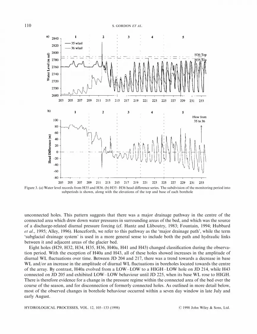
Figure 3. (a) Water level records from H35 and H36. (b) H35±H36 head di�erence series. The subdivision of the monitoring period intosubperiods is shown, along with the elevations of the top and base of each borehole
HYDROLOGICAL PROCESSES, VOL. 12, 105±133 (1998) # 1998 John Wiley & Sons, Ltd.
110 S. GORDON ET AL.
WATER LEVEL, HEAD DIFFERENCE AND WATER QUALITY TIME-SERIES
Over the study period, in situ records of WL and HD from the seven boreholes displayed signi®cant changesin background levels, and in the frequency, amplitude and relative timing of ¯uctuations (Figures 3±5).The EC and t records from H34 and H41 showed major changes which can be correlated with changes inWL and HD records (Figures 4 and 5). Based on these changes, the records were split into ®ve subperiods(JD 203±208; 209±214; 215±219; 220±224; 225±233), which are used as a framework for describing themajor changes in borehole behaviour that occurred during the study period. In this discussion, we assumethat water with an EC of510 mS cmÿ1 is derived directly from surface melt (either by supraglacial/englacialruno� or as drill ¯uid), while more concentrated water has become mineralized as a result of contact withsubglacial sediments. This assumption is justi®ed on the basis of measurements of the EC and chemicalcomposition of supraglacial and bulk runo�, and of waters sampled from the base of boreholes (Lamb et al.,1995; Tranter et al., 1997).
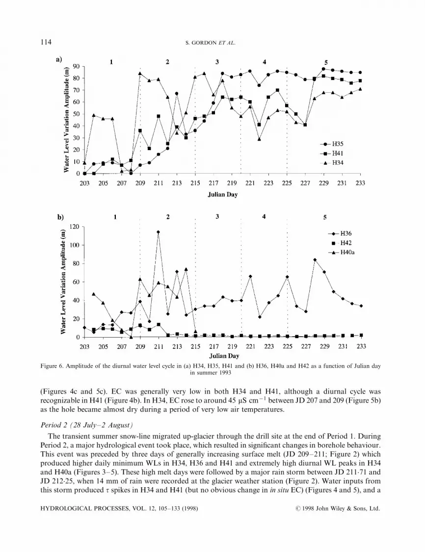
Period 1 (22±27 July)
All seven boreholes were `connected' to the glacier drainage system. Most holes displayed weak, lowamplitude diurnal WL cycles (Figure 6), although H35 showed a two-day WL cycle (Figure 3). There was noconsistency to the order in which holes reached their diurnal peak WL (Figure 7). HD records suggest that
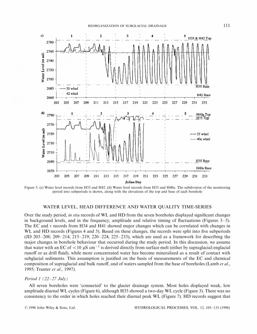
Figure 3. (c) Water level records from H35 and H42. (d) Water level records from H35 and H40a. The subdivision of the monitoringperiod into subperiods is shown, along with the elevations of the top and base of each borehole
# 1998 John Wiley & Sons, Ltd. HYDROLOGICAL PROCESSES, VOL. 12, 105±133 (1998)
REORGANIZATION OF SUBGLACIAL DRAINAGE 111
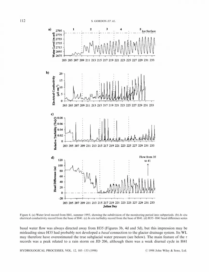
basal water ¯ow was always directed away from H35 (Figures 3b, 4d and 5d), but this impression may bemisleading since H35 had probably not developed a basal connection to the glacier drainage system. Its WLmay therefore have overestimated the true subglacial water pressure (see below). The main feature of the trecords was a peak related to a rain storm on JD 206, although there was a weak diurnal cycle in H41
Figure 4. (a) Water level record from H41, summer 1993, showing the subdivision of the monitoring period into subperiods. (b) In situelectrical conductivity record from the base of H41. (c) In situ turbidity record from the base of H41. (d) H35±H41 head di�erence series
HYDROLOGICAL PROCESSES, VOL. 12, 105±133 (1998) # 1998 John Wiley & Sons, Ltd.
112 S. GORDON ET AL.

Figure 5. (a) Water level record from H34, summer 1993, showing the subdivision of the monitoring period into subperiods.(b) In situ electrical conductivity record from the base of H34. (c) In situ turbidity record from the base of H34. (d) H35±H34 head
di�erence series
# 1998 John Wiley & Sons, Ltd. HYDROLOGICAL PROCESSES, VOL. 12, 105±133 (1998)
REORGANIZATION OF SUBGLACIAL DRAINAGE 113
(Figures 4c and 5c). EC was generally very low in both H34 and H41, although a diurnal cycle wasrecognizable in H41 (Figure 4b). In H34, EC rose to around 45 mS cmÿ1 between JD 207 and 209 (Figure 5b)as the hole became almost dry during a period of very low air temperatures.
Period 2 (28 July±2 August)
The transient summer snow-line migrated up-glacier through the drill site at the end of Period 1. DuringPeriod 2, a major hydrological event took place, which resulted in signi®cant changes in borehole behaviour.This event was preceded by three days of generally increasing surface melt (JD 209±211; Figure 2) whichproduced higher daily minimum WLs in H34, H36 and H41 and extremely high diurnal WL peaks in H34and H40a (Figures 3±5). These high melt days were followed by a major rain storm between JD 211.71 andJD 212.25, when 14 mm of rain were recorded at the glacier weather station (Figure 2). Water inputs fromthis storm produced t spikes in H34 and H41 (but no obvious change in in situ EC) (Figures 4 and 5), and a
Figure 6. Amplitude of the diurnal water level cycle in (a) H34, H35, H41 and (b) H36, H40a and H42 as a function of Julian dayin summer 1993
HYDROLOGICAL PROCESSES, VOL. 12, 105±133 (1998) # 1998 John Wiley & Sons, Ltd.
114 S. GORDON ET AL.

short period when WLs suggested super-¯otation pressures in H36 (Figure 3) (super-¯otation pressurescould be recorded in H36 because it froze shut after drilling). These overnight inputs prevented WLs in H34,H36, H40a and H41 falling to their normal base levels between JD 211 and 212, so these holes recorded asustained period of high water levels (Figures 3±5). During this period, H35 connected to the subglacialdrainage system, while H40a became disconnected from it (Figure 3).
During the connection event (JD 212±214), the WL in H35 fell by 70 m (Figure 3). The daily minimumWL dropped in three stages to successively lower base levels of 2750, 2705 and 2690 m a.s.l. Clear diurnalwater level peaks separated these successive base levels. Following the connection event, a diurnal WLcycle replaced the two-day WL cycle in H35 and more consistent diurnal WL cycles developed in H34, H36and H41 (Figures 3±5). Amplitudes of diurnal WL cycles were greater than in Period 1 (20±50 m in H41,30±80 m in H34 and H35, 30±70 m in H36; Figure 6), and the diurnal WL peak was reached ®rst by H34,followed by H35, H41 and H36 (except on JD 214) (Figure 7). The connection of H35 caused a dramatic
Figure 7. Time (in decimal fractions of a day) at which daily peak water level was reached in (a) H34, H35, H41 and (b) H36, H40aand H42, summer 1993
# 1998 John Wiley & Sons, Ltd. HYDROLOGICAL PROCESSES, VOL. 12, 105±133 (1998)
REORGANIZATION OF SUBGLACIAL DRAINAGE 115
reduction in apparent HD between H35 and H41, H34 and H36, and there were short-lived reversals in thedirection of H35±H34 and H35±H36 HD (Figures 3±5).
Period 3 (3±7 August)
Diurnal WL cycles in H34, H35, H36 and H41 increased further in amplitude (Figure 6). The order inwhich peak diurnal WL was reached changed over the period (Figure 7), with H35 leading H41, H34 andH36. WL behaviour in H42 and H40a continued to contrast with that observed in the other holes. WL¯uctuations in H42 were barely perceptible, while H40a WL remained close to the surface, and showed smalldiurnal ¯uctuations (Figure 3). By the end of the period, there were clear diurnal HD cycles between H35 andH41, H34 and H36 (Figures 3±5).
During this period, there was a major change in the EC signal in H41. A double peaked cycle developedwith an initial, smaller and more attenuated peak of � 5 mS cmÿ1, which was followed by a larger, sharperpeak of 10±15 mS cmÿ1. This suggests that basal water was detected regularly at the base of H41 duringPeriod 3 (Figure 4). Between JD 215 and 217, major t peaks were superimposed upon the diurnal t cycle inH41, and these coincided with times when high EC waters were recorded at the base of the hole (Figure 4).This may suggest that erosional enlargement of a hydraulic link between H41 and the major drainage pathwas taking place. Similar t events were also recorded in H34, although the in situ EC in this hole remainedvery low (Figure 5). Thus, the in situ water quality records for Period 3 clearly suggest a signi®cant basalin¯uence.
Period 4 (8±12 August)
The diurnal WL amplitude in all holes observed was relatively stable (except on JD 222, when airtemperatures were low) (Figures 2 and 6). The order in which boreholes reached their diurnal peak WL wasalso stable (Figure 7). H35 registered the largest WL ¯uctuations, and was the ®rst hole to reach its diurnalpeak WL. Strong diurnal cycles in HD occurred between H35 and H41, H34 and H36 (Figures 3±5), and thedirection of HD between H35 and H34 and H36 reversed on a diurnal basis. t peaks became less frequent inH41, but larger and more frequent in H34 (Figures 4 and 5). A clear diurnal EC signal developed in H34,suggesting that basal water was regularly present at the base of this hole (Figure 5b). These changes in ECand t behaviour in H34 were associated with a major change in the sign of H35±H34 HD, which wasdirected predominantly away from H34 in Period 3, but predominantly towards it in Period 4 (Figure 5d).
Period 5 (13±21 August)
WL and HD behaviour were very similar to that in Period 4, with a few exceptions. In H36, the base WLrose from 30 to 70 m above the bed, rapid drainage events at the end of the falling limb of the diurnal WLcurve began on JD 224 and continued throughout the period, and a secondary WL peak emerged on JD 229(Figure 3a). As outlined below, these trends indicate that H36 was becoming progressively less wellconnected to the subglacial drainage system.
In H34, t peaks continued to occur on a regular basis, while in H41 a double-peaked diurnal t cycledeveloped. The two peaks were coincident with peaks in H35/H41 HD during the rising and falling limbs ofthe diurnal WL cycle (Figures 4c). In H34 the major t peaks were superimposed on a general rise inbackground t, suggesting continued instability of the link between this borehole and the major drainagepath. The diurnal EC cycle in H34 became less marked as the peak daily H35/H34 HD declined progressivelyover time (Figure 5). In H41, by contrast, the two EC peaks that ®rst appeared in Period 3 merged into one,and EC increased during both the daily peak and the preceding attenuated shoulder (Figure 4).
CROSS-CORRELATION ANALYSES
The results presented above suggest that a major subglacial drainage reorganization occurred duringPeriod 2. After this event, borehole WL ¯uctuations were very di�erent in character from those earlier in the
HYDROLOGICAL PROCESSES, VOL. 12, 105±133 (1998) # 1998 John Wiley & Sons, Ltd.
116 S. GORDON ET AL.
season, and there was clear evidence of a basal in¯uence on basal water quality. In an attempt to quantify thechanges that occurred during and after this event, cross-correlation analyses were carried out for eachsubperiod between the di�erent WL series, and between these series and air temperature. Maximum cross-correlation coe�cients and associated lags were used to express the degree of coherence between di�erentdata series. To emphasize diurnal cycles in the records, hourly data series were detrended prior to analysis bycalculating a 25-point centred running mean, subtracting this from the raw data, dividing the data into therelevant subperiods and then re-expressing them as standardized residuals from the running mean.
The results suggest that H34, H35, H36 and H41 behaved in a similar fashion throughout the study period,while H40a and H42 behaved rather di�erently. Holes in the ®rst group showed a generally increasingcorrelation between WL and air temperature over time, with WL eventually lagging air temperature by 3±5hours (Table I). Correlations between pairs of WL records from holes in this group increased substantiallythrough the study period, with a particularly marked increase occurring between Periods 2 and 3 (Table II).During Period 5, maximum correlation coe�cients for pairs of WL records from boreholes in this groupexceeded 0.86. Lags between records ranged from 1±4 hours at the start of the period, but the recordsbecame essentially synchronous during Period 3 when they lagged air temperature by 3±4 hours. By Period5, a systematic pattern of lead±lag relationships developed, with H35WL lagging air temperature by 3 hours
Table I. Maximum cross-correlation coe�cients and associated lags (hours) between temperature and borehole waterlevel records for each of the ®ve subperiods of the 1993 melt season. See text for de®nition of subperiods. Positive lags
indicate that the air temperature series leads the water level series
Period
1 2 3 4 5
T/H35 0.41 (ÿ1) 0.65 (5) 0.83 (3) 0.90 (3) 0.91 (3)T/H41 0.60 (6) 0.81 (6) 0.91 (4) 0.90 (4) 0.93 (4)T/H34 0.58 (2) 0.72 (3) 0.91 (4) 0.91 (4) 0.94 (5)T/H36 0.63 (1) 0.61 (1) 0.88 (4) 0.82 (4) 0.82 (5)T/H40a 0.61 (0) 0.72 (ÿ9) ÿ0�63 (1)T/H42 0.73 (1) 0.55 (ÿ1) ÿ0�64 �ÿ13� ÿ0�47 (6) 0.64 (2)
Table II. Maximum cross-correlation coe�cients and associated lags (hours) between pairs of water level records foreach of the ®ve subperiods of the 1993 melt season. See text for de®nition of subperiods. Positive lags indicate that the
®rst series leads the second
Period
1 2 3 4 5
H35/H41 0.64 (4) 0.77 (1) 0.97 (0) 0.97 (1) 0.97 (1)H35/H34 0.47 (ÿ1) 0.52 (ÿ1) 0.89 (0) 0.95 (1) 0.96 (2)H35/H36 0.66 (ÿ1) 0.70 (0) 0.96 (0) 0.89 (1) 0.89 (1)H41/H34 0.60 (ÿ4) 0.79 (ÿ2) 0.95 (ÿ1) 0.97 (0) 0.97 (1)H41/H36 0.86 (ÿ4) 0.80 (ÿ1) 0.99 (0) 0.93 (0) 0.90 (1)H34/H36 0.44 (ÿ1) 0.55 (3) 0.94 (0) 0.92 (0) 0.86 (1)H36/H42 0.82 (0) 0.55 (ÿ5) 0.75 (ÿ3) 0.66 (0) 0.73 (ÿ2)H35/H42 0.59 (ÿ1) 0.21 (ÿ5) 0.67 (ÿ3) 0.59 (2) 0.73 (1)H41/H42 0.74 (ÿ4) 0.57 (ÿ6) 0.72 (ÿ3) 0.61 (1) 0.80 (ÿ1)H34/H42 0.71 (ÿ1) 0.65 (ÿ3) 0.80 (ÿ3) 0.56 (0) 0.68 (ÿ2)H35/H40a 0.36 (ÿ2) 0.62 (ÿ1) ÿ0�58 (ÿ1)H41/H40a 0.40 (ÿ4) 0.85 (ÿ3) ÿ0�55 (ÿ2)H34/H40a 0.79 (ÿ2) 0.84 (0) ÿ0�60 (ÿ2)H36/H40a 0.44 (0) 0.62 (ÿ2) 0.57 (ÿ16)H42/H40a 0.72 (ÿ1) 0.55 (3) 0.47 (12)
# 1998 John Wiley & Sons, Ltd. HYDROLOGICAL PROCESSES, VOL. 12, 105±133 (1998)
REORGANIZATION OF SUBGLACIAL DRAINAGE 117
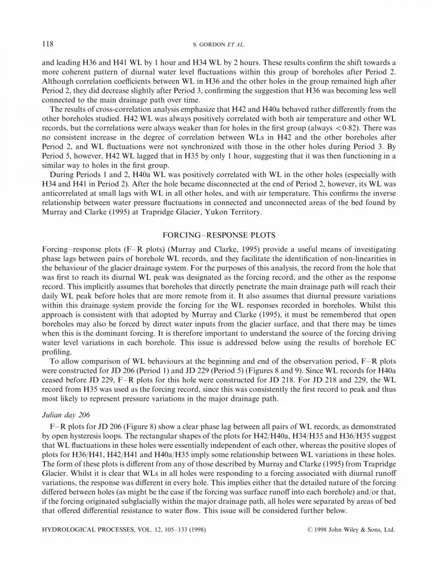
and leading H36 and H41 WL by 1 hour and H34 WL by 2 hours. These results con®rm the shift towards amore coherent pattern of diurnal water level ¯uctuations within this group of boreholes after Period 2.Although correlation coe�cients between WL in H36 and the other holes in the group remained high afterPeriod 2, they did decrease slightly after Period 3, con®rming the suggestion that H36 was becoming less wellconnected to the main drainage path over time.
The results of cross-correlation analysis emphasize that H42 and H40a behaved rather di�erently from theother boreholes studied. H42 WL was always positively correlated with both air temperature and other WLrecords, but the correlations were always weaker than for holes in the ®rst group (always 50�82). There wasno consistent increase in the degree of correlation between WLs in H42 and the other boreholes afterPeriod 2, and WL ¯uctuations were not synchronized with those in the other holes during Period 3. ByPeriod 5, however, H42 WL lagged that in H35 by only 1 hour, suggesting that it was then functioning in asimilar way to holes in the ®rst group.
During Periods 1 and 2, H40a WL was positively correlated with WL in the other holes (especially withH34 and H41 in Period 2). After the hole became disconnected at the end of Period 2, however, its WL wasanticorrelated at small lags with WL in all other holes, and with air temperature. This con®rms the inverserelationship between water pressure ¯uctuations in connected and unconnected areas of the bed found byMurray and Clarke (1995) at Trapridge Glacier, Yukon Territory.
FORCING±RESPONSE PLOTS
Forcing±response plots (F±R plots) (Murray and Clarke, 1995) provide a useful means of investigatingphase lags between pairs of borehole WL records, and they facilitate the identi®cation of non-linearities inthe behaviour of the glacier drainage system. For the purposes of this analysis, the record from the hole thatwas ®rst to reach its diurnal WL peak was designated as the forcing record, and the other as the responserecord. This implicitly assumes that boreholes that directly penetrate the main drainage path will reach theirdaily WL peak before holes that are more remote from it. It also assumes that diurnal pressure variationswithin this drainage system provide the forcing for the WL responses recorded in boreholes. Whilst thisapproach is consistent with that adopted by Murray and Clarke (1995), it must be remembered that openboreholes may also be forced by direct water inputs from the glacier surface, and that there may be timeswhen this is the dominant forcing. It is therefore important to understand the source of the forcing drivingwater level variations in each borehole. This issue is addressed below using the results of borehole ECpro®ling.
To allow comparison of WL behaviours at the beginning and end of the observation period, F±R plotswere constructed for JD 206 (Period 1) and JD 229 (Period 5) (Figures 8 and 9). Since WL records for H40aceased before JD 229, F±R plots for this hole were constructed for JD 218. For JD 218 and 229, the WLrecord from H35 was used as the forcing record, since this was consistently the ®rst record to peak and thusmost likely to represent pressure variations in the major drainage path.
Julian day 206
F±R plots for JD 206 (Figure 8) show a clear phase lag between all pairs of WL records, as demonstratedby open hysteresis loops. The rectangular shapes of the plots for H42/H40a, H34/H35 and H36/H35 suggestthat WL ¯uctuations in these holes were essentially independent of each other, whereas the positive slopes ofplots for H36/H41, H42/H41 and H40a/H35 imply some relationship between WL variations in these holes.The form of these plots is di�erent from any of those described byMurray and Clarke (1995) from TrapridgeGlacier. Whilst it is clear that WLs in all holes were responding to a forcing associated with diurnal runo�variations, the response was di�erent in every hole. This implies either that the detailed nature of the forcingdi�ered between holes (as might be the case if the forcing was surface runo� into each borehole) and/or that,if the forcing originated subglacially within the major drainage path, all holes were separated by areas of bedthat o�ered di�erential resistance to water ¯ow. This issue will be considered further below.
HYDROLOGICAL PROCESSES, VOL. 12, 105±133 (1998) # 1998 John Wiley & Sons, Ltd.
118 S. GORDON ET AL.

Julian days 218 and 229
A variety of responses to H35 forcing were observed on JD218 and 229.
(i) Direct response. The H29/H35 plot (Figure 9a) shows no phase lag, and demonstrates that the recordsare essentially identical. This behaviour is comparable with that reported by Murray and Clarke (1995) for apair of boreholes that intersected the same water body. It indicates minimal resistance to ¯ow between thetwo boreholes.
(ii) Continuous, lagged response. F±R plots for H41/H35 and H34/H35 (Figure 9b and c) show a positiveslope and open hysteresis loops, indicating a phase lag between the records. This suggests that WL variationsin H41 and H34 were a di�erentially lagged response to a common forcing. Lagged response implies thatH41 and H34 were separated from the major drainage path by areas of bed that resisted water ¯ow, but itappears that the magnitude of the resistance varied between the rising and falling limbs of the diurnal WLcycle. While large head di�erences were maintained during the rising limb of the cycle, indicating signi®canthydraulic resistance, HD dropped to values near zero during the falling limb (Figures 4 and 5). This suggests
Figure 8. Forcing±response (F±R) plots for Julian day 206 (25 July), 1993. (a) H34 versus H35. (b) H42 versus H40a. (c) H36 versusH35. (d) H36 versus H41. (e) H42 versus H41. (f) H40a versus H35
# 1998 John Wiley & Sons, Ltd. HYDROLOGICAL PROCESSES, VOL. 12, 105±133 (1998)
REORGANIZATION OF SUBGLACIAL DRAINAGE 119
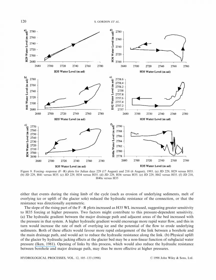
either that events during the rising limb of the cycle (such as erosion of underlying sediments, melt ofoverlying ice or uplift of the glacier sole) reduced the hydraulic resistance of the connection, or that theresistance was directionally asymmetric.The slope of the rising part of the F±R plots increased as H35 WL increased, suggesting greater sensitivity
to H35 forcing at higher pressures. Two factors might contribute to this pressure-dependent sensitivity.(a) The hydraulic gradient between the major drainage path and adjacent areas of the bed increased withthe pressure in that system. A higher hydraulic gradient would encourage more rapid water ¯ow, and this inturn would increase the rate of melt of overlying ice and the potential of the ¯ow to erode underlyingsediments. Both of these e�ects would favour more rapid enlargement of the link between a borehole andthe main drainage path, and would act to reduce the hydraulic resistance along the link. (b) Physical upliftof the glacier by hydraulic jacking e�ects at the glacier bed may be a non-linear function of subglacial waterpressure (Iken, 1981). Opening of links by this process, which would also reduce the hydraulic resistancebetween borehole and major drainage path, may thus be more e�ective at higher pressures.
Figure 9. Forcing±response (F±R) plots for Julian days 229 (17 August) and 218 (6 August), 1993. (a) JD 229, H29 versus H35.(b) JD 229, H41 versus H35. (c) JD 229, H34 versus H35. (d) JD 229, H36 versus H35. (e) JD 229, H42 versus H35. (f) JD 218,
H40a versus H35
HYDROLOGICAL PROCESSES, VOL. 12, 105±133 (1998) # 1998 John Wiley & Sons, Ltd.
120 S. GORDON ET AL.

Murray and Clarke (1995) did not identify lagged behaviour of this sort at Trapridge Glacier (perhapsbecause their experiment was conducted in an area much smaller than ours), but it would be expected, forinstance, if a diurnal pressure wave propagated laterally across the bed from a source in a linear drainageelement such as a subglacial channel (Hubbard et al., 1995; Alley, 1996). Wave propagation could occurthrough either a permeable subglacial sediment, a water ®lm or a network of cavities and/or microchannelsat the ice-bed interface.
(iii) Intermittent, lagged response. The H42/H35 plot shows that H42 WL responded to forcing from H35only after H35WL rose above H42WL at a threshold value of around 2757 m a.s.l. (Figure 9e). This impliesthat a connection between H42 and the drainage system in the vicinity of H35 was established on anintermittent basis. When it existed, H42 WL responded in a lagged manner to H35 forcing. Drilling recordsindicate that an englacial conduit was intercepted at an elevation of 2757 m a.s.l. in H42. If this conduiteventually connected to the major drainage path, the daily WL rise in H42 may have resulted from waterbacking up within this conduit and into the borehole as water pressure rose within the major drainage path.
(iv) Inverse response with premonitory WL rise. The H40a/H35 plot for JD 218 shows a generally inverserelationship (Figure 9f). A marked fall in H40a WL occurred when H35 WL rose to 2757 m a.s.l. (this valueis coincidental as it was di�erent on other days), but this fall was preceded by a slight WL rise in H40a.Murray and Clarke (1995, their Figure 6b) recorded similar behaviour between a connected andunconnected borehole at Trapridge Glacier, and interpreted it as a result of the transfer of mechanicalsupport of the ice overburden between connected and unconnected areas of the bed as water pressure withinthe connected areas ¯uctuated. The premonitory WL rise may thus re¯ect transient loading of the bedaround H40a as areas closer to H35 were unloaded, while the subsequent WL fall suggests that the zone ofdiurnal unloading expanded to include H40a. However, if H35 WL is taken as a measure of pressure in theconnected system, unloading of the unconnected system began while this pressure was signi®cantly belowthat required to ¯oat the overlying ice. H40a WL rose again as H35 WL fell, and an increasing proportion ofice overburden pressure was again supported by unconnected areas of the bed.
The form of the F±R plot shows that the response of the unconnected system to forcing from theconnected system is more sensitive when the pressure in the connected system is high. Murray and Clarke(1995) argued that this behaviour was linked to the in¯uence of ambient pressure on the sensitivity ofchanges in the porosity of subglacial sediments to an incremental change in pressure. However, although thediurnal change in H35 WL (� 80 m) was larger than the forcing recorded by Murray and Clarke (� 50 m),the resultant WL change in the unconnected system was much smaller (10 m as opposed to 40 m).
(v) Alternating response. When H35 WL passed 2757 m a.s.l. (this threshold value is fortuitous because itincreased progressively through Period 5), H36 WL initially fell, then rose rapidly as H35WL approached itsdaily maximum value, and ®nally peaked after H35 WL had begun to fall (Figure 9d). This behavioursuggests that H36 alternated between being connected and unconnected to the major drainage path (Murrayand Clarke, 1995). We interpret the F±R plot as follows. The initial WL fall in H36 represents unloading ofthe area of bed around H36 as water pressure in the major drainage path rose. The subsequent WL riseindicates expansion of the connected area to include H36. The response to H35 forcing was, however, lagged,indicating that there was resistance to ¯ow between the major drainage path and H36. A secondary WL peakpreceding the drainage event became a prominent feature of the H36 WL record after JD 229 (Figure 3).Since this secondary peak occurred while H35 WL was still falling it probably resulted from reloading of thebed around H36 as pressure in the connected region decreased. It should therefore be distinguished from thepremonitory rise recorded in H40a on JD 218, which occurred while H35 WL was rising.
If the rise in pressure at the onset of the secondary peak is taken as the transition to unconnectedbehaviour, and the rise at the end of the drainage event as the transition back to connected behaviour, it isapparent that the switch to connected behaviour always occurred at a higher value of H35 WL than the
# 1998 John Wiley & Sons, Ltd. HYDROLOGICAL PROCESSES, VOL. 12, 105±133 (1998)
REORGANIZATION OF SUBGLACIAL DRAINAGE 121
switch to unconnected behaviour (Figure 3a). It is also clear that transitions between the connected andunconnected states did not occur when water pressures in the two systems were matched. H35 WL exceededH36 WL at the transition to connected behaviour, and the reverse was true at the transition to unconnectedbehaviour. These observations imply that it was easier to exit the connected state than to enter it. The switchto connected behaviour was tripped by a combination of rapidly rising H35WL and rapidly falling H36WL,which produced a very large head di�erence (up to 70 m over a horizontal distance of � 25 m) betweenconnected and unconnected regions of the bed. As outlined under (ii) above, this creates conditions favour-able for opening of links between the areas of high and low pressure. The plot of H35/H36 HD (Figure 3b)shows a diurnal alternation between large positive and negative values, indicating that the hydraulic barrierthat developed while H36 was unconnected o�ered considerable resistance to ¯ow in both directions.
BOREHOLE ELECTRICAL CONDUCTIVITY PROFILING
The above discussion of WL, HD and in situ EC and t records suggests a major change in borehole/drainagesystem behaviour between Periods 2 and 3. To understand the factors behind this change better, EC pro®lingresults were used to identify changes in the sources of water driving WL ¯uctuations, and to reconstructpatterns of water circulation within boreholes. The discussion focuses on di�erences in pro®ling resultsbetween Periods 1/2 and 4/5, and on the process by which H35 became connected to the subglacial drainagesystem.
Periods 1 and 2
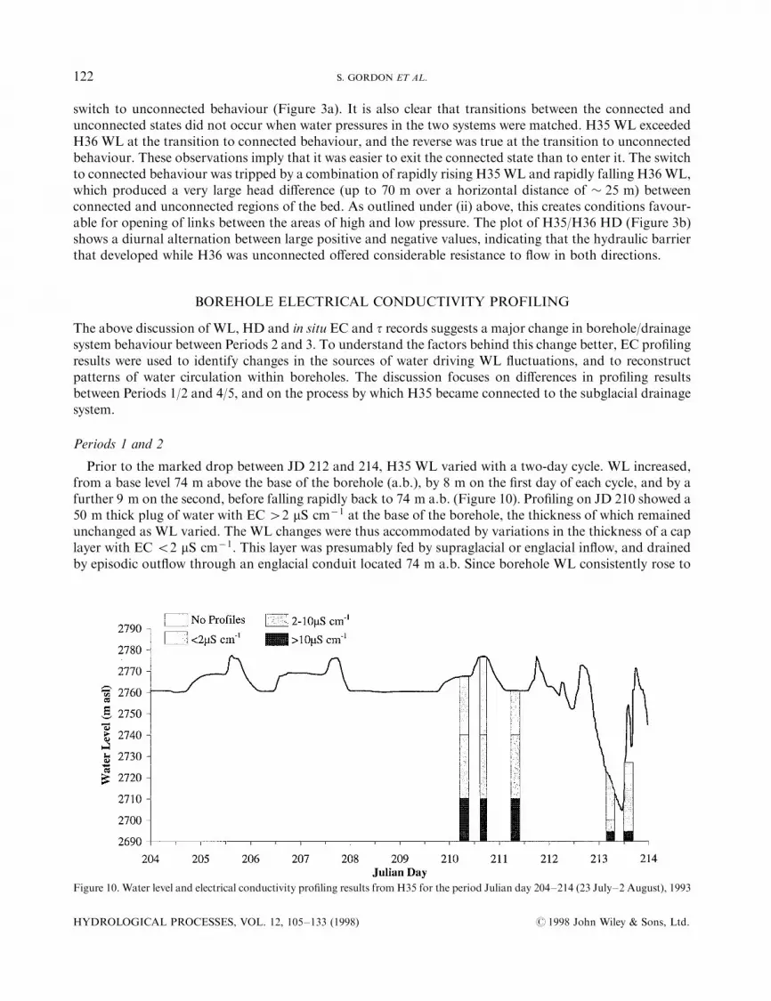
Prior to the marked drop between JD 212 and 214, H35 WL varied with a two-day cycle. WL increased,from a base level 74 m above the base of the borehole (a.b.), by 8 m on the ®rst day of each cycle, and by afurther 9 m on the second, before falling rapidly back to 74 m a.b. (Figure 10). Pro®ling on JD 210 showed a50 m thick plug of water with EC42 mS cmÿ1 at the base of the borehole, the thickness of which remainedunchanged as WL varied. The WL changes were thus accommodated by variations in the thickness of a caplayer with EC 52 mS cmÿ1. This layer was presumably fed by supraglacial or englacial in¯ow, and drainedby episodic out¯ow through an englacial conduit located 74 m a.b. Since borehole WL consistently rose to
Figure 10. Water level and electrical conductivity pro®ling results from H35 for the period Julian day 204±214 (23 July±2 August), 1993
HYDROLOGICAL PROCESSES, VOL. 12, 105±133 (1998) # 1998 John Wiley & Sons, Ltd.
122 S. GORDON ET AL.
91 m a.b. before englacial drainage occurred, some threshold pressure was apparently required to initiateout¯ow. Out¯ow ceased when borehole WL was drawn down to the level of the englacial conduit. Thisbehaviour is suggestive of the making and breaking of a siphon within the englacial conduit, as describedfrom Bondhusbreen, Norway, by Hooke et al. (1985). Clearly, there was no consistent connection betweenH35 and the subglacial drainage system during this period, so records of HD calculated from H35 WLs(Figures 3±5) do not provide a true indication of hydraulic gradients within the subglacial system at thistime.
Minimum WLs in both H34 and H41 were at or just above the glacier bed, indicating that drainageoccurred from the base of each hole. However, the water columns in both holes always consisted entirely ofwater with EC 51 mS cmÿ1. WL variations were therefore presumably driven by supraglacial/englacialinputs. Nevertheless, EC and t records from the base of both boreholes did show some changes. The minorvariations observed may re¯ect variable solute acquisition arising from changing contact times betweenwater and subglacial sediments, or disturbance of the bed by out¯owing water. Larger changes, such as thosein H34 between JD 207 and 210, suggest the presence of basal water at the bottom of the boreholes(Figure 5b). Such water was never observed to rise into the boreholes, however, and it was most evident whenholes were nearly dry and there was therefore limited basal out¯ow of supraglacially or englacially derivedwaters.
Both H34 and H41 connected basally to a drainage system that was able to absorb the volume of waterintroduced to the boreholes during drilling. These boreholes ®lled during the day as a result of water inputsfrom supraglacial/englacial sources, and they drained when these inputs ceased. The fall in in situ EC as WLrose suggests that there was basal out¯ow even at times of rising WL, implying that WL rose becausesupraglacial/englacial inputs exceeded the drainage capacity of the subglacial system. In these circumstances,the boreholes were probably over-pressured by the daily melt input, and measured WL does not provide atrue record of basal water pressure. Basal water detected by in situ sensors was never able to rise up theboreholes, suggesting that the natural water ¯ux across these areas of the bed at this stage of the season wasvery low.
The connection of H35 to the subglacial drainage system
Pro®ling data suggest that the connection of H35 to the subglacial drainage system occurred via anenglacial conduit located close to the bed. A pro®le measured at 09:59 on JD 213 showed a 5 m thick layer ofwater with EC of � 20 mS cmÿ1 at the base of the borehole (Figure 10). This layer was apparently a remnantof a 20 m thick layer which had been present prior to JD 212, suggesting that the drainage event of that dayhad occurred by a pathway located no more than 5 m above the bed. At 09:59 on JD 213, this layer wasoverlain by 5 m of 2±10 mS cmÿ1 water and 10 m of 52 mS cmÿ1 water. By 12:27 on the same day, bywhich time theWL was rising again having passed through a short-lived minimum, the cap consisted of 30 mof 52 mS cmÿ1 water. This suggests that the WL rise was driven by supraglacial/englacial inputs, and thatthese had forced the water of intervening EC out of the borehole walls, leaving the 5 m- thick high EC layerundisturbed at the base of the hole. This implies that the drainage of H35 occurred via an englacialconnection located 5 m above the glacier bed. By JD 215, the WL record appears to show that H35 drainedcompletely overnight (Figure 3a), but the stable overnight WL readings in fact record a WL 5 m above thepressure sensor. Thus, values of HD calculated for periods when H35 WL was at its diurnal minimum maybe in error by as much as +5 m. The EC record from H35 shows a steady increase over the observationperiod, consistent with solute acquisition by weathering of subglacial sediment (Brown et al., 1996). It thusseems that the in situ sensors were located near the bottom of a blind hole below the level of an activeenglacial connection which ®xed the height of the daily minimum WL in the hole.
Periods 4 and 5
Periods 4 and 5 were characterized by clear, high amplitude diurnal WL cycles in H29, H34, H35, H36 andH41. The amplitude of these cycles was greatest in H29 and H35, and the sequence in which WL peaked was
# 1998 John Wiley & Sons, Ltd. HYDROLOGICAL PROCESSES, VOL. 12, 105±133 (1998)
REORGANIZATION OF SUBGLACIAL DRAINAGE 123
stable, with H29 and H35 leading the other boreholes. Records for JD 224 are used to illustrate boreholebehaviour during this time interval, and measurements from H29 are substituted for those from H35 sincewater quality data are available for this hole.
In H29, the diurnal WL peak was associated with large head di�erences directed away from H29 and withlow values of in situ EC and t (Figure 11). It is not clear whether these dilute waters entered the hole from thebase or the surface, but they were clearly a product of the new daily melt cycle. EC and t peaked during the®nal stages of the falling limb of the WL cycle. At this time, H29±H41 HD was close to zero, and H29±H34HD was directed towards H29. This suggests that the in situ sensors were detecting drainage of subglacialwaters past the hole at a time of minimal dilute out¯ow from its base.
While H41WL was rising, H29±H41 HD was always directed towards H41. The initial WL rise was fed bysupraglacial/englacial inputs, resulting in a dilute water column and a fall in in situ EC (Figure 11c). Basalwater with high EC and t entered the borehole after JD 224.58, rising to a height of 40 m a.b. By JD 224.63,this high EC water column had been split in two by more dilute water, leaving a 10 m thick layer of waterwith EC 410 mS cmÿ1 m a.b. and continued high in situ EC. Subsequently, in situ EC fell to 52 mS cmÿ1
by JD 224.67, at which time there was no high EC water in the borehole. This behaviour suggests that H41intersected an englacial conduit � 30 m a.b. This conduit fed dilute water into the borehole and split therising column of high EC water. Initiation of this input triggered basal out¯ow, driving high EC water fromthe base of the borehole and reducing in situ EC. Subsequently, continued high supraglacial inputs drove theupper layer of high EC water out of the englacial conduit, so that by JD 224.67 there was no high EC water inthe hole. As there was no borehole source of high EC water, the overnight rise in in situ EC and t mustindicate subglacial water ¯ow past the hole. As the borehole WL fell and the rate of dilute out¯ow from theborehole base decreased, more concentrated basal water was diluted to a diminishing degree, allowing in situEC to rise.
The in situ record shows that H34 began to be in¯uenced by the in¯ow of basal water during Period 4.Throughout the daily WL peak, H29±H34 HD was directed towards H34 (Figure 12). Low in situ EC valuesas the WL started to rise suggest that the rise was driven by supraglacial/englacial inputs. At JD 224.56,however, water with high t and EC of � 16 mS cmÿ1 entered the base of the hole and rose to 40 m a.b. Thiswater was overlain by a cap of more dilute water which thickened slightly during the day, suggestingcontinued supraglacial/englacial inputs to the borehole. However, 80% of the observed WL rise was fed bybasally derived water. In situ EC fell as the WL fell, re¯ecting the downward motion of the EC strati®cationwithin the borehole. Very low values of in situ EC before the borehole went dry represent the remnants of thedilute cap. The timing of in situ EC changes suggests that the strati®cation fell more rapidly than the WL,and that basal out¯ow must have been initiated before WL started to fall. This part of the subglacialdrainage system drained completely overnight.
The most important conclusion to be derived from the results of EC pro®ling is that there was a signi®cantchange in the source of waters driving WL ¯uctuations between the start and end of the study period. InPeriods 1 and 2, water level ¯uctuations were driven by supraglacial and englacial inputs, and there wasminimal evidence for the presence of true basal water at the bottom of the boreholes. In Periods 4 and 5,however, in situ sensors clearly recorded the regular presence of high EC basal water, and pro®ling revealedthat this water made a signi®cant contribution to borehole WL ¯uctuations. Nevertheless, supraglacial andenglacial inputs to boreholes continued and may have resulted in temporary over-pressurization ofboreholes, with the result that basal out¯ow was initiated while WL was still rising.
CHANGES IN THE CHARACTER OF THE SUBGLACIAL DRAINAGE SYSTEM
The results presented above indicate that a major change in the hydrology of the drill site area occurredbetween JD 210 and 215, 1993. In the following discussion, we attempt to identify the causes of this change,and to characterize the drainage systems that existed before and after it took place.
HYDROLOGICAL PROCESSES, VOL. 12, 105±133 (1998) # 1998 John Wiley & Sons, Ltd.
124 S. GORDON ET AL.
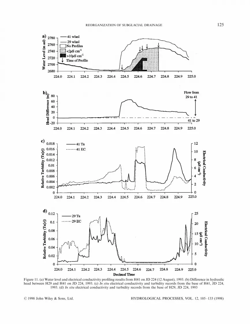
Figure 11. (a) Water level and electrical conductivity pro®ling results from H41 on JD 224 (12 August), 1993. (b) Di�erence in hydraulichead between H29 and H41 on JD 224, 1993. (c) In situ electrical conductivity and turbidity records from the base of H41, JD 224,
1993. (d) In situ electrical conductivity and turbidity records from the base of H29, JD 224, 1993
# 1998 John Wiley & Sons, Ltd. HYDROLOGICAL PROCESSES, VOL. 12, 105±133 (1998)
REORGANIZATION OF SUBGLACIAL DRAINAGE 125
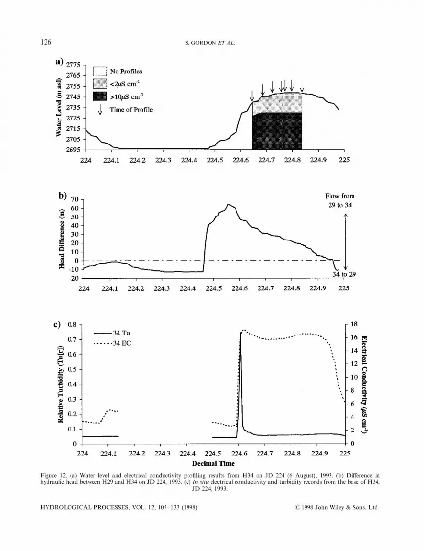
Figure 12. (a) Water level and electrical conductivity pro®ling results from H34 on JD 224 (6 August), 1993. (b) Di�erence inhydraulic head between H29 and H34 on JD 224, 1993. (c) In situ electrical conductivity and turbidity records from the base of H34,
JD 224, 1993.
HYDROLOGICAL PROCESSES, VOL. 12, 105±133 (1998) # 1998 John Wiley & Sons, Ltd.
126 S. GORDON ET AL.
The subglacial drainage system before Julian day 210
Since many of the boreholes drilled connected to the glacier drainage system before the events ofJD 210±215 (either during drilling or shortly afterwards), it is apparent that the area of the bed described asthe VPAwas hydrologically active before these events took place. However, in situ EC and t sensors detectedmineralized and/or turbid basal water at the glacier bed only following rain storms and during a prolongedperiod of low water levels associated with cold weather. EC pro®ling con®rmed that WL ¯uctuations weredriven entirely by dilute englacial and/or supraglacial inputs since basal water never rose into the boreholes.WL responses to diurnal changes in these inputs were relatively weak and poorly correlated betweenboreholes. Four of the boreholes studied (H34, H36, H40a and H41) drained completely overnight whensurface inputs ceased. H35 and H42 connected englacially to the glacier drainage system, but apparentlyoverlay hydrologically inactive patches of glacier bed within the connected region.From these observations we conclude:
(i) Prior to JD 210, WL variations were more a response to diurnal variations in direct supraglacial/englacial inputs to boreholes than to a discharge-related diurnal pressure signal originating within thesubglacial drainage system. This indicates either the absence of a subglacial drainage system connectedto surface water inputs, the existence of su�cient storage volume within such a system to accommodatechanges in discharge with no signi®cant change in water pressure, or the lack of a distinct diurnalrhythm to subglacial meltwater discharge at this stage of the melt season.
(ii) There is no evidence for signi®cant ¯uxes of mineralized basal water across those areas of the bedintersected by our boreholes. If such ¯uxes occurred they must therefore have been restricted to quitesmall areas of the bed.
(iii) During periods of high water inputs to boreholes with a basal connection to the subglacial drainagesystem, borehole WLs rose. When inputs ceased at night, the holes drained completely. This impliesthat, in the absence of water inputs via boreholes, some areas of the bed were at atmospheric pressure.This suggests that drainage may have occurred through a network of interconnected cavities opened byglacier sliding in the lee of bedrock bumps. In the absence of large water ¯uxes, such a system could beexpected to operate at low water pressure (Walder, 1986; Kamb, 1987). When borehole inputs wereactive, however, borehole WLs rose, indicating that the cavity system had insu�cient free storagevolume to accommodate these inputs.
(iv) If, as suggested above, subglacial storage volume was limited, it seems unlikely that there were largediurnal discharge variations within the natural subglacial drainage system at this stage of the season.This could be the case if the system was fed by a source (such as basal melt or seepage from thesupraglacial snowpack) that generated only minor diurnal variations in water ¯ux. Although diurnalWL variations in boreholes indicate that there were diurnal variations in the rate of surface runo� atthis stage of the season, small changes in input can translate into relatively large changes in WL innarrow boreholes connected to a hydraulically resistive drainage system (Engelhardt, 1978). Underthese circumstances, slight di�erences in borehole dimensions, in the transmissivity of the systems towhich each borehole was connected and in the water input history to which each hole was subjectedcould produce signi®cantly di�erent WL responses. So long as the mean ¯ow resistance in thesubglacial drainage system was high, the head di�erences generated by such variable WL responseswould not readily be evened out by basal water ¯ow.
(v) H35 and H42 did not develop basal connections at this stage of the season. Presumably, theyintersected areas of the bed that were isolated from the interconnected cavity network. The upstreamsides of bedrock bumps and patches of till overlying bedrock are, possible areas where such hydro-logical isolation could occur.
We therefore conclude that, at the start of the study period, the drainage system over much of theconnected area of the glacier bed consisted of a hydraulically resistive network of interconnected cavities
# 1998 John Wiley & Sons, Ltd. HYDROLOGICAL PROCESSES, VOL. 12, 105±133 (1998)
REORGANIZATION OF SUBGLACIAL DRAINAGE 127
separated by hydrologically isolated areas. Under conditions of low water ¯ux, this system operated at lowambient pressure. If a more transmissive drainage system fed by surface inputs existed at this time, it wasspatially restricted and probably operated at near-constant pressure under conditions of limited dischargevariability.
The drainage reorganization event of Julian days 210±215
Three days of increasing surface melt, followed by a major rain storm apparently provided the trigger for amajor change in the hydrology of the drill site area. During this period, H34, H36, H40a and H41experienced a sustained period of higher than normal water levels, while H35 developed a near-basalconnection to the glacier drainage system and H40a eventually became disconnected from it. Following thisevent, borehole WL behaviour in all the holes studied was very di�erent from that in the earlier period andthere was clear evidence for basal forcing of WL ¯uctuations.
As outlined above, H35 connected to the subglacial drainage system via an englacial conduit located 5 mabove the glacier bed. The connection event lasted three days, and diurnal WL cycles were superimposed onthe 70 m fall in WL. These diurnal cycles supplanted the two-day WL cycle that had occurred prior toconnection. The onset of the connection event in H35 on JD 211 coincided with an interval of extremely highwater levels in H34 and H36. Synchronous with these water level events, turbidity peaks were recorded inH34, H40a, H41 and H42. The disconnection of H40a began on JD 213 and was complete by JD 215.
The connection event in H35 was rather di�erent in character from borehole connection events recordedelsewhere. Extremely rapid water level drops which occurred when a borehole intersected the subglacialdrainage system during drilling were recorded by Hodge (1976) and Stone and Clarke (1993), while dropslasting a few hours, which resulted from the progressive enlargement of hydraulic links between an over-pressured borehole and the subglacial drainage system, were described by Engelhardt (1978) and Fountain(1994). The event in H35 was thus unusual in its duration and also because it involved formation of a newenglacial connection. Given that the event began at a time when the pressure transducer in H36 recorded atransient water level indicative of substantial artesian pressure, and that the head di�erence between H35 andH36 fell to near-zero for the ®rst time immediately after this event (Figure 3b), we suggest that the connectionwas initiated by hydrofracturing of the basal ice. The initial connection cannot have provided an e�ectivedrainage route since the WL fall in H35 was rapidly reversed by the diurnal melt cycle on JD 212. The mostdramatic WL fall occurred between JD 212 and 213, but this too was reversed by the melt cycle of JD 213, sothat the WL fall was not completed until JD 214. This suggests that enlargement of the initial fracture by icemelt to form an e�cient connection to the subglacial drainage system was a relatively slow process.
The turbidity events that occurred during the connection of H35 indicate simultaneous disturbance of theglacier bed. Since EC records show no major perturbations during this period, it seems likely that theturbidity events resulted from mechanical disturbance of the bed by the glacier, rather than from enhancedsubglacial water ¯ow. Such disturbance could have been induced by either increased glacier sliding ordeformation of subglacial sediments. If increased sliding was involved, it may have resulted in the growth oflee-side cavities, creating new void space beneath the glacier and helping to form the pathways by which basalwater ¯owed across the bed after JD 215. Frequent turbidity events after JD 215 may have been the result oferosional enlargement of these pathways by subglacial water ¯ow. The disconnection of H40a from thesubglacial drainage system was probably linked to these events. Increased sliding could have advected thebase of this borehole into a hydrologically isolated area of the bed such as those on which H35 and H42 wereapparently located before JD 210, while mechanical disturbance of subglacial sediments could have blockedthe hydraulic links between the base of the borehole and the subglacial drainage system.
The subglacial drainage system after Julian day 215
After JD 215, the subglacial drainage system seems to have been much more complex than it was beforeJD 210. F±R plots allow the identi®cation of at least three elements to the system, and provide evidence thatsome parts of the bed changed hydrological status on a diurnal basis. Within the connected area of the bed,
HYDROLOGICAL PROCESSES, VOL. 12, 105±133 (1998) # 1998 John Wiley & Sons, Ltd.
128 S. GORDON ET AL.

therewas clearly a highly transmissive ¯ow systemwhich could not support large hydraulic gradients, and alsoa more resistive system which was connected either continuously or intermittently to the transmissive system.The transmissive system experienced large, discharge-related diurnal pressure ¯uctuations which, togetherwith direct inputs from the glacier surface, acted as a forcing for water level variations in boreholes locatedwithin the more resistive system. With increasing distance from boreholes connected to the transmissivesystem, diurnal water level ¯uctuations became increasingly damped and lagged behind those within thetransmissive system. Head di�erences between the two systems oscillated on a diurnal time-scale, but weregenerally much higher at times of rising pressure than at times when pressure was falling. This suggests that¯ow resistance within the resistive system may have been directionally asymmetric (cf. Alley, 1996, p. 655).
The transmissive system was probably a major subglacial channel, but the nature of the resistive system ismore di�cult to ascertain. This system obviously included links between the bases of some boreholes and thetransmissive system, but it is not clear whether these links developed solely because of the creation of theboreholes, or whether they formed part of a natural drainage system. However, although the character of thelinks may have been signi®cantly altered by drainage of the water introduced into the boreholes duringdrilling, the fact that not all boreholes connected suggests that the resistive system is not entirely a borehole-induced artefact. It is unclear whether the links within the resistive system consisted of microchannels,interconnected cavities, a macroporous horizon overlying a till surface or the pore space within permeablesediments.
Within the unconnected regime, water levels ¯uctuated inversely, but non-linearly, with those in thetransmissive system. This behaviour re¯ects cyclic transfer of mechanical support for ice overburden betweenconnected and unconnected areas as water pressure ¯uctuated within the transmissive system. Over someareas of the bed, WL ¯uctuations alternated between being inverse with and lagged behind those in thetransmissive system regime on a diurnal time-scale. This suggests that the extent of the connected area of thebed varied diurnally. A link to the connected regime was established when pressure in the transmissive systemwas rising, and broken again as it fell. When the link was sealed, borehole WLs in these intermittentlyconnected areas varied inversely with those in the transmissive system. When it was open, they lagged slightlybehind those in the transmissive system. There was, however, a di�erence in the height of the transmissivesystemWLs at which the link opened and closed, indicating that it was much harder for an unconnected areato become connected than vice versa. Opening of the link was probably accomplished by a combination ofglacier uplift in response to rising water pressures, and erosion or ice melt by water ¯owing between theconnected and unconnected areas of the bed under very high hydraulic gradients.
Thus the major feature that distinguishes the drainage system after JD 215 from that before JD 210 is theexistence of a transmissive element, probably a subglacial channel, which acted as the source of a strongdiurnal water pressure forcing. This forcing had three main e�ects which were not apparent in the earlierperiod: (i) it initiated spatially propagating pressure waves, which travelled through the resistive systemproducing damped and systematically lagged water level ¯uctuations in boreholes connected to this system;(ii) it involved water pressure ¯uctuations, which were large enough to produce load transfer betweenconnected and unconnected areas of the bed, thus inducing the inverse and alternating modes of water level¯uctuation; (iii) it produced large head di�erences between the transmissive and resistive systems and thusinduced the ¯ow of mineralized basal water across much larger areas of the bed than in the early period. Thekey question to be addressed concerning the transmissive system is whether it actually developed during thehydrological event of JD 210±215, or whether it simply became easier to detect after this event because of achange in discharge regime that produced a more variable pressure regime within it. This question isaddressed in detail below.
SUBGLACIAL CHANNEL FORMATION
Apart from the borehole measurements described above, the best evidence for subglacial drainage evolutionat Haut Glacier d'Arolla comes from dye-tracing studies conducted in 1990 and 1991. Nienow (1993) found
# 1998 John Wiley & Sons, Ltd. HYDROLOGICAL PROCESSES, VOL. 12, 105±133 (1998)
REORGANIZATION OF SUBGLACIAL DRAINAGE 129
that when repeated dye injections were made at individual moulins, the dye travel time frommoulin to glaciersnout decreased progressively over the melt season, until it eventually reached a stable minimum value. Thisvalue increased in magnitude and was reached later in the season at moulins located further up-glacier. Thedecrease in travel time began before the transient summer snow-line passed each moulin, but the minimumvalue was not reached until up to ®ve days after the snow-line had passed. Nienow concluded that by the timethe minimum value was reached, a system of major subglacial channels connected the moulin to the glaciersnout. Before this date, the channel system was growing headward towards the moulin, but a section ofine�cient distributed drainage system lay between the moulin and the channel system. Nienow argued thatchannel formation was stimulated by changes in the magnitude and diurnal variability of water inputs tomoulins which occurred following exposure of an impermeable, low-albedo ice surface in the drainagecatchment upstream of the moulin.
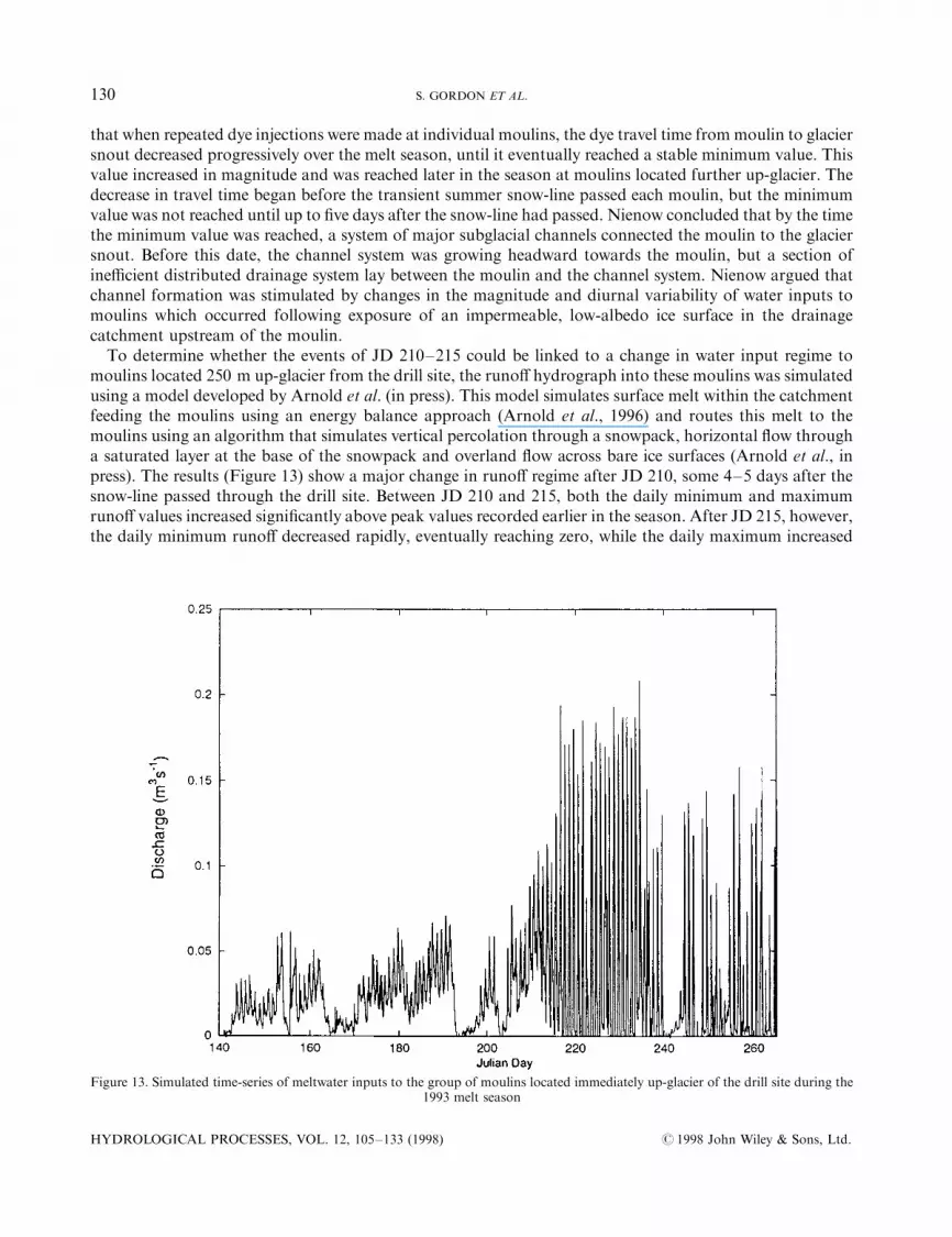
To determine whether the events of JD 210±215 could be linked to a change in water input regime tomoulins located 250 m up-glacier from the drill site, the runo� hydrograph into these moulins was simulatedusing a model developed by Arnold et al. (in press). This model simulates surface melt within the catchmentfeeding the moulins using an energy balance approach (Arnold et al., 1996) and routes this melt to themoulins using an algorithm that simulates vertical percolation through a snowpack, horizontal ¯ow througha saturated layer at the base of the snowpack and overland ¯ow across bare ice surfaces (Arnold et al., inpress). The results (Figure 13) show a major change in runo� regime after JD 210, some 4±5 days after thesnow-line passed through the drill site. Between JD 210 and 215, both the daily minimum and maximumruno� values increased signi®cantly above peak values recorded earlier in the season. After JD 215, however,the daily minimum runo� decreased rapidly, eventually reaching zero, while the daily maximum increased
Figure 13. Simulated time-series of meltwater inputs to the group of moulins located immediately up-glacier of the drill site during the1993 melt season
HYDROLOGICAL PROCESSES, VOL. 12, 105±133 (1998) # 1998 John Wiley & Sons, Ltd.
130 S. GORDON ET AL.
rapidly. These changes resulted from the removal of the snowpack from the catchment feeding the moulins,and are entirely consistent with those which Nienow (1993) hypothesized were responsible for subglacialchannel formation in 1990 and 1991. We therefore suggest that channel formation was initiated by the rise inboth maximum and mean diurnal water inputs to upstream moulins between JD 210 and 215. The heavyrainstorm of JD 211±212 may also have provided a stimulus to channel formation, since the basalconnection in H35 developed immediately after this event. The onset of strong diurnal pressure variationswithin the subglacial drainage system was, however, linked to the initiation of a highly variable water inputregime after JD 215. We note that, had a subglacial conduit existed before JD 210, the modelled change inmoulin water inputs could have produced a change in the pressure regime within such a conduit to onesimilar to that observed after JD 215 (Arnold et al., unpubl.). Nevertheless, in the absence of clear evidencefor the existence of such a conduit before JD 210, we prefer the interpretation that it formed between JD 210and 215.
If the inferred changes in the con®guration of the subglacial drainage system within the drill site area wereinitiated by changes in the discharge regime into moulins located up-glacier from the drill site, it seems likelythat, at the local scale, channel growth occurred in a down-glacier direction. However, as the snow-lineretreated up-glacier during the melt season, it exposed glacier ice within the catchments of moulins locatedprogressively further from the glacier snout. Thus, the process of channel formation occurred later in theseason further up-glacier, giving the impression that the channel system as a whole developed by headwardgrowth (Nienow, 1993). Individual channel segments grew by local melt-induced enlargement and down-glacier extension, and eventually linked up with established channel systems located further down-glacier.When the connection to the established channel system was made, free drainage became possible in the areabetween the feeder moulins and this system. Water stored within this area could then be drained, and waterpressure could oscillate freely in response to the diurnal discharge regime. Clarke (1996, his Figure 9)simulated behaviour of this sort using a lumped element model of a subglacial drainage circuit.
CONCLUSIONS
Borehole measurements have clari®ed our understanding of subglacial drainage system evolution at HautGlacier d'Arolla. Major changes in borehole behaviour resulted from the development of a subglacialchannel during the period JD 210±215, 1993. Prior to channel formation, borehole WL ¯uctuations weredriven by direct inputs of surface water to individual boreholes and were low in amplitude and poorlycorrelated. Basal water pressures and subglacial water ¯uxes across connected areas of the glacier bed areinferred to have been low. Channel formation was promoted by rapidly rising melt and rainfall-induceddischarges which resulted in a period of high subglacial water pressures. It was associated with a markedchange in the diurnal discharge regime of the stream draining into moulins located immediately up-glacierfrom the drill site area. This change resulted from the removal of the snowpack from the catchment feedingthese moulins and involved a signi®cant increase in the amplitude of diurnal discharge ¯uctuations.Following channel formation, borehole WLs were driven in part by discharge-related ¯uctuations in channelwater pressure, though the character of the ¯uctuations was not uniform. Holes connected directly to thechannel system showed identical WL ¯uctuations, while holes connected to it via a more resistive drainagesystem showed damped and systematically lagged ¯uctuations. Holes in unconnected areas of the bedshowed inverse WL ¯uctuations, while holes in intermediate areas showed an alternating response whichincluded elements of the unconnected and lagged responses. The inverse and alternating behaviours provideevidence for diurnal transfer of mechanical support for the ice overburden between connected andunconnected areas of the bed as channel water pressures ¯uctuated, and for diurnal changes in the extent ofthe connected regime. Once the channel existed, large diurnal variations in head di�erence developedbetween it and the adjacent resistive drainage system. These induced lateral ¯ow of mineralized basal waterthrough the resistive system, and this in turn entrained suspended sediment.
# 1998 John Wiley & Sons, Ltd. HYDROLOGICAL PROCESSES, VOL. 12, 105±133 (1998)
REORGANIZATION OF SUBGLACIAL DRAINAGE 131
ACKNOWLEDGEMENTS
This work was supported by grants from the UK Natural Environment Research Council (GR3/8114), theRoyal Society and the Natural Sciences and Engineering Research Council of Canada (to C.S. and M.S.).We thank Michael Nielsen for the design and construction of ®eld equipment, and Alun Hubbard, KeithCarr and Matthew Tully for ®eld assistance. Martyn Tranter and Peter Nienow provided constructivereviews of an earlier draft. Yvonne Bams, Patricia and Basile Bournissen provided logistical support inArolla, where M. Beytreyson of Grande Dixence S. A. also gave us invaluable assistance. We are indebted toGarry Clarke for stimulating and encouraging our interest in subglacial hydrology.
REFERENCES
Alley, R. B. 1996. `Towards a hydrologic model for computerised ice-sheet simulations', Hydrol. Process., 10, 649±660.Arnold, N. S., Willis, I. C., Sharp, M., Richards, K. S., and Lawson, W. 1996. `A distributed surface energy balance model for a small
valley glacier. I. Development and testing for the Haut Glacier d'Arolla, Valais, Switzerland', J. Glaciol., 42, 77±89.Arnold, N. S., Richards, K. S., Willis, I. C., and Sharp, M. In press. `Initial results from a semi-distributed, physically-based model of
glacier hydrology', Hydrol. Process., in press.Bindschadler, R. A. 1983. `The importance of pressurised subglacial water in separation and sliding at the glacier bed', J. Glaciol., 29,
3±19.Brown, G. H., Sharp, M., Tranter, M., Nienow, P., and Gurnell, A. M. 1994. `The impact of post-mixing chemical reactions on the
major ion chemistry of bulk meltwaters draining the Haut Glacier d'Arolla, Valais, Switzerland', Hydrol. Process., 8, 465±480.Brown, G. H., Tranter, M., and Sharp, M. J. 1996. `Experimental investigations of the weathering of suspended sediment by alpine
glacial meltwater', Hydrol. Process., 10, 579±598.Boulton, G. S. and Hindmarsh, R. C. A. 1987. `Sediment deformation beneath glaciers: rheology and geological consequences',
J. Geophys. Res. 92 (B9), 8903±8911.Clarke, G. K. C. 1996. `Lumped element analysis of subglacial hydraulic circuits', J. Geophys. Res., 101 (B8), 17547±17559.Copland, L., Harbor, J., Gordon, S., and Sharp, M. 1997. `The use of borehole video in the investigation of the hydrology of a
temperate glacier', Hydrol. Process., 11, 211±224.Engelhardt, H. F. 1978. `Water in glaciers: observations and theory of the behaviour of water levels in boreholes', Z. Gletscher.
Glazialgeol., 14, 35±60.Fountain, A. G. 1994. `Borehole water level variations and implications for the subglacial hydraulics of South Cascade Glacier,
Washington State, USA', J. Glaciol., 40, 293±304.Gordon, S. 1996. `Borehole-based investigations of subglacial hydrology', MSc Thesis, University of Alberta, 142 pp.Hantz, D. and Lliboutry, L. 1983. `Waterways, ice permeability at depth, and water pressures at Glacier d'ArgentieÁ re, French Alps',
J. Glaciol., 29, 227±239.Harbor, J. M., Sharp, M., Copland, L., Hubbard, B., Nienow, P., and Mair, D. 1997. `The in¯uence of subglacial drainage conditions
on the distribution of velocity within a glacier cross-section', Geology, 25, 739±742.Hodge, S. M. 1976. `Direct measurement of basal water pressure: a pilot study', J. Glaciol., 16, 205±218.Hooke, R. LeB., Wold, B. and Hagen, J.-O. 1985. `Subglacial hydrology and sediment transport at Bondhusbreen, south-west
Norway', Geol. Soc. Am. Bull., 96, 388±397.Hubbard, B. P. 1992. `Basal ice facies and their formation in the western Alps', PhD Thesis, University of Cambridge. 258 pp.Hubbard, B., Sharp, M., Willis, I. C., Nielsen, M., and Smart, C. C. 1995. `Borehole water level variations and the structure of the
subglacial hydrological system of Haut Glacier d'Arolla, Switzerland', J. Glaciol. 41, 572±583.Iken, A. 1981. `The e�ect of the subglacial water pressure on the sliding velocity of a glacier in an idealised numerical model', J. Glaciol.,
27, 407±421.Iken, A. and Bindschadler, R. A. 1986. `Combined measurements of subglacial water pressure and surface velocity of Findelengletscher,
Switzerland: conclusions about drainage system and sliding mechanism', J. Glaciol., 32, 101±119.Kamb, W. B. 1987. `Glacier surge mechanism based on linked cavity con®guration of the basal water conduit system', J. Geophy. Res.,
92, (B9), 9083±9100.Ketterling, B. 1995. `Electrical conductivity of waters in glacier boreholes', MSc Thesis, University of Western Ontario. 156 pp.Lamb, H., Tranter, M., Brown, G. H., Gordon, S., Hubbard, B., Nielsen, M., Sharp, M., Smart, C. C., and Wallis, I. C. 1995.`The composition of meltwaters sampled from boreholes at the Haut Glacier d'Arolla, Switzerland', IAHS Publ., 228, 395±403.
Murray, T. and Clarke, G. K. C. 1995. `Black-box modelling of the subglacial water system', J. Geophys. Res., 100 (B7), 10231±10245.Nienow, P. W. 1993. `Dye-tracer investigations of glacier hydrological systems', PhD Thesis, University of Cambridge. 337 pp.Richards, K. S., Sharp, M., Arnold, N., Gurnell, A. M., Clark, M., Tranter, M., Nienow, P., Brown, G. H., Willis, I. C., and
Lawson, W. 1996. `An integrated approach to modelling hydrology and water quality in glacierized catchments', Hydrol. Process.,10, 479±508.
Sharp, M., Richards, K. S., Willis, I. C., Arnold, N., Nienow, P., and Tison, J.-L. 1993. `Geometry, bed topography and drainagesystem structure of the Haut Glacier d'Arolla, Switzerland', Earth Surf. Process. Landf., 18, 557±571.
Smart, C. C. Statistical evaluation of boreholes as indicators of basal drainage systems', Hydrol. Process., 10, 599±614.Stone, D. B. and Clarke. G. K. C. 1993. `Estimation of subglacial hydraulic properties from induced changes in basal water pressure:
a theoretical framework for borehole response tests', J. Glaciol., 39, 327±340.
HYDROLOGICAL PROCESSES, VOL. 12, 105±133 (1998) # 1998 John Wiley & Sons, Ltd.
132 S. GORDON ET AL.
Stone, D. B. and Clarke, G. K. C. 1996. `In situ measurements of basal water quality and pressure as an indicator of the character ofsubglacial drainage systems', Hydrol. Process., 10, 615±628.
Stone, D. B., Clarke, G. K. C., and Blake, E. W. 1993. `Subglacial measurement of turbidity and electrical conductivity', J. Glaciol., 39,415±420.
Tranter, M., Brown, G. H., Raiswell, R., Sharp, M., and Gurnell, A. M. 1993. `A conceptual model of solute acquisition by alpineglacial meltwaters', J. Glaciol., 39, 573±581.
Tranter, M., Sharp, M., Willis, I. C., Brown, G. H., Hubbard, B., Nielsen, M., Smart, C. C., Gordon, S., Lamb, H., and Tully, M.1997. `Variability in the chemical composition of in situ subglacial meltwaters', Hydrol. Process., 11, 59±77.
Walder, J. S. 1986. `Hydraulics of subglacial cavities', J. Glaciol., 32, 439±445.
# 1998 John Wiley & Sons, Ltd. HYDROLOGICAL PROCESSES, VOL. 12, 105±133 (1998)
REORGANIZATION OF SUBGLACIAL DRAINAGE 133