an inventory of antarctic subglacial lakes
TRANSCRIPT
http://journals.cambridge.org Downloaded: 11 Dec 2013 IP address: 200.44.154.164
Antarctic Science 8 (3): 281-286 (1996)
An inventory of Antarctic sub-glacial lakes M.J. SIEGERTl, J.A. DOWDESWELL‘, M.R. GORMANl and N.F. MCINTYRP
’Centre for Glaciology, Institute of Earth Studies, University of Wales, Aberystwyth, Dyfed 52’23 3DB, UK ZEarth Observation Sciences Lt6 Broadmede, Farnham Business Park, Farnham, Surrey GU9 SQL, UK
Abstract: An extensive analogue database of 60 MHz radio-echo sounding records of Antarctica (covering 50% of the ice sheet) is held at the Scott Polar Research Institute, University of Cambridge. This database was analysed in order to determine the presence and location of Antarctic sub-glacial lakes. In total, 77 sub- glacial lake-type records were identified, 13 more than detected in previous studies. An inventory of these sub-glacial lakes includes geographical coordinates, minimum length and overlying ice thickness for each lake. Information concerning the location of these lakes indicates that the majority (-70%) are found in the proximity of ice divides at Dome C and Ridge B within East Antarctica.
Received 15 November 1995, accepted 10 April 1996
Key words: Antarctic ice sheet, radio-echo sounding, RES
Introduction
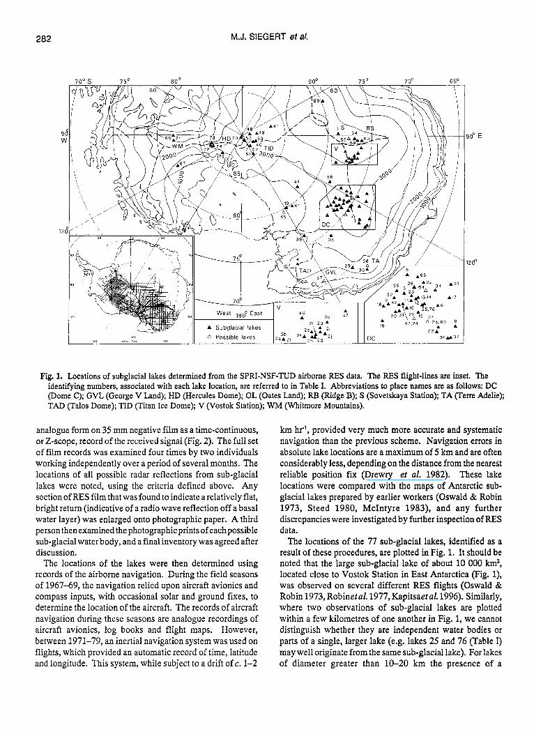
Lakes beneath the Antarctic ice sheet were first reported from airborne radio-echo sounding (RES) records by Oswald & Robin (1973). Several other studies of Antarctic 60 MHz RES data, acquired as part of the SPRI-NSF-TUD (Scott Polar Research Institute, University of Cambridge, UK, National Science Foundation, USA; Technical University of Denmark) joint research programme between 1967 and 1979 (Drewry 1983) (Fig. l), have identified up to 64 areas of bright, mirror-like reflections (Fig. 2), interpreted as representing water beneath the ice sheet (Robin et al. 1977, Steed 1980, McIntyre 1983). The lakes identified in these studies were discovered during the reduction of radio-echo sounding data from several regions of Antarctica.
In this contribution, we present an inventory of Antarctic sub-glacial lakes which is derived from a systematic re- analysis of the entire SPRI-NSF-TUD Antarctic RES dataset, undertaken with the specific aim of identifying the full set of sub-glacial water bodies present along these -400 000 km of RES flight track over the Antarctic ice sheet (Fig. 1). Geographical coordinates, ice thickness and length of mirror- like reflections are presented for the set of Antarctic sub- glacial lakes for the first time.
RES and characteristics of sub-glacial water bodies
Airborne RES at 60 MHz has been used successfully to penetrate to the base of ice over 4 km thick in Antarctica (e.g. Robinetal. 1977, Drewry 1983). This is possible because ice is relatively transparent to radio waves at this frequency (Johari & Charette 1975), especially when it is several tens of degrees below freezing, as is the case for most of the Antarctic ice sheet.
The strength of reflection from the bed depends to a first order upon the difference between the dielectric properties of the ice (dielectric constant E = 3.2), and the dielectric
properties of the sub-ice material. As the dielectric constant of water ( E = 81) is very different from typical bedrock ( E = 4-9), a much stronger reflection is obtained from an ice- water interface compared with an ice-rock interface. This difference is further increased by the relatively rough character of an ice-bedrock interface, which scatters energy and further reduces echo strength.
Sub-glacial lakes are identified on 60 MHz RES records by the presence of the following characteristics (Fig 2.):
(i) strong reflections from the ice sheet base, which appear bright on film records and are typically 10-20 dB stronger than adjacent ice-bedrock reflections,
(ii) echoes of constant strength along the track, indicative of an interface which is very smooth on the scale of the RES wavelength, and
(iii) a very flat and virtually horizontal character, with maximum slopes typically less than 1%.
This last property arises from hydrostatic and ice flow mechanisms (Oswald & Robin 1973). Such ‘lake’ reflections are, thus, highly distinctive, and therefore pose relatively few problems concerning identification (Fig. 2).
It should be noted that accumulations of water-saturated basal sediments may also yield relatively strong electro- magnetic wave returns, in some cases similar to those observed from an ice-water interface. Conceivably, such returns may be observed on the RES record as flat horizontal reflections. As a consequence, we do not preclude that some of the ‘lakes’ identified in this inventory may comprise pockets of water-saturated sediments at the ice-sheet base.
Analysis of Antarctic RES records
RES data from flights over about 7 million km2 of the Antarctica Ice Sheet (Fig. 1) (Drewry 1983) were recorded in
281
http://journals.cambridge.org Downloaded: 11 Dec 2013 IP address: 200.44.154.164
282
9( w
12L
M.J. SIEGERT eta/.
30' E
1200
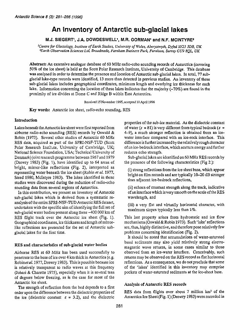
Fig. 1. Locations of subglacial lakes determined from the SPRI-NSF-TUD airborne RES data. The RES flight-lines are inset. The identifying numbers, associated with each lake location, are referred to in Table I. Abbreviations to place names are as follows: DC (Dome C); GVL (George V Land); HD (Hercules Dome); OL (Oates Land); RB (Ridge B); S (Sovetskaya Station); TA (Terre Adelie); TAD (Talos Dome); TID (Titan Ice Dome); V (Vostok Station); WM (Whitmore Mountains).
analogue form on 35 mm negative film as a time-continuous, or Z-scope, record of the received signal (Fig. 2). The full set of film records was examined four times by two individuals working independently over a period of several months. The locations of all possible radar reflections from sub-glacial lakes were noted, using the criteria defined above. Any section of RES film that was found to indicate a relatively flat, bright return (indicative of a radio wave reflection off a basal water layer) was enlarged onto photographic paper. A third person then examined the photographic prints of each possible sub-glacial water body, and a final inventory was agreed after discussion.
The locations of the lakes were then determined using records of the airborne navigation. During the field seasons of 1967-69, the navigation relied upon aircraft avionics and compass inputs, with occasional solar and ground fixes, to determine the location of the aircraft. The records of aircraft navigation during these seasons are analogue recordings of aircraft avionics, log books and flight maps. However, between 1971-79, an inertial navigation system was used on flights, which provided an automatic record of time, latitude and longitude. This system, while subject to a drift of c. 1-2
km hr-*, provided very much more accurate and systematic navigation than the previous scheme. Navigation errors in absolute lake locations are a maximum of 5 km and are often considerably less, depending on the distance from the nearest reliable position fix (Drewry et al. 1982). These lake locations were compared with the maps of Antarctic sub- glacial lakes prepared by earlier workers (Oswald & Robin 1973, Steed 1980, McIntyre 1983), and any further discrepancies were investigated by further inspection of RES data.
The locations of the 77 sub-glacial lakes, identified as a result of these procedures, are plotted in Fig. 1. It should be noted that the large sub-glacial lake of about 10 000 km2, located close to Vostok Station in East Antarctica (Fig. l), was observed on several different RES flights (Oswald & Robin 1973, Robinet al. 1977, Kapitsaet al. 1996). Similarly, where two observations of sub-glacial lakes are plotted within a few kilometres of one another in Fig. 1, we cannot distinguish whether they are independent water bodies or parts of a single, larger lake (e.g. lakes 25 and 76 (Table I) may well originate fromthe same sub-glacial lake). For lakes of diameter greater than 10-20 km the presence of a
http://journals.cambridge.org Downloaded: 11 Dec 2013 IP address: 200.44.154.164
INVENTORY OF SUB-GLACIAL LAKES
- 0
h
E v
v) v) a, t Y 0
a, 0
.- 5 -
3700
,O 5 km,
283
CBD Units
Fig. 2. Sub-glacial lake No. 46, from Flight No. 121 (1974-75) at time 0682. Note the strong, flat, 6.5 km-long reflection off the lake compared with the weaker, undulating signal returned from the surrounding bedrock. Strong downward folding of the ice sheet internal layering is observed directly over the lake. Time is given in CBD units, which are set to zero at aircraft take-off, recording 1 CBD every 15 seconds in the flight thereafter.
continuous, flat and smooth ice-surface, derived from satellite radar altimetry, would provide an independent assessment of this problem (cf. Cudlip & McIntyre 1987, Ridley et al. 1993). Consequently, lake records 30 and 58 (Table I), located close to a relatively flat ice-surface in Terre Adtlie (identified from Seasat altimeter observations), may also correspond with the same sub-glacial lake (Cudlip & McIntyre 1987).
In addition to information on the latitude and longitude of the set of sub-glacial lakes derived from RES, the length of water body and the thickness of overlying ice were also measured (Table I). Lengths of the sub-ice lake records were calculated by assuming a constant aircraft speed of 300 km hrl, and may be considered as representing minimum values for water-body dimensions. Ice thicknesses can be measured directly both from the Z-scope data, and individual pulse (A- scope) recordings, by measuring the one-way travel time of the basal reflection and multiplying by the e/m wave velocity within ice (168.5 m ms-l, Glen & Paren 1975). The error in such measurement of ice thickness from RES methods is up to 1.5% of ice thickness (Drewry 1983).
Inventory of sub-glacial lakes
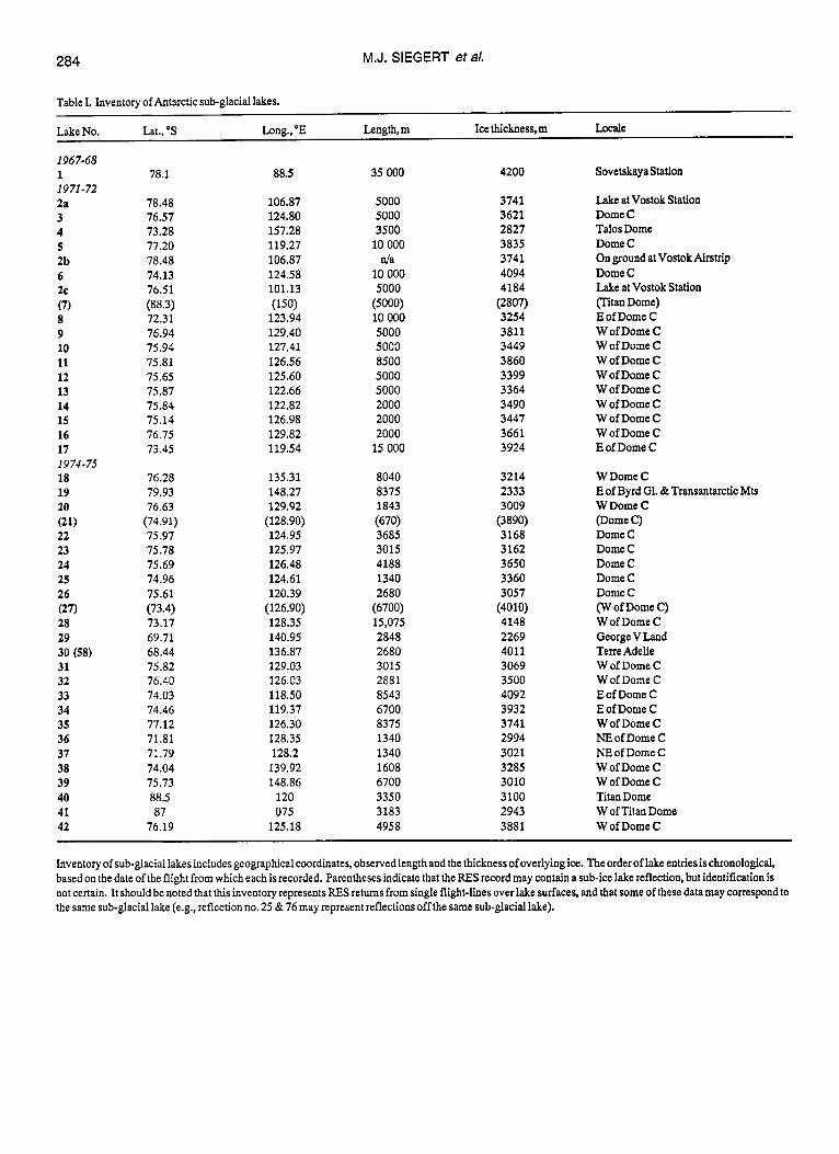
The results of our systematic re-analysis of radio-echo sounding records from approximately half of the Antarctic ice sheet for the presence of sub-glacial lakes are summarized in Table I. This table provides an inventory of data on the latitude and longitude, minimum length and overlying ice thickness for the 77 lake reflections identified from the analogue RES records. The locations of these sub-ice water bodies are shown in Fig. 1.
It is clear from Fig. 1 that the majority of the observed lakes are situated in relatively close proximity to ice divides, where both the surface slope and ice velocity are small. Two clusters of lakes, accounting for 70% of the total lake inventory, are in regions of Dome C and Ridge Bin East Antarctica (Fig. 1). In addition, the ice divide stretching from West to East Antarctica (which runs close to the South Pole), has several sub-ice lakes along its length in the areas of Hercules Dome and Titan Dome (Fig. 1).
Although approximately half of the Antarctic ice sheet was sounded by the SPRI-NSF-TUD survey (Fig. l), flight-line spacing of 50-100 km over much of this area implies that
http://journals.cambridge.org Downloaded: 11 Dec 2013 IP address: 200.44.154.164
M.J. SIEGERT eta/. 284
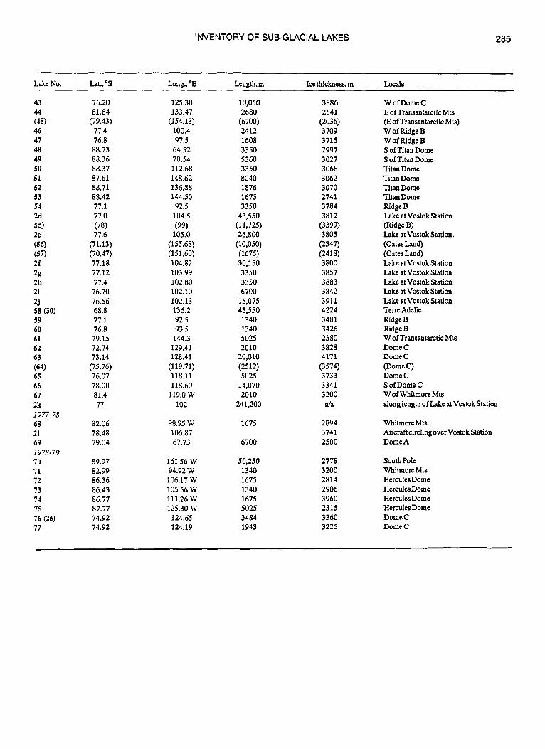
Table I. Inventory of Antarctic sub-glacial lakes.
Lake No. Lat., "S Long., 'E Length, m Ice thickness, m Locale
1967-68 1 1 9 71 -72 2a 3 4 5 2b 6 2c (7) 8 9 10 11 12 13 14 15 16 17 1974-75 18 19 20 (21) 22 23 24 25 26 (27) 28 29 30 (58) 31 32 33 34 35 36 37 38 39 40 41 42
78.1
78.48 76.57 13.28 77.20 78.48 74.13 76.51 (88.3) 72.31 76.94 75.94 75.81 75.65 75.87 75.84 75.14 76.75 73.45
76.28 79.93 76.63 (74.91) 75.97 75.78 75.69 74.96 75.61
73.17 69.71 68.44 75.82 76.40 74.03 74.46 77.12 71.81 7l.79 74.04 75.73 88.5 87
76.19
(73.4)
88.5
106.87 124.80 157.28 119.27 106.87 124.58 101.13
123.94 129.40 127.41 126.56 125.60 122.66 122.82 126.98 129.82 119.54
135.31 148.27 129.92 (128.90) 124.95 125.97 126.48 124.61 120.39 (126.90) 128.35 140.95 136.87 129.03 126.03 118.50 119.37 126.30 128.35 128.2 139.92 148.86 120 075 125.18
(150)
35 000
5000 5000 3500 10 000
d a 10 000 5000
10 000 5000 5000 8500 5000 5000 2000 2000 2000 15 000
8040 8375 1843
3685 3015 4188 1340 2680 (6700) 15,075 2848 2680 3015 2881 8543 6700 8375 1340 1340 1608 6700 3350 3183 4958
(5000)
(670)
4200
3741 3621 2827 3835 3741 4094 4184 (2807) 3254 3811 3449 3860 3399 3364 3490 3447 3661 3924
3214 2333 3009 (3890) 3168 3162 3650 3360 3057 (4010) 4148 2269 4011 3069 3500 4092 3932 3741 2994 3021 3285 3010 3100 2943 3881
Sovetskaya Station
Lake at Vostok Station Dome C Talos Dome Dome C Onground atVostok Airstrip Dome C Lake at Vostok Station flitan Dome) E of Dome C W of Dome C W of Dome C W of Dome C W of Dome C W of Dome C W of Dome C W of Dome C W of Dome C E of Dome C
W Dome C E of Byrd G1. & Transantarctic Mts W Dome C
Dome C Dome C Dome C Dome C Dome C (W of Dome C) W of Dome C George V Land Terre Adelie W of Dome C W of Dome C E of Dome C E of Dome C W of Dome C NE of Dome C NE of Dome C W of Dome C W of Dome C Titan Dome W of Titan Dome W of Dome C
@ome c)
Inventory of sub-glacial lakes includes geographical coordinates, observed length and the thickness of overlying ice. The order of lake entriesis chronological, based on the date of the flight from which each isrecorded. Parentheses indicate that the RES record may contain a sub-ice lake reflection, but identification is not certain. It should be noted that this inventory represents RES returns from single flight-lines over lake surfaces, and that some of these data may correspond to the same sub-glacial lake (e.g., reflection no. 25 & 76 may represent reflectionsoff the same sub-glacial lake).
http://journals.cambridge.org Downloaded: 11 Dec 2013 IP address: 200.44.154.164
INVENTORY OF SUB-GLACIAL LAKES 285
Lake No. Lat., "S Long., *E Length,m Ice thickness, m Locale
43 44 (45) 46 47 48 49 50 51 52 53 54 2d 55) 2e (56) (57) 2f 2g 2h 21 2.i 58 (30) 59 60 61 62 63 (64) 65 66 67 2k 1977-78 68 21 69 1978-79 70 71 72 73 74 75 76 (25) 77
76.20 81.84
77.4 76.8 88.73 88.36 88.37 87.61 88.71 88.42 77.1 77.0
77.6 (71.13) (70.47) 77.18 77.12 77.4 76.70 76.56 68.8 77.1 76.8 79.15 72.74 73.14
(75.76) 76.07 78.00 81.4 77
82.06 78.48 79.04
89.97 82.99 86.36 86.43 86.77 87.77 74.92 74.92
(79.43)
(78)
125.30 133.47
(154.13) 100.4 97.5
64.52 70.54 112.68 148.62 136.88 144.50 92.5
104.5
105.0 (155.68) (15 1.60) 104.82 103.99 102.80 102.10 102.13 136.2 92.5 93.5 144.3 129.41 128.41
(119.71) 118.11 118.60
119.0 w 102
98.95 W 106.87 67.73
161.56 W 94.92 W 106.17 W 105.56 W 111.26 W 125.30 W
124.65 124.19
(99)
10,050 2680
(6700) 2412 1608 3350 5360 3350 8040 1876 1675 3350
43,550 (11,725) 26,800
(1675) 30,150 3350 3350 6700
15,075 43,550 1340 1340 5025 2010
20,010 (2512) 5025
14,070 2010
241,200
1675
6700
50,250 1340 1675 1340 1675 5025 3484 1943
(10,050)
3886 2641
(2036) 3709 3715 2997 3027 3068 3062 3070 2741 3784 3812
3805
(2418) 3800 3857 3883 3842 3911 4224 3481 3426 2580 3828 4171
3733 3341 3200
(3399)
(2347)
(3574)
n/a
2894 3741 2500
2778 3200 2814 2906 3960 2315 3360 3225
W of Dome C E of Transantarctic Mu (J2 of Transantarctic Mts) W of Ridge B W of Ridge B S of Titan Dome S of Titan Dome Titan Dome Titan Dome Titan Dome Titan Dome Ridge B Lake at Vostok Station (Ridge B) Lake at Vostok Station. (Oates Land) (OatesLand) Lake atVostok Station Lake at Vostok Station Lake at Vostok Station Lake at Vostok Station Lake at Vostok Station Terre Adelie Ridge B Ridge B W of Transantarctic Mts Dome C Dome C (Dome C) Dome C S of Dome C W of Whitmore Mts dong length of Lake at Vostok Station
WhitmoreMts. Aircraft circling over Vostok Station DomeA
South Pole Whitmore Mts Hercules Dome HerculesDome Hercules Dome Hercules Dome Dome C Dome C
http://journals.cambridge.org Downloaded: 11 Dec 2013 IP address: 200.44.154.164
286 M.J. SIEGERT eta/.
some additional lakes may be present between existing flight- lines. Similarly, no data were available for the remainder of the ice sheet. Analysis of high-accuracy satellite radar altimeter data will be used in future investigations (during the next two years) of larger sub-glacial lakes over the remaining portion of Antarctica (J.K. Ridley, personal communication 1995). Our inventory provides important information for several
pieces of further work. First, the inventory provides coordinates for the locations of sub-glacial lakes, and an indication of the minimum size of the lake. This may be useful for the identification of ice surface topographical features, using satellite radar altimetry, associated with sub- glacial lakes. Secondly, Antarctic sub-glacial lakes provide an important boundary condition for the thermal analysis of the ice sheet, in that the basal temperature of the ice sheet over sub-glacial lakes may be assumed to be at pressure melting point (Siegert & Dowdeswell in press). Thus, the location of sub-glacial lakes may be important to the understanding of heat flow at the base of the Antarctic ice sheet.
Acknowledgements
We thank Dr Gordon Robin for commenting on a draft of this paper and Prof Dr Heinz Miller and Dr David Vaughan for providing constructive and helpful reviews. We also thank the Director of the Scott Polar Research Institute, University of Cambridge, for his support of this project. Funding for this research was provided by NERC Grant GR9/1418.
References CUDLIP, W. & MCINTYRE, N.F. 1987. Seasat altimeter observations of an
Antarctic “lake”. Annals of Glaciology, 9,55-59. DREWRY, D.J., JORDAN, S.R. & JANKOWSKI, E. 1982. Measured properties
of the Antarctic ice sheet: surface configuration, ice thickness, volume and bedrock characteristics. Annals of Glaciology, 3,83-91.
DREWRY, D.J. ed. 1983. Antarctica: Glaciological and Geophysical Folio. Cambridge: Scott Polar Research Institute.
GLEN, J. & PAREN, J. 1975. The electrical properties of snow and ice. Journal of Glaciology, 15, 15-38.
JOHARI, G.P. & GARETTE, P.A. 1975. The permittivity and attenuation in polycrystalline and single-crystal ice Ih at 35 and 60 MHz. Journal of Glaciology, 14, 293-303.
1996. A large freshwater lake beneath the ice of central East Antarctica. Nature, 381, 684-686.
OSWALD, G.K.A. &ROBIN, G.DE Q. 1973. Lakes beneath the Antarcticice sheet. Nature, 245,251-254.
MCINTYRE, N.F. 1983. The topography and flow of the Antarcticicesheet. PhD thesis, University of Cambridge, 198pp. [Unpublished.]
RIDLEY, J.K., CUDLIP, W. & LAXON, S.W. 1993. Identification of sub- glacial lakes using ERS-1 radar altimeter. Journal of Glaciology, 39,
ROBIN, G. DE Q., DREWRY, D.J. & MELDRUM, D.T. 1977. International studies of ice sheet and bedrock. Philosophical Transactions of the Royal Society, London, 279B, 185-196.
SIEGERT, M.J & DOWDESWELL, J.A. In press. Spatial variations in heat at the base of the Antarctic ice sheet from analysis of the thermal regime above sub-glacial lakes. Journal of Glaciology.
STEED, R.H.N. 1980. Geophysical investigations of Wilkes Land, Antarctica. PhD thesis, University of Cambridge, 178pp. [Unpublished.]
KAPITSA, A.P., RIDLEY, J.K., ROBIN, G.DE Q., SIEGERT, M.J. & z O I l K O V , I . k
625-234.