erosion of bedrock by subglacial meltwater, cantley, quebec
TRANSCRIPT

Erosion of bedrock by subglacial meltwater, Cantley, Quebec
DAVID R. SHARPE Geological Survey of Canada, 601 Booth Street, Ottawa, Ontario K1A 0E8 JOHN SHAW Department of Geography, Queen's University, Kingston, Ontario K7L 3N6
ABSTRACT
Several erosional forms on bedrock at Cant-ley, Quebec, differ from well-known glacial abrasion forms. The forms consist of obstacle marks, hollows, depressions, and channels, which are defined by sharp rims, smooth inner surfaces, divergent flow features, and remnant ridges. These forms are found on lee, lateral, and overhung rock surfaces. This as-semblage of features is best explained by dif-ferential erosion produced by separation eddies along lines of reattachment. Rapid, sediment-laden, turbulent, subglacial melt-water flows likely produced the forms by cor-rasion and cavitation erosion.
Sculpted fluvial forms in terrain subject to flooding in Australia are identical to some of the Cantley forms which confirms their forma-tion by water erosion. Although glacial abra-sion may not be eliminated as an explanation for sculpted forms, it is not necessary.
Ice-abrasion forms, such as striations, and such plucked forms as gouges and crescentic fractures are also present at the Cantley site. Pitted forms, polishing, and carbonate precip-itate are also found. The occurrence of abrasion, pitting, polishing, and carbonate precipitate with meltwater forms suggests that the meltwater flows were subglacial. De-coupling of abrading ice from its bed tempo-rarily suspended glacial abrasion, whereas reattachment of ice to the bed may have led to the rounding of sharp edges and the produc-tion of striations superposed on the glacifluvi-al forms.
The association of forms produced both by glacifluvial erosion and ice abrasion suggests that the glacier was alternately lifted from, and reattached to, the bed during periodic subglacial floods. These floods may have af-fected the dynamics of the ice sheet, and dep-ositional sequences related to catastrophic meltwater outbursts probably were laid down in adjacent basins.
INTRODUCTION
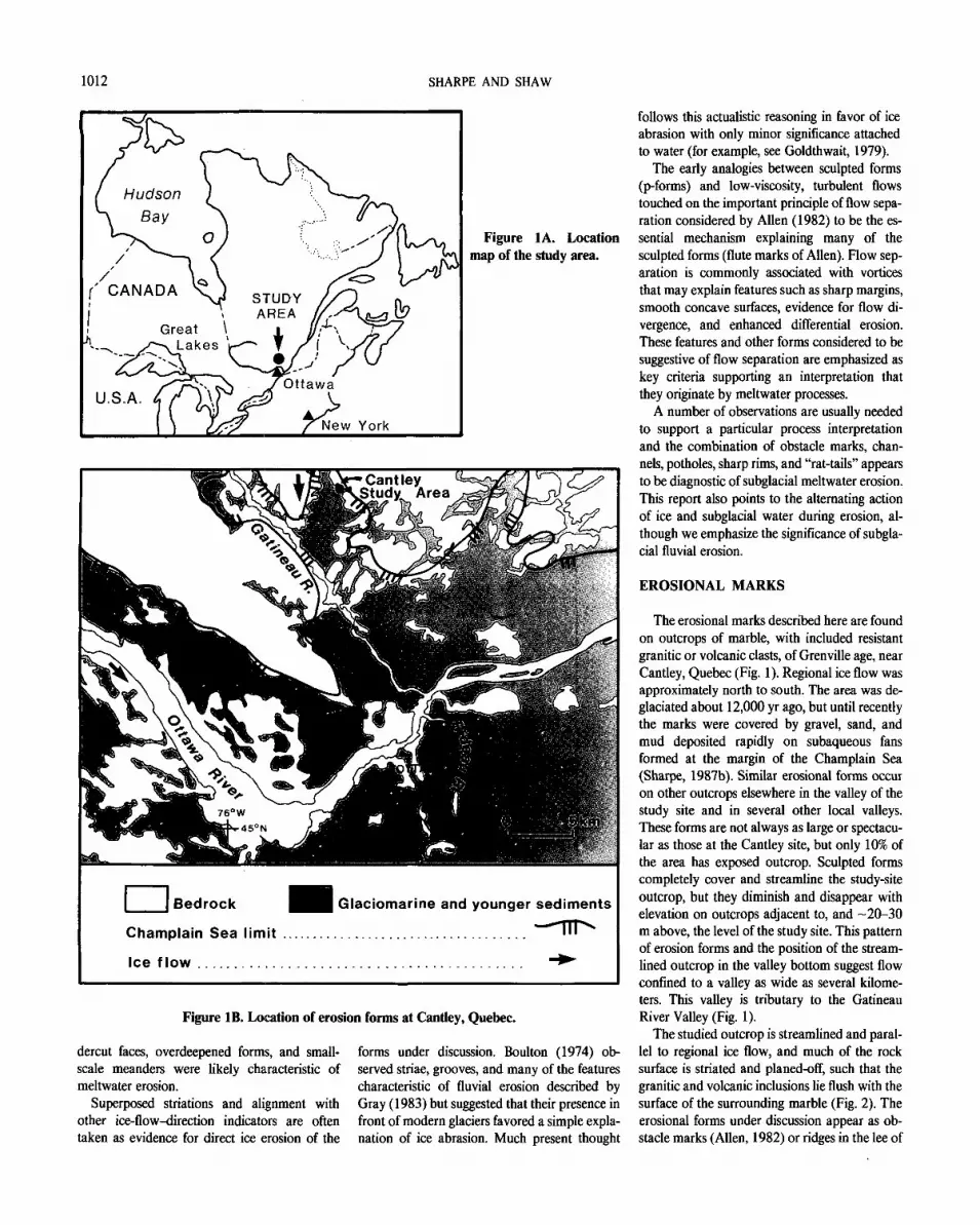
The purpose of this paper is to draw attention to the significance and implications of subglacial meltwater erosion in glaciated terrain. Erosion by subglacial meltwater may be complementary to erosion by ice, but in some areas it may be more significant. The spectacular, sculpted ero-sion forms at Cantley, Quebec, preserve possible distinctive features of subglacial fluvial erosion. Evidence for similar features is widespread in areas of formerly glaciated terrain (Shaw and Kvill, 1984; Shaw and Sharpe, 1987; Shaw, 1988; Sharpe, 1987a). Sculpted erosion forms have been reported in North America (Andrews, 1883; Bernard, 1971), Scandinavia (Ljungner, 1930; Hjulstrom, 1935; Dahl, 1965; Gjessing, 1965, 1967), Britain (Gray, 1981, 1984), and the Alps (Ljungner, 1930). Evidence for subglacial meltwater erosion forms may be subtle in many areas, and we may not yet realize their full extent.
Water-sculpted forms imply subglacial bed conditions with little frictional resistance in the areas of subglacial meltwater flow at the time of such discharge. The discharge rates inferred also require meltwater storage that most probably occurred subglacially somewhere up-ice from the erosional mark sites. Separation of the gla-cier from its bed by a subglacial-meltwater sheet also involves minimal basal resistance to ice flow, and a flat ice sheet is expected to cover such discharge and storage areas. The impor-tance attached here to meltwater corresponds to that applied by others to a subglacially deform-ing bed (Boulton and Jones, 1979; Boulton and Hindmarsh, 1987). Both involve low basal shear stresses, a relatively flat ice-sheet profile, and minimum ice volumes for a given ice-sheet ra-dius. It is important to note that, in the melt-water explanation, these conditions may occur even where the substrate is bedrock. The rapid discharge of meltwater interpreted in this paper is expected to have been accompanied by accel-erated ice flow and surging (Kamb and others,
1985). If ice-sheet profiles are to be reconstruct-ed, it becomes critical that subglacial meltwater forms be mapped and their timing be assessed.
Bedrock erosional forms indicative of subgla-cial action are common in areas affected by the Laurentide Ice Sheet. The forms are mainly elon-gate, straight scratches or striae, grooves, and polished areas that are generally attributed to abrasion when sliding ice drags tools across the glacier bed. Ice abrasion tends to smooth out or plane small irregularities on the glacier bed (Rothlisberger, 1968; Hallet, 1979). Plucked and gouged rock outcrops with ragged, irregular surfaces apparently produced by preferential ice erosion are also common.
Various other erosional forms are also found on many rock surfaces in glaciated terrain (Ljungner, 1931; Hjulstrom, 1935). These forms have been described as "p-forms" or "plastically eroded forms" (Dahl, 1965; Gjessing, 1965, 1967) and have been attributed generally to ero-sion by subglacial meltwater, although Gjessing considered both meltwater and a sediment slurry to be the active agents. More recently, glacial abrasion has been thought to be solely responsi-ble for the erosion (Boulton, 1974; Goldthwait, 1979). The combined role of water and ice has also been considered (Allen, 1982; Gray, 1981, 1984).
The critical features used to distinguish water, slurry, or glacial abrasion are not always clearly stated and are generally vague. Ljungner (1930) relied on the similarity in form and arrangement between subglacial erosion forms and dune fields and other bedforms in turbulent flows. The association of the subglacial forms with un-ambiguous fluvial forms such as potholes was used by Hjulstrom (1935) and Dahl (1965) to support a glacifluvial hypothesis. They also called upon cavitation as an agent of meltwater erosion. Gjessing (1967) considered sinuous channels and associated long, parallel, fine striae to have been formed simultaneously by a vis-cous slurry flow. Gray (1984), summarizing early work, suggested that sharp edges and un-
Geological Society of America Bulletin, v. 101, p. 1011-1020, 13 figs., August 1989.
1011
1012 SHARPE AND SHAW
Figure IB. Location of erosion forms at Cantley, Quebec.
dercut faces, overdeepened forms, and small-scale meanders were likely characteristic of meltwater erosion.
Superposed striations and alignment with other ice-flow-direction indicators are often taken as evidence for direct ice erosion of the
forms under discussion. Boulton (1974) ob-served striae, grooves, and many of the features characteristic of fluvial erosion described by Gray (1983) but suggested that their presence in front of modern glaciers favored a simple expla-nation of ice abrasion. Much present thought
follows this actualistic reasoning in favor of ice abrasion with only minor significance attached to water (for example, see Goldthwait, 1979).
The early analogies between sculpted forms (p-forms) and low-viscosity, turbulent flows touched on the important principle of flow sepa-ration considered by Allen (1982) to be the es-sential mechanism explaining many of the sculpted forms (flute marks of Allen). Flow sep-aration is commonly associated with vortices that may explain features such as sharp margins, smooth concave surfaces, evidence for flow di-vergence, and enhanced differential erosion. These features and other forms considered to be suggestive of flow separation are emphasized as key criteria supporting an interpretation that they originate by meltwater processes.
A number of observations are usually needed to support a particular process interpretation and the combination of obstacle marks, chan-nels, potholes, sharp rims, and "rat-tails" appears to be diagnostic of subglacial meltwater erosion. This report also points to the alternating action of ice and subglacial water during erosion, al-though we emphasize the significance of subgla-cial fluvial erosion.
EROSIONAL MARKS
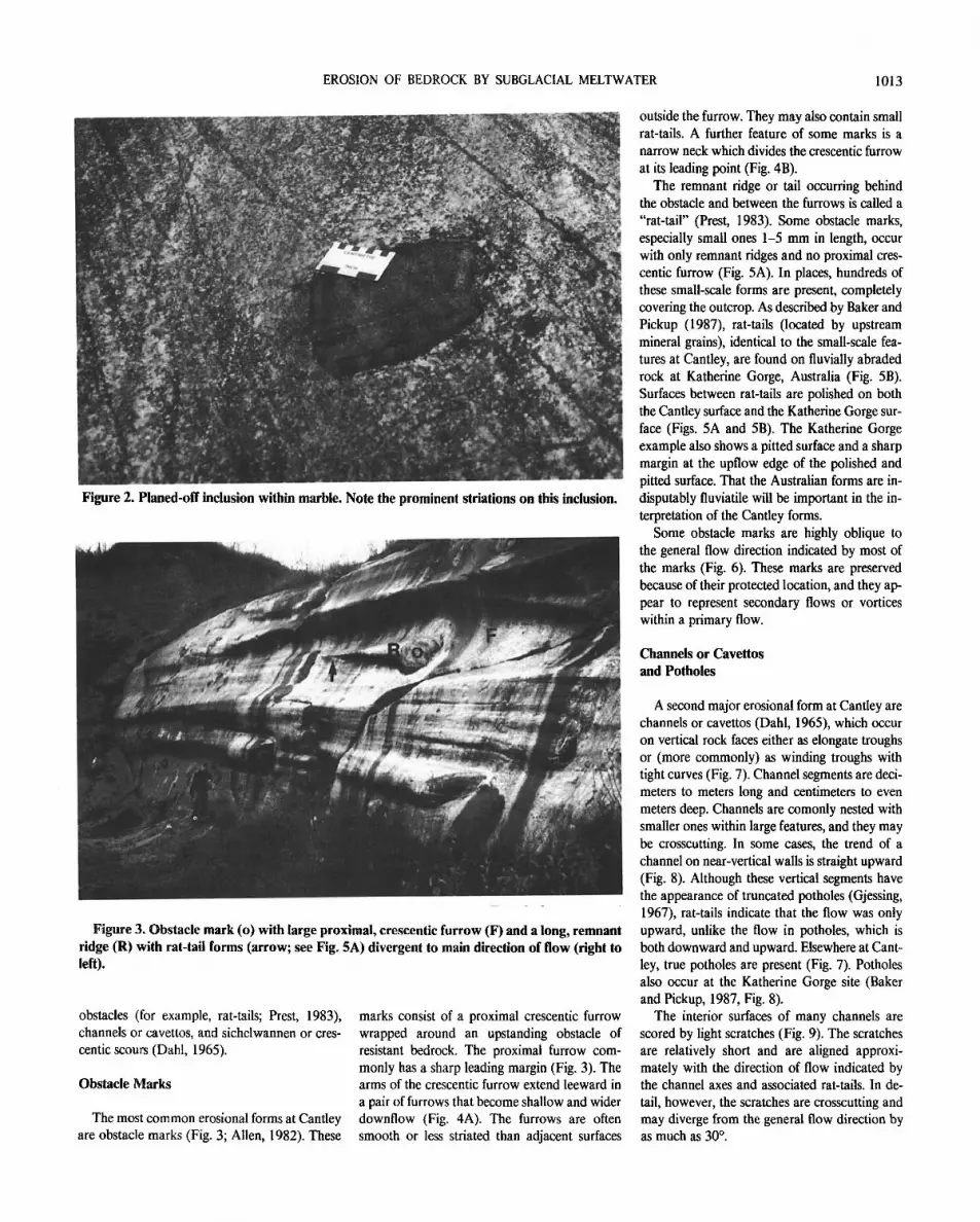
The erosional marks described here are found on outcrops of marble, with included resistant granitic or volcanic clasts, of Grenville age, near Cantley, Quebec (Fig. 1). Regional ice flow was approximately north to south. The area was de-glaciated about 12,000 yr ago, but until recently the marks were covered by gravel, sand, and mud deposited rapidly on subaqueous fans formed at the margin of the Champlain Sea (Sharpe, 1987b). Similar erosional forms occur on other outcrops elsewhere in the valley of the study site and in several other local valleys. These forms are not always as large or spectacu-lar as those at the Cantley site, but only 10% of the area has exposed outcrop. Sculpted forms completely cover and streamline the study-site outcrop, but they diminish and disappear with elevation on outcrops adjacent to, and - 2 0 - 3 0 m above, the level of the study site. This pattern of erosion forms and the position of the stream-lined outcrop in the valley bottom suggest flow confined to a valley as wide as several kilome-ters. This valley is tributary to the Gatineau River Valley (Fig. 1).
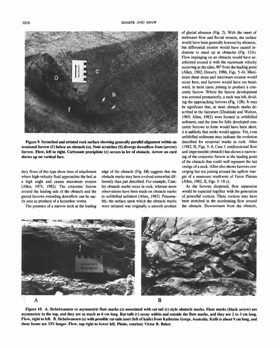
The studied outcrop is streamlined and paral-lel to regional ice flow, and much of the rock surface is striated and planed-off, such that the granitic and volcanic inclusions lie flush with the surface of the surrounding marble (Fig. 2). The erosional forms under discussion appear as ob-stacle marks (Allen, 1982) or ridges in the lee of
EROSION OF BEDROCK BY SUBGLACIAL MELTWATER 1013
Figure 2. Planed-off inclusion within marble. Note the prominent striations on this inclusion.
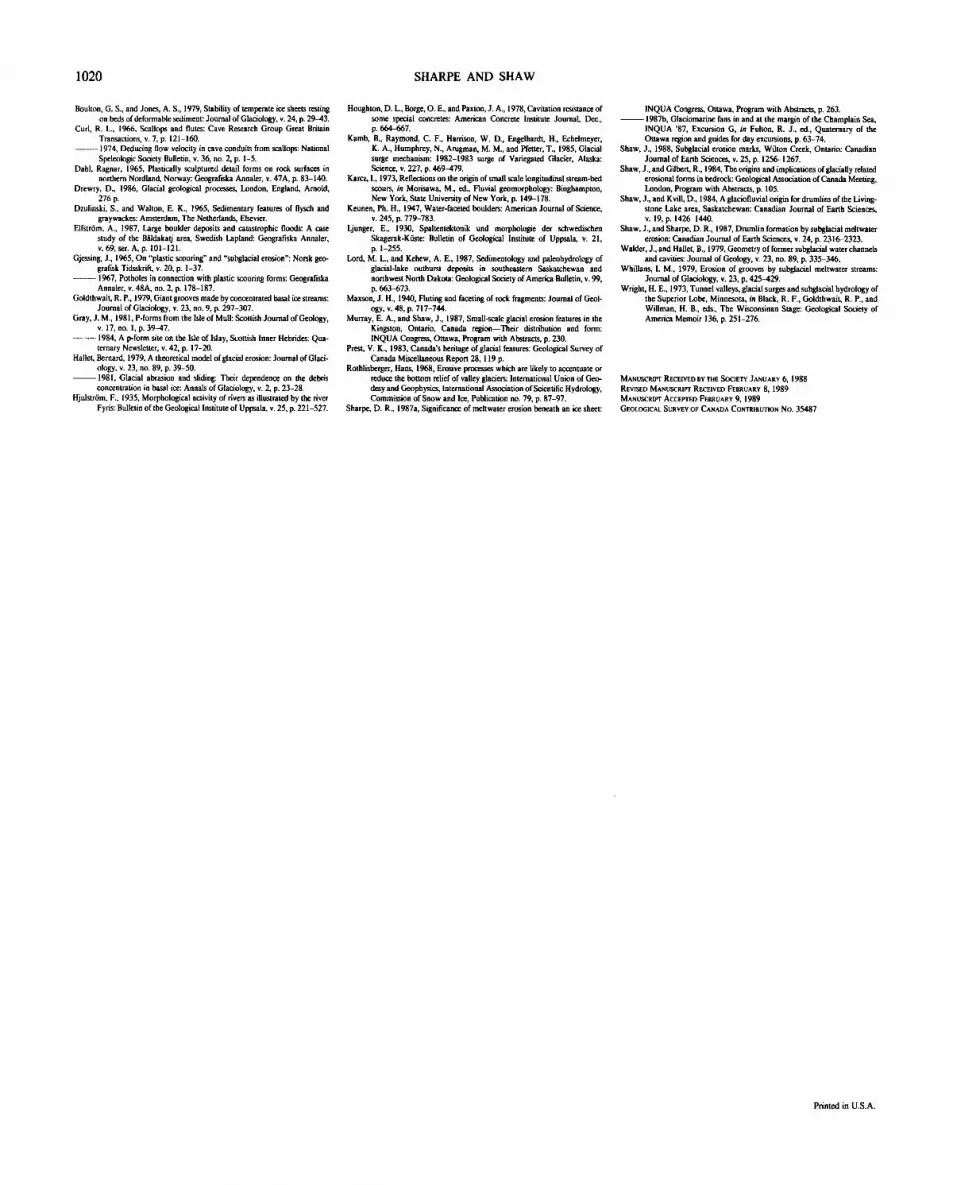
Figure 3. Obstacle mark (o) with large proximal, crescentic furrow (F) and a long, remnant ridge (R) with rat-tail forms (arrow; see Fig. 5A) divergent to main direction of flow (right to left).
obstacles (for example, rat-tails; Prest, 1983), channels or cavettos, and sichelwannen or cres-centic scours (Dahl, 1965).
Obstacle Marks
The most common erosional forms at Cantley are obstacle marks (Fig. 3; Allen, 1982). These
marks consist of a proximal crescentic furrow wrapped around an upstanding obstacle of resistant bedrock. The proximal furrow com-monly has a sharp leading margin (Fig. 3). The arms of the crescentic furrow extend leeward in a pair of furrows that become shallow and wider downflow (Fig. 4A). The furrows are often smooth or less striated than adjacent surfaces
outside the furrow. They may also contain small rat-tails. A further feature of some marks is a narrow neck which divides the crescentic furrow at its leading point (Fig. 4B).
The remnant ridge or tail occurring behind the obstacle and between the furrows is called a "rat-tail" (Prest, 1983). Some obstacle marks, especially small ones 1-5 mm in length, occur with only remnant ridges and no proximal cres-centic furrow (Fig. 5A). In places, hundreds of these small-scale forms are present, completely covering the outcrop. As described by Baker and Pickup (1987), rat-tails (located by upstream mineral grains), identical to the small-scale fea-tures at Cantley, are found on fluvially abraded rock at Katherine Gorge, Australia (Fig. 5B). Surfaces between rat-tails are polished on both the Cantley surface and the Katherine Gorge sur-face (Figs. 5A and 5B). The Katherine Gorge example also shows a pitted surface and a sharp margin at the upflow edge of the polished and pitted surface. That the Australian forms are in-disputably fluviatile will be important in the in-terpretation of the Cantley forms.
Some obstacle marks are highly oblique to the general flow direction indicated by most of the marks (Fig. 6). These marks are preserved because of their protected location, and they ap-pear to represent secondary flows or vortices within a primary flow.
Channels or Cavettos and Potholes
A second major erosional form at Cantley are channels or cavettos (Dahl, 1965), which occur on vertical rock faces either as elongate troughs or (more commonly) as winding troughs with tight curves (Fig. 7). Channel segments are deci-meters to meters long and centimeters to even meters deep. Channels are comonly nested with smaller ones within large features, and they may be crosscutting. In some cases, the trend of a channel on near-vertical walls is straight upward (Fig. 8). Although these vertical segments have the appearance of truncated potholes (Gjessing, 1967), rat-tails indicate that the flow was only upward, unlike the flow in potholes, which is both downward and upward. Elsewhere at Cant-ley, true potholes are present (Fig. 7). Potholes also occur at the Katherine Gorge site (Baker and Pickup, 1987, Fig. 8).
The interior surfaces of many channels are scored by light scratches (Fig. 9). The scratches are relatively short and are aligned approxi-mately with the direction of flow indicated by the channel axes and associated rat-tails. In de-tail, however, the scratches are crosscutting and may diverge from the general flow direction by as much as 30°.

Figure 4. A. Obstacle mark with crescentic furrow defined by arms and weakly formed upstream hollow around an obstacle, where the flow was from right to left. Note that the arms become broader and shallower down flow. Tool is 20 cm long. B. Obstacle mark with well-developed, upstream neck (N) separating arms of down-flow furrows around a large obstacle where the flow was left to right. Card is 8 cm across.
Figure 5. A. Small obstacle marks (~1 mm to ~ 1 cm long) without up-flow erosional furrow. These are also referred to as "rat-tails" (see Prest, 1983; and Shaw and Sharpe, 1987). Arrow indicates direction of meltwater flow. B. Rat-tails (r) within flute form with sharp up-flow margin (m) defining a shiny polished surface, from Katherine Gorge flood-terrain, Australia. Spindle-shaped flutes (f) and pits (p) are also present. Flow right to left. Compare with Figure 5A and Figure 10A. Photo, courtesy Victor R. Baker (see Fig. 9 of Baker and Pickup, 1987).
Figure 6. Obstacle marks (rat-tails) with flow orientation on smaller elements (small ar row) that is secondary or diver-gent from main flow (large arrow). Note-book (N) for scale, 20 cm high.

EROSION OF BEDROCK BY SUBGLACIAL MELTWATER 1015
Figure 7. Channel or cavetto forms of erosion showing elongate and winding, sinuous form at Cantley, Quebec. The channels indicate a variety of flow directions. A pothole also occurs on this surface (arrow). Flow, mainly left to right.
Figure 8. Channel with vertical orientation. Flow di-rections are shown by rat-tail forms within and adjacent to the feature. Direction of flow is indicated by arrows. Fea-ture appears to be a pothole, yet it had inflow directed upward rather than down-ward.
Sichelwannen
Sichelwannen (sickle-trough) are bow-shaped furrows whose arms point in the direction of flow (Ljungner, 1930; Dahl, 1965). Small-scale sichelwannen occur in association with rat-tails (Fig. 10A). They are similar in form to the flute marks described by Allen (1971, 1982). The Cantley marks are asymmetrical in that the principal furrow is well developed on only one side. Cantley sichelwannen also occur in groups as do flute marks. As they are only a few cen-timeters long, these sichelwannen are much smaller than most forms reported in the litera-ture (for example, see Dahl, 1965).
Identical sichelwannen, also with superim-posed rat-tail forms, occur on fluvially eroded rocks at Katherine Gorge, Australia (Fig. 10B). The Katherine Gorge outcrops also contain groups of spindle-shaped flute marks that open in a downstream direction (Fig. 5B and Baker and Pickup, 1987, Fig. 9).
FORMATION OF THE EROSIONAL MARKS
The erosional marks at Cantley are consid-ered to have formed subglacially on the evidence of striations on the surfaces of some marks. Planed-off inclusions and heavy striations are, on the basis of countless observations at the mar-gins of modern glaciers, interpreted to be a prod-uct of glacial abrasion. The most prominent erosional marks at Cantley, the obstacle marks, are distinctly different from the glacial abrasion forms. They attest to differential erosion of the inclusions and surrounding marble and show characteristics identical to obstacle marks pro-duced by turbulent fluids in nonglacial environ-ments (Karcz, 1973; Allen, 1982). Specifically, Allen (1982, Figs. 5-10a and lOf, II, p. 185) illustrates obstacle marks, eroded into cohesive beds, with and without a horseshoe furrow wrapped around a remnant ridge or rat-tail. He also points out that the depth of scour in soft substrate (sand) is related exponentially to Rey-nolds numbers which are in the range for turbu-lent flows when sand moves as bedload. Elfstrom (1987, Fig. 17a) shows a spectacular 20-m-long obstacle mark on an Iceland sandur. Large scours in a relatively hard substrate (mar-ble) would clearly require longer duration or higher velocity, fully turbulent flows than those producing erosion in soft materials.
Obstacle marks are closely related to the for-mation of horseshoe vortices resulting from a vertical pressure gradient generated at the up-stream face of the obstacle. This pressure gradi-ent sets up a secondary flow that plunges toward the bed and swings around the obstacle in a pair of oppositely rotating vortices (Fig. 11). Secon-
1016 SHARPE AND SHAW
Figure 9. Scratched and striated rock surface showing generally parallel alignment within an erosional furrow (f) below an obstacle (o). Note scratches (S) diverge downflow from (arrow) furrow. Flow, left to right. Carbonate precipitate (c) occurs in lee of obstacle. Arrow on card shows up on vertical face.
dary flows of this type show lines of attachment where high-velocity fluid approaches the bed at a high angle and causes maximum erosion (Allen, 1971, 1982). The crescentic furrow around the leading side of the obstacle and the paired furrows extending downflow can be eas-ily seen as products of a horseshoe vortex.
The presence of a narrow neck at the leading
edge of the obstacle (Fig. 4B) suggests that the obstacle marks may have evolved somewhat dif-ferently than just described. For example, Cant-ley obstacle marks occur in rock, whereas more observations have been made on obstacle marks in unlithified sediment (Allen, 1982). Presuma-bly, the surface upon which the obstacle marks were initiated was originally a smooth product
of glacial abrasion (Fig. 2). With the onset of meltwater flow and fluvial erosion, the surface would have been generally lowered by abrasion, but differential erosion would have caused in-clusions to stand up as obstacles (Fig. 12A). Flow impinging on an obstacle would have ac-celerated around it with the maximum velocity occurring at the sides, 90° from the leading point (Allen, 1982; Drewry, 1986, Figs. 5-6). Maxi-mum shear stress and maximum erosion would occur here, and furrows would have cut head-ward, in most cases, joining to produce a cres-centic furrow. Where the furrow development was arrested prematurely, a neck was left, divid-ing the approaching furrows (Fig. 12B). It may be significant that, as most obstacle marks de-scribed in the literature (Dzulinski and Walton, 1965; Allen, 1982) were formed in unlithified sediment, and the time for fully developed cres-centic furrows to form would have been short, it is unlikely that necks would appear. Yet, even unlithified sediments may indicate the evolution described for erosional marks in rock. Allen (1982, II, Figs. 5-9, Case 1 unidirectional flow and impermeable obstacle) has shown a narrow-ing of the crescentic furrow at the leading point of the obstacle that could well represent the last vestige of a neck. Allen also shows furrows con-verging but not joining around the upflow mar-gin of a seamount southwest of Faroe Plateau (Allen, 1982, II, Figs. 5-18 c).
As the furrows deepened, flow separation would be expected together with the generation of powerful vortices. These vortices may have been stretched in the accelerating flow around the obstacle. Downstream from the obstacle,
Figure 10. A. Sichelwannen or asymmetric flute marks (s) associated with rat-tail (r) style obstacle marks. Flute marks (black arrow) are asymmetric to the top, and they are as much as 6 cm long. Rat-tails (r) occur within and outside the flute marks, and they are 2 to 3 cm long. Flow, right to left. B. Sichelwannen (s) with possible rat-tails inset (left of knife) from Katherine Gorge, Australia. Knife is about 9 cm long, and these forms are 33% longer. Flow, top right to lower left. Photo, courtesy Victor R. Baker.

EROSION OF BEDROCK BY SUBGLACIAL MELTWATER 1017
h o r s e s h o e vo r t ex
o b s t a c l e
Figure 11. Conceptual model showing formation of crescentic furrow and furrows to the lee-side of an obstacle related to a horseshoe vortex. A remnant ridge (rat-tail) results.
remnant r idge ( r a t - t a i l )
furrow
however, they would have expanded rapidly, eroding a scoop form rather than the narrow furrow adjacent to the obstacle. The expanding vortices would have been reduced in intensity and erosional power, with the consequence that the furrows would have become broader and shallower downflow. As a result, the rat-tails (that is, the remnant [rock] ridges between the furrows) would have become narrower and
lower. Even so, the rate of narrowing from fea-ture to feature seems to vary tremendously without apparent cause. This variation in nar-rowing may relate to flow intensity, size of ob-stacle, and angle of attack of impacting grains (Allen, 1982).
The above discussion assumes that the obsta-cle marks were formed by turbulent meltwater flows. The geologic agent, however, has been
often debated (Allen, 1982; Gray, 1984). Three hypotheses have been proposed: glacial abrasion (Boulton, 1974; Goldthwait, 1979), meltwater erosion (Dahl, 1965; Allen, 1982; Shaw and Kvill, 1984; Shaw and Sharpe, 1987), and ero-sion by a slurry flow (Gjessing, 1965). In addi-tion to the evidence presented above indicating turbulent flow and horseshoe vortices, three other lines of evidence support the meltwater interpretation. First, sharp margins or rims which are well known for erosional marks creat-ed by separating flows in nonglacial envi-ronments are characteristic of the erosional marks with furrows at Cantley (Maxson, 1940; Kuenen, 1947; Dahl, 1965, Fig. 38; Baker and Pickup, 1987). It is possible that glacial abrasion of a surface upflow of a furrow may also pro-duce a sharp leading rim, but it is not likely to have produced those sharp rims aligned parallel with the general flow direction. Second, the small rat-tails associated with the larger obstacle marks (Fig. 5A) appear to be identical to fluvial-ly produced forms in Australia (Fig. 5B). These features attest to widespread fluvial abrasion of the rock surface at Cantley and indicate that the fluvial flows postulated for the formation of the obstacle marks did, in fact, occur. (Glacial abra-sion, however, also occurred, and we shall dis-cuss below the possibility of erosion by a subglacial slurry.) Third, some obstacle marks within a larger form have an orientation oblique to the axis of the larger feature (Fig. 6). This is thought to indicate the secondary flow of vor-tices contained in the primary flow.
The possibility of glacial formation of the ob-stacle marks has been raised by a number of authors who follow Boulton's (1974) concept of the streaming of debris-rich glacial ice around an obstacle. There are two principal objections to this explanation. First, many of the obstacle marks have smoothly polished surfaces or sur-faces covered by small rat-tails, and they often have sharp leading margins. The fluvial surface from Katherine Gorge, Australia, has polish, small rat-tails, and marks with sharp rims all formed under vigorous, turbulent flows (Baker and Pickup, 1987). Glacial abrasion invariably produces striations, and the absence of striations from some of the forms speaks strongly against their formation by this process. Ice abrasion may produce polish but, even if ice produced the pol-ish within the obstacle marks, it is difficult to see how it could have eroded the form. Second, the obstacle marks at Cantley show remarkably sim-ilar form to other obstacle marks produced by turbulent separated flows (see Allen, 1982, for a discussion and numerous illustrations). We con-clude that the obstacle marks at Cantley were most probably also products of turbulent, sepa-rated flows.
flow line
an emerging obstacle. A. The incipient furrows occur at zones
neck of fiowline convergence. B. Ex-

1018 SHARPE AND SHAW
Turbulent separated flows appear to be neces-sary to form these obstacle marks, but in field discussion with glacial geologists, the possibility is always raised of similar flows in ice. The Rey-nolds number (Re), based on obstacle size, for ice flow is given by vi/v where v is ice flow velocity taken as = 3.1 x 10~5 m/s, f is obstacle diameter = 1 m, and v is the kinematic viscosity of ice = 3.1 x 10⁹ m2/s. A Reynolds number of 0.8 x 10 -13 is obtained, which completely rules out any possibility of turbulence.
The winding channels with sharp curves and potholes (Fig. 7) are also considered to be re-lated to powerful vortices that impinged on ver-tical faces of rock. These vortices were evidently ephemeral, because the crosscutting channels could not have been formed simultaneously. The rotating vortices, armed with an abrasive load of suspended sand and gravel, are believed to have acted like a drill on exposed faces. Fluvial abra-sion, however, produces extremely smooth and polished surfaces. We know of no accounts of striations produced by this process. Saltating particles, for example, bounce rather than slide on the bed. Bouncing particles are in contact with the bed over too short a distance to pro-duce extended scratches. Furthermore, the light scratches on the beds of some channels at Cant-ley are unlike the strong scratches of striations. Some light scratches also deviate significantly from their mean direction (Fig. 9).
Precisely these observations and the same rea-soning against a fluvial or glacial origin for the scratches led Gjessing (1965) to propose that, although some p-forms result from fluvial ero-sion, others are a product of erosion by a subgla-cial slurry of saturated till. We can imagine such a slurry being extruded through a channel with clasts moving past other clasts or temporary blockages of more slowly moving slurry to pro-duce scratches that deviate from the general flow direction. In addition, the stresses driving clasts in the slurry toward the bed would be much less than those calculated to occur on clasts at the base of melting ice (Hallet, 1981). This explains the light nature of the scratches as compared to the much heavier glacial striation. As outlined above, however, the primary formation of the channels probably occurred during the fluviatile events that created the obstacle marks rather than during slurry flow. The scratching, like the striation in some marks, is considered a late-stage ornamentation in which slurries produced scratching and ice abrasion produced striation.
The small-scale sichelwannen add further ev-idence in favor of the formation of the erosional
marks by separated turbulent flows. They have the appearance of flutes (Allen, 1982, Fig. 7-1) and are closely associated with rat-tails. The Cantley sichelwannen and rat-tails are similar to those described on fluvially eroded bedrock in Australia (see Fig. 5B and Fig. 10B; Baker and Pickup, 1987). They also appear similar to flutes on the base of turbidites (Dzulinski and Walton, 1965, Fig. 35). This resemblance to fea-tures produced by turbulent flow and the com-plete absence of any similar forms of known glacial origin favors our conclusion that the small-scale sichelwannen are products of erosion by meltwater.
SOME ADDITIONAL OBSERVATIONS
Some other observations on the bedrock sur-face characteristics at Cantley add to the inter-pretation of the erosional marks.
Pitting
Rock surfaces at Cantley are commonly pit-ted by irregular depressions centimeters to mil-limeters across. The larger pits occur on irregular but smooth rock surfaces, and the smaller pits are on level surfaces with subtle striations. An
unusual group of pits occurs on the up-flow side of an obstacle (Fig. 13). This occurrence may represent incipient furrow development.
The prominent pitting may be cavitation pit-ting (Hjulstrom, 1935; Arndt in Drewry, 1986). A projecting obstruction on the bed (or flow boundary) is susceptible to attack during cavita-tion by damaging shock waves and violent jets of water that may break solid fragments loose. Discrete erosional areas affected by cavitation also expand and coalesce, forming bowl-shaped hollows (Houghton and others, 1978). Although the edges of the hollows reported by Houghton and others are ragged, those of the erosional forms at Cantley are mainly smooth. The pits, however, may well indicate cavitation followed by final smoothing by fluvial abrasion. Dahl (1965) reported a marked similarity between sculpted forms (p-forms) and forms produced in cavitation experiments.
Cavitation occurs within violent flows (v = 8-10 m/s or more) when bubbles form under low pressure and then collapse under high pres-sure (Allen, 1982). Cavitation erosion may de-velop on the high-pressure, up-flow side of bed obstacles by the processes mentioned above, should vortices with a low-pressure core im-pinge on the obstacle (Allen, 1982) (Fig. 13).
Figure 13. Large pitted hollows (see card) occur up-flow of resistant block in marble with remnant ridge (rat-tail) cut short down-flow. Small pits occur on the adjacent surface. Arrow points in direction of flow. Crossing surface striations indicate light reattachment of ice to the bed.

EROSION OF BEDROCK BY SUBGLACIAL MELTWATER 1019
Initiation of obstacle scour, however, tends to occur, as discussed above, at 90° from the lead-ing point of the emerging obstacles (Fig. 12; and Drewry, 1986, Fig. 5.5). The random distribu-tion of many pits (Fig. 13) suggests that other flow factors may also be important.
Precipitates
Precipitates of calcium carbonate, showing fine internal lamination, are found in the lee of obstacles (Fig. 9). The precipitates form thin crusts with striated or scratched surfaces. They appear identical to the calcium carbonate precip-itates described on recently deglaciated carbon-ate bedrock surfaces (Walder and Hallet, 1979).
Walder and Hallet (1979) interpreted the car-bonate as a precipitate from water saturated with calcium carbonate in a thin regelation layer at the ice bed. The carbonate precipitates suggest that the ice reattached to the surface after the erosional marks formed. Striations on the rock also suggest contact with sliding ice.
Solution weathering may also be a mecha-nism of erosion at Cantley. The forms are, how-ever, much larger and different than those reported from caves. Cave forms consist of rounded concavities or scallops and runnels ori-ented transverse to flow (Curl, 1966,1974). The forms at Cantley are mainly obstacle marks and channels oriented parallel to flow.
Plucked Forms
Gouges, crescentic fractures, and plucked sur-faces also occur at Cantley, attesting to the re-attachment of the glacier and ice erosion following the formation of the fluvial erosional marks. This glacial erosion could not have pre-ceded fluvial erosion, because the rough surfaces of glacial erosion then would have been smoothed and polished by fluvial action.
CONCLUSION AND IMPLICATIONS
Landforms eroded by water in glacial terrain can be distinguished from classical ice abrasion by analogy with fluvial features, especially forms produced by separated turbulent flow, obstacle marks with smooth interior surfaces, remnant ridges, sharp rims, and the presence of marks oblique to the principal direction of flow. Gla-cial abrasion invariably produces striated sur-faces, and it is shown that glacier ice cannot attain turbulent flow at the scale of the erosional features described. It is highly unlikely that ice
abrasion was responsible for the large-scale ob-stacle marks, rat-tails, channels, and sichelwan-nen. The striations on some surfaces, the plucked surfaces, and the carbonate precipitates, how-ever, indicate that the glacier at Cantley re-attached to its bed following separation and erosion by meltwater. Still, scratches within the channels possibly could have been produced if a slurry was later extruded through the channels. The general conclusion is that a variety of ero-sional processes occurred at Cantley, but the ma-jor forms resulted from fluvial erosion. Fluvial erosion is attributed to corrasion, probable cavi-tation, and solution.
The observations at Cantley provide a dramat-ic illustration of the significance of meltwater erosion. The scale of the meltwater flows was large enough to cover the streamlined outcrop (10 m high), because erosion forms are found over a broad elevation (20-30 m) and areal range (for example, the width of one valley where flow was several kilometers across. This valley may have acted as a tunnel valley; Wright, 1973). If sculpted forms can be traced beyond valley margins, then the meltwater flows would correspond to some recent conclusions that broad sheet flows occurred catastrophically beneath the Laurentide Ice Sheet (Shaw, 1983; Shaw and Gilbert, 1984; Shaw and Kvill, 1984; Murray and Shaw, 1987; Shaw and Sharpe, 1987; Sharpe, 1987a). The presence of discrete discharge tunnels is evidently important to the formation of eskers, tunnel valleys, and perhaps some erosional marks (Whillans, 1979), but widespread and large forms showing a region-ally consistent flow pattern (Shaw and Kvil, 1984) speak for sheetflows. Such flows would have had a major effect on the dynamics of the Laurentide Ice Sheet by locally eliminating bed resistance. The reduction in bed resistance caused by such flows should be considered, to-gether with that caused by a deforming bed (Boulton, 1986; Alley and others, 1986), when reconstructing ice-sheet dynamics and profiles.
The association of forms produced by subgla-cial fluvial erosion and ice abrasion suggests that the glacier was alternately lifted from, and low-ered to, its bed by periodic subglacial floods. Glacier flow is enhanced by the presence of such subglacial water, and rapid flow may result (Bindschadler, 1983). Abrasion by ice is in-creased where glacial sliding is increased (Roth-lisberger, 1968; Hallet, 1981). It is therefore possible that both meltwater erosion and, on top-ographic highs, glacial abrasion are at a maxi-mum during such catastrophic subglacial floods,
assuming that some tools remained in the ice and the subglacial flood did not completely re-move the basal debris.
The presence of water-scoured bedrock sur-faces with regular erosion marks implies that the flows were competent to transport all clasts from these surfaces. Otherwise, deposited clasts would have protected the bed from erosion, and obsta-cle marks and rat-tails could not have been formed. Whillans (1979) estimated flow veloci-ties at Kelly's Island in Lake Erie at 6 m/s, but Elfstrom (1987) estimated meltwater velocities from outburst floods at a number of localities at tens of meters per second. Cavitation requires such high velocities. By comparison, the Kather-ine Gorge floods attained mean flow velocities of 7.5 m/s, and they produced only small ero-sional marks (Baker and Pickup, 1987). The flows producing the erosional marks at Cantley are considered to have been truly catastrophic. The high velocities and the large amounts of sediment available in subglacial environments are expected to have produced major sediment influxes into lakes, seas, and oceans bordering the Laurentide Ice Sheet (Shaw and Sharpe, 1987; see also Lord and Kehew, 1987).
ACKNOWLEDGMENTS
The work was done as part of project 83-17 Terrain Sciences Division, Geological Survey of Canada and NSERC grant to Shaw. Thanks are extended to V. K. Prest, B. R. Rust, and H. L. Thorliefson for thoughtful comments in review. Refereeing by B. Hallet and an anonymous re-viewer improved the paper.
R E F E R E N C E S C I T E D
Andrews, E., 1883, Glacial markings of unusual forms in the Laurentian Hills: Chicago Academy of Science Bulletin, v. 1, p. 3-9.
Allen, J.R.L., 1971, Transverse erosional marks of mud and rock: Their physi-cal basis and geological significance: Sedimentary Geology, v. 5, p. 167-185. 1982, Sedimentary structures: Their character and physical basis, Vol-ume II; New York, Elsevier Scientific Publishing Co., p. 253-291.
Alley, R. B., Blankenship, D. D„ Bentley, C. R„ and Rooney, S. T., 1986, Deformation of till beneath ice stream B, West Antarctica: Nature, ». 322, p. 57-59.
Baker, V. R., and Pickup, G., 1987, Rood geomorphoiogy of the Katherine Gorge, Northern Territory, Australia: Geological Society of America Bulletin, v. 98, p. 635-646.
Bernard, C., 1971, Les marques sous-glaciaires d'aspect plastique sur la roche en place (p-forms): Observations sur la bordure du bouchier canadien et examen de la question: Revue de Géographie Montréal, v. 25, no. 2, p. 111-127.
Bindschadler, 1983, The importance of pressurized subglacial water in separa-tion and sliding at the glacier bed: Journal of Glaciology, v. 29, no. 101, p. 3-19.
Boulton, G. S., 1974, Processes and patterns of glacial erosion, in Coates, D. R., ed., Glacial geomorphoiogy: Binghampton, New York, State University of New York, p. 41-87. 1986, A paradigm shift in glaciology: Nature, v. 322, p. 18.
Boulton, G. S., and Hindmarsh, R.C. A., 1987, Sediment deformation beneath glaciers: Rheology and geological consequences: Journal of Geophysical Research, v. 92, no. B9, p. 9059-9082.
1020 SHARPE AND SHAW
Boulton, G. S., and Jones, A. S., 1979, Stability of temperate ice sheets resting on beds of deformable sediment: Journal of Glaciology, v. 24, p. 29-43.
Curl, R. L., 1966, Scallops and flutes: Cave Research Group Great Britain Transactions, v. 7, p. 121-160. 1974, Deducing flow velocity in cave conduits from scallops: National Speleologic Society Bulletin, v. 36, no. 2, p. 1-5.
Dahl, Ragnar, 1965, Plastically sculptured detail forms on rock surfaces in northern Nordland, Norway: Geografiska Annaler, v. 47A, p. 83-140.
Drewry, D., 1986, Glacial geological processes, London, England, Arnold, 276 p.
Dzulinski, S., and Walton, E. K., 1965, Sedimentary features of flysch and graywackes: Amsterdam, The Netherlands, Elsevier.
Elfstrom, A., 1987, Large boulder deposits and catastrophic floods: A case study of the BAIdakatj area, Swedish Lapland: Geografiska Annaler, v. 69, ser. A, p. 101-121.
Gjessing, J., 1965, On "plastic scouring" and "subglacial erosion": Norsk geo-grafisk Tidsskrift, v. 20, p. 1-37. 1967, Potholes in connection with plastic scouring forms: Geografiska Annaler, v. 48A, no. 2, p. 178-187.
Goldthwait, R. P., 1979, Giant grooves made by concentrated basal ice streams: Journal of Glaciology, v. 23, no. 9, p. 297-307.
Gray, J . M., 1981, P-forms from the Isle of Mull: Scottish Journal of Geology, v. 17, no. 1, p. 39-47. 1984, A p-form site on the Isle of Islay, Scottish Inner Hebrides: Qua-ternary Newsletter, v. 42, p. 17-20.
Hallet, Bernard, 1979, A theoretical model of glacial erosion: Journal of Glaci-ology, v. 23, no. 89, p. 39-50. 1981, Glacial abrasion and sliding: Their dependence on the debris concentration in basal ice: Annals of Glaciology, v. 2, p. 23-28.
Hjulstrom, F., 1935, Morphological activity of rivers as illustrated by the river Fyris: Bulletin of the Geological Institute of Uppsala, v. 25, p. 221 -527.
Houghton, D. L„ Borge, O. E., and Paxton, J . A., 1978, Cavitation resistance of some special concretes: American Concrete Institute Journal, Dec., p. 664-667.
Kamb, B., Raymond, C. F., Harrison, W. D., Engelhardt, H., Echelmeyer, K. A., Humphrey, N., Arugman, M. M., and Pfetter, T., 1985, Glacial surge mechanism: 1982-1983 surge of Variegated Glacier, Alaska: Science, v. 227, p. 469-479.
Karcz, I., 1973, Reflections on the origin of small scale longitudinal stream-bed scours, in Morisawa, M., ed., Fluvial geomorphology: Binghampton, New York, State University of New York, p. 149-178.
Keunen, Ph. H., 1947, Water-faceted boulders: American Journal of Science, v. 245, p. 779-783.
Ljunger, E., 1930, Spaltentektonik und morphologie der schwedischen Skagerak-Kuste: Bulletin of Geological Institute of Uppsala, v. 21, p. 1-255.
Lord, M. L., and Kehew, A. E., 1987, Sedimentology and paleohydrology of glacial-lake outburst deposits in southeastern Saskatchewan and northwest North Dakota: Geological Society of America Bulletin, v. 99, p. 663-673.
Maxson, J . H., 1940, Fluting and faceting of rock fragments: Journal of Geol-ogy, v. 48, p. 717-744.
Murray, E. A., and Shaw, J., 1987, Small-scale glacial erosion features in the Kingston, Ontario, Canada region—Their distribution and form: INQUA Congress, Ottawa, Program with Abstracts, p. 230.
Prest, V. K., 1983, Canada's heritage of glacial features: Geological Survey of Canada Miscellaneous Report 28 ,119 p.
Rothlisberger, Hans, 1968, Erosive processes which are likely to accentuate or reduce the bottom relief of valley glaciers: International Union of Geo-desy and Geophysics, International Association of Scientific Hydrology, Commission of Snow and Ice, Publication no. 79, p. 87-97.
Sharpe, D. R., 1987a, Significance of meltwater erosion beneath an ice sheet:
INQUA Congress, Ottawa, Program with Abstracts, p. 263. 1987b, Glaciomarine fans in and at the margin of the Champlain Sea, INQUA '87, Excursion G, in Fulton, R. J., ed., Quaternary of the Ottawa region and guides for day excursions, p. 63-74.
Shaw, J., 1988, Subglacial erosion marks, Wilton Creek, Ontario: Canadian Journal of Earth Sciences, v. 25, p. 1256-1267.
Shaw, J., and Gilbert, R., 1984, The origins and implications of glacially related erosional forms in bedrock: Geological Association of Canada Meeting, London, Program with Abstracts, p. 105.
Shaw, J., and Kvill, D., 1984, A glaciofluvial origin for drumlins of the Living-stone Lake area, Saskatchewan: Canadian Journal of Earth Sciences, v. 19, p. 1426-1440.
Shaw, J., and Sharpe, D. R., 1987, Drumlin formation by subglacial meltwater erosion: Canadian Journal of Earth Sciences, v. 24, p. 2316-2323.
Walder, J., and Hallet, B., 1979, Geometry of former subglacial water channels and cavities: Journal of Geology, v. 23, no. 89, p. 335-346.
Whillans, I. M., 1979, Erosion of grooves by subglacial meltwater streams: Journal of Glaciology, v. 23, p. 425-429.
Wright, H. E., 1973, Tunnel valleys, glacial surges and subglacial hydrology of the Superior Lobe, Minnesota, in Black, R. F., Goldthwait, R. P., and Wiilman, H. B., eds., The Wisconsinan Stage: Geological Society of America Memoir 136, p. 251-276.
MANUSCRIPT RECEIVED BY THE SOCIETY JANUARY 6 , 1 9 8 8
REVISED MANUSCRIPT RECEIVED FEBRUARY 8 , 1 9 8 9
MANUSCRIPT ACCEPTED FEBRUARY 9 , 1 9 8 9 GEOLOGICAL SURVEY OF CANADA CONTRIBUTION NO. 3 5 4 8 7
Printed in U.S.A.