subglacial hydrology and drumlin sediments in connemara, western ireland
TRANSCRIPT
SUBGLACIAL HYDROLOGY AND DRUMLIN SEDIMENTSIN CONNEMARA, WESTERN IRELAND
JASPER KNIGHT
School of Geography, Archaeology and Environmental Studies, University of the Witwatersrand,Johannesburg, South Africa
Knight, J., 2014. Subglacial hydrology and drumlin sedi-ments in Connemara, Western Ireland. Geografiska Annaler:Series A, Physical Geography, 96, 403–415. doi:10.1111/geoa.12039
ABSTRACT. Sediment-cored drumlins are uncommonacross the glacially eroded granite bedrock of Connemara(west County Galway, western Ireland). This paper describesthe internal sediments from two significant drumlin expo-sures at Ardmore and Ballyconneely. Both drumlins show alowermost lithofacies association comprising overconsoli-dated subglacial diamicton with clast lithology, strongfabrics and overfolds indicative of regional east/southeast towest/northwest late Weichselian ice flow. This lithofaciesassociation is overlain at both sites by west-dipping, strati-fied, graded gravel and diamicton beds that downlap ontolaminated silts. These beds reflect episodic debris flowsinto a leeside cavity developed following creation of reliefby deposition and deformation of a subglacial diamictonnucleus located up-ice. Variations in substrate hydrologicalprocesses are identified in both drumlins based on the pres-ence of clastic dikes, flame structures and debris flow-deposited gravels which are present at different locationsspatially within the drumlin and at different stratigraphiclevels. These features reflect the close connection betweensubglacial hydrological and sedimentary processes and theirchanges over time as the drumlin form develops.
Key words: Ireland, drumlins, sedimentary deposits
IntroductionMany studies have examined the distribution(Vernon 1966; Hill 1973; Knight 1997; Greenwoodand Clark 2009) and sedimentology of drumlinsacross Ireland, in particular where drumlins havebeen exposed by coastal erosion (McCabe et al.1986; Hanvey 1989; McCabe and Dardis 1989a,1994; Knight and McCabe 1997; Knight 1999,2010, 2011). These drumlin exposures are usefulnot only because their internal sediments can yieldinformation on subglacial processes and environ-ments (McCabe 1993; Knight 2010), but alsobecause the drumlins are commonly located near
the termini of ice streams or lobes and so theirmorphometry and internal sediments can yieldinformation on glaciological conditions and likelycontrols on ice dynamics (McCabe et al. 1999).Most drumlins in Ireland are net depositional(sensu Hart 1997), meaning that they are coredmainly by subglacial sediments rather than bybedrock (e.g. McCabe 1993; Greenwood and Clark2009). Bedrock-cored drumlins with very littlesediment cover are found in some hillslope settings(Knight 1997), and ‘hybrid’ drumlins containingfairly equal thicknesses of bedrock and sedimentsare also found in some coastal bedrock valleys(Knight 2011).
Drumlins in Connemara, western Ireland(Fig. 1), are unusual because they are sediment-cored drumlins that have a size and shape similar tothose elsewhere in Ireland, but here the drumlins arelocated on a regionally extensive and flat-lyingbedrock platform that otherwise shows no glacialsediment whatsoever. This poses a significant gla-ciological problem because intact granite bedrockand unconsolidated subglacial sediments have verydifferent geotechnical properties (including poros-ity, permeability, interstitial water content and massstrength). As a result, ice bed properties and pro-cesses such as bed deformability and thermal andhydrological regimes will be significantly differenton these substrate types. For example, there are verylarge differences in subglacial hydraulic pressure,shear stress, bed deformability and overlying icevelocity as the glacier moves from a bedrock toa sediment substrate (Fischer and Clarke 2001).These spatial differences in hydraulic pressure andshear stress as a result of different substrate types(Piotrowski and Tulaczyk 1999; Knight 2002;Piotrowski et al. 2004) are significant in drivingdrumlin evolution (Clark 1999; Rattas andPiotrowski 2003). The sedimentology of Conne-
© 2014 Swedish Society for Anthropology and GeographyDOI:10.1111/geoa.12039
403
mara drumlins may therefore reveal information onice bed properties and hydrological processes at ornear to the transition between bedrock and sedimentsubstrates, and changes in these properties and pro-cesses over time.
The aim of this study is to document the sedimen-tology and sediment stratigraphy of two wellexposed drumlins in Connemara, western Ireland,and interpret this evidence with respect to subgla-cial hydraulic conditions and sedimentary pro-cesses. This example from Connemara is significantbecause it highlights the subtle feedbacks betweensubstrate type (bedrock versus sediment) and icebed hydrology, and the role that these feedbackshave on drumlin formation in this glacial setting.
Geological and glacial settingConnemara, a region of west County Galway,western Ireland (Fig. 1), is underlain by Dalradiangranites and associated metamorphic rocks (Tanneret al. 1997; Leake 2006). Across the region (around240 km2), bedrock is commonly exposed at thesurface with only isolated patches of glacigenicsediment. The eastern border of the Connemararegion is marked by the Twelve Pins mountains(summits <711 m a.s.l.) which are underlain by
quartzite. To the south and west of these mountainsis a relatively flat and low-lying region (around130 km2 below 35 m a.s.l.) which is characterisedby peat bogs and many small lakes with derangeddrainage (Derbyshire and Phillips 1971) and whichis the geographical focus of this study.
During the late Weichselian glaciation iceflowed generally westwards across this region fromdispersal domes in both mountain and lowlandareas of north-central and western Ireland (Synge1968; Warren 1992; Smith and Knight 2011). Theinterplay between ice sourced from different dis-persal domes is shown by patterns of cross-cuttingstriae (Smith and Knight 2011) and erratic trans-port (Coxon and Browne 1991). Based on cosmo-genic dating of glaciated rock surfaces, maximumice thickness was attained around 24 kyr BP (Bal-lantyne et al. 2008), which broadly corresponds tothe period of maximal ice extent offshore on theAtlantic continental shelf (Ó Cofaigh et al. 2012).Several regional studies have mapped the distribu-tion of glacial landforms (e.g. Charlesworth 1929;Orme 1967; Synge 1968; Kenyon 1986; Thomasand Chiverrell 2006; Greenwood and Clark 2009;Smith and Knight 2011). These studies show thatmainly erosional glacial signatures dominate, inparticular whaleback bedrock ridges, roches moun-
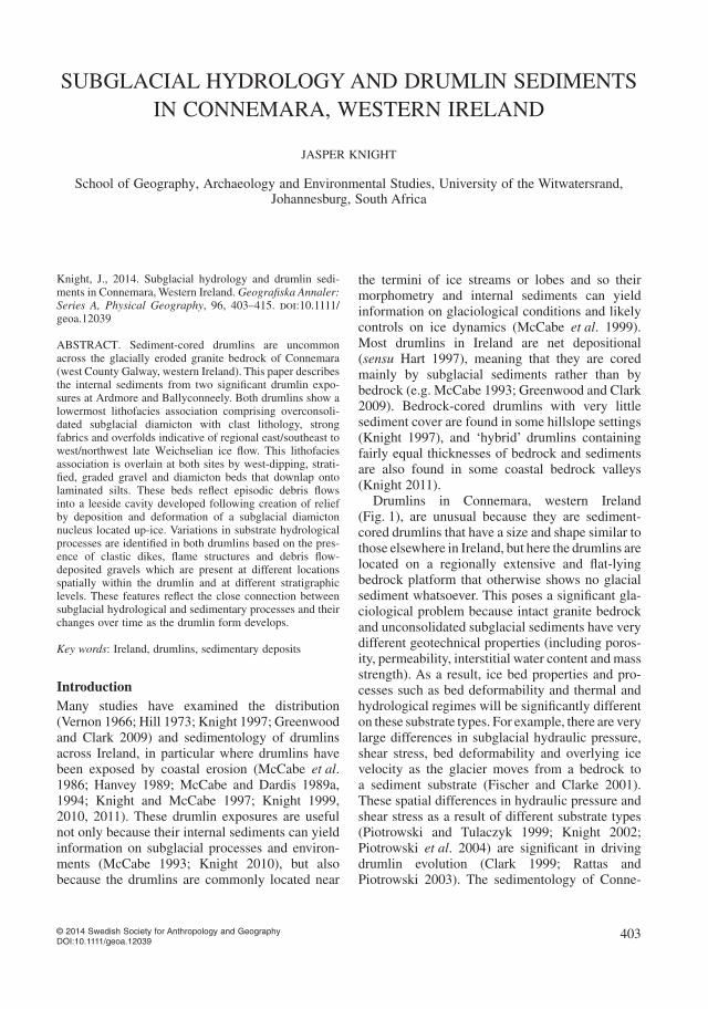
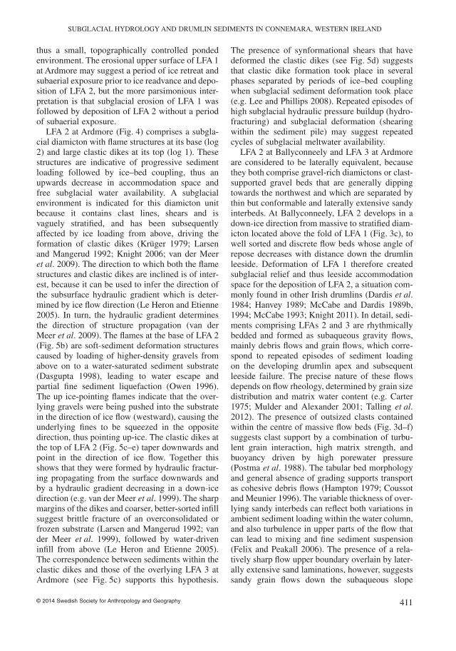
Fig. 1. (a) Map of Ireland showing the location of the Connemara study area (boxed). Land over 200 m is shaded. Major onshore andretreat-stage late Weichselian ice margins and ice flow vectors are shown (after Stephens et al. 1975). (b) Location map showing thedistribution of striae (after Smith and Knight 2011) and drumlins in the west Connemara area, mapped through methods described inthis paper, and the locations of Ballyconneely and Ardmore drumlins.
JASPER KNIGHT
© 2014 Swedish Society for Anthropology and Geography404
tonnées, ice-marginal and subglacial meltwaterchannels and striae. The presence of these land-forms on upland flanks, and the presence of linearmeltwater channels that are not topographicallycontrolled, suggests that these are dominantly sub-glacial forms developed by meltwater incision.Several drumlins are found along the western(down-ice) fringe of the region (Fig. 1). Some ofthese were previously mapped as part of the largerIrish drumlin field from satellite imagery byGreenwood and Clark (2009), but it is notable thatsuch studies do not always identify all bedforms(Finlayson 2013). One of these drumlins has beenmentioned in a previous study (Farrell 2005) buthas not been described in detail.
MethodsGlacial landforms across lowland Connemara weremapped from satellite imagery (at various scales,from 1 : 5000 to 1 : 20 000), air photos (at 1 : 8000scale), and in the field. Drumlins at Ballyconneelyand Ardmore were logged stratigraphically usingthe facies codes of Eyles et al. (1983) and facies
were then grouped into three lithofacies associa-tions (LFAs). Particular attention in both exposureswas paid to primary sedimentary structures, direc-tional signatures, and vertical and horizontal faciesrelationships.
Field evidence
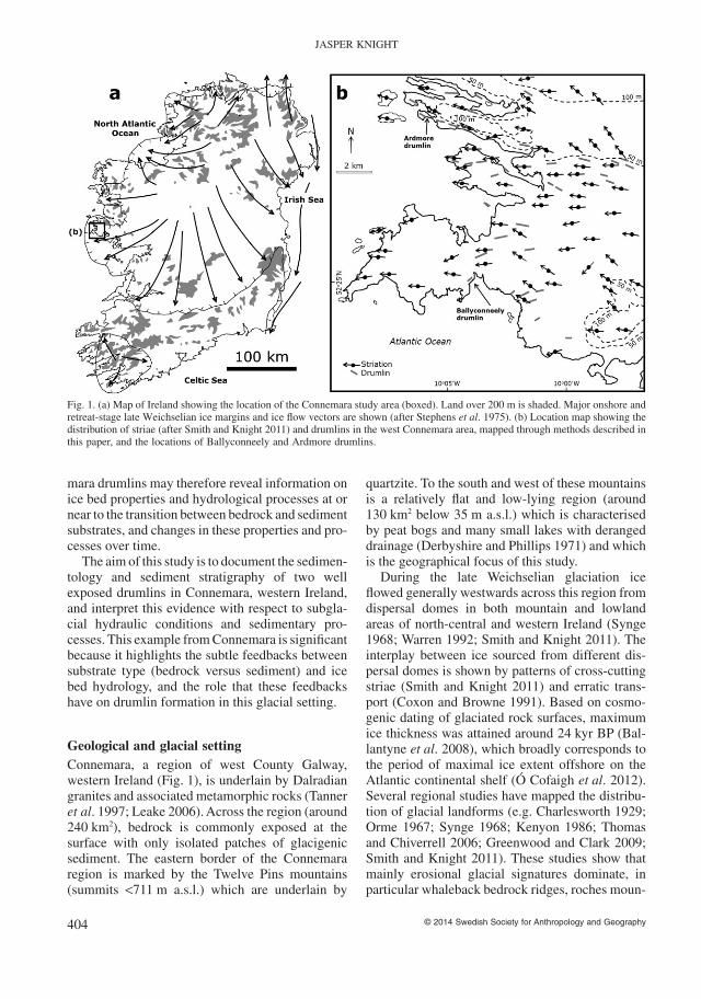
Ballyconneely drumlinThis drumlin has a barchanoid shape, is in total450 m long, 20 m high, and with a median remain-ing width, following coastal erosion, of around240 m. The exposure itself is slightly oblique to thedrumlin long axis, which is aligned towards theWSW. On the foreshore adjacent to the Ballycon-neely drumlin, striae on bedrock surfaces arealigned towards 270° and 280°, consistent withregional striae patterns and with other erosionalbedrock forms such as roches mountonées, tunnelvalleys and whalebacks across west Connemara(Fig. 1b). The core and tail of the drumlin are wellexposed and show two LFAs which are separatedby an erosional disconformity (Fig. 2c).
100 m
Viewpoint of (b)
c
a b
50 m
N
5 4
2 1
Basal overfold
3
Dmm
1
3
5
2
4
LFA 2 Log 5
F S G
m 2
0
LFA 2
Log 4
Fm/Fl
F S G
8
0
Ss
Dms/ Dmm/ Gcs
Dms/Dmm
F S G
20
0 LFA 1
Sm
Gcs
Gcs
Dmm
LFA 2 Dmm
F S G 0
LFA 1
Dmm
Dms
Gcs
Dms
LFA 2
18
F S G 0
LFA 1
Dmm
Dms
LFA 2
11
Log 3
Log 2
Log 1
Overfold
LFA 2 LFA 1 Erosional
boulder lag
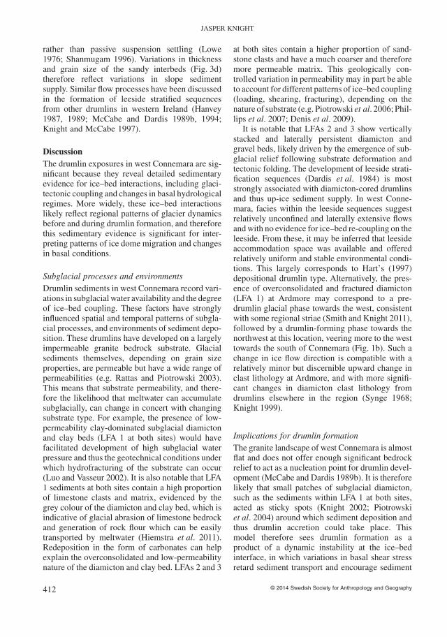
Fig. 2. (a) Google Earth image (2006) of the Ballyconneely drumlin (drumlin outline is dotted). (b) Upper panel: panorama of theBallyconneely drumlin, looking inland (image from Farrell 2005, her Fig. 3.4.2), showing the locations of numbered section logs andannotated with extent of LFAs 1 and 2 (lower panel). (c) Representative section logs showing major facies within LFAs 1 and 2 fromup-ice (right) to down-ice (left). Reproduced by permission of the Quaternary Research Association.
SUBGLACIAL HYDROLOGY AND DRUMLIN SEDIMENTS IN CONNEMARA, WESTERN IRELAND
© 2014 Swedish Society for Anthropology and Geography 405
LFA 1 at the base of the exposure comprisesmassive to vaguely stratified diamicton (Dmm/Dmsfacies) composed of a grey clay to sand matrix withdispersed pebbles to cobbles (<60 cm diameter).These clasts are mainly (70%) well striated lime-stones derived from inner parts of Galway Bay some80 km to the southeast, but granites, sandstones andgrits from more proximal easterly sources are alsofound. At base, larger clasts are often aligned par-allel to bed boundaries and the surrounding matrixis fissile and overconsolidated (Fig. 3a). Strongclast fabrics are found in this LFA (Farrell 2005). Atthe base of the drumlin and approximately below thedrumlin’s highest point, stratified diamicton bedsform a tightly folded structure (Fig. 2b). The foldlimbs are 3 m high and strike 020–200°, plunging20° to the northwest, which is approximately thesame direction as foreshore striae. The descendinglimb also shows some upward-going water escapestructures. Above the fold core, the folded diamic-ton beds flatten out and become more massive andless well defined. Beds (0.5–2.5 m thick) havevague planar to amalgamated contacts which aresometimes marked by laterally continuous but verythin (<1.5 cm thick) sand stringers. These decreasein frequency upwards. Internally, the diamictonbeds are highly uniform and structureless and do notshow any size sorting of clasts or matrix, althoughclasts generally become less common upwards. Onthe down-ice side of the drumlin, the basal diamic-ton is generally absent, but intermittently at beachlevel planar laminated sands and silts (Fl facies)crop out (Fig. 3b). Laminae are undeformed and donot show any ripples but the laminated facies has anerosional and undulating upper surface which isdownlapped by diamictons of LFA 2. Conformableto sand and silt laminae are thin (0.4–0.8 cm thick)laterally continuous interbeds of sorted mediumsand to granules.
The uppermost LFA (LFA 2) is most dominant interms of exposed sediment thickness, and is foundin particular down-ice of the folded drumlin core.On the up-ice side of this core, massive and poorlydemarcated diamicton beds (Dmm/Dms facies) aresimilar to those of the lower LFA, but the beds areseparated by an erosional conformity which is lat-erally continuous in particular on the up-ice side ofthe drumlin and mimics the outer surface of thedrumlin (Fig. 2c). Immediately above, and down-ice of, the folded core the diamicton beds change incharacter to amalgamated planar stratified sand andgravel beds which are laterally continuous andshow clasts that are aligned parallel to bedding
(Fig. 3c). These sand and gravel beds are laterallyequivalent to the massive diamicton beds on theup-ice side of the folded core. It is notable that dipangle of these beds decreases down-ice where, atthe west end of the drumlin, at least 20 rhythmi-cally deposited beds are identified. Individual bedsare tabular in morphology, aligned parallel to oneanother with planar, laterally continuous bedboundaries that dip 5–8° towards 310°. The bedsvary in their internal sediment sorting but the LFAas a whole becomes more stratified and bettersorted upwards. Internal bed sorting and stratifica-tion also increase down-dip (down-ice). Rhythmicbedding is imparted by the presence of individualgravely diamicton beds, variously 5–60 cm thick,separated by laterally continuous laminated sortedsand (3–30 cm thick) or silt drapes (0.5–2 cmthick). Most commonly these beds and overlyingsand/silt interbeds are conformable but sometimesthe overlying diamicton bed has eroded the uppersurface of the underlying sand/silt interbed(Fig. 3d). The diamicton beds are variably sorted,and can exhibit both normal and inverse grading atdifferent lateral positions within the same bed.Most commonly, normal grading is succeeded lat-erally by inverse grading, although the oppositealso occurs. Where outsized clasts are present, theyare commonly found in the centre of individualmatrix-dominated and poorly sorted diamictonbeds (Fig. 3e, f).
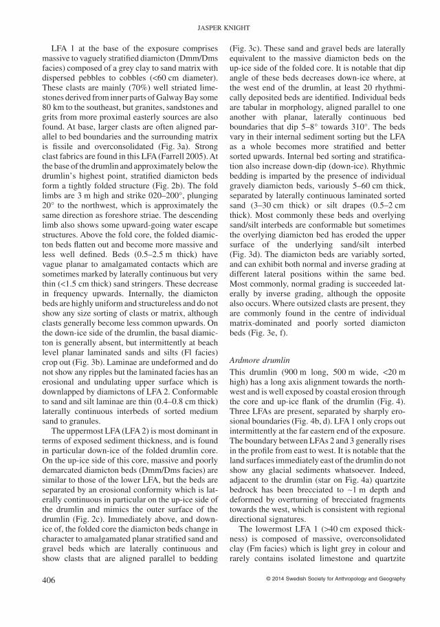
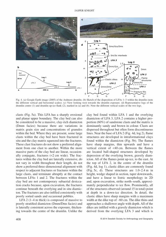
Ardmore drumlinThis drumlin (900 m long, 500 m wide, <20 mhigh) has a long axis alignment towards the north-west and is well exposed by coastal erosion throughthe core and up-ice flank of the drumlin (Fig. 4).Three LFAs are present, separated by sharply ero-sional boundaries (Fig. 4b, d). LFA 1 only crops outintermittently at the far eastern end of the exposure.The boundary between LFAs 2 and 3 generally risesin the profile from east to west. It is notable that theland surfaces immediately east of the drumlin do notshow any glacial sediments whatsoever. Indeed,adjacent to the drumlin (star on Fig. 4a) quartzitebedrock has been brecciated to ∼1 m depth anddeformed by overturning of brecciated fragmentstowards the west, which is consistent with regionaldirectional signatures.
The lowermost LFA 1 (>40 cm exposed thick-ness) is composed of massive, overconsolidatedclay (Fm facies) which is light grey in colour andrarely contains isolated limestone and quartzite
JASPER KNIGHT
© 2014 Swedish Society for Anthropology and Geography406
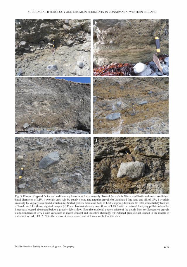
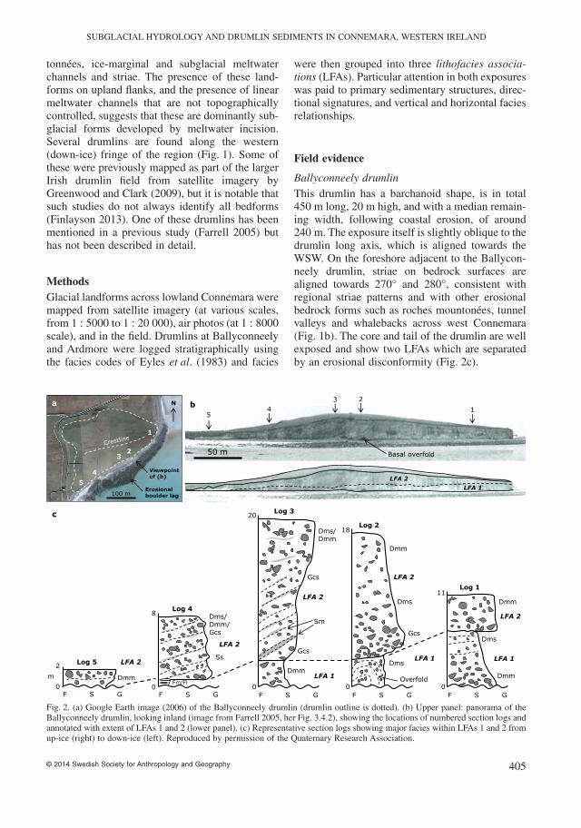
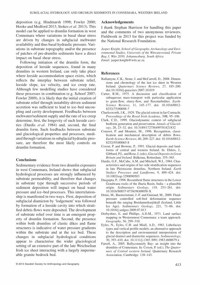
Fig. 3. Photos of typical facies and sedimentary features at Ballyconneely. Trowel for scale is 28 cm. (a) Fissile and overconsolidatedbasal diamicton of LFA 1 overlain erosively by poorly sorted and angular gravel. (b) Laminated fine sand and silt of LFA 1 overlainerosively by vaguely stratified diamicton. (c) Sorted gravely diamicton beds of LFA 2 dipping down-ice (to left), immediately leewardof basal overfolds (lower right of image). (d) Planar laminated sandy mass flows of LFA 2 with occasional flat-lying pebble to boulderintraclasts located above and below a gravely debris flow. Note the erosional upper surface of the debris flow. (e) Successive gravelydiamicton beds of LFA 2 with variations in matrix content and thus flow rheology. (f) Outsized granite clast located in the middle ofa diamicton bed, LFA 2. Note the sediment drape above and deformation below this clast.
SUBGLACIAL HYDROLOGY AND DRUMLIN SEDIMENTS IN CONNEMARA, WESTERN IRELAND
© 2014 Swedish Society for Anthropology and Geography 407
clasts (Fig. 5a). This LFA has a sharply erosionaland planar upper boundary. The clay bed can alsobe considered to be a massive, clay-rich diamicton(Dmm facies) because there are variations inmatrix grain size and concentrations of granuleswithin the bed. Where they are present, some largeclasts within the clay bed have been fractured insitu and the clay matrix squeezed into the fractures.These clast fractures do not show a preferred align-ment from one clast to another. Within the moremassive parts of the clay bed are linear, occasion-ally conjugate, fractures (<2 cm wide). The frac-tures within the clay bed are laterally extensive, donot vary in width throughout their length, do notshow a preferred three-dimensional alignment withrespect to adjacent fractures or fractures within thelarge clasts, and terminate abruptly at the contactbetween LFAs 1 and 2. The fractures within theclay bed are not contemporary subaerial desicca-tion cracks because, upon excavation, the fracturescontinue beneath the overlying and in situ diamic-ton. The fractures are also infilled consistently withpoorly sorted sands and occasional pebbles.
LFA 2 (1–4 m thick) is composed of massive topoorly stratified diamicton (Dmm/Dms facies) andis laterally consistent across the exposure, thicken-ing towards the centre of the drumlin. Unlike the
clay bed found within LFA 1 and the overlyingdiamicton of LFA 3, LFA 2 contains a higher pro-portion (60%) of sandstone clasts and the matrix isdominantly sandy and brown in colour. Clasts aredispersed throughout but often form discontinuouslines. Near the base of LFA 2 (Fig. 4d, log 2), flamestructures are developed in intraformational claysfound within the diamicton (Fig. 5b). The flameshave sharp margins, thin upwards and have avertical extent of <40 cm. Between the flamesare located ball-shaped structures developed bydepression of the overlying brown, gravely diam-icton. All of the flames point up-ice, to the east. Atthe top of LFA 2, in the centre of the drumlin(Fig. 4d, log 1), clastic dikes are commonly found(Fig. 5c, d). These structures are 1.0–2.4 m inheight, wedge shaped in section, taper downwards,and have a linear to listric morphology in 2Dand, upon excavation, strike north–south, approxi-mately perpendicular to ice flow. Prominently, allof the structures observed (around 15 in total) pointat depth in a down-ice direction. In detail, theclastic dikes have sharp margins with a maximumwidth at the dike top of ∼60 cm. The dike thins andapproaches a shallower angle with depth. All of thedikes are infilled with a gravely diamicton which isderived from the overlying LFA 3 and which is
d
a N
200 m
c
Viewpoint of (c)
Log 1
Log 2
Log 1
Log 2
m
4
6
2
0
Dmm/Fd
F S G
Dmm
Fm/Dmm
Gms/Gcs/Dms
F S G
Dmm/Gcs
Dmm/Dms
m
1.5
0
LFA 1
LFA 2
LFA 2
LFA 3
Sm/Ss interbeds
Clastic dikes
Fracture fills
Flame structures
A B
Log 1
Log 2
18 m
b
250 m
LFA 3
LFA 2 LFA 1 A B
Not exposed
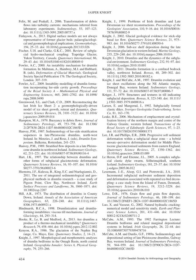
Fig. 4. (a) Google Earth image (2005) of the Ardmore drumlin. (b) Sketch of the disposition of LFAs 1–3 within the drumlin (notethe different vertical and horizontal scales). (c) View looking west towards the drumlin exposure. (d) Representative logs of thedrumlin centre (1) and drumlin up-ice flank (2), marked in (a) and (b). Note the different vertical scales of the two logs.
JASPER KNIGHT
© 2014 Swedish Society for Anthropology and Geography408
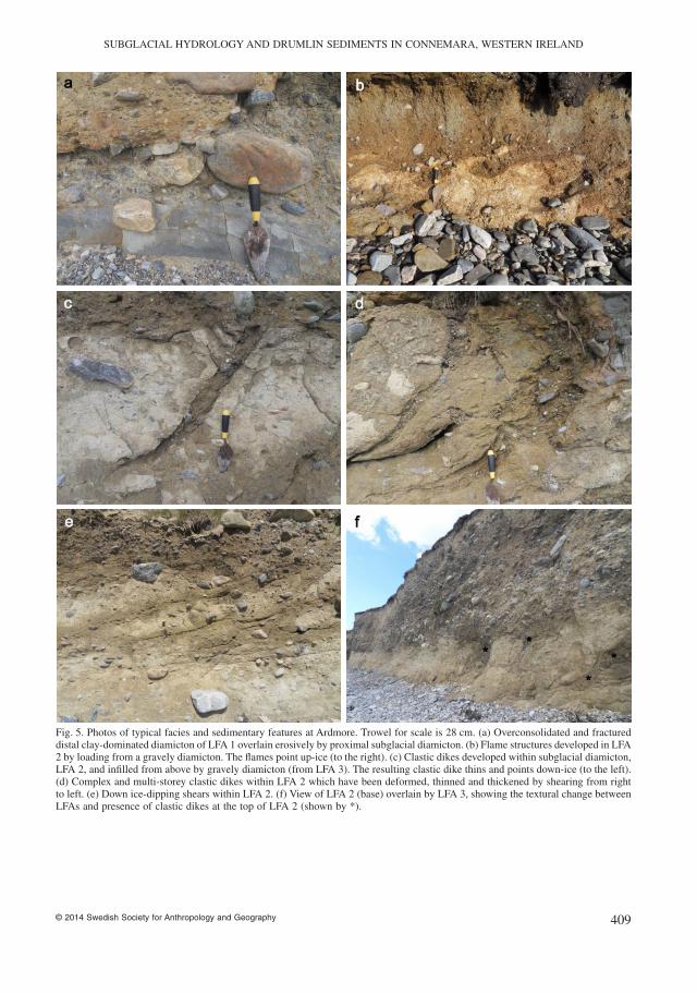
Fig. 5. Photos of typical facies and sedimentary features at Ardmore. Trowel for scale is 28 cm. (a) Overconsolidated and fractureddistal clay-dominated diamicton of LFA 1 overlain erosively by proximal subglacial diamicton. (b) Flame structures developed in LFA2 by loading from a gravely diamicton. The flames point up-ice (to the right). (c) Clastic dikes developed within subglacial diamicton,LFA 2, and infilled from above by gravely diamicton (from LFA 3). The resulting clastic dike thins and points down-ice (to the left).(d) Complex and multi-storey clastic dikes within LFA 2 which have been deformed, thinned and thickened by shearing from rightto left. (e) Down ice-dipping shears within LFA 2. (f) View of LFA 2 (base) overlain by LFA 3, showing the textural change betweenLFAs and presence of clastic dikes at the top of LFA 2 (shown by *).
SUBGLACIAL HYDROLOGY AND DRUMLIN SEDIMENTS IN CONNEMARA, WESTERN IRELAND
© 2014 Swedish Society for Anthropology and Geography 409
notably coarser than the diamicton of LFA 2. Theinfill generally fines downwards, with distancefrom source, but clasts within the infill are oftenclustered either at a certain constriction within thedike or along one of its margins. The dikes usuallyhave a consistently tapering shape, but may vary inwidth where they appear to be deformed and foldedlaterally by subhorizontal shears (Fig. 5d), yieldinga pattern of dike elements that varies substantiallyin width, from <1 cm to tectonically thickenedoverfolds of 20–40 cm width. Shears are laterallypersistent throughout LFA 2. They are generallyplanar to down ice-dipping and often associatedwith sand interbeds (Fig. 5e). They can be distin-guished from the interbeds, however, because inplaces the shears have caused sediment folding orsometimes clast rotation.
The uppermost LFA3 is separated from LFA2 byan erosional contact that rises towards the centre ofthe drumlin and which is generally planar but isundulating near dike upper margins, indicative ofsediments being drawn down into the dikes fromabove (Fig. 5f). LFA 3 (4–8 m thick) comprisesmassive to vaguely stratified diamicton beds (Dmm/Dms, occasionally Gms/Gcs facies, individual beds0.4–1.8 m thick). Overall beds have a brown matrixthat grades upwards through the unit to a greycolour. Clasts are mainly subrounded boulders butvary substantially in lithological makeup, witharound 50% metamorphics from east of Conne-mara, as well as limestones and sandstones. Clastsalso vary in concentration upwards, with discon-tinuous interbeds of clast-supported gravels andintraformational massive to stratified sorted coarsesands and granules (Fig. 4d, log 1). Some larger,flat-lying clasts are found concentrated at bedboundaries, within LFA 3 and at its base. Laterally,LFA 3 shows variations in clast concentration butlittle change in overall stratification.
Facies interpretationIn both drumlins, facies type, sediment stratigra-phy and primary sedimentary structures recordvariations in hydrological conditions and associ-ated sedimentary processes at the ice–bed interfacethat are primarily driven by the degree of ice–bedcoupling and thus water availability (e.g. Phillipset al. 2007; Denis et al. 2009; Lesemann et al.2010). LFAs in both drumlins are interpretedtogether from bottom to top.
The basal parts of both drumlins (LFA 1 at Bal-lyconneely, LFAs 1, 2 at Ardmore) are similar and
are thus considered together here. At both sitesLFA 1 is composed of massive diamicton that isinterpreted as a subglacial till deposited by lodge-ment processes by which clasts are pressed into thesubstrate. Evidence for this comes from the pres-ence of striated limestone clasts transported somedistance from inner Galway Bay, strong clastfabrics (Farrell 2005), overconsolidated and fissilenature of the diamicton, and the overfolded corewithin the Ballyconneely drumlin. The formationof the overfolded core by subglacial tectonics mayhave created substrate relief and leeside accom-modation space (Hart 1997) for the subsequentdeposition of LFA 2. The slightly tangential bedboundaries within LFA 2 may suggest that therewas continued glacitectonic folding during deposi-tion of LFA 2. Striae, clast fabrics, fold axis, andclast lithology all suggest ice flow from the south-east or east during formation of LFA 1, which isconsistent with regional ice flow patterns duringthe late Weichselian (Orme 1967; Synge 1968;Smith and Knight 2011). The upward increase insand stringers at Ballyconneely reflects episodes ofice–bed uncoupling and meltwater flushing acrossthe substrate, causing sediment sorting and depo-sition into small substrate depressions. The lami-nated sands and silts at Ballyconneely (Fig. 3b)represent quiet-water deposition in perhaps adeeper or more extensive depression, but it isnotable that there is an absence of evidence forwater circulation, such as ripples, although thin(cm scale) but conformable granule to pebble inter-beds likely reflect episodic and unconfined massflows (Shanmugam 1996) down very shallow sub-aqueous slopes. A similar depositional environ-ment is suggested for the clay bed (LFA 1) atArdmore (Fig. 5a) where granule interbeds are alsoobserved. There is no diagnostic evidence to deter-mine whether such water bodies were subglacialor proglacial, and as yet no samples from theselocations have been examined for microfossils.However, the fractures observed in the clasts andmatrix of the clay bed at Ardmore very stronglysuggest subglacial overconsolidation and hydraulicfracturing along an intersecting three-dimensionalnetwork of linear fractures, forming small-scaleclastic dikes (Phillips et al. 2007). It is notablethat ice advance or ice thickening over a water-saturated substrate can increase porewater pressureand cause hydrofracturing to occur (Denis et al.2009; van der Meer et al. 2009). The relativelysmall size of these dikes within the clay bed atArdmore suggests a confined sediment depocentre,
JASPER KNIGHT
© 2014 Swedish Society for Anthropology and Geography410
thus a small, topographically controlled pondedenvironment. The erosional upper surface of LFA 1at Ardmore may suggest a period of ice retreat andsubaerial exposure prior to ice readvance and depo-sition of LFA 2, but the more parsimonious inter-pretation is that subglacial erosion of LFA 1 wasfollowed by deposition of LFA 2 without a periodof subaerial exposure.
LFA 2 at Ardmore (Fig. 4) comprises a subgla-cial diamicton with flame structures at its base (log2) and large clastic dikes at its top (log 1). Thesestructures are indicative of progressive sedimentloading followed by ice–bed coupling, thus anupwards decrease in accommodation space andfree subglacial water availability. A subglacialenvironment is indicated for this diamicton unitbecause it contains clast lines, shears and isvaguely stratified, and has been subsequentlyaffected by ice loading from above, driving theformation of clastic dikes (Krüger 1979; Larsenand Mangerud 1992; Knight 2006; van der Meeret al. 2009). The direction to which both the flamestructures and clastic dikes are inclined is of inter-est, because it can be used to infer the direction ofthe subsurface hydraulic gradient which is deter-mined by ice flow direction (Le Heron and Etienne2005). In turn, the hydraulic gradient determinesthe direction of structure propagation (van derMeer et al. 2009). The flames at the base of LFA 2(Fig. 5b) are soft-sediment deformation structurescaused by loading of higher-density gravels fromabove on to a water-saturated sediment substrate(Dasgupta 1998), leading to water escape andpartial fine sediment liquefaction (Owen 1996).The up ice-pointing flames indicate that the over-lying gravels were being pushed into the substratein the direction of ice flow (westward), causing theunderlying fines to be squeezed in the oppositedirection, thus pointing up-ice. The clastic dikes atthe top of LFA 2 (Fig. 5c–e) taper downwards andpoint in the direction of ice flow. Together thisshows that they were formed by hydraulic fractur-ing propagating from the surface downwards andby a hydraulic gradient decreasing in a down-icedirection (e.g. van der Meer et al. 1999). The sharpmargins of the dikes and coarser, better-sorted infillsuggest brittle fracture of an overconsolidated orfrozen substrate (Larsen and Mangerud 1992; vander Meer et al. 1999), followed by water-driveninfill from above (Le Heron and Etienne 2005).The correspondence between sediments within theclastic dikes and those of the overlying LFA 3 atArdmore (see Fig. 5c) supports this hypothesis.
The presence of synformational shears that havedeformed the clastic dikes (see Fig. 5d) suggeststhat clastic dike formation took place in severalphases separated by periods of ice–bed couplingwhen subglacial sediment deformation took place(e.g. Lee and Phillips 2008). Repeated episodes ofhigh subglacial hydraulic pressure buildup (hydro-fracturing) and subglacial deformation (shearingwithin the sediment pile) may suggest repeatedcycles of subglacial meltwater availability.
LFA 2 at Ballyconneely and LFA 3 at Ardmoreare considered to be laterally equivalent, becausethey both comprise gravel-rich diamictons or clast-supported gravel beds that are generally dippingtowards the northwest and which are separated bythin but conformable and laterally extensive sandyinterbeds. At Ballyconneely, LFA 2 develops in adown-ice direction from massive to stratified diam-icton located above the fold of LFA 1 (Fig. 3c), towell sorted and discrete flow beds whose angle ofrepose decreases with distance down the drumlinleeside. Deformation of LFA 1 therefore createdsubglacial relief and thus leeside accommodationspace for the deposition of LFA 2, a situation com-monly found in other Irish drumlins (Dardis et al.1984; Hanvey 1989; McCabe and Dardis 1989b,1994; McCabe 1993; Knight 2011). In detail, sedi-ments comprising LFAs 2 and 3 are rhythmicallybedded and formed as subaqueous gravity flows,mainly debris flows and grain flows, which corre-spond to repeated episodes of sediment loadingon the developing drumlin apex and subsequentleeside failure. The precise nature of these flowsdepends on flow rheology, determined by grain sizedistribution and matrix water content (e.g. Carter1975; Mulder and Alexander 2001; Talling et al.2012). The presence of outsized clasts containedwithin the centre of massive flow beds (Fig. 3d–f)suggests clast support by a combination of turbu-lent grain interaction, high matrix strength, andbuoyancy driven by high porewater pressure(Postma et al. 1988). The tabular bed morphologyand general absence of grading supports transportas cohesive debris flows (Hampton 1979; Coussotand Meunier 1996). The variable thickness of over-lying sandy interbeds can reflect both variations inambient sediment loading within the water column,and also turbulence in upper parts of the flow thatcan lead to mixing and fine sediment suspension(Felix and Peakall 2006). The presence of a rela-tively sharp flow upper boundary overlain by later-ally extensive sand laminations, however, suggestssandy grain flows down the subaqueous slope
SUBGLACIAL HYDROLOGY AND DRUMLIN SEDIMENTS IN CONNEMARA, WESTERN IRELAND
© 2014 Swedish Society for Anthropology and Geography 411
rather than passive suspension settling (Lowe1976; Shanmugam 1996). Variations in thicknessand grain size of the sandy interbeds (Fig. 3d)therefore reflect variations in slope sedimentsupply. Similar flow processes have been discussedin the formation of leeside stratified sequencesfrom other drumlins in western Ireland (Hanvey1987, 1989; McCabe and Dardis 1989b, 1994;Knight and McCabe 1997).
DiscussionThe drumlin exposures in west Connemara are sig-nificant because they reveal detailed sedimentaryevidence for ice–bed interactions, including glaci-tectonic coupling and changes in basal hydrologicalregimes. More widely, these ice–bed interactionslikely reflect regional patterns of glacier dynamicsbefore and during drumlin formation, and thereforethis sedimentary evidence is significant for inter-preting patterns of ice dome migration and changesin basal conditions.
Subglacial processes and environmentsDrumlin sediments in west Connemara record vari-ations in subglacial water availability and the degreeof ice–bed coupling. These factors have stronglyinfluenced spatial and temporal patterns of subgla-cial processes, and environments of sediment depo-sition. These drumlins have developed on a largelyimpermeable granite bedrock substrate. Glacialsediments themselves, depending on grain sizeproperties, are permeable but have a wide range ofpermeabilities (e.g. Rattas and Piotrowski 2003).This means that substrate permeability, and there-fore the likelihood that meltwater can accumulatesubglacially, can change in concert with changingsubstrate type. For example, the presence of low-permeability clay-dominated subglacial diamictonand clay beds (LFA 1 at both sites) would havefacilitated development of high subglacial waterpressure and thus the geotechnical conditions underwhich hydrofracturing of the substrate can occur(Luo and Vasseur 2002). It is also notable that LFA1 sediments at both sites contain a high proportionof limestone clasts and matrix, evidenced by thegrey colour of the diamicton and clay bed, which isindicative of glacial abrasion of limestone bedrockand generation of rock flour which can be easilytransported by meltwater (Hiemstra et al. 2011).Redeposition in the form of carbonates can helpexplain the overconsolidated and low-permeabilitynature of the diamicton and clay bed. LFAs 2 and 3
at both sites contain a higher proportion of sand-stone clasts and have a much coarser and thereforemore permeable matrix. This geologically con-trolled variation in permeability may in part be ableto account for different patterns of ice–bed coupling(loading, shearing, fracturing), depending on thenature of substrate (e.g. Piotrowski et al. 2006; Phil-lips et al. 2007; Denis et al. 2009).
It is notable that LFAs 2 and 3 show verticallystacked and laterally persistent diamicton andgravel beds, likely driven by the emergence of sub-glacial relief following substrate deformation andtectonic folding. The development of leeside strati-fication sequences (Dardis et al. 1984) is moststrongly associated with diamicton-cored drumlinsand thus up-ice sediment supply. In west Conne-mara, facies within the leeside sequences suggestrelatively unconfined and laterally extensive flowsand with no evidence for ice–bed re-coupling on theleeside. From these, it may be inferred that leesideaccommodation space was available and offeredrelatively uniform and stable environmental condi-tions. This largely corresponds to Hart’s (1997)depositional drumlin type. Alternatively, the pres-ence of overconsolidated and fractured diamicton(LFA 1) at Ardmore may correspond to a pre-drumlin glacial phase towards the west, consistentwith some regional striae (Smith and Knight 2011),followed by a drumlin-forming phase towards thenorthwest at this location, veering more to the westtowards the south of Connemara (Fig. 1b). Such achange in ice flow direction is compatible with arelatively minor but discernible upward change inclast lithology at Ardmore, and with more signifi-cant changes in diamicton clast lithology fromdrumlins elsewhere in the region (Synge 1968;Knight 1999).
Implications for drumlin formationThe granite landscape of west Connemara is almostflat and does not offer enough significant bedrockrelief to act as a nucleation point for drumlin devel-opment (McCabe and Dardis 1989b). It is thereforelikely that small patches of subglacial diamicton,such as the sediments within LFA 1 at both sites,acted as sticky spots (Knight 2002; Piotrowskiet al. 2004) around which sediment deposition andthus drumlin accretion could take place. Thismodel therefore sees drumlin formation as aproduct of a dynamic instability at the ice–bedinterface, in which variations in basal shear stressretard sediment transport and encourage sediment
JASPER KNIGHT
© 2014 Swedish Society for Anthropology and Geography412
deposition (e.g. Hindmarsh 1998; Fowler 2000;Hooke and Medford 2013; Stokes et al. 2013). Thismodel can be applied to drumlin formation in westConnemara where variations in basal shear stressare driven by changes in subglacial meltwateravailability and thus basal hydraulic pressure. Vari-ations in substrate topography and/or the presenceof patches of pre-drumlin sediments have a directimpact on basal shear stress.
Following initiation of the drumlin form, thedeposition of leeside sequences, found in manydrumlins in western Ireland, can only take placewhere leeside accommodation space exists, whichreflects the interplay between substrate relief,leeside slope, ice velocity, and ice creep rate.Although few modelling studies have consideredthese processes in combination (e.g. Schoof 2007;Fowler 2009), it is likely that the initial creation ofsubstrate relief through instability-driven sedimentaccretion was sufficient to lead to ice–bed uncou-pling and cavity development. Feedbacks betweenmeltwater/sediment supply and the rate of ice creepdetermine, first, the longevity of such leeside cavi-ties (Dardis et al. 1984) and, second, the finaldrumlin form. Such feedbacks between substrateand glaciological properties and processes, medi-ated through variations in subglacial hydraulic pres-sure, are therefore the most likely controls ondrumlin formation.
ConclusionsSedimentary evidence from two drumlin exposuresin west Connemara, Ireland shows that subglacialhydrological processes are strongly influenced bysubstrate permeability, and therefore that changesin substrate type through successive periods ofsediment deposition will impact on basal waterpressure and ice–bed processes. This interrelation-ship is manifested in two ways. First, deposition ofsubglacial diamicton by ‘lodgement’ was followedby formation of a leeside cavity into which strati-fied debris flows were deposited. The developmentof substrate relief over time is an emergent prop-erty of drumlin formation. Second, the presencewithin both drumlins of clastic dikes and flamestructures is indicative of water pressure gradientswithin the substrate and at the ice bed. Thesechanges in subglacial hydrological conditionsappear to characterise the wider glaciologicalsetting of an extensive part of the late WeichselianIrish ice sheet interacting with a largely imperme-able granite bedrock bed.
AcknowledgementsI thank Stephan Harrison for handling this paperand the comments of two anonymous reviewers.Fieldwork in 2013 for this project was funded bythe National Research Foundation.
Jasper Knight, School of Geography, Archaeology and Envi-ronmental Studies, University of the Witwatersrand, PrivateBag 3, Wits 2050, Johannesburg, South AfricaEmail: [email protected]
ReferencesBallantyne, C.K., Stone, J. and McCarroll, D., 2008. Dimen-
sions and chronology of the last ice sheet in WesternIreland. Quaternary Science Reviews, 27, 185–200.doi:10.1016/j.quascirev.2007.10.019
Carter, R.M., 1975. A discussion and classification ofsubaqueous mass-transport with particular applicationto grain-flow, slurry-flow, and fluxoturbidites. Earth-Science Reviews, 11, 145–177. doi: 10.1016/0012-8252(75)90098-7
Charlesworth, J.K., 1929. The glacial retreat in Iar Connacht.Proceedings of the Royal Irish Academy, 39B, 95–106.
Clark, C.D., 1999. Glaciodynamic context of subglacialbedform generation and preservation. Annals of Glaciol-ogy, 28, 23–32. doi: 10.3189/172756499781821832
Coussot, P. and Meunier, M., 1996. Recognition, classi-fication and mechanical description of debris flows.Earth-Science Reviews, 40, 209–227. doi: 10.1016/0012-8252(95)00065-8
Coxon, P. and Browne, P., 1991. Glacial deposits and land-forms of central and western Ireland. In: Ehlers, J.,Gibbard, P.L. and Rose, J. (eds), Glacial Deposits in GreatBritain and Ireland. Balkema, Rotterdam. 355–365.
Dardis, G.F., McCabe, A.M. and Mitchell, W.I., 1984. Char-acteristics and origins of lee-side stratification sequencesin late Pleistocene drumlins, Northern Ireland. EarthSurface Processes and Landforms, 9, 409–424. doi:10.1002/esp.3290090503
Dasgupta, P., 1998. Recumbent flame structures in the LowerGondwana rocks of the Jharia Basin, India – a plausibleorigin. Sedimentary Geology, 119, 253–261. doi:10.1016/S0037-0738(98)00058-X
Denis, M., Buoncristiani, J.-F. and Guiraud, M., 2009. Fluid-pressure controlled soft-bed deformation sequencebeneath the surging Breidamerkurjökull (Iceland, LittleIce Age). Sedimentary Geology, 221, 71–86. doi:10.1016/j.sedgeo.2009.07.013
Derbyshire, E. and Phillips, A.D.M., 1971. Land surfacemapping in Westernmost Connemara: a team approach.Geography, 56, 299–310.
Eyles, N., Eyles, C.H. and Miall, A.D., 1983. Lithofaciestypes and vertical profile models; an alternative approachto the description and environmental interpretation ofglacial diamict and diamictite sequences. Sedimentology,30, 393–410. doi: 10.1111/j.1365-3091.1983.tb00679.x
Farrell, A., 2005. Ballyconneely Bay: an insight into thedrumlins of Connemara. In: Coxon, P. (ed.), The Quater-nary of Central western Ireland. Quaternary ResearchAssociation, Cambridge. 138–143.
SUBGLACIAL HYDROLOGY AND DRUMLIN SEDIMENTS IN CONNEMARA, WESTERN IRELAND
© 2014 Swedish Society for Anthropology and Geography 413
Felix, M. and Peakall, J., 2006. Transformation of debrisflows into turbidity currents: mechanisms inferred fromlaboratory experiments. Sedimentology, 53, 107–123.doi: 10.1111/j.1365-3091.2005.00757.x
Finlayson, A., 2013. Digital surface models are not alwaysrepresentative of former glacier beds: palaeoglaciologi-cal and geomorphological implications. Geomorphology,194, 25–33. doi: 10.1016/j.geomorph.2013.03.026
Fischer, U.H. and Clarke, G.K.C., 2001. Review of subgla-cial hydro-mechanical coupling: Trapridge Glacier,Yukon Territory, Canada. Quaternary International, 86,29–43. doi: 10.1016/S1040-6182(01)00049-0
Fowler, A.C., 2000. An instability mechanism for drumlinformation. In: Maltman, A., Hambrey, M.J. and Hubbard,B. (eds), Deformation of Glacial Materials. GeologicalSociety Special Publication 176. The Geological Society,London. 307–319.
Fowler, A.C., 2009. Instability modelling of drumlin forma-tion incorporating lee-side cavity growth. Proceedingsof the Royal Society A – Mathematical Physical andEngineering Sciences, 465, 2681–2702. doi: 10.1098/rspa.2008.0490
Greenwood, S.L. and Clark, C.D., 2009. Reconstructing thelast Irish Ice Sheet 2: a geomorphologically-drivenmodel of ice sheet growth, retreat and dynamics. Qua-ternary Science Reviews, 28, 3101–3123. doi: 10.1016/j.quascirev.2009.09.014
Hampton, M.A., 1979. Buoyancy in debris flows. Journal ofSedimentary Petrology, 49, 753–758. doi: 10.1306/212F7838-2B24-11D7-8648000102C1865D
Hanvey, P.M., 1987. Sedimentology of lee-side stratificationsequences in late-Pleistocene drumlins, north-westIreland. In: Menzies, J. and Rose, J. (eds), Drumlin Sym-posium. Balkema, Rotterdam, 241–253.
Hanvey, P.M., 1989. Stratified flow deposits in a late Pleisto-cene drumlin in northwest Ireland. Sedimentary Geology,62, 211–221. doi: 10.1016/0037-0738(89)90116-4
Hart, J.K., 1997. The relationship between drumlins andother forms of subglacial glaciotectonic deformation.Quaternary Science Reviews, 16, 93–107. doi: 10.1016/S0277-3791(96)00023-6
Hiemstra, J.F., Kulessa, B., King, E.C. and Ntarlagiannis, D.,2011. The use of integrated sedimentological and geo-physical methods in drumlin research – a case study ofPigeon Point, Clew Bay, Northwest Ireland. EarthSurface Processes and Landforms, 36, 1860–1871. doi:10.1002/esp.2207
Hill, A.R., 1973. The distribution of drumlins in CountyDown, Ireland. Annals of the Association of AmericanGeographers, 63, 226–240. doi: 10.1111/j.1467-8306.1973.tb00921.x
Hindmarsh, R.C.A., 1998. Drumlinization and drumlin-forming instabilities: viscous till mechanisms. Journal ofGlaciology, 44, 293–314.
Hooke, R., Le, B. and Medford, A., 2013. Are drumlins aproduct of a thermo-mechanical instability? QuaternaryResearch, 79, 458–464. doi: 10.1016/j.yqres.2012.12.002
Kenyon, R.A., 1986. The glaciation of the Nephin Begrange, Co. Mayo, Eire. Quaternary Studies, 2, 14–21.
Knight, J., 1997. Morphological and morphometric analysesof drumlin bedforms in the Omagh Basin, north centralIreland. Geografiska Annaler: Series A, Physical Geog-raphy, 79, 255–266.
Knight, J., 1999. Problems of Irish drumlins and LateDevensian ice sheet reconstructions. Proceedings of theGeologists’ Association, 110, 9–16. doi: 10.1016/S0016-7878(99)80002-9
Knight, J., 2002. Glacial geological evidence for stick-slipbasal ice flow. Quaternary Science Reviews, 21, 975–983. doi: 10.1016/S0277-3791(01)00050-6
Knight, J., 2006. Sub-ice shelf deposition during the lateDevensian glaciation in western Ireland. Marine Geology,235, 229–240. doi: 10.1016/j.margeo.2006.10.016
Knight, J., 2010. Drumlins and the dynamics of the subgla-cial environment. Sedimentary Geology, 232, 91–97. doi:10.1016/j.sedgeo.2010.10.001
Knight, J., 2011. Drumlin formation in a confined bedrockvalley, northwest Ireland. Boreas, 40, 289–302. doi:10.1111/j.1502-3885.2010.00182.x
Knight, J. and McCabe, A.M., 1997. Drumlin evolution andice sheet oscillations along the NE Atlantic margin,Donegal Bay, western Ireland. Sedimentary Geology,111, 57–72. doi: 10.1016/S0037-0738(97)00006-7
Krüger, J., 1979. Structures and textures in till indicatingsubglacial deposition. Boreas, 8, 323-340. doi: 10.1111/j.1502-3885.1979.tb00816.x
Larsen, E. and Mangerud, J., 1992. Subglacially formedclastic dikes. Sveriges Geologiska Undersökning, SeriesCa, 81, 163–170.
Leake, B.E., 2006. Mechanism of emplacement and crystal-lisation history of the northern margin and centre of theGalway Granite, western Ireland. Transactions of theRoyal Society of Edinburgh: Earth Sciences, 97, 1–23.doi: 10.1017/S0263593300001371
Lee, J.R. and Phillips, E.R., 2008. Progressive soft sedimentdeformation within a subglacial shear zone – a hybridmosaic–pervasive deformation model for Middle Pleis-tocene glaciotectonised sediments from eastern England.Quaternary Science Reviews, 27, 1350–1362. doi:10.1016/j.quascirev.2008.03.009
Le Heron, D.P. and Etienne, J.L., 2005. A complex subgla-cial clastic dyke swarm, Sólheimajökull, southernIceland. Sedimentary Geology, 181, 25–37. doi: 10.1016/j.sedgeo.2005.06.012
Lesemann, J.-E., Alsop, G.I. and Piotrowski, J.A., 2010.Incremental subglacial meltwater sediment depositionand deformation associated with repeated ice-bed decou-pling: a case study from the Island of Funen, Denmark.Quaternary Science Reviews, 19, 3212–3229. doi:10.1016/j.quascirev.2010.06.010
Lowe, D.R., 1976. Grain flow and grain flow deposits.Journal of Sedimentary Petrology, 46, 188–199. doi:10.1306/212F6EF1-2B24-11D7-8648000102C1865D
Luo, X. and Vasseur, G., 2002. Natural hydraulic cracking:numerical model and sensitivity study. Earth and Plan-etary Science Letters, 201, 431–446. doi: 10.1016/S0012-821X(02)00711-2
McCabe, A.M., 1993. The 1992 Farrington Lecture:Drumlin bedforms and related marginal depositionalsystems in Ireland. Irish Geography, 26, 22–44. doi:10.1080/00750779309478716
McCabe, A.M. and Dardis, G.F., 1989a. Sedimentology anddepositional setting of late Pleistocene drumlins, GalwayBay, western Ireland. Journal of Sedimentary Petrology,59, 944–959. doi: 10.1306/212F90C0-2B24-11D7-8648000102C1865D
JASPER KNIGHT
© 2014 Swedish Society for Anthropology and Geography414
McCabe, A.M. and Dardis, G.F., 1989b. A geological viewof drumlins in Ireland. Quaternary Science Reviews, 8,169-177. doi: 10.1016/0277-3791(89)90005-X
McCabe, A.M. and Dardis, G.F., 1994. Glaciotectonicallyinduced water-throughflow structures in a Late Pleisto-cene drumlin, Kanrawer, County Galway, westernIreland. Sedimentary Geology, 91, 173–190. doi:10.1016/0037-0738(94)90128-7
McCabe, A.M., Haynes, J.R. and MacMillan, N.F., 1986.Late-Pleistocene tidewater glaciers and glaciomarinesequences from north County Mayo, Republic of Ireland.Journal of Quaternary Science, 1, 73–84. doi: 10.1002/jqs.3390010109
McCabe, A.M., Knight, J. and McCarron, S.G., 1999. Iceflow stages and glacial bedforms in north central Ireland:a record of rapid environmental change during the lastglacial termination. Journal of the Geological Society,156, 63–72. doi: 10.1144/gsjgs.156.1.0063
Mulder, T. and Alexander, J., 2001. The physical characterof subaqueous sedimentary density flows and theirdeposits. Sedimentology, 48, 269–299. doi: 10.1046/j.1365-3091.2001.00360.
Ó Cofaigh, C., Dunlop, P. and Benetti, S., 2012. Marinegeophysical evidence for Late Pleistocene ice sheet extentand recession off northwest Ireland. Quaternary ScienceReviews, 44, 147–159. doi: 10.1016/j.quascirev.2010.02.005
Orme, A.R., 1967. Drumlins and the Weichsel glaciation ofConnemara. Irish Geography, 5, 262–274.
Owen, G., 1996. Experimental soft-sediment deformation:structures formed by the liquefaction of unconsoli-dated sands and some ancient examples. Sedimentology,43, 279–293. doi: 10.1046/j.1365-3091.1996.d01-5.x
Phillips, E.R., Merritt, J.W., Auton, C.A. and Golledge,N.R., 2007. Microstructures developed in subglacial andproglacial sediments: understanding faults, folds andfabrics, and the influence of water on the style of defor-mation. Quaternary Science Reviews, 26, 1499–1528.doi:10.1016/j.quascirev.2007.03.007
Piotrowski, J.A., Larsen, N.K. and Junge, F.W., 2004. Reflec-tions on soft subglacial beds as a mosaic of deforming andstable spots. Quaternary Science Reviews, 23, 993–1000.doi: 10.1016/j.quascirev.2004.01.006
Piotrowski, J.A., Larsen, N.K., Menzies, J. and Wysota, W.,2006. Formation of subglacial till under transient bedconditions: deposition, deformation, and basal decou-pling under a Weichselian ice sheet lobe, central Poland.Sedimentology, 53, 83–106. doi: 10.1111/j.1365-3091.2005.00755.x
Piotrowski, J.A. and Tulaczyk, S., 1999. Subglacial condi-tions under the last ice sheet in northwest Germany:ice-bed separation and enhanced basal sliding? Quater-nary Science Reviews, 18, 737–751. doi: 10.1016/S0277-3791(98)00042-0
Postma, G., Nemec, W. and Kleinspehn, K.L., 1988. Largefloating clasts in turbidites: a mechanism for theiremplacement. Sedimentary Geology, 58, 47–61. doi:10.1016/0037-0738(88)90005-X
Rattas, M. and Piotrowski, J.A., 2003. Influence of bedrockpermeability and till grain size on the formation of theSaadjarve drumlin field, Estonia, under an east-BalticWeichselian ice stream. Boreas, 32, 167–177.
Schoof, C., 2007. Pressure-dependent viscosity and interfa-cial instability in coupled ice-sediment flow. Journalof Fluid Mechanics, 570, 227–252. doi: 10.1017/S0022112006002874
Shanmugam, G., 1996. High-density turbidity currents: arethey sandy debris flows? Journal of SedimentaryResearch, 66, 2–10.
Smith, M.J. and Knight, J., 2011. Palaeoglaciology of thelast Irish Ice Sheet reconstructed from striae evidence.Quaternary Science Reviews, 30, 147–160. doi: 10.1016/j.quascirev.2010.09.019
Stephens, N., Creighton, J.R. and Hannon, M.A., 1975. Thelate-Pleistocene period in north-eastern Ireland: anassessment 1975. Irish Geography, 8, 1–23.
Stokes, C.R., Fowler, A.C., Clark, C.D., Hindmarsh, R.C.A.and Spagnolo, M., 2013. The instability theory of drumlinformation and its explanation of their varied compositionand internal structure. Quaternary Science Reviews, 62,77–96. doi: 10.1016/j.quascirev.2012.11.011
Synge, F.M., 1968. The glaciation of west Mayo. Irish Geog-raphy, 5, 372–386.
Talling, P.J., Masson, D.G., Sumner, E.J. and Malgesini, G.,2012. Subaqueous sediment density flows: depositionalprocesses and deposit types. Sedimentology, 59, 1937–2003. doi: 10.1111/j.1365-3091.2012.01353.x
Tanner, P.W.G., Dempster, T.J. and Rogers, G., 1997. Newconstraints upon the structural and isotopic age of theOughterard Granite, and on the timing of events in theDalradian rocks of Connemara, western Ireland. Geo-logical Journal, 32, 247–263. doi: 10.1002/(SICI)1099-1034(199709)32:3<247::AID-GJ744>3.0.CO;2-Y
Thomas, G.S.P. and Chiverrell, R.C., 2006. A model of sub-aqueous sedimentation at the margin of the Late Midlan-dian Ice Sheet, Connemara, Ireland, and its implicationsfor regionally high isostatic sea-levels. QuaternaryScience Reviews, 25, 2868–2893. doi: 10.1016/j.quascirev.2006.04.002
van der Meer, J.J.M., Kjaer, K.H. and Krüger, J., 1999.Subglacial water-escape structures and till structures, Slé-ttjökull, Iceland. Journal of Quaternary Science, 14, 191–205. doi: 10.1002/(SICI)1099-1417(199905)14:3<191::AID-JQS436>3.0.CO;2-#
van der Meer, J.J.M., Kjaer, K.H., Krüger, J., Rabassa, J. andKilfeather, A.A., 2009. Under pressure: clastic dykes inglacial settings. Quaternary Science Reviews, 28, 708–720. doi: 10.1016/j.quascirev.2008.07.017
Vernon, P., 1966. Drumlins and Pleistocene ice flow over theArds Peninsula/Strangford Lough area, County Down,Ireland. Journal of Glaciology, 6, 401–409.
Warren, W.P., 1992. Drumlin orientation and the pattern ofglaciation in Ireland. Sveriges Geologiska Undersökn-ing, 81, 359–366.
Manuscript received 13 Aug., 2013, revised and accepted 1Feb., 2014
SUBGLACIAL HYDROLOGY AND DRUMLIN SEDIMENTS IN CONNEMARA, WESTERN IRELAND
© 2014 Swedish Society for Anthropology and Geography 415