solution and recrystallisation processes and associated landforms in gypsum outcrops of sicily
TRANSCRIPT

Solution and recrystallisation processes and associated landforms
in gypsum outcrops of Sicily
Francesco Ferrarese a, Tommaso Macaluso b, Giuliana Madonia b,Adelina Palmeri b, Ugo Sauro a,*
aDipartimento di Geografia, Universita di Padova, Via del Santo 26, Padua 35123, ItalybDipartimento di Geologia, Universita di Palermo, Corso Tukory 131, Palermo 90134, Italy
Received 20 July 2001; received in revised form 20 February 2002; accepted 14 March 2002
Abstract
Four small areas of Messinian (Upper Miocene) age gypsum, outcropping in western Sicily, are described. Messinian age
evaporites are found in Sicily over a 1000-km2 area. Here, gypsum outcrops extensively as a consequence of soil erosion induced
by human impact. Geomorphological maps show how the rocky surfaces are characterized by a wide range of forms. There are
large, medium, small, and microsized forms, which can be identified as belonging to different morphotypes. The morphotypes can
be classified into two main categories: those that originated by solution and those that originated through recrystallisation.Four
areas, illustrated by geomorphological maps, were specifically chosen to describe a type of medium-sized form: dome-like hills.
These medium-sized forms are covered by a mosaic of smaller forms, related to both the previous categories: different types of
karren and of ‘‘expansion’’ forms. The types of karren can be explained as the results of the solution process under different hydro-
dynamical behaviour; the dome-like hills and other related ‘‘expansion’’ forms are more difficult to understand. These
‘‘expansion’’ forms can be explained by the same process that leads to the development of gypsum tumuli. The outcrops of gypsum
lacking soil cover and influenced by alternating seasonal water conditions of surplus and deficit are affected by both solution and
recrystallisation processes. During the wet season, the water soaks into the rockymass, filling all the fissures and pores of the outer
rocky layer from a few centimetres to some metres below the surface. During the dry season, there is a capillary upward motion of
the water solution. Near the surface, gypsum precipitates from the oversaturated solution, increasing the crystal size or forming
new crystals. In this way, during the dry season, there is a pressure increase in the outer gypsum layers, which is responsible for the
development of a ‘‘gypsum weathering crust’’ and characterised by many different forms such as gypsum tumuli, pressure ridges,
pressure humps, and other related small forms. The crust may also lead to the development of mega-tumuli and dome-like hills.
From the morphostructural point of view, the dome-like hills do not seem to be controlled by the strike, dip, or fissuring of the
gypsum beds. Their evolution seems to be linked to the fact that on most of the dome surfaces, the weathering crust is evolving
through a nearly isotropic field of stresses, resulting in volume increase in the outer gypsum layer.
D 2002 Elsevier Science B.V. All rights reserved.
Keywords: Evaporites; Gypsum karst; Weathering; Climatic geomorphology; Holocene; Sicily
1. Introduction
During the last two decades, knowledge about
gypsum karst has grown, thanks to a wide range of
0169-555X/02/$ - see front matter D 2002 Elsevier Science B.V. All rights reserved.
PII: S0169 -555X(02 )00159 -9
* Corresponding author.
E-mail address: [email protected] (U. Sauro).
www.elsevier.com/locate/geomorph
Geomorphology 49 (2002) 25–43
research (Agnesi et al., 1986; Agnesi and Macaluso,
1989; Ford and Williams, 1989; Calaforra et al., 1993;
Macaluso and Sauro, 1996, 1998a,b; Calaforra, 1996,
1998; Klimchouk et al., 1996–1997; Calaforra and
Pulido-Bosch, 1997, 1999a,b; Ferrini, 1999; Gutierrez
et al., 2001; Macaluso et al., 2001). Nevertheless,
some of the basic processes that affect gypsum envi-
ronments have yet to be understood in detail. The
analysis of the landforms and the evolution models
inferred from field observations are the starting points
for detailed studies, which will aim to verify and
improve the models, leading to a better understanding
of the processes.
The goal of this paper is to describe some typical
landforms of gypsum karst in Sicily and to discuss
models of the dynamics of the gypsum outcrops. In
particular, some mega-tumuli and dome-like hills will
be illustrated with the support of large scale geo-
morphological maps. The surfaces of these medium-
sized forms comprise a mosaic of small forms, some
of which are linked to the same processes, leading to
the development of the dome-like landforms. Maca-
luso and Sauro (1998a) have already presented a
preliminary description of these types of forms.
An overview of the basic processes and the most
common forms of gypsum karst, found particularly in
the Mediterranean region, is the first necessary step in
introducing further discussion. In addition to normal
slope processes, the two main processes taking place
on gypsum outcrops are solution and recrystallisation
processes.
The typical erosional process on gypsum is the
ionic solution of the rocky mass. In the Santa Ninfa
plateau (Sicily), the mean content of gypsum dis-
solved in the spring waters is nearly 2.5 g/l, and the
estimated average thickness of rock eroded by sol-
ution is of 382 mm/ka (Agnesi et al., 1989). The time
necessary for a solution crossing a gypsum bed to
reach saturation is very short—about 18 min (Cala-
forra, 1998). The solution rate is about one order of
magnitude greater than that of limestone.
According to this process, most of the surface
forms are explainable as solutional forms. The
gypsum presents a karst-type relief, similar to that
developed on limestone. The solution of gypsum
produces landforms that are different in size and
characteristics. Most forms are the result of the
space and time distribution of the chemical solution
in relation to different hydrodynamic and hydro-
logical processes. These processes are controlled by
geological, geomorphological, climatic, and biolog-
ical factors.
The best known medium-sized form of gypsum
karst is the doline, which, in the gypsum karst of
Sicily, shows mostly intermediate characteristics
between a typical solution doline on limestone and a
blind valley (Agnesi et al., 1989; Sauro, 1995). It is
the expression of the transition from a surface hydro-
graphic network to an underground one, marked by a
well-defined conduit system. So most of the gypsum
dolines of Sicily are point recharge-type depressions
as described by Ford and Williams (1989).
A classification of karren developed on gypsum
was illustrated by Macaluso and Sauro (1996). The
different types of solution forms are described in
relation to order of magnitude, the morphometric
characteristics, the lithology, the processes, and some
environmental variables. In the cited paper, it is noted
that in the gypsum karst of Sicily, fractures only rarely
evolve as fissures and grikes, and pits and shafts are
rare; so epikarst is missing or limited. Grikes and
corridors separating gypsum tables or pinnacles are
present only on some gypsum pavements, outcrop-
ping from highly permeable covers, such as alluvial
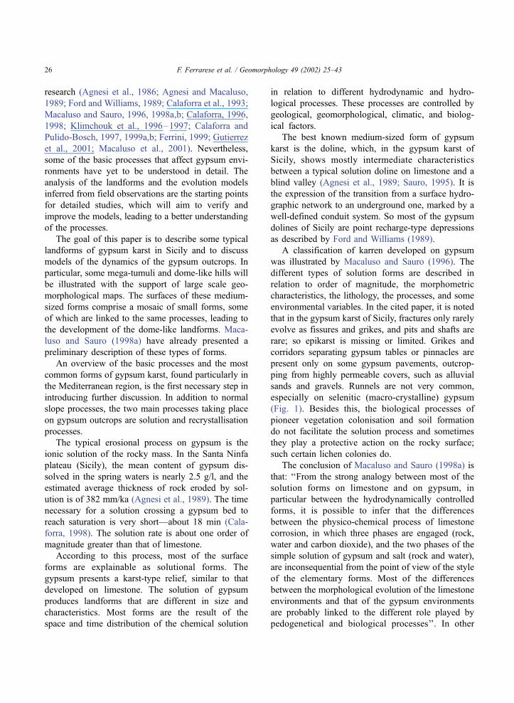
sands and gravels. Runnels are not very common,
especially on selenitic (macro-crystalline) gypsum
(Fig. 1). Besides this, the biological processes of
pioneer vegetation colonisation and soil formation
do not facilitate the solution process and sometimes
they play a protective action on the rocky surface;
such certain lichen colonies do.
The conclusion of Macaluso and Sauro (1998a) is
that: ‘‘From the strong analogy between most of the
solution forms on limestone and on gypsum, in
particular between the hydrodynamically controlled
forms, it is possible to infer that the differences
between the physico-chemical process of limestone
corrosion, in which three phases are engaged (rock,
water and carbon dioxide), and the two phases of the
simple solution of gypsum and salt (rock and water),
are inconsequential from the point of view of the style
of the elementary forms. Most of the differences
between the morphological evolution of the limestone
environments and that of the gypsum environments
are probably linked to the different role played by
pedogenetical and biological processes’’. In other
F. Ferrarese et al. / Geomorphology 49 (2002) 25–4326
words, the appearance of the same types of forms, like
rills, runnels, and so forth, in limestone (see Perna and
Sauro, 1978), in gypsum, and in salt demonstrates that
the evolutionary patterns of such forms are not influ-
enced by the differences of the solution processes, but
are controlled mainly by the hydraulic behaviour of
the runoff.
From the analysis of the landforms, it is also
evident that, beside, the solution process, recrystalli-
sation also occurs. The clearest results of this process
are gypsum tumuli (Pulido-Bosh, 1986) produced
from the swelling of the outer gypsum layer and
described and interpreted in some recent papers (Cal-
aforra, 1996, 1998; Calaforra and Pulido-Bosch,
Fig. 1. Solution runnels on a macro-crystalline gypsum outcrop in the area of Calafimi (Tp).
F. Ferrarese et al. / Geomorphology 49 (2002) 25–43 27
1997, 1999a; Macaluso and Sauro, 1998a). In partic-
ular, in Calaforra (1998) and Calaforra and Pulido-
Bosch (1999b), the different hypotheses for the proc-
ess leading to the development of these forms are
discussed. Recrystallisation is considered to be the
only reasonable explanation for the increase of vol-
ume of the outer gypsum layer.
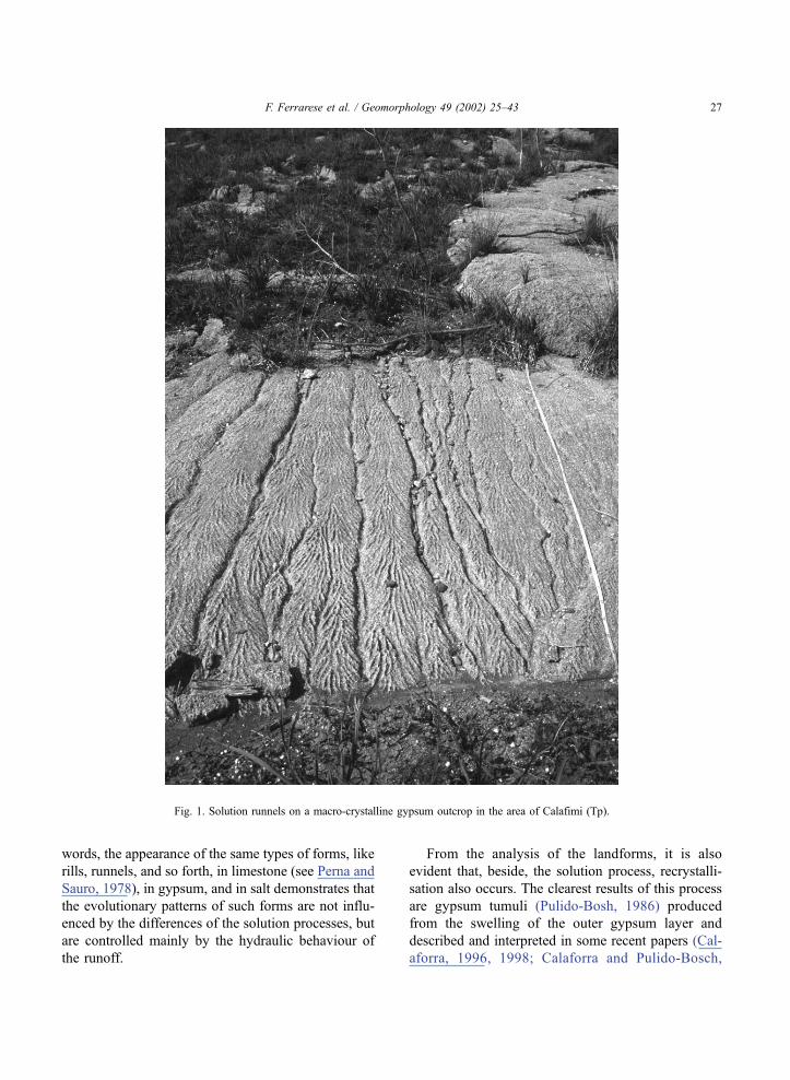
Gypsum tumuli are dome-like bulges ranging from
some decimetres to about 15 m in diameter and a few
centimetres to several decimetres in height. These
structures consist of a circular shell of gypsum arched
upwards above a cavity (Fig. 2). Macaluso and Sauro
(1998a) have observed how tumuli occur only on
gypsum outcrops directly exposed to the outer envi-
ronment without regolith and soil cover. They
describe other forms as pressure ridges, polygons,
pressure pans, pancakes, pressure humps, and steps,
interpreting them as peculiar morphostructures and as
the expression of an increase in volume of the outer
rocky mass. Pressure ridges are rises between pan and
pancake depressions, formed by two gypsum lips bent
upwards and often separated by a fissure. Their
heights range from a few millimetres to some deci-
metres according to lithological control, the morphol-
ogy of the surface, and the evolutionary stage of the
form. Sometimes silt and clay deposits are pinched
between the lips and inside the clefts between two
polygons.
Polygons are made by a system of rocky plaques
delimited by pressure ridges. The size of the polygons
is variable—from a few centimetres in balatine and
alabastrine gypsum to several metres in macro-crys-
talline gypsum. Pressure pans and pancakes are closed
or nearly closed basins, each having developed inside
a polygon with the margins bent upwards. Both forms
may be considered inverted forms of the gypsum
tumuli, or ‘‘reversed tumuli’’. While in pressure pans
the borders are single ridges, in pancakes, the borders
of the two contiguous polygons are separated, giving
rise to two small subparallel banks. Their heights
range from a few millimetres to some decimetres.
Pressure humps are nearly pyramidal or conical pro-
tuberances, from a few decimetres to more than 1 m
high. They develop in correspondence with a junction
point of the borders of three or four polygons. Steps
are similar to pans and/or pancakes but develop on
steep slopes, resulting in stair-like features.
Macaluso and Sauro (1998a) have also illustrated
some larger forms called mega-tumuli and dome-like
hills, and described them as the dynamic outcome of a
Fig. 2. A large partially collapsed gypsum tumulus in the area of S. Angelo Muxaro, S. Elisabetta. The tumulus has developed in macro-
crystalline gypsum and its shell does not correspond to a bed.
F. Ferrarese et al. / Geomorphology 49 (2002) 25–4328
‘‘gypsum crust’’ resulting from recrystallisation and
the consequent swelling of the outer gypsum layer.
2. Geological outline of the studied area
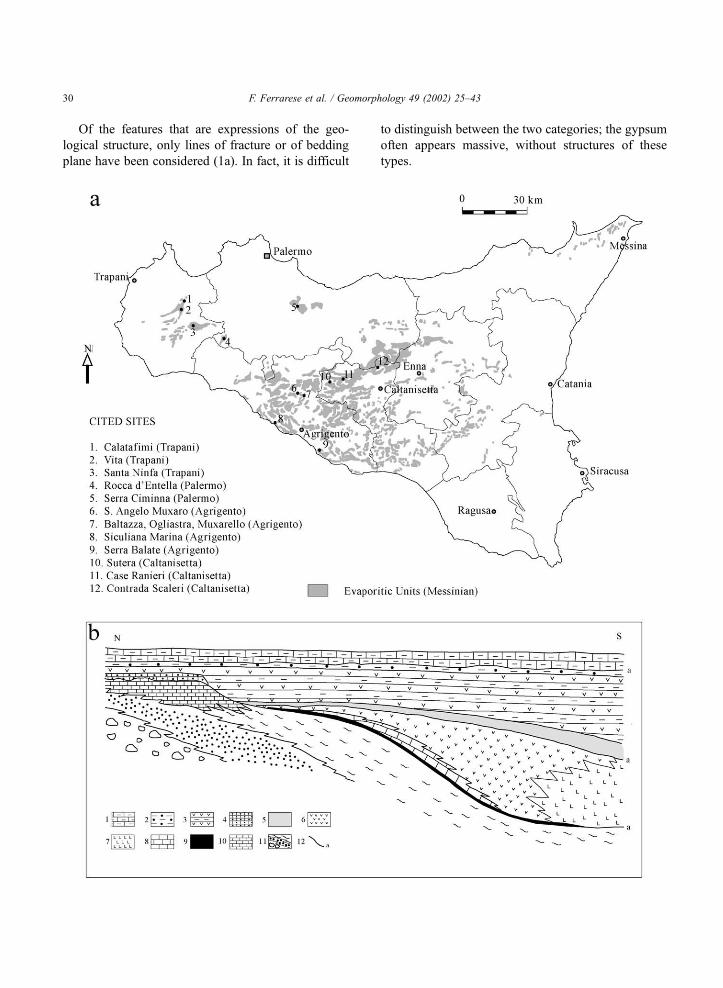
In western Sicily, Messinian age (Upper Miocene)
gypsum outcrops cover an area larger than 1000 km2
(Fig. 3), forming most of the evaporitic sequence of
western Sicily. The evaporitic sequence, locally some
hundreds metres thick, consists of diatomites, evap-
oritic limestones, gypsum, and salt with clay and
intercalations of marls and carbonates. It lies uncon-
formably on the Terravecchia Fm. (Upper Tortonian–
Lower Messinian), a silico-clastic rock unit, and is
covered unconformably by the Trubi Fm. (Lower
Pliocene), made up of pelagic calcilutites and calcar-
enites (Catalano and Esteban, 1978; Catalano, 1979;
Decima, 1982; Catalano, 1986). In particular, two
main units are distinguishable: (a) lower evaporitic
unit, made up of diatomites, evaporitic limestones,
gypsum with marly intercalations, and salt (halite and
kainite); and (b) upper evaporitic unit, made up of
gypsum with clay and sand intercalations, bioclastic
limestones, and clayey sands (Catalano, 1986).
The sedimentation of the evaporitic sequence is the
consequence of the closure of the Mediterranean basin
that partially desiccated during the upper Miocene.
The mineral precipitation in the hypersaline basins,
occasionally fed by water coming from the Atlantic
Ocean, led to the accumulation of the evaporitic
sequence (Di Stefano and Catalano, 1978; Lo Cicero
et al., 1997). The Trubi Fm. marks the reestablishment
of the communication with the ocean. After the
deposition, the evaporitic bodies were folded, with
the development of E–W-, ENE–WSW-, and NW–
SE-oriented synclines and anticlines, translated south-
wards and uplifted (Ghisetti and Vezzani, 1983).
The lithology of the gypsum outcrops, nearly
homogeneous from the chemical point of view,
presents a large variety of different lithofacies such
as the selenitic (or macro-crystalline), alabastrine,
laminated balatino, and detritic lithofacies. There is
a wide range of crystal sizes, from tenths of milli-
metres to several decimetres, and of degrees of
porosity of the rock mass. It has been proved that
near the surface, for a thickness of several tens of
metres, very little anhydrite is present inside the
gypsum mass. The analyses carried out in some caves
of the Santa Ninfa plateau demonstrates that the
gypsum beds, even if characterised by frequent recrys-
tallisation and substitution phenomena, are not the
result of the hydration of anhydrite (Bertolani and
Rossi, 1989). Silty and clayey intercalations inside the
gypsum series are very scarce. In some facies, the
amount of kaolinite may be larger that that of chlorite
(Bertolani and Rossi, 1989).
At present, large surfaces of gypsum are without
soil cover as a consequence of soil erosion induced by
the different forms of human impact, and in particular
by forest clearing, fires, and by sheep and goat
grazing. In addition, the salinity of the soils does
not favour vegetation cover and, therefore, erosion
processes are more active.
3. The mapped landforms
Very large-scale geomorphological maps of the
sample areas are the result of a field survey firstly
based on the use of radio-and laser telemeters, optical
clinometers, and compasses. Selected topographic
profiles were constructed and plotted inside a GIS
computer application (Idrisi GIS package) to get the
digital elevation models, later verified in the field and
utilised as bases for the geomorphological mapping.
The four surveyed areas have been selected
between many similar landscapes in the evaporitic
rocks of western Sicily because they show typical
associations of a wide range of forms different for
size and genesis. The geomorphological maps (Figs.
4–7) illustrate three dome-like summits and a ridge
especially representative of assemblages of both
medium- and small-scale forms resulting through
swelling processes of the outer gypsum layer.
The forms represented on the maps have been
listed in the legend of Fig. 4. It is possible to
separate six main categories of forms: (1) features
that are expressions of the geological structure; (2)
features resulting mostly from the dynamics of the
gypsum crust; (3) features resulting from both the
crust dynamic and solution processes; (4) features
resulting mostly from solution processes; (5) fea-
tures resulting from solution and other weathering
processes; and (6) features resulting from human
activity.
F. Ferrarese et al. / Geomorphology 49 (2002) 25–43 29
Of the features that are expressions of the geo-
logical structure, only lines of fracture or of bedding
plane have been considered (1a). In fact, it is difficult
to distinguish between the two categories; the gypsum
often appears massive, without structures of these
types.
F. Ferrarese et al. / Geomorphology 49 (2002) 25–4330
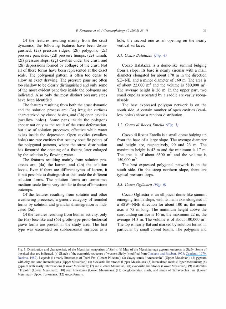
Of the features resulting mainly from the crust
dynamics, the following features have been distin-
guished: (2a) pressure ridges, (2b) polygons, (2c)
pressure pancakes, (2d) pressure humps, (2e) tumuli,
(2f) pressure steps, (2g) cavities under the crust, and
(2h) depressions formed by collapse of the crust. Not
all of these forms have been represented at the exact
scale. The polygonal pattern is often too dense to
allow an exact drawing. The pressure pans are often
too shallow to be clearly distinguished and only some
of the most evident pancakes inside the polygons are
indicated. Also only the most distinct pressure steps
have been identified.
The features resulting from both the crust dynamic
and the solution process are: (3a) irregular surfaces
characterized by closed basins, and (3b) open cavities
(swallow holes). Some pans inside the polygons
appear not only as the result of the crust deformation,
but also of solution processes, effective while water
exists inside the depression. Open cavities (swallow
holes) are rare cavities that occupy specific points of
the polygonal patterns, where the stress distribution
has favoured the opening of a fissure, later enlarged
by the solution by flowing water.
The features resulting mainly from solution pro-
cesses are: (4a) the karren, and (4b) the solution
levels. Even if there are different types of karren, it
is not possible to distinguish at this scale the different
solution forms. The solution forms are sometimes
medium-scale forms very similar to those of limestone
outcrops.
Of the features resulting from solution and other
weathering processes, a generic category of rounded
forms by solution and granular disintegration is indi-
cated (5a).
Of the features resulting from human activity, only
the (6a) box-like and (6b) grotto-type proto-historical
grave forms are present in the study area. The first
type was excavated on subhorizontal surfaces as a
hole, the second one as an opening on the nearly
vertical surfaces.
3.1. Cozzo Balatazza (Fig. 4)
Cozzo Balatazza is a dome-like summit bulging
from a slope. Its base is nearly circular with a main
diameter elongated for about 170 m in the direction
SE–NE, and a minor diameter of 160 m. The area is
of about 22,000 m2 and the volume is 580,000 m3.
The average height is 26 m. In the upper part, two
small cupolas separated by a saddle are easily recog-
nisable.
The best expressed polygon network is on the
south side. A certain number of open cavities (swal-
low holes) show a random distribution.
3.2. Cozzo di Rocca Entella (Fig. 5)
Cozzo di Rocca Entella is a small dome bulging up
from the base of a large slope. The average diameter
and height are, respectively, 90 and 23 m. The
maximum height is 42 m and the minimum is 17 m.
The area is of about 6500 m2 and the volume is
150,000 m3.
The best expressed polygonal network is on the
south side. On the steep northern slope, there are
typical pressure steps.
3.3. Cozzo Ogliastra (Fig. 6)
Cozzo Ogliastra is an elliptical dome-like summit
emerging from a slope, with its main axis elongated in
a SSW–NNE direction for about 100 m; the minor
axis is 75 m long. The minimum height above the
surrounding surface is 16 m, the maximum 22 m, the
average 14.3 m. The volume is of about 100,000 m3.
The top is nearly flat and marked by solution forms, in
particular by small closed basins. The polygons and
Fig. 3. Distribution and characteristic of the Messinian evaporites of Sicily. (a) Map of the Messinian-age gypsum outcrops in Sicily. Some of
the cited sites are indicated. (b) Sketch of the evaporitic sequence of western Sicily (modified from Catalano and Esteban, 1978; Catalano, 1979;
Decima, 1982). Legend: (1) marly limestones of Trubi Fm. (Lower Pliocene); (2) clayey sands ‘‘Arenazzolo’’ (Upper Messinian); (3) gypsum
with clay and sand intercalations (Upper Messinian); (4) bioclastic limestones (Upper Messinian); (5) intercalated marls (Upper Messinian); (6)
gypsum with marly intercalations (Lower Messinian); (7) salt (Lower Messinian); (8) evaporitic limestones (Lower Messinian); (9) diatomites
‘‘Tripoli’’ (Lower Messinian); (10) reef limestones (Lower Messinian); (11) conglomerates, marls, and sands of Terravecchia Fm. (Lower
Messinian–Upper Tortonian); (12) unconformity.
F. Ferrarese et al. / Geomorphology 49 (2002) 25–43 31
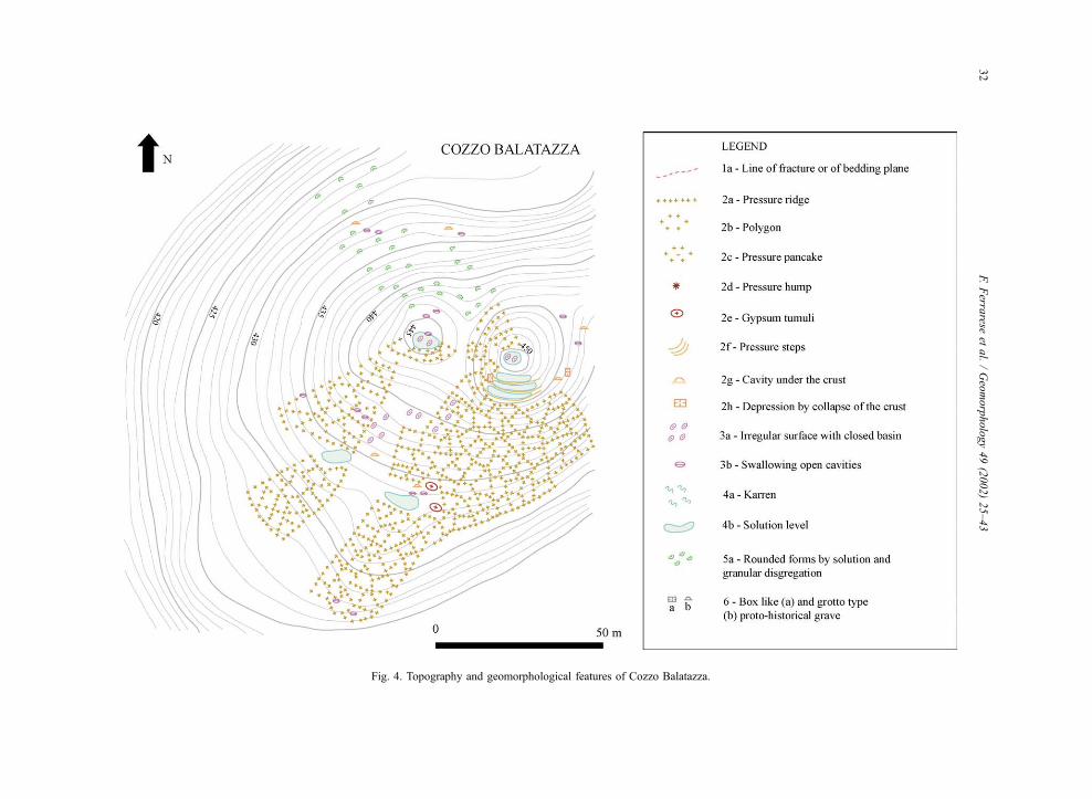
Fig. 4. Topography and geomorphological features of Cozzo Balatazza.
F.Ferra
reseet
al./Geomorphology49(2002)25–43
32
Fig. 5. Topography and geomorphological features of Cozzo di Entella (see the legend in Fig. 4).
F. Ferrarese et al. / Geomorphology 49 (2002) 25–43 33
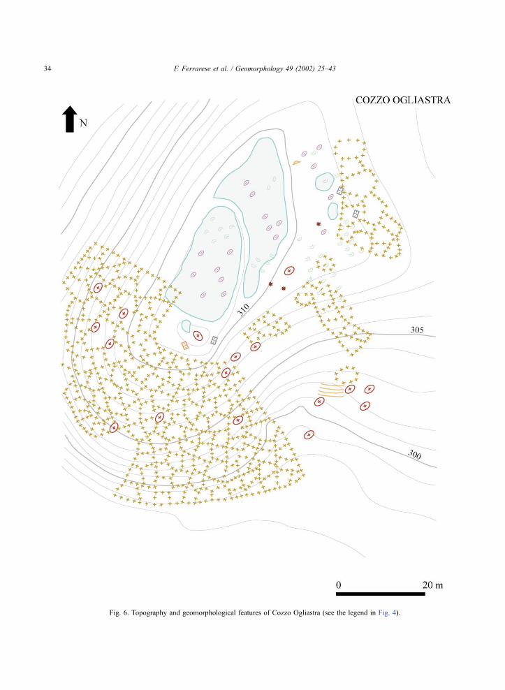
Fig. 6. Topography and geomorphological features of Cozzo Ogliastra (see the legend in Fig. 4).
F. Ferrarese et al. / Geomorphology 49 (2002) 25–4334
the pressure ridges are best developed on the southern
slope.
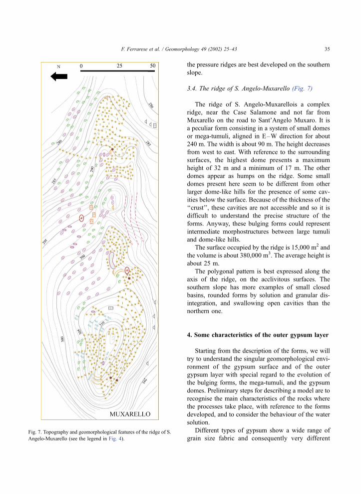
3.4. The ridge of S. Angelo-Muxarello (Fig. 7)
The ridge of S. Angelo-Muxarellois a complex
ridge, near the Case Salamone and not far from
Muxarello on the road to Sant’Angelo Muxaro. It is
a peculiar form consisting in a system of small domes
or mega-tumuli, aligned in E–W direction for about
240 m. The width is about 90 m. The height decreases
from west to east. With reference to the surrounding
surfaces, the highest dome presents a maximum
height of 32 m and a minimum of 17 m. The other
domes appear as humps on the ridge. Some small
domes present here seem to be different from other
larger dome-like hills for the presence of some cav-
ities below the surface. Because of the thickness of the
‘‘crust’’, these cavities are not accessible and so it is
difficult to understand the precise structure of the
forms. Anyway, these bulging forms could represent
intermediate morphostructures between large tumuli
and dome-like hills.
The surface occupied by the ridge is 15,000 m2 and
the volume is about 380,000 m3. The average height is
about 25 m.
The polygonal pattern is best expressed along the
axis of the ridge, on the acclivitous surfaces. The
southern slope has more examples of small closed
basins, rounded forms by solution and granular dis-
integration, and swallowing open cavities than the
northern one.
4. Some characteristics of the outer gypsum layer
Starting from the description of the forms, we will
try to understand the singular geomorphological envi-
ronment of the gypsum surface and of the outer
gypsum layer with special regard to the evolution of
the bulging forms, the mega-tumuli, and the gypsum
domes. Preliminary steps for describing a model are to
recognise the main characteristics of the rocks where
the processes take place, with reference to the forms
developed, and to consider the behaviour of the water
solution.
Different types of gypsum show a wide range of
grain size fabric and consequently very differentFig. 7. Topography and geomorphological features of the ridge of S.
Angelo-Muxarello (see the legend in Fig. 4).
F. Ferrarese et al. / Geomorphology 49 (2002) 25–43 35
primary porosity and permeability. There are very
fine-grained gypsum types such as balatine gypsum
and alabastrine gypsum and coarse-grained gypsum
types such as selenitic (macro-crystalline) gypsum,
with crystals ranging from millimetric to decimetric
sizes. There are also many types of detritic gypsum
containing clasts of different kinds and dimensions.
Some gypsum types are densely bedded; others are
massively bedded or without bedding planes. Also
fracture density is very different from place to place;
some fractures are of tectonic origin, while others are
the consequence of tensional relaxation in the context
of the slope processes. The tectonic setting varies as is
evidenced by the dip of the strata ranging from the
horizontal to the vertical.
While some types of forms are common in nearly
all the gypsum lithologies and structural and geo-
morphological settings, others forms are linked mostly
with specific lithological and structural conditions. In
particular, the polygons and the pressure ridges are
present on most bare gypsum surfaces and their size
seems to be partly related to the crystal size: very
small polygons are present on the balatine and detritic
sandy gypsum, a little larger on alabastrine gypsum,
and larger still on macro-crystalline gypsum. On the
macrocystalline gypsum, small tumuli develop in the
central part of some polygons. Single and multishelled
tumuli exist. The intercrystalline voids of a few tumuli
in selenitic gypsum are filled with silt and clay sedi-
ments, as in the pressure ridges and some pressure
humps. The bedding plane slopes in macro-crystalline
gypsum provide a very favourable environment for
the development of both large polygons and tumuli.
Mega-tumuli and dome-like hills have developed
mainly in massive macro-crystalline gypsum. In gen-
eral, the elementary swelling forms do not seem to be
dependent strictly on the lithological and structural
conditions, even if some types of forms are found at
their best in particular situations.
The behaviour of the water solution inside the
upper gypsum layer must be controlled by the litho-
logical and structural conditions and also by the
previous development of the secondary karst ‘‘poros-
ity’’ inside the rocky mass.
In comparison with the limestone karst, the gyp-
sum karst geosystem of Sicily shows a completely
different epikarst structure. From the analysis of the
dolines, of the caves, and of the escarpments of the
quarries, it is possible to recognise the main character-
istics of the epikarst. The porosity of the rocky mass is
often greater than that of limestones, but the network
of partly hierarchized small fissures is poorly devel-
oped; a few main conduits are present. Some of these
conduits start as swallow holes at the bottom of
dolines or at the end of blind valleys. These conduits
are fed mostly by the water flowing at the rock/air or
cover/rock interfaces, rather than by the aquifer hosted
in the epikarst. The water reservoir stored in the
epikarst could be relatively consistent in the macro-
crystalline gypsum, but does not seem to release water
downwards very much.
Some cavities such as clefts and interbedding
holes may be filled with silt and clay sediments
that are light grey in colour, derived from impur-
ities present within the gypsum mass, from soils,
from the precipitation of calcium carbonate, and
from residuals of the ‘‘Trubi’’ formation. Water
flows slowly inside these fillings, which also rep-
resent small water reservoirs.
The solution process of limestone is a reversible
chemical reaction: part of the mass dissolved at and
near the surface will precipitate as concretion and
flowstone in the fissures and in the caves. In gypsum
karst, the precipitation of gypsum is not so obvious as
in carbonate karst. In most of the middle latitude
gypsum caves, there are few gypsum spleothems,
which are caused mainly by evaporation processes.
The chemical deposits in many of these gypsum caves
are formed largely by calcium carbonate and are
related to the ionic combination of Ca2+, deriving
from the dissociation of gypsum, with HCO3� (hydro-
carbonic ion) present in the natural solutions (Forti
and Rabbi, 1981). In some places, on exposed gypsum
surfaces, it is possible to find stalagmites and flow-
stones of calcium carbonate as remnants of the floors
of caves that have completely dissolved except for
these fillings (e.g., in the areas of Santa Ninfa and
Serra Ciminna in Sicily).
From the analysis of the landform evolution, it is
easy to demonstrate that in gypsum epikarst, precip-
itation of CaSO4�2H2O also occurs. But the modalities
of these precipitation processes are different from
those known for the carbonate rocks. A preliminary
study and a proposal of an evolutionary model of the
outer gypsum layers were presented in Macaluso and
Sauro (1998a).
F. Ferrarese et al. / Geomorphology 49 (2002) 25–4336
5. A dynamic model of the weathering crust
In the evaporite karst of Sicily, the migration and
precipitation of gypsum are linked to the soil water
cycle of the Mediterranean climatic regime character-
ised by a seasonal alternation of water surplus (wet
winter season) and water deficit conditions (dry sum-
mer season). Here, all the forms described find their
dynamic environment in the outer gypsum layer. This
layer is affected by an increase of volume, leading to
the expansion of the rocky mass, which changes its
structure, forming a ‘‘gypsum crust’’. The ‘‘gypsum
crust’’ is the outer gypsum layer where gypsum
reprecipitation occurs and expansion prevails, imped-
ing the opening of fissures and the development of
grikes (Macaluso and Sauro, 1996, 1996–1997).
The shells of the tumuli are good examples of this
dynamic gypsum layer formed by the alternation of
solution and reprecipitation processes (Calaforra,
1996, 1998; Calaforra and Pulido-Bosch, 1999b).
The inner limit of the tumulus crust is usually litho-
logical (i.e., a very thin clay stratum) or structural (i.e.,
bedding plane, pseudo-bedding plain parallel to the
topographical surface). These structural elements may
influence the downward migration of the gypsum
crust.
If the crust coincides with the shells of the tumuli,
its thickness ranges between a few centimetres and
some decimetres. But if we consider all the elements
of the swelling of the outer gypsum layer on some
slopes in Sicily, the crust thickness may reach some
metres (Macaluso and Sauro, 1998a,b). In fact, in
some quarries in the macro-crystalline gypsum, it is
possible to observe open fissures starting 1.5–3 m
below the surface.
An improved version of the model of the dynamics
of the crust illustrated by Macaluso and Sauro (1998a)
is outlined in Fig. 8a: during the wet season, the
rainfall starts overland flow and the water dissolves
gypsum on the surface. The silt transported by the
runoff is trapped in the pores and cavities; part of the
water solution manages to penetrate the rock. The
solution reaches saturation (with CaSO4) near the
surface or a few decimetres inside the rock, except
along the fissures where the saturation front may
reach downward (the B line in Fig. 8a). The solution
continues to penetrate both inside the pores and in the
silt and clay filling of the fissures and of other cavities
such as the tumuli and pressure ridges and humps (2),
reaching a water porosity front (C). The water may
also flow laterally (3 in Fig. 8a).
If there is a long period of water surplus, more and
more water manages to penetrate the rock and the
fissures; the porosity and the water capacity of the
rock increase and the solution flowing at the rock/
fillings interface of the fissures enlarges the cracks;
the speed of the water circulating in the rock increases
and the saturation front migrates downward.
During the dry season, the rock and the fillings of
the cracks lose water by evaporation (4). The over-
saturated inner solution moves by capillary action
towards the surface (5). In the D zone, gypsum
reprecipitates, feeding recrystallisation phenomena
and/or the development of new crystals. In the fissures
and the cavities filled with fine-grained materials, new
gypsum crystals may develop. The mass transfer from
the inner towards the outmost zone results in pressure
relaxation (6) in the C zone and in pressure increase
(7) in the D zone.
It is difficult to evaluate the velocity of water
circulation inside the pores of gypsum because there
is a wide range of primary porosity in relation to the
different lithofacies. The secondary porosity is influ-
enced not only by the solution processes but also by
the anisotropies generated by the stress fields induced
by the reprecipitation.
The time necessary for the water penetrating the
rock to reach saturation is relatively short (about 18
min). Calaforra (1998) considers two limiting cases
related to the thickness of the shells of the gypsum
tumuli: 2 and 30 cm; assuming that the inner surfaces
of these shells are the expression of the saturation
front reached by the solution, in the first case before
reaching saturation, the penetration velocity of the
porosity water front should be about 1 mm/min, in the
second 16 mm/min. Anyway, the inner surfaces of the
tumuli are often structurally controlled and since in
some dome-like hills the thickness of the crust reaches
some metres, the water should be able to penetrate and
to perform solution in a thicker layer.
In some human-made stone structures such as dry
walls and vaults, a rearrangement of the gypsum
crystals is evident due to mass transfer inside the
rocky volume. A very nice example of crystal growth
and rearrangement is represented by a dry wall on the
ridge of Contrada S. Elia, WNW of Sutera. The dry
F. Ferrarese et al. / Geomorphology 49 (2002) 25–43 37
wall stretches in a N–S direction and shows the stones
as closely bonded on the eastern side and loose on the
western side. An easy explanation of such an asym-
metry is that during the night, the wall becomes wet
by condensation and in the early morning, the sun
heats the east side and the water solution inside the
pores is drawn towards the warmed side; it then
becomes oversaturated and favours crystal growth
and rearrangement.
Thus, the main mechanism favouring the poros-
ity of water migration towards the surface of the
bare rock is the heat pump resulting from the input
F. Ferrarese et al. / Geomorphology 49 (2002) 25–4338
of solar radiation, which is very effective during the
summer period. The moving water is an oversatu-
rated solution, leading to mass transfer and repre-
cipitation of the gypsum, by the formation of new
crystals and/or by growth of previous crystals. So
part of the dissolved gypsum at the outer surface or
in the upper decimetres of the rock reprecipitates in
the outer gypsum layer, inducing a volume increase
and tendency to expansion. This tendency operates
at different scales, leading to the development of
tumuli, polygons, other intermediate forms.
The role of the silty and clayey fillings of some
fissures between polygons and ridges does not
appear to be a determining factor for the develop-
ment of such forms. Polygons are also present in
balatine and alabastrine gypsum where the fillings
may be absent. Anyway, these structures could play
an important role in favouring a faster penetration
of the water inside the rocky mass and also locally
increasing the lateral pressure both for the clay
expansion and the growth of new gypsum crystals
inside the fillings.
In Fig. 8b, a different environment is outlined:
gypsum covered by a thick mantle of loose sedi-
ments hosting an aquifer. Here the rock is affected
by solution only, and so the evolution of fissures to
grikes and corridors, and the disjunction of tables
and pinnacles are possible. The resulting forms,
described in the past as a ‘‘gypsum paleokarst’’
(Ruggieri and Torre, 1987), are examples of this
type of evolution. Nice examples of complexes of
forms of this type can be seen on the Serra
Ciminna homoclinal ridge (Fig. 9) and near Siculi-
ana Marina.
6. The role of the weathering crust in the
development of the mega-tumuli and of dome-like
hills
The bare summits of many large hills in gypsum
present a dome-like form, similar to that of the
gypsum tumuli but of a different scale (Fig. 10).
The geomorphological maps (Figs. 4–7) illustrate
some examples of these types of summits, which are
mostly circular or elliptical in shape and show diam-
eters ranging between a few tens of metres and more
than 100 m and heights ranging between a few metres
and more than 30 m.
From the morphostructural point of view, these
forms do not seem to be controlled by the strike, dip,
or fissuring of the gypsum beds: forms of this type are
developed in gypsum outcrops with different dips,
from subvertical to subhorizontal. The evolution of
these forms seems to be linked to polygonal fissuring
occurring on most of the dome surfaces and to other
pressure structures resulting from the processes of
volume increase of the outer gypsum layer.
The genesis of the dome-like forms, which
resemble dome-like summits in crystalline rocks,
is the expression of the nearly homogeneous behav-
iour of the rock mass in comparison with the
erosional processes. The formation of a weathering
gypsum crust may favour the development of the
dome-like form through the creation of nearly
isotropic fields of radial stresses with reference to
the central part of the relief. This stress field
minimises the influence of preexisting structural
elements, such as bedding planes and fractures
(Macaluso and Sauro, 1998a).
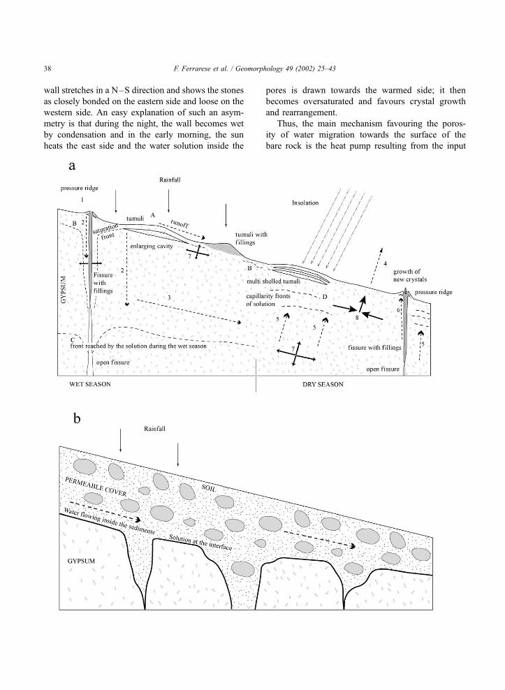
Fig. 8. Sketch of the main processes occurring inside the outer gypsum layer in two different environments: (a) rocky surface directly exposed to
the atmosphere, and (b) rocky surface covered by a mantle of permeable loose sediments. The dynamics of the type I environment are strictly
linked with the typical Mediterranean climatic regime. During the winter season, the rainfall causes an overland flow and the water dissolves the
gypsum on the surface (A) while part of the water solution manages to penetrate inside the pores of the rock. The solution reaches saturation
(with CaSO4) on the surface or a few decimetres inside the rock (the B line may be considered a saturation front). The solution continues to
penetrate both inside the pores and in the fissures (2), reaching a front of porosity water (C). The water may also flow laterally (3). During the
dry season, the solution loses water by evaporation (4). The inner solution becomes oversaturated and moves by capillary action towards the
surface (5). In the D zone, there is precipitation of gypsum. In the fissures and cavities, the solution migrates upwards (6) and new gypsum
crystals may develop. The mass transfer from the inner towards the outmost zone results in pressure relaxation (7) in the C zone, where open
fissures may exist, and in pressure increase (8) in the D zone. In the type II environment, the runoff inside the sediment causes solution of the
underlying gypsum both at the interface and in the fissures and other discontinuities of the rock. In this way, covered solution pavements
develop, perceptible after erosion of the cover sediments, similar to some limestone pavements.
F. Ferrarese et al. / Geomorphology 49 (2002) 25–43 39
In some structural settings, the field stresses may
be influenced by discontinuities such as bedding
planes or systems of fractures or by pseudo-bedding
planes resulting through gravitational release. For
example, in large homoclinal slopes, like that of Serra
Balate, the crust coincides with one or more beds with
expansion, leading to the development of forms like
tumuli, polygons, and related forms (Macaluso et al.,
2001); here, no mega-tumuli develops. The steeper
slopes of some ‘‘half-domes’’ evolve through land-
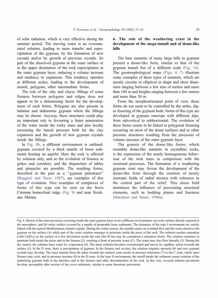
Fig. 9. Points of solution pinnacles partially masked by a cover of permeable alluvial sediments on the Serra Ciminna plateau. Overland flow
and slope processes are exhuming these crypto-forms developed by solution at the interface rock-covering sediments.
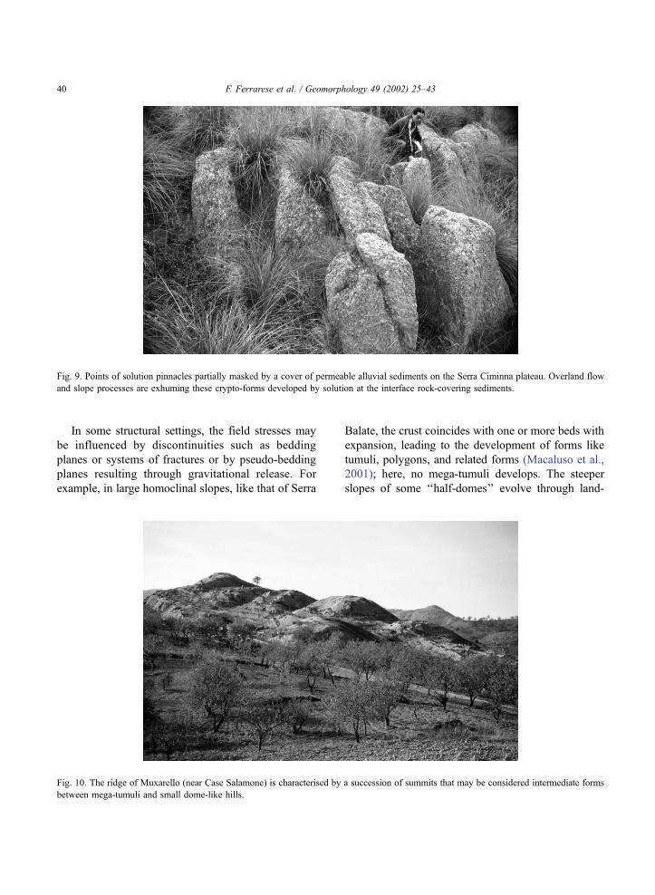
Fig. 10. The ridge of Muxarello (near Case Salamone) is characterised by a succession of summits that may be considered intermediate forms
between mega-tumuli and small dome-like hills.
F. Ferrarese et al. / Geomorphology 49 (2002) 25–4340
sliding more than by solution and other weathering
processes. In the gypsum masses where a relative
isotropy of the stress field exists, the weathering crust,
as a new structural element, tends to favour the
development of dome-like summits, neutralising the
influence of the preexisting structural elements.
In relation to the existence of this weathering crust,
the epikarst in gypsum is not well developed. An
interesting aspect of this epikarst is that most of the
preexisting discontinuities are sealed near the surface,
but they tend to be open at a depth of a few metres.
This aspect, well observable in some quarries, is in
accordance with the model of volume increase of the
crust.
If the growth of morphostructures, ranging in size
between a few decimetres and some metres, such as
tumuli and polygons, is the expression of the dynam-
ics of an outer gypsum layer for a thickness between a
few centimetres and some decimetres, the evolution of
larger forms, ranging in size between a few deca-
metres and more than 1 hm, such as mega-tumuli and
dome-like summits, is the consequence of the swel-
ling of a layer between a metre and a few metres thick.
In the first case, the porosity of water cycles could be
linked to the alternation of a single heavy precipitation
event followed by some sunny days, in the second to
the alternating wet–dry season. From the morphos-
tructural point of view, except for the gypsum tumuli,
it is not possible to make a sharp distinction between
an outer thinner crust and a thicker one. Actually, field
observations evidence that gypsum may behave in a
relatively plastic way. This is also suggested by the
fact that in a gypsum tumulus, there is a unique cavity
delimited by a ‘‘shell’’ between a few centimetres and
2 dm thick, while in the crust of the dome-like hills,
there are many voids along the fractures and other
discontinuities, situated mostly between some deci-
metres and a few metres below the surface.
The lifetime of small forms of the weathering crust
like the pressure ridges and the tumuli may range
between a few years and several decades. The time
span for the formation of the dome-like summit could
be in the order of thousands of years. This last
estimation is based on the consideration that both
deforestation and soil erosion in this region occurred
during early protohistoric times and also by the
presence of tilted protohistoric graves on the flanks
of some domes.
Given the fact that the basic conditions for the
development of the weathering crust are: (a) lack of a
soil cover, which is very often due to human impact
since protohistoric times, and (b) the alternating of
water saturation and dryness conditions in the super-
ficial porosity zone of the rock, the weathering crust
may be considered both a morphoclimatic, and, at
least partially, a human-induced feature (Macaluso
and Sauro, 1998a).
7. Conclusions
The geomorphological environments of the gyp-
sum karst areas of Sicily are complex. The different
landscapes, the many types of landform, and their
wide range of sizes are the result of the combination
and interference of different processes: tectonic evo-
lution, solution, and the precipitation processes and
other weathering phenomena controlled by the cli-
matic regime, the role of vegetation, the impact of the
different types of soil use, and so on. The analysis of
the forms shows that an important morphogenetic
role is played not only by the solution process, but
also by the swelling of the outer rocky volume,
leading to the development of a weathering crust.
Many physical–chemical processes could explain the
change in volume and the development of the weath-
ering crust such as: (a) increase in porosity as a
consequence of tensional relaxation; (b) phenomena
of thermal dilatation and contraction of the crystals;
(c) plastic deformation linked to a rearrangement of
crystalline structure; (d) expansion and contraction of
the clay trapped between the crystals and in the
fissures; and (e) solution, recrystallisation, and crys-
tals growth in connection with the runoff and cycles
of the porosity water.
The most typical forms, such as the polygons and
the gypsum tumuli, are not explainable without taking
recrystallisation phenomena into consideration. In
effect, in some polygons, like those on alabastrine
gypsum, there is very little silt and clay fill in the
fissures. Polygons are found at their best on the south
exposed slopes, which are subject to a greater degree
of solar radiation. If the clay plays an important role in
the development of the pressure ridges between the
polygons, these forms would be best found on the
north-facing slopes, which are wetter and more
F. Ferrarese et al. / Geomorphology 49 (2002) 25–43 41
favourable to clay expansion. Hence, in general, it is
most likely that the main process leading to the
expansion of the weathering crust results from the
precipitation of gypsum near to the topographical
surface.
Also larger forms such as the mega-tumuli and
dome-like hills are not comprehensible on the basis of
simple diapiric processes because their structures do
not fit within these processes. The presence of a
weathering crust expressed by the bulging forms, by
the sealing of the fissures, and by the minimisation of
the influence of the preexisting structural elements,
such as bedding planes and fractures, is the only
reasonable explanation for these forms.
The proposed model gives only a preliminary
pattern to stimulate further discussion and research.
Certain aspects need to be investigated in detail to
improve this model. Since the rate of evolution of
some forms is probably perceptible during the human
life span and is easily monitored, these areas con-
stitute ideal natural laboratories to study the processes.
The establishment of some field laboratories will be
an essential step to enhance future research on this
geomorphological environment.
Acknowledgements
The paper is the result of the cooperation of all the
authors. In particular, T. Macaluso and U. Sauro have
written and edited all the general parts and the
discussion of the model. F. Ferrarese, G. Madonia, and
A. Palmeri undertook the field survey, the geo-
morphological maps, and the illustration of the sample
areas. The authors thank their colleagues and, in
particular, A. Klimchouk, J.M. Calaforra, and G.
Benito who, through discussion and criticism, have
contributed to the development of their ideas. The
research was carried out within the following research
programs: MURST 1997—Risposta dei processi
geomorfologici alle variazioni ambientali; Analisi
degli ambienti, dei paesaggi, delle risorse e della
morfodinamica in aree carsiche italiane e del Medi-
terraneo (60%); and COFIN 2000—Ricostruzione
dell’evoluzione climatica e ambientale ad alta risolu-
zione (1–10 anni) da concrezioni di grotta lungo una
traversa N–S in Italia con particolare riferimento
all’intervallo Tardiglaciale-Attuale.
References
Agnesi, V., Macaluso, T. (Eds.), 1989. I Gessi di Santa Ninfa (Tra-
pani). Studio multidisciplinare di un’area carsica. Memorie Isti-
tuto Italiano Speleologia, vol. 3. s. II, Palermo, 202 pp.
Agnesi, V., Macaluso, T., Pipitone, G., 1986. Fenomeni carsici epi-
gei nelle evaporiti in Sicilia. Le Grotte d’Italia 4 (13), 123–162.
Agnesi, V., Macaluso, T., Meneghel, M., Sauro, U., 1989. Geomor-
fologia dell’area carsica di S. Ninfa. In: Palermo, S. Z. (Ed.),
I gessi di Santa Ninfa: studio multidisciplinare di un’area
carsica. Memorie Istituto Italiano Speleologia 3, pp. 23–48.
Bertolani, M., Rossi, A., 1989. La petrografia della Grotta di S.
Ninfa inquadrata nel suo territorio. In: Agnesi, V., Macaluso,
T. (Eds.), I gessi di Santa Ninfa. Memorie Istituto Italiano Spe-
leologia, vol. 3, pp. 59–83, s. II.
Calaforra, J.M., 1996. Some examples of gypsum karren. In: Fornos,
J.J., Gines, A. (Eds.), Karren Landforms. Universitat de les Illes
Balears, Palma de Mallorca, pp. 253–260.
Calaforra, J.M., 1998. Karstologia des yesos (Gypsum Karstology).
Ciencia y Tecnologia Monografias, vol. 3. Univ. De Almeria,
Almeria, 389 pp.
Calaforra, J.M., Pulido-Bosch, A., 1997. Peculiar landforms in the
gypsum karst of Sorbas (Southeastern Spain). Carbonates and
Evaporites 12/1, 110–116.
Calaforra, J.M., Pulido-Bosch, A., 1999a. Gypsum karst features as
evidence of diapiric processes in the Betic Cordillera, Southern
Spain. Geomorphology 29, 251–264.
Calaforra, J.M., Pulido-Bosch, A., 1999b. Genesis and evolution of
gypsum tumuli. Earth Surface Processes and Landforms 24,
919–930.
Calaforra, J.M., Dell’Aglio, A., Forti, P., 1993. The role of conden-
sation–corrosion in the development of gypsum karst: the case
of the Cueva del Agua (Sorbas Spain). XI International Con-
gress Speleology, pp. 63–66.
Catalano, R., 1979. Scogliere ed evaporiti messiniane in Sicilia.
Modelli genetici ed implicazioni strutturali. Lavori dell’Istituto
di Geologia dell’Universita di Palermo 18, 1–21.
Catalano, R., 1986. Le evaporiti messiniane. Loro ruolo nell’evolu-
zione geologica della Sicilia. Le Grotte d’Italia 4 (13), 109–122.
Catalano, R., Esteban, M., 1978. Messinian reefs of Western and
Central Sicily, Abstracts. Messinian seminar, P4.
Decima, A., 1982. Note sul Messiniano della Sicilia. In: Catalano,
R., D’Argenio, B. (Eds.), Guida alla Geologia della Sicilia Oc-
cidentale. Memorie della Societa Geologica Italiana, vol. 24
(suppl. A), pp. 111–118.
Di Stefano, E., Catalano, R., 1978. Biostratigraphy paleoecology
and tectonosedimentary evolution of the preevaporitic and evap-
oritic deposits in the Ciminna Basin (Sicily). In: Catalano, R.,
Ruggieri, G., Sprovieri, R. (Eds.), Messinian Evaporites in the
Mediterranean. Erice Seminar, October 1975. Memorie della
Societa Geologica Italiana, vol. 16, pp. 95–110.
Ferrini, G. (Ed.), 1999. L’area carsica delle Vigne di Verzino. Mem-
orie Istituto Italiano Speleologia, vol. 10, pp. 35–45, s. II.
Ford, D., Williams, P., 1989. Karst Geomorphology and Hydrology.
Unwin Hyman, London, 601 pp.
Forti, P., Rabbi, E., 1981. The role of CO2 in Gypsum speleogen-
esis. International Journal of Speleology 11, 207–218.
F. Ferrarese et al. / Geomorphology 49 (2002) 25–4342

Ghisetti, F., Vezzani, L., 1983. Evoluzione Neotettonica della Sicilia
e Problematiche Relative. In: Ciaranfi, N., et al., (Eds.), Carta
Neotettonica dell’Italia Meridionale. CNR-PF Geodinamica,
Publ. no. 515, Bari, pp. 43–52.
Gutierrez, F., Orti, F., Gutierrez, M., Perez, M., Gonzalez, A., Be-
nito, G., Prieto, J.G., Valsero, J.J.D., 2001. The stratigraphical
record and activity of evaporite dissolution subsidence in Spain.
Carbonates and Evaporites 16 (1), 46–70.
Klimchouk, A., Lowe, D., Cooper, A., Sauro, U. (Eds.), 1996–
1997. Gypsum karst of the world. International Journal of Spe-
leology 25 (3–4), 307 pp.
Lo Cicero, G., Di Stefano, E., Catalano, R., Agate, M., Contino, A.,
Greco, G., Mauro, G., 1997. The Messinian Evaporitic Ciminna
sedimentation and eustatic control in a transpressive tectonic
setting. In: Catalano, R. (Ed.), Origin of Sedimentary Basins.
Time Scales and Basin Dynamics. Sicily, The Adjacent Medi-
terranean and Other Natural Laboratories. Field Workshop in
Western Sicily. Guidebook. 8th Workshop of the ILP Task
Force, Palermo (Sicily), June 7–13, pp. 70–83.
Macaluso, T., Sauro, U., 1996. The Karren in evaporitic rocks: a
proposal of classification. In: Fornos, J.J., Gines, A. (Eds.), Kar-
ren Landforms. Universitat de les Illes Balears, Palma de Mal-
lorca, pp. 277–293.
Macaluso, T., Sauro, U., 1996–1997. Weathering and Karren on
exposed gypsum surfaces. International Journal of Speleology
25 (3–4), 115–126.
Macaluso, T., Sauro, U., 1998a. Aspects of weathering and land-
forms evolution on gypsum slopes and ridges of Sicily. Fourth
International Conference on Geomorphology—Proceedings,
Geografia Fisica Dinamica Quaternaria, Suppl. III (4), pp. 91–
99. Karst.
Macaluso, T., Sauro, U., 1998b. I Karren nei gessi di Verzino. In:
Ferrini, G. (Ed.), L’area carsica delle Vigne di Verzino. Memorie
dell’Istituto Italiano Speleologia, vol. 10, pp. 35–45, s. II.
Macaluso, T., Madonia, G., Palmeri, A., Sauro, U., 2001. Atlante
dei Karren nelle evaporiti della Sicilia. Quaderni del Museo
Geologico, Gemmellaro, G.G., vol. 5. Dipartimento di Geologia
e Geodesia, Universita degli Studi di Palermo, 143 pp.
Perna, G., Sauro, U., 1978. Atlante delle microforme di dissoluzione
carsica superficiale del Trentino e del Veneto. Memorie Museo
Tridentino di Scienze Naturali 22, 176 pp.
Pulido-Bosh, A., 1986. Le karst dans les gypses de Sorbas (Alme-
ria): aspectes morphologiques et hydrogeologiques. Karstologia,
Memoires 1, 27–35.
Ruggieri, G., Torre, G., 1987. Carsismo fossile sopramiocenico nei
gessi messiniani di Ciminna. Giornale di Geologia 49 (1), 81–
88.
Sauro, U., 1995. Highlights on doline evolution. In: Barany-Kevei, I.
(Ed.), Environmental Effects on Karst Terrains (homage to Las-
zlo Jackucs). Acta Geographica Szegediensis, vol. 34. Univ. of
Szeged, Szeged, pp. 107–121.
F. Ferrarese et al. / Geomorphology 49 (2002) 25–43 43