report on the mineral exploration in the
TRANSCRIPT

REPORT
ON
THE MINERAL EXPLORATION
IN
THE ZACUALPAN AREA,
THE UNITED MEXICAN STATES
(PHASE Ⅱ)
FEBRUARY 2003
JAPAN INTERNATIONAL COOPERATION AGENCY METAL MINING AGENCY OF JAPAN

Preface The Japanese Government decided to conduct a mineral exploration program
consisting of geological, geochemical and geophysical surveys in the Zacualpan area, in
response to the request from the Government of the United Mexican States. The
purpose of the program is to estimate its potential for mineral deposits. The Japanese
Government entrusted the implementation of this plan to the Japan International
Cooperation Agency (JICA) and JICA entrusted the enforcement of the program to the
Metal Mining Agency of Japan (MMAJ) due to the specialty of the program. MMAJ
started the survey program in the fiscal year of 2001 and dispatched a three members
survey team to Mexico from September 16 to November 26, 2002.
The field survey program in the area has completed as scheduled in
cooperation with the Consejo de Recursos Minerales and the concerned Governmental
organizations of Mexico.
Finally, We wish to express a deep appreciation for the cooperation of the
concerned Governmental organizations of Mexico and Japan.
February, 2003
Takao Kawakami
President
Japan International Cooperation Agency
Norikazu Matsuda
President
Metal Mining Agency of Japan

Teloloapan
Taxco
Summary
The survey has been performed in the Zacualpan area to estimate the mineral
potential for volcanogenic massive sulfide ore deposits and other types of gold, silver,
copper and zinc deposits, through an interpretation of results of geological and mineral
occurrence surveys.
The survey of this year (phase Ⅱ) includes the geological and geochemical
exploration in Aurora and Rancho Viejo areas, three drilling exploration holes in Aurora
area and geological detail survey in Santiago Salinas area which were proposed in phaseⅠ
survey.
The result of the geological survey has revealed that the Aurora area is underlain
by the Villa Ayala Formation, Pachivia Formation and andesitic intrusive rock.
Furthermore, distribution pattern of upper sedimentary rocks of Villa Ayala Formation
that hosted massive sulfides lens of old mines has been defined.
Geological detail survey in Santiago Salinas area resulted in the identification of
massive sulfide type mineralization and alteration zones on footwall dacite.
Geochemical survey defined several zones of geochemical anomalies in or around
the old mines, west of La Campana, Santiago Salinas etc.
Drill hole MJZC-1 intersected the massive sulfide horizon and footwall
mineralization and alteration zone. Drill hole MJZC-2 intersected the disseminated pyrite
zone in schistose volcanic rocks. Drill hole MJZC-3 encountered the sedimentary rocks
which corresponded to the host sedimentary rocks of old mines.
Rancho Viejo area is underlain by the Villa Ayala Formation and Pachivia
Formation. No significant mineralization, alteration nor geochemical anomaly was found
in Rancho Viejo area. It is judged that the potential for economically valuable ores in this
area is low.
Following promising districts which include significant mineralization and
alteration, hanging wall sediments, and little explored zone, are recommended for the third
year’s program in conclusion of this survey.
1. Santiago Salinas 2. La Campana 3. North of Capire deposit
CONTENTS
Preface
Location map of survey area
Summary
Part Ⅰ The General
Chapter 1 Introduction ・・・・・・・・・・・・・・・・・・・・・・・・・・・・・・・・・・・・・・・・・・・・・・・・・・・・ 1
1-1 The Background and Objective of the Survey ・・・・・・・・・・・・・・・・・・・・・・・・・・・・ 1
1-2 Conclusions and Recommendation of the First Year・・・・・・・・・・・・・・・・・・・・・・・・ 1
1-3 Outline of Phase Ⅱ ・・・・・・・・・・・・・・・・・・・・・・・・・・・・・・・・・・・・・・・・・・・・・・・・・・・・ 2
Chapter 2 Geography of Survey Area ・・・・・・・・・・・・・・・・・・・・・・・・・・・・・・・・・・・・・・・ 7
2-1 Location and Access ・・・・・・・・・・・・・・・・・・・・・・・・・・・・・・・・・・・・・・・・・・・・・・・・・・・ 7
2-2 Topography, Climate and Vegetation ・・・・・・・・・・・・・・・・・・・・・・・・・・・・・・・・・・・・ 7
2-3 Infrastructures ・・・・・・・・・・・・・・・・・・・・・・・・・・・・・・・・・・・・・・・・・・・・・・・・・・・・・・・ 8
Chapter 3 General Geology ・・・・・・・・・・・・・・・・・・・・・・・・・・・・・・・・・・・・・・・・・・・・・・・・ 9
3-1 Outline of Geology ・・・・・・・・・・・・・・・・・・・・・・・・・・・・・・・・・・・・・・・・・・・・・・・・・・・・・ 9
3-2 History of Mining in the Area ・・・・・・・・・・・・・・・・・・・・・・・・・・・・・・・・・・・・・・・・・・・ 9
Chapter 4 Integrated Discussion of Survey Result ・・・・・・・・・・・・・・・・・・・・・・・・・・・ 12
4-1 Characteristics of Mineralization and Geological Structure ・・・・・・・・・・・・・・・・ 12
4-2 Mineralization and the Result of Geochemical Survey ・・・・・・・・・・・・・・・・・・・ 15
4-3 Potential for Ore Deposit ・・・・・・・・・・・・・・・・・・・・・・・・・・・・・・・・・・・・・・・・・・・・・・ 16
Chapter 5 Conclusions and Recommendation ・・・・・・・・・・・・・・・・・・・・・・・・・・・・・・・・ 23
5-1 Conclusions ・・・・・・・・・・・・・・・・・・・・・・・・・・・・・・・・・・・・・・・・・・・・・・・・・・・・・・・・・・ 23
5-2 Recommendation for the Third Year’s Program ・・・・・・・・・・・・・・・・・・・・・・・・・・・ 26
Part Ⅱ Details of the Survey
Chapter 1 Geological Survey ・・・・・・・・・・・・・・・・・・・・・・・・・・・・・・・・・・・・・・・・・・・・・・・ 29
1-1 Survey Method ・・・・・・・・・・・・・・・・・・・・・・・・・・・・・・・・・・・・・・・・・・・・・・・・・・・・・・・ 29
1-2 Survey Result ・・・・・・・・・・・・・・・・・・・・・・・・・・・・・・・・・・・・・・・・・・・・・・・・・・・・・・・・ 29
Chapter 2 Geochemical Survey ・・・・・・・・・・・・・・・・・・・・・・・・・・・・・・・・・・・・・・・・・・・ 97
2-1 Survey Method ・・・・・・・・・・・・・・・・・・・・・・・・・・・・・・・・・・・・・・・・・・・・・・・・・・・・・・・ 97
2-2 Survey Result ・・・・・・・・・・・・・・・・・・・・・・・・・・・・・・・・・・・・・・・・・・・・・・・・・・・・・・・ 98
Chapter 3 Drilling Survey ・・・・・・・・・・・・・・・・・・・・・・・・・・・・・・・・・・・・・・・・・・・・・・・・・ 131
3-1 Survey Method ・・・・・・・・・・・・・・・・・・・・・・・・・・・・・・・・・・・・・・・・・・・・・・・・・・・・・・・・ 131
3-2 Survey Result ・・・・・・・・・・・・・・・・・・・・・・・・・・・・・・・・・・・・・・・・・・・・・・・・・・・・・・・・・ 133
Part Ⅲ Conclusions and Recommendation
Chapter 1 Conclusions ・・・・・・・・・・・・・・・・・・・・・・・・・・・・・・・・・・・・・・・・・・・・・・・・・・・ 173
Chapter 2 Recommendation for the Third Year’s Program ・・・・・・・・・・・・・・・・・・・・ 176
References ・・・・・・・・・・・・・・・・・・・・・・・・・・・・・・・・・・・・・・・・・・・・・・・・・・・・・・・・・・・・・・・ 177
Appendixes

List of Figures
Fig. 1 Location map of survey area
Fig. Ⅰ-3-1 Tectonostratigraphic terranes of Mexico ・・・・・・・・・・・・・・・・・・・・・・ 10
Fig. Ⅰ-4-1 The integrated interpretation map ・・・・・・・・・・・・・・・・・・・・・・・・・・ 19-20
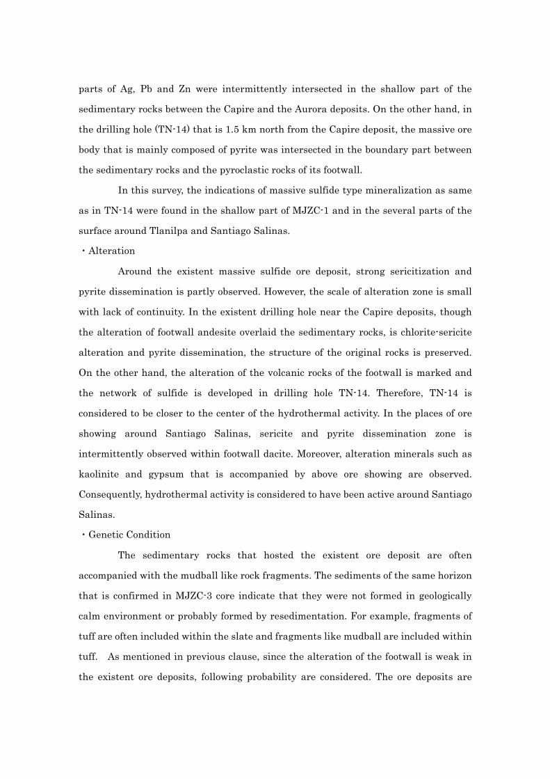
Fig. Ⅰ-4-2 Geological model of Aurora area ・・・・・・・・・・・・・・・・・・・・・・・・・・・ 21
Fig. Ⅰ-5-1 Location map of promising districts ・・・・・・・・・・・・・・・・・・・・・・・・・・ 27
Fig. Ⅱ-1-1 Schematic stratigraphic column of Aurora area ・・・・・・・・・・・・・・・ 57
Fig. Ⅱ-1-2 Geological map of Aurora area・・・・・・・・・・・・・・・・・・・・・・・・・・・・・・・ 59-60
Fig. Ⅱ-1-3 Geological section of Aurora area ・・・・・・・・・・・・・・・・・・・・・・・・・・・・ 61-62
Fig. Ⅱ-1-4 Location map of rock and ore samples ・・・・・・・・・・・・・・・・・・・・・・・ 63-64
Fig. Ⅱ-1-5 Location map of ore showings ・・・・・・・・・・・・・・・・・・・・・・・・・・・・・・ 65-66
Fig. Ⅱ-1-6 Geological map of Santiago Salinas area ・・・・・・・・・・・・・・・・・・・・・ 67-68
Fig. Ⅱ-1-7 Geological section of Santiago Salinas area ・・・・・・・・・・・・・・・・・・・ 69
Fig. Ⅱ-1-8 Stereographic projection ・・・・・・・・・・・・・・・・・・・・・・・・・・・・・・・・・・ Appendix
Fig. Ⅱ-1-9 Sketch map of mineralized outcrop in Santiago Salinas area ・・・ 71
Fig. Ⅱ-1-10 Schematic stratigraphic column of Rancho Viejo area・・・・・・・・ 73
Fig. Ⅱ-1-11 Geological map of Rancho Viejo area ・・・・・・・・・・・・・・・・・・・・・・・ 75-76
Fig. Ⅱ-1-12 Geological section of Rancho Viejo area・・・・・・・・・・・・・・・・・・・・・ 77
Fig. Ⅱ-1-13 Sketch map of mineralized outcrop in Rancho Viejo area ・・・・・ 79
Fig. Ⅱ-1-14 Harker diagram ・・・・・・・・・・・・・・・・・・・・・・・・・・・・・・・・・・・・・・・ Appendix
Fig. Ⅱ-1-15 Discrimination diagram ・・・・・・・・・・・・・・・・・・・・・・・・・・・・・・・・ Appendix
Fig. Ⅱ-1-16 Spidergram ・・・・・・・・・・・・・・・・・・・・・・・・・・・・・・・・・・・・・・・・・・・ Appendix
Fig. Ⅱ-1-17 Result of X-ray diffraction ・・・・・・・・・・・・・・・・・・・・・・・・・・・・・・・・ 81-82
Fig. Ⅱ-1-18 Result of fluid inclusion test ・・・・・・・・・・・・・・・・・・・・・・・・・・・・・・ 83
Fig. Ⅱ-1-19 Result of isotope analysis(δ18O and δ13C) ・・・・・・・・・・・・・・・・・ 87
Fig. Ⅱ-2-1 Scatter diagram of major elements・・・・・・・・・・・・・・・・・・・・・・・・・・・ 106
Fig. Ⅱ-2-2 Histogram of alteration index ・・・・・・・・・・・・・・・・・・・・・・・・・・・・・・ 107
Fig. Ⅱ-2-3 Distribution map of alteration index ・・・・・・・・・・・・・・・・・・・・・・・・ 108
Fig. Ⅱ-2-4 Scatter diagram of minor elements ・・・・・・・・・・・・・・・・・・・・・・・・・・ 109
Fig. Ⅱ-2-5 Histogram of As・・・・・・・・・・・・・・・・・・・・・・・・・・・・・・・・・・・・・・・・・・・・ 110

Fig. Ⅱ-2-6 Distribution map of As ・・・・・・・・・・・・・・・・・・・・・・・・・・・・・・・・・・・・・ 111
Fig. Ⅱ-2-7 Histogram of Ba ・・・・・・・・・・・・・・・・・・・・・・・・・・・・・・・・・・・・・・・・・・ 112
Fig. Ⅱ-2-8 Distribution map of Ba ・・・・・・・・・・・・・・・・・・・・・・・・・・・・・・・・・・・・ 113
Fig. Ⅱ-2-9 Histogram of Cu ・・・・・・・・・・・・・・・・・・・・・・・・・・・・・・・・・・・・・・・・・・ 114
Fig. Ⅱ-2-10 Distribution map of Cu ・・・・・・・・・・・・・・・・・・・・・・・・・・・・・・・・・・ 115
Fig. Ⅱ-2-11 Histogram of Pb ・・・・・・・・・・・・・・・・・・・・・・・・・・・・・・・・・・・・・・・・ 116
Fig. Ⅱ-2-12 Distribution map of Pb ・・・・・・・・・・・・・・・・・・・・・・・・・・・・・・・・・・ 117
Fig. Ⅱ-2-13 Histogram of Zn ・・・・・・・・・・・・・・・・・・・・・・・・・・・・・・・・・・・・・・・・ 118
Fig. Ⅱ-2-14 Distribution map of Zn ・・・・・・・・・・・・・・・・・・・・・・・・・・・・・・・・・・ 119
Fig. Ⅱ-2-15 Histogram of S ・・・・・・・・・・・・・・・・・・・・・・・・・・・・・・・・・・・・・・・・・・ 120
Fig. Ⅱ-2-16 Distribution map of S ・・・・・・・・・・・・・・・・・・・・・・・・・・・・・・・・・・・・ 121
Fig. Ⅱ-2-17 Distribution map of each element ・・・・・・・・・・・・・・・・・・・・・・・ Appendix
Fig. Ⅱ-2-18 Distribution map of principal factor 2 ・・・・・・・・・・・・・・・・・・・・・ 122
Fig. Ⅱ-2-19 Distribution map of geochemical anomaly zones ・・・・・・・・・・・ 123-124
Fig. Ⅱ-2-20 Spectral chart ・・・・・・・・・・・・・・・・・・・・・・・・・・・・・・・・・・・・・・・・ Appendix
Fig. Ⅱ-2-21 Result of spectral analysis ・・・・・・・・・・・・・・・・・・・・・・・・・・・・・・ 125-126
Fig. Ⅱ-3-1 Location map of drilling survey ・・・・・・・・・・・・・・・・・・・・・・・・・・・・・ 142
Fig. Ⅱ-3-2 Drilling site location of MJZC-1 ・・・・・・・・・・・・・・・・・・・・・・・・・・・・ 143
Fig. Ⅱ-3-3 Drilling site location of MJZC-2 ・・・・・・・・・・・・・・・・・・・・・・・・・・・・ 144
Fig. Ⅱ-3-4 Drilling site location of MJZC-3 ・・・・・・・・・・・・・・・・・・・・・・・・・・・・ 145
Fig. Ⅱ-3-5 Geological columnar section(MJZC-1) ・・・・・・・・・・・・・・・・・・・・・・・ 146
Fig. Ⅱ-3-6 Geological columnar section(MJZC-2) ・・・・・・・・・・・・・・・・・・・・・・・ 150
Fig. Ⅱ-3-7 Geological columnar section(MJZC-3) ・・・・・・・・・・・・・・・・・・・・・・・ 153
Fig. Ⅱ-3-8 Geological section of drilling survey ・・・・・・・・・・・・・・・・・・・・・・・・・ 157
List of Tables
Table Ⅱ-1-1 Result of microscopic observation ・・・・・・・・・・・・・・・・・・・・・・・・・・ 88
Table Ⅱ-1-2 Result of ore grade assay ・・・・・・・・・・・・・・・・・・・・・・・・・・・・・・・・・ 91
Table Ⅱ-1-3 Result of X-ray diffraction ・・・・・・・・・・・・・・・・・・・・・・・・・・・・・・・・・ 92
Table Ⅱ-1-4 Result of fluid inclusion test ・・・・・・・・・・・・・・・・・・・・・・・・・・・・・・・ 95
Table Ⅱ-1-5 Result of isotope analysis(δ18O and δ13C) ・・・・・・・・・・・・・・・・・ 96
Table Ⅱ-1-6 Result of radiometric age determination(Ar-Ar method) ・・・・ Appendix
Table Ⅱ-2-1 Result of chemical analysis for rock samples ・・・・・・・・・・・・・・ Appendix
Table Ⅱ-2-2 List of statistic data for chemical analysis・・・・・・・・・・・・・・・・・・・ 127
Table Ⅱ-2-3 Correlation coefficient of minor elements ・・・・・・・・・・・・・・・・・・・ 128
Table Ⅱ-2-4 Result of principal factor analysis ・・・・・・・・・・・・・・・・・・・・・・・・・・ 129
Table Ⅱ-2-5 Result of spectral analysis・・・・・・・・・・・・・・・・・・・・・・・・・・・・・・・ Appendix
Table Ⅱ-3-1 List of drilling equipment ・・・・・・・・・・・・・・・・・・・・・・・・・・・・・・・・・ 163
Table Ⅱ-3-2 List of used diamond bits and consumption goods・・・・・・・・・・・・ 163
Table Ⅱ-3-3 Drilling summary ・・・・・・・・・・・・・・・・・・・・・・・・・・・・・・・・・・・・・・・・ 164
Table Ⅱ-3-4 Drilling schedule ・・・・・・・・・・・・・・・・・・・・・・・・・・・・・・・・・・・・・・・・ 167
Table Ⅱ-3-5 Result of laboratory tests for core samples ・・・・・・・・・・・・・・・・・・ 168
Table Ⅱ-3-6 Result of chemical analysis for core samples・・・・・・・・・・・・・・・ Appendix
List of Plate
1. Geological map of Aurora and Rancho Viejo area (1:25,000)
2. Location map of rock and ore samples (1:25,000)
3. Location map of ore showings (1:25,000)
4. Distribution map of geochemical anomaly zones (1:25,000)
5. Result of spectral analysis (1:25,000)
6. Geological columnar section (1:200)

Part Ⅰ The General
Chapter 1 Introduction
1-1 The Background and Objective of the Survey
The Zacualpan area in the United Mexican Sates, target area for the survey, is of
high potential for the massive sulfide deposits containing polymetallic ore, similar type of
the Japanese Kuroko ore deposits. The Consejo de Recursos Minerales, (hereafter noted as
CRM) has aggressively conducted some exploration programs for the area in the past. The
Mexican government requested the Japanese government to survey for mineral resources
in the Zacualpan area.
The Japanese government responded to the request and decided to conduct an
exploration program to locate some potential zones for gold, silver, copper, lead and zinc
minerals of the massive sulfide and other types of ore deposits. The program was planed to
survey the geology and mineral occurrences in the field and to analyze those results.
1-2 Conclusions and Recommendation of the First Year
1 Conclusions
The regional geological survey, total survey line 500 kilometers and geological
description for the existing drilling cores, total logging length 4,000 meters, have been
performed in this year’s program.
The geological succession of the area is the Tejupilco Schist, Villa Ayala Formation,
Acapetlahuaya Formation and calcareous sedimentary rocks of the Teloloapan and
Pachivia Formations in the Guerrero terrene and the Morelos Formation of the Mixteco
terrene and overlain Cenozoic Balsas and Tilzapotla Rhyolite Formations and intrusive
rocks.
The Tejupilco Schist is mainly composed of weakly metamorphosed muddy to
sandy rocks accompanied with a small amount of green schist. The Villa Ayala Formation
consists mainly of basaltic to andesitic volcanic and pyroclastic rocks such as massive lava,
pillow lava, autobrecciated lava to pillow-breccia and hyaloclastite, and its upper part
contains alternation beds of a little salic andesite to dacite lava, tuff, slate, calcareous
sedimentary rocks. The Acapetlahuaya Formation is composed of mainly alternation beds

of well-bedded slate and sandstone and a small amount of calcareous sedimentary rocks.
The calcareous sedimentary rocks are mainly composed of black phyllite and foliated slate,
accompanied with sandy tuff or conglomerate and dark grayish muddy limestone, which
ranges from thin beds or lenses, several centimeters in thickness, to some large rock bodies,
1 to 2 kilometers in width in some places. The Morelos Formation consists mainly of
grayish black to grayish white massive limestone. It is stratified with thin beds of slate to
shale, or accompanied with thin beds and lenses of chert, 1 to 20 centimeters in thickness,
in some places. The Balsas Formation is mainly composed of reddish brown conglomerate.
The Tilzapotla Rhyolite Formation mainly consists of rhyolitic to dacitic pyroclastic rocks.
The intrusive rocks bodies are distributed in various sizes and the rocks are of rhyolite to
dacite and andesite.
The rocks of Guerrero terrene consisting of Tejupilco Schist, Villa Ayala and
Acapetlahuaya Formations and calcareous sedimentary rocks, has undergone the strong
deformation of folding and thrust faulting due to the Laramide orogeny. This kind of
deformation has not occurred in the Morelos Formation of the Mixteco terrene and
Cenozoic formations.
The mineralization in the area is of the massive sulfide ore and Tertiary vein-type
ore.
The massive sulfide deposits and mineral occurrences in the area are distributed
in the Aurora and Mamatla districts. That of the Mamatla district is in the footwall bed of
the ore horizon, seemingly in the pathway of rising hydrothermal solution. The ore horizon
is situated at the uppermost part of the green volcanic rocks of the Villa Ayala Formation.
It has been accordingly clarified that the ore horizon is of simultaneous deposition with the
alternation beds of a little acidic volcanic rocks and muddy to calcareous sedimentary
rocks.
Some vein-type ore deposits have been mined around Zacualpan, however only
two mines are in small-scale operation at present. Some vein-type mineral occurrences
have been seen in the existing drilling cores, however it is judged that the potential for high
grade and large-scale deposits is low in the area.

2 Recommendation for the Second Year’s Program
The distribution of the ore horizon and the geological environment of the massive
sulfide ore deposits have been revealed by the first year’s program. It is geologic
structurally assumed that the rocks of the ore horizon deposited in a specific environment,
however the details of these still remain unknown due to several times of strong
deformations by folding and thrust faulting. It is possible to assume that some kinds of
chemical elements (e.g.Pb, Zn, Ba, As, etc) have been concentrated in as geochemical halos
in the simultaneously deposited sedimentary rocks. Accordingly, it is possible to select
high-potential zones by more detailed geological and rock-geochemical surveys for the
alternation zones of the hanging wall volcanic and sedimentary rocks near the
mineralization centers.
Also it is possible to reveal the detailed geology by a drilling program of a few
hundred meters long within the hanging wall horizon and it will clarify especially the
details of the depth of the ore horizon, the state of the mineralization and alteration of the
footwall rocks. Furthermore, it will be able to perform a more reliable potential appraisal
for the area by an integrated analysis combined with results of the proposed surface survey
programs.
A geophysical (e.g. IP) survey program is useful to presume the sizes of the
potential targets afterward.
The following surveys are recommended in order of high priority.
1. Detailed geological and geochemical surveys in the hanging wall area.
2. Survey of structural drill holes in the hanging wall area (e.g. the Aurora district).
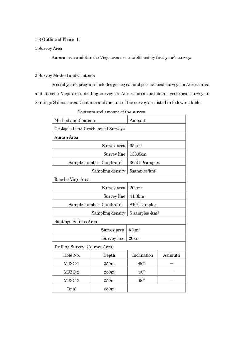
1-3 Outline of Phase Ⅱ
1 Survey Area
Aurora area and Rancho Viejo area are established by first year’s survey.
2 Survey Method and Contents
Second year’s program includes geological and geochemical surveys in Aurora area
and Rancho Viejo area, drilling survey in Aurora area and detail geological survey in
Santiago Salinas area. Contents and amount of the survey are listed in following table.
Contents and amount of the survey
Method and Contents Amount
Geological and Geochemical Surveys
Aurora Area
Survey area 65km2
Survey line 133.8km
Sample number(duplicate) 365(14)samples
Sampling density 5samples/km2
Rancho Viejo Area
Survey area 20km2
Survey line 41.3km
Sample number(duplicate) 81(7) samples
Sampling density 5 samples /km2
Santiago Salinas Area
Survey area 5 km2
Survey line 20km
Drilling Survey(Aurora Area)
Hole No. Depth Inclination Azimuth
MJZC-1 350m -90° -
MJZC-2 250m -90° -
MJZC-3 250m -90° -
Total 850m

List of Laboratory Tests
Contents Amount Geological Survey(Aurora area,Rancho Viejo area ) ①Thin section ②Polish section ③Ore assay ④X-ray diffraction ⑤Ar-Ar dating ⑥Fluid inclusion(with salinity) ⑦Isotope( δ13C, δ18O on carbonate) ⑧Isotope(δ18O on silicate) ⑨Chemical analysis(REE+HFSE+LIL) (Ag,Ba,Ce,Co,Cr,Cs,Cu,Dy,Er,Eu,Ga,Gd,Hf,Ho,La,Lu,Mo,Nd,Ni,Pb, Pr,Rb.Sm,Sn,Sr,Ta,Tb,Th,Tl,Tm,U,V,W,Y,Yb,Zn,Zr)
45 45 15
100 3 15 6 30 45
Geochemical survey(Aurora area,Rancho Viejo area ) ①Rock chip Chemical analysis(Au+AASICP, 34 elements) (Ag,Al,As,B,Ba,Be,Bi,Ca,Cd,Co,Cr,Cu,Fe,Ga,Hg,K,La,Mg,Mn,Mo,Na, Ni,P,Pb,S,Sb,Sc,Sr,Ti,Tl,U,V,W,Zn,Au) ②Whole rock (major element, XRF) ③Spectral analysis
446
(duplicate21)
425 210
Drilling survey(MJZC-1, MJZC-2, MJZC-3) ①Thin section ②Polish section ③Ore assay ④X-ray diffraction ⑤Whole rock (major element, XRF) ⑥Fluid inclusion(with salinity) ⑦Isotope( δ13C, δ18O on carbonate) ⑧Isotope(δ18O on silicate) ⑨Chemical analysis(REE+HFSE+LIL) (Ag,Ba,Ce,Co,Cr,Cs,Cu,Dy,Er,Eu,Ga,Gd,Hf,Ho,La,Lu,Mo,Nd,Ni,Pb, Pr,Rb.Sm,Sn,Sr,Ta,Tb,Th,Tl,Tm,U,V,W,Y,Yb,Zn,Zr)
15 15 15 15 15 3 3 3 3
3 Participant Member List of the Survey
Members participating in the field survey in Mexico are as follows.
Survey team
Japanese side
Shigehisa Fujiwara Head of survey team, Dowa Engineering co. ltd
Kazuyuki Ueda Dowa Engineering co. ltd

Hiroshi Jingu Dowa Engineering co. ltd
Mexican side
Ing. Gerardo Mercado Pineda CRM
Ing. Arturo Ruiz Ortiz CRM
Ing. Enrique Ontiveros Escobedo CRM
Ing. Carlos Bon Aguilar CRM
Supervisor in Mexico
Nobuaki Ishikawa Mineral Resources Survey Department, MMAJ
Masayoshi Itoh Representative of Mexico City office, MMAJ
4 Period of the Survey
Field survey was carried out as follows.
Whole term stayed in Mexico:
September, 16, 2002 ~ November, 26 , 2002
Field survey term:
September, 23, 2002 ~ November, 13 , 2002
Analysis and compilation of field data
November, 14 , 2002 ~ November, 20 , 2002
Drilling survey term:
October, 3 , 2002 ~ November, 15 , 2002

Chapter 2 Geography of Survey Area
2-1 Location and Access
The Zacualpan area is situated to the southwest of Mexico city, in Guerrero and
Mexico states. Principal villages in the survey area are Zacualpan, Ixcateopan Ixcapuzalco
and Teloloapan having population 16,000 is the largest village around the area, to the
south of the survey area. Base camps for the survey have been set at Teloloapan and
Zacualpan. The survey area is situated in the administrative districts of the above village
names.
Access to Teloloapan from Mexico City is possible in three hours by vehicles
through the highway via Iguala. To reach Zacualpan from Mexico city, it is possible to use
the highway through Toluca, taking the same hours. An outline of the access is shown as
follows.
200km 65km
Mexico city ------------ Iguala ------------- Teloloapan
2 hours 1 hour
A branch paved road from Highway No.51 connects Teloloapan and Ixcapuzalco.
Other paved roads from the northeast of the survey area to Zacualpan and from the east to
Ixcateopan are available. There exist other gravel roads connecting each village, but it will
become hard to use those roads in rainy season.
2-2 Topography, Climate and Vegetation
The survey area is geographically in the Sierra Madre del Sur (Raiz 1959) and
included in the Balsas-Mexcara sub-province near by the Neo-volcanic axis.
The northern area is in a high altitude area and shows many steep V-shape
valleys, but its altitude is getting lower toward south. The topography in the southern area
shows relatively gentle low land area. The Sultepec River in the west end of the area is 700
meters in lowest altitude and Cerro Tentacion to the south of Zacualpan is 2,710 meters,
highest in the area.
The drainage systems in the area are divided into three, separated by the

Cerro Tentacion. The Sultepec River system occupies about 60 percent of the whole survey
area and rivers running down to the southwest from the watershed have been formed in
the system area. The Los Sabinas River system occupies the southeast part of the survey
area and rivers running down to the south and southeast have been formed. The San Jose
River system occupies about 10 percent of the whole area at the northeast end and rivers
running down to the east have been formed. These systems constitute branches of the
Balsas River.
The climate in the area is of tropical to subtropical and its rainy season is from the
end of June to October, dry season from November to May. The average annual rainfall is
1,100 to 1,400 millimeters and the average temperature is 18℃ in Zacualpan.
The vegetation in the area is dominated by tall weeds in the lowland area, lower
than 1,800 meters in altitude. Some cornfields are partly seen there. In the highland area,
pine and oak trees grow scarcely.
2-3 Infrastructures
Electricity, communication and medical facilities are satisfactory available in
Teloloapan, one of our base campsite and two major bank offices are situated in the village.
Three gas service stations are located along Highway No.51. In the other villages in the
area, electricity and communication facilities are available, but no bank and gas station are
available. Satellite communication facilities are available in some small villages and
mobile telephones are useable along almost all roads and mountain or hill ridges.
The road networks are generally well developed, but almost all roads are not
paved and difficult to transit in the rainy season. It will be usual that all roads, except
major ones, blocked everywhere in July and August.
Chapter 3 Outline of Geology
3-1 Outline of Geology
Some regional geological survey programs have been conducted in the area by
some investigators such as Fries (1960), De Cserna (1965 and 1978) and Campa et al.,
(1974) and some geological frameworks for the region have been established. Campa et al.,
(1974, 1978 and 1979), specially, proposed a development history model of the geological
structure for an area named “Tierra Caliente” based on description of volcano-sedimentary
rocks of the Ixtapan de la Sal area. Coney and Campa (1987) and Sedlok et al., (1993)
proposed classifications of geological structure zones (Fig.Ⅰ-3-1) for the whole area of
Mexico respectively. The survey area of this report corresponds to the boundary between
the Guerrero Terrene and Mixteco Terrene, based on the classification by Coney and
Campa (1987).
De Cserna and Fries (1983), Guerrero et al., (1990, 1991 and 1993), and Elias and
Sanchez (1992) demonstrated a very detailed stratigraphic succession and a development
history of the geological structure for the volcano-sedimentary rock area. CRM has started
survey programs for massive sulfide ore deposits hosted in the volcano-sedimentary rocks
in the area, as a part of “Eje Neovolcanico” project in 1979 for the
Tlanilpa-Mamatla-Azulaquez area. Recently Valerie Gold Resources Ltd. was carried out
mineral exploration on Mamatla property in 1994-1998.
The survey area is situated in the Teloloapan terrene constituting part of the
Guerrero terrene and the Mixteco terrene in the eastern survey area, based on the regional
geological structure zone classification.
The stratigraphic succession in the Teloloapan terrene side is the Tejupilco
Schist, Villa de Ayala Formation (metavolcanic and sedimentary rocks), Acapetlahuaya
Formation, Amatepec Formation (simultaneous difference phase with Acapetlahuaya) and
overlying Teloloapan and Pachivia Formations, from the bottom. The Mixteco terrene is
consists of the Morelos and Mexcala Formations. These Formatios are unconformablly
covered by the Balsas Formation and Tilzapotla Formation of Tertiary age, Cuernavaca
Formation of Pliocene and alluvial sediments.

The Guerrero terrene has undergone the Laramide orogeny in early Tertiary time
(Salinas et al., 1994) and shows ductile deformation, isoclinal folding and thrust faulting
extending north to south. Generally it shows an east vergence. On the contrary, the
Mixteco terrene shows no ductile deformation, and it is said that the terrene has undergone
compaction stress from east to west.
A fault group trending northwest to southeast appears in this area after the
Laramide orogeny. It is possible that this fault group has been formed in a tension field
from northeast to southwest. Vein type ore deposits nearby Zacualpan are hosted in this
fault group.
3-2 History of Mining in the Area
A private company was aggressive for mining activity for the Azulaquez massive
sulfide deposit in the area from 1915 to 1920, and it is said that the Aurora, Capire, San
Francisco, Guadalupe, Cruz Blanca and San Antonio deposits were developed at that time
(Ochoa et al., 1985). These mines were closed because of deletion of ore reserves.
Peñoles Company conducted a geophysical and drilling program in this district in
1975, but they withdrew from the Azulaquez district.
La Campana Company operated the Rey de Plata mine, about 10 kilometers
southwest of Teloloapan, applying open-pit and underground mining methods from 1946 to
1949. The main target was silver. Afterward, Peñoles conducted a drilling and
underground adit exploration program from 1975 to 1991 and confirmed around 2,000,000
tons of massive sulfide ore reserve after 24,000 meters drilling. Recently Industria Peñoles
S.A. de C.V. Dowa Mining Co., Ltd. and Sumitomo Corporation started operation of Ray de
Plata mine in October 2,000 at a rate of 3,000tones per month. But it was suspended
because of low price of Zn in December 2001.
In Zacualpan, many vein type ore deposits of silver, lead and zinc have been
developed since the Spanish colony time, however only the Cuchara and La Alacrán mines
are in 350 tons a day operation by El Provenir de Zacualpan S.A. de C.V. at present.
Chapter 4 Integrated Discussion of Survey Result
FigureⅠ-4-1 and FigureⅠ-4-2 show the integrated interpretation map
and geological model of Aurora area respectively.
4-1 Characteristics of Mineralization and Geological Structure
・Geological Structure
Zacualpan area is included in Guerrero terrain as the province of geological
structure. There are some characteristics in the formation that consists of Guerrero
terrain. One is that the formation has undergone the regional deformation as a result
of Laramide orogeny in early Tertiary. Another characteristic is that it is accompanied
with massive sulfide ore deposits such as the Tizapa, the Rey de Plata and other ore
deposits.
The geology of the Aurora and the Rancho Viejo areas are mainly composed of
the rocks of the late Jurassic to the middle Cretaceous. The area consists of Villa Ayala
Formation that is composed of volcanic rocks partly includes sedimentary rocks and
the Pachivia Formation of calcareous sedimentary rocks and volcanic rocks that
conformably overlain the former Formation.
The Villa Ayala Formation mainly consists of andesitic volcanic rocks. In the
Aurora area, it includes large quantities of dacitic volcanic rocks and sedimentary
rocks. The existent Capire and Aurora deposits occur within the sedimentary rocks
formed in the late stage of volcanic activity of the Villa Ayala Formation. After the
formation of ore deposits, the regional deformation occurred and the geology around
the area is markedly formed in block by developed overturned folding, thrust and fault
structure in the EW and NW directions.
・Mineralization
The existent massive sulfide ore deposits in Aurora area are mainly lenticular
ore bodies with lack of continuity. They are hosted in the alternation of slate, limestone
and tuff. The common characteristics of the minerals of these ore deposits are rich in
Au, Ag, Pb and Zn, and are accompanied with comparatively much quantity of sulfate
minerals (gypsum, baraite). By the past drilling survey, comparatively high grade
parts of Ag, Pb and Zn were intermittently intersected in the shallow part of the
sedimentary rocks between the Capire and the Aurora deposits. On the other hand, in
the drilling hole (TN-14) that is 1.5 km north from the Capire deposit, the massive ore
body that is mainly composed of pyrite was intersected in the boundary part between
the sedimentary rocks and the pyroclastic rocks of its footwall.
In this survey, the indications of massive sulfide type mineralization as same
as in TN-14 were found in the shallow part of MJZC-1 and in the several parts of the
surface around Tlanilpa and Santiago Salinas.
・Alteration
Around the existent massive sulfide ore deposit, strong sericitization and
pyrite dissemination is partly observed. However, the scale of alteration zone is small
with lack of continuity. In the existent drilling hole near the Capire deposits, though
the alteration of footwall andesite overlaid the sedimentary rocks, is chlorite-sericite
alteration and pyrite dissemination, the structure of the original rocks is preserved.
On the other hand, the alteration of the volcanic rocks of the footwall is marked and
the network of sulfide is developed in drilling hole TN-14. Therefore, TN-14 is
considered to be closer to the center of the hydrothermal activity. In the places of ore
showing around Santiago Salinas, sericite and pyrite dissemination zone is
intermittently observed within footwall dacite. Moreover, alteration minerals such as
kaolinite and gypsum that is accompanied by above ore showing are observed.
Consequently, hydrothermal activity is considered to have been active around Santiago
Salinas.
・Genetic Condition
The sedimentary rocks that hosted the existent ore deposit are often
accompanied with the mudball like rock fragments. The sediments of the same horizon
that is confirmed in MJZC-3 core indicate that they were not formed in geologically
calm environment or probably formed by resedimentation. For example, fragments of
tuff are often included within the slate and fragments like mudball are included within
tuff. As mentioned in previous clause, since the alteration of the footwall is weak in
the existent ore deposits, following probability are considered. The ore deposits are

formed in distal place from the center of mineralization by the property of the
sedimentary rock embedded ore body. Or they are considered to be formed by
resedimentation of ore body with the sedimentary rocks with high probability.
・Vein Type Mineralization
There are metalliferous vein type ore deposits in the northern part of the
Aurora area. The main components of the ore are Ag, Pb and Zn as same as massive
sulfide type. The difference of metalliferous vein ore between the massive sulfide ore is
poor in Ba and accompanied with As minerals. The homogenization temperature of
fluid inclusions in each ore deposit is considered to have been consisted of a single
population and not to have been affected by late hydrothermal solution and
metamorphism. Therefore, the metalliferous veins with the NW direction were formed
by the hydrothermal activity that was the same origin of veins of Zacualpan in Tertiary.
The mining target of and around the existent ore deposits is considered to have been
the high Ag grade part, because the analysis result of 2,700g/ton for Ag in waste of the
San Carlos deposit was reported (CRM). Many ores show hydrothermal brecciated
structure and are accompanied with quartz and amethyst as gangue.
・Comparison to the ore deposits in neighboring region
Guerrero terrain, including the Zacualpan area, includes many indicates of
massive sulfide ore deposits that resembles to kuroko deposit such as the Tizapa and
the Rey de Plata ore deposit and also ore showings like the Aurora area. These ore
deposits and the ore showings were formed in the last stage of andesitic submarine
volcanic activity, and commonly occur covered or accompanied by muddy sediments.
The grades of ores are similar and mainly composed by Au, Ag, Pb and Zn. The
different point is that the ores of the Rey de Plata ore deposit and the Aurora area
contain much sulfate minerals (gypsum, barite). On the other hand, the ores of the
Tizapa less contain these minerals.
The occurrence of the ore bodies vary depends on the areas. The main ore
deposit in the Tizapa occurs between greenschist and graphitic phyllite, on the other
hand, in the Rey de Plata it occurs among green volcanic rocks with thin sedimentary
rock layers. The Aurora deposit occurs within the alternation of sedimentary rocks.
The common point, however, all the three deposits are complicatedly folded by the
cause of regional metamorphism.
Though the alteration of the footwall is not markedly developed like the
Hokuroku area of Japan, it is generally accompanied by distinct sericitization and
pyrite dissemination.
The estimated ore reserves of the Tizapa are 10 mt and the Rey de Plata is 2.0
mt. The ore reserve of the Tizapa in which the hanging wall of mudstone bed is
developed well, is bigger than that of the Rey de Plata.
The progress of the survey is as follows: At first, the exposed lenticular ore body was
observed in slate of the hanging wall side in the Tizapa ore deposit. Then the existence
of the ore body was mainly confirmed by drilling survey around the exposed ore body.
In the Rey de Plata ore deposit, prospecting was carried out firstly around the outcrop
of alteration zone that was accompanied by high grade Ag. After that the massive ore
body was found through expanding the survey area by drilling survey. In the Aurora
area, since the lenticular ore body was already confirmed, the progress of prospecting
is expected by almost same process in the Tizapa ore deposit.
4-2 Mineralization and the Result of Geochemical Survey
The anomaly area of each rock facies that is shown by alteration index (more
than +1σ of average) obtained from bulk rock chemical analysis of major elements are
widely distributed from the Capire to the Cruz Blanca deposit around the existent ore
showings in the Aurora area. Although the distribution of the alteration zone of the
marked outcrop is limited, the area that is shown by alteration index is wide. The area
can be considered as the halo of the mineralization. The other anomaly zones are
sporadic, however, it reflects the alteration in some degree except the samples from the
ridge that is provably reflect the weathering.
The anomaly zone of alteration index distribute in the direction from the
south to the north is observed in a part of the northwestern Rancho Viejo area.
Same trace elements behavior well reflects the metalliferous vein type
mineralization. That is, the plus anomalies of As, Zn, Pb and Cd are marked and Ba

shows minus anomaly. Regards the mineralization of massive sulfide mineral, As and
S forms comparatively wide halo. As regards the other elements, Au, Ag, Ba, Pb and Sb
are possible to reflect the alteration related to the mineralization in the limited
condition. The elements other than the above elements may reflect the original rock
facies or it is difficult to estimate the mineralization process since most of them cannot
to be detected.
Principal component analysis was carried out in order to make general
evaluation of the mineralization. The geochemical anomaly of the second principal
component (high load of As, Pb, Ag, Au, S, Sb, Mo) that is considered to reflect the
mineralization was extracted in the vicinity of the La Campana, the southern Velixtla,
the Santiago Salinas and the Capire to the Aurora II deposits, respectively.
4-3 Potential for Ore Deposit
The massive sulfide type ore deposits of Guerrero terrain occur in the upper
part of green volcanic rocks. They are commonly covered with sedimentary rocks. This
survey revealed that the distribution of the sedimentary rocks that is considered as the
hanging wall of the ore deposits in the Aurora area.
Considering the distribution zone of hanging wall, ore showings, alteration
zone and geochemical anomaly zones, the south part of Santiago Salinas, surrounding
of La Campana and north of Capire are prospective districts for massive sulfide
mineralization in the area. Moreover, prospecting has not performed yet in those areas.
For the surrounding of La Campana, in other words, there is thick hanging
wall alternation of slate and tuff, accompanied by altered rock fragment, and
geochemical anomalies are concentrated there. The alteration with pyrite
dissemination is recognized in schistose volcanic rocks of the footwall.
In the Santiago Salinas, the network of mineralization is observed within
footwall dacite overlaid sedimentary rock, where Ba contents shows approximate 1
percent and is accompanied with geochemical anomaly and alteration with sericite,
gypsum and kaolinite. Therefore, if the mineralization of Pb, Zn and other sulfide
minerals becomes predominant toward the south, the possibility of existence of

massive sulfide type ore deposit becomes higher.
By observing the marked geochemical anomaly, the north of Capire is
considered to be close to the center of mineralization. This area is considered to be
worth to carry out the prospecting. Particularly, the layered pyrite ore body that was
intersected by drilling hole (TN-14) in the vicinity of the mineralization indicate area
of Tlanilpa is expected to be converted to kuroko type deposit toward the east that
the sedimentary rocks of the hanging wall becomes thicker.

ZN:133ZN:133ppmppm, Ba:1.01%, Ba:1.01%ZN:133ppm, Ba:1.01%
ZN:337ZN:337ppmppm, Ba:401, Ba:401ppmppmZN:337ppm, Ba:401ppm
Pb:0.20%, Zn:4.82%, Ba:34Pb:0.20%, Zn:4.82%, Ba:34ppmppmPb:0.20%, Zn:4.82%, Ba:34ppm
Zn:71Zn:71ppmppm, Ba:467, Ba:467ppmppmZn:71ppm, Ba:467ppm
35
70
80
60
85
Sedimentary Rocks(Us, Ms, Ust, CFm, CFv)
Alteration Index (>M+1 )
S (>M+1 )
PC2 (<M 1 )

Chapter 5 Conclusions and Recommendation
5-1 Conclusions
Following surveys are carried out in second year: The geological and
geochemical survey in the Aurora area and the Rancho Viejo area, the detail geological
survey in the Santiago Salinas area and three drilling survey in the Aurora area.
The geology of the Aurora area is composed of the Villa Ayala Formation, the
Pachivia Formation and intrusive rocks.
The Villa Ayala Formation is composed of schistose volcanic rocks (Lsh),
schistose sedimentary rocks (Lss), andesites (Va1~Va6, Vam), dacite (DCw, DCe, DCn,
DCc, Vad) and sedimentary rocks (Us, Ust, Ms).
The Pachivia Formation consists of the layers (CFm) that are mainly
composed of slate and volcanic rocks (CFv).
The geological structure is complicatedly controlled by the folding and fault
structures whose axis is NNE to NNW with the gently inclined cleavage. As a whole,
andesite Va-1 is located in the central part and sedimentary rocks surround it, the
outsides of the sedimentary rocks andesites Va-2~Va-5 are distributed. Dacite rock
bodies are distributed in the south west and south east of the area and schistose
volcanic rocks and sedimentary rocks occupy in the corner of the northwestern part of
the area. The Pachivia Formation is distributed in a belt with the direction of north
to the south in the eastern part of the area. The Formation dips westward in
appearance, but the horizon is judged to be overturned by the fossil age and the folding
pattern.
There are massive sulfide type ore deposit and metalliferous vein type ore
deposit as the mineralization of the Aurora area. Within the above massive sulfide ore
deposit, the Capire, the Aurora and the Manto Rico ore deposit occur within the
sedimentary rocks of the upper part of the Villa Ayala Formation. On the other hand,
the Guadalupe and the Cruz Blanca deposit occur within the uppermost part of the
Pachivia Formation. These ore deposits are relatively rich in Pb, Zn, Ag and Ba. As a
result of this year’s survey, the Santiago Salinas district and the La Campana district
were found as the place of ore showing. The detail geological survey was carried out in

the Santiago Salinas district and confirmed the horizon of occurrence of massive
sulfide ore deposit.
Based on the geochemical survey, the zone that shows more than +1σ of
average alteration index of each rock facies is considered to reflect the halo of the
alteration related to the massive sulfide alteration. It became obvious that there are
high possibility of that Ag, As, Zn, Pb, Cd and Ba as the trace elements to the
indication elements for metalliferous vein type and Au, Ag, As and S as the indication
elements for massive sulfide type ore deposit are effective. Besides the above, principal
component analysis can extract the anomaly related to the mineralization in the La
Campana, the south of Velixtla, the Santiago Salinas and around the Capire to the
Aurora deposits.
The horizon of massive sulfide ore deposit was observed in the shallow part of
the drilling hole MJZC-1. Sulfide network was also observed within the footwall dacite.
This horizon continues to the place of mineralization indicate of Tlanilpa and the
drilling hole TN-14 that was already drilled. Drilling hole MJZC-2 intersected volcanic
rocks that develop schistosity. Though the volcanic rocks show strong pyrite
dissemination, the horizon of these volcanic rocks were judged to be lower than the
horizon of massive sulfide ore deposit. Drilling hole MJZC-3 intersected the
sedimentary rock that is the same as the host rocks of the Capire and the Aurora
deposit were observed in the depth of 149.5 meters. The weak pyrite dissemination and
mineralized rock fragments were sampled in the same depth. Under the sedimentary
rock, andesite lava of the Villa Ayala Formation that corresponds to andsite Va-4 of the
surface was observed.
The geology of the Rancho Viejo area is composed of the Villa Ayala Formation,
the Pachivia Formation.
The Villa Ayala Formation is composed of basalt to andesitic rocks (Va) and
dacite (Vd). The quantity of the dacite is less than that in the Aurora area.
The Pachivia Formation is composed of basalt to andesitic tuff (CFv),
limestone (CFL), slate (CFs), and alternation of tuff and slate (CFt).
As the geological structure, cleavage with the direction of NNE~NNW
develops as same as in the Aurora area, it shows that the folding structure in the NNE
~NNW direction is dominant. The dip of the strata is west in appearance and the
strata is generally overturned.
Though alteration accompanied with mineralization is observed in several
places, all of them were small scale and the zones were limited.
Geochemical anomaly zones of alteration index are outlined in part of the
northwestern district of the Rancho Viejo area by geochemical survey.
Considering the above facts, the north of Capire district, the Santiago Salinas
district and La Campana district in the Aurora area, are considered to be the
prospective zones for ore deposit (shown in figure 1-5-1), since those districts have
thick distribution of hanging wall, geochemical anomaly and remarkable ore showing.
Although the distribution of the horizon of massive sulfide ore deposit and the
hanging wall were developed in Rancho Viejo area, ore showing and marked
geochemical anomaly are rarely observed. Consequently, the potential for ore deposit is
considered to be small in the Rancho Viejo area.

5-2 Recommendation for the Third Year’s Program
The distribution of sedimentary rocks related with massive sulfide deposits
(Capire deposit, Aurora deposit, etc.), ore showings, alteration zone and these
relationships have been revealed by the second year’s program. Distribution pattern of
specific elements that indicate mineralization and geochemical characteristics in the
surveyed area was outlined by geochemical survey.
The previous exploration data that was obtained in this survey, showed the
existence of unexplored districts such as Santiago Salinas, La Campana and north of
Capire deposit districts.
Massive sulfide type mineralization is expected in Santiago Salinas district
where is underlain by hanging wall sediments and alteration occurred in footwall
dacite accompanying mineralization (Ba:1%).
There is little previous exploration in La Campana district located in the west
of Manto Rico deposit, due to private mining concession. But, this survey has defined
geochemical anomaly, ore showings and ore horizon in the district. Moreover, Drilling
hole MJZC-2 encountered footwall alteration and mineralization which are correspond
to the exposure in the creek situated to the west of Otates. Therefore, Massive sulfide
ore body is expected in the depth of 200-300m below the surface between Manto Rico
deposit and La Campana.
Exploration program must be advanced in north of Capire deposit district
where exhibits geochemical anomaly and alteration zone, and is expected the
continuation of mineralization intersected hole TN-14. Since the previous drilling did
not confirm the ore horizon below thick sedimentary rocks, the deep drilling program is
desirable.
As mentioned above, farther investigations must be recommended in the
followings prospective districts to confirm continuation of mineralization and ore
horizon.
1. Santiago Salinas district
2. La Campana district
3. North of Capire deposit district

ZN:133ZN:133ppmppm, Ba:1.01%, Ba:1.01%ZN:133ppm, Ba:1.01%
ZN:337ZN:337ppmppm, Ba:401, Ba:401ppmppmZN:337ppm, Ba:401ppm
Pb:0.20%, Zn:4.82%, Ba:34Pb:0.20%, Zn:4.82%, Ba:34ppmppmPb:0.20%, Zn:4.82%, Ba:34ppm
Zn:71Zn:71ppmppm, Ba:467, Ba:467ppmppmZn:71ppm, Ba:467ppm
35
70
80
60
85
Sedimentary Rocks(Us, Ms, Ust, CFm, CFv)
La Campana area
Capire area
Santiago salinas area
Alteration Index (>M+1 )
S (>M+1 )
PC2 (<M 1 )
Pert II Detailed Discussion
Chapter 1 Geological Survey
1-1 Survey Method
The survey route lines have been set up in the Aurora and Lancho Viejo areas
after study of existing geological data. The topographic maps scaled 1:10,000 enlarged
from existing maps scaled 1: 50,000 have been used for the route mapping, and GPS
has been utilized for confirmation of position.
The principal subject of the survey is to make clear its geological classification,
geological structure, and the state of alteration and mineralization. The mineralized
zones and outcrops have been surveyed by a simple method, and specific important
outcrops have been sketched 1:100 to 1:200 in scale and recorded in photographs. The
survey results have been summarized in a geological map scaled 1:25,000. The
proposed detail survey district, Santiago Salinas, has been summarizes in a rout map
scaled 1:10,000 and geological map.
The specimens of all typical rock types and facies, mineralized occurrences,
and alteration zones have been taken to make clear their mutual relations. Microscopic
observation of rock thin sections and polished ore samples, powder X-ray diffraction
analysis, fluid inclusion analysis, isotopic analysis, age dating, and chemical analysis
for rocks and ore minerals have been conducted to integrate with the geological survey
results.
1-2 Survey result
1 Aurora Area
Aurora Area is situated near by the center of the Zacualpan area and is
divided by a watershed running north to south in the center of the district. The
western part belongs to the Sultepec River system, and the principal part is in the
Paso del Carizo River and its branches. The altitude of the east end of the district is
1,050 meters along the Paso del Carizo River. The area from Otates to the south shows
gentle topography, but other areas are in rugged terrain. The maximum relative height
from the river level is 500 meters in the northern district.

The eastern part belongs to the Los Sabinas River system. The topography of
the part is generally rugged, and its altitude increases to the northeast, reaching to
2,200 meters in Tecolote, the northeast end of the district.
The principal villages are Otates, Pericones, Tlanilpa, Santiago Salinas,
Aurora, and Azulaquez, but they are all small municipalities.
(1) Geology
Figures II-1-1 to II-1-5 show schematic columnar section, geological map,
cross section, location map of samples, and location map of mineral occurrences. The
Aurora area is underlain by the Villa Ayala Formation, Pachivia Formation, and
intrusive rocks.
(i) Villa Ayala Formation
The formation is composed of schistose volcanic rocks (Lsh), sedimentary
rocks (Lss), andesitic rocks (Va-1 to Va-6, Vam), dacitic rocks (DCw, DCe, DCn, DCc,
Vad), sedimentary rocks (Us, Ust, Ms), and intrusive rocks (Dio)
(a) Schistose Volcanic Rocks (Lsh)
The rocks are distributed in the northwestern end of the district, northwest of
Otates. Schistosity and foliaton planes are well developed in the rocks. Green schist
rich in chlorite and quartz-sericitic schist rich in sericite appear alternatively. The
sericitic schist sometimes gradually changes from green schist, being accompanied by
pyrite, and some of them are formed by alteration from green schist. It is possible that
some green schist rocks are originated from andesitic rocks due to presence of vitric
materials and plagioclase relics. Under the microscope, some epidote and chlorite are
seen as principal minerals being accompanied by calcite and opaque minerals.
They gradually change from schistose sedimentary rocks (Lss) with
alternation zones in their boundary.
(b) Schistose Sedimentary Rocks (Lss)
The rocks distributed from around Otates in the northwestern district to the
junction of the Paso del Carizo River and El Manto Stream to the south-southeast.
They are composed of alternations of black slate, quartzose sandstone, and tuff, several
tens centimeters to several meters in thickness. They apparently contain large
amounts of sericite or muscovite, and show some crenulation folding. They are in some
places being accompanied by thin layers containing large amounts of hematite, several
millimeters in thickness. Under the microscope, sandstone contains large amounts of
quartz grains, and small amounts of feldspar fragments and calcite with less amount
of groundmass.
(c) Andesitic Rocks (Va-1to Va-6, Vam)
The rocks are distributed in the central district as several separated bodies.
・Va-1 is distributed around El Copal as a mass extending northwest to southeast. The
rock facies is of green to grayish green and yellowish-grayish green pyroxene andesite.
They are composed of massive lava, autobrecciated lava, lapilli tuff to hyaloclastite,
and breccia. Schistosity is seen in some edges of the body, but the rocks are generally
massive, and well preserve the source original texture. The bodies situated to the west
of the Tlanilpa and Capire deposits tend to be enriched by plagioclase phenocrysts,
grading to dacitic rocks. Under the microscope, they are mainly composed of chlorite
and calcite, being accompanied by small amounts of epidote and opaque minerals, and
to be judged propylite. Rocks showing porphyritic texture are olivine-bearing pyroxene
andesitic.
・Va-2 is distributed in an area to the north of the Manto Rico deposit in the northern
district. The rocks mainly consist of tuffs enriched in green vitric material,
autobrecciated lava showing porphyritic texture and lapilli tuff to tuff breccia. The
tuffs show relatively well developing schistosity and foliaton. The rocks in the upper
stream of the El Manto River contain black mad balls, several meters in diameter.
Under the microscope, the rocks are judged altered rocks mainly consisting of chlorite,
calcite, and opaque minerals being accompanied by plagioclase and epidote.
・Va-3 is distributed in an area from San Carlos to the Yerba Buena deposit, and the

ridge area conforming watershed in the central northern district, The rocks are mainly
composed of schistose tuff and porphyritic pyroxene andesite lava, but they form
alternation of andesitic to dacitic lapilli tuff and tuff breccia. The tuff presents in two
different types, one containing green vitric fragments and another rich in coarse
plagioclase fragments. Under the microscope, the tuff shows clear cleavage texture,
mainly consisting of some altered minerals such as quartz, chlorite, sericite, and
calcite, being accompanied by plagioclase relics and small amounts of epidote and
opaque minerals.
・Va-4 is distributed in the central southern district, in a zone from the Capire deposit
to Metlixtapa. The rocks are grayish green containing small to medium amounts of
plagioclase phenocrysts, and show slightly unclear autobrecciated texture. Schistosity
is weak. Under the microscope, augite and plagioclase are seen. Some metamorphic
and altered minerals such as chlorite, calcite, and small amounts of epidote and
opaque minerals are seen.
・Vam is distributed in the middle stream area to the southeast of Santiago Salinas in a
belt zone, apparently below Va-4. They are grayish to greenish gray silty tuff, being
accompanied by mud balls and several layers of thin muddy beds, several tens meters
in thickness, and mud balls.
・Va-5 is distributed as a layer in a dacite body. The rock distributed along the Paso del
Carrizo River shows autobrecciated texture, being accompanied by thin layers of
mudstone and tuff. Others are of tuff containing green vitric fragments, and show
schistosity.
・Va-6 is distributed as thin layers in dacite bodies in the northeastern and southern
districts. The rocks are fine-grained schistose green tuff.
(d) Dacitic Rocks (DCw, DCe, DCn, DCc)
The rocks are distributed in the southeastern and southwestern districts as
relatively large-scale bodies, and in the northwestern and central districts as
small-scale bodies.
・DCw is distributed in the southwestern district, showing gray to greenish gray, and

being accompanied by several percent of plagioclase phenocrysts. Schistosity tends to
obvious to the north. In the southern part, the rocks show elongated lenticular texture,
10 to 30 centimeters in diameter, in some places. The rocks around andesite Va-5 to the
northwest of Santiago Salinas show black vitric parts in some places and aqueous
autobrecciated texture.
・DCe is distributed in the southeastern district. The rocks show grayish green, being
rich in vitric material in many cases. They are mostly pyroclastic rocks contain several
percent of plagioclase phenocrysts, and mainly consist of small amounts of accidental
rock fragments such as andesite and silicified altered rocks. The rocks alternate with
sedimentary rocks in the rim of rock bodies, and contain mud balls of slate in Cruz
Blanca. Under the microscopic observation of specimens taken in the northeast of
Metlixtapa, porphyritic quartz, calcite, and plagioclase phenocrysts altered to sericite
are seen in the altered fine-grained vitric groundmass.
・DCn is distributed from the Manto Rico deposit to La Campana in the northwestern
district. The rocks are grayish green, schistose, and vitric, containing plagioclase
phenocrysts. The lower parts are graded to alternation with slate.
・DCc is distributed from Velixtla in the northern district to the Capire deposit in the
central, consisting three layers. The rocks are vitric lava to tuff rich in plagioclase
phenocrysts, showing some schistosity. They show grayish white in weathered parts,
but grayish green in fresh parts. They are accompanied by thin layers of andesite and
muddy rocks in the lower part to the south of Velixtla.
・Vad is mainly composed of dacite as well as DCw, being accompanied by andesite thin
layers. Under the microscope, the intercalated andesite is judged altered andesite
containing plagioclase phenocrysts and small amounts of augite, being seen chlorite,
epidote, and opaque minerals.
(e) Sedimentary Rocks (Us, Ust, Ms)
The rocks are composed of alternations of slate, limestone, tuff, and breccia.
Us is named for those distributed in the central district, Ust in the northwestern
district, and Ms in the southern district.
・Us is the host unit for the Aurora I and II deposits, and Capire deposit. The rocks are
mainly composed of layered gray limestone and black slate, being accompanied by
vitric tuff and lapilli tuff. Schistosity and small folding structure are significant in the
rocks, and tuff containing some mud balls; siliceous rock (chart?) lenses are seen
around the ore deposits. Schistosity is seen in the limestone, and some recrystallized
fossil bearing beds are seen near by MJZC-1 drill hole.
・Ust is of alternation zones of slate and tuff. The slate is tuffaceous, changing its color
to gray due to weathering in some places. The La Campana Occurrence is in Ust.
・Ms consists of alternations of slate and limestone, being accompanied by tabular
layers of mineralized siliceous breccia in lapilli size, 10 to 30 centimeters in thickness.
Cleavage is well developed in the rocks, and some folding structure is significant.
Several mineral occurrences are in DCw covered by Ms.
(ii) Pachivia Formation
The calcareous sedimentary rocks distributed in the eastern Aurora area are
correlated to the Pachivia Formation in the Cuernavaca Quadrangle due to their
continuity. The rocks in the district are composed of layers of slate (CFm) and volcanic
rocks (CFv).
・CFm is distributed in the eastern district extending north to south. Also they are in
Velixtla in the northern end and in C. Pena Colorada in the southern end, covering
mountain tops in small areas. They are composed of well-foliated black slate, limestone
layers mainly consisting of calcareous slate, and andesitic tuff. The limestone strata
are variable in the thickness, and poor in continuity. They show a kink folding
structure, boudinage of thin limeston layers, and recrystallized fossil rich layers.
・CFv is distributed around Azulaquez extending north to south. They are generally
dark green to grayish green autobrecciated andesite to basalt and breccia contain
fragments of andesite to basalt, dacite and slate. The rock facies of the autobrecciated
lava is of pyroxene andesite, and basaltic rock rich in gas cavity and poor in
phenocrysts. Under the microscope, the autobrecciated rocks around Azulaquez are
andesite containing augite and hornblende phenocrysts, and calcitization and
chloritization of the rocks are slightly strong.
(iii) Intrusive Rock (Dia)
The rocks are distributed in a stream to the northwest of the Yerba Buena
deposit. The rocks are dark green andesite or micro-diorite. A small outcrop is exposed
in a mountain road near the Aurora deposit, but its relation with surrounding rocks is
unknown. It is supposed to be intrusive rock, because no schistosity is seen in the rocks.
Under the microscope, it is judged pyroxene andesite, and most of pyroxene crystals
have undergone alteration, only remaining their pseudomorph. They are accompanied
by small amounts of pyrite in many cases.
(2) Structural Geology
Significant foliation has been developed in the rocks of the Aurora area. It is
supposed that this is due to the Laramide Orogeny of the early Tertiary (Salinas, 1994
etc.), and this extends all over the Guerrero terrene.
The foliation planes are extensive as penetrative cleavages in the fine-grained
tuff, and their principal folding structures are parallel to the penetrative cleavages
plane. From the field observation of the rock facies distribution, penetrative cleavage,
bedding plane, and folding structure, it is thought that there exist a southwesterly
inclined overturned anticline structure to the southeast of Santiago Salinas and a pair
of overturned anticline and syncline structures to the southeast of the drill hole
MJZC-3.
The tendency of structure has been investigated through a stereo projection of
the penetrative cleavages and bedding planes (Figure II-1-8).
The most of cleavages in the schistose volcanic rocks (Lsh) and sedimentary
rocks (Lss) in the northwestern district show of low angle and dispersion. The bedding
planes tend to incline to the east-northeast, but are dispersed as well as the cleavage.
It is supposed that this probably reflect undulation due to the late stage bending fold.
Although a few measurement data are available in the area from the Manto
Rico deposit to Velixtla, but the cleavages strike east-northeast and dip to the

northwest, and concentrate to low angle. The strike tends to change to the east to west,
to the west-northwest. The bedding planes have same tendency as that of the
cleavages, and generally reflect the bending fold having axis of northwest.
In Santiago Salinas, the cleavages tend to concentrate to the northwest strike
and southwest dip, based on few measurement data. The bedding planes tend to
concentrate to the northwest strike and the southwest gentle dip, and the east to west
strike and the north dip. It is thought that there exists isoclinal holding showing the
northwest trending axis.
The penetrative cleavages of the volcanic rocks (Va-3, Dce, DCn) in the
northeastern and southeastern districts gently dip to west, and its strike shifts from
the north-northwest system to the north to south system, and to the east-northeast to
system. The bedding planes and cleavages of the sedimentary rocks (Us) tend to show
the northeast strike and the west dip. It is supposed that this area has undergone
affect of the northwest extending bending fold.
The Pachivia Formation in the eastern district shows same tendency as that
of above-mentioned volcanic rocks, possibly being affected by the northwest extending
bending fold.
(3) Mineralization and Alteration
The massive sulphide type and vein type mineralization and alteration are
recognized in this district.
(i) Massive Sulfide Type
There exist the Manto Rico, Capire, Aurora I&II, Guadalupe (Salitre Grande),
and Cruz Blanca as the massive sulphide type deposits, and the Tlanilpa as mineral
occurrence. In the Santiago Salinas area, several massive sulphide type mineral
occurrences and alteration zones have been confirmed in this survey.
(a) Manto Rico Deposit
The deposit is situated in the upper stream area of the El Manto Stream in

the northwestern district. Two adits can bee seen both sides of the stream, but it is
supposed that the left bank zone would be its active area in the past because of
existence of some waste dump mounds. An adit orienting N15°E is recognized, even it
has been buried at present, and a layered mineralized zone of pyrite is found in an
outcrop. The host rock is of an alternation of slate and fine-grained tuff. No significant
alteration zone exists.
The geological structure there shows generally inclines to the north. From
lower to upper, cherty lenses, tuff containing some mud balls, dacite (DCn), and
andesitic tuff (Va-2) lie on the upper part. Some cleavages gently inclining to the west
are seen there, and the strata have been bended. In the down stream area, a slate
dominant zone contains some pyrite thin layers.
The sample taken from an outcrop of the mineral occurrence contains only
pyrite grains, but some sample from the waste dump shows 500 ppm Ag and 53.1 % Ba
in the assay result, indicating to be barite ore. The ore constitute minerals are
sphalerite, tetrahedrite, and small amounts of galena, pyrite, and chalcopyrite.
(b) Capire Deposit
The Capire and Aurora (I) deposits are near the mountain ridge in the central
district, the former on the western side and the latter on the eastern side, about 500
meters apart. In the Capire deposit, a buried shaft and small-scale adits exist along
east to west extending ridge. It is thought that the host rocks of the mineral are an
alternation of calcareous slate and tuff containing mud-balls. The footwall is of the
dacite rich in plagioclase phenocrysts (DCc) and andesitic lava (Va-1). Weak pyrite
dissemination is seen in the tuff, but its alteration zone is small-scale. The assay result
of a black ore-type waste rock sample shows 1,900 ppm Ag, 36.7 % Ba, 12.7 % Zn, and
5.09 % Pb. Large amounts of sphalerite and medium amounts of tetrahedrite, galena,
and pyrite have been confirmed in their polished sections. Framboidal and colloform
texture are seen in the pyrite ore.
(c) Aurora (I) Deposit

A submerged inclined shaft exists nearby a junction of streams in the mine
area. An apparent hanging wall andesite partly contains strong dissemination and
films of euhedral pyrite. Large amounts of sphalerite, medium amounts of pyrite and
galena, small amounts of tetrahedrite, and rare of chalcopyrite have been confirmed in
the polished section of an ore sample taken from the waste dump.
(d) Aurora (II) Deposit
The deposit is situated in a small stream one kilometer southeast of the
Aurora (I) deposit. A collapsed adit exists there, and a part of ore body is exposed at the
entrance of the adit. The host rock is an alternation of dominant black slate and
fine-grained tuff, and the ore body is of stratabound, several tens centimeters in
thickness, extending south to north, dipping 20 degrees to the west, in the alternation
bed. The fine-grained tuff has undergone sericitization, but no significant alteration
zone is associated.
The ore shows a banded structure of black fine-grained sulphide layers and
white layers. The assay result of the ore is 18.7 % Ba, 2.36 ppm Au, 133 ppm Ag, 7.94 %
Zn, 1.28 % Pb. In the polished section, ore minerals are large to medium amounts of
sphalerite, medium amounts of pyrite, and small amounts of tetrahedrite, and the
white part consists of barite, gypsum, and feldspar.
(e) Guadalupe Deposit
The Guadalupe (Salitre Grande) deposit is situated to the south of Salitre
Grande Village in the eastern district, and collapsed adit, shaft and waste dump are
found in both sides of a stream running east to west. The rocks distributed in the area
are slate, lapilli tuff, tuff containing mud-balls. The rocks have partly undergone weak
alteration of silicification and argillization mainly consisting of sericite, but its
alteration zone is narrow.
Ores seen in the waste dump are of massive kuroko type ore, barite rich ore,
and slightly layered ore, etc. The assay result of the massive kuroko type ore is 45.2 %
Zn, 7.51 % Pb, 310 ppm Ag, 0.856 % Cu, 0.55 ppm Au. In the polished section, large
amounts of sphalerite, medium to small amounts of pyrite, galena, and tetrahedrite
have been confirmed. The tetrahedrite is mainly accompanied by galena. Pyrite from a
dump ore sample showing layered structure partly shows framboidal and colloform
textures.
(f) Cruz Blanca Deposit
The deposit is situated in the eastern side of a mountain ridge, one kilometer
south of the Guadalupe deposit, and west of Azulaquez Village. Collapsed shaft, adit,
and waste dump are seen in a wide spread area. The area is underlain by stratified tuff
and partly containing mud-balls like slate. In an outcrop nearby the adit in the
western end area, an outcrop of fine-grained kuroko type ore, 20 meters thick, is seen
in the tuff. Its apparent strike and dip are N 30゜E and 40゜N, but the other parts
show variable in dip. Some outcrops of gossan due to pyrite dissemination are seen all
over the place. The area has undergone weak argillization and partly silicification.
It has been confirmed that a part of the dump ores is of massive, siliceous, and
chalcopyrite bearing. The assay result of the ore from the outcrop shows 24.3 % Zn,
9.51 % Pb, 126 ppm Ag, 1.61 % Ba, and 0.36 % Cu. Under the microscope, the minerals
of the massive ore and fine-grained ore consist of large amounts of sphalerite, medium
amounts of pyrite and galena, and small amounts of tetrahedrite and chalcopyrite, and
furthermore very small amounts of bornite and covelline. Recrystallization of minerals
due to metamorphism has been recognized.
(ii) Vein Type
Vein type mineralized and altered products are seen in the northern
district. The Yerba Buena and San Carlos deposits, and the Velixtla South and some to
the north of Manto Rico deposit have been already known.
(a) Yerba Buena Deposit
The deposit is situated to the north of Salitre Grande Village in the
northeastern district. A submerged adit oriented southeast and waste dumps exist
along a stream. Slate is exposed around the adit, and a hydrothermal brecciated quartz
vein, 1 to 2 meters width, is exposed extending northwest. Some high grade lead and
zinc ores are seen in the dumps. Quartz veins extending N 60゜W and N 80゜W have
been confirmed along a stream about 750 to 1,000 meters northwest of the mine site.
These are possible continuation of the vein in the known mine site.
The assay result of the ore taken from the dump shows 3.46 % Zn, 5.2 % Pb,
116 ppm Au. Pyrite, arsenopyrite, and sphalerite are principally seen, being
accompanied by small amounts of galena and minor amounts of chalcopyrite in the
polished section of the outcrop ore and waste.
(b) San Carlos Deposit
The deposit is situated around 2 kilometers north-northeast of Tlanilpa
Village in the northern end of the district. Collapsed old mine site exists on a mountain
ridge extending north to south. A submerged adit exists along a stream. The area is
underlain by greenish vitric tuff, lapilli tuff, and andesite (Va-3), with intersecting
white quartz veinlets trending north-northeast and northwest in these rocks.
No sample has been assayed in this survey, but CRM has reported assay
result of 2,700 g/t Ag for a sample from this site.
(c) South of Velixtla
Pyrite dissemination and stockwork are seen along some roads and at the
dead end of the upper stream of the El Manto. The veinlets extend northwest and
west-northwest. In the polished section of four specimens, the ores consist mainly of
slightly coarse-grained pyrite, and are accompanied by arsenopyrite or sphalerite and
minor amounts of chalcopyrite.
(d) North of Manto Rico
A vein consisting of calcite, sphalerite, and galena has been confirmed at the
bend point of the El Manto Stream in the andesite (Va-2). It is 50 centimeters in width,
extending east to west and dipping to the south. In the polished section, the ore is
composed of medium amounts of sphalerite, small amounts of pyrite, galena, and
chalcopyrite, and very small amounts of marcasite. The chalcopyrite disease in
sphalerite has been observed.
(iii) Other Mineral Occurrences
The mineral occurrences of La Campana and Otates NW are situated in the
northwestern corner of the district.
(a) La Campana
The occurrence is situated in an outcrop along a road to the northwest of C. La
Campana Mountain. There remained a small-scale excavation. The occurrence is in the
uppermost zone of an alternation of slate and dacitic tuff (Ust). Sulphide mineralized
and silicified fragments in the tuff and a pyrite lens associated with a fissure trending
northwest in the slate are seen. In the polished section of the pyrite lens, the gangue
minerals are filled openings of pyrite aggregation, and some pyrite aggregations form
clots. It is thought that the occurrence is of overlapping of massive sulphide type and
vein type mineralization.
(b) Otates NW
The occurrence is situated on the left bank of a stream running down to the
southwest in the northwestern corner of the district. The area is underlain by schistose
green volcanic rocks (Lsh). The schistose rock around the occurrence is grayish due to
sericitization. Sulphide lenses, several tens centimeters thick, continue intermittently
for several meters long, parallel to the schistosity plane dipping gently to the west.
Some malachite stains are partly seen. In the polished section, the ore consists of
mainly pyrite, being accompanied by small amounts of chalcopyrite filling open spaces
of pyrite grains and cracks.
2 Santiago Salinas Area (detailed survey area)
The district is situated to the southwest of the Aurora Area, occupying the
upper stream of the Paso del Carizo River. Many branch rivers run into the Paso del
Carizo.
(1) Geology and Geological Structure
The district is underlain by the dacite (DCw) and (Vad), occupying about 60
percent of the area, sedimentary rocks (Ms), andesitic rocks (Va-5, Va-6, Vam), and
sedimentary rocks (CFm) of the Pachivia Formation covering a part of the southern
ridge.
The dacite (DCw) is grayish green in their fresh parts, and consisting of large
amounts of vitric groundmass and small amounts of plagioclase phenocrysts. The rocks
are supposedly to be lavas showing lenticular structure, several to several tens
centimeters in length, but partly tuffaceous to the west and south of Santiago Salinas,
probably being autobrecciated-rock. Cleavages, trending north-northwest and gentle
dipping to the west, are significantly developed in the rocks.
The sedimentary rocks (Ms) are of alternations of slate and limestone, and
they have very fluctuated thickness. They also form rhythmical alternations with
lapilli tuff to breccia, to the southeast and south of Santiago Salinas. Their strike and
dip are fluctuated as shown in their random distribution, but their cleavages mostly
dip gently to the west or north, forming folding axis planes.
The andesitic rocks (Va-5) are distributed to the west of Santiago Salinas as
intercalated beds (50 to 60 centimeters in thickness) in the dacite. Weak
autobrecciated structure is seen, showing grayish green in color. They are accompanied
by several beds of mudstone with 10 to 20 centimeters thick, and tuffaceous parts in a
stream to the west of Santiago Salinas. The beds show northwest strike and dip to the
northeast, and their recognized cleavage planes dip to the south to west, therefore both
structures intersect each other.
Va-6 is distributed in the dacite at the northeastern end and southern part of
the district. The rocks are schistose green tuff.
Vam is partly distributed on a ridge in the eastern district. The rocks are
andesitic tuff being accompanied by thin beds of mudstone.
Vad is mainly composed of dacite, being accompanied by thin layers of
andesite. It is possible to be correlated to DCw.
(2) Structural Geology
The geological structure of the whole area of Santiago Salinas is controlled by
an anticline structure having northwest trending axis as shown in the distribution
pattern of the sedimentary rocks (Ms). The strata steeply incline to the northeast in
the southeast of Santiago Salinas, and tend to be gentle dip to the east. In the southern
area, they incline gently to the south to southwest. Accordingly, the upper horizon is
exposed in the east, and the lower horizon is exposed in the west.
(3) Mineralization and Alteration
The mineralized and altered zones confirmed in the survey are situated in the
zone to the northwest of Santiago Salinas (Santiago-NW), to the southeast of Santiago
Salinas (Santiago-SE), and to the south of Santiago Salinas (Santiago-S).
(a) Santiago-NW
The mineralized zone has been confirmed in both sides of a stream in different
forms. That on the right bank (northwestern bank) is a mudstone bed, several
centimeters thick, containing silicified breccias with disseminated fine-grained pyrite
in the dacite. In the polished section, disseminated micro-grained pyrite occurred in
groundmass. The main assay result of the rock is 162 to 337 ppm Zn, and 239 to 401
ppm Ba. That on the left bank (southeastern bank) is a sulphide stockwork in the
dacite. In the polished section, it contains aggregation of fine-grained pyrite, but no
other mineral. The main assay result is 1.00 ppm Ag, and 158 ppm Ba.
(b) Santiago-SE
The mineralized zone has been confirmed in the dacite overlain by an
alternation of slate and lapilli tuff as a stockwork of fine-grained pyrite. The alteration
zone of gossan spreads in the dacite around the mineralized zone. Under the

microscope, no other mineral is confirmed rather than large amounts of pyrite. The
main assay result is 4.85 ppm Ag, 121 ppm Pb, and 154 ppm Zn.
(c) Santiago-S
The alteration zone has been confirmed in three points along a stream
running south to north. They are accompanied by sulphide dissemination and
stockwork in the dacite overlain by alternations of slate and tuff, and belong in a same
series. They are also stratigraphically correlated to Santiago-SE; therefore it is
possible to be continuous occurrence. The main assay result shows, 1.01 % Ba, and 133
ppm Zn.
3 Rancho Viejo Area
The area is situated in the central south part of the Zacualpan area. This area
is corresponded to the upper stream of the Los Sabinas River drainage system. The
Sabinas River runs from north-northwest through the central part of the district. Its
branches are in an east-west system. The topography is generally gentle, and its
altitude is between 1,400 and 1,700 meters. The principal villages in the district are
Tierra Colorada in the northwest, Amate Amarillo in the northeast, Rancho Viejo in
the west, and Tenangillo in the east.
(1) Geology
The district is underlain by volcanic rocks of the Villa Ayala Formation and
overlaying sedimentary and volcanic rocks of the Pachivia Formation.
(i) Villa Ayala Formation
The formation is composed of basalt to andesite (Va), and dacite (Vd).
(a) Basalt to Andesite (Va)
The rock occupies about one third of the whole area in the western district.
The rocks are grayish green to dark green, showing autobrecciated and pillow breccia

to hyaloclastite facies, being accompanied by inclusions and thin layers of calcareous
mudstone. The rock facies is fine-grained aphanitic, and in some cases changes from
that of containing small amounts of plagioclase and pyroxene phenocrysts to
coarse-grained porphyritic. They contain many gas cavities, and show amygdaloidal
textures in the pillow breccia parts. Under the microscope, pseudomorph of mafic
minerals and plagioclase phenocrysts are seen in the fine-grained groundmass.
(b) Dacite (Vd)
The rock exists as a mass, several tens to 200 meters thick and several
hundreds meters long, in the basaltic to andesitic rocks (Va). They contain some
amounts of plagioclase phenocrysts, and their groundmass is grayish green to dark
green and vitric. Cleavage planes developed in their vitric groundmass, and the
boudinage is seen due to accumulation of hard porphyritic lenses. Under the
microscope, small amounts of plagioclase phenocrysts are seen in the altered vitric
groundmass.
The Villa Ayala Formation apparently dips to the west, and trends
north-northeast or north-northwest. A small folding structure recognized in the
hyaloclastite thin bed is a syncline showing overturned sense, showing N 10゜W strike
and 30゜west dip.
(ii) Pachivia Formation
The formation is composed of basaltic to andesitic tuff (CFv), limestone (CFL),
slate (CFs), and alternation of tuff and slate (CFt).
(a) Basaltic to Andesitic Tuff (CFv)
The rock is extensively distributed in the central to northern district. The
most of them is rich in andesite to basalt lapilli, being accompanied by small amounts
of fragments of dacite, calcareous slate, and calcareous sandstone. Its little
groundmass is calcareous. It gradually changes to a thin bed of autobrecciated lava to
hyaloclastite. Intercalated thin bed contains some slate and tuff showing clear bedding
and foliation in many cases.
The foliation is not clear in some brecciated part, but intercalated
sedimentary layers unclearly show the north-northwest and the north-northeast
trends and west and east dips. The trend of cleavages is about same as that of the
layers, but its dip is stably west. The axis of the folding structure in outcrop is
coincident to the cleavage plane.
(b) Limestone (CFL)
The rock is distributed in the eastern and southeastern district. The outcrop
along the Sabinas River in the southeastern district is gray, brecciated and slightly
schistose limestone. The bodies distributed in a north to south extending in the eastern
edge of the district are of alternations with tuff and slate, and some foliation planes
and bedding planes are seen.
(c) Slate (CFs)
The rocks mainly composed of slate (CFs), are distributed around Tierra
Colorada in the northwestern district, extending north to south. The rock mainly
consists of well-foliated black slate, being accompanied by thin layers of sandstone, tuff,
and basaltic autobrecciated lava. The stratum shows the north-northeast strike and
west dip, and the cleavages show the same.
(d) Alternation of Tuff and Slate (CFt)
The rock is distributed around Tierra Colorada in small-scale in the
northwestern district. The rock is dominated by tuff, but generally consists of
alternations of black slate and dacitic tuff, several centimeters to several tens
centimeters in thickness, and andesitic hyaloclastite.
Small folding structure gently dipping to the west and other folding structure
bending cleavage planes and bedding planes exist. The stratum shows the
north-northeast strike and west dip, rarely east dip.

(2) Structural Geology
The distribution pattern of the strata in the whole area of Lancho Viejo is in
the systems trending north to south and north-northwest. In the central south district,
a left lateral fault of northwest to southeast system exists between the Villa Ayala and
Pachivia Formations.
A set of isoclinal anticline and syncline showing north-northwest trend exist
in Amate Amarillo and the Los Sabinas River in the central district.
In a stereo project study, the cleavage planes are concentrated to an area of
north to south strike and west gentle dip, and the bedding planes show same tendency,
but some northeast dip and southeast dip planes also exist.
The dips of the bedding and cleavage generally show westward, and the Villa
Ayala Formation apparently overlies the other formations. However, it is thought that
existence of an overturned folding made this appearance from the following view
points, (1) no thrust fault exists there, (2) the sedimentary material of the Pachivia
Formation contains volcanic fragments from the Villa Ayala Formation, (3) the
limestone of the Pachivia Formation contains middle Cretaceous fossils, (4) the
existence of overturned folding showing the axis of westward dip.
(3) Mineralization and Alteration
No significant mineralized and altered zone exists there, but some small-scale
ones have been confirmed in the Tierra Colorada Stream, Tenangillo River, and small
streams to the south and north of Cerro de Zacahuixtepec in the northern district.
(a) Tierra Colorada Stream
A small-scale hydrothermal pyrite-sphalerite vein, 5 centimeters in width, has
been confirmed in between the Villa Ayala Formation and Pachivia Formation on the
down stream area of the Tierra Colorada (Figure II-1-13). A stockwork gossan and
sulphide exist in the andesitic hyaloclastite body, but no alteration affect extends to the
surroundings. The assay result of the ore is 4.8 % Zn, but no other indication for useful
element. Under the microscope, large amounts of brecciated pyrite and small amounts
of sphalerite filling spaces of breccias are seen. The colloform texture is recognized in
the pyrite and sphalerite.
A sericitized and pyrite disseminated zone has been confirmed in the dacitic
tuff overlain by a dacite body in the upper stream area, but its continuity is poor.
Some sulphide stockwork occurrence with reddish gossan has been also
confirmed in the dacite lava (JR-10) in the same area. Under the microscope, only
pyrite dissemination is seen.
(b) Tenangillo River
A weakly mineralized zone of lenticular and disseminated pyrite has been
confirmed in the slightly fine-grained tuff of the Pachivia Formation in this area.
Under the microscope, only pyrite is seen, but no mineralization extends to the
surroundings.
(c) Cerro de Zacahuixtepec (north of Tierra Colorada)
A sericitized and gossan zone has been confirmed in a small stream to the
south of Cerro de Zacahuixtepec, but its continuity is poor. In a small stream to the
north, some pebbly pyrite is contained in the slate. Under the microscope, some
framboidal and colloform textures remain. It is possible to be sedimentary origin,
because fine-grained pyrite dissemination is seen in between the pebbles.

4 Result of laboratory test (Petrologic chemical assay, X-ray powder diffraction
analysis, fluid inclusion test, isotopic analysis, radioactive age determination)
(1) Petrologic Chemical Assay
Major and minor elements of specimens of typical rock facies have been
assayed, and their petrologic characteristics have been investigated. The assay result
is shown in a table together with geochemical assay result. The result of the
investigation is shown in Figure II-1-14 to Figure II-1-16 in the appendix of the report
as the discrimination diagram, Harker diagram, and spidergram.
(a) Major Elements
In the K2O-SiO2 plot, the volcanic rocks belong to medium K type, and partly
high K type. In the FeO/MgO-SiO2 plot, the most andesite and dacite belong to
calc-alkali type, but the schistose green rock and andesite specimens from drilling
cores are plotted in the tholeiite field.
The schistose sandstone (Lss) is potted in the passive margin field, and
sedimentary rocks from the drilling cores (Us) and (CF) from the Rancho Viejo area is
plotted in the continental arc to active continental margin field.
(b) Minor Elements
In the chondrite normalized pattern diagram, all specimens tend to down to
the right. The characteristic depletion of Nb and Ta, significantly low value compared
with neighbor element, in the volcanic rocks associated with subsidence are not seen
there. From the above-mentioned two factors, it is said that the volcanic rocks of this
area possess some intermediate chemical character in between the central ridge and
island arc volcanic activities.
Followings are some consideration for each rock type.
・Andesite
The elements easily be concentrated in liquid phase such as Ba, Rb, Th have
significant variation. This indicates that the rock is the final product of mixing with

various level of differentiation-stage’s material. Only one different from others is the
specimen JA29, which shows high Nb and Ta content, indicating ocean ridge type. The
specimens FA80 and UA85 show relatively low Ba, Rh, and Th content, indicating
some possibility of a magma type resemble to the ocean ridge type component and
different from other andesite.
The specimens FR3, JA132, and JA125, andesite from the Pachivia Formation,
show relatively high Nb and Ta content, indicating the ocean ridge type, clearly
different characteristic from other andesite including drill core’s specimen.
・Dacite
The rocks show principally same chemical character as that of the andesite,
even there is some range in its liquid phase concentrated element content in the all
specimens. It suggests that the dacite and andesite have been formed from the magma
originated under the same series of tectonic setting. No difference is recognized among
dacite.
・Others
The sandstone, tuff, and green schist show the same pattern as that of the
andesite, even the number of the specimens is small. It therefore suggests that these
rocks also have been formed (or crashed and redeposited), under the same
environment.
・In the chondrite normalized REE pattern, rare earth elements (REE) are also useful
to determine the geochemical significance and to distinguish different rocks. In
addition to that, it is applied to discuss on degrees of fractional chrystallization and
different source material.
It tends to that the light rare earth elements, La, Ce, and Pr, are highly
concentrated in the all specimens compared with chondrite, and the heavy rare earth
elements, Lu, Yb, and Tm, are of low concentration. This suggests that the genetic
environment for the all rocks is not so different.
Three specimens, FR3, JA132, and JA125, show higher concentration of the
light rare earth elements, it is therefore possible that their source material is different
from others.

The dacite shows relatively high concentration of the light rare earth
elements, compared with the case of the andesite, and characteristic low concentration
of Eh. It indicates that the plagioclase in the rock had been crystallized from the dacite
magma, therefore it is possible to interpret that the rock is affected by the fractional
crystallization.
(2) X-ray Powder Diffraction
(i) Measuring Condition
Total 102 specimens for the measurement have been taken from the known
mineral occurrences, alteration zones, and their vicinity.
(ii) Measurement Result
The minerals detected by the test are mostly quartz, albite, chlorite, sericite,
and calcite, followed by dolomite and pyrite. Potash feldspar, kaolinite, paragonite,
gypsum, barite, jarosite, galena, sphalerite, epidote, pyroxene, and amphibole have
been rarely detected.
Judging from its mineral assemblage, the chlorite-sericite-albite alteration is
ubiquitously seen in the Aurora Area. The alteration associated with the Tizapa type
massive sulphide mineralization is accompanied by strong sericitization in many cases.
The intensity of the sericitization, therefore, has been investigated by making
contouring map showing the relative volume of sericite as shown in Figure II-1-17.
The sericite rich parts in the Aurora Area are the northern and southern parts
of the Manto Rico deposit, Tlanilpa mineral occurrence to the southeast of MJZC-1,
Capire deposit, eastern part of Aurora II deposit, and southern part of Santiago
Salinas, etc., and they tend to show 3T-type. In the Santiago Salinas area, sericite rich
zone is accompanied by kaolinite and gypsum, and Tlanilpa is accompanied by
paragonite. It is well known in the Hokuroku kuroko region in Japan, that paragenesis
albite in vicinity areas of the deposits is not detected by X-ray test. In the Aurora Area,
albite is detected in minor volume or not detected in the Tlanilpa mineralized zone,
Capire deposit, Aurora I and II deposits, and Santiago Salinas.

Sericite is clearly minor in the Rancho Viejo area compared with that of the
Aurora area. The specimen not detected sericite is only of the tuff nearby Tierra
Colorada. A small amount of gypsum has been detected in the Tenangillo River mineral
occurrence.
(3) Fluid Inclusion Test
(i) Method
The specimens taken from mineral occurrences and alteration zones have
been tested. Some clear specimens have been selected, and their both sides have been
polished for determination. The homogenization temperature measurement has been
performed using the microscope heating apparatus TH-600 made by Linkam and the
temperature rising rate around homogenized temperature was 1.0 to 0.1゜C per
minute. The homogenized temperature for one specimen has been measured twice, and
no leaking problem was confirmed. The compensation of temperature has been
performed using benzaminde (163゜C) and sodium nitrate (305゜C).
The salinity measurement has been performed using liquid nitrogen, cooling
down to -60゜C. After the fluid inclusion was frozen, the temperature was gradually
increased until the frozen material was completely melted, and the temperature was
measured. The salinity was obtained from the standard detection lines already
prepared.
(ii) Measurement Result
Figure II-1-18 and Table II-1-4 show the measurement result.
The homogenized temperatures of the associated minerals from Capire
deposit, Aurora II deposit, and Manto Rico deposit and all the known massive sulphide
type occurrences, show bimodal distribution. The low-side temperature shows the
frequency peak in between 170゜and 190゜C, that of high-side temperature in between
210゜and 230゜C. The alteration zone of the Capire deposit (FA-3), mineral occurrence
of Santiago Salinas, and mineral occurrence of the northern part of Metlixtapa (JR-88)
show same frequency distribution pattern. In contrast, the alteration zones of the

Guadalupe deposit, north of Aurora I deposit, and south of Aurora II deposit form a
single group, concentrating around 150゜to 170゜C. The salinity shows in between 2 to
4 percent, but that of Aurora II is below 1 percent.
It is thought that the variability of the homogenized temperature occurred
because the later regional metamorphism overlapped massive sulphide type
mineralization.
The homogenized temperature of the ore from the vein-type Yerba Buena
deposit is clearly higher than that of the massive sulphide type, and the average
temperature is 292゜C. The frequency distribution is near to a single population.
Accordingly, it probably keeps the temperature record of ore forming stage. The
homogenized temperature of the lead-zinc vein to the north of the Manto Rico deposit
(FAO-2) also forms a single group, but its temperature is low, 170゜C in average. The
salinity is 8 percent, clearly higher those of others.
The specimen from La Campana shows a single frequency distribution,
concentrating nearly 220゜C homogenized temperature. The size of the gas cavities is
variable, suggesting the boiling. The specimen from Velixtla South mineral occurrence
(J100701) shows fluctuated temperature distribution in between 190゜to 260゜C,
indicating overlapping hydrothermal activities.
In the Rancho Viejo area, the zinc vein (FRO-1), showing high grade of 4.8
percent, in the mineral occurrence on the downstream area of the Tierra Colorada
shows a single frequency distribution of the homogenized temperature, having 229 °
C in average. The salinity is 3 to 4 percent, a little fluctuation.
The specimen from a small stream in the north of Cerro de Zacahuixtepec
contains some pyrite, and its homogenized temperature is of bimodal distribution,
resemble to that of the massive sulphide type.
(4) Isotopic Analysis
The specimens for the measurement have been taken around the mineral
occurrence parts. The oxygen isotopes of the whole rock silicate have been measured
for 31 specimens, and the carbon and oxygen isotopes of the carbonate in the
calcareous rocks for 6 specimens. Table II-1-5 and Figure II-1-18 show the result.
The oxygen isotope ratio ranges between 10.1 per mill and 21.0 per mil. The
andesitic rocks show 10.1 to 15.9 per mil, and dacitic rocks show slightly higher 10.3 to
21.0 per mil. The oxygen isotopic value for common volcanic rocks is around 10 per mil,
and that for metamorphic rocks is between 10 per mil and 25 per mil. It is thought that
the volcanic rocks in this area are in a group of being undergone metamorphism in
sense of isotopic; even they preserve some original textures.
The oxygen isotope ratio due to alteration varies due to the isotopic exchange
reaction between rock and hydrothermal liquid. If hydrothermal liquid originated from
marine water attributes in large amounts and long time, it is expected that the oxygen
isotopic ratio of rock would be decrease. As the result of the investigation of the isotopic
measurement of the area, no significant change in the isotopic values by alteration, but
some decrease is recognized around the Aurora deposit. The background value of the
andesite around the Capire and Aurora deposits is 12 to 13 per mil, but that of around
the Aurora I deposit show 10 to 11 per mil, apparently getting a little. The isotopic
background value of the dacite in the Aurora II deposit is 18.5 per mil, but nearer to
the deposit it is getting down to 10.3 per mil, reflecting hydrothermal activity.
The isotopic analysis has been performed for the carbonate from the limestone
near by the ore horizons. The oxygen isotopic ratio ranges between -8.0 per mil and
-13.1 per mil. This low value is lower than that of common sedimentary rocks, 10 per
mil to 30 per mil, and close to that of the calcite contained in the altered volcanic rocks
from Wairakei, therefore this is due to the metamorphism or others.
The carbon isotopic value ranges between -12.4 per mil and +1.7 per mil.
Presuming from the oxygen isotopic value, this is same as the hydrothermal calcium
carbonate, accordingly it is thought that the measured calcite composing the limestone
has been completely changed by the metamorphism and from hydrothermal liquid.
(5) Radioactive Age Determination
The radioactive age determination has been performed for two andesite
specimens (Va-1, Va-4) and one dacite specimen (DCe) from the Aurora area applying
the Ar-Ar method. The analysis was commissioned to Activation Laboratories Ltd. in
Canada.
Table II-1-6 shows the determination result.
Determined age of Va-1 andesite(JA-50) is 92.6 ± 1.2Ma, Va-4
andesite(FA-49) is 118.8±8Ma, and DCe dacite is 93.8±1.9Ma. The age value of
Va-4 andesite is supposed to include some error because of its low Ar content.
The age of these rocks from Villa Ayala Formation is estimated to be early Cretaceous,
in consideration of metamorphism.


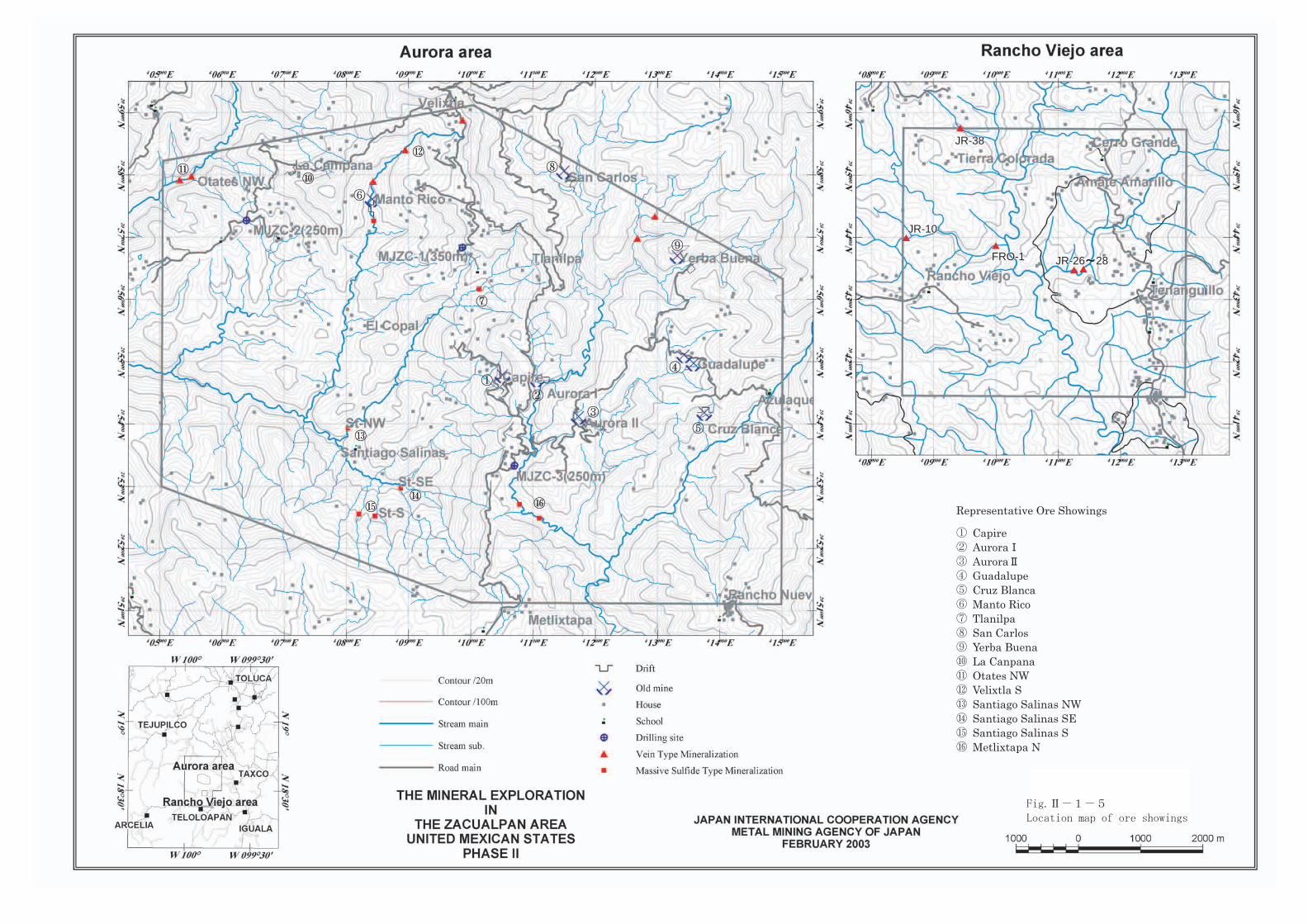
Representative Ore Showings
Capire AuroraAuroraGuadalupeCruz BlancaManto RicoTlanilpaSan CarlosYerba BuenaLa CanpanaOtates NWVelixtla SSantiago Salinas NW Santiago Salinas SESantiago Salinas SMetlixtapa N
JR-26JR-26 2828JR-26 28FRO-1FRO-1FRO-1
JR-10JR-10JR-10
JR-38JR-38JR-38

LEGEND
Pachivia Formation CFm: Calcareous slate, limestone
Villa Ayala FormationDCw: Plagio phyric Dacite tuffMs: Slate, LinestoneVam: Andesitic tuff with mud ballVa-5: Andesite lava, tuffVa-6:Foliated andesiteVad:Dacite with Andesite
Alteration zone
Bedding plane
Cleavage plane
Geological section

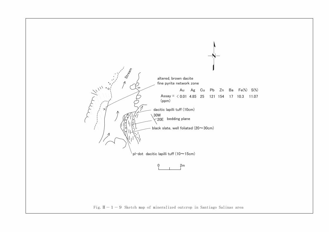
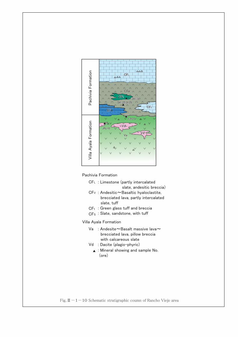
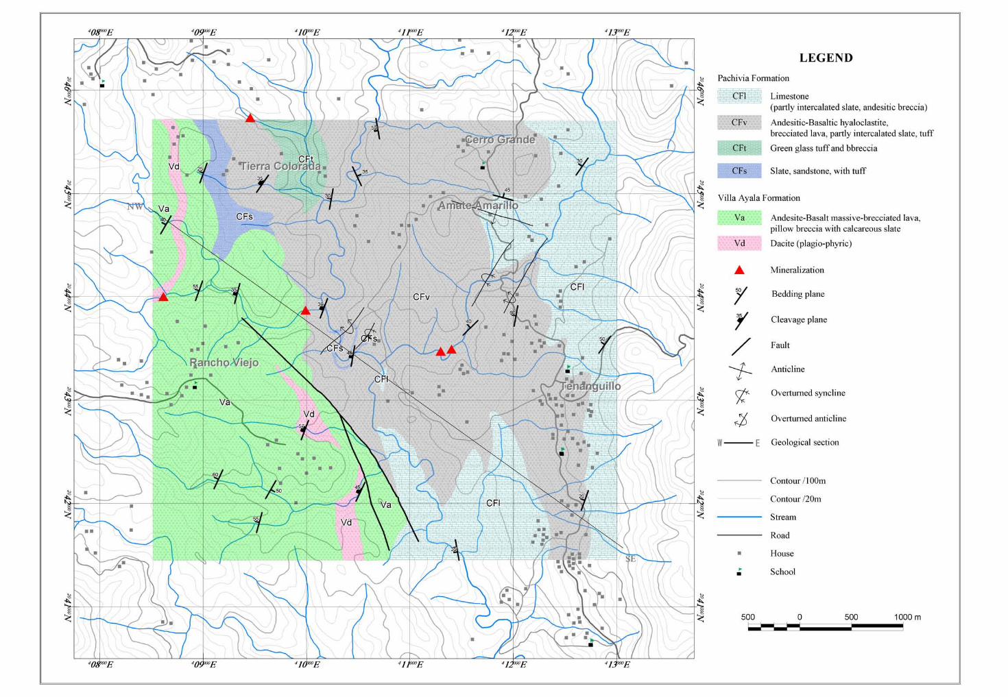
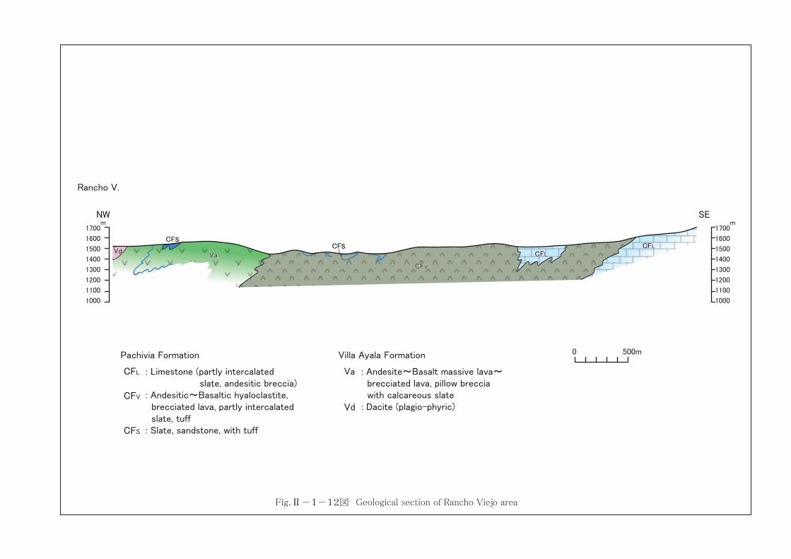
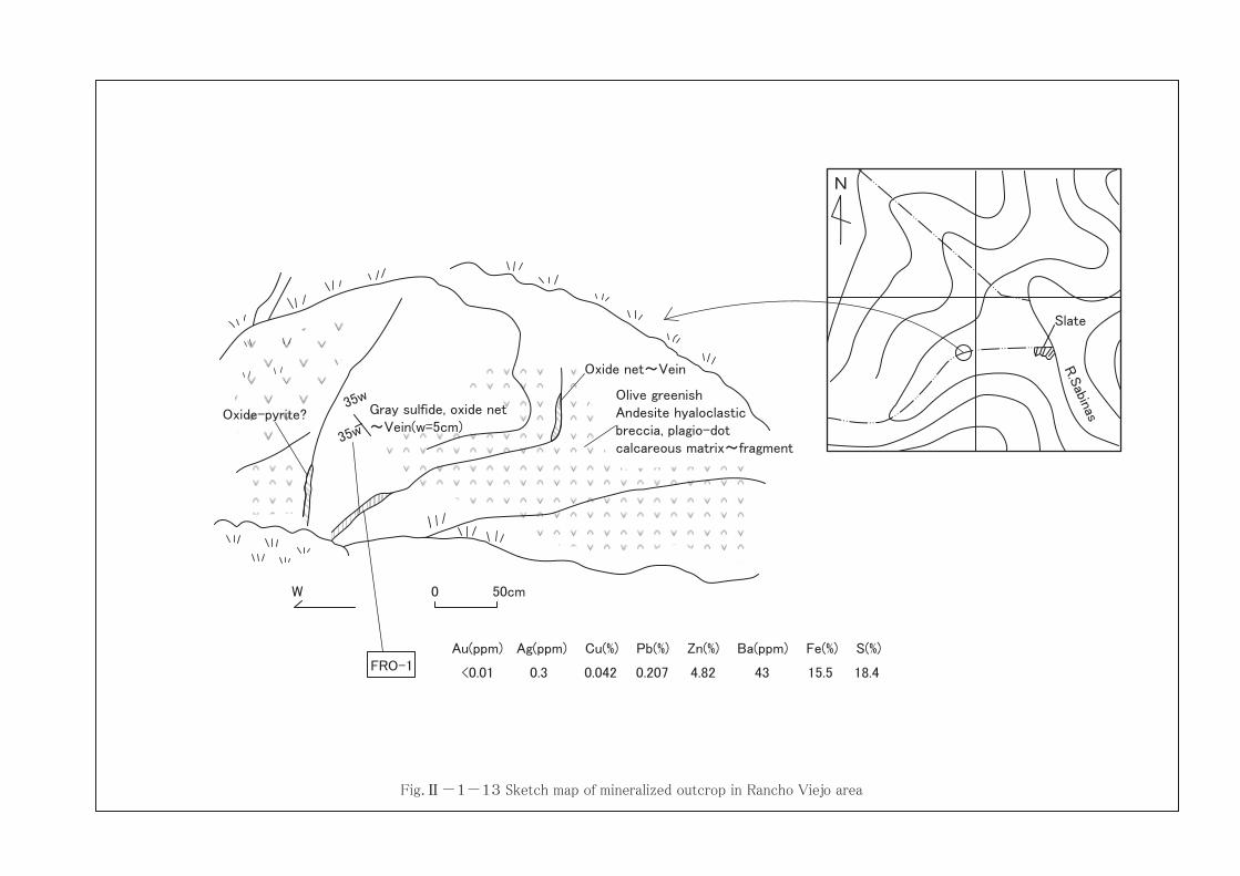

KK
PgPgPg
GpGpGp
GpGpDo
: Sericite (3T)
: Kaolinite
: Palagonite
: Gypsum
: Dolomite
Sericite X0.1cps
KK
KK
KK
PgPgPg
PgPgPg
PgPgPg
PgPgPg
PgPgPg
DoDoDo
GpGpGp
GpGpGp
,,
GpGpGp
LEGEND
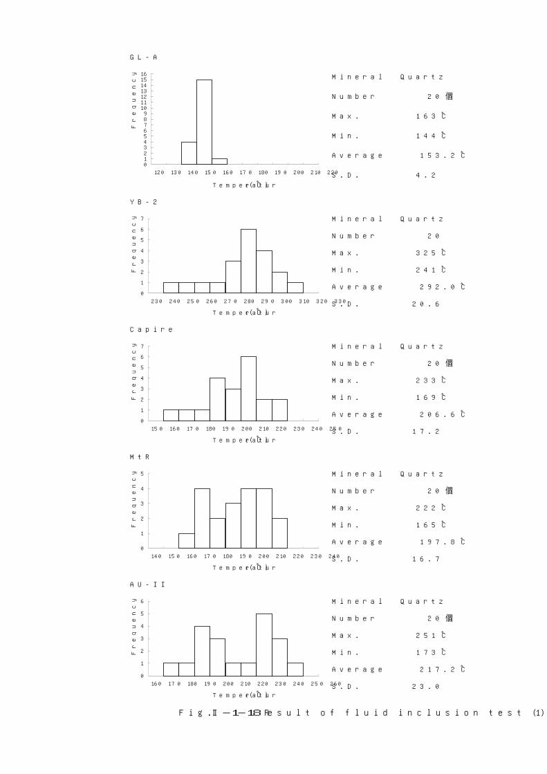
GL-A
Mineral Quartz
Number 20 個
Max. 163 ℃
Min. 144 ℃
Average 153.2 ℃
S.D. 4.2
Temperature(℃)
YB-2
Mineral Quartz
Number 20
Max. 325 ℃
Min. 241 ℃
Average 292.0 ℃
S.D. 20.6Temperature(℃)
Capire
Mineral Quartz
Number 20 個
Max. 233 ℃
Min. 169 ℃
Average 206.6 ℃
S.D. 17.2Temperature(℃)
MtR
Mineral Quartz
Number 20 個
Max. 222 ℃
Min. 165 ℃
Average 197.8 ℃
S.D. 16.7Temperature(℃)
AU-II
Mineral Quartz
Number 20 個
Max. 251 ℃
Min. 173 ℃
Average 217.2 ℃
S.D. 23.0Temperature(℃)
Frequency
Frequency
Fig.Ⅱ-1-18 Result of fluid inclusion test (1)
Frequency
Frequency
Frequency
0123456789
10111213141516
120 130 140 150 160 170 180 190 200 210 220
0
1
2
3
4
5
6
7
230 240 250 260 270 280 290 300 310 320 330
0
1
2
3
4
5
6
7
150 160 170 180 190 200 210 220 230 240 250
0
1
2
3
4
5
140 150 160 170 180 190 200 210 220 230 240
0
1
2
3
4
5
6
160 170 180 190 200 210 220 230 240 250 260
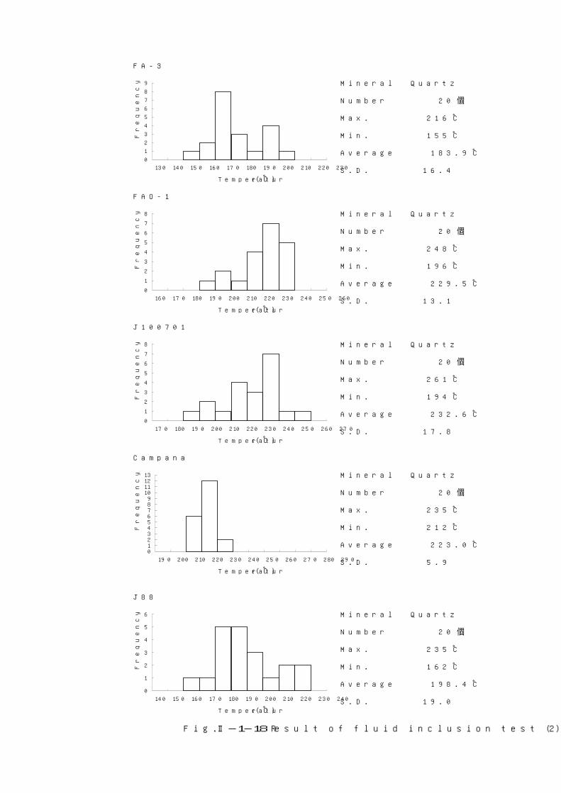
FA-3
Mineral Quartz
Number 20 個
Max. 216 ℃
Min. 155 ℃
Average 183.9 ℃
S.D. 16.4Temperature(℃)
FAO-1
Mineral Quartz
Number 20 個
Max. 248 ℃
Min. 196 ℃
Average 229.5 ℃
S.D. 13.1Temperature(℃)
J100701
Mineral Quartz
Number 20 個
Max. 261 ℃
Min. 194 ℃
Average 232.6 ℃
S.D. 17.8Temperature(℃)
Campana
Mineral Quartz
Number 20 個
Max. 235 ℃
Min. 212 ℃
Average 223.0 ℃
S.D. 5.9Temperature(℃)
J88
Mineral Quartz
Number 20 個
Max. 235 ℃
Min. 162 ℃
Average 198.4 ℃
S.D. 19.0Temperature(℃)
Frequency
Frequency
Frequency
Frequency
Frequency
Fig.Ⅱ-1-18 Result of fluid inclusion test (2)
0
1
2
3
4
5
6
7
8
9
130 140 150 160 170 180 190 200 210 220 230
0
1
2
3
4
5
6
7
8
160 170 180 190 200 210 220 230 240 250 260
0
1
2
3
4
5
6
7
8
170 180 190 200 210 220 230 240 250 260 270
0123456789
10111213
190 200 210 220 230 240 250 260 270 280 290
0
1
2
3
4
5
6
140 150 160 170 180 190 200 210 220 230 240
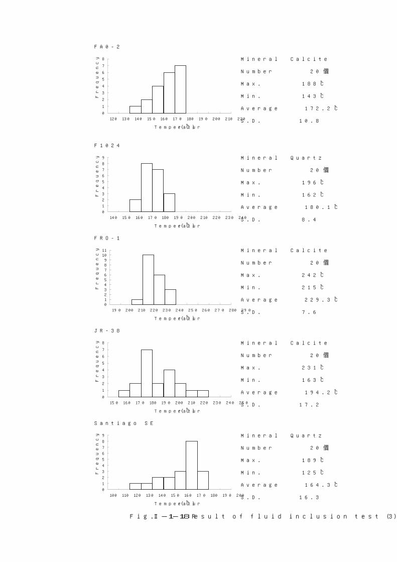
FA0-2
Mineral Calcite
Number 20 個
Max. 188 ℃
Min. 143 ℃
Average 172.2 ℃
S.D. 10.8Temperature(℃)
F1024
Mineral Quartz
Number 20 個
Max. 196 ℃
Min. 162 ℃
Average 180.1 ℃
S.D. 8.4Temperature(℃)
FRO-1
Mineral Calcite
Number 20 個
Max. 242 ℃
Min. 215 ℃
Average 229.3 ℃
S.D. 7.6Temperature(℃)
JR-38
Mineral Calcite
Number 20 個
Max. 231 ℃
Min. 163 ℃
Average 194.2 ℃
S.D. 17.2Temperature(℃)
Santiago SE
Mineral Quartz
Number 20 個
Max. 189 ℃
Min. 125 ℃
Average 164.3 ℃
S.D. 16.3Temperature(℃)
Frequency
Frequency
Frequency
Frequency
Frequency
Fig.Ⅱ-1-18 Result of fluid inclusion test (3)
0
1
2
3
4
5
6
7
8
120 130 140 150 160 170 180 190 200 210 220
0
1
2
3
4
5
6
7
8
9
140 150 160 170 180 190 200 210 220 230 240
0123456789
1011
190 200 210 220 230 240 250 260 270 280 290
0
1
2
3
4
5
6
7
8
150 160 170 180 190 200 210 220 230 240 250
0
1
2
3
4
5
6
7
8
9
100 110 120 130 140 150 160 170 180 190 200

Santiago NW
Mineral Quartz
Number 20
Max. 274 ℃
Min. 205 ℃
Average 244.9 ℃
S.D. 16.6Temperature(℃)
FA1021
Mineral Quartz
Number 20
Max. 203 ℃
Min. 160 ℃
Average 178.0 ℃
S.D. 11.2Temperature(℃)
Fig.Ⅱ-1-18 Result of fluid inclusion test (4)
Frequency
Frequency
0
1
2
3
4
5
6
7
190 200 210 220 230 240 250 260 270 280 290
0123456789
10
140 150 160 170 180 190 200 210 220 230 240

405000E 406000E 407000E 408000E 409000E 410000E 411000E 412000E 413000E 414000E 415000E
405000E 406000E 407000E 408000E 409000E 410000E 411000E 412000E 413000E 414000E 415000E
205
90
00N
2
058
00
0N
205
70
00N
2
056
00
0N
205
50
00N
2
054
00
0N
205
30
00N
2
052
00
0N
205
10
00N
205
90
00N
2
058
00
0N
205
70
00N
2
056
00
0N
205
50
00N
2
054
00
0N
205
30
00N
2
052
00
0N
205
10
00N

1 NA49 schistose coarse tuff 405945 2057670 ◎ △ ・ ・ △ ○ △
2 NA55 altered andesite 407595 2056493 ○ △ ・ △ ○ △ ○ ・ intersertal texture
3 FA49 brecciated pyroxene andesite 410015 2052055 ・ △ △ △ ・ △ ・ intersertal texture
4 FA87 very fine sandstone 405004 2057666 ◎ △ ・ △ ・
5 FA84 altered dacite (lava) 408370 2057360 ◎ ・ ・ ・ △ ・ felsitic texture
6 FA80 altered andesite 408230 2056700 ・ △ ・ ・ ○ ・ △ △ intersertal texture
7 JA15 epidote chlorite schist 405958 2058264 △ ・ ○ △ ○ ・ weakly lepidoblastic texture
8 JA45 slate 408245 2054052 ◎ ・ △ with quartz-calcite vein
9 JA64 altered pyroxene andesite 408525 2053715 ○ ○ ・ ・ ・ ○ △ ・ △ intersertal texture
10 JA18 shistose dacite tuff 405395 2055235 ◎ △ △ ・ ・ ・ lepidoblastic texture
11 JA50 olivine bearing pyroxene andesite 409201 2054675 ・ ○ ○ ・ ・ △ ・ ・ intersertal texture
12 JA85 schistose fine sandstone 410793 2053192 ○ ・ △ ・ ・ △ ・ weakly lepidoblastic texture
13 JA96 altered dacite (tuff) 411925 2051935 ◎ △ ・ ・ ・ △ ・ felsitic texture
14 JA125 hornblende pyroxene andesite 414920 2054035 ・ △ △ ・ ○ ・ △ ・ △ ・ brecciated and intersatal texture
15 JA139 altered andesite 414920 2054035 △ △ ・ ・ △ ・ ○ △ intersertal texture
16 JA141 schistose andesite 410925 2057045 ○ △ ・ △ △ ・ lepidoblastic texture
17 JR15 schistose fine sandstone 408706 2044741 ◎ ・ △ ・ ・ △ ・ lepidoblastic texture
18 UA24 brecciated altered andesite 405549 2055173 △ ○ ・ ・ ・ △ brecciated and intersatal texture
19 UA46 schistose fine sandstone 407128 2055975 △ ・ △ ・ ○ △ lepidoblastic texture
20 UA83 schistose altered andesite 411832 2056189 △ △ △ ・ ○ △ lepidoblastic texture
21 UA85 altered andesite 410645 2052370 △ △ △ △ ・ △ ・ intersertal texture
22 UA130 schistose altered tuff 410190 2058615 △ △ △ ○ ・ ・ △ strongly altered
23 UA143 shistose dacite tuff 406612 2053258 ○ △ △ ・ ・ ・ lepidoblastic texture
24 UR32 slate 409212 2041565 ◎ ・ △
25 FR1 altered andesite 410188 2041993 ○ △ ・ △ △ △ intersertal texture
26 FR3 altered basalt 410330 2042725 ・ ◎ △ ・ △ ・ pilotaxitic texture
27 FR4 dacite 410180 2042705 ◎ △ ・ ・ ・ ・ felsitic texture
28 FR9 shistose dacite tuff 410058 2043878 ○ △ △ ・ △ ・ strongly altered
29 FR24 brecciated altered andesite 410710 2045735 ○ △ ・ ・ ・ ○ △ relativery fresh cpx bearing
30 FA8 pyroxene andesite 411150 2053730 △ △ △ △ ・ △ △ intersertal texture
31 FA9 altered dacite (tuff) 411275 2053810 ◎ △ ・ ・ ・ ○ △
32 FA10 shistose dacite tuff 408446 2057241 ○ △ △ ・ ・ ○ △ lepidoblastic texture
33 FA13 altered andesite (tuff) 408650 2058150 △ △ ・ △ △ △ △ strongly altered
34 FA19 shistose dacite tuff 405618 2054649 ◎ ・ ○ ・ ・ ・ △ lepidoblastic texture
35 FA21 altered dacite (tuff) 406220 2054360 △ ・ ・ ・ ・ ○ △
36 FA30 limestone (biomicrite) 406620 2054785 ・ ◎ biomicrite
37 FA47 very fine sandstone ・siltstone 409561 2052401 ○ ・ △ △ weakly shistose texture
38 FA57 altered andesite (tuff) 412313 2054141 ○ ○ ・ △ ・ △ △
39 FA62 schistose andesite tuff 413620 2055330 △ ○ ・ △ ・ △ △
40 FA72 altered andesite (tuff) 411890 2057435 △ ○ ・ △ ・ △ △
41 FA79 altered andesite (tuff) 409315 2056935 △ △ ・ △ ・ ○ △
42 BR30 slate 414580 2060950 ◎ ○ △ △ lepidoblastic texture
43 CR7 strongly alterd andesite 404717 2050850 ・ ・ △ ○ ・ strongly altered
44 DR4 slate 400914 2043679 ◎ ○ △ ・ lepidoblastic texture
45 ER4 quartz sericite schist 397426 2060253 ◎ △ ○ △ △ △ lepidoblastic texture
Legend; ◎,abundant; ○, common; △, minor; ・rare
qz:quartz, pl:plagioclase, am:amphibole, opx:ortho pyroxene, cpx:clino pyroxene, ol:olivine
se: sericite, chl:chlorite, ca:carbonate mineral (mainly calcite), opa:opague minerals
Table Ⅱ-1-1(1) Result of microscopic observation(thin section)
No.SampleNo.
Rock Name Note
MineralsCoordinates
UTM-E UTM-N qz pl K-f am opxcpx ol opase chlepi ca
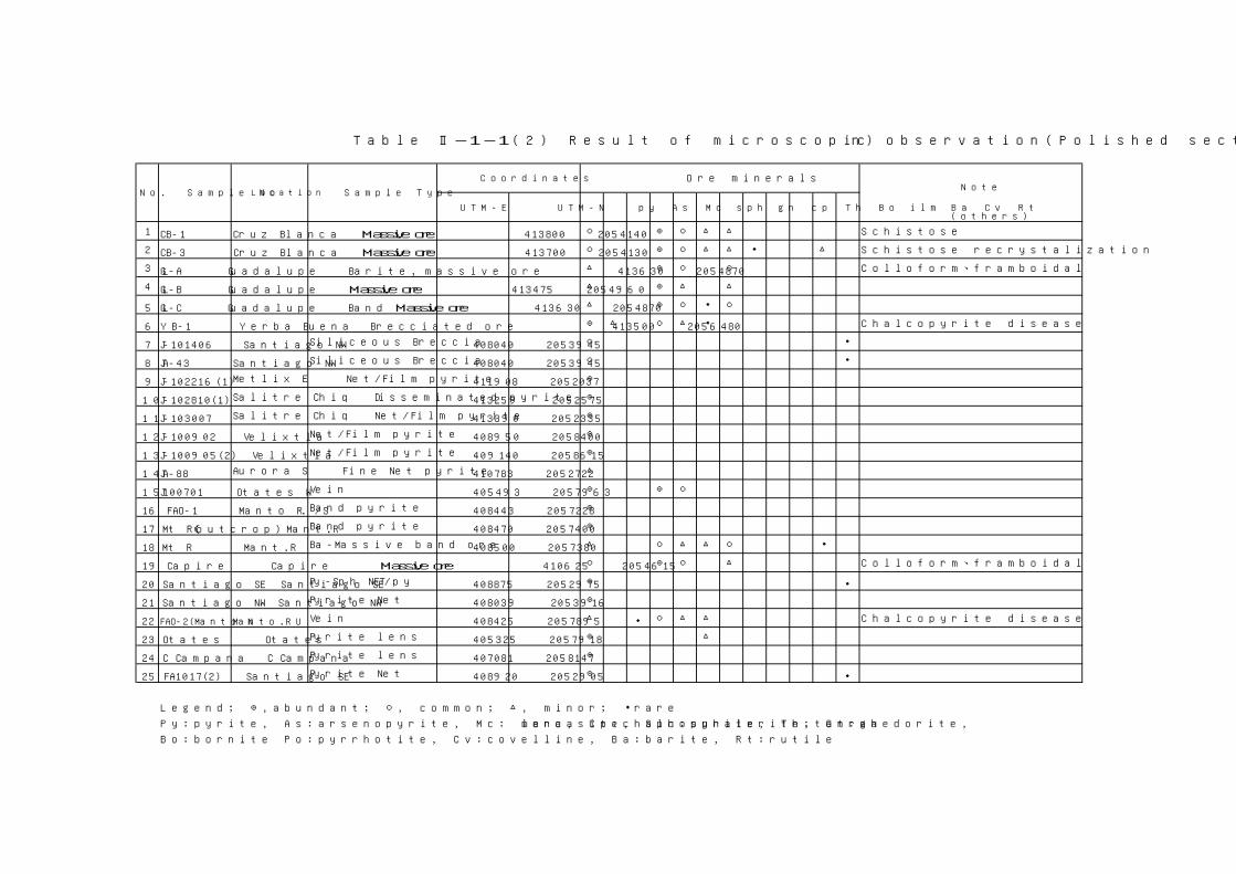
Note
UTM-E UTM-N py As Mc sph gn cp Th Bo ilm Ba Cv Rt(others)
1 CB-1 Cruz Blanca Massive ore 413800 2054140 ○ ◎ ○ △ △ Schistose
2 CB-3 Cruz Blanca Massive ore 413700 2054130 ○ ◎ ○ △ △ ・ △ Schistose recrystalization
3 GL-A Guadalupe Barite, massive ore 413630 2054870 △ ◎ ○ ○ Colloform、framboidal
4 GL-B Guadalupe Massive ore 413475 2054960 △ ◎ △ △
5 GL-C Guadalupe Band Massive ore 413630 2054870 △ ◎ ○ ・ ○
6 YB-1 Yerba Buena Brecciated ore 413500 2056480 ◎ △ ○ △ ・ Chalcopyrite disease
7 J-101406 Santiago NW Siliceous Breccia 408040 2053945 ○ ・
8 JA-43 Santiago NW Siliceous Breccia 408040 2053945 ○ ・
9 J-102216(1) Metlix E Net/Film pyrite 411908 2052037 ◎
10 J-102810(1) Salitre Chiq Disseminated pyrite 413259 2052575 ◎
11 J-103007 Salitre Chiq Net/Film pyrite 413390 2052335 ◎
12 J-100902 Velixtla Net/Film pyrite 408950 2058400 ◎
13 J-100905(2) Velixtla Net/Film pyrite 409140 2058615 ◎
14 JA-88 Aurora S Fine Net pyrite 410783 2052722 △
15 J100701 Otates W Vein 405493 2057963 ◎ ◎ ○
16 FAO-1 Manto R. /S Band pyrite 408443 2057228 ◎
17 Mt R(outcrop) Mant.R Band pyrite 408470 2057400 ◎
18 Mt R Mant.R Ba-Massive band ore 408500 2057380 △ ○ △ △ ○ ・
19 Capire Capire Massive ore 410625 2054615 ○ ◎ ○ △ Colloform、framboidal
20 Santiago SE Santiago SE Py-Sph NET/py 408875 2052975 ◎ ・
21 Santiago NW Santiago NW Pyrite Net 408039 2053916 ◎
22 FAO-2(Manto N)Manto.R U Vein 408425 2057895 △ ・ ○ △ △ Chalcopyrite disease
23 Otates Otates Pyrite lens 405325 2057918 ◎ △
24 C Campana C Campana Pyrite lens 407081 2058147 ◎
25 FA1017(2) Santiago SE Pyrite Net 408920 2052905 ◎ ・
Legend; ◎,abundant; ○, common; △, minor; ・rare
Py:pyrite, As:arsenopyrite, Mc: marcasite, Sph:sphalerite, Gn:galena, Cp:chalcopyrite, Th:tetrahedorite,
Bo:bornite Po:pyrrhotite, Cv:covelline, Ba:barite, Rt:rutile
Table Ⅱ-1-1(2) Result of microscopic observation(Polished section)
Ore minerals
No. Sample No Location Sample Type
Coordinates
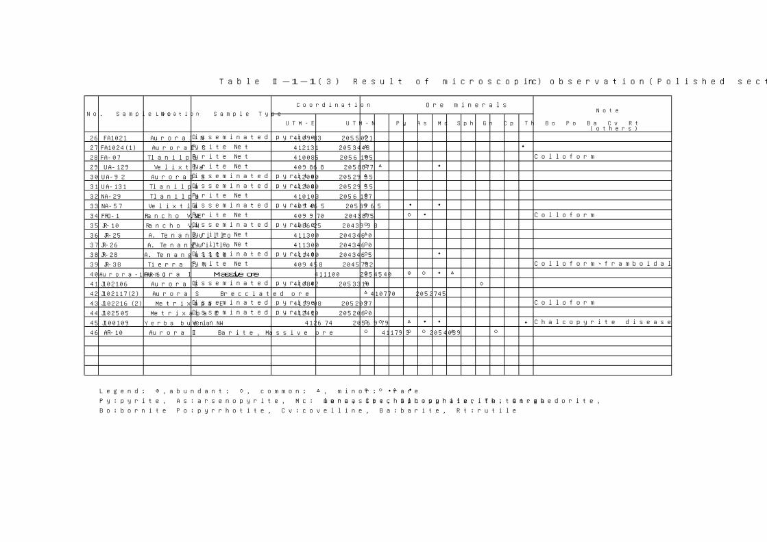
Note
UTM-E UTM-N Py As Mc Sph Gn Cp Th Bo Po Ba Cv Rt(others)
26 FA1021 AuroraⅠ N Disseminated pyrite 410983 2055021 ○
27 FA1024(1) AuroraⅡ S Pyrite Net 412131 2053448 △ ・
28 FA-07 Tlanilpa Pyrite Net 410085 2056105 ◎ Colloform
29 UA-129 Velixtla Pyrite Net 409868 2058877 ○ △ ・
30 UA-92 AuroraⅡ S Disseminated pyrite 412000 2052955 △
31 UA-131 Tlanilpa Disseminated pyrite 412000 2052955 △
32 NA-29 Tlanilpa Pyrite Net 410103 2056187 ◎
33 NA-57 Velixtla Disseminated pyrite 409465 2058965 ○ ・ ・
34 FRO-1 Rancho V.NE Pyrite Net 409970 2043875 ◎ ○ ・ Colloform
35 JR-10 Rancho V.N Disseminated pyrite 408625 2043998 ○
36 JR-25 A. Tenanguillo Pyrite Net 411300 2043460 △
37 JR-26 A. Tenanguillo Pyrite Net 411300 2043460 ○
38 JR-28 A. Tenanguillo Disseminated pyrite 411400 2043465 ○ ・
39 JR-38 Tierra C. N Pyrite Net 409458 2045732 ◎ Colloform、framboidal
40 Aurora-1(AR-6) Aurora Ⅰ Massive ore 411100 2054540 ○ ◎ ○ ・ △
41 J102106 Aurora S Disseminated pyrite 410842 2053310 △ ○
42 J102117(2) Aurora S Brecciated ore 410770 2052745 △
43 J102216(2) Metrixapa E Disseminated pyrite 411908 2052037 ○ Colloform
44 J102505 Metrixapa E Disseminated pyrite 412410 2052060 ○
45 J100109 Yerba buena NW Vein 412674 2056979 ○ ○ △ ・ ・ ・ Chalcopyrite disease
46 AR-10 Aurora Ⅱ Barite, Massive ore 411793 2054039 ○ ○ ○ △ ○
Legend; ◎,abundant; ○, common; △, minor; ・rare ◎ ○ △ ・
Py:pyrite, As:arsenopyrite, Mc: marcasite, Sph:sphalerite, Gn:galena, Cp:chalcopyrite, Th:tetrahedorite,
Bo:bornite Po:pyrrhotite, Cv:covelline, Ba:barite, Rt:rutile
Sample Type
Table Ⅱ-1-1(3) Result of microscopic observation(Polished section)
Ore minerals
No. Sample No Location
Coordination

No. Sample No. UTM-E UTM-NAu
(ppm)Ag
(ppm)Cu
(ppm)Pb
(ppm)Zn
(ppm)Ba
(ppm)Fe
(ppm)S
(ppm)
1 CB-1 413800 2054140 0.39 126 3630 95100 243000 16100 47800 206500
2 GL-B 413475 2054960 0.55 310 8560 75100 452000 7650 27900 289000
3 YB-1 413500 2056480 0.07 116 481 52000 34600 9 160000 234000
4 J-101406 408040 2053945 < 0.01 0.90 29 87 337 401 51500 51300
5 JA-43 408040 2053945 0.03 0.60 25 76 162 239 24300 14800
6 J-110509(2) 408438 2052518 < 0.01 0.60 13 13 133 10120 95900 127000
7 JA-88 410783 2052722 < 0.01 0.30 14 25 44 147 15400 15400
8 Mt.R (outcrop) 408470 2057400 < 0.01 0.90 23 11 82 39 238000 294000
9 Mt.R 408500 2057380 0.84 550 6950 8070 17000 531000 1740 18800
10 Capire 410625 2054615 1.67 1900 4720 50900 127000 367000 11000 88400
11 Santiago SE 408875 2052975 < 0.01 4.85 25 121 154 17 103000 110700
12 Santiago NW 408039 2053916 < 0.01 1.00 16 22 85 158 202000 264000
13 FA-07 410085 2056105 < 0.01 0.90 9 27 71 467 76500 73600
14 FRO-1 409970 2043875 < 0.01 0.30 42 2070 48200 34 242000 348000
15 JR-38 409458 2045732 < 0.01 0.80 42 23 78 43 155000 184000
TableⅡ-1-2 Result of ore grade assay

Qz Ab Kf Sm Ha K Ch S S3 Pg Gp Ba Ja Ca Do Py Gn Sph Px Hb Ep
1 Dacite 410285 2054495 ○ △ △ △
2 Slate>tuff 410500 2054720 ○ ○ △ △ altered
3 Tuff 408446 2057241 ○ ○ ○ ○ ○ ・ △ ・
4 Dacite 408365 2057590 ○ ○ △ △
5 And tuff 408474 2057947 ○ ・ ◎ ○ ◎
6 Andesite 409140 2058025 △ ◎ ○ ○ ・ ・
7 Dacite 406084 2054475 ○ △ ○ △ ・ ・
8 FA-21 And tuff 406220 2054360 ○ ○ ○ △ △ ・
9 FA-32 Dacite 409465 2052710 ○ ○ ・ ・ saponite?
10 FA-33 Dacite tuff 409522 2052573 △ ・ △ △ ・ ○
11 FA-34 Dacite 408884 2052946 ○ ◎ △ ・ ・ ・
12 FA-36 Dacite 409069 2052502 ◎ △ △ ・
13 FA-37 Dacite 408710 2052070 ○ ○
14 FA-43 Dacite 411069 2054760 △ ○ ○ ・ ・
15 FA-44 Tuff 411033 2054943 ○ ・ ○ △ ・
16 FA-45 Tuff 411002 2055180 ○ ・ ○ △ ・
17 FA-48 Tuff 409667 2052163 △ △ ○ ・ ・ ・ ・
18 FA-53 Dacite tuff 412111 2053964 ○ △ ・ ○
19 FA-54 And tuff 412070 2054145 ○ ・ △ △ △
20 FA-55 Dacite 412061 2054335 ◎ ・ △ △
21 FA-64 Calc. Tuff 414650 2055585 ・ ・ △ ・ ◎
22 FA-75 Lapilli tuff 410665 2054135 ○ △ △ ・ △ ・
23 FA-76 Andesite 409880 2056180 △ ○ ○ ・ ・ ・
24 FA-79 Andesite 409315 2056935 △ △ ○ ・ △
25 FA-10/17(3) Andesite 408760 2052000 ○ △ △ △ ・ △
26 FA-10/21(1) Andesite 410983 2055021 ○ ○ ・ pyrite diss
27 FA-10/24(1) Dacite 412131 2053448 ○ ○ ・ △ △ ・
28 FA-10/24(2) Lapilli tuff 412098 2053800 ○ ○ △ ○ ・
29 FA-10/28(1) Dacite 412800 2054700 ○ ◎ ・ ・
30 FA-10/28(2) Slate>tuff 413208 2054807 ○ ◎ ・ ・ ・
31 FA-10/28(3) Calc. Tuff 413355 2054805 △ △ ○ ・ ◎
32 FA-10/29(1) Dacite 413332 2055254 ○ ・ ・ △ ・
33 FA-11/7(1) Andesite 409515 2056440 ○ △ ◎ ○ △ ・
34 FA-11/7(2) Dacite 409515 2056640 ○ △ △ ○ ○
35 FA-11/7(3) Andesite 409395 2057080 ・ △ ◎ △ △Legend; ◎,abundant; ○, common; △, minor; ・rare Qz:quartz, Ab:albite, Kf:K feldspar, Sm:smectite, Ha:halloysite, K: kaolinite, Ch:chlorite, S;sericite,S3;sericite(3T), Pg:palagonite, Gp:gypsum, Ba:barite, Ja:jarosite, Ca:calcite, Do: dolomite, Py:pyrite, Gn:galena, Sph:sphalerite, Px:pyroxene, Hb:horblende, Ep:epidote
Clay MineralsNo. Sample No,
FA-1
Coordinates
UTM-E
Rock nametype
Sulphate MRemarks
UTM-N
Table Ⅱ-1-3 Result of X-ray diffraction(1)
FA-12FA-16
Silica M
Detected Minerals
Other MineralsFeldspar M
FA-3FA-10 FA-11
FA-20
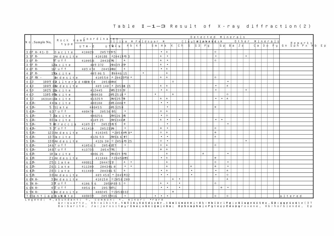
Qz Ab Kf Sm Ha K Ch S S3 Pg Gp Ba Ja Ca Do Py Gn Sph Px Hb Ep
36 FA-41-D Dacite 410020 2057395 ○ ・ △ ○
37 FR- 1 Andesite 410188 2041993 △ △ △ ・ ・ ・
38 FR- 9 Tuff 410058 2043878 △ △ △ ・ ○
39 FR- 12 Dacite 409372 2043925 ○ ・ △ ・
40 FR- 16 Tuff 409470 2045080 ○ △ ・ △
41 FR- 19 Dacite 409065 2044615 ◎ ・ △
42 FRX- 1 Andesite 410550 2042570 △ ・ ・ △ △ ○
43 J- 100902 Ailtered Dc 408950 2058400 ○ ○ ・
44 J- 100905 Andesite 409140 2058615 △ △ △ △ ・ △
45 J- 102511 Dacite 412445 2052395 ○ ○ ・ △ ・ ・
46 J- 110509 Dacite 408438 2052518 ○ ・ ・ △ ○
47 J- 102810(1) Dacite 413259 2052575 △ △ △ △ ・ ・ △
48 JA- 44 Dacite 408100 2054000 ○ ◎ ・ ・
49 JA- 57 Slate 408455 2053250 ○ ・ ◎
50 JA- 63 Tuff 408470 2053635 ○ ・ ○ △
51 JA- 72 Dacite 408256 2052635 ○ ○ ・ ○
52 JA- 83 Dacite 410925 2053440 ○ △ △ ・ ・ ・ ・
53 JA- 90 Breccia 410937 2052559 ○ ◎ ・ ・
54 JA- 93 Tuff 411410 2052310 △ ・ ◎ ・ ○
55 JA- 123 Andesite 414345 2054490 ・ ・ ・ ○ △ ◎
56 JA- 137 Dacite 412653 2056617 ○ ◎ ・ ・ △
57 JA- 138 Andesite 412630 2056925 ○ △ ○ ・ ・
58 JA- 146 Tuff 410563 2054127 ○ ・ ○ △ ○
59 JA- 148 Tuff 413735 2054775 ○ ◎ △
60 JR- 10 Dacite 408625 2043998 ○ △ △ △ ・
61 JR- 21 Andesite 411040 2045085 △ ・ ・ △ ◎
62 JR- 25 Slate 408812 2044721 ・ △ ・ △ ○ ・
63 JR- 26 Slate 411300 2043460 ・ ・ △ △ ◎ ・
64 JR- 28 Slate 411400 2043465 △ ・ △ ・ ・ △
65 JR- 38 Andesite 409458 2045732 ・ △ ・ ・ ・ ・ ○
66 NA- 31 Andesite 410150 2056200 ○ △ ・ △
67 NA- 39 Tuff 410696 2056895 △ ○ △ ・ ・ ○
68 NA- 45 Tuff 405624 2057871 ○ ・ ・ ・ ◎ ・
69 NA- 61 Andesite 408245 2058332 ○ ◎
70 Santiago NW Dacite 408039 2053916 △ ・ ・ ・ ・ ○ ○ alteredLegend; ◎,abundant; ○, common; △, minor; ・rare Qz:quartz, Ab:albite, Kf:K feldspar, Sm:smectite, Ha:halloysite, K: kaolinite, Ch:chlorite, S;sericite,S3;sericite(3T), Pg:palagonite, Gp:gypsum, Ba:barite, Ja:jarosite, Ca:calcite, Do: dolomite, Py:pyrite, Gn:galena, Sph:sphalerite, Px:pyroxene, Hb:horblende, Ep:epidote
No. Sample No, Sulphate M
Table Ⅱ-1-3 Result of X-ray diffraction(2)
Other Minerals
UTM-E UTM-N
CoordinatesSilica M Feldspar M Clay Minerals
Detected Minerals
RemarksRock name
type

Qz Ab Kf Sm Ha K Ch S S3 Pg Gp Ba Ja Ca Do Py Gn Sph Px Hb Ep
71 UA- 54 Andesite 408245 2053200 △ △ ○ ・ ・ ・
72 UA- 55 Tuff 408845 2053033 ○ △ ○ △
73 UA- 57 Tuff 409380 2053586 ○ △ ◎ △ △
74 UA- 59 Tuff 409968 2053576 △ ・ ・ △ ・ ・ ・
75 UA- 61 Tuff 410335 2053511 △ ○ ○ ・ ○
76 UA- 65 Dacite 410971 2053645 ○ △ △ ・
77 UA- 66 Andesite 410963 2053886 ○ ○ △ ・ ・
78 UA- 73 Tuff 410978 2056273 ○ △ ○ △ △
79 UA- 74 Andesite 410985 2054159 ○ D ○ ・ ・
80 UA- 104 Andesite 413735 2053878 ・ △ △ ○ ・ △
81 UA- 106 Tuff 413686 2054082 △ ・ ○ △ ○
82 UA- 108 Andesite 414217 2053787 ・ △ △ ・ ◎ ・
83 UA- 109 Andesite 414297 2053922 △ ・ △ △ △ △
84 UA- 111 Sandstone 414709 2054390 △ △ ◎ ・
85 UA- 113 Dacite 411743 2053843 ○ ・ ◎ △ ○
86 UA- 114 Tuff 412286 2053765 ○ △ ○ ・
87 UA- 115 Dacite 412540 2053652 ◎ ・ ・ △
88 UA- 118 Dacite 413086 2053638 △ △ ・
89 UA- 124 Andesite 412784 2056441 ○ △ △ ・ ○ ・
90 UA- 125 Dacite 413102 2056158 ○ △ △ △
91 UA- 133 Lapilli tuff 410015 2056579 ○ △ ○ ・ ・ △
92 UA- 134 Tuff 411513 2053491 ◎ ・ ・ △
93 UA- 135 Tuff 412660 2054940 ○ △ ○ ・ △
94 UA- 136 Lapilli tuff 412765 2054690 ○ ◎ ・ △
95 UA- 110601 Tuff 410075 2057525 ◎ ○ ・
96 UA- 111202 Tuff 413940 2054200 ○ ・ △
97 Santiago SE Dacite 408875 2052975 △ △ △ ・ ○
98 FA- 10/17(2) Dacite 408920 2052905 ○ ・ ○ △ △
99 AR-2 Dacite 410311 2052948 ◎ ・ ・
100 AR-5 Tuff 410255 2053126 △ ・ △ △
101 AR-10 ore 411793 2054039 △ ・ ○ ○ ◎
102 AR-11 ore 410625 2054605 ・ ・ △ ◎
Legend; ◎,abundant; ○, common; △, minor; ・rare
Qz:quartz, Ab:albite, Kf:K feldspar, Sm:smectite, Ha:halloysite, K: kaolinite, Ch:chlorite, S;sericite,S3;sericite(3T), Pg:palagonite, Gp:gypsum,
Ba:barite, Ja:jarosite, Ca:calcite, Do: dolomite, Py:pyrite, Gn:galena, Sph:sphalerite, Px:pyroxene, Hb:horblende, Ep:epidote
Coordinates
UTM-E UTM-N
Table Ⅱ-1-3 Result of X-ray diffraction(3)
Other MineralsRemarks
Detected Minerals
Silica M Feldspar M Clay Minerals Sulphate MSample No, Rock nametype
No.
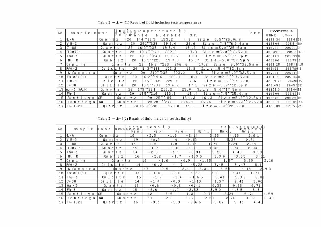
Table Ⅱ-1-4(1) Result of fluid inclusion test(temperature)
Temperature(℃)range average S.D. UTM-E UTM-N
1 GL-A Quartz 20 144~163 153.2 4.2 Size=7.5~25.0μm 413630 20548702 YB-2 Quartz 20 241~325 292.0 20.6 Size=7.5~60.0μm 413500 20564803 JA-88 Quartz 20 162~235 198.4 19.0 Size=5.0~25.0μm 410783 20527224 J100701 Quartz 20 194~261 232.6 17.8 Size=5.0~12.5μm 405493 20579635 FA0-1 Quartz 20 196~248 229.5 13.1 Size=2.5~27.5μm 408443 20572286 Mt R Quartz 20 165~222 197.8 16.7 Size=5.0~37.5μm 408500 20573807 Capire Quartz 20 169~233 206.6 17.2 Size=5.0~32.5μm 410625 20546158 FA0-2 Calcite 20 143~188 172.2 10.8 Size=5.0~32.5μm 408425 20578959 C Campana Quartz 20 212~235 223.0 5.9 Size=5.0~32.5μm 407081 205814710 FA1024(1) Quartz 20 162~196 180.1 8.4 Size=2.5~17.5μm 412131 205344811 FR0-1 Calcite 20 215~242 229.3 7.6 Size=5.0~17.5μm 409970 204387512 JR-38 Calcite 20 163~231 194.2 17.2 Size=5.0~12.5μm 409458 204573213 Au-Ⅱ(AR10) Quartz 20 173~251 217.2 23.0 Size=5.0~17.5μm 411793 205403914 FA-3 Quartz 20 155~216 183.9 16.4 Size=7.5~25.0μm 410500 205472015 Santiago SE Quartz 20 125~189 164.3 16.3 Size=5.0~12.5μm 408875 205297516 Santiago NW Quartz 20 205~274 244.9 16.6 Size=5.0~12.5μm 408039 205391617 FA-1021 Quartz 20 160~203 178.0 11.2 Size=5.0~22.5μm 410983 2055021
Table Ⅱ-1-4(2) Result of fluid inclusion test(salinity)
Frozn temp(℃) salinity(wt%)Min. Max. Ave. Min. Max. Ave.
1 GL-A Quartz 16 -2.5 -1.9 -2.14 3.23 4.18 3.612 YB-2 Quartz 19 -0.2 0 -0.12 0 0.35 0.213 JA-88 Quartz 15 -1.5 -1.0 -1.18 1.74 2.24 2.044 J100701 Quartz 15 -1.7 -0.8 -1.18 1.40 2.74 2.045 FA0-1 Quartz 14 -2.6 -1.9 -2.31 3.23 4.49 3.896 Mt R Quartz 16 -2.2 -1.7 -1.95 2.90 3.55 3.317 Capire Quartz 16 -1.6 -0.9 -1.25 1.57 3.39 2.168 FA0-2 Calcite 14 -6.2 -4.7 -5.22 7.45 9.47 8.179 C Campana Quartz 17 -2.5 -2.1 -2.34 3.55 4.18 3.9310 FA1024(1) Quartz 11 -1.4 -0.8 -1.02 1.23 2.41 1.7711 FA0-1 Calcite 15 -1.7 -1.4 -1.65 2.41 2.90 2.8112 JR-38 Calcite 14 -1.4 -0.9 -1.19 1.57 2.41 2.0613 Au-Ⅱ Quartz 12 -0.6 -0.2 -0.41 0.35 0.88 0.7114 FA-3 Quartz 18 -2.6 -1.7 -2.33 2.90 4.65 3.9115 Santiago SE Quartz 12 -3.5 -1.3 -2.78 2.24 5.71 4.5916 Santiago NW Quartz 11 -2.3 -1.6 -2.03 2.74 3.87 3.4317 FA-1021 Quartz 16 -3.1 -2.3 -2.66 3.87 5.11 4.43
Coordinates
Number
Sample name mineral Form
Remarks
No.
No. Sample name mineral
inclusion no.

FA-10/28 slate no carb 16.6 413208 2054807FA-11/8-10 dacitic tuff no carb 20.2 408165 2053395FA-11 dacite no carb 16.2 408365 2057590FA-12 andesitic tuff treated 20% HCl 14.9 408474 2057947FA-34 dacitic tuff treated 20% HCl 20.0 408884 2052946FA-35 slate treated 20% HCl 20.6 408930 2052844FA-36 dacite treated 20% HCl 21.0 409069 2052502FA-51 dacitic tuff treated 20% HCl 18.5 412180 2053225FA-52 dacitic tuff treated 20% HCl 17.0 412112 2053550FA-54 dacitic tuff treated 20% HCl 10.7 412070 2054145FA-55 dacite no carb 10.3 412061 2054335FA-56 dacitic tuff no carb 11.2 412260 2053895FA-60 dacite no carb 16.6 413115 2054789FA-80 andesite treated 20% HCl 12.4 408230 2056700FA-84 dacite treated 20% HCl 16.8 408370 2057360FA-85 slate treated 20% HCl 16.3 408380 2057370JA-49 andesitic tuff treated 20% HCl 12.2 408945 2054690JA-122 andesite breccia no carb 15.9 414080 2054440JA-123 andesite breccia no carb 15.8 414345 2054490JA-144 andesite treated 20% HCl 12.7 409740 2054430NA-33 dacitic tuff treated 20% HCl 14.5 410225 2056270UA-66 andesite no carb 13.0 410963 2053886UA-67 andesite no carb 13.2 409644 2055876UA-69 dacite no carb 15.8 410056 2056135UA-71 andesite no carb 12.7 410303 2056189UA-73 tuff treated 20% HCl 14.9 410978 2056273UA-74 andesite treated 20% HCl 11.3 410985 2054159UA-76 andesite treated 20% HCl 11.6 411214 2054655UA-78 andesite no carb 10.1 411538 2054741UA-106 sandy tuff no carb 15.4 413686 2054082UA-113 dacitic tuff no carb 15.8 411743 2053843
Sample No Type δ13C δ18O UTM-E UTM-NJA-58 Limestone -12.4 -9.7 408495 2053305JA-74 Limestone -1.6 -7.2 408165 2052405UA-72 Limestone 1.0 -9.5 410733 2056276JA-145 Limestone -4.6 -13.1 410390 2054125JA-124 Limestone 1.7 -8.0 414540 2054610UA-103 Limestone 0.7 -12.0 413795 2053752
Table Ⅱ-1-5 Result of isotope analysis(δ18O and δ13C)
UTM-N
δ13C and δ18O on Carbonates
δ18O on Silicates
Sample No Type Treated for Carbonate δ18O(SMOW)
UTM-E

-97-
Chapter 2 Geochemical Survey
2-1 Survey Method
The rock geochemical survey has been performed in the Rancho Viejo and
Aurora areas. The samples have been taken in the spacing of about every five samples
per one kilometer along the survey lines, but more dense in the ore horizon and
mineralized zones. Only fresh parts of rocks have been taken, eliminating weathered
part. The duplicate sampling for every 20 points has been performed to check assay
accuracy.
All samples have been assayed for the major oxides and minor elements. The
duplicated samples have been assayed for only the minor elements. The assay has been
asked for ALS Chemex. The assay method and detection limits are shown in the
following table. Element Method detection
limit Element Method detection
limit Al203 XRF 0.01% BaO XRF 0.01% CaO XRF 0.01% Cr2O3 XRF 0.01% Fe2O3 XRF 0.01% K2O XRF 0.01% MgO XRF 0.01% MnO XRF 0.01% Na2O XRF 0.01% P2O5 XRF 0.01% SiO2 XRF 0.01% SrO XRF 0.01% TiO2 XRF 0.01% LOI XRF 0.01% Au FA-ICP 1ppb Ag ICP-AES 0.2ppm Al ICP-AES 0.01% As ICP-AES 2ppm B ICP-AES 10ppm Ba ICP-AES 10ppm Be ICP-AES 0.5ppm Bi ICP-AES 2ppm Ca ICP-AES 0.01% Cd ICP-AES 0.5ppm Co ICP-AES 1ppm Cr ICP-AES 1ppm Cu ICP-AES 1ppm Fe ICP-AES 0.01% Ga ICP-AES 10ppm Hg ICP-AES 1ppm K ICP-AES 0.01% La ICP-AES 10ppm Mg ICP-AES 0.01% Mn ICP-AES 5ppm Mo ICP-AES 1ppm Na ICP-AES 0.01% Ni ICP-AES 1ppm P ICP-AES 10ppm Pb ICP-AES 2ppm S ICP-AES 0.01% Sb ICP-AES 2ppm Sc ICP-AES 1ppm Sr ICP-AES 1ppm Ti ICP-AES 0.01% Tl ICP-AES 10ppm U ICP-AES 10ppm V ICP-AES 1ppm W ICP-AES 10pm Zn ICP-AES 2ppm
-98-
2-2 Survey Result
Table II-2-1 shows the chemical assay result.
1 Major Oxides
Figures II-2-1, II-2-2, and II-2-3 show the histogram, scatter diagram, and
distribution map of alteration index. The rocks assayed are mainly andesitic to basaltic
volcanic rocks, dacitic volcanic rocks, and sedimentary rocks, and the obtained assay
values reflect these rock facies.
The alteration index (MgO+K2O)/(Na2O+CaO+MgO+K2O)X100% has been
calculated and investigated to extract alteration zones associated with mineralization,
because the reaching of Na and Ca, and addition of Mg and K are some characteristics
of the common massive sulphide type alteration.
The interpretation has been done for separated rock facies such as the
andesite of the Villa Ayala Formation, dacite of the same formation, sedimentary rocks
of the Villa Ayala and Pachivia Formations, and andesite of the Pachivia Formation.
In the histogram, it tends to that the dacite shows higher background value
than that of the andesite. The background value of the sedimentary rocks shows a
dispersed distribution due to their wide range of rock facies from calcareous to
tuffaceous. Judging from the histogram of each rock facies, the anomaly value is set up
as +1σ in average, and further detailed ranking is set up.
Anomaly zones occupying some portions in the Aurora area are Capire deposit
to the north of Aurora I deposit and an area between the south of Aurora II deposit and
Guadalupe deposit. Small size anomalies are dispersed around Santiago Salinas and
south of Velixtla. An anomaly to the southwest of La Campana is of one point, but its
value is above +2σ, even though the sampling space there is wide. It is thought that
an anomaly zone on a ridge to the southwest of MJZC-3 would be affected by
weathering.
In the Rancho Viejo area, an anomaly zone occupying some area is situated to
the northwest of Tierra Colorada, and this is correlated to the place where some
altered rocks dominated in the sedimentary and pyroclastic rocks.

-99-
2 Minor Elements
The assay result has been processed by logarithmic transformation for every
component, and interpreted. The values lower than the detection limit have been
calculated being regarded as the half of the limit value. Figure II-2-4 to Figure II-2-17
show the interpretation result. The histograms of main elements have been made for
the four categories of the rock facies same as the case of the whole rock analysis. No
value for W and Tl exists in the result. Followings are the description of the
distribution patterns of elements for each group.
(1) B, Hg, U
More than 95 percent of the specimens have the values of less than the
detection limit. It is possible that B and Hg are associated with the local alteration and
fracture. U has been detected mainly in the sedimentary rocks.
(2) Be, Bi, Ga, La
Seventy to eighty percent of these elements show the value of less than the
detection limit. Be and Bi are detected sporadically, but are more frequently appear in
the Rancho Viejo area. Ga is not detected in the western part of the Aurora area and
the eastern part of the Rancho Viejo area. La tends to be detected in the dacite. No
relation is recognized between those elements and mineralization.
(3) Ag, Au, Cd, Mo, Sb
Seventy to eighty per cent of these elements show the values of less than the
detection limit. It is probable that the slightly higher values reflect some hydrothermal
activity or mineralization.
Ag is contained in both vein-type and massive sulphide type deposits. Ag
shows the highest value of 20 ppm in La Campana West, and 18 ppm near by
Guadalupe. Other anomalies over 1 ppm exist in the following portions to the
southwest of the Manto Rico deposit, near by San Carlos, near by the Capire deposit,
and to the southeast of the Aurora deposit. The San Carlos deposit is of the vein-type,

-100-
but the other anomalies supposedly reflect the massive sulphide type mineralization.
The background value of Ag is high in the Rancho Viejo area, but only one point shows
1 ppm.
Au is positively correlated with Ag, and its anomalies coincident with that of
Ag in many cases. Au is not detected vicinity areas of the vein-type San Carlos deposit,
therefore it is thought that many of Au anomalies probably reflect the massive
sulphide type mineralization. Au shows 84 ppb in an area to the west of Capire, 83 ppb
to the west of La Campana, and over 10 ppb in Santiago Salinas and Aurora II deposit.
Cd is commonly contained in sphalerite, and it behaves with Zn. A north to
south extending remarkable anomaly zone exists near by the vein-type San Carlos
deposit. Other high anomaly zones are in areas to the south-southwest of the Manto
Rico deposit, near by the Capire deposit, Aurora II deposit, and near by Guadalupe
deposit to Cruz Blanca deposit.
Mo tends to higher in the dacite and sedimentary rocks. It only shows slightly
high values in the known massive sulphide type mineral occurrences, and no strong
relation with mineralization is recognized.
Sb anomalies are concentrated in the areas to the south of Velixtla in the
northern to northwestern district, to the southwest of the Manto Rico deposit, and to
the west of La Campana. In the vein-type San Carlos deposit, Sb shows below the
detection limit value. Only weak anomalies have been detected near by the known
massive sulphide type mineral occurrences. It is well known that the ores of the Capire
and Aurora deposits contain tetrahedrite, (Cu,Fe)12Sb4S13, and miargyrite, AgSbS2,
therefore it is possible that Sb reflects the massive sulphide type mineralization.
However, it is not clear that the all Sb anomalies in the northern to northwestern
district indicate existence of massive sulphide mineralization.
(4) Co, Cr, Mn, Ni, P, Sc, Sr, V
The density distribution-pattern of the elements reflects the rock facies. These
elements such as Co, Cr, Ni, Sc, V tend to show high values in the andesitic volcanic
rocks. Mn and P tend to show high values in the sedimentary rocks. No direct relation

-101-
between these elements and mineralization.
(5) As, Ba, Cu, Pb, Zn, S
It is highly possible that these elements reflect the vein-type and massive
sulphide type mineralization.
Around a half of the whole samples show the value below the detection limit (2
ppm for As). In the histograms, some groups showing over 3.5 ppm exist in every rock
facies, indicating somewhat anomalous zones. The background value of the dacite and
sedimentary rocks having over 3.5 ppm anomalous groups is slightly higher than that
of the andesite. In the Aurora area, if the average values +1σare set for anomaly, some
anomaly areas are recognized in areas to the south of Velixtla, to the south of the
Manto Rico deposit, near by Tlanilpa occurrence, near by Capire deposit, to the south
of Aurora II deposit, and around Santiago Salinas. Some sporadic anomalies are in
areas to the northwest of the Yerba Buena deposit, to the west of La Campana, and in
the western end of the district. In the Rancho Viejo area, some anomalous area exists
around Terra Colorada.
Massive sulfide ores in the Aurora area have relatively high content of Ba.
This survey has clearly revealed that the ores of the Yerba Buena deposit contain low
Ba (9 ppm). The dacite shows generally higher value than that of the andesite. Some
anomalous zones showing +1σ are extracted in areas from the Capire deposit to
Guadalupe deposit and to the south. Slightly anomalous zones exist areas from the
north of the Manto Rico deposit to the west of Campana, to the west of Santiago
Salinas, and around El Copal. In the Rancho Viejo, some sporadic anomalies tend to
distribute in the central part extending north to south.
Cu shows significant different values for different rock facies. One population
showing the normal distribution exists in the Villa Ayala Formation and Pachivia
Formation respectively, but the latter shows rather higher value than that of the
former. It is judged that the dacite and sedimentary rocks are conformed by multi
numbers of populations, but its variation is large. In the Aurora area, anomalous zones
showing +1σ for each rock facies exist in areas from the Capire deposit to the east of
-102-
the Aurora II deposit, and from the Guadalupe deposit to Cruz Blanca deposit. In the
Rancho Viejo area, the anomalies tend to distribute from the central to the northern
parts.
Pb shows multiple numbers of populations in the histogram. The andesite has
same tendency in the Villa Ayala and Pachivia Formations, Pb is clustered in the lower
side. The dacite shows higher Pb values than that of in the andesite, and has two peaks
in the histogram. The sedimentary rocks show the similar tendency with that of the
dacite. In the Aurora area, the distributions of the average values +1σ are seen in the
areas from the San Carlos deposit to the south of Velixtla, around the Tlanilpa
occurrence, the Guadalupe deposit and to the west, and to the north of Azulaquez. The
small-scale distributions are seen in the Capire deposit and Aurora I deposit. It is
possible that the anomaly distributed from the San Carlos deposit to the south of
Velixtla reflects vein-type mineralization. In the Rancho Viejo area, there are some
sporadic distributions of weak anomaly.
Zn shows one population of the normal distribution in the andesitic rocks, and
the Villa Ayala and Pachivia Formations show the same tendency. It appears that Zn
values of the dacite are almost in one population, but there exist some clearly high
values. The Zn values of the dacite tend to lower than that of the andesitic rocks. The
Zn values of the sedimentary rocks are scattered, but two populations are recognized.
The anomalous zones showing +1σ in average are areas from the San Carlos deposit
to the south of Velixtla, from the Capire deposit to the east of the Aurora I deposit, and
from the Guadalupe deposit to the Cruz Blanca deposit. The anomaly around the San
Carlos reflects vein-type mineralization. In the Rancho Viejo area, small anomalies are
scattered.
S is well reflective for existence of mineralized zones, and can be applied as
same as alteration. In the histogram, several populations are supposedly recognized. It
is possible that the population of the highest values reflects mineralized zones. About
over 0.322 percent of the values are regarded as anomalous values for every rock facies,
and this is correlated to the value of +1σ. In the Aurora area, the anomaly zones are in
areas to the south of Velixtla, to the south of the Manto Rico deposit, from Tlanilpa to

-103-
the Aurora deposit, to the southeast of MJZC-3, and to the southeast of the Aurora II
deposit. Other sporadic anomaly zones are in the western end district, around Otates,
around Santiago Salinas, in the Guadalupe deposit, and around Azulaquez. In the
Rancho Viejo area, some sporadic anomalies exist around Tierra Colorada and to the
north and south of Rancho Viejo Village.
(6) Principal Component Analysis
The principal component analysis has been performed to judge in an
integrated manner the behavior of the elements associated with mineralization. The
elements strongly reflected rock facies characteristics are eliminated. Table II-2-4 and
Figure II-2-18 show the result of analysis.
The first factor shows high load of Co, Cu, Ni, Sc, and V, reflecting the
andesite facies. The contribution rate is 25.5 percent.
The second factor shoes high minus load of As and Pb, and followed by Au, Ag,
Mo, S, Sb, etc. It is, therefore, judged that these elements are the good integral
indicators for mineralized zones. The contribution rate is 11.9 percent.
In the Aurora area, those zones concentrated by the high-points, average +1σ,
in “Figure II-2-18 the points distribution of the second factor” are La Campana, the
south of Velixtla, the southwest of the Manto Rico deposit, San Carlos deposit, Capire
deposit to Aurora I deposit, the southeast of the Aurora II deposit, and the southwest of
Santiago Salinas to the southeast. In the Guadalupe and Cruz Blanca deposits, only
one point shows high +2σ value.
It is possible that the anomaly zones present both vein-type and massive
sulphide type mineralized zones. It is possible that the anomalies to the south of
Velixtla and near by the San Carlos are of the vein-type, and others of the massive
sulphide type.
In the Rancho Viejo area, some sporadic anomalies are scattered in the
northwestern part.
(7) Geochemical Anomaly

-104-
From the above-mentioned result, some geochemical anomaly areas have been
extracted based on the alteration index, principal component, and density distribution
of S. Figure II-2-19 shows the distribution of anomaly areas.
The anomaly areas are distributed in areas from around the Capire deposit to
the southeast of the Aurora II deposit and near by the Guadalupe deposit in large area,
and in areas to the south of Velixtla, to the west of La Campana, to the south of the
Manto Rico deposit, near by Tlanilpa occurrence, and Santiago Salinas in slightly
small-scale.
In areas near by the vein-type Yerba Buena and San Carlos deposits, no
anomaly is recognized nor indicating small-scale.
(8) Spectral Analysis
The spectral-reflection spectrum has been obtained. The spectrometer
“POSAM: Portable SpectrorAdiometer for Mineral identification” made by Dowa
Engineering Co.” has been used. The wavelength between 1,300 and 2,500 millimeters
has been measured. Figure II-2-20 shows the spectral-chart of the measurement. The
measured figures are of the specimen’s relative reflectivity for barite white board in
the range of the wavelength.
The altered minerals identified by the spectral data are sericite,
montmorillonite, illite, chlorite, epidote, and calcite. The identification has been done
through the judgment of existence by the absorption strength, estimation of volume by
the depth of the absorption peaks, and presentation in numerical figures. The
sericite/chlorite ratio and the change of absorption peak positions have been
investigated as an application trial for the alteration zoning from the spectrometric
analysis, and the spectral analysis result is shown in Table II-2-5 and Figure II-2-21.
As shown in Figure II-2-21, the identified mineral distribution is shown as bar
graphs being in proportion to the apparent mineral volume, i.e. absorption strength, at
their sampling positions. Each mineral is presented by different graphical axis. The
change of the absorption peaks for sericite and montmorillonite is expressed by red in
case of shifting to the long-wave-length side, and by blue incase of shifting to the short

-105-
wave length side. The sericite/chlorite ratio is changed to numerical figures by the
formula “sericite - chlorite / sericite + chlorite” setting +1 for sericite and -1 for chlorite.
Figure II-2-21 shows much chlorite in the andesite dominant areas, and much sericite
in the dacite dominant areas. Some relations between rock types and identified
minerals by the spectral analysis are recognized. The sericite/chlorite ratio is also
related with rock types, the ratio is high in dacite and low in andesite.
The absorption position of the spectrum of the sericite in Yerba Buena and
San Carlos deposits, Velixtla, and Otates NW occurrences shifted to the
short-wave-length side, and that in the massive sulfide type Guadalupe, Curz Blanca,
Aurora I, and Aurora II deposits shifted mainly to the long wavelength side. It
probably indicates that same sericite identified by the spectral analysis can be
classified into two different types, vein-type or massive sulphide type, depending upon
their wavelength shift pattern.

Fig.Ⅱ-2-1 Scatter diagram of major elements

Number Average Exponential ave. Standard deviationAll Sample
439 37.6 - 21.6Villa Ayala Formation Andesite
158 35.0 - 14.6Villa Ayala Formation Dacite
137 49.4 - 20.9Sedimentary rocks(Villa Ayala F. + Pachivia F.)
101 27.4 - 27.3Pachivia Formation Andesite
42 33.5 - 12.4
All Sample
0
20
40
60
80
100
0.0
1.5
8.7
16.0
23.2
30.4
37.6
44.8
52.0
59.2
66.4
73.7
80.9
88.1
95.3
100.0
Alteration Index
Freq
uenc
y
0%
20%
40%
60%
80%
100%
間隔=1/3σ
Villa Ayala Formation Andesite
0102030405060
0.0
1.5
8.7
16.0
23.2
30.4
37.6
44.8
52.0
59.2
66.4
73.7
80.9
88.1
95.3
100.0
Alteration Index
Freq
uenc
y
0%
20%
40%
60%
80%
100%
間隔=1/3σ
Villa Ayala Formation Dacite
0
5
10
15
20
0.0
1.5
8.7
16.0
23.2
30.4
37.6
44.8
52.0
59.2
66.4
73.7
80.9
88.1
95.3
100.0
Alteration Index
Freq
uenc
y
0%
20%
40%
60%
80%
100%
間隔=1/3σ
Sedimentary rocks(Villa Ayala F. + Pachivia F.)
05
1015202530
0.0
1.5
8.7
16.0
23.2
30.4
37.6
44.8
52.0
59.2
66.4
73.7
80.9
88.1
95.3
100.0
Alteration Index
Freq
uenc
y
0%
20%
40%
60%
80%
100%
間隔=1/3σ
Pachivia Formation Andesite
0
5
10
15
20
0.0
1.5
8.7
16.0
23.2
30.4
37.6
44.8
52.0
59.2
66.4
73.7
80.9
88.1
95.3
100.0
Alteration Index
Freq
uenc
y
0%
20%
40%
60%
80%
100%
間隔=1/3σ
Fig. Ⅱ-2-2 Histogram of alteration index

Fig.Ⅱ-2-3 Distribution map of alteration index
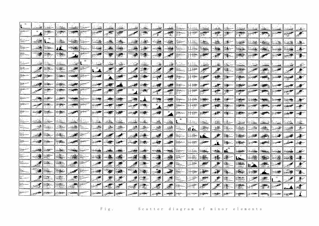
Fig.Ⅱ-2-4 Scatter diagram of minor elements
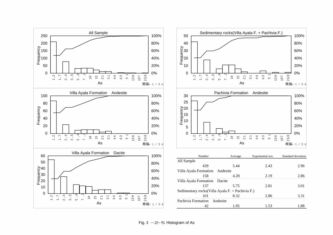
Number Average Exponential ave. Standard deviationAll Sample
439 5.44 2.43 2.96Villa Ayala Formation Andesite
158 4.28 2.19 2.86Villa Ayala Formation Dacite
137 5.75 2.81 3.01Sedimentary rocks(Villa Ayala F. + Pachivia F.)
101 8.32 2.86 3.31Pachivia Formation Andesite
42 1.95 1.53 1.88
All Sample
0
50
100
150
200
250
1.2
1.7
2.4
3.5
5.0
7.2 10
15
21
31
44
63
91
130
187
268
As
Freq
uenc
y
0%
20%
40%
60%
80%
100%
間隔=1/3σ
Villa Ayala Formation Andesite
0
20
40
60
80
100
1.2
1.7
2.4
3.5
5.0
7.2 10
15
21
31
44
63
91
130
187
268As
Freq
uenc
y
0%
20%
40%
60%
80%
100%
間隔=1/3σ
Villa Ayala Formation Dacite
0102030405060
1.2
1.7
2.4
3.5
5.0
7.2 10
15
21
31
44
63
91
130
187
268
As
Freq
uenc
y
0%
20%
40%
60%
80%
100%
間隔=1/3σ
Sedimentary rocks(Villa Ayala F. + Pachivia F.)
0
10
20
30
40
50
1.2
1.7
2.4
3.5
5.0
7.2 10
15
21
31
44
63
91
130
187
268
As
Freq
uenc
y
0%
20%
40%
60%
80%
100%
間隔=1/3σ
Pachivia Formation Andesite
05
1015202530
1.2
1.7
2.4
3.5
5.0
7.2 10
15
21
31
44
63
91
130
187
268
As
Freq
uenc
y
0%
20%
40%
60%
80%
100%
間隔=1/3σ
Fig. Ⅱ-2-5 Histogram of As
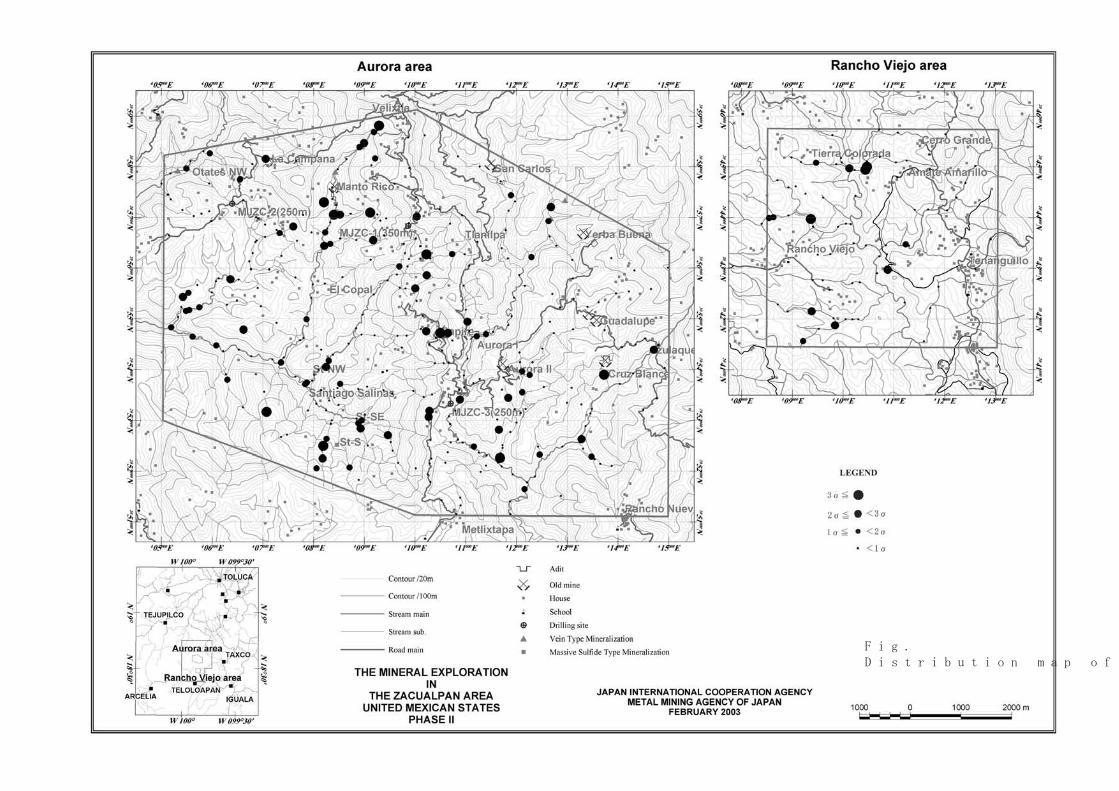
Fig.Ⅱ-2-6Distribution map of As

Number Average Exponential ave. Standard deviationAll Sample
439 50.7 29.0 2.8Villa Ayala Formation Andesite
158 44.3 27.5 2.6Villa Ayala Formation Dacite
137 73.6 44.7 2.6Sedimentary rocks(Villa Ayala F. + Pachivia F.)
101 24.1 15.6 2.5Pachivia Formation Andesite
42 64.2 38.1 2.6
All Sample
0
50
100
150
200
5.3
7.5 11
15
21
29
41
57
80
112
157
220
309
433
607
852
Ba
Freq
uenc
y
0%
20%
40%
60%
80%
100%
間隔=1/3σ
Villa Ayala Formation Andesite
0102030405060
5.3
7.5 11
15
21
29
41
57
80
112
157
220
309
433
607
852
Ba
Freq
uenc
y
0%
20%
40%
60%
80%
100%
間隔=1/3σ
Villa Ayala Formation Dacite
0102030405060
5.3
7.5 11
15
21
29
41
57
80
112
157
220
309
433
607
852
Ba
Freq
uenc
y
0%
20%
40%
60%
80%
100%
間隔=1/3σ
Sedimentary rocks(Villa Ayala F. + Pachivia F.)
05
1015202530
5.3
7.5 11
15
21
29
41
57
80
112
157
220
309
433
607
852
Ba
Freq
uenc
y
0%
20%
40%
60%
80%
100%
間隔=1/3σ
Pachivia Formation Andesite
05
1015202530
5.3
7.5 11
15
21
29
41
57
80
112
157
220
309
433
607
852
Ba
Freq
uenc
y
0%
20%
40%
60%
80%
100%
間隔=1/3σ
Fig. Ⅱ-2-7 Histogram of Ba

Fig.Ⅱ-2-8Distribution map of Ba

Number Average Exponential ave. Standard deviationAll Sample
439 23.7 10.6 3.9Villa Ayala Formation Andesite
158 22.3 16.2 2.6Villa Ayala Formation Dacite
137 12.6 5.1 3.3Sedimentary rocks(Villa Ayala F. + Pachivia F.)
101 31.4 8.4 5.2Pachivia Formation Andesite
42 47.6 43.0 1.6
All Sample
0102030405060
0.7
1.0
1.4
1.9
2.7
3.8
5.3
7.5 11
15
21
30
42
59
83
117
164
231
326
Cu
Freq
uenc
y
0%
20%
40%
60%
80%
100%
間隔=1/4σ
Villa Ayala Formation Andesite
0
10
20
30
40
0.7
1.0
1.4
1.9
2.7
3.8
5.3
7.5 11
15
21
30
42
59
83
117
164
231
326
Cu
Freq
uenc
y
0%
20%
40%
60%
80%
100%
間隔=1/4σ
Villa Ayala Formation Dacite
0
5
10
15
20
25
0.7
1.0
1.4
1.9
2.7
3.8
5.3
7.5 11
15
21
30
42
59
83
117
164
231
326
Cu
Freq
uenc
y
0%
20%
40%
60%
80%
100%
間隔=1/4σ
Sedimentary rocks(Villa Ayala F. + Pachivia F.)
02468
101214
0.7
1.0
1.4
1.9
2.7
3.8
5.3
7.5 11
15
21
30
42
59
83
117
164
231
326
Cu
Freq
uenc
y
0%
20%
40%
60%
80%
100%
間隔=1/4σ
Pachivia Formation Andesite
0
5
10
15
20
0.7
1.0
1.4
1.9
2.7
3.8
5.3
7.5 11
15
21
30
42
59
83
117
164
231
326
Cu
Freq
uenc
y
0%
20%
40%
60%
80%
100%
間隔=1/4σ
Fig. Ⅱ-2-9 Histogram of Cu

Fig.Ⅱ-2-10Distribution map of Cu
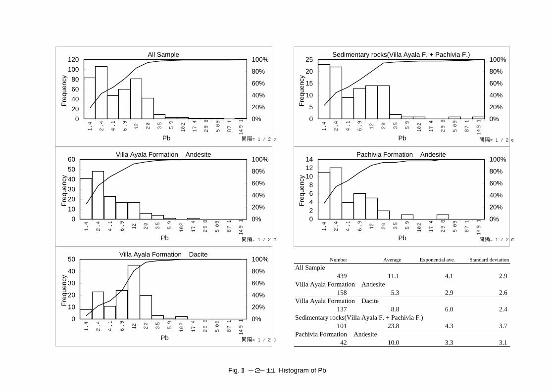
Number Average Exponential ave. Standard deviationAll Sample
439 11.1 4.1 2.9Villa Ayala Formation Andesite
158 5.3 2.9 2.6Villa Ayala Formation Dacite
137 8.8 6.0 2.4Sedimentary rocks(Villa Ayala F. + Pachivia F.)
101 23.8 4.3 3.7Pachivia Formation Andesite
42 10.0 3.3 3.1
All Sample
020406080
100120
1.4
2.4
4.1
6.9 12
20
35
59
102
174
298
509
871
1491
Pb
Freq
uenc
y
0%
20%
40%
60%
80%
100%
間隔=1/2σ
Villa Ayala Formation Andesite
0102030405060
1.4
2.4
4.1
6.9 12
20
35
59
102
174
298
509
871
1491
Pb
Freq
uenc
y
0%
20%
40%
60%
80%
100%
間隔=1/2σ
Villa Ayala Formation Dacite
0
10
20
30
40
50
1.4
2.4
4.1
6.9 12
20
35
59
102
174
298
509
871
1491
Pb
Freq
uenc
y
0%
20%
40%
60%
80%
100%
間隔=1/2σ
Sedimentary rocks(Villa Ayala F. + Pachivia F.)
0
5
10
15
20
25
1.4
2.4
4.1
6.9 12
20
35
59
102
174
298
509
871
1491
Pb
Freq
uenc
y
0%
20%
40%
60%
80%
100%
間隔=1/2σ
Pachivia Formation Andesite
02468
101214
1.4
2.4
4.1
6.9 12
20
35
59
102
174
298
509
871
1491
Pb
Freq
uenc
y
0%
20%
40%
60%
80%
100%
間隔=1/2σ
Fig. Ⅱ-2-11 Histogram of Pb
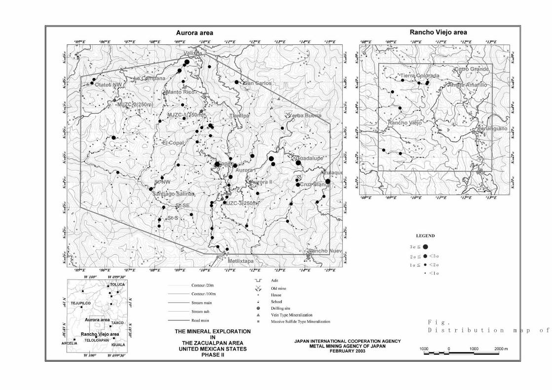
Fig.Ⅱ-2-12Distribution map of Pb
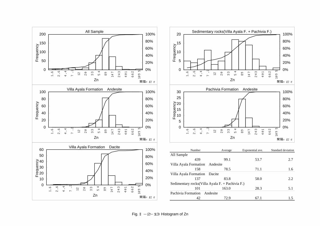
Number Average Exponential ave. Standard deviationAll Sample
439 99.1 53.7 2.7Villa Ayala Formation Andesite
158 78.5 71.1 1.6Villa Ayala Formation Dacite
137 83.8 58.0 2.2Sedimentary rocks(Villa Ayala F. + Pachivia F.)
101 163.0 28.3 5.1Pachivia Formation Andesite
42 72.9 67.1 1.5
All Sample
0
50
100
150
200
1.6
2.6
4.4
7.2 12
20
33
54
89
147
243
401
662
1095
Zn
Freq
uenc
y
0%
20%
40%
60%
80%
100%
間隔=1/2σ
Villa Ayala Formation Andesite
0
20
40
60
80
100
1.6
2.6
4.4
7.2 12
20
33
54
89
147
243
401
662
1095Zn
Freq
uenc
y
0%
20%
40%
60%
80%
100%
間隔=1/2σ
Villa Ayala Formation Dacite
0102030405060
1.6
2.6
4.4
7.2 12
20
33
54
89
147
243
401
662
1095
Zn
Freq
uenc
y
0%
20%
40%
60%
80%
100%
間隔=1/2σ
Sedimentary rocks(Villa Ayala F. + Pachivia F.)
0
5
10
15
20
1.6
2.6
4.4
7.2 12
20
33
54
89
147
243
401
662
1095
Zn
Freq
uenc
y
0%
20%
40%
60%
80%
100%
間隔=1/2σ
Pachivia Formation Andesite
05
1015202530
1.6
2.6
4.4
7.2 12
20
33
54
89
147
243
401
662
1095
Zn
Freq
uenc
y
0%
20%
40%
60%
80%
100%
間隔=1/2σ
Fig. Ⅱ-2-13 Histogram of Zn
Fig.Ⅱ-2-14Distribution map of Zn

Number Average Exponential ave. Standard deviationAll Sample
439 0.2507 0.0523 6.1633Villa Ayala Formation Andesite
158 0.2353 0.0406 6.8851Villa Ayala Formation Dacite
137 0.1838 0.0490 5.7246Sedimentary rocks(Villa Ayala F. + Pachivia F.)
101 0.4081 0.0933 5.8982Pachivia Formation Andesite
42 0.1533 0.0418 4.3407
All Sample
0
20
40
60
80
100
0.0
08
0.0
16
0.0
29
0.0
52
0.0
96
0.1
76
0.3
22
0.5
90
1.0
8
1.9
8
3.6
4
6.6
7
S
Freq
uenc
y
0%
20%
40%
60%
80%
100%
間隔=1/3σ
Villa Ayala Formation Andesite
0
10
20
30
40
50
0.0
08
0.0
16
0.0
29
0.0
52
0.0
96
0.1
76
0.3
22
0.5
90
1.0
8
1.9
8
3.6
4
6.6
7S
Freq
uenc
y
0%
20%
40%
60%
80%
100%
間隔=1/3σ
Villa Ayala Formation Dacite
05
101520253035
0.0
08
0.0
16
0.0
29
0.0
52
0.0
96
0.1
76
0.3
22
0.5
90
1.0
8
1.9
8
3.6
4
6.6
7
S
Freq
uenc
y
0%
20%
40%
60%
80%
100%
間隔=1/3σ
Sedimentary rocks(Villa Ayala F. + Pachivia F.)
05
1015202530
0.0
08
0.0
16
0.0
29
0.0
52
0.0
96
0.1
76
0.3
22
0.5
90
1.0
8
1.9
8
3.6
4
6.6
7
S
Freq
uenc
y
0%
20%
40%
60%
80%
100%
間隔=1/3σ
Pachivia Formation Andesite
02468
1012
0.0
08
0.0
16
0.0
29
0.0
52
0.0
96
0.1
76
0.3
22
0.5
90
1.0
8
1.9
8
3.6
4
6.6
7
S
Freq
uenc
y
0%
20%
40%
60%
80%
100%
間隔=1/3σ
Fig. Ⅱ-2-15 Histogram of S

Fig.Ⅱ-2-16Distribution map of S

Fig.Ⅱ-2-18Distribution map of principal factor 2
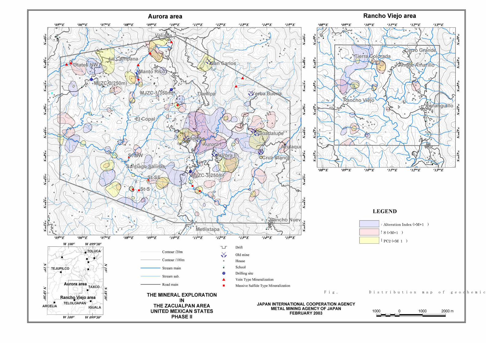
Alteration Index (>M+1 )
S (>M+1 )
PC2 (<M 1 )
Fig.Ⅱ-2-19 Distribution map of geochemical anomaly zones
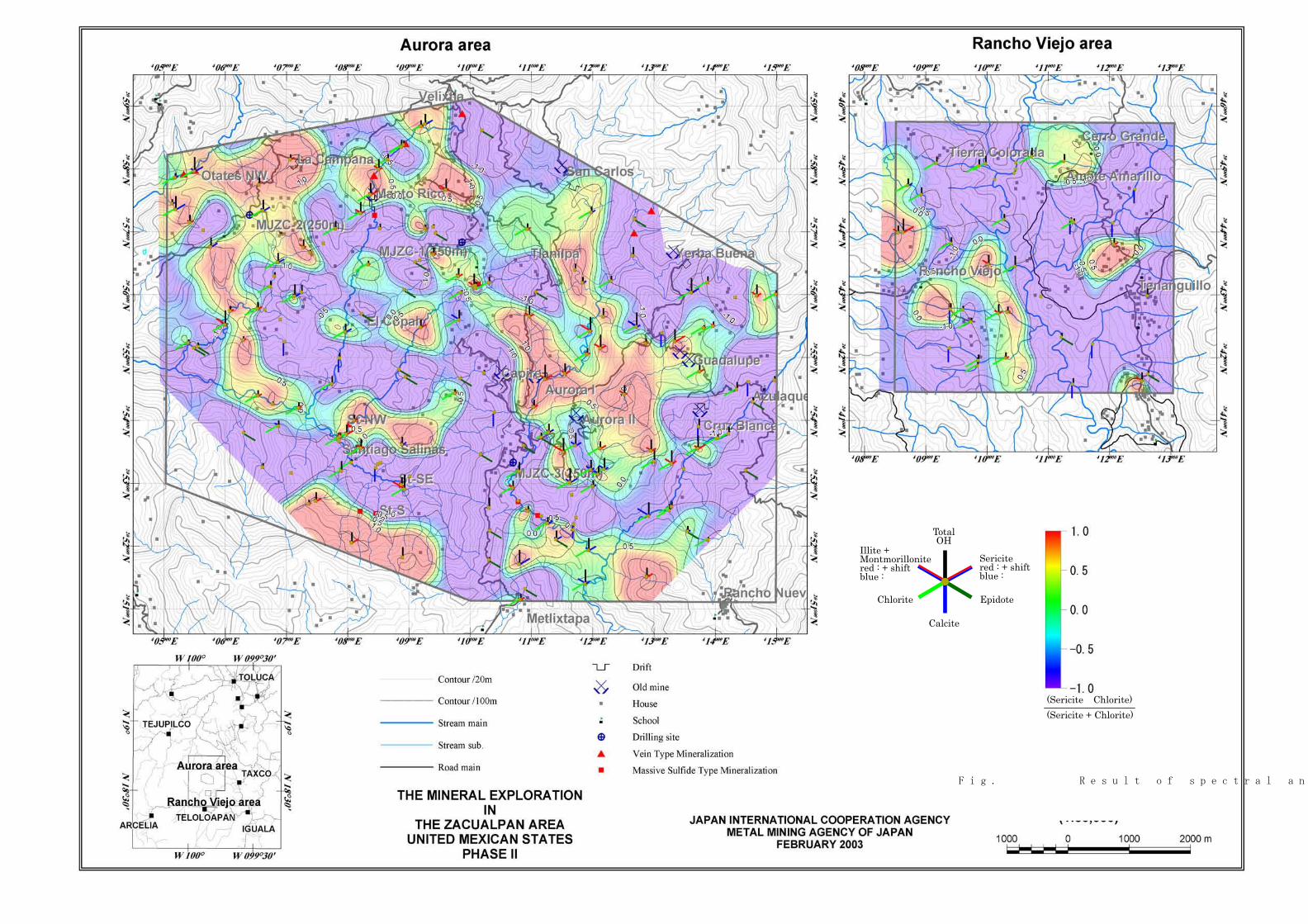
TotalOH
Sericitered : + shift blue :
Epidote
Calcite
Chlorite
Illite + Montmorillonitered : + shiftblue :
(Sericite Chlorite)(Sericite + Chlorite)
Fig.Ⅱ-2-21 Result of spectral analysis

Table Ⅱ-2-2 List of statistic data for cemical analysis
Element Al2O3 BaO CaO Cr2O3 Fe2O3 K2O MgO MnO Na2O P2O5 SiO2 SrO TiO2 LOIMinmum 0.07 0.005 0.03 0.005 0.06 0.01 0.005 0.005 0.005 0.005 0.55 0.005 0.005 1.4Maximum 20.45 0.71 54.7 0.13 12.67 10.12 14.1 0.55 7.34 2.35 91.83 0.15 2 44.74Average 13.02558 0.054214 9.298519 0.010273 4.810456 1.543599 2.868394 0.077916 2.533781 0.135 54.8441 0.031333 0.57672 9.532984Geometoric meanMedian 14.41 0.04 5.16 0.005 5.08 1.27 2.56 0.06 2.56 0.1 57.01 0.03 0.67 5.43Standard deviation 4.838566 0.063824 13.4907 0.012657 2.643082 1.350471 1.989914 0.073046 1.671853 0.202828 19.228 0.023639 0.375587 10.75988Detection limit
Element Au Ag Al As B Ba Be Bi Ca Cd Co Cr Cu FeMinmum 0.5 0.1 0.01 1 5 5 0.25 1 0.005 0.25 0.5 1 0.5 0.04Maximum 84 20 5.35 200 20 670 1.5 8 15 56 40 299 1135 7.79Average 1.318907 0.257403 1.837084 5.439636 5.125285 50.67198 0.33713 1.302961 3.761993 0.583144 9.849658 47.67198 23.74943 2.716446Geometoric mean 0.654788 0.135292 1.211064 2.428791 5.079573 28.98291 0.309072 1.147112 1.512547 0.334518 4.973959 33.38624 10.60745 2.001183Median 0.5 0.1 1.82 2 5 30 0.25 1 1.94 0.25 10 38 14 2.86Standard deviation 5.87539 1.306773 1.15288 13.42935 0.97703 76.26972 0.182604 1.092425 4.670499 2.757189 8.32969 43.48848 60.23678 1.557492Detection limit 358 316 3 210 430 39 320 380 1 328 88 0 18 0
Element Ga Hg K La Mg Mn Mo Na Ni P Pb S Sb ScMinmum 5 0.5 0.005 5 0.005 2.5 0.5 0.005 0.5 5 1 0.005 1 0.5Maximum 20 4 1.71 30 7.8 2920 121 0.11 386 9790 1260 6.08 20 24Average 6.492027 0.531891 0.087016 6.127563 1.385547 489.664 1.58656 0.022232 15.20501 539.8747 11.07289 0.250683 1.457859 5.405467Geometoric mean 6.129536 0.516518 0.055857 5.721225 0.929937 319.1341 0.75713 0.016559 5.386598 315.059 4.054689 0.052254 1.175824 3.207174Median 5 0.5 0.07 5 1.22 400 0.5 0.02 6 380 4 0.05 1 4Standard deviation 2.435338 0.231895 0.103369 3.211302 1.02574 417.4205 6.629843 0.017015 29.52702 822.6597 64.75478 0.590845 1.842528 4.752151Detection limit 312 423 34 364 0 0 301 80 62 0 83 94 380 74
Element Sr Ti Tl U V W ZnMinmum 2 0.005 5 5 0.5 5 1Maximum 778 0.49 5 50 320 5 10000Average 79.36674 0.077437 5 6.161731 51.78018 5 99.10478Geometoric mean 36.18366 0.025962 5 5.386678 20.04279 5 53.74252Median 34 0.02 5 5 43 5 64Standard deviation 123.1657 0.091732 0 6.322302 50.05463 0 481.7116Detection limit 0 201 439 419 25 439 0

Table Ⅱ-2-3 Correlation coefficient of minor elements
AU AG AL AS B BA BE BI CA CD CO CR CU FE GA HG K LA MG MN MO NA NI P PB S SB SC SR TI TL U V W ZNAU 1.00 0.29 -0.05 0.30 -0.05 0.01 0.02 0.05 -0.10 0.02 -0.07 0.06 0.05 0.01 -0.08 0.12 0.06 -0.01 -0.07 -0.10 0.19 0.01 -0.02 -0.08 0.25 0.17 0.27 -0.09 -0.09 -0.05 -- -0.02 -0.04 -- -0.03AG 0.59 1.00 0.09 0.22 0.05 0.10 0.03 0.12 -0.21 0.30 0.02 0.06 0.20 0.10 0.02 0.02 0.11 0.02 0.05 -0.03 0.07 -0.06 0.05 -0.01 0.29 0.09 0.16 0.01 -0.22 0.05 -- -0.09 0.04 -- 0.19AL -0.08 0.05 1.00 -0.05 0.11 0.20 0.34 0.12 -0.14 0.16 0.65 0.63 0.54 0.91 0.46 -0.03 0.33 -0.06 0.68 0.33 -0.11 0.39 0.41 0.22 0.07 -0.05 0.01 0.68 -0.35 0.51 -- -0.46 0.56 -- 0.72AS 0.59 0.17 -0.10 1.00 -0.07 0.08 -0.02 -0.04 -0.29 0.10 0.00 0.05 0.05 0.06 -0.11 0.04 0.22 0.11 -0.23 -0.22 0.29 -0.03 -0.01 -0.10 0.43 0.39 0.37 -0.04 -0.28 -0.04 -- 0.00 -0.05 -- 0.06B -0.02 -0.01 0.16 -0.03 1.00 -0.02 0.24 0.00 0.09 0.03 0.10 0.09 0.09 0.07 0.15 -0.02 -0.11 0.00 0.07 0.10 -0.03 0.05 0.15 0.17 -0.03 -0.01 0.01 0.12 0.03 0.16 -- -0.03 0.12 -- 0.06BA 0.23 0.28 -0.10 -0.01 0.00 1.00 -0.01 -0.03 -0.36 -0.04 -0.06 0.17 0.04 0.17 -0.02 -0.04 0.45 0.18 -0.06 -0.09 0.01 0.14 -0.13 -0.22 0.24 -0.05 -0.03 -0.05 -0.31 -0.01 -- -0.20 -0.16 -- 0.27BE -0.02 -0.03 0.38 -0.06 0.23 -0.05 1.00 0.28 0.15 0.17 0.36 0.20 0.31 0.28 0.20 0.06 0.11 -0.02 0.21 0.17 -0.06 0.26 0.31 0.33 -0.02 -0.05 0.03 0.45 0.03 0.55 -- -0.12 0.40 -- 0.18BI -0.02 -0.01 0.12 -0.04 -0.01 -0.06 0.19 1.00 0.11 0.13 0.19 0.12 0.18 0.12 -0.04 0.13 0.04 -0.09 0.14 0.13 -0.01 0.08 0.22 0.24 -0.06 0.02 0.06 0.21 0.04 0.15 -- -0.07 0.20 -- 0.04CA -0.07 -0.07 -0.29 -0.13 0.03 -0.14 -0.06 0.01 1.00 0.16 0.32 -0.14 0.13 -0.12 0.18 0.03 -0.31 -0.25 0.23 0.60 -0.03 -0.02 0.42 0.55 -0.40 0.07 0.02 0.32 0.85 0.24 -- 0.29 0.44 -- -0.18CD 0.00 0.64 0.16 0.03 0.00 0.01 0.00 0.00 -0.01 1.00 0.21 0.17 0.32 0.20 0.15 0.02 0.04 0.01 0.20 0.26 0.07 -0.05 0.33 0.23 0.20 0.09 0.09 0.26 0.11 0.15 -- -0.02 0.27 -- 0.43CO -0.07 0.02 0.69 -0.04 0.08 -0.12 0.27 0.16 -0.04 0.11 1.00 0.51 0.72 0.74 0.44 0.01 0.26 -0.23 0.52 0.64 -0.11 0.38 0.80 0.63 -0.14 0.11 0.09 0.86 0.08 0.65 -- -0.25 0.89 -- 0.46CR 0.00 0.02 0.34 -0.02 0.07 -0.02 0.12 0.15 -0.02 0.07 0.52 1.00 0.47 0.64 0.25 -0.01 0.31 0.02 0.33 0.21 -0.09 0.39 0.53 0.10 0.12 -0.04 0.01 0.50 -0.28 0.42 -- -0.34 0.37 -- 0.50CU 0.00 0.59 0.27 -0.01 0.01 0.00 0.04 0.04 -0.04 0.87 0.30 0.19 1.00 0.61 0.32 0.02 0.29 -0.10 0.39 0.43 -0.03 0.20 0.70 0.46 0.08 0.15 0.06 0.67 -0.04 0.54 -- -0.24 0.66 -- 0.52FE 0.01 0.05 0.83 0.11 0.04 -0.13 0.25 0.15 -0.29 0.14 0.74 0.27 0.28 1.00 0.43 -0.01 0.41 -0.09 0.62 0.41 -0.06 0.40 0.51 0.24 0.12 0.08 0.08 0.72 -0.33 0.47 -- -0.43 0.61 -- 0.74GA -0.06 0.03 0.64 -0.08 0.14 0.00 0.15 -0.06 -0.02 0.08 0.46 0.18 0.15 0.56 1.00 -0.07 -0.07 -0.13 0.43 0.41 -0.11 0.04 0.33 0.27 -0.01 0.00 -0.06 0.49 0.01 0.34 -- -0.13 0.47 -- 0.29HG 0.07 0.00 -0.04 0.05 -0.02 -0.04 0.04 0.04 0.05 -0.01 -0.04 -0.02 -0.01 -0.02 -0.06 1.00 0.00 -0.02 0.02 0.01 0.08 0.07 0.03 0.10 -0.01 0.04 0.16 0.03 0.01 -0.01 -- 0.01 0.07 -- -0.04K 0.09 0.08 -0.05 0.09 -0.04 0.12 0.05 0.00 -0.18 0.01 0.08 -0.03 0.07 0.06 -0.04 -0.02 1.00 0.19 -0.08 0.08 -0.02 0.23 0.12 0.01 0.22 -0.01 0.08 0.23 -0.34 0.11 -- -0.30 0.08 -- 0.41LA 0.03 0.08 -0.15 0.05 -0.01 0.09 -0.01 -0.07 -0.14 0.05 -0.19 -0.05 0.02 -0.16 -0.11 -0.03 0.15 1.00 -0.20 -0.18 0.06 0.02 -0.15 -0.19 0.29 -0.08 -0.05 -0.23 -0.19 -0.18 -- -0.09 -0.31 -- 0.07MG -0.05 0.07 0.73 -0.09 0.05 -0.09 0.20 0.12 -0.06 0.17 0.63 0.47 0.29 0.64 0.48 -0.04 -0.06 -0.14 1.00 0.50 -0.09 0.20 0.44 0.29 -0.14 0.03 -0.05 0.54 0.09 0.37 -- -0.18 0.53 -- 0.47MN -0.09 0.00 0.32 -0.10 0.08 0.01 0.06 0.05 0.30 0.07 0.48 0.28 0.18 0.44 0.40 -0.03 0.08 -0.12 0.34 1.00 -0.12 0.11 0.54 0.54 -0.22 0.06 -0.02 0.57 0.41 0.35 -- -0.04 0.63 -- 0.31MO 0.03 0.00 -0.05 0.10 -0.02 0.01 0.05 -0.01 0.01 0.00 -0.08 -0.07 -0.03 -0.02 -0.05 0.01 -0.02 -0.01 -0.05 -0.03 1.00 -0.12 0.00 0.01 0.19 0.26 0.18 -0.15 -0.01 -0.13 -- 0.08 -0.09 -- -0.04NA -0.04 -0.07 0.17 -0.03 0.04 0.05 0.18 0.08 -0.25 -0.06 0.26 0.14 -0.03 0.21 -0.01 0.06 0.05 0.05 0.08 0.05 -0.05 1.00 0.24 0.20 0.01 -0.05 0.04 0.38 -0.14 0.47 -- -0.24 0.35 -- 0.27NI -0.02 0.06 0.27 -0.05 0.10 -0.03 0.10 0.13 0.22 0.13 0.59 0.69 0.25 0.26 0.20 -0.02 -0.01 -0.05 0.46 0.35 -0.04 0.07 1.00 0.69 -0.11 0.07 0.06 0.69 0.28 0.54 -- -0.06 0.76 -- 0.32P -0.05 0.01 0.00 -0.06 0.14 -0.09 0.14 0.12 0.35 0.06 0.14 -0.02 0.08 -0.01 0.06 0.07 -0.04 -0.04 0.03 0.12 -0.01 0.05 0.15 1.00 -0.24 0.01 0.05 0.55 0.42 0.49 -- 0.14 0.75 -- 0.13PB 0.63 0.35 0.01 0.68 -0.01 0.05 -0.03 -0.02 -0.06 0.33 0.00 0.03 0.30 0.12 0.01 0.08 0.03 0.03 0.05 0.00 0.04 -0.05 0.02 -0.01 1.00 0.28 0.11 -0.15 -0.39 -0.14 -- -0.13 -0.22 -- 0.31S 0.35 0.06 -0.04 0.68 -0.04 -0.04 0.00 0.03 -0.08 0.00 0.12 -0.06 0.05 0.26 -0.05 0.04 0.06 -0.04 -0.02 -0.05 0.09 0.01 -0.02 -0.03 0.45 1.00 0.18 0.05 0.01 -0.03 -- 0.04 0.07 -- 0.01SB 0.30 0.11 -0.04 0.62 -0.01 -0.03 -0.01 0.06 -0.01 0.03 0.00 -0.03 -0.01 0.11 -0.07 0.12 0.03 -0.03 -0.05 -0.01 0.09 0.00 -0.02 -0.02 0.31 0.50 1.00 0.06 0.01 0.09 -- -0.05 0.10 -- 0.02SC -0.09 -0.01 0.68 -0.06 0.11 -0.14 0.46 0.21 0.02 0.07 0.77 0.49 0.21 0.66 0.52 0.00 0.09 -0.18 0.55 0.45 -0.05 0.26 0.37 0.10 -0.04 0.02 0.00 1.00 0.08 0.66 -- -0.28 0.87 -- 0.48SR -0.06 -0.06 -0.39 -0.10 -0.02 -0.13 -0.11 0.00 0.86 -0.01 -0.18 -0.17 -0.07 -0.38 -0.12 0.04 -0.19 -0.12 -0.16 0.07 -0.01 -0.27 0.03 0.34 -0.05 -0.08 -0.01 -0.15 1.00 0.04 -- 0.40 0.22 -- -0.33TI -0.07 -0.02 0.54 -0.08 0.19 -0.08 0.51 0.13 -0.06 0.03 0.64 0.32 0.16 0.45 0.33 -0.03 0.18 -0.11 0.40 0.23 -0.05 0.42 0.33 0.19 -0.04 0.00 0.01 0.63 -0.16 1.00 -- -0.20 0.69 -- 0.29TL -- -- -- -- -- -- -- -- -- -- -- -- -- -- -- -- -- -- -- -- -- -- -- -- -- -- -- -- -- -- -- -- -- -- --U -0.02 -0.02 -0.28 -0.02 -0.02 -0.07 -0.09 -0.05 0.44 -0.01 -0.19 -0.17 -0.06 -0.29 -0.11 0.00 -0.12 -0.06 -0.12 -0.07 0.01 -0.17 -0.06 0.33 -0.02 -0.04 -0.04 -0.18 0.53 -0.15 -- 1.00 -0.14 -- -0.32V -0.07 0.04 0.72 -0.06 0.11 -0.14 0.41 0.17 -0.01 0.15 0.81 0.43 0.30 0.70 0.56 0.02 0.08 -0.17 0.59 0.43 -0.06 0.33 0.39 0.17 0.00 0.01 -0.02 0.86 -0.14 0.75 -- -0.16 1.00 -- 0.37W -- -- -- -- -- -- -- -- -- -- -- -- -- -- -- -- -- -- -- -- -- -- -- -- -- -- -- -- -- -- -- -- -- -- --ZN 0.00 0.65 0.17 0.01 0.00 0.02 -0.02 -0.02 -0.07 0.98 0.11 0.06 0.88 0.15 0.09 -0.01 0.02 0.07 0.17 0.07 -0.01 -0.05 0.10 0.04 0.33 0.00 0.00 0.05 -0.06 0.02 -- -0.03 0.13 -- 1.00

Table Ⅱ-2-4 Result of principal factor analysis
STAT. Factor Load (analysis_log.sta)FACTORANALYSIS
Factor Factor Factor Factor1 2 3 4
AU -0.044575 -0.525044 -0.267535 -0.187480AG 0.103167 -0.525622 0.047750 -0.201618AS -0.049336 -0.722442 -0.184563 0.164246B 0.170781 0.048043 0.186873 -0.209701BA -0.039951 -0.250912 0.571233 -0.098064BE 0.467034 0.002968 0.029829 -0.494155BI 0.255345 -0.043475 -0.212972 -0.618612CD 0.394263 -0.342496 0.094930 -0.022531CO 0.923743 0.054358 -0.095110 0.103450CR 0.591483 -0.161652 0.336658 -0.075409CU 0.802759 -0.190792 0.056104 0.020511GA 0.545123 0.124173 0.164499 0.246228HG 0.029282 -0.117452 -0.321921 -0.416105LA -0.227125 -0.242108 0.487014 -0.134870MN 0.684935 0.223354 -0.091646 0.173823MO -0.121535 -0.448761 -0.286948 0.143406NI 0.842229 -0.000976 -0.118366 0.014511PB -0.085052 -0.736655 0.333761 0.087255S 0.079445 -0.467762 -0.354021 0.388827SB 0.067967 -0.452544 -0.417529 -0.074347SC 0.909667 0.084525 -0.028660 0.007592V 0.903165 0.113433 -0.216886 0.045547ZN 0.573116 -0.313637 0.482386 0.086662説明済 5.864853 2.747569 1.814177 1.277476寄与率 0.254994 0.119460 0.078877 0.055542
Element

-131-
Chapter 3 Drilling Survey
3-1 Survey Method
1 Outline
The drilling survey has been performed in the three points shown in Figure
II-3-1 to make clear the geological structure, and state of mineralizaion and alteration
in the Aurora area.
MJZC-1 has been planed at Tlanilpa, where some mineral occurrences are
known, in the central north district for planed 350 meters deep. MJZC-2 has been
planned at the northwestern district, where some mineral occurrences exist but no
drilling has been done until now, for planned 250 meters deep. MJZC-3 has been
planned at the area to the south of the Aurora mineral occurrence in the central
district for planned 250 meters deep. These are all vertical holes.
A local contractor, Asesoria y Servicios de Perforacion, has conducted the
drilling.
The drilling cores have been inspected, and presented in drilling logs, 1/200 in
scale. In the same time, some color photos of the cores have been taken, and some
specimens for laboratory tests have been sampled. The all drilling-cores have been
kept in the CRM office in Teloloapan.
2 Drilling Method and Equipment
The drilling has been done using a Longyear 38 machine, and the wire line
method has been applied. Casing pipes have been inserted near the surface, if it was
necessary. Polymer or other chemicals have been used for preservation of boreholes in
response to the state of boreholes.
Table II-3-1 and II-3-2 show the principal machines and equipment for the
drilling.
3 Working Condition
Access road construction, arrangement removal were carried out one shift/day
and drilling work was in two shifts/day as a principal. Personnel for one drilling shift
-132-
consisted of one to two engineers and two to three workers. The base of survey was laid
in Tlanilpa and Otates. Daily necessities including food and fuels were provided by car
from Teloloapan.
4 Transportation of Equipment, Rig up and Tear Down
Tracks have been used for the move-in and transportation of the drilling
machine in the field through unpaved roads to the drilling site. The location of MJZC-1
is in a rugged terrain for transportation due to bad weather condition, accordingly the
transportation for several hundreds meters has to be relied on manpower. Preparation
of drilling site has been kept as much as small-scale considering environmental
preservation, and done by manpower. The drilling sites have been back to the original
state after moved out, and the drill hole have been covered by cement being recorded
the hole number and depth according to the CRM’s custom.
5 Drilling Water
In MJZC-1 and MJZC-3, enough volume of water could not obtained from the
nearby area, so that the necessary water had to be purchased from a pond for farming.
In MJZC-2, stream water has been pumped up, and reserved in the mud pit.
6 Progress of Drilling
Figure II-3-2 to Figure II-3-4 show the location of the drill holes, and Tables
II-3-3 and II-3-4 show the drilling result and process.
(1) MJZC-1
The drilling period is from October 3 to October 21. The wire line NQ drilling
method has been applied from the surface to the bottom of the hole. The drilling rate
has lowered, because troubles such as break of machine parts have happened, and
andesitic rocks having many cracks have been encountered below the depth of 270
meters.
-133-
(2) MJZC-2
The drilling period is from November 8 to November 15. The wire line NQ
drilling method has been applied from the surface to the bottom. The drilling has very
smoothly been done, because no trouble has happened, and all the rocks are stable.
(3) MJZC-3
The drilling period is from October 25 to November 6. The wire line NQ
drilling method has been applied. Troubles of the water pump have happened twice, so
that the drilling rate has lowered during the mid periods. However, the recovery rate
has not lowered, and the drilling has finished.
3-2 Survey Result
Figures II-3-5, II-3-6, and II-3-7 show the geological columner sections,
Figures II-3-8 shows the geological sections, and Tables II-3-5 and II-3-6 show the
assay result and laboratory test result.
1 MJZC-1
(1)Geology
・ 0-6.0 m: Cracked limestone and calcareous slate. Some weathered parts along
cracks.
・6.0-37.1m: Dacitic rock containing many plagioclase phenocrysts. The groundmass
is vitric, and shows dark gray due to argillization. Essential vitric fragments and rock
fragments of underlying porphyritic andesite and fine-grain rocks are contained. Below
24.5 meters, pyroxene andesite cobles and boulders are contained. Under the
microscopic observation of the rock specimen at 32 meters, altered plagioclase
phenocrysts, chlorite, calcite, and iron minerals are seen.
・37.1-53.2 m: Green andesitic tuff to lapilli tuff. The matrix is mainly vitric.
Accessory porphyritic andesite, accidental silicified micro-grained pyrite are contained.
Around 40 to 41 meters depth, rocks change to sandy tuff, and grading structure is
seen. Beds incline 20 degrees. In the X-ray diffraction analysis, large amounts of
-134-
chlorite and small amounts of sericite, calcite, and dolomite are detected in the rock
specimen at 45.5 meters.
・53.2-67.3 m: Reddish to yellowish-greenish gray andesite lava partly showing
opaque autobrecciated structure. Hematite contains in reddish parts and chlorite in
yellowish green parts. Below 61 meters, silicification makes leaching. In the X-ray
diffraction analysis, small amounts of chlorite, sericite, and calcite are detected.
・67.3-121.5 m: Andesitic lapilli tuff to hyaloclastite. Much chloritized accessory
andesite fragments are contained, being accompanied by small amounts of silicified
rocks and green andesite fragments. The groundmass is fine-grained green glass, being
accompanied by chip-like essential glass fragments with plagioclase phenocrysts. At
104.2 meters and 109.8 meters, rocks change to course-grained tuff. The bedding
inclines about 30 degrees. At 92.7 meters, a 10 cm width small fault inclining 50
degrees containing solid cemented clay is seen.
・121.5-145.0 m: Greenish to yellowish-greenish-gray massive, compact andesite lava.
Small amounts of coarse-grained plagioclase and pyroxene phenocrysts, smaller than 3
millimeters in diameter, are contained. No breccia structure is seen. This part is
gradually changed to the underlying layer. Under the microscopic observation of the
sample at 132.5 meters, altered plagioclase set in intersertal groundmass
accompanying chlorite and calcite are seen.
・145.0-150.2 m: Andesitic lapilli tuff to hyaloclastite containing altered accessory
andesite and essential glass fragments. The fragments are 1 to 5 cm in size. The rocks
contact with lower andesite by fracture zone.
・150.2-221.7 m: Andesite lava. About 10 meters thick upper zone shows bluish green
and fine-grained parts, being possible sheared zone. Most parts are of chloritized
massive porphyritic rocks. The lower boundary zone is fine-grained and vitric. Sheared
zones exist at 166.4m and in 198.7 to 199.0 meters.
・221.7-269.5 m: Andesitic lapilli tuff to hyaloclastite, having same facies as of the
upper layer. They show same facies as that of the upper layer. These rocks contain
yellowish green andesitic accessory fragments, and fine-grained andesite and silicified
rock fragments. Under the microscope, plagioclase fragments, chlorite, calcite are
-135-
observed in chlorite altered groundmass.
・269.5-321.8 m: Andesitic tuff and lapilli tuff. Tuff mainly consists of green glass,
being accompanied by green andesite and silicified rock fragments, but volume of
fragments is smaller than that of the upper layer. In 286.2 meters to 300 meters and
303.5 meters to 307 meters, chloritized sheared zones exist.
・321.8-326.5 m: Massive, compact, fine-grained andesite lava. Strong hematite,
chlorite alteration are seen. The lower boundary is of high angle, sheared zone.
・326.5-350.1 m: Yellowish-grayish-green brecciated lava or lapilli tuff with strong
chloritization. Green glass fragments are seen in fine-grained groundmass. Sheared
zone is accompanied by clay in 340.5 to 344.3 meters.
(2) Mineralization and Alteration
A significant mineralized part is seen in the upper part of dacite. It is of the
fine-grained pyrite dissemination and network. Some specimens taken at the depths of
11.8 meters and 28.4 meters have been examined by observation of polished section,
X-ray diffraction, and chemical assay. The assay result is as follows.
0.03 ppm Au, 0.75 to 5.50 ppm Ag, 25 to 32 ppm Cu, 9 to 32 ppm Pb,
36 to 93 ppm Zn, 103 to 201 ppm Ba, 5.17 to 7.17 % Fe, 4.07 to 7.07 % S
In the X-ray diffraction analysis, sericite, chlorite, calcite, and pyrite are
detected. In the polished section, fine-grained pyrites occurred in spaces between
fragments, and colloform structure is partly seen. Fine pyrite grains also exist in the
fragments. No other ore minerals are seen.
At 183.5 meters, 192.6 to 193.3 meters, and 194.7 to 195.4 meters,
calcite-quartz-pyrite veins exist. The assay result of the sample at 192.8 meters is as
follows.
0.03 ppm Au, 0.35 ppm Ag, 22 ppm Cu, 17 ppm Pb, 34 ppm Zn,
172 ppm Ba, 4.53 % Fe, 3.06 % S
Sericite, chlorite, calcite, pyrite, and quartz are detected as alteration
minerals. In the polished section, irregular to idiomorphic pyrites are observed in
quartz veins, and small amounts of fine-grained pyrite are disseminated there.

-136-
2 MJZC-2
(1) Geology
・0.8-8.1 m: Mainly brownish gray weathered schistose rocks.
・8.1-37.0 m: Dark green to grayish green andesitic tuff to lapilli tuff. Foliation planes
are well developed, and banded structure is partly seen. Essential gravels are
confirmed up to the depth of 17 meters, but tend to be flattened. Hematite increases to
the lower part, rock color turns to reddish. This layer gradually changes to the lower
layer. In the X-ray diffraction analysis, of the rock at 17.5 meters, mainly sericite and
calcite, chlorite, and pyrite are detected.
・37.0-55.8 m: Schistose rock with banded structure due to chlorite rich layers and
sericite rich layers with well developed foliation and cleavage. It is possibly that the
source rock is andesitic tuff. Green flattened glass chips are seen. Under the
microscope, the sample at 46.3 meters shows lepidoblastic texture, and quartz, calcite,
chlorite, and sericite align along schistosity. Inclination of foliation plane is 10 degrees.
The contact plane between upper and lower layers is 40 degrees.
・55.8-82.0 m: Altered fine-grained to aphanitic andesite intrusive rock. The rock
shows generally greenish gray, but partly gray networks are seen. It is thought that
fine-grained green spots are of chloritized mafic mineral phenocrysts or glass. In 75 to
78 meters, brecciate to shearing structure is seen. In 79.5 to 82 meters, rock is mixed
with the lower schistose rock.
・82.0-187.0 m: Banded schistose rock of chlorite rich layers and sericite rich layers.
Partly plagioclase phenocrysts, flattened green glass and pumice are contained. Rarely
altered fragments are seen. Foliation plane and cleavage inclines 20 to 50 degrees.
Rocks in 105.5 to 109.5 meters are possibly acidic rocks origin due to dominant quartz
and sericite. Rocks in 184 to 184.9 are of green basic schistose rock.
・187.0-250.0 m: Dark green basic volcanic rock, originally schistose rocks. Plagioclase
relicts are confirmed in many places. In 209.6 to 228 meters, opaque, deformed,
autobrecciated structure is seen. Inclination of schistosity is 10 to 45 degrees. In the
X-ray diffraction analysis of the rock at 218.7 meters, large amounts of chlorite and
calcite, medium amounts of sericite and dolomite, and small amounts of pyrite are

-137-
seen.
(2) Mineralization and Alteration
Networks and silicified zones formed by quartz, calcite, and pyrite are seen in
the andesite. Its hanging and footwall schistose rocks have been disseminated by
pyrite, maximum 5 %, and some film-like mineralized parts are seen. In the assay
result of the rock at 80.6 meters is as follows.
<0.01 ppm Au, <0.01 ppm Ag, 33 ppm Cu, 7 ppm Pb, 48 ppm Zn,
327 ppm Ba, 4.75 % Fe, 2.09 % S
In the polished section of the same specimen, some fine-grained pyrite
network and minor amounts of limonite altered from magnetite are seen. In the X-ray
diffraction analysis, chlorite, calcite, and pyrite are detected
The maximum values of the assay result of the specimens from 45.5, 115.8,
and 128.0 meters are as follows
0.12 ppm Au, 0.45 ppm Ag, 23 ppm Cu, 26 ppm Pb, 198 ppm Zn,
336 ppm Ba, 6.58 % Fe, 6.19 % S
In the polished section, slightly coarse-grained irregular and idiomorphic
pyrite are only seen. In the X-ray diffraction analysis of the specimen at 45.5 meters,
chlorite, sericite, pyrite, and dolomite are detected.
3 MJZC-3
(1) Geology
・0-7.5 m: Talus deposits consisting of weathered yellowish tuff, sandstone, and soil.
・7.5-11.0 m: Weathered yellowish tuffaceous sandstone.
・11.0-34.1 m: Mainly black slate, being accompanied by fine-grained tuffaceous
fragment and mineralized breccia. Alternation of thin layers of those is seen. In 18.6 to
22.45, the rock is calcareous. Inclination of beds is about 45 degrees. Weak
dissemination and films of pyrite, and calcite veinlets are seen.
・34.1-39.5 m: Pale yellowish gray vitric fine-grained tuff. Slump-like structure is seen,
and mud ball-like slate is included inside. Under the microscopic observation,

-138-
specimen at 34.6 meters plagioclase fragment is seen in the vitric groundmass. In the
X-ray diffraction analysis, chlorite, calcite, sericite, and pyrite are detected.
・39.5-53.1 m: Irregular alternation of black slate and tuff. Slate is dominant in the
upper part being accompanied with lenticular tuff, and tuff is dominant in the lower
part. Sandy limestone beds are intercalated in 45.8 to 46.8 meters. Small amounts of
pyrite films and mineralized fragments are in the whole section. Inclination of beds is
about 20 degrees.
・53.1 - 78.5 m: Massive coarse-grained dacite to salic andesite intrusive rock. The
upper boundary inclines 20 degrees, and lower boundary gradually changes to
fine-grained rock. The rock is greenish gray and contains relatively large amounts of
plagioclase phenocryst, 1 to 2 millimeters in size, and colored minerals. Steep angle
calcite veins are distributed in the rock. Little pyrite dissemination nor foliation planes
exist. Under the microscope, the rock at 65.6 meters is judged pyroxene andesite
containing amphibole. In the X-ray analysis, chlorite and calcite are detected.
・78.5-126.8 m: Mainly black slate being accompanied by thin layer and fragmental
vitric tuff. Vitric tuff in 85.1 to 87.7 meters, and calcareous slate in 119.8 to 122.3
meters are dominant. Under the microscope, rocks at 121.8 meters show aligned large
amounts of calcite and small amounts of quartz grains along schistosity. Small
amounts of lenses and films of pyrite and mineralized fragments are seen along
bedding planes. Bedding inclines 20 to 40 degrees. Small-scale overturned folding
structure is seen at 87.4 meters.
・126.8-131.2 m: Tuffaceous breccia. Lithic lapilli stone like part and muddy
fragments are contained.
・131.2-132.5 m: Alternation of well stratified tuff and slate. The rock gradually
changes to lower calcareous slate.
・132.5-136.2 m: Calcareous slate and limestone showing cleavage and bedding planes.
Thin layers of fine-grained pyrite are intercalated. Cleavage and bedding planes
incline 50 degrees.
・136.2-137.6 m: Yellowish gray vitric tuff containing plagioclase phenocrysts.
・137.6-139.7 m: Calcareous limestone with foliation and bedding planes. The rock

-139-
gradually changes to lower breccia.
・139.7-144.8 m: Breccia containing silicified andesite fragments and mineralized rock
fragments ( micro-grained pyrite dissemination).
・144.8-170.0 m: Grayish blue to bluish green autobrecciated andesite lava. Small
amounts of plagioclase and pyroxene phenocrysts exist. Calcite veins are distributed in
the whole section. Gray quartz fills openings of breccia. The contact plane with the
lower layer declines 70 degrees with sheared zone. Under the microscope, the specimen
at 166.0 meters is altered andesite showing intersertal texture. In the X-ray diffraction
analysis of the same specimen, chlorite, and small amounts of sericite, quartz, and
calcite are detected.
・170.0-173.9 m: Dacitic breccia. The upper part is of lapilli tuff containing accidental
silicified fragments. Main component is brecciated vitric lava containing plagioclase
phenocrysts. At the unit boundary at 173.9 meters, phenocryst increases.
・173.9-187.9 m: Grayish green dacitic and andesitic tuff to breccia. Fine-grained
plagioclase is spotted, but mostly green vitric groundmass. The boundary with the
lower unit turned to dark gray vitric groundmass. In the X-ray diffraction analysis of
the specimen at 186.5 meters, some chlorite, and small amounts of calcite and sericite
are detected.
・187.9-199.7 m: Andesitic lapilli tuff and hyaloclastite. The groundmass is mostly
vitric, and contains some fragments of accessory fine-grained porphyritic andesite and
coarse-grained chloritized andesite. The rock gradually changes to autobrecciated lava
of lower layer.
・199.7-250.0 meters: Dark green to grayish green autobrecciated lava. The rock is
generally vitric, but being accompanied by small amounts of plagioclase phenocrysts.
Hyaloclastite principally consisting of green glass balls in 220.0 to 222.5 meters is the
boundary of the unit. Under the microscope, the specimen at 204.5 meters is of
brecciated rock consisting of plagioclase phenocrysts and groundmass showing
intersertal texture. In the X-ray diffraction analysis of the specimen at 186.5 meters,
some chlorite, and small amount of calcite and sericite are detected.
-140-
(2) Mineralization and Alteration
The sedimentary rocks and dacitic breccia above the andesite contain small
amounts of fine-grained pyrite dissemination, films and thin layers, and mineralized
fragments. The maximum values for each element in the chemical assay, for eight
samples, are as follows.
0.18 ppm Au, 1.05 ppm Ag, 46 ppm Cu, 24 ppm Pb, 253 ppm Zn,
771 ppm Ba, 5.55 % Fe, 4.35 % S
In the polished section of eight specimens, most of the mineralized parts are of
pyrite dissemination and fragments of fine-grained pyrite dissemination. In the
specimen taken at the depth of 91.2 meters, pyrite is accompanied with minor amounts
of chalcopyrite. In the specimens take at the depth of 107.8 meters and 114.8 meters, a
little colloform texture and framboidal texture have been observed.
4 Laboratory test (fluid inclusion test and isotopic analysis)
(1) Fluid Inclusion Test
The test has been conducted for three specimens as shown in Tale II-3-5(4).
The test could not be achieve for the two specimens of MJZC-1, because the size of their
inclusions are too small (smaller than 1μm), and they contain too much gas inclusion.
The specimen taken at the depth of 131.5 meters (MJZC-3) is of quartz from a
layered white mineral vein in the stratified tuff. The homogenized temperature of the
inclusion ranges between 220゜and 270゜C, forming a single population. The salinity
ranges between 3 and 4 percent. It is possible that the homogenization temperature
reflects the hydrothermal activity of film-like pyrite in surroundings.
(2) Isotopic Analysis
The oxygen isotope (δ18O) of silicates and the carbon (δ13C) and oxygen
isotopes of carbonates for analysis are shown in Table II-3-5(5).
The dacite taken at the depth of 32 meters in MJZC-1 has been measured for
the oxygen isotope on silicates. δ18O is 15.1 per mil, which is approximately same
value as that of the dacite on the surface to the south of the drill hole (14.5 and 15.8 per

-141-
mil). δ13C andδ18O of the limestone taken at the depth of five meters are -0.6 per mil
and -14.5 per mil respectively, lower than those of the limestone on the surface (δ13C;
1 per mil, δ18O; 9.5 per mil).
Two specimens taken at the depth of 34.6 meters (dacite tuff) and 186.5
meters (andesite) in MJZC-3 have been measured for oxygen isotope on silicates. δ18O
of dacite tuff and andesite are 15.5 per mil and 15.1 per mil respectively. These values
indicate no significant alteration but are equivalent to the background of surface
samples.
Two specimens taken at the depth of 45.5 meters (calcareous slate) and 138.2
meters (limestone) in MJZC-3 have been measured for oxygen isotope and carbon
isotope on carbonates. δ13C values on carbonates of these core samples show -5.6 per
mil (45.5m) and -2.4 per mil (138.2m), and alsoδ18O values are -14.2 per mil (45.5m),
-14.5 per mil (138.2m). It is considered that these indicate hydrothermal calcite origin.

Teloloapan
Taxco

Geo
logi
cal S
ecti
on L
ine
MJZC-1(350m)

Geological Section Line
WSW
ENE
MJZC-2(250m)

Geological Section LineW EMJZC-3(250m)
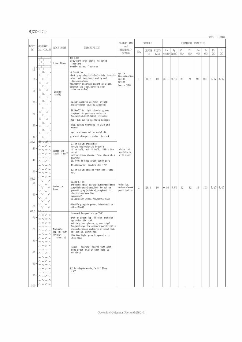


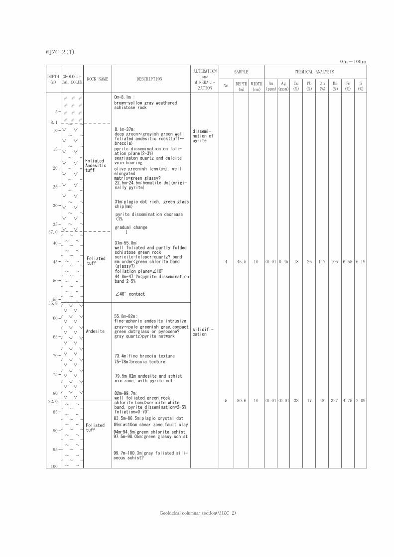


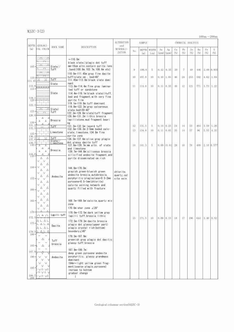


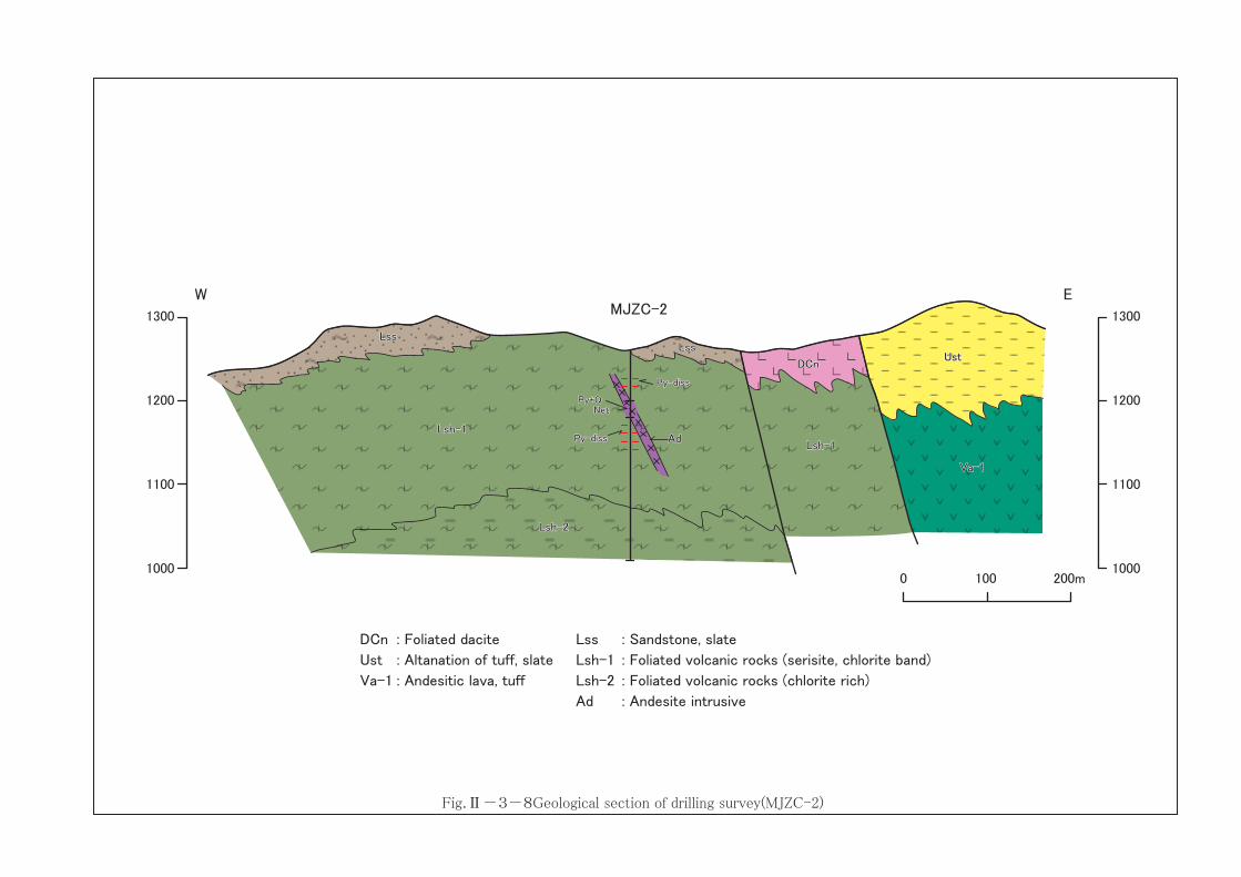

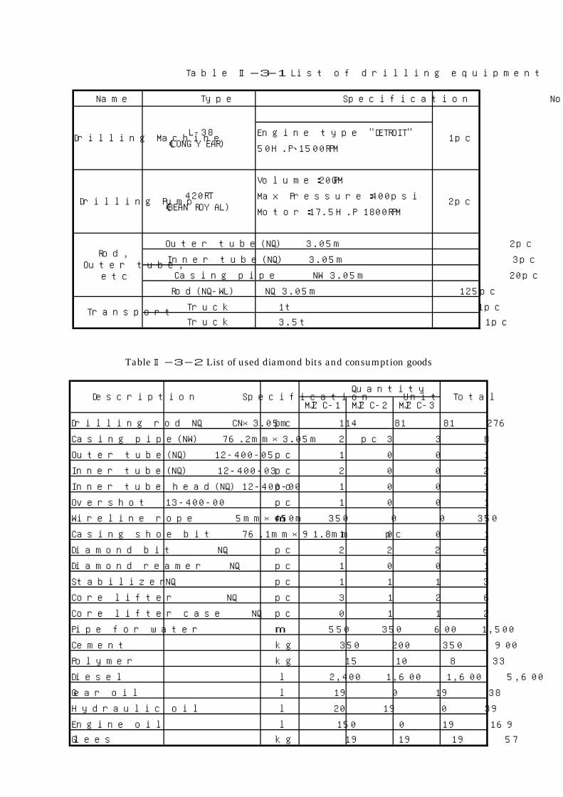
Name Type Specification No.
Engine type "DETROIT"
50H.P、1500RPM
Volume:20GPM
Max Pressure:400psi
Motor:17.5H.P 1800RPM
Outer tube(NQ) 3.05m 2pc
Inner tube(NQ) 3.05m 3pc
Casing pipe NW 3.05m 20pc
Rod(NQ-WL) NQ 3.05m 125pc
Truck 1t 1pc
Truck 3.5t 1pcTransport
Rod,Outer tube,
etc
Table Ⅱ-3-1 List of drilling equipment
L-38(LONG YEAR)
420RT(BEAN ROYAL)
1pc
2pc
Drilling Machine
Drilling Pump
MJZC-1 MJZC-2 MJZC-3
Drilling rod NQ CN×3.05m pc 114 81 81 276
Casing pipe(NW) 76.2mm×3.05m pc 2 3 3 8
Outer tube(NQ) 12-400-05 pc 1 0 0 1
Inner tube(NQ) 12-400-03 pc 2 0 0 2
Inner tube head(NQ) 12-400-00 pc 1 0 0 1
Overshot 13-400-00 pc 1 0 0 1
Wireline rope 5mm×450m m 350 0 0 350
Casing shoe bit 76.1mm×91.8mm pc 1 0 0 1
Diamond bit NQ pc 2 2 2 6
Diamond reamer NQ pc 1 0 0 1
Stabilizer NQ pc 1 1 1 3
Core lifter NQ pc 3 1 2 6
Core lifter case NQ pc 0 1 1 2
Pipe for water m 550 350 600 1,500
Cement kg 350 200 350 900
Polymer kg 15 10 8 33
Diesel l 2,400 1,600 1,600 5,600
Gear oil l 19 0 19 38
Hydraulic oil l 20 19 0 39
Engine oil l 150 0 19 169
Glees kg 19 19 19 57
Total
Table Ⅱ-3-2 List of used diamond bits and consumption goods
QuantityDescription Specification Unit
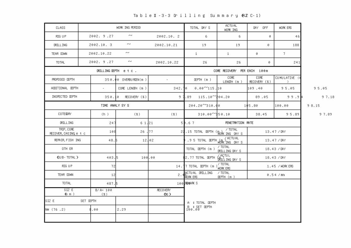
CLASS TOTAL DAYSACTUALWORKING
DAY OFF WORKERS
RIG UP ~ 2002.10. 2 6 6 0 46
DRILLING ~ 2002.10.21 19 19 0 188
TEAR DOWN ~ 1 1 0 7
TOTAL ~ 2002.10.22 26 26 0 241
350.00 OVERBURDEN(m) - DEPTH(m)CORE
LENGTH(m)CORE
RECOVERY(%)CUMULATIVE(%
)
- CORE LENGTH(m) 342.70 0.00~115.10 109.40 95.05 95.05
350.10 RECOVERY(%) 97.89 115.10~204.20 89.05 99.94 97.18
204.20~310.00 105.80 100.00 98.15
(h) (%) (%) 310.00~350.10 38.45 95.89 97.89
247 61.21 50.67
108 26.77 22.15 TOTAL DEPTH(m)/TOTAL
WORKING DAYS13.47 /DAY
48.5 12.02 9.95 TOTAL DEPTH(m)/ACTUAL
WORKING DAYS13.47 /DAY
TOTAL DEPTH(m)/TOTALDRILLING DAYS
18.43 /DAY
403.5 100.00 82.77 TOTAL DEPTH(m)/ACTULDRILLING DAYS
18.43 /DAY
72 14.77 TOTAL DEPTH(m)/TOTALWORKERS
1.45 /WORKERS
12 2.46ACTUAL DRILLINGWORKERS
/TOTALDEPTH(m)
0.54 /m
487.5 100.00
B/A×100(%)
RECOVERY
(%)
SIZE SET DEPTH
NW (76.2) 8.00 2.29 100.00
TRIP,CORERECOVER,CASING,etc
REPAIR,FISHING
DRILLING DEPTH etc.
PROPOSED DEPTH
ADDITIONAL DEPTH
A : TOTAL DEPTH B : SET DEPTH
TOTAL
SIZE(mm)
WORKING PERIOD
TIME ANALYSYS
2002. 9.27
2002.10. 3
2002.10.22
2002. 9.27
OTHER
TableⅡ-3-3 Drilling Summary(MJZC-1)
PENETRATION RATE
CORE RECOVERY PER EACH 100m
REMARKS
(SUB-TOTAL)
INSPECTED DEPTH
RIG UP
TEAR DOWN
COTEGORY
DRILLING
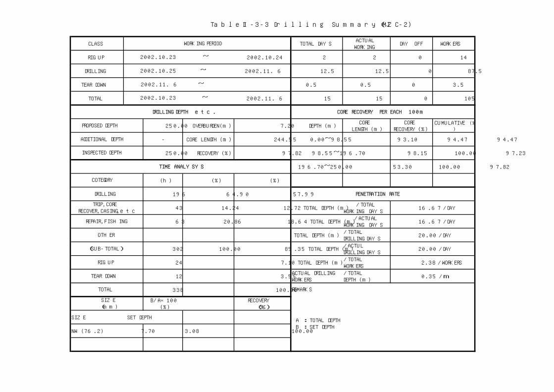
CLASS TOTAL DAYSACTUALWORKING
DAY OFF WORKERS
RIG UP ~ 2002.10.24 2 2 0 14
DRILLING ~ 2002.11. 6 12.5 12.5 0 87.5
TEAR DOWN ~ 0.5 0.5 0 3.5
TOTAL ~ 2002.11. 6 15 15 0 105
250.00 OVERBURDEN(m) 7.20 DEPTH(m)CORE
LENGTH(m)CORE
RECOVERY(%)CUMULATIVE(%
)
- CORE LENGTH(m) 244.55 0.00~98.55 93.10 94.47 94.47
250.00 RECOVERY(%) 97.82 98.55~196.70 98.15 100.00 97.23
196.70~250.00 53.30 100.00 97.82
(h) (%) (%)
196 64.90 57.99
43 14.24 12.72 TOTAL DEPTH(m)/TOTAL
WORKING DAYS16.67 /DAY
63 20.86 18.64 TOTAL DEPTH(m)/ACTUAL
WORKING DAYS16.67 /DAY
TOTAL DEPTH(m)/TOTALDRILLING DAYS
20.00 /DAY
302 100.00 89.35 TOTAL DEPTH(m)/ACTULDRILLING DAYS
20.00 /DAY
24 7.10 TOTAL DEPTH(m)/TOTALWORKERS
2.38 /WORKERS
12 3.55ACTUAL DRILLINGWORKERS
/TOTALDEPTH(m)
0.35 /m
338 100.00
B/A×100(%)
RECOVERY
(%)
SIZE SET DEPTH
NW (76.2) 7.70 3.08 100.00
TableⅡ-3-3 Drilling Summary(MJZC-2)
PENETRATION RATE
CORE RECOVERY PER EACH 100m
REMARKS
(SUB-TOTAL)
RIG UP
TEAR DOWN
COTEGORY
DRILLING
TRIP,CORERECOVER,CASING,etc
A : TOTAL DEPTH B : SET DEPTH
TOTAL
SIZE(mm)
WORKING PERIOD
TIME ANALYSYS
2002.10.23
2002.10.25
2002.11. 6
2002.10.23
OTHER
REPAIR,FISHING
DRILLING DEPTH etc.
PROPOSED DEPTH
ADDITIONAL DEPTH
INSPECTED DEPTH

CLASS TOTAL DAYSACTUALWORKING
DAY OFF WORKERS
RIG UP ~ 1 1 0 7
DRILLING ~ 2002.11.15 8 8 0 56
TEAR DOWN ~ 1 1 0 7
TOTAL ~ 2002.11.16 10 10 0 70
250.00 OVERBURDEN(m) 8.10 DEPTH(m)CORE
LENGTH(m)CORE
RECOVERY(%)CUMULATIVE(%
)
- CORE LENGTH(m) 244.25 0.00~118.60 112.60 94.94 94.94
250.25 RECOVERY(%) 97.60 118.60~195.95 77.35 100.00 96.94
195.95~250.25 54.30 100.00 97.60
(h) (%) (%)
128 74.42 65.98
28 16.28 14.43 TOTAL DEPTH(m)/TOTAL
WORKING DAYS25.03 /DAY
16 9.30 8.25 TOTAL DEPTH(m)/ACTUAL
WORKING DAYS25.03 /DAY
TOTAL DEPTH(m)/TOTALDRILLING DAYS
31.28 /DAY
172 100.00 88.66 TOTAL DEPTH(m)/ACTULDRILLING DAYS
31.28 /DAY
10 5.15 TOTAL DEPTH(m)/TOTALWORKERS
3.58 /WORKERS
12 6.19ACTUAL DRILLINGWORKERS
/TOTALDEPTH(m)
0.22 /m
194 100.00
B/A×100(%)
RECOVERY
(%)
SIZE SET DEPTH
NW (76.2) 3.15 1.26 100.00
TRIP,CORERECOVER,CASING,etc
REPAIR,FISHING
DRILLING DEPTH etc.
PROPOSED DEPTH
ADDITIONAL DEPTH
A : TOTAL DEPTH B : SET DEPTH
TOTAL
SIZE(mm)
WORKING PERIOD
TIME ANALYSYS
2002.11. 7
2002.11. 8
2002.11.16
2002.11. 7
OTHER
TableⅡ-3-3 Drilling Summary(MJZC-3)
PENETRATION RATE
CORE RECOVERY PER EACH 100m
REMARKS
(SUB-TOTAL)
INSPECTED DEPTH
RIG UP
TEAR DOWN
COTEGORY
DRILLING

Hole Name Item September
Transportation 27 2
MJZC-1 Drilling 3 21
Tear down 22
Rig up 7
MJZC-2 Drilling 8 15
Tear down 16
Rig up 23 24
MJZC-1 Drilling 25 6
Tear down 6
Table Ⅱ-3-4 Drilling schedule
October Novmber
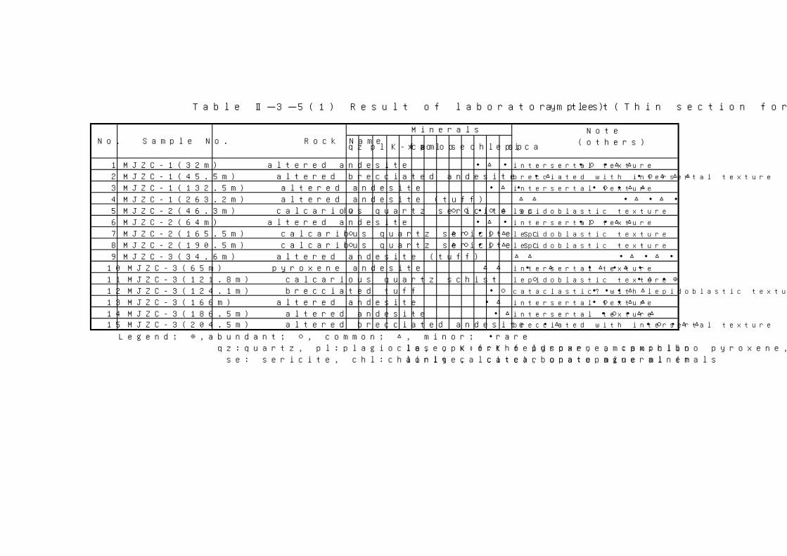
Note
(others)
1 MJZC-1(32m) altered andesite ・ △ ・ ・ ○ ・ △ △ intersertal texture
2 MJZC-1(45.5m) altered brecciated andesite ・ △ ・ ○ △ △ △ brecciated with intersertal texture
3 MJZC-1(132.5m) altered andesite ・ △ ・ ・ ○ ・ △ △ intersertal texture
4 MJZC-1(263.2m) altered andesite (tuff) △ △ ・ △ ・ △ ・
5 MJZC-2(46.3m) calcarious quartz sericite sch○ ○ ○ ・ ○ △ lepidoblastic texture
6 MJZC-2(64m) altered andesite ・ △ ・ ・ ○ ・ △ △ intersertal texture
7 MJZC-2(165.5m) calcarious quartz sericite sch○ △ ○ ・ ○ △ lepidoblastic texture
8 MJZC-2(190.5m) calcarious quartz sericite sch○ △ ○ ・ ○ △ lepidoblastic texture
9 MJZC-3(34.6m) altered andesite (tuff) △ △ ・ △ ・ △ ・
10 MJZC-3(65m) pyroxene andesite △ △ ・ △ ・ △ ・ △ ・ intersertal texture
11 MJZC-3(121.8m) calcarious quartz schist ○ ・ △ ・ ◎ lepidoblastic texture
12 MJZC-3(124.1m) brecciated tuff ・ ○ ・ ・ ・ △ △ cataclastic? with lepidoblastic texture
13 MJZC-3(166m) altered andesite ・ △ ・ ○ ・ △ △ intersertal texture
14 MJZC-3(186.5m) altered andesite ・ △ ・ ○ ・ △ △ intersertal texture
15 MJZC-3(204.5m) altered brecciated andesite ・ △ ・ ○ ・ △ △ brecciated with intersertal texture
Legend; ◎,abundant; ○, common; △, minor; ・rare
qz:quartz, pl:plagioclase, K-f:K feldspar, am:amphibole, opx:ortho pyroxene, cpx:clino pyroxene, ol:olivine
se: sericite, chl:chlorite, ca:carbonate mineral (mainly calcite), opa:opague minerals
Table Ⅱ-3-5(1) Result of laboratory test(Thin section for core sample)
Sample No. Rock Name
Minerals
No.qz pl K-f amopxcpxol opasechlepi ca

Note
py As Mc sph gn cp Th Bo ilm Ba Cv Rt (others)
1 MJZC-1 8.1m ◎
2 MJZC-1 28.4m Pyrite Network ◎ Colloform
3 MJZC-1 192.8m Q-Cal-Py vein ○
4 MJZC-2 43m Pyrite lens, diss ◎
5 MJZC-2 80.5m Pyrite Network △
6 MJZC-2 115.8m Pyriet dissemination, frag △
7 MJZC-3 42.0m Pyriet dissemination, frag ◎
8 MJZC-3 92.1m Pyrite lens, diss ◎ ・
9 MJZC-3 106.6m Pyrite dissemination band △ ・
10 MJZC-3 107.8m Pyrite film, dissemination △ Colloform、framboidal
11 MJZC-3 114.8m Pyrite film, dissemination △ ・
12 MJZC-3 131.5m Pyrite film, dissemination ○
13 MJZC-3 134.8m Pyrite film, dissemination ○ Framboidal
14 MJZC-3 141.3m Brecciated △
15 MJZC-3 171.5m Brecciated △ ・
Legend; ◎,abundant; ○, common; △, minor; ・rare
Py:pyrite, As:arsenopyrite, Mc: marcasite, Sph:sphalerite, Gn:galena, Cp:chalcopyrite, Th:tetrahedorite,
Bo:bornite Po:pyrrhotite, Cv:covelline, Ba:barite, Rt:rutile
Ore minerals
Table Ⅱ-3-5(2) Result of laboratory test(Polished section for core sample)
No. Sample No Location Sample Type
Sulphide network

Qz Ab Kf Sm Ha K Ch S S3 Pg Gp Ba Ja Ca Do Py Gn Sph Px Hb Ep
1 11.8m Dacite △ △ △ △ ○ ・ △ ・ pyrite dissemination
2 28.4m Dacite △ ○ ・ △ ・ ・ △ ・
3 45.5m Andesite △ ・ ○ ・ ・ △
4 54.5m Andesite ○ ◎ ・ ・ ・ ・
5 192.8m Andesite ○ ○ ・ ○ ○ △ pyrite vein
6 17.5m Foliated tuff △ △ ・ △ ◎ ・
7 45.5m Foliated tuff ○ △ ・ ◎ ・ △ pyrite dissemination
8 80.6m Andesite ○ △ ○ △ ◎ ・
9 218.7m Andesite ○ ・ ○ △ ◎ △ ・
10 34.6m Tuff △ ○ △ ・ ○ ・
11 65.6m Andesite ○ ○ △ △ △
12 124.1m Slate>tuff ○ △ ○ ・ △ ・
13 166.0m Andesite ○ △ △ ・ ・ ・
14 186.5m Andesite ・ ○ ○ ・ △
Legend; ◎,abundant; ○, common; △, minor; ・rare
Qz:quartz, Ab:albite, Kf:K feldspar, Sm:smectite, Ha:halloysite, K: kaolinite, Ch:chlorite, S;sericite,S3;sericite(3T), Pg:palagonite, Gp:gypsum,
Ba:barite, Ja:jarosite, Ca:calcite, Do: dolomite, Py:pyrite, Gn:galena, Sph:sphalerite, Px:pyroxene, Hb:horblende, Ep:epidote
Detected Minerals
Table Ⅱ-3-5(3) Result of laboratory test(X-ray diffraction for core sample)
No. Sample No, Rock name, type
MJZC-2MJZC-2
RemarksSilica M Feldspar M Clay Minerals Sulphate M Other Minerals
MJZC-1
MJZC-3MJZC-3
MJZC-2MJZC-3MJZC-3MJZC-3
MJZC-1MJZC-1
MJZC-1MJZC-2
MJZC-1

Temperature(℃)No. range average S.D.1 MJZC-3 131.5m Quartz 20 223~277 245.9 14.1 Size=5.0~17.5μm2 MJZC-1 28.4m Quartz - - - - 1μgass inclusion3 MJZC-1 192.8m Calcite - - - - 1μgass inclusion
Frozn temp(℃) salinity(wt%)Min. Max. Ave. Min. Max. Ave.
1 MJZC-3 131.5m Quartz 10 -2.5 -1.6 -1.98 2.90 4.18 3.352 MJZC-1 28.4m Quartz - - - - - - - No data3 MJZC-1 192.8m Calcite - - - - - - - No data
MJZC-3 131.5m
Mineral Quartz
Number 20
Max. 277 ℃
Min. 223 ℃
Average 249.5 ℃
S.D. 14.1
Temperature
Table Ⅱ-3-5(4) Result of laboratory test(fluid inclusion test,temperature)
Table Ⅱ-3-5(4) Result of laboratory test(fluid inclusion test,salinity)
Form
Frequency
remarksNo. Sample name mineral Number
Sample name mineralinclusion no.
0
1
2
3
4
5
6
7
8
9
200 210 220 230 240 250 260 270 280 290 300

Table Ⅱ-3-5(5) Result of laboratory tests (Isotope, for core samples)
Oxygen isotope
Sample Rock Name treated for carbonate Yield δ18O(SMOW)
MJZC-1, 32.0m dacite treated 20% HCl 14.0 15.1
MJZC-3, 34.6m dc tuff treated 20% HCl 14.4 15.5
MJZC-3, 186.5m Alt Ad treated 20% HCl 15.1 15.1
Oxygen isotope and carbon isotope on carbonates
Sample Rock Name δ13C δ18O
MJZC-1 5.0M CALC SLATE/ls -0.6 -14.5
MJZC-3 45.5M CALC SLATE -5.6 -14.2
MJZC-3 138.2M CALC SLATE/ls -2.4 -14.5
-173-
Part Ⅲ Conclusions and Recommendation
Chapter 1Conclusion
Following surveys are carried out in second year: The geological and
geochemical survey in the Aurora area and the Rancho Viejo area, the detail geological
survey in the Santiago Salinas area and three drilling survey in the Aurora area.
The geology of the Aurora area is composed of the Villa Ayala Formation, the
Pachivia Formation and intrusive rocks.
The Villa Ayala Formation is composed of schistose volcanic rocks (Lsh),
schistose sedimentary rocks (Lss), andesites (Va1~Va6, Vam), dacite (DCw, DCe, DCn,
DCc, Vad) and sedimentary rocks (Us, Ust, Ms).
The Pachivia Formation consists of the layers (CFm) that are mainly
composed of slate and volcanic rocks (CFv).
The geological structure is complicatedly controlled by the folding and fault
structures whose axis is NNE to NNW with the gently inclined cleavage. As a whole,
andesite Va-1 is located in the central part and sedimentary rocks surround it, the
outsides of the sedimentary rocks andesites Va-2~Va-5 are distributed. Dacite rock
bodies are distributed in the south west and south east of the area and schistose
volcanic rocks and sedimentary rocks occupy in the corner of the northwestern part of
the area. The Pachivia Formation is distributed in a belt with the direction of north to
the south in the eastern part of the area. The Formation dips westward in appearance,
but the horizon is judged to be overturned by the fossil age and the folding pattern.
There are massive sulfide type ore deposit and metalliferous vein type ore
deposit as the mineralization of the Aurora area. Within the above massive sulfide ore
deposit, the Capire, the Aurora and the Manto Rico ore deposit occur within the
sedimentary rocks of the upper part of the Villa Ayala Formation. On the other hand,
the Guadalupe and the Cruz Blanca deposit occur within the uppermost part of the
Pachivia Formation. These ore deposits are relatively rich in Pb, Zn, Ag and Ba. As a
result of this year’s survey, the Santiago Salinas district and the La Campana district
were found as the place of ore showing. The detail geological survey was carried out in
the Santiago Salinas district and confirmed the horizon of occurrence of massive

-174-
sulfide ore deposit.
Based on the geochemical survey, the zone that shows more than +1σ of
average alteration index of each rock facies is considered to reflect the halo of the
alteration related to the massive sulfide alteration. It became obvious that there are
high possibility of that Ag, As, Zn, Pb, Cd and Ba as the trace elements to the
indication elements for metalliferous vein type and Au, Ag, As and S as the indication
elements for massive sulfide type ore deposit are effective. Besides the above, principal
component analysis can extract the anomaly related to the mineralization in the La
Campana, the south of Velixtla, the Santiago Salinas and around the Capire to the
Aurora deposits.
The horizon of massive sulfide ore deposit was observed in the shallow part of
the drilling hole MJZC-1. Sulfide network was also observed within the footwall dacite.
This horizon continues to the place of mineralization indicate of Tlanilpa and the
drilling hole TN-14 that was already drilled. Drilling hole MJZC-2 intersected volcanic
rocks that develop schistosity. Though the volcanic rocks show strong pyrite
dissemination, the horizon of these volcanic rocks were judged to be lower than the
horizon of massive sulfide ore deposit. Drilling hole MJZC-3 intersected the
sedimentary rock that is the same as the host rocks of the Capire and the Aurora
deposit were observed in the depth of 149.5 meters. The weak pyrite dissemination and
mineralized rock fragments were sampled in the same depth. Under the sedimentary
rock, andesite lava of the Villa Ayala Formation that corresponds to andsite Va-4 of the
surface was observed.
The geology of the Rancho Viejo area is composed of the Villa Ayala Formation,
the Pachivia Formation.
The Villa Ayala Formation is composed of basalt to andesitic rocks (Va) and
dacite (Vd). The quantity of the dacite is less than that in the Aurora area.
The Pachivia Formation is composed of basalt to andesitic tuff (CFv),
limestone (CFL), slate (CFs), and alternation of tuff and slate (CFt).
As the geological structure, cleavage with the direction of NNE~NNW
develops as same as in the Aurora area, it shows that the folding structure in the NNE
-175-
~NNW direction is dominant. The dip of the strata is west in appearance and the
strata is generally overturned.
Though alteration accompanied with mineralization is observed in several
places, all of them were small scale and the zones were limited.
Geochemical anomaly zones of alteration index are outlined in part of the
northwestern district of the Rancho Viejo area by geochemical survey.
Considering the above facts, the north of Capire district, the Santiago Salinas
district and La Campana district in the Aurora area, are considered to be the
prospective zones for ore deposit (shown in figure 1-5-1), since those districts have
thick distribution of hanging wall, geochemical anomaly and remarkable ore showing.
Although the distribution of the horizon of massive sulfide ore deposit and the
hanging wall were developed in Rancho Viejo area, ore showing and marked
geochemical anomaly are rarely observed. Consequently, the potential for ore deposit is
considered to be small in the Rancho Viejo area.

-176-
Chapter 2 Recommendation for the Third Year’s Program
The distribution of sedimentary rocks related with massive sulphide deposits
(Capire deposit, Aurora deposit, etc.), ore showings, alteration zone and these
relationships have been revealed by the second year’s program. Distribution pattern of
specific elements that indicate mineralization and geochemical characteristics in the
surveyed area was outlined by geochemical survey.
The previous exploration data that was obtained in this survey, showed the
existence of unexplored districts such as Santiago Salinas, La Campana and north of
Capire deposit districts.
Massive sulfide type mineralization is expected in Santiago Salinas district
where is underlain by hanging wall sediments and alteration occurred in footwall
dacite accompanying mineralization (Ba:1%).
There is little previous exploration in La Campana district located in the west
of Manto Rico deposit, due to private mining concession. But, this survey has defined
geochemical anomaly, ore showings and ore horizon in the district. Moreover, Drilling
hole MJZC-2 encountered footwall alteration and mineralization which are correspond
to the exposure in the creek situated to the west of Otates. Therefore, Massive sulfide
ore body is expected in the depth of 200-300m below the surface between Manto Rico
deposit and La Campana.
Exploration program must be advanced in north of Capire deposit district
where exhibits geochemical anomaly and alteration zone, and is expected the
continuation of mineralization intersected hole TN-14. Since the previous drilling did
not confirm the ore horizon below thick sedimentary rocks, the deep drilling program is
desirable.
As mentioned above, farther investigations must be recommended in the
followings prospective districts to confirm continuation of mineralization and ore
horizon.
1. Santiago Salinas district
2. La Campana district
3. North of Capire deposit district

-177-
Reference
Campa, M. F (1978): La evolución tectónica de Tierra Caliente, Gro.: Bol. Soc. Geol.
Mex., Ⅳ Convención Geológica, Tomo XXXⅣ,No 2.
Campa, M. F., Campos, M., Flores, R. y Oviedo, R. (1974): La secuencia mesozoica
volcano-sedimentaria metamorfizada de Ixtapan de la Sal, México-Teloloapan,
Guerrero. : Bolétin de la Sociedad Geológica. Mexicana: v.35, p.7-28.
Campa, M. F. y Ramirez., J. (1979): La evolución geológica y la metalogénesis del
noroccidente de Guerrero: Univesidad. Autónoma de Guerrero, Serie
Técnico-Científica: núm.1, p.1-84.
Coney, P.J. y Campa, M. F. (1987): Lithotectonic terrane map of Mexico(west of the 91st.
meridian): US Geological Survey, Miscellaneous Field Studies Map
MF-1874-D.
De Cserna, Z. (1965): Reconocimiento geológico de la Sierra Madre del Sur de México
entre Chilpancingo y Acapulco, Estado de Guerrero: Universidad Nacional
Autónoma de México. Inst. Geol., Boletín: v.62, 76p.
De Cserna, Z. (1978): Notas sobre la geología de la región comprendida entre Iguala,
Ciudad Altamirano y Temascaltepec, Estado de Guerrero y México, D.F.:
Sociedad Geológica Mexicana, Libro guía de la excursión geológica a Tierra
Caliente: p.1-25.
De Cserna, Z. (1983): Hoja Tejupilco 14Q-g(9), con Resumen de la geología de la Hoja
Tejupilco, estados de Guerrero, México y Michoacán: Universidad Nacional
Autónoma de México, Instituto de Geología, Carta Geologíca de Mexico,
Serie de 1:100,000, mapa con texto explicativo: 28p.
De Cserna, Z., Palacions, N. y Pantoja, A. (1978): Relaciones de facies de las rocas
cretácicas en el noroeste de Guerrero y en áreas colindantes de México y
Michoacán: Universidad Nacional Autónoma de México. Inst. Geol., Revista:
v.2, p.8-18.
Elías-Herrera, Mariano y Sánchez-Zavala, J.L. (1992): Relaciones
tectonoestratigráficas del terreno Guerrero en la porcíon suroccidental del
estado de México y su interpretaíon geodinámica: Sociedad Geológica

-178-
Méxicana, XI Convencíon Geológica Nacional, Veracruz, Ver.,
Resúmenes(abstract).
Fries, C. (1960): Geología del estado de Morelos y de partes adyacentes de México y
Guerrero, regíon central meridional de México: Univ. Nacional Autónoma de
México, Inst. Geol., Bolétin: v.60, 236p.
Guerrero, M., Ramirez, J. y Talavera., O. (1990): Estudio estratigrafico del arco volcanico
cretácico inferior de Teloloapan. Guerrero: Abstracts, X Convencion Sociedad
Geológica Mexicana: p.67.
Guerrero, M., Ramirez, J., Talavera., O. y Campa, M.F. (1991): El desarrollo carbonatado
del cretácico inferior asociad al arco de Teloloapan, Norocidente del Estado
Guerrero: Abstracts, Convencion Sobre la Evolucion Sociedad Mexicana de
Mineralogia and Instituto de Geología, Universidad Nacional Autónoma de
México:p.67.
Ishikawa, Y., Sawaguti, T., Iwaya, S., Horiuti, M.(1976):Aproch to exprolation indicator
using footwall dacite lava of Kuroko deposit, trace for alteration haro around
Fukazawa main and volcanic activity, Mining Geology(in japanese).26(2)
JICA・ MMAJ(1994): Reporte sobre la geologia y depositos minerales en la region de
Tejupilco, Estados Unidos Mexicanos. p44
Ochoa Camarillo, H., Gomez-Moreno, V. y Leon Matz, A. (1985): Geología, geoquimica
de mercurio y magnetometria terrestre del area Azulaquez, Gro.: Informe de
Avance, GFE, CRM, Inedito.
Raiz, Erwin(1959): Landforms of Mexico, Cambridge,Mass
Reyes J.S.(1990): Prospeccion geologico-minera del area la Trinidad, Mpio, de
Zacualpan, Mex. CRM.
Sakai, H., Hisamatu, Y. (1996): Stable isotope geochemistry, University of Tokyo Press
Sedlock, R.L., Ortega, G.F., and Speed, R.C. (1993): Tectonostartigraphic terranes and
tectonic evolution of Mexico: Geological Society of America Bulletin: v.100,
p.274-281.
Serratos,R.V., Diaz, A. S,. and Martinez, M. A. (1999): Carta Geológico-Minera,
Teloloapan E14-A77.

-179-
Serratos,R.V., Diaz, A. S,. Trjillo, D. A,. and Martinez, M. A. (1999): Carta
Geológico-Minera, Pilcaya E14-A67.
Serratos,R.V.,et al(2000): Carta Geológico-Minera, Amatepec E14-A66.