protected areas - voices for biojustice
TRANSCRIPT
PROTECTED AREASand their relationship with food security in a context of
climate change:an overview from Bolivia, Brazil and Peru
Las á
rea
s pro
tegi
da
s y su
rel
aci
ón c
on la
segu
rid
ad
alim
enta
ria
en
un
cont
exto
de
cam
bio
clim
áti
co: u
na m
ira
da
des
de
Bol
ivia
, Bra
sil y
Per
ú
October 2017Lima - Perú
Manuel Ruiz Muller, in collaboration with Loyola Escamilo,
Natalia Araujo and Teresa Moreira
Protected areas and their relationship with food security in a context of climate change: an overview from Bolivia, Brazil and Peru
Author: Manuel Ruiz Muller, Peruvian Society for Environmental Law, in collaboration with Loyola Escamilo, Natalia Araujo y Teresa Moreira.
Sociedad Peruana de Derecho Ambiental (SPDA) Prolongación Arenales 437, Lima 27, Perú Phones: (511) 6124700 Fax: (511) 4424365 E-mail: [email protected] - www.spda.org.pe
Konrad Adenauer Stiftung e.V./ KAS Av. Larco 109, Piso 2, Miraflores, Lima 18 - Perú Phones: (511) 416 6100 Fax: (511) 447 4378 E-mail: [email protected] - www.kas.de/peru
Programa Regional Seguridad Energética y Cambio Climático en América Latina de la Fundación Konrad Adenauer Calle Cantuarias 160 Of. 202, Miraflores, Lima 18 - Perú Phones: (511) 320 2870, (511) 731 2898 [email protected] - www.kas.de/energie-klima-lateinamerika/
First edition: November, 2017 Legal deposit, Biblioteca Nacional del Perú No.2017-16869SBN N° 978-612-4261-27-5 Printed in:
Impresso Gráfica S.AAv. Mariscal La Mar 585, MirafloresRUC 20101052771First edition
Translation: Elissa Muller. The English version of this research is a slightly summarized version of the original research document.
Total or partial reproduction of this book for other than educational purposes is prohibited, except with express authorization of the author.
Opinions in this publication are the exclusive responsibility of the author and do not compromise nor reflect views of Konrad-Adenauer-Stiftung e.V.

Manuel Ruiz Muller, in collaboration with Loyola Escamilo,
Natalia Araujo and Teresa Moreira
PROTECTED AREAS and their relationship with food security in a context of
climate change:an overview from Bolivia, Brazil and Peru
October 2017Lima - Perú
FOREWORD
PERUVIAN SOCIETY FOR ENVIRONMENTAL LAW (SPDA)Since its foundation 30 years ago (1986), SPDA has been working in the promotion of sound environmentalpolicy and legislation both in Peru and abroad. SPDA has become one of the most recognized LatinAmerican environmental education and research non for profi t organizations. SPDA promotes andfacilitates implementation of environmental policy and legal frameworks, participates actively in technicaldiscussions and intervenes in defense of the public interest and citizen rights. To contribute to public andprivate environmental management and solution to environmental problems, SPDA promotes the useof planning and management tools and invests in education and capacity building. The institution alsopromotes corporate responsibility and articulates at diff erent levels with diff erent social actors to realizesustainable development. SPDA believes in the need to decentralize the country and value the role ofmunicipal and regional governments. SPDA has offi ces in Iquitos and Madre de Dios.
ABOUT KAS The Konrad-Adenauer-Stiftung (KAS) is a political foundation. In Germany, 16 regional offi ces and twoconference centers off er a wide variety of civic education conferences and events. The offi ces abroad arein charge of over 200 projects in more than 120 countries. At home as well as abroad, the civic educationprograms aim at promoting freedom and liberty, peace, and justice. KAS focuses on consolidatingdemocracy, the unifi cation of Europe and the strengthening of transatlantic relations, as well as ondevelopment cooperation.For KAS, Energy Security and Climate Change has become an important piece for the structure andmaintenance of a democratic social order. In this context, the Regional Programme Energy Security andClimate Change in Latin America (EKLA) of the KAS, has been designed as a dialogue platform, in order toprovide impetus for political decision- making processes.http://wwvv.kas.de/energie-klima-lateinamerika
index
index
0102030405
INDEXAcknowledgements 6
Methodology 6
Abbreviations 7
Executive Summary 9
Introduction 10
General context: biodiversity, food security, protected areas and climate change 12
Food security and biodiversity: two sides of the same coin 18
Some initial considerations on natural protected areas in Bolivia, Brazil and Peru: the Madidi, Chico Mendes and Bahuaja-Sonene cases 24
Protected areas and food security: critical inputs from Madidi, Chico Mendes and Bahuaja-Sonene 34
The impact of climate change on protected areas: preliminary evidence 42
Conclusions 46
Recommendations 47
References 48
Annex 1 52
Annex 2 60
Annex 3 68
Annex 4 74
Annex 5 75
Annex 6 76
Annex 7 77
6
ACKNOWLEDGEMENTSI would like to thank Pedro Solano, Carla Bengoa and Bruno Monteferri from the Peruvian Society for Environmental Law, and Andrea Yaipen, for their comments to preliminary versions of this document. Sections 2, 3 and 4 of this document correspond to direct contributions and inputs from Loyola Escamilo, Natalia Araujo and Teresa Moreira, adjusted and edited by the author. Finally, a special recognition and thanks to Konrad-Adenauer-Stiftung, and to Christian Hübner and Giovanni Burga for their continued support.
METHODOLOGY This research document reviews some of the ecological, economic, legal, social and policy dimensions related to natural protected areas, climate change and food security, based on experiences in the Madidi National Park and Natural Area for Integrated Management (Provinces of Iturralde and Franz Tamayo in Bolivia), the Chico Mendes Extractive Reserve (State of Acre, Brazil) and the Bahuaja-Sonene National Park (Madre de Dios Region in Peru). The research was supported by experts from each of the selected countries, who worked reviewing different versions of the document. This research document is mainly a desk study, which has included analysis of relevant literature and documents, and interactions with key experts in each country. The final version of the document went through a round of comments, which led to suggestions and recommendations for improvement. However, the content and opinions expressed in the document are the sole responsibility of the author, and do not compromise the Peruvian Society for Environmental Law nor Konrad-Adenauer-Stiftung.
7
ABBREVIATIONS
ANMI Natural Area of Integrated Management
ACP Private Conservation Area
CBD Convention on Biological Diversity
CEDAW Convention on the Elimination of all Forms
of Discrimination
CIFOR Center for International Forestry Research
CDKN Climate Development Knowledge Network
CNS National Council of Rubber Tappers
DEVIDA National Commission for Development and Life without Drugs
FAO Food and Agriculture Organization of the United Nations
FIDA International Fund for Agricultural Development
GCP Global Canopy Program
GIZ German Society for International Cooperation
GRPI Genetic Resources Policy Initiative
IBAMA Brazilian Institute of Environment and Renewable Natural Resources
ICMBio Chico Mendes Institute for Biodiversity Conservation
INEI National Institute of Statistics and Informatics
IPCC Intergovernmental Panel on Climate Change
IRSA Initiative for the Integration of the Regional Infrastructure
MINAM Ministry of Environment
MINAGRI Ministry of Agriculture and Irrigation
OMS World Health Organization
PIDESC International Covenant on Economic, Social and Cultural Rights
PNBS Bahuaja Sonene National Park
PNUD United Nations Development Programme
REDD Reducing Emissions from Deforestation and Forest Degradation
RNTC Tambopata Candamo Natonal Reserve
RESEX Chico Mendes Extractive Reserve
SERNAP National Service for Protected Areas of Bolivia
SERNANP National Service for Protected Areas of Peru
SISAN National System for Food and Nutrition Security
SPDA Peruvian Socienty for Environmental Law
TCO Tierras Comunitarias de Origen
QUNO United National Quaker Office
UICN International Union for Conservation of Nature
UNESCO United Nations Education, Scientific and Cultural Organization
WCS Wildlife Conservation Society
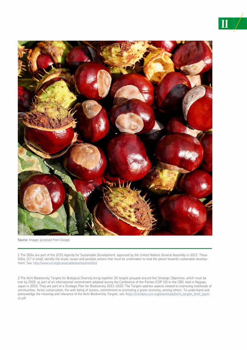
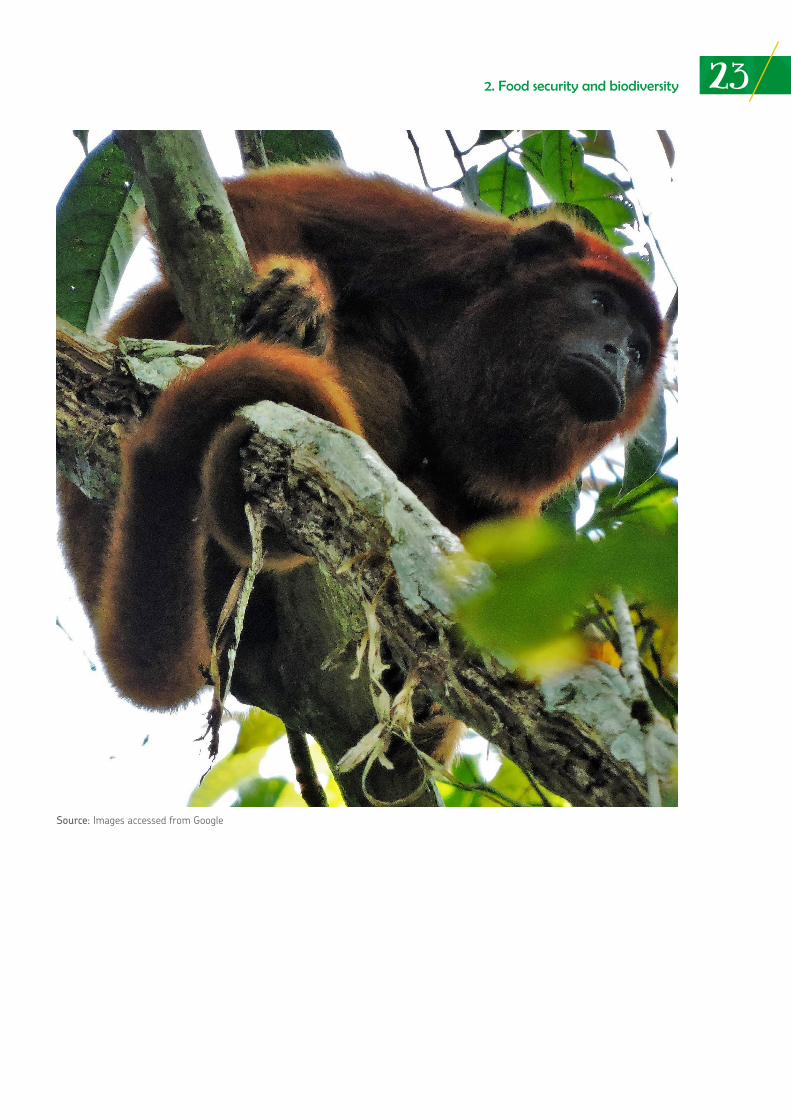
Source: Images accessed from Google
9
EXECUTIVE SUMMARY
The relationship between natural protected areas, their ecosystem services (including the provision of food and water) and climate change has been hardly explored, and in this respect, is poorly understood, particularly in the South American region. This investigation provides a synthesis of the situation in three natural protected areas in particular -the Madidi National Park and Natural Integrated Management Area (Provinces of Iturralde and Franz Tamayo in Bolivia), the Chico Mendes Extractive Reserve (State of Acre) and Bahuaja-Sonene National Park (Madres de Dios region in Peru)- in terms of their contributions to food and water security in a context of evident climate change impacts in the Amazon region. These natural protected areas have been selected due to their proximity to one another, and by the fact that they present some similarities in respect to the populations surrounding and living in them (i.e. indigenous and local communities), and the types of challenges they present based on man-made impacts and its own natural variables.
The investigation addresses these issues from a multidisciplinary perspective, but is not intended to be completely comprehensive or provide answers to many pending problems. It is a first approach that will hopefully open new lines of work and reinforce the work already under way. As part of this investigation, some preliminary conclusions are presented.
Firstly, biodiversity and agrobiodiversity conservation are an unavoidable policy and State objective, if food security is to be guaranteed – through a healthy and nutritious diet for all, at all times. This is particularly the case of food security for vulnerable communities and populations who benefit directly from the ecosystem services provided by the Madidi National Park and Natural Integrated Management Area, the Chico Mendes Extractive Reserve and Bahuaja-Sonene National Park. On the other hand, the tropical forest plays a key role in guaranteeing climate stability, as well as long-term food security for the populations that inhabit these areas and influences zones. Thirdly, the effect of climate change impacts on biodiversity in the Amazon poses a great challenge and opportunity. The populations who benefit from these natural protected areas are generally poor and very poor social groups, facing situations of food insecurity, and changes in the production, access and availability of food may aggravate this situation. Additionally, climate change impacts in the three natural protected areas under analysis are difficult to define at present. Certainly, new and more intense environmental conditions will inevitably be generated, depending on the specific event they face over time: drought, flooding, rising temperatures, cold spells, and others. There have been many examples of these events due to climate cycles such as El Niño and The Niña. Fourthly, legal certainty in terms of the land and territories of indigenous peoples and local communities is essential to guarantee food security for these populations. Together with adequate and consensual planning and space management processes, there is a greater impact on the conservation and sustainable use of resources and services provided by the protected areas and their populations. At a global level, the Amazon is the largest tropical forest on the planet, and accordingly, the main generator of oxygen for the atmosphere, highly important for the world’s climate regulation. The Amazon drainage area corresponds to the largest known river basin, and largest fresh water reserve. The Amazon is also a center with the greatest biological diversity and is a major provider for of raw materials, medicines and food for local populations and the world.
The three case studies presented in this publication describe the contribution of natural protected areas to the local economy, food security and availability of water for mainly rural families and indigenous peoples, who due to the characteristics of global economies, have become vulnerable groups because of their poverty levels, access to education and state services, among others. Additionally the case studies of each natural protected area demonstrate that forest products are highly important for the food security of local populations and their economies. Some products are used to provide food for other groups of populations at the national and international level, as in the case of fishing and chestnuts. In this regard a further analysis is required in order to document the specific contribution of natural protected areas to different scales of the population.

10
INTRODUCTION
This research offers an analysis of the contribution of natural protected areas to food security, as a resulting product and process from environmental or ecosystemic services, mainly in the context of growing and increasingly visible climate change. Three natural protected areas have been selected in the Amazon regions of Bolivia, Brazil and Peru. Selected areas are: Madidi National Park and Natural Area for Integrated Management (Provinces of Iturralde and Franz Tamayo in Bolivia), the Chico Mendes Extractive Reserve (State of Acre, Brazil) and the Bahuaja-Sonene National Park (Madre de Dios Region in Peru). Their close proximity and many common features, offer an opportunity for comparable initial insights on the relationships between natural protected areas, biodiversity conservation, food security and climate change
Certain issues regarding biodiversity (including agrobiodiversity), natural protected areas and climate change have been expressly incorporated into a series of international instruments on development and the environment. These instruments recognize that resilient and robust biodiversity and agricultural systems are necessary to ensure food security. In addition, they recognize that climate change will play an important part and have a significant impact on food security, mainly for small local communities and indigenous peoples who, in many cases, are the direct beneficiaries of services protected areas provide. Finally, these international instruments acknowledge that natural protected areas are important conservation and development instruments for countries. Guidance provided by the Sustainable Development Goals (SDGs) 1 and Aichi Biodiversity Targets,2 serve as the conceptual and policy framework to analyze how natural protected areas may contribute to food security (among other contributions), in a context where climate change and direct human action in these areas are challenging the capacity of communities to maintain a continued access to food and benefit from different environmental services.
The document has been divided into five sections. The first section offers a general overview on the context of the debate and a conceptual framework for reviewing the relationship between biodiversity, natural protected areas, food security and climate change. Section two addresses some elements on the relationship between food security and biodiversity, stressing how it is not possible to look at these dimensions in isolation from one another. This section also reviews the definitions most often used for “food security.” Section three describes the economic, social and ecological features of the three selected natural protected areas. Section four offers a review of the contributions by these protected areas to food security and their importance for local and indigenous communities benefitting directly from them. Finally, section five describes some of the expected impacts of climate change on protected areas in general, and on these areas in particular. Although there is not abundant literature or specific studies on the effects of climate change in each selected natural protected area, some observations and references on how these effects are being perceived by communities have been included. Finally, conclusions and recommendations are made to assist in improving decision making and management of these areas, particularly with regards to food security and climate change.
11
1 The SDGs are part of the 2031 Agenda for Sustainable Development, approved by the United Nations General Assembly in 2015. These SDGs, (17 in total), identify the areas, issues and possible actions that must be undertaken to lead the planet towards sustainable develop-ment. See, http://www.un.org/sustainabledevelopment/es/
2 The Aichi Biodiversity Targets for Biological Diversity bring together 20 targets grouped around five Strategic Objectives, which must be met by 2020, as part of an international commitment adopted during the Conference of the Parties (COP 10) to the CBD, held in Nagoya, Japan in 2010. They are part of a Strategic Plan for Biodiversity 2011-2020. The Targets address aspects related to improving livelihoods of communities, forest conservation, the well-being of oceans, commitment to promoting a green economy, among others. To understand and acknowledge the meaning and relevance of the Aichi Biodiversity Targets, see, https://cmsdata.iucn.org/downloads/aichi_targets_brief_spani-sh.pdf
Source: Images accessed from Google
GENERAL CONTEXT: biodiversity, food security,
protected areas and climate change
01
01
13
Conservation and the sustainable use of biodiversity and agrobiodiversity (genes, species and ecosystems), are crucial for various reasons. One critical reason is to guarantee food security for mankind (Sunderland 2011) 3 One hundred percent of the world’s population depends directly (i.e. through gathering, hunting, farming and subsistence agriculture) or indirectly (i.e. through processed food or improved crops) on biodiversity and agrobiodiversity for food and subsistence. Fisheries, plants, animals, species, grains, etc. are, in essence, biodiversity. A wide range of industrially processed products are derived from biodiversity and guarantee food for urban populations Rural populations rely more directly on biodiversity and its components for their survival. However, biodiversity and agrobiodiversity are increasingly threatened and under pressure,4 despite being a vital input for a growing urban population. Nine billion people must be fed by 2050, nearly two billion more than at present (Perrings et al. 2006). Food shall necessarily have to derive from a combination of good biodiversity conservation and management, innovation and better distribution. According to the United Nations, nearly 70% of these nine billion people will live in cities, provided for, in some way, by the agricultural fields, oceans, and inland waters.5
Modern, intensive, agricultural productive systems, including efforts to conserve seed in ex situ conditions for breeding, depend on resilient and robust in situ biodiversity conservation to guarantee food supply for a growing population. This biodiversity also provides ecosystems services and specific seeds and genes required by to face pests and diseases, long haul transport and prolonged storage, and adapt to climate change conditions.6 This requires the need to study, conserve, develop and use biodiversity and agrobiodiversity sustainably over time.
Biodiversity and agrobiodiversity conservation and food security are the two sides of the same coin (Sunderland 2011). The importance of this relationship has been widely documented and analyzed (Sunderland 2011; Hohns 2007). This basically means that food security depends substantially on the existence and maintenance of a robust and resilient biodiversity/agrobiodiversity. Not only this, but food security also correlates with the human right to food. 7
1. General context
General context: biodiversity, food security, protected areas and climate change
3 According to the Food and Agriculture Organization of the United Nations (FAO), “Food security exists when all people, at all times, have physical and economic Access to sufficient, safe and nutritious food that meets their dietary needs and food preferences for an active and healthy life” (World Food Summit, 1996).
4 The main threats to biodiversity and agrobiodiversity include: expansion of agricultural at the expense of forests, uniformity of crops - which indicates a loss of diversity-; a change in market demands and consumption preferences; marginalization and postponement of small farmers; large infrastructure projects, urban growth at the expense of agroecosystems; escalating climate change; among other factors. For further analysis see FAO Reports on The State of the World’s Plant Genetic Resources for Food and Agriculture (FAO, 2010 and 1997) that refer to the unprecedented loss of agrobiodiversity and associated traditional knowledge all over the planet. Available at, http://www.fao.org/zhc/detail-events/es/c/469329/
5 See, United Nations Department of Economic and Social Affairs. More than Half of the Population Lives in Urban Areas and Continues to Grow. July 14th 2014. Available at, http://www.un.org/es/development/desa/news/population/world-urbanization-prospects-2014.html. In the case of seas and oceans, despite their enormous richness and potential to contribute to food security worldwide, the pressures placed upon fisheries have dramatically reduced the stock of species and hydrobiological products during the past 50 years. See: Roberts, C. (2012) Ocean of Life. How our Oceans are Changing. Penguin Books, UK. 219-236.
6 During the past 15 years, research has increased with regards to the role of ecosystem services provided by agrobiodiversity in particular. For further review see, Narloch, U., Drucker, A., Pascual, U. Payments for Agrobiodiversity Conservation Services for Sustained On-Farm Conservation of Plant and Animal Genetic Resources. In: Ecological Economics. 70 (2011) 1837-1845.
7 The right to adequate food as a human right was formally recognized by the United Nations in the Universal Declaration of Human Rights (UDHR) from 1948. Article 25 establishes tha, “Everyone has the right to a standard of living adequate for the health and well-being of himself and his family, including food” (UNO, 1948). Subsequently in 1999, General Comment No. 12
14
Traditional agricultural productive systems, intrinsically intertwined with indigenous peoples and local communities around the world, are based directly on in situ biodiversity to guarantee timely, continuous, reliable and adequate access to food. For example, at least a billion people depend on biodiversity wild products, collected from the forests around the world, to satisfy their basic nutritional needs (Pimentel et al. 2010). According to the World Health Organization (WHO), in the vast majority of developing countries, 80% of the population (many indigenous peoples and local communities) cover their basic health needs from medicinal plants and different biodiversity components from the forests and fields. This is particularly the case in the Amazon, where indigenous peoples and communities use plants and resources from the forest for food and healing. 8 In turn, small farmers produce most of the food consumed around the world. 9
In relatively recent times, there is a growing concern about the effects of climate change on both modern and more traditional productive systems. FAO acknowledges in multiple reports, that climate change together with population growth is one of the most serious challenges that agriculture faces at all levels (FAO, 2016). Modern and traditional productive systems prepare to face climate change with different methods and approaches. 10 For modern and intensive agriculture, improved varieties produced through biotechnology and a new Green Revolution, 11 offer the best and most
1. General context
8 There are various documents and publications that address the issue of food security for Amazon peoples and communities. See, for example, the report, OTCA (1997) Situación y Perspectivas sobre la Seguridad Alimentaria en la Amazonía: en un Marco de Producción Agro-pecuaria y Cooperación Intraregional. Secretaría Pro tempore de la OTCA. OTCA, DGIS, FAO. Caracas, Venezuela. See, http://otca.info/portal/admin/_upload/publicacoes/SPT-TCA-VEN-64.pdf.
9 80% of the food consumed comes from small scale farmers that plant and collect from areas that measure less than 10 hectares. In many places, farmers even cultivate (successfully) in less than 5 or even 1 hectare. See, http://www.fao.org/docrep/018/ar588s/ar588s.pdf.
10 The CEPAL (Economic Commission for Latin America and the Caribbean, ECLAC) acknowledges that introduction of technology, high in carbon emissions, during productive cycle, is often needed in medium and large scale (intensive) agricultural systems: soil preparation, planting or sowing, fertilization, irrigation, disease, pest and weed control and harvesting, among others. Although agriculture is not the main economic activity responsible for emissions, it represents a 12% of total carbon emissions worldwide. Sánchez, L., Reyes, O. (2015) Medidas de Adaptación y Mitigación frente al Cambio Climático en América Latina y el Caribe. Una Revisión General. CEPAL, Unión Europea. Available at, http://repositorio.cepal.org/bitstream/handle/11362/39781/S1501265_es.pdf;jsessionid=D093E3D18F1D7E0155C83DA1C346DED2?se-quence=1.
11 The Green Revolution was a scientific and policy process that emerged towards the end of the 1960s and beginning of the 1970s, based on the pioneering work of the Nobel Peace Prize Winner, Norman Bourlag in 1970. The Green Revolution was centered in the development of biotechnology and its application to breeding new and more resistant food crops (mainly rice, maize and wheat) to feed the world. As a result, productivity of these crops increased exponentially, and famine indicators, mainly in Africa and Asia, declined substantially. Bourlag was also a driving force in the creation of international agricultural research centers such as the International Potato Center (CIP), the Inter-national Rice Research Institute (IRRI), among others. For an analysis of this process see, Pistorious, R. (1997) Scientists, Plants and Politics: The History of the Plan Genetic Resources Movement. International Plant Genetic Resources Institute. Rome, Italy. Available at, https://www.bioversityinternational.org/uploads/tx_news/Scientists__plants_and_politics_240_01.pdf.
Box No. 1: Data on agrobiodiversity
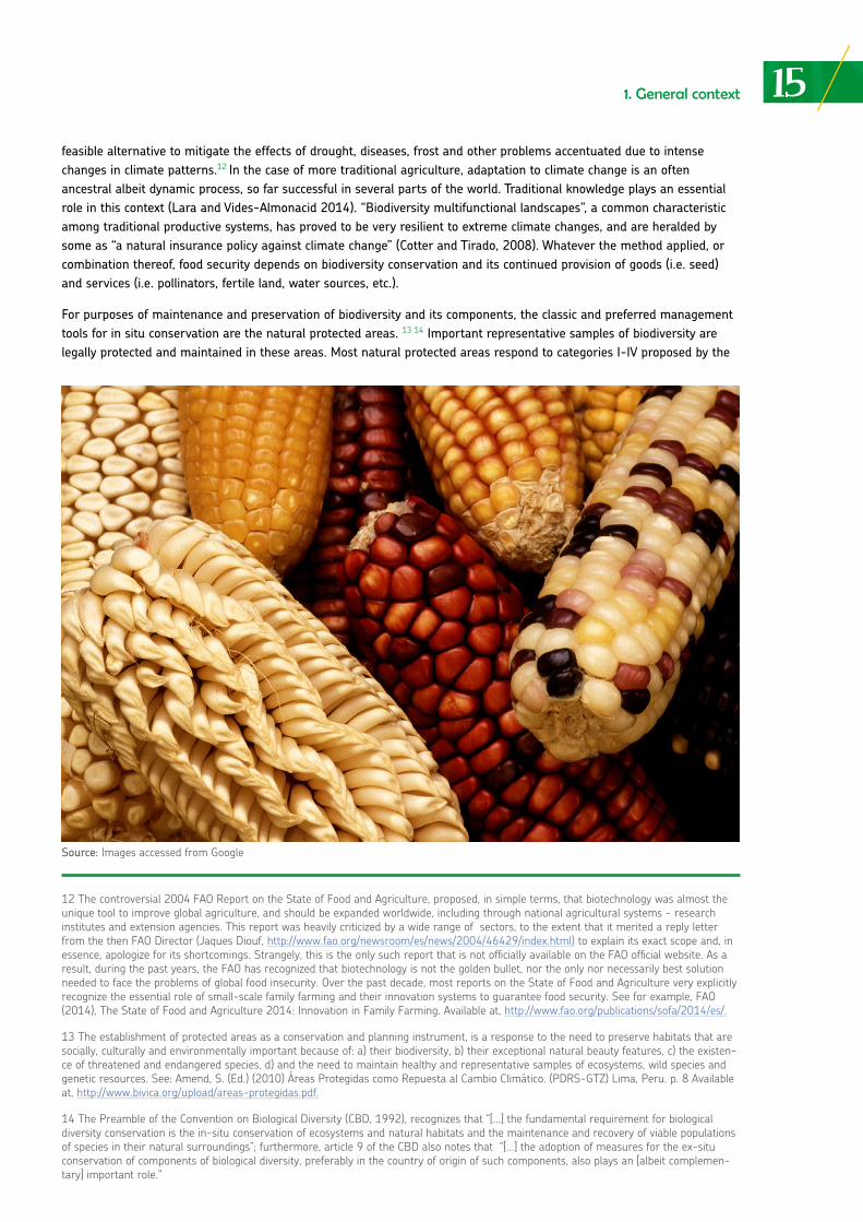
• It is estimated that approximately two billion people around the world suffer from the lack of micronutrients, particularly Vitamin A, iodine, folate, iron and zinc. All these micronutrients may easily be assimilated through a diversified and balanced diet coming from biodiversity.• Agrobiodiversity, as a part of the agricultural systems and natural habitats is disappearing at an unprecedented rate. • Since the beginning of agriculture, more than 10,000 years ago, approximately 7,000 plant species and thousands of animal species have been used as food. • During the past fifty or so years, a small number of agricultural crop varieties have replaced thousands of local varieties on vast production areas.• More than 90% of crop varieties from agricultural fields have disappeared during the past 100 years, and 690 livestock breeds have become extinct.• Fifteen (15) crops (i.e. rice, maize, potato, and wheat) and 8 breeds of domesticated animals represent 90% of the caloric requirements for the worldwide population.
Source: Adapted from: Agricultura y Desarrollo Rural Sostenible. Sumario de Política, No. 16, 2007. Available at, ftp://ftp.fao.org/sd/sda/sdar/sard/SARD-agri-biodiversity%20-%20spanish.pdf
15feasible alternative to mitigate the effects of drought, diseases, frost and other problems accentuated due to intense changes in climate patterns.12 In the case of more traditional agriculture, adaptation to climate change is an often ancestral albeit dynamic process, so far successful in several parts of the world. Traditional knowledge plays an essential role in this context (Lara and Vides-Almonacid 2014). “Biodiversity multifunctional landscapes”, a common characteristic among traditional productive systems, has proved to be very resilient to extreme climate changes, and are heralded by some as “a natural insurance policy against climate change” (Cotter and Tirado, 2008). Whatever the method applied, or combination thereof, food security depends on biodiversity conservation and its continued provision of goods (i.e. seed) and services (i.e. pollinators, fertile land, water sources, etc.).
For purposes of maintenance and preservation of biodiversity and its components, the classic and preferred management tools for in situ conservation are the natural protected areas. 13 14 Important representative samples of biodiversity are legally protected and maintained in these areas. Most natural protected areas respond to categories I-IV proposed by the
1. General context
12 The controversial 2004 FAO Report on the State of Food and Agriculture, proposed, in simple terms, that biotechnology was almost the unique tool to improve global agriculture, and should be expanded worldwide, including through national agricultural systems - research institutes and extension agencies. This report was heavily criticized by a wide range of sectors, to the extent that it merited a reply letter from the then FAO Director (Jaques Diouf, http://www.fao.org/newsroom/es/news/2004/46429/index.html) to explain its exact scope and, in essence, apologize for its shortcomings. Strangely, this is the only such report that is not officially available on the FAO official website. As a result, during the past years, the FAO has recognized that biotechnology is not the golden bullet, nor the only nor necessarily best solution needed to face the problems of global food insecurity. Over the past decade, most reports on the State of Food and Agriculture very explicitly recognize the essential role of small-scale family farming and their innovation systems to guarantee food security. See for example, FAO (2014), The State of Food and Agriculture 2014: Innovation in Family Farming. Available at, http://www.fao.org/publications/sofa/2014/es/.
13 The establishment of protected areas as a conservation and planning instrument, is a response to the need to preserve habitats that are socially, culturally and environmentally important because of: a) their biodiversity, b) their exceptional natural beauty features, c) the existen-ce of threatened and endangered species, d) and the need to maintain healthy and representative samples of ecosystems, wild species and genetic resources. See: Amend, S. (Ed.) (2010) Áreas Protegidas como Repuesta al Cambio Climático. (PDRS-GTZ) Lima, Peru. p. 8 Available at, http://www.bivica.org/upload/areas-protegidas.pdf.
14 The Preamble of the Convention on Biological Diversity (CBD, 1992), recognizes that “[…] the fundamental requirement for biological diversity conservation is the in-situ conservation of ecosystems and natural habitats and the maintenance and recovery of viable populations of species in their natural surroundings”; furthermore, article 9 of the CBD also notes that “[…] the adoption of measures for the ex-situ conservation of components of biological diversity, preferably in the country of origin of such components, also plays an [albeit complemen-tary] important role.”
Source: Images accessed from Google
16World Conservation Union (IUCN). 15 IUCN is, arguably, one of the most important international conservation organizations, whose specific work on development and promotion of protected areas is widely recognized and accepted throughout the world.
Recently, (during the last 10 – 15 years), proposals by NGOs and countries are being made with regards to specific in situ protection categories for the conservation of agrobiodiversity, mainly seeds, agroecosystems and small farmers cultures. This contrasts with the notion of classic natural protected areas, which were historically conceived to protect biodiversity in the “wild.” 17
However, it is important to highlight that the vast majority of existing biodiversity is not located nor conserved in natural protected areas, but it is equally urgent to adopt measures for its conservation and sound management. Since the CBD was adopted, some of the most important advances in terms of in situ conservation at the global level have been the considerable growth in the coverage and protection of sites through different forms of public and private protected areas. 18
A considerable amount of effort and investment has been made by countries to protect representative samples of biodiversity in their territories. In the case of Peru, for example, since 1990 to date, the coverage of natural protected areas has doubled, totaling at present more than 22 million hectares under some form of conservation category or management (MINAM 2015). This is equivalent to nearly 22% of the national territory. In Bolivia, although the percentage of increase in coverage is lower, there are more than 23 million hectares of protected land (CBD Fifth National Report 2015). In the case of Brazil, Federal areas cover more than 73 million hectares, a 300% increase with regard to 1990. 19
For all three countries, the largest proportion of these areas is located in the Amazon or Andean-Amazon in the case of Bolivia and Peru. This expansion also includes private and community based conservation initiatives, over land which is under some form of right entitlement by private persons, indigenous or local communities. 20
Despite management and control difficulties countries face to protect these lands and ecosystems effectively and efficiently, 21 the trend is to increase coverage protection and consolidate the strengths of national competent institutions in their management (i.e. ministries of the environment, management committees, protected areas councils, among others), 22 with the active participation of populations that live in these areas and their surroundings, and benefit from them in one way or another.
1. General context
15 For a rapid introduction to IUCN categories for protected areas see, https://www.iucn.org/es/regiones/am%C3%A9rica-del-sur/nues-tro-trabajo/%C3%A1reas-protegidas/categor%C3%ADas-de-manejo-de-%C3%A1reas-protegidas-de-uicn.
16 Ruiz, M. (2009). Agrobiodiversity Zones and the Register of Native Crops, Learning from Ourselves. SPDA, GRPI, Biodiversity International, Lima, Peru. In 2016, Peru approved Supreme Decree 0020-2016-MINAGRI, a regulation for agrobiodiversity zones, a sui generis form of protected area, specifically oriented to conserve agrobiodiversity and its components. Peru is the first country to have implemented legislation on agrobiodiversity zones, which have been formally created in different regions, such as Huánuco and Cusco.
17 The United Nations Education, Scientific and Cultural Organization (UNESCO), developed the concept of “biosphere reserves” during the 1960´s, as sites recognized by MAB [World Network of Biosphere Reserves of the Man and the Biosphere Program], where local commu-nities actively participate in their governance and management, as well as in research, education, training and monitoring activities, as well as in their economic promotion, development and biodiversity conservation. These sites emphasize the connection between the human and cultural elements with the specific geographical area. However, this is not a category that necessarily focuses on the distinct nature of agro-ecosystems and, in particular, small farmers culture. For further information on biosphere reserves. See, http://portal.unesco.org/es/ev.php- URL_ID=35389&URL_DO=DO_TOPIC&URL_SECTION=201.html.
18 According to IUCN, 15% of the land and 10% of territorial waters are found under some form of legal protection. See, https://www.iucn.org/es/news/secretariat/201609/el-15-de-las-tierras-del-planeta-est%C3%A1n-protegidas-pero-quedan-excluidas-%C3%A1reas-crucia-les-para-la-biodiversidad.
19 To learn more on the advances for the protection of spaces and sites through protected areas, see, Ruiz, M. (2016) Analysis of the Impact and Advances in Biodiversity Policies, Strategies, Plans and Programs in Bolivia, Brazil, Colombia y Perú. Fundación Konrad Adenauer. Lima, Perú. p. 15 Available at, http://www.spda.org.pe/wpfb-file/kas-espanol-pdf/.
20 Since 2001, more than 115 private conservation areas (PCAs) have been recognized in Peru, with a diversity of conservation objectives: research, tourism, ecosystem services, sustainable use of biodiversity, protection of communal spaces, etc. See, http://www.minam.gob.pe/notas-de-prensa/areas-de-conservacion-privada-una-creciente-alternativa-de-conservacion-en-el-peru/.
21 Ruiz (2016) at 16, p. 18.
22 Natural protected areas across the world in general, face common challenges that include direct pressures by extractive activities, pollution, urban expansion and settlements, intensive agriculture, etc., and indirect pressures through public policies that promote activities incompatible with the objectives of these areas (e.g. road construction, mining, etc.). Institutional weaknesses (i.e. the absence of strong police forces or park rangers in situ or unpredictable, corrupt and weak administrative and jurisdictional bodies), hamper efforts for the adequate management and control of natural protected areas.
17
Contrary to past beliefs in what natural protected areas should be, 23 at present and depending on the specific category (i.e. a national park, national reserve, landscape reserve, among others), the unanimous trend is to consider that these areas are not a static “photograph” of a space dedicated to contemplation of the landscape and natural beauty. Rather, these areas almost always include populations that undertake different productive activities inside or within their boundaries, mainly agriculture and associated activities such as hunting and fishing. Indigenous peoples and local communities are especially reliant on what these areas offer, and their food security is met by what these natural protected areas provide and guarantee directly or indirectly over time (Springer y Almeida 2015; FAO 2008; Diegues 2008; Scherr y McNeely 2005).
In this context, natural protected areas provide a continuous and permanent environmental or ecosystem service over time that reaches these populations and has further repercussions beyond. 24 For instance, protected areas may be the direct source of food and water for indigenous peoples and local communities. But, depending on their features, they may also serve as carbon repositories or water purifiers, indirectly benefitting a much broader population. During the last 15 years, the issue of payments or the compensation for these environmental or eco-system services, has received considerable attention, as a positive alternative to promote biodiversity conservation in situ, particularly in the context of forests, as climate regulators (i.e. REDD systems) or stabilizers of watersheds (Constanza et el. 1997; CIFOR 2011). Peru for example, has made a commitment to “zero deforestation” by 2021, in pursuit of a “greener” economy. 25 REDD and compensation schemes may become tools to support achievement of this goal.
1. General context
Box No. 2: Interesting data regarding natural protected areas and climate change
• Natural protected areas provide the following environmental or ecosystem services: Provision of water, food, minerals, inputs for industrial products (i.e. pharmaceuticals, nutraceuticals, latex), energy; - Regulation of services (carbon sequestration, climate regulation, decomposition of solid waste, water and air purification, pollination, pest and disease control); - Support of services: dispersion of nutrients, dispersion of seed, primary production); - Provision of cultural services (cultural inspiration, recreation, education, growth of sciences and knowledge in general).• 33 of the main cities around the world receive their potable water from natural protected areas due to their capture and retention capacity.• There are more than 100,000 protected sites around the world, covering an extension of more than 19 million km2, nearly 12% of Planets Earth´s surface,• 18.8% of the planets tropical forests are protected under a certain category for the conservation of natural protected areas, • There are 5, 000 marine protected areas around the world, with an extension of 2.85 million km2,• Natural protected areas conserve and help to repopulate marine and continental waters fish stocks; in addition, the natural growing processes of certain fish species and their populations, thrive in natural pro tected areas.
References: SciDevNet, Biodiversity Facts and Figures, http://www.scidev.net/global/biodiversity/feature/biodiversity-facts-and-figures-1.html; IUCN, Protect Planets Ocean: http://www.protectplanetocean.org/collections/introduction/introbox/globalmpas/introduction-item.html
23 Since the 1990s, there has been a broader understanding of natural protected areas in terms of the role they play to sustain local and indigenous peoples, or provide services that contribute to local well-being. Naughton-Treves, L., Buck Holland, M., Brandon, K. (2005) The Role of Protected Areas in Conserving Biodiversity and Sustaining Local Livelihoods. Annual Review of Environment and Resources. Vol 30, 2005, p. 219-252.
24According to WWF, it is estimated that natural protected areas store at least 15% of the world’s terrestrial carbon that if released, would convert into carbon dioxide, largely responsible for global warming. See, http://www.wwf.org.pe/?275390/TOP-5-areas-protegidas-cla-ves-para-afrontar-cambio-climatico.
25 Antonio Brack, as Minister of the Environment (Peru), launched this objective of national policy, later followed by his successors, particu-larly Minister Manuel Pulgar-Vidal, in the context of his leadership on climate change. See, for example, the declarations of Minister Pulgar Vidal at, http://www.minam.gob.pe/medios/2014/11/18/el-peru-apunta-a-tener-cero-deforestacion-para-2021/.
FOOD SECURITY AND BIODIVERSITY
two sides of the same coin
02
02
19
26 This is a non legally-binding international instrument, adopted by the FAO during its 127th Period of Sessions in 2004. They help to “measure” the advances in and compliance with, particularly by the State and its institutions, its obligations pertaining to securing the human right to adequate food. Available at, http://www.fao.org/fileadmin/templates/righttofood/documents/RTF_publications/ES/RightToFood_Gui-delines_ES.pdf. Although an official report based on the use of these Voluntary Guidelines is unavailable, the Peruvian Society for Environ-mental Law, with the support of Welthungerhilfe, from Germany, and the European Union, together with a group of national and regional institutions, prepared a report on the status of the right to food, based on utilization of the Voluntary Guidelines in specific communities of three regions in Peru. See, ABISA 2014). Informe sobre el Derecho a la Alimentación en el Perú: el Caso de Comunidades en Loreto, Lima y Cusco. Available at, http://www.spda.org.pe/wp-content/uploads/2015/08/Abisa-OK.compressed.pdf. There is no access to similar reports or documents in Brazil and Bolivia.
27 Simplification of diets has important implications in terms of vulnerability and nutrition. The dietary composition is even more important that the amount of food consumed. In that respect, diversity contributes to guarantee a more balanced and nutritious diet. Biodiversity and agrobiodiversity offer alternatives for this. See, Johns, T. Agrobiodiversity, Diet and Human Health. Jarvis, D.I., Padoch, C., Cooper, H.D. (Eds.) (2007) Managing Biodiversity in Agricultural Ecosystems. Columbia University Press. p. 382-406.
28 The food production system overall, has been privatized, industrialized, consolidated and integrated, creating economies of scale and incentives for profit generation. Limited consideration is given to sensitive social and cultural dimensions, as well as to food preferences. The most visible example of this are the large supermarket chains (i.e. Wong and Vivanda in Peru; Pao de Azucar, Walmart and Carrefour in Brazil; Hipermaxi in Bolivia), and the effects they have on the availability of products –imported, standardized, genetically modified, uniform and industrialized or processed. This is a phenomenon that takes place globally. See, Tansey, G. Rajotte, T (eds) (2009) El Control Futuro de los Alimentos: Guía de las Negociaciones y Reglas Internacionales sobre la Propiedad Intelectual, la Biodiversidad y la Seguridad Alimentaria. Ediciones Multi Prensa, Barcelona, Spain.
2. Food security and biodiversity
As mentioned previously, the World Summit on Food Security (1996) defined “food security” as a situation in which “[…] all people, at all times, have physical, social and economic access to sufficient, safe and nutritious food to meet their dietary needs and food preferences for an active and healthy life.” It is clear that the focus of this definition is a situational element: in other words, the verification of food security is based on compliance with certain basic conditions at a given time, and throughout time. The FAO has moved further, and developed Voluntary Guidelines to Support the Progressive Realization of the Right to Adequate Food in the Context of National Food Security (2004). These Guidelines are a tool that measures the degree of compliance with the human right to food, from a perspective of the States´ efforts and its commitments and actions towards realizing this right in full. The Voluntary Guidelines include a series of dimensions or areas (i.e. access to water, food availability, type of diets, normative and regulatory frameworks, responsible institutions, among others) that are analyzed through surveys, analysis, interviews, etc., and presented in an analytical way, including through charts, tables and other quantitative graphics. 26
Any way it is looked at, biodiversity is the critical dimension of agricultural systems and human well-being (Sunderland 2011). During the course of history, thousands of plant and animal species (biodiversity) have been used for human consumption. Nevertheless, since the emergence of agriculture 10,000 years ago, and development of urban growth and modernization, there has been a progressive but very visible global simplification of the human diet, particularly in cities.
At present, around 15 plant species and 8 animal breeds cover the food requirements of 98% of the world’s population. 27 Wheat and maize provide 50% of the world’s populations energy needs (Frison et al. 2006). The genetic base (seed) used in agriculture, particularly in modern productive systems has decreased. Especially since the Industrial Revolution, important crop varieties have been lost (genetic erosion) due to their disuse, in situ disappearance, acculturation due to globalization, climate change and ultimately, the modern production and distribution processes of foods that promote their standardization, among many other factors. 28 The “distance” between farmers and consumers has increased and there awareness regarding the origin or source of the food as such is limited. 29
Food security and biodiversity: two sides of the same coin
20
29 That “distance” reduces or eliminates –for the urban and villager– any connection, empathy or relationship with food producers, and reduces the ability to question and reflect on the foods origin and particular significance for different actors in the food chain (i.e. farmers, middlemen, brokers, traders, supermarket chains, etc.). To analyze this phenomenon, see, Pollan, M. (2009) In Defense of Food: An Eater´s Manifesto. Penguin Books.
30 Salcedo, S., Guzmán, L. (Eds.) (2014) La Agricultura Familiar en América Latina y el Caribe: Recomendaciones de Política. FAO, Santiago de Chile, pp. 17-101 Available at, http://www.fao.org/docrep/019/i3788s/i3788s.pdf.
31 See: Ruiz (2009) at16, pp. 85-88.
32 Tapia, M. (2000) Cultivos Andinos Sub Explotados: Aporte a la Alimentación. FAO, Oficina Regional para América Latina y el Caribe. Santiago de Chile. Available at, https://issuu.com/b.mendozaelizabeth/docs/cultivos_andinos_subexplotados_y_s1. The positive aspect of “re-discovering” quinoa has been followed by serious social and economic problems in light of growing demand worldwide for this crop, leading to a price increase and preventing its consumption by the farmers and less favored sectors. This phenomenon has been studied considerably and summarized very precisely in a New York Times article titled Quinoa’s Global Success Creates Quandary at Home, that explains how price increases due to the international demand and emphasis on global markets, prevents the rural poor of Bolivia (and Peru) from acquiring this food. The effect has been for the people to resort to cheap processed foods that have increased malnutrition in many cases. The excessive supply in turn, could also depress prices and generate other types of difficulties for farmers who migrated to this crop during the spike in demand and prices. Article available at, http://www.nytimes.com/2011/03/20/world/americas/20bolivia.html.
33 There are many cases of valuable, albeit under-utilized crops in Peru, including arracacha, mashua and other roots and Andean tubers with great nutritional potential. It is important to highlight that the idea of “under-utilized” refers to its almost non-existence in urban markets, and the existing unfamiliarity with potential nutritional values. However, they are certainly utilized by small Andean and Amazon communities. This similar phenomenon is also experienced in Bolivia and Brazil, in many cases with the same crops and similar species. See, Pastor, S., Fuentealba, R., Ruiz, M. (2006) Cultivos Sub-Utilizados en el Perú: Análisis de las Políticas Públicas Relacionadas con su Conserva-ción y Uso Sostenible. Global Facilitation Unit, SPDA. Lima, Peru. Available at, http://www.biopirateria.org/download/documentos/otros-docu-mentos/agrodiversidad/Cultivos%20subutilizados.pdf?lang=en.
34 There are many other international institutions that address these issues: the Consultative Group on International Agricultural Research (CGIAR), universities, NGOs, etc.
35 See, https://www.cbd.int/agro/about.shtml.
36 See, https://www.bioversityinternational.org/.
2. Food security and biodiversity
This happens in a context where in countries like Peru, Bolivia and Brazil, more than 80% of food produced comes from small farmers or peasants. These farmers are the lifeline for both urban and rural food security. 30 This phenomenon of distancing reversing in many places, especially as a result of what could be called the “gastronomic boom” experienced by countries in South American and other regions. Through the joint work of chefs, producers (small farmers), the media, NGOs and the State, cooking has become fashionable, and contributed to the “rediscovery”, mainly in urban sectors, of native ingredients and underutilized foods, and to the emergence of an increasingly proud native culture. 31 One example of this -but far from the only one- is quinoa, unknown to the non-Andean world a couple of decades ago, and today one of the most important new foods incorporated into the diet both at the national and global level. 32
Likewise, the intensive agricultural production and expansion of the agricultural frontier has biodiversity as its main victim. On one hand, product standardization and uniform demand by consumers, results in disuse of many crops and foods; important wild relatives of crops and under-utilized crops with a high nutritional potential have been lost over time due to this pressure. 33 On the other, the expansion of modern agricultural, almost invariably leads to sacrificing forests and ecosystems that are crucial for the maintenance of biodiversity and provision of localized and global ecosystem services.
Institutionally, the FAO, CBD and Bioversity International, World Food Program, have been possibly the most active intergovernmental “umbrella” organizations responsible for setting policy and legal agendas, and driving international social, economic, and scientific research, in biodiversity, agrobiodiversity and food security. 34
Historically, FAO has had the mandate to address these issues and is now showing a growing concern for small-scale farming, climate change and food security. The CBD early on developed an Agricultural Biological Diversity Program (agrobiodiversity) that is active until today. 35 As part of this program, various decisions and resolutions have been adopted relating to the conservation of agroecosystems and crops, agrobiodiversity integration into national development plans, payments for agrobiodiversity services, the effects of climate change on agrobiodiversity, among others. Bioversity International is a CGIAR center, specifically responsible for social, economic, legal and institutional research in terms of agrobiodiversity and its different challenges. The World Food Program is responsible for addressing crisis in food shortages and mitigating food insecurity globally. 36
21
37 These international centers are part of the Consultative Group on International Agricultural Research (CGIAR), which hold the largest ex situ collections on the planet, including potatoes and other Andean roots and tubers (International Potato Center); beans (International Center for Tropical Agriculture); maize and wheat (International Maize and Wheat Improvement Center; all in Latina America. There are 12 other centers around the world. See, http://www.cgiar.org/.
38 See, https://www.croptrust.org/our-work/svalbard-global-seed-vault/.
39 See, https://www.theguardian.com/environment/2017/may/19/arctic-stronghold-of-worlds-seeds-flooded-after-permafrost-melts.
40 The Afghan Mujahideen destroyed the Kabul Seed Bank in 1992; the Sukhumi Seed Bank in Georgia was destroyed during the Civil War in 1993; the Ruanda Civil War and Invasion of Iraq in the 1990s extinguished the seed banks in these countries; the hordes of terrorists des-troyed experimental stations with valuable seed collections in Peru in the 1990s; these examples are repeated time after time. See: Giaimo, C. From WWII to Syria: How Seed Vaults Weather Wars. Atlas Obscura. May 12, 2015. Available at, http://www.atlasobscura.com/articles/wwii-to-syria-how-seed-vaults-weather-wars.
41 Article 9 of the CBD (Ex Situ Conservation) provides that “Each Contracting Party shall, as far as possible and as appropriate, and predo-minantly for the purpose of complementing in situ measures: (a) Adopt measures for the ex-situ conservation of components of biological diversity, preferably in the country of origin of such components; […].
2. Food security and biodiversity
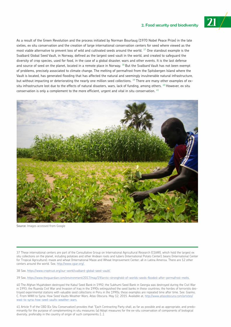
As a result of the Green Revolution and the process initiated by Norman Bourlaug (1970 Nobel Peace Prize) in the late sixties, ex situ conservation and the creation of large international conservation centers for seed where viewed as the most viable alternative to prevent loss of wild and cultivated seeds around the world. 37 One standout example is the Svalbard Global Seed Vault, in Norway, defined as the largest seed vault in the world, and created to safeguard the diversity of crop species, used for food, in the case of a global disaster, wars and other events. It is the last defense and source of seed on the planet, located in a remote place in Norway. 38 But the Svalbard Vault has not been exempt of problems, precisely associated to climate change. The melting of permafrost from the Spitsbergen Island where the Vault is located, has generated flooding that has affected the natural and seemingly invulnerable natural infrastructure, but without impacting or deteriorating the nearly one million seed collections. 39 There are many other examples of ex-situ infrastructure lost due to the effects of natural disasters, wars, lack of funding, among others. 40 However, ex situ conservation is only a complement to the more efficient, urgent and vital in situ conservation. 41
Source: Images accessed from Google
22
42 The Constitution of the Plurinational State of Bolivia (2009) establishes in Article 16: (I). “Every individual has the right to food and water. II. The State is compelled to guarantee food security, through healthy, adequate and sufficient food for the entire population”. In 2010, the Congress of Brazil approved an amendment to the 1988 Constitution, whereby the right to food as a social right is recognized. Article 6 of the Constitution indicates that “social rights are education, health, food, labor, housing, leisure, security, social security, protection of mother-hood and childhood, assistance to the destitute, child protection and assistance for the homeless, in accordance with this Constitution” (2010 Reform). The 1993 Political Constitution of Peru does not explicitly recognize the fundamental right to food. However, Article 3 of the Peru-vian Constitution provides that “the enumeration of rights established in this chapter [the rights of human beings] does not exclude others of a similar nature or those based on the dignity of the human being…”. In regards to this “open clause” when fundamental rights are involved, Samuel Abad, a well-known Peruvian Constitutionalist notes that “…fundamental rights are also those recognized by it [the Constitution] even if they are not found in the first chapter, including “implicit rights”, namely, those not foreseen constitutionally under the theory of “unna-med rights”. The Constitutional Tribunal has understood it as such, for example, when it recognized the right to the truth and a broadened the scope of consumers and users rights”. See, Del Castillo, L. (2016) Normativa Peruana sobre el Derecho a la Alimentación y Seguridad Alimentaria: Revisión Analítica. CEPES, Lima, Peru. p.32 Available at, http://www.cepes.org.pe/sites/default/files/normativa_peruana.pdf.
43 See document: Políticas de Seguridad Alimentaria y Nutricional (in Bolivia), Available at, http://www.aipe.org.bo/public/lst_publicacio-nes/1198163644_LST_PUBLICACIONES_7_documento_adjunto.pdf. (Observatorio de Políticas Públicas en Seguridad Alimentaria, 2007).
2. Food security and biodiversity
In recent years, Bolivia, Brazil and Peru have been implementing a series of legal and policy instruments to address the issue of food insecurity. They not only signed several international instruments such as the World Declaration on World Food Security (World Food Summit 1996) or the International Covenant on Economic, Social and Cultural Rights (1976), but there is also an express recognition, whether directly or indirectly, to the right to food, either at the legal or even constitutional level. 42 A great diversity of laws, regulations, strategies and plans have been enacted and developed that seek to improve the conditions of food insecurity for people. In the case of Bolivia, the State has promoted a very vocal and visible approach regarding the right to food security and food sovereignty. 43
232. Food security and biodiversity
Source: Images accessed from Google
SOME INITIAL CONSIDERATIONS ON NATURAL PROTECTED AREAS IN BOLIVIA, BRAZIL AND PERU:
the Madidi, Chico Mendes and Bajuaja-Sonene cases
03
03
253. Some initial considerations on natural protected areas in Bolivia, Brazil and Peru
Some initial considerations on natural protected areas in Bolivia, Brazil and Peru: the Madidi, Chico Mendes and Bajuaja-Sonene cases
The Andean Amazon region is possibly the most important zone on the planet in terms of its biological and cultural diversity. 44 A growing percentage of the Amazon in Brazil, Bolivia and Peru is subjected to some form of territorial management, through categories of natural protected areas. 45 This section offers a description and analysis of the main characteristics of the Madidi National Park and Natural Area for Integrated Management (Provinces of Iturralde and Franz Tamayo in Bolivia), the Chico Mendes Extractive Reserve (State of Acre, Brazil) and the Bahuaja-Sonene National Park (Madre de Dios region in Peru).
Description of the natural protected areas
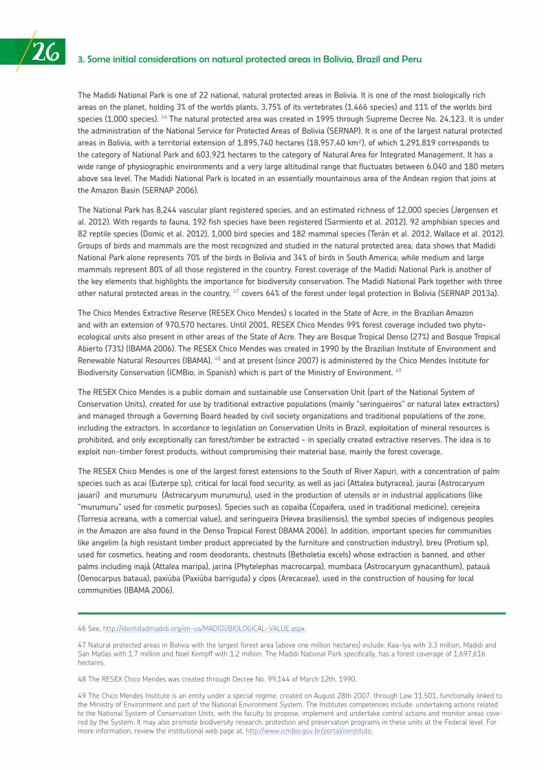
The Madidi National Park and Natural Area for Integrated Management is located in the Northwestern region of Bolivia, Provinces of Iturralde and Franz Tamayo in the Department of La Paz, and includes the Municipalities of Apolo, San Buenaventura, Ixiamas, Pelechuco and Curva. It is located on the border with Peru, adjacent to the Bahuaja-Sonene National Park. In Bolivia, its boundaries include the Apolobamba Integrated Management Natural Area and the Pilón Ljas Biosphere Reserve and Indigenous Territory, forming a massive complex of forest and biodiversity conservation areas, that amount to nearly 4,5 million legally protected hectares. The National Park has an extension of approximately 1,9 million hectares.
Map No. 1
Source: National Service for Protected Areas of Bolivia (SERNAP, in Spanish).
44 Inter-American Development Bank. (1992) Amazonia sin Mitos. Comisión Amazónica de Desarrollo y Medio Ambiente. Available at, http://otca.info/portal/admin/_upload/publicacoes/SPT-TCA-ECU-SN-AMAZONIA.pdf.
45Ruiz, M (2016) at 19 p. 31.
26 3. Some initial considerations on natural protected areas in Bolivia, Brazil and Peru
46 See, http://identidadmadidi.org/en-us/MADIDI/BIOLOGICAL-VALUE.aspx.
47 Natural protected areas in Bolivia with the largest forest area (above one million hectares) include: Kaa-Iya with 3,3 million, Madidi and San Matías with 1,7 million and Noel Kempff with 1,2 million. The Madidi National Park specifically, has a forest coverage of 1,697,616 hectares.
48 The RESEX Chico Mendes was created through Decree No. 99,144 of March 12th, 1990.
49 The Chico Mendes Institute is an entity under a special regime, created on August 28th 2007, through Law 11.501, functionally linked to the Ministry of Environment and part of the National Environment System. The Institutes competences include: undertaking actions related to the National System of Conservation Units, with the faculty to propose, implement and undertake control actions and monitor areas cove-red by the System. It may also promote biodiversity research, protection and preservation programs in these units at the Federal level. For more information, review the institutional web page at, http://www.icmbio.gov.br/portal/oinstituto.
The Madidi National Park is one of 22 national, natural protected areas in Bolivia. It is one of the most biologically rich areas on the planet, holding 3% of the worlds plants, 3,75% of its vertebrates (1,466 species) and 11% of the worlds bird species (1,000 species). 46 The natural protected area was created in 1995 through Supreme Decree No. 24,123. It is under the administration of the National Service for Protected Areas of Bolivia (SERNAP). It is one of the largest natural protected areas in Bolivia, with a territorial extension of 1,895,740 hectares (18,957,40 km²), of which 1,291,819 corresponds to the category of National Park and 603,921 hectares to the category of Natural Area for Integrated Management. It has a wide range of physiographic environments and a very large altitudinal range that fluctuates between 6,040 and 180 meters above sea level. The Madidi National Park is located in an essentially mountainous area of the Andean region that joins at the Amazon Basin (SERNAP 2006).
The National Park has 8,244 vascular plant registered species, and an estimated richness of 12,000 species (Jørgensen et al. 2012). With regards to fauna, 192 fish species have been registered (Sarmiento et al. 2012), 92 amphibian species and 82 reptile species (Domic et al. 2012), 1,000 bird species and 182 mammal species (Terán et al. 2012, Wallace et al. 2012). Groups of birds and mammals are the most recognized and studied in the natural protected area; data shows that Madidi National Park alone represents 70% of the birds in Bolivia and 34% of birds in South America; while medium and large mammals represent 80% of all those registered in the country. Forest coverage of the Madidi National Park is another of the key elements that highlights the importance for biodiversity conservation. The Madidi National Park together with three other natural protected areas in the country, 47 covers 64% of the forest under legal protection in Bolivia (SERNAP 2013a).
The Chico Mendes Extractive Reserve (RESEX Chico Mendes) s located in the State of Acre, in the Brazilian Amazon and with an extension of 970,570 hectares. Until 2001, RESEX Chico Mendes 99% forest coverage included two phyto-ecological units also present in other areas of the State of Acre. They are Bosque Tropical Denso (27%) and Bosque Tropical Abierto (73%) (IBAMA 2006). The RESEX Chico Mendes was created in 1990 by the Brazilian Institute of Environment and Renewable Natural Resources (IBAMA), 48 and at present (since 2007) is administered by the Chico Mendes Institute for Biodiversity Conservation (ICMBio, in Spanish) which is part of the Ministry of Environment. 49
The RESEX Chico Mendes is a public domain and sustainable use Conservation Unit (part of the National System of Conservation Units), created for use by traditional extractive populations (mainly “seringueiros” or natural latex extractors) and managed through a Governing Board headed by civil society organizations and traditional populations of the zone, including the extractors. In accordance to legislation on Conservation Units in Brazil, exploitation of mineral resources is prohibited, and only exceptionally can forest/timber be extracted - in specially created extractive reserves. The idea is to exploit non-timber forest products, without compromising their material base, mainly the forest coverage.
The RESEX Chico Mendes is one of the largest forest extensions to the South of River Xapuri, with a concentration of palm species such as acai (Euterpe sp), critical for local food security, as well as jaci (Attalea butyracea), jaurai (Astrocaryum jauari) and murumuru (Astrocaryum murumuru), used in the production of utensils or in industrial applications (like “murumuru” used for cosmetic purposes). Species such as copaiba (Copaifera, used in traditional medicine), cerejeira (Torresia acreana, with a comercial value), and seringueira (Hevea brasiliensis), the symbol species of indigenous peoples in the Amazon are also found in the Denso Tropical Forest (IBAMA 2006). In addition, important species for communities like angelim (a high resistant timber product appreciated by the furniture and construction industry), breu (Protium sp), used for cosmetics, heating and room deodorants, chestnuts (Betholetia excels) whose extraction is banned, and other palms including inajá (Attalea maripa), jarina (Phytelephas macrocarpa), mumbaca (Astrocaryum gynacanthum), patauá (Oenocarpus bataua), paxiúba (Paxiúba barriguda) y cípos (Arecaceae), used in the construction of housing for local communities (IBAMA 2006).
273. Some initial considerations on natural protected areas in Bolivia, Brazil and Peru
Map No. 2
Source: Fantini, A., Crisostomo, C.F. (2009)
The Bosque Tropical Abierto is characterized by the presence of species such as abiorana seca (Abiorana abiu), acariquara (Minquartia guianensis Aubl., Olacaceae), andirobar (Carapa guianensis), manorana, munguba (Pachira aquatica), seriengueira (Hevea brasiliensis) and ucuúba (Virola Surinamensis), and occasional chestnuts and mogno (Swietenia macrophylla King), which are threatened with extinction in this particular zone. The most common palms are acai (Euterpe oleracea), vacaba (Oenocarpus vacaba, used as food) and grasses, such bamboo (Bambusoideae) (IBAMA 2006).
In terms of animal species, 40% of the mammals in Brazil and 5% of the worlds mammals can be found in the State of Acre; 45% of Brazil´s birds and 8% of the world´s birds are also found in this State. The State of Acre´s contribution to biodiversity in the Amazon is substantial. The RESEX Chico Mendes is located in a region with a high diversity of primates and fish, and is a center of endemism for birds and amphibians.
Finally, the Bahuaja-Sonene National Park (PNBS, in Spanish), extends between 200 and 2,450 meters above sea level, over an area of 537,053.25 hectares. 50 Most of its area is in the Puno Region (nearly 70% of the PNBS is situated in this region), covering part of the Districts of Coasa, Ayapata and San Gabán (Province of Carabaya), and Alto Inambari, Limbani, San Juan del Oro and San Pedro de Putina Punco (Province of Sandia); the other 30% covers part of the Districts of Tambopata and Inambari (Province of Tambopata) in the Madre de Dios Region. The PNBS was created in 1996, with a view of protecting “… representative ecosystems of the subtropical Amazonian biogeographic provinces and subtropical Yunga with high levels of biological diversity and extraordinary scenic beauty”. 51
50 At present, the PNBS has an extension of 1,091,416 hectares, having incorporated areas that correspond to the surface of Lot 78 (oil) and the Tambopata-Candamo Reserved Zone (Supreme Decree 048-2000-AG, of September 4, 2000).
51 The PNBS was established by Supreme Decree 012-96-AG on July 17, 1966.
28 3. Some initial considerations on natural protected areas in Bolivia, Brazil and Peru
Map No. 3
Source: Wildlife Conservation Society
The PNBS has a vast biological diversity, with representative samples of endemic species. The PNBS has three large terrestrial eco-regions: Yungas (or cloud forests), palm savannas (or Beni savannas), and low jungle forests (or Amazon plains), two of which are unique for Peru (the Yungas and Beni Savannas) which also contain endemic and unique species for Peru and the world. This natural protected area safeguards spaces of high relevance for the reproduction and maintenance of fish stocks, which are important for the Madre de Dios ecosystem and economy. It also protects endangered species, such as the Giant River Otter (Pteronura brasiliensis), Spectacled Bear (Tremarctos ornatus), Harpy Eagle (Harpia harpyja) and Jaguar (Pantera onca).
The PNBS, the Tambopata National Reserve and its buffer zones include, but not entirely, the Tambopata and Heath river basins, formed by ravines of various dimensions, making them accessible mostly during the high-water season. The Tambopata River starts in the Puno highlands outside the Parks limits, and its main tributaries are the Tavara River in the PNBS and Malinowski and La Torre Rivers located in the Tambopata National Reserve. The Heath River course is more than 200 km. from its origin, at the last ridges of the Puno Andes, until ends in the Madre de Dios River, and forms the Parks eastern limit, as well as the international limit between Peru and Bolivia. The waters of the Tambopata and Heath Rivers are discharged in the Madre de Dios River; the latter river originates in the Eastern Andes of the Department of Cusco and flows easterly towards its the Brazilian section of the Amazon River, called at this point the River Madeira.
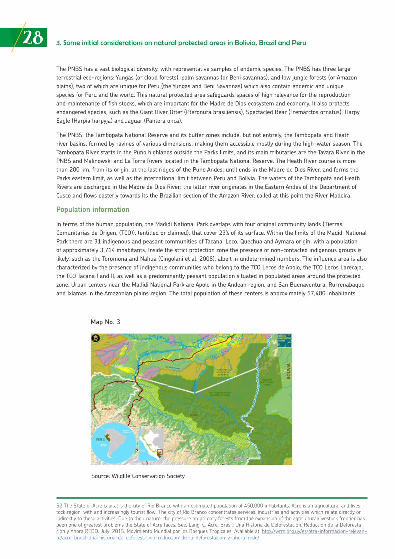
Population information
In terms of the human population, the Madidi National Park overlaps with four original community lands (Tierras Comunitarias de Origen, (TCO)), (entitled or claimed), that cover 23% of its surface. Within the limits of the Madidi National Park there are 31 indigenous and peasant communities of Tacana, Leco, Quechua and Aymara origin, with a population of approximately 3,714 inhabitants. Inside the strict protection zone the presence of non-contacted indigenous groups is likely, such as the Toromona and Nahua (Cingolani et al. 2008), albeit in undetermined numbers. The influence area is also characterized by the presence of indigenous communities who belong to the TCO Lecos de Apolo, the TCO Lecos Larecaja, the TCO Tacana I and II, as well as a predominantly peasant population situated in populated areas around the protected zone. Urban centers near the Madidi National Park are Apolo in the Andean region, and San Buenaventura, Rurrenabaque and Ixiamas in the Amazonian plains region. The total population of these centers is approximately 57,400 inhabitants.
52 The State of Acre capital is the city of Rio Branco with an estimated population of 450,000 inhabitants. Acre is an agricultural and lives-tock region, with and increasingly tourist flow. The city of Rio Branco concentrates services, industries and activities which relate directly or indirectly to these activities. Due to their nature, the pressure on primary forests from the expansion of the agricultural/livestock frontier has been one of greatest problems the State of Acre faces. See, Lang, C. Acre, Brasil: Una Historia de Deforestación, Reducción de la Deforesta-ción y Ahora REDD. July, 2015. Movimiento Mundial por los Bosques Tropicales. Available at, http://wrm.org.uy/es/otra-informacion-relevan-te/acre-brasil-una-historia-de-deforestacion-reduccion-de-la-deforestacion-y-ahora-redd/.
293. Some initial considerations on natural protected areas in Bolivia, Brazil and Peru
Map No. 3
Source: Wildlife Conservation Society
The three TCO that overlap with the Madidi National Park have consolidated their land ownership. The TCO Tacana II is still undergoing a process to formalize its land titles. The Leco communities have problems with peasant communities who feel their rights to access to land have been affected due to the creation of the Leco Indigenous Territory. Both the Lecos and Tacanas communities are being influenced by the lifestyle of peasant communities, which is transforming their economy from the use of forest and wildlife resources, towards an economy based on subsistence and commercial agriculture. Furthermore, these peoples have lost a significant part of their ancestral and native customs and the native language is dwindling, due to factors such as social embarrassment, disuse and the penetration of Spanish. The lowland indigenous territories have conflicts with loggers and illegal chestnut pickers. Leco communities´ livelihoods are the most affected by environmental degradation (SERNAP 2006).
In the case of the RESEX Chico Mendes, the reserve had an original population of 1,838 families (organized in local communities) and approximately 12,017 inhabitants, with a density of 80 inhabitants per hectare (CNS 1992, IBAMA 2006). These numbers have been decreasing, amongst other things, due to the populations migration generated by the effects of competition in the production of latex coming from Southeast Asia, particularly from Indonesia. By 2005, 7,500 inhabitants were accounted for in the RESEX Chico Mendes, which means a reduction of more than 40% from the original population (RESEX 2006 Management Plan). In the environment or influence zone of the RESEX Chico Mendes, particularly in the South and Southeast, there is a strong presence of agricultural projects on the margins of BR 317 (a highway) that encourages other uses and environmentally degrading activities (i.e. informal settlements). This is where deforestation in the region and the State of Acre is concentrated. There is a very high level of human intervention in the RESEX Chico Mendes and surroundings. As a result, more than 16% of forest coverage has been lost in the vicinity of the RESEX Chico Mendes due to urbanism, agriculture and mining, as compared to 1% within the reserve itself. The RESEX Chico Mendes North zone is the best conserved, although with a high-risk of permanent erosion and deforestation due to its proximity to the city of Rio Branco and its gradual expansion as a result of human activities (Silva 2000). 52
In the case of the PNBS, there people are located in “centros poblados” (small towns) in Punto Cuatro (mountain forests) and the recovery zone in the Colorado sector, both in the Puno Region. This “was part of the entry route towards the existing Department of Madre de Dios during the time of rubber workers (end of the XIX Century and beginning of the XX) until the 1960s” (2015-2019 Master Plan). 53 The population of Punto Cuatro in 2012 was estimated at 131 people among permanent and temporary residents; however, by 2012 the calculation was 181, nearly all born in the District of Limbani, Puno, of quechua origin (Burgos, 2012). The main activity is agriculture, primarily intended for self-consumption and to satisfy basic food requirements; secondly, small-scale mining, probably illegal; and thirdly, mule breeding for cargo. However, according to the latest reports from researchers and park rangers who have entered the buffer zones near the Punto Cuatro sector, they refer to mining as becoming the main activity. The demand from middle-men and the international prices of gold have generated increasing pressure, that translates into the intensification of non-regulated and disorderly activities with a direct impact on the environment. There is also the presence of a population dedicated to illegal farming, although there is insufficient nor definitive information in this respect. 54
Furthermore, there are people that enter the area to take advantage of the resources in PNBS, as in the case of chestnut growers and Esé Eja indigenous peoples (who belong to the Tacana linguistic family), who in addition undertake activities such as fishing, the collection of yellow spotted river turtles (Podocnemis unifiliy), and subsistence hunting. The Esé Eja people do nor reside within the PNBS but, rather, are located in the buffer zone, towards the Madre de Dios Region, exactly in the District and Province of Tambopata. They are distributed in 3 native communities, Palma Real, Sonene and Infierno. Nevertheless, they enter the PNBS to access various natural resources that allow their social and cultural processes to persist over time (2015-2019 Master Plan).
53 SERNANP (2015) Master Plan of the Bajuaja Sonene National Park 2015-2019. See,http://sinia.minam.gob.pe/documentos/plan-maes-tro-parque-nacional-bahuaja-sonene-periodo-2015-2019.
54 See the report from the United Nations Office on Drugs and Crime (UNDOCS) https://www.unodc.org/peruandecuador/es/03RECURSOS/informes.html.
30 3. Some initial considerations on natural protected areas in Bolivia, Brazil and Peru
It is important to specify that Infierno is the largest community, with both an indigenous and mestizo population (approximately 50% each). The total number of inhabitants in Esé Eja peoples is 588. 55 The main activities of the Esé Eja are for subsistence purposes and include fishing, collecting, agriculture and hunting. However, there have been changes in the way these are undertaken due to changes in settlement patterns, which are trending towards a more sedentary than nomadic lifestyle. As a result, the Esé Eja no longer access certain ecosystems they have been linked to historically (Mayor and Bodmer, 2009). 56
The total number of inhabitants in the PNBS influence zone and Tambopata Candamo National Reserve (RNTAMB) ascends to 210,771, according to population data figures to 2007 of the National Institute of Statistics and Informatics (INEI, in Spanish); 5,34% (11,237 inhabitants) have settled in the PNBS buffer zone.
Threats
The three natural protected areas under analysis face considerable, common and similar threats to their existence. With obvious differences in intensity, colonization and human settlements, development of infrastructure, extensive and intensive agriculture, informal mining and logging (illegal), hydrocarbon exploitation and livestock farming, are the main threats to these areas and their biodiversity and environmental services.
In the specific case of Madidi National Park, in terms of roads and paths, it limits with the La Paz-Rurrenabaque Highway route that passes through Yungas, and which was constructed more than 30 years ago. This road has been the pillar for colonization and human settlements, mainly of migrants from the country’s Andean zone. This human pressure has involved considerable forest loss due to the expansion of agricultural activities, and later, the transition to livestock farming. It has also contributed to greater threats from hunting, illegal fishing and timber extraction (Painter et al. 2013). More than a decade ago, a project was designed to improve and construct road infrastructure, and develop the Peru-Brazil-Bolivia connecting hub. 58 It included constructing sections of the Ixiamas-El Chivé highway, which has not been fully executed, and would pass through Madidi, generating even more threats to the natural protected area.
In terms of large scale infrastructure, the main threat is focused on the Cañón del Bala Hydroelectric Project on the Beni River, between San Buenaventura and Rurrenabaque, with a feasibility study and final design paperwork approved in 2016. This plant is expected to produce 3,676 MW of electricity. Unofficial data indicates that the predicted inundation area – as a result of the dam to be constructed- could cover 257 km2 within the Madidi National Park and Natural Area for Integrated Management.
There are 31 communities located inside and on the outskirts of Madidi National Park; nine of them reside in the Park and the other 22 in the Natural Area for Integrated Management surrounding the Apolo Municipality. The most important urban centers in the external buffer zone of the natural protected area are Apolo in the Southeast, San Buenaventura and Rurrenabaque in the East and Ixiamas to the North. Approximately 260 medium and small towns are located around Madidi, mainly along the Yucumo-Rurrenabaque and San Buenaventura-Ixiamas road. 59 Sugar cane plantations in the Madidi National Park influence area, catalyzed by a sugar mill constructed in the locality of San Buenaventura, has produced considerable deforestation during the 2011-2016 period.
55 XI Population Census and VI Housing Census 2007 (CPV) and II Census of Indigenous Communities of the Peruvian Amazon 2007 (CNA).
56 Mayor and Bodmer mention that the Ese’ Eja “[D]estinate small surpluses of maize, rice, mandioca and banana to markets. They also work collecting chestnuts, timber and rubber. Likewise, they practice hunting, fishing and collecting. Hunting is prioritized during the rainy season (October-April) generally overnight. Hunting is usually takes place in groups of two and three as the Ese’Eja believe that if done indi-vidually, evil spirits might kill the hunter. They use hunting instruments such as rifles, shotguns and traps, with the help of dogs”. Mayor, P. y Bodmer, R. (2009). Pueblos Indígenas de la Amazonía Peruana. CETA Editions, Iquitos, Peru. pg. 311. Available at, http://atlasanatomiaama-zonia.uab.cat/pdfs/PueblosIndigenasAmazoniaPeruana.pdf.
57 Also see report, https://es.mongabay.com/2016/12/2016-ano-critico-parque-nacional-madidi-bolivia/.
58 The project is part of the Initiative for the Integration of Regional Infrastructure in South America (IIRSA), a wide scale initiative which seeks to create massive interconnection in the region through roads, railroads, ports and fluvial transport routes, airports, etc.
59 A recent study on deforestation scenarios in Madidi National Park using indicators which measure the distances from towns to roads and rivers, concludes that the “stretch throughout the Yucumo and Rurrenabaque highway has a deforestation rate of 3,7% a year, while the
313. Some initial considerations on natural protected areas in Bolivia, Brazil and Peru
Various extractive industries affect and have impacts on the area. Alluvial gold mining is always controversial due to the use of mercury and continued pollution. The main existing concessions in Madidi National Park are located in the Rivers Pelechuco and Motosolo zones, in the upper part of the Tuichi River Basin. Other concessions are located in the Serranía Tigre and Heath zones, both in direct conflict with tourism and its much more environmentally friendly potential (SERNAP 2006). Most mining activities are conducted illegally, as in the case of Brazil and Peru.
Madidi National Park has 75,5% of its surface affected by oil concessions corresponding to the Tuichi North block, Tuichi South block and Río Hondo block, shared with Pilón Lajas National Park, with a duration of 27 additional years starting in 2007. 60 Before its creation, the Park had exploration activities through 22 seismic lines and the exploitation of two wells (SERNAP 2006). Logging on the other hand, rose in the zone in the 1980s. Existing forest concessions within Madidi National Park are progressively being reversed, although concessions in the influence area continue to exist and the extraction of timber and non-timber products continues to rise in the influence zone and certain sectors within Madidi National Park, specifically in the Natural Area for Integrated Management (ANMI).
In the case of the RESEX Chico Mendes, the loss of forest coverage is the biggest threat to its integrity and management. The reasons for this loss are associated to the construction of highways and roads. The RESEX Chico Mendes is surrounded by the BR 317 highway that unites Rio Branco Municipality with the Assis Brasil Municipality (on the border of Peru and Bolivia) and is intersected by the AC 403 State highway. Although the netting of roads and paths are not significantly dense, the environmental and social impacts are considerable. A large part of the communities living in the RESEX Chico Mendes and its surroundings, have difficulties to mobilize their products, access health centers, access educational centers and purchase different types of goods. On the other hand, from a more “positive” perspective, access and transport of illegal loggers, hunters and invaders is made difficult and often impeded altogether.
The most environmentally impacted areas are found South of the RESEX Chico Mendes, between the Branco and Assis Brasil Municipalities, where nearly all deforested zones of the State of Acre are located. These areas have been transformed for agricultural purposes. The construction of BR-317 involved opening forested areas; generating the so-called “fish spine effect”. 61 The implementation of forestry management plans by companies is also considered to be the cause of negative environmental impacts and deforestation. The Eastern side of the RESEX Chico Mendes is also vulnerable, because of its proximity to the city of Rio Branco and agrarian reform settlements INCRA (IBAMA 2006). Although there is a relatively low road density within the RESEX Chico Mendes, deforestation is concentrated on the margins of roads in areas nearby the cities of Xapuri, Epitaciolandia and Capixaba. This phenomenon is common in other areas of the Amazon. 62
The increase in agricultural and fishing activities is the cause of most of significant deforestation processes (Fantini and Crisostomo 2009). Between 2001 and 2005 there was a 5% increase of deforestation in the RESEX Chico Mendes. Overall, in the Brazilian Amazon region and in natural protected areas (or conservation units) as a whole, deforestation went from 6% to 12% between 2015 and 2016. 63
stretch between San Buenaventura and Alto Madidi, north of Ixiamas, in the private property zones or on migrant farmers lands, shows a deforestation rate of 2,3% along a less consolidate road. Under a regime of territorial management by the TCO Tacana, a much lower defo-restation rate is verified: 0,5%”. See: Painter, L., Siles, T.M., Reinaga, A., Wallace, R. (2013) Escenarios de Deforestación en el Gran Paisaje Madidi-Tambopata. Consejo Indígena del Pueblo Tacana y Wildlife Conservation Society. La Paz, Bolivia.
60 In Bolivia, under Supreme Decree No. 2366, approved in May 2015, “the development of hydrocarbon exploration activities is allowed in different zones and categories of protected areas¨.
61 This phenomenon describes a type of deforestation caused by opening communication routes (highways and other smaller unpaved roads), when seeing it from the air, it gives the impression of a fish spine. See image below:
62 Costa, S., Santos, J.E., Pires, J., Henke-Oliveira, C., Moshini, L. (2000) Caracterização Ambiental da Reserva Extrativista Chico Mendes (ACRE-BRASIL): SUBSÍDIO AO PLANO DE MANEJO.
63 For further details on this deforestation process, see, http://sustentabilidade.estadao.com.br/noticias/geral,desmatamento-cresce-em-uni-dades-de-conservacao-no-meio-da-amazonia,70001704735.
32 3. Some initial considerations on natural protected areas in Bolivia, Brazil and Peru
Additionally, the maintenance of traditional forms of production, such as subsistence agriculture (based on slashing and burning small plots), considered by experts as unfavorable for the long-term viability of the RESEX Chico Mendes and communities, because of the constant rising population and demand for production spaces and areas. This is reflected in the progressive loss of forests, increases in rent and deterioration of living conditions of families (IBAMA 2006). In this context, there is also the threat from Acre’s State Government policies in terms of climate change mitigation initiatives through REDD, which have been rejected by indigenous peoples and populations. 64 Between 2009 and 2010, nearly 5,715 hectares of forest inside the RESEX Chico Mendes was deforested on the grounds that 14 of the 46 rubber associations working in 46 latex production areas, had exceeded the 10% limit allowed for deforestation in the area according to the Utilization Plan. 65 Interestingly enough, nearly 60% of population from the RESEX Chico Mendes indicates they are unaware of this Plan (WWF 2015).
In the case of the PNBS, there are four major threats that compromise its viability and sustainability over time. Firstly, the three Government levels (national, regional and local) plan and build roads and highways with limited coordination among them. In some cases, this has led to improvements in rural roads, mostly through funding by the National Commission for Development and Life without Drugs (DEVIDA). Other initiatives are led by the Regional Government, as in the case of a new road that will join the Province of Sandia with the Interoceanic Highway, running parallel to the Inambari River. The latter is a serious threat to the PNBS, as similar development patterns will almost certainly increase illegal mining activities. 66
A second serious problem are illegal crops (cannabis and especially coca leaves) being grown inside the PNBS, mainly in the Colorado sector; this has intensified conflicts between populations with different interests and activities, even before the creation of the PNBS and in its buffer zone. 67
Thirdly, illegal mining poses different types of threats: river contamination due to the use of mercury and other products, land degradation, human trafficking, deforestation, among others. 68 Mining, throughout the PNBS buffer zone that corresponds to the Puno Region, particularly Sandia and Carabaya Provinces, includes mostly inactive titled concessions. Some are being exploited by communities or settlements engaged in tunnel mining. Tunnel mining is taking place in the headwaters of Tambopata River, District of Sina, Province of San Antonio de Puntina; alluvial mining is taking place in the middle and upper basin of Tambopata River, mainly in the District of Yanahuaya, Sandia. Mining in Inambari River is alluvial and in theory should not be impacting the PNBS, as the river runs in parallel to its buffer zone. Alluvial mining has been reported recently in some stretches of Inambari River (PNBS park rangers, informal communication).
Finally, as occurs in many areas of the Peruvian Amazon, although illegal logging occurs, this does not happen at an industrial scale. In the Pumahuaca sector, illegal logging has been taking place for some timber species such as Tornillo, which is sold in local and national markets. However, the construction of a checkpoint in the sector, funded by Frankfurt Zoological Society, has allowed some level of control during transport phases.
64 Faustino and Furtado have reported on what might be called “climate colonialism” by the State, through the pretext of implementing deforestation measures to contribute to climate change mitigation and maintain carbon sinks. This is seriously affecting the daily livelihoods of Apurina, Huni Kui, Jaminawa, Manchineri and Shawadawa indigenous peoples, local communities and rubber tappers living in the RESEX and its surroundings. See: Faustino, C., Furtado, F. (2015) Economía Verde, Povos das Florestas e Territorios: Violaciones de Derechos en el Estado de Acre. Relatoria do Direito ao Medio Ambiente de Plataforma DHESCA. Río Branco-AC. The Xapuri Declaration is also significant, although criticized by these groups in terms of limitation models that could be imposed on the use of forests and natural resources, on the basis of estimates concerning possibilities of capture and sinks offered by the RESEX forests and the State of Acre as a whole. See, http://www.cartadebelem.org.br/site/declaracao-de-xapuri/.
65 Secretariat of the Environment for State of Acre (2010) Diagnóstico Socio-Económico y Catastro de la Reserva Extractivista Chico Men-des.
66 During recent years, a series of reports have been published on illegal mining in Peru. SPDA has studied this issue in detail, particularly in Madre de Dios and the Amazon. The increase of illegal and informal mining, and the social, economic and environmental complexity of the problem requires multi-perspective answers and nuanced approaches. In the case of Madre de Dios, researcher Lenin Valencia highlights the need to differentiate between the types of mining (i.e. small-scale and artisanal), enhance efforts by the State to formalize mining, strengthen sectoral and cross-sectoral entities linked to management, and focus on the policy dimension of the problem, through appropriate participa-tion of key actors in the search of solutions and alternatives. Valencia, L. Políticas de Pequeña Minería y Deforestación: el Caso de Madre de Dios. Research Booklet No. 14. SPDA. August 2016. Lima, Peru. Available at, http://www.spda.org.pe/?wpfb_dl=3242.
333. Some initial considerations on natural protected areas in Bolivia, Brazil and Peru
67 See, https://www.unodc.org/peruandecuador/es/03RECURSOS/informes.html.
68 In Madre de Dios during 2001 and 2013, mining caused nearly 30% of all deforestation. By 2013, an estimated 50,000 hectares of primary forest in Madre de Dios was cleared … what was once a region barely affected by any form of deforestation. Although the 50,000 hectares corresponds to more than 30 years of mining exploitation, 50% of this has been generated in the last decade. The deforestation process and impacts on biodiversity have notably intensified in recent years due to illegal and informal mining. See: Álvarez-Berríos, N., Aide, M. (2015) “Global demand for gold is another threat for tropical forests.” Environ. Research Letters. 10, cited by Valencia, 2016.
Source: Images accessed from Google
PROTECTED AREAS AND FOOD SECURITY:
critical inputs from Madidi, Chico Mendes and Bahuaja-Sonene
04
04
354. Protected areas and food security
Protected areas and food security: critical inputs from Madidi, Chico Mendes and Bahuaja-Sonene
Significant populations (approximately 25,000 people located inside influence zones of natural protected areas), 69 depend both directly or indirectly on environmental services, including what might be called “food services” provided by the natural protected areas of Madidi Natonal Park, the RESEX Chico Mendes and the Bahuaja-Sonene National Park.
As with many local populations that depend on the immediate natural environment for subsistence, they are usually found in situations of food insecurity due to seasonality problems in production, food accessibility and poor nutrition through inappropriate diets, despite the abundance of resources.
A common feature of inhabitants in Madidi National Park, the RESEX Chico Mendes and the PNBS is that they are mostly poor or very poor. 70 This is directly reflected in poor nutrition and health problems (i.e. malnutrition, anemia) due accessibility limitations, the way food is prepared and consumed, regular availability, among others.
It is important to distinguish between food insecurity of local populations and communities who are directly dependent on these areas for their food supply, which is met through agricultural, fishing, collecting, livestock, hunting and fishing activities, and the food insecurity of populations who indirectly benefit from the services and production generated in these areas and surroundings. This section addresses primarily, how communities (including indigenous peoples) cover and take care of their food requirements through the direct consumption of forest products or their sale, as a means to purchase foods that complement traditional diets (e.g. vegetable oil, pasta, tuna, rice, biscuits, etc.).
69 This number includes populations inside natural protected areas (Madidi, RESEX, Bahuaja-Sonene) and in urban centers near and on the outskirts of these. It also seeks to reflect a general universe of individuals and families that depend on the management and what each of these areas generate and contribute in terms of goods and services. In the case of the RESEX Chico Mendes, the town of Rio Branco with approximately 400,000 inhabitants, is vitally important and influential on what is happening in the protected area but is not included. The sources of this data are SERNAP of Bolivia, the RESEX Chico Mendes Management Plan (2006) and the PNBA Authority in Peru (personal mail, 2017).
70 Although specific data and information on poverty in each one of the protected areas is unavailable, one can assume with some certainty that inhabitants in most cases are multimodal poor, meaning that despite improvements on monetary income (monetary poverty), their living conditions are very harsh. In the case of Madre de Dios, official indexes calculate poverty at approximately 30% and extreme poverty at 4% (INE, ENAHO 2006-2009), both decreasing in recent years, possibly due to the actions of illegal mining and its collateral effects on the regio-nal economy and service chains associated to mining. Nevertheless, social indicators emphasize that 2 out of 3 children suffer from anemia, public education has deteriorated, infrastructure is inefficient and health services have failed. See, http://espacio360.pe/noticia/actualidad/ma-dre-de-dios-es-la-region-menos-pobre-pero-donde-2-de-cada-tres-ninos-sufre-de-anemia-5c2a-user12-date2014-11-03-actualidad. There is nothing to suggest that the situation in the PNBS and surroundings is much different or even worse. The case of Madidi National Park is similar. According to the Poverty Map of Bolivia (2001), approximately 93% of the inhabitants in Province of Iturralde are poor, while in Franz Tamayo it reaches 96%. Only 37% of the inhabitants inside natural protected areas rely on potable water and at best, only 30% have latrines. Health services and education are limited, which is one of the reasons for migrating to the city. See, http://www.parkswatch.org/parkprofile.php?l=spa&country=bol&park=mdnp&page=hum. Finally, in the case of the RESEX Chico Mendes, studies indicate that there have been advances, although very limited, in the situation of poverty and improvements to the incomes of chestnut and latex extractors. This is due to State subsidies, the presence of a condom production plant in the zone, the strengthening of cooperatives, among other factors. However, the absence of basic services and precariousness of daily subsistence is evident. See, http://periodicoscientificos.ufmt.br/ojs/index.php/res/article/view/1946/pdf.
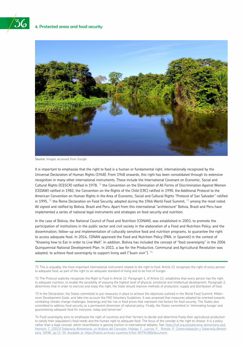
36 4. Protected areas and food security
It is important to emphasize that the right to food is a human or fundamental right, internationally recognized by the Universal Declaration of Human Rights (1948). From 1948 onwards, this right has been consolidated through its extensive recognition in many other international instruments. These include the International Covenant on Economic, Social and Cultural Rights (ICESCR) ratified in 1978, 71 the Convention on the Elimination of All Forms of Discrimination Against Women (CEDAW) ratified in 1982, the Convention on the Rights of the Child (CRC) ratified in 1990, the Additional Protocol to the American Convention on Human Rights in the Area of Economic, Social and Cultural Rights “Protocol of San Salvador” ratified in 1995, 72 the Rome Declaration on Food Security, adopted during the 1966 World Food Summit, 73 among the most noted. All signed and ratified by Bolivia, Brazil and Peru. Apart from this international “architecture” Bolivia, Brazil and Peru have implemented a series of national legal instruments and strategies on food security and nutrition.
In the case of Bolivia, the National Council of Food and Nutrition (CONAN), was established in 2003, to promote the participation of institutions in the public sector and civil society in the elaboration of a Food and Nutrition Policy, and the dissemination, follow-up and implementation of culturally sensitive food and nutrition programs, to guarantee the right to access adequate food. In 2014, CONAN approved the Food and Nutrition Policy (PAN, in Spanish) in the context of “Knowing how to Eat in order to Live Well”. In addition, Bolivia has included the concept of “food sovereignty” in the 2006 Quinquennial National Development Plan. In 2011, a law for the Productive, Communal and Agricultural Revolution was adopted, to achieve food sovereignty to support living well (“buen vivir”). 74
71 This is arguably, the most important international instrument related to the right to food. Article 11 recognizes the right of every person to adequate food, as part of the right to an adequate standard of living and to be free of hunger.
72 The Protocol explicitly recognizes the Right to Food in Article 12. Paragraph 1, of Article 12, establishes that every person has the right to adequate nutrition, to enable the possibility of enjoying the highest level of physical, emotional and intellectual development. Paragraph 2, determines that in order to exercise and enjoy this right, the State should improve methods of production, supply and distribution of food.
73 In the Declaration, the States committed to put measures in place to achieve the objectives outlined in the World Food Summit, Millen-nium Development Goals, and take into account the FAO Voluntary Guidelines. It was proposed that measures adopted be oriented towards combating climate change challenges, bioenergy and the rise in food prices that represent risk factors for food security. The States also committed to address food security as a permanent dimension of national policy. Finally, the States committed to “eliminating hunger and guaranteeing adequate food for everyone, today and tomorrow”.
74 Food sovereignty aims to emphasize the right of countries and their farmers to decide and determine freely their agricultural production to satisfy their population’s food needs and the human right to adequate food. The focus of the concept is the right to choose. It is a policy rather than a legal concept, which nevertheless is gaining traction in international debates. See, https://vsf.org.es/soberania-alimentaria and Heinisch, C. (2013) Soberanía Alimentaria: un Análisis del Concepto. Hidalgo, F., Lacroix, P., Román, P. Comercialización y Soberanía Alimen-taria. SIPAE, pp.11-36. Available at, https://halshs.archives-ouvertes.fr/hal-00794380/document.
Source: Images accessed from Google
374. Protected areas and food security
On the other hand, Brazil has a National System for Food and Nutrition Security (SISAN, in Spanish) created by the Organic Law on Food and Nutrition Security (2006). The Law recognizes that adequate food is a fundamental human right, necessary to satisfy the inherent dignity of the human person. In that regard, the State has the responsibility and obligation to ensure this right is guaranteed and realized fully. In 2017, a law was passed on guidelines for the implementation of small family farming and rural family businesses as a basis to promote food security in the country.
Peru, for its part, has developed and implemented over the past decade, a series of laws, regulations and instruments to promote food security at different levels. The country has updated the National Strategy for Food and Nutrition Security (ENSA, in Spanish) and its Plan 2013 – 2021, prepared by the Multisectoral Commission for Food and Nutrition Security (CMSAN, in Spanish). This objective of this strategy is to promote the population’s food security and nutrition, particularly for the most vulnerable social groups. In addition, Peru relies on the National Development and Social Inclusion Strategy “Include to Grow”, which is based on strategic principles to combat chronic child malnutrition; support early childhood development and the full development of children and adolescents; and enhance economic inclusion and protection for the elderly. In 2015, the Parliamentary Front against Hunger was created in Congress, to monitor advances in food security policy and measures in the country. Finally, on August 2017, Congress approved a draft project (law) on Food Security and Nutrition which is pending enactment.
Following is an overview on how food is guaranteed for populations who live in Madidi National Park, the RESEX Chico Mendes, the PNBS, and their influence zones.
In the case of Madidi National Park, wild meat is one of the main food sources (proteins) for indigenous peoples in the area. It is estimated that TCO Tacana communities benefit from nearly 43 different animal species and at least 10 fish species. These fish are 86% of the biomass fished and consumed. Indigenous and peasant communities in general, also benefit from reptile meat and eggs, such as the black caiman (Caiman yacare y Melanosuchus niger), river turles (Podocnemis unifilis y Podocnemis expansa) and forest tortoise (Chelonoides denticulada). At least 12 mammal species constitute a source of key foods, such as wild pigs, tapirus, some cervids and monkeys. A large part of the hunted game and fish are commercialized in nearby towns of the municipalities of Madidi National Park. In terms of plant species, an important group are palms Bactris sp., Jessenia bataua, Scheela princeps, Euterpe precatoria, Attalea phalerata), from which communities collect fruit or extract the heart of the palm (CIPTA and WCS 2001). Indigenous communities also cultivate banana, cassava and different fruits as a source of vitamins. These products are also commercialized in local markets, mainly in the town of Rurrenabaque, and the money received is usually used to buy provisions and processed food products: oil, rice, biscuits, sugar, others. These products are complementary to more traditional diets derived from the forest, however, external influences and local needs are relying more and more on these “imported” foodstuffs.
There is limited information available regarding water provision services in Madidi National Park. However, the natural protected area´s Management Plan acknowledges that the Madidi River is a key source of water supply for the whole Province of Abel Iturralde. Serranías del Bala, Hurehuapo, Mamuque and Cuñaca, providing water to more than 10,000 people, the total population of the San Buenaventura Municipality and most of the population of Ixiamas Municipality (SERNAP 2006). Likewise, most of the indigenous and peasant populations are supplied with water for human consumption from natural sources without any form of treatment system. The Apolo Municipality in the high-Andean part of the Park is already experimenting water shortages due to deforestation, forest fires and different forms of impacts over water resources, including pollution and climate change (GAM Apolo 2013).
With regards to the access to food, ownership by indigenous peoples of their territories and lands, including those areas overlapping Madidi National Park, has been a key element to guarantee certain levels of food security. If access to land and use of natural resources (biodiversity) are in some way ensured, there is a natural incentive to conserve and use in a sustainable way, according to traditional practices which have proven efficient in the past. A large part of the hunting and fishing areas of indigenous communities are defined within the zoning of the natural protected area. However, it is noticeable that changes in food consumption patterns in indigenous communities, such as the Tacanas, is affecting access to quality food. The Tacanas are substituting nutritious forest products, for others with a more questionable nutritional value, mainly processed food purchased from local and urban markets (CIPTA and WCS 2001).
Food security also relies on projects and small businesses that provide the income that enables the purchase of complementary food - to the traditional diet. Madidi National Park injects at least 2,5 million dollars a year to the regional economy, as a result of conservation initiatives such as management and control of the natural protected areas infrastructure, research and tourism (Fleck et al. 2006). At present, tourism continues to be a high relevant income generator for the local and regional economy; in 2016, 17,000 tourists were formally registered as visitors to the park. A
38 4. Protected areas and food security
number of low cost lodges have been developed along the Tuichi River. Other initiatives such as Chalalán, has ensured a high investment (1,5 million dollars) to attract a segment of tourists that leave an important income to the local economy and which translates into benefits for the local population. 75
Among other initiatives related to biodiversity, are the management of Brazil nuts (Bertholetia excels) by Tacana communities on the Madidi and Madre de Dios Rivers. These are collected, and intermediaries sell the bulk product often to the chocolate and snacks industry. In the Apolo area, small business initiatives are being implemented for the extraction and development of incense (with species such as Clusia aff. Flaviflora y C. salvinii). At least 10 palm species are being used locally as a source of local income for construction, crafts and food purposes. Indigenous communities of TCO Tacana I, have embarked in economic ventures with the production of local bee honey (Tetragonisca angustula y Melipona spp.).
The production of organic coffee in Apolo, together with “Madidi Coffee” is an important economic alternative for many families in the area. During 2009 and 2012, the local Association of Coffee Producers (APCA, in Spanish) secured an income of US $18,000 (SERNAP 2013), and currently has a much more consolidated market. Furthermore, the Tacana and Lecos indigenous communities have also incorporated the production of wild cacao into their local economic activities. 76
Most of the population living in the RESEX Chico Mendes depends on nut collecting, the extraction of latex, cattle raising and subsistence farming to sustain itself (IBAMA 2006). They combine food products obtained from their agricultural and livestock activities, with processed products (i.e. oil, sugar, flour and biscuits) they purchase from small businesses and sellers. Some legumes and fruits, including bananas and papaya (Costa et al. 2000) are also consumed. Beef and fish (i.e. piaba, cará, piau, mandi) provide the main source of proteins. Traditional agricultural activities and subsistence farming is conducted in small parcels of land, of not more than 3 hectares on average. Traditional communities also eat wild pig meat, venison, capuchin monkeys and tapir (IBAMA 2006). Although chicken breeding is restricted under the RESEX Management Plan, there is a tradition among communities to breed poultry.
The production of latex and chestnuts is a major contribution of the RESEX Chico Mendes to the State of Acres economy, and a fundamental aspect for the sustainable living conditions of traditional communities (IBAMA 2006). The State of Acre contributes 35% of the national chestnut production. The RESEX Chico Mendes contributes with 10,5% to the percentage of national chestnut production. Latex and chestnuts are products that generate an income, which in turn allows for the purchase of mainly processed consumer products, as mentioned previously.
The RESEX Chico Mendes has an important hydrographic network that guarantees the availability of and access to water sources for the inhabitants of the reserve. Three principal rivers (Iaco, Xapuri and Acre) pass through the reserve, and are direct tributaries of River Purús in Peru. These rivers provide potable water and means of transport that is critically important for the people in the area. At the same time, the need for transport results in the majority of communities settling near river banks and becoming vulnerable to flooding in particular. There is evidence of a water shortage due to the degradation of ciliary vegetation (Silva 2000).
The State of Acre has enacted a series of measures to stimulate the return of families who abandoned the RESEX Chico Mendes in the 1990s, as a result of competition in the production of latex from Southeast Asia. Particular emphasis has been placed on subsidizing the latex production to increase the earnings for rubber tappers and their families (Faustini and Furtado 2015). There are also a number of ventures around latex, looking for diversification and productive efficiency, supported by institutions such as the World Wildlife Fund (WWF), Folha Defumada Líquida (FDL) and University of Brasilia (IBAMA 2006). The condom industry and a chestnut cooperative processing plant that operates with nearly 2,000 producers, absorb the latex and chestnut production. 77
75 Tourism in Madidi National Park registered a significant growth during the 1980s, as a result of the publication of the book “Back to the Tuichi” by Israeli author Josse Ginsberg, who described his experience when he got lost in the Park. Subsequently, a publication on the natural protected area in National Geographic in 2000, triggered a massive inflow of tourism to Madidi National Park. At present, excessive requirements and paperwork for North Americans and Israelis to obtain an entry visa to Bolivia, has reduced the inflow of “backpackers” to the natural protected area.
76 Madid Coffee is one of the few coffees in the world cultivated in natural protected areas. The shading of the forest, its biodiversity and careful management of the agroecosystem, is the foundation for the success of this sustainable venture model, with the support of Apolo Association of Coffee Producers, SERNAP, German Cooperation (through KfW), Municipality of Apolo, among other actors. See: http://www.alexander-coffee.com/quienes-04b.html.
77 See, Extrativismo Gera Renda para Famílias que Vivem na Reserva Chico Mendes, Available at, http://g1.globo.com/natureza/noti-cia/2015/04/extrativismo-gera-renda-para-familias-que-vivem-na-reserva-chico-mendes.html.
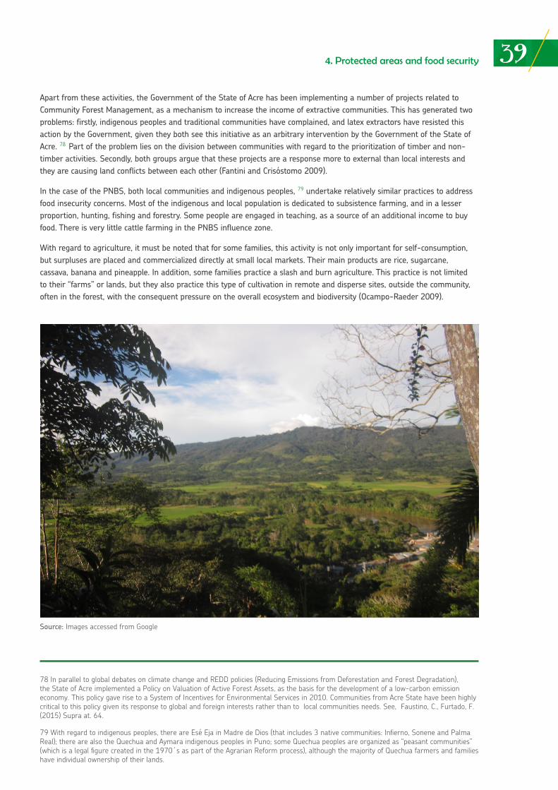
394. Protected areas and food security
78 In parallel to global debates on climate change and REDD policies (Reducing Emissions from Deforestation and Forest Degradation), the State of Acre implemented a Policy on Valuation of Active Forest Assets, as the basis for the development of a low-carbon emission economy. This policy gave rise to a System of Incentives for Environmental Services in 2010. Communities from Acre State have been highly critical to this policy given its response to global and foreign interests rather than to local communities needs. See, Faustino, C., Furtado, F. (2015) Supra at. 64.
79 With regard to indigenous peoples, there are Esé Eja in Madre de Dios (that includes 3 native communities: Infierno, Sonene and Palma Real); there are also the Quechua and Aymara indigenous peoples in Puno; some Quechua peoples are organized as “peasant communities” (which is a legal figure created in the 1970´s as part of the Agrarian Reform process), although the majority of Quechua farmers and families have individual ownership of their lands.
Apart from these activities, the Government of the State of Acre has been implementing a number of projects related to Community Forest Management, as a mechanism to increase the income of extractive communities. This has generated two problems: firstly, indigenous peoples and traditional communities have complained, and latex extractors have resisted this action by the Government, given they both see this initiative as an arbitrary intervention by the Government of the State of Acre. 78 Part of the problem lies on the division between communities with regard to the prioritization of timber and non-timber activities. Secondly, both groups argue that these projects are a response more to external than local interests and they are causing land conflicts between each other (Fantini and Crisóstomo 2009).
In the case of the PNBS, both local communities and indigenous peoples, 79 undertake relatively similar practices to address food insecurity concerns. Most of the indigenous and local population is dedicated to subsistence farming, and in a lesser proportion, hunting, fishing and forestry. Some people are engaged in teaching, as a source of an additional income to buy food. There is very little cattle farming in the PNBS influence zone.
With regard to agriculture, it must be noted that for some families, this activity is not only important for self-consumption, but surpluses are placed and commercialized directly at small local markets. Their main products are rice, sugarcane, cassava, banana and pineapple. In addition, some families practice a slash and burn agriculture. This practice is not limited to their “farms” or lands, but they also practice this type of cultivation in remote and disperse sites, outside the community, often in the forest, with the consequent pressure on the overall ecosystem and biodiversity (Ocampo-Raeder 2009).
Source: Images accessed from Google
40 4. Protected areas and food security
On the other hand, hunting is prioritized during the rainy season (October-April) and is generally performed at night in groups, as the Esé Eja people believe that if hunting is undertaken individually, “evil spirits might kill the hunter” (Mayor and Bodmer, 2009). The displacement for hunting activities is undeniable due to the limited availability of animals in the hills. This has caused them to seek new spaces, which in some cases are occupied by migrant populations of the Andean region. This creates tensions and conflicts (Chavarría, 2003). Fishing is also important for the economic and social dynamics of the population. Fish are key for self-consumption and small-scale commercialization. It takes place all year round; mainly in rivers during the rainy season and also in lakes, creeks and ponds.
Another important activity in the PNBS is the sustainable exploitation of chestnuts (13 concessions exist in special use zones), which is a source of income for the population, mainly for local and riverside communities. 80 At present, communities have constructed warehouses and rely on networks for their commercialization. Tourism has also gained relevance, primarily in the Infierno Community where a lodge is jointly operated with the Rainforest Expedition Ecotourism Company. Although the other two communities, Sonene and Palma Real are also interested in developing this activity, the number of tourists is relatively small in comparison to Infierno. This limitation is due to inexistence of tourist paths and treks, as well as the lack of infrastructure (lodges) and general information. Support and advice is being sought by communities from the administration of natural protected areas, SERNANP.
Along the buffer zones, particularly in the provinces of Carabaya and Sandia, the Quechua and Aymara indigenous population (organized in cooperatives) is engaged mainly in the production of coffee (that is exported) and different fruits (oranges, mandarins, pineapples, bananas, papayas, chirimoyas, among many others), mostly distributed in the cities of Puno and Juliaca. The ventures in the region of Puno are linked mainly to the production of coffee, collected and commercialized through CECOVASA and La San Juan Cooperatives.
Box No. 1 offers a simple proposal based on information regarding food sources obtained from the RESEX Chico Mendes, Madidi National Park and the PNBS, for a healthy and nutritious diet based on forest products, and the complementary alternatives obtained from other food sources, not necessarily from the region. This type of diet is related to the dimension of food availability under the definition “food security”.
80 Chestnuts are extracted both from the Tambopata National Reserve (RNTAMB) and the PNBS. Extraction is considered compatible with the conservation objectives of the Park and Reserve, given the low impact of extractive cultivation/activities. Chestnut production is under-taken under traditional harvesting systems used by the population of Madre de Dios. Since 2004, the Park has had thirteen (13) “use con-tracts” for chestnuts, with a 40-year renewable validity period. Seven (7) of them are in the PNBS and six (6) are shared with the RNTAMB. Chestnut concessions within native communities (indigenous) lands are a very sensitive issue. As far as is known from available information, the Ese´ Eja do not have concessions inside the PNBS. This is a high conflict issue identified by WCS, which is being addressed as part of the up-dating of the Tambopata National Reserve Master Plan. Indigenous peoples exploit chestnuts inside their own communities (Personal conversation, WCS, August 2017).
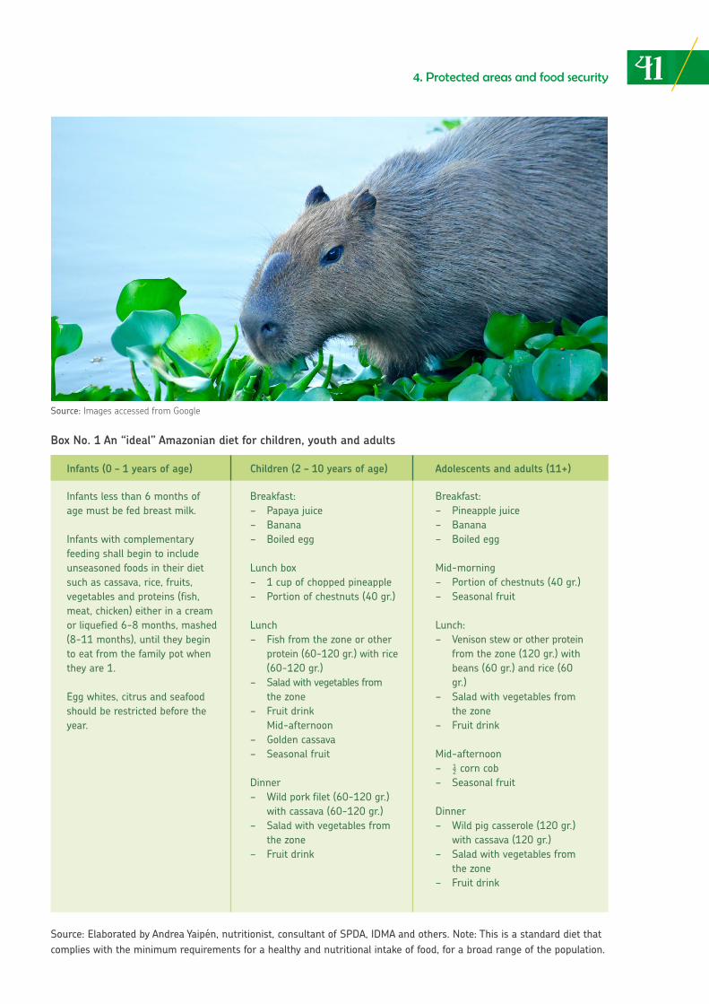
414. Protected areas and food security
Box No. 1 An “ideal” Amazonian diet for children, youth and adults
Source: Elaborated by Andrea Yaipén, nutritionist, consultant of SPDA, IDMA and others. Note: This is a standard diet that complies with the minimum requirements for a healthy and nutritional intake of food, for a broad range of the population.
Infants less than 6 months of age must be fed breast milk.
Infants with complementary feeding shall begin to include unseasoned foods in their diet such as cassava, rice, fruits, vegetables and proteins (fish, meat, chicken) either in a cream or liquefied 6-8 months, mashed (8-11 months), until they begin to eat from the family pot when they are 1.
Egg whites, citrus and seafood should be restricted before the year.
Breakfast:− Papayajuice− Banana− Boiledegg
Lunch box− 1cupofchoppedpineapple− Portionofchestnuts(40gr.)
Lunch− Fishfromthezoneorother protein (60-120 gr.) with rice (60-120 gr.)− Saladwithvegetablesfrom the zone− Fruitdrink Mid-afternoon− Goldencassava− Seasonalfruit
Dinner− Wildporkfilet(60-120gr.) with cassava (60-120 gr.)− Saladwithvegetablesfrom the zone− Fruitdrink
Breakfast:− Pineapplejuice− Banana− Boiledegg
Mid-morning− Portionofchestnuts(40gr.)− Seasonalfruit
Lunch:− Venisonsteworotherprotein from the zone (120 gr.) with beans (60 gr.) and rice (60 gr.)− Saladwithvegetablesfrom the zone− Fruitdrink
Mid-afternoon− ½corncob− Seasonalfruit
Dinner− Wildpigcasserole(120gr.) with cassava (120 gr.)− Saladwithvegetablesfrom the zone− Fruitdrink
Infants (0 – 1 years of age) Children (2 – 10 years of age) Adolescents and adults (11+)
Source: Images accessed from Google
THE IMPACT OF CLIMATE CHANGE ON PROTECTED AREAS:
preliminary evidence and its treatment
05
05
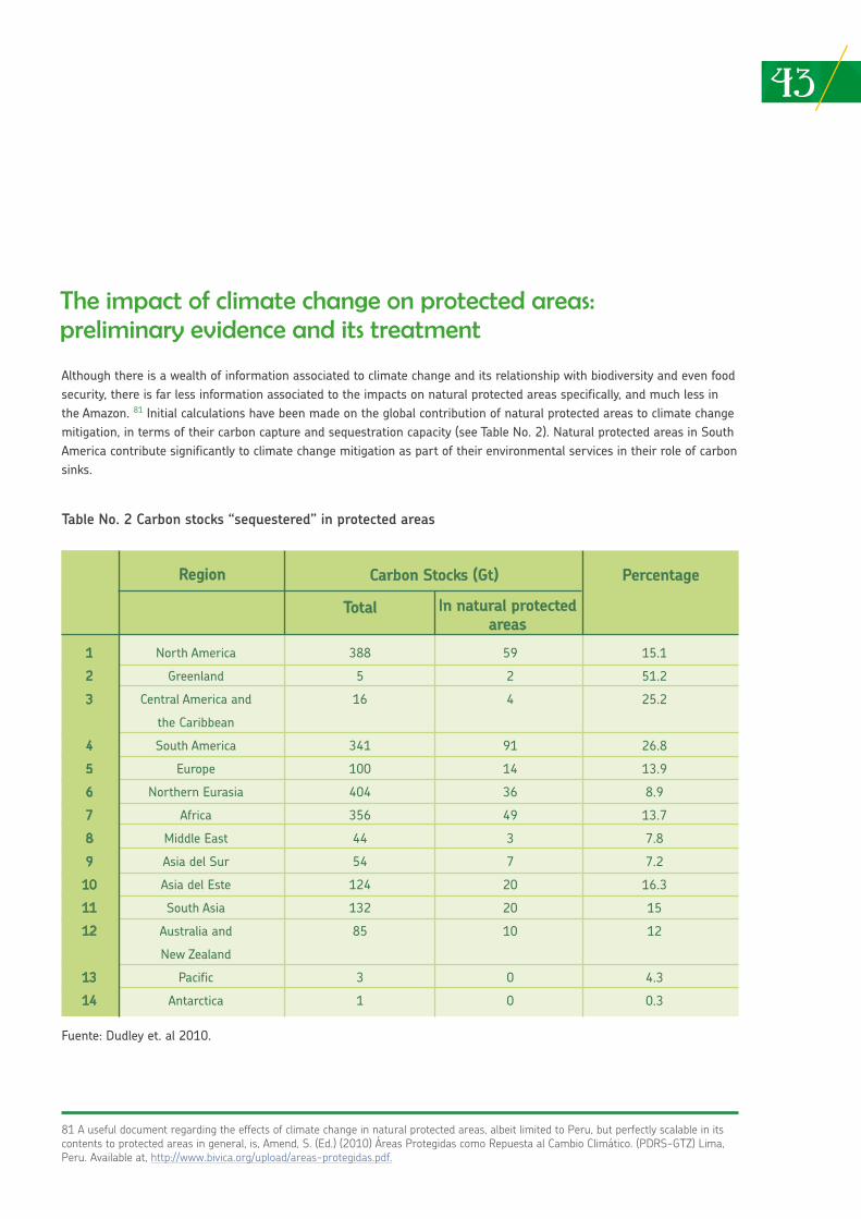
435. The impact of climate change on protected areas
Although there is a wealth of information associated to climate change and its relationship with biodiversity and even food security, there is far less information associated to the impacts on natural protected areas specifically, and much less in the Amazon. 81 Initial calculations have been made on the global contribution of natural protected areas to climate change mitigation, in terms of their carbon capture and sequestration capacity (see Table No. 2). Natural protected areas in South America contribute significantly to climate change mitigation as part of their environmental services in their role of carbon sinks.
The impact of climate change on protected areas: preliminary evidence and its treatment
81 A useful document regarding the effects of climate change in natural protected areas, albeit limited to Peru, but perfectly scalable in its contents to protected areas in general, is, Amend, S. (Ed.) (2010) Áreas Protegidas como Repuesta al Cambio Climático. (PDRS-GTZ) Lima, Peru. Available at, http://www.bivica.org/upload/areas-protegidas.pdf.
Table No. 2 Carbon stocks “sequestered” in protected areas
Fuente: Dudley et. al 2010.
Region Carbon Stocks (Gt)
Total In natural protected areas
Percentage
1
2
3
4
5
6
7
8
9
10
11
12
13
14
North America
Greenland
Central America and
the Caribbean
South America
Europe
Northern Eurasia
Africa
Middle East
Asia del Sur
Asia del Este
South Asia
Australia and
New Zealand
Pacific
Antarctica
388
5
16
341
100
404
356
44
54
124
132
85
3
1
59
2
4
91
14
36
49
3
7
20
20
10
0
0
15.1
51.2
25.2
26.8
13.9
8.9
13.7
7.8
7.2
16.3
15
12
4.3
0.3
44 5. The impact of climate change on protected areas
Usually, situations applicable to the Amazon and specific sites, including natural protected areas, can be extrapolated. Changes in global climate patterns, specifically temperature increase and modification of the rainfall regime, reveal the possibility of negative impacts on Amazonian biodiversity and ecosystems. 82 More intense and prolonged weather events are predicted that will add to the stress on Amazonian ecosystems and their populations. The present climate models, despite their sophistication, are limited to accurately predict how the region would be affected. What appears certain, is that the Amazon region will be affected (Candido et al. 2007). According to OTCA, one can already observe “the substitution of Amazon forests to savanna-like and semiarid vegetation, due to a warmer and drier environment, thereby affecting the hydro-biological cycle and biodiversity” (OTCA 2014).
The effects on Amazon biodiversity from the impacts of changes in climate patterns, including in the RESEX Chico Mendes, Madidi National Park and the PNBS, will directly influence food security and the right to food for populations in these sites and their influence zones. This will occur for several reasons.
Firstly, in terms of stability, the uncertainty with regard to production performance may lead to changes in consumption patterns, towards diets and foods that are less familiar, healthy and nutritional; secondly, in terms of availability, the source of foods and amount produced could be affected; thirdly, with regard to access, income reduction and the increase of food prices, may affect food security for families and affect their possibilities to directly access food and goods that originate from the forest or agroecosystem affected by climate change (i.e. loss of biodiversity, animal migration, reduction of fisheries, etc.). Finally, in terms of utilization, climate change may lead to diet and nutritional changes, mainly for vulnerable families that rely on the forest and do not count on immediate alternatives to elaborate complementary, healthy and nutritional diets (FAO 2016).
The Madidi National Park is located, primarily, in the high/mountainous Amazon region (although it joins the plains). Major climate change impacts in this region are observed in the rain and flood regime, producing delays in normal rainfall months and increasing their intensity, and thus, flooding during certain times of the year (UNDP 2011). Climate scenarios predict an increase in global temperature. In that context, the number of changes in climate variables, predict a potential loss of montane forests greater than 50 km2 by 2050. 83 The most vulnerable areas prone to the significant loss of montane forests, due to these climate scenarios, are concentrated in natural protected areas on the amazon slopes of the Eastern Cordillera. Areas with the most significant losses are in Madidi National Park, together with other three protected areas in Bolivia (Apolobamba, Carrasco and Amboró), as well as two national parks in Peru (Yanachaga-Chemillen and Manu).
At a more local level, the systematization of rainfall due to climate change conducted in the San José de Uchupiamonas Community, inside Madidi National Park, indicated that the agricultural calendar has changed and farmers have been forced to adapt and experiment different cultivation times and methods, to decrease the risk of losing all the harvest. 84 With this in mind, villagers stated that sunlight intensity has increased during the last 10 years, making the working day harder. On the other hand, villagers perceive that due to the changes in rainy and drought seasons, forest fruits are not produced every year as before and there are mosquitos at any time of the year. In addition, they indicated that fish do not spawn as usual and the creeks that provide water for local purposes have started to dry up. Another study in the locality of Teoponte that limits with the Apolo Municipality, indicates that the rise of rainfall intensity has increased fungal infections (mainly coffee leaf rust) in the coffee plantations, as well as reduced coffee production yields when compared to data from 2011, 2014 and 2015. 85 Although these last two cases present information from climate change impacts from specific locations, possibly some of these impacts may be replicable for different municipalities and places linked to Madidi National Park. A better understanding of this issue is essential.
82 According to the Intergovernmental Panel on Climate Change, the resulting extinction risk estimates for Amazonian plant species, exclu-ding the possible impacts from climate change, will have already extended from 5% to 9% by 2050, with a habitat reduction of 12% to 33% by 2030. See, Intergovernmental Climate Change Panel. Fifth Assessment Report of IPCC, 2013.
83 This is according to the HADCM3 A2 scenario (Hadley Centre Coupled Model, version 3), a model recognized by the Intergovernmental Panel on Climate Change (IPCC) and used in the study by Cuesta, F.; Peralvo, M., Valarezo, N. (2009) Los Bosques Montanos de los Andes Tropicales. Una Evaluación Regional de su Estado de Conservación y de su Vulnerabilidad a Efectos del Cambio Climático. Serie Investigación y Sistematización # 5. Programa Regional ECOBONA – INTERCOOPERATION. Quito.
84 See, Padraza, G., Pachaguaya, P. (year unavailable). Amazonia: Pulmón del Mundo Cuando el Sol Calienta más Percepciones del Cambio Climático de los Pueblos Indígenas Amazónicos de Bolivia, El Puquio - Chiquitano y San José de Uchupiamonas. PRAIA Foundation funded by FIDA. La Paz, Bolivia.
455. The impact of climate change on protected areas
In the case of the Brazilian Amazon, including the RESEX Chico Mendes, climate change impacts are being perceived mainly in rainfall regimes, particularly during the El Niño phenomenon. Extreme rainfall or prolonged droughts are two recurrent events that affect communities that directly depend on natural resources. In addition to the anthropic effects and pressures that include inadequate land management and logging close to riverbanks, the global climate phenomenon is affecting food sources (i.e. fresh fish) and the risk of forest fires has incresased (Silva and Texeira 2000; Fearnside 2009).
Predictability of these impacts continues to be complicated. However, some recent events in the RESEX Chico Mendes serve as an example of the types of problems which this area may face in the future as part of widespread climate change. In 2005, a wildfire in the RESEX extended for more than a week as a result of prolonged drought, putting the tappers latex production at a serious risk. 86 Ten years later, the State of Acre suffered the worst floods in its history, affecting more than 80,000 people and more than 20,000 homes.
Specific studies on the impacts of climate change in the PNBS have not been conducted. However, as in the cases of Madidi National Park and the RESEX Chico Mendes, there are situations attributed to recent changes in climate patterns. For example, the most important economic and social activity in the PNBS buffer zone in Puno is agriculture and coffee growing. Communities have various recognitions at the national and international levels, for the world’s best coffee. Despite this, coffee production and productivity in the zone has fallen considerably during the past years, mainly caused by “coffee leaf rust” fungus that attacks the coffee plants. One of the hypotheses is that the impact of climate change is responsible for the recurrent appearance of this fungus, as fluctuating periods of rain and strong radiation improves the conditions for it to be more aggressive. The effect can be observed with other crops, especially fruits.
Another effect, not yet fully confirmed is the impact of climate change on the quality and quantity of water for human consumption. The people in major populated areas surrounding the PNBS consume water from so called fresh water eyes, springs of accumulated underground water that is piped and conducted to their houses. Part of the population and authorities in the zone where the WCS works indicate that these fresh water eyes are drying out from the lack of rain during periods were historically it has always rained, and the water is no longer completely clean. This may be due to maintenance problems. 87
85 See, Chugar, H. (2016) Análisis de la Vulnerabilidad del Cultivo de Café (Coffea arabica L.) y Formulación de Estrategias Locales de Adaptación al Cambio Climático en el Municipio de Teoponte, Departamento de La Paz, Bolivia. Work Project of the Biodiversity Conservation Practice Master Program. CATIE. Turrialba, Costa Rica.
86 See, Incêndio Resiste e Ameaça Reserva Florestal no Acre. http://www1.folha.uol.com.br/fsp/cotidian/ff2609200509.htm.
87 Personal communication, Loyola Escamilo, WCS, August 2017.
46
CONCLUSIONS
1. Biodiversity and agrobiodiversity conservation should be an essential state policy and action objective to guarantee food security – through a nutritious and balanced diet for everyone, at all times. This is particularly the case of food security for vulnerable communities and populations who directly benefit from food services provided by Madidi National Park, the RESEX Chico Mendes and the PNBS.
2. Tropical forests play a central role as a guarantee for climate stability, and in terms of the possibilities for populations living in these areas and their influence zones, of guaranteeing their food security in the long term.
3. The effect of climate change on Amazonian biodiversity poses a significant challenge but also an opportunity. The communities who benefit from natural protected areas are generally poor and extreme poor social groups, that face food insecurity situations, and changes in food production, access and availability may worsen the situation. Nevertheless, a well-planned food reconversion process could improve the way available foods are consumed. In the light of this probable adverse situation to come, state interventions could be catalyzed (through the State, NGOs, and regional governments, municipalities, social programs, etc.) to focus on reverting food insecurity and replacing food habits with more favorable food patterns, in line with changing environmental realities.
4. The impacts from climate change in the three natural protected areas studied are difficult to determine at present. The reality is that new and more intense environmental conditions will inevitably generate, depending on the specific event they face in time: droughts, flooding, high temperatures, cold waves and others. There have been several examples of events attributed to climate cycles such as El Niño and La Niña.
5. Legal security with regard to the land and territories of indigenous peoples and local communities is critical to guarantee the food security of the populations. With adequate and consensual planning and management processes of the spaces, the impact is greater on conservation and the sustainable use of resources and services provided by natural protected areas for their populations.
6. At a global level, the Amazon constitutes the largest tropical forest on the planet, and as a consequence, the principal generator of oxygen for the atmosphere and highly important to regulate the world’s climate. The drainage area of the Amazon corresponds to the largest known river basin, essentially a huge reserve of freshwater. The Amazon is also one of the largest biological diversity centers and is constituted as a major supplier of raw materials, medicines and food for the local population and the world. In this context, the contribution of each one of the protected areas in providing stability in the Amazon and its multiple eco-systemic goods and functions needs to be highlighted.
7. The three case studies presented in this publication primarily describe the protected areas contribution to the local economy, food security and availability of water for mainly rural families and indigenous peoples, who from the characteristics of regional economies, constitute the vulnerable groups due to their poverty level, access to education and state services, among others. Therefore, it is possible to raise the hypothesis that the health of ecosystems of protected areas is linked to the life quality of local populations.
8. The three case studies demonstrate that forest products are extremely important for the food security of local populations and their economies. Some products are used to provide food for other population groups at the national and international level, as in the case of chestnuts or fishing. In this respect, a more exhaustive analysis is required to document the specific contribution of natural protected areas to different levels of the population.
47
RECOMMENDATIONS
1. One of the central approaches to face the impacts of climate change on food security conditions for both the local populations as well as those surrounding the protected areas, specifically in the context of Madidi National Park and Natural Integrated Management Area, the RESEX Chico Mendes and the PNBS, is to improve the levels of understanding and redirect research in these areas. This may imply for example, the installation and regular monitoring of stations on climate conditions over time (for the generation of data and measurements); the implementation of regular biodiversity monitoring stations; the inclusion of dimensions on food security in the different planning and management tools and instruments for the areas (i.e. strategies, plans, etc.); actions to measure the state of food security (i.e. implementing FAO Voluntary Guidelines on Food Security); among others. These kinds of actions and measures will not only mean the improvement of scientific, socioeconomic and cultural knowledge, but will positively impact the decision- making process regarding these sites.
2. Reducing the threats from deforestation must be a matter of priority for the conservation of Madidi National Park and Natural Integrated Management Area, the RESEX Chico Mendes and the PNBS, and essential for climate stability at the local level (certainly global). This requires from the State, an efficient legal and institutional framework and a real, visible and effective presence in each one of these areas or surrounding zones (i.e. administrative instances, expert courts, prosecutors, police force, among others) both to exercise their deterrent role and carry forward the enforcement actions of the normative.
3. Land and territorial issue continue to be crucial in the Amazon, in order to resolve a number of problems, including the illegal settlement of people. Work must be done to conclude land entitlement processes that would enable a clearer legal framework, and contribute in the control of illegal settlement processes. This must go hand in hand with the land use planning, which are already being implemented in the three areas analyzed, through their planning tools (i.e. master plans, strategies, etc.). Physical and legal entitlement is one of the variables which could contribute to improving the management of resources and the space, and influence in the processes to prevent deforestation and maintain traditional food sources.
4. Although the specific realities of Madidi National Park and Integrated Management Area, the RESEX Chico Mendes and the PNBS vary, there is a need to strengthen the capacity of the population and communities in order to manage their parcels of land and crops. This could be realized through extension actions and participative plant breeding, to identify and develop crop varieties that would respond to growing climate pressures and its impacts in terms of drought, pests, excess of water, etc. Although interventions in some areas and influence zones must face scale challenges (i.e. many and varying producers), proper risk and extension management plans implemented at the local level (municipalities), with the technical support of NGOs and different national agricultural research institutes (i.e. EMBRAPA in Brazil, INIA in Peru), would contribute to an efficient adaptation process.
5. During the last 10 years, Bolivia, Brazil and Peru have developed a number of instruments (i.e. strategies, action plans, laws) to address climate change and food security. It is necessary to promote a coordinated implementation, using the positive synergies among these instruments. As is frequent in the region, there is not necessarily a lack of legislative management instruments in different areas, but rather implementation problems and an institutional structure to accompany these processes.
6. Institutional capacities to prevent and respond to the events caused by climate change (i.e. prolonged cold waves, unusual flooding, extended droughts) need to improve and strengthen. Legal frameworks, human capacities and infrastructure is necessary to intervene once climate impacts have occurred by specifically assisting populations that live and directly or indirectly depend on the protected areas analyzed for their survival.
48
• ABISA (2014) Informe sobre el Derecho a la Alimentación en el Perú: el Caso de Comunidades en Loreto, Lima y Cusco. Available at: http://www.spda.org.pe/wp-content/uploads/2015/08/Abisa-OK.compressed.pdf.
• ACRE. Governo do Estado do Acre. Zoneamento Ecológico-Econômico do Estado do Acre, Fase II (Escala 1:250.000): Documento Síntese. 2. Ed. Rio Branco: SEMA, 2010. Available at: http://www.amazonia.cnptia.embrapa.br/publicacoes_estados/Acre/Fase%202/Documento_Sintese.pdf.
• Álvarez-Berríos, N., Aide, M. (2015) “Global demand for gold is another threat for tropical forests.” Environ. Research Letters. 10.
• Amend, S. (Ed.) (2010) Áreas Protegidas como Repuesta al Cambio Climático. (PDRS-GTZ) Lima, Peru. Available at http://www.bivica.org/upload/areas-protegidas.pdf.
• Inter-American Development Bank. (1992) Amazonia Without Myths. Commission on Development and Environment for Amazonia. Available at: http://otca.info/portal/admin/_upload/publicacoes/SPT-TCA-ECU-SN-AMAZONIA.pdf.
• BRASIL. Ministério do Meio Ambiente. Plano de Utilização da Reserva Extrativista Chico Mendes. Portaria Nº 60, from August 28th 2008 – ICMBio.
• Burgos, A. (2012) Informe “Diagnóstico Socioeconómico del Sector Punto Cuatro en el Parque Nacional Bahuaja-Sonene (distrito de Limbani, Puno).” Pronaturaleza/SERNANP. Lima, Peru.
• Candido, L. A et al. (2007) O Clima Atual e o Futuro da Amazônia nos Cenários do IPCC: A questão da Savanização. Cienc. Cult. vol.59 no.3 São Paulo July/Sept. 2007. Available at: http://cienciaecultura.bvs.br/scielo.php?pid=s0009-67252007000300017&script=sci_arttext.
• Chugar, H. (2016) Análisis de la Vulnerabilidad del Cultivo de Café (Coffea arabica L.) y Formulación de Estrategias Locales de Adaptación al Cambio Climático en el Municipio de Teoponte, Departamento de La Paz, Bolivia. Work Project of the Biodiversity Conservation Practice Master Program. CATIE. Turrialba, Costa Rica.
• CIFOR. Pagos por Servicios Ambientales. 2006 (updated in 2011). http://www.cifor.org/pes/_ref/sp/sobre/index.htm.
• Cingolani, P., Díez Astete, A., Brackelaire, V. (2008) Toromonas: La Lucha por la Defensa de los Pueblos Indígenas Aislados en Bolivia. FOBOMADE-Rainforest Foundation Norway. La Paz, Bolivia.
• Costa, S., Santos, J.E., Pires, J., Henke-Oliveira, C., Moshini, L. (2000) Caracterização Ambiental da Reserva Extrativista Chico Mendes (ACRE-BRASIL): SUBSÍDIO AO PLANO DE MANEJO.
• Costanza, R., et al., (1997) The Value of the World´s Ecosystem Services and Natural Capital, Ecological Economics, Vol.25, No. 1, p. 3-15.
• Cotter, J., Tirado, R. (2008) Food Security and Climate Change: The Answer is Biodiversity. Greenpeace Research Laboratories Report, June. Available at: http://www.greenpeace.org/eu-unit/Global/eu-unit/reports-briefings/2009/3/food-security-and-climate-change.pdf.
• Cuesta, F.; Peralvo, M., Valarezo, N. (2009) Los Bosques Montanos de los Andes Tropicales. Una Evaluación Regional de su Estado de Conservación y de su Vulnerabilidad a Efectos del Cambio Climático. Serie Investigación y Sistematización # 5. Programa Regional ECOBONA – INTERCOOPERATION. Quito.
• Del Castillo, L. (2016) Normativa Peruana sobre el Derecho a la Alimentación y Seguridad Alimentaria: Revisión Analítica. CEPES, Lima, Peru. p.32 Available at: http://www.cepes.org.pe/sites/default/files/normativa_peruana.pdf
• Diegues, A. (2008) O mito moderno da natureza intocada. São Paulo: Hucitec, 2008, 3ª. Edição revista e ampliada” Available at: em https://disciplinas.stoa.usp.br/pluginfile.php/141603/mod_folder/content/0/Antonio%20Carlos%20Diegues%20-%20O%20mito%20moderno%20da%20natureza%20intocada.pdf?forcedownload=1.
REFERENCES
49• Domic, E., Cortez, C., Embert, D., Aparicio, J., Reichle, S., De La Riva, I., Padial, J.M. Los Reptiles y Anfibios de Madidi. pp. 96-111. En: Servicio Nacional de Áreas Protegidas. Conocimientos Científicos y Prioridades de Investigación en el Parque Nacional y Área Natural de Manejo Integrado Madidi. Eds. Salinas, E. & R. B. Wallace. La Paz, Bolivia.
• Dudley, N.S, et at (Ads) (2010). Natural Solutions – Protected Areas Helping People cope with Climate Change. IUCN-WCPA, TNC, UNDP, WCS, WB, WWF, Gland, Switzerland, Washington DC and New York, USA.
• Faustino, C., Furtado, F. (2015) Economía Verde, Povos das Florestas e Territorios: Violaciones de Derechos en el Estado de Acre. Relatoria do Direito ao Medio Ambiente de Plataforma DHESCA. Río Branco-AC.
• Fantini, A., Crisostomo, C.F. (2009) Conflitos de Interesses em Torno da Exploração Madeireira na Reserva Extrativista Chico Mendes, Acre, Brasil. Bol. Mus. Para. Emílio Goeldi. Ciênc. hum. vol.4 no.2 Belém May/Aug.
• FAO (2016) Cambio Climático y Seguridad Alimentaria y Nutricional en América Latina y el Caribe. Opciones de Política. Santiago de Chile. Available at: http://www.fao.org/fileadmin/user_upload/rlc/docs/Cambioclimatico.pdf.
• FAO (2014) El Estado Mundial de la Agricultura y la Alimentación 2014: La Innovación en la Agricultura Familiar. Available at: http://www.fao.org/publications/sofa/2014/es/.
• FAO (2008) Pueblos Indígenas y Areas Protegidas en América Latina. Programa FAO/OAPN Fortalecimiento del Manejo Sostenible de los Recursos Naturales en las Áreas Protegidas de América Latina. Available at: http://www.fao.org/3/a-az734s.pdf.
• Fearnside, P. (2009) A Vulnerabilidade da Floresta Amazônica Perante as Mudanças Climáticas. INPA. Manaus, Amazonas. Available at: http://www.academia.edu/1186314/A_vulnerabilidade_da_floresta_amaz%C3%B4nica_perante_as_mudan%C3%A7as_clim%C3%A1ticas.
• Fleck, L., Amend, C., Painter, M., Reid, L. (2006) Beneficios Económicos Regionales de la Conservación: el Caso del Madidi. Serie Técnica No. 5. Conservation Strategy Fund, Bolivia.
• Frison, E., Smith, I.F., Johns, T., Cherfas, J., Eyzaguirre, P. (2006) Agricultural Biodiversity, Nutrition and Health: Making a Difference to Hunger and Nutrition in the Developing World. Food and Nutrition Bulletin. 27(2): 167-179.
• GCP, CIAT (2013) Agenda para la Seguridad de la Amazonía. Fortaleciendo el Nexo entre la Seguridad Hídrica, Energética, Alimentaria, y de la Salud en la Región y más allá. Resumen de Hallazgos y Recomendaciones Iniciales. CDKN, Fundación Futuro Latinoamericano.
• GAM-Apolo (Gobierno Municipal Autónomo de Apolo). 2013. Plan de Desarrollo Municipal 2014-2018. La Paz, Bolivia.
• Giaimo, C. From WWII to Syria: How Seed Vaults Weather Wars. Atlas Obscura. May 12, 2015. Available at: http://www.atlasobscura.com/articles/wwii-to-syria-how-seed-vaults-weather-wars.
• Heinisch, C. (2013) Soberanía Alimentaria: un Análisis del Concepto. Hidalgo, F., Lacroix, P., Román, P. Comercialización y Soberanía Alimentaria. SIPAE, pp.11-36. Available at: https://halshs.archives-ouvertes.fr/hal-00794380/document.
• IBAMA (2006) Plano de Manejo da Reserva Extrativista Chico Mendes. Brasil. Available at: http://www.icmbio.gov.br/portal/images/stories/imgs-unidades-coservacao/resex_chico_mendes.pdf.
• Johns, T. Agrobiodiversity, Diet and Human Health. Jarvis, D.I., Padoch, C., Cooper, H.D. (Eds.) (2007) Managing Biodiversity in Agricultural Ecosystems. Columbia University Press. p. 382-406.
• Jørgensen, P., Zenteno, F., Loza, I., Beck, S., Fuentes, A., Seidel, R., Cayola, L., Miranda, T., Poma, A., Cabrera,. H. (2012) Las Plantas Vasculares de Madidi. pp. 28-49. At: Servicio Nacional de Áreas Protegidas. Conocimientos Científicos y Prioridades de Investigación en el Parque Nacional y Área Natural de Manejo Integrado Madidi. Eds. Salinas, E. & R. B. Wallace. La Paz, Bolivia.
• Lang, C. Acre, Brasil: Una Historia de Deforestación, Reducción de la Deforestación y Ahora REDD. Julio, 2015. Movimiento Mundial por los Bosques Tropicales. Disponible en http://wrm.org.uy/es/otra-informacion-relevante/acre-brasil-una-historia-de-deforestacion-reduccion-de-la-deforestacion-y-ahora-redd/.
• Lara, R. y Vides-Almonacid, R. (Eds) (2014) Sabiduría y Adaptación: El Valor del Conocimiento Tradicional en la Adaptación al Cambio Climático en América del Sur. UICN: Quito, Ecuador. Available at: https://portals.iucn.org/library/sites/library/files/documents/2014-001.pdf
50• Martins, L. et al. (2008). Produção e comercialização da Castanha do Brasil (Bertholletia Excelsa, H.B.K) no Estado do Acre – Brasil – 1998-2006. UFAC, Rio Branco/AC – Brasil. Available at:, http://www.sober.org.br/palestra/9/425.pdf.
• Mayor, P. y Bodmer, R. (2009). Pueblos Indígenas de la Amazonía Peruana. Ediciones CETA, Iquitos, Peru. pg. 311 Available at: http://atlasanatomiaamazonia.uab.cat/pdfs/PueblosIndigenasAmazoniaPeruana.pdf.
• Ministerio del Medio Ambiente (2015) Areas Naturales Protegidas del Perú – 2011-2015. Conservación para el Desarrollo Sostenible. Available at: http://sinia.minam.gob.pe/documentos/areas-naturales-protegidas-peru-2011-2015-conservacion-desarrollo.
• Montoya, M., D., Cossios, M., Silva y D. Coll. (Eds.) (2015) Parque Nacional Bahuaja Sonene: Inventarios Biológicos Rápidos. WCS. Lima. Peru.
• Narloch, U., Drucker, A., Pascual, U. Payments for Agrobiodiversity Conservation Services for Sustained On-Farm Conservation of Plant and Animal Genetic Resources. In: Ecological Economics. 70 (2011) 1837-1845.
• Naughton-Treves, L., Buck Holland, M., Brandon, K. (2005) The Role of Protected Areas in Conserving Biodiversity and Sustaining Local Livelihoods. Annual Review of Environment and Resources. Vol 30, 2005, p. 219-252
• Ocampo-Raeder, C. ¿Tierras Ociosas o Productivas? El Impacto y Significado Cultural de la Agricultura Indígena de la Amazonía Peruana. En: Debate Agrario, CEPES. Noviembre de 2009. Available at: http://www.cepes.org.pe/debate/debate44/debate.htm.
• OTCA (2014) El Cambio Climático en la Región Amazónica. GIZ, Ministerio de Relaciones Exteriores de los Países Bajos. Available at: http://otca.info/portal/admin/_upload/publicacoes/531-libro.cambio.climatico_esp.pdf.
• OTCA (1997) Situación y Perspectivas sobre la Seguridad Alimentaria en la Amazonía: en un Marco de Producción Agropecuaria y Cooperación Intraregional. Secretaría Pro tempore de la OTCA. OTCA, DGIS, FAO. Caracas, Venezuela. See: http://otca.info/portal/admin/_upload/publicacoes/SPT-TCA-VEN-64.pdf.
• Padraza, G., Pachaguaya, P. (without the year). Amazonia: Pulmón del Mundo Cuando el Sol Calienta más Percepciones del Cambio Climático de los Pueblos Indígenas Amazónicos de Bolivia, El Puquio - Chiquitano y San José de Uchupiamonas. Fundación PRAIA con financiamiento de FIDA. La Paz, Bolivia.
• Painter, L., Siles, T.M., Reinaga, A., Wallace, R. (2013) Escenarios de Deforestación en el Gran Paisaje Madidi-Tambopata. Consejo Indígena del Pueblo Tacana y Wildlife Conservation Society. La Paz, Bolivia.
• Pastor, S., Fuentealba, R., Ruiz, M. (2006) Cultivos Sub-Utilizados en el Perú: Análisis de las Políticas Públicas Relacionadas con su Conservación y Uso Sostenible. Global Facilitation Unit, SPDA. Lima, Peru. Available at: http://www.biopirateria.org/download/documentos/otros-documentos/agrodiversidad/Cultivos%20subutilizados.pdf?lang=en.
• Pimentel, D., McNair, M., Buck, L., Pimentel, M., Kamil, J. The Value of Forests to the World Food Security. Human Ecology, 25: 91-120.
• Pistorious, R. (1997) Scientists, Plants and Politics: The History of the Plan Genetic Resources Movement. International Plant Genetic Resources Institute. Rome, Italy. Available at: https://www.bioversityinternational.org/uploads/tx_news/Scientists__plants_and_politics_240_01.pdf
• Pollan, M. (2009) In Defense of Food: An Eater´s Manifesto. Penguin Books.
• Programa de Naciones Unidas para el Desarrollo (2011) Tras las Huellas del Cambio Climático en Bolivia Estado del Arte del Conocimiento sobre Adaptación al Cambio Climático Agua y Seguridad Alimentaria.
• Quinto Informe Nacional CDB, Vivir Bien en Armonía con la Naturaleza, 2015. Avaiable at: https://www.cbd.int/doc/world/bo/bo-nr-05-es.pdf.
• Roberts, C. (2012) Ocean of Life. How are Oceans are Changing. Penguin Books, UK. 219-236.
• Ruiz, M (2016) Análisis del Impacto y Avances de las Políticas, Estrategias, Planes y programas de Biodiversidad en Bolivia, Brasil, Colombia y Peru. Fundación Konrad Adenauer. Lima, Perú. p. 15 Available at: http://www.spda.org.pe/wpfb-file/kas-espanol-pdf/.
51• Ruiz, M. (Ed.) (2015) Agrobiodiversidad, Seguridad Alimentaria y Nutrición: Ensayos sobre la Realidad Peruana. Welthungerhilfe, Unión Europea, IDMA, ARARIWA, SPDA. Lima, Peru. Available at: http://www.spda.org.pe/wpfb-file/ensayo-de-agrobiodiversidad-pdf/.
• Ruiz, M. (2009) Agrobiodiversity Zones and the Register of Native Crops.
• Learning from Ourselves. SPDA, GRPI, Bioversity International, Lima, Peru.
• Salcedo, S., Guzmán, L. (Eds.) (2014) La Agricultura Familiar en América Latina y el Caribe: Recomendaciones de Política. FAO, Santiago de Chile, pp. 17-101 Available at: http://www.fao.org/docrep/019/i3788s/i3788s.pdf.
• Sanchez, L., Reyes, O. (2015) Medidas de Adaptación y Mitigación frente al Cambio Climático en América Latina y el Caribe. Una Revisión General. CEPAL, Unión Europea. Available at: http://repositorio.cepal.org/bitstream/handle/11362/39781/S1501265_es.pdf;jsessionid=D093E3D18F1D7E0155C83DA1C346DED2?sequence=1.
• Sarmiento, J., Barrera, S., Miranda, G. and Mendoza, M. (2012) Los Peces del Madidi. Pp. 79-95. At: Servicio Nacional de Áreas Protegidas. Conocimientos científicos y prioridades de investigación en el Parque Nacional y Área Natural de Manejo Integrado Madidi. Eds.
• Salinas, E. & R. B. Wallace. La Paz, Bolivia.
• Scherr, J., McNeely, J. (2005) Biodiversity Conservation and Agricultural Sustainability: Towards a New Paradigm of “Ecoagriculture” Landscapes. Phil. Trans. R. Soc. B 363 pp. 477-494.
• SERNAP (Servicio Nacional de Áreas Protegidas). (2013a) Deforestación y Regeneración de Bosques en Bolivia y en sus Areas Protegidas Nacionales para los Periodos 1990-2000 y 2000-2010. Ed. Servicio Nacional de Áreas Protegidas, Museo de Historia Natural Noel Kempff Mercado y Conservación Internacional - Bolivia. La Paz, Bolivia.
• SERNAP (2013b) Proyecto Café Madidi – PN y ANMI Madidi. Experiencias de la Cooperación Alemana. La Paz, Bolivia.
• SERNAP (Servicio Nacional de Áreas Protegidas de Bolivia). 2006. Plan de Manejo del Parque Nacional y Área Natural de Manejo Ingegrado Madidi. La Paz, Bolivia.
• Silva, R., Texeira, Erly. Abordagem Microeconômica da Política de Subsídios à Borracha Natural do Acre. Available at: http://www.sober.org.br/palestra/12/06O367.pdf. (Consulted on June 9th 2017).
• Springer, J., Almeida, F. (2015) Protected Areas and the Land Rights of Indigenous Peoples and Local Communities Current Issues and Future Agenda. Rights and Resource Initiative. Available at: http://www.rightsandresources.org/wp-content/uploads/RRIReport_Protected-Areas-and-Land-Rights_web.pdf.
• Sunderland, T.C.H, Food Security: Why is Biodiversity Important? International Forestry Review Vol. 13 (3), 2011 pp. 265-274.
• Tansey, G. Rajotte, T (Eds.) (2009) El Control Futuro de los Alimentos: Guía de las Negociaciones y Reglas Internacionales sobre la Propiedad Intelectual, la Biodiversidad y la Seguridad Alimentaria. Ediciones Multi Prensa, Barcelona, España.
• Tapia, M. (2000) Cultivos Andinos Sub Explotados: Aporte a la Alimentación. FAO, Oficina Regional para América Latina y el Caribe. Santiago de Chile. Available at: https://issuu.com/b.mendozaelizabeth/docs/cultivos_andinos_subexplotados_y_s1.
• Terán, M., Tarifa, T., Bernal, N., Vargas, J., Tordoya, J. (2012) Los Mamíferos Pequeños de Madidi. pp. 125-143. At: Servicio Nacional de Áreas Protegidas. Conocimientos Científicos y Prioridades de Investigación en el Parque Nacional y Área Natural de Manejo Integrado Madidi. Eds. Salinas, E. & R. B. Wallace. La Paz, Bolivia.
• Wallace, R., Aliaga-Rossel, E., Ayala, J., De La Torre, P., López, L., Mercado, N. Los Mamíferos Medianos y Grandes de Madidi. pp. 144-163. At: Servicio Nacional de Áreas Protegidas. Conocimientos Científicos y Prioridades de Investigación en el Parque Nacional y Área Natural de Manejo Integrado Madidi. Eds. Salinas, E. & R. B. Wallace. La Paz, Bolivia.
• WWF-BRASIL (2015) Guia Informativo da Gestão Participativa na Reserva Extrativista Chico Mendes - ACRE. Brasilia-DF.
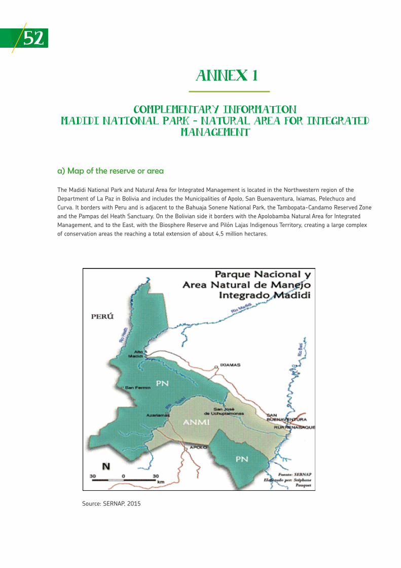
52
ANNEX 1
COMPLEMENTARY INFORMATIONMADIDI NATIONAL PARK – NATURAL AREA FOR INTEGRATED
MANAGEMENT
a) Map of the reserve or area
The Madidi National Park and Natural Area for Integrated Management is located in the Northwestern region of the Department of La Paz in Bolivia and includes the Municipalities of Apolo, San Buenaventura, Ixiamas, Pelechuco and Curva. It borders with Peru and is adjacent to the Bahuaja Sonene National Park, the Tambopata-Candamo Reserved Zone and the Pampas del Heath Sanctuary. On the Bolivian side it borders with the Apolobamba Natural Area for Integrated Management, and to the East, with the Biosphere Reserve and Pilón Lajas Indigenous Territory, creating a large complex of conservation areas the reaching a total extension of about 4,5 million hectares.
Source: SERNAP, 2015
53The Madidi National Park is one of 22 protected areas of national character in Bolivia. It is the most biologically diverse protected area in the world, and is home to 3% of the higher plants in the world, 3.75% of vertebrates (1466 species) and 11% of registered birds at the global level (1000 species).
The protected area was established in 1995 under Supreme Decree No. 24123. The protected area is managed by the National Service for Protected Areas in Bolivia (SERNAP). It is one of the largest protected areas in Bolivia, with a surface of 1,895,740 hectares (18,957,40 km2) of which 1,291,819 corresponds to the category of Natural Area for Integrated Management. It has a large diversity of physiographic environments and an ample altitudinal range varying from 6,030 and 180 m.a.s.l., located in an essentially mountainous zone of the Andean region that joins in the Amazonian plains (SERNAP 2006).
The Madidi Park registers 8.244 vascular plant species and a wealth of 12.000 species is estimated (Jørgensen et al. 2012). With regard to fauna, 192 fish species have been registered (Sarmiento et al. 2012), 92 amphibian species, 82 reptile species (Domic et al. 2012), 1000 bird species 1 and 182 mammal species (Terán et al. 2012, Wallace et al. 2012). The birds and mammals are the most well known taxa in the protected area. Data shows that 70% of the birds in Bolivia are represented in Madidi alone and 34% of birds in South America; while medium and large mammals represent 80% of registered mammals for the country.
The forest coverage in Madidi is another of the key elements that highlights it importance for biodiversity conservation. Madidi Park together with three other protected areas in the country 2 covers 64% of forest coverage under the guard of protected areas in Bolivia (SERNAP 2013a).
In terms of human population, the protected area is overlapped with four communal lands of origin (titled or demanded), covering 23% of its surface. Within the limits of Madidi there are 31 indigenous and peasant communities of Tacana, Leco, Quechua and Aymara origin, with a population of approximately 3.714 inhabitants. The presence of uncontacted indigenous groups such as the Toromona and Nahua (Cingolani et al. 2008) is probable within the strict protection zone. Likewise, the influence area is characterized by the presence of indigenous communities from TCO 3 Lecos de Apolo, demanded TCO Lecos Larecaja, TCO Tacana I and II, in addition to a predominantly peasant population around the protected area. Urban centers near Madidi Park are Apolo in the Andeanzone, San Buenaventura and Rurrenabaque and Ixiamas in the Amazonian plains zone.
b) Principal threats for the reserve or zone
The colonization, road construction, agriculture and livestock farming are the key threats for a protected area. Other threats are gold mining in the highlands, hunting, commercial fishing and the selective extraction of forest resources, unregulated tourism and oil prospecting. Additionally, the threats from El Bala hydroelectric project and construction of the Apolo-Ixiamas highway need to be considered.
• Highways
Madidi Park limits to a large extent with the La Paz-Rurrenabaque Highway, constructed more than 30 years ago, that cuts across the Yungas. This highway has been the axis of colonization, mostly for migrants from the Andean zone in the country. According to Painter et al. 2013), these human settlers have entailed a considerable loss of the forest, due to the expansion of agricultural activities, and subsequently, the transition to livestock farming, in addition to generating major threats from logging and hunting.
88 http://identidadmadidi.org/en-us/MADIDI/BIOLOGICAL-VALUE.aspx.
89 The protected areas with the largest forest surface in Bolivia (more than a million hectares): Kaa-Iya with 3.3 million, Madidi and San Matías with 1.7 million and Noel Kempff with 1.2 million. Madidi specifically has a forest coverage of 1.697.616 hectares.
90 TCOs are indigenous territories declared Communal Lands of Origin by the State.
54More than a decade ago, the design of an improvement project and construction of road infrastructure was initiated, to develop the Peru-Brazil-Bolivia axis 4 including the construction of unexecuted sections of Ixiamas-El Chivé Highway, that would in part run through Madidi, generating multiple threats for the protected area.
• Infrastructure
The principal threat is focused on the Cañón del Bala hydroelectric project, on the Beni River between San Buenaventura and Rurrenabaque, with the final design approved in 2016 (SD No. 2837), anticipating the generation of 3676 MW of energy. Unofficial data indicates that the expected flooding area within the Madidi Natural Area for Integrated Management would cover 257 km2.
• Population centers
There are 31 communities located within the protected area, 9 of them are in the national park and 22 in the natural area for integrated management around the Apolo Municipality. The most important urban centers in the external buffer zone of the protected area are Apolo to the South East, San Buenaventura and Rurrenabaque to the East and Ixiamas to the North. There are also approximately 260 medium and small population centers surrounding Madidi, mainly established along the Yucumo-Rurrenabaque and San Buenaventura-Ixiamas road axis 5 (Painter et al. 2013).
• Extractive industries (timber, mining, others)
The extraction of alluvial gold is a mining activity that involves the use of mercury. The top existing concessions in Madidi are located in the Rivers Pelechuco and Motosolo zones, on the upper part of the Tuichi River basin. Other concessions are found in the Serranía Tigre and Heath zones, both in direct conflict with the tourism potential (SERNAP 2006). Most of the mining activities occur illegally.
Oil concessions 6 impact 75,5% of the Madidi surface, corresponding to the Tuichi North and Tuichi South blocks and Rio Hondo block, all shared with Pilón Lajas National Park, for a 27 year period or more beginning 2007 (CEDIB). Before its creation, the park had explored 22 seismic lines and two wells (SERNAP 2006).
In the 1980s, the extraction of timber experimented a peak. Existing concessions in Madidi Park were reversed, however, concessions in the influence area continue to exist and the extraction of timber and non-timber forest products is still high in the influence zone and certain sectors within Madidi in the Natural Area for Integrated Management (ANMI).
• Others
The advancement of the agricultural frontier and colonizing processes are threats very much tied to the economic activities in populated centers and road access as described in previous paragraphs. In turn, these same factors have had an influence on the persistence of threats due to hunting and commercial fishing. As an example, 87 jaguars from the regions of Madidi National Park and Pilón Lajas Biosphere Reserve and Communal Lands were killed during 2014 and 2016. 7
Another threat already present in the protected area is unregulated tourism that has ultimately generated the minimum application of existing environmental legislation and a high concentration of the activity in the Rurrenabaque zone. A threat over the past few years is the rate of deforestation (1,900 hectares between 2011-2016) 8 for sugarcane plantations in Madidi influence areas, catalyzed by a sugar mill constructed in the town of San Buenaventura.
4 The project is part of the Initiative for the Integration of the Regional Infrastructure of South America (IIRSA, in Spanish).
5 Painter et al. (2013) a study on the Madidi deforestation scenarios using indicators of population centers, road distances and river dis-tances indicated that “the stretch along the Yucumo and Rurrenabaque highway has an annual deforestation rate of 3,7%, while the stretch between San Buenaventura and Alto Madidi, north of Ixiamas, in the private property zones or agricultural producers migrant zones, show a deforestation rate of 2,3% along a less consolidated road. At the same time, the area under TCO Tacana land management along the same road proves a much lower deforestation rate of only 0,5%”.
6 In Bolivia, under Supreme Decree (DS) 2366, adopted in May 2015, “the development of exploration hydrocarbon activities is allowed in different zones and categories of protected areas”.
7 https://es.mongabay.com/2016/12/2016-ano-critico-parque-nacional-madidi-bolivia/.
55c) Situation of indigenous peoples
The Madidi protected area is virtually surrounded by four indigenous territories, it fully overlaps with the TCO San José de Uchupiamonas and partially with the TCO Tacana I, Lecos de Apolo and Lecos de Larecaja. The TCO Tacana II and Araona is located in its influence zone.
The three TCOs that overlap with Madidi have consolidated land ownership. The TCO Tacana II is still in the process of land remediation to obtain ownership. Leco communities face problems with the peasant communities that find their right to access land compromised by the creation of the Leco Indigenous Territory. Both the Leco and Tacana communities are being influenced by the lifestyle of peasant communities, transforming their economy from the use of forest and wildlife resources increasingly towards an economy based on commercial and subsistence agriculture. These communities have lost much of their indigenous customs and their native language is under-used. Indigenous territories from the lowland areas have conflicts with illegal loggers and chestnut extractors. The livelihoods of Leco communities are mostly impacted by the degradation of their environment (SERNAP 2006).
d) Contributions from the reserve or area to food security at the local, regional and national level
• Food types
Wild meat is one of the major food sources for Madidi indigenous peoples. A study by CIPTA & WCS (2001) indicates that the TCO Tacana communities benefit from nearly 43 species, although only 10 of them constitute 86% of the fish biomass. Thereby, indigenous and peasant communities in general, make use of the meat and eggs from various reptiles such as caimans and black caimans (Caiman yacare and Melanosuchus niger), river turtles (Podocnemis unifilis and Podocnemis expansa) and yellow-footed tortoise (Chelonoides denticulada). At least 12 mammal species constitute a key food source, such as wild pigs, tapir, some cervids and monkeys. A large part of fishing and hunting is used for commercial purposes in population centers of the municipal capital linked to Madidi Municipalities.
In terms of plant species used for food purposes, palms are an important group (Bactris sp., Jessenia bataua, Scheela princeps, Euterpe precatoria, Attalea phalerata) from which the fruits are harvested or the heart of the palm extracted.
Indigenous communities also cultivate for food purposes, bananas, yucca and other fruits. These products are also sold at local markets (primarily in the town of Rurrenabaque) and the money received if generally used to buy food supplies.
• Situation of the sources or provision of water
There is little information available on water provision services for Madidi Park. However, the protected area Management Plan (SERNAP 2006) indicates that Madidi is the source that provides water for the entire Abel Iturralde Province. Las Serranías del Bala, Hurehuapo, Mamuque and Cuñaca provides water to more than 10,000 people, the total population of San Buenaventura Municipality, most of the population in Municipio de Ixiamas. A larger part of the indigenous and peasant population is provided with water from natural sources, without a treatment system prior to human consumption.
The Apolo Municipality located towards the high mountainous region of Madidi Park has major conservation challenges with their water sources. They already have problems with fires, deforestation and water shortages at certain times of the year (GAM Apolo 2013).
8 According to data from Global Forest Watch.
56• Access to food
Land titling of indigenous territories overlapping Madidi has been a key element for the population’s food security, provided the access to land and use of natural resources is secured. A good part of the hunting and fishing areas of indigenous communities are defined within the zoning of the protected area.
Nevertheless, it is important to highlight that the changes in food consumption patterns in indigenous communities such a the Tacanas, may be impacting the access to quality food, as forest products are being substituted for others of a lower nutritional value they purchase at local markets (CIPTA and WCS 2001). On the other hand, the Municipalities of Apolo and Pelechuco are on the list of the most food-insecure municipalities at the national level (VDRA 2012).
• Ventures with biodiversity
Data from Fleck et al. (2006) indicates that the Madidi protected area channeled at least 2,5 million dollars a year for the regional economy, from conservation initiatives such as the management of protected areas, infrastructure, research and tourism. At present, tourism 9 continues to be a venture of great importance for the local and regional economy, 17 thousand registered tourists for 2016. A number of low cost lodges have been built along the Tuichi River; other initiatives such as Chalalán assured a high investment of (1,5 million dollars), to attract a segment of tourists that would leave the local community a large economic investment.
Among other initiatives related to biodiversity is the management of Brazil nuts (bertholetia excelsa) by Tacana Communities on the Rivers Madidi and Madre de Dios. In the Apolo zone, initiatives have been implemented for the use of incense (such as Clusia aff. Flaviflora and C. salvinii). At least ten species of palm trees are also used locally as a source of income, for construction, artisan and food purposes. Indigenous communities from TCO Tacana I, have incorporated economic ventures with the production of honey from native stingless bees (Tetragonisca angustula y Melipona spp.).
• Others
The production of organic coffee in the Apolo zone, together with “Madidi Coffee”, is an important economic alternative for many families in this locality. Between 2009 and 2012, the local Association of Coffee Producers (APCA in Spanish) secured an income of 18.000 U.S. Dollars (SERNAP 2013), with a much stronger consolidated market at present. On the other hand, both the Tacana and Lecos indigenous communities have incorporated the production of wild cacao into their economy.
e) Climate change impacts on the reserve or area
The Madidi Park is located in the Amazon region. The main impacts from climate change in the region can be observed in the rainfall and flooding regime, producing delays in the months of normal rainfall and increasing their intensity and thus flooding during certain times of the year (PNUD 2011). Climate scenarios also predict a rise in global temperatures. According to Cuestas et al. (2009) the combination of changes in climate variables forecasts a potential loss of mountain forests above 50 km2 for 2050. 10 Areas most vulnerable to the significant loss of mountain forests, given these climate changes, are concentrated in protected areas on the Eastern slopes of the Andes mountain chain. Among the areas with the most significant losses is Madidi Park, together with three other protected areas in Bolivia (Apolobamba, Carrasco and Amboró), as well as two national parks in Peru (Yanachaga-Chemillen and Manu).
At the local level, the systematization of rainfall due to climate change conducted in the San José de Uchupiamonas Community, inside Madidi National Park, indicated that the agricultural calendar has changed and farmers have been forced to adapt and experiment different cultivation times and methods, to decrease the risk of losing all the harvest. With this in mind, villagers stated that sunlight intensity has increased during the last 10 years, making the working day harder.
9 Tourism in Madidi National Park registered a significant growth during the 1980s, motivated by the publication of a book “Back to the Tuichi” by Israeli author Josse Ginsberg, who described his experience when he got lost in the Park. Subsequently, the publication on the na-tural protected area in National Geographic in 2000, catapulted the Madidi National Park touristically. At present, the excessive requirements for North Americans and Israelis to obtain an entry visa to Bolivia has reduced the inflow of “backpackers” to the natural protected area.
10 According to the HADCM3 A2 (Hadley Centre Coupled Model, version 3) scenario, a model recognized by the Intergovernmental Panel on Climate Change (IPCC) at the time of the study by Cuestas et al. (2009).
57On the other hand, villagers perceive that due to the changes in rainy and drought seasons, forest fruits are not produced every year as before and there are mosquitos at any time of the year. In addition, they indicated that fish do not spawn as usual and the creeks that provide water for local purposes have started to dry up.
Another study in the locality of Teoponte that limits with the Apolo Municipality, indicates that the rise of rainfall intensity has increased fungal infections (mainly coffee leaf rust) in the coffee plantations, as well as reduced coffee production yields when compared to data from 2011, 2014 and 2015. 11
Although these last two cases present information from climate change impacts from specific locations, possibly some of these impacts may be replicable for different municipalities and places linked to Madidi National Park. A better understanding of this issue is essential.
f) Recommendations to improve the food security situation and face the impacts of climate change
One of the key aspects to improve taking action in the face of food security and climate change is the level of understanding implemented to Madidi Park and its influence area. In this regard, research priorities must focus on the installation and monitoring of climate stations, monitoring the state of conservation of cloud forests, some critical species and food security for the local population. The NGO WSC established a “Baseline and Strategy for the Conservation and Management of Protected Areas Integrated to Climate Change Adaptation Processes in Bolivia”, which could not be accessed during this systematization, however, it would be relevant to study the recommendations of the document referred to.
Reducing the threat of deforestation is an essential element for the maintenance of Madidi Park cloud forest, and thereby, for climate stability at the microregional level. Therefore, one must continue to invest in efforts to support the implementation of development strategies formulated by different indigenous territories linked to Madidi, that are directly related to the sustainable use of natural resources. On the other hand, environmental degradation is on the rise in the Apolo Municipality, while they continue to demand priority actions to restore the ecosystem. The availability and access to water is critical issue for the population of this municipality that needs to be addressed.
Work needs to be undertaken to conclude the land sanitation and titling processes tightly linked to deforestation and climate stability in the region. This would allow a clearer legal framework for the region, to control illegal settlement processes. The Bala Dam project is an issue that needs to be addressed continuously in order to avoid its implementation in other highly environmentally sensitive areas.
In terms of adaptation, it is necessary to improve soil management of production plots and incorporate crop varieties resistant to adverse climate conditions and key diseases. There is also the need to strengthen risk management of municipal governments in order to reduce their vulnerability in the face of adverse climate events such as drought in high Andean zones and flooding in the lowlands.
58References or relevant bibliographies of interest
• Chugar, H. 2016. Análisis de la vulnerabilidad del cultivo de café (Coffea arabica L.) y formulación de estrategias locales de adaptación al Cambio Climático en el municipio de Teoponte, departamento de La Paz. Bolivia. Work Project of the Biodiversity Conservation Practice Master Program. CATIE. Turrialba, Costa Rica. Graduación Máster en Práctica de la Conservación de la Biodiversidad. CATIE. Turrialba, Costa Rica.
• Cingolani, P., A. Díez Astete y V. Brackelaire. 2008. Toromonas: La Lucha por la Defensa de los Pueblos Indígenas Aisla-dos en Bolivia. FOBOMADE-Rainforest Foundation Norway. La Paz, Bolivia. 176pp.Las Paz, Bolivia. 176 pp.
• CIPTA & WCS. 2010. Fishing in the Takana territory. CIPTA & WCS. La Paz, Bolivia. 60 pp.
• CIPTA y WCS. 2001. Strategy of Sustainable Development for TCO – Tacana based on natural resources management 2001 – 2005. La Paz, Bolivia.
• Cuesta, F.; M. Peralvo y N. Valarezo. 2009. Los Bosques Montanos de los Andes Tropicales. Una evaluación Regional de su Estado de Conservación y de su Vulnerabilidad a Efectos del Cambio Climático. Serie Investigación y Sistematización # 5. Programa Regional ECOBONA – INTERCOOPERATION. Quito.
• Domic, E., C. Cortez, D. Embert, J. Aparicio, S. Reichle, I. De LaRiva y J.M. Padial. Los Reptiles y Anfibios de Madidi. Pp. 96-111. En: Servicio Nacional de Áreas Protegidas. Conocimientos científicos y prioridades de investigación en el Parque Nacional y Área Natural de Manejo Integrado Madidi. Eds. Salinas, E. & R. B. Wallace. La Paz, Bolivia. 176pp.
• Fleck, L., Amend C., Painter M., Reid, L. 2006. Beneficios económicos regionales de la conservación: el caso del Madidi. Technical Series No. 5. Conservation Strategy Fund, Bolivia. 82 p.
• GAM-Apolo (Gobierno Municipal Autónomo de Apolo). 2013. Plan de Desarrollo Municipal 2014-2018. La Paz
• Hennessey, B., I. Gómez y V. Avalos. 2012. Las aves de Madidi. Pp. 110-121. En: Servicio Nacional de Áreas Protegidas. Conocimientos científicos y prioridades de investigación en el Parque Nacional y Área Natural de Manejo Integrado Madidi. Eds. Salinas, E. & R. B. Wallace. La Paz, Bolivia. 176pp. • Jørgensen, P., F. Zenteno, I. Loza, S. Beck, A. Fuentes, R. Seidel, L. Cayola, T. Miranda, A. Poma y H. Cabrera. 2012. Las Plantas Vasculares de Madidi. Pp. 28-49. En: Servicio Nacional de Áreas Protegidas. Conocimientos científicos y priorida-des de investigación en el Parque Nacional y Área Natural de Manejo Integrado Madidi. Eds. Salinas, E. & R. B. Wallace. La Paz, Bolivia. 176pp.
• Padraza, G. y P. Pachaguaya. (without the year). Amazonia: Pulmón del Mundo Cuando el sol calienta más Percepciones del Cambio Climático de los Pueblos Indígenas Amazónicos de Bolivia, El Puquio - Chiquitano y San José de Uchupiamo-nas. Fundación PRAIA con financiamiento de FIDA.
• Painter, L., T.M. Siles, A. Reinaga y R. Wallace. 2013. Escenarios de deforestación en el Gran Paisaje Madidi-Tambopata. Consejo Indígena del Pueblo Tacana y Wildlife Conservation Society. La Paz, Bolivia.
• PNUD. 2011. Tras las huellas del cambio climático en Bolivia Estado del arte del conocimiento sobre adaptación al cam-bio climático Agua y seguridad alimentaria.
• Sarmiento, J., S. Barrera, G. Miranda y M. Mendoza. 2012. Los peces del Madidi. Pp. 79-95. En: Servicio Nacional de Áreas Protegidas. Conocimientos científicos y prioridades de investigación en el Parque Nacional y Área Natural de Manejo Integrado Madidi. Eds. Salinas, E. & R. B. Wallace. La Paz, Bolivia. 176pp.
• SERNAP (Servicio Nacional de Áreas Protegidas). 2006. Plan de Manejo del Parque Nacional y Área Natural de Manejo Integrado Madidi. La Paz, Bolivia. 344 pp.
59
• SERNAP (Servicio Nacional de Áreas Protegidas). 2013a. Deforestación y regeneración de bosques en Bolivia y en sus áreas protegidas nacionales para los periodos 1990-2000 y 2000-2010. Ed. Servicio Nacional de Áreas Protegidas, Mu-seo de Historia Natural Noel Kempff Mercado y Conservación Internacional - Bolivia. La Paz, Bolivia. 36 pp.
• SERNAP (Servicio Nacional de Áreas Protegidas). 2013b. Proyecto café Madidi – PN y ANMI Madidi. Experiencias de la Cooperación Alemana. Bolivia.
• Terán, M., T. Tarifa, N. Bernal, J. Vargas y J. Tordoya. 2012. Los mamíferos pequeños de Madidi. Pp. 125-143. En: Ser-vicio Nacional de Áreas Protegidas. Conocimientos científicos y prioridades de investigación en el Parque Nacional y Área Natural de Manejo Integrado Madidi. Eds. Salinas, E. & R. B. Wallace. La Paz, Bolivia. 176pp.
• VDRA (Viceministerio de Desarrollo Rural y Agropecuario). 2012. Mapa de Vulnerabilidad a la Inseguridad Alimentaria. La Paz.
• Wallace, R., E. Aliaga-Rossel, J. Ayala, P. De La Torre, L. López y N. Mercado. Los mamíferos medianos y grandes de Ma-didi. Pp. 144-163. En: Servicio Nacional de Áreas Protegidas. Conocimientos científicos y prioridades de investigación en el Parque Nacional y Área Natural de Manejo Integrado Madidi. Eds. Salinas, E. & R. B. Wallace. La Paz, Bolivia. 176pp.
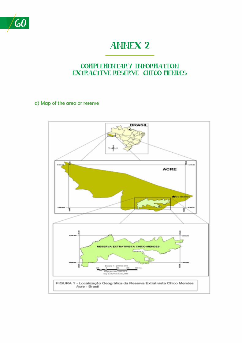
60
ANNEX 2
COMPLEMENTARY INFORMATIONEXTRACTIVE RESERVE CHICO MENDES
a) Map of the area or reserve
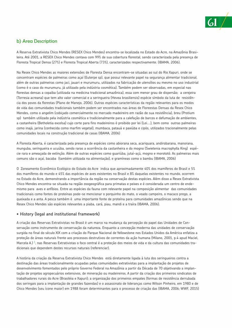
61b) Area Description
A Reserva Extrativista Chico Mendes (RESEX Chico Mendes) encontra-se localizada no Estado do Acre, na Amazônia Brasi-leira. Até 2001, a RESEX Chico Mendes contava com 99% de sua cobertura florestal, sendo caracterizada pela presença de Floresta Tropical Densa (27%) e Floresta Tropical Aberta (73%), caracterizados respectivamente. (IBAMA, 2006).
Na Resex Chico Mendes as maiores extensões de Floresta Densa encontram-se situadas ao sul do Rio Xapuri, onde se concentram espécies de palmeiras como açaí (Euterpe sp), que possui relevante papel na segurança alimentar tradicional, além de outras palmeiras como jaci, jauari e murumuru, utilizados na fabricação de utensílios ou mesmo no uso industrial (como é o caso do murumuru, já utilizado pela indústria cosmética). Também podem ser observadas, em especial nas florestas densas a copaíba (utilizada na medicina tradicional amazônica), essa com menor grau de dispersão; a cerejeira (Torresia acreana) que tem alto valor comercial e a seringueira (Hevea brasiliensis) espécie símbolo da luta de resistên-cia dos povos da florestas (Plano de Manejo, 2006). Outras espécies características da região relevantes para os modos de vida das comunidades tradicionais também podem ser encontrados nas áreas de Floreestas Densas da Resex Chico Mendes, como o angelim (cobiçado comercialmente no mercado madeireiro em razão de sua resistência), breu (Protium sp) também utilizado pela indústria cosmética e tradicionalmente para a calefação de barcos e defumação de ambientes, a castanheira (Betholetia excelsa) cujo corte para fins madeireiros é proibido por lei (Lei....), bem como outras palmeiras como inajá, jarina (conhecida como marfim vegetal), mumbaca, patauá e paxiúba e cipós, utilizados tracionalmente pelas comunidades locais na construção tradicional de casas (IBAMA, 2006)
A Floresta Aberta, é caracterizada pela presença de espécies como abiorana seca, acariquara, andirobarana, manorana, munguba, seringueira e ucuúba, sendo raras a ocorrência da castanheira e do mogno (Swietenia macrophylla King) espé-cie rara e ameaçada de extinção. Além de outras espécies como guariúba, jutaí-açú, mogno e morototó. As palmeiras mais comuns são o açaí, bacaba (também utilizada na alimentação), e gramíneas como o bambu (IBAMA, 2006)
O Zoneamento Econômico Ecológico do Estado do Acre indica que aproximadamente 40% dos mamíferos do Brasil e 5% dos mamíferos do mundo e 45% das espécies de aves existentes no Brasil e 8% daquelas existentes no mundo, ocorrem no Estado do Acre, demonstrando a importância da região na conservação destas espécies. Além disso a Resex Extrativista Chico Mendes encontra-se situada na região zoogeográfica para primatas e peixes e é considerada um centro de ende-mismo para aves e anfíbios. Entre as espécies da fauna com relevante papel na composição alimentar das comunidades tradicionais como fontes de proteínas pode-se mencionar o porquinho do mato, o veado campeiro, o macaco prego, a queixada e a anta. A pesca também é uma importante fonte de proteína para comunidades amazônicas sendo que na Resex Chico Mendes são espécies relevantes a piaba, cará, piau, mandi e a traíra (IBAMA, 2006).
• History (legal and institutional framework)
A criação das Reservas Extrativistas no Brasil é um marco na mudança da percepção do papel das Unidades de Con-servação como instrumento de conservação da natureza. Enquanto a concepção moderna das unidades de conservação surgida no final do século XIX com a criação do Parque Nacional de Yellowstone nos Estados Unidos da América enfatiza a proteção de áreas naturais frente aos processos destrutivos de correntes da ação humana (Milano, 2001, p.4 apud Maciel, Marcela A.) 1, nas Reservas Extrativistas o foco central é a proteção dos meios de vida e da cultura das comunidades tra-dicionais que dependem destes recursos naturais (referenciar).
A história da criação da Reserva Extrativista Chico Mendes está diretamente ligada à luta dos seringueiros contra a destinação das áreas tradicionalmente ocupadas pelas comunidades extrativistas para a implantação de projetos de desenvolvimento fomentados pelo próprio Governo Federal na Amazônia a partir da Década de 70 objetivando a implan-tação de projetos agropecuários extensivos, de mineração ou madeireiros. A partir da criação dos primeiros sindicatos de trabalhadores rurais do Acre (Brasiléia e Xapuri); a organização dos primeiros empates (formas de resistência derrubada dos seringais para a implantação de grandes fazendas) e o assassinato de lideranças como Wilson Pinheiro, em 1980 e de Chico Mendes (seu ícone maior) em 1988 foram determinantes para o processo de criação das (IBAMA, 2006; WWF, 2015)
62Neste contexto, a Reserva Extrativista Chico Mendes é um marco, tendo sido uma das primeiras desta natureza criada no Brasil, por meio do Decreto N° 99,144, de 12 de março de 1990. Com área aproximada de 970,570 hectares (ha), encontra-se localizada no Estado do Acre (próxima à fronteira do Brasil com a Bolívia e Peru) abrangendo os Municípios de Rio Branco, Xapuri, Brasiléia, Assis Brasil, Sena Madureira e Capixaba, no Estado do Acre, Brasil, tendo sido destinada especialmente ao uso sustentável por seringueiros. Teve seu primeiro Plano de Utilização aprovado em 18 de abril de 1995, conforme a Portaria Ibama n° 28-N) (WWF, 2015).
A partir de 2000, com a aprovação da Lei 9,985 de 18 de julho de 2000, que instituiu o Sistema Nacional de Unidades de Conservação da Natureza – SNUC, e buscou regulamentar as diferentes categorias de Unidades de Conservação existentes no Brasil, a Resex Chico Mendes passou ser classificada como uma Unidade de Conservação da categoria Uso Sustentá-vel que, conforme o art. 18 este dispositivo legal é “(...) uma área utilizada por populações extrativistas tradicionais, cuja subsistência baseia-se no extrativismo e, complementarmente, na agricultura de subsistência e na criação de animais de pequeno porte, e tem como objetivos básicos proteger os meios de vida e a cultura dessas populações, e assegurar o uso sustentável dos recursos naturais da unidade” (Brasil, 2000; IBAMA, 2006).
• Working population of the RESEX
Criada em 1990 sob a administração do Instituto Brasileiro de Meio Ambiente e dos Recursos Naturais Renováveis - IBAMA, por meio da Diretoria de Desenvolvimento Sócio Ambiental – DISAM, passou ser administrada a partir de 2007 pelo Instituto Chico Mendes de Conservação da Biodiversidade – ICMBio, uma autarquia também ligada ao Ministério do Meio Ambiente criada em 28 de agosto de 2007, pela Lei 11.516, com a missão específica de executar as ações do Sistema Nacional de Unidades de Conservação, podendo propor, implantar, gerir, proteger, fiscalizar e monitorar as Unidades de Conservação Federais.
Conforme o art. 18, §§ 1o e 2°, da Lei 9,985 de 18 de julho de 2000, a Reserva Extrativista é uma Unidade de Conser-vação de domínio público, cujo uso é concedido (por meio de Contrato de Concessão de Direito Real de Uso) às populações extrativistas tradicionais sendo que as áreas particulares incluídas em seus limites devem ser desapropriadas 2 . A gestão é realizada por um Conselho Deliberativo, presidido pelo ICMBio (atual órgão responsável pela administração da Unidade de Conservação) e composto por representantes dos órgãos públicos (ICMBio, Prefeituras, Universidade), organizações da sociedade civil e das populações tradicionais residentes na área (Sindicatos de Trabalhadores Rurais; Associações, Coope-rativas e o CNC) . 3
Um dos principais instrumentos de gestão das Unidades de Conservação de Uso Sustentável é o Plano de Manejo 4 o qual deve aprovado pelo seu Conselho Deliberativo (art. 18, § 5°), sendo que o da Reserva Extrativista Chico mendes foi aprovado em 2006, e o seu Plano de Utilização revisto em 2008.
A visitação é permitida desde que seja compatível com os interesses locais e com o previsto no Plano de Manejo (art. 18, § 3o), assim como também é permitida a pesquisa científica desde que previamente autorizada pelo órgão responsável pela administração da unidade, e sujeita às condições e restrições estabelecidas (§ 4o). A caça amadorística ou profissio-nal, bem como a exploração de recursos minerais são proibidas nas Reservas Extrativistas (§ 6o), sendo que a exploração comercial de recursos madeireiros só será admitida em bases sustentáveis e em situações especiais e complementares às demais atividades desenvolvidas, conforme dispostos em regulamente e no Plano de Manejo da unidade (§ 7o) (Brasil,
2 As ações de desapropriação da área da Reserva Extrativista Chico Mendes, foram ajuizadas em 1992, permitindo a emissão de posse no interior da Unidade de Conservação às comunidades reinvidicantes e a remoção dos antigos proprietários (WWF, 2015).
3 O artigo 2º da Portaria Nº 13, de 13 de fevereiro de 2014, estabelece a composição do Conselho Deliberativo da Resex Chico Mendes.
4 O Art. 2°, insiso XVII, da Lei do SNUC define como Plano de Manejo o “documento técnico mediante o qual, com fundamento nos objetivos gerais de uma unidade de conservação, se estabelece o seu zoneamento e as normas que devem presidir o uso da área e o manejo dos recursos naturais, inclusive a implantação das estruturas físicas necessárias à gestão da unidade”.
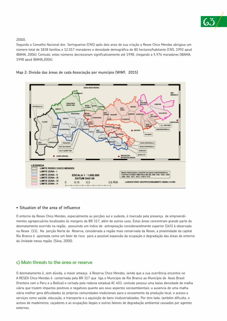
632000).Segundo o Conselho Nacional dos Seringueiros (CNS) após dois anos de sua criação a Resex Chico Mendes abrigava um número total de 1838 famílias e 12.017 moradores e densidade demográfica de 80 hectares/habitante (CNS, 1992 apud IBAMA, 2006). Contudo, estes números decresceram significativamente até 1998, chegando a 5.976 moradores (IBAMA, 1998 apud IBAMA,2006).
• Situation of the area of influence
O entorno da Resex Chico Mendes, especialmente as porções sul e sudeste, é marcado pela presença de empreendi-mentos agropecuários localizados às margens da BR 317, além de outros usos. Estas áreas concentram grande parte do desmatamento ocorrido na região, possuindo um índice de antropização consideravelmente superior (16%) à observada na Resex (1%), Na porção Norte da Reserva, considerada a região mais conservada da Resex, a proximidade da capital Rio Branco é apontada como um fator de risco para a possível expansão da ocupação e degradação das áreas do entorno da Unidade nessa região. (Silva, 2000).
c) Main threats to the area or reserve
O desmatamento é, sem dúvida, a maior ameaça à Reserva Chico Mendes, sendo que a sua ocorrência encontra-se A RESEX Chico Mendes é contornada pela BR 317 que liga o Municipio de Rio Branco ao Município de Assis Brasil (frontera com o Peru e a Bolívia) e cortada pela rodovia estadual AC 403, contudo posssui uma baixa densidade de malha viária que trazem impactos positivos e negativos quanto aos seus aspectos socioambientais: a ausencia de uma malha viária melhor gera dificuldades às próprias comunidades tradicionais para o escoamento da produção local, o acesso a serviços como saúde, educação, e transporte e a aquisição de bens insdustrializados. Por otro lado, também dificulta, o acesso de madeireiros; caçadores e as ocupações ilegais e outros fatores de degradação ambiental causados por agentes externos.
Map 2: Divisão das áreas de cada Associação por município (WWF, 2015)
64
Contudo as areas mais impactadas no entorno da Resex encontram-se na região sul da Unidade, entre os municípios de Rio Branco e Assis Brasil, onde se encontram a maior parte das áreas desmatadas do Estado do Acre, utilizadas para a implantação de empreendimentos agropecuários. A construção da BR-317, a estimulou a abertura de áreas de florestas para a implantação de ramais no sentido BR-317 – Resex (ocasionando o chamado efeito espinha de peixe). A implan-tação de diversos Planos de Manejo Florestal Empresariais também é considerada um agente causadore de impacto na região. Outra área passível de sofrer impactos negativos em um curto período de tempo situa-se a leste da Unidade, devido à proximidade com a área urbana de Rio Branco e assentamentos de reforma agrária do INCRA (IBAMA, 2006)
Neste sentido, embora a malha viária seja pouco adensada na RESEX, existe uma maior concentração dos desmatamentos nas margens de rodovias, nas áreas próximas à cidade de Xapuri, Epitaciolândia e Capixaba e nas margens dos rios 5.
A pecuarização bem como o incremento das atividades agrícolas tradicionais na maioria das áreas extrativas vem sendo observados nas Reservas Extrativistas, e em ambos os casos citados têm produzido impactos negativos na preservação da floresta (Fantini, A.C & Crisostomo, C.F; 2009). Mesmo a manutenção das formas tradicionais de produção, basea-dos na agricultura de subsistencia (caracterizado pelo corte e queima de pequenas áreas para o plantio da lavoura), são consideradas desfavoráveis à manutenção das condições ambientais da Resex e das próprias comunidades tradicionais num cenário de longo prazo, onde o aumento da população e das demandas por áreas para produção pode levar ao declínio progressivo da produtividade dos recursos naturais e das condições ambientais, e, conseqüentemente, da renda e qualidade de vida das famílias (IBAMA, 2006). Esta última abordagem, associada às políticas Estaduais de mitigação de mudanças climáticas (ver mais ao final), vem sendo fortemente questionados por comunidades tradicionais e povos in-dígenas, conforme reportam o relatório “Economia Verde, Povos das Florestas e Territórios: violações de direitos no estado do Acre.” Produzido pela Plataforma DHESCA (Faustini & Furtado, 2015) e Declaração de Xapuri, assinada em maio de 2017 . 6
Entre os anos de 2001 e 2005, desmatamento na área da RESEX Chico Mendes aumentou de 1 (SOUSA) para 5%. Mais recentemente o aumento do desmatamento em áreas de unidades de conservação vem sendo apentado com preocu-pação. Entre os anos 2015 e 2016, a participação do desmatamento em Unidades de Conservação no desmatemento da Amazônia, dobrou, saltando de 6% para 12%. 7
Dados do Diagnóstico Socioeconômico e Cadastro da Reserva Extrativista Chico Mendes realizado pela Secretaria de Estado de Meio Ambiente do Acre em 2010 apontam que entre 2009 e 2010 cerca de 5.713 hectares de floresta foram desmatadas, sendo que 14 dos 46 seringais existentes na Resex haviam ultrapassado o limite de 10% de desmatamento da sua área previsto pelo Plano de Utilização. Por sua vez, 56,85% dos moradores da Resex declararam desconhecer o Plano de Utilização (apud WWF, 2015).
d) Contributions of the reserve or area to local, regional, national food security
A grande maioria da população da Resex continua dependendo economicamente da coleta de castanha, em parte do extrativismo de borracha, criação de gado e da agricultura de subsistencia (IBAMA, 2006), caracterizada pelo cultivo de lavouras de subsistência como o arroz, milho, mandioca e o feijão, que, no sistema tradicional são instalados após a derrubada de pequena parcela de mata e a queimada (em média 3 hectares). É comum também o plantio de algumas
5 Costa, Suely de Souza Melo da; Santos, José Eduardo dos; Pires, José Salatiel Rodrigues; Henke-Oliveira, Carlos & Moshini, Luis E.. Ca-racterização Ambiental da Reserva Extrativista Chico Mendes (ACRE-BRASIL): SUBSÍDIO AO PLANO DE MANEJO.
6 Entre 26 e 28 de maio, indígenas Apurinã, Huni Kui, Jaminawa, Manchineri e Shawadawa, seringueiros e seringueiras de Xapuri e representantes de comunidades tradicionais do interior do Acre se reuniram e denunciaram o que entendiam como colonialismo climático, criticando as limitações dos modelos que tentam mensurar impactos ambientais a partir de estimativas de concentração de carbono e de previsões sobre desmatamento, e questionado o real impacto ambiental das atividades e modos de vida dos diferentes povos da floresta. Ver mais em: http://www.cartadebelem.org.br/site/declaracao-de-xapuri/
7 Ver em: http://sustentabilidade.estadao.com.br/noticias/geral,desmatamento-cresce-em-unidades-de-conservacao-no-meio-da-amazo-nia,70001704735
65fruteiras, principalmente a banana (Costa, 2001).A produção de latex e de Castanha do Brasil são as maiores contribuições da Resex para a economia do estado e um as-pecto fundamental da manutenção das condições de vida das comunidades tradicionais que nela residem (IBAMA, 2006).O Estado do Acre é uma referencia em produção e qualidade do processamento da Castanha do Brasil, sendo um dos maiores produtores nacionais, com uma participação 35% na produção nacional.
• Location of sources or water supply
As comunidades tradicionais da Reserva Extrativista Chico Mendes contam com uma importante rede hidrográfica distri-buída por toda a tensão da Resex, e que é constituída de cursos d’água perenes e intermitentes, com três ríos principais: Iaco, Xapuri e Acre, afluentes da margen direita do Rio Purus. Segundo estudo realizado por Silva (2000) a Resex conta com um total de 10,759km de cursos d’água, sendo 2.229 km (20,7%) de cursos d’água perenes e 8.529 km (79,3%) de intermitentes. Os ríos principais são relevantes não só pelo abastecimento de agua como para o transporte. Por sua vez, pela facilidade logística que representam também são os que possuem as margens mais antropizadas (Silva, 2000). Ainda segundo Silva (2000) a ocorrencia de falta de água potável em algumas partes da Resex está associada à degra-dação das matas ciliares.
• Biodiversity entrepeneurships
Visando o incentivo ao extrativismo da borracha e o retorno de famílias que deixaram o extrativismo em especial na década de 90, o Governo do Acre aprovou em 1999 a Lei Estadual n.º 1,277, conhecida como Lei “Chico Mendes”, a qual preve a remuneração subsidiada do latex, acrescído ao subídio já previsto pelo Governo Federal, promovendo ganhos substanciais para os produtores (Faustini & Furtado).
Entre os empreendimentos ligados à produção de latex podem ser destacadas a produção do “couro vegetal”, a partir de lâminas de tecido emborrachado com látex de seringueira, cuja produção é apoiada pelo “Programa do Couro Vegetal” desenvolvido em parceria com Associações de seringueiros e uma empresa com sede no Rio de Janeiro visando o trei-namento das comunidades, a compra da produção e a instalação de unidades produtivas em todo o Estado; “Projeto do Solado de Borracha” em parceria com o World Wildlife Found (WWF-Brasil) que buscou apoiar o beneficiamento nos locais de extração do látex, eliminando intermediários no processo de comercialização e remunerando melhor o seringueiro; e o desenvolvimento da Folha Defumada Líquida (FDL), que implica na fabricação de folha de látex com uso de ácido pirolen-hoso em forma líquida, dispensando a defumação, um projeto desenvolvido em parceria com a Universidade de Brasília (UnB) (IBAMA, 2006)
Além disso, existem atualmente também duas industrias que absorvem a produção de latex e castanha da Resex, ambos localizados em Xapuri: a) uma fábrica de preservativos, com capacidade para o processamento de 250 toneladas de látex por mês das quais 70% são provenientes da Resex Chico Mendes. Este empreendiento associado ao valor diferenciado pago ao produtor em decorrência la Lei Chico Mendes é um fator relevante no estímulo à manutenção do extrativismo do latex na região; b) uma Uma usina beneficiamento de castanha do Brasil, de propriedade de a uma cooperativa com dois mil produtores. Durante o período da colheita, que vai de janeiro a abril, recebe mais de sete mil toneladas. O Acre
8 Ver: “Extrativismo gera renda para famílias que vivem na Reserva Chico Mendes”, disponível em: http://g1.globo.com/natureza/noti-cia/2015/04/extrativismo-gera-renda-para-familias-que-vivem-na-reserva-chico-mendes.html
66responde por cerca 35% da produção nacional de Castanha do Brasil. 8
Além, da exploração de recursos não madeireiros como o latex e a Castanha do Brasil , o governo do Estado do Acre vem incentivando a implantação de Projetos de Manejo Florestal Comunitários (PMFCs) também é uma aposta para o incre-mento da renda das comunidades extrativistas, gerando, contudo grande controversia entre as comunidades tradicionais e povos indígenas 9, em especial no caso da Resex Chico Mendes, com o intuito de efetivar os PMFCs como instrumento do desenvolvimento econômico, a Secretaria Executiva de Floresta (SEF), realizou inventários florestais em duas comu-nidades na RESEX Chico Mendes (Rio Branco e Dois Irmãos), contudo, iniciativa não é bem aceita também por parte dos extrativistas das comunidades, que entendem que o PMFC foi iniciado de forma arbitrária por parte do Governo do Estado. Além disso, embora o manejo florestal em Resex seja permitido em caratér complementar pelo SNUC, o manejo florestal madeireiro não é apontado como uma atividade tradicionalmente realizada pelas comunidades naquela região. Consultas realizadas às comunidades que aderiram ao PMFC indicaram a existencia de divergencias e dúvidas quanto às prioridades estabelecidas pelas mesmas quanto à priorização de atividades madeireiras e não madeireiras (Fantini, 2009). Além disso, mais recentemente, movimentos sociais alegam que projetos desta natureza tem atendido mais a ineresses externos que os das próprias comunidades envolvidas. Como decorrência da sua implementação, comunidades tradicionais denunciam diversos impactos e conflitos territoriais (Faustina, 2015)
e) Impacts of climate change to the reserve or area
De modo geral a intensificação dos fenômenos climáticos na Amazônia vem sendo percebidos, em especial, no que diz respeito ao regime de chuvas, sobretudo em anos El Nino, tendo como principal consequência a ocorrência de enchen-tes e secas prolongadas, que terminam por afetar diretamente o modo de vida das comunidades que possuem estreita dependência dos recursos naturais. A soma de fatores antrópicos locais (como o desmatamento das margens de rios e o precario manejo do solo) associados à fenómenos climáticos globais elevam os riscos de problemas relacionados à nave-gabilidade de rios e o abasteciento pesqueiro, ou ainda à elevação do risco de incendios florestais de grandes proporções (Silva, 2000; Fearnside, 2009).
As mudanças climáticas globais em curso já provocam aumento generalizado da temperatura do ar e mudanças nos regimes de precipitação. Estudos apontam que somente o aumento da temperatura já afetará a biodiversidade dos ecossistemas da Amazônia de maneira dramática. Eventos extremos mais freqüentes e intensos, como enchentes e secas prolongadas, são fatores adicionais de estresse para os ecossistemas e a vida das populações. Entretanto, devido às limi-tações dos atuais modelos climáticos acoplados em reproduzir o clima atual da Amazônia, ainda é impossível projetar com segurança a intensidade com que as mudanças afetarão a região (Candido, Luis A. et all) e consequêntemente a própria Resex Chico Mendes. Contudo, fatos recentes podem ser exemplos dos problemas a serem enfrentados pela comunidades tradicionais na região em decorrência da insidência eventos climáticos extremos ocorridos neste contexto.
Em 2005, um incêndio florestal na Resex Chico Mendes, que durou mais de uma semana, colocou em risco a produção de latex pelas comunidades seringueiras na reserva. Apesar disso, em 2012 o ICMBio informou em nota sobre os incendios 10 florestais ocorridos em Unidades de Conservação na Amazônia naquele ano, que a Unidade não possui equipe de briga-distas de combate a incêndio . Em 2015 o Estado do Acre sofreu com a maior enchente de sua história. O rio Acre subiu além de seu nível normal, prejudicando 83 mil pessoas e afetando mais de 24 mil imóveis.
Em paralelo aos debates globais sobre implantação de Políticas de Redd+ , o Estado do Acre, instituiu, em 2007, as diretrizes da sua Política de Valorização do Ativo Ambiental Florestal (PVAAF), fundada em seis programas: Incentivos aos Serviços Ambientais; Regularização do Passivo Ambiental; Certificação de Unidades Produtivas Sustentáveis; Gestão de Florestas Públicas, Privadas e Comunitárias; Reflorestamento; e Recuperação de Áreas Degradadas. Eles visam contribuir para o estabelecimento de uma economia de baixo carbono. O PVAAF por sua vez deu origem ao Sistema de Incentivos
9 Ver: http://www.cartadebelem.org.br/site/declaracao-de-xapuri/
67aos Serviços Ambientais (Sisa), lei estadual aprovada em 2010.
Estas políticas públicas no entando, tem causado grande preocupação e resistência por parte de povos indígenas e co-munidades tradicionais cuja percepção é de que, na verdade, as políticas de mitigação propostas pelo Governo do Estado terminam por beneficiar os agentes mais ligados à uma lógica de mercado (fazendeiros que não cumpriram do Código Florestal Brasileiro; países industrializados que não desejam reduzir suas emissões; madeireiras) em detrimento dos inte-resses e modos de vida das próprias comunidades (FAUSTINO, 2015)
References or relevant bibliography
• Costa, Suelyy de S. M. da. Caracterização Ambiental da Reserva Extrativista Chico Mendes (Acre-Brasil): Subsídio ao Plano de Manejo. São Carlos: UFSCar. 2000.
• Declaración de Xapuri. Xapuri – AC, maio, 2017. Disponível em http://www.cartadebelem.org.br/site/declaracao-de-xapu-ri/. Consultado em 07 de junho de 2017.
• Fantini, Alfredo C.; Crissostomo, Charles F.. Conflitos de interesses em torno da exploração madeireira na Reserva Extra-tivista Chico Mendes, Acre, Brasil. Bol. Mus. Para. Emílio Goeldi. Ciênc. hum. vol.4 no.2 Belém May/Aug. 2009.
• Faustino, Cristiane; Furtado, Fabrina. Economia Verde, Povos das Florestas e Territórios: violações de direitos no estado do Acre. Relatoria do Direito ao Meio Ambiente da Plataforma DHESCA. Rio Branco – AC, 2015.
• Fearnside, Philip M. A Vulnerabilidade da Floresta Amazônica Perante as Mudanças Climáticas. INPA. Manaus – AM, 2009. Disponível em: http://www.academia.edu/1186314/A_vulnerabilidade_da_floresta_amaz%C3%B4nica_perante_as_mudan%-C3%A7as_clim%C3%A1ticas
• Ferreira, Everaldo J.L. A exploração da palmeira piaçava no vale do rio Juruá, Acre. Disponível em https://www.ecodebate.com.br/2005/11/29/a-exploracao-da-palmeira-piacava-no-vale-do-rio-jurua-acre-por-evandro-j-l-ferreiraco/ Raydon, Battistin P. & Maciel, Raimundo C. G.. Reserva Extrativista “Chico Mendes”: Meio Ambiente Ameaçado pelo Desflo-restamento.
• WWF-BRASIL. Guia Informativo da Gestão Participativa na Reserva Extrativista Chico Mendes - ACRE. Brasília-DF, 2015.
• Silva, Rubicleis G.; Teixeira, Erly C.. Abordagem Microeconômica da Política de Subsídios à Borracha Natural do Acre. Disponibilizado em: http://www.sober.org.br/palestra/12/06O367.pdf. Consultado em 09 de junho de 2017.
10 Ver: Incêndio resiste e ameaça reserva florestal no Acre. http://www1.folha.uol.com.br/fsp/cotidian/ff2609200509.htm
68
ANNEX 3
SUPPLEMENTARY INFORMATIONBAHUAJA SONENE NATIONAL PARK
The Bahuaja Sonene National Park (PNBS) is categorized as an area of high conservation in Peru; namely, the access to resources is for indirect use. The name comes from two main rivers; Bahuaja and Sonene are the Ese’ejja names for the Tambopata and Heath Rivers, proposed by the Native Federation of the Madre de Dios River and its Tributaries (FENAMAD in Spanish) during the process of its creation.
The history of its establishment dates back to 1977 with the creation of Tambopata Reserved Zone (ZRT in Spanish), in 1983 the creation of Sanitario Nacional Pampas del Heath (SNPH) and in 1990 the creation of Tambopata Candamo Reserved Zone (ZRTC in Spanish). After a long process, PNBS was created on July 17th 1996, through Supreme Decree No. 012-96-AG, incorporating SNPH and part of the ZRTC territory; covering a surface of 537,053,25 hectares. The Decree also establishes that at the end of the accumulation process, Lot 78 for hydrocarbon exploration would return to the State, and a Decree would be enacted to consolidate the Parks total surface. Four years later, with the withdrawal of gas companies, the surface occupied by lot 78 and part of the remaining extension of ZRTC was incorporated to PNBS through S.D. No. 048-2000-AG, enacted on September 4th 2000, expanding the surface to 1,091, 416.00 hectares.
It is important to note that its history is closely linked to the Tambopata National Reserve, also created through S.D. No. 048-2000-AG. Both protected areas are bound by its geography and common origin, constituting together with Madidi National Park, one of the most biologically diverse natural protected complexes in the world.
The objective of creating this National Park is to “Protect representative ecosystems of the biogeographic provinces in the Subtropical Amazon and Subtropical Yunga, with a high biological diversity and extraordinary landscapes”.
The PNBS has an updated Master Plan for the period 2015 to 2019. 1 The objectives of the Master Plan are:
1) Maintain the extensions and quality of land ecosystems in three eco-regions within the PNBS: Yungas Bolivianas (Cloud Forests), Beni Savannas (Pampas del Heath) and Southwest Amazon Moist Forests (Llanura Amazónica).
2) Maintain the quality of aquatic ecosystems – Tambopata and Health River Basins, Lakes (cochas) and swamps within PNBS.
3) Maintain the populations of endemic, threatened, and key species within the normal fluctuations.
4) Maintain the populations of flora and fauna species used by human beings within PNBS.
5) Promote sustainable activities for the benefit of the local population and native communities linked to PNBS.
6) Increase the involvement of actors in the management of a NPA.
It is functionally organized by a manager, 4 experts, 11 park rangers and administrative personnel (a secretary, administrative assistant and driver); in terms of infrastructure, there is an administrative office in the city of Puno and 4 control points, two in the San Gabán District, Province of Carabaya, one in the Tambopata District – MDD located on the Heat River, and one in the San Pedro de Putina Punco District that is closed at the present time.
Since 2008, Bahuaja Sonene National Park has a partial Administration Contract for the Madre de Dios sector shared with Tambopata National Reserve; the NGO Association for Research and Integrated Development (AIDER in Spanish) is in charge of the contract for a 20 year period and it consists in ordering the implementation of methods for biological diversity and research monitoring actions, funded by a mechanism of payment for ecosystem services.
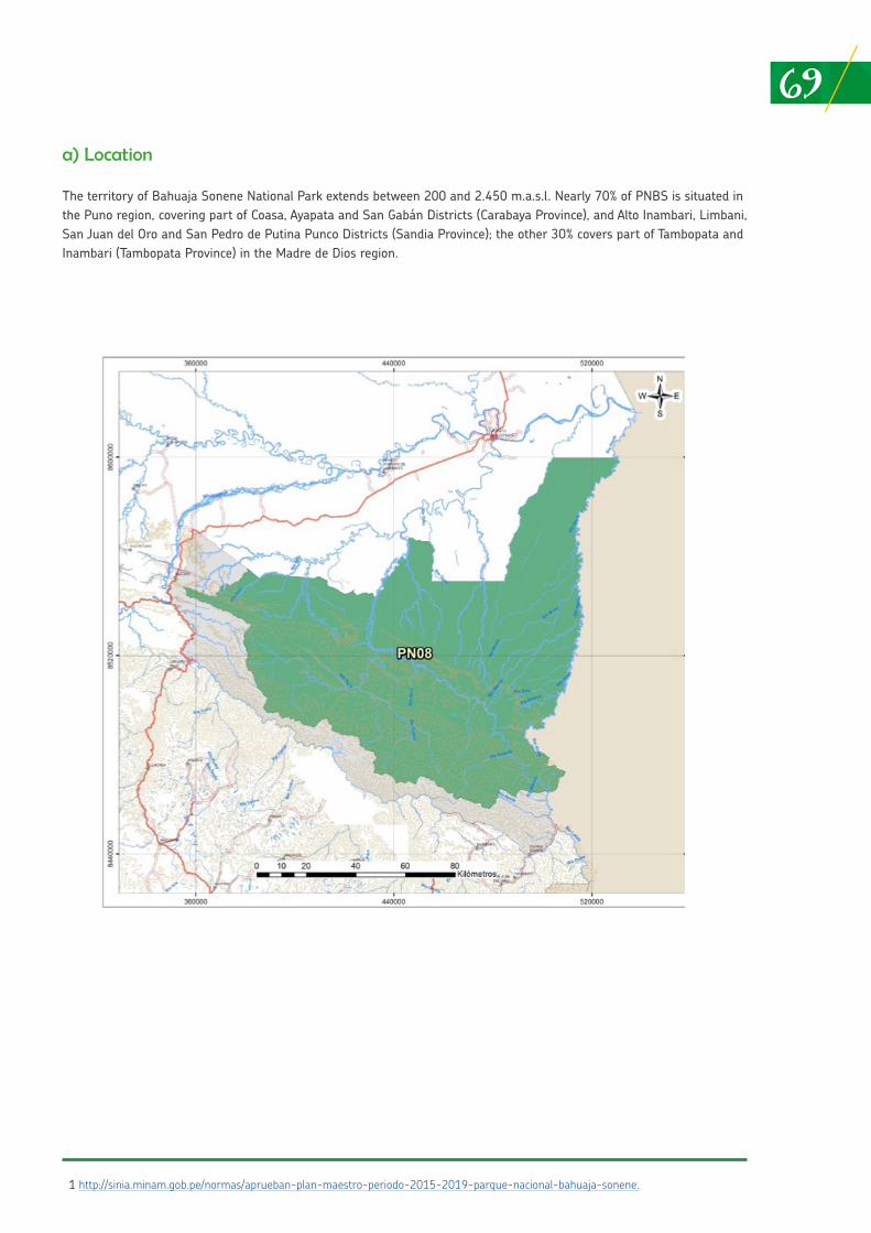
69a) Location
The territory of Bahuaja Sonene National Park extends between 200 and 2.450 m.a.s.l. Nearly 70% of PNBS is situated in the Puno region, covering part of Coasa, Ayapata and San Gabán Districts (Carabaya Province), and Alto Inambari, Limbani, San Juan del Oro and San Pedro de Putina Punco Districts (Sandia Province); the other 30% covers part of Tambopata and Inambari (Tambopata Province) in the Madre de Dios region.
1 http://sinia.minam.gob.pe/normas/aprueban-plan-maestro-periodo-2015-2019-parque-nacional-bahuaja-sonene.
70b) Description of the area: environmental traits (biodiversity richness), history (legal and institutional framework), functioning, population (number), situation of the influence zone, other of interest
The Park has high levels of biological diversity, registering endemic species for Peru and the world. In addition, its 1,092,416 hectares includes three large terrestrial eco-regions, yungas (or cloud forests), palm savannas (or Beni Savanna) and lowland forests (or Amazon plains), two of them unique for Peru such as the Bolivian Yungas and Beni Savanna, that hold endemic and unique species for Peru and the world. In turn, this Natural Protected Area shelters highly important areas for the reproduction and maintenance of fish populations, significant for the Madre de Dios ecosystem and economy, and protects threatened species from across the world such as Giant River Otters (Pteronura brasiliensis), Spectacled Bear (Tremarctos ornatus), Harpy Eagle Harpia harpyja) and Jaguar (Pantera onca).
The Tambopata and Heath Rivers, made up of various sized ravines, accessible in most spaces during flooding seasons, runs but not entirely through Bahuaja Sonene National Park and Tambopata National Reserve, as well as their buffer zones. The Tambopata River originates in the highlands of Puno outside the Parks limits, and its main tributaries are Tavara River in PNBS and Malinowski and La Torre Rivers located in the Tambopata National Reserve. The Heath River with an extension of more than 200 km. in length from its origin, in the final foothills of the Andes in Puno, until its estuary on the Madre de Dios River, limits to the East of the Park as well as the international border between Peru and Bolivia. The waters of Tambopata and Heath Rivers flow into the Madre de Dios River; the latter River originates in the Eastern Andes, Department of Cusco, and flows eastbound towards its estuary along the Amazon River in Brazil, where it becomes the Madeira River.
The Park is a source of resources for neighboring populations, and constitutes a reserved area of resources and ecosystem services for the future. Additionally, it fulfills the important role of harboring part of the ancestral territory of the Ese’ejja indigenous people.
At present, there is a permanent population inside PNBS, as in the case of Punto Cuatro special use zone and recovery zone in the Colorado sector, both in Puno. The known Punto Cuatro sector is located in Limbani District, Sandia Province, southeast of PNBS and is divided into 5 sections: Cochapata, Concapata, Tigrimayo, Wilson and Zambomayo. Its mountain forests invaded by human settlements characterize it. It is referred to as the fourth resting spot for muleteers that transported their goods from Limbani to Astillero. 2 Furthermore, this locality “was part of the route of entry to the Department of Madre de Dios during the time of rubber workers (end of the XIX Century and beginning of the 20 Century) until the 1960s”. 3 It is estimated that the oldest population settled in the zone dates back to 1940; thus, it has been inhabited long before the creation of PNBS, and their preexisting rights were respected when the NPA was created.
The estimated population in Punto Cuatro to 2003 was 131 inhabitants among permanent and temporary residents; however, to 2012 an estimated 26 heads of family were living there permanently together with their families, reaching a total of 77 people, and temporary heads of family with their families around 104 people. A total of 182 inhabitants were linked to the site, an increase in comparison to 2003. Nearly everyone was born in Puno, Limbani District, with quechua being their native language; 50,0% is over 30 years of age and only men reside their permanently (Burgos, 2012). Agriculture is the main activity, mostly for self-consumption; in second place artisanal mining, probably illegal and in third place, pack mule breeding. However, according to the latest reports from park rangers and researchers who entered the buffer zone near Punto Cuatro, mining is becoming the predominant activity.
The population in the Colorado sector is estimated at approximately 300 families and their situation with SERNANP is yet to be defined, to eventually become a special use zone and manage the space for agreements between the two parties.
Furthermore, there are people that enter to benefit from their resources as in the case of chestnut pickers and Ese’ejja who engage in fishing, collecting turtle eggs and subsistence hunting. Regarding chestnuts, they are obtained both from the Tambopata National Reserve (RNTAMB in Spanish) and Bahuaja Sonene National Park, as it is considered a low impact activity developed under traditional harvesting systems, becoming an activity that benefits the Madre de Dios population. Since 2004, the Park has had thirteen (13) utilization contracts for chestnuts, with a 40-year renewable validity period. Seven (7) of them are all in PNBS and six (6) are shared with RNTAMB.
The number of inhabitants in the PNBS and RNTAMB influence zones amount to 210,771 people, according to population data figures from the National Institute of Statistics and Informatics (INEI in Spanish) to 2007, where 5.34% (11,237 inhabitants) are found in the buffer zones.
71c) Principal threats to PNBS
• Highways. The three Government sectors (national, regional and local) undertake the planning and execution of highways indistinctively, in some cases with the improvement of rural roads funded in recent years by DEVIDA. Others are prompted by the regional Government as in the case of a highway that will connect Sandia Province with the Interoceanic Highway, designed to run parallel to Inambari River. This will be a major threat for the Park, as it is likely to increase illegal mining.
• Illegal crops inside the Park in the Colorado sector that have intensified the conflict they had with the population, even before the PNBS and its buffer zone were created.
• Mining along PNBS buffer zone corresponding to the Puno region. Titled mining concessions exist in Sandia and Carabaya Provinces, although the majority is inactive, some communities are exploiting tunnel mining. Illegal alluvial mining has been reported recently in some stretches of River Inambari (PNBS patrol report).
• Illegal logging, although not of industrial character, in the PNBS Pumahuaca sector. There is illegal logging of some timber species in Madre de Dios, such as Tornillo; however, the construction of a control point in the same sector, financed by the Frankfurt Zoological Society, has allowed the control of illegal logging.
d) Situation of indigenous peoples
The geographical area that currently makes up the PNBS was never a wasteland; on the contrary, it has been occupied historically. It has been identified that ancestors of Ese’eja indigenous peoples, belonging to the Tacana linguistic family were the first inhabitants, settled mainly along the headwaters of Tambopata, Heath, Madidi and Beni Rivers (Moore and García, 1993). 4 The indigenous peoples did not remain in isolation; they established contacts with Andean populations in the era of the Inca Empire, possibly along the Beni River valley and during the Sinchi Roca and Yahuar Huaca Governments (Arbaiza, 2008; Zeleny, 1976). In reality, there was also the presence of an Andean population along the Inambari and Tambopata River basins, linked to gold mining. This can be confirmed as ceramics and platforms have been found. Data reveals how the zone tied PNBS has been a dynamic space linked to different groups of people.
It is important to understand that the territory is viewed by Ese’ Eja people not only as a physical space or valued by its economic dimension, but its value is linked to social and cultural aspects. This is central in their cosmovision, in their identity and has a sacred character as it is their ancestor’s place of origin.
At present, the Ese’ Eja peoples have not settled in PNBS but rather in the buffer zone, towards the Madre de Dios region, exactly in Tambopata District and Province, distributed in 3 native communities: 5 Palma Real, Sonene and Infierno (see Box 1). However, they enter the Park to access a number of resources that allows their social and cultural reproduction. 6 It is important to emphasize that Infierno is the largest community, with both an indigenous and mestizo population (approximately 50.0%).
2 2003 - 2008 Master Plan.
3 2015 - 2019 Master Plan.
4 2003 – 2008 Master Plan.
5 These are the only Ese’Eja communities in Peru, the rest of the population can be found in Bolivia.
6 2015 – 2019 Master Plan.
72According to the XI Population Census and VI Housing Census 2007 (CPV in Spanish) and II Census of Indigenous Communities in the Peruvian Amazon 2007 (CNA in Spanish), the Tacana linguistic family with Ese’ejja ethnics, total a number of 588 inhabitants of which 306 are men and 282 correspond to women. It is estimated that in recent years there has been a demographic recovery 7 of this population, although updated official information is not available, it is essential.
Core subsistence activities for the Ese’ejja population are fishing, collecting, agriculture and hunting. Nevertheless, there have been modifications in the way they are being conducted due to changes in settlement patters, going from a mainly nomad lifestyle to a sedentary one. This means they can no longer access certain ecosystems to which they were linked (Mayor and Bodmer, 2009).
If official numbers are considered, according to the XI Population Census and VI Housing Census 2007 and II Census of Indigenous Communities in the Peruvian Amazon 2007, the majority of the population is dedicated mostly to agriculture and livestock farming, and in a much smaller proportion to hunting, forestry, fishing and teaching. With regard to agriculture, for some families it is not only important for self-consumption, but also to place their goods at small local markets. Their main products are rice, sugarcane, yucca, banana and pineapple. It is also important to point out that some practice slash and burn agriculture, and the production is not limited to their small farms, they also carry it out at far and disperse areas (Chavarría, 2003).
On the other hand, it is relevant to mention that hunting is prioritized during the rainy season (October – April), generally overnight. Hunting usually takes place in groups of two and three as the Ese’ Eja believe that if done individually, evil spirits might kill the hunter (Mayor and Bodmer, 2009). The displacement of people to undertake their hunting activities is undeniable, due to the limited availability of mountain animals and areas where they normally hunted. This has originated the search for new spaces, which in some cases are already occupied by migrant populations in the country’s Andean zone (Chavarría, 2003).
Fishing is also important for the population’s economic and social dynamic. It is crucial for self-consumption and small-scale commercialization. Fishing takes place all year round; mainly on the rivers during rainy seasons and also on the lakes, creeks and ponds.
Another activity that is becoming important is the sustainable exploitation of chestnuts, an economic source recognized by the population. At present, Ese’ Eja communities have constructed warehouses and count on networks for their commercialization. Tourism has also grown, particularly in the Infierno community, where they have a lodge jointly managed with the Rainforest Expeditions Ecotourism Company. Although the other two communities of Sonene and Palma Real are also interested in developing this activity, the number of tourists is considerably limited in comparison to the first case. This is associated to the failure to delimit the tourist zones, lack of infrastructure (lodges) and information to develop the activity. This has already been requested from the administration of the NPA.
e) Contributions from PNBS to local, regional and national food security
Inside PNBS, 13 chestnut concessions are being benefited in the special use zone. Hunting, fishing and collection of turtle eggs by Ese’ejja peoples in principal, should be under minor activity or subsistence agreements, but some still need to be established.
Along the buffer zone, mainly in the Carabaya and Sandia provinces, the population is essentially dedicated to the production of coffee for export and various fruits (oranges, mandarins, pineapple, banana, papaya, cherimoya, among others) mainly consumed in the cities of Juliaca and Puno. Ventures in the Puno region are linked principally to the production of coffee, harvested and commercialized through CECOVASA and La San Juan Cooperatives.
7 According to Pacheco (2016), based on information provided by César Ascorra and Julio Cusurichi, on their recognition of cultural mapping undertaken a few years ago by FENAMAD.
8 From 130,000 quintals before 2011 to 87,000 in 2011, 35,000 in 2012, 24,000 in 2013 and the dramatic 5,700 in 2015 (Source: CECO-VASA).
73f) The impacts of climate change on PNBS
One can assert that the most important activity in the PNBS buffer zone in Puno is agriculture and coffee growing, historically the most influential in the economic and social dynamic. They also have various recognitions at the national and international levels, for the world’s best coffee. Despite this, coffee production and productivity in the zone has fallen considerably during the past years, mainly caused by “coffee leaf rust” fungus that attacks the coffee plants. One of the hypotheses is that the impact of climate change is responsible for the recurrent appearance of this fungus, as fluctuating periods of rain and strong radiation improves the conditions for it to be more aggressive. The effect can be observed with other crops, especially fruits.
Another effect, not yet fully confirmed is the impact of climate change on the quality and quantity of water for human consumption. The people in major populated areas surrounding PNBS consume water from so called fresh water eyes, springs of accumulated underground water that is piped and conducted to their houses. Part of the population and authorities in the zone where the WCS works affirm that these fresh water eyes are drying out from the lack of rain during periods were historically it has always rained, and the water is no longer completely clean. This may by due to maintenance problems.
g) Recommendations to improve the situation of food security and face the impacts of climate change
In recent years, the National Government has promoted a national mitigation strategy to face climate change, and has requested regional governments to formulate their regional mitigation strategies articulated to the national strategy. In this context, the Puno Regional Government has elaborated and approved their regional strategy to mitigate climate change; however, beyond its pacification, concrete actions have not been implemented, essentially linked to the conservation and management of river basins, and under this approach, actions linked to research on crop adaptation to climate change, for example, coffee farming, that due to the incidence of rust fungus and increase of illegal crops, their production reduced significantly, 8 affecting the economy of small producers.
74
ANNEX 4
CASE STUDIES FOR SELECTED AREAS IN BOLIVIA, BRAZIL AND PERU
a) Map of the reserve or area.
b) Description of the area: environmental traits (biodiversity richness), history (legal and institutional framework), functioning, population (number), situation of the influence area and others of interest (1 page).c) Principales amenazas a la reserva o área (1 página)
• Highways
• Infrastructure
• Population centers
• Extractive industries (lumber, mining, others)
• Others
d) Situation of the indigenous peoples (1/2 page).
e) Contributions from the reserve or area to local, regional and nationa food security (1 page).
• Food types
• Situation of the sources or water provision
• Access to food
• Biodiversity endeavors
• Others
f) Impact of climate change on the reserve or area (1 page).
g) Recommendations to improve the situation of food security and face the effects of climate change (1 page).
Relevant bibliography or references of interest (7-10 references).
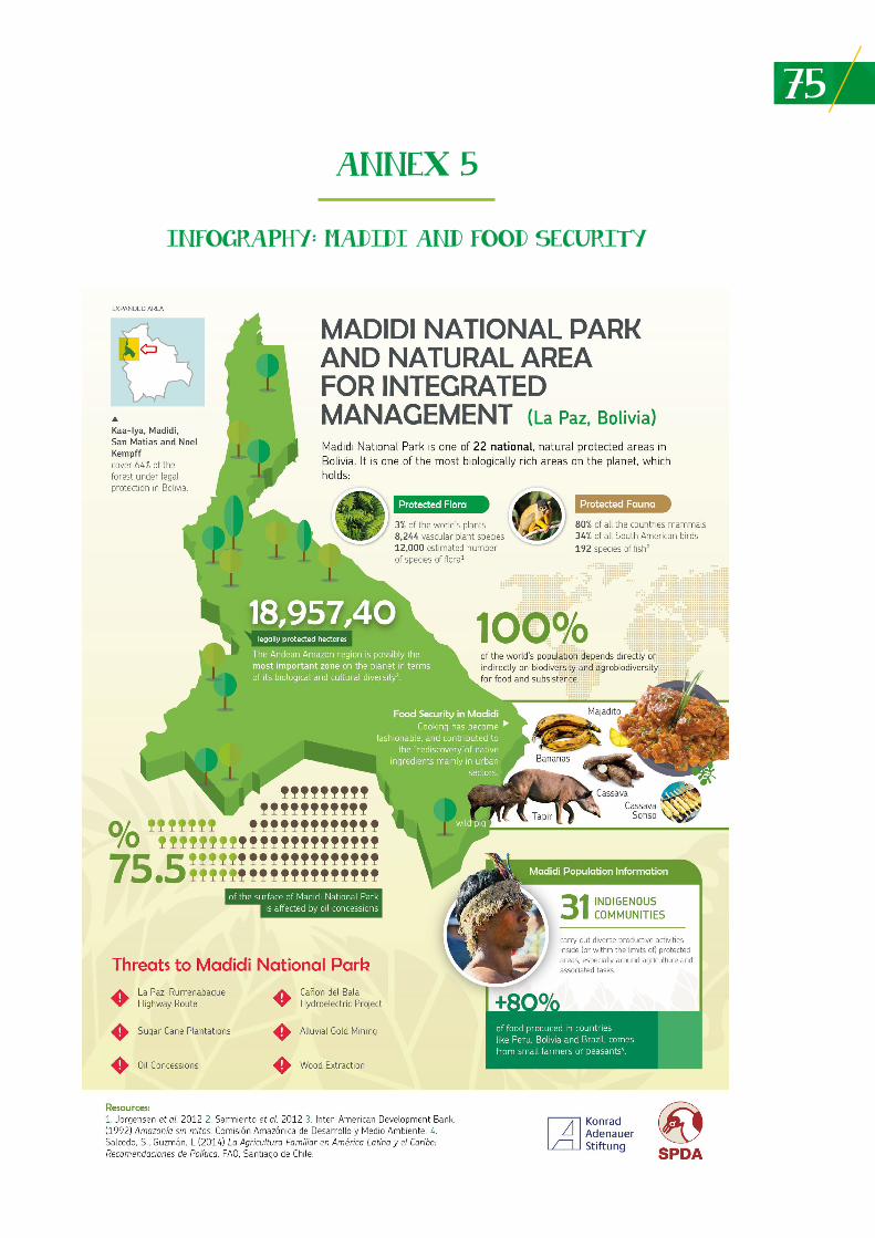
75
ANNEX 5
INFOGRAPHY: MADIDI AND FOOD SECURITY
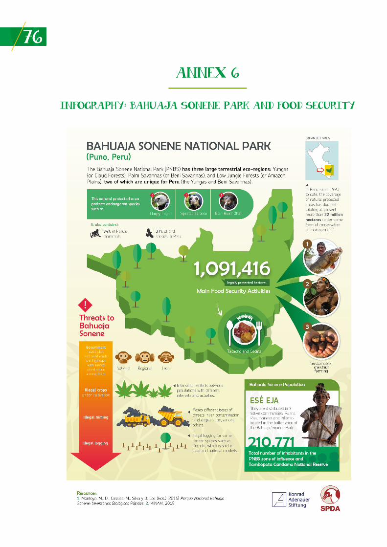
76
ANNEX 6
INFOGRAPHY: BAHUAJA SONENE PARK AND FOOD SECURITY
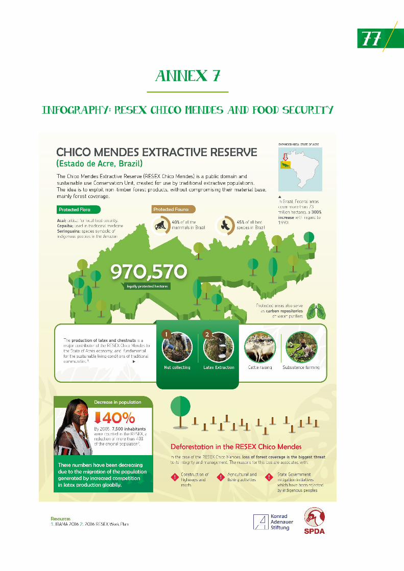
77
ANNEX 7
INFOGRAPHY: RESEX CHICO MENDES AND FOOD SECURITY
78
CURRICULUM VITAE
Manuel Ruiz Muller
Manuel Ruiz is a lawyer graduated from Pontificia Universidad Católica del Perú in 1996. He was a Darwin Fellow during 1998-1999 at the Kew Botanical Gardens, London. At present he is working as a Senior Advisor and Researcher for the Peruvian Society for Environmental Law (SPDA). Between 2000 and 2016 he was Director of the SPDA International Affairs and Biodiversity Program. Since 1992 his work has focused on issues related to the environment, biodiversity, genetic resources and intellectual property. During the past ten years he has dedicated his work to agrobiodiversity, food security, rural indigenous peoples and communities and climate change. He was a professor of the Second Specialty on Environmental Law and Natural Resources of the Pontificia Univesidad Católica del Perú between 2008 and 2016. He has contributed to policy and legal processes related to biodiversity conservation for the Andean Community, Amazon Parliament, OTCA, UNASUR, CCAD and nearly all countries in Latin America and the Caribbean, as well as other regions.
He has been a consultant for GIZ, BID, FAO, CAN, CAF, OTCA, GCIAR, IUCN, among others. Since 1992 he has published extensively, and his publications include: Ruiz, M. (2015) Plan de Acción de Estratégica 2015-2021 para la Adaptación al Cambio Climático de Comunidades Campesinas de los Andes Peruanos. CCTA, FAO International Treaty, INIA, SPDA. Lima, Peru; Ruiz, M., Landivar, N., Editores. (2015) Informe sobre el derecho Humano a la Alimentación Adecuada. El Caso de Comunidades en Loreto, Lima, y Cusco. Proyecto ABISA. IDMA, SPDA, WHH, ARARIWA, Unión Europea. Lima, Perú. Ruiz, M. Editor. (2015) Agrobiodiversidad, Seguridad Alimentaria y Nutrición: Ensayos sobre la Realidad Peruana.Proyecto ABISA. IDMA, SPDA, WHH, ARARIWA, Unión Europea. Lima, Peru, 2015.
E-mail: [email protected]
Natalia Araujo
Natalia Araujo has 18 years of expertise in biodiversity conservation. She has a Degree in Biological Sciences with Post-Graduate studies on Management of Protected Areas and Eco-Regional Development. Since 2016 she works as the Director of the Science Department for the Natura Foundation Bolivia. The main technical areas of her professional experience are conservation planning at the eco-regional level of biological corridors and protected areas, and territorial planning under a conservation approach. Her expertise also includes the management of conservation programs: from their design to the assessment and implementation of different capacity building processes on matters related to her field of expertise. Some of her work includes the design and leadership of the Analysis of Gaps in Representativity of the National System of Protected Areas, the facilitation and technical direction of 20 operational plans based on strategic elements of protected areas in Ecuador, the systematization of study cases of protected areas in Brazil, Colombia, Ecuador, Peru and Bolivia for IUCN, technical management to create 6 protected areas of municipal character in Bolivia. She has undertaken different technical and management positions for non-governmental organizations such as Friends of Nature Foundation and Natura Foundation Bolivia, as well as an international consultant for the German Technical Cooperation (GIZ), the World Conservation Union (IUCN), Environmental Incentives and Chemonics International. She has more than 20 publications related to biodiversity conservation and protected areas. Some of her recent texts are: Araujo N., Casavecchia C. (2014). Parque Nacional Noel Kempff Mercado, Estudio de Caso Bolivia. En: Amazonía Más Allá de las Fronteras: Lecciones Aprendidas en Areas Protegidas. Casavecchia C. (Editora). UICN, Quito, Ecuador; Araujo, N., Casavecchia C. (2014) Parque Nacional do Jaú y Reserva extractivista do río Uniní estudio de caso Brasil. En: Amazonía Más Allá de las Fronteras: Lecciones Aprendidas en Areas Protegidas. Casavecchia C. (Editora). UICN, Quito, Ecuador; Quiroga, D., Araujo, N., Espinoza, S., Larrea-Alcázar, D.M. (2012) Prioridades de Conservación de la Biodiversidad del Departamento de Santa Cruz. Fundación Amigos de la Naturaleza (FAN), Dirección de Áreas Protegidas (DIAP), Secretaría de Desarrollo Sostenible y Medio Ambiente (SDSMA) del Gobierno Departamental Autónomo de Santa Cruz, Editorial FAN, Santa Cruz de la Sierra, Bolivia.
E-mail: [email protected]
79Loyola Escamilo
Loyola Escamilo studied forestry, and graduated from the Universidad Agraria La Molina (UNALM), Lima, Peru. She has a Master’s Degree from UNALM in Ecotourism. She has extensive experience on matters related to protected areas and territorial management. From March 2015 to date, she works for the Wildlife Conservation Society (WCS) in Peru, as Director of the Madidi Tambopata Landscape – Peru. In this context, she is responsible for leading actions on biological and cultural diversity conservation and maintaining forests and lowlands and iconic species of Madidi Tambopata for the benefit of local populations and citizens in general. These actions have contributed to appropriate and timely management of the area, through engagement and coordination between local communities and governmental authorities (local, regional and national), and through strengthening specific management actions in priority conservation sites and productive units; conservation of landscape and species; promotion of alternative livelihoods based on natural resources management and strengthening overall environmental governance. These actions are all based on strong scientific research, planning and adaptive management practices.
E-mail: [email protected]
Teresa Cristina Moreira
Teresa Cristina Moreira is a lawyer, graduated in 1998 from the Law Faculty of Universidad de Marília, Brazil, with a Master Degree in Environmental Sciences from Universidad de Sao Paulo (2002-2003). Since 2010 she has been working as Specialist in Environmental Governance for The Natura Conservancy in Brazil. Previously she worked for the Secretariat of the Environment for the State of Pará and Brazilian Ministry of the Environment. Teresa Cristina Moreira has an extensive experience on matters related to public policies, environmental management and governance, including work with protected areas at different levels (State and Federal) in Brazil.
E-mail: [email protected]
Konrad-Adenauer-Stiftung e.V. Programa Regional Seguridad Energética y Cambio Climático en América Latina (EKLA) Fiscal Address: Av. Larco 109, Piso 2, Miraflores, Lima 18 - Perú Address: Calle Cantuarias 160 Of. 202, Miraflores, Lima 18 - Perú Tel: +51 (1) 320 2870, +51 (1) 731 2898