protected areas and coastal and ocean management in méxico
TRANSCRIPT

ARTICLE IN PRESS
Ocean & Coastal Management 48 (2005) 1016–1046
0964-5691/$ -
doi:10.1016/j
�Fax: +52
E-mail ad
www.elsevier.com/locate/ocecoaman
Protected areas and coastal and oceanmanagement in Mexico
Juan E. Bezaury-Creel�
The Nature Conservancy—Mexico, Montanas Calizas #455, Mexico 11000 DF, Mexico
Available online 20 June 2005
Abstract
No explicit ‘‘integrated coastal and ocean management’’ policy or program has been
formally instituted to manage coastal and marine issues in Mexico. Nevertheless two existing
environmental policy tools: ecological zoning programs and coastal and marine protected
areas, which have incorporated interagency and multi-stakeholder participation within their
design, are currently being used in lieu of such strategy. Coastal and marine protected areas in
Mexico are the result of independent initiatives taken over the last 75 years and as a group
cannot be characterized as the result of a systematic approach. Nevertheless Mexico’s 55
coastal and marine protected areas currently with a valid legal decree, occupy 11,791,824 ha
which represents 69% of Mexico’s total protected area surface. Only 46% of these include
marine ecosystems with a total of 3,577,527 ha with the remaining 8,216,194 ha consisting of
coastal ecosystems. (See In press update.)
r 2005 Elsevier Ltd. All rights reserved.
1. Introduction
The existence of coastal and marine protected areas in Mexico is the result ofindependent initiatives taken over 75 years by nine different presidential adminis-trations, through various federal agencies with jurisdiction over fisheries, wildlife,forestry or the environment, and thus their creation cannot be characterized as asystematic approach. Nevertheless, 55 coastal and marine sites are currently legally
see front matter r 2005 Elsevier Ltd. All rights reserved.
.ocecoaman.2005.03.004
55 56 61 21 75.
dress: [email protected].

ARTICLE IN PRESS
J.E. Bezaury-Creel / Ocean & Coastal Management 48 (2005) 1016–1046 1017
protected and provide key strategic elements that will allow the eventual creation ofa comprehensive and representative system of protected areas, which can effectivelyprotect Mexico’s unique coastal and marine biodiversity. Over the last decadeMexico has made important strides improving management of these sites, howevertheir consolidation over the next years becomes critical, if the country is to avoid thefate of jeopardizing not only the health of coastal and marine ecosystems, but thelivelihood of people whose activities depend upon them. This becomes criticallyimportant due to the presence of a highly fragmented coastal and marine legalframework, a dispersed and overlapping body of governmental institutions withjurisdiction over coastal and marine issues, the lack of experience with the creationand consolidation of intergovernmental and multi-stakeholder participatoryspaces and the absence of an explicit ‘‘integrated coastal and ocean management’’State Policy.
2. Coastal and ocean management in Mexico
Even though the necessity of adopting integrated coastal and ocean management(ICM) practices for coastal governance in Mexico has been discussed within theacademic sector over the last two decades, no explicit ICM policy or program hasbeen formally instituted to manage coastal and marine issues in Mexico.Nevertheless two existing environmental policy tools: ecological zoning programsand coastal and marine protected areas, which have incorporated interagency andmulti-stakeholder participation within their design, are currently being used in lieu ofsuch strategy. This situation is based upon the revised Ecology Law of 1996 whichstates that ‘‘the Federal Government will promote co-responsible participation ofsociety in planning, executing, evaluating and overseeing compliance on environ-mental and natural resources policy’’.
2.1. Ecological zoning programs
Ecological Zoning Programs (Programas de Ordenamiento Ecologico del Territor-
io—OET) are Mexican environmental policy tools utilized to achieve protection ofthe environment and sustainable use of natural resources, through a rational spatialdistribution of economically productive activities. An Ecological Zoning Programdefines land and water use regulations, which in theory apply to all governmentagencies at the Federal, State and Municipal levels. All public agencies programsneed not only to be consistent with, but must fully comply with the OET in theirconcessions, permitting and authorization processes. In practice, the use of this toolis complicated by extremely fractured jurisdictions given by the law to differentagencies at different levels. Still, environmental management is being strengthenedby the fact that a currently much more effective environmental impact assessmentprocess, requires compliance with the OETs as a basic requirement. Non-governmental agents are also brought into compliance through this mechanism.The OET process is meant to consider environmental, social and economic issues.

ARTICLE IN PRESS
J.E. Bezaury-Creel / Ocean & Coastal Management 48 (2005) 1016–10461018
Once approved by all appropriate parties including a public consultation process, allother land use plans must be consistent and conform to the OET regulations.
While not designed as such, OETs have the potential of becoming the main tool tounify diverse criteria and convoke the different actors that need to be involved in anICM strategy. Intergovernmental and non-governmental cooperating bodies(commissions, committees, etc.) must actively participate and ‘‘buy-in’’ to variousstages of the OET process, including design, implementation, compliance and reviewto safeguard their effectiveness. If this process were to occur in all coastal areas, itwould substantially contribute to a national ICM strategy. As relatively newenvironmental policy tool, OETs are still quite imperfect, both from technical andpolicy perspectives. Some government agencies feel that their jurisdiction is beinginvaded and that stakeholders are encroaching on their regulatory powers.Producers and developers consider that OETs create disincentives for investment.Environmentalists feel that the government does not bring enough political will andadministrative resources to enforce the provisions contained within them. All sidescan provide important and valid points towards their argument.
Four types of OETs are considered in the Ecology Law: General (National level),Regional (all or part of one or more states), local (municipalities) and marine(Federal Jurisdiction). By mid 2002 only 13 regional OETs (numbers 48–60 inMap 1) 9 of which cover coastal zones, had become legally binding instrumentswhich have gone through some form of participatory process, even if at times it wasmerely a token gesture. The technical process of 35 other OETs had been finished(numbers 13–47), but still lack either political or social consensus, preventing themfrom being adopted and coming into effect (numbers 1–12 reflect OETs at the project
Map 1. Regional environmental zoning programs [1] (OET type numbers referenced in text).

ARTICLE IN PRESS
J.E. Bezaury-Creel / Ocean & Coastal Management 48 (2005) 1016–1046 1019
stage). The situation is similar with local OETs which cover much smaller territoriesand thus consensus is easier to reach, where only 8 of them are legal—6 of themcovering coastal zones—while other 10 have been technically finished [1].
The only marine OET process initiated to date is targeted at the Gulf of Californialarge marine ecosystem.
2.2. Public efforts towards developing ICM policy in Mexico
The development of an ICM policy was seriously considered and discussed for thefirst time in Mexico’s governmental sphere, within the Secretariat of theEnvironment Natural Resources and Fisheries (SEMARNAP) internal AdvisorsCoordination during the 1994–2000 administration. No effective actions resultedfrom this effort, derived in part from the realization that even coordinatingSEMARNAP’s highly fragmented intra-secretarial departmental responsibilitiesrelated to coastal and ocean management was a daunting task. In practical terms theissue was put to rest and only a draft strategy for integrated costal zone managementwas published as a document with no legal value [2] and management of the 20mFederal Maritime-Terrestrial Zone was coordinated with coastal municipalities.Nevertheless SEMARNAP instituted participatory consultative bodies at thenational level and for each protected area and successfully promoted interagencyand public participation into the protected area management strategy. The purposeof this strategy is to assist the management of protected areas through wide rangingconsensus building processes. Today the National Protected Areas Council providesinput at the system level, while 29 of the 55 coastal and marine protected areas aresupported by 25 ‘‘advisory councils’’, covering 84% of their surface area. OETinteragency and public participation consultation processes were also reinforced bySEMARNAP during this period.
The current’s administration (2000–2006) vision of transversally integrating theenvironment with other sectoral interests, created the expectation of advancing fastertowards the development of ICM policy. Nevertheless little has been done to thisrespect. SEMARNAT recently contracted three academic institutions: CentroEPOMEX-UAC, CETYs-Universidad and CINVESTAV-Merida, to develop‘‘Guidelines for the development of a national strategy for the implementation ofa coastal zone management plan at the national, regional, state and municipal level’’.Over this period, an OET might prove to be the instrument that sets the baseline fora future ICM policy for Mexico.
The urgent need to develop a comprehensive coastal and marine use plan througha marine OET for the Gulf of California was recognized by the Mexican governmentin 1997. By 2000, the end of the previous presidential administration, basic technicalstudies for the OET had been finished, but the political and public participatoryprocesses had not been started. The current administration proposed an ambitiousnautical tourism project for the region. A project of such scope required not onlyenvironmental impact studies at regional and local scales, but also a regional OET toprovide the basic framework for the region’s development. Thus the 2000 OETproject was reinitiated in collaboration with national and regional academic

ARTICLE IN PRESS
J.E. Bezaury-Creel / Ocean & Coastal Management 48 (2005) 1016–10461020
institutions [3] and expanded to include in addition to the Gulf of California, theBaja Californian Pacific and all of the region’s coastal areas including the BajaCalifornia Peninsula.
While the second technical iteration of the Gulf of California OET had beenbasically completed by 2002 [3], the initiation of the political and consensus buildingwas overtly blocked by industrial fisheries interests, who manifested that as a resultfrom the OET, all fisheries were going to be banned and the Gulf turned into amarine sanctuary [4]. This was part is a positional response resulting from therecently enforced 1:1 bicatch rule within protected areas, which prevents them fromtrawling for shrimp within their boundaries, since shrimp trawling activities producea 1:12 bicatch in the region.
Results from preliminary public consultation workshops [5] identified a total of 23interest groups/stakeholders/activities, these being: aquiculture, agriculture/live-stock, protected areas, archeology, hunting, commerce, conservation, urban, energy,natural resource use, forestry, industry, mining, landscape, fisheries, offshorefisheries, commercial fisheries, sport fisheries, industrial fishery, artisan fisheries,pork farms and tourism. A total of 68 negative interactions were identified. Fivesectors were associated more frequently with these interactions, in descending order:tourism, conservation, agriculture/livestock, fisheries and urban. Most interactions(54%) were categorized as low or very low priority, 43% as high priority and 3% asvery high priority (artisan fishery vs. industrial fishery and aquiculture).
Recently SEMARNAT was able to convene all governmental actors required torestart the technical and consultative processes needed in the Gulf of California’sOET. On World Environment Day, July 5 2004, the Secretariat for Agriculture,Livestock, Fisheries and Nourishment; the Secretariat of Communications andTransportation; the Secretariat of the Navy; the Secretariat of Tourism and theSecretariat of Governance (Interior), plus the Governors of the states of BajaCalifornia, Baja California Sur, Nayarit, Sinaloa y Sonora, signed with SEMAR-NAT two parallel agreements [6,7] to develop the Gulf of California’s marine acoastal OETs. Result from these OET processes whether successful or not, will proveto be the most ambitious and geographically widest ranging ICM experience everlaunched in Mexico and provide invaluable lessons towards the future developmentof a national strategy.
Although the development of OETs and protected areas interagency and publicparticipation consultation processes have resulted in significant advances towardslocal stakeholder participation in resource management decisions, it is important torecognize that this concept is in its infancy. There are still important forces thatsupport sectoral and authoritarian decision making process. In addition, a great dealof stakeholder training and capacity development needs to take place in order to beable to achieve positive and long lasting results from the public participation process.
2.3. Private efforts towards developing ICM practices in Mexico
While an integrated approach to coastal zone management has not beenconsidered as a high priority issue by the Mexican Government at its three

ARTICLE IN PRESS
J.E. Bezaury-Creel / Ocean & Coastal Management 48 (2005) 1016–1046 1021
levels, academics have kept working towards developing research projects,conceptual frameworks for implementation and generating awareness of thecritical importance of utilizing this approach to achieve sustainable use of ourcoastal and marine resources. Several workshops dealing with ICM have takenplace since 2000.
Two experimental ICM projects, both including protected area componentshave been carried out through partnerships established between the University ofRhode Island—Coastal Research Center, local NGOs, a University and coastalcommunities. The first one is still taking place in the Caribbean coast of southernQuintana Roo through a partnership with Xcalak Community Committee (XCC),Amigos de Sian Ka’an an NGO and the University of Quintana Roo [8]. The XcalakNational Park is one of the results of this project and the Costa Maya OET receivedimportant input from it. A voluntary tool to promote ‘‘best practices’’ for lowimpact tourism infrastructure development was also a tangible product. Empower-ment of state and municipal authorities for coastal management issues andintegrating ICM in the University’s structure through the formal creation of anextension, outreach and policy programs, were also an important component ofthe project.
The second project is being developed in Bahıa de Santa Marıa, Sonora, one of thehighly productive estuaries in the Gulf of California, in partnership with localmunicipal authorities, the local community and Conservation International. Resultsfrom this project include a management strategy, which addresses a set of issues thatcould not be resolved by proposing a protected area (although the Bay Islands do fallwithin the Gulf of California Islands Flora and Fauna Protection Area). Second, thismay be the first experience in Mexico where two coastal municipalities collaboratedand provided leadership during strategy preparation. Third, the municipalities haveplayed an active role in the design and adoption of a joint implementationmechanism, a council of the two governments that includes a trust fund, which willsecure and administer implementation funds from local and state government,private sector, and donor institutions. It will also create an expanded bay councilwith representation from bay users, public officials, the education community, andcommunities [9].
Since OETs are still relatively weak tools, mainly due to the lack of human andfinancial resources for enforcement, many investors and developers still consider that‘‘it is better to ask for forgiveness that for a permit’’. This results on late andinefficient enforcement measures, derived mainly from public outcry and pressure.The ‘‘environmental guards’’ concept developed for the Maya Coast OET—southand adjacent to Sian Ka’an—currently being experimented by Amigos de SianKa’an, might prove to be a model that provides other OETs with a good set of teeth.This model integrates a non-official operative network of NGOs, interestedindividuals and government officials from different levels and agencies involved inissues related to coastal development and conservation. Network’s participants,individually keep abreast of what is happening in the region covered by the OET,and in case that non-compliance is detected and verified, they act in coordinationwith the other participants of the network, to call the attention of the governmental

ARTICLE IN PRESS
J.E. Bezaury-Creel / Ocean & Coastal Management 48 (2005) 1016–10461022
agency in charge of solving the non-compliance problem. Capacity that allows forpublic broadcasting efforts and/or direct legal action to resolve the non-complianceissue is also created within the network.
3. Evolution of coastal and marine protected areas in Mexico
Coastal and marine protected areas were relatively late emerging as a tool forMexico’s conservation efforts, where the first terrestrial protected area wasestablished in 1876. The first marine protected area included territorial waterssurrounding Isla Guadalupe an offshore island in the Pacific Ocean, which were‘‘reserved for the protection and development of the natural riches which theycontain’’ in 1922. By 1928, they were further reestablished as a Hunting andFisheries Reserve Area under the 1925 Fisheries Law, mainly to protect theNorthern Elephant Seal (Mirounga angustirostris) and the Guadalupe Fur Seal(Arctocephalus townsedi).
The first true coastal national park, Lagunas de Chacahua was created in 1937under the Forestry Law by the forestry and wildlife management authority, toprotect an important estuarine area on the Pacific coast of Oaxaca. That same yearthe Cajon del Diablo Hunting Reserve, that includes most of the rocky coast ofSonora, was established on the Gulf of California coast.
Progress in establishing coastal and marine protected areas is best understoodwithin the framework of the now 6 year presidential terms (Chart 1), since federaldecisions play a dominant role in the pace and orientation of their formationand consolidation. Between 1958 and 1964, three Natural Reserve and Refuge Zoneswere created by the forestry and wildlife management agency, to protect landfauna and marine birds breeding grounds in three islands: Contoy in the Caribbean(1961) and Tiburon (1963) and Rasa (1964) in the Gulf of California. Since these
Chart 1. Evolution of federal coastal and marine protected areas in Mexico.

ARTICLE IN PRESS
J.E. Bezaury-Creel / Ocean & Coastal Management 48 (2005) 1016–1046 1023
were established under the 1952 Federal Hunting law, they could not includesurrounding waters, a major limitation for many Mexican coastal island andshore sites.
3.1. President Luis Echeverrıa’s administration
From 1970 to 1976 marine protection efforts became more evident and diversifiedwithin the agency in charge of fisheries protection. The lagoons used as breeding andcalving grounds for the Grey Whale (Eschrichtius robustus) in Baja California Sur,were given protection status in 1972. First only Laguna Ojo de Liebre as a WhaleRefuge under the Fisheries Law and latter in the same year, expanding the mandateunder the Hunting Law, the Laguna Ojo de Liebre and San Ignacio Reserve andRefuge Area for Migratory Birds an Wildlife was created. Five protected areas wereestablished under the new 1972 Fisheries Fostering Law: the Costa Occidental de IslaMujeres, Punta Cancun y Nizuc Marine Wildlife Refuge (1973) was created in theCaribbean Sea in order to protect the reefs around the new tourism development ofCancun; the Cabo San Lucas Wildlife and Sea Bed Ecological Conditions Refugeprotecting underwater ‘‘sand falls’’ off the southern tip of the Baja Peninsula (1973);the Desembocadura del Rıo Colorado Fishery Species Replenishment and NurseryReserve in the upper Gulf of California, established mainly to protect the endemicTotoaba (Totoaba macdonaldi) (1974); and, two marine wildlife protection refuges,Arcos de Vallarta on the Pacific coast of Jalisco (1975) and La Blanquilla reefs infront of Veracruz on the Gulf of Mexico (1975).
3.2. President Jose Lopez Portillo’s administration
Over the 1976–1982 period presidential administration, protected areas werecreated by three different government agencies. The agency in charge of fisheriesused the Fisheries Fostering Law to create: the Playa Rancho Nuevo Refuge inTamaulipas (1977) in the Gulf of Mexico for the protection Olive Ridley sea turtle(Lepidochelys kempi); two new decrees expanded the area covered by the previousdecrees protecting the Gray Whale breeding and calving grounds (1979 and 1980);and, the Costa Occidental de Isla Cozumel Marine Wildlife Protection Refuge (1980)was established to protect the coral reefs that were supporting an important divingdestination. The Federal Hunting Law was used to establish four coastal protectedareas by the agency in charge of wildlife: the Islas del Golfo de California Reserveand Refuge Zone for Acuatic and Migratory Birds (1978) to protect migratory birdsand endemic reptile species; the Rıa Celestun and Rıa Lagartos (both in 1979) faunalrefuges in coastal Yucatan to protect the breeding and feeding areas of the GreaterFlamingo (Phoenicopterus ruber); the Valle de los Cirios Forestry Protection Zoneand Wildlife Refuge in Baja California (1980), which was additionally based on theForestry Law. Finally, the agency in charge of public works, which by then wasadministering national parks for recreation, established three new coastal nationalparks based upon the Forestry Law: El Veladero (1980) surrounding Acapulco; IslaIsabel (1980) an offshore island in Nayarit at the Pacific Ocean; and, Tulum (1981) in

ARTICLE IN PRESS
J.E. Bezaury-Creel / Ocean & Coastal Management 48 (2005) 1016–10461024
the Caribbean coast of Quintana Roo, to protect the natural environmentsurrounding an important coastal Maya site.
3.3. President Miguel de la Madrıd’s administration
During the next presidential period, 1982–1988, environmental issues were finallyraised to an under-ministerial level, through the creation of the Secretary of UrbanDevelopment and Ecology (SEDUE). This served to unify the management ofprotected areas. Sian Ka’an (1986) was the first protected area established in Mexicoas the result of an federal-state-municipal and local stakeholder process. Sian Ka’anwas created using the term ‘‘biosphere reserve’’ as a place name, since such protectedarea management category was not contemplated within the Federal Law forEnvironmental Protection and the Forestry Law upon which its establishment wasbased. The fisheries and environmental agencies jointly established seventeen RefugeSites for Protection, Repopulation, Development and Control of Diverse Species ofMarine Turtles (1987) in one decree, including two beaches in the Gulf of Mexico,one in the Caribbean, 12 in the Pacific Ocean and two in the Gulf of California, witha total coastal length of 348 km. In 1988 the General Law for Ecological Equilibriumand Environmental Protection (from now on Ecology Law) unified protected areaslegislation and became the legal base for the creation of all new protected areas. TheVizcaino Biosphere Reserve (1988) was created under this new now valid protectedarea management category, over previously established areas protecting the GrayWhale and enlarged to include coastal and marine habitats in the Gulf of Californiaand the Pacific Ocean.
3.4. President Carlos Salina’s administration
During the 1988–1994 presidential term, environmental management wastransferred to the agency dealing with social development (SEDESOL). Terrestrialnational parks in turn were separated out and transferred back to the agencyresponsible for forestry policy and management, while the rest of the protected areasremained within the new environmental management agency. This became an activeperiod for the creation of new coastal and marine protected areas. New marineprotected areas included: two important coral reef areas in the Gulf of Mexico,Sistema Arrecifal Veracruzano (1992) and Arrecife Alacranes (1994) which werecreated utilizing the new ‘‘marine national park’’ protected area managementcategory; and two biosphere reserves, Alto Golfo de California y Delta del RıoColorado (1993) in the upper Gulf of California which includes a greater part of thehabitat where the endemic Vaquita Porpoise (Phocoena sinus) lives; and,Archipielago de Revillagigedo (1994) protecting Mexico’s most important offshorePacific islands group and surrounding waters. Coastal protected areas included threebiosphere reserves: Pantanos de Centla in Tabasco (1992) to protect importantcoastal wetlands in the Gulf of Mexico, El Pinacate y Gran Desierto de Altar inSonora (1993) comprising the coastal zone adjacent to the marine Biosphere Reservein the upper Gulf of California, and Chamela-Cuixmala in Jalisco (1993) to protect
ARTICLE IN PRESS
J.E. Bezaury-Creel / Ocean & Coastal Management 48 (2005) 1016–1046 1025
coastal Pacific dry forests. Three flora and fauna protection areas were also created,Laguna de Terminos in Campeche (1994) which along with Centla protect the mostextensive wetland system in the Gulf of Mexico, Yum Balam (1994) protecting thenorthern Gulf of Mexico wetlands of Quintana Roo and Uaymil (1994) adjacent tothe southern border of Sian Ka’an protecting it’s upper watershed between EspırituSanto y Chetumal bays (Map 2).
3.5. President Ernesto Zedillo’s administration
During the 1994–2000 presidential period, integrating renewable natural resourcesmanagement became the focus of the federal environmental policy agenda. Thusforestry, wildlife, fisheries, water, pollution and the 20m federal zone along the coastwere among the jurisdictions integrated under SEMARNAP, the new agencyresponsible for the environment. Protected area management, including terrestrialnational parks, was reunified once again within this agency and given a higherpolitical visibility and operational status through the creation of the NationalProtected Area Commission, directly under the Minister for the Environment. Earlyinto the administration protected areas started to shed their reputation as paperparks, as professional staff and budget were allocated to many of the sites. Elevenmarine protected areas are created, with the participation of local coastalstakeholders: two in Baja California Sur, Cabo Pulmo (1995) to protect thenorthernmost reefs in the Pacific and Bahıa de Loreto (1996) where industrial fishingactivities were jeopardizing the sustainability of the local sport fishery. Thecontroversy over the construction of a cruise ship pier in Cozumel, became aninternational case utilizing for the first time a tri-national environmental protectionmechanism derived from the North American Free Trade Agreement (NAFTA). Thesocial visibility that coral reefs suddenly acquired as a byproduct of this dispute,helped create support for seven new marine protected areas that were established inthe Caribbean Sea: three previously existing areas in Quintana Roo were enlargedand had their legal instruments modernized as marine national parks, due to tourismrelated activities that had experienced an explosive growth: Arrecifes de Cozumel(1996), Costa Occidental de Isla Mujeres, Punta Cancun y Punta Nizuc (1996) andfinally Isla Contoy (1998) now including it’s surrounding marine zone; two biospherereserves, Banco Chinchorro (1996) an offshore pseudo atoll and Arrecifes de SianKa’an (1998) to include coral reefs and coastal lagoons previously excluded from theoriginal decree; and two new national parks—now as a reunified protected areamanagement category derived from changes in the Ecology Law that includes bothterrestrial and marine parks—Arrecife de Puerto Morelos (1998) south of Cancunand Arrecifes de Xcalak (2000) on the border with Belize. Mexico collaborated withBelize, Guatemala and Honduras in 1997, the International Year of the Reef topromote the Mesoamerican Caribbean Coral Reef Systems Initiative, opening amechanism to jointly manage a shared marine ecosystem. In the Pacific Ocean theHuatulco National Park protecting coral communities in Oaxaca (1998) and the IslasMarıas Biosphere Reserve (2000) with an important oceanic component wereestablished. Six coastal protected areas were also created during this period,

ARTICLE IN PRESS
Map 2. Federal coastal and marine protected areas (Only for areas currently under legal status). 1) Parque
Nacional Lagunas de Chacahua, 2) Area de Proteccion de Flora y Fauna Cabo San Lucas, 3) Area de
Proteccion de Flora y Fauna Islas del Golfo de California, 4) Reserva de la Biosfera las Aguas del
Complejo Laguna Ojo de Liebre (Manuela y Guerrero Negro), 5 Area de Proteccion de Flora y Fauna
Valle de los Cirios, 6) Parque Nacional El Veladero, 7) Parque Nacional Isla Isabel, 8) Parque Nacional
Tulum, 9) Reserva de la Biosfera Sian Ka’an, 10) Santuario Playa de Puerto Arista, 11) Santuario Playa de
Tierra Colorada, 12) Santuario Playa Piedra de Tlacoyunque, 13) Santuario Playa Cuitzmala, 14)
Santuario Playa de Mismaloya, 15) Santuario Playa El Tecuan, 16) Santuario Playa Teopa, 17) Santuario
Playa de Maruata y Colola, 18) Santuario Playa Mexiquillo, 19) Santuario Playa de Escobilla, 20)
Santuario Playa de la Bahıa de Chacahua, 21) Santuario Playa de la Isla Contoy, 22) Santuario Playa
Ceuta, 23) Santuario Playa el Verde Camacho, 24) Santuario Playa de Rancho Nuevo, 25) Santuario Playa
Rıo Lagartos, 26) Reserva de la Biosfera El Vizcaıno, 27) Reserva de la Biosfera Pantanos de Centla, 28)
Parque Nacional Sistema Arrecifal Veracruzano, 29) Reserva de la Biosfera Alto Golfo de California y
Delta del Rıo Colorado, 30) Reserva de la Biosfera El Pinacate y Gran Desierto de Altar, 31) Reserva de la
Biosfera Chamela-Cuixmala, 32) Parque Nacional Arrecife Alacranes, 33) Reserva de la Biosfera
Archipielago de Revillagigedo, 34) Area de Proteccion de Flora y Fauna Laguna de Terminos, 35) Area de
Proteccion de Flora y Fauna Yum Balam, 36) Area de Proteccion de Flora y Fauna Uaimil, 37) Reserva
de la Biosfera La Encrucijada, 38) Parque Nacional Cabo Pulmo, 39) Parque Nacional Bahıa de Loreto,
40) Parque Nacional Arrecifes de Cozumel, 41) Parque Nacional Costa Occidental de Isla Mujeres, Punta
Cancun y Punta Nizuc, 42) Reserva de la Biosfera Banco Chinchorro, 43) Reserva de la Biosfera Arrecifes
de Sian Ka’an, 44) Parque Nacional Arrecife de Puerto Morelos, 45) Parque Nacional Isla Contoy, 46)
Parque Nacional Huatulco, 47) Reserva de la Biosfera Los Tuxtlas, 48) Reserva de la Biosfera Rıa
Lagartos, 49) Reserva de la Biosfera Los Petenes, 50) Reserva de la Biosfera Islas Marıas, 51) Reserva de
la Biosfera Rıa Celestun, 52) Area de Proteccion de Flora y Fauna Meseta de Cacaxtla, 53) Parque
Nacional Arrecifes de Xcalak, 54) Reserva de la Biosfera Isla San Pedro Martir, 55) Santuario Islas La
Pajarera, Cocinas, Mamut, Colorada, San Pedro, San Agustın, San Andres y Negrita y los Islotes Los
Anegados, Novillas, Mosca y Submarino.
J.E. Bezaury-Creel / Ocean & Coastal Management 48 (2005) 1016–10461026

ARTICLE IN PRESS
J.E. Bezaury-Creel / Ocean & Coastal Management 48 (2005) 1016–1046 1027
including five biosphere reserves: La Encrucijada in coastal Chiapas (1995)protecting Mexico’s most biodiverse wetland; Los Tuxtlas in Veracruz (1998); LosPetenes (1999) wetlands on Campeche coast of the Gulf of Mexico; Rıa Lagartos(1999) and Rıa Celestun (2000) in Yucatan were expanded and their 1979 legalmandates fully updated. Coastal Sinaloa in the Gulf of California gained one floraand fauna protection area, Meseta de Cacaxtla (2000). In that same year Cabo SanLucas and Islas del Golfo were re-categorized as flora and fauna protection areas,Sian Ka0an was finally re-categorized as a biosphere reserve, as well as the ComplejoLaguna Ojo de Liebre that includes Manuela y Guerrero Negro lagoons created forthe Grey Whales in 1980 and all existing marine national parks were re-categorizednow as national parks.
3.6. President Vicente Fox’s administration
During the current presidential administration (2000–2006), fisheries have beenseparated again from the Secretarial of Environment and Natural Resources(SEMARNAT) and placed under the Secretariat for Agriculture, Livestock,Fisheries and Nourishment (SAGARPA). This situation has produced not onlyunfortunate consequences for coastal and marine protected area management, whichstill remains unified within the environmental agenda, but also has enormouslycomplicated the establishment of new ones. Work is under way to create nine newcoastal and marine protected areas, while two others have already been established:Isla San Pedro Martir Biosphere Reserve (2002) within a strategy to provideprotected areas status to the waters surrounding all the Gulf of California Islands;and, Islas de la Bahia de Chamela (2002) off shore but close to the ChamelaCuixmala Biosphere Reserve in the Pacific. Previously established Marine TurtleRefuge Sites that included 17 nesting beaches were re-categorized as sanctuaries(2002) to comply with current protected area legislation. Over the whole extent ofMexico’s Exclusive Economic Zone the Great Whale Aquatic Species ProtectionArea (2002) was created. Established by the new Wildlife Law, aquatic speciesprotection areas are equivalent to no take zones and thus strictly not a protectedarea, nevertheless the Protection Plan required for their management can become atool for interagency—multi-stakeholder participation.
3.7. State, municipal and private coastal and marine protected areas
Even though Mexico is working toward the decentralization of environmentalmanagement functions, at the state level, only seven of the 17 Mexican statesadjacent to the coast have established coastal protected areas (Baja California Sur,Sonora, Veracruz), four of them (Campeche, Chiapas, Quintana Roo and Yucatan)have included marine portions within them, even though marine jurisdiction isstrictly Federal. Two Municipal Governments, La Paz in Baja California Sur andTampico in Tamaulipas have established protected areas in coastal ecosystems.Private land protection efforts in Mexico are still in their infancy and to date onlyfour small private protected areas have been established protecting coastal lands.
ARTICLE IN PRESS
J.E. Bezaury-Creel / Ocean & Coastal Management 48 (2005) 1016–10461028
4. Mexican Legislation affecting protected area and coastal and ocean management
today
The legislative framework for coastal and ocean management in Mexico iscomposed of International Conventions and Agreements signed by Mexico and by abody of Mexican Laws, Regulations, Decrees, Secretarial Agreements and OfficialMexican Standards.
4.1. International conventions and agreements
Mexico has signed all major International Law instruments, dealing with coastaland marine biodiversity. These include: the United Nations Convention on the Lawof the Seas (UNCLOS), the Convention on Biological Diversity, the InternationalConvention for the Prevention of Pollution from Ships (MARPOL), the Conventionon the Prevention of Marine Pollution by Dumping of Wastes and Other Matter(London Convention), the Convention on International Trade in EndangeredSpecies (CITES), the Convention Concerning the Protection of the World Culturaland Natural Heritage, the Convention on Wetlands of International ImportanceEspecially as Waterfowl Habitat (Ramsar) and the Convention for the Protectionand Development of the Marine Environment of the Wider Caribbean (CartagenaConvention), although the ratification of the Protocol on Specially Protected Areasand Wildlife (SPAW Protocol) is still pending. Mexico also subscribes to theprinciples of the UN Agreement on Straddling and Highly Migratory Fish Stocks,FAO’s Code of Conduct for Responsible Fisheries, UNEPs Conference onProtection of the Marine Environmental from Land-Based Activities andparticipates in the Intergovernmental Oceanographic Commission (IOC) and itsSub commission for the Caribbean and Adjacent Regions (IOCARIBE).
4.2. National laws and regulations
Mexico’s legislative framework dealing with coastal and marine issues is highlyfragmented and in some instances outright conflicting. Mexico does not have a singlelaw that regulates conservation and use of its biological diversity, since they arecontained in five central pieces of legislation and their regulations: the General Lawfor Ecological Equilibrium and Environmental Protection or Ecology Law (Ley
General del Equilibrio Ecologico y Proteccion al Ambiente, 1988 and 1996); theGeneral Wildlife Law (Ley General de Vida Silvestre, 2000); the Federal FisheriesLaw (Ley Federal de Pesca, 1992), General Sustainable Forestry Development Law(Ley General de Desarrollo Forestal Sustentable, 2003); and the Official MexicanStandard (Norma Oficial Mexicana, NOM-059-ECOL-2000, 2002) which listsendangered and threatened species.
Ocean pollution control provisions are also dispersed among a variety of laws andregulations. The Federal Oceans Law (Ley Federal del Mar, 1986) provides generallythat all prevention, reduction, and control of ocean pollution is to be regulated underthe Ecology Law, the National Waters Law (Ley de Aguas Nacionales, 1992, 2004),
ARTICLE IN PRESS
J.E. Bezaury-Creel / Ocean & Coastal Management 48 (2005) 1016–1046 1029
the General Health Law (Ley General de Salud), and their implementing regulations.Official Mexican Standards (Normas Oficiales Mexicanas NOM) also apply towastewater discharges into the oceans.
The General Law of National Property (Ley General de Bienes Nacionales 1982,1984, 2004) and the Regulation for the Use and Exploitation of the Territorial Sea,Navigable Waters, Beaches, Federal Coastal Land Zone and Newly Emerged Lands(Reglamento para el uso y aprovechamiento de mares territoriales, aguas navegables,playas, la zona federal marıtimo terrestre y terrenos ganados al mar, 1992) regulatemanagement the 20m Federal Maritime-Terrestrial Zone.
Maritime transit is regulated through the Ports Law (Ley de Puertos, 1993) andthe Navigation Law (Ley de Navegacion, 1994) which prohibits all vessels fromdischarging garbage, petroleum and petroleum derivatives, wastewater dischargesand other dangerous and noxious elements that could contaminate or harm watersunder Mexican jurisdiction. Tourism activities are regulated by the Tourism Law(Ley Federal de Turismo, 1992) and a body of Official Mexican Standards.
General Laws in Mexico (such as the Ecology, Wildlife and Sustainable ForestryLaws) provide a basic regulatory framework, that allows for the establishment of adecentralized federalist legal system in which both the states and the federalgovernment share regulatory authority over issues specified by the General law.While SEMARNAT is the administrative authority responsible for almost allenvironmental issues under federal jurisdiction, all 31 states have created their ownenvironmental legal regimes. Changes made to the Ecology Law in 1996 and again in2001, set the stage for granting states more extensive jurisdiction and regulatoryauthority. Increased decentralization should not, however, result in lowered Mexicanenvironmental standards. Rather federal standards establish a floor that must bemet. State standards must be equivalent to or more stringent than the federalstandards. Nevertheless, in coastal and marine issues, states and municipalities areexpected to have a minimal impact on policy in the near future, since these areas stillremain primarily under federal jurisdiction. This situation highlights the importanceof their inclusion on coastal and marine participatory processes, since land relatedjurisdictions belong to the states and municipalities, especially those related to landuse and building permits, which are assigned directly to the municipalities by theMexican Constitution.
All the above mentioned laws, in addition to all other Mexican laws coveringsubjects as diverse as agriculture, oil and mineral exploration and extraction, freshwater use and extraction, human settlements, private property, agrarian communalproperty (ejidos and communities), etc., apply within protected areas and over theterritories covered by OETs. Protected areas and OETs have their own particularRegulations derived from the Ecology Law (Reglamento de la LGEEPA en Materia
de Areas Naturales Protegidas, 2000 and Reglamento de la LGEEPA en Materia de
Ordenamiento Ecologico, 2003). Protected Areas Regulations specify that fisheriesbycatch within them, cannot exceed the volume of the target species, a crucial butstill poorly enforced provision intended to increase sustainability of fisheries. TheManagement Program (plan) for each protected area and specifically theAdministrative Rules defined within it, contain specific regulations applicable to

ARTICLE IN PRESS
J.E. Bezaury-Creel / Ocean & Coastal Management 48 (2005) 1016–10461030
that area. Currently, 18 coastal and marine protected areas or 33% of them have anofficial management program, representing 57% of their surface area.
4.3. Coastal zone jurisdiction
Jurisdiction over Mexico’s coastal zone remains highly fragmented, with 8 out ofthe 19 cabinet functions at the Federal level having direct involvement over coastaland marine management and the rest holding indirect functions: the Secretariat forthe Environment and Natural Resources (SEMARNAT) has jurisdiction overforestry, wildlife, endangered species, water, pollution and the 20m FederalMaritime-Terrestrial Zone amongst others; the Secretariat for Agriculture, Live-stock, Fisheries and Nourishment (SAGARPA) is responsible of managing fishstocks; the Secretariat of Communications and Transportation (SCT) has jurisdic-tion over ports and navigation; the Navy Secretariat’s (SEMAR) main responsibilityis to assert Mexico’s sovereign rights over territorial waters within the confines ofinternational law, including ocean pollution; the Secretariat of Tourism (SECTUR)promotes and regulates tourism related activities; the Secretariat of AgrarianReform (SRA) deals with communal land tenure; the Secretariat of Energy(SENER) under which the National Petroleum Company (PEMEX) is sectorialized;and, the Secretariat of Governance (SEGOB) who has jurisdiction over Mexico’sislands. This situation is further complicated by highly fragmented intra-secretarialdepartmental responsibilities, as well as separate departments belonging to statesand municipalities and their operative units.
5. Characteristics of the Mexican protected area program
Since protected areas represent to date the most advanced experience to datetowards the development of ICM practices, it is important to specify those particularcharacteristics that define Mexico’s protected area program.
5.1. Mexico’s protected area program
Mexico’s efforts to conserve biodiversity encompass an overwhelming necessity toprovide goods and services to its growing population. Thus national conservationapproaches deal primarily with practical issues rather than ethical concepts. Withinthis context, strict reserves, mainly biosphere reserve core zones and sanctuaries, areestablished as benchmarks to monitor long-term effects of human utilization onecosystems and not for the mere concept of wilderness. Protected areas constitute animportant part of the Mexican strategy to protect biodiversity. Most Mexicanprotected areas are conceptualized as multiple use zones, where activities are limitedby the thresholds imposed by sustainable use of natural resources. This means thatprotected areas are not isolated from the National economy, but rather participate toenhance and consolidate Mexico’s economy within the limits imposed by the need toconserve their environmental conditions. This situation has generated certain

ARTICLE IN PRESS
J.E. Bezaury-Creel / Ocean & Coastal Management 48 (2005) 1016–1046 1031
confusion, when it is assumed that the extents of Mexican marine protected areas are‘‘de facto’’ no-take zones. Although protected areas management plans might callfor certain portions not being fished, no-take zones can also be created outsideprotected areas, since they are regulated through different legal bases, mainly theWildlife Law to protect endangered species, marine mammals and sea turtles and theFisheries Law for commercial marine species.
Another crucial characteristic of Mexican protected areas is that existing landtenure within their boundaries is not altered by their creation, but rather land use isrestricted through the signing of the presidential decree creating the protected area,in order to accommodate environmental protection purposes. This has as its legalbasis Article 27 of the Mexican Constitution, which states that originally all landbelongs to the nation, who creates private and communal property but can stillimpose limitations to its use in order to achieve public benefits. Expropriation oflands has been used by certain administrations, but is currently used only inexceptional cases when a strict no use policy is required. It also is important to clarifythat private and communal property of land in Mexico refers only to surface rights,since property of the subsoil including mineral and water rights belongs to thenation. Everything that relates to water is within Federal Jurisdiction in Mexico.Rivers, streams and all freshwater bodies have an adjacent Federal Zone (or ribera)with a width of 5m on each side when the current is less than 5m wide or 10m on allother situations. On the coastal zone a 20m Federal Maritime-Terrestrial Zone existson by all beaches and around all coastal lagoons and estuaries.
The objectives of Mexican protected areas as defined by the Ecology Law are:preserve representative environments from natural biogeographic and ecologicregions and their ecosystems; safeguard genetic diversity of wildlife upon which theirevolutionary continuity depends and insure preservation and sustainable use ofbiodiversity, specially of endangered, threatened, endemic, rare species and thosesubject to special protection; assure sustainable use of ecosystems and their elements;provide opportunities for scientific research and for the study of ecosystems and theirbalance; generate, recover and communicate traditional or new knowledge, practicesand technologies that will allow for preservation and sustainable use of biodiversity;protect towns, communications and industrial infrastructure, agricultural lands andthe hydrological cycle of watersheds; and, protect the natural surroundings ofarcheological, artistic and historical zones, monuments and remains, tourism zonesand other areas important for recreation, culture and national and indigenouscommunities identity.
5.2. Extent of Mexico’s coastal and marine protected areas
Mexico’s 55 coastal and marine protected areas currently with a valid legal decree(Isla Guadalupe, Cajon del Diablo and Arcos de Vallarta are thus excluded),represent 37% of a total of 148 protected areas currently legally updated, comprising11,793,721 ha [10] or 67.8% of their total surface area. Only 45.5% of these includemarine ecosystems with a total of 3,577,527 ha and the remaining 8,216,194 haconsisting of coastal ecosystems (Tables 1 and 2).

ARTICLE IN PRESS
Table
1
TerritorialcoverageofMexicancoastalandmarineprotected
areas
Protected
areascurrently
withalegalinstrument
Number
ofareas
%Totalsurface
area(ha)
(a)
Terrestrial(b)
coastal(c)
surface
area(ha)
%(ofa)
Marinesurface
area(ha)
%(ofa)
Totalfederalprotected
areas
148
100
17,401,100
(b)13,823,573
79.5
3,577,527
20.5
Totalstate
protected
areas
——
3,041,800
(b)2,785,534
91.6
256,266
8.4
Totalfederal&
state
PAs
——
20,442,900
(b)16,609,112
81.2
3,833,793
18.8
Totalfederalcoastaland
marineprotected
areas
55
37
11,793,721
(c)8,216,194
69.6
3,577,527
30.4
Totalstate
coastaland
marineprotected
areas
15
—512,273
(c)256,007
50.0
256,266
50.0
Totalcoastalandmarine
federal&
state
PAs
70
—12,305,994
8,472,201
68.8
3,833,793
31.2
J.E. Bezaury-Creel / Ocean & Coastal Management 48 (2005) 1016–10461032

ARTICLE IN PRESS
Table 2
Ecosystem types in Mexican coastal and marine protected areas
Ecosystem Number of
federal
MPAs
% Number of
state MPAs
% Number of non
governmental
MPAs
%
Marine ecosystems 25 45.5 8 53.3 0 0
Coastal ecosystems
Coastal lagoons 16 29.0 11 73.0 1 25
Flooded vegetation 25 45.5 14 93.3 4 100
Coastal lands 49 89.0 13 86.6 3 75
Highlands 25 45.5 9 60.0 1 25
Total number of
areas
55 100 15 100 4 100
J.E. Bezaury-Creel / Ocean & Coastal Management 48 (2005) 1016–1046 1033
Coastal and Marine Federal and State protected areas include a total of12,305,994 ha, of which the 8,472,201 ha of coastal surface area represents 4.3% ofMexico’s terrestrial territory. Marine protected areas with a total surface area of3,833,793 ha represent 18.3% of Mexico’s Territorial Sea, 9.7% of its continentalplatform and 1.2% of its Exclusive Economic Zone (Table 3).
5.3. National and international management categories
The Ecology law defines six federal protected area management categories ofwhich only four: sanctuary, biosphere reserve, national park and flora and faunaprotection area, have been used on coastal and marine protected areas (Table 4).These correspond to only three categories of IUCNs classification: Category Ia—Strict Nature Reserve, whose primary management objective is scientific researchincludes 293,478 ha representing 8.2% of the total; Category II—National Park,whose primary management objectives include ecosystem protection and recreation,include 629,341 ha representing 17.6%; and, Category VI—Managed ResourceProtected Area, whose primary objective is sustainable management of naturalresources to provide goods and services to communities include 2,652,811 harepresenting 74.2%.
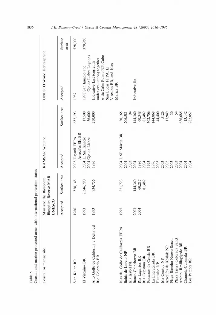
Mexico has 40 coastal and marine sites recognized by international protec-tion status, 32 of them with currently hold national protection status, 28 ofwhich correspond to Federal protected areas, three at the state level and oneprivate protected area belonging to an academic institution. Eight Ramsarsites currently do not hold national protection status. Thus 39.2% of thesurface area of federal coastal and marine protected areas is considered inMAB Biosphere Reserve system, 33.6% as RAMSAR Sites and 7.6% as WorldHeritage Sites (Table 5).

ARTICLE IN PRESS
Table 3
Comparison between coastal and marine protected areas territorial coverage and Mexico’s terrestrial and
marine surface areas
Mexico Total surface
area (km2)
Federal
protected
areas total
surface (km2)
% State
protected
areas total
surface (km2)
% Total
protected
areas total
surface (km2)
%
Terrestrial
(Total terrestrial
PAs including
coastal)
1,964,375 [11] 138,236 7.0 27,855 1.4 166,091 8.4
Coastal
(Total coastal
PAs)
1,964,375 [11] 82,161 4.2 2,560 0.1 84,721 4.3
Territorial Seaa
(Total marine
PAs)
209,000 [12] 35,775 17.1 2,562 1.2 38,337 18.3
Continental
platforma
(Total marine
PAs)
394,603 [13] 35,775 9.1 2,562 0.6 38,337 9.7
Exclusive
economic zone
(Total marine
PAs)
3,149,920 [11] 35,775 1.1 2,562 0.1 38,337 1.2
Total
(Total federal &
state PAs)
5,114,295 [11] 174,011 3.4 30,418 0.6 204,429 4.0
aExclusively for comparative purposes, since a small portions of the MPAs surface are located outside
the Territorial Sea or the Continental platform.
J.E. Bezaury-Creel / Ocean & Coastal Management 48 (2005) 1016–10461034
6. Management capacity for coastal and marine protected areas
Even though Mexico’s protected areas have existed for over a century, most ofthem kept a paper status until the last decade, where a quantum leap on theirconservation capacity was achieved. Professional personnel was assigned to theareas, participatory bodies to assist on their management were established,management plans were defined, legislation was updated and the budget assignedfor protected areas grew exponentially. The National Protected Area Commission(CONANP), who reports directly to the Environmental Minister (then toSEMARNAP now to SEMARNAT) was also created during this period.
6.1. Staffing protected areas
This change was detonated through an initially ill-conceived Global Environ-mental Facility grant that aspired to create and consolidate management capacity on

ARTICLE IN PRESS
Table 4
Federal management categories defined by the ecology law
National category Compatible activities IUCN
category
Sanctuary (Sanct.) Compatible research, recreation
and environmental education.
Ia
Biosphere reserve (BR) Core zone Preservation of ecosystems and
their elements, research,
environmental education.
Ia
Buffer zone Productive activities by the local
communities or with their
participation.
VI
National park (NP) Natural resources protection,
wildlife enhancement,
preservation of ecosystems and
their elements, research,
recreation, tourism and
environmental education.
Additionally, natural resources
use in marine zones.
II
Natural monument Preservation, research, recreation
and education.
III
Flora and fauna protection area
(FFPA)
Preservation, repopulation,
propagation, acclimatization,
refuge, research, sustainable use
of such species, education and
diffusion on these issues, Natural
resource use by local communities
or those that studies prove their
feasibility.
VI
Natural resources protection area Preservation, protection,
sustainable use of natural
resources, research, recreation,
tourism and environmental
education.
VI
J.E. Bezaury-Creel / Ocean & Coastal Management 48 (2005) 1016–1046 1035
10 areas, over an extremely short period of only 5 years, through an investment ofUS $25 Million from GEF and 8 million from the Mexican Government. This grantwas later redesigned and turned into a success story, when the Mexican ProtectedArea Fund was created with $16.48 Million from GEF funds which were left overafter the end of the 5 year period and a $5 million match. Nevertheless since 1993,funding from this project allowed for the hiring of a professional staff body,equipping the sites and paying operational expenses. By 1995 SEMARNAP throughthe Federal budget, directly hired a basic administrative body composed of 5 staffmembers for each of these 10 areas. By the year 2000, 52 administrative bodies hadbeen assembled covering a total of 60 protected areas, representing 45.5% of the 148protected areas currently with a legal instrument. Most of these also count with
ARTICLE IN PRESS
Table
5
Coastalandmarineprotected
areaswithinternationalprotectionstatus
Coastalormarinesite
ManandtheBiosphere
BiosphereReserveMAB-
UNESCO
RAMSAR
Wetland
UNESCO
WorldHeritageSite
Accepted
Surface
area
Accepted
Surface
area
Accepted
Surface
area
SianKa’anBR
1986
528,148
2003UaymilFFPA
Arrecifes
SK
BR
652,193
1987
528,000
ElVizcaınoBR
1993
2,546,790
2004L.Sn.Ignacio
17,500
1993SanIgnacioand
Ojo
deLiebre
Lagoons
370,950
2004Ojo
deLiebre
36,600
AltoGolfodeCalifornia
yDelta
del
Rıo
ColoradoBR
1993
934,756
1996
250,000
IndicativeList(currently
under
evaluation)together
with:CaboPulm
oNP,Cabo
SanLucasFFPA,El
VizcainoBR,andIslas
MarıasBR
Islasdel
GolfodeCalifornia
FFPA
1995
321,723
2004I.SPMartirBR
30,165
Bahıa
deLoreto
NP
2004
206,581
Isla
Isabel
NP
2003
94
Banco
ChinchorroBR
2003
144,360
2004
144,360
Indicativelist
Rıa
LagartosBR
2004
60,217
1986
60,348
Rıa
Celestum
BR
81,482
2004
81,482
PantanosdeCentlaBR
1995
302,706
LaEncrucijadaBR
1996
144,868
HuatulcoNP
2003
44,400
Isla
ContoyNP
2003
5126
Arrecifes
deXcalakNP
2003
17,949
PlayaRanchoNuevoSanct.
2003
30
PlayaTierraColoradaSanct.
2003
54
Archip.RevillagigedoBR
2004
636,685
Chamela-C
uixmala
BR
2004
13,142
LosPetenes
BR
2004
282,857
J.E. Bezaury-Creel / Ocean & Coastal Management 48 (2005) 1016–10461036

ARTICLE IN PRESS
LagunadeTerminosFFPA
2004
705,516
Yum
Balam
FFPA
2004
154,052
ArrecifedePto.M
orelosNP
2004
9066
Sist.Arrec.VeracruzanoNP
2004
52,238
PlayaVerdeCamachoSanct.
2004
6450
PlayaMexiquillo
Sanct.
2004
67
Dzilam
State
Reserve
2000
61,707
ElPalm
arState
Reserve
2003
50,177
Pla.X
’cacel-X’cacelito
ZSCE
2004
362
LaManchayElLlano(Private)
2004
1414
Total32protected
areas
7Areas
4,617,476
31Areas
3,968,189
2Areas
898,950
Marism
asNacionales
1995
200,000
LagunaMadre
2004
307,894
LagunaPlayaColorada—Sta.Marıa
2004
53,140
LagunaSontecomapan
2004
8921
IslasMarietas
2004
94
AcuitanTurtle
Beach
2004
65
ChenkanTurtle
Beach
2004
100
AlvaradoLagoonSystem
2004
267,010
Total32Areasw/noPA
status
8Areas
837,224
TotalMexico40areas
7Areas
4,617,476
39Areas
4,805,413
2Areas
898,950
No
te:Indicatedsurface
areasincludeonly
theamountregisteredforeach
category
ineach
area.
J.E. Bezaury-Creel / Ocean & Coastal Management 48 (2005) 1016–1046 1037

ARTICLE IN PRESS
Table 6
Personnel assigned to Mexican protected areas
1995 1996 1998 2000 2002
Personnel at the central offices 136 136 119 119 135
Personnel on site at protected areas 0 138 193 273 320
Total personnel for protected areas 136 274 312 392 455
Information provided by the Comision Nacional de Areas Naturales Protegidas—SEMARNAT.
J.E. Bezaury-Creel / Ocean & Coastal Management 48 (2005) 1016–10461038
additional staff, hired from funds derived from the federal budget or through theinterests produced by the Protected Area Fund, representing an average of over54,000 ha per person (Table 6).
Currently 33 coastal and marine protected areas are managed by 24 administrativebodies while 3 others operate through agreements with other government orinstitutions. This means that 64% of Mexico’s coastal and marine protected areasare being managed, representing 98.5% of their coastal surface area and 59% oftheir marine area. It is important to recognize that even after this tremendous growthrate, only very small areas such as Contoy or Isabel Islands, can be considered tofulfill their baseline staffing needs and adequate management requires furtherimportant increases in staff.
6.2. Financing protected areas
Total investment for protected areas is still hard to quantify. An analysisthat provides an estimate of overall investment from different sectors, over a 3 yearperiod (1997–1999) for 31 protected areas (only 9 of them coastal and marine)who were candidates for a second GEF protected area grant, estimated that a totalof US $43.7 million dollars were invested on these areas, averaging $469,000 perarea, 76% of them coming from national sources and 24% from foreign ones. Thepublic sector provided 61%, NGOs 13%, the private sector 11%, researchinstitutions 9.5% and the social sector 2.5% [14]. For comparison purposes,investment over a 4 year period (1998–2001) in four of the five coastal and marineprotected areas covered by the first GEF grant, estimate that a total of $6.9 millionswere invested, averaging $430,000 per area. The public sector provided43%, interests from the Protected Area Fund 26%, NGOs 13%, the privatesector 5%, multilaterals, bilaterals and the US Government 9% in this case and thesocial sector 4% [15].
The above mentioned Protected Area Fund is currently providing an average ofover US $100,000 dollars per year to five coastal and marine protected area units,which through their administrative body manage six other protected areas. A secondGEF grant that includes US $22.5 million in capital for the fund will cover 12 newprotected areas, five of them coastal and marine. When completed, both projects willprovide basic permanent financial coverage for 29% of Mexico’s coastal and marineprotected areas representing 49.5% of their surface area.

ARTICLE IN PRESS
J.E. Bezaury-Creel / Ocean & Coastal Management 48 (2005) 1016–1046 1039
During the last decade, federal investments for all protected areas increased fromUS $1.43 million in 1995 to $15.36 in 2000 [16]. In 2003 the National Protected AreaCommission’s initial budget of US $22.88 million [17] was increased by the end of theyear to $26.99 [18]. For 2004 an initial sum of US $22.57 was budgeted [18] and it isexpected to increase to US $35.2 million [19]. The Legislative branch has recentlysubmitted two Bills which are expected to significantly increase protected areasbudget for 2005. Currently 33 coastal and marine protected areas have been assigneda federal budget through 24 administrative bodies. This means that 64% of themreceive federal funds which can be invested to hire extra staff, acquire goods andservices, pay for communication costs and office rent and so on, representing 98.5 ofthe coastal protected area surface area and 56% of the marine surface. Notwithstanding this tremendous increment in funding, it is clear that it provides only aminimum operative base and is still insufficient to cover many pressing needs.
One important future source of financial resources is the authority granted in 2002to charge entrance fees in marine protected areas and recycle them for their operativeneeds. This authorization was based upon the National property status held bymarine areas and was expanded in 2003 to include certain specific activities that takeplace in coastal and terrestrial ecosystems. To date 20 coastal and marine protectedareas have received authorization from the fiscal authority (SHCP) to chargeentrance fees, and 14 of them, 13 marine (aprox. US $2 per visitor) and 1 coastal(aprox. US $1 per visitor), have already implemented the system for collecting andrecycling such fees. During 2002 approximately US $1.02 million were collected frommarine protected areas and for 2003 it increased to US $2.28 [19].
A great number of local, regional, national and international NGOs and researchinstitutions, support important activities within Mexican protected areas. Thesegroups provide funding for or directly execute scientific and technological researchand develop community development projects. One critically important componentof this support system has been capacity building for protected area management,which has been the focus of The Nature Conservancy’s (TNC) activities in Mexicanprotected areas for over 15 years. TNC work is carried out through partnershipswith national NGOs and the protected area administrative body. The Parks in Perilproject, a long term USAID funded project that concentrates on capacity building,has resulted in the definition and use of a wide array of site planning andmanagement tools, used in more than 14 Mexican coastal and marine protectedareas.
6.3. Public participation and protected area management plans
Participatory public planning processes have been incorporated into Mexicanfederal protected area governance, where most of their land surface portions areeither within a communal or private property regime. Participatory processes arealso required for their marine portions, in spite of the fact that all of Mexico’sMarine Zones are national property subject to federal jurisdiction due to thepresence of valid stakeholders utilizing natural resources within their boundaries.This has been achieved through the establishment of participatory consultative

ARTICLE IN PRESS
J.E. Bezaury-Creel / Ocean & Coastal Management 48 (2005) 1016–10461040
bodies at the national level and for each protected area. Their purpose is to assistprotected area establishment and management through a consensus buildingprocesses. Today the ‘‘National Protected Areas Council’’ provides input at thesystem level, while 41 of the 148 Mexican federal protected areas are supported by 44‘‘Advisory Councils’’ [20] covering 74% of their total surface area. Currently 29 ofthe 55 federal coastal and marine protected areas are supported by 25 AdvisoryCouncils [20] representing 84% of their surface area. Nevertheless it is important torecognize that these councils are still at an embryonic stage and as any otherdemocratic space created in Mexico, they will still require a long social capacitybuilding process towards their consolidation.
One of the most important functions the Advisory Councils have today is theirparticipation in the approval of their protected area ‘‘Management Plan’’. Currently19 federal coastal and marine protected areas, representing 35% out of 55 areas havean approved management plan which covers 57% of their total surface area.
6.4. Enforcement capacity in protected areas
Environmental law enforcement capacity is still at its infancy in Mexico. This isespecially true in coastal and marine habitats where access over very vast areas ishard to control. Enforcement responsibility falls within the jurisdiction of theEnvironmental Attorney (PROFEPA) within SEMARNAT. PROFEPA is in chargeof compliance of land use restrictions imposed through OETs and of protected arearegulations, attribution that CONANP’s staff has not been vested with. Thissituation further complicates enforcement activities in protected areas anddiminishes efficacy of on site staff that need to call upon PROFEPA’s Inspectors,who in turn have to bring if the situation requires them, firearm bearing municipal,state or federal authorities with law enforcement jurisdiction.
Notwithstanding the increased amount of resources and the developing capacityfor coastal and marine protected management, these areas still are far from achievingthe thresholds required for their minimum operational needs. Their planninginstruments still need to be improved and their participatory processes need to beexpanded and consolidated. Lack of enforcement capability is still a criticallyimportant issue that could be tackled more effectively with co-managementprocesses. These efforts should not only be sustained over a longer period of time,but also substantially increased. This situation would increase coastal and marineprotected role in the development of an ICM strategy for Mexico.
7. Towards a Mexican coastal and marine protected area system
It is evident that practically no individual protected area will be able to supportthe whole array of biodiversity that permanently or seasonally is present within it, ifsustainable management of those external spaces used by species populations orthose where physical or biological processes upon which they depend are notcontemplated. This reality has generated a diverse set of solutions such as: the

ARTICLE IN PRESS
J.E. Bezaury-Creel / Ocean & Coastal Management 48 (2005) 1016–1046 1041
establishment of biological corridors, the use of environmentally sound land use landplanning practices and the definition of functionally interconnected protected areasystems, that contemplate spatial movement of species, function complementarily intheir protected habitat diversity and include functional redundancy in case not all thesites can be effectively protected.
This situation becomes even more evident in marine habitats, where dispersal oflarvae, propagates or juveniles and their recruitment as reproductive adults,generally takes place over much larger geographical areas than terrestrial species.Mexico is now working on two regional designs for coastal and marine protectedarea networks, one for Mexico’s Caribbean Sea and the other one for the Gulf ofCalifornia and the Southern Californian Pacific Ocean.
The Mexican Caribbean protected area network is part of the MesoamericanCaribbean Coral Reef Initiative and a product of a 10 year ‘‘reef characterization’’project executed by Amigos de Sian Ka’an a local NGO. This network includes allpreviously established protected areas and three new ones with a total marine surfacearea of 56,868 ha: Arrecifes de Xaman-Ha (2 polygons: Pta Maroma 2024 ha andTulum 12,044 ha); Arrecifes de la Costa Maya (2 polygons: Uaymil 23,958 ha andMajahual 6028 ha); Arrecifes de Cozumel (2 polygons: North 11,109 ha and theexpansion of the existing polygon 1705 ha) [21].
Work is underway to define ‘‘Specially Important Areas for Coastal and MarineBiodiversity in the Gulf of California and the Baja Californian Pacific’’ [22] some ofwhich could potentially become protected areas. This project is based upon theresults of the ‘‘Workshop for the Definition of Conservation Priorities in the Gulf ofCalifornia’’ convened by the Coalition for the Gulf of California Sustainability inMay 2001. In this workshop over 180 regional, national and international experts,identified, analyzed and defined biologically important areas and their threats [23].Results from the ‘‘Marine conservation at a regional scale: developing a science-based network of marine reserves in the Gulf of California’’ project [24], that usedreef fish habitat as conservation targets and optimized the number and distributionof sites required for their protection [25], was incorporated into the portfolio.Resulting polygons were further refined excluding non-critical areas for biodiversitycurrently used by shrimp trawlers and specific fisheries regulations. Finally resultsfrom the meeting convened by the North America Commission for EnvironmentalCooperation to determine conservation priorities in the Baja to Bering region (B2B)were incorporated the portfolio in the Southern Californian Pacific Ocean.
The recently developed framework of ‘‘Marine Ecological Regions of NorthAmerica’’ [26], which provides a three level hierarchical system of classification, cannow be used as the base for developing comprehensive regional protected areanetworks, carry out gap analysis and provide the base for natural resource usereporting and monitoring within ecologically significant regions, rather than politicalboundaries. This framework will facilitate Mexico’s protected area systems design inthe Gulf of Mexico and the Pacific Ocean. Resulting portfolios should further refinegeneral areas identified through the workshops convened by the NationalCommission for the Understanding and Use of Biodiversity (CONABIO) to identify‘‘Priority Marine Regions of Mexico’’ [27].

ARTICLE IN PRESS
J.E. Bezaury-Creel / Ocean & Coastal Management 48 (2005) 1016–10461042
Deriving from the Programme of Work on Protected Areas, adopted in 2004 atthe 7th Conference of the Parties of the Convention on Biological Diversity, Mexicohas undertaken a protected area gap analysis within a partnership establishedbetween Governmental institutions (CONANP, CONABIO and the NationalInstitute of Ecology), international NGOs (CI, TNC and WWF) and nationalNGOs (Ducks Unlimited of Mexico, the Mexican Fund for Nature Conservationand PRONATURA) that will include coastal and marine Protected areas. CurrentlyTNC is leading the efforts in developing the Gulf of California and theMesoamerican Reef ecoregional plans.
With all these elements Mexico will be ready to define and plan in order to be ableto integrate a representative system of coastal and marine protected areas, capable ofprotecting its natural heritage and contributing to a global system.
8. Lessons learned
8.1. Operation of local and regional participatory coastal and ocean management
spaces
�
Developing intergovernmental and public participatory processes is not an easytask. About 20% of the workload takes place during the actual participatoryprocess meetings and 80% is invested in preparation and follow-up tasks thatprovides for the process credibility. Specific human and financial resources need tobe allocated for these tasks. � Existing environmental policy tools can be used to initiate ‘‘experiments’’ withintergovernmental and public participatory processes, which can later evolve intolegally established tools. Lack of specific instruments should not deter public andprivate stakeholder participation. It is better to begin working with available toolsand provide a legal framework after the process has been tested. With the publicsupport gained through the initial processes, giving legal definition to otherprograms should be much easier.
� Intergovernmental and public participatory processes should be kept focused andsimple in their infancy, both on the issues and the extent of the geographic spacesthey deal with. Visible urgent issues can become the training ground for longerterm vision issues. This is especially important in cultures where participation inpublic policy issues is new. Participatory capacity will be built faster by tacklingcommon issues across stakeholder groups (e.g. deal with fisheries separate fromtourism). Once these initial issues have been internally resolved they can bebrought together to a joint forum and modified if needed. By this timestakeholders from each side will have a clearer view of their own issues and willbe able to focus on the other side’s issues.
� Using on-site examples to demonstrate positive and negative impacts of regulatorymeasures can promote and enhance the participatory process.
� Public participation makes regulatory processes slower in the short term, but moredurable over the long term.

ARTICLE IN PRESS
J.E. Bezaury-Creel / Ocean & Coastal Management 48 (2005) 1016–1046 1043
8.2. Creation of protected area management capacity and enhancing social
participation
�
Protected area management capacity cannot be created overnight, through largeinfusion of funds, but rather requires sufficient time with enough resources tolearn, experiment and consolidate. � The presence of a basic staff body on the sites with basic operative funds is the firstand single most important step that needs to be taken. Local presence in turnbuilds local support.
� Local support creates credibility that can become an important platform forleveraging not only conservation related funding, but also non-conservationrelated funds from other governmental agencies, that can be used to further theprotected area objectives.
� No-take zones should only be established when the capacity to enforce andmonitor these areas exists. Community established no-take zones should initiallybe created with a modest scope to increase the factors for implementation success.Once No-take Zones have proved that they can provide a service to thecommunities, they can be expanded to encompass larger and more remote areas.
� Protected areas can facilitate the development of intergovernmental and publicparticipation processes because they provide manageable pilot projects with aspecific geographic scope and a defined set of conservation objectives.
9. In press update
On April and May 2005, five new Federal protected areas were established inMexico. One of them coastal (Laguna Madre y Delta del Rıo Bravo Flora andFauna Protection Area), two coastal and marine (Islas Marietas National Park andIsla Guadalupe, Biosphere Reserve), another exclusively marine (Archipielago SanLorenzo National Park) and one more strictly terrestrial (Bala0am K0aax Flora andFauna Protection Area).
This represents a new total of 153 Federal protected areas with updated legalstatus, occupying a total of 18,639,097 hectares. Thus the 59 coastal and marineprotected areas in Mexico currently with a valid legal decree, occupy 12,903,327 ha(4,089,998 ha marine and 8,813,329 ha coastal) which represents 69% of Mexico’stotal protected area surface (including 19.5% of Mexico’s Territorial Sea, 10.4% ofit’s Continental Platform and 1.3% of it’s Exclusive Economic Zone).
Acknowledgments
This article is an updated and expanded version of paper presented at CZ 2003/World Parks Congress—International Workshop, ‘‘Integrating Marine ProtectedArea Management with Coastal and Ocean Governance: Principles and Practices’’,convened by NOAA, IOC, WCPA-Marine, University of Delaware, University of

ARTICLE IN PRESS
J.E. Bezaury-Creel / Ocean & Coastal Management 48 (2005) 1016–10461044
Maryland, University of Rhode Island, National Estuarine Research ReserveAssociation, Coastal Zone 03, coastal States Organization, in Baltimore, Maryland,July 11–14, 2003.
This article is dedicated to Dr. Mario Lara Perez Soto, who passed away in hishouse in Puerto Morelos, Quintana Roo on July 8th, 2003, after a valiant fightagainst Lou Gering’s disease. May he continue exploring eternal coral reefs ofinfinity in peace.
The author wishes to thank Don Robadue for his invaluable suggestions and PamRubinnof, Joe Quiroz, and Rosario Alvarez for their support.
References
[1] SEMARNAT—Secretarıa de Medio Ambiente y Recursos Naturales. Ordenamieto Ecologico del
Territorio. Direccion General de Polıtica Ambiental e Integracion Regional Sectorial, Mexico DF,
2002. http://www.semarnat.gob.mx/dgpairs/oe, 06/20/02.
[2] INE—Instituto Nacional de Ecologıa—SEMARNAP. Estrategia Ambiental para la Gestion
Integrada de la Zona Costera de Mexico. Propuesta, Mexico DF, 2000.
[3] INE—Instituto Nacional de Ecologıa. Resumen de la Memoria Tecnica del Ordenamiento Ecologico
del Mar de Cortes. El Colegio de Mexico A.C., Universidad Autonoma de Baja California, 2003.
http://www.semarnat.gob.mx/dgpairs/mcortes/bases.shtml, 01/09/2003 .pdf file.
[4] CANAIPESCA—Camara Nacional de la Industria Pesquera, Delegacion Sonora/Union de
Pesqueras de Guaymas. Amenazan la Pesca en el Golfo de California. Insercion pagada Reforma,
El Imparcial, La Voz del Puerto, 12/05/2003.
[5] SEMARNAT—Secretarıa de Medio Ambiente y Recursos Naturales. Golfo de California.
Integracion de Resultados Direccion General de Polıtica Ambiental e Integracion Regional Sectorial.
Mexico DF, 2003. http://www.semarnat.gob.mx/dgpairs/mcortes/pubir.shtml 01/09/2003.
[6] SEMARNAT. Convenio marco de coordinacion para la instrumentacion del proceso tendiente a la
formulacion, la expedicion y la ejecucion del Programa de Ordenamiento Ecologico Marino del Golfo
de California, que suscriben las Secretarıas de Gobernacion, de Marina, de Medio Ambiente y
Recursos Naturales, de Agricultura, Ganaderıa, Desarrollo Rural, Pesca y Alimentacion, de
Comunicaciones y Transportes y de Turismo, con la participacion de los Ejecutivos de los estados
libres y soberanos de Baja California, Baja California Sur, Nayarit, Sinaloa y Sonora, 2004.
[7] SEMARNAT. Acuerdo de cooperacion para la instrumentacion de un proceso de Ordenamiento
Ecologico Costero Terrestre en la region del Golfo de California con el fin de asegurar el desarrollo
sustentable de la region, que suscriben por una parte los Ejecutivos de los estados libres y soberanos
de Baja California, Baja California Sur, Nayarit, Sinaloa y Sonora y por la otra parte el poder
ejecutivo de la union, por conducto de las Secretarıas de Medio Ambiente y Recursos Naturales
asistido en este acto por el Subsecretario de Planeacion y Polıtica Ambiental, de Agricultura,
Ganaderıa, Desarrollo Rural, Pesca asistido por el Comisionado Nacional de Pesca y Acuacultura y
de Turismo, con la participacion del Presidente de los Estados Unidos Mexicanos, en calidad de
testigo de honor, 2004.
[8] Bezaury-Creel J, Lopez-Santos C, McCann J, Molina C, Rubinoff P, Goddard T, Robadue D, Hale
L. Participatory coastal and marine management in Quintana Roo, Mexico. In: Dight I, Kenchington
R, Baldwing J, editors. Proceedings of the International Tropical Marine Ecosystems Management
Symposium (ITMEMS), Townsville, Qld. Australia, November, 1998, Great Barrier Reef Marine
Park Authority, p. 163–171. 452pp. http://www.gbrmpa.gov.au/corp_site/info_services/publications/
itmems/pdf/itmems_163-171_s03_3.pdf.
[9] Villalba A, Robadue D. Just in time: conservation and development strategy for Santa Maria Bay.
Intercoast 42. Fall 2002. Focus on Decentralization. Narragansett: Coastal Resources Center,
University of Rhode Island; 2002.

ARTICLE IN PRESS
J.E. Bezaury-Creel / Ocean & Coastal Management 48 (2005) 1016–1046 1045
[10] Modified from: CONANP—Comision Nacional de Areas Naturales Protegidas. Unpublished. Base
de datos—Superficie de las areas naturales protegidas federales y su correspondencia con las
categorıas de la UICN, 2003.
[11] INEGI—Instituto Nacional de Geografıa y Estadıstica. Informacion Geografica/Datos basicos/
Extension, fronteras, litorales y Zona Economica Exclusiva, 2003. http://www.inegi.gob.mx/difusion/
espanol/figdatb.html.
[12] INEGI—Instituto Nacional de Geografıa y Estadıstica. Datos Basicos de la Geografıa de Mexico,
1991. p. 27.
[13] Cifuentes-Lemus JL, Torres-Garcıa P, Frıas-Mondragon M. El Oceano y sus Recursos, Volumen
IX—La Pesca, Segunda Reimpresion 1995. Coleccion Ciencia para Todos, Fondo de Cultura
Economica, S. A. de C.V., Mexico, 1989.
[14] Perez Gil-Salcido R, Jaramillo-Monroy F. Informe Final Sobre la Consultarıa Relativa al
Financiamiento y Consecucion de Apoyos y Fondos en Areas Naturales Protegidas de Mexico—
Estudio de Caso para 31 areas selectas, PG-7 Consultores S.C.Y FAUNAM A.C Primera Version y
Presentacion Powerpoint, Octubre de 1999.
[15] CTFANP—Consejo Tecnico del Fondo de Areas Naturales Protegidas. Minuta de la Reunion de
abril del 2001, Mexico DF, 2001. (Note: 1998, 1999 and 2000 data represent expenditures and 2001
budgeted expenses.)
[16] SEMARNAP—Secretarıa de Medio Ambiente Recursos Naturales y Pesca. Balance del Programa
Nacional de Areas Naturales Protegidas 1995–2000, Secretarıa de Medio Ambiente Recursos
Naturales y Pesca, Mexico DF, 2000. p. 34. (Exchange rate: 1995—Mex $7.68/US $1.00, 2000—
$9.57/US $1.00).
[17] CONANP—Comision Nacional de Areas Naturales Protegidas. III Aniversario—Logros 2003
Comision Nacional de Areas Naturales Protegidas. Mexico DF, 2003. (Exchange rate: 2003—Mex
$11.20/US $1.00).
[18] SEMARNAT. Programas Estrategicos y Presupuesto Secretarıa de Medio Ambiente y Recursos
Naturales, Ejercicio Fiscal 2004, Enero 2004. Acrobat Reader, 2004. 9p. (Exchange rate: 2003—Mex
$11.20/US $1.00, 2004—Mex $11.53/US $1.00).
[19] CONANP—Comision Nacional de Areas Naturales Protegidas. IV Aniversario. Comision Nacional
de Areas Naturales Protegidas. Mexico DF, 2004. (Exchange rate: 2002—Mex $10.22/US $1.00,
2003—Mex $11.20/US $1.00, 2004—Mex $11.53/US $1.00).
[20] CONANP—Comision Nacional de Areas Naturales Protegidas. Unpublished. Base de datos-
Consejos de Planeacion de las areas naturales protegidas federales, 2003.
[21] Bezaury-Creel J, Macias Ordonez R (Bibliographic revision), Garcıa Beltran G, Castillo Arenas G,
Pardo Caicedo N, Ibarra Navarro R, Loreto Viruel A. Implementation of the International Coral
Reef Initiative (ICRI) in Mexico, Commission for Environmental Cooperation (CEC), in The
International Coral Reef Initiative—The Status of Coral Reefs in Mexico and the United States Gulf
of Mexico, Compact Disk, Amigos de Sian Ka’an A.C., CINVESTAV, NOAA, CEC, The Nature
Conservancy, 1997. http://www.nmfs.noaa.gov/prot_res/PR/fpweb/icri/home.htm.
[22] Bezaury-Creel JE, Parra I, Sala E. Areas de Especial Importancia para la Conservacion de la
Biodiversidad Costera y Marina del Golfo de California y el Pacıfico BajaCaliforniano, in
preparation.
[23] Coalicion para la Sustentabilidad del Golfo de California. Productos del Taller para el
establecimiento de prioridades de conservacion de la biodiversidad del Golfo de California. Mexico,
2001. (Compact Disk).
[24] Sala E, Aburto O, Paredes G, Dayton P, Parra I, Barrera JC. Marine conservation at a regional scale:
developing a science-based network of marine reserves in the Gulf of California. Project Report—
WWF, 2002.
[25] Sala E, Aburto-Oropeza O, Paredes G, Parra I, Barrera JC, Dayton PK. A General Model for
Designing Networks of Marine Reserves. Science 2002;298:1991–3.
[26] Wilkinson T, Bezaury-Creel J, Gutierrez F, Hourigan T, Lisa Janishevski, Madden C, Padilla M,
Wiken E. Marine Ecological Regions of North America Commission for Environmental
Cooperation, in preparation.

ARTICLE IN PRESS
J.E. Bezaury-Creel / Ocean & Coastal Management 48 (2005) 1016–10461046
[27] Arriaga-Cabrera E, Vazques-Domınguez L, Gonzalez-Cano J, Jımenez-Rosemberg R, Munoz-Lopez
E, Aguilar-Sierra V (Coords.). Regiones Prioritarias Marinas de Mexico. Comision Nacional para el
Conocimiento y Uso de la Biodiversidad, Mexico, 1998.
Further Reading
[1] Bezaury-Creel JE. El papel de las organizaciones civiles nacionales e internacionales en la proteccion
de los oceanos. en Rodrıguez M.C., C. Hernandez (compiladores), Oceanos Fuente inagotable de
Recursos? Memorias de la VII Reunion Anual del Programa Universitario del Medio Ambiente.
PUMA-UNAM, SEMARNAP, 1999. (p. 281–305) 589pp.
[2] Bezaury-Creel JE. El Papel de las Organizaciones no Gubernamentales y la Participacion Social en la
Conservacion de los Arrecifes Coralinos en Mexico. Memorias de la Reunion Arrecifes Coralinos,
Riqueza Marina Amenazada. UNAM—Programa Universitario de Medio Ambiente, SEMARNAP-
Procuradurıa Federal de Proteccion al Ambiente, Instituto Nacional de Pesca, Comision Nacional
para el Conocimiento y uso de la Biodiversidad CONABIO, Disco Compacto, 1999.
[3] Bezaury-Creel J. Mitigating the Effects of Coastal Development on the Sian Ka’an Biosphere Reserve:
A Case Example from Mexico. MPAs News, 2002;4(2):5.
[4] Bezaury-Creel J. Land and Sea Use Planning and Protected Areas as Regional Instruments for
Sustainability. Paper presented at the V World Parks Congress. WCPA–IUCN. Workshop Stream
4-Developing the Capacity to Manage PA. Durban, South Africa, 2003.
[5] Bezaury-Creel JE. Las Areas Naturales Protegidas Costeras y Marinas de Mexico. In: Rivera-Arriaga
E, Villalobos-Zapata G, Rosado-May F, Azuz-Adeath I, editors. El Manejo Costero en Mexico, Parte
III Proteccion de la Zona Costera, Universidad Autonoma de Campeche, SEMARNAT, CETYS-
Universidad, Universidad de Quintana Roo. 654 p. 2004.