international journal of architectural research
TRANSCRIPT
Vo
lum
e (
11)
- Is
sue
(3)
- N
ove
mb
er
2017
Archnet-IJAR is published and archived by ARCHNET, the most comprehen-sive online community for architects, planners, urban designers, interior de-signers, landscape architects, and scholars working in these fields, developed at the MIT Libraries-Aga Khan Documentation Center, MIT School of Archi-tecture and Planning in close cooperation with, and with the full support of The Aga Khan Trust for Culture, an agency of the Aga Khan Development Network.
ArchitecturePlanning Built Environment Studies
Chief EditorAshraf M. Salama
Collaborating EditorFarzad Pour Rahimian
Special Issue
Architectural and Urban Heritage in the Digital Era
Guest EditorMohamed Gamal Abdelmonem
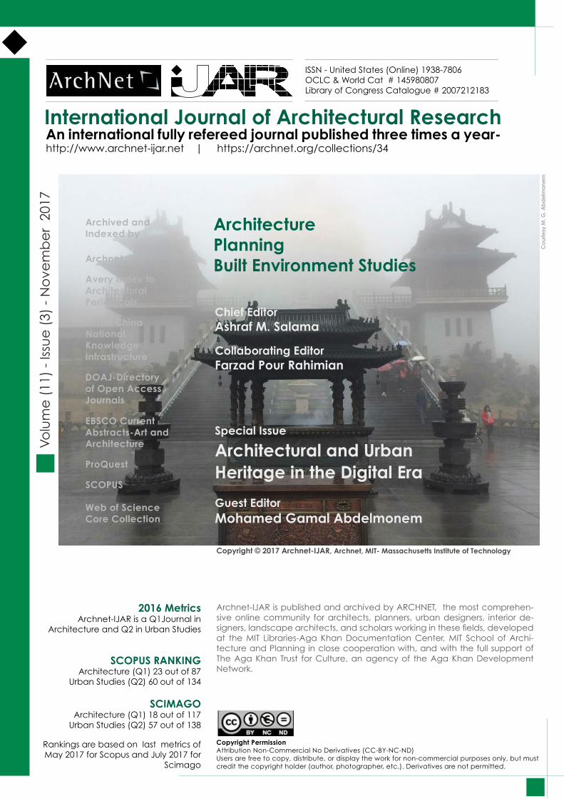
Copyright © 2017 Archnet-IJAR, Archnet, MIT- Massachusetts Institute of Technology C
ourte
sy M
. G. A
bd
elm
onem
Archived and Indexed by
Archnet
Avery Index to Architectural Periodicals
CNKI: China National Knowledge Infrastructure
DOAJ-Directory of Open Access Journals
EBSCO Current Abstracts-Art and Architecture
ProQuest
SCOPUS
Web of Science Core Collection
Copyright PermissionAttribution Non-Commercial No Derivatives (CC-BY-NC-ND) Users are free to copy, distribute, or display the work for non-commercial purposes only, but must credit the copyright holder (author, photographer, etc.). Derivatives are not permitted.
2016 MetricsArchnet-IJAR is a Q1Journal in
Architecture and Q2 in Urban Studies
SCOPUS RANKING Architecture (Q1) 23 out of 87
Urban Studies (Q2) 60 out of 134
SCIMAGO Architecture (Q1) 18 out of 117
Urban Studies (Q2) 57 out of 138
Rankings are based on last metrics of May 2017 for Scopus and July 2017 for
Scimago
International Journal of Architectural Research An international fully refereed journal published three times a year-http://www.archnet-ijar.net | https://archnet.org/collections/34
ISSN - United States (Online) 1938-7806OCLC & World Cat # 145980807Library of Congress Catalogue # 2007212183
All contributors granted Massachusetts Institute of Technology (“MIT”) worldwide rights and permission to reproduce, distribute, publicly display, and publicly perform the following Work in electronic format on the ArchNet Internet web site at URL http://archnet.org.
Views, opinions, and research results are the responsibility of the contributors.Images and figures are provided by the contributors.
ArchitecturePlanning Built Environment Studies
Copyright © 2017 Archnet-IJAR, Archnet, MIT- Massachusetts Institute of Technology
Archnet-IJAR is published and archived by ARCHNET, the most comprehen-sive online community for architects, planners, urban designers, interior de-signers, landscape architects, and scholars working in these fields, developed at the MIT Libraries-Aga Khan Documentation Center, MIT School of Archi-tecture and Planning in close cooperation with, and with the full support of The Aga Khan Trust for Culture, an agency of the Aga Khan Development Network.
Volume (11) - Issue (3) - November 2017
Copyright PermissionAttribution Non-Commercial No Derivatives (CC-BY-NC-ND) Users are free to copy, distribute, or display the work for non-commercial purposes only, but must credit the copyright holder (author, photographer, etc.). Derivatives are not permitted.
International Journal of Architectural Research An international fully refereed journal published three times a year-http://www.archnet-ijar.net | https://archnet.org/collections/34
ISSN - United States (Online) 1938-7806OCLC & World Cat # 145980807Library of Congress Catalogue # 2007212183
Archived and Indexed by
Archnet
Avery Index to Architectural Periodicals
CNKI: China National Knowledge Infrastructure
DOAJ-Directory of Open Access Journals
EBSCO Current Abstracts-Art and Architecture
ProQuest
SCOPUS
Web of Science Core Collection
Chief EditorAshraf M. Salama
Collaborating EditorFarzad Pour Rahimian
Special Issue
Architectural and Urban Heritage in the Digital EraGuest EditorMohamed Gamal Abdelmonem
Advisory BoardAshraf M. Salama, Attilio Petruccioli, Besim S. Hakim, Chimay Anumba, Derya Oktay, Hashim Sarkis, Henry Sanoff, Jack Steven Goulding, Jamel Akbar, Michael J. Crosbie, Mohammad Al-Asad, Nasser O Rabbat, Nezar AlSayyad, Nicholas Wilkinson, Nikos A. Salingaros, Peter G Rowe, Rahinah Ibrahim, Suha Ozkan, Tomasz Arciszewski
Editorial BoardAhad Nejad Ebrahimi, Ahmed Elseragy, Amar Bennadji, Amira Elnokaly, Beatriz C. Maturana, Branka Dimitrijevic, Budi Adelar Sukada, Chengzhi Peng, David Grierson, Dalila El Kerdany, Do-natella Mazzoleni, Ebru Cubukcu, Eman El-Nachar, Fahriye Hilal Halicioglu, Farzad Pour Rahimian, Florian Wiemann, Fuad Mallick, Hans Sagan, Georgia LindsayHisham Elkadi, Hülya Turgut, Ihab Elzeyadi, James Benedict Brown, Karim Hadjri, Kheir M Al-Kodmany, Magda Sibley, Mallika Bose, Mashary Alnaim, Mi Jeong Kim, Mirjana Lozanovska, Mohamed Gamal Abdelmonem, Nada Al Nafea, Nisha A. Fernando, Norsi-dah Ujang, Pantoleon D. Skayannis, Peter Kellett, Phillippa Car-nemolla, Rabee Reffat, Remah Y. Gharib, Samer Bagaeen, Smita Khan.
Copyright © 2017 Archnet-IJAR, Archnet, MIT- Massachusetts Institute of Technology
International Journal of Architectural Research
ArchitecturePlanning Built Environment Studies
An international fully refereed journal published three times a year-http://www.archnet-ijar.net | https://archnet.org/collections/34
ISSN - United States (Online) 1938-7806OCLC & World Cat # 145980807Library of Congress Catalogue # 2007212183
Volume (11) - Issue (3) - November 2017
Chief EditorAshraf M. Salama
Collaborating EditorFarzad Pour Rahimian
Special Issue
Architectural and Urban Heritage in the Digital EraGuest EditorMohamed Gamal Abdelmonem
ArchNet-IJAR is an interdisciplinary scholarly open access journal of architecture, planning, and built environment studies. The journal aims at establishing a bridge between theory and practice in the fields of architectural and design research, and urban planning and built environment studies.
ArchNet-IJAR is indexed and listed in several databases, including:
Avery Index to Architectural Periodicals EBSCO-Current Abstracts-Art and Architecture CNKI: China National Knowledge Infrastructure Directory of Open Access Journals Pro-Quest Scopus-Elsevier Web of Science Core Collection of Clarivate Analytics (formerly Thomson Reuters) Many university library databases
ArchNet-IJAR is also archived by ArchNet, the most comprehensive online community for architects, planners, urban designers, interior designers, landscape architects, and scholars working in these fields, developed at the MIT School of Architecture and Planning in close cooperation with, and with the support of The Aga Khan Trust for Culture, an agency of the Aga Khan Development Network.
ArchNet-IJAR was established in 2007 and is led by the Chief Editor Professor Dr. Ashraf M. Salama with support from co-editor: Dr. Farzad Pour Rahimian. Two international boards (advisory and editorial) ensure the quality of scholarly papers and allow for a comprehensive academic review of contributions spanning a wide spectrum of disciplinary issues, methods, and practices.
Focus and ScopeArchNet-IJAR ObjectivesArchNet-IJAR objective is to establish a bridge between theory and practice in the fields of architectural and design research, urban planning, and built environment studies. It reports on the latest research findings and innovative approaches for creating responsive environments, with special focus on architecture and planning in developing countries. ArchNet-IJAR is truly international and aims at strengthening ties between scholars from different parts of the world with contributors and readers reaching across geography, boundaries, and cultures.
ArchNet-IJAR publishes research studies, criticisms and critical analyses about the creation, use, and evaluation of different types of environments at the macro and micro scales. The journal includes original empirical research papers, analytical case studies, and high quality position papers that contribute to the advancement of knowledge in architecture and urbanism.
Four major areas are covered by ArchNet-IJAR:
Architectural and Design Research Topics include –but not limited to: architectural pedagogy and design studio teaching practices; architectural and sustainable design; design methods and architectural theories; architectural criticism; design and project programming; environment-behavior studies;
Copyright © 2017 Archnet-IJAR, Archnet, MIT- Massachusetts Institute of Technology
International Journal of Architectural Research An international fully refereed journal published three times a year-http://www.archnet-ijar.net | https://archnet.org/collections/34
ISSN - United States (Online) 1938-7806OCLC & World Cat # 145980807Library of Congress Catalogue # 2007212183
information technology; Islamic architecture; computer applications and virtual environments; post occupancy and facility performance evaluation; and social and cultural factors in design.
Urban and Built Environment Studies Topics include --but not limited to: administrative and political factors contributing to the shaping of communities, cities and urban regions, community planning; sustainable urban conservation; environmental planning and eco development; housing policy, planning, and design; new urbanism; everyday urbanism; sustainable development; space syntax and GIS applications; and way-finding and signage systems.
Critical Essays on Architectural and Planning Projects Essays that cover the above topics; critically discussing projects in use; after they have been designed, built and occupied. Articles are preferred to utilize the case study approach as a critical method in built environment research.
Reviews and Trigger ArticlesIn this section, non-refereed, thought provoking articles are published while book reviews, conference announcements of interest to ArchNet-IJAR readers are outlined and summarized including critical reviews of recent books. The intention of this section is to give room for more voices so that the debate goes beyond pure academic writing. Therefore, this section represents a means of rapidly disseminating innovative ideas or lessons learned from experience and practice. However, while following the same graphical format, submissions are reviewed by the chief editor and interested board members principally on the basis of usefulness and interest to ArchNet-IJAR readers. However, the section is not necessarily a regular section and it will be available based on the quality of submissions received.
Notes to Contributors
Publication Ethics - MalpracticeArchNet-IJAR: International Journal of Architectural Research is committed to adopting and implementing the highest standards of publication ethics and takes all possible measures against any publication malpractices. Contributors submitting their works to the ArchNet-IJAR for publication as original articles attest that the submitted works represent their actual contributions and have not been copied or plagiarized in whole or in part from other works. By submission of manuscripts to the chief editor, the authors acknowledge that they have disclosed all and any actual or potential conflicts of interest with their work or partial benefits associated with it.
ArchNet-IJAR: International Journal of Architectural Research is committed to objective and fair double-blind peer-review of the submitted contributions for publication and to preventing any actual or potential conflict of interests between the editorial and review personnel and the reviewed material.
Papers are reviewed based on the following criteria:
1. Originality: Does the paper contain new and/or significant information adequate to justify publication?
2. Relationship to Seminal Literature: Does the paper demonstrate an adequate understanding of the relevant literature in the field and cite an appropriate range of literature sources? Is any significant work ignored?
Copyright © 2017 Archnet-IJAR, Archnet, MIT- Massachusetts Institute of Technology
International Journal of Architectural Research An international fully refereed journal published three times a year-http://www.archnet-ijar.net | https://archnet.org/collections/34
ISSN - United States (Online) 1938-7806OCLC & World Cat # 145980807Library of Congress Catalogue # 2007212183
3. Research Methodology: Is the paper’s argument built on an appropriate base of theory, concepts, or other ideas? Has the research or equivalent intellectual work on which the paper is based been well designed? Are the methods employed, robust, defendable and appropriate?
4. Results: Are results presented clearly and analysed appropriately? Do the conclusions adequately tie together all elements of the paper?
5. Interpretation, Implications for research, practice and/or society: Does the paper identify clearly any implications for research, practice and/or society? Does the paper bridge the gap between theory and practice? How can the research be used in practice (economic and commercial impact), in teaching, to influence public policy, in research (contributing to the body of knowledge)? What is the impact upon society (influencing public attitudes, affecting quality of life)? Are these implications consistent with the findings and conclusions of the paper?
6. Quality of Communication: Does the paper clearly express its case, measured against the technical language of the field and the expected knowledge of the journal’s readership? Has attention been paid to the clarity of expression and readability, such as sentence structure, jargon use, acronyms, etc. Do the figures/tables aid the clarity of the paper?
Publication FrequencyArchNet-IJAR is published three times a year, in March, July, and November. An archive of all previous issues can be found here:http://archnet-ijar.net/index.php/IJAR/issue/archive
ArchivingAn archive of all previous issues with downloadable articles in PDF format is available here: http://archnet-ijar.net/index.php/IJAR/issue/archive
ArchNet-IJAR utilizes the LOCKSS system to create a distributed archiving system among participating libraries and permits those libraries to create permanent archives of the journal for purposes of preservation and restoration. More... ArchNet-IJAR Registration and Indexing
ArchNet-IJAR ISSN - United States (Online) 1938-7806
The journal was first registered in the following portals:
- OCLC & World Cat (Online Computer Library Center and World Catalogue) # 145980807- Library of Congress Catalogue, LOC # 2007212183
Established in 2007, ArchNet-IJAR is an Open Access interdisciplinary scholarly peer reviewed journal of architecture, planning, and built environment studies, published on the World Wide Web three times a year.
ArchNet-IJAR is indexed and listed in several databases, including: Avery Index to Architectural Periodicals EBSCO-Current Abstracts-Art and Architecture CNKI: China National Knowledge Infrastructure
Copyright © 2017 Archnet-IJAR, Archnet, MIT- Massachusetts Institute of Technology
International Journal of Architectural Research An international fully refereed journal published three times a year-http://www.archnet-ijar.net | https://archnet.org/collections/34
ISSN - United States (Online) 1938-7806OCLC & World Cat # 145980807Library of Congress Catalogue # 2007212183
Directory of Open Access Journals Pro-Quest Scopus-Elsevier Web of Science Core Collection of Clarivate Analytics (formerly Thomson Reuters) Many university library databases
ArchNet-IJAR: Editors, International Advisory and Review Boards
ArchNet-IJAR is led by the Chief Editor Professor Ashraf M. Salama. The journal is co-editor: Dr. Farzad Pour Rahimian.• For more information, visit this page: http://archnet-ijar.net/index.php/IJAR/about/editorialTeam
ArchNet-IJAR has two international boards; advisory and editorial. The range of knowledge and expertise of the boards members ensures high quality scholarly papers and allows for a comprehensive academic review of contributions that span wide spectrum of issues, methods, theoretical approach and architectural and development practices.
• For more infromation on the International Advisory Board, visit this link: http://archnet-ijar.net/index.php/IJAR/about/displayMembership/5• For more infromation on the International Review Board, visit this link:http://archnet-ijar.net/index.php/IJAR/about/displayMembership/6 ArchNet-IJAR: Authors and Readers
ArchNet-IJAR Authors ArchNet-IJAR articles come from architects, interior designers, planners, and landscape architects, and from those working in these fields in academic institutions, universities, research centers, government agencies, and professional practice. For more information, visit the authors page: http://archnet-ijar.net/index.php/IJAR/information/authors
ArchNet-IJAR Readers ArchNet-IJAR addresses academics, practitioners, and students of architecture, planning and interior design. It addresses those who are interested in developing their understanding and enhancing their knowledge about how environments are designed, created, and used in physical, social, cultural, economic, and aesthetic terms. Archnet-IJAR content keeps readers up-to-date on the latest ideas, designs, and developments in built environment related fields. For more information, visit the readers’ page: http://archnet-ijar.net/index.php/IJAR/information/readers
Author Guidelines
Registration and login are required to submit items online and to check the status of current submissions.
Two submission files are requested: one is in Microsoft Word or RTF document file format that includes author names and the other is in PDF format without the author names. A representative image of the paper should be uploaded as a supplementary file during the initial submission of
Copyright © 2017 Archnet-IJAR, Archnet, MIT- Massachusetts Institute of Technology
International Journal of Architectural Research An international fully refereed journal published three times a year-http://www.archnet-ijar.net | https://archnet.org/collections/34
ISSN - United States (Online) 1938-7806OCLC & World Cat # 145980807Library of Congress Catalogue # 2007212183
the paper. The image is of high quality and hiigh resolution in JPEG or TIFF formats.
Following the IJAR Template, submissions should adhere to the formatting and requirements listed. Submissions may be returned to authors or rejected based on their technical and academic qualities and also based on adherence to the requirements.
Book Reviews and NotesA book review should normally run between 700-1200 words, which gives scope for an assessment of the book and its contribution to knowledge and debate within the broad field of architecture, planning and design. Reviews should be typed following the IJAR Template, and should be submitted with a JPEG/TIFF image of the cover. The heading should include the title, author, origin, publisher, date, number of pages, price and ISBN number. Name, affiliation and address (e-mail) of reviewer should be provided.
Submission Preparation ChecklistAs part of the submission process, authors are required to check off their submission’s compliance with all of the following items, and submissions may be returned to authors that do not adhere to these guidelines.
1. The submission has not been previously published, nor is it before another journal for consideration (or an explanation has been provided in Comments to the Editor).2. The main submission file is in OpenOffice, Microsoft Word, RTF, or WordPerfect document file format. Please note that the manuscript should be formatted using the IJAR Template. Please make sure that you download the IJAR Template and cut and paste your content as unformatted text into our template.3. The text adheres to the stylistic and bibliographic requirements outlined in the Author Guidelines, which is found in About the Journal.4. If submitting to a peer-reviewed section of the journal, the instructions in Ensuring a Blind Review have been followed.
Copyright NoticeAuthors must manage reproduction rights to any third party. The submission of an article to ArchNet-IJAR implies that the author(s) certifies that neither the article nor any portion of it is copyrighted by a third party. It is expected that all submissions are original and have not been published before, and are not currently under review for any journal or conference. However, papers previously presented at conferences can be submitted for possible publication provided that a written permission from the conference organizers is submitted before publishing.
View points and responsibilities on opinions submitted are the sole responsibility of the author.
All contributors retain copyright of their article and should sign a copyright permission form in which they indicate that they have granted Massachusetts Institute of Technology (MIT) non-exclusive worldwide rights and permission to reproduce, distribute, publicly display, and publicly perform their work in electronic format on ArchNet Internet web site at URL http://www.archnet.org and on this site http://www.archnet-ijar.net/index.php/IJAR/index
Contributors should submit a signed copyright permission form when the final revised version of their papers are accepted. Copyright permission forms can be downloaded from this link. IJAR
Copyright © 2017 Archnet-IJAR, Archnet, MIT- Massachusetts Institute of Technology
International Journal of Architectural Research An international fully refereed journal published three times a year-http://www.archnet-ijar.net | https://archnet.org/collections/34
ISSN - United States (Online) 1938-7806OCLC & World Cat # 145980807Library of Congress Catalogue # 2007212183
editorial team will inform contributors whose paper are accepted when and how to send the signed copyright permission form prior to publishing.
Starting from Volume 4 Issue 1, articles are licensed under the Creative Commons license BY-NC-ND (attribution, non-commerical, no derivatives). A “CC-BY-NC-ND” license means that users are free to copy, distribute, and display your work for non-commercial purposes only, but they must credit the copyright holder (author, photographer, etc.). Derivatives are not permitted. For more information about the CC-BY--NC-ND license, see the Creative Commons web site http://creativecommons.org/licenses/by-nc-nd/3.0/
Privacy StatementThe names and email addresses entered in ArchNet-IJAR site will be used exclusively for the stated purposes of this journal and will not be made available for any other purpose or to any other party.
Copyright © 2017 Archnet-IJAR, Archnet, MIT- Massachusetts Institute of Technology
International Journal of Architectural Research An international fully refereed journal published three times a year-http://www.archnet-ijar.net | https://archnet.org/collections/34
ISSN - United States (Online) 1938-7806OCLC & World Cat # 145980807Library of Congress Catalogue # 2007212183
Contents
Original Research Articles
ARCHITECTURAL AND URBAN HERITAGE IN THE DIGITAL AGE: DILEMMAS OF AUTHENTICITY, ORIGINALITY AND REPRODUCTION (05/15)Mohamed Gamal AbdelmonemDOI: http://dx.doi.org/10.26687/archnet-ijar.v11i3.1415
SMART CITIES AND HERITAGE CONSERVATION: DEVELOPING A SMARTHERITAGE AGENDA FOR SUSTAINABLE INCLUSIVE COMMUNITIES (16/27)Patrizia RigantiDOI: http://dx.doi.org/10.26687/archnet-ijar.v11i3.1398
VIRTUAL PLATFORMS FOR HERITAGE PRESERVATION IN THE MIDDLE EAST: THE CASE OF MEDIEVAL CAIRO (28/41)Mohamed Gamal Abdelmonem, Gehan Selim, Sabah Mushatat, Abdulaziz AlmogrenDOI: http://dx.doi.org/10.26687/archnet-ijar.v11i3.1404
VIRTUAL WOLVERHAMPTON: RECREATING THE HISTORIC CITY IN VIRTUAL REALITY (42/57)Eleanor RamseyDOI: http://dx.doi.org/10.26687/archnet-ijar.v11i3.1395
A VIRTUAL OASIS: TRAFALGAR SQUARE’S ARCH OF PALMYRA (58/77)Stuart BurchDOI: http://dx.doi.org/10.26687/archnet-ijar.v11i3.1401
VIRTUAL REALITY AND THE ISLAMIC WATER SYSTEM IN CAIRO: CHALLENGES AND METHODS (78/93)Mohamed Soliman DOI: http://dx.doi.org/10.26687/archnet-ijar.v11i3.1386
VIRTUAL REALITY: TOWARDS PRESERVING ALEXANDRIA HERITAGE BY RAISING THE AWARENESS OF THE LOCALS (94/108)Heba AggourDOI: http://dx.doi.org/10.26687/archnet-ijar.v11i3.1390
ACHILLES AS A MARKETING TOOL FOR VIRTUAL HERITAGE APPLICATIONS (109/118)Mohamed Nabil ArafaDOI: http://dx.doi.org/10.26687/archnet-ijar.v11i3.1385
Volume (11) - Issue (3) - November 2017
Copyright © 2017 Archnet-IJAR, Archnet, MIT- Massachusetts Institute of Technology
International Journal of Architectural Research An international fully refereed journal published three times a year-http://www.archnet-ijar.net | https://archnet.org/collections/34
ISSN - United States (Online) 1938-7806OCLC & World Cat # 145980807Library of Congress Catalogue # 2007212183

Contents
SUSTAINED LIVEABILITY: A FRAMEWORK BEYOND ENERGY CONSCIOUS BUILDING CONSERVATION OF MARKET HALLS (119/131)Neveen Hamza, Dalila ElKerdany, John Pendlebury, Sahar Imam, Aliaa AlSadaty, Tamer ElSerafiDOI: http://dx.doi.org/10.26687/archnet-ijar.v11i3.1381
TALENT MANAGEMENT: A NOVEL APPROACH FOR DEVELOPING INNOVATIVE SOLUTIONS TOWARDS HERITAGE COMMUNITIES DEVELOPMENT (132/145)Mohamed Khalil, Heba Elsaay, Ayman OthmanDOI: http://dx.doi.org/10.26687/archnet-ijar.v11i3.1400
CONTESTED HERITAGE: AN ANALYSIS OF THE PHYSICAL TRANSFORMATION OF DERRY/LONDONDERRY’S SIEGE MONUMENT (146/162)Gehan Selim, Mohamed Gamal Abdelmonem, Sabah Mushatat, Abdulaziz AlmogrenDOI: http://dx.doi.org/10.26687/archnet-ijar.v11i3.1407
WALKABILITY IN HISTORIC URBAN SPACES: TESTING THE SAFETY AND SECURITY IN MARTYRS’ SQUARE IN TRIPOLI (163/177)Khairi M. A. Abdulla, Mohamed Gamal Abdelmonem, Gehan SelimDOI: http://dx.doi.org/10.26687/archnet-ijar.v11i3.1378
MODERNIST ARCHITECTURE, CONFLICT, HERITAGE AND RESILIENCE: THE CASE OF THE HISTORICAL MUSEUM OF BOSNIA AND HERZEGOVINA (178/192)Selma Harrington, Branka Dimitrijevic, Ashraf M. SalamaDOI: http://dx.doi.org/10.26687/archnet-ijar.v11i3.1330
ORNAMENTAL ART AND SYMBOLISM: ACTIVATORS OF HISTORICAL REGENERATION FOR KAZAKHSTAN’S LANDSCAPE ARCHITECTURE (193/213)Akmaral Yussupova*, Liu Songfu, Ardasher Namazbay, Farzad Pour Rahimian, Ahad Nejad Ebrahimi DOI: http://dx.doi.org/10.26687/archnet-ijar.v11i3.1358
EVALUATION OF AUTHENTICITY ON THE BASIS OF THE NARA GRID IN ADAPTIVE REUSE OF MANOCHEHRI HISTORICAL HOUSE KASHAN, IRAN (214/230)Parastoo Eshrati, Somayeh Fadaei Nezhad Bahramjerdi, Samaneh Eftekhari Mahabadi, Mitra Azad DOI: http://dx.doi.org/10.26687/archnet-ijar.v11i3.1276
Volume (11) - Issue (3) - November 2017
International Journal of Architectural Research An international fully refereed journal published three times a year-http://www.archnet-ijar.net | https://archnet.org/collections/34
ISSN - United States (Online) 1938-7806OCLC & World Cat # 145980807Library of Congress Catalogue # 2007212183
Contents
Review Articles
BOOK REVIEW: UNIFIED ARCHITECTURAL THEORY: FORM, LANGUAGE, COMPLEXITY, NIKOS A. SALINGAROS (231/236)Farzad Pour RahimianDOI: http://dx.doi.org/10.26687/archnet-ijar.v11i3.1394
BOOK REVIEW: COMPLEX HOUSING. DESIGNING FOR DENSITY, JULIA WILLIAMS ROBINSON (237/240)Ombretta Romice DOI: http://dx.doi.org/10.26687/archnet-ijar.v11i3.1412
Volume (11) - Issue (3) - November 2017
International Journal of Architectural Research An international fully refereed journal published three times a year-http://www.archnet-ijar.net | https://archnet.org/collections/34
ISSN - United States (Online) 1938-7806OCLC & World Cat # 145980807Library of Congress Catalogue # 2007212183
Mohamed Gamal Abdelmonem Archnet-IJAR, Volume 11 - Issue 3 - November 2017 - (5-15) – Regular Section
Copyright © 2017 | Copyrights are granted to author(s), Archnet-IJAR, and Archnet @ MIT under the terms of the "CC-BY-NC-ND" License.
5
Archnet-IJAR: International Journal of Architectural Research www.archnet-ijar.net/ -- https://archnet.org/collections/34
ARCHITECTURAL AND URBAN HERITAGE IN THE DIGITAL AGE: DILEMMAS OF AUTHENTICITY, ORIGINALITY AND REPRODUCTION DOI: http://dx.doi.org/10.26687/archnet-ijar.v11i3.1415
Guest Editor: Mohamed Gamal Abdelmonem
Keywords Abstract
architectural history; urban heritage; heritage preservation; digital archaeology; visualisation; historic buildings.
The archaeology of our built heritage is centred on the understanding of human experiences, rituals and social history that add meaningful narratives to physical fabric, structures and artefacts. The meaning of the building in the collective memory is intrinsically attached to the process by which it was produced and the manner with which it endured a series of critical socio-cultural change. Whilst we cannot live in the past, engaging with historic buildings or walking through traditional urban fabric and alleyways becomes an essential asset of the contemporary urban experience. This paper interrogates the dilemmas of authenticity, originality and legitimacy of the preservation of architectural and urban heritage through digital and virtual technologies. It addresses examples of historic buildings that have changed character, functions or got destroyed during times of wars and conflict. With advanced techniques of recording historic buildings through digital and virtual environments taking a leading role in modern preservation, integrating architectural heritage into the creative economy and income generating activities is critical to their survival in the digital age.
M. G. Abdelmonem*, M. G. Abdelmonem, Chair in Architecture, Nottingham Trent University, City Campus, Nottingham NG1 4FQ, UK.
*Corresponding Author’s email address: [email protected]
ArchNet-IJAR is indexed and listed in several databases, including: • Avery Index to Architectural
Periodicals • EBSCO-Current Abstracts-Art
and Architecture • CNKI: China National
Knowledge Infrastructure • DOAJ: Directory of Open
Access Journals • Pro-Quest • Scopus-Elsevier • Web of Science
International Journal of Architectural Research Mohamed Gamal Abdelmonem
Archnet-IJAR, Volume 11 - Issue 3 - November 2017 - (5-15) – Regular Section
Copyright © 2017 | Copyrights are granted to author(s), Archnet-IJAR, and Archnet @ MIT under the terms of the "CC-BY-NC-ND" License.
6
INTRODUCTION: ARCHITECTURAL AND URBAN HERITAGE: WHY DO WE CARE
‘The reality and reliability of the human world rests primarily on the fact that we are surrounded by things more permanent than the activity by which they were produced.’
Hanna Arendt (1958), The Human Condition.
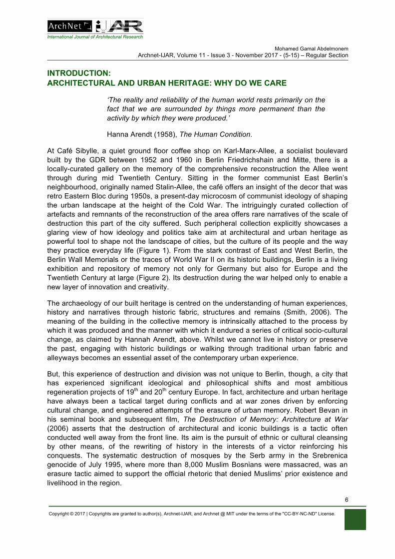
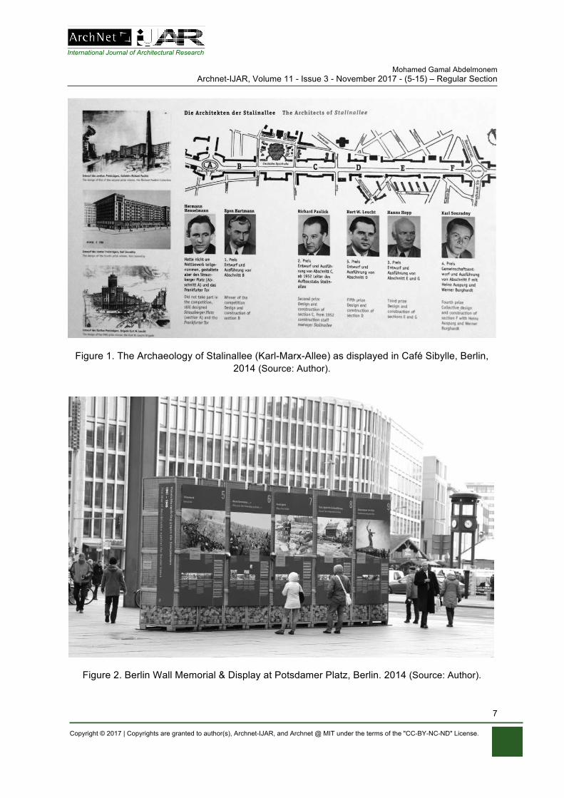
At Café Sibylle, a quiet ground floor coffee shop on Karl-Marx-Allee, a socialist boulevard built by the GDR between 1952 and 1960 in Berlin Friedrichshain and Mitte, there is a locally-curated gallery on the memory of the comprehensive reconstruction the Allee went through during mid Twentieth Century. Sitting in the former communist East Berlin’s neighbourhood, originally named Stalin-Allee, the café offers an insight of the decor that was retro Eastern Bloc during 1950s, a present-day microcosm of communist ideology of shaping the urban landscape at the height of the Cold War. The intriguingly curated collection of artefacts and remnants of the reconstruction of the area offers rare narratives of the scale of destruction this part of the city suffered. Such peripheral collection explicitly showcases a glaring view of how ideology and politics take aim at architectural and urban heritage as powerful tool to shape not the landscape of cities, but the culture of its people and the way they practice everyday life (Figure 1). From the stark contrast of East and West Berlin, the Berlin Wall Memorials or the traces of World War II on its historic buildings, Berlin is a living exhibition and repository of memory not only for Germany but also for Europe and the Twentieth Century at large (Figure 2). Its destruction during the war helped only to enable a new layer of innovation and creativity.
The archaeology of our built heritage is centred on the understanding of human experiences, history and narratives through historic fabric, structures and remains (Smith, 2006). The meaning of the building in the collective memory is intrinsically attached to the process by which it was produced and the manner with which it endured a series of critical socio-cultural change, as claimed by Hannah Arendt, above. Whilst we cannot live in history or preserve the past, engaging with historic buildings or walking through traditional urban fabric and alleyways becomes an essential asset of the contemporary urban experience.
But, this experience of destruction and division was not unique to Berlin, though, a city that has experienced significant ideological and philosophical shifts and most ambitious regeneration projects of 19th and 20th century Europe. In fact, architecture and urban heritage have always been a tactical target during conflicts and at war zones driven by enforcing cultural change, and engineered attempts of the erasure of urban memory. Robert Bevan in his seminal book and subsequent film, The Destruction of Memory: Architecture at War (2006) asserts that the destruction of architectural and iconic buildings is a tactic often conducted well away from the front line. Its aim is the pursuit of ethnic or cultural cleansing by other means, of the rewriting of history in the interests of a victor reinforcing his conquests. The systematic destruction of mosques by the Serb army in the Srebrenica genocide of July 1995, where more than 8,000 Muslim Bosnians were massacred, was an erasure tactic aimed to support the official rhetoric that denied Muslims’ prior existence and livelihood in the region.
International Journal of Architectural Research Mohamed Gamal Abdelmonem
Archnet-IJAR, Volume 11 - Issue 3 - November 2017 - (5-15) – Regular Section
Copyright © 2017 | Copyrights are granted to author(s), Archnet-IJAR, and Archnet @ MIT under the terms of the "CC-BY-NC-ND" License.
7
Figure 1. The Archaeology of Stalinallee (Karl-Marx-Allee) as displayed in Café Sibylle, Berlin, 2014 (Source: Author).
Figure 2. Berlin Wall Memorial & Display at Potsdamer Platz, Berlin. 2014 (Source: Author).
International Journal of Architectural Research Mohamed Gamal Abdelmonem
Archnet-IJAR, Volume 11 - Issue 3 - November 2017 - (5-15) – Regular Section
Copyright © 2017 | Copyrights are granted to author(s), Archnet-IJAR, and Archnet @ MIT under the terms of the "CC-BY-NC-ND" License.
8
Urban Heritage, on the other hand, could have negative connotations to the past. Madanipour (2010) argued that the spatial manifestation of social polarisation is evident in physical inequalities of an urban space that was inherited across centuries; where preferential or strict accessibility is its most obvious form (Madanipour, 2010). Peace line walls as well as insular communities in Derry/Londonderry highlight the impact of insular forms of urban heritage to provoke imaginable fear about the other community and reducing the desire for intercommunity engagement (Goldie and Brid, 2010; Gaffikin, 2008). The peace lines and gates between communities are the most powerful tools of division, by the very fact of their existence. Such mysterious embodiments of memory within buildings and spaces where bad events took place, however, cannot magically embody memories by virtue of their existence, without continuous and sustainable performance of acts, rituals and normative social behaviour (Abdelmonem, 2016). When attached to buildings and/or structures, myths become powerful tools of collective memory of the group (Connerton, 1989). By their very existence in the physical fabric, buildings of a horrible past become signifiers of the present and to a large extent determine future attitudes. Architecture in that sense becomes the most durable part of this fabric through objects of remembrance, but is paradoxical and contested when it engages with collective memory (Kuechler and Forty, 1999). By the same token, the preservation of architectural and urban heritage is a practice and investment in cultural survival. (Holod, 1980) In such context, architecture takes on a totemic quality: a mosque, a synagogue or a church are no more religious buildings than targets to its enemies, when a community is marked for erasure of its memory. Muslims have taken over a Christian church to build the Great Mosque of Cordoba in Spain (8th – 10th Centuries) by the Umayyads, which was subsequently converted back into a Catholic Cathedral by King Charles V in 1523 (Khan, 2015). Similarly, Constantine’s Hagia Sophia Basilica in Istanbul was built in 360 CE and used as a church until it was converted into a mosque in 1453 until today. Politicians have long acknowledged that the built heritage has far much value and meaning than its very existence as physical traces. It is the fabric of everyday life. As preservation, conservation as well as destruction are essentially political endeavour, architectural and urban heritage remains that inevitable cache of cultural memory of society that legitimises its existence (Bevan, 2006). Hence places of meanings, especially those with relevance to tolerance and multiculturalism remain high targets for oblivion with deliberate intent during acts of wars, religious extremism and ethnic conflicts (Kamel-Ahmed, 2015). Recent deliberate destruction of Buddhas of Bamiyan in Afghanistan in 2001, (dated back to 6th) or Palmyra Arch in Syria by Islamic State (2015), aimed at cultural, religious symbols and heritage sites designed to alter the historical narratives of the region and make it more difficult to validate for future generations (Khan, 2015).
PRESERVING ARCHITECTURAL HERITAGE IN THE DIGITAL AGE
'It is impossible, as impossible as to raise the dead, to restore anything that has ever been great or beautiful in architecture'.
John Ruskin (1849), The Seven Lamps of Architecture
In his manifesto for the preservation of architectural heritage, John Ruskin, 19th Century pioneering theorist, underlined the difference between restoration and repair as two distinct processes. He believed nothing from the present should disturb the remnants of the past and
International Journal of Architectural Research Mohamed Gamal Abdelmonem
Archnet-IJAR, Volume 11 - Issue 3 - November 2017 - (5-15) – Regular Section
Copyright © 2017 | Copyrights are granted to author(s), Archnet-IJAR, and Archnet @ MIT under the terms of the "CC-BY-NC-ND" License.
9
that a building is born, lives and then, dies. For him, originality must be sought as the sole identity of the building with real layers of its fabric as it ages. The craft of preservation and repair of building is like surgical intervention in which the original must remain distinct (Ruskin, 1849). Following decades of architectural malpractice towards architectural heritage during the Twentieth Century, successful interventions and design projects over the past decade have returned to Ruskin’s principles of authenticity and originality. From David Chipperfield’s Neues Museum to Norman Foster’s Reichstag Building Renovation, British architects have been able to introduce modern interventions that contribute rather than violate the authenticity of the past (Foster, 2000; Shcultz, 2000; Nezhad et al 2015). While the former has inclined to keep the traces and holes of WWII bomb shells and bullets clearly visible on the entrance hall columns, allowing the building’s own heritage of destruction to be integrated into the new design of newly constructed brick walls and timber roof, the latter’s Glass Dome over the Reichstag did not make any attempt to hide or replace the story behind the original structure. Both projects resemble how narratives of architectural heritage can shape modern and contemporary practice that in return shapes our present-day memories and identity. Conservation, in this sense, is equally about the collective knowledge of societies, their origins and habits that are learned through remnants of buildings and objects (Abdullahi & Embi, 2015). With conservation comes long-term planning of occupancy, maintenance and feasibility for the long term economic planning. European conservation policies developed the belief that a vacant property is detrimental to the vitality of town centres and if not carefully planned or made economically feasible, there are more likely to grow derelict and negatively impact its surrounding environment. Conserving heritage, hence, is no longer a technical process by which architects, archaeologists and engineers embark on the mission of repairing or restoring historic artefacts, buildings of spaces. Heritage buildings must be part of active and successful business and income-generating environment that keeps buildings occupied, functional and subsequently well maintained by its own occupants, owners or enterprises. European legislations have indicated repeatedly the essential need for social capital and economic return to be part of heritage conservation projects. But, as we have seen over the past few years, iconic heritage is increasingly threatened by terror, climate change, rampant commercialisation, and overexploitation by tourism; and in some cases, by significant disinvestment. Lack of responsible planning, maintenance and preservation strategies have equally caused unmitigated dereliction and irreversible damage to many heritage sites in the developing world. In many instances, heritage sites have become either inaccessible to tourists or visitors, due to security risks, others are isolated in remote locations that is hard to reach. New modes of preservation and engagement with heritage have become essential. With the increasing rate of destruction of heritage sites, such as Palmyra in Syria, digital preservation of historic artefacts and cultural heritage has become an international priority (Denker, 2016). Strategies, practices and technologies that can protect and sustain these places in other forms of reproduction such as digital modelling, immersive virtual and augmented reality, cinematography and Audio-visual archives have been key aspects of cultural heritage preservation effort over the past decade. As digital archaeology has evolved during 1980s and 1990s, it was only during 2000s when all recorded data about architectural and urban history of our cities have been effectively process used to produce 3D models, manual or computer generated, allowing public users from having access to visible and reproduced models in electronic and online format.
International Journal of Architectural Research Mohamed Gamal Abdelmonem
Archnet-IJAR, Volume 11 - Issue 3 - November 2017 - (5-15) – Regular Section
Copyright © 2017 | Copyrights are granted to author(s), Archnet-IJAR, and Archnet @ MIT under the terms of the "CC-BY-NC-ND" License.
10
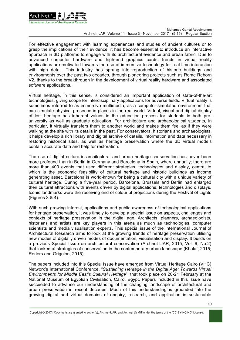
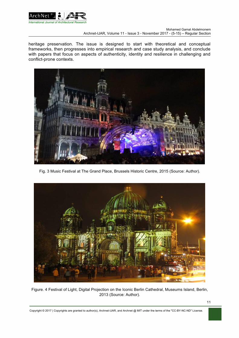
For effective engagement with learning experiences and studies of ancient cultures or to grasp the implications of their evidence, it has become essential to introduce an interactive approach in 3D platforms to engage with its architectural evidence and urban fabric. Due to advanced computer hardware and high-end graphics cards, trends in virtual reality applications are motivated towards the use of immersive technology for real-time interaction with high detail. This industry has sprung into reproduction of historic buildings and environments over the past two decades, through pioneering projects such as Rome Reborn V2, thanks to the breakthrough in the development of virtual reality hardware and associated software applications. Virtual heritage, in this sense, is considered an important application of state-of-the-art technologies, giving scope for interdisciplinary applications for adverse fields. Virtual reality is sometimes referred to as immersive multimedia, as a computer-simulated environment that can simulate physical presence in places in the real world. Virtual, visual and digital display of lost heritage has inherent values in the education process for students in both pre-university as well as graduate education. For architecture and archaeological students, in particular, it virtually transfers them to another world and makes them feel as if they were walking at the site with its details in the past. For conservators, historians and archaeologists, it helps develop a rich library and digital archive of details, information and data necessary in restoring historical sites, as well as heritage preservation where the 3D virtual models contain accurate data and help for restoration. The use of digital culture in architectural and urban heritage conservation has never been more profound than in Berlin in Germany and Barcelona in Spain, where annually; there are more than 400 events that used different strategies, technologies and display, central to which is the economic feasibility of cultural heritage and historic buildings as income generating asset. Barcelona is world-known for being a cultural city with a unique variety of cultural heritage. During a five-year period, Barcelona, Brussels and Berlin had enlarged their cultural attractions with events driven by digital applications, technologies and displays. Iconic landmarks were the receiving end of colourful projections during the Festival of Lights (Figures 3 & 4). With such growing interest, applications and public awareness of technological applications for heritage preservation, it was timely to develop a special issue on aspects, challenges and contexts of heritage preservation in the digital age. Architects, planners, archaeologists, historians and artists are key players in this arena as much as technologies, computer scientists and media visualisation experts. This special issue of the International Journal of Architectural Research aims to look at the growing trends of heritage preservation utilising new modes of digitally driven modes of documentation, visualisation and display. It builds on a previous Special Issue on architectural conservation (Archnet-IJAR, 2015, Vol. 9, No.2) that looked at strategies of conservation in the contemporary urban landscape (Khalaf, 2015; Roders and Grigolon, 2015). The papers included into this Special Issue have emerged from Virtual Heritage Cairo (VHC) Network’s International Conference, “Sustaining Heritage in the Digital Age: Towards Virtual Environments for Middle East’s Cultural Heritage”, that took place on 20-21 February at the National Museum of Egyptian Civilisation, Cairo, Egypt. Papers included in this issue have succeeded to advance our understanding of the changing landscape of architectural and urban preservation in recent decades. Much of this understanding is grounded into the growing digital and virtual domains of enquiry, research, and application in sustainable
International Journal of Architectural Research Mohamed Gamal Abdelmonem
Archnet-IJAR, Volume 11 - Issue 3 - November 2017 - (5-15) – Regular Section
Copyright © 2017 | Copyrights are granted to author(s), Archnet-IJAR, and Archnet @ MIT under the terms of the "CC-BY-NC-ND" License.
11
heritage preservation. The issue is designed to start with theoretical and conceptual frameworks, then progresses into empirical research and case study analysis, and conclude with papers that focus on aspects of authenticity, identity and resilience in challenging and conflict-prone contexts.
Fig. 3 Music Festival at The Grand Place, Brussels Historic Centre, 2015 (Source: Author).
Figure. 4 Festival of Light, Digital Projection on the Iconic Berlin Cathedral, Museums Island, Berlin, 2013 (Source: Author).
International Journal of Architectural Research Mohamed Gamal Abdelmonem
Archnet-IJAR, Volume 11 - Issue 3 - November 2017 - (5-15) – Regular Section
Copyright © 2017 | Copyrights are granted to author(s), Archnet-IJAR, and Archnet @ MIT under the terms of the "CC-BY-NC-ND" License.
12
The Special Issue starts with Patrizia Riganti’s paper, “Smart Cities and Heritage Conservation: Developing a Smartheritage Agenda for Sustainable Inclusive Communities” (Riganti, 2017), that discusses advancements in Information Communication Technologies (ICT) for cultural heritage preservation highlighting the potential of virtual environments to assess the impacts of heritage policies on urban development while using virtual globes and crowdsourcing to support the participatory valuation and management of cultural heritage assets. My co-authored paper: “Virtual Platforms for Heritage Preservation in the Middle East: The Case of Medieval Cairo” (Abdelmonem et al, 2017), reports on a research process to investigate and incorporate a cultural-feed into digital platforms of Virtual Heritage. It analyses current practices and projects of the virtual heritage technologies and reports on fieldwork that took place in Islamic Cairo with Five Start-Up entrepreneurs. Mohamed Khalil’s paper, “Talent Management as a Novel Approach for Developing Innovative Solutions for Egyptian Heritage Communities Development” (Khalil et al, 2017), on the other hand, interrogates aspects of intangible heritage such as stories, memories and traditions of people. The paper aims to investigate the role of Talent Management (TM) as a novel approach for developing innovative solutions for Egyptian heritage communities’ development.
Beyond the theoretical discourse and conceptual frameworks, other papers have tackled practical, yet novel solutions to document, preserve and engage with historic buildings and traditional urban fabric. Stuart Burch’s paper, “A Virtual Oasis: Trafalgar Square’s Arch of Palmyra” (Burch, 2017), interrogates the destruction of the Arch of Palmyra in Syria in 2015 and its temporary reconstruction a year later in London’s Trafalgar Square. It scrutinizes the processes involved in the artistic production of public memorials and art’s commemorative function. In their paper: “Sustained Liveability: A framework beyond energy-conscious Building Conservation of Market Halls ”Neveen Hamza and colleagues argue that sustainable conservation goes beyond a physical characteristics of building fabric conservation or the addition of renewable energy resources (Hamza et al, 2017). They postulate and validate the notion that market halls offer the chance to enable the markets to become sustainable local economies that are creative and inventive. Such inventive handling of heritage was pushed even further in Eleanor Ramsey’s paper, “Virtual Wolverhampton: Recreating the Historic City in Virtual Reality” (Ramsey, 2017). According to Ramsey, heritage buildings are part of a dynamic and changing environment, and their place within their original landscape is not always visible. Hence, she discusses a project based on Wolverhampton that aims to create immersive and 360° experiences of the historic city that allows the user or viewer to explore how the city might have been in the past from a ‘first person’ perspective. Gehan Selim’s paper on “Contested Heritage: an analysis of the physical transformation of Derry/Londonderry’s siege monument” (Selim et al, 2017), has analysed the socio-cultural impact of built form and physical segregation infused by religious conflict. Selim’s work offers an understanding of the spatial relationships between enclaves and the siege monument during key moments of conflict and political change in Northern Ireland. Mohamed Soliman’s paper: “Virtual Reality and the Islamic Water System in Cairo: Challenges and Methods” (Soliman, 2017), analysed tangibles and intangibles of the water system using the virtual reality application. These historic processes by which the Muslim Rulers in Egypt have used to attract attention to water projects have been used to develop efficient water systems. Khairi Abdulla’s Paper, “Walkability in Historic Urban Spaces: Testing the Safety and Security in Martyrs’ Square in Tripoli” (Abdulla et al, 2017),

International Journal of Architectural Research Mohamed Gamal Abdelmonem
Archnet-IJAR, Volume 11 - Issue 3 - November 2017 - (5-15) – Regular Section
Copyright © 2017 | Copyrights are granted to author(s), Archnet-IJAR, and Archnet @ MIT under the terms of the "CC-BY-NC-ND" License.
13
investigates the effectiveness of “walkability” in traditional Libyan urban spaces and analyses the relationship between walking, safety and security environment and its impacts on heritage site of Tripoli city centre. Heba Aggour’s paper entitled “Virtual Reality: Towards Preserving Alexandria Heritage by Raising Awareness of the Locals” (Aggour, 2017), analyses the growing destruction of historic buildings to accommodate the new high-rise residential buildings done by the construction investment firms. Mohamed Nabil Arafa’s Paper, “ACHILLES as a Marketing Tool for Virtual Heritage Applications” (Arafa, 2017), focus on Virtual Reality technology as a powerful tool to communicate architectural and urban heritage, values stranger visitors and tourists. The need for tourism to become virtual becomes more urgent than ever before.
In addition to the above papers, the Special Issue includes a distinct group of papers that offer insights into the impact of socio-cultural and political contexts on the identity and characteristics of architectural heritage. The papers address unique contexts and societies in Bosnia and Herzegovina, Iran, and Kazakhstan. These papers have allowed this issue to be more global in coverage and diverse in content. In their paper, “Modernist Architecture, Conflict, Heritage and Resilience: The Case of the Historical Museum of Bosnia and Herzegovina” Selma Harrington et al, 2017 introduced a research into symbiotic elements of architecture and public function of the Museum of Bosnia and the impact of conflict on its survival, resilience and continuity of use (Harrington et al, 2017). Akmaral Yussupova’s paper on “Ornamental Art and Symbolism: Activators of Historical Regeneration for Kazakhstan’s Landscape Architecture” (Yussupova et al, 2017), explores different ways of implementing symbolic ornaments in landscape architecture. It collects historical information on the semiotics of Kazakh ornaments and presents outcomes of field studies that place emphasis on the cultural tradition of the native people in Eurasia. Finally, Parastoo Eshrati’s paper, “Evaluation of Authenticity on the Basis of the Nara Grid in Adaptive Reuse of Manochehri Historical House Kashan, Iran” (Eshrati et al, 2017), investigates authenticity in the adaptive reuse of Manouchehri House in Kashan and also interrogates the shifts from top-down to a bottom-up approach in the field of cultural heritage. The depth and breadth of the discussions within the papers of this issue demonstrate various possibilities for Sustaining Heritage in the Digital Age with a focus on the greater Middle East. In essence, they offer insights toward advanced understandings of the ever-changing landscape of contemporary architectural and urban heritages. While the majority of the contributions react to the growing digital and virtual domains of enquiry, research, and application in sustainable heritage preservation, issues relevant to authenticity, meaning, symbolism, identity, sustainability, and resilience remain integral components for future discourse on heritage conservation and preservation.
REFERENCES Abdelmonem, M. G. (2016). The Architecture of Home in Cairo: Socio-spatial Practice of the
Hawari Everyday Life. London: Routledge. Abdelmonem, M. G.; Selim, G.; Mushatat, S.; Almogren, A. (2017). Virtual Platforms for
Heritage Preservation in the Middle East: The Case of Medieval Cairo. International Journal of Architectural Research: ArchNet-IJAR, 11(3), 28-41.
Abdulla, K. M. A.; Abdelmonem, M. G.; Selim, G. (2017). Walkability in Historic Urban Spaces: Testing the Safety and Security in Martyrs’ Square in Tripoli. International Journal of Architectural Research: ArchNet-IJAR, 11(3), 163-177.
International Journal of Architectural Research Mohamed Gamal Abdelmonem
Archnet-IJAR, Volume 11 - Issue 3 - November 2017 - (5-15) – Regular Section
Copyright © 2017 | Copyrights are granted to author(s), Archnet-IJAR, and Archnet @ MIT under the terms of the "CC-BY-NC-ND" License.
14
Abdullahi, Y., Embi, M. R. (2015). Evolution of Abstract Vegetal Ornaments in Islamic Architecture. International Journal of Architectural Research: ArchNet-IJAR 9(1):31-49
Addison, A. C. (2000). Emerging trends in virtual heritage. IEEE multimedia, 7 (2), 22-25. Aggour, H. (2017). Virtual Reality: Towards Preserving Alexandria Heritage by Raising
Awareness of the Locals. International Journal of Architectural Research: ArchNet-IJAR, 11(3), 94-108.
Arafa, M. N. (2017). ACHILLES as a Marketing Tool for Virtual Heritage Applications. International Journal of Architectural Research: ArchNet-IJAR, 11(3), 109-118.
Arendt, H. (1958). The Human Condition. Chicago: University of Chicago Press. Burch, S. (2017). A Virtual Oasis: Trafalgar Square’s Arch of Palmyra. International Journal of Architectural Research: ArchNet-IJAR, 11(3), 58-77.
Connerton, P. (1989). How societies remember. Cambridge: Cambridge University Press. Eshrati, P.; Bahramjerdi, S. F. N.; Mahabadi, S. E.; Azad, M. (2017). Evaluation of
Authenticity on the Basis of the Nara Grid in Adaptive Reuse of Manochehri Historical House Kashan, Iran. International Journal of Architectural Research: ArchNet-IJAR, 11(3), 214-230.
Foster, N. (2000). Rebuilding The Reichstag. London: Weidenfeld & Nicolson. Gaffikin, F., McEldowney, M., Rafferty, G., Sterret, K. (2008). Public Space for a Shared
Belfast. Belfast: Belfast City Council. Goldie, R., Brid, R. (2010). Crossing the Line: Key Features of effective practice in the
development of shared space in areas close to an interface. Belfast: Belfast Interface Project.
Hamza, N.; ElKerdany, D.; Pendlebury, J.; Imam, S.; AlSadaty, A.; Elserafi, T. (2017). Sustained Liveability: A Framework Beyond Energy-Conscious Building Conservation of Market Halls. International Journal of Architectural Research: ArchNet-IJAR, 11(3), 119-131.
Harrington, S.; Dimitrijević, B.; Salama, A. M. (2017). Modernist Architecture, Conflict, Heritage and Resilience: The Case of the Historical Museum of Bosnia and Herzegovina. International Journal of Architectural Research: ArchNet-IJAR, 11(3), 178-192.
Holod, R. (1980). Conservation as Cultural Survival (Ed.). Philadelphia: Aga Khan Award for Architecture.
Kamel-Ahmed, E. (2015). What to conserve?: Heritage, memory, and management of meanings. International Journal of Architectural Research: Archnet-IJAR, 9(1): 67-76.
Khalaf, R. (2015). The Reconciliation of Heritage Conservation and Development: The Success of Criteria in Guiding the Design and Assessment of Contemporary Interventions in Historic Places. International Journal of Architectural Research: ArchNet-IJAR, 9(1), 77-92.
Khalil, M.; Elsaay, H.; and Othman, A. (2017). Talent Management as a Novel Approach for Developing Innovative Solutions for Egyptian Heritage Communities Development. International Journal of Architectural Research: ArchNet-IJAR, 11(3), 132-145.
Khan, H. U. (2015). Architectural Conservations as a Tool for Cultural Continuity: A Focus on the Built Environment of Islam. International Journal of Architectural Research: Archnet-IJAR, 9(1), 01-17.
Kuechler, S., Forty, A. (1999). The Art of Forgetting. Berg: Oxford. Madanipour, A. (2010). Marginal public spaces in European cities. Journal of Urban Design
9(3), pp. 267-286. Nezhad S. F., Eshrati, P., Eshrati, D. (2015). A definition of authenticity concept in
conservation of cultural landscapes. International Journal of Architectural Research: ArchNet-IJAR, 9(1):93–107.
International Journal of Architectural Research Mohamed Gamal Abdelmonem
Archnet-IJAR, Volume 11 - Issue 3 - November 2017 - (5-15) – Regular Section
Copyright © 2017 | Copyrights are granted to author(s), Archnet-IJAR, and Archnet @ MIT under the terms of the "CC-BY-NC-ND" License.
15
Ramsey, E. (2017). Virtual Wolverhampton: Recreating the Historic City in Virtual Reality. International Journal of Architectural Research: ArchNet-IJAR, 11(3), 42-57.
Riganti, P. (2017). Smart Cities and Heritage Conservation: Developing a Smartheritage Agenda for Sustainable Inclusive Communities. International Journal of Architectural Research: ArchNet-IJAR, 11(3), 16-27.
Roders, A., & Grigolon, A. (2015). UNESCO to Blame: Reality or Easy Escape?. International Journal of Architectural Research: ArchNet-IJAR, 9(1), 50-66.
Schulz, B. (2000). The Reichstag. The Parliament Building by Norman Foster. Munich: Prestel.
Selim, G. ; Abdelmonem, M. G.; Mushatat, S.; Almogren, A. (2017). Contested Heritage: An Analysis of the Physical Transformation of Derry/Londonderry’s Siege Monument. International Journal of Architectural Research: ArchNet-IJAR, 11(3), 146-162.
Smith, L. (2006). Uses of Heritage. Oxon: Routledge. Soliman, M. (2017). Virtual Reality and the Islamic Water System in Cairo: Challenges and
Methods. International Journal of Architectural Research: ArchNet-IJAR, 11(3), 78-93. Yussupova, A.; Songfu, L.; Namazbay, A.; Pour Rahimian, F; Ebrahimi, A. N. (2017).
Ornamental Art and Symbolism: Activators of Historical Regeneration for Kazakhstan’s Landscape Architecture. International Journal of Architectural Research: ArchNet-IJAR, 11(3), 193-213.
Patrizia Riganti Archnet-IJAR, Volume 11 - Issue 3 – November 2017 - (16-27) – Regular Section
Copyright © 2017 | Copyrights are granted to author(s), Archnet-IJAR, and Archnet @ MIT under the terms of the "CC-BY-NC-ND" License.
16
Archnet-IJAR: International Journal of Architectural Research www.archnet-ijar.net/ -- https://archnet.org/collections/34
SMART CITIES AND HERITAGE CONSERVATION: DEVELOPING A SMARTHERITAGE AGENDA FOR SUSTAINABLE INCLUSIVE COMMUNITIES DOI: http://dx.doi.org/10.26687/archnet-ijar.v11i3.1398
Patrizia Riganti
Keywords Abstract
cultural heritage; smart cities; intelligent environments; sustainable cities
This paper discusses the potential of current advancements in Information Communication Technologies (ICT) for cultural heritage preservation, valorization and management within contemporary cities. The paper highlights the potential of virtual environments to assess the impacts of heritage policies on urban development. It does so by discussing the implications of virtual globes and crowdsourcing to support the participatory valuation and management of cultural heritage assets. To this purpose, a review of available valuation techniques is here presented together with a discussion on how these techniques might be coupled with ICT tools to promote inclusive governance.
P. Riganti * Nottingham Trent University, 50 Shakespeare Street, Nottingham, NG1 4FQ – United Kingdom *Corresponding Author’s email address: [email protected]
ArchNet-IJAR is indexed and listed in several databases, including:
• Avery Index to Architectural Periodicals
• EBSCO-Current Abstracts-Art and Architecture
• CNKI: China National Knowledge Infrastructure
• DOAJ: Directory of Open Access Journals
• Pro-Quest • Scopus-Elsevier • Web of Science

International Journal of Architectural Research Patrizia Riganti
Archnet-IJAR, Volume 11 - Issue 3 – November 2017 - (16-27) – Regular Section
Copyright © 2017 | Copyrights are granted to author(s), Archnet-IJAR, and Archnet @ MIT under the terms of the "CC-BY-NC-ND" License.
17
INTRODUCTION
In recent decades, our world has witnessed a constant upwardly trend in urbanization. Most of the world’s population (54%) is currently concentrated in urban areas and this percentage is projected to rise to 66% by 2050 (UN, 2014). Such a trend places excessive pressure on the fragile cultural heritage of cities, and may escalate to irreversible damage and ultimate loss. Historic cities in both developed and developing countries possess assets of both cultural and economic value, with strong potential for sustainable growth. Urban heritage and urban landscapes are essential resources for sustainable human development, economic growth and job creation, therefore their protection is not only a moral need but also a necessary financial investment to progress towards the creation of inclusive and sustainable cities (Fusco Girard, 2013; Angrisano et al., 2016).
In the last few years, a multifaceted debate has spurred around the concept of “smart cities” (Batty et al., 2012). Undoubtedly, the Internet of Things (Zanella et al., 2014) is changing the way we live and plan our connected world and recent advancement in technologies might help the development of a new framework able to support heritage-led policymaking in smart cities, in other words, a novel smartheritage agenda. Information technologies can respond to the need to promote inclusive, participative governance to support heritage centred sustainable urban development and economic growth.
The paper reflects on the nexus between smart technologies, heritage conservation and the progress towards inclusive, sustainable cities and communities. The paper explores the role that the conservation of cultural heritage can have in the progress towards UN Sustainable Development Goals (SDGs) (UN, 2015) and highlights the necessity of a coordinated smartheritage approach, focusing on the potential of intelligent environment for the economic assessment of cities’ cultural heritage (Riganti & Nijkamp, 2006).
The structure of the paper is as follows: first, the nature of cultural heritage is discussed in the context of contemporary cities; second, the economic dimension of cultural heritage is argued together with the economic valuation techniques needed to assess the value of cultural heritage; third, an intelligent environment for cultural heritage management is presented within the context of smart cities.
CITIES, RAPID URBANIZATION TRENDS, CULTURAL HERITAGE AND POLICY MAKING
Contemporary cities face unique challenges, whose solutions might lie in more innovative ways of using smart technologies in support of decision-making. The geographies of regions are changing, due to recent immigration phenomena, often linked to important socio-economic problems (e.g. terrorism, armed conflicts, lack of jobs or resources, extreme poverty, ethnic contrasts) and/or environmental ones (e.g. environmental hazards, climate change). People move towards new territories that might be more secure, productive, economically stable and socially inclusive. Terrorism’s attacks together with the displacement of populations have caused the surge of nationalism and of roaring intolerance.
Cultural diversity, which in the previous decade had been studied as a positive phenomenon (Ottaviano & Peri, 2006; Putnam, 2007) is now seen as a peril and people nurture suspicion for what is considered different, other from us. Spreading intolerance and nationalism are making the integration process more difficult in many countries of the world. Different forms
International Journal of Architectural Research Patrizia Riganti
Archnet-IJAR, Volume 11 - Issue 3 – November 2017 - (16-27) – Regular Section
Copyright © 2017 | Copyrights are granted to author(s), Archnet-IJAR, and Archnet @ MIT under the terms of the "CC-BY-NC-ND" License.
18
of sectarianism and social conflicts are present in both developed and developing countries. Within this scenario, heritage plays a strategic role in peace building and overcoming divisions (UNESCO, 2017; G7, 2017). In fact, cultural heritage, in both its tangible and intangible expressions, summarizes people’s identities, shapes communities’ ones, and contributes to the creation of social capital (Coleman, 1988; Portes, 1998). The loss of heritage has to be avoided; its purposeful destruction at the hand of terrorists has been recently declared a war crime (International Criminal Court, 2015); and its conservation calls for coordinated actions. Within this debate, understanding the value that heritage has for a community is becoming crucial.
The preservation of cultural heritage implies a valuation process. Labelling something as heritage constitutes a value judgment, distinguishing a specific object/event from others; it is a conscious act of belonging to a group, a city, a nation and the outcome of an important cultural journey (Riganti, 2010). The debate around the definition of heritage as cultural capital (Throbsy, 1999) highlights important research questions that this paper aims to address. What is the value of cultural heritage? How can we express the total economic value of goods that are not exchanged in the market? Can the economic valuation of heritage goods help their management and conservation? How can the progress in smart technologies, combined with the participatory valuation of cultural heritage, support policymaking? The following two sections discuss the concept of cultural heritage as an economic good and the potential of valuation methods to enhance participation in heritage management.
CULTURAL HERITAGE AS AN ECONOMIC GOOD
Cultural heritage can be defined as the ensemble of tangible and intangible assets, which hold cultural, artistic or architectural significance to society at large (UNESCO, 1972). It may include monuments, artistic expressions, landscapes, and even traditions, languages, and dances.
From an economic perspective, cultural heritage has a collective nature and it is essentially a club good (Buchanan, 1965), although this aspect has been debated in literature and is not fully agreed upon. The ownership rests with society, which may decide on the access conditions, though in principle, no citizen can be excluded from its use.
As an economic good, cultural heritage shows some important anomalies, since usual market conditions do not hold. In fact, there is no clear production function (at least not in the short run, though the current production - architectural or artistic - might become the heritage of the future) and its demand curve is often latent. Cultural heritage it is usually unique in nature and sometimes difficult to substitute, even though in principle its loss could be compensated. People gain a utility just by knowing of its mere existence (existence value) or by the fact that they may preserve it for future generations (bequest value) (Nijkamp & Riganti, 2009).
ECONOMIC VALUATION METHODS FOR INCLUSIVE HERITAGE MANAGEMENT
Assessing the value that the public attach to cultural heritage represents a crucial step toward its participatory management. This section discusses some of the main economic valuation methods used to elicit the economic value of heritage goods.
International Journal of Architectural Research Patrizia Riganti
Archnet-IJAR, Volume 11 - Issue 3 – November 2017 - (16-27) – Regular Section
Copyright © 2017 | Copyrights are granted to author(s), Archnet-IJAR, and Archnet @ MIT under the terms of the "CC-BY-NC-ND" License.
19
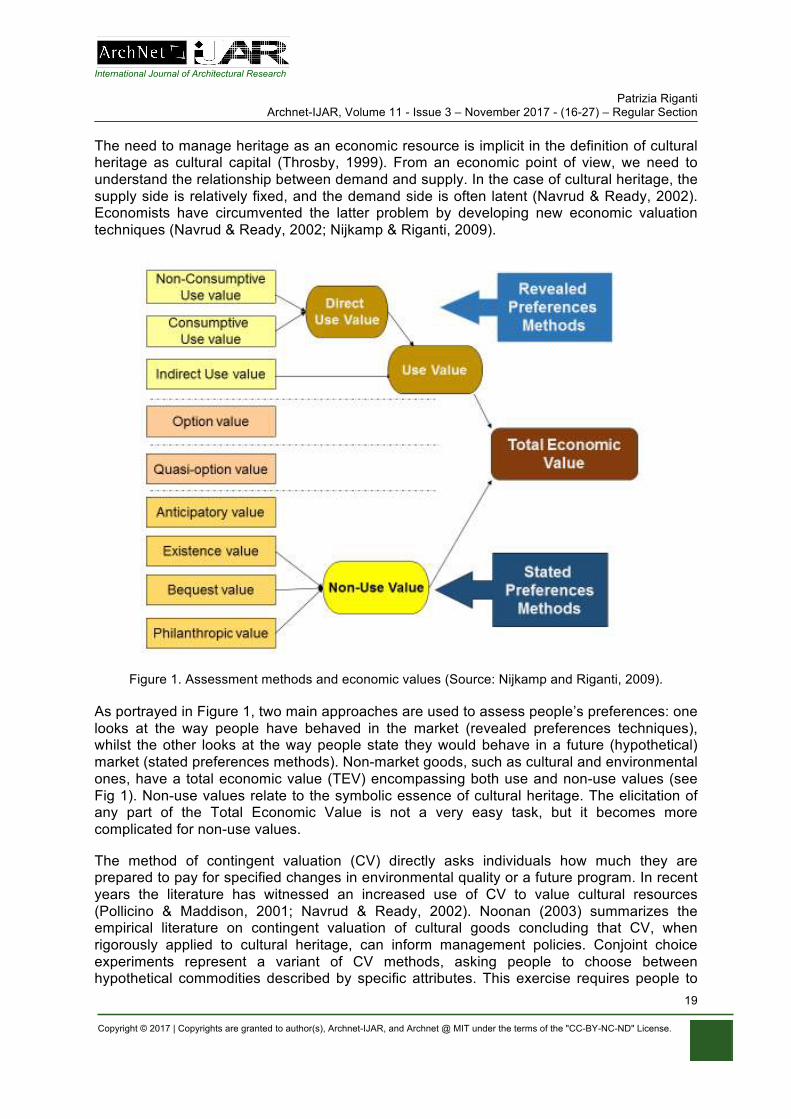
The need to manage heritage as an economic resource is implicit in the definition of cultural heritage as cultural capital (Throsby, 1999). From an economic point of view, we need to understand the relationship between demand and supply. In the case of cultural heritage, the supply side is relatively fixed, and the demand side is often latent (Navrud & Ready, 2002). Economists have circumvented the latter problem by developing new economic valuation techniques (Navrud & Ready, 2002; Nijkamp & Riganti, 2009).
Figure 1. Assessment methods and economic values (Source: Nijkamp and Riganti, 2009).
As portrayed in Figure 1, two main approaches are used to assess people’s preferences: one looks at the way people have behaved in the market (revealed preferences techniques), whilst the other looks at the way people state they would behave in a future (hypothetical) market (stated preferences methods). Non-market goods, such as cultural and environmental ones, have a total economic value (TEV) encompassing both use and non-use values (see Fig 1). Non-use values relate to the symbolic essence of cultural heritage. The elicitation of any part of the Total Economic Value is not a very easy task, but it becomes more complicated for non-use values.
The method of contingent valuation (CV) directly asks individuals how much they are prepared to pay for specified changes in environmental quality or a future program. In recent years the literature has witnessed an increased use of CV to value cultural resources (Pollicino & Maddison, 2001; Navrud & Ready, 2002). Noonan (2003) summarizes the empirical literature on contingent valuation of cultural goods concluding that CV, when rigorously applied to cultural heritage, can inform management policies. Conjoint choice experiments represent a variant of CV methods, asking people to choose between hypothetical commodities described by specific attributes. This exercise requires people to
International Journal of Architectural Research Patrizia Riganti
Archnet-IJAR, Volume 11 - Issue 3 – November 2017 - (16-27) – Regular Section
Copyright © 2017 | Copyrights are granted to author(s), Archnet-IJAR, and Archnet @ MIT under the terms of the "CC-BY-NC-ND" License.
20
make trade-offs between attributes, one of which is typically the cost of the commodity to the respondent (Louviere & Hensher, 1982; Louviere & Woodworth, 1983). Though the applications of such approach to heritage are still limited, it has been successfully implemented to value urban transformations and assess management strategies for tourism purposes (Alberini et al., 2003; Alberini et al., 2006; Riganti, Nese & Colombino, 2006; Riganti & Nijkamp, 2008).
SMART CITIES AND INCLUSIVE HERITAGE MANAGEMENT: USING INTELLIGENT ENVIRONMENTS
The debate on smart cities is bringing many crucial issues to the forefront, linked with the nature of the big data being collected, the related privacy issues and the way such data could be analysed to improve citizens’ quality of life and increase participation for democratic city governance. Decision support systems involving models and tools to achieve proper urban intelligence are still in their infancy (Batty et al., 2012). This section discusses how a specific decision support model (Riganti & Nijkamp, 2006), might be developed considering recent technological and social media advancements, as well as the current debate on smart cities and the Internet of things (Batty et al., 2012; Zanella et al., 2014).
The applications of ICT to cultural heritage in recent decades have mainly focused on the digitalization of cultural goods. Such effort has been commendable, since creating inventories of movable and non-movable heritage assets and goods is an essential part of the conservation process. Preserving the good’s physical appearance and integrity, using sustainable intervention techniques, is another main feature of preservation as it is the documentation of any intervention or modification. Storing information about how the good has been transformed was traditionally confined to archives and specialist publications. All this wealth of information has often been barely available, if not completely inaccessible. Debate has to be spurred around the role that intelligent environment could play within the creation, for instance, of urban observatories, as currently promoted in the UK (University of Newcastle, 2017).
Riganti and Nijkamp (2006) described a vision of a future intelligent environment (IE) which would integrate the digital preservation of heritage with its inclusive, participatory management. In 2006, social media platforms were in their infancy and the impact and breath of ICT development as it has occurred in the last decade was unforeseen. At that time, the main advancement in ICT pointed towards the creation of various forms of E-Heritage. Nowadays, the advent of social media, smart phones apps, virtual globes and crowdsourcing (Kefalidou et al., 2012) is changing the way heritage is recorded by locals and tourists.
As noted by Batty et al. (2012), research in this field should aim to develop integrated platforms for city governance. The intelligent environment/decision making support platform proposed by the author in 2006 shows a structure still relevant after more than a decade. An intelligent environment for the management of cultural heritage should be capable of storing and retrieving information on cultural heritage goods, not only for preserving their memory in our digital era but also to monitor best management practices and public preferences for their exploitation (Riganti, 2003). Such a platform should address the need for E-governance in the cultural sector, and promote the transfer of cultural heritage management good practices (Riganti & Nijkamp, 2006; Batty et al., 2012). The development of such an integrated
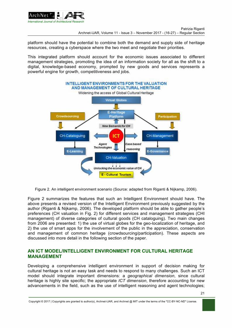
International Journal of Architectural Research Patrizia Riganti
Archnet-IJAR, Volume 11 - Issue 3 – November 2017 - (16-27) – Regular Section
Copyright © 2017 | Copyrights are granted to author(s), Archnet-IJAR, and Archnet @ MIT under the terms of the "CC-BY-NC-ND" License.
21
platform should have the potential to combine both the demand and supply side of heritage resources, creating a cyberspace where the two meet and negotiate their priorities.
This integrated platform should account for the economic issues associated to different management strategies, promoting the idea of an information society for all as the shift to a digital, knowledge-based economy, prompted by new goods and services represents a powerful engine for growth, competitiveness and jobs.
Figure 2. An intelligent environment scenario (Source: adapted from Riganti & Nijkamp, 2006).
Figure 2 summarizes the features that such an Intelligent Environment should have. The above presents a revised version of the Intelligent Environment previously suggested by the author (Riganti & Nijkamp, 2006). The developed platform should be able to gather people’s preferences (CH valuation in Fig. 2) for different services and management strategies (CHI management) of diverse categories of cultural goods (CH cataloguing). Two main changes from 2006 are presented: 1) the use of virtual globes for the geo-localization of heritage, and 2) the use of smart apps for the involvement of the public in the appreciation, conservation and management of common heritage (crowdsourcing/participation). These aspects are discussed into more detail in the following section of the paper.
AN ICT MODEL/INTELLIGENT ENVIRONMENT FOR CULTURAL HERITAGE MANAGEMENT
Developing a comprehensive intelligent environment in support of decision making for cultural heritage is not an easy task and needs to respond to many challenges. Such an ICT model should integrate important dimensions: a geographical dimension, since cultural heritage is highly site specific; the appropriate ICT dimension, therefore accounting for new advancements in the field, such as the use of intelligent reasoning and agent technologies;
International Journal of Architectural Research Patrizia Riganti
Archnet-IJAR, Volume 11 - Issue 3 – November 2017 - (16-27) – Regular Section
Copyright © 2017 | Copyrights are granted to author(s), Archnet-IJAR, and Archnet @ MIT under the terms of the "CC-BY-NC-ND" License.
22
and finally should account for the relevant preferences, i.e. the users’ and decision makers’ ones, hence have a user centric dimension (see Fig. 2). This last aspect is highly relevant to achieve a participatory management of cultural assets and progress towards the achievement of SDG 11: sustainable cities and inclusive communities. The integration of the above dimensions should allow further integration with specific software/apps dedicated to elicit users’ preferences by means of online surveys.
The two main aspects that the revised IE (Fig. 2) has introduced with respect to the previous version published in 2006 are virtual globes and crowdsourcing. Although these additions do not represent a dramatic shift from the original IE vision, the implementation of such changes has some important implications. An IE/DSS would need to address and resolve important issues related to problems of information privacy, data sharing, where such a DSS should be hosted, and how it could be interfaced with urban observatories. How virtual globes and crowdsourcing could be used to progress towards a more inclusive governance of cultural heritage are other issues.
The cultural heritage sector has witnessed important technological advancement in recent years. First, the emergence of virtual environments reconstructing cultural or archaeological sites or proposing a virtual representation of cultural artefacts. Augmented Reality (AR) has also been used to combine digital information with the real and physical environment. The development of 3D games to enhance cultural experiences is another important aspect of the digital revolution taking place in the cultural arena. Finally, the use of Smart Phones (SPs) to capture peoples’ experiences while traveling, through taking photos, digital notes, video and voice records and pathways mapping, is a novel aspect that has changed the way narratives around heritage could be gathered and recorded. This constitutes the crowdsourcing aspect important for a participatory management of heritage assets. Crowdsourcing involves the acquisition of information from online communities or the public, often tourists visiting a site or residents. Crowdsourcing is the expression of an active participation by members of the public sharing information on sites and personal experiences of cultural heritage. This has the potential to enhance collaboration among the public and operators promoting creativity and innovation (Oomen & Aroyo, 2011).
The development of virtual globes (Brovelli et al., 2013a) is another essential technological development that has taken place over the last decade. Virtual globes have been inspired by the visionary idea of Digital Earth (Gore, 1999). Unlike the traditional 2D-visualization typical of Geographic Information Systems (GIS), they offer a 3D, fully-realistic content visualization allowing for a richer user experience. They have been made possible by the great progress in geo-technologies, and have changed the way people access geographic information on the Web. There are several virtual globes available, and NASA has made their World Wind virtual globe openly accessible on the web. In the last few years, several applications to cultural heritage have been developed using World Wind (Brovelli et al., 2013b). This idealistic view of creating an open platform for heritage mapping built upon a unifying, open virtual globe, marries very well with the transnational ethos of the ICT environment previously proposed (Riganti & Njikamp, 2006). This has to be combined with an open data policy supporting an open platform enabling others to reuse information without any restrictions. This could potentially catalyse innovation and overcome the barriers to digital opportunities for all.
The proposed/revised intelligent environment discussed here would provide a national and regional (potentially transnational) database for the preservation and management of cultural heritage. All local information on cultural heritage objects, as well as its virtual representation,
International Journal of Architectural Research Patrizia Riganti
Archnet-IJAR, Volume 11 - Issue 3 – November 2017 - (16-27) – Regular Section
Copyright © 2017 | Copyrights are granted to author(s), Archnet-IJAR, and Archnet @ MIT under the terms of the "CC-BY-NC-ND" License.
23
public narratives etc, would be geographically referenced within the GIS infrastructure. This IE would record public preferences for alternative management options for the site, as proposed by the relevant authorities, by using Smart phones apps or online systems. This will provide decision makers with an important decision support system.
This Intelligent Environment would be an integrated platform. This integration would refer to three major components: an ICT architecture, based on the use of advanced information techniques such as agent technologies; which would be linked to a 3D GIS relational database/virtual globe containing all the relevant information on the site and its cultural heritage. Finally, the combination of these two components would be enriched by a number of users driven software/apps, providing e-services to enhance the access and appreciation of cultural destinations and their heritage, as well as software for online valuation of public preferences for the way such heritage is presented/managed/used (see Fig. 2). The final product should be adaptable to accommodate future improvements. The wealth of information would be stored by the ICT architecture, and then, by means of agent technologies and case-based reasoning, it would be provided, in a way relevant to their own specific interest, to different stakeholders as potential users of the integrated platform. They can be decision makers, citizens, tourists, academics, travel agents, tour operators, small firms and business, or people working in the hospitality sector.
As proposed by the 2006 model, the GIS dimension would make all collected information and especially all monitored preferences relevant at local level, whilst making them available for comparisons at regional, national and international level. This could create a national or a European geographical database to implement benefit transfer of cultural values, an operation that has encountered diffidence (Navrud & Ready, 2002), but whose potential has been acknowledged (EFTEC, 2005; Riganti & Nijkamp, 2007), but not much progressed so far. This aspect is potentially crucial to support decision-making in the cultural sector and transfer economically sound and viable management practices.
SMART CITIES AND HERITAGE CONSERVATION: A SMARTHERITAGE AGENDA
The concept of smart cities has been widely debated in recent years (e.g. Batty et al., 2012; Zanella et al., 2014). How the use of urban observatories, the use of sensors and the collection of big data can help develop safer, more prosperous, inclusive cities, is still a topic of debate. In particular, the role that heritage can play in all this remains unclear.
The proposed Intelligent Environment could address most of the above concerns and the international debate about the SDGs, and provide an impetus for action in urban development and heritage preservation.
A smartheritage vision for contemporary cities should account for the following main points:
• The development of Smart solutions (from tailored apps to sensors generating real time data). These should be integrated into:
• A user-friendly platform/GIS-based intelligent environment based on agent technologies, to help customize contents for different communities of users (e.g. academics, policy makers and citizens).
• An open heritage-mapping platform, building upon a unifying, open virtual globe, OpenCitySmart, with an API for functionalities.
International Journal of Architectural Research Patrizia Riganti
Archnet-IJAR, Volume 11 - Issue 3 – November 2017 - (16-27) – Regular Section
Copyright © 2017 | Copyrights are granted to author(s), Archnet-IJAR, and Archnet @ MIT under the terms of the "CC-BY-NC-ND" License.
24
• This global platform should have an initial suite of functionalities, including high-level definition 3D visualization and real time data, based on the success stories of some municipalities in Italy (Brovelli et al., 2013a).
• Such functionalities might use, for instance, the NASA World Wind globe.
A smartheritage agenda should focus on the development of such open access ICT infrastructures. However, this vision based on the concept of open and common knowledge, whilst incorporating the main progress in terms of crowdsourcing and virtual globes, brings some challenges in terms of privacy of data and willingness of policy makers to cooperate beyond the national (or at times even state/regional) boundaries.
CONCLUSIONS
This paper has presented a revised model of a previously developed GIS-based Intelligent Environment to support decision making for the sustainable management of cultural heritage. The main argument of the paper is that in order to achieve an inclusive, participatory governance of heritage assets it is necessary to understand the value attached by various stakeholders, in particular local communities, to heritage goods. Such an evaluation of the economic dimension of cultural goods is an important aspect that needs to be incorporated within any ICT environment in order to progress towards SDG 11: sustainable cities and inclusive communities. In fact, a city that does not appropriately value and preserve its heritage is neither sustainable nor resilient.
Making the best of advancements in information technologies and social media is a necessary step to develop a smartheritage agenda for cities in both developed and developing countries. A smartheritage agenda could consist of a policy framework in the first stage, but eventually needs to be articulated into a proper ICT intelligent environment to support policy making related to the various risks that heritage faces in contemporary cities.
World Heritage has been at risk of destruction in various instances during human history. Natural catastrophes as well as man-caused events have threatened our physical heritage several times in the past and will do so again in the future. Whilst some events cannot be avoided others could, and we should make sure that strategies are put in place in order to contrast them. Assessing the social and economic costs associated to heritage loss is a first step towards finding a better way to manage risk and its consequences. With a great part of the world population living in our contemporary cities, and a constant upward trend towards urbanization, scientists need to integrate disperse knowledge and face the new challenges posed to cities’ sustainable development during these times of global economic and political crisis.
Decision Support Systems (DSS) need to account for public preferences on the way heritage sites are managed. Understanding the values that people attach to cultural goods is an important step towards their sound management and therefore towards the minimizations of the risks heritage faces. The economic assessment of the risks brought to heritage needs a holistic approach, given its complexity. However, techniques such as choice experiments and contingent valuations have great potential to assist this process.
More research is needed to explore ways of addressing the risks faced by our world heritage. An intelligent environment, based on an open data approach, would be an ideal support for policy makers. Many, if not most, of the challenges facing the cities of today are quite similar
International Journal of Architectural Research Patrizia Riganti
Archnet-IJAR, Volume 11 - Issue 3 – November 2017 - (16-27) – Regular Section
Copyright © 2017 | Copyrights are granted to author(s), Archnet-IJAR, and Archnet @ MIT under the terms of the "CC-BY-NC-ND" License.
25
in nature if not identical: from infrastructure management to essential public services. If the cities of the world were to share best practices with each other, they could each focus on different parts of the problem and progress would be quicker.
This paper has highlighted the need to create new synergies between academic approaches and disciplines, while focusing on the important role played by the economic valuation of urban cultural heritage at risk in its various (tangible and intangible) forms. In order to protect our heritage, we need to link transversally diverse issues such as cultural diversity, migration phenomena, city identity and branding, city governance and management, cultural heritage conservation, cultural tourism management, climate change challenges to cultural heritage, and identity/cultural heritage preservation in armed conflicts and in their aftermaths. At a time when nationalism and terrorism bring division and separate communities, heritage has the potential for peace building and the digital era could make the world feel not only smaller, but also more united (UNESCO, 2017).
ACKNOWLEDGEMENTS
The author is grateful to Luigi Fusco Girard and Peter Nijkamp to have stimulated her reflection on the issues described in this paper, though at different points in time. The author wishes to thank Prof David Bell, Queen’s University Belfast. His visionary takes on the future of Computer Science for heritage assets was highly inspiring during our discussions of more than decade ago and have never been forgotten since. All errors remain solely responsibility of the author.
REFERENCES Alberini A., Riganti, P., & Longo, A. (2003). Can People Value the Aesthetic and Use Services of
Urban Sites? Evidence from a Survey of Belfast Residents. Journal of Cultural Economics, 27, 3-4.
Alberini, A., Longo, A., & Riganti, P. (2006). Using Surveys to Compare the Public’s and Decision-makers’ Preferences for Urban Regeneration: The Venice Arsenale. The Fondazione Eni Enrico Mattei, Note di Lavoro Series, Inde. Retrieved from http://www.feem.it/Feem/Pub/Publications/WPapers/default.htm.
Angrisano, M., Biancamano, P.F., Bosone, M., Carone, P., Daldanise, G., De Rosa, F., Franciosa, A., Gravagnuolo, A., Iodice, S., Nocca, F., Onesti, A., Panaro, S., Ragozino, S., Sannicandro, V., & Fusco Girard, L. (2016). Towards operationalizing UNESCO Recommendations on “Historic Urban Landscape”. Aestimum 69, December 2016.
Batty, M., Axhausen, K., Fosca, G., Pozdnoukhov, A., Bazzani, A., Wachowicz, M., Ouzounis, G., & Portugali, Y. (2012). Smart cities of the future. The European Physical Journal, Special Topics 214, 481–518.
Brovelli, M.A., Minghini, M., & Zamboni, G. (2013a). Participatory GIS: Experimentations for a 3D Social Virtual Globe. The International Archives of the Photogrammetry, Remote Sensing and Spatial Information Sciences, XL-2/W2.
Brovelli, M. A., Hogan, P., Minghini, M., & Zamboni, G. (2013b). The power of Virtual Globes for valorising cultural heritage and enabling sustainable tourism: NASA World Wind applications. International Archives of the Photogrammetry, Remote Sensing and Spatial Information Sciences, XL-4/W2, 115–120.
Buchanan, J.M. (1965). An Economic Theory of Clubs. Economica, 32, pp. 1-14. Coleman, J. (1988). Social Capital in the Creation of Human Capital. American Journal of Sociology,
94, Supplement S95-S120. University of Chicago. EFTEC. (2005). Valuation of the Historic Environment. Report to English Heritage. London: Heritage
Lottery Fund, Department for Culture, Media and Sport, Department for Transport.
International Journal of Architectural Research Patrizia Riganti
Archnet-IJAR, Volume 11 - Issue 3 – November 2017 - (16-27) – Regular Section
Copyright © 2017 | Copyrights are granted to author(s), Archnet-IJAR, and Archnet @ MIT under the terms of the "CC-BY-NC-ND" License.
26
Fusco Girard, L. (2013). Toward a Smart Sustainable Development of Port Cities/Areas: The Role of the “Historic Urban Landscape” Approach. Sustainability 5, 2013, 4329-4348. doi:10.3390/su5104329. ISSN 2071-1050.
Gore, A. (1999). The Digital Earth: understanding our planet in the 21st century. Photogrammetric Engineering and Remote Sensing, 65(5), pp. 528.
G7. (2017). Culture as An Instrument For Dialogue Among Peoples. Joint Declaration of The Ministers of Culture of G7 On the Occasion of The Meeting. Florence: Ministers of Culture of G7, March 2017.
International Criminal Court (2015). Case No. ICC-01/12-01/15, Prosecutor v. Ahmad Al Faqi Al Mahdi.
Kefalidou, G., Mercourios, G., Bryn, A. C., & Suchith, A. (2012). Crowdsourcing Our Cultural Heritage. In: Clare Mills, Michael Pidd and Esther Ward. Proceedings of the Digital Humanities Congress 2012. Studies in the Digital Humanities. Sheffield: HRI Online Publications, 2014. Retrieved from https://www.hrionline.ac.uk/openbook/chapter/dhc2012-kefalidou.
Louviere, J., & Hensher, D. A. (1982). On the Design and Analysis of Simulated Choice or Allocation Experiments in Travel Choice Modeling. Transportation Research Record, 890, 11-17.
Louviere, J., & Woodworth, J. N. (1983). Design and Analysis of Simulated Consumer Choice of Allocation Experiments: An Approach Based on Aggregate Data. Journal of marketing Research, 20, 350-367.
Navrud, S., & Ready, R. (2002). Valuing Cultural Heritage, Edward Elgar Publishing, UK. Nijkamp, P., & Riganti, P. (2009). Valuing Urban Cultural Heritage. In P. Nijkamp & L. Fusco Girard
(Eds.), Cultural Heritage, Local resources and sustainable tourism. UK: Ashgate, Aldershot, February 2009.
Noonan, D.S. (2003). Contingent Valuation and Cultural Resources: A Meta-Analytic Review of the Literature. Journal of Cultural Economics, 27(3-4) 159-176.
Oomen, J., & Aroyo, L. (2011). Crowdsourcing in the Cultural Heritage Domain: opportunities and challenges. In: C&T ’11 (Eds.), Proceedings of the 5th International Conference on Communities and Technologies 2011. 138-149.
Ottaviano, G.I.P., & Peri, G. (2006). The economic value of cultural diversity: evidence from US cities. Journal of Economic geography, 6(1), January 2006.
Pollicino, M. & Maddison, D. (2001). Valuing the Benefits of Cleaning Lincoln Cathedral. Journal of Cultural Economics, 25(2), 131-148.
Portes, A. (1998). Social Capital: Its Origins and Applications in Modern Sociology. Annual Review of Sociology (24),1-24.
Putnam, R. D. (2007). E Pluribus Unum: Diversity and Community in the Twenty-first Century The 2006 Johan Skytte Prize Lecture. Scandinavian Political Studies, 30, 137–174.
Riganti, P. (2003). Assessing Public Preferences For Managing Cultural Heritage: Tools And Methodologies. In Official Publication Office of the European Commission (Eds.), Cultural Heritage Research: a Pan European Challenge. Luxembourg.
Riganti, P., & Nijkamp, P. (2006). The Value of Urban Cultural Heritage: An Intelligent Environment Approach. Studies in Regional Science, 36 (2).
Riganti, P., Nese A., & Colombino, U. (2006). A Methodology for Eliciting Public Preferences for Managing Cultural Heritage Sites; An Application to the Temples of Paestum. In M. Giaoutzi & P. Nijkamp (Eds.), Tourism and Regional Development (pp 201- 216). UK: Ashgate, Aldershot.
Riganti, P., & Nijkamp, P. (2007). Benefit transfer of cultural values: Lessons from environmental economics. Journal of Environmental Law and Policy, 2, 2/2007, 135-148.
Riganti, P., & Nijkamp, P. (2008). Congestion in Popular Tourist Areas: A Multi-Attribute Experimental Choice Analysis of Willingness-To-Wait in Amsterdam. Tourism Economics, 14, 1, March 2008, pp. 25-44.
Riganti, P. (2010). Cultural capital, local identities and ethnic diversity: A study of Amsterdam cultural tourism trends. In M. Janssens, M. Bechtoldt, G. Prarolo & V. Stenius (Eds.), Sustainable Diversity. Edward Elgar.
Throsby, D. (1999). Cultural Capital. Journal of Cultural Economics, 23, pp. 3-12. UN. (2014). World Urbanization Prospects. The 2014 Revision Highlights. New York: Department of
Economic and Social Affairs.

International Journal of Architectural Research Patrizia Riganti
Archnet-IJAR, Volume 11 - Issue 3 – November 2017 - (16-27) – Regular Section
Copyright © 2017 | Copyrights are granted to author(s), Archnet-IJAR, and Archnet @ MIT under the terms of the "CC-BY-NC-ND" License.
27
UN. (2015). Transforming Our World: The 2030 Agenda for Sustainable Development. New York. UNESCO. (1972). Convention Concerning the Protection of the World Cultural and Natural Heritage.
Paris: Unesco. UNESCO. (2017). Unite4Heritage Partnership. Paris: Unesco. University of Newcastle upon Tyne. (2017). Urban Observatory. Retrieved from
http://www.research.ncl.ac.uk/urbanobservatory, Access Date, 12/06/2017. Zanella, A., Bui, N., Castellani, A., Vangelista L., & Zorzi, M. (2014). Internet of Things for Smart
Cities. IEEE Internet of Things Journal, 1(1), February 2014.
Mohamed Gamal Abdelmonem, Gehan Selim, Sabah Mushatat, Abdulaziz Almogren Archnet-IJAR, Volume 11 - Issue 3 - November 2017 - (28-41) – Regular Section
Copyright © 2017 | Copyrights are granted to author(s), Archnet-IJAR, and Archnet @ MIT under the terms of the "CC-BY-NC-ND" License.
28
Archnet-IJAR: International Journal of Architectural Research www.archnet-ijar.net/ -- https://archnet.org/collections/34
VIRTUAL PLATFORMS FOR HERITAGE PRESERVATION IN THE MIDDLE EAST: THE CASE OF MEDIEVAL CAIRO DOI: http://dx.doi.org/10.26687/archnet-ijar.v11i3.1404
Mohamed Gamal Abdelmonem, Gehan Selim, Sabah Mushatat, Abdulaziz Almogren
Keywords Abstract
virtual heritage; digital archaeology; architectural history; urban heritage; visualisation; historic buildings.
Much of the effort in virtual heritage (VH) is directed towards accurate representation of historic structures, objects or artefacts. There is little attention paid, however, to the human aspects of city life, the intangible heritage to which people can actually relate. Digital models of historic buildings and spaces only give a sense of precision. Yet, rituals, human attitude and cultural traditions remain a gap in current research and advanced technology in heritage visualisation. Virtual Heritage Environments (VHE) suffer from the lack of ‘thematic interactivity’ due to the limited cultural content and engaging modules largely used in photorealistic video gaming systems. In order to approach virtual fidelity and accurate reproductions of historic environments, this paper reports on a research process to investigate and incorporate a Cultural-feed into digital platforms of Virtual Heritage. In doing so, the paper focuses on the Middle East in general and Medieval Cairo in particular. It discusses a conceptual and practical framework for the development of virtual heritage platforms as a research, educational and engagement tool that brings historic spaces and buildings back to the recognition of the public eye; the ordinary user. It analyses current practices and projects of virtual heritage technologies and reports on field work that took place in Islamic Cairo with five Start-Up entrepreneurs.
M. G. Abdelmonem*, G. Selim, S. Mushatat, A. Almogren M. G. Abdelmonem, Chair in Architecture, Nottingham Trent University, City Campus, Nottingham NG1 4FQ, UK. G. Selim, Lecturer in Architecture, University of Leeds, Leeds, UK. S. Mushatat, Professor of Architecture, University of Wolverhampton, Wolverhampton, UK. A. Almogren, Prince Sultan Bin Salman Chair for Architectural Heritage, King Saud University, Riyadh, Kingdom of Saudi Arabia
*Corresponding Author’s email address: [email protected]
ArchNet-IJAR is indexed and listed in several databases, including: • Avery Index to Architectural
Periodicals • EBSCO-Current Abstracts-Art
and Architecture • CNKI: China National
Knowledge Infrastructure • DOAJ: Directory of Open
Access Journals • Pro-Quest • Scopus-Elsevier • Web of Science
International Journal of Architectural Research
Mohamed Gamal Abdelmonem, Gehan Selim, Sabah Mushatat, Abdulaziz Almogren Archnet-IJAR, Volume 11 - Issue 3 – November 2017 - (28-41) – Regular Section
Copyright © 2017 | Copyrights are granted to author(s), Archnet-IJAR, and Archnet @ MIT under the terms of the "CC-BY-NC-ND" License.
29
INTRODUCTION
“We understand that the past did not happen in 2D and that it cannot be effectively studied or taught as a series of disconnected static images” Sanders (2008).
Iconic heritage is increasingly threatened by terror, climate change, rampant commercialisation, and overexploitation by tourism; and in some cases, by significant disinvestment. Lack of responsible planning, maintenance and preservation strategies have equally caused unmitigated dereliction and irreversible damage to many heritage sites and cultural traditions in the medieval Middle East. With the increasing rate of destruction of heritage sites, such as Palmyra in Syria, digital preservation of historic artefacts and cultural heritage has become an international priority (Denker, 2016). Hence, strategies, practices and technologies that can protect and sustain these places in other forms of reproduction - such as digital modelling, immersive virtual and augmented reality, and cinematography and Audio-visual archives - have been key aspects of cultural heritage preservation over the past decade (Roussou, 2008). Virtual environments which encompass cultural heritage offer the possibility to experience virtually reconstructed historic sites as visitors or travelers.
Much of the effort in digital archaeology over the past two decades had primarily been directed towards accurate documentation, recording and representation of historic sites and buildings with not much emphasis on the socio-spatial patterns of human aspects of city life (Yang et al., 2006; Goodrick & Gillings, 2000). Although virtual heritage, by contrast, possesses great potential to reconstruct our heritage and memory, critics often blame high cost, sophisticated hardware and software requirements, inaccessibility of technology and training, and high maintenance for preventing widespread dissemination and use of virtual heritage platforms (Mosaker, 2001). Recent virtual heritage applications recognise the necessity of incorporating non-human controlled characters in order to enhance presence and provide the user with an engaging experience (Vosinakis & Avradinis, 2016). Cultural content of Virtual Heritage focuses on the potentials of reducing technical limitations and addition of sub-grid cultural terrains to attain a degree of ‘reality’ and photorealism of culture as a measure for virtual environments; leading towards the amorphous nature of history. Trends in virtual reality applications, as a consequence, have become increasingly motivated by the use of immersive technology for real-time interaction.
Virtual, visual and digital display of lost heritage in the Middle East has inherent values in both the tourism industry and the education process for students in pre-university as well as graduate education. For architecture and archaeological students, in particular, it transfers theoretical courses of archaeology and conservation into real simulations of narratives and historical atmosphere. It helps enlivening the socio-cultural memory of local communities as essential part of their historic continuity and appreciated of heritage (Abdelmonem & Selim 2012). For conservators, historians and archaeologists, it helps develop a rich library and digital archive of details, information and data necessary in restoring historical sites (Abdelmonem, 2017). In this paper, we aim to uncover a conceptual framework for the development of virtual heritage platforms as a research, educational and engagement tool for the Middle East’s historic cities that brings historic environments back to the recognition of the public eye of ordinary users. The paper analyses current virtual heritage productions both globally and regionally with focus on the centrality of narratives where life is explored and practiced in motion. The paper introduces an analytical approach to virtual heritage platforms including techniques, contexts, and outputs that are suitable to different purposes.
International Journal of Architectural Research
Mohamed Gamal Abdelmonem, Gehan Selim, Sabah Mushatat, Abdulaziz Almogren Archnet-IJAR, Volume 11 - Issue 3 – November 2017 - (28-41) – Regular Section
Copyright © 2017 | Copyrights are granted to author(s), Archnet-IJAR, and Archnet @ MIT under the terms of the "CC-BY-NC-ND" License.
30
THE INTERFACE BETWEEN ARCHITECTURE, CULTURAL AND VIRTUAL HERITAGE
The first use of virtual heritage emerged with the first 'walk-through' of a 3D reconstruction of Dudley Castle in England as it was in 1550, through virtual tour settings in 1994. This consisted of a computer controlled laserdisc-based system designed by British-based engineer Colin Johnson (Sanders, 2008). Queen Elizabeth II was one of the first users of this new virtual environment, when she officially opened the visitor centre in June of the same year. As part of the opening ceremony programme, the system was named Virtual Tour, being a cross between virtual reality and Royal Tour. Ever since, computer and digital applications for heritage have vastly progressed over the past two decades on the back of huge leap in technological innovations to approach the problems of archaeology and heritage preservations (Ch’ng, 2013). Early methods of digital archaeology or archaeological computing were seen as methods for the elaboration of archaeological data using quantitative computing. Later versions, however, contributed to the representation of archaeological data using cognitive procedures. Virtual Archaeology, in this context, has become a primary discipline in the analysis of the procedures of management, interpretation and representation of archaeological evidence using 3D computer graphic techniques.
The breakthrough in the digital reconstruction of historic events, lost structures or disappeared heritage enabled both theoretic and applied research to test different propositions and narratives, and undertake forensic examination and analysis of archaeological remnants of the past (Guttentag, 2010). However, Virtual Archaeology (VA) remained a specialised platform for researchers and archaeologists for research-led activities. The public was not involved in its applications, and nor were its outputs intended for public consumption and use. The proliferation of the use of 3D modelling techniques, nonintrusive imaging, geophysics and augmented reality cameras has offered a multiplicity of platforms to simply store, archive and communicate vast amounts of information on cultural heritage sites, traditions and contents.
The Neues Museum in Berlin, for example, has collaborated with CultLab to scan and develop a virtual Model of the Nefertiti Bust to enable a larger audience to visualise the details of the masterpiece without exposing the invaluable artefact to damage. Similar to the Neues Museum, the Louvre and Victoria & Albert both offer online Virtual Tours curated for public audiences and children (Kidd, 2015). It is not uncommon to find museums rendered in Minecraft, built by an invisible crowd of tech-savvy fans, as in the British Museum’s Museumcraft, or Tatecraft. The EU’s DigiArt project use drones, 3D Laser scanners, and 60 cameras to “capture” inaccessible cultural artefacts, before creating advanced 3D representations of them. It uses augmented and virtual reality technologies for viewing, or interacting with the 3D models as a pathway to deeper understanding of artefacts. DigiArt (2017) provide innovative 3D capture systems, including aerial capture via drones, automatic registration and modelling techniques for post-capture processing, semantic image analysis and digital 3D representations via a “story telling engine”.
In this discourse, the rhetoric of authenticity has been debated and contested as opposed to originality. Authenticity has traditionally been key to the way museum experiences are packaged and displayed to the public users. What is remarkable is how far we have come to offer realistic interactivity with historic environments, and the way in which the boundaries between virtual and physical experiences have begun to blur. Being able to test new forms of reality that no longer exist raises intriguing aspects of re-reading and reinterpreting history in the eyes of the audience, rather than the curator. For example, a Mummy never existed in
International Journal of Architectural Research
Mohamed Gamal Abdelmonem, Gehan Selim, Sabah Mushatat, Abdulaziz Almogren Archnet-IJAR, Volume 11 - Issue 3 – November 2017 - (28-41) – Regular Section
Copyright © 2017 | Copyrights are granted to author(s), Archnet-IJAR, and Archnet @ MIT under the terms of the "CC-BY-NC-ND" License.
31
daylight, nor the setting in which pharaonic artefacts were mostly discovered. Virtual models enable these experiences in a way the normal museum could never offer.
VIRTUAL HERITAGE AND IMMERSIVE ENVIRONMENTS “[Virtual Heritage is] an attempt to convey not just the appearance but also the meaning and significance of cultural artefacts and the associated social agency that designed and used them through the use of interactive and immersive digital media” (Champion, 2015: 95).
According to Erik Champion (2016), virtual heritage has eluded clear and useful definitions and it has been even more difficult to evaluate. Virtual heritage aims to recreate cultural heritage environments as well as presenting historic information, context and practices as accurately, authentically and engagingly as possible. Virtual heritage is the fusion of virtual reality technology with cultural heritage content (Addison, 2000). Stone and Ojika (2000: 73) defined virtual heritage as: “the use of computer-based interactive technologies to record, preserve, or create artefacts, sites and factors of historic, artistic, religious, and cultural significance and to deliver the results openly to a global audience in such a way as to provide formative educational experiences through electronic manipulations of time and space.” (Champion, 2016). However, the idea of cultural content is rather limited and increasingly is under representative of several intangible aspects of cultural heritage; which were summarised by Pujol and Champion (2013) & Ch’ng (2013) as “practices, representations, expressions, knowledge, skills – as the instruments, objects, artefacts and cultural spaces associated therewith – that communities, groups and in some cases, individuals recognize as part of their cultural heritage”.
As history is increasingly contested due to different interpretations of evidence, being tangible or intangible, virtual heritage becomes accustomed to interpretation, contestation and analytical debate. Virtual heritage and cultural heritage, in such theoretical contexts, pose different and independent meanings; cultural heritage refers to sites, monuments, buildings and objects with historical, aesthetic, archaeological, scientific, ethnological or anthropological value, whereas virtual heritage refers to instances of these within a technological domain, usually involving computer visualisation of artefacts or virtual reality environments. Virtualisation is, however, much more complex and multi-layered than visualisation that is to form a mental image of something incapable of being viewed or visible at a certain moment (Pujol and Champion, 2013). It involves the verification of not only the specific moment, site or context, but also narratives, practices and habits (Madary & Metzinger, 2016).
While the ‘London Charter’ of 2009 defined computer-based visualisation as ‘the process of representing information visually with the aid of computer technologies’, scholars have demanded that this narrow definition is extended to include the non-visual aspects of visual experience, the haptic, auditory, olfactory and generally multi-sensory. Pujol and Champion (2013) stressed that it is not enough to reproduce a set of artefacts and archaeological objects as individual items separated from the story and context that give them meaningful representation. According to Yaram et al. (1997), perceiving the intangible is at the foundation of all human culture. Then, as cultural heritage refers to historic periods and societies that no longer exist, we face the troubled task of how to virtualise aspects that are not visible, and whose evidence of existence is scattered items, objects, spaces and series of unconnected narratives. In fact, Virtual Heritage Cairo argues that while visualisation of archaeological sites, objects and artefacts offer a detailed record of physical environments,
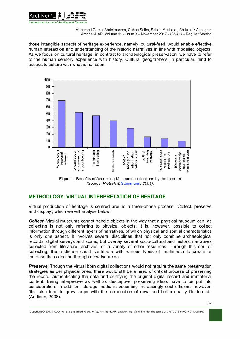
International Journal of Architectural Research
Mohamed Gamal Abdelmonem, Gehan Selim, Sabah Mushatat, Abdulaziz Almogren Archnet-IJAR, Volume 11 - Issue 3 – November 2017 - (28-41) – Regular Section
Copyright © 2017 | Copyrights are granted to author(s), Archnet-IJAR, and Archnet @ MIT under the terms of the "CC-BY-NC-ND" License.
32
those intangible aspects of heritage experience, namely, cultural-feed, would enable effective human interaction and understanding of the historic narratives in line with modelled objects. As we focus on cultural heritage, in contrast to archaeological preservation, we have to refer to the human sensory experience with history. Cultural geographers, in particular, tend to associate culture with what is not seen.
Figure 1. Benefits of Accessing Museums' collections by the Internet (Source: Pietsch & Steinmann, 2004).
METHODLOGY: VIRTUAL INTERPRETATION OF HERITAGE
Virtual production of heritage is centred around a three-phase process: ‘Collect, preserve and display’, which we will analyse below:
Collect: Virtual museums cannot handle objects in the way that a physical museum can, as collecting is not only referring to physical objects. It is, however, possible to collect information through different layers of narratives, of which physical and spatial characteristics is only one aspect. It involves several disciplines that not only combine archaeological records, digital surveys and scans, but overlay several socio-cultural and historic narratives collected from literature, archives, or a variety of other resources. Through this sort of collecting, the audience could contribute with various types of multimedia to create or increase the collection through crowdsourcing.
Preserve: Though the virtual born digital collections would not require the same preservation strategies as per physical ones, there would still be a need of critical process of preserving the record, authenticating the data and certifying the original digital record and immaterial content. Being interpretive as well as descriptive, preserving ideas have to be put into consideration. In addition, storage media is becoming increasingly cost efficient, however, files also tend to grow larger with the introduction of new, and better-quality file formats (Addison, 2008).

International Journal of Architectural Research
Mohamed Gamal Abdelmonem, Gehan Selim, Sabah Mushatat, Abdulaziz Almogren Archnet-IJAR, Volume 11 - Issue 3 – November 2017 - (28-41) – Regular Section
Copyright © 2017 | Copyrights are granted to author(s), Archnet-IJAR, and Archnet @ MIT under the terms of the "CC-BY-NC-ND" License.
33
Display: All virtual museums have some way of interpreting and displaying heritage in a customised manner, that is particular to its creator, that is commensurate to the original artefact production. Such interpretations promote various types of activities and are designed to engage the user in different themes (Chen & Kalay, 2008). Not only does this accessibility turn the museum global but it also contributes to a sort of democratisation of the museum, making museum collections available to theoretically anyone (Malpas, 2008). Putting content online in the shape of databases, virtual museums, personalised exhibitions etc. let not only people of various cultures enjoy each other's cultural heritage, but would let societies to get a virtual access to its own heritage that is being exhibited elsewhere. (Fahey, 1995).
Although a virtual exhibition cannot replace or diminish the value of experiencing the original exhibits, there are cases where it can enhance the visitors' experience and draw new visitors to museums (Lepouras et al., 2001). Exhibition designers can easily change a collection’s contents and the mode of presentation to suit a target audience. The system’s VR/AR technologies extend standard Web presentations and allow visitors to interact with digital models of cultural objects in an intuitive and exciting manner (Walczak et al., 2006). The revolutionary exhibition ‘Sensorium’ at the Tate Britain in 2015, tried to transform the visitor’s experience of displayed paintings that should be perceived not only with eyes, but also with all five senses in a real, tangible experience. The exhibition, conceived by London-based studio Flying Object, was established by Tate and the Porter Foundation to promote digital creativity. In the exhibition, four paintings by Francis Bacon, David Bomberg, Richard Hamilton and John Latham were on display around which a complex multi-sensory experience develops. Visitors can “touch”, “smell”, “taste”, “hear”, and of course see, each painting by a series of cutting-edge interaction solutions and technologies, aimed to expand their experience and trigger engagement and imagination.
Similarly, in the Uffizi Gallery in Florence, an interactive installation was on display in October 2014 that aimed to allow visitors to virtually visit the Tribuna, a space not physically accessible to the public because of conservation issues and visible only through side openings. The multimedia and interactive installation not only allowed people to virtually tour the octagonal space of the Tribuna but also provided details and infographics on its architecture and history as well as on the precious artworks it contains (Figure 2). In an ideal scenario of a virtual museum’s tour, the “visitor” is placed in the virtual environment (CAVE) of a 3D heritage site scene with a first-person perspective of the site's terrain, seeing the scene and its monuments as it would be seen in real life. The terrain should be of the highest detail with a high-resolution texture. CUTURAMA Exhibition of Egyptian History is another immersive technology application of virtual heritage that enables the visitor to navigate through accurate recordings and displays of different dynasties and buildings (CultNat, 2017). Using the keyboard and/or mouse, the visitor should be able to manipulate the view to create a sense of place and the atmosphere of walking through the scene (flying could also be incorporated). The visitor should then be free to "visit" 3D heritage structures. When arriving at a structure the visitor should be able to view 360 degree photographic panoramas of the environment to add sense of reality.
Musée du Louvre in Paris (Louvre, 2013) has constructed a virtual tour of its collection that consists of a simple web site containing 360 degree photographic panoramas. An overall map allows navigation and indicates the various available points of view in the visit. The virtual visit of Oxford (2017) uses interactive web pages which allow users to explore and to manipulate 360 degree photographic panoramas of the city and university, constructed from hundreds of high quality photographs of the city, with a photography tutorial blog about how these panoramas were captured and created. Google Foundation’s World Wonders Project
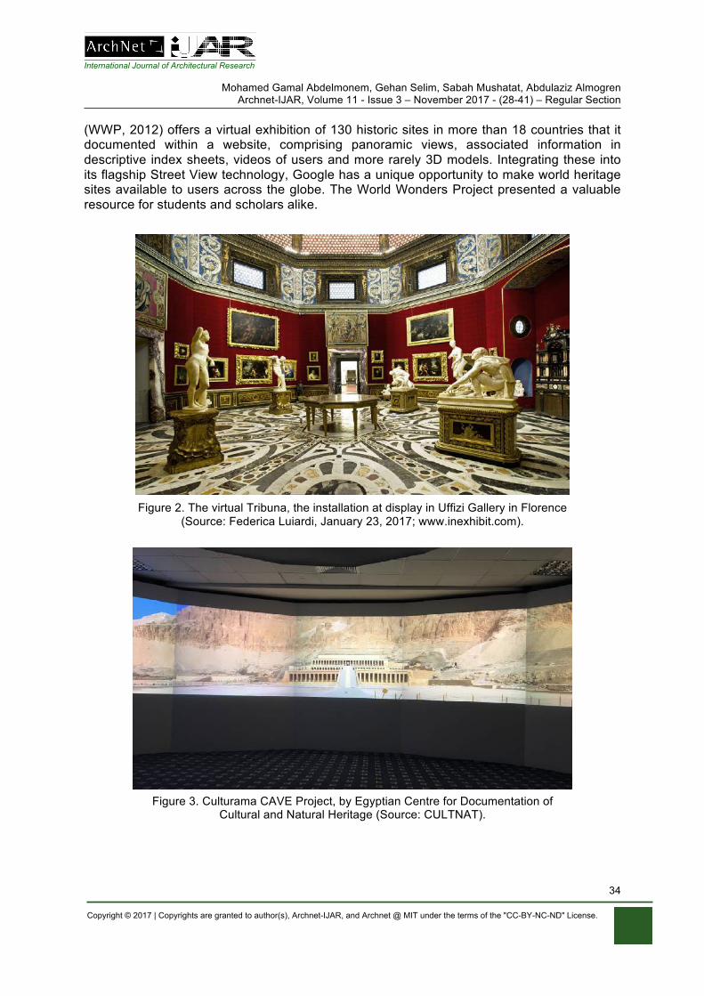
International Journal of Architectural Research
Mohamed Gamal Abdelmonem, Gehan Selim, Sabah Mushatat, Abdulaziz Almogren Archnet-IJAR, Volume 11 - Issue 3 – November 2017 - (28-41) – Regular Section
Copyright © 2017 | Copyrights are granted to author(s), Archnet-IJAR, and Archnet @ MIT under the terms of the "CC-BY-NC-ND" License.
34
(WWP, 2012) offers a virtual exhibition of 130 historic sites in more than 18 countries that it documented within a website, comprising panoramic views, associated information in descriptive index sheets, videos of users and more rarely 3D models. Integrating these into its flagship Street View technology, Google has a unique opportunity to make world heritage sites available to users across the globe. The World Wonders Project presented a valuable resource for students and scholars alike.
Figure 2. The virtual Tribuna, the installation at display in Uffizi Gallery in Florence (Source: Federica Luiardi, January 23, 2017; www.inexhibit.com).
Figure 3. Culturama CAVE Project, by Egyptian Centre for Documentation of Cultural and Natural Heritage (Source: CULTNAT).
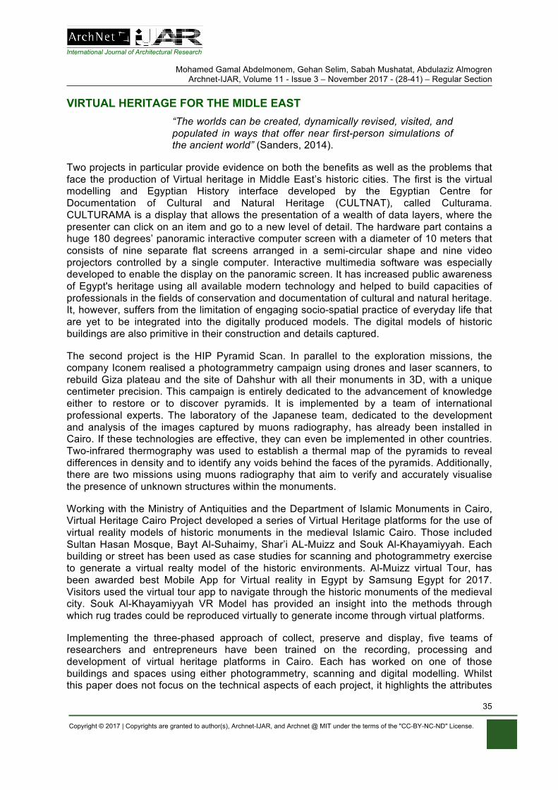
International Journal of Architectural Research
Mohamed Gamal Abdelmonem, Gehan Selim, Sabah Mushatat, Abdulaziz Almogren Archnet-IJAR, Volume 11 - Issue 3 – November 2017 - (28-41) – Regular Section
Copyright © 2017 | Copyrights are granted to author(s), Archnet-IJAR, and Archnet @ MIT under the terms of the "CC-BY-NC-ND" License.
35
VIRTUAL HERITAGE FOR THE MIDLE EAST “The worlds can be created, dynamically revised, visited, and populated in ways that offer near first-person simulations of the ancient world” (Sanders, 2014).
Two projects in particular provide evidence on both the benefits as well as the problems that face the production of Virtual heritage in Middle East’s historic cities. The first is the virtual modelling and Egyptian History interface developed by the Egyptian Centre for Documentation of Cultural and Natural Heritage (CULTNAT), called Culturama. CULTURAMA is a display that allows the presentation of a wealth of data layers, where the presenter can click on an item and go to a new level of detail. The hardware part contains a huge 180 degrees’ panoramic interactive computer screen with a diameter of 10 meters that consists of nine separate flat screens arranged in a semi-circular shape and nine video projectors controlled by a single computer. Interactive multimedia software was especially developed to enable the display on the panoramic screen. It has increased public awareness of Egypt's heritage using all available modern technology and helped to build capacities of professionals in the fields of conservation and documentation of cultural and natural heritage. It, however, suffers from the limitation of engaging socio-spatial practice of everyday life that are yet to be integrated into the digitally produced models. The digital models of historic buildings are also primitive in their construction and details captured.
The second project is the HIP Pyramid Scan. In parallel to the exploration missions, the company Iconem realised a photogrammetry campaign using drones and laser scanners, to rebuild Giza plateau and the site of Dahshur with all their monuments in 3D, with a unique centimeter precision. This campaign is entirely dedicated to the advancement of knowledge either to restore or to discover pyramids. It is implemented by a team of international professional experts. The laboratory of the Japanese team, dedicated to the development and analysis of the images captured by muons radiography, has already been installed in Cairo. If these technologies are effective, they can even be implemented in other countries. Two-infrared thermography was used to establish a thermal map of the pyramids to reveal differences in density and to identify any voids behind the faces of the pyramids. Additionally, there are two missions using muons radiography that aim to verify and accurately visualise the presence of unknown structures within the monuments.
Working with the Ministry of Antiquities and the Department of Islamic Monuments in Cairo, Virtual Heritage Cairo Project developed a series of Virtual Heritage platforms for the use of virtual reality models of historic monuments in the medieval Islamic Cairo. Those included Sultan Hasan Mosque, Bayt Al-Suhaimy, Shar’i AL-Muizz and Souk Al-Khayamiyyah. Each building or street has been used as case studies for scanning and photogrammetry exercise to generate a virtual realty model of the historic environments. Al-Muizz virtual Tour, has been awarded best Mobile App for Virtual reality in Egypt by Samsung Egypt for 2017. Visitors used the virtual tour app to navigate through the historic monuments of the medieval city. Souk Al-Khayamiyyah VR Model has provided an insight into the methods through which rug trades could be reproduced virtually to generate income through virtual platforms.
Implementing the three-phased approach of collect, preserve and display, five teams of researchers and entrepreneurs have been trained on the recording, processing and development of virtual heritage platforms in Cairo. Each has worked on one of those buildings and spaces using either photogrammetry, scanning and digital modelling. Whilst this paper does not focus on the technical aspects of each project, it highlights the attributes
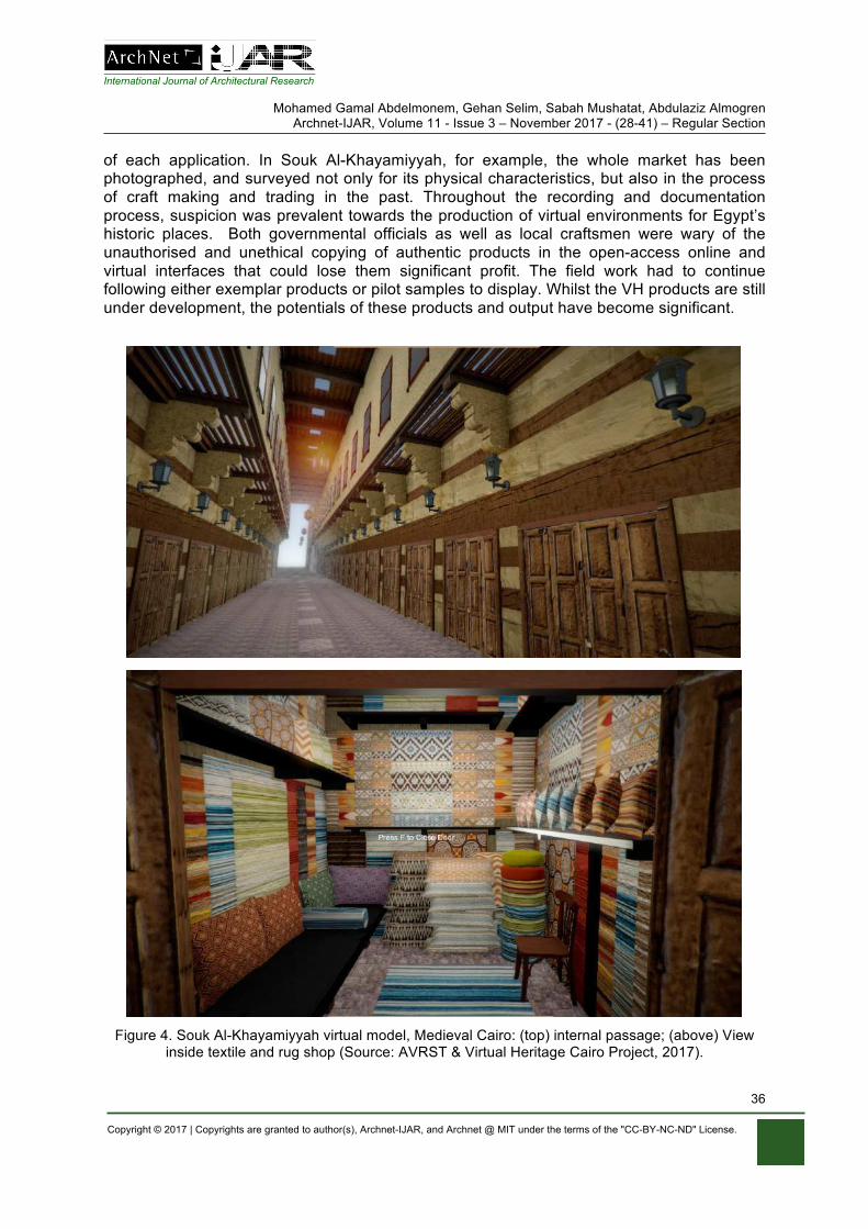
International Journal of Architectural Research
Mohamed Gamal Abdelmonem, Gehan Selim, Sabah Mushatat, Abdulaziz Almogren Archnet-IJAR, Volume 11 - Issue 3 – November 2017 - (28-41) – Regular Section
Copyright © 2017 | Copyrights are granted to author(s), Archnet-IJAR, and Archnet @ MIT under the terms of the "CC-BY-NC-ND" License.
36
of each application. In Souk Al-Khayamiyyah, for example, the whole market has been photographed, and surveyed not only for its physical characteristics, but also in the process of craft making and trading in the past. Throughout the recording and documentation process, suspicion was prevalent towards the production of virtual environments for Egypt’s historic places. Both governmental officials as well as local craftsmen were wary of the unauthorised and unethical copying of authentic products in the open-access online and virtual interfaces that could lose them significant profit. The field work had to continue following either exemplar products or pilot samples to display. Whilst the VH products are still under development, the potentials of these products and output have become significant.
Figure 4. Souk Al-Khayamiyyah virtual model, Medieval Cairo: (top) internal passage; (above) View inside textile and rug shop (Source: AVRST & Virtual Heritage Cairo Project, 2017).
International Journal of Architectural Research
Mohamed Gamal Abdelmonem, Gehan Selim, Sabah Mushatat, Abdulaziz Almogren Archnet-IJAR, Volume 11 - Issue 3 – November 2017 - (28-41) – Regular Section
Copyright © 2017 | Copyrights are granted to author(s), Archnet-IJAR, and Archnet @ MIT under the terms of the "CC-BY-NC-ND" License.
37
Elsewhere in the Middle East, Virtual heritage applications have taken technical and safeguarding purposes. The Digital records of Petra Historic Site in Jordan, as part of Zamani Project, proved very effective in its sustainable preservation. This project is part of the African Cultural Heritage Sites and Landscapes Database. It has been run by a research group at the University of Cape Town since 2005, and has been spatially documenting heritage sites in Africa and the Middle East. They acquire models and present and manage spatial and any other data. A large database of spatial material has been generated over this time. This data has been widely used by heritage and conservation experts to manage and conserve these sites. The virtual tour in this project is designed to allow interactive virtual walk-through sites using the spatial data. The project allows users to check virtually online: 3D model viewer and texturing, virtual tour, topography in the virtual tour (laser scan), panorama tours, GIS layouts, architectural drawings, and videos.
NAVIGATING CITIES’ HISTORIES
British cities, likewise, have become more accustomed to creatively experiencing their historic fabric in virtual environments and tours. Completed in 2017 by Alan Miller & Keith Millican of the School of Computer Science & Smart History at the University of Edinburgh, the virtual reconstruction of pre-reformation Edinburgh has evolved out of collaboration between historians and computer scientists to investigate an important layer of the city’s history. Miller and Millican (2016) used mobile phones and the Google Day dream platform to produce an onsite dual reality experience. As visitors explore the sites of Edinburgh, they can see its historic layers using their digital time travel binoculars. The application they developed is a comprehensive reconstruction of parts of the city and allows the visitors to move along a series of houses and streets. It is mobile and orientation aware, automatically delivering the correct view with a map interface that offers an equally engaging experience for remote virtual visitors.
Similarly, Jarlshof in the Shetland Islands is a short computer-generated film by Kieran Baxter that offers research-led analytical narratives of the story of settlement at the Shetland Islands’ archaeological site, using speculative scenarios and built structures from different historic eras (Baxter, 2014.) The project was funded by Historic Scotland, as part of PhD research at Duncan of Jordanstone College of Art and Design, University of Dundee. It was completed in 2016 and has won the Arts and Humanities Research Council (AHRC) award for the same year. Baxter based his film on aerial photographs taken from a kite-suspended camera over the site, inserting and overlaying the speculative reconstructions of disappeared buildings mapped towards aerial photographs of other sites across Scotland. Using limited reconstructed elements and incorporating photographic and cinematic considerations, the interpretation of the narrative was conveyed into a visual toolkit for storytelling.
The aerial view reveals the structure and components of the site, parts of which are difficult to grasp from ground level. According to Baxter, the low altitude aerial perspective used in 'Jarlshof' “was intended as a compromise between the relatable ground-level view and the revealing yet distancing qualities available from high altitude” (Baxter, 2014). Camera movement was used to enhance the viewer's perception of depth and the 3D depth and structure of the site. This format bears no resemblance to the normal experience of moving around Jarlshof on foot. Rather, the depth of the site’s structure provided by the flying motion enhances the viewer's sense of the three-dimensional space. The camera was also used to create a sense of progression through the distinct chronological phases of the site through annotated interplay of views, camera movement and chronological display.
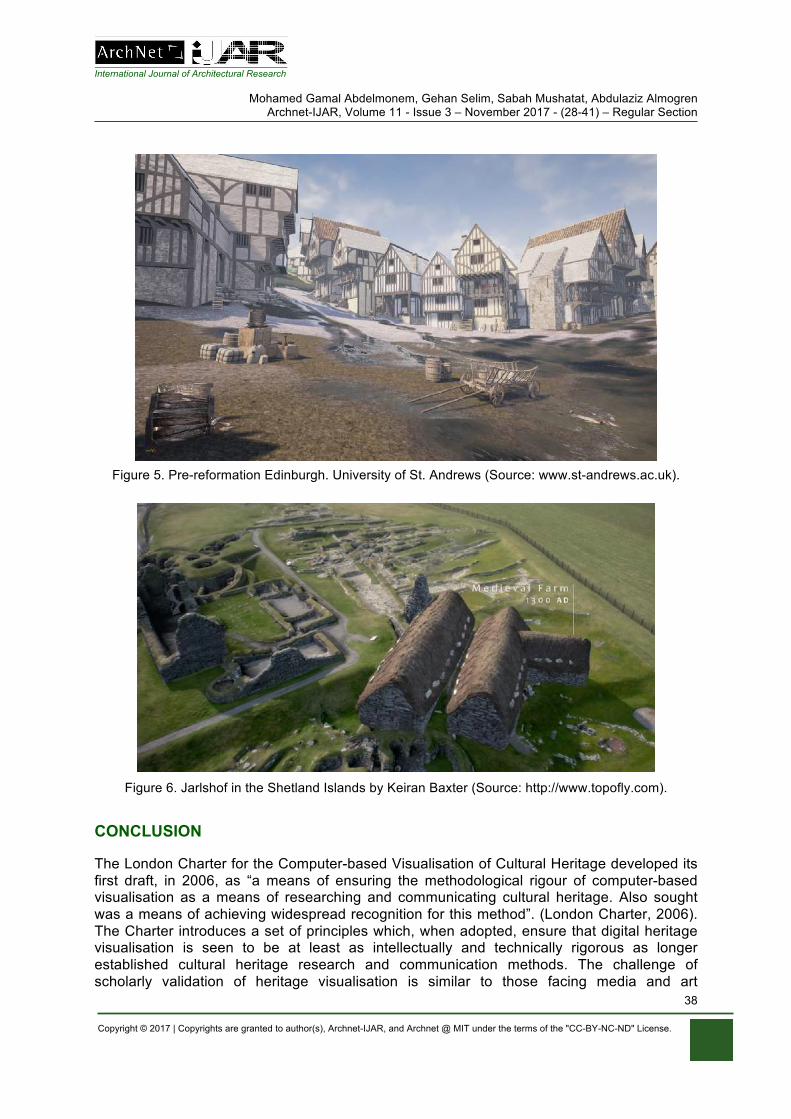
International Journal of Architectural Research
Mohamed Gamal Abdelmonem, Gehan Selim, Sabah Mushatat, Abdulaziz Almogren Archnet-IJAR, Volume 11 - Issue 3 – November 2017 - (28-41) – Regular Section
Copyright © 2017 | Copyrights are granted to author(s), Archnet-IJAR, and Archnet @ MIT under the terms of the "CC-BY-NC-ND" License.
38
Figure 5. Pre-reformation Edinburgh. University of St. Andrews (Source: www.st-andrews.ac.uk).
Figure 6. Jarlshof in the Shetland Islands by Keiran Baxter (Source: http://www.topofly.com).
CONCLUSION
The London Charter for the Computer-based Visualisation of Cultural Heritage developed its first draft, in 2006, as “a means of ensuring the methodological rigour of computer-based visualisation as a means of researching and communicating cultural heritage. Also sought was a means of achieving widespread recognition for this method”. (London Charter, 2006). The Charter introduces a set of principles which, when adopted, ensure that digital heritage visualisation is seen to be at least as intellectually and technically rigorous as longer established cultural heritage research and communication methods. The challenge of scholarly validation of heritage visualisation is similar to those facing media and art
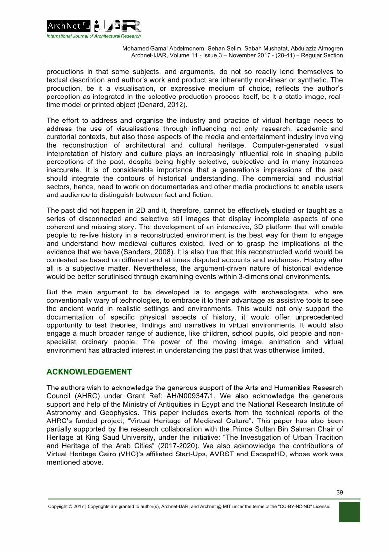
International Journal of Architectural Research
Mohamed Gamal Abdelmonem, Gehan Selim, Sabah Mushatat, Abdulaziz Almogren Archnet-IJAR, Volume 11 - Issue 3 – November 2017 - (28-41) – Regular Section
Copyright © 2017 | Copyrights are granted to author(s), Archnet-IJAR, and Archnet @ MIT under the terms of the "CC-BY-NC-ND" License.
39
productions in that some subjects, and arguments, do not so readily lend themselves to textual description and author’s work and product are inherently non-linear or synthetic. The production, be it a visualisation, or expressive medium of choice, reflects the author’s perception as integrated in the selective production process itself, be it a static image, real-time model or printed object (Denard, 2012).
The effort to address and organise the industry and practice of virtual heritage needs to address the use of visualisations through influencing not only research, academic and curatorial contexts, but also those aspects of the media and entertainment industry involving the reconstruction of architectural and cultural heritage. Computer-generated visual interpretation of history and culture plays an increasingly influential role in shaping public perceptions of the past, despite being highly selective, subjective and in many instances inaccurate. It is of considerable importance that a generation’s impressions of the past should integrate the contours of historical understanding. The commercial and industrial sectors, hence, need to work on documentaries and other media productions to enable users and audience to distinguish between fact and fiction.
The past did not happen in 2D and it, therefore, cannot be effectively studied or taught as a series of disconnected and selective still images that display incomplete aspects of one coherent and missing story. The development of an interactive, 3D platform that will enable people to re-live history in a reconstructed environment is the best way for them to engage and understand how medieval cultures existed, lived or to grasp the implications of the evidence that we have (Sanders, 2008). It is also true that this reconstructed world would be contested as based on different and at times disputed accounts and evidences. History after all is a subjective matter. Nevertheless, the argument-driven nature of historical evidence would be better scrutinised through examining events within 3-dimensional environments.
But the main argument to be developed is to engage with archaeologists, who are conventionally wary of technologies, to embrace it to their advantage as assistive tools to see the ancient world in realistic settings and environments. This would not only support the documentation of specific physical aspects of history, it would offer unprecedented opportunity to test theories, findings and narratives in virtual environments. It would also engage a much broader range of audience, like children, school pupils, old people and non-specialist ordinary people. The power of the moving image, animation and virtual environment has attracted interest in understanding the past that was otherwise limited.
ACKNOWLEDGEMENT
The authors wish to acknowledge the generous support of the Arts and Humanities Research Council (AHRC) under Grant Ref: AH/N009347/1. We also acknowledge the generous support and help of the Ministry of Antiquities in Egypt and the National Research Institute of Astronomy and Geophysics. This paper includes exerts from the technical reports of the AHRC’s funded project, “Virtual Heritage of Medieval Culture”. This paper has also been partially supported by the research collaboration with the Prince Sultan Bin Salman Chair of Heritage at King Saud University, under the initiative: “The Investigation of Urban Tradition and Heritage of the Arab Cities” (2017-2020). We also acknowledge the contributions of Virtual Heritage Cairo (VHC)’s affiliated Start-Ups, AVRST and EscapeHD, whose work was mentioned above.
International Journal of Architectural Research
Mohamed Gamal Abdelmonem, Gehan Selim, Sabah Mushatat, Abdulaziz Almogren Archnet-IJAR, Volume 11 - Issue 3 – November 2017 - (28-41) – Regular Section
Copyright © 2017 | Copyrights are granted to author(s), Archnet-IJAR, and Archnet @ MIT under the terms of the "CC-BY-NC-ND" License.
40
REFERENCES Abdelmonem, M. G. (2017). Virtual Heritage: Global Perspectives on Creative Modes of Heritage
Visualisation. Research Report. Virtual Heritage Cairo (VHC), AHRC-funded Project. 61 Pages. Online-access: www.virtualheritagecairo.com. Accessed on 20th August 2017.
Abdelmonem, M. G., Selim, G. (2012). Architecture, Memory and Historical Continuity in Old Cairo. Journal of Architecture, 17(2), 163-189. doi: 10.1080/13602365.2012.678634.
Addison, A. C. (2008). The vanishing virtual: safeguarding heritage’s endangered digital record. In Y. E. Kalay, T. Kvan, & J. Affleck (Eds.), New Heritage: New Media and Cultural Heritage, (pp.27-39). London: Routledge.
Addison, A. C. (2000). Emerging trends in virtual heritage. IEEE multimedia, 7 (2), 22-25. Baxter, K. (2014). Jarlshof Lost and Found: Low altitude aerial photography and computer-generated
visualisation for the interpretation of the complex settlement remains found at Jarlshof, Shetland. Internet Archaeology, 36. doi: 10.11141/ia.36.1
Ch’ng, E., Gaffney, V., Chapman, H (Eds.). (2013) Visual Heritage in the Digital Age. Springer Series on Cultural Computing. London: Springer-Verlag London.
Chen, X; Kalay, Y. E. (2008). Making a livable “place”: content design in virtual environment. In Y. E. Kalay, T. Kvan, & J. Affleck (Eds.), New Heritage: New Media and Cultural Heritage, (pp.207-222). London: Routledge.
Champion, E. (2016). Critical Gaming: Interactive History and Virtual Heritage. London: Routledge. CULTURAMA (2017). CULTURAMA is a large panoramic display that surrounds the audience in 180
degrees for the visualization of Egyptian Cultural and Natural Heritage. A registered Patent Patent #23651 in Egypt under the name of The Egyptian Centre for Documentation of Cultural and Natural Heritage (CULTNAT). Available at: http://www.cultnat.org/Culturama.
Denard, H. (2012). A New Introduction to the London Charter. In A. Bentkowska-Kafel, D. Baker & H. Denard (Eds.), Paradata and Transparency in Virtual Heritage Digital Research in the Arts and Humanities Series, (pp.57-71). London: Ashgate.
Denker, A. (2016). Virtual Palmyra: 3D Reconstruction of the lost Reality of “The Be Bridge of the Desert. In 8th International congress on archaeology, computer graphics, cultural heritage and innovation. Editorial Universitat Politècnica de València, (pp 318-320).
DigiArt (2017) EU- Horizon 2020 Project, DigiArt. Online source, Website: http://digiart-project.eu/consortium/certh/, accessed on 30th March 2017
Goodrick, G., Gillings, M. (2000). Constructs, Simulations and Hyperreal Worlds: The Role of Virtual Reality (VR) in Archaeological Research. In G. Lock & K. Brown (Eds.), On the Theory and Practice of Archaeological Computing (pp. 41–58). Oxford: Oxford University Press.
Guttentag, D. A. (2010). Virtual reality: Applications and implications for tourism. Tourism Management, 31(5), 637-651.
Fahey, A. (1995). New Technologies for Museum Communication. In Hooper- Greenhill, E. (Ed.), Museum, Media, Message, (pp.82-96). London, Routledge.
Kidd, J. (2015). “Museums are using virtual reality to preserve the past – before it’s too late”. The Conversation, July 14, 2015. Online Source: https://theconversation.com. Accessed on 12 August 2017.
London Charter (2006). The London Charter for the Computer-based Visualisation of Cultural Heritage. An Online document. Available at: http://www.londoncharter.org.
Lepouras, G., Charitos, D., Vassilakis, C., Charisi, A., Halatsi, L., 2001, “Building a VR museum in a museum”. In: Proc. of VRIC Virtual Reality International Conference, Laval, France.
Madary M., Metzinger, T.K. (2016). Real Virtuality: A Code of Ethical Conduct. Recommendations for Good Scientific Practice and the Consumers of VR-Technology. Front, Robot, AI, 3(3). doi: 10.3389/frobt.2016.00003
Malpas, J. (2008). Cultural heritage in the age of new media. In Y. E. Kalay, T. Kvan, & J. Affleck (Eds.), New Heritage: New Media and Cultural Heritage, (pp.13-26). London: Routledge.
Miller, A. Millican, K. (2016). Virtual time travel in pre-reformation Edinburgh. University of St. Andrews: http://epsrc-showcase.wp.st-andrews.ac.uk/2016/12/01/virtual-time-travel-in-pre-reformation-edinburgh-premiere/ (accessed on 15th March 2017)
International Journal of Architectural Research
Mohamed Gamal Abdelmonem, Gehan Selim, Sabah Mushatat, Abdulaziz Almogren Archnet-IJAR, Volume 11 - Issue 3 – November 2017 - (28-41) – Regular Section
Copyright © 2017 | Copyrights are granted to author(s), Archnet-IJAR, and Archnet @ MIT under the terms of the "CC-BY-NC-ND" License.
41
Mosaker, L. (2001). Visualising Historical Knowledge Using Virtual Reality Technology. Digital Creativity, 12, 15-25.
Musée du Louvre (Paris) (2013). A Virtual Tour through the Louvre Museum in Paris, France. An Online application. The virtual tour is available on: http://www.louvre.fr/en/visites-en-ligne
Oxford City Virtual Tour. (2004). A Virtual Tour of the City of Oxford, Developed Initially at 2004 and continues as crowd source to add more digital components. The Virtual Tour of Oxford are accessible at: http://www.chem.ox.ac.uk/oxfordtour/
Pietsch, K., Steinmann, K. (2004). Potentials of Virtual Museums- Media- Specific Conception of Cultural Learning Environments. E-book Available at http://www.diplomarbeiten24.de/vorschau/114447.html.
Pujol, L., Champion, E. (2013). Evaluating presence in cultural heritage project. International Journal of Heritage Studies, 18(1), 83-102.
Roussou, M. (2008). The Components of engagement in virtual heritage environments. In Y. E. Kalay, T. Kvan, & J. Affleck (Eds.), New Heritage: New Media and Cultural Heritage (pp.225-241). London: Routledge.
Sanders, D. H. (2014). Virtual Heritage: Research and Visualizing the Past in 3D. Journal of Eastern Mediterranean Archaeology and Heritage Studies, 2(1), pp 30-47.
Sanders, D. H. (2008). Why do virtual heritage? Online Features Article. Archaeology Archive. Published on 13 March 2008. Accessed online via: http://archive.archaeology.org. Accessed on 10 March 2017.
Stone, R., and Ojika, T. (2000). Virtual Heritage: What Next? IEEE multimedia, 7(2), 73-74. Vosinakis, S., Avradinis, N. (2016). VIRTUAL AGORA: Representation of an ancient Greek Agora in
virtual worlds using biologically-inspires motivational agents”, Mediterranean Archaeology and Archaeometry, 16 (5), pp. 29-41.
Virtual Heritage Cairo (2017). Research Project and online-database of the Virtual Reality of Medieval Culture Project. An Arts and Humanities Research Council (AHRC) funded project. under Grant Ref: AH/N009347/1. Available at: www.virtualheritagecairo.com.
Walczak, K, Cellary, W and White, M (2006). Virtual Museum Exhibitions. IEEE Computer, 39 (3). pp. 93-95. ISSN 0018-9162
World Wonders Project (WWP). (2012). Online Digital Archive and Database of Wolr Heritage Site and Monuments. The Online platform is run by Google Foundation’s Cultural Institute in partnership with UNESCO, the World Monuments Fund and Getty Images.
Yang, C., Peng, D. and Sun, S. (2006). Creating a Virtual Activity for the Intangible Culture Heritage. In 16th International Conference on Artificial Reality and Telexistence-Workshops, ICAT’06 (Pp 636-641).
Yaram, S., Connacher, H., Lyons, K. (1997). Virtual assembly using virtual reality techniques. Computer-Aided Design. 29(8), pp. 575-584.
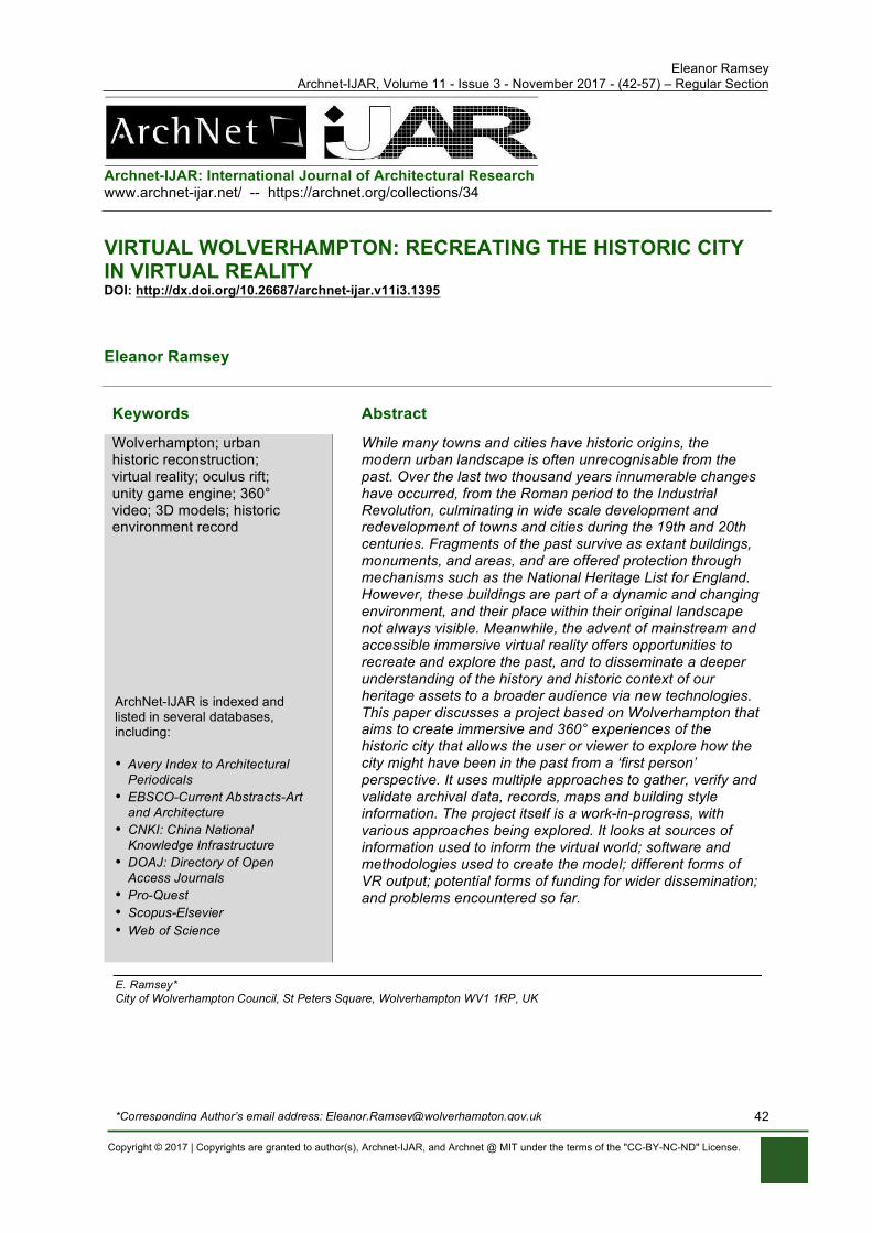
Eleanor Ramsey Archnet-IJAR, Volume 11 - Issue 3 - November 2017 - (42-57) – Regular Section
Copyright © 2017 | Copyrights are granted to author(s), Archnet-IJAR, and Archnet @ MIT under the terms of the "CC-BY-NC-ND" License.
42
Archnet-IJAR: International Journal of Architectural Research www.archnet-ijar.net/ -- https://archnet.org/collections/34
VIRTUAL WOLVERHAMPTON: RECREATING THE HISTORIC CITY IN VIRTUAL REALITY DOI: http://dx.doi.org/10.26687/archnet-ijar.v11i3.1395
Eleanor Ramsey
Keywords Abstract
Wolverhampton; urban historic reconstruction; virtual reality; oculus rift; unity game engine; 360° video; 3D models; historic environment record
While many towns and cities have historic origins, the modern urban landscape is often unrecognisable from the past. Over the last two thousand years innumerable changes have occurred, from the Roman period to the Industrial Revolution, culminating in wide scale development and redevelopment of towns and cities during the 19th and 20th centuries. Fragments of the past survive as extant buildings, monuments, and areas, and are offered protection through mechanisms such as the National Heritage List for England. However, these buildings are part of a dynamic and changing environment, and their place within their original landscape not always visible. Meanwhile, the advent of mainstream and accessible immersive virtual reality offers opportunities to recreate and explore the past, and to disseminate a deeper understanding of the history and historic context of our heritage assets to a broader audience via new technologies. This paper discusses a project based on Wolverhampton that aims to create immersive and 360° experiences of the historic city that allows the user or viewer to explore how the city might have been in the past from a ‘first person’ perspective. It uses multiple approaches to gather, verify and validate archival data, records, maps and building style information. The project itself is a work-in-progress, with various approaches being explored. It looks at sources of information used to inform the virtual world; software and methodologies used to create the model; different forms of VR output; potential forms of funding for wider dissemination; and problems encountered so far.
E. Ramsey* City of Wolverhampton Council, St Peters Square, Wolverhampton WV1 1RP, UK *Corresponding Author’s email address: [email protected]
ArchNet-IJAR is indexed and listed in several databases, including: • Avery Index to Architectural
Periodicals • EBSCO-Current Abstracts-Art
and Architecture • CNKI: China National
Knowledge Infrastructure • DOAJ: Directory of Open
Access Journals • Pro-Quest • Scopus-Elsevier • Web of Science
International Journal of Architectural Research Eleanor Ramsey
Archnet-IJAR, Volume 11 - Issue 3 - November 2017 - (42-57) – Regular Section
Copyright © 2017 | Copyrights are granted to author(s), Archnet-IJAR, and Archnet @ MIT under the terms of the "CC-BY-NC-ND" License.
43
INTRODUCTION
History of Wolverhampton
The history of Wolverhampton can be traced back over 1000 years. In AD 985 King Aethelred made a grant of land at Heantune to the town’s benefactress Lady Wulfrun, with Lady Wulfrun herself endowing a minster church nine years later (Farley, 1985). The name, ‘Wolverhampton’, known historically as Hampton or Heantun, may mean ‘Wulfrun’s settlement on a hill’ (ibid.) or ‘Wulfrun’s chief manor’ (Horovitz, 2005). It is said that King Wulfhere of Mercia founded an abbey in the site as early as AD 659, and it is possible that there was an earlier Iron Age hillfort there, although no evidence of either has been found (Upton, 1998). Outside St Peter’s church today stands the base of a Saxon cross, a scheduled monument, erected to celebrate the founding of the town. The cross is possibly a re-used Roman column from Wroxeter or Wall (Baker, 1980).
The extent of the Saxon settlement has been postulated by Slater (1986), based on analysis of 18th century mapping. Centred on the higher ground with commanding views over the hinterland, it would have been surrounded by a fence or a ditch, that in part followed the alignment of North Street to the west, and Princess Street/Princes Square to the east (Figure 1). Wolverhampton is named as Heantun or Hantone in the Domesday book (1086), and is recorded as having fourteen slaves, six villagers and thirty smallholders with a total of nineteen ploughs, suggesting a settlement of over two hundred people (Farley, 1985).
From these humble origins, Wolverhampton developed as a centre of trade, having a market here in some form from at least 1179, and being granted a charter for a market and a fair in 1258. The wool trade was particularly important to the town in the 14th and 15th centuries, and the wealth of the town at this time resulted in a major reconstruction of St Peter’s church at the end of the 15th century (ibid). The extent of the medieval town has also been suggested based on analysis of the mapping (Shaw, 2000), with the town in this period extending to include Red Lion Street and Victoria Street in the west, Market Street and Thornley Street to the east, Dudley Street, Bell Street and Salop Street to the south, and Paternoster Street and Mitre Fold to the north (Figure 1). The Lych Gate Tavern on Exchange Street has a mid-late 16th century timber-framed rear wing with a brick ground floor. A great fire in 1590 resulted in the destruction of 104 houses and 30 barns. It lasted for 5 days and would have had a major impact on the built environment at the time. 19 Victoria Street, known locally as ‘Lindy Lou building’, dates from the late 16th or early 17th century and may have been built following this event.
The town continued to grow, and Isaac Taylor’s map drawn in 1750 shows the extent of the town during the mid-18th century, with a population at this time (according to Taylor) of 7454 inhabitants (Figure 1). Buildings shown on this map include Giffard House, built between 1727 and 1733, and Molineux House, built on land purchased in 1744 (Farley, 1985). Between 1751 and 1753 much of King Street was built. The construction of the canals in the late 18th century followed by the coming of the railways during the 19th century transformed the town further, with both massive expansion outwards and changes to the centre. The industrial revolution saw Wolverhampton flourish, with industries like ironworking, japanning, and lock-working becoming dominant and ubiquitous. During this time Queen Street and Darlington Street were constructed, and Lichfield Street widened, with grand, ornate buildings representing wealth and civic pride replacing much of the older building stock. The
International Journal of Architectural Research Eleanor Ramsey
Archnet-IJAR, Volume 11 - Issue 3 - November 2017 - (42-57) – Regular Section
Copyright © 2017 | Copyrights are granted to author(s), Archnet-IJAR, and Archnet @ MIT under the terms of the "CC-BY-NC-ND" License.
44
20th century saw continued change, including major slum clearance and the construction of the ring road.
Figure 1. Red outline shows the possible extent of the town in different periods. Height map generated
from Lidar data (Source: © Environment Agency copyright and/or database right 2015. All rights reserved. Contains OS data © Crown copyright and database right 2017).
Evolution of virtual reality for heritage
Archaeologists have long appreciated the potential for computing and digital technologies to capture, analyse and visualise datasets to enhance our understanding of the past. As frontrunners in the social sciences and humanities in employing spatial approaches, archaeologists have used Geographic Information Systems (GIS) to model, analyse and visualise disparate datasets and generate new knowledge (Gupta and Devillers, 2016; Ramsey, 2013; Chapman, 2006). This technology originated as a digital 2D mapping technique, while adding height and temporal information creates 3D and 4D GIS. In particular, archaeological landscape analysis will often ask the question ‘What did they see?’ with GIS viewshed analysis being a common approach to finding the answers (Chapman, 2006; Wheatley and Gillings, 2000). However regardless of the quality of data input into any analysis, it is not without problems in the interpretation, not least because the visual aspect of perception is only part of the whole (Eve, 2017). GIS practitioners are aware of the limitations of abstract realities that simplify the complexity of the relationship between people and place (Richards-Rissetto, 2017).
As GIS developed in spatially mapping data, digital technologies have also been used to recreate and present the past in the form of 3D models. Often the aim is not only to capture, preserve and interpret information, but to make the interpretations accessible to the wider public, and using virtual reconstructions is an effective method of communication (Frankland and Earl, 2011). The first use of virtual heritage as a museum exhibit was in 1994 that provided a ‘walk-through’ of a reconstruction of Dudley Castle as it was in 1550 (Abdelmonem, 2017), with Game Engines such as Crytek’s Cryengine, Unreal Engine, and Unity later providing widely accessible platforms for larger world creation (Ch’ng, 2007). Cryengine was used by Ch’ng to recreate the lost Mesolithic landscape of the North Sea (2007) and by students from De Montfort University who created a detailed reconstruction and animation around Pudding Lane in London before 1666, based on original maps of the area (Pudding Lane Productions, 2013).
The problem of authority and authenticity of archaeological visualisations has been acknowledged in the archaeological community (Frankland and Earl, 2011), where
International Journal of Architectural Research Eleanor Ramsey
Archnet-IJAR, Volume 11 - Issue 3 - November 2017 - (42-57) – Regular Section
Copyright © 2017 | Copyrights are granted to author(s), Archnet-IJAR, and Archnet @ MIT under the terms of the "CC-BY-NC-ND" License.
45
reconstructions are often interpretations of data, but are potentially taken as fact by the audience. As Ch’ng notes (2007) ‘the process that leads to the final delivery of the presentation layer of an archaeological visualisation is often a thorough and lengthy scientific process,’ and argues that the credibility of the final product depends on the process that creates it. The veracity and comprehensiveness of the input data needs to be as complete as possible, and even then the end result will inevitably represent a certain amount of subjectivity on the part of the creator.
There are ever more sophisticated ways of capturing data from object to a landscape scale, such as high resolution laser scanning and photogrammetry, or remote sensing techniques like LIDAR and ground penetrating radar, and ever advancing methodologies to communicate and disseminate this captured digital data (Ch’ng et al, 2013; Feldmann et al, 2016).
With all these visualisations, however, there are still limitations on the experience. As Gillings (2012) says (quoted in Eve, 2017), ‘if the interpretation of landscape [lies] not in its measurement, abstraction and representation, but instead through immersion, movement and perceptual engagement, then how [are] archaeologists to go about recognising, gathering and interrogating this data’. The same might be said of cultural objects, especially when viewed out of context in museum exhibits. Immersive VR has the potential to simulate immersion, movement and engagement, and by generating images, sounds and interactions mimic a user’s physical presence in the environment (Kersten et al, 2017), as well as providing context for cultural objects and historic buildings. This may overcome problems associated with authenticity (Frankland and Earl, 2011) and can also provide a sensory experience and allow culture in context to be accessible to the general public (Guerra, 2015). Using virtual reality allows us to recognise the subtleties of embodied space, to be ‘in’ the world, and to interpret the spatial relationships between monuments (Ch’ng, 2009).
The year 2016 witnessed what might be considered the advent of accessible immersive virtual reality. While VR in a number of forms has been around for a while (Abdelmonem, 2017), 2016 saw the commercial launch of the Oculus Rift (launched initially as a crowd funded project in 2014), followed by the HTC Vive and Playstation VR headsets. This equipment is relatively expensive (£350 - £750 at the time of writing), and additionally requires high spec gaming computers or games consoles to run them, adding to the cost. Less expensive headsets that work with smartphones rather than PCs, such as the Samsung Gear VR and Google Cardboard have also been released, and standalone headsets that require neither PC nor smartphones are expected later in 2017. The price of the equipment might put off the average user, however the potential for this technology to be incorporated into museum displays or art exhibits is already being realised.
There are an ever-growing number of examples of the use of VR technologies to create immersive and interactive experiences to enhance cultural exhibitions. The technology has been explored by Gonizzi Barsanti et al. (2015), who created a scenario regarding the ‘path of the dead’, to enhance the comprehension of significance of specific artefacts relating to this important ritual. Kersten et al. have used Unity Game Engine to create an immersive and interactive virtual reality experience of the Selimiye Mosque of Edirne in Turkey (Kersten et al., 2017). In August 2015 the British Museum invited visitors to experience a virtual reality Bronze Age roundhouse, and have more recently partnered on a major exhibition at the Yorkshire Museum brining back to life a Viking camp based on research at Torksey, Lincolnshire (Alberge, 2017).
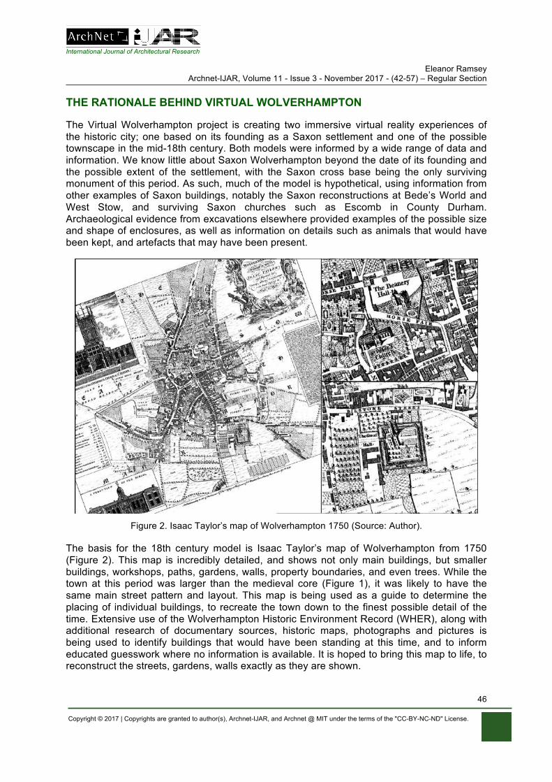
International Journal of Architectural Research Eleanor Ramsey
Archnet-IJAR, Volume 11 - Issue 3 - November 2017 - (42-57) – Regular Section
Copyright © 2017 | Copyrights are granted to author(s), Archnet-IJAR, and Archnet @ MIT under the terms of the "CC-BY-NC-ND" License.
46
THE RATIONALE BEHIND VIRTUAL WOLVERHAMPTON
The Virtual Wolverhampton project is creating two immersive virtual reality experiences of the historic city; one based on its founding as a Saxon settlement and one of the possible townscape in the mid-18th century. Both models were informed by a wide range of data and information. We know little about Saxon Wolverhampton beyond the date of its founding and the possible extent of the settlement, with the Saxon cross base being the only surviving monument of this period. As such, much of the model is hypothetical, using information from other examples of Saxon buildings, notably the Saxon reconstructions at Bede’s World and West Stow, and surviving Saxon churches such as Escomb in County Durham. Archaeological evidence from excavations elsewhere provided examples of the possible size and shape of enclosures, as well as information on details such as animals that would have been kept, and artefacts that may have been present.
Figure 2. Isaac Taylor’s map of Wolverhampton 1750 (Source: Author).
The basis for the 18th century model is Isaac Taylor’s map of Wolverhampton from 1750 (Figure 2). This map is incredibly detailed, and shows not only main buildings, but smaller buildings, workshops, paths, gardens, walls, property boundaries, and even trees. While the town at this period was larger than the medieval core (Figure 1), it was likely to have the same main street pattern and layout. This map is being used as a guide to determine the placing of individual buildings, to recreate the town down to the finest possible detail of the time. Extensive use of the Wolverhampton Historic Environment Record (WHER), along with additional research of documentary sources, historic maps, photographs and pictures is being used to identify buildings that would have been standing at this time, and to inform educated guesswork where no information is available. It is hoped to bring this map to life, to reconstruct the streets, gardens, walls exactly as they are shown.
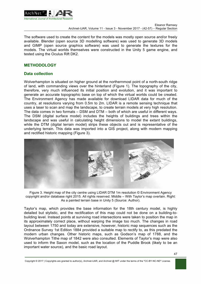
International Journal of Architectural Research Eleanor Ramsey
Archnet-IJAR, Volume 11 - Issue 3 - November 2017 - (42-57) – Regular Section
Copyright © 2017 | Copyrights are granted to author(s), Archnet-IJAR, and Archnet @ MIT under the terms of the "CC-BY-NC-ND" License.
47
The software used to create the content for the models was mostly open source and/or freely available. Blender (open source 3D modelling software) was used to generate 3D models and GIMP (open source graphics software) was used to generate the textures for the models. The virtual worlds themselves were constructed in the Unity 5 game engine, and tested using the Oculus Rift DK2.
METHODOLOGY
Data collection
Wolverhampton is situated on higher ground at the northernmost point of a north-south ridge of land, with commanding views over the hinterland (Figure 1). The topography of the city, therefore, very much influenced its initial position and evolution, and it was important to generate an accurate topographic base on top of which the virtual worlds could be created. The Environment Agency has made available for download LIDAR data for much of the country, at resolutions varying from 0.5m to 2m. LIDAR is a remote sensing technique that uses a laser to scan and map the landscape, to create terrain models at very high resolution. The data comes in two formats – DSM and DTM – both of which are useful in different ways. The DSM (digital surface model) includes the heights of buildings and trees within the landscape and was useful in calculating height dimensions to model the extant buildings, while the DTM (digital terrain model) strips these objects out and is representative of the underlying terrain. This data was imported into a GIS project, along with modern mapping and rectified historic mapping (Figure 3).
Figure 3. Height map of the city centre using LIDAR DTM 1m resolution © Environment Agency
copyright and/or database right 2015. All rights reserved. Middle – With Taylor’s map overlain. Right: As a painted terrain base in Unity 5 (Source: Author).
Taylor’s map, which provides the base information for the 18th century model, is highly detailed but stylistic, and the rectification of this map could not be done on a building-to-building level. Instead points at surviving road intersections were taken to position the map in its approximately correct place, without warping the image too much. The changes in road layout between 1750 and today are extensive, however, historic map sequences such as the Ordnance Survey 1st Edition 1884 provided a suitable map to rectify to, as this predated the modern urban changes. Other historic maps, such as Godson’s map of 1788, and the Wolverhampton Tithe map of 1842 were also consulted. Elements of Taylor’s map were also used to inform the Saxon model, such as the location of the Puddle Brook (likely to be an important water source), and the basic road layout.
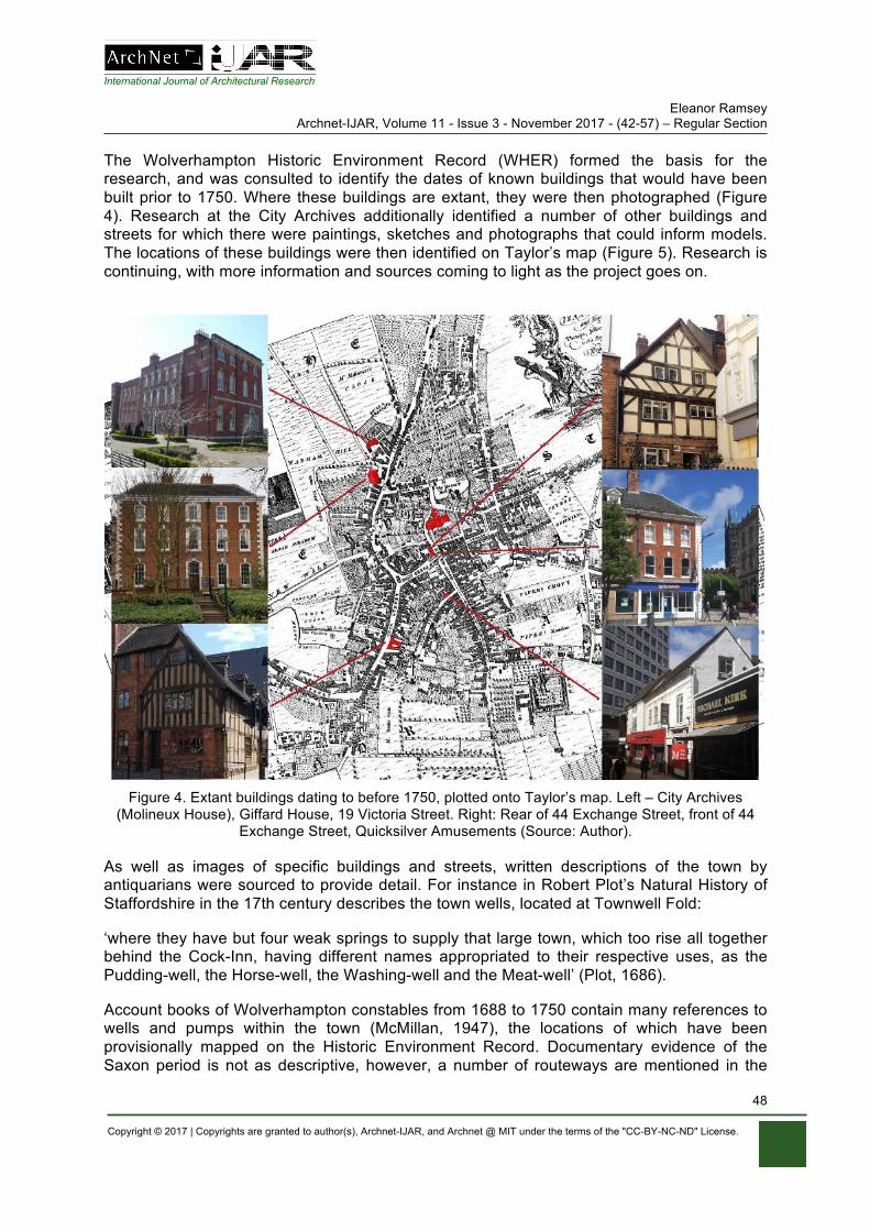
International Journal of Architectural Research Eleanor Ramsey
Archnet-IJAR, Volume 11 - Issue 3 - November 2017 - (42-57) – Regular Section
Copyright © 2017 | Copyrights are granted to author(s), Archnet-IJAR, and Archnet @ MIT under the terms of the "CC-BY-NC-ND" License.
48
The Wolverhampton Historic Environment Record (WHER) formed the basis for the research, and was consulted to identify the dates of known buildings that would have been built prior to 1750. Where these buildings are extant, they were then photographed (Figure 4). Research at the City Archives additionally identified a number of other buildings and streets for which there were paintings, sketches and photographs that could inform models. The locations of these buildings were then identified on Taylor’s map (Figure 5). Research is continuing, with more information and sources coming to light as the project goes on.
Figure 4. Extant buildings dating to before 1750, plotted onto Taylor’s map. Left – City Archives
(Molineux House), Giffard House, 19 Victoria Street. Right: Rear of 44 Exchange Street, front of 44 Exchange Street, Quicksilver Amusements (Source: Author).
As well as images of specific buildings and streets, written descriptions of the town by antiquarians were sourced to provide detail. For instance in Robert Plot’s Natural History of Staffordshire in the 17th century describes the town wells, located at Townwell Fold:
‘where they have but four weak springs to supply that large town, which too rise all together behind the Cock-Inn, having different names appropriated to their respective uses, as the Pudding-well, the Horse-well, the Washing-well and the Meat-well’ (Plot, 1686).
Account books of Wolverhampton constables from 1688 to 1750 contain many references to wells and pumps within the town (McMillan, 1947), the locations of which have been provisionally mapped on the Historic Environment Record. Documentary evidence of the Saxon period is not as descriptive, however, a number of routeways are mentioned in the
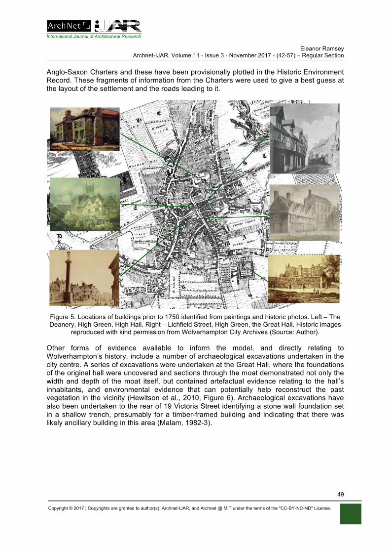
International Journal of Architectural Research Eleanor Ramsey
Archnet-IJAR, Volume 11 - Issue 3 - November 2017 - (42-57) – Regular Section
Copyright © 2017 | Copyrights are granted to author(s), Archnet-IJAR, and Archnet @ MIT under the terms of the "CC-BY-NC-ND" License.
49
Anglo-Saxon Charters and these have been provisionally plotted in the Historic Environment Record. These fragments of information from the Charters were used to give a best guess at the layout of the settlement and the roads leading to it.
Figure 5. Locations of buildings prior to 1750 identified from paintings and historic photos. Left – The Deanery, High Green, High Hall. Right – Lichfield Street, High Green, the Great Hall. Historic images
reproduced with kind permission from Wolverhampton City Archives (Source: Author).
Other forms of evidence available to inform the model, and directly relating to Wolverhampton’s history, include a number of archaeological excavations undertaken in the city centre. A series of excavations were undertaken at the Great Hall, where the foundations of the original hall were uncovered and sections through the moat demonstrated not only the width and depth of the moat itself, but contained artefactual evidence relating to the hall’s inhabitants, and environmental evidence that can potentially help reconstruct the past vegetation in the vicinity (Hewitson et al., 2010, Figure 6). Archaeological excavations have also been undertaken to the rear of 19 Victoria Street identifying a stone wall foundation set in a shallow trench, presumably for a timber-framed building and indicating that there was likely ancillary building in this area (Malam, 1982-3).
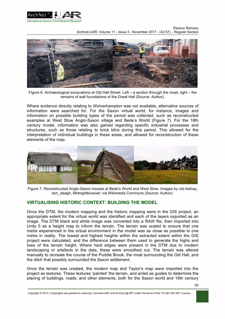
International Journal of Architectural Research Eleanor Ramsey
Archnet-IJAR, Volume 11 - Issue 3 - November 2017 - (42-57) – Regular Section
Copyright © 2017 | Copyrights are granted to author(s), Archnet-IJAR, and Archnet @ MIT under the terms of the "CC-BY-NC-ND" License.
50
Figure 6. Archaeological excavations at Old Hall Street. Left – a section through the moat, right – the
remains of wall foundations of the Great Hall (Source: Author).
Where evidence directly relating to Wolverhampton was not available, alternative sources of information were searched for. For the Saxon virtual world, for instance, images and information on possible building types of the period was collected, such as reconstructed examples at West Stow Anglo-Saxon village and Bede’s World (Figure 7). For the 18th century model, information was also gained regarding specific industrial processes and structures, such as those relating to brick kilns during this period. This allowed for the interpretation of individual buildings in these areas, and allowed for reconstruction of these elements of the map.
Figure 7. Reconstructed Anglo-Saxon houses at Bede’s World and West Stow. Images by rob bishop,
dun_deagh, Midnightblueowl: via Wikimedia Commons (Source: Author).
VIRTUALISING HISTORIC CONTEXT: BUILDING THE MODEL
Once the DTM, the modern mapping and the historic mapping were in the GIS project, an appropriate extent for the virtual world was identified and each of the layers exported as an image. The DTM black and white image was converted into a RAW file, then imported into Unity 5 as a height map to inform the terrain. The terrain was scaled to ensure that one metre experienced in the virtual environment in the model was as close as possible to one metre in reality. The lowest and highest heights within the extracted extent within the GIS project were calculated, and the difference between them used to generate the highs and lows of the terrain height. Where hard edges were present in the DTM due to modern landscaping or artefacts in the data, these were smoothed out. The terrain was altered manually to recreate the course of the Puddle Brook, the moat surrounding the Old Hall, and the ditch that possibly surrounded the Saxon settlement.
Once the terrain was created, the modern map and Taylor’s map were imported into the project as textures. These textures ‘painted’ the terrain, and acted as guides to determine the placing of buildings, roads, and other elements, both for the Saxon world and 18th century
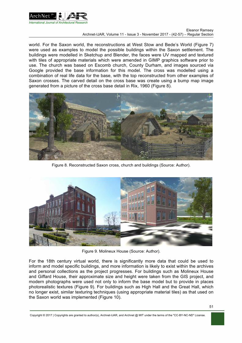
International Journal of Architectural Research Eleanor Ramsey
Archnet-IJAR, Volume 11 - Issue 3 - November 2017 - (42-57) – Regular Section
Copyright © 2017 | Copyrights are granted to author(s), Archnet-IJAR, and Archnet @ MIT under the terms of the "CC-BY-NC-ND" License.
51
world. For the Saxon world, the reconstructions at West Stow and Bede’s World (Figure 7) were used as examples to model the possible buildings within the Saxon settlement. The buildings were modelled in Sketchup and Blender, the faces were UV mapped and textured with tiles of appropriate materials which were amended in GIMP graphics software prior to use. The church was based on Escomb church, County Durham, and images sourced via Google provided the base information for this model. The cross was modelled using a combination of real life data for the base, with the top reconstructed from other examples of Saxon crosses. The carved detail on the cross base was create using a bump map image generated from a picture of the cross base detail in Rix, 1960 (Figure 8).
Figure 8. Reconstructed Saxon cross, church and buildings (Source: Author).
Figure 9. Molineux House (Source: Author).
For the 18th century virtual world, there is significantly more data that could be used to inform and model specific buildings, and more information is likely to exist within the archives and personal collections as the project progresses. For buildings such as Molineux House and Giffard House, their approximate size and height were taken from the GIS project, and modern photographs were used not only to inform the base model but to provide in places photorealistic textures (Figure 9). For buildings such as High Hall and the Great Hall, which no longer exist, similar texturing techniques (using appropriate material tiles) as that used on the Saxon world was implemented (Figure 10).
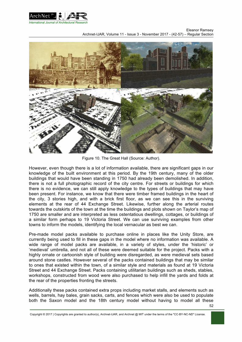
International Journal of Architectural Research Eleanor Ramsey
Archnet-IJAR, Volume 11 - Issue 3 - November 2017 - (42-57) – Regular Section
Copyright © 2017 | Copyrights are granted to author(s), Archnet-IJAR, and Archnet @ MIT under the terms of the "CC-BY-NC-ND" License.
52
Figure 10. The Great Hall (Source: Author).
However, even though there is a lot of information available, there are significant gaps in our knowledge of the built environment at this period. By the 19th century, many of the older buildings that would have been standing in 1750 had already been demolished. In addition, there is not a full photographic record of the city centre. For streets or buildings for which there is no evidence, we can still apply knowledge to the types of buildings that may have been present. For instance, we know that there were timber framed buildings in the heart of the city, 3 stories high, and with a brick first floor, as we can see this in the surviving elements at the rear of 44 Exchange Street. Likewise, further along the arterial routes towards the outskirts of the town at the time the buildings and plots shown on Taylor’s map of 1750 are smaller and are interpreted as less ostentatious dwellings, cottages, or buildings of a similar form perhaps to 19 Victoria Street. We can use surviving examples from other towns to inform the models, identifying the local vernacular as best we can.
Pre-made model packs available to purchase online in places like the Unity Store, are currently being used to fill in these gaps in the model where no information was available. A wide range of model packs are available, in a variety of styles, under the ‘historic’ or ‘medieval’ umbrella, and not all of these were deemed suitable for the project. Packs with a highly ornate or cartoonish style of building were disregarded, as were medieval sets based around stone castles. However several of the packs contained buildings that may be similar to ones that existed within the town, of a similar style and materials as found at 19 Victoria Street and 44 Exchange Street. Packs containing utilitarian buildings such as sheds, stables, workshops, constructed from wood were also purchased to help infill the yards and folds at the rear of the properties fronting the streets.
Additionally these packs contained extra props including market stalls, and elements such as wells, barrels, hay bales, grain sacks, carts, and fences which were also be used to populate both the Saxon model and the 18th century model without having to model all these
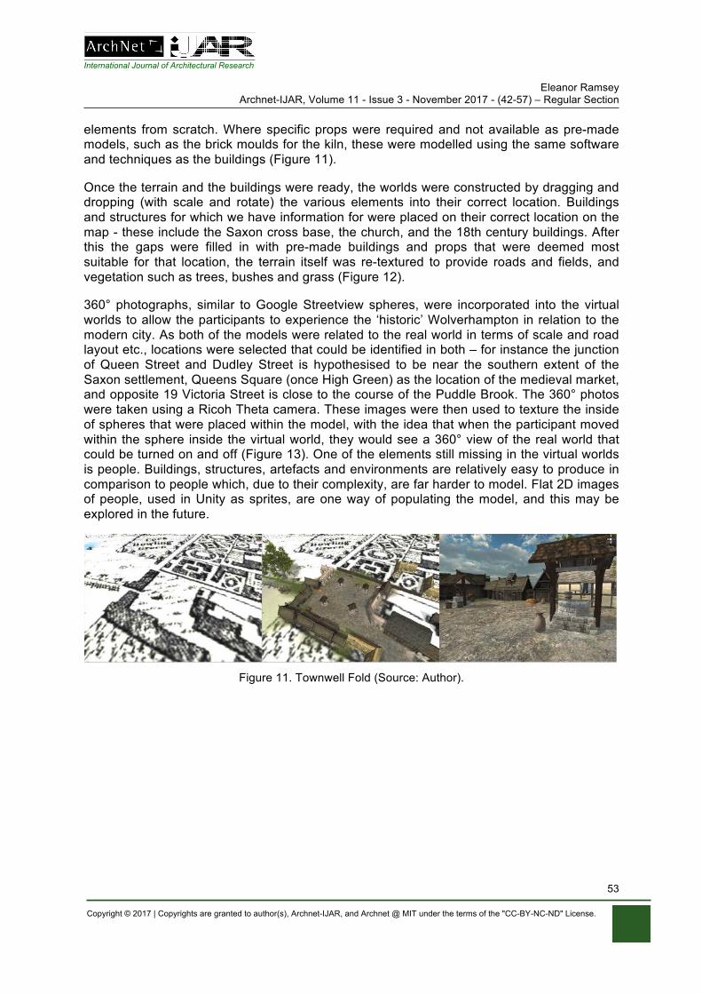
International Journal of Architectural Research Eleanor Ramsey
Archnet-IJAR, Volume 11 - Issue 3 - November 2017 - (42-57) – Regular Section
Copyright © 2017 | Copyrights are granted to author(s), Archnet-IJAR, and Archnet @ MIT under the terms of the "CC-BY-NC-ND" License.
53
elements from scratch. Where specific props were required and not available as pre-made models, such as the brick moulds for the kiln, these were modelled using the same software and techniques as the buildings (Figure 11).
Once the terrain and the buildings were ready, the worlds were constructed by dragging and dropping (with scale and rotate) the various elements into their correct location. Buildings and structures for which we have information for were placed on their correct location on the map - these include the Saxon cross base, the church, and the 18th century buildings. After this the gaps were filled in with pre-made buildings and props that were deemed most suitable for that location, the terrain itself was re-textured to provide roads and fields, and vegetation such as trees, bushes and grass (Figure 12).
360° photographs, similar to Google Streetview spheres, were incorporated into the virtual worlds to allow the participants to experience the ‘historic’ Wolverhampton in relation to the modern city. As both of the models were related to the real world in terms of scale and road layout etc., locations were selected that could be identified in both – for instance the junction of Queen Street and Dudley Street is hypothesised to be near the southern extent of the Saxon settlement, Queens Square (once High Green) as the location of the medieval market, and opposite 19 Victoria Street is close to the course of the Puddle Brook. The 360° photos were taken using a Ricoh Theta camera. These images were then used to texture the inside of spheres that were placed within the model, with the idea that when the participant moved within the sphere inside the virtual world, they would see a 360° view of the real world that could be turned on and off (Figure 13). One of the elements still missing in the virtual worlds is people. Buildings, structures, artefacts and environments are relatively easy to produce in comparison to people which, due to their complexity, are far harder to model. Flat 2D images of people, used in Unity as sprites, are one way of populating the model, and this may be explored in the future.
Figure 11. Townwell Fold (Source: Author).
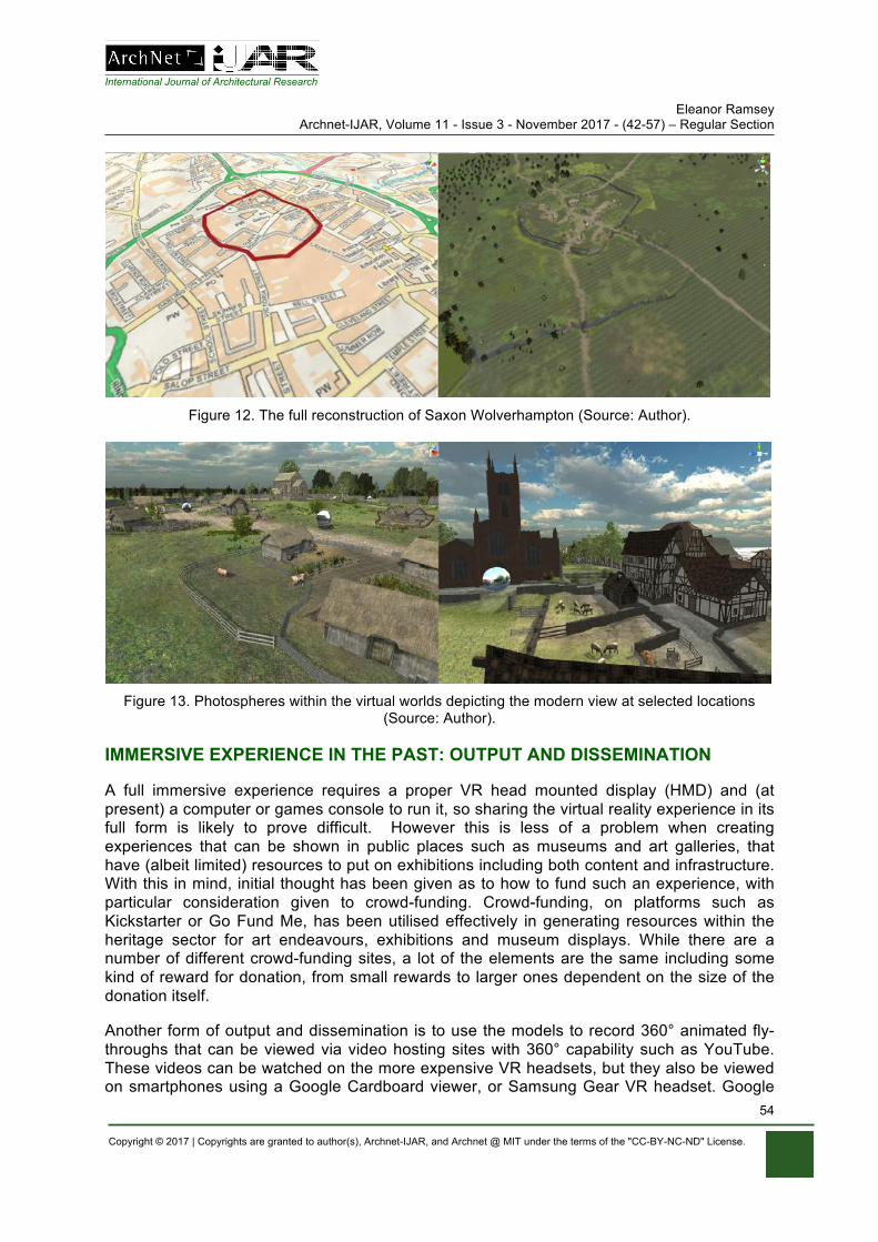
International Journal of Architectural Research Eleanor Ramsey
Archnet-IJAR, Volume 11 - Issue 3 - November 2017 - (42-57) – Regular Section
Copyright © 2017 | Copyrights are granted to author(s), Archnet-IJAR, and Archnet @ MIT under the terms of the "CC-BY-NC-ND" License.
54
Figure 12. The full reconstruction of Saxon Wolverhampton (Source: Author).
Figure 13. Photospheres within the virtual worlds depicting the modern view at selected locations
(Source: Author).
IMMERSIVE EXPERIENCE IN THE PAST: OUTPUT AND DISSEMINATION
A full immersive experience requires a proper VR head mounted display (HMD) and (at present) a computer or games console to run it, so sharing the virtual reality experience in its full form is likely to prove difficult. However this is less of a problem when creating experiences that can be shown in public places such as museums and art galleries, that have (albeit limited) resources to put on exhibitions including both content and infrastructure. With this in mind, initial thought has been given as to how to fund such an experience, with particular consideration given to crowd-funding. Crowd-funding, on platforms such as Kickstarter or Go Fund Me, has been utilised effectively in generating resources within the heritage sector for art endeavours, exhibitions and museum displays. While there are a number of different crowd-funding sites, a lot of the elements are the same including some kind of reward for donation, from small rewards to larger ones dependent on the size of the donation itself.
Another form of output and dissemination is to use the models to record 360° animated fly-throughs that can be viewed via video hosting sites with 360° capability such as YouTube. These videos can be watched on the more expensive VR headsets, but they also be viewed on smartphones using a Google Cardboard viewer, or Samsung Gear VR headset. Google
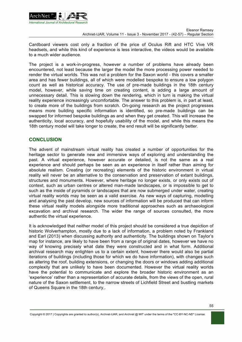
International Journal of Architectural Research Eleanor Ramsey
Archnet-IJAR, Volume 11 - Issue 3 - November 2017 - (42-57) – Regular Section
Copyright © 2017 | Copyrights are granted to author(s), Archnet-IJAR, and Archnet @ MIT under the terms of the "CC-BY-NC-ND" License.
55
Cardboard viewers cost only a fraction of the price of Oculus Rift and HTC Vive VR headsets, and while this kind of experience is less interactive, the videos would be available to a much wider audience.
The project is a work-in-progress, however a number of problems have already been encountered, not least because the larger the model the more processing power needed to render the virtual worlds. This was not a problem for the Saxon world - this covers a smaller area and has fewer buildings, all of which were modelled bespoke to ensure a low polygon count as well as historical accuracy. The use of pre-made buildings in the 18th century model, however, while saving time on creating content, is adding a large amount of unnecessary detail. This is slowing down the rendering, which in turn is making the virtual reality experience increasingly uncomfortable. The answer to this problem is, in part at least, to create more of the buildings from scratch. On-going research as the project progresses means more building specific information is identified, so pre-made buildings can be swapped for informed bespoke buildings as and when they get created. This will increase the authenticity, local accuracy, and hopefully usability of the model, and while this means the 18th century model will take longer to create, the end result will be significantly better.
CONCLUSION
The advent of mainstream virtual reality has created a number of opportunities for the heritage sector to generate new and immersive ways of exploring and understanding the past. A virtual experience, however accurate or detailed, is not the same as a real experience and should perhaps be seen as an experience in itself rather than aiming for absolute realism. Creating (or recreating) elements of the historic environment in virtual reality will never be an alternative to the conservation and preservation of extant buildings, structures and monuments. However, where heritage no longer exists, or only exists out of context, such as urban centres or altered man-made landscapes, or is impossible to get to such as the inside of pyramids or landscapes that are now submerged under water, creating virtual reality worlds may be seen as a valid exercise. As new ways of capturing, modelling and analysing the past develop, new sources of information will be produced that can inform these virtual reality models alongside more traditional approaches such as archaeological excavation and archival research. The wider the range of sources consulted, the more authentic the virtual experience.
It is acknowledged that neither model of this project should be considered a true depiction of historic Wolverhampton, mostly due to a lack of information, a problem noted by Frankland and Earl (2013) when discussing authority and authenticity. The buildings shown on Taylor’s map for instance, are likely to have been from a range of original dates, however we have no way of knowing precisely what date they were constructed and in what form. Additional archival research may enlighten us to a certain extent, however there would also be partial iterations of buildings (including those for which we do have information), with changes such as altering the roof, building extensions, or changing the doors or windows adding additional complexity that are unlikely to have been documented. However the virtual reality worlds have the potential to communicate and explore the broader historic environment as an ‘experience’ rather than a representation of accurate details, from the views of the open, rural nature of the Saxon settlement, to the narrow streets of Lichfield Street and bustling markets of Queens Square in the 18th century,.
International Journal of Architectural Research Eleanor Ramsey
Archnet-IJAR, Volume 11 - Issue 3 - November 2017 - (42-57) – Regular Section
Copyright © 2017 | Copyrights are granted to author(s), Archnet-IJAR, and Archnet @ MIT under the terms of the "CC-BY-NC-ND" License.
56
The technology is still developing (albeit rapidly) and is not without problems. There is still the dominance of the visual aspect of the immersive experience, with an obvious need to address other senses and incorporate elements such as 3D sounds into the worlds. The use of ‘serious gaming’ – videogames designed for educational purposes – has clear potential in the cultural heritage sector (Mortara, 2014), which may have the benefit of attracting younger audiences, however, while a study by Fabola and Miller (2016) demonstrated the efficacy of virtual reality as a tool for learning history, it also showed that higher levels of immersion (where the interactivity was confined to specific view points) did not stimulate young pupils’ interest more than screen based experiences that allowed for a free-form type of interactivity.
However research has also shown that using VR (and augmented reality) in museums enhances visitor experiences in terms of appreciation of the exhibit and the intent to revisit (Jung, 2016), which has significant implications at time when museums and other cultural heritage institutions are struggling for funding.
It is hoped to present the Saxon World as an immersive, interactive experience using Oculus Rift within a future Saxon exhibit at Wolverhampton Museum and Art Gallery, supplemented by 360° video fly-throughs of the world hosted on YouTube. By generating new and immersive ways of experiencing and exploring the city’s past, a new understanding can be found of its history by both academics and the general public and by using exciting new technologies, new audiences within Wolverhampton and the wider community can be engaged.
ACKNOWLEDGEMENTS
Thanks are due to Mohamed Gamal Abdelmonem and Mike Shaw for their feedback on the first draft of this paper, and to the staff of Wolverhampton City Archives and Wolverhampton Museum and Art Gallery for their support for the project.
REFERENCES Abdelmonem, M. G. (2017) Virtual Heritage: Global Perspectives for creative modes of heritage
visualisation. Nottingham: Nottingham Trent University Alberge, D. (2017). Virtual reality brings ninth century Viking invaders’ camp to life. In: The Guardian
from https://www.theguardian.com/artanddesign/2017/may/17/virtual-reality-brings-ninth-century-viking-invaders-camp-to-life accessed 02/10/17
Baker, N. (1980). The Archaeology of Wolverhampton: A report on the archaeology of the town centre. Birmingham: Birmingham University Field Archaeology Unit and The Urban Research Committee.
Ch’ng, E., Gaffney, V., & Chapman, H. (eds) (2013). Visual Heritage in the Digital Age. Springer Series on Cultural Computing. London: Springer-Verlag London.
Ch’ng, E. (2009). Experiential archaeology: Is virtual time travel possible? Journal of Cultural Heritage, 10, 458-470. doi https://doi.org/10.1016/j.culher.2009.02.001
Ch’ng, E. (2007). Using Games Engines for Archaeological Visualisation: Recreating Lost Worlds. CGames ’07 The 11th International Conference on Computer Games, AI, Animation, Mobile, Educational and Serious Games La Rochelle, France 21-23 November 2007.
Chapman, H. (2006). Landscape Archaeology and GIS. Stroud, Gloucestershire: Tempus Eve, S. (2017). The Embodied GIS. Using Mixed Reality to explore multi-sensory archaeological
landscapes. Internet Archaeology 44. https://doi.org/10.11141/ia.44.3 Fabola, A., & Miller, A. (2016). Virtual Reality for Early Education: A Study. In Allison, C., Morgado, L.,
Pirker, J., Beck, D., Richter, J., & Gutl, C. (eds), Immersive Learning Research Network: Second International Conference. iLRN 2016 Santa Barbara, CA, USA, June 27-July 1, 2016
International Journal of Architectural Research Eleanor Ramsey
Archnet-IJAR, Volume 11 - Issue 3 - November 2017 - (42-57) – Regular Section
Copyright © 2017 | Copyrights are granted to author(s), Archnet-IJAR, and Archnet @ MIT under the terms of the "CC-BY-NC-ND" License.
57
Proceedings. Communications in Computer and Information Science, Vol 621. Cham: Springer. pp 59-72
Feldmann, I., Schreer, O., Ebner, T., Eisert, P., Hilsmann, A., Nonne, N. & Haeberlein, S. (2016) Digitization of People and Objects for Virtual Museum Applications. EVA Berlin 2016 Conference, 9-11 November. pp 119-124
Frankland, T. & Earl, G. (2011). Authority and authenticity in future archaeological visualisation. In: Proceedings of Ads-Vis2011: Making Visible the Invisible: Art, Design and Science in Data Visualisation. Huddersfield: University of Huddersfield
Farley, K. (1985). Wolverhampton 985-1985. From http://www.historywebsite.co.uk/history/farley/oldwlv.htm (accessed 25/10/17)
Gillings, M. (2012). Landscape phenomenology, GIS and the role of affordance. Journal of Archaeological Method and Theory 19(4), pp. 601–11. doi: https://doi.org/10.1007/s10816-012-9137-4
Gonizzi Barsanti, S., Caruso, G., Micoli, L. L., Covarrubias Rodriguez, M. and Guidi, G. (2015). 3D Visualisation of Cultural Heritage Artefacts with Virtual Reality Devices. in The International Archives of the Photogrammetry, Remote Sensing and Spatial Information Sciences Vol XL-5/W7 25th International CIPA Symposium 2015.165-172. doi: 10.5194/isprsarchives-XL-5-W7-165-2015.
Guerra, J. P., Pinto, M. M. and Beato, C. (2015). Virtual Reality – Shows a new vision for tourism and heritage. European Scientific Journal , 11(9) pp. 49-54
Gupta, N. and Devillers, R. (2016) Geographic Visualisation in Archaeology. Journal of Archaeological Method and Theory. 24(3) pp852-885. doi https://doi.org/10.1007/s10816-016-9298-7
Hewitson, C., Ramsey, E., Shaw, M., Hislop, M. & Cutler, R. (2010). The Great Hall, Wolverhampton: Elizabethan Mansion to Victorian Workshop. Oxford: British Archaeological Reports 517
Historic England. (2015). Conservation Principles, Policies and Guidance. From https://historicengland.org.uk/advice/constructive-conservation/conservation-principles/
Horovitz, D. (2005). Place Names of Staffordshire. Brewood: David Horowicz Kersten, T. P., Büyüksalih, G., Tschirschwitz, F., Kan, T., Deggim, S., Kaya, Y., & Baskaraca, A. P.
(2017). The Selimiye Mosque of Edirne, Turkey – An Immersive and Interactive Virtual Reality Experience Using HTC Vive. in The International Archives of the Photogrammetry, Remote Sensing and Spatial Information Sciences Vol XLII-5/W1, pp403-409. Geomatics and Restoration – Conservation of Cultural Heritage in the Digital Era 22-24 May
Jung, T., tom Dieck, M. C., Lee, H. & Chung, N. (2016). Effects of Virtual Reality and Augmented Reality on Visitor Experiences in Museum. in Inversini, A. & Schegg, R. (eds). Information and Communication Technologies in Tourism. pp. 621-635. Wien, New York: Springer International Publishing.
Malam, J. P. (1982-3) Excavations and Archaeology in Wolverhampton 1980-82. Transactions of the South Staffordshire Archaeology and Historical Society 24, p66-83
McMillan, B. L. (1947). The History of the Water Supply of Wolverhampton 1847-1947. Wolverhampton: WMBC
Plot, Robert (1686). The Natural History of Staffordshire. Oxford Pudding Lane Productions (2013) from http://puddinglanedmuga.blogspot.co.uk/ Richards-Rissetto, H. (2017). What can GIS + 3D mean for landscape archaeology. Journal of
Archaeological Science 84 pp.10-21 Rix, M. (1960). The Wolverhampton Cross Shaft. The Archaeological Journal, 117. p71-81 Shaw, M. (2000). Mapping the town: Medieval Wolverhampton and Walsall. West Midlands
Archaeology 43. pp29-32 Slater, T.R. (1986) Wolverhampton: central place to medieval borough. In Hooke, D. & Slater, T.
Anglo-Saxon Wolverhampton: the town and its monastery. pp 29-47. Wolverhampton: WMBC Ramsey, E. (2013) Urban Scrawl: Reconstructing Urban Landscapes Using Documentary Sources. In
Ch’ng, E., Gaffney, V., & Chapman, H. (eds) (2013). Visual Heritage in the Digital Age. Springer Series on Cultural Computing. London: Springer-Verlag London.
Taylor, I. (1750). Map of Wolverhampton Upton, C. (1998). A History of Wolverhampton. Chichester UK: Phillimore & Co.
Stuart Burch Archnet-IJAR, Volume 11 - Issue 3 - November 2017 - (58-77) – Regular Section
Copyright © 2017 | Copyrights are granted to author(s), Archnet-IJAR, and Archnet @ MIT under the terms of the "CC-BY-NC-ND" License.
58
Archnet-IJAR: International Journal of Architectural Research www.archnet-ijar.net/ -- https://archnet.org/collections/34
A VIRTUAL OASIS: TRAFALGAR SQUARE’S ARCH OF PALMYRA DOI: http://dx.doi.org/10.26687/archnet-ijar.v11i3.1401
Stuart Burch
Keywords Abstract
Arch of Palmyra; heritage; iconoclasm; Michael Rakowitz; monuments; Trafalgar Square.
This paper considers the destruction of the Arch of Palmyra in Syria in 2015 and its temporary reconstruction a year later in London’s Trafalgar Square. Attention is paid to an adjacent pedestal known as the Fourth Plinth, with a particular focus on a proposed monument by the Iraqi-American conceptual artist, Michael Rakowitz (born 1973). His works provide the basis for a discussion of public memorials and art’s commemorative function; the preservation, destruction and politicisation of heritage; the role of technology for the purposes of documentation and reconstruction; notions of authenticity; ethics and legal issues surrounding the global trade in cultural artefacts.
S. Burch* School of Arts & Humanities, Nottingham Trent University, Nottingham, NG1 4FQ, United Kingdom
*Corresponding Author’s email address: [email protected]
ArchNet-IJAR is indexed and listed in several databases, including: • Avery Index to Architectural
Periodicals • EBSCO-Current Abstracts-Art
and Architecture • CNKI: China National
Knowledge Infrastructure • DOAJ: Directory of Open
Access Journals • Pro-Quest • Scopus-Elsevier • Web of Science
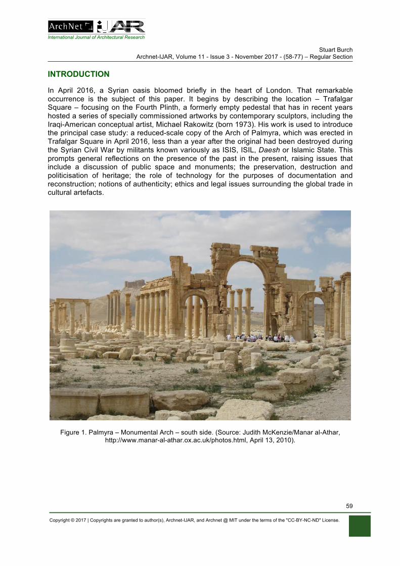
International Journal of Architectural Research Stuart Burch
Archnet-IJAR, Volume 11 - Issue 3 - November 2017 - (58-77) – Regular Section
Copyright © 2017 | Copyrights are granted to author(s), Archnet-IJAR, and Archnet @ MIT under the terms of the "CC-BY-NC-ND" License.
59
INTRODUCTION
In April 2016, a Syrian oasis bloomed briefly in the heart of London. That remarkable occurrence is the subject of this paper. It begins by describing the location – Trafalgar Square – focusing on the Fourth Plinth, a formerly empty pedestal that has in recent years hosted a series of specially commissioned artworks by contemporary sculptors, including the Iraqi-American conceptual artist, Michael Rakowitz (born 1973). His work is used to introduce the principal case study: a reduced-scale copy of the Arch of Palmyra, which was erected in Trafalgar Square in April 2016, less than a year after the original had been destroyed during the Syrian Civil War by militants known variously as ISIS, ISIL, Daesh or Islamic State. This prompts general reflections on the presence of the past in the present, raising issues that include a discussion of public space and monuments; the preservation, destruction and politicisation of heritage; the role of technology for the purposes of documentation and reconstruction; notions of authenticity; ethics and legal issues surrounding the global trade in cultural artefacts.
Figure 1. Palmyra – Monumental Arch – south side. (Source: Judith McKenzie/Manar al-Athar, http://www.manar-al-athar.ox.ac.uk/photos.html, April 13, 2010).
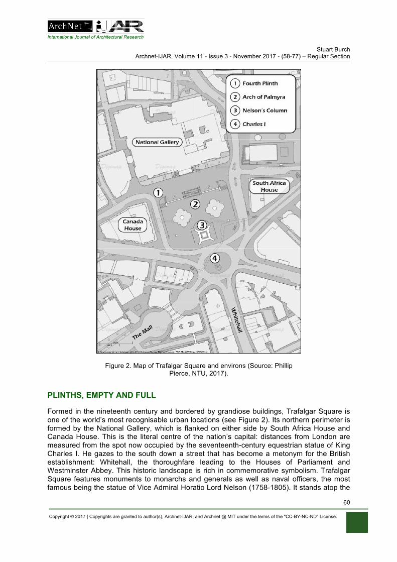
International Journal of Architectural Research Stuart Burch
Archnet-IJAR, Volume 11 - Issue 3 - November 2017 - (58-77) – Regular Section
Copyright © 2017 | Copyrights are granted to author(s), Archnet-IJAR, and Archnet @ MIT under the terms of the "CC-BY-NC-ND" License.
60
Figure 2. Map of Trafalgar Square and environs (Source: Phillip Pierce, NTU, 2017).
PLINTHS, EMPTY AND FULL
Formed in the nineteenth century and bordered by grandiose buildings, Trafalgar Square is one of the world’s most recognisable urban locations (see Figure 2). Its northern perimeter is formed by the National Gallery, which is flanked on either side by South Africa House and Canada House. This is the literal centre of the nation’s capital: distances from London are measured from the spot now occupied by the seventeenth-century equestrian statue of King Charles I. He gazes to the south down a street that has become a metonym for the British establishment: Whitehall, the thoroughfare leading to the Houses of Parliament and Westminster Abbey. This historic landscape is rich in commemorative symbolism. Trafalgar Square features monuments to monarchs and generals as well as naval officers, the most famous being the statue of Vice Admiral Horatio Lord Nelson (1758-1805). It stands atop the
International Journal of Architectural Research Stuart Burch
Archnet-IJAR, Volume 11 - Issue 3 - November 2017 - (58-77) – Regular Section
Copyright © 2017 | Copyrights are granted to author(s), Archnet-IJAR, and Archnet @ MIT under the terms of the "CC-BY-NC-ND" License.
61
lofty column that dominates a forum named after the victorious naval battle that cost the British hero his life.
Unusually, however, one of Trafalgar Square’s pedestals remained empty for 150 years. Many remedies were suggested, but it was not until 1998 that a proposal was made to use it to temporarily support three specially commissioned pieces of contemporary sculpture. The most notable of these was Mark Wallinger’s statue of Christ, Ecce Homo (1999). Placing a life-size cast of a sacred figure of peace among a secular pantheon of oversized men of war generated much discussion. The perceived success of this initiative has led to the Fourth Plinth Commission, an ongoing scheme carried out under the auspices of the elected Mayor of London. It has to date overseen the commissioning of eight artworks. At the time of writing it is adorned by David Shrigley’s (Everything is) Really Good (2016), a colossal bronze hand making a thumbs-up gesture. The surreal proportions of the massively extended digit emphasises the artist’s hope that his work ‘will make the world a better place’ and his belief that ‘we need positive messages.’ In so doing, Shrigley sought to convince a dubious and uneasy public that ‘something, somewhere, is really good’ (Shrigley, 2016).
That such optimism was felt necessary is indicative of prevalent global insecurities and fears about an uncertain future. These anxieties infused five works shortlisted in January 2017, two of which would be selected to succeed Shrigley’s Really Good. These were Damián Ortega’s High Way, a precarious arrangement of oil cans, a scaffold and ladders mounted on a truck; Raqs Media Collective’s The Emperor’s Old Clothes, a bodiless effigy swathed in a copy of the robes worn by a colonial-era statue in Delhi; a brooding, malevolent Untitled figure by Huma Bhabha; and Heather Phillipson’s The End, a Pop Art-inspired composition infested with parasites and monitored by a surveillance drone. Concluding this remarkable line-up is perhaps the most thought provoking and, in the context of this paper, most relevant proposal: The Invisible Enemy Should Not Exist by Michael Rakowitz (born 1973), a New York-born, Chicago-based conceptual artist of Iraqi Jewish heritage (see Figure 3).
Rakowitz’s proposal for Trafalgar Square’s Fourth Plinth shares its title with a project that has occupied the artist for more than a decade. This involves the recreation of thousands of artefacts looted from Iraq’s National Museum following the US-led invasion of 2003. These substitutes are fashioned from food packaging or local newspapers and displayed alongside explanatory labels in both English and Arabic. Whilst the presentation of these bargain-basement treasures mimic museum methods, closer inspection reveals both the mundane materials and unconventional texts. A case in point is a missing fluted beaker made of gold. The replacement consists of strips of metal from date syrup cans and a display card that includes an extract from comments made by Donald Rumsfeld during a news briefing held on April 11, 2003. The United States Secretary of Defense angrily dismissed accusations that he lacked a plan to tackle lawlessness in Iraq and instead sought to deflect criticism by characterising the anarchy and looting that was then taking place as the understandable release of pent-up anger targeted at the deposed regime of Saddam Hussein. Rumsfeld then went on to make a notorious quip that Rakowitz repeated in his museum label:
The images you are seeing on television you are seeing over, and over, and over, and it’s the same picture of some person walking out of some building with a vase,
and you see it 20 times, and you think, “My goodness, were there that many vases?” [Laughter.] “Is it possible that there were that many vases in the whole
country?” (cited in Mockaitis, 2012: 147).
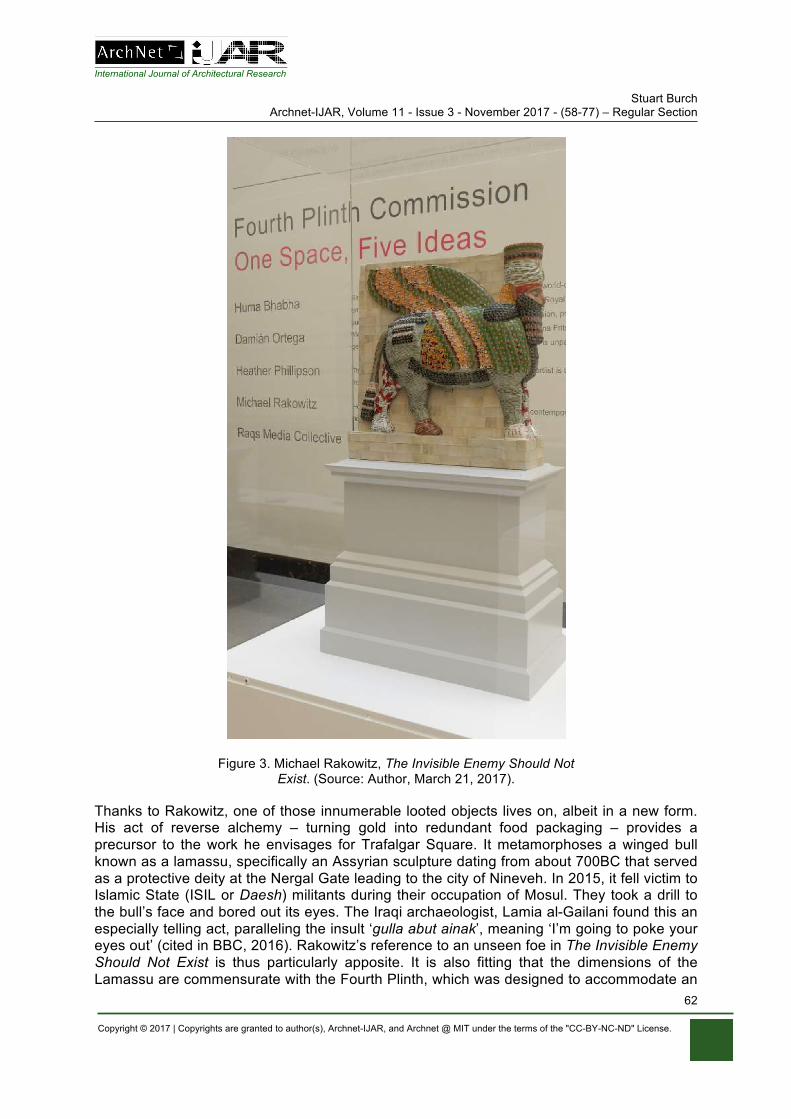
International Journal of Architectural Research Stuart Burch
Archnet-IJAR, Volume 11 - Issue 3 - November 2017 - (58-77) – Regular Section
Copyright © 2017 | Copyrights are granted to author(s), Archnet-IJAR, and Archnet @ MIT under the terms of the "CC-BY-NC-ND" License.
62
Figure 3. Michael Rakowitz, The Invisible Enemy Should Not Exist. (Source: Author, March 21, 2017).
Thanks to Rakowitz, one of those innumerable looted objects lives on, albeit in a new form. His act of reverse alchemy – turning gold into redundant food packaging – provides a precursor to the work he envisages for Trafalgar Square. It metamorphoses a winged bull known as a lamassu, specifically an Assyrian sculpture dating from about 700BC that served as a protective deity at the Nergal Gate leading to the city of Nineveh. In 2015, it fell victim to Islamic State (ISIL or Daesh) militants during their occupation of Mosul. They took a drill to the bull’s face and bored out its eyes. The Iraqi archaeologist, Lamia al-Gailani found this an especially telling act, paralleling the insult ‘gulla abut ainak’, meaning ‘I’m going to poke your eyes out’ (cited in BBC, 2016). Rakowitz’s reference to an unseen foe in The Invisible Enemy Should Not Exist is thus particularly apposite. It is also fitting that the dimensions of the Lamassu are commensurate with the Fourth Plinth, which was designed to accommodate an
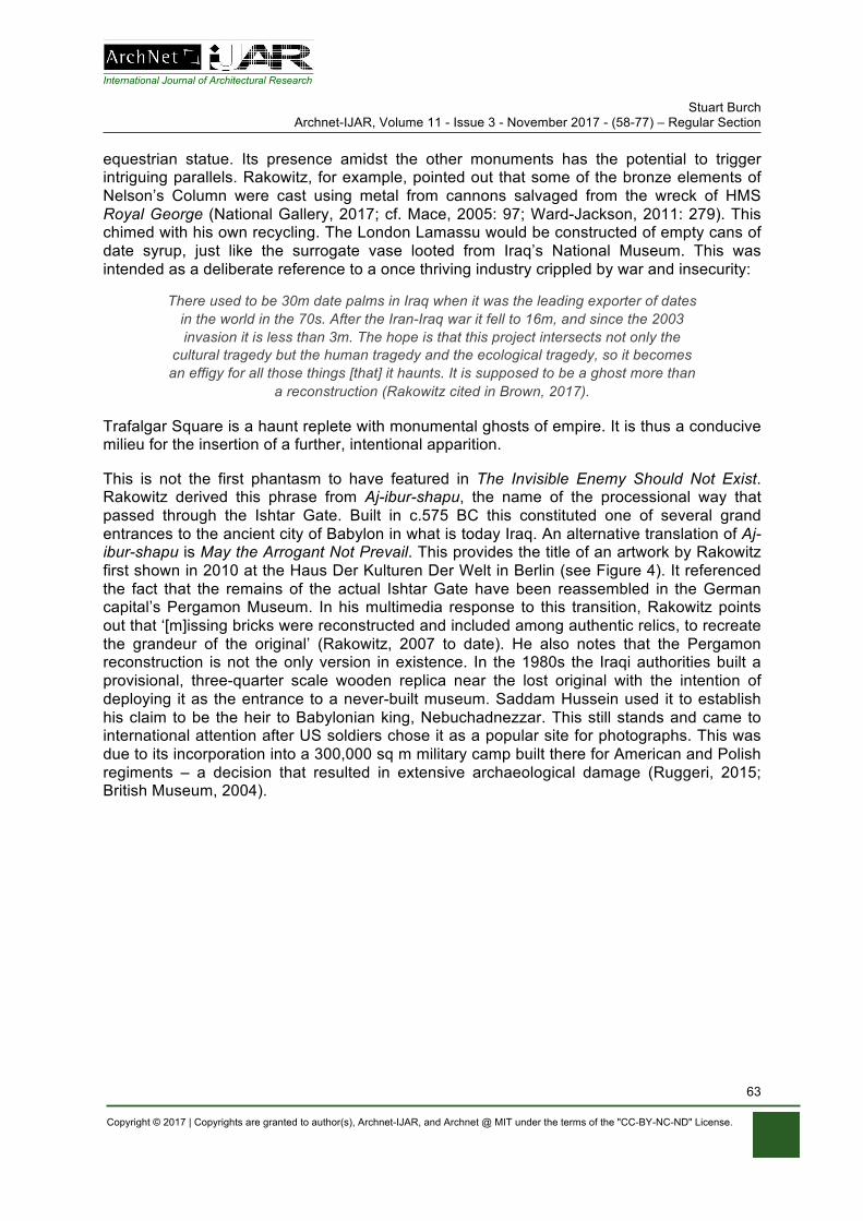
International Journal of Architectural Research Stuart Burch
Archnet-IJAR, Volume 11 - Issue 3 - November 2017 - (58-77) – Regular Section
Copyright © 2017 | Copyrights are granted to author(s), Archnet-IJAR, and Archnet @ MIT under the terms of the "CC-BY-NC-ND" License.
63
equestrian statue. Its presence amidst the other monuments has the potential to trigger intriguing parallels. Rakowitz, for example, pointed out that some of the bronze elements of Nelson’s Column were cast using metal from cannons salvaged from the wreck of HMS Royal George (National Gallery, 2017; cf. Mace, 2005: 97; Ward-Jackson, 2011: 279). This chimed with his own recycling. The London Lamassu would be constructed of empty cans of date syrup, just like the surrogate vase looted from Iraq’s National Museum. This was intended as a deliberate reference to a once thriving industry crippled by war and insecurity:
There used to be 30m date palms in Iraq when it was the leading exporter of dates in the world in the 70s. After the Iran-Iraq war it fell to 16m, and since the 2003 invasion it is less than 3m. The hope is that this project intersects not only the
cultural tragedy but the human tragedy and the ecological tragedy, so it becomes an effigy for all those things [that] it haunts. It is supposed to be a ghost more than
a reconstruction (Rakowitz cited in Brown, 2017).
Trafalgar Square is a haunt replete with monumental ghosts of empire. It is thus a conducive milieu for the insertion of a further, intentional apparition.
This is not the first phantasm to have featured in The Invisible Enemy Should Not Exist. Rakowitz derived this phrase from Aj-ibur-shapu, the name of the processional way that passed through the Ishtar Gate. Built in c.575 BC this constituted one of several grand entrances to the ancient city of Babylon in what is today Iraq. An alternative translation of Aj-ibur-shapu is May the Arrogant Not Prevail. This provides the title of an artwork by Rakowitz first shown in 2010 at the Haus Der Kulturen Der Welt in Berlin (see Figure 4). It referenced the fact that the remains of the actual Ishtar Gate have been reassembled in the German capital’s Pergamon Museum. In his multimedia response to this transition, Rakowitz points out that ‘[m]issing bricks were reconstructed and included among authentic relics, to recreate the grandeur of the original’ (Rakowitz, 2007 to date). He also notes that the Pergamon reconstruction is not the only version in existence. In the 1980s the Iraqi authorities built a provisional, three-quarter scale wooden replica near the lost original with the intention of deploying it as the entrance to a never-built museum. Saddam Hussein used it to establish his claim to be the heir to Babylonian king, Nebuchadnezzar. This still stands and came to international attention after US soldiers chose it as a popular site for photographs. This was due to its incorporation into a 300,000 sq m military camp built there for American and Polish regiments – a decision that resulted in extensive archaeological damage (Ruggeri, 2015; British Museum, 2004).
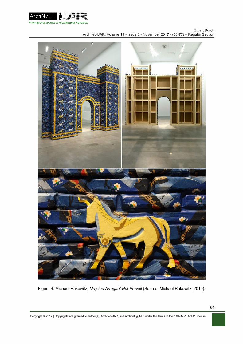
International Journal of Architectural Research Stuart Burch
Archnet-IJAR, Volume 11 - Issue 3 - November 2017 - (58-77) – Regular Section
Copyright © 2017 | Copyrights are granted to author(s), Archnet-IJAR, and Archnet @ MIT under the terms of the "CC-BY-NC-ND" License.
64
Figure 4. Michael Rakowitz, May the Arrogant Not Prevail (Source: Michael Rakowitz, 2010).
International Journal of Architectural Research Stuart Burch
Archnet-IJAR, Volume 11 - Issue 3 - November 2017 - (58-77) – Regular Section
Copyright © 2017 | Copyrights are granted to author(s), Archnet-IJAR, and Archnet @ MIT under the terms of the "CC-BY-NC-ND" License.
65
Rakowitz’s own reconstruction of this reconstruction is a precarious mêlée of newspaper, adhesive and cardboard around a plywood armature. To recreate the characteristic blue bricks Rakowitz sourced ‘colour-correct packaging of Arabic foodstuffs found in Berlin’ (Rakowitz, 2010). Now preserved in the collection of Chicago’s Museum of Contemporary Art, this composition invites reflections on the fragile and vulnerable state of modern-day Iraq plus the transit of cultural heritage, goods and people. It also places truth claims under scrutiny given that what was built at Berlin’s Pergamon Museum ‘in the 1920s was not, and still is not, the entire gate’ (Ruggeri, 2015). Rakowitz’s makeshift version of the same object disturbs notions of authenticity and reveals the mutable nature of heritage. As such it provides an arch precedent for a similar act of architectural reimagining; one that conjured up the ghost of a Syrian oasis in the heart of London.
COPY THAT
In March 2017 it was announced that Michael Rakowitz’s tin can lamassu would be appearing on the Fourth Plinth the following year, to be succeeded by Heather Phillipson’s The End in 2020. These two works had received the most plaudits, eliciting praise even from art critics who were otherwise sceptical about the whole venture (Jones, 2017). One reviewer extolled Rakowitz’s ‘rejoinder to iconoclasm’, heralding it as an ‘abject memorial’ to the welter of cultural heritage being lost (Searle, 2017). Sadly, the wilful destruction of objects has a long, ignoble history. Indeed, it is tempting to perceive the epoch in which we live as having been ushered in by a glut of iconoclasm. This is brilliantly visualised in an illustration by J. Otto Seibold first published in The New Yorker (see Morgan, 2012: 24-25). In 2002, he was one of nine artists invited to suggest ways of filling the void left following the terrorist demolition of the World Trade Center. Seibold proposed the erection of a pair of gigantic Buddhas in reference to two such statues destroyed by the Taliban in Afghanistan six months prior to Al-Qaeda’s coordinated attacks on the United States. In return, Seibold suggested that the alcoves that once contained the colossal Buddhas could accommodate the rebuilt Twin Towers, and that these should be used to house refugees.
Obviously, this radical idea was not so much a practical solution as a thought experiment. Seibold’s insightful and inventive response confirms that conflict can be a catalyst for creativity (Sinclair, 2016). This was confirmed by another instance of iconoclasm that occurred some fifteen years after the events of 9/11. In May 2015, militants loyal to the so-called Islamic State occupied the town of Tadur, just over 130 miles north-east of the Syrian capital, Damascus. From there they took control of the archaeological remains at nearby Palmyra, including the ancient Temple of Bel. The most famous structure at this UNESCO World Heritage Site was the 1,800 year-old Arch of Palmyra. Reports that it had been deliberately blown-up triggered a global outcry. In response, the Institute for Digital Archaeology (IDA) moved swiftly to construct a replacement. The IDA’s founder and director, Roger L. Michel Jr. indicated that this token of defiance was ‘a political statement’; an avowal that every time such a monument was wiped out, another would arise in its place (Gayle, 2015). His ultimate wish was to see this new version assembled near the site of the lost original. The ongoing turmoil in Syria made this impossible, however. Michel therefore sought out an alternative location to place it on a temporary basis. This needed to be as conspicuous as possible in order to highlight the plight of Palmyra whilst also promoting the IDA and the causes it espoused. And so it was that a fragmentary echo from an oasis in the Syrian Desert arose in the shadow of Nelson’s Column. Michel explained his choice of Trafalgar Square on the grounds that London’s principal forum, with its diverse audiences
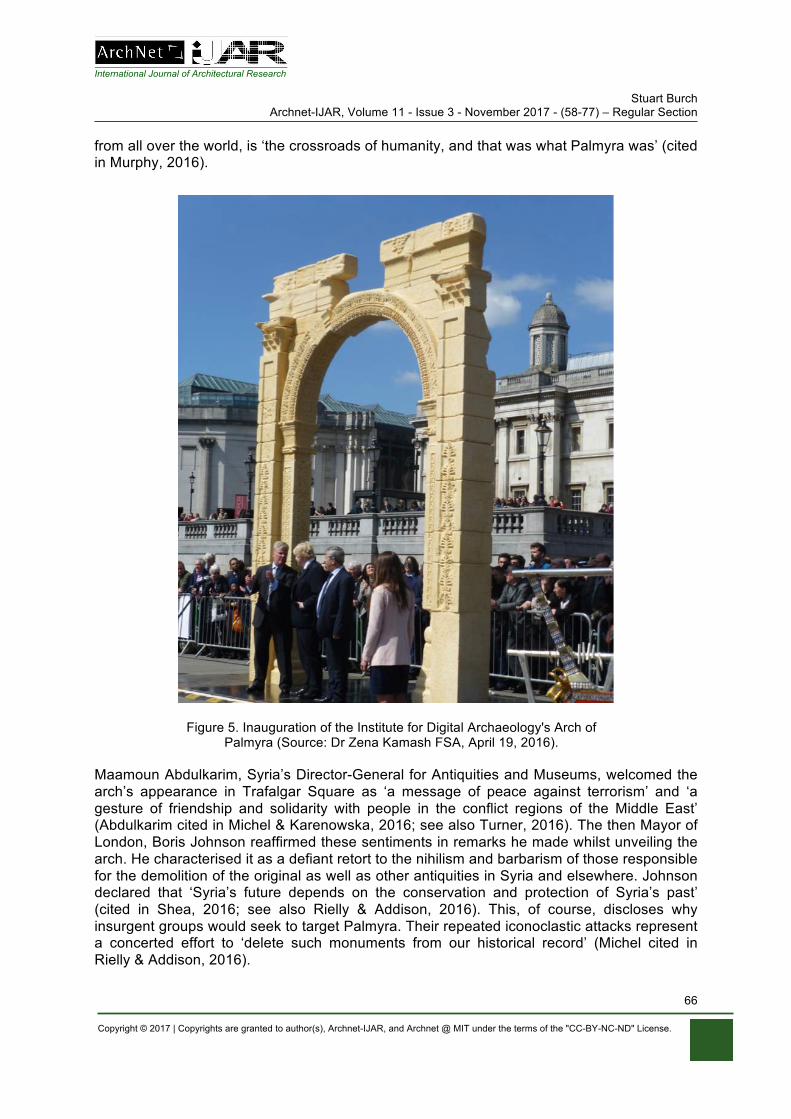
International Journal of Architectural Research Stuart Burch
Archnet-IJAR, Volume 11 - Issue 3 - November 2017 - (58-77) – Regular Section
Copyright © 2017 | Copyrights are granted to author(s), Archnet-IJAR, and Archnet @ MIT under the terms of the "CC-BY-NC-ND" License.
66
from all over the world, is ‘the crossroads of humanity, and that was what Palmyra was’ (cited in Murphy, 2016).
Figure 5. Inauguration of the Institute for Digital Archaeology's Arch of Palmyra (Source: Dr Zena Kamash FSA, April 19, 2016).
Maamoun Abdulkarim, Syria’s Director-General for Antiquities and Museums, welcomed the arch’s appearance in Trafalgar Square as ‘a message of peace against terrorism’ and ‘a gesture of friendship and solidarity with people in the conflict regions of the Middle East’ (Abdulkarim cited in Michel & Karenowska, 2016; see also Turner, 2016). The then Mayor of London, Boris Johnson reaffirmed these sentiments in remarks he made whilst unveiling the arch. He characterised it as a defiant retort to the nihilism and barbarism of those responsible for the demolition of the original as well as other antiquities in Syria and elsewhere. Johnson declared that ‘Syria’s future depends on the conservation and protection of Syria’s past’ (cited in Shea, 2016; see also Rielly & Addison, 2016). This, of course, discloses why insurgent groups would seek to target Palmyra. Their repeated iconoclastic attacks represent a concerted effort to ‘delete such monuments from our historical record’ (Michel cited in Rielly & Addison, 2016).
International Journal of Architectural Research Stuart Burch
Archnet-IJAR, Volume 11 - Issue 3 - November 2017 - (58-77) – Regular Section
Copyright © 2017 | Copyrights are granted to author(s), Archnet-IJAR, and Archnet @ MIT under the terms of the "CC-BY-NC-ND" License.
67
This explains another of the IDA’s initiatives, namely the Million Image Database (MID). Described as a collaboration between UNESCO, the government of the United Arab Emirates and a range of academic partners, it aims to distribute approximately 5,000 3D-cameras to volunteers who would use them to document sites across the conflict zones of the Middle East and North Africa (MID, n.d.). By the summer of 2016 the IDA announced that its database had exceeded 250,000 records (Anon, c. 2016). In 2015 it won Apollo Magazine’s Digital Innovation award for helping to ‘galvanise an international community appalled by [that] year’s destruction and uncertain how to respond’ (Gray, 2015). Images from the MID collection were used to create a Digital Rendering of the Triumphal Arch, Palmyra, Syria (2016, 3D resin print, height 25 cm). This was shown at ‘The Missing: Rebuilding the Past’, an exhibition showcasing how artists and technologists can unite to thwart those intent on destroying cultural heritage (Jessica Carlisle, 2016).
The aims of the IDA are laudable. Yet it is not impervious to criticism. The wisdom of physically recreating a single architectural motif is open to debate. Unpicking the decision-making process behind this endeavour reveals that the IDA scheme underwent a number of changes in terms of substance, scale, subject and site (Richardson, 2016). It seems clear that the original plan was to replicate the straight arch at the entrance to Palmyra’s Temple of Bel. Apollo Magazine published an image credited to the IDA showing a 3D-rendering of this structure devoid of other archaeological features and standing isolated in a desert landscape (Gray, 2015). The Guardian newspaper showed another IDA-credited image of the same thing from a different angle and set in Trafalgar Square (Gayle, 2015). The tiny proportions of the pedestrians wandering beneath show that this is intended to be a full-size copy. What was eventually built, however, was a two-thirds scale model of the curved Arch of Triumph that formed one end of Palmyra’s colonnade. As well as being reduced in size, it is also shorn of the two lesser arches by which it was flanked (see Figure 1). Furthermore, media reports indicate that the IDA originally planned to build two replica Palmyra arches and unveil them simultaneously in London and Times Square in New York. The date of their inauguration – April 19, 2016 – was deliberately chosen to coincide with UNESCO World Heritage Week, although it was not officially endorsed by the United Nations agency (Willits, 2016). In the event, however, only the London version was realised. Following its Trafalgar Square appearance it was moved to Oxford, where the IDA is based. It did not get erected in the United States until September, by which time the location had been changed to a site in New York’s City Hall Park, where it stayed for a week. The next destination was said to be Dubai (Potenza, 2016). However, before that it appears that it would spend time at the Museum of Archaeology in Arona, Italy (Michel, n.d.).
The sight of this diminutive double traversing the globe polarises opinion. Should it be praised as a serious and welcome endeavour? Is a shrunken arch carved in an Italian quarry any more authentic or highbrow than the specious Sphinx or petite Eiffel Tower in Las Vegas? Indeed, these kitsch examples may be fitting precursors for what can be castigated as an ‘expensive publicity stunt’ that seeks to grandstand the IDA and its flamboyant leader (Bevan, 2016; cf. Sinclair, 2016). Its fleeting presence in Trafalgar Square was intended to generate a debate about the potential of reproductive techniques. It undoubtedly succeeded in this objective, revealing in the process that the nature and purpose of digital technologies in the field of heritage conservation are deeply contested and fraught with challenges (Bevan, 2016). The most sustained denunciation occurred in a web posting by the Factum Foundation for Digital Technology in Conservation. This not-for-profit organisation was founded in Madrid in 2009 and operates together with Factum Arte, a sister company which has since 2001 specialised in the manufacture of facsimiles. One of its productions is of a full-scale version of the burial chamber of Tutankhamun, created because conservation
International Journal of Architectural Research Stuart Burch
Archnet-IJAR, Volume 11 - Issue 3 - November 2017 - (58-77) – Regular Section
Copyright © 2017 | Copyrights are granted to author(s), Archnet-IJAR, and Archnet @ MIT under the terms of the "CC-BY-NC-ND" License.
68
concerns make the original inaccessible (Sinclair, 2016). This helped it win Apollo Magazine’s Digital Innovation award, the year before the IDA received the same accolade (Ahmed, 2014).
One might assume a close correlation between the ethos and methods of the Institute for Digital Archaeology and the Factum Foundation. However, closer inspection reveals them to be strongly contrasting organisations fronted by very different personalities. Whereas Roger Michel is the unmistakeable face of the IDA, Factum Arte’s director, Adam Lowe is keen to stress that ‘Factum is not about him’ (Sattin, 2015). Neither man is an archaeologist. Lowe is British and a fine art graduate from the Royal College of Art whilst Michel is a practising lawyer from the United States. To his detractors, Michel comes across as a swaggering self-publicist prone to exaggeration and who has used academic credentials to lend credence to his dubious activities (Richardson, 2016; Factum Arte, n.d.). Moreover, an individual such as Michel can be seen as hindering the very causes he champions by perpetuating popular misunderstandings and expectations regarding ‘3D photography’. Lowe points out that, far from being a panacea, this unhelpful term is used to refer to a variety of techniques that produce very different results (Lowe, 2015).
The Factum Foundation is openly critical of what it sees are the IDA’s overstated aims. Its aforementioned web posting collates a series of quotations from Roger Michel and associated media reports to argue that the IDA’s claims of crafting a faithful reproduction were disingenuous. Instead, it had merely succeeded in producing ‘a reduced size low resolution arch with very little detail’ (Factum Arte, n.d.). It went on to point out inconsistencies in terms of the technique used and material. In November 2015, Lowe – in marked contrast to Michel – argued that the imperative was ‘to document’ and that deciding what to do with the collated information was a question for the future (Sattin, 2015).
So, despite their apparent similarities, Factum Foundation and the IDA differ in significant respects. And they are by no means the only organisations involved in using technology in relation to heritage. This is a congested and rapidly developing field. Lack of coordination risks duplication and the wasting of limited resources at a time of acute crisis (Bevan, 2016).
WHAT DUST WILL RISE?
It follows, therefore, that the 2016 Arch of Triumph could never offer the final verdict on Palmyra. Nor should it. Whilst it can and should be criticised, the exercise merits praise for raising fundamental concerns regarding how best to respond to the threats facing cultural heritage. These extend far beyond high-profile attacks by so-called religious fundamentalists. For instance, a site such as Nineveh faces longstanding, chronic problems. In 2010 the Global Heritage Fund added it to nearly 200 sites that were on the verge of destruction due to a range of man-made degradations relating to insufficient management and development pressures together with looting (GHF, 2010: 15). War and conflict have undoubtedly exacerbated these phenomena, but they are not the sole cause either here or elsewhere in the region and beyond.
The challenge is, then, to evaluate what steps should be taken to safeguard and utilise vulnerable sites and damaged artefacts. Decisions need to be made regarding whether to stabilise the remaining structure, reconstruct that which has been lost or put something new in its place. These complex choices arise in relation to monuments both ancient and modern, utilitarian and symbolic. Manhattan’s Ground Zero, for example, was the subject of heated
International Journal of Architectural Research Stuart Burch
Archnet-IJAR, Volume 11 - Issue 3 - November 2017 - (58-77) – Regular Section
Copyright © 2017 | Copyrights are granted to author(s), Archnet-IJAR, and Archnet @ MIT under the terms of the "CC-BY-NC-ND" License.
69
argument before the construction of a memorial, museum and skyscraper. Even more contentious is how to respond to the assaults on the Buddhas of Bamiyan. There is an extensive and ongoing discussion regarding whether or not the statues should be rebuilt (Bobin, 2015; Hegarty, 2012). In 2005, the US-based Japanese artist, Hiro Yamagata proposed using a wind and solar-powered laser system to project images into the empty alcoves. This went unrealised, although another similar scheme did briefly take place a decade later (Delman, 2015). Further complicating the matter are the new discoveries made courtesy of the 2001 attacks. These actually enhance our understanding of the dating, construction and polychromy of the figures. Large parts of the sculptures survive, raising the possibility of using this salvage to begin reconstruction through a process known as anastylosis, meaning ‘the reassembling of existing but dismembered parts’ (ICOMOS, 1964: §15). This is the only reconstructive technique that would be acceptable should the site wish to retain its UNESCO World Heritage status (Bevan, 2017; Gall, 2006).
Robert Bevan, an authority on the destruction of monuments and architecture in times of conflict, responded to Trafalgar Square’s Arch of Palmyra by making the provocative point that the decision to rebuild is a form of denial – a disavowal of ‘the ruination that bears witness to traumatic events’ (Bevan, 2016). Whenever stones are reduced to rubble, the question that inevitably follows is: What Dust Will Rise? This query provided the title for Michael Rakowitz’s typically inventive contribution to dOCUMENTA (13), an art exhibition held in Kassel in 2012. The venue was Kunsthalle Fridericianum, which was heavily bombed during the Second World War. Rakowitz selected books charred by these attacks and made stone copies using travertine quarried from Bamiyan. These were displayed in vitrines beside shards of the devastated Buddhas and casings from shells that the Taliban used to destroy them. Also included was a fragment of granite from the floor of the World Trade Center. All this is an acknowledgement of the sacred appeal, emotive power and memorial capacity of even the humblest sliver of debris (Harris, 2011).
Rakowitz’s artistic praxis is arguably more effective than high-tech solutions offering the chimera of absolute replication: it is impossible to mistake his sculptures for the ‘real thing’ (Jones, 2017). Rather than harking back to the elusive past, he instead invokes history by offering something new; a legacy that is symptomatic of the present and holding the promise of becoming the heritage of the future. Furthermore, there is a sense that the works he co-produces retain their link to humanity. The roots of Rakowitz’s practice are autobiographical. His grandfather was an Iraqi Jew who went into exile in 1946, moving to the United States where he established a business (Fahim, 2006). Exactly sixty years later, Rakowitz revived this entrepreneurial spirit by starting an import/export company trading in dates. The palms providing these fruits were planted in California, but dates were first cultivated in the area now known as Iraq. Thus, trade relations align with the movement of goods and people. Rakowitz’s decision to use empty date cans to revive ancient sculptures lost in the present imbues them with life, paralleling their trajectory with his own personal story.
Whilst Michael Rakowitz is the named artist of the projects he devises, his work is processual and collaborative (Volk, 2012). What Dust Will Rise? involved Rakowitz working alongside Afghan students and local artisans as well as the sculptor and conservator, Bert Praxenthaler. Knowledge retention and the passing on of skills are as important as the production of fresh fine art commodities. Roger Michel of the IDA has similarly acknowledged the need to join forces with indigenous workers (Michel, n.d.). He posits that the scheme to recreate the Arch of Palmyra was all about ‘restoring dignity to people’ (cited in Gayle, 2015). This stance is necessary in order to counter accusations that devoting time and resources on pastiches of totemic artefacts ignores the needs of individuals left injured, displaced and
International Journal of Architectural Research Stuart Burch
Archnet-IJAR, Volume 11 - Issue 3 - November 2017 - (58-77) – Regular Section
Copyright © 2017 | Copyrights are granted to author(s), Archnet-IJAR, and Archnet @ MIT under the terms of the "CC-BY-NC-ND" License.
70
bereft by war and conflict. In the spring of 2017, throngs of visitors to London’s National Gallery were able to admire Rakowitz’s Lamassu model. Meanwhile, at the site of the originating monument, hundreds of thousands of besieged Mosul residents were trapped as Iraqi forces began a bloody offensive against Islamic State. This coincided with the publication of two reports exposing the ‘grave violations’ perpetrated against Syria’s children and the ‘toxic stress’ induced by six years of warfare (UNICEF, 2017; McDonald, 2017). The obscenity of being seen to prioritize inanimate things ahead of humans leads to situations where the well-being of the former takes precedence. At present there exists a sickening disparity between the treatment of Syria’s people and its cultural heritage (Willits, 2016). A copy of an arch from that country was welcomed into the United States in September 2016. A few months later, a newly-elected President Donald Trump signed Executive Order 13769 implementing an indefinite ban on all Syrian refugees on the grounds that their entry was ‘detrimental to the interests of the United States’ (E.O., 13769: §5c).
This carries disturbing echoes of a statement cited by Michael Rakowitz in his piece, What Dust Will Rise? In 2002, Mullah Omar was asked about the rationale for the Taliban’s wanton act of iconoclasm the previous year:
I did not want to destroy the Bamiyan Buddha. In fact, some foreigners came to me and said they would like to conduct the repair work of the Bamiyan Buddha that
had been slightly damaged due to rains. This shocked me. I thought, these callous people have no regard for thousands of living human beings – the Afghans who are dying of hunger, but they are so concerned about non-living objects like the
Buddha. This was extremely deplorable. That is why I ordered its destruction. Had they come for humanitarian work, I would have never ordered the Buddha’s
destruction (Rediff, 2004).
Michael Rakowitz’s proposition May the Arrogant Not Prevail is reasonable. But whose superciliousness deserves to fail?
One thing is clear: human stories and object biographies entwine. Current initiatives that rely on the taking and collecting of vast numbers of digital images are dependent on droves of crowdsourced volunteers (Sinclair, 2016). And, of course, the very existence of such databases is thanks to pioneers such as Bassel Khartabil (or Safadi) (born 1981), founder of the digital archaeology and cultural development project ‘New Palmyra’ (http://www.newpalmyra.org/). In 2013 this Palestinian-born Syrian computer engineer won Index on Censorship’s digital freedom award for his promotion of open-source software and web freedom. The previous year he was arrested at the behest of the Syrian government. He remains in detention, although it is possible that he has been executed. Does the existence of the pseudo Arch of Palmyra divert attention away from the grim fate of Khartabil and thousands like him? Indeed, some saw it as helping to consolidate Bashar al-Assad’s tenacious grip on power (Willits, 2016). However, it could also be enlisted as a means of alerting the international community to the fact that Syrians have suffered and died at the hands of both ISIS and Assad’s increasingly violent regime (Taylor, 2016). One name to be found among the statistics of Syria’s dead is Khaled al-Asaad (1932-2015). This widely respected archaeologist dedicated his career to researching Palmyra. And it was there that the 81-year old was murdered, reportedly for refusing to tell his Islamic State captors the location of objects that he had taken into safekeeping.
Bassel Khartabil and Khaled al-Asaad are reminders that focusing on heritage does not mean ignoring human suffering. Indeed, an understanding of attitudes towards the former
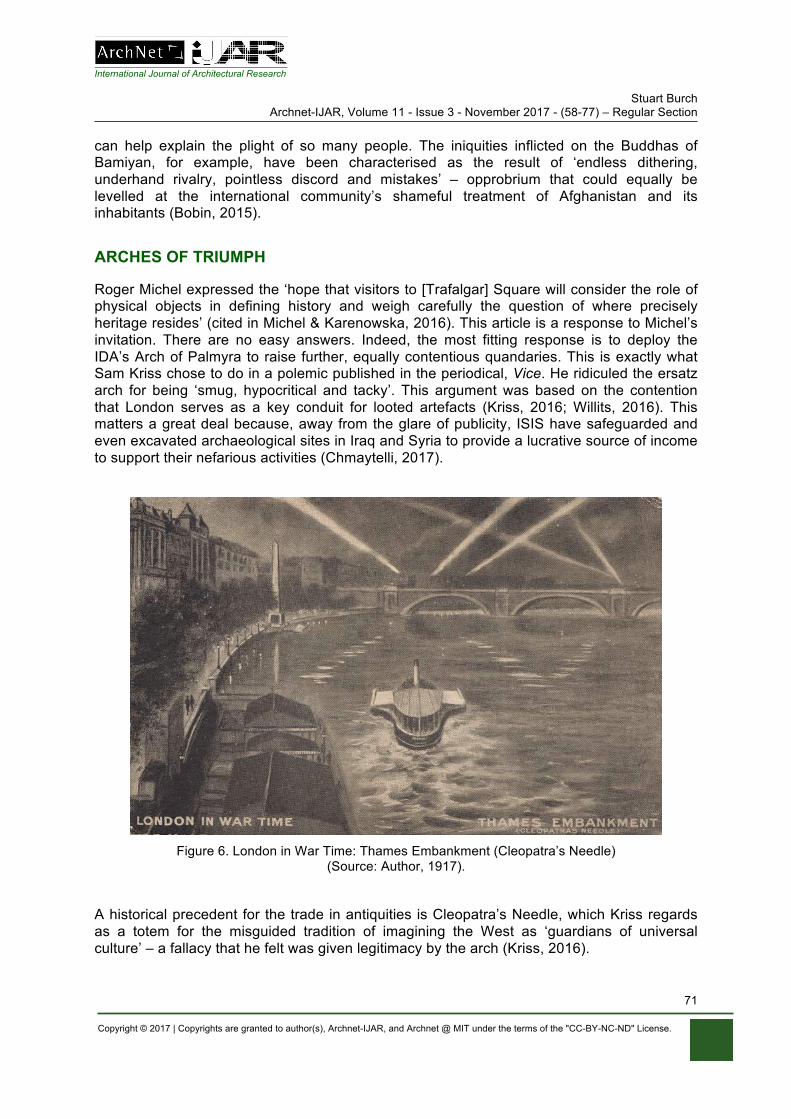
International Journal of Architectural Research Stuart Burch
Archnet-IJAR, Volume 11 - Issue 3 - November 2017 - (58-77) – Regular Section
Copyright © 2017 | Copyrights are granted to author(s), Archnet-IJAR, and Archnet @ MIT under the terms of the "CC-BY-NC-ND" License.
71
can help explain the plight of so many people. The iniquities inflicted on the Buddhas of Bamiyan, for example, have been characterised as the result of ‘endless dithering, underhand rivalry, pointless discord and mistakes’ – opprobrium that could equally be levelled at the international community’s shameful treatment of Afghanistan and its inhabitants (Bobin, 2015).
ARCHES OF TRIUMPH
Roger Michel expressed the ‘hope that visitors to [Trafalgar] Square will consider the role of physical objects in defining history and weigh carefully the question of where precisely heritage resides’ (cited in Michel & Karenowska, 2016). This article is a response to Michel’s invitation. There are no easy answers. Indeed, the most fitting response is to deploy the IDA’s Arch of Palmyra to raise further, equally contentious quandaries. This is exactly what Sam Kriss chose to do in a polemic published in the periodical, Vice. He ridiculed the ersatz arch for being ‘smug, hypocritical and tacky’. This argument was based on the contention that London serves as a key conduit for looted artefacts (Kriss, 2016; Willits, 2016). This matters a great deal because, away from the glare of publicity, ISIS have safeguarded and even excavated archaeological sites in Iraq and Syria to provide a lucrative source of income to support their nefarious activities (Chmaytelli, 2017).
Figure 6. London in War Time: Thames Embankment (Cleopatra’s Needle)
(Source: Author, 1917).
A historical precedent for the trade in antiquities is Cleopatra’s Needle, which Kriss regards as a totem for the misguided tradition of imagining the West as ‘guardians of universal culture’ – a fallacy that he felt was given legitimacy by the arch (Kriss, 2016).
International Journal of Architectural Research Stuart Burch
Archnet-IJAR, Volume 11 - Issue 3 - November 2017 - (58-77) – Regular Section
Copyright © 2017 | Copyrights are granted to author(s), Archnet-IJAR, and Archnet @ MIT under the terms of the "CC-BY-NC-ND" License.
72
Modern-day London and New York – like Paris – possess ancient Egyptian obelisks. In traversing two of these so-called ‘world cities’, the copy of the Palmyra Arch can be seen as following the trajectory of innumerable dubiously acquired antiquities, many of which now take pride of place in the public and private collections of the rich and powerful. London’s most famous Egyptian trophy was erected beside the River Thames in 1878, and over the intervening years the obelisk has been imbued with new meanings, some of which are recorded on supplementary inscriptions. One such plaque transforms it into an analogue of the column in Trafalgar Square by extolling the virtues of ‘Viscount Nelson of the Nile’ (Ward-Jackson, 2011: 274, 316-320). In addition to conceptual shifts, the obelisk has also physically changed, including the addition of new-fangled bronze sphinxes and a pedestal. These were damaged by German bombs dropped during the First World War. A metal panel emphasises that these scars have been retained to testify to this suffering. The fact that Cleopatra’s Needle and the people of its adopted homeland overcame this onslaught bolstered the obelisk’s status as a British icon (see Figure 6).
It is therefore highly improbable that this antiquity will ever return ‘home’ to Egypt. But if a faithful copy was to be made for this purpose, should it bear witness to its time spent in Britain? To do so would align it with what Robert Bevan terms ‘critical reconstruction’, defined here as occurring ‘where the cracks and fissures and layers of experience are incorporated as memories into the rebuilt fabric of a monument’. Thus an ‘authentic’ version of London’s Cleopatra’s Needle would feature ‘layers of wartime damage’ (Bevan, 2016).
A contrary approach would eschew arresting an artefact at an arbitrary moment in time. Take the Arch of Palmyra, for example. Copious archives of artistic depictions and historical photographs capture it in various states of preservation. Consequently, the object has existed in multiple guises through recorded history. An asynchronous composite reconstruction would retain memories of the life of the monument as opposed to simply how it just happened to have been constituted before its evisceration. Because, perversely, freezing the Arch of Palmyra at the juncture of its destruction risks playing into the hands of its nemesis. It is a crowning irony that a movement seeking to deprive other groups of their monuments should be gifted a memorial to their destructiveness. Seen in this light, the IDA has succeeded in manufacturing a grotesque Duchampian readymade that is the fulfilment of ISIS’s wishes.
Regrettably, such pessimistic interpretations are not restricted to the tangible rendering of the missing monument. This is intimated by an edition of The Spectator magazine dated February 18, 2017 (see Figure 7). The cover is devoted to Morten Mørland’s oxymoronic cartoon depiction of a fictitious ISIS statue. This is shown being yanked off its pedestal by a metal chain noosed around its idiotic neck. The masked figure wielding a blood-splattered knife parodies an infamous sculpture of Saddam Hussein that once stood with arm outstretched in Baghdad’s Firdos Square. Its orchestrated toppling by United States Marines on April 9, 2003 was celebrated as an instance of just and legitimate iconoclasm. Nevertheless, this symbolic victory unleashed the above-mentioned lawlessness and looting so heartlessly laughed-off by Donald Rumsfeld. The Spectator’s updated cartoon version invoked this debacle in order to caution against a too hasty celebration of ISIS’s imminent demise. Defeat on the battlefield would simply shift the theatre of war to the internet, meaning that the militants’ online propaganda now circulates the web alongside careful 3D renderings of the monuments they destroy. The proclamation of a ‘virtual caliphate’ was announced by ISIS on social media under a rubric that might almost be the title of a Michael Rakowitz artwork: ‘The caliphate will not perish’ (cited in Wood, 2017: 11).
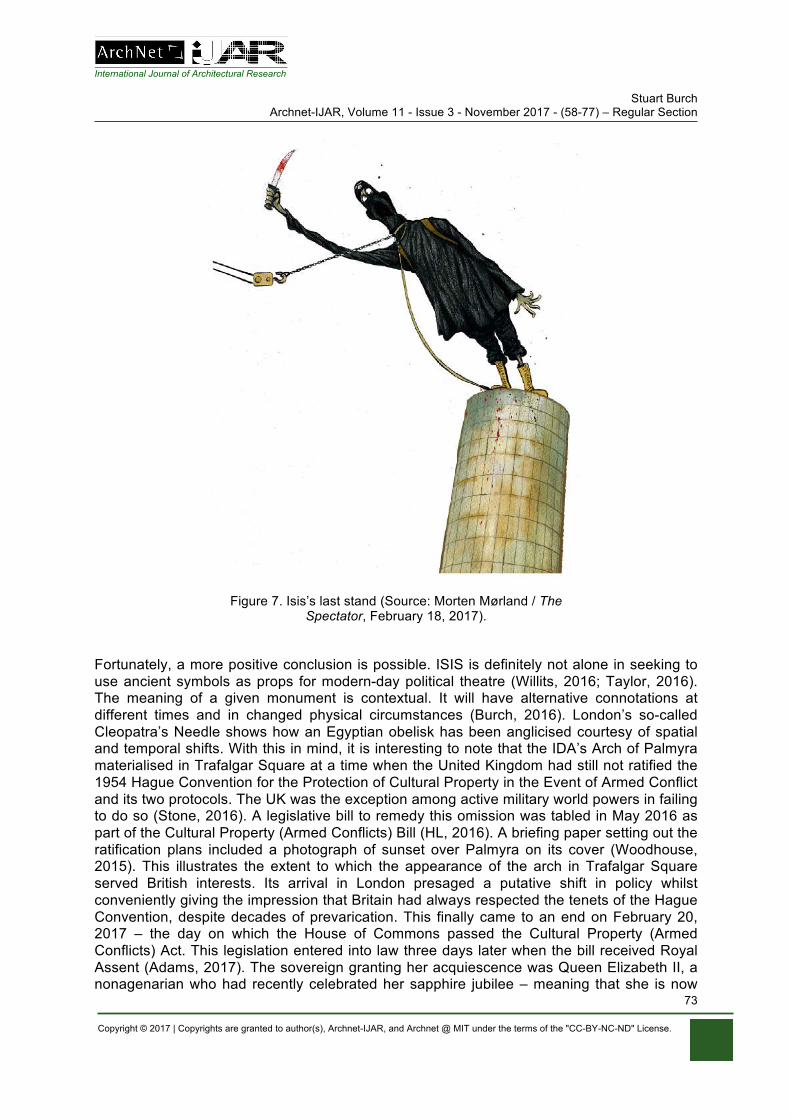
International Journal of Architectural Research Stuart Burch
Archnet-IJAR, Volume 11 - Issue 3 - November 2017 - (58-77) – Regular Section
Copyright © 2017 | Copyrights are granted to author(s), Archnet-IJAR, and Archnet @ MIT under the terms of the "CC-BY-NC-ND" License.
73
Figure 7. Isis’s last stand (Source: Morten Mørland / The
Spectator, February 18, 2017).
Fortunately, a more positive conclusion is possible. ISIS is definitely not alone in seeking to use ancient symbols as props for modern-day political theatre (Willits, 2016; Taylor, 2016). The meaning of a given monument is contextual. It will have alternative connotations at different times and in changed physical circumstances (Burch, 2016). London’s so-called Cleopatra’s Needle shows how an Egyptian obelisk has been anglicised courtesy of spatial and temporal shifts. With this in mind, it is interesting to note that the IDA’s Arch of Palmyra materialised in Trafalgar Square at a time when the United Kingdom had still not ratified the 1954 Hague Convention for the Protection of Cultural Property in the Event of Armed Conflict and its two protocols. The UK was the exception among active military world powers in failing to do so (Stone, 2016). A legislative bill to remedy this omission was tabled in May 2016 as part of the Cultural Property (Armed Conflicts) Bill (HL, 2016). A briefing paper setting out the ratification plans included a photograph of sunset over Palmyra on its cover (Woodhouse, 2015). This illustrates the extent to which the appearance of the arch in Trafalgar Square served British interests. Its arrival in London presaged a putative shift in policy whilst conveniently giving the impression that Britain had always respected the tenets of the Hague Convention, despite decades of prevarication. This finally came to an end on February 20, 2017 – the day on which the House of Commons passed the Cultural Property (Armed Conflicts) Act. This legislation entered into law three days later when the bill received Royal Assent (Adams, 2017). The sovereign granting her acquiescence was Queen Elizabeth II, a nonagenarian who had recently celebrated her sapphire jubilee – meaning that she is now
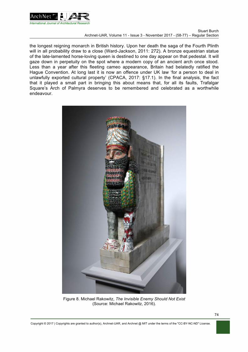
International Journal of Architectural Research Stuart Burch
Archnet-IJAR, Volume 11 - Issue 3 - November 2017 - (58-77) – Regular Section
Copyright © 2017 | Copyrights are granted to author(s), Archnet-IJAR, and Archnet @ MIT under the terms of the "CC-BY-NC-ND" License.
74
the longest reigning monarch in British history. Upon her death the saga of the Fourth Plinth will in all probability draw to a close (Ward-Jackson, 2011: 272). A bronze equestrian statue of the late-lamented horse-loving queen is destined to one day appear on that pedestal. It will gaze down in perpetuity on the spot where a modern copy of an ancient arch once stood. Less than a year after this fleeting cameo appearance, Britain had belatedly ratified the Hague Convention. At long last it is now an offence under UK law ‘for a person to deal in unlawfully exported cultural property’ (CPACA, 2017: §17.1). In the final analysis, the fact that it played a small part in bringing this about means that, for all its faults, Trafalgar Square’s Arch of Palmyra deserves to be remembered and celebrated as a worthwhile endeavour.
Figure 8. Michael Rakowitz, The Invisible Enemy Should Not Exist
(Source: Michael Rakowitz, 2016).
International Journal of Architectural Research Stuart Burch
Archnet-IJAR, Volume 11 - Issue 3 - November 2017 - (58-77) – Regular Section
Copyright © 2017 | Copyrights are granted to author(s), Archnet-IJAR, and Archnet @ MIT under the terms of the "CC-BY-NC-ND" License.
75
REFERENCES
Adams, G.K. (2017). UK passes bill to protect cultural property in armed conflict. Museums Association, February 22. Retrieved February 27, 2017 from http://www.museumsassociation.org/museums-journal/news/22022017-uk-passes-cultural-property-bill.
Ahmed, F. (2014). Digital innovation of the year. Apollo Magazine, 3 December. Retrieved February 27, 2017 from https://www.apollo-magazine.com/apollo-awards-digital-innovation-year/.
Anon (c. 2016). Million Image Database tops 250,000 records. Summer Newsletter: The Institute for Digital Archaeology, 1(2), 3.
BBC (2016). Museum of lost objects: Winged-Bull of Nineveh. BBC Radio 4, February 29. Retrieved February 27, 2017 from http://www.bbc.co.uk/programmes/b071skph.
Bevan, R. (2016). Should Palmyra rise again? London Evening Standard, 25 April, 34-35. Bevan, R. (2017). Ruin or rebuild? Conserving heritage in an age of terrorism. The Art Newspaper,
286. Retrieved February 27, 2017 from www.theartnewspaper.com/features/ruin-or-rebuildconserving-heritage-in-an-age-of-terrorism.
Bobin, F. (2015). Disputes damage hopes of rebuilding Afghanistan’s Bamiyan Buddhas. The Guardian, January 10. Retrieved February 27, 2017 from https://www.theguardian.com/world/2015/jan/10/rebuild-bamiyan-buddhas-taliban-afghanistan.
British Museum (2004). Report on meeting at Babylon 11th – 13th December 2004. Retrieved February 27, 2017 from http://www.britishmuseum.org/PDF/BabylonReport04.pdf.
Brown, M. (2017). Fourth plinth shortlist includes winged bull and giant cream blob. The Guardian, January 19. Retrieved February 27, 2017 from https://www.theguardian.com/artanddesign/2017/jan/19/fourth-plinth-shortlist-trafalgar-square-winged-bull.
Burch, S. (2016). Have buildings, will travel. In C. Lige et al (Ed.). Face-to-face: The story of the Baltic Exchange (99-101). Tallinn: Museum of Estonian Architecture.
Chmaytelli, M. (2017). Tunnels under ancient Mosul mosque show Islamic State’s focus on loot. Reuters, 10 March. Retrieved March 12, 2017 from http://uk.reuters.com/article/uk-mideast-crisis-iraq-antiquities-idUKKBN16H1UK.
CPACA (2017). Cultural Property (Armed Conflicts) Act 2017 c. 6. Retrieved February 27, 2017 from http://www.legislation.gov.uk/ukpga/2017/6/pdfs/ukpga_20170006_en.pdf.
De Certeau, M. (1988). The practice of everyday life. Los Angeles, C.A.: University of California Press. Delman, E. (2015). Afghanistan’s Buddhas rise again. The Atlantic, June 10. Retrieved February 27,
2017 from https://www.theatlantic.com/international/archive/2015/06/3d-buddhas-afghanistan/395576/.
E.O. 13769 (2017). Protecting the nation from foreign terrorist entry into the United States. Federal Register, 82(20), 8977-8982.
Factum Arte (n.d.). IDA Palmyra Arch copy. Retrieved February 27, 2017 from http://www.factumfoundation.org/pag/236.
Fahim, K. (2006). Dates with an artist: An Iraq installation. New York Times, October 10, B4. Retrieved February 27, 2017 from http://www.nytimes.com/2006/10/10/nyregion/10ink.html.
Gall, C. (2006). Afghans consider rebuilding Bamiyan Buddhas. International Herald Tribune, November 5. Retrieved February 27, 2017 from http://www.nytimes.com/2006/12/05/world/asia/05iht-buddhas.3793036.html.
Gayle, D. (2015). Palmyra arch that survived Isis to be replicated in London and New York. The Guardian, December 28. Retrieved February 27, 2017 from https://www.theguardian.com/world/2015/dec/28/palmyra-temple-bel-arch-survived-isis-syria-london-new-york.
GHF (2010). Saving our vanishing heritage: Safeguarding endangered cultural heritage sites in the developing world. California: Global Heritage Fund.
Gray, M. (2015). Million Image Database wins Apollo Digital Innovation Award. Apollo Magazine, November 23. Retrieved February 27, 2017 from https://www.apollo-magazine.com/apollo-awards-2015-digital-innovation-of-the-year-million-image-database-institute-digital-archaeology/.
International Journal of Architectural Research Stuart Burch
Archnet-IJAR, Volume 11 - Issue 3 - November 2017 - (58-77) – Regular Section
Copyright © 2017 | Copyrights are granted to author(s), Archnet-IJAR, and Archnet @ MIT under the terms of the "CC-BY-NC-ND" License.
76
Harris, P. (2011). World Trade Centre fragments are turned into 9/11 memorials. The Guardian, September 4. Retrieved February 27, 2017 from https://www.theguardian.com/world/2011/sep/04/world-trade-centre-fragments-memorials.
Hegarty, S. (2012). Bamiyan Buddhas: Should they be rebuilt? BBC, August 13. Retrieved February 27, 2017 from http://www.bbc.co.uk/news/magazine-18991066.
HL (2016). Cultural Property (Armed Conflicts) Bill. House of Lords, HL Bill 3 56/2, May 19, (773). Retrieved February 27, 2017 from https://www.gov.uk/government/publications/cultural-property-armed-conflicts-bill.
ICOMOS (1964). International charter for the conservation and restoration of monuments and sites (Venice charter). Paris: ICOMOS. Retrieved February 27, 2017 from https://www.icomos.org/charters/venice_e.pdf.
Jessica Carlisle (2016). The missing: Rebuilding the past. Jessica Carlisle gallery, London, April 15 – May 7. Retrieved February 27, 2017 from http://www.jessicacarlisle.com/the-missing.
Jones, J. (2017). Trafalgar Square’s fourth plinth is fine for horses, but not avant garde art. The Guardian, March 21. Retrieved March 22, 2017 from https://www.theguardian.com/artanddesign/jonathanjonesblog/2017/mar/21/fourth-plinth-trafalgar-square-heather-phillipson-michael-rakowitz.
Kriss, S. (2016). Views my own: Why recreating the Palmyra Arch in London was smug, hypocritical and tacky. Vice, April 25. Retrieved February 27, 2017 from http://www.vice.com/en_uk/read/palmyras-arch-trafalgar-square-dubai-new-york.
Lowe, A. (2015). Can 3D recording help preserve threatened sites in Syria and Iraq? Apollo Magazine, September 11. Retrieved February 27, 2017 from https://www.apollo-magazine.com/can-3d-recording-help-preserve-threatened-sites-syria-iraq/.
Mace, R. (2005). Trafalgar Square emblem of empire. London: Lawrence & Wishart. McDonald, A. (2017). Invisible wounds: The impact of six years of war on the mental health of Syria’s
children. London: Save the Children. Michel, R. (n.d.). Reflecting on an extraordinary year – and looking ahead to 2017. Retrieved February
27, 2017 from http://digitalarchaeology.org.uk. Michel, R., and Karenowska, A. (2016). A letter from the director, April 6. Retrieved February 27, 2017
from http://digitalarchaeology.org.uk/letter-from-roger-michel. MID (n.d.). The Million Image Database: preserving the past, protecting the future. Retrieved February
27, 2017 from http://www.millionimage.org.uk. Mockaitis, T.R. (2012) (Ed.). Document 40: Excerpt of Secretary of Defense Donald Rumsfeld and
General Richard B. Myers, Department of Defense News Briefing, April 11, 2003. In T.R. Mockaitis (Ed.). The Iraq War: A Documentary and Reference Guide (145-151). Santa Barbara, CA: Greenwood Press.
Morgan, L. (2012). The Buddhas of Bamiyan. Cambridge, MA: Harvard University Press. Murphy, K. (2016). Download: Roger Michel. New York Times (Sunday Review), April 23. Retrieved
February 27, 2017 from http://www.nytimes.com/2016/04/24/opinion/sunday/roger-michel.html. National Gallery (2017). Fourth plinth shortlist exhibition. National Gallery, Annenberg Court, January
19 –March 26. Potenza, A. (2016). Syrian arch razed by ISIS and re-created with 3D technology arrives in New York
City. The Verge, September 19. Retrieved February 27, 2017 from http://www.theverge.com/2016/9/19/12972504/palmyra-arch-of-triumph-isis-3d-replica-new-york-city.
Rakowitz, M. (2007 to date). The invisible enemy should not exist. Retrieved February 27, 2017 from http://www.michaelrakowitz.com/the-invisible-enemy-should-not-exist/.
Rakowitz, M. (2010). May the arrogant not prevail. Retrieved February 27, 2017 from http://www.michaelrakowitz.com/may-the-arrogant-not-prevail/.
Rediff (2004). The Rediff Interview/Mullah Omar. Rediff, April 12. Retrieved February 27, 2017 from http://www.rediff.com/news/2004/apr/12inter.htm.
Richardson, N. (2016). The Arch of Triumph of Palmyra is recreated in London – 1,800 years after it was built. Daily Telegraph, April 18. Retrieved February 27, 2017 from http://www.telegraph.co.uk/news/2016/04/08/why-the-arch-of-triumph-of-palmyra-is-being-recreated-in-london/.
International Journal of Architectural Research Stuart Burch
Archnet-IJAR, Volume 11 - Issue 3 - November 2017 - (58-77) – Regular Section
Copyright © 2017 | Copyrights are granted to author(s), Archnet-IJAR, and Archnet @ MIT under the terms of the "CC-BY-NC-ND" License.
77
Rielly, B. and Addison, S. (2016). Recreation of destroyed Palmyra arch unveiled in London. Reuters, April 19. Retrieved February 27, 2017 from http://www.reuters.com/article/us-mideast-crisis-britain-palmyra-idUSKCN0XG1TF.
Ruggeri, A. (2015). The great Gate of Ishtar: A door to wonder. BBC, March 2. Retrieved February 27, 2017 from http://www.bbc.co.uk/culture/story/20150302-ancient-babylons-greatest-wonder.
Sattin, A. (2015). Meet the master of reproduction. Christie’s Magazine, November 9. Retrieved February 27, 2017 from http://www.christies.com/features/Master-of-reproduction-Adam-Lowe-and-Factum-Arte-6776-1.aspx.
Searle, A. (2017). Plinth perfect: the five contenders for the fourth Trafalgar spot. The Guardian, January 19. Retrieved February 27, 2017 from https://www.theguardian.com/artanddesign/2017/jan/19/plinth-perfect-the-five-contenders-for-the-fourth-trafalgar-spot.
Shea, C.D. (2016). Palmyra Arch replica is unveiled in Trafalgar Square in London. New York Times, April 19. Retrieved February 27, 2017 from www.nytimes.com/2016/04/20/arts/international/replica-of-palmyra-arch-is-unveiled-in-trafalgar-square.html.
Shrigley, D. (2016). A Really Good chat with David Shrigley... Retrieved February 27, 2017 from https://www.london.gov.uk/sites/default/files/a_really_good_chat_with_david_shrigley_transcript.pdf.
Sinclair, M. (2016). Should museums be recreating the past? Creative Review, July 20. Retrieved February 27, 2017 from https://www.creativereview.co.uk/should-museums-be-recreating-the-past.
Stone, P. (2016). Why ratifying the Hague convention matters. The Art Newspaper, November 29. Retrieved February 27, 2017 from http://theartnewspaper.com/comment/comment/why-ratifying-the-hague-convention-matters-/.
Taylor, A. (2016). The problem with rebuilding a Palmyra ruin destroyed by ISIS – does it simply help Assad? Washington Post, April 20. Retrieved February 27, 2017 from https://www.washingtonpost.com/news/worldviews/wp/2016/04/20/the-problem-with-rebuilding-a-roman-ruin-destroyed-by-isis-does-it-simply-help-assad/.
Turner, L. (2016). Palmyra’s Arch of Triumph recreated in London. BBC, April 19. Retrieved February 27, 2017 from http://www.bbc.co.uk/news/uk-36070721.
UNICEF (2017). Hitting rock bottom: How 2016 became the worst year for Syria’s children. New York: UNICEF.
Volk, G. (2012). dOCUMENTA (13): Books, Afghanistan and both. Art in America, July 5. Retrieved February 27, 2017 from http://www.artinamericamagazine.com/news-features/news/documenta-4-books-afghanistan/.
Ward-Jackson, P. (2011). Public sculpture of historic Westminster: Volume 1. Liverpool: Liverpool University Press.
Willits, J. (2016). Syria’s human losses and London’s replica of Palmyra’s arch. The New Arab, April 23. Retrieved February 27, 2017 from https://www.alaraby.co.uk/english/comment/2016/4/22/syrias-human-losses-and-londons-replica-of-palmyras-arch
Wood, P. (2017). Isis? Bomb those suckers. The Spectator, 33 (9834), 17 February, 10-11. Woodhouse, J. (2015). UK plans to ratify the Hague convention protecting cultural property during
armed conflict (cover photograph, Sunset over Palmyra from the Qalaat ibn Maan castle, Syria by A. Kocman). Briefing Paper, No. 7427, 11 December, House of Commons Library. Retrieved February 27, 2017 from http://researchbriefings.files.parliament.uk/documents/CBP-7427/CBP-7427.
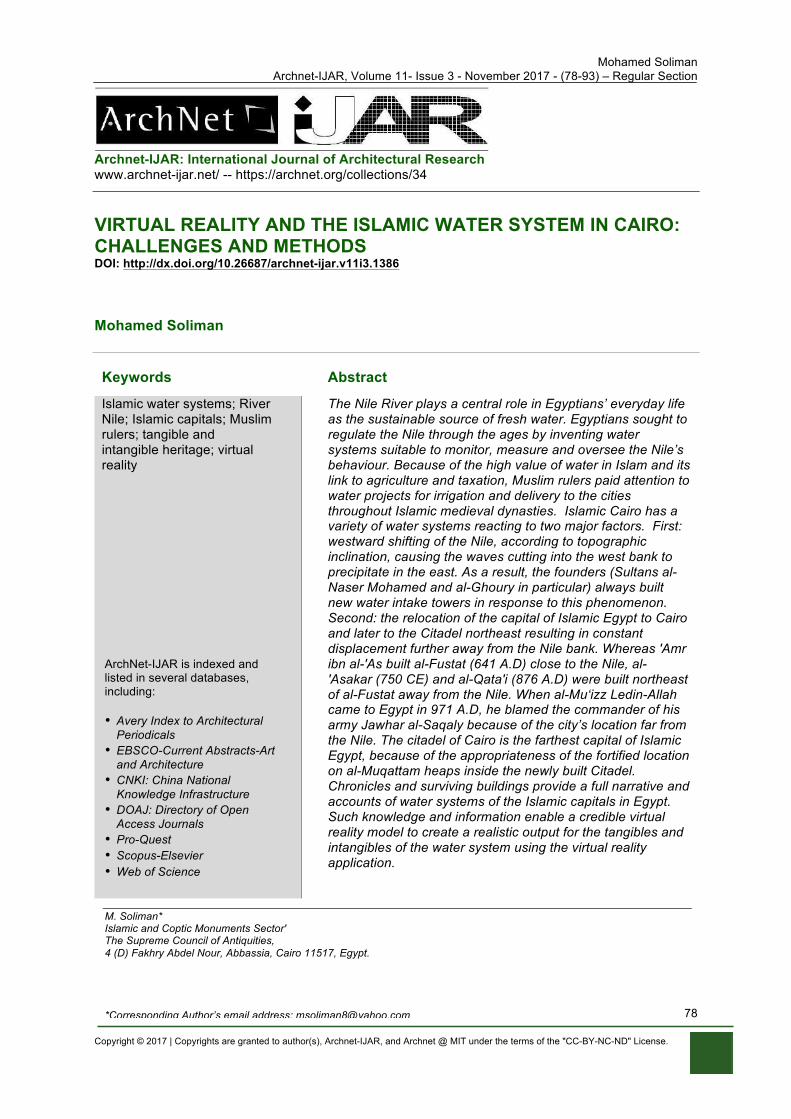
Mohamed Soliman Archnet-IJAR, Volume 11- Issue 3 - November 2017 - (78-93) – Regular Section
Copyright © 2017 | Copyrights are granted to author(s), Archnet-IJAR, and Archnet @ MIT under the terms of the "CC-BY-NC-ND" License.
78
Archnet-IJAR: International Journal of Architectural Research www.archnet-ijar.net/ -- https://archnet.org/collections/34
VIRTUAL REALITY AND THE ISLAMIC WATER SYSTEM IN CAIRO: CHALLENGES AND METHODS DOI: http://dx.doi.org/10.26687/archnet-ijar.v11i3.1386
Mohamed Soliman
Keywords Abstract
Islamic water systems; River Nile; Islamic capitals; Muslim rulers; tangible and intangible heritage; virtual reality
The Nile River plays a central role in Egyptians’ everyday life as the sustainable source of fresh water. Egyptians sought to regulate the Nile through the ages by inventing water systems suitable to monitor, measure and oversee the Nile’s behaviour. Because of the high value of water in Islam and its link to agriculture and taxation, Muslim rulers paid attention to water projects for irrigation and delivery to the cities throughout Islamic medieval dynasties. Islamic Cairo has a variety of water systems reacting to two major factors. First: westward shifting of the Nile, according to topographic inclination, causing the waves cutting into the west bank to precipitate in the east. As a result, the founders (Sultans al-Naser Mohamed and al-Ghoury in particular) always built new water intake towers in response to this phenomenon. Second: the relocation of the capital of Islamic Egypt to Cairo and later to the Citadel northeast resulting in constant displacement further away from the Nile bank. Whereas 'Amr ibn al-'As built al-Fustat (641 A.D) close to the Nile, al-'Asakar (750 CE) and al-Qata'i (876 A.D) were built northeast of al-Fustat away from the Nile. When al-Mu‘izz Ledin-Allah came to Egypt in 971 A.D, he blamed the commander of his army Jawhar al-Saqaly because of the city’s location far from the Nile. The citadel of Cairo is the farthest capital of Islamic Egypt, because of the appropriateness of the fortified location on al-Muqattam heaps inside the newly built Citadel. Chronicles and surviving buildings provide a full narrative and accounts of water systems of the Islamic capitals in Egypt. Such knowledge and information enable a credible virtual reality model to create a realistic output for the tangibles and intangibles of the water system using the virtual reality application.
M. Soliman* Islamic and Coptic Monuments Sector' The Supreme Council of Antiquities, 4 (D) Fakhry Abdel Nour, Abbassia, Cairo 11517, Egypt.
*Corresponding Author’s email address: [email protected]
ArchNet-IJAR is indexed and listed in several databases, including: • Avery Index to Architectural
Periodicals • EBSCO-Current Abstracts-Art
and Architecture • CNKI: China National
Knowledge Infrastructure • DOAJ: Directory of Open
Access Journals • Pro-Quest • Scopus-Elsevier • Web of Science
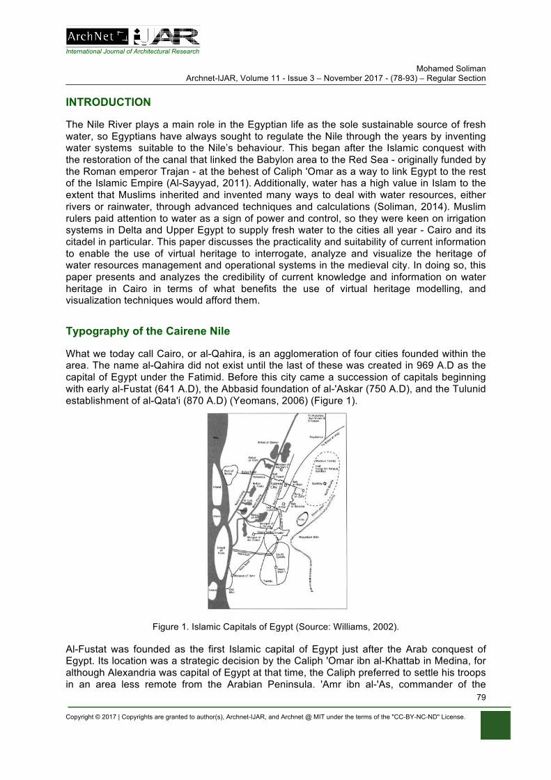
International Journal of Architectural Research Mohamed Soliman
Archnet-IJAR, Volume 11 - Issue 3 – November 2017 - (78-93) – Regular Section
Copyright © 2017 | Copyrights are granted to author(s), Archnet-IJAR, and Archnet @ MIT under the terms of the "CC-BY-NC-ND" License.
79
INTRODUCTION
The Nile River plays a main role in the Egyptian life as the sole sustainable source of fresh water, so Egyptians have always sought to regulate the Nile through the years by inventing water systems suitable to the Nile’s behaviour. This began after the Islamic conquest with the restoration of the canal that linked the Babylon area to the Red Sea - originally funded by the Roman emperor Trajan - at the behest of Caliph 'Omar as a way to link Egypt to the rest of the Islamic Empire (Al-Sayyad, 2011). Additionally, water has a high value in Islam to the extent that Muslims inherited and invented many ways to deal with water resources, either rivers or rainwater, through advanced techniques and calculations (Soliman, 2014). Muslim rulers paid attention to water as a sign of power and control, so they were keen on irrigation systems in Delta and Upper Egypt to supply fresh water to the cities all year - Cairo and its citadel in particular. This paper discusses the practicality and suitability of current information to enable the use of virtual heritage to interrogate, analyze and visualize the heritage of water resources management and operational systems in the medieval city. In doing so, this paper presents and analyzes the credibility of current knowledge and information on water heritage in Cairo in terms of what benefits the use of virtual heritage modelling, and visualization techniques would afford them.
Typography of the Cairene Nile
What we today call Cairo, or al-Qahira, is an agglomeration of four cities founded within the area. The name al-Qahira did not exist until the last of these was created in 969 A.D as the capital of Egypt under the Fatimid. Before this city came a succession of capitals beginning with early al-Fustat (641 A.D), the Abbasid foundation of al-'Askar (750 A.D), and the Tulunid establishment of al-Qata'i (870 A.D) (Yeomans, 2006) (Figure 1).
Figure 1. Islamic Capitals of Egypt (Source: Williams, 2002).
Al-Fustat was founded as the first Islamic capital of Egypt just after the Arab conquest of Egypt. Its location was a strategic decision by the Caliph 'Omar ibn al-Khattab in Medina, for although Alexandria was capital of Egypt at that time, the Caliph preferred to settle his troops in an area less remote from the Arabian Peninsula. 'Amr ibn al-'As, commander of the
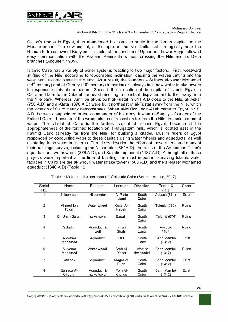
International Journal of Architectural Research Mohamed Soliman
Archnet-IJAR, Volume 11 - Issue 3 – November 2017 - (78-93) – Regular Section
Copyright © 2017 | Copyrights are granted to author(s), Archnet-IJAR, and Archnet @ MIT under the terms of the "CC-BY-NC-ND" License.
80
Caliph's troops in Egypt, thus abandoned his plans to settle in the former capital on the Mediterranean. The new capital, at the apex of the Nile Delta, sat strategically near the Roman fortress town of Babylon. This site, at the junction of Upper and Lower Egypt, allowed easy communication with the Arabian Peninsula without crossing the Nile and its Delta branches (Abouseif, 1989).
Islamic Cairo has a variety of water systems reacting to two major factors. First: westward shifting of the Nile, according to topographic inclination, causing the waves cutting into the west bank to precipitate in the east. As a result, the founders - Sultans al-Naser Mohamed (14th century) and al-Ghoury (16th century) in particular - always built new water intake towers in response to this phenomenon. Second: the relocation of the capital of Islamic Egypt to Cairo and later to the Citadel northeast resulting in constant displacement further away from the Nile bank. Whereas 'Amr Ibn al-'As built al-Fustat in 641 A.D close to the Nile, al-'Askar (750 A.D) and al-Qata'i (876 A.D) were built northeast of al-Fustat away from the Nile, which the location of Cairo clearly demonstrates. When al-Mu'izz Ledin-Allah came to Egypt in 971 A.D, he was disappointed in the commander of his army Jawhar al-Saqaly - founder of the Fatimid Cairo - because of the wrong choice of a location far from the Nile, the sole source of water. The citadel of Cairo is the farthest capital of Islamic Egypt, because of the appropriateness of the fortified location on al-Muqattam hills, which is located east of the Fatimid Cairo (already far from the Nile) for building a citadel. Muslim rulers of Egypt responded by conducting water to these capitals using water wheels and aqueducts, as well as storing fresh water in cisterns. Chronicles describe the efforts of those rulers, and many of their buildings survive, including the Nileometer (861A.D), the ruins of the Ahmed ibn Tulun's aqueduct and water wheel (876 A.D), and Saladin aqueduct (1187 A.D). Although all of these projects were important at the time of building, the most important surviving Islamic water facilities in Cairo are the al-Ghouri water intake tower (1508 A.D) and the al-Naser Mohamed aqueduct (1340 A.D) (Table 1).
Table 1: Maintained water system of historic Cairo (Source: Author, 2017).
Serial No.
Name Function Location Direction Period & date
Case
1 Nileometer Nileometer Al-Roda Island
South Cairo
Abbasid(861) Exist
2 Ahmed Ibn Tulun
Water wheel Qalat Al-Kabsh
South Cairo
Tulunid (876) Ruins
3 Bir Umm Sultan Intake tower Basatin South Cairo
Tulunid (876) Ruins
4 Saladin Aqueduct & well
Imam Shafii
South Cairo
Ayyubid (1187)
Ruins
5 Al-Naser Mohamed
Aqueduct Out South Cairo
Bahri Mamluk (1312)
Exist
6 Al-Naser Mohamed
Water wheel Arab Al-Yasar
West to the citadel
Bahri Mamluk (1312)
Ruins
7 Qait’bey Aqueduct Magra Al-Euon
South Cairo
Bahri Mamluk (1312)
Exist
8 Qun’sua Al-Ghoury
Aqueduct & Intake tower
Fom Al-Khalige
South Cairo
Bahri Mamluk (1312)
Exist
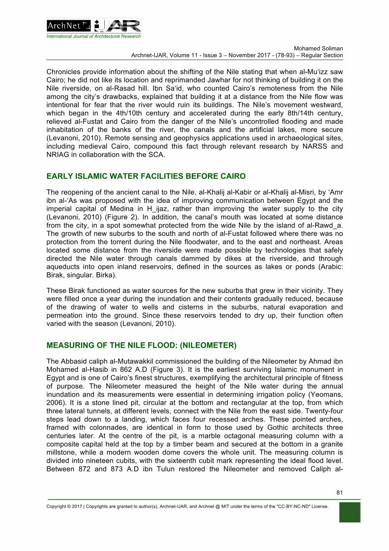
International Journal of Architectural Research Mohamed Soliman
Archnet-IJAR, Volume 11 - Issue 3 – November 2017 - (78-93) – Regular Section
Copyright © 2017 | Copyrights are granted to author(s), Archnet-IJAR, and Archnet @ MIT under the terms of the "CC-BY-NC-ND" License.
81
Chronicles provide information about the shifting of the Nile stating that when al-Mu‘izz saw Cairo; he did not like its location and reprimanded Jawhar for not thinking of building it on the Nile riverside, on al-Rasad hill. Ibn Sa‘id, who counted Cairo’s remoteness from the Nile among the city’s drawbacks, explained that building it at a distance from the Nile flow was intentional for fear that the river would ruin its buildings. The Nile’s movement westward, which began in the 4th/10th century and accelerated during the early 8th/14th century, relieved al-Fustat and Cairo from the danger of the Nile’s uncontrolled flooding and made inhabitation of the banks of the river, the canals and the artificial lakes, more secure (Levanoni, 2010). Remote sensing and geophysics applications used in archaeological sites, including medieval Cairo, compound this fact through relevant research by NARSS and NRIAG in collaboration with the SCA.
EARLY ISLAMIC WATER FACILITIES BEFORE CAIRO
The reopening of the ancient canal to the Nile, al-Khalij al-Kabir or al-Khalij al-Misri, by ‘Amr ibn al-‘As was proposed with the idea of improving communication between Egypt and the imperial capital of Medina in H_ijaz, rather than improving the water supply to the city (Levanoni, 2010) (Figure 2). In addition, the canal’s mouth was located at some distance from the city, in a spot somewhat protected from the wide Nile by the island of al-Rawd_a. The growth of new suburbs to the south and north of al-Fustat followed where there was no protection from the torrent during the Nile floodwater, and to the east and northeast. Areas located some distance from the riverside were made possible by technologies that safely directed the Nile water through canals dammed by dikes at the riverside, and through aqueducts into open inland reservoirs, defined in the sources as lakes or ponds (Arabic: Birak, singular. Birka).
These Birak functioned as water sources for the new suburbs that grew in their vicinity. They were filled once a year during the inundation and their contents gradually reduced, because of the drawing of water to wells and cisterns in the suburbs, natural evaporation and permeation into the ground. Since these reservoirs tended to dry up, their function often varied with the season (Levanoni, 2010).
MEASURING OF THE NILE FLOOD: (NILEOMETER)
The Abbasid caliph al-Mutawakkil commissioned the building of the Nileometer by Ahmad ibn Mohamed al-Hasib in 862 A.D (Figure 3). It is the earliest surviving Islamic monument in Egypt and is one of Cairo’s finest structures, exemplifying the architectural principle of fitness of purpose. The Nileometer measured the height of the Nile water during the annual inundation and its measurements were essential in determining irrigation policy (Yeomans, 2006). It is a stone lined pit, circular at the bottom and rectangular at the top, from which three lateral tunnels, at different levels, connect with the Nile from the east side. Twenty-four steps lead down to a landing, which faces four recessed arches. These pointed arches, framed with colonnades, are identical in form to those used by Gothic architects three centuries later. At the centre of the pit, is a marble octagonal measuring column with a composite capital held at the top by a timber beam and secured at the bottom in a granite millstone, while a modern wooden dome covers the whole unit. The measuring column is divided into nineteen cubits, with the sixteenth cubit mark representing the ideal flood level. Between 872 and 873 A.D ibn Tulun restored the Nileometer and removed Caliph al-
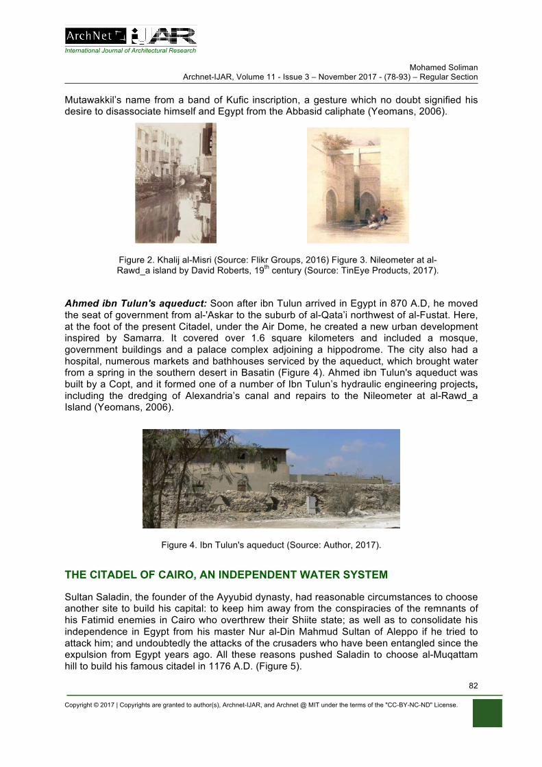
International Journal of Architectural Research Mohamed Soliman
Archnet-IJAR, Volume 11 - Issue 3 – November 2017 - (78-93) – Regular Section
Copyright © 2017 | Copyrights are granted to author(s), Archnet-IJAR, and Archnet @ MIT under the terms of the "CC-BY-NC-ND" License.
82
Mutawakkil’s name from a band of Kufic inscription, a gesture which no doubt signified his desire to disassociate himself and Egypt from the Abbasid caliphate (Yeomans, 2006).
Figure 2. Khalij al-Misri (Source: Flikr Groups, 2016) Figure 3. Nileometer at al-Rawd_a island by David Roberts, 19th century (Source: TinEye Products, 2017).
Ahmed ibn Tulun's aqueduct: Soon after ibn Tulun arrived in Egypt in 870 A.D, he moved the seat of government from al-'Askar to the suburb of al-Qata’i northwest of al-Fustat. Here, at the foot of the present Citadel, under the Air Dome, he created a new urban development inspired by Samarra. It covered over 1.6 square kilometers and included a mosque, government buildings and a palace complex adjoining a hippodrome. The city also had a hospital, numerous markets and bathhouses serviced by the aqueduct, which brought water from a spring in the southern desert in Basatin (Figure 4). Ahmed ibn Tulun's aqueduct was built by a Copt, and it formed one of a number of Ibn Tulun’s hydraulic engineering projects, including the dredging of Alexandria’s canal and repairs to the Nileometer at al-Rawd_a Island (Yeomans, 2006).
Figure 4. Ibn Tulun's aqueduct (Source: Author, 2017).
THE CITADEL OF CAIRO, AN INDEPENDENT WATER SYSTEM
Sultan Saladin, the founder of the Ayyubid dynasty, had reasonable circumstances to choose another site to build his capital: to keep him away from the conspiracies of the remnants of his Fatimid enemies in Cairo who overthrew their Shiite state; as well as to consolidate his independence in Egypt from his master Nur al-Din Mahmud Sultan of Aleppo if he tried to attack him; and undoubtedly the attacks of the crusaders who have been entangled since the expulsion from Egypt years ago. All these reasons pushed Saladin to choose al-Muqattam hill to build his famous citadel in 1176 A.D. (Figure 5).
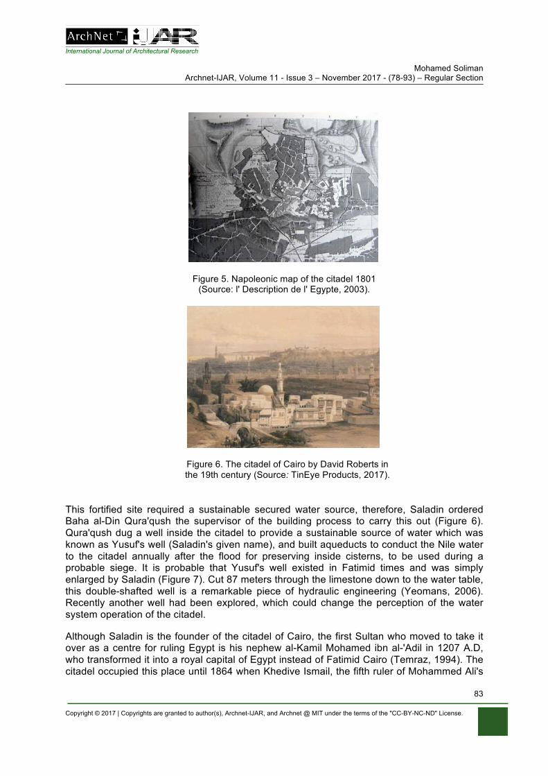
International Journal of Architectural Research Mohamed Soliman
Archnet-IJAR, Volume 11 - Issue 3 – November 2017 - (78-93) – Regular Section
Copyright © 2017 | Copyrights are granted to author(s), Archnet-IJAR, and Archnet @ MIT under the terms of the "CC-BY-NC-ND" License.
83
Figure 5. Napoleonic map of the citadel 1801 (Source: l' Description de l' Egypte, 2003).
Figure 6. The citadel of Cairo by David Roberts in the 19th century (Source: TinEye Products, 2017).
This fortified site required a sustainable secured water source, therefore, Saladin ordered Baha al-Din Qura'qush the supervisor of the building process to carry this out (Figure 6). Qura'qush dug a well inside the citadel to provide a sustainable source of water which was known as Yusuf's well (Saladin's given name), and built aqueducts to conduct the Nile water to the citadel annually after the flood for preserving inside cisterns, to be used during a probable siege. It is probable that Yusuf's well existed in Fatimid times and was simply enlarged by Saladin (Figure 7). Cut 87 meters through the limestone down to the water table, this double-shafted well is a remarkable piece of hydraulic engineering (Yeomans, 2006). Recently another well had been explored, which could change the perception of the water system operation of the citadel.
Although Saladin is the founder of the citadel of Cairo, the first Sultan who moved to take it over as a centre for ruling Egypt is his nephew al-Kamil Mohamed ibn al-'Adil in 1207 A.D, who transformed it into a royal capital of Egypt instead of Fatimid Cairo (Temraz, 1994). The citadel occupied this place until 1864 when Khedive Ismail, the fifth ruler of Mohammed Ali's
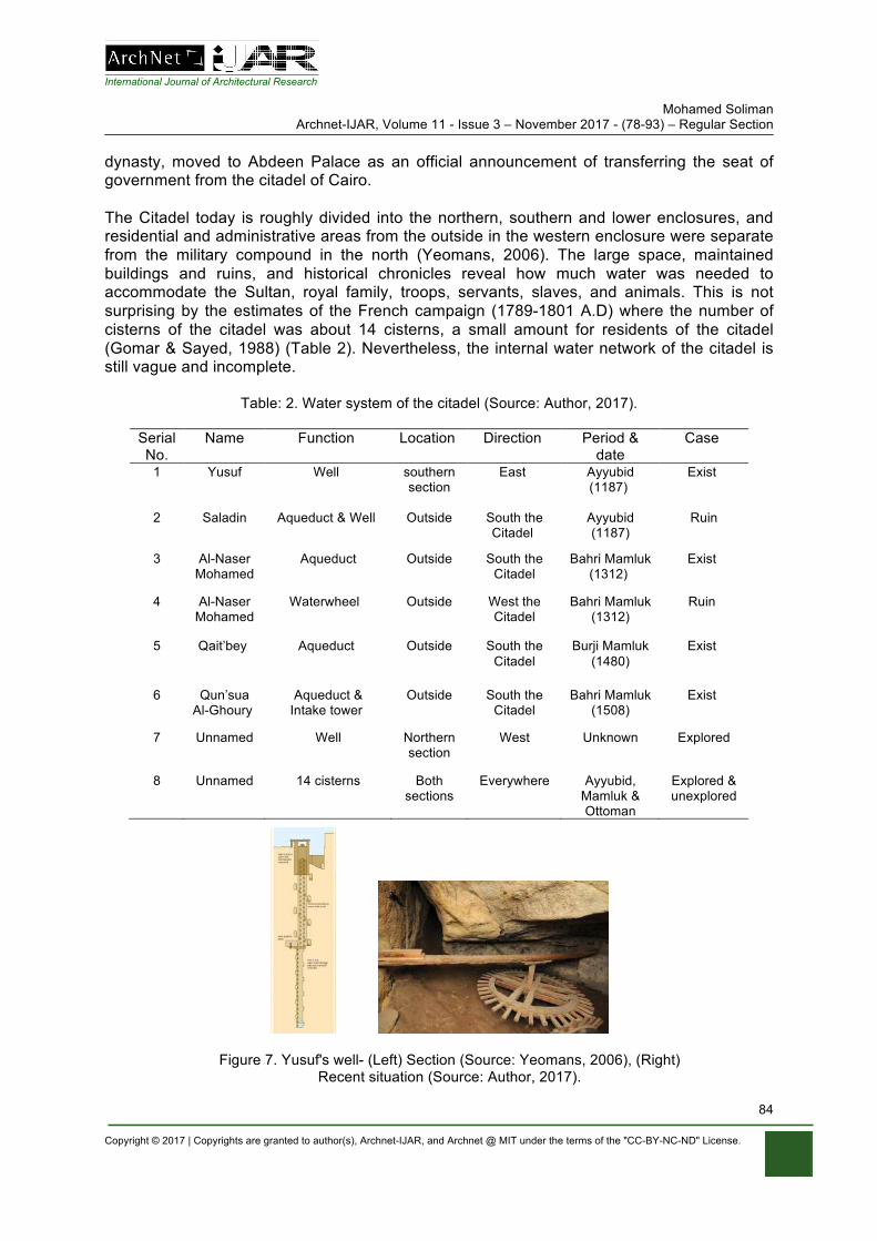
International Journal of Architectural Research Mohamed Soliman
Archnet-IJAR, Volume 11 - Issue 3 – November 2017 - (78-93) – Regular Section
Copyright © 2017 | Copyrights are granted to author(s), Archnet-IJAR, and Archnet @ MIT under the terms of the "CC-BY-NC-ND" License.
84
dynasty, moved to Abdeen Palace as an official announcement of transferring the seat of government from the citadel of Cairo. The Citadel today is roughly divided into the northern, southern and lower enclosures, and residential and administrative areas from the outside in the western enclosure were separate from the military compound in the north (Yeomans, 2006). The large space, maintained buildings and ruins, and historical chronicles reveal how much water was needed to accommodate the Sultan, royal family, troops, servants, slaves, and animals. This is not surprising by the estimates of the French campaign (1789-1801 A.D) where the number of cisterns of the citadel was about 14 cisterns, a small amount for residents of the citadel (Gomar & Sayed, 1988) (Table 2). Nevertheless, the internal water network of the citadel is still vague and incomplete.
Table: 2. Water system of the citadel (Source: Author, 2017).
Serial No.
Name Function Location Direction Period & date
Case
1 Yusuf Well southern section
East Ayyubid (1187)
Exist
2 Saladin Aqueduct & Well Outside South the Citadel
Ayyubid (1187)
Ruin
3 Al-Naser Mohamed
Aqueduct Outside South the Citadel
Bahri Mamluk (1312)
Exist
4 Al-Naser Mohamed
Waterwheel Outside West the Citadel
Bahri Mamluk (1312)
Ruin
5 Qait’bey
Aqueduct Outside South the Citadel
Burji Mamluk (1480)
Exist
6 Qun’sua Al-Ghoury
Aqueduct & Intake tower
Outside South the Citadel
Bahri Mamluk (1508)
Exist
7 Unnamed Well Northern section
West Unknown Explored
8 Unnamed 14 cisterns Both sections
Everywhere Ayyubid, Mamluk & Ottoman
Explored & unexplored
Figure 7. Yusuf's well- (Left) Section (Source: Yeomans, 2006), (Right) Recent situation (Source: Author, 2017).
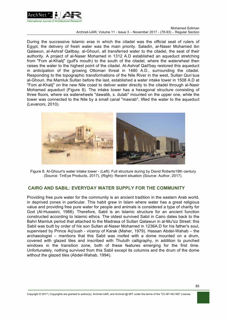
International Journal of Architectural Research Mohamed Soliman
Archnet-IJAR, Volume 11 - Issue 3 – November 2017 - (78-93) – Regular Section
Copyright © 2017 | Copyrights are granted to author(s), Archnet-IJAR, and Archnet @ MIT under the terms of the "CC-BY-NC-ND" License.
85
During the successive Islamic eras in which the citadel was the official seat of rulers of Egypt, the delivery of fresh water was the main priority. Saladin, al-Naser Mohamed ibn Qalawun, al-Ashraf Qaitbay, al-Ghouri, all transferred water to the citadel, the seat of their authority. A project of al-Naser Mohamed in 1312 A.D established an aqueduct stretching from "Fom al-Khalij" (gulf's mouth) to the south of the citadel, where the waterwheel then raises the water to the highest point of the citadel. Al-Ashraf Qait'bay restored this aqueduct in anticipation of the growing Ottoman threat in 1480 A.D., surrounding the citadel. Responding to the topographic transformations of the Nile River in the west, Sultan Qun’sua al-Ghouri, the Mamluk Sultan before the last, established a water intake tower in 1508 A.D at "Fom al-Khalij" on the new Nile coast to deliver water directly to the citadel through al-Nasir Mohamed aqueduct (Figure 8). The intake tower has a hexagonal structure consisting of three floors, where six waterwheels "dawalib, s. dulab" mounted on the upper one, while the tower was connected to the Nile by a small canal "masrab", lifted the water to the aqueduct (Levanoni, 2010).
Figure 8. Al-Ghouri's water intake tower - (Left): Full structure during by David Roberts19th century (Source: TinEye Products, 2017), (Right): Recent situation (Source: Author, 2017).
CAIRO AND SABIL: EVERYDAY WATER SUPPLY FOR THE COMMUNITY
Providing free pure water for the community is an ancient tradition in the eastern Arab world, in deprived zones in particular. This habit grew in Islam where water has a great religious value and providing free pure water for people and animals is considered a type of charity for God (Al-Husseini, 1988). Therefore, Sabil is an Islamic structure for an ancient function constructed according to Islamic ethics. The oldest survived Sabil in Cairo dates back to the Bahri Mamluk period that attached to the Madrasa of Sultan Qalawun in al-Mu'izz Street: this Sabil was built by order of his son Sultan al-Naser Mohamed in 1236A.D for his father's soul, supervised by Prince Aq'oush - viceroy of Karak (Maher, 1979). Hassan Abdel-Wahab – the archaeologist – mentions that this Sabil was roofed with a dome mounted on a drum, covered with glazed tiles and inscribed with Thuluth calligraphy, in addition to punched windows in the transition zone, both of these features emerging for the first time. Unfortunately, nothing survived from this Sabil except its columns and the drum of the dome without the glazed tiles (Abdel-Wahab, 1994).
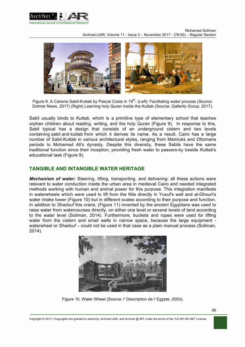
International Journal of Architectural Research Mohamed Soliman
Archnet-IJAR, Volume 11 - Issue 3 – November 2017 - (78-93) – Regular Section
Copyright © 2017 | Copyrights are granted to author(s), Archnet-IJAR, and Archnet @ MIT under the terms of the "CC-BY-NC-ND" License.
86
Figure 9. A Cairene Sabil-Kuttab by Pascal Coste in 19th- (Left): Facilitating water process (Source: Dotmsr News, 2017) (Right) Learning holy Quran inside the Kuttab (Source: Gallerily Group, 2017).
Sabil usually binds to Kuttab, which is a primitive type of elementary school that teaches orphan children about reading, writing, and the holy Quran (Figure 9). In response to this, Sabil typical has a design that consists of an underground cistern and two levels containing sabil and kuttab from which it derives its name. As a result, Cairo has a large number of Sabil-Kuttab in various architectural styles, ranging from Mamluks and Ottomans periods to Mohamed Ali's dynasty. Despite this diversity, these Sabils have the same traditional function since their inception, providing fresh water to passers-by beside Kuttab's educational task (Figure 9).
TANGIBLE AND INTANGIBLE WATER HERITAGE
Mechanism of water: Steering, lifting, transporting, and delivering: all these actions were relevant to water conduction inside the urban area in medieval Cairo and needed integrated methods working with human and animal power for this purpose. This integration manifests in waterwheels which were used to lift from the Nile directly in Yusuf's well and al-Ghouri's water intake tower (Figure 10) but in different scales according to their purpose and function. In addition to Shadouf this crane, (Figure 11) invented by the ancient Egyptians was used to raise water from watercourses directly, on either one level or several levels of land according to the water level (Soliman, 2014). Furthermore, buckets and ropes were used for lifting water from the cistern and small wells in narrow space, because the large equipment - waterwheel or Shadouf – could not be used in that case as a plain manual process (Soliman, 2014).
Figure 10. Water Wheel (Source: l' Description de l' Egypte, 2003).
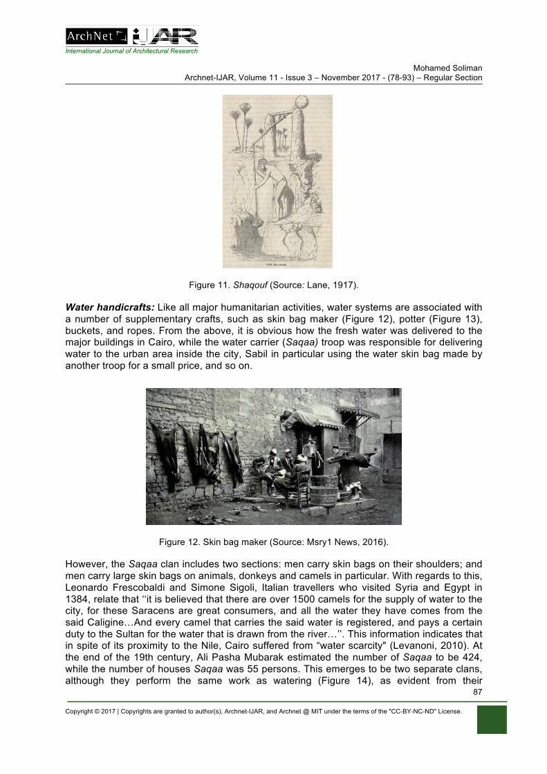
International Journal of Architectural Research Mohamed Soliman
Archnet-IJAR, Volume 11 - Issue 3 – November 2017 - (78-93) – Regular Section
Copyright © 2017 | Copyrights are granted to author(s), Archnet-IJAR, and Archnet @ MIT under the terms of the "CC-BY-NC-ND" License.
87
Figure 11. Shaqouf (Source: Lane, 1917).
Water handicrafts: Like all major humanitarian activities, water systems are associated with a number of supplementary crafts, such as skin bag maker (Figure 12), potter (Figure 13), buckets, and ropes. From the above, it is obvious how the fresh water was delivered to the major buildings in Cairo, while the water carrier (Saqaa) troop was responsible for delivering water to the urban area inside the city, Sabil in particular using the water skin bag made by another troop for a small price, and so on.
Figure 12. Skin bag maker (Source: Msry1 News, 2016).
However, the Saqaa clan includes two sections: men carry skin bags on their shoulders; and men carry large skin bags on animals, donkeys and camels in particular. With regards to this, Leonardo Frescobaldi and Simone Sigoli, Italian travellers who visited Syria and Egypt in 1384, relate that ‘‘it is believed that there are over 1500 camels for the supply of water to the city, for these Saracens are great consumers, and all the water they have comes from the said Caligine…And every camel that carries the said water is registered, and pays a certain duty to the Sultan for the water that is drawn from the river…’’. This information indicates that in spite of its proximity to the Nile, Cairo suffered from “water scarcity" (Levanoni, 2010). At the end of the 19th century, Ali Pasha Mubarak estimated the number of Saqaa to be 424, while the number of houses Saqaa was 55 persons. This emerges to be two separate clans, although they perform the same work as watering (Figure 14), as evident from their
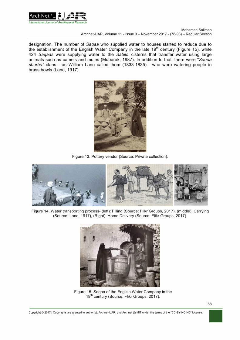
International Journal of Architectural Research Mohamed Soliman
Archnet-IJAR, Volume 11 - Issue 3 – November 2017 - (78-93) – Regular Section
Copyright © 2017 | Copyrights are granted to author(s), Archnet-IJAR, and Archnet @ MIT under the terms of the "CC-BY-NC-ND" License.
88
designation. The number of Saqaa who supplied water to houses started to reduce due to the establishment of the English Water Company in the late 19th century (Figure 15), while 424 Saqaas were supplying water to the Sabils' cisterns that transfer water using large animals such as camels and mules (Mubarak, 1987). In addition to that, there were "Saqaa shurba" clans - as William Lane called them (1833-1835) - who were watering people in brass bowls (Lane, 1917).
Figure 13. Pottery vendor (Source: Private collection).
Figure 14. Water transporting process- (left): Filling (Source: Flikr Groups, 2017), (middle): Carrying (Source: Lane, 1917), (Right): Home Delivery (Source: Flikr Groups, 2017).
Figure 15. Saqaa of the English Water Company in the 19th century (Source: Flikr Groups, 2017).
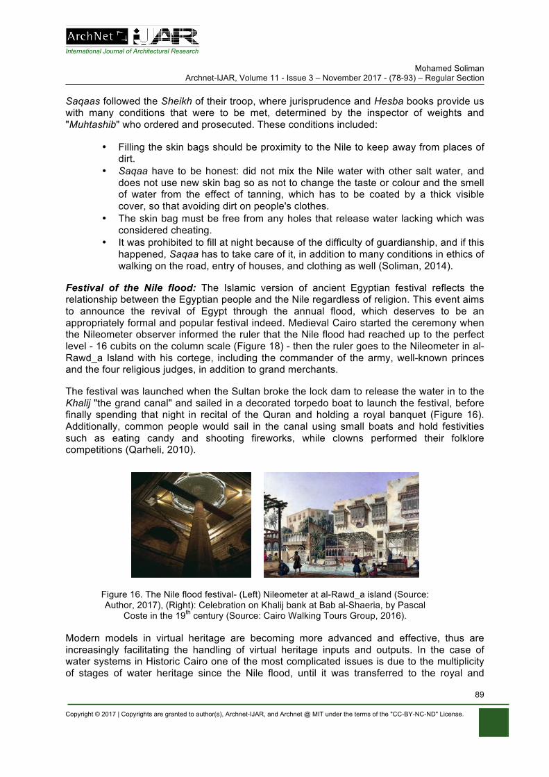
International Journal of Architectural Research Mohamed Soliman
Archnet-IJAR, Volume 11 - Issue 3 – November 2017 - (78-93) – Regular Section
Copyright © 2017 | Copyrights are granted to author(s), Archnet-IJAR, and Archnet @ MIT under the terms of the "CC-BY-NC-ND" License.
89
Saqaas followed the Sheikh of their troop, where jurisprudence and Hesba books provide us with many conditions that were to be met, determined by the inspector of weights and "Muhtashib" who ordered and prosecuted. These conditions included:
• Filling the skin bags should be proximity to the Nile to keep away from places of dirt.
• Saqaa have to be honest: did not mix the Nile water with other salt water, and does not use new skin bag so as not to change the taste or colour and the smell of water from the effect of tanning, which has to be coated by a thick visible cover, so that avoiding dirt on people's clothes.
• The skin bag must be free from any holes that release water lacking which was considered cheating.
• It was prohibited to fill at night because of the difficulty of guardianship, and if this happened, Saqaa has to take care of it, in addition to many conditions in ethics of walking on the road, entry of houses, and clothing as well (Soliman, 2014).
Festival of the Nile flood: The Islamic version of ancient Egyptian festival reflects the relationship between the Egyptian people and the Nile regardless of religion. This event aims to announce the revival of Egypt through the annual flood, which deserves to be an appropriately formal and popular festival indeed. Medieval Cairo started the ceremony when the Nileometer observer informed the ruler that the Nile flood had reached up to the perfect level - 16 cubits on the column scale (Figure 18) - then the ruler goes to the Nileometer in al-Rawd_a Island with his cortege, including the commander of the army, well-known princes and the four religious judges, in addition to grand merchants.
The festival was launched when the Sultan broke the lock dam to release the water in to the Khalij "the grand canal" and sailed in a decorated torpedo boat to launch the festival, before finally spending that night in recital of the Quran and holding a royal banquet (Figure 16). Additionally, common people would sail in the canal using small boats and hold festivities such as eating candy and shooting fireworks, while clowns performed their folklore competitions (Qarheli, 2010).
Figure 16. The Nile flood festival- (Left) Nileometer at al-Rawd_a island (Source: Author, 2017), (Right): Celebration on Khalij bank at Bab al-Shaeria, by Pascal
Coste in the 19th century (Source: Cairo Walking Tours Group, 2016).
Modern models in virtual heritage are becoming more advanced and effective, thus are increasingly facilitating the handling of virtual heritage inputs and outputs. In the case of water systems in Historic Cairo one of the most complicated issues is due to the multiplicity of stages of water heritage since the Nile flood, until it was transferred to the royal and
International Journal of Architectural Research Mohamed Soliman
Archnet-IJAR, Volume 11 - Issue 3 – November 2017 - (78-93) – Regular Section
Copyright © 2017 | Copyrights are granted to author(s), Archnet-IJAR, and Archnet @ MIT under the terms of the "CC-BY-NC-ND" License.
90
residential urban contexts. This complicated process includes many phases; lifting the Nile water using water wheel, camel, donkey and water carrier in transportation in the case of the population context. Furthermore, in the royal context (Cairo Citadel mainly) it is more complicated according to the power of the Sultan, as happened when al-Naser Mohammed ibn Qalawun established his Intake tower and aqueduct for delivering water to the citadel. Additionally, the governors expanded the water storage of the citadel cisterns in the Ottoman period, dependant on associated craftsmen such as skin bag makers, Saqqa, carpenters of water wheels, pottery makers, and venders.
Producing virtual water heritage became easier through previous virtual heritage outputs, where discussion and outputs of relevant reports show expertise in various aspects of virtual water heritage. For example; in the Temple of Venus, Baalbek, Lebanon a virtual heritage project featuring a digital recreation of the Roman temple (Berger, 2016). Recreation concept works to put a full perception of missing elements in water heritage sites that are not allowed in reality according to the world code of conservation, while Info-graphic reconstruction of Roman aqueducts in Italy is equivalent to virtual water heritage in VHC project (Caius, 2010; Barragán, 2009).
Virtual environments, which are embedded with cultural heritage and represented through digital media are often categorized as "virtual heritage" (Beng-Kiang & Hafizur, 2009). The conservation of the historic waterfront to improve the quality of life in old Dhaka is an equivalent model for Khalij al-Misri as none exist to consider the watercourse and observation of the westward movement of the Nile course, for example (Rahman & Imon, 2017). Additionally, the virtual reality model of the northern sluice of the ancient dam in Marib/ Yemen, is appropriate to study heritage water installation under any condition (maintained or ruined) using a combination of digital photogrammetric and terrestrial Laser scanning for archaeological applications (Kersten, 2007), which would mainly be applicable for Yusuf's well, al-Naser Mohamed's aqueduct and water wheel, and al-Ghouri's water intake tower.
CRITICAL VIES OF VIRTUAL MODELS OF WATER SYSTEM
Recently, new media and digital devices facilitate virtual reconstructed historic sites or virtual heritage sites for visitors, travellers or even for a resident. Although virtual heritage poses great potential to reconstruct our ancient heritage and memory, many critics often blame high cost, development complexity, inaccessibility of technology complexity in usability and high maintenance for prohibiting widespread dissemination, distribution and use of virtual heritage media. Some authors have also identified different weaknesses within the interface and delivered contents (Beng-Kiang & Hafizur, 2009).
In the case of Governmental Organizations such as the Egyptian Ministry of Antiquities that rely on self-financing for their activities, it is important to adopt a mechanism to protect intellectual property rights for heritage presented by virtual reality, which is difficult to control. Failing to provide such a mechanism exposes the organization to a loss of an assumed financial source, in addition to falling under the law of the state, which is a waste of public money. Virtual Heritage threats the tourism movement, which is a source of national income for many countries. A tourist may only visit a virtual site or museum without moving to a live site, which is considered an obstacle to the spread of this advanced technology. In this context, heritage organizations must establish an international mechanism guaranteeing the financial and moral rights of those countries by establishing a charter to regulate the
International Journal of Architectural Research Mohamed Soliman
Archnet-IJAR, Volume 11 - Issue 3 – November 2017 - (78-93) – Regular Section
Copyright © 2017 | Copyrights are granted to author(s), Archnet-IJAR, and Archnet @ MIT under the terms of the "CC-BY-NC-ND" License.
91
exchange of information. However, virtual heritage would be applied to limited promotion and education in such a way as to ensure that the tourist or researcher is not excluded from visiting the museum or site. Footage for a project was filmed in Caerwent, where the first Roman town was founded almost 2000 years ago, and is considered a perfect model for a perfect purpose appropriate for a heritage focused Governmental Organization. This promotional piece is part of a bigger project where virtual reality devices will be placed in museums to bring in younger museum audiences to experience Roman culture in Wales. The model we have created in Maya will be the model used in the museum, making use of Oculas Rifts and iPhone apps (Cart Best Video, 2016).
VISUALIZING AND CHALLENGES OF WATER HERITAGE
Chronicles and surviving buildings provide full information about the water system of the Islamic capitals of Egypt ready for virtualization to create a realistic output for the tangible and intangible aspects of water heritage using virtual reality application, although these amounts of information still need more investigation as an independent project. In this case visualizing this information supports a full perception to reveal overlaps of the water heritage of historic Cairo, because of the adjustability of those applications, which is appropriated with the methodology of archaeological research that considers water systems a challenge. On the other hand, conservation processes that take place in water system sites is so difficult to deal with, regarding to world code of conservation - Venice 1964, in particular. Venice Convention calls for the preservation of the authenticity of archaeological sites and buildings without completing the missing elements of the building, but only in cases of necessity. Additionally the site often cannot be reused in the original function; this concept does not enable non-specialized audiences to visualize how heritage water systems operate. Here, the importance of virtual reality as a compensatory method of missing elements gives a perfect perception for everyone.
In this respect, organizations working in the field of preserving cultural heritage, especially governmental organizations such as the Egyptian Ministry of Antiquities, rely on their own funding, which is not often allowed to expand spending in some non-financial projects, water heritage sites in particular. In this case, virtual reality is a benefit as a low-cost technology to transform those sites into developed projects aiming to placing these sites on the touristic and educational plan.
CONCLUSION
Virtual reality is a promising technology for preserving the cultural heritage properties and reviving the tangible and intangible aspects of water heritage, which contains the secret of human life itself in several aspects.
Visualizing the archaeo-historical data for students in all educational stages, students of history and archaeology particularly, facilitates handling with unseen events or a distant archaeological site. Virtual heritage is an adjustable method, where the user can correct his information continuously and in a limited time, rather than the printed books that require to be corrected and reprinted, resulting in misinformation due to loss of time and money.
World conservation code, the Venice Convention of 1964 in particular, obligates preservation of the archaeological heritage aiming to conserve the archaeological raw material as the main target of the conservation process. One of these codes prohibits the completion of
International Journal of Architectural Research Mohamed Soliman
Archnet-IJAR, Volume 11 - Issue 3 – November 2017 - (78-93) – Regular Section
Copyright © 2017 | Copyrights are granted to author(s), Archnet-IJAR, and Archnet @ MIT under the terms of the "CC-BY-NC-ND" License.
92
missing fragments of an object; otherwise, it loses its values. On the other hand, reconstruction of demolished monumental buildings should follow the same code. These restricted rules could hinder the sustainable development of the cultural heritage properties, especially in the non-profit governmental organizations, the Egyptian Ministry of Antiquities for example that count on self-financing related to tourism income. In this case, virtual heritage dissolves this conflict by reconstructing the cultural heritage property additionally to reducing the cost of the conservation process without real effect, using new attractive factors to the Islamic water system of Cairo aiming to develop that remarkable type of architecture and put it on the tourism map.
Saqaa clan, handicraft, moral values and songs related to water that are considered intangible heritage, have mostly disappeared because the community no longer needs them. In this context, the importance of the intangible heritage to the old city and the moral values associated with them is evident. Virtual reality is an appropriate method for reviving the intangible heritage through visualizing values related to water.
The Islamic water system of Cairo permeates the poor urban context, surrounded by a poor uneducated community that does not think of anything except earning their food. Threats rise day by day directly related to the poverty rate. Community engagement in the conservation or rehabilitation process for heritage properties is the best way for the maintenance of the cultural heritage, but first the community needs to interact with fascinating and easy methods aiming to raise awareness within the community about the value of the remaining water system artefacts.
Responding to previous conclusions, it is recommended to build up a professional lab for virtual reality studies and projects in major universities and institutions of Egypt to provide expertise for students and graduates of virtual reality, additionally it is recommended to supply the schools with these advanced methods loaded with adjustable information for cultural heritage. Furthermore, the major cultural governmental organizations should build up specialized units for many aspects mainly, heritage conservation, tourism attraction, and to raise awareness of community.
REFERENCES
Abdel Wahab, H. (1994). History of the Historical Mosques. Cairo: the Egyptian Public Book Organization.
Al-Husseini, M. H. (1988). The Ottoman Sabils, Cairo: Medbouli Press. Al-Sayyad, N. (2011). Cairo-Histories of a City. London: The Belknap Press of Harvard University
Press. Abouseif, D. B. (1989). Islamic Architecture in Cairo. Cairo: the American University in Cairo Press. Barragán, E. (2009). Acueducto Romano de Itálica 3D. Virtual Roman aqueduct. Retrieved
fromhttps://www.youtube.com/watch?v=X4GUOymrHvg Beng-Kiang T. & Hafizur R. (2009). Virtual Heritage: Reality and Criticism, (pp.144), T. Tidafi and T.
Dorta (eds) Joining Languages, Cultures and Visions: CAAD Futures. Berger, K. (2016).Temple of Venus, Baalbek, Lebanon. A virtual heritage project featuring a digital
recreation of the Roman temple that is in modern day Lebanon. Retrieved from https://www.youtube.com/watch?v=2Lvr6gKspos
Cairo Walking Tours Group. (2016). from www.cairowalkingtours.com 624063.jpg Caius, J. (2010). A Roman Aqueduct - 3D Animation Class Project. New England Technical Institute.
Retrieved from https://www.youtube.com/watch?v=AMEy2R9Fp9U
International Journal of Architectural Research Mohamed Soliman
Archnet-IJAR, Volume 11 - Issue 3 – November 2017 - (78-93) – Regular Section
Copyright © 2017 | Copyrights are granted to author(s), Archnet-IJAR, and Archnet @ MIT under the terms of the "CC-BY-NC-ND" License.
93
Cart Best Video. (2016). Virtual Heritage Wales Project. A virtual heritage project, filmed in Caerwent where the first Roman town was founded almost 2000 years ago. Retrieved from https://www.youtube.com/watch?v=SlIPdgRVT9A
Chercheurs de la campagne française (Traduction: El-Shayeb, Z). (2003). L' Description de l'Egypte. Vol. 13. L'Caire Organisation égyptienne du livre général.
Dotmsr News. (2017). from www.dotmsr.com. from free-946014893603740170.jpg Flikr Groups. (2017). Flikr Group Website. from flikrhiveminer.com 12979994694_75321055d5_b.jpg Flikr Groups. (2017). Flikr Group Website. from flickrhivemind.net 15660072964_432a4af571_m.jpg Flikr Groups. (2017). Flikr Group Website. from Tags/moslem/Interesting
12979994694_75321055d5_b.jpg Gallerily Group. (2017). Gallerily Group Website. from gallerily.com los-dos-q-sonaron2.jpg Gomar & Sayed, A. (1988). Description of Cairo and the Castle of Cairo. Cairo: Al-Khanji Press. Kersten, T. P. (2007). Virtual Reality of the Northern Sluice of the Ancient Dam in Marib/ Yemen,
International Journal Of Architectural Computing, 2(5), 340-354. DOI: 10.1260/1478-0771.5.2.340
Lane, E. W. (1917). The Manners and Customs of the Modern Egyptians. London: The Temple Press, Letchwo.
Levanoni, A. (2010). Water Supply in Medieval Middle Eastern Cities: The Case of Cairo. Al-Masaq: Journal of the Medieval Mediterranean, 20(2) 180-205. DOI: 10.1080/09503110802283408
Maher, S. M. (1979). Mosques of Egypt and its Saints. Cairo: Ministry of Awqaf. Msry1 News. (2017). Fliker Group Website. from www.1msry.com 2185.jpg Mubarak, A. (1987). The new Tawfiqian Plans. Vol. 7. Cairo: The General Egyptian Book
Organization. Qarheli, N. J. (2010). Celebrations in the Mamluk Period. Master Thesis, Damascus University.
Retrieved from https://theses.ju.edu.jo/Original_Abstract/JUA0709016/JUA0709016.pdf Rahman, M. M. & Imon, S. S. (July 2017). Conservation of Historic Waterfront to Improve the Quality
of Life in Old Life in Old Dhaka. Archnet-IJAR: International Journal of Architectural Research. 11(2) 83-100. Retrieved from DOI: http://dx.doi.org/10.26687/archnet-ijar.v11i2.1170
Soliman, M. A. (2014). The Water Installations in Alexandria City, From the Islamic Conquest to the End of Mohmad Ali Dynasty. (Doctor of Philosophy PhD Dissertation), Helwan University, Cairo. Retrieved from (The author).
Temraz, S, N. (1994). Nineteenth-Century Cairene Houses and Places. Cairo: The American University in Cairo Press.
TinEye Products. (2017). www.tineye.com. from digitalcollections.nypl.org , index.php TinEye Products. (2017). www.tineye.com. from mickjennings.wordpress.com, p1210262.jpg TinEye Products. (2017). www.tineye.com. from www.keyword-suggestions.com,
David_Roberts_Aqueduct.jpg Williams, C. (2002). Islamic Monuments in Cairo. Cairo: The American University in Cairo Press. Yeomans, R. (2006). The Art and Architecture of Islamic Cairo. UK: Garnet Publishing Limited.
Heba Aggour Archnet-IJAR, Volume 11 - Issue 3 - November 2017 - (94-108) – Regular Section
Copyright © 2017 | Copyrights are granted to author(s), Archnet-IJAR, and Archnet @ MIT under the terms of the "CC-BY-NC-ND" License.
94
Archnet-IJAR: International Journal of Architectural Research www.archnet-ijar.net/ -- https://archnet.org/collections/34
VIRTUAL REALITY: TOWARDS PRESERVING ALEXANDRIA HERITAGE BY RAISING THE AWARENESS OF THE LOCALS DOI: http://dx.doi.org/10.26687/archnet-ijar.v11i3.1390
Heba Aggour
Keywords Abstract
heritage preservation; virtual reality; public awareness, Alexandria; historical buildings
One of the biggest problems facing Alexandria nowadays is the ongoing destruction of historic buildings to accommodate new high-rise residential buildings, carried out by the “construction mafia” with the aid of the landlords and the silence of the locals, to gain considerable financial profit in a remarkably short period of time. Through previous data collection and surveys, it was concluded that most of the residents don't have an adequate consciousness about the significance of these structures and the destructive actions happening to them. Here arises the role of virtual reality: this research attempts to discuss its impact on increasing this knowledge, enhancing the participatory heritage conservation process and its ability to encourage the residents to save their heritage from destruction.
H. Aggour* Alexandria University, 108 Abdelsalam Aref street, Alexandria and 21311, Egypt.
*Corresponding Author’s email address: [email protected]
ArchNet-IJAR is indexed and listed in several databases, including: • Avery Index to Architectural
Periodicals • EBSCO-Current Abstracts-Art
and Architecture • CNKI: China National
Knowledge Infrastructure • DOAJ: Directory of Open
Access Journals • Pro-Quest • Scopus-Elsevier • Web of Science
International Journal of Architectural Research Heba Aggour
Archnet-IJAR, Volume 11 - Issue 3 - November 2017 - (94-108) – Regular Section
Copyright © 2017 | Copyrights are granted to author(s), Archnet-IJAR, and Archnet @ MIT under the terms of the "CC-BY-NC-ND" License.
95
INTRODUCTION
According to Calvino, the history of every city worldwide is what differentiates it from other cities, and gives it a distinctive identity (Tung, 2001). Passing by Alexandria’s old town center is like crossing through an open museum that incorporates different architectural styles: Italian, British, Greek and French buildings stand and exhibit Alexandria’s history. Alexandria used to attract famous creative writers such as EM Foster and Lawrence Durrell; in addition to architects and poets like the Greek poet Constantine Cavafy in the 19th and 20th centuries (Heba, 2011). Unfortunately, on a trip through the center it might be noticed that many buildings are found in a deteriorated state or demolished. The decay situation provokes activists to protest to the neglect of the heritage of their city, asking the government to act and save it. According to Desouki (2007) since the end of the 19th century Alexandria was a cosmopolitan city, home to a high number of foreigners who lived together and influenced the city to have a collection of an astonishing variety of architectural styles. The historical importance of cosmopolitan Alexandria’s buildings was classified in the heritage list of Alexandria into four categories: have a unique architectural value; built by a famous international architect; belong to a well-known historical character; and have Moral value (Alexandria Government, 2007).
Figure 1. Example of urban deterioration phenomenon in Alexandria (Source: Save Alex, edited by the Author, 2013).
Before the current use of social media and online sources of knowledge, museums used to act as the primary source of information concerning the heritage and were used to assist the locals to stand against Heritage demolition activities (Gaitatzes, 2001). However nowadays a low quantity of Egyptians visits museums; instead they depend more on social media to gain old or new information - but what if the media is not providing adequate materials that can improve the feel of belonging of the locals towards their heritage? Nagy declared that the concept of open wall museums, which are represented by virtual reality like mobile applications and augmented reality projects, has many advantages in saving heritage through boosting awareness and integrating users (2016). Virtual and augmented heritage projects are easy to access by the citizens, and narrow the gap between the past and the
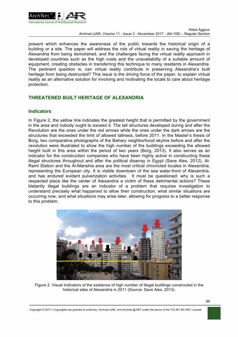
International Journal of Architectural Research Heba Aggour
Archnet-IJAR, Volume 11 - Issue 3 - November 2017 - (94-108) – Regular Section
Copyright © 2017 | Copyrights are granted to author(s), Archnet-IJAR, and Archnet @ MIT under the terms of the "CC-BY-NC-ND" License.
96
present which enhances the awareness of the public towards the historical origin of a building or a site. The paper will address the role of virtual reality in saving the heritage of Alexandria from being demolished, and the challenges facing the virtual reality approach in developed countries such as the high costs and the unavailability of a suitable amount of equipment, creating obstacles in transferring this technique to many residents in Alexandria. The pertinent question is, can virtual reality contribute in preserving Alexandria’s built heritage from being destructed? This issue is the driving force of the paper, to explain virtual reality as an alternative solution for involving and motivating the locals to care about heritage protection.
THREATENED BUILT HERITAGE OF ALEXANDRIA
Indicators
In Figure 2, the yellow line indicates the greatest height that is permitted by the government in the area and nobody ought to exceed it. The tall structures developed during and after the Revolution are the ones under the red arrows while the ones under the dark arrows are the structures that exceeded the limit of allowed tallness, before 2011. In the Master’s thesis of Borg, two comparative photographs of the Bahary neighborhood skyline before and after the revolution were illustrated to show the high number of the buildings exceeding the allowed height built in this area within the period of two years (Borg, 2013). It also serves as an indicator for the construction companies who have been highly active in constructing these illegal structures throughout and after the political disarray in Egypt (Save Alex, 2012). Al-Raml Station and the Al-Manshia area are the most critical chronicled locales in Alexandria, representing the European city. It is visible downtown of the sea water-front of Alexandria, and has endured evident pulverization activities. It must be questioned: why is such a respected place like the center of Alexandria a victim of these detrimental actions? These blatantly illegal buildings are an indicator of a problem that requires investigation to understand precisely what happened to allow their construction; what similar situations are occurring now; and what situations may arise later, allowing for progress to a better response to this problem.
Figure 2. Visual Indicators of the existence of high number of illegal buildings constructed in the
historical sites of Alexandria in 2011 (Source: Save Alex, 2013).
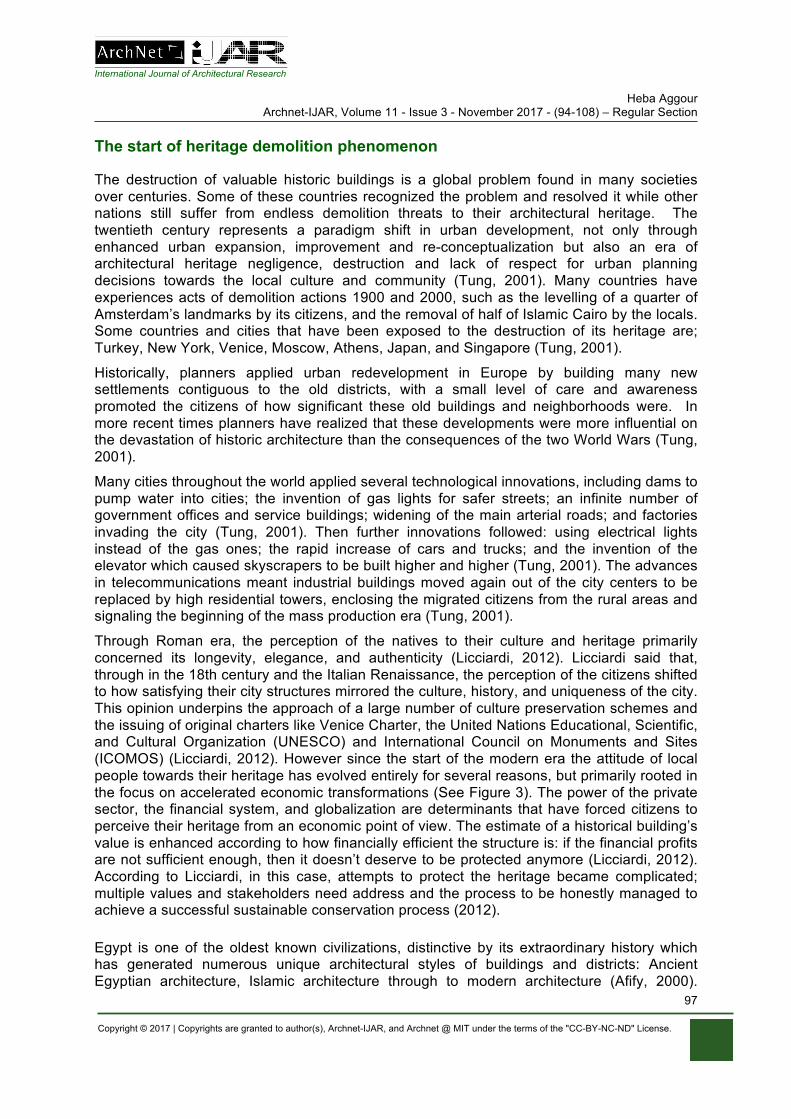
International Journal of Architectural Research Heba Aggour
Archnet-IJAR, Volume 11 - Issue 3 - November 2017 - (94-108) – Regular Section
Copyright © 2017 | Copyrights are granted to author(s), Archnet-IJAR, and Archnet @ MIT under the terms of the "CC-BY-NC-ND" License.
97
The start of heritage demolition phenomenon
The destruction of valuable historic buildings is a global problem found in many societies over centuries. Some of these countries recognized the problem and resolved it while other nations still suffer from endless demolition threats to their architectural heritage. The twentieth century represents a paradigm shift in urban development, not only through enhanced urban expansion, improvement and re-conceptualization but also an era of architectural heritage negligence, destruction and lack of respect for urban planning decisions towards the local culture and community (Tung, 2001). Many countries have experiences acts of demolition actions 1900 and 2000, such as the levelling of a quarter of Amsterdam’s landmarks by its citizens, and the removal of half of Islamic Cairo by the locals. Some countries and cities that have been exposed to the destruction of its heritage are; Turkey, New York, Venice, Moscow, Athens, Japan, and Singapore (Tung, 2001).
Historically, planners applied urban redevelopment in Europe by building many new settlements contiguous to the old districts, with a small level of care and awareness promoted the citizens of how significant these old buildings and neighborhoods were. In more recent times planners have realized that these developments were more influential on the devastation of historic architecture than the consequences of the two World Wars (Tung, 2001).
Many cities throughout the world applied several technological innovations, including dams to pump water into cities; the invention of gas lights for safer streets; an infinite number of government offices and service buildings; widening of the main arterial roads; and factories invading the city (Tung, 2001). Then further innovations followed: using electrical lights instead of the gas ones; the rapid increase of cars and trucks; and the invention of the elevator which caused skyscrapers to be built higher and higher (Tung, 2001). The advances in telecommunications meant industrial buildings moved again out of the city centers to be replaced by high residential towers, enclosing the migrated citizens from the rural areas and signaling the beginning of the mass production era (Tung, 2001).
Through Roman era, the perception of the natives to their culture and heritage primarily concerned its longevity, elegance, and authenticity (Licciardi, 2012). Licciardi said that, through in the 18th century and the Italian Renaissance, the perception of the citizens shifted to how satisfying their city structures mirrored the culture, history, and uniqueness of the city. This opinion underpins the approach of a large number of culture preservation schemes and the issuing of original charters like Venice Charter, the United Nations Educational, Scientific, and Cultural Organization (UNESCO) and International Council on Monuments and Sites (ICOMOS) (Licciardi, 2012). However since the start of the modern era the attitude of local people towards their heritage has evolved entirely for several reasons, but primarily rooted in the focus on accelerated economic transformations (See Figure 3). The power of the private sector, the financial system, and globalization are determinants that have forced citizens to perceive their heritage from an economic point of view. The estimate of a historical building’s value is enhanced according to how financially efficient the structure is: if the financial profits are not sufficient enough, then it doesn’t deserve to be protected anymore (Licciardi, 2012). According to Licciardi, in this case, attempts to protect the heritage became complicated; multiple values and stakeholders need address and the process to be honestly managed to achieve a successful sustainable conservation process (2012).
Egypt is one of the oldest known civilizations, distinctive by its extraordinary history which has generated numerous unique architectural styles of buildings and districts: Ancient Egyptian architecture, Islamic architecture through to modern architecture (Afify, 2000).
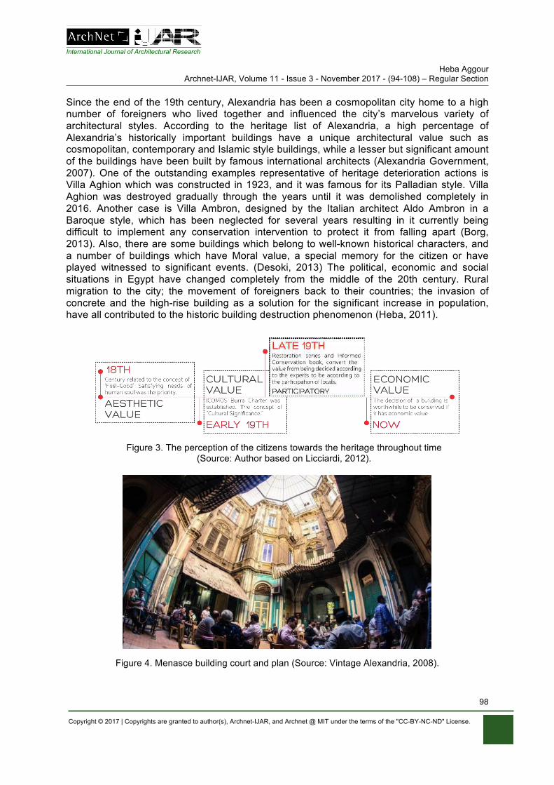
International Journal of Architectural Research Heba Aggour
Archnet-IJAR, Volume 11 - Issue 3 - November 2017 - (94-108) – Regular Section
Copyright © 2017 | Copyrights are granted to author(s), Archnet-IJAR, and Archnet @ MIT under the terms of the "CC-BY-NC-ND" License.
98
Since the end of the 19th century, Alexandria has been a cosmopolitan city home to a high number of foreigners who lived together and influenced the city’s marvelous variety of architectural styles. According to the heritage list of Alexandria, a high percentage of Alexandria’s historically important buildings have a unique architectural value such as cosmopolitan, contemporary and Islamic style buildings, while a lesser but significant amount of the buildings have been built by famous international architects (Alexandria Government, 2007). One of the outstanding examples representative of heritage deterioration actions is Villa Aghion which was constructed in 1923, and it was famous for its Palladian style. Villa Aghion was destroyed gradually through the years until it was demolished completely in 2016. Another case is Villa Ambron, designed by the Italian architect Aldo Ambron in a Baroque style, which has been neglected for several years resulting in it currently being difficult to implement any conservation intervention to protect it from falling apart (Borg, 2013). Also, there are some buildings which belong to well-known historical characters, and a number of buildings which have Moral value, a special memory for the citizen or have played witnessed to significant events. (Desoki, 2013) The political, economic and social situations in Egypt have changed completely from the middle of the 20th century. Rural migration to the city; the movement of foreigners back to their countries; the invasion of concrete and the high-rise building as a solution for the significant increase in population, have all contributed to the historic building destruction phenomenon (Heba, 2011).
Figure 3. The perception of the citizens towards the heritage throughout time
(Source: Author based on Licciardi, 2012).
Figure 4. Menasce building court and plan (Source: Vintage Alexandria, 2008).
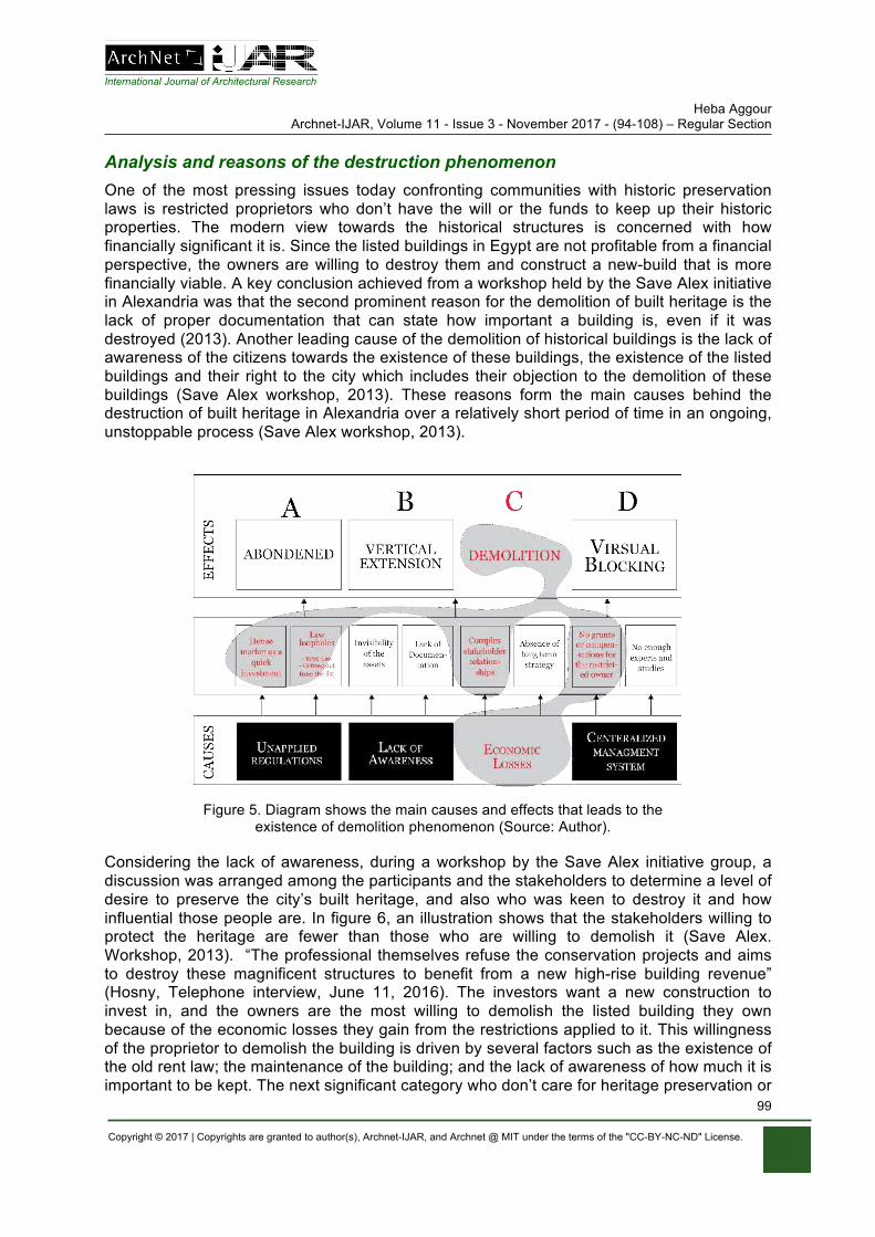
International Journal of Architectural Research Heba Aggour
Archnet-IJAR, Volume 11 - Issue 3 - November 2017 - (94-108) – Regular Section
Copyright © 2017 | Copyrights are granted to author(s), Archnet-IJAR, and Archnet @ MIT under the terms of the "CC-BY-NC-ND" License.
99
Analysis and reasons of the destruction phenomenon One of the most pressing issues today confronting communities with historic preservation laws is restricted proprietors who don’t have the will or the funds to keep up their historic properties. The modern view towards the historical structures is concerned with how financially significant it is. Since the listed buildings in Egypt are not profitable from a financial perspective, the owners are willing to destroy them and construct a new-build that is more financially viable. A key conclusion achieved from a workshop held by the Save Alex initiative in Alexandria was that the second prominent reason for the demolition of built heritage is the lack of proper documentation that can state how important a building is, even if it was destroyed (2013). Another leading cause of the demolition of historical buildings is the lack of awareness of the citizens towards the existence of these buildings, the existence of the listed buildings and their right to the city which includes their objection to the demolition of these buildings (Save Alex workshop, 2013). These reasons form the main causes behind the destruction of built heritage in Alexandria over a relatively short period of time in an ongoing, unstoppable process (Save Alex workshop, 2013).
Figure 5. Diagram shows the main causes and effects that leads to the
existence of demolition phenomenon (Source: Author).
Considering the lack of awareness, during a workshop by the Save Alex initiative group, a discussion was arranged among the participants and the stakeholders to determine a level of desire to preserve the city’s built heritage, and also who was keen to destroy it and how influential those people are. In figure 6, an illustration shows that the stakeholders willing to protect the heritage are fewer than those who are willing to demolish it (Save Alex. Workshop, 2013). “The professional themselves refuse the conservation projects and aims to destroy these magnificent structures to benefit from a new high-rise building revenue” (Hosny, Telephone interview, June 11, 2016). The investors want a new construction to invest in, and the owners are the most willing to demolish the listed building they own because of the economic losses they gain from the restrictions applied to it. This willingness of the proprietor to demolish the building is driven by several factors such as the existence of the old rent law; the maintenance of the building; and the lack of awareness of how much it is important to be kept. The next significant category who don’t care for heritage preservation or
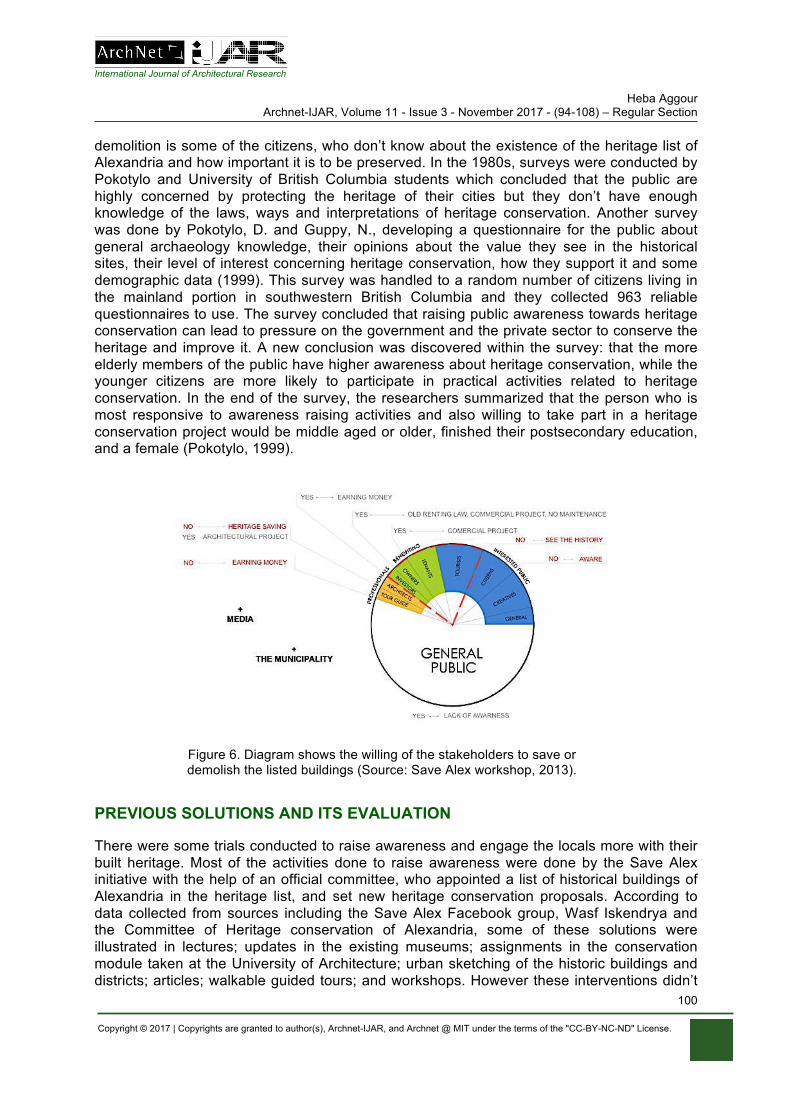
International Journal of Architectural Research Heba Aggour
Archnet-IJAR, Volume 11 - Issue 3 - November 2017 - (94-108) – Regular Section
Copyright © 2017 | Copyrights are granted to author(s), Archnet-IJAR, and Archnet @ MIT under the terms of the "CC-BY-NC-ND" License.
100
demolition is some of the citizens, who don’t know about the existence of the heritage list of Alexandria and how important it is to be preserved. In the 1980s, surveys were conducted by Pokotylo and University of British Columbia students which concluded that the public are highly concerned by protecting the heritage of their cities but they don’t have enough knowledge of the laws, ways and interpretations of heritage conservation. Another survey was done by Pokotylo, D. and Guppy, N., developing a questionnaire for the public about general archaeology knowledge, their opinions about the value they see in the historical sites, their level of interest concerning heritage conservation, how they support it and some demographic data (1999). This survey was handled to a random number of citizens living in the mainland portion in southwestern British Columbia and they collected 963 reliable questionnaires to use. The survey concluded that raising public awareness towards heritage conservation can lead to pressure on the government and the private sector to conserve the heritage and improve it. A new conclusion was discovered within the survey: that the more elderly members of the public have higher awareness about heritage conservation, while the younger citizens are more likely to participate in practical activities related to heritage conservation. In the end of the survey, the researchers summarized that the person who is most responsive to awareness raising activities and also willing to take part in a heritage conservation project would be middle aged or older, finished their postsecondary education, and a female (Pokotylo, 1999).
Figure 6. Diagram shows the willing of the stakeholders to save or demolish the listed buildings (Source: Save Alex workshop, 2013).
PREVIOUS SOLUTIONS AND ITS EVALUATION
There were some trials conducted to raise awareness and engage the locals more with their built heritage. Most of the activities done to raise awareness were done by the Save Alex initiative with the help of an official committee, who appointed a list of historical buildings of Alexandria in the heritage list, and set new heritage conservation proposals. According to data collected from sources including the Save Alex Facebook group, Wasf Iskendrya and the Committee of Heritage conservation of Alexandria, some of these solutions were illustrated in lectures; updates in the existing museums; assignments in the conservation module taken at the University of Architecture; urban sketching of the historic buildings and districts; articles; walkable guided tours; and workshops. However these interventions didn’t
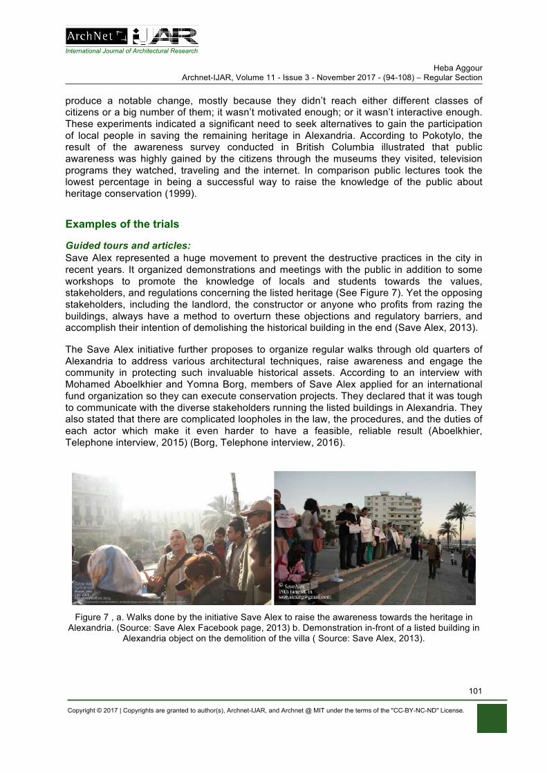
International Journal of Architectural Research Heba Aggour
Archnet-IJAR, Volume 11 - Issue 3 - November 2017 - (94-108) – Regular Section
Copyright © 2017 | Copyrights are granted to author(s), Archnet-IJAR, and Archnet @ MIT under the terms of the "CC-BY-NC-ND" License.
101
produce a notable change, mostly because they didn’t reach either different classes of citizens or a big number of them; it wasn’t motivated enough; or it wasn’t interactive enough. These experiments indicated a significant need to seek alternatives to gain the participation of local people in saving the remaining heritage in Alexandria. According to Pokotylo, the result of the awareness survey conducted in British Columbia illustrated that public awareness was highly gained by the citizens through the museums they visited, television programs they watched, traveling and the internet. In comparison public lectures took the lowest percentage in being a successful way to raise the knowledge of the public about heritage conservation (1999).
Examples of the trials
Guided tours and articles: Save Alex represented a huge movement to prevent the destructive practices in the city in recent years. It organized demonstrations and meetings with the public in addition to some workshops to promote the knowledge of locals and students towards the values, stakeholders, and regulations concerning the listed heritage (See Figure 7). Yet the opposing stakeholders, including the landlord, the constructor or anyone who profits from razing the buildings, always have a method to overturn these objections and regulatory barriers, and accomplish their intention of demolishing the historical building in the end (Save Alex, 2013).
The Save Alex initiative further proposes to organize regular walks through old quarters of Alexandria to address various architectural techniques, raise awareness and engage the community in protecting such invaluable historical assets. According to an interview with Mohamed Aboelkhier and Yomna Borg, members of Save Alex applied for an international fund organization so they can execute conservation projects. They declared that it was tough to communicate with the diverse stakeholders running the listed buildings in Alexandria. They also stated that there are complicated loopholes in the law, the procedures, and the duties of each actor which make it even harder to have a feasible, reliable result (Aboelkhier, Telephone interview, 2015) (Borg, Telephone interview, 2016).
Figure 7 , a. Walks done by the initiative Save Alex to raise the awareness towards the heritage in
Alexandria. (Source: Save Alex Facebook page, 2013) b. Demonstration in-front of a listed building in Alexandria object on the demolition of the villa ( Source: Save Alex, 2013).
International Journal of Architectural Research Heba Aggour
Archnet-IJAR, Volume 11 - Issue 3 - November 2017 - (94-108) – Regular Section
Copyright © 2017 | Copyrights are granted to author(s), Archnet-IJAR, and Archnet @ MIT under the terms of the "CC-BY-NC-ND" License.
102
Sketching workshops A series of events were organized by Mohamed Gohar, an architect, called Wasf Iskendrya under the umbrella of Urban Sketchers group. This group aims to document Alexandria’s fabulous architecture as it is currently through sketches and drawings before it disappears like the other demolished historic buildings. Photographs are misleading and do not focus on the construction style as the sketches do, as stated Gohar in an article interview. The Gudran organization also has a substantial role in spreading the knowledge of the important unknown heritage of Alexandria, through Al-Cabina, a cultural space managed by them. In Al-Cabina, they hold several cultural activities and lectures; its main aim is to integrate everyone and raise the attachment of the locals with the city (Rollins, 2015). Lectures Some architects, urban planners, private institutions and even ordinary people who care for the built heritage of the city have organized several lectures to illustrate the types of heritage found in the city, its importance, how to conserve it and discuss the problems and solutions related to it. Also, a number of round tables were organized with stakeholders including investors and owners to bring the deterioration phenomenon into discussion, and to try to achieve a proper solution that results in a win-win situation for the interested stakeholders to preserve the heritage. Museums Alexandria has some museums which are generally in good condition and exhibit valuable historical artefacts. The locals are not interested in visiting these museums, and school trips mostly visit the museums. These trips are very short, not well prepared and don’t usually offer a high quality of information, with the students mostly forgetting what they have learned and not visiting again when they are older. Ultimately, these museums are left neglected and unable to share their knowledge (Gaitatzes, 2001). Education Recently some educational modules were added to the architecture department of Alexandria University to study heritage conservation and also to allow students to gain some knowledge about historical buildings, and the different historical architectural styles present in Alexandria. This module had a significant impact on the students and brought their focus on to the heritage and conservation field in addition to the computational and conceptual design aspects they were already being taught to consider. A huge number of the neglected buildings in Alexandria need to be reused so the module brought the reality of the situation into their studies and decreased the gap found between what is known and practiced in the work environment and what the architectural students are studying in the university.
LEVEL OF ENGAGEMENT EVALUATION
An assessment of the previously stated solutions was done - present in Table 1 - after looking at each intervention, what happened and the feedback of the users. The assessment was conducted according to how much each activity may contribute to an increase in awareness and knowledge gained by the locals about the already demolished buildings and their willingness to preserve their remaining heritage. In order to drive the citizens to change the existing situation and to be prepared to object to the demolition actions, activities should be introduced to help in enhancing their sense of belonging through a well-managed interactive methodology. The interactive activities should make them aware of how beautiful the urban identity was before and what changes have happened to reach the existing
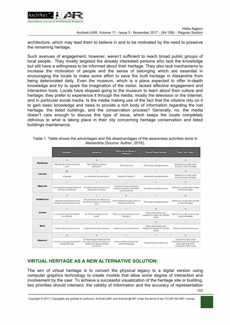
International Journal of Architectural Research Heba Aggour
Archnet-IJAR, Volume 11 - Issue 3 - November 2017 - (94-108) – Regular Section
Copyright © 2017 | Copyrights are granted to author(s), Archnet-IJAR, and Archnet @ MIT under the terms of the "CC-BY-NC-ND" License.
103
architecture, which may lead them to believe in and to be motivated by the need to preserve the remaining heritage.
Such avenues of engagement, however, weren’t sufficient to reach broad public groups of local people. They mostly targeted the already interested persons who lack the knowledge but still have a willingness to be informed about their heritage. They also lack mechanisms to increase the motivation of people and the sense of belonging which are essential in encouraging the locals to make some effort to save the built heritage in Alexandria from being deteriorated daily. Even the museum, which is a place expected to offer in-depth knowledge and try to spark the imagination of the visitor, lacked effective engagement and interaction tools. Locals have stopped going to the museum to learn about their culture and heritage; they prefer to experience it through the media, mostly the television or the Internet, and in particular social media. Is the media making use of the fact that the citizens rely on it to gain basic knowledge and news to provide a rich body of information regarding the lost heritage, the listed buildings, and the conservation process? Generally, no, the media doesn’t care enough to discuss this type of issue, which keeps the locals completely oblivious to what is taking place in their city concerning heritage conservation and listed buildings maintenance.
Table 1. Table shows the advantages and the disadvantages of the awareness activities done in
Alexandria (Source: Author, 2016).
VIRTUAL HERITAGE AS A NEW ALTERNATIVE SOLUTION:
The aim of virtual heritage is to convert the physical legacy to a digital version using computer graphics technology to create models that allow some degree of interaction and involvement by the user. To achieve a successful visualization of the heritage site or building, two priorities should intersect: the validity of information and the accuracy of representation
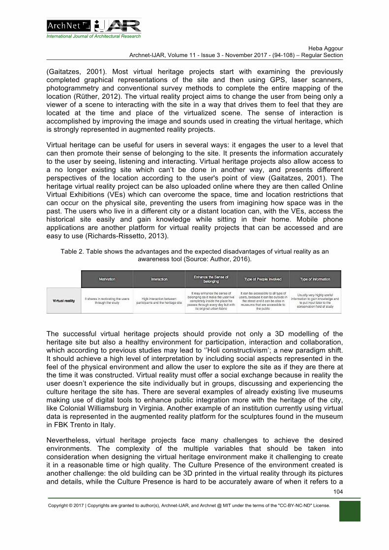
International Journal of Architectural Research Heba Aggour
Archnet-IJAR, Volume 11 - Issue 3 - November 2017 - (94-108) – Regular Section
Copyright © 2017 | Copyrights are granted to author(s), Archnet-IJAR, and Archnet @ MIT under the terms of the "CC-BY-NC-ND" License.
104
(Gaitatzes, 2001). Most virtual heritage projects start with examining the previously completed graphical representations of the site and then using GPS, laser scanners, photogrammetry and conventional survey methods to complete the entire mapping of the location (Rüther, 2012). The virtual reality project aims to change the user from being only a viewer of a scene to interacting with the site in a way that drives them to feel that they are located at the time and place of the virtualized scene. The sense of interaction is accomplished by improving the image and sounds used in creating the virtual heritage, which is strongly represented in augmented reality projects.
Virtual heritage can be useful for users in several ways: it engages the user to a level that can then promote their sense of belonging to the site. It presents the information accurately to the user by seeing, listening and interacting. Virtual heritage projects also allow access to a no longer existing site which can’t be done in another way, and presents different perspectives of the location according to the user's point of view (Gaitatzes, 2001). The heritage virtual reality project can be also uploaded online where they are then called Online Virtual Exhibitions (VEs) which can overcome the space, time and location restrictions that can occur on the physical site, preventing the users from imagining how space was in the past. The users who live in a different city or a distant location can, with the VEs, access the historical site easily and gain knowledge while sitting in their home. Mobile phone applications are another platform for virtual reality projects that can be accessed and are easy to use (Richards-Rissetto, 2013).
Table 2. Table shows the advantages and the expected disadvantages of virtual reality as an awareness tool (Source: Author, 2016).
The successful virtual heritage projects should provide not only a 3D modelling of the heritage site but also a healthy environment for participation, interaction and collaboration, which according to previous studies may lead to ‘’Holi constructivism’; a new paradigm shift. It should achieve a high level of interpretation by including social aspects represented in the feel of the physical environment and allow the user to explore the site as if they are there at the time it was constructed. Virtual reality must offer a social exchange because in reality the user doesn’t experience the site individually but in groups, discussing and experiencing the culture heritage the site has. There are several examples of already existing live museums making use of digital tools to enhance public integration more with the heritage of the city, like Colonial Williamsburg in Virginia. Another example of an institution currently using virtual data is represented in the augmented reality platform for the sculptures found in the museum in FBK Trento in Italy.
Nevertheless, virtual heritage projects face many challenges to achieve the desired environments. The complexity of the multiple variables that should be taken into consideration when designing the virtual heritage environment make it challenging to create it in a reasonable time or high quality. The Culture Presence of the environment created is another challenge: the old building can be 3D printed in the virtual reality through its pictures and details, while the Culture Presence is hard to be accurately aware of when it refers to a
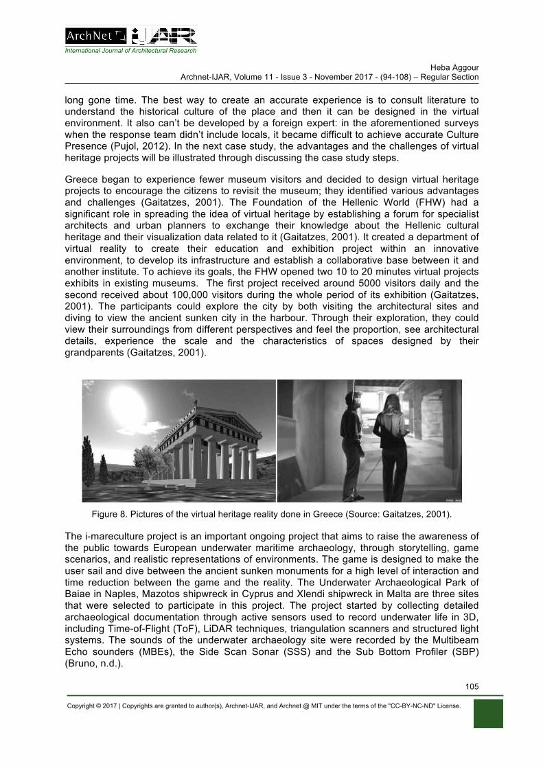
International Journal of Architectural Research Heba Aggour
Archnet-IJAR, Volume 11 - Issue 3 - November 2017 - (94-108) – Regular Section
Copyright © 2017 | Copyrights are granted to author(s), Archnet-IJAR, and Archnet @ MIT under the terms of the "CC-BY-NC-ND" License.
105
long gone time. The best way to create an accurate experience is to consult literature to understand the historical culture of the place and then it can be designed in the virtual environment. It also can’t be developed by a foreign expert: in the aforementioned surveys when the response team didn’t include locals, it became difficult to achieve accurate Culture Presence (Pujol, 2012). In the next case study, the advantages and the challenges of virtual heritage projects will be illustrated through discussing the case study steps.
Greece began to experience fewer museum visitors and decided to design virtual heritage projects to encourage the citizens to revisit the museum; they identified various advantages and challenges (Gaitatzes, 2001). The Foundation of the Hellenic World (FHW) had a significant role in spreading the idea of virtual heritage by establishing a forum for specialist architects and urban planners to exchange their knowledge about the Hellenic cultural heritage and their visualization data related to it (Gaitatzes, 2001). It created a department of virtual reality to create their education and exhibition project within an innovative environment, to develop its infrastructure and establish a collaborative base between it and another institute. To achieve its goals, the FHW opened two 10 to 20 minutes virtual projects exhibits in existing museums. The first project received around 5000 visitors daily and the second received about 100,000 visitors during the whole period of its exhibition (Gaitatzes, 2001). The participants could explore the city by both visiting the architectural sites and diving to view the ancient sunken city in the harbour. Through their exploration, they could view their surroundings from different perspectives and feel the proportion, see architectural details, experience the scale and the characteristics of spaces designed by their grandparents (Gaitatzes, 2001).
Figure 8. Pictures of the virtual heritage reality done in Greece (Source: Gaitatzes, 2001).
The i-mareculture project is an important ongoing project that aims to raise the awareness of the public towards European underwater maritime archaeology, through storytelling, game scenarios, and realistic representations of environments. The game is designed to make the user sail and dive between the ancient sunken monuments for a high level of interaction and time reduction between the game and the reality. The Underwater Archaeological Park of Baiae in Naples, Mazotos shipwreck in Cyprus and Xlendi shipwreck in Malta are three sites that were selected to participate in this project. The project started by collecting detailed archaeological documentation through active sensors used to record underwater life in 3D, including Time-of-Flight (ToF), LiDAR techniques, triangulation scanners and structured light systems. The sounds of the underwater archaeology site were recorded by the Multibeam Echo sounders (MBEs), the Side Scan Sonar (SSS) and the Sub Bottom Profiler (SBP) (Bruno, n.d.).
International Journal of Architectural Research Heba Aggour
Archnet-IJAR, Volume 11 - Issue 3 - November 2017 - (94-108) – Regular Section
Copyright © 2017 | Copyrights are granted to author(s), Archnet-IJAR, and Archnet @ MIT under the terms of the "CC-BY-NC-ND" License.
106
One of the most critical challenges the projects faced was the high cost of the VR equipment needed to create the projects, and the costs required to pay the team working on the project. This lead the team to choose more readily available VR equipment with less cost to be able to represent different projects to the visitors (Rüther, 2012). In other cases, specialists were needed in the 3D scanning of the virtual heritage projects such as architects and conservators to check all the architectural details. The team may have another challenge which is the ability of the designers and the curators to understand the virtual software that they should apply the architectural details on, which makes it necessary for them to be involved with the project from the beginning to be familiar with this software before starting. In other cases, challenges occur against the timeline the team should meet to finish the project, especially if an international institute funds this project. These problems are highly present in the ability of the 3D laser equipment to capture a huge site in a high-quality virtual heritage environment project, and the permissions to photograph such important historical sites may also form a challenge (Rüther, 2012).
The advantages of Virtual Reality projects can be summed by their ability to increase immersion and interaction for the users. The users can be immersed in the surrounding digital environment and experience the space and sounds like they are in the real place and time, interacting with this environment to create their own experience (Roussou, 2010).
CONCLUSION
Additional challenges to the ones mentioned in the paper occur when trying to implement the virtual reality project in Alexandria. Alexandria is a city in a developing country which makes it more difficult for the locals to be aware of the term “Virtual reality” itself, adding the need to raise awareness of the concept of virtual environments to the challenges. In Alexandria, it is difficult to visit the museums to see new visual heritage environment projects. The locals in Greece went to visit the museum to see the new project and to have fun exploring the historic city because they were aware of what virtual reality means. It is much expected that the locals in Alexandria won't visit the museum even after the launching of the virtual projects, which means there should be another additional step to address this before the launch of the projects in the museum, such as an on-site experiment of the virtual reality by the citizens in the street. The cost is another challenge which makes it nearly impossible to be done without a full fund from an international institute.
The awareness of the citizens around their heritage is an essential aspect to protect the historic built environment from being regularly demolished. The activities tackling the increase of knowledge of the citizens occurred in several forms: workshops, tours, lectures and social media. These outreach activities have been met with ignorance and inefficiency towards raising the knowledge of citizens, building the will power to save the heritage of the city, and deepening the understanding of their rights to the city. According to the case study, virtual reality can be a successful alternative for these activities to raise awareness. Although virtual reality has a lot of advantages, it may bring some challenges to achieve the necessary knowledge level in the context of Alexandria. Resultantly it is better to bring the virtual reality to the citizens on the site rather than expecting the locals to go to a place like a museum to experience the virtual project due to their lack of awareness about the meaning of virtual reality. Additionally the project needs to be accompanied by a detailed proposal to gain full funding from international institutes to implement it without delays parallel to the achievement of the required awareness level goal.
International Journal of Architectural Research Heba Aggour
Archnet-IJAR, Volume 11 - Issue 3 - November 2017 - (94-108) – Regular Section
Copyright © 2017 | Copyrights are granted to author(s), Archnet-IJAR, and Archnet @ MIT under the terms of the "CC-BY-NC-ND" License.
107
REFERENCES Aboelkhier, M. (2015). Heritage destruction phenomenon in Alexandria. [Telephone interview]. Save
Alex member. Alexandria Government. (2007). اثية المبا"! ع"! الحفاظ مجلد ا()سكندرية لمحافظة ال&% . Alexandria: Alexandria
Government. Borg, Y. (2016). Heritage destruction phenomenon in Alexandria [Telephone interview]. Save Alex
member. Bruno, F., Lagudi, A., Ritacco, G., Agrafiotis, P., Skarlatos, D., Philpin-Briscoe, O., & Liarokapis, F.
(n.d.). Development and integration of digital technologies addressed to raise awareness and access to European underwater cultural heritage: An overview of the H2020 i-MARECULTURE project, http://poullis.org/pubs/POULLIS_OCEANS2017.pdf, Access Date, 04/09/2017.
Desouki, Y. (2007). The Bibliotheca Alexandria and the preservation of Egypt’s visual cultural heritage [PowerPoint file]. Retrieved 20/01/2015.
Gaitatzes, A., Christopoulos, D,. & Roussou, M. (2001). Virtual Reality Interfaces for The Broad Public: Advances in Human Computer Interaction. 1st ed. Patra, Greece: University of Patras, 2017. pp. 159-164.
Heba, K. (2011). Preserving architectural heritage in historical cities. Study Of The Architectural Heritage With The End Of The Nineteenth Century And The Beginning Of The Twentieth Centure In Alexandria, Egypt, http://www.cpas-egypt.com/pdf/Khaled_Heba/Research/001%20%20Preserving%20architectural%20heritage%20in%20historical%20cities.pdf, Access Date, 20/01/2015.
Hosny, H. (2016). Heritage destruction phenomenon in Alexandria [Telephone interview]. Member in the National Organization for Urban Harmony (NOUH).
International Council on Monuments and Sites. (2000). Heritage at risk: ICOMOS world report ... on monuments and sites in danger. München: K.G. Saur.
Licciardi, G., & Amirtahmasebi, R. (2011). The economics of uniqueness: Investing in historic city cores and cultural heritage assets for sustainable Urban Development; Washington, DC: World Bank. © World Bank.
Nagy, G., & El Khateeb, S. (2016). Emerging the Awareness of Cultural Heritage Through Digital Technologies and Mobile Low-cost Applications in Jeddah Open Wall Museum (JOWM) [Scholarly project], https://www.researchgate.net/publication/303805912_Emerging_the_Awareness_of_Cultural_Heritage_Through_Digital_Technologies_and_Mobile_Low-cost_Applications_in_Jeddah_Open_Wall_Museum_JOWM, Access Date, 09/2017.
Pokotylo, D., & Guppy, N. (1999). Public Opinion and Archaeological Heritage: Views from Outside the Profession, https://www.jstor.org/stable/2694141?seq=1#page_scan_tab_contents, Access Date, 09/09/2017.
Pujol, L., & Champion, E. (2012). Evaluating presence in cultural heritage projects. International Journal of Heritage Studies, 18(1), 83-102. doi:10.1080/13527258.2011.577796.
Richards-Rissetto, H., Robertsson, J., Schwerin, J. V., Agugario, G., & Remondino, F. (2013). Geospatial Virtual Heritage: A Gesture-Based 3D GIS to Engage the Public with Ancient Maya Archaeology [Scholarly project], http://digitalcommons.unl.edu/anthropologyfacpub/62/, Access Date, 02/09/2017.
Rollins, T. (2015). Understanding Alexandria’s embattled urban heritage, A cultural conservation project is trying to document Alexandria’s embattled heritage as historic buildings continue to disappear, http://www.middleeasteye.net/in-depth/features/understanding-alexandria- s-embattled-urban-heritage-1613781298, Access Date, 02/08/2016.
Roussou, M. (2010). Immersive Interactive Virtual Reality in the Museum [Scholarly project], https://www.researchgate.net/publication/281982881_Immersive_Virtual_Mixed_or_Augmented_Reality_Art, Access Date, 01/09/2017.
Rüther, H., & Palumbo, G. (2012). 3D Laser Scanning for Site Monitoring and Conservation in Lalibela World Heritage Site, Ethiopia. International Journal of Heritage in the Digital Era, 1(2), 217-231. doi:10.1260/2047-4970.1.2.217.
Save Alex. Workshop (2013). Workshop. Alexandria, Egypt
International Journal of Architectural Research Heba Aggour
Archnet-IJAR, Volume 11 - Issue 3 - November 2017 - (94-108) – Regular Section
Copyright © 2017 | Copyrights are granted to author(s), Archnet-IJAR, and Archnet @ MIT under the terms of the "CC-BY-NC-ND" License.
108
Tung, Anthony M. (2001). Preserving the world’s great cities: The destruction and renewal of the historic metropolis. New York: Clarkson Potter.
UNESCO. (2013). Warning: Looting of the Malawi National Museum in the Upper Egypt city of Minya. http://www.unesco.org: http://www.unesco.org/new/en/culture/themes/illicittraffic-of-cultural-property/emergency-actions/egypt/warning-looting-of-the-malawi-national-museum/, Access Date, 05/05/2016.

Mohamed Nabil Arafa Archnet-IJAR, Volume 11 - Issue 3 - November 2017 - (109-118) – Regular Section
Copyright © 2017 | Copyrights are granted to author(s), Archnet-IJAR, and Archnet @ MIT under the terms of the "CC-BY-NC-ND" License.
109
Archnet-IJAR: International Journal of Architectural Research www.archnet-ijar.net/ -- https://archnet.org/collections/34
ACHILLES AS A MARKETING TOOL FOR VIRTUAL HERITAGE APPLICATIONS DOI: http://dx.doi.org/10.26687/archnet-ijar.v11i3.1385
Mohamed Nabil Arafa
Keywords Abstract
virtual heritage; virtual heritage consumers; virtual heritage marketing; online visitor engagement; online visitor management
Virtual Reality technology has made it possible for people to visit places and enjoy different exciting experiences while remaining at home. It gives an opportunity to enjoy the past at its best. Virtual Reality was introduced in 1929 with interactive training devices that simulated fighter planes. In 1957, the Sensorama simulator was designed which could generate city smells and wind sensations. The need for tourism to become virtual becomes more urgent than ever before. Virtual Reality applications provide this chance, not only in place, but in time as well. This paper presents a guide to the heritage applications' builders and marketers to reach more online users. The paper helps the builder to understand the consumer behaviour for marketing research. The paper illustrates eight levels, with each one leading to the next. The author named the eight levels A.C.H.I.L.L.E.S. Each letter represents a level; beginning with the awareness and ending with the sustainability. ACHILLES represents a sequence that shows three main phases of mobile application usage. It aims for a better management for the online visitors' engagement. This aim can be accomplished through the understanding of the different stages that the online visitors go through. In addition, it shows the correlation between the users and the mobile application.
M. N. Arafa * 3 Gamal El Din El Afgany, Al Ahram, Pyramids Road, Postcode12552, Giza, Egypt.
* Corresponding Author’s email address: [email protected]
ArchNet-IJAR is indexed and listed in several databases, including: • Avery Index to Architectural
Periodicals • EBSCO-Current Abstracts-Art
and Architecture • CNKI: China National
Knowledge Infrastructure • DOAJ: Directory of Open
Access Journals • Pro-Quest • Scopus-Elsevier • Web of Science
International Journal of Architectural Research Mohamed Nabil Arafa
Archnet-IJAR, Volume 11 - Issue 3 - November 2017 - (109-118) – Regular Section
Copyright © 2017 | Copyrights are granted to author(s), Archnet-IJAR, and Archnet @ MIT under the terms of the "CC-BY-NC-ND" License.
110
INTRODUCTION
Due to recent developments and advances in Internet technology and Information development, virtual tourism has increasingly become reality. 3D graphics technology offers a great opportunity to replicate ancient worlds and civilizations. In other words, this 3D technology helps to experience the past at its best. This technology makes the person feels transported to another place, referred to as immersion (Heim, 1998).
Virtual heritage strategies normally focus on the tangible facts of cultural heritage associated with sites and objects, such as graphics and animation. However, virtual heritage projects should also illustrate the intangible features of cultural heritage, such as stories, foods and dances. Both tangible and intangible facts are different but have to be combined by using serious Heritage Applications/Games. Egyptian projects such CULTNAT Institute (Center for Documentation of Cultural and Natural Heritage) have developed more realistic experiences that allow more understanding of, and protection for, touristic sites, monuments and objects. The real-life tourism sometimes creates damage to historic sites and the contextual fabric that endangers the very monuments they are supposed to enrich and support. Several protests have taken place in Venice and Barcelona against the overflow of tourism to their historic cities, and the impact on their everyday life in the city. So "being not-there may safeguard the place" (Champion, 2011), as what virtual heritage would suggest as a solution.
There is consensus that virtual experiences of touristic sites and associated applications will be the language of the future (Curia, 2014). Moreover, those Games/Applications will be the visitors' tool to visualize the old civilizations and become more excited about them. Additionally, online platforms provide archaeology applications for children and students to learn more about the archaeological sites and the unpublished excavations, for example; Archeologia Viva, Archeological Discoveries in History Guide and Great Archeological Discoveries in History Info.
Many authors have tackled the issue of Culture and Heritage Marketing. In 1997, Fiona McLean proved that the theories of marketing developed for manufactured goods are relevant to the experience of visiting a museum (McLean, 1997). In 2009 Sue Mahar and Jay Mahar provided us with proven techniques for successful marketing and branding (Mahar & Mahar, 2009).
Based on consumer behaviour studies and practical experience in tourism, the author chooses eight letters forming the new acronym ACHILLES. It is a sequence comprising eight stages that both online users and developers go through. Each level leads to the next forming a complete solution that helps the developers of virtual heritage applications to understand the needs and behaviours of the online visitors. Moreover, it gives those developers indicators to develop and update the applications to sustain existence. The main aim was to increase visitors and to encourage the online users to have more interaction with the website and the application.
The eight stages of ACHILLES aim to increase the number of the online visitors through the continuous developing of the application according to the visitor status. These eight levels can be identified by three principle phases; pre-application visit phase; on application phase; and post-application visit phase. ACHILLES levels are presented in Table 1.
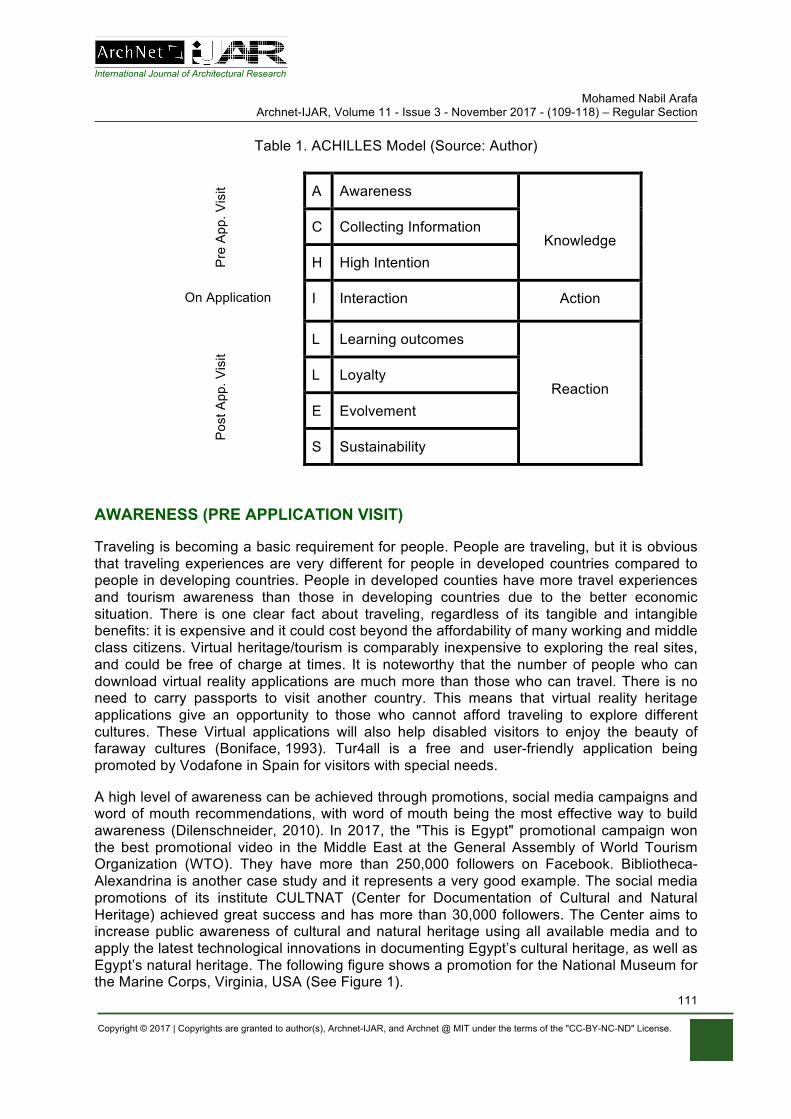
International Journal of Architectural Research Mohamed Nabil Arafa
Archnet-IJAR, Volume 11 - Issue 3 - November 2017 - (109-118) – Regular Section
Copyright © 2017 | Copyrights are granted to author(s), Archnet-IJAR, and Archnet @ MIT under the terms of the "CC-BY-NC-ND" License.
111
Table 1. ACHILLES Model (Source: Author)
Pre
App
. Vis
it A Awareness
Knowledge C Collecting Information
H High Intention
On Application I Interaction Action
P
ost A
pp. V
isit
L Learning outcomes
Reaction L Loyalty
E Evolvement
S Sustainability
AWARENESS (PRE APPLICATION VISIT)
Traveling is becoming a basic requirement for people. People are traveling, but it is obvious that traveling experiences are very different for people in developed countries compared to people in developing countries. People in developed counties have more travel experiences and tourism awareness than those in developing countries due to the better economic situation. There is one clear fact about traveling, regardless of its tangible and intangible benefits: it is expensive and it could cost beyond the affordability of many working and middle class citizens. Virtual heritage/tourism is comparably inexpensive to exploring the real sites, and could be free of charge at times. It is noteworthy that the number of people who can download virtual reality applications are much more than those who can travel. There is no need to carry passports to visit another country. This means that virtual reality heritage applications give an opportunity to those who cannot afford traveling to explore different cultures. These Virtual applications will also help disabled visitors to enjoy the beauty of faraway cultures (Boniface, 1993). Tur4all is a free and user-friendly application being promoted by Vodafone in Spain for visitors with special needs.
A high level of awareness can be achieved through promotions, social media campaigns and word of mouth recommendations, with word of mouth being the most effective way to build awareness (Dilenschneider, 2010). In 2017, the "This is Egypt" promotional campaign won the best promotional video in the Middle East at the General Assembly of World Tourism Organization (WTO). They have more than 250,000 followers on Facebook. Bibliotheca- Alexandrina is another case study and it represents a very good example. The social media promotions of its institute CULTNAT (Center for Documentation of Cultural and Natural Heritage) achieved great success and has more than 30,000 followers. The Center aims to increase public awareness of cultural and natural heritage using all available media and to apply the latest technological innovations in documenting Egypt’s cultural heritage, as well as Egypt’s natural heritage. The following figure shows a promotion for the National Museum for the Marine Corps, Virginia, USA (See Figure 1).
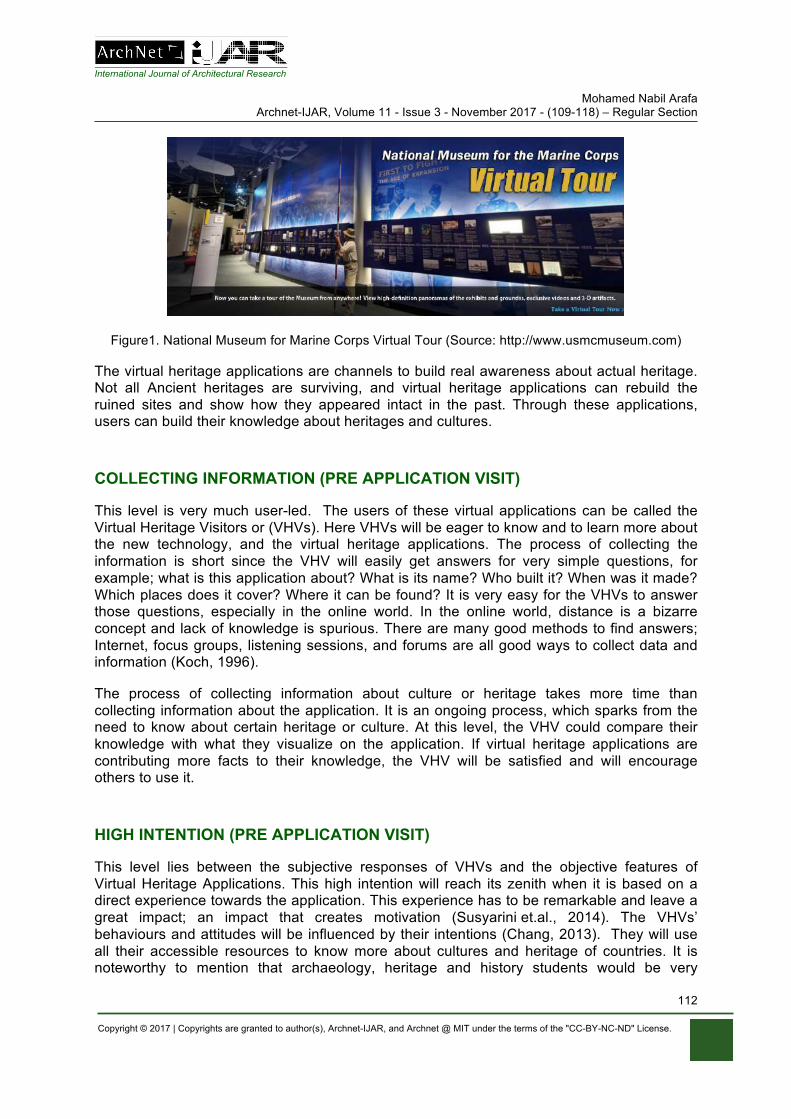
International Journal of Architectural Research Mohamed Nabil Arafa
Archnet-IJAR, Volume 11 - Issue 3 - November 2017 - (109-118) – Regular Section
Copyright © 2017 | Copyrights are granted to author(s), Archnet-IJAR, and Archnet @ MIT under the terms of the "CC-BY-NC-ND" License.
112
Figure1. National Museum for Marine Corps Virtual Tour (Source: http://www.usmcmuseum.com)
The virtual heritage applications are channels to build real awareness about actual heritage. Not all Ancient heritages are surviving, and virtual heritage applications can rebuild the ruined sites and show how they appeared intact in the past. Through these applications, users can build their knowledge about heritages and cultures.
COLLECTING INFORMATION (PRE APPLICATION VISIT)
This level is very much user-led. The users of these virtual applications can be called the Virtual Heritage Visitors or (VHVs). Here VHVs will be eager to know and to learn more about the new technology, and the virtual heritage applications. The process of collecting the information is short since the VHV will easily get answers for very simple questions, for example; what is this application about? What is its name? Who built it? When was it made? Which places does it cover? Where it can be found? It is very easy for the VHVs to answer those questions, especially in the online world. In the online world, distance is a bizarre concept and lack of knowledge is spurious. There are many good methods to find answers; Internet, focus groups, listening sessions, and forums are all good ways to collect data and information (Koch, 1996).
The process of collecting information about culture or heritage takes more time than collecting information about the application. It is an ongoing process, which sparks from the need to know about certain heritage or culture. At this level, the VHV could compare their knowledge with what they visualize on the application. If virtual heritage applications are contributing more facts to their knowledge, the VHV will be satisfied and will encourage others to use it.
HIGH INTENTION (PRE APPLICATION VISIT)
This level lies between the subjective responses of VHVs and the objective features of Virtual Heritage Applications. This high intention will reach its zenith when it is based on a direct experience towards the application. This experience has to be remarkable and leave a great impact; an impact that creates motivation (Susyarini et.al., 2014). The VHVs’ behaviours and attitudes will be influenced by their intentions (Chang, 2013). They will use all their accessible resources to know more about cultures and heritage of countries. It is noteworthy to mention that archaeology, heritage and history students would be very
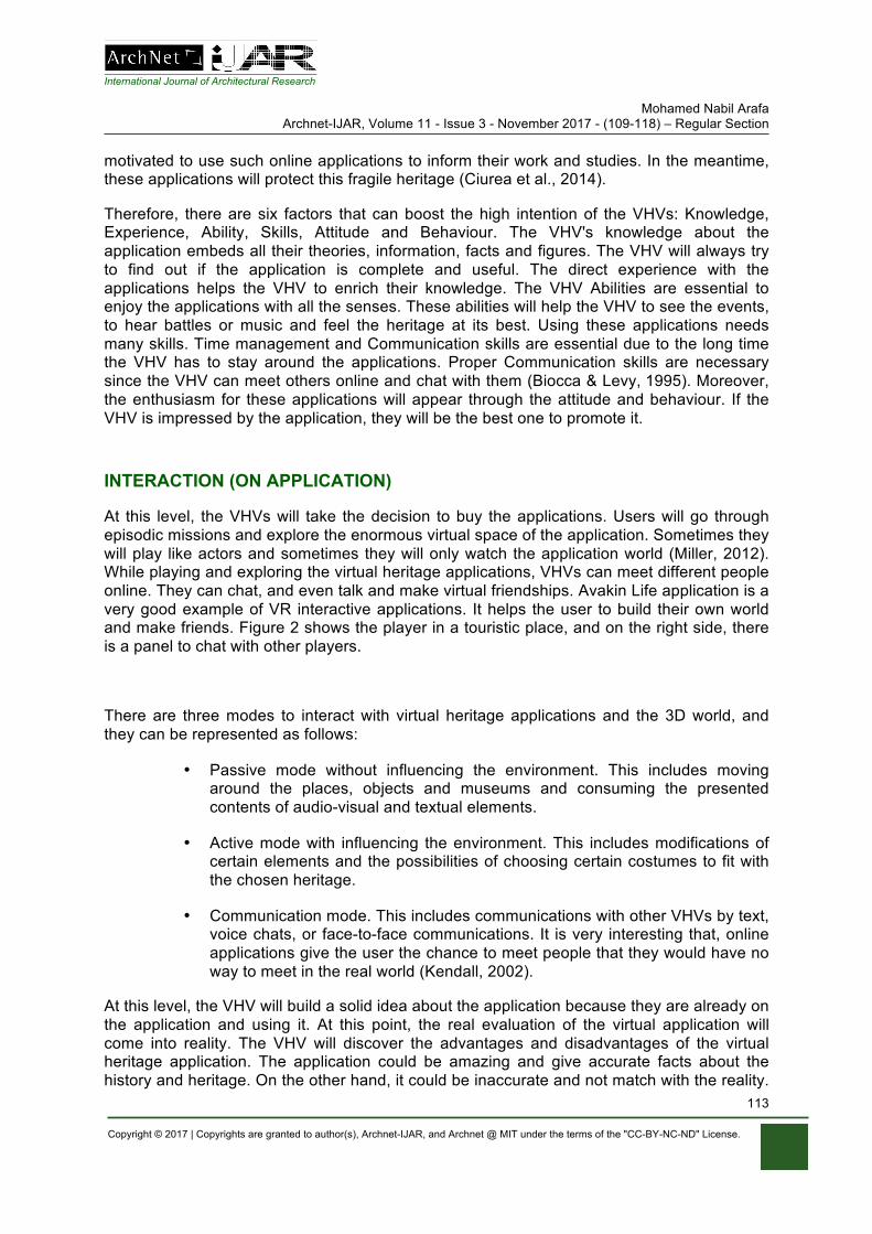
International Journal of Architectural Research Mohamed Nabil Arafa
Archnet-IJAR, Volume 11 - Issue 3 - November 2017 - (109-118) – Regular Section
Copyright © 2017 | Copyrights are granted to author(s), Archnet-IJAR, and Archnet @ MIT under the terms of the "CC-BY-NC-ND" License.
113
motivated to use such online applications to inform their work and studies. In the meantime, these applications will protect this fragile heritage (Ciurea et al., 2014).
Therefore, there are six factors that can boost the high intention of the VHVs: Knowledge, Experience, Ability, Skills, Attitude and Behaviour. The VHV's knowledge about the application embeds all their theories, information, facts and figures. The VHV will always try to find out if the application is complete and useful. The direct experience with the applications helps the VHV to enrich their knowledge. The VHV Abilities are essential to enjoy the applications with all the senses. These abilities will help the VHV to see the events, to hear battles or music and feel the heritage at its best. Using these applications needs many skills. Time management and Communication skills are essential due to the long time the VHV has to stay around the applications. Proper Communication skills are necessary since the VHV can meet others online and chat with them (Biocca & Levy, 1995). Moreover, the enthusiasm for these applications will appear through the attitude and behaviour. If the VHV is impressed by the application, they will be the best one to promote it.
INTERACTION (ON APPLICATION)
At this level, the VHVs will take the decision to buy the applications. Users will go through episodic missions and explore the enormous virtual space of the application. Sometimes they will play like actors and sometimes they will only watch the application world (Miller, 2012). While playing and exploring the virtual heritage applications, VHVs can meet different people online. They can chat, and even talk and make virtual friendships. Avakin Life application is a very good example of VR interactive applications. It helps the user to build their own world and make friends. Figure 2 shows the player in a touristic place, and on the right side, there is a panel to chat with other players.
There are three modes to interact with virtual heritage applications and the 3D world, and they can be represented as follows:
• Passive mode without influencing the environment. This includes moving around the places, objects and museums and consuming the presented contents of audio-visual and textual elements.
• Active mode with influencing the environment. This includes modifications of certain elements and the possibilities of choosing certain costumes to fit with the chosen heritage.
• Communication mode. This includes communications with other VHVs by text, voice chats, or face-to-face communications. It is very interesting that, online applications give the user the chance to meet people that they would have no way to meet in the real world (Kendall, 2002).
At this level, the VHV will build a solid idea about the application because they are already on the application and using it. At this point, the real evaluation of the virtual application will come into reality. The VHV will discover the advantages and disadvantages of the virtual heritage application. The application could be amazing and give accurate facts about the history and heritage. On the other hand, it could be inaccurate and not match with the reality.
International Journal of Architectural Research Mohamed Nabil Arafa
Archnet-IJAR, Volume 11 - Issue 3 - November 2017 - (109-118) – Regular Section
Copyright © 2017 | Copyrights are granted to author(s), Archnet-IJAR, and Archnet @ MIT under the terms of the "CC-BY-NC-ND" License.
114
It could be an opportunity to know more about the heritage, or it could be at danger of causing confusion. VHVs can easily evaluate the application through a SWOT analysis (strength, weakness, opportunities and threats) (Thompson, 2001).
Figure 2. Avakin Life Application (Source: Avakin Game, 2017)
LEARNING OUTCOMES (AFTER APPLICATION VISIT)
Sometimes it is difficult to get to know the heritage of a certain country. Many reasons are behind this. One of the reasons is traveling. It is difficult, sometimes, to travel to places because of the travel budget or due to political situations. Sometimes people dislike travelling to certain places because they feel they are not welcomed. This is one of the reasons why museum artefacts and objects travel for external exhibitions (Sheller & Urry, 2004). Virtual heritage applications give the opportunity for everyone to learn more about other cultures with no worries. VHVs will understand the different cultures by interacting with local artisans, teachers, musicians and storytellers. They can visit ancient temples, museums, even historical streets and market places (Champion, 2011). .
A question poses itself, why virtual heritage applications might matter to education? There are many reasons to make such applications useful in education. The most important of which are, constructionism and role-play (Hale & Stanney, 2002). Educators can make the VHV part of the application; they can be the Pharaoh or one of the farmers who built the pyramid. This makes education more interesting. Moreover, Virtual heritage is situated learning. There is no need to go to a certain place to login to the application. The problem here is that sometimes it is very hard to source these games and applications (Champion, 2015). Therefore, games builders should do more marketing for this type of games and applications.
Virtual heritage applications are the first step towards heritage preservation since it reduces the number of the visitors to the real places. Although tourism is a source of needed income, it might cause damage to historical sites due to intensive visits to the sites. Tourism is a consumer of environments and human communities (Orbaşli, 2000). The social heritage is very sensitive and it might be affected by the tourist's customs and traditions. Virtual applications will help to maintain the heritage and sites and preserve them in a good condition. One of the good examples here is the Louvre Museum Visitor Guide application, and it is inexpensive to explore each section: see Figure 3.
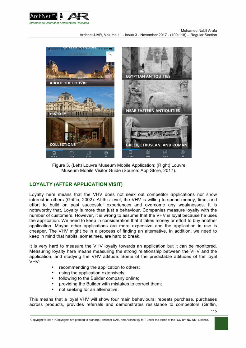
International Journal of Architectural Research Mohamed Nabil Arafa
Archnet-IJAR, Volume 11 - Issue 3 - November 2017 - (109-118) – Regular Section
Copyright © 2017 | Copyrights are granted to author(s), Archnet-IJAR, and Archnet @ MIT under the terms of the "CC-BY-NC-ND" License.
115
Figure 3. (Left) Louvre Museum Mobile Application; (Right) Louvre Museum Mobile Visitor Guide (Source: App Store, 2017).
LOYALTY (AFTER APPLICATION VISIT)
Loyalty here means that the VHV does not seek out competitor applications nor show interest in others (Griffin, 2002). At this level, the VHV is willing to spend money, time, and effort to build on past successful experiences and overcome any weaknesses. It is noteworthy that, Loyalty is more than just a behaviour. Companies measure loyalty with the number of customers. However, it is wrong to assume that the VHV is loyal because he uses the application. We need to keep in consideration that it takes money or effort to buy another application. Maybe other applications are more expensive and the application in use is cheaper. The VHV might be in a process of finding an alternative. In addition, we need to keep in mind that habits, sometimes, are hard to break.
It is very hard to measure the VHV loyalty towards an application but it can be monitored. Measuring loyalty here means measuring the strong relationship between the VHV and the application, and studying the VHV attitude. Some of the predictable attitudes of the loyal VHV:
• recommending the application to others; • using the application extensively; • following to the Builder company online; • providing the Builder with mistakes to correct them; • not seeking for an alternative.
This means that a loyal VHV will show four main behaviours: repeats purchase, purchases across products, provides referrals and demonstrates resistance to competitors (Griffin,
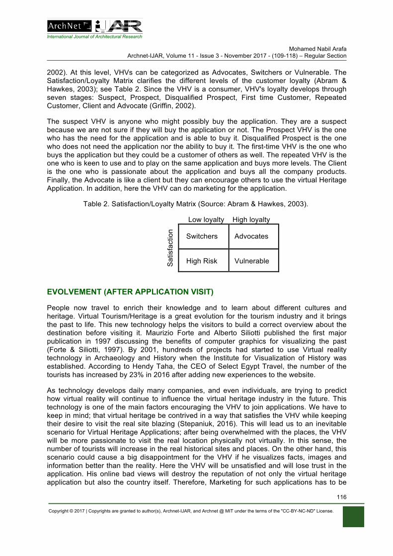
International Journal of Architectural Research Mohamed Nabil Arafa
Archnet-IJAR, Volume 11 - Issue 3 - November 2017 - (109-118) – Regular Section
Copyright © 2017 | Copyrights are granted to author(s), Archnet-IJAR, and Archnet @ MIT under the terms of the "CC-BY-NC-ND" License.
116
2002). At this level, VHVs can be categorized as Advocates, Switchers or Vulnerable. The Satisfaction/Loyalty Matrix clarifies the different levels of the customer loyalty (Abram & Hawkes, 2003); see Table 2. Since the VHV is a consumer, VHV's loyalty develops through seven stages: Suspect, Prospect, Disqualified Prospect, First time Customer, Repeated Customer, Client and Advocate (Griffin, 2002).
The suspect VHV is anyone who might possibly buy the application. They are a suspect because we are not sure if they will buy the application or not. The Prospect VHV is the one who has the need for the application and is able to buy it. Disqualified Prospect is the one who does not need the application nor the ability to buy it. The first-time VHV is the one who buys the application but they could be a customer of others as well. The repeated VHV is the one who is keen to use and to play on the same application and buys more levels. The Client is the one who is passionate about the application and buys all the company products. Finally, the Advocate is like a client but they can encourage others to use the virtual Heritage Application. In addition, here the VHV can do marketing for the application.
Table 2. Satisfaction/Loyalty Matrix (Source: Abram & Hawkes, 2003).
S
atis
fact
ion
Low loyalty High loyalty
Switchers Advocates
High Risk Vulnerable
EVOLVEMENT (AFTER APPLICATION VISIT)
People now travel to enrich their knowledge and to learn about different cultures and heritage. Virtual Tourism/Heritage is a great evolution for the tourism industry and it brings the past to life. This new technology helps the visitors to build a correct overview about the destination before visiting it. Maurizio Forte and Alberto Siliotti published the first major publication in 1997 discussing the benefits of computer graphics for visualizing the past (Forte & Siliotti, 1997). By 2001, hundreds of projects had started to use Virtual reality technology in Archaeology and History when the Institute for Visualization of History was established. According to Hendy Taha, the CEO of Select Egypt Travel, the number of the tourists has increased by 23% in 2016 after adding new experiences to the website.
As technology develops daily many companies, and even individuals, are trying to predict how virtual reality will continue to influence the virtual heritage industry in the future. This technology is one of the main factors encouraging the VHV to join applications. We have to keep in mind; that virtual heritage be contrived in a way that satisfies the VHV while keeping their desire to visit the real site blazing (Stepaniuk, 2016). This will lead us to an inevitable scenario for Virtual Heritage Applications; after being overwhelmed with the places, the VHV will be more passionate to visit the real location physically not virtually. In this sense, the number of tourists will increase in the real historical sites and places. On the other hand, this scenario could cause a big disappointment for the VHV if he visualizes facts, images and information better than the reality. Here the VHV will be unsatisfied and will lose trust in the application. His online bad views will destroy the reputation of not only the virtual heritage application but also the country itself. Therefore, Marketing for such applications has to be
International Journal of Architectural Research Mohamed Nabil Arafa
Archnet-IJAR, Volume 11 - Issue 3 - November 2017 - (109-118) – Regular Section
Copyright © 2017 | Copyrights are granted to author(s), Archnet-IJAR, and Archnet @ MIT under the terms of the "CC-BY-NC-ND" License.
117
clear that these applications will satisfy only the imaginative needs of the user. It cannot be ensured that the experience of visiting the real site will be as perfect as virtual reality heritage.
SUSTAINABILITY (AFTER APPLICATION VISIT)
Sustainability in virtual heritage is the practice of maintaining the process of using virtual Heritage Applications. Here, sustainability should ensure the recurring of the previous seven levels is an ongoing process for the future generations. Sustainability, generally, is not only concerned with maintaining the process but also with improving it all the time. On the other hand, we also need to sustain the real heritage and history (Banse et. al., 2011). To sustain Virtual Heritage industry, it is important to understand the application’s beneficiaries. The virtual heritage visitors (individuals or educational organizations) and the Applications builders are considered the direct beneficiaries. Two main concepts; the Concept of Needs and the Concept of Technology Limitations (Champion, 2011) affect sustainability of Virtual Heritage.
• The Concept of Needs: Sustainability of Virtual Heritage depends on the needs of the future generations who will use the applications. New Applications have to meet the developed essential needs of the coming generations. These needs are growing and developing every day. According to most of the online statistics, the number of users adopting the new virtual reality technology is expecting to reach 200 million by 2021 worldwide.
• The Concept of Technology Limitations: This challenge makes the virtual reality industry more interesting because there is no limit to the technological aspiration of humankind.
This means that sustainability of Virtual Heritage rests on three main pillars; technology, interest and economy. Big companies and the application builders have to invest in research to create the applications. At the same time, people must have the interest to learn about heritage and the economic leisure to buy such applications and keep buying them. Finally the main goals of virtual heritage sustainability are collecting more archaeological data; deep study of the past; a better way to visualize the past and reproduce the ancient environment; and tackling heritage from different prospective to satisfy the different educational and entertainment needs of the Virtual heritage Visitor. The heritage visitor will always travel between two worlds; the real world where he could be affected by its uncontrollable surroundings and the virtual one where he can control its environments (Cortés, 2017).
CONCLUSION
The virtual heritage applications developers should be concerned with their online users and visitors not only before buying the applications but they should give more attention to the users' needs after the interaction phase. ACHILLES will help the marketers to create complete marketing plans through the understanding of the visitor's stages. It shows the steps of the visitor's engagement on the applications. This model illustrates a code reflecting the correlation between the virtual heritage visitor and the application developers. Finally, it represents a method for the developers to evolve and improve their applications to sustain the application.
International Journal of Architectural Research Mohamed Nabil Arafa
Archnet-IJAR, Volume 11 - Issue 3 - November 2017 - (109-118) – Regular Section
Copyright © 2017 | Copyrights are granted to author(s), Archnet-IJAR, and Archnet @ MIT under the terms of the "CC-BY-NC-ND" License.
118
ACKNOWLEDGMENTS
The author is very grateful to the president of the Egyptian Tourism Authority and the committee responsible for the official website and the mobile application of the authority. The meetings with the team helped the author to form the ACHILLES model. Special thanks to Select Egypt Travel and PMEC for providing the necessary information regarding e-tourism and mobile applications
REFERENCES Abram, J. & Hawkes, P. (2003). The Seven Myths of Customer Management: How to be Customer-
Driven without being Customer-Led. Hoboken: Wiley. Banse, G., Nelson, G.L. & Parodi, O. (2011). Sustainable Development-the Cultural Perspective:
Concepts- Aspects – Examples. Berlin. Biocca, F. & Levy, M. (1995). Communication in the Age of Virtual Reality. Hillsdale, NJ: Routledge. Boniface, P. & Fowler, P. (1993). Heritage and Tourism in The Global Village. New York, NY:
Routledge. Champion, E. (2015). Critical Gaming: interactive History and Virtual Heritage. London: Routledge. Champion, E. (2011). Playing with the Past. London: Springer-Verlag. Chang, L. (2013). Influencing Factors on Creative Tourists' revisiting Intentions: The Roles of
Motivation, Experience and Perceived Value, unpublished thesis, Clemson University, South Carolina.
Ciurea, C., Zamfiroiu, A. & Grosu, A. (2014). Implementing Mobile Virtual Exhibitions to increase Cultural Heritage Visibility. Informatica Economica, 18(2), 24-31.
Cortés, G. L. (2017). The Influence of Tourism Experience Self-Congruity on the Use of the Virtual Social Media. European Journal of Tourism Research, 16, 154-176.
Crawford, G., Gosling, V.K.. & Light, B. (2011). Online Gaming in Context: the social and cultural significance of Online Games. London: Routledge.
Dilenschneider, R. (2010). The AMA Handbook of Public Relations. New York, NY: AMACOM. Forte, M. & Siliotti, A. (1997). Virtual Archaeology: re-creating ancient worlds. New York, NY: H.N.
Abrams. Griffin, J. (2002). Customer loyalty: How to Earn it, How to Keep it. San Francisco, CA: Jossey-Bass. Hale, K.S. & Stanney, K.M. (2002). Handbook of Virtual Environments: Design, Implementation, and
Application. Boca Raton, FL: CRC Press. Heim, M. (1998). Virtual Realism. New York, NY: Oxford University Press. Kendall, L. (2002). Hanging Out in the Virtual Pub: Masculinities and Relationships Online. Berkeley,
CA: University of California Press. Koch, T. (1996). The Message is the Medium: Online All the Time for Everyone. Westport, CT:
Praeger Publishers. Mahar, S.M. & Mahar, J. (2009). The Unofficial Guide to Building Your Business in the Second Life
Virtual World: Marketing and Selling Your Product, Service and Brand in-World. New York, NY: AMACOM.
McLean, F. (1997). Marketing the Museum. London and New York: Routledge. Miller, K. (2012). Playing Along: Digital Games, Youtube, and Virtual Performance. New York, NY:
Oxford University Press. Orbaşli, A. (2000). Tourists in Historic Towns: Urban Conservation and Heritage Management.
London: E&FN Spon, Taylor & Francis Group. Sheller, M. & Urry, J. (2004). Tourism Mobilities: places to play, places in play. London: Routledge. Stepaniuk, K. (2016). The Model of Tourist Virtual Community Members Engagement Management.
Business: Theory and Practice, 17(1), 74-79. Susyarini, N.P.W.A., Hadiwidjojo, H., Supartha, W.G. & Rohman, F. (2014), Tourists Behavioral
Intentions Antecedent Meeting Incentive Convention & Exhibition (MICE) in Bali. European Journal of Business and Management, 6(25), 102-109.
Thompson, J. (2001). Strategic Management. University of Huddersfield, Thomson Learning.
Neveen Hamza, Dalila ElKerdany, John Pendlebury, Sahar Imam, Aliaa ElSadaty, Tamer ElSerafi Archnet-IJAR, Volume 11 - Issue 3 – November 2017 - (119-131) – Regular Section
Copyright © 2017 | Copyrights are granted to author(s), Archnet-IJAR, and Archnet @ MIT under the terms of the "CC-BY-NC-ND" License.
119
Archnet-IJAR: International Journal of Architectural Research www.archnet-ijar.net/ -- https://archnet.org/collections/34
SUSTAINED LIVEABILITY: A FRAMEWORK BEYOND ENERGY CONSCIOUS BUILDING CONSERVATION OF MARKET HALLS DOI: http://dx.doi.org/10.26687/archnet-ijar.v11i3.1381
Neveen Hamza, Dalila ElKerdany, John Pendlebury, Sahar Imam, Aliaa AlSadaty, Tamer ElSerafi
Keywords Abstract
historic market halls; sustainable heritage, creative economy; Attaba vegetable market
Market halls are commonly found in contexts of cultural and heritage value. Positioned in urban centres and transport networks, these unique buildings were originally constructed in the 19th century to ensure better food distribution in growing European cities, then copied to other territories such as Egypt. We argue that leaving market halls, with their large spanning structures and indoor open space, for dilapidation is a lost opportunity for sustaining community engagement, and educating the public on the original sustainability, neighbourhood regeneration and cultural thinking that underpinned these buildings. The proposed framework extends current sustainable ‘heritage conservation frameworks’ beyond concepts of adding renewable energy technologies, recycling and sustainable goods movement, to ‘sustaining liveability and social inclusion’. We argue that market halls offer the opportunities to merge the daily activities of buying and selling food with creating local creative economies such as culinary art exhibitions, and culinary schools. The paper consists of two parts: the first discusses the historical urban context of market halls in Cairo; the second proposes a sustainable heritage conservation model for market halls.
______________________________________________________________________________________________________ N. Hamza*, Senior Lecturer, School of Architecture, Planning and Landscape, Newcastle University, Newcastle, NE1 7RU, UK D. ElKerdany, Professor, Department of Architecture, Faculty of Engineering, Cairo University, Cairo, Egypt J. Pendlebury, Professor, School of Architecture, Planning and Landscape, Newcastle University, Newcastle, NE1 7RU, UK S. Imam, Associate Professor, Department of Architecture, Faculty of Engineering, Cairo University, Cairo, Egypt A. AlSadaty, Assistant Professor, Department of Architecture, Faculty of Engineering, Cairo University, Cairo, Egypt T. ElSerafi, Lecturer, Department of Architecture, Faculty of Engineering, Cairo University, Cairo, Egypt
* Corresponding author: [email protected]
ArchNet-IJAR is indexed and listed in several databases, including: • Avery Index to Architectural
Periodicals • EBSCO-Current Abstracts-Art
and Architecture • CNKI: China National
Knowledge Infrastructure • DOAJ: Directory of Open
Access Journals • Pro-Quest • Scopus-Elsevier • Web of Science
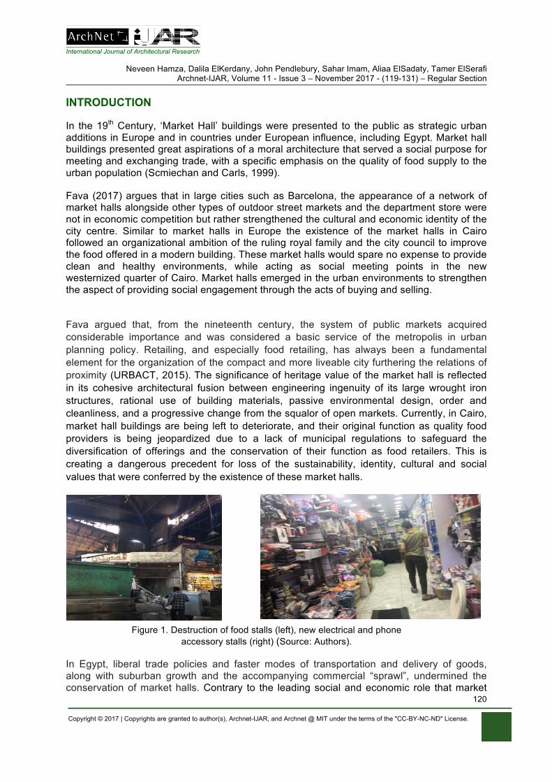
International Journal of Architectural Research
Neveen Hamza, Dalila ElKerdany, John Pendlebury, Sahar Imam, Aliaa ElSadaty, Tamer ElSerafi Archnet-IJAR, Volume 11 - Issue 3 – November 2017 - (119-131) – Regular Section
Copyright © 2017 | Copyrights are granted to author(s), Archnet-IJAR, and Archnet @ MIT under the terms of the "CC-BY-NC-ND" License.
120
INTRODUCTION
In the 19th Century, ‘Market Hall’ buildings were presented to the public as strategic urban additions in Europe and in countries under European influence, including Egypt. Market hall buildings presented great aspirations of a moral architecture that served a social purpose for meeting and exchanging trade, with a specific emphasis on the quality of food supply to the urban population (Scmiechan and Carls, 1999).
Fava (2017) argues that in large cities such as Barcelona, the appearance of a network of market halls alongside other types of outdoor street markets and the department store were not in economic competition but rather strengthened the cultural and economic identity of the city centre. Similar to market halls in Europe the existence of the market halls in Cairo followed an organizational ambition of the ruling royal family and the city council to improve the food offered in a modern building. These market halls would spare no expense to provide clean and healthy environments, while acting as social meeting points in the new westernized quarter of Cairo. Market halls emerged in the urban environments to strengthen the aspect of providing social engagement through the acts of buying and selling.
Fava argued that, from the nineteenth century, the system of public markets acquired considerable importance and was considered a basic service of the metropolis in urban planning policy. Retailing, and especially food retailing, has always been a fundamental element for the organization of the compact and more liveable city furthering the relations of proximity (URBACT, 2015). The significance of heritage value of the market hall is reflected in its cohesive architectural fusion between engineering ingenuity of its large wrought iron structures, rational use of building materials, passive environmental design, order and cleanliness, and a progressive change from the squalor of open markets. Currently, in Cairo, market hall buildings are being left to deteriorate, and their original function as quality food providers is being jeopardized due to a lack of municipal regulations to safeguard the diversification of offerings and the conservation of their function as food retailers. This is creating a dangerous precedent for loss of the sustainability, identity, cultural and social values that were conferred by the existence of these market halls.
Figure 1. Destruction of food stalls (left), new electrical and phone accessory stalls (right) (Source: Authors).
In Egypt, liberal trade policies and faster modes of transportation and delivery of goods, along with suburban growth and the accompanying commercial “sprawl”, undermined the conservation of market halls. Contrary to the leading social and economic role that market
International Journal of Architectural Research
Neveen Hamza, Dalila ElKerdany, John Pendlebury, Sahar Imam, Aliaa ElSadaty, Tamer ElSerafi Archnet-IJAR, Volume 11 - Issue 3 – November 2017 - (119-131) – Regular Section
Copyright © 2017 | Copyrights are granted to author(s), Archnet-IJAR, and Archnet @ MIT under the terms of the "CC-BY-NC-ND" License.
121
halls played in sustaining culinary and cultural activities, for example in Barcelona and Italian market halls, stalls in market halls in Cairo were not governed by regulations. Increasingly, they are losing their function and diversity of culinary offerings to stalls offering electrical goods and mobile phone accessories imported from China (Figure 1).
Traditional conceptions of heritage conservation focusing narrowly on building fabric are increasingly being challenged and broadened to encompass integrated approaches focused upon sustaining the ‘liveability’ of a building. Conservation and heritage management are conceived as value-based activities and there is a focus upon what is significant about a building or place that makes it worthwhile of protections (Gibson & Pendlebury, 2009). In the case of the market halls, this is integrally linked to their traditional use and technologies. The loss of the traditional tenants focused on food retailing is leading to a loss of the building’s sustainability, identity, cultural and social values.
The Ford Foundation (in Florida, 2002) states “Public markets are a vehicle for social integration and upward mobility”, highlighting that what separates public markets from other economic development projects is that a good public market is not only a local economic engine, but also a social gathering place that builds community. Urban regeneration is the attempt to reverse socio-economic decline by improving the physical structure of the built heritage aiming for a better economy. Therefore, we argue that there is an opportunity to move building conservation beyond a singular attempt to valorise building fabric, or a particular building use, to a more integrated strategy that repositions market halls as a focal point for educating the public about sustainable strategies, as well as a space for cultural exchange and art appreciation through exhibition activities.
The presence of market halls in Egypt dates back to the second half of the 19th century. By the 1890s, the market halls in Europe faced considerable competition from new-fashioned department stores and chain stores. One factor deflecting popular sentiment away from the public markets was that governments downgraded the priority they gave to improving the public food supply. Towns focused their resources on sanitary reform, gas and water, slum clearances, and public housing projects. As a result, some market halls were allowed to deteriorate to the point of public embarrassment (Scmiechan and Carls, 1999). In Egypt, the ‘Attaba vegetable market hall’, is a typical building of its age and urban significance in Egypt: a 19th century historical building which is currently losing its architectural significance due to uncontrolled change to its urban context, and internal spaces left to marginalized urban squatter occupants. This research looks to create a holistic framework that would pave the way for improving the built heritage to regenerate the building’s economic prosperity, while using its central positioning in the city fabric to house temporary artistic and cultural events related to food production, consumption, and food art as a social catalyst in the multicultural city centre of Cairo.
MARKET HALLS AS TANGIBLE AND INTANGIBLE HERITAGE
Watson (2009) highlights the role of markets in providing places for meeting and engagement and as a significant factor in place attachment, presenting a site of everyday sociality and public space where people from different cultures connect through casual encounters as both traders and shoppers. Halbwachs (1992) draws attention to how place and groups receive the imprints of each other. The physical presence of these historic markets create mental maps of place and way finding, and support collective memory that
International Journal of Architectural Research
Neveen Hamza, Dalila ElKerdany, John Pendlebury, Sahar Imam, Aliaa ElSadaty, Tamer ElSerafi Archnet-IJAR, Volume 11 - Issue 3 – November 2017 - (119-131) – Regular Section
Copyright © 2017 | Copyrights are granted to author(s), Archnet-IJAR, and Archnet @ MIT under the terms of the "CC-BY-NC-ND" License.
122
resides in everyday communication taking place between customers, vendors and passers-by, an essential role in maintaining community identity. We argue that historic markets are social spaces that, if well preserved and managed, can play a major role in strengthening local community ties, attract visitors, and erase boundaries between groups of different ethnicities, classes and ideological backgrounds. However, if not regenerated sensitively, they could easily feed into the undesirable impacts of the neighbourhood gentrification process. Site visits by the team in winter and summer of 2016 revealed that the market halls experience gradual changes due to lack of policy implementation, public spending initiatives and squatter activities. The buildings, along with their urban fabric, experience daily vandalism and a complete lack of maintenance and sanitary services.
Historic green markets as experience/creative economies
Europe has given much attention to the potential role of historic market halls in redeveloping urban districts. Several cities such as Barcelona, Milan, Budapest and many German cities have aimed at valorising and reinforcing the integration of historic markets within their surrounding urban contexts. Such projects deal with historic markets as the economic backbone of many towns, highlighting their role as venues for social exchanges and cohesion between community members (URBACT, 2015).
Historic markets represent a rich ground for two growing fields in cultural economics: experience economy and creative economy. The term ‘experience economy’ was coined by Pine and Gilmore (1998) where they argued that people search for memorable experiences and events, and that the experience becomes the product itself. Historic markets are venues with the most social diversity; they attract people of different ages, genders and backgrounds. Thus, the act of buying, selling and creating food is socialization between different levels that cannot be found in regular modern supermarkets. This act, in fact, transforms the market from a venue for exchanging goods and money to ‘an engine for community life’ (Panozzo, 2013).
In Florence (Figure 2), the refurbishment of the San Lorenzo Market completed in 2015, provided a unique and rich experience that encompasses the entertainment, the education, and the aesthetic experiences. The remit of the market extended from merely the vending of fresh produce and dry foods, to offer an experience of social engagement with cooked food shared in the food court that becomes an end in itself. The creation of a food culinary school acts to preserve the cherished Tuscan cuisine recipes, and is a popular facility. A plastic removable canopy divides the internal height of the space to trap heat from cooking activities and people, to warm the large open space with less energy demand in winter, a functional and educational addition focused on energy consciousness in practice.
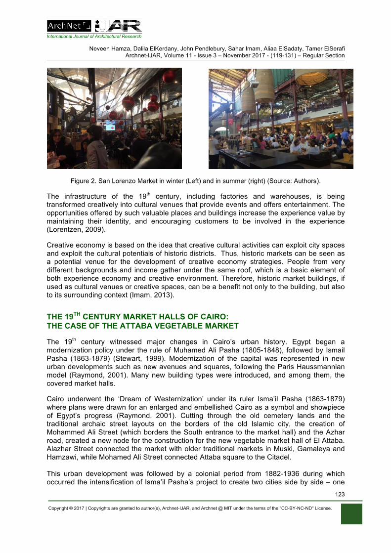
International Journal of Architectural Research
Neveen Hamza, Dalila ElKerdany, John Pendlebury, Sahar Imam, Aliaa ElSadaty, Tamer ElSerafi Archnet-IJAR, Volume 11 - Issue 3 – November 2017 - (119-131) – Regular Section
Copyright © 2017 | Copyrights are granted to author(s), Archnet-IJAR, and Archnet @ MIT under the terms of the "CC-BY-NC-ND" License.
123
Figure 2. San Lorenzo Market in winter (Left) and in summer (right) (Source: Authors).
The infrastructure of the 19th century, including factories and warehouses, is being transformed creatively into cultural venues that provide events and offers entertainment. The opportunities offered by such valuable places and buildings increase the experience value by maintaining their identity, and encouraging customers to be involved in the experience (Lorentzen, 2009).
Creative economy is based on the idea that creative cultural activities can exploit city spaces and exploit the cultural potentials of historic districts. Thus, historic markets can be seen as a potential venue for the development of creative economy strategies. People from very different backgrounds and income gather under the same roof, which is a basic element of both experience economy and creative environment. Therefore, historic market buildings, if used as cultural venues or creative spaces, can be a benefit not only to the building, but also to its surrounding context (Imam, 2013).
THE 19TH CENTURY MARKET HALLS OF CAIRO: THE CASE OF THE ATTABA VEGETABLE MARKET
The 19th century witnessed major changes in Cairo’s urban history. Egypt began a modernization policy under the rule of Muhamed Ali Pasha (1805-1848), followed by Ismail Pasha (1863-1879) (Stewart, 1999). Modernization of the capital was represented in new urban developments such as new avenues and squares, following the Paris Haussmannian model (Raymond, 2001). Many new building types were introduced, and among them, the covered market halls.
Cairo underwent the ‘Dream of Westernization’ under its ruler Isma’il Pasha (1863-1879) where plans were drawn for an enlarged and embellished Cairo as a symbol and showpiece of Egypt’s progress (Raymond, 2001). Cutting through the old cemetery lands and the traditional archaic street layouts on the borders of the old Islamic city, the creation of Mohammed Ali Street (which borders the South entrance to the market hall) and the Azhar road, created a new node for the construction for the new vegetable market hall of El Attaba. Alazhar Street connected the market with older traditional markets in Muski, Gamaleya and Hamzawi, while Mohamed Ali Street connected Attaba square to the Citadel. This urban development was followed by a colonial period from 1882-1936 during which occurred the intensification of Isma’il Pasha’s project to create two cities side by side – one
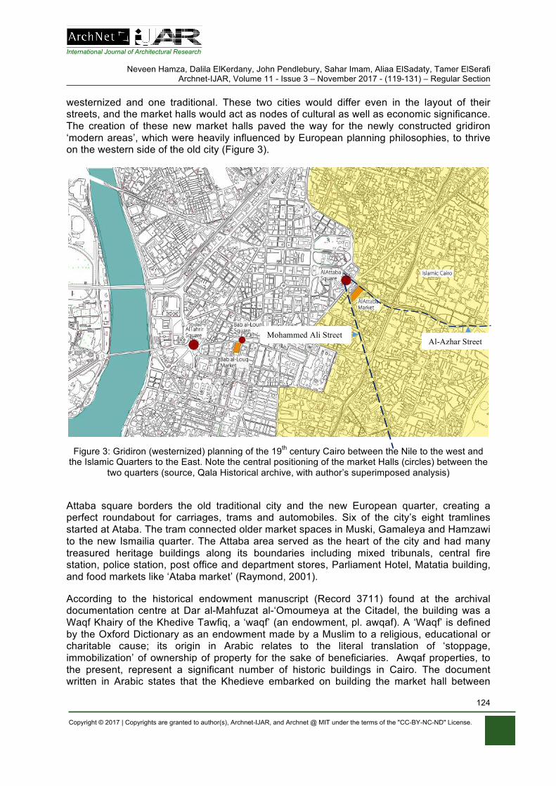
International Journal of Architectural Research
Neveen Hamza, Dalila ElKerdany, John Pendlebury, Sahar Imam, Aliaa ElSadaty, Tamer ElSerafi Archnet-IJAR, Volume 11 - Issue 3 – November 2017 - (119-131) – Regular Section
Copyright © 2017 | Copyrights are granted to author(s), Archnet-IJAR, and Archnet @ MIT under the terms of the "CC-BY-NC-ND" License.
124
westernized and one traditional. These two cities would differ even in the layout of their streets, and the market halls would act as nodes of cultural as well as economic significance. The creation of these new market halls paved the way for the newly constructed gridiron ‘modern areas’, which were heavily influenced by European planning philosophies, to thrive on the western side of the old city (Figure 3).
Figure 3: Gridiron (westernized) planning of the 19th century Cairo between the Nile to the west and the Islamic Quarters to the East. Note the central positioning of the market Halls (circles) between the
two quarters (source, Qala Historical archive, with author’s superimposed analysis)
Attaba square borders the old traditional city and the new European quarter, creating a perfect roundabout for carriages, trams and automobiles. Six of the city’s eight tramlines started at Ataba. The tram connected older market spaces in Muski, Gamaleya and Hamzawi to the new Ismailia quarter. The Attaba area served as the heart of the city and had many treasured heritage buildings along its boundaries including mixed tribunals, central fire station, police station, post office and department stores, Parliament Hotel, Matatia building, and food markets like ‘Ataba market’ (Raymond, 2001).
According to the historical endowment manuscript (Record 3711) found at the archival documentation centre at Dar al-Mahfuzat al-‘Omoumeya at the Citadel, the building was a Waqf Khairy of the Khedive Tawfiq, a ‘waqf’ (an endowment, pl. awqaf). A ‘Waqf’ is defined by the Oxford Dictionary as an endowment made by a Muslim to a religious, educational or charitable cause; its origin in Arabic relates to the literal translation of ‘stoppage, immobilization’ of ownership of property for the sake of beneficiaries. Awqaf properties, to the present, represent a significant number of historic buildings in Cairo. The document written in Arabic states that the Khedieve embarked on building the market hall between
Al-Azhar Street Mohammed Ali Street
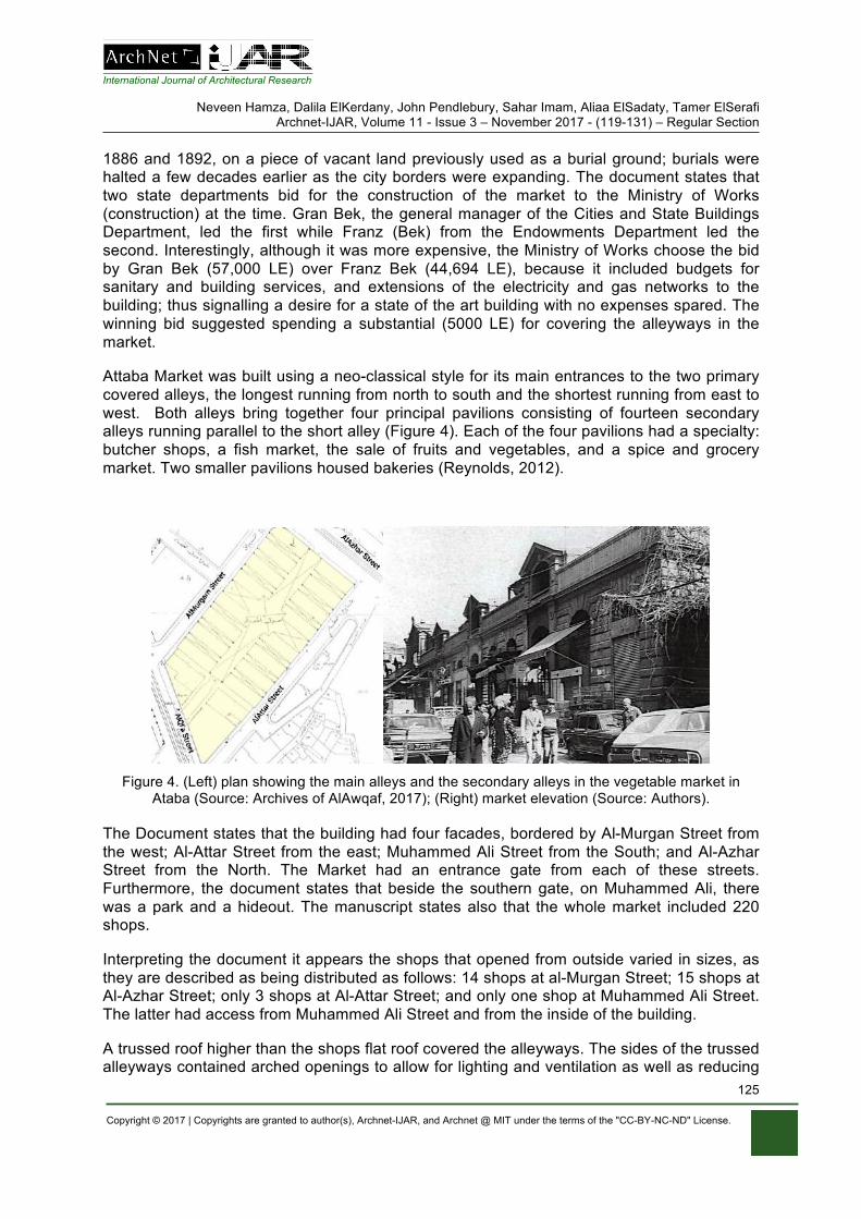
International Journal of Architectural Research
Neveen Hamza, Dalila ElKerdany, John Pendlebury, Sahar Imam, Aliaa ElSadaty, Tamer ElSerafi Archnet-IJAR, Volume 11 - Issue 3 – November 2017 - (119-131) – Regular Section
Copyright © 2017 | Copyrights are granted to author(s), Archnet-IJAR, and Archnet @ MIT under the terms of the "CC-BY-NC-ND" License.
125
1886 and 1892, on a piece of vacant land previously used as a burial ground; burials were halted a few decades earlier as the city borders were expanding. The document states that two state departments bid for the construction of the market to the Ministry of Works (construction) at the time. Gran Bek, the general manager of the Cities and State Buildings Department, led the first while Franz (Bek) from the Endowments Department led the second. Interestingly, although it was more expensive, the Ministry of Works choose the bid by Gran Bek (57,000 LE) over Franz Bek (44,694 LE), because it included budgets for sanitary and building services, and extensions of the electricity and gas networks to the building; thus signalling a desire for a state of the art building with no expenses spared. The winning bid suggested spending a substantial (5000 LE) for covering the alleyways in the market.
Attaba Market was built using a neo-classical style for its main entrances to the two primary covered alleys, the longest running from north to south and the shortest running from east to west. Both alleys bring together four principal pavilions consisting of fourteen secondary alleys running parallel to the short alley (Figure 4). Each of the four pavilions had a specialty: butcher shops, a fish market, the sale of fruits and vegetables, and a spice and grocery market. Two smaller pavilions housed bakeries (Reynolds, 2012).
Figure 4. (Left) plan showing the main alleys and the secondary alleys in the vegetable market in
Ataba (Source: Archives of AlAwqaf, 2017); (Right) market elevation (Source: Authors).
The Document states that the building had four facades, bordered by Al-Murgan Street from the west; Al-Attar Street from the east; Muhammed Ali Street from the South; and Al-Azhar Street from the North. The Market had an entrance gate from each of these streets. Furthermore, the document states that beside the southern gate, on Muhammed Ali, there was a park and a hideout. The manuscript states also that the whole market included 220 shops.
Interpreting the document it appears the shops that opened from outside varied in sizes, as they are described as being distributed as follows: 14 shops at al-Murgan Street; 15 shops at Al-Azhar Street; only 3 shops at Al-Attar Street; and only one shop at Muhammed Ali Street. The latter had access from Muhammed Ali Street and from the inside of the building.
A trussed roof higher than the shops flat roof covered the alleyways. The sides of the trussed alleyways contained arched openings to allow for lighting and ventilation as well as reducing
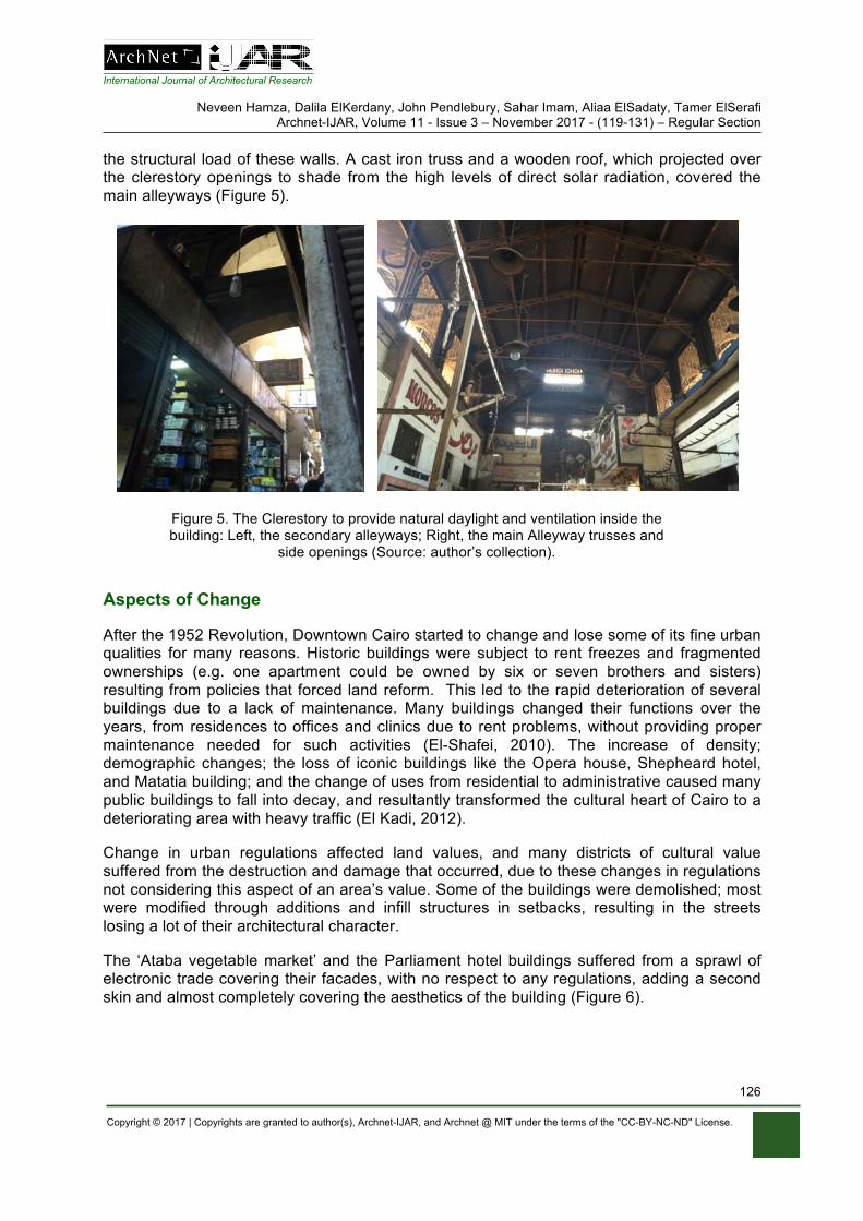
International Journal of Architectural Research
Neveen Hamza, Dalila ElKerdany, John Pendlebury, Sahar Imam, Aliaa ElSadaty, Tamer ElSerafi Archnet-IJAR, Volume 11 - Issue 3 – November 2017 - (119-131) – Regular Section
Copyright © 2017 | Copyrights are granted to author(s), Archnet-IJAR, and Archnet @ MIT under the terms of the "CC-BY-NC-ND" License.
126
the structural load of these walls. A cast iron truss and a wooden roof, which projected over the clerestory openings to shade from the high levels of direct solar radiation, covered the main alleyways (Figure 5).
Figure 5. The Clerestory to provide natural daylight and ventilation inside the building: Left, the secondary alleyways; Right, the main Alleyway trusses and
side openings (Source: author’s collection).
Aspects of Change
After the 1952 Revolution, Downtown Cairo started to change and lose some of its fine urban qualities for many reasons. Historic buildings were subject to rent freezes and fragmented ownerships (e.g. one apartment could be owned by six or seven brothers and sisters) resulting from policies that forced land reform. This led to the rapid deterioration of several buildings due to a lack of maintenance. Many buildings changed their functions over the years, from residences to offices and clinics due to rent problems, without providing proper maintenance needed for such activities (El-Shafei, 2010). The increase of density; demographic changes; the loss of iconic buildings like the Opera house, Shepheard hotel, and Matatia building; and the change of uses from residential to administrative caused many public buildings to fall into decay, and resultantly transformed the cultural heart of Cairo to a deteriorating area with heavy traffic (El Kadi, 2012).
Change in urban regulations affected land values, and many districts of cultural value suffered from the destruction and damage that occurred, due to these changes in regulations not considering this aspect of an area’s value. Some of the buildings were demolished; most were modified through additions and infill structures in setbacks, resulting in the streets losing a lot of their architectural character.
The ‘Ataba vegetable market’ and the Parliament hotel buildings suffered from a sprawl of electronic trade covering their facades, with no respect to any regulations, adding a second skin and almost completely covering the aesthetics of the building (Figure 6).
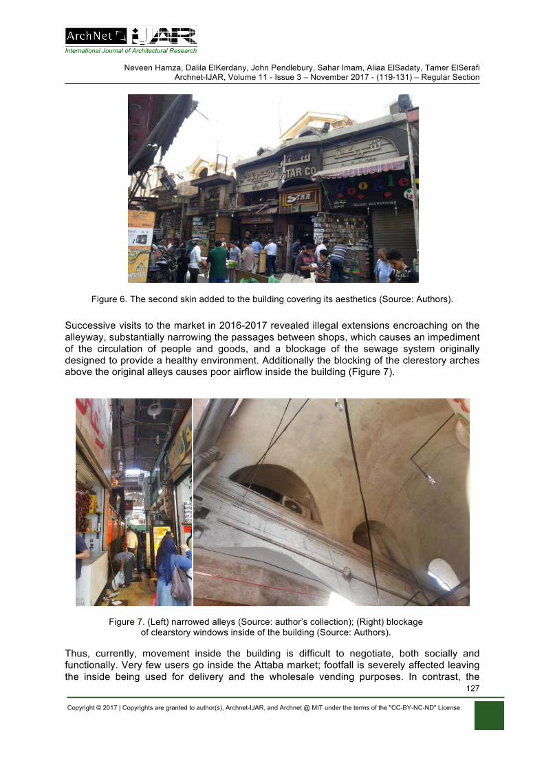
International Journal of Architectural Research
Neveen Hamza, Dalila ElKerdany, John Pendlebury, Sahar Imam, Aliaa ElSadaty, Tamer ElSerafi Archnet-IJAR, Volume 11 - Issue 3 – November 2017 - (119-131) – Regular Section
Copyright © 2017 | Copyrights are granted to author(s), Archnet-IJAR, and Archnet @ MIT under the terms of the "CC-BY-NC-ND" License.
127
Figure 6. The second skin added to the building covering its aesthetics (Source: Authors).
Successive visits to the market in 2016-2017 revealed illegal extensions encroaching on the alleyway, substantially narrowing the passages between shops, which causes an impediment of the circulation of people and goods, and a blockage of the sewage system originally designed to provide a healthy environment. Additionally the blocking of the clerestory arches above the original alleys causes poor airflow inside the building (Figure 7).
Figure 7. (Left) narrowed alleys (Source: author’s collection); (Right) blockage of clearstory windows inside of the building (Source: Authors).
Thus, currently, movement inside the building is difficult to negotiate, both socially and functionally. Very few users go inside the Attaba market; footfall is severely affected leaving the inside being used for delivery and the wholesale vending purposes. In contrast, the
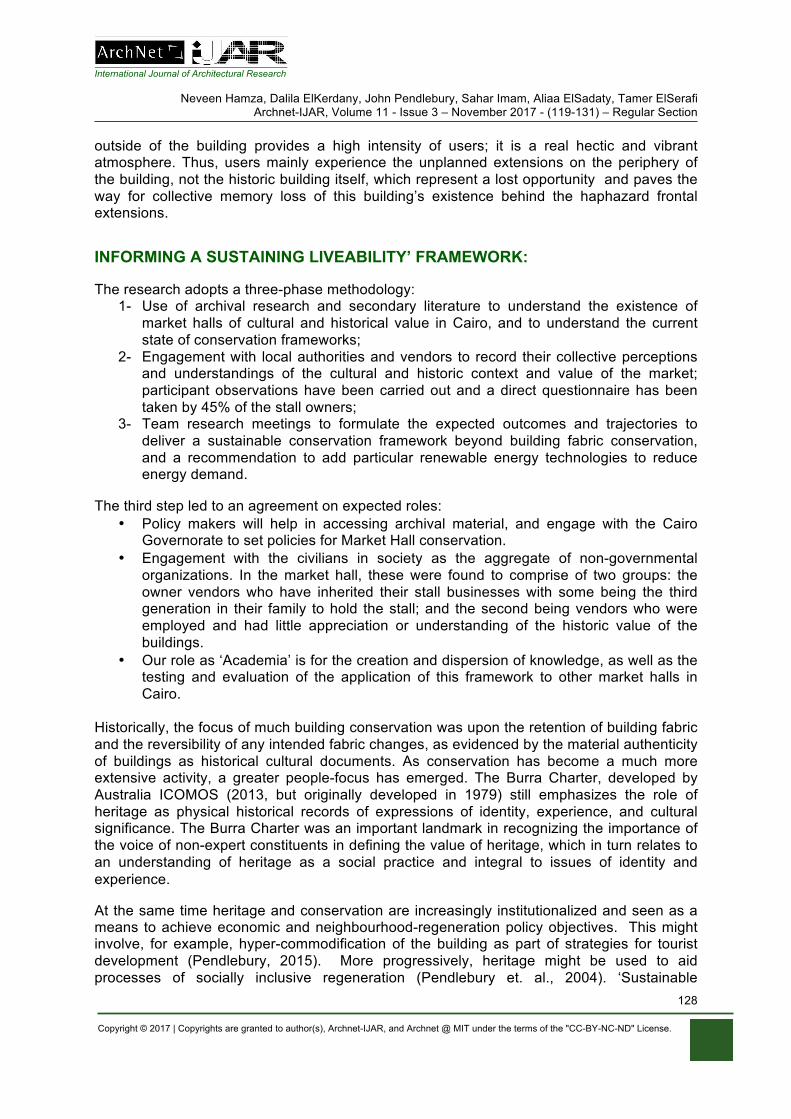
International Journal of Architectural Research
Neveen Hamza, Dalila ElKerdany, John Pendlebury, Sahar Imam, Aliaa ElSadaty, Tamer ElSerafi Archnet-IJAR, Volume 11 - Issue 3 – November 2017 - (119-131) – Regular Section
Copyright © 2017 | Copyrights are granted to author(s), Archnet-IJAR, and Archnet @ MIT under the terms of the "CC-BY-NC-ND" License.
128
outside of the building provides a high intensity of users; it is a real hectic and vibrant atmosphere. Thus, users mainly experience the unplanned extensions on the periphery of the building, not the historic building itself, which represent a lost opportunity and paves the way for collective memory loss of this building’s existence behind the haphazard frontal extensions.
INFORMING A SUSTAINING LIVEABILITY’ FRAMEWORK:
The research adopts a three-phase methodology: 1- Use of archival research and secondary literature to understand the existence of
market halls of cultural and historical value in Cairo, and to understand the current state of conservation frameworks;
2- Engagement with local authorities and vendors to record their collective perceptions and understandings of the cultural and historic context and value of the market; participant observations have been carried out and a direct questionnaire has been taken by 45% of the stall owners;
3- Team research meetings to formulate the expected outcomes and trajectories to deliver a sustainable conservation framework beyond building fabric conservation, and a recommendation to add particular renewable energy technologies to reduce energy demand.
The third step led to an agreement on expected roles: • Policy makers will help in accessing archival material, and engage with the Cairo
Governorate to set policies for Market Hall conservation. • Engagement with the civilians in society as the aggregate of non-governmental
organizations. In the market hall, these were found to comprise of two groups: the owner vendors who have inherited their stall businesses with some being the third generation in their family to hold the stall; and the second being vendors who were employed and had little appreciation or understanding of the historic value of the buildings.
• Our role as ‘Academia’ is for the creation and dispersion of knowledge, as well as the testing and evaluation of the application of this framework to other market halls in Cairo.
Historically, the focus of much building conservation was upon the retention of building fabric and the reversibility of any intended fabric changes, as evidenced by the material authenticity of buildings as historical cultural documents. As conservation has become a much more extensive activity, a greater people-focus has emerged. The Burra Charter, developed by Australia ICOMOS (2013, but originally developed in 1979) still emphasizes the role of heritage as physical historical records of expressions of identity, experience, and cultural significance. The Burra Charter was an important landmark in recognizing the importance of the voice of non-expert constituents in defining the value of heritage, which in turn relates to an understanding of heritage as a social practice and integral to issues of identity and experience.
At the same time heritage and conservation are increasingly institutionalized and seen as a means to achieve economic and neighbourhood-regeneration policy objectives. This might involve, for example, hyper-commodification of the building as part of strategies for tourist development (Pendlebury, 2015). More progressively, heritage might be used to aid processes of socially inclusive regeneration (Pendlebury et. al., 2004). ‘Sustainable
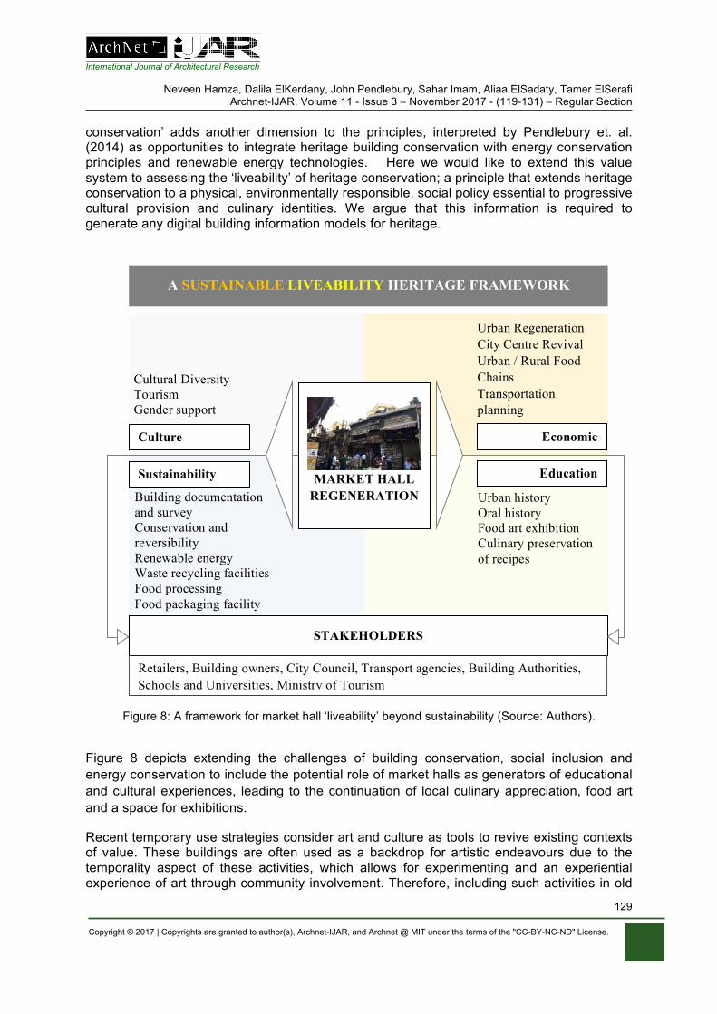
International Journal of Architectural Research
Neveen Hamza, Dalila ElKerdany, John Pendlebury, Sahar Imam, Aliaa ElSadaty, Tamer ElSerafi Archnet-IJAR, Volume 11 - Issue 3 – November 2017 - (119-131) – Regular Section
Copyright © 2017 | Copyrights are granted to author(s), Archnet-IJAR, and Archnet @ MIT under the terms of the "CC-BY-NC-ND" License.
129
conservation’ adds another dimension to the principles, interpreted by Pendlebury et. al. (2014) as opportunities to integrate heritage building conservation with energy conservation principles and renewable energy technologies. Here we would like to extend this value system to assessing the ‘liveability’ of heritage conservation; a principle that extends heritage conservation to a physical, environmentally responsible, social policy essential to progressive cultural provision and culinary identities. We argue that this information is required to generate any digital building information models for heritage.
Figure 8: A framework for market hall ‘liveability’ beyond sustainability (Source: Authors).
Figure 8 depicts extending the challenges of building conservation, social inclusion and energy conservation to include the potential role of market halls as generators of educational and cultural experiences, leading to the continuation of local culinary appreciation, food art and a space for exhibitions.
Recent temporary use strategies consider art and culture as tools to revive existing contexts of value. These buildings are often used as a backdrop for artistic endeavours due to the temporality aspect of these activities, which allows for experimenting and an experiential experience of art through community involvement. Therefore, including such activities in old
Culture Economic
A SUSTAINABLE LIVEABILITY HERITAGE FRAMEWORK
Urban history Oral history Food art exhibition Culinary preservation of recipes
Building documentation and survey Conservation and reversibility Renewable energy Waste recycling facilities Food processing Food packaging facility
Community, local council, schools / universities, retail sector, legislators …
MARKET HALL REGENERATION
STAKEHOLDERS
Urban Regeneration City Centre Revival Urban / Rural Food Chains Transportation planning
Cultural Diversity Tourism Gender support
Sustainability Education
Retailers, Building owners, City Council, Transport agencies, Building Authorities, Schools and Universities, Ministry of Tourism

International Journal of Architectural Research
Neveen Hamza, Dalila ElKerdany, John Pendlebury, Sahar Imam, Aliaa ElSadaty, Tamer ElSerafi Archnet-IJAR, Volume 11 - Issue 3 – November 2017 - (119-131) – Regular Section
Copyright © 2017 | Copyrights are granted to author(s), Archnet-IJAR, and Archnet @ MIT under the terms of the "CC-BY-NC-ND" License.
130
historic buildings as an adaptive reuse policy helps protect and maintain the historical building, and is an influential tool for addressing social development strategies. Temporary activities are also considered as experimental projects that can change areas’ economic conditions by attracting investments and visitors (Imam, 2013).
We argue that market halls may represent a catalytic pivot in their locations, attracting new types of users and changing the image of decaying contexts of value. To achieve a sustainable goal that is all inclusive of sustaining ‘liveability of the building and its users’, a comprehensive framework coordinating and linking building owners, stall vendors, building services managers, policy makers, educational and tourism authorities needs to be integrated.
CONCLUSIONS
Markets as buildings are tangible pieces of heritage that witness daily consumer and vendor patterns, casual encounters and sociality of space, and are a scene for multi-cultural exchanges. These buying and selling activities, with their changes through time, create the intangible heritage of a culture’s sounds, smells, and a value system of what a community appreciates.
Current conservation frameworks focus on singular aspects. A true ‘Sustainable Conservation’ framework needs to expand to ‘Liveability of Heritage conservation’, beyond the usual challenges of conserving building fabric and aesthetics or merely the call to add renewable energies or recycling facilities, to considering market halls as arenas for cultural experiences.
Historical market halls, with their large cast iron truss constructions and strategic positioning in historical city centres, offer a major opportunity to expand existing activities of food buying and selling to experiences of culinary art and the conservation of local culinary recipes through the creation of cooking schools. Due to their centrality in the urban fabric, market halls also create an opportunity for inclusion of exhibition space to educate the public and tourists alike.
ACKNOWLEDGEMENTS
This paper is jointly funded by the UK, Arts and Humanities Research Council (AHRC- grant reference AH/N009169/1Sustainable Green Markets) and the Egyptian Sciences, and Technology Development Fund (STDF); under the Newton-Mosharafa Fund. The first author was also supported by a Newton-Mosharafa fund to undertake the initial visits and research team engagement: Newton-Mosharafa fund (165346057). The authors are also grateful for the Postgraduates students of the Department of Architecture, Faculty of Engineering, Cairo University who helped in the visual material used in this paper. Special thanks to Dr. Mahmoud Abdallah for his persistent efforts in finding the original endowment documents of the market.
REFERENCES
The Attaba Waqf endowment document: The Attaba Waqf endownment documentربیع آخر 27سجالت الباب العالى بتاریخ 3711حجة وقف سوق العتبة برقم : ـ
ھـ 1303سنة
International Journal of Architectural Research
Neveen Hamza, Dalila ElKerdany, John Pendlebury, Sahar Imam, Aliaa ElSadaty, Tamer ElSerafi Archnet-IJAR, Volume 11 - Issue 3 – November 2017 - (119-131) – Regular Section
Copyright © 2017 | Copyrights are granted to author(s), Archnet-IJAR, and Archnet @ MIT under the terms of the "CC-BY-NC-ND" License.
131
The Burra Charter. (2013). Burra Charter: The international council on monuments and sites ICOMOS Charter for Places of Cultural Significance. Canberra: Australia.
---. (1941-1942). Document no. 32/358/17582, pp. 80-90, at. Cairo, Egypt: Dar al-Mahfuzat al-‘Omoumeya at the Citadel.
El Kadi, G. (2012). Cairo: Center in Movement. Marseille: IRD Editions. El-Shafei, K. (2010). “Downtown reborn? The Ismaelia Consortium's vision for urban regeneration”.
(M. Strasser, Interviewer) Al-Masry Al-Youm, Available at: http://www.egyptindependent.com. Gibson, L. & Pendlebury, J. (2009). Valuing Historic Environments. Oxford: Routledge. Florida, R. (2002). The Rise of The Creative Class (and how it’s transforming work, leisure, community
and everyday life). New York, USA: Basic Books. Halbwachs, M. (1992). On Collective Memory. Chicago and London: The University of Chicago Press. Imam, S. (2013). Creative Economy and Urban Transformation in Developing Countries. Journal of
Engineering and Applied Science, Faculty of Engineering, Cairo University, 60(6). Lorentzen, A. (2009). Cities in the experience economy. European Planning Studies, 17(2). Panozzo, F. (2013 ). Policy Paper on the role of Urban Markets for Local Development and Urban
Regeneration. EU: A project implemented through the CENTRAL EUROPE Programme co-financed by the ERDF. Retrieved from: www.centralmarkets.eu
Pendlebury, J. (2015). Heritage and Policy. In: Waterton, E., & Watson, S (Eds.). The Palgrave Handbook of Contemporary Heritage Research (pp 426-441). London: Palgrave Macmillan.
Pendlebury, J., Hamza, N., Sharr, A. (2014). Conservation Values, Conservation Planning and Climate Change. DISP - The Planning Review, 50(3), pp.43.54.
Pendlebury, J., Townshend, T.G., Gilroy, R. (2004). The Conservation of English Cultural Built Heritage: A Force for Social Inclusion? International Journal of Heritage Studies, 10(1)
Pine, B., II, & Gilmore, J. (1998). Welcome to the experience economy. Harvard Business Review, 76(4), 97-105.
Raymond, A. (2001). Cairo: city of history. Cairo, Egypt: American University Press in Cairo. Reynolds, N. (2012 ). A City Consumed: Urban Commerce, the Cairo Fire, and the Politics of
Decolonization in Egypt . Stanford, California: Stanford University Press. Stewart, D. (1999). Changing Cairo: The political Economy of Urban Form. International Journal of
Urban and Regional Research, 23(1), p128. URBACT. (2015). Urban markets: heart, soul and motor of cities - Making city markets the drivers of
sustainable urban development. Barcelona: City of Barcelona Institut Municipal de Mercats de Barcelona (IMMB). Retrieved from http://urbact.eu/sites/default/files/urbact_markets_handbook_250315.pdf accessed 4/4/2017
Watson, S. (2009) Brief Encounters of an Unpredictable Kind: Everyday Multiculturalism in Two London Street Markets, in Wise, A.; Velayutham, S., Everyday Multiculturalism. London: Palgrave Macmillan.
Mohamed Khalil, Heba Elsaay, Ayman Othman Archnet-IJAR, Volume 11 - Issue 3 - November 2017 - (132-145) – Regular Section
Copyright © 2017 | Copyrights are granted to author(s), Archnet-IJAR, and Archnet @ MIT under the terms of the "CC-BY-NC-ND" License.
132
Archnet-IJAR: International Journal of Architectural Research www.archnet-ijar.net/ -- https://archnet.org/collections/34
TALENT MANAGEMENT: A NOVEL APPROACH FOR DEVELOPING INNOVATIVE SOLUTIONS TOWARDS HERITAGE COMMUNITIES DEVELOPMENT DOI: http://dx.doi.org/10.26687/archnet-ijar.v11i3.1400
Mohamed Khalil, Heba Elsaay, Ayman Othman*
Keywords Abstract
heritage development; creative industries; architectural design firms; motivation; talent management; Egypt vision 2030
Heritage communities in Egypt have continuously developed to sustain a history of millenniums. Developments have been focused on sustaining the physical heritage such as buildings and cities, yet ignoring the intangible heritage such as stories, memories and traditions of people. The results are deterioration of the developed physical heritage as a natural response of ignorance. Architectural Design Firms (ADFs) are responsible for developing innovative solutions that translate intangible heritage into sustainable projects. Such solutions require talented architects who are in need of being treated in a talented manner. Therefore, this paper aims to investigate the role of Talent Management (TM) as a novel approach for developing innovative solutions for Egyptian heritage communities’ development. In order to achieve this aim, a qualitative approach based on (1) literature review is used to investigate heritage development, creative industries, ADFs, motivation and TM and (2) a case study is collected and analysed to study the relationship between TM and intangible heritage preservation.
M. Khalil, H. Elsaay and A. Othman* M. Khalil, Department of Architectural Engineering, the British University in Egypt (BUE), El Shorouk City – Cairo Suez Desert Road, Postal No. 11837 – P.O. Box 43, Egypt. H. Elsaay, Department of Architectural Engineering, the British University in Egypt (BUE), El Shorouk City – Cairo Suez Desert Road, Postal No. 11837 – P.O. Box 43, Egypt. A. Othman*, Department of Architectural Engineering, the British University in Egypt (BUE), El Shorouk City – Cairo Suez Desert Road, Postal No. 11837 – P.O. Box 43, Egypt.
*Corresponding Author’s email address: [email protected]
ArchNet-IJAR is indexed and listed in several databases, including: • Avery Index to Architectural
Periodicals • EBSCO-Current Abstracts-Art
and Architecture • CNKI: China National
Knowledge Infrastructure • DOAJ: Directory of Open
Access Journals • Pro-Quest • Scopus-Elsevier • Web of Science

International Journal of Architectural Research Mohamed Khalil, Heba Elsaay, Ayman Othman
Archnet-IJAR, Volume 11 - Issue 3 - November 2017 - (132-145) – Regular Section
Copyright © 2017 | Copyrights are granted to author(s), Archnet-IJAR, and Archnet @ MIT under the terms of the "CC-BY-NC-ND" License.
133
INTRODUCTION
Egypt Vision 2030, ‘Sustainable Development Strategy (SDS)’ aims to achieve a balanced and knowledge based economy to ensure the provision of sustainable development for Egyptians (El-Megharbel, 2015). Since ancient Egyptian history dates back several millenniums (Shaw, 2000), developing heritage urban communities for sustainability is of essence. In this regard, Issawi (2012) stated that urban communities earn their value from their heritage, which is the inherited achievements from ancestors. Heritage in turn earns its value through resisting change over time. It makes foreigners curious to know more about the culture and its people who in turn feel attached to the heritage place that has their memories (Feilden, 1982). Heritage urban communities could be developed with surface development or deep development (Appleyard, 1979). On one hand, surface development focuses on developing the physical heritage (Issawi, 2012). Conversely, deep development focuses on developing the physical heritage and its surrounding environment including indigenous residents’ memories, values and stories (Bennett, Reid and Petocz, 2014). Improper translation of these memories, values and stories into architectural facilities in heritage urban communities will have negative results. According to Issawi (2012), failure to achieve indigenous residents’ needs, which are higher than a shelter, results in a negative behaviour. Therefore, ADFs have great responsibility in this regard when developing new architectural facilities in the heritage urban communities.
Since architecture is a talent-based creative industry (Galloway and Haniff, 2015), architects should be managed like artists (Bennett, et al., 2014) to produce innovative products. The nature of work affects the ability of artists’ ‘creative talents’ to unleash their creativity in developing heritage communities (Smagina and Lindemanis, 2013). Amabile (1993) mentioned that demotivated workers are more likely to develop low quality work, which is inconsistent with innovative thinking. The same concept applies in ADFs since architects face multiple demotivating factors in their workplace (Oyedele, 2013). In this regard, TM is one of the novel approaches that enhances commitment, career development and balancing work-life commitments. In turn, it enhances productivity and creative thinking and gives competitiveness to the ADFs (Deery, 2008; Kehinde, 2012; Vural, Vardarlier, and Aykir, 2012; Khoram and Samadi, 2013; Ingram, 2016). However, there is a gap in academic literature regarding implementing TM in Egyptian ADFs. Therefore, the aim of this research is to investigate the role of TM as a novel approach for developing innovative solutions for Egyptian heritage communities’ development. In order to achieve this aim, a research methodology based on literature review and case study was designed to accomplish three objectives. Firstly, literature review was used to build a comprehensive background about the research topic through covering heritage development, creative industries, ADFs, motivation and TM. Secondly, a case study is presented to investigate the correlation between TM and intangible heritage preservation. Finally, research conclusions and recommendations are outlined.
EGYPT VISION 2030: PRESERVATION OF EGYPTIAN HISTORY
Egypt Vision 2030: SDS is the pathway to achieve citizens’ aspirations, dreams and improve their quality of life through linking the present to the future. The strategy has three dimensions that consist of different pillars to comply with international updates. Economic dimension pillars are economic development, energy, knowledge, innovation and scientific research, and transparency and efficient government institutions. Social dimension pillars are
International Journal of Architectural Research Mohamed Khalil, Heba Elsaay, Ayman Othman
Archnet-IJAR, Volume 11 - Issue 3 - November 2017 - (132-145) – Regular Section
Copyright © 2017 | Copyrights are granted to author(s), Archnet-IJAR, and Archnet @ MIT under the terms of the "CC-BY-NC-ND" License.
134
education and training, social justice, health and culture. Environmental dimension pillars: environment and urban development (Ministry of Planning [MOP], 2015).
Since ancient Egyptian history dates back several millenniums (Shaw, 2000), it is important to preserve this heritage and to comply with the SDS’s culture pillar, which is concerned with this issue. Moreover, it is important to develop a creative workforce capable of providing innovative solutions to preserve the heritage. Therefore, this research complies with the knowledge, innovation and scientific research pillar as well (MOP, 2015).
Heritage is the valuable credit for any society and its main characteristic is the resistance to change over time (Al-Raies, 2010). Heritage could be classified as physical tangible heritage and non-physical intangible heritage (Bennett, et al. 2014). Physical heritage is what ancestors have built from iconic buildings, homogenous urban contexts or cultural landmarks. It could be a comprehensive spatial urban environment, comprehensive location, location with visual composition, or a unique building (Al-Raies, 2010). According to Alvizatou (2012), intangible heritage comprises the embodied practices of cultural transmission among generations and it relies on communication between generations. It includes more ephemeral than tangible elements that still shape essential parts of the culture. It could be poetry, spoken stories, dance, weaving patterns, art, music, clothing and memories of the indigenous residents of heritage communities. This type of heritage is not preserved except in the minds of the people and it is hard to sustain such type of heritage (Bennett, et al., 2014). Blake (2000) mentioned that recently there has been difficulty in identifying it precisely. Based on that, Bell (2013) addressed the marginalization of the intangible heritage, which resulted in marginalizing the communities themselves to divergent associations to the extent that affects their identity. Therefore, people would change the environment in an attempt to preserve their attachment to the place.
Problems affecting physical heritage are categorized as human, economic, technical, environmental and political factors (Issawi, 2012). However, the human factors are the most important because when urban places do not fulfil users’ entertaining and social needs it leads to negative effects that form part of the economic and environmental factors (Farahat, 1999). Major problems related to the human factor or ‘citizens’ (Issawi, 2012) are: a) migration of indigenous residents to other communities due to lack of satisfaction as their needs are higher than a mere provision of a shelter - therefore, they are replaced with other people who are not familiar with heritage value; b) lack of awareness about the value of heritage, which leads to human-related deterioration of the physical heritage as noted by Maher (2016); c) changing character and identity of the physical heritage through removal or addition.
TANGIBLE AND INTANGIBLE HERITAGE: ASPECTS OF HUMAN BEHAVIOUR
According to Taha (2010), design of the physical heritage, built space and urban communities planning plays a vital role, which affects psychological and social state of the individuals who inhabit these places. Therefore, ADFs have a great responsibility in designing facilities that meet individuals’ needs and in parallel preserve the identity of the physical heritage. This is achieved through taking into consideration the intangible heritage preservation in the design process. According to Appleyard (1979) there are two types of communities’ development: a) Surface development: Focuses on preserving the physical heritage; b) Deep development: Focuses on preserving the physical heritage and its surrounding environment.
International Journal of Architectural Research Mohamed Khalil, Heba Elsaay, Ayman Othman
Archnet-IJAR, Volume 11 - Issue 3 - November 2017 - (132-145) – Regular Section
Copyright © 2017 | Copyrights are granted to author(s), Archnet-IJAR, and Archnet @ MIT under the terms of the "CC-BY-NC-ND" License.
135
On one hand, cultural industries combine the creation, production and commercialization of intangible, cultural and creative content. Such industries are design and crafts, multimedia and cinematographic productions. On the other hand, creative industries are broader than cultural industries since they include the activities of the last in addition to all artistic or cultural tangible productions that contain creative endeavour (UNESCO, 2010). In addition, such industries are talent-based for the innovative design (Galloway and Haniff, 2015). From this perspective, the term traditional industry in this research is not related to arts or heritage on both the tangible and intangible levels. According to Scheffel and Thomas (2011), architecture was among nine creative industries classified according to the Department for Culture, Media and Sports in the UK. Therefore, all of the previously mentioned characteristics of the creative industries apply to the architectural industry.
Creative talents are responsible for delivering practices that originate in cultural and temporal matrices (Smagina and Lindemanis, 2013). Hence, they are responsible for the process of establishing identities, social relations and economic practices (Bennett, et al., 2014). In this regard, personnel who create distinct products and projects should be differentiated from those concerned with mass production. The differentiation is achieved in the employment nature since careers’ satisfaction and success are measured through an intangible measure, which is the motivation (Miege, 2011). In cases where creative talents lack provision of qualitative cultural work, it is due to the improper management at the workplace such as part-time working stipulations or low payments (Bennett, Coffey, Fitzgerald, Petocz, and Rainnie. 2014). Creative-talents in that sense form the main pillar of an organizational development strategy since acquiring the right people with distinctive and diverse capabilities ensures a competitive advantage (Winslow, 1990). Ramaswamy (2009) mentioned that organizational success is not usually associated with following traditional management approaches, but acquiring different mind-sets and novel value propositions ensure competitiveness asserts with the previous statement.
According to Bennett, et al. (2014), cultural heritage preservation is part of sustainability yet creative artists’ ‘talents’ perceive this concept in different manners. To better explain the way in which creative-talents perceive cultural heritage preservation and sustainability, the authors developed Arts-Sustainability-Heritage (ASH) model, which has three levels. In the lowest level, creative talents perceive sustainability and cultural heritage preservation as disparate to their unleashed creativity through arts. However, the concept of sustainability for them only means sustaining their artistic skills and career development. In the mid-level, cultural heritage is considered a source of inspiration for designing creative products, which in turn complies with the sustainable development. In the broad level, cultural heritage is considered the reason for becoming an artist. Therefore, their intuition of designing creative products for sustainability reaches its peak.
Categorizing artists in any of the three levels depends on the quality and nature of workplace management and its role in their career development. In this regard, Oakley, Sperry, and Pratt (2008) stated that artistic talents have high potential to develop innovative solutions. Therefore, it is of essence enhancing workplace management to improve the way creative talents contribute to heritage communities’ development, which is in turn part of Egypt vision 2030: SDS. However, there are several aspects of demotivation and lack of motivation of creative talents that were found prominent in Egypt. Oyedele (2013) mentioned three levels of demotivation on behalf of architects in ADFs: a) Project-based demotivation due to the stressful and excessive workload nature; b) Teamwork-related demotivation due to miscommunication; c) Organizational-related demotivation due to the lack of day-to-day work
International Journal of Architectural Research Mohamed Khalil, Heba Elsaay, Ayman Othman
Archnet-IJAR, Volume 11 - Issue 3 - November 2017 - (132-145) – Regular Section
Copyright © 2017 | Copyrights are granted to author(s), Archnet-IJAR, and Archnet @ MIT under the terms of the "CC-BY-NC-ND" License.
136
flexibility, age-old payments, improper evaluation systems or conflict between goals of an organization and its individuals.
According to Ng, Skitmore, Lam and Poon (2004), there is a great difference between demotivation and lack of motivation. Demotivation reduces morale or spirit when an individual is in charge of certain task in addition to causing dissatisfaction. Furthermore, its consequences are worse than lack of motivation, which means reduction of stimulus or drive for action. The individual’s personal traits are required for creativity stimulation, but without intrinsic motivation, they are not sufficient (Amabile, 1983). Moreover, extrinsic motivation such as financial and non-financial rewarding fosters stimulating creativity (Eisenberger and Rhoades, 2001; Prabhu, Sutton, and Sauser, 2008). In case of presence of any of the demotivation levels, the motivational factors whether intrinsic or intrinsic or the personality traits of the individual will not enhance creativity. Thus, demotivation prevents the benefits of the motivational incentives and personality traits, therefore, ADFs should not rely only on motivational factors or personality traits.
Based on the acquired knowledge that architecture is a creative industry, architects are considered creative talents. In a similar manner to the artists’ ‘creative talents’, the nature and management of workplace affect architects’ perception towards cultural heritage preservation and sustainability either negatively or positively, and also influences their creativity stimulation due to the imposed motivation state of different workplace management. From this regard, enhanced management system at the workplace, which affects their motivation, is essential for architects to develop innovative solutions in designing facilities for heritage urban communities’ development.
TALENT MANAGEMENT: DEFINITIONS, APPROACH AND PHILOSOPHY
The term ‘talent’ has different definitions according to the different fields of study. However, Wu, Nurhadi, and Zahro (2016) combined the various definitions of ‘talent’ as the mastery of abilities and skills, individual thoughts of generating creative ideas, combination of values, an intrinsic gift, cognitive and knowledge skills or enhanced competences that allow employees to perform in an excellent manner. However, Dries (2013) mentioned its meaning in HRM literature specifically as the capital, which contributes to the organizational success. Dias, Sousa, and Caracol (2016) stated that the inborn features and ability to develop lead to competence, commitment and contribution by talents. Gallardo-Gallardo, Dries, and Gonzalez-Cruz (2013) mentioned that the term ‘talent’ is perceived in two different approaches. Firstly, subject approach that focuses on inimitable, valuable and difficult-to-replace individual workers. Secondly, object approach that focuses on the characteristics of people as ‘individual workers’.
The authors defined two approaches of perceiving talents for management. Firstly, inclusive approach that focuses on all employees. Secondly, exclusive approach that focuses on specific group of employees. Meyers, van Woerkom, and Dries (2013) proposed another categorization regarding management of talents based on their status. Firstly, a stable entity where management practices are concerned and focused on identification and selection of talents. Secondly, developable resources where management practices are concerned and focused on increasing talents’ experience.
Lewis and Heckman (2006) stated that there was not a universal definition for TM due to the different definitions by authors who perceive it from different perspectives. The authors
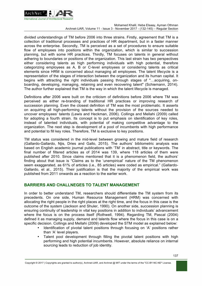
International Journal of Architectural Research Mohamed Khalil, Heba Elsaay, Ayman Othman
Archnet-IJAR, Volume 11 - Issue 3 - November 2017 - (132-145) – Regular Section
Copyright © 2017 | Copyrights are granted to author(s), Archnet-IJAR, and Archnet @ MIT under the terms of the "CC-BY-NC-ND" License.
137
divided understandings of TM before 2006 into three strains. Firstly, agreement that TM is a collection of traditional processes and practices of HR department, but in a faster manner across the enterprise. Secondly, TM is perceived as a set of procedures to ensure suitable flow of employees into positions within the organization, which is similar to succession planning, but with some HR practices. Thirdly, TM focuses on talents in general without adhering to boundaries or positions of the organization. This last strain has two perspectives either considering talents as high performing individuals with high potential, therefore categorizing employees as A, B or C-level employees or considering talents as critical elements since HRM is concerned about managing all employees. The talent lifecycle is a representation of the stages of interaction between the organization and its human capital. It begins with attracting the right individuals passing through stages of "…acquiring, on-boarding, developing, managing, retaining and even recovering talent" (Schiemann, 2014). The author further explained that TM is the way in which the talent lifecycle is managed.
Definitions after 2006 were built on the criticism of definitions before 2006 where TM was perceived as either re-branding of traditional HR practices or improving research of succession planning. Even the closest definition of TM was the most problematic. It asserts on acquiring all high-performing talents without the provision of the sources needed to uncover employees’ talents (Lewis and Heckman, 2006). Collings and Mellahi (2009) called for adopting a fourth strain. Its concept is to put emphasis on identification of key roles, instead of talented individuals, with potential of making competitive advantage to the organization. The next step is development of a pool of incumbents with high performance and potential to fill key roles. Therefore, TM is exclusive to key positions.
TM status was considered in the mid-level between growing and mature field of research (Gallardo-Gallardo, Njis, Dries and Gallo, 2015). The authors’ bibliometric analysis was based on English academic journal publications with ‘TM’ in abstract, title or keywords. The final number of filtered articles as of 2014 was 139, where 118 articles of them were published after 2010. Since claims mentioned that it is a phenomenon field, the authors’ finding about that issue is “Claims as to the ‘unempirical’ nature of the TM phenomenon seem exaggerated, as 61% of articles (i.e., 85 articles) were coded as empirical.” (Gallardo-Gallardo, et al., 2015). Their justification is that the majority of the empirical work was published from 2011 onwards as a reaction to the earlier work.
BARRIERS AND CHALLNEGES TO TALENT MANAGEMENT
In order to better understand TM, researchers should differentiate the TM system from its precedents. On one side, Human Resource Management (HRM) was concerned with allocating the right people in the right places at the right time, and the focus in this case is the outcome of the system (Jackson and Shuler, 1990). On another side, succession planning is ensuring continuity of leadership in vital key positions in addition to individuals’ advancement where the focus is on the process itself (Rothwell, 1994). Regarding TM, Pascal (2004) defined it as managing supply, demand and talents flow where the focus in this case is on a specific decision. Collings and Mellahi (2009) developed the STM model as explained below:
• Identification of pivotal talent positions through focusing on ‘A’ positions rather than ‘A’ level players.
• Talent pool development through filling the pivotal talent positions with high performing and high potential incumbents. However, absolute reliance on internal sourcing leads to reduction of job identity.
International Journal of Architectural Research Mohamed Khalil, Heba Elsaay, Ayman Othman
Archnet-IJAR, Volume 11 - Issue 3 - November 2017 - (132-145) – Regular Section
Copyright © 2017 | Copyrights are granted to author(s), Archnet-IJAR, and Archnet @ MIT under the terms of the "CC-BY-NC-ND" License.
138
• Creating a differentiated HR architecture for managing employees who can contribute to the organizational performance. The following are types of employment for talents:
§ Knowledge-based: Long-term employment for valuable, unique and high potential employees.
§ Job-based: Internal sourcing for employees with strategic value, but limited uniqueness.
§ Contract work: Outsourcing since employees lack strategic importance or uniqueness.
§ Partnership: employees are unique, but lack strategic value for employment.
• Outcome: The outcome of STM is a positive return at both organizational and individual levels.
Thunnissen, Boselie and Fruytier (2013) mentioned that TM values are achieved on three levels: a) Individual level economic values such as financial rewards and job security, and non-economic values such as meeting social needs, fair treatment and provision of challenging work; b) Organizational level economic values such as profitability and efficiency, and non-economic values such as legitimacy; c) Societal level economic values such as a competitive position and better economic condition, and non-economic values such as development of social norms of the society. They asserted on achieving a pluralistic approach, which means perceiving the organization as a whole instead of focusing on one part of the organization, which leads to conflict in goals (Guthridge, Komm, and Lawson, 2008; Martin and Schmidt, 2010). For example, changing from narrow HR practices to work relationships, obtaining goals through the organization only to consider well-being of all players and shift from economic value to multi-value levels mentioned previously (Thunnissen, et al. 2013).
According to Deery (2008), work-life commitments balance enhances the intention of the employees to stay in the organization since exhaustion and job burnout are major significances to employees’ turnover. As a result we envisaged a framework to enhance retention of employees through achieving work-life commitments balance as part of a TM strategy. The framework defines attributes of the industry and the organization including working hours, payments, mismatch of education and career development. Such problems of these attributes lead to stress, exhaustion and job burnout. Therefore, enhanced strategies of recruitment, development and work-life balance policies are highly recommended to be adopted to enhance job satisfaction, commitment and retention. Moreover, the authors mentioned that provision of flexible working hours, days off, family times, working from home, on-job training, different types of leave and appropriate workdays breaks enhance the work-life commitments balance. According to Ingram (2016), allowing organizations to achieve high performance with TM strategy, there should be a working climate that enhances creativity. The authors mentioned that TM has a purpose of achieving sustainable competitive advantage to the organization, which is in turn associated with the ability to deliver valuable novel solutions (George, 2007).
Tafti, Mahmoudsalehi, and Amiri (2017) provided in their paper a detailed list of barriers, challenges and success factors of TM. This in addition to the previously mentioned barriers and values discussed within this literature helps to understand them in a categorized manner. The following are the barriers and challenges mentioned by the authors:
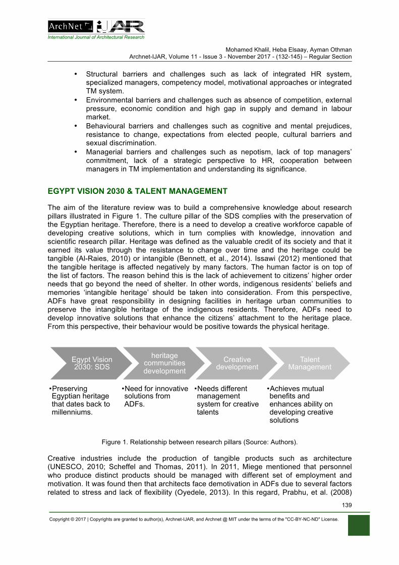
International Journal of Architectural Research Mohamed Khalil, Heba Elsaay, Ayman Othman
Archnet-IJAR, Volume 11 - Issue 3 - November 2017 - (132-145) – Regular Section
Copyright © 2017 | Copyrights are granted to author(s), Archnet-IJAR, and Archnet @ MIT under the terms of the "CC-BY-NC-ND" License.
139
• Structural barriers and challenges such as lack of integrated HR system, specialized managers, competency model, motivational approaches or integrated TM system.
• Environmental barriers and challenges such as absence of competition, external pressure, economic condition and high gap in supply and demand in labour market.
• Behavioural barriers and challenges such as cognitive and mental prejudices, resistance to change, expectations from elected people, cultural barriers and sexual discrimination.
• Managerial barriers and challenges such as nepotism, lack of top managers’ commitment, lack of a strategic perspective to HR, cooperation between managers in TM implementation and understanding its significance.
EGYPT VISION 2030 & TALENT MANAGEMENT
The aim of the literature review was to build a comprehensive knowledge about research pillars illustrated in Figure 1. The culture pillar of the SDS complies with the preservation of the Egyptian heritage. Therefore, there is a need to develop a creative workforce capable of developing creative solutions, which in turn complies with knowledge, innovation and scientific research pillar. Heritage was defined as the valuable credit of its society and that it earned its value through the resistance to change over time and the heritage could be tangible (Al-Raies, 2010) or intangible (Bennett, et al., 2014). Issawi (2012) mentioned that the tangible heritage is affected negatively by many factors. The human factor is on top of the list of factors. The reason behind this is the lack of achievement to citizens’ higher order needs that go beyond the need of shelter. In other words, indigenous residents’ beliefs and memories ‘intangible heritage’ should be taken into consideration. From this perspective, ADFs have great responsibility in designing facilities in heritage urban communities to preserve the intangible heritage of the indigenous residents. Therefore, ADFs need to develop innovative solutions that enhance the citizens’ attachment to the heritage place. From this perspective, their behaviour would be positive towards the physical heritage.
Figure 1. Relationship between research pillars (Source: Authors).
Creative industries include the production of tangible products such as architecture (UNESCO, 2010; Scheffel and Thomas, 2011). In 2011, Miege mentioned that personnel who produce distinct products should be managed with different set of employment and motivation. It was found then that architects face demotivation in ADFs due to several factors related to stress and lack of flexibility (Oyedele, 2013). In this regard, Prabhu, et al. (2008)
Egypt Vision 2030: SDS
• Preserving Egyptian heritage that dates back to millenniums.
heritage communities development
• Need for innovative solutions from ADFs.
Creative development
• Needs different management system for creative talents
Talent Management
• Achieves mutual benefits and enhances ability on developing creative solutions
International Journal of Architectural Research Mohamed Khalil, Heba Elsaay, Ayman Othman
Archnet-IJAR, Volume 11 - Issue 3 - November 2017 - (132-145) – Regular Section
Copyright © 2017 | Copyrights are granted to author(s), Archnet-IJAR, and Archnet @ MIT under the terms of the "CC-BY-NC-ND" License.
140
stated that creativity is based on intrinsic and extrinsic motivation in addition to personal traits. Therefore, emphasizing motivation as a cornerstone for creativity. Since the architectural industry is talent-based (Galloway and Haniff, 2015) it is required to have a differentiated management system.
One of the definitions that describes TM mentioned that it is the way of managing the talent lifecycle, which represents stages of interaction between human capital and organization (Schiemann, 2014). Moreover, Wu, et al. (2016) combined definitions of talents as mastery of abilities, skills, an intrinsic gift, combination of value and individual’s thoughts to produce creative ideas and perform in excellent way. Therefore, emphasizing that TM contributes to enhancing innovative solutions and prevents demotivation that is a barrier to creativity in ADFs. In addition, Thunnissen et al. (2013) stated that one of the TM objectives is to achieve mutual benefits of individuals, organization and society on both the non-economic and economic levels. Therefore, TM is capable to enhance architects ability to provide creative solutions in ADFs while maintaining profitability to organization and developing social norms of the society.
CASE STUDY: PERKINS AND WILL DESIGN FIRM
Perkins and Will is an American interdisciplinary and research-based design firm founded in 1935, whose founders perceived that design has the power of improving communities and changing lives. They employ 2,000 professionals in architecture, urban design and branded environments, landscape architecture and interior design, distributed among more than 20 offices (“Perkins and Will Profile,” 2016). Although the firm has focus on healthcare projects, it has successful cultural projects as well (Grozdanic, 2016). The firm was ranked fifth in the list of 10 most innovative architectural firms in the world in 2013 and was ranked fourth in 2015 (“The World's Top 10,” 2015). Therefore, innovation in the firm is continuous, which indicates a successful permanent adopted strategy to maintain competitiveness through distinctive innovative architectural projects.
In an interview done by Hubbard (2015) to several ADFs, Perkins and Will firm mentioned that the key factor to the firm’s competitive success is the talent strategy. The HR team is responsible for sourcing top talents. Before recruitment, talents are asked about their aspirations on both personal and professional levels and about what brings them joy. Moreover, the firm acquires talents through online applications or referrals from current employees. The last ensures long-term employment at the firm for the current talent for successful referrals. Even in case of no key positions vacancies, the firm keeps seeking for top talents. One of the most important issues in an applicant’s portfolio is the ability of creative thinking. Perkins and Will was in charge of designing the latest Shanghai Natural History Museum (“Shanghai Natural History Museum,” 2015). The museum’s history dates back to 1868’s Xuijaihui Museum and to 1874’s Shanghai Museum of Asiatic Society. The independent Shanghai Natural History Museum was established in 1956 with collections from the previously mentioned two museums. However, the museum became dependent once again in 2001 when it was merged with Shanghai Science and Technology Museum. Therefore, there was a need to design a new independent museum in 2007, which was completed in 2015 (“Shanghai Natural History Museum,” 2014).
The latest design by Perkins and Will allows visitors to explore 10,000 artefacts through exhibitions, 4D theatres and gardens. The aim of the design was to preserve the memories of the traditional gardens of China. In addition, maintaining the experience of the old
International Journal of Architectural Research Mohamed Khalil, Heba Elsaay, Ayman Othman
Archnet-IJAR, Volume 11 - Issue 3 - November 2017 - (132-145) – Regular Section
Copyright © 2017 | Copyrights are granted to author(s), Archnet-IJAR, and Archnet @ MIT under the terms of the "CC-BY-NC-ND" License.
141
museum, so there is an excitement to visit the place, and a similarity to places in the hearts of Shanghai’s indigenous residents, and foreign visitors (“Shanghai Natural History Museum,” 2015). The Chinese gardens feature buildings with natural elements with decorative rocks, water elements as ponds and plants (Zhou, 2016) are very close to Shanghai Natural History Museum by Perkins and Will.
In spite of the focus of the firm on healthcare projects, it successfully contributed to preserve intangible heritage in a cultural project for which the firm won its design competition. Therefore, the creativity in designing the museum reflects the internal human capital management in the ADF, which is TM. In this regard, TM enhances architects’ ability to preserve intangible heritage when designing cultural architecture.
CONCLUSION AND RECOMMENDATIONS
The human-related deterioration to the physical heritage was identified to be caused by improper behaviour from people. Such behaviour is caused by either the intention of imposing an individual’s intangible heritage over the physical heritage if there is no association with the last or trying to blend the identity of the physical heritage with the individual’s intangible heritage because of the sense of belonging. Although such problems required creative solutions in the newly designed architectural facilities to bridge that gap between both types of heritage, the diversity of the intangible heritage has complicated that development of creative solutions. Therefore, the role of ADFs towards developing creative solutions is paramount in order to preserve the physical heritage. In addition, sharing with the development of Egypt Vision 2030, in case of Egyptian ADFs.
Despite the critical role of ADFs for developing creative solutions, existing demotivation caused by the stressful nature, excessive workload, miscommunication between team members, lack of day-to-day work flexibility, improper evaluation systems, conflict between goals and age-old payments acted as a barrier for creativity. This barrier of demotivation of talents was not suitable for architectural practice especially that architecture is classified as one of the creative industries. Therefore, investigation of proper solutions in ADFs resulted with studying TM as a novel approach for enhancing creativity in ADFs for potential of developing heritage communities creatively. TM research recently was recognised as practical instead of been phenomenal at its initial start. Consequently, the investigation of TM was of essence as previous research proved the role of the strategy in enhancing talents ability for balancing work-life commitments and for achieving mutual benefits for organisation and individuals. The strategy was developed over the past years to be comprehensive to manage talents with four different approaches depending on the objective from the strategy. This ensures prevention of demotivation and enhancement of motivation in ADFs in order to enhance creative development, which highlights the critical importance of adopting TM in ADFs, or other creative industries, to enhance creative development. Ignorance of the strategy will lead to wasted efforts in ADFs and increasingly deteriorated physical heritage because TM solves the root of the problem.
The effectiveness of the TM strategy was investigated in an international case study in which it enhanced the firm’s ability to develop creative solutions, even though that the firm is specialised mainly in medical projects. However, designing the SNHM was successful in preserving the intangible heritage of its users through linking its design to the Chinese gardens as well as the old experience of the museum. This highlights the critical need to investigate the integration of TM in ADFs and other creative industries worldwide not strictly
International Journal of Architectural Research Mohamed Khalil, Heba Elsaay, Ayman Othman
Archnet-IJAR, Volume 11 - Issue 3 - November 2017 - (132-145) – Regular Section
Copyright © 2017 | Copyrights are granted to author(s), Archnet-IJAR, and Archnet @ MIT under the terms of the "CC-BY-NC-ND" License.
142
in Egypt, but the study chosen Egypt as a case for study in order for the research to be specific and to highlight the main problem due to feasibility of local study. Hence, the following recommendations are proposed for future research to build upon the findings of this paper:
• Although TM is paramount in motivating and reducing demotivation of talents, assessing the accurate influence of TM in other creative industries will develop further strong baselines to facilitate integrating TM in all creative industries.
• Investigating potential barriers of creativity that could appear even after the implementation of TM is critically needed because even that TM is paramount for solving the investigated potential barriers; other minor or major barriers should need additional in-depth research.
• An assessment and evaluation of TM adoption in ADFs, which will vary according to each country’s conditions, is required to develop adequate methods to be applied in each country’s ADFs.
• Empirical research is required to assess the perception and behaviour of people towards several innovative solutions developed accordingly.
It is critical to highlight that focusing on preservation of heritage communities creatively and the investigation of TM as a novel approach for creativity is not considered a limitation. On the contrary, it highlighted the role of TM on enhancing creativity, which should be of interest to researchers for future works. Moreover, referring to the Egyptian 2030 SDS highlighted the need for developing heritage communities and developing a creative workforce. It is not considered a limitation that led to the findings of this research, but asserted on the need of sharing with the national development, which should be an essence in worldwide research. Lastly yet importantly, the findings of this research are applicable for all creative industries since all share the same role of developing tangible and intangible creative solutions, products or services to the end-user.
REFERENCES
Al-Raies, A.A. (2010). [Urban revitalization as a pillar of sustainability with a special mention for the areas of architectural heritage], Cairo: Cairo University. [In Arabic].
Alvizatou, M. (2012). The Paradox of Intangible Cultural Heritage. In M. L. Stefano, P. Davis, & G. Corsane (Eds.), Safeguarding Intangible Cultural Heritage (pp. 9-22). Woodbridge: The Boydell Press.
Amabile, T.M. (1983). The social psychology of creativity. New York: Springer Verlag. Amabile, T.M. (1993). Motivational synergy: Toward new conceptualizations of intrinsic and extrinsic
motivation in the workplace. Human Resource Management Review, 3(3), 185-201. Appleyard, D. (1979). The Conservation of European Cities. Cambridge, Mass: MIT Press. Bell, J.S. (2013). The Politics of Preservation: Privileging One Heritage over Another. International
Journal of Cultural Property, 20(4), 431–450. DOI: 10.1017/S0940739113000192 Bennett, D., Coffey, J., Fitzgerald, S., Petcoz, P. and Rainnie, A. (2014). Beyond the Creative:
Understanding the Intersection of Specialist and Embedded Work for Creatives in Metropolitan Perth. In G. Hearn, R. Bridgstock, B. Goldsmith and J. Rodgers (Eds.), Creative Work Beyond the Creative Industries: Innovation, Employment, and Education (pp. 158-172). Cheltenham: Edward Elgar Publishing.
Bennett, D., Reid, A. and Petocz, P. (2014). Creative Workers' Views on Cultural Heritage and Sustainability. Journal of Aesthetics and Culture, 6. DOI: 10.3402/jac.v6.24476
Blake, J. (2000). On Defining the Cultural Heritage. International and Comparative Law Quarterly, 49(1), 61–85. DOI: 10.1017/S002058930006396X
International Journal of Architectural Research Mohamed Khalil, Heba Elsaay, Ayman Othman
Archnet-IJAR, Volume 11 - Issue 3 - November 2017 - (132-145) – Regular Section
Copyright © 2017 | Copyrights are granted to author(s), Archnet-IJAR, and Archnet @ MIT under the terms of the "CC-BY-NC-ND" License.
143
Collings, D.G. and Mellahi, K. (2009). Strategic talent management: A review and research agenda. Human Resource Management Review, 19, 304-313. http://doi:10.1016/j.hrmr.2009.04.001
Deery, M. (2008). Talent Management, Work-Life Balance and Retention Strategies. International Journal of Contemporary Hospitality Management, 20(7), 792-806.
Dias, I., Sousa, M.J. and Caracol, C. (2016). The Sustainability of Internal Talent Pool through the use of Business Intelligence. In ECIC2016-Proceedings of the 8th European Conference on Intellectual Capital: ECIC2016 (pp. 70-78). Kidmore End: Academic Conferences International Limited.
Dries, N. (2013). The psychology of talent management: A review and research agenda. Human Resource Management Review, 23(4), 272-285. DOI: 10.1016/j.hrmr.2013.05.001
Eisenberger, R. and Rhoades, L. (2001). Incremental effects of reward on creativity. Journal of Personality and Social Psychology, 81, 728-741.
El-Megharbel, N. (2015). Sustainable Development Strategy Egypt's Vision 2030 and Medium Term Investment Framework. Retrieved October 29, 2016, from https://sustainabledevelopment.un.org/content/documents/15262El-Megharbell,%20Egypt%20NSDS%2020150527.pdf
Farahat, B.I. (1999). The Reciprocal Relationship between the Human Behavior and the Physical Environment in Urban Spaces (Unpublished MSc thesis). Ainshams University, Cairo, Egypt.
Feilden, B. (1982). Conservation of Historic Buildings. England: Butterworth and Co., LTD. Gallardo-Gallardo, E., Dries, N. and Gonzalez-Cruz, T. (2013). What is the meaning of 'talent' in the
world of work?. Human Resource Management Review, 23(4), 290-300. DOI: 10.1016/j.hrmr.2013.05.002
Gallardo-Gallardo, E., Nijs, S., Dries, N. and Gallo, P. (2015). Towards an Understanding of Talent Management as a Phenomenon-Driven Field Using Bibiometric and Content Analysis. Human Resource Management Review, 25, 264-279. DOI: 10.1016/j.hrmr.2015.04.003
Galloway, L. and Haniff, A. (2015). Managing Projects in Architecture: A Study of Leadership in a Creative Industry. Open Economics and Management Journal, 2, 38-44. DOI: 10.2174/2352630001502010038
George, J.M. (2007). Creativity in Organizations. The Academy of Management Annals, 1(1), 439-477. DOI: 10.1080/078559814
Grozdanic, L. (2016). These Are the World's Most Innovative Architecture Firms. Retrieved January 7, 2017, from http://www.archdaily.com/798252/these-are-the-worlds-most-innovative-architecture-firms
Guthridge, M., Komm, A.B. and Lawson, E. (2008). The people problem in talent management. Mckinsey Quarterly, 1, 48-59.
Hubbard, B. (2015). 5 Top Firms Respond: What Do You Look for in Job Applications?, Retrieved January 7, 2017, from http://www.archdaily.com/773584/5-top-firms-respond-what-do-you-look-for-in-job-applications
Ingram, T. (2016). Relationship between Talent Management and Organizational Performance: The Role of Climate for Creativity. Entrepreneurial Business and Economics Review, 4(3), 195-205. DOI: 10.15678/EBER.2016.040315
Issawi, M.A. (2012). [Upgrading traditional domains of value "A comparative study to policies to preserve the architectural heritage"]. Dubai, Third International Conference and Exhibition to preserve the architectural heritage. [In Arabic].
Jackson, S. E., & Schuler, R. S. (1990). Human resource planning: Challenges for industrial/organizational psychologists. American Psychologist, 45(2), 223−239. DOI:10.1016/j.hrmr.2006.03.001
Kehinde, J.S. (2012). Talent Management: Effect on Organizational Performance. Journal of Management Research, 4(2), 178-186. DOI: 10.5296/jmr.v4i2.937
Khoram, L.A. and Samadi, A (2013). Relationship of Talent Management and Organizational Creativity in Maskan Bank of Hamedan. Middle-East Journal of Scientific Research, 18(5), 728-731. DOI: 10.5829/idosi.mejsr.2013.18.5.11741
Lewis, R.E. and Heckman, R. J. (2006). Talent Management: A critical review. Human Resource Management Review, 16, 139-154. DOI: 10.1016/j.hrmr.2006.03.001
International Journal of Architectural Research Mohamed Khalil, Heba Elsaay, Ayman Othman
Archnet-IJAR, Volume 11 - Issue 3 - November 2017 - (132-145) – Regular Section
Copyright © 2017 | Copyrights are granted to author(s), Archnet-IJAR, and Archnet @ MIT under the terms of the "CC-BY-NC-ND" License.
144
Maher, M. (2016). [Love and adoration phrases spoils Egyptian heritage dates back to three millenniums]. Retrieved January 19, 2017, from http://yallafeed.com/msh-htsd-q-abarat-tshw-h-aathar-amrha-aalaf-alsnyn-fy-msr-5671;c=yallafeed. [In Arabic].
Martin, J. and Schmidt, C. (2010). How to keep your top talent. Harvard Business Review, 88(5), 54-61.
Meyers, M.C., van Woerkom, M. and Dries, N (2013). Talent — Innate or acquired? Theoretical considerations and their implications for talent management. Human Resource Management Review, 23(4), 305-321. DOI: 10.1016/j.hrmr.2013.05.003
Miege, B. (2011). Theorizing the Cultural Industries. In J. Wasko, G. Murdock, H. Sousa (Eds.), Handbook of Political Economy of Communication (pp. 83-108). Oxford: Blackwell.
Ministry of Planning (2015). SDS Summary. Retrieved November 20, 2016, from http://sdsegypt2030.com/wp-content/uploads/2016/08/English-Booklet-2030.compressed.pdf
Ng, S.T., Skitmore, R.M., Lam, K.C. and Poon, A.W. (2004). Demotivating factors influencing the productivity of civil engineering projects. International Journal of Project Management, 22(2), 139-146. DOI: 10.1016/S0263-7863(03)00061-9
Oakley, K., Sperry, B. and Pratt, A.C. (2008). The art of innovation: How fine arts graduates contribute to innovation. Retrieved November 25, 2016, from http://openaccess.city.ac.uk/6704/
Oyedele, L.O. (2013). Analysis of Architects' Demotivating Factors in Design Firms. International Journal of Project Management, 31, 342-354. DOI: 10.1016/j.ijproman.2012.11.009
Pascal, C. (2004). Foreword. In A. Schweyer (Ed.), Talent management systems: Best practices in technology solutions for recruitment, retention, and workforce planning. Canada: Wiley.
Perkins and Will Profile. (2016). Retrieved January 7, 2017, from http://perkinswill.com/firm-profile Prabhu, V., Sutton, C. and Sauser, W. (2008). Creativity and Certain Personality Traits: Understanding
the Mediating Effect of Intrinsic Motivation. Creativity Research Journal, 20(1), 53-66. DOI: 10.1080/10400410701841955
Ramaswamy, V. (2009). Leading the transformation to co-creation of value. Strategy and Leadership, 37(2), 32-37. DOI: 10.1108/10878570910941208
Rothwell, W. J. (1994). Effective succession planning: Ensuring leadership continuity and building talent from within. New York: Amacom.
Scheffel, E. and Thomas, A. (2011). Employment and intangible spending in the UK's creative industries: A view from the micro data. London, Office for National Statistics.
Schiemann, W.A. (2014). From Talent Management to Talent Optimization. Journal of World Business, 49, 281-288. DOI: 10.1016/j.jwb.2013.11.012
Shanghai Natural History Museum. (2015). Retrieved January 7, 2017, from http://www.archdaily.com/623197/shanghai-natural-history-museum-perkins-will
Shanghai Natural History Museum – History. (2014). Retrieved January 7, 2017, from http://www.snhm.org.cn:7070/gywm_eg/lssy.htm
Shaw, I. (2000). The Oxford History of Ancient Egypt (Oxford Illustrated Histories). 1st ed. Oxford: Oxford University Press.
Smagina, A. and Lindemanis, A. (2013). Artistic Talents - Facilitators of Creativity and Innovation. In Proceedings of the Multidisciplinary Academic Conference (pp. 1-8).
Tafti, M.M., Mahmoudsalehi, M. and Amiri, M. (2017). Critical success factors, challenges and obstacles in talent management. Industrial and Commercial Training, 49(1), 15-21. DOI: 10.1108/ICT-05-2016-0036
Taha, R.M.A. (2010). [The mutual influence between the reality of urban housing and social and cultural identity of the population Case Study: Old City in Nablus] (Unpublished MSc thesis), An-Najah National University, Palestine. [In Arabic].
The World's Top 10 Most Innovative Companies in Architecture. (2015). Retrieved January 7, 2017, from https://www.fastcompany.com/3041577/most-innovative-companies-2015/the-worlds-top-10-most-innovative-companies-in-architecture
Thunnissen, M., Boselie, P. and Fruytier, B. (2013). Talent Management and the Relevance of Context: Towards a Pluralistic Approach. Human Resource Management Review, 23, 326-336. DOI: 10.1016/j.hrmr.2013.05.004
International Journal of Architectural Research Mohamed Khalil, Heba Elsaay, Ayman Othman
Archnet-IJAR, Volume 11 - Issue 3 - November 2017 - (132-145) – Regular Section
Copyright © 2017 | Copyrights are granted to author(s), Archnet-IJAR, and Archnet @ MIT under the terms of the "CC-BY-NC-ND" License.
145
UNESCO (2010). Understanding Creative Industries. Retrieved November 27, 2016, from http://portal.unesco.org/culture/en/files/30297/11942616973cultural_stat_EN.pdf/cultural_stat_EN.pdf
Vural, Y., Vardarlier, P. and Aykir, A. (2012). The Effects of Using Talent Management with Performance Evaluation System Over Employee Commitment. Procedia - Social and Behavioral Sciences, 58, 340-349. DOI: 10.1016/j.sbspro.2012.09.1009
Winslow, E.K. (1990). The Issue of Motivating Entre(Intra)Preneurial Behavior. The Journal of Creative Behavior, 24(4), 256-262. DOI: 10.1002/j.2162-6057.1990.tb00546.x
Wu, M.C., Nurhadi, D. and Zahro, S. (2016). Integrating the Talent Management Program as a New Concept to Develop a Sustainable Human Resource at Higher Educational Institutions. International Journal of Organizational Innovation, 8(4), 146-160.
Zhou, R. (2016). Features of Chinese Gardens. Retrieved January 21, 2017, from http://www.chinahighlights.com/travelguide/architecture/features-garden.htm
Gehan Selim, Mohamed Gamal Abdelmonem, Sabah Mushatat, Abdulaziz Almogren Archnet-IJAR, Volume 11 - Issue 3 - November 2017 - (146-162) – Regular Section
Copyright © 2017 | Copyrights are granted to author(s), Archnet-IJAR, and Archnet @ MIT under the terms of the "CC-BY-NC-ND" License.
146
Archnet-IJAR: International Journal of Architectural Research www.archnet-ijar.net/ -- https://archnet.org/collections/34
CONTESTED HERITAGE: AN ANALYSIS OF THE PHYSICAL TRANSFORMATION OF DERRY/LONDONDERRY’S SIEGE MONUMENT DOI: http://dx.doi.org/10.26687/archnet-ijar.v11i3.1407 Gehan Selim, Mohamed Gamal Abdelmonem, Sabah Mushatat, Abdulaziz Almogren
Keywords Abstract
heritage; Derry/Londonderry; contested space; memory; Northern Ireland; walls
Transformations of Derry/Londonderry’s medieval city walls during the twentieth century have shaped an urbanism of segregated settlements within a city of religious confrontation. The heritage of military blockades, peace lines and watchtowers imposed upon the city’s Walls has influenced the disintegration of public space and created areas of no man’s land around the peripheries of the monument. The aim of this paper is to examine physical transformation and trace the consequences of urban planning regarding the historic city Walls. This change includes the shifting of residential settlements in the Bogside/Fountain areas and the movement of Protestant settlements towards the Waterside of Derry/Londonderry. The history and heritage of the Walls are analysed by focusing on four periods: 1600, when the first medieval walls were constructed; the housing crisis of 1948; the 1968 urban area plan and the beginning of the ‘Troubles’; and the present day. This analysis offers an understanding of the spatial relationships between enclaves and the monument over key moments of conflict and political change. The paper reveals that the manifestations of the Walls have aided in the further division of religiously segregated communities in Derry/Londonderry.
G. Selim*, M. G. Abdelmonem, S. Mushatat, A. Almogren
G. Selim, Lecturer in Architecture, University of Leeds, Leeds, UK. M. G. Abdelmonem, Chair in Architecture, Nottingham Trent University, UK. S. Mushatat, Professor of Architecture, University of Wolverhampton, Wolverhampton, UK. A. Almogren, Prince Sultan Bin Salman Chair for Architectural Heritage, King Saud University, Riyadh, KSA
*Corresponding Author’s email address: [email protected]
ArchNet-IJAR is indexed and listed in several databases, including: • Avery Index to Architectural
Periodicals • EBSCO-Current Abstracts-Art
and Architecture • CNKI: China National
Knowledge Infrastructure • DOAJ: Directory of Open
Access Journals • Pro-Quest • Scopus-Elsevier • Web of Science
International Journal of Architectural Research
Gehan Selim, Mohamed Gamal Abdelmonem, Sabah Mushatat, Abdulaziz Almogren Archnet-IJAR, Volume 11 - Issue 3 - November 2017 - (146-162) – Regular Section
Copyright © 2017 | Copyrights are granted to author(s), Archnet-IJAR, and Archnet @ MIT under the terms of the "CC-BY-NC-ND" License.
147
INTRODUCTION
Walled urban settlements have, over centuries, played a significant role in shaping the characteristics of the communities they embrace. Cities such as San Gimignano in Italy, Carcassonne in France and Nicosia in North Cyprus display a long-lasting fabric of civil defence, articulating inherent geographies of heritage, displaying considerable potential as cultural resources and exhibiting substantial challenges, practical and theoretical (Doratli, Hoskara, & Fasli, 2004). Walls in towns are intellectualised as a ‘dissonant’ form of heritage whose value is commonly contested among different interest groups and whose meaning is not static but can be interpreted in various ways. During periods of insecurity and past endeavours, walls portrayed cities as achieving order from chaos and providing protection for citizens, at the expense of putting up barriers to their free movement (Creighton, 2007).
The identities and heritage of walled cities are multi-layered and fluid, what renders them vulnerable to reinvention. By their very existence as defensive fortresses, walled cities witnessed violent histories that changed their political and national allegiance over time (Mulholland et al., 2014; Selim, 2015). These cities, while superficially embracing citizenship and collective sense of spatial belongings, are also inescapably performing other forms of exclusion and marginalisation of other social groups. The urban impact of walled cities on infusing segregation has been well documented. Andreas Huyssen (2003) interrogated the Berlin Wall through narratives of people’s collective memory and past experience of spatial division that continue to exist as an invisible barrier in the psyche of many residents until today. Eyal Weizman (2012) examined the Jerusalem/Palestine Wall through a strong understanding of the key political and social motivations of its construction. Others employed visual analysis to understand the forced urbanism of interface areas in Belfast and Northern Ireland by documenting shifts in religion, mobility and settlements (Abdelmonem & McWhinney, 2015; Selim & Abraham, 2016). Tracing physical attributes of segregated landscapes such as frontiers, watchtowers, and housing decay offers an insight of how spatial geography shifts in post conflict cities for a long time after peace has been achieved (Misselwitz & Rieniets, 2006).
The walled city, Derry/Londonderry in Northern Ireland, has been branded as a city that exhibits long-rooted clashes of religious identities between Catholics/Nationalists and Protestants/Unionists. It was named the UK City of Culture (CoC) in 2013, building on the successful experience of Liverpool as the EU Capital of Culture in 2008. This distinctive status has offered local authorities the advent prospect of refashioning the city as a model of unity and healing whilst being distanced from its troubled past. In part, this included redefining multiple readings of the city’s character, history and heritage. The complete seventeenth-century circuit wall surrounding the post-conflict renaissance city had stood intact as a symbol of civilisation for hundreds of years (Murtagh, Boland, & Shirlow, 2017). The uninterrupted and continuous city wall is one of the oldest historic defensive walls to survive in Europe (Hume, 2002). The transformation of the wall during the twentieth century eroded an architectural dialogue with the heritage of the city and shaped an urbanism of defences and segregated settlements (Figure 1).
The paper aims to interrogate how the military blockades, peace lines and watchtowers being imposed upon the city’s historic Walls during the troubles in the second half of the Twentieth Century have influenced the segregated urban planning of Derry/Londonderry. Tracing two pivotal moments of transformation prior to the ‘Great Siege’ of 1689 and the ‘Battle of the Bogside’ of 1968 illuminates the shifting residential settlements in the Bogside/Fountain areas and the migration of Protestant settlements towards the Waterside
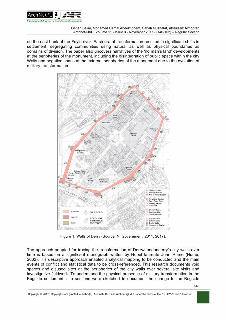
International Journal of Architectural Research
Gehan Selim, Mohamed Gamal Abdelmonem, Sabah Mushatat, Abdulaziz Almogren Archnet-IJAR, Volume 11 - Issue 3 - November 2017 - (146-162) – Regular Section
Copyright © 2017 | Copyrights are granted to author(s), Archnet-IJAR, and Archnet @ MIT under the terms of the "CC-BY-NC-ND" License.
148
on the east bank of the Foyle river. Each era of transformation resulted in significant shifts in settlement, segregating communities using natural as well as physical boundaries as domains of division. The paper also uncovers narratives of the ‘no man’s land’ developments at the peripheries of the monument, including the disintegration of public space within the city Walls and negative space at the external peripheries of the monument due to the evolution of military transformation.
Figure 1. Walls of Derry (Source: NI Government, 2011; 2017).
The approach adopted for tracing the transformation of Derry/Londonderry’s city walls over time is based on a significant monograph written by Nobel laureate John Hume (Hume, 2002). His descriptive approach enabled analytical mapping to be conducted and the main events of conflict and statistical data to be cross-referenced. This research documents void spaces and disused sites at the peripheries of the city walls over several site visits and investigative fieldwork. To understand the physical presence of military transformation in the Bogside settlement, site sections were sketched to document the change to the Bogside
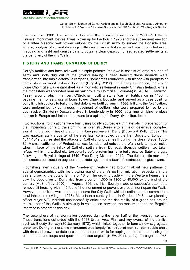
International Journal of Architectural Research
Gehan Selim, Mohamed Gamal Abdelmonem, Sabah Mushatat, Abdulaziz Almogren Archnet-IJAR, Volume 11 - Issue 3 - November 2017 - (146-162) – Regular Section
Copyright © 2017 | Copyrights are granted to author(s), Archnet-IJAR, and Archnet @ MIT under the terms of the "CC-BY-NC-ND" License.
149
interface from 1968. The sections illustrated the physical prominence of Walker’s Pillar (a Unionist monument) before it was blown up by the IRA in 1973 and the subsequent erection of a 60-m Masonic watchtower outpost by the British Army to survey the Bogside area. Finally, analysis of current dwellings within each residential settlement was conducted using mapping and first-hand census data to obtain a clear depiction of segregated settlements at the periphery of the city Walls.
HISTORY AND TRANSFORMATION OF DERRY
Derry's fortifications have followed a simple pattern: “their walls consist of large mounds of earth and sods dug out of the ground leaving a deep trench”; these mounds were transformed into basic defensive ramparts, sometimes reinforced with timber with parapets of earth, stone or wood fashioned on top (Hippsley, 2012). In its early foundation, the city of Doire Cholmcille was established as a monastic settlement in early Christian Ireland, where the monastery was founded near an oak grove by Colmcille (Columba) in 546 AD (Hamilton, 1999), around which Flathbert O'Brolchain built a stone ‘cashel’ fortification in 1156. It became the monastic site of Long Tower Church, Bogside, and served as a base point for early English settlers to build the first defensive fortifications in 1566. Initially, the fortifications were undermined by continuous movement of settlers who were prepared to flee to the countryside. Sir Henry Docwra arrived in Londonderry in 1600, at a time of rising religious tension in Europe and Ireland, that were to erupt later in Derry (Hamilton, ibid.).
Two additional fortifications were built using locally sourced earth materials in preparation for the impending conflict; transforming simpler structures into a major defensive complex, signalling the beginning of a strong military presence in Derry (Docwra & Kelly, 2008). This was approximately a quarter of the area later constructed by the Irish Society of London in 1614-1619 that resisted the attacks of Catholic King James II during the Great Siege, 1688-89. A small settlement of Protestants was founded just outside the Walls only to move inside when in face of the influx of Catholic settlers from Donegal. Bogside settlers had taken refuge within the walled city temporarily before returning to re-build outside Butcher’s gate following the Royalist siege of 1649 (Free Derry Museum, 2012). The fluid elastic moves of settlements continued throughout the middle ages on the back of continuous religious wars.
Flourishing linen industry of the Nineteenth Century had brought about new patterns of spatial demographics with the growing use of the city’s port for migration, especially in the years following the potato famine of 1845. The growing trade with the Western hemisphere saw the population of Derry rise from around 11,000 in 1800 to 40,000 by the end of the century (McSheffrey, 2000). In August 1803, the Irish Society made unsuccessful attempt to remove all housing within 40 feet of the monument to prevent encroachment upon the Walls. However, a decision was made to preserve the City Walls while it continued to accommodate local inhabitants (Milligan, 1948). More than a century later, In October 1943, town planning officer Major A.T. Marshall unsuccessfully articulated the desirability of a green belt around the exterior of the Walls. A similarity in void space between the monument and the Bogside interface is present to this day.
The second era of transformation occurred during the latter half of the twentieth century. These transitions coincided with the 1968 Urban Area Plan and key events of the conflict, such as Bloody Sunday (30 January 1972), which linked together to form a new segregated urbanism. During this era, the monument was largely “constructed from random rubble shale with dressed brown sandstone used on the outer walls for copings to parapets, dressings to embrasures and loops and quoins to bastion angles” (NIEA, 2011, p. 29). Throughout 1968,
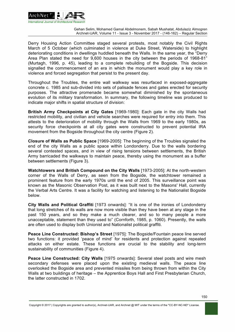
International Journal of Architectural Research
Gehan Selim, Mohamed Gamal Abdelmonem, Sabah Mushatat, Abdulaziz Almogren Archnet-IJAR, Volume 11 - Issue 3 - November 2017 - (146-162) – Regular Section
Copyright © 2017 | Copyrights are granted to author(s), Archnet-IJAR, and Archnet @ MIT under the terms of the "CC-BY-NC-ND" License.
150
Derry Housing Action Committee staged several protests, most notably the Civil Rights March of 5 October (which culminated in violence at Duke Street, Waterside) to highlight deteriorating conditions in dwellings huddled beneath the Walls. In the same year, the “Derry Area Plan stated the need for 9,600 houses in the city between the periods of 1968-81” (Murtagh, 1996, p. 45), leading to a complete rebuilding of the Bogside. This decision signalled the commencement of an era in which the monument would play a key role in violence and forced segregation that persist to the present day.
Throughout the Troubles, the entire wall walkway was resurfaced in exposed-aggregate concrete c. 1985 and sub-divided into sets of palisade fences and gates erected for security purposes. The attractive promenade became somewhat diminished by the spontaneous evolution of its military transformation. In summary, the following timeline was produced to indicate major shifts in spatial structure of division:
British Army Checkpoints at City Gates [1969-1980]: Each gate in the city Walls had restricted mobility, and civilian and vehicle searches were required for entry into them. This attests to the deterioration of mobility through the Walls from 1969 to the early 1980s, as security force checkpoints at all city gates were constructed to prevent potential IRA movement from the Bogside throughout the city centre (Figure 2).
Closure of Walls as Public Space [1969-2005]: The beginning of the Troubles signaled the end of the city Walls as a public space within Londonderry. Due to the walls bordering several contested spaces, and in view of rising tensions between settlements, the British Army barricaded the walkways to maintain peace, thereby using the monument as a buffer between settlements (Figure 3).
Watchtowers and British Compound on the City Walls [1973-2005]: At the north-western corner of the Walls of Derry, as seen from the Bogside, the watchtower remained a prominent feature from the early 1970s until the end of 2005. This surveillance point was known as the Masonic Observation Post, as it was built next to the Masons' Hall, currently the Verbal Arts Centre. It was a facility for watching and listening to the Nationalist Bogside below.
City Walls and Political Graffiti [1973 onwards]: “It is one of the ironies of Londonderry that long stretches of its walls are now more visible than they have been at any stage in the past 150 years, and so they make a much clearer, and so to many people a more unacceptable, statement than they used to” (Cornforth, 1985, p. 1060). Presently, the walls are often used to display both Unionist and Nationalist political graffiti.
Peace Line Constructed: Bishop’s Street [1975]: The Bogside/Fountain peace line served two functions: it provided ‘peace of mind’ for residents and protection against repeated attacks on either estate. These functions are crucial to the stability and long-term sustainability of communities (Figure 4).
Peace Line Constructed: City Walls [1975 onwards]: Several steel posts and wire mesh secondary defenses were placed upon the existing medieval walls. The peace line overlooked the Bogside area and prevented missiles from being thrown from within the City Walls at two buildings of heritage – the Apprentice Boys Hall and First Presbyterian Church, the latter constructed in 1702.
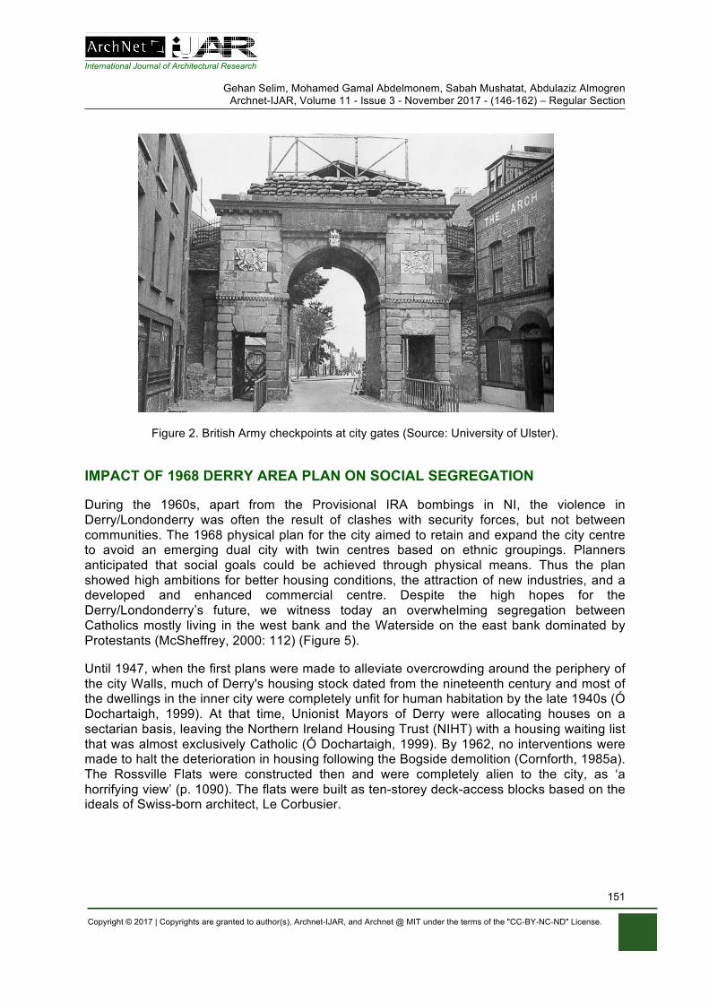
International Journal of Architectural Research
Gehan Selim, Mohamed Gamal Abdelmonem, Sabah Mushatat, Abdulaziz Almogren Archnet-IJAR, Volume 11 - Issue 3 - November 2017 - (146-162) – Regular Section
Copyright © 2017 | Copyrights are granted to author(s), Archnet-IJAR, and Archnet @ MIT under the terms of the "CC-BY-NC-ND" License.
151
Figure 2. British Army checkpoints at city gates (Source: University of Ulster).
IMPACT OF 1968 DERRY AREA PLAN ON SOCIAL SEGREGATION
During the 1960s, apart from the Provisional IRA bombings in NI, the violence in Derry/Londonderry was often the result of clashes with security forces, but not between communities. The 1968 physical plan for the city aimed to retain and expand the city centre to avoid an emerging dual city with twin centres based on ethnic groupings. Planners anticipated that social goals could be achieved through physical means. Thus the plan showed high ambitions for better housing conditions, the attraction of new industries, and a developed and enhanced commercial centre. Despite the high hopes for the Derry/Londonderry’s future, we witness today an overwhelming segregation between Catholics mostly living in the west bank and the Waterside on the east bank dominated by Protestants (McSheffrey, 2000: 112) (Figure 5).
Until 1947, when the first plans were made to alleviate overcrowding around the periphery of the city Walls, much of Derry's housing stock dated from the nineteenth century and most of the dwellings in the inner city were completely unfit for human habitation by the late 1940s (Ó Dochartaigh, 1999). At that time, Unionist Mayors of Derry were allocating houses on a sectarian basis, leaving the Northern Ireland Housing Trust (NIHT) with a housing waiting list that was almost exclusively Catholic (Ó Dochartaigh, 1999). By 1962, no interventions were made to halt the deterioration in housing following the Bogside demolition (Cornforth, 1985a). The Rossville Flats were constructed then and were completely alien to the city, as ‘a horrifying view’ (p. 1090). The flats were built as ten-storey deck-access blocks based on the ideals of Swiss-born architect, Le Corbusier.
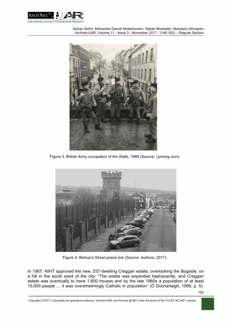
International Journal of Architectural Research
Gehan Selim, Mohamed Gamal Abdelmonem, Sabah Mushatat, Abdulaziz Almogren Archnet-IJAR, Volume 11 - Issue 3 - November 2017 - (146-162) – Regular Section
Copyright © 2017 | Copyrights are granted to author(s), Archnet-IJAR, and Archnet @ MIT under the terms of the "CC-BY-NC-ND" License.
152
Figure 3. British Army occupation of the Walls, 1969 (Source: i.pinimg.com).
Figure 4. Bishop's Street peace line (Source: Authors, 2017).
In 1967, NIHT approved the new, 537-dwelling Creggan estate, overlooking the Bogside, on a hill in the south ward of the city: “The estate was expanded haphazardly, and Creggan estate was eventually to have 1,800 houses and by the late 1960s a population of at least 15,000 people … it was overwhelmingly Catholic in population” (Ó Dochartaigh, 1999, p. 5).
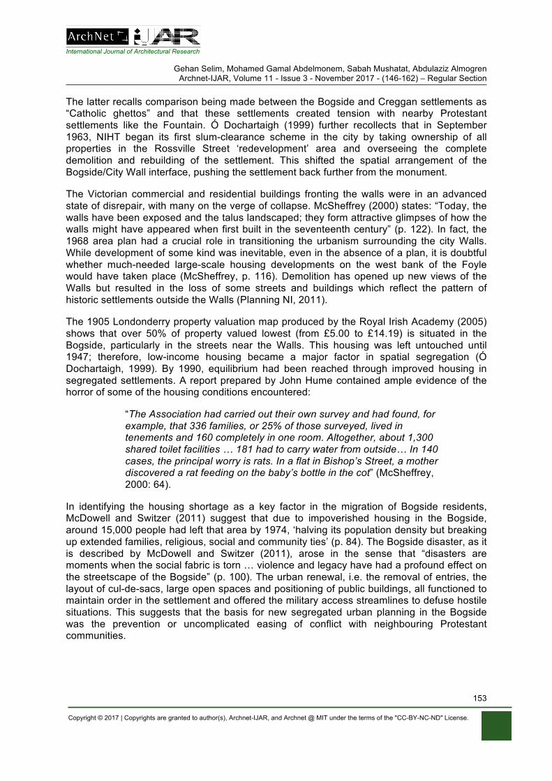
International Journal of Architectural Research
Gehan Selim, Mohamed Gamal Abdelmonem, Sabah Mushatat, Abdulaziz Almogren Archnet-IJAR, Volume 11 - Issue 3 - November 2017 - (146-162) – Regular Section
Copyright © 2017 | Copyrights are granted to author(s), Archnet-IJAR, and Archnet @ MIT under the terms of the "CC-BY-NC-ND" License.
153
The latter recalls comparison being made between the Bogside and Creggan settlements as “Catholic ghettos” and that these settlements created tension with nearby Protestant settlements like the Fountain. Ó Dochartaigh (1999) further recollects that in September 1963, NIHT began its first slum-clearance scheme in the city by taking ownership of all properties in the Rossville Street ‘redevelopment’ area and overseeing the complete demolition and rebuilding of the settlement. This shifted the spatial arrangement of the Bogside/City Wall interface, pushing the settlement back further from the monument.
The Victorian commercial and residential buildings fronting the walls were in an advanced state of disrepair, with many on the verge of collapse. McSheffrey (2000) states: “Today, the walls have been exposed and the talus landscaped; they form attractive glimpses of how the walls might have appeared when first built in the seventeenth century” (p. 122). In fact, the 1968 area plan had a crucial role in transitioning the urbanism surrounding the city Walls. While development of some kind was inevitable, even in the absence of a plan, it is doubtful whether much-needed large-scale housing developments on the west bank of the Foyle would have taken place (McSheffrey, p. 116). Demolition has opened up new views of the Walls but resulted in the loss of some streets and buildings which reflect the pattern of historic settlements outside the Walls (Planning NI, 2011).
The 1905 Londonderry property valuation map produced by the Royal Irish Academy (2005) shows that over 50% of property valued lowest (from £5.00 to £14.19) is situated in the Bogside, particularly in the streets near the Walls. This housing was left untouched until 1947; therefore, low-income housing became a major factor in spatial segregation (Ó Dochartaigh, 1999). By 1990, equilibrium had been reached through improved housing in segregated settlements. A report prepared by John Hume contained ample evidence of the horror of some of the housing conditions encountered:
“The Association had carried out their own survey and had found, for example, that 336 families, or 25% of those surveyed, lived in tenements and 160 completely in one room. Altogether, about 1,300 shared toilet facilities … 181 had to carry water from outside… In 140 cases, the principal worry is rats. In a flat in Bishop’s Street, a mother discovered a rat feeding on the baby’s bottle in the cot” (McSheffrey, 2000: 64).
In identifying the housing shortage as a key factor in the migration of Bogside residents, McDowell and Switzer (2011) suggest that due to impoverished housing in the Bogside, around 15,000 people had left that area by 1974, ‘halving its population density but breaking up extended families, religious, social and community ties’ (p. 84). The Bogside disaster, as it is described by McDowell and Switzer (2011), arose in the sense that “disasters are moments when the social fabric is torn … violence and legacy have had a profound effect on the streetscape of the Bogside” (p. 100). The urban renewal, i.e. the removal of entries, the layout of cul-de-sacs, large open spaces and positioning of public buildings, all functioned to maintain order in the settlement and offered the military access streamlines to defuse hostile situations. This suggests that the basis for new segregated urban planning in the Bogside was the prevention or uncomplicated easing of conflict with neighbouring Protestant communities.
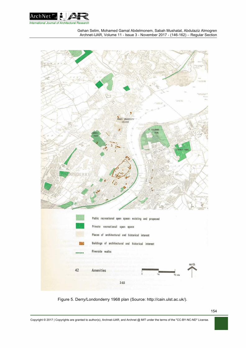
International Journal of Architectural Research
Gehan Selim, Mohamed Gamal Abdelmonem, Sabah Mushatat, Abdulaziz Almogren Archnet-IJAR, Volume 11 - Issue 3 - November 2017 - (146-162) – Regular Section
Copyright © 2017 | Copyrights are granted to author(s), Archnet-IJAR, and Archnet @ MIT under the terms of the "CC-BY-NC-ND" License.
154
Figure 5. Derry/Londonderry 1968 plan (Source: http://cain.ulst.ac.uk/).
International Journal of Architectural Research
Gehan Selim, Mohamed Gamal Abdelmonem, Sabah Mushatat, Abdulaziz Almogren Archnet-IJAR, Volume 11 - Issue 3 - November 2017 - (146-162) – Regular Section
Copyright © 2017 | Copyrights are granted to author(s), Archnet-IJAR, and Archnet @ MIT under the terms of the "CC-BY-NC-ND" License.
155
TRANSFORMATIONS OF CITY WALLS
The rituals associated with the Walls’ martial past were a major factor in the creation of various contested spaces in the city (Creighton, 2007). Both the Unionist celebration of annual marches around the Walls and contested spaces exemplify the Walls as a symbol of division. For decades, the Walls, looking down upon the Bogside, represented a symbolic partition. In an account of life on the interface of the Bogside throughout the 1950s, Deane (1992; 1997) observes that the Protestant cathedral was girded by the city Walls, while Governor Walker’s monument towered over the small huddled houses of the Bogside. In fact, Derry’s town planning was a key factor in developing unused negative space at the peripheries of the city walls, whereas “the open spaces of earlier years have been replaced by bleak apartment blocks … the shape of the neighbourhood has been changed … a city besieged within the siege” (Deane, 1992, p. 18).
Listing the reasons behind the fragmentation of the Bogside settlement from the Walls, in particular, those imposed upon the monument overlooking the Bogside, Cornforth (1985b, p. 1091) explains that the Walls’ military transformation over the course of 1969 to 1985 played a key role in continuing segregation. The Apprentice Boys of Derry’s hall just behind the wall served as a “convenient point for lobbing missiles over … hence, the mesh screen was constructed upon the city walls” (p. 1060). In 1969, a ballot was held amongst Bogside residents in response to the ‘Bogside Peace Ring’ barricades and police actions. It is notable that 3,613 residents voted ‘no’ when asked whether the barricades should be taken down immediately and unconditionally, a figure over three times higher than had said ‘yes’. Furthermore, a very similar vote in favour of a dedicated police force for the Bogside, one unconnected to the Royal Ulster Constabulary, implies that many Bogside residents were satisfied with imposed segregation and would have chosen to set up services organised within the Bogside itself independently of the city authorities.
In order to develop a vehicular buffer zone between the city Walls and the Bogside, only two possibilities existed: one that would have cut through the Bogside (the ‘Lecky Road Flyover’) or the quayside route. Either “would assist in the early clearance of obsolete and unsightly buildings” (McSheffrey, 2000, p. 77). The former, constructed in June 1974, effectively cut off the Bogside and associated nationalist murals from the embankment, over which the Walls loom. McSheffrey (2000) notes that people were worried about MacKinder’s insensitivity to the importance of the existing city fabric, regarding him as a Baron Hausmann, “the most famous exponent of massive urban surgery” in the nineteenth century who had destroyed the medieval areas of Paris to create his splendid boulevards (p. 77).
A significant shift in population density at the periphery of the city Walls took place over the course of the twentieth century. This shift is mainly attributed to the change in housing density from 1948 to 2012, following the 1968 area plan and replacement of the Bogside’s terraced housing with accommodation blocks rising up as high as the medieval walls on the hill above. The terrain above the Walls served to accelerate segregation afterwards. The oblique drop from the Walls to the Bogside below gave the British Army a panoramic view of the ground below to monitor signs of imminent conflict. Due to this surveillance, the Fountain was permitted to become a protected enclave on higher terrain (Figure 6).
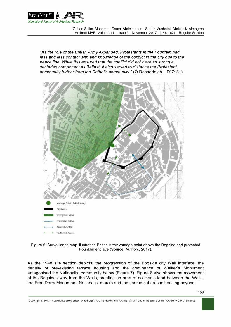
International Journal of Architectural Research
Gehan Selim, Mohamed Gamal Abdelmonem, Sabah Mushatat, Abdulaziz Almogren Archnet-IJAR, Volume 11 - Issue 3 - November 2017 - (146-162) – Regular Section
Copyright © 2017 | Copyrights are granted to author(s), Archnet-IJAR, and Archnet @ MIT under the terms of the "CC-BY-NC-ND" License.
156
“As the role of the British Army expanded, Protestants in the Fountain had less and less contact with and knowledge of the conflict in the city due to the peace line. While this ensured that the conflict did not have as strong a sectarian component as Belfast, it also served to distance the Protestant community further from the Catholic community.” (Ó Dochartaigh, 1997: 31)
Figure 6. Surveillance map illustrating British Army vantage point above the Bogside and protected Fountain enclave (Source: Authors, 2017).
As the 1948 site section depicts, the progression of the Bogside city Wall interface, the density of pre-existing terrace housing and the dominance of Walker’s Monument antagonised the Nationalist community below (Figure 7). Figure 8 also shows the movement of the Bogside away from the Walls, creating an area of no man’s land between the Walls, the Free Derry Monument, Nationalist murals and the sparse cul-de-sac housing beyond.
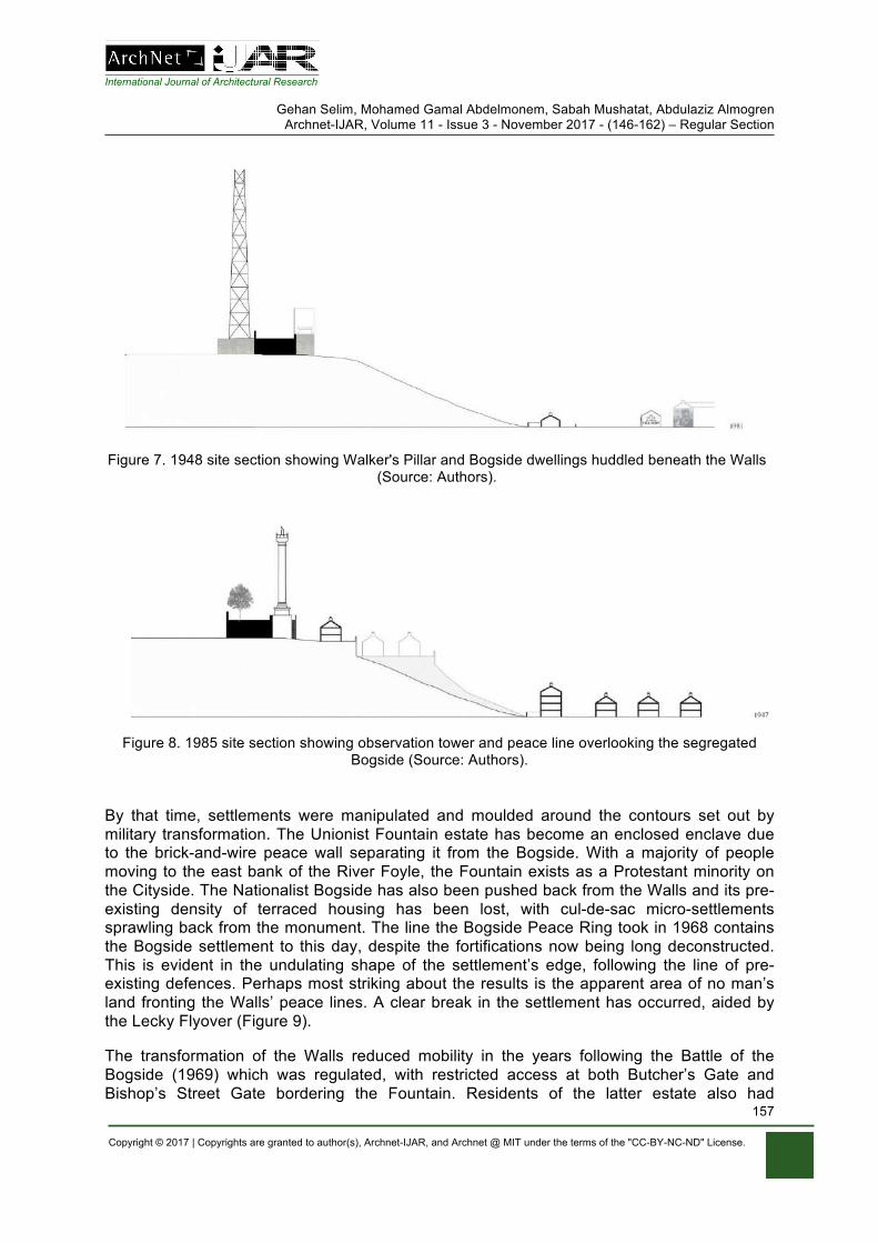
International Journal of Architectural Research
Gehan Selim, Mohamed Gamal Abdelmonem, Sabah Mushatat, Abdulaziz Almogren Archnet-IJAR, Volume 11 - Issue 3 - November 2017 - (146-162) – Regular Section
Copyright © 2017 | Copyrights are granted to author(s), Archnet-IJAR, and Archnet @ MIT under the terms of the "CC-BY-NC-ND" License.
157
Figure 7. 1948 site section showing Walker's Pillar and Bogside dwellings huddled beneath the Walls (Source: Authors).
Figure 8. 1985 site section showing observation tower and peace line overlooking the segregated Bogside (Source: Authors).
By that time, settlements were manipulated and moulded around the contours set out by military transformation. The Unionist Fountain estate has become an enclosed enclave due to the brick-and-wire peace wall separating it from the Bogside. With a majority of people moving to the east bank of the River Foyle, the Fountain exists as a Protestant minority on the Cityside. The Nationalist Bogside has also been pushed back from the Walls and its pre-existing density of terraced housing has been lost, with cul-de-sac micro-settlements sprawling back from the monument. The line the Bogside Peace Ring took in 1968 contains the Bogside settlement to this day, despite the fortifications now being long deconstructed. This is evident in the undulating shape of the settlement’s edge, following the line of pre-existing defences. Perhaps most striking about the results is the apparent area of no man’s land fronting the Walls’ peace lines. A clear break in the settlement has occurred, aided by the Lecky Flyover (Figure 9).
The transformation of the Walls reduced mobility in the years following the Battle of the Bogside (1969) which was regulated, with restricted access at both Butcher’s Gate and Bishop’s Street Gate bordering the Fountain. Residents of the latter estate also had
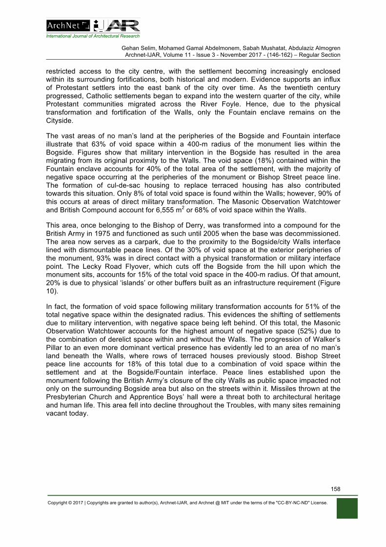
International Journal of Architectural Research
Gehan Selim, Mohamed Gamal Abdelmonem, Sabah Mushatat, Abdulaziz Almogren Archnet-IJAR, Volume 11 - Issue 3 - November 2017 - (146-162) – Regular Section
Copyright © 2017 | Copyrights are granted to author(s), Archnet-IJAR, and Archnet @ MIT under the terms of the "CC-BY-NC-ND" License.
158
restricted access to the city centre, with the settlement becoming increasingly enclosed within its surrounding fortifications, both historical and modern. Evidence supports an influx of Protestant settlers into the east bank of the city over time. As the twentieth century progressed, Catholic settlements began to expand into the western quarter of the city, while Protestant communities migrated across the River Foyle. Hence, due to the physical transformation and fortification of the Walls, only the Fountain enclave remains on the Cityside.
The vast areas of no man’s land at the peripheries of the Bogside and Fountain interface illustrate that 63% of void space within a 400-m radius of the monument lies within the Bogside. Figures show that military intervention in the Bogside has resulted in the area migrating from its original proximity to the Walls. The void space (18%) contained within the Fountain enclave accounts for 40% of the total area of the settlement, with the majority of negative space occurring at the peripheries of the monument or Bishop Street peace line. The formation of cul-de-sac housing to replace terraced housing has also contributed towards this situation. Only 8% of total void space is found within the Walls; however, 90% of this occurs at areas of direct military transformation. The Masonic Observation Watchtower and British Compound account for 6,555 m2 or 68% of void space within the Walls.
This area, once belonging to the Bishop of Derry, was transformed into a compound for the British Army in 1975 and functioned as such until 2005 when the base was decommissioned. The area now serves as a carpark, due to the proximity to the Bogside/city Walls interface lined with dismountable peace lines. Of the 30% of void space at the exterior peripheries of the monument, 93% was in direct contact with a physical transformation or military interface point. The Lecky Road Flyover, which cuts off the Bogside from the hill upon which the monument sits, accounts for 15% of the total void space in the 400-m radius. Of that amount, 20% is due to physical ‘islands’ or other buffers built as an infrastructure requirement (Figure 10).
In fact, the formation of void space following military transformation accounts for 51% of the total negative space within the designated radius. This evidences the shifting of settlements due to military intervention, with negative space being left behind. Of this total, the Masonic Observation Watchtower accounts for the highest amount of negative space (52%) due to the combination of derelict space within and without the Walls. The progression of Walker’s Pillar to an even more dominant vertical presence has evidently led to an area of no man’s land beneath the Walls, where rows of terraced houses previously stood. Bishop Street peace line accounts for 18% of this total due to a combination of void space within the settlement and at the Bogside/Fountain interface. Peace lines established upon the monument following the British Army’s closure of the city Walls as public space impacted not only on the surrounding Bogside area but also on the streets within it. Missiles thrown at the Presbyterian Church and Apprentice Boys’ hall were a threat both to architectural heritage and human life. This area fell into decline throughout the Troubles, with many sites remaining vacant today.
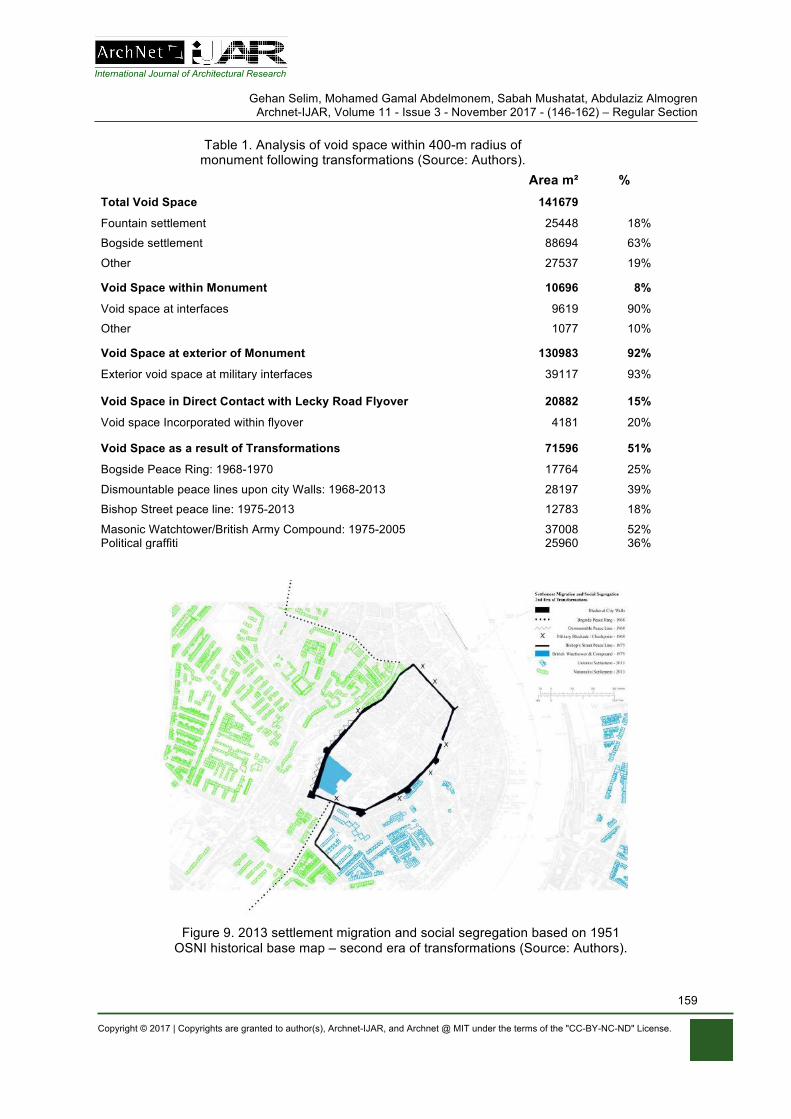
International Journal of Architectural Research
Gehan Selim, Mohamed Gamal Abdelmonem, Sabah Mushatat, Abdulaziz Almogren Archnet-IJAR, Volume 11 - Issue 3 - November 2017 - (146-162) – Regular Section
Copyright © 2017 | Copyrights are granted to author(s), Archnet-IJAR, and Archnet @ MIT under the terms of the "CC-BY-NC-ND" License.
159
Table 1. Analysis of void space within 400-m radius of monument following transformations (Source: Authors).
Area m² %
Total Void Space 141679
Fountain settlement 25448 18%
Bogside settlement 88694 63%
Other 27537 19% Void Space within Monument 10696 8%
Void space at interfaces 9619 90%
Other 1077 10% Void Space at exterior of Monument 130983 92%
Exterior void space at military interfaces 39117 93%
Void Space in Direct Contact with Lecky Road Flyover 20882 15%
Void space Incorporated within flyover 4181 20% Void Space as a result of Transformations 71596 51%
Bogside Peace Ring: 1968-1970 17764 25%
Dismountable peace lines upon city Walls: 1968-2013 28197 39%
Bishop Street peace line: 1975-2013 12783 18%
Masonic Watchtower/British Army Compound: 1975-2005 37008 52% Political graffiti 25960 36%
Figure 9. 2013 settlement migration and social segregation based on 1951 OSNI historical base map – second era of transformations (Source: Authors).
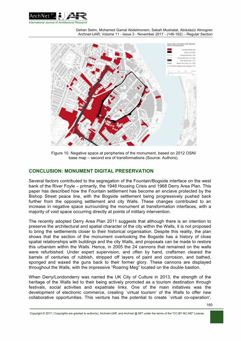
International Journal of Architectural Research
Gehan Selim, Mohamed Gamal Abdelmonem, Sabah Mushatat, Abdulaziz Almogren Archnet-IJAR, Volume 11 - Issue 3 - November 2017 - (146-162) – Regular Section
Copyright © 2017 | Copyrights are granted to author(s), Archnet-IJAR, and Archnet @ MIT under the terms of the "CC-BY-NC-ND" License.
160
Figure 10. Negative space at peripheries of the monument, based on 2012 OSNI base map – second era of transformations (Source: Authors).
CONCLUSION: MONUMENT DIGITAL PRESERVATION
Several factors contributed to the segregation of the Fountain/Bogside interface on the west bank of the River Foyle – primarily, the 1948 Housing Crisis and 1968 Derry Area Plan. This paper has described how the Fountain settlement has become an enclave protected by the Bishop Street peace line, with the Bogside settlement being progressively pushed back further from the opposing settlement and city Walls. These changes contributed to an increase in negative space surrounding the monument at transformation interfaces, with a majority of void space occurring directly at points of military intervention.
The recently adopted Derry Area Plan 2011 suggests that although there is an intention to preserve the architectural and spatial character of the city within the Walls, it is not proposed to bring the settlements closer to their historical organisation. Despite this reality, the plan shows that the section of the monument overlooking the Bogside has a history of close spatial relationships with buildings and the city Walls, and proposals can be made to restore this urbanism within the Walls. Hence, in 2005 the 24 cannons that remained on the walls were refurbished. Under expert supervision, and often by hand, craftsmen cleared the barrels of centuries of rubbish, stripped off layers of paint and corrosion, and bathed, sponged and waxed the guns back to their former glory. These cannons are displayed throughout the Walls, with the impressive “Roaring Meg” located on the double bastion.
When Derry/Londonderry was named the UK City of Culture in 2013, the strength of the heritage of the Walls led to their being actively promoted as a tourism destination through festivals, social activities and expatriate links. One of the main initiatives was the development of electronic commerce, creating `virtual tourism’ of the Walls to offer new collaborative opportunities. This venture has the potential to create `virtual co-operation',
International Journal of Architectural Research
Gehan Selim, Mohamed Gamal Abdelmonem, Sabah Mushatat, Abdulaziz Almogren Archnet-IJAR, Volume 11 - Issue 3 - November 2017 - (146-162) – Regular Section
Copyright © 2017 | Copyrights are granted to author(s), Archnet-IJAR, and Archnet @ MIT under the terms of the "CC-BY-NC-ND" License.
161
whereby potential tourists are able to browse the website, develop a coherent picture of the 400-year-old Walls and experience their history by taking a stroll along the rampart walkway (NI Government, 2013). A set of 360 cameras document the main four points on the wall – Bishop’s Gate, Butcher Gate, Shipquay Gate and Ferryquay Gate. Famously, the latter was closed by 13 apprentices to prevent Jacobite troops from entering the city, leading to the siege of 1689, while the Double Bastion offers a fine panoramic view over the Bogside and the slopes above where Jacobite guns were positioned during that siege.
The interactive website provides a good opportunity for uplifting the tourism market in Derry/Londonderry by uniquely fashioning together specific components of the Walls sought by individual visitors. In addition, in 2013, through a fund established by the Northern Ireland Environment Agency (NIEA), the Department of Communities published Walk the Walls, a visitor guide, and developed an interactive mobile-friendly App that provides an exclusive guide to the history of the city and the Walls using CGI, videos, photos and 3D-animations. Some of its key features include a 3D-image of the Walls with each gate identified, a GPS map showing the location of 12 key sites along Walls and 'Stories of the Siege' sections that provide colourful information on events in 1689.
The heritage of conflict in Derry/Londonderry is one of the most fiercely contested heritage in contemporary Europe. The irony of that conflict lies in the way it has altered the urban fabric, landscape and demography of the city with forced segregation due to violence, yet it preserved its historic wall. With grievances continuing until the present day and young generations embroiled by the remnant of such history of violence, virtual heritage applications emerge as non-physical, neutral and adaptive tools that allows different stories to appear side by side. While history is contested in Northern Ireland, the visualisation of its conflict and the understanding of its urban change has offered some grounds for a neutral domain for the benefit of the distant onlookers or temporary visitors.
NOTE This article reports on research that investigates the landscapes of division in NI. Thanks are due to James Boyd for his support with fieldwork.
REFERENCES
Abdelmonem, M. G., & McWhinney, R. (2015). In search of common grounds: Stitching the divided landscape of urban parks in Belfast's interface zones. Cities, 44, 40-49.
Cornforth, J. (1985a). Survival of a city: Londonderry I. Country Life, 178 (4596), 784-787. Cornforth, J. (1985b). The grid within the Walls: Londonderry II. Country Life, 178 (4598), 974-976. Cornforth, J. (1985c). Views of a city: Londonderry III. Country Life, 178 (4599) 1060-1062. Creighton, O. (2007). Contested townscapes: the walled city as world heritage. World Archaeology,
39(3), 339-354. Deane, S. (1992). Derry: City besieged within the siege. Fortnight, 198, 18-19. Deane, S. (1997). Reading in the dark. London, Vintage. Doratli, N., Hoskara, S. O., & Fasli, M (2004). An analytical methodology for revitalization strategies in
historic urban quarters: A case study of the Walled City of Nicosia, North Cyprus. Cities, 21(4), 329-348.
Docwra, H., & Kelly, W. (2008). Docwra’s Derry: A narration of events in north-west Ulster 1600-1604. Belfast: Ulster Historical Foundation.
Free Derry Museum website. Retrieved from http://www.museumoffreederry.org/history-bogside01.html
Hamilton, R. (1999). 100 years of Derry. Belfast: Blackstaff Press.
International Journal of Architectural Research
Gehan Selim, Mohamed Gamal Abdelmonem, Sabah Mushatat, Abdulaziz Almogren Archnet-IJAR, Volume 11 - Issue 3 - November 2017 - (146-162) – Regular Section
Copyright © 2017 | Copyrights are granted to author(s), Archnet-IJAR, and Archnet @ MIT under the terms of the "CC-BY-NC-ND" License.
162
Hippsley, P (2012). The Walls of Derry, Londonderry. Retrieved from http://www.derryswalls.com. Hume, J. (2002). Derry beyond the walls: Social and economic aspects of the growth of Derry: 1825-
1850. Belfast: Ulster Historical Foundation. Huyssen, A. (2003). Present pasts: Urban palimpsests and the politics of memory. Chicago: Stanford
University Press. McDowell, S., & Switzer, C. (2011). Violence and the vernacular: Conflict, commemoration &
rebuilding in the urban context. Journal of the Vernacular Architecture Forum, 18(2), 82-104. McSheffrey, G. (2000). Planning Derry: Planning and politics in Northern Ireland. Liverpool: Liverpool
University Press. Milligan, C. D. (1948). The Walls of Derry: Their building, defending and preserving. Londonderry: the
Londonderry Sentinel Printing Works. Misselwitz, P. and Rieniets, T. (2006). City of collision: Jerusalem and the principles of conflict
urbanism. Walter de Gruyter: Switzerland. Murtagh, B. (1996). On Derry’s Walls, segregation and space in Northern Ireland. Administration,
44(1), 30-47. Murtagh, B., Boland, P., & Shirlow, P. (2017). Contested heritages and cultural tourism. International
Journal of Heritage Studies, 23(6), 506-520. http://dx.doi.org/10.1080/13527258.2017.1287118 Mulholland, C., Abdelmonem, M. G., & Selim, G. (2014). Narratives of Spatial Division: The Role of
Social Memory in Shaping Urban Space in Belfast. Journal of Civil Engineering and Architecture, 8(6), 746-760.
Northern Ireland Government (2011). Derry City Walls Gazetteer October 2011. Retrieved from https://www.communities-ni.gov.uk/publications/derry-city-walls-gazetteer-october-2011
Northern Ireland Government (2017). The Derry Walls. Retrieved from: https://www.communities-ni.gov.uk/articles/conservation-case-studies
Ó Dochartaigh, N. (1997). From Civil Rights to Armalites: Derry and the birth of the Irish Troubles, 1st edn. Cork: Cork University Press.
Ó Dochartaigh, N. (1999). The Politics of Housing; Social Change and Collective Action in Derry in the 1960s (625-646). In Derry and Londonderry: History and Society. Dublin: Geography Publications.
Pinimg (n.d.). Bogside demolition and construction of Rossville Flats in 1963. Retrieved from: https://s-media-cache ak0.pinimg.com/736x/4a/0f/97/4a0f97bd9a9a2b81ab974921f6be5090--irish-flats.jpg
Planning Northern Ireland (2011). Derry Area Plan. Retrieved from https://www.planningni.gov.uk/index/policy/development_plans/devplans_az/derry_2011/derry_benvironment/derry_benv_policies/derry_benv_policies2.htm
Selim, G. (2015). The Landscape of Differences: Contact and Segregation in the Everyday Encounters. Cities, 46, 16 - 25.
Selim, G., & Abraham, A. (2016). Peace by Piece: (Re) imagining Division in Belfast’s Contested Spaces through Memory. Athens Journal of Architecture, 2(3), 197-221.
Thomas, A. (2005). Irish historic towns atlas – Derry/Londonderry. Dublin, Royal Irish Academy. Weizman, E. (2012). Hollow land: Israel’s architecture of occupation. London, Verso Books.
Khairi M. A. Abdulla, Mohamed Gamal Abdelmonem, Gehan Selim Archnet-IJAR, Volume 11 - Issue 3 - November 2017 - (163-177) – Regular Section
Copyright © 2017 | Copyrights are granted to author(s), Archnet-IJAR, and Archnet @ MIT under the terms of the "CC-BY-NC-ND" License.
163
Archnet-IJAR: International Journal of Architectural Research www.archnet-ijar.net/ -- https://archnet.org/collections/34
WALKABILITY IN HISTORIC URBAN SPACES: TESTING THE SAFETY AND SECURITY IN MARTYRS' SQUARE IN TRIPOLI DOI: http://dx.doi.org/10.26687/archnet-ijar.v11i3.1378
Khairi M. A. Abdulla, Mohamed Gamal Abdelmonem, Gehan Selim
Keywords
Abstract
walkability; safety and security; open space; historical space
Much of the built environment design literature focuses on a composite of walkable spaces variables such as density, diversity, and destination accessibility. One of the most effective factors in walkability is “safety and security”. There is an evident gap in understanding the perceived ability of Libyan public spaces to support walkability. This paper aims to investigate the effectiveness of “walkability” in traditional Libyan urban spaces and analyse the relationship between walking, a safe and secure environment, and its impact on a heritage site in Tripoli city centre. The perceived personal safety of 140 users of the heritage site “Martyrs' Square” were measured; this research is studying the quality of environment and users’ interaction with their environmental issues relating to the study area. Mixed methods were used in this research: this study used both quantitative and qualitative methods to gather information; the quantitative took the form of a questionnaire; and the qualitative took the form of observations. Analysis of quantitative data was conducted with SPSS software; the survey was conducted from August 2016 to September 2016. The results of this study are useful for urban planning, to classify the walkable urban space elements, which could improve the level of walkability in Libyan cities and create sustainable and liveable urban spaces.
Khairi M. A. Abdulla*, Mohamed Gamal Abdelmonem, Gehan Selim
K. M. A. Abdulla, Nottingham Trent University, UK M. G. Abdelmonem, Chair in Architecture, Nottingham Trent University, UK. G. Selim, Lecturer in Architecture, University of Leeds, Leeds, UK.
*Corresponding Author’s email address: [email protected]
ArchNet-IJAR is indexed and listed in several databases, including: • Avery Index to Architectural
Periodicals • EBSCO-Current Abstracts-Art
and Architecture • CNKI: China National
Knowledge Infrastructure • DOAJ: Directory of Open
Access Journals • Pro-Quest • Scopus-Elsevier • Web of Science
International Journal of Architectural Research
Khairi M. A. Abdulla, Mohamed Gamal Abdelmonem, Gehan Selim Archnet-IJAR, Volume 11 - Issue 3 - November 2017 - (163-177) – Regular Section
Copyright © 2017 | Copyrights are granted to author(s), Archnet-IJAR, and Archnet @ MIT under the terms of the "CC-BY-NC-ND" License.
164
INTRODUCTION
Walkability and city design have both been studied for a long time, with notable works including The Life and Death of Great American Cities (Jacobs, 1961) followed by Cook (1980), while Gehl (1989) was the first researcher to use walkable streets, street activity and city vitality as an index of successful and growing urban areas. Their approaches towards urban design of communities was not only limited to the design of outside spatial characteristics, but also the activities that happen there. Various studies acknowledge that the level of walkability and other physical activities is positively associated with specific open space design qualities. In the USA, walking is the most common form of physical activity, with national estimates indicating roughly 42% of adults walk during leisure time and 28% walk for transportation purposes in periods of at least 10 min (Kruger et al., 2008).
Child and Falconer (2015) reported that improvements to public spaces could increase footfall and trading by up to 40%, with users of open spaces being more physically active if provided with accessible, safe and attractive areas for exercise, as observed in some walkways used by residents of cities. There are several categories to determine the quality and attractiveness of walkability in public spaces in Libyan cities, most of important of which is safety (Abdulla et al., 2017). This research explores the relationship between safety and walkability in heritage spaces, and how safety-security affects walkability in historic urban spaces, in the context of Tripoli, Libya. It examines the concept of walkability in heritage public spaces within the urban context of Libyan cities. Additionally, the study explores the relationship between safety-security and aspects of the built environment, focusing in particular on the walkability of heritage spaces as determined by the mix of land uses.
Ewing and Cervero (2010) refer to over 200 studies in the relationship between the built environment and travel, as well as more than 13 literature reviews and 2 meta-analyses. (Badoe and Miller, 2000; Cao et al., 2009; Cervero and Duncan, 2003; Crane, 2000; Ewing and Cervero, 2001, 2010; Handy et al., 2005; Heath et al., 2006; McMillan, 2005, 2007; Pont et al., 2009; Saelens et al., 2003; Saelens and Handy, 2008; Leck, 2006). There are different motivations for walking that require different elements from the built environment (Zuniga-Teran et al., 2017). Two primary motivations for walking have been identified by behavioural scientists: recreation, and transportation (Giles-Corti et al., 2005; Saelens and Handy, 2008). Cubukcu (2013) illustrated seven groups of elements from a review of literature that can make a place walkable: land use safety; traffic; crime rate; ease in walking and cycling; accessibility; environmental aesthetics, and others associated with social relations in open places.
Alfonso (2005) established the hierarchy of walking needs, a theoretical model of the decision process in designing walkable public open space, Figure 1. It has been used as a framework in various recent studies. Alfonso (2005) wrote that “This model can (a) serve as a framework by which to understand the relative significance of the cornucopia of variables identified by existing research, (b) offer hypotheses for how these factors affect peoples' decision to walk, and (c) help to guide future research and practice”. Mehta (2008) combined the perceptual element of Ewing and Handy’s (2009) conceptual model of the environment with an ecological model of walking behaviour. Stockton et al. (2016) have developed a walkability model for London; they have measured connectivity, residential density, and land use mix, and observed a radial decay in walkability. On other hand, Abdulla et al. (2016) indicate that a pedestrian’s level of walking in Tripoli, Libya depends not only on built environment factors but also on feelings of safety and security, as well as many complex considerations for user comfort.
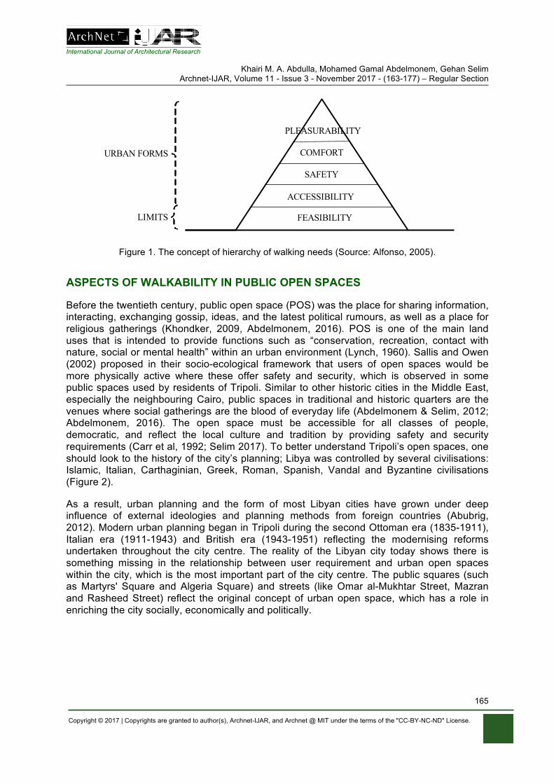
International Journal of Architectural Research
Khairi M. A. Abdulla, Mohamed Gamal Abdelmonem, Gehan Selim Archnet-IJAR, Volume 11 - Issue 3 - November 2017 - (163-177) – Regular Section
Copyright © 2017 | Copyrights are granted to author(s), Archnet-IJAR, and Archnet @ MIT under the terms of the "CC-BY-NC-ND" License.
165
FEASIBILITY
ACCESSIBILITY
SAFETY
COMFORT
PLEASURABILITY
LIMITS
URBAN FORMS
Figure 1. The concept of hierarchy of walking needs (Source: Alfonso, 2005).
ASPECTS OF WALKABILITY IN PUBLIC OPEN SPACES
Before the twentieth century, public open space (POS) was the place for sharing information, interacting, exchanging gossip, ideas, and the latest political rumours, as well as a place for religious gatherings (Khondker, 2009, Abdelmonem, 2016). POS is one of the main land uses that is intended to provide functions such as “conservation, recreation, contact with nature, social or mental health” within an urban environment (Lynch, 1960). Sallis and Owen (2002) proposed in their socio-ecological framework that users of open spaces would be more physically active where these offer safety and security, which is observed in some public spaces used by residents of Tripoli. Similar to other historic cities in the Middle East, especially the neighbouring Cairo, public spaces in traditional and historic quarters are the venues where social gatherings are the blood of everyday life (Abdelmonem & Selim, 2012; Abdelmonem, 2016). The open space must be accessible for all classes of people, democratic, and reflect the local culture and tradition by providing safety and security requirements (Carr et al, 1992; Selim 2017). To better understand Tripoli’s open spaces, one should look to the history of the city’s planning; Libya was controlled by several civilisations: Islamic, Italian, Carthaginian, Greek, Roman, Spanish, Vandal and Byzantine civilisations (Figure 2).
As a result, urban planning and the form of most Libyan cities have grown under deep influence of external ideologies and planning methods from foreign countries (Abubrig, 2012). Modern urban planning began in Tripoli during the second Ottoman era (1835-1911), Italian era (1911-1943) and British era (1943-1951) reflecting the modernising reforms undertaken throughout the city centre. The reality of the Libyan city today shows there is something missing in the relationship between user requirement and urban open spaces within the city, which is the most important part of the city centre. The public squares (such as Martyrs' Square and Algeria Square) and streets (like Omar al-Mukhtar Street, Mazran and Rasheed Street) reflect the original concept of urban open space, which has a role in enriching the city socially, economically and politically.
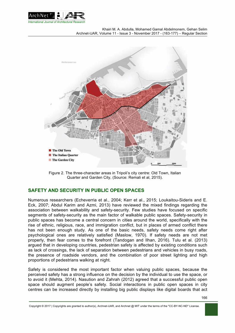
International Journal of Architectural Research
Khairi M. A. Abdulla, Mohamed Gamal Abdelmonem, Gehan Selim Archnet-IJAR, Volume 11 - Issue 3 - November 2017 - (163-177) – Regular Section
Copyright © 2017 | Copyrights are granted to author(s), Archnet-IJAR, and Archnet @ MIT under the terms of the "CC-BY-NC-ND" License.
166
Figure 2. The three-character areas in Tripoli’s city centre: Old Town, Italian Quarter and Garden City, (Source: Remali et al, 2015).
SAFETY AND SECURITY IN PUBLIC OPEN SPACES
Numerous researchers (Echeverria et al., 2004; Kerr et al., 2015; Loukaitou-Sideris and E. Eck, 2007; Abdul Karim and Azmi, 2013) have reviewed the mixed findings regarding the association between walkability and safety-security. Few studies have focused on specific segments of safety-security as the main factor of walkable public spaces. Safety-security in public spaces has become a central concern in cities around the world, specifically with the rise of ethnic, religious, race, and immigration conflict, but in places of armed conflict there has not been enough study. As one of the basic needs, safety needs come right after psychological ones are relatively satisfied (Maslow, 1970). If safety needs are not met properly, then fear comes to the forefront (Tandogan and Ilhan, 2016). Tulu et al. (2013) argued that in developing countries, pedestrian safety is affected by existing conditions such as lack of crossings, the lack of separation between pedestrians and vehicles in busy roads, the presence of roadside vendors, and the combination of poor street lighting and high proportions of pedestrians walking at night.
Safety is considered the most important factor when valuing public spaces, because the perceived safety has a strong influence on the decision by the individual to use the space, or to avoid it (Mehta, 2014). Nasution and Zahrah (2012) agreed that a successful public open space should augment people’s safety. Social interactions in public open spaces in city centres can be increased directly by installing big public displays like digital boards that act
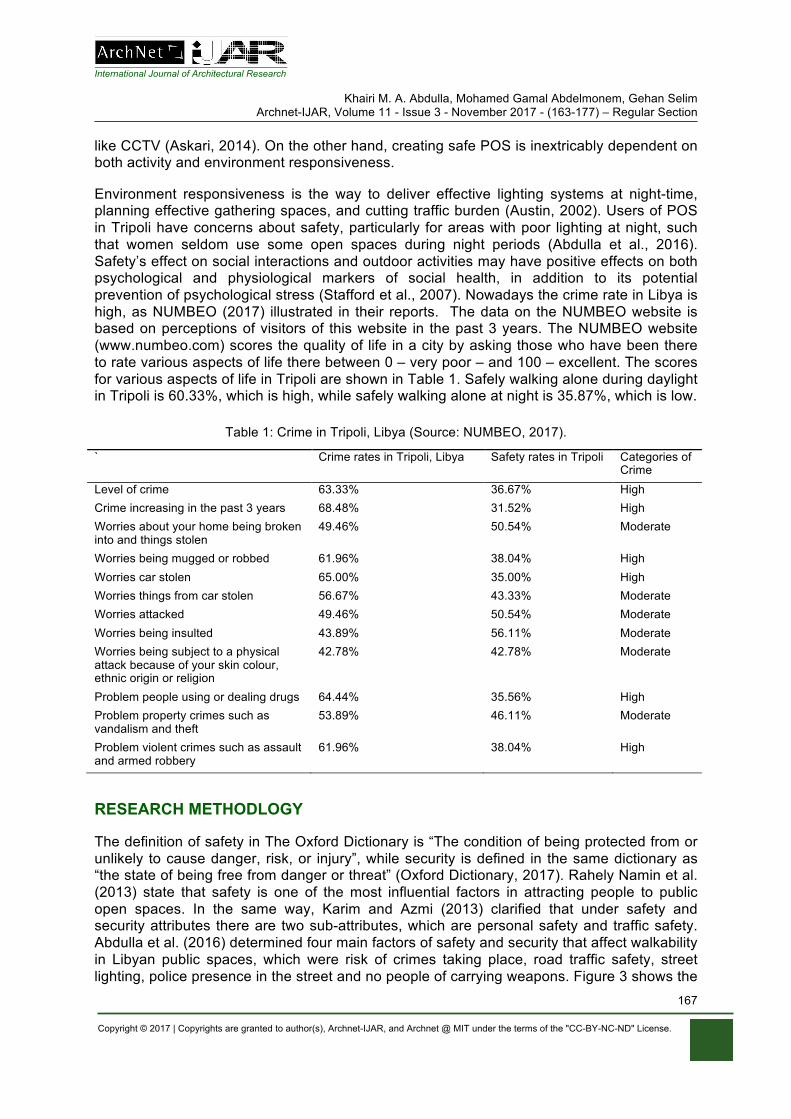
International Journal of Architectural Research
Khairi M. A. Abdulla, Mohamed Gamal Abdelmonem, Gehan Selim Archnet-IJAR, Volume 11 - Issue 3 - November 2017 - (163-177) – Regular Section
Copyright © 2017 | Copyrights are granted to author(s), Archnet-IJAR, and Archnet @ MIT under the terms of the "CC-BY-NC-ND" License.
167
like CCTV (Askari, 2014). On the other hand, creating safe POS is inextricably dependent on both activity and environment responsiveness.
Environment responsiveness is the way to deliver effective lighting systems at night-time, planning effective gathering spaces, and cutting traffic burden (Austin, 2002). Users of POS in Tripoli have concerns about safety, particularly for areas with poor lighting at night, such that women seldom use some open spaces during night periods (Abdulla et al., 2016). Safety’s effect on social interactions and outdoor activities may have positive effects on both psychological and physiological markers of social health, in addition to its potential prevention of psychological stress (Stafford et al., 2007). Nowadays the crime rate in Libya is high, as NUMBEO (2017) illustrated in their reports. The data on the NUMBEO website is based on perceptions of visitors of this website in the past 3 years. The NUMBEO website (www.numbeo.com) scores the quality of life in a city by asking those who have been there to rate various aspects of life there between 0 – very poor – and 100 – excellent. The scores for various aspects of life in Tripoli are shown in Table 1. Safely walking alone during daylight in Tripoli is 60.33%, which is high, while safely walking alone at night is 35.87%, which is low.
Table 1: Crime in Tripoli, Libya (Source: NUMBEO, 2017).
` Crime rates in Tripoli, Libya Safety rates in Tripoli Categories of Crime
Level of crime 63.33% 36.67% High Crime increasing in the past 3 years 68.48% 31.52% High Worries about your home being broken into and things stolen
49.46% 50.54% Moderate
Worries being mugged or robbed 61.96% 38.04% High Worries car stolen 65.00% 35.00% High Worries things from car stolen 56.67% 43.33% Moderate Worries attacked 49.46% 50.54% Moderate Worries being insulted 43.89% 56.11% Moderate Worries being subject to a physical attack because of your skin colour, ethnic origin or religion
42.78% 42.78% Moderate
Problem people using or dealing drugs 64.44% 35.56% High Problem property crimes such as vandalism and theft
53.89% 46.11% Moderate
Problem violent crimes such as assault and armed robbery
61.96% 38.04% High
RESEARCH METHODLOGY
The definition of safety in The Oxford Dictionary is “The condition of being protected from or unlikely to cause danger, risk, or injury”, while security is defined in the same dictionary as “the state of being free from danger or threat” (Oxford Dictionary, 2017). Rahely Namin et al. (2013) state that safety is one of the most influential factors in attracting people to public open spaces. In the same way, Karim and Azmi (2013) clarified that under safety and security attributes there are two sub-attributes, which are personal safety and traffic safety. Abdulla et al. (2016) determined four main factors of safety and security that affect walkability in Libyan public spaces, which were risk of crimes taking place, road traffic safety, street lighting, police presence in the street and no people of carrying weapons. Figure 3 shows the
International Journal of Architectural Research
Khairi M. A. Abdulla, Mohamed Gamal Abdelmonem, Gehan Selim Archnet-IJAR, Volume 11 - Issue 3 - November 2017 - (163-177) – Regular Section
Copyright © 2017 | Copyrights are granted to author(s), Archnet-IJAR, and Archnet @ MIT under the terms of the "CC-BY-NC-ND" License.
168
conceptual model by the authors, based on literature from the theoretical framework. This research is studying the quality of environment, and users’ interaction with their environment issues relating to the study area.
The study used both quantitative and qualitative methods to gather information: the quantitative took the form of a questionnaire and the qualitative took the form of observations. Analysis of data was conducted with the Statistical Package for the Social Sciences (SPSS version 22) and qualitative analysis. The conceptual framework in Figure 3 presents the analysis of the relationship between safety, security and walkability in a historical public open space concerning personal safety, traffic safety and safety in law enforcement.
Libyan cities increased their population by more than 90% during the twentieth century (Saad, 1995). Tripoli has been rapidly growing and its population has tripled in less than 20 years, from 0.5 million in 1993 to 1.5 million in 2013 (Bureau of Statistics and Census-Libya, 2010), as well as most Libyan people wanting to visit historical places in Tripoli (such as the old city and Martyrs' Square). Furthermore, some of Tripoli’s main public open spaces, such as Martyrs’ Square, were extensively used by many people meeting to show their political support for and/or objections against the former regime during the conflict in 2011. Protests, prayers, celebrations, political debate, and the sharing of moments of joy and mourning have all been experienced in these historical symbolic urban public centres (El-Allous, 2016). Moreover, the regulations of land use applied since the 1990s preclude overcoming most of these difficulties. Many open spaces and streets which were for pedestrians have been destroyed under these regulations (Lakhder & Dugeny, 2010). Additionally, the current crisis in Libya has helped the rise of crime, as well as spreading illegal activities, such as parking on pedestrian ways and selling merchandise in the street.
In addition, the lack of clear pedestrian pathways from Martyrs’ Square to Omer Al-Mukhtar Street, and the mix between motor traffic and pedestrian movement, does not improve comfort or aesthetic enjoyment of the central area (Alzklaa, 2016). Martyrs’ Square (MS) is a public open space located in the centre of Tripoli, founded in the 20th century in the time of Italian colonialism, where it was named "Piazza Italia". After the independence of Libya in 1951 it was changed to Independence Square, and then changed to MS and then Green Square in the years of Gaddafi's rule; nowadays it is named MS again. Within the city of Tripoli, MS is located on the coastline, on the northern side of the city.
The square is the centre of the city, bordered by the Al-Saraya Al-Hamra and the seaport columns, and the old city in the North: it is one of the monuments of Tripoli. There are a number of main streets that branch out from it, such as Omar Al-Mukhtar Street, Mezzran Street, and 24 December Street (Zaqlai, 2016). The square has served as a central stage for key political events: from the Italian occupation to Libyan independence, and throughout the rule of Gaddafi, to the violent conflicts in post-Gaddafi Libya. Both pro- as well as anti-government actors have tried to use the square as a stage during these different periods.
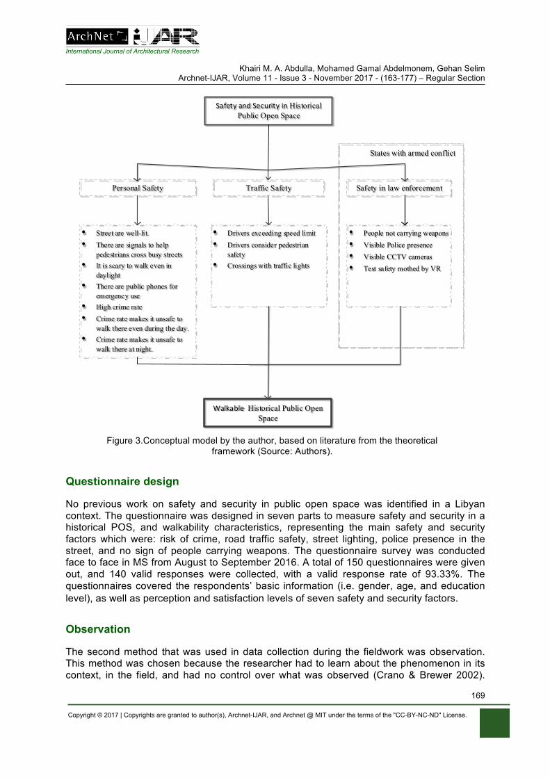
International Journal of Architectural Research
Khairi M. A. Abdulla, Mohamed Gamal Abdelmonem, Gehan Selim Archnet-IJAR, Volume 11 - Issue 3 - November 2017 - (163-177) – Regular Section
Copyright © 2017 | Copyrights are granted to author(s), Archnet-IJAR, and Archnet @ MIT under the terms of the "CC-BY-NC-ND" License.
169
SafetyandSecurityinHistorical Public Open Space
Personal Safety Traffic Safety
• Street are well-lit. • There are signals to help
pedestrians cross busy streets• It is scary to walk even in
daylight• There are public phones for
emergency use• High crime rate • Crime rate makes it unsafe to
walk there even during the day.• Crime rate makes it unsafe to
walk there at night.
• Drivers exceeding speed limit• Drivers consider pedestrian
safety• Crossings with traffic lights
WalkableHistorical Public Open Space
Safety in law enforcement
• People not carrying weapons• Visible Police presence• Visible CCTV cameras• Test safety mothed by VR
States with armed conflict
Figure 3.Conceptual model by the author, based on literature from the theoretical
framework (Source: Authors).
Questionnaire design
No previous work on safety and security in public open space was identified in a Libyan context. The questionnaire was designed in seven parts to measure safety and security in a historical POS, and walkability characteristics, representing the main safety and security factors which were: risk of crime, road traffic safety, street lighting, police presence in the street, and no sign of people carrying weapons. The questionnaire survey was conducted face to face in MS from August to September 2016. A total of 150 questionnaires were given out, and 140 valid responses were collected, with a valid response rate of 93.33%. The questionnaires covered the respondents’ basic information (i.e. gender, age, and education level), as well as perception and satisfaction levels of seven safety and security factors.
Observation
The second method that was used in data collection during the fieldwork was observation. This method was chosen because the researcher had to learn about the phenomenon in its context, in the field, and had no control over what was observed (Crano & Brewer 2002).
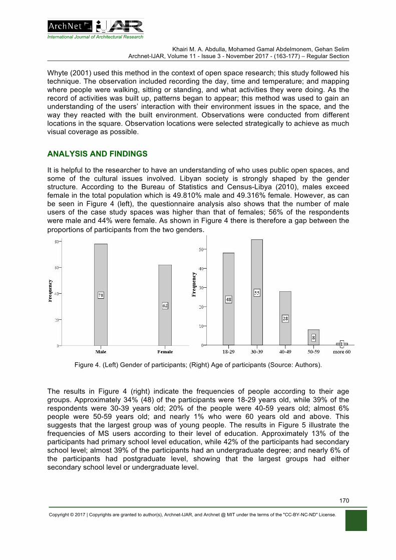
International Journal of Architectural Research
Khairi M. A. Abdulla, Mohamed Gamal Abdelmonem, Gehan Selim Archnet-IJAR, Volume 11 - Issue 3 - November 2017 - (163-177) – Regular Section
Copyright © 2017 | Copyrights are granted to author(s), Archnet-IJAR, and Archnet @ MIT under the terms of the "CC-BY-NC-ND" License.
170
Whyte (2001) used this method in the context of open space research; this study followed his technique. The observation included recording the day, time and temperature; and mapping where people were walking, sitting or standing, and what activities they were doing. As the record of activities was built up, patterns began to appear; this method was used to gain an understanding of the users’ interaction with their environment issues in the space, and the way they reacted with the built environment. Observations were conducted from different locations in the square. Observation locations were selected strategically to achieve as much visual coverage as possible.
ANALYSIS AND FINDINGS
It is helpful to the researcher to have an understanding of who uses public open spaces, and some of the cultural issues involved. Libyan society is strongly shaped by the gender structure. According to the Bureau of Statistics and Census-Libya (2010), males exceed female in the total population which is 49.810% male and 49.316% female. However, as can be seen in Figure 4 (left), the questionnaire analysis also shows that the number of male users of the case study spaces was higher than that of females; 56% of the respondents were male and 44% were female. As shown in Figure 4 there is therefore a gap between the proportions of participants from the two genders.
Figure 4. (Left) Gender of participants; (Right) Age of participants (Source: Authors).
The results in Figure 4 (right) indicate the frequencies of people according to their age groups. Approximately 34% (48) of the participants were 18-29 years old, while 39% of the respondents were 30-39 years old; 20% of the people were 40-59 years old; almost 6% people were 50-59 years old; and nearly 1% who were 60 years old and above. This suggests that the largest group was of young people. The results in Figure 5 illustrate the frequencies of MS users according to their level of education. Approximately 13% of the participants had primary school level education, while 42% of the participants had secondary school level; almost 39% of the participants had an undergraduate degree; and nearly 6% of the participants had postgraduate level, showing that the largest groups had either secondary school level or undergraduate level.
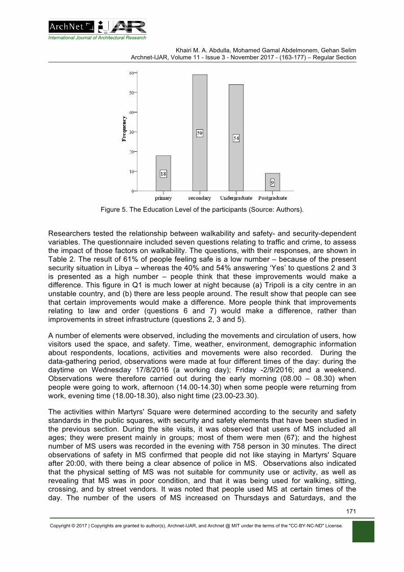
International Journal of Architectural Research
Khairi M. A. Abdulla, Mohamed Gamal Abdelmonem, Gehan Selim Archnet-IJAR, Volume 11 - Issue 3 - November 2017 - (163-177) – Regular Section
Copyright © 2017 | Copyrights are granted to author(s), Archnet-IJAR, and Archnet @ MIT under the terms of the "CC-BY-NC-ND" License.
171
Figure 5. The Education Level of the participants (Source: Authors).
Researchers tested the relationship between walkability and safety- and security-dependent variables. The questionnaire included seven questions relating to traffic and crime, to assess the impact of those factors on walkability. The questions, with their responses, are shown in Table 2. The result of 61% of people feeling safe is a low number – because of the present security situation in Libya – whereas the 40% and 54% answering ‘Yes’ to questions 2 and 3 is presented as a high number – people think that these improvements would make a difference. This figure in Q1 is much lower at night because (a) Tripoli is a city centre in an unstable country, and (b) there are less people around. The result show that people can see that certain improvements would make a difference. More people think that improvements relating to law and order (questions 6 and 7) would make a difference, rather than improvements in street infrastructure (questions 2, 3 and 5).
A number of elements were observed, including the movements and circulation of users, how visitors used the space, and safety. Time, weather, environment, demographic information about respondents, locations, activities and movements were also recorded. During the data-gathering period, observations were made at four different times of the day: during the daytime on Wednesday 17/8/2016 (a working day); Friday -2/9/2016; and a weekend. Observations were therefore carried out during the early morning (08.00 – 08.30) when people were going to work, afternoon (14.00-14.30) when some people were returning from work, evening time (18.00-18.30), also night time (23.00-23.30).
The activities within Martyrs' Square were determined according to the security and safety standards in the public squares, with security and safety elements that have been studied in the previous section. During the site visits, it was observed that users of MS included all ages; they were present mainly in groups; most of them were men (67); and the highest number of MS users was recorded in the evening with 758 person in 30 minutes. The direct observations of safety in MS confirmed that people did not like staying in Martyrs' Square after 20:00, with there being a clear absence of police in MS. Observations also indicated that the physical setting of MS was not suitable for community use or activity, as well as revealing that MS was in poor condition, and that it was being used for walking, sitting, crossing, and by street vendors. It was noted that people used MS at certain times of the day. The number of the users of MS increased on Thursdays and Saturdays, and the
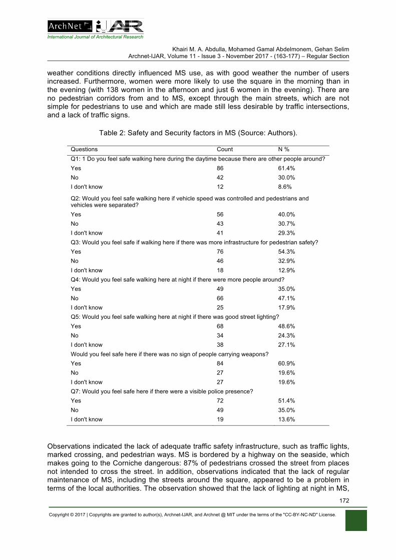
International Journal of Architectural Research
Khairi M. A. Abdulla, Mohamed Gamal Abdelmonem, Gehan Selim Archnet-IJAR, Volume 11 - Issue 3 - November 2017 - (163-177) – Regular Section
Copyright © 2017 | Copyrights are granted to author(s), Archnet-IJAR, and Archnet @ MIT under the terms of the "CC-BY-NC-ND" License.
172
weather conditions directly influenced MS use, as with good weather the number of users increased. Furthermore, women were more likely to use the square in the morning than in the evening (with 138 women in the afternoon and just 6 women in the evening). There are no pedestrian corridors from and to MS, except through the main streets, which are not simple for pedestrians to use and which are made still less desirable by traffic intersections, and a lack of traffic signs.
Table 2: Safety and Security factors in MS (Source: Authors).
Questions Count N % Q1: 1 Do you feel safe walking here during the daytime because there are other people around? Yes 86 61.4% No 42 30.0% I don't know 12 8.6%
Q2: Would you feel safe walking here if vehicle speed was controlled and pedestrians and vehicles were separated? Yes 56 40.0% No 43 30.7% I don't know 41 29.3% Q3: Would you feel safe if walking here if there was more infrastructure for pedestrian safety? Yes 76 54.3% No 46 32.9% I don't know 18 12.9% Q4: Would you feel safe walking here at night if there were more people around? Yes 49 35.0% No 66 47.1% I don't know 25 17.9% Q5: Would you feel safe walking here at night if there was good street lighting? Yes 68 48.6% No 34 24.3% I don't know 38 27.1% Would you feel safe here if there was no sign of people carrying weapons? Yes 84 60.9% No 27 19.6% I don't know 27 19.6% Q7: Would you feel safe here if there were a visible police presence? Yes 72 51.4% No 49 35.0% I don't know 19 13.6%
Observations indicated the lack of adequate traffic safety infrastructure, such as traffic lights, marked crossing, and pedestrian ways. MS is bordered by a highway on the seaside, which makes going to the Corniche dangerous: 87% of pedestrians crossed the street from places not intended to cross the street. In addition, observations indicated that the lack of regular maintenance of MS, including the streets around the square, appeared to be a problem in terms of the local authorities. The observation showed that the lack of lighting at night in MS,
International Journal of Architectural Research
Khairi M. A. Abdulla, Mohamed Gamal Abdelmonem, Gehan Selim Archnet-IJAR, Volume 11 - Issue 3 - November 2017 - (163-177) – Regular Section
Copyright © 2017 | Copyrights are granted to author(s), Archnet-IJAR, and Archnet @ MIT under the terms of the "CC-BY-NC-ND" License.
173
due to power outages for long hours or the lack of regular maintenance of the lamps in MS, gave the users a sense of insecurity.
DISCUSSIONS OF FINDINGS
According to Table 2, the investigation asserted that there are six main safety and security factors underlying people’s evaluation of the characteristics of public open spaces in the context of their appeal for walking. Furthermore, fear is also a social or collective experience, rather than only an individual state (Pain & Smith, 2008). Before 2011, Libya was one of the safest countries in the region, as Khalifa (2010) illustrated in his interview with a tourist in Libya: “It’s very safe; Libya is the safest country in the region. It is worth remembering that this is the only place in the whole region that has not had any bombs. It is not paradise, but Libyans are not extremists”. The main safety and security factors will be discussed in this section.
Firstly, ‘the feeling of safety makes a place more walkable’. Apparently, gender imposes a significant impact on people’s opinions about the length of stay in public open spaces. According to the survey, females who use MS have more fear of crime, where 53% of females feel scared when walking in this place during the day and 70% of females feel scared when walking in MS during the evening or nighttime. Also from the observations, the study found that women take several precautions in MS due to their fear of offences. They never come or stay in the dark and never walk through the old city alone. In general, there is a lack of feeling safe among the users of MS and this is due to the situation in Libya nowadays.
Secondly, imposing a speed limit and separating pedestrians and vehicles would improve walkability; according to the survey results, the vehicle speed limit is also a significant factor on walkability and safety. As can be seen, in general, the majority of participants crossed the highway daily or weekly, and most participants perceived the traffic in the area as dangerous or very dangerous. Moreover, with more pedestrians crossing the intersection, more traffic accidents will be caused, especially on the highway (Corniche Road) which separates MS from the Corniche. Furthermore, due to the absence of law and order in Libya (i.e. the on-going conflict since 2011) drivers do not slow down around MS, which makes walking very risky. The risk of traffic accidents varies across the surrounding streets, as there are more pedestrians using streets leading to/from commercial spaces and buildings.
Thirdly, infrastructure is needed for pedestrian safety; safety elements for pedestrians include traffic signs, curb cuts, pathways and crossings. There was a strong positive and statistically significant relationship between participants’ feelings of safety in MS and infrastructure for pedestrian safety. The existence of signs regarding pedestrian safety such as pedestrian-activated/audible signals, stop signs, and overpass signs was noticed. Over 68% of participants suggested that the local authority should separate pedestrians from traffic on sidewalks, indicating that there were no safety signs for pedestrians, and that the highway between the Corniche and Martyrs’ Square should be removed because this highway is very dangerous for the users of MS.
Fourthly, the proliferation of weapons; since the revolution and overthrow of Gaddafi in 2011, the political and economic conditions of Libya remain extremely fluid. Due to the proliferation of weapons in Libya in general, and in Tripoli in particular, most participants believe that less evidence of weapons being carried makes MS safer; one participant said, "I have been
International Journal of Architectural Research
Khairi M. A. Abdulla, Mohamed Gamal Abdelmonem, Gehan Selim Archnet-IJAR, Volume 11 - Issue 3 - November 2017 - (163-177) – Regular Section
Copyright © 2017 | Copyrights are granted to author(s), Archnet-IJAR, and Archnet @ MIT under the terms of the "CC-BY-NC-ND" License.
174
robbed by being threatened with a gun in this place before”. However, the users of MS have overcome this problem by walking in groups and leaving the square after sunset.
Fifthly, police presence in MS; the extraordinary conditions under which this study was conducted (i.e. the on-going conflict since 2011) means that insecurity and the lack of availability of police on the streets, combined with the spread of crime and absence of respect for the law, exacerbated such problems beyond what one would expect under normal circumstances. Many participants believe that "the return of the police to the street would make them feel safe".
Sixthly, Virtual reality: as a result of the dangers and limitations in the real world, which control the testing of new safety and security methods, it has often been replaced by virtual reality (VR) in safety and security research. In this case, users are able to view these virtual spaces as if they were traveling through them in reality (Badland et al. 2010).
CONCLUSION
As far as this research could establish, this is the first study that examines safety and security in public open spaces in a situation of armed conflict, and their relationships to walkability and physical activity. Furthermore, the inclusion of heritage POS with walkability represents a new contribution. Walkability, and safety and security are important factors in determining urban life on and around public open spaces. Safety infrastructure is one of the safety elements, but it does not completely reflect the potential pedestrian risk in public open spaces. Reflecting on the results of this paper, the absence of police and the proliferation of weapons were the main threats for pedestrians in public open spaces of a city that has armed conflicts. This research demonstrated that walkability is no longer associated with the physical environment only, but safety and security also play an important role in attracting people to public spaces for walking. Moreover, it is considered that security and extending the rule of law should be the foundation for a sustainable city, because with the lack of security, daily activities are becoming risky.
On other hand, in order to promote walkability in POS, there are several elements needed to support a walkable environment. Based on the character of the problems that have been identified in this research, the high level of traffic flow in combination with mobility problems in pedestrian infrastructure and maintenance incites pedestrians to walk in the street or cross outside designated crossings, thus undermining their safety. In conclusion, it is proposed that an increase in pedestrian safety can be achieved by controlling vehicle speed at unprotected mid-block marked crossing; creating footpaths; creating and maintaining traffic signals; and controlling all the junctions around MS and pedestrian crossings by traffic signals. Also, to reduce crime within POS in cities with armed conflict, there are several elements needed, such as setting up activities and encouraging people to walk in groups, installing CCTV, and the police intensifying foot patrols.
REFERENCES
Abdelmonem, M.G. (2016). The Architecture of Home in Cairo: Socio-spatial practice of the Hawari’s Everyday Life. London: Routledge
Abdelmonem, M.G., Selim, G. (2012). Architecture, Memory and Historical Continuity in Old Cairo. The Journal of Architecture, 17(2), 163-189.
International Journal of Architectural Research
Khairi M. A. Abdulla, Mohamed Gamal Abdelmonem, Gehan Selim Archnet-IJAR, Volume 11 - Issue 3 - November 2017 - (163-177) – Regular Section
Copyright © 2017 | Copyrights are granted to author(s), Archnet-IJAR, and Archnet @ MIT under the terms of the "CC-BY-NC-ND" License.
175
Abdulla, K., Abdelmonem, M.G., Selim, G. (2016). Understanding Walkability in the Libyan Urban Space: Policies, Perceptions and Smart Design for Sustainable Tripoli. International Journal of Civil, Environmental, Structural, Construction and Architectural Engineering, 10 (12), 1602-1610.
Abdulla, K., Abdelmonem, M. G., & Selim, G. (2017). Understanding Walkability in the Libyan Urban Space: Policies, Perceptions and Smart Design for Sustainable Tripoli. International Journal of Civil, Environmental, Structural, Construction and Architectural Engineering, 10(12), 1602-161.
Alfonso, M.A. (2005). TO WALK OR NOT TO WALK? The Hierarchy of Walking Needs. Environment & Behavior, 37 (6), 808-836.
Alzklaa, N. (2016). Evaluating Public Squares According to the World Organization for Projects of Public Spaces Case Study: Al-Shuhada Square. Master., University of Tripoli.
Askari, A.H. (2014). Assessment of Urban Public Spaces: Cases Of Kuala Lumpur City Center. Doctor of Philosophy. Universiti Malaya.
Austin, E.K. (2002). The Social Bond and Place: a Study of how the Bureau of Land Management Contributes to Civil Society. Administrative Theory & Praxis (Administrative Theory & Praxis), 24 (2), 355.
Badland, H.M., Opit, S., Witten, K., Kearns, R.A. and Mavoa, S. (2010). Can Virtual Streetscape Audits Reliably Replace Physical Streetscape Audits? Journal of Urban Health, 87(6), 1007-16.
Badoe, D.A., and Miller, E.J. (2000). Transportation–land-use interaction: empirical findings in North America, and their implications for modeling.
Bureau of Statistics and Census-Libya. (2010). Statistics Book. Bureas of Statistics and Census-Libya. Cao, X., Handy, S.L., Mokhtarian, P.L. (2009). Examining the Impacts of Residential Self-Selection on
Travel Behaviour: A Focus on Empirical Findings. Transport Reviews, 29 (3), 359-395. Child, A. & Falconer, R. (2015). Walkability Study. Australia: Arup. Cook, R.S. (1980). Zoning for Downtown Urban Design: How Cities Control Development. First ed.
New York: Lexington Books. Crane, R. (2000). The Influence of Urban Form on Travel: An Interpretive Review. Journal of Planning
Literature, 15 (1), 3. Cubukcu, E. (2013). Walking for Sustainable Living. Echeverria, S.E., Diez-Roux, A. and Link, B.G. (2004). Reliability of self-reported neighborhood
characteristics. Journal of Urban Health: Bulletin of the New York Academy of Medicine, 81 (4), 682-701.
Ewing, R., and Handy, S. (2009). Measuring the Unmeasurable: Urban Design Qualities Related to Walkability. Journal of Urban Design, 14 (1), 65-84.
Ewing, R. & Cervero, R. (2010). Travel and the Built Environment. Journal of the American Planning Association, 76 (3), 265-294.
Ewing, R. & Cervero, R. (2001). Travel and the Built Environment: A Synthesis. Transportation Research Record, 1780 (1), 87–114.
Gehl, J. (1989). A Changing Street Life in a Changing Society. Places Journal, 6 (1). Giles-Corti, B., Timperio, A., Bull, F. and Pikora, T., (2005). Understanding physical activity
environmental correlates increased specificity for ecological models. Exercise and Sport Sciences Reviews, 33 (4), 175-181.
Handy, S., Cao, X. and Mokhtarian, P. (2005). Correlation or causality between the built environment and travel behavior? Evidence from Northern California. Transportation Research: Part D, 10 (6), 427-444.
Heath, G.W., Brownson, R.C., Kruger, J., Miles, R., Powell, K.E. and Ramsey, L.T. (2006). The Effectiveness of Urban Design and Land Use and Transport Policies and Practices to Increase Physical Activity: A Systematic Review. Journal of Physical Activity & Health, 3, S55-S76.
Jacobs, J. (1961). The Death and Life of Great American Cities. New York: Random House. Karim, H.A., and Azmi, D.I. (2013). Convenience and Safety of Walking Experience in Putrajaya
Neighbourhood Area. Kerr, Z., Evenson, K.R., Moore, K., Block, R. and Diez Roux, A.V. (2015). Changes in walking
associated with perceived neighborhood safety and police-recorded crime: The multi-ethnic study of atherosclerosis.
Khondker, H. (2009). Dhaka and the contestation over the public space. City, 13 (1), 129-136.
International Journal of Architectural Research
Khairi M. A. Abdulla, Mohamed Gamal Abdelmonem, Gehan Selim Archnet-IJAR, Volume 11 - Issue 3 - November 2017 - (163-177) – Regular Section
Copyright © 2017 | Copyrights are granted to author(s), Archnet-IJAR, and Archnet @ MIT under the terms of the "CC-BY-NC-ND" License.
176
Kirner, C., Siscoutto, R. (2007). Realidade Virtual e Aumentada Conceitos, Projeto e Aplicaçoes. Mostra de Produtos Prototipos de RV e RA - IX Symposium on Virtual and Augmented Reality -SVR.
Kruger, J., Ham, S.A., Berrigan, D. and Ballard-Barbash, R. (2008). Prevalence of transportation and leisure walking among U.S. adults. Preventive Medicine, 47 (3), 329-334.
Lakhder, A. and Dugeny, F. (2010). Tripoli City Centre’s Urban and Architectural Charter. Tripoli-Libya: Engineering and Consulting Office for Utilities and AKT / IAURIF GROUP.
Leck, E. (2006). The impact of urban form on travel behavior: a metaanalysis . Berkeley Plan, 19, 37–58.
Listerborn, C. (2009). Fear: Critical Geopolitics and Everyday Life. Urban Studies (Sage Publications, Ltd.), 46 (10), 2243-2245.
Loukaitou-Sideris, A., and Eck, J.E. (2007). Crime prevention and active living. American Journal of Health Promotion, 21 (4), 380-389.
Lynch, K. (1960). The image of the city. Cambridge, Mass; London: MIT Press. Maslow, A. (1970). Motivation Personality (2nd ed). USA: Harper & Row. McMillan, T.E., (2007). The relative influence of urban form on a child’s travel mode to school. Mehta, V. (2014). Evaluating Public Space. Journal of Urban Design, 19 (1), 53-88. Mehta, V. (2008). Walkable streets: pedestrian behavior, perceptions and attitudes. Journal of
Urbanism, 1 (3), 217-245. Nasution, A.D., and Zahrah, W. (2012). Public Open Space Privatization and Quality of Life, Case
Study Merdeka Square Medan. Numbeo. (2017). Crime in Tripoli, Libya [online]. Numbeo. Available at:
https://www.numbeo.com/crime/in/Tripoli. NZ Transport Agency. (2009). Pedestrian planning and design guide. Wellington: NZ Transport
Agency. Oxford University Press. (2017). Oxford University Press [online]. Oxford University Press. Pikora, T.J., Bull, F.C.L., Jamrozik, K., Knuiman, M., Giles-Corti, B. and Donovan, R.J. (2002).
Developing a reliable audit instrument to measure the physical environment for physical activity. American Journal of Preventive Medicine, 23 (3), 187-194.
Pont, K., Ziviani, J., Wadley, D., Bennett, S. and Abbott, R. (2009). Environmental correlates of children's active transportation: A systematic literature review.
Rahely Namin, E., Najafpour, H. and Lamit, H. (2013). Public Places and Spaces and Social Urban Interaction (A Case Study of Johor Bahru, Malaysia). International Journal of Current Engineering and Technology, 3 (2), 281-291.
Remali, A.M., Porta, S., Romice, O. & Abudib, H. (2015). Street Quality, Street Life, Street Centrality (pp. 104-129). In: Laura Vaughan (ed.) Suburban Urbanities: Suburbs and the Life of the High Street. London: UCL Press.
Saad, A. (1995). The Libya study in geography. In: Urbanization. Libya: Dar Libya. Saelens, B.E., Sallis, J.F., Frank, L.D. (2003). Environmental Correlates of Walking and Cycling:
Findings from the Transportation, Urban Design, and Planning Literatures. Annals of Behavioral Medicine, 25 (2), 80.
Saelens, B.E., and Handy, S.L. (2008). Built Environment Correlates of Walking: A Review. Medicine & Science in Sports & Exercise, 40, S550-S566.
Sallis, J., Bauman, A. and Pratt, M. (1998). Environmental and policy interventions to promote physical activity. American Journal of Preventive Medicine, 15 (4), 379-397.
Sallis, J.F., and Owen, N. (2002). Ecological models of health behavior (pp. 462-484). In: Karen Glanz, K., Rimer, B.K. and Viswanath, K (ed.). Health Behaviour and Health Education: Theory, Research, and Practice. San Francisco: Jossey-Bass, 2002,
Selim, G. (2017). Unfinished Places: The Politics of Urban Remaking Old Quarters. (Routledge Research in Planning and Urban Design). London: Routeldge.
Stafford, M., Chandola, T. and Marmot, M. (2007). Association between fear of crime and mental health and physical functioning. American Journal of Public Health, 97 (11), 2076-2081.
Stockton, J.C., Duke-Williams, O., Stamatakis, E., Mindell, J.S., Brunner, E.J. and Shelton, N.J. (2016). Development of a novel walkability index for London, United Kingdom: cross-sectional application to the Whitehall II Study. BMC Public Health, 16, 416-416.
International Journal of Architectural Research
Khairi M. A. Abdulla, Mohamed Gamal Abdelmonem, Gehan Selim Archnet-IJAR, Volume 11 - Issue 3 - November 2017 - (163-177) – Regular Section
Copyright © 2017 | Copyrights are granted to author(s), Archnet-IJAR, and Archnet @ MIT under the terms of the "CC-BY-NC-ND" License.
177
Tandogan, O., and Ilhan, B.S. (2016). Fear of Crime in Public Spaces: From the View of Women Living in Cities.
The Mayor of London and Transport for London (2004). Making London a walkable city: The Walking Plan for London. London: Mayor of London&Transport for London.
Tulu, G.S., Washington, S., King, M.J. & Haque, M.M. (2013). Why are Pedestrian Crashes so Different in Developing Countries? A Review of Relevant Factors in Relation to their Impact in Ethiopia. Australasian Transport Research.
Whyte, W. (2001). The Social Life of Small Urban Spaces. New York: Project for Public Spaces Inc. Zuniga-Teran, A.A., Orr, B.J., Gimblett, R.H., Chalfoun, N.V., Marsh, S.E., Guertin, D.P. and Going,
S.B. (2017). Designing healthy communities: Testing the walkability model. Frontiers of Architectural Research, 6 (1), 63-73.
Selma Harrington, Branka Dimitrijević, Ashraf M. Salama Archnet-IJAR, Volume 11 - Issue 3 - November 2017 - (178-192) – Regular Section
Copyright © 2017 | Copyrights are granted to author(s), Archnet-IJAR, and Archnet @ MIT under the terms of the "CC-BY-NC-ND" License.
178
Archnet-IJAR: International Journal of Architectural Research www.archnet-ijar.net/ -- https://archnet.org/collections/34
MODERNIST ARCHITECTURE, CONFLICT, HERITAGE AND RESILIENCE: THE CASE OF THE HISTORICAL MUSEUM OF BOSNIA AND HERZEGOVINA DOI: http://dx.doi.org/10.26687/archnet-ijar.v11i3.1330
Selma Harrington, Branka Dimitrijević, Ashraf M. Salama
Keywords
Abstract
Bosnia and Herzegovina; conflict and identity narratives; Modernist architecture; public function; resilience; reuse of architectural heritage
Bosnia and Herzegovina is one of the successor states of former Yugoslavia, with a history of dramatic conflicts and ruptures. These have left a unique heritage of interchanging prosperity and destruction, in which the built environment and architecture provide a rich evidence of the many complex identity narratives. The public function and architecture of the Historical Museum of Bosnia and Herzegovina, once purposely built to commemorate the national liberation in World War 2, encapsulates the current situation in the country, which is navigating through a complicated period of reconstruction and transformation after the war in 1990s. Once considered as the embodiment of a purist Modernist architecture, now a damaged structure with negligible institutional patronage, the Museum shelters the fractured artefacts of life during the three and a half year siege of Sarajevo. This paper introduces research into symbiotic elements of architecture and public function of the Museum. The impact of conflict on its survival, resilience and continuity of use is explored through its potentially mediatory role, and modelling for similar cases of reuse of 20th century architectural heritage.
Selma Harrington*, Branka Dimitrijević, Ashraf M. Salama
S. Harrington *, PhD Architecture, University of Strathclyde, 75 Montrose Street, Glasgow G1 1XJ United Kingdom B. Dimitrijević, Professor of Architecture and Director of Knowledge Exchange, Department of Architecture, University of Strathclyde, 75 Montrose Street, Glasgow G1 1XJ United Kingdom A. M. Salama, Professor and Head of Department of Architecture, University of Strathclyde, 75 Montrose Street, Glasgow G1 1XJ United Kingdom
*Corresponding Author’s email address: [email protected]
ArchNet-IJAR is indexed and listed in several databases, including: • Avery Index to Architectural
Periodicals • EBSCO-Current Abstracts-Art
and Architecture • CNKI: China National
Knowledge Infrastructure • DOAJ: Directory of Open
Access Journals • Pro-Quest • Scopus-Elsevier • Web of Science
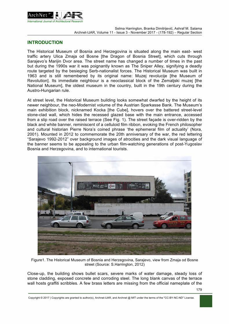
International Journal of Architectural Research Selma Harrington, Branka Dimitrijević, Ashraf M. Salama
Archnet-IJAR, Volume 11 - Issue 3 - November 2017 - (178-192) – Regular Section
Copyright © 2017 | Copyrights are granted to author(s), Archnet-IJAR, and Archnet @ MIT under the terms of the "CC-BY-NC-ND" License.
179
INTRODUCTION The Historical Museum of Bosnia and Herzegovina is situated along the main east- west traffic artery Ulica Zmaja od Bosne [the Dragon of Bosnia Street], which cuts through Sarajevo’s Marijin Dvor area. The street name has changed a number of times in the past but during the 1990s war it was poignantly known as The Sniper Alley, signifying a deadly route targeted by the besieging Serb-nationalist forces. The Historical Museum was built in 1963 and is still remembered by its original name: Muzej revolucije [the Museum of Revolution]. Its immediate neighbour is a neoclassical block of the Zemaljski muzej [the National Museum], the oldest museum in the country, built in the 19th century during the Austro-Hungarian rule. At street level, the Historical Museum building looks somewhat dwarfed by the height of its newer neighbour, the neo-Modernist volume of the Austrian Sparkasse Bank. The Museum’s main exhibition block, nicknamed Kocka [the Cube], hovers over the battered street-level stone-clad wall, which hides the recessed glazed base with the main entrance, accessed from a slip road over the raised terrace (See Fig. 1). The street façade is over-ridden by the black and white banner, reminiscent of a celluloid film ribbon, evoking the French philosopher and cultural historian Pierre Nora’s coined phrase ‘the ephemeral film of actuality’ (Nora, 2001). Mounted in 2012 to commemorate the 20th anniversary of the war, the red lettering “Sarajevo 1992-2012” over background images of atrocities and the dark visual language of the banner seems to be appealing to the urban film-watching generations of post-Yugoslav Bosnia and Herzegovina, and to international tourists.
Figure1. The Historical Museum of Bosnia and Herzegovina, Sarajevo, view from Zmaja od Bosne street (Source: S.Harrington, 2012)
Close-up, the building shows bullet scars, severe marks of water damage, steady loss of stone cladding, exposed concrete and corroding steel. The long blank canvas of the terrace wall hosts graffiti scribbles. A few brass letters are missing from the official nameplate of the
International Journal of Architectural Research Selma Harrington, Branka Dimitrijević, Ashraf M. Salama
Archnet-IJAR, Volume 11 - Issue 3 - November 2017 - (178-192) – Regular Section
Copyright © 2017 | Copyrights are granted to author(s), Archnet-IJAR, and Archnet @ MIT under the terms of the "CC-BY-NC-ND" License.
180
Museum and overgrown shrubs obscure the main entrance. All speaks of neglect. The weary body of the building is bitten by rain and frost, and its once sharp edges and smooth volumes are deformed. The dilapidation caused by war damage and post-war lack of maintenance is slowly turning the building into an urban ruin. Often, on a gloomy Sarajevo winter’s day, it looks as if the building is abandoned. Walking past the entrance towards the river Miljacka and negotiating by a rusty armoured vehicle from World War 2, the view opens to a café named after the former Yugoslav President Tito. The café occupies part of the dysfunctional plant room at the basement level, its walls and alcoves adorned with posters, slogans and memorabilia clearly themed on the leading figure and symbolism of former Yugoslav times.
WAR AND CULTURAL HERITAGE Having declared independence from former Yugoslavia in March 1992, Bosnia and Herzegovina, (its acronym BiH used henceforth in citing local references), plunged into a major regional conflict. The siege of its capital, Sarajevo, was televised internationally with live recording of the enormous suffering of its people, many of whom were forced from homes, raped, imprisoned, maimed and killed, over a three and a half year period. This catastrophe created huge loss and trauma, with unanswered questions regarding the violations of a once shared life lived under the banner of bratstvo i jedinstvo [brotherhood and unity] in former Yugoslavia. This is particularly poignant as Bosnia and Herzegovina was and remains multi-cultural, but the 1990s’ war ruthlessly disregarded the shared cultural narratives based on memories of the anti-fascist national-liberation struggle, socialism and a supra national Yugoslav identity. What seems to have been the unifying founding myths, disappeared as if it never existed. The new post-war reality is dominated by the polarization among three main nationalistic parties, who continue their hold on power based on an uneasy and complicated system of governance that was negotiated through significant international engagement and measures to stop the war. The war left a legacy of ethnic cleansing, internal displacement and emigration, together with a radical change of political system and economy. There is a significant dependence on the international patronage represented by the Office of High Representative and other agencies, which makes the contemporary Bosnia and Herzegovina in many ways ‘a country- in -waiting’. Its citizens and institutions are caught in a state of in-betweenness, where memories of the conflict clash with memories of life previously lived and where the new way of life is not yet fully owned. With a collective memory of other historic conflicts in the past, each generation needs an enormous adaptability in order to live through dramatic changes of regimes, as each one had radically interrupted and altered previous conditions of life. The Dayton Peace Agreement in 1995 put an end to war and in recognition of the significance and scale of the cultural heritage destruction, unlike other peace treaties, it included a special Annex 8, designed to address and assist in potentially redressing this situation (Walasek et al, 2015). Under the provisions of Annex 8, a Commission to Preserve National Monuments was formed, with the aim to ‘guarantee[...] the right to reconstruct, rehabilitate and protect national monuments that have been damaged or destroyed during the war’. Together with Annex 7, these two Annexes 'provide for a unique right for return, not only of people, but potentially of the culture, history and identity that existed in the region before the damaging results of war’ (Perry, 2015, p. 186). However, despite the ambition of such provisions, the situation with cultural heritage is quite complex and its renewal is not as straightforward.
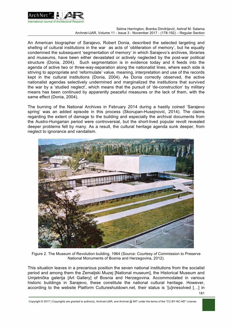
International Journal of Architectural Research Selma Harrington, Branka Dimitrijević, Ashraf M. Salama
Archnet-IJAR, Volume 11 - Issue 3 - November 2017 - (178-192) – Regular Section
Copyright © 2017 | Copyrights are granted to author(s), Archnet-IJAR, and Archnet @ MIT under the terms of the "CC-BY-NC-ND" License.
181
An American biographer of Sarajevo, Robert Donia, described the selected targeting and shelling of cultural institutions in the war as acts of ‘obliteration of memory’, but he equally condemned the subsequent ‘segmentation of memory‘ in which Sarajevo’s archives, libraries and museums, have been either devastated or actively neglected by the post-war political structure (Donia, 2004). Such segmentation is in evidence today and it feeds into the agenda of active two or three-way-separation along the nationalist lines, where each side is striving to appropriate and ‘reformulate’ value, meaning, interpretation and use of the records kept in the cultural institutions (Donia, 2004). As Donia correctly observed, the active nationalist agendas selectively undermined and marginalized the institutions that survived the war by a ‘studied neglect’, which means that the pursuit of ‘de-construction’ by military means has been continued by apparently peaceful measures or the lack of them, with the same effect (Donia, 2004). The burning of the National Archives in February 2014 during a hastily coined ‘Sarajevo spring’ was an added episode in this process (Skorupan-Husejnović, 2014). The claims regarding the extent of damage to the building and especially the archival documents from the Austro-Hungarian period were controversial, but the short-lived popular revolt revealed deeper problems felt by many. As a result, the cultural heritage agenda sunk deeper, from neglect to ignorance and vandalism.
Figure 2. The Museum of Revolution building, 1964 (Source: Courtesy of Commission to Preserve National Monuments of Bosnia and Herzegovina, 2012).
This situation leaves in a precarious position the seven national institutions from the socialist period and among them the Zemaljski Muzej [National museum], the Historical Museum and Umjetnička galerija [Art Gallery] of Bosnia and Herzegovina. Accommodated in various historic buildings in Sarajevo, these constitute the national cultural heritage. However, according to the website Platform Cultureshutdown.net, their status is ‘[u]nresolved […] in
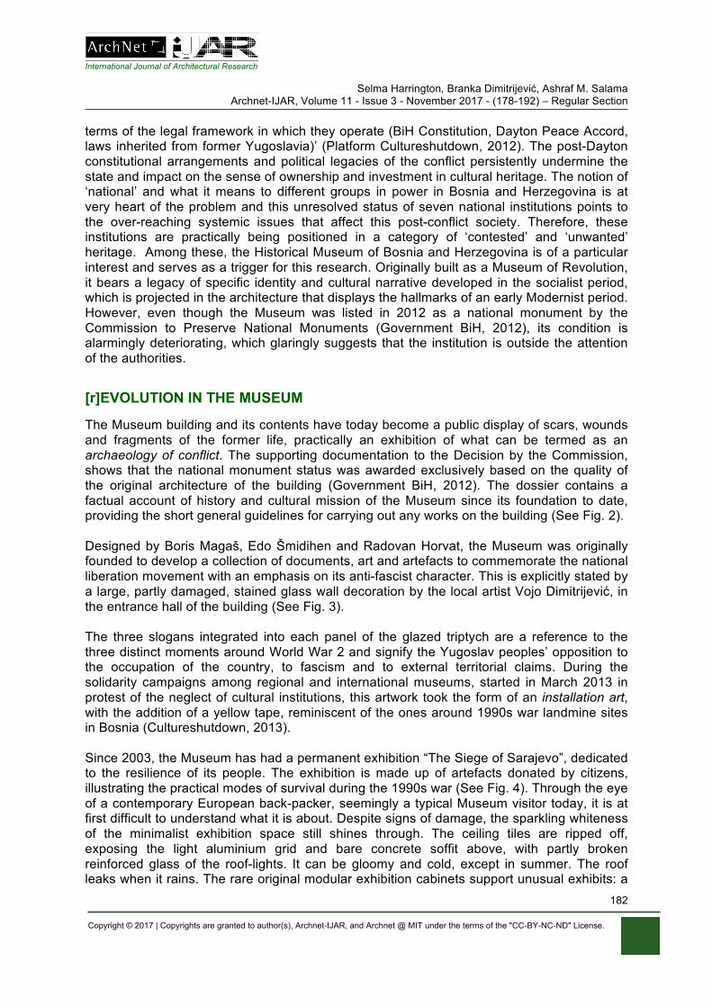
International Journal of Architectural Research Selma Harrington, Branka Dimitrijević, Ashraf M. Salama
Archnet-IJAR, Volume 11 - Issue 3 - November 2017 - (178-192) – Regular Section
Copyright © 2017 | Copyrights are granted to author(s), Archnet-IJAR, and Archnet @ MIT under the terms of the "CC-BY-NC-ND" License.
182
terms of the legal framework in which they operate (BiH Constitution, Dayton Peace Accord, laws inherited from former Yugoslavia)’ (Platform Cultureshutdown, 2012). The post-Dayton constitutional arrangements and political legacies of the conflict persistently undermine the state and impact on the sense of ownership and investment in cultural heritage. The notion of ‘national’ and what it means to different groups in power in Bosnia and Herzegovina is at very heart of the problem and this unresolved status of seven national institutions points to the over-reaching systemic issues that affect this post-conflict society. Therefore, these institutions are practically being positioned in a category of ‘contested’ and ‘unwanted’ heritage. Among these, the Historical Museum of Bosnia and Herzegovina is of a particular interest and serves as a trigger for this research. Originally built as a Museum of Revolution, it bears a legacy of specific identity and cultural narrative developed in the socialist period, which is projected in the architecture that displays the hallmarks of an early Modernist period. However, even though the Museum was listed in 2012 as a national monument by the Commission to Preserve National Monuments (Government BiH, 2012), its condition is alarmingly deteriorating, which glaringly suggests that the institution is outside the attention of the authorities.
[r]EVOLUTION IN THE MUSEUM
The Museum building and its contents have today become a public display of scars, wounds and fragments of the former life, practically an exhibition of what can be termed as an archaeology of conflict. The supporting documentation to the Decision by the Commission, shows that the national monument status was awarded exclusively based on the quality of the original architecture of the building (Government BiH, 2012). The dossier contains a factual account of history and cultural mission of the Museum since its foundation to date, providing the short general guidelines for carrying out any works on the building (See Fig. 2). Designed by Boris Magaš, Edo Šmidihen and Radovan Horvat, the Museum was originally founded to develop a collection of documents, art and artefacts to commemorate the national liberation movement with an emphasis on its anti-fascist character. This is explicitly stated by a large, partly damaged, stained glass wall decoration by the local artist Vojo Dimitrijević, in the entrance hall of the building (See Fig. 3). The three slogans integrated into each panel of the glazed triptych are a reference to the three distinct moments around World War 2 and signify the Yugoslav peoples’ opposition to the occupation of the country, to fascism and to external territorial claims. During the solidarity campaigns among regional and international museums, started in March 2013 in protest of the neglect of cultural institutions, this artwork took the form of an installation art, with the addition of a yellow tape, reminiscent of the ones around 1990s war landmine sites in Bosnia (Cultureshutdown, 2013). Since 2003, the Museum has had a permanent exhibition “The Siege of Sarajevo”, dedicated to the resilience of its people. The exhibition is made up of artefacts donated by citizens, illustrating the practical modes of survival during the 1990s war (See Fig. 4). Through the eye of a contemporary European back-packer, seemingly a typical Museum visitor today, it is at first difficult to understand what it is about. Despite signs of damage, the sparkling whiteness of the minimalist exhibition space still shines through. The ceiling tiles are ripped off, exposing the light aluminium grid and bare concrete soffit above, with partly broken reinforced glass of the roof-lights. It can be gloomy and cold, except in summer. The roof leaks when it rains. The rare original modular exhibition cabinets support unusual exhibits: a
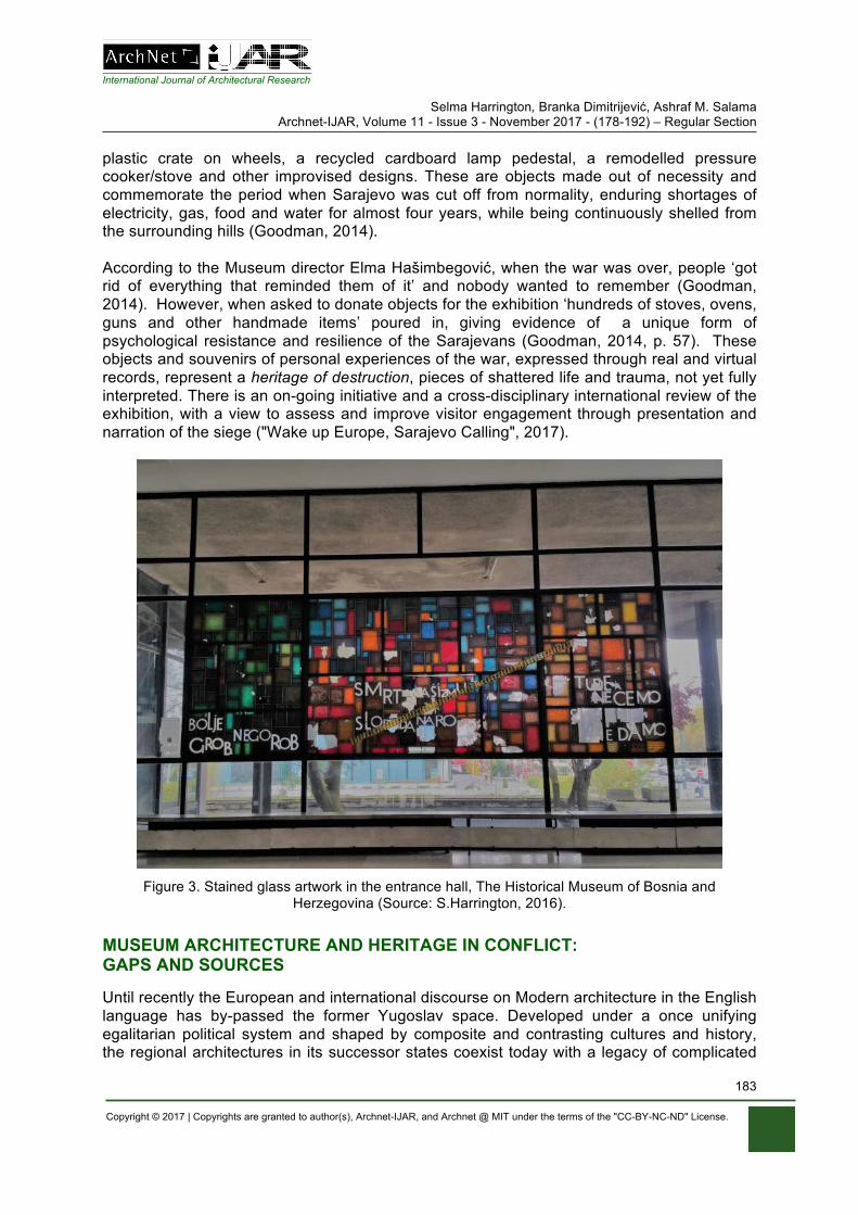
International Journal of Architectural Research Selma Harrington, Branka Dimitrijević, Ashraf M. Salama
Archnet-IJAR, Volume 11 - Issue 3 - November 2017 - (178-192) – Regular Section
Copyright © 2017 | Copyrights are granted to author(s), Archnet-IJAR, and Archnet @ MIT under the terms of the "CC-BY-NC-ND" License.
183
plastic crate on wheels, a recycled cardboard lamp pedestal, a remodelled pressure cooker/stove and other improvised designs. These are objects made out of necessity and commemorate the period when Sarajevo was cut off from normality, enduring shortages of electricity, gas, food and water for almost four years, while being continuously shelled from the surrounding hills (Goodman, 2014). According to the Museum director Elma Hašimbegović, when the war was over, people ‘got rid of everything that reminded them of it’ and nobody wanted to remember (Goodman, 2014). However, when asked to donate objects for the exhibition ‘hundreds of stoves, ovens, guns and other handmade items’ poured in, giving evidence of a unique form of psychological resistance and resilience of the Sarajevans (Goodman, 2014, p. 57). These objects and souvenirs of personal experiences of the war, expressed through real and virtual records, represent a heritage of destruction, pieces of shattered life and trauma, not yet fully interpreted. There is an on-going initiative and a cross-disciplinary international review of the exhibition, with a view to assess and improve visitor engagement through presentation and narration of the siege ("Wake up Europe, Sarajevo Calling", 2017).
Figure 3. Stained glass artwork in the entrance hall, The Historical Museum of Bosnia and
Herzegovina (Source: S.Harrington, 2016).
MUSEUM ARCHITECTURE AND HERITAGE IN CONFLICT: GAPS AND SOURCES Until recently the European and international discourse on Modern architecture in the English language has by-passed the former Yugoslav space. Developed under a once unifying egalitarian political system and shaped by composite and contrasting cultures and history, the regional architectures in its successor states coexist today with a legacy of complicated
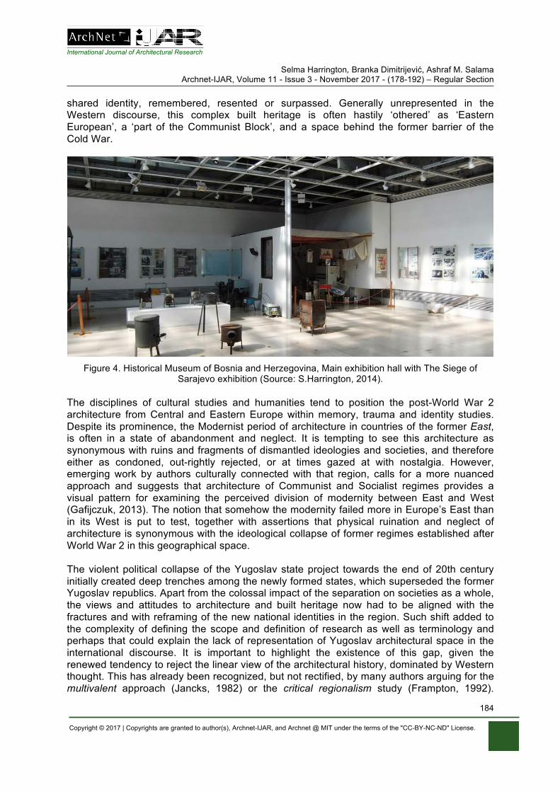
International Journal of Architectural Research Selma Harrington, Branka Dimitrijević, Ashraf M. Salama
Archnet-IJAR, Volume 11 - Issue 3 - November 2017 - (178-192) – Regular Section
Copyright © 2017 | Copyrights are granted to author(s), Archnet-IJAR, and Archnet @ MIT under the terms of the "CC-BY-NC-ND" License.
184
shared identity, remembered, resented or surpassed. Generally unrepresented in the Western discourse, this complex built heritage is often hastily ‘othered’ as ‘Eastern European’, a ‘part of the Communist Block’, and a space behind the former barrier of the Cold War.
Figure 4. Historical Museum of Bosnia and Herzegovina, Main exhibition hall with The Siege of
Sarajevo exhibition (Source: S.Harrington, 2014).
The disciplines of cultural studies and humanities tend to position the post-World War 2 architecture from Central and Eastern Europe within memory, trauma and identity studies. Despite its prominence, the Modernist period of architecture in countries of the former East, is often in a state of abandonment and neglect. It is tempting to see this architecture as synonymous with ruins and fragments of dismantled ideologies and societies, and therefore either as condoned, out-rightly rejected, or at times gazed at with nostalgia. However, emerging work by authors culturally connected with that region, calls for a more nuanced approach and suggests that architecture of Communist and Socialist regimes provides a visual pattern for examining the perceived division of modernity between East and West (Gafijczuk, 2013). The notion that somehow the modernity failed more in Europe’s East than in its West is put to test, together with assertions that physical ruination and neglect of architecture is synonymous with the ideological collapse of former regimes established after World War 2 in this geographical space. The violent political collapse of the Yugoslav state project towards the end of 20th century initially created deep trenches among the newly formed states, which superseded the former Yugoslav republics. Apart from the colossal impact of the separation on societies as a whole, the views and attitudes to architecture and built heritage now had to be aligned with the fractures and with reframing of the new national identities in the region. Such shift added to the complexity of defining the scope and definition of research as well as terminology and perhaps that could explain the lack of representation of Yugoslav architectural space in the international discourse. It is important to highlight the existence of this gap, given the renewed tendency to reject the linear view of the architectural history, dominated by Western thought. This has already been recognized, but not rectified, by many authors arguing for the multivalent approach (Jancks, 1982) or the critical regionalism study (Frampton, 1992).
International Journal of Architectural Research Selma Harrington, Branka Dimitrijević, Ashraf M. Salama
Archnet-IJAR, Volume 11 - Issue 3 - November 2017 - (178-192) – Regular Section
Copyright © 2017 | Copyrights are granted to author(s), Archnet-IJAR, and Archnet @ MIT under the terms of the "CC-BY-NC-ND" License.
185
Adding to this plurality, other research has emerged, placing architecture into Utopian studies, arguing for a more complex reading of a presumption that ‘modern architecture[…][has] been fundamentally utopian in its aims and delusions’ and cautioning against the automatic assumption that therefore all postmodern architecture is anti-utopian (Coleman, 2014). This important focus shift leans towards the rapprochement of architectural discourse with the social, political and cultural value systems, and wishes to clarify and untangle often-misused terms Utopia, Dystopia and visionary, while attempting to reclaim the visionary social and political role for architecture (Coleman, 2014). However, this is still confined to a Western discourse. A recent edited volume East, West, Central, Re-Building Europe 1950-1990 geographically broadens and relocates the architectural Modernism discourse into the field of European politics and identity, arguing for more nuanced understanding of diverse developments as well as of ‘transnational exchanges […] and post-colonial context of the global south’ (Moravanszky & Lange, 2017). Among others, a contribution by the former Magaš’s assistant aims to position the Croatian architect’s work in the European Modernist and Post-modernist discourse, charting his early projects, which include the Museum of Revolution in Sarajevo. Similarly, the publication and research outcome of the project Unfinished Modernisations, Between Pragmatism and Utopia, narrows the focus to former Yugoslav architectural and urban space (Mrduljaš & Kulić, 2012). The authors reinforce not only the argument for a subtler reading of Yugoslav architecture, but also suggest the necessity of putting it on an equal footing with Western. They argue that in some cases the Yugoslav architecture and urbanism had more vision and have acted as drivers of ‘the idea of the city as a collective endeavour’, which consequently implies the specificity of a ’socialist city’ (Mrduljaš & Kulić, 2012). Following with the Modernism in-between, the same authors further develop the ‘in-betweenness’ concept of architecture in socialist Yugoslavia suggesting its important mediatory role in the modernization of the country (Mrduljaš et al., 2012). The pre-1990s original literature in Bosnian/Croatian/Serbian language points to the local authors, mainly architects, who recorded buildings designed in Yugoslavia, and Bosnia and Herzegovina and the work of early local Modernists in the Kingdom of Yugoslavia (Milošević, 1997). Much of this work tends to be of a descriptive nature, documenting the architectural opus with a limited analysis and lack of its contextual positioning within broader international contemporary movements in architecture. As an exception, the earlier Architecture of Bosnia and the road to Modernity, offers a clear positioning and explains the direct links with the Modern movement in architecture, elaborating the transposition and own interpretation of the regional vernacular, thus setting out direction for new regional concepts (Najdhart & Grabrijan, 1957). These were successfully developed in practice by a number of later protagonists in Bosnia and Herzegovina like Zlatko Ugljen, Ahmed Ðuvić, Mirko Ovadia, Amir Vuk and others. It can be said that the ideas and work of Juraj Najdhardt represent the original strand of regional Modernism, thus foreshadowing what Frampton will later term as critical regionalism, albeit observed in other parts of the world (Frampton, 1992). The unpublished doctoral thesis by Boris Magaš, completed two decades after the winning competition entry for the design of the Museum in Sarajevo, is an important primary source for insight in his architectural philosophy and ethos (Magaš, 1977). Preoccupied with the nature of creativity and the dynamism between the intellectual and emotional forces, the author exposes the conditionality of the architectural practice within a social and historical power base. Written in somewhat difficult expressionist style, his analysis and language
International Journal of Architectural Research Selma Harrington, Branka Dimitrijević, Ashraf M. Salama
Archnet-IJAR, Volume 11 - Issue 3 - November 2017 - (178-192) – Regular Section
Copyright © 2017 | Copyrights are granted to author(s), Archnet-IJAR, and Archnet @ MIT under the terms of the "CC-BY-NC-ND" License.
186
demonstrate the influence of the dialectic materialism, rooted in the official rhetoric of the period. It can be said that a literature search on architecture in Bosnia and Herzegovina and former Yugoslavia shows up a modest number of publications in local language and practically none in English created up to 1990s. The search does not include periodicals and exhibition catalogues. What is known and documented is that what was built and what is still in evidence across former Yugoslav space. So in defining the scope of knowledge and gaps, it is necessary to say that any study of architecture and urbanism in that space has to commence by framing a system which was founded and existed for some four decades, until its subsequent collapse, fragmentation, reframing and current state of fluidity. The system was manifested as a unique form of society, economy, culture and politics, within which architecture and urban space performed functions perceived to reflect the values of the system. Hence, the system’s collapse, or more accurately targeted de(con)struction, together with the passage of time, have pushed the architecture synonymous and synchronous with it, in the domain of heritage and at the extreme, in a category of heritage at risk.
METHODS, AIMS AND STRUCTURE OF THE RESEARCH
The complexity of understanding the architecture of this space requires a cross-disciplinary approach. Therefore, this research is undertaken from the perspective of an architect and cultural historian, looking at two disciplinary fields: architecture and public history, which will underpin the composite methodological framework. Initially, this will be developed by the content analysis of literature in English and in Bosnian/Croat/Serbian language, the analysis of local archival material, and development of a qualitative case study based on the architecture of the Historical Museum in Sarajevo. Broadly speaking, the research is constructed as a form of dialogic action derived from the concept of knowledge development, which begins with an ‘epistemological distance’, or in plain words, with ‘circling around’ the object (Freire, 1997). The illustration of similar concepts, such as the dialogic inquiry approach (Wells, 1999) or the theory of communicative action (Habermas, 1984), will later support this approach. As a starting point, a dialogic action is applied here to a process of parallel examination of form, content and meaning, embodied in a system of public building space, which will be followed through the dynamics of ruptures and continuities in the life span of the Museum and described further in the outline themes of the Thesis. At the outset, three principal aims are stated below:
• To contribute to the critical heritage discourse, by positioning the public history narrative of the Historical Museum closer to the representations of identity politics and conflict in the European context
• To contribute to the other Modernisms discourse, by positioning the architecture of the Historical Museum of Bosnia and Herzegovina in the revision of the post-World War 2 Modernist architecture representations
• To contribute to a broader cross-disciplinary approach in environmental sustainability discourse, by examining the resilience of the Museum as a micro system in a post-conflict society, arguing that an architectural object, space, content and meaning of architecture is a part of strategy to achieve balance between environmental, economic, political and societal aspects of a system in general.
International Journal of Architectural Research Selma Harrington, Branka Dimitrijević, Ashraf M. Salama
Archnet-IJAR, Volume 11 - Issue 3 - November 2017 - (178-192) – Regular Section
Copyright © 2017 | Copyrights are granted to author(s), Archnet-IJAR, and Archnet @ MIT under the terms of the "CC-BY-NC-ND" License.
187
Firstly, a preliminary position is formed using a critical heritage discourse lens, applied to the examination of the museum as a public institution associated with national identity and the history of social conflict. This observes the historical patterns of social stratification in heritage preservation practices differentiated by scale, scope, exclusivity and inclusivity of heritage in different environments, as presented in the edited volume Heritage, Identity and Ideology in Central and Eastern Europe (Rampley, 2013). Here, the key contributor Rampley reflects on the British heritage discourse and politics, seeing it as an evolution, which spans from the 19th century sentimentalism and celebration of the Imperial past to the 20th century heritage industry, subordinate to a commodity culture and adaptable to the changing nature of tourism and education (Harrington, 2013). Other contributors examine the contemporary heritage and museum policies from perspectives of ownership and varied claims on heritage narratives by different communities and social groups (Rampley, 2013). The distinctions are drawn between dominant and minority cultures, linking the attitudes to heritage, development of nationhood and a sense of national belonging to a specific history within or without a colonial and foreign rule. The second edited volume, Heritage and Museums, Shaping National Identity, is of particular interest as it gives a record of the debates, plans and realization of the building of the National Museum of Scotland in Edinburgh (Fladmark, 2000). Here, the Scottish contributors from academia, architecture, museum studies, administration and practice examine the complex history, collections, curatorship, identity and briefing, while the international authors discuss the national museums’ experiences of Nordic and other countries, suggesting that some of these approach heritage in a more inclusive manner, in line with the present-day culture (Fladmark, 2000). Secondly, advancing the concept of other Modernisms in architecture, the architecture of the Historical Museum will be examined through its formative qualities, its monumentality, and its international and regional conceptual precedents. The content analysis of the recently available primary material will include the original correspondence and meeting records, documenting the intent and detail in the process of developing the Museum building and ideological positions of the design and management team. The comparative analysis of the Scottish National Museum building, based on “The Architect’s Vision. Designing for Context and Content” will be used as a dialogic precedent, (Benson, 2000). The analysis of approaches to architectural interventions at the National Museum of Ireland and Ulster Museum in Belfast will also form part of the argument. As part of data gathering, an international Focus group has been formed, representing individuals, institutions and museums with responsibility for safeguarding, managing, curating and interpreting complex heritage assets associated with national identity and conflict narratives. Geographically, the Focus group represents the Republic of Ireland, Northern Ireland, Scotland, Bosnia and Herzegovina and Croatia, with an implication that the participants have knowledge and understanding of institutional foundation, representation, conflict and fluidity, arising, but not exclusively, from encounters and/or coexistence between minority and dominant cultural narratives. The work with the Focus group will include three seminars and direct communication, examining the themes arising from a basic question of why museum matters today, taking a lead from a comprehensive edited volume A Companion to Museum Studies (Macdonald, 2011). A number of key issues will be developed by exploring a number of themes, as follows: Systems Thinking and Resilience Theory The occurrence of heritage at risk is sadly rising at an alarming pace. Since the later part of the 20th century, natural disasters, climate change and modern warfare affect people and
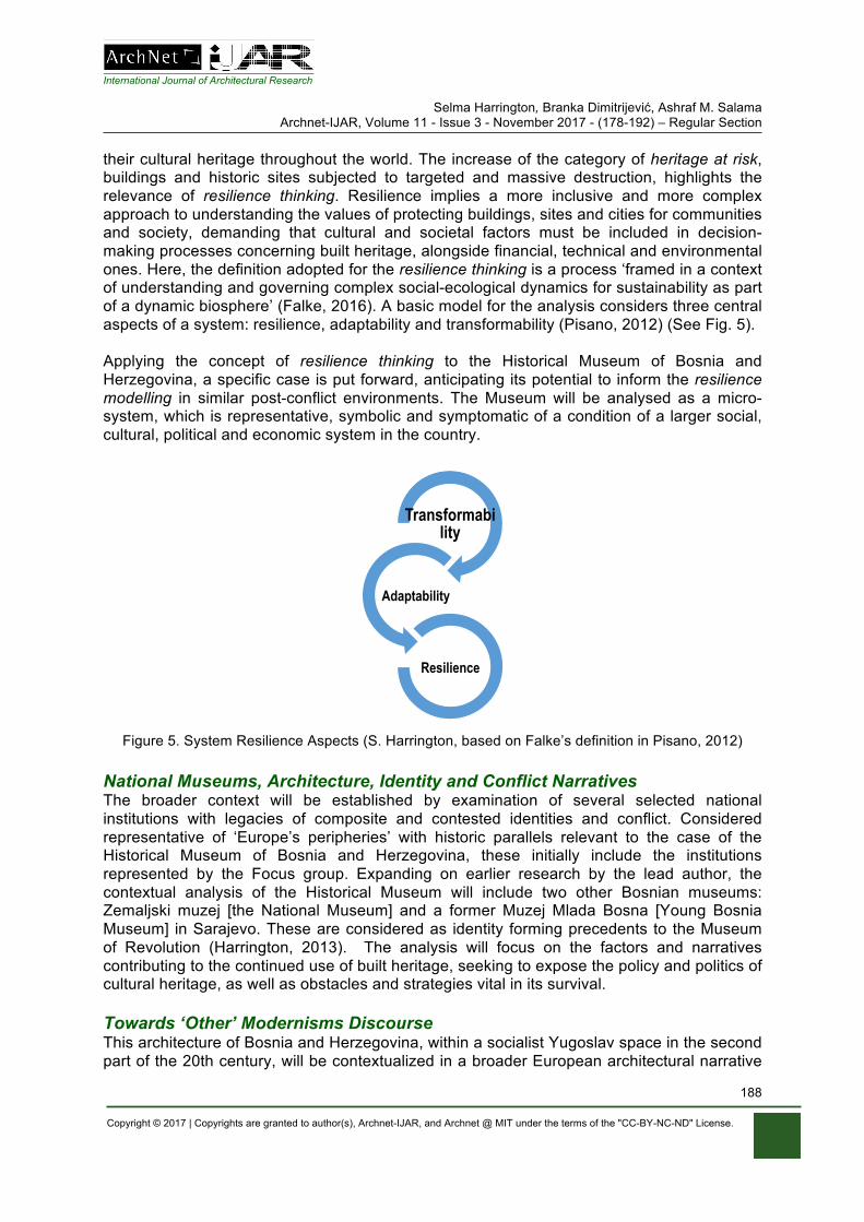
International Journal of Architectural Research Selma Harrington, Branka Dimitrijević, Ashraf M. Salama
Archnet-IJAR, Volume 11 - Issue 3 - November 2017 - (178-192) – Regular Section
Copyright © 2017 | Copyrights are granted to author(s), Archnet-IJAR, and Archnet @ MIT under the terms of the "CC-BY-NC-ND" License.
188
their cultural heritage throughout the world. The increase of the category of heritage at risk, buildings and historic sites subjected to targeted and massive destruction, highlights the relevance of resilience thinking. Resilience implies a more inclusive and more complex approach to understanding the values of protecting buildings, sites and cities for communities and society, demanding that cultural and societal factors must be included in decision-making processes concerning built heritage, alongside financial, technical and environmental ones. Here, the definition adopted for the resilience thinking is a process ‘framed in a context of understanding and governing complex social-ecological dynamics for sustainability as part of a dynamic biosphere’ (Falke, 2016). A basic model for the analysis considers three central aspects of a system: resilience, adaptability and transformability (Pisano, 2012) (See Fig. 5). Applying the concept of resilience thinking to the Historical Museum of Bosnia and Herzegovina, a specific case is put forward, anticipating its potential to inform the resilience modelling in similar post-conflict environments. The Museum will be analysed as a micro-system, which is representative, symbolic and symptomatic of a condition of a larger social, cultural, political and economic system in the country.
Figure 5. System Resilience Aspects (S. Harrington, based on Falke’s definition in Pisano, 2012)
National Museums, Architecture, Identity and Conflict Narratives The broader context will be established by examination of several selected national institutions with legacies of composite and contested identities and conflict. Considered representative of ‘Europe’s peripheries’ with historic parallels relevant to the case of the Historical Museum of Bosnia and Herzegovina, these initially include the institutions represented by the Focus group. Expanding on earlier research by the lead author, the contextual analysis of the Historical Museum will include two other Bosnian museums: Zemaljski muzej [the National Museum] and a former Muzej Mlada Bosna [Young Bosnia Museum] in Sarajevo. These are considered as identity forming precedents to the Museum of Revolution (Harrington, 2013). The analysis will focus on the factors and narratives contributing to the continued use of built heritage, seeking to expose the policy and politics of cultural heritage, as well as obstacles and strategies vital in its survival. Towards ‘Other’ Modernisms Discourse This architecture of Bosnia and Herzegovina, within a socialist Yugoslav space in the second part of the 20th century, will be contextualized in a broader European architectural narrative
Transformability
Adaptability
Resilience
International Journal of Architectural Research Selma Harrington, Branka Dimitrijević, Ashraf M. Salama
Archnet-IJAR, Volume 11 - Issue 3 - November 2017 - (178-192) – Regular Section
Copyright © 2017 | Copyrights are granted to author(s), Archnet-IJAR, and Archnet @ MIT under the terms of the "CC-BY-NC-ND" License.
189
by listening to the voices and expressions of local architects (Štraus, 1991). This will include the review of influences and relationships to the originators of the international Modern movement in architecture, gazing back at the two distinct periods of Modernism that were in evidence in the first Kingdom of Yugoslavia (Milošević, 1997) and the subsequent period of Yugoslav socialism (Najdhart & Grabrijan, 1957). In addition, the themes of Architecture, Revolution and Utopia, as a reflection of recent rethinking, will also be considered (Coleman, 2005), as this might provide better understanding of the social role and ideology of the regional architecture and the ideas and practices of the socialist urbanism and socialist city. Embodying Revolution: Building the Museum. The overview of the unique network of Yugoslav and Bosnian museums set up to commemorate the national liberation struggle, will give a pretext to the case study of the Museum of Revolution in Sarajevo. The design and architecture of the Museum of Revolution building will be observed in their symbiotic relationship with the shared identity narrative constructs, expressed through the Museum’s collections, exhibitions, publications and Annual conference proceedings published from 1975 to 1984. The preliminary study of the original archival material from the Museum indicates a systematic approach in a decade-long preparation, planning and completion of the building on site in Sarajevo. The material consists of original correspondence, briefing and meeting notes, instructions to the design and construction team, some original drawings and subsequent renovation proposals. The information about original construction materials, methods and services, provides a valuable lead to understanding the original condition of the building and potential clues to deterioration of a national monument, caused by factors other than the war damage. 1990s War: Destruction and Resilience. The 1990s war brought about deliberate targeting, damage and destruction of the cultural heritage of Bosnia and Herzegovina. This part of the research will be constructed by applying the content analysis of primary material, revealing the elements of local institutional and individual professional resistance and survival strategies. These include the project “Warchitecture” developed during the first years of the war as a publication and an exhibition “Sarajevo Urbicide”, most likely an evidence of the first professional mapping of the built heritage destruction in the war (The Association of Architects Sarajevo, 1993). The analysis will also look into the proceedings from a major conference devoted to the strategy for renewal of the country, organized at the time by the Government of Bosnia and Herzegovina in Sarajevo, with contributions by local experts (Government BiH, 1993). Cultural Heritage and the Historical Museum: Cracks and Light. A recent comprehensive study Bosnia and the destruction of cultural heritage provides an overview of the scale, scope and problems currently facing the custodians of the built heritage in the country (Walasek at al, 2015). The analysis of the constitutional provisions in Annex 8, for inclusion of the cultural heritage renewal as a condition in the Dayton Peace Agreement, is of particular interest. It provides an important basis for system analysis and critique, in particular in relation to the work of the Commission to Preserve National Monuments and their role in care for the Historical Museum, seen from a perspective of an external expert. This will be presented in a dialogue with local professional voices, expressed in essays and interviews with architects in a special edition of a weekly magazine Dani [Days], painting a fuller picture of the local context and complexity of navigating through the current politics of urban development and built heritage (Urbicid, 2003).
International Journal of Architectural Research Selma Harrington, Branka Dimitrijević, Ashraf M. Salama
Archnet-IJAR, Volume 11 - Issue 3 - November 2017 - (178-192) – Regular Section
Copyright © 2017 | Copyrights are granted to author(s), Archnet-IJAR, and Archnet @ MIT under the terms of the "CC-BY-NC-ND" License.
190
As part of the analysis, a review of selected contemporary activities in the Museum will focus in particular on the initiatives and collaboration with architects and architecture education groups. The base material and data collection is based on the engagement, action research and fieldwork by the lead author, since 2012 to date (Čaušević et al, 2014).
TOWARDS CONCLUSIONS: RESILIENCE, FLUIDITY AND TRANSFORMATION
The research to date and the response by the participants of the Focus group at the Seminar organized in May 2017 at the University of Strathclyde, confirmed the actuality of the research topic. The ethos, mission and policy of the museums and public heritage institutions; physical aspects of architectural space and museum exhibitions; education and public engagement; research, funding and future of museums were presented in the individual contributions with examples of own practices and experiences. The participants confirmed the need to advance the knowledge exchange and insight into current social, economic and environmental contexts within which modern museums operate. Further work with the Focus group will examine partnerships and associations critical to the process at each national level, examining brief development and knowledge exchange, specifically in the context of fluidity of architectural space, design of museum exhibitions and visitors’ engagement. It is expected that the resilience thinking approach will lead to conclusions with an adequate level of modelling and generalization, applicable when discussing the preservation, meaningful appropriation, adaptive use and maintenance of public buildings of national significance and affected by conflicts.
ACKNOWLEDGEMENTS
The lead author wishes to acknowledge the generosity of time, information, support and friendship given by Elma Hašimbegović, Dr Adi Ćorović, Dr Amir Čaušević, Dr Nerman Rustempašić, Dr Aida Idrizbegović-Zgonić, Dr Muhamed Hamidović, Amira Arnautović and Jasna Šišić from Sarajevo; also Dubravko Bačić, Tomislav Ćurković, Vladimir Petrović, Maroje Mrduljaš and Lidia Maković from Zagreb.
REFERENCES
Benson, G. (2000). The Architect's Vision. Designing for Context and Content. In J. Fladmark (Ed.). Heritage and Museums, Shaping National Identity (pp. 17-28). Aberdeen: The Robert Gordon University.
Čausević,A., Kudimović, L., Rustempašić, N. (2014). Structural interventions on the modern heritage. SAHC2014 – 9th International Conference on historic constructions (p. 12). Mexico City: F.Pena & M.Chavez (Eds.).
Coleman, N. (2005). Utopias and Architecture. Milton Park, Abingdon & New York: Routledge. Coleman, N. (2014). The Problematic of Architecture and Utopia. Utopian Studies, 25 (1), 1-22. Cultureshutdown. (1 February 2013). "Day of Museums Solidarity". [Campaign call], Retreived from:
http://www.cultureshutdown.net/public-call-day-of-museum-solidarity/Participate: Day of Museum Solidarity – March 4
Donia, R. J. (2004). ‘Sarajevo Archives and Cultural memory under Fire: destruction and the Post-war nationalist Transformation’. Retrieved from http://www.arhivsa.ba/ica2004/robert.html.
Falke, C. (2016). Resilience (p. 63). Oxford Research Encyclopedia of Environmental Science. Fladmark, J.,M., (Ed.) (2000). Heritage and Museums, Shaping National Identity. Aberdeen: The
Robert Gordon University. Frampton, K. (1992). Modern Architecture. A Critical History. London: Thames and Hudson. Freire, P. (1997). Pedagogy of the Heart. New York: Continuum (O.V. 1995).
International Journal of Architectural Research Selma Harrington, Branka Dimitrijević, Ashraf M. Salama
Archnet-IJAR, Volume 11 - Issue 3 - November 2017 - (178-192) – Regular Section
Copyright © 2017 | Copyrights are granted to author(s), Archnet-IJAR, and Archnet @ MIT under the terms of the "CC-BY-NC-ND" License.
191
Gafijczuk, D. (2013). Dwelling Within: The Inhabited Ruins of History (pp.149-170). History and Theory 52.
Goodman, J. (2014). Improvised design in the Siege of Sarajevo. A Magazine of Unexpected Creativity, (4), 42-57. Retrieved from https://worksthatwork.com/4
Government of the Republic of Bosnia and Herzegovina. (1993). Strategija Obnove. Business Magazine, 3-98. Sarajevo: Vlada RBiH i Ministarstvo za obnovu.
Habermas, J. (1984 (O.V. 1981)). The theory of communicative action. Volume I: Reason and the rationalization of society and Volume II: Lifeworld and system: A critique of functionalist reason. Boston: Beacon Press.
Harrington, S. (2013). The Politics of Memory: The Museum Sarajevo 1878-1918 and the Centenary of the Catastrophe. Unpublished MPhil Thesis. Dublin, Ireland: Trinity College Dublin.
Jancks, C., (Maksimović, S.-trans.) (1982). Moderni pokreti u arhitekturi. Beograd: IRO "Gradjevinska knjiga".
Macdonald,S.,(Ed.) (2011). A Companion to Museum Studies. Chichester: Wiley-Blackwell. Magaš, B. (1977). Analiza dominacije intelektualnog ili senzibilnog faktora u procesu arhitektonskog
stvaralaštva. [Unpublished doctorate] Doktorska teza. Zagreb: Sveučilište u Zagrebu. Arhitektonski fakultet.
Milošević, P. (1997). Arhitektura u Kraljevini Jugoslaviji. Srbinje (Rogatica): Srpsko prosvjetno i kulturno društvo "Prosvjeta".
Moravanszky, A. and Lange, T. (Eds.) (2017). Re-Framing Identities, Architecture's Turn to History, 1970-1990, East, West, Central,Re-Building Europe 1950-1990, Vol. 3. Basel: Birkhauser.
Mrduljaš,M. and Kulić, V. and Thaler,W. (2012). Modernism in-between. The mediatory architectures of Socialist Yugoslavia. Berlin: Jovis Verlag Gmbh.
Mrduljaš, M., Kulić, V. (Eds.) (2012). Unfinished modernisations Between Utopia and Pragmatism. Zagreb: UHA (Croatian Architect' Association) & Chamber of Croatian Architects (CCA).
Najdhart, J. and Grabrijan, D. (1957). Arhitektura Bosne i put u savremeno. Ljubljana: Državna založba Slovenije uz pomoć N.R. Bosne i Hercegovine i N.R. Slovenije.
Nora,P., (Ed.) (2001). “Introduction”, in Rethinking France Le Lieux de Mémoire Space, |Vol.3-. Chicago and London: University of Chicago Press.
Perry, V. (2015). Cultural heritage protection in post-conflict Bosnia-Herzegovina: Annex 8 of the Dayton Peace Agreement. In H. Walasek (Ed.) et al. Bosnia and the Destruction of Cultural Heritage (pp. 185-204). Farnham, Surrey & Burlington, VT: Ashgate.
Pisano, U. (2012). Resilience and Sustainable Development:Theory of resilience, systems thinking and adaptive governance. Vienna: European Sustainable Development Network (ESDN).
Platform Cultureshutdown. SUMMARY OF INSTITUTIONS’ POSITIONS. The crisis of seven cultural institutions in Bosnia and Herzegovina at the national level: Causes, Implications and Potential Solutions. (August 2012). Retrieved from http://www.cultureshutdown.net/summary-of-institutions-positions
Rampley, M. (2013). 'Contested Histories: Heritage and/as the Construction of the Past: An Introduction'. In M. Rampley (Ed.). Heritage, Ideology and Identity in Central and Eastern Europe: Contested Pasts, Contested Presents (pp. 1-20). Woodbridge: The Boydel Press.
Skorupan-Husejnović, E. (2014). Arhiv BiH četiri mjeseca nakon paljenja:Crnilo zidova, smrad izgorjelog papira i vlage. klix.ba. Retrieved from www.klix.ba
The Government of Bosnia and Herzegovina (2012). Odluka o proglašenju Historijskog muzeja Bosne i Hercegovine kao nacionalnog spomenika. Sarajevo: The Commission to Preserve National Monuments of Bosnia and Herzegovina.
The Association of Architects Sarajevo. (1993). Warchitecture. ARH, Magazine for Architecture, Town Planning and Design. Sarajevo, Bosnia and Herzegovina: The Association of Architects Sarajevo.
Ugljen Ademović, N. and Turkušić, E. (2012). “Sarajevo Marijin Dvor. The Formation of a New City Centre.” In Maroje Mrduljaš & Vladimir Kulić (Eds.), Unfinished Modernisations. Between Utopia and Pragmatism (pp. 232-245). Zagreb: UHA/CCA.
Urbicid. (2003, Juni). Dani, Bosanskohercegovački nezavisni magazin. Sarajevo, Bosna i Hercegovina: Dani.
International Journal of Architectural Research Selma Harrington, Branka Dimitrijević, Ashraf M. Salama
Archnet-IJAR, Volume 11 - Issue 3 - November 2017 - (178-192) – Regular Section
Copyright © 2017 | Copyrights are granted to author(s), Archnet-IJAR, and Archnet @ MIT under the terms of the "CC-BY-NC-ND" License.
192
"Wake up Europe, Sarajevo Calling". Connecting local history and international perspective. (2017, June 26-29). Memory Lab, Historijski Muzej Bosne i Hercegovine, Sudosteurope-Gesellschaft. [Programme]. Sarajevo, Bosnia and Herzegovina: History Museum of Bosnia and Herzegovina.
Walasek, H. (Ed.) & Carlton, R.& Hadžimuhamedović, A.& Perry, V. & Wik, T. (2015). Bosnia and the destruction of cultural heritage. Farnham, Surrey & Burlington, VT: Ashgate.
Walasek, H. (2015). Domains of Restoration: Acters and Agendas in post-conflict Bosnia-Herzegovina. In H. Walasek (Ed.) et al. Bosnia and the destruction of cultural heritage (pp. 205-258). Farnham, Surrey & Burlington, VT: Ashgate.
Wells, G. (1999). Dialogic Inquiry. Cambridge: Cambridge University Press.
Akmaral Yussupova*, Liu Songfu, Ardasher Namazbay, Farzad Pour Rahimian, Ahad Nejad Ebrahim Archnet-IJAR, Volume 12 - Issue 3 – November 2017 - (193-213) – Original Research Papers
Copyright © 2017 | Copyrights are granted to author(s), Archnet-IJAR, and Archnet @ MIT under the terms of the "CC-BY-NC-ND" License.
193
Archnet-IJAR: International Journal of Architectural Research www.archnet-ijar.net/ -- https://archnet.org/collections/34
ORNAMENTAL ART AND SYMBOLISM: ACTIVATORS OF HISTORICAL REGENERATION FOR KAZAKHSTAN’S LANDSCAPE ARCHITECTURE DOI: http://dx.doi.org/10.26687/archnet-ijar.v11i3.1358
Akmaral Yussupova*, Liu Songfu, Ardasher Namazbay, Farzad Pour Rahimian, Ahad Nejad Ebrahimi
Keywords Abstract
landscape architecture; symbolism; floral; zoomorphic; geometric; cosmogonic
The use of symbolism in contemporary architecture is increasingly gaining momentum, especially so in the Eastern countries currently undergoing rapid economic development. Sociologically, this phenomenon can be related to a desire to manifest a vast wealth of national art and respond to the globalisation and unification of world culture. Taking this tendency as a prompt, this study explores different ways of implementing symbolic ornaments in landscape architecture. Traditionally architecture has been defined through and judged against culturally acceptable criteria that set the norm for appropriate form and expression. Yet, technical advances have altered this process and contributed to a certain level of oblivion of traditional architectural form. Thus, the meaning of many Kazakh ornaments has been lost through time. On one hand, this paper collects historical information on the semiotics of Kazakh ornaments and on the other hand, it conducts field studies focusing on the cultural tradition of the native people in Eurasia. The study introduces the use of symbolism in landscape architecture as an aspiration for luck and prosperity which then dictates the quality of the landscape compositions. The findings show that the use of symbolic ornamentation in architecture is not bound to specific geographic areas but rather motivated by broader underlying principles. Through analytical exploration of different cultures and their use of symbols in architecture, this study identifies four main categories of architectural symbolism relating to floral, zoomorphic, geometric and cosmogonic patterns. Each nation then recognises its own identity in the semiotics of those patterns and incorporates them in the urban realm as part of its cultural legacy.
A.Yussupova*, L. Songfu, A. Namazbay, F. Pour Rahimian, A. Nejad Ebrahim A.Yussupova*, PhD student of School of Architecture, Harbin Institute of Technology, Harbin 150000, China L. Songfu, PhD Professor, School of Architecture, Harbin Institute of Technology, Harbin 150000, China A. Namazbay, Associate Prof. Dr. of Architecture, The South Kazakhstan State University, Shymkent 160012, Kazakhstan F. Pour Rahimian, Associate Prof. Dr. of Architecture, University of Strathclyde, Glasgow G1 1XJ, UK A. Nejad Ebrahim, Assistant Prof. Dr. of Architecture, Tabriz Islamic Art University, Tabriz 51368, Iran
*Corresponding Author’s email address: [email protected]
ArchNet-IJAR is indexed and listed in several databases, including: • Avery Index to Architectural
Periodicals • EBSCO-Current Abstracts-Art
and Architecture • CNKI: China National
Knowledge Infrastructure • DOAJ: Directory of Open
Access Journals • Pro-Quest • Scopus-Elsevier • Web of Science
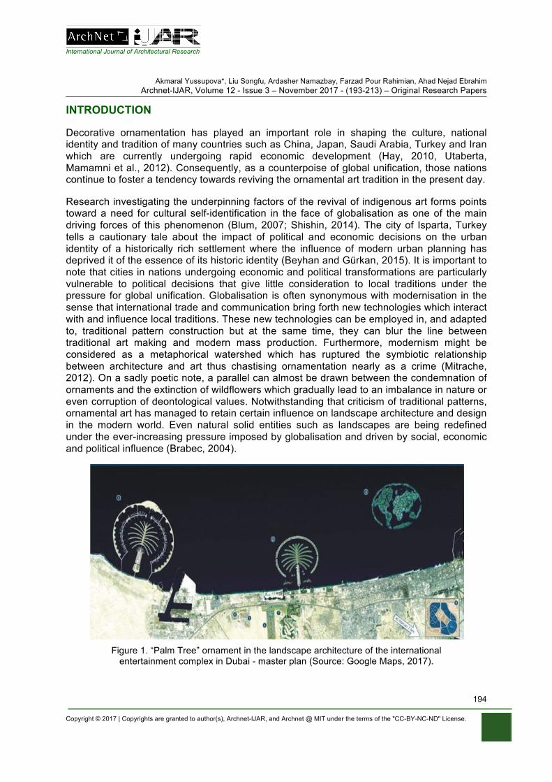
International Journal of Architectural Research
Akmaral Yussupova*, Liu Songfu, Ardasher Namazbay, Farzad Pour Rahimian, Ahad Nejad Ebrahim Archnet-IJAR, Volume 12 - Issue 3 – November 2017 - (193-213) – Original Research Papers
Copyright © 2017 | Copyrights are granted to author(s), Archnet-IJAR, and Archnet @ MIT under the terms of the "CC-BY-NC-ND" License.
194
INTRODUCTION
Decorative ornamentation has played an important role in shaping the culture, national identity and tradition of many countries such as China, Japan, Saudi Arabia, Turkey and Iran which are currently undergoing rapid economic development (Hay, 2010, Utaberta, Mamamni et al., 2012). Consequently, as a counterpoise of global unification, those nations continue to foster a tendency towards reviving the ornamental art tradition in the present day.
Research investigating the underpinning factors of the revival of indigenous art forms points toward a need for cultural self-identification in the face of globalisation as one of the main driving forces of this phenomenon (Blum, 2007; Shishin, 2014). The city of Isparta, Turkey tells a cautionary tale about the impact of political and economic decisions on the urban identity of a historically rich settlement where the influence of modern urban planning has deprived it of the essence of its historic identity (Beyhan and Gürkan, 2015). It is important to note that cities in nations undergoing economic and political transformations are particularly vulnerable to political decisions that give little consideration to local traditions under the pressure for global unification. Globalisation is often synonymous with modernisation in the sense that international trade and communication bring forth new technologies which interact with and influence local traditions. These new technologies can be employed in, and adapted to, traditional pattern construction but at the same time, they can blur the line between traditional art making and modern mass production. Furthermore, modernism might be considered as a metaphorical watershed which has ruptured the symbiotic relationship between architecture and art thus chastising ornamentation nearly as a crime (Mitrache, 2012). On a sadly poetic note, a parallel can almost be drawn between the condemnation of ornaments and the extinction of wildflowers which gradually lead to an imbalance in nature or even corruption of deontological values. Notwithstanding that criticism of traditional patterns, ornamental art has managed to retain certain influence on landscape architecture and design in the modern world. Even natural solid entities such as landscapes are being redefined under the ever-increasing pressure imposed by globalisation and driven by social, economic and political influence (Brabec, 2004).
Figure 1. “Palm Tree” ornament in the landscape architecture of the international
entertainment complex in Dubai - master plan (Source: Google Maps, 2017).
International Journal of Architectural Research
Akmaral Yussupova*, Liu Songfu, Ardasher Namazbay, Farzad Pour Rahimian, Ahad Nejad Ebrahim Archnet-IJAR, Volume 12 - Issue 3 – November 2017 - (193-213) – Original Research Papers
Copyright © 2017 | Copyrights are granted to author(s), Archnet-IJAR, and Archnet @ MIT under the terms of the "CC-BY-NC-ND" License.
195
The artificial palm islands in Dubai created in 2003 are an example of a modern megaproject where traditional ornamental pattern is incorporated in contemporary design. For various political and economic factors, towards the end of the 20th century and the beginning of 21st century, Dubai set out to establish itself as a global centre. In order to achieve that, massive infrastructural projects were carried out so as to enable global trading and communication (Elsheshtawy, 2004). Latest methods of theoretical design were employed in the attempt to tackle climatic and geographic challenges (Hellebrand, Fernandez et al., 2004). The result was a vast cultural and entertainment complex in the physical form of a tree ornament. Along with other architectural and infrastructural achievements, the shape of the palm tree islands has become the landmark of Dubai and is recognised across the whole world. Furthermore, floral patterns have been increasingly gathering attention. For instance, at the flower exhibition in Chelsea, London in 2004 an initiative led by the Prince of Wales resulted in a garden carpet design based on oriental floral art which then became the main object of interest at the exhibition (Clark, 2011).
Another example of floral patterns in contemporary culture is the official motif of the Beijing Olympic Games in 2008 – the “Clouds of Fortune”. The swirls of the design pattern were incorporated in the landscape of the central stadium as well as in the opening intro videos of the games. Experts of oriental art would recognise the symbolic value of the pattern as a wish for good luck and fortune. Economically developing countries put a great emphasis on their cultural heritage which is often expressed in the form of gardens and parks articulated through the means of symbolic ornamentation thus seeking the attention of tourists and promoting their national traditions.
RESEARCH METHOD
The main research question of this paper is: What is the relationship between the symbolism of ornamental art and landscape architecture design?As we stand, there is certain evidence that symbols of the ornamental arts have been the inspiration for landscape architecture. Hence, this study explores the approaches and methods used in the process of landscape design in Eurasian countries and specifically in Kazakhstan. The primary method used in this investigation is fundamental research which relies on theoretical analysis and interpretation of historical resources. Additional information for the research is gathered through field studies. The conclusion of the paper is reached through qualitative analysis.
Given that the countries along the Silk Road in Eurasia developed economically at about the same time and share similar cultural traditions, they have mutually influenced each other in this process and therefore foster similar contemporary tendencies. Kazakhstan serves as a case study of the symbolic value of ethnographic ornamentation and its influence on landscape architecture. It is located at an important intersection on the Silk Road. It is immediately bordered by China to the west and Russia to the east, and therefore sits on the route from Japan and Korea to Europe in the east-west direction. In the north-south direction, bordered by Russia to the north and Kyrgyzstan and Uzbekistan to the south, Kazakhstan is at the heart of the routes from Turkey, Iran and India to Russia. Sharing common culture and level of economic progress, these countries have developed their ornamental arts in a similar way. This tradition has been then translated into the landscape architecture of Eurasia and particularly in Kazakhstan. National Kazakh ornaments have heavily influenced the evolution of landscape architecture in Kazakhstan. Ornamentation is also an intrinsic part of Kazakhstan, almost becoming its trade mark, reflected in its national flag, land and currency.
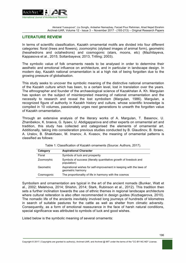
International Journal of Architectural Research
Akmaral Yussupova*, Liu Songfu, Ardasher Namazbay, Farzad Pour Rahimian, Ahad Nejad Ebrahim Archnet-IJAR, Volume 12 - Issue 3 – November 2017 - (193-213) – Original Research Papers
Copyright © 2017 | Copyrights are granted to author(s), Archnet-IJAR, and Archnet @ MIT under the terms of the "CC-BY-NC-ND" License.
196
LITERATURE REVIEW
In terms of scientific classification, Kazakh ornamental motifs are divided into four different categories: floral (trees and flowers), zoomorphic (stylised images of animal form), geometric (hexahedrons and octahedrons) and cosmogonic (stars, moons, etc) (Mazhitayeva, Kappasova et al., 2015; Soltanbayeva; 2013, Trilling; 2003).
The symbolic value of folk ornaments needs to be analysed in order to determine their aesthetic and emotional influence on architecture, and in particular in landscape design. In modern day, Kazakh national ornamentation is at a high risk of being forgotten due to the growing pressure of globalisation.
This study seeks to uncover the symbolic meaning of the distinctive national ornamentation of the Kazakh culture which has been, to a certain level, lost in translation over the years. The ethnographer and founder of the archaeological science of Kazakhstan A. Kh. Margulan has spoken on the subject of misinterpreted meaning of national ornamentation and the necessity to research and reveal the lost symbolism (Margulan, 1986). Margulan, a recognized figure of authority in Kazakh history and culture, whose scientific knowledge is compiled in 10 volumes, passionately urges next generations to unearth the forgotten value of Kazakh ornamentation.
Through an extensive analysis of the literary works of A. Margulan, T. Basenov, U. Zhanibekov, K. braeva, G. Ilyaev, U. Abdigapparova and other experts on ornamental art and tradition, this study has collected and categorised the elements of ornamental art. Additionally, taking into consideration previous studies conducted by B. Glaudinov, B. Ibraev, A. Uralov, B. Shakirbaev, M. Imanov, A. Kvasov, the meaning of ornamental patterns is classified as follows:
Table 1: Classification of Kazakh ornaments (Source: Authors, 2017).
Category Aspirational Character Floral Symbols of luck and prosperity Zoomorphic Symbols of success (literally quantitative growth of livestock and
population) Geometric Aspirational wishes for self-improvement in keeping with the laws of
geometric harmony Cosmogonic The proportionality of life in harmony with the cosmos
Symbolism and ornamentation are typical in the art of the ancient nomads (Bunker, Watt et al., 2002; Melehova, 2014; Shishin, 2014; Stark, Rubinson et al., 2012). This tradition then sets a further inclination towards the use of ethnic themes in regional landscape architecture where cultural reiteration is also often recommended in design guides (Kozbagarova, 2010). The nomadic life of the ancients inevitably involved long journeys of hundreds of kilometres in search of suitable pastures for the cattle as well as shelter from climatic adversity. Consequently, as a form of emotional reassurance in the face of harsh natural conditions, special significance was attributed to symbols of luck and good wishes.
Listed below is the symbolic meaning of several ornaments:
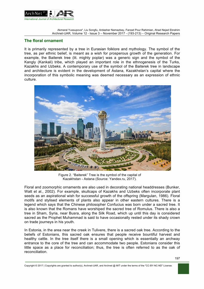
International Journal of Architectural Research
Akmaral Yussupova*, Liu Songfu, Ardasher Namazbay, Farzad Pour Rahimian, Ahad Nejad Ebrahim Archnet-IJAR, Volume 12 - Issue 3 – November 2017 - (193-213) – Original Research Papers
Copyright © 2017 | Copyrights are granted to author(s), Archnet-IJAR, and Archnet @ MIT under the terms of the "CC-BY-NC-ND" License.
197
The floral ornament
It is primarily represented by a tree in Eurasian folklore and mythology. The symbol of the tree, as per ethnic belief, is meant as a wish for prosperous growth of the generation. For example, the Baiterek tree (lit. mighty poplar) was a generic sign and the symbol of the Kangly (Kankali) tribe, which played an important role in the ethnogenesis of the Turks, Kazakhs and Uzbeks. A contemporary use of the symbol of the Baiterek tree in landscape and architecture is evident in the development of Astana, Kazakhstan’s capital where the incorporation of this symbolic meaning was deemed necessary as an expression of ethnic culture.
Figure 2. “Baiterek” Tree is the symbol of the capital of
Kazakhstan - Astana (Source: Yandex.ru, 2017).
Floral and zoomorphic ornaments are also used in decorating national headdresses (Bunker, Watt et al., 2002). For example, skullcaps of Kazakhs and Uzbeks often incorporate plant seeds as an aspirational wish for successful growth of the offspring (Margulan, 1986). Floral motifs and stylised elements of plants also appear in other eastern cultures. There is a legend which says that the Chinese philosopher Confucius was born under a sacred tree. It is also known that the Romans have worshiped the sacred tree of Romulus. There is also a tree in Sham, Syria, near Busra, along the Silk Road, which up until this day is considered sacred as the Prophet Muhammad is said to have occasionally rested under its shady crown on trade journeys in his youth.
In Estonia, in the area near the creek in Tulivere, there is a sacred oak tree. According to the beliefs of Estonians, this sacred oak ensures that people receive bountiful harvest and healthy cattle. In the tree itself there is a small opening which is essentially an archway entrance to the core of the tree and can accommodate two people. Estonians consider this little space as a place for reconciliation; thus, the tree is often referred to as the oak of reconciliation.
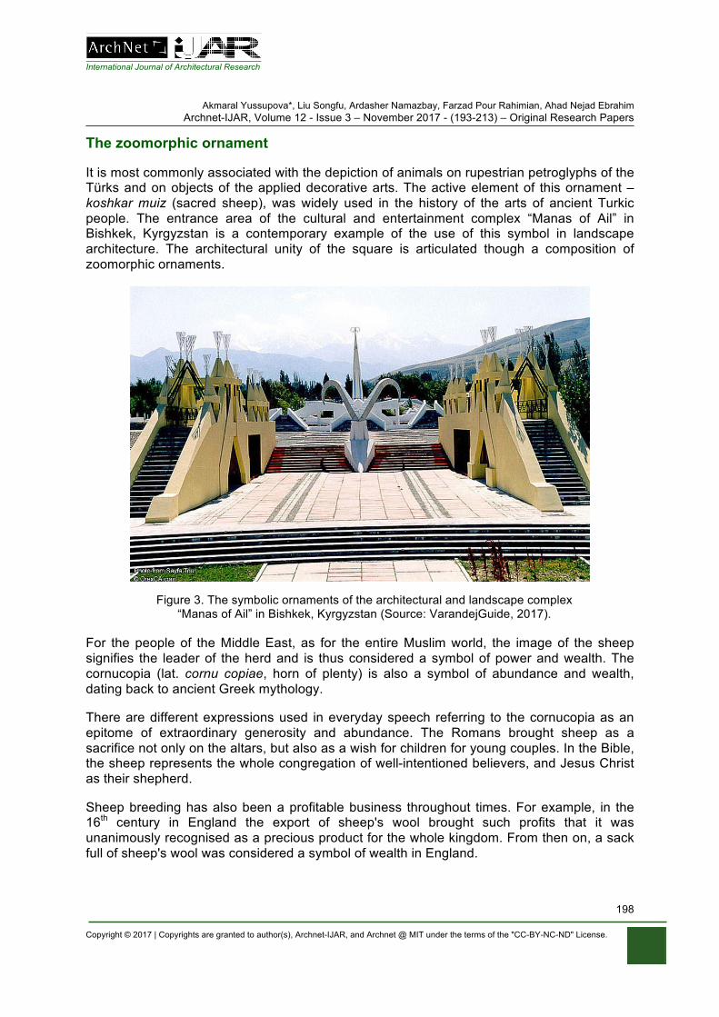
International Journal of Architectural Research
Akmaral Yussupova*, Liu Songfu, Ardasher Namazbay, Farzad Pour Rahimian, Ahad Nejad Ebrahim Archnet-IJAR, Volume 12 - Issue 3 – November 2017 - (193-213) – Original Research Papers
Copyright © 2017 | Copyrights are granted to author(s), Archnet-IJAR, and Archnet @ MIT under the terms of the "CC-BY-NC-ND" License.
198
The zoomorphic ornament
It is most commonly associated with the depiction of animals on rupestrian petroglyphs of the Türks and on objects of the applied decorative arts. The active element of this ornament –koshkar muiz (sacred sheep), was widely used in the history of the arts of ancient Turkic people. The entrance area of the cultural and entertainment complex “Manas of Ail” in Bishkek, Kyrgyzstan is a contemporary example of the use of this symbol in landscape architecture. The architectural unity of the square is articulated though a composition of zoomorphic ornaments.
Figure 3. The symbolic ornaments of the architectural and landscape complex
“Manas of Ail” in Bishkek, Kyrgyzstan (Source: VarandejGuide, 2017).
For the people of the Middle East, as for the entire Muslim world, the image of the sheep signifies the leader of the herd and is thus considered a symbol of power and wealth. The cornucopia (lat. cornu copiae, horn of plenty) is also a symbol of abundance and wealth, dating back to ancient Greek mythology.
There are different expressions used in everyday speech referring to the cornucopia as an epitome of extraordinary generosity and abundance. The Romans brought sheep as a sacrifice not only on the altars, but also as a wish for children for young couples. In the Bible, the sheep represents the whole congregation of well-intentioned believers, and Jesus Christ as their shepherd.
Sheep breeding has also been a profitable business throughout times. For example, in the 16th century in England the export of sheep's wool brought such profits that it was unanimously recognised as a precious product for the whole kingdom. From then on, a sack full of sheep's wool was considered a symbol of wealth in England.
International Journal of Architectural Research
Akmaral Yussupova*, Liu Songfu, Ardasher Namazbay, Farzad Pour Rahimian, Ahad Nejad Ebrahim Archnet-IJAR, Volume 12 - Issue 3 – November 2017 - (193-213) – Original Research Papers
Copyright © 2017 | Copyrights are granted to author(s), Archnet-IJAR, and Archnet @ MIT under the terms of the "CC-BY-NC-ND" License.
199
The zoomorphic ornament khus muryn which literally means “bird's beak” is very popular in Kazakhstan and was widely used in traditional jewellery. For the Kazakhs “khus muryn” is a harbinger of good news. In the Kazakh legends, birds bring good news from distant lands about the well-being of close relatives.
Doves also hold a special position in the cultural tradition of the people in Eurasia. The dove is often interpreted as a symbol of God's mercy as it was the dove that let Noah out of the ark after the flood and helped him find the land. The dove returned to the ark with clay on its feet thus suggesting the proximity of dry land and signalling that God had cleared the land and forgiven men.
Ancient culture greatly honours doves as well; the emblem of Athens is a dove with an olive branch. For the Romans, it was a symbol of love, dedicated to the goddess Venus. In Chinese culture, the image of the dove is a sign of loyalty, a sign of respect for elders, as well as a sign of longevity and peace. In Japan, the dove heralds the end of the war. The Prophet Muhammad, peace be upon him, also received divine revelations through a dove that sat on his shoulder. This ancient cultural symbolism has been carried on to present day. The emblem of the first World Congress of Peace Supporters held in 1949 in Paris and in Prague was drawn by the artist Pablo Picasso and it depicts a white dove, carrying an olive branch in its beak. There is clearly a continuous tradition to use the dove as a symbol of benevolent intentions and peace.
In Kazakh culture there is also another zoomorphic symbol that signifies health and long life – the stylised image of a turtle represented as a continuous smooth knot, consisting of four loops (Abdigapparova, 1999). In Feng shui the turtle means not only longevity and health, but is also a symbol of endless patience, wisdom and diligence, which always bear fruit. According to the Chinese legend, the doctrine of Feng shui was introduced by the turtle, so the followers of this doctrine treat it with great respect.
The geometric ornament
Its symbolic meaning was widely used in the architecture of Kazakhstan and Central Asia. For example, the typical dwelling of the Kazakhs – the yurt – is based on a round shape.
Geometric ornamentation offers a visually comprehensive representation of complex mathematical concepts and a rational explanation of the surrounding world. This ornamental type includes a series of geometric motifs, consisting of simple geometric figures like circles, squares and polygons. These individual figures united as per the creative intentions of artists form complicated compositions. Geometric ornaments in Kazakhstan and Central Asia are common in ancient geoglyphs, petroglyphs and in ceramic art. These geometric figures are also used in carpet weaving and jewellery and have a symbolic meaning.
Ancient settlements in Kazakhstan had both round and square shapes, the sides of which were oriented towards the directions of the world (Ibrayeva, 1994). This signifies the equilibrium of the urban structure and the intent for equal cooperation with other cities. In South Kazakhstan, the name of the historic city of Taraz comes from the word equilibrium and means the “scales”.
The square is the basis for building architectural compositions. The octagon, as the derivative of a displaced square, represented the need for improvement according to the
International Journal of Architectural Research
Akmaral Yussupova*, Liu Songfu, Ardasher Namazbay, Farzad Pour Rahimian, Ahad Nejad Ebrahim Archnet-IJAR, Volume 12 - Issue 3 – November 2017 - (193-213) – Original Research Papers
Copyright © 2017 | Copyrights are granted to author(s), Archnet-IJAR, and Archnet @ MIT under the terms of the "CC-BY-NC-ND" License.
200
laws of nature. This is confirmed by the number of boulders in the so-called stone gardens of ancient Turks in Kyrgyzstan (Nasredinova, 2007). Later, in the landscape architecture of the Taj Mahal, built by the descendants of Babur, the octahedrons were actively used as symbols of self-improvement to achieve a harmony with the environment and with the cosmos. Geometric ornaments from three thousand years ago are found in petroglyphs and in stone sculptures of modern Greece, Iran, Iraq and Turkey. Geometric forms were also revered in Japan and among American Indians.
The cosmogonic ornament
Philosophical expression through ornamental art is also part of the ancient traditions. The ancient ancestors of the Kazakhs represented the laws of nature in the form of symbolic ornaments which were then further manifested into the landscape architecture. In the fields of planning and architecture, there are examples of the use of symbolism in urban planning. The general plan of the city of Brasilia is in the form of a symbolic ornament - a bird. The clear readability of the symbol has contributed to the popularity of the city throughout the world. Consequently, this master plan in the shape of bird with unfolding wings has become an aspiration for a brighter future and has inspired many Brazilians.
In the modern landscape architecture of Kazakhstan, there are also examples of successful use of ornamental symbols. For instance, the basis of the general plan of the ethno-park in Astana is the petroglyph of the sun-headed man from the Tamgaly tract. The symbolism of the general plan is also intended as a force of inspiration for the people of Kazakhstan. The landscaping solution for the park was designed as an informative tour of Kazakhstan’s history, beginning from ancient times up until present time, concentrated in one entity on the same territory. From bird’s eye view, the ethnographic complex “Aray” appears to be following the silhouette of the “sun man” petroglyph (drawing from Tamgaly area). The park is divided into seven sectors where the main alleys cover certain historical periods and prominent figures who have influenced the culture development, formation and great history of the nomads. The park was designed by architect Sh. Mataibekov and R. Aubakirov and it was built and inaugurated in 2006 (Mаtaibekov, 2010). The petroglyph remains at the very heart of the general layout of the park as a symbolic wish for further development and prosperity of the Aray Park.
It should be emphasised that elaborating the general layout of a park with symbolic value requires special attention to the soil condition and ecological environment. In the arid areas of Kazakhstan, there are three types of ecosystems:
• clay (takyr) ecosystems: formed on silt drifts of Syr Darya, Amudarya and other small rivers with moderate phytomass (5-8t/ha), which have a large arable potential;
• desert (sand) ecosystems: with sufficient phytomass (several tens of tons/ha), especially in developed historical areas;
• riverine (tugai) ecosystems: formed in valleys and lower reaches of rivers with rich phytomass (300 tons/ha) and wildlife. Hence, tugai ecosystems in the lowlands of rivers and valleys are very convenient for the construction of gardens and parks (Yussupov, 1985).
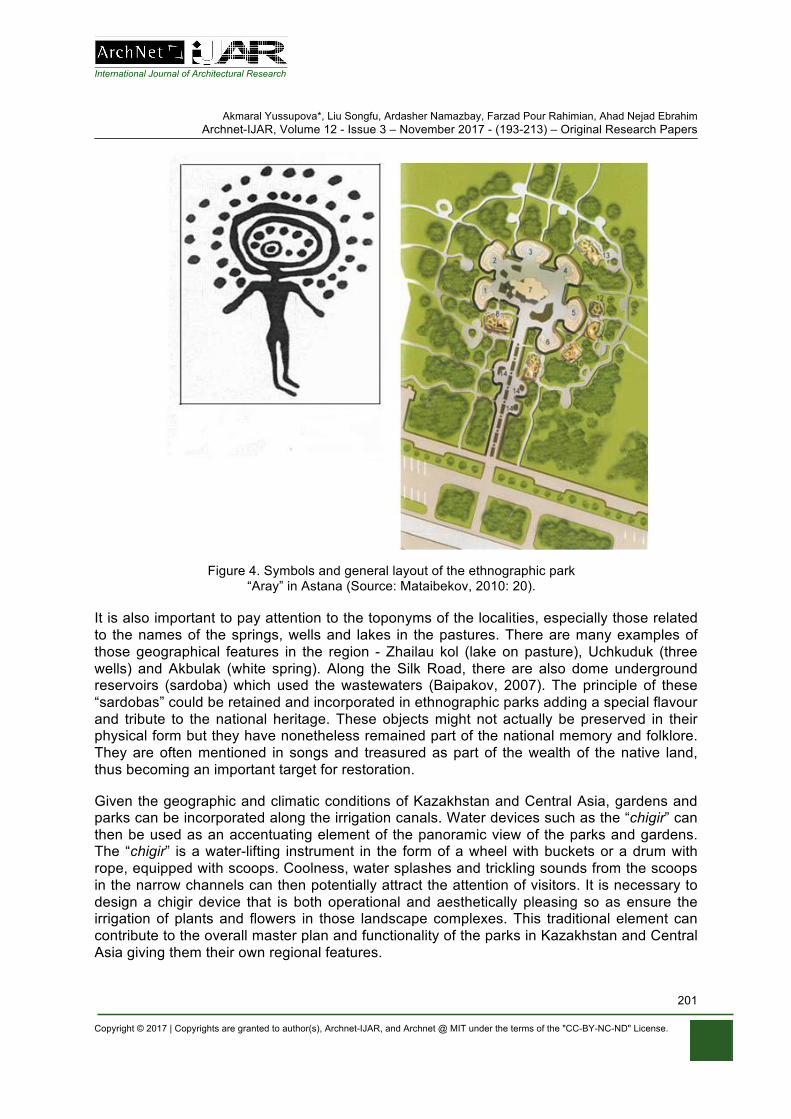
International Journal of Architectural Research
Akmaral Yussupova*, Liu Songfu, Ardasher Namazbay, Farzad Pour Rahimian, Ahad Nejad Ebrahim Archnet-IJAR, Volume 12 - Issue 3 – November 2017 - (193-213) – Original Research Papers
Copyright © 2017 | Copyrights are granted to author(s), Archnet-IJAR, and Archnet @ MIT under the terms of the "CC-BY-NC-ND" License.
201
Figure 4. Symbols and general layout of the ethnographic park
“Aray” in Astana (Source: Mataibekov, 2010: 20).
It is also important to pay attention to the toponyms of the localities, especially those related to the names of the springs, wells and lakes in the pastures. There are many examples of those geographical features in the region - Zhailau kol (lake on pasture), Uchkuduk (three wells) and Akbulak (white spring). Along the Silk Road, there are also dome underground reservoirs (sardoba) which used the wastewaters (Baipakov, 2007). The principle of these “sardobas” could be retained and incorporated in ethnographic parks adding a special flavour and tribute to the national heritage. These objects might not actually be preserved in their physical form but they have nonetheless remained part of the national memory and folklore. They are often mentioned in songs and treasured as part of the wealth of the native land, thus becoming an important target for restoration.
Given the geographic and climatic conditions of Kazakhstan and Central Asia, gardens and parks can be incorporated along the irrigation canals. Water devices such as the “chigir” can then be used as an accentuating element of the panoramic view of the parks and gardens. The “chigir” is a water-lifting instrument in the form of a wheel with buckets or a drum with rope, equipped with scoops. Coolness, water splashes and trickling sounds from the scoops in the narrow channels can then potentially attract the attention of visitors. It is necessary to design a chigir device that is both operational and aesthetically pleasing so as ensure the irrigation of plants and flowers in those landscape complexes. This traditional element can contribute to the overall master plan and functionality of the parks in Kazakhstan and Central Asia giving them their own regional features.
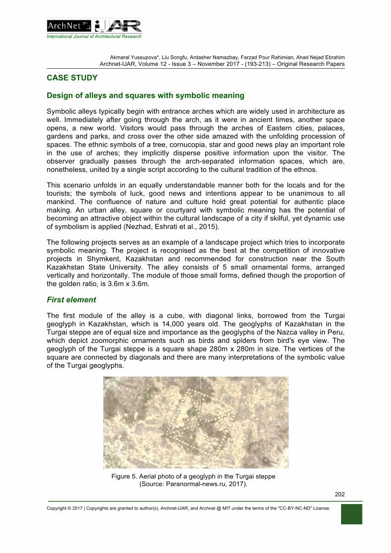
International Journal of Architectural Research
Akmaral Yussupova*, Liu Songfu, Ardasher Namazbay, Farzad Pour Rahimian, Ahad Nejad Ebrahim Archnet-IJAR, Volume 12 - Issue 3 – November 2017 - (193-213) – Original Research Papers
Copyright © 2017 | Copyrights are granted to author(s), Archnet-IJAR, and Archnet @ MIT under the terms of the "CC-BY-NC-ND" License.
202
CASE STUDY
Design of alleys and squares with symbolic meaning
Symbolic alleys typically begin with entrance arches which are widely used in architecture as well. Immediately after going through the arch, as it were in ancient times, another space opens, a new world. Visitors would pass through the arches of Eastern cities, palaces, gardens and parks, and cross over the other side amazed with the unfolding procession of spaces. The ethnic symbols of a tree, cornucopia, star and good news play an important role in the use of arches; they implicitly disperse positive information upon the visitor. The observer gradually passes through the arch-separated information spaces, which are, nonetheless, united by a single script according to the cultural tradition of the ethnos.
This scenario unfolds in an equally understandable manner both for the locals and for the tourists; the symbols of luck, good news and intentions appear to be unanimous to all mankind. The confluence of nature and culture hold great potential for authentic place making. An urban alley, square or courtyard with symbolic meaning has the potential of becoming an attractive object within the cultural landscape of a city if skilful, yet dynamic use of symbolism is applied (Nezhad, Eshrati et al., 2015).
The following projects serves as an example of a landscape project which tries to incorporate symbolic meaning. The project is recognised as the best at the competition of innovative projects in Shymkent, Kazakhstan and recommended for construction near the South Kazakhstan State University. The alley consists of 5 small ornamental forms, arranged vertically and horizontally. The module of those small forms, defined though the proportion of the golden ratio, is 3.6m x 3.6m.
First element
The first module of the alley is a cube, with diagonal links, borrowed from the Turgai geoglyph in Kazakhstan, which is 14,000 years old. The geoglyphs of Kazakhstan in the Turgai steppe are of equal size and importance as the geoglyphs of the Nazca valley in Peru, which depict zoomorphic ornaments such as birds and spiders from bird's eye view. The geoglyph of the Turgai steppe is a square shape 280m x 280m in size. The vertices of the square are connected by diagonals and there are many interpretations of the symbolic value of the Turgai geoglyphs.
Figure 5. Aerial photo of a geoglyph in the Turgai steppe
(Source: Paranormal-news.ru, 2017).
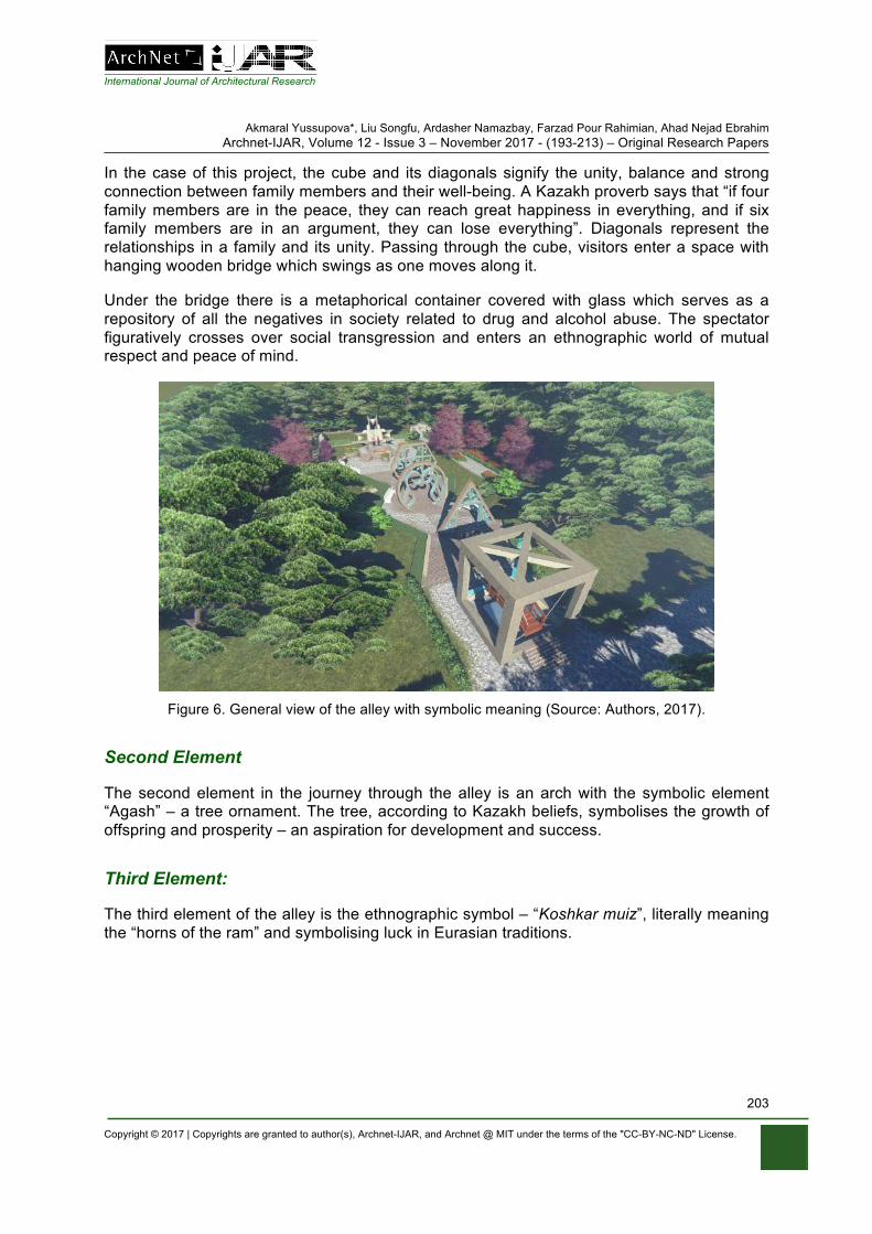
International Journal of Architectural Research
Akmaral Yussupova*, Liu Songfu, Ardasher Namazbay, Farzad Pour Rahimian, Ahad Nejad Ebrahim Archnet-IJAR, Volume 12 - Issue 3 – November 2017 - (193-213) – Original Research Papers
Copyright © 2017 | Copyrights are granted to author(s), Archnet-IJAR, and Archnet @ MIT under the terms of the "CC-BY-NC-ND" License.
203
In the case of this project, the cube and its diagonals signify the unity, balance and strong connection between family members and their well-being. A Kazakh proverb says that “if four family members are in the peace, they can reach great happiness in everything, and if six family members are in an argument, they can lose everything”. Diagonals represent the relationships in a family and its unity. Passing through the cube, visitors enter a space with hanging wooden bridge which swings as one moves along it.
Under the bridge there is a metaphorical container covered with glass which serves as a repository of all the negatives in society related to drug and alcohol abuse. The spectator figuratively crosses over social transgression and enters an ethnographic world of mutual respect and peace of mind.
Figure 6. General view of the alley with symbolic meaning (Source: Authors, 2017).
Second Element
The second element in the journey through the alley is an arch with the symbolic element “Agash” – a tree ornament. The tree, according to Kazakh beliefs, symbolises the growth of offspring and prosperity – an aspiration for development and success.
Third Element:
The third element of the alley is the ethnographic symbol – “Koshkar muiz”, literally meaning the “horns of the ram” and symbolising luck in Eurasian traditions.
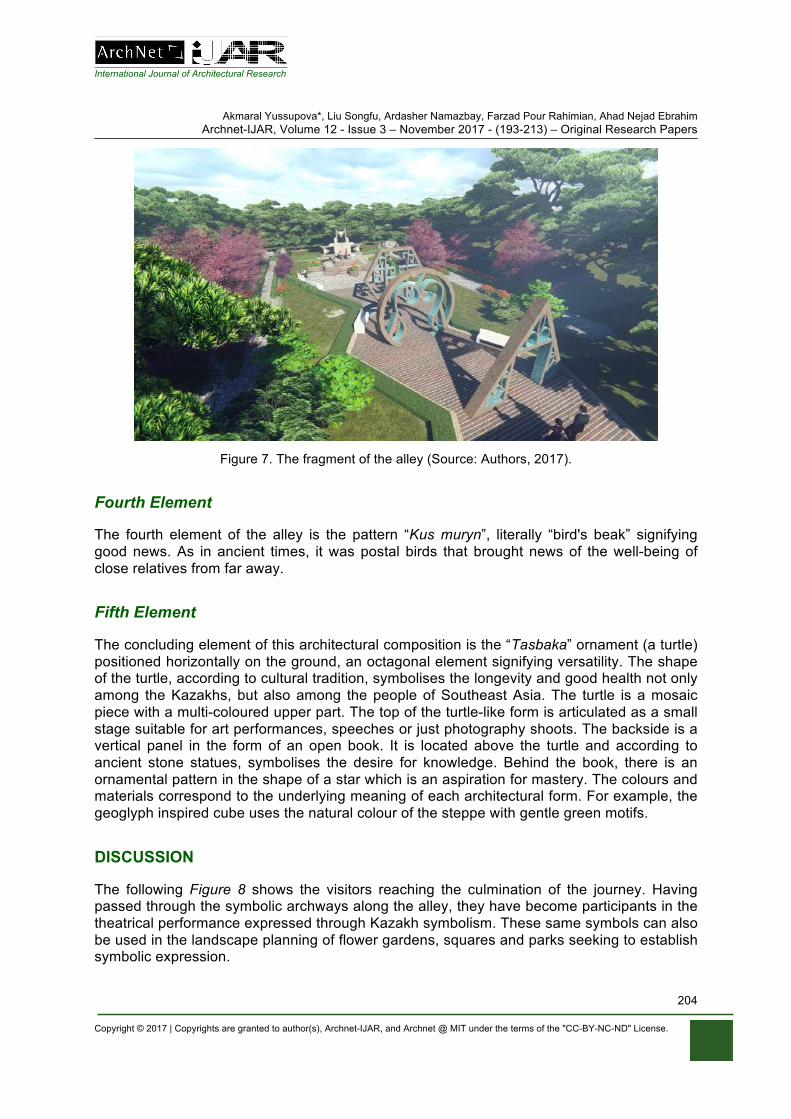
International Journal of Architectural Research
Akmaral Yussupova*, Liu Songfu, Ardasher Namazbay, Farzad Pour Rahimian, Ahad Nejad Ebrahim Archnet-IJAR, Volume 12 - Issue 3 – November 2017 - (193-213) – Original Research Papers
Copyright © 2017 | Copyrights are granted to author(s), Archnet-IJAR, and Archnet @ MIT under the terms of the "CC-BY-NC-ND" License.
204
Figure 7. The fragment of the alley (Source: Authors, 2017).
Fourth Element
The fourth element of the alley is the pattern “Kus muryn”, literally “bird's beak” signifying good news. As in ancient times, it was postal birds that brought news of the well-being of close relatives from far away.
Fifth Element
The concluding element of this architectural composition is the “Tasbaka” ornament (a turtle) positioned horizontally on the ground, an octagonal element signifying versatility. The shape of the turtle, according to cultural tradition, symbolises the longevity and good health not only among the Kazakhs, but also among the people of Southeast Asia. The turtle is a mosaic piece with a multi-coloured upper part. The top of the turtle-like form is articulated as a small stage suitable for art performances, speeches or just photography shoots. The backside is a vertical panel in the form of an open book. It is located above the turtle and according to ancient stone statues, symbolises the desire for knowledge. Behind the book, there is an ornamental pattern in the shape of a star which is an aspiration for mastery. The colours and materials correspond to the underlying meaning of each architectural form. For example, the geoglyph inspired cube uses the natural colour of the steppe with gentle green motifs.
DISCUSSION
The following Figure 8 shows the visitors reaching the culmination of the journey. Having passed through the symbolic archways along the alley, they have become participants in the theatrical performance expressed through Kazakh symbolism. These same symbols can also be used in the landscape planning of flower gardens, squares and parks seeking to establish symbolic expression.
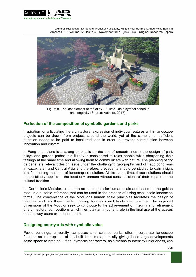
International Journal of Architectural Research
Akmaral Yussupova*, Liu Songfu, Ardasher Namazbay, Farzad Pour Rahimian, Ahad Nejad Ebrahim Archnet-IJAR, Volume 12 - Issue 3 – November 2017 - (193-213) – Original Research Papers
Copyright © 2017 | Copyrights are granted to author(s), Archnet-IJAR, and Archnet @ MIT under the terms of the "CC-BY-NC-ND" License.
205
Figure 8. The last element of the alley – “Turtle”, as a symbol of health
and longevity (Source: Authors, 2017).
Perfection of the composition of symbolic gardens and parks
Inspiration for articulating the architectural expression of individual features within landscape projects can be drawn from projects around the world, yet at the same time, sufficient attention needs to be paid to local traditions in order to prevent contradiction between innovation and custom.
In Feng shui, there is a strong emphasis on the use of smooth lines in the design of park alleys and garden paths; this fluidity is considered to relax people while sharpening their feelings at the same time and allowing them to communicate with nature. The planning of dry gardens is a relevant design issue under the challenging geographic and climatic conditions in Kazakhstan and Central Asia and therefore, precedents should be studied to gain insight into functioning methods of landscape resolution. At the same time, those solutions should not be blindly applied to the local environment without considerations of their impact on the cultural tradition.
Le Corbusier’s Modulor, created to accommodate for human scale and based on the golden ratio, is a suitable reference that can be used in the process of sizing small scale landscape forms. The convenience of the Modulor’s human scale principles facilitates the design of features such as flower beds, drinking fountains and landscape furniture. The adjusted dimensions of the Modulor seek to contribute to the achievement of integrity and refinement of architectural compositions which then play an important role in the final use of the spaces and the way users experience them.
Designing courtyards with symbolic value
Public buildings, university campuses and science parks often incorporate landscape features as interruptions of the built form, metaphorically giving those large developments some space to breathe. Often, symbolic characters, as a means to intensify uniqueness, can

International Journal of Architectural Research
Akmaral Yussupova*, Liu Songfu, Ardasher Namazbay, Farzad Pour Rahimian, Ahad Nejad Ebrahim Archnet-IJAR, Volume 12 - Issue 3 – November 2017 - (193-213) – Original Research Papers
Copyright © 2017 | Copyrights are granted to author(s), Archnet-IJAR, and Archnet @ MIT under the terms of the "CC-BY-NC-ND" License.
206
be also identified in the layouts of those courtyards. Below is an example of a landscape proposal for a courtyard within the technopark of South Kazakhstan State University. The design concept is based around a spiral element in the centre which forms pedestrian paths and lawns.
At the heart of the spiral composition, there is a star-shaped decorative fountain “Temirkazyk” symbolising the scientific discoveries of the university and its aspirations for further innovation. “Temirkazyk” is the Kazakh name of the North Star (lat. Alpha Ursae Minoris) which is the only visible star from Earth that does not change its position on the horizon and was therefore a key celestial reference in ancient times.
Figure 9. Symbols and general layout of thetechnopark of South Kazakhstan State
University (Source: Authors, 2017).
The ancient Kazakhs used to explore the starry sky through a hole at the top of their yurts. This primeval form of an observatory allowed them to ponder the philosophical questions of the universe and create an interpretation of the universe in form of a spiral shaped map symbolising infinity. This map of the universe was published in the 19th century by the Kazakh natural scientist Chokan Valikhanov (Strelzova, 1990). In this courtyard proposal, inspired by the ancient spiral representation of the universe, boulders create the allusion of planets and stars. In small scale landscape propositions, their immediate architectural articulation has to be underpinned by the meta-theme of the whole park or campus.
Symbolic gardens, parks and courtyards can often be defined through smooth outlines, bends, curves and other ornamental patterns as seen in the case of the entertainment complex in Dubai shaped as a palm tree, or the petroglyph inspired park Aray in Astana. In order to fully determine the concept of a landscape proposal, it is necessary to clearly establish its purpose, boundaries and connections with the rest of the urban realm. A carefully selected range of symbols can yield public interest and turn the space into an urban activator. The design of each individual element of the park has to be carried out in keeping with the overall theme where preference is given to smooth forms replicating the relief of the natural landscape. At the same time, symbolism can be incorporated at the discretion of the
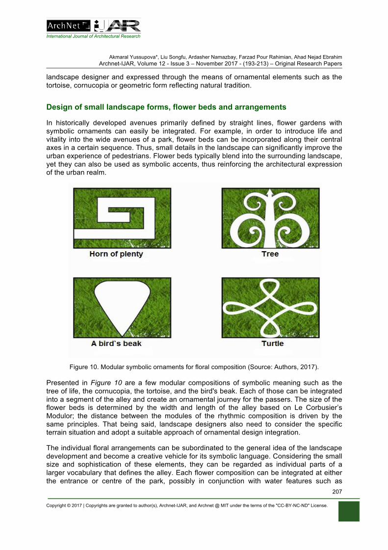
International Journal of Architectural Research
Akmaral Yussupova*, Liu Songfu, Ardasher Namazbay, Farzad Pour Rahimian, Ahad Nejad Ebrahim Archnet-IJAR, Volume 12 - Issue 3 – November 2017 - (193-213) – Original Research Papers
Copyright © 2017 | Copyrights are granted to author(s), Archnet-IJAR, and Archnet @ MIT under the terms of the "CC-BY-NC-ND" License.
207
landscape designer and expressed through the means of ornamental elements such as the tortoise, cornucopia or geometric form reflecting natural tradition.
Design of small landscape forms, flower beds and arrangements
In historically developed avenues primarily defined by straight lines, flower gardens with symbolic ornaments can easily be integrated. For example, in order to introduce life and vitality into the wide avenues of a park, flower beds can be incorporated along their central axes in a certain sequence. Thus, small details in the landscape can significantly improve the urban experience of pedestrians. Flower beds typically blend into the surrounding landscape, yet they can also be used as symbolic accents, thus reinforcing the architectural expression of the urban realm.
Figure 10. Modular symbolic ornaments for floral composition (Source: Authors, 2017).
Presented in Figure 10 are a few modular compositions of symbolic meaning such as the tree of life, the cornucopia, the tortoise, and the bird's beak. Each of those can be integrated into a segment of the alley and create an ornamental journey for the passers. The size of the flower beds is determined by the width and length of the alley based on Le Corbusier’s Modulor; the distance between the modules of the rhythmic composition is driven by the same principles. That being said, landscape designers also need to consider the specific terrain situation and adopt a suitable approach of ornamental design integration.
The individual floral arrangements can be subordinated to the general idea of the landscape development and become a creative vehicle for its symbolic language. Considering the small size and sophistication of these elements, they can be regarded as individual parts of a larger vocabulary that defines the alley. Each flower composition can be integrated at either the entrance or centre of the park, possibly in conjunction with water features such as
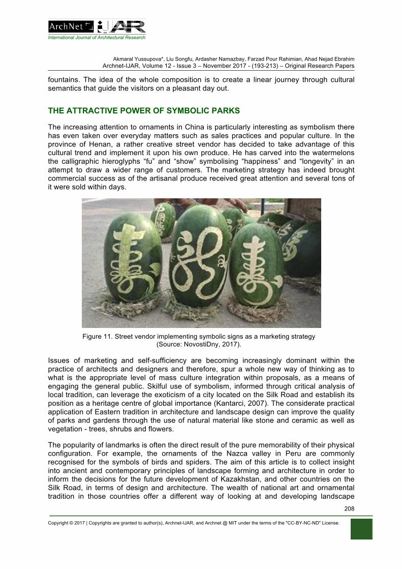
International Journal of Architectural Research
Akmaral Yussupova*, Liu Songfu, Ardasher Namazbay, Farzad Pour Rahimian, Ahad Nejad Ebrahim Archnet-IJAR, Volume 12 - Issue 3 – November 2017 - (193-213) – Original Research Papers
Copyright © 2017 | Copyrights are granted to author(s), Archnet-IJAR, and Archnet @ MIT under the terms of the "CC-BY-NC-ND" License.
208
fountains. The idea of the whole composition is to create a linear journey through cultural semantics that guide the visitors on a pleasant day out.
THE ATTRACTIVE POWER OF SYMBOLIC PARKS
The increasing attention to ornaments in China is particularly interesting as symbolism there has even taken over everyday matters such as sales practices and popular culture. In the province of Henan, a rather creative street vendor has decided to take advantage of this cultural trend and implement it upon his own produce. He has carved into the watermelons the calligraphic hieroglyphs “fu” and “show” symbolising “happiness” and “longevity” in an attempt to draw a wider range of customers. The marketing strategy has indeed brought commercial success as of the artisanal produce received great attention and several tons of it were sold within days.
Figure 11. Street vendor implementing symbolic signs as a marketing strategy
(Source: NovostiDny, 2017).
Issues of marketing and self-sufficiency are becoming increasingly dominant within the practice of architects and designers and therefore, spur a whole new way of thinking as to what is the appropriate level of mass culture integration within proposals, as a means of engaging the general public. Skilful use of symbolism, informed through critical analysis of local tradition, can leverage the exoticism of a city located on the Silk Road and establish its position as a heritage centre of global importance (Kantarci, 2007). The considerate practical application of Eastern tradition in architecture and landscape design can improve the quality of parks and gardens through the use of natural material like stone and ceramic as well as vegetation - trees, shrubs and flowers.
The popularity of landmarks is often the direct result of the pure memorability of their physical configuration. For example, the ornaments of the Nazca valley in Peru are commonly recognised for the symbols of birds and spiders. The aim of this article is to collect insight into ancient and contemporary principles of landscape forming and architecture in order to inform the decisions for the future development of Kazakhstan, and other countries on the Silk Road, in terms of design and architecture. The wealth of national art and ornamental tradition in those countries offer a different way of looking at and developing landscape
International Journal of Architectural Research
Akmaral Yussupova*, Liu Songfu, Ardasher Namazbay, Farzad Pour Rahimian, Ahad Nejad Ebrahim Archnet-IJAR, Volume 12 - Issue 3 – November 2017 - (193-213) – Original Research Papers
Copyright © 2017 | Copyrights are granted to author(s), Archnet-IJAR, and Archnet @ MIT under the terms of the "CC-BY-NC-ND" License.
209
projects that might potentially gain further recognition in modern occidental society and, in the spirit of the UNESCO initiatives, increase the awareness and tolerance of other cultures.
DESIGN OF RECREATIONAL AREAS, ARBOURS AND PATHWAYS
Recreational areas
Recreational areas of round shapes in parks and gardens can potentially carry additional symbolic meaning. For the Kazakhs the round shape is associated with the layout of the traditional dwelling - the yurt. This form is believed to foster a comfortable ambiance and conditions for calm conversation. In keeping with the zoning of the park, urban furniture can be arranged around the circle to encourage people to sit and have an open conversation. A tortoise ornament, complemented with modular circles would be particularly suitable to place at the very centre of the round space as a symbol of well-being. The choice of materials can include natural flat stones, ceramic tiles and pebbles, yet it is necessary to skilfully combine these materials, emphasising their colour and texture. In order to achieve diversity in the composition of recreational areas, square and polygonal shapes can also be used as intensifiers of the architectural expression.
In homage to national tradition, the use of local materials in the ethnographic gardens is very important, therefore facing stone, brick, cobblestone, pebble and coloured ceramics are good examples of possible choices. Local flat rocks provide a rather solid basis for the development of picturesque compositions. Cobblestone and pebbles are convenient for framing drinking fountains and cascades eluding a sense of plasticity. Pebbles can also be used as a medium for mosaic compositions with symbolic patterns. These compositions can be placed as accents of the recreational areas. Facing bricks are suitable for curbs and various geometric patterns for landscape compositions. These geometric patterns add an exotic flavour to the landscape compositions and attract local population.
Arbours, pavilions and sanctuaries
The arbour is an indispensable attribute of the symbolic garden. In Kazakh tradition, the yurts are often placed in gardens and used as summer gazebos. The Kazakh yurt keeps cool in the summer heat and is a tranquil place for daily pondering or contemplating philosophical questions. At present, there is a rather prominent demand for modern modular arbours. These arbours, as well as yurts, are assembled from light structures, yet retain the main features of ethnographic tradition. Pavilions, pergolas and sanctuaries can also be covered in vegetation such as draught-resistant flowers and vines. Additional vertical landscaping can come in the form of contour walls of the park complementing the garden composition as well as providing shade in the summer heat. Special attention should be dedicated to the small fountains located near the gazebos as the gentle murmur of their water at dusk can have a particularly calming effect. In tea drinking gardens where “samovars” (traditional tea-making devices) are used, their light smoke adds an additional rural feel to the ambiance. The tea itself is considered healing and an activator of philosophical conversations. There is a saying that “wisdom is at the bottom of the bowl” which originates in the Kazakh tea drinking tradition. The locals pour themselves small portions of tea repeatedly and carry out long, fluid conversations. In keeping with folk traditions, fruit trees and shrubs such as drought-resistant
International Journal of Architectural Research
Akmaral Yussupova*, Liu Songfu, Ardasher Namazbay, Farzad Pour Rahimian, Ahad Nejad Ebrahim Archnet-IJAR, Volume 12 - Issue 3 – November 2017 - (193-213) – Original Research Papers
Copyright © 2017 | Copyrights are granted to author(s), Archnet-IJAR, and Archnet @ MIT under the terms of the "CC-BY-NC-ND" License.
210
varieties of apple, pear, peach, apricot and grapes would be particularly suitable for symbolic gardens.
Pathways with fragrant flowers and plants
Fragrant plants and flowers such as irises, roses, basil and mint create an additional layer of symbolism with a sacred garden or park. For example, flower beds can be planted along both sides of the alleys thus immersing visitors and passers-by into a fragrant experience of different scents. Special attention should be given to those aromatic avenues as they unfold the distinct theatricality of the landscape. Flowering season, orientation, composition and careful combination of species are of crucial importance for the creation of a pleasant fragrant scene. The colour of the plants in the symbolic gardens and parks should also be carefully considered. Combination of bright colours and ornaments add to the small scale architectural forms of gardens a sense of completeness, monumentality and exotic beauty, thus triggering special attraction. Examples of this style can be found in Turkestan, Samarkand and Bukhara. The combination of ceramic colours, natural stone, textured wood and metalwork add a magical tint to the design and make an allusion to the artisanal landscapes of the Eastern countries. Design colour themes are often based on the season of the year. In Kazakhstan, the traditional ornamental patterns favour autumn and winter tones. Autumn shades of yellow, red, beige, brown and black combined with a winter palette of turquoise, and crimson create a vivid contrast against the white felt of the Kazakh yurt. All these particularities and nuances of colour should be carefully transferred to the elements of design and architecture of the symbolic garden.
Walkways of smooth, winding character are associated with the shape and outline of small rivers. These fluid, natural forms induce tranquillity in visitors and enhance their spiritual connection with nature. Intentional use of sinuous outlines of pedestrian paths in parks can also recreate the same sentiments. For an artistic reorganisation of existing straight paths, it is possible to use symbolic ornaments to naturally integrate them into the surrounding landscape. On the surface of the paths, fragments of zoomorphic ornaments such as cornucopia, tortoise, avian beak, etc. can be used in order to establish a hierarchy and break the paths into segments. These fragments can also be incorporated at rest benches, drinking fountains and intersections between main and minor trails. Modular prints of the ornamental art can also be stamped onto uncompressed concrete surfaces, the traces of the print can then be infilled with tiles, coloured concrete or pebbles. The pedestrian paths themselves can be made of coloured concrete and in this case the ornaments can be articulated using a different colour. If the walkways are framed on both sides by brick curbs, then they can be covered in gravel. In this case, the symbolic ornament is placed in round or square concrete rosettes positioned as per the main design. In nomad tradition, roads bear great significance as they are associated with a journey to the future, therefore, symbols of luck would be particularly suitable in garden walkways.
CONCLUSION
This study has identified a recurring tendency in the use of symbolic ornaments in landscape architecture as in the case of Dubai and Astana. This growing interest in symbolism can be explained as a result of the revival of national arts and a response to the globalisation of world communities. The critical analysis of historic and field materials has revealed common
International Journal of Architectural Research
Akmaral Yussupova*, Liu Songfu, Ardasher Namazbay, Farzad Pour Rahimian, Ahad Nejad Ebrahim Archnet-IJAR, Volume 12 - Issue 3 – November 2017 - (193-213) – Original Research Papers
Copyright © 2017 | Copyrights are granted to author(s), Archnet-IJAR, and Archnet @ MIT under the terms of the "CC-BY-NC-ND" License.
211
features and meaning of symbolic ornaments which are characteristic of native nomads as well as peoples from Europe and the Eastern countries.
Through an experimental project proposal, this study establishes a methodology of developing landscape architecture through a vocabulary of symbolic ornamentation in Kazakhstan. Additionally, a practical guide of further design considerations is established to facilitate the planning of parks, gardens, alleys and floral compositions. Symbolism refers back to intrinsic human values and aspirations and is thus recognised in the architectural expression both of eastern and occidental cultures albeit in different forms. The universal value of wishes for mutual understanding, benevolence, good luck and prosperity reverberates through time and brings cultures together in an age of rapid economic development.
Listed below are five design guidelines for landscape projects with symbolic meaning:
• Symbols of good fortune - every culture manifests symbols of good fortune in its ornamental art: the tree signifying life, the cube - equality and strength of society, birds - good news and peace. Throughout time mankind has always forged its conventions of reassurance and hope for the future. These wishes of health and prosperity strive to uplift the human spirit in times of hardship and encourage it along the small battles of every day. Hence, the creative endeavours of architects and planners expressed through architectural and landscape design should also strive to fulfil the ultimate goal of a healthy and prosperous modern society.
• Plasticity of ornamental art - ornamental patterns are an essential design element of landscape architecture as they are effortlessly integrated in existing terrains as its natural continuation. Inspired by nature in the first place, ornamental elements remain part of the vocabulary of geographic language and fit seamlessly into the contours of its terrains. The malleable qualities of the very earth are reflected in the smooth, fluid outlines of ornamental elements and their application in landscape design reinforces the natural perception of gardens and parks.
• Eastern charm as a hallmark of ornamental landscape design - appropriate colour schemes are achieved through a careful consideration of local tradition and mindful selection of building materials so that there is an overall cohesion of the overall landscape. Warm coloured natural stones, ceramic tiles and intricate patterns come together to pay tribute to an eastern exotic typical of the exterior and interior public spaces of Turkestan, Samarkand and Bukhara.
• Clarity of expression - the simplicity and instant comprehension of the compositions is achieved through the use of natural symbolic forms (trees, birds, flowers). The concise silhouettes of those elements make them easy to understand and remember. Compositional unity and artistic originality in the use of symbolic elements are key to a successful landscape design.
• Small scale modular design - the human scale approach to design outlined in Le Corbusier’s Modulor is a good starting point for the design of landscape elements such as flower beds, water fountains and furniture. The main driver of design concepts for small scale modular compositions and their adaptation to local conditions should always be the end user.
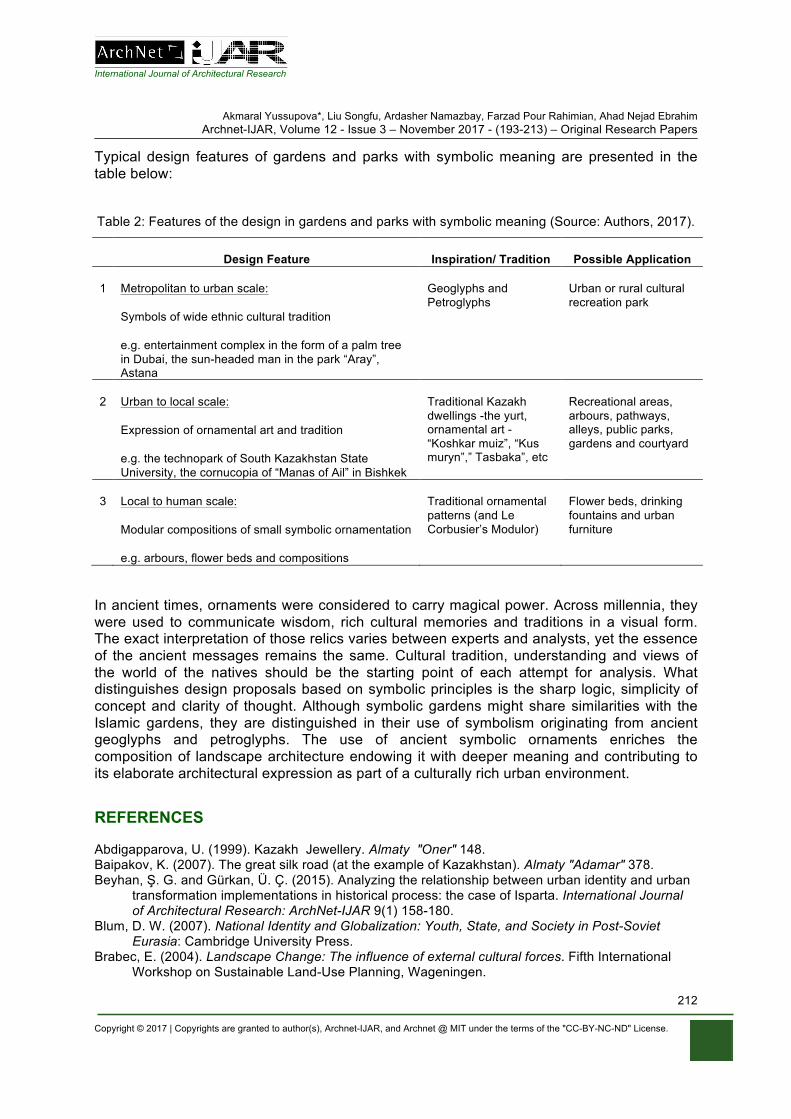
International Journal of Architectural Research
Akmaral Yussupova*, Liu Songfu, Ardasher Namazbay, Farzad Pour Rahimian, Ahad Nejad Ebrahim Archnet-IJAR, Volume 12 - Issue 3 – November 2017 - (193-213) – Original Research Papers
Copyright © 2017 | Copyrights are granted to author(s), Archnet-IJAR, and Archnet @ MIT under the terms of the "CC-BY-NC-ND" License.
212
Typical design features of gardens and parks with symbolic meaning are presented in the table below:
Table 2: Features of the design in gardens and parks with symbolic meaning (Source: Authors, 2017).
Design Feature Inspiration/ Tradition Possible Application
1 Metropolitan to urban scale:
Symbols of wide ethnic cultural tradition
e.g. entertainment complex in the form of a palm tree in Dubai, the sun-headed man in the park “Aray”, Astana
Geoglyphs and Petroglyphs
Urban or rural cultural recreation park
2 Urban to local scale:
Expression of ornamental art and tradition
e.g. the technopark of South Kazakhstan State University, the cornucopia of “Manas of Ail” in Bishkek
Traditional Kazakh dwellings -the yurt, ornamental art - “Koshkar muiz”, “Kus muryn”,” Tasbaka”, etc
Recreational areas, arbours, pathways, alleys, public parks, gardens and courtyard
3 Local to human scale:
Modular compositions of small symbolic ornamentation
e.g. arbours, flower beds and compositions
Traditional ornamental patterns (and Le Corbusier’s Modulor)
Flower beds, drinking fountains and urban furniture
In ancient times, ornaments were considered to carry magical power. Across millennia, they were used to communicate wisdom, rich cultural memories and traditions in a visual form. The exact interpretation of those relics varies between experts and analysts, yet the essence of the ancient messages remains the same. Cultural tradition, understanding and views of the world of the natives should be the starting point of each attempt for analysis. What distinguishes design proposals based on symbolic principles is the sharp logic, simplicity of concept and clarity of thought. Although symbolic gardens might share similarities with the Islamic gardens, they are distinguished in their use of symbolism originating from ancient geoglyphs and petroglyphs. The use of ancient symbolic ornaments enriches the composition of landscape architecture endowing it with deeper meaning and contributing to its elaborate architectural expression as part of a culturally rich urban environment.
REFERENCES Abdigapparova, U. (1999). Kazakh Jewellery. Almaty "Oner" 148. Baipakov, K. (2007). The great silk road (at the example of Kazakhstan). Almaty "Adamar" 378. Beyhan, Ş. G. and Gürkan, Ü. Ç. (2015). Analyzing the relationship between urban identity and urban
transformation implementations in historical process: the case of Isparta. International Journal of Architectural Research: ArchNet-IJAR 9(1) 158-180.
Blum, D. W. (2007). National Identity and Globalization: Youth, State, and Society in Post-Soviet Eurasia: Cambridge University Press.
Brabec, E. (2004). Landscape Change: The influence of external cultural forces. Fifth International Workshop on Sustainable Land-Use Planning, Wageningen.
International Journal of Architectural Research
Akmaral Yussupova*, Liu Songfu, Ardasher Namazbay, Farzad Pour Rahimian, Ahad Nejad Ebrahim Archnet-IJAR, Volume 12 - Issue 3 – November 2017 - (193-213) – Original Research Papers
Copyright © 2017 | Copyrights are granted to author(s), Archnet-IJAR, and Archnet @ MIT under the terms of the "CC-BY-NC-ND" License.
213
Bunker, E. C., et al. (2002). Nomadic Art of the Eastern Eurasian Steppes: The Eugene V. Thaw and Other New York Collections: Metropolitan Museum of Art.
Clark, E. (2011). The Art of the Islamic Garden. Kent: The crowood Press. Elsheshtawy, Y. (2004). Redrawing boundaries: Dubai, an emerging global city. Planning middle
eastern cities: an urban kaleidoscope in a globalizing world. Routledge, New York 169-199. Hay, J. (2010). Sensuous Surfaces: The Decorative Object in Early Modern China: Reaktion Books. Hellebrand, S., Fernandez, J. and Stive, R. (2004). Case Study: Design of Palm Island No. 1 Dubai.
Terra et Aqua 14-20. Ibrayeva, K. (1994). Kazakh ornament. Almaty "Oner" 31. Kantarci, K. (2007). Perceptions of foreign investors on the tourism market in central Asia including
Kyrgyzstan, Kazakhstan, Uzbekistan, Turkmenistan. Tourism Management 28(3) 820-829. Kozbagarova, N. (2010). The development of landscape architecture of Kazakhstan in the twentieth
century. Almaty. Margulan, A. k. K. (1986). Kazakh national applied art. Almaty "Oner" 83-90. Mazhitayeva, S., et al. (2015). Semiology of Kazakh Ornaments. Review of European Studies 7(6)
170. Melehova, K. A. (2014). Formation and development of artistic traditions in the fine arts of Mongolia.
European Journal of Science and Theology 10(6) 243-252. Mitrache, A. (2012). Ornamental Art and Architectural Decoration. Procedia - Social and Behavioral
Sciences 567-572. Mаtaibekov, S. (2010). Portfolio. Almaty 20. Nasredinova, A. (2007). Sacred architecture of the nomadic world. Bishkek: scheme 62. Nezhad, S. F., Eshrati, P. and Eshrati, D. (2015). A definition of authenticity concept in conservation of
cultural landscapes. International Journal of Architectural Research: ArchNet-IJAR 9(1) 93-107. NovostiDny. (2017). Novosti-dny.ru [online]. Available at: http://novosti-
dny.ru/mir/rossiya/armeniya/99513-v-kitae-naladili-prodazhu-arbuzov-schastya-i-dolgoletiya-novosti-armenii.html (Accessed: 10 Oct 2017).
ParanormalNews. (2017). Гигантские геоглифы Казахстана [online]. Available at: http://paranormal-news.ru/news/gigantskie_geoglify_kazakhstana/2014-09-26-9809 (Accessed: 10 Oct 2017).
Shishin, M. Y. (2014). EURASIAN PHILOSOPHY OF CULTURE THE PRINCIPLES OF FORMATION. Himalayan and Central Asian Studies 18(3/4) 37.
Soltanbayeva, G. (2013). Ornamental art of Kazakhstan. GISAP: Culturology, Sports and Art History(1).
Stark, S., et al. (2012). Nomads and networks: the ancient art and culture of Kazakhstan: Princeton University Press.
Strelzova, I. (1990). The lives of great men.Ch. Valihanov.Мoscow 250. Trilling, J. (2003). Ornament: A Modern Perspective: University of Washington Press. Utaberta, N. U., et al. (2012). The study on the development of ornamentation in the architecture of
Safavid dynasty. Journal World Academy of Science, Engineering and Technology 67 2012 632-636.
VarandejGuide. (2017). Varandej Guide / Парк Манас Фото [online]. Available at: http://svobodnyy.gagashow.ru/park-manas-foto.cfm (Accessed: 10 Oct 2017).
Yussupov, A. (1985). Cultural and natural factors in the process of rural settlement (for example, reclaimed lands of the Syrdarya river). Moscow.
Parastoo Eshrati, Somayeh Fadaei Nezhad Bahramjerdi, Samaneh Eftekhari Mahabadi, Mitra Azad Archnet-IJAR, Volume 11 - Issue 3 – November 2017 - (214-230) – Regular Section
Copyright © 2017 | Copyrights are granted to author(s), Archnet-IJAR, and Archnet @ MIT under the terms of the "CC-BY-NC-ND" License.
214
Archnet-IJAR: International Journal of Architectural Research www.archnet-ijar.net/ -- https://archnet.org/collections/34
EVALUATION OF AUTHENTICITY ON THE BASIS OF THE NARA GRID IN ADAPTIVE REUSE OF MANOCHEHRI HISTORICAL HOUSE KASHAN, IRAN DOI: http://dx.doi.org/10.26687/archnet-ijar.v11i3.1276
Parastoo Eshrati, Somayeh Fadaei Nezhad Bahramjerdi, Samaneh Eftekhari Mahabadi, Mitra Azad
Keywords Abstract
authenticity; adaptive reuse; Manouchehri house; Kashan; Iran
Since it is highly desirable in the reuse of historic monuments not only to maintain their values but to promote them in contemporary life, authenticity is considered one of the measures of success in adaptive reuse projects. Nara Grid, which is designed concerning authenticity, is used as a tool to assess the authenticity of cultural heritage. This paper investigates authenticity in the adaptive reuse of Manouchehri House in Kashan based on the Nara Grid. The importance of this house lies in the fact that it is one of the first which has been reused by the private sector in this city and also has managed to encourage private sector partnership in the reuse of houses in this city and other historic cities of Iran. It has also been able to increase government trust, which shifts from top-down to a bottom-up approach in the field of cultural heritage, in the private sector. In this research, using Statistical Analysis methods, it is determined within the adaptive reuse of this house which ‘Dimensions’ and ‘Aspects’ of authenticity have received more attention and which ones received less; and also significant differences among individual’s viewpoints according to their gender, field, education, and age were investigated.
P. Eshrati*, S. Fadaei Nezhad Bahramjerdi, S. Eftekhari Mahabadi, M. Azad P. Eshrati*, Assistant Professor, School of Architecture, College of Fine Arts, University of Tehran, Tehran, Iran. S. Fadaei Nezhad Bahramjerdi, Assistant Professor, School of Architecture, College of Fine Arts, University of Tehran, Iran. S. Eftekhari Mahabadi, Assistant Professor, School of Mathematics, Statistics and Computer Science, College of Science, University of Tehran, Iran. M. Azad, Assistant Professor, Department of History of Architecture and Conservation, Faculty of Architecture and Urbanism, Shahid Beheshti University, Tehran, 1983969411, Iran.
*Corresponding Author’s email address: [email protected]
ArchNet-IJAR is indexed and listed in several databases, including: • Avery Index to Architectural
Periodicals • EBSCO-Current Abstracts-Art
and Architecture • CNKI: China National
Knowledge Infrastructure • DOAJ: Directory of Open
Access Journals • Pro-Quest • Scopus-Elsevier • Web of Science
International Journal of Architectural Research
Parastoo Eshrati, Somayeh Fadaei Nezhad Bahramjerdi, Samaneh Eftekhari Mahabadi, Mitra Azad Archnet-IJAR, Volume 11 - Issue 3 – November 2017 - (214-230) – Regular Section
Copyright © 2017 | Copyrights are granted to author(s), Archnet-IJAR, and Archnet @ MIT under the terms of the "CC-BY-NC-ND" License.
215
INTRODUCTION
Historic cities can play a role as the main core of sustainable development processes and the engine of economic development (Bandarin & Oers, 2012; English Heritage, 2007). This has affected views about urban conservation and has paid special attention to adaptability and reuse of historic buildings to achieve sustainability by integrating conservation and development policies. (Bullen & Love, 2011; Cohen, 1999; Steinberg, 2007; UNESCO World Heritage Centre, 2007; Aydin, Yaldiz & Büyükşahin Siramkaya, 2015; Haddad & Fakhoury, 2016). Iran is a developing country which has envisioned to lead toward sustainable development. This country is one of the oldest civilizations of the world and has embraced a lot of historic buildings from different time periods. These buildings are one of Iran's potential economic resources that have received less attention than other resources. Perhaps, one of the main reasons of this negligence is the oil-based economy. However, recently as a result of the increase in sanctions against Iran, fluctuations in oil prices, and its impacts on Iran’s domestic economy, more considerations have been given to non-oil economic resources like cultural tourism, and adaptability and reuse of historic buildings for providing facilities for domestic and foreign tourists (World Travel & Tourism Council, 2015; Ghalayini, 2011; Musai, 2013). Also, due to the serious effects of climate change and drought in Iran, there has been a decrease in income making of the agricultural sector. As a result, most of the cities have changed their policies toward the tourism-based economy. Another factor, which led to more attention of adaptive reuse of historic buildings, was the ending of the 'construction revolution period. In this period, the need for extensive reconstruction after the Iran-Iraq 8-year war made the government increase the share of construction projects budget considerably (Izadi, 2008), but a small amount of this budget was spent on the historical areas of cities. By the end of this period, the share of civil projects dropped. Consequently, public and private sectors devoted more attention to historic cities and adaptive reuse of historic buildings to provide sustainable ways to revenues from the building industry. Furthermore, stimulating pressures to reconsider adaptive reuse, and increasing awareness of experts, politicians, and public to the historic cities were such invoking factors to promote adaptive reuse flow in Iran that governmental policies shifted from the physical development of cities, to recreating historical cities (Izadi, 2014). Compatibility and reuse of historical constructions have been in the spotlight of this policy to attain sustainability in historical environments, and converge conservation and development approaches (Bullen & Love, 2011; Strange & Whitney, 2003; Fakhoury & Haddad, 2017). Also, the vision of the Islamic Republic of Iran has been emphasized on changing cultural guardian policies from centralized, state, and non-cooperative methods to decentralization and community-centeredness (Iran's 20-Year Vision Plan on the Horizon 1404, 2003) which has provided ground for more participation of the private sector in the reuse of historic buildings. In spite of this policy shift (and the emphasis of the 44th Principle of the Islamic Republic of Iran's constitution, and Article 2 of the Third Development Plan of Iran on private sector participation in economic affairs), the governmental organizations do not have enough confidence in the private sector in adaptive reuse of historic buildings (F. Parsi, personal communication, January 10, 2017; R. Feizi, personal communication, January 9, 2017). However, regulations related to land use change codified by Cultural Heritage, Tourism and Handicrafts Organization have a higher supervisory of adaptive reuse of historic buildings in Iran. Preserving authenticity is determined as one of the principles of land use change
International Journal of Architectural Research
Parastoo Eshrati, Somayeh Fadaei Nezhad Bahramjerdi, Samaneh Eftekhari Mahabadi, Mitra Azad Archnet-IJAR, Volume 11 - Issue 3 – November 2017 - (214-230) – Regular Section
Copyright © 2017 | Copyrights are granted to author(s), Archnet-IJAR, and Archnet @ MIT under the terms of the "CC-BY-NC-ND" License.
216
which should be considered in all processes of planning, design, and implementation (Zia Shahabi & Imani, 2013), and the private sector is also obliged to observe this principle. Even the new use for a building should be adopted according to the suggestions of Iran’s reuse handbook (Revitalization and Utilization Fund for Historic Places [RUFHP], 2012). However, there are still concerns about private sector actions in adaptive reuse due to the lack of knowledge and the desire for greater economic productivity that can result in distortion to the authenticity of heritage. Although several researchers have been dealing with the issue of authenticity in cultural heritage (Araoz, 2008; Fadaei Nezhad, Eshrati and Eshrati, 2015a; Fadaei Nezhad, Eshrati & Eshrati, 2015b; Inaba, 2009; Jokilehto, 2006; Rossler, 2008; Stovel, 1995; Stovel, 2007; Van Balen, 2008) and adaptive reuse of historic buildings (Shipley, Utz & Parsons, 2006; Sarmento & Kazemi, 2014; Haddad, 2007; Mine, 2013; Shehada, Bin Ahmad, Naziaty & Keumala, 2015), few researchers have examined the relationship between these two with some exceptions (Van Balen, 2008; Korumaz, Korumaz & Canan, 2012; Gregory, 2008; Philokyprou, 2014). In Iran, many scholars have written about adaptive reuse of Iranian historic buildings (Majedi, Amjadi & Bahmanpour, 2014; Mohammad Moradi & Parhizkari, 2013; Zia Shahabi, Imani, 2013; Sarmento & Kazemi, 2014) but there is not any disquisition that directly evaluates authenticity investigations of Adaptive reuse of historic buildings. This theoretical void sometimes causes disagreements between Cultural Heritage, Tourism, and Handicrafts Organization and private beneficiaries of historic buildings (F. Parsi, personal communication, January 10, 2017). This paper investigates authenticity evaluation in adaptive reuse of a historic building done by the private sector. This building, which won numerous national awards and has been nominated for Agha Khan Award in 2016, is a historic house in Kashan which is turned into a Boutique Hotel. This house is of special national concern because of its role in mainstreaming of land use change in historical houses of Kashan private section (A.A. Helli, personal communication, January 4, 2015; A. Talebi Nezhad, personal communication, December 23, 2016; M.S. Izadi, personal communication, January 6, 2017; R. Feizi, personal communication, January 9, 2017; Majidi, 2016). AUTHENTICITY
The concept of authenticity could be defined as the ability of heritage to convey the importance of its cultural significance (UNESCO World Heritage Centre, 2005). Van Balen considered authenticity as a layered concept which is used to recognize the values of heritage (Van Balen, 2008). Authenticity is not a value itself (Stovel, 2003) but it is "the essential qualifying factor concerning values" which its understanding “plays a fundamental role in all scientific studies of the cultural heritage, in conservation and restoration planning” (ICOMOS, 1994, Article 10). Today, Iran’s Cultural Heritage, Tourism and Handicrafts Organization considers authenticity as one of the fundamental criteria for evaluating conservation measures in the process of adaptive reuse of historic buildings. Authenticity’s qualitative and relative nature (Stovel, 2007) make its evaluation complex. In the first step of authenticity conservation, it is necessary to determine its definition and categories. Nowadays authenticity is known as a concept by which the total tangible and intangible values of heritage are manifested; it is suggested that heritage values must be “truthfully and credibly expressed through a variety of attributes” in order to maintain authenticity (UNESCO World Heritage Centre, 2008, Article 82). However, this definition puts emphasis on conservation of both tangible and intangible values but from the Venice Charter (ICOMOS, 1964) - which is the first international document about authenticity- and the Bergen Conference in 1994, the pressure was only on tangible values. Nara Document
International Journal of Architectural Research
Parastoo Eshrati, Somayeh Fadaei Nezhad Bahramjerdi, Samaneh Eftekhari Mahabadi, Mitra Azad Archnet-IJAR, Volume 11 - Issue 3 – November 2017 - (214-230) – Regular Section
Copyright © 2017 | Copyrights are granted to author(s), Archnet-IJAR, and Archnet @ MIT under the terms of the "CC-BY-NC-ND" License.
217
on Authenticity (ICOMOS, 1994) is the result of the conference and the first document which emphasizes the intangible dimension of authenticity and the concepts of cultural diversity and indigenous culture. This document, with an emphasis on the concept of authenticity in the Venice Charter, states that conservation of cultural heritage is rooted in the values of heritage. Our ability in recognizing these values depends on how their sources remain credible or truthful (ICOMOS, 1994). According to the 13th article of this document, aspects of the sources that should be considered may include “form and design, materials and substance, use and function, traditions and techniques, location and setting, and spirit and feeling, and other internal and external factors. The use of these sources permits elaboration of the specific artistic, historic, social and scientific dimensions of the cultural heritage being examined” (ICOMOS, 1994). After the Nara document, emphasis on both tangible and intangible values were considered in other international documents (ICOMOS, 1994; Australia ICOMOS, 1999; ICOMOS, 1999) and approved by the 2003 Convention for the Safeguarding of the Intangible Cultural Heritage (UNESCO World Heritage Centre, 2003), which accordingly states preserving intangible heritage is a guarantee for continuing creativity (Mitchell, Rossler & Tricaud, 2009). The results of these documents led to revising the UNESCO Operational Guidelines for the Implementation of the World Heritage Convention in 2005. So the ‘test of authenticity’ was referred to four tangible parameters: design, material, workmanship and setting which turn to the ‘conditions of authenticity' evaluation to include tangible parameters in addition to intangible ones (UNESCO World Heritage Centre, 2005). Adding intangible parameters to authenticity makes it more complicated for assessment. After that several works of research were performed in the field of authenticity in different scales of cultural heritage (Stovel, 2007; Jokilehto, 2006; Zancheti, Lira & Piccolo, 2009; Mitchell, 2008; Andrews & Buggey, 2008; Araoz, 2008; Rossler, 2008; Fadaei Nezhad et al., 2015a & b; Fadaei Nezhad & Eshrati, 2015) and scholars have developed various strategies to deal with the complexity of authenticity (Gregory, 2008). Considering the quality and relative concept of authenticity and cultural differences all over the world, it seems that choosing a constant measure for authenticity assessments is impossible (Stovel, 2007) and cultural heritage authenticity should be evaluated in its own context (Gregory, 2008), under the experts’ viewpoints of various scientific fields (Stovel, 2003). However, it seems that the Nara document has been successful in presenting a functional basis for authenticity evaluation (Rossler, 2008). This basis is named Nara Grid and was developed based on Article 13 of the Nara Document which developed in the Raymond Lemaire International Centre for Conservation (R.L.I.C.C) at the Katholieke Universiteit Leuven, Belgium. In Nara Grid, there is a column for each category of value (‘Artistic’, ‘Historic’, ‘Social’, and ‘Scientific’), the subgroup includes ‘Design’, ‘Use and Function’, ‘Material and Substance’, ‘Tradition and Techniques’, ‘Location and Setting’, and ‘Spirits and Feeling’. A row is given to the ‘Aspect’. Thus, it can reduce the ambiguity and complexity of the multi-layered concept of authenticity in the evaluation process. Iranian Cultural Heritage, Tourism and Handicrafts Organization as a higher supervisor of reuse projects in Iran has used Nara Grid for evaluation of authenticity (RUFHP, 2012). In this paper, we also used the same method for authenticity evaluation of the case study. CASE STUDY: MANOUCHEHRI HOUSE IN KASHAN IRAN Kashan is a desert city located between Tehran and Isfahan and its residence history goes back to 9000 years ago. This city once was the centre of Iran's textile art and the unique
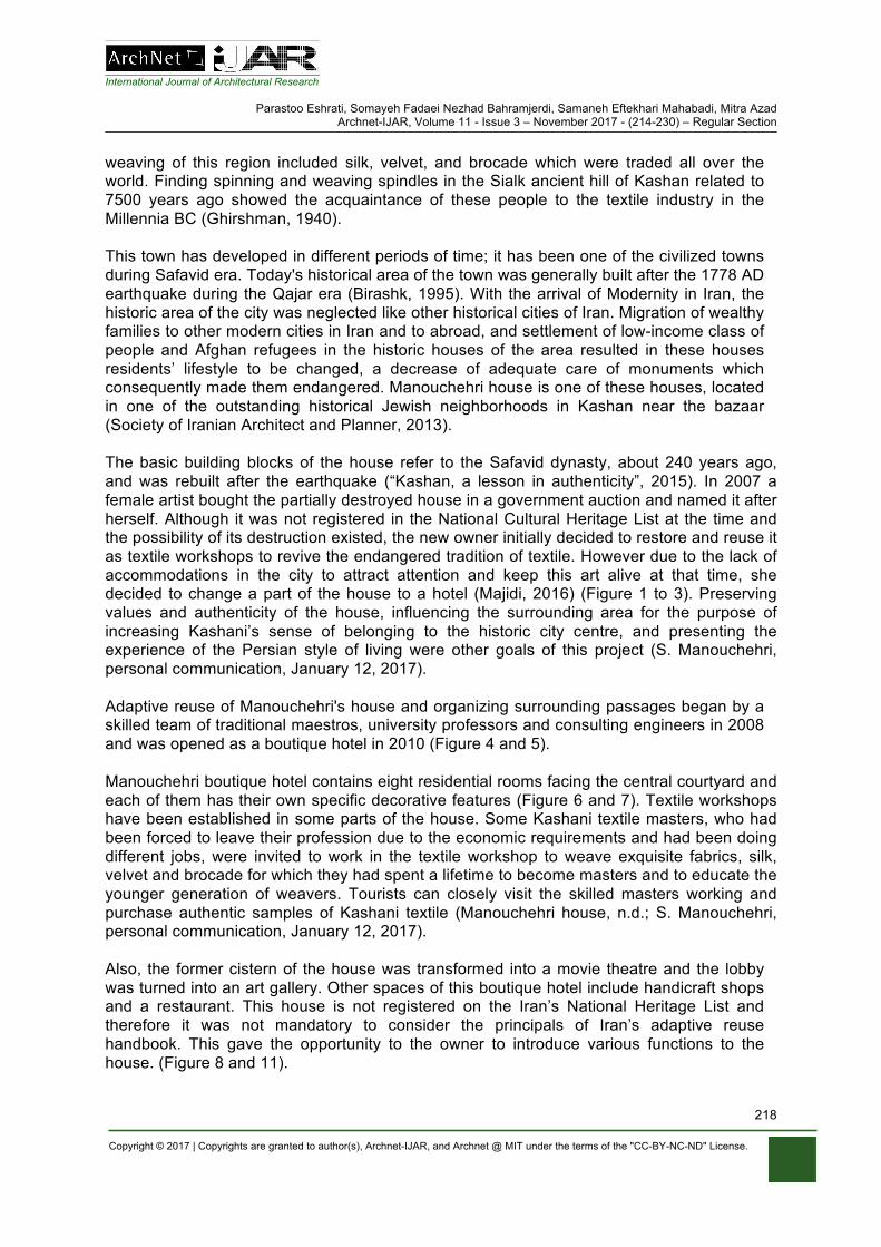
International Journal of Architectural Research
Parastoo Eshrati, Somayeh Fadaei Nezhad Bahramjerdi, Samaneh Eftekhari Mahabadi, Mitra Azad Archnet-IJAR, Volume 11 - Issue 3 – November 2017 - (214-230) – Regular Section
Copyright © 2017 | Copyrights are granted to author(s), Archnet-IJAR, and Archnet @ MIT under the terms of the "CC-BY-NC-ND" License.
218
weaving of this region included silk, velvet, and brocade which were traded all over the world. Finding spinning and weaving spindles in the Sialk ancient hill of Kashan related to 7500 years ago showed the acquaintance of these people to the textile industry in the Millennia BC (Ghirshman, 1940). This town has developed in different periods of time; it has been one of the civilized towns during Safavid era. Today's historical area of the town was generally built after the 1778 AD earthquake during the Qajar era (Birashk, 1995). With the arrival of Modernity in Iran, the historic area of the city was neglected like other historical cities of Iran. Migration of wealthy families to other modern cities in Iran and to abroad, and settlement of low-income class of people and Afghan refugees in the historic houses of the area resulted in these houses residents’ lifestyle to be changed, a decrease of adequate care of monuments which consequently made them endangered. Manouchehri house is one of these houses, located in one of the outstanding historical Jewish neighborhoods in Kashan near the bazaar (Society of Iranian Architect and Planner, 2013). The basic building blocks of the house refer to the Safavid dynasty, about 240 years ago, and was rebuilt after the earthquake (“Kashan, a lesson in authenticity”, 2015). In 2007 a female artist bought the partially destroyed house in a government auction and named it after herself. Although it was not registered in the National Cultural Heritage List at the time and the possibility of its destruction existed, the new owner initially decided to restore and reuse it as textile workshops to revive the endangered tradition of textile. However due to the lack of accommodations in the city to attract attention and keep this art alive at that time, she decided to change a part of the house to a hotel (Majidi, 2016) (Figure 1 to 3). Preserving values and authenticity of the house, influencing the surrounding area for the purpose of increasing Kashani’s sense of belonging to the historic city centre, and presenting the experience of the Persian style of living were other goals of this project (S. Manouchehri, personal communication, January 12, 2017). Adaptive reuse of Manouchehri's house and organizing surrounding passages began by a skilled team of traditional maestros, university professors and consulting engineers in 2008 and was opened as a boutique hotel in 2010 (Figure 4 and 5). Manouchehri boutique hotel contains eight residential rooms facing the central courtyard and each of them has their own specific decorative features (Figure 6 and 7). Textile workshops have been established in some parts of the house. Some Kashani textile masters, who had been forced to leave their profession due to the economic requirements and had been doing different jobs, were invited to work in the textile workshop to weave exquisite fabrics, silk, velvet and brocade for which they had spent a lifetime to become masters and to educate the younger generation of weavers. Tourists can closely visit the skilled masters working and purchase authentic samples of Kashani textile (Manouchehri house, n.d.; S. Manouchehri, personal communication, January 12, 2017). Also, the former cistern of the house was transformed into a movie theatre and the lobby was turned into an art gallery. Other spaces of this boutique hotel include handicraft shops and a restaurant. This house is not registered on the Iran’s National Heritage List and therefore it was not mandatory to consider the principals of Iran’s adaptive reuse handbook. This gave the opportunity to the owner to introduce various functions to the house. (Figure 8 and 11).
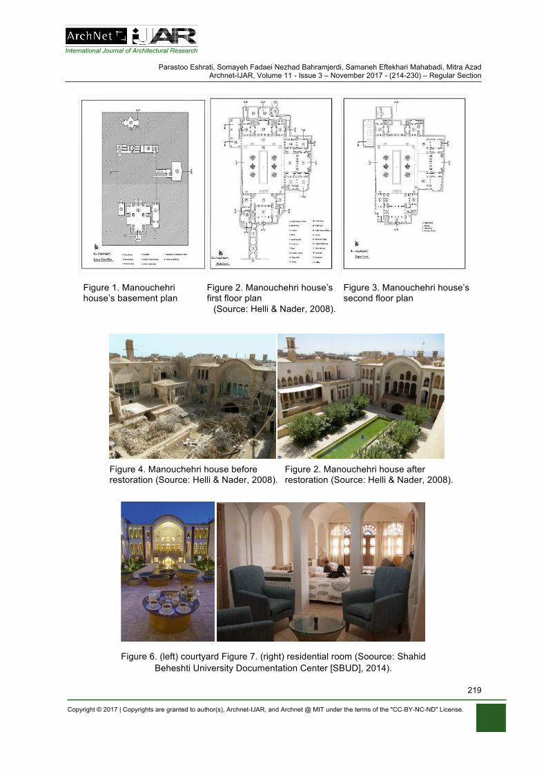
International Journal of Architectural Research
Parastoo Eshrati, Somayeh Fadaei Nezhad Bahramjerdi, Samaneh Eftekhari Mahabadi, Mitra Azad Archnet-IJAR, Volume 11 - Issue 3 – November 2017 - (214-230) – Regular Section
Copyright © 2017 | Copyrights are granted to author(s), Archnet-IJAR, and Archnet @ MIT under the terms of the "CC-BY-NC-ND" License.
219
Figure 1. Manouchehri house’s basement plan
Figure 2. Manouchehri house’s first floor plan
Figure 3. Manouchehri house’s second floor plan
(Source: Helli & Nader, 2008).
Figure 4. Manouchehri house before restoration (Source: Helli & Nader, 2008).
Figure 2. Manouchehri house after restoration (Source: Helli & Nader, 2008).
Figure 6. (left) courtyard Figure 7. (right) residential room (Soource: Shahid Beheshti University Documentation Center [SBUD], 2014).
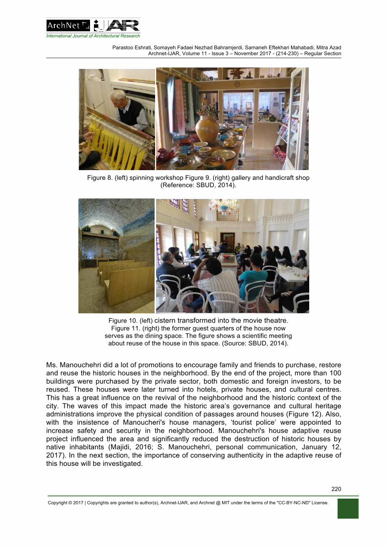
International Journal of Architectural Research
Parastoo Eshrati, Somayeh Fadaei Nezhad Bahramjerdi, Samaneh Eftekhari Mahabadi, Mitra Azad Archnet-IJAR, Volume 11 - Issue 3 – November 2017 - (214-230) – Regular Section
Copyright © 2017 | Copyrights are granted to author(s), Archnet-IJAR, and Archnet @ MIT under the terms of the "CC-BY-NC-ND" License.
220
Figure 8. (left) spinning workshop Figure 9. (right) gallery and handicraft shop (Reference: SBUD, 2014).
Figure 10. (left) cistern transformed into the movie theatre. Figure 11. (right) the former guest quarters of the house now
serves as the dining space. The figure shows a scientific meeting about reuse of the house in this space. (Source: SBUD, 2014).
Ms. Manouchehri did a lot of promotions to encourage family and friends to purchase, restore and reuse the historic houses in the neighborhood. By the end of the project, more than 100 buildings were purchased by the private sector, both domestic and foreign investors, to be reused. These houses were later turned into hotels, private houses, and cultural centres. This has a great influence on the revival of the neighborhood and the historic context of the city. The waves of this impact made the historic area’s governance and cultural heritage administrations improve the physical condition of passages around houses (Figure 12). Also, with the insistence of Manoucheri's house managers, ‘tourist police’ were appointed to increase safety and security in the neighborhood. Manouchehri's house adaptive reuse project influenced the area and significantly reduced the destruction of historic houses by native inhabitants (Majidi, 2016; S. Manouchehri, personal communication, January 12, 2017). In the next section, the importance of conserving authenticity in the adaptive reuse of this house will be investigated.
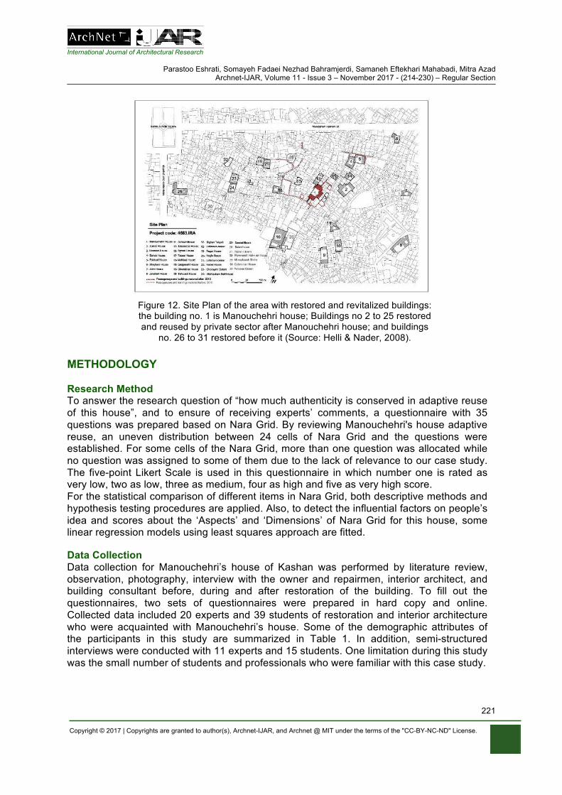
International Journal of Architectural Research
Parastoo Eshrati, Somayeh Fadaei Nezhad Bahramjerdi, Samaneh Eftekhari Mahabadi, Mitra Azad Archnet-IJAR, Volume 11 - Issue 3 – November 2017 - (214-230) – Regular Section
Copyright © 2017 | Copyrights are granted to author(s), Archnet-IJAR, and Archnet @ MIT under the terms of the "CC-BY-NC-ND" License.
221
Figure 12. Site Plan of the area with restored and revitalized buildings: the building no. 1 is Manouchehri house; Buildings no 2 to 25 restored and reused by private sector after Manouchehri house; and buildings
no. 26 to 31 restored before it (Source: Helli & Nader, 2008).
METHODOLOGY Research Method To answer the research question of “how much authenticity is conserved in adaptive reuse of this house”, and to ensure of receiving experts’ comments, a questionnaire with 35 questions was prepared based on Nara Grid. By reviewing Manouchehri's house adaptive reuse, an uneven distribution between 24 cells of Nara Grid and the questions were established. For some cells of the Nara Grid, more than one question was allocated while no question was assigned to some of them due to the lack of relevance to our case study. The five-point Likert Scale is used in this questionnaire in which number one is rated as very low, two as low, three as medium, four as high and five as very high score. For the statistical comparison of different items in Nara Grid, both descriptive methods and hypothesis testing procedures are applied. Also, to detect the influential factors on people’s idea and scores about the ‘Aspects’ and ‘Dimensions’ of Nara Grid for this house, some linear regression models using least squares approach are fitted. Data Collection Data collection for Manouchehri’s house of Kashan was performed by literature review, observation, photography, interview with the owner and repairmen, interior architect, and building consultant before, during and after restoration of the building. To fill out the questionnaires, two sets of questionnaires were prepared in hard copy and online. Collected data included 20 experts and 39 students of restoration and interior architecture who were acquainted with Manouchehri’s house. Some of the demographic attributes of the participants in this study are summarized in Table 1. In addition, semi-structured interviews were conducted with 11 experts and 15 students. One limitation during this study was the small number of students and professionals who were familiar with this case study.
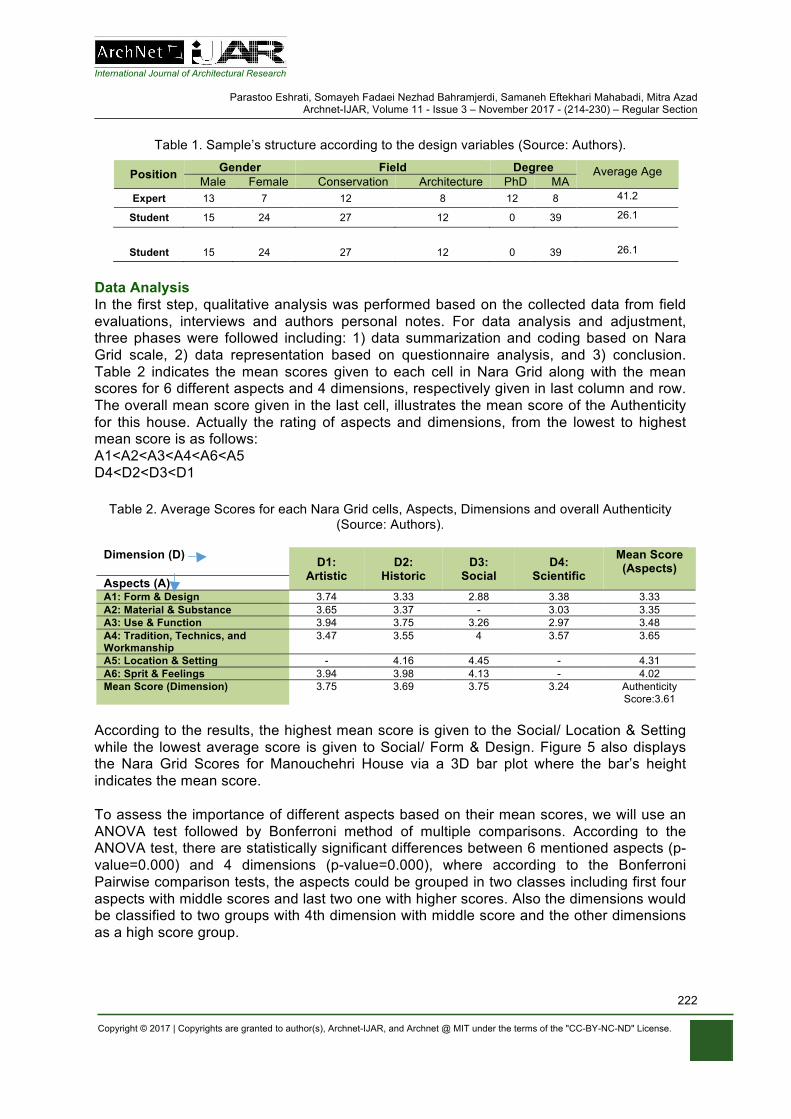
International Journal of Architectural Research
Parastoo Eshrati, Somayeh Fadaei Nezhad Bahramjerdi, Samaneh Eftekhari Mahabadi, Mitra Azad Archnet-IJAR, Volume 11 - Issue 3 – November 2017 - (214-230) – Regular Section
Copyright © 2017 | Copyrights are granted to author(s), Archnet-IJAR, and Archnet @ MIT under the terms of the "CC-BY-NC-ND" License.
222
Table 1. Sample’s structure according to the design variables (Source: Authors).
Average Age Degree Field Gender Position MA PhD Architecture Conservation Female Male 41.2 8 12 8 12 7 13 Expert 26.1 39 0 12 27 24 15 Student
26.1 39 0 12 27 24 15 Student
Data Analysis In the first step, qualitative analysis was performed based on the collected data from field evaluations, interviews and authors personal notes. For data analysis and adjustment, three phases were followed including: 1) data summarization and coding based on Nara Grid scale, 2) data representation based on questionnaire analysis, and 3) conclusion. Table 2 indicates the mean scores given to each cell in Nara Grid along with the mean scores for 6 different aspects and 4 dimensions, respectively given in last column and row. The overall mean score given in the last cell, illustrates the mean score of the Authenticity for this house. Actually the rating of aspects and dimensions, from the lowest to highest mean score is as follows: A1<A2<A3<A4<A6<A5 D4<D2<D3<D1
Table 2. Average Scores for each Nara Grid cells, Aspects, Dimensions and overall Authenticity (Source: Authors).
Dimension (D) D1:
Artistic D2:
Historic D3:
Social D4:
Scientific
Mean Score (Aspects)
Aspects (A) A1: Form & Design 3.74 3.33 2.88 3.38 3.33 A2: Material & Substance 3.65 3.37 - 3.03 3.35 A3: Use & Function 3.94 3.75 3.26 2.97 3.48 A4: Tradition, Technics, and Workmanship
3.47 3.55 4 3.57 3.65
A5: Location & Setting - 4.16 4.45 - 4.31 A6: Sprit & Feelings 3.94 3.98 4.13 - 4.02 Mean Score (Dimension) 3.75 3.69 3.75 3.24 Authenticity
Score:3.61 According to the results, the highest mean score is given to the Social/ Location & Setting while the lowest average score is given to Social/ Form & Design. Figure 5 also displays the Nara Grid Scores for Manouchehri House via a 3D bar plot where the bar’s height indicates the mean score. To assess the importance of different aspects based on their mean scores, we will use an ANOVA test followed by Bonferroni method of multiple comparisons. According to the ANOVA test, there are statistically significant differences between 6 mentioned aspects (p-value=0.000) and 4 dimensions (p-value=0.000), where according to the Bonferroni Pairwise comparison tests, the aspects could be grouped in two classes including first four aspects with middle scores and last two one with higher scores. Also the dimensions would be classified to two groups with 4th dimension with middle score and the other dimensions as a high score group.
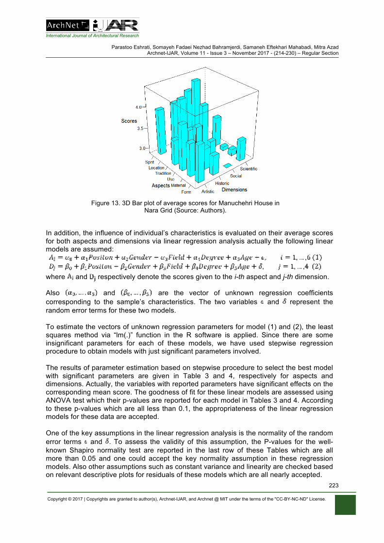
International Journal of Architectural Research
Parastoo Eshrati, Somayeh Fadaei Nezhad Bahramjerdi, Samaneh Eftekhari Mahabadi, Mitra Azad Archnet-IJAR, Volume 11 - Issue 3 – November 2017 - (214-230) – Regular Section
Copyright © 2017 | Copyrights are granted to author(s), Archnet-IJAR, and Archnet @ MIT under the terms of the "CC-BY-NC-ND" License.
223
Figure 13. 3D Bar plot of average scores for Manuchehri House in Nara Grid (Source: Authors).
In addition, the influence of individual’s characteristics is evaluated on their average scores for both aspects and dimensions via linear regression analysis actually the following linear models are assumed:
where and respectively denote the scores given to the i-th aspect and j-th dimension.
Also and are the vector of unknown regression coefficients corresponding to the sample’s characteristics. The two variables and represent the random error terms for these two models. To estimate the vectors of unknown regression parameters for model (1) and (2), the least squares method via “lm(.)” function in the R software is applied. Since there are some insignificant parameters for each of these models, we have used stepwise regression procedure to obtain models with just significant parameters involved. The results of parameter estimation based on stepwise procedure to select the best model with significant parameters are given in Table 3 and 4, respectively for aspects and dimensions. Actually, the variables with reported parameters have significant effects on the corresponding mean score. The goodness of fit for these linear models are assessed using ANOVA test which their p-values are reported for each model in Tables 3 and 4. According to these p-values which are all less than 0.1, the appropriateness of the linear regression models for these data are accepted. One of the key assumptions in the linear regression analysis is the normality of the random error terms and . To assess the validity of this assumption, the P-values for the well-known Shapiro normality test are reported in the last row of these Tables which are all more than 0.05 and one could accept the key normality assumption in these regression models. Also other assumptions such as constant variance and linearity are checked based on relevant descriptive plots for residuals of these models which are all nearly accepted.
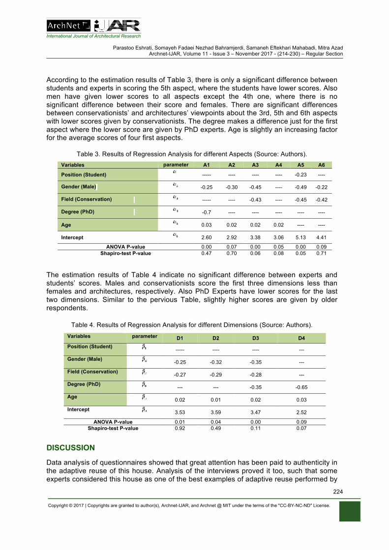
International Journal of Architectural Research
Parastoo Eshrati, Somayeh Fadaei Nezhad Bahramjerdi, Samaneh Eftekhari Mahabadi, Mitra Azad Archnet-IJAR, Volume 11 - Issue 3 – November 2017 - (214-230) – Regular Section
Copyright © 2017 | Copyrights are granted to author(s), Archnet-IJAR, and Archnet @ MIT under the terms of the "CC-BY-NC-ND" License.
224
According to the estimation results of Table 3, there is only a significant difference between students and experts in scoring the 5th aspect, where the students have lower scores. Also men have given lower scores to all aspects except the 4th one, where there is no significant difference between their score and females. There are significant differences between conservationists’ and architectures’ viewpoints about the 3rd, 5th and 6th aspects with lower scores given by conservationists. The degree makes a difference just for the first aspect where the lower score are given by PhD experts. Age is slightly an increasing factor for the average scores of four first aspects.
Table 3. Results of Regression Analysis for different Aspects (Source: Authors).
Variables parameter A1 A2 A3 A4 A5 A6
Position (Student) ----- ---- ---- ---- -0.23 ----
Gender (Male) -0.25 -0.30 -0.45 ---- -0.49 -0.22
Field (Conservation) ----- ---- -0.43 ---- -0.45 -0.42
Degree (PhD) -0.7 ---- ---- ---- ---- ----
Age 0.03 0.02 0.02 0.02 ---- ----
Intercept 2.60 2.92 3.38 3.06 5.13 4.41
ANOVA P-value 0.00 0.07 0.00 0.05 0.00 0.09 Shapiro-test P-value 0.47 0.70 0.06 0.08 0.05 0.71
The estimation results of Table 4 indicate no significant difference between experts and students’ scores. Males and conservationists score the first three dimensions less than females and architectures, respectively. Also PhD Experts have lower scores for the last two dimensions. Similar to the pervious Table, slightly higher scores are given by older respondents.
Table 4. Results of Regression Analysis for different Dimensions (Source: Authors).
Variables parameter D1 D2 D3 D4 Position (Student) ----- ---- ---- ---
Gender (Male) -0.25 -0.32 -0.35 ---
Field (Conservation) -0.27 -0.29 -0.28 ---
Degree (PhD) --- --- -0.35 -0.65
Age 0.02 0.01 0.02 0.03
Intercept 3.53 3.59 3.47 2.52
ANOVA P-value 0.01 0.04 0.00 0.09 Shapiro-test P-value 0.92 0.49 0.11 0.07
DISCUSSION Data analysis of questionnaires showed that great attention has been paid to authenticity in the adaptive reuse of this house. Analysis of the interviews proved it too, such that some experts considered this house as one of the best examples of adaptive reuse performed by
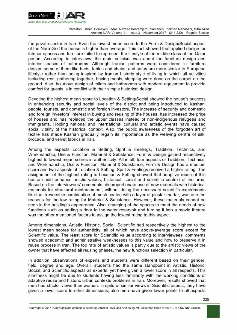
International Journal of Architectural Research
Parastoo Eshrati, Somayeh Fadaei Nezhad Bahramjerdi, Samaneh Eftekhari Mahabadi, Mitra Azad Archnet-IJAR, Volume 11 - Issue 3 – November 2017 - (214-230) – Regular Section
Copyright © 2017 | Copyrights are granted to author(s), Archnet-IJAR, and Archnet @ MIT under the terms of the "CC-BY-NC-ND" License.
225
the private sector in Iran. Even the lowest mean score to the Form & Design/Social aspect of the Nara Grid the house is higher than average. This fact showed that applied design for interior spaces and furniture failed to represent the lifestyle of the middle class of the Qajar period. According to interviews, the main criticism was about the furniture design and interior spaces of bathrooms. Although Iranian patterns were considered in furniture design; some of them like beds, tables and chairs, and sofas are more similar to European lifestyle rather than being inspired by Iranian historic style of living in which all activities including rest, gathering together, having meals, sleeping were done on the carpet on the ground. Also, luxurious design of toilets and bathrooms with modern equipment to provide comfort for guests is in conflict with their simple historical design. Devoting the highest mean score to Location & Setting/Social showed the house's success in enhancing security and social levels of the district and being introduced to Kashani people, tourists, and domestic and foreign investors. The increase of security and domestic and foreign investors’ interest in buying and reusing of the houses, has increased the price of houses and has replaced the upper classes instead of non-indigenous refugees and immigrants. Holding national and international cultural and artistic events have caused social vitality of the historical context. Also, the public awareness of the forgotten art of textile has made Kashan gradually regain its importance as the weaving centre of silk, brocade, and velvet fabrics in Iran. Among the aspects Location & Setting, Sprit & Feelings, Tradition, Technics, and Workmanship, Use & Function, Material & Substance, Form & Design gained respectively highest to lowest mean scores in authenticity. All in all, four aspects of Tradition, Technics, and Workmanship, Use & Function, Material & Substance, Form & Design had a medium score and two aspects of Location & Setting, Sprit & Feelings received a higher rating. The assignment of the highest rating to Location & Setting showed that adaptive reuse of this house could enhance artistic values, historical, social and scientific context of the area. Based on the interviewees’ comments, disproportionate use of new materials with historical materials for structural reinforcement, without doing the necessary scientific experiments like the irreversible combination of mesh coated with a layer of plaster mortar, was one the reasons for the low rating for Material & Substance. However, these materials cannot be seen in the building’s appearance. Also, changing of the spaces to meet the needs of new functions such as adding a door to the water reservoir and turning it into a movie theatre was the other mentioned factors to assign the lowest rating to this aspect. Among dimensions, Artistic, Historic, Social, Scientific had respectively the highest to the lowest mean scores for authenticity, all of which have above-average score except for Scientific value. The least score for Scientific value according to interviewees’ comments showed academic and administrative weaknesses to this value and how to preserve it in reuse process in Iran. The top rate of artistic values is partly due to the artistic views of the owner that have affected all reusing phases, the new functions selection in particular. In addition, observations of experts and students were different based on their gender, field, degree and age. Overall, students had the same standpoint in Artistic, Historic, Social, and Scientific aspects as experts; yet have given a lower score in all respects. This strictness might be due to students having less familiarity with the working conditions of adaptive reuse and historic urban contexts problems in Iran. Moreover, results showed that men had stricter views than women: in spite of similar views in Scientific aspect, they have given a lower score to other dimensions; also men have given lower points to all aspects
International Journal of Architectural Research
Parastoo Eshrati, Somayeh Fadaei Nezhad Bahramjerdi, Samaneh Eftekhari Mahabadi, Mitra Azad Archnet-IJAR, Volume 11 - Issue 3 – November 2017 - (214-230) – Regular Section
Copyright © 2017 | Copyrights are granted to author(s), Archnet-IJAR, and Archnet @ MIT under the terms of the "CC-BY-NC-ND" License.
226
expect for Location & Setting. This strict view revealed itself by higher education. Doctors gave a relatively lower score to Social and Scientific aspects and also Form and Design attributes. In addition, interviews showed that the doctorate specialists had professional views in the field of harmony and forms of new design with historical pattern and documentation and also creativity in proportions, shape, and color of the new design in interior spaces, furniture, yard, toilets and baths equipment and visible parts of heating and cooling systems and lighting. Preservationists, in comparison with architects, have given fewer scores to Artistic, Historical, and Social values and also Use & Function, Location & Setting and Sprit & Feelings aspects. Their responses were similar for Scientific values and another aspect of authenticity. This demonstrates the different views of architects and preservationists. Interviews with preservationists showed that generally, because of the focus on technical issues and high sensitivity of coordinating any action with historical documents, creativity in adaptive reuses are paid less attention and sometimes are rejected by them. However, architects believe that this creativity, although in small scale, made the house different and more successful than other reuse projects in Iran. Devoting a low score to Use & Function by preservationists has two interpretations: one is that preservationists expect more functions; and the other one is that they believe repurposing a mono-functional house to a multi-functional space including a boutique hotel, spinning workshop, gallery, restaurant, cinema and arts and Cultural events centre is inconsistent with its character, a stance which was confirmed by interview assessments. In contrast, architects believe that this functional diversity is the positive point of the house reuse which has helped to attract a wide range of audiences. Age was also another determinant factor in assessment. Old aged people gave a higher score to all dimensions and the first four aspects. Interviews with different ages of people showed that older people regarded these efforts more realistic, generally because they are more familiar with the capacity, academic, and administrative deficiencies of reuse in Iran. Table 5 represents the house authenticity evaluations according to the analysis of questionnaires and interviews.
CONCLUSION
Manouchehri house adaptive reuse project has been successful in conserving authenticity as its main objective and has played an important role in the surrounding area beyond the role of one single house. With increased security and investment opportunities in the historical centre of the city, it has influenced authenticity conservation of Kashan and has increased Kashani people’s sense of belonging to their city. Moreover, reviving the forgotten art has helped to pave the path to revive other traditional arts. The project successfully increased the confidence of the government in the private sector; the owner of the house took advantage of knowledge and experience of traditional craftsmen, university professors, and consulting engineers as well as her artistic vision to create a new approach for private investors to conserve authenticity rather that aiming for short-term economic efficiency. Therefore, adaptive reuse of Manouchehri house has established a flow in the construction industry and made the small city of Kashan the leading city of private sector adaptive reuse in Iran.
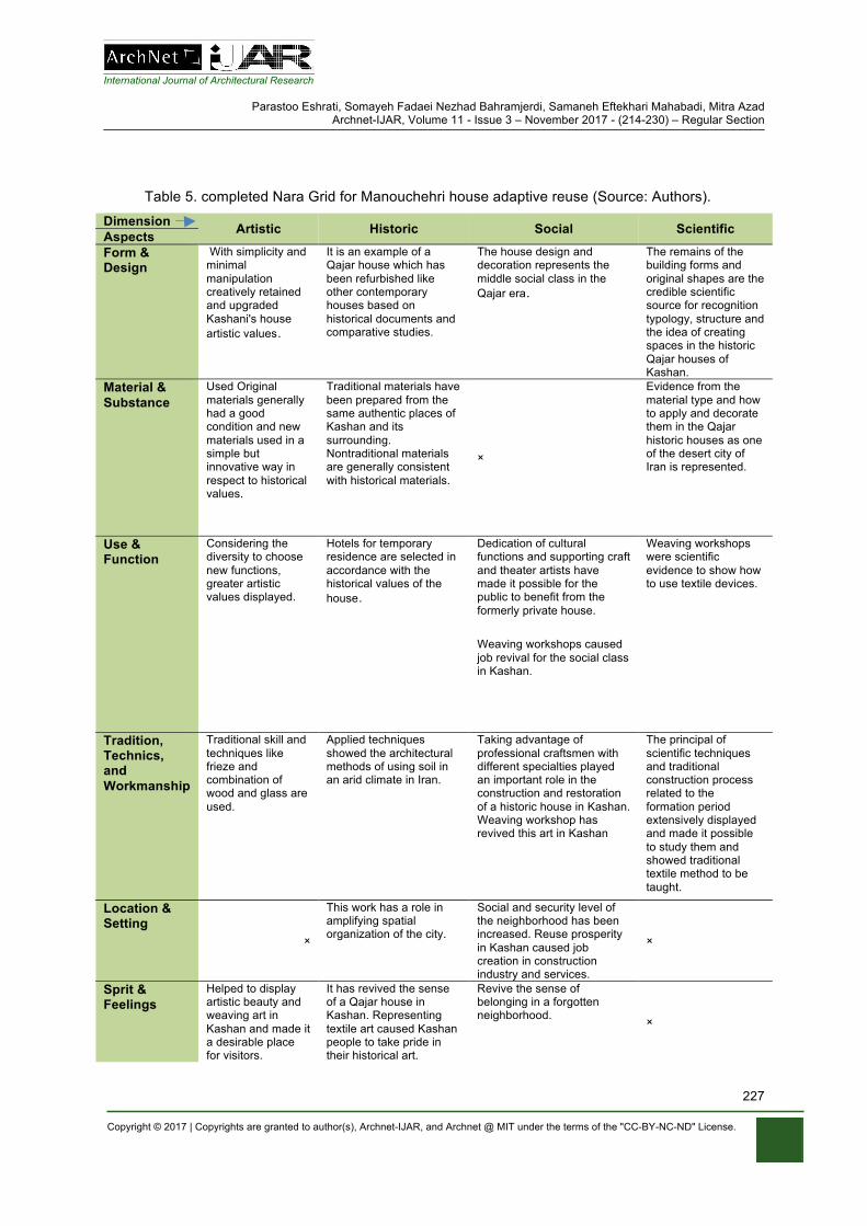
International Journal of Architectural Research
Parastoo Eshrati, Somayeh Fadaei Nezhad Bahramjerdi, Samaneh Eftekhari Mahabadi, Mitra Azad Archnet-IJAR, Volume 11 - Issue 3 – November 2017 - (214-230) – Regular Section
Copyright © 2017 | Copyrights are granted to author(s), Archnet-IJAR, and Archnet @ MIT under the terms of the "CC-BY-NC-ND" License.
227
Table 5. completed Nara Grid for Manouchehri house adaptive reuse (Source: Authors).
Dimension Artistic Historic Social Scientific Aspects Form & Design
With simplicity and minimal manipulation creatively retained and upgraded Kashani's house artistic values.
It is an example of a Qajar house which has been refurbished like other contemporary houses based on historical documents and comparative studies.
The house design and decoration represents the middle social class in the Qajar era.
The remains of the building forms and original shapes are the credible scientific source for recognition typology, structure and the idea of creating spaces in the historic Qajar houses of Kashan.
Material & Substance
Used Original materials generally had a good condition and new materials used in a simple but innovative way in respect to historical values.
Traditional materials have been prepared from the same authentic places of Kashan and its surrounding. Nontraditional materials are generally consistent with historical materials.
×
Evidence from the material type and how to apply and decorate them in the Qajar historic houses as one of the desert city of Iran is represented.
Use & Function
Considering the diversity to choose new functions, greater artistic values displayed.
Hotels for temporary residence are selected in accordance with the historical values of the house.
Dedication of cultural functions and supporting craft and theater artists have made it possible for the public to benefit from the formerly private house.
Weaving workshops caused job revival for the social class in Kashan.
Weaving workshops were scientific evidence to show how to use textile devices.
Tradition, Technics, and Workmanship
Traditional skill and techniques like frieze and combination of wood and glass are used.
Applied techniques showed the architectural methods of using soil in an arid climate in Iran.
Taking advantage of professional craftsmen with different specialties played an important role in the construction and restoration of a historic house in Kashan. Weaving workshop has revived this art in Kashan
The principal of scientific techniques and traditional construction process related to the formation period extensively displayed and made it possible to study them and showed traditional textile method to be taught.
Location & Setting
×
This work has a role in amplifying spatial organization of the city.
Social and security level of the neighborhood has been increased. Reuse prosperity in Kashan caused job creation in construction industry and services.
×
Sprit & Feelings
Helped to display artistic beauty and weaving art in Kashan and made it a desirable place for visitors.
It has revived the sense of a Qajar house in Kashan. Representing textile art caused Kashan people to take pride in their historical art.
Revive the sense of belonging in a forgotten neighborhood. ×
International Journal of Architectural Research
Parastoo Eshrati, Somayeh Fadaei Nezhad Bahramjerdi, Samaneh Eftekhari Mahabadi, Mitra Azad Archnet-IJAR, Volume 11 - Issue 3 – November 2017 - (214-230) – Regular Section
Copyright © 2017 | Copyrights are granted to author(s), Archnet-IJAR, and Archnet @ MIT under the terms of the "CC-BY-NC-ND" License.
228
Results also showed that authenticity evaluators’ characteristics affected scores so it could be suggested that professionals as well as students with different genders, disciplines, educations, and ages, be called upon to consider different dimensions and aspects of authenticity in teamwork reuse of historical construction. Also with facilitating the cooperation between traditional craftsmen and the scientific society of architects and preservationists, it would be possible to revive and promote traditional techniques, train a new generation and increase restoration and the adaptive reuse knowledge in Iran. Another result of this study is the need to give more freedom to the private sector, review Iran’s handbook of adaptive reuse, and change attitudes form unchangeable museum-like conservation in Iran. Although, according to the current handbook, priorities are determined for a possible new program for reusing historic buildings, the Manouchehri house program is not compatible with the suggested ones in the handbook. Manouchehri house’s creative view in introducing new functions not only did not mar the building authenticity but also promoted the values of the heritage. Preservationists should have closer cooperation with architects and artists and be welcome to creativity in restoration and adaptive reuse, and to reviving historic contexts by linking historic buildings to current lifestyle. Despite the success of this project to conserve authenticity, it was not successful enough in considering Scientific values in comparison to other ones. This weakness may be rooted in the novelty of adaptive reuse knowledge in Iran which can be investigated in future research.
REFERENCES Andrews, T.D., & Buggey, S. (2008). Authenticity in aboriginal cultural landscapes. APT Bulletin, 39
(2/3), 63-71. Araoz, G. F. (2008). World-heritage historic urban landscapes: Defining and protecting authenticity.
APT Bulletin, 39 (2/3), 33-37. Australia ICOMOS (1999). Charter for Places of Cultural Significance: Burra Charter. Retrieved from
http://australia.icomos.org/publications/charters Aydin, D., Yaldiz, E., & Büyükşahin Siramkaya, S. (2015). Evaluation of domestic
architecture via the context of sustainability: Cases from Konya city center. Archnet-IJAR: International Journal of Architectural Research, 9 (1), 305-317.
Bandarin, F., & Oers, R.V. (2012). Historic urban landscape: Managing heritage in an urban century. Chichester, UK: Wiley-Blackwell.
Birashk, S. (1995). The Process of development and evolution of the Kashan City within history from the beginning to the end of the Seljuk period. In B. Ayatollah Zadeh Shirazi (Ed.), Proceedings of the Congress Architectural & Urbanism History of Iran, Volume III (pp. 379-399). Tehran, Iran: Iranian Cultural Heritage Organization.
Bullen, P. A., & Love, P. E. D. (2011). Adaptive reuse of heritage buildings. Structural Survey, 29 (5), 411-421. doi: 10.1108/02630801111182439.
Cohen, N. (1999). Urban conservation. Cambridge, Mass: MIT Press. English Heritage (2007). The Use of historic building in regeneration. London: English Heritage. Fadaei Nezhad, S., & Eshrati, P. (2015). Analyzing the components for recognition the concept of
authenticity in cultural heritage conservation. Journal of Fine Arts, Architecture and Urbanism, 19(4), 77-86.
Fadaei Nezhad, S., Eshrati, P., & Eshrati, D. (2015a). Authenticity evaluation in revitalization of the Atique square of Isfahan. IJAUP: International Journal of Architectural Engineering & Urban Planning, 25 (2), 112-119.
Fadaei Nezhad, S., Eshrati, P., & Eshrati, D. (2015b). A Definition of authenticity concept in conservation of cultural landscapes. Archnet-IJAR: International Journal of Architectural Research, 9 (1), 93-107.
International Journal of Architectural Research
Parastoo Eshrati, Somayeh Fadaei Nezhad Bahramjerdi, Samaneh Eftekhari Mahabadi, Mitra Azad Archnet-IJAR, Volume 11 - Issue 3 – November 2017 - (214-230) – Regular Section
Copyright © 2017 | Copyrights are granted to author(s), Archnet-IJAR, and Archnet @ MIT under the terms of the "CC-BY-NC-ND" License.
229
Fakhoury, L. A., & Haddad, N. A. (2017). Aspects of the architectural and urban heritage: From registers to conservation for adaptive and modern use at the historic cores of salt and Irbid, Jordan. Archnet-IJAR: International Journal of Architectural Research, 11 (2), 190-218.
Ghalayini, L. (2011). The Interaction between oil price and economic growth. Middle Eastern Finance and Economics, (13), 127-141.
Ghirshman, R. (1940). Excavations of Sialk. Translated & edited by Tobiah, S. Journal of Education, 10 (6/7), 44-55.
Gregory, J. (2008). Reconsidering relocated building: ICOMOS, authenticity and mass relocation. International Journal of Heritage Studies, 14 (2), 112-130. doi: 10.1080/13527250701844027.
Haddad, N. (2007). Criteria for the assessment of the modern use of ancient theatres and odea. International Journal of Heritage Studies, 13 (3), 265-280. doi: 10.1080/13527250701228221.
Haddad, N. A., & Fakhoury, L. A. (2016). Towards developing a sustainable heritage tourism and conservation action plan for Irbid’s historic core. Archnet-IJAR: International Journal of Architectural Research, 10 (3), 36-59.
Helli, A. A., & Nader, S. (2008). Manouchehri house. Aga Khan Award for Architecture, 2014-2016. Retrieved from http://www.akdn.org/architecture/project/manouchehri-house
ICOMOS (1964). International Charter for the Conservation and Restoration of Monuments and Sites: Venice Charter. Retrieved from http://www.international.icomos.org/centre_documentation/chartes_eng.htm
ICOMOS (1994). Nara Document on Authenticity. Retrieved from http://icomos.org/index.php/en/charters-and-texts
ICOMOS (1999). International Cultural Tourism Charter, Managing Tourism at Places of Heritage Significance: Mexico Charter. Retrieved from http://www.icomos.org/charters/tourism_e.pdf
Inaba, N. (2009). Authenticity and heritage concepts: Tangible and intangible, discussions in Japan. In N. Stanley-Price, & J. King (Eds.), Conserving the authentic: Essays in honour of Jukka Jokilehto (pp. 153-163). Rome, Italy: ICCROM.
Iran's 20-Year Vision Plan on the Horizon 1404. (2003, November 4). Retrieved from http://farsi.khamenei.ir/special?id=4133
Izadi, M. S. (2008). A Study of city center regeneration: A Comparative analysis of two different approaches to the revitalization of historic city center in Iran (Doctoral dissertation). New Castle University, Faculty of Humanities and Social Science, School of Architecture, Planning and Landscape, New Castle, England.
Izadi, M. S. (2014). National strategy document on revitalizing, upgrading, renovating and enabling deteriorated and underutilized urban fabrics. Tehran, Iran: The Council of Ministers, Ministry of Road & Urban Development, Urban Development and Revitalization Organization (UDRO).
Jokilehto. J. (2006). Considerations on authenticity and integrity in world heritage context. City & Time, 2 (1), 1-16. Retrieved from http://www.ct.ceci-br.org
Kashan, a lesson in authenticity, architecture. (2015, February 08). Financial Tribune, Retrieved from https://financialtribune.com/articles/travel/10722/kashan-a-lesson-in-authenticity-architecture
Korumaz, M., Korumaz, S. A. G., & Canan, F. (2012). Authenticity examination of re-used traditional houses in the city center of Konya, Turkey. International Journal of Multidisciplinary Thought, 2 (3), 51-58.
Majedi, H., Amjad, H., & Bahmanpour, H. (2014). A Model to revitalization of historical and cultural places (case study: Moshir-o-Almamalek, garden city of Yazd). Journal of Environmental Science and Technology, 15 (4), 119-132.
Majidi, M. (2016). Interview with Saba Manouchehri. Memar Magazine, (99), 40-49. Manouchehri house. (n.d.). Retrieved from http://www.manouchehrihouse.com/ Mine, T. Z. (2013). Adaptive re-use of monuments: Restoring religious buildings with different uses.
Journal of Cultural Heritage, 14 (3), S14-S19. doi: 10.1016/j.culher.2012.11.017. Mitchell, N. J. (2008). Considering the authenticity of cultural landscapes. APT Bulletin, 39 (2/3), 25-
31.
International Journal of Architectural Research
Parastoo Eshrati, Somayeh Fadaei Nezhad Bahramjerdi, Samaneh Eftekhari Mahabadi, Mitra Azad Archnet-IJAR, Volume 11 - Issue 3 – November 2017 - (214-230) – Regular Section
Copyright © 2017 | Copyrights are granted to author(s), Archnet-IJAR, and Archnet @ MIT under the terms of the "CC-BY-NC-ND" License.
230
Mitchell, N. J., Rossler, M., & Tricaud, P.M. (2009). World heritage cultural landscapes: A Handbook for conservation and management. World Heritage Paper 26, Paris: UNESCO World Heritage Centre.
Mohammad Moradi, A., & Parhizkari, M. (2013). An Approach to rehabilitation of Qajar Hotel in Qazvin. Journal of Architecture Iranian Studies, 1 (3), 55-66.
Musai, M. (2013). A Study of demand factors on foreign tourism in Iran. International Journal of Social Sciences, 3 (4), 35-42.
Philokyprou, M. (2014). Adaptation of new university uses in old buildings: The Case of rehabilitation of listed buildings in Limassol Cyprus for university purposes. International Journal of Architectural Heritage, 8 (5), 758-782.
Revitalization and Utilization Fund for Historic Places (2012). First Chapter: The Role and legal status, objectives and duties, patterns of attract investment, document of rehabilitation. In E. Iravani (Ed.), Three colors of rehabilitation (pp. 1- 70). Tehran: Rehabilitation and Utilization Fund for Historical Places.
Rossler, M. (2008). Applying authenticity to cultural landscapes. APT Bulletin, 39 (2/3), 47-52. Sarmento, J., & Kazemi, Z. (2014). Hammams and the contemporary city: The Case of Isfahan, Iran.
International Journal of Heritage Studies, 20 (2), 138-156. doi: 10.1080/13527258.2012.736873. Shahid Beheshti University Documentation Center. (2014). Report of Restoration workshop of
Manouchehri House. (Unpublished Report). Shehada, Ziad M.M., Bin Ahmad, Y., Naziaty M. Y., & Keumala, N. I. M. (2015). Developing
methodology for adaptive re-use: Case study of heritage buildings in Palestin. Archnet-IJAR: International Journal of Architectural Research, 9 (2), 216-229.
Shipley, R., Utz, S., & Parsons, M. (2006). Does adaptive reuse pay? A Study of the business of building renovation in Ontario, Canada. International Journal of Heritage Studies, 12 (6), 505-520. doi: 10.1080/13527250600940181.
Society of Iranian Architect and Planner (2013). A Delightful restoration. Retrieved from http://archive2016.siap.org/ee-index.php/news/story/a_delightful_restoration
Steinberg, F. (2007). Conservation and rehabilitation of urban heritage in developing countries. Habitant International, 20 (3), 463-475. doi: 10.1016/0197-3975(96)00012-4.
Stovel, H. (1995). Considerations in framing the authenticity question for conservation. In Proceedings of the Nara Conference on Authenticity in Relation to the World Heritage Convention. Paris: UNESCO WHC.
Stovel, H. (2003). From commentaries included in Annex 4, The Operational guidelines for the implementation of the world heritage convention. Paris: UNESCO WHC.
Stovel, H. (2007). Effective use of authenticity and integrity as world heritage qualifying conditions. City & Time 2 (3), 21-36. Retrieved from http://www.ct.ceci-br.org
Strange, I., & Whitney, D. (2003). The Changing roles and purposes of heritage conservation in the UK. Planning Practice and Research, 18, 219-229. doi: 10.1080/0269745032000168278.
UNESCO World Heritage Center (2003). Convention for the safeguarding of the intangible cultural heritage. Retrieved from http://portal.unesco.org/en/ev.php-URL_ID=17716&URL_DO=DO_TOPIC&URL_SECTION=201.html
UNESCO World Heritage Center (2005). Operational Guidelines for the Implementation of the World Heritage Convention. Retrieved from http://whc.unesco.org/en/guidelines/
UNESCO World Heritage Center (2007). Asia conserved: Lessons learned from the UNESCO Asia-Pacific heritage awards for culture heritage conservation. Retrieved from http://unesdoc.unesco.org/images/0015/001557/155754e.pdf
UNESCO World Heritage Center (2008). Operational guidelines for the implementation of the world heritage convention. Retrieved from http://whc.unesco.org/en/guidelines/
Van Balen, K. (2008). The Nara grid: An Evaluation scheme based on the Nara document on authenticity. APT Bulletin, 39 (2/3), 39-45.
World Travel & Tourism Council (2015). Travel tourism economic impact Iran. London: World Travel & Tourism Council.
Zancheti, S., Lira, F., & Piccolo, R. (2009). Judging the authenticity of the city. In N. Stanley-Price, & J. King (Eds.), Conserving the authentic: Essays in honour of Jukka Jokilehto (pp. 163-168). Rome, Italy: ICCROM.
International Journal of Architectural Research
Parastoo Eshrati, Somayeh Fadaei Nezhad Bahramjerdi, Samaneh Eftekhari Mahabadi, Mitra Azad Archnet-IJAR, Volume 11 - Issue 3 – November 2017 - (214-230) – Regular Section
Copyright © 2017 | Copyrights are granted to author(s), Archnet-IJAR, and Archnet @ MIT under the terms of the "CC-BY-NC-ND" License.
231
Zia Shahabi, N., & Imani, N. (2013). The Role of interior design in preservation the latent values in a historical building a critical survey into the revitalization of music museum, moghaddam museum and saba museum. Journal of Architecture and Urban Planning, 5 (10), 121-140.
Farzad Pour Rahimian Archnet-IJAR, Volume 11 - Issue 3 - November 2017 - (231-236) – Review Papers
Copyright © 2017 | Copyrights are granted to author(s), Archnet-IJAR, and Archnet @ MIT under the terms of the "CC-BY-NC-ND" License.
231
Archnet-IJAR: International Journal of Architectural Research www.archnet-ijar.net/ -- https://archnet.org/collections/34
BOOK REVIEW: UNIFIED ARCHITECTURAL THEORY: FORM, LANGUAGE, COMPLEXITY, NIKOS A. SALINGAROS DOI: http://dx.doi.org/10.26687/archnet-ijar.v11i3.1394
Farzad Pour Rahimian
Keywords Abstract
architectural language; biological form; geometry; evidence-based design; organised complexity
Unified Architectural Theory: Form, Language, Complexity is a compendium of scientific knowledge and practical insight into architectural theory and how it is taught to students. In this guide, Nikos Salingaros, Professor of Mathematics at the University of Texas, offers a succinct summary of his extensive course focusing on how to intelligently approach architectural design by aid of scientific evidence. Unified Architectural Theory seeks to establish a clear articulation of the perdurable framework behind “all of architecture” through centuries that is based on hard scientific facts rather than personal sentiments. The book contains 44 sections and is organised in two parts that respectively give an overview of the course lectures and assignments. The concise format of the sections as well as the comprehensible writing tailored to meet students’ needs make it a great companion for anyone who wants to learn.
F. Pour Rahimian, *
Department of Architecture, University of Strathclyde Office JW 302d, Level 3, James Weir Building, 75 Montrose Street, Glasgow G1 1XJ
*Corresponding Author’s email address: [email protected]
ArchNet-IJAR is indexed and listed in several databases, including: • Avery Index to Architectural
Periodicals • EBSCO-Current Abstracts-Art
and Architecture • CNKI: China National
Knowledge Infrastructure • DOAJ: Directory of Open
Access Journals • Pro-Quest • Scopus-Elsevier • Web of Science
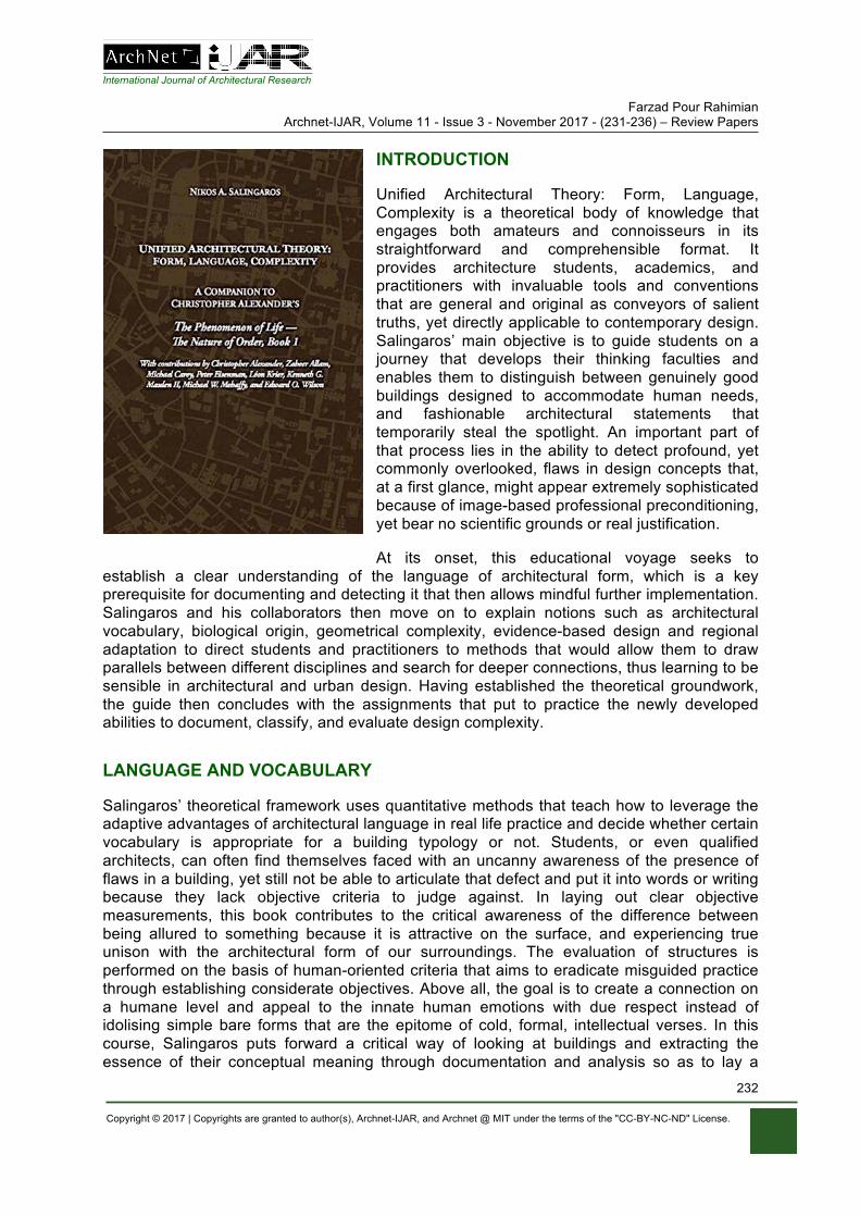
International Journal of Architectural Research Farzad Pour Rahimian
Archnet-IJAR, Volume 11 - Issue 3 - November 2017 - (231-236) – Review Papers
Copyright © 2017 | Copyrights are granted to author(s), Archnet-IJAR, and Archnet @ MIT under the terms of the "CC-BY-NC-ND" License.
232
INTRODUCTION
Unified Architectural Theory: Form, Language, Complexity is a theoretical body of knowledge that engages both amateurs and connoisseurs in its straightforward and comprehensible format. It provides architecture students, academics, and practitioners with invaluable tools and conventions that are general and original as conveyors of salient truths, yet directly applicable to contemporary design. Salingaros’ main objective is to guide students on a journey that develops their thinking faculties and enables them to distinguish between genuinely good buildings designed to accommodate human needs, and fashionable architectural statements that temporarily steal the spotlight. An important part of that process lies in the ability to detect profound, yet commonly overlooked, flaws in design concepts that, at a first glance, might appear extremely sophisticated because of image-based professional preconditioning, yet bear no scientific grounds or real justification.
At its onset, this educational voyage seeks to establish a clear understanding of the language of architectural form, which is a key prerequisite for documenting and detecting it that then allows mindful further implementation. Salingaros and his collaborators then move on to explain notions such as architectural vocabulary, biological origin, geometrical complexity, evidence-based design and regional adaptation to direct students and practitioners to methods that would allow them to draw parallels between different disciplines and search for deeper connections, thus learning to be sensible in architectural and urban design. Having established the theoretical groundwork, the guide then concludes with the assignments that put to practice the newly developed abilities to document, classify, and evaluate design complexity.
LANGUAGE AND VOCABULARY
Salingaros’ theoretical framework uses quantitative methods that teach how to leverage the adaptive advantages of architectural language in real life practice and decide whether certain vocabulary is appropriate for a building typology or not. Students, or even qualified architects, can often find themselves faced with an uncanny awareness of the presence of flaws in a building, yet still not be able to articulate that defect and put it into words or writing because they lack objective criteria to judge against. In laying out clear objective measurements, this book contributes to the critical awareness of the difference between being allured to something because it is attractive on the surface, and experiencing true unison with the architectural form of our surroundings. The evaluation of structures is performed on the basis of human-oriented criteria that aims to eradicate misguided practice through establishing considerate objectives. Above all, the goal is to create a connection on a humane level and appeal to the innate human emotions with due respect instead of idolising simple bare forms that are the epitome of cold, formal, intellectual verses. In this course, Salingaros puts forward a critical way of looking at buildings and extracting the essence of their conceptual meaning through documentation and analysis so as to lay a

International Journal of Architectural Research Farzad Pour Rahimian
Archnet-IJAR, Volume 11 - Issue 3 - November 2017 - (231-236) – Review Papers
Copyright © 2017 | Copyrights are granted to author(s), Archnet-IJAR, and Archnet @ MIT under the terms of the "CC-BY-NC-ND" License.
233
foundation that practitioners would be able to build upon in their further work. The author urges students to analyse buildings not only to detect their language pattern but to also be aware of what it signifies - how well it responds to the environment and how it connects to things greater than the building itself. The book shows empirically how to extract and document a language in a manner that allows students to implement it, considering regional factors such as climate, geography, local materials and culture. As a facilitator of the first assignment, Salingaros offers a checklist, which students can use to identify architectural styles.
Due to the lack of objective criteria, students and professionals often encounter unnecessary design predicaments stemming from the diatribe of different philosophical theories that fight for validity in the architectural world. In this course, the author examines the appropriate level of philosophical involvement that has to be used in the field of architectural design. Along with his fellow writers, Salingaros contemplates what are the philosophical categories that can best guide practitioners in an honest way to meaningful design decisions, rather than mislead them into intellectual whims in favour of current fashion trends.
Commonly, architecture is taught through an image-based educational practice without sufficient critical evaluation: this methodology imposes a risk that a market image might supersede the very object it refers to and skew students’ perception. Additionally, architectural style reflected in images is a by-product of a mass movement that uses fixed aesthetic features as amplifiers with the sole purpose of promoting the styles typical of certain architectural elite. Salingaros attempts to remedy the effects of this enforced malpractice in clearly demarking the boundaries between political ideology and scientific theory in teaching to prevent the preconditioning of students to only recognise as valid market-driven architectural languages.
The author emphasises that students are vulnerable to confusion as not all architectural teaching members have background as architectural theorists. Educators might assume that the editors of certain books have already carefully chosen the content, but they might not be able to judge it themselves. Ultimately, there is no guarantee that the materials included carry no hidden political agendas; hence Salingaros’ course seeks to lay out the groundwork of architectural theory as a mechanism for prevention against the subjectivism of personal opinion that might be swayed in one direction or another depending on the cultural and political winds of the current time.
The eloquence of modern architectural rhetoric and the evangelical fervour it is often propagated with a capacity to derail the objectives of contemporary architects. Poetic architectural expression in writing often takes advantage of human perception of patterns and its ability to create associations, imagine things and endorse them with ungrounded meaning. As a counterpoise to those literary incantations that seize human perception of abstract concepts, Salingaros proposes an empirical mechanism to distinguish between true and false theory, sense and non-sense. The course introduces students to Christopher Alexander’s theory of human-made order that dictates buildings should be designed for the people who work and live in them rather than for the simplicity and clarity of a concept that an architect would like to achieve purely for aesthetic reasons that are only evident to a certain intellectual elite. The ability to interpret the actions of other architects is also important as a pre-emptive measure against involuntary mistakes resulting from coercive mass culture practices. The clear criteria to measure design informs it and provides it with predictive value. Science then helps in providing a vehicle to understand mechanical systems and extract their principles that can be applied elsewhere.
International Journal of Architectural Research Farzad Pour Rahimian
Archnet-IJAR, Volume 11 - Issue 3 - November 2017 - (231-236) – Review Papers
Copyright © 2017 | Copyrights are granted to author(s), Archnet-IJAR, and Archnet @ MIT under the terms of the "CC-BY-NC-ND" License.
234
BIOLOGY AND NEUROSCIENCE
Through notions such as ecophobia and biophilia, supported by neuroscience and different biological studies, Salingaros and his fellow academics explain the empirical difference between naturally and artificially generated forms and how they are perceived by human consciousness. The ability to ask critical questions and interrogate form is crucial for a deeper understanding of the interconnectedness of everything in the Universe. Recognising the biological origins of urbanism, and by extension architecture, requires more than simply analysing the resemblances of structure; it necessitates a more complex study of the wiring of the human brain and how it discerns form and space. It is equally important to recognise buildings as “living” entities and thus acknowledge their need for repair and restoration. In the author’s view, a unified architectural theory is the starting point to creating a system with its own means of self-correction and maintenance.
A failure to recognise the true significance of naturally generated forms may result in creating a poor imitation of natural morphology when attempting to implement it in design. Anthropologically triggered ecological disasters and resource depletion are a function of the detachment from nature without critical evaluation of the technologies we employ and the appropriate level to do so. Connectivity to the surrounding world yields natural order while detachment and unnecessary abstraction lead to isolation. Replacing natural information with its intellectual abstraction often leads to a loss of innate intuitive knowledge that has been accumulated through centuries.
The cognitive ability of the human mind to perceive space and the objects in it should also be taken into consideration when we try and apply natural order and mathematical hierarchy to architecture. It is important that architects as well as theorists ask themselves whether they understand natural order well enough to be able to use and adapt its principles without corrupting them. The risk of implementing natural principles in a sense that is too general is that they are diluted and robbed of their value. Synthesis is an important tool, yet it might come with unavoidable reduction. Salingaros warns its readers to be cautious and mindful of what materials they choose to study, as reduction is easier than synthesis, so it often predominates in literature.
The most important highlight of the book is the importance of being able to differentiate between a salient discipline and ephemeral fashion where the first is based on knowledge that can be tested and verified while the latter is a result of market slogans and bold statements. Through the notion of consilience, i.e. the interconnectedness of knowledge within different disciplines, the author explains the significance of theoretical coherence. All contributors in the book strongly emphasise the necessity to refer to other disciplines when engaging in architectural design in order not to perpetuate distorted information within the field and propagate inherited underlying misconceptions. If a discipline is only self-referenced, then it lacks strong connection to the outside world and is rendered numb in its own expression. Hence, Salingaros’ strong architectural theory offers a hierarchy in its complex structure where ideas and results are organised, compared and easily tested.
GEOMETRY AND ORNAMENTS
Written language is linear, composed of letters into words into text into compendiums that seek to deliver a message: in a similar way, architectural language is expressed in forms, volumes and combinations that try to evoke different experiences. Therefore, achieving
International Journal of Architectural Research Farzad Pour Rahimian
Archnet-IJAR, Volume 11 - Issue 3 - November 2017 - (231-236) – Review Papers
Copyright © 2017 | Copyrights are granted to author(s), Archnet-IJAR, and Archnet @ MIT under the terms of the "CC-BY-NC-ND" License.
235
coherence is a crucial factor in the design process as there are infinitely more ways to arrive at incoherence than at coherence in an architectural proposal. On a number of occasions, Salingaros reiterates the significance in connecting human beings to a higher natural order in the world that aids achieving wholeness. As one example, ornamentation has a function other than physical stylisation of natural elements; it connects to the human body which has developed unconscious mechanisms to sense proportion and geometry. It has its biological wiring to recognise natural and artificial constructs which trigger specific emotions that then lead to ideas and thoughts. Hence, it is important to carefully choose a particular architectural language for a building as it, albeit adaptive, predisposes it to a certain geometry.
Modernism has never been in favour of pattern languages which inevitably led to their neglect in the teaching practice of many architecture schools. Fashionable symbols and veneer came to replace deep human values and the timeless language they were expressed in. As an alternative to that, the author presents a careful study of symmetries that aids student understanding of the principles behind repetition, alignment, reflection and translation. That then facilitates the design of a product or structure that is perceived and experienced as a holistic entity.
The Kolmogorov-Chaitin complexity is given as an example of a method for estimation which measures the complexity of a system against the complexity of its description. The presence or non-presence of pattern defines the complexity of its informational string. Therefore, a minimum level of complexity is required to transmit a meaningful message; over-simplicity carries no information. Through a simple visual check, one can recognise a pattern and estimate the relative complexity of its data string. That ability, however, might be misleading as, in an attempt to introduce innovation, architects might be tempted to use an element of randomness as an artistic shortcut, yet this random act is not an actual adaptation and thus does not communicate a meaningful message.
Salingaros defines architectural theory as an explanatory framework founded upon scientific practice. This framework explains and relates to the buildings themselves and to their meaning as without clear justification, theories cannot hold any meaningful value. There is a common, yet misleading perception among architects that only subjects such as physics and mathematics can be empirically proven, hence the author appeals that it is important to understand that architecture is experimental in itself and thus is subject to validation. The profession is responsible to society and its experience with built form, therefore, it needs to apply valid solutions in its practice.
POLITICS, FASHION AND INTERVIEWS
Salingaros breaks up the structure of the book and reinforces the dynamicity of the architectural discussion through the interview format of certain chapters. In a section dedicated to urbanism, Léon Krier, renowned architect and urbanist, passionately discusses New Urbanism and its direct relation to the free market that dictates its commissions as well as their location and programme. Unfortunately, the interest of the end-users is rarely an objective in that brief. Krier adamantly argues against the culture of “wow” architecture and points out that “wow” styles only cater to “wow” occasions, not necessarily to everyday use and need, as there is little value of sculptural abstraction in residential or industrial buildings.
International Journal of Architectural Research Farzad Pour Rahimian
Archnet-IJAR, Volume 11 - Issue 3 - November 2017 - (231-236) – Review Papers
Copyright © 2017 | Copyrights are granted to author(s), Archnet-IJAR, and Archnet @ MIT under the terms of the "CC-BY-NC-ND" License.
236
In the present day the market is leading and often turns architectural language in a commodity that can be marketed in certain ways so as to maximise profits and evoke “wow” responses. The exploitative objectives of fashion put a spoke in the wheel of the development of architectural theory while ignorant attempts at innovation often condemn the implementation of an architectural style simply because it is considered traditional and thus retrograde. Derived from a necessity to keep the market stimulated and with a sense of urgency in the need to sell for profit, modern architectural expression risks supressing timeless knowledge just because it might not align with current trends.
Krier also argues that cities need principles and rules as a stable foundation that then creates conditions for a vibrant mix of typologies and uses as well as forms and volumes. If, however, there is no structure in the language of the urban form, or its grammar and syntax are ignored and distorted, then the urban realm turns into an idiosyncratic chaos. In an attempt to elevate architectural expression, architects might defeat its functional purpose.
CONCLUSION
In his Unified Architectural Theory, Salingaros appeals for greater awareness of architectural language and its impact on our surroundings. Within the diverse sections of this compendium, Form, Language and Complexity are regarded through the prism of architectural vocabulary, biology, neuroscience, geometry and even politics and fashion. The author, as well as his fellow academics, emphasise the urgent need for intelligence-based design and adaptive architecture that respects humanity and promotes a deeper universal meaning. Unified Architectural Theory teaches considerate design for people unaware of architectural rhetoric as opposed to design for other architects and is a perfect synthesis of ideas for self-motivated students, teaching professionals or simply lovers of considerate design.
REFERENCES
Salingaros, N. A., et al. (2013). Unified Architectural Theory: Form, Language, Complexity: A Companion to Christopher Alexander's "The Phenomenon of Life - The Nature of Order, Book 1": Vajra Books. ISBN-10: 9937623057 - ISBN-13: 978-9937623056
Ombretta Romice Archnet-IJAR, Volume 11 - Issue 3 - November 2017 - (237-240) – Review Papers
Copyright © 2017 | Copyrights are granted to author(s), Archnet-IJAR, and Archnet @ MIT under the terms of the "CC-BY-NC-ND" License.
237
Archnet-IJAR: International Journal of Architectural Research www.archnet-ijar.net/ -- https://archnet.org/collections/34
BOOK REVIEW: COMPLEX HOUSING. DESIGNING FOR DENSITY, JULIA WILLIAMS ROBINSON DOI: http://dx.doi.org/10.26687/archnet-ijar.v11i3.1412
Ombretta Romice
Keywords Abstract
The Netherlands; complex housing; typology; environmental psychology
This is a clear, useful and practical book, which makes an important link between research in environment-behaviour studies and practice, in this case architecture, urbanism and planning. The goal of the book is straightforward: to analyse ‘complex housing’, here defined as middle-high density, with a mix of tenures, uses and renting/ownership ranges, and of urban significance, in a structured and consistent manner, and with a degree of professional criticism stemming both from the author’s view and that of a range of professionals involved in the projects illustrated. The context selected is the Netherlands, a country that for geographic, political, cultural and religious reasons has had a rather special and successful record in dealing with density in housing both from an architectural and urban point of view, at least until recently, as the author reminds us (‘spatial plans’ have been abandoned in 2005).
O. Romice, * Department of Architecture, University of Strathclyde, Office JW 302, Level 3, James Weir Building, 75 Montrose Street, Glasgow G1 1XJ
*Corresponding Author’s email address: [email protected]
ArchNet-IJAR is indexed and listed in several databases, including: • Avery Index to Architectural
Periodicals • EBSCO-Current Abstracts-Art
and Architecture • CNKI: China National
Knowledge Infrastructure • DOAJ: Directory of Open
Access Journals • Pro-Quest • Scopus-Elsevier • Web of Science
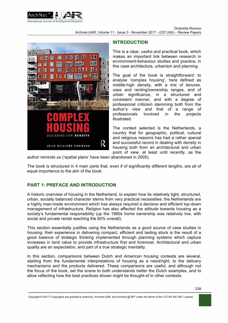
International Journal of Architectural Research Ombretta Romice
Archnet-IJAR, Volume 11 - Issue 3 - November 2017 - (237-240) – Review Papers
Copyright © 2017 | Copyrights are granted to author(s), Archnet-IJAR, and Archnet @ MIT under the terms of the "CC-BY-NC-ND" License.
238
INTRODUCTION
This is a clear, useful and practical book, which makes an important link between research in environment-behaviour studies and practice, in this case architecture, urbanism and planning.
The goal of the book is straightforward: to analyse ‘complex housing’, here defined as middle-high density, with a mix of tenures, uses and renting/ownership ranges, and of urban significance, in a structured and consistent manner, and with a degree of professional criticism stemming both from the author’s view and that of a range of professionals involved in the projects illustrated.
The context selected is the Netherlands, a country that for geographic, political, cultural and religious reasons has had a rather special and successful record in dealing with density in housing both from an architectural and urban point of view, at least until recently, as the
author reminds us (‘spatial plans’ have been abandoned in 2005).
The book is structured in 4 main parts that, even if of significantly different lengths, are all of equal importance to the aim of the book:
PART 1: PREFACE AND INTRODUCTION
A historic overview of housing in the Netherland, to explain how its relatively tight, structured, urban, socially balanced character stems from very practical necessities: the Netherlands are a highly man-made environment which has always required a decisive and efficient top-down management of infrastructure. Religion has also affected the attitude towards housing as a society’s fundamental responsibility (up the 1980s home ownership was relatively low, with social and private rental reaching the 60% overall).
This section essentially justifies using the Netherlands as a good source of case studies in housing: their experience in delivering compact, efficient and lasting stock is the result of a good balance of strategic thinking implemented through planning systems which capture increases in land value to provide infrastructure first and foremost. Architectural and urban quality are an expectation, and part of a true strategic mentality.
In this section, comparisons between Dutch and American housing contexts are several, starting from the fundamental interpretations of housing as a need/right, to the delivery mechanisms and the products delivered. These comparisons are useful, and although not the focus of the book, set the scene to both understands better the Dutch examples, and to allow reflecting how the best practices shown might be thought-of in other contexts.
International Journal of Architectural Research Ombretta Romice
Archnet-IJAR, Volume 11 - Issue 3 - November 2017 - (237-240) – Review Papers
Copyright © 2017 | Copyrights are granted to author(s), Archnet-IJAR, and Archnet @ MIT under the terms of the "CC-BY-NC-ND" License.
239
PART 2: ANALYSING COMPLEX HOUSING
This section defines the methodology used to select, study and comment upon the 8 case studies illustrated in the rest of the book.
Here the logic, justification and decisions benefit from the author’s strong background in a field complementary to architecture and urban design, namely environmental psychology. In looking for a comprehensive list of those factors that a complex housing project should deliver, she refers to research on the impact that built and natural environments have on people, and uses them to build a structured and comparable narrative across the projects.
Issues of density, access and distribution, privacy, ownership and control, access to nature, are listed as playing an important role on housing quality and satisfaction, and analysed through an overview of typologies.
Typologies are studied in detail across a number of factors, such as their relationship with the context (in terms of location, uses, landmark value, access and parking), form (in terms of massing, contextual compatibility, density), relationship to open green and public space, dwelling type (in relation to dwelling layout, access to the dwelling and circulation between dwellings, access to open private and public space), and mix of tenures and uses. The author adopts a way to search, measure and describe each of the issues across all case studies, so that they are all assessed against the same important principles. In some instances, these are straightforward (i.e. comparing for example densities and tenures), in others less so (i.e. the organisational principle that explains the sequence of thresholds between public and private space. She uses the gamma syntax to diagram how each project takes people from the street to the dwelling).
PART 3: CASE STUDIES
This section includes the 8 case studies. Each case is described via an introduction to the design brief, context and set of events that delivered it, and then analysed typologically, using the set of issues selected in part 2. Since each project plays an important role in its context, and is either a visual or social landmark, this introduction is useful in clarifying the expectations that each project had to fulfil, thus explaining the real and long term value that successful design can have on an area and its people, and putting the hurdles encountered in perspective.
The narrative of the cases is straightforward, clear and easy to follow, also thanks to a commendable richness in photographs, architectural drawings and diagrams. These are especially helpful in explaining the mix and combination of units types, and the circulation systems adopted. In terms of explanatory diagrams, the urban scale is less explicit than the architectural one, so whilst all floor plans are provided, and also each unit type with an indication of their access to private, semi-private and public spaces, internal or external, come through mainly from the photographs.
At the end of each case, the author offers a list of lessons learned – successful and not, from the point of view of those who commissioned, delivered or use the projects. These sections are useful, in reminding us that delivering good housing is a hard, difficult journey of self-improvement and critical revisions. It is not easy. The author is candid and open in doing so,
International Journal of Architectural Research Ombretta Romice
Archnet-IJAR, Volume 11 - Issue 3 - November 2017 - (237-240) – Review Papers
Copyright © 2017 | Copyrights are granted to author(s), Archnet-IJAR, and Archnet @ MIT under the terms of the "CC-BY-NC-ND" License.
240
often inclosing quite provocative quotes, but this is ultimately an effective way to prove that good design comes when there is genuine interest in achieving it, no matter what.
PART 4: DESIGN PRINCIPLES AND IMPLICATIONS:
This section summarises all lessons learned from the case studies. Organised through the important issues identified in Part 2, it lists strengths and weaknesses, expedients and solutions from all examples using their typological detail to give concrete illustrations.
It is effective in that joins values in housing and findings form research to design solutions; for example, the link between number of units served by a corridor is linked to effects on privacy and sense of neighbourliness. These are important issues but too often remain theoretical aspirations, whilst in this case the author manages to be very practical, and show ranges of implementation from all cases where these issues have been taken into account and resolved to variable degrees of success.
There is a degree of common sense across all lessons, but it is a useful common sense with explicit links to practice, and I would argue it is a much-needed common sense.
If things were so obvious in fact, why excellent housing is not standard practice after all?
CONCLUSION
Whilst acknowledging that the focus is on complex housing, and accepting that these are by definition significantly large projects, my query is on the resilience and flexibility over time of these urban and suburban investments. In several cases (i.e. De Muzen, Carnisselande, La Grande Cour… these have a significantly large footprint; they are, essentially, superblocks), so I would raise questions over their longevity: what happens when conditions change? will their complexity let them evolve along with different needs, requirements, budgets and interests? One can argue that the answer might be found in their intentionally planned complexity, but can we really plan complexity, or shall we accept that these are ‘special’ units, even if very good at that, and resilience might not be of concern to their regards? will they be still here in 200 years, same as much other admired Dutch more traditional, ordinary typologies? Does complexity require special forms, or can it be accommodated in more ‘ordinary’ ones? In other words, should we assess these complex housing against resilience, or do we accept that can play by different rules? And if so, why and where should we draw a line?
Overall, this is a useful book, an important resource for undergraduate and postgraduate students in architecture, urban design and planning, for developers, architects and municipalities. The author goes out of her way to discuss responsibilities and even stubbornness at times, and to show that the distance between an idea and its fulfilment is a hard one to bridge; her lessons are a step towards building this bridge.
REFERENCES
Robinson, J. W. (2018). Complex Housing. Designing for Density. New York: Routledge Taylor & Francis Group. ISBN: 978-1-138-19249-2 (hbk), ISBN: 978-1-138-19250-8 (pbk), ISBN: 978-1-135-63992-5 (ebk).