gis-based highway maintenance prioritization model: an integrated approach for highway maintenance...
TRANSCRIPT
Journal of Transport Geography 18 (2010) 426–433
Contents lists available at ScienceDirect
Journal of Transport Geography
journal homepage: www.elsevier .com/locate / j t rangeo
GIS-based highway maintenance prioritization model: an integrated approachfor highway maintenance in Nepal mountains
Bhoj Raj Pantha *, Ryuichi Yatabe, Netra Prakash BhandaryGraduate School of Science and Engineering, Ehime University, Bunkyo-cho, Matsuyama 790-8577, Japan
a r t i c l e i n f o
Keywords:Pavement maintenanceRoadside slope maintenanceGISIntegrated maintenance approachMountainous region
0966-6923/$ - see front matter � 2009 Elsevier Ltd. Adoi:10.1016/j.jtrangeo.2009.06.016
* Corresponding author. Address: KEI, Ginza, Tokyo,Ku, Tokyo, Japan. Tel.: +81 90 6287 7680.
E-mail address: [email protected] (B.R. Panth
a b s t r a c t
Roadside slope failures often result in day to week-long traffic disruption and are a major problem inNepal so that timely maintenance of roadside slopes needs greater priority for smooth operation of traffic.In this paper, we develop a Geographic Information Systems (GIS)-based maintenance model consideringpavement and roadside slope stability conditions. A pavement maintenance priority map is preparedbased on pavement condition. International Roughness Index (IRI) is used as the pavement conditionindex. Similarly, a roadside slope maintenance priority map is produced by analyzing slope stability con-dition. An integrated maintenance priority map is produced by combining both pavement and roadsideslope maintenance priority maps with consideration of weighting of each maintenance component. Theintegrated maintenance priority index developed in the research lies from 1 to 3, and is distributed het-erogeneously. Higher index values qualify for higher priority in maintenance planning. Thus, a conven-tional method of maintenance planning under the constraints of budget, time and resources can beimproved by incorporating the actual condition of pavement and roadside slope failure susceptibility,which has the potential to improve significantly the serviceability of the road system. The study showsthat GIS, which can manage and visualize different types of data together or separately, can help the deci-sion making process for road maintenance planning in the Himalayan regions.
� 2009 Elsevier Ltd. All rights reserved.
1. Introduction
Construction of roads and their maintenance in mountainousregions are usually very expensive and difficult because of geolog-ical and topographical complexities. In these areas there is usuallya limited number of roads. The situation is more severe in develop-ing countries not only in terms of the number of roads but also thequality and standard of road construction. Due to increasing trafficon highways their timely maintenance and upkeep is critical.Timely maintenance of roads and highways in mountainous re-gions is most crucial because there are usually a limited numberor no alternative routes to reach a destination. Due to constraintsin time, budget, and other resources such as manpower and equip-ment, it may not be possible for a highway agency to either attendto all road sections requiring maintenance within a given period, orto perform all the planned maintenance concurrently. This calls fora priority scheme to select and schedule road sections for mainte-nance treatments. Priority ranking of road sections according totheir maintenance need is therefore an integral part of a highwaymaintenance management system (Fwa and Chan, 1993).
ll rights reserved.
Taiko Building, 4-2-16 Chuo-
a).
GIS offers some special features that can enhance the approachto highway management. The key element that distinguishes GISfrom other data systems is the manner in which geographic dataare stored and accessed. The addition of this spatial dimension tothe database system is, of course, the source of power of GIS.Linked with the spatial dimension, database features enable GISto capture spatial and topological relationships among geo-refer-enced entities even when these relationships are not predefined.Standard GIS functions include thematic mapping, statistics, chart-ing, matrix manipulation, decision support systems, modelingalgorithms, and simultaneous access to several databases. Visuali-zation helps people approach problems in the dimensions of spaceand time with intuitive maps instead of dimensionally restricteddata tables and graphs (Miles and Ho, 1999).
High volume transportation related data are spatially distrib-uted and so are well suited to GIS analysis, which has the potentialto boost the efficiency of transport planners and engineers signifi-cantly in terms of money, time and effective decision making pro-cesses. Because of these advantages, GIS is becoming more popularin transportation engineering in the recent years, and has evolvedinto a new generation of GIS called GIS-T. (The acronym ‘‘GIS-T” isstands for GIS in transportation engineering). Some examples thisextension of GIS into transportation engineering can be found inSaccomanno et al. (2001), Thill (2000), Smith et al. (2001), Jhaand Schonfeld (2000a,b) and Dueker and Butler (2000). The current
B.R. Pantha et al. / Journal of Transport Geography 18 (2010) 426–433 427
paper provides another example of its application: the analysis anidentification of aspects of the road system in remote and moun-tainous locations.
Traffic disruption due to roadside slope failure on highways forfew days up to a week is very normal during the rainy season inNepal. For example, landslides and slope failures along Narayang-hat–Muglin highway created blockages that meant traffic came toa complete halt for two weeks in 2003. The situation is not differ-ent in other national highways too. The Departments of Roadsallocates an average annual budget of about 8 millions US$ forroad maintenance but this does not meet the problems createdin the rainy season. Road damage is found almost in the samesections of highways every year, and it may be because of ineffec-tiveness of maintenance work, partly because in Nepal, mainte-nance work involves pavement maintenance only, whereasslope failures are a much more important cause of disruption toroad services.
Most of the previous research in highway maintenance havebeen focused on pavement and bridge maintenance due to theircapital intensive nature and sensitivity to traffic exposure (Jhaand Abdullah, 2006). The details of pavement and bridge mainte-nance approaches are explained in Carnahan (1988), Carnahanet al. (1987), Irrgang and Maze (1993), Miyamoto et al. (2000),Madanat and Ben-Akiva (1994), Mauch and Madanat (2000), Mor-cous et al. (2002), Durango and Madanat (2002), Chootinan et al.(2006), She et al. (1999) and Tsunokawa and Ul-Islam (2003). Littleresearch in highway maintenance has been conducted on roadsideslope failure susceptibility. Many maintenance optimization mod-els have been developed for pavement maintenance, but the realoptimization can not be achieved from a single highway mainte-nance component. Our extensive literature search can not findany integrated approach for highway maintenance consideringboth pavement condition and roadside slope failure susceptibility.Jha and Abdullah (2006) have developed maintenance optimiza-tion model considering maintenance of roadside appurtenances,such as guardrails, signs and lighting. While roadside features arenot sensitive to traffic volumes, their maintenance and upkeepover the time is equally important since they are critical to driverinformation and safety (Jha and Abdullah, 2006). However, road-side slope failures and their maintenance are very important inmountainous regions. The deterioration of pavement surface onlyreduces the passenger comfort and enhances faster wearing andtearing of vehicle tyres whereas the consequences of roadsideslope failure include complete collapse of road surface, partial orfull subsidence of road surface, pavement cracks, and blockade ofdrainage system and closure of the road.
Generally, the implementing agency for road repair and mainte-nance for both pavement surfaces and roadside slopes is the same.Hence an integrated road repair and maintenance approach has thepotential to be more efficient economically, technically and admin-istratively. Various types of maintenance schemes such as periodic,routine, recurrent and emergency maintenance are being practicedin road repair and maintenance. In this study, we only focus onrecurrent maintenance.
Because of inherit geographic nature of roadway networks, GISand other spatial data management and analysis technologies areparticularly appropriate for integrating highway data and enhanc-ing the use and presentation of these data for highway manage-ment and operation. Thus, the aim of this study is to develop aGIS-based highway maintenance prioritization model integratingpavement condition and roadside slope failure susceptibility. Wehave produced a pavement condition inventory map, slope failuresusceptibility map, and finally have used them to develop mainte-nance prioritization model. A 53 km of highway section in centralNepal has used as an application of the maintenance prioritizationmodel. We believe that the proposed methodology would be useful
for road repair and maintenance planning especially in othermountainous regions like Nepal.
2. Components of highway maintenance
A modern highway consists of various types of structures andequipment such as pavement, bridge, culverts, tunnels, roadsideslope, equipment associated with intelligence systems, road furni-ture (traffic sign, guardrails, luminaries, etc.), drainage structures,and retaining structures. These structures and equipment requiremaintenance at various time intervals. Because of this variabilityin time interval highway maintenance has been defined separatelyas pavement maintenance, bridge maintenance, tunnel mainte-nance, intelligence systems maintenance, roadside slope mainte-nance, roadside appurtenance maintenance and so on. In thisstudy, we have focused on pavement maintenance and roadsideslope maintenance only.
2.1. Pavement maintenance systems
Pavement management system (PMS) involves managing thepavement systems, including its maintenance. PMS have beenused at different management levels as a tool to assist in selectingcandidate pavement sections for treatment and to identify cost-effective treatments. Decisions on pavement management are nor-mally developed at different levels. The difference in the manage-ment level is normally related to the purpose of the decision andthe quantity of the network facility considered in the process(Chang, 2004).
Pavement management strategies are normally developed atthe network management level with the assistance of pavementmanagement systems that include economic techniques for betterinvestment decisions. The strategic level above network level man-agement normally involves senior managers and funding authori-ties who determine how much funding will be available and setthe policies that affect the allocation of those funds (Chang,2004). As the pavement data are spatially distributed, GIS can beused for pavement maintenance planning and visualization ofhighway pavement condition in roadway network.
2.2. Roadside slope maintenance systems
Naturally formed slopes are disturbed by road constructionactivities. Being largely natural material, there is more inherentvariability to their engineering performance and sensitivity tolong-term degradation or changes than is exhibited in other ele-ments of the highway network. However, the consequences oftheir response can significantly influence the safety, environment,performance and whole life cycle cost of the highway. The scale ofthe problem ranges from one of the most devastating geo-hazardswith threats to life and economy, to one of nuisance requiring in-creased maintenance costs. This makes the task of effective andoptimal resource allocation for road repair and maintenance typi-cally a complex and at times subjective undertaking (Sadek et al.,2005). Sidle et al. (2006) have well documented the phenomenaof the frequency in occurrence of slope failure (i.e. landslides)along new road corridors, and have also demonstrated that thedensity of landslides associated with road construction in moun-tainous terrains is one, and in some cases two, orders of magnitudegreater than for other land use changes. Petley et al. (2007) havepresented the growth of rural road network and also associatedlandslides in Nepal. The underlying trend of landslide occurrencecoincides with the trend of rural road network expansion. There-fore, assessing slope instability along roads is a fundamental issuefor road maintenance in this area.

428 B.R. Pantha et al. / Journal of Transport Geography 18 (2010) 426–433
Roadside slopes can be classified into number of categories bythorough slope instability analysis. With the use of GIS, a suscepti-bility map of a large area can be produced efficiently considering awide range of landslide controlling factors. Highway slopes suscep-tible to failure can be efficiently identified in this way. Highly sus-ceptible zones are prone to slope failure at any time. Thus, roadagencies can prepare maintenance plans accordingly. These main-tenance activities include both preventive and curative measuressuch as construction and maintenance of retaining walls, groundanchoring, soil reinforcing, management of rainwater, stream andriver diversion works, planting vegetation on slopes, debris clear-ance, and construction and maintenance of drains.
3. The study area
The study area lies in central part of Nepal (Fig. 1). It covers atotal roadway length of 53.2 km including parts of both Prithviand Narayanghat–Muglin highways and measures 337.62 km2.Prithvi highway is the major highway that connects the capital cityof Kathmandu to the other parts of the country. Similarly, Naray-anghat–Muglin highway is the linkage between Prithvi highwayand Mahendra highway (an east-west highway which passesthrough the southern belt of Nepal). The Annual Average DailyTraffic (AADT) of the part of Prithvi highway is 9542 PassengerCar Units (PCU). Similarly, the AADT of the part of Narayanghat–Muglin highway is 7541 PCU. The average International RoughnessIndex (IRI) of the part of Prithvi highway and Narayanghat–Muglinhighway are 4.22 m/km and 5.34 m/km, respectively. This stretchof the highway suffers from frequent landslide and slope failures.As a result, the road service is commonly disrupted for severaldays. Due to lack of information on potential failure sites, however,road clearance equipment are neither properly placed nor are anypre-monsoon failure prevention strategies (as discussed above)considered as part of the road management strategies.
Physiographically, the study area lies in Midland group (UpperPrecambrian to late Paleozoic). Lower and Upper Nawakot forma-tions (Phyllite, Limestone, Quartzite, Dolomite, Metagabbro, Met-adiabase, etc.) are the dominant rock formations. Several majorfault/thrust lines pass through the area. Average annual rainfall ismore than 1800 mm, and the study area is comprised of 45 drain-age basins of various sizes. Many streams with different orders(1st–5th) dissect the area on both sides of the highway. The totallength of the streams is 1277 km. The average drainage densityof the area is about 3.65 km/km2. The Trishuli River flows throughthe middle of the study area. The selected stretch of both highways
Fig. 1. The study area (a) location map and
runs along the left bank of this river, and also the foot of the hills.This context exposes the sensitivity of the landscape to the heavyrains of the monsoonal season.
4. Materials and method
Different kinds of data related to pavement condition, land-slides and their controlling factors were collected. The originalpavement survey data was taken from information collected bythe Department of Roads. The pavement survey was conductedby using a Benkelman Beam Deflectometer. This deflectometermeasures pavement surface roughness causes by various pave-ment phenomena including pavement distress, rut depth, patchand pot holes and cracks. The pavement surface roughness was col-lected as IRI values (International Roughness Index) for furtheranalysis. The IRI was developed by the World Bank in the 1980sand is still in use as pavement condition index. The IRI is used todefine characteristics of longitudinal profile of a traveled wheel-track and constitutes a standardized roughness measurement. Itis based on the average rectified slope (ARS), which is a filtered ra-tio of a standard vehicle’s accumulated suspension motion (in mm,inches, etc.) divided by the distance traveled by the vehicle duringthe measurement (km, mi, etc.). Commercially available ArcGIS 9.0software was employed to store, manage, analyze and visualize thepavement data. The stretch of road under study was divided into anumber of sections based on its IRI value. A pavement inventorymap was prepared in the GIS environment, and the IRI values werefurther reclassified into three classes, namely good (IRI < 4), fair(4 6 IRI 6 6) and poor (6 6 IRI 6 8). The reclassified pavementinventory map was then names as the ‘‘pavement maintenancepriority” map.
The identification of existing landslides on roadside slopes, cat-egorization of roadside slope into a number of susceptibility clas-ses based on existent landslides and landslide influencingparameters, and prioritization of roadside slope maintenance workaccording to slope failure susceptibility were the main steps takento prepare roadside slope maintenance prioritization map. The GISsoftware was employed to prepare different layer maps that couldrepresent these dimensions of landslide susceptibility, beginningwith the identification and mapping of existing landslides. Thestudy area was delineated in such a way that it covers at leastone complete drainage basin on each side of the highway. The geo-logical map prepared by Stocklin and Bhattarai (1977), was repro-duced in digitized form to cover the study area. A landslideinventory of the area was produced from 1:50,000 aerial images
(b) typical landslide in the study area.
B.R. Pantha et al. / Journal of Transport Geography 18 (2010) 426–433 429
taken in 1992 and 1:25,000 topographical maps of the study area.The parameters selected for influencing susceptibility to landslidesin this particular study included slope, aspect, landuse, lithology,drainage density, proximity to streams and proximity to roads.The significance of these parameters in landsliding is explainedin Pantha et al. (2008). Incorporation into the GIS model was viaa Digital Elevation Model (DEM) of the study area, produced usingtopographical map, and the slope and aspect layers were createdfrom the DEM. The land use pattern was derived from the topo-graphical maps. Drainage basins were delineated on the topo-graphical map, and the drainage density in each drainage basinwas computed. Proximity to streams and road were computedusing spatial analyst tool of ArcGIS 9.0. Since raster dataset has en-riched capability for spatial analysis, all parameter layers wereconverted into raster images.
The bivariate statistical method (Information Value Method),also known as statistical index method, was employed in thisstudy. This method must follow a number of steps such as theselection and mapping of significant parameters and their catego-rization into a number of relevant classes, landslide inventorymapping, overlay mapping of the landslide inventory map withmaps of each parameter map, determination of density of landslidein each parameter class and the definition of weighted values. Theweighted value of the classes used to categorize each parameterwas determined on the basis of landslide density in each individualclass. In the statistical index (Wi) method, a weight value for aparameter class is computed from the relation in Eq. (1). A weightvalue for a parameter class is defined as the natural logarithm ofthe landslide density class, divided by the landslide density overthe entire map (van Westen, 1997) and is given by the followingformula:
Wi ¼ lnDensclassDensmap
¼ lnNpixðSiÞ=NpixðNiÞ
Pni¼1NpixðSiÞ=
Pni¼1NpixðNiÞ
ð1Þ
where Wi is the weight given to an ith class of a particular thematiclayer (e.g. 10–20� in the thematic layer ‘slope’), Densclass is thelandslide density within the parameter class, Densmap is the land-slide density within the entire map, Npix(Si) is the number of pixels,within the landslides, in a certain parameter class, Npix(Ni) is the to-tal number of pixels in a certain parameter class, and n is the num-ber of classes in a thematic map. The natural logarithm is used totake care of the large variation in the weights.
The statistical index of each parameter class was calculatedusing raster calculator. Finally, all the weighted parameter mapswere added as in Eq. (2), and a resultant susceptibility index(LSI) map was produced.
LSI ¼WiSlþWiAsþWiLuþWiLiþWiDdþWiPsþWiPr ð2Þ
where WiSl, WiAs, WiLu, WiLi, WiDd, WiPs and WiPr are distribution-derived weights for slope, aspect, landuse, lithology, drainage den-sity, proximity to streams and proximity to road, respectively. Sinceroad agencies only pay attention to vicinity of road, it may not beappropriate to categorize the whole catchments together. As thehighways pass through the foot of the drainage basins, there maybe cumulative influence of all landslide controlling factors appliedat the foot of the basins. Therefore, a 1 km wide road corridor wascreated by buffering from the nearest river on roadside bank only.The susceptibility index of the corridor computed from the full sizebasins was extracted and classified into three zones; low, moderateand high susceptibility. To test the reliability of the landslide sus-ceptibility map produced in this study, it was compared statisticallyto the landslide inventory map and susceptibility map. This stage ofthe research produced the roadside slope priority map.
The weighted value for pavement and roadside slope mainte-nance was computed by analyzing a five-year maintenance budget
of the Department of Roads for recurrent maintenance for the samestretch of highway. As the roadside slope maintenance data areplanar and pavement data are linear, the linear pavement mainte-nance data were projected laterally by creating polygons tocoincide the area under consideration. Thus, an integrated mainte-nance priority was computed by adding pavement maintenanceprioritization index and roadside slope maintenance prioritizationindex after multiplying by weighted value of each component, as inEq. (3).
MPI ¼ PMPI �Wpþ RMPI �Wr ð3Þ
where MPI is the maintenance prioritization index, PMPI is thepavement maintenance prioritization index, RMPI is the roadsideslope maintenance prioritization index, Wp is the weight given topavement maintenance and Wr is the weight given to roadsideslope maintenance.
5. Results and discussion
5.1. Pavement maintenance prioritization
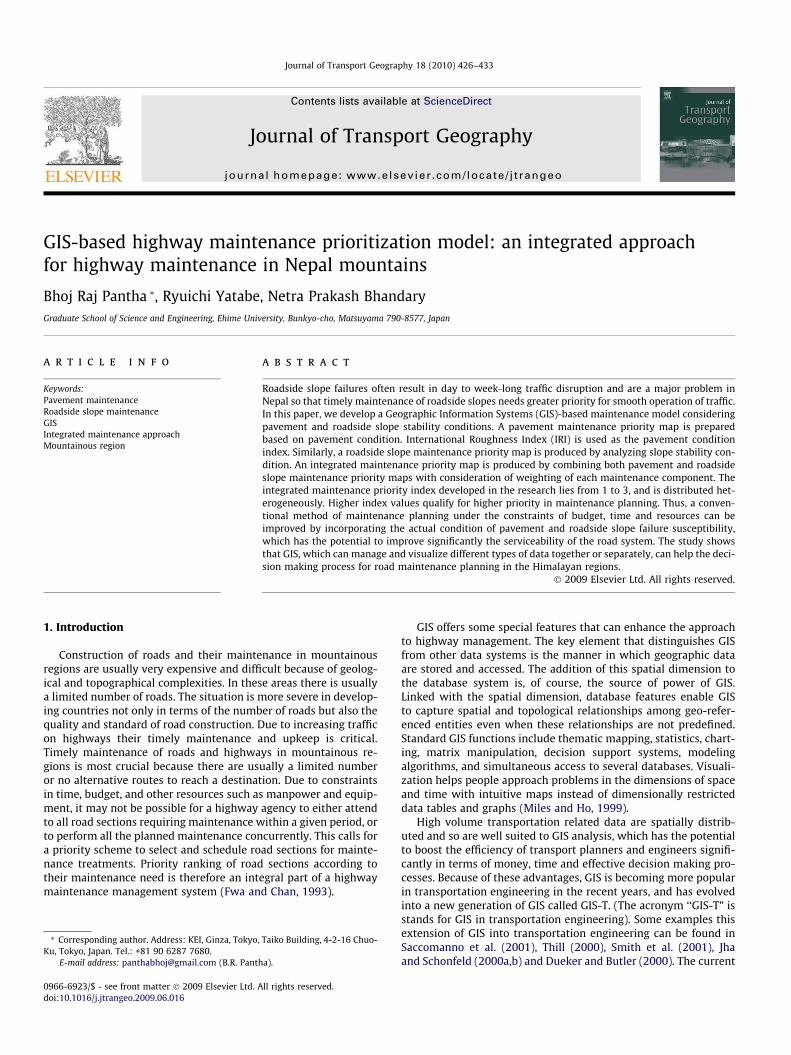
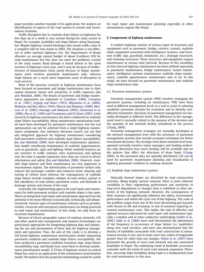
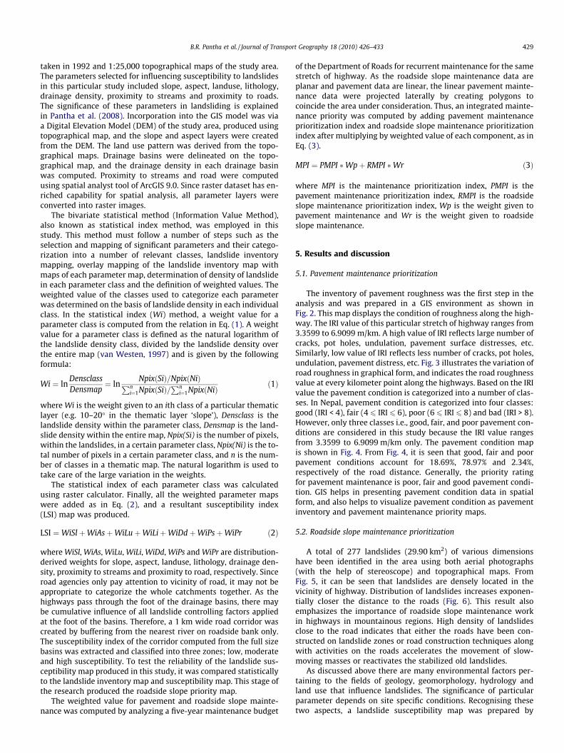
The inventory of pavement roughness was the first step in theanalysis and was prepared in a GIS environment as shown inFig. 2. This map displays the condition of roughness along the high-way. The IRI value of this particular stretch of highway ranges from3.3599 to 6.9099 m/km. A high value of IRI reflects large number ofcracks, pot holes, undulation, pavement surface distresses, etc.Similarly, low value of IRI reflects less number of cracks, pot holes,undulation, pavement distress, etc. Fig. 3 illustrates the variation ofroad roughness in graphical form, and indicates the road roughnessvalue at every kilometer point along the highways. Based on the IRIvalue the pavement condition is categorized into a number of clas-ses. In Nepal, pavement condition is categorized into four classes:good (IRI < 4), fair (4 6 IRI 6 6), poor (6 6 IRI 6 8) and bad (IRI > 8).However, only three classes i.e., good, fair, and poor pavement con-ditions are considered in this study because the IRI value rangesfrom 3.3599 to 6.9099 m/km only. The pavement condition mapis shown in Fig. 4. From Fig. 4, it is seen that good, fair and poorpavement conditions account for 18.69%, 78.97% and 2.34%,respectively of the road distance. Generally, the priority ratingfor pavement maintenance is poor, fair and good pavement condi-tion. GIS helps in presenting pavement condition data in spatialform, and also helps to visualize pavement condition as pavementinventory and pavement maintenance priority maps.
5.2. Roadside slope maintenance prioritization
A total of 277 landslides (29.90 km2) of various dimensionshave been identified in the area using both aerial photographs(with the help of stereoscope) and topographical maps. FromFig. 5, it can be seen that landslides are densely located in thevicinity of highway. Distribution of landslides increases exponen-tially closer the distance to the roads (Fig. 6). This result alsoemphasizes the importance of roadside slope maintenance workin highways in mountainous regions. High density of landslidesclose to the road indicates that either the roads have been con-structed on landslide zones or road construction techniques alongwith activities on the roads accelerates the movement of slow-moving masses or reactivates the stabilized old landslides.
As discussed above there are many environmental factors per-taining to the fields of geology, geomorphology, hydrology andland use that influence landslides. The significance of particularparameter depends on site specific conditions. Recognising thesetwo aspects, a landslide susceptibility map was prepared by
Fig. 3. Variation of IRI along highways.
Fig. 4. Pavement mainte
5.2
4.85
3.89
4.125.4
5.23
4.745
3.79
5.93 4.45
3.76
5.194.44
4.14
4.23
5.29
5.235.12
4.9
4.9754.7
4.52
4.84
5.17
3.88
4.94
5.52
5.34
4.84
5.17
4.25
4.99
6.91
5.92
3.47
5.463.36
5.46
4.16
5.26
5.06
6.05
4.86
3.82
5.114.94
3.43
3.47
5.46
3.59
3.81
3.47
3.54
4.13
4.14
4.25
4.16
6.37
4.16
84°44'0"E
84°44'0"E
84°38'30"E
84°38'30"E
84°33'0"E
84°33'0"E
84°27'30"E
84°27'30"E
27°55'0"N 27°55'0"N
27°50'0"N 27°50'0"N
27°45'0"N 27°45'0"N
Fig. 2. Pavement inventory map.
430 B.R. Pantha et al. / Journal of Transport Geography 18 (2010) 426–433
employing bivariate statistical method reveals that the landslidesusceptibility index values range from �7.1084 to 3.7291 (Fig. 7).
The susceptibility index of the maintenance area under consid-eration (54.08 km2) was exported into the GIS, and a cumulativefrequency curve of landslide susceptibility index values which ran-ged from �5.834 to 3.2822 was segmented into three zones withnearly equal distribution viz. low, moderate and high. The resul-tant map is roadside slope maintenance priority map which isshown in Fig. 8. From the comparison of landslide inventory andsusceptibility maps, the area in the landslide inventory map indi-cating landslide locations is found to match with the landslide sus-ceptibility map. In addition past landslide density in eachsusceptibility zone verifies the result. The total landslide area lo-cated in three susceptibility zones is 11.07 km2, while the landslidedensities in low, moderate and high susceptibility zones are0.0773 km2/km2 (12.58% of the landslide area), 0.1925 km2/km2
(31.29% of the landslide area) and 0.3440 km2/km2 (56.13% of the
nance priority map.

Fig. 5. Landslide inventory map.
Fig. 6. Distribution of landslides in transverse direction of highways.
Fig. 7. Statistical index obtaine
B.R. Pantha et al. / Journal of Transport Geography 18 (2010) 426–433 431
landslide area), respectively. Thus, the trend of landslide distribu-tion in various susceptibility zones verifies the approach.
5.3. Integrated maintenance prioritization
Spatially distributed pavement maintenance priority and road-side slope maintenance priority maps were added in ArcGIS. Fig. 9shows the resultant map after combining both thematic layers;pavement maintenance prioritization and roadside slope mainte-nance prioritization. Thus, visualization of maintenance needsalong highway can identify priorities and help a highway adminis-trator in planning and management of road maintenance.
To simplify the output, final maintenance priority was rated in arange from 1 to 3. A high score gets higher priority for repair andmaintenance. Distribution of maintenance priority score is hetero-geneous. Priority rating provides the necessary input for selecting
d from bivariate method.

Fig. 8. Roadside slope maintenance priority map.
Fig. 9. Maintenance prioritization map.
432 B.R. Pantha et al. / Journal of Transport Geography 18 (2010) 426–433
and scheduling maintenance activities in different road sections.The relative rating scores of different maintenance needs have a di-rect impact on final outcomes of a programming analysis for roadmaintenance.
The conventional method of budget allocation without assess-ing actual condition of pavement and roadside slope failure sus-ceptibility is likely to cost ineffective, and will not improve theserviceability of the road.
6. Conclusions
Road maintenance planning under the constraints of budget,time and other resources is very challenging. Characteristics andspatial distribution of different road components makes the deci-sion making process on priorities very complicated. The processcan be made easier by applying a powerful tool which can store,analyze and manipulate spatially distributed data. In this paper,we have developed a GIS-based integrated model for road repair
and maintenance considering road pavement component androadside slope failure. In the process we have drawn attention tothe need to incorporate roadside slope maintenance in yearly roadmaintenance programs, which is particularly crucial for road main-tenance in mountainous regions.
The approach has another important benefit. Currently, a pave-ment engineer only focuses on pavement maintenance while, ageotechnical engineer focuses only on roadside slope maintenance.Recently there has been little effort applied to roadside slope repairand maintenance in a systematic manner. The GIS analysis showsboth pavement and roadside slope conditions can be integratedso the approach could be used to improve the administration andmanagement of effective maintenance planning.
In this study, we have prepared a pavement inventory map andpavement maintenance priority map and a landslide inventorymap and landslide susceptibility map. The landslide susceptibilityof a 1 km corridor have been extracted and combined with pave-ment maintenance priority map to produce an integrated mainte-nance priority map which can be used by road agency for planning
B.R. Pantha et al. / Journal of Transport Geography 18 (2010) 426–433 433
of maintenance program. With the aid of visualization of results inGIS maps, decision makers can decide the allocation of funds bylocation and function (road surface and slope work) more effi-ciently. In future, this work can be extended by incorporating otherhighway maintenance components.
The section of highway that we considered in this study is a ma-jor link to the capital city of Kathmandu to other parts of the coun-try, but it is frequently damaged and remains closed for severaldays during monsoon every year. The Department of Roads cur-rently allocates road maintenance budget without any of the scien-tific/technical assessment carried out in this research. As a result,maintenance work is less effective than it could be. We hope thatthe methodology that we have developed in this study will be use-ful in maintenance planning to ensure operation of the highwaythroughout the year not only in Nepal, but also in other similargeographical and topographical regions.
References
Carnahan, J., 1988. Analytical framework for optimizing pavement maintenance.Transportation Engineering 114, 307–322.
Carnahan, J., Davis, W., Shahin, M., Keane, P., Wu, M., 1987. Optimal maintenancedecisions for pavement management. Journal of Transportation Engineering113, 554–572.
Chang, C., 2004. The effects of pavement maintenance and rehabilitation strategieson the value of roadway infrastructure. In: [CD-ROM] Sixth InternationalConference on Managing Pavements, Queensland, Australia.
Chootinan, P., Chen, A., Horrocks, M., Bolling, D., 2006. A multi-year pavementmaintenance program using a stochastic simulation-based genetic algorithmapproach. Transportation Research Part A 40, 725–743.
Dueker, K., Butler, J., 2000. A geographic information system framework fortransportation data shearing. Transportation Research Part C 8, 13–36.
Durango, P., Madanat, S., 2002. Optimal maintenance and repair policies ininfrastructure management under uncertain facility deterioration rates: anadaptive control approach. Transportation Research Part A 36, 763–778.
Fwa, T., Chan, W., 1993. Priority rating of highway maintenance need by neuralnetworks. Journal of Transportation Engineering 119 (3), 419–432.
Irrgang, F., Maze, T., 1993. Status of pavement preservation, definition, benefits,issues, and barriers. Transport Research Record 1397, 1–6.
Jha, M., Abdullah, J., 2006. A Markovian approach for optimizing highway life-cyclewith genetic algorithms by considering maintenance of roadsideappurtenances. Journal of Franklin Institute 343, 404–419.
Jha, M., Schonfeld, P., 2000a. Geographic information system-based analysis ofright-of-way cost for highway optimization. Transportation Research Record1719, 241–249.
Jha, M., Schonfeld, P., 2000b. Integrating genetic algorithms and GIS to optimizehighway alignments. Transportation Research Record 1719, 233–240.
Madanat, S., Ben-Akiva, M., 1994. Optimal inspection and repair policies fortransportation facilities. Transportation Science 28, 55–62.
Mauch, M., Madanat, S., 2000. Semiparametric hazard rate models of reinforcedconcrete bridge deck deterioration. Journal of Infrastructure Systems 3 (1),4–9.
Miles, S., Ho, C., 1999. Applications and issues of GIS as a tool for civil engineeringmodeling. Journal of Computing in Civil Engineering 13 (3), 144–152.
Miyamoto, A., Kawamura, A., Nakamura, H., 2000. Bridge management system andmaintenance optimization for existing bridge. Computer-Aided Civil andInfrastructure Engineering 15, 45–55.
Morcous, G., Ricard, H., Hanna, A., 2002. Modeling bridge deterioration using casebased reasoning. Journal of Infrastructure Systems 8 (3), 86–94.
Pantha, B., Yatabe, R., Bhandari, N., 2008. GIS-based landslide susceptibilityzonation for roadside slope repair and maintenance in the Himalayan region.Journal of International Geoscience 31 (4), 384–391.
Petley, D., Hearn, G., Hart, A., Rosser, N., Dunning, S., Oven, K., Mitchell, W., 2007.Trends in landslide occurrence in Nepal. Natural Hazards 43, 23–44.
Saccomanno, F., Fu, L., Roy, R., 2001. Geographic information system-basedintegrated model for analysis and prediction of road accidents. TransportationResearch Record 1768, 193–202.
Sadek, S., Ramadan, R., Naghi, H., 2005. A GIS-based landslide hazard framework forroad repair and maintenance. [Electronic] Electronic Journal of GeotechnicalEngineering 10 (G).
She, T., Aouad, G., Sarshar, M., 1999. A geographic information system (GIS)-basedbridge management system. Computer-Aided Civil and InfrastructureEngineering 14, 417–427.
Sidle, R., Ziegler, A., Negishi, J., Nik, A., Siew, R., Turkelboom, F., 2006. Erosionprocess in steep terrain-truths, myths, and uncertainties related to forestmanagement in Southeast Asia. Forest Ecology and Management 224, 199–225.
Smith, C., Harkey, L., Harris, B., 2001. Implementation of a GIS-based highway safetyanalysis: bridging the gap. Transportation Research Information Services (TRIS)3, 10.
Stocklin, J., Bhattarai, K., 1977. Geology of Kathmandu area and central MahabharatRange, Nepal Himalaya. Report of Department of Mines and Geology/UNDP(Unpublished), pp. 1–86.
Thill, J., 2000. Geographic information systems for transportation in perspective.Transportation Research, Part C 8 (1), 3–12.
Tsunokawa, K., Ul-Islam, R., 2003. Optimal pavement design and maintenancestrategy for developing countries: an analysis using HDM-4. The InternationalJournal of Pavement Engineering 4 (4), 193–208.
van Westen, C., 1997. Statistical landslide hazard analysis. ILWIS 2.1 for WindowsApplication Guide. ITC Publication, Enschede. pp. 77–84.