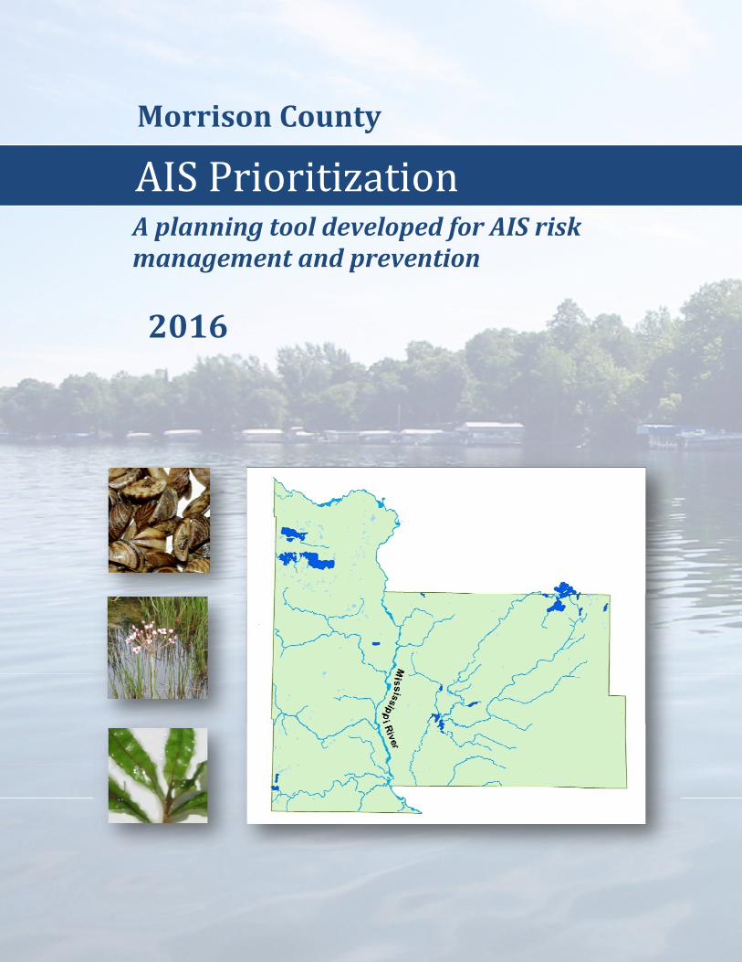
morrison county - ais prioritization
TRANSCRIPT
1
MorrisonCounty
2016
AISPrioritizationAplanningtooldevelopedforAISriskmanagementandprevention
2
Report Date: March 30, 2016 Funded by: Morrison County Assessment Development: Moriya Rufer RMB Environmental Laboratories
22796 County Highway 6 Detroit Lakes, MN 56501 218-846-1465 [email protected] http://rmbel.info
Data Sources: Morrison County Lake Associations Morrison County
Minnesota Department of Natural Resources Minnesota Pollution Control Agency This AIS prioritization process was developed by the Red River Basin Commission and RMB Environmental Laboratories, Inc through a Minnesota Environment and Natural Resources Trust Fund grant in 2014 and local funding partners including Becker County, Clay County, Otter Tail County, Wilkin County, Pelican River Watershed District, Buffalo Red River Watershed District and Wild Rice River Watershed District.
3
Table of Contents Introduction
Background ....................................................................................................................................................... 4 Project Goals ..................................................................................................................................................... 4
Setting Watersheds ........................................................................................................................................................ 5 Morrison County ............................................................................................................................................... 6
History of AIS in Morrison County ................................................................................................................ 7 Plants ................................................................................................................................................................. 7 Zebra Mussels ................................................................................................................................................... 7
Zebra Mussel Risk Assessment Lake Methods .................................................................................................................................................... 9
Water Connectivity ................................................................................................................................. 9 Public Use ............................................................................................................................................... 10 Water Chemistry ..................................................................................................................................... 12 Substrate Suitability ................................................................................................................................ 12 Temperature ............................................................................................................................................ 13 Infestation Risk Rating ........................................................................................................................... 13 Suitability Risk Rating ............................................................................................................................ 13
River Science..................................................................................................................................................... 14 Turbulence and Flow .............................................................................................................................. 14 Downstream Dispersal ............................................................................................................................ 14 Water Quality ......................................................................................................................................... 15
Lake Risk Assessment Report Cards .............................................................................................................. 16
Results and Discussion Results ............................................................................................................................................................... 38 Data Gaps .......................................................................................................................................................... 44 Vectors of Spread .............................................................................................................................................. 45 Time of Year Risk ............................................................................................................................................. 46
AIS Program Management Recommendations ........................................................................................................ 48
References ...................................................................................................................................................................... 51
4
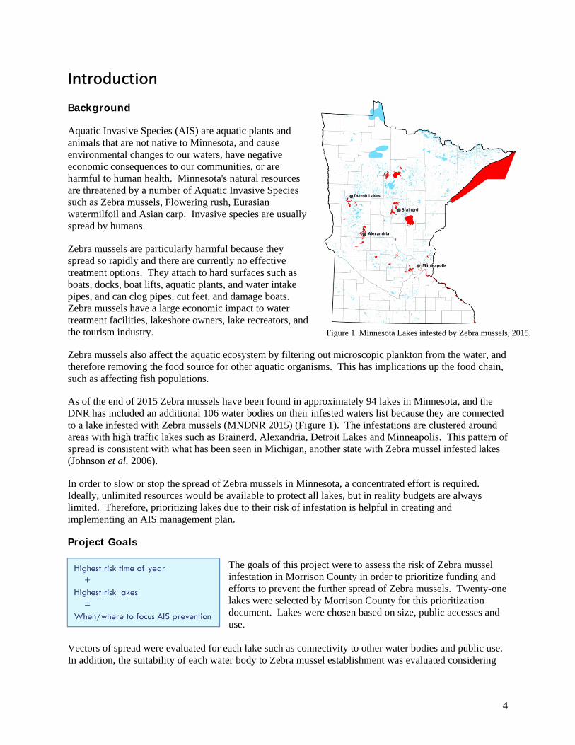
Introduction Background Aquatic Invasive Species (AIS) are aquatic plants and animals that are not native to Minnesota, and cause environmental changes to our waters, have negative economic consequences to our communities, or are harmful to human health. Minnesota's natural resources are threatened by a number of Aquatic Invasive Species such as Zebra mussels, Flowering rush, Eurasian watermilfoil and Asian carp. Invasive species are usually spread by humans. Zebra mussels are particularly harmful because they spread so rapidly and there are currently no effective treatment options. They attach to hard surfaces such as boats, docks, boat lifts, aquatic plants, and water intake pipes, and can clog pipes, cut feet, and damage boats. Zebra mussels have a large economic impact to water treatment facilities, lakeshore owners, lake recreators, and the tourism industry. Zebra mussels also affect the aquatic ecosystem by filtering out microscopic plankton from the water, and therefore removing the food source for other aquatic organisms. This has implications up the food chain, such as affecting fish populations. As of the end of 2015 Zebra mussels have been found in approximately 94 lakes in Minnesota, and the DNR has included an additional 106 water bodies on their infested waters list because they are connected to a lake infested with Zebra mussels (MNDNR 2015) (Figure 1). The infestations are clustered around areas with high traffic lakes such as Brainerd, Alexandria, Detroit Lakes and Minneapolis. This pattern of spread is consistent with what has been seen in Michigan, another state with Zebra mussel infested lakes (Johnson et al. 2006). In order to slow or stop the spread of Zebra mussels in Minnesota, a concentrated effort is required. Ideally, unlimited resources would be available to protect all lakes, but in reality budgets are always limited. Therefore, prioritizing lakes due to their risk of infestation is helpful in creating and implementing an AIS management plan. Project Goals
The goals of this project were to assess the risk of Zebra mussel infestation in Morrison County in order to prioritize funding and efforts to prevent the further spread of Zebra mussels. Twenty-one lakes were selected by Morrison County for this prioritization document. Lakes were chosen based on size, public accesses and use.
Vectors of spread were evaluated for each lake such as connectivity to other water bodies and public use. In addition, the suitability of each water body to Zebra mussel establishment was evaluated considering
Figure 1. Minnesota Lakes infested by Zebra mussels, 2015.
5
water chemistry, substrate, dissolved oxygen and temperature. A report card was developed for each water body showing the available data and assigned risk category. These risk ratings can be used in AIS management plans to prioritize lakes for specific prevention measures. A summary table using the assessments to form management recommendations is provided (Table 13). This table can used to guide the most efficient use of AIS funds in the most effective way possible.
Setting
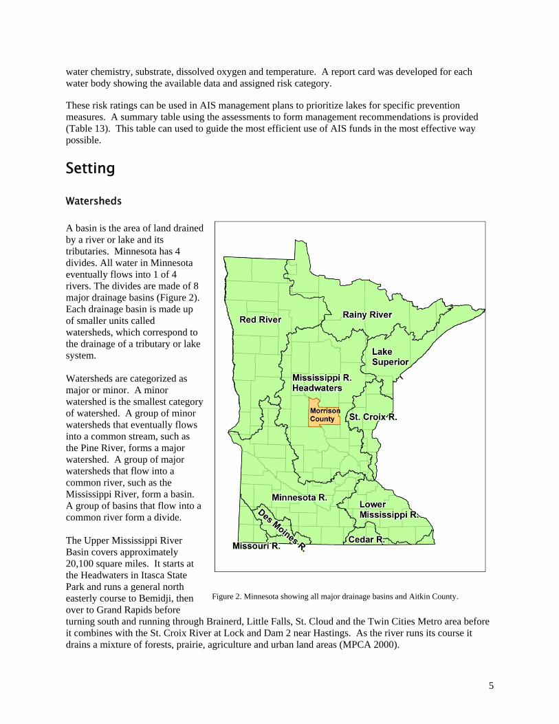
Watersheds A basin is the area of land drained by a river or lake and its tributaries. Minnesota has 4 divides. All water in Minnesota eventually flows into 1 of 4 rivers. The divides are made of 8 major drainage basins (Figure 2). Each drainage basin is made up of smaller units called watersheds, which correspond to the drainage of a tributary or lake system. Watersheds are categorized as major or minor. A minor watershed is the smallest category of watershed. A group of minor watersheds that eventually flows into a common stream, such as the Pine River, forms a major watershed. A group of major watersheds that flow into a common river, such as the Mississippi River, form a basin. A group of basins that flow into a common river form a divide. The Upper Mississippi River Basin covers approximately 20,100 square miles. It starts at the Headwaters in Itasca State Park and runs a general north easterly course to Bemidji, then over to Grand Rapids before turning south and running through Brainerd, Little Falls, St. Cloud and the Twin Cities Metro area before it combines with the St. Croix River at Lock and Dam 2 near Hastings. As the river runs its course it drains a mixture of forests, prairie, agriculture and urban land areas (MPCA 2000).
Figure 2. Minnesota showing all major drainage basins and Aitkin County.
6
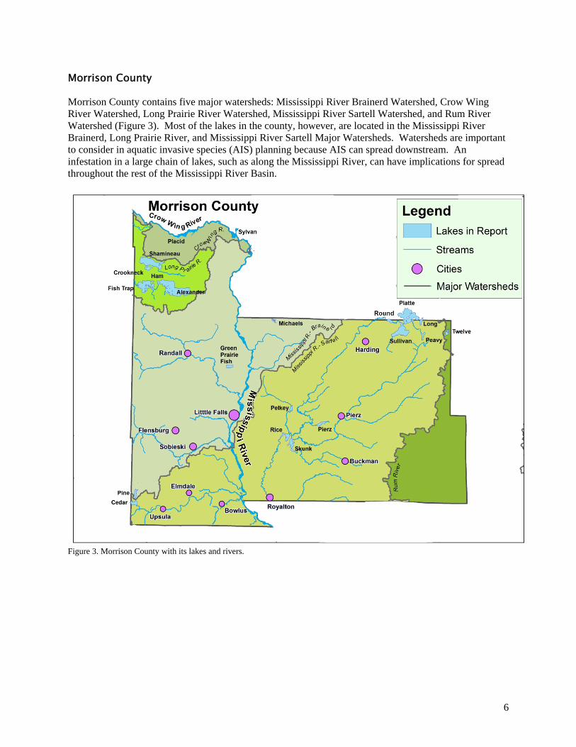
Morrison County Morrison County contains five major watersheds: Mississippi River Brainerd Watershed, Crow Wing River Watershed, Long Prairie River Watershed, Mississippi River Sartell Watershed, and Rum River Watershed (Figure 3). Most of the lakes in the county, however, are located in the Mississippi River Brainerd, Long Prairie River, and Mississippi River Sartell Major Watersheds. Watersheds are important to consider in aquatic invasive species (AIS) planning because AIS can spread downstream. An infestation in a large chain of lakes, such as along the Mississippi River, can have implications for spread throughout the rest of the Mississippi River Basin.
Figure 3. Morrison County with its lakes and rivers.
7
History of AIS in Morrison County
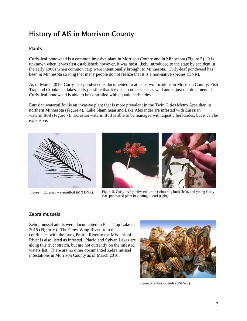
Plants Curly-leaf pondweed is a common invasive plant in Morrison County and in Minnesota (Figure 5). It is unknown when it was first established; however, it was most likely introduced to the state by accident in the early 1900s when common carp were intentionally brought to Minnesota. Curly-leaf pondweed has been in Minnesota so long that many people do not realize that it is a non-native species (DNR). As of March 2016, Curly-leaf pondweed is documented in at least two locations in Morrison County: Fish Trap and Crookneck lakes. It is possible that it exists in other lakes as well and is just not documented. Curly-leaf pondweed is able to be controlled with aquatic herbicides. Eurasian watermilfoil is an invasive plant that is more prevalent in the Twin Cities Metro Area than in northern Minnesota (Figure 4). Lake Shamineau and Lake Alexander are infested with Eurasian watermilfoil (Figure 7). Eurasian watermilfoil is able to be managed with aquatic herbicides, but it can be expensive.
Figure 5. Curly-leaf pondweed turion (wintering bud) (left), and young Curly-leaf pondweed plant beginning to curl (right).
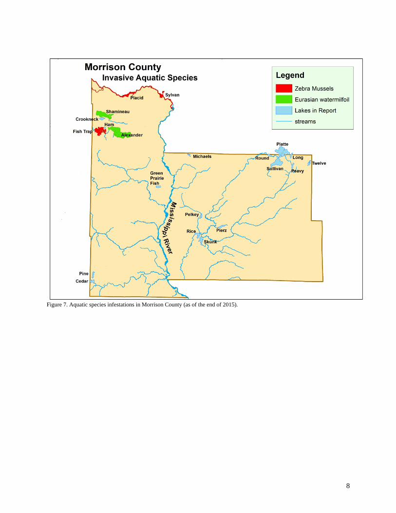
Zebra mussels Zebra mussel adults were documented in Fish Trap Lake in 2015 (Figure 6). The Crow Wing River from the confluence with the Long Prairie River to the Mississippi River is also listed as infested. Placid and Sylvan Lakes are along this river stretch, but are not currently on the infested waters list. There are no other documented Zebra mussel infestations in Morrison County as of March 2016.
Figure 6. Zebra mussels (USFWS).
Figure 4. Eurasian watermilfoil (MN DNR).
8
Figure 7. Aquatic species infestations in Morrison County (as of the end of 2015).
9
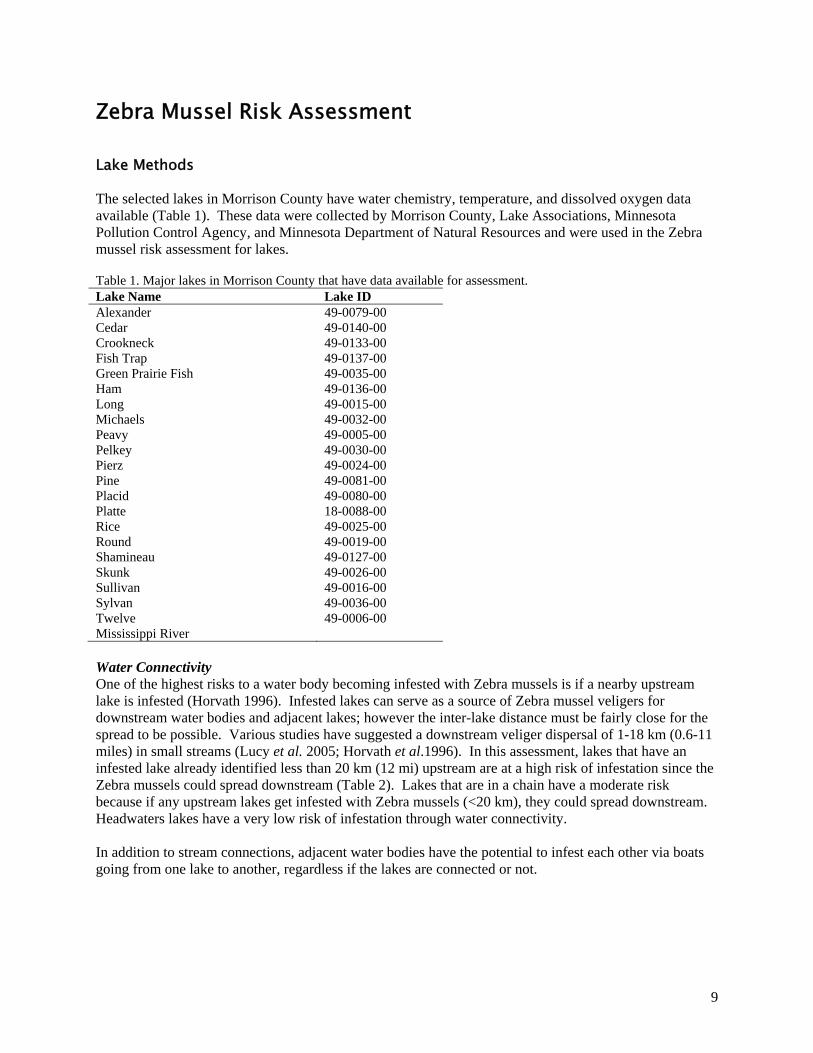
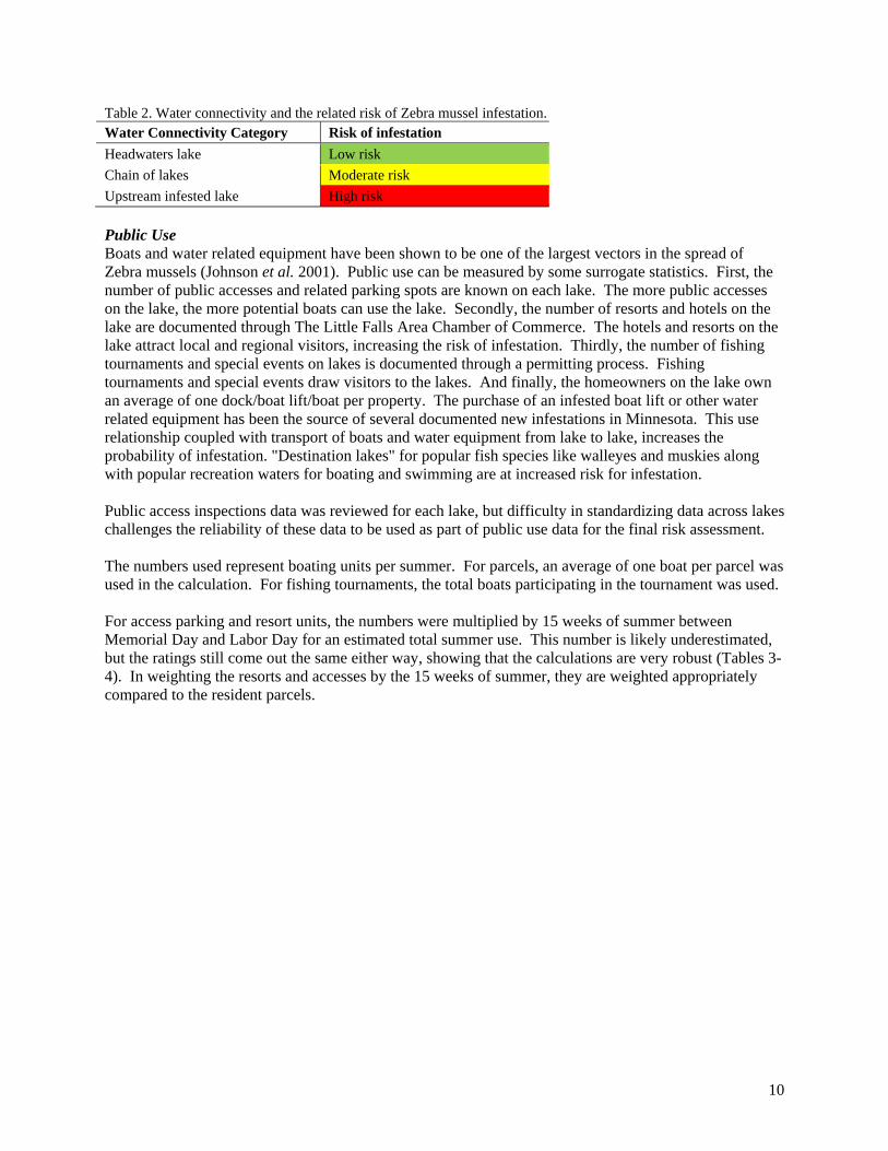
Zebra Mussel Risk Assessment Lake Methods The selected lakes in Morrison County have water chemistry, temperature, and dissolved oxygen data available (Table 1). These data were collected by Morrison County, Lake Associations, Minnesota Pollution Control Agency, and Minnesota Department of Natural Resources and were used in the Zebra mussel risk assessment for lakes. Table 1. Major lakes in Morrison County that have data available for assessment. Lake Name Lake ID Alexander 49-0079-00 Cedar 49-0140-00 Crookneck 49-0133-00 Fish Trap 49-0137-00 Green Prairie Fish 49-0035-00 Ham 49-0136-00 Long 49-0015-00 Michaels 49-0032-00 Peavy 49-0005-00 Pelkey 49-0030-00 Pierz 49-0024-00 Pine 49-0081-00 Placid 49-0080-00 Platte 18-0088-00 Rice 49-0025-00 Round 49-0019-00 Shamineau 49-0127-00 Skunk 49-0026-00 Sullivan 49-0016-00 Sylvan 49-0036-00 Twelve 49-0006-00 Mississippi River Water Connectivity One of the highest risks to a water body becoming infested with Zebra mussels is if a nearby upstream lake is infested (Horvath 1996). Infested lakes can serve as a source of Zebra mussel veligers for downstream water bodies and adjacent lakes; however the inter-lake distance must be fairly close for the spread to be possible. Various studies have suggested a downstream veliger dispersal of 1-18 km (0.6-11 miles) in small streams (Lucy et al. 2005; Horvath et al.1996). In this assessment, lakes that have an infested lake already identified less than 20 km (12 mi) upstream are at a high risk of infestation since the Zebra mussels could spread downstream (Table 2). Lakes that are in a chain have a moderate risk because if any upstream lakes get infested with Zebra mussels (<20 km), they could spread downstream. Headwaters lakes have a very low risk of infestation through water connectivity. In addition to stream connections, adjacent water bodies have the potential to infest each other via boats going from one lake to another, regardless if the lakes are connected or not.
10
Table 2. Water connectivity and the related risk of Zebra mussel infestation. Water Connectivity Category Risk of infestation
Headwaters lake Low risk
Chain of lakes Moderate risk
Upstream infested lake High risk
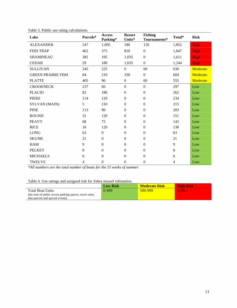
Public Use Boats and water related equipment have been shown to be one of the largest vectors in the spread of Zebra mussels (Johnson et al. 2001). Public use can be measured by some surrogate statistics. First, the number of public accesses and related parking spots are known on each lake. The more public accesses on the lake, the more potential boats can use the lake. Secondly, the number of resorts and hotels on the lake are documented through The Little Falls Area Chamber of Commerce. The hotels and resorts on the lake attract local and regional visitors, increasing the risk of infestation. Thirdly, the number of fishing tournaments and special events on lakes is documented through a permitting process. Fishing tournaments and special events draw visitors to the lakes. And finally, the homeowners on the lake own an average of one dock/boat lift/boat per property. The purchase of an infested boat lift or other water related equipment has been the source of several documented new infestations in Minnesota. This use relationship coupled with transport of boats and water equipment from lake to lake, increases the probability of infestation. "Destination lakes" for popular fish species like walleyes and muskies along with popular recreation waters for boating and swimming are at increased risk for infestation. Public access inspections data was reviewed for each lake, but difficulty in standardizing data across lakes challenges the reliability of these data to be used as part of public use data for the final risk assessment. The numbers used represent boating units per summer. For parcels, an average of one boat per parcel was used in the calculation. For fishing tournaments, the total boats participating in the tournament was used. For access parking and resort units, the numbers were multiplied by 15 weeks of summer between Memorial Day and Labor Day for an estimated total summer use. This number is likely underestimated, but the ratings still come out the same either way, showing that the calculations are very robust (Tables 3-4). In weighting the resorts and accesses by the 15 weeks of summer, they are weighted appropriately compared to the resident parcels.
11
Table 3. Public use rating calculations.
Lake Parcels* Access Parking*
Resort Units*
Fishing Tournaments*
Total* Risk
ALEXANDER 547 1,005 180 120 1,852 High
FISH TRAP 462 375 810 0 1,647 High
SHAMINEAU 381 195 1,035 0 1,611 High
CEDAR 29 180 1,035 0 1,244 High
SULLIVAN 345 225 0 60 630 Moderate
GREEN PRAIRIE FISH 64 210 330 0 604 Moderate
PLATTE 405 90 0 60 555 Moderate
CROOKNECK 237 60 0 0 297 Low
PLACID 82 180 0 0 262 Low
PIERZ 114 120 0 0 234 Low
SYLVAN (MAIN) 5 210 0 0 215 Low
PINE 113 90 0 0 203 Low
ROUND 31 120 0 0 151 Low
PEAVY 68 75 0 0 143 Low
RICE 18 120 0 0 138 Low
LONG 63 0 0 0 63 Low
SKUNK 21 0 0 0 21 Low
HAM 9 0 0 0 9 Low
PELKEY 8 0 0 0 8 Low
MICHAELS 6 0 0 0 6 Low
TWELVE 4 0 0 0 4 Low *All numbers are the total number of boats for the 15 weeks of summer.
Table 4. Use ratings and assigned risk for Zebra mussel infestation. Low Risk Moderate Risk High Risk Total Boat Units (the sum of public access parking spaces, resort units, lake parcels and special events)
0-499 500-999 1,000+
12
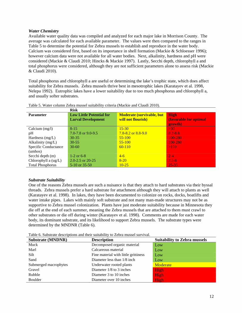
Water Chemistry Available water quality data was compiled and analyzed for each major lake in Morrison County. The average was calculated for each available parameter. The values were then compared to the ranges in Table 5 to determine the potential for Zebra mussels to establish and reproduce in the water body. Calcium was considered first, based on its importance in shell formation (Mackie & Schloesser 1996); however calcium data were not available for all water bodies. Next, alkalinity, hardness and pH were considered (Mackie & Claudi 2010; Hincks & Mackie 1997). Lastly, Secchi depth, chlorophyll a and total phosphorus were considered, although they are not sufficient parameters alone to assess risk (Mackie & Claudi 2010). Total phosphorus and chlorophyll a are useful or determining the lake’s trophic state, which does affect suitability for Zebra mussels. Zebra mussels thrive best in mesotrophic lakes (Karatayev et al. 1998, Nelepa 1992). Eutrophic lakes have a lower suitability due to too much phosphorus and chlorophyll a, and usually softer substrates. Table 5. Water column Zebra mussel suitability criteria (Mackie and Claudi 2010). Risk Parameter Low Little Potential for
Larval Development Moderate (survivable, but will not flourish)
High (favorable for optimal growth)
Calcium (mg/l) 8-15 15-30 >30 pH 7.0-7.8 or 9.0-9.5 7.8-8.2 or 8.8-9.0 8.2-8.8 Hardness (mg/L) 30-35 55-100 100-280 Alkalinity (mg/L) 30-55 55-100 100-280 Specific Conductance (umhos)
30-60 60-110 >110
Secchi depth (m) 1-2 or 6-8 4-6 2-4 Chlorophyll a (ug/L) 2.0-2.5 or 20-25 8-20 2.5-8 Total Phosphorus 5-10 or 35-50 10-25 25-35 Substrate Suitability One of the reasons Zebra mussels are such a nuisance is that they attach to hard substrates via their byssal threads. Zebra mussels prefer a hard substrate for attachment although they will attach to plants as well (Karatayev et al. 1998). In lakes, they have been documented to colonize on rocks, docks, boatlifts and water intake pipes. Lakes with mainly soft substrate and not many man-made structures may not be as supportive to Zebra mussel colonization. Plants have just moderate suitability because in Minnesota they die off at the end of each summer, meaning the Zebra mussels that are attached to them must crawl to other substrates or die off during winter (Karatayev et al. 1998). Comments are made for each water body, its dominant substrate, and its likelihood to support Zebra mussels. The substrate types were determined by the MNDNR (Table 6). Table 6. Substrate descriptions and their suitability to Zebra mussel survival. Substrate (MNDNR) Description Suitability to Zebra mussels Muck Decomposed organic material Low Marl Calcareous material Low Silt Fine material with little grittiness Low Sand Diameter less than 1/8 inch Low Submerged macrophytes Underwater rooted plants Moderate Gravel Diameter 1/8 to 3 inches High Rubble Diameter 3 to 10 inches High Boulder Diameter over 10 inches High
13
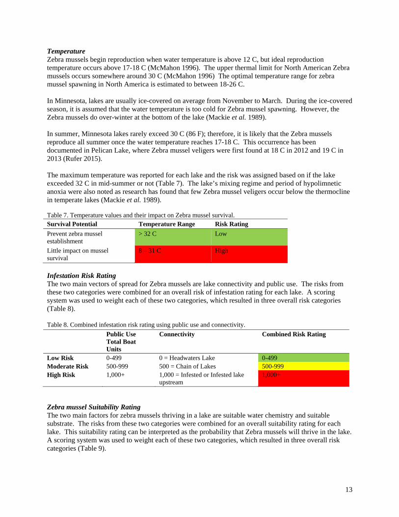
Temperature Zebra mussels begin reproduction when water temperature is above 12 C, but ideal reproduction temperature occurs above 17-18 C (McMahon 1996). The upper thermal limit for North American Zebra mussels occurs somewhere around 30 C (McMahon 1996) The optimal temperature range for zebra mussel spawning in North America is estimated to between 18-26 C. In Minnesota, lakes are usually ice-covered on average from November to March. During the ice-covered season, it is assumed that the water temperature is too cold for Zebra mussel spawning. However, the Zebra mussels do over-winter at the bottom of the lake (Mackie et al. 1989). In summer, Minnesota lakes rarely exceed 30 C (86 F); therefore, it is likely that the Zebra mussels reproduce all summer once the water temperature reaches 17-18 C. This occurrence has been documented in Pelican Lake, where Zebra mussel veligers were first found at 18 C in 2012 and 19 C in 2013 (Rufer 2015). The maximum temperature was reported for each lake and the risk was assigned based on if the lake exceeded 32 C in mid-summer or not (Table 7). The lake’s mixing regime and period of hypolimnetic anoxia were also noted as research has found that few Zebra mussel veligers occur below the thermocline in temperate lakes (Mackie et al. 1989). Table 7. Temperature values and their impact on Zebra mussel survival. Survival Potential Temperature Range Risk Rating
Prevent zebra mussel establishment
> 32 C Low
Little impact on mussel survival
8 – 31 C High
Infestation Risk Rating The two main vectors of spread for Zebra mussels are lake connectivity and public use. The risks from these two categories were combined for an overall risk of infestation rating for each lake. A scoring system was used to weight each of these two categories, which resulted in three overall risk categories (Table 8). Table 8. Combined infestation risk rating using public use and connectivity.
Public Use Total Boat Units
Connectivity Combined Risk Rating
Low Risk 0-499 0 = Headwaters Lake 0-499 Moderate Risk 500-999 500 = Chain of Lakes 500-999 High Risk 1,000+ 1,000 = Infested or Infested lake
upstream 1,000+
Zebra mussel Suitability Rating The two main factors for zebra mussels thriving in a lake are suitable water chemistry and suitable substrate. The risks from these two categories were combined for an overall suitability rating for each lake. This suitability rating can be interpreted as the probability that Zebra mussels will thrive in the lake. A scoring system was used to weight each of these two categories, which resulted in three overall risk categories (Table 9).
14
Table 9. Combined Zebra mussel suitability rating using water chemistry and substrate. Water Quality Substrate Combined Risk Rating Low Risk 0 = The majority of
averages in green category.
0 = Sand, Silt, Muck 0 - Low
Moderate Risk 500 = The majority of averages in yellow category.
500=Submerged macrophytes
1000 - Moderate
High Risk 1,000 = The majority of averages in red category.
1,000 = Rocks, Gravel, Rubble
2000 - High
River Science Unlike lakes, rivers are not usually ideal habitat for Zebra mussels. Studies have shown that the turbulence in streams and rivers causes high Zebra mussel veliger mortality and assists in preventing the veligers from settling on hard substrates (Horvath & Lamberti 1999). Without an infested lake upstream continually supplying the stream with Zebra mussel veligers, the stream is unlikely to sustain a large population on its own. Although streams can be pathways for downstream infestations, the probability of Zebra mussel veliger survival decreases with distance downstream (Horvath & Lamberti 1999; Horvath et al. 1996). For small streams, even the presence of an infested lake upstream supplying veligers will probably not allow the stream to support populations of Zebra mussel adults. Strayer (1991) found that in streams <10 meters wide (33 feet) there were no stable adult Zebra mussel populations. Zebra mussel adults seem to only survive in the largest rivers (>100 m wide) or large pools and stagnant backwaters. Turbulence & Flow Studies show that turbulence or shear may be the limiting factor for Zebra mussel survival in streams and rivers (Horvath & Lamberti 1999). Although specific flow rates are not determined, it appears that in streams and rivers, zebra mussels are only self-sustaining behind dams and stagnant backwaters. Therefore, for the purposes of this risk assessment, any stream sites are considered to have low risk due to the flow in the river, even if there is no flow data available. Downstream Dispersal Zebra mussel veliger abundance has been shown to decrease with distance in streams. Veligers have been found 10-18 km (6-11 miles) downstream of an infested lake in stream systems (Horvath et al.,1996). In heavily vegetated wetland stream systems, the dispersal distance has been found to be about 1 km (0.6 mile), which is much lower. There are a few possible factors affecting Zebra mussel veliger survival in wetlands streams, including aquatic vegetation, low water velocity, unsuitable water characteristics, limited substrate availability, and/or increased predation pressure (Bodamer & Brossenbroek 2008). These results show that protecting aquatic vegetation from removal, limiting stream dredging, and installing wetlands could help as a barrier for spreading Zebra mussels downstream. The small streams in Morrison County have some submerged vegetation, usually lined with emergent vegetation, has sandy/rocky substrate and mostly clear water. Taking into account the literature and the condition and habitat of the river, for the purposes of this risk assessment, 32 km (20 mi) is considered the longest a veliger could theoretically travel. This distance of 32 km is very conservative, but until further research is conducted a better estimate is not available.
15
Water Quality The water chemistry ranges from Mackie and Claudi 2010 (Table 5) can be applied to streams; however, more applicable water quality parameters to streams are turbidity and total suspended solids. Turbidity has been shown to limit Zebra mussel survival. Although acute exposures to high turbidity can negatively affect a Zebra mussel population, they are able to compensate for some high exposure (McMahon 1996). Chronic high turbidity has a greater negative effect on Zebra mussel survival, as it inhibits their filtering ability (McMahon 1996, Karatayev et al. 1998). Mackie and Claudi (2010) suggest upper limits for Zebra mussel survival for total suspended solids at 96 mg/L and turbidity at 80 NTU, if the turbidity is caused mainly from sediment suspension. The combination of high temperature and high turbidity seem to be most stressful to Zebra mussels (Alexander 1994).
16
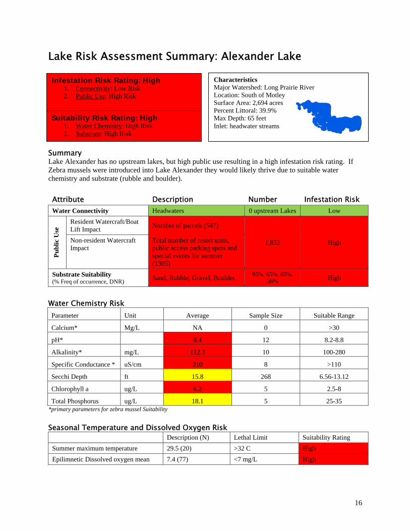
Lake Risk Assessment Summary: Alexander Lake
Summary Lake Alexander has no upstream lakes, but high public use resulting in a high infestation risk rating. If Zebra mussels were introduced into Lake Alexander they would likely thrive due to suitable water chemistry and substrate (rubble and boulder).
Attribute Description Number Infestation Risk Water Connectivity Headwaters 0 upstream Lakes Low
Pu
bli
c U
se Resident Watercraft/Boat
Lift Impact Number of parcels (547)
1,852 High Non-resident Watercraft Impact
Total number of resort units, public access parking spots and special events for summer (1305)
Substrate Suitability (% Freq of occurrence, DNR)
Sand, Rubble, Gravel, Boulder, 95%, 65%, 65%,
38% High
Water Chemistry Risk Parameter Unit Average Sample Size Suitable Range
Calcium* Mg/L NA 0 >30
pH* 8.4 12 8.2-8.8
Alkalinity* mg/L 112.3 10 100-280
Specific Conductance * uS/cm 210 8 >110
Secchi Depth ft 15.8 268 6.56-13.12
Chlorophyll a ug/L 6.2 5 2.5-8
Total Phosphorus ug/L 18.1 5 25-35 *primary parameters for zebra mussel Suitability
Seasonal Temperature and Dissolved Oxygen Risk
Description (N) Lethal Limit Suitability Rating
Summer maximum temperature 29.5 (20) >32 C High
Epilimnetic Dissolved oxygen mean 7.4 (77) <7 mg/L High
Characteristics Major Watershed: Long Prairie River Location: South of Motley Surface Area: 2,694 acres Percent Littoral: 39.9% Max Depth: 65 feet Inlet: headwater streams
Infestation Risk Rating: High 1. Connectivity: Low Risk 2. Public Use: High Risk
Suitability Risk Rating: High 1. Water Chemistry: High Risk 2. Substrate: High Risk
17
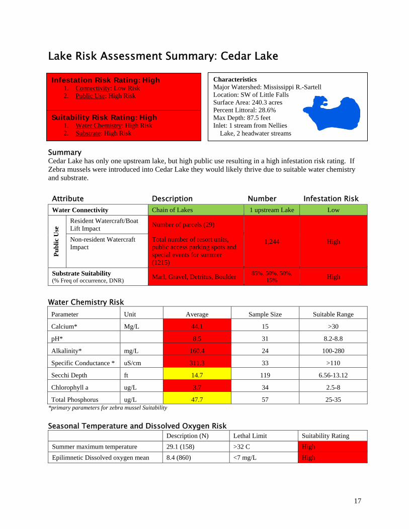
Lake Risk Assessment Summary: Cedar Lake
Summary Cedar Lake has only one upstream lake, but high public use resulting in a high infestation risk rating. If Zebra mussels were introduced into Cedar Lake they would likely thrive due to suitable water chemistry and substrate.
Attribute Description Number Infestation Risk Water Connectivity Chain of Lakes 1 upstream Lake Low
Pu
bli
c U
se Resident Watercraft/Boat
Lift Impact Number of parcels (29)
1,244 High Non-resident Watercraft Impact
Total number of resort units, public access parking spots and special events for summer (1215)
Substrate Suitability (% Freq of occurrence, DNR)
Marl, Gravel, Detritus, Boulder 85%, 50%, 50%,
15% High
Water Chemistry Risk Parameter Unit Average Sample Size Suitable Range
Calcium* Mg/L 44.1 15 >30
pH* 8.5 31 8.2-8.8
Alkalinity* mg/L 160.4 24 100-280
Specific Conductance * uS/cm 311.3 33 >110
Secchi Depth ft 14.7 119 6.56-13.12
Chlorophyll a ug/L 3.7 34 2.5-8
Total Phosphorus ug/L 47.7 57 25-35 *primary parameters for zebra mussel Suitability
Seasonal Temperature and Dissolved Oxygen Risk
Description (N) Lethal Limit Suitability Rating
Summer maximum temperature 29.1 (158) >32 C High
Epilimnetic Dissolved oxygen mean 8.4 (860) <7 mg/L High
Characteristics Major Watershed: Mississippi R.-Sartell Location: SW of Little Falls Surface Area: 240.3 acres Percent Littoral: 28.6% Max Depth: 87.5 feet Inlet: 1 stream from Nellies Lake, 2 headwater streams
Infestation Risk Rating: High 1. Connectivity: Low Risk 2. Public Use: High Risk
Suitability Risk Rating: High 1. Water Chemistry: High Risk 2. Substrate: High Risk
18
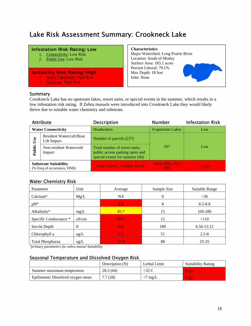
Lake Risk Assessment Summary: Crookneck Lake
Summary Crookneck Lake has no upstream lakes, resort units, or special events in the summer, which results in a low infestation risk rating. If Zebra mussels were introduced into Crookneck Lake they would likely thrive due to suitable water chemistry and substrate.
Attribute Description Number Infestation Risk Water Connectivity Headwaters 0 upstream Lakes Low
Pu
bli
c U
se Resident Watercraft/Boat
Lift Impact Number of parcels (237)
297 Low Non-resident Watercraft Impact
Total number of resort units, public access parking spots and special events for summer (60)
Substrate Suitability (% Freq of occurrence, DNR)
Sand, Gravel , Rubble, Muck 100%, 60%, 35%,
20% High
Water Chemistry Risk Parameter Unit Average Sample Size Suitable Range
Calcium* Mg/L NA 0 >30
pH* 8.8 8 8.2-8.8
Alkalinity* mg/L 85.7 15 100-280
Specific Conductance * uS/cm 149.1 12 >110
Secchi Depth ft 8.8 180 6.56-13.12
Chlorophyll a ug/L 6.1 51 2.5-8
Total Phosphorus ug/L 25.8 88 25-35 *primary parameters for zebra mussel Suitability
Seasonal Temperature and Dissolved Oxygen Risk
Description (N) Lethal Limit Suitability Rating
Summer maximum temperature 28.3 (64) >32 C High
Epilimnetic Dissolved oxygen mean 7.7 (28) <7 mg/L High
Characteristics Major Watershed: Long Prairie River Location: South of Motley Surface Area: 183.1 acres Percent Littoral: 79.1% Max Depth: 18 feet Inlet: None
Infestation Risk Rating: Low 1. Connectivity: Low Risk 2. Public Use: Low Risk
Suitability Risk Rating: High 1. Water Chemistry: High Risk 2. Substrate: High Risk
19
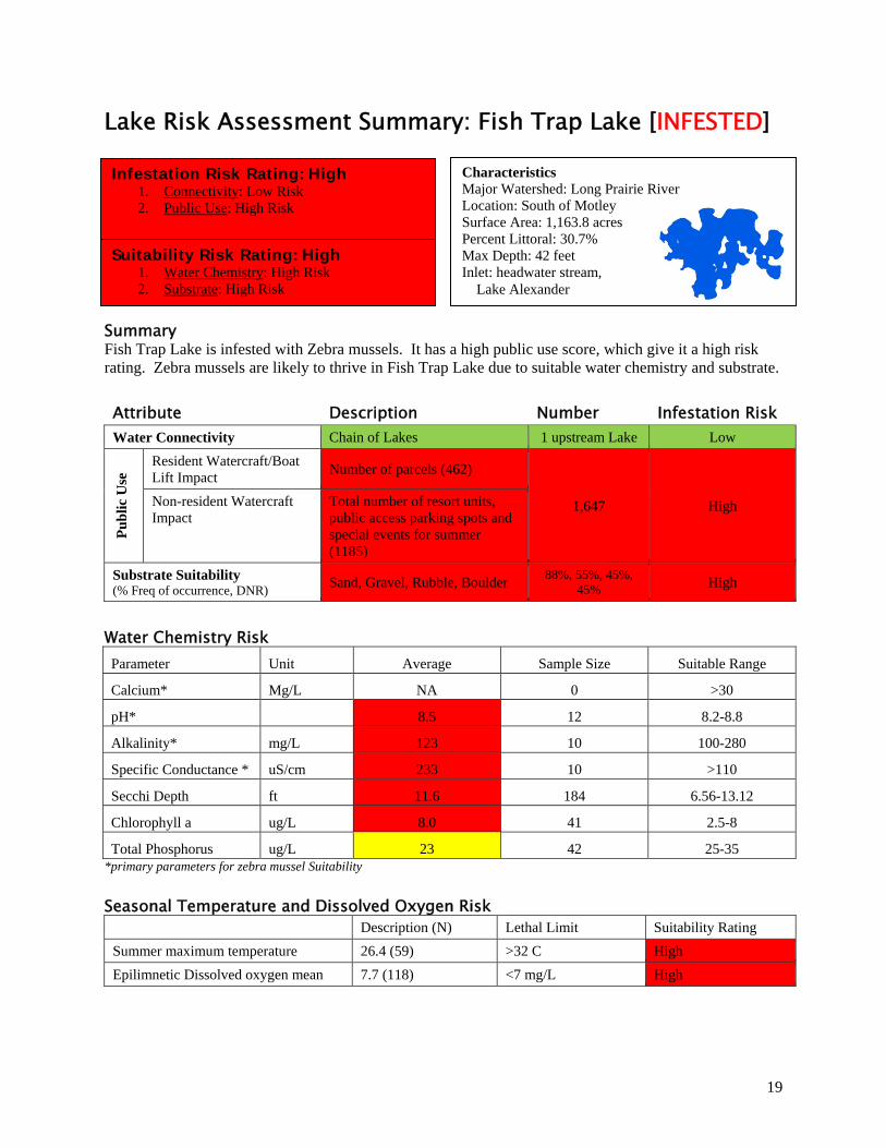
Lake Risk Assessment Summary: Fish Trap Lake [INFESTED]
Summary Fish Trap Lake is infested with Zebra mussels. It has a high public use score, which give it a high risk rating. Zebra mussels are likely to thrive in Fish Trap Lake due to suitable water chemistry and substrate.
Attribute Description Number Infestation Risk Water Connectivity Chain of Lakes 1 upstream Lake Low
Pu
bli
c U
se Resident Watercraft/Boat
Lift Impact Number of parcels (462)
1,647 High Non-resident Watercraft Impact
Total number of resort units, public access parking spots and special events for summer (1185)
Substrate Suitability (% Freq of occurrence, DNR)
Sand, Gravel, Rubble, Boulder 88%, 55%, 45%,
45% High
Water Chemistry Risk Parameter Unit Average Sample Size Suitable Range
Calcium* Mg/L NA 0 >30
pH* 8.5 12 8.2-8.8
Alkalinity* mg/L 123 10 100-280
Specific Conductance * uS/cm 233 10 >110
Secchi Depth ft 11.6 184 6.56-13.12
Chlorophyll a ug/L 8.0 41 2.5-8
Total Phosphorus ug/L 23 42 25-35 *primary parameters for zebra mussel Suitability
Seasonal Temperature and Dissolved Oxygen Risk
Description (N) Lethal Limit Suitability Rating
Summer maximum temperature 26.4 (59) >32 C High
Epilimnetic Dissolved oxygen mean 7.7 (118) <7 mg/L High
Characteristics Major Watershed: Long Prairie River Location: South of Motley Surface Area: 1,163.8 acres Percent Littoral: 30.7% Max Depth: 42 feet Inlet: headwater stream, Lake Alexander
Infestation Risk Rating: High 1. Connectivity: Low Risk 2. Public Use: High Risk
Suitability Risk Rating: High 1. Water Chemistry: High Risk 2. Substrate: High Risk
20
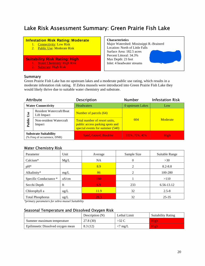
Lake Risk Assessment Summary: Green Prairie Fish Lake
Summary Green Prairie Fish Lake has no upstream lakes and a moderate public use rating, which results in a moderate infestation risk rating. If Zebra mussels were introduced into Green Prairie Fish Lake they would likely thrive due to suitable water chemistry and substrate.
Attribute Description Number Infestation Risk Water Connectivity Headwaters 0 upstream Lakes Low
Pu
bli
c U
se Resident Watercraft/Boat
Lift Impact Number of parcels (64)
604 Moderate Non-resident Watercraft Impact
Total number of resort units, public access parking spots and special events for summer (540)
Substrate Suitability (% Freq of occurrence, DNR)
Sand, Gravel, Boulder 100%, 70%, 40% High
Water Chemistry Risk Parameter Unit Average Sample Size Suitable Range
Calcium* Mg/L NA 0 >30
pH* 8.9 2 8.2-8.8
Alkalinity* mg/L 86 2 100-280
Specific Conductance * uS/cm 160 1 >110
Secchi Depth ft 6.9 233 6.56-13.12
Chlorophyll a ug/L 11.9 32 2.5-8
Total Phosphorus ug/L 28.3 32 25-35 *primary parameters for zebra mussel Suitability
Seasonal Temperature and Dissolved Oxygen Risk
Description (N) Lethal Limit Suitability Rating
Summer maximum temperature 27.8 (30) >32 C High
Epilimnetic Dissolved oxygen mean 8.3 (12) <7 mg/L High
Characteristics Major Watershed: Mississippi R.-Brainerd Location: North of Little Falls Surface Area: 182.5 acres Percent Littoral: 34.3% Max Depth: 23 feet Inlet: 4 headwater streams
Infestation Risk Rating: Moderate 1. Connectivity: Low Risk 2. Public Use: Moderate Risk
Suitability Risk Rating: High 1. Water Chemistry: High Risk 2. Substrate: High Risk
21
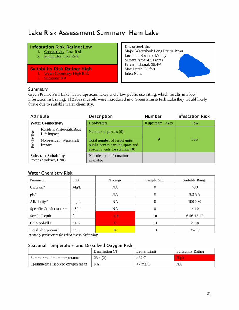
Lake Risk Assessment Summary: Ham Lake
Summary Green Prairie Fish Lake has no upstream lakes and a low public use rating, which results in a low infestation risk rating. If Zebra mussels were introduced into Green Prairie Fish Lake they would likely thrive due to suitable water chemistry.
Attribute Description Number Infestation Risk Water Connectivity Headwaters 0 upstream Lakes Low
Pu
bli
c U
se Resident Watercraft/Boat
Lift Impact Number of parcels (9)
9 Low Non-resident Watercraft Impact
Total number of resort units, public access parking spots and special events for summer (0)
Substrate Suitability (mean abundance, DNR)
No substrate information available
Water Chemistry Risk Parameter Unit Average Sample Size Suitable Range
Calcium* Mg/L NA 0 >30
pH* NA 0 8.2-8.8
Alkalinity* mg/L NA 0 100-280
Specific Conductance * uS/cm NA 0 >110
Secchi Depth ft 11.6 10 6.56-13.12
Chlorophyll a ug/L 6 13 2.5-8
Total Phosphorus ug/L 16 13 25-35 *primary parameters for zebra mussel Suitability
Seasonal Temperature and Dissolved Oxygen Risk
Description (N) Lethal Limit Suitability Rating
Summer maximum temperature 28.4 (2) >32 C High
Epilimnetic Dissolved oxygen mean NA <7 mg/L NA
Characteristics Major Watershed: Long Prairie River Location: South of Motley Surface Area: 42.3 acres Percent Littoral: 56.4% Max Depth: 23 feet Inlet: None
Infestation Risk Rating: Low 1. Connectivity: Low Risk 2. Public Use: Low Risk
Suitability Risk Rating: High 1. Water Chemistry: High Risk 2. Substrate: NA
22
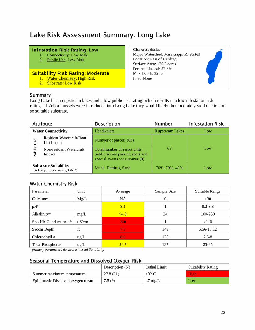
Lake Risk Assessment Summary: Long Lake
Summary Long Lake has no upstream lakes and a low public use rating, which results in a low infestation risk rating. If Zebra mussels were introduced into Long Lake they would likely do moderately well due to not so suitable substrate.
Attribute Description Number Infestation Risk Water Connectivity Headwaters 0 upstream Lakes Low
Pu
bli
c U
se Resident Watercraft/Boat
Lift Impact Number of parcels (63)
63 Low Non-resident Watercraft Impact
Total number of resort units, public access parking spots and special events for summer (0)
Substrate Suitability (% Freq of occurrence, DNR)
Muck, Detritus, Sand 70%, 70%, 40% Low
Water Chemistry Risk Parameter Unit Average Sample Size Suitable Range
Calcium* Mg/L NA 0 >30
pH* 8.1 1 8.2-8.8
Alkalinity* mg/L 94.6 24 100-280
Specific Conductance * uS/cm 200 1 >110
Secchi Depth ft 7.2 149 6.56-13.12
Chlorophyll a ug/L 8.0 136 2.5-8
Total Phosphorus ug/L 24.7 137 25-35 *primary parameters for zebra mussel Suitability
Seasonal Temperature and Dissolved Oxygen Risk
Description (N) Lethal Limit Suitability Rating
Summer maximum temperature 27.8 (91) >32 C High
Epilimnetic Dissolved oxygen mean 7.5 (9) <7 mg/L Low
Characteristics Major Watershed: Mississippi R.-Sartell Location: East of Harding Surface Area: 126.3 acres Percent Littoral: 52.6% Max Depth: 35 feet Inlet: None
Infestation Risk Rating: Low 1. Connectivity: Low Risk 2. Public Use: Low Risk
Suitability Risk Rating: Moderate 1. Water Chemistry: High Risk 2. Substrate: Low Risk
23
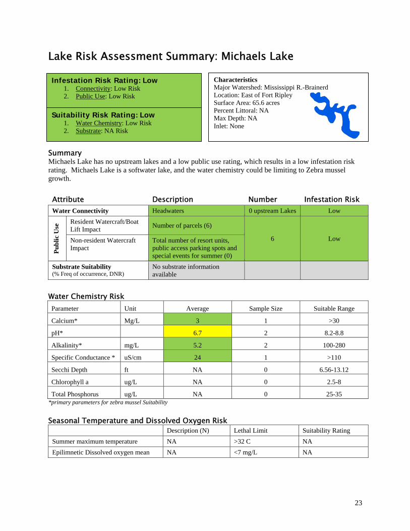
Lake Risk Assessment Summary: Michaels Lake
Summary Michaels Lake has no upstream lakes and a low public use rating, which results in a low infestation risk rating. Michaels Lake is a softwater lake, and the water chemistry could be limiting to Zebra mussel growth.
Attribute Description Number Infestation Risk Water Connectivity Headwaters 0 upstream Lakes Low
Pu
bli
c U
se Resident Watercraft/Boat
Lift Impact Number of parcels (6)
6 Low Non-resident Watercraft Impact
Total number of resort units, public access parking spots and special events for summer (0)
Substrate Suitability (% Freq of occurrence, DNR)
No substrate information available
Water Chemistry Risk Parameter Unit Average Sample Size Suitable Range
Calcium* Mg/L 3 1 >30
pH* 6.7 2 8.2-8.8
Alkalinity* mg/L 5.2 2 100-280
Specific Conductance * uS/cm 24 1 >110
Secchi Depth ft NA 0 6.56-13.12
Chlorophyll a ug/L NA 0 2.5-8
Total Phosphorus ug/L NA 0 25-35 *primary parameters for zebra mussel Suitability
Seasonal Temperature and Dissolved Oxygen Risk
Description (N) Lethal Limit Suitability Rating
Summer maximum temperature NA >32 C NA
Epilimnetic Dissolved oxygen mean NA <7 mg/L NA
Characteristics Major Watershed: Mississippi R.-Brainerd Location: East of Fort Ripley Surface Area: 65.6 acres Percent Littoral: NA Max Depth: NA Inlet: None
Infestation Risk Rating: Low 1. Connectivity: Low Risk 2. Public Use: Low Risk
Suitability Risk Rating: Low 1. Water Chemistry: Low Risk 2. Substrate: NA Risk
24
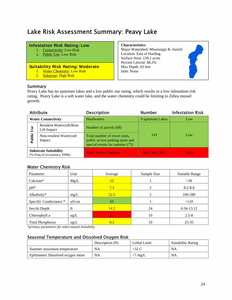
Lake Risk Assessment Summary: Peavy Lake
Summary Peavy Lake has no upstream lakes and a low public use rating, which results in a low infestation risk rating. Peavy Lake is a soft water lake, and the water chemistry could be limiting to Zebra mussel growth.
Attribute Description Number Infestation Risk Water Connectivity Headwaters 0 upstream Lakes Low
Pu
bli
c U
se Resident Watercraft/Boat
Lift Impact Number of parcels (68)
143 Low Non-resident Watercraft Impact
Total number of resort units, public access parking spots and special events for summer (75)
Substrate Suitability (% Freq of occurrence, DNR)
Sand, Gravel, Detritus 83%, 28%, 26% High
Water Chemistry Risk Parameter Unit Average Sample Size Suitable Range
Calcium* Mg/L 12 1 >30
pH* 7.3 2 8.2-8.8
Alkalinity* mg/L 22.5 2 100-280
Specific Conductance * uS/cm 63 1 >110
Secchi Depth ft 14.2 24 6.56-13.12
Chlorophyll a ug/L 3.1 10 2.5-8
Total Phosphorus ug/L 9.3 10 25-35 *primary parameters for zebra mussel Suitability
Seasonal Temperature and Dissolved Oxygen Risk
Description (N) Lethal Limit Suitability Rating
Summer maximum temperature NA >32 C NA
Epilimnetic Dissolved oxygen mean NA <7 mg/L NA
Characteristics Major Watershed: Mississippi R.-Sartell Location: East of Harding Surface Area: 139.1 acres Percent Littoral: 48.2% Max Depth: 63 feet Inlet: None
Infestation Risk Rating: Low 1. Connectivity: Low Risk 2. Public Use: Low Risk
Suitability Risk Rating: Moderate 1. Water Chemistry: Low Risk 2. Substrate: High Risk
25
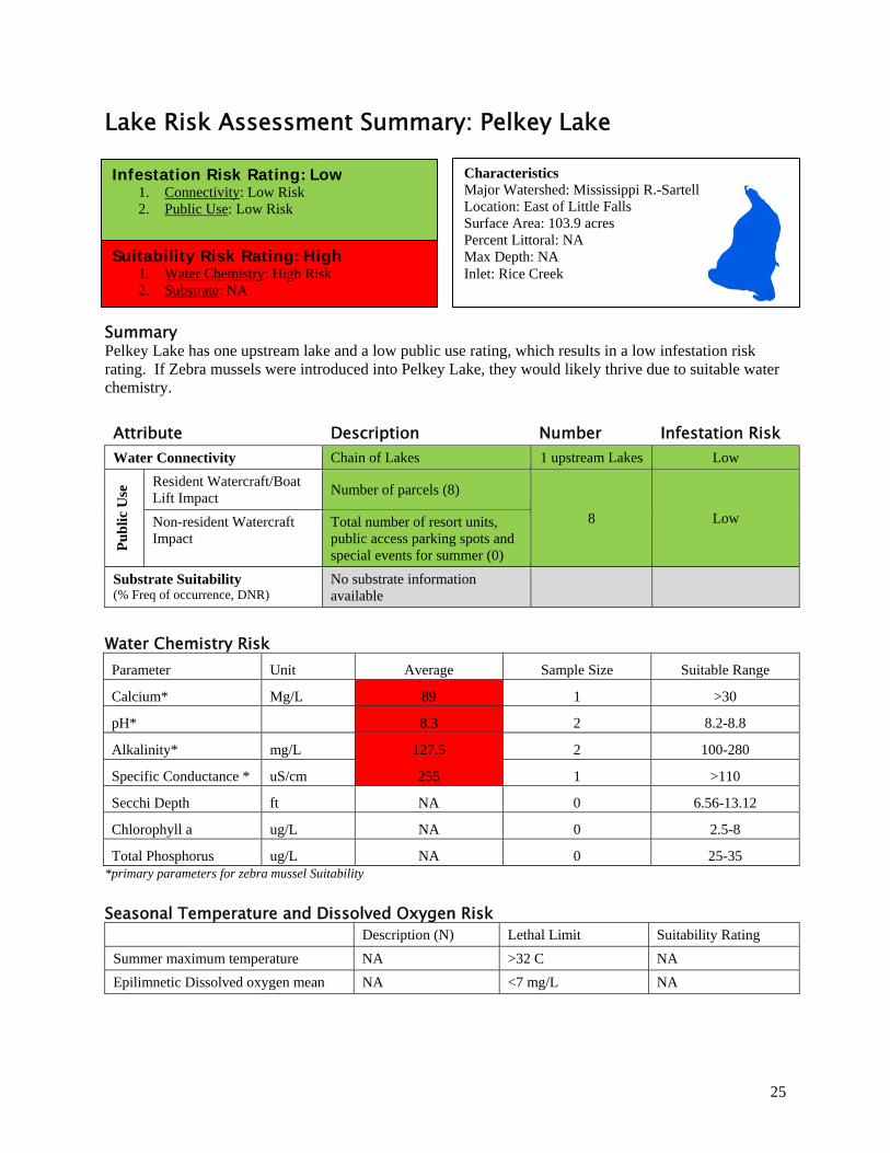
Lake Risk Assessment Summary: Pelkey Lake
Summary Pelkey Lake has one upstream lake and a low public use rating, which results in a low infestation risk rating. If Zebra mussels were introduced into Pelkey Lake, they would likely thrive due to suitable water chemistry.
Attribute Description Number Infestation Risk Water Connectivity Chain of Lakes 1 upstream Lakes Low
Pu
bli
c U
se Resident Watercraft/Boat
Lift Impact Number of parcels (8)
8 Low Non-resident Watercraft Impact
Total number of resort units, public access parking spots and special events for summer (0)
Substrate Suitability (% Freq of occurrence, DNR)
No substrate information available
Water Chemistry Risk Parameter Unit Average Sample Size Suitable Range
Calcium* Mg/L 89 1 >30
pH* 8.3 2 8.2-8.8
Alkalinity* mg/L 127.5 2 100-280
Specific Conductance * uS/cm 255 1 >110
Secchi Depth ft NA 0 6.56-13.12
Chlorophyll a ug/L NA 0 2.5-8
Total Phosphorus ug/L NA 0 25-35 *primary parameters for zebra mussel Suitability
Seasonal Temperature and Dissolved Oxygen Risk
Description (N) Lethal Limit Suitability Rating
Summer maximum temperature NA >32 C NA
Epilimnetic Dissolved oxygen mean NA <7 mg/L NA
Characteristics Major Watershed: Mississippi R.-Sartell Location: East of Little Falls Surface Area: 103.9 acres Percent Littoral: NA Max Depth: NA Inlet: Rice Creek
Infestation Risk Rating: Low 1. Connectivity: Low Risk 2. Public Use: Low Risk
Suitability Risk Rating: High 1. Water Chemistry: High Risk 2. Substrate: NA
26
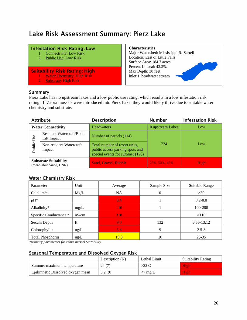
Lake Risk Assessment Summary: Pierz Lake
Summary Pierz Lake has no upstream lakes and a low public use rating, which results in a low infestation risk rating. If Zebra mussels were introduced into Pierz Lake, they would likely thrive due to suitable water chemistry and substrate.
Attribute Description Number Infestation Risk Water Connectivity Headwaters 0 upstream Lakes Low
Pu
bli
c U
se Resident Watercraft/Boat
Lift Impact Number of parcels (114)
234 Low Non-resident Watercraft Impact
Total number of resort units, public access parking spots and special events for summer (120)
Substrate Suitability (mean abundance, DNR)
Sand, Gravel, Rubble 75%, 50%, 45% High
Water Chemistry Risk Parameter Unit Average Sample Size Suitable Range
Calcium* Mg/L NA 0 >30
pH* 8.4 1 8.2-8.8
Alkalinity* mg/L 110 1 100-280
Specific Conductance * uS/cm 318 >110
Secchi Depth ft 9.0 132 6.56-13.12
Chlorophyll a ug/L 5.4 9 2.5-8
Total Phosphorus ug/L 19.3 10 25-35 *primary parameters for zebra mussel Suitability
Seasonal Temperature and Dissolved Oxygen Risk
Description (N) Lethal Limit Suitability Rating
Summer maximum temperature 24 (7) >32 C High
Epilimnetic Dissolved oxygen mean 5.2 (9) <7 mg/L High
Characteristics Major Watershed: Mississippi R.-Sartell Location: East of Little Falls Surface Area: 184.7 acres Percent Littoral: 43.2% Max Depth: 30 feet Inlet:1 headwater stream
Infestation Risk Rating: Low 1. Connectivity: Low Risk 2. Public Use: Low Risk
Suitability Risk Rating: High 1. Water Chemistry: High Risk 2. Substrate: High Risk
27
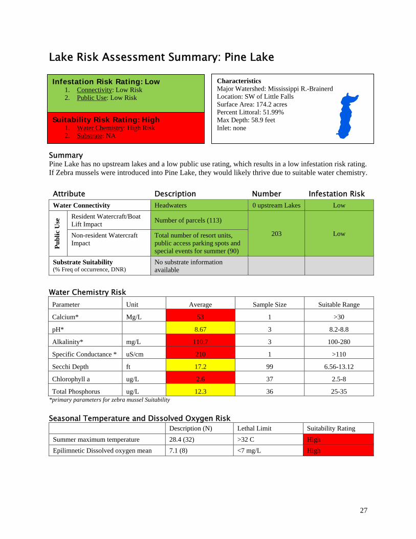
Lake Risk Assessment Summary: Pine Lake
Summary Pine Lake has no upstream lakes and a low public use rating, which results in a low infestation risk rating. If Zebra mussels were introduced into Pine Lake, they would likely thrive due to suitable water chemistry.
Attribute Description Number Infestation Risk Water Connectivity Headwaters 0 upstream Lakes Low
Pu
bli
c U
se Resident Watercraft/Boat
Lift Impact Number of parcels (113)
203 Low Non-resident Watercraft Impact
Total number of resort units, public access parking spots and special events for summer (90)
Substrate Suitability (% Freq of occurrence, DNR)
No substrate information available
Water Chemistry Risk Parameter Unit Average Sample Size Suitable Range
Calcium* Mg/L 53 1 >30
pH* 8.67 3 8.2-8.8
Alkalinity* mg/L 110.7 3 100-280
Specific Conductance * uS/cm 210 1 >110
Secchi Depth ft 17.2 99 6.56-13.12
Chlorophyll a ug/L 2.6 37 2.5-8
Total Phosphorus ug/L 12.3 36 25-35 *primary parameters for zebra mussel Suitability
Seasonal Temperature and Dissolved Oxygen Risk
Description (N) Lethal Limit Suitability Rating
Summer maximum temperature 28.4 (32) >32 C High
Epilimnetic Dissolved oxygen mean 7.1 (8) <7 mg/L High
Characteristics Major Watershed: Mississippi R.-Brainerd Location: SW of Little Falls Surface Area: 174.2 acres Percent Littoral: 51.99% Max Depth: 58.9 feet Inlet: none
Infestation Risk Rating: Low 1. Connectivity: Low Risk 2. Public Use: Low Risk
Suitability Risk Rating: High 1. Water Chemistry: High Risk 2. Substrate: NA
28
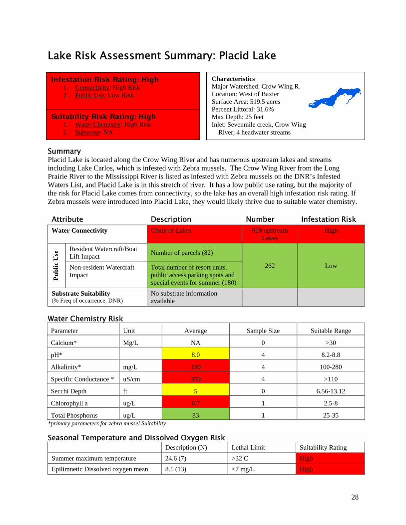
Lake Risk Assessment Summary: Placid Lake
Summary Placid Lake is located along the Crow Wing River and has numerous upstream lakes and streams including Lake Carlos, which is infested with Zebra mussels. The Crow Wing River from the Long Prairie River to the Mississippi River is listed as infested with Zebra mussels on the DNR’s Infested Waters List, and Placid Lake is in this stretch of river. It has a low public use rating, but the majority of the risk for Placid Lake comes from connectivity, so the lake has an overall high infestation risk rating. If Zebra mussels were introduced into Placid Lake, they would likely thrive due to suitable water chemistry.
Attribute Description Number Infestation Risk Water Connectivity Chain of Lakes 919 upstream
Lakes High
Pu
bli
c U
se Resident Watercraft/Boat
Lift Impact Number of parcels (82)
262 Low Non-resident Watercraft Impact
Total number of resort units, public access parking spots and special events for summer (180)
Substrate Suitability (% Freq of occurrence, DNR)
No substrate information available
Water Chemistry Risk Parameter Unit Average Sample Size Suitable Range
Calcium* Mg/L NA 0 >30
pH* 8.0 4 8.2-8.8
Alkalinity* mg/L 180 4 100-280
Specific Conductance * uS/cm 359 4 >110
Secchi Depth ft 5 0 6.56-13.12
Chlorophyll a ug/L 6.7 1 2.5-8
Total Phosphorus ug/L 83 1 25-35 *primary parameters for zebra mussel Suitability
Seasonal Temperature and Dissolved Oxygen Risk
Description (N) Lethal Limit Suitability Rating
Summer maximum temperature 24.6 (7) >32 C High
Epilimnetic Dissolved oxygen mean 8.1 (13) <7 mg/L High
Characteristics Major Watershed: Crow Wing R. Location: West of Baxter Surface Area: 519.5 acres Percent Littoral: 31.6% Max Depth: 25 feet Inlet: Sevenmile creek, Crow Wing River, 4 headwater streams
Infestation Risk Rating: High 1. Connectivity: High Risk 2. Public Use: Low Risk
Suitability Risk Rating: High 1. Water Chemistry: High Risk 2. Substrate: NA
29
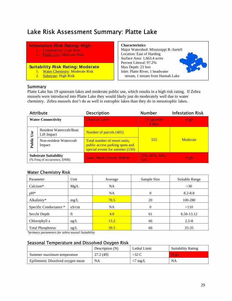
Lake Risk Assessment Summary: Platte Lake
Summary Platte Lake has 19 upstream lakes and moderate public use, which results in a high risk rating. If Zebra mussels were introduced into Platte Lake they would likely just do moderately well due to water chemistry. Zebra mussels don’t do as well in eutrophic lakes than they do in mesotrophic lakes.
Attribute Description Number Infestation Risk Water Connectivity Chain of Lakes 19 upstream
Lakes High
Pu
bli
c U
se Resident Watercraft/Boat
Lift Impact Number of parcels (405)
555 Moderate Non-resident Watercraft Impact
Total number of resort units, public access parking spots and special events for summer (150)
Substrate Suitability (% Freq of occurrence, DNR) Sand, Muck, Gravel, Rubble
73%, 48%, 40%, 35%
High
Water Chemistry Risk Parameter Unit Average Sample Size Suitable Range
Calcium* Mg/L NA >30
pH* NA 0 8.2-8.8
Alkalinity* mg/L 70.5 20 100-280
Specific Conductance * uS/cm NA 0 >110
Secchi Depth ft 4.0 61 6.56-13.12
Chlorophyll a ug/L 15.2 66 2.5-8
Total Phosphorus ug/L 39.5 66 25-35 *primary parameters for zebra mussel Suitability
Seasonal Temperature and Dissolved Oxygen Risk
Description (N) Lethal Limit Suitability Rating
Summer maximum temperature 27.2 (49) >32 C High
Epilimnetic Dissolved oxygen mean NA <7 mg/L NA
Characteristics Major Watershed: Mississippi R.-Sartell Location: East of Harding Surface Area: 1,663.4 acres Percent Littoral: 97.2% Max Depth: 23 feet Inlet: Platte River, 1 headwater stream, 1 stream from Hannah Lake
Infestation Risk Rating: High 1. Connectivity: High Risk 2. Public Use: Moderate Risk
Suitability Risk Rating: Moderate 1. Water Chemistry: Moderate Risk 2. Substrate: High Risk
30
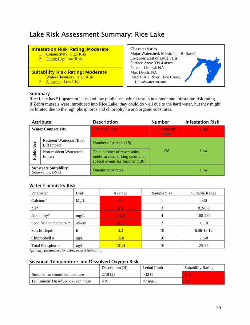
Lake Risk Assessment Summary: Rice Lake
Summary Rice Lake has 51 upstream lakes and low public use, which results in a moderate infestation risk rating. If Zebra mussels were introduced into Rice Lake, they could do well due to the hard water, but they might be limited due to the high phosphorus and chlorophyll a and organic substrates.
Attribute Description Number Infestation Risk Water Connectivity Chain of Lakes 51 upstream
Lakes High
Pu
bli
c U
se Resident Watercraft/Boat
Lift Impact Number of parcels (18)
138 Low Non-resident Watercraft Impact
Total number of resort units, public access parking spots and special events for summer (120)
Substrate Suitability (observation, DNR)
Organic substrates Low
Water Chemistry Risk Parameter Unit Average Sample Size Suitable Range
Calcium* Mg/L 86 1 >30
pH* 8.5 3 8.2-8.8
Alkalinity* mg/L 112.5 4 100-280
Specific Conductance * uS/cm 243.5 2 >110
Secchi Depth ft 3.3 10 6.56-13.12
Chlorophyll a ug/L 15.8 10 2.5-8
Total Phosphorus ug/L 101.4 10 25-35 *primary parameters for zebra mussel Suitability
Seasonal Temperature and Dissolved Oxygen Risk
Description (N) Lethal Limit Suitability Rating
Summer maximum temperature 27.8 (2) >32 C High
Epilimnetic Dissolved oxygen mean NA <7 mg/L NA
Characteristics Major Watershed: Mississippi R.-Sartell Location: East of Little Falls Surface Area: 339.4 acres Percent Littoral: NA Max Depth: NA Inlet: Platte River, Rice Creek, 1 headwater stream
Infestation Risk Rating: Moderate 1. Connectivity: High Risk 2. Public Use: Low Risk
Suitability Risk Rating: Moderate 1. Water Chemistry: High Risk 2. Substrate: Low Risk
31
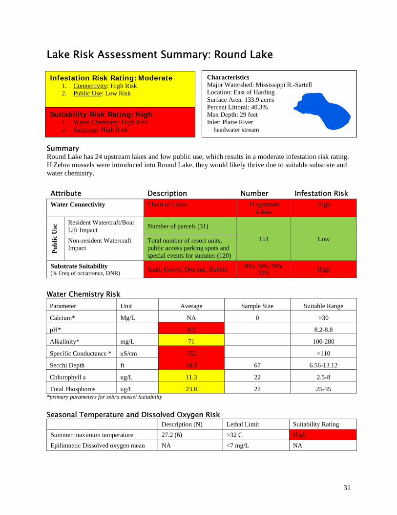
Lake Risk Assessment Summary: Round Lake
Summary Round Lake has 24 upstream lakes and low public use, which results in a moderate infestation risk rating. If Zebra mussels were introduced into Round Lake, they would likely thrive due to suitable substrate and water chemistry.
Attribute Description Number Infestation Risk Water Connectivity Chain of Lakes 24 upstream
Lakes High
Pu
bli
c U
se Resident Watercraft/Boat
Lift Impact Number of parcels (31)
151 Low Non-resident Watercraft Impact
Total number of resort units, public access parking spots and special events for summer (120)
Substrate Suitability (% Freq of occurrence, DNR)
Sand, Gravel, Detritus, Rubble 90%, 60%, 50%,
50% High
Water Chemistry Risk Parameter Unit Average Sample Size Suitable Range
Calcium* Mg/L NA 0 >30
pH* 8.2 8.2-8.8
Alkalinity* mg/L 71 100-280
Specific Conductance * uS/cm 152 >110
Secchi Depth ft 10.3 67 6.56-13.12
Chlorophyll a ug/L 11.3 22 2.5-8
Total Phosphorus ug/L 23.8 22 25-35 *primary parameters for zebra mussel Suitability
Seasonal Temperature and Dissolved Oxygen Risk
Description (N) Lethal Limit Suitability Rating
Summer maximum temperature 27.2 (6) >32 C High
Epilimnetic Dissolved oxygen mean NA <7 mg/L NA
Characteristics Major Watershed: Mississippi R.-Sartell Location: East of Harding Surface Area: 133.9 acres Percent Littoral: 40.3% Max Depth: 29 feet Inlet: Platte River headwater stream
Infestation Risk Rating: Moderate 1. Connectivity: High Risk 2. Public Use: Low Risk
Suitability Risk Rating: High 1. Water Chemistry: High Risk 2. Substrate: High Risk
32
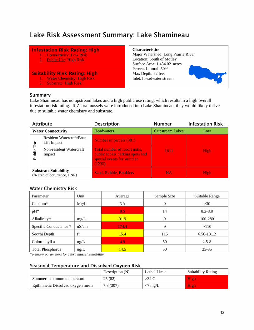
Lake Risk Assessment Summary: Lake Shamineau
Summary Lake Shamineau has no upstream lakes and a high public use rating, which results in a high overall infestation risk rating. If Zebra mussels were introduced into Lake Shamineau, they would likely thrive due to suitable water chemistry and substrate.
Attribute Description Number Infestation Risk Water Connectivity Headwaters 0 upstream Lakes Low
Pu
bli
c U
se Resident Watercraft/Boat
Lift Impact Number of parcels (381)
1611 High Non-resident Watercraft Impact
Total number of resort units, public access parking spots and special events for summer (1230)
Substrate Suitability (% Freq of occurrence, DNR)
Sand, Rubble, Boulders NA High
Water Chemistry Risk Parameter Unit Average Sample Size Suitable Range
Calcium* Mg/L NA 0 >30
pH* 8.5 14 8.2-8.8
Alkalinity* mg/L 91.9 9 100-280
Specific Conductance * uS/cm 174.4 9 >110
Secchi Depth ft 15.4 115 6.56-13.12
Chlorophyll a ug/L 4.9 50 2.5-8
Total Phosphorus ug/L 14.5 50 25-35 *primary parameters for zebra mussel Suitability
Seasonal Temperature and Dissolved Oxygen Risk
Description (N) Lethal Limit Suitability Rating
Summer maximum temperature 25 (82) >32 C High
Epilimnetic Dissolved oxygen mean 7.8 (307) <7 mg/L High
Characteristics Major Watershed: Long Prairie River Location: South of Motley Surface Area: 1,434.02 acres Percent Littoral: 50% Max Depth: 52 feet Inlet:1 headwater stream
Infestation Risk Rating: High 1. Connectivity: Low Risk 2. Public Use: High Risk
Suitability Risk Rating: High 1. Water Chemistry: High Risk 2. Substrate: High Risk
33
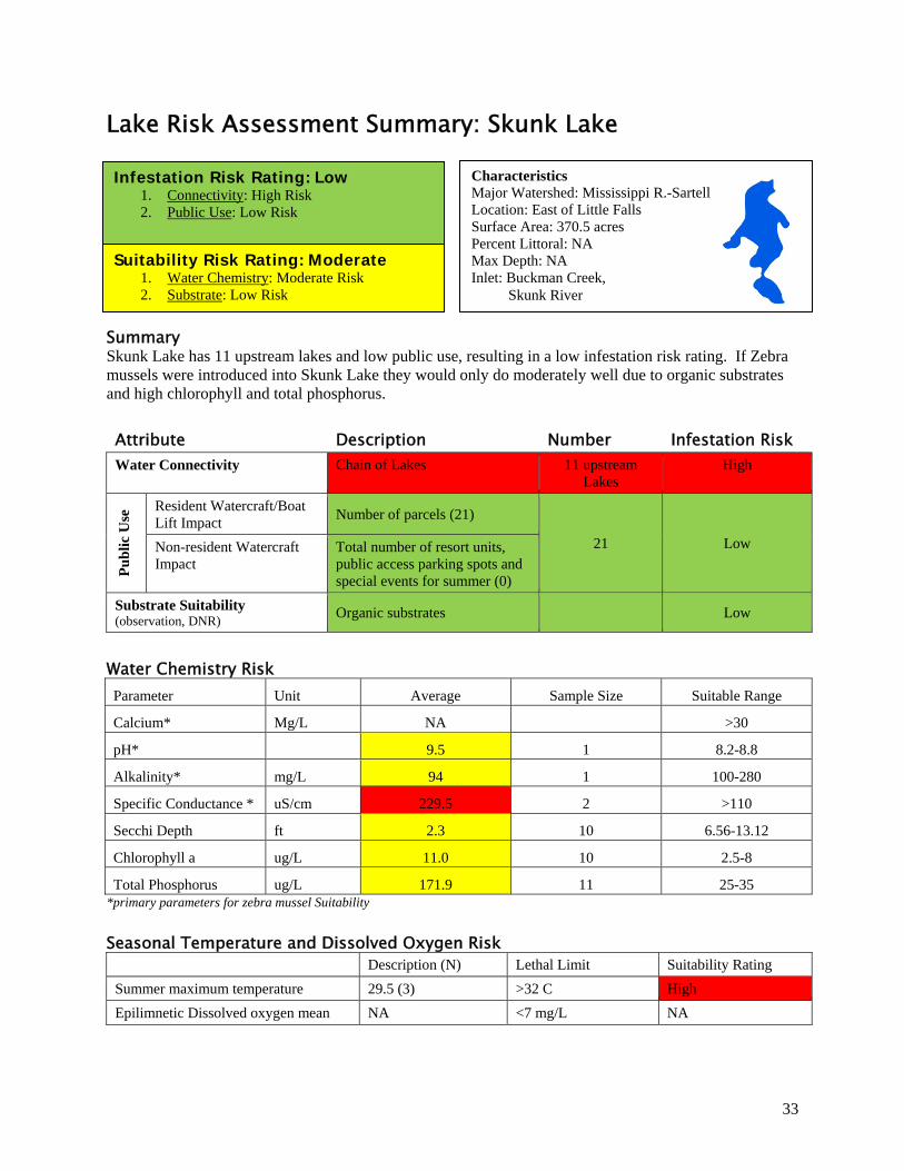
Lake Risk Assessment Summary: Skunk Lake
Summary Skunk Lake has 11 upstream lakes and low public use, resulting in a low infestation risk rating. If Zebra mussels were introduced into Skunk Lake they would only do moderately well due to organic substrates and high chlorophyll and total phosphorus.
Attribute Description Number Infestation Risk Water Connectivity Chain of Lakes 11 upstream
Lakes High
Pu
bli
c U
se Resident Watercraft/Boat
Lift Impact Number of parcels (21)
21 Low Non-resident Watercraft Impact
Total number of resort units, public access parking spots and special events for summer (0)
Substrate Suitability (observation, DNR)
Organic substrates Low
Water Chemistry Risk Parameter Unit Average Sample Size Suitable Range
Calcium* Mg/L NA >30
pH* 9.5 1 8.2-8.8
Alkalinity* mg/L 94 1 100-280
Specific Conductance * uS/cm 229.5 2 >110
Secchi Depth ft 2.3 10 6.56-13.12
Chlorophyll a ug/L 11.0 10 2.5-8
Total Phosphorus ug/L 171.9 11 25-35 *primary parameters for zebra mussel Suitability
Seasonal Temperature and Dissolved Oxygen Risk
Description (N) Lethal Limit Suitability Rating
Summer maximum temperature 29.5 (3) >32 C High
Epilimnetic Dissolved oxygen mean NA <7 mg/L NA
Characteristics Major Watershed: Mississippi R.-Sartell Location: East of Little Falls Surface Area: 370.5 acres Percent Littoral: NA Max Depth: NA Inlet: Buckman Creek, Skunk River
Infestation Risk Rating: Low 1. Connectivity: High Risk 2. Public Use: Low Risk
Suitability Risk Rating: Moderate 1. Water Chemistry: Moderate Risk 2. Substrate: Low Risk
34
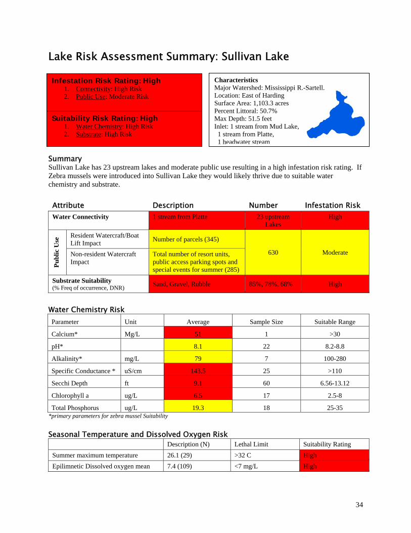
Lake Risk Assessment Summary: Sullivan Lake
Summary Sullivan Lake has 23 upstream lakes and moderate public use resulting in a high infestation risk rating. If Zebra mussels were introduced into Sullivan Lake they would likely thrive due to suitable water chemistry and substrate.
Attribute Description Number Infestation Risk Water Connectivity 1 stream from Platte 23 upstream
Lakes High
Pu
bli
c U
se Resident Watercraft/Boat
Lift Impact Number of parcels (345)
630 Moderate Non-resident Watercraft Impact
Total number of resort units, public access parking spots and special events for summer (285)
Substrate Suitability (% Freq of occurrence, DNR)
Sand, Gravel, Rubble 85%, 78%, 68% High
Water Chemistry Risk Parameter Unit Average Sample Size Suitable Range
Calcium* Mg/L 51 1 >30
pH* 8.1 22 8.2-8.8
Alkalinity* mg/L 79 7 100-280
Specific Conductance * uS/cm 143.5 25 >110
Secchi Depth ft 9.1 60 6.56-13.12
Chlorophyll a ug/L 6.5 17 2.5-8
Total Phosphorus ug/L 19.3 18 25-35 *primary parameters for zebra mussel Suitability
Seasonal Temperature and Dissolved Oxygen Risk
Description (N) Lethal Limit Suitability Rating
Summer maximum temperature 26.1 (29) >32 C High
Epilimnetic Dissolved oxygen mean 7.4 (109) <7 mg/L High
Characteristics Major Watershed: Mississippi R.-Sartell. Location: East of Harding Surface Area: 1,103.3 acres Percent Littoral: 50.7% Max Depth: 51.5 feet Inlet: 1 stream from Mud Lake, 1 stream from Platte, 1 headwater stream
Infestation Risk Rating: High 1. Connectivity: High Risk 2. Public Use: Moderate Risk
Suitability Risk Rating: High 1. Water Chemistry: High Risk 2. Substrate: High Risk
35
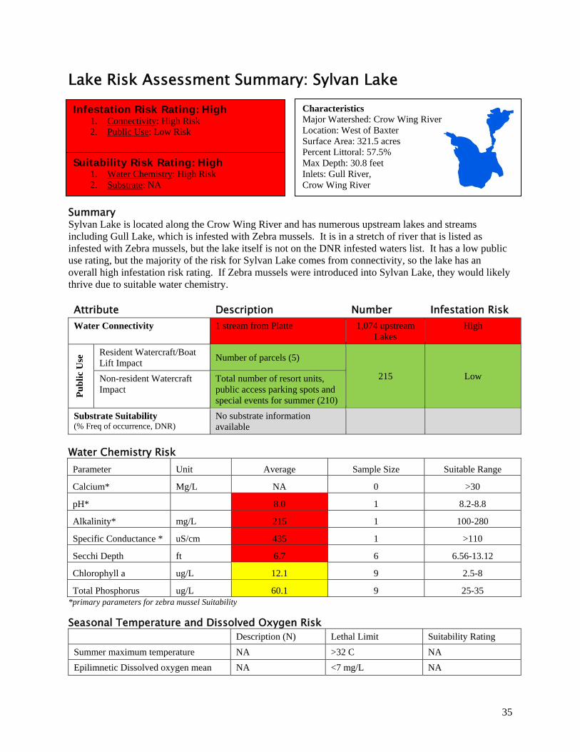
Lake Risk Assessment Summary: Sylvan Lake
Summary Sylvan Lake is located along the Crow Wing River and has numerous upstream lakes and streams including Gull Lake, which is infested with Zebra mussels. It is in a stretch of river that is listed as infested with Zebra mussels, but the lake itself is not on the DNR infested waters list. It has a low public use rating, but the majority of the risk for Sylvan Lake comes from connectivity, so the lake has an overall high infestation risk rating. If Zebra mussels were introduced into Sylvan Lake, they would likely thrive due to suitable water chemistry.
Attribute Description Number Infestation Risk Water Connectivity 1 stream from Platte 1,074 upstream
Lakes High
Pu
bli
c U
se Resident Watercraft/Boat
Lift Impact Number of parcels (5)
215 Low Non-resident Watercraft Impact
Total number of resort units, public access parking spots and special events for summer (210)
Substrate Suitability (% Freq of occurrence, DNR)
No substrate information available
Water Chemistry Risk Parameter Unit Average Sample Size Suitable Range
Calcium* Mg/L NA 0 >30
pH* 8.0 1 8.2-8.8
Alkalinity* mg/L 215 1 100-280
Specific Conductance * uS/cm 435 1 >110
Secchi Depth ft 6.7 6 6.56-13.12
Chlorophyll a ug/L 12.1 9 2.5-8
Total Phosphorus ug/L 60.1 9 25-35 *primary parameters for zebra mussel Suitability
Seasonal Temperature and Dissolved Oxygen Risk
Description (N) Lethal Limit Suitability Rating
Summer maximum temperature NA >32 C NA
Epilimnetic Dissolved oxygen mean NA <7 mg/L NA
Characteristics Major Watershed: Crow Wing River Location: West of Baxter Surface Area: 321.5 acres Percent Littoral: 57.5% Max Depth: 30.8 feet Inlets: Gull River, Crow Wing River
Infestation Risk Rating: High 1. Connectivity: High Risk 2. Public Use: Low Risk
Suitability Risk Rating: High 1. Water Chemistry: High Risk 2. Substrate: NA
36
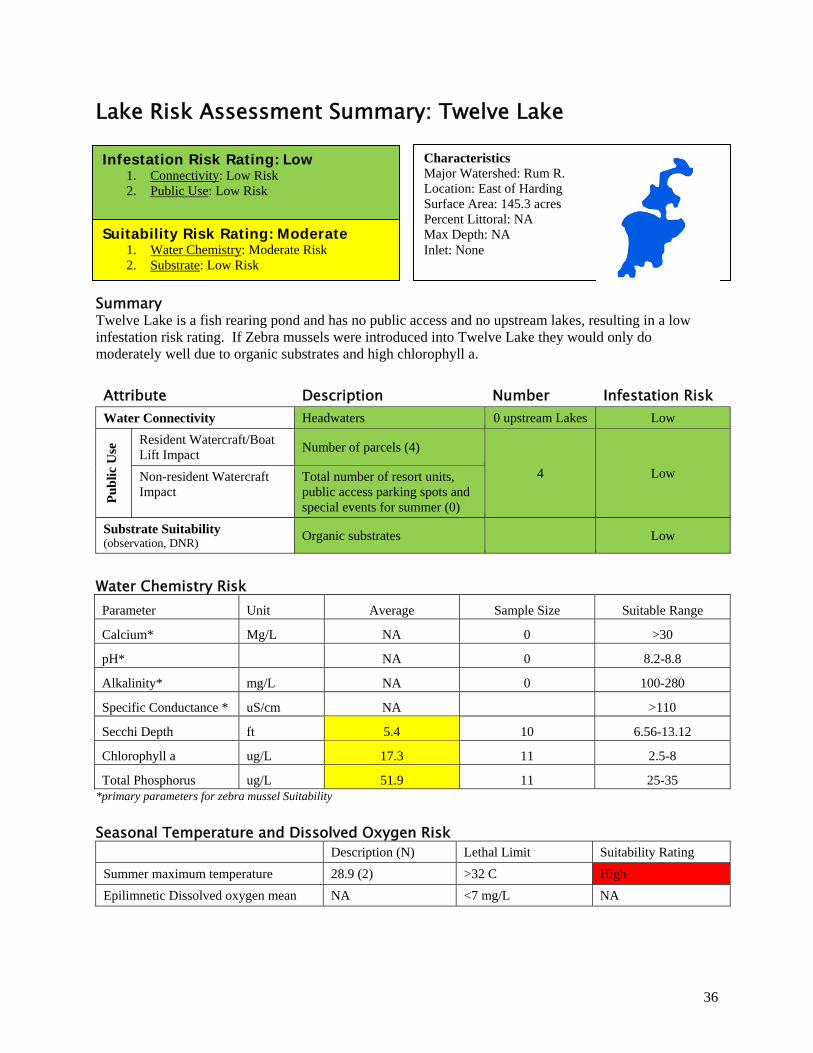
Lake Risk Assessment Summary: Twelve Lake
Summary Twelve Lake is a fish rearing pond and has no public access and no upstream lakes, resulting in a low infestation risk rating. If Zebra mussels were introduced into Twelve Lake they would only do moderately well due to organic substrates and high chlorophyll a.
Attribute Description Number Infestation Risk Water Connectivity Headwaters 0 upstream Lakes Low
Pu
bli
c U
se Resident Watercraft/Boat
Lift Impact Number of parcels (4)
4 Low Non-resident Watercraft Impact
Total number of resort units, public access parking spots and special events for summer (0)
Substrate Suitability (observation, DNR)
Organic substrates Low
Water Chemistry Risk Parameter Unit Average Sample Size Suitable Range
Calcium* Mg/L NA 0 >30
pH* NA 0 8.2-8.8
Alkalinity* mg/L NA 0 100-280
Specific Conductance * uS/cm NA >110
Secchi Depth ft 5.4 10 6.56-13.12
Chlorophyll a ug/L 17.3 11 2.5-8
Total Phosphorus ug/L 51.9 11 25-35 *primary parameters for zebra mussel Suitability
Seasonal Temperature and Dissolved Oxygen Risk
Description (N) Lethal Limit Suitability Rating
Summer maximum temperature 28.9 (2) >32 C High
Epilimnetic Dissolved oxygen mean NA <7 mg/L NA
Characteristics Major Watershed: Rum R. Location: East of Harding Surface Area: 145.3 acres Percent Littoral: NA Max Depth: NA Inlet: None
Infestation Risk Rating: Low 1. Connectivity: Low Risk 2. Public Use: Low Risk
Suitability Risk Rating: Moderate 1. Water Chemistry: Moderate Risk 2. Substrate: Low Risk
37
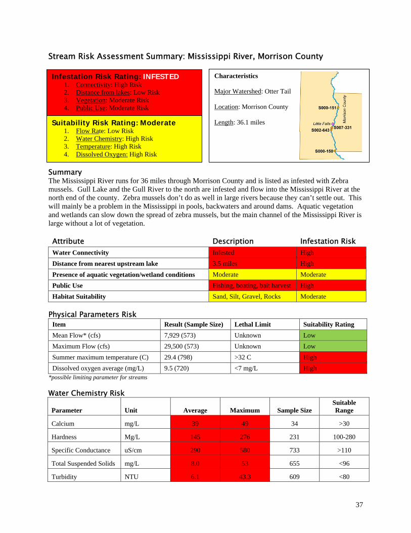
Stream Risk Assessment Summary: Mississippi River, Morrison County
Summary The Mississippi River runs for 36 miles through Morrison County and is listed as infested with Zebra mussels. Gull Lake and the Gull River to the north are infested and flow into the Mississippi River at the north end of the county. Zebra mussels don’t do as well in large rivers because they can’t settle out. This will mainly be a problem in the Mississippi in pools, backwaters and around dams. Aquatic vegetation and wetlands can slow down the spread of zebra mussels, but the main channel of the Mississippi River is large without a lot of vegetation.
Attribute Description Infestation Risk Water Connectivity Infested High
Distance from nearest upstream lake 3.5 miles High
Presence of aquatic vegetation/wetland conditions Moderate Moderate
Public Use Fishing, boating, bait harvest High
Habitat Suitability Sand, Silt, Gravel, Rocks Moderate
Physical Parameters Risk Item Result (Sample Size) Lethal Limit Suitability Rating
Mean Flow* (cfs) 7,929 (573) Unknown Low
Maximum Flow (cfs) 29,500 (573) Unknown Low
Summer maximum temperature (C) 29.4 (798) >32 C High
Dissolved oxygen average (mg/L) 9.5 (720) <7 mg/L High *possible limiting parameter for streams
Water Chemistry Risk
Parameter Unit Average Maximum Sample Size Suitable Range
Calcium mg/L 39 49 34 >30
Hardness Mg/L 145 276 231 100-280
Specific Conductance uS/cm 290 580 733 >110
Total Suspended Solids mg/L 8.0 53 655 <96
Turbidity NTU 6.1 43.3 609 <80
Characteristics Major Watershed: Otter Tail Location: Morrison County Length: 36.1 miles
Infestation Risk Rating: INFESTED 1. Connectivity: High Risk 2. Distance from lakes: Low Risk 3. Vegetation: Moderate Risk 4. Public Use: Moderate Risk
Suitability Risk Rating: Moderate 1. Flow Rate: Low Risk 2. Water Chemistry: High Risk 3. Temperature: High Risk 4. Dissolved Oxygen: High Risk
38
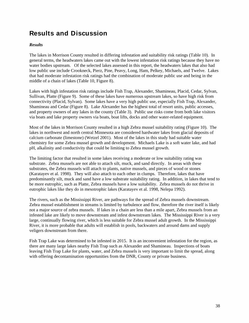
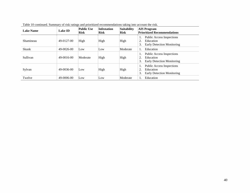
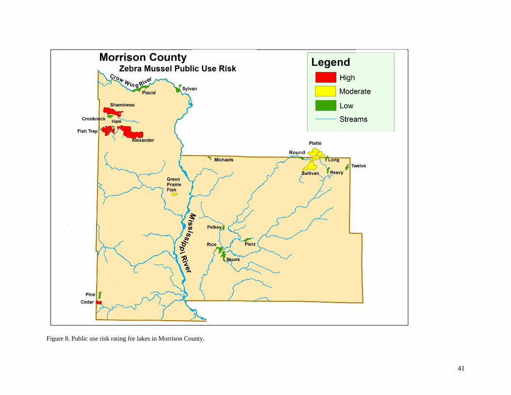
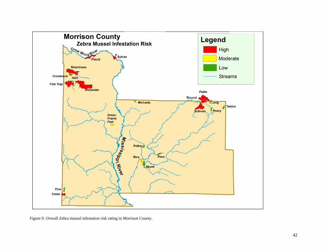
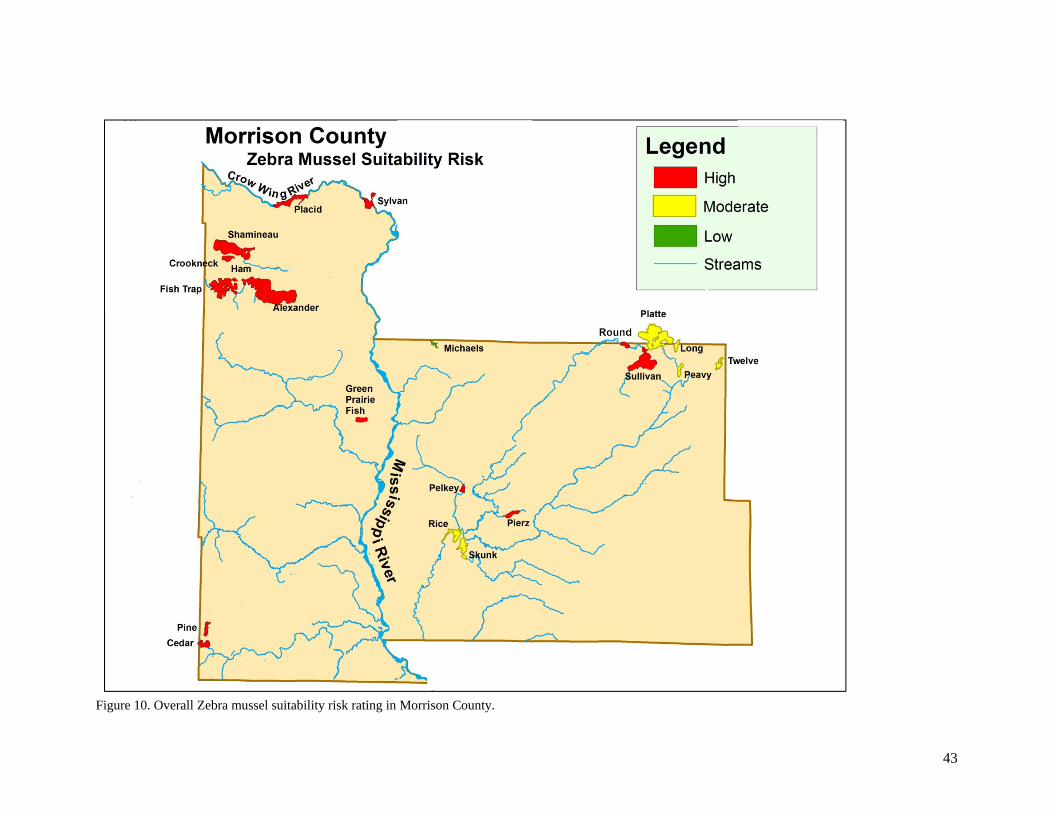
Results and Discussion Results The lakes in Morrison County resulted in differing infestation and suitability risk ratings (Table 10). In general terms, the headwaters lakes came out with the lowest infestation risk ratings because they have no water bodies upstream. Of the selected lakes assessed in this report, the headwaters lakes that also had low public use include Crookneck, Pierz, Pine, Peavy, Long, Ham, Pelkey, Michaels, and Twelve. Lakes that had moderate infestation risk ratings had the combination of moderate public use and being in the middle of a chain of lakes (Table 10, Figure 8). Lakes with high infestation risk ratings include Fish Trap, Alexander, Shamineau, Placid, Cedar, Sylvan, Sullivan, Platte (Figure 9). Some of these lakes have numerous upstream lakes, so have high risk from connectivity (Placid, Sylvan). Some lakes have a very high public use, especially Fish Trap, Alexander, Shamineau and Cedar (Figure 8). Lake Alexander has the highest total of resort units, public accesses, and property owners of any lakes in the county (Table 3). Public use risks come from both lake visitors via boats and lake property owners via boats, boat lifts, docks and other water-related equipment. Most of the lakes in Morrison County resulted in a high Zebra mussel suitability rating (Figure 10). The lakes in northwest and north central Minnesota are considered hardwater lakes from glacial deposits of calcium carbonate (limestone) (Wetzel 2001). Most of the lakes in this study had suitable water chemistry for some Zebra mussel growth and development. Michaels Lake is a soft water lake, and had pH, alkalinity and conductivity that could be limiting to Zebra mussel growth. The limiting factor that resulted in some lakes receiving a moderate or low suitability rating was substrate. Zebra mussels are not able to attach silt, muck, and sand directly. In areas with these substrates, the Zebra mussels will attach to plants, native mussels, and pieces of wood or stones (Karatayev et al. 1998). They will also attach to each other in clumps. Therefore, lakes that have predominantly silt, muck and sand have a low substrate suitability rating. In addition, in lakes that tend to be more eutrophic, such as Platte, Zebra mussels have a low suitability. Zebra mussels do not thrive in eutrophic lakes like they do in mesotrophic lakes (Karatayev et al. 1998, Nelepa 1992). The rivers, such as the Mississippi River, are pathways for the spread of Zebra mussels downstream. Zebra mussel establishment in streams is limited by turbulence and flow, therefore the river itself is likely not a major source of zebra mussels. If lakes in a chain are less than a mile apart, Zebra mussels from an infested lake are likely to move downstream and infest downstream lakes. The Mississippi River is a very large, continually flowing river, which is less suitable for Zebra mussel adult growth. In the Mississippi River, it is more probable that adults will establish in pools, backwaters and around dams and supply veligers downstream from there. Fish Trap Lake was determined to be infested in 2015. It is an inconvenient infestation for the region, as there are many large lakes nearby Fish Trap such as Alexander and Shamineau. Inspections of boats leaving Fish Trap Lake for plants, water, and Zebra mussels is very important to limit the spread, along with offering decontamination opportunities from the DNR, County or private business.
39
Table 10. Summary of risk ratings and prioritized recommendations taking into account the risk.
Lake Name Lake ID Public Use Risk
Infestation Risk
Suitability Risk
AIS Program Prioritized Recommendations
Alexander 49-0079-00 High High High 1. Public Access Inspections 2. Education 3. Early Detection Monitoring
Cedar 49-0140-00 High High High 1. Public Access Inspections 2. Education 3. Early Detection Monitoring
Crookneck 49-0133-00 Low Low High 1. Education
Fish Trap 49-0137-00 High High High 1. Public Access Inspections 2. Education 3. Early Detection Monitoring
Green Prairie Fish 49-0035-00 Moderate Moderate High 1. Education
Ham 49-0136-00 Low Low High 1. Education
Long 49-0015-00 Low Low Moderate 1. Education
Michaels 49-0032-00 Low Low Low 1. Education
Peavy 49-0005-00 Low Low Moderate 1. Education
Pelkey 49-0030-00 Low Low High 1. Education
Pierz 49-0024-00 Low Low High 1. Education
Pine 49-0081-00 Low Low High 1. Education
Placid 49-0080-00 Low High High 1. Public Access Inspections 2. Education 3. Early Detection Monitoring
Platte 18-0088-00 Moderate High Moderate 1. Public Access Inspections 2. Education 3. Early Detection Monitoring
Rice 49-0025-00 Low Moderate Moderate 1. Education
Round 49-0019-00 Low Moderate High 1. Education Table continued on the next page…
40
Table 10 continued. Summary of risk ratings and prioritized recommendations taking into account the risk.
Lake Name Lake ID Public Use Risk
Infestation Risk
Suitability Risk
AIS Program Prioritized Recommendations
Shamineau 49-0127-00 High High High 1. Public Access Inspections 2. Education 3. Early Detection Monitoring
Skunk 49-0026-00 Low Low Moderate 1. Education
Sullivan 49-0016-00 Moderate High High 1. Public Access Inspections 2. Education 3. Early Detection Monitoring
Sylvan 49-0036-00 Low High High 1. Public Access Inspections 2. Education 3. Early Detection Monitoring
Twelve 49-0006-00 Low Low Moderate 1. Education
41
Figure 8. Public use risk rating for lakes in Morrison County.
42
Figure 9. Overall Zebra mussel infestation risk rating in Morrison County.
43
Figure 10. Overall Zebra mussel suitability risk rating in Morrison County.
44
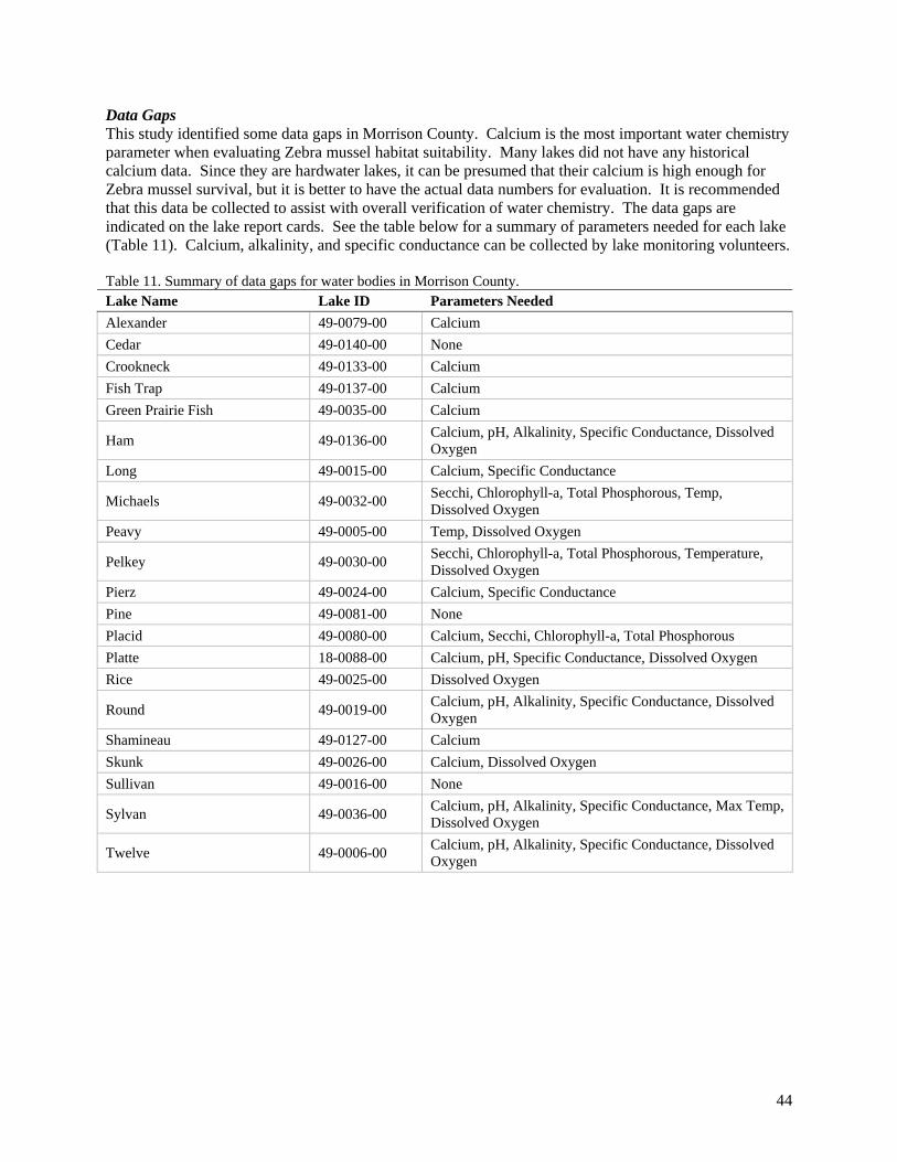
Data Gaps This study identified some data gaps in Morrison County. Calcium is the most important water chemistry parameter when evaluating Zebra mussel habitat suitability. Many lakes did not have any historical calcium data. Since they are hardwater lakes, it can be presumed that their calcium is high enough for Zebra mussel survival, but it is better to have the actual data numbers for evaluation. It is recommended that this data be collected to assist with overall verification of water chemistry. The data gaps are indicated on the lake report cards. See the table below for a summary of parameters needed for each lake (Table 11). Calcium, alkalinity, and specific conductance can be collected by lake monitoring volunteers. Table 11. Summary of data gaps for water bodies in Morrison County. Lake Name Lake ID Parameters Needed
Alexander 49-0079-00 Calcium
Cedar 49-0140-00 None
Crookneck 49-0133-00 Calcium
Fish Trap 49-0137-00 Calcium
Green Prairie Fish 49-0035-00 Calcium
Ham 49-0136-00 Calcium, pH, Alkalinity, Specific Conductance, Dissolved Oxygen
Long 49-0015-00 Calcium, Specific Conductance
Michaels 49-0032-00 Secchi, Chlorophyll-a, Total Phosphorous, Temp, Dissolved Oxygen
Peavy 49-0005-00 Temp, Dissolved Oxygen
Pelkey 49-0030-00 Secchi, Chlorophyll-a, Total Phosphorous, Temperature, Dissolved Oxygen
Pierz 49-0024-00 Calcium, Specific Conductance
Pine 49-0081-00 None
Placid 49-0080-00 Calcium, Secchi, Chlorophyll-a, Total Phosphorous
Platte 18-0088-00 Calcium, pH, Specific Conductance, Dissolved Oxygen
Rice 49-0025-00 Dissolved Oxygen
Round 49-0019-00 Calcium, pH, Alkalinity, Specific Conductance, Dissolved Oxygen
Shamineau 49-0127-00 Calcium
Skunk 49-0026-00 Calcium, Dissolved Oxygen
Sullivan 49-0016-00 None
Sylvan 49-0036-00 Calcium, pH, Alkalinity, Specific Conductance, Max Temp, Dissolved Oxygen
Twelve 49-0006-00 Calcium, pH, Alkalinity, Specific Conductance, Dissolved Oxygen
45
Vectors of Spread – Infestation Routes In order to have a watershed strategy for AIS program management, the vectors of spread for each lake needs to be determined. This risk assessment process also identifies the vectors of spread for the lakes in the watershed. For headwaters lakes there is no risk of infestation from upstream, so any new infestation would come from lake users (boats, boat lifts, docks, etc). For lakes in a river chain, both lake users and upstream lakes need to be considered as potential vectors of spread. Zebra mussels can be transferred from infested waters through several different pathways. These pathways are highly dependent upon the time of year and the stage in the Zebra mussel life cycle. The risk pathway ratings for time of year are shown in Table 12.
1. Connectivity via a river or stream. An upstream infested lake is almost certain to infest downstream lakes if the stream distance between lakes is short enough.
2. Transfer of equipment from lake to lake. The transfer of a large breeding adult Zebra mussel population from one lake to another on an infested boat lift, dock, swim raft or other water-related equipment has a very high probability of infesting a lake.
3. Transfer of mussels hitchhiking on vegetation or mud on boat and trailers. The risk of hitchhiking mussels depends somewhat on the time of year. When vegetation dies off in the fall, the Zebra mussels fall off into the sediments. Therefore, Zebra mussels are only attached to plants from approximately June to September. Zebra mussels can’t be transferred alone in mud because they do not thrive in soft substrates; they need to be attached to a hard surface.
4. Transfer of veligers or mussels from live wells, bilges, and any area of the boat that holds water. The risk of veliger transfer depends greatly on the time of year. In infested lakes in northwest Minnesota, it has been documented that Zebra mussel veligers are at peak concentrations in early July (Rufer 2015). Therefore, July is the month of the year where veliger transfer from lake to lake has the highest risk for infestation. Research has shown that veligers are non-existent during the ice-covered season, so there is essentially no risk of veliger transfer in the winter (Rufer 2015).
5. Transfer of juvenile mussels on boats not thoroughly cleaned after being tied up on infested waters for an extended period of time.
The risk of mussel transfer on boats is highest in July through September, because that is when the mussels are reproducing and settling on new hard surfaces.
6. Transfer of veligers and juvenile mussels on swimwear, SCUBA equipment, waders or other gear
used in water. The risk of veliger transfer on gear depends somewhat on the time of year. July and August would be the times of highest risk throughout the year. Overall, this pathway is considered to be very low risk potential because the amount of water transferred is so small.
46
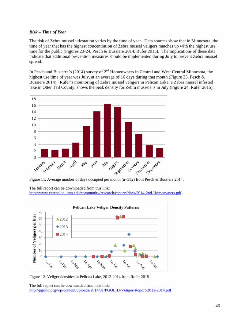
Risk – Time of Year
The risk of Zebra mussel infestation varies by the time of year. Data sources show that in Minnesota, the time of year that has the highest concentration of Zebra mussel veligers matches up with the highest use time for the public (Figures 23-24, Pesch & Bussiere 2014, Rufer 2015). The implications of these data indicate that additional prevention measures should be implemented during July to prevent Zebra mussel spread. In Pesch and Busierre’s (2014) survey of 2nd Homeowners in Central and West Central Minnesota, the highest use time of year was July, at an average of 16 days during that month (Figure 23, Pesch & Bussiere 2014). Rufer’s monitoring of Zebra mussel veligers in Pelican Lake, a Zebra mussel infested lake in Otter Tail County, shows the peak density for Zebra mussels is in July (Figure 24, Rufer 2015).
Figure 11. Average number of days occupied per month (n=552) from Pesch & Bussiere 2014.
The full report can be downloaded from this link: http://www.extension.umn.edu/community/research/reports/docs/2014-2nd-Homeowners.pdf
Figure 12. Veliger densities in Pelican Lake, 2012-2014 from Rufer 2015.
The full report can be downloaded from this link: http://pgolid.org/wp-content/uploads/2014/01/PGOLID-Veliger-Report-2012-2014.pdf
0
10
20
30
40
50
60
70
Nu
mb
er o
f V
elig
ers
per
lite
r
Pelican Lake Veliger Density Patterns
2012
2013
2014
47
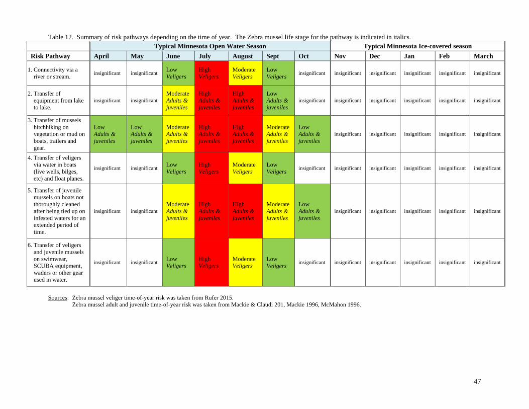
Table 12. Summary of risk pathways depending on the time of year. The Zebra mussel life stage for the pathway is indicated in italics. Typical Minnesota Open Water Season Typical Minnesota Ice-covered season
Risk Pathway April May June July August Sept Oct Nov Dec Jan Feb March
1. Connectivity via a river or stream.
insignificant insignificant Low Veligers
High Veligers
Moderate Veligers
Low Veligers
insignificant insignificant insignificant insignificant insignificant insignificant
2. Transfer of equipment from lake to lake.
insignificant insignificant Moderate Adults & juveniles
High Adults & juveniles
High Adults & juveniles
Low Adults & juveniles
insignificant insignificant insignificant insignificant insignificant insignificant
3. Transfer of mussels hitchhiking on vegetation or mud on boats, trailers and gear.
Low Adults & juveniles
Low Adults & juveniles
Moderate Adults & juveniles
High Adults & juveniles
High Adults & juveniles
Moderate Adults & juveniles
Low Adults & juveniles
insignificant insignificant insignificant insignificant insignificant
4. Transfer of veligers via water in boats (live wells, bilges, etc) and float planes.
insignificant insignificant Low Veligers
High Veligers
Moderate Veligers
Low Veligers
insignificant insignificant insignificant insignificant insignificant insignificant
5. Transfer of juvenile mussels on boats not thoroughly cleaned after being tied up on infested waters for an extended period of time.
insignificant insignificant Moderate Adults & juveniles
High Adults & juveniles
High Adults & juveniles
Moderate Adults & juveniles
Low Adults & juveniles
insignificant insignificant insignificant insignificant insignificant
6. Transfer of veligers and juvenile mussels on swimwear, SCUBA equipment, waders or other gear used in water.
insignificant insignificant Low Veligers
High Veligers
Moderate Veligers
Low Veligers
insignificant insignificant insignificant insignificant insignificant insignificant
Sources: Zebra mussel veliger time-of-year risk was taken from Rufer 2015. Zebra mussel adult and juvenile time-of-year risk was taken from Mackie & Claudi 201, Mackie 1996, McMahon 1996.
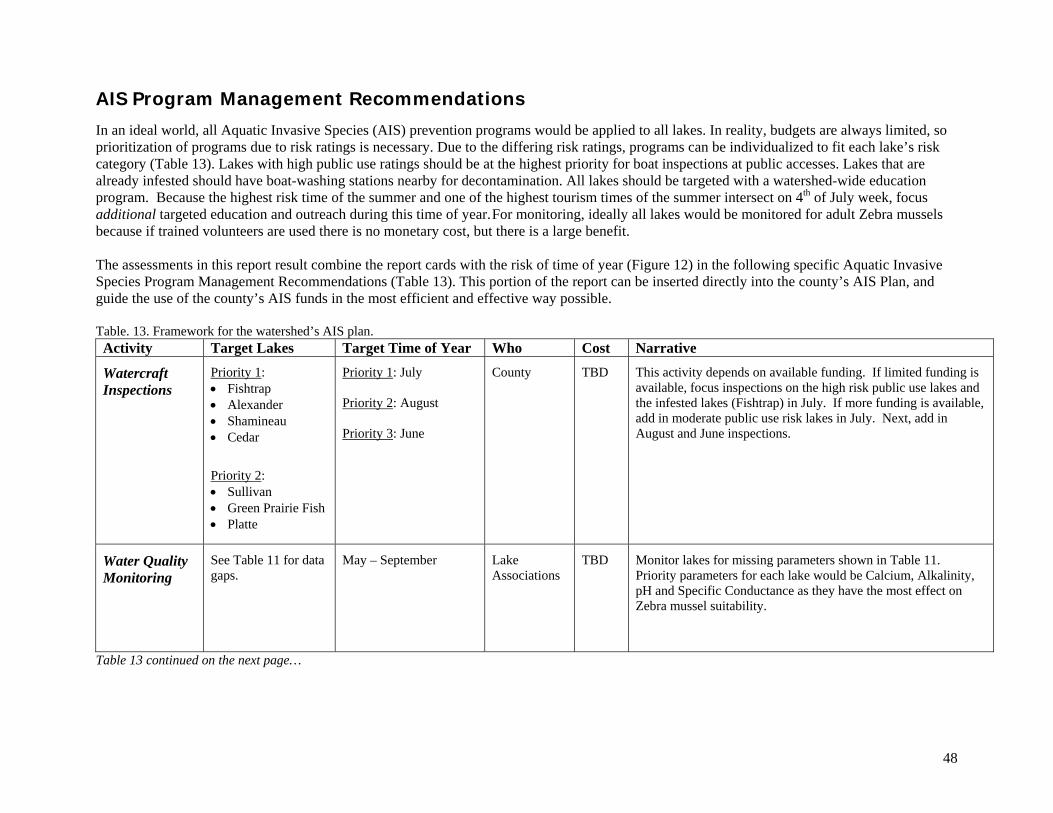
48
AIS Program Management Recommendations
In an ideal world, all Aquatic Invasive Species (AIS) prevention programs would be applied to all lakes. In reality, budgets are always limited, so prioritization of programs due to risk ratings is necessary. Due to the differing risk ratings, programs can be individualized to fit each lake’s risk category (Table 13). Lakes with high public use ratings should be at the highest priority for boat inspections at public accesses. Lakes that are already infested should have boat-washing stations nearby for decontamination. All lakes should be targeted with a watershed-wide education program. Because the highest risk time of the summer and one of the highest tourism times of the summer intersect on 4th of July week, focus additional targeted education and outreach during this time of year. For monitoring, ideally all lakes would be monitored for adult Zebra mussels because if trained volunteers are used there is no monetary cost, but there is a large benefit.
The assessments in this report result combine the report cards with the risk of time of year (Figure 12) in the following specific Aquatic Invasive Species Program Management Recommendations (Table 13). This portion of the report can be inserted directly into the county’s AIS Plan, and guide the use of the county’s AIS funds in the most efficient and effective way possible. Table. 13. Framework for the watershed’s AIS plan. Activity Target Lakes Target Time of Year Who Cost Narrative
Watercraft Inspections
Priority 1: Fishtrap Alexander Shamineau Cedar
Priority 2: Sullivan Green Prairie Fish Platte
Priority 1: July Priority 2: August Priority 3: June
County
TBD
This activity depends on available funding. If limited funding is available, focus inspections on the high risk public use lakes and the infested lakes (Fishtrap) in July. If more funding is available, add in moderate public use risk lakes in July. Next, add in August and June inspections.
Water Quality Monitoring
See Table 11 for data gaps.
May – September
Lake Associations
TBD
Monitor lakes for missing parameters shown in Table 11. Priority parameters for each lake would be Calcium, Alkalinity, pH and Specific Conductance as they have the most effect on Zebra mussel suitability.
Table 13 continued on the next page…
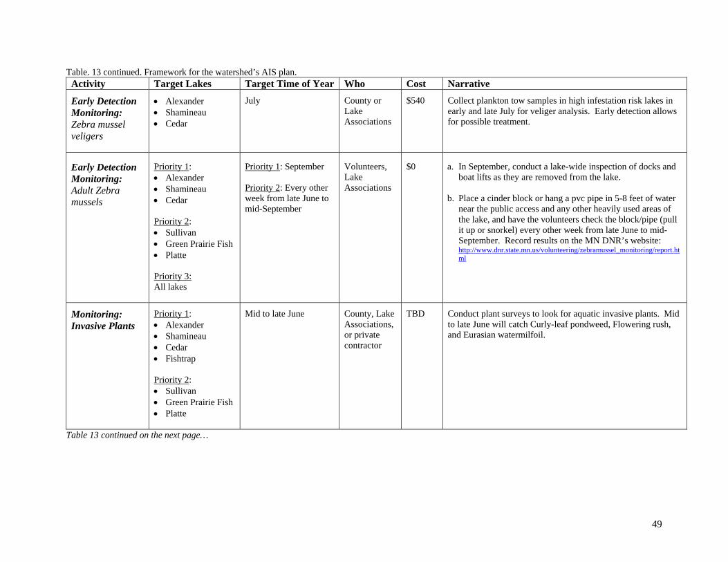
49
Table. 13 continued. Framework for the watershed’s AIS plan. Activity Target Lakes Target Time of Year Who Cost Narrative
Early Detection Monitoring: Zebra mussel veligers
Alexander Shamineau Cedar
July
County or Lake Associations
$540
Collect plankton tow samples in high infestation risk lakes in early and late July for veliger analysis. Early detection allows for possible treatment.
Early Detection Monitoring: Adult Zebra mussels
Priority 1: Alexander Shamineau Cedar Priority 2: Sullivan Green Prairie Fish Platte Priority 3: All lakes
Priority 1: September Priority 2: Every other week from late June to mid-September
Volunteers, Lake Associations
$0
a. In September, conduct a lake-wide inspection of docks and boat lifts as they are removed from the lake.
b. Place a cinder block or hang a pvc pipe in 5-8 feet of water near the public access and any other heavily used areas of the lake, and have the volunteers check the block/pipe (pull it up or snorkel) every other week from late June to mid-September. Record results on the MN DNR’s website: http://www.dnr.state.mn.us/volunteering/zebramussel_monitoring/report.html
Monitoring: Invasive Plants
Priority 1: Alexander Shamineau Cedar Fishtrap Priority 2: Sullivan Green Prairie Fish Platte
Mid to late June
County, Lake Associations, or private contractor
TBD
Conduct plant surveys to look for aquatic invasive plants. Mid to late June will catch Curly-leaf pondweed, Flowering rush, and Eurasian watermilfoil.
Table 13 continued on the next page…
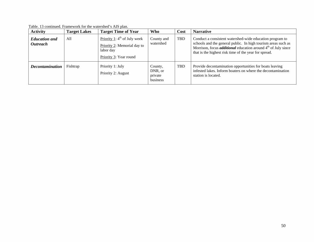
50
Table. 13 continued. Framework for the watershed’s AIS plan. Activity Target Lakes Target Time of Year Who Cost Narrative
Education and Outreach
All
Priority 1: 4th of July week
Priority 2: Memorial day to labor day
Priority 3: Year round
County and watershed
TBD
Conduct a consistent watershed-wide education program to schools and the general public. In high tourism areas such as Morrison, focus additional education around 4th of July since that is the highest risk time of the year for spread.
Decontamination
Fishtrap
Priority 1: July
Priority 2: August
County, DNR, or private business
TBD
Provide decontamination opportunities for boats leaving infested lakes. Inform boaters on where the decontamination station is located.
51
References Alexander, J.E. Jr., J.H. Thorp, and R.D. Fell. 1994. Turbidity and temperature effects on oxygen
consumption in the zebra mussel (Dreissena polymorpha). Canadian Journal of Fisheries and Aquatic Sciences, 51: 179-184.
Bodamer, B.L. and J.M. Bossenbroek. 2008. Wetlands as barriers: effects of vegetated waterways on
downstream dispersal of zebra mussels. Freshwater Biology, 53: 2051-2060. Hincks, S.S. and G.L. Mackie. 1997. Effects of pH, calcium, alkalinity, hardness and chlorophyll on the
survival, growth, and reproductive success of zebra mussels (Driessena polymorpha) in Ontario Lakes. Canadian Journal of Fisheries and Aquatic Sciences, 54: 2049-2057.
Horvath, T.G. and G. A. Lamberti. 1999. Mortality of zebra mussel, Dreissena polymorpha, veligers
during downstream transport. Freshwater Biology, 42: 69-76. Horvath, T. G., G. A. Lamberti, D. M. Lodge and W. L. Perry. 1996. Zebra Mussel Dispersal in Lake-
Stream Systems: Source-Sink Dynamics. Journal of the North American Benthological Society, 15(4): 564-575.
Johnson, L. E., and A. Ricciardi, and J. T. Carlton. 2001. Overland Dispersal of aquatic invasive species:
a risk assessment of transient recreational boating. Ecological Applications, 11(6): 1789-1799. Karatayev, A.Y, L. E. Burlakova, and D. K. Padilla. 1998. Physical factors that limit the distribution and
abundance of Dreissena polymorpha. Journal of Shellfish Research, 17(4): 1219-1235. Mackie, G.L., W.N. Gibbons, B.W. Muncaster, and I.M. Gray. 1989. The zebra mussel, Dreissena
polymorpha, a synthesis of European experiences and a preview for North America. Queen's Printer for Ontario.
Mackie, G. and R. Claudi, 2010. Monitoring and Control of Macrofouling Mollusks in Fresh Water
Systems. Boca Raton: CRC Press. Mackie, G.L., and D.W. Schlosser. 1996. Comparative biology of zebra mussels in Europe and
North America: an overview. American Zoologist 36: 244-258. McMahon, R. F. 1996. The Physiological Ecology of the Zebra Mussel, Dreissena polymorpha, in North
America and Europe. American Zoologist, 36(3): 339-363. Minnesota Department of Natural Resources. Minnesota Infested Waters List, Downloaded 3/31/2015.
Available from: http://www.dnr.state.mn.us/invasives/ais/infested.html. Minnesota Pollution Control Agency. 2000. Upper Mississippi River Basin Information Document,
Downloaded 3/3/2015. Available from: http://www.pca.state.mn.us/pyriaba Nalepa, T. F. and D. Schloesser, editors. 1992. Zebra mussels: biology, impacts and control. Lewis
Publishers.
52
Pesch, R. and M Bussiere. 2014. Profile of Second Homeowners in Central and West Central Minnesota. University of Minnesota Extension, Extension Center for Community Vitality.
Available from: http://www.extension.umn.edu/community/research/reports/docs/2014-2nd-Homeowners.pdf
Rufer, M. M. 2014. Zebra mussel veliger density monitoring in Pelican Lake, Otter Tail County, MN,
2012-2013. Available from: http://pgolid.org/programs/aquatic-invasive-species/. Strayer, David L. 1991. Projected distribution of the zebra mussel, Dreissena polymorpha, in North
America. Can. J. Fish. Aquat. Sci., 48: 1389-1395. Wetzel, R. G. 2001. Limnology: Lake and River Systems. Third Edition. Elsevier Science, San Diego,
California.