relationship between highway constructions and natural habitat, a case study of İzmir highway
TRANSCRIPT

1881
* For correspondence.
Journal of Environmental Protection and Ecology 15, No 4, 1881–1892 (2014)
Sustainable landscape planning
RELATIONSHIP BETWEEN HIGHWAY CONSTRUCTIONS AND NATURAL HABITAT. A CASE STUDY OF IZMIR HIGHWAY
M. T. ESETLILI*, F. OZEN, Y. KURUCU, M. BOLCA
Department of Soil Science and Plant Nutrition, Faculty of Agriculture, Ege University, Izmir, Turkey E-mail: [email protected]; [email protected]
Abstract. Natural habitats and ecological systems provide living space for one or more living be-ings, and they are the source of biodiversity on Earth. Integrity of ecosystems impetuously collapse due to unplanned urbanisation, misuse of lands and excessive consumption of natural resources by human beings. Additionally, monitoring studies are not sufficient to plan preventions. The main aim of this study is to set a precedent by monitoring the damage, the pressure and time-dependent changes, which are caused by highway projects planned without analysing ecosystem flexibility, on natural habitats through the use of remote sensing technique and GIS. The effects of highway projects on habitats are investigated with respect to two different points of view. The first one is that highway projects directly invade and divide habitats. The other one is that highways become centre of attractions for residential and industrial zones, and demand for settlements increases around highways. The research area of this study is the most seriously affected natural area in Aegean region where Izmir-Aydin highway passes through. The changes in the research area in terms of land usage from 1984 to 2014 were analysed by satellite images. The size of industrial and residential zones in the research area was 138 ha in 1984. The size of industrial and residential zone has increased by 1.225% and reached to 1.690 ha as industrial and residential zones became denser throughout the highway. As a result of this study, it was determined that Izmir-Aydin highway has irreversibly split and destroyed substantial part of the natural habitat.
Keywords: habitat fragmentation, highway, Izmir, remote sensing, GIS.
AIMS AND BACKGROUND
Ecosystems should be protected and constantly monitored in order to sustain the biodiversity on Earth. The aim of this study is to make a model, which can moni-tor and determine the damage of large-scale highway and infrastructure projects imposing as a physical and biological barrier against flora and fauna in natural habitats, by remote sensing technique and GIS.
Habitat is an area where there are suitable conditions for species of living be-ings to live, to shelter; and species can be found when examined1. An area having particular ecological integrity (can be wetland or terrestrial) owns more diversity
1882
of species as it reserves wide range of habitats. Thus, the habitat diversity is an essential element of biodiversity. As the habitat diversity increases, diversity of species, genetic diversity and functional diversity in the ecosystem dependently increase as well2–4.
Considering the interaction between environment and living beings and their relations in this context, areas containing habitat are called as ‘ecosystem’. Eco-system is described to be a dynamic structure which constitutes the interaction as a functional unit between species of animal, plant and other types of microorgan-isms and inorganic environment5. The nutrient, energy and water cycles on Earth are provided by ecosystems where living natural resources have interaction with other living species and inorganic environmental constituents. Ecosystems can exist in wetlands and/or terrestrial lands. Various different habitats can exist in the same ecosystem, which can provide living space for many different species. The sustainability of ecosystems, which is one of the most significant elements of biological cycles, is dependent on size of ecosystems and that each element in the system should not be degenerated.
The integrity of ecosystems has been rapidly disrupted as a result of human activities. Negative changes occurring in natural habitats heavily result in loss of biodiversity and other critical ecosystems. The integrity of ecosystems is disturbed due to unplanned urbanisation, misuse of lands, excessive grazing, and destruc-tion of forests and excessive consumption of natural resources6. Consequently, great deals of habitats are firstly affected, and then living species in these habitats are adversely affected. This process is named to be habitat fragmentation. As a result of habitat fragmentation, ruptures in food and energy chains occur, thus it is inevitable that some specifies are to be affected.
This worldwide problem sometimes occurs due to unconscious activities, but it mostly occurs as a result of activities that are consciously performed by humans. For instance, opening tropical rainforests, which contain half of the biological di-versity on Earth, to settlement or loss and fragmentation of rainforest due to slash and burn farming are considered to be a quite common environmental problem7.
The fragmentation of wide natural living spaces into smaller spaces gives rise to disturbance of living species in terms of form of life and diet. It is indi-cated that species emigrate due to ruptures in food chain, and hence biodiversity is reduced.
In recent years, deterioration of natural habitats mounts up in the world and in Turkey. Correspondingly, large and small habitat fragments are formed, and diver-sity and number of species in habitats decrease. Later on, increment of distances between habitat fragments leads to blockage of dispersal of species, blockage of access to vitally important resources such as water resources, and decline of spe-cies is accelerated. Additionally, ‘core habitat’ rate decreases and ‘edge habitat’
1883
rate increases as a result of fragmentations; physical features of habitats (moisture, wind, temperature, etc.) and biological structure of habitats alter.
Intersection of natural habitats and highways is a growing ecological prob-lem. Highways provide some ecological benefits such as transportation to forest, pasturage and agricultural areas8; however, they act as both physical and biologi-cal barrier against many species. Highways affects available wildlife, quality and of habitats due to fragmentation9–12. Similarly, vehicle traffic on highways is the direct cause of deaths occurring in wildlife and sometimes disaster for wildlife population13–16.
Lastly, some species of plants loses germination, adaptation and competition abilities in alternating new conditions as a result of fragmentation of habitats by highways. Besides, some mammal and bird species exhibit behaviour disorders (nesting in season, etc.). They lose their resistance, and they have difficulty in finding migration paths. Generation of many species in fragmented habitats remain under pressure.
EXPERIMENTAL
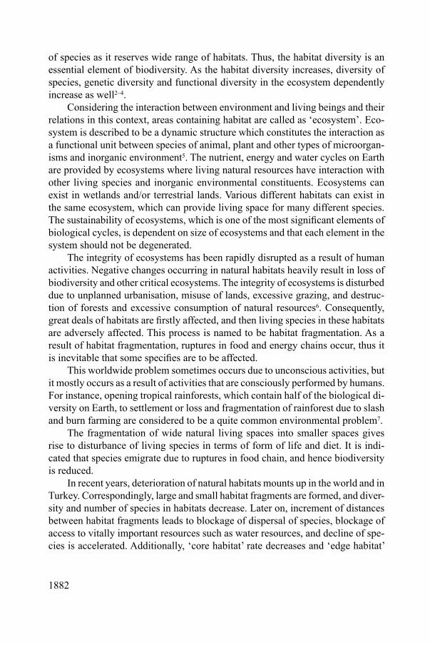
Study area. A section of 25 km of Izmir-Aydin highway in metropolitan district and the environment as far as 1000 m around the highway were chosen to be the research area since Izmir-Aydin highway is one of the biggest influence on natural areas in Izmir (Fig. 1).
Fig. 1. Location map of the study area
As the research material, the Landsat 5 TM image of the environment before the construction of Izmir-Aydin highway in 1985 and soil maps were used to
1884
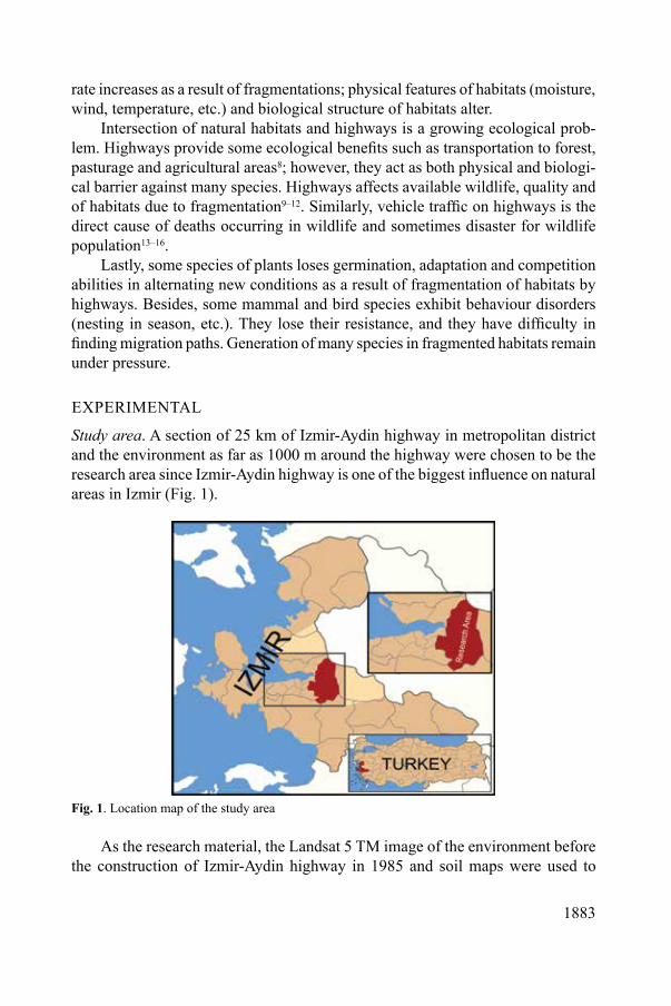
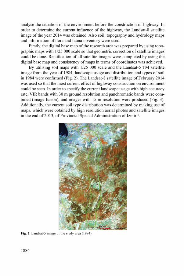
analyse the situation of the environment before the construction of highway. In order to determine the current influence of the highway, the Landsat-8 satellite image of the year 2014 was obtained. Also soil, topography and hydrology maps and information of flora and fauna inventory were used.
Firstly, the digital base map of the research area was prepared by using topo-graphic maps with 1/25 000 scale so that geometric correction of satellite images could be done. Rectification of all satellite images were completed by using the digital base map and consistency of maps in terms of coordinates was achieved.
By utilising soil maps with 1/25 000 scale and the Landsat-5 TM satellite image from the year of 1984, landscape usage and distribution and types of soil in 1984 were confirmed (Fig. 2). The Landsat-8 satellite image of February 2014 was used so that the most current effect of highway construction on environment could be seen. In order to specify the current landscape usage with high accuracy rate, VIR bands with 30 m ground resolution and panchromatic bands were com-bined (image fusion), and images with 15 m resolution were produced (Fig. 3). Additionally, the current soil type distribution was determined by making use of maps, which were obtained by high resolution aerial photos and satellite images in the end of 2013, of Provincial Special Administration of Izmir17.
Fig. 2. Landsat-5 image of the study area (1984)
1885
Fig. 3. Landsat-8 image of the study area (2014)
By utilising all the data, the progress of habitat fragmentation since the be-ginning of Izmir-Aydin highway construction and environmental influences were analysed and fragmented spaces and their distributions were mapped.
RESULTS AND DISCUSSION
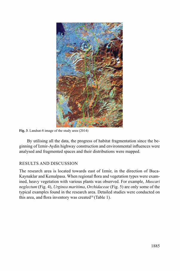
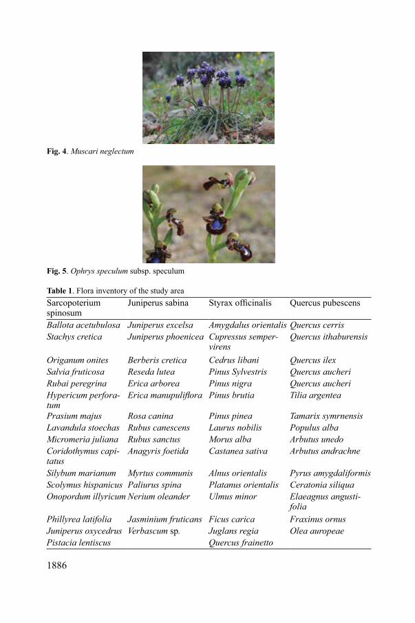
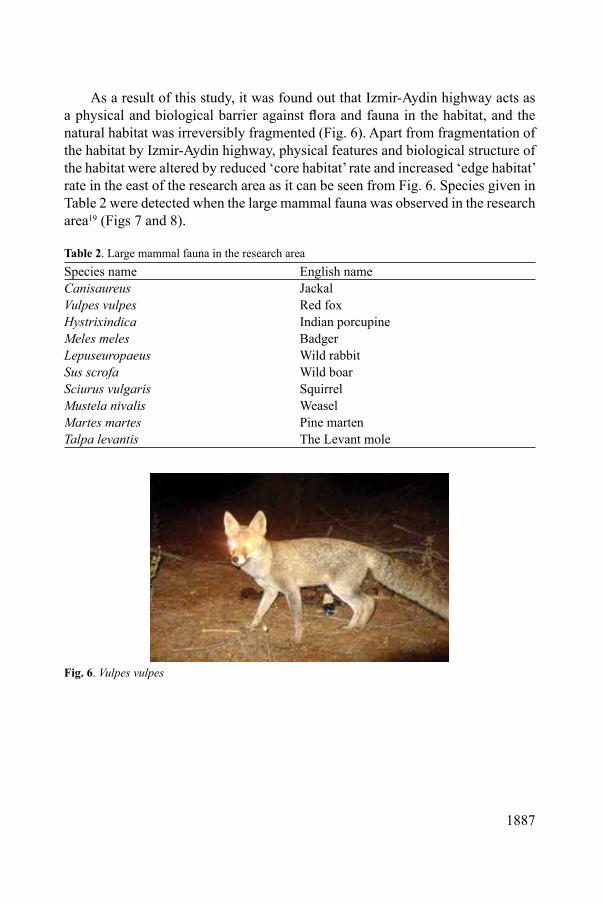
The research area is located towards east of Izmir, in the direction of Buca-Kaynaklar and Kemalpasa. When regional flora and vegetation types were exam-ined, heavy vegetation with various plants was observed. For example, Muscari neglectum (Fig. 4), Urginea maritima, Orchidaceae (Fig. 5) are only some of the typical examples found in the research area. Detailed studies were conducted on this area, and flora inventory was created18 (Table 1).
1886
Fig. 4. Muscari neglectum
Fig. 5. Ophrys speculum subsp. speculum
Table 1. Flora inventory of the study areaSarcopoterium spinosum
Juniperus sabina Styrax officinalis Quercus pubescens
Ballota acetubulosa Juniperus excelsa Amygdalus orientalis Quercus cerrisStachys cretica Juniperus phoenicea Cupressus semper-
virensQuercus ithaburensis
Origanum onites Berberis cretica Cedrus libani Quercus ilexSalvia fruticosa Reseda lutea Pinus Sylvestris Quercus aucheriRubai peregrina Erica arborea Pinus nigra Quercus aucheriHypericum perfora-tum
Erica manupuliflora Pinus brutia Tilia argentea
Prasium majus Rosa canina Pinus pinea Tamarix symrnensisLavandula stoechas Rubus canescens Laurus nobilis Populus albaMicromeria juliana Rubus sanctus Morus alba Arbutus unedoCoridothymus capi-tatus
Anagyris foetida Castanea sativa Arbutus andrachne
Silybum marianum Myrtus communis Alnus orientalis Pyrus amygdaliformisScolymus hispanicus Paliurus spina Platanus orientalis Ceratonia siliquaOnopordum illyricum Nerium oleander Ulmus minor Elaeagnus angusti-
foliaPhillyrea latifolia Jasminium fruticans Ficus carica Fraxinus ornusJuniperus oxycedrus Verbascum sp. Juglans regia Olea auropeaePistacia lentiscus Quercus frainetto
1887
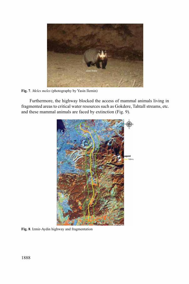
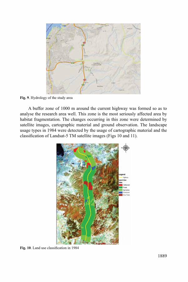
As a result of this study, it was found out that Izmir-Aydin highway acts as a physical and biological barrier against flora and fauna in the habitat, and the natural habitat was irreversibly fragmented (Fig. 6). Apart from fragmentation of the habitat by Izmir-Aydin highway, physical features and biological structure of the habitat were altered by reduced ‘core habitat’ rate and increased ‘edge habitat’ rate in the east of the research area as it can be seen from Fig. 6. Species given in Table 2 were detected when the large mammal fauna was observed in the research area19 (Figs 7 and 8).
Table 2. Large mammal fauna in the research areaSpecies name English name Canisaureus JackalVulpes vulpes Red foxHystrixindica Indian porcupineMeles meles BadgerLepuseuropaeus Wild rabbitSus scrofa Wild boarSciurus vulgaris SquirrelMustela nivalis WeaselMartes martes Pine martenTalpa levantis The Levant mole
Fig. 6. Vulpes vulpes
1888
Fig. 7. Meles meles (photography by Yasin Ilemin)
Furthermore, the highway blocked the access of mammal animals living in fragmented areas to critical water resources such as Gokdere, TahtalI streams, etc. and these mammal animals are faced by extinction (Fig. 9).
Fig. 8. Izmir-Aydin highway and fragmentation
1889
Fig. 9. Hydrology of the study area
A buffer zone of 1000 m around the current highway was formed so as to analyse the research area well. This zone is the most seriously affected area by habitat fragmentation. The changes occurring in this zone were determined by satellite images, cartographic material and ground observation. The landscape usage types in 1984 were detected by the usage of cartographic material and the classification of Landsat-5 TM satellite images (Figs 10 and 11).
Fig. 10. Land use classification in 1984

1890
28%
2%5%
4%
61%forest
agriculture
grass land
olive treessettlement
Fig. 11. Land use distribution in 1984
According to the classification results of satellite image from the year of 1984 and analysis of data, 61% of the research area contained forest ecosystem. When planted olive trees and pasturages were included, the percentage of natural habitats was 68%. The remaining areas were mainly agricultural land (28%) and residential area (4%).
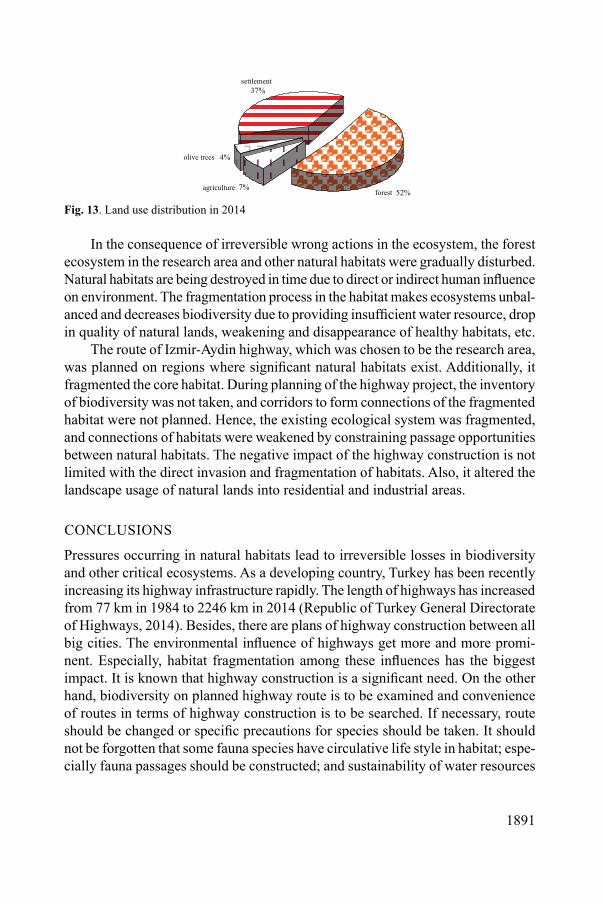
As of this year, the effects of highway on natural habitats can be dramatically seen. Types of landscape usage were detected to change irreversibly by the Land-sat-8 satellite data taken in February 2014 and analysis of other data. Agricultural land percentage has dropped from 28% in 1984 to 7% in 2014, while pasturages have totally disappeared. Concordantly, 9% loss in forest ecosystems was observed. Nevertheless, as a result of development in residential and industrial areas due to the highway, 138 ha of industrial and residential areas in 1984 have increased by 2.30% and reached to 1690 ha (Figs 12 and 13).
Fig. 12. Land use classification in 2014
1891
7%
37%
4%
52%forestagriculture
olive trees
settlement
Fig. 13. Land use distribution in 2014
In the consequence of irreversible wrong actions in the ecosystem, the forest ecosystem in the research area and other natural habitats were gradually disturbed. Natural habitats are being destroyed in time due to direct or indirect human influence on environment. The fragmentation process in the habitat makes ecosystems unbal-anced and decreases biodiversity due to providing insufficient water resource, drop in quality of natural lands, weakening and disappearance of healthy habitats, etc.
The route of Izmir-Aydin highway, which was chosen to be the research area, was planned on regions where significant natural habitats exist. Additionally, it fragmented the core habitat. During planning of the highway project, the inventory of biodiversity was not taken, and corridors to form connections of the fragmented habitat were not planned. Hence, the existing ecological system was fragmented, and connections of habitats were weakened by constraining passage opportunities between natural habitats. The negative impact of the highway construction is not limited with the direct invasion and fragmentation of habitats. Also, it altered the landscape usage of natural lands into residential and industrial areas.
CONCLUSIONS
Pressures occurring in natural habitats lead to irreversible losses in biodiversity and other critical ecosystems. As a developing country, Turkey has been recently increasing its highway infrastructure rapidly. The length of highways has increased from 77 km in 1984 to 2246 km in 2014 (Republic of Turkey General Directorate of Highways, 2014). Besides, there are plans of highway construction between all big cities. The environmental influence of highways get more and more promi-nent. Especially, habitat fragmentation among these influences has the biggest impact. It is known that highway construction is a significant need. On the other hand, biodiversity on planned highway route is to be examined and convenience of routes in terms of highway construction is to be searched. If necessary, route should be changed or specific precautions for species should be taken. It should not be forgotten that some fauna species have circulative life style in habitat; espe-cially fauna passages should be constructed; and sustainability of water resources
1892
should be provided. Among transportation projects, railways are to be preferred as an alternative to highways in order to influence habitats less.
It is necessary that remote sensing technique and geographic information systems are to be utilised so that influence of highways and residential areas can be constantly monitored.
REFERENCES1. E. P. ODUM, G. W. BARRETT: Fundamentals of Ecology. Thomson-Brooks/Cole, Belmont,
CA, 2005. 598 p.2. N. CEPEL: Biodiversity, Importance and Protection. TEMA Publication, No 15, 1997. 40 p.3. K. ISIK, F. YALTIRIK, A. AKESEN: Forests, Biological Diversity and the Maintenance of Natural
Heritage. In: Proc. of the 11th World Forestry Congress, Antalya, October 1997, Vol. 2, 3–27.4. K. ISIK: Biodiversity. TEMA Publication, No 26, 2003. 174 p.5. United Nations Educational, Scientific and Cultural Organization (UNESCO): Solving the Puz-
zle: The Ecosystem Approach and Biosphere Reserves. Paris, 2000. 6. A. KAMPOURIS, A. ANASTASIADIS, M. MOSOARCA: Environmental Impact Assessment
and Evaluation of Road Construction Works in Forest Ecosystems. J Environ Prot Ecol, 14 (2), 753 (2013).
7. O. J. SCHMITZ: Ecology and Ecosystem Conservation. Island Press, Washington, USA, 2007. 8. R. T. T. FORMAN: Estimate of the Area Affected Ecologically by the Road System in the United
States. Conserv Biol, 14, 31 (2000).9. R. T. T. FORMAN, L. E. ALEXANDER: Roads and Their Major Ecological Effects. Annu Rev
Ecol Syst, 29, 207 (1998).10. S. D. JACKSON: Overview of Transportation Related Wildlife Problems. In: Proc. of the
International Conference on Wildlife Ecology and Transportation (Eds G. L Evink, P. Garrett, D. Zeigler, J. Berry). Florida Department of Transportation, Tallahassee, 2000, 1–4.
11. S. MANSUROGLU, P. KINIKLI, R. YILMAZ: Impacts of Highways on Land Uses: the Case of Antalya–Alanya Highway. J Environ Prot Ecol, 14 (1), 293 (2013).
12. G. GULER, A. C. YILDIZCI: Measuring the Effects of the Bridges on Istanbul Green System. J Environ Prot Ecol, 10 (2), 488 (2009).
13. T. E. S. LANGTON: Reasons for Preventing Amphibian Mortality on Roads. In: Amphibians and Roads (Ed. T. E. S. Langton), Proceedings of the Toad Tunnel Conference. ACO Polymer Products Ltd., Bedfordshire, England, 1989.
14. S. C. TROMBULAK, C. A. FRISSELL: Review of Ecological Effects of Roads on Terrestrial and Aquatic Communities. Conserv Biol, 14, 18 (2000).
15. J. P. GIBBS, G. SHRIVER: Estimating the Effects of Road Mortality on Turtle Populations. Conserv Biol, 16, 1647 (2002).
16. D. J. GLISTA, T. L. DEVAULT, J. A. DEWOODY: Vertebrate Road Mortality Predominately Impacts Amphibians. Herpetol Conserv Biol, 3, 77 (2008).
17. ANONYMOUS: Land Inventory of Izmir Province. Governorship of Izmir Publications, 2013.18. F. UNAL ANKAYA: A Research Study for Determination of Connections between Natural
Vegetation and Edaphic Pecularities by GIS and Remote Sensing Methods in Kaynaklar (Buca/Izmır) Region. MSc. Thesis, Department of Landscape Architecture of Ege University, 2007.
19. ANONYMOUS: An Inventory of the Regional Flora and Fauna in Seferihisar: Seferihisar Municipality Publication, 2013.
Received 23 May 2014 Revised 18 August 2014