unpublished report: preliminary report. fourth season of the saudi-french mission in al-kharj -...
TRANSCRIPT

Preliminary rePort
Fourth season of the Saudi-French missionin al-Kharj
- Province of Riyadh -
23 January - 27 February 2015

Al-Kharj - Report of the 4th season - January-February 2015
2

3
Preliminary report
Fourth season of the Saudi-French missionin al-Kharj
- Province of Riyadh -23 January - 27 February 2015
Prepared under the supervision ofJérémie Schiettecatte & Abdalaziz al-Ghazzi
With contributions byCharlène Bouchaud, Antoine chaBrol, Rémy craSSard, Julien cuny, Michèle dinieS, Yamandu hilBert, Hervé monchot, Thomas SaGory & Pierre Siméon
Paris
2015

Al-Kharj - Report of the 4th season - January-February 2015
4

5
Introduction .................................................................................................................... 7
Preamble ........................................................................................................................................................ 7
Geographic setting ........................................................................................................................................ 10
Archaeology in al-Kharj: past research and present issues ........................................................................... 11
Purpose of the 4th season, programme, schedule ....................................................................................... 13
Recording system .......................................................................................................................................... 15
PREHISTORY .................................................................................................................. 17
Prehistory of Al-Kharj: Middle Paleolithic sites from the Rufāʾ Graben .......................... 19
Introduction .................................................................................................................................................. 19
Methods: survey and lithic analyses ............................................................................................................. 19
Excavations at AK-31 ..................................................................................................................................... 20
Survey along the northern half of the Rufāʾ Graben .................................................................................... 22
Perspectives .................................................................................................................................................. 22
LATE PRE‑ISLAMIC & ISLAMIC PERIODS ........................................................................ 25
Al-Yamāma - The Great Mosque (Area N6 - Building 1) .................................................. 27
Description of the site of al-Yamāma ............................................................................................................ 27
Building 1 - the Mosque ............................................................................................................................... 27
Stratigraphy of Building 1 in the prayer Hall (R. 013) .................................................................................... 31
Trench C in the north-western corner of the courtyard ............................................................................... 36
The Southern part of the courtyard ............................................................................................................. 36
Trench A & B: excavation of Building 3, a monumental structure under Building 1 ..................................... 42
Trench D: a dwelling prior to the mosque .................................................................................................... 62
Trench E : west of the miḥrāb (Ni. 160) ........................................................................................................ 63
Trench F : north of the mosque .................................................................................................................... 69
Interpretation and phasing of Buildings 1, 3, 4 and 5 (figs. 95-97) ............................................................ 72
Al-Yamāma - Sounding 4 (Area K17) .............................................................................. 75
Location and aim of the sounding ................................................................................................................ 75
General stratigraphy and phases .................................................................................................................. 76
ENVIRONMENTAL STUDIES ............................................................................................ 87
Al-Yamāma - Archaeobotanical Study ............................................................................ 89
Introduction .................................................................................................................................................. 89
Methodology ................................................................................................................................................ 89
The first results ............................................................................................................................................. 92
Conclusion .................................................................................................................................................... 94
Al-Yamāma - Archaeozoological Study ......................................................................... 109
The association of camel & caprine ............................................................................................................ 109
The gazelle (Gazella sp.) ............................................................................................................................. 109

Al-Kharj - Report of the 4th season - January-February 2015
6
The spiny tailed-lizard (Uromastyx aegyptia) ............................................................................................ 109
The ostrich (Struthio camelus) ................................................................................................................... 111
Domestic fowl (Gallus gallus) ..................................................................................................................... 111
Other species already attested during the previous seasons ..................................................................... 111
New species ................................................................................................................................................ 112
Holocene Environmental changes in the region of al-Kharj .......................................... 117
Vegetation changes in the region of al-Kharj during the Holocene ............................................................ 117
The palaeolake of al-Hayāthim: Geomorphological study .......................................................................... 122
References .................................................................................................................. 123
Survey and excavation at Umm al-Shaʿāl, in the northeastern part of the governorate
of al-Kharj [in Arabic] .................................................................................................. 175

7
INTRODUCTION
Preamble
Al-Kharj area is one of the major oases of the Najd, in the very heart of the Kingdom of Saudi Arabia. Specific environmental conditions made this area one of the most attractive regions of Central Arabia for settled communities. And as a consequence, the region of al-Kharj appears as an obvious stopping place and main crossroad on the commercial routes that linked Yemen and the Ḥijāz to the Gulf and Mesopotamia.Stimulated by this prospect, a Joint Cooperative Agreement for Archaeological Surveys and excavations in the oasis of al-Kharj was signed in September 2011 between the Saudi Commission for Tourism and Antiq-uities (SCTA), Riyadh, and the Centre National de la Recherche Scientifique (CNRS), Paris. A scientific team was formed under the supervision of Abdalaziz al-Ghazzi (King Saud University, Riyadh) and Jérémie Schi-ettecatte (CNRS, Paris).The aim of the research is to characterize the diverse prehistoric, protohistoric, pre-Islamic, and Islamic archaeological remains as well as to illustrate the environmental context that made it possible for people to settle in such an arid region.For the past three years, the archaeological study of this region has open up new horizons for the compre-hension of the peopling and settlement process, and of circulation and contacts within the Arabian Penin-sula, from prehistory down to the mediaeval period.The fourth season of survey and excavation was carried out from January 23 to February 27, 2015.
Team
Saudi Part• Prof. Abdalaziz AL-GHAZZĪ (King Saud University, Riyadh) – head of the project• Prof. Sālim bin Aḥmad Ṭayrān (King Saud University, Riyadh) – archaeologist• Abdalaziz AL-HAMMAD (Saudi Commission for Tourism and Antiquities, Riyadh) – archaeologist• Dr Saʿīd bin Dubays AL-ʿUTAYBĪ (Saudi Commission for Tourism and Antiquities, Riyadh) – archaeologist • Dr Abdalaziz b. Fahd B. NAFĪSSA (Saudi Commission for Tourism and Antiquities, Riyadh) – archaeologist• Khalid AL-HAFĪ (Saudi Commission for Tourism and Antiquities, Riyadh) – archaeologist
European Part• Dr Charlène BOUCHAUD (postdoctoral fellow, National Museum of Natural History, Paris) – archaeo-
botanist• Antoine CHARBOL (Ecole Française d’Athènes, PhD candidate) – geomorphologist• Dr Rémy CRASSARD (CNRS, Lyon) – archaeologist• Julien CUNY (INRAP, Lille) – archaeologist• Michèle DINIES (Deutsches Archäologisches Institut, Berlin, PhD Candidate) – palynologist• Prof. Eric FOUACHE (Paris-Sorbonne University - Abu Dhabi) – geomorphologist• Dr Yamandù HILBERT (Maison de l’Orient et de la Méditerranée, Lyon) – archaeologist• Fanny LARUAZ (Panthéon-Sorbonne University, Paris, Master Student) – archaeologist• Dr Hervé MONCHOT (postdoctoral fellow, National Museum of Natural History, Paris) – archaeozoologist• Dr Michel MOUTON (CEFAS, Jeddah) – archaeologist• Alexia ROSAK (Paris-Sorbonne University, Master Student) – archaeologist• Thomas SAGORY (Ministry of Culture, Paris) – photographer• Dr Jérémie SCHIETTECATTE (CNRS, Paris) – head of the project• Dr Pierre SIMEON (postdoctoral fellow, Pergamonmuseum, Berlin) – archaeologist

Al-Kharj - Report of the 4th season - January-February 2015
8
SupportThe scientific issues dictating our field activities address those set out in four research programmes. These funded the major part of the field activities:• Programme ‘Oasis d’Arabie déserte’, conducted by G. Charloux (UMR 8167 ‘Orient & Méditerranée’,
Paris), funded by the Ministry of Foreign affairs, Paris; this programme also supports field activities in Dumat al-Jandal and Najran;
• Laboratoire d’excellence ‘Resmed – Religion et Société en Méditerranée’, conducted by J.-Cl. Cheynet (UMR 8167 ‘Orient & Méditerranée’, Paris), funded by the Agence Nationale pour la Recherche in Paris [ANR-10-LABX-72];
• Programme ‘EmOAD – Emergence des Oasis de l’Arabie Déserte’, conducted by J. Schiettecatte (UMR 8167 ‘Orient & Méditerranée’, Paris), funded by the Idex SUPER (Sorbonne Universités à Paris pour l’éducation et la recherche) of Sorbonne Universités.
• Regular activities of the Research Centre from the Saudi Commission for Tourism and Antiquities, Ri-yadh, headed by Abdallah al-Saud.
Besides, several institutions and programmes contributed by their financial and technical support to the field activities:• King Saud University, Riyadh (researchers and logistics);• Paris Sorbonne University - Abu Dhabi (researcher, funding and logistics);• CNRS through the research centres UMR 8167 ‘Orient & Méditerranée’, Paris, UMR 7209 ‘Archéozoolo-
gie & archéobotanique, Paris, and UMR 5133 ‘Archéorient’, Lyons (researchers and logistics);• Académie des inscriptions et belles-lettres, Paris (academic grant);• Deutsches Archäologisches Institut, Berlin (researcher and logistics);• Ecole française d’Athènes (researcher);• Institut National de Recherches Archéologiques Préventives, Paris (researcher);• ‘Service de Coopération et d’Action Culturelle’ of the French Embassy, Riyadh (logistics).
Al-Yamâma: team and field workers

9
AcknowledgmentsWe would like to thank these institutions most warmly for their support. We are also most grateful to people who put their trust in our work and did their best to make fieldwork possible and easier in Riyadh and Paris: HRH Prince Sultan bin Salman bin Abdalaziz (President of Saudi Commission for Tourism and Antiquities [SCTA] and Chairman of the Board of Directors of SCTA), Prof. Ali al-Ghabban (Vice-President of SCTA for Antiquities and Museums, Riyadh), Abdallah al-Saud (Head of the Research and Excavation Centre, SCTA, Riyadh), Jean-Louis Laveille (Cultural Advisor, French Embassy in Riyadh), Cyrille Le Déaut (Cooperation At-taché, French Embassy in Riyadh), Marie-Véronique Diamant (CNRS, Ivry-sur-Seine).
46°E 47°E 48°E
46°E 47°E 48°E
23°N
24°N
25°N
23°N
24°N
25°N
0 20 40 60 80 10010Km
Modern road
Archaeological site
Wadi bed
Surveyed areas
Map: J. Schiettecatte 2012 - UTM-WGS84
Riyadh
al-Kharj
al-Yamāma
AK-22
Wādī as-SahbāʾWādī Nisāḥ
Ja
ba
l
Ṭ
uw
ay
q
Jabal al-Jubayl
Jabal al-ʿUrumaBuʿayjāʾgrabenAwsaṭgraben
Dilamdepression
Jaba
l al-Q
uasa
yʿa
Wād
ī al-ʿ
Aqīm
ī
al-Dahnāʾdunes
Wādī Ḥanīfa
Wādī Laḥā
AK-1 AK-28AK-29
Khafs Daghra 1-4
Fig. 2
Fig. 28
Fig. 21E
Figure 1 - The location of the oasis of al-Kharj and its setting (J. Schiettecatte – Saudi-French Archaeological Mission in al-Kharj).

Al-Kharj - Report of the 4th season - January-February 2015
10
Geographic setting
Al-Kharj area is located 70 km south-west of the capital of the Kingdom of Saudi Arabia, Riyadh. The area lies between latitude 23.8° and 24.4° N. and longitude 46.9° and 48° E. (fig. 1).The Najd region is characterized by a hot, dry climate. Modern annual rainfall rarely exceeds 100 mm: for the period 1980–2007, the annual mean was 94.6 mm and the amount of rainfall was irregular throughout the year, with rain occurring mainly from November to April. The hydrological network includes a large wādī system, with no permanent river. However, water resources from several of the largest aquifers of the Arabian Peninsula have allowed agriculture and farming to develop (Sanlaville 2000: 73–75, 210–211).Al-Kharj is the main city in this area. The rapid growth of the city makes it sprawl into the former palm groves and absorb older villages in its neighbourhood (al-Yamāma, al-Salmiyya, etc.). The second city of the oasis is al-Dilam. This huge agglomeration has more than 376,000 inhabitants. A well-developed road net-work connects the city of al-Kharj with the capital Riyadh to the north-west, with the United Arab Emirates to the east, and the Wādī al-Dawāsir to the south-west.
Figure 2 - The two major swallow holes in ʿ Ayn al-Ḍilaʿ, looking north-west (photograph: Th. Sagory – Saudi-French Archaeological Mission in al-Kharj).

11
Geological backgroundThe geological context explains the location of al-Kharj area in the Arabian platform. Large units of lime-stone and sandstone of Jurassic and Cretaceous form more or less eroded plateaus, dissected by valleys (wādīs). Nowadays there is very little flow in them, but in the past it was sufficient to incise them several tens of metres. The major part of wādīs within the oasis of al-Kharj is influenced by series of grabens origi-nating from the opening of the Red Sea, marked by west-east faults.In the valleys, more recent sedimentary cover includes both fluvial deposits (silt, clay, etc.) and eolian de-posits, with barkhan fields in numerous places. Current erosion comes mainly from wind, since the very low rainfall has minimal impact on the ground. Because of the sedimentary context, karst morphologies are common in the oasis of al-Kharj: the most impressive features are swallow holes south-west of al-Kharj (vaSlet et al. 1991: 35–36) (fig. 2). Three swallow holes are located in ʿAyn al-Ḍilaʿ, with a diameter of 60 to 80 m, and an average depth of 50 m. These features were formed by the phenomenon of dissolution in calcare-ous layers.
TopographyThe simple geological context provides an easy explanation of the topographical context of the area of al-Kharj.The oasis is a large, funnel-shaped valley in sandstone and limestone plateaus incised by many wādīs. The joint action of drainage and uplift of the crystalline basement in depth led to the formation of cuestas with escarpments north, north-west and south-west of the oasis.The area is bounded on the west by a Jurassic mountain, the Jabal Ṭuwayq, through which flows the Wādī Nisāḥ from west to east inside grabens. The Wādī Ḥanīfa comes from Riyadh in the north-west, along the cuesta of the Jabal al-Jubayl, and this escarpment forms the northern boundary of the oasis. South-west, the Wādī al-ʿAyn comes from the slopes of the Jabal Ṭuwayq, and then follows the escarpment of the Jabal al-ʿUruma, on the south side of the oasis. These three main wādīs reach the centre of the oasis and join to form the Wādī al-Sahbāʾ, which crosses the whole oasis from west to east in the valley bounded by the Jabal al-Jubayl and the Jabal al-ʿUruma. It continues toward the east and is lost in the sands of al-Dahnāʾ desert.The three mountain massifs located around the oasis are almost parallel and bound it to the north, west, and south. The confluence of the wādīs within these mountains forms the cluse of al-Kharj, thus cutting the Jabal al-Jubayl and the Jabal al-ʿUruma into two parts. In this area, the Jabal Ṭuwayq reaches 1,050 m, while the Jabal al-Jubayl and the Jabal al-ʿUruma have average maximum altitudes around 550 m north of the oasis and 500 m south of the oasis.The central valley with the wādīs slopes gently from west (mean altitude ca. 470 – 480 m a.s.l.) to east (mean altitude ca. 380 m a.s.l.). The oasis ends at the gates of al-Dahnāʾ desert.The confluence of the main wādīs is unclear within the oasis, partly due to the expansion of the city of al-Kharj and the development of infrastructure (road network, farms, etc.). The wādīs are also partly disturbed by other human activities.The largest archaeological site, al-Yamāma, is near a heavily altered wādī. It is located within the valley but is several metres higher than the surrounding area, which preserved the site from potential flash floods.
Archaeology in al-Kharj: past research and present issues
The favourable environment which made this oasis so promising for archaeological and historical studies should have been all the more inviting given that this area is frequently mentioned in pre-Islamic poetry and Islamic tradition (WüStenfeld 1874, thilo 1958, Bin KhamiS 1978, al-aSKar 2002, al-Juhany 2002).In spite of this, archaeological remains in Central Arabia have rarely been noticed. Philby mentioned the presence of tumulus fields, underground water channels and a large ancient settlement, al-Yamāma, during

Al-Kharj - Report of the 4th season - January-February 2015
12
a journey in the Najd in 1917–18 (PhilBy 1919; 1920). In 1945, Col. G. de Gaury reported the presence of tumu-lus fields nearby al-Kharj (de Gaury 1945). A few years later, Philby completed the description of the oases of al-Kharj, al-Aflāj and the Wādī Dawāsir (PhilBy 1949). In 1978, a comprehensive archaeological survey of the Kingdom of Saudi Arabia was carried out in Central Arabia and identified sixteen sites in the oasis of al-Kharj alone (ZarinS et al. 1979), confirming the potential of the area. Consequently, in the late 1980s and the 2000s, Abdalaziz al-Ghazzi initiated soundings at four sites in the oasis: on the settlement of Ḥazm ʿ Aqīla (al-GhaZZi 1996, 2009), on that of al-Yamāma (al-GhaZZi 2010), in the necropolis of al-ʿAfja (al-GhaZZi 2011a), and on the water channel of Abraq Farzān (al-GhaZZi 2011b).Although limited by their duration or by their scope, these previous studies registered the existence of a variety of sites where one could expect to find answers to several of the current research issues in the Ara-bian Peninsula.Regarding PrehiStory, one of the main current research issues in the Peninsula concerns the dispersal of the first Anatomically Modern Humans (AMH) during the Palaeolithic. A debate also exists about trying to understand where the Arabian Neolithic comes from: Levantine influence or local developments from au-tochthonous populations? Recent palaeo-environmental and palaeo-climatic studies revealed the possible influence of the wet phases in the development of a production economy. If much has been done in South and East Arabia, the centre of the Peninsula remains unexplored. Environmental studies combined with lithic analysis have therefore been carried out since 2011 in order to address these issues.The Proto-hiStorical occuPation of the oasis is obvious, through the presence of several necropolises that struck all the travellers and archaeologists passing by in the past. At two of them, al-ʿAfja and ʿAyn al-Ḍilaʿ, hundreds of dry-stone turret graves or tumuli are visible. The main issues are the date of their building, and the time span of their use. In Yemen, these tombs delivered artefacts from the third and first millennium BC. Is this indicative of long-lasting funerary practices, or of the reuse of these tombs much later on? An-other question regards the cultural affiliation of these funerary practices and people who built the tombs. In West and South Arabia, these tombs were collective and are generally associated with (semi)nomad or pastoralist groups; contrarily, along the Persian Gulf coast and in the Bahrain and Dhahran area, these tu-mulus tombs were designed for a single body and were the practice of sedentary people. Al-Kharj area is the buffer zone between these two cultural spheres; the study of the burial practices here could be indicative of the very nature of people, of their origin and their way of living. One of these necropolises was investigated in 2013 (see Schiettecatte & al-GhaZZi [ed.] 2013).Ascribing a time-span to the sedentarisation process in al-Kharj area is also crucial. Did this process begin right from the third millennium BC, as it can be observed in the Oman Peninsula during the Hafit period, or in Bahrain area during the Dilmun period? Or are we to observe in al-Kharj area an alternate and specific model? Is the sedentarisation process linked to the domestication of the palm tree, as in the Oman Penin-sula, or to other criteria such as long-distance trade?Another issue concerns the late iron aGe and early chriStian era, a transitional period in the Arabian Peninsula. New populations appeared in historical sources and archaeological contexts; they settled in the Oman peninsula (e.g. Mleiha), in South Arabia (penetration of Arab groups in the Jawf valley), in North-west Arabia (Nabataeans). They all shared common features, particularly in their funerary practices. And yet, the origin of these groups is still unknown. The study of a site in Central Arabia could throw new light on this process.Finally, issues regarding the late Pre-iSlamic and the iSlamic Period are numerous. A sharp decline of the settlement density can be observed in South, West and North Arabia from the 4th century onwards and accelerated during the 6th century. This process might have been partly linked to changes in the environ-ment. Is this process to be observed in Central Arabia? Arab-Islamic sources and preliminary fieldwork re-sults indicate a different trajectory for this region, which might have been continuously occupied from the Late Pre-Islamic period until the end of the 12th century. Finally, a deep sounding on the site of al-Yamāma indicates a temporary abandonment of the site at the end of the 12th century. One wonders what might

13
have led to such a situation.As one can see, archaeological research in the oasis of al-Kharj is driven by many questions, and preliminary results are raising new issues. This prompted us to set up complementary field investigations, dealing with the long term, from Palaeolithic to modern times, from the environmental, archaeological and historical point of view.
Purpose of the 4th season, programme, schedule
During the previous field seasons (2011-2013), the aim has been to provide a comprehensive view of the evolution of regional occupation from the Palaeolithic to the Islamic era. This has been achieved through the creation of archaeological and geomorphological maps of the oasis, and the study of significant sites: AK-22, AK-31 (Palaeolithic); ʿAyn al-Ḍilaʿ (protohistoric necropolis) and al-Yamāma (Late Pre-Islamic / Early Islamic settlement). The fourth season is in line with this previous research, the aim being:
• To continue the prehistoric survey of al-Kharj region along the Rufāʾ graben and to excavate the Middle Palaeolithic site AK-31.
• To initiate the excavation of 6 graves in the protohistoric necropolises of the Jibāl Umm al-Shaʿāl.• To continue the excavation at al-Yamāma in areas N6 (the mosque and its surrounding) and K17
(stratigraphic sounding to the south of the site).• To continue the study of animal bones coming from al-Yamāma.• To initiate an archaeobotanical study at al-Yamāma.• To initiate the geomorphological and palynological study of al-Kharj oasis through the sampling
of cores in the palaolake of al-Hayathim.
1. The Prehistory of in the region of al-Kharj: survey in the Rufāʾ graben and excavation at AK-31From February 14 to 27, two prehistorians, Rémy craSSard and Yamandù hilBert resumed the Survey of al-KharJ oaSiS, focusing on the Rufāʾ graben where 6 new Palaeolithic sites were identified.Moreover, they undertook a SoundinG at the Stratified middle Paleolithic Site aK-31, whose potential was consid-ered during the previous field season as very promising.
2. The Bronze Age in al-Kharj region: excavation at Jibāl Umm al-ShaʿālFrom January 25 to February 26, 6 dry-stone GraveS aScriBed to the BronZe and iron aGe have been excavated on the southern edge of the rocky outcrop of Umm al-Shaʿāl, near the left bank of the Wādī Ḥanīfa. The exca-vation was conducted by prof. Abdalaziz al-GhaZZi, who was accompanied by Sālim Ṭayrān, Saʿīd al-ʿUtaybī, Abdalaziz al-hammad, Abdalaziz b. nafīssa and Khalid al-Hafī.
3. The Late Pre-Islamic and Early Islamic periods: excavation at the site of al-YamāmaDuring the fourth season, the excavation of the moSque partly unearthed during the second and third season was resumed and achieved: clearing of the entire prayer room; undertaking of two soundings under the floor of the prayer room in order to identify previous occupations; emptying of pits in the prayer room. Moreover, the excavation was extended to the north-west of the mosque in order to uncover dwellings partly recovered by the mosque. This operation was taken in charge by Jérémie Schiettecatte and Alexia roSaK from January 25 to 31 and then by Pierre Siméon and Alexia roSaK from February 1 to 26, they were accompa-nied by Saʿīd bin Dubays al-ʿUtaybī and Abdalaziz bin Fahd bin nafīssa.To the south of the site (area K17), a sounding was carried out by Julien cuny, Fanny laruaZ and Khalid al-Hafī in order to get a stratigraphic sequence of the occupation in this southern part of the settlement. It has been

Al-Kharj - Report of the 4th season - January-February 2015
14
conducted from January 25 to February 26.The draWinGS of pottery were done by Julien cuny.The completion of the toPoGraPhic maP of the mosque was done by Jérémie Schiettecatte with a D-GPS Trimble R4.An aerial Photo coveraGe has been completed thanks to the use of a kite by Thomas SaGory on February 18-23. These photographs allowed to proceed, through the photogrammetry, to the reconstruction of a 3D model of the Great mosque (area N6).
4. Environmental researchesThis season, we put the accent on environmental studies through complementary approaches:
• Faunal remains coming from the excavation at al-Yamāma have been studied by Hervé mon-chot from February 6 to 26. Plant remains (charcoals, seeds) coming from the excavation at al-Yamāma have been sampled and sorted out on the field for further lab analyses by Charlène Bouchaud, from February 6 to 26. These two operations aim at giving an outline of the evolution of agricultural productions, husbandry and hunt practices during historical periods.
• At al-Hayāthim, a deep section of a palaeolake has been studied and sampled by Antoine chaBrol, Eric fouache, Michèle dinieS, Michel mouton and Abdalaziz al-hammad from February 6 to 14 for lab analyses in the field of sedimentology and palynology. Core-samples will aim at defining the evolution of Holocene vegetation and waterflows in al-Kharj areas.
47°00'E 47°10'E 47°20'E 47°30'E
24°10'N
24°20'N
24°10'N
24°20'N
47°00'E 47°10'E 47°20'E 47°30'E
AK-17AK-16
AK-14AK-15
AK-12AK-13
AK-11 AK-10 AK-9AK-4AK-2,3
AK-5
AK-6
AK-7
AK-8Wādī Nisāḥ 4 Wādī Nisāḥ 1-3
Wādī Nisāḥ 5
ʿAyn al-Ḍilaʿ 3ʿAyn al-Ḍilaʿ 2
ʿAyn al-Ḍilaʿ 1ʿAyn al-Ḍilaʿ 4
al-Kharj
AK-27
Yamāma/ al-Bannāʾ
Ḥazm ʿAqīla
al-ʿAfja
AbraqFarzān
al-Salmiyya
al-Rufayaʿ 1
al-Rufayaʿ 2-3AK-22, 31
AK-18-26, 30-39, 41
To Riyadh
Wādī al-Sahbāʾ
Wādī Nisāḥ
Wādī Ḥanīfa
Jabal al-Jubayl
Ṭuwayq escarpm
ent
Rufāʾgraben
Mugharagraben
Nisāḥ graben
Wād
ī Abā
al-D
harr
Wādī al-ʿAyn
Wādī Biljān
Wādī Ḥanīfa
Wād
ī al-R
aghīb
Jibāl Mughra 3Jibāl Mughra 1
Jibāl Mughra 2
Wādī al-Hayāthim 1
Wādī Abā al-Dharr 1
Quwayd Farzān North 1
J. Umm al-Shaʿāl
AK-40, 42-43AK-44-47
^^
^^
Riyadh Doha
Abu DhabiMuscat
0 5 10 15 20KmMap: J. Schiettecatte, A. Chevalier 2015 - UTM-WGS84
Modern road
Tumuli field(loc. by remote sensing)
Prehistoric siteBronze / Iron Age necropolisWadi bedLate Pre-Islamic / Early Islamic siteIsolated tumulus(loc. by remote sensing)
Figure 3: Archaeological map of the oasis of al-Kharj (J. Schiettecatte – Saudi-French Archaeological Mission in al-Kharj).

15
Recording system
The nomenclature adopted for the recording of sites is as follow:• Prehistoric sites are named AK (for al-Kharj) followed by a number in the order of their discov-
ery, e.g. AK-01, AK-02, etc.• Protohistoric and historic sites are named by their location, followed by a number if several sites
have been discovered in a single area, e.g. al-ʿAfja, ʿAyn al-Ḍilaʿ 1, ʿAyn al-Ḍilaʿ 2.The nomenclature we adopted for recording stratigraphic units and structures during the excavation at al-Yamāma and ʿAyn al-Dilaʾ 1 is as follow:
• Stratigraphic units (called UF for unité de fouille) are numbered continuously, from 001 to n. Se-ries of numbers have been attributed to the different excavated areas: 001 to 299 in al-Yamāma (area N6-O7); 400-499 in al-Yamāma (area K17); 1000 to 1099 in ʿAyn al-Dilaʾ 1 (area H9-H10).
• Structures are numbered continuously, from 001 to n, preceded by a letter indicative of the na-ture of the structure (W = Wall; F = Floor; P = Pit; H = Hearth; Ni = Niche; R = Room; A = Access; Po = Posthole; Co = Column; St. = other structure). For example, W.001, W.002, W.003, Co.004, etc. Series of number have been attributed to the different excavated areas: 001 to 299 in al-Yamāma (area N6-O7); 400 to 499 in al-Yamāma (area K17); 1001 to 1099 in ʿAyn al-Dilaʾ 1 (area H9-H10).
The nomenclature we adopted for recording artefacts, pottery and samples from protohistoric and historic sites is as follow:
• Artefacts: initials of the site + number of the stratigraphic unit or ‘surf ’ when sampled on sur-face + number from 1 to n. Example 1: WH1.surf.3 for the third artefact collected on surface on the site of Wādī al-Hayāthim 1. Example 2: Y.022.5 for the fifth artefact collected in layer no 22 during the excavation at al-Yamāma.
• Pottery: a specific number was attributed to each sherd indicative of a pottery shape (base, rim, han-dle, etc.). The number is written in the same way as those of artefacts. The only exception concerns sherds sampled on the surface of the site of al-Yamāma, where the abbreviation ‘surf ’ (for surface) is preceded by a square number – the site of al-Yamāma has been divided in squares of 50 × 50 m identified by a letter (A to R from west to east) and a number (1 to 21 from north to south). Example 1: Y.001.1 for the first sherd from the first stratigraphic unit during the excavation at al-Yamāma. Example 2: Y.P6.surf.1 for the first sherd collected on the surface of the site of al-Yamāma, in the square P6.
• Samples: this category includes non-manufactured material (e.g. ash, bone, charcoal, date stone, eggshell, mother of pearl, shell, slag, plant), building material (baked brick, earthen coat, earthen floor, mudbrick, plaster) or pieces of unidentified artefacts (fragments of bronze, flint, glass, iron and steatite). They are all numbered S (for sample) + number of the stratigraphic unit or ‘surf ’ when sampled on the surface + number from 1 to n. Example: S.005.1 for the first sample (here bones) collected in the stratigraphic unit no 5 during the excavation at al-Yamāma.
All these data are recorded within a homogeneous recording system which has been set up to meet the re-quirements of both the survey of al-Kharj area and the excavation of the site of al-Yamāma. It is constituted of several related databases designed using FileMaker Pro 10 software. It has been created by J. Schiettecatte and G. Charloux and is based on databases used by the past on previous projects. It has been completed by a photographic database based on the one used by the Saudi-French Mission in Madāʾin Ṣāliḥ (dir. L. Nehmé, Fr. Villeneuve, D. al-Talhi) and designed by Jérôme Haquet (engineer at the UMR 8167 of the CNRS). These

Al-Kharj - Report of the 4th season - January-February 2015
16
related databases are:• Database of archaeological sites of al-Kharj area;• Database of photographs taken during survey and excavation;• Database of stratigraphic units;• Database of archaeological structures;• Database of archaeological artefacts;• Database of pottery;• Database of samples.The database of archaeological sites has been designed so as to be exported and used on a GIS (Geographic Information System), the software being used is ArcGis Desktop 10 designed by ESRI (fig. 3).

17
PREHISTORY

Al-Kharj - Report of the 4th season - January-February 2015
18

19
PREHISTORY OF AL-KHARJ: MIDDLE PALEOLITHIC SITES FROM THE RUFĀʾ GRABEN
Rémy Crassard (CNRS – UMR 5133 “Archéorient”, Lyon, France)Yamandu Hilbert (Post-doctoral fellow – CNRS – UMR 5133 “Archéorient”, Lyon, France)
Introduction
Since 2011, a joint Saudi-French comprehensive survey program has been mapping prehistoric sites across the diverse landscapes surrounding the modern town of al-Kharj (Schiettecatte et al. 2013; craSSard & hilBert 2013a). During the first season (2011), survey activities were focused on the wider surroundings of al-Kharj (craSSard & hilBert 2011) and allowed the discovery of 29 Middle Paleolithic surface sites. The third season (2013) was concentrated along the Rufāʾ Graben system, 15 km north of al-Kharj (craSSard & hilBert 2013b). Aside from the discovery of additional 10 sites in this area, excavation at the stratified Middle Paleolithic site of al-Kharj-31 (AK-31) was undertaken. A test pit of 2 x 2 m was excavated to a maximum depth of 80 cm disclosing more than 300 artifacts. Given the potential of the Rufāʾ Graben for providing clues to the Middle Paleolithic occupation of central Saudi Arabia, survey and excavation activities were concentrated in this general area this season. In addition, excavations at the stratified site of AK-31 have been extended to un-derstand the deposition of the site and the material culture found therein.
Methods: survey and lithic analyses
Since the first season of the comprehensive survey, a comparable survey methodology and artifact ana-lytical protocols has been applied, making it possible to find and analyze a total of 893 artifacts from 47 prehistoric sites. For an outline of the methodology used throughout the survey in 2015, see the methodol-ogy section of the 2011 and 2013 survey reports (craSSard & hilBert 2011, 2013b). An important change has been made to the survey and analytical protocols that streamlined the process. Survey sheets, GPS, analysis sheets and databases have been uploaded into a handheld tablet device. Survey sheets have been made us-ing Filemaker Pro 13 and were filled in during the field work. The archaeological localities have also been described with systematic criteria, such as:
• Name of the closer topographic feature (e.g. wādī, jabal…);• Location (latitude and longitude, altitude, type of topography, anthropic structure in the vicin-
ity, general aspect of the locality);• Site description (state of preservation of the site, artifacts position, density and quantity by m²,
estimated surface of the site and estimated explored surface, potentiality of the site, preliminary dating);
• Raw material (state and type of raw material);• Techno-typology (general dimension of pieces, types of artifacts, preliminary observations on
the material, functional interpretation);• Final notice (general potentiality of the discovered site).
Therein, information on each of the site location, disposition, archaeological period, raw material, techno/typology and general observations were recorded. An additional database containing the location of the sites was created using the MotionX HD GPS program, which aside from GPS coordinates includes photo-graphs of each site.Analytical protocols of the artifacts were also converted into a Filemaker Pro 13 database. Metrical attri-butes, typology and morphology of the artifacts were recorded individually; artifacts were then photo-graphed and drawn to produce high-quality illustrations and diacritic schemes.

Al-Kharj - Report of the 4th season - January-February 2015
20
Excavations at AK-31
The AK-31 site is located at the foot of a low jabal, less than 200 m away from AK-22, to the northwest. It is situated at the eastern portion of the southern fringe of the Rufāʾ Graben, within the Ashqar Marāgha segment. A low plain filled with recent eolian sediments dissected by small erosional gullies marks the im-mediate surroundings of the site. It has been recognized as a surface scatter of medium density, with me-dium to small sized artifacts. Characteristic artifacts from the surface encompass Nubian cores; preferential Levallois with centripetal preparation and some bidirectional fake production on flat cores. The scatter is approximately 80 x 30 m and artifacts have been found on a slight slope and on a flatter area. Artifacts show different patination stages ranging from pieces with heavily rounded edges to pieces relatively fresh and pristine edges. Originally, no surface collection had been made at the site, as it was expected to return for a proper surface collection and excavations. Raw material used at the site has been identified as grey quartz-ite, cropping out in the immediate proximity further up the talus slope. Preliminary excavations at a 2 × 2 m test-pit (Square 1) have been carried out at the edge of a modern gully, which exposed a rich and promising sedimentary succession. The goal was to assess the potential for buried artifacts and possibly estimate the age of the AK-31 assemblage.Excavations at the Middle Paleolithic stratified site of AK-31, which during 2013 have reached 80 cm across Square 1, were resumed in 2015. Deep soundings were made in the eastern side of Square 1 and reached a depth of 200 cm. Two additional squares –Square 2 and 3– were excavated towards the north of the excavat-ed area, which stretched out over 6 × 2 m (fig. 4). In these two later squares excavations where halted after reaching a depth of 80 cm, because down this level the sediment become increasingly concreted and exca-vations difficult. While artifacts across all squares were concentrated on the upper 70 cm of the sequence, isolated artifacts were found in the deep sounding at 90 and at 170 cm below surface. Excavations have been conducted in 10 cm spits and the excavated material sieved.In order to further understand depositional factors at the site as well as to provide a chronological anchor for the excavated lithic assemblage, both geochronological and sedimentological samples were taken. A total of 16 Optically Stimulated Luminescence (OSL) dating samples were taken from the eastern section of the test-pit. The OSL samples were taken by jamming metal tubes of different lengths into the sediment using a hammer (fig. 5). Tubes were of 15 and 10 cm length, in order to shield the sediment samples from light. Tubes had to be opaque and robust, paper sheets were inserted into the ends of the tube to eliminate any light pollution. Following these steps, the tubes containing the sediment samples were retrieved from the section and sealed using tape. The position of the OSL samples was both marked on the section drawing, and photographed. Additional sediment samples were required for the dosimetry rate readings, which will be conducted in the laboratory by the dating unit. For this step, a 100 mg sediment sample was taken from around the OSL sample, attention was given that the sediment sample was from the same sedimentary unit as the OSL sample.Additional sediment samples for granulometry, magnetical susceptibility and phytolith analysis were taken from the section. These were taken in a column in 10 centimeter intervals by filling the sediment into small bags, approximately 50 mg were taken for each sample. In conjunction with the OSL samples and from the dates these will provide, it is expected to reconstruct the site formation process and date the archaeological material at the site.A total of 809 lithics, including 69 flakes smaller that 2 cm, have been excavated and analyzed, all collected as well after systematic sieving. All lithics show typical Middle Paleolithic Levallois methods of flaking, in-cluding the preferential methods. A very large proportion of artefacts show cortical remains, indicating the use of this site in the first steps of the operational sequence in the processes of producing preferential and/or recurrent flakes. A complete analysis of the technology implied at AK-31 has been carried out on-site, of which a full study is being done for final publication. With the potentiality of obtaining OSL dating at AK-31, and with a comprehensive sedimentogical and geomorphological study, this site will be one of the few to serve as a reference to document the Middle Paleolithic variability in the Arabian Peninsula.

21
Figure 4: Middle Palaeolithic site AK-31: General view of the excavation (Y. Hilbert - Saudi French archaeological Mission in al-Kharj).
Figure 5: AK-31: OSL sampling (Y. Hilbert - Saudi French archaeological Mission in al-Kharj)

Al-Kharj - Report of the 4th season - January-February 2015
22
Survey along the northern half of the Rufāʾ Graben
Six additional sites were mapped along the Rufāʾ Graben (Table 1, fig. 6) on the western side of the High-way 65, which leads to Riyadh. Previous survey in this area was concentrated on the eastern side of Graben. Approximately 30 km in lengths and between 0.8 and 1.5 km in diameter, in its north south axis, the Rufāʾ graben is composed of three segments, respectively from west to east: the ʿAmmāj segment, the Shaʿāl seg-ment and the Ashqar Marāgha segment. The northern face of the graben is marked by the Jabal Umm al-Shaʿāl with its roughed cliff rising 80-100 meter above the bottom of the graben. Beyond the cliff this feature extents towards the northeast as a flat undulating plateau composed of beige bioclastic, bioturbated lime-stone and clayey limestone (Sulayy formation). The graben’s southern face is for the greater part masked by superficial deposits except for its eastern crest also composed of Sulayy formation limestone. The eastern portion of the Rufāʾ Graben is marked by a variety of lacustrine, wetland and Khabra deposits attesting the presence of lakes in the area during the Quaternary.As with previous years, prehistoric surface sites were generally associated with large raw material outcrops, in this particular area beige fine-grained quartzite. The quality of this raw material varies strongly from block to block, when of good quality it is more than suitable for the production of lithic artifacts. Middle Paleolithic artifacts are most commonly found on these large raw material outcrops. This trend is also pres-ent on the side of the graben system surveyed in 2015, with artifacts attributed to Middle Paleolithic being the most common types found.
Date Site Latitude (dec. deg.) Longitude (dec. deg.) Alt. (m. a.s.l.)
14-26/02/2015 AK-42 24.345030 47.115020 528
14-26/02/2015 AK-43 24.342275 47.114900 510
14-26/02/2015 AK-44 24.341696 47.097756 515
14-26/02/2015 AK-45 24.341009 47.093620 483
14-26/02/2015 AK-46 24.341436 47.092114 505
14-26/02/2015 AK-47 24.344503 47.087890 507Table 1. List of Palaeolithic sites discovered during the 2015 season in al-Kharj.
Of special interest for the reconstruction of the Middle Paleolithic occupation of this area and central Ara-bia are sites AK-43 and AK-47, both being very rich surface scatters with a high amount of artifacts found across their respective surfaces. Of these, only AK-43 was intensively sampled. Given the high-density of artifacts at this high-quality raw material outcrop, two sampling strategies were adopted. One collection was made across one portion of the site and targeted cores, tools and specifically diagnostic debitage, while a second collection samples a 7 × 1 m strip where artifacts were collected in total (fig. 7). The first collection will help to establish the different reduction modalities used, while the second will pro-vide insights into site composition in general. The most common reduction system found at AK-43 is the Nubian Levallois reduction system, which had previously been detected at AK-22 (craSSard & hilBert 2013a) (fig. 8).
Perspectives
The variability observed within the Arabian lithic assemblages shows different traditions that likely reflect different populations that inhabited the Arabian Peninsula during the second half of the Late Pleistocene, adding to the complexity of the regional prehistoric record. The discoveries in the region of al-Kharj are or particular interest as they show variability within the Levallois methods, including the Nubian “types”. The

23
location of al-Kharj is also particularly crucial in the actual debates encompassing the origins of our species, as it is right in the centre of the Arabian Peninsula, at the crossroads of potential currents of cultural influ-ences and human movements. Finding these sites at this very location shows the high potential of Arabia as a whole in discussing our origins, as remote regions, far from the coasts, induce other interpretation models in explaining the peopling of Asia, and by extension of the Earth. Further research in al-Kharj will then dra-matically fill this gap in our still very limited knowledge of Upper Pleistocene human occupations in Arabia.
AK-47
AK-46
AK-45
AK-44 AK-43
AK-42
AK-40
AK-39AK-38AK-37
AK-36AK-35
AK-34AK-33
AK-32
AK-30-32
AK-26
AK-25AK-24
AK-22-23
AK-21
AK-19
AK-18AK-41
Jibal Umm al-Shaʿāl 1
al-Rufayaʿ 2 al-Rufayaʿ 3
al-Rufayaʿ 1
47°12'E
47°12'E
47°10'E
47°10'E
47°08'E
47°08'E
47°06'E
47°06'E
24°20'N24°20'N
24°18'N24°18'N
DubaiMuscat
Riyadh
Abu Dhabi
Prehistoric site Bronze / Iron Age necropolis
Map: J. Schiettecatte 2015 - UTM-WGS84
0 1 2 3 4Km
Figure 6: Map of the Pleistocene and Protohistoric sites in the Rufāʾ-Rufayaʿ area (J. Schiettecatte - Saudi French archaeological Mission in al-Kharj - include content © CNES 2012, Distribution Astrium Services / Spot Image S.A., France, all rights reserved).

Al-Kharj - Report of the 4th season - January-February 2015
24
Figure 8: AK-43: Nubian cores (Y. Hilbert - Saudi French archaeological Mission in al-Kharj)
Figure 7: AK-43: Systematic sur-face collection (Y. Hilbert - Saudi French archaeological Mission in al-Kharj)

25
LATE PRE-ISLAMIC &
ISLAMIC PERIODS

Al-Kharj - Report of the 4th season - January-February 2015
26

27
AL-YAMĀMA - THE GREAT MOSQUE (AREA N6 - BUILDING 1)
Pierre siméon (Pergamonmuseum, Berlin)Jérémie sCHietteCatte (CNRS, UMR 8167, Paris)With the participation of Alexia rosak, Saʿīd al-ʿUtaybī & Abdalaziz bin nafīssa
Description of the site of al-Yamāma
Al-Yamāma is the largest ancient settlement reported in the region of al-Kharj. It is located in the centre of al-Kharj oasis, one kilometre to the north-west of the Industrial City, and west of the confluence of the Wādīs Ḥanīfa and Nisāḥ.The existence of this site was first reported by H. St. J. Philby in 1920. During the Comprehensive Survey of Saudi Arabia in 1978, the site received the registration number 207-30 (ZarinS et al. 1979: 27, 30). Finally, soundings were carried out in the late 1980s by Abdalaziz al-Ghazzi, north and west of the site, for his PhD thesis at the University College London. They revealed well-preserved mudbrick structures. A pottery ty-pology was subsequently put together (al-GhaZZi 2010).The archaeological area stretches over 75 ha, north-west of a village named al-Yamāma, on the edge of palm groves. Two other names are locally used to designate the site: al-Bannāʾ and al-Mahraqa. Al-Bannāʾ is a recent name meaning the source of mud that could be reused for recent building activity by inhabitants of the neighbourhood.The site has been identified with the mediaeval city of Jaww al-Khiḍrima (al-Juhany 2002: 45; al-GhaZZi 2010: 45–47, roBin & arBach in press) mentioned by Ibn Khordādhbeh as ‘Jaww al-Khiḍrima’ (KHordādHbeH 1889: 113) and by al-Balādhurī as ‘al-Khiḍrima’ in the 9th cent. AD (balādHUrī 1916: 141–142), by al-Masʿūdī as ‘Jaww’ in the 10th century AD (al-Masʿūdī 1861–1877 iii: 106, 276, 287–288), and by Yāqūt as ‘Jaww al-Khaḍārim in Yamāma’ (Jaww al-Khaḍārim bī-l-Yamāma) in the 12th cent. AD (yāqūt 1866–1873 ii: 120, 161). Finally, two South Arabian pre-Islamic inscriptions mention the toponym Jawwān (Gwn) in association with Kharjān (Hrgn) and Yamamatān (Ymmtn), respectively inscription ʿAbadān 1, dated to AD 360 (roBin & GaJda 1994) and ʿIrāfa 1 from the 5th cent. AD (GaJda 2004). The toponym Jawwān is likely to be identified with the mediaeval Jaww [al-Khiḍrima] also associated with the valley of al-Kharj and the region of al-Yamāma (regarding the toponyms Jaww, al-Kharj and al-Yamāma).Today, al-Yamāma is only used to name a village in the vicinity of al-Kharj, near the archaeological site. We are inclined to see it as a legacy of the time when this site, the ancient Jaww al-Khaḍārim, was nicknamed al-Yamāma.Most of the archaeological area was fenced in the 1980s. It enclosed a 75-ha-wide area, 1,000 m from north to south and 750 m from east to west. Many mudbrick structures are visible on the ground, together with a large quantity of pottery sherds. Archaeological structures are also to be seen outside the fenced area, prin-cipally to the north-west of the site. Another concentration of outcropping mudbrick walls has been located 700 m north-east of the site (figs. 9-10).According to South-Arabian inscriptions, Arab-Islamic sources, pottery sampled on the ground, surface coins dated to the early Christian era (al-GhaZZi 2010: 89–90, pl. 23/1–2), the deep sounding carried out in the northern part of the site and the excavation of Buildings 1 and 2, the occupation of the site dates from at least the 2nd to the 18th cent. AD (Schiettecatte et al. 2013; Schiettecatte & al-GhaZZi (ed.) in press).
Building 1 - the Mosque
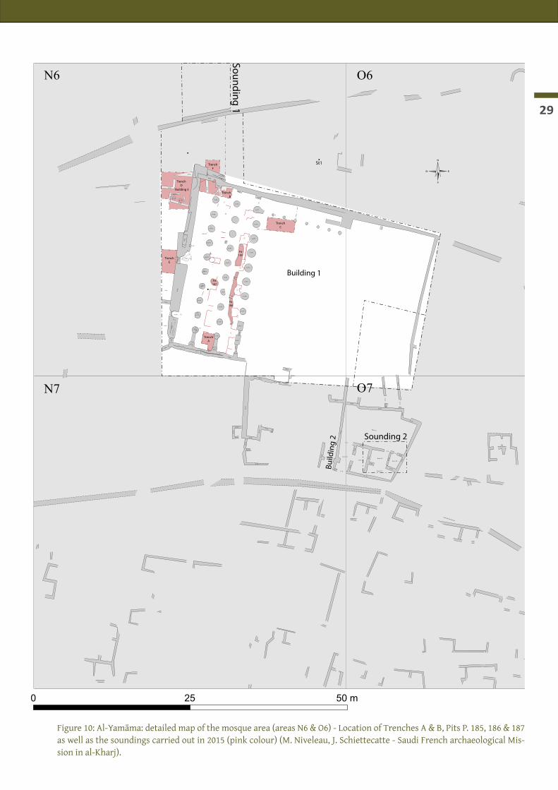
The construction straddles areas N6 and O6, in the northern part of the site (figs. 10-12).

Al-Kharj - Report of the 4th season - January-February 2015
28
During the first excavation season (2011), the north-west corner of a large columned hall that was partly visible on surface was exposed in the southern part of Sounding 1. Two large mudbrick walls (W. 002, ori-ented E–W, and W. 006, oriented N–S) bordering a room (R. 013) with a plastered floor (F. 015) and two large mudbrick columns standing on this floor (Co. 004–005) were brought to light. This construction was labelled Building 1.During the second season (2012), we concentrated our efforts on the excavation of the western and central naves of the columned hall. Several things proved it to be the Great Mosque of the site (fig. 10): the pres-ence of a large columned hall with three rows of ten columns preceded by a large courtyard to the east and a square recess (miḥrāb) built in the middle of the western wall (qibla wall). The fact that very few artefacts were found, despite sieving the fill and rubble, also supported this interpretation.The third season (2013) was devoted to pursuing and extending the excavation of the prayer room and part of the courtyard (area N6, Building 1).In the fourth season (2015), both the prayer room (R. 013) and the courtyard were entirely cleared. Three pits dug through the plaster floor F. 015 were emptied. Two trenches were dug under floor F. 015 (Trench A & B). Soundings were carried out in the north-western corner of the courtyard (Trench C), west of the mosque (Trenches D & E) and to the north of the mosque (Trench F) (fig. 10 & fig. 12: coloured areas).The aim was to define the earliest occupation of the mosque (Building 1) and to characterize previous strati-graphical and architectural phases before the construction of Building 1. The foundations were reached in trenches A, B and E. Older structures (Buildings 3, 4 and 5) were identified.
Sounding 1
Sounding 2
Sounding 3 Sounding 4
A B C D E F G H I J K L M N O P Q R
1
2
3
4
5
6
7
8
9
10
11
12
13
14
15
16
17
18
19
20
21
47°21'20"E
47°21'20"E
47°21'10"E
47°21'10"E
47°21'0"E
47°21'0"E
47°20'50"E
47°20'50"E
24°11'40"N 24°11'40"N
24°11'30"N 24°11'30"N
24°11'20"N 24°11'20"N
24°11'10"N 24°11'10"N
0 100 200 300m
Fenced area
Fenced area Fe
nced
are
a
©
Cemetery
Camel enclosure
Modern building
Fence
Road
Figure 9: al-Yamāma: top-ographic map of the site
(M. Niveleau, J. Schiette-catte - Saudi French ar-chaeological Mission in al-Kharj).
29
TrenchA
0 25 50 m
©
Sounding 2
Sounding 1Bu
ildin
g 2
St1
N6 O6
O7N7
TrenchB
TrenchC
Pit185
Pit186
Pit187
TrenchD
Building 5
Building 1
TrenchE
TrenchF
Empreinte
W.034
W.035
W.036
W.0
56
W.120
A.123
W.122
W.1
24
W.127
W.128
W.1
26
W.1
19
W.1
18
A.137
W.117
W.106
A.115A.111
W.103
W.1
02W.1
07
W.10
0
W.101
A.125
W.129
W.1
34A
.135
W.1
33 W.1
32
Room 112
W.130
W.1
31
A.1
38
W.151
W.152
W.1
50
W.146
W.1
47
W.148
W.1
49
W.1
44
W.143
W.145
W.1
42
W.156
A.154W.140
W.1
39
W.153
Co.023
Co.022
Co.021
Co.020
Co.019
Co.018
Co.017
Co.016
Co.005
Co.004
Co.033
Co.030
Co.029
Co.028
Co.027
Co.026
Co.025
Co.024
Co.053
Co.054
Co.055
Co.060
Co.061
Co.082
Co.075
Co.076
Co.077
W.002
W.208
W.207
W.205
W.228
W.205b
W.003
W.227
W.225
W.062
W.037
W.043
W.0
06
Room 136
Room 113Room 109
Room 110
Room 108
W.078
W.079
W.0
44
W.0
06
Ni.049W.0
50W
.051
W.063
W.067
Ni.047
P.04
1
P.040
P.038
P.01
2
P.009
W.0
81
F.065
F.066
W.220
W.221
W.231
W.229
St.218
St.226
Figure 10: Al-Yamāma: detailed map of the mosque area (areas N6 & O6) - Location of Trenches A & B, Pits P. 185, 186 & 187 as well as the soundings carried out in 2015 (pink colour) (M. Niveleau, J. Schiettecatte - Saudi French archaeological Mis-sion in al-Kharj).

Al-Kharj - Report of the 4th season - January-February 2015
30
Figure 11: Aerial view of Building 1 (Mosque) (Thomas Sagory - Saudi-French archaeological mission in al-Kharj).
©St1
TrenchB
TrenchC
Pit185
Pit186
Pit187
Building 5
TrenchA
Empreinte
W.034
W.035
W.036
W.0
56
W.1
33 W.1
32
W.156
A.154W.140
W.1
39
W.153
Co.023
Co.022
Co.021
Co.020
Co.019
Co.018
Co.017
Co.016
Co.005
Co.004
Co.033
Co.030
Co.029
Co.028
Co.027
Co.026
Co.025
Co.024
Co.053
Co.054
Co.055
Co.060
Co.061
Co.082
Co.075
Co.076
Co.077
W.002
W.208
W.207
W.205W
.228
W.205b
W.003
W.227
W.225
W.062
W.037
W.043
W.0
06
W.078
W.079
W.0
44
W.0
06
Ni.049W.0
50W
.051
W.063
W.067
Ni.047
P.04
1
P.040
P.038
P.01
2
P.009
W.0
81
F.065
F.066
W.220
W.221
W.231
W.229
St.218
St.226
Co.031
Co.032
Co.098
Co.162
Co.163
Co.165
Co.167
Co.168
Co.169
Co.193
W. 172
W. 213
W. 200
W. 214
W. 201
W. 216
St. 175
St. 174
St. 173
St. 176
W. 188
W. 215
W. 203
W. 212
W. 093
W. 092
W. 091
W. 090
W. 217TrenchD
TrenchE
TrenchF
W.0
06
P. 088
R. 222R. 223
(UF 149)
Figure 12: Al-Yamāma. Plan of Building 1: white: working area; pink= pits and trenches; yellow= levelled mud-brick structures (Building 3) (M. Niveleau & J. Schiettecatte - Saudi-French archaeological mission in al-Kharj).

31
Stratigraphy of Building 1 in the prayer Hall (R. 013)
The large south-north baulk (28x1,5 m) was still standing in the south-ern half of the eastern nave of Building 1. The baulk has been entirely removed this season in order to clear the eastern nave of R. 013 in Build-ing 1 and to have a complete overview of the plaster floor F. 015. Its re-moval showed 5 occupation phases already described in the rest of the prayer room (R. 013) during the previous field seasons (2012, 2013), in particular in the central miḥrāb area. These occupations are presented from the most recent to the oldest one.
The 5th occupation level (F. 039)The last remnants of the 5th occupation level of Building 1 were floor F. 039, a crust of hardened sand. This floor was abutting small mudbrick walls built between the different columns of the eastern row, thus clos-ing the access between the courtyard and R. 013 (figs. 13-14): W. 058 closing the access between Co. 054 and Co. 053, made of three courses of mudbricks of undetermined size, and W. 059 between Co. 054 and Co. 055, made of one course of mudbricks. These walls were directly built above a sand accumulation (UF 104, 105, 106).During the previous seasons, this 5th occupation had already been characterized by the restoration of a thin mudbrick wall (W. 044) made of irregular mudbricks at the back of the central miḥrāb (Ni. 160).
UF 104UF 105-106UF 108
TrenchB
Pit 185
Pit 186
Pit187
TrenchD
Building 5
TrenchA
W.034
W.035
W.036
W.056
Co.023
Co.022Co.021
Co.020
Co.019
Co.018
Co.017Co.016
Co.005
Co.004
Co.033
Co.030
Co.031
Co.032
Co.029
Co.028
Co.027
Co.026Co.025
Co.024
Co.053Co.054
Co.055
Co.060
Co.061Co.075
Co.076Co.077
W.002
W.207
W.205
W.228
W.205b
W.003W.227
W.225
W.062
W.037
W.043
W.006
W.078
W.079
W.044
W.006
Ni.049
W.050W.051
W.063
W.067
Ni.047
P.041P.040
P.038
P.009
W.081
F.065
F.066
W.231
W.229
St.218
St.226
A.177A.178 A.179
A.180
Figure 13: Al-Yamāma, Building 1. Late mudbrick wall W. 058 between Co. 053 and Co. 054 built above sand deposit - look-ing west (A. Rosak - Saudi-French archaeological mission in al-Kharj).
Figure 14: Al-Yamāma, Building 1. Late mudbrick wall W. 059 between Co. 054 and Co. 055 built above sand deposit - look-ing west (A. Rosak - Saudi-French archaeological mission in al-Kharj).
The 4th occupation level (F. 046, UF 104)Under F. 039, a 30-cm-thick eolian sand deposit recovered another thin floor, F. 046. This brownish-orange soft sand layer yielded few artefacts (4 sherds, 1 iron pin [Y.104.1] after sieving). The sediment of UF 104, between floors F. 039 and F. 046 was sampled for archaeobotanical investigations but no botanical rest have been found in spite of careful sieving (see Bouchaud’s report). At the bottom of UF 104, floor F. 046 was a thin hardened sandy crust which was only partially preserved.During the previous seasons, this 4th occupation phase had already been characterized by the building of a thin mudbrick wall (W. 044) made of irregular mudbricks at the back of the central miḥrāb (Ni. 160).In the courtyard, the peristyle to the north of the courtyard bordered by small columns built during the pre-vious phase (3rd occupation phase) was destroyed as indicated the collapse of Co. 193 and its capital (W. 172) on the floor of the courtyard (F. 086). As only one of the 9 capitals were found in the courtyard, we might guess that the large stones and mudbricks used in these capitals were then reused in the restoration of the prayer hall. It was also probably at this period that two long pits were dug in the courtyard, P. 194 and P. 195.

Al-Kharj - Report of the 4th season - January-February 2015
32
The 3rd occupation level (F. 014, UF 105)Under floor F. 046, an eolian deposit of soft brownish orange sand (UF 105) was recovering floor F. 014. This layer only yielded few artefacts including an iron pin (Y.105.1), a fragment of a glass bangle (Y.105.3) and a musket bullet (Y.105.4), both indicative of a modern occupation (17th-18th centuries). No botanical remains were found; faunal remains included 7 camel bones, 10 caprine bones and a single ostrich egg-shell fragment.F. 014 was an irregular sandy crust partially preserved by patches (fig. 15). In the courtyard, the constructions of a thick hardened and irregular surface is contemporary to the lay-ing of floor F. 014. Moreover nine small columns bordering a peristyle to the north of the courtyard were built. As shown during the previous season, the central miḥrāb (Ni. 160) was opened to the west during this occupation phase.
The 2nd and 1st occupation levels (F. 015 and his fifth sub-phases, UF 106, UF 108)Under F. 014, an orange soft sand layer, c. 15-20 cm thick, was removed (UF 106, equivalent to the last sea-son UF 030), and floor F. 015 was fully uncovered (fig. 16). The sieving of the sediment yielded 41 sherds, a few bones of camel, caprine, lizard, chicken and other birds, and a few charcoals. This material could be intrusive and linked to rejection from the digging of pits through F. 015 (fig. 16, left). Indeed, two long pits (P. 185, P. 186) have been dug in the eastern nave, most probably for the reuse of older building material. They have been excavated after the building of F. 015, which has been smashed down during the digging, and before F. 014 was laid down. In the southern half of the central nave, during the season 2013, a col-lapse of mudbricks was found (UF 089) between F. 014 and F. 015 (fig. 17). The 2015 excavations revealed that it corresponded to the top of the filling of a third pit (P. 187).Thanks to the removing of the long baulk in the eastern nave, we had a complete view of the prayer hall of Building 1 (figs. 11, 16). The whitish-grey hardened floor F. 015 appears very damaged in the eastern nave. During the two last seasons (2012 and 2013), 13 game boards engraved on floor F. 015 were found. The now complete clearing of F. 015 led to the discovering of 5 additional engraved game boards (fig. 18): two of the so-called type “game of the fourteen”, one of the “alquerque” type, one being a circle, and one a rectangle made of three successive lines whose purpose is still unclear. This corpus of 18 game boards is a unique set.A careful observation of F. 015 showed several sub-phases including at least two phases of occupation (1st and 2nd occupation phases of Building 1). The first corresponds to the building of the mudbrick columns above F. 015. The second phase of occupation is characterized by the restoration of floor F. 015 with a thick coating of compacted clayey earth (up to 5-6 cm) (fig. 19).If floor F. 015 was used in Building 1 as a flat surface supporting the columns, it is in fact much older than this building and belong to another earlier architectural structure, Building 3, whose remains are levelled on the ground and only partially visible (fig. 12: yellow parts). It has been already noticed during the previous seasons that F. 015 was abutting levelled structures built in mudbrick. New levelled structures were discovered in the eastern nave (W. 214, W. 201, W. 205, W. 213, W. 203, W. 212 - figs. 20-21), abutted by F. 015. They were also covered by the earthen coating restoration of the floor during the 2nd occupation phase of Building 1.In the eastern nave, the earthen coating restoration of the floor was present almost everywhere. This layer of restoration (UF 108) has been removed. Where F. 015 was not preserved prior to the restauration, we directly uncovered another plaster floor (F. 182) which belongs to Building 3 and was laid down prior to F. 015 (see below). UF 108 is equivalent to UF 107 into Trench A.The entire eastern nave opens on to the courtyard, excepted during the 5th occupation phase, when walls were closing the space between most of the columns. During the 1st, 2nd and 3rd phases, the correspond-ing floors F. 015 and F. 014 were connected to a built threshold. Corresponding to F. 015, eleven doorsteps

33
Figure 15: Al-Yamâma - area N6 - Build-ing 1. Base of UF 105, floor F. 014 partially preserved. Looking north (J. Schiette-catte - Saudi-French archaeological mis-sion in al-Kharj).
Figure 16: Al-Yamâma - area N6 - Building 1. Eastern (left), central (middle) and western (right) naves of the prayer hall with its plaster floor F. 015. Looking south (Th. Sagory - Saudi-French archaeological mission in al-Kharj).
Figure 17: Al-Yamâma - area N6 - Building 1. UF 089 over floor F. 015. Looking south-east (P. Siméon - Saudi-French archaeo-logical mission in al-Kharj).

Al-Kharj - Report of the 4th season - January-February 2015
34
A
DCBFigure 18: Al-Yamāma, Building 1, R. 013. Game boards engraved on floor F. 015: A) game board no 14 of the albuquerque type; B) game boards no 15 & 16 of the “game of the fourteen” type; C) game board no 17, unknown rectangular type; D) game board no 18, unknown circular type (P. Siméon - Saudi French archaeological mission in al-Kharj).

35
Figure 19: Al-Yamāma, Building 1, R. 013. Floor F. 015 with earthen coating restoration (J. Schiette-catte - Saudi French archaeological mission in al-Kharj).
Figure 20: Al-Yamāma, Building 1, R. 013. Lev-elled pillar W. 213, east of the pit P. 186. Looking east (P. Siméon - Saudi French archaeological mission in al-Kharj).
Figure 21: Al-Yamāma, Building 1, R. 013. Lev-elled pillar W. 201, east of the pit P. 186. Looking east (P. Siméon - Saudi French archaeological mission in al-Kharj).

Al-Kharj - Report of the 4th season - January-February 2015
36
were built with flat stones between each columns and pillars (figs. 22-23); they probably remained un-touched when floor F. 015 was restored. Their stones, by size and type, are almost similar to the stones of wall W.235 (partially covered by F. 015 and belonging to Building 3). Stones could have been reemployed and might come from the pits P. 185 and P. 186. Threshold connected to F. 014 are made of packed earth (fig. 23).
Trench C in the north-western corner of the courtyard
In the north-western corner of the courtyard, in 2013, we pulled out of the sand on a 7-m-wide band south of the northern wall (W. 002). Nine small columns were found aligned (fig. 12), forming a portico (riwāq). Stratigraphic sequence (figs. 26-30) give an over-view of the levels related to Building 3 and they complete architec-tural observations made in Trenches A and B (see below).It appears that the small columns were built on F. 014 (figs. 24-25, fig. 28). C. 45 cm under F. 014, two successive plaster floors were built: F. 182 and F. 192. The upper floor F. 182 was built on a 20-cm-thick layer of packed greyish earth with angular pebbles and whites grits. The oldest built floor (F. 192) was built on a homogeneous yellowish packed earth level, c. 15 cm thick.Both floors F. 182 and F. 192 were cut by two large and long pits P. 194 and P. 195 (figs. 28-29). P. 195 recuts the second P. 194. P. 195 was filled with eolian sand and fragments of mudbrick (UF 135). The filling of P. 194 (UF 121) included many rounded pebbles at the bottom, probably coming from the partially destroyed preparation of F. 192.Both pits end on a level of melted mudbrick (F. 190/UF 124). This level was once exposed to the weathering as indicated by traces of water streaming on its surface (fig. 25). This level is reminiscent of the UF 151 found in Trench B (figs. 64-65). This layer of melted mudbrick covered a mudbrick structure preserved over three courses of square mudbricks (38×38×8-9 cm) with 5-cm-thick joint. This structure was built directly above eolian sand (fig. 31). The size of its bricks are identical to those of the structures visible on the ground of F. 015 (W. 200, 201, 203, 212, 213, 216). These structures pre-existing Building 1, are part of Building 3.To the north-east of the courtyard, at the end of the peristyle, we found in 2013 an architectural geometric element (W. 172) interpreted at the time as a merlon or a crow step. Enlargement of excavation in this area revealed in fact a capital made of mudbricks and large flat stones connected to the small column Co. 193 (figs. 32-34). Part of the column shaft was lying on the ground, on floor F. 086 (corresponding to F. 046 inside the prayer hall R. 013, i.e. the 4th occupation level. According to the different fragments of column Co. 193 and its capital, the minimal height of the small columns in the peristyle was 1.72 m. Since no other capital was found during the excavations, we can guess they have been taken down and there materials reused elsewhere.
The Southern part of the courtyard
The northern wall of room R. 099 (W. 153), belonging to a house abutting the mosque to the south, had col-lapsed in the courtyard of the mosque. Uncovered in 2013, the wall was removed this season (UF 112) in order to clarify extension of F. 086. As observed during 2013 season. Its mudbricks were convex and rectan-gular (33×25×8 cm) (fig. 35). No material was found into the wall structure. As stated in the previous report (2013), this house belong to the last period of occupation of al-Yamāma (17th-18th centuries).
TrenchA
025
50 m
©
Sounding 2
Sounding 1
Building 2
St1
N6
O6
O7
N7
TrenchB
TrenchC
Pit185
Pit186
Pit187
TrenchD
Building 5
Empreinte
W.034
W.035
W.036
W.056
W.120
A.123
W.122
W.124
W.127
W.128
W.126
W.119
W.118
A.137
W.117
W.106
A.115
A.111
W.103
W.102
W.107
W.100
W.101
A.125
W.129
W.134 A.135W.133
W.132
Room 112
W.130
W.131
A.138
W.151
W.152
W.150
W.146
W.147W
.148
W.149
W.144
W.143
W.145
W.142
W.156
A.154
W.140
W.139
W.153
Co.023 C
o.022
Co.021 C
o.020 Co.019
Co.018 C
o.017
Co.016 C
o.005 Co.004
Co.033
Co.030
Co.029
Co.028
Co.027
Co.026
Co.025
Co.024
Co.053
Co.054
Co.055
Co.060 C
o.061
Co.082
Co.075 C
o.076
Co.077
W.002
W.208
W.207
W.205
W.228
W.205b
W.003W.227
W.225
W.062
W.037
W.043
W.006
Room
136
Room
113R
oom 109
Room
110
Room
108
W.078
W.079
W.044
W.006
Ni.049
W.050W.051
W.063
W.067
Ni.047
P.041P.040
P.038
P.012
P.009
W.081
F.065
F.066
W.220
W.221
W.231
W.229
St.218
St.226

37
Figure 22: Al-Yamāma, Building 1. Threshold between R. 013 and the courtyard, and W. 078 and Co. 077, contemporary to F. 015. Three stones on the outer side; two mudbricks on the inner side. Looking east (P. Siméon - Saudi French archaeo-logical mission in al-Kharj).
Figure 23: Al-Yamāma, Building 1. Threshold between R. 013 and the courtyard, and Co. 054 and 055, contemporary to F. 015 and F. 014. Looking east (P. Siméon - Saudi French ar-chaeological mission in al-Kharj).
▼ Figures 24-25: Al-Yamāma, Building 1, courtyard. Trench C. Left: Looking south; right: Looking north (P. Siméon - Saudi French archaeological mission in al-Kharj).

Al-Kharj - Report of the 4th season - January-February 2015
38NS
0 1 2 m
alt. (m)429
428
Mudbrick
Stone
Sediment with mudbrick fragments
Sand
Plaster/lime
Ashes
Plaster fragments
Aeolian sand with mudbrick fragments
Aeolian with mudbrick fragments
F. 192
F. 182
Preparation of F. 014 = rounded pebbles (west-east slope)
Excavated in 2013
Surface in courtyard
Yamama 2015 - N6 - Trench CWest baulk
SN
0 1 2 m
alt. (m)429
428
Mudbrick
Stone
Sediment with mudbrick fragments
Sand
Plaster/lime
Ashes
Plaster fragments
Aeolian sand with mudbrick fragments
Yamama 2015 - N6 - Trench CEast baulk
F. 192
F. 014 F. 014
F. 190
F. 182Ashes +charcoal
Figure 26: Al-Yamāma, Building 1, courtyard. Trench C: west baulk (P. Siméon/A. Emery - Saudi French archaeological mission in al-Kharj).
Figure 27: Al-Yamāma, Building 1, courtyard. Trench C: east baulk (P. Siméon/A. Emery - Saudi French archaeological mission in al-Kharj).

39
0 1 2 m
WE
alt. (m)429
428
427
Mudbrick
Stone
Sediment with mudbrick fragments
Sand
Plaster/lime
Ashes
Plaster fragments
P. 195 Numerous rounded mudbrick fragments + stone �akes
P. 194 Rond pebbles at the bottom + mudbrick fragments, more aeolian sand than in P. 195
Ashes
Yamama 2015 - N6 - Trench CSouth baulk
P. 195
UF 121
P. 194
F. 190
Aeolien
AeolienAeolien
Aeolien + mudbrick fragments + pebbles
Aeolien
Pottery
Destruction
F. 192
F. 182F. 014
F. 014F. 014
0 1 2 m
EW
alt. (m)429
428
Mudbrick
Stone
Sediment with mudbrick fragments
Sand
Plaster/lime
Plaster fragments
Yamama 2015 - N6 - Trench CNorth baulk
F. 192
F. 014F. 014
Co. 098
Co. 082
F. 182
AeolienUF 121
P. 194 P. 195
limepebbles ?
pottery (cad 15 sampled)38 × 38
38 × 38 × 1038 × 38 × 10
Figure 28: Al-Yamāma, Building 1, courtyard. Trench C: north baulk (P. Siméon/A. Emery - Saudi French archaeological mission in al-Kharj).
Figure 29: Al-Yamāma, Building 1, courtyard. Trench C: south baulk (P. Siméon/A. Emery - Saudi French archaeological mission in al-Kharj).

Al-Kharj - Report of the 4th season - January-February 2015
40
Figure 30: Al-Yamāma, Building 1, courtyard. Trench C: strati-graphic chart (P. Siméon - Saudi French archaeological mission in al-Kharj).
Figure 31: Al-Yamāma, Building 1. Trench C: W. 196 at the bottom of the trench (P. Siméon - Saudi French archaeological mission in al-Kharj).

41
◄ Figure 32: Al-Yamāma, Building 1, Courtyard. Bases of the small columns of the peristyle bordering the courtyard to the north. Looking west (P. Siméon - Saudi French archaeological mission in al-Kharj).
▲ Figure 33: Al-Yamāma, Building 1, Courtyard. Small column Co. 193 and its capital W. 172. Looking south (P. Siméon - Saudi French archaeological mission in al-Kharj).
Figure 34: Al-Yamāma, Building 1, Courtyard. Small column Co. 193 and its capital W. 172. Looking east (P. Siméon - Sau-di French archaeological mission in al-Kharj).
Figure 35: Al-Yamāma, Building 1, Courtyard. Small column Co. 193 and its capital W. 172. Looking south (P. Siméon - Saudi French archaeological mission in al-Kharj).

Al-Kharj - Report of the 4th season - January-February 2015
42
Trench A & B: excavation of Building 3, a monumental structure under Building 1
Previous excavations (2012-2103 seasons) of the central miḥrāb (Ni. 160) damaged by pit (P. 040) and inves-tigations over the floor F. 015 (2011-2013 seasons) reveal the existence of a former monumental building with at least 13 pillars and a former columned hall visible to the north of the central nave (fig. 12: yellow structures). A closer look at F. 015 from pit P. 187 shows a long fault turned north-south corresponding to the vertical limit of a plastered vertical face of a wall(?) running down the central nave of Building 1 over at least 6 meters (figs. 36-37). This fracture line visible on F. 015 indicates a rupture. The western face of this vertical structure is coated with grooved plaster; this could belong to the first stage of Building 3. Plaster elements were found in the upper part of the filling of P. 187 in 2013 (UF 089: Y.089.1), and in Trench B (UF 133) (fig. 38-39) which should be somehow connected to this grooved plaster coating.
In order to have a clearer knowledge of this Building 3 and previous buildings, we opened two soundings within the prayer room R. 013: Trench A in the southern end of the central nave, at the foot of wall W. 043, and a second one, Trench B, in the north-west corner of R. 013, in the western and central naves, along W. 002.
Trench AUF & structures: F 107, F. 182, UF 116, UF 122, W. 188, P. 183, P. 184, UF 109, UF 110.This trench measures 2.35 × 2.70 m. It has been excavated in the southern extremity of the central nave of R. 013, between Co. 024, Co. 023, W. 034, and W. 035 (figs. 11-12; figs. 40-43).We successively removed a 5-cm-thick layer of densely packed earth above floor F. 015 (restoration of the floor) and then plas-tered floor F. 015 itself. It was resting on a 10-to-15-cm-thick layer of mixed materials (UF 107: broken fragments of plastered floor, fragments of plastered wall coating sometimes with red paint, hard clay). This constituted a dense layer which provided an horizontal surface necessary for the laying out of F. 015 (fig. 44). UF 107 was covering another plaster floor, F. 182, which was also abutting all the levelled structures of Building 3 (W. 188, St. 173, 174, 175, 176) (fig. 45). Some of the plaster fragments from UF 107 belonged to this former floor, which was broken in some parts. Almost no ceramic/faunal/botanical material was found in UF 107 with the exception of a single camel bone and 4 sherds (cat. 6, 12, 24 and 35).Two small pits (P. 183, P. 184) were going through F. 182 at the foot of pillar W. 035. Filled with eolian sand (UF 109-110), they were probably created by the water infiltration along the southern wall of Building 3 and 1 (fig. 45).Plastered floor F. 182 was laid over a 8-10-cm-thick preparation layer (UF 116). This was made of hard clay above a level of sand and small rounded stones. Lentils of white and grey rounded pebbles (fluviatile ori-gin) sometime happened between the floor and the packed earth preparation. This layer yielded 12 sherds (cat. 1, 2 and 36), 2 caprine bones and charcoals.The levelled structures St. 173 and W; 188 against which F. 182 was abutting where preserved over 2 to 3 courses of square mudbricks (38 × 38 cm).Under floor F. 182 and its preparation, there was only orange eolian sand (UF 122) with a few charcoals, 4 bones (camel, caprine), and 17 sherds (cat. 1, 2, 12, 16, 17c, 28 and 35) (figs. 40-42, fig. 46). This is indicative of a human presence nearby but no structures were found there. This layer was excavated on a thickness of 1.2 m before we decided to stop due to the narrowness of the trench (stop at 427.30 m a.s.l.).
TrenchA
025
50 m
©
Sounding 2
Sounding 1
Building 2
St1
N6
O6
O7
N7
TrenchB
TrenchC
Pit185
Pit186
Pit187
TrenchD
Building 5
Empreinte
W.034
W.035
W.036
W.056
W.120
A.123
W.122
W.124
W.127
W.128
W.126
W.119
W.118
A.137
W.117
W.106
A.115
A.111
W.103
W.102
W.107
W.100
W.101
A.125
W.129
W.134 A.135W.133
W.132
Room 112
W.130
W.131
A.138
W.151
W.152
W.150
W.146
W.147
W.148
W.149
W.144
W.143
W.145
W.142
W.156
A.154
W.140
W.139
W.153
Co.023 C
o.022
Co.021 C
o.020 Co.019
Co.018 C
o.017
Co.016 C
o.005 Co.004
Co.033
Co.030
Co.029
Co.028
Co.027
Co.026
Co.025
Co.024
Co.053
Co.054
Co.055
Co.060 C
o.061
Co.082
Co.075 C
o.076
Co.077
W.002
W.208
W.207
W.205
W.228
W.205b
W.003W.227
W.225
W.062
W.037
W.043
W.006
Room
136
Room
113R
oom 109
Room
110
Room
108
W.078
W.079
W.044
W.006
Ni.049
W.050W.051
W.063
W.067
Ni.047
P.041P.040
P.038
P.012
P.009
W.081
F.065
F.066
W.220
W.221
W.231
W.229
St.218
St.226

43
Figure 36: Al-Yamāma, Building 1, R. 013, central nave. F. 015 seen from P. 187. A vertical fault corresponds to the outer plastered face of a wall (P. Siméon - Saudi French archaeo-logical mission in al-Kharj).
▼ Figure 37: Al-Yamāma, Building 1, R. 013, central nave. De-tails of the vertical fault in F. 015 and the vertical outer plas-tered face of a wall (P. Siméon - Saudi French archaeological mission in al-Kharj).

Al-Kharj - Report of the 4th season - January-February 2015
44
Figure 39: Al-Yamāma, Trench B. Plaster moulding on the top of the filling of P. 203 (UF 133) (P. Siméon - Saudi French archaeological mission in al-Kharj).
Figure 38: Al-Yamāma, Building 1, central nave. Plaster mouldings on the top of the filling of P. 187 (UF 089) (L. Munduteguy - Saudi French archaeological mission in al-Kharj).
Figure 40: Al-Yamāma, Building 1, R. 013. Trench A: zenithal view, looking west (P. Siméon - Saudi French archaeological mission in al-Kharj).

45SN
0 1 2 m
alt. (m)
428
427
429
Mudbrick
Stone
Sediment with mudbrick fragments
Sand
Plaster/lime
Plaster fragments
Ashes
Yamama 2015 - N6 - MosqueTrench A
Pottery
UF 122
UF 107
UF 116
restauration stamped earthof F. 015
East baulk
Mudbrick fragments
F. 182
F. 192
F. 182 abutting against F. 192/red paint
cf. 2013
F. 182
F. 015
Aeolian
0 1 2 m
EW
alt. (m)
428
427
429
Yamama 2015 - N6 - MosqueTrench A
UF 122
restaurationof F. 015
North baulk
38 × 10
▲ Figure 41: Al-Yamāma, Building 1. Trench A: east baulk (P. Siméon/A. Emery - Saudi French archaeological mission in al-Kharj).
◄ Figure 42: Al-Yamāma, Building 1. Trench A: north baulk (P. Siméon/A. Emery - Saudi French archaeological mission in al-Kharj).
▼ Figure 43: Al-Yamāma, Building 1. Trench A: stratigraphic chart (P. Siméon - Saudi French archaeological mission in al-Kharj).

Al-Kharj - Report of the 4th season - January-February 2015
46
Figure 44: Al-Yamāma, Building 1, R. 013. Trench A : detail of UF 107, a preparation layer for F. 015, above F. 182 (J. Schiette-catte - Saudi French archaeological mis-sion in al-Kharj).
Figure 45: Al-Yamāma, Building 1, R. 013. Trench A : floor F. 182abutting levelled structures of Building 3 (P. Siméon - Sau-di French archaeological mission in al-Kharj).
Figure 46: Al-Yamāma, Building 1, R. 013. Trench A : UF 122 = eolian sand accumu-lation under F. 182 (P. Siméon - Saudi French archaeological mission in al-Kharj).

47
Trench BUF & structures: UF 127, UF 128, F. 182, UF 130, UF 131, UF 134, F. 192, UF 141, UF 144, UF 145, UF 147, UF 150, UF 151, UF 152, UF 153, UF 154, UF 156, UF 159, UF 160, F.224, W.255, UF 230, P. 198.In order to locate the foundations of the northern and western walls of the prayer hall (W. 002 and W. 006) as well as previous occupations, a second trench, Trench B, turned east-west, was opened in the north-west corner of the prayer hall (R. 013), at the northern extremity of the western and central naves. It measured 5 × 2 m (figs. 47-52). It was first divided in two parts with a cen-tral bench turned north-south which provided a stratigraphic se-quence of the sounding (figs. 50-51). From top to bottom, the sequence can be described as follow.Built floor F. 015 covered the 3/4 of the sounding area. It was only disturbed to the north-west by a small pit (P. 198), whose filling (UF 128) proved it to be a hearth. It went through floor F. 015 and into wall W. 199 under this floor (fig. 58); its filling included a fragment of glass and charcoals (including a carbonized date stone).The dismantling of F. 015 (UF 127) did not yield any artefact/botanical/faunal remain. In the western nave F. 015 was sometime directly built above F. 182 (UF 130) (fig. 49). In the central nave, as we observed in Trench A, F. 015 have a non-homogeneous preparation layer (UF 131) made of packed earth, plaster frag-ments and rounded pebbles forming patches (fig. 53: upper left). This layer has been prepared to equalize the irregular surface of UF 134 (fig. 49).Floors F. 182 and F. 192 were separated by a 20-to-25-cm-thick destruction layer of dense dark brown melted mudbricks and plaster fragment (UF 134 - figs. 53-55). These fragments probably came from a previous plaster floor or a wall coating.Along W. 090, to the north-east of Trench B, F. 192 was covered with a small heap of fragments of plaster coating with red painting (UF 140) (fig. 55), in some other part of the trench, accumulation of rounded pebbles (UF 136 and 143) corresponded to repair of F. 192 and levelling of its surface.Two small structures were built together with F. 192: a small pillar (W. 211) built within UF 144, the floor preparation layer of F. 192, which seems to have been an intermediate stage between northern pillars W. 090 and W. 003 (fig. 57), and small wall W. 199 (dismantled with ref. UF 142) built above F. 192 and covered by
TrenchA
025
50 m
©
Sounding 2
Sounding 1
Building 2
St1
N6
O6
O7
N7
TrenchB
TrenchC
Pit185
Pit186
Pit187
TrenchD
Building 5
Empreinte
W.034
W.035
W.036
W.056
W.120
A.123
W.122
W.124
W.127
W.128
W.126
W.119
W.118
A.137
W.117
W.106
A.115
A.111
W.103
W.102
W.107
W.100
W.101
A.125
W.129
W.134 A.135W.133
W.132
Room 112
W.130
W.131
A.138
W.151
W.152
W.150
W.146
W.147
W.148
W.149
W.144
W.143
W.145
W.142
W.156
A.154
W.140
W.139
W.153
Co.023 C
o.022
Co.021 C
o.020 Co.019
Co.018 C
o.017
Co.016 C
o.005 Co.004
Co.033
Co.030
Co.029
Co.028
Co.027
Co.026
Co.025
Co.024
Co.053
Co.054
Co.055
Co.060 C
o.061
Co.082
Co.075 C
o.076
Co.077
W.002
W.208
W.207
W.205
W.228
W.205b
W.003W.227
W.225
W.062
W.037
W.043
W.006
Room
136
Room
113R
oom 109
Room
110
Room
108
W.078
W.079
W.044
W.006
Ni.049
W.050W.051
W.063
W.067
Ni.047
P.041P.040
P.038
P.012
P.009
W.081F.065
F.066
W.220
W.221
W.231
W.229
St.218
St.226
Figure 47: Al-Yamāma, Building 1, R. 013. Trench B: general view after completion (Th. Sagory - Saudi French archaeologi-cal mission in al-Kharj).

Al-Kharj - Report of the 4th season - January-February 2015
48
01
2 mS
N
alt.
(m)
428
427
426
Mud
bric
k
Ston
e
Sedi
men
t with
mud
bric
k fr
agm
ents
Sand
Plas
ter/
lime
Plas
ter f
ragm
ents
Ash
es
Yam
ama
2015
- N
6 - M
osqu
eTr
ench
B
W. 0
90
UF
151
pott
ery
UF
134
UF
144
UF
147
UF
153
F. 1
92
F. 0
15
bott
om o
f pit
benc
h
Sect
ion
2 (N
-S)
foun
datio
n tr
ench
W. 0
90po
st B
ulid
ing
3
Figu
re 4
8: A
l-Yam
āma,
Bui
ldin
g 1.
Tre
nch
B: E
aste
rn se
ctio
n (P
. Sim
éon/
A. E
mer
y - S
audi
Fre
nch
arch
aeol
ogic
al m
issi
on in
al-K
harj
).

49W
E
01
2 m
alt.
(m)
428
427
426
Mud
bric
k
Ston
e
Sedi
men
t with
mud
bric
k fr
agm
ents
Sand
Plas
ter/
lime
Plas
ter f
ragm
ents
Ash
es
Yam
ama
2015
- N
6 - M
osqu
eTr
ench
B
pott
ery
P.2
?
F. 1
82
F. 1
92F.
192
F. 0
15F.
182
F. 0
15
UF
134
UF
144 UF
147
UF
147
UF
151 U
F 15
3
F. 2
30
UF
144
UF
134 UF
145
UF
145
UF
152
UF
150F.
192
W. 2
25
W. 2
31
W. 2
27
W. 2
37
UF
160U
F 15
9U
F 15
6
UF
155
F. 2
24 =
UF
154U
F 15
3
dest
ruct
ion
Co. 0
04
Sect
ion
1 (E
-W)
dest
ruct
ion
38 ×
38
× 10
20 ×
25
× ?
26 ×
20
× 5
38-4
0 ×
20 ×
10
7 co
urse
s
32 ×
? ×
10
9 co
urse
s
Figu
re 4
9: A
l-Yam
āma,
Bui
ldin
g 1.
Tre
nch
B: S
outh
ern
sect
ion
(P. S
iméo
n/A.
Em
ery
- Sau
di F
renc
h ar
chae
olog
ical
mis
sion
in a
l-Kha
rj).

Al-Kharj - Report of the 4th season - January-February 2015
50
0 1 2 m
N S
alt. (m)
427
428
429
Mudbrick
Stone
Sediment with mudbrick fragments
Sand
Plaster/lime
Yamama 2015 - N6 - MosqueTrench BBench - eastern side
F. 015 = surface F. 2010
F. 192
UF 134
UF 144
UF 147
facing of W. 227
0 1 2 m
alt. (m)
SN
427
428
429
Mudbrick
Stone
Sediment with mudbrick fragments
Sand
Plaster/lime
Plaster fragments
Yamama 2015 - N6 - MosqueTrench BBench - western side
F. 015
F. 192UF 134
UF 144
UF 147
UF 147
UF 151
Aeolian
Aeolian
Aeolian
Mudbrick ?
Figure 50: Al-Yamāma, Building 1. Trench B: Central bench - eastern side (P. Siméon/A. Emery - Saudi French archaeological mission in al-Kharj).
Figure 51: Al-Yamāma, Building 1. Trench B: Central bench - western side (P. Siméon/A. Emery - Saudi French archaeological mission in al-Kharj).

51
Figure 52: Al-Yamāma, Building 1. Trench B: stratigraphic chart (P. Si-méon - Saudi French archaeological mission in al-Kharj).
Figure 53: Al-Yamāma, Eastern half of Trench B: UF 131= preparation layer at the top of UF 134 (P. Siméon - Saudi French archaeo-logical mission in al-Kharj).

Al-Kharj - Report of the 4th season - January-February 2015
52
Figure 55: Al-Yamāma, Eastern half of Trench B: UF 134 over F. 192. Looking south (P. Siméon - Saudi French ar-chaeological mission in al-Kharj).
Figure 54: Al-Yamāma, Eastern half of Trench B: prepa-ration layer of F; 015. Looking south (P. Siméon - Saudi French archaeological mission in al-Kharj).
Figure 56: Al-Yamāma, Eastern half of Trench B: floor F. 192. Looking south (P. Siméon - Saudi French archaeo-logical mission in al-Kharj).
Figure 57: Al-Yamāma, Eastern half of Trench B: prepara-tion layer of floor F. 192 (top of UF 144). Looking south (P. Siméon - Saudi French archaeological mission in al-Kharj).

53
◄ Figure 58: Al-Yamāma. Western half of Trench B: suc-cession of F. 192, F. 182 and F. 015. Looking south (P. Si-méon - Saudi French archaeological mission in al-Kharj).
◄ Figure 60: Al-Yamāma. Western half of Trench B: UF 147 - eolian sand between two phases of occupation. Looking south (P. Siméon - Saudi French archaeological mission in al-Kharj).
▲ Figure 59: Trench B: fragments of plaster from F. 192 (P. Siméon - Saudi French archaeological mission in al-Kharj).
▼ Figure 61: Al-Yamāma. Trench B: UF 147 - eolian sand between two phases of occupation. Looking west (P. Si-méon - Saudi French archaeological mission in al-Kharj).

Al-Kharj - Report of the 4th season - January-February 2015
54
F. 015 (fig. 58). It comprised three courses of small square bricks (15 to 20 cm in width). The axis of this wall, north-east/south-west is different from the axes of the walls from Building 1. F. 192 is about 2-5 cm thick (UF 141). Its composition is different from the one of F. 015 or F. 182: it was made of lime and shows an abundant red, pink and greenish grit temper (figs. 56, 59). F. 192 went up on walls W. 006 (western wall) and W. 217 (NW corner of Trench B). When used as wall coating, the plaster was painted in red; it was preserved up to 20 cm high (F. 015 is abutting on it at the top). Floor F. 192 was dam-aged in the eastern part of the trench (fig. 56) and in some parts, it is simply made of densely packed earth including a lot of pebbles. F. 192 was built on a thick preparation level made of dark brown densely packed earth with straw (UF 144 - fig. 57). This layer only yielded 2 sherds (cat. 1).Under UF 144 an irregular level of aeolian sand (UF 147, 5-15 cm thick) indicates a rupture in the stratigra-phy and in the occupation of the area (figs. 48-49, 60-61). This eolian sand layer is covering a thick collapse layer (UF 145, UF 150), made of fragments of thick dark-brown mudbricks, intermingled with sand pockets. The slope of this collapse, from west to east, and the presence of fragments of mudbricks to the west indi-cate that it was a former state of wall W. 006 which fell down (see below). In the eastern half of Trench B, mudbricks laid flat on the sand (dimensions: 20-23 × 28 × 7 cm) (UF 151). In these layers, material was more abundant:
• UF 145: 16 sherds (cat. 2, 6, 12, 15, 28, 35, 36), 1 camel bone, 2 caprine bones, 1 flint, painted plas-ter coating;
• UF 147: 13 sherds (cat. 2, 16, 26, 28, 29, 35, 36), 15 caprine bones, 1 lizard bone.• UF 150: 2 sherds (cat. 2, 35).
Under this collapse, a paving covered the western side of Trench B. It was made of very large stones laid flat ion the ground (UF 152 – upper altitude 427.58 to 427.68 m a.s.l., fig. 62). We noticed that this altitude corresponded to the one of floor F. 189 (427.54 m), outside of the Building 1, just west of wall W. 006. UF 152 only yielded 2 sherds (cat. 1, 35). This paving covered a south-north wall (W. 225) (fig. 63), very eroded to the North, and a soft bright green sediment sloping from south to north (UF 154). Its aspect and texture remind latrine sediment. In the eastern half of Trench B, the mudbrick layer (UF 151) covered a 1.4-m-thick layer of eolian sand (UF 153), abutting a large brickwork to the west (figs. 64-65). This structure is made of at least three walls, one of them being hard to outline (fig. 65): on the top W. 227 (South-East/North West axis, 9 courses, bricks of 38 x 38 x 10 cm); it was partly built above W. 237, apparently perpendicular to W; 227, and which is pro-truding to the east. The altitude of its base is the same as that of W. 225 (426.90 m) (fig. 49). UF 153 yielded several animal bones (7 bones of caprine, 3 of lizard, 1 ostrich eggshell fragment) and 18 sherds (cat. 1, 2, 13, 15, 26, 35, 36).In the western half of Trench B, the mudbrick layer (UF 151 = UF 145) covered a layer of aeolian sand (UF 153). At the basis of this layer, a floor F. 224 is associated to the stone paving (UF 152) and is abutting W. 227 to the east. Floor F.224 covered a second mudbrick wall, W. 225, parallel to W. 227 and 1.5 m west of it. It is preserved over 7 courses of mudbricks (38-40 × 20 × 10 cm). Floor F.224 sealed a thick collapse layer of mudbrick fragments and sand pockets (UF 155 - fig. 63). This collapse layer was located between W. 227 and W. 225. This space was defined as room R. 234. UF 155 yielded 5 bones of caprine and 7 sherds (cat. 2, 12, 26, 36).This collapse covered an irregular mudbrick paving (UF 156, UF 159) (figs. 63, 66). Some of the bricks were c. 20 × 25 × 7 cm. They were at the same altitude than the basis of W. 225 and W. 227. This paving (UF 156, UF 159) recovered a third wall (W. 231, South-West/North-East) and an eolian sand level, UF 160 (fig. 66). Due to the narrowness of the area, we were only able to remove a limited part of this eolian sand layer to the west (UF 160). W. 225 appeared to be built directly on it.Excavation was stopped on the sand layer UF 153 in the eastern half and UF 160 in the western half, at an altitude of 426.32 m (east) and 426.77 m (west) (figs. 65-66).

55
Figure 62: Al-Yamāma. Western half of Trench B: stone paving (UF 152). Look-ing south (P. Siméon - Saudi French ar-chaeological mission in al-Kharj).
Figure 64: Al-Yamāma. Eastern half of Trench B: eolian sand layer (UF 153) against wall W; 227. Looking south (P. Siméon - Saudi French archaeological mission in al-Kharj).
Figure 63: Al-Yamāma. Western half of Trench B: stone paving (UF 152) and wall W. 225. Looking south (P. Si-méon - Saudi French archaeological mission in al-Kharj).

Al-Kharj - Report of the 4th season - January-February 2015
56
Figure 65: Al-Yamāma. Trench B: eolian sand layer (UF 153) against walls W. 227 & W; 237. Looking west (P. Siméon - Saudi French archaeological mission in al-Kharj).
▼ Figure 66: Al-Yamāma. Western half of Trench B after completion. Looking south (P. Siméon - Saudi French ar-chaeological mission in al-Kharj).

57
Pits in the prayer hall (P. 185, P. 186, P. 187)Two long and narrow north-south pits (P. 185 and P. 186) and a large ovoid pit (P. 187) appears in the central and eastern naves (fig. 67). They are going through F. 015. The three pits P. 185, P. 186 and P. 187 provide interesting and complementary stratigraphi-cal sections under floor F. 015 and under Building 1 and Building 3 (levelled structures and their different floors F. 182 and F. 192). Traces of digger tools were clearly visible on pillar W. 201, some-how similar to traces already observed in the pit dug through the main miḥrāb (Ni. 160, see the report of the 2012 season).
Pit 185 (UF 111, W. 203, W. 215)P. 185 is a narrow and elongated pit (3.50 × 0.75 m) dug through floor F. 015, from the levelled pillar W. 203 to the north, to the levelled pillar W. 215 to the south (figs. 67-69). The hardness of these pillars might have compelled the diggers to stop extending the pit. The pit was filled with a thick layer of homogeneous eolian sand (UF 111) (figs. 68-69), numerous fragments of mudbrick (undetermined size, 8-10 thick), rare large stones (max 30 × 30 cm), and fragments of plastered floors F. 015 and F. 182. UF 111 also included a large amount of camel (44) and caprine (16) bones, and 16 sherds (cat. 2, 14, 15, 35, 36 and 42). Three rims of dark brown burnished ware and red slip ware were found in the bottom filling.In the eastern section, a sequence similar to the one observed in Trench A can be seen (fig. 68): plastered floor F. 192 goes up on the outer face of mudbrick structures only preserved on 2 or 3 courses (W. 203 and W. 215). These structures were levelled during the construction of Building 1. F. 192 is recovered by a prepa-ration layer of the plaster floor F. 182. This latter is recovered by packed earth which might have been ei-ther the preparation layer for F. 015 or repairs done in the places where F. 015 was missing during the 2nd occupation of the mosque (cf. above). A difference with Trench A is the presence of a horizontal layer of mudbricks laid flat on the sand. Their function is unclear.
Pit 186 (UF 115, W.220, W.221, R.233)Floor F. 015 was smashed down by the digging of a second pit (P. 186), one meter south of P. 185. It is in the same axis, along the eastern nave of the mosque. it is a long and narrow pit (8.50 × 0.75 m) (fig. 67, 69-70, 72). The pit was filled up with a homogeneous layer of eolian sand (UF 115) similar to the one described in P. 185 (mudbrick fragments where less numerous). A fragment of a yellow fired brick with vegetal temper (5 cm thick) was found in this pit. P. 186 cut two massive pillars (W. 201 and W. 213 - see figs. 20-21), which are parts of the levelled structures of Building 3. These structures are preserved over 3 to 4 courses of square mudbricks (two sizes 34-38 × 8-10 cm and 25 × ?× 10 cm) (fig. 72).At the bottom of P. 186, two small mudbrick walls appeared, W.220 and W.221, oriented South-East/North-west (fig. 70). Part of their bricks had been removed when the pit where initially dug, the aim of these pits being probably to extract building material. 24 sherds were found in this pit (cat. 2, 5, 6, 12, 13, 15, 26, 35, 36 and 42). The presence of the type 15 (red ware with grey-black core and very abundant chaff temper) is interesting since this type is up-to-now only attested in the preislamic layers from the bottom of Sounding 1 (Phase 4: 4th-1st cent. BC) (see report 2012 and Schiettecatte & Siméon in press). A dating only based on this sherd in an eolian sand layer however would be too rash.
Pit 187 (UF 114)This ovoid pit (1.10 × 1.37 m) has been dug through floor F. 015 in the central nave of R. 013, between Co. 019, 020, 027, and 028 (figs. 67, 71). The top of pit P. 187 already partially appeared in the 2013 season. at the bot-tom of UF 082, just under F. 014 (4th occupation level of Building 1). Its top was filled with fragments of fired
TrenchA
025
50 m
©
Sounding 2
Sounding 1
Building 2
St1
N6
O6
O7
N7
TrenchB
TrenchC
Pit185
Pit186
Pit187
TrenchD
Building 5
Empreinte
W.034
W.035
W.036
W.056
W.120
A.123
W.122
W.124
W.127
W.128
W.126
W.119
W.118
A.137
W.117
W.106
A.115
A.111
W.103
W.102
W.107
W.100
W.101
A.125
W.129
W.134 A.135W.133
W.132
Room 112
W.130
W.131
A.138
W.151
W.152
W.150
W.146
W.147
W.148
W.149
W.144
W.143
W.145
W.142
W.156
A.154
W.140
W.139
W.153
Co.023 C
o.022
Co.021 C
o.020 Co.019
Co.018 C
o.017
Co.016 C
o.005 Co.004
Co.033
Co.030
Co.029
Co.028
Co.027
Co.026
Co.025
Co.024
Co.053
Co.054
Co.055
Co.060 C
o.061
Co.082
Co.075 C
o.076
Co.077
W.002
W.208
W.207
W.205
W.228
W.205b
W.003W.227
W.225
W.062
W.037
W.043
W.006
Room
136
Room
113R
oom 109
Room
110
Room
108
W.078
W.079
W.044
W.006
Ni.049
W.050W.051
W.063
W.067
Ni.047
P.041P.040
P.038
P.012
P.009
W.081F.065
F.066
W.220
W.221
W.231
W.229
St.218
St.226

Al-Kharj - Report of the 4th season - January-February 2015
58
Figure 67: Al-Yamāma, Building 1, R. 013. Pits dug through F. 015 (P. Siméon - Saudi French archaeological mission in al-Kharj).
SN
SN
0 1 2 m
alt. (m)429
428
427
Mudbrick
Stone
Sediment with mudbrick fragments
Sand
Plaster/lime
Plaster fragments
Bone
Yamama 2015 - P. 185Plan and section
W. 215
W. 215F. 192on stamped earth
F. 190 (?)on mudbricks
F. 182
P. 185
3 states of F. 182
F. 192
40 × 1010 33 × 11 35 × 11 43 × 11
Figure 68: Al-Yamāma, Building 1, R. 013. Pit P. 185: plan and eastern section (P. Siméon/A. Emery - Saudi French archaeological mission in al-Kharj).
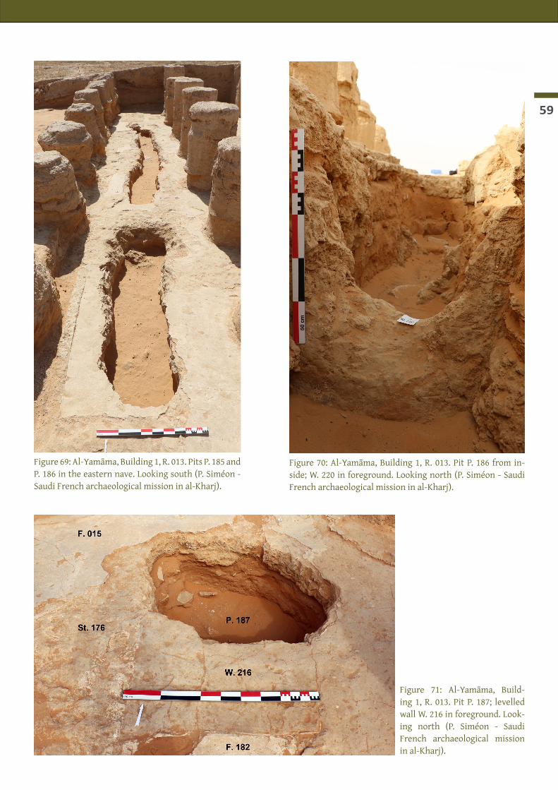
59
Figure 69: Al-Yamāma, Building 1, R. 013. Pits P. 185 and P. 186 in the eastern nave. Looking south (P. Siméon - Saudi French archaeological mission in al-Kharj).
Figure 70: Al-Yamāma, Building 1, R. 013. Pit P. 186 from in-side; W. 220 in foreground. Looking north (P. Siméon - Saudi French archaeological mission in al-Kharj).
Figure 71: Al-Yamāma, Build-ing 1, R. 013. Pit P. 187; levelled wall W. 216 in foreground. Look-ing north (P. Siméon - Saudi French archaeological mission in al-Kharj).

Al-Kharj - Report of the 4th season - January-February 2015
60
SN
SN
01
2 m
alt. (m)
429
428
427
Mudbrick
Stone
Sediment w
ith mudbrick fragm
ents
Sand
Plaster/lime
Plaster fragments
destruction /plaster
destruction
destruction
Yamam
a 2015 - P. 186Plan and section
W. 221
W. 221
W. 220
W. 220
W. 201
W. 213
F. 182F. 182
F. 182F. 015
F. 015
Pottery (sampled)
Aeolian
F. 182F. 182
F. 182 (1st state)
destruction
destruction
destruction
Aeolian
bottom of pit
bottom of pit
destructiondestruction
numerous brick
fragments
Aeolian
Aeolian
built �oor level≈ F. 192 ?
equivalent UF 122 (Sounding 1)
UF 153 (Sounding 2) ?
plaster fragments
+ medium
-sized pebbles
pebbles and plaster
rounded pebbles
plaster fragments
bottom of pit
P. 186
25 × 10
34 × 736 × 8-9
26 × 8
top : 3 mudbricks 23 × 9
bottom : 1 m
udbrick 24 × 7 with prep. F. 182
23 × 10
34 × 8
Figure 72: Al-Yamām
a, Building 1, R. 013. Pit P. 186: plan and eastern section (P. Siméon/A. Em
ery - Saudi French archaeological mission in al-Kharj).

61
Figure 73: Al-Yamāma, Building 1, R. 013. Pit P. 187; levelled wall W. 216 and St. 176. Looking south (P. Siméon - Saudi French archaeological mis-sion in al-Kharj).
Figure 74: Al-Yamāma, Building 1, R. 013. Pit P. 187; levelled structure St. 176. Looking south-west (P. Si-méon - Saudi French archaeological mission in al-Kharj).
Figure 75: Al-Yamāma, Building 1, R. 013. Pit P. 187; superimposition of F. 182 and F. 015 with their prepara-tion layer in packed earth. Looking south-east (P. Siméon - Saudi French archaeological mission in al-Kharj).

Al-Kharj - Report of the 4th season - January-February 2015
62
bricks, stones and fragment of plastered floor F. 015, associated with four sherds (types 6 and 35).The filling of the pit (UF 114) was made of eolian sand, rare fragments of mudbrick, fragments of F. 015 and pre-existing plaster floor F. 182 mixed with numerous broken whitish calcareous stones. At the bottom of the pit, an accumulation of mixed material is clearly different from the eolian filling above it. Unfortunately the area was to narrow to be excavated without being sanded up by the benches. Only two sherds were re-covered (cat. 1) and very few bones (undetermined).In the upper part of the south-western section, a square pillar, W. 216, is built in mudbrick and only pre-served over a single course; it is abutting a strong masonry made of large stones (40-50 cm) tied with a lime-based mortar. They are levelled at the height of F. 015 which is abutting on them (figs. 73-74). Large stones were missing into P. 187/UF 114, the aim of this pit being precisely the reuse of extracted building material. Against W. 216, the two floors, F. 015 and F. 182, already described in Trench A and B (remaining of Build-ing 3), form a 30-cm-thick layer (fig. 75). It is equivalent to UF 107 + 116 in Trench A. They are built at the top of the thick eolian sand level (UF 114 equivalent to UF 122 in Trench A - compare figs. 71, 73 to figs. 40-41).
Trench D: a dwelling prior to the mosque
Carrying on the 2012 and 2013 investigations in this area, we re-sumed the excavation outside Building 1, at the foot of the west-ern wall (W. 006) (figs. 76-77). During the previous seasons, we al-ready unearthed a several meters wide depression (P. 088) where sediment and artefacts gathered. This depression intersects an open-air walking area (F. 087) to the south. Under walking area F. 087, a burial of a child was excavated last season (pit P. 094, burial S.P.094.1 - see Schiettecatte & al-GhaZZi (ed.) 2013: 102 sq.). The large depression (P. 088) to the north of the trench deeply disturbed the stratigraphical sequence and eroded the summit of walls W. 207 and W. 208.In the southern part of Trench D, we removed a very compact layer (UF 132) corresponding to floor F. 087 (fig. 78). This greyish 10-cm-thick floor was better preserved to the south (south of W. 205). It was only partially preserved at the foot of W. 006 and in some patches over W.205 and W.207. By mistake, part of the depression P. 088 has been excavated within the same stratigraphic unit UF 132 (the exposure of its surface after the 2013 excavation season made it look like F. 087). Material was rich and abundant but its context is not sure because of the depression which has cut the floor and introduced more recent artefacts. UF 132 yielded animal bones (camel, caprine), ostrich eggshell, a fragment of a glass bangle and 119 sherds (includ-ing 26 shapes [foot, rim, handle, decor]: cat. 1, 2, 12, 15, 16, 17c, 19, 24, 26, 33, 35, 36, 41). Potteries included a complete conical bowl (fig. 79: Y.132.20), a white glazed sherd (fig. 79: Y.132.27), jar or open forms with everted rim, sherds with a dark brown fabric and a burnished surface (similar to the sherds found in UF 111 and 115 – pits P. 185 and 186 in the mosque, under Building 3), and a fragment of an open form with a black varnish convex base (fig. 79: Y.132.18 - Attic black varnish ware?).The hardened level (UF 132 - F. 087) covered a thick orange eolian sand deposit (UF 138) as well as several mudbrick walls (W. 205, 205b, 207 and 208) bordering a rectangular area (R. 222) (fig. 80). A fragment of col-lapsed mudbrick column (Co. 206) was found edgeways in this area (fig. 81). In the upper part of this eolian deposit, large collapsed mudbricks (c. 40 × 10 × 7 cm) were unearthed in the north-west corner, along W. 208 and W. 207 (UF 139), the collapse covered an almost complete vessel broken flat (fig. 82: Y.139.2).At the base of UF 138, in the corner of walls W. 205 and W. 205b, a tannūr (St. 218) made of mud appeared (fig. 83) and a complete ceramic bowl was preserved between the tannūr and wall w. 205 (figs. 83-84). The bowl was found together with a thick irregular layer of ashes and charcoal, faunal remains and sherds laid flat on the ground.
TrenchA
025
50 m
©
Sounding 2
Sounding 1
Building 2
St1
N6
O6
O7
N7
TrenchB
TrenchC
Pit185
Pit186
Pit187
TrenchD
Building 5
TrenchE
TrenchF
Empreinte
W.034
W.035
W.036
W.056
W.120
A.123
W.122
W.124
W.127
W.128
W.126
W.119
W.118
A.137
W.117
W.106
A.115
A.111
W.103
W.102
W.107
W.100
W.101
A.125
W.129
W.134 A.135W.133
W.132
Room 112
W.130
W.131
A.138
W.151
W.152
W.150
W.146
W.147
W.148
W.149
W.144
W.143
W.145
W.142
W.156
A.154
W.140
W.139
W.153
Co.023 C
o.022
Co.021 C
o.020 Co.019
Co.018 C
o.017
Co.016 C
o.005 Co.004
Co.033
Co.030
Co.029
Co.028
Co.027
Co.026
Co.025
Co.024
Co.053
Co.054
Co.055
Co.060 C
o.061
Co.082
Co.075 C
o.076
Co.077
W.002
W.208
W.207
W.205
W.228
W.205b
W.003W.227
W.225
W.062
W.037
W.043
W.006
Room
136
Room
113R
oom 109
Room
110
Room
108
W.078
W.079
W.044
W.006
Ni.049
W.050W.051
W.063
W.067
Ni.047
P.041P.040
P.038
P.012
P.009
W.081
F.065
F.066
W.220
W.221
W.231
W.229
St.218
St.226

63
Under this layer, UF 148 was the an occupation phase characterized by a succession of horizontal layers made of ashes and faunal remains (UF 148) covering a layer of hardened sand and mud (floor F. 219). At the bottom of UF 148, the different elements of a furnished kitchen appeared: tannūr St. 218, an elongated basin (St. 226) and two low walls bordering the cooking area to the north (W. 229) and east (W. 228) (fig. 85). Ashes were particularly abundant around the tannūr. They have been sampled for anthracological studies. As well, the inner sediment of tannūr St. 218 was totally sampled for archaeobotanical study (UF 149). West of R. 222, a door gave access to R. 223. To the north-east of this access, against W. 207, two limestone door sockets were superimposed (fig. 86). Under F. 219 (base of UF 148), an eolian sand layer (UF 157, UF 158) was excavated in the central part of R. 222, down to a compact horizontal layer of sand on which the excavation has been stopped. UF 157 and UF 158 included a lot of small mudbrick fragments, a few stones, faunal remains and sherds. In this layer, to the east of R. 222, a concave milestone, (Y.157.3), two grinders (Y.157.1 and Y.152.2), and an incense burner with incised decorations (Y.152.4) were found (fig. 87).The stratigraphical sequence of Trench D is summed up in fig. 88; the content of the UFs is summarized here:
• UF 138: bones (596 g.: caprine, gazelle, lizard, rodent, ostrich eggshell); carpological remains (Triticaceae, Boraginaceae, Medicago cf. arabica, Plantago sp.);1 carnelian bead; 54 sherds (belong-ing to a minimum of 13 vases; cat. 1, 2, 4, 6, 10 [Layla ware with glossy surface], 11, 14, 19, 26, 35, 36, 42).
• UF 139: bones (80 g.: caprine); 31 sherds (belonging to a minimum of 11 vases; cat. 1, 2, 4, 12, 15, 19, 26, 29, 35, 36, 42).
• UF 148: bones (662 g.: camel, caprine, gazelle, lizard, ostrich eggshell); carpological remains (Hor-deum vulgare, Triticum turgidum subsp. durum, Phoenix dactylifera, Asphodelus sp. , Medicago cf. ara-bica, Plantago sp. , Poaceae, Zilla spinosa); 2 door sockets; 77 sherds (belonging to a minimum of 15 vases; cat. 1, 2, 6, 11, 12, 15, 16, 26, 33, 35, 36).
• UF 149: bones (caprine, lizard); carpological remains (Triticum turgidum subsp. durum, Phoenix dactylifera, Medicago cf. arabica); 1 carnelian bead, 1 stone bead; 3 sherds (belonging to a minimum of 3 vases; cat. 2, 16, 35).
• UF 157: bones (338 g.: camel, caprine, lizard); 2 grinders; 1 millstone; 1 incense burner; 20 sherds (belonging to a minimum of 9 vases; cat. 1, 2, 5, 14, 15, 26, 35).
• UF 158: bones (122 g. : caprine); 8 sherds (belonging to a minimum of 5 vases; cat. 1, 2, 11, 12, 19).
Trench E : west of the miḥrāb (Ni. 160)
The excavation which had been carried out in 2012 behind the miḥrāb (Ni. 160) to answer the issue of a pos-sible outer extension of the qibla wall to the west or an older stage of the miḥrāb was resumed this season.This sounding has shown that the central part of the qibla wall (W. 006) did not protrude to the west in its lower part; it had the same layout during the several phases of occupation of Building 1. It was founded at an altitude of 427.03 m a.s.l. (fig. 97).In 2012, an east-west wall (W. 084) was unearthed. It was perpen-dicular to W. 006, in the same axis as the miḥrāb Ni. 160 (fig. 89), and made of mudbricks (undefined size). This wall was built above floor F. 189, an irregular layer (5 to 10 cm thick) made of greenish sediment with ashes and thick fragment of plaster (UF 118). This floor was laid above a thin layer of angular pebbles.
TrenchA
025
50 m
©
Sounding 2
Sounding 1
Building 2
St1
N6
O6
O7
N7
TrenchB
TrenchC
Pit185
Pit186
Pit187
TrenchD
Building 5
TrenchE
TrenchF
Empreinte
W.034
W.035
W.036
W.056
W.120
A.123
W.122
W.124
W.127
W.128
W.126
W.119
W.118
A.137
W.117
W.106
A.115
A.111
W.103
W.102
W.107
W.100
W.101
A.125
W.129
W.134 A.135W.133
W.132
Room 112
W.130
W.131
A.138
W.151
W.152
W.150
W.146
W.147
W.148
W.149
W.144
W.143
W.145
W.142
W.156
A.154
W.140
W.139
W.153
Co.023 C
o.022
Co.021 C
o.020 Co.019
Co.018 C
o.017
Co.016 C
o.005 Co.004
Co.033
Co.030
Co.029
Co.028
Co.027
Co.026
Co.025
Co.024
Co.053
Co.054
Co.055
Co.060 C
o.061
Co.082
Co.075 C
o.076
Co.077
W.002
W.208
W.207
W.205
W.228
W.205b
W.003W.227
W.225W
.062
W.037
W.043
W.006
Room
136
Room
113R
oom 109
Room
110
Room
108
W.078
W.079
W.044
W.006
Ni.049
W.050W.051
W.063
W.067
Ni.047
P.041P.040
P.038
P.012
P.009
W.081
F.065
F.066
W.220
W.221
W.231
W.229
St.218
St.226

Al-Kharj - Report of the 4th season - January-February 2015
64
Figure 76: Al-Yamāma. Trench D. Looking east (P. Siméon - Saudi French archaeological mission in al-Kharj).
TrenchB
Pit185
Building 5
Empreinte
Co.019
Co.018
Co.017
Co.016
Co.005
Co.004
Co.033
Co.030
Co.029
Co.028
W.002
W.208
W.207
W.205
W.228
W.205b
W.003
W.227
W.225
W.079
W.0
44
Ni.047
P.04
1
P.040
P.038
P.01
2
P.009
W.221
W.231
W.229
St.218
St.226
Co.031
Co.032
W. 093
W. 092
W. 091
W. 090
W. 217TrenchD
TrenchE
TrenchF
W.0
06
P. 088
R. 222R. 223
Figure 77: Al-Yamāma. Plan of the NW corner of Building 1 and surrounding trenches/buildings (M. Niveleau, J. Schi-ettecatte - Saudi French archaeological mission in al-Kharj).
Figure 78: Al-Yamāma. Trench D. Floor F. 087 at the foot of wall W. 006. Looking east (P. Siméon - Saudi French ar-chaeological mission in al-Kharj).

65
Figure 79: Al-Yamāma. Trench D. UF 132 (pit P. 088 and floor F. 087): Yellow ware with white glaze (Y.132.27); (Attic?) black varnish ware (Y.132.18) and cup in medium fine buff ware (cat. 12) (Y.132.20) (J. Schiettecatte, J. Cuny, A. Emery - Saudi French archaeological mission in al-Kharj).
Figure 80: Al-Yamāma. Trench D. UF 138: sand deposit under floor F. 087. Looking north-east (P. Siméon - Saudi French archaeological mission in al-Kharj).

Al-Kharj - Report of the 4th season - January-February 2015
66
Figure 81: Al-Yamāma. Trench D. Small col-umn fragment Co. 206 in the sand deposit of UF 138. Looking east (P. Siméon - Saudi French archaeological mission in al-Kharj).
Figure 82: Al-Yamāma. Trench D. Vessel Y.138.2 (cat. 1) (P. Siméon - Saudi French ar-chaeological mission in al-Kharj).
Figure 83: Al-Yamāma. Trench D. Tannūr St. 218 at the basis of UF 138 and bowl Y.138.9 (P. Siméon - Saudi French archaeo-logical mission in al-Kharj).

67
Figure 84: Al-Yamāma. Trench D: Bowl Y.138.9 (J. Schiettecatte - Saudi French archaeological mission in al-Kharj).
Figure 85: Al-Yamāma. Trench D: Cooking area in R. 222. Looking south (P. Siméon - Saudi French archaeological mission in al-Kharj).

Al-Kharj - Report of the 4th season - January-February 2015
68
Figure 86: Al-Yamāma. Trench D. Door sockets between R. 222 and R. 223. Looking west (P. Siméon - Saudi French archaeological mission in al-Kharj).
Figure 87: Al-Yamāma. Trench D. Artefacts from UF 157: left: incense burner (Y.157.4), view from the top and two sides, upper right: mill-stone (Y.157.3), middle: grinder (Y.157.1), bottom: grinder (Y.157.2) (J. Schiettecatte - Saudi French archaeological mission in al-Kharj).
Figure 88: Al-Yamāma. Trench D: stratigraphic chart (P. Siméon - Saudi French archaeological mission in al-Kharj).

69
The western wall of the mosque (W. 006) was built atop UF. 118 as well and was abutting wall W. 084 (fig. 90). Wall W. 006 is founded slightly higher than W. 084. This latter could be part of a larger structure, it was built before W. 006 and was levelled and covered by floor F. 015. The altitude of floor F. 189 (428,07 m) corresponds to the base of UF 144 in Trench B (428.06 to 427.82 m; Building 3) and to the summit of the first stage of western wall W. 006 – Building 4).Floor F. 189 covers a thick eolian sand layer with some ash pockets, possibly being fireplaces (UF 119-120) (figs. 90-91). These sand levels are not connected to any built structures. They are at the same altitude as the occupation levels in trench D (Building 5). Three sherds of turquoise alkaline glazed pottery were found in UF 119 (Y.119.2 - fig. 92). They are comparable to those found at Kush (UAE), in the phase III levels (late 8th-early 9th cent.) (Kennet 2004: TURQ, Type 72, p. 30, fig. 5).At the bottom of UF 120 (426.80 m a.s.l.), an occupation layer (UF 123 / F. 191) was characterized by a thick eolian sand deposit with a lot of ashes and charcoals. Excavation of Trench E was stopped at an altitude of 426.42 m a.s.l. because of unsteady baulks.The stratigraphical sequence of Trench D is summed up in fig. 93; the content of the UFs is summarized here:
• UF 118: bones (96 g.: caprine); plaster fragments; 5 sherds (belonging to a minimum of 4 vases; cat. 1, 7, 13, 15).
• UF 119: bones (104 g.: camel, caprine, gazelle, lizard); carpological remains (Hordeum vulgare, Hordeum vulgare, Triticum turgidum subsp. dicoccon, Phoenix dactylifera, Amaranthaceae, Plantago sp., Teucrium sp.); 24 sherds (belonging to a minimum of 11 vases; cat. 1, 2, 15, 20, 26, 29, 33, 34, 35).
• UF 120: bones (64 g.: camel, caprine, gazelle, ostrich eggshell); 1 bronze pin; 21 sherds (belonging to a minimum of 10 vases; cat. 1, 5, 19, 24, 35, 37, 40).
• UF 123: bones (80 g.: camel, caprine, rodent) ; carpological remains (Phoenix dactylifera, Arnebia tinctoria, Boraginaceae, Plantago sp., Teucrium sp.); 4 sherds (belonging to a minimum of 4 vases; cat. 1, 2, 29, 35).
Trench F : north of the mosque
As a complement to Sounding 1, carried out in 2011-12, a small trench (Trench E) was dug at the foot of the northern wall of Building 1 (W. 002). Two thick and compact layers (UF 125 and UF 126), made of melted mudbricks resulting from the gullying along wall W. 002 and water run-off from two large depressions (P. 038 and P. 088) to the north of it. The foundations of W. 002 appeared at 426.92 m a.s.l. (fig. 94). Wall W. 002 is built atop of an older wall turned south-east/north-west (W. 225) which has also been seen inside the mosque in Trench B. Its altitude corresponds to that of the walls of the cooking area in Trench D (R. 233).
TrenchA
025
50 m
©
Sounding 2
Sounding 1
Building 2
St1
N6
O6
O7
N7
TrenchB
TrenchC
Pit185
Pit186
Pit187
TrenchD
Building 5
TrenchE
TrenchF
Empreinte
W.034
W.035
W.036
W.056
W.120
A.123
W.122
W.124
W.127
W.128
W.126
W.119
W.118
A.137
W.117
W.106
A.115
A.111
W.103
W.102
W.107
W.100
W.101
A.125
W.129
W.134 A.135W.133
W.132
Room 112
W.130
W.131
A.138
W.151
W.152
W.150
W.146
W.147
W.148
W.149
W.144
W.143
W.145
W.142
W.156
A.154
W.140
W.139
W.153
Co.023 C
o.022
Co.021 C
o.020 Co.019
Co.018 C
o.017
Co.016 C
o.005 Co.004
Co.033
Co.030
Co.029
Co.028
Co.027
Co.026
Co.025
Co.024
Co.053
Co.054
Co.055
Co.060 C
o.061
Co.082
Co.075 C
o.076
Co.077
W.002
W.208
W.207
W.205
W.228
W.205b
W.003W.227
W.225
W.062
W.037
W.043
W.006
Room
136
Room
113R
oom 109
Room
110
Room
108
W.078
W.079
W.044
W.006
Ni.049
W.050W.051
W.063
W.067
Ni.047
P.041P.040
P.038
P.012
P.009
W.081
F.065
F.066
W.220
W.221
W.231
W.229
St.218
St.226

Al-Kharj - Report of the 4th season - January-February 2015
70
Figure 90: Al-Yamāma. Trench E: intermediary eolian deposit (UF 119). Looking east (P. Siméon - Saudi French archaeologi-cal mission in al-Kharj).
Figure 91: Al-Yamāma. Trench E: F. 191 at the bottom. Look-ing east (P. Siméon - Saudi French archaeological mission in al-Kharj).
Figure 89: Al-Yamāma. Trench E: Floor F. 189 and wall W. 084. Looking east (P. Siméon - Saudi French archaeo-logical mission in al-Kharj).

71
0 3 cm
Figure 93: Al-Yamāma. Trench E: stratigraphic chart (P. Siméon - Saudi French archaeological mission in al-Kharj).
Figure 92: Al-Yamāma. Trench E: Turquoise glazed bowl Y.119.2 (drawing: J. Cuny / A. Em-ery; photo: J. Schiettecatte - Saudi French ar-chaeological mission in al-Kharj).
Figure 94: Al-Yamāma. Trench F: Foundations of W. 002 and W. 225 under it (P. Siméon - Saudi French archaeological mission in al-Kharj).

Al-Kharj - Report of the 4th season - January-February 2015
72
Interpretation and phasing of Buildings 1, 3, 4 and 5 (figs. 95-97)
The carrying out of 6 trenches inside and outside Building 1 as well as the emptying of pits P. 185, 186 and 187 highlighted several architectural phases, each corresponding to a main phase of occupation of area N6: Building 1 —the mosque— was built above two former monumental buildings, Buildings 3 and 4. Building 3 was clearly levelled for the needs of Building 1’s construction. To the west of area N6, Building 4 was built atop a dwelling area (Building 5).
Figure 95: Al-Yamāma. Trench B: the successive architectural phases (P. Siméon - Saudi French archaeological mission in al-Kharj).
Figure 95: Al-Yamāma. Trench D: the successive architectural phases (P. Siméon - Saudi French archaeological mission in al-Kharj).

73
Figure 95: Al-Yamāma. Trench E: the successive architectural phases (P. Siméon - Saudi French archaeological mission in al-Kharj).

Al-Kharj - Report of the 4th season - January-February 2015
74

75
AL-YAMĀMA - SOUNDING 4 (AREA K17)
Julien CUny (INRAP, Lille)With the participation of Fanny LarUaz and Khalid al-Hafī
Location and aim of the sounding
During the fourth season, a new sounding has been opened in the southern part of the site, within the fence, in area K17. Many evidence pointed out the presence of Late pre-Islamic and Early Islamic occupation in this area:
• Two pre-Islamic coins were found on surface by Abdalaziz al-Ghazzi (al-GhaZZi 2010: 89, pl. 23); • Sounding 3, excavated by M. Mouton during the second season in area G17, 150 m further west, yield-
ed two kilns (Schiettecatte & al-GhaZZi (ed) 2012: 44-46) dated to the 9th-10th centuries by 14C datings.• No modern pottery (i.e. 15th to 18th cent.) had been recorded in the area during the surface
sampling conducted all over the site.The aim then was to dig a deep stratigraphical sounding through expected Early Islamic layers and possible earlier occupation phases.Thus, an 8 × 6 m-wide area encompassing several outcropping mudbrick structures was circumscribed and excavated (figs. 98-99, 101). Each time we went 1 m down, benches were left against the excavation walls to avoid the breaking of the sandy sediment, which reduced progressively the excavated area. Because of this, the sounding had subsequently to be extended twice. It was first widened to the west to reach 10 × 6 m; and later on extended to the north and the west, thus excavating an irregular rectangle of approximately 12 × 10 m (fig. 108). In its deepest layers, due to the presence of a thick accumulation of loose sand under the house of the most recent phase, the sounding had to be restricted to a 3 × 2 m small trench (figs. 99, 118). From a surface at 424.07 m a.s.l., the digging was undertaken down to 419.11 m a.s.l. through a 5 m-deep stratigraphy. Due to lack of time, the sounding was stopped. The virgin soil has not been reached.
Sounding 1
Sounding 2
Sounding 3 Sounding 4
A B C D E F G H I J K L M N O P Q R
1
2
3
4
5
6
7
8
9
10
11
12
13
14
15
16
17
18
19
20
21
47°21'20"E
47°21'20"E
47°21'10"E
47°21'10"E
47°21'0"E
47°21'0"E
47°20'50"E
47°20'50"E
24°11'40"N 24°11'40"N
24°11'30"N 24°11'30"N
24°11'20"N 24°11'20"N
24°11'10"N 24°11'10"N
0 100 200 300m
Fenced area
Fenced area
Fenc
ed a
rea
©
Cemetery
Camel enclosure
Modern building
Fence
Road
Figure 98: al-Yamāma: location of Sounding 4 on the topographic map of the site (M. Niveleau, J. Schiette-catte - Saudi French archaeological Mission in al-Kharj).

Al-Kharj - Report of the 4th season - January-February 2015
76
General stratigraphy and phases
Four main phases have been distinguished:Phase 1 is the last occupation phase, characterized by mudbrick dwelling structures. Three rooms were excavated: R. 404, R. 406, and R. 417, belonging to one or possibly two houses placed side by side extending to the north-east and to the south-west (fig. 100). The rooms were possibly adjoined by courtyards or open spaces whose parts of were excavated in the north-east corner and the north-west quarter of the trench.Phase 2 is represented by a sequence of sterile aeolian sand, c. 1 meter deep (422.29 to 421.14 m a.s.l.). It marks a period of abandonment, alternating with thin layers of pure mud. It is unclear whether the layers of mud have an anthropogenic origin (for some kind of irrigation) or are natural (flooding?).Phases 3 and 4 are two periods of occupation represented by two overlapping walls unearthed in the small trench (3 × 2 m) dug in the deepest sequence under the sand of phase 2.
Phase 1: a dwelling area (fig. 101)In the eastern half of the sounding, the walls circumscribing two rooms (R. 404 and R. 406) were visible on the ground before excavation started. These rooms belonged to a house which developed towards east and north around a possible courtyard or an open space. R. 404 has been fully unearthed, while only part of R. 406 has been excavated, as it continued to the north.R. 404 is c. 7,5 m², delimited by walls W. 400, W. 401, W. 402 and W. 403. These walls were built in mudbricks and had an average width of 45 cm. They were coated with a mixture of earth and straw, particularly well preserved on the outer face of W. 402. In the angles, the walls were not tied together but were simply abut-ting one against another, and were directly built on the underlying layer of eolian sand of phase 2, with a foundation which did not exceed 25 cm in depth (as indicated by the uncoated foot of the wall). The walls were preserved up to 1.40/1.50 m. In the middle of W. 401 a small window (St. 409), 25 cm wide, was pre-served at eye level and opened to the east. It was the only direct source of light. The upper courses of the walls had been levelled, but probably not far from the original location of the ceiling. To the north-west, an access opened onto R. 406, but the actual state of preservation of the structure of the house made the exact dimension of the original door unclear.R. 404 has been fully excavated, excepted a bench left to the east against W. 401 (fig. 102). It contained sev-eral layers to be linked with at least three stratigraphical sub-phases.
Figure 99 : Al-Yamāma. Area K17 : Sounding 4. Aerial view at the end of the season (Th. Sagory – Saudi French archaeological mission in al-Kharj).

77
The original floor F. 416 was made of a thick hardened mud layer (c. 422.30 m a.s.l.) and was partially broken so that the underlying eolian sand (UF 428) was exposed. It cannot be determined whether one or more fireplaces or pits (for garbage or some other use) were originally dug on that floor. This could be the case for two pits, namely near the entrance and at the foot of W. 400 (fig. 102, to the right), but no clear limit could be found and it cannot be said whether they were intentionally dug or if they were the result of the subsid-ence of the floor, either due to the unsteady underlying layer of loose sand or to the collapse of structures.Over floor F. 416, UF 413 constituted the remains of the last occupation phase of that part of the house (sub-phase 1a). UF 413 is a grey layer up to 25-30 cm thick composed of slight grey ash with darker grey-black ashy patches and charcoals. Among some stones, four fragments of rotating millstones have been brought to light: two of them, belonging to a single object, laid near the entrance of the room, set upside down (fig. 103). They both fit together and show an axial hole and another hole set on the side of the object in order to insert a stick and make it rotate. The two other fragments (Y.413.2) had been thrown the one in the centre of the room, and the other near the western wall (fig. 104). They had a larger diameter (40 cm) than the former stone (26 cm) and a single hole in the centre. Set together, the four fragments probably com-posed the two parts of the same entire object. No other artefact were brought to light, with the exception of two limestone slabs, the first (40 × 36 × 3.5 cm) was set upright against northern wall W. 402; the second (50 × 47 × 8 cm) was laid horizontally in the middle of the room over the ashy layer (fig. 105).The sediment of UF 413 has been sampled almost entirely for sieving. It contained 1.644 kg of animal bones: mainly camel, caprine, gazelle and lizard, but also cattle, equid, rodent, bird and ostrich eggshell (see here-after the contribution of Hervé Monchot). This layer also yielded many seeds, in particular date stones (see hereafter the contribution of Charlène Bouchaud: table 5 p. 102). All in all, only two small sherds (cat. 1, 16) have been picked up, which suggests, along with the results of the fauna analysis, that the room was cleaned after the last principal occupation and that UF 413 is mostly the result of squat or temporary reuse of the space.Over UF 413, the fragments of collapsed mudbricks mixed in a sediment made of melted mud and sand in a 35 cm-thick layer (UF 411) witness the collapse of the upper part of the walls and possibly of the roof (sub-phase 1b). After an undetermined period of abandonment during which the weathering (wind and water) created the exposed layer F. 410 and damaged the walls by partially sapping them, the remaining empty space of the room was filled with orange eolian sand (UF 401; sub-phase 1c). Other weathered layers of mixed sand and mud constituted the sub-actual surface (UF 405) (fig. 102). Directly to the north of R. 404 and connected to it by an access between W. 402b and W. 403, room R. 406 was only partially excavated since it continues further north, beyond the limit of Sounding 4. It constitutes a narrow and long room which possibly served as a corridor. Its bordering walls W. 405 and W. 408 are respec-tively leaning against W. 402 and W. 403. It cannot be said whether they were built at the same time as those of R. 404 or if they are the result of some later addition. Be that as it may, the final layout, completed by the remains of walls visible on the ground outside Sounding 4, gives the image of a construction organized around a courtyard or at least an empty central space. Indeed the north-eastern space of Sounding 4, east of R. 406 and north of R. 404, was without any doubt an open-air area (fig. 106). Such was also the case for the area to the west of W. 408.The stratigraphical sequence within R. 406 is roughly similar to that of R. 404: layers of eolian sand and wa-ter-hardened mud with sand (UF 406, UF 409) and of collapsed mudbricks (UF 412) respectively correspond to a period of abandonment and of collapse; they cover an accumulation of fine grey sand mixed with ash, a lot of charcoals, faunal remains and stones (F. 419) corresponding to a period of occupation.The same simple stratigraphical sequence was registered in R. 417, to the west of R. 404. This room contin-ues south of Sounding 4 and is bordered by walls W. 403, W. 413 and W. 414. The sequence include an occupa-tion layer (UF 415) covered by a collapse layer (UF 416). W. 413 is leaning against W. 403 and was then built after it. W. 413 is built above floor F. 421 and a levelled wall (W. 422), all built over the eolian sand of Phase 2 (fig. 107). This shows the presence of a previous architectural phase in that area.

Al-Kharj - Report of the 4th season - January-February 2015
78
Y.413.2Y.413.2
Y.411.2Y.411.3
▼
▼422.05
422.38
▼422.43
▼422.64
▼422.21
▼422.21
▼422.02
Area K17 L17L16K16
W 413
W 414
R. 417
F. 423
F. 421
W 422
Later extent of Sounding 4 (Phases 2 & 3)
5 m10 3 42
W 400
W 405
W 408
W 403
W 401
W 402W 402b
R. 404
R. 406
F 416
F. 419 F. 415
Section (fig. 106)
Section (fig. 102)
Compact earth /Melted mudbrick
Sand
Crust of mud and sandhardened by water
Millstone
Stone
St. 409
Figure 100: Al-Yamāma. Area K17: Sounding 4. General view looking south-east (J. Cuny – Saudi French archaeological mission in al-Kharj).
Figure 101: Al-Yamāma. Area K17: Sounding 4. Plan of Phase 1 level (J. Schiettecatte, J. Cuny – Saudi French archaeological mission in al-Kharj).

79SN
0 1 2 m
alt. (m)
422
423
424
Aeolian sand
Aeolian sand and clay in beddings
Brick earth with sand ( = destruction)
Mudbrick
C
Bone
Charcoal
Beddings
Stone
C C
CCC
Yamama 2015 - K17 - Sounding 4East Baulk in R.404 = Section A
W. 402
W. 400
UF 405
UF 401
F. 410
UF 411
UF 413F. 416
UF 428
Charred sedimentGrinder
R. 404
Figure 102: Al-Yamāma. Area K17: Sounding 4. Eastern stratigraphical section in R. 404 (J. Cuny / A. Emery – Saudi French archaeo-logical mission in al-Kharj).
Figure 103: Al-Yamāma. Area K17: Sounding 4. R. 404: Millstone fragments (Y. 411.2; Y.411.3) on F. 413 (J. Cuny – Saudi French archaeological mission in al-Kharj)
Figure 104: Al-Yamāma. Area K17: Sounding 4. R. 404: Millstone fragments (Y. 413.2) on F. 413 (J. Cuny – Saudi French archaeo-logical mission in al-Kharj)
Figure 105: Al-Yamāma. Area K17: Sounding 4. R. 404: limestone slabs over F. 413 (J. Cuny – Saudi French archaeological mission in al-Kharj)

Al-Kharj - Report of the 4th season - January-February 2015
80
SN
0 1 2 m
alt. (m)
421
422
423
1 Sandy/slightly ashy heterogeneous layer (similar to UF 417)
2 Fallen brick fragments with more sand than in UF 423a
3 Ashy and charry layer
4 Thick white lime mortar, hardened ++
5 Heterogeneous : orange/grey sand, numerous small mudbrick fragments (0.5 to 1 cm, round, rolled over), lime pellets = raising for 9
6 End of light-coloured ashy layer
7 Very thin homogeneous clay level ( “mud“), crackeled by drying up
8 Fallend mudbrick fragments, heterogeneous, bone, pebbles, quite loose
9 Bedded clay on a thin layer of pebbles + mortar pellets = F. 421
10 Beige thin and homogeneous sand
11 Hardened, very homogeneous melted mudbrick, with large bones = from the collapse of W. 413
416 Very hard and homogeneous melted mudbrick earth, a f ew pebbles and thin lime
pellets
424 Light concressions of orange to light grey sand, numerous small stones and
micro-charcoals = occupation on sand dune
430 Orange steril sand, very homogeneous
423 Fallen mudbrick fragments with slightly hard melted brick earth + small pebbles
(max. 2 cm, +), rare lime pellets (-)
417 Very heterogeneous: orange to grey sand, numerous small stones and nodules,
micro-charcoals, bone, with pockets of beddings.
Aeolian sand
Melted brick earth with brick fragments
Mudbrick
Bone
Beddings
Stone
Thin cracked clay
Yamama 2015 - K17 - Sounding 4North-South section = Section C
Protruding
W. 413
UF 415a
UF 415b
UF 416 F. 421
UF 426
UF 429
F. 415
UF 417
UF 423a
UF 423b
UF 424 F. 423
F. 432F. 432
UF 430
UF 434
UF 432
?
3
11
2
1
6
10
7 7
11
6
4
5
9
8
6
6
4
7
SN
0 1 2 m
alt. (m)
422
423
424
Aeolian sand
Melted and hardened brick earth
Brick earth with sand
Mudbrick
Beddings
Stone
Yamama 2015 - K17 - Sounding 4East baulk, northern part = Section B
UF 400
UF 404 UF 403
F. 407
W. 402
UF 414
UF 418
F. 415
UF 419
Figure 106: Al-Yamāma. Area K17: Sounding 4. Eastern stratigraphical sec-tion in the open-air area to the NE of Sounding 4, west of W. 405 and north of W. 402(J. Cuny / A. Emery – Saudi French archaeological mission in al-Kharj).
Figure 107: Al-Yamāma. Area K17: Sounding 4. Central stratigraphical section – eastern baulk) (J. Cuny / A. Emery – Saudi French archaeological mission in al-Kharj).

81
The north-western quarter: an open-air area with pits (fig. 108)In the north-western quarter of Sounding 4, the extension of Sounding 4 towards west allowed the excava-tion of an open-air area (fig. 108). It was occupied by subsidiary structures: pits had been dug, possibly as si-los, all associated with the architectural remains of Phase 1 and divided into two sub-periods (figs. 109-112). Pit P. 424 (filled by UF 427) and pit P. 425 (UF 431) are the most ancient, directly dug in the sand of UF 430 (phase 2) (figs. 110, 113-114). They have been dug prior to the building of W. 413 and may have been contem-porary to the first architectural phase under R. 417, characterized by F. 421 and W. 422 (see supra, fig. 107). There is unfortunately no stratigraphical link with R. 404 and R. 406 but we nevertheless consider that they are contemporary in the broadest sense. Those two first pits had sub-vertical walls and a flat base. The most important (P. 424: 1,15 m wide at the top, from 421.27 m a.s.l. to 421.90 m) was filled with grey sand mixed with a lot of light grey ash, lots of charcoals, and few animal bones (figs. 111, 113). Small sherds, including a cup with an underglaze blue decor would indicate a rather recent date, in the modern times (c. 17th cent.). A quite identical filling has been noticed for UF 431. It seems to be the witness of a final use of the pits as garbage, a final use probably different to the one which drove their digging.UF 436 and UF 423 are a sand accumulation which led to a raising of the ground level and definitely covered the first pits of the area (figs. 112-114). A series of new pits was dug again through these layers: P. 426 filled with UF 435 and P. 427 filled with UF 437, which again contained a huge amount of homogeneous grey ash.
Phase 2This period witnesses to a general abandonment of the area, although some sort of human activity can still have taken place in the neighbourhood. It is represented by a sequence of several layers of loose sterile or-ange aeolian sand (UF 419 = 424 = 426 = 428; UF 430; UF 434). Building of Phase 1 was built directly atop this sand accumulation (figs. 107, 113-115). Through the layers of sand, two layers are made of a thin crust of earth/mud hardened by stagnant water or run-off (UF 429; UF 432). These layers keep the natural shape of the basin formed by sand accumulation and might have a natural origin (figs. 116-117).
Phase 3 (figs. 118-120)Under the first sand layer of Phase 2, in the baulk, a stone wall (W. 429) appeared at 420 m a.s.l. (figs. 118, 121). UF 440 might be an occupation layer abutting it. It contained a few potsherds and an ashy sediment that has been sampled for radiocarbon dating. The subsequent layers are to be interpreted as the collapse (UF 439) and the abandonment (UF 433) of this architectural phase.
Phase 4An unequal layer of aeolian sand (UF 441), up to 40 cm thick, under W. 429, covers mudbrick wall W. 430. This wall belongs to the earliest phase uncovered so far (upper altitude: 419.50 m a.s.l.) (figs. 119-120, 122). UF 442 which is leaning against the wall and which contained a few amount of sherds and charcoals, indi-cates a light occupation. Sample of charcoals have to be dated. Interestingly, this layer is the only one in Sounding 4 which yielded sherds of Red ware with grey-black core and very abundant chaff temper (cat. 15). This pottery type has been abundantly found in the bottom of Sounding 1 (area N6, 2012 season), in layers dated to the 4th-1st cent. BC by 14C analysis.UF 442 covered layer of sand (UF 443), also leaning against wall W. 430. It possibly means the abandonment of a prior phase of occupation of the building which included W. 430. UF 443 is the last and deepest layer excavated in the sounding during the February 2015 season. Excavation stopped at 419.11 m a.s.l.

Al-Kharj - Report of the 4th season - January-February 2015
82 Area K17 L17L16K16
W 413W 413
P.425
P.426
P.427
P.424
P.428
UF 430
UF 432
UF 427
UF 437
UF 435
UF 431
UF 438
▼423.26
▼422.60
▼422.08
▼421.76
▼421.35
▼
▼422.05
422.38
▼422.43
▼422.64
▼421.77
▼421.28
▼421.96
▼421.28
5 m10 3 42
W 400
W 405
W 408
W 403
W 401
W 402W 402b
R. 404
R. 406
F 416
F. 419 F. 415
Compact earth /Melted mudbrick
Sand
Crust of mud and sandhardened by water
Pit
Stone
St. 409
Section (fig. 106)
Section (fig. 102)
Section (fig. 107)
Section (fig. 113)
Section (fig. 114)
Figure 109: Al-Yamāma. Area K17: Sounding 4. NW quarter: pit P. 424. Looking north-west (J. Cuny – Saudi French archaeologi-cal mission in al-Kharj).
Figure 110: Al-Yamāma. Area K17: Sounding 4. NW quarter: pits P. 424, P. 425, P. 426, P. 427 (J. Cuny – Saudi French archaeologi-cal mission in al-Kharj)
Figure 111 Al-Yamāma. Area K17: Sounding 4. NW quarter: pit P. 424 dug in UF 424 and filled with UF 427 (J. Cuny – Saudi French archaeological mission in al-Kharj).
Figure 112: Al-Yamāma. Area K17: Sounding 4. NW quarter: western baulk with pit P. 426 (J. Cuny – Saudi French archaeo-logical mission in al-Kharj).
Figure 108: Al-Yamāma. Area K17: Sounding 4. Plan of Phase 1 level (previously to the building of W. 413 and W. 414) (J. Schiette-catte, J. Cuny – Saudi French archaeological mission in al-Kharj).
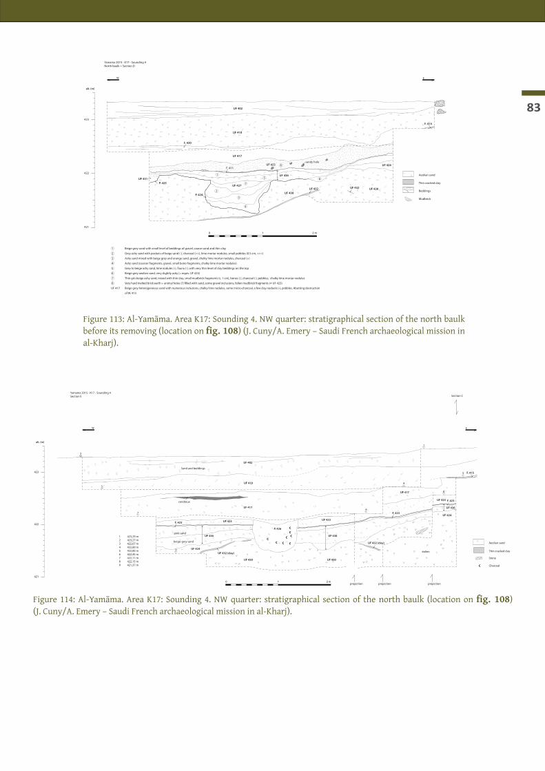
83
EW
0 1 2 m
alt. (m)
421
422
423
Section C
projection projection projection
Aeolian sand
Stone
Thin cracked clay
423,29 m423,27 m422,67 m422,60 m422,85 m422,45 m422,11 m422,15 m421,37 m
123456789 C Charcoal
Sand and beddings
CC C C
C C
CC
Yamama 2015 - K17 - Sounding 4Section E
UF 402
UF 410
UF 417
UF 417
F. 423
F. 423
F. 423
UF 423
UF 423
UF 423
UF 424
UF 432 (clay)
UF 432 (clay)
UF 436
UF 436
UF 436
P. 426
F. 415
UF 430 UF 430
UF 424
2
3
7
9
8
4
6
5
1
cendreux
pink sand
beige-grey sand
éolien
EW
0 1 2 m
alt. (m)
421
422
423
1 Beige grey sand with small level of beddings of gravel, coarse sand and thin clay
2 Grey ashy sand with pockets of beige sand (-), charcoal (++), lime mortar nodules, small pebbles (0.5 cm, +++)
3 Ashy sand mixed with beige grey and orange sand, gravel, chalky lime mortar nodules, charcoal (+)
4 Ashy sand (coarser fragments, gravel, small bone fragments, chalky lime mortar nodules)
5 Grey to beige ashy sand, lime nodules (-), fauna (-), with very thin level of clay beddings on the top
6 Beige grey aeolian sand, very slightly ashy (= equiv. UF 424)
7 Thin gris beige ashy sand, mixed with thin clay, small mudbrick fragments (c. 1 cm), bones (-), charcoal (-), pebbles, chalky lime mortar nodules
8 Very hard melted brick earth + animal holes (?) �lled with sand, some gravel inclusions, fallen mudbrick fragments (= UF 423)
UF 417 Beige grey heterogeneous sand with numerous inclusions, chalky lime nodules, some micro-charcoal, a few clay noduels (-), pebbles. Abutting destruction
of W. 413
Aeolian sand
Thin cracked clay
Mudbrick
Beddings
Yamama 2015 - K17 - Sounding 4North baulk = Section D
UF 402
UF 410
UF 417
F. 420
F. 423UF 423
UF 427
UF 431
UF 430UF 432
UF 424
UF 430UF 432
UF 436
P. 425
P. 424
1
2
3
4
7
5
8
6
F. 415
sandy hole
Figure 113: Al-Yamāma. Area K17: Sounding 4. NW quarter: stratigraphical section of the north baulk before its removing (location on fig. 108) (J. Cuny/A. Emery – Saudi French archaeological mission in al-Kharj).
Figure 114: Al-Yamāma. Area K17: Sounding 4. NW quarter: stratigraphical section of the north baulk (location on fig. 108) (J. Cuny/A. Emery – Saudi French archaeological mission in al-Kharj).

Al-Kharj - Report of the 4th season - January-February 2015
84
Figure 115: Al-Yamāma. Area K17: Sounding 4. Eolian sand accumulation of Phase 2. Looking east (J. Cuny – Saudi French archaeological mission in al-Kharj).
Figure 116: Al-Yamāma. Area K17: Sounding 4. Western half. Phase 2: mud layer (UF 432) under sand layers (UF 424 and 430). Looking south (J. Cuny – Saudi French archaeological mission in al-Kharj).
Figure 117: Al-Yamāma. Area K17: Sounding 4. Western half. Phase 2: crust of earth hardened by water run-off (UF 429) (J. Cuny – Saudi French archaeological mission in al-Kharj).
Figure 118 : Al-Yamāma. Area K17: Sounding 4. Plan of Phase 3 level (J. Schiettecatte, J. Cuny – Saudi French archaeological mis-sion in al-Kharj).
Area K17 L17L16K16
5 m10 3 42
W 400
W 405
W 408
W 403
W 401
W 402W 402b
R. 404
R. 406
Compact earth /Melted mudbrick
Sand
Crust of mud and sandhardened by water
Stone
Mudbrick fragment
St. 409
W 413W 413
W. 429
W. 430
UF 442
UF 443
Section (fig. 119)
Section (fig. 120)
▼420.01
▼419.50
▼419.37
▼419.11

85
EW
0 1 2 m
alt. (m)
419
420
421
Yamama 2015 - K17 - Sounding 4Section F
BF Small brick fragment
Sand
Mortar
Bone
Beddings
Stone
UF 432
Charred
Sand
UF 434
UF 433
UF 439
UF 439
UF 441
Beddings
Mortar
BF
SN
0 1 2 m
alt. (m)
419
420
421
421,05 m420,67 m420,18 m420,01 m419,48 m419,41 m419,11 m
1234567
BF Small brick fragment
Plaster mortar
Bone
Stone
Mudbrick
Yamama 2015 - K17 - Sounding 4Section G
UF 432
UF 433
UF 439
UF 441 UF 441
1
4
7
6
5
2
3
W. 430
UF 442UF 442
UF 443
W. 429 eq. UF 440
end of excavations on destruction level
Sand
BF
BFfootprint
Sand
UF 434
Charred grey-black sediment
Figure 119: Al-Yamāma. Area K17: Sounding 4. Stratigraphical section of the north baulk in the deepest trench of Sounding 4 (J. Cuny/A. Emery – Saudi French archaeological mission in al-Kharj).
Figure 120: Al-Yamāma. Area K17: Sounding 4. Strati-graphical section of the east baulk in the deepest trench of Sounding 4 (J. Cuny/A. Emery – Saudi French archaeological mission in al-Kharj).
Figure 121: Al-Yamāma. Area K17: Sounding 4. Deepest trench of Sounding 4: W. 429 appears in the eastern baulk. Looking south (J. Cuny – Saudi French archaeological mission in al-Kharj).
Figure 122: Al-Yamāma. Area K17: Sounding 4. Deepest trench of Sounding 4: stone wall W. 429 and mudbrick wall W. 430. Looking south (J. Cuny – Saudi French archaeological mission in al-Kharj).

Al-Kharj - Report of the 4th season - January-February 2015
86

87
ENVIRONMENTAL STUDIES

Al-Kharj - Report of the 4th season - January-February 2015
88

89
AL-YAMĀMA - ARCHAEOBOTANICAL STUDY
Charlène boUCHaUd (Muséum national d’histoire naturelle, Paris)
Introduction
The fieldwork took place from 5 to 26 February 2015. It constitutes the first archaeobotanical campaign on the site of al-Yamāma. The aim of the archaeobotanical study of al-Kharj is twofold. We focus first on a palaeoethnobotanical approach by studying the plant economy of the site, in particular the evolution of the local agrarian system and the fuel management practices, the different plant uses and processes in domestic and cultic contexts, as well as the potential long-distance trade of plant products. Secondly, we would like to undertake a palaeoenvironmental study in order to reconstitute the plant environment dynamics during the occupation of the site. This study is part of a wider archaeobotanical project involving the sites of Madāʾin Ṣāliḥ (ancient Hegra) and Dūmat al-Jandal that will contribute to a better understanding of the origin and development of the oasian agrobiodiversity and its impact on the environmental evolution.The archaeobotanical material in al-Yamāma is composed of all the plant macro-remains preserved within the sediment excavated on the archaeological site, i.e. on the one hand the seeds, fruits and others non-woody remains, like leaves and roots (carpological remains) and on the other hand the charcoals (anthra-cological remains). The work on the field mainly consisted to process the soil samples in order to extract the plant macro-remains from the sediment before exporting them to France where they will be analyzed in the archaeobotanical laboratory of the UMR 7209 (National Museum of Natural History). The study of the carpological remains will be used mostly for reconstructing the agrosystem evolution and the herbaceous natural vegetation. The charcoals analysis will mostly contribute to our knowledge on fuel selection and palaeoenvironmental reconstruction.
Methodology
Sampling strategyFor this first field season, the objective was to assess the preservation of the plant material in the differ-ent excavated areas and to evaluate its potential in terms of richness and diversity, in order to prepare an adequate sampling strategy. A first sampling procedure was designed beforehand and implemented during excavations thanks to the direct collaboration with the archaeological team.Previous works in Arabian Peninsula show that plant macro-remains found in archaeological contexts are generally preserved by charring (Boivin & fuller 2009; Bouchaud 2013; lomBard & tenGBerG 2001; tenGBerG in press). This process of charring occurred because of the ancient contact with fire (fire, domestic fuel, culi-nary accident, specific process as roasting, dumping, etc.). In this case, the sediment which contain charred plant is generally ashy (grey-dark color) if the concentration of carbonized material is high (primary de-posit as fireplace, accumulation of several dumps, processing area) or non-ashy if the carbonized material is less abundant (secondary deposit with mixing activities, occupation level with scattered charcoals).According to this general view, different types of samples were made. First, small samples of sediment (3-10 liters) were randomly taken in various layers mostly composed of occupation layers, pit fillings, fireplaces, ovens (tannūr) and ashy deposits. Bigger samples were made in the richest layer, and one layer of critical importance (UF 413, 280 liters) was completely sampled. We assume that the assemblage of plant macro-remains preserved in these samples is mainly related to human activities and selection processes. So their study will offer palaeoethnobotany outcomes. However, some of these samples, in particular the sandy ac-cumulation and occupation layers can be considered as “synthetic” deposits, i.e. “scattered charcoal in the archaeological layer from long-term deposition and mixing, difficult to link precisely to specific activities, but with a reliable significance concerning the environment” (théry-PariSot et al. 2010: 143).

Al-Kharj - Report of the 4th season - January-February 2015
90
In parallel, we selected three different ashy layers –already sampled for plant macro-remains analysis– for phytoliths analysis (study of the mineral concretion produced by plants) in order to compare the results obtained by the two approaches 1 (Table 2).
Samples processingFifty-three samples, corresponding to 33 different excavation units (UF) or features taken by the archaeolo-gists during the two last seasons (2013 and 2015) and representing a total volume of 579 liters, were dry-sieved on a column of geological sieves (2 mm, 1 mm and 0.5 mm mesh sizes, fig. 123). The largest material (2 mm fraction) was hand sorted on the field in order to separate the charcoal fragments, seeds and fruits, other types of organic material (like dung, or food preparation), bones (macro and micro-fauna) and ar-chaeological artifacts (as pottery and pearls). 2 For a majority of samples, the refuses of the 0.5 mm fraction were hand-floated in order to decrease the time of sorting stage. The 1 mm-fraction was sometimes floated too when the sample presented a high concentration of charred material.The flotation process consisted to pour slowly the sediment in a bucket partly full of water. The charred elements, whose density is lighter than water one, floated on the surface and were collected thanks to a flexible sieve (0.3 mm mesh size) (fig. 124). This latter was then put in form of a small bag and put to dry in the shade (to avoid the fragmentation of the charred element during the drying stage) (fig. 125).Some of the samples from the UF 413 and F-419 (hearth) have been sub-sampled, i.e. the total volume of the sample has been sieved through the 2 mm and 1 mm-mesh sieves but only one half has been sieved through the 0.5 mm-mesh sieve. In this case, the quantitative results will be weighted at the analysis stage.All the 2 mm fractions were sorted during the fieldwork. The 1 mm and 0.5 mm fractions were partly sorted by using a field binocular microscope. Charcoals fragments were only sorted on the 2 mm fraction.Two samples (148-1 in the mosque area and 442 in the residential sector) have been selected for radiocarbon dating as they are likely to correspond to the most ancient occupation of each sector reached this year. For each one, fragmented date palm stones were isolated and given to A. Zazzo (UMR 7209, National Museum of Natural History) for processing before dating by Artemis program.
IdentificationAll the plant remains are preserved by charring, except for some mineralised Boraginaceae nutlets.The carpological remains coming from the thin (0.5 mm and 1 mm) and heavy (2 mm) fractions should be identified thanks to a binocular microscope (magnification: 8 to 60) by the observation of morphological criteria, notably the shape, the size, the epidermis ornamentation or the hilum position and the comparison of modern material (caPPerS & BeKKer 2013; caPPerS et al. 2012; caPPerS & neef 2012). Some preliminaries iden-tifications were made during the campaign but most of the wild plants could not be identified and counting could not be made.The charcoal fragments coming from the 2 mm fraction should be identified through a high-power micro-scope with incident light (not present on the field). The analysis requires each fragments of selected char-coal to be broken in three sections (transversal, tangential, radial). The identification is based on the obser-vation of the cell structure (the number of vessels, their disposition, the rays width, type of intervascular punctuations, etc.) which are characteristics of a species or a genus according to different atlas of reference (fahn et al. 1986; JaGiella & KurSchner 1987; neumann et al. 2001). Some identifications were made during the campaign for the most characteristic species (as the date palm, see below).In order to continue the first identifications, the sieved and partly sorted samples were exported to the ar-chaeobotanical laboratory of the National Museum of Natural History (UMR 7209) (Table 3).1 The phytoliths analysis will be made in collaboration with Michèle Diniès (DAI, Berlin).2 A very warming thanks to Hervé Monchot, the archaezoologist of the team (UMR 7209, MNHN) who spent several days to sort the sieve refuses. Many thanks too to Fanny Laruaz, Alexia Rozak, Jérémie Schiettecatte and Julien Cuny for their appreciated temporary help for sieving and sorting stages.

91
Figure 123: The column of the geological sieves (up) and the different refuses of sediment after sieving stage (bottom) (Ch. Bouchaud - Saudi French archaeological mission in al-Kharj).
◄ Figure 124: Flotation process (Ch. Bouchaud - Saudi French archaeologi-cal mission in al-Kharj).
Figure 125: Drying of the flotation residues (Ch. Bouchaud - Saudi French archaeological mission in al-Kharj). ►

Al-Kharj - Report of the 4th season - January-February 2015
92
The first results
Richness, diversity and future sampling strategyAs expected, the random sampling revealed that apparent pure sandy layers don’t contain plant residues, or very few, whereas dark and ashy layers present a relative high concentration of charred plant material. Wood charcoal is ubiquitous in the archaeological soil, even in the Aeolian sediment layers where only micro-charcoal fragments (<2 mm) are present. Nevertheless, these latter ones have not been extracted because their small size avoids correct taxonomic identification.In the future, if we have to choose the simplest strategy due to time constraints, we can concentrate the sampling on these apparently dark layers. In parallel, only some selected samples will be made on appar-ent non-ashy soil sediment in order to get dispersed charcoals for the palaeoenvironmental analysis (see above). In this case, a large quantity of sediment (100-200 liters) should be directly sieved during the excava-tion using a big 2 mm- mesh sieve.Fruit and seed remains are less abundant than charcoals, and, as expected, are mostly found in the occu-pation layers of the sector K17 (Sounding 4). On the 27 samples took in K17 (Sounding 4), 24 contain fruit and seed remains (88.9%) whereas for the same number of samples coming from the mosque area, only 13 contained carpological remains (48.2%) (Table 2). This discrepancy is also observed on the representation of the biodiversity: 21 taxa are identified in K17 (Sounding 4) whereas only 15 taxa are found to date in the mosque samples (Table 4).
The preliminary carpological studyAt least 24 taxa are recognized in total. They can be classified according to economic or ecological factors as cultivated fruit trees (1 taxa), cereals (5 taxa), pulses (1 taxa), oil and textile plants (1 taxa) and wild plants (16 taxa). 3 As the chronological setting of the different loci is not definitely established yet, the preliminary results are presented without relative dating consideration. Furthermore, as no quantification is made, re-sults are discussed according to their ubiquity (presence/absence).
Fruit treeThe only clearly cultivated fruit tree is the date palm (which is not a tree according to the botanical defini-tion as it is a monocotyledon plant). Fragmented and whole charred date palm seeds (the “stone”) are ubiq-uitous in both excavation areas, supporting the existence of a palm grove in the surroundings. Fragments of charred date palm stipe (the “trunk”), petiole (rachis of the leaf) and lamina (leaflet) are very often found among the charcoal assemblages (for example in UF 076). The sample 036-1 contains several pieces of prob-able plaster with imprints of date palm leaves visible at the surface. All these elements clearly indicate the cultivation of the date palm and its large use as food, fuel and building material, as it is always the case in the oases of the Arabian Peninsula (Bouchaud et al. 2012).
CerealsAt least five different cereal species are identified. A first group corresponds to cereals originating from Near East, including two hulled cereals –i.e. the barley (Hordeum vulgare) and the emmer (Triticum turgidum subsp. dicoccon)– and one free-threshing cereal –the durum wheat (or macaroni wheat, Triticum turgidum subsp. durum). These cereals are domesticated since the Neolithic period in Near East before spreading in the surrounding regions (Zohary et al. 2012: 39–46, 51–56). In Levant, durum wheat gradually replaces emmer during the Bronze Age whereas emmer stays dominant in Southern Arabia until the end of the first mil-lennium BC (Boivin & fuller 2009: 146). The preliminary results at al-Yamāma show that durum wheat is the most frequent in the samples. Common wheat (Triticum aestivum subsp. aestivum) seems to be absent –as it
3 This number of identified taxa is a minimum as all the samples have not been analyzed, most of all the thin fractions. Further-more, the indeterminate elements (indicated as “others” in the table 4) have not been counted in this report.

93
is observed in the north-western Arabia (Bouchaud in press)– whereas it is present in sites located in Eastern and Southern Arabia during Antiquity and Islamic period (Boivin & fuller 2009). Wheat and barley cereals are generally winter crops, sown during the autumn and harvested during the spring or early summer.4
The second cereal group corresponds to African species (Panicoideae tribe). They contain sorghum (Sorghum bicolor) and other indeterminate taxa from de same tribe (perhaps pearl millet, Pennisetum glaucum). It is not excluded that some of these indeterminate seeds of Panicoideae correspond to wild grasses. The domes-tication process of the sorghum and pearl millet is still in debate but probably took place during the first millennium BC, or second millenium in subtropical Africa (fuller in press; haaland 1999; roWley-conWy et al. 1999; van der veen 2011: 100). Their introduction in Arabian Peninsula is unclear but we know that they are staple crops in Southern part during medieval period (Boivin & fuller 2009). They are not cultivated at all in northern Arabia, probably because of their ecological requirement and their photoperiodism period. Sor-ghum and pearl millet are summer crop, requiring sun and water during their growing season that occurs during summer.Whereas barley and wheat are present in both excavation areas –with the predominance of wheat remains– sorghum and other Panicoideae are only attested in K17 (Sounding 4) (UF 413 and 425).By-products remains –straw and chaff– are sporadically found in the thinnest fractions. Their presence is likely to illustrate their use as fuel (and probably fodder, see below) after the processing stage of cereal crops, threshing, winnowing, husking (van der veen 1999), occurring near or inside the city.
Textile/oil plantsAt least two samples of K17 (Sounding 4) contain remains of cotton (Gossypium sp.) in form of whole and fragmented seeds and seed coats. One complete seed in UF 413 has still tiny fibers (the linters) adhesive to the seed coat. Cotton is a subtropical plant which can correspond to two species, one coming from India (Gossypium arboreum) and the other from Africa (G. herbaceum). To date, archaeobotanical, textile and textual evidences show that cotton (either Indian or African species) is introduced probably in the middle of the 1st century BC in Eastern Arabian Peninsula and at the end of the 1st century AD in Northwestern Arabia (Bouchaud in press; Bouchaud et al. 2011). The low quantity of cotton seeds found in al-Yamāma doesn’t allow to confirm the production of this plant in the ancient city. Indeed, cotton seeds could circulate inside the raw cotton ball coming from elsewhere, as it is shown by archaeological examples in the Egyptian Eastern desert (Bouchaud et al. 2011: 409). However, due to the history of the plant in Arabia, the hypothesis of local production is worth being considered. In this case, seeds could have been directly discarded after the gin-ning process (separation of the fibers from the seeds).
The absence of pulsesOnly one hypothetic chickpea (cf. Cicer arietinum) seed was found in K17 (Sounding 4) (hearth F.419). Pulses are generally not very well represented in archaeological sites where only charred material is preserved, notably because of the agricultural and culinary processes of these plants that do not involved the use of fire (or at least less than cereals or other crops). Nevertheless, lentils (Lens culinaris) are generally found in Arabian oases and, in less extant, pea (Pisum sativum), common vetch (Vicia sativa), bitter vetch (Vicia ervilia) (Boivin & fuller 2009; Bouchaud 2013). It is thus curious to these species are seemingly absent at al-Yamāma.
Wild plantsWild plants can be separated into two groups. The first correspond to weeds growing on anthropogenic habitats, in particular disturbed ground, as asphodels (Asphodelus sp.) and smallflower mallow (Malva cf. parviflora, fig. 126) and some Boraginaceae. The others are typical desert plants, including one tree plant (Acacia sp.), shrubs (Amaranthaceae like Haloxylon persicum, Zilla spinosa, fig. 126) and herbaceous species (Ai-zoon cf. canariense, the colocynth – Citrullus colocynthis, wild medick – Medicago cf. arabica, grasses). They give 4 Some varieties of hulled barley or free-threshing wheat can be spring types, they are planted in early springtime and mature latter than same summer.

Al-Kharj - Report of the 4th season - January-February 2015
94
indication on the ecological state of the site, which seems to be very similar to modern one. Several reasons explain their presence on a charred state on archaeological layers. One part of them is likely to be brought “by accident” with the wood used for fuel (notably the woody species), others could be naturally brought by wind before being caught on the fireplaces during their use. Finally, all of these seeds could be eaten by animals, passed through the digestive system, and preserved within the dung used as fuel. Indeed, charred camel dung and indeterminate dung fragments were found in a lot of archaeological layers (Table 4). Eth-nogaphic and archaeobotanical researches show that seeds consumed by animals are likely to be preserved by charring in the archaeological sites due to the regular use of dung, mixed with others elements (straw, olive stones, etc.) as fuel, notably in semi-arid and arid habitats (anderSon & ertuG-yaraS 1998; miller 1984).
Two observations in relation with the archaeological contexts (tables 5-6)
Area N6, the mosqueVery few seeds or fruits remains are present inside the Mosque, as it is common in sacred space. What is more surprising is the almost absence of seeds and fruits within and around the tannūr T. 218 in room R. 222, in the dwelling structure under the mosque (Samples no 138, 148-1, 148-2, 148-3, 149-1, 149-2, 149-3). Some seeds (date stones, one hard wheat grain and one barley grain, wild plants) are recognized but the majority of the charred plant remains correspond to charcoal fragments, probably resulting for their fuel utilization. Dung is also present, suggesting that it was used as fuel too and perhaps this explain the presence of the seeds (see above). This assemblage is not similar to common archaeobotanical assemblage generally associated with domestic oven where we can find a mixture of fuel, dung and food plant (as well as bones) residues (Bouchaud 2011: 248; reddy 1998). This discrepancy maybe suggests a re-use of this oven for a non-alimentary purpose. Nevertheless, the two elements of complete barley and wheat grains, the bones and the fish remains found inside the oven would illustrate the rest(s) of limited cooking activities.
Area K17, Sounding 4, the residential areaUF 413 is very heterogeneous in terms of sediment nature and color (from sandy to ashy sediment, from white to dark color), plant richness and diversity. The highest density of plant (and bones) remains seems to be located in the eastern part (south and north), corresponding to the most ashy part of the layer. The samples coming from the grid pattern in the western part of the layer (squares A, B, C, E, F) are quite poor in plant residues. The large volume of the burnt deposit and the presence in it of a mixture of cultivated and wild seeds, fruits, charcoals, dung, charred and non-charred bones and some potteries are likely indicating several domestic refuses accumulating through time. The presence of big pieces of charcoal in some part of the layer (notably in the eastern part) could indicate the burning of decayed architectural elements (as date palm stipe used as beams).
Conclusion
The first archaeobotanical campaign in al-Yamāma is very encouraging. The preservation of the plant ma-terial is good and the preliminary carpological study reveals a strong biodiversity. The assemblage of culti-vated plants evokes the presence of oasian agrosystems characterized by northern (Near East) and southern (Africa/Southern Arabia) influences offering all the common staple crops for local needs and maybe for ex-change economy (with likely cotton production). These results fit well in the global view of the traditional Arabian agrosystems as it can be seen through archaeobotanical studies. Only the absence of pulses is quite surprising, but it may be due to methodological process. The analyses to come in the MNHN laboratory will be devoted to the final sorting of the thin fractions (1 and 0.5 mm) and the identification of the indetermi-nate carpological remains as well as charcoal assemblages.

95
Figure 126: Modern Malva parvi-flora (top) and Zilla spinosa (bottom) (Ch. Bouchaud – Saudi French ar-chaeological mission in al-Kharj).

Al-Kharj - Report of the 4th season - January-February 2015
96
Table 2: Data samples, process and nature of plant remains
Year AreaN°UF or
StructureContext type Relative datation N°Sample Sample detail
Sample Volume (l)
Dry-sievingFlottation after
sieving CharcoalsSeeds & fruits
Sample for phytoliths
2 mm 1 mm 0,5 mm 1 mm 0,5 mm
YM 2013 N6 036 Eolian depositModern (15th-18th c.) 036-1 10 x x x x
036-2 10 x x
YM 2013 N6 042 Eolian deposit Modern 042-1 10 x x x
042-2 10 x x x x x
YM 2013 N6 076 Fireplace ? 076 8 x x x x x
YM 2015 N6 104 Occupation layer Modern 104 8 x x (x)
YM 2015 N6 105 Occupation layer Modern 105 5 x x x
YM 2015 N6 106 Occupation layer Modern 106 6 x x x x
YM 2015 N6-test trench 1 107 Construction level ? 107 2 x x x x
YM 2015 N6 111 Pit filling P.185 ? 111 3 x x x
YM 2015 N6 114 Pit filling P.187 ? 114 3 x x x
YM 2015 N6 115 Pit filling P.186 ? 115 2 x x x
YM 2015 N6 (Ext)119 Fireplace ? 119-1 10 x x (x) x x
119-2 10 x (x) x x x
YM 2015 N6 (Ext) 123 Soil ? 123 10 x x (x) x x
YM 2015 N6- test trench 2 128 Pit filling P.197 ? 128 1 x x x x x
YM 2015 N6- test trench 2 129 Fireplace in a wall ? 129 2 x x x x x
YM 2015 N6-R222 138 Abandonment layer ? 138 5 x x x x x
YM 2015 N6-R222 148
Ashy dump around the tannūr T.218 ? 148-1* around the tannūr 10 x (x) x x x
148-2 around the tannūr 8 x (x) (x) x x
148-3 F.219 (floor south of the tannūr) 8 x (x) (x) x
YM 2015 N6-R222 149
Tannūr filling ? 149-1 Upper part 20 x x x
149-2 Intermediary part 14 x x (x) x x
149-3 Bottom part 8 x x (x) x x
YM 2015 N6-R222 P.226 Filling of the small cavity located east of the tannūr ? P-226 6 x x x
YM 2015 N6- test trench 2 154 pit latrine?154-1 3 x x x
154-2 3 x x x
YM 2015 K17-Sdg4 (R404) 401 Eolian deposit Recent-Modern 401 6 x x x x x
YM 2015 K17-Sdg4 (Ext) 402 Eolian deposit Recent-Modern 402 2 x x x x x
YM 2015 K17-Sdg4 (Ext) 403 Eolian deposit Recent-Modern 403 2 x x x x x
YM 2015 K17-Sdg4 (R404) 411 Demolition Modern 411 4 x x x
YM 2015 K17-Sdg4 (R404) 413 Occupation layer / Ashy dumpModern
(15th-18th cent.)
413 Mix of the whole layer 90 x x
413-1/4NE-1 20 x x x (10l)** x x
413-1/4NE-2 20 x x (x) x x
413-1/4NE-3 20 x x (x) (10l) x x
413-1/4SE-1 20 x x (x) (10l) x x
413-1/4SE-2 20 x (x) (x) (10l) x x
413 square A Western part 20 x (x) (x) (10l) x x
413 square B Western part 20 x (x) (10l) (x) (10l) x x x
413 square C Western part 10 x x (x) x
413 square E Western part 10 x (x) (x) x x
413 square F Western part 10 x (x) (x) x x
413 sac 1 20 x x (x) (10l) x x

97
Table 2: Data samples, process and nature of plant remains
Year AreaN°UF or
StructureContext type Relative datation N°Sample Sample detail
Sample Volume (l)
Dry-sievingFlottation after
sieving CharcoalsSeeds & fruits
Sample for phytoliths
2 mm 1 mm 0,5 mm 1 mm 0,5 mm
YM 2013 N6 036 Eolian depositModern (15th-18th c.) 036-1 10 x x x x
036-2 10 x x
YM 2013 N6 042 Eolian deposit Modern 042-1 10 x x x
042-2 10 x x x x x
YM 2013 N6 076 Fireplace ? 076 8 x x x x x
YM 2015 N6 104 Occupation layer Modern 104 8 x x (x)
YM 2015 N6 105 Occupation layer Modern 105 5 x x x
YM 2015 N6 106 Occupation layer Modern 106 6 x x x x
YM 2015 N6-test trench 1 107 Construction level ? 107 2 x x x x
YM 2015 N6 111 Pit filling P.185 ? 111 3 x x x
YM 2015 N6 114 Pit filling P.187 ? 114 3 x x x
YM 2015 N6 115 Pit filling P.186 ? 115 2 x x x
YM 2015 N6 (Ext)119 Fireplace ? 119-1 10 x x (x) x x
119-2 10 x (x) x x x
YM 2015 N6 (Ext) 123 Soil ? 123 10 x x (x) x x
YM 2015 N6- test trench 2 128 Pit filling P.197 ? 128 1 x x x x x
YM 2015 N6- test trench 2 129 Fireplace in a wall ? 129 2 x x x x x
YM 2015 N6-R222 138 Abandonment layer ? 138 5 x x x x x
YM 2015 N6-R222 148
Ashy dump around the tannūr T.218 ? 148-1* around the tannūr 10 x (x) x x x
148-2 around the tannūr 8 x (x) (x) x x
148-3 F.219 (floor south of the tannūr) 8 x (x) (x) x
YM 2015 N6-R222 149
Tannūr filling ? 149-1 Upper part 20 x x x
149-2 Intermediary part 14 x x (x) x x
149-3 Bottom part 8 x x (x) x x
YM 2015 N6-R222 P.226 Filling of the small cavity located east of the tannūr ? P-226 6 x x x
YM 2015 N6- test trench 2 154 pit latrine?154-1 3 x x x
154-2 3 x x x
YM 2015 K17-Sdg4 (R404) 401 Eolian deposit Recent-Modern 401 6 x x x x x
YM 2015 K17-Sdg4 (Ext) 402 Eolian deposit Recent-Modern 402 2 x x x x x
YM 2015 K17-Sdg4 (Ext) 403 Eolian deposit Recent-Modern 403 2 x x x x x
YM 2015 K17-Sdg4 (R404) 411 Demolition Modern 411 4 x x x
YM 2015 K17-Sdg4 (R404) 413 Occupation layer / Ashy dumpModern
(15th-18th cent.)
413 Mix of the whole layer 90 x x
413-1/4NE-1 20 x x x (10l)** x x
413-1/4NE-2 20 x x (x) x x
413-1/4NE-3 20 x x (x) (10l) x x
413-1/4SE-1 20 x x (x) (10l) x x
413-1/4SE-2 20 x (x) (x) (10l) x x
413 square A Western part 20 x (x) (x) (10l) x x
413 square B Western part 20 x (x) (10l) (x) (10l) x x x
413 square C Western part 10 x x (x) x
413 square E Western part 10 x (x) (x) x x
413 square F Western part 10 x (x) (x) x x
413 sac 1 20 x x (x) (10l) x x

Al-Kharj - Report of the 4th season - January-February 2015
98
Year AreaN°UF or
StructureContext type Relative datation N°Sample Sample detail
Sample Volume (l)
Dry-sievingFlottation after
sieving CharcoalsSeeds & fruits
Sample for phytoliths
2 mm 1 mm 0,5 mm 1 mm 0,5 mm
YM 2015 K17-Sdg4 (R406) F.419 Soil/occupation layer Modern F.419 20 xx
(10l)(x) (10l) x x
YM 2015 K17-Sdg4 (Ext) 420 Fireplace/Ashy dump Modern 420 3 x x x x x
YM 2015 K17-Sdg4 (Ext) 423 Demolition/backfill ? 423 4 x x x x x
YM 2015 K17-Sdg4 (Ext) 425 Fireplace/Ashy dump ? 425 4 x (x) (x) x x
YM 2015 K17-Sdg4 (Ext) 427 Pit filling ?427-1 10 x x (x) x x
427-2 10 x x (x) x x
YM 2015 K17-Sdg4 (Ext) 435 Pit filling ?435-1 7 x (x) (x) x x
435-2 6 x (x) (x) x x
YM 2015 K17-Sdg4 (Ext) 439 Demolition ? 439 8 x x x x x
YM 2015 K17-Sdg4 (Ext) 442 Demolition ? 442* 5 x x x x x x
YM 2015 K17-Sdg4 (Ext) 443 Abandonment layer ? 443 18 x x x x
(x) : the fraction has not been sorted
* Seeds and leaves of date palm found in theses samples have been selected for radiocarbon dating
** number in brackets indicates the volume sub-sampled for this fraction

99
Year AreaN°UF or
StructureContext type Relative datation N°Sample Sample detail
Sample Volume (l)
Dry-sievingFlottation after
sieving CharcoalsSeeds & fruits
Sample for phytoliths
2 mm 1 mm 0,5 mm 1 mm 0,5 mm
YM 2015 K17-Sdg4 (R406) F.419 Soil/occupation layer Modern F.419 20 xx
(10l)(x) (10l) x x
YM 2015 K17-Sdg4 (Ext) 420 Fireplace/Ashy dump Modern 420 3 x x x x x
YM 2015 K17-Sdg4 (Ext) 423 Demolition/backfill ? 423 4 x x x x x
YM 2015 K17-Sdg4 (Ext) 425 Fireplace/Ashy dump ? 425 4 x (x) (x) x x
YM 2015 K17-Sdg4 (Ext) 427 Pit filling ?427-1 10 x x (x) x x
427-2 10 x x (x) x x
YM 2015 K17-Sdg4 (Ext) 435 Pit filling ?435-1 7 x (x) (x) x x
435-2 6 x (x) (x) x x
YM 2015 K17-Sdg4 (Ext) 439 Demolition ? 439 8 x x x x x
YM 2015 K17-Sdg4 (Ext) 442 Demolition ? 442* 5 x x x x x x
YM 2015 K17-Sdg4 (Ext) 443 Abandonment layer ? 443 18 x x x x
(x) : the fraction has not been sorted
* Seeds and leaves of date palm found in theses samples have been selected for radiocarbon dating
** number in brackets indicates the volume sub-sampled for this fraction

Al-Kharj - Report of the 4th season - January-February 2015
100
Table 3: Proposal for exports from al-Kharj to France (total = 144 bags)
Season Area Sample Charcoal Seeds & fruits Phytoliths Total bags
YM 2015 N6 106 x 1
YM 2015 N6 107 x 1
YM 2015 N6 119-1 x x 4
YM 2015 N6 119-2 x x 4
YM 2015 N6 123 x x 4
YM 2015 N6 128 x x 2
YM 2015 N6 129 x x 2
YM 2015 N6 138 x x 4
YM 2015 N6 148-1 x x 4
YM 2015 N6 148-2 x x 4
YM 2015 N6 148-3 x 3
YM 2015 N6 149-1 x x 2
YM 2015 N6 149-2 x x 4
YM 2015 N6 149-3 x 3
YM 2011 N6 076 x x 4
YM 2013 N6 036-1 x 1
YM 2013 N6 036-2 x 1
YM 2013 N6 042-1 x 1
YM 2013 N6 042-2 x x 2
YM 2015 K17-Sdg4 401 x x 3
YM 2015 K17-Sdg4 402 x x 3
YM 2015 K17-Sdg4 403 x x 4
YM 2015 K17-Sdg4 413 x 1
YM 2015 K17-Sdg4 413-1/4NE-1 x x 4
YM 2015 K17-Sdg4 413-1/4NE-2 x x 4
YM 2015 K17-Sdg4 413-1/4NE-3 x x 4
YM 2015 K17-Sdg4 413-1/4SE-1 x x 4
YM 2015 K17-Sdg4 413-1/4SE-2 x x 4
YM 2015 K17-Sdg4 413-squareA x x x 5
YM 2015 K17-Sdg4 413-squareB x x 4
YM 2015 K17-Sdg4 413-squareC x 3
YM 2015 K17-Sdg4 413-squareE x x 4
YM 2015 K17-Sdg4 413-squareF x x 4
YM 2015 K17-Sdg4 413-sac1 x x 4
YM 2015 K17-Sdg4 F-419 x x 4
YM 2015 K17-Sdg4 420 x x 2
YM 2015 K17-Sdg4 423 x x 2
YM 2015 K17-Sdg4 425 x x 4
YM 2015 K17-Sdg4 427-1 x x 4
YM 2015 K17-Sdg4 427-2 x x 4
YM 2015 K17-Sdg4 435-1 x x 4
YM 2015 K17-Sdg4 435-2 x x 4
YM 2015 K17-Sdg4 439 x 2
YM 2015 K17-Sdg4 442 x x x 3
YM 2015 K17-Sdg4 443 x 1
YM 2015 P2-Coupe wadi-1 x 1
YM 2015 P2-Coupe wadi-2.1 x 1
YM 2015 P2-Coupe wadi-2.2 x 1
YM 2015 P2-Coupe wadi-2.3 x 1

101
Table 4: Ubiquity of the taxa in each excavation area
Area K17 N6
Number of samples 17 17
CerealsHordeum vulgare_caryopsis barley grain 3Hordeum vulgare_rachis barley rachis 1 2cf. Triticum turgidum subsp. dicoccon_caryopsis emmer grain 2Triticum turgidum subsp. dicoccon_glume base emmer glume base 1 1Triticum turgidum subsp. durum_caryopsis hard wheat grain 8 1Triticum turgidum subsp. durum_rachis hard wheat rachis 4 3Triticaceae_caryopsisSorghum bicolor_caryopsis sorgho 3 1Panicoideae_caryopsis 2Cerealia_stem straw 1
Pulsescf. Cicer arietinum_seed chickpea 1
Fruit treesPhoenix dactylifera_seed date stone 20
Textile/oil plant 10
Gossypium sp._seed cotton seed 1cf. Gossypium sp._seed cotton seed 1Gossypium sp._seed coat cotton seed coat 2
Wild plantAcacia sp._seed acacia 3Aizoon cf. canariense_seed 1Amaranthaceae_seed 1 1Anchusa sp._nutlet 1 1Arnebia tinctoria_nutletAsphodelus sp._seed asphodel 3 1Boraginaceae_nutlet 4 1Brassicaceae_seed 2Citrullus colocynthis_seed colocynth 3 1Malva cf. parviflora_seed smallflower mallow 3Medicago cf. arabica_seed wild lucerne 3Plantago sp._seed plantain 7 4Poaceae_caryopsis grass 2 4Salsola type_seed 4 1Teucrium sp._seed 4Zilla spinosa_silique 1
Others 1
Coproliths camel 1Copoliths rodent 2Coproliths indeterminate 18 1Indet-Arc 2 4Seed indeterminate 1 2ashy mass 1Organical material 1 1

Al-Kharj - Report of the 4th season - January-February 2015
102
Table 5: Preliminary carpological results from Area K17 (Sounding 4)
AREA K17 (Sounding 4) AREA K17 (Sounding 4)
Sample number (after UF number) 401 402 403 413 413-1/4NE-1 413-1/4NE-2 413-1/4NE-3 413-1/4SE-1 413-1/4SE-2 413-sq.A 413-sq.B 413-sq.C 413-sq.EVolume (l.) 6 2 2 90 20 20 20 20 20 20 20 10 10Mesh sieving (mm) 2 1 0.5 2 1 0.5 2 1 0.5 2 2 1 1 2 1 2 2 1 2 2 2 2 1 2
CARPOLOGICAL REMAINS
CerealsHordeum vulgare_caryopsis + + +Hordeum vulgare_rachis +cf. Triticum turgidum subsp. dicoccon_caryopsis
Triticum turgidum subsp. dicoccon_glume base +Triticum turgidum subsp. durum_caryopsis + + + + +Triticum turgidum subsp. durum_rachis + + +Triticaceae_caryopsis
Sorghum bicolor_caryopsis + +Panicoideae_caryopsis +Cerealia_stem
Pulsescf. Cicer arietinum_seed
Fruit treesPhoenix dactylifera_seed + + + + + + + + +
Textile/oil plantGossypium sp._seed +cf. Gossypium sp._seed
Gossypium sp._seed coat +Wild plant
Acacia sp._seed + + +Aizoon cf. canariense_seed +Amaranthaceae_seed
Anchusa sp._nutlet +Arnebia tinctoria_nutlet
Asphodelus sp._seed + +Boraginaceae_nutlet + + +Brassicaceae_seed
Citrullus colocynthis_seed + +Malva cf. parviflora_seed + +Medicago cf. arabica_seed + +Plantago sp._seed + + + + + +Poaceae_caryopsis +Salsola type_seed + + + +Teucrium sp._seed + + + +Zilla spinosa_silique
OthersCoproliths camel +Copoliths rodent
Coproliths indeterminate + + + + + + + + +Indet-Arc +Seed indeterminate +ashy mass
Organical material +ANTHRACOLOGICAL REMAINS x x x x x x x x x x x

103
Table 5: Preliminary carpological results from Area K17 (Sounding 4)
AREA K17 (Sounding 4) AREA K17 (Sounding 4)
Sample number (after UF number) 401 402 403 413 413-1/4NE-1 413-1/4NE-2 413-1/4NE-3 413-1/4SE-1 413-1/4SE-2 413-sq.A 413-sq.B 413-sq.C 413-sq.EVolume (l.) 6 2 2 90 20 20 20 20 20 20 20 10 10Mesh sieving (mm) 2 1 0.5 2 1 0.5 2 1 0.5 2 2 1 1 2 1 2 2 1 2 2 2 2 1 2
CARPOLOGICAL REMAINS
CerealsHordeum vulgare_caryopsis + + +Hordeum vulgare_rachis +cf. Triticum turgidum subsp. dicoccon_caryopsis
Triticum turgidum subsp. dicoccon_glume base +Triticum turgidum subsp. durum_caryopsis + + + + +Triticum turgidum subsp. durum_rachis + + +Triticaceae_caryopsis
Sorghum bicolor_caryopsis + +Panicoideae_caryopsis +Cerealia_stem
Pulsescf. Cicer arietinum_seed
Fruit treesPhoenix dactylifera_seed + + + + + + + + +
Textile/oil plantGossypium sp._seed +cf. Gossypium sp._seed
Gossypium sp._seed coat +Wild plant
Acacia sp._seed + + +Aizoon cf. canariense_seed +Amaranthaceae_seed
Anchusa sp._nutlet +Arnebia tinctoria_nutlet
Asphodelus sp._seed + +Boraginaceae_nutlet + + +Brassicaceae_seed
Citrullus colocynthis_seed + +Malva cf. parviflora_seed + +Medicago cf. arabica_seed + +Plantago sp._seed + + + + + +Poaceae_caryopsis +Salsola type_seed + + + +Teucrium sp._seed + + + +Zilla spinosa_silique
OthersCoproliths camel +Copoliths rodent
Coproliths indeterminate + + + + + + + + +Indet-Arc +Seed indeterminate +ashy mass
Organical material +ANTHRACOLOGICAL REMAINS x x x x x x x x x x x

Al-Kharj - Report of the 4th season - January-February 2015
104
AREA K17 (Sounding 4)
Sample number (after UF number or struc-ture number)
413-
sq.F
413-
sac1F.419 420 423 425
427-
1427-2 435-1 435-2 439 442* 443
Structure F.419 P.426 P.426 Volume (l.) 10 20 20 3 4 4 10 10 7 6 8 5 18Mesh sieving (mm) 2 2 1 2 1 2 2 1 2 2 2 1 2 2 0.5
CARPOLOGICAL REMAINS
Cereals
Hordeum vulgare_caryopsis Hordeum vulgare_rachis cf. Triticum turgidum subsp. dicoccon_caryopsis Triticum turgidum subsp. dicoccon_glume base Triticum turgidum subsp. durum_caryopsis + + + Triticum turgidum subsp. durum_rachis + Triticaceae_caryopsis Sorghum bicolor_caryopsis + Panicoideae_caryopsis + Cerealia_stem +
Pulses
cf. Cicer arietinum_seed +
Fruit trees
Phoenix dactylifera_seed + + + + + + + + + + +
Textile/oil plant
Gossypium sp._seed cf. Gossypium sp._seed + Gossypium sp._seed coat +
Wild plant
Acacia sp._seed Aizoon cf. canariense_seed Amaranthaceae_seed + Anchusa sp._nutlet Arnebia tinctoria_nutlet Asphodelus sp._seed + Boraginaceae_nutlet + Brassicaceae_seed Citrullus colocynthis_seed + Malva cf. parviflora_seed + Medicago cf. arabica_seed + Plantago sp._seed + Poaceae_caryopsis + Salsola type_seed Teucrium sp._seed Zilla spinosa_silique
Others
Coproliths camel Copoliths rodent Coproliths indeterminate + + + + + + + + + Indet-Arc + Seed indeterminate ashy mass Organical material
ANTHRACOLOGICAL REMAINS x x x x x x x x x x x x
* Radiocarbon dating of charred date palm seeds of the sample

105

Al-Kharj - Report of the 4th season - January-February 2015
106
Table 6: Preliminary carpological results from Area N6 (mosque)
AREA N6 AREA N6
Sample number (after UF number or structure number)
test
trench 1Ext. Ext. Ext.
test
trench 2
test trench
2R.222 R.222 R.222 R.222 R.222 R.222 R.222
036-1 036-2 042-1 042-2 076 106 107 119-1 119-2 123 128 129 138 148-1* 148-2 148-3 149-1 149-2 149-3
Structure F.191 P.197 P.198 H.218 H.218 F.219 H.218 H.218 H.218
Volume (l.) 10 10 10 10 8 6 2 10 10 10 1 2 5 10 8 8 20 14 8Mesh sieving (mm) 2 2 2 0.5 2 1 2 2 2 1 2 0.5 2 1 2 2 1 2 1 0.5 2 0.5 2 2 2 2 2 1
CARPOLOGICAL REMAINS
Cereals
Hordeum vulgare_caryopsis + + Hordeum vulgare_rachis + + cf. Triticum turgidum subsp. dicoccon_caryopsis + Triticum turgidum subsp. dicoccon_glume base + Triticum turgidum subsp. durum_caryopsis + + + Triticum turgidum subsp. durum_rachis Triticaceae_caryopsis + Sorghum bicolor_caryopsis Panicoideae_caryospsis Cerealia_stem
Pulses
cf. Cicer arietinum_seed
Fruit trees
Phoenix dactylifera_seed + + + + + + + + + +
Textile/oil plant
Gossypium sp._seed cf. Gossypium sp._seed Gossypium sp._seed coat
Wild plant
Acacia sp._seed Aizoon cf. canariense_seed + Amaranthaceae_seed + Anchusa sp._nutlet Arnebia tinctoria_nutlet + Asphodelus sp._seed + Boraginaceae_nutlet + + Brassicaceae_seed + Citrullus colocynthis_seed Malva cf. parviflora_seed Medicago cf. arabica_seed + + + +Plantago sp._seed + + + + Poaceae_caryopsis + Salsola type_seed Teucrium sp._seed + Zilla spinosa_silique +
Others
Coproliths camel + + Copoliths rodent + Coproliths indeterminate + + + + Indet-Arc + + Seed indeterminate + ashy mass + Organical material
ANTHRACOLOGICAL REMAINS x x x x x x x x x x x x x x x x x x x
* Radiocarbon dating of charred date palm seeds of the sample

107
Table 6: Preliminary carpological results from Area N6 (mosque)
AREA N6 AREA N6
Sample number (after UF number or structure number)
test
trench 1Ext. Ext. Ext.
test
trench 2
test trench
2R.222 R.222 R.222 R.222 R.222 R.222 R.222
036-1 036-2 042-1 042-2 076 106 107 119-1 119-2 123 128 129 138 148-1* 148-2 148-3 149-1 149-2 149-3
Structure F.191 P.197 P.198 H.218 H.218 F.219 H.218 H.218 H.218
Volume (l.) 10 10 10 10 8 6 2 10 10 10 1 2 5 10 8 8 20 14 8Mesh sieving (mm) 2 2 2 0.5 2 1 2 2 2 1 2 0.5 2 1 2 2 1 2 1 0.5 2 0.5 2 2 2 2 2 1
CARPOLOGICAL REMAINS
Cereals
Hordeum vulgare_caryopsis + + Hordeum vulgare_rachis + + cf. Triticum turgidum subsp. dicoccon_caryopsis + Triticum turgidum subsp. dicoccon_glume base + Triticum turgidum subsp. durum_caryopsis + + + Triticum turgidum subsp. durum_rachis Triticaceae_caryopsis + Sorghum bicolor_caryopsis Panicoideae_caryospsis Cerealia_stem
Pulses
cf. Cicer arietinum_seed
Fruit trees
Phoenix dactylifera_seed + + + + + + + + + +
Textile/oil plant
Gossypium sp._seed cf. Gossypium sp._seed Gossypium sp._seed coat
Wild plant
Acacia sp._seed Aizoon cf. canariense_seed + Amaranthaceae_seed + Anchusa sp._nutlet Arnebia tinctoria_nutlet + Asphodelus sp._seed + Boraginaceae_nutlet + + Brassicaceae_seed + Citrullus colocynthis_seed Malva cf. parviflora_seed Medicago cf. arabica_seed + + + +Plantago sp._seed + + + + Poaceae_caryopsis + Salsola type_seed Teucrium sp._seed + Zilla spinosa_silique +
Others
Coproliths camel + + Copoliths rodent + Coproliths indeterminate + + + + Indet-Arc + + Seed indeterminate + ashy mass + Organical material
ANTHRACOLOGICAL REMAINS x x x x x x x x x x x x x x x x x x x
* Radiocarbon dating of charred date palm seeds of the sample

Al-Kharj - Report of the 4th season - January-February 2015
108

109
AL-YAMĀMA - ARCHAEOZOOLOGICAL STUDY
Hervé monCHot (Muséum national d’histoire naturelle, Paris)The faunal material from the excavations of 2013 and 2015 seasons of the site of al-Yamāma was studied by the author during this last field mission (February 2015). Thus the corpus of the excavation of area N6, the mosque and its surrounding area was completed, while the new material from Sounding 4 (domestic con-text in area K17) was added. The methodology follows the one published in 2012 (monchot in press b). Taking advantage of the presence of Ch. Bouchaud, archaeobotanist, within the team, it was important to note that some samples of sensitive UF (eg, floor, pit, ashy layers) were sieved with a 2 mm mesh.This year, 6782 bone remains were found during this last archaeological excavation, 2548 belonging to the Mosque area (Area N6, Building 1) while the remaining bones belonged to Sounding 4, in area K17 (n= 4234). As previously the faunal assemblage is widely dominated by the couple camel/caprine in both areas. The table 7 –at the end of this chapter– presents the species distribution by UF i.e. stratigraphic as-signments.
The association of camel & caprine
As it has already been shown in previous results (monchot 2014), the bone assemblage is clearly dominated by the camel (Camelus dromedarius) and by the caprine, sheep/goat (Ovis aries/Capra hircus). These species make up a significant proportion of the assemblage from al-Yamāma throughout the excavated sequences and the zooarchaeological results clearly show a subsistence economy largely based on these animals. They are purveyors of meat, milk and wool. For the camel, it served also as transportation mean from oasis to oasis. The high proportion of camel and caprine is not unusual in this area; they were the most common of the exploited terrestrial animals from Late Pre-Islamic/Early Islamic contexts at Dūmat al-Jandal or for earlier periods in Saudi Arabia.Some of the ovicaprids or camel bones show cutting or butchering marks (fig. 127) which are the result of disarticulation or filleting processes. The variety of butchery marks proves that the inhabitants of al-Yamāma consumed camel and sheep/goat meat. This is not an unexpected result since faunal remains rep-resent consumption debris recovered in domestic quarters.
The gazelle (Gazella sp.)
Numerous samples could be identified as gazelle among the different UF of al-Yamāma, most of them com-ing from area K17 (Sounding 4). It suggests an important hunting activity by the inhabitants (fig. 128). The gazelle bones present characteristics osteomorphological features and a preliminary biometric study shows clearly that these were smaller species (e.g. the Arabian gazelle, Gazella arabica also called the Saudi gazelle, Gazella saudiya) than the mountain gazelle (Gazella gazella) (munro et al. 2011; thouleSS et al. 1991). The Saudi gazelle is not regarded as a subspecies of G. Dorcas (yom-tov et al. 1995). It is important to note that the Ara-bian gazelle, the smallest one, was an elusive gazelle that was apparently hunted to extinction in its Middle Eastern homeland, Saudi Arabia.
The spiny tailed-lizard (Uromastyx aegyptia)
The presence of spiny-tailed lizard, already confirmed during the previous excavation seasons (monchot et al. 2014), was confirmed. Numerous bones (n=163) were found in Sounding 4 (area K17), in a domestic con-text and in the Building 1, the Mosque (area N6) (n=33).The Egyptian spiny-tailed lizard or mastigure (Uromastyx aegyptia microlepsis) is present in central Saudi

Al-Kharj - Report of the 4th season - January-February 2015
110
Arabia, the Sultanate of Oman, the United Arab Emirates, Kuwait and in the north and south of Iraq (WilmS et al. 2009). This lizard is locally known to the Arabs as ḍabb. It is a burrowing lizard which has a predilection for open habitats with sand and gravel substrates, and sparse vegetation. This abundance of lizards remains associated with leftovers, especially in Sounding 4, confirms its anthropogenic origin, i.e. its consumption by the inhabitants.
Fig. 128. Disarticulation cut marks (removal of a head) on an atlas of a (female) gazelle (area K17, Sounding 4, UF 411) (Y. Hilbert - Saudi French archaeological mission in al-Kharj).
Figure 127. Right ulnar carpal bone of a camel showing disar-ticulation cut marks (area K17, Sounding 4, UF 414) (Y. Hilbert - Saudi French archaeological mission in al-Kharj).
Fig. 129. Eggshell of ostrich found in domestic context (area K17, Sounding 4, UF 415) (Y. Hilbert - Saudi French archaeological mis-sion in al-Kharj).

111
The ostrich (Struthio camelus)
The ostrich is represented by twenty-eight fragments of eggshell found everywhere in the domestic context of Sounding 4 (n=20) or in the mosque area N6 (n=8) (fig. 129). If the ostrich bones are quasi-absent in ar-chaeological sites (with the possible exception of the Paleolithic site of Umm El Tlel in Syria: Bonilauri et al. 1990), the eggshell fragments are known from various archaeological sites in Saudi Arabia (PottS 2001; Studer 2010; monchot in press a) or in Iran, Iraq, Bahrain or eastern Syria (see references in Summer 2003).The Middle Eastern Ostrich or Arabian Ostrich (Struthio camelus syriacus) is an extinct subspecies of the os-trich which once lived on the Arabian Peninsula and in the Near East. Ostriches also appear frequently on petroglyphs from prehistory to modern time and then in Islamic verse, especially in the poetry from Arabia itself, where the birds were common. Although the flesh is edible and the fat useful, the ostrich has been primarily valued for its plumage, notably the tail feathers, and for its large eggs (laufer 1926).The question of the presence of ostrich eggs is interesting. Indeed, it is difficult to know whether they have been consumed or if the eggs were used as container (moorey 1994) or decorative elements like beads as found in many countries in South Africa (taPela 2001; Kandel & conard 2005).
Domestic fowl (Gallus gallus)
Only 6 remains represent the domestic fowl, i.e. chicken. One skull fragment, a distal fragment of a metatar-sus and a proximal fragment of a tibiotarsus (UF 106) and one fragment of humerus diaphysis (UF 156) were found in test trench A (Mosque, area N6) whereas one fragment of a left proximal femur (Bp=17.1; Dp=10.6) and one fragment of a left distal femur (Bd=15.3; Dd=11.4) belonging certainly to the same individual, were found in UF 435 (Sounding 4, area K17). The macroscopic inspection does not show any evidence of anthrop-ic use such as cut marks or others traces of slaughtering. Nevertheless we can interpret these domestic fowl bones as food refuses although these species were not primarily used for consumption.The presence of some fragments of eggshell found in the sieve residue is questionable. Indeed, they can be issued from chicken or from wild galliformes, species widely hunted and consumed.
Other species already attested during the previous seasons
Alongside sheep, goats and camel, the inhabitants of the oasis also kept other domestic animals, such as dog (Canis lupus f. familiaris), donkey (Equus asinus) or cat (Felis catus). These species are represented in very low percentage and had other role within the local economy and were not generally used for food. Thus, the discovery of bones from these animals at archaeological sites is not a sign of consumption. In rare cases, however, bones have been discovered with cut marks indicating that meat (or skin removal) was cut off with a knife, presumably for consumption.
• The donkey is represented by a second phalanx in UF 434 and a proximal fragment of a first pha-lanx in UF 413. Donkey as the camel was used as a beast of burden.
• The cat is present by a proximal radius and a fragment of ulna in UF 137 (test trench A, mosque, area N6) and by three bones (proximal tibia, proximal ulna and distal femur) in UF 435 (Sound-ing 4, area K17, dwelling).
• Dogs may have been killed during hunting sessions, or within the walls of the city, where at-tracted by food or garbage.
• This year three bones of cattle (Bos Taurus) were found and no bones of oryx (Oryx leucoryx) were identified even if its presence is suspected. Indeed the oryx bones are very similar in size and morphology to those of caprine (PeterS et al. 1997); the intense fragmentation made their identi-fication difficult.

Al-Kharj - Report of the 4th season - January-February 2015
112
New species
Several new species have been discovered this year, including two species of sea fish.
SerranidaeThe first one, a dorsal spine, belongs to the family of Serranidae (Perciforme order) was in the area N6, UF 132 (fig. 130). The family contains about 450 species in 64 genera, including the sea basses and the grou-pers (subfamily Epinephelinae). Many serranid species are brightly colored, and many of the larger species are caught commercially for food. It is not possible to be more specific yet about the origin of the grouper, this family is well represented in the Red Sea as in the Arabian Gulf. Groupers bones belonging to a mini-mum of seven specimens were found in Madāʾin Ṣāliḥ (Studer 2010). The presence of marine fish bones as far inland as al-Yamāma offers insights into dietary habits and trade.
ClupeidaeTwo very small vertebrae belongs to a Clupeidae (fig. 131) found after the sieving in UF 148, which represent sediment present around tannūr T. 218. This is the fish family of the herring, shad, sardine, ilish and men-haden. They include many of the most important food fish in the world, and are also commonly caught for production of fish oil and fish meal.
Cape hareUbiquitous animal that can live in diverse environments such as steppes, agricultural areas and even the desert, when vegetation is sufficient, the Cape hare (Lepus capensis) is represented in UF 417 (Sounding 4, area K17) by a distal humerus (Distal breadth= 9,6; Distal depth= 5,9), a proximal ulna and a skull fragment. Cape hare was also identified in Madāʾin Ṣāliḥ in 4th-7th century AD level (Studer 2010).
RodentsNumerous rodent bones were identified and the species identification is ongoing (fig. 132). Nevertheless one sub-complete skull of a Meriones has been found in UF 422 (Sounding 4, area K17). The Meriones is a ro-dent species in the family Muridae and includes the gerbil. The genus contains most animals referred to as jirds, rodents which tend to inhabit arid regions including clay desert, sandy desert, and steppe, but are also in slightly wetter regions, and are an agricultural pest.
Golden Eagle and unidentified birdsSome bones of birds belonging to two or three species were found and the specific determination is ongo-ing. However it can already been said that a proximal ulna discovered in UF 417 (Sounding 4, area K17) proves the presence of a large Accipitridae certainly a golden eagle (Aquila chrysaetos) (fig. 133) (lePaGe 2007). While this raptor may have been captured for his feathers, Bundy reported communal roosting of Eastern Imperial Eagles in Saudi Arabia and northern India (Bundy 1985 quoted in WatSon 1988).

113
Figure 132. A merione skull (area K17, Sounding 4 - UF 422) (Y. Hilbert - Saudi French archaeological mission in al-Kharj).
Figure 131. Vertebrae of Clupeidae (Mosque area, area N6, UF148) (Y. Hilbert - Saudi French archaeological mission in al-Kharj).
Figure 130. Dorsal spine of a Serranidae (Mosque area, area N6, UF 132) (Y. Hilbert - Saudi French archaeological mission in al-Kharj).
Figure 133. Proximal ulna of a large Accipitridae (Golden eagle) - UF 417 (Sounding 4, area K17) (Y. Hilbert - Saudi French archaeological mission in al-Kharj).

Al-Kharj - Report of the 4th season - January-February 2015
114
Table 7: Species inventory of bone material by UF (Cap = caprine, Bos = cattle, SH= Small-sized herbivore, MH = medium-sized herbivores, LH = Large-sized herbivore, Ind = indeterminate, * = sieving of sediment).
UF N Camel Cap Gaz Bos Dog Cat Hare Equid Lizard Rodent Chicken Bird Ostrich SH MH LH IND
62 203 42 45 1 35 80
63 19 15 4
66 3 1 2
67 4 2 2
68 39 10 4 25
71 115 13 2 40 60
72 150 49 20 7 13 61
79 2 2
82 16 9 1 1 5
83 3 3
85 18 4 2 12
87 2 2
89 1 1
94 7 2 5
104 3 3
105 97 7 10 1 1 78
106 201 7 15 2 3 1 26 17 130
107 1 1
108 18 3 15
111 74 44 16 14
112 11 4 4 3
114 3 3
115 11 3 8
116 2 2
118 17 3 3 11
119* 29 2 15 1 2 9
120 14 2 5 2 1 4
121 1 1
122 10 2 2 1 5
123* 63 2 12 2 8 4 8 27
124 1 1
125 25 8 7 10
126 16 7 4 5
130 5 3 2
132 121 9 38 2 6 66
133 12 1 11
137 77 1 16 3 3 48 6
138 322 84 2 2 7 1 6 220
139 2 1 1
145 15 1 2 12

115UF N Camel Cap Gaz Bos Dog Cat Hare Equid Lizard Rodent Chicken Bird Ostrich SH MH LH IND
146 2 1 1
147 37 15 1 21
148 306 8 99 4 6 2 6 181
149* 22 1 1 20
153 37 7 3 1 26
155 16 5 2 9
156 76 2 22 4 1 5 42
157 150 2 6 10 132
158 37 9 1 27
159 42 7 4 3 28
218* 87 2 85
P.226 3 2 1
401 23 7 5 11
402 13 2 1 1 9
409 2 1 1
410 29 14 8 7
411 663 68 198 7 1 22 1 1 2 1 70 292
412 27 8 5 14
413* 793 36 117 23 2 1 57 1 5 1 33 24 494
414 24 4 8 1 2 9
415 351 66 35 1 11 4 7 2 225
416 10 4 6
417 330 34 82 1 3 14 3 9 2 1 21 160
418 85 25 20 40
419* 263 10 59 1 36 4 3 9 3 16 122
422 147 47 16 5 1 3 1 8 66
423 335 58 96 3 7 1 3 1 10 156
424 127 17 32 1 2 2 2 71
426 50 1 7 42
427* 135 14 33 2 1 5 6 74
430 12 1 2 1 8
431 2 1 1
433 128 2 7 11 108
434 28 7 1 20
435* 90 17 20 2 3 2 46
437 214 26 101 1 3 2 2 3 76
439* 224 22 14 1 10 177
440 13 1 3 9
441 116 23 18 2 73
TOT 6782 745 1410 45 3 11 5 3 2 196 23 6 34 28 99 17 372 3784

Al-Kharj - Report of the 4th season - January-February 2015
116

117
HOLOCENE ENVIRONMENTAL CHANGES IN THE REGION OF AL-KHARJ
Antoine CHabrol (Ecole française d’Athènes)Michèle dinies (Deutsche Archäologisches Institut, Berlin)Eric foUaCHe (Paris-Sorbonne University - Abu Dhabi)
Vegetation changes in the region of al-Kharj during the Holocene
By Michèle dinies (Deutsches Archäologisches Institut, Berlin)
Natural vegetation as ‘indicator’ for possible subsistence strategiesBiomes and on a more regional to local scale the different types of ecosystems as parts of the biome consti-tute the environment where humans live in. Following Campbell biomes are “... the world’s major (plant and animal) communities, classified according the predominant vegetation and characterized by adaptation of organisms to that particular environment” (camPBell 1996).The biome, or more specific the different types of ecosystems of a region, thus may be considered as a most prominent factor for subsistence, at least in the past. Scarce and less diverse plant cover restricts animal populations to a limited amount or even induce migration into more favorable regions. This holds true for wild animal populations as well as domesticated animals, flocks tended by herders. Scarce and less diverse plant cover therefore restricts the resources of gatherer, hunter and herder communities. Abundant and (highly) diverse vegetation in contrast creates more favorable conditions for human occupation and sub-sistence. The vegetation of a region may therefore be considered as ‘indicator’ for the subsistence practice that can be carried out in the region under concern.The distribution and occurrence of vegetation is determined by climate and other abiotic factors like soils and the geological formations. Temperature and precipitation are the most important climatic components affecting the plant cover of a region. Yet, changing amounts of precipitation may not necessarily result in vegetational changes because of the resilience of ecosystems / vegetation formations. Often a specific threshold value has to be exceeded before ecosystems reorganize and the plant cover of a region changes. Therefore, reconstructing the vegetation development of a region through time is a more reliable ‘indica-tor’ for possible subsistence strategies of a region than the reconstruction of past climate changes solely.At least since the Holocene, human agency is another prominent factor that shapes the natural vegetation cover. Tracing the cultivation of (domesticated) plants is an unambiguous evidence of the manipulating presence of human populations. Decline of woody taxa or change in the composition of vegetation forma-tions, however, may be ascribed to climate change or land use. Aridification as well as (intensive) nomadic grazing may e.g. trigger changes in the plant cover composition. In many cases it is difficult to ascribe vegetation changes to climate or human agency. The most promising approach are therefore multiproxy investigations, bringing together archaeology, historical, climate and environmental sciences.
Recent vegetationThe actual dominating vegetation formations of central and eastern Saudi Arabia are (very) open xero-morphic dwarf-shrublands and rock/gravel and sand desert communities. The rimth saltbush shrublands (Haloxylon salicornicum-formations), the arfaj shrublands (Rhanterium eppaposum-formations), and Calligo-num-Artemisia formations (Calligonum comosum, Artemisia monosperma) on sand are most common (fig. 134), alternating and/or associated with e.g. Gymnocarpos decander, Fagonia, Blepharis, Astragalus and Heliotropium species (el rahman 1986: 42-45; KürSchner 1998: 78-79, 88-89; Zohary 1973: 227-231). For al-Kharj region the dwarf-shrublands alter/are associated with grass ‘steppes’ with Stipa tortilis (veSey-fitZGerald 1957). The veg-etation of different wādīs of the Riyadh area has been investigated (e.g. alatar et al. 2015; alyemeni & Zayed

Al-Kharj - Report of the 4th season - January-February 2015
118
1999) as well as sand dunes south of Kharj (alyemeni 2000).The luxuriant growth of e.g. Rhayza and Calatropis, non-palatable invasive neophytes, documents the in-tensive (over) use of the natural resources (alatar et al. 2015; al-roWaily et al. 2012) (fig. 135). Even the wide-spread arfaj shrublands in northern Arabia (Rhanterium communities), highly appreciated because of their high potential for grazing, may be the result of anthropogenic promotion since (pre)historical times (GueSt 1966).The actual vegetation is thus mainly the result of the long lasting and during the last century much intensi-fied land use. Reconstructing the past vegetation of the al-Kharj region by palynological and/or phytolithe investigations may reveal what the natural vegetation was like during the Holocene, how climate changes though the Holocene triggered vegetational changes and how and since when vegetation was shaped by human agency.
Holocene vegetation records of the Arabian PeninsulaDuring the last decades geomorphological studies and investigations of speleothems improved our knowl-edge about the latest Pleistocene and Holocene climate and landscape evolution of Arabia (e.g. Davies 2006; Fleitmann et al. 2007; Hoorn & Cremaschi 2004; Lézine et al. 1998, 2002, 2007, 2010; liPPi et al. 2011; Parker et al. 2006; Parker & Goudie 2008; Preusser 2009; Preston et al. 2012, 2015). Palynological investigations how-ever, especially continuous sequences, are rare, mainly due to the scarcity of suitable sediments for pollen analysis. The eight published palynological and phytolithe investigations show a ‘greening of the landscapes’ during the early to mid-Holocene and the onset of arid conditions with vegetation formations similar to the actual vegetation during (at least) mid-Holocene (Bonnefille & riollett, 1988; dinieS et al. in press; Garcia anton & SainZ ollero 1999; léZine et al. 1998, 2002, 2007, 2010; ParKer et al. 2004, 2006; ParKer & Goodie 2008; urBan & BuerKert 2009). Yet, minor climatic fluctuations during the mid and late Holocene may have triggered less prominent vegetational changes that may have influenced human land use.For the central Arabian region, palynological investigations are missing up to now. Additionally, the paly-nologically investigated sequences from other parts of the Arabian Peninsula record the vegetation only during some millennia or an even shorter periods. Further pollen analytical investigations thus are highly desirable to verify whether the emerging vegetational changes and subsistence pattern hold true.
Field workTwo extended flat depressions in the west of al-Kharj oasis were interpreted as probably shallow palaeo-lakes active during the early Holocene (fouache et al. 2012; Schiettecatte et al. 2012).Lakes are suitable archives for pollen analysis. To test whether the sediments of these flat depressions bear pollen, the southern palaeolake, at al-Hayāthim, and crossed by the Wādī al-ʿAyn (fig. 3), was sampled dur-ing the field season in February 2015.
SamplingAn already existing artificial, about 5.5 meter deep trench in the southwestern ‘palaeolake’ at al-Hayāthim was discovered (fig. 136). In order to know whether the basal sands with pebbles of the trench are underlain by (further) possible limnic sediments another trench was dug by an excavator, 4.5 meter deeper than the first trench (fig. 137). This 10 m-deep trench was sampled every 1 to 30 cm for granulometry and palyno-logical/phytolithe investigations. A total of 151 samples were taken. The sediments were described while sampling. The results of these preliminary field descriptions are summarized in the preliminary event stra-tigraphy (fig. 138).
Preliminary event stratigraphyA simplified preliminary stratigraphy, according to the field description of the sediments is summarized

119
Figure 134: Simplified vegetation map of the Arabian Peninsula:
1) rock desert;
2) sand desert;
3) dwarf shrublands;
4) shrub & grasslands;
5) coastal plain vegetation;
6) semi-evergreen montane wood-lands;
7) evergreen montane woodlands
(after KürSchner 1998 & thomaS n.d.).
Figure 135: Heavily grazed land-scapes in the Kharj region (top: with Calatropis; bottom: with Rhayza)

Al-Kharj - Report of the 4th season - January-February 2015
120
in figure 138. Assuming that the described continental-scale climatic changes may be recognized in the deposits of the Wādī al-ʿAyn depression at al-Hayāthim, we may postulate that the uppermost unit was built up during late Holocene, perhaps through episodic floodings. The underlaying unit dominated by silt and probably post-sedentary gypsum crystals may mirror a shallow, ephemeral lake (or an ancient ground water horizon). The subsequent silty sediments with smallest plant remains may mirror slightly wetter conditions, intercalated with fluviatile sand/pebbles during latest Pleistocene/early Holocene. Of course this preliminary interpretation is highly speculative and will be revised by dating and further analysis (e.g. AMS dating of pollen concentrations if pollen are preserved and/or OSL dating of basal and intercalated sand layers).
Outstanding investigationsTest samples of the different units will be prepared for pollen and phytolith analysis. If the sediments or parts of the sediments prove to be suitable for palynological investigations further samples will be analyzed in order to achieve a high time resolution. Additionally, if the sediments are suitable for pollen analysis, AMS-dating of pollen concentrations will help to build up a reliable chronology. Analogous, if the sediments or parts of the sediments prove to be suitable for phytolith analysis further samples will be analyzed in or-der to achieve a high time resolution.
PerspectivesAs mentioned above, continuous palynological records in the interior of eastern Arabia are missing and thus we are ignorant of the past Holocene vegetation and its changes –a key commodity for hunter-herd communities, together with water availability. Even if the superimposed climate changes are known, the impact of these broad, continental-scale changes at a more local level is unknown –but these impacts are crucial for human populations. Additionally the palynological and sedimentological investigations will per-haps yield hints whether the monsoonal precipitation regime affected al-Kharj region or not during early-to-mid Holocene.To summarize, if the sediments are suitable for pollen and/or phytolith analysis the outstanding recon-struction of the Holocene vegetation development will furnish clues for possible subsistence strategies and by chance even evidence unambiguously human agency by recording continuously the beginning and de-velopment of crop cultivation in al-Kharj region.
Figure 137: Al-Hayāthim ‘palaeolake’. Excavator digging another 4.5 m-deep trench (Saudi French archaeological Mission in al-Kharj).
Figure 136: Al-Hayāthim ‘palaeolake’. Existing trench c. 5.5 m deep (Saudi French archaeological Mission in al-Kharj).

121
Figure 138: Al-Hayāthim ‘palaeolake’. Preliminary stratigraphy of the trench Yam P2, Wādī al-ʿAyn de-pression at al-Hayāthim and its preliminary interpretation (Saudi French archaeological Mission in al-Kharj).
0
50
100
150
200
250
300
350
400
450
500
550
600
650
700
750
800
850
900
950
1000
Profile Yam P2D
epth
(cm
bel
ow s
urfa
ce)
Yellow-reddish, slightly cemented sand
Pale brown silt, slightly reddish, slightly sandy,with gypsum cristalls
Reddish sands, with sporadic pebbles layers
Pale brown silt with (very) small plant remains
Al-Hayathim

Al-Kharj - Report of the 4th season - January-February 2015
122
The palaeolake of al-Hayāthim: Geomorphological studyBy Antoine chaBrol
Pending...

123
REFERENCES
aBd el-rahman A.A. 1986. The desert of the Arabian Peninsula. In M. Evenari, Noy-Meir I. & Goodall D. (eds), Ecosystems fo the world, 12B, Hot deserts and arid shrublands. Amsterdam: Elsevier: 29-54.
alatar a., el-SheiKh m., thomaS J., heGaZy a. & el-adaWy h. 2015. Vegetation, floristic diversity, and size-classes of Acacia gerrardii in an arid wadi ecosystem. Arid Land Research and Management 29: 335-359.
al-aSKar a. 2002. Al-Yamama in the Early Islamic Era (Salsala dirāsāt Athariyya Muḥakma, 10). Dryden – Riyadh: Ithaca Press – King Abdul Aziz Foundation for Research and Archives.
alyemeni m. 2000. Ecological studies on sand dunes vegetation in Al-Kharj region, Saudi Arabia. Saudian Jour-nal of Biological Sciences 7.1: 65-87.
alyemeni m. & Zayed K. 1999. Ecology of some plant communities along Riyadh Al-Thumamah Road, Saudi Arabia. Saudi Journal of Biological Science 6.1: 11-25.
anderSon S., ertuG-yaraS f. 1998. Fuel fodder and faeces: an ethnographic and botanical study of dung fuel use in Central Anatolia. In M. Charles, P. Halstead & J. Glynis (eds.), Fodder: Archaeological, Historical and Ethnographic Studies, Environmental Archaeology. Oxford: Oxbow Books: 99–109.
balādHUrī, abū ʾl-ḥasan / ed. e. PH. KH. Hitti 1916. The Origins of the Islamic State being a Translation from the Arabic, accompanied with Annotations, Geographic and Historic Notes, of the “Kitāb futūḥ al-buldān” of al-Imām abu-l ʿAbbās Aḥmad ibn Jābir al-Balādhurī. Vol. 1 = Studies in History, Economics and Public Law, vol. LXVIII, no. 163 (New York 1916 [reedited in 2002: Georgias Press]).
bin KHaMīs a.M. 1978. Muʿjam al-Yamāma (2 volumes). Riyadh.
Boivin n., fuller q.d. 2009. Shell middens, ships and seeds: Exploring coastal subsistence, maritime trade and dispersal of domesticates in and around the ancient arabian peninsula. Journal of World Prehistory 22: 113–180.
Bonilauri S., Boëda é., GriGGo G., al-SaKhel h. & muheSen S. 1990. Un éclat de silex moustérien coincé dans un bassin d’autruche (Struthio camelus) à Umm El Tlel (Syrie centrale). Paléorient 33(2): 39-46.
Bonnefille r. & riollet G. 1988. Palynologie des sédiments Holocènes de sites archéologiques du Qatar. In M.-L. Inizan (ed), Préhistoire à Qatar. Mission archéologiques francaise à qatar, t. 2. Paris: Editions Recher-ches sur les civilations: 137-145.
Bouchaud c. 2013. Exploitation végétale des oasis d’Arabie : production, commerce et utilisation des plantes. L’exemple de Madâ’in Sâlih (Arabie Saoudite) entre le IVe siècle av. J.-C. et le VIIe siècle ap. J.-C. Ethnoécologie 4 [doi:http://ethnoecologie.revues.org/1217].
Bouchaud c. 2011. Paysages et pratiques d’exploitation des ressources végétales en milieux semi-aride et aride dans le sud du Proche-Orient : Approche archéobotanique des périodes antique et islamique (IVe siècle av. J.-C.-XVIe siècle ap. J.-C.) (Thèse de doctorat). Paris: Université Paris 1 Panthéon-Sorbonne.
Bouchaud C. In press. Agrarian legacies and innovations in the Nabataean territory. ArchéoSciences.
Bouchaud c., tenGBerG m., dal Prà P. 2011. Cotton cultivation and textile production in the Arabian Peninsula during antiquity: the evidence from Madâ’in Sâlih (Saudi Arabia) and Qal’at al-Bahrain (Bah-rain). Vegetation History and Archaeobotany 20: 405–417.
Bouchaud c., thomaS r., tenGBerG m. 2012. Optimal use of the date palm (Phoenix dactylifera L.) during Antiq-uity: Anatomical identification of plant remains from Madâ’in Sâlih (Saudi Arabia). In E. Badal

Al-Kharj - Report of the 4th season - January-February 2015
124
(ed.), Wood and Charcoal. Evidences for the Human and Natural History. Valencia: Universitat de Va-lencia: 173–185.
camPBell n. 1996. Biology. Menlo Park: The Benjamin/Cummings Publishing Company.
caPPerS r.t. & BeKKer r.m. 2013. A manual for the identification of plant seeds and fruits. Groningen: Barkhuis.
caPPerS r.t.J. & neef r. 2012. Handbook of plant palaeoecology. Groningen: Barkhuis.
caPPerS r.t.J., neef r. & BeKKer r.m. 2012. Digital atlas of economic plants in archaeology. Groningen: Barkhus & Groningen University Library.
craSSard r., hilBert y.h. 2011. Prehistoric survey of the oasis and its neighborhood. In: Schiettecatte, J., Al-Ghazzi, A. (ed.), 2011: 17-30.
craSSard r., hilBert y.h. 2013a. A Nubian Complex Site from Central Arabia: Implications for Levallois Tax-onomy and Human Dispersals during the Upper Pleistocene. PLoS ONE 8(7): e69221.
craSSard r., hilBert y.h. 2013b. Prehistoric Survey. In: Schiettecatte, J., Al-Ghazzi, A. (ed.), 2013: 15-23.
davieS c. 2006. Holocene paleoclimates of southern Arabia from lacustrine deposits of the Dhamar high-lands, Yemen. Quaternary Research 66: 454-464.
de Gaury G. 1945. A Burial Ground in Al-Kharj. The Geographical Journal 106/3: 152–153.
dinieS m., PleSSen B., neef r. & KürSchner h. In press. When the desert was green. Grassland expansion dur-ing the early Holocene in northwestern Arabia. Quaternary International 2015 [http://dx.doi.org/10.1016/j.quaint.2015.03.007].
fahn a., WerKer e., BaaS P. 1986. Wood anatomy and identification of trees and shrubs from Israel and adjacent re-gions. Jerusalem: the Israel academy of Sciences and Humanities.
fleitmann d., BurnS S., manGini a., mudelSee m., KramerS J., villa i., neff u., al-SuBBary a., Buettner a., hiPPler, d. & matter a. 2007. Holocene ITCZ and Indian monsoon dynamics recorded in stalagmites from Oman and Yemen (Socotra). Quaternary Science Reviews 26: 170-188.
fouache e., fortin G. & chaBrol a. 2012. Geomorphological study of al-Kharj oasis. In: Schiettecatte, J., Al-Ghazzi, A. (ed.), 2012: 73-82.
fuller D.Q. In press. The economic basis of the Qustul splinter state: cash crops, subsistence shifts, and labour demands in the post-meroitic transition. In M. Zach (ed.), Kushite World. Proceedings of the 11th International Conference for Meroitic Studies (Beitrage Zur Sudanforschung Beiheft Series). Vienna: 1–28.
GaJda i. 2004. Ḥimyar en Arabie centrale – un nouveau document. Arabia 2: 87–98.
Garcia anton m. & SainZ ollero h. 1999. Étude palynologique menée dans le secteur de Mleiha. In M. Mou-ton (ed), Mleiha I, Environnement, stratégies de subsistance et artisanats (TMO 29). Lyon: Maison de l’Orient Méditerranéen: 83-87.
al-GhaZZi a. 1996. A preliminary report of an excavation at Hazem Agila in al-Kharj oasis/central region of Saudi Arabia. Atlal 14: 43–51.
al-GhaZZi a. 2009. Awān fukhāriyya min mawqaʿ Ḥazm ʿAqīla (muḥāfaḍat al-Harj/Manṭaqat al-Riyādh). Riyadh: Dārat al-malik ʿAbd al-ʿAzīz.
al-GhaZZi a. 2010. A Comparative Study of Pottery from a site in the al-Kharj Valley, Central Arabia. (Series of ar-

125
chaeological refereed studies, 1). Riyadh: Saudi Commission for Tourism and Antiquities.
al-GhaZZi a. 2011a. Mashrūʿ masaḥ w-tawthīq al-Manshāt al-ḥajariyya fī maḥīṭ ʿAynī Farzān. Al-mujāllad al-awal. Dirāsat maydāniyya muqārna li-l-muqābarā al-rakāmiyyat al-ḥajariyya. Riyadh: Dārat al-malik ʿAbd al-ʿAzīz.
al-GhaZZi a. 2011b. Mashrūʿ masaḥ w-tawthīq al-Manshāt al-ḥajariyya fī maḥīṭ ʿAynī Farzān. Al-mujāllad al-thānī. Qanāt al-rī fī Farzān ʿAynī Farzān wa-fukhār-ha (Dirāsat maydāniyya tawthīqiyya athāriyya muqārna). Riyadh: Dārat al-malik ʿAbd al-ʿAzīz.
GueSt e. 1966. Introduction to the Flora of Iraq. Kew – Baghdad: Royal Botanic Gardens – University of Baghdad.
haaland r. 1999. The puzzle of the late emergence of domesticated sorghum in the Nile Valley. In C. Gosden & J. Hather (eds.), The Prehistory of Food. London: Routledge: 397–418.
hoorn c. & cremaSchi m. 2004. Late Holocene palaeoenvironmental history of Khawr Rawri and Khawr Al Balid (Dhofar, Sultanate of Oman). Palaeogeography, Palaeoclimatology, Palaeoecology 213: 1-36.
JaGiella c. & KurSchner h. 1987. Atlas der Holzer saudi Arabiens: die Holzanatomie der wichtigsten Baume und Straucher Arabiens mit einem holzanatomischen Bestimmungsschlussel, Beih. Tubinger At-las Vorderen Orients. Wiesbaden: Verlag Dr. Ludwig Reichert.
al-Juhany u. m. 2002. Najd before the Salafi reform movement. Social, political, and religious conditions during the three centuries preceding the rise of the Saudi state. Reading – Riyadh: Ithaca Press – King Abdul Aziz Foundation for Research and Archives.
Kandel a.W. & conard n.J. 2005. Production sequences of ostrich eggshell beads and settlement dynamics in the Geelbek Dunes of the Western Cape, South Africa. Journal of Archaeological Science 32: 1711-1721.
KHordādHbeH, abUʾl-KāsiM ʿUbaidallaH ibn ʿabdallaH ibn / ed. M. J. de GoeJe, 1889. Kitāb al-masālik wa-l-mamālik. Auctore Abu ʾl-Kāsim Obaidallah ibn Abdallah Ibn Khordādhbeh et excerpta e Kitāb al-Kharādj aucto-re Kodāma ibn Djaʿafar quae cum versione Gallica edidit, indicibus et glossario instruxit M.J. de Goeje. Leiden: Brill.
KürSchner h. 1998. Biogeography and introduction to vegetation. In S. Ghazanfar & M. Fisher (eds.), Vegeta-tion of the Arabian Peninsula. Dordrecht: Kluwer Academic: 63-98.
laufer B. 1926. Ostrich Egg-Shell cups of Mesopotamia and the Ostrich in Ancient and Modern Times (Anthropology Leaflet 23). Chicago: Field Museum of Natural History.
lePaGe d. 2007. Checklist of birds of Saudi Arabia. Bird Checklists of the World. Avibase. Retrieved 26 April 2007.
léZine a.-m., roBert c., cleuZiou S., iniZan m.-l., Braemer f., SalièGe J.-f., SylveStre f., tiercelin J.-J., craSSard r., méry S., charPentier v. & Steimer-herBet t. 2010. Climate change and human occupation in the southern Arabian lowlands during the last deglaciation and the Holocene. Global and Planetary Change 72: 412-428.
léZine a.-m., SalièGe J.-f., mathieu r., taGliatela t.-l., méry S., charPentier v. & cleuZiou S. 2002. Mangroves of Oman during the late Holocene: climatic implications and impact on human settlements. Vegeta-tion History and Archaeobotany 11: 221-232.
léZine a.-m., SalièGe J.-f., WertZ c., WertZ f. & iniZan m.-l. 1998. Holocene lakes from Ramlat as-Sab’atayn Ye-men illustrate the impact of monsoon activity in southern Arabia. Quaternary Research 50: 290-299.

Al-Kharj - Report of the 4th season - January-February 2015
126
léZine a.-m., tiercelin J.-J., roBert c., SalièGe J.-f., cleuZiou S., iniZan m.-l. & Braemer f. 2007. Centennial to millen-nial-scale variability of the Indian monsoon during the early Holocene from a sediment, pollen and isotope record from the desert of Yemen. Palaeogeography, Palaeoclimatology, Palaeoecology 243: 235-249.
liPPi m., Bellini c., Benvenuti m. & fedi m. 2011. Palaeoenvironmental signals in ancient urban settings: The heavy rainfall record in Sumhuram, a pre-Islamic archaeological site of Dhofar (S Oman). The Holocene 21,6: 951-965.
lomBard P. & tenGBerG m. 2001. Environnement et économie végétale à Qal’at al-Bahreïn aux périodes Dilmoun et Tylos. Premiers éléments d’archéobotanique. Paleo 27: 167–181 [doi:10.3406/paleo.2001.4727].
al-Masʿūdī, ʿalī ibn al-HUsayn / ed. C. barbier de Meynard C. & a. Pavet de CoUrteille. 1861–1877. Les prairies d’or [Murūj al-dhahab wa maʿādin al-Jawhar], traduction française de [Charles-Adrien-Casimir] Barbier de Meynard et [Abel] Pavet de Courteille. 9 vol.. Paris: Imprimerie impériale.
miller n.f. 1984. The use of dung as fuel: an ethnographic example and an archaeological application. Paléorient 10: 71–79.
monchot h. 2014. Camels in Saudi oasis during the last two millennia, the examples of Dūmat al-Jandal (Al-Jawf Province) and al-Yamāma (Riyadh province). Anthropozoologica 42(2): 195-206.
monchot h. In press a. The faunal remains: preliminary results. In G. Charloux & R. Loreto (eds.), Dûma II. Re-port of the Saudi-Italian-French Archaeological Project at Dûmat al-Jandal (Saudi Arabia). Riyadh: Saudi Commission for Tourism and antiquities.
monchot h. In press b. Chapter 11 - The faunal remains of al-Yamāma: from camel to the spiny-tailed lizard. In J. Schiettecatte J. & A. Al-Ghazzi (ed.), Al-Kharj I. Report on two excavation seasons in the oasis of al-Kharj (2011–2012). Riyadh: Saudi Commission for Tourism and Antiquities: 251-285.
monchot h., Bailon S. & Schiettecatte J. 2014. Archaeozoological evidence for traditional consumption of spiny-tailed lizard (Uromastyx aegyptia) in Saudi Arabia. Journal of Archaeological Science 45: 96-102.
moorey P.r.f. 1994. Ancient Mesopotamian Materials and Industries: the Archaeological Evidence. Oxford: Claren-don Press.
munro n.d., Bar-oZ G. & hill a.c. 2011. An exploration of character traits and linear measurements for sexing mountain gazelle (Gazella gazella) skeletons. Journal of Archaeological Science 38: 1253-1265.
neumann K., Schoch W., détienne P. & SchWeinGruBer f.h. 2001. Woods of the Sahara and the Sahel: an anatomical atlas. Bern: Paul Haupt.
ParKer a.G., ecKerSley l., Smith m., Goudie a., StoKeS S., Ward S., White K. & hodSon m. 2004. Holocene vegetation dynamics in the northeastern Rubʿ al-Khali desert, Arabian Peninsula: a phytolith, pollen and carbon isotope study. Journal of Quaternary Science 19,7: 665-676.
ParKer a.G. & Goudie a. 2008. Geomorphological and palaeoenvironmental investigations in the southeastern Arabian Gulf region and the implication for the archaeology of the region. Geomorphology 101: 458-470.
ParKer a.G., Goudie a., StoKeS S., White K., hodSon m., manninG m. & Kennet d. 2006. A record of Holocene climate change from lake geochemical analyses in southeastern Arabia. Quaternary Research 66: 465–476.
PeterS J., van neer W. & PluG i. 1997. Comparative postcranial osteology of hartebeest (Alcelaphus buselaphus), Scimitar oryx (Oryx dammah) and Addax (Addax nasomaculatus), with notes on the osteometry of Gemsbok (Oryx gazella) and Arabian Oryx (Oryx leucoryx) (Annales Sciences Zoologiques 280), Ter-
127
vuren: Musée Royal de L’Afrique Centrale.
PhilBy h. St J. 1919. Southern Nejd. Journey to Kharj, Aflaj, Sulaiyyil and Wadi Dawasir in 1918. Cairo: The Arab Bureau.
PhilBy h. St J. 1920. Southern Najd. The Geographical Journal 55/3–4: 161–185.
PhilBy h. St J. 1949. Two notes from Central Arabia. The Geographical Journal 113: 86–93.
PottS d.t. 2001. Ostrich distribution and exploitation in the Arabian peninsula. Antiquity 75: 182-190.
PreSton G., ParKer a.G., WalKinGton h., lenG m. & hodSon m. 2012. From nomadic herder-hunters to sedentary farmers: The relationship between climate change and ancient subsistence strategies in south-eastern Arabia. Journal of Arid Environments 86: 122-130.
PreSton G., thomaS d., Goudie a., atKinSon o., lenG m., hodSon m., WalKinGton h., charPentier v., méry S., BorGi f. & ParKer a.G. 2015. A multi-proxy analysis of the Holocene humid phase from the United Arab Emirates and its implications for southeast Arabia’s Neolithic populations. Quaternary Interna-tional [http://dx.doi.org/10.1016/j.quaint.2015.01.054].
PreuSSer f. 2009. Chronology of the impact of Quaternary climate change on continental environments in the Arabian Peninsula. Comptes Rendus Geoscience 341: 621-632.
reddy S.n. 1998. Fueling the hearths in India: the role of dung in paleoethnobotanical interpretation. Paleo 24: 61–69 [doi:10.3406/paleo.1998.4677].
roBin ch. & arBach M. in press. Nouveaux jalons pour une géographie historique de la Yamāma. In J. Schiette-catte & A. al-Ghazzi (eds.) 2011: 51-68.
roBin ch.J. & GaJda i. 1994. L’inscription du wādī ʿAbadān. Raydān 6: 113-137.
al-roWaily S., al-Bana m. & al-duJain f. 2012. Changes in vegetation composition and diversity in relation to morphometry, soil and grazing on a hyper-arid watershed in the central Saudi Arabia. Catena 97: 41-49.
roWley-conWy P., deaKin W. & ShaW c.h. 1999. Ancient DNA from Sorghum. In M. Van der Veen (ed.), The Exploi-tation of Plant Resources in Ancient Africa. New York: Kluwer Academic: 55–61.
Sanlaville P. 2000. Le Moyen-Orient arabe, le milieu et l’homme. Paris: Armand Colin.
Schiettecatte J., al-GhaZZi a. (ed.), 2011. Preliminary report of the first season of the Saudi French Mission in al-Yamāma. Al-Kharj area, on-line: https://halshs.archives-ouvertes.fr/halshs-00670367.
Schiettecatte J., al-GhaZZi a. (ed.), 2012. Preliminary report. Second season of the Saudi French Mission in al-Yamāma. Al-Kharj area, on-line: https://halshs.archives-ouvertes.fr/halshs-00797003.
Schiettecatte J., al-GhaZZi a. (ed.), 2013. Preliminary report. Third season of the Saudi French Mission in al-Kharj, on-line: https://halshs.archives-ouvertes.fr/halshs-01062149.
Schiettecatte J. & al-GhaZZi a. (ed.), in press. Al-Kharj I. Report of two excavation seasons in the oasis of al-Kharj (2011-2012). Saudi Arabia. Riyadh.
Schiettecatte J., al-GhaZZi a., chaBrol a., fortin G. & fouache e. 2012. Le peuplement protohistorique et histo-rique de l’oasis d’al-Kharj (province de Riyâd, Arabie Saoudite). Comptes rendus des séances de l’Académie des Inscriptions et Belles-Lettres, 2012, III (juillet-octobre): 1365-1399.
Schiettecatte, J., al-GhaZZi, a., charloux, G., craSSard et al., 2013. Al-Kharj oasis through time: first results of

Al-Kharj - Report of the 4th season - January-February 2015
128
archaeological fieldwork in the province of Riyadh (Saudi Arabia). Proc. Sem. Arabian Stud. 43, 285-308.
Schiettecatte, J. & Siméon P., in press. Al-Yamāma (area N6): Building 1 – The Great Mosque. In J. Schiettecatte & A. al-Ghazzi (eds). Al-Kharj I. Report of two excavation seasons in the oasis of al-Kharj (2011-2012). Saudi Arabia. Riyadh.
Studer J. 2010. Preliminary Report on Faunal Remains. In L. Nehmé, D. al-Talhi & F. Villeneuve (ed.), Report on the Third Excavation Season (2010) of the Madâ’in Sâlih Archaeological Project: 285-293 [http://halshs.archives-ouvertes.fr/halshs-00542793].
Summer W.m. 2003. Early urban life in the land of Ashan: excavations at Tal-e Malyan in the highlands of Iran. Phila-delphia: University of Pennsylvania, Museum of Archaeology and Anthropology.
taPela m.c. 2001. An archaeological examination of Ostrich eggshell beads in Bostwana. Journal of African Studies 15(1): 60-74.
tenGBerG M. In press. Vegetation History and Wood Exploitation at Kush (Ras al-Khaimah, UAE), 4th-17th/18th centuries AD. First Results of the Charcoal Analysis. In D. Kennet (ed.), Palaeoenvironmental Stud-ies at Kush.
théry-PariSot i., chaBal l. & chrZavZeZ J. 2010. Anthracology and taphonomy, from wood gathering to charcoal analysis. A review of the taphonomic processes modifying charcoal assemblages, in archaeologi-cal contexts. Palaeogeography, palaeoclimatology, palaeoecology 291: 142–153.
thomaS J. N.d. Flora of Saudi Arabia [http://plantdiversityofsaudiarabia.info/biodiversity-saudi-arabia/flora/Flora.htm – 21/03/2015].
thouleSS c.r., GrainGer J.G., ShoBraK m. & haBiBi K. 1991. Conservation status of gazelles in Saudi Arabia. Biologi-cal Conservation 58: 85-98.
urBan B. & BuerKert a. 2009. Palaeoecological analysis of a late Quaternary sediment profile in northern Oman. Journal of Arid Environments 73: 296-305.
van der veen m. 1999. The economic value of chaff and straw in arid and temperate zones. Vegetation History and Archaeobotany 8: 211–224 [doi:10.1007/BF02342721].
van der veen m. 2011. Consumption, Trade and Innovation: Exploring the Botanical remains from the Roman and Is-lamic Ports at Quseir al-Qadim, Egypt. Frankfurt: Africa Magna Verlag.
vaSlet d., al-muallem m.S., maddah S.S., BroSSe J-m. et al. 1991. Geologic Map of the Ar-Riyādh Quadrangle, Sheet 24 I, Kingdom of Saudi Arabia [1:250,000] & Explanatory Notes to the Geologic Map of the Ar-Riyādh Quad-rangle, Sheet 24 I, Kingdom of Saudi Arabia. Riyadh: Ministry of Petroleum and Mineral Resources.
veSey-fitZGerald d. 1957. The vegetation of central and eastern Arabia. Journal of Ecology 45.3: 779-798.
WatSon J. 1988. The Golden Eagle. London: T & A.D. Poyser
WilmS t., Böhme W., WaGner P., lutZmann n. & SchmitZ a. 2009. On the Phylogeny and Taxonomy of the Genus Uromastyx Merrem, 1820 (Reptilia: Squamata: Agamidae: Uromastycinae) – Resurrection of the Genus Saara Gray, 1845. Bonner zoologische Beiträge 56(1/2): 55-99.
WüStenfeld f. 1874. Bahrein und Jemâma. Nach arabischen Geographen beschrieben. Göttingen: Dieterichschen Buchhandlung.
yāqūt sHiHāb al-dīn abī ʿabd allāH b. ʿabdallāH al-ḥaMawī al-rūMī al-baGHdādī / ed. f. wüstenfeld. 1866–1873. Kitāb muʿjam al-buldān. Jacut’s geographisches Wörterbuch, aus den Handschriften zu Berlin, St. Peters-

129
burg, Paris, London und Oxford, herausgegeben von Ferdinand Wüstenfeld. 6. vol. (Deutsche Morgen-ländische Gesellschaft, in Commission bei F. A. Brockhaus). Leipzig: F.A. Brockhaus. [Reed. 1924].
yom-tov y., mendelSShon h. & GroveS c.P. 1995. Gazella dorcas. Mammalian Species 491: 1-6.
ZarinS J., iBrahim m., PottS d. t. & edenS ch. 1979. Saudi Arabian Archaeological Reconnaissance 1978. The pre-liminary report on the third phase of the Comprehensive Archaeological Survey Program — The Central Province. Atlal 3: 9–42.
Zohary m. 1973. The geobotanical foundations of the Middle East. Stuttgart: Fischer.
Zohary d., hoPf m. & WeiSS e. 2012. Domestication of Plants in the Old World: The origin and spread of domesticated plants in Southwest Asia, Europe, and the Mediterranean Basin. Oxford: OUP.

Al-Kharj - Report of the 4th season - January-February 2015
130

131
استخدمت املونة الطينية يف مجيع املدافن دون استثناء، بل ملئت �ا الفراغات بني األحجار أو استكملت النواقص طينية اليت وجدناها ذائبة سهلة احلفر والنقل. وهذا على خالف مدافن عني فرزان اليت استخدم فيها باستخدام املونة ال
احلجر دون استخدام أي نوع من املونة.ب. كما استخدمت األلواح احلجرية املهذبة يف 2استخدم احلجر املهذب يف بناء اجلدار اجلنويب للمدفن 2يف املدفن
.15واملدفن 12واملدفن 2فن بناء الغطاء اخلارجي للمدأكد لنا العمل يف أم الشعال أن املدافن ترتكز يف األماكن اليت يوجد فيها مياه دائمة مثل العيون، وتقل كلما أبعد
ياه الدائمة مثل مصادر امل عناإلنسان كان إال أن كثافتها تقل كلما بعد اإلنسان عنها. ويف ذات الوقت توجد يف كل موحدت ،نتاج أمة كانت تربطها عقيدة واحدةايدل على أ�ا ،مع تفاوت كثافتها ،يف كل مكاناملدافن فوجودالعيون.
لت الزراعة طريقة الدفن لدى معتنقيها. وتدل كثافتها حول مصادر املياه الدائمة على أ�ا ترتبط بأمة مستقرة شك األول القتصادها. راملصد
خلندق املنفذ يف اجلانب قلتها فتحمل دالالت جيدة. فوجود الصدفة احللزونية يف امن حيث املعثورات األثرية على و يدل على أن للموقع صالت جتارية مع بلدان بعيدة تشرف على حبار منها 2من الغطاء اخلارجي للقرب رقم الشمايل
توضع عليها يدل على التخريب جاءت تلك الصدفة احللزونية. أما بقايا العظام ووجودها يف غري أماكنها اليت عادة ما وبالنسبة إىليدل على إعادة االستخدام. 6مثل ما وجدنا يف املدفن رقم والنبش مرات عديدة. أما تعدد املدفونني
الكسرة الفخارية اليت وجدت يف اجلهة الشمالية للغطاء اخلارجي فهي ذات داللة استيطانية وزمنية، وإن كنا ال نعرف ومع ذلك جتدر اإلشارة إىل أن الفخار عثر عليه بأعداد قليلة يف مدافن الزمن الذي تعود إليه. على وجه التحديد
سبخة أم احلمام بالقرب من مدينة بقيق، ويف مدافن عني فرزان يف العفجة، ويف مدافن الربيعية يف جزيرة تاروت. ولكن أو ما بسبب السرقة ب األحوال على معثورات أثرية، إجيب أن نشري إىل أن املدافن الركامية احلجرية ال حتتوي يف غال .إعادة االستخدام أو عادات الدفن عند الشعوب اليت أوجد�ا

Al-Kharj - Report of the 4th season - January-February 2015
132
وبعضها يوجد على تالل وجبال ،وجد فيها األحياءيف أماكن بعيدة عن األماكن اليت ياملدافن. فاملدافن عادة ما توجد لالختفاء بإعادة االستخدام قليلة.أرضها ليست هدفا لإلنسان املستقر، لذا فنسبة حدوث تعرضها فهي إلنسان مهما اختلفت األزمان، مستلزمات بقاء اأما املستوطنات فتوجد يف غالب األحوال يف مواضع تتوفر فيها
وهكذا تتكرر عملية لذا فنشاطات اإلنسان الالحق تطمس آثار اإلنسان السابق. ،زمن بعد زمن منذ هدف لإلنسانوعليه فإن تشخيص املستوطنات حيتاج إىل أعمال ميدانية ضخمة جتري يف املستوطنات اليت مة.الطمس من أمة إىل األ
يعتقد أن هلا عالقة بتلك املدافن، ورمبا أن املستوطنات اختفت حتت تكوينات الرمال اليت عادة ما يكون تكوينها يف ت. املناطق املفتوحة سريع، واألماكن املفتوحة هي أماكن وجود املستوطنا
االستنتاج 2فنجد أن املدفن ،من حيث املنشآت احلجرية تأكد لنا من العمل يف املوضع أن هناك إعادة استخدام لبعض املدافن
ليدل على اعادة 6أعيد تقسيمه إىل مدفنني وأضيف إليه مدفنا خارج جداره اخلارجي. كما أن تعدد اجلثث يف املدفن د أجزاء من مجاجم ألناس بالغني وجو الدفن يف املكان، فالعظام املكتشفة تدل على وجود هيكل إلنسان كبري العمر و
ته؛ ووجود عظام حتت اهليكل العظمي ويف اجتاه خيتلف يدل على وجود جثة ثالثة شخص صغري يدل على الشيء ذالو أقدم من اجلميع.
تصميما جديدا ألول مرة نراه يف املواقع اليت سبق أن عملنا فيها. 15من حيث التصميم اخلارجي قدم لنا املدفن رقم مني ليظهر الشكل أسطواين مجيل، ويف الوسط يوجد فاملدفن ظهر جبانبني متقابلني مقوسني وجانبني متقابلني مستقي
أما بقية املدافن فشكلها اخلارجي رمجي يتسع قطره يف األسفل ويأخذ بالتناقص مع ارتفاع املدفن إىل مكان الدفن. األعلى.
لة، كما ليوجد استدارة كاميف املنطقة األوىل 6استخدم املعماري األلواح احلجرية يف بناء مكان الدفن يف املدفن ليوجد شكال دائريا مجيال. فمن حيث استخدام األلواح احلجرية إلجياد مكان 3استخدم الكتل احلجرية يف املدفن رقم
فوجد يف عدد مع ألواح حجرية أو شظايا دفن دائري فرمبا أن هذا املدفن األول من نوعه، أما استخدام الكتل احلجرية من املواقع.
يوحي بأن املدافن ذات وهو أمر دار مستقيم مبين بكتل حجرية جريية مشكلة بشكل جيدب ج2يوجد يف املدفن ، كانت متأخرة عن البقية، باإلضافة إىل استخدام املونة الطينية بشكل كثيف لسد )ب2أ، 2، 2رقام العالقة، (أ
.أو لربط الكتل بعضها ببعض الفراغات بني الكتل احلجريةمكان بشكل خشن، إذ متتد رؤوس األحجار بشكل جيعل من النزول إىل 15، و12 نيفندظهر البناء الداخلي يف امل
أمرا خطرا، فرؤوس تلك األحجار شبيهة برؤوس سكاكني متقابلة، وهذا على خالف ما يوجد يف املدافن الركامية الدفن اليت تظهر اعتناء كبريا يف الوجه الداخلي جلدار مكان الدفن.
القاعدة اجلبلية اليت تقوم هي جزء من تشكلها بالطات حجرية صخرية،ليت اكتشفنا يف مجيع املدافن مجيع األرضيات ا الكل.يف يف الغالب إن مل يكن عليها املدافن

133
لمكان الدفن في المدفن رقم -62 صورةبمونة طينية على تبين تثبيت العمود 15
الحجر الذي يقع تحته
داللة االنتشار المكاني
تنتشر املدافن الركامية يف مجيع أحناء اململكة العربية السعودية، وتتفاوت كثافتها من مكان إىل آخر، علما أ�ا تكون كثيفة يف األماكن اليت توجد فيها مصادر للمياه دائمة مثل العيون اليت جتري على سطح األرض، وتقل كثافتها يف
اه الدائمة وحواف األودية الضخمة اليت تتصل باألراضي اخلصبة حيث غري بعيدة عن مصادر امليتكون األماكن اليت توجد مصادر املياه الدائمة، وتصبح فردية الوجود يف األماكن الرعوية. ويدل انتشارها املكاين على أ�ا مرتبطة بأمة
إما لقرى زراعية، أو مواقع ن تدل على أ�ا تتبع، كزراعية اقتصادها قوي عماده الزراعة والتجارة، وقلتها يف بعض األما حدودية، أو ألنصاف رعاة يقيمون يف األماكن املعشبة إقامة مومسية. واستخدامها الواسع من قبل املستقر والراعي ونصف الراعي يدل على أ�ا مرتبطة مبعتقد وحد بني تلك الفئات وهذا يعين أننا نتحدث عن أحد األمم اليت جاء
تب التاريخ اإلسالمية املبكرة. وعندما نطبق هذه النظرية على االنتشار املكاين للمقابر ذكرها يف القرآن الكرمي وكالركامية يف واحة اخلرج وضواحيها جندها تنطبق بشكل واضح ومتكامل، فأكرب املواقع تقع عند العيون، مث تقل على
قل على األودية الصغرية اليت خترتق األطراف مثل جبال أم الشعال والشديدة وجبال خفس دغرة ووادي النظيم. مث تجبال أم الشعال، واملرتفعات املنخفضة اليت تطل على شعيب النظيم يف جنوب واحة اخلرج، وكذلك مرتفعات وادي نساح الواقعة إىل الغرب من واحة اخلرج، واملرتفعات اليت تقع بني واحة اخلرج وبلدة احلائر، وعلى األطراف الشرقية
.الذي يصب يف بلدة الضبيعة لروايب املطلة على وادي بلجان الضخمه واهلضبة علي
أين المستوطنات؟
السؤال الذي غالبا ما أمر متفق عليه، ولكن مع أن وجود املستوطنات الضخمة اليت عايشت تلك املدافن العمالقة سؤال وجيه وجوابه ملح، ولكن ال هو: أين املستوطنات اليت تعاصر تلك املدافن: الباحثون يف تاريخ االستيطان يطرحه
يأت جواب قاطع إال بدليل قاطع، والدليل القاطع من وجهة نظرنا على وجود املستوطنات هو وجود املدافن ألنه لوال الدليل القاطع على حتديد مواقع تلك املستوطنات غري حمدد. ملاذا تبقى واليزالوجود أحياء ملا نتج مدافن أموات.
املستوطنات؟ سؤال ميكن أن جند اجلواب عليه يف طبيعة وجود املستوطنات اليت ختتلف عن طبيعة وجود املدافن وختتفي

Al-Kharj - Report of the 4th season - January-February 2015
134
لوح حجري مثبت في الزاوية -60 صورة
15الشمالية الغربية الجدار الشمالي للمدفن رقم يتبين في الوسط لوح حجري -61 صورة
يحمل آثار اآللة التي فصلته عن أصله
بناء المدافنكيف تم
مع أننا غري متيقنني من كيفية بنا تلك املدافن، إال أننا متأكدين أن املعماري وضع يف نصب عينية قوة التشييد لكي حيول دون حدوث حترك يف الكتل احلجرية يؤدي إما إىل ا�يار املبىن أو اإلضرار مبكان الدفن. وعمل على حتقيق ذلك
ل املناسب والتداخل عند الزوايا واإلمالة. فمن الواضح أن اختالف أحجام األحجار باستخدام التوزيع واستخدم الثقلعب دورا يف توزيع األمحال، كما أن تداخل األحجار وتشريكها زاد من قوة حتمل البناء ومتانته واحلد من تأثري قوة
ربط جبدار مكان الدفن، فساعدت السحب واالنزالق. أما اإلمالة، وخاصة يف الغطاء احلجري اخلارجي للمدفن الذي ،إما أن يكون بألواح حجرية منصوبة عموديا يف األرض ،صر جبدار حميطيف قوة االحتمال وتثبيت اجلدران كساند ح
أو بكتل حجرية ضخمة رصت بعضها فوق بعض. على امتداد اجلدار إىل يبدو أن جدران مكان الدفن تشيد تزامنيا مع الغطاء اخلارجي وبتداخل يف منطقة االلتقاء
األعلى وبرفع اجلدران يف آن واحد. ويستمر املعماري بالتشييد حىت يصل إىل االرتفاع املطلوب جلدران غرفة الدفن، فيبدأ املعماري بتشكيل فوهة غرفة الدفن مبد اجلزء اخلارجي للمدفن إىل الداخل مدماك بعد مدماك وتثقيل األحجار
الغطاء اخلارجي وتثبيتها بوضع ألواح عرضية كلما دعت احلاجة إىل أن تضيق فوهة الدفن؛ مث من اخلارج بأحجار ارتفاعيشكل أغطية فوهة غرفة الدفن، ويتلو بتقفيل الفراغات بشظايا حجرية، وبعدها يكسو الكل أتربة وأحجار صغرية
يف محايتها، مث يدفن حجارة التثقيل أغطية فوهة مكان الدفن إمعانا ةيضع كتل حجرية على دفنمث م؛ ومتوسطة احلجبفرشة من األتربة وكسر احلجارة. وبعد ذلك يرفع املسطبة إىل األعلى حىت تتجاوز قمة مكان الدفن بارتفاع يتفاوت من
أصبح ارتفاع املصطبة العليا ا ومرتفع ا كبري املدفن لما كانفك ؛مع حجم املدفن ىاألرجح أنه يتماشمدفن إىل آخر، و أكثر.

135
عروق لطبقات كتل حجرية جيرية -56 صورة
ةبيضاء يمكن فصلها على شكل كتل سميكألواح حجرية جيرية يمكن فصلها -57 صورة
عن بعضها البعض
من الواضح أن بعض احلجارة خضعت للتشكيل البسيط، فتظهر على ألواح حجرية جريية بيضاء آثار ألداة كبرية تشبه
صلية، واألرجح أ�ا آثار �ذي� قاعدة رأس الفأس استخدمت لتهيئة قاعدة احلجر املثلث أو لفصله عن لوحته األ ).61-58صور احلجر املثلث ليأخذ شكل القوس (
لوح حجري مثلث على قاعدته -58 صورة آثار األداة التي استخدمت في الفصل
لوح حجري طولي عليه آثار األداة -59 صورة التي استخدمت في الفصل

Al-Kharj - Report of the 4th season - January-February 2015
136
الدراسة التحليلية والمقارنةتشري الدراسات السابقة إىل أن أم الشعال من أقدم األماكن استيطانا يف حوض اخلرج؛ فقد سبق أن أخذت من بعض
12000و 18000املشع واعطت تواريخ ترتاوح بني 14وية حللت بواسطة كربون املنشآت احلجرية عينات عضأجريت فيوجد يف املنطقة موقع يقع شرق منطقة الدراسة بثمانية كيلومرتات ). 11قبل الوقت احلاضر (أطالل العدد
نطقة عن اكتشافات وال يستبعد أن يسفر البحث يف هذه املالعصر احلجري القدمي األعلى. ب فيه حفريات أثرية وأرخ .أقدم مناذج املدافن الركامية يف العامل القدمي
مصدر مادة البناء
من الواضح أن موقع الدراسة هو املصدر ملادة البناء اليت استخدمت يف تشييد املدافن الركامية احلجرية فيه. فمن تشعبها شقوق طولية، وتفصلها عدسات مكونات سطح املوقع، مبنطقتيه األوىل والثانية، طبقات أفقية لصخور جريية
)، ومن السهل فصل تلك الطبقات عن بعضها البعض ومن مث جتزئتها إىل ألواح حجرية 54 صورةمن الطني والرمل ( ) وأحيانا تكون مهذبة األطراف. 55 صورةمتعددة األحجام واألشكال، ويتم استخدامها من دون �ذيب (
طبقات ألواح حجرية تظهر بينها -54 صورةطبقات غير سميكة لرواسب طينية تساعد على فصل الطبقات الحجرية عن بعضها البعض
طبقات الواح حجرية صفراء اللون -55 صورة قابلة للفصل بسهولة
)، أو 56 صورةما أن تكون عمودية متعاقبة (إحجرية ارة عن عروق مكونة من كتلويوجد نوع آخر من املكونات عب)، ويوجد بينها يف كال النوعني فواصل سهلت عملية فصلها عن بعضها البعض بأحجام 57 صورةأفقية متوالية (
سوى التثليث يف ،دون �ذيب أو تشكيل جاءت من احملجركما يف عمارة املدافن متنوعة وأشكال خمتلفة واستخدمت أو استخدام ألي نوع من املونة اليت عادة ما تستخدم لربط الكتل واأللواح والشظايا حالة احلصوص على شكل دائري، احلجرية، إىل جانب سد الفراغات.

137
األصداف
األصداف بشكل عام ترتبط مبواقع العصر احلجري احلديث ما قبل الفخار والعصر احلجري احلديث الفخاري، كما أن عثرنا على صدفة 2نا يف الربع الشمايل للمدفن رقم هلا عالقة باملدافن رمبا ألمور عقائدية. ويف اخلندق الذي حفر
). وقد سبق أن عثر على أصداف استخدمت 53 صورةحلزونية هلا سطح أملس وعليها شيء يشبه اللون األمحر (كتمائم يف مواقع تؤرخ باأللف السادس قبل امليالد، كما وجدت يف مدافن يف اململكة العربية السعودية ودول جملس
. وعالوة على داللتها اويذأو تعكتمائم رى أ�ا كانت تستخدم خلليجي ارخت باأللف الثالث قبل امليالد، وي التعاون اعليها حيث توجد تشرف فوجودها يف موقعنا يدل على صالت جتارية مع أماكن تقع بالقرب من البحار أو ،العقائدية
الداخلية البعيدة عن البحار.زاء األصداف، ومن تلك األماكن كان تصدير األصداف لألج
2صدفة حلزونية ناعمة الملمس، الخندق في الربع الشمالي للمدفن -53 صورة

Al-Kharj - Report of the 4th season - January-February 2015
138
الفخار
غالبا ما يكون الفخار شحيحا يف مواقع املقابر الركامية احلجرية، وخباصة الفردية منها، ولكن حيدث أن يعثر على كسر املقابر ال داخلها. ويف موقعنا عثرنا على كسرة واحدة يف الغطاء اخلارجي للمدفن متناثرة هنا وهناك ويف الغالب حول
متيل إىل الوردي خشنة ختالطها حبيبات حجرية بيضاء صغرية ومتوسطة احلجم اء. تظهر الكسرة بعجينة محر 12رقم ر للكربون أو تنوع ر فيه آثاتظهر يف بنية الكسرة وعلى سطحيها الداخلي واخلارجي، شواءها جيد ومؤكسد، إذ ال يظه
) بطانة يبدو أن لو�ا األصلي كان أصفر وحتول إىل أصفر معتم مع 50 صورةالسطح اخلارجي ( للون. تظهر على) حتولت مع الزمن إىل زهرية متيل إىل الرمادي. 51 صورةالزمن. ويظهر على السطح الداخلي بطانة زهرية اللون (
نسب إىل فرتات سابقة على ظهور اإلسالم، ويسود غالبا يف مواقع شرقي اململكة العربية الشبيه ��ا النوع من الفخار ييدل على إما أن تكون جزء من 12السعودية ودول جملس التعاون اخلليجي. ووجودها يف املوقع وبالقرب من املدفن
رجة من داخل مكان الدفن أثناء آنية ماء كان لصوص املدافن يستخدمو�ا فتكسرت أثناء نبشهم للموقع، أو أ�ا خمكان الدفن. ال نستطيع اجلزم بشيء، ولكن نشري إىل أنه سبق أن عثرنا على كسر فخارية خارج ملنبش اللصوص
وداخل مدافن منبوشة يف موقع عني فرزان، وهي قريبة الشبه بالكسرة اليت عثرنا عليها بالقرب من الغطاء اخلارجي . 12للمدفن رقم
للكسرة الفخارية السطح الداخلي -51 صورة السطح الخارجي للكسرة الفخارية -50 صورة
المعادن
بالقرب عليه أنه ليس قدمي، إذ عثر عليهمن النحاس، ويشري مكان العثور ) رمبا أنه52 صورةعثر على حمبس أصبع ( .كته عائلة كانت تتنزه يف املكان، وهي عبارة عن موقد صغري يرجح أن يكون من عهد قريب تر 18من املنشأة رقم
محبس من المعدن، ربما من النحاس، حالته سليمة. -52 صورة

139
جزء -7)، ، 47-46عظم العصعص (الصورتان -6عدد من خرزات الظهر، -5جزء من العمود الفقري، -4مربط الكتف بالعضد، - 9 ،)49 صورةجزء من فك فيه مخسة أسنان باقية ( -8، )48 صورةكبري من اجلمجمة (
أجزاء من عظام الساق مع الركبة، ووجدت عظام أطرف وأجزاء أخرى من اجلسم. 10أجزاء من مججمة طفل، -9
6مجموعة من العظام، المدفن -46 صورة
جزء من فك فيع خمسة أسنان -48 صورة 6مجموعة من العظام المدفن رقم -47 صورة
جزء كبير من جمجمة إنسان -49 صورة

Al-Kharj - Report of the 4th season - January-February 2015
140
المعثوراتال شك أن املدافن الركامية شحيحة يف موجودا�ا املنقولة، وهو شح يتعارض مع ضخامتها، وما تنم عنه من قوة
املصادر. فما السبب يف شح املعثورات؟ رمبا وجد البعض السبب يف تعرضها للنهب، ورمبا أن اقتصادية وثروات متعددة لو مل يكن مع امليت أشياء حيتاجها احلي ملا تعرضت مجيع تلك املدافن للسرقة لكن السبب يرجع لعادة الدفن آنذاك. و
لنظام الوراثة ا خاضعا يدفن مع امليت فيكون م ،والنبش. ولكن، من الناحية األخرى، من احملتمل أن السبب عقديفيما يتصل بتوزيع ثروة امليت، فقد يكون نصيب امليت هو ما يدفن معه، ورمبا كان نصيب امليت، يف نظام تلك األزمنة
ليلة تنم عن وجود استيطان تلك املدافن وحوهلا مواد أثرية ق القدمية، قليل، وقد يقتصر على سالحه. ومع ذلك وجد يف يف مكان الدراسة. وتشمل املادة األثرية اآليت: األدوات احلجرية، والعظام، والفخار، واملعادن، واألصداف.مبكر
األدوات الحجرية
تنتشر يف منطقة الدراسة وحوهلا تالل تكسوها األحجار ذات األوجه البنية املائلة للسواد. وهذه األحجار كانت مصدر :قدمي األعلى. ومن إحدى األكمات الواقعة على اإلحداثياتصناعات اإلنسان يف العصر احلجري ال
24°19,628’N 47°05,418’E كم مشال غرب، عثرنا على 1, 5واليت ال تبعد عن موقع املدافن أكثر منواألخرى سيفيه ،)45 صورةوالثانية والثالثة سكينان أحدمها قلبية الشكل ( ؛ثالث أدوات حجرية أحدها بلطة مجيلة
الشكل.
سكين ذات حد واحد، قلبية الشكل -45 صورة
العظام
، تظهر العظام مشتتة 6. ويف مجيع املدافن إال املدفن رقم 12، و6، و3أ، و2، و2وجد بقايا عظام آدمية يف املدافن ) ال تزال متماسكة 49-46الصور فظهرت كمية من العظام ( 6ومهرتئة بل يف بعض األحيان ذائبة. أما يف املدفن
ن كانت سريعة الكسر. فعلى عمق ما يقرب من مخسني سنتمرتا من ارتفاع املدفن الباقي وجدنا هيكال عظميا وإرأسه يف الغرب ورجليه يف الشرق. كان اهليكل حبالة غري جيدة، ولكن عظامه القوية ال تزال ءة القرفصائموضوع �ي
بعض األضالع، -3عظام الفخذ، -2عظام سيقان، -1باقية، فجمعنا ما استطعنا مجعه، واشتمل ما مجعنا على

141
التنقيب
وهي عبارة عن رصف من احلجارة من مدماك واحد وبشكل ،يف املنطقة الثالثة )44 صورة( منشأة واحدةمت تنقيب بيضاوي يتجه من اجلنوب إىل الشمال. يقع على سفح أكمة صخورها جريية البعض منها أصبحت أوجهه سوداء أو
مائلة إىل السواد. يف حماولة ملعرفة وظيفة هذه املنشأة قمنا حبفر تلك املنشأة وكانت البداية حبفر رأسها الذي بنية غامقة أضح أنه مستدير الشكل، وبعد النزول فيه قليال أنقطع احلجر الذي تبني لنا أنه عبارة عن مدماك واحد نظم على
سطح األرض.سر على أنه مضايب كبرية، ولكننا مل جند أي أثر للرماد أو سواد على مثل هذه املنشأة وجد يف سلطنة عمان وف
األحجار وقد يفسر اختفاء الفحم وعدم وجود السواد على أوجه الصخور بامتداد الزمن واألمطار والرياح. وإن مل يكن فح أكمة غري مرتفعة مضايب فرمبا أنه ميثل منط قدمي ملدافن حتلل ما حتتها بالكامل ويرجح القدم لكون املنشأة بس
. بل تكسوها احلجارة ذات الوجوه السوداء واليت كانت مادة صناعة األدوات احلجرية يف العصر احلجري القدمي األعلىةـ، أما األداة الثانية وجد فيها ثالث أدوات حجرية مجيلة أحدها بلطة مداورة مشطوفه على حافة واحدة وجهة واحد
.الثالثة سكني على شكل حنية سيف فسكني على شكل مثلث، واألداة
في المقدمة تم تنقيب رأسها المستدير صورةلمنشأتين في المنطقة الثالثة، ال - 44 صورة

Al-Kharj - Report of the 4th season - January-February 2015
142
المنطقة الثالثةتشكل املنطقة الثالثة األرض املمتدة من النهاية الشمالية للتلني وحىت السفوح اجلنوبية جلبال أم الشعال بطول رمبا وصل
شرق يصل كيل واحد. يتوسط املنطقة الثالثة وادي ينحدر من جبال إىل كيل ونصف الكيل، وبعرض من الغرب إىل التنتشر يف املوقع أم الشعال إىل اجلنوب حىت يالقي بطني وادي حنيفة يف الرفايع. وبالرغم من أن املنطقة كانت مزارع،
ما ميكن أن وام احلجرية وجدناكأكوام من احلجارة على الرغم من أن آثار حرث املوقع واضحة، وبتفحص تلك األ. )43 صورة)، ومنها ما ميكن أن يكون مواقد (42 صورة( يكون مدافن رمبا أ�ا إسالمية التاريخ ورمبا تكون أبكر
.كنتيجة حلرث املوقعلحجارة لعلما أن هناك من أفاد أ�ا جتميع
ةثلبعض التجمعات الحجرية في المنطقة الثال 42 - صورة
لبعض التجمعات الحجرية في المنطقة الثالثة -43 صورة

143
بعد التنقيب 16لمكان الدفن في المدفن رقم -40 صورة
ليقوي 16للعمود الحجري الذي نصب في الجدار الشرقي لمكان الدفن في المدفن رقم -41 صورة
الجدران

Al-Kharj - Report of the 4th season - January-February 2015
144
الداخليةعمارة المدفن . على تلك البالطة بسط )38 صورة( شيد مكان الدفن على األرض الصخرية اليت متثل البالطة اليت وضع عليها امليت
مث �� جبدار مكان ،أساسات مكان الدفن املتمثلة بألواح حجرية طولية وداخلها مع بداية الغطاء اخلارجي املعماريحجريا يف اجلهة اجلنوبية الشرقية من جدار مكان الدفن قواه بتثبيته على ا عمود وركز الدفن بألواح حجرية مثلثة الشكل
. استمر املعماري )41 صورة( أحجار املدماك السفلي وتداخله مع أحجار الغطاء اخلارجي وقوى به بقية اجلداربربطه بالغطاء اخلارجي بالبناء بألواح حجرية مثلثة تساعد على تدوير جدار ومكان الدفن. قوى جدار مكان الدفن
ال ميكن معرفة شكل فوهة مكان الدفن وكيفية تشكيلها عن طريق تداخل األحجار ليكون البناء وحدة واحدة مرتابطة.املعماري، علما أن املدماك احلجري األعلى تكونه أحجار متتد رؤوسها إىل الداخل يدل على أن املعماري عمد إىل
قليل. تضييقها، وأن ما أزيل منها
، بعد تنقيبه وتنقيب خندق يخترق ربعة الجنوبي الغربي لمعرفة عالقة جدار 16للمدفن -39 صورة
الدفن بركام الغطاء الخارجي

145
16المدفن رقم
N 47°05,649’E’19,127°24 اإلحداثيات: m 485 االرتفاع: سم.60سم، قطر فوهة مكان الدفن 40عمق مكان الدفن ،م1، 60قطره :القياسات
الموقع والحالةش وحتريك ب، وكان يف حالة سيئة نتيجة لتعرضه للنللمنطقة الثانية الغربيةحافة الشمايل للطرف يقع هذا املدفن على السم ومن املؤكد أنه كان أعلى من ذلك، ومن الواضح 40 ىيبق من ارتفاع غطائه اخلارجي سو حجارته اخلارجية فلم
.)38 صورة( أنه هرمي الشكل عمارة المدفن الخارجية
املدافن الركامية بالرغم من تدمري اللصوص لغطائه احلجري. وإلزالة معظم غطاءه احلجري ال ميكن يتضح أن املدفن من .)38 صورة( التكهن فيما إن كان مبساطب أو أحزمة أم أنه مركوم بالتداخل مع جدار مكان الدفن
ركومة بشكل متقن وباستخدام تبني أن احلجار م، فقمنا حبفر خندق على امتداد الربع اجلنويب الغريب للغطاء اخلارجيواتضح أيضا أن حجارة الغطاء اخلارجي متداخلة مع بعضها ببعض. ةأحجام متنوعة تساعد على تداخل احلجار
.)39 صورة( حجارة جدار مكان الدفن ومغروسة فيها وهذه تقنية تزيد يف قوة ثبات االثنني
قبل التنقيب 16للمدفن رقم -38 صورة

Al-Kharj - Report of the 4th season - January-February 2015
146
مكان الدفن في في التنقيب بداية بالكامل و بعد تنظيف محيطه الخارجي 15للمدفن -36 صورة
منتصف المدفن
عمارة المدفن الداخليةسم، 80الشمايل. يبلغ عمق املدفن اجلزء و ،اجلنويب وهو األصغرمقسما إىل جزأين، اجلزء ظهر املدفن بشكل بيضاوي ي
م. 1، 10م وعرضه من الشرق إىل الغرب 1، 60ويبلغ طول مكان الدفن من الشمال الغريب إىل اجلنوب الشرقي شيد املعماري اجلدار الداخلي بالتزامن مع .)37 صورة(ويقوم جداره الداخلي على بالطات حجرية مرصوفة طبيعيا
استخدم البناء ألواح وكتل حجرية هلا رؤوس مدببة ممتدة إىل الداخل أحجارها.املصطبة األوىل والتداخل مع .)37 صورة(
ة األرضية، وفي بعد تنظيف مكان الدفن، وتظهر في اليسار البالطات الحجري 15للمدفن -37 صورة
اليسار الجدار الذي يحتمل أنه كان يفصل مكان الدفن إلى مدفنين
بالطة حجرية

147
15المدفن رقم
N 47°05,651’E’19,127°24 اإلحداثيات: m 482 :االرتفاع، عمق مكان الدفن م3، 40م، ومن الشرق إىل الغرب 4، 50من الشمال إىل اجلنوب طوله يبلغ :القياسات
م.1، 10عرضه من الشرق إىل الغرب م و 1، 60طول مكان الدفن من الشمال الغريب إىل اجلنوب الشرقي سم؛ 80 الموقع والحالة
وإىل الشمال مباشرة من املدفن رقم 15وإىل الشرق من املدفن رقم يقع املدفن على الطرف الشمايل للمنطقة الثانيةالدفن وخرب حمتواه. يظهر املدفن دافن فأزيل اجلزء األعلى ملكان تعرض املدفن للتدمري اجلائر من قبل لصوص امل .14 شكل فريد مل يسبق أن رأينا شبيه له، فتأخذ �ايتيه الشمالية واجلنوبية شكل التقوس ليظهر املدفن بشكل برميليب .)35 صورة(
عمارة المدفن الخارجيةسم 50يبلغ ارتفاعها املسطبة األوىل اليت ،أنه كان مكونا من مسطبتني ، األرجحين املدفن بشكل طويل برميليب أزاهلا واليت لجدار احمليط اخلارجي، واملسطبة الثانية اليت توازي النهاية العلوية لفوهة الدفنمع النهاية العلوية لتساوي وت
.)35 صورة( د منها إال بقايا أحجارها السفلىاملدافن، ومل يع التخريب الذي أحدثه لصوص
بعد تنظيف محيطه الخارجي 15للمدفن -35 صورة

Al-Kharj - Report of the 4th season - January-February 2015
148
تظهر فيها األلواح المثلثة المتساقطة نتيجة للعبث 12لجزء لمكان الدفن في المدفن رقم -33 صورة
في المدفن
في الخلفية البعيدة ، يظهر12لجزء من الخندق في الربع الجنوبي الغربي للمدفن رقم -34 صورة
في الخلفية القريبة كيفية تداخل األحجاريظهر و ،جدار مكان الدفن

149
عرضه نظرا الرتفاع املدفن من ناحية وتعقد ما ميكن أن يشاهد يف املدافن الركامية، أما عمارة املدفن الداخلية فهي من أهرمي يتسع يف . من حيث الشكل فهو دائريواستخدام أنواع خمتلفة من األحجار للتخريب من الناحية األخرى
ؤوس مدببة شبيهة برؤوس أقالم . أما مادة العمارة فهي كتل حجرية هلا ر األسفل ويضيق تدرجييا مع ارتفاعه إىل األعلى. ركم املعماري الكتل احلجرية على بعضها البعض مع ربطها بأحجار الغطاء اخلارجي عن طريق )32 صورة( الرصاص
رؤوسها املدببة إىل الداخل. عمق مكان الدفن يصل إىل املرتين وهو عمق يقبل يف التداخل بني األحجار، إال أنه مد ولكن وجود املدافن هرمية الشكل، ألن جدار مكان الدفن ال بد أن يتماش مع ارتفاع الغطاء اخلارجي للمدفن.
مل جند شيئا ماديا يؤكد اعلما أنناألحزمة اخلارجية اليت توجد مساطب متتابعة تشري إىل أن عمق مكان الدفن اقل، ، وهو من أنواع األحجار )32 صورة( داخل املدفنالواح حجرية مستطيلة الشكل وصفراء اللون ذلك. عثرنا على
أغطية فوهة مكان تلك األحجار كانت من احملتمل جدا أن. )55 صورة( يوجد هلا حماجر بالقرب من املدفناليت .الدفن
تظهر كيفية مد الحجارة لتكون دعامات 12لبداية ظهور مكان الدفن في المدفن رقم -32 صورة
لغطاء الدفن

Al-Kharj - Report of the 4th season - January-February 2015
150
تظهر فيها األلواح المثلثة التي تكون 12لجزء من الربع الشمالي الشرقي للمدفن رقم -30 صورة
المسطبة على محيط القبر
تظهر فيها منطقة تداخل 12لجزء من الخندق في الربع الجنوبي الغربي للمدفن رقم -31 صورة
الغطاء الخارجي بجدار مكان الدفن

151
بعد تنظيف الربع الشمالي الشرقي من األتربة وكسر الحجارة 12للمدفن رقم -28 صورة
تظهر فيها األلواح المثلثة، والكتل 12لجزء من الربع الشمالي الشرقي للمدفن رقم -29 صورة
والشظايا

Al-Kharj - Report of the 4th season - January-February 2015
152
المنطقة الثانيةميتد متوسط االرتفاع تكونه األحجار اجلريية بيضاء اللون مع ميل للون الرمادي. تل جبليتتكون املنطقة الثانية من
يوجد على .األوىلاملنطقة بليلتقي الغربومييل إىل ،تقريبا اجلنوب إىل الشمال بطول يصل إىل مخسني مرتا من التل التل عدد من املدافن الركامية احلجرية اليت تعرضت للنبش والتخريب والبعض منها أزيل بالتمام ومل يبق منه إال أحجار
على قمة التل، ووقع متناثرة تدل على مكانه. مت حتديد مدفنني واضحي املعامل على السفح الغريب للتل، ومخسة مدافن االختيار على ثالثة مدافن للتنقيب والدراسة من اخلمسة الواقعة على قمة التل.
12المدفن
N 47°05,659’E’19,1°24 اإلحداثيات: m 487 :االرتفاع
م1، 90سم، عمقها 150م، قطر فوهة الدفن 2، 5ارتفاعه م،8، 5قطره م،30حميطه األسفل القياسات: والحالةالموقع
يظهر هذا املدفن حبجم يفوق مجيع املدافن األخرى يف منطقة يقع على قمة الركن اجلنويب الغريب للمنطقة الثانية، و . يبلغ ارتفاعه مرتان ونصف املرت، وقد يصل عندما كان سليما ثالثة أمتار. يبلغ حميطه عند )28 صورة( الدراسة
أمتار كمحيط ملسطبته مخسةالقمة ليصل حميطه ديصل أضيق نطاق له عنقاعدته ثالثني مرتا تقل كلما ارتفع حىت لذا يضيق حميطه )30- 29(الصورتان وي باألحزمة الدائرية،ق واألكثر ارتفاعا. يظهر املدفن بشكل هرمي الرابعة
تدرجيا مع ارتفاعه إىل األعلى. الخارجية عمارة المدفن
تطلب جهدا كبريا للوصول به إىل النهاية. االرتفاع الكبري للمدفن الذي رمبا وصل تظهر عمارة هذا املدفن بشكل معقد إىل ثالثة أمتار استوجب على املعماري توفري ما ال يقل عن تسعة أالف حجر، وأن يستخدم تقنية معمارية تستوعب
طويلة تتماشى مع االعتقاد حبياة لفرتات املدفن ذلك العدد الكبري من األحجار مع احملافظة على قوة التشييد ليبقىأربعة. األسفل منها شيده بألواح حجرية نصبها على خلارجي قسمه املعماري إىل أحزمةاخللود األزلية. والرتفاع الغطاء ا
مبيول إىل سم80البالطة احلجري اليت شيد عليها املدفن واستوعب ما ميكن أن يسمى املسطبة األوىل بارتفاع يصل إىل الشكل ةسم بألواح حجرية مثلث60رصف احلزام الثاين بارتفاع قدره ، مثل ليتحقق يف النهاية الشكل اهلرميالداخ
بسطها على بعضها البعض مبيول إىل الداخل ومأل املسطبة باألحجار املتفاوتة األحجام واألشكال. مث شكل احلزام املسطبة بكتل حجرية متنوعة األحجام واألشكال. سم، ومأل50الثالث بألواح حجرية مثلثة الشكل وبارتفاع قدره
سم وبألواح حجرية حتقق له االستدارة املطلوبة، ومأل الفراغ بأحجار 40وبعد ذلك شكل احلزام الثالث بارتفاع قدره اليت قفلها سم مع تشكيل فوهة مكان الدفن35ع بارتفا متنوعة األحجام واألشكال. بعد ذلك أسس احلزام الرابع
سم. مث أقفل البناء بوضع كتل 25واح حجرية وتربة مفككة ختالطها كسر حجرية متوسطة احلجم لتأخذ ارتفاع قدره بأل طسمح للرمال املنقولة أن تتكوم وسحجرية فوق أغطية مكان الدفن لئال تكشفها الرياح، فوجود األحجار الثقيلة ي
ياح نقلها.الفراغات املوجودة بني األحجار ويصبح من الصعب على الر

153
18منشأة
:اإلحداثيات : االرتفاع . أ�ا على حلتها األوىل ومل تتغري ، ويبدو17من املنشأة إىل الشمال الشرقيقع ت :والحالة الموقع
سير العملمنشأة حجرية صغرية تقع يف املنطقة األوىل على خط متاسها مع املنطقة الثانية. يتكون البناء الداخلي من صف من
.)27 صورة( احلجارة متوسطة احلجمسم عثرنا على كسر 15هـ وبعد أن مت تنقيب الرمل إىل عمق 3/5/1436ة يوم األحد املوافق بدأ العمل يف هذه املنشأ
من فحم أخشاب سبق أن أوقد �ا. وهذه املادة تؤكد استخدام تلك املنشأة كموقد رمبا أنه كان بقسمني بداللة وجود لنار.لكل قسم وظيفة هلا صلة با ،مها إىل قسمنيقس أحجار يف وسط املنشأة كانت ت
موقد بعد تنظيفه، يظهر بشكل مستطيل، وتظهر بقايا الفحم في وسطه -27 صورة

Al-Kharj - Report of the 4th season - January-February 2015
154
17منشأة رقم
N 47°05,418’E’19,628°24 :اإلحداثيات m 473 :االرتفاع والحالة الموقع
. األوىل مل يتغري اعلى حالته ا، ويبدو أ�6اجلنوب الشرقي من املدفن رقم إىل قع ت أن حنفر واحدة منها فوقع االختيار على هذه املنشأة حلالتها اجليدةنظرا لكثرة املنشآت الشبيهة �ذه املنشأة رأينا
، فحفرنا وسطها وبعد عمق ال 17هـ بدأنا بكشف املنشأة رقم 2/5/1436. ويف يوم السبت املوافق )26 صورة(للرتبة. و�ذه يزيد على بضعة سنتمرتات تبني لنا وجود رماد وكسر فحم صغرية زدنا يف احلفر واتضح وجود الرماد خمالطا
النتيجة تأكد لنا أن هذه املنشآت مواقد ولكن عددها وانتشارها يوحي بأن املكان كان معسكر جليش تقسم إىل فرق كل فرقة أوقدت هلا نارا، علما أن املكان ال يزال مقصدا للمتنزهني الذين قد يكون هلم دورا يف اجياد تلك املواقد.
ملنطقة األوىل على خط متاسها مع املنطقة الثانية. غطت الرمال معظم املنشأة ما عدا منشأة حجرية صغرية تقع يف ا رؤوس جدرا�ا اليت ميكن أن تشاهد من على سطح األرض.
بقايا الفحم والرمادفي وسطه وتظهر يظهر بشكل دائري، بعد تنظيفهموقد -26 صورة

155
ن أسفل الهيكل العظميالعظمين الواقعي: تبين 24 صورة
بعد التنقيب تتضح الجدران واألرضية 6للمدفن رقم -25 صورة

Al-Kharj - Report of the 4th season - January-February 2015
156
عمارة المدفن الداخليةسطح املدفن بعد ملتناثرة، مث ازلنا األتربة اليت تكونت علىقمنا يف بداية األمر بتنظيف سطح القرب من كسر احلجارة ا
فقمنا بتنظيف املكان لتحديد ،وخالل عملية التنظيف تبينت سطوح جدران مكان الدفن الباقية ختريب اللصوص له.مث اتضح بعد ذلك تنقيب مكان الدفن. وبعد النزول فيه لنصف مرت، بدأت بقايا العظام تظهر،ليتم ،معامل غرفة الدفن
.)23 صورة( وجود جثة فيه موضوعة �ي�ة القرفصاء رأسها يف الغرب ووجهها إىل اجلنوب وأقدامها يف الشرق مقرفصة
: تبين الهيكل العظمي23 صورة
األرضية الصخرية . مث استمر احلفر حىت وصلنا إىل )24 صورة( أسفل من هذه اجلثة وجد عظمان كبريان مت رفعهما األوىل عليها. اليت كانت الدفنه
جدران مكان الدفن وبعد احلفر قليال أتضح أن مكان لى سطح املدفن تبينت رؤوس بقايا بعد إزاحة الرمال من ع). ترتاوح أطوال األلواح 25صورة الدفن قد شيد بشكل دائري كونته ألواح حجرية غالبيتها ذات أشكال مثلثة (
سم وضعت على أرضية صخرية قوية مثلت 50سم و40سم، بينما يرتاوح عرضها بني 70سم و60 احلجرية بنيالبالطة اليت وضع عليها امليت. ويف حالة وجود ألواح ينقص ارتفاعها عن ما جاورها من ألواح يكمل املعماري االرتفاع
ي ممتد على لوحني ليحقق ثالثة لوح حجر عسب املكان، أو يكمل االرتفاع بوضبإضافة ألواح حجرية أخرى تناأهداف، اهلدف األول هو توازن االرتفاع، واهلدف الثاين هو حتقيق تثبيت احلجارة اليت تقع أسفل، واهلدف الثالث
السهم). مث يبدأ باستخدام الواح حجرية مثلثة الشكل 25صورة تأسيس قوة قادرة على محل ما يأيت فوقها من ثقل (بيتها بأحجار الغطاء اخلارجي املوازي هلا، ويستمر إىل أن حيقق التضييق املطلوب لفوهة مكان مبدها إىل الداخل وتث
الدفن. ويبدو أنه استخدم ألواحا حجرية طولية لقفل فوهة مكان الدفن.

157
6المدفن
N 47°05,585’E’19,090°24 اإلحداثيات: m 483:االرتفاع سم.60سم، قطر فوهة مكان الدفن 65م، عمق مكان الدفن 3، 5: القطر القياسات
الموقع والحالةقرابة املائة 3ويبعد عن املدفن ،5و 4 نيفننطقة األوىل وقريب جدا من املديقع هذا املدفن يف اجلهة الشمالية من امل
سم.65سم وقطر فوهته 55يبلغ عمق املدفن .مرت باجتاه الشمال عمارة المدفن الخارجية
ارجياخل وعند اختياره للتنقيب كان الغطاء ،اخلارجي من احلجارةغطاءه شكلكان املدفن منبوشا وخمربا بشكل كبري، قد أزيلت عن أماكنها، وتبدو فوهة مكان الدفن واضحة وعليها ركمت أغطيتها اليت متت إزالتها مكان الدفن أغطيةو
يبدو أن الغطاء اخلارجي للقرب هرمي الشكل ومع ذلك قد يكون بشكل أخر ألن .)22 صورة( عن أماكنها األصليةه اخلارجي سوى أحجار منثورة بعضها نقل من من غطائ بل اللصوص مل يبق على شيءالتدمري الذي حصل له من ق
املكان. ومن بقايا احلجارة املتناثرة تظهر مادة البناء حجرية كلسية بيضاء اللون مبيل إىل الرمادي.
قبل التنقيب 6للمدفن رقم -22 صورة

Al-Kharj - Report of the 4th season - January-February 2015
158
بعد اكتمال التنقيب 3المدفن رقم -19 صورة
، تشاهد في األعلى األلواح الحجرية التي تضيق مكان الدفن3المدفن رقم -20 صورة
تشاهد في األعلى ألواح ممتدة إلى الداخل بداية لتضييق فوهة مكان ، 3المدفن رقم -21 صورة
الدفن

159
3المدفن
N 47°05,622’E’19,067°24 :اإلحداثيات m 467 :االرتفاع نوبطول املدفن من الشمال إىل اجلسم، 70سعة الفوهة سم، 75: عمق مكان الدفن القياسات
الموقع والحالة، ونظرا لتعرضه للتخريب فقد شتت حجارة ويبعد عنه بثالثة أمتار تقريبا 2يقع هذا املدفن إىل الشمال من املدفن رقم
سم.50غطائه اخلارجي ومل يعد من ارتفاعه إال ما يقارب عمارة المدفن الخارجية
،وبالرغم من النبش اجلائر .من ارتفاعه إال أحجار متناثرةتعرض املدفن للنبش اجلائر الذي أزال غطائه اخلارجي ومل يبق .)18 صورة( منها ا نرجح أن املدفن كان هرمي الشكل مبين باحلجارة اجلريية اللينة اليت كست الرمال جزء
قبل التنقيب 3المدفن رقم -18 صورة
عمارة المدفن الداخلية وضع. )19 صورة( تخدمت احلجارة يف بناء مكان الدفنشيد مكان الدفن بشكل دائري كامل االستدارة. اس
املعماري املدماكني السفليني بكتل حجرية كبرية احلجم شكل منها دائرة رائعة مث بىن عليها بأحجار طولية اختارها بامليل سم بدأت اجلدران 60. وعند االرتفاع إىل ما يقارب من )20 صورة( بعناية لتشكل مكان الدفن �ي�ة دائرية
.)21 صورة( الطفيف إىل الداخل لتضيق فوهة مكان الدفن ليصبح باإلمكان قفلها حبجر أو أثنني أو ثالثة

Al-Kharj - Report of the 4th season - January-February 2015
160
تبين كيفية تداخل األحجار لتقوية البناء -16 صورة
تبين كيفية بناء الغطاء الخارجي للجز الغربي من المدفن -17صور

161
أ2ب، و2، و2تبين المقابر الثالثة من اليمين لليسار -14 صورة
تتبين بها إحدى بالطات أساس الخندق 2للخندق في الربع الشمالي للمدفن -15 صورة
بالطة حجرية
2
ب2
أ2

Al-Kharj - Report of the 4th season - January-February 2015
162
تبين ركم الحجارة العلوية في محاولة لتحقيق الميول إلى الداخل -12 صورة
ب2تبين كيفية بناء الركن الجنوبي الغربي للجدار الجنوبي للمدفن -13 صورة

163
لوحيظهر حيث يوجد السهم الصغير ، 2تبين البناء السفلي لمكان الدفن في المدفن -10 صورة
وحمل عدة أحجار وضعت عليه حجري ارسي على ثالثة أحجار
جدار مكان الدفن إلى الداخل ميالنتبين بداية -11 صورة

Al-Kharj - Report of the 4th season - January-February 2015
164
ب2تبين كيف بني الجدار الشمالي للمدفن - 8 صورة
ب2و 2تبين كيفية بناء الجدار الجنوبي للمدفن -9 صورة

165
وكيف غرس بين كتل حجرية ليثبتأ 2د من مكونات المدفن و تبين عم -6 صورة
يبين كيف رصت الحجارة وشرك بعضها ببعض 2جزء من جدار المدفن -7 صورة

Al-Kharj - Report of the 4th season - January-February 2015
166
الجدار الجنوبي للمدفن صورةأ وتظهر استدارة المدفن وكيفية بنائه، وفي مقدمة ال2المدفن -5 صورة
ب2
، شيدا املدماكان 2ب بشكل طويل من الشرق إىل الغرب، فجداره الشمايل هو اجلدار اجلنويب للمدفن 2بين املدفن ومهذبة ،ن شيدا حبجارة طولية الشكلعليها مدماكان حجريايظهر ، و ة خشنة السطوح وغري مهذبةالسفليان حبجار
أما جداره اجلنويب فهو مبين بشكل جيد وحجارة مهذبة. أما جداريه الشرقي . )9، 3 الصورتان( ها جيدعوقط ،املظهرالغريب والشرقي. اجتهد املعماري يف تثبيت القبور الثالثة باستخدام ،2امتداد لزوايا جداري املدفن فهماوالغريب
، مث قواها بالغطاء اخلارجي الذي شيده مبيول من )13 صورة( ولية لدعم الزوايا السفلى وتثبيتها لئال تتحركاحلجارة الطعلى أجزاء )15 صورة( األعلى إىل األسفل وهذا امليول اكسبه قوة حتمل عالية فأسفله ثبت ببالطات حجرية طبيعية
، )15 صورة( ثبته باملداميك العلوية جلدران أمكنة الدفن منها قامت أمكنة الدفن يف املدافن الثالثة، ومن األعلىأضف إىل ذلك أن الشكل جدران أمكنة الدفن. املعماري فأصبح الغطاء اخلارجي مثبت ال يستطيع االنزالق فثبت
افية حتمل اجلزء األسفل ك املخروطي يوفر قاعدة عريضة يقل قطرها مع ارتفاعها إىل األعلى، و�ذا التصميم تكون قدرةقل األجزاء العلوية. وبعد ذلك ينتهي املعماري بقفل فوهة مكان الدفن بألواح حجرية ترتاوح بني حجر وثالثة لتحمل ث
.)3 صورة( أحجار، وجد البعض منها ساقطة داخل أمكنة الدفن نتيجة لتعرض املدافن للنهب خالل العصور القدمية

167
وإضافة اجلدران الثالثة، ب،2 أ فيبدو أنه بين الحقا بشكل دائري مستفيدا من اجلدار اجلنويب للمدفن2أما املدفن ره الغريب فبين بكتل حجرية كبرية الشرقي والغريب واجلنويب �ي�ة قوس بنيت بألواح حجرية متفاوتة االرتفاعات. أما جدا
احلجم.
في اليمين 2ب في اليسار والمدفن 2تبين المدفن - 3 صورة
، تتبين األرضية الصخرية للمدفن وهي عبارة عن بالطة واحدة 2للمدفن رقم -4 صورة
2
ب2
أ2

Al-Kharj - Report of the 4th season - January-February 2015
168
المنطقة األولىيبلغ طوله .قليل االرتفاع تكونه األحجار اجلريية بيضاء اللون مع ميل للون الرمادي عبارة عن تل جبلياملنطقة األوىل وجد على التل عدد من املدافن ي املنطقة الثانية.بومييل إىل الشرق ليلتقي ،ربعمائة مرت تقريبا إىل الشمال أمن اجلنوب
الركامية احلجرية اليت تعرضت للنبش والتخريب والبعض منها أزيل بالتمام ومل يبق منه إال أحجار متناثرة تدل على للتنقيب 6، 3ب، 2أ، 2، 2ختيار على األرقام مكانه. مت حتديد تسعة مدافن واضحة املعامل، ومن بينها وقع اال
والدراسة.
ب2أ، 2، 2المدافن
N 47°05,623’E’19,063°24 :اإلحداثيات m 467: االرتفاع :القياسات
.م2، 5طول املدفن من الشمال إىل اجلنوب سم 60 قطر فوهتهسم، 67عمق مكان الدفن : 3 مدفن سم.60سم، قطر فوهته 70أ، عمقه 2 مدفن
سم. 50م، ومن الشمال إىل اجلنوب 2طويل من الشرق إىل الغرب 2ب، جزء من مدفن 2مدفن الموقع والحالة:
مما أدى تقع هذه املدافن الثالثة بالقرب من الطرف اجلنويب للمنطقة األوىل. وتعرض الغطاء اخلارجي للمدافن للنبش تواها حملخلط نتج عنه ا تعرضت أمكنة الدفن إىل نبش الدفن، كم حىت الوصول إىل فوهات أمكنة إىل بعثرت أحجاره
.لبقايا اهليكل العظمي ةوبعثر بأ�ا غري املعمارية يوحي العناصرإال أن تتبع وجدت حتت غطاء خارجي واحد، هذه املدافن الثالثة بالرغم من أن و
قد بين أوال؛ فجدرانه ختتلف يف طريقة بنائها عن جدران املدفنني 2فمن الناحية املعمارية يبدو أن املدفن رقم متعاصرة. 2ب قد أضيف عن طريق إنشاء اجلدار اجلنويب للقرب 2ب. وعليه ووفقا هلذا التوقع فيظهر أن القرب 2أ و2اآلخرين،
ومتناسقة األطوال واألحجام. بعد ذلك أضيف املدفن رقم يدة القطعب ببناء حمكم وحجارة ج2واجلدار اجلنويب للقرب يوحي بأن املقابر الثالثة فب. هذا احتمال، أما االحتمال الثاين 2الذي أضيف بعد إضافة اجلدار اجلنويب للمدفن 2
يضيق قطرها مث غطيت بالغطاء اخلارجي الذي أخرجها على هيئة قمع، أي خمروطية الشكل ،يدت يف وقت واحدقد ش ، ولكن االحتمال األول هو األرجح لوجود اختالف يف بناء جدران املدافن الثالثة يدل على أن األعلى مع ارتفاعها إىل
).3 صورةب، قد أضيفا إىل املدافن (2أ، 2املدفنني يعية، مث وضعت حبجارة جيدة القطع وبأحجام كبرية، ففي األساس يقوم املدفن على الواح حجرية طب 2بين املدفن
عليها كتل حجرية كبرية احلجم وتقوى بوضع كتل شكلها طويل على الكتل الضخمة حبيث ميتد الواحد على اثنتني من سم تبدأ اجلدران بالتقوس إىل الداخل من خالل استخدام أحجار 60و 50الكتل الضخمة. وبعد االرتفاع إىل ما بني
).4صورة ان الدفن ليمكن إقفاهلا حبجر أو أثنني أو ثالثة على األكثر (مدت إىل الداخل لكي تضيق فوهة فتحة مك

169
المدافن التي تم تنقيبها في المنطقتين األولى والثانية

Al-Kharj - Report of the 4th season - January-February 2015
170
طقتين األولى والثانيةتوزيع المدافن الركامية في المن

171
الرئيس الذي يجري إلى الشرق من منطقة الدراسة منحدرا من مرتفعات أم يللواد عاممنظر -1 صورة
ل باتجاه وادي حنيفة في الجنوباالشع
، 2يجري التنقيب في مجمع المدافن األولى، في الخلفية البعيدة المنطقةجزء من -2 صورة
ب2أ،و2و

Al-Kharj - Report of the 4th season - January-February 2015
172
3ب، 2أ، 2، 2، 1تظهر عليها القبور 1جوية لجزء من المنطقة صورة
9- 4تظهر عليها القبور 1جوية لجزء من المنطقة صورة
16-10تظهر عليها القبور 2جوية للمنطقة صورة

173
قع التنقيب ضمن منطقة المسح العامامو لخريطة
قع التنقيب ضمن منطقة المسح العامامو لخريطة

Al-Kharj - Report of the 4th season - January-February 2015
174
اجلنوب إىل الشمال؛ أما املنطقة وقد قسمنا منطقة الدراسة إىل ثالث مناطق، املنطقة األوىل عبارة عن هضبة متتد من بسط الواقع ناملنطقة الثالثة للمسح فهو السهل امل أماكون املنطقة األوىل؛ الثانية فعبارة عن هضبة موازية للهضبة اليت ت سبق أن كان مزرعة ال وهذا السهل ،فوح مرتفعات أم الشعال يف الشمالإىل الشمال من اهلضبتني إىل أن يالقي س
النشاطات الزراعة باقية فيها إىل اليوم. تنتشر يف هذه املنطقة ركامات حجرية صغرية ثبت أن نسبة كبرية منها تزال آثار .لفرتة قصريةيف املكان مسرحا إلقامة جيش تمواقد، وتشري كثرة املواقد يف هذه املنطقة أ�ا كان
قد تعرضت للنبش يف تفظ بشكلها مع أ�ا مجيعا ) ال تزال حت9-1 (األرقامعدد تسعة مدافن األوىليوجد يف املنطقة العصور القدمية واحلديثة.
) ومجيعها تعرضت للنبش إال أ�ا ال تزال حمتفظة بشكلها 16-10األرقام سبعة مدافن ( الثانيةويوجد يف املنطقة يف البناء احلديث قبل منهوبة رمبا لالستخدام ، أحجار غطائها اخلارجي األصلي. عالوة على ذلك يوجد بقايا مدافن
.إىل حد كبريحمتواه خرب فقد بناءها الداخلي ، أما ظهور البناء االمسنيتمت اختيار ستة مدافن للتنقيب ثالثة منها يف املنطقة (األوىل والثانية) ملنطقتني ني الستة عشر مدفنا املنتشرة يف اومن بيف 2رقموتضمن الغطاء اخلارجي للمدفن .16، 15، 12وهي 2، وثالثة منها يف املنطقة 6، 3، 2وهي األوىل
دية.مدافن فر عبارة عن والبقية ،املنطقة األوىل مدفنني صغريينأما املنطقة الثالثة فيوجد فيها حول املنطقتني األوىل والثانية منشآت حجرية صغرية اختربنا اثنني منها فوجدناها مواقد،
عليها أحجار سود تستخدم يف صناعة األدوات احلجرية وجدنا حول واحدة ويف وسط املنطقة الثالثة يوجد أكمات منها منشأتني نقبنا رأس واحدة منهما ومل نعثر على شيء أو استمرارا للبناء.
خريطة لمنطقة المسح

175
في أم الشعالعمال البعثة السعودية الفرنسية المشتركة التقرير العلمي أل هـ1436هـ/1435موسم
الشعال في الجزء الشمالي الشرقي من محافظة الخرج مسح وتنقيب أم
أ.د. عبدالعزيز بن سعود الغزي د. جريمي شيتيكات
أ.د. سامل بن أمحد طريان د. سعيد بن دبيس العتييب
عبدالعزيز بن إبراهيم احلمادأ. أ. عبدالعزيز النفيسه
وآخرون أ. خالد احلايف
مقدمةالاإلنسان القدمي يف اململكة منجزات وثقافةمن ا املدافن الركامية ليست فقط مدافن بل اجناز حضاري ابقى لنا جزء
الضخمة يف بناء املادة احلجرية ستعمال با الذي يتضحهذه املدافن االعتناء بالبقاء الطويل فتعكس العربية السعودية. عمارة املدفن تعكس و . الذي يؤمن به اإلنسان القدمي عالقة باخللود يف الدار اآلخرة ذا االعتناءرمبا أن هلو ،تلك املدافنوقدرته على ،عقيدته وفكرهعمق و ،اقتصادهقوة لنا أن جيسدمن خالله املعمارياستطاع مميزا معماريا أيضا فكرا
وخباصة احلجارة اليت استطاع نزعها وتفعيلها يف البناء .التعامل مع املظاهر الطبيعية. تقع أم الشعال يف للموسم اخلامس من أعمال البعثة السعودية الفرنسية يف حمافظة اخلرج ا مسح أم الشعال جزءميثل
الرياض اخلرج ومن الغرب نفود الزويليات ومن الشمال وحيدها من الشرق خط ،اجلزء الشمايل الشرقي حملافظة اخلرجوتبلغ مساحة املنطقة . اليت تشرف على وادي حنيفة من الشمال تالل أم الشعال ومن اجلنوب وادي حنيفة والرفائع
فيها أعمال الدراسة الشمال. أما املنطقة اليت تركزتكم من اجلنوب إىل4و ،كم من الشرق إىل الغرب7املمسوحة .م من الشرق إىل الغرب500من اجلنوب إىل الشمال و كم2 أبعادهاتنقيب فتبلغ وال
إىل أن من سفوح جبال أم الشعال ابتداء الشرقي إىل اجلنوب و الغريب املنطقة عبارة عن سهل مستوي مبيل من الشمال . تشكل هذه األرض سهال فسيحا تشرف على وادي حنيفة من الشمال قليلة االرتفاع تالليلتحم بالرفائع، وهي
تنحدر إليه األودية من تالل أم الشعال يف الشمال وتسيح فيه إىل أن تعانق وادي حنيفة الذي ينقل مياهها إىل الشرق يفرغها يف روضة السهباء.ل
تكثر على قمم .املكونة من أحجار جريية وهلا قمم مستويةومتوسطة االرتفاع تنتشر يف هذه املنطقة التالل املتقطعة هذه التالل املدافن الركامية ذات األحجام املتفاوتة البعض من تلك التالل زحفت عليه املزارع خاصة يف اجلزء الشرقي
.الذي تنمو فيه املزارع بشكل سريع وواسع من منطقة الدراسة
SURVEY AND EXCAVATION AT UMM AL-SHAʿĀL, IN THE NORTHEASTERN PART OF THE GOVERNORATE OF AL-KHARJ [IN ARABIC]

Al-Kharj - Report of the 4th season - January-February 2015
176