historical trends of land & resource claims in the mandrare valley (2011 unpublished manuscript)
TRANSCRIPT
1
DRAFT MANUSCRIPT JUNE 2011 by Barry Ferguson
Foreign Claims on Malagasy Land: Patterns of Land Use
Change in the Mandrare Valley: 1896- 2009
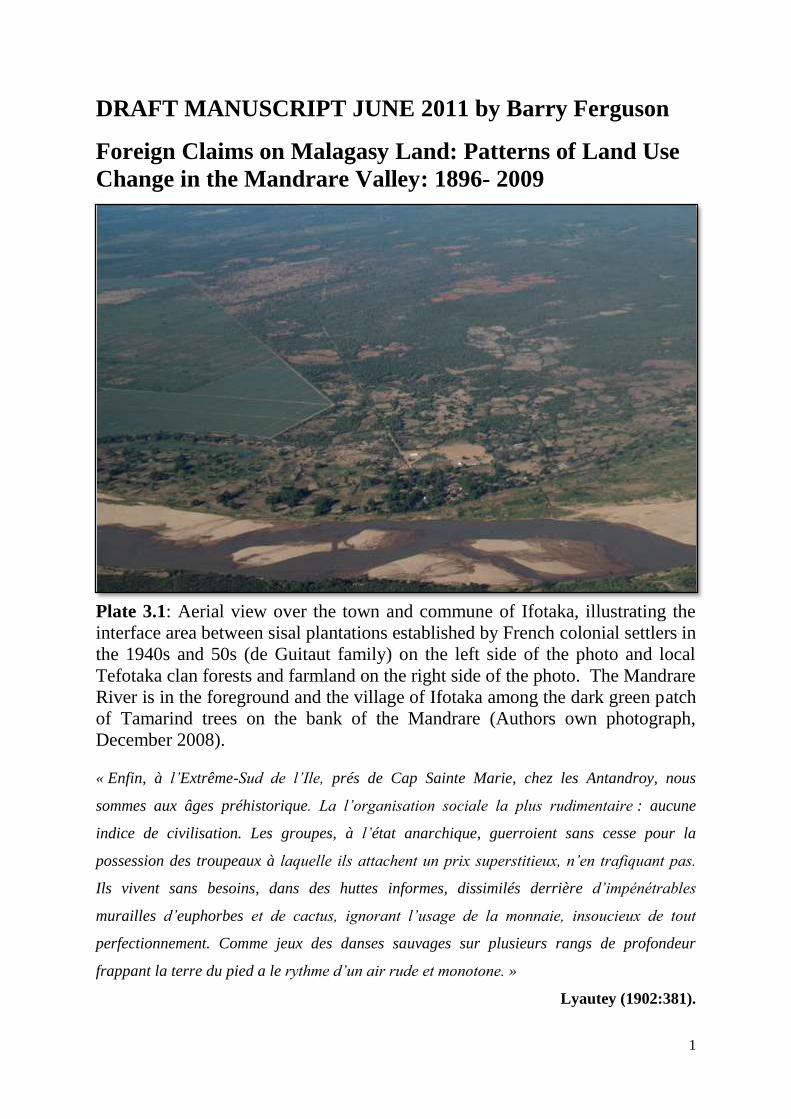
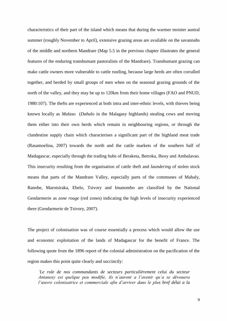
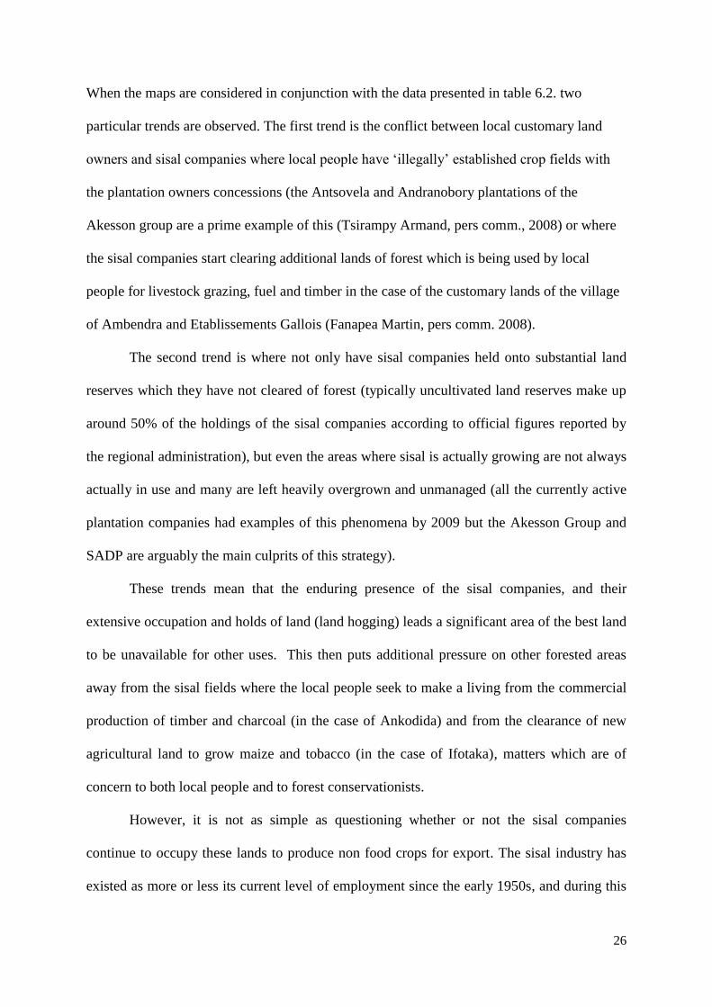
Plate 3.1: Aerial view over the town and commune of Ifotaka, illustrating the
interface area between sisal plantations established by French colonial settlers in
the 1940s and 50s (de Guitaut family) on the left side of the photo and local
Tefotaka clan forests and farmland on the right side of the photo. The Mandrare
River is in the foreground and the village of Ifotaka among the dark green patch
of Tamarind trees on the bank of the Mandrare (Authors own photograph,
December 2008).
« Enfin, à l‟Extrême-Sud de l‟Ile, prés de Cap Sainte Marie, chez les Antandroy, nous
sommes aux âges préhistorique. La l‟organisation sociale la plus rudimentaire : aucune
indice de civilisation. Les groupes, à l‟état anarchique, guerroient sans cesse pour la
possession des troupeaux à laquelle ils attachent un prix superstitieux, n‟en trafiquant pas.
Ils vivent sans besoins, dans des huttes informes, dissimilés derrière d‟impénétrables
murailles d‟euphorbes et de cactus, ignorant l‟usage de la monnaie, insoucieux de tout
perfectionnement. Comme jeux des danses sauvages sur plusieurs rangs de profondeur
frappant la terre du pied a le rythme d‟un air rude et monotone. »
Lyautey (1902:381).
2
« L‟exemple donne par la colonisation du Mandrare apporte la preuve certain que la ténacité
et l‟esprit d‟entreprise ont permis l‟une des plus belles réussites de la province de Tuléar. »
Charles Rocca August 1952 (CAOM, 2D34)
« …de Heaulme, il est tolérable. Même si il a accaparé les terres des Tandroy pour son sisal
et la réserve ou on est interdit de rentrer, il est plus ou moins assimilé avec nous, il parle
bien le dialecte Antandroy et ils n‟ont pas touché les tombeaux ancestrales pendent la
création de ses plantations de sisal. Il sait intégrer avec nous, il vient pour assister et même
cotiser les funérailles dans le village de Berenty. Par contre, du Guitaut, il a défrichée sans
hésitation. Avec un bulldozer il a détruit des tombeaux de mes ancêtres et les forets tabous
aux alentours… »
Anonymous informant, Antefotaka Clan, 21st October 2007.
Chapter Contents 3.1 Introduction and Research Question
3.2 Methods and Approach
3.2.1 A Framework for analysing foreign land use changes
3.3 Foreign Land Claims for Agriculture
3.3.1 Sisal Plantations
3.3.2 Significance of Sisal Plantations for this Thesis
3.3.3 Biofuels and Other Oleaginous Crops
3.4 Mining
3.5 Conservation and forestry related land claims
3.6 Other land use changes and plans in the Mandrare
3.6.1 Tourism
3.6.2 Planning for Dams: Hydroelectricity and Irrigation Schemes
3.6.3 Reduced Emissions from Deforestation and Degradation (REDD)
3.6.4 Regional Land Use Planning
3.7 Conclusions: Trends in Human Land Use in the Mandrare
Abbreviations
References
Translations of quotes in French from archival material and an interview
List of Plates
Plate 3.1 Aerial view over the town and commune of Ifotaka.
Plate 3.2 Mandrare Sisal Plantations in 1952.
Plate 3.3 Images of the Mandrare Sisal Plantations in 2009.
Plate 3.4 Oleaginous Crop Plantation and Processing.
Plate 3.5 Flora Eco Power Castor Oil Biofuel Project in the Mandrare 2008.
Plate 3.6 Ambindrakemba Quarry (C.E.A. Mine 37 Tranomaro).
3
Plate 3.7 Colonial Era Mining in the Mandrare Valley.
Plate 3.8 Current Status of Mining Activities in the Mandrare.
List of Tables
Table 3.1 Typology of Directions of Land Use Change.
Table 3.2 Land Claims for Sisal Plantations, Mandrare Valley 1934-2010.
Table 3.3 Recent Plantations for Biofuel/Oleaginous Plants in the Mandrare.
Table 3.4 Companies With Documented Mining Claims, Mandrare Valley.
Table 3.5 Managed and Protected Forest Areas in the Mandrare Valley.
Table 3.6 Information on Mandrare Valley Tourism Site.
Table 3.7 Overview of Land Cover Statistics for Mandrare Valley (2009).
Table 3.8 Overview of Political Economy and Major Events 1900 – 2010.
List of Figures
Figure 3.1 Land Claims and Sisal Plantations, Mandrare Valley.
Figure 3.2 Official Data on Sisal Production from Madagascar.
Figure 3.3 Employees and Dependents of Mandrare Sisal Plantations.
Figure 3.4 National Production of Castor Oil from Madagascar.
Figure 3.5 Trends in Forest Protected Areas in the Mandrare.
Figure 3.6 Typology of Directions of Land Use Change and Drivers.
List of Maps
Map 3.1 Map of the Status of Colonisation of the Mandrare Valley 1st January
1898.
Map 3.2 Dates of French Colonisation of sites in the Mandrare Valley and
Androy.
Map 3.3 Mandrare Valley Sisal Plantations in 2009.
Map 3.4 Land Use Conflicts in the Hinterlands of Sisal Plantations.
Map 3.5 Distribution of Biofuel/Oleaginous Crop Plantations, Mandrare.
Map 3.6 Mining Claims in the Mandrare Valley, January 2009.
Map 3.7 Working Mines of the Mandrare Valley SE Madagascar from 1900-
2009.
Map 3.8 Principal Forests of Androy 1952.
Map 3.9 Potential Land Use and Resources in Mandrare 1953.
Map 3.10 Large Scale Afforestation Plans from 1950s.
Map 3.11 Managed and Protected Forests of the Mandrare Valley in 2010.
Map 3.12 Tourism Sites in the Mandrare Valley.
Map 3.13 The Air France/Good Planet/WWF REDD Pilot Project.
Map 3.14 Regional Development Planning Maps for Anosy and Androy.
Map 3.15 Regional Forest Zoning for Amboasary District in 2008.
Map 3.16 Mandrare Valley: Mining Land Claims Overlaid with Conservation
Claims 2009.
Map 3.17 Mandrare Valley: Foreign Land Claims with Actual Activities up to
2010.
Y
ear
Pla
nta
tion
Co
mp
an
y
Typ
e
19
34
19
45
19
47
19
52
19
53
a 1
955
19
59
19
77
19
99
20
00
20
09
20
10
1,2
3
2
4
5
6
6,2
7
8,9
,11
10
12
13,1
4
SF
SM
C
L
40
00
41
77
(4
17
7)
10
00
0
10
00
0
41
77
P
L
50
97
5
11
50
2
671
25
51
SA
DP
C
L
13
05
.15
(5
66
5.1
5)
8
136
54
00
54
70
55
00
55
00
P
L
60
0
62
2
29
50
44
93
40
73
4
104
.10
HA
H
CL
1
147
.2
(401
5)
72
50
72
50
60
40
60
00
60
00
P
L
50
0
12
50
2
758
40
00
29
97
.00
SS
M
CL
8
86.9
4
(187
6.9
4)
39
00
41
50
23
40
25
00
25
00
P
L
50
0
80
0
27
58
20
00
17
45
.76
GA
LL
OIS
C
L
14
30
(3
66
0)
62
00
64
60
48
00
30
00
30
00
6
000
P
L
50
0
14
00
2
354
30
00
24
95
.70
CA
IM
CL
N
IL
(555
0)
58
50
44
50
P
L
15
55
AK
ES
SO
N G
RO
UP
C
L
10
00
0
10
00
0
7
550
P
L
66
92
.81
57
00
OT
HE
RS
c
CL
3
12
(274
0)
P
L
43
5.7
4b
TO
TA
L
CL
4
000
8
946
.29
(2
48
94
.09
) 4
1,3
36
37
65
0
22
87
7
27
00
0
27
00
0
P
L
50
13
00
30
75
52
22
1
604
4
14
02
5
1
935
2.4
6
Dif
fere
nce
CL
- P
L
3
950
68
33
12
97
5
% C
laim
ed
La
nd
Pla
nte
d
1
.25
%
70
.13
%
51
.94
%
4
3.1 Introduction and Research Question
As briefly described in the previous chapter, the Mandrare valley has been subject to a whole
array of human induced land use changes since Madagascar was settled by man, thought to be
approximately two thousand three hundred years before present (Burney et al., 2004:25). No
written records are known to exist for the peoples of southern Madagascar prior to the first
documented foreign colonisation efforts in the 1640‟s (de Flacourt, 1984; Larson, 2009)1.
Even for the period following the eventually unsuccessful seventeenth century attempts to
establish a French colony, the written records are somewhat scant, especially in terms of
information on land use. The main available sources for the period between 1640 and 1896
which relate to the Mandrare valley are the diary of a shipwrecked English sailor, Robert
Drury (Drury, 1729) an archaeological and historical study examining the early history of the
Androy (Parker Pearson & Godden, 2002) and the Histoire de la Grande Isle Madagascar
written by Etienne de Flacourt (1984) the latter being an administrator of the French
settlement established in the Fort Dauphin region in 1642. During the seventeenth century
the French did launch expeditions westwards from Fort Dauphin, these were typically
military endeavours, one it was led by a Monsieur Le Vacheur and crossed the Mandrare
Valley entering the Androy region which was then to the west of the Mandrare with Tanosy
allies, although battles were reported, presumably with the Bara and Tanala people who were
then resident in the northern parts of the valley, and so the mission did not last long (Decary,
1930).
During the 19th century Madagascar underwent numerous military campaigns, both between
Malagasy groups, and between the Malagasy and at least four successive French military
1 Raymond Decary (1930:98) described a Dutch colonisation effort from Cap Sainte Marie (the southern tip of
Madagascar) in 1595, and a series of shipwrecks along the coast of Dutch and French traders through the
following decades leading to numerous deaths among the few passengers who did make it ashore.
5
expeditions (Randrianja & Ellis, 2009). Prior to 1810 Madagascar had been divided into a
number of rival and feuding kingdoms of different parts of the island including the Merina
of the central highlands, the Sakalava of the West and Southwest, the Betsimisaraka of the
East and the Bara of the central south. When the British took control of the neighbouring
island of Mauritius from the French in 1810, their strategy which envisaged exerting
dominance over the island of Madagascar by means of an allegiance with a single monarch,
rather than through a military campaign to completely colonise the island was a turning point
(Brown, 1995). The British provided both military advice and training and Christian
missionaries to the areas which by this time were under the control of the Merina kingdom.
Such support was among the factors which helped the Merina come to dominate much of the
island during the nineteenth century. In the 1830s the Merina kingdom did unsuccessfully
attempt to conquer the southern regions of Madagascar which up to then had not been under
their control (Decary, 1930:97). The Mandrare was at this time something of a frontier
region, both in the sense of not having been colonised by the Merina, who were considered to
largely control Madagascar, but also because of the still dynamic boundaries between the
different ethnic groups resident in the region. Unlike the neighbouring Anosy region (around
Fort Dauphin) which had been conquered by the Merina in the nineteenth century and where
a number of French had settled in the early 1890s the Mandrare was explored and pacified
much later than other areas. The fourth main French military expedition in Madagascar of
the nineteenth century2 was eventually to lead to Madagascar‟s annexation as a French
colony, with the Merina capital city of Antananarivo in the central highlands being captured
by the French in 1896. At this same time the Mandrare valley, in contrast to most of the rest
of Madagascar remained uncolonised by either French or Merina and different areas were
ruled by the one of the three largest groups: the Tandroy, the Tanosy and the Bara peoples.
2 Randrianja and Ellis (2009:151) detail four military expeditions by the French in Madagascar during the
nineteenth century these being during 1829, 1845, 1883-85, 1894-5, with the last one leading to eventual
annexation as a French colony.
6
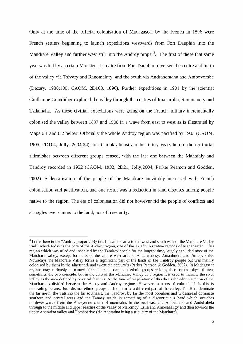
Only at the time of the official colonisation of Madagascar by the French in 1896 were
French settlers beginning to launch expeditions westwards from Fort Dauphin into the
Mandrare Valley and further west still into the Androy proper3. The first of these that same
year was led by a certain Monsieur Lemaire from Fort Dauphin traversed the centre and north
of the valley via Tsivory and Ranomainty, and the south via Andrahomana and Ambovombe
(Decary, 1930:100; CAOM, 2D103, 1896). Further expeditions in 1901 by the scientist
Guillaume Grandidier explored the valley through the centres of Imanombo, Ranomainty and
Tsilamaha. As these civilian expeditions were going on the French military incrementally
colonised the valley between 1897 and 1900 in a wave from east to west as is illustrated by
Maps 6.1 and 6.2 below. Officially the whole Androy region was pacified by 1903 (CAOM,
1905, 2D104; Jolly, 2004:54), but it took almost another thirty years before the territorial
skirmishes between different groups ceased, with the last one between the Mahafaly and
Tandroy recorded in 1932 (CAOM, 1932, 2D21; Jolly,2004; Parker Pearson and Godden,
2002). Sedentarisation of the people of the Mandrare inevitably increased with French
colonisation and pacification, and one result was a reduction in land disputes among people
native to the region. The era of colonisation did not however rid the people of conflicts and
struggles over claims to the land, nor of insecurity.
3 I refer here to the “Androy proper”. By this I mean the area to the west and south west of the Mandrare Valley
itself, which today is the core of the Androy region, one of the 22 administrative regions of Madagascar. This
region which was ruled and inhabited by the Tandroy people for the longest time, largely excluded most of the
Mandrare valley, except for parts of the centre west around Andalatanosy, Antanimora and Ambovombe.
Nowadays the Mandrare Valley forms a significant part of the lands of the Tandroy people but was mainly
colonised by them in the nineteenth and twentieth century‟s (Parker Pearson & Godden, 2002). In Madagascar
regions may variously be named after either the dominant ethnic groups residing there or the physical area,
sometimes the two coincide, but in the case of the Mandrare Valley as a region it is used to indicate the river
valley as the area defined by physical features. At the time of preparation of this thesis the administration of the
Mandrare is divided between the Anosy and Androy regions. However in terms of cultural labels this is
misleading because four distinct ethnic groups each dominate a different part of the valley. The Bara dominate
the far north, the Tatsimo the far southeast, the Tandroy, by far the most populous and widespread dominate
southern and central areas and the Tanosy reside in something of a discontinuous band which stretches
northwestwards from the Anosyenne chain of mountains in the southeast and Ambatoabo and Andohahela
through to the middle and upper reaches of the valley of Maromby, Esira and Amboahangy and then towards the
upper Andratina valley and Tomboarivo (the Andratina being a tributary of the Mandrare).
7
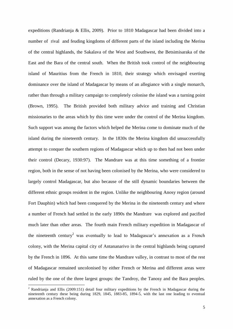
Map 3.1: Map of the Status of Colonisation of the Mandrare Valley 1st January 1898
French Flags indicate established military posts (CAOM, 1898, 2D10).
Map 3.2: Dates of French Colonisation of sites in the Mandrare Valley and Androy.
8
This chapter deals largely with the issue of land claims, but before moving into that it is
perhaps worth giving a short overview of the issue of insecurity which is an essential
characteristic feature of the region. The Mandrare valley up to this day is well known for
cattle rustling which carries on across the region, and which for the Bara people of the north
of the valley is said by some to be a rite of passage for young men or traditional sport
(Bouwer, 2000). During fieldwork between 2007 and 2009 I frequently encountered groups
of Tandroy men on tinondia4 who were in search of zebu cattle recently stolen from their
families. Men on tinondia are easily recognisable as they are groups of men, carrying little
other than their spears and wrapped in a lamba or flannel (a printed cotton sheet used as
clothing and as a sleeping sheet), and they typically have a more concentrated and aggressive
demeanour than is habitual. The other time that one is likely to encounter groups of men with
such dress and demeanour, is during a kabaro or traditional conflict resolution
hearing/meeting. So prevalent is the phenomena of cattle rustling that even from the
relatively small sample of households who were informants in focal villages for this study
(n=120) several were victims of cattle thefts during the period of fieldwork. I also had a
number of encounters with individuals who were reportedly active or former cattle rustlers
themselves. While increased sedentarisation does seem to have been an outcome of the
advent of French colonial rule at the end of the nineteenth century, it is still not ubiquitous,
since many of the Tandroy cattle producers of the Mandrare region and beyond have for
many generations relied on transhumant grazing systems, due to the biophysical
4 Being on the trail on the hunt for stolen cattle, following hoofprints across the landscape is known as tinondia
(in the Tandroy language tinone is the hunt for hoofprints; dia is being on the trail). As well as encountering the
victims of cattle theft, it was an almost daily occurrence when travelling in the Mandrare to hear of the latest
movements of the Malaso. Indeed bands of armed malaso are widely believed by local people of the northern
parts of the Mandrare to be working in complicity with various representatives of the state: i) Bands of
Antaisaka are rumoured to have been armed with Kalashnikovs automatic rifles by a now retired Antaisaka
army General, ii) Commune officials in the isolated regions of the centre and east of southern Madagascar
(Iakora, Ihosy, Betroka, Ranotsara, Mahabo) are frequently said to be responsible for cattle laundering by
providing new official papers for cows stolen further south, iii) Local Gendarmes in the Mandrare whose job it
is to apprehend these thieves have a very low success rate in apprehending and seeking justice for the large scale
thieving which goes on, indeed during the weekly market in Tsivory on the 8th
December 2007 they were not
present as they usually would be, and a theft of some 87 zebu took place by an armed group.
9
characteristics of their part of the island which means that during the warmer moister austral
summer (roughly November to April), extensive grazing areas are available on the savannahs
of the middle and northern Mandrare (Map 5.5 in the previous chapter illustrates the general
features of the enduring transhumant pastoralists of the Mandrare). Transhumant grazing can
make cattle owners more vulnerable to cattle rustling, because large herds are often corralled
together, and herded by small groups of men when on the seasonal grazing grounds of the
north of the valley, and they may be up to 120km from their home villages (FAO and PNUD,
1980:107). The thefts are experienced at both intra and inter-ethnic levels, with thieves being
known locally as Malaso (Dahalo in the Malagasy highlands) stealing cows and moving
them either into their own herds which remain in neighbouring regions, or through the
clandestine supply chain which characterises a significant part of the highland meat trade
(Rasamoelina, 2007) towards the north and the cattle markets of the southern half of
Madagascar, especially through the trading hubs of Beraketa, Betroka, Ihosy and Ambalavao.
This insecurity resulting from the organisation of cattle theft and laundering of stolen stock
means that parts of the Mandrare Valley, especially parts of the communes of Mahaly,
Ranobe, Marotsiraka, Ebelo, Tsivory and Imanombo are classified by the National
Gendarmerie as zone rouge (red zones) indicating the high levels of insecurity experienced
there (Gendarmerie de Tsivory, 2007).
The project of colonisation was of course essentially a process which would allow the use
and economic exploitation of the lands of Madagascar for the benefit of France. The
following quote from the 1896 report of the colonial administration on the pacification of the
region makes this point quite clearly and succinctly:
„Le role de nos commandants de secteurs particulièrement celui du secteur
Antanosy est quelque peu modifie, ils n‟auront a l‟avenir qu‟a se dévouera
l‟œuvre colonisatrice et commerciale afin d‟arriver dans le plus bref délai a la
10
mise en valeur des richesses du sol que l‟ou saurait contester a la province de
Fort Dauphin‟. (CAOM, 1896 2D103).
It goes without saying that various foreign influences such as the motors of capitalist
industry, the demand for natural resources and the aspiration of western environmentalism
have been behind the plethora of land related claims in the Mandrare Valley. Initially the
focus of this research was on Tandroy forest people, and in examining the customary land
and resource use practices. On returning to Madagascar in July 2007 it quickly became
apparent that not only was the history of the region highly significant in developing a proper
understanding of what the relationships and perceptions are between local customary land
owners and outsiders making claims on the land and the resources upon or underneath this
land. My focus on forest lands was based on an assumption that I could adequately examine
forests, forest peoples and conservationists independently from the other claims in the region
(foreign agricultural, biofuels, tourism and mining activities) also quickly proved to be naive.
Mining concessions surrounded all six of my focal study villages, and even overlapped
extensively the lands allocated for forest protection by conservation NGOs in one of these
villages. Biofuels plantations were starting and planned for areas adjacent to several of these
same study villages, and foreign investment in tourism development was also taking place.
Add to this the fact that a significant number of people from two of my six focal study
villages were employed or dependent on markets created by enduring colonial era sisal
plantations. This led me to adopt a somewhat more holistic approach than had initially been
envisaged both in terms of the period under investigation and in terms of spatial coverage of
the research.
These diverse land related claims have undoubtedly had many impacts on the social,
economic, political and cultural life of the people of the Mandrare, it would be a monumental
11
task to comprehensively research, document and analyse such matters at the scale of the
whole valley so this is well beyond the scope of this thesis. Some of the impacts and potential
impacts of a small subset of these claims (mainly in terms of forest conservation) on the
people of the Mandrare are considered in chapters seven, eight and nine. Chapter seven
consider the important question of local claims on land through examining patterns of
contemporary village land use in a historical context. Chapter eight considers local land
claims and the competing claims of outsiders using a cultural lens to understand local
customary institutions and land tenure systems. The task of this chapter however is to set the
scene for these subsequent sections by cataloguing and mapping the major land related claims
made by people and bodies who are not natives of the region over the period since 1896 when
written records useful for this purpose began to be kept.
So, for the remainder of this chapter I will attempt to deal specifically with the following
question: What trends have been observed in foreign claims on land in the Mandrare
Valley for the period since French colonisation to the present day?
3.2 Methods and Approach
Chapter four already describes in some detail the methods which have been adopted for this
study. The synthesis and analysis presented in sections 6.3 to 6.7 comprise the results of
trawls of colonial and post colonial archives in Aix-en-Provence and on www.madadoc.mg ,
information gathering from key stakeholder interviews with employees of conservation
NGOs, biofuels and mining company employees and employees of sisal plantations as well as
general internet and literature review. Spatial data was collected from archived reports
(forests), from interviews with conservation organisations (protected areas), the regional
administration of Anosy in Fort Dauphin (mining concessions and permits), and using
Google Earth and some ground surveys a spatial survey was made of sisal plantations, and
12
mining activities. The maps presented in the subsequent sections of this chapter are
combination of these diverse data sources, and GIS analysis.
3.2.1 A Framework for analysing land use changes
The sheer diversity and complexity of competing claims and aspirations for land use in the
Mandrare requires some sort of systematic form of analysis. While the thesis overall is most
concerned with local people their land uses, livelihoods and customs, this chapter considers
the whole array of land use changes driven or influenced by outsiders, that is projects or
businesses of foreign or domestic investors from outside the region, as well as state and NGO
programmes and interventions of development agencies. The recent resurgence of foreign
interest in land acquisitions in the developing world (often emotively and sometimes
misleadingly termed land grabbing) has spurred the emergence of some new theoretical
explorations by scholars who are examining what changes are actually happening and
analysing the characteristics of these processes, including the drivers, legal context and the
associated flows of wealth and power. One popular framework of analysis has been
developed by Borras and Franco (2010a) which focuses principally on two features (i)
directions of land use change and (ii) the flow of land based wealth and power. Their
framework, which deals mainly with agricultural land use changes proposes a typology with
four broad categories of land use change (A-Food to Food; B-Food to Biofuels; C-Nonfood to
Food; D-Nonfood to Biofuels) and four categories of flows of land-based wealth and power
(A-Redistribution; B-Distribution; C-Non-(re)distribution; D-(Re)concentration). However
the first part of their framework does not provide an adequate tool for the analysis of other
competing land use changes outside the agricultural domain. Considering the subject matter
of this chapter, and the trends observable in the Mandrare, a number of additional categories
are needed to allow us to take account of forestry (for biodiversity conservation, to establish
forest carbon based commodities under emerging mechanisms such as REDD, for habitat
13
restoration, and for productive forestry through afforestation and reforestation), farming of
textiles (sisal), mining, tourism and other potential land use changes which have been such as
dams and hydroelectricity. At the same time that I had developed additional categories during
the preparation of this work, Hall (2010:16) also made useful additions to the Borras and
Franco framework to accommodate these other significant land uses which need to be
considered in holistic spatial analyses of land use change. The Land Use Change element of
Hall‟s framework, which I have adapted slightly for this chapter is illustrated in Table 6.1
below. The longer range historical reconstruction of land use changes which this chapter
combines with examination of contemporary trends is deemed necessary to understand the
relative significance of competing claims and of drivers of land use change (Dearing et al.
2010).
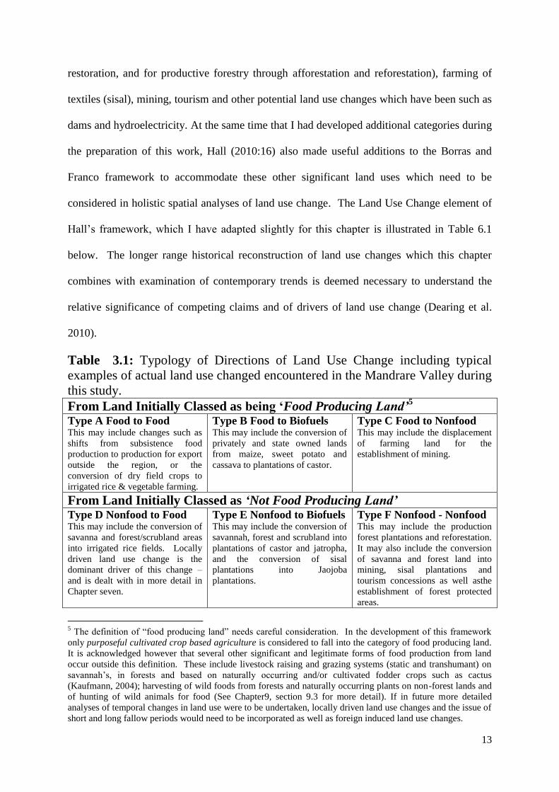
Table 3.1: Typology of Directions of Land Use Change including typical
examples of actual land use changed encountered in the Mandrare Valley during
this study.
From Land Initially Classed as being ‘Food Producing Land’5
Type A Food to Food This may include changes such as
shifts from subsistence food
production to production for export
outside the region, or the
conversion of dry field crops to
irrigated rice & vegetable farming.
Type B Food to Biofuels This may include the conversion of
privately and state owned lands
from maize, sweet potato and
cassava to plantations of castor.
Type C Food to Nonfood This may include the displacement
of farming land for the
establishment of mining.
From Land Initially Classed as ‘Not Food Producing Land’ Type D Nonfood to Food This may include the conversion of
savanna and forest/scrubland areas
into irrigated rice fields. Locally
driven land use change is the
dominant driver of this change –
and is dealt with in more detail in
Chapter seven.
Type E Nonfood to Biofuels This may include the conversion of
savannah, forest and scrubland into
plantations of castor and jatropha,
and the conversion of sisal
plantations into Jaojoba
plantations.
Type F Nonfood - Nonfood This may include the production
forest plantations and reforestation.
It may also include the conversion
of savanna and forest land into
mining, sisal plantations and
tourism concessions as well asthe
establishment of forest protected
areas.
5 The definition of “food producing land” needs careful consideration. In the development of this framework
only purposeful cultivated crop based agriculture is considered to fall into the category of food producing land.
It is acknowledged however that several other significant and legitimate forms of food production from land
occur outside this definition. These include livestock raising and grazing systems (static and transhumant) on
savannah‟s, in forests and based on naturally occurring and/or cultivated fodder crops such as cactus
(Kaufmann, 2004); harvesting of wild foods from forests and naturally occurring plants on non-forest lands and
of hunting of wild animals for food (See Chapter9, section 9.3 for more detail). If in future more detailed
analyses of temporal changes in land use were to be undertaken, locally driven land use changes and the issue of
short and long fallow periods would need to be incorporated as well as foreign induced land use changes.
14
3.3 Foreign Land Claims for Agriculture
This section focuses on foreign claims on land in the Mandrare for agricultural activitie,
rather than trying to tackle the daunting task of reviewing all agricultural land use changes
across the valley. Chapter seven will deal with a series of local cases of land use change,
including slash and burn agriculture systems where local farmers clear forest to establish
agricultural land and the interaction of local land use systems with conservation policies
which restrict local customary land use systems.
Various foreign stakeholders have been involved in agriculture in the Mandrare Valley since
the 1930s. The activities which have been undertaken over the eighty years since this time
included the production of food crops (maize and rice) and livestock (cattle) as well as
growing non-food crops particularly oils and textiles but also tobacco and aloes. Only the
farming of non-food crops endured at any significant scale through to the present day. The
demise of foreign interest in food crops and enduring focus on the export products such as
oils and textiles is perhaps unsurprising from a business perspective when one considers the
socio-economic deprivation of the local communities, and the cultural prevalence of cattle
rustling as a common occurrence in the region.
Unlike the neighbouring Anosy region which had already been settled by various foreigners
even before official French colonisation of Madagascar was complete in 1896, the Mandrare
was not stabilised enough for foreign led agriculture to be established until the 1930‟s. The
first recorded investors were from the Southern Madagascar Land Company (SFSM or
Société Foncière du Sud de Madagascar), who after establishing sisal plantations near
Ranopiso to the east of the Mandrare Valley in 1928 then went on to establish the first
foreign plantation on a four thousand hectare concession of fallow land (friche) on the
15
western banks of the Mandrare opposite the current location of the town of Amboasary-Sud
in 1932, on what is now the SPSM Sisal Plantation at Maharangotsy (Guerin, 1969:133;
1972:40). The same company also held at this time a concession of 24,851 hectares to the
north west of Tranomaro, which was expected to be used for extensive cattle farming, but
was among various ambitious ventures not to be realised. The first SFSM plantation was of
225 hectares of castor plants (Ricinus communis) an oil producing crop then used for
pharmaceuticals (for medicine for intestinal disorders and hair oil among others)6. The
plantation was however entirely unsuccessful due to insect infestations and the perception of
inappropriate soils and was abandoned the next year (CAOM, 1934, 2D21). Following this
failed plantation the same lands were planted with Aloes, a succulent plant of which many
endemic species naturally thrive in the south of Madagascar. The Aloe plantation was also
destined to fail, and the huge cattle farming venture never came to fruition either (although
the Ranobe plains, where the latter was to be located is still today an important zone used my
large herds of cattle in transhumant grazing systems) (PNUD/FAO, 1980; Pers obs, 2007).
The next agricultural trials undertaken by the SFSM were of sisal (Agave sisalana, known
locally as laloasy) were much more successful than their precursors, and have proved to be
instrumental in shaping the extensive foreign owned landscape of the lower Mandrare valley
which exists today. The next section presents an overview of the expansion of the Mandrare
valley sisal plantations since the first plantations of 1934 (Guerin, 1972) through to the
present day.
6 Incidentally castor oil is now becoming more prominent globally as a crop due to its use in the global biofuel
production industry, and at the same time it maintains many of its pharmaceutical functions.
16
3.3.1 Sisal Plantations
After what turned out to be unsuccessful trials of castor and aloe plantations in 1932 and
1933 by the Southern Madagascar Land Company (SFSM), Sisal, a fibrous succulent plant
which since 1928 was being extensively planted in the north, west and south west of
Madagascar (Rakotovao, 1979) was planted in the Mandrare valley for the first time. The
plantations by the SFSM (where the SPSM plantation is today) to the west of the town of
Amboasary (See Plantation marked “Akesson Group” in map 6.3) experienced a relatively
slow start up in the mid 1930‟s. After SFSM had installed, the de Heaulme family began
establishing their plantations in 1936 (Jolly, 2004:37) and following a lull in production
during the second world war a „sisal land rush‟ began in earnest in the late 1940s and early
1950s (Frere, 1958:109). At the peak of speculative interest in the early 1950s there were ten
different companies/families as well as the French Cotton and Textile Research Institute
(IRCT) with claims to lands in the valley, most of which established plantations. As sisal is
predominantly an export crop, the investments were somewhat speculative, and exposed to
fluctuations in currency and market prices with competing nations, especially Brazil, Mexico,
Tanzania, Kenya and Angola (MDRRA, 1977; Rakotovao, 1979). In the 1950‟s the
economic viability of the sisal plantations came into question, and the colonial administration
was encouraged to lobby Paris for subsidies, which did emerge and what was known as the
„Credit Textile‟ was one critical factor allowing the colonists to continue the expansion of
their plantations throughout the 1950‟s right up to Madagascar‟s independence in 1960. Post
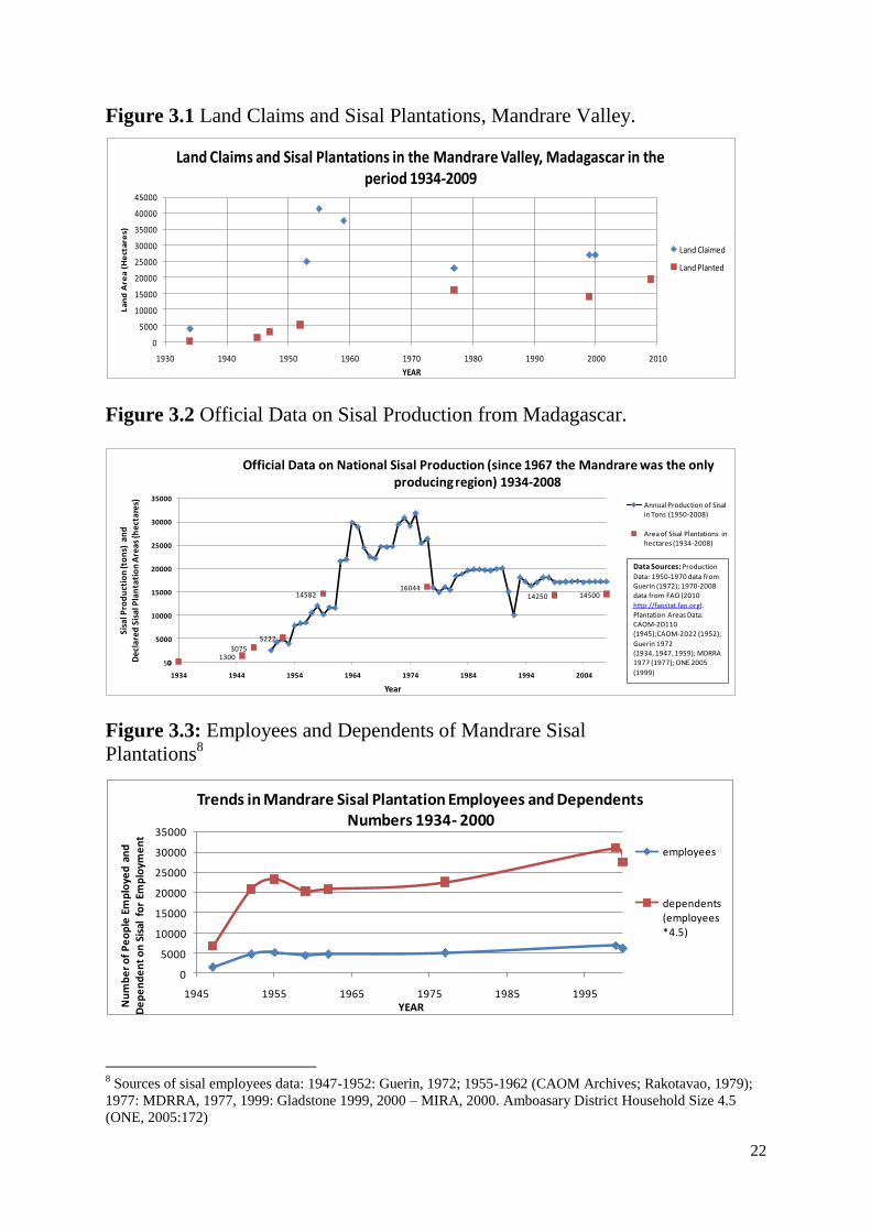
independence, the production from the then maturing plantations of the previous decade
meant that production increased, according to official figures production first peaked in 1964
at almost 29,000tons and then again in 1975 at almost 32,000tons (see figure 6.1 for a more
complete picture of the production trends).
17
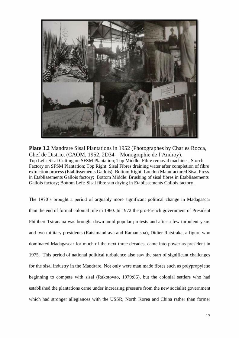
Plate 3.2 Mandrare Sisal Plantations in 1952 (Photographes by Charles Rocca,
Chef de District (CAOM, 1952, 2D34 – Monographie de l‟Androy). Top Left: Sisal Cutting on SFSM Plantation; Top Middle: Fibre removal machines, Storch
Factory on SFSM Plantation; Top Right: Sisal Fibres draining water after completion of fibre
extraction process (Etablissements Gallois); Bottom Right: London Manufactured Sisal Press
in Etablissements Gallois factory; Bottom Middle: Brushing of sisal fibres in Etablissements
Gallois factory; Bottom Left: Sisal fibre sun drying in Etablissements Gallois factory .
The 1970‟s brought a period of arguably more significant political change in Madagascar
than the end of formal colonial rule in 1960. In 1972 the pro-French government of President
Philibert Tsiranana was brought down amid popular protests and after a few turbulent years
and two military presidents (Ratsimandrava and Ramantsoa), Didier Ratsiraka, a figure who
dominated Madagascar for much of the next three decades, came into power as president in
1975. This period of national political turbulence also saw the start of significant challenges
for the sisal industry in the Mandrare. Not only were man made fibres such as polypropylene
beginning to compete with sisal (Rakotovao, 1979:86), but the colonial settlers who had
established the plantations came under increasing pressure from the new socialist government
which had stronger allegiances with the USSR, North Korea and China rather than former
18
colonial power France or America. Initially many were ordered to leave, which some did (the
Jenny Family and the du Guitaut family for example), but subsequently the government
negotiated with the main sisal plantation owners. They established shared control of the
plantations of deHeaulme (HAH), Confolens (SSM) and Gallois (Jolly, 2004:194) and
presumably the de Guitaut family as well, but two of the plantations (CAIM and SFSM) were
acquired in 1978 by retiring Paris based Swedish diplomat Bertil Akesson (Akesson, 2010)
and were re-established under two new plantation companies (SPSM, SAMA) and a fibre
processing factory (SFM). Akesson at the same time acquired land assets across Madagascar,
including cocoa, coffee and vanilla plantations as well as the Ampandrandava Mica
Phlogopite mine on the edge of the Mandrare Valley near Beraketa. The turmoil to the
companies meant that by the late 1970s production had receded to the levels of the pre-
colonial expansion era of the late 1950‟s and since then it has retained a roughly steady level
of production with a momentary dip during 1991-92 when there was a period of drop in value
attributed to the serious drought and famine in the south of Madagascar (Jolly, 2004:222).
The negotiations between the government and the sisal producers of the Mandrare Valley at
the end of the 1970s were crucial for the industry‟s continuation, indeed the Mandrare settlers
bucked the trend of decolonisation by foreign agricultural capitalists which was experienced
elsewhere in Madagascar both in the 1960‟s (Koerner, 1969:662) and in the 1970‟s
(MDRRA, 1977). The Mandrare remains as the only sisal producing region of Madagascar in
the present day. Without a more detailed investigation into the relative importance of neo-
patrimonial relationships, and unofficial/rent-seeking arrangements between sisal plantation
owners and the elites in the Malagasy political, business and administration classes remain
19
unclear, but indications from informants in the region7 and recent analysis of the political
economy of Madagascar more generally (Plangemann et al 2010) indicate that such
arrangements forming a Shadow State may well be an important determinant for the observed
endurance of the sisal plantations.
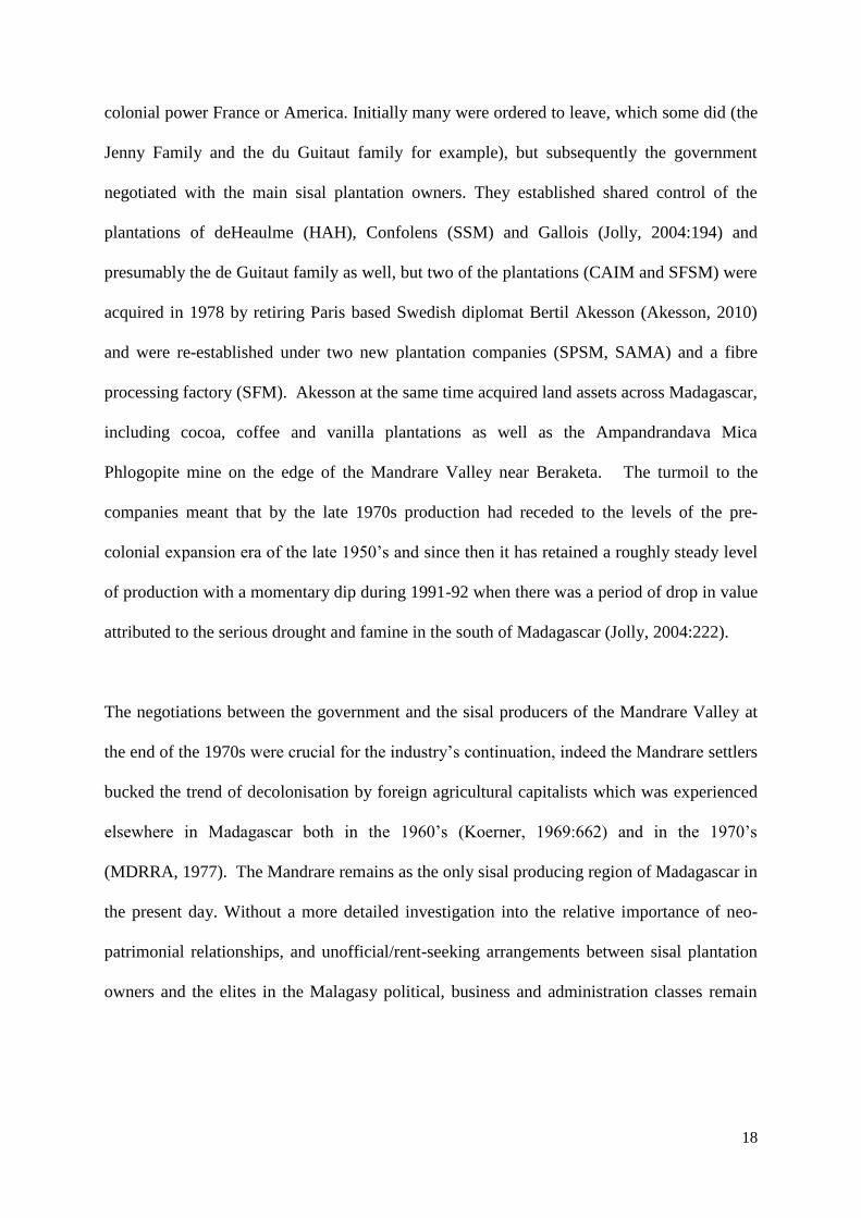
Plate 3.3 Images of the Mandrare Sisal Plantations in 2009 (authors photos). Top left: Anjahamahavelo Plantation, arguably one of the best kept of the Mandrare
plantations (de Heaulme); Top right: Cutting on Maharangotsy Plantation (Akesson Group,
SPSM); Bottom right: Sisal fibres drying in the sun at Ifotaka DP Factory (deGuitaut,
SADP); Bottom left: Sisal leaves being delivered to Ifotaka DP Factory for fibre extraction.
7 Several discussions have been held between the author and anonymous Tandroy informants from the political
classes in the lower Mandrare valley during 2008 and 2009 where such rent-seeking relationships were
described, but
20
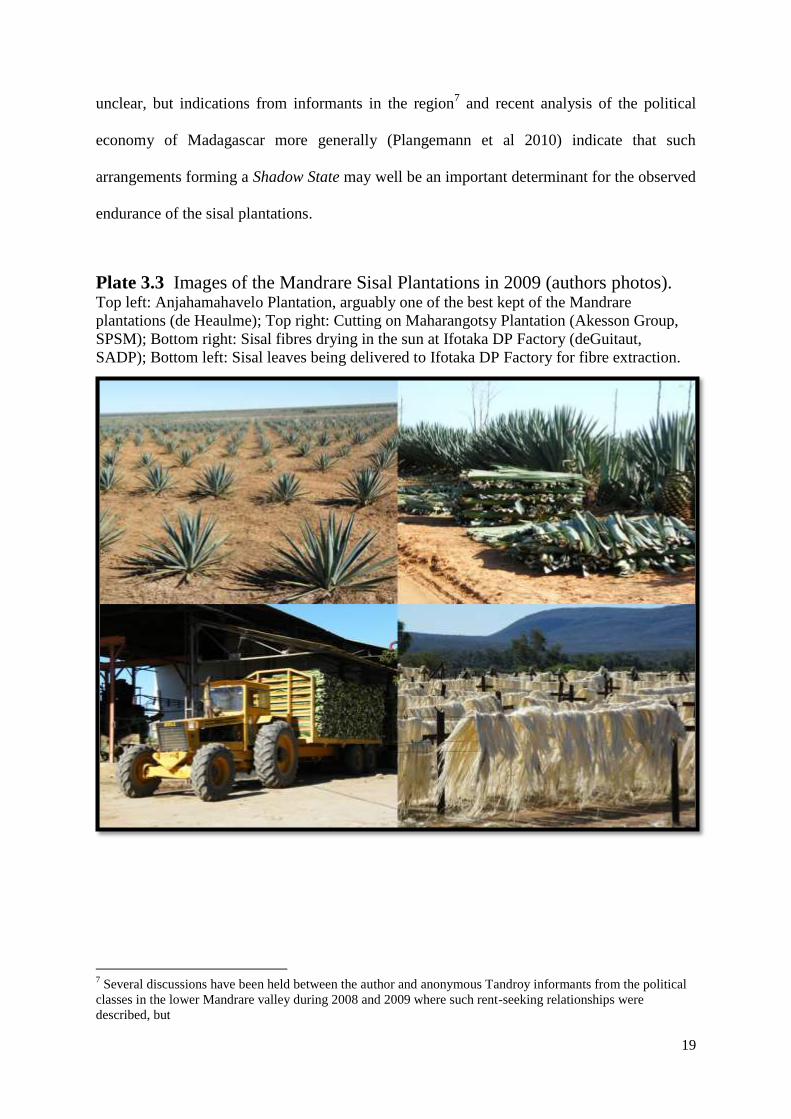
Map 3.3 : Mandrare Valley Sisal Plantations in 2009
21
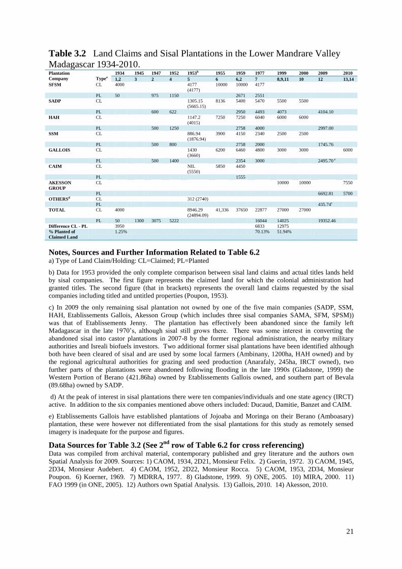
Table 3.2 Land Claims and Sisal Plantations in the Lower Mandrare Valley
Madagascar 1934-2010. Plantation
Company
Typea 1934 1945 1947 1952 1953b 1955 1959 1977 1999 2000 2009 2010
1,2 3 2 4 5 6 6,2 7 8,9,11 10 12 13,14
SFSM CL 4000 4177
(4177)
10000 10000 4177
PL 50 975 1150 2671 2551
SADP CL 1305.15
(5665.15)
8136 5400 5470 5500 5500
PL 600 622 2950 4493 4073 4104.10
HAH CL 1147.2
(4015)
7250 7250 6040 6000 6000
PL 500 1250 2758 4000 2997.00
SSM CL 886.94
(1876.94)
3900 4150 2340 2500 2500
PL 500 800 2758 2000 1745.76
GALLOIS CL 1430
(3660)
6200 6460 4800 3000 3000 6000
PL 500 1400 2354 3000 2495.70 e
CAIM CL NIL
(5550)
5850 4450
PL 1555
AKESSON
GROUP
CL 10000 10000 7550
PL 6692.81 5700
OTHERSd CL 312 (2740)
PL 435.74c
TOTAL CL 4000 8946.29
(24894.09)
41,336 37650 22877 27000 27000
PL 50 1300 3075 5222 16044 14025 19352.46
Difference CL - PL 3950 6833 12975
% Planted of
Claimed Land
1.25% 70.13% 51.94%
Notes, Sources and Further Information Related to Table 6.2 a) Type of Land Claim/Holding: CL=Claimed; PL=Planted
b) Data for 1953 provided the only complete comparison between sisal land claims and actual titles lands held
by sisal companies. The first figure represents the claimed land for which the colonial administration had
granted titles. The second figure (that in brackets) represents the overall land claims requested by the sisal
companies including titled and untitled properties (Poupon, 1953).
c) In 2009 the only remaining sisal plantation not owned by one of the five main companies (SADP, SSM,
HAH, Etablissements Gallois, Akesson Group (which includes three sisal companies SAMA, SFM, SPSM))
was that of Etablissements Jenny. The plantation has effectively been abandoned since the family left
Madagascar in the late 1970‟s, although sisal still grows there. There was some interest in converting the
abandoned sisal into castor plantations in 2007-8 by the former regional administration, the nearby military
authorities and Isreali biofuels investors. Two additional former sisal plantations have been identified although
both have been cleared of sisal and are used by some local farmers (Ambinany, 1200ha, HAH owned) and by
the regional agricultural authorities for grazing and seed production (Anarafaly, 245ha, IRCT owned), two
further parts of the plantations were abandoned following flooding in the late 1990s (Gladstone, 1999) the
Western Portion of Berano (421.86ha) owned by Etablissements Gallois owned, and southern part of Bevala
(89.68ha) owned by SADP.
d) At the peak of interest in sisal plantations there were ten companies/individuals and one state agency (IRCT)
active. In addition to the six companies mentioned above others included: Ducaud, Damitie, Banzet and CAIM.
e) Etablissements Gallois have established plantations of Jojoaba and Moringa on their Berano (Amboasary)
plantation, these were however not differentiated from the sisal plantations for this study as remotely sensed
imagery is inadequate for the purpose and figures.
Data Sources for Table 3.2 (See 2nd
row of Table 6.2 for cross referencing) Data was compiled from archival material, contemporary published and grey literature and the authors own
Spatial Analysis for 2009. Sources: 1) CAOM, 1934, 2D21, Monsieur Felix. 2) Guerin, 1972. 3) CAOM, 1945,
2D34, Monsieur Audebert. 4) CAOM, 1952, 2D22, Monsieur Rocca. 5) CAOM, 1953, 2D34, Monsieur
Poupon. 6) Koerner, 1969. 7) MDRRA, 1977. 8) Gladstone, 1999. 9) ONE, 2005. 10) MIRA, 2000. 11)
FAO 1999 (in ONE, 2005). 12) Authors own Spatial Analysis. 13) Gallois, 2010. 14) Akesson, 2010.
22
Figure 3.1 Land Claims and Sisal Plantations, Mandrare Valley.
Figure 3.2 Official Data on Sisal Production from Madagascar.
Figure 3.3: Employees and Dependents of Mandrare Sisal
Plantations8
8 Sources of sisal employees data: 1947-1952: Guerin, 1972; 1955-1962 (CAOM Archives; Rakotavao, 1979);
1977: MDRRA, 1977, 1999: Gladstone 1999, 2000 – MIRA, 2000. Amboasary District Household Size 4.5
(ONE, 2005:172)
501300
3075
5222
1458216044
14250 14500
0
5000
10000
15000
20000
25000
30000
35000
1934 1944 1954 1964 1974 1984 1994 2004
Sisa
l Pro
du
ctio
n (t
on
s) a
nd
D
ecl
are
d S
isal
Pla
nta
tio
n A
reas
(he
ctar
es)
Year
Official Data on National Sisal Production (since 1967 the Mandrare was the only producing region) 1934-2008
Annual Production of Sisal in Tons (1950-2008)
Area of Sisal Plantations in hectares (1934-2008)
Data Sources: Production
Data: 1950-1970 data from Guerin (1972); 1970-2008 data from FAO (2010
http://faostat.fao.org). Plantation Areas Data: CAOM-2D110 (1945);CAOM-2D22 (1952);
Guerin 1972 (1934, 1947, 1959); MDRRA 1977 (1977); ONE 2005
(1999)
0
5000
10000
15000
20000
25000
30000
35000
40000
45000
1930 1940 1950 1960 1970 1980 1990 2000 2010
La
nd
Are
a (
He
cta
res)
YEAR
Land Claims and Sisal Plantations in the Mandrare Valley, Madagascar in the period 1934-2009
Land Claimed
Land Planted
Y
ear
Pla
nta
tion
Co
mp
an
y
Typ
e
19
34
19
45
19
47
19
52
19
53
a 1
955
19
59
19
77
19
99
20
00
20
09
20
10
1,2
3
2
4
5
6
6,2
7
8,9
,11
10
12
13,1
4
SF
SM
C
L
40
00
41
77
(4
17
7)
10
00
0
10
00
0
41
77
P
L
50
97
5
11
50
2
671
25
51
SA
DP
C
L
13
05
.15
(5
66
5.1
5)
8
136
54
00
54
70
55
00
55
00
P
L
60
0
62
2
29
50
44
93
40
73
4
104
.10
HA
H
CL
1
147
.2
(401
5)
72
50
72
50
60
40
60
00
60
00
P
L
50
0
12
50
2
758
40
00
29
97
.00
SS
M
CL
8
86.9
4
(187
6.9
4)
39
00
41
50
23
40
25
00
25
00
P
L
50
0
80
0
27
58
20
00
17
45
.76
GA
LL
OIS
C
L
14
30
(3
66
0)
62
00
64
60
48
00
30
00
30
00
6
000
P
L
50
0
14
00
2
354
30
00
24
95
.70
CA
IM
CL
N
IL
(555
0)
58
50
44
50
P
L
15
55
AK
ES
SO
N G
RO
UP
C
L
10
00
0
10
00
0
7
550
P
L
66
92
.81
57
00
OT
HE
RS
c
CL
3
12
(274
0)
P
L
43
5.7
4b
TO
TA
L
CL
4
000
8
946
.29
(2
48
94
.09
) 4
1,3
36
37
65
0
22
87
7
27
00
0
27
00
0
P
L
50
13
00
30
75
52
22
1
604
4
14
02
5
1
935
2.4
6
Dif
fere
nce
CL
- P
L
3
950
68
33
12
97
5
% C
laim
ed
La
nd
Pla
nte
d
1
.25
%
70
.13
%
51
.94
%
0
5000
10000
15000
20000
25000
30000
35000
1945 1955 1965 1975 1985 1995
Nu
mb
er
of
Pe
op
le E
mp
loye
d a
nd
D
ep
en
de
nt
on
Sis
al f
or
Emp
loym
en
t
YEAR
Trends in Mandrare Sisal Plantation Employees and Dependents Numbers 1934- 2000
employees
dependents (employees*4.5)
23
3.3.2 Significance of Sisal Plantations for this Thesis
It may not be immediately apparent what relevance the existence and trends of the Mandrare
Valley sisal plantations have for this thesis so I will devote here some space to making the
link a little more explicit. Of the six main study villages where this thesis research was
undertaken, the customary lands of two (Ankodida and Ifotaka) are immediately adjacent to
sisal plantations. Indeed both villages lost ancestral lands to the sisal plantations during the
1950‟s, in the case of Ankodida this was to the Agricultural and Industrial Company of
Madagascar (CAIM), now SAMA and owned by the Akesson group; and in the case of
Ifotaka the lands were lost to French family de Guitaut as part of their company SADP and its
sisal plantations (SADP still hold it today). This theme of competing land claims between
local customary holders and foreign investors in the sisal industry is not just the subject of a
historical conflict. Not only do some local people still recount memory of the bulldozing of
ancestral burial grounds9, but the general disquiet towards the foreign theft of their land to
plant sisal frequently pervades informal discussions. More importantly perhaps is the fact
right that up to the present day land tenure conflicts characterise these hinterlands between
sisal fields, local farms, villages and forest, most significantly with the company
Etablissements Gallois converting part of its forest land bank at Ambendra (de facto occupied
for grazing and forest use by local people) into new sisal and jojoba plantations. The rapid
increase in interest in forest conservation in the region by international NGOs, the conversion
of forest land banks by these sisal companies, and the needs of the growing local populations
for new agricultural land, forest pasture for their livestock, and forest timber and non timber
9 It seems that the destruction of ancestral burial grounds during the bulldozing of forests for the establishment
of sisal fields was not a common practice (the incident referred to near Ifotaka in the quote of a Tefotaka elder‟s
testimony is apparently an exception rather than a rule) – indeed the presence of remnant forests within and
along the edges of sisal plantations remains a feature up to the present day. Many of these forests are ancestral
burial areas, and the two present day de Heaulme (HAH) plantations at Anjamahavelo and Berenty have not
only visibly conserved several dozen burial areas, but indeed have allocated at least 20% to conservation, in not
only the well known reserve of Berenty, but also in at least eight other substantial spiny forest reserves as well
as the Gallery Forest Reserve at Bealoka. The other plantations have spared numerous burial areas, but none
has been so sparing of the spiny forest as deHeaulme typically only conserving forests around dwellings some
administrative buildings and burial sites.

24
forest products are precariously juxtaposed in these communities. The clearing of forest for
new sisal fields is also seen as somewhat unwelcome by some local leaders when extensive
areas of planted sisal are effectively abandoned and overgrown, especially when the lower
Mandrare is among the most food insecure regions of southern Madagascar. Map 6.4
illustrates some of these conflicts visually some are merit worthy of in-depth research.
25
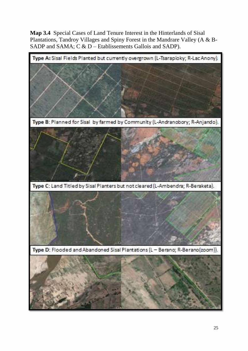
Map 3.4 Special Cases of Land Tenure Interest in the Hinterlands of Sisal
Plantations, Tandroy Villages and Spiny Forest in the Mandrare Valley (A & B-
SADP and SAMA; C & D – Etablissements Gallois and SADP).
26
When the maps are considered in conjunction with the data presented in table 6.2. two
particular trends are observed. The first trend is the conflict between local customary land
owners and sisal companies where local people have „illegally‟ established crop fields with
the plantation owners concessions (the Antsovela and Andranobory plantations of the
Akesson group are a prime example of this (Tsirampy Armand, pers comm., 2008) or where
the sisal companies start clearing additional lands of forest which is being used by local
people for livestock grazing, fuel and timber in the case of the customary lands of the village
of Ambendra and Etablissements Gallois (Fanapea Martin, pers comm. 2008).
The second trend is where not only have sisal companies held onto substantial land
reserves which they have not cleared of forest (typically uncultivated land reserves make up
around 50% of the holdings of the sisal companies according to official figures reported by
the regional administration), but even the areas where sisal is actually growing are not always
actually in use and many are left heavily overgrown and unmanaged (all the currently active
plantation companies had examples of this phenomena by 2009 but the Akesson Group and
SADP are arguably the main culprits of this strategy).
These trends mean that the enduring presence of the sisal companies, and their
extensive occupation and holds of land (land hogging) leads a significant area of the best land
to be unavailable for other uses. This then puts additional pressure on other forested areas
away from the sisal fields where the local people seek to make a living from the commercial
production of timber and charcoal (in the case of Ankodida) and from the clearance of new
agricultural land to grow maize and tobacco (in the case of Ifotaka), matters which are of
concern to both local people and to forest conservationists.
However, it is not as simple as questioning whether or not the sisal companies
continue to occupy these lands to produce non food crops for export. The sisal industry has
existed as more or less its current level of employment since the early 1950s, and during this
27
period significant proportion, thought to be up to 50%10
of the population of the six
communes where sisal plantations are located depend on income from permanent or task
based work for these companies, and as a result the local economy of the Amboasary area
(the regional markets as well as local commune administrations who receive taxes from the
sisal companies) is dominated by sisal. This situation, combined with the current trends in
biofuel and oil crop industries in the region makes the consideration of alternative land uses
(food production, large scale irrigation, forestry) an extremely challenging prospect11
, and
this is thought to be among the reasons why there is no apparent political will to enact any
land redistributions of the kind seen in Zimbabwe and Southern and Eastern Africa.
The issue of food production is briefly mentioned above. One might legitimately ask why
such an emphasis has been put on the production of non-food crops which are largely for
export12
, when the Mandrare Valley is the only part of the dry south with year round water
10
The dependency of the local population on employment of a family member in the sisal industry is
challenging to measure accurately. Families migrate in and out of the region, polygamous marriages and
relatively frequent separations are commonplace, many of the positions on the plantations are for piece work
and as such are seasonal and part time, and several of the sisal plantations have become renowned for extended
and unpredictable layoffs due to difficulties with cash flow, insecurity and technical breakdowns (Gladstone,
1999; Employee at SAMA, pers comm. Spring 2008; Employee at Ifotaka DP, pers comm. Autumn 2008).
However in order to generate at least some indicative estimate it was assumed that each sisal worker has 4.5
dependents (taken from Gladstone, 1999). The population of the six communes containing sisal plantations is
99,219 (SIRSA, 2005), however for four of these six communes only between 10 and 50% of their population is
within the geographical range for employment (estimated at potential catchment population of 53,000). This
suggests that with around five thousand employees, roughly ten percent of the local population is employed at
least part time, and based on Gladstone‟s dependency ratio of 1:4.5 it suggests that roughly 22,500 people
benefit. This of course does not include other businesses who also inevitably benefit from the sisal industry,
such as market traders, local government servants, transporters, as well as the black market diesel trade in diesel
stolen from the sisal companies in Amboasary (anonymous informant, March 2009). 11
While it is not the subject of this thesis to reflect specifically on possible alternatives to the sisal industry, it is
perhaps worth mentioning that there have been various technical studies undertaken with a view to establishing
a major irrigation/hydroelectric scheme on the Mandrare, however several factors have meant these plans have
never got off the drawing board. The presumed clientelistic relationships between the sisal companies and
Malagasy elites in the capital “The Shadow State” (Damy Mahasoa, pers comm. 21st October 2008; Richard
Marcus, pers comm. Autumn 2009,; the extremely high cost of such a project Malagasy Hydroelectricity
Technician (Raoelijaona, October 2009), and the lack of political will to (or good sense not to) risk destabilising
the employment of several thousand Tandroy sisal workers and the potential resulting instability an insecurity. 12
Sisal fibres are used for making brooms for local use, but other than that provide little by way of opportunities
for local enterprise. Community production of sisal carpets from a local variety of the plant was tried during the
early 1970‟s (Bos, 2002:11) but has since disappeared.
28
availability. Towards the end of the colonial period various companies were recorded
making investments and trial plantations of various food crops, but it was a much smaller
venture than the sisal, by 1950 having reached just over a thousand hectares of commercial
food land concessions as opposed to more than nine thousand hectares of land granted for
sisal at the same time13
.
3.3.3 Biofuels and Other Oleaginous Crops
The production of plant oils in the Mandrare has elements of both traditional activity and
foreign induced change. A number of oleaginous plants exist naturally and/or in the wild in
the south of Madagascar. Notably the castor plant (Ricinus minimus) and an endemic
eurphorbia species (Jatropha mahafaliensis) of the globally popular biofuel plant genus
Jatropha (Houtart, 2010:108). Both castor and jatropha have long been used locally, as
medicine for digestive ailments and as eye ointment respectively (Ferguson et al., 2000), and
both are also used as hair oil (Langhoff, 2003). Castor oil preparation and sale at market is
often a regular ongoing income generating activity undertaken by rural Tandroy women
(ibid) and is of particular importance as a safety net activity during periods of food shortage
or prior to harvest (GRET, 2003).
The production of various kinds of oils (predominantly castor, but also groundnuts, atratra,
sunflowers and pignon d‟inde) was also an activity initiated in the Androy region during and
following the colonial era. Section 6.3 above described how prior to sisal plantations being
established the Southern Madagascar Land Company (SFSM) had tried unsuccessfully to
establish large scale castor plantations. Although production was usually not organised in
13
Chef de District Charles Rocca (CAOM, 1951, 2D34) reported the following food and sisal production sisal
by settlers in the Androy district in his annual report for 1950 : SIACS 47ha (Groundnuts and Pignon d‟Inde)
and 400ha for manioc, Union des Mica 200ha Maize (crop failed entirely), Etablissements Jenny 400ha maize,
groundnuts, manioc, Emile 75ha unstated food (Total Food Concessions Area : 1122ha). In the same report
concessions for sisal plantations of 9540ha had been granted, on which 4250ha of sisal was already planted.
29
formal plantations (with the notable exception of the SIACS concessions in Ambovombe14
),
Madagascar has exported castor oil since before the Second World War. Production was
typically by the haphazard planting of castor in marginal areas (field and villages edges)
although more often just the collection of wild growing ripe castor beans by rural Tandroy for
collection and processing. The castor processing plant was in Fort Dauphin (SITO) and the
plant for extracting oil from groundnuts, atratra and pignon d‟inde was in in Ambovombe
(SIACS). The late colonial and immediate post colonial eras of saw a number of oil plant
projects, including Castor Oil by Compagnie Generale de Oleagineux (CGOT)1958-62 and
Castor and Sunflowers Operation Androy (1966) (Bos, 2002:11, 17).
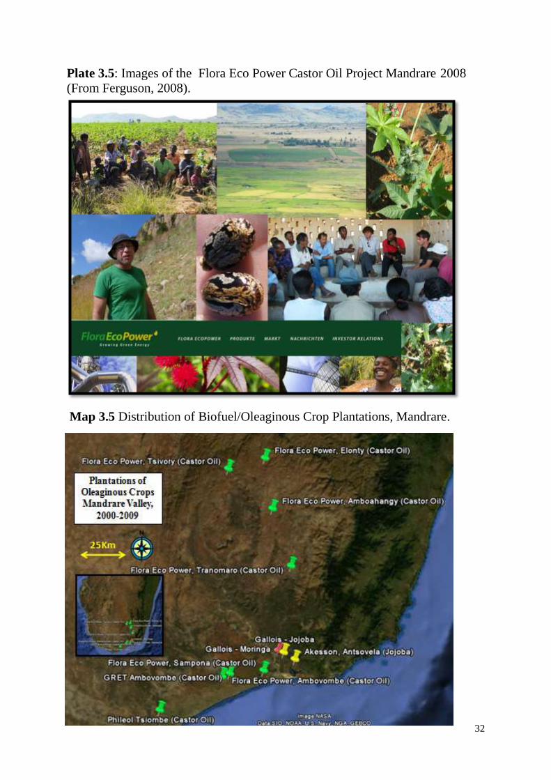
In the last decade there has been renewed interest in the production of oleaginous plants in
the south of Madagascar. As with the mining sector, oil crops grew as new investors
encouraged by the attitudes of the Ravalomanana government between 2003 and 2008
established plantations of castor both through contract work with local farmers and outgrower
schemes (three such investors in the south of Madagascar are Phileol and Caresse in Tsiombe
(Phileol, 2009) and FloraEcoPower in the Mandrare (Ferguson, 2008)). Speculation has not
been restricted to companies new to the region. Two of the well established sisal companies,
Akesson Group and Etablissements Gallois have begun converting sisal plantations (as well
as clearing forest) into Jojoba fields, and Gallois has also begun planting Moringa oleifera.
These biofuel and oleaginous crop plantations and trials described by Table 6.5, Map 6.5 and
Plate 6.5 are relatively insignificant in terms of the actual surface areas cultivated (they cover
less than 500 hectares of a valley of 1.2 million hectares or 0.04% of the land area),
especially considering that the GRET project (Kibler, 2003) and FloraEcoPower Trials have
both now been completed and not followed up. The projects were well received by
14
R Martin 14 February 1952, Reseignements et Statistiques Economique Destine a la mise a jour de la
Monographie du District de l„Androy (CAOM, 2D34) : In 1952 SIACS planted 5ha of groundnuts (and
produced 18.430Kgs), 20ha of Pignon d‟Inde (and produced 39.703Kgs), 1ha of Atratra (and produced
54.645Kgs) and 12 ha of Castor.
30
communities where no conflicts at all were noted and communities were relatively open to
future support and collaborations with external agencies (Ferguson, 2008; Robson, pers
comm 2011).
However what may be more significant is the poor reputation of operating practices of some
of the companies concerned and the substantial scale of the ambitions which may exist for
establishing plantations. The sisal companies have reportedly gone to the length of clearing
forests in order to establish oleaginous crop plantations, and the potential is certainly there for
the future conversion of sisal fields (and the extensive land banks of all the sisal companies)
into biofuel plantations (rather than food to feed local people). Agricultural speculation by
foreign investors in Madagascar remains controversial, with a series of high profile deals in
2008 and 2009 contributing to the ongoing national political instability in Madagascar
(Vinciguerra, 2010; Ratsialonona et al 2010; Gingembre, 2010). Indeed the German
Company Flora Eco Power who had established castor plantations spread across the
Mandrare had something of a chequered history in their other major biofuel operation in
Ethiopia. Not only were they found to have bulldozed forests within protected areas for
commercially run castor farming (Tadesse, 2007) but they also caused serious hardship for
Ethiopian farmers who had been contracted in their out grower schemes and on which the
company failed to honour purchases (Lavers 2010). Flora Eco Power also had a precipitated
departure from Madagascar in early 2009, due to the business connections they had
established with senior politicians and associates of the ousted Ravalomanana regime in order
to gain presidential approval for their investment. These included a company shareholder
being the supplier of foreign military equipment and personnel to the then President
Ravalomanana in the lead up to his ousting (Biller, pers comm., 2009).
31
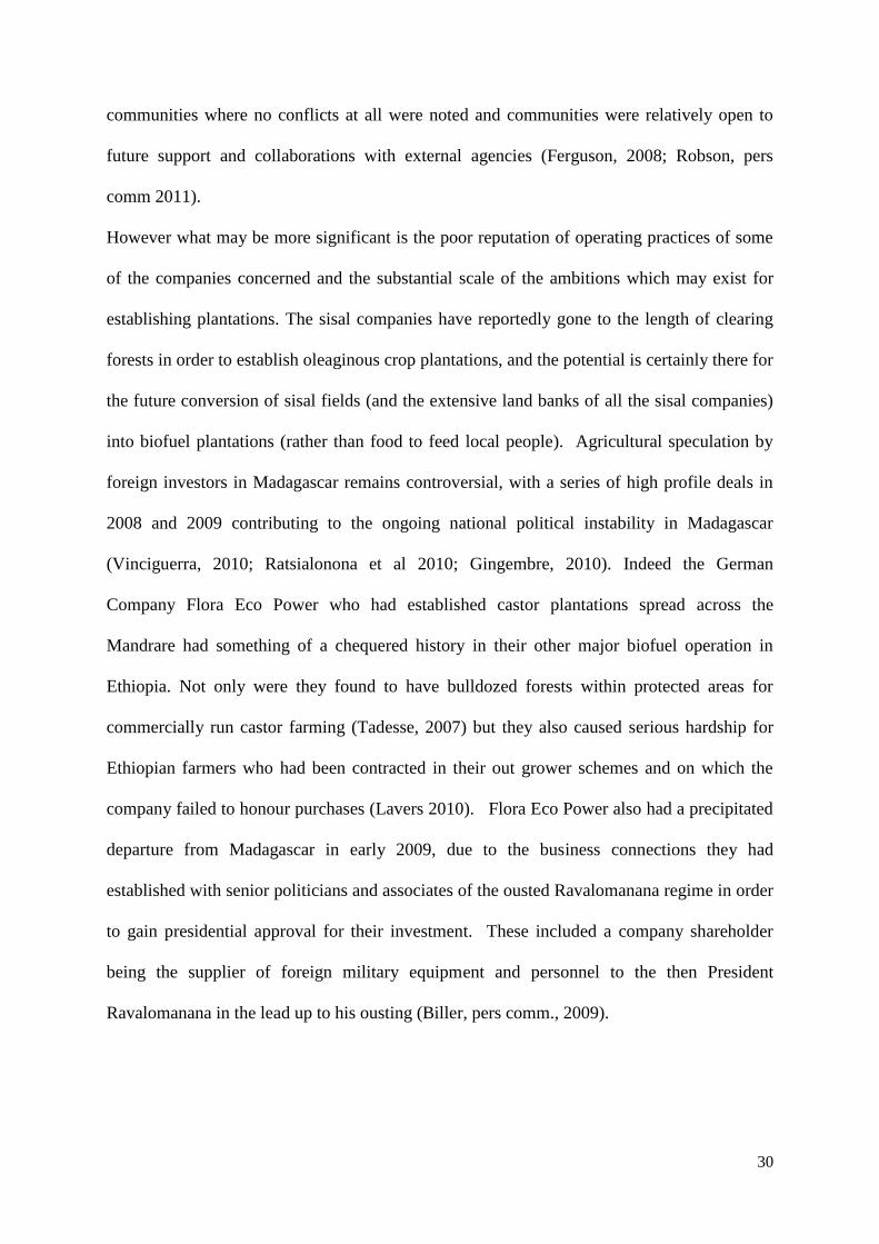
Figure 3.4 National Production of Castor Oil from Madagascar
Plate 3.4 Top left/right – oil presses at SIACS in Ambovombe in 1950. Bottom
right: Graph illustrating the castor production between 1949 and 1951 (vertical
axis reads “pousee a l‟etat spontanee” growing spontaneously), Bottom left
Castor (local name Kinana (Ricinis minimus)). Photographs Charles Rocca,
Chef de District (CAOM, 1952, 2D34 – Monographie de l‟Androy).
0
500
1000
1500
2000
2500
3000
3500
1946 1956 1966 1976 1986 1996 2006
An
nu
al P
rod
uct
ion
(to
nn
es)
Year
Madagascar Castor Oil Bean Production (1946-2008)Data sources: (1946-1960: Guerin, 1962; 1961-2008 FAO http://faostat.fao.org)
32
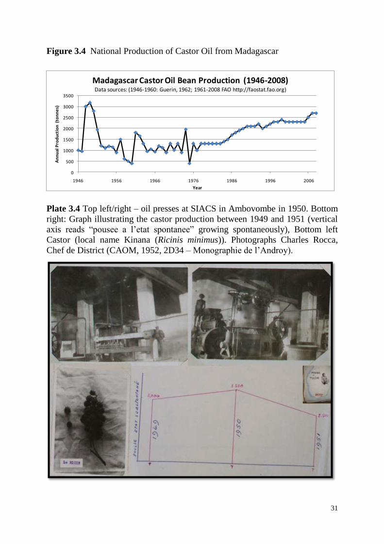
Plate 3.5: Images of the Flora Eco Power Castor Oil Project Mandrare 2008
(From Ferguson, 2008).
Map 3.5 Distribution of Biofuel/Oleaginous Crop Plantations, Mandrare.
33
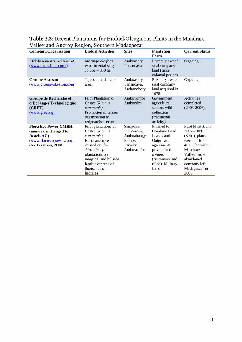
Table 3.3: Recent Plantations for Biofuel/Oleaginous Plants in the Mandrare
Valley and Androy Region, Southern Madagascar Company/Organisation Biofuel Activities Sites Plantation
Form
Current Status
Etablissements Gallois SA
(www.ets-gallois.com/)
Moringa oleifera –
experimental stage.
Jojoba – 350 ha
Amboasary,
Tanandava
Privately owned
sisal company
land (since
colonial period).
Ongoing.
Groupe Akesson
(www.groupe-akesson.com)
Jojoba – undeclared
area.
Amboasary,
Tanandava,
Andranobory
Privately owned
sisal company
land acquired in
1978.
Ongoing.
Groupe de Recherche et
d’Echanges Technologique
(GRET)
(www.gret.org)
Pilot Plantation of
Castor (Ricinus
communis).
Promotion of farmer
organisation to
redynamise sector.
Ambovombe
Ambondro
Government
agricultural
station, wild
collection
(traditional
activity)
Activities
completed
(2003-2006).
Flora Eco Power GMBH
(name now changed to
Acazis AG)
(www.floraecopower.com);
(see Ferguson, 2008)
Pilot plantations of
Castor (Ricinus
communis).
Reconaissance
carried out for
Jatropha sp.
plantations on
marginal and hillside
lands over tens of
thousands of
hectares.
Sampona,
Tranomaro,
Amboahangy
Elonty,
Tsivory,
Ambovombe
Planned to
Combine Land
Leases and
Outgrower
agreements
private land
owners
(customary and
titled); Military
Land
Pilot Plantations
2007-2008
(80ha), plans
were for for
40,000ha within
Mandrare
Valley– now
abandoned
company left
Madagascar in
2009.
34
3.4 Mining
By far the most challenging element of foreign claims to land in the Mandrare are the
activities of the mining sector. Not only were the earliest recorded mining activities (1900,
Mica at Ampandrandava, (Beaudouard 1963)) almost thirty years prior to the first agricultural
colonisation and therefore almost four decades prior to the establishment of the first protected
area, but the number of actors and sites in the sector is much more extensive. Indeed mining
as a sector is inherently more complex, transitory, speculative and secretive than either the
agricultural land or protected areas domains. I can make no pretence here to have compiled a
complete picture of mining activities in the Mandrare over the last century, but I am confident
that the information which I have gathered from the various archives, published literature and
company records and also through diverse personal communications can give at least some
indication of the characteristics and trends in mining in the region for this period. In some
ways the most recent period (the last decade or so since environmental permitting processes
began in earnest) has been the least problematic to reconstruct, at least in terms getting access
to information on the mining permits which have been issued and therefore undertaking the
spatial analyses of mining activities. This was also supported by the opportunity to undertake
a series of site visits to various mining areas during fieldwork from 2007 to 2009. However
the nature of mining means that inevitably many gaps exist in the data, as a complete archival
study would be necessary covering the records of the regional administration, the mining
service and the French atomic energy commission (CEA) records in order to be able to
construct a comprehensive temporal analysis of trends. One example of this is that the
uranium exploration (and production?) undertaken by the socialist government of the
Malagasy state during the late 1970s (Raoelijaona, pers comm., 2010), and establishing a
meaningful temporal analysis of mining activity is therefore not possible.
35
Since the earliest recorded mines of 1900 the records suggest that the mining sector in the
Mandrare experienced seven main phases. The first phase (1) followed the establishment of
colonial rule and ran until after the start of the Second World War, and was characterised
initially by initially artisanal extraction of mica and quartz, however in the post war era of the
1920s it substantial investment in mining in Madagascar began, mainly by French, Swiss and
American prospectors and companies. These efforts were largely in the extraction of Mica
and Quartz. Various mica mines were established, with notable operations in
Ampandrandava (one of only two of Madagascar‟s underground pit mines) by the Societe
Miniere de la Grande Ile (SMGI), in Ambia by the Union des Mica (run by the deHeaulme
family who were later to become sisal plantation owners and backed by their American
associates) and of Quartz in TamoTamo-Bas and Soarivimasy (by the Societe Miniere de
Quartz (SQM), Ambia is now abandoned, but the other two mines continue to operate, albeit
under different owners up to the present day. During WW2 mining was largely wound
down, (as was expansion in the Malagasy sisal industry), but it quickly started up again (2),
and in the investment rush of the 1950‟s mining extended to dozens of sites across the valley
with more than twenty three producers of mica, quartz and other semiprecious stones
(CAOM, 1950, 2D34 Androy and Tsivory). The discovery in 1953 of Uranium in the
Tranomaro region by the French nuclear energy commission (C.E.A) then led to further
expansion of nuclear mining activities as was happening elsewhere in the French colonies of
Africa (Hecht, 2010)(3). By the 1960‟s five factories and numerous quarries and trenches
were established be private operators (Goua, 1964) were able to mine, concentrate and sell
uranothorianite to the CEA, even controversially being done so by workers given no
protection from the radioactive material and to the disdain of the CEA‟s national director
Andre Goua who discovered during an August 1955 inspection that concentrated
uranothorianite was be being purchased by the CEA by the barrel load (CAOM, 1955, 2D11,
36
anon), allowing them to supplement their production from their own two factories. In all
4000tons of concentrated Uranium and Thorium wase reportedly exported before the CEA
closed its Madagascar operations in 1969 (Hecht, 2002). Just three years later Madagascar
declared the start of second republic under President Didier Ratsiraka (amending the
constitution established for the end of colonial rule), shrugging off French and Anglophone
involvement, and making new alliances with socialist nations such as the USSR, North Korea
and China under its „scientific socialism‟ political regime. The socialist era seems to have led
to something of a downturn in the private mining sector, with most of the foreign operators
returning home to France and Switzerland as did the plantation owners many of whom also
had interests in mining as well. Some activities did endure the advent of the socialist period
and state led mining exploration played an important role. Information is of course strictly
guarded on the subject of mining exploration in this era, especially bearing in mind that
uranium was among the products still on the agenda, and that this was the time of the cold
war. Despite the resulting paucity of information on mining during the 1970s and 1980s, the
folk history one encounters across the Mandrare valley talks of Ratsiraka‟s interest in
precious stones in Babaria and Jafaro (Anon, Soarivimasy, 2007; Mihavatsara, pers com
2009) and it is known that uranium exploration was carried out once again during the late
1970‟s (for example Raoelijaona, pers comm., 2010)(4).
Little activity was reported in the mining sector during the 1980s, but at the start of the
1990‟s with now liberalised trade policies interest had rejuvenated, and foreign speculators
appeared from across the globe (England, United States, Canada, Australia, Vietnam,
Thailand, Sri Lanka) as a rush in Malagasy sapphires made the island the largest global
producer supplying up to 40% of the world Market by 2005 (MRA, 2005)(5). One of the
early sites of Madagascar‟s sapphire rush, Andranondambo in the middle west part of the
Mandrare, was discovered in 1993 (Tilghman et al 2007) when President Zafy Albert had
37
come into power and the discovery led to thousands of Malagasy from across the island and
dozens of buyers flocking to the small village. Sapphire production is however a highly
problematic endeavour for the state to manage and tax because the mining is relatively easily
undertaken by artisanal methods, and the products are easily concealed by the predominantly
Asian traders on leaving the country. The vast majority of the sapphire production is believed
to be exported illegally (MRA, 2005; Duffy, 2005), facilitated in part by high ranking
government officials, leading to the emergence of the term shadow state to describe the
operations of the sector (Duffy, 2005).
Following the sapphire rush in Andranondambo and the return of Ratsiraka to the presidency
a new period growth of exploration and mining began (6). Concessions were granted for
Ilmenite exploration by mining giant Phelps Dodge in the alluvial plains of the lower
Mandare valley (Phelps Dodge, 2001) and for the extraction of tourmaline at Anjahamiary
(Pezotta and Jobin, 2003; Jobin pers comm. 2008) and for sapphire production at
Andranondambo (Healy, 2005).
Then following a protracted political crisis during 2002 new President Marc Ravalomanana
took power from Ratsiraka, and ushered in the seventh (7) main period of mining interest in
the Mandrare. The Uranium assets discovered during the colonial era would become the
main driving force for over 50% of the surface of the valley coming under mining exploration
permits. Once again the investors were diverse, the only company to have received actual
mining extraction permits for uranium is the joint venture with the Malagasy authorities Blue
Sun Mining (backed by Bekitoly Resources Limited a subsidiary of the London based Vuna
Capital (Vuna, 2011). Other companies from Canada (Pan African Mining, Mineaux ITEA),
Thailand (Asia Thai Mining Company), Israel (Madagascar Mineral Fields) and
Australia/UK (LP Hill/Tranomaro Mineral Development Corporation) have undertaken aerial
38
and ground survey exploration programmes for Uranium covering an area of approximately
300,000ha (almost a quarter of the valley).
Aside from the attention for uranium which burgeoned under the Ravalomanana presidency,
exploration and research holdings for illmenite (Ambatovy Minerals), gold, granite and
various semiprecious stones were established across the valley, and mining for sapphires
continues in various formal and informal, approved and illicit operations by local
entrepreneurs and investors from Malaysia (Nan Tin Polychrome). At the point of analysis
for this text (January 2009) there were over fifty permit holders for at least twenty four
mineral types within the Mandrare Valley. Table 6.4 and the illustrations in Plates 6.7-6.8
illustrate the diversity of these activities and Maps 6.7 illustrate their distribution (which is
largely in the middle part of the eastern edge of the valley for mines where actual physical on
the ground activity has been undertaken). Map 6.6 then illustrates the spatial extent of the
mining permits, and the date in table 5.4 below describes how only a tiny proportion (an
estimated 870 hectares or 0.06% of the whole valley) of the overall areas concerned have
actually experienced physical works on the ground (quarrying, trenching, establishment of
airstrips and mining camps). This goes to show that mining, especially for the radioactive
and gemstone sectors is a particularly speculatory endeavour (i.e. exploration occurs over
much larger areas than will eventually be mined), but that the Ravalomanana era had
signalled to foreign investors that they should rush to secure their claims on the region. As is
the case elsewhere in Madagascar, mining claims in the Mandrare have extensively
overlapped with protected areas (Cardiff and Andriamanalina, 2007), as well as with local
agriculture and the regions sought out by biofuels investors such as FloraEcoPower.
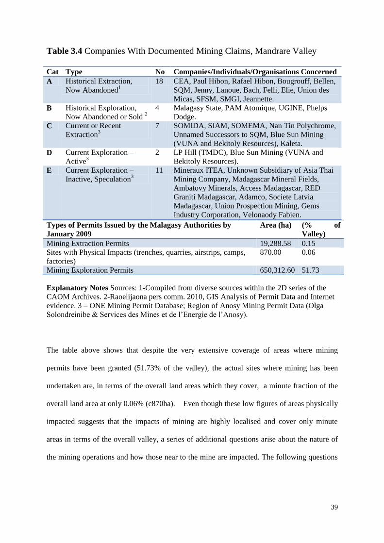
39
Table 3.4 Companies With Documented Mining Claims, Mandrare Valley
Cat Type No Companies/Individuals/Organisations Concerned
A Historical Extraction,
Now Abandoned1
18 CEA, Paul Hibon, Rafael Hibon, Bougrouff, Bellen,
SQM, Jenny, Lanoue, Bach, Felli, Elie, Union des
Micas, SFSM, SMGI, Jeannette.
B Historical Exploration,
Now Abandoned or Sold 2
4 Malagasy State, PAM Atomique, UGINE, Phelps
Dodge.
C Current or Recent
Extraction3
7 SOMIDA, SIAM, SOMEMA, Nan Tin Polychrome,
Unnamed Successors to SQM, Blue Sun Mining
(VUNA and Bekitoly Resources), Kaleta.
D Current Exploration –
Active3
2 LP Hill (TMDC), Blue Sun Mining (VUNA and
Bekitoly Resources).
E Current Exploration –
Inactive, Speculation3
11 Mineraux ITEA, Unknown Subsidiary of Asia Thai
Mining Company, Madagascar Mineral Fields,
Ambatovy Minerals, Access Madagascar, RED
Graniti Madagascar, Adamco, Societe Latvia
Madagascar, Union Prospection Mining, Gems
Industry Corporation, Velonaody Fabien.
Types of Permits Issued by the Malagasy Authorities by
January 2009
Area (ha) (% of
Valley)
Mining Extraction Permits 19,288.58 0.15
Sites with Physical Impacts (trenches, quarries, airstrips, camps,
factories)
870.00 0.06
Mining Exploration Permits 650,312.60 51.73
Explanatory Notes Sources: 1-Compiled from diverse sources within the 2D series of the
CAOM Archives. 2-Raoelijaona pers comm. 2010, GIS Analysis of Permit Data and Internet
evidence. 3 – ONE Mining Permit Database; Region of Anosy Mining Permit Data (Olga
Solondreinibe & Services des Mines et de l‟Energie de l‟Anosy).
The table above shows that despite the very extensive coverage of areas where mining
permits have been granted (51.73% of the valley), the actual sites where mining has been
undertaken are, in terms of the overall land areas which they cover, a minute fraction of the
overall land area at only 0.06% (c870ha). Even though these low figures of areas physically
impacted suggests that the impacts of mining are highly localised and cover only minute
areas in terms of the overall valley, a series of additional questions arise about the nature of
the mining operations and how those near to the mine are impacted. The following questions
40
arise as topics for further investigation, although they are largely beyond the scope of the
present study:
1. How have customary land owners in mining concessions been dealt with by mining
companies in the processes of accessing minerals and acquiring land?
2. Are local residents compensated for loss of farming land, forest or pasture?
3. Do local communities (communes) receive a proportion of revenues through companies
making local tax payments (redevances)?
4. Are there any negative consequences in terms of biodiversity, environmental pollution,
health and socio-economic impacts of the mines?
5. If there are such consequences how are they mitigated, by whom and who ensures that all
necessary mitigation is undertaken?
There is neither space nor data at this authors disposal to answer most of these questions
authoritatively, however, one indicative example can be provided from the report by German
geologists sent by the World Bank mining development programme (PGRM) to assess
mining assets in the Mandrare Valley, that of Ulrich Schwarz-Schampera and colleagues.
They discovered that on one of the now abandoned French C.E.A. uranium mine pits in the
Tranomaro and Maromby area (at Ambatomika and Ambindrakemba) were exhibiting
dangerously high levels of radiation and posed a public health risk. Despite these health risks
local communities in the neighbouring villages have long been using the pits as reservoirs for
both human and livestock drinking water, and the local mining officer confirmed that no
health checks were undertaken and no monitoring of radiation were implemented (Schwarz-
Schampera, 2007; Schwarz-Schampera et al 2008). One of these sites is illustrated in plate
6.6 below. It suffices to say that neither the mining administration, nor the national
environmental office (ONE), who are responsible for such tasks as monitoring impacts and
mitigation efforts, have a personnel allocated to the Mandrare Valley. Staff members based
in Fort Dauphin spend a portion of their time responsible for the Mandrare Valley (but
principal responsibilities being for the very large Rio Tinto (QMM) Illmenite mine in Fort
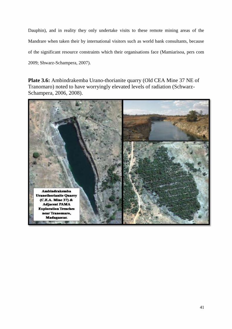
41
Dauphin), and in reality they only undertake visits to these remote mining areas of the
Mandrare when taken their by international visitors such as world bank consultants, because
of the significant resource constraints which their organisations face (Mamiarisoa, pers com
2009; Shwarz-Schampera, 2007).
Plate 3.6: Ambindrakemba Urano-thorianite quarry (Old CEA Mine 37 NE of
Tranomaro) noted to have worryingly elevated levels of radiation (Schwarz-
Schampera, 2006, 2008).
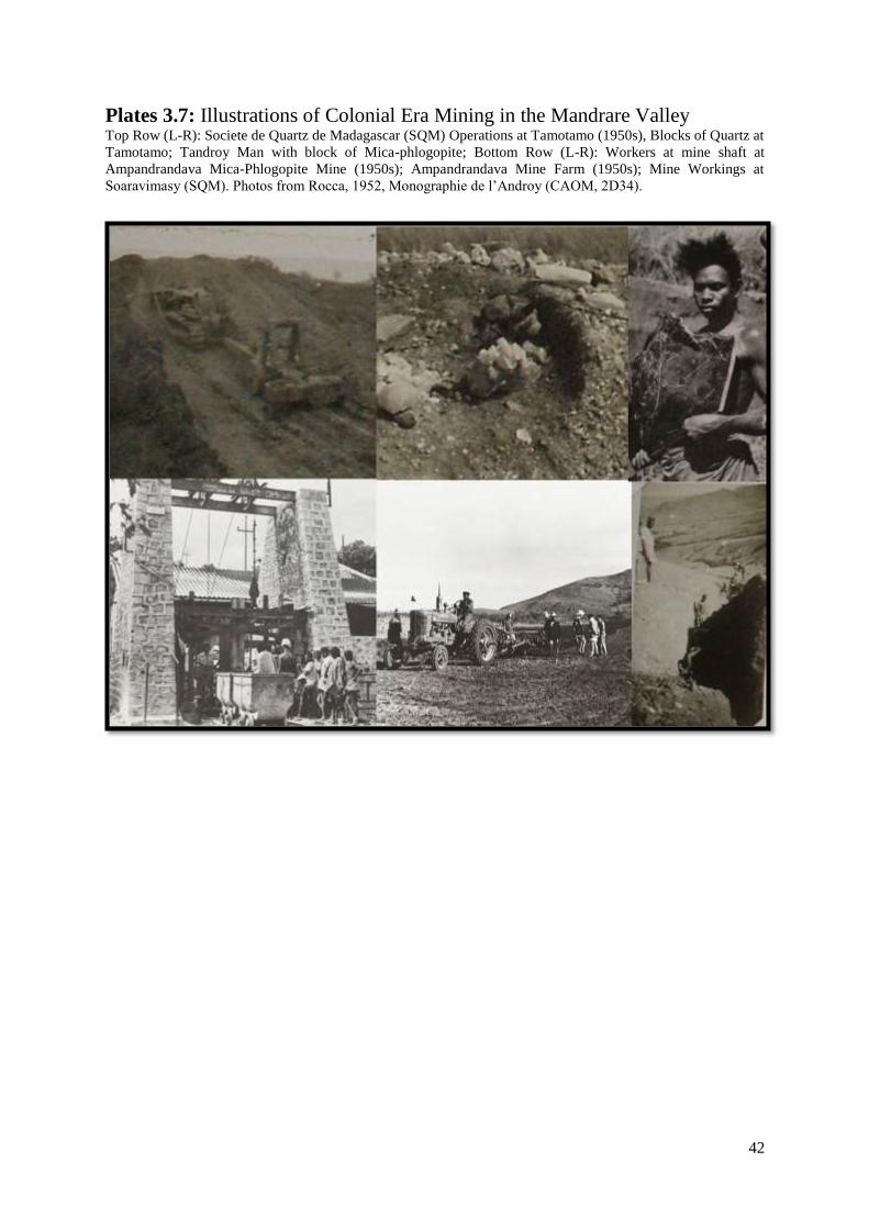
42
Plates 3.7: Illustrations of Colonial Era Mining in the Mandrare Valley Top Row (L-R): Societe de Quartz de Madagascar (SQM) Operations at Tamotamo (1950s), Blocks of Quartz at
Tamotamo; Tandroy Man with block of Mica-phlogopite; Bottom Row (L-R): Workers at mine shaft at
Ampandrandava Mica-Phlogopite Mine (1950s); Ampandrandava Mine Farm (1950s); Mine Workings at
Soaravimasy (SQM). Photos from Rocca, 1952, Monographie de l‟Androy (CAOM, 2D34).
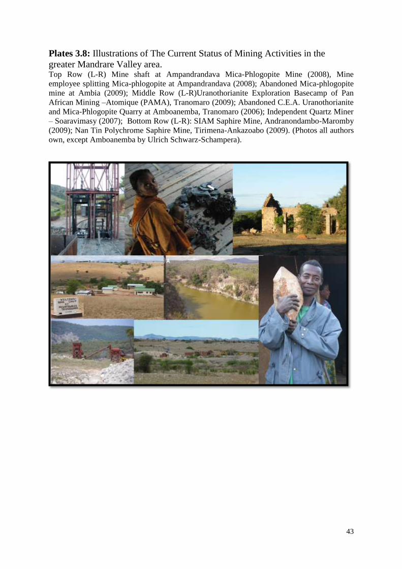
43
Plates 3.8: Illustrations of The Current Status of Mining Activities in the
greater Mandrare Valley area. Top Row (L-R) Mine shaft at Ampandrandava Mica-Phlogopite Mine (2008), Mine
employee splitting Mica-phlogopite at Ampandrandava (2008); Abandoned Mica-phlogopite
mine at Ambia (2009); Middle Row (L-R)Uranothorianite Exploration Basecamp of Pan
African Mining –Atomique (PAMA), Tranomaro (2009); Abandoned C.E.A. Uranothorianite
and Mica-Phlogopite Quarry at Amboanemba, Tranomaro (2006); Independent Quartz Miner
– Soaravimasy (2007); Bottom Row (L-R): SIAM Saphire Mine, Andranondambo-Maromby
(2009); Nan Tin Polychrome Saphire Mine, Tirimena-Ankazoabo (2009). (Photos all authors
own, except Amboanemba by Ulrich Schwarz-Schampera).
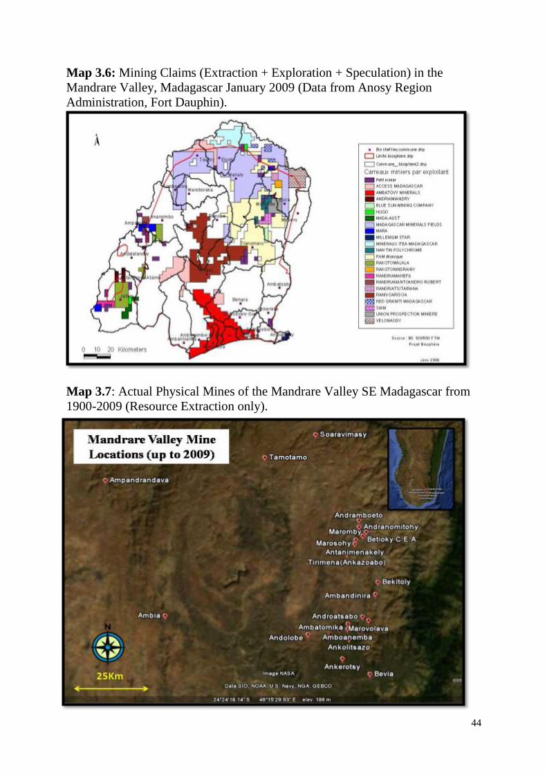
44
Map 3.6: Mining Claims (Extraction + Exploration + Speculation) in the
Mandrare Valley, Madagascar January 2009 (Data from Anosy Region
Administration, Fort Dauphin).
Map 3.7: Actual Physical Mines of the Mandrare Valley SE Madagascar from
1900-2009 (Resource Extraction only).
45
3.5 Conservation and forestry related land claims
As has already been described at some length in chapter five, the unique qualities of the
forests of the Mandrare valley alerted the attention of the scientists of the colonial era
relatively early on. The considerable topographical variation, combined with the east to west
ecotonal variation from rainforest to spiny thicket due to the character of the regions climate
makes it something of a curiosity. Wilme et al. (2006) consider the valley to have been a
„retreat dispersion watershed‟ where over geological time the natural climatic changes led to
successive expansions and restrictions of species ranges, and due to the resulting isolation
from other areas due to unconnected habitats and topographical barriers, evolutionary
processes of speciation led to the region becoming a centre of endemism, that is to say an
area with endemic species which are locally restricted to that area. Whichever way the
scientific importance of these forests is categorised by colonial naturalists of the 1930s or
modern day biodiversity conservationists, as in much of the rest of Madagascar the forests of
the Mandrare have received a great deal of attention from foreigners.
3.5.1 Forests, Economics and Colonial Perceptions
The colonial era however was far from characterised as a period of forest conservation, as
section 6.4.1 amply illustrates with the example of the rapid expansion of the sisal industry in
the lower parts of the valley. This was a phenomena typical of much of Madagascar, where
the colonial powers saw forest as something to be exploited in certain acceptable ways
(Scales 2008:92), which as well as the clearance to make way for sisal in the Mandrare it also
included extraction of timber in forests across the island, clearance of forests for maize and
cattle farming in the west and for cloves and coffee in the east (Jarosz, 1993:370).
The colonial perceptions of the Mandrare‟s forests seems to have been typical of the period,
namely as resources to be extracted, and as barriers to development. Raik (2007:6) reports
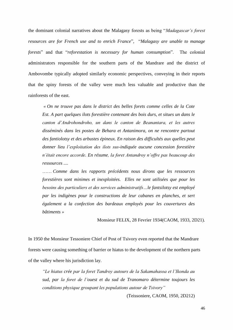
46
the dominant colonial narratives about the Malagasy forests as being “Madagascar‟s forest
resources are for French use and to enrich France”, “Malagasy are unable to manage
forests” and that “reforestation is necessary for human consumption”. The colonial
administrators responsible for the southern parts of the Mandrare and the district of
Ambovombe typically adopted similarly economic perspectives, conveying in their reports
that the spiny forests of the valley were much less valuable and productive than the
rainforests of the east.
« On ne trouve pas dans le district des belles forets comme celles de la Cote
Est. A part quelques ilots forestière contenant des bois durs, et situes un dans le
canton d‟Androhondroho, un dans le canton de Beanantara, et les autres
disséminés dans les postes de Behara et Antanimora, on ne rencontre partout
des fantiolotsy et des arbustes épineux. En raison des difficultés aux quelles peut
donner lieu l‟exploitation des ilots sus-indiquée aucune concession forestière
n‟était encore accorde. En résume, la foret Antandroy n‟offre pas beaucoup des
ressources ....
…… Comme dans les rapports précédents nous dirons que les ressources
forestières sont minimes et inexploitées. Elles ne sont utilisées que pour les
besoins des particuliers et des services administratifs…le fantsilotsy est employé
par les indigènes pour le constructions de leur cabanes en planches, et sert
également a la confection des bardeaux employés pour les couvertures des
bâtiments »
Monsieur FELIX, 28 Fevrier 1934(CAOM, 1933, 2D21).
In 1950 the Monsieur Tessoniere Chief of Post of Tsivory even reported that the Mandrare
forests were causing something of barrier or hiatus to the development of the northern parts
of the valley where his jurisdiction lay.
“Le hiatus crée par la foret Tandroy autours de la Sakamahasoa et l‟Ikonda au
sud, par la foret de l‟ouest et du sud de Tranomaro détermine toujours les
conditions physique groupant les populations autour de Tsivory”
(Teissoniere, CAOM, 1950, 2D212)
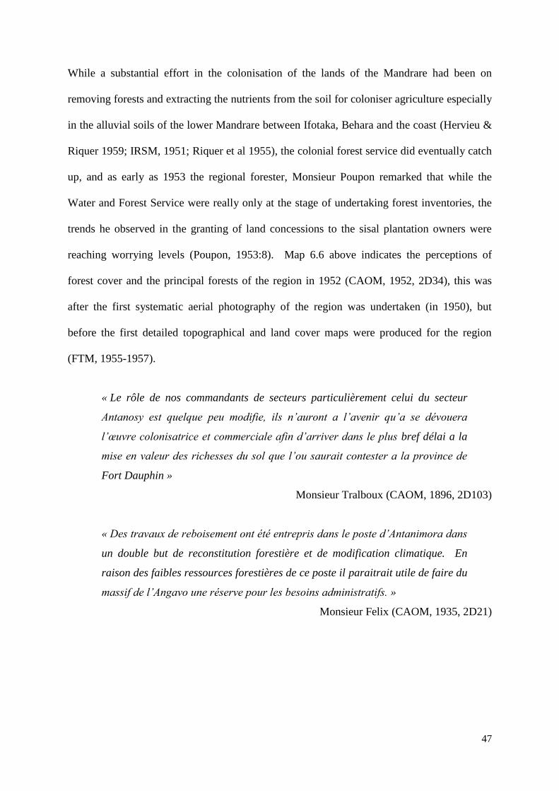
47
While a substantial effort in the colonisation of the lands of the Mandrare had been on
removing forests and extracting the nutrients from the soil for coloniser agriculture especially
in the alluvial soils of the lower Mandrare between Ifotaka, Behara and the coast (Hervieu &
Riquer 1959; IRSM, 1951; Riquer et al 1955), the colonial forest service did eventually catch
up, and as early as 1953 the regional forester, Monsieur Poupon remarked that while the
Water and Forest Service were really only at the stage of undertaking forest inventories, the
trends he observed in the granting of land concessions to the sisal plantation owners were
reaching worrying levels (Poupon, 1953:8). Map 6.6 above indicates the perceptions of
forest cover and the principal forests of the region in 1952 (CAOM, 1952, 2D34), this was
after the first systematic aerial photography of the region was undertaken (in 1950), but
before the first detailed topographical and land cover maps were produced for the region
(FTM, 1955-1957).
« Le rôle de nos commandants de secteurs particulièrement celui du secteur
Antanosy est quelque peu modifie, ils n‟auront a l‟avenir qu‟a se dévouera
l‟œuvre colonisatrice et commerciale afin d‟arriver dans le plus bref délai a la
mise en valeur des richesses du sol que l‟ou saurait contester a la province de
Fort Dauphin »
Monsieur Tralboux (CAOM, 1896, 2D103)
« Des travaux de reboisement ont été entrepris dans le poste d‟Antanimora dans
un double but de reconstitution forestière et de modification climatique. En
raison des faibles ressources forestières de ce poste il paraitrait utile de faire du
massif de l‟Angavo une réserve pour les besoins administratifs. »
Monsieur Felix (CAOM, 1935, 2D21)
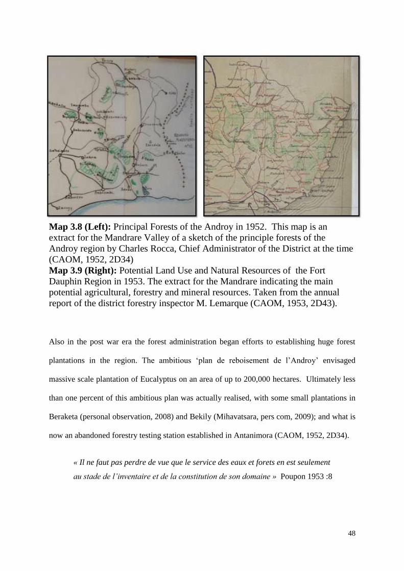
48
Map 3.8 (Left): Principal Forests of the Androy in 1952. This map is an
extract for the Mandrare Valley of a sketch of the principle forests of the
Androy region by Charles Rocca, Chief Administrator of the District at the time
(CAOM, 1952, 2D34)
Map 3.9 (Right): Potential Land Use and Natural Resources of the Fort
Dauphin Region in 1953. The extract for the Mandrare indicating the main
potential agricultural, forestry and mineral resources. Taken from the annual
report of the district forestry inspector M. Lemarque (CAOM, 1953, 2D43).
Also in the post war era the forest administration began efforts to establishing huge forest
plantations in the region. The ambitious „plan de reboisement de l‟Androy‟ envisaged
massive scale plantation of Eucalyptus on an area of up to 200,000 hectares. Ultimately less
than one percent of this ambitious plan was actually realised, with some small plantations in
Beraketa (personal observation, 2008) and Bekily (Mihavatsara, pers com, 2009); and what is
now an abandoned forestry testing station established in Antanimora (CAOM, 1952, 2D34).
« Il ne faut pas perdre de vue que le service des eaux et forets en est seulement
au stade de l‟inventaire et de la constitution de son domaine » Poupon 1953 :8
49
Map 3.10 Large Scale Forestation Plans (Plan de Reboisement de l‟Androy)
derived from data in CAOM, 1952, 2D23:19)
3.5.2 Protecting Forests: The emergence of conservation policies
The predominantly economic perspectives of the colonial administration of the Androy
towards the forests described in the previous section, illustrated that the promotion of
deforestation for settler agriculture including sisal plantations and the common discourse of
spiny forests being of limited value other than for construction wood supply for local people
(see section above) were characteristic features. However this was not the full picture, a
parallel conservationist tendency was also apparent. The early part of the twentieth century
saw protected areas and reserves being gazetted on a significant scale in many of the
European colonies in the Africa region (Beinart, 1987) and Madagascar was no exception to
this trend. The island was afforded significant corps of zoologists (Andriamialisoa &
Langrand, 2003) and botanists (Gautier & Goodman, 2003) who busily explored, collected
and described many endemic and unique animal and plant species for which the island has
become increasingly famous. The scientists were themselves supported by other intellectuals
50
in more general service in the colonial administration and the south of Madagascar was gifted
a number. Among the notable contributors to the scientific exploration of the region were
administrator and multidisciplinary scholar Raymond Decary and botanists Henri Humbert
and Joseph Perrier de la Bathie. These scientists shared the notion that in order to preserve a
representative sample of the variety of Malagasy ecosystems and species it was necessary to
establish a network of strict nature reserves, into which only scientific expeditions would be
permitted. This led to the establishment in 1927 of the first wave of strict nature reserves
(Reserve Naturelle Integrale) in various parts of the island (Randrianandianina et al., 2003).
The forests of the Mandrare did not come under any formal protection at this time despite
early zoological expeditions having taken place to the Tsivory region in the north of the
valley as early as 1907 (CAOM, 1907, 6D(9)14) and the recognition of colonial
administrators by 1930 of the threats to nature in the Mandrare and the south of Madagascar
(CAOM, 1935, 2D21). While the deforestation of central and southern regions was said to be
at a relatively early stage and not too extensive, Raymond Decary (1930:187-188) a colonial
administrator come ethnographer and naturalist who was posted to the Androy in 1916 and
stayed there until the end of the second world war (Balard, 2002), did judge that it need to be
immediately and urgently prevented. Since early in the colonial era there had been island
wide bans on most deforestation (see Bertrand and Sourdat, 1998:20-22 for a detailed
review), but Decary‟s call to stop deforestation in the Androy were echoing the same
sentiments expressed by Humbert and Perrier de la Bathie at the national level resulting in a
general decree banning deforestation in 1913 (ibid; CAOM, 1913, 6D(7)2715
). These same
two men were significant in influencing the establishment of the first nature reserves across
Madagascar in 1927 and subsequently the introduction of bonuses for forest officers
15
CAOM, 1913, 6D(7)27, Décret établissant le régime forestier a Madagascar, Section II, Article 79 - Les
incendies de forets, les feux de brousse pour la préparation des cultures ou pour les pâturages sont formellement
interdits dans tout le domaine de la Colonie. A covering note added: Cette restriction implique le droit d'user du
feu dans les propriétés privées à l‟exclusion des forets et bois (Art 56 du décret).
51
producing reports on deforestation infractions in order to increase the actual enforcement of
the deforestation bans in 1930 through article 36 (ibid; Raik, 2007).
In addition to his remarks on deforestation, Raymond Decary had also noted a number of
other concerns about the human impacts on natural habitats and species (Decary, 1930) in the
Androy. These included (1) the annual burning, for the purpose of transhumant grazing, of
the grasslands of the northern Androy which he said were leading to the formation of a
species poor savannah flora; (2) that the excessive and destructive exploitation of rubber trees
by enthusiastic Tandroy rubber collectors eager to maximise gains from sales to rubber
exporters16
and (3) that particular plant species such as Aloe suzannae17
which were unique to
the region were becoming increasingly rare and threatened by fire and creation of agricultural
fields.
The forests of the Mandrare were not afforded any special protection in the first wave of
protected area establishment. The first legal recognition of forest sites in the Mandrare for
protection came on the 8th
February 1939 with the inscription of the „Vestiges des Forets
Primitives d‟Anadabolava/Tsivory‟ as National Heritage Site Number 122 (MCP, 2010;
Decary and Faurec, 1941), this designation decree was neither accompanied by a clear spatial
demarcation, detailing the area concerned nor was any formal legal protection granted other
than the pre-existing national deforestation ban. National Heritage Site status did however
16
Rubber export from southern Madagascar preceded French colonisation, with the first exports from Fort
Dauphin note in 1891 (Decary, 1930:188). National production peaked in 1907 with 1000 tons exported, and
finally the trade effectively ceased in 1928 with a minor reprise during the latter part of the second world war
(Decary, 1962:4). Two particular species from the south were exploited the tree Euphorbia intisy, known
locally as Herotse and the vine Pentopetia grevei known locally as Kompitse.
17 Aloe suzannae (Vahondrano/Vahondrandra) is today classified as critically endangered on the IUCN Red List
(IUCN, 2009). Decary reported in 1930 only a hundred or so individuals remaining in the wild, many of them
featuring shorch marks fromm the deforestation which was threatening their survival. Decary called for special
protection measures to be taken for this species (Decary, 1930:188). It seems no particular protection measures
were taken and in the present day in the Mandrare only two sites are known to have remnant populations of this
species, numbering less than a dozen individuals. These sites are within one planned protected area
Ambia/Mitakeba, Antanimora/Imanombo and one existing protected area at Ranomainty/Ankodida, Ankariera
(Eboroke & Rakotomalaza, 2007).
52
indicate that the uniqueness of the Anadabolava forests merited scientific recognition and
protection. Anadabolava was said by Decary and Faurec (ibid:136) to be a rare transitional
habitat between rainforest and spiny thicket which is of particular importance18
. Later the
same year in the 11th June a second site in the Mandrare valley was recognised, this time
with specific legal protection. The designation of the first parcel of Andohahela Integral
Nature Reserve No.11 (30,000 hectares) put into strict state protection the rainforest massif19
(Humbert, 1946). The designation of both of these sites was specifically attributed to the late
1920‟s and early 1930s visits by Decary to Anadabolava (Decary & Faurec, 1941) and by
Humbert to Andohahela (Goodman, 1999:1; Goodman et al, 1997:21).
The 1930s also saw the establishment of three main private reserves, albeit that still to this
day they do not have any formal protection status (i.e. they are not part of the new Malagasy
System of Protected Areas (SAPM), nor are they subject to any intervention or management
by the forest service), other than that afforded by their foreign owners, who are also the
owners of the adjacent sisal plantations.
The first forest to fit into this category was in 1934, what is now known by the names of its
disputing owners „Akesson/Kaleta‟ belonged originally to the Societe Foncier de Sud de
Madagascar (SFSM) who established the first sisal plantations on the west bank of the
18
This same feature which led to its gazetting on the 25th
August 1964 (Arrêté No. 2292) as a 7580 hectare
classified forest which included a clearer spatial demarcation (DEF, 1993) and its extension and strengthening
as a new protected area 18,269 hectares in October 2008 by Arrêté 18633/2008/MEFT/MEM (Randriatsivery,
2009; MEFT and MEM, 2008).
19
Andohahela Integral Nature Reserve was extended from the original single 30,000hectare rainforest parcel in
1966 (decree 66-242) to extend the size of the reserve to 76020 hectares with Parcel 1 (Rainforest) being
expanded and a spiny forest parcel included (Parcel 2) as well as a small transitional forest (Parcel 3). On the 8th
August 1997 following the completion of a USAID funded Integrated Conservation and Development Project
(ICDP) the status of the reserve was changed, and it became Andohahela National Park through decree. 97-
1043. The new park included some small extensions and alterations to the boundaries taking it to a size of
78,220 hectares. In 2007 Andohahela also became part of the Forets Humides d‟Atsinanana UNESCO World
Heritage Site along with seven other Malagasy rainforest national parks of the east coast.
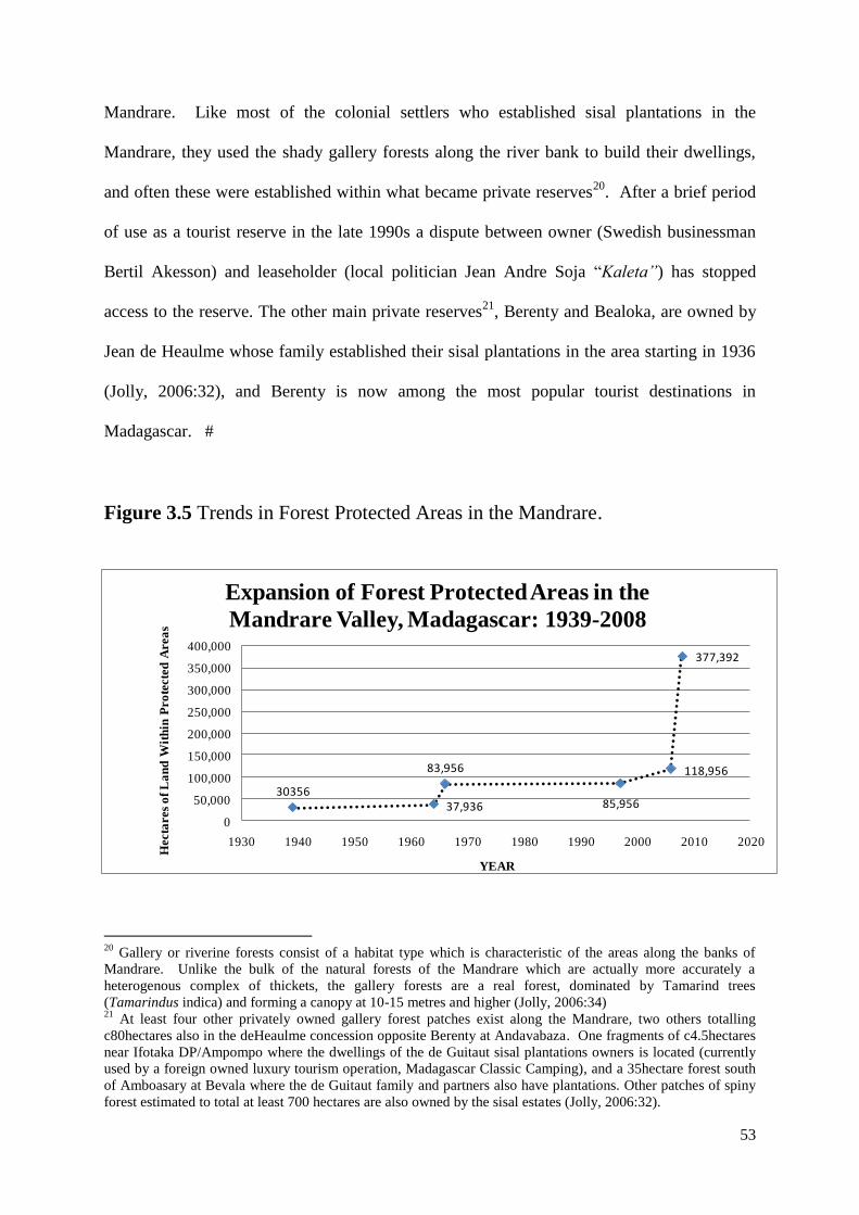
53
Mandrare. Like most of the colonial settlers who established sisal plantations in the
Mandrare, they used the shady gallery forests along the river bank to build their dwellings,
and often these were established within what became private reserves20
. After a brief period
of use as a tourist reserve in the late 1990s a dispute between owner (Swedish businessman
Bertil Akesson) and leaseholder (local politician Jean Andre Soja “Kaleta”) has stopped
access to the reserve. The other main private reserves21
, Berenty and Bealoka, are owned by
Jean de Heaulme whose family established their sisal plantations in the area starting in 1936
(Jolly, 2006:32), and Berenty is now among the most popular tourist destinations in
Madagascar. #
Figure 3.5 Trends in Forest Protected Areas in the Mandrare.
20
Gallery or riverine forests consist of a habitat type which is characteristic of the areas along the banks of
Mandrare. Unlike the bulk of the natural forests of the Mandrare which are actually more accurately a
heterogenous complex of thickets, the gallery forests are a real forest, dominated by Tamarind trees
(Tamarindus indica) and forming a canopy at 10-15 metres and higher (Jolly, 2006:34) 21
At least four other privately owned gallery forest patches exist along the Mandrare, two others totalling
c80hectares also in the deHeaulme concession opposite Berenty at Andavabaza. One fragments of c4.5hectares
near Ifotaka DP/Ampompo where the dwellings of the de Guitaut sisal plantations owners is located (currently
used by a foreign owned luxury tourism operation, Madagascar Classic Camping), and a 35hectare forest south
of Amboasary at Bevala where the de Guitaut family and partners also have plantations. Other patches of spiny
forest estimated to total at least 700 hectares are also owned by the sisal estates (Jolly, 2006:32).
3035637,936
83,956
85,956
118,956
377,392
0
50,000
100,000
150,000
200,000
250,000
300,000
350,000
400,000
1930 1940 1950 1960 1970 1980 1990 2000 2010 2020
Hecta
res
of
La
nd
Wit
hin
Pro
tecte
d A
rea
s
YEAR
Expansion of Forest Protected Areas in the
Mandrare Valley, Madagascar: 1939-2008
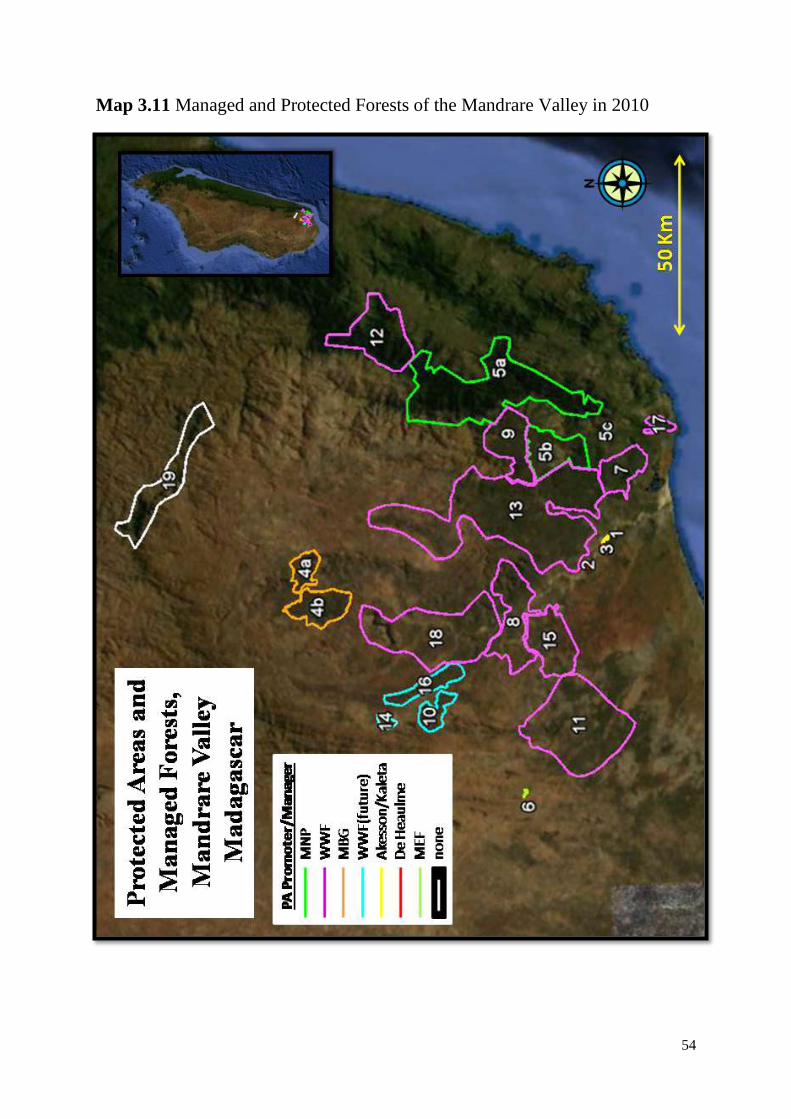
54
Map 3.11 Managed and Protected Forests of the Mandrare Valley in 2010
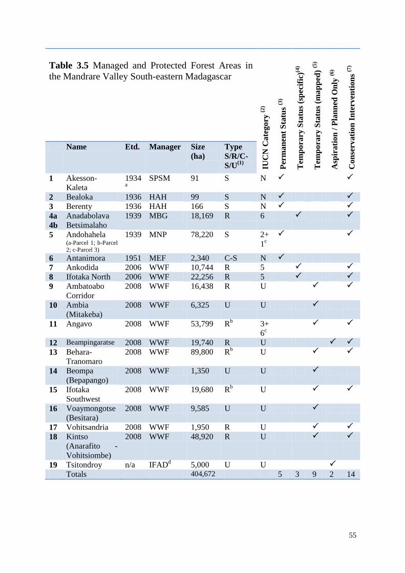
55
Table 3.5 Managed and Protected Forest Areas in
the Mandrare Valley South-eastern Madagascar
IUC
N C
ate
gory
(2)
Per
man
ent
Sta
tus
(3)
Tem
pora
ry S
tatu
s (s
pec
ific
)(4)
Tem
pora
ry S
tatu
s (m
ap
ped
) (5
)
Asp
irati
on
/ P
lan
ned
On
ly (6
)
Con
serv
ati
on
In
terv
enti
on
s (7
)
Name Etd. Manager Size
(ha)
Type
S/R/C-
S/U(1)
1 Akesson-
Kaleta
1934a
SPSM 91 S N
2 Bealoka 1936 HAH 99 S N
3 Berenty 1936 HAH 166 S N
4a
4b
Anadabolava
Betsimalaho
1939 MBG 18,169 R 6
5 Andohahela (a-Parcel 1; b-Parcel
2; c-Parcel 3)
1939 MNP 78,220 S 2+
1c
6 Antanimora 1951 MEF 2,340 C-S N
7 Ankodida 2006 WWF 10,744 R 5
8 Ifotaka North 2006 WWF 22,256 R 5
9 Ambatoabo
Corridor
2008 WWF 16,438 R U
10 Ambia
(Mitakeba)
2008 WWF 6,325 U U
11 Angavo 2008 WWF 53,799 Rb 3+
6c
12 Beampingaratse 2008 WWF 19,740 R U
13 Behara-
Tranomaro
2008 WWF 89,800 Rb U
14 Beompa
(Bepapango)
2008 WWF 1,350 U U
15 Ifotaka
Southwest
2008 WWF 19,680 Rb U
16 Voaymongotse
(Besitara)
2008 WWF 9,585 U U
17 Vohitsandria 2008 WWF 1,950 R U
18 Kintso
(Anarafito -
Vohitsiombe)
2008 WWF 48,920 R U
19 Tsitondroy n/a IFADd 5,000 U U
Totals 404,672 5 3 9 2 14
56
Notes from Table 3.5: a) The date of 1934 is noted for the „establishment‟ of the Akesson-Kaleta Reserve. This date refers to the
establishment of the original concession within which the reserve is now found. The company was SFSM,
although many of its assets were acquired by the Akesson Group under the SPSM Company in 1978. The
Reserve is subject to unclear disputes over access and/or ownership of the reserve between Akesson and
Kaleta.
b) for each of the areas at Angavo, Tranomaro-Behara and Ifotaka Southwest the „b‟ indicates that each of
these areas is currently producing significant volumes of timber and/or wood fuel for commercial sale
outside the areas (Angavo and Ifotaka Southwest supplying Ambovombe and Tranomaro-Behara
supplying Amboasary-Sud – an activity considered to be incompatible with „R‟ status.
c) Dual IUCN Category Status is noted for Andohahela National Park which maintains some strict no-go
areas consistent with the INR (IUCN Cat 1) status prior to its conversion to a National Park in 1997 (IUCN
Cat2). Angavo‟s core conservation zone (a forested mountain with sacred values) is considered to be a
Natural Monument (IUCN Cat 3) and its surrounding zone is a natural resource reserve (IUCN cat 6).
N=does not have a category (external to SAPM); U=Undefined.
d) Tsitondroy was nominated by the IFAD development project in the High Mandrare valley (PHBM) to
be included in the Anosy Regional policies for protected areas (WWF, 2008). Nobody is actively
establishing a protected area in this region (it is extremely remote and access is difficult), although some
botanical research has been conducted on the Ivakoany Mountain at its northern limit during 2008
(Randriatsivery Monique, Missouri Botanical Gardens, personal communication July 2009).
1 – Type : This refers to the authors own understanding of the form which forest management is planned
to take. S=Strict Conservation (no entry except with permits from owners or managers, no extractive use);
R=Restricted Natural Resource Use (typically restricted to the grazing of livestock, and natural resource
extraction for own or family use(food, fuel, shelter); C-S=Commercialisation-Sustainable Forest
Management – where the commercial production of timber, fuel, medicines etc is permitted either from
plantations or from sustainable levels of use; U=unknown or undecided – refers to protected areas which
are an aspiration for the relevant conservation organisation.
2 - IUCN Protected Area Category Titles as part of SAPM (1-Integral Nature Reserve; 2-National Park;
3-Natural Monument; 4-Species/Habitat Management Area; 5-Terrestrial/Marine Landscape; 6-Natural
Resource Reserve. (GoM, 2008).
3 - Permanent Status – the areas within this category have either recieevd permanent protection status
and are under the management of Madagascar National Parks (MNP) (Andohahela) or the Forest
Administration (MEF) (Antanimora) or have clearly titled private property rights (Berenty, Bealoka,
Akesson-Kaleta).
4 Temporary Protection (Specific) – this refers to areas which have had their own specific activities
undertaken and are considered part of SAPM, but are awaiting political decisions concerning permanent
protection status (Gardner 2008a-Ankodida; Gardner 2008b-Ifotaka North; MBG 2009-Anadabolava).
5 Temporary Protection (Mapped) – this refers to planned protected areas which have had an
aspirational/provisional boundary recognised/mapped by the SAPM in the decree : MEFT & MEM (2008)
and as such are recognised as having temporary protection status, but do not have specific completed
nomination/designation dossiers completed (as is the case for the PAs within the REDD Pilot Project
described in section 6.7.3). Three areas which come into this category, but which have had no on the
ground implementation have typically been identified during regional and communal development
planning exercises where state policy of protected area creation was included as an activity category which
all communes with suitable resources should plan for (Ambia, Voaymongotse and Beompa fall into this
category).
6 Aspirational/Planned Only – This category refers to protected areas which have not yet had any actual
on the ground activities undertaken and which do not so far have even temporary protection status
(Tsitondroy, Beampingaratse).
7 Conservation Interventions – This category refers to the presence/absence of proactive activities by
non local actors to ensure the conservation of the protected area in question. The preliminary meetings held
at the commune level while discussing other regional development planning (which have taken place in the
cases of Ambia, Voaymongotse, Beompa) do not qualify as conservation interventions for the purpose of
this study.
57
3.6 Other land use changes and plans in the Mandrare
The previous sections have dealt with land use changes and land claims largely by outsiders
to the region. Undoubtedly local farming is also a highly significant driver of land use
change, with forest clearance and the abandonment of degraded lands comprising one of the
main land use changes in the region in recent times, these questions are considered more in
the next chapter. This section aims to provide an overview of the drivers of land use change
other than expanding peasant farming, mining, protected areas and foreign commercial
agricultural investment. These have been divided into four categories, tourism, dams,
agricultural intensification and Carbon offsetting. These activities do not all represent
substantive change to the land use in the Mandrare because some are just plans, yet, although
they do have potential to do so.
3.6.1 Tourism
The tourism sector in the Mandrare valley is relatively limited in scope. Although communal
and regional development plans across the valley do regularly cite ecotourism as a
development priority, tourism activity is almost entirely restricted to seven relatively small
areas in the valley, only two of which (Berenty and Ifotaka) currently provide
accommodation for visitors. The remaining sites are largely used for short drive by visits
(Ranomainty, Andavaka, and Lac Anony), or for overnight camping (Tsimilahy). Two
previously well used sites have become disused (Ihazofotsy and Kaleta/Akesson Reserve).
Undeniably the Mandrare valley has great potential for tourism in many other sites, but
absence of outside investment which is inevitably needed to initiate tourism combines with
poor communication infrastructure, the prevalence of rural banditry and generally poor
knowledge by outsiders about the potential tourism sites within the region constrain its
growth.
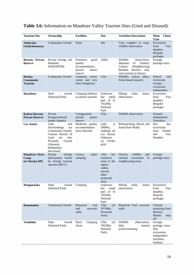
58
Table 3.6: Information on Mandrare Valley Tourism Sites (Used and Disused).
Tourism Site Ownership Facilities Size Activities/Attractions Main Client
Type
Andavaka
(Andrahomana)
Community Owned None 4ha Cave complex at coast,
wildlife observation
Excursions
from Fort
dauphin,
Bespoke
packages
Berenty Private
Reserve
Private foreign (de
Heaulme,
HAH/SHTM)
Extensive good
quality
accommodation,
private nature
reserve
166ha Wildlife observation,
Museum of Tandroy
Culture. (Neighbouring
Bealoka Reserve may
start tourism in future).
Foreign
package tours.
Ifotaka
Community
Tourism
Community Owned Campsite, visitor
centre and very
basic bungalows
c1ha Wildlife, culture, hikes,
forest based research
School and
University
Groups,
occasional
independent.
Ihazofotsy State owned
(National Park)
Camping (defunct
as almost unused)
Unknown
but small
part of of
78220ha
National
Park
Hiking trails, lemur
observation
Excursions
from Fort
dauphin,
Bespoke
packages
Kaleta/Akesson
Private Reserve
Private
foreign/national
(under dispute)
Campground,
private nature
reserve
91ha Wildlife observation Disused
Independent
Travellers.
Lac Anony Lake and
Surroundings are
Community Owned,
Various Parcels of
Land are also
Privately Owned
(Akesson,
deHeaulme,
deGuitaut)
Moderate quality
accommodation
(now disused)
Lake is
3000ha,
Auberge de
Lac Anony
(Akesson
on 0.65ha
plot)
Birdwatching, Beach and
Sand Dune Walks
Part day
excursions
from Ifotaka
and Fort
Dauphin
Mandrare River
Camp
(nr Ifotaka DP)
Private foreign
(deGuitaut), leased
by foreign tourism
operator (MCC)
Luxury safari
camping
12ha but
extensive
tours in the
region
within
several
other
protected
areas
Diverse wildlife and
cultural excursions in
neighbouring areas.
Foreign
package tours.
Mangatsiaka State owned
(National Park)
Camping Unknown
but small
part of of
78220ha
National
Park
Hiking trails, lemur
observation
Excursions
from Fort
dauphin,
Bespoke
packages
Ranomainty Community Owned Botanical trail
and souvenir
stalls
12ha (of
10744ha
Protected
Area)
Botanical Trail, souvenir
stalls
Tourists
transiting from
Berenty,
Ifotaka stop
off
Tsimilahy State owned
(National Park)
Basic Camping
Areas
55ha (of
78220ha
National
Park)
Wildlife observation,
hike, natural
pool/swimming
Foreign
package tours,
Day
excursions,
independent
travellers,
students
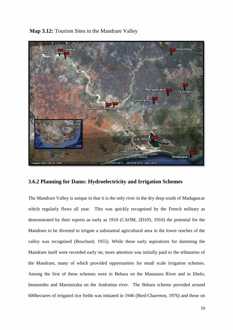
59
Map 3.12: Tourism Sites in the Mandrare Valley
3.6.2 Planning for Dams: Hydroelectricity and Irrigation Schemes
The Mandrare Valley is unique in that it is the only river in the dry deep south of Madagascar
which regularly flows all year. This was quickly recognised by the French military as
demonstrated by their reports as early as 1910 (CAOM, 2D105, 1910) the potential for the
Mandrare to be diverted to irrigate a substantial agricultural area in the lower reaches of the
valley was recognised (Bouchard, 1955). While these early aspirations for damming the
Mandrare itself were recorded early on, more attention was initially paid to the tributaries of
the Mandrare, many of which provided opportunities for small scale irrigation schemes.
Among the first of these schemes were in Behara on the Mananara River and in Ebelo,
Imanombo and Marotsiraka on the Andratina river. The Behara scheme provided around
600hectares of irrigated rice fields was initiated in 1946 (Bied-Charreton, 1976) and those on
60
the Andratina were more extensive exceeding a thousand hectares with wooden local
irrigation channel aquaducts being replaced with cement ones through support from the
colonial administration (Audebert, 1946 (CAOM, 2D34)). Following these initial irrigation
schemes attention turned to combining both irrigation and electricity generation and a study
was carried out in 1949 by Electricité de France (EDF) to examine the hydroelectricity
generation potential of the Mandrare to supply the envisioned industrial development in the
region including bauxite mining (MAERR, 1966:51). At the same time soil studies (Service
Pedologique, 1951) and hydrological surveys (Danloux, 1974 (based on data from 1949-
1974)) were carried out across the valley and successive colonial administrators at both
district (Tessoniere, 1950 (CAOM, 2D212), and provincial (Valmary, 1956 (CAOM, 2D11))
levels emphasised in their reports the importance and potential that irrigation should play in
the development of the valley, especially considering the potential which the Mandrare
offered compared to the drier and more distant Androy proper to the west.22
Budgets were
periodically allocated to allow the construction of additional dams and irrigation schemes,
something which continued with governmental and European development assistance after
the end of the colonial period. Potential new and extended agricultural irrigation schemes
continued to be considered in technical studies and various small scale infrastructural works
undertaken in sites across the valley in the 1960‟s (MAERR, 1966), 1970s (MDR, 1974) and
1980s (MPARA, 1988), and most recently a twelve year project of the International Fund for
Agricultural Development (IFAD), known as PHBM (Projet de mise en valeur du Haut
Bassin du Mandrare) ran in nine communes of the upper valley between 1997 and 2009,
rehabilitating over five thousand hectares of irrigation schemes (FIDA, 2009; Thierry et al
22
« Je viens de parcourir les postes de Tsivory et d‟Esira et me suis arête à Behara et à Amboasary. J‟ai
constate l‟importance croissante de ce district appelé, a mon avis, a un développement beaucoup plus important
que celui que pourra atteindre l‟actuel district de l‟Androy. Les possibilités de travaux d‟hydraulique
paraissent dignes d‟intérêt.» (Valmary, 1956 (CAOM, 2D11)). « L‟innovation économique la plus important
serait la mise en œuvre des travaux tendent a irriguer la plaine située a l‟Est de Tsivory » (Tessoniere, 1950
(CAOM, 2D212)
61
2008) and other micro irrigation projects have been funded and implemented by the World
Bank Rural Development Support Programme (PSDR) and by the European Union through
the international NGO CARE. The end result of these various schemes has not produced any
dramatic land use change when considered at the river valley scale, the most significant of
them having only impacting a few thousand hectares, not more than a fraction of percent of
the overall surface of the valley23
. Despite this, a number of studies did consider the potential
of a Mandrare dam to effect more significant change (increase) in irrigated farming with the
1966 study reporting a potential for irrigating 37,000, or 3% of the valley, for the first time
(MAERR, 1966) and a 2005 dissertation informed by previous hydroelectricity and
hydrological studies estimating the potential to irrigate 45,000hectares or 3.6% of the valley
(Randrianjanaharizaka, 2005). While these estimations are treated with caution, they are
included to indicate that the agricultural potential of damming the Mandrare itself, rather than
its tributaries, has clearly been considered by planners in the past. The hydroelectric potential
of such a dam on the Mandrare has been periodically considered and reported since the late
1940‟s (MAERR, 1966:51; Bied-Charreton, 1976:80; Jirama, 1993, ORE, 1996; Raoelijaona
2004) and today three potential dam sites on the Mandrare still remain on the list of
Madagascar‟s 89 potential hydroelectric projects (Leutwiler & Zimmerman, 2008:A5:3). The
largely agrarian and rural character of the Mandrare region as well as its distance from urban
industrial centres such as Fort Dauphin means that potential of electricity generation as well
as provision of drinking water, water for irrigated subsistence farming and livestock as well
as for commercial agriculture and the supply future industrial needs such as the mining
developments being prospected across the south east of Madagascar would all need to be
combined. Raoelijanona (2004:8) considers among the five potential dam sites which the
23
This comment about not effecting significant land use changes at the river valley scale is not made to
undermine the merits of such schemes (many of which were observed by the author to be very successful and
are much appreciated by the local population), its inclusion is more to make the point about the differences
between ambitious large scale planning/visioning exercises and the more modest scales at which these
agricultural development projects are actually implemented.
62
various studies over the years have identified, that a site, near the village of the Amboetsy,
some 90km upstream from the Mandrare‟s mouth (two thirds of the way down the rivers
course), is the site with the greatest potential. This is principally due to its having the greatest
water retention capacity, anticipated scale of electricity generation and also due to its greater
proximity to urban centres which such a project would supply. In the same way that mining,
commercial agriculture, and protected areas in the Mandrare have been characterised by
periods of large scale speculation followed by an implementation period on a much more
modest scale, the hydroelectric and irrigation potential of the river has yet to be realised, and
if it is to be, there would undoubtedly be significant positive and negative impacts both on
land use and on local communities through flooding and compulsory resettlement.
3.6.3 Reduced Emissions from Deforestation and Degradation (REDD)
The most recent period of expansion of biodiversity conservation and protected areas in
Madagascar (see section 6.5) began in earnest following the declaration by the then President
Marc Ravalomanana in Durban in late 2003. In parallel to this government commitment to
tripling protected areas, Madagascar has been at the forefront of efforts to seek resources
from the global climate change mitigation system in order to finance protected areas and to
restore forest habitats. While World Bank funded carbon forestry projects promoting habitat
restoration have been established in other regions of Madagascar (for example the TAMS
project near Andasibe, east of the capital Antananarivo– Pollini, 2009), none are currently
active in the Mandrare Valley. Another activity under the umbrella of integrating forests into
global climate change mitigation efforts is Reduced Emissions from Deforestation and forest
Degradation (REDD), wherby nations/regions attempt to reduce the rates of deforestation and
forest degradation within their area, in order to obtain carbon credits in payment for the
resulting reductions in carbon dioxide emissions (more detailed information on REDD in
63
Madagascar is presented in Ferguson 2009 and Ferguson 2010). As well as the development
of national scale REDD policies, various sub-national REDD projects have been established
across Madagascar, including one within the Mandrare Valley. The French NGO Good
Planet, in collaboration with WWF Madagascar, began implementing a pilot REDD project,
known as the Holistic Conservation Programme for Forests in Madagascar which includes the
Mandrare Valley towards the end of the fieldwork period of this thesis. The project is
designed to ensure the sequestration of 60-70 Million tons of carbon, by establishing
protected areas and community forest plantations, on over 500,000hectares of land (Air
France, 2010)24
. Of these protected areas which the project is establishing more than half are
located within the Mandrare Valley25
. The project really only began implementation on the
ground after fieldwork for this thesis was concluded so no comment can yet be made as to its
implementation, however assuming that the quarter of a million hectares or so of new
protected areas which are planned to be established in the Mandrare do reach completion, this
will be the single largest change ever recorded in official land use policy for the valley.
While proponents of these new protected area like WWF state that their establishment does
not constitute any change in land use policy (slash and burn agriculture on primary forest is
illegal), the reality is that the state forest service is renowned for its impotence and corruption
and resulting ineffectiveness in preventing deforestation. As a result many of the people of
the Mandrare have enjoyed more or less unfettered access to new farmland through forest
clearance in recent years (to such an extent that the Mandrare forests experienced among the
highest rates of deforestation nationally (MEFT et al 2009)), and the implementation of these
24
The project also has an extensive research project in order to use and develop technological approaches to
measure and monitor forest cover and forest carbon changes within the protected areas, but conspicuous by its
apparent exclusion from the project are social, economic and cultural monitoring schemes, and initiatives to
design revenue distribution mechanisms for REDD carbon credits or to establish free prior informed consent
(FPIC) procedures. 25
The protected areas being established within this project (as well as the two pre-existing ones of Ifotaka North
and Ankodida) are indicated in Map 6.9 above. Based on the size estimates for these protected areas (see Table
6.6) derived from an indepth interview with the WWF regional coordinator they cover an area of
283,327hectares.
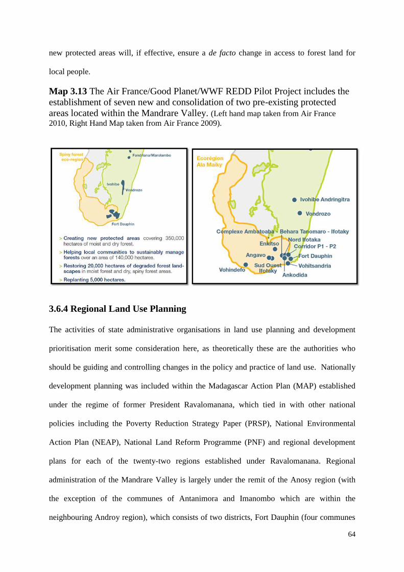
64
new protected areas will, if effective, ensure a de facto change in access to forest land for
local people.
Map 3.13 The Air France/Good Planet/WWF REDD Pilot Project includes the
establishment of seven new and consolidation of two pre-existing protected
areas located within the Mandrare Valley. (Left hand map taken from Air France
2010, Right Hand Map taken from Air France 2009).
3.6.4 Regional Land Use Planning
The activities of state administrative organisations in land use planning and development
prioritisation merit some consideration here, as theoretically these are the authorities who
should be guiding and controlling changes in the policy and practice of land use. Nationally
development planning was included within the Madagascar Action Plan (MAP) established
under the regime of former President Ravalomanana, which tied in with other national
policies including the Poverty Reduction Strategy Paper (PRSP), National Environmental
Action Plan (NEAP), National Land Reform Programme (PNF) and regional development
plans for each of the twenty-two regions established under Ravalomanana. Regional
administration of the Mandrare Valley is largely under the remit of the Anosy region (with
the exception of the communes of Antanimora and Imanombo which are within the
neighbouring Androy region), which consists of two districts, Fort Dauphin (four communes
65
of which are in the Mandrare) and Amboasary-Sud (all eighteen communes of which are
within the Mandrare Valley). The MAP development priorities which were formalised at the
national level were subsequently elaborated with more detail into regional development plans
(PRD) which were completed for both the Anosy and Androy regions in early 2005 (Region
de l‟Anosy, 2005; Region de l‟Androy, 2005). The next level of planning is the commune,
each of which represents a population typically between 10,000 and 20,000, has an elected
Mayor and councillors and employs administrative staff. Each commune has its own
development plan, these having been developed through various forms of participatory
processes with external donor and technician support. In terms of spatial planning the
regional development plans are the most informative about general trends and patterns within
and between sectors across the region. Commune level development plans generally don‟t
include any mapping illustrating areas prioritised for given activities26
, and serve more as
legitimised wish lists for local political leaders and are frequently used as tools of political
patronage within the commune. The regional development plan for Anosy (Region de
l‟Anosy, 2005; CRD, 2005) identified eleven development poles for the region, each of these
representing a convergence of interest (typically around an urban centre or high profile
project) and each focuses on the sectors perceived to have the greatest potential. Two of the
eleven Anosy development poles are located entirely within the Mandrare (Tsivory for
Agriculture and Amboasary-Sud for sisal and tourism) and a further two are partially within
the valley (Littoral for fisheries and Andohahela for protected area tourism). The regional
development plan for Androy (Region de l‟Androy, 2005) arguably has a more disparate
approach, with regional potentialities in crops, livestock and fisheries being indicated in
dozens of areas across the region. What seem to be the important points to take from the
26
Of thirteen communal development plans (Tomboarivo, Tsivory, Elonty, Mahaly, Ranobe, Martsiraka,
Maromby, Esira, Tranomaro, Analapatsy, Andranobory, Ifotaka, Imanombo) consulted by the author during
2009 (no others were unavailable) only one of these (Ifotaka) actually included a map identifying priority
development activities spatially within the commune.
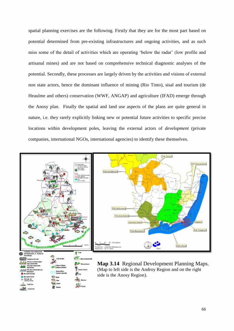
66
spatial planning exercises are the following. Firstly that they are for the most part based on
potential determined from pre-existing infrastructures and ongoing activities, and as such
miss some of the detail of activities which are operating „below the radar‟ (low profile and
artisanal mines) and are not based on comprehensive technical diagnostic analyses of the
potential. Secondly, these processes are largely driven by the activities and visions of external
non state actors, hence the dominant influence of mining (Rio Tinto), sisal and tourism (de
Heaulme and others) conservation (WWF, ANGAP) and agriculture (IFAD) emerge through
the Anosy plan. Finally the spatial and land use aspects of the plans are quite general in
nature, i.e. they rarely explicitly linking new or potential future activities to specific precise
locations within development poles, leaving the external actors of development (private
companies, international NGOs, international agencies) to identify these themselves.
Map 3.14 Regional Development Planning Maps. (Map to left side is the Androy Region and on the right
side is the Anosy Region).
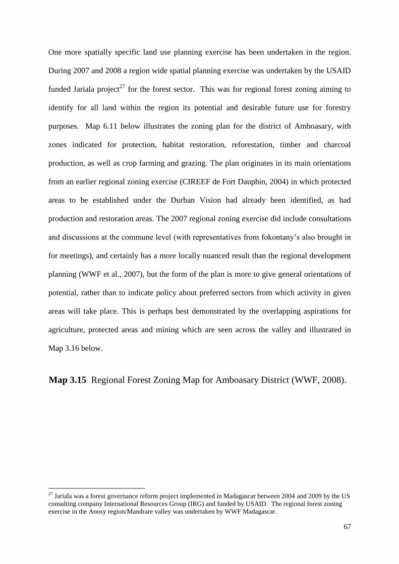
67
One more spatially specific land use planning exercise has been undertaken in the region.
During 2007 and 2008 a region wide spatial planning exercise was undertaken by the USAID
funded Jariala project27
for the forest sector. This was for regional forest zoning aiming to
identify for all land within the region its potential and desirable future use for forestry
purposes. Map 6.11 below illustrates the zoning plan for the district of Amboasary, with
zones indicated for protection, habitat restoration, reforestation, timber and charcoal
production, as well as crop farming and grazing. The plan originates in its main orientations
from an earlier regional zoning exercise (CIREEF de Fort Dauphin, 2004) in which protected
areas to be established under the Durban Vision had already been identified, as had
production and restoration areas. The 2007 regional zoning exercise did include consultations
and discussions at the commune level (with representatives from fokontany‟s also brought in
for meetings), and certainly has a more locally nuanced result than the regional development
planning (WWF et al., 2007), but the form of the plan is more to give general orientations of
potential, rather than to indicate policy about preferred sectors from which activity in given
areas will take place. This is perhaps best demonstrated by the overlapping aspirations for
agriculture, protected areas and mining which are seen across the valley and illustrated in
Map 3.16 below.
27
Jariala was a forest governance reform project implemented in Madagascar between 2004 and 2009 by the US
consulting company International Resources Group (IRG) and funded by USAID. The regional forest zoning
exercise in the Anosy region/Mandrare valley was undertaken by WWF Madagascar.
Map 3.15 Regional Forest Zoning Map for Amboasary District (WWF, 2008).
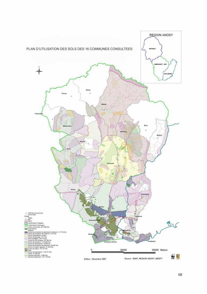
68
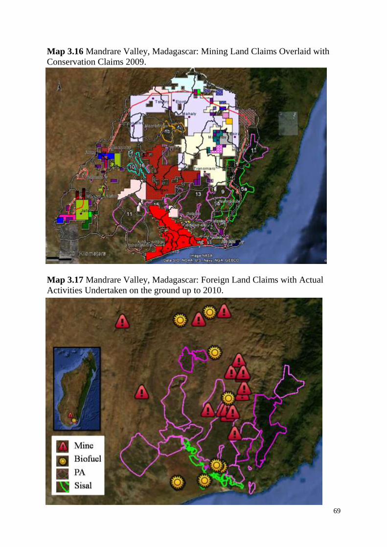
69
Map 3.16 Mandrare Valley, Madagascar: Mining Land Claims Overlaid with
Conservation Claims 2009.
Map 3.17 Mandrare Valley, Madagascar: Foreign Land Claims with Actual
Activities Undertaken on the ground up to 2010.
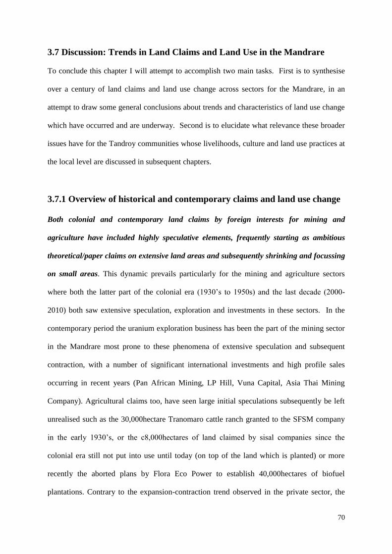
70
3.7 Discussion: Trends in Land Claims and Land Use in the Mandrare
To conclude this chapter I will attempt to accomplish two main tasks. First is to synthesise
over a century of land claims and land use change across sectors for the Mandrare, in an
attempt to draw some general conclusions about trends and characteristics of land use change
which have occurred and are underway. Second is to elucidate what relevance these broader
issues have for the Tandroy communities whose livelihoods, culture and land use practices at
the local level are discussed in subsequent chapters.
3.7.1 Overview of historical and contemporary claims and land use change
Both colonial and contemporary land claims by foreign interests for mining and
agriculture have included highly speculative elements, frequently starting as ambitious
theoretical/paper claims on extensive land areas and subsequently shrinking and focussing
on small areas. This dynamic prevails particularly for the mining and agriculture sectors
where both the latter part of the colonial era (1930‟s to 1950s) and the last decade (2000-
2010) both saw extensive speculation, exploration and investments in these sectors. In the
contemporary period the uranium exploration business has been the part of the mining sector
in the Mandrare most prone to these phenomena of extensive speculation and subsequent
contraction, with a number of significant international investments and high profile sales
occurring in recent years (Pan African Mining, LP Hill, Vuna Capital, Asia Thai Mining
Company). Agricultural claims too, have seen large initial speculations subsequently be left
unrealised such as the 30,000hectare Tranomaro cattle ranch granted to the SFSM company
in the early 1930‟s, or the c8,000hectares of land claimed by sisal companies since the
colonial era still not put into use until today (on top of the land which is planted) or more
recently the aborted plans by Flora Eco Power to establish 40,000hectares of biofuel
plantations. Contrary to the expansion-contraction trend observed in the private sector, the
71
conservation sector has seen a more consistent expansion of protected areas over time, and
while the latest and most significant expansion observed since 2006 has meant that the
protected areas have only received temporary protection so far, no contractions in areas
claimed for protected areas has been observed through degazettement, nor by the
abandonment of claims by conservation organisations.
Mining exploration and new protected areas appear to be the most significant land use
categories. Claims are frequently in transition (being sold, permit areas changing), and
awareness of mining activities is not always prominent in regional development circle, with
some activities operating below the radar of the mainstream. The relative significance of
the different planned land uses indicates that mining exploration (51.73%) and protected
areas (31.79%) are the most significant. With foreign agricultural holdings (2.14%) and
mines with actual physical works undertaken (0.06%) and exclusive tourism sites (0.02%)
being somewhat less significant. Table 6.7 below presents information on the estimated areas
of the valley which is covered by different land uses and claims. Many of the mining land
claims included in this analysis are periodically in transition since they are controlled by
overseas interests and are highly speculative in nature. Indeed some of these activities have
been operating „below the radar‟ of the mainstream development planning community.
Concrete examples of this are the Bekitoly uranium mine of the London based Vuna Group
(Blue Sun Mining Company), the Ankazoabo saphire mines of Malaysian company Nan Tin
Polychrome, and the Israeli backed German biofuels company Flora Eco Power, none of
which feature in regional development planning, as their approvals have been facilitated at
the presidential and or national mining administration level with little or no involvement of
the regional representatives of the ONE or MEM.
72
There are significant and competing/overlapping interests in land from mining companies,
conservation organisations and local communities. From the review and analysis presented
in this chapter, it is evident that there are significantly overlapping claims on land and
resources between local and external actors. In terms of official land use policy and planning
the most apparent competition is between the exploration claims of mining companies and
new protected areas established by international conservation NGOs. Less well documented,
but arguably equally significant, is the competition between local people and external actors.
The de facto customary land use systems in the Mandrare mean that all land is effectively
owned and managed by local people, but in de jure terms only the tiniest proportion of the
land is actually legally titled, and the vast majority of these titles are held by foreign
plantation owners and a few by local elites, and next to none by local farmers. On the land
which conservation organisations have worked to have included within new protected areas
which covers some 31% of the surface of the valley, there are significant numbers of local
settlements and agricultural areas, and the negotiations (which are somewhat stacked in
favour of the conservationists interests) around the resource use rules within the protected
areas are to restrict local use of forest resources, and in their current from neither allow for
the recognition of untitled customary land, nor for compensation for holders of customary
land or customary rights to resources on that land. On the land which has been reserved for
mining exploration there are also significant numbers of local settlements and agricultural
areas, and while those areas which do finally become pits or quarries for mines may conflict
with local ownership, these areas are typically very small in extent (most being under a
hectare in size28
) for the predominant mineral resources of the Mandrare (sapphires, mica,
tourmaline, quartz, uranothorianite) and require mining companies to negotiate with
28 The notable exception of the Ambatovy minerals illmenite sands claim, which would require more spatially extensive
mining operations if it is realised.
73
compensate local land owners who are displaced and to negotiate directly with them (Healy,
2004).
The processes of land use planning seem to have been more reactionary and descriptive in
their outcomes, rather than being pre-emptive and prescriptive in terms of explicitly
integrating policy judgements based on deliberation between constituents, leaders and
external land claimants. The Anosy administrative region, within which much of the
Mandrare valley is located, has been the subject of several intensive development planning
exercises in recent years (SDR, PDR, SMRA). These particularly resource intensive
planning efforts (numerous international experts engaged, extensive processes including
diverse stakeholders), which far exceed those offered to neighbouring regions (Ihorombe,
Atsimo-Atsinanana; Androy; Atsimo-Andefana) has been largely a consequence of the desire
of international development donors, particularly the World Bank and USAID, to be seen to
be engaging in supporting planning efforts in the region where Madagascar‟s most recent
high profile, international company led mine is taking place (this being the Rio Tinto/QMM
illmenite mine in Fort Dauphin). The regional plans which have resulted have however been
largely descriptive and reactionary to known areas of existing interest by international mining
companies and international conservation organisations and therefore are somewhat biased
towards the interests of external actors. This is rather than their being based on processes of
complete resource audits across all sectors, responsible consultations of local constituents by
local and regional political leaders and subsequent deliberation between constituent interests
and interests advocated for by foreign mining and conservation groups. Such an aspirational
approach could be described as more strategic, democratic and prescriptive. Despite the
serious challenges to development and land use planning in the region, some innovative
planning tools and data sets have been developed. The USGS and World Bank dynamic
74
mineral resources management GIS tools (Stanley & Harris, 2006) and the USAID and WWF
Participatory forest zoning work (WWF, 2008) are examples of technical approaches which
could be useful to consider adapting to allow for the inclusion of the agricultural and tourism
sectors in more integrated land use planning.
The capacity of state agencies to ensure the enforcement and monitoring of regulations
around land use is quasi absent for the mining and environment sectors, and extremely
poorly staffed for the forestry, land titling and agricultural sectors in the Mandrare Valley.
The Malagasy state has established various agencies and bodies whose role it is to oversee
the enforcement of environmental, land use and forestry regulations. A number of these
bodies, notably the National Environment Office (ONE), the Ministry of Energy and Mines
(MEM) and the Observatories for Forestry, Environment (ONESF) and Land Rights (ONF),
have no employees based with the Mandrare valley. And the staff of these organisations
whose remit does cover the Mandrare valley rarely have resources at their disposal to
undertake supervisory or monitoring visits due to their location in the capital (ONESF, ONF)
or the regional centre of Fort Dauphin (ONE, MEM). Other sectors do have a number of
employees based in the region forestry (2), land titling (2) and agriculture, although due to
highly restricted resources at their disposal, and their very small numbers, their efficacy is
very limited. They can largely rely on direct support from external bodies to catalyse and
fund their work, in the case of forestry this would be fieldwork carried out for, and fund by,
WWF as well as other funds provided by donors such as the World Bank for purchase of
means of transport and activities such as reforestation campaigns. Similarly the technical staff
from the agriculture sector have also been largely dependent on support facilitated by bodies
such as IFAD. Even with external support the tasks for some of these government agencies
are immense when considered in the context of the scales at which they must operate (for
75
example the two forest service staff for the district of Amboasary each cover almost 1200km2
of forest land). For the private sector operators of mining and biofuels, contrary to
conservation and development agencies, it is much less likely to be in their interests to invite
along and pay for the regulators to work with them, so many of these operations go on
entirely unmonitored unless donor supported programmes stimulate and fund activities (such
as the case of the consultancy work undertaken by the World Bank Mining Resources
Governance Programme (PGRM) which paid for regional director of mining to accompany
its consultants to examine ongoing and abandoned quarries (Swarz-Schampera, 2007).
Terminology such as Land Grab, Foreign Land Claims, Protected Areas and Displacement
are all able to evoke emotive understandings of the complex processes and characteristics
of the activities which they represent, and as such should be used in academic critiques
with great caution. None of the sectors discussed in this chapter are homogeneous or static,
indeed they are highly complicated, dynamic and nuanced domains which include tradeoffs,
the politicisation of decision making process as well as significant positive and negative
socioeconomic and environmental impacts. The use of emotive terminology is arguably
effective for political and activist purposes, in terms of raising these important issues in the
public domain and striving to influence opinion. However use of such terms in academic
critiques, such as the work presented here, should be done with great caution, and to ensure
that balanced and careful representation of both positive and negative aspects of the realities
are made. As has been demonstrated by the unconstitutional removal from Madagascar‟s
Presidency of Marc Ravalomanana in March 2009, the perception by the public of the sale of
Malagasy land to foreigners can be highly damaging, and risks provoking xenophobic and
violent reactions from the public, when the details of the land contracts has not been fully
explained in public (Burnod et al, 2010; Gingembre, 2010).
76
As already stated this chapter has been principally concerned with synthesising the land use
changes and land/resource claims by people, companies and organisations who are not native
to the Mandrare valley region. While local people are undoubtedly also heavily involved in
land use and land use change, through activities such as grazing, slash and burn agriculture,
field abandonment and reforestation the focus here is on external or foreign influences. All
three of the sectors with the largest spatial scope in the Mandrare, namely agriculture, mining
and forest conservation, exert significant influence (or have the potential to do so) on the
customary lands and resources of all of the six main study villages described in subsequent
chapters. It is important to note that if significant new mining, industrial agriculture or
biofuels investment does take place in the Mandrare, that not only those areas and peoples
directly within those areas will be impacted, but resultant changes in road infrastructure and
immigration could be expected to also increase demand for, and potential access to, natural
resources from the forests in order to feed and house new employees and the growing
population across the broader region.
Those external actors involved in actual or potential land and resource use changes are
diverse. These actors who could be said to be the drivers of change range from small private
companies (FEP, MCC) to larger agro-mining corportations (SAGI, Gallois, VUNA,
PAMA), from relatively small cooperation NGOs (GRET, MBG), to large international
conservation agencies (WWF) and international donor programmes encouraging mining
investment from the World Bank (PGRM) to the large agricultural development programmes
from United Nations agencies like IFAD (PHBM). The important point to note is that
identification as a driver of change does not imply a normative assumption that they are
promoting development or conservation and that is good, nor that they are taking over
communities land for mining or biofuels and that that is bad. Any given intervention in land
use by outsider actors is inevitably going to have both positive and negative outcomes, as

77
win-win scenarios are unfortunately elusive. This highlights the importance of combining
research at broad spatial and temporal scales, with place based case studies, incorporating
spatial, economic and cultural perspectives being essential in understanding the real impacts
of externally driven land use change on local people and local environments.
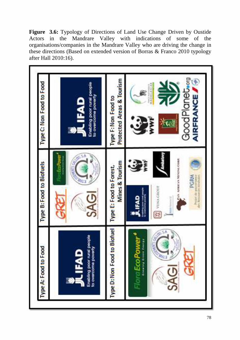
78
Figure 3.6: Typology of Directions of Land Use Change Driven by Oustide
Actors in the Mandrare Valley with indications of some of the
organisations/companies in the Mandrare Valley who are driving the change in
these directions (Based on extended version of Borras & Franco 2010 typology
after Hall 2010:16).
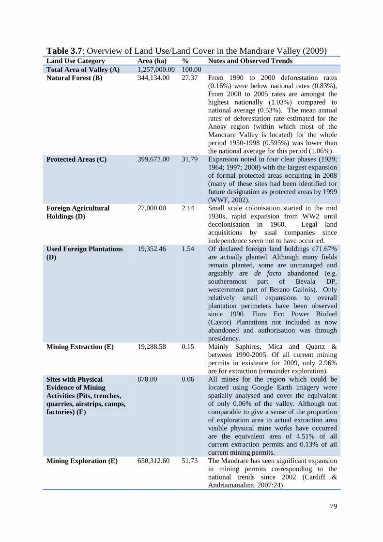
79
Table 3.7: Overview of Land Use/Land Cover in the Mandrare Valley (2009) Land Use Category Area (ha) % Notes and Observed Trends
Total Area of Valley (A) 1,257,000.00 100.00
Natural Forest (B) 344,134.00 27.37 From 1990 to 2000 deforestation rates
(0.16%) were below national rates (0.83%),
From 2000 to 2005 rates are amongst the
highest nationally (1.03%) compared to
national average (0.53%). The mean annual
rates of deforestation rate estimated for the
Anosy region (within which most of the
Mandrare Valley is located) for the whole
period 1950-1998 (0.595%) was lower than
the national average for this period (1.06%).
Protected Areas (C) 399,672.00 31.79 Expansion noted in four clear phases (1939;
1964; 1997; 2008) with the largest expansion
of formal protected areas occurring in 2008
(many of these sites had been identified for
future designation as protected areas by 1999
(WWF, 2002).
Foreign Agricultural
Holdings (D)
27,000.00 2.14 Small scale colonisation started in the mid
1930s, rapid expansion from WW2 until
decolonisation in 1960. Legal land
acquisitions by sisal companies since
independence seem not to have occurred.
Used Foreign Plantations
(D)
19,352.46 1.54 Of declared foreign land holdings c71.67%
are actually planted. Although many fields
remain planted, some are unmanaged and
arguably are de facto abandoned (e.g.
southernmost part of Bevala DP,
westernmost part of Berano Gallois). Only
relatively small expansions to overall
plantation perimeters have been observed
since 1990. Flora Eco Power Biofuel
(Castor) Plantations not included as now
abandoned and authorisation was through
presidency.
Mining Extraction (E) 19,288.58 0.15 Mainly Saphires, Mica and Quartz &
between 1990-2005. Of all current mining
permits in existence for 2009, only 2.96%
are for extraction (remainder exploration).
Sites with Physical
Evidence of Mining
Activities (Pits, trenches,
quarries, airstrips, camps,
factories) (E)
870.00 0.06 All mines for the region which could be
located using Google Earth imagery were
spatially analysed and cover the equivalent
of only 0.06% of the valley. Although not
comparable to give a sense of the proportion
of exploration area to actual extraction area
visible physical mine works have occurred
are the equivalent area of 4.51% of all
current extraction permits and 0.13% of all
current mining permits.
Mining Exploration (E) 650,312.60 51.73 The Mandrare has seen significant expansion
in mining permits corresponding to the
national trends since 2002 (Cardiff &
Andriamanalina, 2007:24).
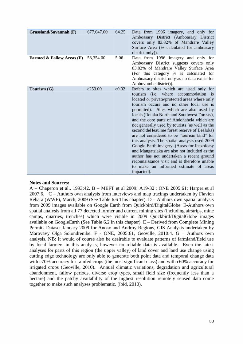
80
Grassland/Savannah (F) 677,047.00 64.25 Data from 1996 imagery, and only for
Amboasary District (Amboasary District
covers only 83.82% of Mandrare Valley
Surface Area (% calculated for amboasary
district only)).
Farmed & Fallow Areas (F) 53,354.00 5.06 Data from 1996 imagery and only for
Amboasary District suggests covers only
83.82% of Mandrare Valley Surface Area
(For this category % is calculated for
Amboasary district only as no data exists for
Ambovombe district)).
Tourism (G) c253.00 c0.02 Refers to sites which are used only for
tourism (i.e. where accommodation is
located or private/protected areas where only
tourism occurs and no other local use is
permitted). Sites which are also used by
locals (Ifotaka North and Southwest Forests),
and the core parts of Andohahela which are
not generally used by tourists (as well as the
second deHeaulme forest reserve of Bealoka)
are not considered to be “tourism land” for
this analysis. The spatial analysis used 2009
Google Earth imagery. (Areas for Ihazofotsy
and Mangatsiaka are also not included as the
author has not undertaken a recent ground
reconnaissance visit and is therefore unable
to make an informed estimate of areas
impacted).
Notes and Sources:
A – Chaperon et al., 1993:42. B – MEFT et al 2009: A19-32 ; ONE 2005:61; Harper et al
2007:6. C – Authors own analysis from interviews and map tracings undertaken by Flavien
Rebara (WWF), March, 2009 (See Table 6.6 This chapter). D – Authors own spatial analysis
from 2009 images available on Google Earth from Quickbird/DigitalGlobe. E-Authors own
spatial analysis from all 77 detected former and current mining sites (including airstrips, mine
camps, quarries, trenches) which were visible in 2009 Quickbird/DigitalGlobe images
available on GoogleEarth (See Table 6.2 in this chapter). E – Derived from Complete Mining
Permits Dataset January 2009 for Anosy and Androy Regions, GIS Analysis undertaken by
Marovavy Olga Solondrenibe. F - ONE, 2005:61, Geoville, 2010:4. G – Authors own
analysis. NB: It would of course also be desirable to evaluate patterns of farmland/field use
by local farmers in this analysis, however no reliable data is available. Even the latest
analyses for parts of this region (the upper valley) of land cover and land use change using
cutting edge technology are only able to generate both point data and temporal change data
with c70% accuracy for rainfed crops (the most significant class) and with c60% accuracy for
irrigated crops (Geoville, 2010). Annual climatic variations, degradation and agricultural
abandonment, fallow periods, diverse crop types, small field size (frequently less than a
hectare) and the patchy availability of the highest resolution remotely sensed data come
together to make such analyses problematic. (ibid, 2010).
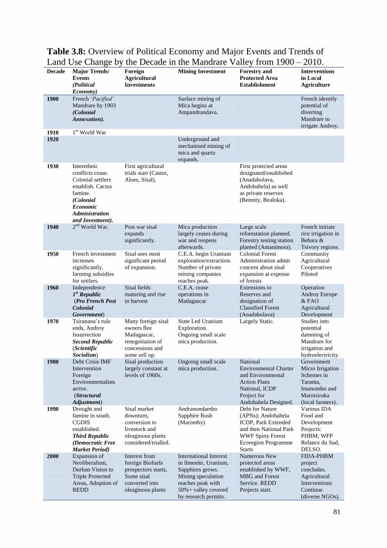
81
Table 3.8: Overview of Political Economy and Major Events and Trends of
Land Use Change by the Decade in the Mandrare Valley from 1900 – 2010. Decade Major Trends/
Events
(Political
Economy)
Foreign
Agricultural
Investments
Mining Investment Forestry and
Protected Area
Establishment
Interventions
in Local
Agriculture
1900
French „Pacified‟
Mandrare by 1903
(Colonial
Annexation).
Surface mining of
Mica begins at
Ampandrandava.
French identify
potential of
diverting
Mandrare to
irrigate Androy.
1910 1st World War
1920
Underground and
mechanised mining of
mica and quartz
expands.
1930
Interethnic
conflicts cease.
Colonial settlers
establish. Cactus
famine.
(Colonial
Economic
Administration
and Investment).
First agricultural
trials start (Castor,
Aloes, Sisal).
First protected areas
designated/established
(Anadabolava,
Andohahela) as well
as private reserves
(Berenty, Bealoka).
1940
2nd World War. Post war sisal
expands
significantly.
Mica production
largely ceases during
war and reopens
afterwards.
Large scale
reforestation planned.
Forestry testing station
planted (Antanimora).
French initiate
rice irrigation in
Behara &
Tsivory regions.
1950
French investment
increases
significantly,
farming subsidies
for settlers.
Sisal sees most
significant period
of expansion.
C.E.A. begin Uranium
exploration/extraction.
Number of private
mining companies
reaches peak.
Colonial Forest
Administration admit
concern about sisal
expansion at expense
of forests
Community
Agricultural
Cooperatives
Piloted
1960
Independence
1st Republic
(Pro French Post
Colonial
Government)
Sisal fields
maturing and rise
in harvest
C.E.A. cease
operations in
Madagascar
Extensions to
Reserves and
designation of
Classified Forest
(Anadabolava)
Operation
Androy Europe
& FAO
Agricultural
Development
1970
Tsiranana‟s rule
ends, Androy
Insurrection
Second Republic (Scientific
Socialism)
Many foreign sisal
owners flee
Madagascar,
renegotiation of
concessions and
some sell up.
State Led Uranium
Exploration.
Ongoing small scale
mica production.
Largely Static. Studies into
potential
damming of
Mandrare for
irrigation and
hydroelectricity.
1980
Debt Crisis IMF
Intervention
Foreign
Environmentalists
arrive.
(Structural
Adjustment)
Sisal production
largely constant at
levels of 1960s.
Ongoing small scale
mica production.
National
Environmental Charter
and Environmental
Action Plans
National, ICDP
Project for
Andohahela Designed.
Government
Micro Irrigation
Schemes in
Taranta,
Imanombo and
Marotsiraka
(local farmers).
1990
Drought and
famine in south.
CGDIS
established.
Third Republic
(Democratic Free
Market Period)
Sisal market
downturn,
conversion to
livestock and
oleaginous plants
considered/trialled.
Andranondambo
Sapphire Rush
(Maromby)
Debt for Nature
(APNs); Andohahela
ICDP, Park Extended
and then National Park
WWF Spiny Forest
Ecoregion Programme
Starts
Various IDA
Food and
Development
Projects:
PHBM; WFP
Relance du Sud,
DELSO.
2000
Expansion of
Neoliberalism,
Durban Vision to
Triple Protected
Areas, Adoption of
REDD
Interest from
foreign Biofuels
prospectors starts,
Some sisal
converted into
oleaginous plants
International Interest
in llmenite, Uranium,
Sapphires grows.
Mining speculation
reaches peak with
50%+ valley covered
by research permits.
Numerous New
protected areas
established by WWF,
MBG and Forest
Service. REDD
Projects start.
FIDA-PHBM
project
concludes.
Agricultural
Interventions
Continue
(diverse NGOs).
82
Abbreviations
ALT – Andrew Lees Trust.
ANGAP – Association National pour la Gestion des Aires Protegees (National Association
for the Management of Protected Areas). Became Madagascar National Parks (MNP) in
2008.
AROPA – Agricultural and Rural Development Programme of IFAD/FIDA.
BRL - Bekitoly Resources Limited. Holding Company for VUNA Uranium Assets in
Bekitoly.
BSMC - Blue Sun Mining Company. Partnership company between VUNA and OMNIS.
CAIM – Compagnie Agricole et Industrielle de Madagascar, established in 1928.
CAOM- Centre d‟Archives d‟Outre Mer (Aix-en-Provence).
CARE – International Humanitarian and Rural Development NGO.
CEA – Commissariat de l‟Energie Atomique (French Atomic Energy Commission, active in
Madagascar during 1950s and 1960s, later became AREVA).
CGDIS – Comissariate Generale pour le Developpement Integree du Sud (General
Comission for the Integrated Development of Southern Madagascar).
CGOT – Compangie Generale de Oleagineaux (General Oleagineous Plants Company).
CIREEF – Circonscription de l‟Environnement, des Eaux et Forets (Circinscription of
Environment, Water and Forests). In successive reforms of government administration by
2009 had become DREF (Direction Regional de l‟Environnement et des Forets).
CRD – Comite Regional de Developpement (Regional Development Committee for Anosy).
DEF – Direction des Eaux et Forets (Directorate of Water and Forests).
EG - Etablissements Gallois (French owned sisal and graphite mining company).
FAO – Food and Agriculture Organisation of the United Nations.
FEP - Flora Eco Power GmbH (German Registered Biofuel Company, renamed Acazis).
FIDA – Fonds International pour le Development Agricole (International Fund for
Agricultural Development (IFAD)).
FPIC – Free Prior and Informed Consent.
GIS – Geographical Information System.
GRET – Groupe de Recherche et Technique (French Rural Development NGO).
HAH – Henri et Alain de Heaulme, Sisal Company owned by de Heaulme family.
ICDP – Integrated Conservation and Development Project.
IDA – International Development Assistance.
IMF – International Monetary Fund.
IRCT – Institut de Recherche sur le Coton et Textiles, French Cotton & Textile Research.
IRG – Instutit de Recherche pour le Developpement (French Research and Cooperation
Agency).
83
IUCN – International Union for the Conservation of Nature.
MAERR – Ministere de l‟Agriculture, de l‟Elevage et de la Reconstruction Rurale.
MAP – Madagascar Action Plan (National Development Strategy under President
Ravalomanana).
MBG - Missouri Botanical Gardens (International Conservation NGO).
MCC - Madagascar Classic Camping (Ecotourism Company).
MCP – Ministere pour la Culture et Patrimoine (Ministry of Heritage and Culture).
MDR – Ministere de la Developpement Rurale
MECIE – Mise en Compatabilite des Investissements et l‟Environnement (Environmental
Regulations in respect of investments.
MEEFT – Ministere des Eaux de l„Environnement, des Forets et du Tourisms (Ministry of
Water, Environment, Forests and Tourism).
MEF – Ministere de l‟Environnement et des Forets (Ministry of Environment and Forests).
MEFT – Ministere de l„Environnement, des Forets et du Tourism (Ministry of Environment,
Forests and Tourism).
MEM – Ministere de l‟Energie et Mines (Ministry of Energy and Mines).
MPARA - Ministere de la Production Agricole et de la Reforme Agraire (Ministry of
Agricultural Production and Agricultural Reform).
NEAP – National Environmental Action Plan (15 Year National Environmental Strategy).
NGO – Non Governmental Organisation.
NTP - Nan Tin Polychrome (Malaysian Sapphire Mining Company).
ONE – Office Nationale de l‟Environnement (National Environment Office).
ONESF – Observatoire Nationale de l‟Environnement et du Secteur Forestière. (National
Environment and Forest Sector Observatory).
ONF – Observatoire National Foncier (National Land Rights Observatory).
ONMIS – Office Malgache des Mines et Industries Strategiques.
ORE – Office de Regulation de l‟Electricite (Electricity Regulators Office).
PA – Protected Area.
PAM – Programme Alimentaire Mondiale
PAMA – Pan African Minerals Atomique (Canadian Uranium/Coal Company Partner of
OMNIS).
PDR – Plan de Développement Régionale (Regional Development Plan).
PGRM – Programme de Gouvernance des Ressources Minière.
PHBM – Projet de la mise en valeur de la Haut Basin du Mandrare (High Mandrare
Development Project, a project of IFAD/FIDA).
PNF – Programme Nationale Foncier (National Land Programme)
PNUD - Programme des Nations Unis pour le Développement (United Nations Development
Programme).
84
PRD - Plan Regionale pour la Developpement (Regional Developpement Programme).
PSDR – Programme de Soutien pour la Developpement Rurale (Rural Development Support
Programme, a project of the World Bank).
QMM – Qit Fer et Titane Madagascar Minerals (Joint Company between the Malagasy State
and Qit Fer et Titane, subsidiary of Rio Tinto).
REDD – Reduced Emissions from Deforestation and Forest Degradation.
SADP – Société Agricole de Domaine de Pechpeyrou – French Sisal Company (1942).
SAMA – Société Agricole Malgache – French Agricultural Company in Madagascar (1920).
SAPM – Système des Aires Protegees de Madagascar (Malagasy System of Protected Areas).
SDR – Schema de Developpement Regionale (Anosy Region, Dobbin International & CRD).
SFM – Société de Ficellerie de Mandrare (sisal fibre processing company).
SFSM – Société Foncière du Sud de Madagascar, South Madagascar Land Company (1928)
SHTM – Société d‟Hôtellerie et du Tourisme de Madagascar (Tourism company associated
with Berenty Private Reserve and Jean de Heaulme owner of HAH Sisal Plantations).
SIACS – Societe d‟Investissement Agricole (unidentified).
SIAM(1) – Société d‟Investissements Agricole de Mandrare (closed in 1974).
SIAM(2) - Société d‟Investissement Australien a Madagascar (sapphire mining company).
SIFOR –Société Industrielle de Fort Dauphin (Sisal processing and weaving
company)(1957).
SITO – Societe Industrielle (unidentified).
SMRA –Societe Malgache (unidentified).
SOMEMA- Société Malgache d‟Exploitation Minière et Aurifère (Gemstones and Gold
Mining Company).
SPSM – Société de Plantation de Sisal du Mandrare, (1978 Akesson group sisal company).
SQM – Société de Quartz de Madagascar.
SSM – Société de Sisal Malgache (1943, Confolent and sons) operated with SIFOR.
UNESCO – United Nations Educational, Scientific and Cultural Organisation.
USAID – United States Agency for International Development.
USGS – United States Geological Service.
USSR – Union of Soviet Socialist Republics.
WFP – World Food Programme.
WWF - World Wildlife Fund.
85
References
Air France, 2009, Contre le Changement Climatique : Air France S‟Engage a Madagascar en
Partenariat avec Good Planet et le WWF, Company Brochure (17pp).
Air France, 2010, Combating Deforestation in Madagascar: The Air France Commitment,
Company Brochure (12pp).
Akesson Group, 2010, http://www.groupe-akesson.com/societe.php, accessed on 29th December
2010.
Andriamialisoa F. and Langrand O., 2003, History of Zoological Exploration of Madagascar,
pages 1-15 in Goodman SM and Benstead J P (eds) The Natural History of Madagascar, Chicago
University Press.
Anonymous, 2007, Unstructured Interview with Quartz Miner, Soarivimasy (nr Babaria), Mahaly,
August.
Balard M, 2002, Madagascar 1916-1945 : Les Regards d‟un administrateur-ethnographe :
Raymond Decary, Azalees Editions.
Beaudouard G, 1963, Note sur l‟Evolution de l‟Industrie Miniere Malgache Graphite et Mica,
Bulletin de L‟Academie Malgache, 281-286.
Beinart W, 1987, Conservation Ideologies in Africa, pages 15-19 in Anderson D and Grove R
(eds) Conservation in Africa : people, policies and practice, Cambridge University Press.
Bertrand A and Sourdat M, 1998, Feux et déforestation a Madagascar: Revue Bibliographique,
CIRAD-ORSTOM-CITE.
Bied-Charreton M, 1976, Dynamismes Internes et Interventions Externes: Le Perimetre Hydro-
Agricole de Behara Dans l‟Extrême Sud de Madagascar, Cahiers ORSTOM, Serie Sciences
Humaines, Vol 13(1):3-89.
Biller, Christopher, 2009 Interview and subsequent informal discussions (Former Research
assistant, former employee of Flora Eco Power GmbH), Tsivory, Fort Dauphin, Antananarivo.
Borras SM & Franco J, 2010a, Towards a broader View of the Politics of Global Land grab:
Rethinking Land Issues, Reframing Resistance, ICAS Working Paper Series No. 001 (May).
Borras SM & Franco J, 2010b, « Codes de bonne conduit »: un reponse a l‟accaparement des
terres?, Alternatives Sud, Vol 17 (3): 57-78.
Bos R, 2002, Diognistic agraire, Bilan des experiences passees, Ebauche de Programme, Mission
d‟Expertise Agricole Objectif Sud GRET, Fort Dauphin 30 Decembre 2002.
Bouchard, 1955, Etude Monographique de la Station de Reboisement d‟Antanimora, Archives de
Cantonnement Forestiere d‟Antanimora-Sud.
Bouwer L, 2000, The Bara of Madagascar, http://cesa.imb.org/peoplegroups/bara.html (accessed
on 14th March 2010).
Brenon P, 1957, Etude des Gisements de Thorianite et de Mica de la Region de Tranomaro,
chapter (pages 171-177) in dissertation of unknown title (www.madadoc.mg).
Brown M, 1995, A History of Madagascar, Damien Tunnacliffe, Cambridge.
Burney DA, Piggot Burney L, Godfrey LR, Jungers WL, Goodman SM, Wright HT and Jull AJT,
2004, A chronology for late prehistoric Madagascar, Journal of Human Evolution, Vol 47: 25-63.
Burnod P, Andrianirina RR and Teyssier A, 2010, „Foreign Land Claims and Acquisitions in
Madagascar: What Reality? What Regulations On the Ground?‟, Paper accompanying
presentation at the Conference “Africa for Sale” Analysing and Theorizing Foreign Land Claims
and Acquisitions, Groningen, Netherland, 28th-29
th October.
86
CAOM 2D103 1896 Rapport sur la situation de la Province de Fort Dauphin, Marche de la
Pacification dans la Cercle Annexe.
CAOM, 1896, 2D103 Map of the Expedition into the Mandrare valley and the Androy by M.
Lemaire Annex to Letter from the Resident of Fort Dauphin, M. Lemaire to the Resident General
of Madagascar in Antananarivo (written in Faux Cap describing the expedition between the 18th
and 26th October 1896.
CAOM, 1905, 2D104, Rapport politique et administrative, Cercle de Fort Dauphin 2eme
Trimestre.
CAOM, 1907, 6D(9)14, Essai de Classification des Mammiferes et Oiseaux de la region de
Tsivory, 1st February.
CAOM, 1910, 2D105, Rapport Politique de Fort Dauphin, Annee 1910,
CAOM, 1913, 6D(7)27, Décret établissant le régime forestier a Madagascar.
CAOM, 1932, 2D21, Rapport Politique Annuel, District Ambovombe, Region de Fort Dauphin.
CAOM, 1933, 2D21, District d‟Ambovombe Rapport Economique 1933, Monsieur FELIX, 28
Fevrier 1934.
CAOM, 1933, 2D21, District d‟Ambovombe Rapport Economique 1935, Monsieur FELIX,
31Decembre 1935.
CAOM, 1934, 2D21, District d‟Ambovombe Rapport Economique Annuel 1933, Monsieur Felix
28 Fevrier.
CAOM, 1946, 2D34, Circonscription Agricole de Fort Dauphin, Rapport Annuel 1945 : Annexe
Complement pour l‟Hydraulique Agricole et la Lutte Antiacridienne, Monsieur Audebert 19
Fevrier, Ambovombe.
CAOM, 1950, 2D212, Rapport Annuel Poste de Tsivory 1951, Monsieur Teissonniere Chef de
Poste, 31 Janvier 1952.
CAOM, 1952, 2D23:19, Notes on the Establishment of Antanimora Forestry Station.
CAOM, 1952, 2D34, Monographie de la Region de l‟Androy.
CAOM, 1952, 2D34, Rapport Annuel de l‟Inspection Forestière de Fort Dauphin (Monsieur P
Lamarque, 28 Mars 1953).
CAOM, 1952, 2D34, Rocca C, Carte des Principales Forets de l‟Androy, Annex to Rapport
Annuel de Chef de District Androy, 2nd
August 1952
CAOM, 1953, 2D110, Lemarque P, 28th March 1953, Carte de Potentiel de Fort Dauphin,
Rapport Annuel de l‟Inspecteur Forestiere de Fort Dauphin.
CAOM, 1953, 2D110, Rapports Administrative Annuel District de Fort Dauphin.
CAOM, 1955, 2D11, Rapports Politiques Mensuel de District d‟Amboasary-Sud, Aout, Unknown
Author).
CAOM, 1956, 2D11, Rapports Politiques Mensuel de District d‟Amboasary-Sud, September,
Annexe: Note de mission de Monsieur A Valmary, Administrateur en Chef (Tulear 22
Septembre).
Cardiff SG and Andriamanalina A, 2007, Contested Spatial Coincidence of Conservation and
Mining Efforts in Madagascar, Madagascar Conservation and Development, Volume 2 (1):28-34.
Chaperon P, Danloux J & Ferry L, 1993, Fleuves et Rivieres de Madagascar, monographie
Hydrologique 10, IRD Editions.
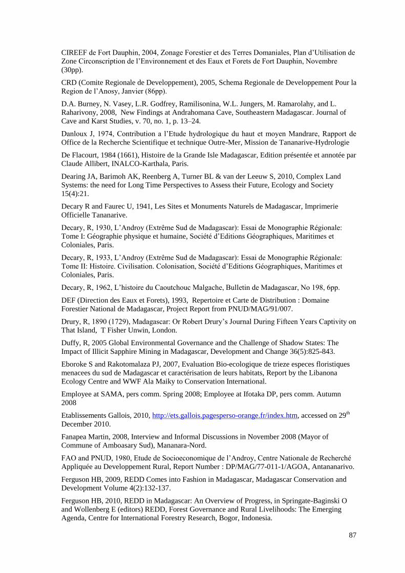
87
CIREEF de Fort Dauphin, 2004, Zonage Forestier et des Terres Domaniales, Plan d‟Utilisation de
Zone Circonscription de l‟Environnement et des Eaux et Forets de Fort Dauphin, Novembre
(30pp).
CRD (Comite Regionale de Developpement), 2005, Schema Regionale de Developpement Pour la
Region de l‟Anosy, Janvier (86pp).
D.A. Burney, N. Vasey, L.R. Godfrey, Ramilisonina, W.L. Jungers, M. Ramarolahy, and L.
Raharivony, 2008, New Findings at Andrahomana Cave, Southeastern Madagascar. Journal of
Cave and Karst Studies, v. 70, no. 1, p. 13–24.
Danloux J, 1974, Contribution a l‟Etude hydrologique du haut et moyen Mandrare, Rapport de
Office de la Recherche Scientifique et technique Outre-Mer, Mission de Tananarive-Hydrologie
De Flacourt, 1984 (1661), Histoire de la Grande Isle Madagascar, Edition présentée et annotée par
Claude Allibert, INALCO-Karthala, Paris.
Dearing JA, Barimoh AK, Reenberg A, Turner BL & van der Leeuw S, 2010, Complex Land
Systems: the need for Long Time Perspectives to Assess their Future, Ecology and Society
15(4):21.
Decary R and Faurec U, 1941, Les Sites et Monuments Naturels de Madagascar, Imprimerie
Officielle Tananarive.
Decary, R, 1930, L‟Androy (Extrême Sud de Madagascar): Essai de Monographie Régionale:
Tome I: Géographie physique et humaine, Société d‟Editions Géographiques, Maritimes et
Coloniales, Paris.
Decary, R, 1933, L‟Androy (Extrême Sud de Madagascar): Essai de Monographie Régionale:
Tome II: Histoire. Civilisation. Colonisation, Société d‟Editions Géographiques, Maritimes et
Coloniales, Paris.
Decary, R, 1962, L‟histoire du Caoutchouc Malgache, Bulletin de Madagascar, No 198, 6pp.
DEF (Direction des Eaux et Forets), 1993, Repertoire et Carte de Distribution : Domaine
Forestier National de Madagascar, Project Report from PNUD/MAG/91/007.
Drury, R, 1890 (1729), Madagascar: Or Robert Drury‟s Journal During Fifteen Years Captivity on
That Island, T Fisher Unwin, London.
Duffy, R, 2005 Global Environmental Governance and the Challenge of Shadow States: The
Impact of Illicit Sapphire Mining in Madagascar, Development and Change 36(5):825-843.
Eboroke S and Rakotomalaza PJ, 2007, Evaluation Bio-ecologique de trieze especes floristiques
menacees du sud de Madagascar et caractérisation de leurs habitats, Report by the Libanona
Ecology Centre and WWF Ala Maiky to Conservation International.
Employee at SAMA, pers comm. Spring 2008; Employee at Ifotaka DP, pers comm. Autumn
2008
Etablissements Gallois, 2010, http://ets.gallois.pagesperso-orange.fr/index.htm, accessed on 29th
December 2010.
Fanapea Martin, 2008, Interview and Informal Discussions in November 2008 (Mayor of
Commune of Amboasary Sud), Mananara-Nord.
FAO and PNUD, 1980, Etude de Socioeconomique de l‟Androy, Centre Nationale de Recherché
Appliquée au Developpement Rural, Report Number : DP/MAG/77-011-1/AGOA, Antananarivo.
Ferguson HB, 2009, REDD Comes into Fashion in Madagascar, Madagascar Conservation and
Development Volume 4(2):132-137.
Ferguson HB, 2010, REDD in Madagascar: An Overview of Progress, in Springate-Baginski O
and Wollenberg E (editors) REDD, Forest Governance and Rural Livelihoods: The Emerging
Agenda, Centre for International Forestry Research, Bogor, Indonesia.
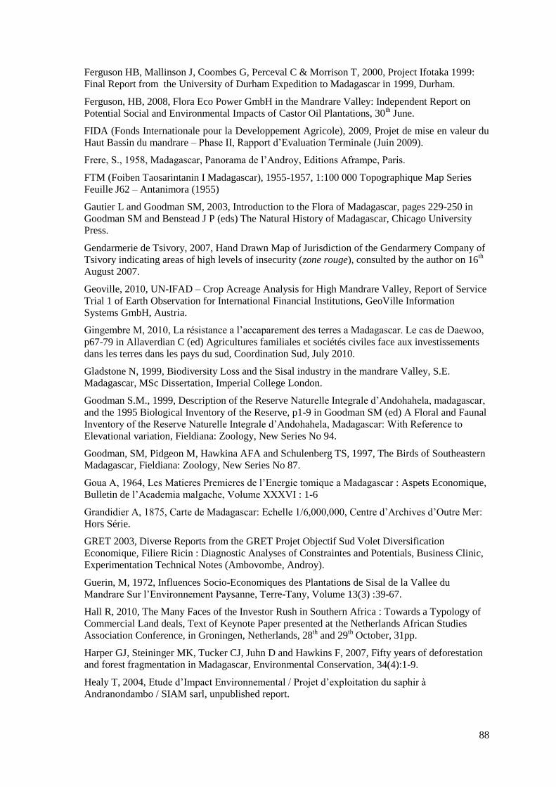
88
Ferguson HB, Mallinson J, Coombes G, Perceval C & Morrison T, 2000, Project Ifotaka 1999:
Final Report from the University of Durham Expedition to Madagascar in 1999, Durham.
Ferguson, HB, 2008, Flora Eco Power GmbH in the Mandrare Valley: Independent Report on
Potential Social and Environmental Impacts of Castor Oil Plantations, 30th June.
FIDA (Fonds Internationale pour la Developpement Agricole), 2009, Projet de mise en valeur du
Haut Bassin du mandrare – Phase II, Rapport d‟Evaluation Terminale (Juin 2009).
Frere, S., 1958, Madagascar, Panorama de l‟Androy, Editions Aframpe, Paris.
FTM (Foiben Taosarintanin I Madagascar), 1955-1957, 1:100 000 Topographique Map Series
Feuille J62 – Antanimora (1955)
Gautier L and Goodman SM, 2003, Introduction to the Flora of Madagascar, pages 229-250 in
Goodman SM and Benstead J P (eds) The Natural History of Madagascar, Chicago University
Press.
Gendarmerie de Tsivory, 2007, Hand Drawn Map of Jurisdiction of the Gendarmery Company of
Tsivory indicating areas of high levels of insecurity (zone rouge), consulted by the author on 16th
August 2007.
Geoville, 2010, UN-IFAD – Crop Acreage Analysis for High Mandrare Valley, Report of Service
Trial 1 of Earth Observation for International Financial Institutions, GeoVille Information
Systems GmbH, Austria.
Gingembre M, 2010, La résistance a l‟accaparement des terres a Madagascar. Le cas de Daewoo,
p67-79 in Allaverdian C (ed) Agricultures familiales et sociétés civiles face aux investissements
dans les terres dans les pays du sud, Coordination Sud, July 2010.
Gladstone N, 1999, Biodiversity Loss and the Sisal industry in the mandrare Valley, S.E.
Madagascar, MSc Dissertation, Imperial College London.
Goodman S.M., 1999, Description of the Reserve Naturelle Integrale d‟Andohahela, madagascar,
and the 1995 Biological Inventory of the Reserve, p1-9 in Goodman SM (ed) A Floral and Faunal
Inventory of the Reserve Naturelle Integrale d‟Andohahela, Madagascar: With Reference to
Elevational variation, Fieldiana: Zoology, New Series No 94.
Goodman, SM, Pidgeon M, Hawkina AFA and Schulenberg TS, 1997, The Birds of Southeastern
Madagascar, Fieldiana: Zoology, New Series No 87.
Goua A, 1964, Les Matieres Premieres de l‟Energie tomique a Madagascar : Aspets Economique,
Bulletin de l‟Academia malgache, Volume XXXVI : 1-6
Grandidier A, 1875, Carte de Madagascar: Echelle 1/6,000,000, Centre d‟Archives d‟Outre Mer:
Hors Série.
GRET 2003, Diverse Reports from the GRET Projet Objectif Sud Volet Diversification
Economique, Filiere Ricin : Diagnostic Analyses of Constraintes and Potentials, Business Clinic,
Experimentation Technical Notes (Ambovombe, Androy).
Guerin, M, 1972, Influences Socio-Economiques des Plantations de Sisal de la Vallee du
Mandrare Sur l‟Environnement Paysanne, Terre-Tany, Volume 13(3) :39-67.
Hall R, 2010, The Many Faces of the Investor Rush in Southern Africa : Towards a Typology of
Commercial Land deals, Text of Keynote Paper presented at the Netherlands African Studies
Association Conference, in Groningen, Netherlands, 28th and 29
th October, 31pp.
Harper GJ, Steininger MK, Tucker CJ, Juhn D and Hawkins F, 2007, Fifty years of deforestation
and forest fragmentation in Madagascar, Environmental Conservation, 34(4):1-9.
Healy T, 2004, Etude d‟Impact Environnemental / Projet d‟exploitation du saphir à
Andranondambo / SIAM sarl, unpublished report.
89
Healy T, 2005, Etude d‟Impacte Environmentale et Sociale et Plan d‟Amenagement
Environnementale de la Mine de Saphirs d‟Andranondambo, Report by Aquaterre for the Societe
d‟Investissement Australien a Madagascar.
Hecht G, 2002, Rupture-Talk in the Nuclear Age: Conjugating Colonial power in Africa, Social
Studies of Science, Vol 32 No5-6:691-727.
Hecht G, 2006, Nuclear Ontologies, Constellations, Vol 13, No 3:320-331.
Hecht G, 2010, The Power of Nuclear Things, Technology and Culture, Volume 51, Issue 1:1-30
(doi: 10.1353/tech.0.0396).
Hervieu J and Riquer J, 1959, Notice sur les Sols du Bas-Mandrare, Notices sur les Cartes
d‟Utilisation des Sols : II, Publications de l‟Institute de Recherche Scientifique de Madagascar,
Tsimbazaza, Tananarive.
Houtart, F, 2010, Agrofuels: Big Profits, Ruined Lives and Ecological Destruction, Pluto Press,
London.
Humbert H, 1946, La protection de la nature a Madagascar, p258-361 in Revue international de
Botanique Applique, Tome XXVI, No 286.
Interview with an anonymous informant, Antefotaka Clan, 21st October 2007.
IRSM (l‟Institute de Recherche Scientifique de Madagascar), 1951, Carte de Bas Mandrare
(Campagnes 1946 et 1948), 1 :200,000, Service Pédologique de l‟Institute de Recherche
Scientifique de Madagascar.
IUCN Red List of Threatened Species. Version 2009.1. <www.iucnredlist.org>, Aloe suzannae,
Critically Endangered D (Ver 2.3), Downloaded on 25th August 2009.
Jarosz, L. 1993. Defining and explaining tropical deforestation: Shifting cultivation and
population growth in colonial Madagascar (1896-1940), Economic Geography 69, 4: 366-379.
Jirama, 1993, Etude de reconaissance du Site d‟Amboetsy sur le Mandrare (cited in
Randrianjanaharizaka 2005 and Raoelijaona 2004).
Jobin Marc 2008, Informal Discussion May (Owner Tourmaline/Pegmatite Concession,
Anjahamiary, Director SOMEMA), Antananarivo.
Jolly, A, 2004, Lords and Lemurs: Mad Scientists, Kings with Spears, and the Survival of
Diversity in Madagascar, Houghton Mifflin, New York.
Jolly, A, 2006, Berenty Reserve: A Research Site in Southern Madagascar, pages 32-42 in Jolly
A, Sussman RW, Koyama N and Rasamimanana H (eds) Ringtailed Lemur Biology: Lemur catta
in Madagascar, Springer, New York.
Kaufmann JC, 2004, Prickly Pear Cactus and Pastoralism in Southwest Madagascar, Ethnology,
Vol 43(4):345-361.
Kibler JF, 2003, Rapport d‟Activites Aout 2002 – Mai 2003, Project Objectif Sud (GRET, Union
Europenne, Kiomba), Ambovombe, Mai.
Koerner F, 1969, Décolonisation et économie de plantations: Situation des propriétés européennes
a Madagascar, Annales de Géographie, Tome 78(430):654-679.
Langhoff, C, 2003, Women and Resource Use: A study of rural women in a spiny desert region in
Madagascar, BA Dissertation, University of Oxford.
Lavers T, 2010, The role of foreign investment in Ethiopia‟s Smallholder-focused agricultural
development strategy, Unpublished manuscript.
Leutwiler H & Zimmerman W, 2008, Vaolrisation des Potentiels Hydroelectriqes pour
l‟Electrification rurale a madagascar, Rapport Finale de ITECO Ingenieurs SA for GTZ (22 Mai
2008).
90
MAERR (Ministere d‟Etat Charge de l‟Agriculture de l‟Expansion Rurale er du Ravitaillement),
1966, Reconnaissanse des Possibilities d‟Amenagement de la Vallee du Mandrare, Dossier de
Presentation, Mars.
Mamiarisoa, 2009, informal discussion during conservation planning workshop, (Regional
representative for Anosy for the National Environment Office (ONE), 13th March, Ambovombe.
MCP, 2010, Liste des Sites et Monuments inscrits sur l‟Inventaire des Sites Classées come
Patrimoine National http://www.mcp.gov.mg/index.php?option=com_content&view=article&id=120&Itemid=105
(accessed on Friday October 15th 2010)
MDR (Ministere du Developpement Rural), 1974, Etude d‟Orientation sur les Possibilities
d‟Intervention Rurale dans la Region du Haut Mandrare, (Rapport Définitif de SODETAG-AED).
MDRRA, 1977, Elements de Resolution du Probleme Lie a la Production et la Commercialisation
du Sisal a Madagascar, Report PFSL 491-A of Ministere du Developpement Rural et de la
Reforme Agraire.
MEFT (Ministere de l‟Environnement, des Forets et du Tourisme) and MEM (Ministere de
l‟Energie et Mines), 2008, Arrêté 18633/2008/MEFT/MEM portant mise en protection temporaire
globale des sites vises par l‟Arrêté interministériel no 171914 du 18 octobre 2006 et levant la
suspension de l‟octroi des permis miniers et forestiers pour certains sites.
MEFT, USAID and CI, 2009, Evolution de la couverture de forets naturelles a Madagascar, 1990-
2000-2005, Report to the United States Agency for International Development, Antananarivo.
Mihavatsara, 2009 Interview and Informal Discussions (Chef de Service: Control et Suivi,
DREFT (Direction Regionale l‟Environnement, des Forets et du Tourisme, Androy) Ambovombe.
MIRA, 2000, Donnees Economique et Sociale Region de l‟Anosy, Province Autonome de Tulear
(Ministere de l‟Interieur et de la Reforme Administrative).
MPARA (Ministere de la Production Agricole et de la reforme Agraire), 1988, Projets de
Rehabilitation des Petits Perimetres Irrigues, Etudes de Preselection Region de Betroka-Tsivory-
Tolagnaro, Tome I (Mars 1988).
MRA (Mining Review Africa), 2005, Madagascar to be Benchmark for Global Genstonr
Reform ?, Mining Review Africa, Isue 4:8-11.
ONE, 2005, Tableau de Bord Environnementale Régionale de l‟Anosy, Office Nationale de
l‟Environnement/Comite Regionale pour le Developpement, Fort Dauphin.
ORE (Office de Regulation de l‟Electricite), 1996, Amenagement Hydroelectrique du Site
d‟Amboetsy.
Parker Pearson M & Godden K, 2002, In Search of the Red Slave: Shipwreck and Captivity in
Madagascar, Sutton Publishing, Stroud.
Pers obs, 2007, Fieldwork in the fokontany of Ambalatany, Commune of Ranobe, 6th-10
th
December.
Pezotta F and Jobin M, 2003, The Anjahamiary pegmatite, Fort Dauphin area, Madagascar, Lapis
(Mineralien magazin) 29(2):24-28 (www.minsocam.org/msa/pegmatites.html.
Phelps Dodge, 2000, Plan d‟Engagement Environnemental (PEE-RS) Relatif a la Demande d‟un
Permis de recherché Pour Titane Region Androy, Aout 2000.
Phelps Dodge, 2001, Rapport Environnemental de Fin de Travaux Projet TiaTane, Ambovombe
Androy, Phelps Dodge Madagascar, Permis: 2041 du 08/01/2001, Aout 2001.
Phileol, 2009, SME Portfolio Phileol Madagascar, http://amanda.nfrance.com/~eq57487/5-16226-
PhileoL-Madagascar.php
Plangemann KA, Lefebvre A-L, Randriamanampisoa D, Keener S, Rajaonsos B, Marcus RR,
Blum J and Poole A, 2010, Governance and Development Effectiveness Review: A Political
91
Economy Analysis of Governance in Madagascar, World Bank Report No: 54277-MG,
December.
PNUD/FAO, 1980, Etude de socioéconomique de l‟Androy, Janvier 1980 Project DP/MAG/77-
011-1/AGOA, pp276.
Pollini J, 2009, Carbon Sequestration for Linking Conservation and Rural Development in
Madagascar: The Case of the Vohidrazana-Mantadia Corridor Restoration and Conservation
Carbon Project, Journal of Sustainable Forestry 28:322-342.
Poupon, 1953, Note sur les concessions de la vallée du Bas-Mandrare et la Conservation des
formations forestiers de l‟Androy, Rapport No.390, Services des Eaux et Forets, Province de
Tulear.
Raik D, 2007, Forest Management in Madagascar: An Historical Overview, Madagascar
Conservation and Development Volume 2(1):5-10.
Ramangalahy Jules, Chef Cantonnement de l‟Environnement, des Forets et du Tourisme,
Antanimora-Sud, Personal Communication, April, 2009.
Randrianandianina BN, Andriamahaly LR, Harisoa FM and Nicoll ME, 2003, The Role of the
Protected Areas in the Management of the Island‟s Biodiversity, pages 1423-1432 in Goodman
SM and Benstead J P (eds) The Natural History of Madagascar, Chicago University Press.
Randrianja S & Ellis S, 2009, Madagascar: A Short History, Hurst and Company, London.
Randrianjanaharizaka G.H. 2005, Utilisation des Ressources Hydrologiques du Haut Bassin de
Mandrare, Mémoire de fin d‟etude pour l‟obtention du diplôme d‟Ingenieur, Universite
d‟Antananarivo.
Randriatsivery, M, 2009, Dossier de création de la nouvelle aire protégée d‟Anadabolava-
Betsimalaho, Missouri Botanical Gardens Antananarivo, 86pp.
Raoelijaona D, 2004, Possibilites d‟Amenagement d‟un Barrage sur le Fleuve Mandrare,
Ministere de l‟Energie et des Mines, Aout 2004.
Raoelijaona Dieudonee, 2010, Email Correspondence (Former Employee of the National Military
Mining Office in 1979, Hydroelectricity Geologist for JIRAMA).
Rasamoelina H, 2007, Madagascar : Etat, communautés villageoises et banditisme rural,
L‟Harmattan et Association de Recherche Coopérative International, Paris.
Ratsialonana RA, Ramarojohn L, Burnod P, Teyssier A, 2010 Après Daewoo? Etat des lieux et
perspectives des appropriations foncières à grande échelle à Madagascar, Report of CIRAD and
National Land Observatory of Madagascar.
Rebara Flavien, 2009, Interviews and Map Annotation Sessions March and June (Regional
Coordinator of WWF), Fort Dauphin.
Region de l‟Anosy, 2005, Plan Regionale de Developpement, Fevrier (52pp).
Region de l‟Androy, 2005, Plan Regionale de Developpement, Octobre (103pp).
Riquer J, Hervieu J and Ratasilana JR 1955, Carte Pedologique de Reconaissance au 1/50 000
Basse Vallee du Mandrare, Institut de recherche Scientifique de Madagascar, Tananarive.
Riquer J, nd, Basse Vallee du Mandrare, Pages 45-84 in unknown book (www.madadoc.mg
No :14.348-FOR)
Scales IR, 2008, Forest Frontiers: the Political Ecology of Landscape Change in Western
Madagascar, PhD Thesis, University of Cambridge, UK.
Schwarz Schampera U, Hirdes W, Schulte B, 2008, Mining Potential of Selected Geological
Domains of Southern Madagascar, Presentation Given at the International Symposium on “le
92
Potential de Mineralisation de Madagascar”, World Bank PGRM, Antananarivo 17th and 18
th
(ftp://ftp3.intranet.mdm.gov.mg).
Schwarz-Schampera U, 2007, Ore Depostis and Commodities in Southern Madagascar – A
Reconnaissance Study: Field Evidences and Sampling, Report to the World Bank PGRM (Projet
de Gouverance des Ressources Miniere).
Service Pedologique de l‟Institut de Recherche Scientifique de Madagascar, 1951, Carte du bas
Mandrare (Campagnes 1946 et 1948), 1:200 000.
Tadesse, T, 2007, Ethiopian elephants, lions at risk as forest cut
http://www.alertnet.org/thenews/newsdesk/L31635717.htm 31 May 2007 17:06:59
Theirry B, Shapiro B, Woldeyes A, Ramilison H, Rakotodratsima A, 2008, Nourrir la Terre,
Nourrir les Hommes : La mise en valeur reussie du haut bassin du Mandrare a Madagascar,
L‟Harmattan.
Tilghman L, Baker M & DeLeon SD, 2007, Artisinal Sapphire Mining in Madagascar :
Environmental and Social Impacts, Report to University of Vermont.
Tsirampy Armand, 2008, Informal Discussions between January 2008 and March 2009 (Research
Assistant/Enumerator and Former Regional Head of Security for Akesson Group), Ankodida,
Besakoa, Fort Dauphin, Ifotaka.
Vinicguerra V, 2010, How the Daewoo Attempted Land Acquisition Contributed to Madagascar‟s
Political Crisis in 2009, Unpublished Manuscript.
VUNA, 2011, Uranium and Rare Earth Exploration in Madagascar: Bekitoly Resources Limited,
www.vunacapital.com (accessed on Monday 10th January 2011).
Wilme L, Goodman SM and Ganzhorn JU, 2006, Biogeographic Evolution of Madagascar‟s
Microendemic Biota, Science, Volume 312:1063-1065.
WWF, 2002, Plan Pour la Conservation des Forets Epineux de Madagascar : Programme Ala
Maiky, Antananarivo.
WWF, 2008, Collecte de donnees complementaires et consultations communales dans le cadre du
zonage forestier regional dans la CIREEF de l‟Anosy, Rapport final pour IRG/JARIALA
(USAID Madagascar), Janvier (288pp)
Zoomers A, 2010, Globalisation and the Foreignisation of space: seven processes driving the
current global land grab, Journal of Peasant Studies, Volume 37 (2):429-447.
93
Translations of quotes in French from archival material and an interview
« Enfin, à l‟Extrême-Sud de l‟Ile, prés de Cap Sainte Marie, chez les Antandroy, nous
sommes aux âges préhistorique. La l‟organisation sociale la plus rudimentaire : aucune
indice de civilisation. Les groupes, à l‟état anarchique, guerroient sans cesse pour la
possession des tropeaux à laquelle ils attachent un prix superstitieux, n‟en trafiquant pas. Ils
vivent sans besoins, dans des huttes informes, dissimilés derrière d‟impénétrables murailles
d‟euphorbes et de cactus, ignorant l‟usage de la monnaie, insoucieux de tout
perfectionnement. Comme jeux des danses sauvages sur plusieurs rangs de profondeur
frappant la terre du pied a le rythme d‟un air rude et monotone. » Lyautey (1902:381).
“Finally, in the far south of the island, near Cap Sainte Marie, home of the Antandroy, we are
in the prehistoric ages. Only the most rudimentary social organisation: no indication of
civilisation. The groups, in a state of anarchy, fight endlessly for the possession of herds,
upon which they give a superstitious value, and don‟t trade. They live without needs, in
shapeless huts, scattered behind impenetrable walls of euphorbias and cactus, ignorant about
the use of money, unconcerned about improvement. Like games, their wild dances are done
in multiple ranks one behind the other they beat their feet on the ground in a monotonous and
rough manner”
ooo000ooo
« L‟exemple donne par la colonisation du Mandrare apporte la preuve certain que la ténacité
et l‟esprit d‟entreprise ont permis l‟une des plus belles réussites de la province de Tuléar. »
Charles Rocca August 1952 (CAOM, 2D34)
“The example given by the colonisation of the Mandrare, gives certain proof that the tenacity
and the spirit of enterprise have allowed one of the finest successes of the province of
Tulear.”
ooo000ooo
« …de Heaulme, il est tolérable. Même si il a accaparé les terres des Tandroy pour son sisal
et la réserve ou on est interdit de rentrer, il est plus ou moins assimilé avec nous, il parle

94
bien le dialecte Antandroy et ils n‟ont pas touché les tombeaux ancestrales pendent la
création de ses plantations de sisal. Il sait intégrer avec nous, il vient pour assister et même
cotiser les funérailles dans le village de Berenty. Par contre, du Guitaut, il a défrichée sans
hésitation. Avec un bulldozer il a détruit des tombeaux de mes ancêtres et les forets tabous
aux alentours… »
Anonymous informant, Antefotaka Clan, 21st October 2007.
“...de Heaulme, he‟s bearable. Even if he did take over the Tandroy lands for his sisal and
reserve where we are forbidden from entering, he is more or less integrated with us. He
speaks the Tandroy dialect well, and he didn‟t touch ancestral tombs during the planting of
his sisal. He knows how to integrate with us, taking part in, and even contributing to funerals
in Berenty village. On the other hand, de Guitaut, he deforested without hesitation. With a
bulldozer he destroyed the tombs of my ancestors and the sacred forest around them...”
ooo000ooo
« On ne trouve pas dans le district des belles forets comme celles de la Cote Est. A part
quelques ilots forestière contenant des bois durs, et situes un dans le canton
d‟Androhondroho, un dans le canton de Beanantara, et les autres disséminés dans les postes
de Behara et Antanimora, on ne rencontre partout des fantiolotsy et des arbustes épineux. En
raison des difficultés aux quelles peut donner lieu l‟exploitation des ilots sus-indiquée aucune
concession forestière n‟était encore accorde. En résume, la foret Antandroy n‟offre pas
beaucoup des ressources ....
…… Comme dans les rapports précédents nous dirons que les ressources forestières sont
minimes et inexploitées. Elles ne sont utilisées que pour les besoins des particuliers et des
services administratifs…le fantsilotsy est employé par les indigènes pour le constructions de
leur cabanes en planches, et sert également a la confection des bardeaux employés pour les
couvertures des bâtiments »
Monsieur FELIX, 28 Fevrier 1934(CAOM, 1933, 2D21).
“In this district we don‟t find fine forests such as those of the east coast. Apart from a few
fragments containing hardwoods, one found in the canton of Androhondroho, one found in
the canton of Beanantara, and others scattered in the postes of Behara and Antanimora, we
only find Fantiolotsy and spiny shrubs. Because of the difficulties of locating the precise
95
exploitable fragments mentioned above, no forest concessions have yet been granted. In
short, the Antandroy forests offer little by way of resources...
... as in previous reports we said that the forest resources are minimal and untapped. The are
only used for the needs of individuals and the administrative services.... the fantiolotsy is
used by the natives to build their cabines in boards, and equally serve as the shutters used to
cover buildings”
ooo000ooo
“Le hiatus crée par la foret Tandroy autours de la Sakamahasoa et l‟Ikonda au sud, par la
foret de l‟ouest et du sud de Tranomaro détermine toujours les conditions physique groupant
les populations autour de Tsivory” (Teissoniere, CAOM, 1950, 2D212)
“The hiatus created by the Tandroy forests around the Sakamahasoa and the Ikonda to the
south, by the forests to the south and west of Tranomaro always determines the physical
conditions which group the peoples around Tsivory”
ooo000ooo
« Le rôle de nos commandants de secteurs particulièrement celui du secteur Antanosy est
quelque peu modifie, ils n‟auront a l‟avenir qu‟a se dévouera l‟œuvre colonisatrice et
commerciale afin d‟arriver dans le plus bref délai a la mise en valeur des richesses du sol que
l‟ou saurait contester a la province de Fort Dauphin »
Monsieur Tralboux (CAOM, 1896, 2D103)
“The role of our sector commanders, especially those of the Antanosy sector is slightly
modified, they only have in the future to dedicate themselves to the labour of colonising and
commercialising in order to ensure that as quickly as possible the developpement of the
unquestionably rich soils of the province of Fort Dauphin”
ooo000ooo
« Des travaux de reboisement ont été entrepris dans le poste d‟Antanimora dans un double
but de reconstitution forestière et de modification climatique. En raison des faibles
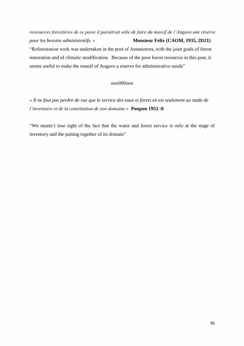
96
ressources forestières de ce poste il paraitrait utile de faire du massif de l‟Angavo une réserve
pour les besoins administratifs. » Monsieur Felix (CAOM, 1935, 2D21)
“Reforestation work was undertaken in the post of Antanimora, with the joint goals of forest
restoration and of climatic modification. Because of the poor forest resources in this post, it
seems useful to make the massif of Angavo a reserve for administrative needs”
ooo000ooo
« Il ne faut pas perdre de vue que le service des eaux et forets en est seulement au stade de
l‟inventaire et de la constitution de son domaine » Poupon 1953 :8
“We mustn‟t lose sight of the fact that the water and forest service is only at the stage of
inventory and the putting together of its domain”