the sedimentology of middle holocene tsunami facies in northern sutherland, scotland, uk
TRANSCRIPT

The sedimentology of Middle Holocene tsunami facies innorthern Sutherland, Scotland, UK
S. Dawson*, D.E. Smith
Centre for Quaternary Science, Geography, School of Natural and Environmental Sciences, Coventry University, Priory Street,
William Morris Building, Coventry CV1 5FB, UK
Received 1 February 1999; accepted 1 September 1999
Abstract
Lagoonal sediments attributed to the main Holocene marine transgression in Strath Halladale, northern Sutherland, contain a
complex coarser layer believed to have been deposited during the tsunami associated with the Second Storegga Slide off South
West Norway. The coarser sequence is dated at between 7590 ^ 50 and 7290 ^ 50 radiocarbon years BP (6507±6260 cal BC
and 6228±6029 cal BC). Detailed stratigraphical analysis has determined a distinctive suite of sedimentary sub-units within the
coarser layer in marked contrast to the sediments, which occur above, and below. A pronounced erosional unconformity with
the underlying sediments is recorded with the base of the tsunami layer characterised by eroded material from the underlying
peat. The presence of a mixed diatom assemblage, although fragmentary, indicates a chaotic accumulation of the deposit with all
habitats represented. Variations in particle size within the sequence disclose striking similarities with those from contemporary
tsunami deposits. The run-up of the tsunami sediments is calculated at a minimum of 4.6 m. This is the ®rst occasion on which a
deposit of the Second Storegga Slide tsunami has been found outside the North Sea basin and indicates that the area affected by
the tsunami may have been larger than has been previously described. q 2000 Elsevier Science B.V. All rights reserved.
Keywords: Tsunami; Holocene; Diatoms; Sedimentology
1. Introduction
Tsunamis are seismic sea waves caused by distur-
bance of the sea ¯oor during earthquakes, volcanic
eruptions or submarine landslides. These long waves
(up to 200 km) travel over the ocean at great velocity.
Within the open ocean, the wave height is low, but
upon reaching shallow water, in the vicinity of the
coastline, it becomes greatly ampli®ed. Therefore,
the impact at the coast is often catastrophic (e.g. the
Papua New Guinea tsunami of July 1998 led to the
death of at least 2000 people).
Within a geological timescale, a tsunami is a low-
frequency high-magnitude event. Several studies of
sedimentation associated with contemporary tsunami
inundation have been undertaken, for example by Yeh
et al. (1993) and Dawson (1996). These disclose
complex patterns with large-scale movement of
sediment both in onshore and seaward direction.
Recent years have seen a proliferation of sedimento-
logical studies of inferred tsunami sediments from the
geological record (e.g. Dawson et al., 1988, 1995;
Bourgeois et al., 1988; Minoura et al., 1994; Shi,
1995; Dawson et al., 1996; Dawson and Smith, 1997;
Goff and Chague±Goff, 1999b; Goff et al., 2000).
Marine Geology 170 (2000) 69±79
0025-3227/00/$ - see front matter q 2000 Elsevier Science B.V. All rights reserved.
PII: S0025-3227(00)00066-9
www.elsevier.nl/locate/margeo
* Corresponding author.
E-mail addresses: [email protected] (S. Dawson),
[email protected] (D.E. Smith).

S. Dawson, D.E. Smith / Marine Geology 170 (2000) 69±7970
Fig. 1. Geomorphological and borehole location map of lower Strath Halladale, northern Sutherland. Inset shows the location of the study area
in northern Scotland.

Research by Smith et al. (1985) has established the
widespread accumulation of a distinctive horizon of
marine sand within Holocene coastal sediments in
eastern Scotland. This horizon was subsequently
interpreted as having been laid down by a tsunami
triggered by the Second Storegga Slide on the
continental slope off western Norway (Dawson et
al., 1988) This paper describes the ®rst occurrence
of the sand horizon outside the North Sea basin. The
sedimentology of this deposit is the focus of the
present paper.
2. Geological context
The coastline of northern Sutherland is intersected
by the northward draining river valleys. Strath
Halladale (Fig. 1) is one of the largest of these valleys
and appears to have been a major corridor for the
deposition of outwash material during the deglaciation
of the last Scottish ice sheet. Much of this material has
been eroded and redeposited by subsequent ¯uvial
action. At the mouth of the valley, in Melvich Bay,
granitic rocks of the western headland and ¯agstones
of Old Red Sandstone to the east form impressive
cliffs. A large boulder beach occurs at the western
extremity of the bay. At the eastern side a terraced
intertidal rock platform occurs.
The study area comprises the lower 3 km of
Strath Halladale, where the river ¯ows across a
wide ¯oodplain. Throughout this area, the river is
tidal and the ¯oodplain and saltings are frequently
inundated by spring tides. The present altitude of
the High Water Mark of Ordinary Spring Tides
(HWMOST) at Strath Halladale is 12.30 m OD
(Admiralty Tide Tables, 1996). The surface of the
¯oodplain declines consistently down-valley from
an altitude of 3.5 m above Kirkton before levelling
out beyond the roadbridge (Fig. 1), where it gradu-
ally merges with the modern saltings at ca. 2 m.
Towards the mouth of the Halladale River, the
vegetated saltings have an upper surface at 2.11±
2.61 m OD and a lower surface of 1.95±2.08 m OD.
The surfaces are ¯ooded by spring tides. At the edge
of the saltings, a small bluff overlooks sand¯ats,
which are exposed during the tidal cycle at between
1.74 and 1.90 m OD.
3. Methodology
Sediments have been traced across the ¯oor of
Strath Halladale using an Eijkelkamp gouge of 2 cm
diameter to determine the overall sedimentary
sequences and inter-relationships. Samples for labora-
tory analyses were collected using a 50 mm diameter
Stitz piston corer, which provided undisturbed cores
up to 1.3 m long. In the laboratory, a photographic
record of each core was taken before detailed
stratigraphical descriptions were made, followed by
sub-sampling for microfossil and particle size analy-
sis. Preparation for diatom analysis followed well-
established techniques (Barber and Haworth, 1981)
and a minimum count of 300 valves was made
where possible. A Malvern Mastersizer 2600 involving
laser diffraction spectroscopy was used to determine
particle size of the minerogenic sediments. The
mean particle size and standard deviation were
calculated using Malvern software. Radiocarbon
dating was carried out at Beta Analytic, Miami.
Table 1 lists the dates obtained, calibrations use
Calib 4 according to the method of Stuiver and
Reimer (1993). All dates referred to in the text are
quoted in radiocarbon years BP.
S. Dawson, D.E. Smith / Marine Geology 170 (2000) 69±79 71
Table 1
Radiocarbon dates from Strath Halladale. Ages in conventional radiocarbon years (1s) and calibrated ages (cal BC, 2s)
Laboratory code 14C age ^ 1s BP Calibrated age
(cal BC)
Altitude
(m OD)
Depth
(m)
Material dated
Beta-105030 (AMS) 7290 ^ 50 6228±6054 24.25 7.19 Peat
6043±6029
Beta-105031 (AMS) 7590 ^ 50 6507±6373 24.98 7.92 Peat
6364±6346
6311±6260

S.
Da
wso
n,
D.E
.S
mith
/M
arin
eG
eolo
gy
170
(2000)
69
±79
72
Fig. 2. Section along lower Strath Halladale showing the sedimentary sequence examined.

4. Stratigraphy
The sediments have been classi®ed into two major
facies groups based on their sedimentary characteris-
tics. Group 1 facies incorporate the underlying and
overlying sedimentary suite, and group 2 facies
incorporate the distinctive suite of sediments within
the stratigraphy of Strath Halladale.
Group 1 facies. The facies in group 1 incorporate
intercalated peats and clastic sediments with graded
transitional facies, which represent sediments asso-
ciated with long-term sea surface change (Dawson,
1999). Representative stratigraphical pro®les from
north to south and from east to west within the valley
are shown in Figs. 2 and 3. Organic sediments both
under- and overlie the depositional unit under
investigation. The overlying peats grade into a black
organic gyttja, which, from an analysis of the micro-
fossils, indicates deposition within a shallow tidal
lagoon (Dawson, 1999). This quiet water sedimenta-
tion and distinct organic facies is well suited to the
identi®cation and preservation of a contrasting sediment
body accumulated during a high-energy event.
Group 2 facies. Detailed stratigraphical analyses
were restricted to the sediments retrieved from core
SH 2, the deepest borehole undertaken in the valley.
Examination of Fig. 4 shows in detail the major
elements of the distinctive suite of sub-units contained
within the sediment. The sediment succession starts
with a pronounced erosional unconformity with the
underlying organic deposit. This is overlain by
alternating sand layers of varying particle size, and
redeposited organic material (mostly eroded peat),
from the underlying organic deposits. Some of the
S. Dawson, D.E. Smith / Marine Geology 170 (2000) 69±79 73
Fig. 3. Cross-valley stratigraphic transect of lower Strath Halladale.

S. Dawson, D.E. Smith / Marine Geology 170 (2000) 69±7974
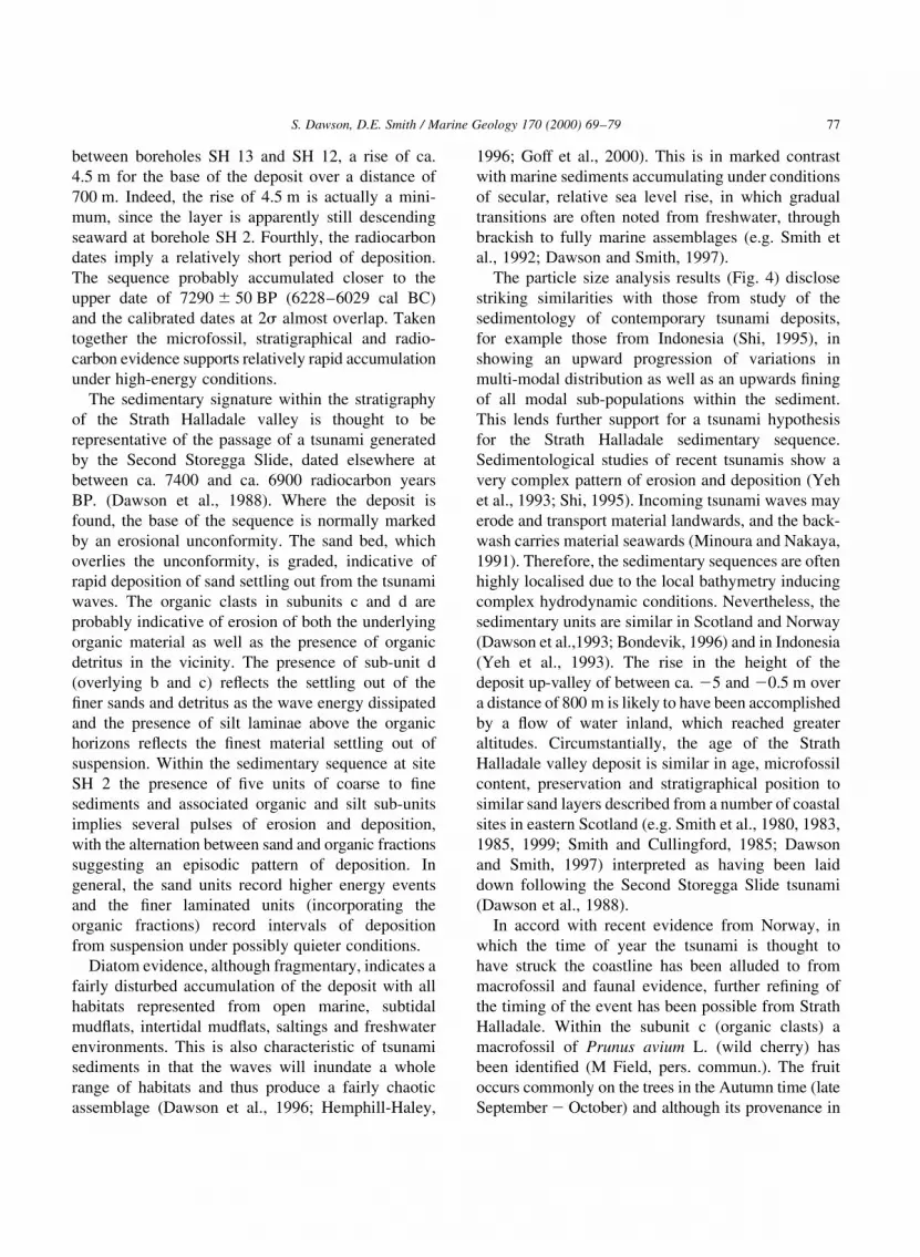
Fig. 4. Detailed stratigraphy of coarser unit within the sediment sequence of SH 2 and the mean particle size pro®le in microns at 1 cm
contiguous intervals. Fining upwards sequences are shown to the right of the pro®le.

sand layers are graded, whilst others are unsorted. The
organic horizons contain clasts, twigs, stems and
macrofossils as well as other plant detritus, which
are often found in a chaotic matrix of silt, clay and
sands. The base of the sedimentary succession is
erosive, whereas the upper boundary with the over-
lying shelly organic material becomes ®ner and
more gradual. The sediments can be divided into
®ve sub-facies:
1. Graded sands (sub-facies a). These are composed
of very coarse sand with ®ne gravel at the base,
grading upwards to medium and often ®ne grey
sand. The ®ne sand often has detrital plant material
present with occasional small twigs.
2. Massive sand (sub-facies b). The massive sand is
generally coarse to medium with de®ned bound-
aries. The unit is thinner than the graded beds
and has no apparent internal structure.
3. Organic inclusions (sub-facies c). This unit is
composed of a variety of materials, with clasts of
different origin including peat, silt, undifferentiated
organic matter, sand, gravel, twigs and plant
matter. Sand and silt laminae are also present.
Typically, the twigs are of Betula sp. and approxi-
mately 1±2 cm in length. Where present they are
orientated parallel to the silt and sand laminae.
4. Organic detritus (sub-facies d). Subfacies d resem-
bles subunit c and the boundary between them is
transitional. The layer is characterised by ®ner
plant debris, twigs and detrital matter. The minero-
genic fraction of the unit is typically ®ne sand.
5. Light grey silt (sub-facies e). Grey silt laminae are
often present lying stratigraphically above the
organic detritus (sub-facies d).
4.1. Microfossils
The sedimentary facies was examined for diatoms
and foraminifera. While no foraminifera were found
(J. Wells, pers. commun), diatom species were present
in small numbers within the ®ner sands and clays of
the intercalating sequence. In view of the small
number of individuals present, no viable counts
were possible. Identi®able species include a range of
marine and brackish species, including Paralia
sulcata, Cocconeis scutellum, Grammatophora
oceanica, Rhaphoneis surirella, Diploneis smithii,
Diploneis interrupta and Auliscus sculptus. In
addition, there are many freshwater species present,
identi®able only by their intact central areas, such as
Pinnularia sp. and Fragilaria construens species.
Diatom valves were often broken and therefore,
identi®cation was dif®cult. A full count was not
undertaken.
Table 2 details the main taxa present, together with
the total number of valves identi®ed. One sample was
taken from the ®ner clastic sediments within the unit,
and discloses a complex suite of diatoms. This is
dominated by the polyhalobous planktonic Paralia
sulcata, the valves of which are of a very broken
and fragmentary nature. Other fully marine indicators
are present including Rhaphoneis surirella, a sand-¯at
living benthon (Vos and De Wolf, 1993). The sample
also contains a range of mesohalobous and oligo-
halobous species including Diploneis and Fragilaria
species. The assemblage contains a range of species
from many differing habitats within the coastal zone,
from fully marine subtidal to intertidal sand¯at and
supratidal dwelling species, and has a clear allochtho-
nous component.
4.2. Particle size analysis
The entire sediment sequence was also analysed for
particle size and comprised 74 cm of material, which
was sampled contiguously with 1 cm thick samples
S. Dawson, D.E. Smith / Marine Geology 170 (2000) 69±79 75
Table 2
Diatom species and total number of valves (24.25 to 25.00 m OD)
Diatom species Total number
Paralia sulcata (broken and eroded) 135
Grammatophora oceanica 40
Auliscus sculptus 7
Rhaponeis surirella 12
Cocconeis scutellum 22
Diploneis interrupta 17
Diploneis ovalis 12
Navicula forcipata 4
Diploneis smithii 9
Navicula abrupta 5
Navicula pusilla 25
Pinnularia sp. 34
Fragilaria construens 36
Epithemia sp. 6
Total no. of valves 364

and the results are shown in Fig. 4. Mean particle size
is determined in microns and discloses a multi-modal
particle size distribution. From the base of the
sequence upward, variation in mean particle size is
complex. However, certain trends are identi®able.
The sequence is characterised by several ®ning-
upward sequences. This can be determined both
visually, from inspection of the detailed stratigraphy,
and from the trend of mean particle size. Five indivi-
dual coarse±®ne suites can be seen, with a range of
particle sizes from ca. 500 to 40 mm. At a depth of
765±769 cm, a unit of unsorted sand occurs, and
particle size through this unit exhibits no change. In
addition to the individual ®ning-upwards sequences,
the overall trend of mean particle size throughout the
unit is from predominantly coarse at the base, at
792 cm depth to ®ne at the top, at 719 cm depth.
4.3. Chronology
Radiocarbon dates on samples at the upper and
lower contacts of the deposit have been determined
from borehole SH 2. The dates were obtained by the
Accelerator Mass Spectrometer method. The date
obtained on organic deposits immediately beneath
the deposit is 7590 ^ 50 14C yr BP (24.98 m OD).
and the overlying organic sediment is dated at
7290 ^ 50 14C yr BP (24.25 m OD), calibrated ages
6507±6260 cal BC and 6228±6029 cal BC, respec-
tively. The ®rst date is thought to represent a maxi-
mum age, because the underlying peat surface, from
which it was taken, appears to have been eroded from
the sharp contact and presence of peat intraclasts in
the sand above. The upper date is thought to be a more
accurate re¯ection of the age of the event in the
valley, since a more gradual change occurs across
the upper boundary with no apparent erosion.
5. Facies inter-relationships
The presence of an erosional unconformity at the
base of group 2 facies implies that the time the deposit
took to accumulate was less than the span of the radio-
carbon dates, and that some of the underlying deposit
has been removed. The unit of graded sand, which
overlies the unconformity, suggests rapid deposition
from a suspended state. The presence of ripup clasts
of peat and gyttja indicate high-energy erosive
processes. The greatest accumulation of organic clasts
is concentrated towards the lower parts of the group 2
facies re¯ecting the initial erosion of the underlying
deposits. The presence of alternating graded sand beds
and organic facies throughout the sedimentary succes-
sion possibly indicates several pulses of erosion and
re-deposition with the decreases in grain size indicat-
ing the decreasing velocity of each pulse of erosion
and a pattern of episodic deposition. Thus, the sand
beds re¯ect higher energy conditions and the organic
facies and silt lamineae re¯ect intervals of deposition
from suspension under quieter conditions.
6. Discussion
Several processes can be considered as responsible
for the deposition of the sedimentary sequence. These
include: ¯ooding by the river, slumping, possible
long-term sea surface change, storm surge or tsunami
inundation. The overall form of the deposits precludes
the effects of ¯uvial ¯ooding and possible slumping
from the valley sides. The presence, however frag-
mentary, of marine microfossils and the geometry of
the base of the deposit suggest deposition under
marine conditions. The deposits are not attributed to
a progressive secular marine transgression into the
valley because they contrast sharply with the lagoonal
sediments both under and overlying them. A storm
surge hypothesis is precluded because only one
extreme event has been identi®ed within the Holocene
sequence and many storms have impacted the north
coast of Scotland over the last century with no apparent
trace within the stratigraphic record.
It is believed that the deposits incorporating the
alternating coarse to ®ne sedimentary suites and the
intercalated organic facies represent a deposit of a
high-energy event. Several factors support this view.
Firstly, the diatoms, in contrast to those of other layers
analysed, are generally eroded with up to 90% of the
pennate species broken and many centric species
damaged. Secondly, there is evidence that the basal
peat was eroded as the initial coarse sand accumulated.
At borehole SH 2, fragments of peat occur in the
lower part of the grey silty ®ne sand and at all bore-
holes, the basal contact is particularly sharp in appear-
ance. Thirdly, the sand unit rises sharply up-valley
from between 24.98 (borehole SH 2) to ca. 20.50 m
S. Dawson, D.E. Smith / Marine Geology 170 (2000) 69±7976
between boreholes SH 13 and SH 12, a rise of ca.
4.5 m for the base of the deposit over a distance of
700 m. Indeed, the rise of 4.5 m is actually a mini-
mum, since the layer is apparently still descending
seaward at borehole SH 2. Fourthly, the radiocarbon
dates imply a relatively short period of deposition.
The sequence probably accumulated closer to the
upper date of 7290 ^ 50 BP (6228±6029 cal BC)
and the calibrated dates at 2s almost overlap. Taken
together the microfossil, stratigraphical and radio-
carbon evidence supports relatively rapid accumulation
under high-energy conditions.
The sedimentary signature within the stratigraphy
of the Strath Halladale valley is thought to be
representative of the passage of a tsunami generated
by the Second Storegga Slide, dated elsewhere at
between ca. 7400 and ca. 6900 radiocarbon years
BP. (Dawson et al., 1988). Where the deposit is
found, the base of the sequence is normally marked
by an erosional unconformity. The sand bed, which
overlies the unconformity, is graded, indicative of
rapid deposition of sand settling out from the tsunami
waves. The organic clasts in subunits c and d are
probably indicative of erosion of both the underlying
organic material as well as the presence of organic
detritus in the vicinity. The presence of sub-unit d
(overlying b and c) re¯ects the settling out of the
®ner sands and detritus as the wave energy dissipated
and the presence of silt laminae above the organic
horizons re¯ects the ®nest material settling out of
suspension. Within the sedimentary sequence at site
SH 2 the presence of ®ve units of coarse to ®ne
sediments and associated organic and silt sub-units
implies several pulses of erosion and deposition,
with the alternation between sand and organic fractions
suggesting an episodic pattern of deposition. In
general, the sand units record higher energy events
and the ®ner laminated units (incorporating the
organic fractions) record intervals of deposition
from suspension under possibly quieter conditions.
Diatom evidence, although fragmentary, indicates a
fairly disturbed accumulation of the deposit with all
habitats represented from open marine, subtidal
mud¯ats, intertidal mud¯ats, saltings and freshwater
environments. This is also characteristic of tsunami
sediments in that the waves will inundate a whole
range of habitats and thus produce a fairly chaotic
assemblage (Dawson et al., 1996; Hemphill-Haley,
1996; Goff et al., 2000). This is in marked contrast
with marine sediments accumulating under conditions
of secular, relative sea level rise, in which gradual
transitions are often noted from freshwater, through
brackish to fully marine assemblages (e.g. Smith et
al., 1992; Dawson and Smith, 1997).
The particle size analysis results (Fig. 4) disclose
striking similarities with those from study of the
sedimentology of contemporary tsunami deposits,
for example those from Indonesia (Shi, 1995), in
showing an upward progression of variations in
multi-modal distribution as well as an upwards ®ning
of all modal sub-populations within the sediment.
This lends further support for a tsunami hypothesis
for the Strath Halladale sedimentary sequence.
Sedimentological studies of recent tsunamis show a
very complex pattern of erosion and deposition (Yeh
et al., 1993; Shi, 1995). Incoming tsunami waves may
erode and transport material landwards, and the back-
wash carries material seawards (Minoura and Nakaya,
1991). Therefore, the sedimentary sequences are often
highly localised due to the local bathymetry inducing
complex hydrodynamic conditions. Nevertheless, the
sedimentary units are similar in Scotland and Norway
(Dawson et al.,1993; Bondevik, 1996) and in Indonesia
(Yeh et al., 1993). The rise in the height of the
deposit up-valley of between ca. 25 and 20.5 m over
a distance of 800 m is likely to have been accomplished
by a ¯ow of water inland, which reached greater
altitudes. Circumstantially, the age of the Strath
Halladale valley deposit is similar in age, microfossil
content, preservation and stratigraphical position to
similar sand layers described from a number of coastal
sites in eastern Scotland (e.g. Smith et al., 1980, 1983,
1985, 1999; Smith and Cullingford, 1985; Dawson
and Smith, 1997) interpreted as having been laid
down following the Second Storegga Slide tsunami
(Dawson et al., 1988).
In accord with recent evidence from Norway, in
which the time of year the tsunami is thought to
have struck the coastline has been alluded to from
macrofossil and faunal evidence, further re®ning of
the timing of the event has been possible from Strath
Halladale. Within the subunit c (organic clasts) a
macrofossil of Prunus avium L. (wild cherry) has
been identi®ed (M Field, pers. commun.). The fruit
occurs commonly on the trees in the Autumn time (late
September 2 October) and although its provenance in
S. Dawson, D.E. Smith / Marine Geology 170 (2000) 69±79 77

uncertain due to a lack of additional macrofossils, it
gives added support to the autumn age for the event
determined by Bondevik et al. (1997a,b). Within a
Norwegian Lake basin, ®sh bones deposited with the
tsunami sediments were attributed to the Autumn
based on their size.
Only a minimum value can be given for the run-up
of the tsunami at Strath Halladale. This is due to the
selective preservation of the tsunami deposits within
the valley; the fact that lower seaward deposits may
occur and because the sedimentary signature may not
represent the ®nal elevation attained by the tsunami
waves. Nevertheless, the evidence presented suggests
at least a 4.5 m run-up (even accounting for compac-
tion of the underlying peat, which is calculated to
22 cm the run-up is in the vicinity of 4 m) for the
event in Strath Halladale, as determined from the
stratigraphic extent of the deposit within the Strath
Halladale valley. This is currently greater than the
value for run-up from available numerical models
(Harbitz, 1991), although these use relatively simple
bathymetric information. The presence of tsunami
deposits attributed to the Second Storegga Slide in
Strath Halladale provides the ®rst evidence for the
event outside the North Sea basin, and the highest
minimum run-up of this tsunami recorded to date,
despite the possible sheltering effect of the Orkney
and Shetland Islands located immediately in the
path of an incoming tsunami from the Norwegian
continental slope. It is possible that the magnitude
of the run-up may re¯ect particular local conditions,
including the point on the tidal cycle when the
tsunami struck.
6.1. Tsunami inundation into a shallow lagoonal and
estuarine environment
Studies of recent tsunamis exhibit a highly complex
pattern of erosion and deposition (Dawson, 1994; Shi,
1995; Sato et al., 1995, 1996). Processes of tsunami
backwash are poorly understood (Dawson, 1994), but
are thought to re¯ect the redeposition of much of
the eroded clasts and sand sheets. The deposits
attributable to tsunami inundation range from single
sand sheets of a few centimetres in thickness (e.g.
Reinhardt and Bourgeois, 1989; Minoura and Nakaya,
1991) to multiple graded sand units and intercalated
organic facies (e.g. Shi, 1995; Bondevik et al., 1997a,b)
and even boulder deposition (Dawson, 1996). This
re¯ects, in the main, the site speci®c antecedent
conditions and the hydrodynamic nature of the
tsunami to variable offshore bathymetry. Neverthe-
less, tsunami inundation into quiet-water lagoonal
sedimentation holds great potential for preservation
of the tsunami deposits and may lead to the deposition
of a sedimentary succession, which can be observed in
many other localities, both in other sites around
Scotland and further a®eld, for example in coastal
lagoonal deposits and isolation basins at sites in
western Norway (Bondevik et al., 1997a,b).
7. Conclusions
Detailed analysis of a sedimentary sequence within
deposits attributed to middle Holocene lagoonal
conditions in Strath Halladale, northern Sutherland,
reveals the presence of a distinctive sedimentary
suite, which contrasts strongly with the enclosing
sediments. The sediments have been classi®ed into
®ve predominant facies, and have been attributed to
a tsunami, probably triggered by the Second Storegga
Slide dated to ca. 7100 radiocarbon years BP. The
main characteristics of the deposit are that it is under-
lain by an erosional unconformity with an overlying
distinctive graded or poorly sorted medium to
coarse sand, which contain eroded organic sediments,
redeposited gyttja, plant and twig fragments eroded
from the underlying sediments. A sequence of graded
sand from coarse to ®ne lies stratigraphically above
the redeposited organic fragments. Within the Halladale
valley, the coarse to ®ne sequences are repeated and
up to four ®ning upwards sequences are present, and
®ne silts are characteristic immediately overlying the
®ner sand sediments.
The presence of a deposit of the Second Storegga
Slide tsunami in the Strath Halladale valley taken with
the evidence of the event elsewhere demonstrates that
the tsunami not only affected the low-lying eastern
coast of mainland Scotland but also the coastline of
the Pentland Firth.
Acknowledgements
The authors are grateful to Lucy Holloway, James
Wells and Anne de la Vega for assistance with the
S. Dawson, D.E. Smith / Marine Geology 170 (2000) 69±7978

®eldwork and to Mike Field for identifying the
macrofossils. Thanks are extended to Kirsty Handley
and Erica Milwain for cartographic assistance.
Roland Gehrels and James Goff are thanked for
their constructive advice. The research was partially
funded by the European Union under Contract
EV5C-CT93-0266 and radiocarbon dates were
funded by the Centre for Quaternary Science,
Coventry University. This work is a contribution to
IGCP 367 Rapid coastal changes during the Late
Quaternary.
References
Admiralty Tide Tables, 1996. European waters including the Medi-
terranean Sea, vol. 1. Hydrographer of the Navy, Admiralty
Hydrographic Department.
Barber, H.G., Haworth, E.Y., 1981. A guide to the morphology of
the diatom Frustule, with a key to the British freshwater genera,
Freshwater Biological Association, Ambleside (109pp.).
Bondevik, S., 1996. The Storegga tsunami deposits in western
Norway and Postglacial sea level margin on Svalbard. DSc
thesis, Department of Geology, University of Bergen.
Bondevik, S., Svendsen, J.I., Mangerud, J., 1997a. Tsunami sedi-
mentary facies deposited by the Storegga tsunami in shallow
marine basins and coastal lakes, western Norway. Sedimentol-
ogy 44, 1115±1131.
Bondevik, S., Svendsen, J.I., Johnsen, G., Mangerud, J., Kaland,
P.E., 1997b. The Storegga tsunami along the Norwegian
coast, its age and runup. Boreas 26, 29±53.
Bourgeois, J., Hansen, T.A., Wiberg, P.L., Kauffman, E.G., 1988. A
Tsunami deposit at the Cretaceous-Tertiary Boundary in Texas.
Science 241, 567±570.
Dawson, A.G., 1994. Geomorphological effects of tsunami run-up
and backwash. Geomorphology 10, 83±94.
Dawson, A.G., 1996. The geological signi®cance of tsunamis. Z.
Geomorphol. N.F. 102, 199±210.
Dawson, S., 1999. Flandrian relative sea level changes in northern
Scotland. Unpublished PhD dissertation, Coventry University.
Dawson, S., Smith, D.E., 1997. Holocene relative Seal-level
changes on the margin of a glacio-isostatically uplifted area:
an example from Caithness, Scotland. The Holocene 7 (1),
51±77.
Dawson, A.G., Long, D., Smith, D.E., 1988. the Storegga Slides:
evidence from eastern Scotland for a possible tsunami. Mar.
Geol. 82, 271±276.
Dawson, A.G., Long, D., Smith, D.E., Shi, S., Foster, I.D.L., 1993.
Tsunamis in the Norwegian Sea and North Sea caused by the
Storegga submarine landslides. In: Tinti, S. (Ed.). Tsunamis in
the World, Kluwer, Dordrecht, pp. 31±42.
Dawson, A.G., Hindson, R., Andrade, C., Freitas, C., Parish, R.,
Bateman, M., 1995. Tsunami sedimentation associated with
the Lisbon earthquake of 1 November AD 1755: Boco do Rio,
Algarve, Portugal. The Holocene 5 (2), 209±215.
Dawson, S., Smith, D.E., Ruffman, A., Shi, S., 1996. The diatom
biostratigraphy of a tsunami sediments: examples from recent
and middle Holocene events. Phys. Chem. Earth 21 (12), 87±92.
Goff, J.R., ChagueÂ-Goff, C., 1999b. A Late Holocene record of
environmental changes from coastal wetlands: Abel Tasman
National Park, New Zealand. Quatern. Int. 56, 39±51.
Goff, J.R., Rouse, H.L., Jones, S., Hayward, B., Cochran, U.,
McLea, W., Dickinson, W.W., Morley, M.S., 2000. Reconnais-
sance of the Late Holocene Evolution of Okupe Lagoon, Kapiti
Island, New Zealand. Mar. Geol. (in review).
Harbitz, C.B., 1991. Model simulations of tsunamis generated by
the Storegga slide. Institute of Mathematics, University of Oslo,
series 5, 30pp.
Hemphill-Haley, E., 1996. Diatoms as an aid in identifying late
Holocene tsunami deposits. The Holocene 6 (4), 439±448.
Minoura, K., Nakaya, S., 1991. Traces of tsunami preserved in
inter-tidal lacustrine and marsh deposits:some examples from
Northeast Japan. J. Geol. 99, 265±287.
Minoura, K., Nakaya, S., Uchida, M., 1994. Tsunami deposits in
a lacustrine sequence of the Sanriku coast, northern Japan.
Sediment. Geol. 89, 25±31.
Reinhardt, M.A., Bourgeois, J., 1989. Tsunami favoured over storm
or seiche for sand deposits overlying buried Holocene peat,
Willapa Bay, Washington. EOS Trans., 1331.
Sato, H., Shimamoto, T., Tsutsumi, A., Kawamoto, K., 1995.
Onshore tsunami deposits caused by the SW Hokkaido and
1993 Japan Sea earthquakes. Pageoph 144 (3/4), 693±717.
Shi, S., 1995. Observational and theoretical aspects of tsunami sedi-
mentation. Unpublished PhD dissertation, Coventry University.
Smith, D.E., Cullingford, R.A., 1985. Flandrian relative sea level
changes in the Montrose Basin area. Scott. Geogr. Mag., 91±105.
Smith, D.E., Morrison, J., Jones, R.L., Cullingford, R.A., 1980.
Dating the Main Postglacial Shoreline in the Montrose area.
In: Cullingford, R.A., Davidson, D.A., Lewin, J. (Eds.), Time-
scale in Geomorphology. Riley, pp. 225±245.
Smith, D.E., Cullingford, R.A., Brooks, C.L., 1983. Flandrian
relative sea level changes in the Ythan Valley, North-East
Scotland. Earth Surface Processes Landforms 8, 423±438.
Smith, D.E., Cullingford, R.A., Haggart, B.A., 1985. A major
coastal ¯ood during the Holocene in eastern Scotland.
Eiszeitalte Gegenwart 35, 104±118.
Smith, D.E., Firth, C.R., Turbayne, S.C., Brooks, C.L., 1992. Holo-
cene relative sea-level changes and shoreline displacement in
the Dornoch Firth area, Scotland. Proceedings of the Geologists'
Association, vol. 103, pp. 237±257.
Smith, D.E., Firth, C.R., Brooks, C.L., Robinson, M., Collins,
P.E.F., 1999. Relative sea level rise during the Main Postglacial
Transgression in North East Scotland, UK. Trans. R. Soc. Edinb.
Earth Sci. 90, 1±27.
Stuiver, M., Reimer, P.J., 1993. Extended 14C database and revised
CALIB radiocarbon calibration program. Radiocarbon 35, 215±
230.
Vos, P.C., De Wolf, H., 1993. Diatoms as a tool for reconstructing
sedimentary environments in coastal wetlands; methodological
aspects. Hydrobiologia 269/270, 285±296.
Yeh, H., Imamura, F., Synolakis, C., Tsuji, Y., Liu, P., Shi, S., 1993.
The Flores Island tsunamis. EOS Trans. AGU 74, 369±373.
S. Dawson, D.E. Smith / Marine Geology 170 (2000) 69±79 79