subglacial deforming bed conditions recorded by late quaternary sediments exposed in vineland...
TRANSCRIPT

Sedimentary Geology 238 (2011) 277–287
Contents lists available at ScienceDirect
Sedimentary Geology
j ourna l homepage: www.e lsev ie r.com/ locate /sedgeo
Subglacial deforming bed conditions recorded by late Quaternary sediments exposedin Vineland Quarry, Ontario, Canada
John C. Maclachlan ⁎, Carolyn H. Eyles 1
McMaster University, School of Geography and Earth Sciences, 1280 Main Street West, Hamilton, Ontario, Canada L8S 4K1
⁎ Corresponding author. Tel.: +1 905 525 9140x2128E-mail addresses: [email protected] (J.C. Macla
(C.H. Eyles).1 Tel.: +1 905 525 9140x24077.
0037-0738/$ – see front matter © 2011 Elsevier B.V. Aldoi:10.1016/j.sedgeo.2011.04.016
a b s t r a c t
a r t i c l e i n f oArticle history:Received 3 December 2010Received in revised form 22 March 2011Accepted 21 April 2011Available online 1 May 2011
Editor: M.R. Bennett
Keywords:Subglacial deformationGlacitectoniteQuaternary sedimentsLaurentide ice sheetVineland, Ontario
There has been considerable interest in recent years in the development of theoretical models of subglacialtransport and deposition of sediment, but relatively few studies report field documentation of the resultantsediment stratigraphies. This paper presents detailed sedimentological description and analysis of asuccession of late Quaternary deposits interpreted to record subglacial overriding and deformation ofpreviously deposited lacustrine sediments exposed in the Vineland Quarry that sits close to the crest of theNiagara Escarpment within the Lake Ontario basin. The predominately fine-grained sediments recorddeposition under glaciolacustrine conditions followed by deformation and deposition by overriding glacialice. Laminated silt and clay deposits overlie the striated bedrock surface and were deposited within a lake thatformed as the Ontario Lobe of the Laurentide Ice Sheet advanced during the Port Huron stadial and pondedwater against the Niagara Escarpment. The laminated silt and clay facies show increasing amounts ofdeformation up-section, passing from planar through ductile to brittle deformation. This succession ofdeformed facies is overlain by a macroscopically massive clay-rich diamict that caps the section. This patternof sediment deposition and deformation is consistent with that proposed by current models of subglacialsediment deformation with the disrupted laminated silts and clays representing ‘glacitectonites’ resultingfrom downward penetrating stresses imparted by an overriding ice sheet. The uppermost massive diamictunit represents full macroscopic homogenization of the overridden sediment and is classified as a subglacial‘traction till’. The gradual transition from undisturbed laminated deposits through increasingly deformedsediment to structureless, diamict suggests that these deposits record a single episode of ice advance acrossthe region. This ice advance was probably the short-lived advance of the Ontario Lobe of the Laurentide IceSheet that occurred at approximately 13,000 ybp.
3.chlan), [email protected]
l rights reserved.
© 2011 Elsevier B.V. All rights reserved.
1. Introduction
In recent years the process of subglacial sediment deformation hasbeen recognized as an important mechanism of sediment transportand deposition in glaciated regions underlain by relatively thicksedimentary successions (Boulton, 1996; Phillips et al., 2008;Lesemann et al., 2010). Subglacial sediment deformation processesinvolve the entrainment, transport and deposition of substratematerials by overriding glacier ice when shear stresses induced bythe overriding ice exceed the shear strength of the substratematerials. Mobilized substrate sediments undergo attenuation byshear stresses and form a deforming subglacial bed that enhanceslateral ice motion and increases net ice velocity (Boulton and Caban,1995; Benn and Evans, 1996; Hindmarsh and Stokes, 2008). The shearstrength of the substrate is controlled to a large extent by grain size
and water content of the sediment (Schoof and Clarke, 2008; Boulton,2010) and deformation commonly takes place when sediments arefine-grained with high pore water content (Hart and Roberts, 1994;Benn, 1995). Incorporation of pre-existing sediment into the deform-ing subglacial bed, together with the addition of sediment melted outfrom the ice base, replenishes the deforming bed and ultimatelyallows accumulation and deposition of thick packages of poorly sortedsubglacial till (Waller et al., 2008; McKay et al., 2009).
Given the practical difficulties of documenting these processes andtheir depositional products in modern subglacial environments, muchresearch has focussed on establishing the theoretical relationshipbetween subglacial deformation processes and resulting sediments(‘the deforming bed model’; Boulton and Jones, 1979; Boulton, 1986;Boulton and Hindmarsh, 1987; Alley, 1989; Boulton and Dobbie,1993; Boulton, 1996; van der Meer et al., 2003; Evans et al., 2006;Boulton, 2010). This model of ice movement and sediment depositiondiffers substantially from that proposed for glaciers moving acrossrigid substrates where frictional retardation of sediment containedwithin the ice base allows deposition of relatively thin sheets ofsubglacial sediment by lodgement processes (Iverson, 1999; Stokes

278 J.C. Maclachlan, C.H. Eyles / Sedimentary Geology 238 (2011) 277–287
and Clark, 2003; Larsen et al., 2006). The deforming bed model hasparticular significance for the interpretation of glacial stratigraphies incontinental areas where glacial ice advanced over relatively thicksuccessions of pre-existing sediment, such as regions fringing themargins of the southern Great Lakes basins in North America.
This paper presents the detailed sedimentological description andanalysis of a series of late Quaternary deposits in southern Ontariothat are interpreted to record subglacial overriding and deformationof previously deposited lacustrine sediments within the Lake Ontariobasin. These sedimentological data will add to the limited informationavailable from field observations of modern subglacial deformationprocesses and recent sediments such as those reported from Icelandand Antarctica (Alley et al., 1986; Benn, 1995; Hart and Rose, 2001;Roberts and Hart, 2005) and may be used to validate theoreticalmodels of subglacial deformation discussed within the literature(Alley, 1989; Menzies, 1989; Boulton, 1996; Evans et al., 2006).
2. Geological background and study area
A series of exposures through late Quaternary sediments havebeen created by bedrock quarrying operations at the Vineland Quarry,located approximately 10 km south of Lake Ontario on the NiagaraPeninsula of southern Ontario (Fig. 1). Quarrying operations are activeand extract Paleozoic Lockport Dolostone, the caprock of the NiagaraEscarpment. The quarry itself sits on the brow of the NiagaraEscarpment overlooking Lake Ontario to the north (Fig. 1).
The late Quaternary depositional history of this area of southernOntario records the complex interaction between glacial andlacustrine processes operating along the southern margin of theLake Ontario basin as well as the influence of the topographic barriercreated by the Niagara Escarpment (Fig. 1). The southern margin ofthe Ontario basin was completely overridden by the Laurentide IceSheet (LIS) during the Nissouri Stadial (between 22 and 16 Ka;
Fig. 1. Physiographic regions and schematic nortModified from Haynes, 2000; Shaw, 2005.
Dreimanis and Karrow, 1972). Ice withdrew from the region duringtheMackinaw Interstadial (Karrow, 1984;Meyer and Eyles, 2007) andthe final re-advance of the Ontario Lobe of the LIS during the PortHuron Stadial (around 13 Ka) allowed the ice to breach the crest of theNiagara Escarpment (Tinkler and Stenson, 1992). Advance of icetoward the northward-facing portion of the Niagara Escarpment fromthe north and east allowed the development of extensive proglaciallakes between the ice margin and the escarpment and encouragedrapid movement of the ice over freshly deposited fine-grained, watersaturated glaciolacustrine sediments (Menzies, 2001). The southern-most extent of the Port Huron ice advance at 13 Ka is recorded by theextensive low relief moraine ridge of the Vinemount Moraine thatstretches from the Dundas Valley in the west towards Niagara Falls inthe east (Fig. 1; Barnett, 1992). The Fonthill Kame, a large (approx-imately 6 km across and 77 m high) body of sand and gravel thatstands above the surrounding Haldimand clay till plain, lies to thesouth of the moraine (Fig. 1) and is interpreted to have formed as anice-contact delta during this time (Feenstra 1981).
Quarrying operations in the Vineland Quarry involve the excava-tion and removal of Quaternary sediment from the Paleozoic bedrocksurface. The quarry has been in operation since 1974 (WalkerIndustries, 2010) and new exposures through the Quaternarysediments are generated on an ongoing basis. This paper describessediment exposures created along the eastern and southern faces ofthe active quarry during the summers of 2007 and 2010 (Fig. 1). Thethickness of Quaternary sediment overlying bedrock is not uniformacross the area of active quarrying and ranges between 3 and 8 m ontop of the gently undulating and striated dolostone surface. Thebedrock surface dips slightly from west to east with one distinctbedrock low in the westernmost part of the study area. Elongatesinuous ridges trending in an approximately northeast to southwestdirection ornament the exposed bedrock surface close to the southernquarry face. These bedrock ridges have a relief of between 2 and 5 cm
h-south cross section of the study area.

Fig. 2. Bedrock surface exposed in the southern study area within Vineland Quarry. Thecamera lens cap is approximately 6 cm in diameter with the north facing sedimentexposure in the upper section of the photograph.
279J.C. Maclachlan, C.H. Eyles / Sedimentary Geology 238 (2011) 277–287
with crests spaced up to 20 cm apart (Fig. 2). Striations on the bedrocksurface are oriented approximately northeast-southwest and indicateice flow to the southwest.
In the eastern section of the study area the bedrock surface ishighly sculpted with topographic relief of up to 5 m (Fig. 3A; Fig. 3B).Many types of erosional bedform are displayed on this surfaceincluding s-forms and scallops, particularly on north-facing (up-ice)surfaces. South-facing (down-ice) bedrock forms are sharply trun-cated along joint surfaces and show similar characteristics to the‘plucked’ ends of roches moutonnées (Sugden et al. 1992). Compa-rable erosional features have been reported on Paleozoic bedrockexposures elsewhere (Kor et al., 1991; Tinkler 1993; Rea et al. 2000).
Fig. 3.North-south (A) and east-west (B) views of sculpted bedrock surfaces in the eastern stdirectional variability (C, D). The overlying Quaternary sediment has been removed from th
Striations on the bedrock surface trend consistently northeast-southwest, although those identified on north-facing, highly sculptedareas, show much higher directional variability (Fig. 3C; Fig. 3D).
3. Sediment description
A total of six vertical sections were logged through Quaternarysediments exposed along the eastern and southern faces of theVineland Quarry (Fig. 1). Details of sediment texture, sedimentarystructures (including laminae thickness and deformation features),unit contacts and lateral and vertical changes in sediment type wererecorded using standard sedimentological logging techniques and astandard lithofacies code (Fig. 4; Eyles et al., 1983). Six distinct faciestypes were identified (crudely bedded clays, finely laminated clays,finely laminated clays with clasts, deformed laminated clays,structureless silty-clay diamict, and structureless silty-clay diamictwith sand stringers: Figs. 4, 5, 6) that were subsequently grouped intofour stratigraphic units on the basis of stratigraphic position,similarity of sediment type and inferred depositional environment.The four stratigraphic units identified are numbered 1 through 4(oldest to youngest: Figs. 4, 5, 6). Sediment samples were alsocollected in the field for laboratory-based textural analysis usingstandard sieving techniques and a Beckman LS Coulter Counter.
3.1. Unit 1
Unit 1 is the lowermost sedimentary unit identified in theVineland Quarry and infills lows on the undulating bedrock surface.It consists of fine-grained crudely bedded clays and silty clays thatcontain scattered lithic clasts and/or silt clasts. This unit directly
udy area within the Vineland Quarry. Striations on the sculpted bedrock forms showingis area to facilitate quarrying operations.

LITHOFACIES CODES D (diamict facies) Dmm matrix-supported, massive Dms matrix-supported, stratified
F (fine-grained facies) Fm massive Fmd massive, with dropstones Fl laminated
S (sand facies) Sd soft sediment deformation
SYMBOLS
Silt Clast
Clast
Horizontal Bedding
Sand Stringers
Fig. 4. The lithofacies code used for all logs and sediment descriptions.Modified from Eyles et al., 1983.
LOG 1
LOG 2
Unit 2b
Unit 3
Unit 4a
Unit 4b
1m
2m
3m
4m
5m
6m
0m
Fl (silt clasts)
Fl (silt clasts)
Fl (deformed,silt clasts)
Fl
Clast Horizon
Dmm
Dmm, Dms
LOG 3
Unit 2a
Unit 1
Unit 2b
Unit 3
Unit 4a
Unit 4b
1m
2m
3m
4m
5m
0m
Unit 2b
Unit 3
Unit 4a
Unit 4b
1m
2m
3m
4m
5m
6m
7m
0mUnit 2a
Fmd, DmmFlClast Horizon
Fl (silt clasts)
Fl (silt clasts)
Fl (deformed,silt clasts)
Fl
Clast Horizon
Dmm
Dmm, Dms
Sd Sd
Unit 2a
CLAY
CLAY CLAY
SILT
SILT SILT
SAND
SAND S
PEBBLE
PEBBLE
BEDROCKBEDROCK
BEDROCK
5 cm
A B C
15 cm
Fig. 5. Sediment logs through exposures along the southern face of the study area. All logsstratified clays of Unit 1 containing a subangular dolostone clast. (B) Contact between Unitsstudy area with location of sedimentary logs illustrated.
280 J.C. Maclachlan, C.H. Eyles / Sedimentary Geology 238 (2011) 277–287
overlies the heavily striated bedrock and forms a laterally discontin-uous unit between 20 and 60 cm in thickness (Figs. 5A and 6E). Thefine-grained sediment is compact to very compact within the bedrocklows and contains scattered subangular to subrounded clasts rangingin size from 0.5 to 5 cm composed predominately of limestone anddolostone. Lithic clasts have no preferred long axis orientation andconstitute approximately 5% of the sediment volume. Small white siltclasts (1 to 10 mm diameter) are commonly observed in exposuresalong the southern section of the study area. Common small (1 to10 mm diameter) subrounded to subangular silt clasts are found atthe top of Unit 1 in the eastern section (Fig. 6D).
3.2. Unit 2
Unit 2 consists of laminated clays and silty clays and can be dividedinto two subunits, each with slightly different characteristics (Fig. 6Cand D).Unit 2a is a 1 m thick unit of dark brown, finely laminated siltyclay. This unit either overlies crudely bedded sediments of Unit 1 orrests directly on bedrock. Laminations are relatively planar withminor undulations and range in thickness between 1 mm and 2 cm.Contacts between silt and clay laminae are relatively sharp and nowell graded beds were observed. There are no clasts present withinthis unit, with the exception of a single horizon of subrounded to
Unit 2b
Unit 3
Unit 4a
Unit 4b
1m
2m
3m
4m
5m
6m
0m
7m
Fl (silt clasts)
Fl (silt clasts)
Fl (deformed,silt clasts)
Fl
Clast Horizon
Dmm
Dmm, Dms
Unit 2b
Unit 3
Unit 4a
Unit 4b
1m
2m
3m
4m
5m
6m
0m
Fl (silt clasts)
Fl (silt clasts)
Fl (deformed,silt clasts)
Fl
Clast Horizon
Dmm
Dmm, Dms
Unit 2a
Fl (silt clasts)
Fl (silt clasts)
Fl (deformed,silt clasts)
Fl
Clast Horizon
Dmm
Dmm, Dms
LOG 4 LOG 5
Sd
Sd Sd
Unit 2a
CLAY
CLAY
SILT
SILT
AND SAND
SAND
PEBBLE PEBBLE
PEBBLEBEDROCK
BEDROCK
54
1
3
2
N
50 m
In Situ - Paleozoic
Quarried Bedrock
Quaternary SedimentCover
are positioned accurately with respect to their relative elevation. (A) Clay-rich crudely3 and 4 marked by a thin clast horizon. (C) Oblique aerial photograph of the southern

Bedrock
Quarry Fill
0m 10m
G
D
0cm 5cm
E
0cm 5cm
B CA
North South
B CUnit 1a
Unit 2b
Unit 2c
Unit 3a
CLAY SILT SAND PEBBLE
Unit 1c Unit 1Unit 2
Unit 4
Unit 3
D E
Unit 2b
Unit 3
Unit 4a
CLAY SILT SAND PEBBLE
Unit 1
Fmd, Dmm
Dmm
Fl (silt clasts)
Fl (deformed, silt clasts)
Fm (silt clasts)
1m
2m
3m
4m
5mA
B
C
D
E
Bedrock
C
0cm 5cm
Bedrock
0m 1.5m
F
F
Unit 1
Unit 2b
A
0cm 10cm
F
B
0cm 3cm
Fig. 6. Sedimentological log and photograph of the eastern study area within Vineland Quarry. The location of each photo (A through F) is illustrated on both the log and the outcropphoto. (A)Macroscopically structureless diamict of Unit 4a. (B) Small scale faulting commonwithin the laminated silts and clays in upper portions of Unit 3.(C) Minor deformation ofsilt and clay lamina at the contact between Units 2B and Unit 3. (D) Contact between Unit 1 (crudely stratified clay) and Unit 2b (laminated silts and clay). (E) Crudely stratified clay-rich Unit 1. (F) View of section face. (G) Photograph of eastern study area annotated with Unit boundaries and location photos A through F.
281J.C. Maclachlan, C.H. Eyles / Sedimentary Geology 238 (2011) 277–287
subangular limestone clasts between 10 and 30 cm diameter (Fig. 5,log 1). This clast horizon is only observed in a bedrock low found inthe southern section of the study area where it extends horizontallyfor approximately 25 m and appears to be sourced from adjacentbedrock highs.
Unit 2b has a transitional lower contact with Unit 2a and forms alaterally extensive, slightly coarser grained unit of laminated siltyclays that contain scattered lithic clasts and silt clasts. In the easternportion of the study area Unit 2b sharply overlies Unit 1 (Fig. 6D).Laminations are flat-lying to slightly undulating and range inthickness from several mm to 1 cm, becoming thicker up-section(Fig. 6C). Rounded to subrounded silt clasts and dolostone clasts,ranging in size from mm to 1.5 cm, are incorporated within thelaminations.
Table 1Results of grain size analysis using a Beckham LS coulter counter.
Number ofsamples
Mean(μm)
Median(μm)
Variance(μm²)
Skewness(right skewed +)
Kurtosis
Unit 4 9 51 28 1700 1.7 2.8Unit 3 12 6.1 4.1 34.1 1.3 0.8Unit 2 8 4.1 3.1 12.4 1.8 1.1Unit 1 5 3.7 2.4 11.7 1.4 1.2
3.3. Unit 3
Unit 3 can be identified in all sections exposed in the quarry andconsists of a 2 m thick unit of laminated clays and silts that show aprogressive increase in deformation up-section. This unit has atransitional basal contact with Unit 2 and is slightly coarser grained,becoming increasingly silt-rich up-section (Table 1). Individuallaminae are between 5 mm and 3 cm in thickness and pass frombeing essentially flat-lying and undeformed at the base to highlyfolded and faulted toward the top of the unit (Fig. 6). The scale ofdeformation also increases up-section changing from mm scaleundulations near the base of Unit 3 to larger folds and faults up to5 cm in thickness close to the top (Figs. 5, 6, 7). Evidence for bothductile (fold structures) and brittle (micro and macro faults)deformation is present within the uppermost deformed zone(Fig. 6B). Rounded to subrounded silt clasts (mm to 3 cm size) arescattered throughout this unit but no lithic clasts were observed. Insome sections, silt clasts form distinct laminae that show similarforms of distortion to surrounding silt and clay laminae (Fig. 6B).
3.4. Unit 4
Unit 4 is coarser grained and much more poorly sorted thanunderlying facies of Units 1, 2 and 3, forming an uppermost diamictunit that can be traced throughout the quarry. This diamict can be
Unit 2
Unit 1
Unit 2
Unit 1
Unit 3Unit 4
A
B
North South
Niagara Escarpment
Niagara Escarpment
ice contact lake
ice
ice contact lake
N
N S
S
ice contact lake
glacial icemovement
Paleozoic bedrock
Paleozoic bedrock
iceberg
Vineland study area
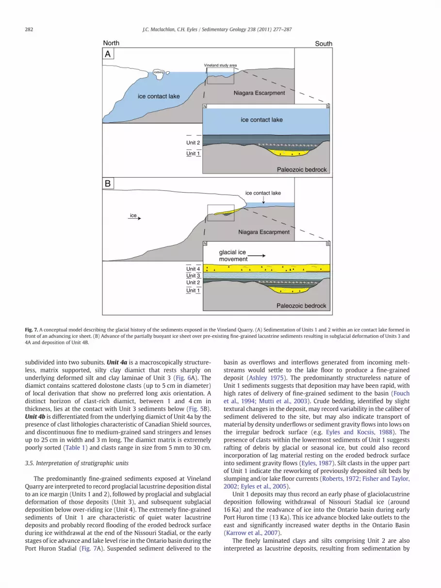
Fig. 7. A conceptual model describing the glacial history of the sediments exposed in the Vineland Quarry. (A) Sedimentation of Units 1 and 2 within an ice contact lake formed infront of an advancing ice sheet. (B) Advance of the partially buoyant ice sheet over pre-existing fine-grained lacustrine sediments resulting in subglacial deformation of Units 3 and4A and deposition of Unit 4B.
282 J.C. Maclachlan, C.H. Eyles / Sedimentary Geology 238 (2011) 277–287
subdivided into two subunits. Unit 4a is a macroscopically structure-less, matrix supported, silty clay diamict that rests sharply onunderlying deformed silt and clay laminae of Unit 3 (Fig. 6A). Thediamict contains scattered dolostone clasts (up to 5 cm in diameter)of local derivation that show no preferred long axis orientation. Adistinct horizon of clast-rich diamict, between 1 and 4 cm inthickness, lies at the contact with Unit 3 sediments below (Fig. 5B).Unit 4b is differentiated from the underlying diamict of Unit 4a by thepresence of clast lithologies characteristic of Canadian Shield sources,and discontinuous fine to medium-grained sand stringers and lensesup to 25 cm in width and 3 m long. The diamict matrix is extremelypoorly sorted (Table 1) and clasts range in size from 5 mm to 30 cm.
3.5. Interpretation of stratigraphic units
The predominantly fine-grained sediments exposed at VinelandQuarry are interpreted to record proglacial lacustrine deposition distalto an ice margin (Units 1 and 2), followed by proglacial and subglacialdeformation of those deposits (Unit 3), and subsequent subglacialdeposition below over-riding ice (Unit 4). The extremely fine-grainedsediments of Unit 1 are characteristic of quiet water lacustrinedeposits and probably record flooding of the eroded bedrock surfaceduring ice withdrawal at the end of the Nissouri Stadial, or the earlystages of ice advance and lake level rise in the Ontario basin during thePort Huron Stadial (Fig. 7A). Suspended sediment delivered to the
basin as overflows and interflows generated from incoming melt-streams would settle to the lake floor to produce a fine-graineddeposit (Ashley 1975). The predominantly structureless nature ofUnit 1 sediments suggests that deposition may have been rapid, withhigh rates of delivery of fine-grained sediment to the basin (Fouchet al., 1994; Mutti et al., 2003). Crude bedding, identified by slighttextural changes in the deposit, may record variability in the caliber ofsediment delivered to the site, but may also indicate transport ofmaterial by density underflows or sediment gravity flows into lows onthe irregular bedrock surface (e.g. Eyles and Kocsis, 1988). Thepresence of clasts within the lowermost sediments of Unit 1 suggestsrafting of debris by glacial or seasonal ice, but could also recordincorporation of lag material resting on the eroded bedrock surfaceinto sediment gravity flows (Eyles, 1987). Silt clasts in the upper partof Unit 1 indicate the reworking of previously deposited silt beds byslumping and/or lake floor currents (Roberts, 1972; Fisher and Taylor,2002; Eyles et al., 2005).
Unit 1 deposits may thus record an early phase of glaciolacustrinedeposition following withdrawal of Nissouri Stadial ice (around16 Ka) and the readvance of ice into the Ontario basin during earlyPort Huron time (13 Ka). This ice advance blocked lake outlets to theeast and significantly increased water depths in the Ontario Basin(Karrow et al., 2007).
The finely laminated clays and silts comprising Unit 2 are alsointerpreted as lacustrine deposits, resulting from sedimentation by
283J.C. Maclachlan, C.H. Eyles / Sedimentary Geology 238 (2011) 277–287
fluctuating density underflows and/or intermittent turbidity currents.Slight coarsening and thickening of the laminae up-section suggestenhanced rates of sediment delivery to the site and increasedproximity to the sediment source, likely caused by progressive iceadvance into the region (Brazier et al., 1998; Last and Teller, 2004).Clasts composed of local bedrock (dolostone) observed in Unit 2bmayhave been rafted into the lake by icebergs or shore ice (Ovenshine1970). Sediment instability caused by rapid deposition, isostaticadjustments of the basin, wave activity or iceberg grounding woulddisrupt previously deposited silt beds and produce abundant silt clasts(Eyles et al., 1983). The lithic clast horizon observed within Unit 2a atthe southern section of the study area could represent an erosional lagformed by the removal of fines by currents or liquefaction as lakelevels fluctuated (Hart and Boulton, 1991). However, there are noclasts contained within underlying deposits and there is no clearevidence of erosional truncation of underlying clay and silt laminae.Given that the clast horizon lies at the same elevation as ‘highs’ on thebedrock surface, it is more likely that it formed due to erosion andtransport of clasts from nearby bedrock outcrops by lake floorcurrents or sediment gravity flow processes (Eyles et al., 1987).
The silt and clay laminae characteristic of Unit 3 are also interpretedto have formed as a result of density underflow and/or turbiditedeposition in a lacustrine environment (van Rensbergen et al., 1999).Discrete laminae composed of silt clasts probably record the disruptionanddownslope transport of previously deposited silt beds by sedimentgravity flows. The most distinctive feature of Unit 3, however, isthe progressive up-section increase in the amount and intensity ofsediment deformation with uppermost laminae showing extensivedisruption by folding and faulting (Fig. 6B). The brittle and ductiledeformation structures that characterize the upper part of Unit 3 couldresult from a number of processes including slumping, dewateringand/or overriding by glacier ice (Boulton, 1986; Benn, 1994).
Folding and disruption of silt and clay laminae are commonlyreported from glaciolacustrine successions deposited on relativelyhigh relief substrates in which sediment has been subject todownslope creep or slumping (Evans, 1993; Chunga et al., 2007). Inthese situations, deformation occurs at either regular or irregularintervals in the succession as the shear stress of the sediment isexceeded and episodic downslope failure occurs. The progressive up-section increase in sediment deformation observed in Unit 3 is notconsistent with disruption caused by episodic slope generated failure,and in the absence of any water escape structures associated withdewatering processes (Cheel and Rust, 1986), a mechanism involvingdeformation by overriding ice is preferred.
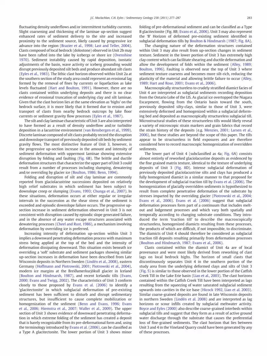
Increasing intensity of deformation up-section within Unit 3implies a downward penetrating deformation process with maximumstress being applied at the top of the bed and the intensity ofdeformation dissipating downward. This situation exists beneath iceoverriding a ‘soft’ substrate and sediment packages showing similarup-section increases in deformation have been described from LateWisconsin deposits in Northern Sweden (Lindén et al., 2008), easternGermany (Hoffmann and Piotrowski, 2001; Piotrowski et al., 2004),modern ice margins at the Breiðamerkurjökull glacier in Iceland(Boulton and Hindmarsh, 1987), and recent Icelandic tills (Evans,2000; Evans and Twigg, 2002). The characteristics of Unit 3 conformclosely to those proposed by Evans et al. (2006) to identify a‘glacitectonite’ in which subglacial deformation of pre-existingsediment has been sufficient to disturb and disrupt sedimentarystructures, but insufficient to cause complete mobilization orhomogenization of the sediment (Benn and Evans, 1996; Evanset al., 2006; Hiemstra et al., 2007; Waller et al., 2009). The uppersection of Unit 3 shows evidence of downward penetrating deforma-tion in which extreme folding of the sediment has created a depositthat is barely recognizable from its pre-deformational form and, usingthe terminology introduced by Evans et al. (2006), can be classified asa Type A glacitectonite. The lower portion of Unit 3 shows minor
folding of pre-deformational sediment and can be classified as a TypeB glacitectonite (Fig. 8B; Evans et al., 2006). Unit 3 may also representthe ‘B’ Horizon of deformed pre-existing sediment identified insubglacial deformation tills by Boulton & Hindmarsh (1987; Fig. 8A).
The changing nature of the deformation structures containedwithin Unit 3 may also result from up-section changes in sedimenttexture. Sediment in the lower portion of Unit 3 has extremely highclay content which can facilitate shearing and ductile deformation andallow the development of folds within the sediment (Alley, 1989;Boulton, 1996). Faulting is observed near the top of Unit 3 wheresediment texture coarsens and becomes more silt-rich, reducing theplasticity of the material and allowing brittle failure to occur (Alley,1989; Hart and Rose, 2001; Evans et al., 2006).
Macroscopically structureless to crudely stratified diamict facies ofUnit 4 are interpreted as subglacial sediments recording depositionfrom the Ontario Lobe of the LIS. As glacial ice overtopped the NiagaraEscarpment, flowing from the Ontario basin toward the south,previously deposited silty-clays, similar to those of Unit 3, wereextensively deformed and homogenized within a subglacial deform-ing bed and deposited as macroscopically structureless subglacial till.Microstructural studies of these structureless tills would likely reveala variety of microscopic strain markers and grain fabrics that recordthe strain history of the deposits (e.g. Menzies, 2001; Larsen et al.,2006), but these studies are beyond the scope of this paper. The tillsappear to be structureless in field exposures and are thereforeconsidered here to record macroscopic homogenization of overriddensediments.
The lower part of Unit 4 (subclassified as 4a; Fig. 6A) consistsalmost entirely of reworked glaciolacustine deposits as evidenced bythe fine grained matrix texture, identical to the texture of underlyingdeposits of Unit 3 (Fig. 8D). Intense subglacial deformation ofpreviously deposited glaciolacustrine silts and clays has produced afully homogenized diamict in a similar manner to that proposed forthe development of subglacial traction till by Evans et al. (2006). Thehomogenization of glacially overridden sediments is hypothesized toresult from complete penetrative deformation of the substrate bystresses imparted by the overriding glacier (Piotrowski et al., 2004;Evans et al., 2006). Evans et al. (2006) suggest that subglacialdeformation processes form part of a continuum that includes melt-out and lodgement processes and which vary both spatially andtemporally according to changing substrate conditions. They intro-duced the term ‘traction till’ to describe the macroscopicallystructureless, homogenized diamicts resulting from these processes,the products of which are difficult, if not impossible, to discriminate.The diamicts of Unit 4 should therefore be considered as subglacialtraction till deposits resulting primarily from deformation processes(Boulton and Hindmarsh, 1987; Evans et al., 2006).
Clasts contained within the diamict of Unit 4a are of localprovenance and were most likely derived from reworking of clastlags on local bedrock highs. The horizon of small clasts thatdiscontinuously separates Unit 4 in the southern portion of thestudy area from the underlying deformed clays and silts of Unit 3(Fig. 5) is similar to those observed in the lower portion of the CatfishCreek Till in the Lake Erie basin (Lian et al., 2003). The clast horizonscontained within the Catfish Creek Till have been interpreted as lagsresulting from the squeezing of water saturated subglacial sedimentupwards into cavities in the ice base (Hicock 1992, Lian et al. 2003).Similar coarse-grained deposits are found in late Wisconsin depositsin northern Sweden (Lindén et al. 2008) and are interpreted as laghorizons or scour infills created by subglacial meltwater activity.Boyce and Eyles (2000) also describe coarse-grained interbeds withinsubglacial tills and suggest that they form as a result of active groundwater discharge through the substrate that causes the preferentialloss of fine-grained sediments. The clast horizon that lies betweenUnit 3 and 4 in the Vineland Quarry could have been generated by anyof these processes.

1m
2m
3m
4m
5m
6m
7m
0m
Unit 2a
Unit 2b
Unit 3
Unit 4a
Unit 4b
Unit 1
min max
max
A/B
Hor
izon
B H
oriz
onA
Hor
izon
zone
of m
axim
umdi
spla
cem
ent
Gla
ciot
ecto
nite
Gla
ciol
acus
trin
eS
edim
ents
Sub
glac
ial T
ract
ion
Till
Typ
e ‘A
’ T
ype
‘B’
dept
h be
low
ice
0 20 40 60 80 20 40 60 80
Mode (µm) Median (µm)
A B C Ddisplacement
(Boulton and Hindmarsh 1987) (Evans et al., 2006)
Idealized Stratigraphy, Vineland Quarry
CLAY SILT SAND PEBBLE
Sediment Grain Size
n=34 n=34
Fig. 8. Summary stratigraphy of the Vineland Quarry (C) shown relative to grain size (D), and the classification of subglacial deformation zones proposed by Boulton and Hindmarsh(1987) (A), and the subglacial sediment classification scheme of Evans et al. (2006) (B). The uppermost sediments of Unit 4 conform to the ‘A’ horizon of Boulton and Hindmarsh(1987) with Unit 4a representing the zone of maximum displacement. The ‘B’ horizon of Boulton (1986) is equivalent to the relatively undeformed laminated silts and clays of units1, 2 and the lower part of unit 3 and represents an area minimally influenced by the downward penetrative deformation imparted by the overriding ice sheet (A). The relatively thin‘A/B’ horizon contains deformed material that retains some of its original structure and represents transition between the ‘A’ and ‘B’ horizons. (B) According to the sedimentclassification scheme of Evans et al. (2006) the homogeneous diamict of Unit 4 can be identified as subglacial traction till and Unit 3 as either a type A or type B glacitectonitedepending upon the amount of deformation. (D) Sediment grain size analysis curves (mode, median) based on the analysis of 34 samples. Analysis conducted using a Beckman LScoulter counter.
284 J.C. Maclachlan, C.H. Eyles / Sedimentary Geology 238 (2011) 277–287
The uppermost unit exposed in the Vineland Quarry (Unit 4b) is anextremely poorly sorted diamict that contains far-traveled clasts andcommon discontinuous sand stringers and lenses (Fig. 6A). Thepresence of far-traveled clasts is indicative of sediment contributionfrom glacial sources and the melting out of debris from the overridingice base (Hicock andDreimanis, 1992a, 1992b). The inclusion of poorlyconsolidated sand stringers into the diamict may either recordepisodic meltwater flow on the aggrading diamict surface or thedeformation of sand-rich sediment inclusions (e.g. Menzies, 1990;Norris, 1998). Similar sand inclusions are described in theNorthern Tillof southern Ontario by Boyce and Eyles (2000) and ascribed toincorporation of sand into the deforming subglacial bed as glacial iceadvanced over sand-rich outwash. Silty clay diamicts containingrounded and boudinaged sand interclasts are also reported fromPleistocene subglacial successions in North Norfolk, UK (Hart, 2007;Lee and Phillips, 2008; Waller et al., 2009) where sand clasts areinterpreted as having been preserved due to cementation by pore iceduring transport and deposition. Given that there is no evidence ofsand-rich substrate materials in the Vineland region an origin for the
sand stringers by winnowing of accumulating diamict is preferred.Overall, Unit 4b is interpreted as a subglacial till that recordsdeposition from the deforming bed of a glacier and includes bothglacially derived sediment and reworked substratematerials (Boulton,1986; Fig. 8A). This unit should also be considered as a traction till(Evans et al., 2006) that records enhanced delivery and incorporationof glacially transported material into the resulting sediment. Units 4Aand4B togethermay also represent theAhorizon, or zoneofmaximumsediment displacement, proposed in the model of glacier ice-bedinterface presented by Boulton and Hindmarsh (1987): Fig. 8B).
The complete succession of sediments exposed above bedrock inthe Vineland Quarry passes upwards from undeformed lacustrinesediments (Units 1 and 2), through increasingly disrupted anddeformed fine-grained sediments (Unit 3) into macroscopicallyhomogenized deposits that incorporate sediment contributed directlyfrom the overriding ice (Unit 4). The Vineland succession thus appearsto record the full suite of deposits theorized to form as a result of thedevelopment of a subglacial deforming bed (Alley, 1991; Boyce andEyles 2000; Evans et al., 2006).

285J.C. Maclachlan, C.H. Eyles / Sedimentary Geology 238 (2011) 277–287
4. Discussion
The exposed sediments in the Vineland Quarry study area offer aunique opportunity to test theoretical models of subglacial deforma-tion processes through detailed analysis of their characteristics andinferred depositional origin. The predominantly fine-grained sedi-ments provide strong evidence of glaciolacustrine deposition fol-lowed by overriding, deformation and deposition under subglacialconditions. Facies transitions that pass from undisturbed laminatedsilts and clays through increasingly disturbed and deformed laminat-ed fines to massive clay-rich diamicts are consistent with models ofsubglacial deformation proposed to result from variations in sedimentdisplacement imposed by an overriding ice sheet (Fig. 8A; Boultonand Hindmarsh, 1987; Benn, 1995; Evans et al., 2006, Cofaigh et al.,2010).
The progressive vertical increase in sediment deformation up-section, passing from an unaltered crudely bedded deposit to a fullyhomogenized deposit, can be directly related to the sedimentdisplacement curve proposed by Boulton and Hindmarsh (1987)(Fig. 8A). The curve represents the theoretical displacement ofsediments beneath an overriding ice mass. The sediments in thestudy area record a smooth progression from essentially undisturbedsediments of units 1 and 2 to the intensely deformed andmacroscopically homogenized deposits of Unit 4 which form in thezone of maximum displacement (Fig. 8). It is unusual to record such asmooth transition in a succession of subglacial deposits as spatial andtemporal variability in subglacial conditions (the stable/deformingsubglacial bed mosaic concept; Piotrowski et al., 2004) results in avariety of depositional processes operating as the sediment accumu-lates (Evans et al., 2006). The Quaternary sediments exposed at theVineland Quarry show a remarkably consistent change in the intensityof sediment deformation up-section, and fully align with theoreticalmodels describing subglacial deformation processes. This suggeststhat the deformation signature is the result of a single event that mayhave been relatively short-lived and could record rapid movement ofice across the area in a similar fashion to that proposed for icemarginal surges (Costello and Walker, 1972; Boyce and Eyles, 1991;Eyles et al., 2011). This interpretation, of rapid ice movement isconsistent with the recent interpretations of other late glacialmoraines fringing the Ontario basin and suggests that the PortHuron ice margin flowed rapidly out of the western Ontario basin,possibly as an ice surge, supported by a bed of soft, wet sediment(Clarke, 1987; Evans et al., 2006; Eyles et al., 2011). Rapid icemovement and deforming bed conditions may have been promotedby the development of extensive proglacial lake bodies between theadvancing ice margin and the topographic barrier of the NiagaraEscarpment that allowed both the accumulation of easily deformedclay-rich sediments and the partial buoyancy of the ice margin.Similar ice marginal environments are known to have existedelsewhere in the Great Lakes basins during the Quaternary andexamples of subglacially deformed proglacial lacustrine sedimentscan be found farther afield in areas such as Scotland (Banham, 1977;Golledge, 2007), northern Venezuela (Mahaney et al., 2004),southwest Ireland (Cofaigh et al., 2010) and the state of Illinois inthe United States (Johnson and Hansel 1990). A modern analog forthis type of glacial setting can be identified in Antarctica where IceStream B flows rapidly over clay-rich subglacial debris (Alley et al.,1997; Eyles et al., 2011).
The succession of sediments exposed above bedrock at theVineland Quarry appears to very closely conform to theoreticalmodels describing subglacial deformation processes and may there-fore serve as an appropriate ‘model’ to use for the interpretation ofsediment packages elsewhere around the margins of the Great Lakesbasins. In these lake margin settings, similar conditions to thoseexperienced in the Vineland region may have developed in whichwater saturated fine-grained sediments were overridden by an ice
margin. Using an appropriate terminology to describe such sedimen-tary successions is extremely important as the terminology shouldrecognize the complexity and spatial/temporal variability of subgla-cial processes. We concur with the proposal of Evans et al. (2006) touse the non-process specific term of traction till to describe thedeposits resulting from the continuum of subglacial deformation,lodgement and meltout.
5. Conclusion
The introduction of the deforming-bed model by Boulton andJones (1979) can be viewed as a major paradigm shift in the study ofsubglacial processes and sediments (Murray, 1997; Hart and Rose,2001; Lian and Hicock, 2001). Recognizing the importance of sub-glacial sediment deformation as a means of facilitating ice movementhas triggered a re-examination of how glacial beds control the overalldynamics of ice sheets, particularly the extensive Pleistocene icesheets that covered large areas of North America and Europe (Stokesand Clark, 2003; Piotrowski et al., 2004; Clarke, 2005; Lee and Phillips,2008). The identification of deformable beds beneath modern icemasses (Alley et al., 1986; Evans et al., 2006) has also stimulatedresearch into the potential effects of climate and sea level change oncurrent subglacial deformation processes and subsequent ice sheetbehavior (Bentley, 1997).
The field-based study presented here is a contribution to theliterature describing deposits resulting from subglacial deformationprocesses. The sedimentary succession exposed in the VinelandQuarry shows clear evidence of the operation of subglacial deformingbed conditions in the form of up-section increases in the amount ofattenuation and deformation of fine-grained substrate sediments thatculminate in the formation of a macroscopically homogenized diamictidentified here as a traction till (Fig. 8). This interpretation of thesediment succession is consistent with the proposed theoreticalmodels of sediment deformation due to overriding ice sheets (e.g.Boulton and Hindmarsh, 1987). There is now widespread recognitionof the importance and significance of subglacial deformationprocesses, but there are many questions yet to be answered regardingthe spatial extent and variability of these processes as they operateunder ice masses of different type and extent (Piotrowski et al., 2004).Subglacial successions resulting from the continuum of processes thatinclude lodgement, melt-out and deformation are likely to bewidespread around the Great Lake margins where the interplay oflacustrine and glacial processes has been complex. Recognition of thedepositional signature of deformation processes is therefore impor-tant as an aid to the reliable reconstruction of past climate andenvironmental conditions.
Acknowledgments
Research was funded by Discovery Grants to CHE from the Naturaland Engineering Research Council of Canada. We would like to thankthe management of Vineland Quarry for granting access to the quarryand Paul Durkin, Prateek Gupta, Kelsey MacCormack, Riley Mulligan,Stacey Puckering and Jessica Slomka for assistance in the field, withdrafting figures, taking photos, editing of the manuscript and hours ofdiscussion.
References
Alley, R.B., 1989. Water-pressure coupling of sliding and bed deformation: I. Watersystems. Journal of Glaciology 35, 108–118.
Alley, R.B., 1991. Deforming-bed origin for southern Laurentide tillsheets? Journal ofGlaciology 37, 67–76.
Alley, R.B., Blankenship, D.D., Bentley, C.R., Rooney, S.T., 1986. Deformation of tillbeneath ice stream B, West Antarctica. Nature 322, 57–59.
Alley, R.B., Cuffey, K.M., Evenson, E.B., Strasser, J.C., Lawson, D.E., Larson, G.J., 1997. Howglaciers entrain and transport basal sediment: physical constraints. QuaternaryScience Reviews 16, 1017–1038.

286 J.C. Maclachlan, C.H. Eyles / Sedimentary Geology 238 (2011) 277–287
Ashley, G.M., 1975. Rhythmic sedimentation in Glacial Lake Hitchcock, Massachusetts-Connecticut. In: Jopling, V., McDonald, B. (Eds.), Glacioflucial and GlaciolacustrineSedimentation. Special Publications Society economic Palaeontology. Miner, Tulsa,pp. 304–320.
Banham, P.H., 1977. Glacitectonites in till stratigraphy. Boreas 6, 101–105.Barnett, P.J., 1992. Quaternary geology of Ontario. In: Thurston, P.C., Williams, H.R.,
Sutcliff, R.H., Scott, G.M. (Eds.), Geology of Ontario: Special. Ontario GeologicalSurvey, 4. Toronto, Ontario, pp. 1011–1088.
Benn, D.I., 1994. Fluted moraine formation and till genesis below a temperate valleyglacier: Slettmarkbreen, Jotunheimen, southern Norway. Sedimentology 41,279–292.
Benn, D.I., 1995. Fabric signature of subglacial till deformation, Breiðamerkurjökull,Iceland. Sedimentology 42, 735–747.
Benn, D.I., Evans, D.J.A., 1996. The interpretation and classification of subglacially-deformed materials. Quaternary Science Reviews 15, 23–52.
Bentley, C.R., 1997. Rapid sea-level rise soon from West Antarctic ice sheet collapse?Science 275, 1077–1078.
Boulton, G.S., 1986. A paradigm shift in glaciology. Nature 332, 18–20.Boulton, G.S., 1996. Theory of glacial erosion, transportation and deposition as a
consequence of subglacial sediment deformation. Journal of Glaciology 42, 43–62.Boulton, G.S., 2010. Drainage pathways beneath ice sheets and their implications for ice
sheet form and flow: the example of the British Ice Sheet during the Last GlacialMaximum. Journal of Quaternary Science 25, 483–500.
Boulton, G.S., Caban, P., 1995. Groundwater flow beneath ice sheets: Part II— its impacton glacier tectonic structures and moraine formation. Quaternary Science Reviews14, 563–587.
Boulton, G.S., Dobbie, K.E., 1993. Consolidation of sediments by glaciers: relationsbetween sediment geotechnics, soft-bed glacier dynamics and subglacial ground-water flow. Journal of Glaciology 39, 26–44.
Boulton, G.S., Hindmarsh, R.C.A., 1987. Sediment deformation beneath glaciers:rheology and geological consequences. Journal of Geophysical Research 92,9059–9082.
Boulton, G.S., Jones, A.S., 1979. Stability of temperate ice caps and ice sheets resting ondeformable sediment. Journal of Glaciology 24, 29–43.
Boyce, J.I., Eyles, N., 1991. Drumlins carved by deforming till streams below theLaurentide ice sheet. Geology 19, 787–790.
Boyce, J.I., Eyles, N., 2000. Architectural element analysis applied to glacial deposits:Internal geometry of a late Pleistocene till sheet, Ontario, Canada. GeologicalSociety of America Bulletin 112, 98–118.
Brazier, V., Kirkbride, M.P., Gordon, J.E., 1998. Active ice-sheet deglaciation and ice-dammedlakes in the northern CairngormMountains, Scotland. Boreas 27, 297–310.
Cheel, R.J., Rust, B.R., 1986. A sequence of soft-sediment deformation(dewatering)structures in Late Quaternary subaqueous outwash near Ottawa, Canada.Sedimentary Geology 47, 77–93.
Chunga, K., Livio, F., Michetti, A.M., Serva, L., 2007. Synsedimentary deformation ofPleistocene glaciolacustrine deposits in the Albese con Cassano Area (SouthernAlps, Northern Italy), and possible implications for paleoseismicity. SedimentaryGeology 196, 59–80.
Clarke, G.K.C., 1987. Subglacial till: a physical framework for its properties andprocesses. Journal of Geophysical Research 92, 9023–9036.
Clarke, G.K.C., 2005. Subglacial processes. Annual Review of Earth and PlanetarySciences 33, 247–276.
Cofaigh, C.O., Evans, D.J.A., Heimstra, J.F., 2010. Formation of a stratified subglacial ‘till’assemblage by ice-marginal thrusting and glacier overriding. Boreas 20, 1–14.
Costello, W.R., Walker, R.G., 1972. Pleistocene sedimentology, Credit River, southernOntario; a new component of the braided river model. Journal of SedimentaryPetrology 42, 389–400.
Dreimanis, A., Karrow, P.F., 1972. Glacial history of the Great Lakes-St. Lawrence region,the classification of the Wisconsin stage and its correlatives. InternationalGeological Congress, 24th Session.
Evans, D.J.A., 1993. High-latitude rock glaciers: a case study of forms and processes inthe Canadian arctic. Permafrost and Periglacial Processes 4, 17–35.
Evans, D.J.A., 2000. A gravel outwash/deformation till continuum, Skalafellsjokull,Iceland. Geografiska Annaler: Series A, Physical Geography 82A (4), 499–512.
Evans, D.J.A., Twigg, D.R., 2002. The active temperate glacial landsystem: a model based onBreiðamerkurjökull and Fjallsjökull, Icleand.Quaternary ScienceReviews21, 2143–2177.
Evans, D.J.A., Phillips, E.R., Hiemstra, J.F., Auton, C.A., 2006. Subglacial till: formation,sedimentary characteristics and classifcation. Earth-Science Reviews 78, 115–176.
Eyles, N., 1987. Late Pleistocene debris flow deposits in large glacial lakes in BritishColumbia and Alaska. Sedimentary Geology 53, 33–71.
Eyles, N., Kocsis, S., 1988. Sedimentology and clast fabric of subaerial debris flow faciesin a glacially-influenced alluvial fan. Sedimentary Geology 59, 15–28.
Eyles, N., Eyles, C.H., Mjall, A.D., 1983. Lithofacies types and vertical profile models; analternative approach to the description and environmental interpretation of glacialdiamict and diamictite sequences. Sedimentology 30, 393–410.
Eyles, N., Clark, B.M., Clague, J.J., 1987. Coarse-grained sediment gravity flow facies in alarge supraglacial lake. Sedimentology 34, 193–216.
Eyles, N., Eyles, C.H., Woodworth-Lynas, C., Randall, T.A., 2005. The sedimentary recordof drifting ice (early Wisconsin Sunnybrook deposit) in an ancestral ice-dammedlake, Ontario, Canada. Quaternary Research 63, 171–181.
Eyles, N., Eyles, C.H., Menzies, J., Boyce, J., 2011. End moraine construction byincremental till deposition below the Laurentide Ice Sheet: Southern Ontario,Canada. Boreas 40, 92–104.
Feenstra, B.H., 1981. Quaternary geology and industrial minerals of the Niagara-Welland area, southern Ontario. Ontario Geological Survey Open File Report 5361,1–260.
Fisher, T.G., Taylor, L.D., 2002. Sedimentary and stratigraphic evidence for subglacialflooding, south-central Michigan, USA. Quaternary International 90, 87–115.
Fouch, D., Carter, L.D., Kunk, M.J., Smith, C.A.S., White, J.M., 1994. Nature andsignificance of Miocene lacustrine and fluvial sequence. Upper Ramparts andCanyon Village, Porcupine River, east-central Alaska. Quaternary International 22,11–29.
Golledge, N.R., 2007. Sedimentology, stratigraphy, and glacier dynamics, westernScottish Highlands. Quaternary Research 68, 79–95.
Hart, J.K., 2007. An investigation of subglacial shear zone processes from Weybourne,Norfolk, UK. Quaternary Science Reviews 26, 2354–2374.
Hart, J.K., Boulton, G.S., 1991. The interrelation of glaciotectonics and glaciodepositionalprocesses within the glacial environment. Quaternary Science Reviews 10,335–350.
Hart, J.K., Roberts, D.H., 1994. Criteria to distinguish between subglacial, glaciotectonicand glaciomarine sedimentation, I. Deformation styles and sedimentology.Sedimentary Geology 91, 191–213.
Hart, J.K., Rose, J., 2001. Approaches to the study of glacier bed deformation. QuaternaryInternational 86, 45–58.
Haynes, S.J., 2000. Geology and wine 2: a geological foundation for terroirs andpotential sub-appellations of Niagara Peninsula wines, Ontario, Canada. GeoscienceCanada 27, 67–87.
Hicock, S.R., 1992. Lobal interactions and rheologic superposition in subglacial till nearBradtville, Ontario, Canada. Boreas 21, 73–88.
Hicock, S.R., Dreimanis, A., 1992a. Sunnybrook drift indicates a grounded earlyWisconsin glacier in the Lake Ontario Basin. Geology 17, 169–172.
Hicock, S.R., Dreimanis, A., 1992b. Deformation till in the Great Lakes region:implications for rapid flow along the south-cental margin of the Laurentide IceSheet. Canadian Journal of Earth Sciences 29, 1565–1579.
Hiemstra, J.F., Evans, D.J.A., O'Cofaigh, C., 2007. The role of glacitectonic rafting andcomminution in the production of subglacial tills: examples from southwestIreland and Antarctica. Boreas 36, 386–399.
Hindmarsh, R.C.A., Stokes, C.R., 2008. Formation mechanisms for ice-stream lateralshear margin moraines. Earth Surface Processes and Landforms 33, 610–626.
Hoffmann, K., Piotrowski, J.A., 2001. Till mélange at Amsdorf, central Germany:sediment erosion, transport and deposition in a complex, soft-bedded glacialsystem. Sedimentary Geology 140, 215–234.
Iverson, N.R., 1999. Coupling between a glacier and a soft bed: II. Model results. Journalof Glaciology 45, 41–53.
Johnson, W.H., Hansel, A.K., 1990. Multiple Wisconsinan Glacigenic sequences atWedron, Illinois. Journal of Sedimentary Research 60, 26–41.
Karrow, P.F., 1984. Quaternary stratigraphy and history, Great Lakes-St. Lawrence region.In: Fulton, R.J. (Ed.), Quaternary Stratigraphy of Canada— a Canadian Contribution toIGCP Project 24, Geological Survey of Canada Paper 84–10, pp. 137–153.
Karrow, P.F., Morris, T.F., McAndrews, J.H., Morgan, A.V., Smith, A.J., Walker, I.R., 2007. Adiverse late-glacial (Mackinaw Phase) biota from Leamington, Ontario. CanadianJournal of Earth Sciences 44, 287–296.
Kor, P.S.G., Shaw, J., Sharpe, D.R., 1991. Erosion of bedrock by subglacial meltwater, GeorgialBay, Ontario: a regional view. Canadian Journal of Earth Sciences 28, 623–642.
Larsen, N.K., Piotrowski, J.A., Christoffersen, P., Menzies, J., 2006. Formation anddeformationof basal till during a glacier surge; Elisebreen, Svalbard. Geomorphology 81, 217–234.
Last, W.M., Teller, J.T., 2004. Paleolimnology of Lake Manitoba, Canada: the lithostrati-graphic evidence. Geographie physique et Quaternaire 56, 135–154.
Lee, J.R., Phillips, E.R., 2008. Progressive soft sediment deformation within a subglacialshear zone— a hybrid mosaic-pervasive deformation model for Middle Pleistoceneglaciotectonised sediments from eastern England. Quaternary Science Reviews 27,1350–1362.
Lesemann, J., Alsop,G.A., Piotrowski, J.A., 2010. Incremental subglacialmeltwater sedimentdeposition anddeformation associatedwith repeated ice-beddecoupling: a case studyfrom the Island of Funen, Denmark. Quaternary Science Reviews 29, 3212–3229.
Lian, O.B., Hicock, S.R., 2001. Lithostratigraphy and limiting optical ages of thePleistocene fill in Fraser River valley near Clinton, south-central British Columbia.Canadian Journal of Earth Sciences 38, 839–850.
Lian, O.B., Hicock, S.R., Dreimanis, A., 2003. Laurentide and Cordilleran fast ice flow:some sedimentological evidence from Wisconsian subglacial till and its substrate.Boreas 32, 102–113.
Lindén, M., Möller, P., Adrielsson, L., 2008. Ribbedmoraine formed by subglacial folding,thrust stacking and lee-side cavity infill. Boreas 37, 102–131.
Mahaney, W.C., Dirszowsky, R.W., Milner, M.W., Menzies, J., Stewart, A., Kalm, V.,Bezada, M., 2004. Quartz microtextures and microstructures owing to deformationof glaciolacustrine sediments in the northern Venezuelan Andes. Journal ofQuaternary Science 19, 23–33.
McKay, R., Browne, G., Carter, L., Cowan, E., Dunbar, G., Krissek, L., Naish, T., Powell, R.,Reed, J., Talarico, F., Wilch, T., 2009. The stratigraphic signature of the late CenozoicAntarctic Ice Sheets in the Ross Embayment. GSA Bulletin 121, 1537–1561.
Menzies, J., 1989. Subglacial hydraulic conditions and their possible impact uponsubglacial bed formation. Sedimentary Geology 62, 125–150.
Menzies, J., 1990. Brecciated diamictons from Mohawk Bay, S. Ontario, Canada.Sedimentology 37, 481–493.
Menzies, J., 2001. The Quaternary sedimentology and stratigraphy of small, ice-proximal, subaqueous grounding-line moraines in the central Niagara Peninsula,southern Ontario. Geographie physique et Quaternaire 55, 75–86.
Meyer, P.A., Eyles, C.H., 2007. Nature and origin of sediments infilling poorly-definedbedrock valleys adjacent to the Niagara Escarpment, southern Ontario, Canada.Canadian Journal of Earth Sciences 44, 89–105.
Murray, T., 1997. Assessing the paradigm shift: deformable glacier beds. QuaternaryScience Reviews 16, 995–1016.

287J.C. Maclachlan, C.H. Eyles / Sedimentary Geology 238 (2011) 277–287
Mutti, E., Tinterri, R., Benevelli, G., di Biase, D., Cavanna, G., 2003. Deltaic, mixed andturbidite sedimentation of ancient foreland basins. Marine and Petroleum Geology20, 733–755.
Norris, S.E., 1998. The occurrence and origin of sand bodies in till, with special referenceto Franklin County, Ohio Landfill site. Ohio Journal of Science 98, 23–27.
Ovenshine, A.T., 1970. Observations of iceberg rafting in Glacier Bay, Alaska and theidentification of ancient ice-rafted deposits. Geological Society of American Bulletin81, 891–894.
Phillips, E., Lee, J.R., Burke, H., 2008. Progressive proglacial to subglacial deformationand syntectonic sedimentation at the margins of the Mid-Pleistocene British IceSheet: evidence from north Norfolk, UK. Quaternary Science Reviews 27,1848–1871.
Piotrowski, J.A., Larsen,N.K., Frank, F.W., Junge,W., 2004. Reflections on soft subglacial beds asa mosaic of deforming and stable spots. Quaternary Science Reviews 23, 993–1000.
Rea, B.R., Evans, D.J.A., Dixon, T.S., Whalley, W.B., 2000. Contemporaneous, local-ized, basal ice-flow variations: implications for bedrock erosion and the originof p-forms. Journal of Glaciology 46, 470–476.
Roberts, A.E., 1972. Cretaceous and early Tertiary depositional and tectonic history ofthe Livingston area, southwestern Montana. U.S. Geological Survey ProfessionalPaper 526-C, 1–120.
Roberts, D.H., Hart, J.K., 2005. The deforming bed characteristics of a stratified tillassemblage in north East Anglia, UK: investigating controls on sediment rheologyand strain signatures. Quaternary Science Reviews 24, 123–140.
Schoof, C.G., Clarke, G.K.C., 2008. A model for spiral flows in basal ice and formation ofsubglacial flutes based on a Reiner-Rivlin rheology for glacial ice. Journal ofGeophysical Research 113 (B5), 1–11.
Shaw, A., 2005. The Niagara Peninsula viticultural area: a climatic analysis of Canada'slargest wine region. Journal of Wine Research 16, 85–103.
Stokes, C.R., Clark, C.D., 2003. Laurentide ice streaming on the Canadian Shield: aconflict with the soft-bedded ice stream paradigm? Geology 31, 347–350.
Sugden, D.E., Glasser, N., Clapperton, C.M., 1992. Evolution of large Roches Moutonnees.Geografiska Annaler: Series A, Physical Geography 74, 253–264.
Tinkler, K.J., 1993. Fluvially sculpted rock bedforms in twenty mile creek, NiagaraPeninsula, Ontario. Canadian Journal of Earth Sciences 30, 945–953.
Tinkler, K.J., Stenson, R.E., 1992. Sculpted bedrock forms along the Niagara Escarpment,Niagara Peninsula, Ontario. Geographie physique et Quaternaire 46, 197–207.
van der Meer, J.J.M., Menzies, J., Rose, J., 2003. Subglacial till: the deforming glacier bed.Quaternary Science Reviews 22, 1659–1685.
van Rensbergen, P., de Batist, M., Beck, C., Chapron, E., 1999. High-resolution seismicstratigraphy of glacial to interglacial fill of a deep glacigenic lake: Lake Le Bourget,Northwestern Alps, France. Sedimentary Geology 128, 99–129.
Walker Industries, 2010. http://www.walkerind.com/. Accessed March 2010.Waller, R.I., van Dijk, T.A.G., Knudsen, Ó., 2008. Subglacial bedforms and conditions
associated with the 1991 surge of Skeiðarárjökull, Iceland. Boreas 37, 179–194.Waller, R.I., Murton, J.B., Knight, P.G., 2009. Basal glacier ice andmassive ground ice: different
scientists, same science? Geological Society, London, Special Publications 320, 57–69.