seismic monitoring of séchilienne rockslide (french alps): analysis of seismic signals and their...
TRANSCRIPT

Seismic monitoring of Séchilienne rockslide (French Alps):Analysis of seismic signals and their correlation with rainfalls
Agnès Helmstetter1 and Stéphane Garambois1
Received 14 September 2009; revised 22 December 2009; accepted 4 February 2010; published 4 August 2010.
[1] In the French Alps, Séchilienne rockslide is one of the natural phenomena thatpresents one of the highest levels of risk in terms of socioeconomical outcomes. Thisrockslide has been active for a few decades and has been instrumented since 1985.The current very active volume of this rockslide is estimated to be up to 5 million m3,located on the border of a slowly moving mass reaching 50–100 million m3. The velocityof the most active zone reached 1.4 m/yr in 2008, about twice the value of 2000. Aseismic network was installed on this rockslide in May 2007 to supplement the monitoringsystem. It has now recorded several thousand events, mostly rockfalls but also hundredsof local and regional earthquakes, which can be distinguished and classified from theirsignal characteristics. Rockfalls and microseismicity, which occur in bursts of activity, arefound to be weakly, but significantly, correlated with rainfall. Rockfall occurrenceincreases linearly with precipitation, with however strong fluctuations of the numbers ofrockfalls per day for the same rainfall intensity. No threshold was found for rainfalltriggering, with even 1 mm of rain being enough to trigger rockfalls. Rockfall activitystarts almost immediately during a rainfall episode and lasts for several days after therainfall. Rain also induces strong accelerations of the rockslide movement, which also startquasi‐instantaneously and last for about a month.
Citation: Helmstetter, A., and S. Garambois (2010), Seismic monitoring of Séchilienne rockslide (French Alps): Analysis ofseismic signals and their correlation with rainfalls, J. Geophys. Res., 115, F03016, doi:10.1029/2009JF001532.
1. Introduction
[2] Landslides can be triggered by many different causes,including intense or extended rainfall and earthquakes.Understanding of the mechanisms influencing landslidedynamics is limited by the lack of dense and multiparameterdata, as very few active rockslides are nowadays instru-mented with continuousmeasurements. Although there existsan extensive literature about the triggering of shallow land-slides or rockfalls by rainfall (see Guzzetti et al. [2007] for arecent review), the catalogs used in these studies often exhibitimprecise times (about 1 day), because they were generallyconstructed from discrete field observations or aerial andsatellite images. In contrast, seismic monitoring presents theopportunity to study the triggering mechanisms of land-slides with very precise event times, but in a small area.This method is also highly sensitive, allowing one to recordseveral thousand events per year. Finally, seismometers alsodetect microearthquakes induced by the slope movement andby fracturing of the rock mass, in addition to those generatedby debris flows and rockfalls. Seismology thus appears to bea promising technique to complement classical techniquesfor landslide monitoring.
[3] Local seismological networks have been occasionallyused for monitoring active landslides. Most seismologicalstudies have used regional networks, primarily dedicated tomonitor seismicity [McSaveney and Downes, 2002]. Seis-mology has been used for studying landslide propagation,detecting precursory signals, or analyzing site effects. Norris[1994] used seismic stations to detect rock avalanches atthree Cascade Range volcanoes. McSaveney [2002] andMcSaveney and Downes [2002] estimated the onset time,duration, volume and propagation velocity of rockfall ava-lanches in New Zealand from seismic signals. Deparis et al.[2008] investigated ten rockfalls recorded in the FrenchAlps by a regional seismic network and tried to link seismicparameters to rockfall properties. Brodsky et al. [2003] usedseismic waves to characterize landslide basal friction forthree huge landslides. Del Gaudio et al. [2008] analyzedseismic site amplification from microtremors in a landslideprone area (central Italy). Permanent networks were alsoinstalled in Norway on the Åknes landslide [Roth et al.,2006] and in Swiss Alps on the Randa landslide [Spillmannet al., 2007] in order to characterize microseismicity ofthese active rockslides. At a smaller scale, Amitrano et al.[2005] observed precursory microseismicity before a cliffcollapse in Normandy (France).[4] In this study, we present the results obtained from the
seismic monitoring of a large active rockslide. In the FrenchAlps, Séchilienne rockslide presents one of the highest levelsof risk in terms of socioeconomical outcomes. The failure of
1Laboratoire de Géophysique Interne et Tectonophysique, UniversitéJoseph Fourier, CNRS, Grenoble, France.
Copyright 2010 by the American Geophysical Union.0148‐0227/10/2009JF001532
JOURNAL OF GEOPHYSICAL RESEARCH, VOL. 115, F03016, doi:10.1029/2009JF001532, 2010
F03016 1 of 15

this landslide (3 to several tens of millions m3) is likely toform a natural dam which could potentially block theRomanche River located just bellow [Panet, 2000]. Itssubsequent rupture would have devastating consequencesdownstream for people and facilities. For these reasons,this area has been extensively instrumented since 1988 forsurveillance purposes using a multitechniques displacementnetwork (noncontinuous GPS, laser, radar, extensometers)and a meteorological station.[5] In May 2007, this monitoring system was supple-
mented with a seismological network. The main objective isto detect microseismicity activity associated with fractureswithin the rock mass and/or rockfalls occurring within therockslide, and to characterize these events (location, mag-nitude and mechanisms of microearthquakes, volume andpropagation velocity of rockfalls). This network also allowsstudy of small local earthquakes generated by the nearbyBelledonne Border fault [Thouvenot et al., 2003], andcharacterization of the properties and heterogeneities ofseismic site amplification of the landslide. It will also permitseismic noise analyses to monitor very weak temporalchanges in seismic wave velocities between each sensor dueto fracture openings or fluid flow.[6] In less than 2 years, several thousands seismic events
have been recorded. In this paper, we first focus on thevarious types of signals which were acquired and on theircharacteristics. Most events have been identified as rock-falls, but hundreds of microearthquakes and distant earth-quakes have also been detected. The microseismicity androckfall activity appear very variable, from zero to morethan 100 events per day during seismic crises. Most of thesepeaks are correlated with rainfall and are also associatedwith accelerations of the movement.[7] Landslides triggered by rainfall are generally caused
by the buildup of subsurface water pressure. Many investiga-tions on rainfall‐induced landslides have attempted to estimateminimum thresholds for initiation of landslides [Guzzettiet al., 2007]. Our monitoring network gives us the opportu-nity to investigate the relation between rockfalls and rainfall,using a large data set of events with very accurate times. Thisstudy suggests the absence of any triggering threshold, andalso allows us to analyze the time delay between rainfall,rockfall activity and slope movement dynamics.
2. Séchilienne Rockslide
[8] The Séchilienne landslide is located in the south-western Belledonne massif, one of the Paleozoic externalcrystalline massifs of the French Alps, which is divided intwo major tectonic blocks: the external domain to the westand the internal one to the east. These two blocks are sep-arated by a major Late Paleozoic subvertical fault, known asthe Belledonne Middle Fault. The southern part of theBelledonne massif is deeply incised by the east‐west strikinglower Romanche River valley (Figure 1). This incision resultsfrom the alternate activity of the Romanche River and theRomanche glacier, which developed repeatedly during theQuaternary glaciations [Montjuvent and Winistorfer, 1980].The resulting morphology displays very steep slopes, around35° to 40°, which are affected by large active or past gravi-tational movements in the micaschists. Eight major land-
slides have been reported in the area, including the largeSéchilienne landslide which is affecting the south facingvalley flank of the Romanche River.[9] In the Séchilienne area, the valley slope consists
mainly of micaschists with interbedded quartz‐feldspar‐richlayers, which were affected by both the Hercynian andAlpine orogenies. Due to this tectonic history, the micaschistbedrock is cut by several faults and three sets of near‐vertical fractures [Pothérat and Alfonsi, 2001]. The globalgeometry of the hill displays a nested slide delimited at thetop by a 20 to 40 m high scarp (the Mont‐Sec scarp). Thisscarp presents a corner shape on the northeast limit of thelandslide, and extents several hundred meters to the westand a few hundred of meters to the south. It was studiedusing cosmic ray exposure dating to provide chronologicalconstraints on the failure time and kinematics [Le Roux et al.,2009]. The part of the slope that exhibits more signs ofcurrent instability (high‐motion zone; Figure 2) is located inthe middle of the hill at an elevation of 600–900 m, andinvolves a rock volume estimated from geometric constraintsto be about 3 to 5 million m3 [Giraud et al., 1990].[10] Sismalp seismological network has shown a con-
centration of seismic sources along a strip which is parallelto the western edge of the Belledonne massif [Thouvenotet al., 2003] and extends for more than 50 kilometers.Earthquakes are located at depths shallower than 10 kmand focal solutions reveal a dextral strike‐slip seismotec-tonic regime. Since the installation of Sismalp network in1989, the largest event detected on this fault is a ml = 3.5earthquake, which occurred in 1999 only 7 km southwestof Séchilienne.[11] The rockslide has been extensively instrumented and
studied since 1988 thanks to the presence of a displacementmonitoring system designed for surveillance and alert pur-poses [Evrard et al., 1990; Duranthon et al., 2003]. Thisinstrumentation was supplemented by modeling computa-tions [Vengeon et al., 1999; Pothérat and Alfonsi, 2001] andhydrological [Guglielmi et al., 2002] and geophysical studies[Méric et al., 2005]. In 1993–1994, a 240 m long gallerywas excavated at an elevation of 710 m in a zone locatedto the west of the high‐motion zone (Figure 2) characterizedby a displacement rate of about 5 cm/yr. Displacementmeasurements and observations inside the gallery showed asuccession of rigid moving blocks delimited by highly frac-tured zones parallel to the main fracture set. These blocksexhibit differential normal faulting movement. Unfortunately,the gallery did not reach sound rock, and the presence of asliding surface is still an open question.[12] All these studies suggest that the slope movements at
Séchilienne are controlled by the principal discontinuities.The mass breaks into blocks, which are toppling or sliding.The rockslide has evolved from progressive damage to apotential large slide of unknown characteristics. Severalinvestigation campaigns using geotechnical, geophysical,hydrogeological and dating methods were performed on thisrockslide (see Méric et al. [2005] and Le Roux et al. [2009]for reviews). Guglielmi et al. [2002] used isotopic andhydrogeochemical methods to investigate groundwater flows.This study showed that the deep groundwater in the low partof the slope is partly recharged from a perched sedimentaryaquifer, and that water flows very quickly (several cm/d)
HELMSTETTER AND GARAMBOIS: SEISMIC MONITORING OF SÉCHILIENNE ROCKSLIDE F03016F03016
2 of 15

through the major fault set (oriented 20°N) affecting the rockmass. This analysis showed the existence of a deep saturatedzone extending into the fractured metamorphic bedrock, witha probable 100 m thick vadose zone above. In case of inten-sive rainfall and prolonged water recharge, this vadose zonecould be saturated for a short time, increasing the displace-ment rate. A major outcome of a multimethod geophysicalstudy performed along various profiles [Méric et al., 2005] isthat all zones exhibiting signs of present‐time or previousmovements (collapse, toppling, sliding) are characterized byhigh electrical resistivity values (�3 kW.m) and low P wavevelocity values (2000 m/s), compared with the undisturbedzones (between a few hundred and 800W.m for resistivity andmore than 3000 m/s for P wave velocity). Combining surfaceobservations and the geophysical results clearly shows that
the resistivity increase and the velocity decrease are associ-ated with a high degree of fracturing andwith the formation ofair‐filled voids inside the mass.[13] Despite all these studies, many questions are still
open, particularly those related to the volume and thegeometry of the rockslide, the deep hydrological context andthe possibility of precursory events such as rockfalls andmicroseismicity. To address these issues, deep boreholes(�120 m) have recently been drilled and instrumented withinclinometers, piezometers and seismometers. Piezometersmeasure fluid pore pressure and water level. Seismometersat depth could help to better constrain the depth of seismicevents and consequently to locate more precisely seismo-genic zones. In addition, the Séchilienne rockslide is part ofa National Observatory in France (denoted “OMIV”), which
Figure 1. Location of Séchilienne rockslide, in the French Alps, about 15 km southeast of Grenoble, andcontour of the rockslide. Also shown are the Belledonne Border Fault (solid line), earthquakes (whitestars) and weather stations in the proximity of the rockslide (circles).
HELMSTETTER AND GARAMBOIS: SEISMIC MONITORING OF SÉCHILIENNE ROCKSLIDE F03016F03016
3 of 15

aims at continuously monitoring several active landslideswith different techniques (seismology, geodesy, remotesensing, hydrology).
3. Monitoring Network
3.1. Displacement
[14] A surveillance and alert system based on displacementsmeasurements (laser, radar, extensometers, inclinometers,strainmeters, GPS) was set up and progressively supple-mented from 1985 [Evrard et al., 1990; Effendiantz andDuranthon, 2002; Duranthon et al., 2003; Duranthon andEffendiantz, 2004; Lemaître et al., 2004; Kasperski, 2008].This very dense system has allowed delimitation of zones inmovement and their evolution for more than 20 years. Itnotably has shown that the displacement rate of the mostactive zone has increased up to 1.4 m/yr in 2008, more thantwice the mean rate observed before 2000. The other regionsexhibit displacements generally lower than 10 cm/yr. Inaddition, a camera and video have been installed in June 2009to detect and characterize large rockfalls, and to estimatedisplacement from the comparison of successive images.
3.2. Seismic Network
[15] The seismic network was progressively installed fromMay 2007. It consists of three seismological stations andvarious receivers, whose locations are shown in Figure 2.Two stations denoted “THE” and “RUI” were first installedin May 2007. Each station was connected to 6 vertical 2 Hzvelocity sensors and one 3‐component 2 Hz velocimeter.Station RUI is now located just above the most active zone.Before April 2008, it was located 50 m downward, and onesensor was located below the scarp which borders the mainactive zone. This sensor displayed a very large resonancearound 15 Hz, which made it difficult to correlate the signals
with the other sensors outside the active zone. To enlargetheir frequency sensitivity toward low frequencies, all sen-sors were replaced in April 2009 by broadband 0.05 HzNoeMax velocimeters. The typical distance between sensorsfor these two stations is 50 m. In addition, a 24‐channelstation, denoted “GAL” (Figure 2), was later installed inApril 2008 in the 240 m long survey gallery on the westernside of the most active zone. It was connected to 4.5 Hzgeophones (21 vertical sensors and one 3 component), withan intertrace of 20 m. Among them, 11 sensors were installedwithin the gallery and 10 outside the gallery in the easterndirection (Figure 2).[16] Stations THE and RUI were first recording data in
triggering mode, with a STA/LTA threshold fixed to 3, anda 250 Hz sampling frequency. This setting was changed inApril 2008 to a continuous mode. Sampling tests conductedover a short period with a higher sampling frequency (1 kHz)showed the near absence of seismic energy above 100 Hz.For station GAL, due to the larger number of channels, thestation is working in trigger mode to limit the amount ofdata recorded. However, a higher sampling rate of 500 Hz isbeing used, because we thought that small high‐frequencymicroearthquakes may occur close to the end of the 240 mgallery near the base of the rockslide. Until now, however,most events were first detected by the channels located out-side the survey gallery and present little energy above 50 Hz.
4. Detection and Classification of Seismic Signals
[17] Since the installation of the first two stations in May2007, several thousands events have been recorded by eachstation. A semiautomatic software has been developed todetect and classify events. All events are then visually ana-lyzed to separate natural local events from regional orworldwide earthquakes, and to reject events classified as
Figure 2. (a) Map of the seismic network: vertical sensors (circles) and 3‐component seismometers(triangles) for the 3 stations. (b) Photograph of the rockslide. Also shown are the locations of bench-marks of the displacement network (diamonds) and the location of a shot on 24 June 2008 (red star).The red contour shows the limit of the most active zone. The white dashed line in Figure 2a shows theMont‐Sec scarp.
HELMSTETTER AND GARAMBOIS: SEISMIC MONITORING OF SÉCHILIENNE ROCKSLIDE F03016F03016
4 of 15

noise (helicopters, industrial noise, storms). The catalogs ofevents are available on the OMIV web site: http://www‐lgit.obs.ujf‐grenoble.fr/observations/omiv/SECHILIENNE.
4.1. Detection of Seismic Signals
[18] The detection of seismic signals is based on thespectrogram of the signal, averaged over all sensors of a
seismic antenna (see Figure 3, right). We estimate theamplitude of the spectrogram stacked in the frequency range1–50 Hz, as a function of time. An event is identified whenthis function exceeds 3. The event starting time and durationare first defined by the time interval during which the spec-trogram amplitude stays above the noise level. This definitionleads to a large number of events with very short interevent
Figure 3. (a–j) A selection of different types of signals. (left) Seismograms recorded for channel 0 ofstation THE and (middle) zoom for a window of 5 s around the peak of amplitude. The maximum ampli-tude (in counts) is given in the top right corner of each plot. (right) Spectrograms (log amplitude scale)averaged over all vertical channels of station THE. Dots indicate the start and end of each event.
HELMSTETTER AND GARAMBOIS: SEISMIC MONITORING OF SÉCHILIENNE ROCKSLIDE F03016F03016
5 of 15
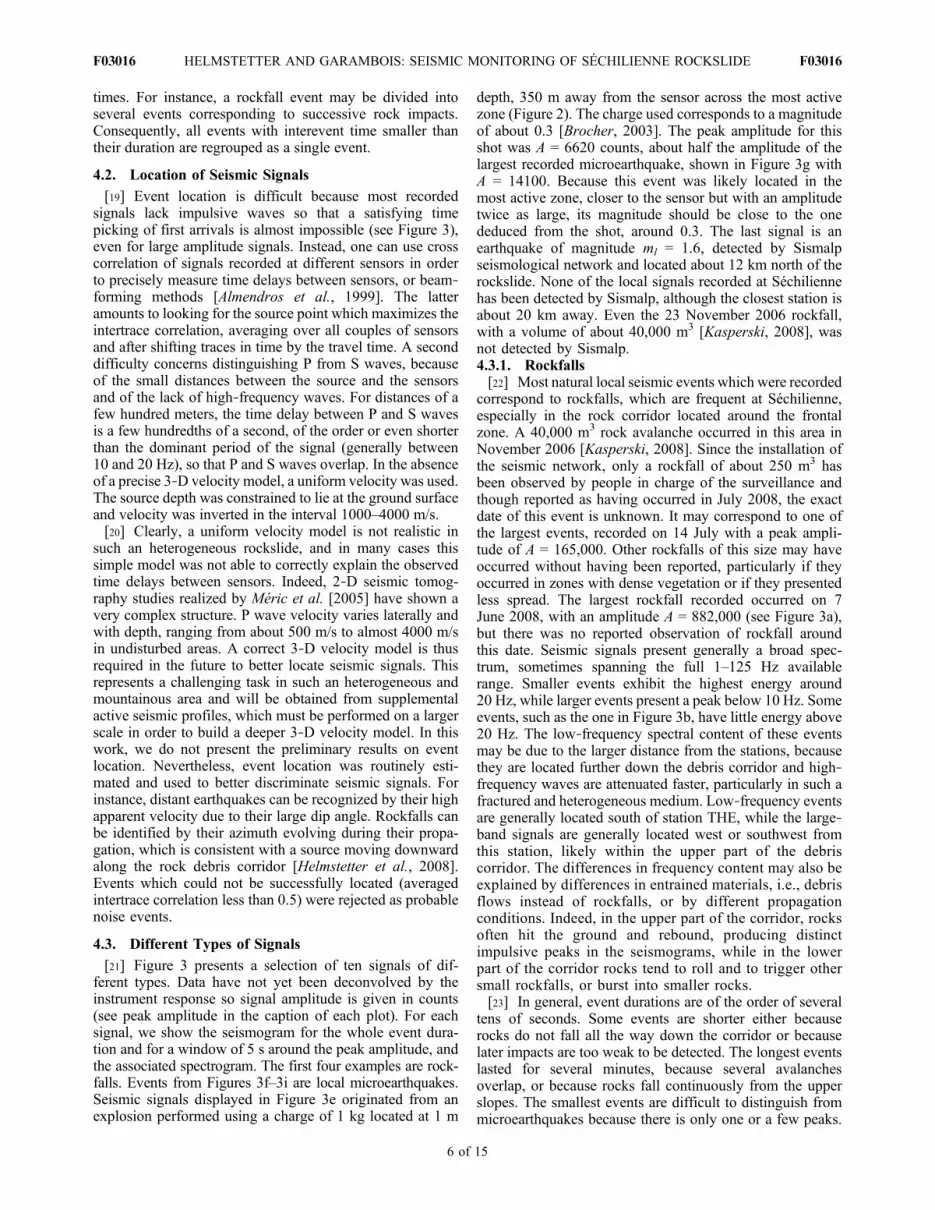
times. For instance, a rockfall event may be divided intoseveral events corresponding to successive rock impacts.Consequently, all events with interevent time smaller thantheir duration are regrouped as a single event.
4.2. Location of Seismic Signals
[19] Event location is difficult because most recordedsignals lack impulsive waves so that a satisfying timepicking of first arrivals is almost impossible (see Figure 3),even for large amplitude signals. Instead, one can use crosscorrelation of signals recorded at different sensors in orderto precisely measure time delays between sensors, or beam‐forming methods [Almendros et al., 1999]. The latteramounts to looking for the source point which maximizes theintertrace correlation, averaging over all couples of sensorsand after shifting traces in time by the travel time. A seconddifficulty concerns distinguishing P from S waves, becauseof the small distances between the source and the sensorsand of the lack of high‐frequency waves. For distances of afew hundred meters, the time delay between P and S wavesis a few hundredths of a second, of the order or even shorterthan the dominant period of the signal (generally between10 and 20 Hz), so that P and S waves overlap. In the absenceof a precise 3‐D velocity model, a uniform velocity was used.The source depth was constrained to lie at the ground surfaceand velocity was inverted in the interval 1000–4000 m/s.[20] Clearly, a uniform velocity model is not realistic in
such an heterogeneous rockslide, and in many cases thissimple model was not able to correctly explain the observedtime delays between sensors. Indeed, 2‐D seismic tomog-raphy studies realized by Méric et al. [2005] have shown avery complex structure. P wave velocity varies laterally andwith depth, ranging from about 500 m/s to almost 4000 m/sin undisturbed areas. A correct 3‐D velocity model is thusrequired in the future to better locate seismic signals. Thisrepresents a challenging task in such an heterogeneous andmountainous area and will be obtained from supplementalactive seismic profiles, which must be performed on a largerscale in order to build a deeper 3‐D velocity model. In thiswork, we do not present the preliminary results on eventlocation. Nevertheless, event location was routinely esti-mated and used to better discriminate seismic signals. Forinstance, distant earthquakes can be recognized by their highapparent velocity due to their large dip angle. Rockfalls canbe identified by their azimuth evolving during their propa-gation, which is consistent with a source moving downwardalong the rock debris corridor [Helmstetter et al., 2008].Events which could not be successfully located (averagedintertrace correlation less than 0.5) were rejected as probablenoise events.
4.3. Different Types of Signals
[21] Figure 3 presents a selection of ten signals of dif-ferent types. Data have not yet been deconvolved by theinstrument response so signal amplitude is given in counts(see peak amplitude in the caption of each plot). For eachsignal, we show the seismogram for the whole event dura-tion and for a window of 5 s around the peak amplitude, andthe associated spectrogram. The first four examples are rock-falls. Events from Figures 3f–3i are local microearthquakes.Seismic signals displayed in Figure 3e originated from anexplosion performed using a charge of 1 kg located at 1 m
depth, 350 m away from the sensor across the most activezone (Figure 2). The charge used corresponds to a magnitudeof about 0.3 [Brocher, 2003]. The peak amplitude for thisshot was A = 6620 counts, about half the amplitude of thelargest recorded microearthquake, shown in Figure 3g withA = 14100. Because this event was likely located in themost active zone, closer to the sensor but with an amplitudetwice as large, its magnitude should be close to the onededuced from the shot, around 0.3. The last signal is anearthquake of magnitude ml = 1.6, detected by Sismalpseismological network and located about 12 km north of therockslide. None of the local signals recorded at Séchiliennehas been detected by Sismalp, although the closest station isabout 20 km away. Even the 23 November 2006 rockfall,with a volume of about 40,000 m3 [Kasperski, 2008], wasnot detected by Sismalp.4.3.1. Rockfalls[22] Most natural local seismic events which were recorded
correspond to rockfalls, which are frequent at Séchilienne,especially in the rock corridor located around the frontalzone. A 40,000 m3 rock avalanche occurred in this area inNovember 2006 [Kasperski, 2008]. Since the installation ofthe seismic network, only a rockfall of about 250 m3 hasbeen observed by people in charge of the surveillance andthough reported as having occurred in July 2008, the exactdate of this event is unknown. It may correspond to one ofthe largest events, recorded on 14 July with a peak ampli-tude of A = 165,000. Other rockfalls of this size may haveoccurred without having been reported, particularly if theyoccurred in zones with dense vegetation or if they presentedless spread. The largest rockfall recorded occurred on 7June 2008, with an amplitude A = 882,000 (see Figure 3a),but there was no reported observation of rockfall aroundthis date. Seismic signals present generally a broad spec-trum, sometimes spanning the full 1–125 Hz availablerange. Smaller events exhibit the highest energy around20 Hz, while larger events present a peak below 10 Hz. Someevents, such as the one in Figure 3b, have little energy above20 Hz. The low‐frequency spectral content of these eventsmay be due to the larger distance from the stations, becausethey are located further down the debris corridor and high‐frequency waves are attenuated faster, particularly in such afractured and heterogeneous medium. Low‐frequency eventsare generally located south of station THE, while the large‐band signals are generally located west or southwest fromthis station, likely within the upper part of the debriscorridor. The differences in frequency content may also beexplained by differences in entrained materials, i.e., debrisflows instead of rockfalls, or by different propagationconditions. Indeed, in the upper part of the corridor, rocksoften hit the ground and rebound, producing distinctimpulsive peaks in the seismograms, while in the lowerpart of the corridor rocks tend to roll and to trigger othersmall rockfalls, or burst into smaller rocks.[23] In general, event durations are of the order of several
tens of seconds. Some events are shorter either becauserocks do not fall all the way down the corridor or becauselater impacts are too weak to be detected. The longest eventslasted for several minutes, because several avalanchesoverlap, or because rocks fall continuously from the upperslopes. The smallest events are difficult to distinguish frommicroearthquakes because there is only one or a few peaks.
HELMSTETTER AND GARAMBOIS: SEISMIC MONITORING OF SÉCHILIENNE ROCKSLIDE F03016F03016
6 of 15

By default, local natural events were classified as rockfalls,so the classification is often inaccurate for low‐amplitudesignals.[24] With the intention of calibrating our network for
small events, a small rock of dimensions about 0.5 × 0.5 ×0.2 (small volume of 0.05 m3 selected for security reasons)was thrown from the upper part of the rock corridor in orderto compare the recorded signal with natural events. Thecorresponding seismogram is shown in Figure 3d. In termsof amplitudes, the peak was 12,000, much smaller than thelargest recorded rockfall. The corresponding seismogramshows several distinct events associated with successiverock impacts. The rock fell for about 30 s over a distance ofabout 400 m. The following peaks in the seismograms (after100 s) are due to other small rocks falling down another partof the rock corridor. Compared with the natural eventsshown in Figures 3a–3c, this event does not show a long‐period prolonged ringing. This could be because it involvedonly one block, while large natural events likely involvemany blocks. However, we also observed natural eventswhich displayed characteristics similar to those of theexperimental rockfall.[25] Assuming rockfall volume is proportional to peak
amplitude, as suggested by Norris [1994], the largest recordedrockfall would have a volume around 4 m3. This volumeappears very small because much larger events are knownto have occurred since the network installation. This vol-ume may be underestimated if either natural events occurredfarther away from the seismometer or if rockfall volumeincreases more rapidly than seismic peak amplitude. Thevideo camera, installed in June 2009 and facing the landslide,should enable us to calibrate the seismic network. It will allowus to estimate the nature of the materials involved (rockfallsor debris flow) and to study the relation between the involvedvolume and the recorded signal amplitude and frequencycontent. This requires events large enough to be observedwith the video camera, occurring during a daywithout clouds.4.3.2. Local Microearthquakes[26] Microearthquakes can be distinguished from rockfalls
by their shorter duration, typically a few seconds. Examplesare shown in Figures 3f–3i. They have about the same fre-quency content, although the largest events exhibit generallymore energy at low frequencies (below 10 Hz) than rockfalls.There is also a large variability of signal waveform, durationand frequency content. Some events, such as the one shownin Figure 3g, exhibits waveform characteristics rather similarto the shot shown in Figure 3e in terms of duration, fre-quency content and amplitude. The largest arrival of thisquake is preceded by an emergent signal, starting about 0.2 sbefore, of much weaker amplitude. Other events consist ofseveral subevents, separated by about 1 s or longer. Examplesare shown in Figures 3f and 3h.[27] Compared to distant earthquakes (see the largest one
recorded in Figure 3j), microearthquakes lack high‐frequencywaves. This low‐frequency content may be due to the sourceof these events or to the strong attenuation of high‐frequencywaves within the fractured zone. These events may be asso-ciated with water flow within the fractures, similar to long‐period earthquakes induced by magma flow on volcanoes.Another possibility is that this unusually low frequencycontent results from low rupture velocities combined with
strong path effects due to their shallow sources, as first sug-gested by Harrington and Brodsky [2007] for volcanicearthquakes. Other microearthquakes exhibit a broadbandspectrum, comparable with distant earthquakes. They occureither individually or as a sequence of a few events, withinterevent times of about 1 s (see Figure 3g). Micro-earthquakes can be distinguished from distant earthquakes bytheir absence of distinct P and S waves and by their lowerapparent velocities, because of their shallower depth. Mostlocal events (microearthquakes or rockfalls) have an apparentvelocity of about 2 km/s, while for earthquakes V > 4 km/sdue to their higher dip angles.4.3.3. Distant Earthquakes[28] Many earthquakes have been recorded, 773 in less
than 2 years. About half of these events have also beendetected by the Sismalp regional network. Most of themissing events are nearby earthquakes, with interevent timesbetween P and S waves in the range of 0.5–2 s, correspondingto a distance of about 4–16 km. Their magnitudes are likelysmaller than 1, which is the detection threshold of Sismalpnetwork in this area. As mentioned before, the Séchiliennerockslide is located within an active seismogenic zone closeto the Belledonne Border fault [Thouvenot et al., 2003]. Sofar, the largest signal recorded by our network is the 2008/3/9ml = 1.6 earthquake, located about 12 km to the northwest.It is displayed in Figure 3j. Before the installation of theseismic network, a ml = 3.5 earthquake occurred about 7 kmsouthwest of Séchilienne, on the southwestern ending of theBelledonne fault, followed by a ml = 2.8 event in October2005 [Thouvenot et al., 2003]. The mean recurrence time ofa m � 6 earthquake on this fault has been estimated to beabout 10,000 years. As it could occur only 1 km away fromthe landslide, any risk assessment study should account forpossible triggering of the rockslide by an earthquake.
4.4. Distribution of Signal Amplitude, Duration,and Energy
[29] Figure 4a presents the distribution of signal amplitudesfor rockfalls (type R) and microearthquakes (type Q). Theamplitude was estimated after low‐pass filtering seismo-grams below 50 Hz, and after averaging maximum amplitudeof all 7 vertical channels of station THE. The distributionfollows a power law for amplitudes larger than 1000. Forsmaller events, the curvature is likely due to the incom-pleteness of the catalog because of temporal fluctuations ofthe noise level. The slope exponent is 1.1 for rockfalls and1.6 for quakes. These exponents can be compared to the bvalue of the Gutenberg‐Richter distribution of earthquakemagnitudes, b ≈ 1, if we assume that most events arelocated at about the same distance from the station so thatamplitude variations according to distance from the sourceare limited and do not modify the shape of the distribution[Weiss, 1997].[30] Figure 4b shows the distribution of energy, defined as
the envelope of the signal integrated over event duration.For quakes, the distribution can be fitted by a power law ofexponent 1.2, while for rockfalls, the distribution is curvedin a log‐log plot over the whole interval, and cannot befitted by a power law.[31] The distribution of signal durations is shown in
Figure 4c. It can be fitted by a power law over a limited
HELMSTETTER AND GARAMBOIS: SEISMIC MONITORING OF SÉCHILIENNE ROCKSLIDE F03016F03016
7 of 15

interval; for microearthquakes longer than 2 s and for rock-falls with duration larger than 30 s. For rockfalls, this durationof 30 s corresponds to the time taken for a rock to fall fromthe upper part of the corridor down to the valley. Longerevents are sequences of rockfall avalanches with intereventtimes smaller than their duration (which were thereforecounted as a single event). Microearthquakes with durationlonger than 5 s are generally sequences of shorter subevents.The relation between peak amplitude and duration for quakesand rockfalls is shown in Figure 4d. Rockfall duration maybe underestimated for small rockfalls, because only themore energetic impacts are above the detection threshold.Also, as distinguishing quakes from rockfalls is difficult forsmall events, they were classified as rockfalls by default.The amplitude‐duration relation is rather similar for quakes
and rockfalls, but the largest quakes exhibit a shorter durationthan rockfalls with the same peak amplitude.
5. Influence of Rainfall on the RockslideDynamics
5.1. Meteorological Data
[32] At least 5 meteorological stations or rain gauges arelocated within 10 km of the rockslide (Figure 1). The closeststation (maintained by CETE Lyon) is located at Mont‐Sec,but presents several gaps in the data, and has a large samplingtime of 1 day, leading us to preferentially use other raingauges. The Luitel rain gauge is located 4 km northeast fromthe landslide at a higher elevation (1280 m). It is maintainedby the “Laboratoire d’étude des Transferts en Hydrologie
Figure 4. (a) Distribution of the peak amplitude A of rockfalls (red curve) and microearthquakes (black)and fit by a power law for A > 1000 (slope exponent is given in the plot), (b) distribution of signal energy(signal envelope integrated in time) for rockfalls (red curve) and microearthquakes (black) and fit by apower law for E > 1000 (see slope exponent in the plot), (c) distribution of event duration for rockfalls(red curve) and microearthquakes (black) and fit by a power law, and (d) relation between peak amplitudeand signal duration for rockfalls (red dots) and microearthquakes (black circles).
HELMSTETTER AND GARAMBOIS: SEISMIC MONITORING OF SÉCHILIENNE ROCKSLIDE F03016F03016
8 of 15

et Environnement,” and data are available since July 2007.This is our preferred station because it has a fast samplingtime of 15 min with few gaps in the data. Another gaugeis located at Vizille, about 3 km west from the rockslideat an elevation of 290 m. It has a sampling time of 5 minand was placed in operation in September 2007 (http://pagesperso‐orange.fr/meteo.vizille). The last station is locatedat Chamrousse, about 10 km to the northeast of the rockslideat an elevation of 1860 m. It is part of Meteo France networkand has been working with few gaps since the installation ofour network, with a sampling rate of 1 h. It was used to fill inthe gaps observed at other stations. We tested every meteo-rological station to analyze the influence of station location onthe correlation between landslide dynamics and precipitation.Only weak differences were found.
5.2. Temporal Evolution of Microseismicity, RockfallActivity, Rockslide Movement, and Weather
[33] Figure 5 illustrates the temporal variability of therockslide dynamics since the installation of the seismicnetwork in May 2007. All events detected by station THEare shown in Figure 5a, but only events with amplitudelarger than 500 were used to estimate the daily rate dis-played in Figure 5b. Quakes and rockfalls occur in bursts ofactivity, lasting for a few days, and appear very often cor-related with rainfall (Figure 5d) and acceleration of therockslide displacement (Figure 5c). Quakes generally occurduring episodes of rockfalls, but rockfalls were relativelymore frequent in June 2007 and June 2008, and quakesoccurred more frequently and continuously in the winter2008 (see cumulative number of events in Figure 5b). Thismay be due to continuous snowmelt inducing continuouswater flow within the rockslide.[34] Rockslide movement also fluctuates with time.
Figure 5c shows the displacement rate of benchmark 635,located in the most active zone (Figure 2). This is one of themost rapidly moving targets that presents no gaps during thetime period considered, except after March 2009, becausedata are not yet available. Daily displacement rate increasesalmost instantaneously following rainfall [Alfonsi, 1997;Duranthon and Effendiantz, 2004], and decreases back to itsmean value within about 2 months. The temporal evolutionof displacement rate has been successfully modeled byAlfonsi [1997], assuming that velocity increases with theamount of water (rainfall or snow, decreased by evapotrans-piration) received by the rockslide, and that the groundwatertable decreases exponentially with time in the absence ofprecipitation. However, seasonal variations of the hydrolog-ical parameters are required in order to correctly model theobservations.
5.3. Thresholds for Rainfall Triggering?
[35] Correlation between rainfall and rockfalls is notstriking when looking at the temporal evolution of rainfalland daily rates of rockfall in Figure 5. Using traditional dia-grams showing rainfall intensity versus duration, introducedby Caine [1980], is not very helpful. Caine [1980] firstplotted each landslide occurrence in a diagram showing theprecipitation at the time of each event as a function of therainfall duration, for a catalog of worldwide shallow land-slides and debris flows. He observed that all events occurred
above a threshold Ir (in mm/h) defined by Ir = 14.82 D−0.39,where D is the storm duration in hours. Such a plot isshown in Figure 6 (circles) for all rockfalls recorded withamplitude greater than 500. A rainfall episode is consideredfinished as soon as there is a gap of 1 day without rain. It isimpossible to define a minimum threshold for triggering fromFigure 6. Most events occur for zero or very small rainfallintensities, and consequently no apparent relation can bederived between the density of events and the rainfall inten-sity or duration.[36] Other types of thresholds have been proposed using
the rain accumulated from the beginning of the rainfall untilthe landslide occurs, or the total rainfall stacked over a periodof a few days up to a year before the landslide occurs, or morecomplex physically based thresholds (see Guzzetti et al.[2007] for a recent review). Similar results were foundwhen replacing the hourly rainfall by the cumulated rainfallbefore the event. A problem arising with these thresholds isthat, when new data are added to the database, landslidesmay be observed for rainfall conditions lower than the min-imum threshold, so that a new threshold has to be defined[Chleborad et al., 2006]. Thresholds describe the mini-mum rainfall above which landslides may occur. Amaximumthreshold is sometimes introduced to give the maximumrainfall above which landslides always occur. But thisapproach does not tell us how likely landslides are betweenthe minimum andmaximum thresholds. Also, only landslidestriggered by rain are considered in these studies, giving upthose which were triggered by earthquakes or by an unknownmechanism.[37] Few studies have attempted to quantify the probability
of landslide occurrence as a function of rainfall properties(either rainfall duration, intensity, or cumulated rainfall, or acombination of these parameters). Glade et al. [2000] haveestimated this probability as a function of daily rain at thetime of the landslide and as a function of the “antecedentdaily rainfall index.” Guzzetti et al. [2007] also estimatedthe probability of landslide occurrence as a function of rain-fall duration and intensity. In section 5.4, we use a modelinspired by the “Antecedent Daily Rainfall” model ofGlade et al. [2000] in order to quantify the probability ofrainfall triggering at Séchilienne.
5.4. Antecedent Rainfall Water Model
[38] We have modeled the observed temporal variationsof rockfall activity using a method inspired by the Ante-cedent Daily Rainfall model [Crozier and Eyles, 1980;Glade et al., 2000]. We define the cumulated rainfall indexPc at time ti by
Pc tið Þ ¼X
j¼0:i
P tj� �
exp � ti � tj� �
=tc� �
: ð1Þ
Pc is the sum of hourly rainfall, and rainfall of all previoushours with a weight exponentially decreasing with time.This model accounts for the decay of the amount of waterwith time due to drainage. The rate of rockfall activity R(t)is then assumed to vary linearly with Pc(t). Only events withA > 500 were used together with rainfall data measured atLuitel meteorological station, with a sampling rate of 1 h.
HELMSTETTER AND GARAMBOIS: SEISMIC MONITORING OF SÉCHILIENNE ROCKSLIDE F03016F03016
9 of 15

We estimate the characteristic time tc = 0.25 day by maxi-mizing the linear correlation coefficient between R(t) andPc(t).[39] Figure 7 compares the time series of rainfall, cumu-
lated rainfall, and number of rockfalls per hour, for a time
window of one month in September 2008. Peaks of rockfallactivity are rather well correlated with cumulated rainfall,although some events have occurred in the absence of rain-fall. Figure 8 shows the correlation between the number ofevents per hour and rainfall. When looking at the raw rainfall
Figure 5. (a) Time series of event peak amplitude for rockfalls (red dots) and microearthquakes (blackdots). Gray areas indicate gaps in the monitoring. (b) Daily rates of rockfalls (red) and microearthquakes(black) and normalized cumulated number (smooth red and black lines). (c) Displacement rate (blue line)and displacement (black) of benchmark 635 (data are not yet available after March 2009). (d) Daily andcumulated rainfall and (e) daily average temperature recorded at Luitel meteorological station.
HELMSTETTER AND GARAMBOIS: SEISMIC MONITORING OF SÉCHILIENNE ROCKSLIDE F03016F03016
10 of 15

data as a function of number of rockfalls (hourly rainfall orPc(t), shown as crosses in Figures 8a and 8b), the correlationis not obvious. There are indeed large fluctuations of thenumber of rockfalls for the same rainfall value. But whenaveraging the number of rockfalls for different classes ofrainfall (using a sampling bin size of 1 mm), we now betterobserve an increase in rockfall activity with precipitation(dots in Figures 8a and 8b), which becomes stronger whenlooking at cumulated rainfall rather than hourly rainfall.[40] Using all hourly values of rate and rainfall (crosses in
Figures 8a and 8b), the correlation between R(t) and Pc(t) is0.36, a little larger than the correlation with hourly precip-
itation, equals 0.25. Taking into account antecedent rainfallin the model thus improves the correlation between rockfallactivity and rainfall. In both cases this correlation is highlysignificant, the probability of getting the same correlation bychance being almost zero. However, if we fit the data afteraveraging in classes of rainfall values (i.e., fitting the redcurve with dots in Figures 8a and 8b), the correlation is thenonly significant for cumulated rainfall. This approach givesthe same weight to any rainfall interval, while fitting the rawdata of R(t) and Pc(t) gives the same weight to each timeinterval, so mostly to small rainfall values. After increasingfor rainfall smaller than 10 mm/h, the number of events perhour appears to stabilize or even decrease. We think that thisis mostly due to the limited number of observations for largerainfalls. Rockfall rate increases from 0.14 per hour up toabout 2.5 events per hour when rainfall increases from 0 to10 mm/h. Figure 8c shows the cumulated distribution ofrainfall at the time of a rockfall event. About 49% of eventshave occurred when the hourly rainfall was zero, and 94%when rainfall was less than 5 mm/h. Only 2% have occurredwhen rainfall was larger than 10 mm/h.
5.5. Cross Correlation of Microseismicity, RockfallActivity, and Weather
[41] In order to study the correlation between rainfall androckfalls at Séchilienne, we have used the cross‐correlationfunction between the rate of rockfalls R and the precipita-tion P, defined by CR,P(t) =
Pi R(ti)P(ti + t). The variables R
and P were first detrended (removing average value) andnormalized by their standard deviation, so that CR,P(0) (forzero time lag t) denotes the linear correlation coefficientof P and R (equals 1 for perfect correlation, −1 for anti-correlation). The cross correlation of R and P can be inter-preted as the average precipitation as a function of timebefore and after a rockfall occurrence. This method allowscomparison between rockfall occurrence and previous rain-fall. It is useful to quantify the correlation and to estimate thetime delay between precipitation and triggered rockfalls.Figure 9a shows the cross correlation between hourly pre-cipitation recorded at Luitel and the number of rockfalls per
Figure 6. Rockfall occurrence (events with A > 500) as afunction of the duration of the rainfall episode until eachevent and of the daily rainfall at the time of the event.
Figure 7. (a) Hourly rainfall (blue bars) and cumulated rainfall (red curve) and (b) hourly number of A >500 rockfalls in September 2008.
HELMSTETTER AND GARAMBOIS: SEISMIC MONITORING OF SÉCHILIENNE ROCKSLIDE F03016F03016
11 of 15

Figure 8. Number of rockfalls per hour with A > 500, as a function of (a) hourly precipitation and(b) cumulated precipitation (crosses). The solid line is a linear fit of all hourly values, and the dashed line isa fit by a second‐order polynomial. Dots represent the average value of rockfall rate, obtained by binning therainfall data with a bin width of 1mm. (c) Fraction of events that have occurred for precipitation smaller thana given value as a function of this threshold. Black line is for hourly precipitation, and red line is using cumu-lated precipitation.
Figure 9. (a) Cross‐correlation function of hourly rate of rockfalls and hourly precipitation recorded atLuitel rain gauge; (b) zoom for short time delays, and fit by an exponential law ∼exp(−∣t∣/tc), for bothnegative and positive times; (c) cross‐correlation function of hourly rate of rockfalls and temperature(red line) and of temperature and rainfall (black); and (d) cross correlation of daily precipitation and dis-placement rate of benchmark 635 (black curve) compared with the cross correlation of displacement rateand daily rate of rockfalls (red line).
HELMSTETTER AND GARAMBOIS: SEISMIC MONITORING OF SÉCHILIENNE ROCKSLIDE F03016F03016
12 of 15

hour. We used 3098 rockfalls recorded by station THE withpeak amplitude above 500. In order to minimize the influ-ence of gaps in the seismic monitoring, the precipitationwas set to zero during gaps before computing CR,P(t). Thecross correlation displays a maximum value of 0.27 for atime delay of 1 h (sampling rate) between precipitation androckfall activity. The peak amplitude is much larger than theaverage value, indicating that the correlation is weak butsignificant. A zoom for shorter time delays is shown inFigure 9b. The peak of the cross‐correlation function isasymmetric. It is wider for negative times (rain precedesseismicity) than for positive times. This shows that rockfallsare not only sensitive to hourly rain, but also to previousrainfall, due to water infiltration or snowmelt. Rockfallsmay also trigger future events, thus increasing the durationof rockfall crisis after the end of the rainfall episode. Thecorrelation function for short time delays can be fitted byan exponential law C(t) ∼ exp(−∣t∣/tc), with a correlation timetc = 1.3 days for negative times, and 0.26 days for positivetimes. The fit is however not perfect as the curvature of thedata is stronger than the fit. But in a log‐log plot, CR,P(t)exhibits a convex shape, so that it cannot be fitted by apower law over a significantly large time interval. The vari-ation of CR,P with time is thus intermediate between anexponential and a power law function.[42] To access shorter times delays, we used Vizille rain
gauge, with a sampling time of 5 min. We found that thepeak of CR,P(t) occurs at t = −25 minutes. Using Luitelrainfall data, sampled at 15 min, the correlation peaksfor t = −45 minutes. It is not clear at present if there is a finitetime delay for triggering rockfall, due for instance to the timenecessary for water infiltration, or if this delay is due to thedistance between the rain gauges and the rockslide. Usingrain gauge data sampled every 5 min at Vizille, the peakvalue is only 0.12, much smaller than when using Luitelhourly data, but this effect is due to the higher sampling rate.Using hourly data recorded at Vizille, the maximum corre-lation is 0.29, close to the value obtained with Luitel raingauge. Peak correlation further increases up to 0.47 whenusing daily rain recorded at Luitel. The same approach wasused to study microearthquakes (Figure 10a), using 376
events with A > 500. The shape of the cross‐correlationfunction between rate of quakes and precipitations is similarto the results obtained for rockfalls, but the correlation isweaker, and has a peak for t = −3 h. Using hourly data, thepeak is 0.06, compared to 0.27 with rockfalls, but it is stillabove the noise level.[43] There is also a weak but significant negative correla-
tion between temperature and rockfall activity (Figure 9c).Maximum of activity coincides with a decrease of tempera-ture. While a decrease of temperature below 0°C is knownas a potential mechanism for rockfall triggering [e.g.,Frayssines and Hantz, 2006], we do not think that freeze‐thaw cycles can explain the correlation between rockfallsand decreasing temperature at Séchilienne. The largestpeaks of rockfall activity have been observed in October2007 and June 2008, when temperatures always remainedpositive. We rather suggest that this correlation results fromthe correlation between temperature and rainfall (red curvein Figure 9c), because precipitation is usually associatedwith a temperature drop. Indeed, the cross correlationbetween rainfall and temperature is very similar to CR,P(t),for both the shape and the peak value.
5.6. Cross Correlation of Rockfalls, Microearthquakes,and Displacement
[44] Both rockfalls and microearthquakes were found tobe significantly correlated with accelerations of the rock-slide displacement (Figures 9d and 10b). For rockfalls, thepeak occurs for t = −4 days; that is, peak of rockfall activityprecedes peak of landslide velocity by about 4 days. Thecross correlation is very asymmetric, as it is above zero for−36 < t < 2 days. Peak velocities are thus delayed by a fewdays relative to a crisis of rockfall activity, and velocityrelaxes more slowly. This correlation probably mainly resultsfrom the correlation of rockfalls with rain, and of rain withdisplacement. The cross correlation of precipitations anddisplacement, shown in Figure 9d, is also positive in the timeinterval −36 < t < 2 days, with a peak at t = −4 days. Themaximum value of 0.2 is however smaller than the peak ofcross correlation between rockfalls and displacement rate,equal to 0.26. We have used the data for benchmark 635 in
Figure 10. Same as in Figures 9b and 9d for microearthquakes.
HELMSTETTER AND GARAMBOIS: SEISMIC MONITORING OF SÉCHILIENNE ROCKSLIDE F03016F03016
13 of 15
Figures 9d and 10b, because it has no gap since the installa-tion of the seismic network. Benchmarks 1011 and 631 arealso located within the most active zone, and move slightlyfaster than benchmark 635 (see Figure 1). However, bench-mark 631 was destroyed in July 2008 after a rock collapse,and no data are available for benchmark 1011 in January2009. These two benchmarks produce a higher correlationwith precipitation and rockfall activity. Data are also avail-able for other benchmarks located outside the frontal zone,but the correlation with rockfalls and rainfall is very weak.The result that correlation increases with average landslidevelocity probably only results from the higher signal‐to‐noiseratio available in hourly displacement data. This suggests thatprecipitation is not the only forcing controlling rockslidedynamics. For microearthquakes, the time of the peak is−5 days, slightly larger than for rockfalls, but the correlationdecreases faster to zero (Figure 10b). Also, the peak value isslightly smaller, about equal to the maximum cross correla-tion between precipitation and displacement rate.
6. Discussion and Conclusions
[45] The seismic network installed in 2007 at theSéchilienne landslide has now recorded several thousandsevents, mostly rockfalls, and also hundreds of local micro-earthquakes and regional earthquakes. Localmicroearthquakesgenerally exhibit less high‐frequency energy than distantearthquakes, but the frequency content appears very variableamong those events. The lack of high‐frequency waves maybe due to the strong attenuation of seismic waves in thedamaged zone, as shown by recorded signals generated byactive shots in this area. Another explanation can alsooriginate from the source, which may generate few high‐frequency waves if they are induced by fluid flows, orbecause of low rupture velocities or strong path effects. Thesource of these signals is not well understood, in partbecause their location is presently inaccurate. A deeper andmore dense active seismic tomography study is in progress,which will permit derivation of a realistic 3‐D P waveseismic velocity model and better location of a few hundredevents recorded by all 3 stations. This will help us tounderstand the nature of the signals recorded, and will alsoilluminate the most active fractured zones of the rockslideand assess the potential presence (or absence) of a slidingsurface. Rockfall volumes are currently unknown, the largestevent having likely a volume of about 100 to 1000 m3, andthe smallest ones being much smaller than 0.05 m3. Seismicmonitoring is thus a very sensitive method for monitoringrockfall activity as it provides a continuous monitoring,with accurate event times and durations. In the near future,we hope to estimate rockfall volume, location, and propa-gation velocity from seismic signals. A video camera willbe a good complement to better understand the nature of thematerial involved (rock avalanches or debris flows) andcalibrate their volumes. However, video will only workduring daylight and will be inefficient if the weather is toocloudy, which is frequent during episodes of rockfall activity,or because of dust clouds during rockfalls.[46] Rockfall activity and microseismicity were found to
be weakly, but significantly, correlated with rainfall. Nothreshold was found for rainfall triggering: even 1 mm ofrain is enough to trigger rockfalls, and most rockfalls occur
spontaneously in the absence of any precipitation or anyother forcing. The probability of rockfall occurrence wasfound to linearly increase with rainfall (either daily rainfall orantecedent rainfall). Taking into account antecedent rainfallclearly improves the correlation between rockfall occurrenceand rainfall. From the cross correlation of rainfall and rock-fall, we suggest that rockfall activity starts immediatelyduring a rain episode and lasts for a few days after the end ofthe rainfall. This time delay can be explained by water infil-tration or snowmelt, or by a nucleation process (time taken formotion to displace portions of the toe enough to affect toestability, or time delay in the conversion of aseismic topplingto seismic rockfall). The relaxation of rockfall activity fol-lowing rainfall may also be due to the triggering of rockfallsby previous events.[47] Although rockfall occurrence increases with rainfall,
only a small proportion of rockfall events have occurredduring the largest rain episodes. Indeed, only 2% of eventshave occurred when precipitation was larger than 1 cm/h.Thus the probability of a moderate rockfall being triggeredby a large rainfall is very small because the probability ofrockfall occurrence increases more slowly with the rainfallintensity than the decrease of the rainfall distribution.[48] If these observations, based on moderate rainfall and
small rockfall volume, can be extrapolated to much biggerevents and intense precipitation, then these results could haveimplications for estimating the coupled hazard of a floodresulting from a slope failure. Hazard assessment studiesgenerally assume that slope failure will occur during anexceptional rainfall, thus resulting in destructive floods ifthe river is dammed by the rockslide and the dam fails. Ourobservations suggest that the occurrence of a slope failureduring an exceptional rainfall is rather unlikely, and thatthe coupled risk of flood due to a slope collapse may beoverestimated.[49] Finally, we showed that rockfall occurrence is cor-
related with accelerations of the rockslide, the displacementrate being delayed by a few days relative to rockfall activity,and decreases more slowly to its mean value after about onemonth, compared to only 5 days for rockfall activity trig-gered by rainfall. This correlation is likely indirect, due tothe influence of precipitation on both slope displacementand rockfall activity. Our interpretation is that rainfallimmediately triggers rockfalls and also produces an acceler-ation of the rockslide displacement which lasts longer thantriggered rockfalls due to inertial effects.
[50] Acknowledgments. We acknowledge CETE for providing dis-placement and meteorological data. METEO FRANCE, LTHE laboratory,and METEO VIZILLE also provided meteorological data, and FrançoisThouvenot provided the Sismalp earthquake catalog. This research wassupported by the European Commission under grant TRIGS‐043251, by“Pôle Grenoblois d’Etudes et de Recherches pour la Prévention des RisquesNaturels,” and by French “Agence Nationale pour la Recherche” and “Insti-tut des Sciences de l’Univers.” We thank Pascal Lacroix and Jean‐RobertGrasso for useful discussions. This work could not have been possiblewithout the help from many technicians, engineers, students, and researchersfrom LGIT: we are grateful to Rémi Bethoux, Glenn Cougoulat, Sophie Cra-voisier, Fabrice Doré, Jean‐Robert Grasso, Armand Mariscal, Yves Orengo,Pascal Lacroix, Catherine Pequegnat, Sandrine Roussel, Laura Sanchez,Mohamed Tahir, Lucile Tatard, and Christophe Voisin for helping withinstallation and maintenance of the seismic network and data processing.We also thank Mauri McSaveney and an anonymous reviewer for theircareful reading and for interesting suggestions, which helped improve
HELMSTETTER AND GARAMBOIS: SEISMIC MONITORING OF SÉCHILIENNE ROCKSLIDE F03016F03016
14 of 15
the quality of the manuscript. Finally, we thank the editor who carefullyread the manuscript and proposed corrections to improve the English.
ReferencesAlfonsi, P. (1997), Relation entre les paramètres hydrologiques et lavitesse dans les glissements de terrains: Exemples de La Clapièreet de Séchilienne, Rev. Fr. Geotech., 79, 3–12.
Almendros, J., J. M. Ibáñez, G. Alguacil, and E. Del Pezzo (1999), Arrayanalysis using circular‐wave‐front geometry: An application to locate thenearby seismo‐volcanic source, Geophys. J. Int., 136, 159–170.
Amitrano, D., J. R. Grasso, and G. Senfaute (2005), Seismic precursorypatterns before a cliff collapse and critical point phenomena, Geophys.Res. Lett., 32, L08314, doi:10.1029/2004GL022270.
Brocher, T. M. (2003), Detonation charge size versus coda magnitude rela-tions in California and Nevada, Bull. Seismol. Soc. Am., 93, 2089–2105,doi:10.1785/0120020185.
Brodsky, E. E., E. Gordeev, and H. Kanamori (2003), Landslide basal fric-tion as measured by seismic waves, Geophys. Res. Lett., 30(24), 2236,doi:10.1029/2003GL018485.
Caine, N. (1980), Rainfall intensity‐duration control of shallow landslidesand debris flows, Geogr. Ann., Ser. A, 62, 23–27.
Chleborad, A. F., R. L. Baum, and J. W. Godt (2006), Rainfall thresholdsfor forecasting landslides in the Seattle, Washington, area: Exceedanceand probability, U.S. Geol. Surv. Open File Rep., 2006‐1064.
Crozier, M. J., and R. J. Eyles (1980), Assessing the probability of rapidmass movement, in Proceedings of Third Australia‐New Zealand Con-ference on Geomechanics, edited by N. Z. Geomech. Soc., Proc. Tech.Groups N. Z. Inst. Eng., 6, 247–251.
Del Gaudio, V., S. Coccia, J. Wasowski, M. Gallipoli, and M. Mucciarelli(2008), Detection of directivity in seismic site response from microtremorspectral analysis, Nat. Hazards Earth Syst. Sci., 8, 751–762.
Deparis, J., D. Jongmans, F. Cotton, L. Baillet, F. Thouvenot, and D. Hantz(2008), Analysis of rock‐fall seismograms in the western Alps, Bull.Seismol. Soc. Am., 98, 1781–1796.
Duranthon, J.‐P., and L. Effendiantz (2004), The unstable “Ruines deSéchilienne” slope: State of site activity and presentation of thenew remote‐monitoring management system, Bull. Lab. Ponts Chaussees,252, 29–48.
Duranthon, J.‐P., L. Effendiantz, M. Memier, and H. Previtali (2003),Apport des méthodes topographiques et topométriques au suivi du versantrocheux instable des “Ruines” de Séchilienne, Rev. XYZ, 94, 31–38.
Effendiantz, L., and J.‐P. Duranthon (2002), Risques majeur d’éboulementdes Ruines de Séchilienne Point des mesures de suivi et de surveillancedu site de 1985 au 31 Mars 2002, LRPC Rhône‐Alpes, CETE de Lyon,Lyon, France.
Evrard, H., T. Gouin, A. Benoit, and J.‐P. Duranthon (1990), Séchilienne:Risques majeurs d’éboulements en masse: Point sur la surveillance dusite, Bull. Liaison Lab. Ponts Chaussees, 165, 7–16
Frayssines, M., and D. Hantz (2006), Failure mechanisms and triggeringfactors in calcareous cliffs of the Subalpine Ranges (French Alps),Eng. Geol., 86, 256–270.
Giraud, A., L. Rochet, and P. Antoine (1990), Processes of slope failure incrystallophyllian formations, Eng. Geol., 29, 241–253.
Glade, T., M. Crozier, and P. Smith (2000), Applying probability determi-nation to refine landslide‐triggering rainfall threshold using an empiricalantecedent daily rainfall model, Pure Appl. Geophys., 157, 1059–1079.
Guglielmi, Y., J. Vengeon, C. Bertrand, J. Mudry, J. Follacci, and A. Giraud(2002), Hydrogeochemistry: An investigation tool to evaluate infiltrationinto large moving rock masses (case study of La Clapière and Séchiliennealpine landslides), Bull. Eng. Geol. Environ., 61, 311–324.
Guzzetti, F., S. Peruccacci, M. Rossi, and C. P. Stark (2007), Rainfallthresholds for the initiation of landslides in central and southern Europe,Meteorol. Atmos. Phys., 98, 239–267, doi:10.1007/s00703-007-0262-7.
Harrington, R. M., and E. E. Brodsky (2007), Volcanic hybrid earthquakesthat are brittle‐failure events, Geophys. Res. Lett., 34, L06308,doi:10.1029/2006GL028714.
Helmstetter, A., L. Sanchez, S. Garambois, J. Grasso, F. Doré, Y. Orengo,J. Duranthon, P. Pothérat, and J. Kasperski (2008), Multidisciplinarymonitoring of a huge rocky landslide (Séchilienne, the Alps, France),Eos Trans. AGU, 89(53), Fall Meet. Suppl., Abstract H51F‐0899.
Kasperski, J. (2008), Confrontation des données de terrain et de l’imageriemulti‐sources pour la compréhension de la dynamique des mouve-ments de versants, Ph.D. thesis, 268 pp., Univ. Claude Bernard‐Lyon I,Villeurbanne, France.
Lemaître, F., J.‐C. Duranthon, and L. Effendiantz (2004), L’utilisation duradar au sol pour la surveillance des mouvements de terrain, Bull. Lab.Ponts Chaussees, 249, 19–34.
Le Roux, O., S. Schwartz, J. F. Gamond, D. Jongmans, D. Bourles,R. Braucher, W. Mahaney, J. Carcaillet, and L. Leanni (2009), CRE datingon the head scarp of a major landslide (Séchilienne, French Alps), age con-straints on Holocene kinematics, Earth Planet. Sci. Lett., 280, 236–245.
McSaveney, M. J. (2002), Recent rockfalls and rock avalanches in MountCook National Park, New Zealand, in Catastrophic Landslides: Effects,Occurrence, and Mechanisms, edited by S. G. Evans and J. V. DeGraff,Rev. Eng. Geol., 15, 35–70.
McSaveney, M. J., and G. Downes (2002), Application of landslide seis-mology to some New Zealand rock avalanches, in Landslides, editedby J. Rybář, J. Stemberk, and P. Wagner, pp. 649–654, A. A. Balkema,Lisse, Netherlands.
Méric, O., S. Garambois, D. Jongmans, M. Wathelet, J. L. Chatelain, andJ. M. Vengeon (2005), Application of geophysical methods for theinvestigation of the large gravitational mass movement of Séchilienne,France, Can. Geotech. J., 42, 1105–1115.
Montjuvent, G., and J. Winistorfer (1980), Glaciations quaternaires dans lesAlpes Franco‐Suisses et leur piedmont, Geol. Alp., 56, 251–282.
Norris, R. D. (1994), Seismicity of rockfalls and avalanches at three cas-cade range volcanoes: Implications for seismic detection of hazardousmass movements, Bull. Seismol. Soc. Am., 84, 1925–1939.
Panet, M. (2000), Expertise relative aux risques d’éboulement du versantdes Ruines de Séchilienne, 24 pp., Préfecture de l’Isère, Grenoble,France.
Pothérat, P., and P. Alfonsi (2001), Les mouvements de versant deSéchilienne (Isère): Prise en compte de l’héritage structural pour leursimulation numérique, Rev. Fr. Geotech., 95, 117–131.
Roth, M., M. Dietrich, L. H. Blikra, and I. Lecomte (2006), Seismicmonitoring of the unstable rock slope site at Åknes, Norway, in 19thAnnual Symposium on the Application of Geophysics to Engineeringand Environmental Problems (SAGEEP), edited by J. Gamey, pp. 184–192, Environ. and Eng. Geophys. Soc., Denver, Colo.
Spillmann, T., H. Maurer, A. G. Green, B. Heincke, H. Willenberg, andS. Husen (2007), Microseismic investigation of an unstable mountainslope in the Swiss Alps, J. Geophys. Res., 112, B07301, doi:10.1029/2006JB004723.
Thouvenot, F., J. Fréchet, L. Jenatton, and J.‐F. Gamond (2003), TheBelledonne Border Fault: Identification of an active seismic strike‐slipfault in the western Alps, Geophys. J. Int., 155, 174–192.
Vengeon, J.‐M., A. Giraud, P. Antoine, and L. Rochet (1999), Contributionà l’analyse de la déformation et de la rupture des grands versants rocheuxen terrain cristallophyllien, Can. Geotech. J., 36, 1123–1136,doi:10.1139/cgj-36-6-1123.
Weiss, J. (1997), The role of the attenuation on acoustic emission amplitudedistributions and b‐values, Bull. Seismol. Soc. Am., 87, 1362–1367.
S. Garambois and A. Helmstetter, Laboratoire de Géophysique Interneet Tectonophysique, Université Joseph Fourier, CNRS, F‐38041Grenoble, France. (stephane.garambois@ujf‐grenoble.fr; [email protected]‐grenoble.fr)
HELMSTETTER AND GARAMBOIS: SEISMIC MONITORING OF SÉCHILIENNE ROCKSLIDE F03016F03016
15 of 15