land evaluation - wur edepot
TRANSCRIPT
K. J. BEEK
LAND EVALUATION
FOR AGRICULTURAL DEVELOPMENT
LAND EVALUATION
Pub/ication 23
LAND EVALUATION FOR AGRICUL TURAL DEVELOPMENT
Some explorations of land-use systems analysis with particular reference to Latin America
K. J. BEEK
INTERNATIONAL INSTITUTE FOR LAND RECLAMATION AND IMPROVEMENT/ILRI P.O. BOX45,6700AA WAGENINGEN, THE NETHERLANDS, 1978

Also published as thesis, University of Agriculture, Wageningen, The Netherlands
© International Institute for Land Redamation and lmprovement/ILRI Wageningen, The Netherlands, 1978
This book or any part thereof must not be reproduced in any form without the written permission ofILRI.
Printed in the Netherlands

FOREWORD
During the last three decades great progress has been made in identifying and characterizing the world's major soils. The use being made of resource data for development projects, however, has been lagging far behind. The reasons for this situation are that these data are often presented in a form which is not readily accessible to the potential user, or that land use planners find it more convenient to handle economie parameters without taking physical variables into account.
The increasing and competitive demand for land, both for agricultural production and for other purposes, requires that decisions be made on the most beneficial use of Iimited land resources, whilst at the same time conserving these resources for the future. It is a function of land evaluation to bring about an understanding of the relationships between the conditions of the land and the uses to which it is put, and to present planners with comparisons and options of promising alternatives.
By 1970 many countries had developed their own systems of land evaluation. Some were very genera! in scope and were limited to assessing areas of land suitable for cultivation, forestry or grassland. Other systems were concemed with single forms of land use, e.g. irrigated agriculture. There was a clear need for international standardization and especially for the development of a classification which allowed a comparative evaluation of the different uses that can be made of the same land.
The general principles which are fundamental to this approach are that land is evaluated with respect to specific types of land use and in terms relevant to the physical, economie and social conditions of the area concemed. Through an international cooperative eff ort, FAO developed a framework for land evaluation by which land can be assessed, with regard to its soit and climatic conditions, in terms of requirements for successful growth of different crops, or for alternative types of land use.
Since the early days Dr. Klaas Jan Beek has been closely associated with this effort. The fieldwork which he has been carrying out with FAO since 1963 contributed considerably towards establishing relationships between land qualities and erop requirements. Dr. Beek was instrumental in defining different types of land utilization which express the use of land in terms of produce, labour, capital, management, technology and scale of operations. The principal objective ofhis book is to strengthen the foundation of land evaluation by consolidating the 'land utilization type' concept. The rapidly increasing number of land use systems and the great variety of the related land requirements and management altematives, called indeed for an indepth study of the land utilization type itself, including the application of statistica! methods and modelling.
Dr. Beek's intensive work in Latin America has led towards new methods of land
v

evaluation being introduced in that region. The synthesis presented in this book should promote the further application of a methodology which, through an interdisciplinary approach, provides a basis for land use planning decisions that take into account the qualities and constraints of the physical and socio-economie environment.
March 1978, Rome, Italy
VI
R. Dudal Director Land and Water Development Division Food and Agriculture Organization of the United Nations
ACKNOWLEDGEMENTS
Much of my experience 1 gained whilst employed by the Food and Agriculture Organization of the United Nations (FAO). Many ideas and much information 1 obtained from soil scientists and other professionals in Latin America, especially in the Soil Survey and Conservation Service EMBRAPA, Rio de Janeiro, Brazil.
For the scientific guidance of the present study, I express my gratitude to Prof. Dr. J. Bennema; the better part ofthis book I owe to him. For the valuable comments of Dr. Ir. H.A. Luning, 1 express my thanks. For constructive criticism of Chapter 5, 1 am indebted to Prof. Dr. C. T. de Wit and Dr. H. van Keulen. For her editorial assistance, 1 thank Mrs. Joy Boenisch Burrough.
And finally, for giving me the opportunity to present this study, 1 thank the International Agricultural Centre (JAC) and the International Institute for Land Reclamation and lmprovement (ILRI) at Wageningen.
VII
CONTENTS
Summary
Resumen
1 Land evaluation: the purpose it serves .
2 The land utilization type concept . . . 5
2.1 Definition and comparison with other land use defining concepts 5 2.1.l Who performs: the land or the use? . 8 2.1.2 The need for land utilization types . . . . . 9
2.2 Classification of agricultural land use . . . 10 2.2. l Literature review of land use classifications . 11
The agricultural typology of the International Geographical Union (IGU) 12 Farming systems . . . . . . . . . . . . . . . . . . . . . . . . 16 Agricultural 'systems' . . . . . . . . . . . . . . . . . . . . . . 23
2.3 The characteristics that the definition of a land utilization type should contain . . . . . . . . . . . . . . . . . 24
2.3.l Who defines land utilization types? and when? 25 2.3.2 Key attributes of land utilization types . . . 26 2.3.3 Key attributes and aggregational levels. . . . ;31
2.4 The process of defining land utilization types . 35 2.4. l Fundamental references for identifying land utilization types 38
a) Terms of reference of the land evaluation study . . . . . 39 b) Overall development objectives and land suitability criteria . 39 c) Overall development situation and present land use . . . . 40 d) Time period during which the land evaluation results should be relevant 41 e) Socio-economie attributes of land . . . . . . . . . . . . . . . 41 f) The physical attributes ofland . . . . . . . . . . . . . . . . . 42
2.4.2 Preparation of a structured checklist of major and minor determinants of land utilization . . . . . . . . . . . . . . . . . . . . . . . . . 43 APPENDIX l : Checklist of major and minor determinants of land utilization types (an example) . . . . . . . . . . . . . . . . . . . 48
IX
3 Land requirements and land qualities . . . . . . . . . . . . . . . 53
3.1 Systematic disaggregation ofland and the identification ofland qualities 54 3.1.1 Land quality concept . . . . . 54
Ecological qualities of the land . . 56 Management qualities of the land . 57 Conservation qualities of the land . 58 Improvement qualities of the land . 59
3.1.2 Measurement of land qualities . . 61 On land improvement qualities and input application efficiency 69 Are IQ values always constants? . . . . . . . 77 Parametric methods . . . . . . . . . . . . . 78 Temporal and spatial variation of land qualities . 80
3.1.3 Land qualities and land resource data collection . 83 3.2 Disaggregation of land utilization types and the identification of land
requirements . . . . . . . . . . . 86 Measurement of land requirements . . . . . . . 90
3.3 Intemal and overall land suitabilities . . . . . . 94 3.3.l Major landscape elements and overall land qualities 94 3.3.2 Land use interactions . . . . . . . . . . . . . 95 3.3.3 Impact of full-scale implementation of land use proposals . 96
Field check on environmental impact . . . . . 98 Non-physical off-site effects of land use changes . 99 Intemal and overall land suitability classification 99 An intemal land suitability classification . l 00 An overall land suitability classification . . . . 100
3.4 Combination ofland utilization types . . . . . 102 3.5 Availability and reliability ofland resources data 104
4 Approaches to land evaJuation . . l 09
4.1 Genera} purpose land evaluation 111 4.2 Specific purpose land evaluation 113
4.2.1 Physical land evaluation . . . . 118 Land suitability criteria . . . . 120 Qualitative versus quantitative land suitability classification . 124 When are the land utilization types defined in physical land evaluation? . 126
4.2.2 Integral land evaluation . . . . . . . . . . . . 127 a) Land suitability classification in economie terms 127 b) Optimization of land use . . . . . 129
4.2.3 Choice ofland evaluation me:hods . . 133 4.2.4 Land evaluation and land use planning . 135
Land use planning activities . . . . . 136 4.2.5 Land evaluation and the individual farmer 139
x
4.3 Land evaluation in Latin America . . . . . . . . . . . . . . . .. 142 4.3.l Venezuela: adapting the USDA Land Capability System to local needs . 151 4.3.2 Nicaragua: combining general purpose with specific purpose land evalua- 162
tion . . . . . . . . . . . . . . . . . . . . . . . . . . . . . . 162 4.3.3 Mexico: towards a land evaluation for individual crops . . . . . . . . 180 4.3.4 Brazil: a system of physical land evaluation based on land qualities and
land utilization types (at reconnaissance level) . . . . . . . . . 192 4.3.5 Chile: an example of integral land evaluation with staged procedure 220 APPENDIX 2: Land qualities and component properties in Brazil . . 235
5 Towards a systems approach in specific purpose land evaluatioo 251
5.1 The data-analysis problem . . . . . . 253 5.2 The temporal problem . . . . . . . . 255 5.3 Systems analysis and simulation models 259
5.3. l System theory . . . . . . . . . . . 259 5.3.2 The rationale of a systems approach to land evaluation . 263
5.4 Descriptive and prescriptive systems analysis 269 5.4. l Descriptive input-output analysis . . . . . . . . . . 278 5.4.2 Prescriptive land suitability classification . . . . . . . 296 APPENDIX 3: Definitions of important concepts in systems theory . 309
Literature . 312
Glossary . 329
XI

SUMMARY
LAND EVALUATION FOR AGRICULTURAL DEVELOPMENT
LAND EVALUA TION
Increases in the demand for agricultural produce and for space to meet non-agricultural needs are provoking rapid changes in the use of land. These changes have stimulated a critica} examination of our methods of looking at land. Most useful is a land evaluation that predicts the inputs, outputs. and other favourable as well as adverse effects resulting from specified uses of the land that is being evaluated ( Chapter l ).
LAND UTILIZA TION TYPES
Thus, relevant uses need to be identified at an early stage (Chapter 2). This has not always been satisfactory. To help in land evaluation, the concept 'land utilization type' (LUT) has been introduced. This is defined as a specific way, actual or alternative, of using the land, described in terms of produce, labour, capital, management, technology and scale of operations. The principal objective of this thesis is to strengthen the philosophical base of land evaluation by explaining the LUT concept. Many similarities exist between this concept in land evaluation and other land-use defining concepts such as production and farming systems. Due to the complicated interactions that occur between their many constituent parts, the analysis of farming systems cannot fully account for the variation in physical land conditions. Land evaluation contributes to solving this problem by making preliminary and partial analyses of the variability of the land and of its influence on the performance of present and altemative land uses. To this end, land use is arbitrarily subdivided into two elements: the land (LU), mostly described by land evaluators in terms of land (mapping) units, and the use (LUT). Thus it should be possible to predict the performance of different LU, LUT combinations, called 'land use systems' (LUS) in this report. Such a 'landuse systems approach' should permit easy extrapolation of the land evaluation results to farming systems research and land use planning.
LAND REQUIREMENTS AND LAND QUALITIES
In.agronomy the term 'requirement' is commonly used when referring to the specific land conditions required for the successful growth of a erop or the functioning of an agricultural implement, e.g. the water requirements of wheat or the soit workability requirements of a tractor.,.driven plough. These land requirements (LR) are the most fundamental aspects of the land utilization types for purposes of land evaluation (Chapter 3). A very critical aspect ofland evaluation is the availability of information
XIII

about these LRs, especially in developing countries. Most usefu1 are the descriptions of LR expressed in terms of relationships between different levels of specified land conditions and the corresponding levels of output, e.g. a table or graph that relates different levels of soil salinity with yield.
The land requirements of a LUT determine toa great extent which land resources data need to be studied and in how much detail. Early identification of LUTs and their land requirements may considerably reduce the cost and duration of the land resource studies by focussing attention on those land characteristics that may not wholly meet these requirements. In any event, land resource studies result in an enormous amount of data about soil, climate, hydrology etc. But, because of the way data are collected according to the academie discipline of the researcher, important relations and interactions between different land attributes are often overlooked, particularly those between climate and soil. To synthesize the overwhelming volume of data into amore comprehensible form, the construction of simpte functional models of the physical environment (LU) is proposed, based on the concept of land qualities. A land quality is a component of the land which acts as a separate factor on the land-use performance. The following broad types of land qualities have been distinguished:
- ecological qualities; e.g. available water, length of growing season; - management qualities; e.g. the possibility of using specified types of implements
or transportation; - conservation qualities; they represent the land 's unique capacities to maintain
the status of the land qualities, in particular the productive capacity; - improvernent qualities; land units diff er in behaviour when certain physical
inputs are applied for their improvement: they have a different 'input application efficiency', e.g. in their response tof ertilizers or irrigation water.
There is still much to be achieved in the quantitative measurement of land qualities. They are usually ranked on an ordinal scale: high-medium-low-very low. Statistica! methods, such as multiple regression and principal component analysis, are also used as a means of rating land qualities, e.g. soil fertility or soil erosion susceptibility. The success of these statistica} methods for describing land qualities seems to be attributable to the small number of factors taken into account. The prospects of using mathematical and analog models for characterizing and simulating dynamic land qualities influenced by the weather, e.g. the soil workability, oxygen contained in the soil, soil nitrogen, are very important. The timing of land-use activities and processes of the LUT - the cropping calender- affects the way in which the time intervals need to be chosen for measuring and simulating dynamic land qualities and component properties.
Land evaluation should be able to predict the impact of land use proposals not only for single land (mapping) units but also for combinations of land units and for the physical environment as a whole. Also, interactions occurring between different land
XIV
uses operating on different land units should be foreseen. For this purpose, a distinction is proposed between internal land qualities ofindividual land units and overall land qualities of major landscape elements, internal land requirements of individual land utilization types and overall land requirements encompassing the sum of individual land requirements made by the different land utilization types that operate simultaneously.
APPROACHFS TO LAND EVALUATION, LATIN AMERICA
In Chapter 4 the different approaches to land evaluation are presented. At the highest level, a distinction is made between general purpose and specific purpose land evaluation. General purpose land evaluation represents a standardized approach for all lands to evaluate their capability to support a generally defined land use. The best known example is the USDA Land Capability System. Specific purpose land evaluation represents a pragmatic approach: not only the land but also the use possibilities (LUT) are explicitly studied. The use (LUT) becomes as much a determinant of land suitability as the land itself. Many land suitability classifications for specific crops belong to this category.
To compare the performances of different LU-LUT combinations, not only an analysis of the physical factors is needed (physical land evaluation), but also a socioeconomic analysis. The approach to land evaluation that includes socio-economie analysis has been named 'integral land evaluation'.
Application of the proposed concepts and procedures of land evaluation requires close contact with the farmer: his operations need to be observed, and his achievements, attitudes, and expectations taken into account. During field surveys, one should always be on the look-out for potentially constraining land qualities. Observation of present land use and discussions with farmers will improve the correspondence between the real land conditions and their descriptive models in terms of qualities and properties.
To illustrate the above concepts and procedures in land evaluation, methods from Venezuela, Nicaragua, Mexico, Brazil, and Chile are described. In Latin America land evaluation is relied on as a fundamental source of information fot agricultural development. Land evaluàtion methods that evolved in other countries, especially the USDA Land Capability System, have not been rigidly followed. New systems are being developed to suit local needs. The willingness of national scientists to abandon established methods of land capability classification is encouraging the introduction of new approaches that pay more attention to the biological, technical, and socioeconomic aspects ofland use, and in particular to the farmer himself. In such specificpurpose land evaluations, the dynamic aspects ofland and land usecan no Jonger be ignored; this is makirig land evaluation more complex, but not insurmountably so, given today's data-handling techniques. This idea is elaborated in Chapter 5, where the possibilities for using systems analysis are explored.
XV
LAND-USE SYSTEMS ANAL YSIS
Land-use systems analysis in land evaluation must be understood as ·simulation', defined by De Wit and Goudriaan (1974) as the building ofa dynamic model and the study of its behaviour. The land-use model only includes that part of reality that is needed to answer the questions asked: to predict inputs (l), outputs (Y) and changes in the values of land qualities (LQ), on-site or off-site, that would aris~ if a particular LV were to be combined with a specific LUT.
To be able to provide this information the relation structure of the land-use system must be known. Tuis consists of three fundamental relations:
Y = F(LQ); LQ = F(I); Y = F(I)
These relations are interrelated; one relation can be derived from the two others through the elimination of one variable, usually LQ. A graphical method of co-axial analysis is shown for expressing the 1-LQ Y relations.
A further simplification is the tabular presentation of the relation structure of a landuse system, presenting only a few input-land quality-output combinations. Two multiple-entry tables are proposed: the land quality table (Table 5.4A) expressing the input-land quality relations for land units(LU) with different land improvement qualities, and the output table (Table 5.48) expressing land quality-output relations for land utilization types (LUT) with different land requirements. Combination of the two tables permits the identification of several alternative input-land quality-output combinationsforeachLU-LUTcombination.
A distinction is made between descriptive and prescriptive land-use systems analysis. During the descriptive analysis, physical inputs for ameliorating constraining land qualities, their management and conservation, are compared with their effects on the land qualities and the outputs: ·ctescriptive input-output analysis'. This information is needed for the next step, when the suitability of a particular land unit (LU) for combination with a particular land utilization type (LUT) is classified: 'prescriptive land suitability classification'. During this second step, for each LUT-LU combination, the input-land quality-output combination is selected which places the land unit in the highest possible land suitability class : a kind of optimization process.
CONCLUSION
The use of simulation models of specific land use processes and mechanisms holds much promise for land-use systems analysis and is therefore likely to increase, particularly in situations where the physicaJ and/or socio-economie conditions seriously limit a satisfactory matching between land qualities and land requirements.
Such models will probably relate primarily to specific partial land-use problems, e.g.
XVI
drainage, soil tillage, the behaviour of nitrogen or chemica! fertilizers, and to potential yield. In the immediate future the use of mathematica! models solely for simulating all input-ouput relations influencing the performance of a land use system will probably remain too complex to satisfy practical land evaluation entirely. Thus land evaluation must compromise between scientific ideals and the limitations posed by data availability, data reliability, and the possibilities for data handling.
Meanwhile land resources inventories should aim increasingly towards the collection of data that explicitly characterize the fundamental environmental regimes (i.e. land qualities) influencing the physiological and agricultural mechanisms and prncesses, to improve the possibilities for land-use simulation and the prediction oflanduse performance.
XVII
RESUMEN
EVALUACION DE TIERRAS PARA EL DESARROLLO AGRICOLA
EVALUACION DE TIERRAS
La demanda creciente de productos agricolas y la necesidad de poder disponer de tierras para fin es que no sean agricolas, causan grandes modificaciones en el uso de la tierra. Esto ha llevado a una consideración critica de nuestros métodos para la evaluación de tierras. Los métodos más utiies son los que permiten pronosticar acerca de los insumos, los resultados y otras consecuencias favorables o desfavorables deun cierto uso de la tierra en cuestión ( Capitulo l ).
TIPOS DE USO DE LA TIERRA
Es necesario por lo tanto, que en un principio se identifiquen los usos más relevantes de la tierra. Podrá ser el uso actual, pero en general se aplica la evaluación de tierras en el cuadro de un plan de desarrollo, en el cual las modificaciones del uso de la tierra juegan justamente un papel muy importante (Capitulo 2). Los métodos de evaluación de tierras que utilizan los especialistas de suelos, más conocidos como la clasificación de tierras o la interpretación de mapas edafológicos, fallan en cuanto a la atención prestada al uso de la tierra y al hombre que la utiliza. Para ayudar la evaluación de tierras, se introdujo el concepto 'tipo de uso de la tierra' (Land Utilization Type, LUT) durante una consulta de expertos de la FAO celebrada en Wageningen, Holanda, en 1972. Antes también se habia aplicado este concepto en una nueva metodologia para Ja interpretación de m.apas edafológicos en el Brasil. Un tipo de uso de la tierra (LUT) es una manera especifica de utilizar la tierra, actual o alternativo, y está descripta en términos de producto (cultivo), empleo, capital, manejo, tecnologia y escala de operaciones.
Esta tésis intenta mejorar la metodologia de la evaluación de tierras, dando una explicación más detenida sobre el lugar que Ie pertenece al uso de la tierra y sobre todo al usuario mismo, dentro de dicha metodologia. El babel de lenguas de la literatura intemacional tratándose de conceptos como 'sistema de producción', 'sistemas agricolas' y 'uso de Ia tierra' será aun más grande si aftadimos el concepto LUT de la evaluación de tierras. Sin embargo, después de haber explicado los conceptos más similares, se debe constatar que para el llamada 'farming-system research', boy dia resulta muy dificil de tomar en cuenta suficientemente las caracteristicas variables de la tierra. La dificultad surge por la estructura de relaciones sumamente complicada del sistema agricola, que está compuesto de una cantidad muy grande de variables y parámetros fisicos, sociales y e.conómicos, de los cuales algunos son además variables en el tiempo. Para aliviar estos problemas, los que efectuen la evaluación de tierras, tendrán que hacer un análisis provisional del uso de la tierra, muy simplificado, que
XVIII
se refiere solamente del estudio de la variabilidad de la tierra y su influencia en los resultados del sistema de este uso. Por eso es deseable de dividir el uso de la tierra en dos element os: el 'uso' y la 'tierra'. Para la 'tierra' se utiliza normalmente en la evaluación de tierras la palabra 'unidad (de mapeo) de tierra' o 'land (mapping) unit', LU. Y con el 'uso' se en tiende aqui el concepto arriba mencionado ya de 'tipo de uso de la tierra', LUT. En cuanto LU y LUT sean conocidos se trata de pronosticar el comportamiento de la diferentes combinaciones de LU y LUT. En este informe llamaremos tales combinaciones sistemas de uso de la tierra (land-use systems, LUS). Un método por sistemas de uso de la tierra procurará que los resultados de la evaluación de tierras sean los más utiles posible para el farming-system research y para el planeamiento del uso de la tierra, que en su tumo tendrán que contribuir mucho al desarrollo de la populación rural en las regiones tropicales y subtropicales.
REQUERIMIENTOS DE TIERRA Y CUALIDADES DE LA TIERRA
En la literatura internacional el término 'requirement', traducido aqui por 'requerimiento', se utiliza muchas veces para indicar qué es lo que se le exige a la tierra en cuanto al crecimiento de las plantas o al uso de cierto tipo de maquinaria: el requerimiento de agua y el requerimiento de cultivo (Capitulo 3). Estos requerimientos representan los aspectos más fundamentales del tipo de uso de la tierra (LUT), dentro de la evaluación de tierras. La disponibilidad de datos acerca de estos requerimientos de tierra es un factor restrictivo para la evaluación de tierras, sobre todo en los paises en desarrollo. Las más utiles son las descripciones de los requerimientos de tierra expresadas como relaciones entre niveles especificados de una cierta caracteristica de la tierra y el resultado relacionado con dicho nivel del sistema de uso de la tierra en cuestión. Por ejemplo un cuadro o un gráfico que indica la relación entre los diferentes niveles de salinidad de la tierra y los rendimientos que se esperan de ciertos cultivos. Los requerimientos del tipo de uso (LUT) fijan en gran medida que propiedades de la tierra tendrán que estudiarse y a que nivel de detalle esto tendrá que efectuarse. Una identificación de los LUT y de los requerimientos de tierra, al iniciar el estudio, podrán limitar considerablemente los gastos y la duración de los estudios de la tierra, ya que nos podramos fijar en esas caracteristicas de la tierra que no estén de acuerdo con los requerimientos de los· LUT. Sin embargo se producen, durante el levantamiento y la experimentación, grandes cantidades de datos sobre la tierra, referente al suelo, clima, vegetación, hidrologia etc. Por desgracia se descuidan frecuentemente por la manera de juntar los datos segun la especialización del investigador, relaciones e interacciones importantes entre los diferentes atributos de la tierra. y sobre todo entre suelo y clima. Por eso pasa con frecuencia que no se presta suficiente atención a las caracteristicas dinámicas del suelo en la evaluación de la tierra. Para Uegar a una sintesis de la cantidad impresionante de datos sueltos, se pasó ya en el ano 1960, en el Bmsil. a la construcción de modelos simples y funcionales del medioambiente fi'sico (las unidades de mapeo), haciendo uso de 'cualidades de la tierra'.
XIX
Una cualidad de la tierra es un elemento de la tierra, con una influencia independiente sobre los resultados del sistema de uso. Se podrán distinguir las siguientes clases de cualidades de la tierra :
- cualidades ecológicas, como p.e. la cantidad de agua disponible para la planta; la duración del periodo de crecimiento;
- cualidades de manejo, p.e. las posibilidades para el uso de ciertos tipos de maquinaria y medios de transporte;
- cualidades de conservación. Estas son las facultades de la tierra para poder conservar el nivel original de sus diferentes cualidades, como también su capacidad productiva;
- cualidades de mejoramiento; unidades de tierra (LU) pueden diferenciar en su comportamiento, cuando se empleen ciertos insumos fisicos para el mejoramiento de la tierra: tienen una eficiencia en la aplicación de insumos diferente, p.e. empleando fertilizantes quimicos o agua de irrigación.
La etapa de la determinación cuantitativa de las cualidades de la tierra es aun incipiente. Casi siempre, también en Holanda y en el Brasil, se utiliza una escala de medición ordinaria: alto-medio-bajo-muy bajo. Métodos estadisticos como p.e. la regresión multiple y el análisis por componentes principales, también son aplicados por ejemplo en el terreno de la f ertilidad y la erosión de suelos. El éxito de estos métodos estadisticos se debe, entre otras cosas, a la cantidad reducida de factores que se tienen en cuenta, por lo cual se trata todavia de relaciones funcionales entre las causas y los efectos. Por desgracia no se puede decir lo mismo de los métodos estadisticos empleados en la evaluación de tierra (los llamados métodos paramétricos se rechazan comotal).
M uy importantes son las perspectivas del uso de los modelos matemáticos y análogos para la descripción y la simulación de las cualidades de la tierra más dinámicas como el drenaje, el agua disponible para la planta, el nitrógeno en el suelo y la capacidad productiva (cosecha). Dependerá mucho del calendaria de Jas diferentes actividades y procesos del uso de la tierra, de cómo se escojan Jos intervalos de tiempo y cuando se midan o se simulan las cualidades dinamicas de la tièrra. Al pronosticar las consecuencias de los diferentes usos de la tierra, la evaluación de tierras tendrá que tener en cuenta, de vez en cuando, que existen relaciones entre las diversas unidades de tierra (LU) fonnando parte de un paisaje mayor. Las interacciones entre diferentes usos de la tierra que se emplean en lugares que se encuentran a cierta distancia los unos de los otros, y los efectos de un cierto uso de la tierra, sobre las cualidades de la tierra en otras partes, deberán ser pronostieados. Por eso se hace una división entre las cualidades de tierra internas de las unidades de tierra individuales y las cualidades de tierra globales de los pa:isajes mayores y de los cuales forman parte las unidades de tierra. De la misma manéra se puede hablar de los requerimientos de tierra intemos de un cierto LUT y de los requerimientos de tierra globales, que representa el total de requerimientos de los diferentes LUT, a cuyas exigencias tendrá que satisfacer la tierra evaluada.
XX
METODOS DE EV ALUACION DE TIERRAS EN LATINO-AMERICA
En el Capitulo 4 se ha intentado ordenar un poco los diferentes métodos de evaluación de tierras que boy dia se utilizan, sobre todo en America Latina. En el nivel más alto se hace una diferencia entre una evaluación de tierras para fmes generales y una evaluación para fines especificos. La evaluación para fines generales representa un método estandardizado para toda clasede tierras, a fin de poder fijar su aptitud para un uso de la tierra genera!. El ejemplo más conocido es el Sistema de Capacidad de Uso de la USDA en los Estados Unidos. La evaluación de tierras para fines especificas representa un método pragmático: tanto la tierra como las posibilidades de uso (LUT) se someten a un estudio. El uso de la tierra (LUT) es tan determinante para la aptitud de la tierra como la tierra misma. Muchas clasificaciones de aptitud para cultivos individuales pertenecen a ello. Desafortunadamente, en muchos paises en desarrollo se apliquen demasiadas veces todavia el Sistema de Capacidad de Uso, arriba mencionado, cuando en realidad se deberia aplicar una evaluación de tierras que cuente más con el uso de la tierra especifico y con los que trabajan esta tierra. Esta tésis pretende, por lo tanto, desarrollar, más que todo, la evaluación de tierras para fin es especificos.
Para poder comparar los pronósticos del comportamiento de las diferentes combinaciones de LU y LUT, efectuados durante la evaluacion de tierras, un analisis de los factores fisicos resultará insuficiente (evaluación fisica de tierras). En estas circunstancias se necesitará también a veces un análisis socio-económico, que frecuentemente se efectua más tarde, pero que en evaluaciones de tierras muy detalladas se puede hacer al mismo tiempo que el análisis fisico.
La aplicación de los conceptos y métodos arriba mencionados, requiere una colaboración intima con los agricultores: sus actividades se observan, y se tienen en cuenta sus resultados, opiniones y esperanzas. Durante el levantamiento de las tierras, se deberán buscar continuamente esas cualidades de la tierra, que puedan Jimitar el uso. Observaciones del uso actua:l de la tierra y discusïones con los agricultores aumentarán en gran medida la semejanza entre la realidad y los modelos descriptivos de la tierra en términos de cualidades, sobre todo las cualidades dinámicas que el agricultor pueda constatar diariamente y sobre las cuales sus antepasados le hayan informado.
Como ilustración de los conceptos y métodos tratados basta aqui, en el capitulo 4.3 se tratan unos métodos de evaluación de tierras de America Latina, donde el autor efectuó sus investigaciones en los afios 1963 basta 1974. Personalmente estaba más relacionado con la evaluación de tierras en el Brasil. También en otros paises como Chile, Mexico y Venezuela participó en la realización de nuevos métodos de evaluación de tierras que prestan más atención al uso y al usuario de la tierra.
Durante el Seminario CIA T sobre la función de la ciencia del suelo en el desarrollo del Trópico Americano (Bomemisza and Alvarado, Eds, 1975) A. Colin Me. Clung
XXI

(experto de suelos) dijo las siguientes palabras notables: 'La ciencia del suelo es la disciplina agricola más importante para el desarrollo del Trópico Americano. Ningun terreno de estudios tiene una importancia semejante ... ' Sea como sea, la evaluación de tierras que recibió poca atención durante este seminario, es sin duda ninguna una fuente de información fundamental para el desarrollo de la población rural de America Latina. Resumenes de los métodos de evaluaciones de tierras aplicados en Venezuela, Nicaragua, Mexico, Brasil y Chile muestran que se estan desarrollando nuevos sistemas de evaluación de tierras que reemplazarán el sistema USDA y que se adaptarán más a làs circunstancias locales. El interés que los expertos de suelos latinoamericanos han mostrado para la renovación es muy alentador para la introduccion de los métodos de evaluación de tierras que prestan más atencióna los aspectos biológicos, técnicos y social-económicos de la tierra. Pero se deberá prestar mucho más atención, utilizando estos nuevos métodos, al clima y a los aspectos dinámicos de la tierra. Esto complicará más la evaluación de tierras, pero las técnicas actuales para el tratamiento matemático de datos, nos tendrán que ayudar. Para poder comprender en qué dirección tendrá que dirigirse la evaluación de tierras en los aiios que vienen, en el ultimo Capitulo 5 se tratan más detenidamente las posibilidades para la aplicación del análisis por sistemas y de los model os de simulación.
ANALISIS POR SISTEMAS DEL USO DE LA TIERRA
El análisis por sistemas del uso de la tierra en la evaluación de tierras tiene que considerarse como una forma de 'simulación', descrita por de Wit y Goudriaan (1974) como 'la construcción deun modelo dinámico y el estudiode su comportamiento'. Solo aquella parte de la realidad que estimamos necesaria para la contestación de las preguntas que nos han hecho se incluirá en el modelo de uso de la tierra. Estas preguntas son el pronóstico de los insumos, los resultados y las modificaciones de los niveles de las cualidades de la tierra, en el caso de que se combine una cierta unidad de tierra LU con un tipo especifico de uso de la rierra LUT. Para poder contestar a estas preguntas, tenemos que conocer la estructura de relaciones del sistema de uso de la tierra, que está compuesto de tres relaciones fundamentales: Y = F(LQ); LQ = F(I); Y = F(I). Estas tres relaciones están también relacionades entre ellas, de modo que una relación se podrá deducir de las otras dos eliminando un variable, LQ casi siempre. En el Capitulo 5 se trata de un método de análisis coaxial para presentar gráficamente las relaciones 1-LQ-Y. También se indica la utilidad de las funciones dis-continuas, basándose en los resultados obtenidos por el Proyecto Internacional de la Evaluación de la Fertilidad del Suelo en North CaroJina.
Una forma aón más simpte para presentar la estructura de relaciones del sistema de uso de la tierra .es la forma tabular, en el cual sólo se indicm unos pocos niveles 1-LQ-Y. Se recomiendandos cuadros de entrada doble:
- el cuadro de cualidades de la tierra, que presenta las relaciones 1-LQ para unidades de tierra (LU), con diferentes cualidadesde mejorainiento, y
- el cuadro de resultados que presentaJas relaciones LQ-Y para tipos de uso de la
XXII
tierra (LUT) con diferentes requerimientos de la tierra (LR).
Combinando estos dos cuadros, se obtiene la posibilidad de fijar las diferentes combinaciones de valores 1-LQ-Y para cada combinación de LU y LUT. Se hace una diferencia entre el análisis por sistema descriptivo y prescriptivo. Al hacer el análisis descriptivo, los medios fisicos para el mejoramiento y el mantenimiento de las cualidades de la tierra, se comparan con sus efectos en las cualidades de la tierra y en los resultados: 'análisis descriptivo insumos-resultados'. Esta información la necesitamos para el paso siguiente, al clasificar la aptitud de una cierta unidad de tierra (LU) para su combinación con un cierto tipo de uso de la tierra (L UT): 'clasificación de aptitud de la tierra prescriptiva'. Durante este paso segundo, se escoge para cada combinación de LUT y LU, la combinación 1-LQ-Y, que situa la unidad de tierra LU en la clase de aptitud de tierra más alta posible. Esto es un proceso de optimación cuyos resultados dependen mucho del objetivo del uso de la tierra, que tiene que traducirse en criterios de aptitud de la tierra, detenidamente descritos para cada clase de aptitud.
Por fin llegamos a la conclusión genera! que el uso de modelos para la simulación de los procesos y actividades especificos del uso de la tierra ofrece perspectivas importantes para el análisis por sistemas. Tendrá que convertirse en el expediente imprescindible para los consejeros técnicos, a quienes se recurre en los paises en desarrollo, en situaciones en las cuales Jas condiciones fisicas y/o socio-económicas forman un impedimiento serio para conciliar las cualidades de la tierra y los requerimientos de los tipos de uso de la tierra en el lugar en cuestión. También pét. -._los pronósticos a largo plazo y la reducción al minimo de los riesgos para los agricultores de bajo ingreso que dependen mucho de las cualidades de la tierra dinámicos, como p.e. del agua disponible dichos modelos son de suma importancia. De momento, se podrá esperar el mayor beneficio de los modelos al describir y al simular procesos y mecanismos en el uso de la tierra, que se puede aislar facilmente: drenaje, labranza de la tierra, régimen de nitrógeno, disponibilidad del agua, rendimiento potencial. El uso de modelos matemáticos para simular todas las relaciones 1-LQ-Y que fijan el comportamiento de LUS, de momento resulta demasiado complejo para poderlo aplicar en la práctica, durante una evaluación de tierras.
La evaluación de tierras tendrá que encontrar un compromiso entre las ideales cientificas y las restricciones que surgen de la disponibilidad de datos, de la fidelidad de estos datos (p.e. de los parámetros hidráulicos del suelo) y de las posibilidades para el tratamiento de dichos datos. Sin embargo, la cartografia y otras investigaciones básicas de la tierra tendrán que aplicarse aón más que antes en la colección de datos que puedan caracterizar los factores del medio-ambiente y las cualidades de la tierra que son fundamentales para los procesos y mecanismos fisiológicos y agricolas. Con esto se atribuye directamente a la posibilidad de simulación de uso de la tierra, con el fm de mejorar de esta manera, la posibilidad de pronosticar el comportamiento de sistemas de uso de la tierra especificos, pensando en primer lugar en los paises en desarrollo.
XXIII
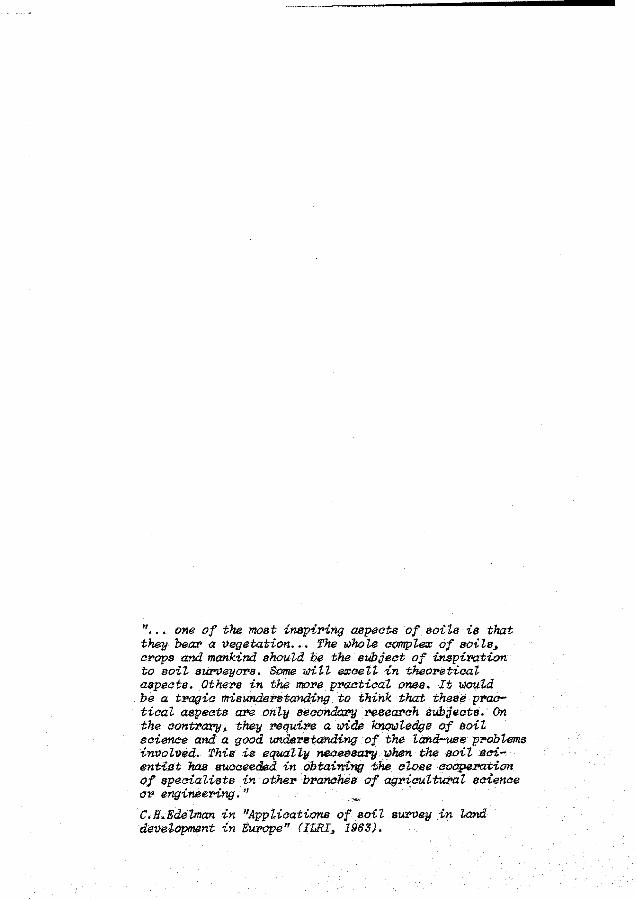
" one of the most inspiring aspects of soits is tltat they beaz> a t>egetation •.• The w'hole compte:c of soi'Ls, cPOps and man.kind shoutd be the subject of inspirotion to soii SUPl)eyors. Some mti eroceit in theoretica.'t aspeats. Others in the more pmetical ones. It 'llJOul.d be a t1.'agie misunde1.'standing to think that these p:ractiaal aspeets azte only seaonda:cy 1."esearch sub;jects. On the aonti'a.?"JI, they :requiN a mdE 1<.nowZ.edge of soil seience and a good undentanding of the Land-use p1'ob!ems in:t)olved. Thî.B is equaU11 necessa:171 IJ.hen the soit 4eientiPt has succeeded in obtai11{7J(J the c Z.ose cOOJ?(l:.ration of speeial.ists in other bPamihes of agPieu.Z.tw>aZ. seience 01.' engineer>ing. 11
C.H.Edelman in 11AppUcations of soii stl.I'Vey in Land devetopment in E~e" (ILRI, 196S).
1. Land evaluation: the purpose it serves
People have always been on the look out for land that suits their
purposes: for building shelters, for providing food and fibre, for
protection against wild animals, endemie diseases, war, floods, pollution,
seismic or volcanic activity. Land that was unsuitable was left idle as
long as possible: for example, clay soils too heavy to work were often
ignored in favour of soils that were easier to cultivate.
Nowadays soil scientists are often asked to evaluate the agricultural
suitability of land that has traditionally been left idle, or used only
very extensively. This land may have been considered to be of no or low
suitability by traditional farmers because of factors such as acidity,
salinity, alkalinity or susceptibility to flooding or to erosion. But the
increase in population and of their demands for agricultural produce and
for space to meet their non-agricultural needs, such as urban development
and road construction, are provoking rapid changes in traditional land
use patterns. These changes include occupying new lands, or frontier
development where land reserves still exist, as well as intensifying the
utilization of already occupied lands, by applying new techniques and
inputs to stretch its productivity or 'intensive margin'. Beside this
rapidly increasing demand for land resources from many potential users
there is also a growing awareness that the utilization of land resources
must be carefully planned and controlled to meet the interests of present
and future generations to conserve its productivity and the quality of
the human environment.
All these changes in the demand for land and in the criteria for
land utilization have stimulated the scientists responsible for the study
of land resources to modify their methods of land resource evaluation.
Land is a broader concept than soil:
an area of the earth's surface; the characteristics of which
embrace all reasonably stable, or predictably cyclic, attributes
of the biosphere vertically above and below this area including
those of the atrnosphere, the soil and the underlying geology,
the hydrology, the plant and animal populations and the results
of past and present human activity, to the extent that these
attributes exert a significant influence on present and future
uses of the land by man (FAO, 1976, p.67).
Land evaluation has been defined by FAO (1976, p. 67), as:
the process of assessment of land performance when used f or
specified purposes, involving the execution and interpretation
of surveys and studies of landforms, soils, vegetation, climate
and other aspects of land in order to identify and make a compa
r ison of promising kinds of land use in terms applicable to the
objectives of the evaluation.
Land evaluation has developed from soil survey interpretation and land
classification. The terms 'land evaluation' and 'land classification'
acknowledge that their object of study is land; the term 'soil survey
interpretation' suggests that soil is the main object of study, restricting
itself to the prediction of soil performance. Although soil is often the
most variable aspect of the environment, soil survey interpretation also
considers other environmental variables such as climate and hydrology
(Bartelli et al., Ed., 1966). An example is the USDA-SCS land capability
classification, which is a product of soil survey interpretation: (Klinge
biel and Montgomery, 1961). Ina land evaluation for forestry or grazing
purposes, however, the land attribute 'vegetation' is likely to receive
more attention than the soil.
2
The term 'land evaluation' is preferable to 'land classification': the
term 'classification' overemphasizes the importance of an arrangement of
the land in classes. Land classification has also become synonymous with
a number of specific systems, each of which has been created to solve a
particular set of land use problems occurring in a specific physical and
socio-economie environment.
An example is the United States Bureau of Reclamation (USBR) Land
Classification System for Irrigated Land Use. (For descriptions of
different land classification systems see Steele 1968; FAO, 1974a, 1975b;
Vink, 1975) Although each system may serve its purpose perfectly well,
and although, admittedly some successful adaptions of such systems to
other environments have been realized, none of these systems has been
universally accepted. Disappointment has resulted when land classification
systems that originated in the developed countries have been transferred
to the developing countries. In view of this, FAO has prepared a manual,
entitled FPamewoPk foP Land Evaluation (FAO 1976). This manual, intended
to have world-wide application, is based on the concepts and procedures
of land evaluation that have evolved during FAO-assisted development
projects. (See Bennema, Beek, and Camargo, 1964; Mahler et al. 1970;
the CSIRO/UNESCO Symposium on Land Evaluation, Stewart, Ed., 1968; the
FAO/UNDP Latin American Seminar on Systematic Land and Water Resources
Appraisal, Mexico, FAO 1971; Beek, 1972; and the FAO Expert Consultation
on Land Evaluation for Rural Purposes, Wageningen 1972, Brinkman and
Smyth, Eds, 1973.)
The FPamewoPk foP Land Evaluation states that to serve its purpose,
land evaluation should answer the following questions:
How is the land currently managed, and what will happen if
present practices remain unchanged?
3

What improvements in management practices, within the present
use, are possible?
What other uses of land are physically possible and economically
and socially relevant?
Which of these uses offer possibilities of sustained production
or other benefits?
What adverse effects, physical,economic or social, are associated
with each use?
What recurrent inputs are necessary to bring about the desired
production and minimize the adverse effects?
What are the benefits of each form of use?
If the introduction of a new use involves significant change in the
land itself, as for example in irrigation schemes, then the following
additional questions should be answered:
What changes in the condition of the land are f easible and
necessary, and how can they be brought about?
What non-recurrent inputs are necessary to implement these
changes?
In summary it may be concluded that the purpose of land evaluation
is to predict the inputs, outputs, and other favourable as well as
adverse effects resulting from the action of the most pertinent types of
land use that can be identif ied in connection with the land that is
evaluated. To fulfil this purpose, the pertinent land use options
should be identified at an early stage. This will be the main subject of
the next chapter.
4
"When the aotton's piaked and the work is done Boss man takes the money And we get none."
Langston Hughes in "Shareeroppers"
2. The land utilization type concept
2.1 Definition and comparison with other land use defining concepts
The definition of pertinent land use options has not always been
satisfactory in land evaluation. In the past, land classif ication often
resulted in the presentation of groupings of land/soil units according
to their suitability for producing crops of economie significance (Jacks,
1946), either specific crops or a generalized equivalent: 'agriculture',
'horticulture', etc. A certain level of technology was usually assumed but
seldom mentioned explicitly; other characteristics of the kind of land
use in question received little or no mention at all. These land classifi
cation systems used to be primarily descriptive in terms of degrees of
limitations of the soil for generalized land use purposes. Little attention
was given to the real influence of these limitations on the performance
of more specific types of land use. The groupings of land/soil units in
capability or suitability classes were based on deviations from an 'ideal'
soil/land tract, e.g. a soil that does not erode when intensively used,
bas no excess water problems, can be easily tilled, has adequate available
wáter etc.
Aware of the need for precisely defined kinds of land use in systematic
land evaluation Beek (1972) introduced the concept 'land utilization
type' which was adopted in the Framework for Land EvaZuation (FAO,
1976).
A land utilization type (LUT) is a specific way of using the land,
actual or alternative, described tor the purpose of land evaluation in the
5
)
following terms or key attributes (1) produce (e.g. kind of crop 1 ), (2)
labour, (3) capital, (4) management, (5) technology, (6) scale of opera
tions. It is a broadly generalized equivalent of the management factor. The
land utilization type is a technical organizational unit in a specif ic
socio-economie and institutional setting, and related to other similarly
selected land utilization types. Many similarities exist between the
land utilization type and other land use defining concepts such as pro
duction systems, farming systems (Duckham and Masefield, 1970; Ruthenberg,
1976) and agricultural systems (Grigg, 1974; Dalton, 1975). The literature
on these other land use concepts has been reviewed in Section 2.2.1.
For a better understanding of the land utilization type concept, some of
the similarities and dif f erences between the land utilization type and
these other land use concepts will now be explained.
Land use systems, whether they have been named production, agricul
tural, farming, non-agricultural, recreational, urban, or any other kind of
land use systems are integral systems and their purposes will include
physical as well as social and economie considerations. Evaluating the
performance of such systems needs to be based on an understanding of all
underlying constituent processes and requires a synthesis of several
disciplines such as agronomy, soil science, hydrology, economics. In
view of the complexity of land use systems and the complicated interactions
that occur between the various constituents of land use it will be
difficult to take full account of the variation of each constituent in
multidisciplinary farming systems research. Land evaluation contributes
to the solution of this problem by carrying out a preliminary and partial
but very systematic analysis of the variability of the physical land
conditions and its influence on the performance of present and alternative
land use systems, in such a way that its results can be easily absorbed
by farming systems research and can ultimately serve an optimal land
use planning.
6
The key attribute 'produae' shouU not be aonfused with 'produativity', a va'l'iable aha'l'aate'l'istia of the physiaal land aonditions and of the overall land use system {see Seation 3.1).
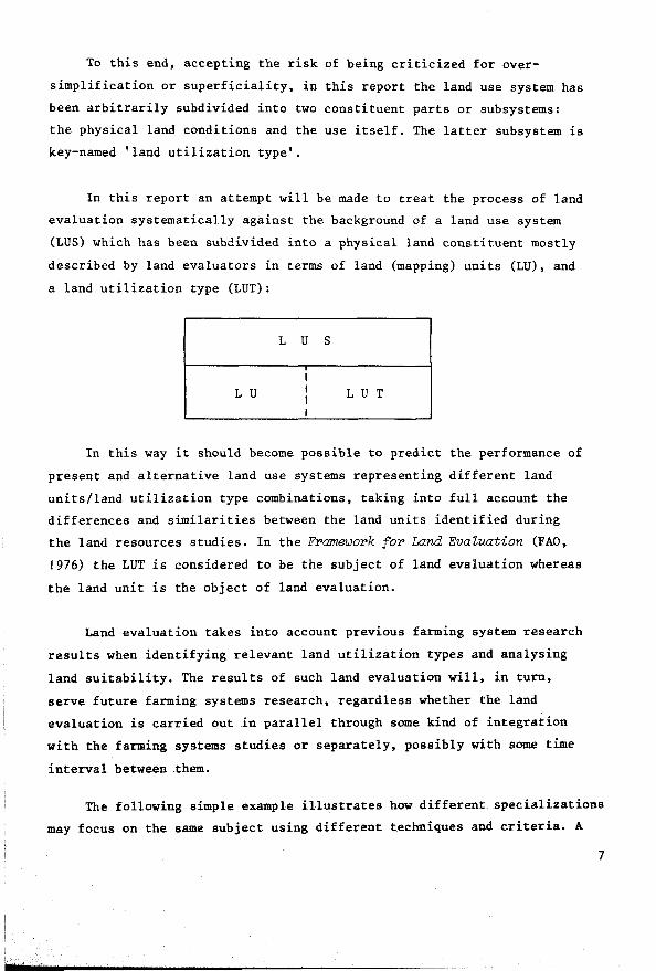
To this end, accepting the risk of being criticized for over
simplification or superficiality, in this report the land use system has
been arbitrarily subdivided into two constituent parts or subsystems:
the physical land conditions and the use itself. The latter subsystem is
key-named 'land utilization type'.
In this report an attempt will be made to treat the process of land
evaluation systematically against the background of a land use system
(LUS) which has been subdivided into a physical land constituent mostly
described by land evaluators in terms of land (mapping) units (LU), and
a land utilization type (LUT):
L U S
L U L U T
In this way it should become possible to predict the performance of
present and alternative land use systems representing different land
units/land utilization type combinations, taking into full account the
differences and similarities between the land units identified during
the land resources studies. In the Framework for Land Evatuation (FAO,
1976) the LUT is considered to be the subject of land evaluation whereas
the land unit is the object of land evaluation.
Land evaluation takes into account previous farming system research
results when identifying relevant land utilization types and analysing
land suitability. The results of such land evaluation will, in turn,
serve f uture farming systems research, regardless whether the land
evaluation is carried out in parallel through some kind of integration
with the farming systems studies or separately, possibly with some time
interval between them.
The following simple example illustrates how different specializations
may focus on the same subject using different techniques and criteria. A
7
house will be looked at, classified and evaluated differently by: an
architect; a person who intends to buy it for his home; a prospective
investor; or by a municipal tax evaluator. All look at the same house
from a different viewpoint with different classification criteria,
because it serves a different purpose for each of them. In the same way,
land is looked at by specialists from different disciplines involved in
land use planning.
2.1. l Who perf orms: the land or the use?
The terms soil performance and land performance are frequently used
in soil survey and land evaluation reports. As already mentioned, the
Framework for Land EvaZuation (FAO, 1976) defines land evaluation as 'the
process of assessment of land performance'. But there is remarkable
confusion in the literature as regards who performs: the land, the erop,
or the farmer. The solution to this paradox depends on the discipline of
the specialist who is studying the problem: soil scientists will tend to
attribute performance ability to a soil/land unit, while others, such as
biologists and agronomists, are more likely to regard the soil as a
medium affecting the crop's performance. A.A. Bishop suggested during a
seminar at CIAT, Cali, Colombia (Bornemisza and Alvarado, Eds, 1974)
that water management is more important than soil management, since all
manipulations for optimizing the environment conditioning erop performance
are ultimately concerned with the management of the liquid phase or, in
other words, with water management. Conflicts also exist concerning the
use of terms such as 'soil' potential or 'land' potential that do not
connect the soil or land with a specific use.
In this report, the term 'performance' will be used in connection
with expressions of inputs, outputs and other effects resulting from a
specific LUT, LU combination. It bas been decided that the performance
of LUT and LU should not be assessed separately, but in a specific
combination. This permits easy extrapolation to the performance of a
land use system or farming system.
8
2.1.2 The need for land utilization types
There are several reasons for paying attention to land utilization
types in land evaluation.
In the first place, the users of land evaluation data demand more·
precise information about land behaviour and land use performance. Land
use planners want to include land evaluation results in their development
plans, either very broadly or through precise optimizations, depending
on the scale and purpose of their planning. This means that not only are
qualitative expressions of land suitability needed;quantifiable assessments
of inputs, outputs and other effects are also required. Such information
can only be provided in conjunction with specific land utilization types.
A second reason for paying more attention to land utilization types
is that land use planners increasingly face the problem of having to
reconcile a multitude of social, technica! and environmental criteria and
constraints. In such cases, land evaluation can be of some help because
alternative solutions for land use problems can be considered. These al
ternative solutions may comprise a variety of technica! possibilities,
which will often represent alternative types of land utilization. Depending
on the situation, such alternative types may be closely related (e.g.
alternative types of irrigated farming), or they may be as far apart as
urban development, recreation and horticulture.
There is a third reason: in the past, different land classification
systems were created for different types of land use for example, the
USBR Land Classif ication System for Irrigated Land Use and the USDA
Land Capability System for Rainfed Conditions. One of the aims of today's
land evaluation is to provide land use planners with information based
on a methodology that uses the same concepts and procedures f or any
kind of land use so that comparisons and cross ref erences are facilitated
(FAO, 1976). Such a methodology is best served by a systematic approach
to the kinds of land use considered, and of explicit mention of the
assumptions that have led to their selection.
9
Only by precisely defining the land utilization types will it be
possible to determine what are the specif ic requirements of land utiliza
t ion that the land must meet, and how far the land that is being evaluated
will meet these requirements. Often, land utilization types will have
sufficient flexibility to adapt the land to their requirements through
the application of inputs, e.g. of irrigation water to meet the water
requirements, of fertilizers to meet the nutrient requirements, or of
drainage measures to meet the aeration requirements in the rooting
zone. Land evaluation should take into account the responsiveness of the
land to the application of such inputs. A very common error with the
application of the USDA Land Capability System in developing countries
in Latin America has been the assumption, based on USDA practice, that
all farmers will be able to use fertilizers. This assumption underestimates
the limitation of soil fertility (often the most limiting soil factor in
tropical countries) because the prevailing land use is quite different
as it corrresponds to farmers who cannot afford or cannot take the risk
of buying fertilizers, or live where fertilizer cannot be bought at
competitive prices.
To sum up: land use performance and land suitability depend on
intimate relationships between the land and the use. Therefore land
evaluation should always take into account specific land utilization
types, with specific land requirements. Noting the rapidly increasing
number of land use systems and the enormous variety among them in their
land requirements and in their abilities to manage, improve and conserve
the land, the land utilization type itself should be an explicit subject
of study and reporting in land evaluation.
2.2 Classification of agricultural land use
Do satisfactory procedures already exist, or should land evaluation
develop suitable methods for identifying and describing land utilization
types?
JO
The literature on land use classification is very extensive, not
only as regards local environments, but also for regional and worldwide
conditions. But each source follows different rules and criteria according
to the author's specialization and interest. Land use classifications
have been presented in such varied fields as agronomy, agricultural
statistics, geography and development planning. Now land evaluation is
deliberately added to this list: during the FAO Expert Consultation of
Land Evaluation in Wageningen (Brinkman and Smyth, Eds, 1973, p.9) it
was recommended that:
Agricultural and other rural land utilization types (including new types actively contemplated for the near future) be further examined and defined at different levels of generalization, by specialists and interdisciplinary working groups.
A broad classification of rural land utilization types was presented
to the meeting (Beek, in FAO, 1974a) complemented by suggestions for further
disaggregation and adjustment, emphasizing key attributes (Sect.2.3.2).
2.2. I Literature review ofland use classifications
The following review is necessarily selective and illustrative rather
than exhaustive in discussing differences and similarities between land
evaluation and other disciplines interested in land use characterization,
in particular geography and agronomy. Because of the enormous variation
in the ecological, socio-economie and cultural conditions, land use can
be of many different types. Basically, each type represents a unique
combination of the production factors land, labour, capita! and management
capacity in conjunction with a specific product, just like any other
industry designed by man to satisfy his needs. According to Duckham and
Masefield (1970):
land utilization represents a judicious balance between the ecological potential, the operational potential, the input potential and level and the demand for its produce.
Il
Land use classif ication has primarily been the concern of geographers
responsible for studying the spatial variation of agriculture and for
preparing present land use maps. Their emphasis varies according to
specialization: physical geographers emphasize the importance of landforms,
soils and climate on their land use classification. Human geographers
stress the importance of population, location, markets, socio-economie
development stage, farmers' motives and other related social and economie
variables (FAO, 1965).
The geographer's task is primarily descriptive. But today he is
increasingly concerned with analysing present land use systems on their
development potential and with understanding the complex combination of
factors involved in the transformation of traditional land uses (Kostro
wicki, 1974; Kleinpenning, 1968; Gregor, 1970).
When formulating land use types, agronomists attempt to combine
physical and socio-economie conditions 'to satisfy market demand with
the maximum profit or domestic or social satisfaction' (Duckham and
Masefield, 1970, p.3). Agronomists often refer to production systems,
enterprises, farming systems (Lebeau, 1969; Duckham and Masefield, 1970;
Ruthenberg, 1976) and agricultural systems (Grigg, 1974; Dalton, Ed., 1975;
Westphal, 1975).
The agricultural typology of the International
Geographical Union (IGU)
There is still no recognized international land use classif ication.
The Commission on Agricultural Typology of the IGU has, however, prepared
a provisional typology of world agriculture based on 22 diagnostic
variables, each subdivided into a number of classes, mostly five, by
distinguishing critical threshold values for each variable (Kostrowicki,
1974; see Table 2.1).
12
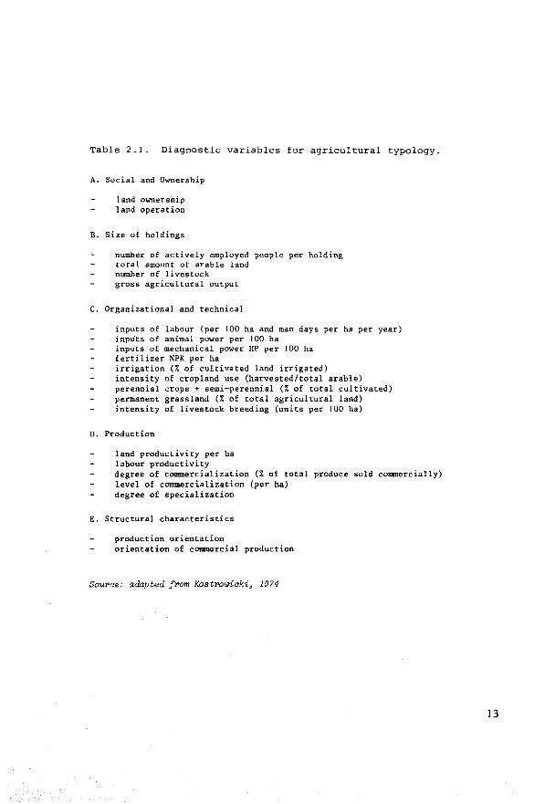
Table 2.1. Diagnostic variables for agricultural typology.
A. Social and Ownership
land ownership land operation
B. Size of holdings
number of actively employed people per holding total amount of arable land number of livestock gross agricultural output
C. Organizational and technica!
inputs of labour (per 100 ha and man days per ha per year) inputs of anima! power per 100 ha inputs of mechanica! power HP per 100 ha fertilizer NPK per ha irrigation (% of cultivated land irrigated) intensity of cropland use (harvested/total arable) perennial crops + semi-perennial (% of total cultivated) permanent grassland (% of total agricultural land) intensity of livestock breeding (units per 100 ha)
D. Production
land productivity per ha labour productivity degree of cODDDercialization (% of total produce sold col!Dllercially) level of commercialization (per ha) degree of specialization
E. Structural characteristics
production orientation orientation of commercial production
Sourae: adapted from Kostrowiaki, 1974
13
According to Kostrowicki (1974, p.2) the purpose of the IGU typology,
like any classification is to
organize our knowledge of the objects under study in such a way that their properties may be best remembered and their relationships more easily understood.
The final goal of the typology is the preparation of a world map of
agriculture. To what extent can such a typology be used to explain
relationships that exist between the type of agriculture and the land
conditions? Kostrowicki (1974) recognizes the ad hoc value of the typology
but says that
the first studies of IGU on dynamics of spatial organization of agriculture, both for the past and for the future, including the progress and progranmes of its future changes have been initiated.
However, the IGU typology of world agriculture is primarily a
framework for the indication of differences and similarities in space,
not in time. It is expected to influence the structuring of agricultural
statistics and more detailed agricultural typologies. Kostrowicki (1974,
pp.4-5) believes that a type of agriculture should be:
14
a more or less established form of erop growing and/or livestock breeding for production purposes characterized by a definite set or association of its internal characteristics, developed and shaped by specific.historical processes in given external and other conditions;
a supreme concept in agricultural classification embracing all other concepts used in systematic or partial typologies (such as breeding, farming systems etc.);
a hierarchical concept encompassing types of various orders, from types of world agriculture through severa.l intermediate orders, down to the lowest order identified by grouping individual agricultural holdings;
a dynamic notion changing in an evolutionary or revolutionary way along with a change of its basic characteristics.
It seems questionable if the four criteria can be met by the sa.me
typology.
The characteristics defining the agricultural type have been limited
to its internal characteristics. The use of external variables, such as
the physical environment, location, transportation, market conditions,
prices, supply and demand of agricultural products, are, according to
Kostrowicki, both dangerous and unfruitful because such factors should
'pre-suppose rather than prove their influence on the formation of
agricultural types'. He nevertheless recognizes the importance of the
external conditions in the formation of agricultural types and the need
to study them in combination with existing agriculture for planning more
rational types of agriculture and their spatial organization, which is
also the ultimate goal of land evaluation.
The diff erences in purpose and therefore in the descriptions of
agricultural types and land utilization types will now be clear:
The IGU typology selects and describes diagnostic land use charac
teristics for the purpose of preparing a present land use classification
with a map that shows the spatial variation of present land use. The
influence of the physical land conditions on the formation of the agri
cul tural type and its performance is not considered. Therefore the
definitions of the agricultural types are not functional in the sense
that the relationships between land and land utilization can be easily
deduced. The key attributes have not been selected and rated for explicit
recognition of the abilities of the agricultural type to manage, conserve
or improve the land, nor for an easy recognition of its land requirements.
Land evaluation needs more functional descriptions to suit its purpose:
the prediction of land use performance on the basis of a critica! comparison
of land requirements and land use abilities with the land conditions.
Nevertheless the geographers' description of present land use provides a
necessary ref erence for the process of identifying and describing alter
native land utilization types for development.
15

Farrning Systems
An important contribution to the global understanding of agricultural
land use has been made by Duckham and Masefield (1970). Their concept of
farming systems, like the IGU types of agriculture, departs from the
individual holding as the unit of classification. Duckham and Masefield
however represent the dynamic approach of the agronomist rather than the
more statie one of the geographer, and establish therefore a closer
contact with land evaluation.
They attempt, especially for temperate countries, to
systematize the analyses and syntheses of the many variables influencing the location, input intensity and food out-put of farming systems and to submit models thereof which are actually or potentially quantifiable.
The work represents a textbook on comparative agriculture that is
usefully complemented by Ruthenberg (1976) who describes farming systems
in the tropics.
Duckham and Masefield's main argument coincides with the approach
to land evaluation followed in this report: the nature, location and
intensity of land utilization are the product of the interactions between
and within three groups of factors: ecological; operational; socio-economie.
Duckham and Masefield (1970, p.xi) state that
16
as yet, in many cases neither the relative importance of, nor the size of the interactions between individual factors or groups of factors can be quantified, but that nevertheless one can usually identify the critica! factors or interactions in any area and offer tentative models of the major interactio~s; and that the simplest and most convincing way of illustrating the influence of singl.~factors or of groups of factors, is to hold as many of the others as possible constant.

They decide on two major variables to classify the world's farming
systems: the intensity of farming and the 'farming land use'.
Farming intensity means the actual sum of inputs, other than natural/
ecological factors, which has been (admittedly arbitrarily) subdivided
into: very extensive; extensive; semi-intensive; and intensive.
'Farming land use' distinguishes between:
tree crops
tillage: ~ 75% of the ploughable land is in tillage crops or one-year fallow
alternating: 25-75% of the ploughable land is in tillage which is alternated with grassland (mostly temporary leys) or with long-term fallow or forest regeneration
grazing or grassland: (pastures and ruminant livestock): ~ 75% of the ploughable land is in temporary leys or permanent pastures. Land that cannot be ploughed is in cultivated grassland or grazeable shrub, scrub or natura! grasses
Livestock occurs in all systems, but land use on grassland systems
is usually confined to ruminants (cattle and sheep).
The classif ication also distinguishes between temperate and tropical
systems.
Table 2.2 shows examples of 29 different combinations of the
chosen criteria.
17

00
Table 2.2 Classification of Farming Systems
Duckham & Masefield farm.land
Tree crops
use
Farming intensity
Tempera te
Very COrk collection Extensive ffom Maquis in Examples southern Fr.&nce
Extensive Sctlf-sown or !xamplea planted blue
berriea in the north-east of the U.S.A.
SemiInten•ive Examplea
lntensive Examples
Typical Food Chains
Cider apple orchards in the U.K. Some vineyards in France
Citrua in California o't Israel
A
tropical
Collect ion from wild treeal e.g. shea butter
Self-sovn oil palms in West Africa
Cocoa in West Africa. Coffee in Brazil
Rubber in S.E. A.sia. Tea in India and Ceylon
A
Til lage with or without livestock
Tempera te Tropical
Cereal growing Unirrigated in Interior cereals in Plaina of central N.America, Sudan pam.pas of S.America, in unirrigated areas 7 e.g. Syr ia
Dry cereal farming in lsrael or Texas, USA
Corn Belt of the U.S.A. Continuous bar ley growing in the U.K.
A, B
Co1ltinuous cropping in congested areas of Africa. Rice in S.E. Asia
Rice and vegetable growing in south China. Sugar-cane plantations throughout tropics
A
Alternating Grassland or Crazing tillage with grass, bush or forest of land consiatently in 'indi-
Tempera te
Shifting cultivation in Negev ~s.ert, tsrae.l
Cotton or tobacco with livestock in soutb-east of the U.S.A. Wheat with 1 eys and sheep in Australia
lrrigated rice and gTaas beef farms in Australia. Much of the east and south of the U.K., the Netherlandst northern France, Denmark. southern Sweden
A, B, C, D
Tropical
Shifting cultivation in Zambia
Shifting cultivation in the more arid parts of Africa
Shifting cultivation in much of tropical Africa
Experiment stations and scattered settlement schemes
A (C)
genous 1 or man-made pasture
Temperate
Reindeer herding in Lapland. Nomadic putoral ism in Afghanistan
Wool-growing in Australia. Hill sheep in the U.K. (Sheep in Iceland) Cattle ranching in the U.S.A.
Upland aheep country in North Island, New Zealand
Parts of the Netherlands, New Zealand and Eng land
c (D)
Tropical
Camel herding in Arabia and Somalia
Nomadic cattleherding in East and West Africa. Llamas in South America
Catt le and buffaloes in mixed farming in India and Africa
Dairying in Kenya and Rhodesia high lands
Sourae: A.N. J)uakham and G.B. Masefield, 1970, Faming Systems of the WorUi, Chatto and Win.du.s, London, p.106.
See te.st for ezp lariation

In connection with these four kinds of 'farming land use', Duckham
and Masef ield present an interesting classification of typical food
chains which is relevant to land evaluation as well. Each food chain
represents a different input-output efficiency and has a different
protein production capacity:
Foodchain
A. tillage crops/man
B. tillage crops/livestock/man
C. grassland/ruminants/man
D. tillage crops and grassland/ruminants/man
Duckham and Masefield list a number of criteria that should be
met by a 'biologically efficient food producing system'. Some criteria
are directly related to the production of the farming system ('nature
proposes, man disposes'): maximize plant growth and minimize plant and
animal wastages 'on farm'; optimize input ratios of energy in skill,
man work, animal work, fossil fuel and scientific and industrial inputs.
Other criteria are related to 'off-farm conditions': supply of sufficient
calories to feed the population, adequate storage and distribution and
processing facilities with minimum wastages 'off-farm'. All requirements
have been further elaborated into a simple energy model.
Finally there are a number of non-energetic criteria to be met
related to the continuity of the system; the system should be
reliable between and within years, months and weeks
persistent over decades (and centuries)
be capable of reduction, expansion or adjustment to meet changes in demand
Duckham and Masefield also pay attention to the process of synthesis
(Fig.2.1) and comparative analysis of farming systems, covering several
aspects of the process which in the land evaluation procedure has been
named 'matching' (see Section 5.4.2).
19
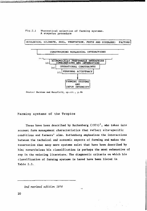
Fig.2.1 Theoretica! selection of farming systems. A stepwise procedure
l ECOLOGICAL (CLIMATE, SOIL, VEGETATION, PESTS AND DISEASES) FACTORS!
CONSTRAINING ECOLOGICAL INTERACTIONS
\~'--~~~~~~~~~~~~~~~~~~~~-' ECONOMICALLY PREFERABLE ENTERPRISE
(d) COMBINATIONS AND INTENSITIES OPERATIONAL CONSTRAINTS
(el,__~~~~~~~~~~~~--' (f) PERSONAL ACCEPTANCE
FARMING SYSTEMS AND
INPUT INTENSITY
Source: Duckham and Masefield, op.cit., p.96
Farming systems of the Tropics
These have been described by Ruthenberg (1971) 1 , wbo takes into
account farm management characteristics that reflect site-specific
conditions and farmers' aims. Ruthenberg emphasizes the interactions
between the technical and economie aspects of farming and makes the
reservation that many more systems exist that have been described by
him; nevertheless bis classification is perhaps the most exhaustive of
any in the existing literature. The diagnostic criteria on which bis
classification of farming systems is based have been listed in
Table 2.3.
2nd ~eviaed edition 1976
20
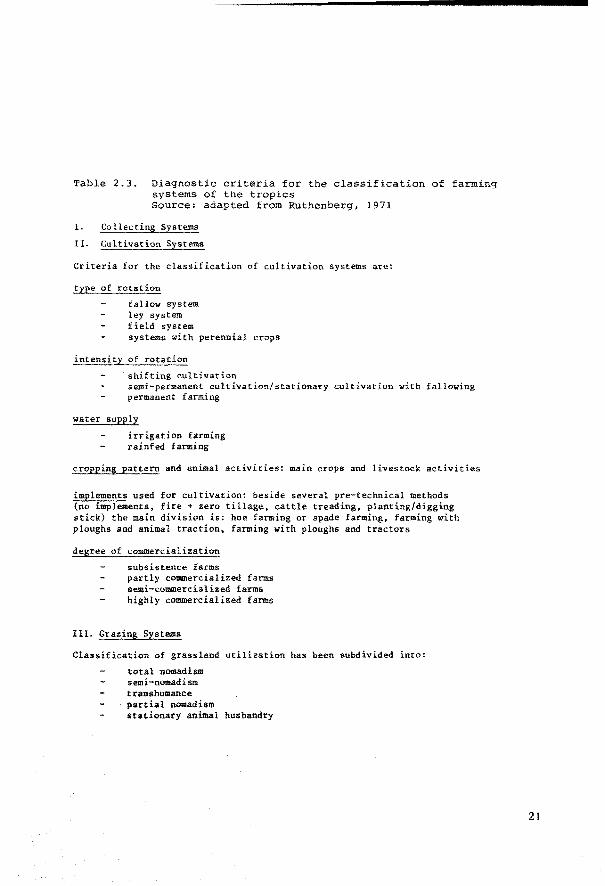
Table 2.3. Diagnostic criteria for the classification of farming systems of the tropics Source: adapted from Ruthenberg, 1971
1.
Il. Cultivation Systems
Criteria for the classification of cultivation systems are:
type of rotation
fallow system ley system field system systems with perennial crops
intensity of rotation
shif ting cultivation semi-permanent cultivation/stationary cultivation with fallowing permanent f arming
water supply
irrigation farming rainfed farming
cropping pattern and animal activities: main crops and livestock activities
implements used for cultivation: beside several pre-technical methods (no implements, fire + zero tillage, cattle treading, planting/digging stick) the main division is: hoe farming or spade farming, farming with ploughs and animal traction, farming with ploughs and tractors
degree of commercialization
subsistence farms partly commercialized farms ae111i-commercialized farms highly commercialized farms
III. Grazing Systems
Classification of grassland utilization has been subdivided into:
total nomadism semi-nomadism transhumance partial nomadism stationary animal husbandry
21
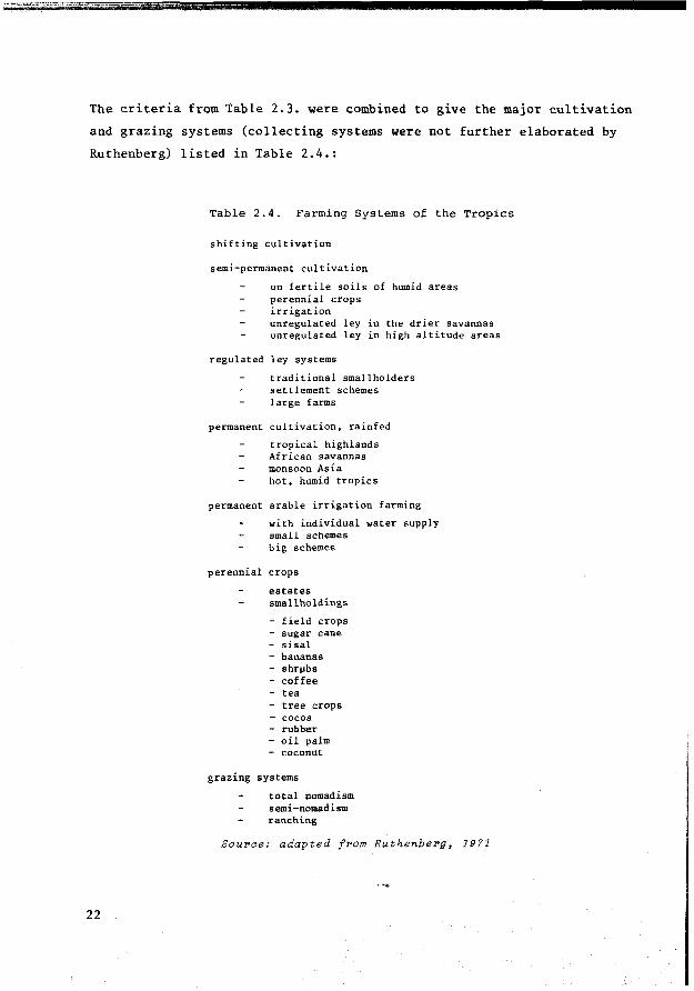
The criteria from Table 2.3. were combined to give the major cultivation
and grazing systems (collecting systems were not further elaborated by
Ruthenberg) listed in Table 2.4.:
22
Table 2.4. Farming Systems of the Tropics
shifting cultivation
semi-permanent cultivation
on fertile soils of humid areas perennial crops irrigation unregulated ley in the drier savannas unregulated ley in high altitude areas
regulated ley systems
traditional smallholders settlement schemes large farms
permanent cultivation, rainfed
tropical highlands African savannas monsoon Asia hot, humid tropics
permanent arable irrigation farming
with individual water supply small schemes big scheines
perennial crops
estates sinallholdings
- field crops - sugar cane - sisal - bananas - shrµbs - coffee - tea - tree crops - cocoa - rubber - oil palm - coconut
grazing systems
total nomadism semi-nomadism ranching
Souroe: adapted from Ruthenberg, 1971
Ruthenberg departs from the farm as a unit on which the various activities
are functionally related to each other by the common employment of labour,
land, capita! and management. His farming systems cover the overall manage
ment characteristics of a farm. Duckham and Masefield mention the possibil
ity that a farm may consist of one or more farming systems; their concept
ref ers primarily to production systems or enterprises of which several can
be combined. In Section 3.4 of this report it will be explained that land
utilization types sometimes are complementary options for the same farm unit:
'multiple' or 'compound' land utilization types, to be distinguished from
'single' land utilization types. A land utilization type defined in great
detail and combined with a specific land unit results in a land use system
that is very similar to the farming system concept used by agronomists.
Agricultural 'systems'
In recent years, possible ways have been explored of studying whole
agricultural systems, taking into account their multi-disciplinary
nature and dynamic character, using a 'systems approach' (Dalton, Ed.,
1975). The systems approach represents a methodology developed during
the last ten years for describing and predicting the functioning of
complex physical entities taking good notice of their internal structure
and the cause-effect relations between the elements that are part of it.
Also the relations between the system that is being examined and other
systems in its environment are taken into account. Simulation and optimiza
tion with mathematica! models are characteristic techniques of the systems
approach, which was developed originally for solving complex multi-discipli
nary problems to do with engineering (Forrester, 1968; Toebes, 1975).
A summary of the state of the art in agricultural systems analysis is given
by Van Dyne and Abramsky in Dalton, Ed., (1975) who discuss about one
hundred such studies. The importance of studying whole agricultural systems
is receiving international recognition, especially in connection with
the development problems of low income farmers in developing countries.
The dynamic aspects are treated more satisfactorily than in the more statie
and descriptive approaches already discussed, which have been adopted by
geographers and agronomists.
23
However, the systems approach so far has produced mainly experimental
results, useful for further refinement of methodology, and for the solution
of site-specific problems, Van Dyne and Abramsky (in Dalton, Ed., 1975)
conclude that 'there is an almost complete lack of treatment of spatial
problems in simulation models; but spatial problems are handled in a number
of linear programming models'. It seems that practical land evaluation
should not expect agricultural systems research soon to provide a ready
made classification or methodology for identifying, describing and classi
fying the most relevant agricultural land use options for varying physical
land conditions. Systems theory does provide valuable ideas for the syste
matic disaggregation of agricultural systems, significant for the solution
of the questions that need to be answered during land evaluation. For prac
tical purposes, land evaluation will, in the near future, be expected to
make the definition of relevant land utilization types a part of its
routine procedure. If agricultural systems analysis has been carried out
already in the area where the land evaluation takes place, its results
should provide an important reference. On the other hand, future agri
cultural systems analyses will benefit from land evaluations that have been
carried out in the knowledge of the concepts and procedures of a systems
approach, since both aim ultimately at the planning and realization of opti
ma! land use. For that reason, the prospects for a systems approach to land
evaluation have been discussed in Chapter 5 of this report.
The methods proposed in the next chapters can be implemented by the
usual land evaluation teams, with consultant services of visiting agri
cultural economists and agronomists (Luning, 1973; de Jong, 1976, 1977).
2.3 The characteristics that the definition of a land utilization type should contain
The characterization of land utilization types may include a variety
of factors according to the detail and purpose of the land evaluation
study. This section deals only with the most fundamental characteristics
that have a marked influence on the performance of the land use and
24
which, for their significant role, have been named 'key attributes'.
Leading questions, when selecting key attributes to form relevant land
utilization types, are:
are the key attributes relevant and sufficiently mutually exclusive in their influence on land use performance?
can each key attribute be graded in a practical way, distinguishing groups/levels/threshold values that are relevant for the purpose of land evaluation?
will the key attributes recognized permit identif ication of the land requirements and of the land management, improvement and conservation abilities of the land utilization type pertinent for systematic interpretation of the land resources data?
2. 3.1 Who defines land utilization types? and when?
Often land evaluation serves a specific purpose, this having been
broadly defined by the interested party who requested the study. Examples
are land evaluation studies for the establishment of family farms in new
areas, land evaluation for milk production or for the establishment of
quick-growing tree species for pulp production. It will depend on who
specifies the requirements of the land evaluation study, as to which key
attributes are stressed, which key attributes receive only casual
mention and which are not mentioned at all. The future land user is more
interested in economie results, the government more in political results,
than how these results are obtained. The key attribute 'produce' is
named: pulp wood, or milk, but not which trees, which animals or which
pasture grasses.
The definitions of land utilization types formulated by the commission
ing authority of the land evaluation study may not be sufficiently compre
hensive for all their land requirements and land management, improvement
and conservation abilities to be identified.
25
Most existing land evaluation procedures somehow take into considera
tion broad types of land use, specific management practices, or even speci
f ic crops or species: land classification for irrigated agriculture, for
arable crops, tree crops, pastures, horticulture, pine plantations, coffee,
etc. However, in land evaluation reports it is rare to find systematic list
ings of all the assumptions made concerning the technical, economie and so
cial aspects of the envisaged types of land use. The omission of land uti
lization assumptions may result in considerable confusion and difficulties
with re-interpretation when assumptions change with time or become invalid.
So far, mention bas only been made of land utilization types that
are defined at the beginning of land evaluation to supply the user with
an explicit list of the land use assumptions and to provide the land
evaluator with the necessary references for identifying land requirements
and land management, improvement and conservation abilities. Later it
will be pointed out that these definitions in the course of land evaluation
may be subjected to modifications and adjustments in the light of land
evaluation results.
2.3.2 Key attributes ofland utilization types
Produce is the most diversified and important key attribute. It
determines to a great extent the essence of the other key attributes and
of the ecological land requirements. Not only primary biological production
is included (crops, pastures, forests), hut also secondary produce (live
stock, wildlife) as well as other produce resulting from land use, such
as the leisure and satisfaction obtained from recreation, the satisfaction
from being a private farmer, and the produce resulting from specific en
vironmental protection schemes.
The description of produce should be as precise as possible, even
in a small-scale land evaluation: natural pastures or cultivated pastures,
annual crops or perennial crops, natural forest or cultivated forest for
26

timber production or pulp. Further subdivisions can be made into single
crops, groups of crops or rotations of crops which in the context of
land evaluation have the same land requirements. When mixed cropping or
rotational cropping represent an integrated production system, land eva-
1 uation should be undertaken for the produce combination, e.g. rotational
strip cropping of cultivated pastures with annual fieldcrops (in the undul
ating Pampa of Argentina), and the double cropping of wheat and soya beans
(in South Brazil).
Labour is a key attribute closely connected with the level of
applied capital and technology and the labour requirements of the produce.
Land may differ in its response to labour inputs. Manual labour mostly pre
f ers the more easily worked 'light' textured sandy soils for cultivation,
rather than the 'heavy' clay soils. Soils may also vary in their response
to labour inputs for certain tillage operations such as weeding, due to
differences in moisture and soil fertility. Land units may respond
differently to seasonal fluctuations and this may result not only in
different overall labour requirements but also in a different distribution
of labour through the seasons and different labour peaks. Furthermore,
land may differ in its response to labour inputs for land improvement
and conservation (Strauss, 1969).
Besides labour intensity, other aspects such as labour productivity,
labour absorption and labour substitution are important variables in
land use planning. Therefore labour will usually be an important key
attribute when constructing alternative land utilization types for land
evaluation.
CapitaZ. Technically it may be possible to condition virtually any
site to satisfy a particular requirement of a land utilization type.
However, the extent to which land conditioning occurs depends in practice
on: inherent characteristics of the land conditions; the cost of modifying
them in relation to the value of the desired product; and the availability
of private and public capita!.
27
Capital intensity determines the range of possibilities for applying
technology for management, improvement and conservation of the land re
sources. A distinction is usually made between non-recurrent capital (e.g.
for major land improvements, but also for important farm buildings and
structures) and recurrent capital, required for the year to year manipula
tion of the land conditions (e.g. for fertilizers, fuel, maintenance of
irrigation and drainage structures).
Depending on the local situation, several levels of capital intensity
may be distinguished. Camargo et al. (1975) distinguish 3 levels for recon
naissance-scale land evaluation in Brazil; low, medium, and high, in rela
tion to rainfed erop production. Ma.hler (1967) recognizes five levels in
Iran for land utilization types which, on the capital intensive side, inclu
de irrigated farming, and on the capital extensive side, dry farming.
Management is a complex attribute usually expressed as 'management
level' which needs constant consideration when defining land utilization
types. It is closely related to capital intensity and technology, but
also to the produce, the scale of operations and the labour intensity.
It is perhaps the most difficult attribute to be handled as a variable.
The cooperation of sociologists and farm economists will often be required.
Management is responsible for the allocation of production factors and
the timing of their applications, makes decisions within the range of
possibilities provided by the other key attributes, and is thus to a
great measure responsible for the realization of the potential productivity
of the land indicated by the land suitability classification. Differences
in management competence are found in all social strata and societies.
In land evaluation it should be recognized that land may vary in its
claim on management skill, because of different degrees of risk and
uncertainty and different degrees of complexity in the solution of land
use problems. This variation in land conditions may affect the management
still required, for instance in the choice of crops, the timing of the
operations and the kind and amount of inputs to be applied.
Apart from individual diff erences between farmers wbich are beyond
28
the scope of land evaluation it will often be possible to distinguish
more than one management level relevant to the area under study.
In less advanced stages of development, farmers' attitudes and
preferences, (or religious beliefs), can greatly influence the actual
results of potentially promising land and water development schemes and
special attention must be given to these aspects.
Teahnology is a key attribute complementing the production factors
capital and labour. For the purpose of land evaluation it is preferable
to point out feasible land management and improvement practices, or at
least a range of key techniques and corresponding inputs, because of
their great influence on the land suitability classification.
Beek et al. (1964) in Brazil paid special attention to the source
of farm power and accompanying sets of implements as a diagnostic key
attribute for the definition of land utilization types, at the time named
'management systems'. Another aspect of technology that is closely
related to the assessment of land suitability is the intensity of chemical
fertilizer use. Kostrowicki (1974) in bis typology of world agriculture
distinguishes the following levels (in kg) of pure content NPK per hectare
of cultivated land: 0-10-30-80-200 and more. Camargo et al. (1975) distin
guish three levels in US dollar values of fertilizer applied in Brazil: no
fertilizers; less than $ 50 US; and more than $ 50 US (1966 prices). The
amount of fertilizer that can be bought for US $ 50 may vary substantially
from one part of the country to another.
The source of farm power can be (Beek & Bennema, 1972):
four-wheel and crawler tractors two-wheel and one-wheel power operated animal power hand power
A special aspect of technology in the def initions of land utilization
types is the major improvements of the land conditions or 'key improvements',
29
requiring specif ic practices for their use and maintenance and a certain
response from the land to become feasible. Examples are: drainage (if
needed specified according to type: gravity or pumping, surface or sub
surface), irrigation (e.g. by system: flood, border, furrow, sprinkler,
drip), terracing. Such improvements modify the overall focus of land
utilization. Land evaluation for development projects will often be
concerned with comparing land utilization types with and without such
major improvements, and therefore such improvements should be specifically
mentioned in the definition of land utilization types.
The seale of operations poses limits to the size of the land area
for which the land evaluation type is relevant. This may be the minimum
size of a parcel of land needed to a certain kind of produce; it may
also be the size of a farm if the produce of the land utilization type
corresponds to the farm produce; occasionally the scale of operations
will be related to a combination of farms when a very large scale of
operations is required, e.g. multi-farm production of sugar cane, rubber,
oil palm.
Sometimes the scale of operations has been established bef orehand
by the planning authorities, or depends entirely on the present scale of
farm operations.
The scale of operations is closely related to most other key attributes.
lts inclusion in the definition stresses the importance of economies of
scale in relation to specific kinds of produce and the indivisibility of
certain kinds of inputs, e.g. refrigerated milk tanks, sugar cane harvesting
machines. These economies of scale can result in specific demands of the
land utilization type regarding the size and shape of parcels, or the
location of irrigation and drainage channels, which in turn may depend
on the soil pattern or existing land consolidation.
Size and shape of parcels and the status of land consolidation and
infrastructure are socio-economie attributes of the land. They may
become objects of survey and evaluation together with the physical land
30
attributes when they are considered limiting for development and their
modification is contemplated; for instance in the Netherlands reallotment
projects ('ruilverkaveling') and in rehabilitation projects of existing
irrigation and drainage systems.
Economies of scale may interf ere in land evaluation in several
ways. For example, in developed countries land evaluation will often be
interested in the minimum scale of operations required because of the
minimum amount of capital and technological inputs applied. But in
developing countries, land evaluation may need to account for a maximum
scale of operations, set by the maximum physical labeur capacity of the
farmer and bis family.
A list of 39 examples of land utilization types characterized by
selected levels of the key attributes: produce, capital, technology and
labour is presented in Table 2.5.
Produce bas been classified into annual crops, semi-annual crops,
perennial crops, natura! grasslands, cultivated grasslands, forestry and
mixed farming (crops with grassland).
Capital has been subdivided into non-recurrent inputs (three levels)
and recurring inputs (three levels).
Technology bas been symbolized by four levels of farmpower: hand,
animal, two-wheel tractor and four-wheel tractor power.
Labour has been subdivided into three levels of intensity.
2.3.3 Key attributes and aggregational levels
Land utilization types can be defined at different levels of detail.
The highest aggregational level corresponds to the smallest scale of land
evaluation. The Framework for Land Eval-uation uses the term 'major kinds
31

Table 2.5. The rating of key attributes for defining land utilization types. Source: Beek (1972), FAO 1974a
p··R 0 D U C ! CAPl'fAL 1 FARM POWER EM!'l.OîMEN'i' FAJlM SlZE
Cl>OFS C:WtNG
ANNIJAL
! 1 .c 1 1- 1 1 1-1 11~1~1~1~1~1 1 ~1"" i! 1 '.i. ] 1 ·~ 1 i J ·.ä l g ~ ] lil ! 1 1 i i ! ~]1 ~
EXAl'IPLES OF LAND UTlLIZAT!ûN TYPES
hand 1.abour
• •
• • "~" • ..-"""" "." ... "" •. _..__. • ....J
no irrU. • •
of land use' for this level, e.g. agriculture, extensive grazing, dry
farming, forestry. The key-words describing these major kinds of land
use summarize a number of interrelated characteristics of land use that
need not always be specifically mentioned, as long as they represent
actual existing combinations of key attributes. But major kinds of land
use that are statistica! averages of types that in practice are highly
disparate (for instance in level of technology and in level of capita!
input, as is the case when speaking of 'agriculture' in developing
countries with dual economies), are not well suited as a base for land
evaluation. In such cases subdivision into more realistic land utilization
types of a lower order of aggregation is necessary. For example, in the
Perspeative Study for Long Te:r>m Agriaultural Development of Brazil
(SUPLAN, 1975) 'agriculture' has been subdivided into three categories
according to the levels of technology: low-medium-high, not only for
the statistica! simulation of product supply and demand projections but
also for the analysis of available and required land resources.
The detail of the definition of a land utilization type is expressed
by the choice and detail of description of the key attributes. Differences
and similarities between land utilization types should be recognizable
not only for types belonging to the same aggregational level, but also
for types of different levels of aggregation.
This can be achieved by describing the key attributes according to
a pre-established hierarchical system of disaggregations for different
levels of detail. For example the key attribute 'produce' could be
broken down as follows:
level biologica! produce
level 2 agricultural crops
level 3 annual crops
level 4 field crops
level 5 maize
level 6 hybrid maize, var. H-131
33
Precise disaggregations of key attributes will sometimes only be
possible at the end of land evaluation, when the land conditions are
well understood. That is why some land evaluation systems such as the
USDA Land Capability System def ine the land use in very broad terms at
the beginning and complement this information later with land use re
commendations the land capability units - which may include suggestions
about the crops and varieties to be grown, the physical inputs to be
applied, the timing of field operations etc.
The use of an hierarchical system in the definition of land utilization
types would improve information flow between land use planning activities
at different levels of generalization. For example, information about
land suitability in connection with subsistence agriculture at the
detailed level, can be incorporated more systematically in a regional or
national development plan.
Whereas rules can be established for the disaggregation of key
attributes, the choice of attributes and of their aggregational levels
for a particular case will remain the responsibility of those who are in
charge of the land evaluation. Sometimes additional key attributes will
enter the definition as detail increases. A definition may combine key
attributes of different aggregational levels. But key attributes that should
be included in the definition are those that have a real influence on the
results of the land evaluation: on the land suitability classification
and on the land management, improvement and conservation recommendations.
Thus to sum up, the definition of a land utilization type should 1
consist of a combjnation of carefully described key attributes, such as:
produce, labour, capital, management, tecbnology and scale of operations.
Because of their close relationships, key attributes are identified
simultaneously and described at the appropriate aggregational level, in
accordance with the purpose and detail of land evaluation.
Key attributes are selected for tbeir marked influence on the land
requirements and therefore on the land suitability which depends on the
land requirements and the land conditions. Descriptions of key attributes
34
should be sufficiently informative for easy identification of the land
requirements. The ecological requirements can normally be deduced directly
from the key attribute 'biological produce'. Other land requirements re
garding management, improvement and conservation may require the transla
tion of key attributes in terms of abilities of the land utilization
type to manage, improve and conserve the land. Therefore description of
the key attributes should also take into account the need for an easy
identification of these land use abilities.
2.4 The process of defining land utilization types
Definition of land utilization types is a synthetic process that
begins with an analysis of fundamental references, and that should
result in an analytical description in terms of key attributes as indicated
in Section 2.3. Fundamental references are the broad fields of information
that need to be selectively studied (see Section 2.4.1).
A convenient intermediate step for the synthesis of the diverse
information contained in the fundamental references is the preparation
of a structured checklist of major and minor determinants of land use.
This checklist is an important part of the land evaluation report. It
provides a background for periodic revision of land evaluation results.
Land use determinants are the first results of this analysis and
serve as building stones for the construction of land utilization type
definitions. In a physical land evaluation, i.e. in which only the physi
cal land conditions are the object of com.parison and evaluation, the land
use determinants embody the fixed constraints and assumptions about land
use in the cla,ssification of land suitability.
In Fig. 2.2 the process of synthesizing land utilization types has
been summarized:
35

S T E P
Data collection and analysis of fundamental ref erences for selection of relevant land utilization types
S T E P 2
Preparation of a struc-~ tured checklist of major ~ and minor determinants of land utilization
STEP 3
Determination of key attributes and presentation of integral def initions of land utilization types
Fig.2.2: The proeess of synthesiziYllJ land utilization types.
Basically this synthesis represents a preliminary form of socio
economic analysis. The scale and purpose of land evaluation and the
availability of a specialist in this type of analysis determine what
degree of quantification will be reached with the land utilization type
definition. Land utilization types, which have been defined beforehand
in the terms of reference of the land evaluation study ('pre-estab
lished' land utilization types) will aften have been selected by a
procedure similar to the one discussed here, but separate from the land
evaluation study.
Fig. 2.3 presents a more detailed diagram of the process of synthesis
of land utilization types. A horizontal braken line divides land in two
parts: the lower corresponds with the physical land conditions and the
upper part with the socio-economie land conditions. In the FAO Framework
for Land Evaluation the terms 'object' and 'subject' of land evaluation
have been applied to distinguish between the role of the physical land
conditions and that of the land utilization type. The braken line in
Fig. 2.3. should represent the divide between the object and subject of
land evaluation. But this line does not represent an absolute limit. If
some non-physical aspect or 'attribute' of land is known to be a variable
of great significance, e.g. the degree of fragmentation of farm land or
36
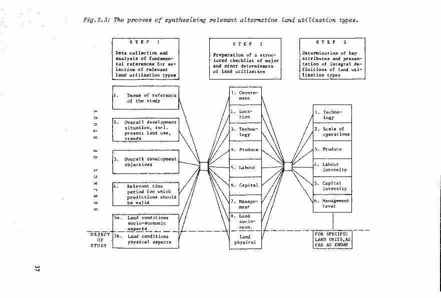
Fig.2.3: The pr>oaess of synthesizing relevant alte!'native Zand utilization types.
>< (:>
::::>
H
"'
r;..
0
.... u
!'1
...,
" :::>
"'
OBJECT OF
STUDY
STEP
Data collection and analysis of fundamental references for selection of relevant land utilization types
1. Terms of reference of the study
2. Overall development situation, incl. present land use, trends
3. Overall development objectives
4. Relevant time per iod for which predictions should be valid
5a. Land conditions soc io-economic
_..!!Peet~ ___
Sb. Land conditions physical aspects
S T E P 2
Preparation of a structured checklist of major and minor determinants of land utilization
1. Govern-ment
2. Loca-tion
3. Techno-logy
4. Produce
6. Capital
7. Manage-ment
8. Land socio-econ.
Land physical
STEP 3
Determination of key attributes and presentation of integral definitions of lsnd utilization types
J. Techno-logy
2. Scale of operations
3. Produce
Labour intensity
Capital intensity
Management level
FOR SPEClFIC LAND UNITS,AS FAR AS KNOWN
the status of the infrastructure, this attribute may well be included as
a variable object for evaluation. Neither should the possibility of an
integrated multi-disciplinary approach to land evaluation, in which both
the land utilization type and the land are object of study be excluded
beforehand. After all, land use planning will most probably process the
physical and socio-economie attributes of the land simultaneously in its
search for optima! land use.
However, this report aims to contribute primarily to physical land
evaluation, because the experience on which it is based sterns from soil
survey interpretation, which includes only physical land/soil conditions
as object of study. References to land suitability classifications that
include socio-economie land attributes have mainly been made to assure
the genera! applicability of the concepts and procedures presented.
2.4. l Fundamental references for identifying land utilization types
No relevant development alternatives should be overlooked when a
first estimate of relevant land utilization types is made. Fundamental
ref erences for the selection and description of land utilization types
are:
38
a) the terms of reference of the land evaluation study
b) overall development objectives and land suitability criteria
c) the overall development situation, in particular present land use, past trends and outlook for the future
d) the time period during which the land evaluation results should be relevant
e) the socio-economie attributes of the land
f) the physical attributes of the land.
a) Terms of reference of the land evaluation study
Sometimes the terms of reference include precise descriptions of
land utilization types: land evaluation for 'pre-established land utiliza
tion types'. Otherwise, a careful analysis of the terms of reference needs
to be made, complemented by criteria derived from the fundamental ref eren
ces b) to e) to assure the relevance of the utilization types considered.
b) Overall development objectives and land suitability criteria
The overall development objectives to which land evaluation is
supposed to contribute are seldom made explicit in the terms of ref erence
for land evaluation. It is mostly seen as the task of planners to assure
that development proposals agree with both immediate and longer-term
development objectivès. This report views land evaluation as an integral
part of systematic land use planning. Development objectives therefore
are regarded as vital for the selection of land utilization types and
also for the establishment of pertinent land suitability criteria. Examples
of land suitability criteria are: optimal input/output relations; maximum
labour absorption at a pre-established mimimum income level; sustained
yields; minimal soil losses from erosion; minimum risk and uncertainty in
meeting a certain income level (USBR, 1967; FAO/IBRD, 1970).
A long-term objective that is receiving a great deal of attention
and which represents an important criterion for every land evaluation is the
need for conservation of the quality of the environment. Land utilization
types will differ in their abilities to conserve the land resource, an
essential element of this. On the other hand, land resources differ in
their capacity to respond to management without showing degradation,
depending on the kind of land utilization.
If_ the relevance of certain land utilization types has to be tested in
conjunction with specif ic environmental impact criteria, it should be
realized that such an impact may be felt either on-site or off-site; in
the latter case interfering with the functioning of other land utilization
39
types. Another important consideration is the accumulated impact that
may result from a full-scale implemention of land use changes on the
area as a whole (see also Section 3.3.3).
If one of the suitability criteria should be that 'no erosion is
allowed to take place' (viz. USDA Land Capability System), land utilization
types that cannot meet this criterion will be irrelevant. In practice
other land suitability criteria related, for instance, to acceptable
input levels for soil conservation measures, may limit the range of
relevant land utilization types even further.
Other major development objectives related to such diverse subjects
as employment, income distribution and health may also affect the choice
of land suitability criteria and land utilization types in different ways.
If the development objectives are included in the selection process
of relevant land utilization types, the persons responsible for land
evaluation will be given an opportunity of adding a certain measure of
social awareness and responsibility to their otherwise essentially
technica! work.
c) overall development situation and present land use
The overall development situation provides the socio-economie,
demographic, legal, institutional and political setting of land evaluation
and represents a valuable yardstick for the kind of development to which
the land evaluation is expected to contribute. The development situation
determines to a great extent the choice of the key attributes of the
land utilization type and the method and procedure of land evaluation.
Important aspects of the development situation are: population pressure,
land/man ratios, land productivity and labour productivity, status of
research, status of infrastructure, price policies, foreign trade, etc.
Present land use and past trends provide important evidence of the
40
development situation in rural areas. lts outlook for the future can
guide the selection of development alternatives. IBRD (1975) includes
the following characteristics in the description of a development situation
for the purpose of providing a context for land reform: land property
concentration; social inequality; economie inequality; land productivity;
labour productivity; level of technology; land tenure; labour intensity;
capital intensity; production orientation (subsistence or market);
supply of land resources (abundant or scarce); presence and degree of
centralization of institutional structures; status of service structure.
The literature on development situations is mostly ·too general or
too much related to a specific area or project to provide a systematic
base for the typology of land utilization; more relevant literature for
this purpose bas already been mentioned in the field of agricultural
geography and farm management (see Section 2.2; Sachs, 1974).
d) Time period during which the land evaluation results should be relevant
The time validity of selected land utilization types and of land eva
luation in general should agree with the purpose of land evaluation. This
may either he specified in the terms of reference or be lef t to the judgment
of the land evaluator. Land utilization changes with time and therefore
needs frequent modification. National and regional plans require reasónably
stable interpretations with a validity of five or ten years, or longer
in the case of long-term planning. Local land use plans usually require
more precisely defined land utilization types including socio-economie
assumptions whose life-span is likely to be shorter (Gonzalez et al., 1977).
e) socio-economie attributes of land
A distinction should be made between the socio-economie and the
physical attributes of land. In most land evaluation studies only the
physical land attributes are the focus of surveys and land evaluation.
41

Socio-economie attributes such as land tenure, location, land value, land
consolidation status and land ownership are the object of other kinds of
studies, e.g. cadastral studies, market studies and farm management studies.
The socio-economie attributes of land represent an important ref erence for
the selection of pertinent land utilization types, and assumptions reg~rd
ing such factors will need to be formulated (Van den Noort, 1975; Feder
and Manger Cats, 1971; Barraclough and Domike, 1966).
f) The physical attributes of land
In land evaluation as understood in this report the physical land
conditions are the main object of study. Therefore their full consideration
will only be possible at the end of the land resources surveys. But some
generalized advance information about the physical land conditions for
an early selection of relevant utilization types is usually available
from existing information, or in the report of a project identif ication
field party. Tbis information should be carefully analysed and if necessary
updated through another field visit. Physical land attributes may include
soil, climate, hydrology, geology, topography, vegetation and fauna.
Seldom will all physical land attributes be the object of study in land
evaluation; for several of them only literature study may be contemplated,
e.g. of hydrology and vegetation in soil survey for unirrigated agriculture.
Whatever fundamental ref erences are consulted one should concentrate
primarily on the collection of site-specific and research tested information.
Sources and quality of the referred data should be mentioned and the
standards of reliability for their adoption stated. In many situations,
however, this information will probably need to be complemented by
information tested elsewhere: knowledge transfer. An interesting qualitative
classification of the nature of knowledge transfer has been suggested by
Keller et al. (1973) who designed a strategy for optimizing research on
agricultural systems involving water management. Their categories are:
42
e:r:pliait PeZationships and formulas available for definite predictions
objeative reasoning based on some data points or a mix of data and theory: simple interpolations and empirical equations
subjeetive reasoning based upon personal knowledge and experience is possible
unknoum: where it is not known if transfer of knowledge is possible
none: where it is known that transfer of knowledge is not possible
Such qualifications can give important evidence of the confidence
limits to be attributed to the land utilization types selected on the
basis of analogy.
2.4.2 Preparation of a structured checklist of major and minor determinants ofland utilization
Synthesis of land utilization types is likely to involve the consid
eration of many data and determina.nts of land use. To ensure that no
important determinants are overlooked, and to summarize all this informa
tion, it will be convenient to prepare a checklist of the determinants
of land utilization types. This list will need to be reproduced in the land
evaluation report: for this purpose a structured list that distinguishes
between major and minor determinants is preferable. Appendix l is an
example of the items to be included in such a checklist, taking into
account eight major determinants, each subdivided into a number of minor
determinants. The major determinants selected are: Government, Location,
Technology, Produce, Labour, Capital, Management, Land (socio-economie
aspects). The physical aspects of land h.av~ not been included because
these are e:xplicitly disèussed in other chapters of this report, although
it is quite obvious that they are land use determinants, otberwise there
would be·no need for land evaluation.
The atructured checklist of major and minor determinants embodies
the justification for the land utilization types selected. It is a
43

picture of ever-changing constraining land use factors and variables at
the time when the land evaluation was executed. It should provide the
necessary background information for a better understanding of the
definitions of land utilization types.
When preparing a checklist of land use determinants it will be
useful to distinguish between the present situation and the situation
that would exist af ter the execution of improvements foreseen by the
development plan or project to which the land evaluation contributes.
Since information about the future development situation is likely to be
very incomplete at the beginning of land evaluation when the checklist
is compiled, revision and adjustment of this checklist and also of the
land utilization types will be required at later stages of land evaluation,
in the light of new information collected.
Land utilization determinants have a specific influence on the
suitability of the land, an influence that may range from very slight to
very strong. They need to be considered when the most promising land
utilization types are being selected. For example: Zand tenure is a
socio-economie attribute of land and appears in the checklist as a minor
determinant of land utilization. It may affect the land suitability
classification tbrough its specific influence on the key attributes
capital application, the kind of technology employed, the labour intensity,
or the management level. If no changes in the land tenure are foreseen
within the time perspective for which the land evaluation should be
valid, the land tenure conditions act as an invariable determinant or
fixed constraint on land use performance. If a future govermnent chooses
land reform as a major policy, this changes the major references on
which the land evaluation is based; as a consequence, the determinants
of the land utilization type change and the key attributes of the land
utilization type will need to be revised accordingly. These changes
provide the starting point for a revision of the land evaluation results
reported originally. Sometimes there will be an opportunity to compare
land suitability with and without the proposed land tenure changes, or
to evaluate the effect on land suitability of other land tenure reform
measures.
44
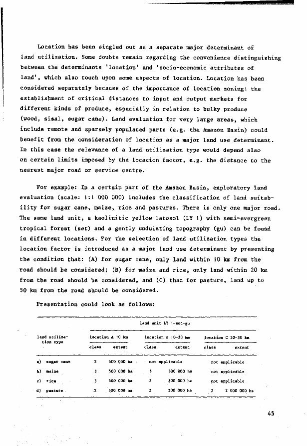
Location has been singled out as a separate major determinant of
land utilization. Some doubts remain regarding the convenience distinguishing
between the determinants 'location' and 'socio-economie attributes of
land', which also touch upon some aspects of location. Location has been
considered separately because of the importance of location zoning: the
establishment of critical distances to input and output markets for
different kinds of produce, especially in relation to bulky produce
(wood, sisal, sugar cane). Land evaluation for very large areas, which
include remote and sparsely populated parts (e.g. the Amazon Basin) could
benefit from the consideration of location as a major land use determinant.
In this case the relevance of a land utilization type would depend also
on certain limits imposed by the location factor, e.g. the distance to the
nearest major road or service centre.
For example: In a certain part of the Amazon Basin, exploratory land
evaluation (scale: 1:1 000 000) includes the classification of land suitab
ility for sugar cane, maize, rice and pastures. There is only one major road.
The same land unit, a kaolinitic yellow latosol (LY l) with semi-evergreen
tropical forest (set) and a gently undulating topography (gu) can be found
in different locations. For the selection of land utilization types the
location factor is introduced as a major land use determinant by presenting
the condition that: (A) for sugar cane, only land within 10 km from the
road should be considered; (B) for maize and rice, only land within 20 km
from the road should be considered, and (C) that for pasture, land up to
50 km from the road should be considered.
Presentation could look as follows:
land utilization type
a) sugar cane
b) maiae
c) rice
d) paature
loc at ion A 10 Jaa
class ex tent
2 500 000 bs
500 000 ha
soo 000 ba
2 500 000 ha
land unit LY 1-set-gu
location B 10-20 km
class ex tent
not applicable
3
3
300 000 ba
300 000 ba
300 000 ba
location C 20-SO km
class ex tent
not applicable
not applicable
not applicable
2 2 000 000 ha
45

In this example, suitability of land units will only be determined for
those land utilization types that meet the criteria put forward by the
land utilization determinants. This will require an overlay on the land
resources map, indicating location zones with a distance of respectively
10 km, 20 km and 50 km from the main roads.
Location as a land attribute: Sometimes location becomes an object
of study in land evaluation e.g. in Japan (Norinsho Norin-Suisan Gijutsu
Kaigi, Ed., 1963). Location is no longer a land utilization determinant,
presented as an overlay on the land resources map, which limits the
choice and relevance of land utilization types. Location is now a land
quality that determines the suitability class, according to the degree
to which location meets the demands of the land utilization type.
Presentation of our previous example from the Amazon Basin would look
as follows:
land units land
utilization LY 1-set-gu, phase A LY t-set-gu, phase B LY J-set-gu, phase c type
class extent class ex tent class ex tent
a) sugar cane 500 000 ha 300 000 ha 4 2 000 000 ha
b) maize 3 500 000 ha 3 300 000 ha 4 2 000 000 ha
c) rice 3 500 000 ha 3 300 000 ba 4 2 000 000 ha
d) pasture 2 500 000 ha 2 300 000 ha 2 2 000 000 ha
This example represents a land evaluation which beside physical
attributes includes other attributes (location) as object of study. It
is no longer a purely physical land evaluation.
This report is based mainly on experience in physical land suitability
classifications in which location is not a variable. For instance, the
exploratory physical land suitability classification of the Amazon
region of Brazil did not include location as a variable. lt was used
46
however for the tracing of the Trans Amazon highway, to include the more
fertile soils. Now that the road has been constructed, a subsequent more
detailed land suitability classification for more precise purposes of
land use planning could include location as a major variable, in accordance
with the example presented.
Another important aspect of location is the distance from irrigation
inlets to drainage outlets, and particularly the gradient, which determine
the possibilities and costs involved for receiving irrigation water and
evacuating drainage water and controlling the groundwater table. However,
this is a physical land attribute that will be discussed further in
Section 3.3 when the need to examine the relationship of a certain LUT
and LU combination in conjunction with its broader environment are
discussed.
47
Appendix 1 : Checklist of major and minor determinants ofland utilization types (an example)
1. GoveP11111ent: existing development plans and targets, such as
projections for scales of operation, land reclamation and consolidation;
labour absorption targets; farm income and labour income targets; production
targets for specific produce; consumption targets of specific produce;
import substitution of specific produce; export targets of specific
produce; environmental control policies (soil conservation, flood control);
financial policies: subsidies, taxation, foreign exchange; status of
governmental services: research, extension, credit, supply of inputs,
output processing, transport, storage, marketing; prices and price
structure of inputs, outputs and trends observed.
2. Loaation: distance between residence and working place (production
distance); distance to input and output markets: railheads, airports,
ports, consumption centres etc. (market distance); critica! distances to
markets, both in terms of physical distance and costs; distance from
service and research centres; distance from labour centres; distance
from education and health facilities; competition from other areas;
urban influences; natural interdependencies with other areas (water supply,
drainage, land degradation); availability and local price deviations of
inputs; means and conditions of transport; status of infrastructure
(roads, harbours, rivers, airports, hazards such as susceptibility to
obstructions such as snow, flooding, landslides, regulations regarding
weight of vehicles, speed limits); relative environmental advantages
compared to other areas (healthy overpopulated mountain areas, as compared
to hot tropical jllllgle where life expectancy is shorter); intermediate
handling cost related to distance from markets (packaging, storage,
transport losses); cost of transportation (Found, 1971).
NOTE: When reportinfJ on major and minor determinants, a sharp distinction shoul,d be made be-tween the present situa1:lon and the aptions for deveZ.opment.
48

3. Teohnotogy: kind of techniques applied (cropping systems, fertilizer
use, milking systems, tillage, harvesting, weeding, animal breeding and
feeding, milk storage); specification of available animal/power traction
and accompanying implements per hectare and per operational unit; supply
of readily available and applicable techniques; scale of operations
required for the application of specific techniques; status and outlook
of research; status of educational facilities; predictive capacity of
climatic and ether environmental hazards; predictive capacity of market
fluctuations and price relationships.
4. Produoe: primary produce (crops, cropping systems, grasses,
natural products); secondary produce (cattle, meat, milk, fish, charcoal,
game, honey, but also the products of recreation, nature conservation
etc.); observed yields and potential yields, yield trends; scale of
operations required in relation to specific produce; availability of
seeds, sperm, breeding animals, planting material; destination of specific
kinds of produce (subsistence, industry, fuel, market, construction,
food, fibre); age and overall condition of present perennial crops and
animals; cattle reproduction rate and life expectancy; phytosanitary/animal
sanitary conditions; overall cattle/land ratio; effective cattle density
(cattle density and duration of pasturing on effectively grazed area of
land); competition from substitute products; export prospects of specific
produce; income elasticity of demand for particular produce and trends;
prices and price structure of outputs and trends; marginal distances of
specif ic produce to input and output markets (in effective length as
well as cost).
5. LaboUP: availability (total; per operational unit, e.g. family,
state farm, cooperative); kind (male, female, child; part-time, full
time; on-farm, off-farm); limits to scale of operations due to labour
availability and distribution; educational level; specialization (e.g.
experience with specific techniques or crops); labeur density; trends:
increase, outflow rate; seasonal distribution of available labour;
seasonal labour absorption; labeur income; labour productivity per time
unit effectively worked; labour productivity per hectare; labeur producti-
49
vity per capital unit invested; capital invested per labeur unit and trends;
available land per labeur unit and trends; occupied land per labeur unit
and trends; preferences of labeur for specific kinds of work (e.g.
resistance to animal traction); labour organizations strength and behaviour;
value of leisure as compared to labeur; mobility of labour; availability
of off-farm labour opportunities; percentage of income derived from off:
farm activities (rural and non-rural); effective animal labour inputs
per hectare and seasonal distribution; effective mechanical labour inputs
per hectare and seasonal distribution.
6. Capital: invested capital per operational unit and per hectare;
on-fat1". available capital for investment, per hectare and per operational
unit; off-farm capital available for investment; investment incentives
and conditions; price of capital for investment and financing (interest
rates, inflation, trends, alternative investment opportunities); kind of
capital investment already present and its value: drainage, irrigation
structures, buildings; kind and value of on-farm available animal traction,
total and per hectare; kind and value of on-farm available power traction,
total and per hectare; kind and value of off-farm available animal/power
traction; cost of invested capital (interest, amortization, annuities);
availability of non-recurring inputs; availability for maintenance and
repair of machinery, equipment and installations, veterinary services;
level of recurring inputs applied and trends, per operational unit and
per hectare; prices of recurring inputs and trends; input levels (technica!
coefficients and value) of specific kinds of inputs (e.g. fertilizers,
fuels, pesticides) applied per hectare; status of credit institutions
and credit regulations; price structure and inputs.
7. Management: operational experience; commercial experience;
technica! experience: feeling for the use of equipment, machines; feeling
for timing of operations related to climatic variation; feasibility and
adoption rate of new techniques; specific social, religieus and cultural
values; degree of centralization of management decisious; freedom in
timing of operations; ability to absorb inefficiencies in agricultural
services; individual attitudes and outlook; levels of farmers' coumunity
50
morale, solidarity and other group attitudes; efficiency in use of
specific inputs; fertilizer use efficiency, irrigation efficiency;
degree of specialization of individual and groups of farmers; effective/
available labour ratio with seasonal fluctuations; orientation of specif ic
produce components and overall production: subsistence, market, level
and organization of product processing, storage, transport, marketing;
levels of short-term and longer-term credit.
8. Land (soaio-eaonomie aspeets): available land per inhabitant:
man/land ratio; land ownership; land tenure; land prices and trends;
transferability of land titles; security of land titles and status of
cadastral services; status of physical infrastructure; form and size of
land parcels; status of land consolidation; farm sizes, size of operational
units, and trends observed; percentage share of different farm size
groups; trends in land occupation and outlook; trends in land productivity
and outlook; status of institutions and land legislation; land banks,
water board, irrigation authority, soil conservation law and services;
occurrence of endemie diseases (is sometimes a 'land assessment factor');
changes in land use and trends observed (diversification); present
occupation of land; expected destination of land; trends and outlook in
scale of operations; present land use intensity; status of unused land
and amounts available.
51
3. Land requirements and land qualities
In agronomy the term 'requirement' is commonly used when speaking of
the specific land conditions required for the proper functioning of a
certain erop (or agricultural implement). Examples of requirements
include: water requirements, nutrient requirements and seedbed re
quirements of a certain erop; and the soil moisture and workability
requirements needed by certain types of ma.chinery during specific time
periods of the year. These land requirements (LR) are the most fundamental
aspects of the land utilization type for the purpose of land evaluation.
A very critical aspect of land evaluation is the availability of
information about these land requirements, especially in developing
countries. This information is often very difficult to obtain, and may be
incomplete or vague. It is not unusual to find that handbooks on the
cultivation of tropical crops give the ideal land conditions, which bear
little comparison with the actual land conditions prevailing in the
project area where the suitabîlity needs to be evaluated. More useful are
the descriptions of land requirements expressed in terms of relationships
between different levels of specified land conditions and the corresponding
levels of expected land use performance. Tables on pages 92-93 give an
example, rating yield potential of a great nUlllber of crops as influenced
by different degrees of soil salinity/alk.alinity. Similar tables can be
constructed to relate erop yield to variable degrees of soil moisture
stress, or to levels of specified nutrients in the soil.
A land utilization type's land requirements determine toa great
53

extent which land resource data need to be studied and in how much
detail. In particular, the characteristics of the land that may not
wholly meet these land requirements and which therefore represent
potential constraints for the performance of the envisaged land use
system should be examined. Advance information on the relevant land
utilization types and their land requirements will increase the effect
iveness and reduce the cost of field surveys and other studies on which
land evaluation is based. This is not a new argument: survey and land
evaluation criteria related to specific types of land utilization have
also been used in the past - land classification for irrigation; soil
survey and interpretation for rainfed agriculture; for intensive dairy
production, etc.
This report emphasizes the importance of an analysis of the cause-
ef f ect relations between the land conditions and the land use perform
ance that takes into account the specific land requirements of each land
utilization type. To explain how such an analysis proceeds it will be
necessary at this stage to explain briefly what is meant by land condit
ions and how they can be conveniently described for purposes of land
evaluation (Section 3.1). After this digression we sball return to the
main subject of this report: the land utilization types, and the systematic
determination of their land requirements (Section 3.2). It must be said in
advance that in this report the functional description of the land condi
tions and the land requirements of the land utilization types are consi
dered to be the foundation of successful land evaluation.
3.1 Systematic disaggregation ofland and the identification ofland qualities
3.1.l Land quality concept
" The consideration of land from the viewpoint of individual disciplines
results in an enormous amount of spatial aad time-dependent data about
54
each land attribute. Such inventorization often overlooks important
relations and interactions between different land attributes. Moreover,
users of the products of single-attribute surveys are frequently over
whelmed by data volume and technica! jargon: significant details can
easily be overlooked, particularly in land evaluation. Therefore ways must
be found to synthesize the data into a more comprehensible form. Bennema
(1976) sees one of land evaluation's tasks as the construction of simple
models of the physical environment; but first and foremost these models
should be product of synthesis of data rather than of elimination of data
that are considered less relevant.
The concept of '7,a;nd quality' has been developed for the exclusive
purpose of synthesizing measurable single properties of the land into
assessment factors that have a specific influence on the land use
processes. The term 'quality' was used by Kellogg in 1953 to distinguish
between two groups of properties that are important for evaluating the
behaviour and potentialities of soils:
(a) the characteristics that can be observed directly in the field or examined from representative soil samples in the laboratory
(b) the qualities that 'may be interpretated from the observable characteristics and the results of field trials including the experience of cultivators, on areas of defined kinds of soils' (Kellogg in: Desert Researah, Jerusalem, 1953, p.27.
Kellogg makes the important point that for the evaluation of optima!
use and management of any specific kind of soil, combinations of the single
observable and measurable characteristics must be interpreted. As examples
of soil qualities for arid soil interpretation, he specifies soil drainage,
salinity and alkalinity, tilth, fertility, erosion hazard, soil blowing,
hazard of grading (the hazard of exposing undesirable strata from below the
surface when grading and levelling the land for irrigation purposes).
The concept of land qualities was soon adopted in Brazil under the
name of limitations (Lemos et al., 1960, Bennema, Beek and Camargo, 1964),
55
in The Netherlands (Vink (Ed.). 1963; De Smet. 1969; Van Dam. 1973; Gibbons
and Haans, 1976) and in methods of land evaluation published by Beek and
Bennema (1971) and FAO (1976). Bennema uses the term 'major land qualities'
when referring to the main land characteristics that are important from
the viewpoint of the user (the farmer, the hunter, the forester) and also
from the 'viewpoint' of the plants, the animals and the agricultural equip
ment. There should be no conceptual difference between major land qualities
and major ecological conditions. Bennema's definition of a major land
quality is (Bennema,1972):
A major land quality is a complex attribute of the land which acts largely as a separate factor on the performance of a certain use. The expression of each land quality is determined by a set of interacting single or compound land characteristics with different weights in different environments depending on the values of all characteris tics in the set.
The following braad types of land qualities can be distinguished:
Ecological qualities of the land
These relate to the ecological land use processes and the ecological
requirements of the land utilization types. Most agricultural land uses
have at their core biological production processes of crops, or animals
with specific ecological requirements for their physiological growth and
development.
Examples are: availability of water and nutrients, temperature condi
tions, length of growing season, availability of drinking water for grazing
cattle, photosynthetic capacity for producing carbohydrates and proteins.
A 'super' quality integrating several ecological land qualities is
land productivity, normally expressed by the yield per hectare, obtained
in combination with a specific land utilization type. Kellogg (1961)
56

defines 'soil productivity' as:
the potential for producing specified plants or sequences of plants under defined sets of management practices. It is measured in terms of outputs in relation to inputs for a specific kind of soil under physically defined systems of management.
Bennema (1976) observes that in cases when land evaluation is only
asked to answer questions about the productivity levels of existing types
of produce in the context of already established land utilization types,
it will not be necessary to base the land evaluation on land qualities.
Productivity levels can be determined by direct observation and
measurement in the field, and these can be extrapolated to other land units
in the same area by methods of correlating yield data with local land
characteristics.
But when considering new land utilization types in which yield cannot
be measured, or when major land improvements are foreseen, land quality will
be a useful concept for land evaluation. The rating of such land qualities
can sometimes also be based on direct observation and measurement of natural
phenomena, e.g. the natural vegetation, indicator plants, land use. Other
wise land qualities will need to be expressed in terms of values of their
component characteristics, e.g.the expression of natural fertility in terms
of values determined by soil tests, the expression of water availability in
terms of water balances for specific land (mapping) units (Van de Weg et -:il.,
1975).
Management qualities of the land
Agricultural land use requires not only that crops and/or livestock
grow, but also that the land is conditioned for optima! productivity:
that the seedbed is prepared, the erop is sown, protected against hazards,
pests, diseases, weeds, that it is harvested, transported and processed.
Depending on the kind of land use these agricultural practices make
specific demands on the manageability of the land. The possibilities for
57
implementing the most essential agricultural management practices on the
land should be rated by distinguishing relevant levels for each management
quality of the land, according to the degree in which they meet the land
requirements of the land utilization types.
Examples of management qualities of the land are: the possibilities
of using certain kinds of traction, or implements, or transport during
different seasons of the year.
Conservation qualities of t~e land
These represent the land's unique capacities to maintain the
status of the above-mentioned land qualities (in particular its product
ive capacity) at pre-established levels. Another term could be the
'environmental control capacities' of the land. Conservation qualities are
a measure of the land's resistance to land degradation processes that
can be caused by certain kinds of land use.
For example, in the USDA Soil Survey Manual the soil conservation
qualities are described in terms of erodibility or erosion hazards under
defined sets of practices. The soils are grouped in five classes of
erodibility: (1) none, (2) slight, (3) moderate, (4) high, (S) very high.
The manual states that
meaningful groupings of soils according to erosion hazard are accompanied by descriptions of the sets of soil management practices and cropping systems adapted to them (Soil Survey Staff, 1951, p.269).
Another example is the capacity of soils to recycle waste products.
Knowledge of this ability is required when the land utilization type in
question involves applying large amounts of toxic elements (e.g. heavy
metals) in farm chemicals or other products that are incorporated in the
soil. Some soils (latosols or oxisols) in the humid Tropics are known for
their high biologica! activity combined with a voluminous water supply and
good internal drainage conditions. Such soils probably have a higher capa-
58
city to recycle waste products from agriculture, towns and industries, than
do the soils of colder and drier climates. On the other hand they depend
more on their thin organic top layer for their nutrient cycle than do soils
in ether climates whose mineral parts contain more weatherable minerals
and have a higher cation exchange capacity. Thus the hazards of losing
topsoils through erosion should be a major concern in the humid Tropics.
Conservation qualities are firstly examined in relation to the land
utilization types that are expected to act on the land unit in question.
But sometimes the effects of adjacent or more distant land utilization
types may be felt, e.g. the effects of deforestation or irrigation in the
upper watershed on the groundwater table, the inundation hazards and the
soil salinity of the bottom lands. In these situations the hazards posed
to the environment by certain types of land utilization and the corre
sponding land qualities will need to be studied in a wider areal context
(e.g. watersheds, irrigation districts) than these individual land units.
The additional demands made on land evaluations in such situations have
been further discussed in Section 3.3.2.
Improvement qualities of the land
Land units differ in behaviour when certain physical inputs are
applied for their improvement: they have a different response to inputs
or a different 'input application efficiency' (Bennema, 1976). Well
known are the differences in the application efficiency of irrigation
on soils with a different texture and different infiltration rate or
permeability. Another example is the variation in response to fertilizers
and other chemica! soil conditioners due to the presence of variable
amounts of toxic elements or of unfavourable physical aoil conditions,
e.g. the differences in response to nitrogen fertilizers because of
dif ferences in aeration of the rooting zone caused by inadequate soil
drainage (van Hoorn, 1958). Improvement qualities of the land are often
inalterable, as they are mostly determined by soil characteristics that
cannot be changed, such as texture, slope, soil depth or permeability.
59
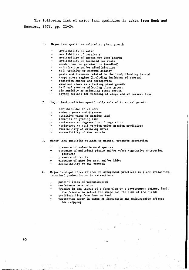
The following list of major land qualities is taken from Beek and
Bennema, 1972, pp. 22-24.
60
1. Major land qualities related to plant growth
availability of water availability of nutrients availability of oxygen for root growth availability of foothold for roots conditions for germination (seedbed) salinization and/or alkalinization soil toxicity or extreme acidity pests and diseases related to the land, flooding hazard temperature regime (including incidence of frosts) radiation energy and photoperiod wind and storm as affecting plant growth hail and snow as affecting plant growth air humidity as affecting plant growth drying periods for ripening of crops and at harvest time
2. Major land qualities specifically related to animal growth
hardships due to climate endemie pests and diseases nutritive value of grazing land toxicity of grazing land resistance to degradation of vegetation resistance to soil erosion under grazing conditions availability of drinking water accessibility of the terrain
3. Major land qualities related to natural products extraction
presence of valuable wood species presence of medicinal plants and/or other vegetative extraction
products presence of fruits presence of game for meat and/or hides accessibility of the terrain
4. Major land qualities related to management practices in plant production, in animal production or in extractions
possibilities of mechanization resistance to erosion freedom in the layout of a farm plan or a development scheme, incl.
the freedom to select the sbape and the size of the fields trafficability from farm to land vegetation cover in terms of favourable and unfavourable effects
for cropping
In Appendix 2 of Chapter 4 the definitions of several land qualities
and their ratings are presented.
3.1.2 Measurement ofland qualities
Land qualities can be described and rated independently to express
the status of component regimes and properties of the environment during
a particular time period. But the significance of these ratings and of
the threshold values of component properties depends on how much is known
about the specific land requirements of the use in question.
The kind of land use and the objectives of land use determine which
land qualities are limiting and to what degree. The constraining effect
of such land qualities will need to be assessed first for individual time
d iscrete land use processes and activities, and after that, by means of
some kind of integration or critica! path analysis, for the whole sequence
of time-overlapping land use processes (Visser, 1977).
Land qualities can provide a link between land resources inventories
and land use planning by identifying the properties that merit observat
ion, measurement and classification, and by suggesting the detail, in
terms of number and density of observations, that is required. We measure
only the essential qualities of the land so they can be used as independ
ent determinants of the land quality-dependent effects or 'outputs'
resulting from a specific combination of land (mapping) unit and land
utilization type (yields, erosion losses, etc.).
Vink (1975), in a book that gives a thorough treatment of land use
in advancing countries and contains many references to soil survey and
land evaluation, concludes that 'the study of land qualities is an
essential factor in the development of more complicated systems of
land evaluation'. However amore fundamental approach to land evaluation
should not necessarily be more complicated. Simplif ication will be
possible if we succeed in mobilizing the soil surveyor's capacity for
61
observing natural phenomena, by trying to measure (at least on an ordinal
scale) some of the land qualities directly in the field. The soil drain
age classes of the USDA Soil Survey Manual are an example. Such measure
ments require correlation, calibration and refinement with additional
ratio scale measurements in the field and in the laboratory. Refinement
of the techniques of interpretation of soil resources inventory data in
genera! will generate critica! questions about the accuracy of the data
base (for example, concerning the variation in the m.easured soil properties
and the degree of heterogeneity of soil/land (mapping) units). These
(mapping) units for planning purposes will be handled as homogeneous land
:.areas with a homogeneous performance. Soil resources inventory reports
need to be very explicit on this subject of variability vis à vis accuracy.
There is still much to be achieved in the quantitative measurement
of land qualities. They are usually ranked on an ordinal scale: high
medium-low-very low, using threshold values of component properties to
distinguish different levels.
In The Netherlands, where most of the soil properties that contribute
to land quality are measured on a ratio scale, the land qualities them
selves are mostly rated on an ordinal scale (see Table 3.1).
When measuring and rating land qualities it will be useful to
distinguish those threshold values of component properties that are
pertinent for the use in question, e.g. in soil salinity, soil fertility,
erosion hazard. For example the limit of -300 cm water moisture suction
in the top 5 cm of the soil during one week is a threshold value for the
land quality 'workability' in springtime in The Netherlands (Wind, 1976).
The threshold value depends on the type of land utilization. When
recommending sugar beet production, the moisture suction value of the
top 5 cm of the seedbed must be known; but for potatoes, the moisture
condition of the top 7 cm of soil is required. For grain production, the
information is required f or only a few centimetres depth, as these seeds
require a shallow seedbed.
62
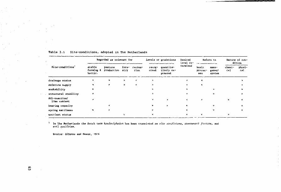
Table 3.1 Site-conditions, adopted in The Netherlands
R4gardéd as relevant for Levels or gradations Desited Re.fen to Nature of con-level de- dit ion
Site-conditions 1 arable. pasture fore- recrea- re.cog- quantita- termined basic ma.na- chemi- physi-farming & production stry tion nized tive.ly ex- proces- gement cal cal hort ic. preased ses system
drainage status "' x x x )( x x
moistur• supply x x x x x x
"orl<abil i ty x x x x
structural stability x x x )(
l:IC1-reaction/ )( x lime content
l>earing cap.acity )( x x x
spring earline&a x x x x
nutrient &tatus x x x
In The Netherlands the Ot.ttch term hoedanigheden has been translated as site eoru:iitions, aaa<?sWlent faetor>s, and aoil quaUties.
Source: Gibbons and ilaans, 1976

The definitions of land qualities for reconnaissance type land
evaluation in Brazil also reflect the influence of land use in the way
the land qualities are rated. Thus, for example:
Grades of natura! fertility
(simplified definitions, see also Section 4.3.4 and Appendix 2)
very high/high
soils with high level of available nutrients
When the other four factors (land qualities) are also favourable, nutrient reserves allow good yields for many years, also for the more demanding crops •••
medium
soils in which the reserve of one or more available plant
nutrients is small
When the other factors (land qualities) are favourable, nutrient conditions only permit good yields of annual crops during the first few years: after that yields rapidly decrease, when agricultural use of the land continues
low
soils in which one or more of the available nutrients appear
only in small quantities.
When the other factors are favourable, nutrient conditions only permit a reasonably good yield for adapted crops •••
very low
soils with a very restricted nutrient content, leaving the
soils practically without any possibility of agricultural
pasture or reforestation use •••
Some land qualities have received more attention than others and
attempts have been made to describe and rate them quantitatively because
of their dominating role in the planning of optima! use and management.
64
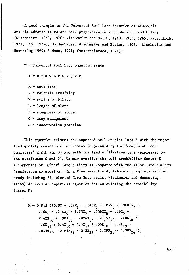
A good example is the Universa! Soil Loss Equation of Wischmeier
and his efforts to relate soil properties to its inherent erodibility
(Wischmeier, 1959, 1976; Wischmeier ·and Smith, 1960, 1962, 1965; Rauschkolb,
1971; FAO, 1977c; Moldenhauer, Wischmeier and Parker, 1967; Wischmeier and
Mannering 1969; Hudson, 1971; Constantinesco, 1976).
The Universal Soil Loss equation reads:
A = R x K x L x S x C x P
A = soil loss
R = rainfall erosivity
K = soil erodibility
L = length of slope
s a steepness of slope
C = erop management
P • conservation practice
This equation relates the expected soil erosion loss A with the major
land quality resistance to erosion (expressed by the 'component land
qualities' R,K,L and S) and with the land utilization type (expressed by
the attributes C and P). We may consider the soil erodibility factor K
a component or 'minor 1 land quality as compared with the major land quality
'resistance to erosion'. Ina five-year field, laboratory and statistical
study including 55 selected Corn Belt soils, Wischmeier and Mannering
(1969) derived an empirical equation for calculating the erodibility
factor K:
K = 0.013 (18.82 + .62X1 + .043X2 - .07X3 + .0082X4 -
.IOX5
- .214X6 + t.73X7 - .0062X8 - .26X9 -
2.42XIO + .30X11 - .024x12 - 21.5X13 - .l8X14 +
1.ox,5 + 5.4X16 + 4.4Xl7 + .65X18 - .39Xl9 +
.043x20
- 2.82x21 + 3.3X22 + 3.29X23 - l.38X24 )
65
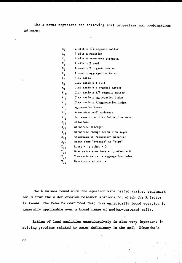
The X terms represent the following soil properties and combinations
of them:
% silt x 1/% organic matter
% silt x reaction XI
x2
x3
x4
xs x6
x7
xs
% silt x structure strength
% silt x % sand
% sand x % organic matter
% sand x aggregation index
Clay ratio
Clay ratio x % silt
x9 Clay ratio x % organic matter
x10 Clay ratio x 1/% organic matter
x1 1 Clay ratio x aggregation index
x12 Clay ratio x l/aggregation index
x13 Aggregation index
xl4 Antecedent soil moisture
x15 Increase in acidity below plow zone
x16
Structure
x17 Structure strength
x18 Structure change below plow layer
x19 Thickness of "granular" material
x20 Depth from "friable" to "firm"
x21 Loess - I; other - 0
x22 Over calcareous base• I; other • 0
x23
% organic matter x aggregation index
x24 Reaction x structure
The K values found with the equation were tested against benchmark
soils from the older erosion-research stations for which the K factor
is known. The results confirmed that this empirically found equation is
generally applicable over a broad range of medium-textured soils.
Rating of land qualities quantitatively is also very important in
solving problems related to water deficiency in the soil. Dimantha's
66
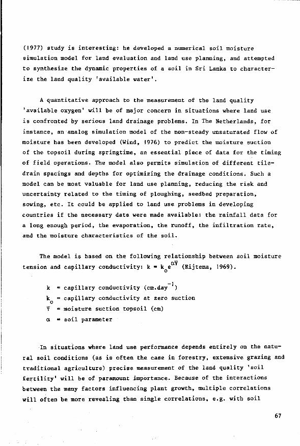
(1977) study is interesting: he developed a numerical soil moisture
simulation model for land evaluation and land use planning, and attempted
to synthesize the dynamic properties of a soil in Sri Lanka to character
ize the land quality 'available water'.
A quantitative approach to the measurement of the land quality
'available oxygen' will be of major concern in situations where land use
is confronted by serieus land drainage problems. In The Netherlands, for
instance, an analog simulation model of the non-steady unsaturated flow of
moisture bas been developed (Wind, 1976) to predict the moisture suction
of the topsoil during springtime, an essential piece of data for the timing
of field operations. The model also permits simulation of different tile
drain spacings and depths for optimizing the drainage conditions. Such a
model can be most valuable for land use planning, reducing the risk and
uncertainty related to the timing of ploughing, seedbed preparation,
sowing, etc. It could be applied to land use problems in developing
countries if the necessary data were made available: the rainfall data for
a long enough period, the evaporation, the runoff, the infiltration rate,
and the moisture characteristics of the soil.
The model is based on the following relationship between soil moisture
tension and capillary conductivity: k • k ea~ (Rijtema, 1969). 0
k = capillary conductivity (cm.day- 1)
k capillary conductivity at zero suction 0
~ • moisture suction topsoil (cm)
a = soil parameter
In situations where land use performance depends entirely on the natu
ral soil conditions (as is often the case in forestry, extensive grazing and
traditional agriculture) precise measurement of the land quality 'soil
fertility' will be of paramount importance. Because of the interactions
between the many factors influencing plant growth, multiple correlations
will often be more revealing than single correlations, e.g. with soil
67
phosphorus, with pH or with organic matter. This is illustrated by van
Goor's work on growth-site relations in Sao Paulo, Brazil, with
Pinus elliottii and Arauaa:ria angustifolia. Since these tree species
are grown without fertilization, the analysis of site factor-growth
relations directly influences the land suitability classification (van
Goor, 1965/1966; Bastide and van Goor, 1970, Bennema and van Goor, in
FAO, 1975a). Sixty-five percent of the growth differences in Pinus
elliottii and 50 percent in Arauaa:ria could be explained by differences
between land units, or more specifically between the soil types, the
natural vegetation types corresponding with these soil types and the
land use history. Consequently land suitability classification on the
basis of the existing (reconnaissance) soil map became relatively easy.
By adding the land quality 'soil fertility' to the land units and the
land use history, 70-75 percent of the growth differences could be
explained. Mathematica! methods of principal component analysis and
non-linear curve fitting proved helpful in explaining the influence of
separate components and their constituent parts composing the land
quality 'soil fertility'. The principal components that could be identified
were: the adsorption complex comprising pH, amount of exchangeable bases
and aluminium saturation; the organic matter component comprising carbon,
nitrogen and phosphate; the third component consisted only of phosphate.
The latter information on the influence of land quality components is
significant for land utilization types that include the fertilization of
forest plantations in their management practices.
Principal component analysis bas also been successfully applied by
Kyumi and Kawaguchi (1972) for the capability c1assification of soils for
paddy rice. Bleven selected character data of 417 paddy soils from South
and South-east Asia were related to outputs, which resulted in a so
called 'soil chemica! potentiality' classification.
68
On land improvement qualities and input application efficiency
Land (mapping) units may differ in certain characteristics influen
cing the amount of input needed, although the unimproved levels of the
land quality that needs improvement may be very similar, while the other
land qualities also do not vary significantly. Examples of such character
istics are: the presence of toxic amounts of certain chemical soil
components which cause the fixation of fertilizers; differences in soil
texture, in infiltration rate or in permeability which affect the
amount of irrigation water that needs to be applied or the rate of nitrogen
mineralization.
Bennema (1976) uses the term 'land improvement qualities' for such
factors that independently influence the efficiency of input application.
Their values can only be determined when both the land and the use,
including the kind of input, the method and time of input application
and the foreseeable input levels are known.
The values of land improvement qualities (IQ) often depend on the
status of uncontrollable or only partly controllable land properties
such as soil texture, slope and soil depth. For instance in irrigation
much attention is given to the levelling of the land to maximize the
field application efficiency of the irrigation water. Nevertheless
substantial dif ferences may be observed between fields having different
soil texture. An example is Figure 3.1 (from Bos & Nugteren, 1974), in
which the field application efficiency (e ) of irrigation water bas been a
expressed graphically in relation to the soil texture. Different relations
are found for different input application methods: basin (continuous), basin
(intermittent), flow, and sprinkler irrigation. Differences in e of a ten percent between light and heavy textured soils are common. There is
a very great diff erence in efficiency of continuous basin irrigation
between heavy soils and light textured soils.
69
10
0 GI
~e c GI ~ ..... Qj 6 c 0 A :;:; 0 ,g 4 a. a. 0
!! GI 2 ~
Ot--~~+-~~+-~~+-~~+-~~+-~---i sond loom silt silty
ctoy cloy heavy
cloy
Fig.3.1: Field appliaation effiaienay and method of irrigation with referenae to soil type. Sourae: Bos and Nugteren, 1974.
The identif ication of land improvement qualities (IQ) and the
grouping of land (mapping) units into populations of defined levels of
IQ is a major responsibility of those who study and interpret land
resources. For example:
the regression line expressing input-output relations in Fig. 3.2 for selected land (mapping) units that have a low soil test value of available phosphorus (land quality value) could (at least conceptually) be further refined. To do this the land (mapping) units would have to be partitioned into categories, each with a different input efficiency (IQ) attributable to a measurable characteristic, e.g. the phosphorus fixation level.
The most useful studies of land improvement qualities (IQ) will be
those that aim to understand and describe the process underlying the
conversion of inputs into outputs, e.g. the study by simulation of
nitrogen behaviour in soils (Beek and Frissel, 1973; van Keulen, 1977);
To explain input-output transformation processes it will be necessary to
identify the measurable characteristics of the land (mapping) unit that
determine this land improvement quality IQ: I shall refer to such character-
70
istics as 'land improvement quality determinants' (IQD) of the land. 1
The soil texture in Fig. 3.1 is an example of a land improvement quality
determinant of irrigation water. Within the textural classes referred
to: sand; loam; silt; silty clay; clay; heavy clay; great differences may
be observed in, for example, infiltration rate, moisture retention curves
(pF) and permeability. However, data on soil texture are more often
available from soil survey and other research reports than are other,
more specific determinants of irrigation water application efficiency.
y erop response kg/ho 300
Clow soit test) / /
..---------250 P-tixotion //
! / 200
150
100
/, 50 /j
/
/ /
/
.:;./ '~oe /tf
/o.:>.
'<'v::.V ./' --
/ /
/ ./
/ /
/ /
~-/
P3 f4 I
fertil izer applicotion rate
Fig.3.2: Hypothetiaal partitioning of lauJ plzosphorus soit test population in -two sub-populations with different P-application efficiencies (IQ) based on differenaes in aluminium saturation.
The infiltration rate is an important land improvement quality also
for other land improvements such as desalinization and erosion control.
The infiltration rate itself can be measured directly, but its values
again depend on smaller elements of the system that is analysed, but
which will not always be necessary to question during land evaluation.
Correlation of values of IQ with values of their determinants (IQDs)
Simiü:r.rly the cha:l'acteristias that deterrnine the values of the parameter LR (1,and requirement) of a 'land utiUzation type couid be named ''land :requirement determinants' (LHD).
71

will mostly be empirica! rather than functional. The deeper systems
analysis digs into the relation structure of the land use system, by
subdividing it into smaller and smaller elements and sub-elements, each
level being characterized by a more detailed structure of relations
between the composing elements, the more likely will it be that the
explanations for the observed phenomena become empirica!.
Empirica! explanations have been quite useful in the past for
assessing the responsiveness of land units to specific inputs and for
comparing different land units on their responsiveness to such inputs.
For instance, at this moment there is still some speculation about the
role of exchangeable aluminium in the soil chemica! processes that
determine the uptake of phosphorus by plants. But enough is known from
empirically established correlations to predict from measured amounts of
aluminium how an aluminium problem should be handled in practice: the
amounts of lime required to neutralize the aluminium and to guarantee a
satisfactory response to phosphorus fertilizers.
The transfer of values of land improvement qualities from places
where these values have been (empirically) determined to other areas
requires a careful comparison of similarities and differences between
the areas concerned, in particular between their determinants (IQD). An
example is the transfer of formulas for drain spacings that include IQ
values empirically determined in the Netherlands to solve drainage
problems in countries with different soil and climatic conditions, e.g.
Portugal. Or the transfer of experience with drip irrigation in a low
rainfall area in Israel to a no rainfall area with soil salinization
problems in Northern Africa.
An interesting reference to land improvement quality determinants
(IQD) in soil fertility evaluation is Buol et ai. (1975), wbo have
presented a technica! classification system for grouping soils with
similar fertilizer limitations. They defined quantitative values for
selected soil parameters (see Table 3.2) that are expected to act as
critica! levels. Some of these critical Jevels have been found to
72
correspond with different fertilizer response patterns, especially when
they are combined with information about critica! levels of land qualities
(plant nutrients) determined by analysing land quality-output relations.
Therefore some of these selected soil parameters should be helpful in
the search for land improvement quality determinants (IQD) connected
with the improvement of soil fertility.
Buol et al. use the term 'conditioner modifiers' for such soil parameters,
suggesting that the critica! values modify the effect to be expected
from a certain conditioner, or in other words from a certain type of
fertilizer or other input affecting soil fertility. However, the term
'modifier' implies that an 'ideal' soil exists which does not have this
problem of a modified response from inputs. The 'ideal' soil concept and
the description of land capability in terms of degrees of limitation or
'deviation' from this 'ideal' soil, is a well known approach to land
capability classification in the USA (USDA Land Capability System). But
in this report, and also in the Framework for Land Evaluation (FAO,
1976), each land unit is described in its own right, without comparison
with 'better' soils. The land qualities describe the land unit's status in
terms of measurable characteristics: in addition, the discussion on land
improvement qualities in this report should eventually lead to the
identification and measurement of land improvement quality determinants.
The 'ideal' soil concept must be rejected, because the land utilization
type determines what type of land is 'ideal': 'ideal' soils for cocoa,
maize, rice or coconuts should have quite different characteristics. By
analogy, the land improvement quality determinants should be related
primilarly to the type of inputs they are supposed to inf luence and the
specific method of input application e.g. broadcasting versus placement of
fertilizers (de Wit, 1953).
To sum up: describing the land improvement qualities (IQ) of a
land unit in terms of measurable values of land improvement quality
determinants, IQD, could become a useful tool for land evaluation,
for local application as well as for the transfer of accumulated know
ledge to otber areas. Sucb data sbould complement the information about
73

74
Table 3.2. Fertility-Capability Soil Classification System: 1974 Version
TYPE:
Texture is average of plowed layer or 20 cm (8 in.) depth, whichever is shallower
S = Sandy topsoils: loamy sands and sands (USDA) L = Loamy topsoils: < 35% clay but not loamy sand or sand C = Clayey topsoils:> 35% clay 0 • Organic soil: > 30% O.M. to a depth of 50 cm or more
SUBSTRATA TYPE:
Used if textural change or hard root restricting layer is encountered within 50 cm (20 in.)
S = Sandy subsoil: texture as in type L = Loamy subsoil: texture as in type C = Clayey subsoil: texture as in type R = Rock or other hard root restrictlng layer
*g
CONDITIONER MODIFIERS:
In plowed layer or 20 cm (8 in.), whichever is shallower, unless otherwise specif1ed ( )
(gley):
(dry):
Mottles < 2 chroma within 60 cm from surface and below all A horizons or saturated with H20 for > 60 days in most years.
Ustic or xeric envirolllllent: dry > 60 consecutive days per year within 20-60 cm depth.
e = (low CEC): < 4 meq/100 g soil by E bases+ unbuffered Al. > 7 meq/100 g soil by E cations at pH 7.
*a = (Al toxic):
< 10 meq/100 g soil by E cations + Al + H at pH 8.2.
> 60% Al saturation of CEC by E bases and unbuffered Al within 50 cm.
> 67% Al saturation of CEC by E cations at pH 7 within 50 cm.
> 86% Al saturation of CEC by E cations at pH 8.2 within 50 cm or pH< 5.0 in 1:1 H2o except in organic soils.
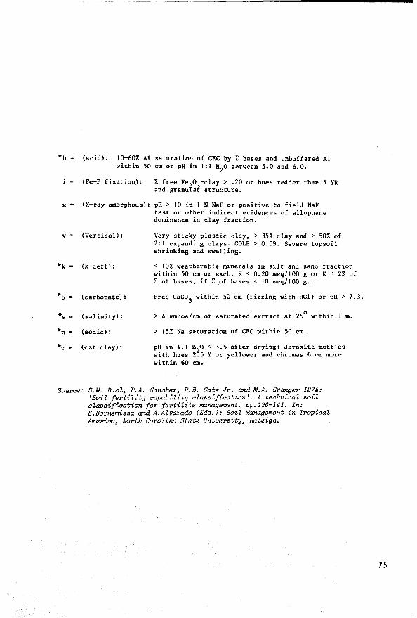
•h = (acid): 10-60% Al saturation of CEC by E bases and unbuffered Al within 50 cm or pH in 1:1 H
2o between 5.0 and 6.0.
i = (Fe-P fixation): % free Fe2o3-clay > .20 or hues redder than 5 YR
and granular structure.
x - (X-ray amorphous):
v = (Vertisol):
*k = (k deff):
*b = (carbonate):
*s • (salinity):
*n • (sodic):
*c • (cat clay):
pH > 10 in 1 N NaF or positive to field NaF test or other indirect evidences of allophane dominance in clay fraction.
Very sticky plastic clay, > 35% clay and > 50% of 2:1 expanding clays. COLE > 0.09. Severe topsoil shrinking and swelling.
< 10% weatherable minerals in silt and sand fraction within 50 cm or exch. K < 0.20 meq/100 g or K < 2% of E of bases, if L .of bases < JO meq/100 g.
Free Caco3
within 50 cm (fizzing with HCl) or pH> 7.3.
> 4 tmnhos/cm of saturated extract at 25° within 1 m.
> 15% Na saturation of CEC within 50 èm.
pH in 1.1 1!z0 < 3.5 after drying: Jarosite mottles with hues 2.5 Y or yellower and chromas 6 or more within 60 cm.
Sourae: S.W. BuoZ, P.A. Sanahez, R.B. Gate Jr. and M.A. Granger 1975: 'Soil fertility aapahility alassifiaation'. A teahniaal soil alassifiaation for fertility management. pp.126-141. In: E.Bo!'nemisza and A.AZvarado (Eds.): Soil Management in Tl'opiaal Ameriaa, North CaroZina State University, RaZeigh.
75
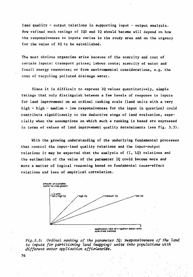
land quality - output relations in supporting input - output analysis.
How ref ined such ratings of IQD and IQ should become will depend on how
the responsiveness to inputs varies in the study area and on the urgency
for the value of IQ to be established.
The most obvious urgencies arise because of the scarcity and cost of
certain inputs: transport prices; labour costs; scarcity of water and
fossil energy resources; or from enviromnental considerations, e.g. the
cost of recycling polluted drainage water.
Since it is difficult to express IQ values quantitatively, simple
ratings that only distinguish between a few levels of response to inputs
for land improvement on an ordinal ranking scale (land units with a very
high - high - medium - low responsiveness for the input in question) could
contribute significantly to the deductive stage of land evaluation, espe
cially when the assumptions on which such a ranking is based are expressed
in terms of values of land improvement quality determinants (see Fig. 3.3).
With the growing understanding of the underlying fundamental processes
that control the input-land quality relations and the input-output
relations it may be expected that the analysis of (I, LQ) relations and
the estimation of the value of the parameter IQ could become more and
more a matter of logical reasoning based on fundamental cause-ef fect
relations and less of empirica! correlation.
omount ol ovoilol>le water for erop growth
LUwith very high IQ low IQ
I applicotlon rate of irrigotion water wlth gpecilled method
Fig.3.3: ()pdinal ranking of the parameter IQ: responsiveness of the land. to inputs fOl' partitioning land. (mapping) units into populations 1.ûith different water appZication efficiencils.
76

Are IQ values always constants?
IQ values are determ.ined primarily by land improvement quality
determinants that are difficult to change, e.g. the texture of the soil
and its perm.eability, soil depth, slope, gradient. In reality the parame
ter values of IQ are not entirely immutable. For example, the response
to fertilizers is affected by the cation exchange capacity of the soils.
If the soil is going to be irrigated, this can result not only in a
change in the land quality 'water availability' , but also in a change in
the organic matter content; either a decrease possibly resulting in an
even more constrained response to fertilizers, or an increase, which
affects the response to fertilizers favourably. Sometimes the side
effects of physical inputs on the land and on its responsiveness to
other inputs can be quite unexpected, and should therefore be of major
concern during land evaluation.
Sometimes inputs are applied with the explicit purpose of changing
the responsiveness of the land to inputs. In some of the Arab countries,
where water is a more expensive resource than oil, soil conditioners
have been applied, for instance to increase the water retention capacity
of the soil, or to decrease its susceptibility to wind erosion. Although
rare, these countries can make use of a large supply of cheap waste and
by-products of the petro-chemical industry to tackle the problems of a
too low responsiveness to inputs. It is more common that the responsiveness
to inputs is gradually improved as a side-eff ect of the application of
inputs to correct limiting land qualities, such as the application of
organic manures on infertile land, resulting in better soil structure,
input response etc. At the same time, the input-producing industries
continue their research towards producing more efficient products to
cope with low conversion efficiencies resulting from the low IQD and IQ
values that have been observed. An example is the development of slow
release fertilizers, which can be used efficiently when the land improv
ement qualities IQ for normal fertilizer applications are low.
77
Parametric methods
The usefulness of the methods described to measure land qualities
quantitatively can be attributed in no small measure to the small number
of limiting factors taken into account: susceptibility to erosion, the
available water, the available oxygen, the natura! soil fertility. A dis
tinction must be made between quantitative methods in land evaluation that
concentrate on specific land qualities, as bas been discussed so far, and
those methods that attempt to include all land factors influencing the per
formance of a land use system simultaneously in a quantitative analysis.
The latter methods are known as 'parametric' methods in the literature.They
have been most concerned with rating the 'super' land quality 'productivity'.
The first demand for such metbods arose from the need for objective
quantitative standards in raising land taxes. The Storie-index (Storie,
1937, 1950) was developed for this purpose. An example of combining values
of a variety of characteristics (soil texture, parent rock, natural soil
fertility level) into a rating for taxation purposes in the Federal Republic
of Germany (Taschenmacher, 1954) bas been cited by Vink (1975). Nowadays
parametric methods are also employed for purposes of land use planning. An
example is the use of parametric methods for calculating target yields for
state farms in Eastern European countries (e.g.Teaci, in FA0,1974; Krasta
nov et al. in FA0,1975b) and the methods published by FAO for the prediction
of biologica! productivity (Riquier and Bramao,1964; Riquier,1974). Accord
ing to Riquier (in FAO, 1974a, p.74) the parametric method consists of:
78
(1) evaluating separately the different properties of soils and giving them separate numerical valuations according to the importance within and between each other,
(2) combininf these factors (numerical values) in a mathematica! law ) taking into consideration the relationships and the interactions between the factors to produce a final index of performance,
(3) which in turn is used to rank soils in order of agricultural value.
'law' is toa strong a wol'd for suah an empirical equation; mathematical e::cpression' is better.

Each factor bas an influence on the final result according to its
own equation, other factors being considered constant. The combination
of factors to include their interactions may be either additive, additive
and subtractive, multiplicative, or a more complex equation:
p = C'k + C' 'l + C' ''m (1)
p "' C'k + C' '1 - C' ''m (2) p C'k x C' 'l x C" 'm (3)
p = A (C'k + C'''m)/C''l (4)
P production in kg/ha
k.l.m = production factors, e.g. soil depth, texture
A constant
C' ,C'' ,C''' coeff icients g1v1ng appropriate weights to the individual production factors
Riquier (in FAO, 1974) observes that the multiplicative method is
realistic and conforms to experimental data. After presenting some
advantages and disadvantages, Riquier (in FAO, 1974a, p.52) concludes that:
the parametric method provides an attempt to express land evaluation in quantitative terms compatible with modern facilities for calculation. It introduces quantitatively the use of yield and productivity in a manner which provides communication between the pedologist and the economist. It can easily be integrated with other global methods of land classification to provide an evaluation of the agricultural value of the soil.
Parametric methods have mainly been based on easily measurable
properties of the land, not on land qualities, and consequently there
is a likelihood that interactions (and therefore site-specific conclusions)
exist, thereby preventing analogies being made. Parametric methods repre
sent empirica! methode of land use systems analysis; the land use system is
treated as a black box, little attention is paid to its internal structure
and to the functional relations between inputs, land qualities and outputs.
79

However, with statistica! methods of analysis, high coefficients
of correlation have sometimes been found between the soil and climatic
parameters and, for instance, yield, although the number of land parameters
considered is rather limited, as are the inputs considered. Parametric
methods have been more concerned with predicting biological output than
with the role of inputs or the effect of land utilization on the status
of the land qualities.
Advocates of parametric methods have sometimes criticized supporters
of more qualitative methods for being subjective in their treatment of
the selected variables influencing the land suitability classif ication
or the land productivity rating.
However, as Burrough (1976) has observed, though the mathematica!
treatment of factors in parametric methods gives them the appearance of
objectivity, the selection and compounding of factors is still largely
a matter of choice. The subjective aspects of parametric methods are
reduced if the factors used reflect the results of field trials and if
the results have statistica! significance. Parametric methods still
lack adequate treatment of biotic and climatic controls. Once all
important factors have been identif ied the use of complex modelling
techniques should improve the ability of the parametric approach to
calculate the relations between all the significant production factors
and productivity.
Temporal and spatial variation of land qualities
Land qualities may vary in space and time. Consequently, when
observing and measuring land qualities and component properties, the
arbitrary disaggregations of the land resource continuum must be con
sidered in the context of space and time. The temporal variation is
the result of weather-imposed and human influences. Because of the tempo-
80
ral variation, land resources studies may need to take heed of different
time perspectives, ranging from the variation within one erop or rotation
growing season, to the variation that may occur during the period consi
dered by long-term (20-40 years) perspective studies for development.
Spatial variation ref ers to the variation of the values of land qualities
and component properties both horizontally and vertically.
The horizontal disa.ggregation of land into component qualities and
properties is the object of land resource surveys and depends on such fac
tors as: purpose of study; feasible density of observations; availability
of financial resources, human resources, aerial imagery, topographic maps;
the heterogeneity of each property/quality; skill of the surveyor; data
processing facilities; etc. (UNESCO, 1965; Zonneveld, 1972; Mitchell, 1973;
Nossin, Ed., 1977).
By virtue of their location in the landscape, land (mapping) units
often share the same geomorphological processes of transfer of mass. For
example, land units lying in the catchment of one river system may be
linked sequentially downstream by the water flow of that river and will
therefore experience effects that have originated on other, not
necessarily adjacent, land units (e.g. sedimentation, flooding, salinizat
ion). To explain and predict such interactions between land units, data
collection needs to be aware of the genera! geomorphological setting.
The systems approach to geomorphology bas been discussed by Chorley and
Kennedy (1971; see also Section 3.3.2 and Chapter 5 of this report).
The vertiaal disa.ggregation of the land into different strata to
facilitate data collection should also consider the interactions between
these strata caused by flows of mass and energy. Perhaps the most obvious
disaggregation, which corresponds roughly to the subdivision between
disciplines traditionally engaged in data collection is:
81

1. OFF-GROUND, the atmosphere above the vegetative cover (macro-climate)
2. NEAR-GROUND, the vegetative cover and the atmosphere in this cover (micro-climate)
3. GROUND SURFACE, the borderline between atmosphere and soil
4. SOIL
5. SUB-STRATA, the deeper strata below the soil
Each stratum can be further disaggregated into composing substrata,
layers, or horizons for the purpose of land evaluation.
The five strata, product of vertical disaggregation, vary areally too.
In small-scale land evaluation, the areal variation of meteorological
variables will strongly affect the delineation of boundaries between land
(mapping) units. In intermediate and detailed land evaluation the soil
and surface conditions will provide many of the boundaries. Sub-strata
conditions greatly influence land evaluations that include the consider
a tion of irrigation and drainage.
The temporaZ variation of land qualities and component properties
also needs to be taken into account. To achieve this, their values should
be measured during significant time periods or at time-discrete moments.
The timing of land use activities and processes, (i.e. the cropping calen
dar) determines how the finite time periods for observing and measuring
land qualities and properties must be chosen. For example, the time periods
may correspond with the time-specific requirements of the land utilization
types f or land preparation, sowing, germination, early vegetative growth,
etc. Relating these land use activities and processes to the land qualities
and component properties should indicate which qualities and properties need
careful examination, and at what time of the year, the month, the week or
even the day.
It is not easy to measure time-variable land qualitites and properties.
We may have to go to great lengths to be able to characterize a non-steady
state regime, e.g. by constructing an analog simulation model of the non-
82
steady unsaturated flow of moisture in the soil (Wind, 1976) to character
ize the moisture tension and related workability of the topsoil during
springtime in the Netherlands.
The dynamic fluctuations of the values of land qualities and component
properties produce a characteristic pattern for each stratum, e.g. the
daily, weekly and seasonal temperature and moisture fluctuations.
Tempora! disaggregation will be further discussed in the next section
(3.2.) which deals with the disaggregation of land utilization types and
identification of land requirements.
3.1.3 Land qualities and land resource data collection
Data collection is, perforce, a selective process. The mono-disciplin
ary collection of data to characterize land attributes and land properties
has traditionally paid much attention to the aspects of genesis and
classification, particularly in soil survey. Interpreting such data for
the solution of land use problems usually requires a more complex body of
information than can be provided by a mono-disciplinary approach
orientated towards single attributes. For example, the interpretation of
soil surveys f or agricultural uses requires cross ref erence to data
collected by meteorologists, hydrologists, etc. Even the study of one
land attribute, such as soil, is often partitioned into specializations
susceptible to communication problems, e.g. between soil survey, soil
fertility research and soil conservation studies.
The land utilization type concept is expected to provide common ground
for these various disciplines and specializations and can make their
studies more problem-orientated. As far as collecting land resources data
to characterize land qualities is concerned, even in reconnaissance soil
survey the main land use problems and development options are recognizable.
Instead of standardized data collection for a high category of soil
classification, it should be possible to collect some additional data such
83
as infiltration capacity of sloping land occupied by traditional farmers,
hydraulic conductivity of poorly drained bottom-lands,pF values, data about
aggregate stability, etc. Indeed, reconnaissance soil survey in Brazil
includes collecting compound samples for soil fertility analysis. However,
few soil survey manuals deal with specific purposes: the draft edition
of a new soil bulletin of FAO on soil survey investigations for irrigation
is an exception (FAO, 1974b).
When collecting land resource data to solve the land use problems of
farmers or other land users we must be fully aware of the farmer's land
dependent activities. We should be able to concentrate on the fundamental
processes and activities of the specific land utilization type and the role
of measurable land qualities/properties in these processes.Is this feasible?
This depends on our interpretation of the term fundamental. For a biologist
(PUDOC, 1970; de Wit & Goudriaan, 1974), photosynthesis, respiration and
transpiration are fundamental processes. He may try to simulate, for in
stance, plant root growth as a function of variables such as soil tempera
ture and soil oxygen, measured hourly or daily. Such precision may be
possible in a programme of meteorological data collection but not in a soil
survey. On the other hand, parametric methods that translate a set of
measurable soil properties directly into expressions of productivity or
suitability, based on statistically-found correlations pay little attention
to the underlying fundamental processes. A balance must be struck between
these two extremes.
In its effort to construct sophisticated analog and computer simulat
ion models, research sometimes forgets that some concrete analog models
may still be found in nature; the natural vegetation and present land use
can reveal much of how hypothetical land use alternatives may be expected
to perform. A good example from Brazil is the interpretation of the natural
forest vegetation in terms of water availability: Beek and Olmos (1964)
prepared land suitability maps for cocoa production in coastal Bahia, making
a direct correlation between the water requirements of cocoa and features
of the tropical forest vegetation that express the land quality 'water
availability'. To permit this the reconnaissance-type soil surveys in Brazil
84
include the natural vegetation as a phase in the soil (mapping) unit
(Bennema and Camargo, 1963).
Another example is the use of the natural vegetation as an indicator
of soil permeability and soil salinity (Risseeuw, 1972). The soil surveyor
is in the exceptional position of being able to observe and correlate such
phenomena to refine the prediction of soil behaviour under specific uses.
Conclusion
The systematic disaggregation of land in terms of land qualities is
in its early stages of development. If the concept of land qualities
can be developed successfully, it could serve several purposes:
indicating which land properties deserve priority for study in land resources surveys;
systematizing the soil surveyor's capacity to observe and interpret natural phenomena: levels of some land qualities can be deduced directly from the present land use. Crops and natural vegetation provide a model for the optimal land use systems as far as ecological processes and related ecological land qualities are concerned (Bennema, 1976);
facilitating knowledge transfer to areas in developing countries with a poor data base for optimizing land use, because land properties with a site-specific influence on land use performance are synthesized into land qualities controlling fundamental land use processes and therefore of broader application than single properties;
Improving the predictive value of land suitability classifications and the possibility of their periodical updating.
85
3.2 Disaggregation ofland utilization types and the identification ofland requirements
In previous chapters the procedure for defining land utilization
types bas been discussed and their key attributes have been described. Given
this background it should be possible to identify the specific land require
ments of each land utilization type, but this is complicated because the
land use process is continuous and dynamic. Therefore, to facilitate data
measurement and manipulation it will be necessary to disaggregate the
land use process into a number of component processes and activities that
take place during defined time periods. Each process or activity should be
characterized by its own land requirements. During these finite time periods
the land requirements may be assumed to be constant, to simplify the task of
land evaluation. Once the continuous land use process has been disaggregated
into a kind of land utilization calendar which specif ies in chronological
order each pertinent land use process/activity and the corresponding land
requirements, it should become possible to make a problem-orientated
analysis of the status of the time-variable land qualities that should meet
these land requirements. This calendar will also be useful for ascertaining
the optimal application of physical inputs for improving and maintaining the
land qualities.
The list below gives examples of time-discrete sub-processes and activi
ties produced by disaggregating the continuous land use process.A distinction
bas been made between plant growth and plant development (Rose, 1969).
Growth is the increase in plant material (if possible, differentiated for
the various parts of the plant: roots, stem, leaves, generative part).
Development is the sequence of phases throughout the erop cycle which relate
to changes in form and structure, such as germinative, vegetative and repro
ductive phases. Some land variables seem to have a so-called 'trigger action'
effect on plant development, such as soil moisture and soil temperature
on germination. Day length and temperature are also known to affect the
initiation of other development phases, for example, for flovering.
86
Fitzpatrick and Nix (1970) mention three distinctive thermal
response curves for tropical grasses, tropical legumes and temperate
grasses and legumes. The differences between them have been attributed
to a trigger-action effect.
A land evaluation procedure that takes into account each biological
production process and every agricultural activity concerned with land
management, improvement and conservation is unlikely to be operational
soon, in view of the great number of processes, variables and relation
ships involved. The ability of plants and animals to adapt co constrain
ing land conditions makes it even more difficult to predict agricultural
land use performances. However the literature on dynamic modelling and
simulation of ecological processes and plant growth is increasing rapid
ly as more of the underlying plant growth processes are understood and
the possibilities of mathematica! data processing grow (e.g. Patten, 1971,
1972; PUDOC 1975-1977). The Elementary Crop Growth Simulator, ELCROS, of
de Wit et al. (1971, 1978) is a pioneering example of how a data-analysis
based on fundamental land use processes should ideally operate. Of course,
practical land evaluation is still limited to less sophisticated simulations
of the processes and activities that will result from a certain land utili
zation type being combined with different land (mapping) units.
Because of the complexity of the land use process, analog and
mathematica! simulation models usually refer to partial processes rhat
take place during finite time periods and that are related to a
particular limiting land quality. An example is the time-finite activity
'land preparation' which is related to the land quality 'workability' and
depends on the seasonally varying characteristics of component properties
such as the groundwater table, infiltration rate, pF values of the top
soil, rainfall and evaporation, data, etc. (Wind, 1976).
Recognizing the need and possibilities for using partial simulation
models to solve land use problems, Nix (1968) bas suggested that for a
first assessment only energy, water and plant nutrients should be consider-
87
ed and that other 'regimes' (= land qualities) should be assumed not to
be limiting. This may be a good solution for Australian land conditions,
but for land evaluation in general, a priori elimination of any land
quality that may not satisfy the land requirements of the utilization
type is premature.
To streamline data-collection and to sharpen its focus on the most
elementary land-use bottlenecks, the early stages of land evaluation could
be improved by consulting a matrix t~at relates the various land use
processes and activities to the land qualities and their component pro
perties, and the strata in which they should be measured (see Table 3.3).
88
LP Land Preparation
SO SOwing or planting
FE FErtilization, manuring
IR IRrigation (water application, maintenance)
DR DRainage (water management, maintenance)
PP Phytosanitary Practices
GE GErmination
AP Asexual Propagation (cropping, budding, cutting: stem, roots, bulbs, tubers)
VD Vegetative Development
VDR - root development VDS - stem development VDL - leaf development
VGL - Early Vegetative Growth
VGER - Early Vegetative VGES - Early Vegetative VGEL - Early Vegetative
VGR - Rapid Vegetative Growth
VGRR - Rapid Vegetative VGRS - Rapid Vegetative VGRL - Rapid Vegetative
GD Generative Development
Root Growth Stem Growth Leaf Growth
Root Growth Stem Growth Le af Growth
GDS - Generative Development, Sexual
GDSF - Production of flowers and embryo, apomixia GDSS - Fruit and Seed development GDSR - Ripening and dissemination of seed
GDA - Generative Development - Asexual: buds, layering, bulbs, tubers •.• etc.
HA HArvesting
SV Survival (perennials)
FA FAllow (rotations)
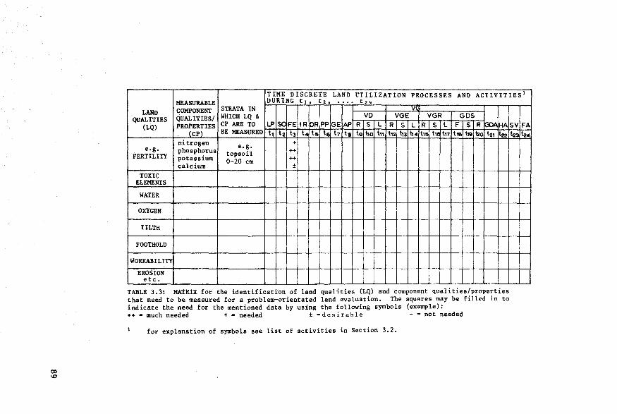
TIME DISCRETE LAND UTILIZATION PROCESSES AND ACTIVITIES 1
MEASURABLE DURING ti, t2t •••• t24
LAND COMPONENT STRATA IN 1
VI
QUALITIES QUALITIES/ WHICH LQ & VD VGE VGR GOS (LQ) PROPERTIES CP ARE TO LP ,se FE IR DRPP GE AP R S L R s L R s L F s R~ HA
(CP) BE MEASURED t, t2 t3 t. t!!> t~ t7 ta tg t10 t11 t12 t13 t14 t1!> tic t11 tlf t111 ll!o t21 t22 nitrogen +
e.g. phosphorus e.g.
++ FERTILITY potassium
topsoil ++ 0-20 cm
calcium ±
TOXIC ELEMENTS
WATER
OXYGEN
TILTH
FOOTHOLD
WORKAJ!lLITY
EROS ION etc.
TABLE 3.3: MATRIX for the identificati'on of land qualities (LQ) and component qualities/properties that need to be measured for a problem-orientated land evaluation. The squares may be filled in to indicate the need for the mentioned data by using the following symbols (example): ++ = much needed + = needed ± =desirable - =not needed
for explanation of symbols see list of activities in Section 3.2.
SV FA t23 ~4
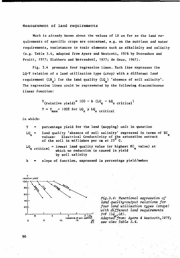
Measurement of land requirements
Much is already known about the values of LR as far as the land re
quirements of specific crops are concerned, e.g. on the nutrient and water
requirements, resistances to toxic elements such as alkalinity and salinity
(e.g. Table 3.4, adapted from Ayers and Westcott, 1976 by Doorenbos and
Pruitt, 1977; Slabbers and Herrendorf, 1977; de Geus, 1967).
Fig. 3.4 presents four regression lines. Each line expresses the
LQ-Y relation of a land utilization type (erop) with a different land
requirement (LR) for the land quality (LQ) 'absence of soil salinity'. s s
The regression lines could be represented by the following discontinuous
linear function:
Y( 1 . yi"eld)s 100 - b (LQ - LQ • . 1) re ative s s critica
Y = ymax IOO% for LQs ~ LQs critical
in which:
y percentage yield for the land (mapping) unit in question
land quality 'absence of soil salinity' expressed in terms of EC values: Electrical Conductivity of the saturation extract e of the soil in millimhos per cm at 25° C.
LQ = lowest land quality value (or highest EC value) at 8 critica! which no reduction is caused in yield e
by soil salinity
b slope of function, expressed in percentage yield/mmhos
y relative yield
·:\~-·~ 40
20
QL-~5~~'--~4~~.l--(-~-...,,~ot-~'--...,-i-lsal_2 _1~~~-'~
0 5 10 15 20 EC
90
Fig.3.4: FunctionaZ expression of Zand quaZity-output relations for four Zand utiZization types (crops) with different Zand requirements Y=F (LQ ,LR). AdapteifJfrom: Ayers & Westcott,19?6; see aZso TabZe 3.4.
For reasons of simplification a discontinuous linear function has
been fitted to the data points expressing LQ ,Y values. Quadratic and s
exponential functions are also quite co111111on, as are logarithmic functions
for expressing LQ-Y and I-Y relations.
The function could also be presented in terms of absolute yield,
rather than in relative yield:
y (absolute)
y (absolute)
Y - b(lQ - LQ ) max s s critica!
Y for LQ > LQ . . 1 max s - s critica
Fig 3.4 indicates that b (the value of the land requirement LR)
takes a value that depends on the critica! level LQ . . 1
at which s critica
the land conditions begin to limit the output, and the slope indicating
the direction or velocity with which the yield decreases with increasing
soil salinity.
Parameter values of land requirements, summarized by the symbol LR,
but as indicated in Fig.3.4 composed of a critical level LQ .t. 1 s cri ica
and the slope b, can be determined with the help of curves fitting the
equation Y = F (LQ, LR). But the fitting of such curves requires that a
number of data points correspond with observed and measured values of (LQ,Y)
combinations for specific land utilization types. This information is not
always available, certainly not for every (LUT, LU) combination that is con
sidered to be important in the study area. On the other hand, evaluation
cannot always wait until the required site-specific research-tested informa
tion has been produced. Therefore other approaches for obtaining this vital
information are needed, the most obvious one being the transfer of knowledge
from analogous situations that are better known. Ref erence has already been
made to yet another approach: the use of simulation models. In fact some
authors (Sanchez, 1976; Keller et aZ., 1973) have expressed their concern at
the amount of site-specific research on input-output relations that is dupli
cated on fertilizer response and water management, without making sufficient
use of transfer of knowledge. Using analogy would require published results
to be made very specif ic in their description of the factors (particularly
in the description of land conditions, plant materials and physical inputs)
that underlie the results.
91
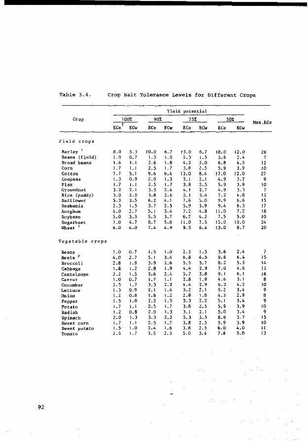
Table 3 .4. erop Salt Tolerance Levels for Different Crops
Yield potential
Crop 100% 90% 75% 50%
ECet Max.ECe
ECw ECe ECw ECe ECw ECe ECw
Field crops
Barley 1 8.0 5.3 10.0 6.7 13.0 8.7 18.0 12.0 28 Beans (field) 1.0 0.7 1.5 1.0 2.3 1. 5 3.6 2.4 7 Braad beans 1.6 1. 1 2.6 1.8 4.2 2.0 6.8 4.5 12 Corn 1. 7 1. 1 2.5 1. 7 3.8 2.5 5.9 3.9 10 Cotton 7.7 5.1 9.6 6.4 13.0 8.4 17.0 12.0 27 Cowpeas 1. 3 0.9 2.0 1.3 3. 1 2. 1 4.9 3.2 9 Flax 1. 7 1. 1 2.5 1. 7 3.8 2.5 5.9 3.9 10 Groundnut 3.2 2.1 3.5 2.4 4.1 2. 7 4.9 3.3 7 Rice (paddy) 3.0 2.0 3.8 2.6 5. 1 3.4 7.2 4.8 12 Safflower 5.3 3.5 6.2 4.1 7.6 s.o 9.9 6.6 15 Sesbania 2.3 1.5 3.7 2.5 5.9 3.9 9.4 6.3 17 Sorghum 4.0 2.7 5. 1 3.4 7.2 4.8 11.0 7.2 18 Soybean 5.0 3.3 5.5 3.7 6.2 4.2 7.5 5.0 10 Sugarbeet 7.0 4.7 8.7 5.8 11.0 7.5 15.0 10.0 24 Wheat 1 6.0 4.0 7.4 4.9 9.5 6.4 13.0 8.7 20
Vegetable crops
Beans 1.0 0.7 1. 5 1.0 2.3 1.5 3.6 2.4 7 Beets 2 4.0 2.7 5.1 3.4 6.8 4.5 9.6 6.4 15 Broccoli 2.8 1.9 3.9 2.6 5.5 3.7 8.2 5.5 14 Cabbage 1.8 1.2 2.8 1.9 4.4 2.9 7.0 4.6 12 Cantaloupe 2.2 1.5 3.6 2.4 5.7 3.8 9.1 6.1 16 Carrot 1.0 0.7 1. 7 1. 1 2.8 1.9 4.6 3.1 8 Cucumber 2.5 1. 7 3.3 2.2 4.4 2.9 6.3 4.2 10 Lettuce 1.3 0.9 2.1 1.4 3.2 2. 1 5.2 3.4 9 On ion 1.2 0.8 1.8 1.2 2.8 1.8 4.3 2.9 8 Pepper 1. 5 1.0 2.2 1. 5 3.3 2.2 5. 1 3.4 9 Potato 1. 7 1. 1 2.5 1. 7 3.8 2.5 5.9 3.9 10 Radish 1.2 0.8 2.0 1.3 3.1 2.1 s.o 3.4 9 Spinach 2.0 1.3 3.3 2.2 5.3 3.5 8.6 5.7 15 Sweet corn 1. 7 1. 1 2.5 1. 7 3.8 2.5 5.9 3.9 10 Sweet potato 1.5 1.0 2.4 1.6 3.8 2.5 6.0 4.0 Il Tomató Z.5 1. 7 3.5 Z.3 5.0 3.4 7.6 5.0 13
92
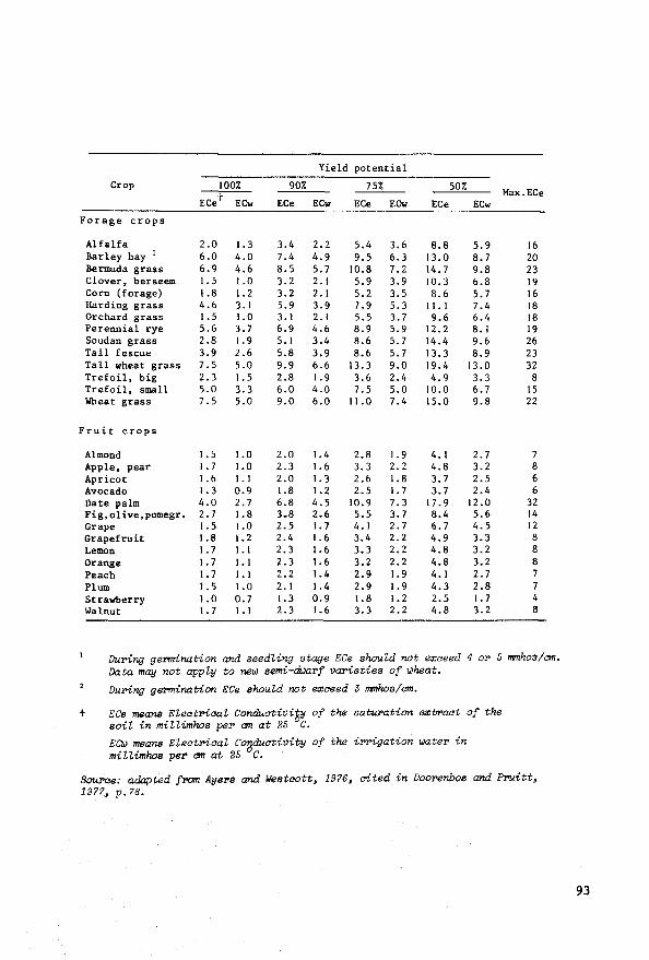
Yield potential
erop 100% 90% 75% 50% ECet
Max.ECe ECw ECe ECw ECe ECw ECe ECw
Forage crops
Alfalfa 2.0 1. 3 3.4 2.2 5.4 3.6 8.8 5.9 16 Barley hay 1 6.0 4.0 7 .4 4.9 9.5 6.3 13.0 8.7 20 Bermuda grass 6.9 4.6 8.5 5.7 10.8 7.2 14.7 9.8 23 Clover, berseem 1. 5 1.0 3.2 2.1 5.9 3.9 10.3 6.8 19 Corn (forage) 1.8 1.2 3.2 2.1 5.2 3.5 8.6 5.7 16 Harding grass 4.6 3. 1 5.9 3.9 7.9 5.3 11. 1 7.4 18 Orchard grass 1.5 1.0 3.1 2.1 5.5 3.7 9.6 6.4 18 Perennial rye 5.6 3.7 6.9 4.6 8.9 5.9 12.2 8. 1 19 Soudan graas 2.8 1.9 5.1 3.4 8.6 5.7 14.4 9.6 26 Tall fescue 3.9 2.6 5.8 3.9 8.6 5.7 13.3 8.9 23 Tall wheat grass 7.5 5.0 9.9 6.6 13.3 9.0 19.4 13.0 32 Trefoil, big 2.3 1. 5 2.8 1. 9 3.6 2.4 4.9 3.3 8 Trefoil, small 5.0 3.3 6.0 4.0 7.5 5.0 10.0 6.7 15 Wheat grass 7.5 5.0 9.0 6.0 11.0 7.4 15.0 9.8 22
Fruit crops
Al mond 1. s 1.0 2.0 1.4 2.8 1. 9 4. 1 2.7 7 Apple, pear 1. 7 1.0 2.3 1.6 3.3 2.2 4.8 3.2 8 Apricot 1.6 1. 1 2.0 1. 3 2.6 1.8 3.7 2.5 6 Avocado 1. 3 0.9 1.8 1.2 2.5 1. 7 3.7 2.4 6 Date palm 4.0 2.7 6.8 4.5 10.9 7.3 17.9 12.0 32 Fig,olive,pomegr. 2.7 1.8 3.8 2.6 5.5 3.7 8.4 5.6 14 Grape 1.5 1.0 2.5 1. 7 4.1 2.7 6.7 4.5 12 Grapefruit 1.8 1.2 2.4 1.6 3.4 2.2 4.9 3.3 8 Lemon 1. 7 1. 1 2.3 1.6 3.3 2.2 4.8 3.2 8 Orange 1. 7 1.1 2.3 1.6 3.2 2.2 4.8 3.2 8 Peach 1. 7 1. 1 2.2 1.4 2.9 1.9 4.1 2.7 7 Plum 1.5 1.0 2. 1 1.4 2.9 1.9 4.3 2.8 7 Strawberry 1.0 0.7 1. 3 0.9 1.8 1.2 2.5 1. 7 4 Walnut 1. 7 J. 1 2.3 1.6 3.3 2.2 4.8 3.2 8
Duri'1{] germination and seedling stage ECe should not e:x:aeed 4 or 5 mmhos/am. Data may not appZy to new semi-di.Jarf varieties of wheat.
During germination ECe should not e3!aeed 3 mmhos/am.
t ECe means EZeatriaaZ Conduativi~ of the saturation e:x:traat of the soil in miZZimhos per cm at 25 C.
ECW means EZeatriaal Conduativity of the miZ Umhos per cm at 25 ° C.
irrigation water in
Source: adapted from Ayers and Westaott, 1976, aited in Doorenbos and Prui tt. 1977, p. 78.
93
3.3 Intemal and overall land suitabilities
3.3. l Major landscape elements and overall land qualities
In endeavouring to simplify the concepts of land qualities and land
requirements in previous chapters, the impressio~ may have been created
that their sole purpose is to determine the suitability of individual land
(mapping) units and the specific land utilization types operating on these
land units. Although land evaluation often limits itself to this kind of
land suitability classification, it is sometimes necessary to carry out
land suitability classifications that take into account landscape elements
of a higher order, composed of several land (mapping) units.
Systematic resources surveys normally pay attention to the genera!
composition of the study area, recognizing landscape elements at different
levels of generalization. Individual land units usually correspond with the
most detailed subdivision of such landscape elements. Geology, geomorph
ology, climatology, hydrology and physiography are normally described
in such a way that the principal landscape elements and their relations
with individual land units can easily be recognized. Aerial photograph
interpretation and resource mapping techniques often begin by identifying
and subdividing such broad landscape elements. Of course these landscape
elements can also present certain 'overall' characteristics, qualities or
limitations, comparable with the more 'internal' characteristics, qualities
and limitations of individual land units.
Examples of 'overall' land qualities of major landscape elements are:
the distribution of water wells and the location of a river in a semi-arid
grazing area (e.g. of the Sahelian type); the precipitation, interception
and water storage capacity as agents of the hydrological cycle and water
flow in a catchment; the way the vegetative pattern regulates climate by in
f luencing the movement of cold airmasses in an area of frost hazards; the
presence of a water storage basin on the border of an area with potentially
fluctuating groundwater tables (e.g.the Veluwe lake, on the divide between
the IJsselmeer polders and Pleistocene uplands in The Netherlands; Volker
94
et al., 1969) presence and location of basins for temporary water storage
and flood control (e.g. Cienagas of Magdalena river system in Colombia);
the presence of low-lying land reserves suitable for discharge and evapora
tion of saline drainage water; the quality of irrigation water at the inlet
of an irrigation district; the gradient between the water inlet and the
water outlet of an irrigation and/or drainage project.
A land evaluation that takes account of major landscape elements and
their overall land qualities can help solve two very complex land use
planning problems:
- the analysis of land use interactions
- the assessment of the impact of full-scale implementations of the land use proposals
3.3.2 Land use interactions
Land (mapping) units rarely coincide with landscape elements. This
must be borne in mind when considering cause-effect relations between
land units, because the major geomorphological processes operating over
(and uniting) the whole landscape element may affect the component land
units. Land use effects that are felt outside the land unit where they
originate are sometimes not foreseen when land use recommendations are
made. But they are most important. For example: a land unit in the lower
part of a coastal plain seems to have the right land qualities for growing
sugar cane, providing the groundwater table can be lowered. However, in the
upper part of the plain sugarcane is grown very inefficiently, using too
much irrigation water; this causes the high groundwater tables, salinizat
ion and workability problems near the coast. If the land suitability
classification of the land unit in the lower plain does not consider
the upper plain, it may be concluded that sugarcane can be grown,
provided that a subsurface drainage system is installed to control the
groundwater table. But a land suitability classification that views the
lower plain in its context as part of a major landscape element - the
95
coastal plain - may conclude that sugarcane production in the lower plain
is feasible with a much simpler drainage system, provided that certain
recommendations for more eff icient water use in the upper plain are
implemented.
Sometimes land evaluation will concentrate on land units in the
upper catchment and will ignore the effects of land use changes on the
lower catchment, or even on land use in areas that are not included in
the same major landscape element. This is the case when large-scale
implementation of settlement projects results in natural forests being
replaced by pasture land and crops, thereby affecting the micro-climate
and possibly even the macro-climate. Although the impact of land use
changes on weather conditions and climate is controversial, consideration
of the off-site effects of land use changes should certainly be a matter
of concern for land evaluation (Wendt, Ed., 1971).
3.3.3 Impact of fuIJ-scaJe implementation ofland use proposals
To evaluate the effect of full-scale implementation of land use
proposals, the sum of the land requirements of individual land utilization
types must be compared with the corresponding overall land qualities. For
this purpose the term 'overall land requirement' will be useful: it
encompasses the sum of individual requirements made by the different land
utilization types that operate simultaneously on different land units
belonging to the same major landscape element.
The land requirements of individual land utilization types could be
distinguished frOlll the overall land requirements by the term 'internal'
land requirements.
Examples of overall land requirements are: the overall requirements
for drinking water of all livestock grazing on a major landscape element,
c0111pared with the overall availability of drinking water of that landscape
element; the overall drainage requirements in an irrigation project,
96
compared with the overall water storage and drainage possibilities of the
land area to be occupied by the irrigation project. 1
When overall land requirements are compared with overall land
qualities, constraints may be identified, warranting a reduction in area
where the land use proposals are to be realized. The following examples
should be able to clarify this point:
In several parts of South America (Andean Region, Southern
Brazil), traditional land utilization types were able to
occupy f ertile sloping land in forest areas on a permanent
basis without causing alarming soil erosion. Only small parcels
of land were occupied, obeying an established pattern of
rotations, including fallows and forest reserves. But once the
percentage of occupied land exceeded a critical limit for the
area as a whole, determined by the resistance to erosion of
the major landscape elements of which the land units are a
part, land degradation accelerated, often with disastrous
effects. Therefore land evaluation must include a prediction
of erosion, based on the overall requirements for soil con
servation of the envisaged land utilization types and the
overall land quality 'resistance to erosion' of the major land
scape element.
In N. Parana (Brazil) there has been an intrusion of coffee
plantations in areas marginal for coffee growing because of
night frost hazards. Certain land units are traditionally
protected from frost to a certain extent by nearby high-lying
The aomparison of overall land qualities with overall land requirements may neaessitate very speaialized saientifia methods. Examples are hydPology and water management, whiah use ~laborate methods to aonstruat water balanaes and to plan and design irrigation and dPainage systems. Another exampZe is watershed management. This report d.oes not presume to aontribute to suah established fields of speaialization. The purpose of this study is to indiaate how these speaializations and the information they produae relate to the land evaluation aonaepts and procedures presented her>e, to assure better Zand evaZuation results and aZoser aooperation with other speaiaZizations in the future.
97

forested zones that prevent the cold air masses from moving into
the coffee plantations. Removal of such forests would be disas
trous for the coffee on lower lying land.Therefore land evaluation
in such a zone, if contemplating coffee production, should take
into consideration the overall land quality 'absence of frost
hazard' of the major landscape element,including the possibilities
for improvement, e.g. the creation of channels in the vegetation
on the lower landscape element for the displacement of cold air
masses, and of conserving the situation where frost is not limit
ing, according to the requirements for frost-free land conditions
of the coffee-producing land utilization type (Camargo A.de,1966).
Field check on environmental impact
Vink (1975, p.316) proposes a field check after the provisional
evaluations have been made,
including the inspection of 10% or less of the area surveyed, to realize in the field the actual position in the terrain of the land mapping units which have been evaluated on the basis of maps and other data.
In my opinion such a fieldcheck will be most usefully served if the
possible land use interactions and the impact on the environment upon
full-scale implementation of the land use proposals are included.
There should be no doubt about the responsibility of the land
evaluator to predict the environmental impact as precisely as possible.
This bas been done in the past by placing land units in a lower class when
some doubts about the long-term effects of a particular land use existed.
Often such a down-grading of the land (mapping) unit was merely intuitive,
depending on the personal judgment of the land evaluation specialist. In
a systematic land evaluation, the main variables influencing such environ
mental considerations should be explicitly mentioned. If the land utiliz-
98
ation types are to receive more attention in land evaluation, their
environmental impact should also be more precisely predicted.
Non-physical off-site effects of land use changes
So far our discussion has been limited to the physical effects to be
expected from full-scale land use changes: the irrigation of arid lands,
the occupation of hilly land with long slopes, the transformation of
tropical forest areas into pasture land or erop land, the reclamation
of lakes. But the non-physical effects, both on-site and off-site, of such
land use changes can also be remarkable. Such off-site effects have also
been described by the term 'ripple effects'. An example is the effect of
the expansion (with government credit and subsidy) of the wheat and soybean
acreage in S. Brazil on the labour situation. On-site there has been little
increase in the number of farm labourers employed, but their productivity,
real income and acquisitive power have increased substantially. Off-site
the multi-million hectare increase of mechanized erop land, with its
dependence on fertilizers, pesticides and other farm inputs has strongly
influenced the services and manufacturing sector. Such socio-economie
ripple effects are unlikely to affect the land suitability classification,
unless these effects are included in the questions asked from land evaluat
ion. This may occasionally happen in integrated land development projects.
Although in most cases, they are not criteria, ripple effects can help
determine the selection of relevant land utilization types and the adjust
ment of their definitions at an advanced stage of the land evaluation
procedure, when the overall land requirements and the overall land qualities
are compared and the resulting effects of the land use proposals are
analysed. But the ripple effects must be of a certain magnitude before this
is worthwhile.
Internal and overall land suitability classification
To distinguish between a land suitability classification with a narrow
99
individual land (mapping) unit approach and one with a much wider environ
mental scope that takes into account major landscape elements, the terms
'internal' and 'overall' land suitability classification are proposed.
An internal land suitability classification
This is a classification of land (mapping) units according to the
degree to which their internal land qualities meet the internal land
requirements of a defined land utilization type, e.g. the listing of
land (mapping) units according to their productivity when under a
specific erop cultivated with a defined set of management practices.
An overall land suitability classification
This is a classif ication of land (mapping) units and major land
scape elements according to the degree to which their internal and
overall land qualities meet the internal and overall land requirements.
It takes into consideration the interactions between the envisaged land
uses and an assessment of the environmental impact from full-scale
implementation of the land use proposals.
This type of classification is unusual in today's land evaluation
methodology. The USDA Land Capability System bas been designed to minimize
undesirable environmental impacts, but its methodology still needs
considerable refinement to 111eet the standards of a true overall land
suitability classification. Some recommended land use classifications,
products of land use planning, also reflect some of the aims of the
overall land suitability classification. However, they are mostly
classifications in economie terms and may not be based on the kind of
physical analysis suggested in this report.
100
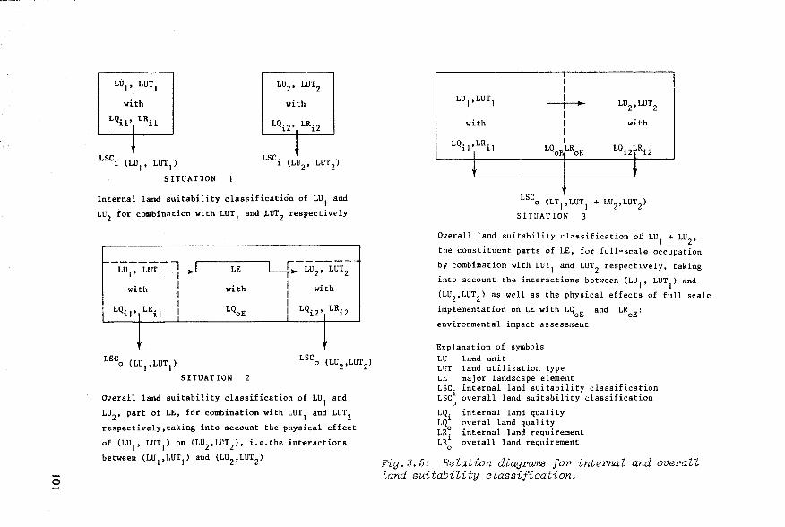
0
LU1
, LUT1
with
LQil' LRil
LSCi (LU1
, LUT1
)
SITUATION
LSC.( T) l LU 2, LU 2
Internal land suitability classificatión of LU1
and
LU2
for combination with LUT1
and LUT2 respectively
SITUATION 2
overall land suitability classification of LU1
and
LU2
, part of LE, for combination with LUT1
and LUT2
respectively,taking into account the physical effect
of (LU1
, LUT1
) on (LU2,LuT2), i.e.the interactions
between (LU1
,LUT1
) and (LU2 ,LUT2)
with
LQ.1,LR.
1 l 1 1
i 1 1
with
LSC o (LT1
,LUT1
+ LU2
,LUT2
)
SITUATION 3
Overall land suitability classification of LU1
+ LU2
,
the constituent parts of LE, for full-scale occupation
by combination with LUT1
and LUT2
respectively, taking
into account the interactions between (LU1
, LUT1
) and
(LU2,LuT2) as well as the physical effects of full scale
implementation on LE with LQ0
E and LR0
E:
environmental impact assessment
Explanation of symbols LU land unit LUT land utilization type LE major landscape element LSC. internal land suitability classification LSC 1 overall land suitability classification
0
LQ. LQ1 LR~ LR1
0
internal land quality overal land quality internal land requirement overall land requirement
Fig.3.5: Relation diagrams for internal and overall land suitability classification.
Conclusion
Land evaluation should be able to predict the impact of land use pro
posals not only for single land (mapping) units but also for combinations
of land units and for the physical environment as a whole. Also, inter
actions occurring between different land uses operating on different
land units should be foreseen. For this purpose a distinction is proposed
between internal and overall land qualities, internal and overall land
requirements, land (mapping) units and major landscape elements, internal
and overall land suitability classifications. The relation diagrams,
presented in Fig.3.5 summarize this proposal.
3.4 Combination ofland utilization types
Sometimes land use planning has to consider combinations of land
utilization types for the same land unit, or combinations of land units
for the same land utilization type. It then becomes necessary to establish
the principal combinations of land utilization types for land evaluation,
and the position of land qualities and land requirements for combinations
of land utilization types for land evaluation. At this point some def ini
tions will be useful (see also Beek in FAO, 1975 a,b, and FAO, 1976):
!02
A 'single land utilization type' bas land requirements that exclude other simultaneous uses of the land, e.g. large-scale sugarcane production.
- A 'multiple land utilization type' consists of more than one single land utilization type operating simultaneously on the same parcel of land, each with its own land requirements, inputs and outputs: e.g. recreation and timber production in the same forest area (Deshler, 1973; USDA, 1971b).
- A 'compound land utilization type' also comprises more than one single land utilization type operating on the same parcel of land but in different sites of the parcel. For the purpose or within the possibilities of land evaluation they constitute one use~ with one set of land requirements: e.g. strip cropping, mixed cropping.

0 ....,
1. Single land utilization type
LU1
,LUT1
with
LQt'ILRt
t LSC(LUI ,LUT t)
2. Multiple land utilization type
LU1
, LUT l + LUT2
with
LQ1 t ,LR1 and
LQl2'LR2 1
t LSC(LUI ,LUT
1 + LUT
2)
3. Compound land utilization type
LUI ,LUT1 + LUT2
with
LQI' LR( 1 +2) 1
t LSC(LU LUT + LUT )
I' 1 2
--·-·-------~---------------------------------------
4. Interacting land utilization types on inter-related land units
1
LU1
, LUT1
1 LU2
, LUT2 1 1 1
with 1 with 1 1
LQ1
, LR1
1 LQ2, LR2 1
LSC (LU1
,LUT1
+ LU2 ,LUT2
)
S. Land utilization type for combination of land uhits
LU 1, LUT 1
1 1 1 1 1
with 1 1
LQl+i• LRI 1
LU2, LUT 1
t LSC(LU , LUT1)
1+2
Fig.3.6. Relation diagrams indicating the role of land qualitie.s and land requirements in land evaluations for combinations of land utilization types/land units.
- A land utilization type for a 'combination of land units' will be required when the constraining land qualities of the land units in question can be most conveniently met by combining them within one operational unit, e.g. the combination of seasonally flooded land with better-drained uplands for extensive grazing.
The position of land qualities and land requirements in a land evaluat
ion for combinations of land utilization types and/or land units can be
easily understood by studying Fig.3.6.
3.5 A vailability and reliability of land resources data
At this stage of our discussion a few words need to be said .about the
available data base in land evaluation to explain some of the differences
in methodology between practical land evaluation and the more theoretica!
approaches to land use and plant growth simulation mentioned in Section 3.2.
Land resources maps and the descriptions of land (mapping) units are
products of land resources surveys. Land resources maps are produced either
by superimposing maps displaying the properties of separate attributes of
the land: the soil, the climate, the topography, etc., or by carrying out
an integrated survey of the land attributes.
For purposes of land eváluation the land (mapping) units that are dis
played on the maps are supposed to be homogeneous in their properties and
qualities. But of course there will always be a certain degree of short
range variation unaccounted for. Land resources survey reports therefore
need to include estimates of the purity/heterogeneity of the land (mapping)
units and their properties. Classifications of land attributes and component
properties underlying the maps and descriptions of land resources often
take into account value ranges of diagnostic properties, e.g. the range in
cation-exchange capacity, in base-saturation or in texture that corresponds
to a particular classification category. This range may sometimes be too
104
large, or the threshold values used for class distinction may not be rele
vant for the purpose of land evaluation.
Dijkerman (1974) referring to pedological data, distinguishes between
observational and experimental data. Most pedological data are observational
and the choice of data collected is subjective; the site and kind of 'data
collected depend greatly on the pedologist's apriori hypotheses of what
is important. Quantitative field and laboratory data may suggest a high
degree of precision (the closeness of the measurements among themselves
or their reproducibility), but their accuracy (the closeness of the measure
ments to the real value) can be questionable, especially when such data are
extrapolated to bigger land units, e.g. data about hydraulic conductivity,
soil fertility, salinity, etc. Obviously, the soil surveyor's competence
affects the validity of his observations and maps. He chooses his sampling
points purposely, not randomly, though the purpose as perceived by him
may differ from the purpose of the user of the information.
Field observations need to be restricted to the most important
information to enable the results to be produced within the allotted
time and budget. Data collection is strongly conditioned by professional
standards (e.g. guidelines for profile descriptions, soil survey manuals).
Luning (1974, personal communication) concluded that in the low rainfall
areas of Kapenguria, Kenya, the only feasible land utilization type was
range management. Therefore, the soil survey scale, which had been estab
lished at 1:100 000 could be reduced to 1:250 000 for that area.
Land resource inventory specialists may have difficulty in satisfying
all the users of their information to the same extent, whatever criteria
they adopt for their classifications. This is apparent from some recent
statistica! studies of soil survey results. Webster and Butler (1976) found
that simple correlations between morphological properties and other proper
ties of the topsoil were almost negligible at Ginninderra Experimental Sta
tion near Canberra, Australia (an area known for its great heterogeneity).
This partly explains the long-standing controversies between some soil survey
105
and soil fertility specialists. Land evaluators should also recognize that
the reliability of the data produced during the inventory stage poses limit
ations to the data analysis. It is sometimes useful to base interpretative
methodology on ranges rather than on fixed values of measurable limiting land
qualities and component properties. Webster (1977) has proposed the use of
choropleth maps (maps that show area partitions) to indicate the limits
within which relevant point data can be safely extrapolated, as a tool for
land suitability classification. In view of the increasing use of computer
stored soil information, Webster also expects more use to be made of point
symbol maps and isorithm maps (contour maps of continuous land variables
such as soil thickness, texture, hydraulic conductivity) in detailed
planning. Such maps provide great flexibility for expressing the spatial
variation of land constraints and for analysing the response to inputs.
However, the success of such new mapping techniques will depend on the ex
tent to which they can be blended with the soil surveyor's capacity to ob
serve and interpret natural phenomena in the field, and to make abstractions
of the real situation by using the criteria and logic that underlie
good soil classif ication systems. After all, data collection in land
evaluation is not a statistica! study based on stratified random sampling.
Homogeneity of land (mapping) units is sometimes considered a land
quality: in The Netherlands, Pons (1977) has observed that the more homo
geneous the land unit is, the more uniform its response to management will
be, and therefore the easier an optimal utilization of the land will
become. Homogeneity is also an important factor for the rationalization
of agriculture: to increase the scale of operations the fields must be
enlarged, which may require amalgamation of land areas of differing land
qualities and management needs. Assessing the homogeneity of land units
will always be a problem given the limitations posed by the sampling
density. Observation of present land use and erop response sometimes help
this assessment. Whatever methods of observation and data collection are
chosen, one should always be on the look out for potential constraints for
the uses in question. Observation of the present land use and discussion
with the farmers are important, to improve the correspondence between the
actual land conditions and the descript~ons of the land units resulting
106

from observing, measuring and classifying land resource properties. This
need for correspondence between actual and described conditions stimulates
the improvement of data collecting techniques and makes them more problem
orientated, thus improving our predictions of land behaviour and land use performance.
107
4. Approaches to land evaluation
To explain the land utilization type concept, references have been
made to several methods of land evaluation used in different parts of the
world. Apparently different methods of land evaluation have developed side
by side, depending on the kind of land use problems to be solved and on
the prevailing land conditions and constraints encountered. Also, the level
of detail of field surveys and land resource mapping have had a strong in
f luence on land evaluation methodology (Murdoch, 1972; McDonald, 1975;
Brook, 1975).
Special attention will be given to land evaluation methods in Latin
America, and to the role land utilization types play in these methods.
Since this role may vary considerably depending on the approach to land
evaluation employed, it seems necessary at this stage of our discussion
to identify the main approaches to land evaluation. This chapter presents
such a breakdown, and this breakdown should provide the necessary back
ground for a more detailed discussion in Chapter 5, of the role of land
utilization types in land evaluation. If the views expressed are not
fully consistent with earlier contributions made to the Framework for Land
Evaluation (Beek 1972, 1975a, 1975b FAO, 1976), explicit mention will be
made. However, most of this part of the report provides complementary infor
mation f or applying the Framework for Land Evaluation and the Soil Survey
Interpretation Methodology actually employed by EMBRAPA in Brazil (Beek,
Bennema and Camargo, 1964; Beek, 1975d).
Burrough (1976), when reviewing the major land evaluation systems
of English-speaking countries, The Netherlands and the Framework for
109
Land Evaluation, makes a distinction between land evaluations that serve
general purposes and land evaluations that serve specific purposes.
General purpose land evaluation represents a standardized approach for
all lands to evaluate their capability to support a generally defined
land use. Examples are the USDA Land Capability Classification, and many
local adaptations, for instance in Australia, New Zealand, Canada,
England and Wales, Pakistan, Chile and many others.
Specific purpose land evaluation represents a pragmatic approach:
not only the land hut also the use possibilities are explicitly studied.
Many soil suitability classification systems for specif ic crops beloog
to this category. General versus specific purpose land evaluation is
probably the most fundamental subdivision as far as the role of the land
utilization type in land evaluation is concerned.
In general purpose land evaluation, the land utilization type is a
standardized, broadly defined kind of land use, which is not the subject
of study during the land evaluation. In specif ic purpose land evaluation
the land utilization type is not standardized hut bas to be selected in
view of the prevailing physical and socio-economie conditions of the
area where the land evaluation takes place. If all lands are evaluated
on their suitability for the sam.e land utilization type the classification
has great comparative value, a major goal of genera! purpose land evaluation.
If the lands are evaluated only for selected relevant land utilization
types which are expected to be promising, the classification bas more
analytical than comparative value; specif ic purpose land evaluation.
This report concentrates mainly on the role of land utilization types in
specif ic purpose land evaluation.
In the Frameb)ork for Land Evaluation (FAO, 1976, pp.9-10), which is
an example of specif ic purpose land evaluation, a distinction is made
between a major kind of land use, which is 'a major sub-division of
rural land use, such as rainfed agriculture, irrigated agriculture,
grassland, forestry, recreation' and a land utilization type, which is
'a kind of land use described or defined in a degree of detail greater
than that of a major kind of land use'.
110
Major kinds of land use correspond roughly with the broad standardized
uses of general purpose land evaluation e.g. in the United States Land
Capability System. The concept of land utilization type was introduced
in the first place to support specific purpose land evaluation (Beek,
1972). It should be noted that specific purpose land evaluation does not
refer exclusively to more detailed studies than the general purpose land
evaluation. Both general purpose and specif ic purpose land evaluations
may be carried out at any scale. The examples given in Section 4.3.4 of
exploratory and reconnaissance land evaluation in Brazil are specific
purpose land evaluations. The definitions of land utilization types may
be very broad when describing one key attribute (e.g. agriculture versus
pasture) but detailed in another key attribute (e.g. the level of capital
intensity, or the kind of implements used). It appears to be difficult
to make sharp distinctions between different levels of generalization
when defining land utilization types, and therefore between a major kind
of land use and a land utilization type.
When applying specific purpose land evaluation, it is essential to
remember that the use is as much an explicit determinant of land suitability
as the land itself, and that separate evaluations should be carried out
for different uses. The level of detail at which the use is defined is
of secondary importance. However, it is extremely important for the land
evaluation methodology whether or not the use is specif ied beforehand,
and also whether or not this methodology provides standardized inforl!lation
for translating the data collected about the land conditions into land
classes. General purpose land evaluation is supposed to follow such a
standardized methodology, while specific purpose land evaluation is more
flexible, providing the land evaluator with an opportunity to consider
most the most relevant types of land utilization, to determine their land
demands and to interpret the degree to which the land conditions can meet
these land requirements, i.c. the land suitability classes.
4.1 Genera! purpose land evaluation
General purpose land evaluation fellows a standardized procedure for
111
all lands to evaluate their capability to support a generally def ined land
use. The suitability classification depends on relations between very
broadly defined kinds of land use and qualities of the physical environment
expressed in terms of limitations or hazards. A stable and near optimum me
chanized management system is assumed. Technological and socio-economie
variables are not considered. If one or more physical limitations can be
removed, the same land capability classification with the same criterïa
applies, according to the limitations after improvement. To complement the
broad definitions of land use, information about land management practices
is presented in connection with the land capability units, which are subdi
visions of the land capability classes with similar limitations and similar
land management recommendations. There is no provision for comparison between
the different kinds of land use. Agriculture is given precedence over pasto
ral, forestry and recreational or wildlife uses, respectively. On the other
hand, all lands can be compared, once they have been classified according
to the universa! land capability classes.
The system of land evaluation is easy to understand, relates only
to physical land variables and is relatively unaffected by social,
economie or technological changes. Therefore the land classes remain
valid for a long time. Land capability classifications at all scales can
be easily set up, from the national to the farm level (soil conservation
planning).
But the methodology also presents a number of disadvantages: these
have led to the development of another approach - specific purpose land
evaluation.
112
Disadvantages of the general purpose land evaluation are:
Although intended to be of genera! purpose, the method is based on an understanding of the needs of only the most common land uses. In developing countries especially, the urgency of socio-economie development has created a need for land evaluation that takes into account more specif ic types of land use of local relevance. The braad development objectives of governments such as labour absorption, higher and more equal income and improved nutrition for a rapidly growing population require a

pragm.atic assessment of the prospects for more intensive land uses despite seriously limiting land resources.
In many countries, present land use is very variable, corresponding to very unequal levels of technology. It will be difficult to predict land use performance on the basis of general purpose land capability classes.
The system is not sufficiently specific for comparisons to be made between conflicting land uses, as it considers each use as a separate option. Though the system allows for the lands to be ranked according to how far they meet the requirements of several broad land uses, it does not provide a ranking of different land uses competing for the same parcel of land.
4.2 Specific purpose land evaluation
Specif ic purpose land evaluation also follows a standardized procedure
but the methodology is not based on standardized relationships between
pre-established uses and standard limitations of the physical environment.
Using all relevant and available physical, technological, social and
economie data, each land area is evaluated on its fitness to support the
most pertinent land utilization types. This fitness, or land suitability,
is expressed in terms of the effects to be expected and the inputs required.
Separate land suitability classifications are made for each relevant land
utilization type. In a purely physical analysis, the effects or outputs
are expressed in physical terms (erosion losses, yields) and the inputs
are also expressed in physical terms (amounts of fertilizer, water appli
cations, duration of field operations, labour requirements ••• ) quantified
eithèr on an ordinal or a ratio scale. In a physical analysis it is diff i
cult to compare different uses that compete for the same tract of land,
unless the multi-dimensional physical effects and inputs are brought under
a common denominator: commensuration, or are grouped in capability/
113

suitability classes (see Sect.5.4) 1•
The most practical method of commensuration is by measuring all effects
and inputs in monetary terms by applying appropriate prices. This usually
requires some additional economie analysis.
The land evaluation methods employed by the United States Bureau of
Reclamation, the ecological method of land evaluation of Beek and Bennema
(1972) and the Framework for Land Evaluation (FAO, 1976) are examples of
specif ic purpose land evaluation. These methods provide guidance for the
physical and the socio-economie analysis. The soil survey interpretation
system for reconnaissance surveys in Brazil (Beek, Bennema and Camargo
1964) covers only the physical analysis in specific purpose land èvaluation.
Specific purpose land evaluation is complex and requires the services
of different disciplines (soils, hydrology, water management, agronomy,
agricultural economics, sociology, agricultural engineering):
114
to select the relevant land utilization types
to interpret the land utilization types in terms of specific land requirements
to study the land conditions, determine the constraining land qualities and the possibilities of their improvement
to predict the performance of the land use within defined levels of reliability, taking into account their land requirements and tolerances,
to translate these predictions from multi-dimensional physical effects into common (mostly economie) terms.
The process of measuring factors of different dimension by the same standm>d, bringing them thus under one cormzon denominator in systems aria.lysis (Toebes, 1975) is refeI'Ped to as commenBUI'ation. The best knou.m corrunensUPation is in monetary te1'"1s.

A number of the disadvantages indicated for the genera! purpose
land evaluation will thus be overcome; but several new problems emerge.
Outstanding are:
a) the greater dependence on precise information about fundamental
cause-effect relationships between the constraining land qualities and
the performance of the land use systems.
This problem, as a result of the many combinations that exist in
the world between types of land utilization and types of land (constraints),
has been the subject of innumerable fragmentary studies, mostly dealing
with specific crops and rather site-specific physical land conditions.
Chapter 5 suggests ways of increasing the possibility of making
analogy, despite of scarce specific local information, by using systems
analysis and models in land evaluation.
b) The need for interdisciplinary cooperation. General purpose
land evaluation bas been mainly the task of soil scientists, who, with
the help of comprehensive manuals of land capability classification, had
little difficulty in assigning a land capability class - subclass-unit -
to a particular land unit. They faithfully applied the rules and regulations
of manuals, which in some places have acquired a sacred status.
Manuals for general purpose land evaluation have been published in
consultation with agronomists and other specialists, but their contribution
is usually rather generalized. The same may be said of the recommendations
for environmental conditions of specific crops. References to soils are
usually restricted to soils with no or few limitations: deep friable
soils of high fertility, neutral pH, well drained, sufficient moisture
and high organic matter. Such specifications do not answer the questions
arising in most projects where the soils unfortunately seldom meet such
qualifications.
Manuals could be prepared for specific purpose land evaluation. In
fact, the documents prepared by the Working Group for the Interpretation
115
of Soil Maps of The Netherlands Soil Survey Institute (Stiboka, 1976
Report No.6047) go in this direction,although the types of land utilization
remain rather unspecific and as a consequence the corresponding critical
levels of land qualities have not yet been elaborated in great detail.
Much has to be done, in developed countries too, to elaborate
satisfactory guidelines for specific purpose land evaluation. Even the
United States Bureau of Reclamation manual Land Classifiaation for
Irrigated Land Use (see also FAO, l974b) is too braad a guide for specific
purpose land evaluation. For a detailed land evaluation in relation to
specific types of land utilization - say, horticultural crops and also for
specific erop rotations - this manual gives no explicit guidelines on the
interpretation of land conditions based on specific land requirements
of the mentioned crops. Proper application of the United States Bureau
of Reclamation system requires substantial support from agronomists, agri
cultural economists, agricultural engineers familiar with the use of
farm equipment, etc., before reliable classifications of land suitability
can be made. There is a strong reliance on the experience obtained in
other areas under analogous conditions.
It is fashionable nowadays to expect spectacular results from
interdisciplinary cooperation. Indeed much of the thinking put forward
in this report was obtained after looking into the kitchen of other
disciplines, especially regarding methods of work, concepts and procedures
in theoretical plant production, water management, agricultural economics
and agricultural geography. However, it has also been rightly observed
(Lekanne dit Deprez, 1976) that interdisciplinary cooperation introduces
new problems of communication and organization. Soil scientists should
remain soil scientists and agronomists be always agronomists. I hope
that the systems approach proposed in Chapter 5 will be useful in managing
this problem. The system analysis specifies, organizes and processes the
contributions made by the various disciplines. A basic assumption of a
systems approach is that each discipline should be given as much independence
as possible to produce its own data. In many countries, land evaluation is
the task of specialized natural resource~ institutions, which in the
116

past may have concentrated in the first place on soil or vegetation
survey, often the most variable attributes of the land. Such institutions
have concentrated mainly on general purpose land evaluation. Future
changes should be concerned especially with:
more emphasis on climate
more emphasis on biologica! and technic?l aspects of land use
more attention to socio-economie aspects of land use
more emphasis on fundamental land use - land relationships.
Burrough (1976) presents the following suggestions for future
research in land survey and evaluation in Australia:
to put less emphasis on research for its own sake and more on
incorporating the results of research into the decision-making
process. This implies the setting of specific research goals.
to develop techniques of system modelling and analysis to aid
resource appraisal
to increase knowledge on the social and cultural perceptions
of land and the ability of land to support socially and eco
nomically, as well a physically feasible land use options.
If such changes seem over-ambitieus, one is reminded that the
workload involved in the interpretative stages of land evaluation is
minor when compared with the inventory stages, both in man days and
operational costs.
c) An obvious drawback of the more pragmatic specif ic purpose
land evaluation is the shorter duration of the validity of its results.
The time variability of the technological and socio-economie factors
introduced needs to be taken into account. The systems approach introduced
in Chapter 5 should overcome this disadvantage by permitting easy feedback
to fundamental data and revision of the interpretations when assumptions
change. Particularly in societies with rapid technological and socio-
117

economie change, the institutions involved in land evaluation are respons
ible for presenting timely revisions of their results before they become
obsolete.
d) Separate land suitability classif ications for different uses do
not permit the performance of one use to be compared with the performance
to be expected from another use, Ullless these performances are expressed
in counnon (mostly monetary) terms. Comparison between different land
utilization types for which the land is classified as suitable requires
not only a physical analysis but also mostly a socio-economie analysis.
In the next section more attention will be given to this aspect of land
evaluation. It may prove difficult for scientists in the physical discipli
nes to introduce into their working methods an element that increases their
dependence on the cooperation of the socio-economie disciplines. Therefore
it is best to maintain a clear distinction between the physical analysis
in land evaluation or physical land evaluation, and the socio-economie
analysis. In this report, the approach to land evaluation that includes
both the physical and the socio-economie analyses has been named integral
land evaluation.
4.2. l Physical land evaluation
Physical land evaluation is concerned with predicting the performance
of specific land use systems, as conditioned by the constraining
influence of physical land conditions. Performance is expressed in
physical terms. 1 The physical land conditions are the only variables that
affect the rating of the performance of the land use systems, i.e. the
physical land suitability classification.
118
The te1'1Tl 'physiaal' as used in this Peport is set against "soaio-eaonomia".
Physical land suitability classification with and without major land improvements
Often, land evaluation includes the consideration of major one-time
improvements of the physical land conditions: irrigation, drainage, deep
ploughing. Such improvements demand large capital investments. Careful
physical and socio-economie analysis of the feasibility of these land
improvements is needed to predict their effects on development and
environmental conservation.
For an objective evaluation of major capital investments, a comparison
is normally made between what would happen in the project area with and
without implementation of the envisaged land improvements. Thus there
are two land suitability classifications: land suitability classification
for improved conditions (LSCi) and land suitability classification for
unimproved conditions (LSCu).
As an intermediate step in predicting the effect of land improvements
on the performance of land use, land evaluation includes a prediction of
the effect that major land improvements will have on the constraining
land qualities. For this purpose a distinction can be made between
unimproved land qualities (LQu) and improved land qualities (LQi). The
physical improvements are specified as precisely as possible in technical
terms (e.g. subsurface drainage is expressed in terms of spacing and
depth of tiles, materials to be used). Predicting the effect of land
improvements can be difficult, requiring substantial local research
and/or analogy. Care is taken that the technical specifications of
improvement can be easily translated into costs during subsequent socio
economic analysis.
The distinction made in the Frame:liJork f or Land Evaluation between
current and potential land suitability is not quite satisfactory. 'Potential'
is a vague term, which can easily be confused with 'maximum'. Especially
in developing countries, land suitability after improvement, will represent
performance levels that are far below maximum level.
119
Land use and land improvement decisions are a result of optimization
that takes into account the most limiting factors: seasonal labour
shortage, land tenure, availability of irrigation water, capital, etc. In
view of the many limiting factors there will almost invariably be a
substantial dif ference between the feasible level of performance and the
hypothetical maximum performance that would be obtained if land use were
limited only by the physical characteristics of a particular kind of
land. Especially in areas with an established land use pattern, potential
land suitability will be strongly influenced by limiting socio-econom.ic
oriented factors inherited from the past. Specif ic purpose land evaluation
takes this legacy into account.
Land suitability criteria
The land suitability class expresses the degree of fitness of a
given type of land for a specified land utilization type. Distinction
between different classes of suitability depends on the land suitability
criteria that control the limits between suitable and unsuitable -
between highly suitable and moderately suitable land. Land suitability
criteria depend again on the criteria for optimal land use. The most
common criteria are maximum benefit and minimum losses: land suitability
classes express different levels of expected benefit and loss. This
logic applies not only to the land suitability classif ication, but also
to the land improvement specifications: optimum land improvements are
those that produce the 'best' results, i.e. are most in agreement with
the criteria for optimal land use.
Optimal land use performance is a socio-economie criterion employed
(after translation into physical terms) in physical land evaluation for
grouping lands in different land suitability classes according to the
levels of expected performance. But physical land evaluation normally
120
does not include commensuration in case the performance or land use
'effects' are expressed in different physical terms: expected yield,
expected erosion losses, expected physical input requirements. A precise
quantitative expression of each land suitability class to indicate the
expected performance of a land utilization type on a particular land
unit is beyond its scope. However, at the beginning of physical land
evaluation, when the land utilization types are identified, explicit
attention should be given to the selection of land suitability criteria
for land evaluation for defining land suitability. A rating scale in
terms of values taken by the criterion variables of e.g. yield levels,
should permit a classification or ranking of the land units according to
their fitness for a specified land utilization type.
Examples of land suitability criterion variables are:
Yield level
Performance reliability
Multi-annual yield trend
Flexibility for timing of field operations
Flexibility in choice of equipment for field operations
Levels of soil erosion losses per hectare
Levels of physical inputs required
Time period required for a major land improvement to take effect (e.g. desalinization)
Time period that continuous cropping is possible (shif ting cultivation).
In a physical land evaluation, the land suitability classes stand
for different values of each criterion variable corresponding with the
different degrees to which the land use objectives are expected to be
met. In the absence of a common denominator for criterion variables of
different dimensions, the land suitability classes are mostly verbal
descriptions of the degrees in which the land use objectives are met.
Expected outputs and inputs may be expressed in terms of dissimilarities
from normal outputs and inputs with their standard deviations observed
in the project area.
121

The following example of physical land suitability classification
for traditional agriculture (no fertilizer, no mechanization) is from
Brazil (see also Section 4.3.4):
122
Land suitability class I - good
Actual agricultural soil conditions 1 suited to a wide range of annual
crops and tree crops. Relatively good yields (considering the management
practices concerned) normally for a period of at least 30-40 years
(tentatively), during which the productivity only decreases gradually.
Even under the assumption that productivity may decrease gradually,
good land for this land utilization type is very scarce in Srazil,
because fertility mostly decreases rapidly while the soil is used for
agriculture.
Land suitability class II - fair
a) Actual agricultural soil conditions suited to a wide range of
annual crops, after burning, with yields that are good during the first
few years of occupation, hut which will rapidly decrease to reasonable
yields, considering the management practices, the latter normally lasting
for a period of 7 until 30 years (tentatively) after the beginning of
the occupation.
b) Agricultural soil conditions suited only for a restricted
number of crops and tree.crops, with relatively good yields fora period
of at least 30 years (tentatively) during which the productivity will be
nearly sustained.
c) Presence of permanent slight risk of erop damage, reducing yields;
likely to occur once in a period of more than five years.
~gl'ieulturaZ soil eonditions' in BI'azil aI'e the equivalent of ''land quaZities'.
Land suitability class III - restricted
a) Actual agricultural soil conditions suited to a wide range of
crops, after burning, hut only during the first years of occupation,
since yields rapidly decrease to low yields within a period of 7 years
(tentatively).
b) Actual soil conditions suited to a restricted number of tree
crops, with relatively good yields, for a period of not more than 30
years, or reasonable yields during a langer period, with practically
sustained production.
c) (In case of management system III) Actual soil conditions
restrict considerably the use of animal traction and accompanying implements,
or where (in case of management systems IV and VI) hand labour is difficult.
d) Presence of a permanent moderate risk of erop damsge reducing
yields, which is likely to occur once during a period of 1-5 years.
Land suitability class IV - not suitable
a) Actual agricultural soil conditions not suited for the cultivation
of crops or tree-crops, since yields are already low in the first year
of occupation, or when yields are not feasible.
b) Actual agricultural soil conditions make the use of animal
draftpower impossible (system III) or impede practices based on manpower
(systems IV and VI).
c) Actual agricultural soil conditions include a permanent strong
risk of erop damage reducing yields, which is likely to occur once or
more every year.
Class !Va - soils, suitable for extensive grazing
Class IVb - soils, not suitable for grazing
Sou:rae: Beek, Bennema and Ca:margo, 1964
123
From the example it will be understood that the definitions of
land suitability classes are closely linked to the definition of the
land utilization type. When no fertilizers can be added, the time
period that the land can be utilized before it returns to fallow is an
important criterion. In the example, flexibility in the use of tractor
drawn farm equipment is not a relevant criterion variable for the suita
bility classification as it does not affect the operations of this non
mechanical land utilization type. The identification of relevant land
utilization types explores references that can also provide the criteria
for distinguishing land suitability classes. When major land improvements
are contemplated, criteria for the selection of optimal land improvements
are needed e.g. of relevant drainage techniques in view of available
government funds, and of prices and market prospects of envisaged crops.
Physical land evaluation for specific purposes thus requires
some kind of preliminary, mainly qualitative, socio-economie analysis
serving two purposes:
to synthesize the most relevant land utilization types, as described in Chapter 2 of this report,
to identify criterion variables and their significant values for the selection and specification of land improvements and to define the land suitability classes in terms of values taken by these variables
Qualitative versus quantitative land suitability classification
The degree of quantification in which the suitability criteria
are expressed will depend on the purpose and detail of the land evaluation.
Some criteria (such as yield) will be more easily expressed in quantitative
terms than others (e.g. performance reliability or soil erosion losses).
The more comprehensive the land evaluation (taking into account more
effects resulting from the interactions between land utilization and its
environment) the more difficult it will be to present purely quantitative
results.
124
The FAO Frcunework for Land Evaluation makes a distinction between a
qualitative land suitability classification and a quantitative land
suitability classification (FAO, 1976, p.22):
A qualitative classification is one in which relative suitability is expressed in qualitative terms only, without precise calculations of costs and returns.
A quantitative classification is one in which the distinctions between classes are defined in common numerical terms, which permits objective comparison between classes relating to different kinds of land use.
It is questionable if land evaluation is well served by a distinction
between qualitative and quantitative. The FAO document (p.22) admits that
qualitative evaluations allow the intuitive integration of many aspects of benefits, social and environmental as well as economie. This facility is to some extent lost in quantitative evaluations.
It seems that even in the most detailed integral land evaluation,
in which systematic socio-economie analysis is included, there will, most
probably, be a multi-dimensional output consisting of physical, biologi
cal, social, economie and environmental effects, outputs and inputs
which cannot easily be brought under a common quantitative denominator.
On the other hand, physical land evaluation may be able to express some
of its ratings in precise quantitative terms (e.g. yields, fertilizer
inputs), whereas other land classification criteria remain qualitative:
no - low - medium erosion losses expected. Thus the distinction between
qualitative and quantitative land evaluation is blurred. In this report
the distinction between qualitative and quantitative land suitability
classification has been deliberately omitted. Land evaluation should
always be as quantitative as possible, without compromising on its
responsibility for predicting all physical, socio-economie and environmental
effects of proposed land use changes or of a continuation of existing land
125
use systems (see also the economie evaluation of environmental pollution:
Opschoor, 1974; Hueting, 1975; OECD, 1974; Bouma, 1972; Pearce & Rose, 1975).
When are the land utilization types def ined in physical
land evaluation?
Two separate situations can be distinguished:
a) The land utilization types are synthesized at the beginning and
are not modified during the later steps of the physical land evaluation
procedure.
b) The land utilization types are broadly defined at the beginning
and are modif ied and adjusted in accordance with the findings of the
physical analysis. This is the case in more detailed land evaluation,
especially when major land improvements are considered. Such refinements,
which may also affect the selected criteria for land suitability and
land improvement, represent a corrective feedback ·to the earlier described
land utilization types. It is not an optimization of the land utilization
types in the sense that they are ranked according to their performances if
combined with a particular land unit. The latter is a task for socio-econo
mie analysis in integral land evaluation. In physical land evaluation the
land utilization types represent separate land use possibilities. Separate
land suitability classifications are made for each land utilization type
and sometimes for combinations of land utilization types (compound/multiple
land utilization types).
In small-scale physical land evaluation, the suitability of each
land unit will probably be classified for each land utilization type. In
more detailed evaluations the suitability of a land unit wilt only be
classified for the most pertinent land utilization types.
126
4.2.2 Integral land evaluation
Integral land evaluation is a combination of physical land evaluation
and socio-economie analysis. Since physical land evaluation bas been the
subject of the previous paragraphs, I will now discuss mainly socio
economic analysis in land evaluation.
Socio-economie analysis in land evaluation bas two main tasks:
a) commensuration of the multi-dimensional land suitability
classification produced by the physical land evaluation: land suitability
classification in common economie terms.
b) to find the optimal land use for different classes of land:
optimization of land use.
a) Land suitability classification in economie terms
This is a synthesis of the physical land suitability classif ication
and the relevant socio-economie factors. Appropriate product and input
prices that define the physical land suitability classes are applied to
the physical inputs and returns. Sometimes socio-economie analysis of
the land utilization types, following the methods described above,
produces new information that needs to be f ed back into the physical
land evaluation so that its findings can be revised. ldeally, the analysis
of land use performance in the light of physical land variables, and
the land suitability classification in economie terms should proceed si
multaneously, one supporting the other. This will mostly be the case in
detailed land evaluation, but in less detailed studies, physical land
evaluation and socio-economie analysis can be separate studies. At the
reconnaissance level in particular, there can be a considerable time lapse
between the physical land suitability classification and the land suitab
ility classification in economie terms. An example is the natura! resources
survey executed with OAS assistance in Chile, discussed in Section 4.3.5.
127
Generally, in reconnaissance land evaluation, socio-economie analysis
is limited to selecting the most promising land utilization types. On the
basis of a physical land suitability classification, those lands that are
of interest for more detailed land evaluation are selected. Only during
these subsequent studies will the necessary data be collected to translate
the land suitability classification into economie terms of net benefit~,
repayment capacities etc.
At the semi-detailed level the economist will usually carry out
cost benefit analysis or gross-margin analysis on a tentative basis so
as to offer early guidance on how the land utilization types being
considered will perform in connection with different classes of land.
This exercise also helps to raise the general level of analysis and
reporting, by forcing the land evaluator to make the necessary assumptions,
including the key attributes of land utilization types and the expected
physical outputs and inputs, for suitability rating. During the semi
detailed land suitability classif ication in economie terms, feedback to
the physical land evaluation is connnon practice. For purposes of land
use planning, land classes will often be established at semi-detailed
level, first in physical terms, and after that, subject to possible
modifications, in economie terms. These classes provide the background
for detailed land use planning.
At the detailed level, socio-economie analysis is more concerned
with optimizing the land use than with the commensuration of physical
land suitability classes in common economie terms. Often, non-physical
factors will receive more attention than physical land variables in the
land use optimization process.
Land suitability classes in economie terms do not necessarily
coincide fully with the physical land suitability classes. The latter
classes, however, do support the determination of suitability classes in
economie terms by providing essential data on technical input coefficients
as well as on returns to be expected (in the first place yields, but
also other secondary and intangible benefits and services).
128
b) Optimization of land use
This process is initiated at the beginning of the physical land
evaluation with the synthesis of the most promising land utilization
types, as described in Section 2.4.
During integral land evaluation, the optimal type bas to be selected
and sometimes combinations need to be made to arrive at optimal systems
of rotation or multiple use. In multi-annual land reclamation projects,
the ultimate goal of land evaluation will sometimes be the production of
a sequence of land utilization types, replacing each other in accordance
with the progress made with land improvement e.g. desalinization. Opti
mization of land use shows an increase in quantif ication and reliance on
socio-economie data with increasing detail of land evaluation (Robertson,
Luning and Beek, in FAO, 1975b).
At reeonnaissanae level socio-economie analysis is unlikely to go
further than a synthesis of relevant land utilization types at the beginning
of (physical) land evaluation. A genera! socio-economie framework is esta-
b lished1 and a qualitative inventory is made of development constraints
and possibilities. Constraining qualities of the socio-economie environment
identified at this stage might include adverse land tenure conditions,
inadequate legislative aspects of soil and water conservation, seasonal
labour shortages or unemployment, poor access to markets and services,
market prospects of main crops of the project area and comparative advanta
ges in relation to other areas producing these crops, price policies, etc.
Conclusions are unlikely to be expressed in quantitative terms unless the
amount and quality of existing data justify a quantitative analysis. Much
of the information is likely to derive from discussions with farmers,
traders and officials and from publications by government and other
development agencies (World Bank, FAO). Sometimes farm surveys will be
important f or the analysis of present land use and broad development
perspectives. Examples of such studies at reconnaissance level are the
INCRA (1973) survey and evaluation of natura!, socio-economie and insti
tutional resources of Rio Grande do Sul, Brazil, and the SUPLAN studies of
potential land use (Beek, 1975d). Also the Kenya Soil Survey uses an agro-
e.g. through ag:rieultura.Z sector analysis
129
economist for the systematic identification of land utilization types (Lu
ning, 1973; de Jong, 1977):he carries out a preliminary farm survey to
collect the pertinent real data.
At the semi-detailed level or intermediate level, the form taken by
socio-economie analysis depends greatly on the quality and quantity of
existing data. Where data are scanty, the analysis will incline towards
the approach followed to synthesize relevant land utilization types in
the reconnaissance phase. Where data are more plentiful, the analysis
will more probably approximate the methodology appropriate for the
detailed phase. Where necessary, a global farm survey confined to the
structure of the farm enterprise will be carried out. Linkages between
land utilization types and farm types will need to be established.
Stratified random sampling based on ecologically and agriculturally
homogeneous zones will allow extrapolation to the required area level.
Sometimes a detailed farm survey with emphasis on the production process
will be useful. In this micro-analysis, attention should not be confined
merely to production-oriented objectives but should also comprise other
national development objectives, e.g. self-sufficiency in food, employment,
income distribution. The major focus could be on particular target
groups, such as - on the one hand - the farmers who are in a stage of
transformation, cultivating new crops, using new techniques and other
inputs; on the other hand, small-scale traditional farmers, consisting
of the poorest with the lowest risk-taking capacities, who have remained
out of reach of rural services and technical assistance.
The detailed level of land evaluation is the most appropriate level
for optimizing land use. Reconnaissance and semi-detailed levels should
produce no more than preliminary approximations of recommended land
uses. Now, farm level optimization techniques may be used beneficially
to give guidance in realistic farm planning. Tecbniques such as budgeting,
programme planning and mathematica! (linear) programming, known already
from detailed land use planning, will be selected.
Socio-economie analysis is based,,on data produced by the detailed
130
farm survey, the availability of resources and their allocation by pro
ducers: water, agro-chemicals, labour, capita!, land of a certain suitab
ility etc., input-output relationships, sales patterns and prices and
costs. Also taken into account are credit needs and availability, tenure
arrangements and market systems, the nature of social groupings and the
interactions among them, and the values and attitudes of prospective pro
ducers.
Criteria for socio-economie analysis in integral land evaluation
Robertson, Luning and Beek (in FAO, 1975b) have singled out the
following criteria:
Net benefit and repayment capacity of loans for land improvement are the best known criteria for distinction between land suitabili ty classes in economie terms. An example is the United States Bureau of Reclamation Classification for Irrigated Land Use. The proposed types of land utilization, sometimes combined into more complex farming systems, should be commercially attractive when operating on the land under consideration from the point of view of the land user (the farmer or the company).When big investment loans are involved, the repayment capacity of the beneficiaries also needs to be reviewed (Price Gittinger, 1972).
Simultaneously, a social cost-benefit analysis should discover whether the proposed development will benefit society as a whole. This requires adjusting costs and prices where relevant in order to correct foreign exchange deviations and other distortions (taxes, subsidies). This analysis is concerned with the true scarcity value of resources to the society.
Apart from calculating the returns to scarce capital and other resources, as carried out in the conventional cost-benefit analysis, due attention needs to be paid to the possible trade-offs with other objectives (employment, income distribution, efficient use of fossil energy, minimization of environmental pollution). Appropriate weight should be given to these other objectives. Sensitivity analysis could be usefully applied.
131
Staged and parallel land evaluation procedure
Integral land evaluation may follow two rather different procedures
(Beek, in FAD 1975 a):
In a staged procedure the stage concerned with physical land eva
luation is followed by a stage concerned with socio-economie analysis as
described in the previous paragraphs.
In a parallel procedure socio-economie analysis proceeds concur
rently with the physical land evaluation at a comparable level of detail.
Up until now the staged procedure was referred to as 'two-stage'
procedure: this term bas been adopted for the Frcunework for Land Evaluation
(FAO, 1976). But strictly speaking the staged procedure consists of
three stages:
132
J. preliminary socio-economie analysis for the synthesis of land
utilization types, land suitability criteria and land improvement
criteria to be used during the physical land evaluation. It
bas been said earlier that this kind of socio-economie analysis
is not necessarily a task of land evaluation; the information
about land utilization and criteria may also be contained in
the terms of reference for the land evaluation study (pre
established land utilization types, most conunon in genera!
purpose land evaluation).
2. The physical analysis.
3. The complementary socio-economie analysis: land suitability
classification in commmon economie terms and the optimization
of land use for specif ic land conditions.
There can be a considerable time lapse between stages 2 and 3. Some
times there will be no stage 3 but a more detailed follow-up land evaluation
study of some areas selected from the data produced during stages 1 and 2.
4.2.3 Choice ofland evaluation methods
Exploratory and reconnaissance type studies rely mainly on physical
land evaluation. Such evaluations concentrate on identifying physical
constraints and possibilities at regional and national levels, and are
mainly carried out by institutions that specialize in physical resources
studies. The rather generalized land suitability classifications that
are produced should be valid for a long time. When the study area is
large, climate is an important variable both in terms of spatial variability
and because of seasonal and multi-annual variance. Results provide the phy
sical geographical base for medium- and long-term plans, and the selection
of priority areas for more specific studies, and more detailed land eva
luation. Examples of problem-oriented studies that can be identif ied during
a reconnaissance physical land evaluation are: the installation of rain
gauges, piezometers and experimental fields for artificial drainage, use of
chemical fertilizer, pilot areas for soil conservation and water management.
A special application of physical land evaluation is the prediction of bio
logical production potential, as conditioned by site-specific physicLl fac
tors. Although in such rather theoretical studies the emphasis is usually
on the climatic factors, other physical variants such as soil, natural vege
tation and topography can be introduced as reduction factors for the clima
tologically feasible production potential (Buringh et ai., 1975, 1977; Nix
1968; FAO Agro-Ecological Zones Project, Africa Report 1978).
Today's interest in long-term planning and environmental control at
regional and global level, shown by the Club of Rome and the U.N. System
(Garbutt et ai., 1976; Linneman, M., 1977) is adding a new stimulus to the
national interests in small-scale physical land evaluation.The challenge is
to introduce into such studies specific target groups (e.g.low income versus
high income farmers, minifundioe versus tatifwulioe) for a better analysis
133
of development alternatives in the light of physical constraint and struc
tural development problems. Specific purpose land evaluation should be able
to contribute, also at small scale, as will be demonstrated in Section 4.3
for Latin America.
At larger scales (usually greater than 1 : 50 000) physical land
evaluation serves more specif ic purposes connected with project planning,
design and implementation: feasibility studies for land reclamation and
improvement, settlement, reallotment, farm planning, soil conservation,
rural extension.
The borderline between physical land evaluation and integral land
evaluation becomes less clear. At the semi-detailed level, the physical
land evaluation is carried out mostly as part of a staged integral land
evaluation procedure. Physical development problems and improvement possib
i lities are examined and the results expressed in such a way that commensu
ration into economie terms can be easily done. The accent will be in the
first place on subdividing the project area into land classes with different
physical possibilities for alternative uses (conceptual physical planning).
The predictable yields, the broad techniques and costs of land improvement,
and the possibilities for carrying out the main farm operations are
important. Semi-detailed land evaluation frequently serves as an introduc
tory stage for detailed land evaluation. At this scale we are concerned
with the formulation of specific projects and their implementation. The
range of land conditions will already be known from previous less detailed
studies, and also their suitabilities for specific land utilization types,
both in physical and economie terms. At a detailed level, the geographical
base (land resources map) needs to be refined (1 : 5 000 - 1 : 10 000 scale
mostly).
A few properties of the soils are added or are described more preci
sely, thereby increasing the accuracy of the predictions of performance.
These predictions will be limited to the most promising land use alterna
tives. Such refinements will be influenced mainly by the variable topogra
phy and hydrology and also by the existing pbysical infrastructure. Because
of its limited size, a project area u~ually belongs to a bomogeneous
134

climatological zone. Therefore the interpretation of climatic data con
centrates exclusively on detailed analysis of the time-variable influence
of climate on the performance of the land use during its various stages
of development: land clearing, land preparation, sowing, germination,
vegetation growth, ripening and harvesting - this for a sequence of years.
Because of the greater influence of socio-economie variables, and
the possibility of limiting the analysis only to the most relevant land
use alternatives, detailed land evaluation is likely to opt for an
integral land evaluation with parallel procedure.
4.2.4 Land evaluation and land use planning
There is no sharp distinction between land evaluation and land use
planning. Whoever is involved in land suitability classification is
himself involved in land use planning. Choices are made regarding the
application of scarce physical inputs and their effect on the productivity
of the land is evaluated. Land use planning is concerned primarily with
the economie aspects of land use and land use changes. But a physical
land suitability classification that expresses its outputs in kg yield
per ha and the corresponding inputs in kg/ha or labour hours per ha
already uses economie, if not common monetary terms. If, for some pr~ctical
reason, any sharp boundary is to be maintained between technica! and
other disciplines in land evaluation, it should be between the inventory
stage proper and the subsequent interpretive stages.
Fundamental distinctions between physical land evaluation, socio
economic analysis and land use planning have evolved from the fundamentally
different approaches of different institutions: these need to be coordinated.
Already the development of a multi-disciplinary approach to land evaluation
bas stimulated the introduction of new concepts serving this purpose.
One of them is the concept of land utilization types, which lies on the
borderline between environmental sciences, farm economics and planning.
135
lts function is not limited to the scope of a purely physical land eva
luation for specific purposes, but has also been demonstrated for integral
land evaluation. Here the land utilization type concept merges with already
established concepts and theories in farm management (farming systems,
cost-benefit analysis, production functions) and in land use planning
(regional plans, farm plans, production plans. To illustrate its role,
and to summarize the discussion on land evaluation methods of this chapter,
a flow chart has been prepared.
This scheme shows the procedures of land evaluation at three levels
of detail. For reasons of simplification, it has been assumed that:
at reconnaissance level a physical land evaluation is carried out followed by a very generalized socio-economie analysis
at semi-detailed level an integral staged procedure is followed
at the detailed level, preference is given to an integral parallel land evaluation procedure.
Of course, many other combinations could be brought to mind. Beek
(in FAO, 1975b, see also FAO, 1976) earlier presented two separate
schemes for integral land evaluation methods; one that follows a staged
procedure at the three mentioned levels of detail, and another that
shows the parallel procedure at the three above-mentioned levels of detail.
Land use planning activities
The FrameziJork for Land Evaluation (FAO, 1976) indicates the role of
land evaluation in land use planning, presenting the land use planning
process by the following generalized sequence of activities and decisions:
136
a) recognition of a need for change
b) identification of aims
c) formulation of proposals, involving alternative forms of land use, and recognition of their main requirements
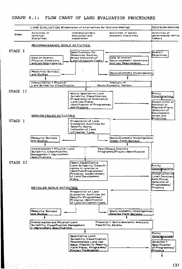
GRAPH 4.1: FLOW CHART OF LAND EVALUATION PROCEDURES
Steps
STAGE I
STAGE II
STAGE I
STAGE II
LAND EVALUATION (Elaboration of Aiternatives for Oeclsion Making)
Activities in technica! disciplines
lnterdisclplinary di scussion and cooperation
RECONNAISSANCE SCALE ACTIVITIES
Data on OVera 11 Physical Conditions andUseRe uirements
Specifications for Resources Studies, Broad lndication of Land Uti lisation T es
Activities in socioeconomic disciplines
Data on Overall Socio-economie Conditions and Use Re uirements
IOECISION MAKING
IActivitles of fgovernmental pollcy !makers
Resources Surveys and Studies
1 Socio-Economie lnvestigations
lnterpretation + Physical Land Suitability Classiflcatlon
Analysis of Socio-Economie Context
Mainly Qualitative Land Suitabi llty Classlflcation; Preparation of Alternatlve Land Use Plans; ldentlfication of Pr-ogrammes and Pro· ects
SEMl-DETAILEO ACTIVITIES
Preparation of Land --1 Evaluation Activities for Speclflc Goals; lndlcatlon of Land Uti llsation T es
Resource Surveys 1 jSocio-Economic lnvestigatio and Studies 1
1Global Farm SJrve~s
+ i 'nterpretat1on + Physica' Land 1 lnput/OUtpu~ Ana lysl s
1 Sultabl lity Classlfication; Programme/Project ldentlfication Management + lmprovement 1
~ecificatlons j
' (Seml-)Quantitative Land Sultabiiity Classlfl-catlon In relation to ldentlfied Programmes/ Projects; Establishment of Land Oevelopment Plans
DETAILED SCALE ACTIVITIES
iPreparation of Land
IEvaluatlon Actlvlties for Speclfic Programmes/
.Projects; ldentification of Land Uli llsation T
_J
lnterpretatlon and Physlcal Land Sultablllty Classlflcatlon; Management: + n lfl n
Flnanci.al + Socio-Economie Analysls; Feaslbl llty Studies
Quantitatlve Lam> Sultab111ty Classlflcatlon; Recommended Land Use Maps; Feaslbl il ty Reports; Farm Plans; Programme/
onstruction of ationat or egiona 1 Plans;
ISelection of 1 1
ns·
1
evelopment reas and rlorittes
,F-oliC_Y 1 Cons1deratlons
·~--"----~ 1 Construct ion of Local Oevelopment Plans; Selectlon of Programmes/ Projects
'~---'----~ : Selectlon + 1 Speclflcatlon ; of Programmes/ 1Pro·ect
137
d) recognition and delineation of the different types of land present in the area
e) comparison and evaluation of each type of land for the different uses
f) selection of a preferred use for each type of land
g) project design, or other detailed analysis of a selected set of alternatives for distinct parts of the area. This, in certain areas, may take the form of a feasibility study.
h) decision to implement
i) implementation
j) monitoring of the operation
A major role for land evaluation is reserved regarding the stages
(c), (d) and (e) in the Framework, which is mainly concerned with physical
land evaluation. Stages (a) and (b) are identified by the decision
makers. Of course, broad reconnaissance-type land evaluations can bring
important elements to the attention of the decision-makers. For instance,
in Brazil it was shown with reconnaissance-level information that the
increase in cultivated area projected by the government for the southern
and south-eastern region would meet with great difficulty and that more
attention needed to be given to an increase of productivity per hectare,
requiring, amongst other things, more detailed land evaluation for
purposes of erop zoning and soil conservation. The same study also
brought deficiencies in the farm structure (the concentration of unused,
cultivable land in iatifu:ndios) to the government's attention, showing
them to be a constraint on the free expansion of the cultivated area in
southern Brazil (Pereira et ai., 1975).
At the more detailed level, integral land evaluation is also involved
in stages (f) (which corresponds to the optimization of land use for a
given class of land) and (g) (which is concerned with the planning and
design of land and water use changes). Planning and design will, as
138
long as possible, attempt to elaborate alternatives for the decision
makers to consider during stage (g). Even during stage (h) (implementation),
there can be considerable feedback to the land evaluation if new problems
arise or assumptions change during implementations that require a consi
derable time span, such as land reclamation, polder development, de
salinization, flood control. Sometimes it is more practical to limit the
land evaluation to a few alternatives, start implementation as soon as
possible and make the revision of the land evaluation a matter of principle.
This applies not only to major land reclamation and improvement projects,
but also to land evaluation for current conditions. Beek (FAO, 1975a)
sees land evaluation as a continuous process that should be executed as
a permanent supporting service to farmers, planners and other users of
land resource data.
Land evaluation is more than an ad hoe activity in a sequence of
steps which precedes the implementation of a specific development project
or plan. Planners, researchers, farmer-supporting services (extension, cre
dit) and last hut not least the farmers themselves should have continuous
access to and be assisted in the analysis of land resource data. Pragmatic
land evaluation should be able to contribute to the formulation of concrete
management recommendations and their constant revision in the light of the
continuously changing values of other production factors,inputs and outputs
to assure optimal land use.
4.2.5 Land evaluation and the individual farmer
The farrner's role: (a) Closer cooperation between land
evaluation and local farmer
Existing land evaluation procedures emphasize the importance of
well-defined land use and land improvement recommendations. This may
have created the wrong impression of a rather academie specialist's job,
resulting in the preparation of 'cookery book recipes' on how to use
each tract of land. It would be a misunderstanding if the role of the
139
individual farmer were to begin where the land evaluation procedure
stops.
In virtually every aspect of the land evaluation fieldwork, the
user of the land needs to be consulted, bis operations observed, his
achievements, attitudes and expectations taken into account. The proposed
land evaluation methods and related concepts require this, particularly
for a proper matching of land qualities and land i.mprovements with land
utilization types. Proper observation, analysis and rating of the factors
involved will require close contact with the farmers. For instance, to
be applied properly, the concept of land quality needs more information
on the behaviour of the natural vegetation and of cultivated crops, than
the description of land properties according to pre-established manuals
or guidelines and the interpretation of such individual properties. The
land quality concept puts the field surveyor in a better position to
translate bis widely acknowledged 'feel of the land' into more digestible
and readily applicable formulas than before. On the other hand, this will
place higher demands on his agronomie and biological insight, and this is
where local farmers will be of great help. The same applies to the iden
tif ication of land requirements of utilization types, and the selection
of land management and land improvement recommendations. Land use re
commendations that reflect some of the 'grass roots' experience of local
farmers are likely to be more easily accepted by the land users.
The farmer's role: (b) his decisions
Even the most precisely def ined land use recommendations cannot
take full account of the variables involved in the proper utilization of
a tract of land. Land management specifications contain information that
com.plements the definitions of the land utilization types. To be applied,
these data will require further interpretation, adaptation and elaboration
by the actual land user to suit his situation. This situation may vary
according to location, year, season, weather conditions, economie conditions
(market conditions, price signals, labour mark.et), life stage of the
140
farmer and his family, to name but a few variables that land evaluation
can never take into account fully. Land use recommendations should be
relevant for most of the range of conditions that may occur, but should
not become excessively detailed by attempting to give a specific solution
for every situation in this range. Extreme situations may not be covered
at all by the land evaluation procedure. Sometimes, extreme situations
are unjustly cited to prove that the entire land evaluation procedure is
inadequate. For instance, the sudden increase in fertilizer prices that
occurred during 1973/74 may have given rise to strong doubts about the
usefulness of land evaluations proposed for specific purposes. Indeed,
such extreme situations do occur, but fortunately not every day; it is
to be hoped that serious efforts are also made in other fields such as
agricultural planning, to increase the reliability of the agricultural
enterprise.
In this context, Singh's observation (1974) holds true:
loaal deaisions with regard to aativities to be taken up in
a given area, and determination of priority amorl{!st different
proposed aativities should be left to benefiaiary farmers
themselves and should not be taken by anybody from outside
howsoever important he may be. Outsiders and experts should
therefore only outline different alternatives, the final
deaision beirl{! the prerogative of the benefiaiaries alone.
141

4.3 Land evaluation in Latin America
To illustrate the land evaluation concepts and procedures that have
been explained in previous chapters, land evaluation methods from five
Latin American countries will be described.
The examples from Venezuela, Nicaragua and Mexico have in conunon that
they represent attempts to adapt the general purpose USDA-SCS Land Capabi
lity System to local needs and circumstances. The Brazilian method is a
new land evaluation system based on land qualities and land utilization ty
pes. The first four examples are all concerned with physical land eva
luation. The fifth, from Chile, bas been included to describe an interesting
and simple method for stage II, the socio-economie analysis, of an integral
land evaluation method with staged procedure.
The examples from Brazil and Nicaragua have actually been applied in
the field. Those from Venezuela, Mexico and Chile represent theoretica!
proposals in the present search for new land evaluation methods.
The Venezuelan method remains closest to the USDA Land Capability
System: no effort has been made to make land evaluation use-specific. Only
two very broad land utilization types have been considered: one that uses
all kinds of agricultural inputs except irrigation and drainage and one that
includes irrigation and drainage. A significant step forward in the Vene
zuelan method is the way in which the combined influences of climate and
soil on land capability have been specified.
Twenty-two bio-climatic life zones have been distinguished, and for
each such zone a semi-quantitative conversion table that relates land fea
tures with land capability bas been prepared. Because of the climatic diffe
rences between life zones, the value of a particular soil characteristic
(e.g. soil depth) sometimes receives a different weight in the land capabil
ity classification of different life zones.
The modif ications succeed in overcoming the criticism made against the
142
USDA Land Capability System for not being aufficiently specific in its cor
relation between land features and land capability classes. However, to
arrive at a specific purpose land evaluation, the land utilization types
will need to be defined in more detail, thus enabling the identification
of their land use abilities and land requirements. A refinement of the
correlation between land characteristics and land capability classes is
lost to a certain extent when this correlation does not reflect the degree
to which the land characteristics meet the specif ic requirements of the
utilization types.
The Nicaraguan land evaluation was carried out for purposes of
natura! resources inventory and land taxation. The amount of information
presented goes far beyond what is normally contained in soil survey reports
in Latin America. Both a genera! purpose and a specific purpose land
evaluation have been included. Unfortunately the two evaluations became
rather mixed up.
Various valuable items of information about land capability, land
suitability, soil management and conservation specifications (inputs),
and yield potential (outputs) have been presented without making suff iciently
clear the relations that exist between them.
The more than 600 soil series and types distinguished during the
soil survey were first grouped into USDA-type land capability classes,
sub-classes and units. The result was a drastic simplification of the data
base into only 66 land capability units. These units, the product of gene
ral purpose land evaluation, were then interpreted according to their
suitability (four class system) for 25 irrigated and rain-fed crops, for
pastures, and for five types of woodland production (specific purpose land
evaluation). Obviously, a land suitability classification of each of the
600 soil series and types in combination with the various produce types
mentioned would have been a much more elaborate task. To arrive at more
realistic management assumptions, these produce types should have been
combined with other key attributes of land utilization such as technolo
gical level, capital level and available labour. This would have increased
143

the number of interpretations (LUT, LU combinations) even more, although
many of them would have been deemed irrelevant at the start of data inter
pretation. In the Nicaraguan example the land capability unit also stands
model f or the land conditions when the soil management and conservation
practices (inputs) are specified. In these specifications a distinction bas
been made between two levels of management: 'average' and 'itnproved'. But
an interpretation of (groups of) land capability units in terms of manage
ment and conservation practices for different management levels presents
us with a contradiction: to group soil units into land capability classes,
sub-classes and units, the assumed management level bas to be established
beforehand. If it were decided at a later stage to distinguish between dif
ferent management levels, this would contradict the management assumptions
underlying the land capability classification. The 'average' management
level and the improved' management level are likely to give rise to two
different groupings of soil series and types into land capability units.
Management specif ications have been given for one to five different groups
of land capability units, depending on the type of erop. Conservation spe
cifications have been presented for twenty groups of land capability units.
This primary concern with conservation is probably the best feature of the
USDA Land Capability System.
We learn from the Nicaraguan example that land evaluation results
are strongly conditioned by the land utilization types chosen. A systema
tic procedure is needed to arrive at a clear presentation of input-output
relations for pertinent combinations of land utilization types and (groups
of) land mapping units. Genera! purpose and specific purpose land evalua
tion will need to be separate studies when the management assumptions
underlying them are not the same.
In Mexico CETENAL (the Collllllission for the Study of the National
Territory) is making a natural resources inventory at the scale 1:50 000.
Their land evaluation methodology adheres strictly to the USDA Land Capa
bility System. New proposals by CETENAL for making land suitability maps
in the future include a genera! purpose land evaluation and a specific
purpose land evaluation.
144

In the general purpose land evaluation a distinction has been made
between land capability for unimproved conditions, the 'agrological capa
city' classification, and the land capability for improved conditions, the
'potential capacity' classification. Eight capability classes have been
defined in a conversion table in terms of specified values of eleven se
lected land properties/qualities. Emphasis is placed on the land quality
'available water', which has been specified in terms of climatic classes
(KÖppen classification).
There is no mention of land utilization types or of management levels,
apart from the statement that adequate techniques will be applied in
realizing land improvements. Eight major improvements have been listed:
irrigation, leaching, application of amendments for alkalinity control,
stone removal, liming, flood control, drainage, and erosion control. The
level of inputs required for land improvement can be deduced solely from
these qualitative references to the types of major land improvement. The
effectiveness of the input applications has to be read from the dif ference
between the potential capacity class and the agrological capacity class.
There is no mention of outputs (yields).
Essentially, the eight classes of agrological and potential capacity
are no more than systematic groupings of land mapping units with similar
levels of selected land properties/qualities. Although no capability class
definitions have been presented, it seems that inputs and outputs are no
criteria for the general purpose land evaluation method.
In the specific purpose land evaluation,the physical possibilities
of growing more than one hundred different crops, forage, and forestry spe
cies are assessed. For this purpose the country has been divided into four
major climatic zones: arid and semi-arid, sub-humid with dry season, sub-hu
mid, humid all year round. Within each major zone, four temperature regimes
are distinguished: hot, semi-hot, temperate, cold. Differences in water
availability in each of the 16 resulting climatic zones have been rated by
using the levels of available water defined for the general purpose land
145
capability classes (based on the K.Öppen classification).Apparently two cli
matic classifications have been superimposed here.
The specific purpose land evaluation also includes a erop tolerance
level for effective soil depth, salinity, alkalinity, and acidity. Since
hundreds of different combinations of crops may result, a numerical key
has been developed in which each combination is indicated by a different
number. Separate ratings are presented for the unimproved and for the
improved land conditions.
The proposed system is a two-class specific purpose physical land eva
luation: Class I-suitable, Class II-unsuitable. Correlation between these
two classes and the eight land capability classes of the general purpose
land evaluation may exist, but the methodology has not been designed to be
conclusive about such a correlation. Unlike the Nicaraguan example, the two
land evaluation procedures are separate exercises. The Mexican method, how
ever, is much less specific about such fundamental data for land use plan
ning as yields, hazards, inputs. One also gets the impression that the
methodology still lacks an adequate body of knowledge about the land
requirements of the great many crops considered.
The emphasis placed on climatic variables is most valuable, although
more attention will need to be given to the interactions between soil and
climate.
Apart from the produce factor, other key attributes of the land utili
zation types should be explicitly mentioned in the future, considering the
high percentage of farmers who can apply only small amounts of capital in
puts.
In Brazil the Soil Survey and Conservation Service of EMBRAPA (Minis
try of Agriculture) has developed its own system of land evaluation. The
system permits each land utilization type to be classif ied into four suitab
i li ty classes. The factors determining land suitability are the five land
qualities: natural fertility, availability of water, availability of oxygen
in the soil, resistance to erosion, absence of impediments to the use of
146

mechanical implements. Each land quality has been defined at three to five
levels of limitation (Appendix 2).
Inputs have an appropriate place in the system. The feasibility of
improving the land qualities is rated as follows: improvement easily
feasible, improvement feasible, improvement perhaps feasible, improvement
not feasible. The land utilization type, called management system in Brazil,
determines which land improvements are pertinent.
The ease and level of input needed for land improvement are important
criteria for land suitability; another is yield. Sustained production and
erosion control are necessary criteria for the land utilization types that
require physical inputs for land improvement, although a decrease in pro
ductivity and some erosion losses are considered inevitable in the tradi
tional low input type of land utilization. Because of these differences in
suitability criteria, separate definitions of land suitability classes are
presented for different land utilization types. Land utilization types are
defined in terms of produce, farm power (manual, animal, tractor), capital
intensity, and technological knowledge (low, medium, high).The key attribute
'produce' is normally divided into short cycle (annual) crops, long cycle
(perennial) crops, planted pastures, natural pastures, silviculture. In a
few cases individual crops have been considered: cocoa, sugar cane, Pinus
eZZiottii.
Normally two or three interpretative maps accompany the soil survey re
ports to show the suitability for the relevant land utilization types. For
regional planning purposes one single map, that combines all the interpre
tative information is now being presented: the multi-purpose land suitability
map. The presentation is similar to that of the USDA Land Capability System
with the distinction that the Brazilian methodology considers three levels
of management for crops and two levels of management for grazing.
Conversion tables are the backbone of the land evaluation method. In
these multiple entry tables land qualities and the feasibility of their
improvement are related to the land suitability classes. For each land uti
lization type a separate conversion table is needed. The tables are both
147
use-specific and site-specific because, except for the availability of
water, no climatic variation is included in the land qualities that deter
mine land suitability.
Conversion tables in Brazil do not consider the cumulative effect of
different land qualities. The land suitability class is determined by the
most limiting land quality after improvement. This problem still needs to
be solved.
The reliability of the conversion tables depends greatly on the availab
ility of site-specific research-tested information. Since such information
is often hard to obtain in areas where reconnaissance land evaluations are
needed, the transfer of knowledge through correlation and analogy with
better known areas is important. In Brazil the use of land qualities bas
been of great aid in permitting this transfer of knowledge, while the atten
t ion Brazil bas given to soil classification and soil correlation bas been
most valuable for systematic soil survey interpretation.
It must be admitted that there is now a great need in Brazil for con
version tables that permit land suitability classification for more specific
types of produce: for individual crops, erop associations, and rotations
grown at defined levels of management. More attention should also be given
to climatic-parameters and to soil conservation. This will require more
participation from agronomists and agro-meteorologists. Only by incorpo
rating these studies will the Brazilian methodology reach the full status of
a specific purpose physical land evaluation. After achieving this, the
methodology should be able to meet the data requirements for application of
systems analysis and land use simulation in land evaluation and land use
planning, as will be explained further in Chapter S. The method as it stands
now is intermediate between general purpose and specif ic purpose land eva
luation, giving reasonably satisfactory results in reconnaissance land eva
luation, hut results that are too superficial at more detailed levels.
The example from Chile bas been cbosen to show how the results of
a physical land evaluation were to be used ten years later for detailed land
use planning in agrarian reform areas. The planning methodology is also
148
a good example of Stage II in an integral land evaluation with staged pro
cedure i.e. the socio-economie analysis. This method attempts to combine
single land utilization types into compound land utilization types (erop
rotations) with the objective of maximizing the use of labour and the
labour income. It takes into account the physical limitations of the land,
the availability of labour, the prices of inputs and outputs, and the market
restrictions for certain products. In this process of land use planning
there is a strong reliance on the results of Stage I: the physical land
evaluation. Unfortunately a sharp discrepancy exists between the reliability
of the data produced during Stage I and the data requirements of Stage II.
Stage I is represented by a large integrated land resources survey,
based on the interpretation of aerial photographs covering an area of
120 000 km2 . The study distinguishes 350 soils, classified in terms of se
ries, types, and phases. Field checks were made at an average observation
density of 1 per 1100 ha with a range of 1 per 270 ha to 1 per 2700 ha. Data
interpretation resulted in a map of land capability classes and sub-classes
at the scale 1:20 000 (USDA Land Capability System). This publishing scale
suggests a soil sampling more detailed than it actually was.
When examining the method of socio-economie analysis proposed f or Stage
II, one bas to conclude that this method cannot rely entirely on the general
information produced during Stage I. More detailed soil surveys of parts of
the Centra! Valley by the Chilean Soil Institute confirmed these reserva
tions. Physical land evaluation should be careful not exceed its claim as
to the usefulness of its products. Clear statements about the reliability
of maps and other data are needed.
A fundamental piece of information for Stage II should have been the
produetivity ratings for individual crops. But Stage I was not eoneerned
with individual erops, only with very generalized types of land utilization:
(annual) agrieultural erops cultivated with modern management teehniques (e.
g.:meehanized) and supplied with the necessary inputs for soil improvement
and conservation. (Stage II is more eoneerned with other types of land uti
lization that permit maximum labour absorption.) To select optimal erop ro
tations during Stage II, erop yields were eorrelated with land eapability
149
classes, although for a proper assessment of productivity and yield poten
tial reference should have been made to the soil units. Such misunderstand
ings between persons responsible for Stages I and II can be avoided if the
presentation of the results of Stage I includes a productivity rating of
crops for individual soil units or groups of similar soil units, preferably
in combination with corresponding inputs required.
To sum up: Land evaluation in Latin America is relied on as a fundamen
tal source of information for agricultural development. Land evaluation
methods that evolved in other countries, especially the USDA Land Capability
System, have not been rigidly followed. New systems are being developed to
suit local needs. The observed willingness of national scientists to abandon
established methods of land capability classif ication is encouraging the
introduction of new approaches which pay more attention to land utilization
and in particular to the land user. It must, however, be stated that a more
integral study of the components that make up the land conditions, parti
cularly climate and soil, is needed. In such more specific purpose oriented
land evaluations, the dynamic aspects of land and land use can no longer be
ignored. In view of the complexity of a land evaluation that considers the
temporal problems of land use, data analysis will become more complex. With
today's data-handling techniques, however, such problems of data analysis
need not be insurmountable. In elaboration of this idea, some initia!
explorations towards the use of systems analysis in land evaluation are
presented in Chapter 5.
Readers who are more interested in general methodology than in further
details on the methods of land evaluation in the five Latin American
countries may turn directly to Chapter 5.
Those who want to take a closer look at the Latin American methods will
find further information, mainly in tabular form, in Sections 4.3.1 -
4.3.5.
150
4.3.1 Venezuela: adapting the USDA Land Capability System to local needs
The number of soil scientists in Venezuela has grown rapidly during
the last decade, especially in the field of soil survey and classification.
Their methods are strongly influenced by USA standards, laid down in the
Soil Survey Manual, the Soil Taxonomy and in the Land Capability System.
In 1968 a national land resources inventory started, ordered by COPLANARH
(the Conunission for the National Plan for the Utilization of Hydraulic
Resources). The first phase of the project included the study of the
country north of the Orinoco river. A rapid 1 : 500 000 reconnaissance
survey was planned, based on the measurement of selected soil features
that are rated and used independently of one another to designate soil
(mapping) units. Avery (1968) termed this method a 'coordinate' system,
a term used again by van Wambeke (1972) in bis description of soil survey
methods in Latin America. Coordinate systems should be distinguished from
'hierarchical' systems of classification (e.g. the U.S. Soil Taxonomy)
which place more emphasis on the relationships between soils and the factors
responsible for their features.
'Coordinate' systems have also been used in other parts of Latin
America, for example in Chile (OAS, 1964; see also Section 4.3.5) and
in Panama for rural cadastral purposes (CATAPLAN, 1964).
To interpret the first soil survey (Unare and Neveri) COPLANARH
(1969) adopted a numerical system which raised many critical questions
after publication. The original idea was to incorporate, as much as
possible, the land suitability criteria laid down in the regulations of
the national land reform law, chap. XV, articles 238-250. Unfortunately
these criteria happened to produce a suitability classif ication bearing
little relevance to real land use problems. The system assigned numerical
values, scale 0-100, to soil properties: relief, effective soil depth,
texture, degree of erosion, fertility, erodibility, drainage. For example,
the rating of:
151
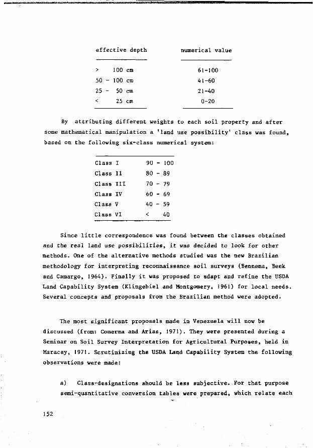
effective depth numerical value
> 100 cm 61-100
50 - 100 cm 41-60
25 - 50 cm 21-40
< 25 cm 0-20
By attributing different weights to each soil property and af ter
some mathematica! manipulation a 'land use possibility' class was found,
based on the following six-class numerical system:
Class I 90 - 100
Class II 80 - 89
Class III 70 - 79
Class IV 60 - 69
Class v 40 - 59
Class VI < 40
Since little correspondence was found between the classes obtained
and the real land use possibilities, it was decided to look for other
methods. One of the alternative methods studied was the new Brazilian
methodology for interpreting reconnaissance soil surveys (Bennema, Beek
and Camargo, 1964). Finally it was proposed to adapt and refine the USDA
Land Capability System (Klingebiel and Montgomery, 1961) for local needs.
Several concepts and proposals from the Brazilian method were adopted.
The most significant proposals made in Venezuela will now be
discussed (from: Comerma and Arias, 1971). They were presented during a
Seminar on Soil Survey Interpretation for Agricultural Purposes, held in
Maracay, 1971. Scrutinizing the USDA Land Capability System the following
observations were made:
152
a) Class-designations should be less subjective. For that purpose
semi-quantitative conversion tables were prepared, which relate each

land capability class with specified values of selected land
features (see Tables 4.1-4.6). These selected features area
mixture of properties and land qualities. However the concept of
land qualities was not explicitly used.
b) More attention should be given in land capability assessment to
the factor 'climate'. In several Latin American countries the bio
climatic life zones have been mapped according to Holdridge's method.
In Venezuela (Ewell and Madriz, 1968) 22 such life zones have been
distinguished. The semi-quantitative conversion tables relating
land features with land capability were prepared for each life zone
to take into account the interactions between the climate and the
other features of the land that influence land capability and land
use performance.
A certain value of a particular property/quality does not always
have the same influence on land use performance. This becomes
clear when comparing the influence of the property 'soil depth'
in Tables 4.4. and 4.5. It seems that soil depth class 3 limits
land capability in a dry tropical climate to capability class V,
whereas in a humid tropical climate the same depth class only
limits to class II!. From this example it can be deduced that soil
depth has a modifying effect on the water regime. However, the
conversion tables do not consider the land quality 'available water'
directly although this would have been a more functional approach
to what is probably the most important problem for land use in
Venezuela given the objectives of COPLANARH - the planning of water
resource use till the year 2000.
c) The management level described in the USDA system is not
consistent with Venezuelan agriculture. In particular, land manage
ment and land improvement practices that are supposed to be feasible
in the USA require a more subtle treatment in Venezuela because of
the wider range in socio-economie land use conditions. Therefore a
distinction has been proposed in two technological levels, which
splits the land utilization types into two groups:
153
- Land utilization types of normal teehnologieal level, which do not include irrigation or drainage, but which may include a wide range of practices such as the use of fertilizers, pesticides, conservation practices, machinery etc. In fact this could be any type of agriculture, but without irrigation or drainage.
- Land utilization types of improved teahnologiaal level, which includes irrigation and drainage, in combination with intensive fertilizer use, pest and disease control, weed control, conservation practices, machinery etc. It is assumed that land use is permanent, and that such land use has a higher productivity than the types with a normal technological level.
Since the influence of land properties/qualities on land use perfor
mance depends on the technological level, separate conversion tables
have been prepared for the two technological levels (see Tables 4.3-4.6).
Following Brazilian methodology, the possibilities for land improve
ment have been rated at three levels:
improvement is easily feasible
improvement is feasible
improvement is hardly or not feasible
This rating does not influence the land suita~ility class, and is
therefore not mentioned in the conversion tables (contrary to the Brazilian
method, see Section 4.3.4.).
Although the proposed modifications succeed in meeting several
criticisms about the applicability of the USDA Land Capability System
in developing countries, the Venezuelan method cannot meet the objectives
of a specif ic purpose land evaluation. It is a general purpose physical
land evaluation, but with possibilities for development into a specific
purpose land evaluation, once the land utilization types have been defined
154

at amore disaggregated level, and once a more functional approach is
made when selecting the limiting land characteristics (in particular
the land qualities 'availability of water' and 'rainfall probability').
This improved technological level supposes irrigation and/or drainage.
However in most of the life zones where water is a limiting factor
rainfed agriculture will probably remain a reality. On the other hand
there are areas, such as in the Andean life zones, where normal technology
does not include all the practices listed as 'normal'. Therefore the
construction of conversion tables for rainfed cultivation of specif ied
(groups of) crops at various technological levels could be a first step
towards developing a specific purpose land evaluation. Another type
of land utilization of high priority for the conditions prevailing in
Venezuela is grazing for beef production. In the conversion tables
attention should be given to yield data to provide a quantitative back
ground to socio-economie interpretations of the physical land evaluation
results.
155
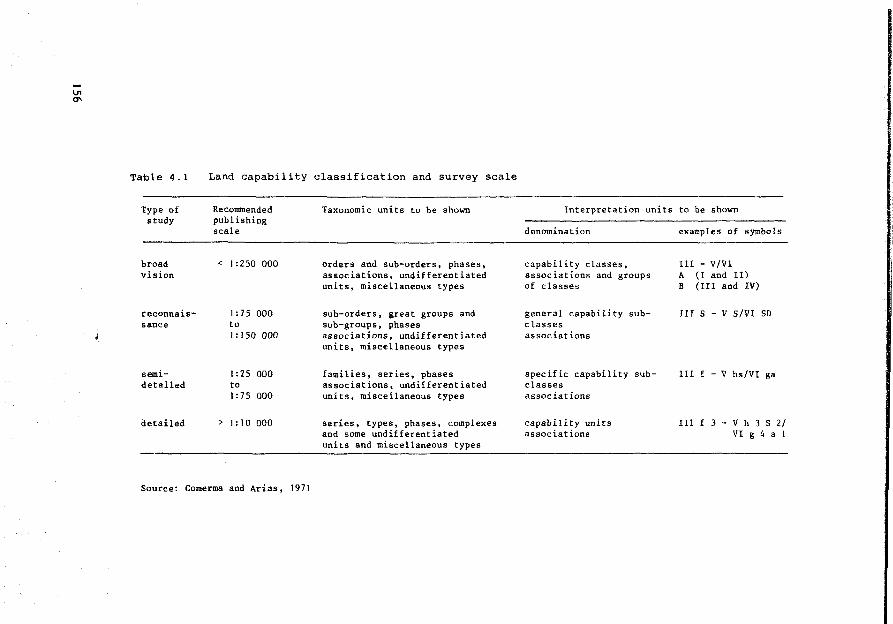
Table 4.1
Type of study
broad vis ion
reconnais-sance
semi-detailed
detailed
Land capability classification and survey scale
Recommended pub lis hing scale
< 1 :250 000
1 :75 000 to 1: 150 000
1 :25 000 to 1 :75 000
> 1: JO 000
Taxonomie units to be shown
orders and sub-orders, phases, associations, undifferentiated units, miscellaneous types
sub-orders, great groups and sub-groups, phases associations, undifferentiated units, miscellaneous types
families, series, phases associations, undifferentiated units, miscellaneous types
series, types, phases, complexes and some undifferentiated units and miscellaneous types
Source: Comerma and Arias, 1971
lnterpretation units to be shown
denomination
capability classes, associations and groups of classes
general capability subc lasses associations
specific capability subclasses associations
capability units associations
examples of symbols
111 - V/Vl A (1 and Il) B {III and IV)
III S - V S/VI SD
111 f - V hs/VI ga
III f 3 - V h 3 S 2/ VI g 4 a 1
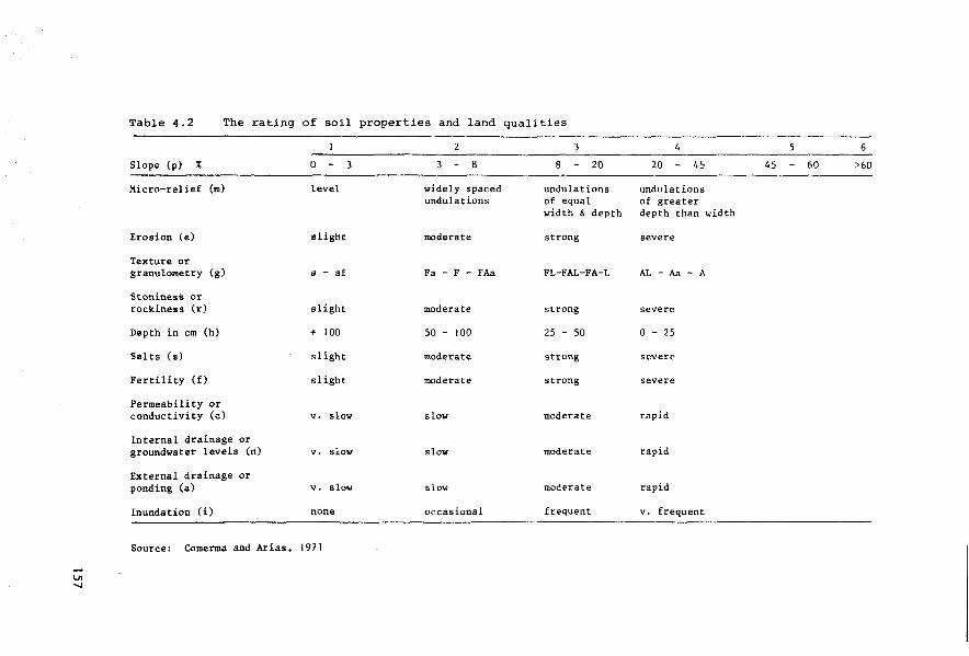
Table 4.2 The rating of soil properties and land qualities
Slope (p) %
Micro-relief (m)
Erosion (e)
Texture or granulometry (g)
Stoniness or rockines s ( r)
Depth in cm (h)
Salts (s)
Fertility (f)
Permeability or conductivity (c)
Internal drainage or groundwater levels (n)
External drainage or ponding (a)
Inundation (i)
0 3
level
slight
a - af
slight
+ 100
sl ight
slight
v. slow
v. slow
v. slow
none
Source: Comerma and Arias, 1971
2
8
widely spaced undulations
moderate
Fa - F - FAa
moderate
50 - 100
moderate
moderate
slow
slow
slow
occasional
3
8 20
undulations of equal width & depth
strong
FL-FAL-FA-L
strong
25 - 50
streng
streng
moderate
moderate
moderate
frequent
4 5 6
20 45 45 60 >60
undulations of greater depth than width
severe
AL-Aa-A
severe
0 - 25
severe
severe
rap id
rap id
rap id
v. frequent
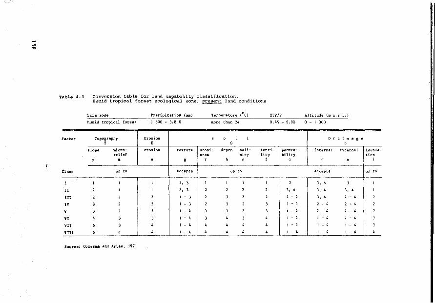
Table 4.3 Conversion table for land capability classification. Humid tropical forest ecological zone, present land conditions
Lif e zone Precipitation (mm) Temperature (°C) ETP/P Altitude (m a.s.J.)
humid tropical forest 1 800 - 3.8 0 more than 24 0.45 - 0.90 0 - 1 000
Factor Topography Eros ion s 0 i l D r a i n a g e T E s D
slope micro- eros ion texture stoni- depth sali- ferti- permea- internal external inunda-re lief ness nity lity bility tion
p m e g r h s f c n a i
Class up to accepts up to accepts up to
1 l 1 1 2, 3 1 1 1 1 3 3, 4 3 1
II 2 1 1 2, 3 2 2 2 2 3, 4 3. 4 3, 4 1
III 2 2 2 1 - 3 2 3 2 2 2 - 4 3, 4 2 - 4 2
IV 3 2 2 1 - 3 2 3 2 3 1 - 4 2 - 4 2 - 4 2
v 3 2 3 1 - 4 3 3 2 3 1 - 4 2 - 4 2 - 4 2
VI 4 3 3 1 - 4 3 4 3 4 1 - 4 1 - 4 1 - 4 3
VII 5 3 4 1 - 4 4 4 4 4 1 - 4 1 - 4 1 - 4 3
VIII 6 4 4 1 - 4 4 4 4 4 1 - 4 l - 4 l - 4 4
Source: Comerma and Arias, 1971

Table 4.4 Conversion table for land capability classification. Humid tropical forest ecological zone, improved land conditions
Life zone Precipitation (nm) Temperature (0
c) ETP/P Altitude (m a.s.1.)
humid tropical forest 1 800 - 3 800 more than 24 0.45 - 0.90 0 - l 000
Factor Topography Eros ion s 0 i 1 D r a i n a g e T E s D
slope micro- eros ion texture stoni- depth sali- ferti- permea- internal external inunda-re lief ness nity lity bility tion
p m e g r h s f c n a i
Class up to accepts up to accepts up to
I 1 1 1 2, 3 1 1 1 1 3 3, 4 3 1
Il 2 1 1 2, 3 2 2 1 2 3. 4 3, 4 3, 4 1
III 2 2 2 1 - 3 2 2 2 2 2 - 4 3, 4 3, 4 2
IV 3 2 2 1 - 4 2 3 2 2 1 - 4 2 - 4 2 - 4 2
v 4 2 2 1 - 4 3 3 2 3 1 - 4 2 - 4 2 - 4 2
VI 5 3 3 1 - 4 3 4 3 4 1 - 4 2 - L, 2 - 4 3
VII
VIII
Source: Comerma and Arias, 1971
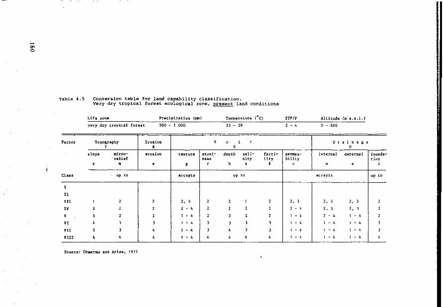
-°' 0
Table 4.5 Conversion table for land capability classification. Very dry tropical forest ecological zone, present land conditions
Life zone Precipitation (Ulll) Temperature ( 0c)
very dry tropical forest 500 - 1 000 23 - 29
Factor Topography Eros ion s 0 i l T E s
slope micro- eros ion texture stoni- depth sali- ferti-re lief ness nity lity
p m e g r h • f
Class up to accepts up to
1
Il
11! 1 2 2 2, 3 2 2 1 2
IV 2 2 2 2 - 4 2 2 2 2
v 3 2 2 1 - 4 2 3 2 2
VI 4 3 3 1 - 4 3 3 3 3
VII 5 3 4 1 - 4 3 4 3 3
VIII 6 4 4 1 - 4 4 4 4 4
Source: Comerma and Arias, 1971
ETP/l' Altitude (m a. s .1.)
2 - 4 0 - 600
D r a i n a g e D
permea- internal external inunda-bility tion
c n a i
accepts up to
2, 3 2, 3 2, 3 2
2 - 4 2, 3 2. 3 2
1 - 4 2 - 4 1 - 4 2
1 - 4 1 - 4 1 - 4 3
1 - 4 1 - 4 1 - 4 3
1 - 4 1 - 4 1 - 4 4

Table 4.6 Conversion table for land capability classification. Very dry tropical forest ecoloqical zone, improved land conditions
Life (111111) ETl'/P Altitude a.s .1.
very 0 - 600
Factor Topograpby Erodon s 0 i l Drainage T E s D
dope mie re- eros ion tex.t:u'te stoni- depth sali- ferti- permea- intern.al external inunda-re lief ness nity lity l:>ility tion
p m e g r: h • f c n a i
Clasa up to accepts up to accepts up to
l 1 J l 2, 3 l J l 1 3 3 2, 3 1
tr 1 1 1 2, 3 l 2 1 2 2. 3 2, 3 2, 3 l
III 2 2 2 2 - 4 2 2 l 2 2 - 4 2 - 4 2 - 4 2
lV 3 2 2 1 - 4 2 3 2 2 2 4 2 - 4 2 - 4 2
v 4 2 2 1 - 4 3 3 2 3 1 - 4 2 - 4 2 4 2
VI 5 3 3 1 - 4 3 4 3 3 1 4 1 - 4 1 - 4 3
VII
Vlll
Source: Comerma and Arias, 1971
4.3.2 Nicaragua: combining general purpose with specific purpose land evaluation
Under the supervision of several US consultant firms the Tax Improve
ment and Natural Resources Inventory Project of Nicaragua has carried out
a semi-detailed soil survey (scale 1:20 000) of the Pacific Region. The
resulting map and report on Soils, Their Use and Management (Nicaragua,
1971) is very interesting because of the emphasis placed on data interpre
tation. Approximately 600 soil series and types were distinguished during
the soil survey and were interpreted firstly according to the USDA Land
Capability System (Klingebiel & Montgomery, 1961), which resulted in their
grouping into the usual eight classes. Subclasses were made to indicate
the nature of the limiting factors:
e - erosion
w - excess of water
s - root zone limitations
Topographic or climatic subclasses were not used, but climatic condi
tions were shown on a lif e zone map that combines climate and vegetation
according to the Holdridge system, similar to the method mentioned for
Venezuela. An isohyet map was also included showing the precipitation data
during the period May-November, when 85-97% of the rain falls. 66 land
capability units (lcu) were identified. Each lcu is comprised of soil/land
(mapping) units of the same class and subclass which are supposed to have
similar potential and continuing conservation limitations and hazards.
The report (Nicaragua, 1971, p. Il-124) states:
162
The soils of a capability unit are suff iciently uniform to produce similar kinds of cultivated crops and pasture plants with similar management practices; require similar conservation and management practices under the same kind and condition of vegetative cover, and have comparable potential productivity.
In Venezuela and Brazil it has been recognized that the US-type
management practices underlying the land capability classifications may
not correspond with the socio-economie and technica! conditions of the
local farmers. But in Nicaragua this is not the case: therefore one must
be careful when applying the Nicaraguan interpretation of land capability,
particularly f or taxation purposes (which was the purpose of the Nicara
guan study). On the other hand, the report does include a wealth of other
information on how to use and manage the soils, which goes far beyond the
amount of such information normally found in soil survey reports in
Latin America.
Apart from tax assessors, the potential users of this information are
expected to comprise: agricultural research stations, farmers, ranchers,
agricultural corporations, agricultural extension werkers, agricultural
supply and services corporations, banks and other loan agencies, engineers
and educational institutions. The ultimate objective of supplying them
with the information about the land capability is of course the planning
of optima! land use, higher erop yields and better soil conservation.
The Nicaraguan study is an example of mixing genera! purpose land
evaluation with specific purpose land evaluation. The US Land Capability
Classif ication represents a genera! purpose land evaluation system. The
resulting classes, subclasses and units all correspond to the assumptions
and criteria specified for that.system. The Nicaraguan report is remarkable
in that the 66 land capability units are maintained as homogeneous
(land) units for a specific purpose land suitability classification (see
Tables 4.7 and 4.8).
163

Table 4. 7 Crop adaptation by capability units
INTERTILLED ANNUAL ROW CROPS SOLID-Pl.ANTED
LOW-VOLUME RESIDUE RETURNING HIGH-VOLUME RESIDUE ANNUAL CRDPS
CAPABILITY
~ "' " . ~j 8 :9 ~ :s < UNITS ... " ~ ~ á ~ ~ u ...
"' ili 5 "" < " 1:: ili ~ li:: u "' 0 ~ f;l ~ ~ o~ S!~ 8 8-' lil-' " u~ ... > "'
UN UN UN UN UN UN IR UN UN UN UN UN IR
I-1 1 A 1 A 1 A 1 A 2 A 2 A 1 A 1 A 1 A 1 A 1 A 2 A t B
Ile-1 1 B 1 B 1 B 1 B 2 B 2 B 1 A 1 B 1 B 1 B l A 2 B 1 B
Ille-1 1 c 1 1 c 1 c 1 c 2 c ' 2 c t B 1 c 1 c t c 1 B 2 c 1 c
IVe-1 1 D) 1 D l D 1 1 D 2 D 2 D 1 c 1 D 1 D 1 D 1 c 2 D 1 D
Ile-2. J 1 B 1 B 1 B j2 B 2 B 2 B IA l B 1 B 1 B 1 A 3 B 1 B
IIe-2. 2 1 B 2 B 2 B 2 B 1 3 B 3 B 1 B 2 B 2 B 1 B 2 A 4 B 1 D
II!e-2a 2 B ! 2 B 2 B 2 B 3 B 3 B 2 B 3 B 2 B 2 B 3 A 3 B 2 D
Ille-2 1 c 1 c f 1 c ! 1 c 2 c 2 c 1 c 1 c: 1 c 1 c 1 B 3 c 1 D
IVe-2 1 D ! 1 D
!Vs-2 4 c 4 c
lle-3 1 B 1 3 B
Ille-Ja 2 B 3 B
IIIe-3. 1 1 c 3 c
IIIe-3.2 4 c 4 c IVe-3.1 2 D 3 D
!Ve-3.2 4 D 4 D
I-4. 1 2 A , 2 A
I-4.2 2 A j 3 A
Ile-4. J 2 B 2 B
Ile-4.2 2 B 3 B
IIIe-4a 1 2 B 1 2 B
IIIe-4a2 2 B 3 B
IIIe-4.1 2 c 2 c
Ille-4.2 2 c 3 c
IVe-4. 1 2 D 2 D
IVe-4. 2 4 D 4 D
I-5 t A 2 A
IIe-5. 1 1 B 1 2 B
IIe-5. 2 1 B 2 B
llle-5a 2 B 2 B
IIIe-5 1 c 1 c
IVe-Sa 2 c 3 c
IVe-5 1 D 2 D
I-6 2 A 2 A
Ile-6 2 B 2 B
IIIe-6 2 c 2 c
IVe-6 2 D 2 D
IVe-7 3 A 3 A
lllw-1 3 A 3 A
IIIw-2 3 B 4 B
IVw-1 4 A 4 A
IVw-2 4 A 4 A
IVw-3 3 A 4 A
Vw-1 4 A 4 A
U N • uttirrigated l R • irrigated
2 DJ 2 D 2 D 2 D 1 D 2 D; 2 D 2 D 1 2 C 3 D 2 D
4 c 4 c 4 c 3 c 4 c 4 c 4 c 4 c 3 D 4 c 4 c
2 B j 1 B '3 B 1 2 B 1 B 2 B 2 B 1 B 2 A 3 B 2 B
2 B 2 B 3 B 3 B 2 B 3 B 2 B 2 B 3 A 3 B 2 B
2 c 1 c 3 c 3 c 1 1 c 2 c 2 c 1 c 2 B 3 c 2 c
3 c 3 c 4 c 3 c 4 c 4 c 3 c 4 c 3 B 2 c 4 c
2 Dj 2 D 3 D 3 Dj 2 D 3 D 2 D 2 D 3 D 3 D 2 D
3 D : 3 D 4 D 3 D '4 D 4 D 1 3 D 4 D 3 D 2 D 4 D
1 A 11 A 2 A 2 A 1 A 1 A 1 A 1 A 2 A 2 A 2 A
2 A 1 A 3 A 3 A 1 A 2 A 2 A 2 A 2 A 3 A 2 B
I B 1 B 2 B 2 B 1 B 1 B 1 B 1 B 2 A 2 B 2 B
2 B 2 B 3 B 3 B 1 B 2 B 2 B 1 B 2 A 3 B 2 B
2 B 2 B 2 B , 2 B 1 B 2 B 2 B 2 B 3 A 2 B 3 B
2 B 2 B 3 B 3 B 1 B 2 B 2 B 2 B 3 A 3 B 3 B
t c 1 c. 2 c 2 c 1 c 1 c 1 c 1 c 2 B 2 c 2 c 2 c 2 c
1 D ! l D
2 D 2 D
IA 1 A
1 B 1 B
2 B 2 B
2 B 1 B
1 c 1 c
2 c 2 c
1 D 1 D
1 A 1 A
1 B 1 B
1 c 1 c
1 D 1 D
4 A 3 A
3 A 2 A
3 B 2 B
4 A 3 A
4 A 3 A
3 A 3 A
4 A 4 A
3 c 3 c 1 c 2 c 2 c 1 c Z B 3 c 2 c
2 D 2 D 1 D 1 D 1 D 1 D 2 c 2 D 2 D
4 D 3 D 4 D 4 D 3 D 4 D 2 c 1 D 4 D
1 A 2 A 1 A 1 A 1 A 1 A 1 A 2 A 1 B
2 B 2 B 1 A 1 B 1 B 1 B 2 B 2 B 1 B
3 B 3 B t B 2 B 2 B 1 B 2 B 3 B 1 c 2 B 3 B 2 B 2 B 2 B 1 B 2 B 2 B 2 c
2 c 2 c 1 c 1 c 1 c 1 c 1 c 2 c 1 c
2 c 3 c 2 c 2 c 2 c 2 c 3 c 3 c 2 c
2 D 2 D 1 D 1 D 1 D 1 D 2 D 2 D 1 D
2 A 2 A 1 A 2 A 1 A 1 A 1 A 2 A 1 B
2 B 2 B 1 8 2 B ~ B 1 B 1 A 2 B 1 Il
2 c 2 c 1 c 2 c 1 c 1 c 1 Il 2 c 1 c
2 D 2 D 1 D 2 D 1 D 1 D 1 c 2 D 1 D
4 A 4 A 3 A 4 A 4 A JA 3 A 4 A 3 B
3 A 3 A 2 A 3 A 3 A 2 A 3 A 1 A 1 A
3 B 3 B 2 A 3 B 3 B 2 B 4 A 1 B l A
4 A 3 A 2 A 4 A 4 A 3 A 4 A 2 A 1 A
4 A 3 A 2 A 4 A 4 A 3 A 4 A 2 A 1 A
3 A 3 A 2 A 4 A 3 A 3 A 3 A 2 A 1 A
4 A 4 A 4 A 4 A 4 A 4 A 4 A 3 A 3 A
1 • well suited • high yielda expected witb good aa:nas..ent
2 • aoclerately well euited, average yield• expected witb good unagement
3 • poorly auited, low yield• even vith good ma:aageraent
4 • unauited, would not survive or yield a harveatable erop
Source: Nicaragua, 1971, p.II-193
164
~ UN
2 A
2 B
2 c
2 D
2 B
2 B
3 B
2 c
2 D
4 c
2 B
3 B
2 c
4 c
3 D
4 D
2 A
2 A
2 B
2 B
2 B
2 B
2 c
2 c
2 D
4 D
2 A
2 B
2 B
2 B
2 c
2 c
2 D
2 A
2 B
2 c
2 D
4 A
3 A
3 B
4 A
4 A
4 A
4 A
SOLID-
PERENNIAL ROW CROPS PLAllTED SPECIALTY CROPS PERENllIAI
CROPS
"
! 1 e: l:l " " " § ~ t! " e "' ['; < " " <.> <.>
UN IR UN IR UN IR UN IR UN UN IR
2 A 1 A 3 A 1 A 2 A 1 A 2 A 1 A 4 A 3 A 2 A
2 A t B J 3 A t A 2 A 1 A 2 A t A 4 A 3 A 2 A
2 B 1 c 3 B 1 B 2 B 1 B 2 A 1 B 4 A 3 A 2 B
2 c 1 D 3 c 1 c 1 c 1 c 2 A 1 c 4 B 3 B 2 c
2 A 1 B 3 A IA 2 A 1 A 2 A 1 A 4 B 3 B 2 A
3 A 2 B 4 A 2 c 3 A 2 c 2 A 1 A 4 A 3 A 2 A
3 A 2 c 4 A 2 c 4 A 3 c 2 A 1 B 4 A 3 A 2 A
3 B 2 C 1 4 B 2 c 3 B 2 c 2 A 1 B 4 A 3 A 2 B
3 c 2 D 4 B 2 D 3 B 2 D 2 A 1 c 4 B 13 B 2 c
4 c 4 c 4 B 3 c 4 B 3 c 2 A 1 c 4 B 3 B 2 c
3 A 1 B 4 A 2 A J A 2 A 2 A 1 A 4 A 3 A 2 A
3 A 1 B 4 A 3 A 3 A 3 A 2 A IA 4 A 3 A 2 A
3 B 1 c 4 B 3 B 3 B 3 B 2 A 1 B 4 A 3 A 2 B
3 c 4 C14 B 4 c 3 B 4 c 2 A 4 B 4 A 3 A 4 B
3 D IDl4C,4C 3 c 3 c 2 A 1 c 4 B 3 B 2 A
3 D • 4 D 4 c 4 D 3 c 4 D 2 A 4 D 4 A 4 B 4 A
2 A 3 A J 2 A 2 A 2 A 1 2 A 2 A 2 A 4 A 3 A 2 A
3 A 1 B 4 A 2 B 3 A 2 B 2 A 2 A 4 A 3 A 2 A
2 A 2 B j 3 A 2 A 2 A 2 A 2 A 1 A 4 A 3 A 2 A
3 A 2 B 4 A 2 B 3 A 2 B 2 A t A 4 A 3 A 2 A
2 A 2Bi3A13A 3 A l 3 A 2 A 1 B 4 A 3 A 2 A
3 A 2 B 1 4 A 3 B 4 A 3 B 2 A 1 B 4 A 3 A 2 A
2 B 1 c 3 B 2 c 2 B 1 Z C Z A 1 B 4 A 3 B 2 B
3 B 1 c 4 B 2 c 3 B 2 c 2 A 1 B 4 A 3 B 2 B
2 c 1 1 D 1 4 C 2 D 3 c 2 D 4 A 1 c 4 B 1 3 B 2 c
3 D
2 A
2 A
3 A
3 A
2 B
3 B
2 c
2 A
2 B
2 c
2 D
4 D
2 A
2 A
2 A
3 A
2 A
4 A
4 c 3 c 4 c 2 c 4 c 1 A 4 c 4 B 3 B 4 c
1 A 3 A' 1 A 2 A 1 A 2 A 1 A 4 A 3 A 2 A
1 B 3 A t A 2 A 1 A 2 A t A 4 A 3 A 2 A
1 B 4 A 1 B 3 A 1 B 2 A 1 B 4 A 3 A 2 A
2 B 4 A 2 B 3 A 2 B 2 A 1 B 4 A 3 A 2 A
1 c 3 Il 1 B 3 B' 1 Il 2 A 1 B 4 A 3 B 2 B
2 c 4 B 3 B 3 B 2 B 2 A 1 B 4 A 3 B 2 B
1 D 3 c 1 c 3 c 1 c 2 A 1 c 4 B 3 B 2 c 1 A 2 A 1 A 2 A 1 A 2 A 1 A 1 A 1 A 1 A
1 B 2 A 1 A 2 A 1 A 2 A 1 A IA 1 A IA
1 c 2 B 1 B 2 B 1 B 2 A 1 B 1 A 1 A 1 A
1 D 2 c l c 2 c l c 2 A 1 B 1 B 1 B 1 c
3 A 4 A 3 B 4 A 3 B 2 A 2 B 4 A 4 A 3 B
1 A 3 A 3 A 3 A 3 A 2 A t A 4 A 3 A 3 A
l A 4 A 4 A 4 A 3 A 2 A 1 A 4 A 3 A 3 A
1 A 4 A 4 A 4 A 4 A 2 A 1 A 4 A 4 A 4 A
2 A 4 A 4 A 4 A 4A 2 A 1 A 4 A 4 A 4 A
2 A 4 A 4 A 3 A 3 A 2 A 1 A 4 A 4 A 4 A
4 A 4 A 4 A 4 A 4 A 3 A 3 A 4 A 4 A 4 A
A • no ha&al"d to &light• oo special con•arvation pr act icea needed
B • alight to a:Nluate hazard, one or few conaervation practicea needed.
C • moderate to aevere hazard, require special conaarvation practicee or inteneive application of siaple pl'actices
D • very severe ha~rcl, uaec:onoaieal becauae of the numeroua apecial praèticea required
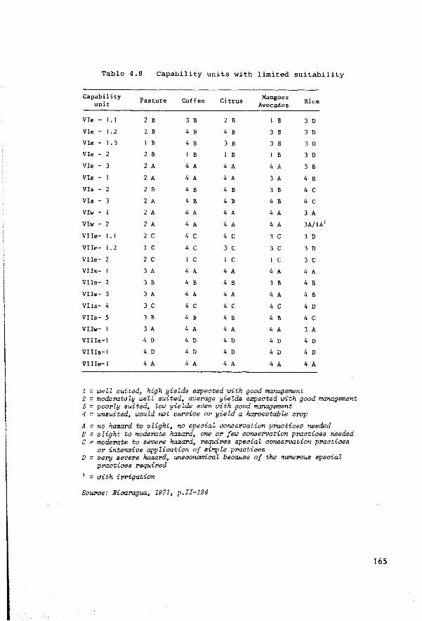
Table 4.8 Capability units with limited suitability
Capability Pasture Coffee Citrus
Mango es Rice unit Avocados
VIe - 1. 1 2 B 3 B 2 B B 3 D
VIe - 1.2 2 B 4 B 4 B 3 B 3 D
Vle - 1. 3 B 4 B 3 B 3 B 3 D
VIe - 2 2 B B B B 3 D
Vle - 3 2 A 4 A 4 A 4 A 3 B
Vls - 2 A 4 A 4 A 3 A 4 B
Vls - 2 2 B 4 B 4 B 3 B 4 c Vls - 3 2 A 4 B 4 B 4 B 4 c Vlw - 2 A 4 A 4 A 4 A 3 A
Vlw - 2 2 A 4 A 4 A 4 A 3A/1A1
VIIe- 1. 1 2 c 4 c 4 c 3 c 3 D
Vlle- 1. 2 c 4 c 3 c 3 c 3 D
VIle- 2 2 c c 1 c c 3 c Vlls- 3 A 4 A 4 A 4 A 4 A
Vlls- 2 3 B 4 B 4 B 3 B 4 B
Vlls- 3 3 A 4 A 4 A 4 A 4 B
VIIs- 4 3 c 4 c 4 c 4 c 4 D
VIIs- 5 3 B 4 B 4 B 4 B 4 c VIIw- 3 A 4 A 4 A 4 A 3 A
Vllle-1 4 D 4 D 4 D 4 D 4 D
VIlls-1 4 D 4 D 4 D 4 D 4 D
VII!w-1 4 A 4 A 4 A 4 A 4 A
1 = welZ suited, high yieZds expeated with good management 2 = moderoteZy welZ suited, average yieZds expeated with good management 3 = poorZy suited, Zow yieZds even with good management 4 = unsuited, would not survive or yieZd a harvestabZe al'Op
A = no hazard to sZight, no speaiaZ aonservation praatiaes needed B = sZight to moderate haza.rd, one or few aonseT'Vation praatiaes needed C = moderate to severe haza.rd, requires speaiaZ aonservation praatiaes
or intensive appZiaation of simpZe praatiaes D = very severe hazard, uneaonomiaaZ beaause of the nwnerous speaiaZ
praatiaes required 1 = with ir:rigation
Sourae: Nicaragua, 1971, p.II-194
165
The specif ic purpose land evaluation
Each land capability unit has been classified according to its
suitability for specified crops, using a four-class land suitability
classification. For some crops a distinction has been made between U
Unirrigated and I- Irrigated.
The land suitability classes have been specified as follows:
class 1: Well suited; high yields expected with good management
class 2: Moderately suited; average yields expected with good management
class 3: Poorly suited; low yields expected with good management
class 4: Unsuited; would not survive or yield a harvestable erop
There are also four subclasses:
A. No hazard to slight; no special conservation practices needed
B. Slight to moderate hazard; one or a few conservation practices needed
C. Moderate to severe hazard; requires special conservation practices or intensive application of simple practices
D. Very severe hazard; uneconomical because of the num.erous special practices required
Obviously the separate land suitability classification of each of
600 soil series and types for twenty-three different land utilization
types would have been a much more elaborate task than the interpretation of
only 66 land capability units. However many combinations of soil series and
land utilization types would have been deemed irrelevant at the beginning,
thus reducing the number of land suitability analyses that needed to be
carried out.
166
The land suitability classification for specific crops is not
supported by a conversion table that specif ies and weighs the limiting
land properties/qualities taken into account. It is therefore a subjective,
qualitative grouping.
There is also a land suitability classification of nine classes for
pastures: it does have a conversion table, similar to those mentioned
for Venezuela and Brazil (see Table 4.9).
The number of days of grazing and the carrying capacity during the
grazing period are the criteria used to distinguish the classes, named
in the report 'pasture suitability groups'. The conversion table also
lists for each pasture suitability group the corresponding land capability
units, their slope, rainfall, and water availability, grazing period,
the kind of grasses to be grown (a kind of management specification) and
some conservation specifications. It is a very informative table and
therefore a good example of data presentation in land evaluation.
Separate conversion tables have also been prepared for potential
woodland production.
They relate the various suitability classes (called management
aategories in the report) to limiting land conditions (Table 4.10.)
This table can be applied to all the mapping units that correspond to
the land capability classes IV, VI, VII or VIII. The range of land
conditions corresponding with classes I, II and III have not been included;
they are considered to have such a high value for cropland that it would
not be economical to use them for woodland. This hypothesis is not
supported by the proposals in previous chapters of this report, suggesting
that in a physical land evaluation for specif ic purposes each land
utilization type represents a land use alternative in its own right, and
that it is not the task of the physical land evaluator to exclude land
utilization types from certain land units on economie grounds. The
demand f or cropland determines whether forestry should operate on non
agricul tural land only. There is now increased interest in farming
167

Table 4. 9 Pasture sui tabili ty groups
Pasture auitability group
Capability units
Ille-3.2. Vle-1.3, IVe-3.2. lVe-4.2
IVe-1
I-1, I-5, I-6, Ile-1, Ile-2. 1, lle-6, l!Ie-1
Slope Rainfalt r.ana:e ranse in
annual •an
(%)
o-30 2000-3000
0- J 5 900-2000
0-8 1400-2000
lle-1, IVe-2, llle-2 0-15 1100-2000
I-4, I-4.2, IIe-2.2, 0-15 f000-2000 Ile-3,Ile-4.1, Ile-4.2, Ile-S.1,Ile-5.2, llle-2a, Ille-2, 1Ue-3a, llle-3.1, Ille-4al, lIIe-4a2,IIIe-4. I, I Ile-4. 2, I!Ie-5a, IIIe-S, Ille-6, !Ve-1, IVe-2,IVe-J,IVa-4.1
Vle-1
Vlle-1
Ve-2, Ve-Sa, Ve-5 IVe-6, IVe-7, VIe-I, Vle-J. 2, Vle-2, Vle-1
IVe-J, Vle-~Ve-1
Vle-1, VIe-2, Vle-3, Vle-3, VUe-1, Vlle-1.2,VIIe-4, VIle-2,VIIe-J, Vlle-4, Vlte-5
0-15 800-1500
0-15 800-1500
8-3-0 1000-2000
0-15 1000-2000
0-75 1000-2000
A Present ca-on aanagearent
Days GTazing period of
May to March
Dec.to Aug.
June to Jan.
June to Jan.
JUDe to Jan.
Dec. to June
Dec.to June
June to Nov.
June to Nov.
June to Nov.
grazing
270
240
210
210
180
180
180
180
180
190
Carrying c::apachy for
grazing period Al 81
aniaal uniu 2
per Ul8DUna
O.> 1.5
0.25 0. 75
0.5
0.5
Water availability and
abundant, strems and Lake Nicar.
limited, shallow wells
limited, deep wel ls
limited, springs and vells
limited, deep vells
abundant, atrttams and shallow wells
limited, deep wells
limited strealll&, or wells
Puturl!: grasses
Jaragua, N•pier, Guinea, Alemán, Para
Guinea, Pangola Bermuda, Estrella Para
J:aragua, Napier. Pangola, Guatemala, B.uffalo
Jaragua, Guinea, Pangola, Napier, Japaa•ae, eu.tamala, and Bermuda
J aragu.a, Guinea, Napier, Buffalo
Bermuda, PaTa* Est re Ha
Jaragua., Guiuea Buffalo, Bermuda, Napiu
Jaragua, Alemin
0.25 O. 75 very limited, Jara.gua, Guinea, auat be piped Buffalo
1 8 I:mproved 1Ullageiunt (to convert to carrying ca.pacity per hectare, multiply b)I 1.4)
One ani"l u:.Ciit ia e:qualto a cow and c•lf, bull, or on• ma~ure horae
Source: Nicaragua., 1971, p.II-2?5
168
Conservat ion practices
overgrazîng, c:ontrol. Field ditches loc:ally
field ditchea, drainage main or lateral if needed
field ditehes, drainage main or lateral if needed
overgrazing control
field ditches, for drainage and soi l reduction
over9ra2ing control. Grass w•tervays. Structural outlet or gully control where ne-eded
drainage ditches
structural outlet or gul ly con trol Overgrai.ing control
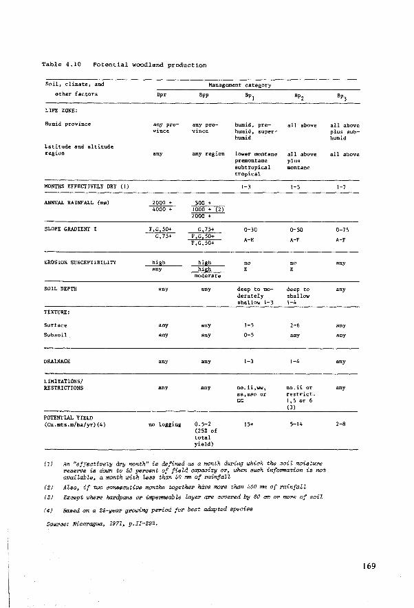
Table 4.10 Potential woodland production
Soil, climate, and
other factors
LIFE ZONE:
Humid province
Latitude and altitude region
MONTHS EFFECTIVELY DRY ( 1)
ANNUAL RAINF ALL (mm)
SLOPE GRADIENT %
EROSION SUSCEPTIBILITY
SOIL DEPTH
TEXTURE:
Surf ace
Subsoil
DRAINAGE
LIMITATIONS/ RESTRICTIONS
POTENTIAL YIELD (Cu.mts.m/ha./yr) (4)
Bpr
any pro-vinc.e
any
2000 + 4000 +
F,G,50+ G,75+
high any
any
any
any
any
any
no logging
Management category
Bpp
any pro-vince
any reg ion
500 + 1000 + (2) 2000 +
G 75+ F ,G,50+ F ,G,50+
hillh hiah
moderate
any
any
any
any
any
0.5-2 (25% of total yield)
Bpl
humid, pre-humid, super-humid
lower montane premontane subtropical tropie al
1-3
0-30
A-E
no E
deep to mo-derately shallow 1-3
1-5
0-5
1-3
no" ii,ww, ss, sso or GG
15+
Bp2
all above
all above plus montane
1-5
0-50
A-F
no E
deep to shallow 1-4
2-6
any
1-4
no.ii or restrict. 1,5 or 6 (3)
5-14
(1) An "effeotively dry month" is defined as a month dw>ing which the soiZ moisture reserve is a.o.m to 50 percent of field capacity or, when such information is not avail.abLe, a month with Less than 50 nm of rainfaH
(2) Alao, if tbJo consecutive months together have more than 500 mm of rainfaZZ
(3) E:r:aept where hardpans or impemeable /,ayer are covered by 60 cm or more of soil
(4) Based on a 25-year growing period for best adapted species
Source: Nicaragua, 1971, p.II-292.
all above plus subhumid
all above
l-7
0-75
A-F
any
any
any
any
any
any
2-8
169
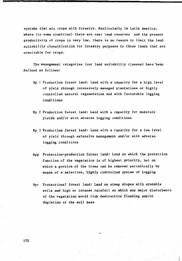
systems that mix crops with forestry. Particularly in Latin America,
where (in some countries) there are vast land reserves and the present
productivity of crops is very low, there is no reason to limit the land
suitability classification for forestry purposes to those lands that are
unsuitable for crops.
The management categories (our land suitability classes) have been
defined as follows:
170
Bp 1 Production forest land: Land with a capacity for a high level
of yield through intensively managed plantations or highly
controlled natural regeneration and with favourable logging
conditions
Bp 2 Production forest land: Land with a capacity for moderate
yields and/or with adverse logging conditions
Bp 3 Production forest land: Land with a capacity for a low level
of yield through extensive management and/or with adverse
logging conditions
Bpp Protection-production forest land: Land on which the protection
function of the vegetation is of highest priority, but on
which a portion of the trees can be removed periodically by
means of a selective, highly controlled system of logging
Bpr Protectional forest land: Land on steep slopes with erodable
soils and high or intense rainf all on which any major disturbance
of the vegetation would risk destructive flooding and/or
depletion of the soil base
Management and conservation specifications (inputs)
The land capability units are the model for the land conditions,
not only in the land suitability classification for specific crops, but
also for the specification of management and conservation practices.
The latter is consistent with the purpose of the land capability units
in the USDA system. Separate tables have been presented for cotton,
maize, sorghum, sugar cane (irrigated and unirrigated), rice (irrigated
and unirrigated), banana, plantain (irrigated and unirrigated), and
coffee that specify recommended management practices, e.g. seedbed
preparation, planting, irrigation, insect control, harvesting, for
several combinations of land capability units (see Tables 4.11. and 4.12
which refer to sugar cane). Only a few sets of land capability units
have been distinguished, varying from five sets (cotton) to only one set
(unirrigated plantain). In the tables a distinction is made between two
management levels: present common practices and improved practices.
It is surprising that management level is considered at such a late
stage of land evaluation, after the land capability/suitability groupings
have already been made. It would have been more in agreement with the
proposals made in previous chapters of this report to make separate land
capability/suitability groupings for different management levels rig~t from
the start, distinguishing between land utilization types dedicated to pro
ducing the given crops with present practices and with improved practices.
Soil conservation practices have been presented in a table (Table
4. 13). This table distinguishes more land conditions (20 sets/combinations
of land capability units) than the table that specif ies the management
practices. This greater emphasis on conservation than on management
specifications is consistent with the primary objective of the USDA Land
Capability Classification: soil conservation.
For each set of land capability units several sets of 'adapted
crops' have been distinguished with different conservation requirements,
171
Table 4 .11 Non-irrigated sugar cane production practices by capability units
SET 1: Management recommendation for capability units: I-1, I-4.1, I-5, Ile-1, IIe-2.1, Ile-2.2, Ile-3, Ile-4.1, lle-5.1, Ille-4al, II!e-4a2, III-1 (no erosion to moderate erosion hazard)
Practice of operation
Seedbed preparation
Planting - varieties - rate - date
Cultivation
Fertilization
Disease control
Insect and pest control
Trash disposal
Harvesting
Replanting
LEVEL A (present cotIIDOn practices)
m a n a g e m e n t
same as for irrigated sugar cane
POJ, Purple, Pinder same as for irrigated sugar cane Mayt June
blade oncet cultivation 2 or 3 times, machete 3-4 times
none
resistant varieties used
none
after harvest, trash piled in alternate rows away from base of plant. This controls weeds in every second row reducing cultivation costs by half
by hand when cane reaches maturity, from November to May
from 3 to 5 years, depending on yields
1 e v e 1
LEVEL B ( improved practices)
same as for irrigated sugar cane
POJ, Purple, Pinder same as for irrigated sugar cane May, June
cultivator 3 or 4 times. Machete 4-5 times
200 lbs urea and 100 lbs 10-40-10 in June, July
resistant varieties used
2 or 3 applications of insecticides against little bugs, armyworms, stalk borer
after harvest, trash piled in alternate rows away from base of the plant. This controls weeds in every second row reducing cultivation casts by half
by hand when cane reaches maturity, from November to May
trom 3 to S years, depending on yields
. SET 2: Management recommendation for capability units: IIIe-1, llle-3, IIIe-4.1, II!e-5a (si ight eros ion hazards)
Planting cane planted on contour cane planted on contour
All other practices same as f or Set 1 above same as for Set J above
Source: Nicaragua, 1971, p.II-204

Table 4 .12 Irrigated sugar cane production practices by capability units
SET l: Management. recouaendation for ca.pabîlity unita: 1-1, I-4.J, I-4.2, I-5, Ile-2.1, Ile-3, Ile-4.1, lle-4.2, Ile-5. l, Ile-5.2, IIIe-Je, Illa-5e (no erosion to slight erosion hazard)
Practice of operat:ion
LEVEL A (pruent ccnmon practices)
management 1 e v e 1
Seedbed preparation beginning of dry season. Deep plowed, disk harrow twice, furrowed. Furrowing equipment less dfective than in B. Furrow 5 feet apart.
Preparation for irrigation irrigation laterals and sublaterals are revived with large 1DOldboard ditcbe11; connections to permanent canals repaired by ltand
Planting - variet.ies varieties: CP-44155, Houaton 41223, LS-143, Pindar, NK0-3-10
- rate 2.5 to 4 tons/mz:,planted cootinuously in the furrow with hand labour
- date early in dry aea1on, as 1000 as land is prepared
Cultivation 4-6 cultivations, machete in the row as required
Fertili:tation - lst year at planting tiae 200 lb• 10-40-10, if phosphorus required; 150 lb11 urea two raoths sfter planting and 150 lbs urea in June or July
- subsequent 150 Ibs urea right after harvest. If required yeara 10-40-JO is also applied at this titae. 150 lbs
urea tbree to four months after harvesting
Irrigation auTface irrigation, longer interval betveen applications than in B
Oi$ease control diseaa-e-resist.ant vaTietiea planted
Insect and pe•t control 4 to 6 spray applications to control insects. Main insects - spitth. bug&, arm.ywonns, stalk borers Rats controlled with poison baits.
Harvesting beginning of dry season. Earlier matuTing varieties harvestetd first. Select.ion of area to harveat is made by checking age of plant, its appearance, and cbemical analyses for total solids and sugar. Cane burned prior to being harvestctd to reduce harvest costs. Irrigation discontinued ooe month before harvest. Harvesting done by hand.
R.eplanting from 3 to 7 yeara, depending on yields
SET 2: Management recoaaendation for capability unita: IIlw-2. IVe-1, IVe-2
LEVEL B (im.proved practices)
beginning of dry season. Deep plowed, disk harrow twice furrowed. Special furrow machine to make furrows 6" to 12" deep and 5 feet apart.
irrigat.ion laterals and sublaterals are revived with large moldboard ditches; connections to permanent cana.ls repaired by hand
Varieties: CP-44155, Houston 41223, LS-143, Pindar, NIW-3-10
2.5 to 4 tons/mz,planted continuously in the furrow with hand labour
early in dry season, as soon as land is prepared
pre-emergence herbicides used. Post-emergence herbicides used dong with 2 or 3 cultivations. Machete weeding in rows, as required. In second and subsequent years, special plow is run on either side of cane row, shortly after barvest, very close to cane to tear away part of the stool&: and to trim roots
at planting time 200 lbs J0-40-10, if phosphorus required; 15-0 lbs urea two months after planting and 150 lbs urea in June or July.
150 lbs urea right after harvest. lf required 10-40-10 is also applied at this time. 15-0 lbs urea three to four months after harvesting
surfa.ce irrigation, 6-12 days intervals
disease resistant varieties planted
4 to 6 spray applications to control insects. Main insects - spittle bugs, armyworms, stalk borers Rats controlled with poison baits.
beginning of dry seas.on. E.t.rlier maturing varieties harvested first. Selection of area to harvest is made by checking age of plant, its appearanc.e, and chemie.al analyses for total solids and sugar. Cane burned prior to being harvested to reduce harvest costs. lrrigation discontinued one month before harvest. Harvesting done by hand.
from 4 to 10 years, depending on yields
(little or no ero•ion hazard hut drainage problem)
Plant ins
All other practices
emne ae for SET 1 above except that cane is planted on the ddge
,,... aa for SET 1 above
NOT!: mz • aanzana; 1 manzaoa • o. 7 hectares
Source: Nioal"'llgua~ 1971~ p.II-204
saae as for SET 1 above except that cane is planted on the ridge
same as for SET l above
173
resulting in distinct conservation specifications. The sets of crops
distinguished are:
A 1 Intertilled annual row crops (corn, cotton, sesame, sorghum, peanuts, vegetables, tobacco, cassava. Solid-planted crops
B Perennial row crops (bananas, plantains, sugar cane)
B 2 Perennial solid-planted crops (pastures)
C 1 Coffee
The table also ref ers to the urgency for implementing conservation
practices specif ied if the sets of crops mentioned are grown:
E Practice essential for soil and water conservation
0 Practice essential only if on-site inspection shows need
X Practice desirable but not essential for soil conservation
F Practice applies only to certain kinds of crops in group
It is surprising that the table does not show any correlation
between the urgency of soil conservation practices and the class levels;
for example the classes II, III, and IV apparently have the same need
for gradient terrace systems when cultivated with erop sets A or B 1.
Yield potential (outputs)
Whereas the land capability units have been given the centra! role
in the land suitability classification and in the specifications of
management and conservation practices, they have not been considered as
the most detailed land (mapping) units for yield prediction. Tables are
presented specifying the yield potential of each soil (mapping) unit.
174
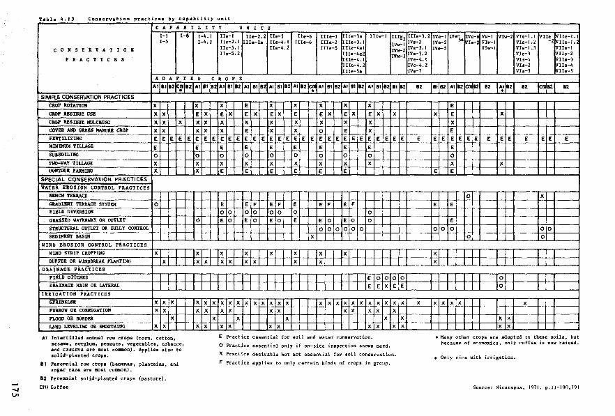
....., \J1
T•ble 4.13 Conservation practices by capability unit
C A P A B I L l T y U N I T S
I-1 I-6 I-4. l IIe-1 Ile-2.2 Ile-3 Ile-6 IIIe-1 Uie-3a IIIw-1 IIIi;2 I-5 I-4. 2 Ue-2.1 Ille-2a Ile-4. 1 IIIe-6 IIIe-2 IIIe-3.1 IVv-1
c 0 N S E R V A T I 0 Il IIe-5.1 Ile-4. 2 IIIe-5 1Ile-4al IVv-2 Ue-5. 2 II!e-4a2 IVw-3
P R A C T l C B S Ille-4.l lIIe-4. 2 1Ite-5a
ADAPTED C R 0 P S
Al 8112ft.L" 12 A1 81 12 Al 81 82 Al 81 82 Al 8112 Al 12 en Al BI 82 Al 81 82 Al 81 12 BI 12 • SIMPLE CONSERVATION PRACTICES
CROP ROTATIOIJ x CROP IESIDUE US! x x CROP llES!Dlm KllLCHtllG x x x COVER AND GREEll l!Al1URE CROP x x FERTILIZING E E E E MillIMUll TILLAGE E SUBSO ILING 0 TWO-WAY TILLAGE x CONTOUR F ARllIIIG x
SPECIAL CONSERVATION t'RACTICES
WATER EROSION CONTROL PRACTICES
BENCH TERRACE
GRADIENT TERRACE SYSTEM 0 FIELD DlVERSIOIJ
GRASSED WATERWAY OR O\ITLET
STRUCTURAL OUTLET OR GULL Y CONTROL
SED DIENT BASIN
WIND EROSION CONTROL PRACTICES
WIND STRIP CROPPING x BUFFER OR WINDBl\E,\J{ PLANTING x
DRAINAGE PRACTICES
FIELD DITC!IES
DRAillAGE MAIN OR LATERAL
IRRIGATION PRACTICES
SPRI!llCLER x x x FURROW OR CORRUGATIOIJ x x FLOOD OR BORDER x LAND LEVELING OR SMOOT!IIllG x x
A1 Intertilled annual row crops (corn, cotton, sesame, sorghum, peanuts, vegetables, tobacco, and cassava are lbOst common). Applies also to solid-planted crops.
lt Perennial row crops (baoanas, plantains, and sugar cane are most common).
12 Perennial solid-planted crops (pasture).
Cl1) Coffee
x E x x x x x
E E E E
E 0
x x
0
x x x
x x x x x
x x x
x E x x x x x E x E x E x E E x E x E x x x x x x x x x x E x x 0 E x E E E E E E E E E E E E E E E E E E E E E E E
E E E E E E E
0 0 0 0 0 0 0
x x x x x x x E E E E E E
E E F E F E E F E F
0 0 0 0 0 0 0 0 E 0 E 0 E 0 E E 0 E 0 0
0 0 0 0 0 0 x
x x x x x x x x x x x x
E 0 0 0
E E x E
x x x x x x x x x x x x x x x x x x x x x x x x x x x x
x x x x x x x x x x E Practice essential for soil and water conservation.
0 Practice essential only if on-site inspection shows need.
X Prac.tic.e. desirable but not enential for soil conservation.
F Practice applies to only certain kinds of crops in group.
0 E
x
x x
IIIe-3. 2 !Vs-2 !Ve-3. 1 !Ve-3. 2 IVe-4.1 !Ve-4. 2 lVe-7
82
E
x
IVe-1 IVeSa IVe-E Vv-1 Vlw-2 VIe-1.1 VIIe VIIe-1.1 IVe-2 ~Ie-l VIw-1 VIe-1.2 -2 VIIe-1.l IVe-5 Vlw-1 VIe-1.3 VIIs-1
V!e-3 vns-2 Vls-1 Vlle-3 V!s-2 VIIe-4 Vls-3 vue-5
11 82 All2~2 82 Al 82 12 fml2 12 +
E
x E x x E
E E E E E E E E E E E E E
E
0
x x E E
0 x E E
E
0 0 0 00 0 0
x x 1
0 0
x x x x x
x x x x
• Many other crops are adapted to these soils, but because of economics, only coffee is now raised.
+ Only rice with irrigation.
Source: Nicaragua, 1971. p.II-190,191

Climatic variation is not a separate factor in the rating of yield
potential; the soil series and types are supposed to be homogeneous in
this respect, an acceptable assumption at this scale of land evaluation.
Yields (averages over several years) have been estimated for eight
different crops and for pastures. Rice and sugar cane yields have been
specified for both irrigated and unirrigated conditions.
A distinction has been made between two levels of management when
specifying erop yield:
A-average management B-improved management
These two levels have been defined as follows:
Management level A:
'farmers who do not use a good cropping system, the best tillage or planting methods, or pest control methods, and optimum amounts and kinds of fertilizers'
Management level B:
'farmers who use such practices as suggested .••• in the report'
Conclusions
The role of the land (mapping) units
lt may be concluded from the discussion that a preliminary grouping
of the many soil (mapping) units into a much smaller (only 107.) number
of land units for purposes of data interpretation bas some advantages:
it simplifies data processing and the presentation of results. All land
(mapping) units that belong to the same capability units are considered to
be the same for purposes of data interpretation except for yield potential.
But this kind of step-wise simplification of the land evaluation into
smaller, homogeneous strata of land (mapping) units carries the risk of
176
mixing up different land suitability criteria: those used for the grouping
into land capability units, for the grouping into land suitability classes,
for the grouping into sets with similar management and/or conservation
specifications and finally into sets with similar yield potential.
It seems convenient to make separate interpretations for each land
(mapping) unit in connection with each land utilization type that is rated
relevant. Data processing of the multiple data should not be a reason for
an a prioPi and possibly too arbitrary grouping of land (mapping) units
as shown in the Nicaragua report, since data interpretation anyway represents
only a fraction of the time and expenses dedicated to the resource survey,
the data collection stage. In future, automated data handling for purposes
of land evaluation and periodical re-interpretation should be a major
concern of this type of study in developing countries too.
The role of the land utilization types
A more systematic approach to the definition of relevant land
utilization types would have been valuable for the user of the Nicaraguan
report. It would have shown more clearly the relations that exist between
the various pieces of information about land capability, land suitability,
management, conservation and yield potential. It might also have improved
the quality of the interpretations, obliging the reporters to be more
problem-oriented and more specific in their conclusions.
The major criticism of the report is that the present land use
practices, which were systematically studied when the present land use
map was made, have not been considered more carefully in the identi-
f ication and definition of relevant land utilization types. The only key
attributes considered were produce, management and the distinction
between irrigated and unirrigated. Management has been dealt with rather
superf icially at a very late stage of the procedure, when a distinction
was made between common and improved management. Only the factor 'produce'
was seriously considered at several levels of generalization:
177

LEVEL A
crops
pasture
forestry
LEVEL B
annual intertilled annual solid-planted perennial row perennial solid-planted perennial coffee perennial citrus
production forest protection/production forest protection forest
only foP annual cPops
LEVEL C1
sesame peanuts corn (forage) corn (grain) sorghum (forage) sorghum (grain) vegetables tobacco cotton cassava rice kenaf
The question whether the land utilization types and their key attributes in
the Nicuraguan land evaluation play a role has been answered in the follow
ing scheme:
Key attributes Suitability Yield Management Conservation
classif ication prediction specif ications specifications
produce LEVEL c LEVEL c LEVEL C LEVEL A/B
irrigated/ YES YES YES YES unirrigated
managetnent NO YES YES NO
levels A/B
A more systematic application of the land utilization type would
suggest the following answers (without referring to other key attributes
mentioned in previous chapters hut not considered by the Nicaraguan study,
such as technological level (the kind of implements used, hand/animal/power
operated equipment, labour intensity, the scale of operations, the land
tenure conditions):
178
Key attributes Suitability
classification
produce LEVEL C
irrigated/ YES unirrigated
management levels A/B YES
other 1 YES
e.g. labeur, implements, capital, scale of operations, technology
Yield
prediction
LEVEL C
YES
YES
YES
Management Conservation
specifications specifications
LEVEL C LEVEL C
YES YES
YES YES
YES YES
179
4.3.3 Mexico: towards a land evaluation for individual crops
CETENAL (the Commission for the Study of the National Territory)
has embarked on a very ambitious project: a natural resources inventory
of the entire country. The selected scale 1:50 000 is surprisingly
large, considering the size of the country (approx. 2 million km2) and
the great expanse of arid and semi-arid low potential zones. The inventory
is supported by 1:25 000 coloured aerial photographs. Separate maps are
made of the topography, geology, climate, land use and vegetation, soils
(slightly modified legend of the FAO/UNESCO World Soil Map), and potential
land use.
In this section we will pay attention to the potential land use map.
CETENAL adheres strictly in the publication of its series of potential land
use maps to the USDA Land Capability System (Klingebiel and Montgomery,
1961). However, in 1973 CETENAL had already published some interesting
new proposals for making potential land use maps (Quinones et al., 1973).
The new methods proposed include a general purpose land evaluation and a
specif ic purpose land evaluation, which take into account over a hundred
different crops, forage and forestry species.
The reasons why CETENAL has not changed its method of preparing
potential land use maps since these new proposals were published are not
known to this author. Perhaps it is for reasons of consistency that
CETENAL continues to apply the USDA Land Capability System, although the
new method has several interesting points as will be explained in this
section.
GENERAL PURPOSE LAND EVALUATION
Land qualities/properties and 'agrological capacity' classes
The following land qualities/properties have been considered:
180
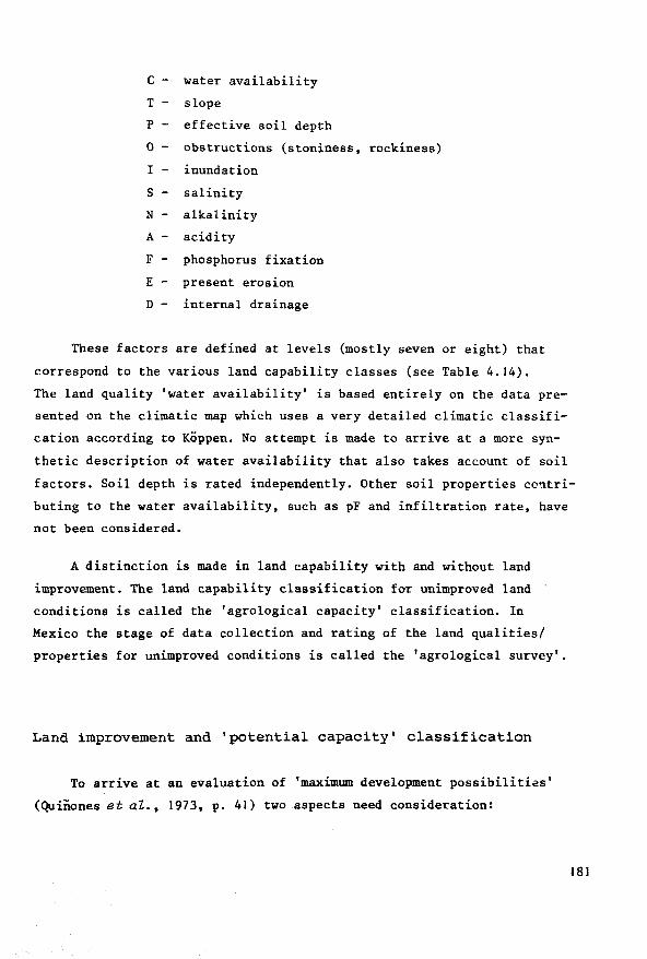
C - water availability
T - slope
P - effective soil depth
0 - obstructions (stoniness, rockiness)
I - inundation
S - salinity
N - alkalinity
A - acidity
F - phosphorus fixation
E - present erosion
D - internal drainage
These factors are defined at levels (mostly seven or eight) that
correspond to the various land capability classes (see Table 4.14).
The land quality 'water availability' is based entirely on the data pre
sented on the climatic map which uses a very detailed climatic classifi
cation according to KÖppen. No attempt is made to arrive at a more syn
thetic description of water availability that also takes account of soil
factors. Soil depth is rated independently. Other soil properties contri
buting to the water availability, such as pF and infiltration rate, have
not been considered.
A distinction is made in land capability with and without land
improvement. The land capability classification for unimproved land
conditions is called the 'agrological capacity' classification. In
Mexico the stage of data collection and rating of the land qualities/
properties for unimproved conditions is called the 'agrological survey'.
Land improvement and 'potential capacity' classification
To arrive at an evaluation of 'maximum development possibilitias'
(Quiîiones et al., 1973, p. 41) two aspects need consideration:
181

00 N
Table 4 .14 conversion table for rating soil properties and climate in eight classes
LAND QUALITY/PROPERTY
A. AVAILABLE WATER
B. SLOPE (gentle) (rolling)
C. EFFECTIVE SOIL DEPTH (cm)
D.
E.
OBSTRUCTlONS stones <75 cm stones >75 cm
INUNDATION
F. SALINITY (mmbos/cm)
G. ALl<ALINITY/ SODICITY +
%Na pH
depth
CLASS 1
Af, Afm (A)Cf, (A)Cfm Cf, Cfm Cfb', Cfmb'
0-2%
>75
<5% <10% <5%
no losses
0-2
<10 <7.5 0-75
Sourae: Adapted from Quiiiones et at., 1973
CLASS
Am, Amf, Aw2 , Aw2x', Aw1, Aw1x' A(C)m, (A)Cmf, A(C)w2, (A)C(w2)x', A(C)w1, (A)C(w1 )x' Cm, Cmf, C(w2), C(w2)x', C(wi), C(w1)x' Cmb'' Cmfb'' C(w2)b', C(w2)x'b', C(w1)b', C(wi)x'b'
2-6% <3%
50-75
5-10% 15-25%
5-10%
once in 1 O years 0-20% losses
2-4
10-15 7.5-8.5 0-75
>IS
75-125
CLASS 3
Awo, Awox' A(C)wo, (A)C(wo )x', C(wo), C(wo)x', C(wo)b', C(wo)x'b'
6-10% 2-6%
35-50
10-15% 25-35% 10-15%
once in 10 years 20-50% losses
4-8
15-40
0-75
CLASS 4
BS1h'w, Bs1h'x' BS1 hw, BS1 hx' BS1kw, Bs1kx' BS1k 11w, BS1k"x'
10-15% 6-10%
25-35
15-35% 35-50% 15-35%
once in 10 years >50% losses
8-16
40-60
0-75
CLASS 5
15-25% 10-25%
15-25
35-50%
no crops only past ure
>16
>60
0-75
CLASS 6
25-40% 25-40%
10-15
50-70%
past ure limited
CLASS 7
BSohw,BSohx, BSohs, BSohw, BSohx,BSohs, BWhw, BWhx, BWhs, BSokw, BSokx, BSoks, BWkw, BWkx, BWks,BSokw, BSokx, BSoks, BWkw, BWkx, BWks
40-100% 30-100%
<10
40-90%
only occas. pasture
CLASS 8
BWh'w, BWh'x', BWh•s, BWhw, BWhx ' , BWhs,BWkw, BWkx 1
,
BWks, BWk 11w, BWk"x', BWk"s
>100% >100%
>90%
no pasture

specification in genera! terms of recommended land improvement practices
the effe~tiveness of these improvements, which can be expressed by the difference between the 'agrological' capacity class (the land capability class without land improvement) and the 'potential' capacity class (the land capability class with improvement). In the Mexican method this effectiveness depends entirely on physical factors; the cost of land improvement is not considered.
The following land improvement practices have been considered:
a - irrigation
1 - leaching
p - application of amendments for correcting alkalinity
t - stone removal
c - liming
i - flood control
d - drainage
e - erosion control
Land utilization types
The new CETENAL method does not define the land utilization types
considered in the agrological and potential capacity classifications,
apart from the usual distinction that is made between agricultural crops
(classes 1-4), pastures (classes 5 and 6) and forestry (classes 6-8).
There is one reference to the management level in the potential capacity
classification (Quinones et al., 1973, p. 41): 'adequate techniques will
be applied for the realization of the mentioned land improvements'.
Definition of agrological and potential capacity classes
The eight classes have not been defined. It has only been stated
183
that from class 1 to class 8 the limitations increase, affecting the number
and quality of crops ~ncluding forage and forest tree species) that can
be grown economically within each climatic/physiographic zone. Criteria
such as yield or input requirements have not been considered. Therefore
these capacity classes are essentially no more than systematic groupings
of land (mapping) units with similar levels of selected land qualities/pro
perties.
Specific purpose land evaluation
The lack of consideration for land utilization types in the genera!
purpose land evaluation has been compensated in the specific purpose
land evaluation. In this evaluation the feasibility of growing over one
hundred different crops, forage and forestry species is assessed. The
single most important land quality considered here is 'water availability'.
Conversion tables (using computers for data handling) have been prepared
for four broad climatic zones: arid and semi-arid; subhumid; humid with
dry season; humid all year round. In each broad climatic zone four
temperature regimes have been distinguished: hot; semi-hot; temperate;
semi-cold. The water availability in each zone has been rated according
to the levels of this land quality distinguished in the genera! purpose
land evaluation (by using subdivisions of KÖppen's climatic classification).
For each combination of broad climatic zone, temperature regime and
level of water availability, the crops that it is feasible to grow have
been listed in the conversion table. Examples of such conversion tables
are Tables 4.15 and 4.16.
The land evaluation for specific crops also takes into account their
requirements for some other land qualities: effective soil depth, salinity,
alkalinity, acidity (Table 4.17).
Since hundreds of different combinations of feasible crops may
result, a numerical key has been developed in which each combination of
feasible crops is indicated by a different number (similar to telephone
numbers).
184
The crops that are classified feasible have been selected on physical
grounds only. They are not necessarily relevant from the socio-economie
point of view. CETENAL's maps and reports are made primarily for national
and regional planning. More detailed physical analyses will be needed
regarding erop varieties, management techniques, inputs and outputs, in
order to orient more detailed types of land use planning.
The proposed system is a two-class specific purpose physical land
evaluation: class I-suitable; class II-not suitable.
Correlation between these two classes and the land capability classes
of the general purpose land evaluation may exist, but the system bas not
been designed to be conclusive about such a correlation. Basically the
two land evaluations are separate exercises; this distinguishes them
(favourably) from the Nicaraguan example, where the two systems became
rather mixed up. If there is a correspondence between general purpose
land capability classes and the yields of the crops of the specific
purpose land evaluation, this is more likely to be coincidence than a
deliberate result of the classification. A more profound comparison of
the land qualities/properties and the land requirements of each erop
would be needed to arrive at a land suitability classification that is
more specific about such fundamental data for land use planning as
yields, input requirements, hazards.
The CETENAL report does not explain in detail how the computerized
conversion tables for the identification of feasible crops were made.
Therefore one is forced to conclude that there is no adequate body of
knowledge about the land requirements of the mentioned crops based on
on-site agronomie experience, for determining the crop-feasibility
within an acceptable margin of accuracy, as the CETENAL report purposes.
My impression is that the CETENAL proposals are refreshingly courageous
and relevant, as far as methodology is concerned, but that the basic
assumptions and the computerized conversion tables need to be examined by
a wider circle of specialists who have been asked to help improve the
method in successive approximations. The combination of crops into
185
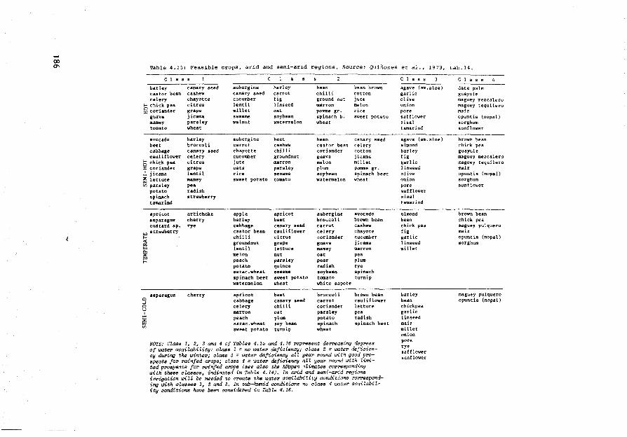
Table 4.15: Feasible crops, arid and semi-arid regions. Source: Quihones et al., 1973, tab.14.
C 1 a s s
barley castor bean celery
E-o chick pea g coriander
guava mamey tomato
avocado beet cab ba.ge cauliflower
b chick pea ::c coriander ~ jicama ~ lettuce tn parsley
potato spinach tam.arind
•pricot asparagus custard ap.
~ a trawberry
~ "' "" 1fi ...
0 asparagus
_, 0 y
ffi "'
canary seed cashew chayotte citrus grape jicama parsley wheat
barle.y broccoli canary seed celery citrus grape le:ntil mamey pea radish strawberry
artichoke cherry rye
cherry
aubergine barley canary seed carrot cucum.ber fig lentil 1 inseed millet oat sesame soybean wal nut watennelon
aubergine beet carrot cashew chayotte chilli CUCUlllber groundnut jute marron oats parsley rice ses.ame sweet potato tomato
apple apricot barley beet cabbage canary seed castor bean cauliflower chilli citrus groundnut grape lentil lettuce melon nut peach parsley potato quince sarac.wheat sesarae sp inach beet sweet potato watermelon wheat
apricot beet cabbage canary seed celery chilli marron oat peach plum sarac.wheat soy bean sweet potato turnip
bean bean brown chilli cotton ground nut jute marron melon pomme gr. rice spinach b. sweet potato wheat
bean canary seed castor bean celery coriander cotton guava jicama melon millet plum pomme gr. soybean spinach beet watermelon wheat
aubergine avocado broccoli brown bean carrot cashew celery chayote coriander CUC\lmber guava jicama mamey marron oat pea pear plum radish rye soybean spinach tomato turnip white sapote
broccoli brown bean carrot cauliflower coriander lettuce parsley pea potato tadish spinach spin.ach beet wheat
NOTE: Class 1, 2,,. 3 and 4 of Tables 4.15 and 4.16 represent decNasing d.egI"ees of wter avai'lability: alass 1 =no r.Jatel" deficien<!y; class 2 = wate:r defiaiency during the winter; al,ass 3 = water deficiency atz year round i.>ith good prosp.?cts fo'tt rainfed crops; class 4 ::: wate.r ~fieienay all yea.1' :round with tinrited prospects for rainfed cl"Ops ( sse atso t>w Köppen atimates t!o:r:responding with these classes, indicated in Tab"le 4.14). In arid and aemi-arid regione ifflgation IJiZl be needed to create the ti)ater avaitabitity condition.s üorresponding uith classes 1, 2 and 3. In aub-humid conditions no class 4 water availability aonditiona have been considered in Ta.bZe 4.16.
C l a s s
agave (am.aJoe) garlic olive on ion po re safflower sisal tamarind
agave (am.aloe) almond barley fig garlic 1 inseed olive <mion po re safflower sisal tamarind
a.lmond bean chick pea, fig garlic l inseed millet
barley bean chickpea garlic 1 i,nseed maiz millet on ion po re rye saf flower sunflower
c 1 a s s
date palm guayu le maguey mezcalero magufty tequi lero maiz opuntia (nopal) sorghum sunflower
brovn bean chick pea guayule maguey mezcalero maguey tequilero mait opuntia (nopal) sorghum sunflower
brown bean chick pea maguey pulquero maiz opuntia (nopal) sorghum
maguey pulquero opuntia (nopal)
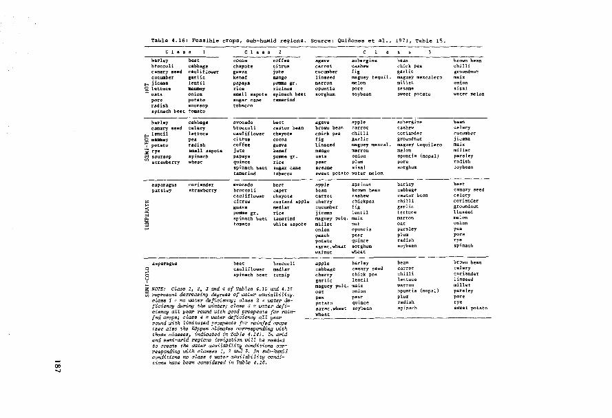
Table 4.16: Feasible crops, sub-hum.id regions. Source: Quiöones et al., 1971, Table 15.
l • s a
barley beet broccoli cabbage canary seed cauliflower cucumber garlic
"""' j icama leut il g, lettuce mauaey
oats onion pore potato radish soursop spinach beet tomato
barley canary seed
f-o lentil Q uumae.y "':-' potato ; rye
~ :~~:::rry
asparagus paYaley
"' .... ;'.2
"' 0. :>:
"' ,,...
asparagus
cabbage celery lettuce pea radisb small sapote spinach wheat
coriander strawberry
C 1 a s s
cocoa chayote guava kenaf papaya rice small sapote sugar cane tobacco
avocado broccoli caulif 1011er citrus coffee jute papaya qui nee spinac.h beet tamarind
avocado broccoli caul iflower citrus gua.va potllDe gr, spinach beet tomato
coffee citrus jute mango pomne gr. ricinus spinach beet tamarind
beet castor bean chayote cocoa guava kenaf poa:ne gr. rice sugar cane tobacco
beet caper chayou custard apple medln rice tamarind white sapote
beet broccoli caul iflower medlar spinach beet turnip
ffi NOTE: Class 1, 2, 3 and 4 of Tables 4.15 and 4.16 tn rep:resènt deal"easing dsgrees of water avaiaZbitity;
cZaaa 1 ::= no wtero dtaficiency; class 2 = water defiaien&y du.ring the ûJinte:r; aZass 3 := water deficiency aU year POUnd With good prospeots for rainfed crops; class 4 == tJater defiaienoy alt year round with 1-imitated prospects for rainfed arops ( see also the Köppen aUmates aorroesponding with these aZasses, indicated in TabltJ 4.14). In arid and semi-arid regiona i:rriga.tion witL be needed to create the tiJa.tel' availabilit'fi aondition.s correap0?1ding urlth ctaaaes 1, 2 anJ 3. In sub-humid conditions no alass 4 wateP availability aonditiorts have been aonsidsred in Table 4.16.
agave carrot CUCWllber linseed marron opuntia sorghum
agave browo bean chick pea fig linaeed ma.ngo oats pear sesame
aubergine cashew fig maguey tequi 1. melon po re soybean
apple carrot chilli garlic maguey mezcal. marron on ion plum sisal
sweet potato water melon
apple be an carrot cherry cucumber jicama maguey pulq. millet on ion peach potato sara.c.wheat. wal nut
apple cabbage cherry garlic maguey pulq. oat pe• potato sarac. whea t wheat
apricot brown bean cashew chickpea fig lentil maiz nut cpuntia pear quince sorghum. wheat.
barley canary seed chick pea lentil mai.z on ion peat quince soybean
be an chick pea garlic maguey mezcalero mil let sesame sweet potato
aubergine cashew coriander groundnut maguey tequi lero melon opuntia (nopal) po re sorghum
barley cabbage caator bean chilli garlic lettuce marron oat parsley plum radish soybean
be an carrot chilli lettuce mat:ron opuntia (nopal) plum radish spinach
bt'own bean chilli groundnut maiz on ion sisal water aielon
be an celery cucumber jicama maiz millet parsley radish Joybean
beet canary seed celery coriander groundnut linseed melon on ion pea po re rye spinach
brown bean celery cot:iander linseed millet parsley pore rye s1'1eet potato
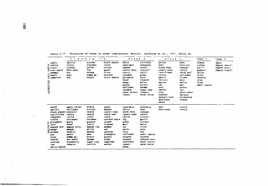
00 00
Table 4.17. Tolerance of crops to other limitations. Source: Quifiones et al., 1971, Table 18.
c 1 • . • . • 1 - 2 c 1 • • s c l a s s
apple apricot avocado black pepper abacá artichoke barley bean ~ cherry citrus cinnamon clove aaparagus aubergine beet broccoli ~ cocoa c.oconut coffee cotton ba na na carrot brown bean cabbage ~ cust.apple date palm fig guava caator bean chayote 1 cartary seed cele.ry ...J manmey nut nutm.eg olive cherry chilli. caul if lower chick pea 1
- peach pear pome gr. soursop cucumber grape ei trus coriander ~ tamarind tea walnut white sapote groundnut jute garlic jicama
"' kenaf linseed lettuce maiz
;:; mango melon marron medlar ... papaya potato oat pea u safflower sesame pear qui nee
"' "' sorghum augar cane radish rye
"' sweet potato tobacco rice aarac.wheat "' tomato water melon soybean spin.ach
spinach beet strawberry sunf lower turnip wheat
abaci •1ave (aloe) al mond apple asparagus aubergine beet cotton apricot artichoke avocado ba na na barley be an date palm turnip black pepper broccoli 1 cashew castor bean brown bean cabbage caul if101fer celery cherry chick pea1 canary seed carrot cinnamon citrus clave cocoa chilli cocon ut coffee coriander cucwaber custard apple fig garlic
>- groundnut auav• guayule jicama grape lettuce t: jute1 k.enaf lentil linaeed maiz melon ~ maguey mezc. maauey pulq. maguey teq. -•Y oat olive ~mango medaar millet nut onion po re ~ nutmeg opuntia papaya paraley rice ryo
pea peach pe•r pineapple safflower small sapote plum pomegr. potato qui nee sorghum soybean radish ear.'lifheat seaame sisal spinach spinach beet 1oursop atrawberry augar cane tamarind sunflower sweet potato tea tobacco vanille valnut tomato water melon white sapote wheat
Class 5 Class 6
almond agave cashew maguey me ze al. aar He maguey puJq. guayule maguey tequil. millet on ion opuntia po re sisal small sapote
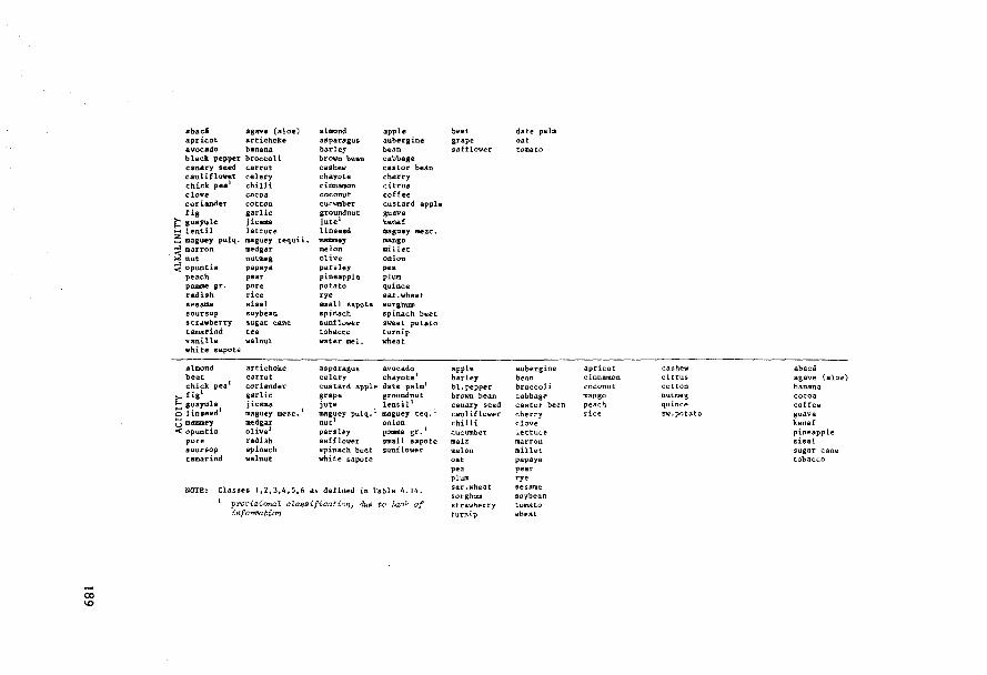
abac4 agave (aloe) aprîcot artichoke avocado banana b laclt pépper broccoli canary seed carrot cauliflowe"r celery chick pea 1 chi 11 i clove cocoa coriander cotton fig garlic
i'.'.: gu&ft'le jicmaa Jo-j lentll lettuce :=:; magv.ey pulq. maguey tequiL
~ mnuartron medgar ~ nut\Hg ~ opuntîa papaya
peach pear pOlll:Ae sr. pore radish rice sesame sisal soursop soybean strawberry sugat: cane tamarind tea vanilla walnut t1hi te sapote
almond beet chick. pea 1
>- f ig1
E--< guayule Q linseed 1
t) mammey < opuntia
pore aoursop tamarind
artichoke carrot coriander garlic jic.ama maguey mezc. 1
medgar olive 1
radish spinach wal nut
altnond asparagus barley brown bean cashew cbayote cinnauion coconut cucumber groundnut jute1
linseed maumey melon olive parsley pineapple potato rye small sapote spinach sunflower tobaccp water mel.
apple auber1ine bean cabbage castor bean cherry citrus coffee custard apple guava k.enaf maguey mezc. aango millet on ion pea plum qui nee sar.wheat SO'tghwn spinach beet sweet potato turnip wheat
asparagus avocado celery chayote 1
custard apµle date palm1
grape groundnut jute lentil 1
maguey pulq. 1 maguey teq. 1
nut 1 onion parsley pOD111e gr. 1
safflower small sapote spinach beet sunflower white sapote
NOTE: Classes 1,2,3,4,5,6 as defined in Table 4.14. 1 proviaiona.l c1..assifiC!ation, due to lack of
in.foPmation
beet grape safflower
apple barley bl, pepper brown bean canary seed cauliflower chilli cucumber maiz melon oat pea plum sar .wheat sorghum strawberry turnip
date palm oat tomato
aubergine be an broccoli cabbage castor bean cherry clove lettuce marron millet papaya pear rye se sa.me soybean tomato whellt
apricot cinnamon coconut mango peach rice
cashe-wcitrus cot:ton nutmeg qui nee sw.potato
abacá agave (aloe) banana cocoa coffee guava kenaf pineapple sisal sugar cane tobacco
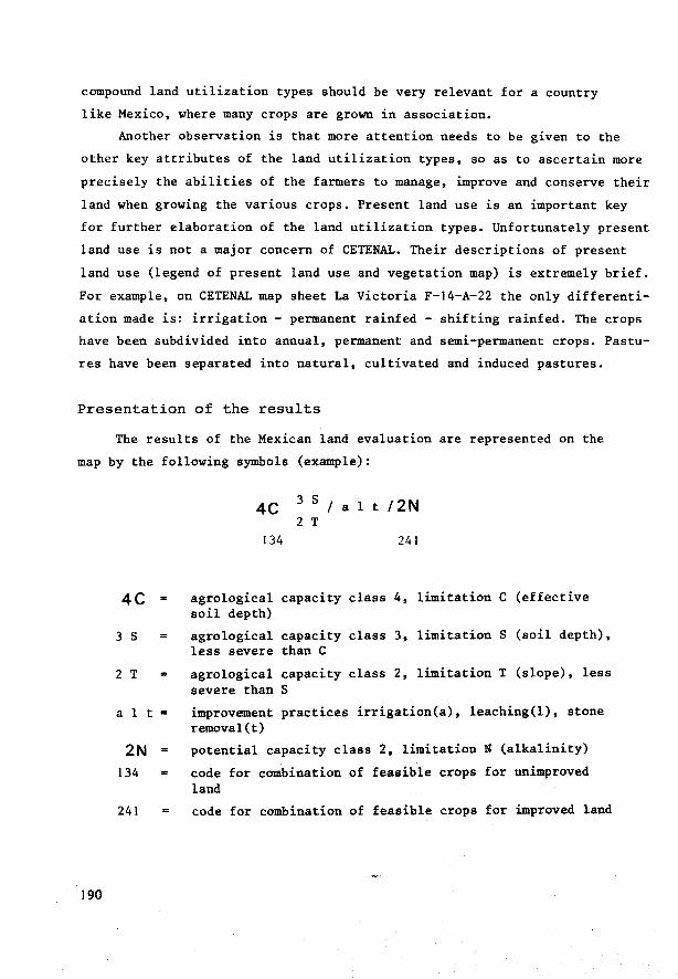
compound land utilization types should be very relevant for a country
like Mexico, where many crops are grown in association.
Another observation is that more attention needs to be given to the
other key attributes of the land utilization types, so as to ascertain more
precisely the abilities of the farmers to manage, improve and conserve their
land when growing the various crops. Present land use is an important key
for further elaboration of the land utilization types. Unfortunately present
land use is not a major concern of CETENAL. Their descriptions of present
land use (legend of present land use and vegetation map) is extremely brief.
For example, on CETENAL map sheet La Victoria F-14-A-22 the only differenti
ation made is: irrigation - permanent rainfed - shifting rainfed. The crops
have been subdivided into annual, permanent and semi-permanent crops. Pastu
res have been separated into natural, cultivated and induced pastures.
Presentation of the results
The results of the Mexican land evaluation are represented on the
map by the following symbols (example):
190
4C
3 s
2 T
a 1 t
2N 134
241
4C 3 s I a 1 t 12 N 2 T
134 241
agrological capacity class 4, limitation soil depth}
agrological capacity class 3, limitation less severe than C
c (effective
s (soil depth),
agrological capacity class 2, limitation T (slope), less severe than S
improvement practices irrigation(a), leaching(l), stone removal(t)
potential capacity class 2, limitation N (alkalinity)
code for combination of feasible crops for unimproved land
code for combination of feasible crops for improved land
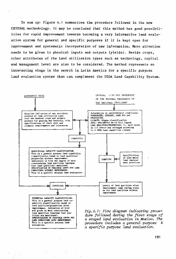
To sum up: Figure 4.1 suIIUllarizes the procedure followed in the new
CETENAL methodology. It may be concluded that this method has good possibil
ities for rapid improvement towards becoming a very informative land evalu
ation system for general and specific purposes if it is kept open for
improvement and systematic incorporation of new information. More attention
needs to be given to physical inputs and outputs (yields). Beside crops,
other attributes of the land utilization types such as technology, capital
and management level are also to be considered. The method represents an
interesting stage in the search in Latin America for a specif ic purpose
land evaluation system than can complement the USDA Land Capability System.
AGRONOMIC DATA
, De tai led indication of key attribute produce of land utilization type: over one hundred crops and primary -- produce for grazing and forestry~ with -specifications of their soit and climatic requirements aud tolerances
" 1
COMPUTER
~ AGROLOGICAL CAPACITY CLASSIFICATION. This is a genera! purpose land capability classification based on land qualities/ properties without improvement. Indication of kind and degree of 100.st constraining land qualities (maximum four land qualities) mentioned. SPECIFICATION OF FEASIBLE CROPS FOR LAND CONDITIONS WITHOUT lMPROVEHENT. Tbia ia a specific purpoae land evaluation.
_1 COMPUTER 1-
-1 1
~ POTENTIAL CAPACITY CLASSIFICATION. This is a general purpose land ca-pability classification based on land qualities/properties after improvement. Indication of kind and 1r-ade. of most constrainina land qualities (maximum four qua-liti~s are. lltmtiouû). SPECIFICATION OF FEASIBLE CllDPS FOR LAND CONDITIOHS WlTH IMPROVEllENT. This is a specif ic purpose land evaluation.
CETENAL 1:50 000 INVENTORY
OF THE NATURAL RESOURCES OF
THE NATIONAL TERRITORY
J Info?11l8tion on environmental conditions: TOPOGRAPHY, GEOLOGY, LAND USE and VEGETATION.
- CLIMA.TE: KÖppen classificat.ion SOIL: FAO/UNESCO World Soil Legend LAND QUALITIES/PROPERTIES: 11, each rated in t-8 levels and arranged according to 8 USDA land capability classes
1'1 Specification
~ COMPUTER of nine major land i.mprove-ment. pre.ctices
1
Levels of land qua l i ties af ter im.provement t same rating scale as for land qualities without improvement
Fig.4.1: Fl()b) diagr-am indiaat dure foUOlJed du.Ping the f ir-s a staged land ei1aluation in
ing proaet stage of exiao. The purpose & at ion.
Mi procedure inaludes a gener-al a speaifia purpose land ei1alu
191

4.3.4 Brazil: a system of physical land evaluation based on land qualities and land utilization types (at reconnaissance level)
Introduction
In Brazil, several institutions apply the USDA Land Capability
System (e.g. Verdade et al., 1974; INCRA, 1973, Quintiliano and Marques,
1971). But the Soil Survey and Conservation Service (SNLCS, EMBRAPA) of
the Ministry of Agriculture has developed its own system of soil survey
interpretation (Bennema, Beek and Camargo, 1964). The system was primarily
designed to interpret reconnaissance-type soil surveys. It has provided
many of the concepts and procedures of the FAO Framework for land
Evaluation (Beek and Bennema, 1972; FAO, 1976). The first proposals for
the use of land qualities, underlying this system, were formulated by J.
Bennema, R. Costa de Lemos and J. Olmos when carrying out the recon
naissance soil survey of Sao Paulo State (Lemos et al., 1960) This study
even includes the land quality 'absence of risk of night frosts', so
important for the coffee erop.
In the Brazilian system, land suitability classes ('classes de
aptidào'J are determined for specific land utilization types, called
'management systems' in Brazil. The factors determining suitability are
five land qualities (in Brazil named 'agricultural soil conditions') and
the possibilities for their improvement. Each of the agricultural soil
conditions is described in terms of degrees of limitation:
No limitation Slight limitation Moderate limitation Strong limitation Very strong limitation
Sometimes transitions between. these degrees of limitation are used:
slight to moderate, moderate to strong. When it is difficult to distinguish
192

between two degrees of limitations, combinations have also been used: no
+ slight limitation, strong + very strong limitation.
The feasibility of improving the land qualities is rated as follows:
1. improvement easily feasible
2. improvement feasible
3a. improvement perhaps f easible
3b. improvement not f easible
Four land suitability classes have been distinguished:
class I GOOD
class II FAIR
class III RESTRICTED
class IV NOT SUITABLE
(Class IV has been subdivided into the subclasses IV A: Suitable for
extensive grazing and IV B: Not suitable for extensive grazing).
Land Utilization Types
Land utilization types have a proper place in the Brazilian metho
dology. The following references are selected examples at different
levels of soil survey and interpretation intensity:
Sahematia soil inventory of North West, North East and Central Brazil, 2 saaie 1:5 000 000, total area 6 000 000 km (Camargo et al., 1975).
Three separate soil suitability maps have been prepared for each of
the following management systems:
193
Management System A (Routine management)
Farming practices in this system depend on traditional knowledge.
No capital is used for farm or soil management and the level of
technica! knowledge is low. Draft power is usually manpower.
If animals are used, only simple implements are available.
Management System B (Improved management)
Farming practices in this system reflect a reasonable level of
technica! knowledge. Some use is made of capital for maintenance
and improvement of the agricultural soil conditions. Cultivation of
crops mainly depends on hand labour and animal traction. If some
power-operated machinery is used, this will be mainly for transport
and processing, rather than for proper field operations.
Management System C (Advanced management)
Farming practices in this system depend upon a high level of tech
nology. Intensive use is made of capital for maintenance and im
provement of the agricultural soil conditions. Farming practices
make full use of the results of modern agricultural research.
Management practices in the field include the use of power-operated
machinery.
On the land suitability map a distinction is also made between the
suitability for short-cycle and long-cycle crops; e.g.:
Class Ia: first class for short-cycle crops and long-cycle crops
Class Ib: first class for long-cycle crops; second class for short-cycle crops
Class Ic: first class for short-cycle crops; third class for long-cycle crops
Class Id: first class for long-cycle crops; third class fcr short-cycle crops
194

The report does include a three-class climatic suitability classifi
cation for individual crops, based on the KÖppen classifications of climate
(Serra, 1960). Tables 4.19 and 4.20. illustrate the three management
systems, A, B and C, on the distribution among economie eomponents of erop
produetion.
Interpretation of the exploratory soil sUPVey of the eoeoa belt of Bahia 2 seale 1:1 000 000; total area 81 184 km (Beek, 07.:mos et al., 1965).
Eight management systems were defined aecording to the following
scheme:
Key attributes of land utilization types
MANAGEMENT SYSTEM
I II III IV v VI VII VIII
FARM POWER hand + + +
animal + +
tractor + + +
P R 0 D U C E
annual + + + +
perennial + +
cocoa + +
C A P IT AL I N T E N S I T Y
low + + + +
medium +
high + + +
TECHNICAL KNOWLEDGE
low + + +
medium + +
high + + +
195
This is one of the few cases of low intensity soil survey interpretation
for utilization by a specific erop (cocoa).
Monochrome soil suitability maps were prepared for each of the
eight management systems, using hatching to distinguish between classes.
Reaonnaissance soil su:t'Vey and interpretation for OfJrieultUPal uses of
the soils of Iguatemi, Mata Grosso, saale 1:120 000; total area 22 230 km2
(Ramalho Filho et al.,1970).
Here the land evaluation took into account two management systems
only, 'primitive' and 'developed', both without irrigation. The defin
itions of these two systems correspond to the definitions of the manage
ment systems A and C of the previously mentioned schematic soil inventory,
scale 1:5 000 000. Two separate monochrome soil suitability maps accompany
the report. In some other reconnaissance-type soil survey interpretations,
coloured suitability maps have also been included e.g. the reports of
reconnaissance soil surveys and interpretations of the states of North
East Brazil and of South Mato Grosso. All these interpretations only
include management systems A and C and all make a distinction between
the suitability for short-cycle and long-cycle (rainfed) crops.
Semi-detailed soil su:t'Vey and interpretation of the areas Olimed by the
Ministry of Agrieulture in the Fe<ktral Distriat of B!'asilia, saale
1:25 000, total area 140 km2 (Alvarez Filho et al.,1970).
The soil survey interpretation was done separately for five manage
ment systems. The definitions of these five systems roughly correspond
to the definitions of the management systems I, II, IV, V and VI applied
in the interpretation of the exploratory soil survey of the cocoa belt
of Bahia, already mentioned. No suitability maps were presented in the
final report, only tables indicating the land suitability of each soil
unit for each management system.
196
From these four examples it may be concluded that there is very
little distinction in the detail of defining land utilization types at
different intensities of survey. At reconnaissance and semi-detailed
level, this detail could be increased. More attention should be paid to
the suitability of the land for specific crops and their productivity. A
recent example is the assessment of suitability for specific crops in
North East Brazil (Klinger et al., 1976) at scale l:l 000 000.
At present the management systems are standard systems for the
purpose of comparing all soil units on their physical suitability for
the same purpose.
Land properties and land qualities
Soil survey interpretation in Brazil starts with the listing of
land properties that may influence the land suitability classification.
To this end the methodology includes a list of 23 selected properties
with standards for their measurement and rating. Because of the diffi
culty of synthesizing these properties into the terms of land qualities,
a short description of the role of the various properties (not necessarily
all) in each of the land qualities is given in Appendix 2 of this report.
In many interpretation systems soil depth is handled as an independent
constraint rather than a component property of certain land qualities
such as erosion susceptibility and available water. Therefore in the
Brazilian methodology the role of soil depth in land evaluation has been
treated separately.
The actual agricultural land conditions (or land qualities) are
described as deviations from an 'ideal' soil, an approach which is
similar to the description of limitations in the USDA Land Capability
System. The ideal agricultural soil is defined as a soil that has a good
natura! fertility, no deficiency of water or oxygen, is not susceptible
to erosion and bas no impediments to the use of agricultural implements.
Such a soil should have the widest range of possibilities for the highest
organized forms of plant associations.
197
But there are special crops such as rice, cotton, eucalyptus, that have
better or at least equally good possibilities on soils that differ from
this ideal soil in one or more aspects. That is why the 'ideal' soil
concept bas been abandoned in more recent publications on land qualities
and land evaluation (Beek and Bennema, 1971).
In Brazil the following agricultural soil conditions/limitations
have been considered:
(a) deficiency of natura! fertility, including the presence or absence of soluble salts
(b) deficiency of water (see Table 4.18)
(c) deficiency of oxygen (excess of water), including risk of ov erf low
(d) susceptibility to erosion
(e) impediments to the use of agricultural implements
A distinction is made between the 'ecological' conditions (a), (b)
and (c) and the 'agricultural' conditions (d) and (e).
Each of these five conditions bas been defined in terms of degrees
of deviation trom the ideal soil: zero, slight, moderate, strong, very
strong (see Appendix 2).
Since their formulation in 1964, there have not been important
changes in these def initions and the number of land qualities bas not
been increased. The main reason is probably that soil survey interpretation
bas mostly been concerned with reconnaissance-type studies for rather
generalized types of land utilization: annual crops, or perennial crops
in combination with only two or three levels of management.
198

Table 4.18 Genera! relationship of clirnatic classification (KÖRJen) to pre:ianinant vegetation, length of dry season, genera! location ani degrees of limitations due to deficiency of water
Climatic Predominant vegetation Average length of Gen. location Degree of limi-classification dry season within publi- tation for defi-
(KÖppen) cation area ciency of water
M evergreen tropical forest, campo, none: continuously hot and Amazonas aampo de Vál"zea wet zone near equator
Cfa evergreen sub-tropical forest, none: always moist with few Southern part of none grassland months in winter which are Mato Grosso adja-
slightly drier cent to Paraná
Am semi-evergreen tropie al forest, short: 0-3 months Amazon Region slight (Amw') campo (locally campo ce1"1"arlo in (greater part)
Amapá)
semi-evergreen tropical forest moderate (range to with babaçu palms slight limitation)
Aw semi-deciduous tropical forest, moderately long Central Brazil (Aw') aampo aer!'ado, semi-deciduous 3 to 7 months
tropical forest with babar;u palms, semi-evergreen tropical forest (Roraima), aampo
Cw aampo, carrrpo aerTado, deciduous moderately long Cent ral Braz i 1 moderate (Cws, Cwbi) forest (and transitions) 3 to 7 months above an attitude
of 1000 m
Bswh 1 aaatinga (equivalent of mesquite long: more than Northeast Brazil severe (BSw"h') or deciduous low spiny shrubs 7 months
and its transition to deciduous forest)
Soupae: Camal"go et ai., 1975, p.470
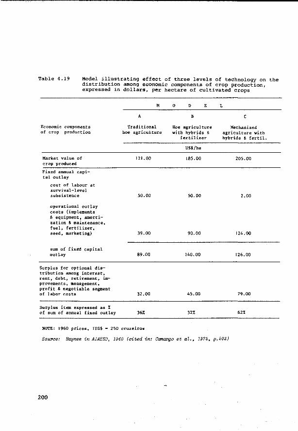
Table 4.19 Model illustrating effect of three levels of technology on the distribution among economie components of erop production, expressed in dollars, per hectare of cultivated crops
Economie components of erop production
Market value of c rop produced
Fixed annual capita! outlay
cost of labour at survival-level subsistence
operational outlay costs (implements & equipment, amortization & maintenance, fuel, fertilizer, seed, marketing)
sum of fixed capital out lay
Surplus for optional distribution among interest, rent, debt, retirement, improvements, management, profit & negotiable segment of labor casts
Surplus item expressed as % of sum of annual f ixed outlay
M
A
Traditional hoe agriculture
121.00
50.00
39.00
89.00
32.00
36%
NOTE: 1960 prices, !US$ s 250 cruzeiros
0 D E
B
Hoe agriculture with hybrids &
fertilizer
US$/ha
185.00
50.00
90.00
140.00
45.00
32%
L
c
Mechanized agriculture with hybrids & fertil.
205.00
2.00
124.00
126.00
79.00
62%
Source: Haynes in AIAESD, 1960 (cited in: Camargo et al., 19?5, p.503)
200
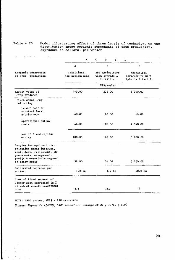
Table 4.20 Model illustrating effect of three levels of technology on the distribution among economie components of erop production, expressed in dollars, per werker
Economie components of erop production
Market value of erop produced
Fixed annual capita! outlay
labour cost at survival-level subsistence
operational outlay coats
sum of fixed capital outlay
Surplus for optional distribution among interest, rent, debt, retirement, improvements, management, profit & negotiable segment of labor costs
Cultivated hectares per worker
Item of f ixed segment of labour cost expressed in % of sum of annual investment cost
M
A
Traditional hoe agriculture
145.00
60.00
46.00
108.00
39.00
1.2 ha
57%
NOTE: 1960 prices, IUS$ = 250 cruzeiros
0 D E
B
Hoe agriculture with hybrids &
fertilizer
US$/worker
222.00
60.00
108.00
168.00
54.00
1.2 ha
36%
L
c
Mechanized agriculture with hybrids & fertil.
8 200.00
60.00
4 940.00
5 000.00
3 200.00
40.0 ha
1%
Sourae: Haynes in AIAESD, 1960 (aited in: Camargo et al., 1975, p.509)
201
Land Improvement
As already mentioned, three classes of feasihility for improvement
are used:
1. easily feasihle with restricted input of capital and technical knowledge
2. feasihle, hut with considerahle input of capital or technical knowledge (hut still within the reach of economie possihilities)
Ja. perhaps feasible after thorough investigations and/or largescale improvement projects, heyond the scope of the majority of individual farmers
3h. not feasihle
The land utilization type (management system) determines which land
improvements are pertinent, while the soil (mapping) unit determines what
the effect of these improvements will be.
In the schematic soil inventory of North, North West, North East
and Central Brazil (Camargo et al., 1975) no land improvement was consider
ed in relation to management system A (routine management). For management
systems B; {mproved management) and C (advanced management) the soil
units were combined in so-called 'feasihility of improvement groups',
according to:
(a) the degree of limitation before improvement
(b) the degree of limitation after improvement
(c) the suitahility class of these soil units after improvement
For example the following grouping of soil units was made in connect
ion with the limitation 'deficiency of natural fertility' and improvement
to be made within management system B:
202
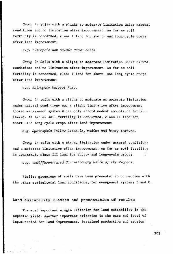
Group 1: soils with a slight to moderate limitation under natural
conditions and no limitation after improvement. As far as soil
fertility is concerned, class I land for short- and long-cycle crops
after land improvement;
e.g. Eutrophia Non Calaia Broum soils.
Group 2: Soils with a slight to moderate limitation under natural
conditions and no limitation after improvement. As far as soil
fertility is concerned, class I land for short- and long-cycle crops
after land improvement;
e.g. Eutrophia Latosol Roxo.
Group 3: soils with a slight to moderate or moderate limitation
under natura! conditions and a slight limitation after improvement
(note: management system B can only afford modest amounts of fertil
izers). As far as soil fertility is concerned, class II land for
short- and long-cycle crops after land improvement;
e.g. Dystraphia Yellow Latosols, medium and heavy texture.
Group 4: soils with a streng limitation under natural conditions
and a moderate limitation after improvement. As far as soil fertility
is concerned, class !II land for short- and long-cycle crops;
e.g. Undifferentiated ConaP.etiona;py Soils of the Tropias.
Similar groupings of soils have been presented in connection with
the other agricultural land conditions, for management systems B and C.
Land suitability classes and presentation of results
The most important single criterion for land suitability is the
expected yield. Another important criterion is the ease and level of
input needed for land improvement. Sustained production and erosion
203
control are necessary conditions for the land utilization types that use
physical inputs for land improvement. But a decrease in productivity and
some erosion losses are considered inevitable in the traditional, low
input type of land utilization in view of the prevailing management
practices. Therefore separate definitions of land suitability classes have
been presented for different management systems. Table 4.21A presents the
definitions of land suitability classes for the three management systems
A, B and C formulated in the schematic soil inventory of North, North West,
North East and Central Brazil (Camargo et al., 1975).
Fig. 4.2 is an example of presenting the results of land suitability
classification, carried out by the Brazilian Soil Survey and Conservation
Service along the Trans Amazon highway for purposes of identifying
suitable areas for colonization by the National Institute for Colonization
and Agrarian Reform (INCRA). Because of the predominance of the limitation
'soil fertility' and the problems involved in fertilizer use, a distinction
bas been made between land utilization with fertilizers and land utiliz
ation without fertilizers. A distinction bas also been made between
short-cycle crops, long-cycle crops and pastures (published in: Beek,
Sombroek and Van Wambeke, Eds., 1972) 1 •
In addition to such diagrams, maps and tables are the most common means
of presenting the results of land suitability classification. Table
4.21B swmnarizes the results of the schematic soil inventory of North,
North West, North East and Central Brazil (Camargo et al., 1975).
To date, the Brazilian Soil Survey and Conservation Service bas
published separate land suitability maps for each management system.
The advantage of clear presentation is, however, offset by the dis
advantage of the cost involved in printing all these separate maps. For
that reason the RADAMBRASIL Project, which uses the same land evaluation
204
Goodland and Il'UJin (1974) present an intereeting and controvereial diecuesion of the environmental impact of the highiûay construation programme in the Amazon Basin.
N 0 V1
Table 21A: Definitions of land suitability classes in Brazil (reconnaissance level).
CLASS GOOD
CLASS Il FAIR
CLASS IIl RESTRICTED
CLASS IV NOT SUlTABLE
SouPoe: CamaPgo et al., 1975
MANAGEMENT SYSTEM A ROUTINE
The soil conditions present no or slight limitations to a great number of climatically adapted crops. Good yields can be expected during a period of approx. 20 year1, during which the yields will decrease only gradually.
The aoil conditions present moderate limitations to a great number of climatically adapted cropa. Good yielda may be expected during the first ten years, after which the yields will decrease rapidly to medium yields for the next ten years.
The soil conditions present strong limitations to a great number of climatically adapted crops. Medium yields may be expected during the first few years, after that yields will decrease rapidly to a low level within a period of ten years.
The soil conditions present very strong limitations to a great number of climatically adapted crops. Low to very low yields may be expected even during the first years of use, Crops will not develop or it will not be feasible to plant them.
MANAGEMENT SYSTEM B IIMPROVED
The soil conditions present no or slight limitations to the sustained production of a great number of climatically sdapted crops. Good yields can be obtained and maintained with relatively few management problems.
The soil conditions present moderate limitations to a great number 'of climatically adapted crops. Good yields can be obtained in most years, but the number of alternative crops, the possibility of sustained production and the selection of management practices are restricted by one or more limitations which cannot wholly be removed.
The soil conditions present strong limitation$ to the sustained production of a great number of climatically adapted crops. The yielda are seriously reduced and the number of alternative crops is very much restricted by one or more limitations which cannot be removed.
The aoil conditions present very streng limitations to a great number of climatically adapted crops. Sustained production is not considered economically feasible, due to one or more limitations which cannot be removed. Only a few special crops may be adapted to such conditions, in combination with special management practices.
MANAGEMENT SYSTEM C ADVANCED
The soil conditions present no or slight limitations to the sustained production of a great number of climatically adapted crops. Good yields may be expected, hut their maintenance rnay be somewhat affected by certain limitations which in this management system can only partly be removed.
The soil conditions present moderate limitations to the sustained production of a great number of climatically adapted cropa. Good yields may be expected in most years, hut the number of alternative crops, the maintenance of the productivity and the selection of management practices will be restricted by one or more limitations that cannot be removed.
The soil condition& present strong limitations to the sustained production of a great number ot climatically adapted crops. The yields are seriously reduced and the number of alternative crops is very limited due to one or more limitations which cannot be removed.
The soil conditions present very strong limitations to a great number of cl imatically adapted érops, Sustained product ion is not considered economically feasible, due to one or more limitations which cannot be removed.

Table 4.2lb
Map symbols of suitability classes on in-terpretive maps
Class I Ia Ib Ic Id
TOTALS
Class II Ila Ilb Ilc Ild
TOT ALS
Class III Illa Illb Illc
TOT ALS
Class IV TOT ALS
GRAND TOTALS
Approximate area and prof'>rtionate extent of suitability classes and subdivisions in the delineations on the interpretative maps for the three management systems
M A N A G E M E N T s y s T E M
A B c Area Prop.extent Area Prop.extent Area Prop.extent (km2) (%) (km2) (%) (km2) (%)
12 500 0.21 27 800 0.46 197 400 3.29 21 900 0.36 22 400 0.37 317 700 21. 94 66 800 1.11 44 100 o. 73 44 100 0.73
333 800 5. 55
101 200 1.68 94 300 1.56 893 000 31 .51
27 800 0.46 2 170 100 36. 12 367 400 s. Il 37 700 0.63 86 800 1,44 494 800 8.23
938 200 15.61 288 700 4.80 938 200 15.61
65 500 J.09 3 195 100 53. 17 2 089 100 34. 75
3 528 200 58. 72 266 200 4.43 256 904 4.28 48 800 0.81 73 000 1. 22 34 300 0.57
5 200 0.09 3 577 000 59.53 339 200 5.65 296 404 4.94
2 265 208 37.70 2 380 308 39.62 730 404 28.80 2 265 208 37.70 2 380 308 39.62 730 404 28.80
6 008 908 100.00 6 008 908 100.00 6 008 908 100.00
Source: Ca:ma:rgo et aZ. 1975, p.535
'!he meaning_of the subdivisions is:
class Ia Ib Ic Id !Ia IIb !Ic !Id IIIa IIIb Illc J.N
short cycle crops I II I III II II UI IV II! !II IV IV
long cycle crops I I III l II II! II II III IV III IV
206
N 0 ......
______________________________________________ ,
Fig,4.Z Oiagrammetric presentation of land suitability along the Trans Amazon High~ay, km 1000 to km 1310 Estreito (kmo: Itaituba)
WORKING GROUP ON EVALUATION AND MANAGEMENT R E G I 0 N A L P R 0 J E C T F A O / U N D P R L A 70/457 OF SOILS IN THE AMAZON REGION -------..--. z
WITHOUT IC IC IIC IIC IICP ~s FERTILIZERS III UIP IVCL IIIP IVCL IV III IV III UI IV IV IIP IV IIP IV UIP IV IIIP UIL ........ ... < UIL IIIL IVL IVL ,_,N
~~~ WITH UCP IC IC IC IIIC UIC IC ?:49 IP IIIP IVCL IIIP IVCL IV IV IV UP IV IV IIP IV IIP IV HIP IV HIP UP Ïiloz FERTILIZERS llCL IIIL IIIL IIIL IIIL IV L IV L UIL .., ....
c se c c cd c cd VEGETATION ssv-sc ssv-sc se se c cd se se se se se c
PV 6 LV2 PV 7 AQ 6 TR S AQ 7 L 1 AQ 7 2 SOILS PVP 4 PVP 4 AQ 4 AQ4 LA3 AQS AQ 7 TR S v 1 v PVL2 Hl c 2
PV 4 PVS PV S AQ 1 B 3 B 3 LE AQ S L 1 LREJ
PVP4 TR 6 B 3 B 2
TOPOGRAPHY 0 so-o-p BO p-so SD so so-o so-p sa p-so so-o p SD p-so so so so-p 50
m.a.s.I.
\ ! \ I //L ~~~\. 200 Rlo 100 Igarape Macaubas Estreito -Ma ra ba
Rio Itacaiunas Grota de Areia R10
Araguaia road Belem
Brasilia
km1000 1020 1040 1060 1080
LAND SU!TABILITY CLASSES TYPES OF CROPS
I Good c Short cycle crops II Fair III Marginal L Long cycle
IV Not suitable p Pastures
IC IIP IIIL l!xample good for short cycle crops, fair for pastures, marginal for long cycle crops
crops
Sourae: Beek, Sombroek and van Wambeke, Ede. 1972
1100 1120 1140
ssv se cd c
Baeed on data pPOVided by the Soil Survey and- Conservation Service, EMBRAPA, Rio de Janeiro, Braail
1160 1180 1200 1220 1240 1260 1280 1300
p H A s E s
VEGETAT!ON TOPOGRAPHY
equatorial semi-evergreen p level (0-3%) equatorial semi -dec iduous so gently undulating (3-8%) deciduous 0 undulating (8-20%) cerrado (savannah) fo strongly undulating (20-40%)
methodology f or evaluating the natural resources of the Amazon Basin at
1:1 000 000 scale based on side-looking radar images and other remote
sensing techniques has attempted to combine the two land suitability
classifications for traditional and advanced technology into one land
suitability map. Unfortunately the resulting map is rather confusing
(PROJETO RADAMBRASIL, first Il volumes).
To meet this problem, it was suggested that a multi-purpose land
suitability map to serve agricultural planning at national, regional
and State level should be prepared (Beek, 1975).
The land utilization types to be included in this map are:
crops (short- and long-cycle) with advanced management techniques
crops (short- and long-cycle) with improved management techniques
A -
B -
c - crops (short- and long-cycle) with traditional management techniques
P - intensive grazing on planted pastures
N - extensive grazing on natura! pastures
S - silviculture
X - conservation of flora and fauna.
A six-group system has been proposed in which suitability group I
is suitable for the greatest number of land utilization types: this
number decreases with each lower group, group VI only being suitable for
the conservation of flora and fauna. This approach is similar to that of
the USDA Land Capability System, with the distinction that in Brazil
three levels of management have been considered for erop cultivation and
two levels of management for grazing. At the class level letter symbols
have been used to indicate the suitability for each separate land util
ization type: for instance: A-first class for land utilization type A;
a - second class for land utilization type A; (a) - third class for land
utilization type A. Tables 4.22A/B present the legend proposed for the
multi-purpose land suitability map for broad agricultural planning
purposes.
208

Table 4.22a Land suitability groups
G R 0 U P Land with a good suitability for short-cycle crops, at least at one level of management; suitable for most less intensive types of land utilization
G R 0 U P Land with a fair suitability for short-cycle crops, at least at one level of management; suitable for most less intensive types of land
II utilization
G R 0 U P Land with a restricted suitability for short-cycle crops at least at one level of management; suitable for most less intensive types of
III land utilization
G R 0 U P Land suitable for planted pastures with a transitional level of management (incl.25-50 kg fertilizer nutrient/ha) and possibly for
IV some less intensive uses (silviculture or extensive grazing)
G R 0 U P Land suitable for extensive grazing on natural pastures with a traditional (low) level of management and/or for silviculture with
V a transitional level of management (including the application of small amounts of fertilizers)
G R O U P Land unsuitable for crops, grazing or forestry at any level of management, only suitable for preservation and conservation of flora
VI and fauna (may include seve.ral productive types of utilization of the natural flora and fauna)
Souroce: Adapted from: Ramalho Fiiho, Guedes and Beek, 1977
209
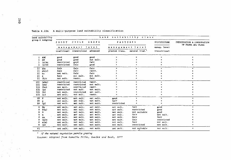
0
Table 4.22b A multi-purpose land suitability classification
Land suitability L a n d s u a b group & subgroup
S H 0 R T C Y C LE C R 0 p s P A S T
m a n a g e m e n t e v e m a n a g e m e
traditional transitional advanced planted trans.
ABC good good good + AB good good not suît. + (a)Bc restricted good fair (a)bC restricted fair good
II abc fair fair fair + II ab(c) fair fair restr. + II be not suit. fair fair II a fair not suit. not suit. + II (b)c not suit. rest r. fair +
UI (abc) restricted restricted restr. + II! (ab) restricted restricted not suit. + III (be) not suit. restricted restr. + II! (a) restricted not suit. not suit. + II! (b) not suit. restricted not suit. + lll (c) not suit. not suit. restr. +
IV p not suit. not suit. not suit. good IV p not suit. not suit. not suit. fair IV (p) not suit. not suit. not suit. restricted
v Sn not suit. not suit. not suit. not suit. v S(n) not suit. not suit. not suit. not suit. v s not suit. not suit. not suit. not suit. v n not suit. not suit. not suit. not suit. v sn not suit. not suit. not suit. not suit. v (s)n not suit. not suit. not suit. not suit. v s(n) not suit. not suit. not suit. not suit. v (n) not suit. not suit. not suit. not suit.
VI not suit. not suit. not suit. not suit.
If the naturaZ vegetation permits grazing
So1n•<Je: Adapted from RamaZho Filho, Guedes and Beek, 1977
l i y c 1 a s s
u RE s
n t e v e 1
natural trad. 1
+ + + +
+ + + + +
+ + + +
+
+ + +
fair restricted not suitable fair fair fair fair restricted
not suitable
SILVICULTURE
manag. level
transitional
+ + + +
+ + + + +
+ + + + + +
+ + +
good good good not suit. fair restricted not suit. not suit.
not suit.
PRESERVATION & CONSERVATION OF FAUNA AND FLORA
+ + + +
+ + + + +
+ + + + + +
+ + +
+ + +
+ + + +
+
By using different types of overprints multi-purpose land suitability
maps can provide additional information on the areas where crops with
special land requirements can be grown (e.g. cashew and perennial cotton
in North East Brazil), on land that is suitable for producing two crops
per year, land that is suitable for long-cycle crops only, land that is
not suitable for long-cycle crops but suitable for short-cycle crops,
land that is not suitable for any other crops except inundated rice,
land where irrigation is foreseen or bas already been installed.
A multi-purpose land suitability map has some advantages over sets
of single-purpose suitability maps:
It shows the development perspective for all land-use alternatives
under consideration. The suitabilities for land utilization types
with different levels of management can be compared without having
to superimpose the single-purpose map. This will be useful for
long-term perspective planning
It shows the range of development alternatives for each mapping
unit. This will be useful for land use planning, and also for a
shorter time perspective
Area calculations can be made distinguishing between areas of
different flexibility in the selection of land use alternatives and
different development perspectives: some areas are only suitable
for one level of technology, low, medium or high; other land units
may be suitable for step-wise development, presenting possibilities
for traditional as well as for transitional and advanced technologies,
while there may be still other land units that have a certain
ceiling for development, being suitable only for traditional and
transitional levels of management. Such information is pertinent for
long-term sequentia! development planning. Area calculations suppor
ting this type of planning are difficult to make on the strength of
single-purpose maps.
211
Conversion tables
The most interesting aspect of Brazilian land evaluation methodology
is the way that has been found to overcome the problem of relating the
land qualities and the feasibility of their improvement to the land
suitability classes.
To do this a conversion table is constructed. A conversion table is
site specific, because of the climatic variation between different sites,
which has not been fully incorporated in the five land qualities under
consideration: the available water bas been included, but not the other
features of the climate such as temperature and radiation. Tables 4.23/25
are examples of conversion tables that have been used to interpret the
schematic soil inventory of North, North West, North East and Central
Brazil (Camargo et al., 1975). Of course separate conversion tables are
prepared for each land utilization type.
But when preparing a multi-purpose land suitability map a multi-purpose
conversion table can also be constructed (Beek, 1975d; tbis proposal inclu
des three multi-purpose conversion tables for the (humid) tropics, the (hu
mid) sub-tropics, and the semi-arid zones).
Conversion tables in Brazil do not consider the cumulative effect
of different limiting land qualities. The land suitability class is
determined by the most limiting land quality after improvement (if
improvement is feasible). This problem still needs to be solved.
A first step in the right direction was made in the land evaluation for
livestock development on Maraj6 Island in the Amazon Estuary (IDESP,
1974) which considers the cumulative effect of excess water of Ground
Water Laterites (Plinthaquults) in one season and water deficiency
during another season.
Conversion tables give an instantaneous picture of the state of the
art of land evaluation in a specific location and in connection with a
212
specific use. Their reliability will depend to a great extent on the
availability of site-specif ic research-tested information. In areas
where reconnaissance type land evaluations have to be carried out, this
type of information is often very hard to obtain and transfer of knowledge
through correlation and analogy with better known areas is therefore
important. In Brazil the use of land qualities bas been an important means
for permitting this transfer of knowledge. Also, the fact that great
attention is given to systematic soil classification and soil correlation
has been very useful for systematic soil survey interpretation. However
it must be admitted that there is now a great need in Brazil for conversion
tables that permit land suitability classification for specif ic crops at
defined levels of management, with due attention to the climatic parameters,
and to soil conservation and to productivity.
Conclusion: the soil survey interpretation methodology developed in
Brazil, and proved to be so useful for regional planning, (e.g. Pereira et
al., 1974) will need to be further developed to support more specific types
of agricultural planning and development at the local and farm level. This
will require more participation from agronomists who know the land
requirements of the crops, and of agro-meteorologists who are able to supply
more detailed information about the climatic variation to complement the
excellent soil information collected and published by the Soil Survey and
Conservation Service. Only then will the Brazilian methodology reach the full
status of a physical specific purpose land evaluation method, as described
in Section 4.2.1. The method as it now stands is intermediate between gene
ral purpose and specific purpose physical land evaluation, giving satisfact
ory results in reconnaissance type land evaluation hut too superficial
results at more detailed levels.
213
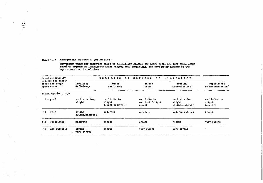
Table 4.23 Management system A (primitive)
O>nversion table far assigning soils to suitability classes for short-cycle and long-cycle crops, baseci cn degrees of l:lmitations under natura! soil caOOitions, for five major aspects of the agricultural soil c:onditions 1
Braad suitability Est imate 0 f de g rees 0 f 1 1 m 1 t a t i o n classes for short-cycle and long- fertility water excess eros ion cycle crops deficiency deficiency water susceptibility2
Short cycle crops
I - good no limitation/ no limitation no limitation no limitation slight slight no limit./slight slight
slight/moderate slight sl ight/moderate
II - fair slight moderate moderate moderate/strong slight/moderate
UI - restricted moderate streng strong strong
IV - not auitable strong strong very streng very strong very strong
to imped imenta mechanization2
no limitation slight moderate
streng
very strong
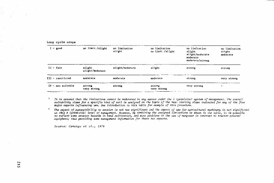
N
U'1
long cycle crops
1 - good no limit./slight
Il - fair slight slight/moderate
111 - restricted moderate
IV - not suitable strong very streng
no limitation slight
slight/moderate
moderate
strong
no limitation no limit./ slight
slight
moderate
strong very streng
no limi tat ion slight sl ight/moderate moderate moderate/streng
strong
strong
very streng
no limitation slight moderate
strong
very streng
It is asswned that the limitations aannot be mode1'ated in any manne1' unde1' the A (primitive) system of management. The ovePalt suitabiUty alass fo1' a speaifio kind of soil ia assigned on the basis of the most limiting àlass indioated fo1' any of the five ma.ja?' aspeats influencing use. See int1'oduation to this table fo1' e:x:ample of this p1'oaedu1'e.
The aspeat of susaeptibility to erosion is not toa signifiaant and the aspect of use fo1' agriaultuml machinePy is not signifioant at this A (primitive) level of management. Hoü!eVe1', by aambining the assigned limitations as shüü!n in the table, it is possible to refZ<Jat acme erosion haza?'ds in hand cultivation, and same pPoblems in the use of manp0ü!e1' in aont1'ast to tPaato1' püü!e?'ed equipment; thus pPoviding some management infot'mation fo1' these tü!o aspeats.
Sou1'ae: Camapgo et al., 1975
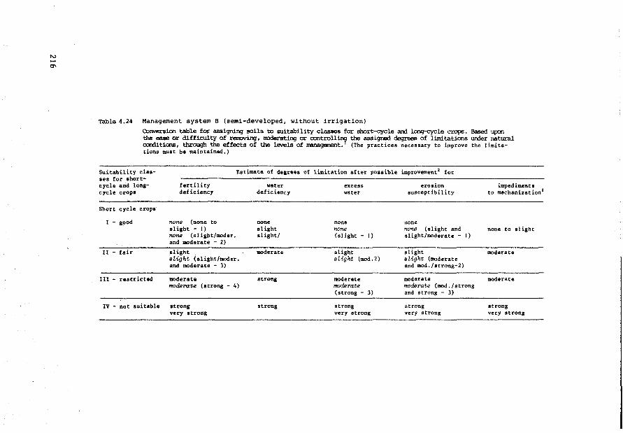
Table 4.24 Management systero B (semi-developed, without irrigation)
Conversion table for assignin;J soils to suitability classes for short-cycle arrl long-cycle crops. Based upon the ease or difficulty of renoving, l'IDderating or controll:n'f the assigned degrees of limitations un:ler natural ocnlitions, through the effects of the levels of managenent. (The practices necessary to improve the limitations must be maintained.)
Suita.bility classes for shortcycle and longcycle crops
Estimate of degreea of limitation after poasible improvement2 for
Short cycle crops
fertility deficiency
I - good none (none to slight - 1) none (sligbt/moder. and moderate - 2)
II - fair slight sUght (slight/lllOder. and moderate - 3)
!II - restricted moderate moderate (strong - 4)
IV - not suitable strong very strong
water deficiency
none slight slight/
moderate
strong
strong
excess water
none none (slight - 1)
slight slight (mod.2)
moderate model'ate (strong - 3)
strong very strong
erosion ausceptibility
none none (slight and slight/moderate - 1)
slight aLight (moderate and mod./strong-2)
moderate moderate (mod • / s t rong and strong - 3)
strong very strong
impediments to mechanization 3
none to slight
moderate
moderate
streng very atrong
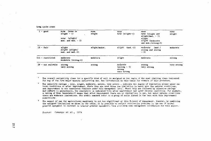
Long cycle crops
1 - good
Il - fair
none (none to slight - 1)
none (s light/ mod. and mod. - 2)
slight sZight (slight/ mod. and mod.-2)
111 - restricted moderate modsrote (strong-4)
IV - not suitable strong very strong
none slight
slight/moder.
moderate
strong
none none (slight-1)
slight (mod. -2)
slight
modePate (strong - 3) strong very streng
none none (slight and slight/mod. - 1) slight stight (moderate and mod. /strong-2)
moderute (mod./ strong and streng - 2)
moderate
strong very strong
none slight
moderate
strong
very strong
The overall suitability class for a specific kind of soil is assigned on the basis of the most limiting class indicated for any of the five major aspects influencing use. See introduction to this table for exatnple of this procedure.
The adjective ratings - none. slight, moderatet severe. very severe - indicate the degree of limitation either under natural condi tions or after improvement. Where they are used alone the limi tation is based upon the natural condi tions, and improvement is not considered feasible under this management level. Where they are followed by adjective ratings and numbers in parenthesis, the limitation is indicated both after improvement and under natural conditions. For exa.mple, a rating of None (modera.te-2) means that after improvement there are no limitations in use, but under natural conditions there are moderate limitations. The e.rabic numbers refer to a group of soils listed in the text with this improvement possibility.
The aspect of use for agricultural machinery is not too significant at this B-level of management. However, by combining the assigned limitations as shown in the table, it is possible to reflect cultivation problems in the use of animal powered equipnent in contrast to tractor powered equipment; thus providing some management information for this aspect.
SouPae: CamaPgo et at., 1975
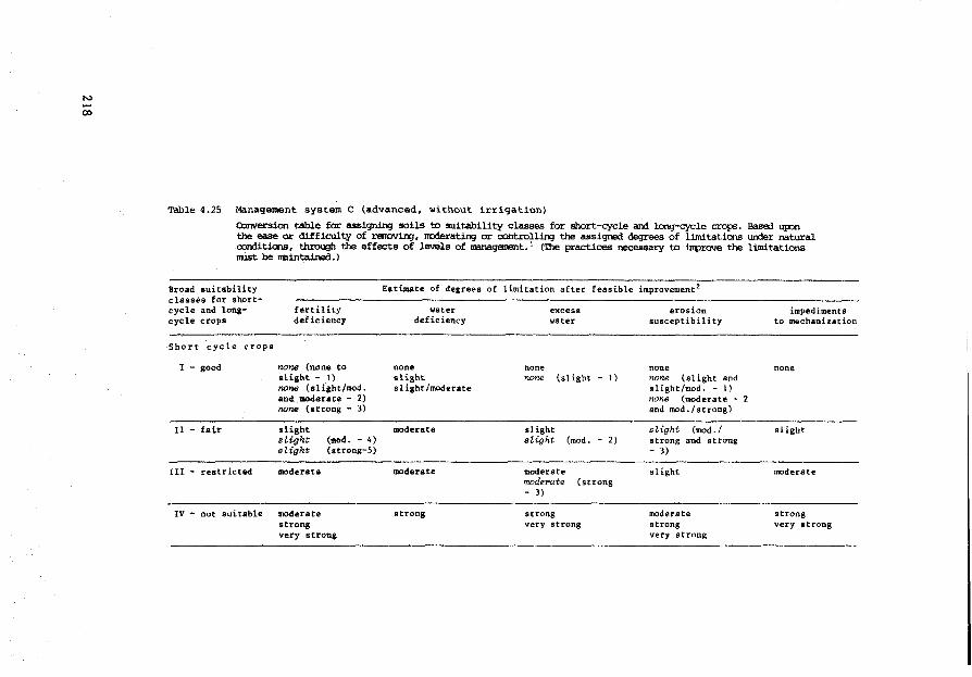
N
00
Table 4.25 Management system C (advanced, without irriqation)
eonversion table for assiqninq soils to suitability classes for short-cycle arrl lonq-cycle crops. Based upon the ease or difficulty of renovin:,J, lt'Oderatin:,J or oontrollin:,J the assigned deqrees of limitations w-der natural oonditions, through the effects of levels of nanaqanent. 1 ('!.be practices necessary to improve the li.mitations nust be nBintained.)
Broad suitability classes for shortcycle and longcycle crops
Short cycle crops
I - good
II - fair
III - restricted
fértility deficiency
none (none to slight - 1) none (slight/mod. and moderate - 2) none (atrong - 3)
slight sU.ght stight
moderate
(mod. - 4) (strong-5)
IV - not suitable moderate strong very strong
Eatimate of degrees of limitation after feasible improvement 2
none
water deficiency
slight slight/moderate
moderate
moderate
strong
none
excesa water
none (slight - t)
slight sZight (mod. - 2)
moderate moder>ate (strong - 3)
streng very streng
eros ion susceptibil ity
none none (slight and slight/mod. - 1) none (moderate -and mod./strong)
ûight (mod./ streng and strong - 3)
slight
moderate streng very streng
impediment• to mechanization
none
slight
moderate
streng very strong
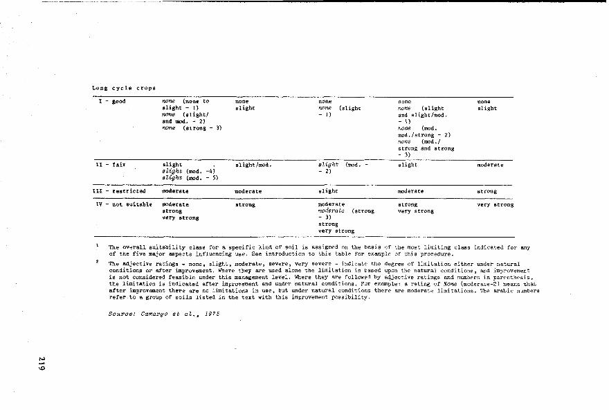
---------~------------------------------------------------------------
Long cycle crops
1 - good none (none to slight - 1) none (slight/ and mod. - 2)
none slight
none none none slight
none (strong - 3)
noM (slight - 1)
none (slight and slight/mod. - \) noM (mod. mod./strong - 2) none (mod./ strong and strong - 3)
11 - fair slight slight /mod, s1ight (mod. - slight moderate stight (mod. -4) - 2) sti{Jht (mod, - 5)
II! - restricted moderate moderate slight moderate strong
IV - not suitable moderate stTong moderate strong very strong strong moderate (strong very strong very strong - 3)
strong very strong
The overall suitability class for a specific kind of soil is assigned on the basis of the most limiting class indicated for any of the five major aspects influencing use. See introduction to this table for example of this procedure.
The e.djective ratings - none, slight, moderate, severe, very severe - indicate the degree of limitation either under natural conditions or after improvement. Where they are used alone the limitation is based upon the natural conditions, and improvement is not considered feasible under this management level. Where they are followed by adjective ratings and numbers in parenthesis, the limitation is indicated after i.mprovement and under natural conditions. For examPle: a rating of None (moderate-2) means that after improvement there are no limitations in use, but under natural conditions there are moderate limitations. The arabic numbers refer to a group of soils listed in the text with this improvement possibility.
Souroe: Camargo et aZ., 1975
4.3.5 Chile: an example of integral land evaluation with staged procedure
After the very damaging earthquakes of May 1960, the Organization
of American States (OAS) recommended a vast programme of reconstruction
in the affected areas in Chile. This recommendation resulted in the
largest integrated land resources survey project to that date, based on
aerial photograph interpretation. It included the study of present land
use, land ownership, geology and geomorphology, meteorology and climatology,
hydrology, soils and soil limitations, forestry, irrigation and drainage
systems, economie studies and land capability.
2 The results of this enormous study, which covered 120 000 km , should
guide land reform taxation programnes, and irrigation and agricultural
development.
The soil study distinguishes 350 different soils, classified in terms
of series, types and phases. The main purpose of the soil study (and of the
studies of other land attributes) was the rapid determination of the land
capability (according to the USDA Land Capability System). Observation and
measurement of soil properties and soil limitations included a predetermined
set which are rated similarly for the entire country. Such a 'coordinate
system' 1 of soil inventory (Van Wambeke, 1972) permits a rapid, broad
picture but does not allow for precise soil classification nor for precise
interpretation. The method chosen is indeed rapid: with the help of 1:20 000
aerial pbotographs and controlled photomosaics at the same scale (472 mosaics
of 270 km2 each) 16 soil scientists completed the fieldwork for the 1:20 000
soil map in 16 calendar months. The coastal zone was surveyed at a smaller
scale, 1:50 000. Field checking included 10-100 observations per mosaic,with
an average of 25. This means that the average observation density was one
per 1100 hectares, with a range of 1:270 ha to 1:2700 ha. 750 profiles be
longing to 200 soil series were sampled and analysed in the laboratory. The
scale at which the maps were published (1:20 000) suggests that the soil
sampling was more detailed than it actually was. Broad planning at national
See Seation 4.3.1 for e:xrpZanation.
220

STAGE I PHYSICAL LAND EVALUATIOM 1960-1963
broad USA types of --IOAS/CHILE agricJ land utilization
IO- land invent.ory
produce level a) land limitations
' l land capability soil conserva-classes and sub- f-0 tion specifica-classes tions; erop/ .....
past.ure rota-t ion schemes
-----------------------------STAGE II SOCIO-ECONOMIC LAND APPRAISAL 1 971 ' 1 government ,j socio-eco- Il agrono- ! recommended classes additional policies; macro-aignals nom.ic data mie data for further analysis c>--0 soil &
during the stage II: water data Ir-Ilr-IIIr-IVr. all i rr igated land
' t
analytica! descript.ion ~~ land suitability land utilization type: groups
- - PllODUCE: levels b) & c) LABOllR: intensity and distribution
KEY lMPROVEMENT: irrigation
t ' feed
1 socio-economie 1 - for each land suitability
back analysis 1
group,and for each alt.erna-
! t i ve produce type (level c): - 2 class suitability clasif. - yield prediction - labour income/ha - labour income/working day
! optim.ization of k.ey attribute produce priorities per land produce: ranking of laad util-
~ suitability group, by compound
ization tyPes according to index: labour days x labour (eocial) benefit potential on income each land suitability sroup
I""-"------------ ! ceilinge for areae plauted per elaboration of alternative erop, depending on market basic erop rotations per - cond i t ions: internal demand ___. standard area of land suita-plus export bility group of 100 ha: Ict-
physically recommended produce rotations
! aelection of socio-economically
optimization of key attribute recommended erop rotation per labour: adjustmeo.t of erop land suitability group, as a choice in rotation to monthly function of (coapound index): labour availability ___. - % occupation of ava.ilable
combination of labour and manpower
- total man working days produ.ce into recommen.ded land - labour income/ha utiliaation type• per land - labour income/calendar day: suit&bility group
REC<llMENDED LAllD USE
Fig.4.J: Staged tand evaluation ~ith 11-year time interval between stages. Chile 1960 - 1971.
221
---------------------------~--- ----~-----·-
and regional level may be served by such schematic study, but more detailed
planning cannot be based entirely on its results. In The Netherlands a
density of one observation per 5-6 hectares is not unusual tor a 1:20 000
scale soil map (the variability of the soil properties in the survey area
is important). Fora reconnaissance soil survey in Portugal for purposes
of irrigation and drainage planning, scale 1:25 000, an observation density
of 1 per 12 hectares was recommended (Schulze and Beek, 1976).
It is interesting to analyse how the results of this OAS/CHILE
Aero-photogrammetric Project were intended to be used for detailed land
use planning in agrarian reform areas (IICA/CORA, 1971), particularly
because this planning is a good example of stage II of a staged land
evaluation procedure: socio-economie analysis (see Section 4.2.2). So
far our discussions of land evaluation (in Venezuela, Nicaragua, Mexico
and Brazil) have only been concerned with stage I: Physical analysis.
Figure 4.3 summarizes the proposed IICA/CORA method of land use plan
ning for agrarian reform purposes. In this procedure the OAS/CHILE project,
although implemented 10 years earlier, represents stage I of the staged
integral land evaluation procedure. The IICA/CORA method is mainly concern
ed with stage II, socio-economie analysis. It is particularly interesting
to note how the IICA/CORA method attempts to combine single land utilization
types into compound land utilization types (erop rotations) with the aim
of maximizing the use of labour and the labour income, taking into
account the physical limitations of the land, the availability of labour,
the prices of inputs and outputs and the market restrictions for certain
products. The method is not sophisticated in its approach to data proces
sing; it does not rely on linear programning, but on simple input-output
studies and production functions. It is interesting for its strong reliance
on the results of physical land evaluation.
222
Agronomie considerations during Stage II
a) The role of the soil information
The result of stage I, physical land evaluation, is a map of land
capability classes and subclasses, USDA type, scale 1:200 000. For this
classification US-type management practices have been assumed. The classes
Ir. Ilr, IIIr and IVr, which correspond with land that is already under
irrigation, were selected by the IICA/CORA method for further socio
economic analysis because these are the classes that have been classif ied
as being capable of growing agricultural crops. The US Capability System
does not assess the capability of the land for the specif ic purpose of
irrigated erop cultivation. Therefore capability classes I-IV do not
necessarily correspond in that order with land capability for irrigated
land use. Land evaluation for irrigated land use should require additional
observation and measurement of such properties as infiltration rate,
hydraulic conductivity in saturated and unsaturated zone, fluctuations of
the groundwater tables, surface characteristics conditioning the flow of
irrigation and drainage water, water quality and availability, etc.
(USBR, 1953; FAO, 1976).
The IICA/CORA methodology foresees that the land capability infor
mation will be complemented by additional data, unfortunately to a very
limited extent: four textural classes have been added and the availability
of irrigation water is rated, distinguishing between a scarce and an
abundant supply. Thus fourteen so called 'land suitability groups' have
been established, to be handled as homogeneous land units for socio
economic analysis and land use planning; see Table 4.26.
Cross reference to the original information on soil series, types
and phases, produced during stage I was only made when adding the tex
tural phases. The other land properties/limitations are assumed to be
sufficiently characterized by the land capability classes and subclasses.
The justification for this rather superficial treatment of the data base
has been the need for a rapid method of land evaluation, because of the
223
urgency to implement the government's land reform policies. Oversim
plification of the land resources data in socio-economie studies is more
likely to occur when the physical land evaluation (stage I) exceeds its
claim on the usefulness of its products for certain types of land use
planning. Considering the low density of the observation network of the
OAS/CHILE land inventory this seems to have been the case. Later more
detailed soil surveys of parts of the Central Valley by the Chilean
Soils Institute confirmed these reservations about the reliability of
these soil resources maps (personal communications Mella, Culot, 1972).
Table 4.26 The fourteen land suitability groups
Group Capability Texture Availability class irrigation water
A lr medium abundant
B lr medium scarce
c Ilr medium to light abundant
D Ilr medium to light scarce
E Ilr medium to heavy abundant
F Ilr medium to heavy scarce
G Illr medium to light abundant
H Illr medium to light scarce
I lllr heavy abundant
J Illr heavy scarce
l< lVr medium to light abundant
L IVr medium to light scarce
M IVr heavy abundant
N IVr heavy scarce
Source: IICA/CORA, 19 71
224
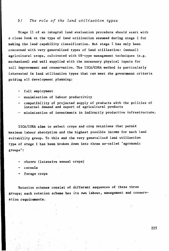
b) The role of the land utilization types
Stage II of an integral land evaluation procedure should scart with
a close look at the type of land utilization assumed during stage I for
making the land capability classif ication. But stage I has only been
concerned with very generalized types of land utilization: (annual)
agricultural crops, cultivated with US-type management techniques (e.g.
mechanized) and well supplied with the necessary physical inputs for
soil improvement and conservation. The IICA/CORA method is particularly
interested in land utilization types that can meet the government criteria
guiding all development planning:
full employment
maximization of labour productivity
compatibility of projected supply of products with the policies of internal demand and export of agricultural products
minimization of investments in indirectly productive infrastructure.
IICA/CORA aims to select crops and erop rotations that permit
maximum labour absorption and the highest possible income for each land
suitability group. To this end the very generalized land utilization
type of stage I has been broken down into three so-called 'agronomie
groups':
ahacra (intensive annual crops)
cereals
forage crops
Rotation schemes consist of different sequences of these three
groups; each rotation scheme has its own labour, management and conserv
ation requirements.
225
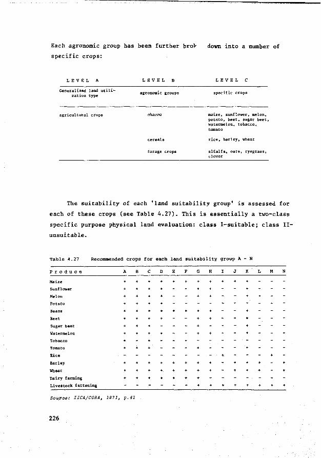
Each agronomie group bas been further bro}
specific crops:
LEVEL A
Generalized land utilization type
agricultural crops
LEVEL B
agi:-onomic groups
cereals
forage crops
down into a number of
LEVEL C
spec if ic crops
maize, sunflower, melon, potato, beet, sugar beet, watermelon, tobacco, tomato
rice, barley, wheat
alfalfa, oats, ryegrass, clover
The suitability of each 'land suitability group' is assessed for
each of these crops (see Table 4. 27). This is essentially a two-class
specific purpose physical land evaluation: class 1-suitable; class II-
unsuitable.
Table 4.27 Recommended crops for each land suitability qroup A - N
Produce A B c D E F G H I J I< L M N
Maize + + + + + + + + + + +
Sunflower + + + + + + +
Melon + + + + + + +
Potato + + + +
Beans + + + + + + + + +
Beet + + + + + + +
Sugar beet + + + + +
Watermelon + + + + + + +
Tobacco + +
Tomato + + + + +
Rice + +
Barley + + + + " + + + + + + +
Wheat " + + " " + + + + + + +
Dairy farming + + + + + " +
Livestock fattening + + + + + + + +
Source: IICA/CORA, 1971, p.41
226
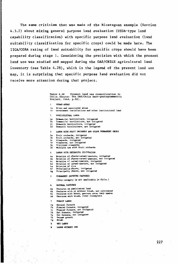
The same criticism that was made of the Nicaraguan example (Section
4.3.2) about mixing genera! purpose land evaluation (USDA-type land
capability classification) with specific purpose land evaluation (land
suitability classification for specific crops) could be made here. The
IICA/CORA rating of land suitability for specific crops should have been
prepared during stage 1. Considering the precision with which the present
land use was studied and mapped during the OAS/CHILE agricultural land
inventory (see Table 4.28), ~hich is the legend of the present land use
map, it is surprising that specific purpose land evaluation did not
receive more attention during that project.
Table 4.28 Present land use classification in Chile.(SOurce: The OAS/Chile Aero-photogrammetric Project, 1964, p.66).
URIWI AREAS
la Urban and associated areas 1 b Government installations and other institutional land
HORTICULTURAL LANDS
2a Coaaercial horticulture, irrigated 2b Connercial horticulture" ruJt irrigated 2c Dollestic horticulture, irrigated 2d Doaestic horticulture, not irrigated
LANDS WITH FRUIT ORCHARDS AND OTHER PEllMANEliT CROPS
la Fruit orcharde, irrigated 3b Fruit orchards, not irrigated 3c Vineyards, irrigated 3d Vineyards, not irrigated 3e Trellised vineyards Jf Multiple use with fruit orcharda
LANDS WITH EXTENSIVE CULTIVATION
4a Rotation of chacra:-cereal-paature, irrigated 4b llotation of chacN-cereal-pasture, not irrigated 4c Rotation of cereal-pasture, irrigated 4d 'Rotation of cereal-pasture, not irrigated. 4e Rotation of rice 4f Pt'incipally. ohacru., irrigated 4g Principally chacru, not. irrigated
PIWWIENT IMPROVED PASTURES
(Thia category ia not applicable in Chile.)
NATURAL PASTURES
6a Paeture1 oo. semicleared land 6b Paetures with or without. bt'Uah, not cultivated 6c t>asture• with brush, pastu:re cover very sparse 6d Paeturea with brush, river floodplain
FOREST LANDS
7a Natural forests 7b Ple.nted foreste, irrigated 7c Planted foreeta, not irrigated 7d Cut foreats, irrigated 7e Cut foreata, not irrigated 7f Second growth 7& llruah
8 WET LAllDS
9 LAllDS WITHOUT USE
227

More recent soil studies made by the Chilean Soil Institute do
include land suitability ratings for specif ic crops. For example a
checklist of land utilization types was published in the semi-detailed
soil surveys of Maule Norte and Digua (Table 4.29). Each soil (mapping)
unit was rated suitable/unsuitable for these types. The land utilization
types/crops suitable are physically feasible options, similar to the erop
lists prepared in Mexico with the new CETENAL methodology (Section 4.3.3).
There is no mention of required inputs and/or expected outputs. In Chile
the term 'agricultural soil suitability' is used for this kind of rating.
228
Table 4.29 Land utilization types applied for two class 'agricultural suitability' classification by the Chilean Soil Institute
1" All cultivated crops (chac1'28, cere.als, pasture), deep rooting fruit trees, or vineyards
2. All cultivated crops (chaaras, cereals, pastures), medium deep rooting crops, or vineyards
3. All cultivated crops (chaal'a8, cereals, pastures), shallow rooting crops, or vineyards
4. All cultivated crops and deep rooting fruit trees
5. All cultivated crops and medium deep rooting fruit trees
6. All cultivated crops and shallow rooting fruit trees
7. All cultivated crops (mainly horticultural crops) and medium deep rooting fruit trees
8. All cultivated crops (mainly horticultural crops)
Chacras, cereals and deep rooting pastures
Chaaras, cereals and medium deep rooting pastures
Chacras, cereals and shallow rooting pastures
Chacras, cereals and reaiatant paatures
9.
JO.
1).
12.
13.
14.
IS.
Cereals, pastures and deep rooting fruit trees, or vineyards
Cereals, pastures and middle deep rooting fruit trees, or vineyards
Cereals, pastures and vineyards
16. Cereals or pastures
17. Cereals, shallow rooting pastures or vineyards
IB. Cereals or shallov rooting pa•tures
19. Cereals (mainly rice) and pastures
20. Shallow rooting pasturea
21. llatural pasturea
22. Forestry
23. Wildlife and recreation
SOW'Ce: Estudio Agl'OZ6gico dei Area Mau'l.8 NOl'Ul (2a etapa. App. VI. 1989)

When examining Table 4.27 the question arises whether the variation
of properties affecting the suitability for the crops mentioned within
each land suitability group is really smaller than the variation in
properties between these groups, at least between the groups now rated
suitable and unsuitable. How far apart are, for instance, groups D and F
in their suitability for growing sunflower, melon or watermelon, and how
great is the variation in suitability for these crops within each of
these two groups?
Productivity
To select the optimal erop rotation for each land suitability group
the productivity of these groups when growing the various crops needs to
be known. IICA/CORA correlates erop yield with land capability classes,
by using standards established by the National Agronomie Institute La
Platina. However, such a correlation is questionable, because the land
capability classes defined in the OAS/CHILE report (see Table 4.30) are
not explicit about erop yield. The USDA Land Capability System (Klingebiel
and Montgomery, 1961) also recognizes that fora proper assessment of
productivity and yield potential the soil (mapping) units not the land
capability classes should be used as a base.
Correlating erop productivity with the various land capability
classes introduces a subjective element in the socio-economie analysis
of stage II which can seriously interfere with the accuracy of the
conclusions on integral land evaluation.
229
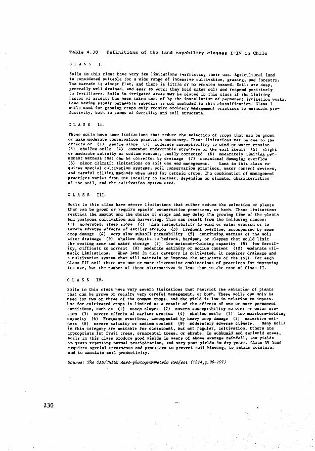
230
Table 4.30 Definitions of the land capability classes I-IV in Chile
CLASS 1.
Soils in this class have very few limitations restricting their use. Agricultural land is considered suitable for a wide range of intensive cultivation, gra.zing, and forestry. The terrain is almost flat, and tbere is little or no erosion hazard~ Soils are de.ep, generally well drained, and easy to work; they hold water well and respond positively to fertilizers. Soils in irrigated areas may be placed in this class if the limiting factor of aridity has been taken care of by the installation of permanent irrigation works. Land having slowly permeable subsoils is not included in this classification. Class I soils used for growing crops only require ordinary management practices to maintain productivi ty, both in terms of fertility and soil structure.
C L A S S II.
These soils have some limitations that reduce the selection of crops that can be grown or make moderate conservation practices necessary. These limitations may be due to the effects of ( 1) gentle slope (2) moderate susceptibility to wind or water erosion (3) shallow soils (4) somewbat unfavorable structure of the soil itself (5) slight or moderate salinity or sodium. content, easily corrected (6) moderately limiting permanent wetness that can be corrected by drainage (7) occasional damaging overflow (8) minor climatic limitations on soil use and management. Land in this class re· quires special cultivation systetns, soil conservation practices, water control devices, and careful tilling methods when used for certain crops. The eombination of management practices varies from one locality to another, depending on climate, characteristics of the soil, and the cultivation syste.m used.
C L A S S III.
Soils in this class have severe limitations that either reduce the selection of plants that can be grown or require special conservation practices, or both. These limitations restrict the amount and the choice of cropa and may delay the growing time of the plants and postpone cultivation and barvesting. This can result from the following causes: ( 1) moderately steep slope (2) high susceptibility to wind or water erosion or to severe adverse effects of earlier erosion (3) frequent overflow, accom.panied by some erop damage (4) very slow subsoil permeability (5) continuing wetness of the soil after drainage (6) sballow deptbs to bedrock, hardpan, or elaypan that would limit the rooting zone and water storage (7) low moiature-holding eapacity (8) low fertility, difficult to correct (9) moderate salinity or sodium content (10) moderate climatic limitations. When land in this category ia cultivated, it requires drainage and a cultivation system that will maintain or improve the structure of the soil. For each Class III soil there are one or more alternative combinations of practiees for improving its use, but the number of these alternatives is leas than in the case of Class II.
CLASS IV.
Soils in this class have very severe lim.itationa that rest.riet the selection of plants that can be grown or require very careful management, or both. These soils can only be used for two or three of the coumon crops, and the yield ia low in relation to inputs. Use for cultivated crops is limited as a result of the effects of one or more permanent eonditions, auch as (1) ateep slopes (2) severe susceptibility to wind or water ero-s ion (3) severe effeets of earlier erosion (4) shallow 110ils (5) low moisture-holding capacity (6) Frequent overflows, acc0111panied by heavy erop damage (7) excessive wet-ness (8) severe salil>ity or sodium content (9) moderately adverse elimate. Many soils in this category are suitable for occasional, but not regular, cultivation. Others are appropriate for fruit trees, ornamental trees, or shrubs. In subhumid and semiarid areas, soils in this class produce good yields in years of above average rainfall, low yields in years reporting nonnal pracipitation, and. very poor yields in dry years" Class IV land requires special treatmel'lts and practices to prevent soil blowing, to retain moisture, and to maintain soil productivity"
Sourae: The OAS/CHILE Ael'O-photogramnetria P?ooject (1964,p.96-101)
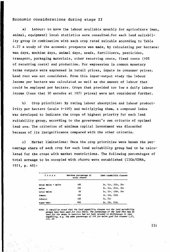
Economie considerations during stage II
a) Labour: to know the labour available monthly for agriculture (man,
animal, equipment) local statistics were consulted.For each land suitabil
ity group in combination with each erop rated suitable according to Table
4.27 a study of the economie prospects was made, by calculating per hectare:
man days, machine days, animal days, seeds, fertilizers, pesticides,
transport, packaging materials, other recurring costs, fixed costs (10%
of recurring costs) and production. For expression in common monetary
terms outputs were expressed in retail prices, inputs in consumer prices.
Land rent was not considered. From this input-output study the labour
income per hectare was calculated as well as the amount of labour that
could be.employed per hectare. Crops that provided too low a daily labour
income (less that 30 escudos at 1971 prices) were not considered further.
b) Crop priorities: By rating labour absorption and labour product
ivity per hectare (scale 1-100) and multiplying them, a compound index
was developed to indicate the crops of highest priority for each land
suitability group, according to the government's own criteria of optimal
land use. The criterion of minimum capital investment was discarded
because of its insignificance compared with the other criteria.
c) Market limitations: Once the erop priorities were known the per
centage share of each erop for each land suitability group had to be calcu
lated for the crops with market restrictions. The following percentages of
total acreage to be occupied with chacra were established (IICA/CORA,
1 971, p. 49) :
C r o p s Maximum percen.uge of ûmd capability classes to tal chacra
water aelon + melon 10% Ir 0 IIr, IIIr, IVr
melon 10% Ir. Itr. lllr, IVr
water melon 5% Ir, IIr, Uir, IVr
tomato 10% Ir, Ilr, IIIr
tobacco 10% Ir, Ilr
sugar beet 20% Ir, IIr, lIIr
NOTE: It slioukl be notsd that the Zand capability classes f'IOt the Zand suitability gl'OUps hcwe been used fol' this TabU.. The pePcentags of the Zand that may be used foP the CPOpB in q1M1sticm has not been rel.atsd to differences in Zand capabitity, e.g. the """"' P"""""ta{I• of 101 for ..,zon goes fOI' classes I,II, III, IV.
231
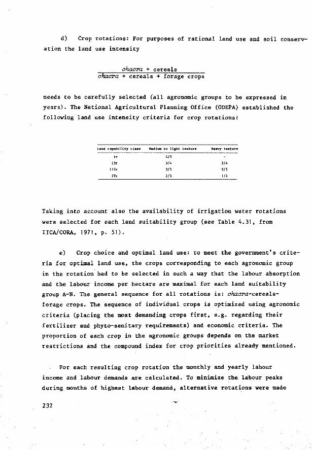
d) erop rotations: For purposes of rational land use and soil conserv
ation the land use intensity
ahaa:ra. + cereals aha.ara + cereals + forage crops
needs to be carefully selected (all agronomie groups to be expressed in
years). The National Agricultural Planning Office (ODEPA) established the
following land use intensity criteria for erop rotations:
Land capability claas Medium to light texture. Heavy te:xture
Ir 4/5
Ilr 3/4 2/4
IIIr 3/5 2/5
IVr 2/5 l /5
Taking into account also the availability of irrigation water rotations
were selected for each land suitability group (see Table 4.31, from
IIeA/eORA, 1971, p. 51).
e) erop choice and optimal land use: to meet the government's crite
ria f or optimal land use, the crops corresponding to each agronomie group
in the rotation had to be selected in such a way that the labour absorption
and the labour income per hectare are maximal for eaeh land suitability
group A-N. The genera! sequenee for all rotations is: aha.ara-eereals
forage crops. The sequenee of individual crops is optimized using agronomie
criteria (placing the most demanding crops first, e.g. regarding their
fertilizer and phyto-sanitary requirements) and economie criteria. The
proportion of each erop in the agronomie groups depends on the market
restrictions and the compound index for erop priorities already mentioned.
For each resulting erop rotation the monthly and yearly labour
income and labour demands are calculated. To minimize the labour peaks
during months of highest labour demand, alternative rotations were made
232
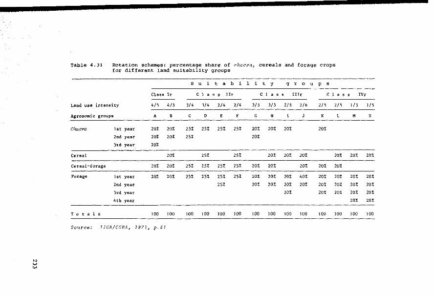
N w w
Table 4.31 Rotation schemes: percentage share of for different land suitability groups
s u i t a b
Class Ir c l a s s Ilr
Land use intensity 4/5 4/5 3/4 3/4 2/4
Agronomie groups A B c D E
Chacra lst year 20% 20% 25% 25% 25%
2nd year 20% 20% 25%
3rd year 20%
Cereal 20% 25%
Cereal-forage 20% 20% 25% 25% 25%
Forage lst year 20% 20% 25% 25% 25%
Znd year 25%
3rd year
4th year
Totals 100 100 100 100 100
Source: IICA/CORA, 1971, p. 51
ehacra, cereals and forage crops
i l i t y g r 0 u p s
c l a s s Illr c l a s s IVr
2/4 3/5 3/5 2/5 2/6 2/5 2/5 1/5 1/5
F G H l J K L M N
25% 20% 20% 20% 20%
20%
25% 20% 20% 20% 20% 20% 20%
25% 20% 20% 20% 20% 20%
25% 20% 20% 20% 40% 20% 20% 20% 20%
20% 20% 20% 20% 20% 20% 20% 20%
20% 20% 20% 20% 20%
20% 20%
100 100 100 100 100 100 100 100 100
for each land suitability group. From these the optimal rotation can be
selected by using a compound index which considers four variables:
percentage of available labour that is absorbed, number of man equivalents
engaged, labour income per hectare and labour income per calendar day.
Conclusion
Stage II, socio-economie analysis, relies heavily on the results of
the preceding (10-year-old) physical land evaluation. Information produced
during the physical land evaluation should be as specific as possible in
defining the land utilization types and in defining the land suitability/
capability classes. A rating of productivity for individual or groups of
similar land (mapping) units is very useful. The reliability of information
and maps produced during stage I should be clearly stated.
The observations made may have lost some of their relevance in the
light of political changes which have since occurred in Chile. Nevertheless
the IICA/CORA approach represents an interesting attempt to make use of the
results of physical land evaluation in socio-economie land use planning.
234
Appendix 2: Land qualities and component properties in Brazil 1
a) Deficiency of natura! fertility, which in this case means
chemica! fertility, depends on:
1. the availability of the macro- and micro-nutrients in the soil, and
2. the absence or presence of soluble salts, especially sodium. Some other important toxic substances, such as soluble Al and Mn, are toxic, because they depress the availability of some mineral nutrients. These toxicities are considered as part of point 1).
Easy-to-interpret data on the availability of macro- and micro-nutrients
are not available. The best relations between fertility status and other
data which have been used till now in defining the fertility status are: Al+++
base saturation (or Al saturation Al+++ +S x 100), total exchangeable
bases, and activity of organic cycle (forest against savannah).
Many more data are present which are relevant to the fertility status,
directly or indirectly, but which cannot be clearly interpreted in terms of
soil fertility. They include: total nitrogen, C/N quotient, total P2o5,
Fe2o3
, exchangeable cations, exchangeable Al, and exchange capacity. Other
properties, such as soil depth and biologica! activity, water deficiency
and oxygen deficiency, are also influential.
Field observations have to be used too, because it is mostly impossible
to draw a final conclusion about the natura! fertility of a tropical soil
solely on the basis of the available chemical data. Observations about
land use, yields, qualities of pastures etc., as well as the relationship
between natural vegetation and natura! fertility, will help in establishing
the class or classes of the natura! fertility of a given soil unit.
Degrees of limitations due to NATURAL FERTILITY
The classes of 'no' and 'slight' limitations are combined in the fol
lowing def inition, but should be split in a future revision.
SoUPae: Beek, Bennema and Camargo, 1964 (sZightZy roevised)
235
NO/SLIGHT LIMITATION
MODERATE LIMITATION
236
Soils with a high level of available plant
nutrients, and without toxic salts due to soluble
salts or exchangeable sodium. When the other four
factors are also favourable, nutrient reserves
allow good yields for many years for the more
demanding crops too.
Profiles of Non Hydromorphous soils with latosolic
B or textural B belonging to this class normally
have more than 35% base saturation in the solum or +++ . Al+++
less than 50% Al saturat1on (Al+++ +S x 100)
and the sum of exchangeable bases is higher than
3 meq per 100 g soil. Further, the solum is
practically free of excessive salts, conductivity
less than 4 m.mhos/cm. The soils of humid and sub
humid tropical regions of Brazil belonging to this
group are usually covered by forest.
1. Soils in which the reserve of one or more
available plant nutrients is small, (this nutrient
reserve may be present in the organic cycle, which
includes the vegetation as well). When the other
factors are favourable, nutrient conditions only
permit good yields of annual crops during the first
few years - after that yields decrease rapidly
when agricultural use of the land continues. These
soils need fertilizer after a few years to extend
and maintain productivity, as otherwise they are
likely to deteriorate and degrade into lower
productivity classes as a result of exhaustive use.
The soils that belong to this group and are situa
ted in the humid and sub-bumid Tropics are usually
covered by forest.
STRONG LIMITATION
VERY STRONG LIMITATION
2. Soils with salt toxicity resulting from soluble
salts and exchangeable sodium) on which sensitive
crops will not grow. Conductivity normally 4-8
mmhos/cm.
J. Soils in which one or more of the available
nutrients only appear in small quantities. When
the other factors are favourable, nutrient condi
tions permit only reasonably good yield for adapted
crops, yields of the other crops being very low
(likewise pastures are low-yielding).
To be used prof itably these soils generally need
fertilizing from the time they are first exploited.
The non-hydromorphic soils belonging to this class
normally have low total exchangeable bases. In the
humid and sub-humid Tropics these soils have a
tree shrub cerrado vegetation, or a closed cerrado
vegetation, or exist as exhausted agricultural
lands.
2. Soils with toxic salt toxicity due to soluble
salts and exchangeable sodium which only permit
the growth of salt-tolerant plants, seriously
damaging other plants.
Conductivity normally 8-15 mmhos/cm
J. Soils with a very restricted nutrient content,
leaving them with practically no possibility of
agricultural, pasture or re-forestation use.
These soils are in Centra! Brazil connected with
cerrado and campo cerrado (savannah vegetation),
and have very low sum of total exchangeable
bases.
237

2. Soils with salt toxicity, due to soluble salts
and exchangeable sodium, which only permit very
aalt-tolerant plants to grow. Bare spots and salt
crusts may occur.
Without desalinization these soils have only re
stricted possibilities for use as pasture or ex
tensive grazing. Conductivity normally more than
15 nnnhos/cm.
b) De f ic i ene y of wat er is in many cases primarily the resul t of
the climate, especially of precipitation and evapotranspiration. In extreme
cases, the climatological factors may even be the only important factors,
e.g. in the desert and in some super-hum.id areas; but in ether cases soil
factors also have an influence.
In well drained soils the amount of available water that can be stored
is critical; this amount depends on a set of single soil properties, includ
ing texture, kind of clay, carbon content and effective soil depth. In the
case of not so well drained soils, as well as the amount of available water
that can be stored, the presence and depth of a water table, together
with the hydraulic conductivity, also have important influence on the
availability of water in a certain soil.
The data on precipitation and evapotranspiration, as well as those on
physical soil data, are, however, too scarce to allow conclusions to be
drawn about the class of water deficiency a certain soil belongs to. Other
data, such as the reaction of pastures and crops in the dry period, and
also the kind of natural vegetation, may help in classifying the soil
according to water deficiency. This is especially evident in cases where
vegetation is adapted to wet soils, and also in the case of a tropical
forest.
The tropical forest may be divided in~o the following groups:evergreen,
semi-evergreen,semi-deciduous and deciduous. These groups,from evergreen to
238
deciduous, are an expression of the increase in the deficiency of water,
and they can be related directly to the different classes of water defi
ciency of the soil in question. The reaction of the forest, however, does
not always seem to agree with the deficiency of water for crops,especially
in cases where the rooting possibilities for forest trees are evidently
much better than for many annual crops. Coastal terraces in Pernambuco with
a hard A3
/B 1 (fragipan) are an example of this. One should therefore be
alert that deficiency of water may be more than the forest indicates.
Degrees of limitations due to WATER DEFICIENCY
The degrees of limitations are defined in terms of water shortage for
plant production during a shorter or longer period of the growing season.
NO LIMITATION
SLIGHT LIMITATION
Soils in which the deficiency of available water
does not limit plant growth and/or agricultural use.
a) Soils with free internal drainage belonging to
this class are found in climates with no dry season.
b) Soils with a water table belonging to this class
may also occur in climates with a dry season.
c) Irrigated soils may also be included in this
class.
Soils in which a small def iciency of available
water occurs during a short period, which is part
of the growing season. Growth of all plants is
still permitted, but the growth of the most drought
sensitive plants is limited.
a) Soils with free internal drainage belonging to
this class are found in climates with a short dry
season, 0-3 months. In tropical climates the
natural vegetation in these conditions is usually
semi-evergreen forest.
239

MODERATE LIMITATION
STRONG LIMITATION
VERY STRONG LIMITATION
240
b) Soils with a water table belonging to this
class can also occur in climates with a longer
dry period.
c) Irrigated soils may also be included in this
class.
Soils in which a considerable deficiency of
available water occurs during a rather long period.
The growth of plants which are not very sensitive
to drought is possible; sensitive plants are harmed.
a) Soils in this class with free drainage are only
found in climates with a rather long dry season,
3-7 months, if the soils are sandy and shallow,
or in climates with a short dry season. In tropical
climates the vegetation of this class, if it is
forest, is normally semi-deciduous.
b) Soils with a water table or with temporarily
stagnating water, belonging to this class can also
occur in climates with a long dry period.
Soils in which a great def iciency of available
water occurs during a long per.iod. Only very tole
rant crops can be grown.
Soils belonging to this class are found in clima
tes with a long dry period, longer than 7 months,
and in climates with a rather long dry season (3-
7 months), if the soils are sandy or shallow.
Soils in which a very great deficiency of available
water occurs during a very long period, with a very
short growing season, and where a growing season
may be completely absent. The vegetation is often
scarce, or only present during part of the year.

c) Deficiency of oxygen is normally caused by excess of water,
and is mostly directly related to the drainage class, which is the result
of climatological conditions (precipitation and evapotranspiration), local
relief, and soil properties. In soils with a water table, the height of the
water table is particularly important. In soils without a water table the
critical factors are: the structure of the topsoil and the permeability of
soil and subsoil, and if a more permeable topsoil is present, the depth of
the less permeable layer.
It is evident that, in genera!, a direct relation must exist between
drainage class and oxygen deficiency, because the drainage classes are
defined in terms of excess of water. However, some discrepancies may
exist in practice because the essential point when classifying according
to oxygen def iciency is the reaction of plant life, while the drainage
classes are defined according to soil profile characteristics.
This discrepancy between drainage class and oxygen def iciency is ob
vious in those areas of hydromorphic soils where artif icial drainage is
the common practice. Neither excess of water nor deficiency of oxygen may
be present in such cases, although the drainage class based on profile
characteristics may still be 'poorly drained' •
It must be noted that deficiency of water and def iciency of oxygen are
here seen as two ind~pendent factors affecting the agricultural soil
conditions, because a soil lacking water in one (the dry) season may show
an excess of water in the rainy season. However, not all combinations of
classes with lack of water and lack of oxygen are possible. With a great
deficiency of water, the lack of oxygen will, for example, never be more
than slight.
The occurrence of floods, which, next to a temporary deficiency of oxy
gen, also cause mechanical damage to plants not adapted to them, is con-
s idered as a separate factor in the rating of lack of oxygen.
241
Degree of limitation due to DEFICIENCY OF OXYGEN
In soils that are not artificially drained the degrees of limitation
due to the def iciency of oxygen are closely related to the natural drainage
classes of the soil. This relation is given after each definition.
NO LIMITATION
SLIGHT LIMITATION
MODERATE
STRONG LIMITATION +
VERY STRONG LIMITATION
242
Soils in which the aeration is not prejudiced by
the effect of water during any period of the year.
Normally well or excessively drained soils.
a) Soil in which plant roots that are sensitive
to a certain deficiency of air are adversely
affected during the rainy season, when the
aeration worsens because of excessive water.
Normally moderately well drained soils.
b) Soils with permanent risk of slight and occa
sional overflow causing some erop damage.
a) Soils in which plant roots that are sensitive
to a certain deficiency of air cannot develop
satisfactorily, because the soil aeration is ad
versely af fected by excessive water during the
rainy season.
Normally imperfectly drained soils.
b) Soils with a permanent risk of overflow, causing
erop damage.
a) Soils on which plants which are not adapted to
excessive water can only grow satisfactorily
if artif icial drainage is provided.
Normally poorly or very poorly drained soils.
b) Soils with frequent overflow causing erop
damage.

d) The susceptibility to erosion. Water erosion is most im
portant: aeolian erosion has not been very important in the areas surveyed
until now in Brazil. Susceptibility to erosion by water not only depends on
climate, topography and soil, hut also on the land use, and on the natural
vegetation. The standard for susceptibility to erosion is the erosion that
would occur if the land were used for agriculture, growing crops that
are not specifically soil-protecting and neglecting to take measures
to prevent erosion. The susceptibility not only depends on climatological
factors (especially rainfall distribution), degree of slope, slope length,
and micro-relief of the slope, hut also on the following soil factors:
infiltration rate, quantity of water which can be stored until the soil is
saturated, permeability, coherence of the soil material (with its varia
tions in depth of the profile), the presence of stones on the surface which
may act as soil protectors, and presence of slip surfaces in the subsoil.
Most of these soil properties are complex and in turn are the result
of other, single or, at least less complex properties such as structure,
texture, kind of clay, soil depth etc. The soil properties of friable
latosols suggest that these soils are generally not very susceptible to
erosion and indeed they are less susceptible than the slope would suggest.
Shallow soils of the Sertao area (semi-arid North East) such as 'Cabrobo'
and 'Vermelho do Sertào' and also Solonetz, are examples of soils in which
the profile characteristics are unfavourable as far as erosion hazard is
concerned. Red-Yellow Podzolic soils are often in between these two
extremes.
Previous erosion which bas removed the more porous and of ten more co
herent topsoil and bas initiated a system of rills and gullies, is often a
factor making the soils still more susceptible to erosion. In the case of
soils with a shallow solum on deep, non-coherent C-material, the erosion of
this solum may lead to a disastrous development, in which the C-material is
rapidly eroded. It must be noted that erosion by changing the soil also
greatly influences the degrees of limitation of the other agricultural soil
conditions.
243
The class of susceptibility to erosion to which a certain soil belongs
can obviously best be determined in cases where these soils are used for
agriculture without measures to prevent erosion. These observations of real
data together with a fundamental knowledge about the.relations between the
susceptibility to erosion and land characteristics, provide a useful guide
for rating erosion susceptibility.
Degrees of limitations due to susceptibility for EROSION
NO (+practically NO LIMITATION)
SLIGHT
244
Soils that are not, or practically not, susceptible
to erosion.
'If used for agriculture' erosion is absent or nearly
absent in the greater part of the area. The A-ho
rizon is intact also 'if used for agriculture' du
ring a longer time.
In general, soils that are level or soils that are
nearly level and have good permeability.
The very slight erosion that might occur in this
class can normally be controlled easily.
Soils that are slightly susceptible to erosion.
'If used for agriculture' erosion is recognizable
by slight phenomena (SSM-Erosion Class 1, p.262);
however, soil damage only occurs after prolonged
agricultural use.
In general, A-horizon still present, but part may
MODERATE LIMITATION
be removed; approximately 25-75% of the original
A-horizon may be lost from most of the area 'if
used for agriculture' (SSM).
In general soils that have gentle slope (3-8%)
and good or rather good physical soil conditions;
the soils may sometimes be sloping if the physical
soil conditions are very favourable.
Protection and control mostly easily feasible
under modern management, the use of selected crops
(sugar cane) or tree crops will generally satis
factorily protect against erosion, as well as culti
vating the land in small plots only.
Soils that are moderately susceptible to erosion.
'If used for agriculture' erosion is recognizable
by moderate phenomena in the greater part of the
area (SSM - erosion class 2); soil damage will be
rather rapid: at first removal of the whole Al
horizon, which extends to the formation of rills
and gullies.
In general, soils on a sloping or strongly sloping
surface (8-20%), also when the physical soil
conditions are poor or rather poor. The land may
be moderately steep (20-40%) when the physical
soil conditions are very favourable, or gently
sloping (3-8%) when the physical soil conditions
are very unfavourable.
Protection and control may be easily feasible, but
in general will be more intensive, requiring more
investment and knowledge and more expensive main
tenance. Tree erop cultivation without the entire
removal of the protecting vegetation cover may
still be possible.
245
STRONG LIMITATION
VERY STRONG LIMITATION
246
Soils that are very susceptible to erosion. 1 lf
used for agriculture' erosion is recognizable by
strong phenomena in the greater part of the area
(SSM - erosion class 3); soil damage will be
rapid.
In genera!, soils on moderately steep or steep land
(20-40%), when the physical soil conditions are
good or rather good. Land may be very steep when
the physical soil conditions are extremely good,
and strongly sloping (8-20%) soils when the physi
cal soil conditions are unfavourable.
Protection and control will mostly be very diffi
cult and expensive, or not feasible.
Soils that are extremely susceptible to erosion.
'If used for agriculture' these soils will be
destroyed within a few years. If used for grazing,
the risk of soil damage is still great (SSM-erosion
class 4). The damage includes a rapid removal
of the A-horizon and eventually of other horizons,
and very easy development of deep gullies.
This class includes soils on very steep slopes
(more than 70%) whose physical soil conditions
are extremely favourable, and soils on steep
slopes (40-70%) when the physical soil conditions
are unfavourable.
Protection and control of the erosion in this class
is normally neither technically nor economically
feasible, whether the soil is being used for
agriculture, tree erop cultivation or even exten
sive grazing.
e) Impediments restricting the use of agricultural
implements (mechanization)
This typical agricultural factor depends on slope, absence or presence
of stones or rocks, absence or presence of extreme shallowness of the soil,
at least if underlain by consolidated material or by material unfavourable
to being ploughed up, bad drainage conditions, and an extreme constitution
of the soil material, such as clayey texture with the presence of 2:1 layer
silicate clays (often together with bad drainage conditions), organic
soils, or loose sandy soils. Extra impediments in the microrelief include
large numbers of ant-hills, termite mounds, or many gullies due to ero
sion.
lf mechanization is contemplated, it should be noted that an area that
has no impediments to mechanization should be larger than the defined mi
nimum size to be of importance. Small areas that do not prevent problems
to mechanization, but are scattered among other areas which do not allow
mechanization, can be neglected.
It must be noted that the preceding five aspects (a - e) do not re
present all the agricultural soil conditions. The condition of the tilth,
for instance, is important for the germination of many seeds and is diffi
cult to evaluate in any of the five aspects mentioned. Beside soil condi
tions, other conditions e.g. temperature and light, and conditions related
to biologica! environment, are important in view of possibilities for agri
cultural use.
As follows from the foregoing, soil properties may have influence
on only one of the five agricultural conditions, or on more than one.
Most chemica! properties only influence the fertility status, while slope
influences at least 4 factors: water deficiency, excess of water (as part
of local relief), susceptibility to erosion, and mechanization. Soil
depth even influences all five aspects of agricultural soil conditions.
247
Degrees of limitation for the use of agricultural implements
(MECHANIZATION)
NO LIMITATION
SLIGHT LIMITATION
248
Soils on which all types of agricultural machinery
can be used without difficulty during the whole
over most of the area. Tractor efficiency (=% of
tractor hours effectively used) more than 90%.
These soils have a level topography, with slopes
of less than 8% and show no other relevant impedi
ments for mechanization.
Soils on which most agricultural machinery can be
used without, or with slight difficulty on most
of the area. Tractor efficiency 60-90%.
These soils have:
a) Slopes of 8-20% with a gently undulating,
undulating or sometimes hilly topography, when
no other more serious impediments are present.
In this class, the use of power-operated equipment
(tractors) is still possible. Contour cultivation
will be necessary.
b) Level topography with slight impediments due
to stoniness (0.05-1%), rockiness (2-10%) or
shallowness.
c) Level topography with slight impediments
due to sandy texture, or clayey texture with
presence of montmorillonitic clays or illitic
clays; heavy textured soils may also present slight
impediments due to lack of drainage systems or
irregular drainage systems (compact soils with low
permeability which can be very hard during the dry
season).
MODERATE LIMITATION
STRONG LIMITATION
Soils on which in the greater part of the area only
the lighter types of agricultural equipment can be
used, sometimes only part of the year; draft-power
provided by animals. lf tractors are used, tractor
efficiency less than 60%.
These soils have:
a) Slopes of 20-40% with a topography which is
usually hilly. There are no other more serious
impediments to mechanization. 'If used for agri
culture', frequent and deep erosion rills may be
present.
b) Slopes less than 20%, but with moderate impe
diments due to stoniness (1-15%), rockiness
(10-25%) or shallowness.
c) Level topography with moderate impediments
due to sandy texture, or clayey texture, with
presence of montmorillonitic or illitic clays;
heavy-textured soils may also present moderate
impediment due to lack of drainage or presence
of a very irregular drainage system (compact soils,
with low permeability, which are very hard during
the dry season).
Soils"which in most of the area can•only be culti
vated with the use of hand tools.These soils have:
a) Slopes of 40-70% in a mountainous topography,
or a topography that may be partly hilly. 'If used
for agriculture', a pattern of frequent, shallow or
deep erosion gullies may be present, being a strong
impediment for the use of agricultural machinery.
b) Slopes of less than 40% with strong impediments
due to stoniness (15-40%), rockiness (25-70%) or
shallowness.
249
VERY STRONG LIMITATION
250
Soils which cannot, or only with great difficulty
be used for agriculture; no possibility for drawn
implements or even hand implements. These soils
have:
a) Slopes of more than 70% in the mountainous
topography and escarpments.
b) Slopes of less than 70% but with very strong
impediments due to stoniness (more than 40%)
rockiness (more than 70%) or shallowness, or 'if
used for agriculture', a frequent pattern of
shallow or deep gullies may be present.

5. Towards a systems approach in specific purpose land evaluation
In view of the many variables and disciplines involved, data analysis
in land evaluation can be expected to become more and more complex. Facing
a similar situation of growing complexity, disciplines bordering on land
evaluation are relying increasingly on systems analysis and simulation to
solve their data-handling and analysis problems, e.g. in land and water
management (Kowalik, 1973; Carr and Underhill, 1974; Fleming, 1975; Hillell,
1977), agronomy and biology (Rose et aZ., 1972; Patten, Ed., 1971, 1973;
Arnold and de Wit, Eds., 1976).
Soil science, the discipline that in the past bas probably been most
actively engaged in land evaluation, is also following suit (Trudgill,1977).
Dijkerman (1974), discussing the role of models in studying natural soil
systems, pointed out that two sorts of models were required: genetic, to
help explain the origins and development of soils, and functional, to help
explain how the soil system operates and may therefore be controlled.
Pedologists have traditionally favoured the genetic approach so useful
in land resources inventory for understanding the spatial variation of the
soil properties. Land evaluation will benefit greatly from more functional
studies that examine the interrelationships between land properties (qua
lities) and e.g. erop growth. These functional studies should involve con
sideration of all the pedological, biological, climatological, and physico
chemical aspects of plant growth.
251

When dynamic models of plant growth (Van Keulen, 1975; Arnold and de
Wit, Eds., 1976; de Wit et al., 1978) based on fundamental processes that
can be explained by genera! scientif ic laws are compared with the methods
of land evaluation in use today, the gap that exists between them must be
accepted. While attempts should be made to narrow this gap, land evaluation
should meanwhile develop its own laws and deductions, based on known rela
tions between land and land utilization. Since systems analysis bas appa
rently been useful in solving complex problems in different fields of science
and engineering, this final section will examine what systems analysis can
do for land evaluation. To arrive at a more rational approach to the
complex multidisciplinary land evaluation broadly outlined in Chapter 4
of this report, is it worth further refining the identification of under
lying key variables, parameters and relation structures? This question
must be answered.
252
5.1 The data-analysis problem
The most difficult part of land evaluation is the data analysis,
when the various data about land utilization types and land mapping
units are brought together and compared. Data analysis should result in
a land suitability classification.
The comparison between land utilization and land becomes even more
complex when variable physical inputs for improving the land units are
taken into account, giving rise to variable outputs that depend on the
types and amounts of inputs applied and the responsiveness of the land
units to such input applications.
In reconnaissance-type land evaluations the levels of constraining
land qualities are normally interpreted very generally according to the
production and other effects to be expected from a land utilization type
that uses standardized levels of input. In most cases each land unit
will be evaluated concomitantly with each of the land utilization types
selected for the study area. The time-variant character of land and land
use is broadly analysed by taking into account roughly defined climatic
seasons and hazards.
The principal purpose of data analysis in reconnaissance-type
physical land evaluation is to eliminate from more detailed analysis
those land units that are definitely unsuitable for the land utilization
types under _consideration. Usually, only a few standardized levels of
input and output suffice for this purpose:
outputs inputs Z.and suitabiUty
high low high
high high medium
low low medium
low high low
253
The reconnaissance-type land evaluations of Brazil, described in
Section 4.3.4 are examples of this.
Detaiied tand evaiua:tion requires a more refined analysis including
simulation of inputs and corresponding outputs. The land qualities and
the physical inputs will need to be handled as interrelated variables
controlling the fl.IDdamental land utilization processes and the resulting
outputs. Such a selective method of input and output prediction requires
the continuous land use process to be split up into a number of specific
activities taking place during finite time periods: land preparation,
sowing, vegetative growth, etc. as was explained in Section 3.2.
Because this kind of data analysis is more complex, the only land
utilization types considered are those that are really promising for the
land in question.
In detailed land evaluation there is a def inite shift in emphasis
from a suitability classification to an analysis of physical inputs and
corresponding effects - first in physical and then in economie terms,
e.g. the specification of management, improvement and conservation
practices and corresponding effects; amounts of fertilizers, water
applications, subsurf ace drain spacing, and yields.
The discussion in Section 4.3 on land evaluation in Latin America
revealed that the prevalent data-analysis techniques in that part of the
world consist of conversion tables that relate diagnostic soil/la.nd
properties or qualities directly to different classes of land capability/
suitability.
Physical inputs are considered mainly to enable land suitability with
improvement to be distinguisbed from land suitability without improvement.
Only a few levels of input are considered: low-medium-high. The Brazilian
methodology also uses input levels as a criterion for land suitability
class distinction. Land requiring high inputs for iroprovem.ent is excluded
from class I.
254
More detailed land evaluation studies have been confined to irriga
tion, drainage, desalinization, soil conservation and soil fertility
studies (e.g. Alva et al., 1976; Chanduvi, Ed., 1973; Sanchez, 1973,
1976; Bornemisza and Alvarado, Eds., 1975). The more detailed observa
tions and measurements of cause-effect relations underlying such problem
oriented studies are mostly carried out by specialists in the fields of
soil and water management, with the specific purpose of providing site
specific information for land evaluation, to complement the observations
of the soil surveyors.
Although detailed investigations can be made for special projects,
it will be impossible to carry out site-specific research on all land units,
and for all relevant types of land utilization for lack of sufficient time
to suit all needs of land evaluation and land use planning. There will
thus always be a need to predict land use performance by analogy.
5.2 The temporal problem
Land use and its elements land and land utilization type are dynamic
systems, not merely because they depend on variable weather conditions,
hut because they alter with time. The analysis of dynamic systems is
necessarily complex.
A distinction should be made between time-variant processes and
land (use) changes that take place within one cycle of the continuous
land use process ('repeating systems'), and those that are part of a
normally much slower and irreversible process of change: the long-term
trends in land degradation, land improvement and land use ('transforming
systems'). Land evaluation and land use planning normally make proposals
for the shorter-term cyclic land use activities of repeating systems that
take into account a certain control of the longer-term dynamic processes,
which may be strongly influenced by these shorter term land use activities.
Well-known criteria serving this purpose are sustained productivity and the
conservation of environmental qualities such as water and soil resources.
255
Probably the best known example of dynamic systems analysis in land
use planning is the preparation of cropping calendars. Cropping calendars
are the basis of dynamic systems analysis in land evaluation. However,
optima! timing of the various land use activities is only one aspect of
dynamic systems analysis; we also have to find the best input-output
relations for each separate land-dependent activity, taking into account
that a decision about inputs for one activity may affect such decisions
for other activities, and the input-output relations of the land use as
a whole. For a dynamic analysis of the total land use performance it
will be necessary to have a data-analysis system with good possibilities
for feedback between the various partial analysis of separate land use
activities. For practical reasons, data analysis will be limited only to
land use activities that are possibly constrained by one or more land
qualities, with a significant effect on the overall performance of the
land use or on the quality of the environment.
In Section 3.1 the dynamic character of land qualities and land re
quirements that describe the land and land utilization bas been simplified
by describing their values during finite time periods. During such time
periods the factors describing the land use system are assumed to be time
invariant, for land evaluation convenience' sake. The duration of such
finite time periods and the timing of time-dependent activities will depend
on the weather experienced by the land unit and on the activities and
processes of the land utilization type.
The land qualities defined in Brazil (Section 4.3.4) describe
their variable status during one cycle of the land utilization type. The
levels describing their status refer to specif ic time periods pertinent
for the land use, e.g. water deficiencies in the growing season, work
ability problems in the land preparation period. Each level represents a
different sum of the conditions occurring during finite time periods
that make up the cycle of the land utilization type. Little attention
bas been paid to the actual timing of such finite time periods.
More detailed land evaluation needs to pay more attention to cropping
calendars in the definition and rattng of land qualities.
256
When the weather is very erratic it will be necessary to add a
probability distribution to the values found for the relevant weather
controlled land qualities. An example is Virmani's (1976, 1977) studies;
he has applied systems analysis to estimate the erop moisture availability
of two different soils for purposes of erop planning in the monsoon climate
of the Hyderabad region of India. Another example is Wind's study (1976)
on the influence of drainage on the seedbed preparation of heavy clay
soils during the spring season in The Netherlands, taking into account a
daily record of the weather conditions for a twenty-five-year period. In
this study the land quality 'workability' bas been estimated on a weekly
basis, in combination with a probability that a certain pF value of the
topsoil, critica! for the land utilization in question will occur: 70%-80%
or 90%.
An example of analysis of dynamic land requirements is the study by
Slabbers and Herrendorf (1977) of the water requirements of alfalfa. This
study produced criteria for irrigation during finite stages of the vege
tative growth of this erop.
For purposes of data analysis in practical land evaluation, finite
time periods of one week to one month are usually sufficient. More
theoretical and partial analyses of dynamic systems may require more
detail: the dynamic model of plant and erop growth described by de Wit
et al. (1973, 1978) is based on hourly data-inputs of the key variables.
Fig. 5.1 is an illustration of dynamic systems analysis in land
evaluation, based on three critical land use activities taking place at
finite time periods t 1, t 2 and t 3 • The factors LQ, LR, I and Y are handled
as time-invariant for the mentioned finite time periods:
257
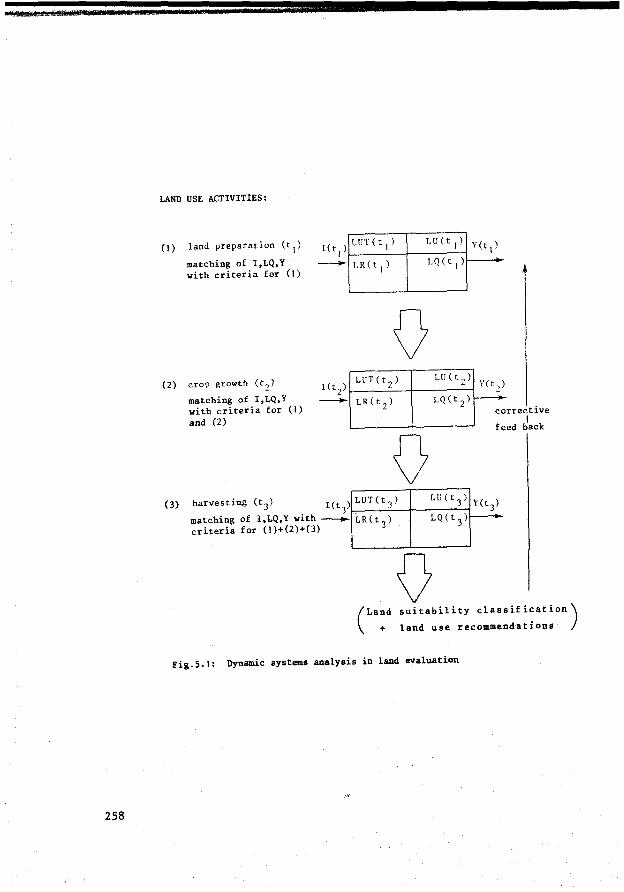
258
LAND USE ACTIVITIES:
(1) land preparation (t 1)
matching of I,LQ,Y with criteria for (1)
(2) erop growth (t2)
matching of I,LQ,Y with criteria for (1) and (2)
0 LUT(t 2 )
LR(t 2 )
0
Lll ( t 2 )
LQ(t 2 )
Y(t,)
~
co rrective 1
feed back
) LUT(t,l LU(t3
) Y(t 3) (3) harvesting (t3 ) l(t . 3
matching of I,LQ,Y with ~ criteria for (1)+(2)+(3)
i..Rct 3 > LQ(t 3 ) ....__
0 (
Lan+d suitability classification)
land use recommendations
Fig.5.1: Dynamic systems analysis in land evaluation
Although the temporal problem can be managed by carrying out
partial analyses of land use activities taking place during finite time
periods there remains a need for some kind of dynamic systems analysis to
solve two types of temporal problems in specific purpose land evaluation:
In the first place there is the problem of accurately measuring the
values of the dynamic (and sometimes stochastic) variables and parameters
for these finite time periods, e.g. the characterization of the land
qualities 'available water' and 'workability', or of the land requirement
'water required for rapid vegetative growth'.
Secondly there is the need to integrate the results of the partial
analyses for finite time periods into an evaluation of the total land
use process. In this case too, the assistance of specialists in dynamic
systems analysis, e.g. land use planners, may be required to prepare land
use calendars, to time the application of variable physical inputs, select
input application methods, etc.
In the next sections, systems analysis in land evaluation will be
discussed mainly against the background of land use processes and acti
vities taking place during finite time periods. The time variability of
the main variables and parameters will be ignored as much as possible to
avoid complications irrelevant to the discussion.
5.3 Systems analysis and simulation models
5.3. l Systems theory
The aim of systems analysis is to construct common theoretica! frame
works within which scientists of different f ields can f ind a common lan
guage1.
This aim is also one of the objectives that originated the Framework f or Land Evaluation (FAO 1976) and of the publications supporting it.
259
Since systems analysis is relatively new to land evaluation it seems
worth explaining some of its underlying concepts and principles, even
though very sophisticated methods of mathematical modelling and computer
simulation have been achieved in soil conservation (e.g.Fleming, 1974)
and water management (e.g. De Ridder and Erez, 1977) to solve specific
problems. At the risk of being criticized for superficiality, I present
some definitions below and in Appendix 3 based mainly on Toebes's (1975)
report and on De Wit and Goudriaan (1974).
The term 'system' bas many meanings, varying from sets of interac
ting physical elements (e.g. the 'land' system, describing a mapping
unit in some Australian reconnaissance resource surveys) to relations
between land and user (e.g. the land tenure system) and to techniques of
cultivating the land (e.g. the management system). Toebes observes that
most systems have three things in common. These are:
a collection of elements
relationships between these elements
a rationale for selecting elements and relationships
According to Toebes, a system is enclosed by a systems boundary which
separates it from other systems over which the scientist bas no control, but
which are expected or known to be related to the system under consideration.
These other systems represent the environment of the constructed system.
The systems environment is part of the Universe that comprehends all kinds
of systems that can be thought of, but which are not supposed to have rela
tions with the system that is being considered. Against this background
Toebes presents the following def inition of the concept system:
A system is a collection of elements and their relationships selected for their hearing on the questions being asked or the goals pursued and related to similarly selected systems in its environment.
Toebes's definitions seem to refer primarily to systems that have been
designed by engineers and are tberefore under their full control: the
260
bridge, the railroad, the ship, the space craft. The elements of the system
and the relations between them can normally be rationally chosen. But the
elements and relations of biologica! systems are not a product of our
choice: they are the product of creative, evolutionary, and other proces
ses largely beyond our control. De Wit and Goudriaan (1974, p.2) when
introducing the simulation of ecological processes define a system as a
'limited part of reality with related elements' • Examples of biological
systems are a plant, a field, or a farm.
The engineer's definition of a system can be compared with a model of
a biological system that bas been constructed on the basis of well known
elements of that biological system and of the relations between them.
The description of a land (mapping) unit LU, no matter whether expressed
in terms of land properties or land qualities, is a model of the real land
conditions of the mapped area. The land use system LUS, constructed by
combining a land (mapping) unit LU with the descriptive model of land
utilization LUT represents a model (LUS ) assumed to be relevant where land m
evaluation is carried out. It follows that strictly speaking the term
systems ana.lysis when used in the context of data analysis in land evalua
t ion for agricultural purposes must be understood as 'simulation', defined
by de Wit and Goudriaan (1974) as 'the building of a dynamic model (chang
ing with time) and the study of its behaviour' •
The elements of a system may be of any kind, ranging from certain
types of equipment in a farming system to the various phases (solid,
liquid, gas) of a soil system and the physical components of mathematical
systems. Toebes, Hanken et al. (1973) emphasize that increasing numbers of
non-physical elements are incorporated into the system or are placed in its
environment, e.g. the aesthetic qualities of the natural environment and
ethical elements of the human behavioural system.
The attributes: elements generally have a number of properties,
called attributes. Their specification requires measurement. Toebes also
mentions the need (in environmental engineering) to specify the spatial and
temporal variation of attributes which govern the frequency and accuracy
of measurement.
261
De Wit and Goudriaan (1974) stress the convenience of choosing the
boundaries between a system and its environment in such a way that the
system is isolated. Since this is often not possible boundaries should be
chosen so that the environment influences the system but the system does
not affect the environment. The consequence may be that the system bas to
be expanded. An example from land evaluation is the expansion of the soil
unit as the main reference for data interpretation into a land (mapping)
unit by adding topographic, climatic and/or vegetation phases. De Wit and
Goudriaan also suggest that if such expanded models become too large to
handle, the interaction between the system and its environment can also be
characterized by continuous measurement at the interface. In land evaluation
we may thus decide to measure the impact of rainfall on soil erosion through
continuous measurements at the soil surface.
As explained in Section 3.3 sometimes land evaluation bas to consider
the effect of the land use system on its environment (overall land suitab
i lity classification). Partial analyses of only the most important land use
processes based on selected variables (overall LQ's and overall LR's) and
a simplified relation structure should in many cases suffice to solve such
problems of interaction between the system and its environment.
Relationships and systems structure have been explained by Toebes
(in Civil Engineering Systems Analysis, Part II, Spring 1975 II-12
(GHT), B: 'Further Definitions and Simple Concepts', II Systems: Perspec
tive Concepts and Procedures as follows:
Relationships or ties between elements and between attributes of elements can also be of many kinds: flows of material; constraints on variables; mutual dependencies on a third element; etc. Given a set of elements, the network of relationships, called systems structure, defines the 'invariant part' of a system's 'behavior'. Hence a system's ability to implement a purpose, can vary greatly depending on the composition of the network of relationships or system structure.
Sub-systems: Fuller specification of elements will usually permit one to see them as systems in their own right. Consequently, elements will often be refered to as sub-systems, SS. If one continues an hierarchical analysis, sub-systems may have sub-subsystems, SSS, and so forth •••
For further definitions of important concepts in systems theory,
see Appendix 3 of this report.
262
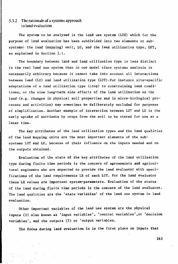
5.3.2 The rationale of a systems approach to land evaluation
The system to be analysed is the land use system (LUS) which for the
purpose of land evaluation has been subdivided into two elements or sub
sys tems: the land (mapping) unit, LU, and the land utilization type, LUT,
as explained in Section 2.1.
The boundary between land and land utilization type is less distinct
in the real land use system than in our model since systems analysis is
necessarily arbitrary because it cannot take into account all interactions
between land (LU) and land utilization type (LUT).For instance site-specific
adaptations of a land utilization type (erop) to constraining land condi
tions, or the slow long-term side effects of the land utilization on the
land (e.g. changes in physical soil properties and in micro-biological pro
cesses and activities) may sometimes be deliberately excluded for purposes
of simplif ication. Another example of interaction between LUT and LU is the
early uptake of nutrients by crops f rom the soil to be stored f or use at a
later time.
The key attributes of the land utilization types and the land qualities
of the land mapping units are the most important elements of the sub
systems LUT and LU, because of their influence on the inputs needed and on
the outputs obtained.
Evaluation of the state of the key attributes of the land utilization
type during finite time periods is the concern of agronomists and agricul
tural engineers who are expected to provide the land evaluator with speci
fications of the land requirements LR of each LUT. For the land evaluator
these LR values are important system-parameters. Evaluation of the status
of the land during finite time periods is the concern of the land evaluator.
The land qualities are the 'state variables' of the land use system in land
evaluation.
Other important variables of the land use system are the physical
inputs (1) also known as 'input variables', 'control variables',or 'decision
variables', and the outputs (Y) or 'output variables.
The focus during land evaluation is in the first place on inputs that
263
control the outputs through manipulation of the land qualities.If in a land
use system the conversion of inputs into outputs does not involve the land
conditions, such inputs will not be subject of simulation hut will be land
utilization determinants underlying the land utilization type definitions
(see Section 2.4). Examples are the foliar application of fertilizers based
on foliar analysis of nutrient deficiencies, and the direct application of
concentrates and minerals to cattle. Of course when such inputs have a
significant modifying effect on the land qualities, such as the contami
nation of soils with heavy metals or phosphates derived from concentrates
and contained in cattle droppings, the inputs responsible for such land
degradation processes will need to be included in the systems nalysis.
The systematic breakdown of the land use system into measurable land
qualities, land requirements, inputs and outputs is the foundation for a
systems approach to land evaluation.
Toebes's definition rightly stresses that to make a systems approach
meaningful specific questions should be asked or a goal should be pur
sued. De Wit and Goudriaan refer to the 'requirements of relevance imposed
on the model' which determine the parts of the real (biologica!) system
that need to be presented in the model.
The questions asked of land evaluation essentially concern the pre
diction of physical inputs (I), outputs (Y), changes in the values of the
land qualities (LQ), and possible other effects if a particular land unit
(LU) were to be combined with a specific land utilization type (LUT): in
other words, the prediction of the performance of LUS.
This requires first of all techniques for measuring the pertinent
factors already mentioned: LQ, LR, I and Y. To be able to do this the
relations that exist between them must be described, particularly the
I/LQ,LQ/Y and I/Y relations. (Relevant techniques that do this will be
discussed in Section 5.4).
The goal pursued by land evaluation is ultimately the optima! utiliza
tion of land. To reach the desired goal of land evaluation,systems analysis
includes the application of optimization techniques in order to find the
'best' LQ, LR, I,Y combination, based on explicit land suitability
264
criteria, as will be explained in Section 5.4.2.
Toebes's definition of a system ends with the mention of other
related systems. This is a very important observation for land evaluation,
because land (mapping) units and land utilization types should not be
analysed out of context. Therefore in Section 3.5 a distinction bas
been made between internal and overall land suitability classification.
Systems analysis in land evaluation as explained so far, can be re
presented diagramatically (see Fig. 5.2).
,------------- -----, 1 L U S : 1 1 r-- -----î- ------, iLU 1 LUT:
controllable 1 [1
1 physical J : 1 physical inTts 1! LQ 6 : LR 6 -outprs Y
t + land matching of land
suitability~suitability criteria criteria with values I, LQ, Y
i land
suitability classification
Fig.5.2: A diagrarrmatia representation of systems analysis in land evaluation.
The stages that a systems approach must adopt for land evaluation
are summarized below:
I. Problem analysis: At the outset the development situation bas
to be assessed and relevant land utilization types must be
identif ied. The most important limiting land qualities are
recognized. Land suitability criteria are formulated. Problem
analysis bas been discussed in Section 2.4. Against the back
ground of this information the activities to be carried out
during the next stage are specified.
265
266
II. Abstraction: The selective process of observing the real systems,
and measuring, classifying and mapping the pertinent information.
Thus we arrive at abstractions or 'models' of the real systems.
the land utilization types (LUT) and the land mapping units (LU).
Land utilization types will often be models of uses that do not
yet exist in the study area; sometimes their description can be
supported by analogy with real systems existing outside the study
area, otherwise such descriptions will be entirely hypothetical,
and must be reported as such. It would be impossible to collect
and describe all information that can be observed and measured
about land and land utilization. Abstraction is necessarily a
very selective process of data collection, limited to describing
the characteristics of land and land utilization that are needed
for the next stage, which is deduction.
III. Deduction: By systematically analysing the data collected we aim
to deduce the effects produced when a specific land utilization
type operates on a specified land (mapping) unit. This deduction
is in two separate steps:
input-output analysis: comparing physical inputs that will ameliorate constraining land conditions, their management and conservation, with the effects or 'outputs' to be expected from such inputs. Each input-output combination is handled as a separate option.
This information is needed for the next step:
land suitability classification: the suitability of a particular land unit for combination with a particular land utilization type is classified.
Land units of comparable suitability are combined in the same land suitability class.
During the land suitability classification the best inputoutput combination for each LU, LUT combination is selected.
This is the combination that places the land unit in the highest
possible suitability class if operated by the land utilization
type in question. Tbus land suitability classification is a
type of optimization process.
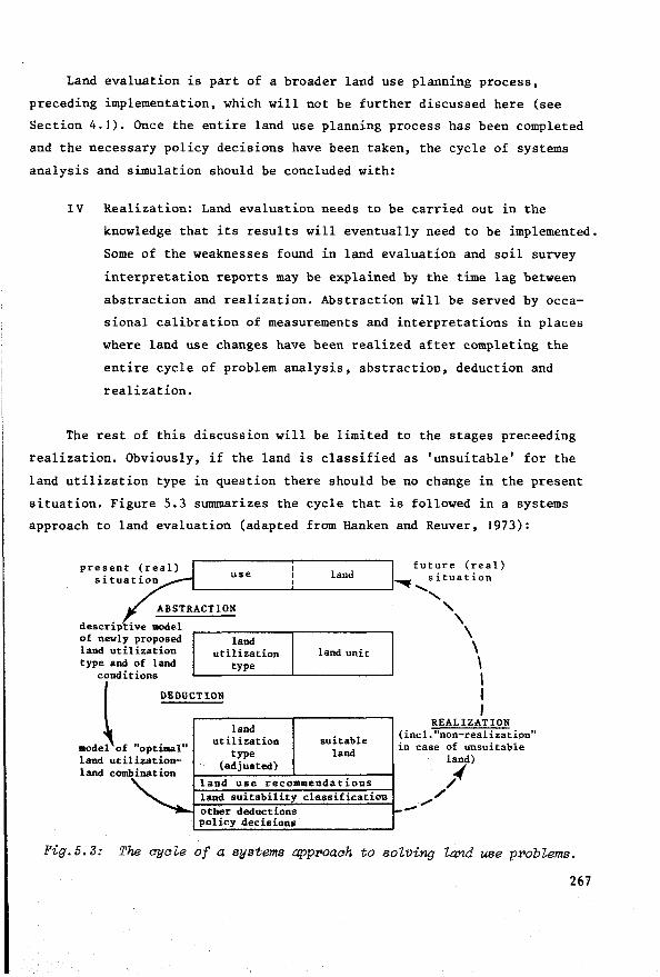
Land evaluation is part of a broader land use planning process,
preceding implementation, which will not be further discussed here (see
Section 4.1). Once the entire land use planning process bas been completed
and the necessary policy decisions have been taken, the cycle of systems
analysis and simulation should be concluded with:
IV Realization: Land evaluation needs to be carried out in the
knowledge that its results will eventually need to be implemented.
Some of the weaknesses found in land evaluation and soil survey
interpretation reports may be explained by the time lag between
abstraction and realization. Abstraction will be served by occa
sional calibration of measurements and interpretations in places
where land use changes have been realized after completing the
entire cycle of problem analysis, abstraction, deduction and
realization.
The rest of this discussion will be limited to the stages preceeding
realization. Obviously, if the land is classified as 'unsuitable' for the
land utilization type in question there should be no change in the present
situation. Figure 5.3 summarizes the cycle that is followed in a systems
approach to land evaluation (adapted from Ranken and Reuver, 1973):
use land
ABSTRACT ION
future (real) situation
.............
' '\ descriptive model \ of newly proposed land land utilization utilization land unit \ type and of land type \
conditions 1
~ DEDUC_T_r_o_N ________ ~-------------. l land REALIZATION
utilization suitable (incl. "non-realization" model of "optimal" type land in case of unsuitable land utilization- (adjusted) land) land cómbination /~
land use recommendations land suitability classification ;I'
other deductions - ""' policy decisions
Fig.5.3: The ayale of a systems appr>oaah to solving land use problems.
267

.., " " ....
Fig.5.4 presents a more detailed view of the systems approach to land
evaluation.
PHYSICAL LAND EVALUATION: A SYSTEMS APPROACH
STAGE I PROBLEM ANALYSIS Socio-economie environment
(real system) Physical environment
(real system)
Preliminary socio-economie analysis 1 Preliminary physical analysis 1 Land conditions, physical aspects
overall
overall 1 1 near-
terms of development relevant 1 ground deeper reference situation soc io-economic 1 off- incl. soil sub-
development 1 time- aspects of 1 surf ace of the incl. present
objectives period land conditionsl ground crops strata
project land use & 1 vegetation trends 1 1
Analvsis of maior and minor determ.inants of land utilization Fundamental regimes/qualities
techno-! produce
socio- energy nutrients mechanica! strength govern-
ocatio11 labour capital manage- ieconomic water air toxicities ment logy 1 ment land biotics foothold episodical hazards
1 iaspects
STAGE II ABSTRACTION observation, measurement, classification, mapping
LAND UTILIZATION TYPE (LUT) LAND (LU)
(model) (model)
multiple/compound/sequential/interacting overall land overal 1 land major landscape elements land utilization types requirements qualities ( interrelated?)
single land utilization types internal land internal land land (mapping) units
scale of labour capital techno- requirements qualities (interrelated?)
in ten- in ten-logy & kind of opera- manage- produce tions sity sity ment
STAGE 111 DEDUCTION based on fundamental processes activities, taking place during ót, prediction of performance of LUS, composed of land utilization type LUTt operating on specificland unit LU, applying_ controllable physical inputs I
STAGE II I INPUT OUTPUT ANALYSIS
STAGE II I 2 SUITABILITY CLASS IF !CAT ION
INPUTS I-
DECISION MAKING
SELECTION OF RELEVANT CRITERIA
L u T
specificlLR LUT with: e land re-' LR
• 1 m qu1re- 1 ments LR!LR
c
L u s relation structure
ecologie.al
management
conservation
improvement
L u
LQe: specific LU : LU with
m1 land LQ 1 qualities
c, lQ : ......
-OUTPUTS Y (EFFECTS)
FOR LAND SUITAB- rMATCHING_oF_CRÏTËRIÄ"""1 ILITY CLASS DIS-1------• I WITH INPUTS, OUTPUTS i--o----------'
TINCTION l_~-~-QO~:::_E~-_J feedback f
PHYSICAL LAND SUITABILITY CLASSlFICATION
LAND USE RECOMMENDATlONS IN PHYSICAL TERMS
Pig.5.4: Physioa'l Zand evaluation: a systems app:roaoh.
268
5.4 Descriptive and prescriptive systems analysis
In Fig. 5.4 the deductive stage III of physical land evaluation
bas been subdivided in two parts:
stage III. I
stage III.2
input-output analysis
suitability classification
This subdivision coincides with the basic distinction in systems theory
between descriptive and prescriptive systems analysis:
Descriptive input-output analysis
Input-output analysis should be carried out not only to support the
land suitability classification hut also to provide the decision-maker
with alternative land use changes.
Stage III. 1 (Fig.5.4) bas been designed to produce exactly that: for
each land use activity likely to deviate from a standard input-output
pattern, a range of alternative inputs is assumed and the corresponding
outputs and effects on the land qualities calculated. In physical land
evaluation this should result in sets of inputs, outputs and land qualities
specified in physical terms: e.g. levels of fertilizers (I) and the
corresponding yields (Y), duration, type of machinery work and the
resulting soil compaction (LQ). The specification of these levels may be
measured on an ordinal scale as indicated in Section 5.1 or on a ratio
scale. This analysis of input-output relations is an example of what
several authors on systems analysis (e.g. Toebes, 1975) have called
'descriptive systems analysis'. This investigates and describes. There
is no question of choice or optimization: each input-output combi-
nation is analysed and.described separately, without being compared with
other input-output combinations. The fact that the range of inputs is
restricted to those relevant for the given land utilization type does
not alter the descriptive nature of this kind of data-analysis.
269
Descriptive input-output analysis can highlight undesirable outputs
or effects on the land qualities resulting from certain inputs, which
may not have been included in the decision-maker's set of criteria, e.g.
the problem of salt accumulating in the drainage water when installing
an irrigation project. (This salt is an output of the land use system,
whereas the irrigation water added to the natural water supply of the
land is a physical input).
NOTE: As mentioned earZier, desariptive systems-analysis is expeated to play a greater role in the future; for exampZe in the use of aomputerized and analogue models to aharaaterize time-variant land qualities and Zand requirements, whiah in turn represent key elements for input-output analysis. This type of desariptive input-output analysis has muah more than saientifia signifiaanae if it is aoupled with presariptive systema analysis based on fundamentally aoaial and eaoncmia ariteria, related to alearly-defined goals of optimal Zand utilization. This aombination of desariptive and preaariptive aystema analysis is the basis of the systema approaah preaented here and also (perhaps less expliaitly) of the land evaluation methodology developed for Brazil (Bennema, Beek and Camargo, 1964) and in the Framework for Land Evaluation (FAO), 1976).
Prescriptive suitability classification
During the deductive stage III.2 (Fig.5.3) the land evaluator's task
is to bring order to the multiple information on input-output relations
corresponding to a particular LUT, LU combination, and also in the some
times great variety of land (mapping) units that have a certain measure
of potential or 'suitability' for a particular land utilization type.
To this end he should declare which input-output combination should be
'preferred' to give the 'best' land use performance. In addition, he should
express preference for the suitability of different land (mapping) units
for combination with the land utilization type in question.
The presuppositions and judgments underlying such a process of ranking
should be acceptable to the user of the information, the decision-maker, or
at least be made clear in the report.
270
Preferably, the land evaluator should not establish his own norms
hut base himself on norms formulated by the decision-makers. A clear
exception is the environmental norms, often overlooked by decision-makers.
The land evaluator bas a major responsibility to help formulate environmen
tal norms by giving the decision-maker the benefit of his familiarity
in foreseeing hazards of resource degradation and in formulating alterna
tive conservation measures.
The type of systems analysis leading to an answer to the questions
'what should the land be used for?' and 'how should it be used?' bas been
called in this report 'prescriptive systems-analysis' (Toebes, 1975).
Prescriptive systems-analysis implies several value judgments. To
this end the land evaluator should base himself on the earlier mentioned
land suitability criteria.
Prescriptive land suitability classification is a process of ranking
land units according to their suitability for combination with a specified
land utilization type into a specific land use system. This ranking
should be carried out against the background of a specif ied Goal or Ob-
j ec tive, which the land use system is supposed to meet or to approximate as
closely as possible. The measure in which this Objective is met determines
the degree or 'class' of suitability of the land unit for the land utili
zation type in question.
The presence of an Objective distinguishes prescriptive land suitabi
lity classification from descriptive input-output analysis.
Objective, land suitability criteria and Criterion Function
The Objective provides the ultimate rationale for placing land
units into land suitability classes. The overall Objective of land
evaluation is similar to that of all other studies of land and land use:
271
to contribute to the optimal use of the land, taking into account the
local socio-economie and physical conditions and constraints. But such
an expression of the Objective is much too abstract to serve specific
purpose land evaluation. Therefore this Objective (Z) should be expressed
in terms of a combination of more specific derived objectives (z) (Hanken
and Reuver, 1973):
Some of the derived objectives controlling the land suitability classi
f ication may at first appear to be conflicting or even irrational: combin
ing the objectives of maximum yield, sustained performance and conservation
of the quality of the physical environment may sound like making omelettes
without wanting to break the eggs. When specifying the derived objectives
these sources of conflict must be confronted.
Duckham and Masefield (1970, p.15) include the following derived
objectives for a food-producing farming system: optimization of inputs,
maximization of erop plant growth, minimization of plant and animal
wastages, realization of an adequate economie return and the assurance
that this return is reliable from year to year and persistent over
decades or even longer.
De Wit (1975, p.159) formulates the broad objectives of agricultural
land use as follows:
should remain suff iciently productive to function as a source of income for farmers and agriculturally based industries, both up-hill towards the farm and down-hill towards the consumer, but also guarantee a reasonable diet for the population in times of international stress. At the same time agriculture should remain a source of employment, contribute its share towards a more efficient energy use, function as a source of land for urban development and semi-natura! conservancies, rehabilitate valuable landscapes and in genera! lessen its effect on the environment.
Each derived objective needs to receive a certain weight or value
which is realistic compared with the values expected to be taken by the
272
other derived objectives. For reasons of simplification the term 'derived
objective' will be further referred to as 'land suitability criterion'
z .. Each land suitability criterion z. can be given a real value v(z.). l l l
Presentation of the objective Z in terms of v(z) is called the Criterion
Function or simply Criterion (C) (Hanken and Reuver, 1973).
To specify the Criterion Function of a land suitability classificátion
the land suitability criteria z 1, z2 , .• zn are related to the values of
corresponding input, land quality and output variables of the land use
system. In principle, C is a selective collection of values of these va
riables. The selected variables are therefore also known as object va
riables or criterion variables. Output variables that are not selected
for the role of criterion variables are also known as indifferent variables.
They exercise no influence on the ultimate result of land evaluation. An
example is the salinity of drainage water evacuated from an irrigation
district, when its level is not a concern for land suitability rating.
When land evaluation is only concerned with the on-site effects of land
use there is a good chance that some output variables will be handled as
indifferent variables, or not considered at all, since they have no effect
on land use performance on the site itself. A distinction could be made
between an internal and an 'overall' Criterion Function to highlight
this problem (see also Section 3.3.). Examples of land suitability
criteria have been given by Beek and Bennema (1972; see Table 5.1).
A great variety of criterion variables concerned with objectives
concerning environmental quality and control have been listed in Vink, Ed.,
(1971) and Dassmann et ai. (1973).
During the prescriptive systems analysis the best input-land quality
output combination is selected, that is the combination for which the
Criterion Function is optima!. This requires firstly a precise definition
of the Criterion Function, which is realized by specifying the values that
each criterion variable should take to correspond with the different land
suitability classes, i.e. the multi-dimensional Criterion Function vector
is subdivided into trajectories corresponding to the different land suitabi
lity classes.
273
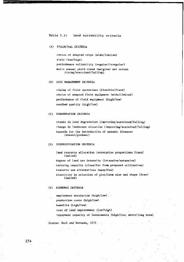
274
Table 5.1: Land suitability criteria
(A) BIOLOGICAL CRITERIA
choice of adapted crops (wide/limited)
yield (low/high)
performance reliability (regular/irregular)
multi annual yield trend (marginal net return rising/sustained/falling)
(B) SOIL MANAGEMENT CRITERIA
timing of field operations (flexible/fixed)
choice of adapted field equipment (wide/limited)
performance of field equipment (high/low)
seedbed quality (high/low)
(C) CONSERVATION CRITERIA
trends in land degradation (improving/sustained/falling)
change in landscape situation (improving/sustained/falling)
hazards f or the introduction of endemie diseases (absent/present)
(D) DIVERSIFICATION CRITERIA
land resource allocation (enterprise proportions f ixed/ limited)
degree of land use intensity (intensive/extensive)
earrying capacity (close/far frO!l! proposed utilization)
resource use alternatives (many/few)
elasticity in selection of plot/farm size and shape (free/ limited)
(E) ECONOMIC CRITERIA
employment absorption (high/low)
production costs (high/low)
benefits (high/low)
cost of land improvement (low/high)
repayment capacity of investments (high/low; short/long term)
Sou:rae: Beek and Bennema, 1972
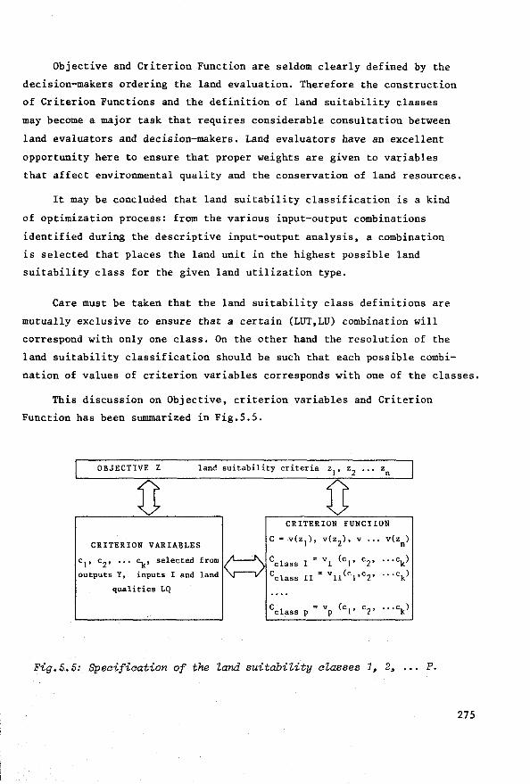
Objective and Criterion Function are seldom clearly defined by the
decision-makers ordering the land evaluation. Therefore the construction
of Criterion Functions and the definition of land suitability classes
may become a major task that requires considerable consultation between
land evaluators and decision-makers. Land evaluators have an excellent
opportunity here to ensure that proper weights are given to variables
that affect environmental quality and the conservation of land resources.
It may be concluded that land suitability classification is a kind
of optimization process: from the various input-output combinations
identified during the descriptive input-output analysis, a combination
is selected that places the land unit in the highest possible land
suitability class for the given land utilization type.
Care must be taken that the land suitability class definitions are
mutually exclusive to ensure that a certain (LUT,LU) combination will
correspond with only one class. On the other hand the resolution of the
land suitability classification should be such that each possible combi
nation of values of criterion variables corresponds with one of the classes.
This discussion on Objective, criterion variables and Criterion
Function has been summarized in Fig.5.5.
OBJECTIVE Z land suitability criteria z1
, z2 z
n
CRITERION FUNCTION
CRITERION VARIABLES C = v(z
1), v(z
2), v ..• v(z
0)
c,, c2, .•. ck, selected from ,;t----1\,. cclass l =VI <c,, Cz· ... ck)
outputs Y, inputs I and land '\r---v1 Cclass II= v11(c 1,c2, .•. ck)
qualities LQ
Fig.5.5: Speaifiaation of the Zand suitability classes 1, 2, •.. P.
275

For example (Table 5.2): the Objective Z, optimal land use, can be
expressed by two derived objectives or land suitability criteria z1= maximum
production and z2= no soil erosion. The criterion variables that make up
the Criterion Function are the output 'variable yield' and the output
variable 'erosion losses'. The Criterion Function C=F(c1,c
2) reads:
maximize c 1 with c2=0, which can be translated into the following speci
fication of land suitability classes 1-IV:
Table 5.2
CLASS
I
II
III
IV
Specification of land suitability classes. An example
cl -yield c2 -erosion losses
kg/ha kg/ha
> 5000 0 -100
4000-5000 100-200 3000-4000 0 -100
3000-4000 100-200
< 3000 > 200
The problem of conunensuration
Difficulties can be expected when the values of different criterion
variables need to be translated into a single commensurate value - the
land suitability class - and when the best set of several alternative
sets of values of criterion variables needs to be selected according to
the Criterion Function.
As already mentioned, criterion variables are a selection of inputs,
land qualities and/or outputs whose values are mostly expressed in physical
terms of different dimensions: inputs expressed in tractor hours per hectare
or amounts of fertilizer per hectare; land qualities expressed in terms
of erosion or flooding ha~ard; outputs expressed in kilograms of harvestable
produce per hectare.
276

The process of translating or converting the values taken by variables
and parameters of different dimensions into a single comm.ensurate value -
the suitability class in our system - is known as commensuration. Comm.en
suration usually results in an expression of value in monetary terms and is
a common practice in economie analysis, which is mostly concerned with
inputs and outputs to which prices can be easily added.
Comm.ensuration becomes much more complex when land qualities are also
included in the set of criterion variables and specif ic (monetary)
weights need to be ascribed to each of them, e.g. to the value of erosion
control, of flood control or of a reduction in the contamination of soil
or drainage water (Locht, 1971; OECD, 1974; Opschoor, 1974; Wendt, Ed.,1976).
Physical land evaluation precedes the stage when prices are added,
and is primarily concerned with criterion variables expressed in physical
terms. Although sometimes commensuration in comm.on physical terms will
be successful, e.g. in grain equivalents or in calories, in most cases
physical land evaluation should be prepared to carry out its analysis
while maintaining the multi-dimensional nature of its Criterion Function
and of the land suitability classes, as bas already been demonstrated in
previous examples.
The number and kind of criterion variables and the interactions
between them determine how complex land suitability classification may be
come. The problems tend to be more pronounced in detailed land evaluations,
when all kinds of specific inputs which have a variable influence on the
outputs and on the land qualities need to be taken into account. For
that reason, as explained in Section 4.2 a parallel land evaluation
procedure is convenient because it relies on commensuration in economie
(monetary) terms being done at the same time as the physical analysis
that defines the values of criterion variables in physical terms.
In semi-detailed and reconnaissance type land evaluations, simpler
and less quantitative methods prevail; therefore the multi-
dimensional status of the Criterion Function in the definitions of the
land suitability classes is maintained (see Table 5.3).
277
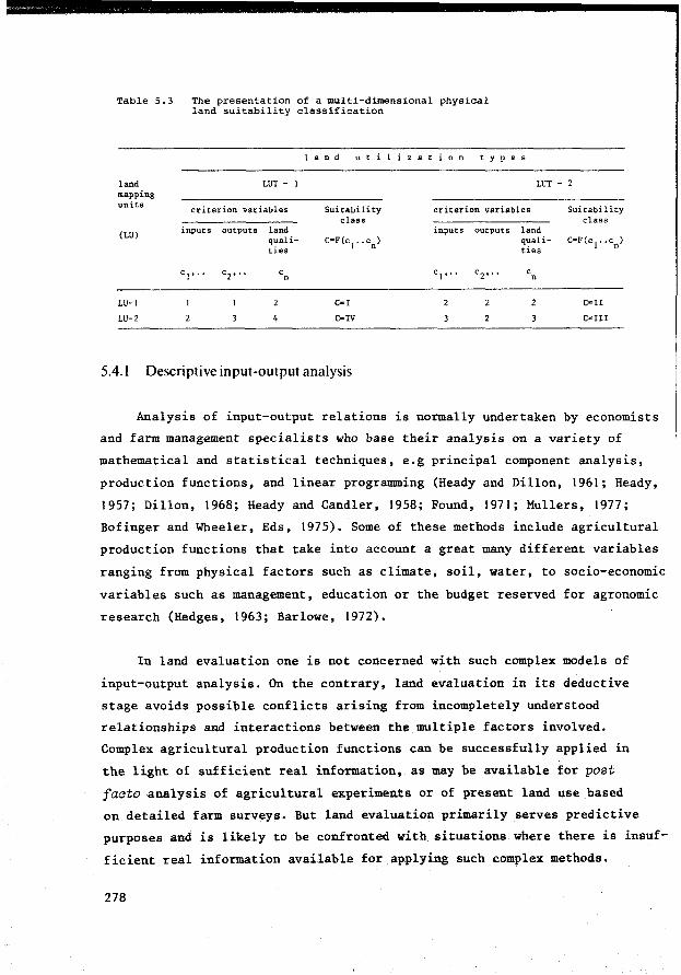
Table 5.3 The presentation of a multi-dimensional physical land suitability classification
land mapping units
(LU)
LU-1
LU-2
LUT - 1
criterion variables
inputs outputs land qualities
4
c n
1 a n d u t i 1 z a t i o n t y p e s
Suitability class
C•I
C•IV
LUT - 2
c.riterion variables Sui tab il i ty class
inputs outputs land
2
quali- C•F(c1 .. en)
ties
c n
C•Il
C•Ill
5.4. l Descriptive input-output analysis
Analysis of input-output relations is normally undertaken by economists
and farm management specialists who base their analysis on a variety of
mathematical and statistical techniques, e.g principal component analysis,
production functions, and linear programming (Ready and Dillon, 1961; Ready,
1957; Dillon, 1968; Ready and Candler, 1958; Found, 1971; Mullers, 1977;
Bofinger and Wheeler, Eds, 1975). Some of these methods include agricultural
production functions that take into account a great many different variables
ranging from physical factors such as climate, soil, water, to socio-economie
variables such as management, education or the budget reserved for agronomie
research (Hedges, 1963; Barlowe, 1972).
In land evaluation one is not concerned with such complex models of
input-output analysis. On the contrary, land evaluation in its deductive
stage avoids possible conflicts arising from incompletely understood
relationships and interactions between the multiple factors involved.
Complex agricultural production functions can be successfully applied in
the light of sufficient real information, as may be available for post
facto analysis of agricultural experiments or of present land use based
on detailed farm surveys. But land evaluation primarily serves predictive
purposes and is likely to be confronted with situations where there is insuf
f icient real information available for applying such complex methods.
278

To avoid confusion with the economie type of input-output analysis
it is perhaps better to speak of 'intermediate' input-output analysis.
Within the range of input possibilities of the land utilization type in
question (or of the land improvement project when major improvements are
included, beyond the possibilities of individual utilization types) we
select a number of relevant physical input levels and for each of them
the effect on the outputs and on the land qualities is described.
The soil series described in the USA using the Soil Taxonomy (USDA,
1976) are expected to be sufficiently homogeneous to permit transfer of
experimental results from so-called 'Benchmark' (representative) sites to
ether sites with soils .of the same series which have not been studied direc
t ly. Such Benchmark soils are analogue models serving the purpose of extra
polation of experimental results (Dijkerman, 1974).
The use of systems analysis and simulation models may modify the data
collecting stage in land evaluation, the methods and density of sampling
(Bouma, 1977), the techniques of making land resources maps and the classifi
cation of land attributes, e.g. the application of a numerical soil classi
fication (De Gruyter, 1977).
An important advantage of using mathematical simulation models, when
comparing them with the real systems, is that they can be operated in two
directions: the role of the dependent variables (the outputs and the land
qualities that need to be improved with inputs) and the independent variables
(the inputs) can be interchanged. When the output is known first, the
questions posed to land evaluation will refer to matters such as where,when
and how to produce: which type of land to choose; cropping calendar; kind
and amounts of inputs to be applied, input application method.
The possibility of interchanging variables in mathematical systems
is also important when the values of certain land qualities have been fixed
beforehand: the cons~rvation of a particular rare plant or animal species at
a specified density, the preservation of a particular quality of the land
scape such as concealing ugly buildings by maintaining a cordon of trees
around building sites. In this case the land qualities are to be handled as
independent constraints within a def ined range, while both outputs and in-
279
puts become dependent variables. when analysing the input-land quality re
lations and the land quality-output relations.
Land qualities can be output variables when specific questions are
asked about their status; e.g. the workability of the soil that results
from different soil loosening processes in an evaluation of different soil
tillage methods (Koolen, 1977). Yield may be considered both an output va
riable and a 'super' land quality (see Section 3.1.1). In the latter case
yield becomes a state variable, e.g.the yield of grass in a grazing system.
Descriptive input-output analysis is not concerned with optimizing in
put-output relations. It consists of a number of simulations of the real land
use processes for different kinds of input and different input levels to de
termine the corresponding outputs (or vice versa) and the status of the land
qualities, that are responsible for the continuity of the land use process.
Strictly speaking the inputs added to the land use system in each
simulation influence the system in a manner comparable to that of the
uncontrollable land qualities, such as radiation and temperature. During
the separate input-output simulations it does not become apparent that the
input levels have been rationally chosen in view of subsequent prescriptive
input-output analysis. Only when the results of two or more simulations
are compared against the background of specific land suitability criteria,
will the inputs represent decision variables in the true sense: prescriptive
systems analysis.
The role of land qualities and land requirements
Descriptive analysis of input-output relations emphasizes the role
of land qualities. The reasons are:
280
Outputs may differ on different land units when no inputs are applied for land improvement, because of differences in the unimproved status of the land qualities (LQ ).
u The status that the land conditions are expected to assume at different input levels and described in terms of land qualities after improvement (LQ.) represent important information for land suitability clasàif ication and land use planning.

The response to inputs (erop response) on different land units when applying the same type and amount of input with the same method may differ because of dif f erences between these land units in land properties and qualities influencing this responsiveness to inputs.
Input-output analysis should include in the first place the study
of the relation between land qualities and the outputs, and the relatiort
between inputs and outputs. These two relations and the input-land
quality relations together represent the relation structure of the land
use system:
land quality-output relations (1)
input-output relations (2)
input-land quality relations (3)
The land qualities seem to have several roles during the input
output analysis: they act as independent variables in the analysis of
land quality-output relations and as dependent variables in the analysis
of input-land quality-relations. In the analysis of input-output relations
they are like intermediate variables, serving the purpose of grouping
the multitude of different land (mapping) units into populations or
'classes' with similar levels of land qualities and properties as far as
input-output relations are concerned (Beek, 1977).
In a problem-oriented land evaluation the input-output analysis
should be based on knowledge of the land qualities that are limiting,
i.e. that require inputs for their improvement. Techniques for identifying
limiting land qualities and for quantifying their influence on the
input-output relations vary from direct observation of natural phenomena
such as the interpretation of mineral deficiencies and toxicities from
plant features, to analyses of the results of controlled experiments. Com
parison of different values of a land quality (of which the limiting effect
is assessed) with corresponding output values should permit expression of
the LQ-Y relation for that particular land quality, which will depend on
the requirements LR of the land utilization type for the land quality in
question (see also Section 3.2).
281

Productivity ratings can provide a useful check on the weights attribu
ted to the land qualities that condition productivity. Physical land eva
luation should pay great attention to the estimation of productivity levels,
which according to Beek and Bennema (1972) may follow five different
procedures:
direct measurement of site-specific yields
analysis of site-specific statistical data on productivity
site-specific empiricism, by establishing correlations between measured yields and the relevant land qualities or between measured yield and the land (mapping) unit as a whole (e.g. Van Goor, 1965/66)
site-specific empiricism, by establishing correlations between measured yields and single characteristics of the land, such as soil depth and soil texture (e.g. Riquier, Bramao and Cornet, 1970; Sys, FAO 1975; see also Section 3.1.2)
land use simulation models, based on fundamental plant growth and production processes, which may include land qualities and/or properties in their equations for calculating theoretical yields (e.g. De Wit et al. 1971, 1978).
Study of the land requitements of specific land utilization types
in view of the types of crops grown, the type of equipment used and of
other attributes and management techniques, is more· a concern for agronomie
research than for land evaluation as such. But land evaluation can
formulate some key questions to be answered by agronomie research on the
values of LR. The functional explanations that can relate the values of LR
to measurable characteristics of the crop/equipment/utilization type that
determine these requirements are very interesting. Examples of these
functional characteristics are: the leaf area index (LAI) and the stomatal
characteristics that control the potential evapotranspiration; rooting
system characteristics that control the uptake of water and nutrients
(see Section 3.2 for more reference to the study of LR); the specifications
282
of power, bearing pressure and operational depth of farm equipment that
control the requirements for workable land conditions.
For land utilization types that depend entirely on the natural status
of the land, a land suitability classification could be based exclusively
on information about the land requirements (LR) and on land quality-output
relations. Examples are the land suitability classifications applied in
forestry (van Goor, 1965/1966) and the land suitability classification for
'traditional' agriculture in Brazil (Section 5.3.4). In the latter system
the relationship between the land quality, 'natural fertility' and output
has been expressed in terms of yield, expected period that these yields can
be maintained and subsequent trends in yield decline.
But in most cases land evaluation includes the consideration of
land use systems that can make use of physical inputs to reduce the
problems caused by limiting land qualities. The (LQ,Y) combinations
identified during land quality-output analysis can indicate the probability
of response to specific physical inputs. The response probability depends
on whether the value found for the land quality of a land unit is situated
below or above the value at which no further increase in yield of a speci
f ic erop is to be expected from higher values of LQ: the critical value or
'critical level', and on the difference between the critical value and
the present value of the land quality in question.
An interesting contribution to the discussion on interacting vePsus
most limiting factors in biological production processes is the 'linear
response and plateau model' of Waugh et al. (1973, 1975). In soil fertility
evaluation it has been observed that in most cases fertilizer response
curves consist of two trajects: a sharp linear increase followed by a
flat horizontal line (Bartholomew, 1972; Boyd, 1970, 1974; cited in
Sanchez, 1976). On the strength of this observation and on the many expe
riments with fertilizers and soil fertility tests of the North Carolina
Soil Testing Program, and by FAO, Waugh et al. developed a discontinuous
input-output function (see Fig. 5.6.) that consists of two lines:
the first line represents the relatively steep response of an added
nutrient until it ceases to be a limiting factor. The second line is a
horizontal 'plateau', when further additions of the nutrient in question
no longer increase yield. The fertilizer rate needed to reach the 'plateau'
yield should be the recommended rate for the nutrient. This plateau yield
is not necessarily the maximum yield because other nutrients may still be
limiting the yield at the site of the fertilizer experiment.
Land qualities other than soil fertility have not been considered, but
they could become the most limiting factors when the soil fertility problem
can be solved. The final plateau yield is determined by genetic characte
ristics of the erop (variety) and the uncontrollable variables of the land
unit e.g. the land reclamation level (the boundary between controllable and
uncontrollable should greatly depend on the abilities of the land utiliza
tion type to manage, improve and conserve the land conditions).
The promising results in soil fertility research, are encouraging for
the use of conversion tables in land evaluation in relating outputs or land
suitability classes to defined levels of land qualities.
The simplified diagram presented in Fig. 5.6 summarizes the result
of statistica! studies of input-output relations when selected plant
nutrients limit erop production. This method of Waugh et al. is supported
by the simple technique used by Cate and Nelson (1965, 1971) to identify
the critical level of soil test values to separate soils with a low
probability of response to fertilizers from soils with a high probability
of response (Fig.5.7). This critica! level is identified by taking
a transparant overlay sheet divided into quadrants by vertical and
horizontal lines, and superimposing it on the scattered data points
expressing the (LQ, Y) relation between the element in question and
relative yield (%of maximum attainable at the site). The overlay is mani
pulated until the fewest points are left in the upper left and lower
right quadrants. The critica! soil test level is the point at which the
vertical line intersects with the x-axis, dividing the data points with
a larger yield response probability from those with a low response proba
bility. Other studies by the same authors include proposals for statistical
methods to partition soil test erop response probability in more than two
classes (Cate and Nelson, 1971; Nelson and Anderson, 1977),
284
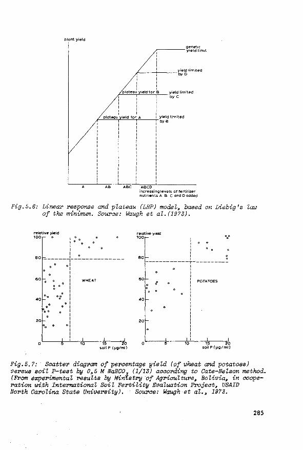
plant yield
A
1 1 1 1 1 1
r----+----yield limited 1 by D 1 1 1
1 1 plateau yield tor B yield lîmited
by c
plateau yield limited i-~--.-'~---t---~byB
AB ABC ABCD increosing levels of fertilizer nutrîents A B C and D odded
Fig.5.6: Linea:r> response and plateau (LRP) modEZ, based on Liebig's ZC1J.JJ of the minimum. Sourae: Waugh et aZ. (1973).
relative yield 100 0
1 00 0
: 0
1 1
80 -------:--------------
60
0 ol 1 1 1 1
0 1 : 0 1
00 0 o0
:
40 ° 1
20
0
0 0
0 0
00
0 1 0 1
5
1 1 1 1
0 1 ! 1 1 1
WHEAT
10 15 20 soil P < µgtml)
relative y1eld 100
80
1 1 1 1 1 1
0 0
00 0
1 0 1 0 ------------T----------
60
40
20
0
0 0
0
5 10
1 1 1 1
: POTATOES 1 1 1 1 1 1 1 1 1 1 1 1 1 1 1 1 1
15 20 soil P (fJglmll
Fig.5.7: Scatter diagram of percentage yield (of wheat and potatoes) versus soil P-test by 0,5 M NaHC0
3 (1/13) according to Cate-Nelson method.
(From e:x:perimentaZ resuZts by Min'f..stry of AgricuZture, Bolivia, in aooperation with IntePY1ationaZ SoiZ FertiZity Evaluation Project, USAID North Carolina State University). Source: WtrUgh et al., 1973.
285

The interpretation of fertilizer response curves as two straight
lines is to simplify soil test and fertilizer experiment interpretations.
The authors of the method do not dispute that the actual input-output
function is continuous and curvilinear, but want to keep the data analysis
as simple as possible. The question arises how far simplification may
go. Can certain phenomena of interaction and cumulative effects between
plant growth factors be ignored for the sake of simplification? The
linear response and plateau model encourages, at least in soil fertility
evaluation, the construction of conversion tables that emphasize the
importance of the most limiting factor while paying less attention to
the interactions between the limiting factors and their cumulative
effects. Comparative regression studies have indicated that the linear
response and plateau model provides as good results as the more conventional
continuous curvilinear functions. But when attempting to apply the
genera! principles of their observations (which are stated to be in line
with Liebig's law of the minimum) 1 to land evaluation in general we are
confronted with several questions:
In the first place the slope of the function of Fig. 5.6 is
not necessarily the same for each limiting nutrient. But that could
probably be remedied by mathematica! manipulation of the scale of the x
axis. A more serious problem concerns the interaction between nutrients
at higher levels of productivity. Nitrogen is likely to be needed in
higher amounts at higher levels of productivity and the same is probably
true for potassium. Nitrogen and potassium are removed in relatively
high quantities from the soil compared with phosphorus, which also has a
greater residual effect than the other nutrients. The existence of a
critical soil phosphorus level seems therefore to have more prospects
for practical land evaluation than that of a potassium or nitrogen
level, the supply of which should be correlated in the first place with
the requirements of the erop in question.
Generally speaking the statistical correlations found between
inputs and outputs should be complemented by functional explanations
286
Liebig's la:uJ of the minimum establishes that the pl'Oduativity ievei is detel'mined by the most limiting factor.
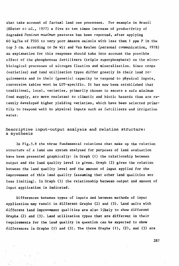
that take account of factual land use processes. For example in Brazil
(KÖster et al., 1977) a five to ten times increase of productivity of
degraded Paniawn ma:x:irrrwn pastures has been reported, after applying
60 kg/ha of P205 to very poor Amazon oxisols with less than 1 ppm P in the
top 5 cm. According to De Wit and Van Keulen (personal communication, 1978)
an explanation for this response should take into account the possible
effect of the phosphorous fertilizers (triple superphosphate) on the micro
biological processes of nitrogen fixation and mineralization. Since crops
(varieties) and land utilization types differ greatly in their land re
quirements and in their (genetic) capacity to respond to physical inputs,
conversion tables must be LUT-specific. It bas now been established that
traditional, local, varieties, primarily chosen to secure a safe minimum
food supply, are more resistant to climatic and biotic hazards than are re
cently developed higher yielding varieties, which have been selected prima
rily to respond well to physical inputs such as fertilizers and irrigation
water.
Descriptive input-output analysis and relation structure: a synthesis
In Fig.5.8 the three fundamental relations that make up the relation
structure of a land use system analysed for purposes of land evaluation
have been presented graphically: in Graph (1) the relationship between
output and the land quality level is given. Graph (2) gives the relation
between the land quality level and the amount of input applied for the
improvement of this land quality (assuming that other land qualities are
less limiting). In Graph (3) the relationship between output and amount of
input application is indicated.
Diff erences between types of inputs and between methods of input
application may result in different Graphs (2) and (3). Land units with
different land improvement qualities are also likely to show different
Graphs (2) and (3). Land utilization types that are different in their
requirements for the land quality in question can be expected to show
differences in Graphs (1) and (3). The three Graphs (1), (2), and (3) are
287
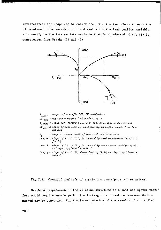
interrelated: one Graph can be constructed from the two others through the
elimination of one variable. In land evaluation the land quality variable
will mostly be the intermediate variable that is eliminated: Graph (3) is
constructed from Graphs (1) and (2).
~~::::tCl==-(1 )
l(LUS)
l(LUS)
Y(LVSJ =output of specific LVT, LV combination
LQ(LU) =most constr>ainiYllJ land quality of LV
lQ(lU)
(2)
I(LUS) =input for improviYllJ LQ, urith specified appZication method
LQu(LU)= leve~ of constr>aining land quality LQ before inputs have been apphed
Y0
=output at zero level of input (threshold output)
tanga= slope of Y = F (LQ), detePmined by land requirement LR of LUT for LQ
tang $ = slope of LQ = F (IJ, detePmined by improvement quality IQ of LU and input application method
tQYllJ y = slope of Y = F (IJ, determined by LR,IQ and input application method
Fig.5.8: Co-aziai ana.iysis of input-iand quaiity-output reiations.
Graphical expression of the relation structure of a land use system ther"
fore would require knowledge for the fitting of at least two curves. Such a
method may be convenient for the interpretation of the results of controlled
288
experiments 1, but in land evaluation it will often be difficult to make
use of precisely measurable uptake values.
Measuring land properties and qualities for several reasons (e.g.
variance of values of variables within land mapping units; tempora!
variance; limits posed to measurement techniques and to data interpretation)
has often been in terms of ranges of values, expressed either on an
ordinal or a ratio scale: soil salinity classes, drainage classes,
workability classes, erosion hazard classes etc., rather than in absolute,
fixed values.
The selection of input values for the field experimentation under
lying input-output analysis also uses ranges, for convenience' sake,
subdividing the continuum of input levels into a few levels, e.g.: 0-30-
60 kg fertilizers (pure nutrients) per hectare; 0-10-20-30-40 metres
subsurface drain spacings.
As a consequence, the relations between inputs and land qualities,
between inputs and outputs or between land qualities and outputs are
also necessarily based on these selected ranges and levels.
The users of such analyses will usually accept these simplifications,
which may result in output also being expressed in ranges of values,
rather than in absolute values. The user thus accepts the limitations
imposed on a more precise, but not necessarily more accurate, result of
land evaluation. Against this background a tabular presentation of the r2-
lation structure of land use systems provides a convenient and simple al
ternative for the use of continuous functions and co-axial analysis: in
Table 5.4 a combination of two conversion tables is shown in which the most
constraining land quality LQ plays the role of intermediate variable in p
input-output analysis. Interactions between different constraining land
qualities can also be taken into account as will be shown later (LQ p
e.g. De Wit (1953) and Van Keulen (1977) ha:ve applied ao-azial analysis successfully for the interpretation of fertilizer e:r:pe:riments, using nutrient uptake as an intermediate variable betLJeen input and output. The uptake rate can be measured and e:r:pressed on a continuous ratio scale.
289
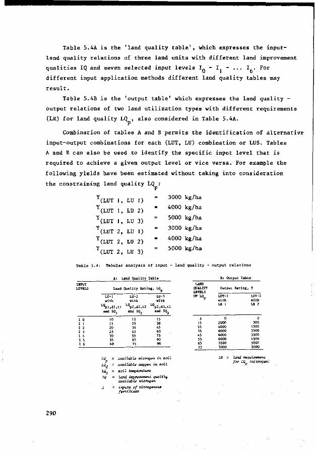
Table 5.4A is the 'land quality table', which expresses the input
land quality relations of three land units with different land improvement
qualities IQ and seven selected input levels I0 - I 1 - ••• I 6 • For
different input application methods different land quality tables may
result.
Table 5.4B is the 'output table' which expresses the land quality -
output relations of two land utilization types with different requirements
(LR) for land quality LQ , also considered in Table 5.4A. p
Combination of tables A and B permits the identification of alternative
input-output combinations for each (LUT, LU) combination or LUS. Tables
A and B can also be used to identify the specif ic input level that is
required to achieve a given output level or vice versa. For example the
following yields have been estimated without taking into consideration
the
290
constraining land quality LQ : p
y(LUT 1 , LU 1) 3000 kg/ha
y(LUT l ' LU 2) 4000 kg/ha
y(LUT 1 , LU 3) 5000 kg/ha
y(LUT 2, LU 1) 3000 kg/ha
y(LUT 2, LU 2) 4000 kg/ha
y(LUT 2, LU 3) 5000 kg/ha
Table 5.4: Tabular analysis of input - land quality - output relations
A: Land Quality Table
IllPUT LEVELS Land Quality Rating, ~
I 0 I 1 I 2 l 3 l 4 I 5 I 6
LU-1 LU-2 LU-3 vith with witb
~1,dl,tl L~2,d2,t2 LQp2,d3,t2 and IQ I and IQ2 and IQ3
10 15 20 25 30 35 40
15 25 35 45 55 65 75
15 30 45 60 1S 90 90
LQP availab"'Le nitrogen in soit
L/id availabl8 o:r:ygen in soii
Lilt ooi i temperat"""
IQ !.and iiltp1'''""11ent quaiit~ availabl8 nit"'llsn
I inputs of nit:rogenous fertil.iur
LAllD QUALITY LEVELS OF LQP
5 15 25 35 45 55 65 75
B: Output table
Output Rating, Y
LUT-1 LUT-2 vith with LR 1 LR 2
0 0 2000 500 4000 1500 6000 2500 6000 3500 6000 4500 5500 5000 5000 5000
LR = land Nqui:rement fo~ LQP (nitrogen)

Based on Tables 5.4A and 5.4B the following input levels I (with spe
cified application method) can be calculated:
Table 5.5: Calculation of input levels I
LU 1
LU 2
LU 3
30 000
4 000
5 000
L U T 1
(Table B)
20
25
30
(Table A)
L U T 2
(Table B)
3 000 40
4 000
5 000
50
60
(Table A)
6
4
Interacting land qualities: Suppose that LQ represents the land quality p
'available nitrogen' (the nitrogen sub-system) and LQd represents the land
quality 'available oxygen', strongly influenced by the drainage conditions.
If land unit LU 1, which is characterized by poor drainage conditions
and therefore by a poor response to nitrogen fertilizers (low IQ), can be
improved by major drainage works, the land quality LQd may be raised from
LQdl to LQdJ' thus becoming similar to land unit LU 3, also in its response
to fertilizer. Consequently input levels for improving LQ of LU 1 now p
correspond with the input levels given for LU 3 in land quality Table 5.4A.
Constraints on the inputs, outputs and land qualities
The consideration of constraints is a first step towards prescriptive
systems analysis, but in addition, during the descriptive input-output
analysis the input/land quality/output combinations that are presented must
take into account the existing constraints. Therefore sets of (I, LQ, Y)
values should be presented that exclude values within the forbidden tra-
j ects of the I, LQ and Y axes. Examples are Fig.5.9 and Table 5.6 which
have been based on Fig.5.8 and Table 5.4.
In any case, descriptive and prescriptive analysis are closely related.
291

Ymif,k ~ ~"·7T/77/77mmm ,/
LO(LU)
l(LUS)
Fig.5.9: Co-a.xial input-output a:nalysis with limited solution space due to constraints on inputs (I ) and outputs (Y . ). ma:c mi.n
The role of constraints on inputs, outputs and land qualities can
conveniently be discussed against the background of Fig.5.10.
The analysis of input-output relations should take into account
which input levels of a certain type and application method are pertinent
for the land utilization type in question and for the development situation
in general. This means that on the I-axis of a graph expressing input-output
relations only the traject of the pertinent input application rates should
be taken into account. Suppose that the input-output analysis in Fig.5.10
is concerned with two types of land utilization for growing cotton: one
type that is not constrained in the level of phosphatic fertilizers (type I);
and another, type II, that is constrained by an upper limit of I units, an x
amount that depends on the market price of fertilizer and the farmer's
access to credit.
292

Fig.5.10:
erop response kg/ho 300
250
200
150
100
o~~~-:-~~--'-~~~~~~~ P, p2 f3 P,i
- Ix fertllizer forbidden applicotion
input levels rate tor LUT II
Input-output anaLysis with a constrained input level (I ). Source: Adapted from Hauser, 1973. x
According to the slope of the costline1 points 1 and 2 on the regression
lines indicate the op.timal (I, Y) combinations for land units with low and
medium P soil test values respectively. Often a range of (I,Y) values is
preferred above a fixed value, because of the expected variance in response
to inputs. The optimum ranges have been indicated by A for the low P soil
test regression line and C for the medium P soil test regression line.
Taking into account the constraint on inputs for land utilization
type II, as indicated by Ix, the land mapping units with medium P-test
could still receive the optimal fertilizer rate, while the low P-test
land units should receive amounts well below the optimum. But as Hauser
explains (1973) lower than optimal doses of fertilizer are sometimes
convenient when benefit/cost ratios are more important than benefits· per
hectare. For the ranges B and D with steeper slopes than the ranges A
and C the benefit/cost ratio is higher, while the benefit per hectare is
lower because of a lower productivity.
The line tha.t connects points (I, Y) for üJhich t1ze marginaL cost equaLs marginal benefit, or some other oost benefit criterion, e.g. marginal oost equals half the margina.l benefit.
293

Table 5.6: Descriptive input-output table
(based on Table 5.4) with
constraints Imax LUT-1 = l;
I
LUT-1 0
LUT-2 0
2
3
lmax LUT-2 = 3; Ymin LUT-1 = 2000;
Ymin LUT-2 = 1000.
(Irrelevant I-Y combinations
have been excluded)
y
LU-1 LU-2 LU-3
2000 2000
2000 4000 ± 5000
1500 ± 2000
± 1000 2500 3500
1500 3500 ± 4750
Low income farmers in developing countries, where the cost of
fertilizers may represent a high percentage of the total capital input,
are of ten more interested in high monetary returns to be able to repay
their loans (I,Y combinations corresponding with ranges Band D) than in
highest profits (ranges A and C). Therefore input-output analysis should
envisage the description of input-output relations at various input and out
put levels and not aim exclusively at identifying the highest profit combi
nation. 'Constraints' on the inputs (input restrictions) may stem from diffe
rent causes, as reflected by the attributes and abilities of the land utili
zation types in question. Well known are available capital and credit, risk
taking capacity and available labeur. The kind of equipment and the
local availability of physical inputs (e.g. fertilizers, irrigation water)
should also be taken into account.
Constraints sometimes also affect the land qualities and the outputs.
Constraints on land qualities often originate from environmental criteria,
e.g. that the groundwater should remain at a certain level to preserve valu
able drought-susceptible plant species. Another example is the need to control
the calcium level of the soil to avoid the spread of soil-borne pests
and diseases.
Outputs are sometimes constrained in the sense that tbeir values, e.g.
294

yield, have been calculated beforehand, in which case it will be the task
of land evaluation to find the corresponding inputs. Fig.5.10 and Table 5.6
are examples of a constraint on the output (Y . ) determined by the minimum min food requirements of a (subsistence) farm family.
Surnmarizing:
Descriptive input-output analysis in specific purpose land evaluation
should be based on three relations of a specific land use system (specific
LU, LUT combination) which together make up its relation structure.
These relations are:
the land quality-output relations
the input-output relations
the input-land quality relations
For this purpose the land (mapping) units need to be grouped in
such a way, that the response to inputs, as conditioned by the unimproved
levels of constraining land qualities (LQ ),the levels of other influential p
land qualities (LQ) and the values expressing the land improvement
qualities (IQ) of these land mapping units, as measured during specified
time period öt, are similar for each group. The input-output relations
also depend on the parametric values expressing the land requirements (LR)
of each land utilization type during öt. Possible constraints on the levels
of inputs, land qualities and out.puts should also be taken into account:
y(LUS) = F (LQP unimproved (LU)' 1 (LUS)' IQ(LU)' LQd,t(LU)' LR(LUT)) (I)
since 1~ improved (LU) = F (L~ unimproved, 1 (LUS)' IQ(LU) (2)
y(LUS) = F (LQP improved (LU)' LQd,t (LU)' LR(LUT) (J)
I ma;e = a (aonstraint on inputs)
I min = b (aonstraint on outputs)
LQt min = a (aonstraint on land quality)
295
(For explanation of symbols see te:r:t and Figs.5.8 and 5.10. where equations (1), (2) and (3) have been presented graphiaally a:nd Table 5.4 where equations (2) and (3) have been presented in tabular farm.)
Input-output relations are use-specific and environment-specif ic,
because of the many site characteristics involved. Of ten they are also
time-specific due to the dynamic character of the land use system. Therefore
input-output analysis must be based on real information observed and
measured directly at defined time periods in the field or from samples
taken to the laboratory. Since such measurements are by definition, limited,
maximum use should be made of the information provided by land resources
inventories in the selection of representative observation sites for
extrapolation of the conclusions. Indeed, this is already being done in
water management, soil conservation and agricultural engineering, albeit
not always with the desired results, considering the abundance of irrigation
projects with severe soil salinization problems. But in the analysis of
soil fertility problems, at least in the Americas, soil survey and soil
fertility research, according to Buol et aZ.,(1975, pp.126-141 in
E. Bornemisza and A. Alvarado, Eds.), have played rather separate and
sometimes even 'competitive' roles in the evaluation of the agricultural
potential. Sanchez (1976 p. 355) concludes that
efforts must be increased to bring soil survey data into soil fertility evaluation projects ••• The development of technica! classification systems grouping soils with similar fertility limitations is likely to improve the effectiveness of soil fertility evaluation programmes and to bridge the present gap between the two disciplines.
5.4.2 Prescriptive land suitability classification
At the beginning of Section 5.4 bas been described how the definitions
of land suitability classes are specified against the background of explicit
296
land use objectives and translated into land suitability criteria. Once
these classes are described it should become possible to determine the land
suitability class for each (LUT,LU) combination by critically comparing
these class definitions with the values taken by the criterion variables.
But a land suitability classification process in specific purpo~e
land evaluation is likely to comprise more than just the specification
of suitability class definitions and the determination of suitability
classes for different (LUT,LU) combinations. The reason is that its aim
is not limited to classifying the suitability of the land for specified
purposes but also to ensure that these purposes are the most relevant
development alternatives for the area in question, given the prevailing
physical land constraints. Only during the prescriptive land suitability
classification will it be possible to appreciate fully how serious these
constraints are for the land utilization types selected at the beginning
of land evaluation. As a consequence it may happen that these definitions,
synthesized at an earlier stage, are no longer satisfactory, if the
discrepancies observed between their land requirements (LR) and the
qualities of the land (even after improvements with all kinds of inputs),
remain too great, resulting in too low land suitability classes. It may
also happen that all land units are classified as equally suitable or
that no land unit can be found that meets the land suitability criteria
for the use in question, making an unsatisfactory base for land use
planning decisions.
To solve this problem it may be necessary to adapt the (LUT,LU)
combination, not by adapting the LU with variable inputs to the requirements
of the LUT, but by adjusting the LUT and its requirements for land in
the light of the accumulated knowledge about the constraining influence
of the land units on the performance of the land use system. The changes
made during this adjustment, e.g. the selection of another type of
equipment or management technique or of a different erop variety with
land requirements better adapted to the limiting land qualities, also
make it necessary to revise the descriptive input-output analysis. After
this, the land suitability classification can be repeated to ascertain
297

if a more satisfactory grouping of land units bas been achieved.
In physical land evaluation the 'adjustment' of land utilization
types will mostly be qualitative, depending on the scale, the kind and
number of land suitability criteria, the availability of data and the
participation of specialists of the agronomie and socio-economie discipline.
lts results are processed as a corrective feedback to revise the earlier
defined land utilization types. Modifications will refer principally to
physical aspects: the type of crops and varieties, the type of implements,
the rotation scheme. Such refined definitions represent only an intermediate
or 'sub-optimal' result in the process of selecting optima! land use systems.
The latter requires quantitative methods of economie analysis such as
linear and dynamic progra1I1111ing as explained during the discussion on
integral land evaluation (Section 4.2.2).
If the land suitability classif ication and the adjustment of the
land utilization type definitions still do not produce satisfactory
results, there is another possibility for reconciling (LUT,LU) systems
and land suitability criteria: by adjusting the land suitability criteria
themselves, e.g. a check of the possibility of accepting a lower yield
or a higher erosion loss from a particular land suitability class.Adjustment
of land suitability criteria can have far-reaching consequences and there
fore requires considerable consultation with the decision-makers.
It may be concluded that prescriptive land suitability classif ication
in specific purpose land evaluation offers considerable flexibility to
the land evaluating team for reconciling (LUT,LU) system variables and
land suitability criteria.
Matching
lt is proposed to adopt the term 'matching' to describe a comprehensive
process of land suitability classification as referred to above, which
not only specifies land suitability class definitions and determines land
suitability classes for different (LUT,LU) combinations, but also offers
the possibility of adjusting the definitions of land utilization types
298
and of the Criterion Function (see Fig.5.4). A land classification system
that includes matching therefore has a much wider scope than one that is
solely interested in determining land suitability classes for pre-established
land utilization types, against the background of fixed land suitability
criteria (which in the past have seldom been clearly defined anyway). The
term 'matching' was introduced originally (Beek, in FAO, 197Sa) solely to
describe the process of adjusting the definitions of land utilization types
during prescriptive land suitability classification. It has been adopted
with the same meaning in the FrameworK foi' Land Evaluation (FAO, 1976).
However it seems justified to expand its meaning to embrace all the activities
taking place during the prescriptive land suitability classification process
because of the many linkages between them:
the specification of definitions of land suitability classes
the determination of land suitability classes for different (LUT,LU) combinations
the adjustment of land utilization type definitions
the adjustment of the Criterion Function and consequently of the definitions of the land suitability classes
Of course it will not always be necessary to carry out all the activi
ties listed above. The definitions of land suitability classes in particu
lar will often be standardized.
Matching represents the essence of a multi-disciplinary approach to
specific purpose land evaluation, which aims simultaneously at the
classification of land suitability and the selection of the most relevant
land utilization types (see Fig.5.11).
299
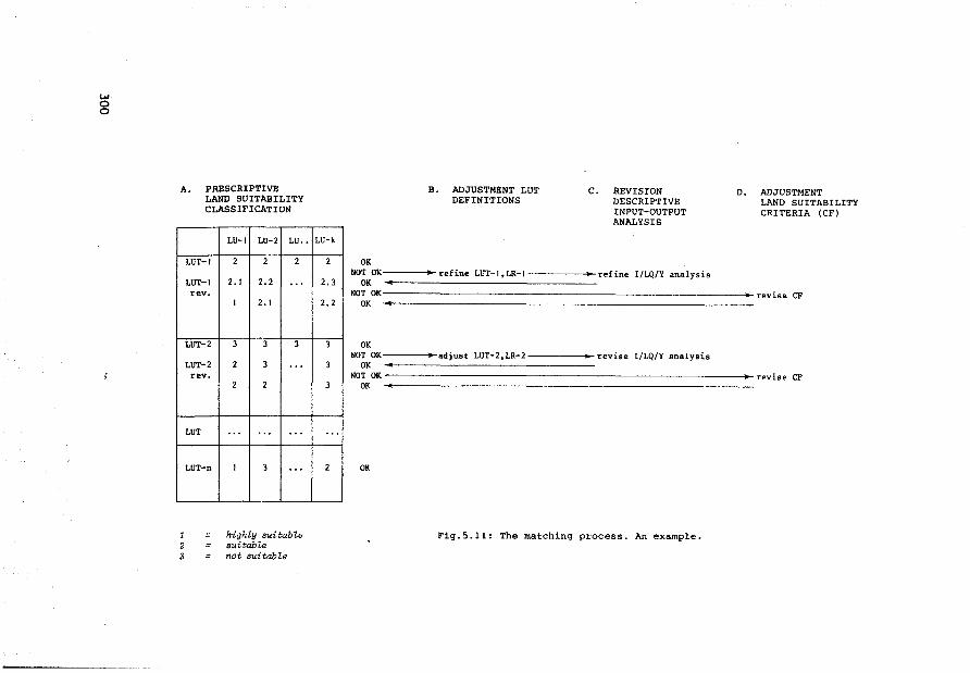
w g
A. PRESCRIPTIVE LAND SUITABILITY CLASSIFICATION
l 2 3
LUT-1
LUT-1 rev.
LUT-2
LUT-2 rev.
LUT
LUT-n
LU-1 LU-2 LU ..
2 2 2
2. 1 2.2 ".
1 2. 1
3 3 3
2 3 ".
2 2
". ". ".
1 3 ".
highZy suitabZe sui tab Ze not suitabZe
LU-k
2
2.3
2.2
3
3
3
".
2
OK
B. ADJUSTMENT LUT DEFINITIONS
C. REVISION DESCRIPTIVE INPUT-OUTPUT ANALYSIS
NOT OK----l~refine LUT-l,LR-1----~-refine 1/LQ/Y analysis OK
D. ADJUSTMENT LAND SUITABILITY CRITERIA (CF)
NOT OK-------------------------------->-revise CF OK
OK NOT OK~---..-adjust LUT-2,LR-2-----l~revise I/LQ/Y analysis
OK NOT OK~-----------------------------~revise CF
OK
OK
Fig.5.11: The matching process. An example.
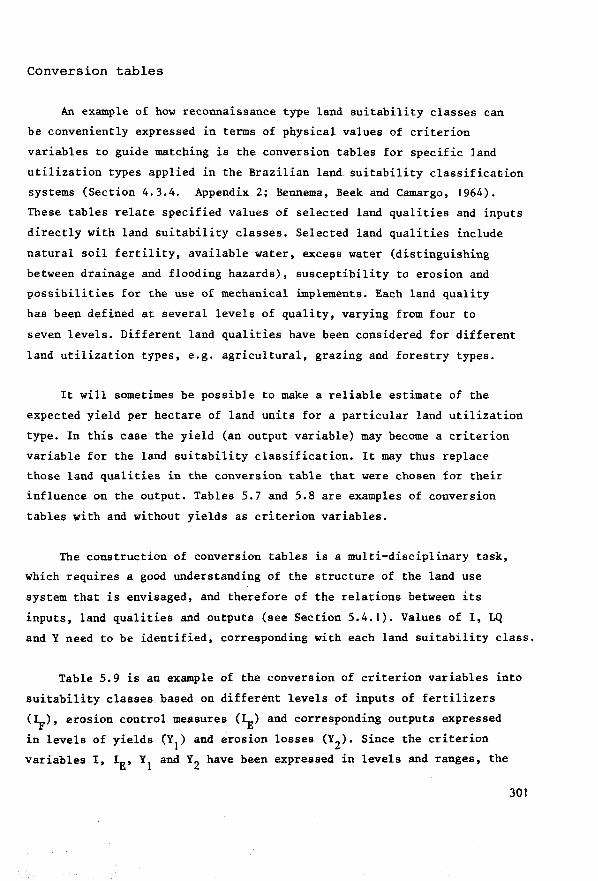
Conversion tables
kn example of how reconnaissance type land suitability classes can
be conveniently expressed in terms of physical values of criterion
variables to guide matching is the conversion tables for specif ic land
utilization types applied in the Brazilian land suitability classification
systems (Section 4.3.4. Appendix 2; Bennema, Beek and Camargo, 1964).
These tables relate specified values of selected land qualities and inputs
directly with land suitability classes. Selected land qualities include
natura! soil fertility, available water, excess water (distinguishing
between drainage and flooding hazards), susceptibility to erosion and
possibilities for the use of mechanical implements. Each land quality
bas been defined at several levels of quality, varying from four to
seven levels. Different land qualities have been considered for different
land utilization types, e.g. agricultural, grazing and forestry types.
It will sometimes be possible to make a reliable estimate of the
expected yield per hectare of land units for a particular land utilization
type. In this case the yield (an output variable) may become a criterion
variable for the land suitability classification. It may thus replace
those land qualities in the conversion table that were chosen for their
influence on the output. Tables 5.7 and 5.8 are examples of conversion
tables with and without yields as criterion variables.
The construction of conversion tables is a multi-disciplinary task,
which requires a good understanding of the structure of the land use
system that is envisaged, and therefore of the relations between its
inputs, land qualities and outputs (see Section 5.4.1). Values of I, LQ
and Y need to be identified, corresponding with each land suitability class.
Table 5.9 is an example of the conversion of criterion variables into
suitability classes based on different levels of inputs of fertilizers
(J}.), erosion control measures (IE) and corresponding outputs expressed
in levels of yields (Y1) and erosion losses (Y2). Since the criterion
variables I, IE, Y1
and Y2 have been expressed in levels and ranges, the
301
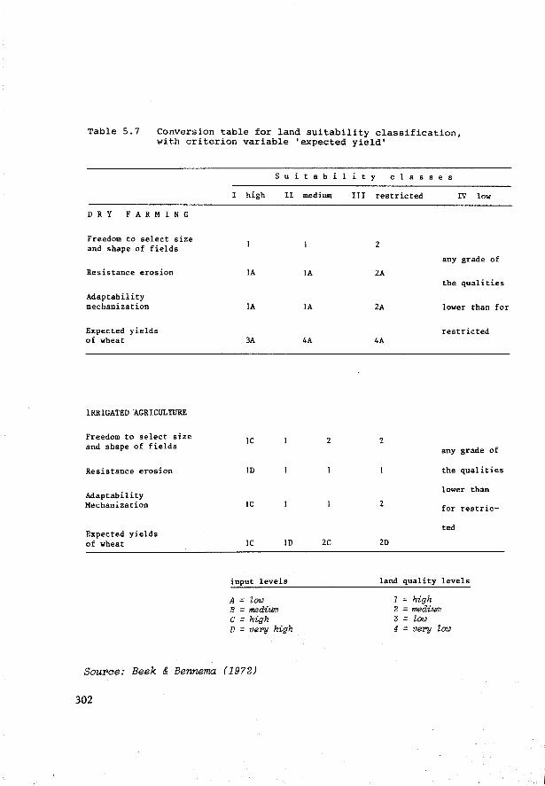
Table 5.7 Conversion table for land suitability classification, with criterion variable 'expected yield'
DRY FARMING
Freedom to select size and shape of fields
Resistance erosion
Adaptability mechanization
Expected yields of wheat
IRRIGATED AGRICULTURE
Freedom to select size and shape of fields
Resistance erosion
Adaptability Mechanization
Expected yields of wheat
s u i t a b
I high II
IA
IA
3A
IC
ID
IC
IC ID
input levels
A = low B =medium c = high D = very high
medium
IA
IA
4A
2
2C
Source: Beek & Bennema (19?2)
302
i i t
III
y c l a s s e s
restricted IV low
2
any grade of
2A the qualities
2A lower than for
restricted 4A
2 any grade of
the qualities
lower than
2 for restric-
ted
2D
land quality levels
1 = high 2 = medium J = low 4 = very low
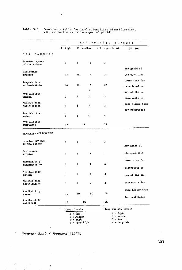
Table 5.8 Conversion table for land suitability classification, with criterion variable expected yield'
DRY FARMING
Freedom lay-out of the scheme
Resistance eros ion
Adaptability mechanization
Availability oxygen
Absence risk salinization
Availability water
Availability nutrients
IRRIGATED AGRICULTURE
Freedom lay-out of the scheme
Resistance eros ion
Adaptability mechanization
Availability oxygen
Absence risk salinization
Availability water
Availability nutrients
Suitabil t y c 1 a s s e s
high II medium !II restricted IV low
any grade of
IA IA IA 2A the qualities
lower tban for
IA IA IA 2A restricted or
any of the im-
provements in-
3 puts higher than
for restricted
IA IA 2A
any grade of
the qualities
lower than for
restricted or
2 any of the im-
2 2 provem.ent s in-
puts higher than
IC ID IC 2D for restricted
Il! Il! Il!
input levels land quali ty levels
A = loi.i B = mediwn c = high D = very high
1 = high 2 = mediwn 3 = loi.i 4 = very loi.i
SouX'Ce: Beek & Bennema (1972)
303
deductive part of the physical land evaluation becomes relatively easy:
there is no need to express the input-output relations in terms of conti
nuous functions to permit the identification of the optimal values of I
and Y on a ratio scale. It should suffice to correlate the LU, LUT combi
nations according to their sets of (I, Y) values with the squares indicated
in Table 5.9 and select for each (group of) land unit(s) the square of
highest possible suitability class for the land utilization type in
question.
... c ~ ' c ~c
§ :3b UJ ii
a
0 0
-
-
-
1
1
Il
111
,
1
1 Il 111 IV
Il 111 IV IV
111 111 IV IV
IV IV IV IV
2 ! 4.-lf" fert111zer appllcat1on rate
IV
' constrc ned
Il 111 IV
1 2 3-IE erosion control meosure opplication rate
Table 5.9: Dia{Jr>aJTUT1etT'ic presentation of land suitability classes I-IV for matching purposes, based on ranges and levels of values of Y1, Y2, I F' IE cri terion variab Zes.
Soil erosion losses (Y2) are criterion variables that are often
specified as constraints (see Section 5 .4 .1) in .the Criterion Function
304
of a physical land suitability classification, e.g. 'the land must not
lose more soil per hectare per year than an amount Y ' (see Table 5.9), q
which should be roughly the equivalent of the amount that can be replaced
by the soil-forming processes. If the Wischmeier equation
A = R x K x L x S x C x P
is used for measuring the land quality 'resistance to erosion', this equa
tion can be quite helpful during the matching (see also Section 3.1.2).
In the Criterion Function a certain value of A = Y (soil erosion q
losses per hectare) is specified: this should not be exceeded.
Hence, all (LUT, LU) combinations that are expected to result in too
high A values (A > Y ) should be eliminated, or classif ied as unsuitable q
(=IV) during the matching.
Conclusion
Ideally, land evaluation should be carried out on the strength of ob
servations of real data related to specific sites. But the number of ob
servations of natural phenomena and experiments is necessarily limited in
space and time. There is an obvious need for additional techniques to gene
rate information about the expected effect of physical inputs on outputs
and land qualities. Making analogies with other areas has been the most
common technique for obtaining such additional data. The construction of
conversion tables that relate inputs, land qualities and outputs with
land suitability classes often uses this method. The analyses of land
quality - output relations and input - land quality relations, identified
for analogous areas (as described in previous Sections) are expected to help
input-output analysis when there is inadequate site-specif ic information.
The soil series described in the USA using the Soil Taxonomy (USDA,
1976) are expected to be sufficiently homogeneous to permit transfer of ex
perimental results from so-called 'Benchmark' (representative) sites to
other sites with soils of the same series which have not been studied
directly. Such Benchmark soils are analogue models serving the purpose of
extrapolation of experimental results (Dijkerman, 1973).
305
But one cannot always rely on the correlation with analogous areas,
since many development situations are characterized by a unique combination
of socio-economie and physical constraints and very specific development
objectives.
Other difficulties with the generation of real data to support
input-output analysis are the relative slowness of real time experiment
ation and the fact that some inputs may have an irreversible effect on
the land qualities, which interferes with the possibility for repeating
and modifying experiments when the observed effects of input application
are not needed, e.g. the formation of impermeable layers in the soil or
the accumulation of toxic elements.
As the analyses of input-output relations tend to become more
and more complex, systems analysis and simulation is now being relied on
increasingly. This approach is further stimulated by the introduction
of computer-based natural resources information systems (Decker et al.,1975;
Tomlinson et al., 1976; McDougall, 1976).
Systems can be transformed into models to simulate the effects of va
riable inputs on the land qualities and on the outputs. These models can
either be mathematical computer models, or analogue simulation models of
the type described by Wind (1976), who uses models in which the flow'of
water in soils is simulated by flows of water and electricity.
The use of systems analysis and simulation models may modify the data
collecting stage in land evaluation, the methods and density of sampling
(Stroosnijder, 1976; Bouma, 1977) the techniques of making land resources
maps and the classification of land attributes, e.g. the application of a
numerical soil classification (de Gruyter, 1977).
An important advantage of using mathematical simulation models, when
comparing them with the real systems, is that they can be operated in two
directions: the role of the dependent variables (the outputs and the land
qualities that need to be improved with inputs) and the independent variables
(the inputs) can be interchanged.
306
The use of simulation models holds much promise and is theref ore likely
to increase, particularly in view of the temporal and spatial problems of
collecting real data.
This becomes even more important because land evaluation is increasingly
involved in analysing the possibilities of land use changes in situations
where the physical and/or socio-economie conditions are seriously limiting
a satisfactory matching between land qualities and land requirements of
relevant land-utilization types. Therefore the distinction between suitable
and unsuitable land becomes more difficult to make in these marginal areas,
requiring a very careful analysis of the present status of the land qualities
and the effects of physical inputs.
Such a task is likely to be beyond the scope of routine land evaluation.
Specialized institutions will be asked more and more to carry out such
detailed problem analyses. The capacity for modelling and simulating funda
mental land use processes and activities and the willingness of these
institutions (which are often located in developed countries and at
international research centres) to cooperate with the land evaluators, auger
well for more sophisticated analysis (e.g. sensitivity analysis) of complex
problems in practical land evaluation, in developing countries too.
Such models will probably relate foremost to specific partial land
evaluation problems, e.g. of water management in the soil, drainage, soil
tillage, the behaviour of plant nutrients and chemica! fertilizers and of
potential yield. The use of mathematica! models solely for simulating all
input-output relations influencing the performance of a land use system
will probably remain too complex to satisfy practical land evaluation
entirely in the innnediate future.
Thus, land evaluation must compromise between scientific ideals and
limitations posed by data availability, data reliability, and the possibilities
for data handling. Furthermore, land evaluation is concerned with prediction,
which signifies that its results cannot pass certain limits of probability
because of the variation in weather conditions and in human behaviour.
Therefore, data analysis in land evaluation will need to be based on a
307
realistic breakdown of the land use process into well understood sub
processes occurring during finite time periods when the process-conditioning
variables and parameters can be identif ied with a reasonable degree of re-
1 iabili ty, e.g. the requirements for water and plant nutrients and their
availability during the period t ~ t • This period may be either a day, n n+m a week, or a month depending on the objectives of land evaluation and the
available data base.
The ELCROS model (de Wit et al.,1978) and related investigations in the
field of ecosystem research and theoretica! plant production are increasing
our understanding of fundamental biologica! processes. The authors of
ELCROS state that their efforts must be regarded more as a guide to research
than a final solution. Their contribution is of great conceptual signifi
cance for land evaluation: it heralds the possibility that in the future si
mulations of agricultural production processes will be based on a much
better understanding of the underlying physiological mechanisms. We will
have a better insight into the land requirements of specif ic land utili
zation types.
In addition, soil scientists and agricultural engineers are increasing
our understanding of mechanisms underlying the various soil and water mana
gement and engineering practices. Agricultural equipment is being adapted
for use in adverse physical environments and for a wider range of socio
economic conditions. The land conditions required for the necessary field
operations are becoming better understood.
This means that land resources inventories will need to collect data
that explicitly characterize the fundamental environmental regimes (i.e.
land qualities) influencing these physiological and agricultural mechanisms
and processes to improve the possibilities for land use simulation and the
prediction of land use performance.
Meanwhile land evaluation is likely to continue to study input-output
relations primarily by observing site-specific data and by transfer of
knowledge from analogous areas. Conversion tables will be remain useful
for input-output analysis and for translating the values of criterion va
riables of different dimensions into land suitability classes for specific
types of land utilization.
308

Appendix 3: Definitions of important concepts in systems theory
(Adapted from Toebes in Civil Engineering Analysis, Part II, spring 1975
II-12 (GHT). B: 'Further Definitions and Simple Concepts', II Systems:
Perspective Concepts and Procedures)
Black Box - A black box is a system for which the internal structure
is unspecified, either by choice or of necessity. Evidently a system
element as defined above, is a black box. The function, purpose or
nature of a black box is specif ied by or is to be identif ied from a
comparison of input and output as defined below.
At the initial stage of a system synthesis or a systems identification
analysis the system itself is considered as a black box. At the next
level of analysis, the system is considered as being composed of a set
of black boxes. At a yet further level of detail, several of these black
boxes may be promoted to sub-systems which, in turn, contain black
boxes, and so on. Black box analysis thus may be a tactic of descriptive
systems analysis.
Inputs and Outputs - The systems approach begins by selecting from
the Universe a collection of elements that are considered most important
and which are related to each other in terms of the questions asked.
This process of synthesis is a very dif f icult creative activity for
which no formal rules exist. Subsequently, the questions asked or the
point of view taken are made more precise and, on the basis of this,
some elements are placed within a systems boundary, SB, and the others
are placed in the environment outside SB. A relation between an element
inside and one outside of SB is called either input or output.
Inputs and outputs may be material or conceptual. They may be
vectors having quantity, quality, time, space, or informational charac
teristics. For dynamic systems these characteristics may resemble flows.
An 'input-output relation' may be a relabelling for cause-and
effect or stimulus response phenomena.
309
Dee!ision Variables - In terms of the systems goal, the outputs Y. J
may be desirable, undesirable or neutral. The inputs I. may be controllable, i
partially controllable or uncontrollable. The controllable and partially
controllable inputs are called decision variables.
State Variables and Systems Parameters - Systems elements often
have quantifiable attributes that vary with the (history of the) input
and output levels. The internal variables, called 'state variables',
may or may not be present in the systems equation of the element. State
variables may constitute important information of the total system. They
may be constrained and thereby constrain the inputs or outputs of systems
elements and hence of the entire system.
Systems equations also contain constants. These are called 'systems
parameters', if they are subject to changes imposed by systems external
to the one under consideration. Varying systems parameters is like an
outsider occasionally turning knobs on a black box to alter the way it
transforms input into output.
The 'state' of a system is the collection of state variable values,
indicating its condition in terms of some question that is being asked.
Discipline Systems - For complex systems there exists the practice
to look at the technological, economie, politica!, ecological and other
aspects. Thereby the real system is divided into overlapping sub-systems
which could be called discipline systems. Breaking a system into discipline
systems is useful because it minimizes the number of systems inputs,
outputs, and (hence) decision variables. However, an elimination of too
many or all interactions leaves sub-systems that may usefully contribute
to discipline systems, but often will no longet involve key features of
the original system.
Corrunensuration - If there are several effectiveness parameters it
is usually necessary to make them comparable in order to measure, at
least in a mathematica! sense, the degree of attainment of 'best'. This
310
may be done by translating or converting the effectiveness parameters
into a single commensurate effectiveness parameter. The conversion
procedure is called commensuration.
Corrunent - The above definitions should be taken primarily as represent
ing a convenient jargon in systems analysis. Only for relatively simple and
special types of systems could they be found to have any axiomatic power.
311
Literature
Alva, C.A., J.G. van Alphen, A. de la Torre, L. Manrique. 1976. Problemas de drenaje y salinidad en la Costa Peruana. Int.Institute for Land Reclamation and Improvement, Bull.16. 116 pp.
Alvarez Filho, A., A.M. Pires Filho, A. Ramalho Filho et al. 1970. Levantamento semi-detalhado dos solos de areas do M.A.no Distrito Federal. Bol.Téc.No.8. SNLCS, EMBRAPA (EX EPFS-EPE), Rio de Janeiro.
Arnold, G.W., C.T. de Wit (Eds.). 1976. Critica! Evaluation of systems analysis in ecosystems research and management. Simulation Monographs, PUDOC, Wageningen.
Avery, B.W. 1968. General soil classification: hierarchical and coordinate systems. Trans.9th Congr.Int.Soil Sci.Soc. Adelaide, vol.4,pp.169-175.
Ayers, R.S., and D.W.Westcot. 1976. Water quality for agriculture. Irrigation and drainage paper No. 29. FAO, Rome, 97 pp.
Barlowe, R. 1972. Land resource economics. Englewood Cliffs,2nd ed.616 pp.
Barraclough, S.L., and A.L.Domike. 1966. La estructura agraria en siete paises de America Latina. El Trimestre Economico, Vol.33, No.130. 1966. Mexico, pp.235-301.
Bartelli, L.J., A.A. Klingebiel, J.V.Baird, and M.R.Heddleson (Eds.). 1966. Soil surveys and land use planning. Soil Sci.Soc.Am. and Am.Soc.Agr. Madison, Wisc., pp.196.
Bartholomew, W.V. 1972. Soil nitrogen. Supply process and erop requirements. Int.Soil Fert.Eval.Improvement Progr., Techn.Bull.6. North Carolina St.Univ., Raleigh.
Bastide, J.G.A., and C.P.van Goor. 1970. Growth-site relationships in plantations of Pinus elliottii and Araucaria angustifolia in Brazil. Plant and Soil 32 (2), 1970, pp.349-366.
Beek, J. and M.J.Frissel. 1973. Simulation of nitrogen behaviour in soils. Simul. monographs, PUDOC, Wageningen.
Beek, K.J. 1972. The concept of land utilization types. In: Approaches to land classification. FAO Soils Bull. No.22. Paper presented to FAO Expert Consultation on Land Evaluation for rural Purposes, Wageningen, 6-12 October 1972.
Beek, K.J. 197Sa. Identification of land utilization types. In: FAO World Soil Resources Report 45. Report on the ad hoc expert consultation on land evaluation. Rome, Italy, 6-8 January 1975.
Beek, K.J. 1975b. Land utilization types for land evaluation. In: Land evaluation in Europe. FAO Soils Bull.No.29. pp.87-106. FAO, Rome.
Beek, K.J. 1975c. Land evaluation in Latin America. In: FAO, World Soil Soil Resources Report 45. Report on the ad hoc consultation on land evaluation. Rome, Italy. 6-8 January 1975. 6 p.
312
Beek, K.J. 1975d. Recursos naturais e estudos perspectivos a longo prazo. Notas Metodologicas pp.69. Project UNDP/FAO/BRA/71/553. Min.of Agric., SUPLAN, Brasilia, Brazil.
Beek, K.J. 1977. The selection of soil properties and land qualities relevant to specific land uses in developing countries. 20 pp • . In: Soil Resources Inventories. Proc.of a Workshop held at Cornell Univ. April 4-7, 1977.
Beek, K.J. and Bennema, J. 1971. Land evaluation for agricultural land use planning. An ecological method. 17 pp. In: Systematic Land and Water Resources Appraisal. FAO/Santiago, Latin American Land and Water Development Bull.No.! (spanish and english versions) and in: FAO Soils Bulletin No.22. 1974. Rome-Santiago, pp.170-190.
Beek, K.J. and J. Bennema. 1972. Land evaluation for agricultural land use planning. An ecological methodology. Dept.Soil Sci. and Geology, Univ. of Agric., Wageningen. Spanish ed.: Boletin Latinoamericano sobre fomento de tierras y aguas, 3. Proyecto Regional FAO/PNUD/RLA 457. Santiago, Chile.
Beek, K.J., J. Bennema and M. Camargo. 1964. Soil survey interpretation in Brazil. A system of land capability classification for reconnaissance surveys. First draft. DPFS-FAO-Stiboka. Rio de Janeiro, Wageningen.
Beek, K.J. and Goedert, W.J. 1973. Recursos naturais (terras) e desenvolvimente agricola. Vol.1, pp.69. Vol.2 (anexos), 130 pp. Projeto PNUD/FAO/BRA/71/553. Documento de trabalho SUPLAN, Brasilia, Min. da Agricul tura.
Beek, K.J., J.I.L.Oilmos et al. 1965. Interpretacao preliminar para uso agricola da carta de solos da Regiao Cacaueira. Convenio DPFS/CEPLAC. Min. da Agric., Itabuna (mimeo), pp.127.
Beek, K.J., A.G.Sombcoek, and A. van Wambeke. (Eds.) 1972. Evaluación y Manejo de suelos en la región Amazonica. Grupo de trabajo FAO/PNUD en colaboración con los Gobiernos de Brasil, Colombia y Venezuela. 5-23 Septiembre de 1972. Bol. Latinoamericano sobre Fomento de Tierras y Aguas, No.5. Proyecto Regional FAO/PNUD/RLA/70/457. Santiago, Chile.
Bennema, J. 1972. The Concept "Land Qualities". Mimeo, distributed at FAO Expert Consultation on Land evaluation for rural purposes. Wageningen. 6-12 October 1972. pp.4.
Bennema, J. 1976. Land evaluation for agricultural land use planning. Benchmark soil project. Univ. of Hawaii.
Bennema, J., K.J.Beek, and M.N.Camargo. 1964. Un sistema de classificacào de capacidade de uso da terra para levantamentos de reconhecomento de solos. DPFS/DPEA/FAO. Min. de Agric., Rio de Janeiro, Mimeo.
Bennema, J., and M.N.Camargo. 1963. Esquema de proposta de divisào de florestas tropicais (com exclusào de florestas hidrofilas e florestas secundarias) para utilizar como fases. Mimeo for discussion in techn. inf., Rio de Janeiro, Soil Survey Div.
Bennema, J. and C.P.van Goor. 1975. Physical land evaluation for forestry. 7 p. In: FAD, 1975. Report on the ad hoc Exp.Consultation, Rome, 6-8 Jan.1975. FAO World Soil Res. Report 45.
313
Bishop, A.A. 1975. On-farm water management. In: E.Bornemisza and A. Alvarado (Eds.): Soil management in tropical America. North Carolina State Univ., Raleigh.
Bofinger, V.J. and J.L.Wheeler (Eds.) 1975. Developments in the design and analysis of field experiments. Proc. of symposium at Univ. of New England. Bull.50. Gom.Bureau of Pastures and Field Crops, Hurley.
Bornemisza, E. and A. Alvarado (Eds.) 1975. Soil management in tropical America. North Carolina St.Univ., Raleigh.
Bos, M.G. and J.Nugteren. 1974. On irrigation efficiencies. Int.Institute for Land Reclamation and Improvement. Publ. No.19.
Bouma, F. 1972. Evaluatie van natuur funkties. Waarderingsproblemen bij natuurfunkties vanuit ekonomisch gezichtspunt. Inst. voor milieu vraagstukken van de Vrije Univ., Amsterdam.
Bouma, J. 1977. Soil survey and the study of water in unsaturated soil. Netherl. Soil Survey Inst., Wageningen. Soil Survey Paper,No. 13.pp.107.
Boyd, D.A. 1970. Some recent ideas on fertilizer response curves. pp.461-473. 9th Congr.Int.Potash Inst.Bern.
Boyd, D.A. 1974. Developments in field experimentation with fertilizers. Phosphorous in Agric. 1974:7-17.
Brinkman, R. and A.J.Smyth (Eds.) 1973. Land evaluation for rural purposes. Summary of an Expert Consultation, Wageningen, The Netherlands, 6-12 October 1972. Int.Inst.for Land reclamation and Improvement,Wageningen. Publ.No.17.
Brook, R.K. 1975. Soil survey Interpretation. An annotated bibliography. Int.Inst.for Land Reclamation and Improvement, Bibl.No.10.Wageningen.
Buol, S.W., P.A.Sanchez, R.B.Cate, and M.A.Granger. 1975. Soil fertility capability classification for fertility management. A technical soil classification for fertility management. pp.126-141. In: E.Bornemisza, A.Alvarado (Eds.): Soil management in tropical America. North Carolina St.Univ., Raleigh.
Buringh, P., H.D.J.van Heemst and G.J.Staring. 1975. Computation of the absolute maximum food production of the world. Agric.Univ.Wageningen, Dept.Trop.Soil Sci.
Buringh, P. and H.D.J.van Heemst. 1977. An estimation of world food production based on labour-oriented agriculture. 46 pp. Centre for World Food Market Res. Amsterdam, The Hague, Wageningen.
Burrough, P.A. 1976. Overseas methods of land evaluation. Part 6: A national study of soil conservation. Dept. of Environment, Health and Community Development, Canberra. Austr.Capital territory.
Burrough, P.A., Maconachie, A.P. and A.J.Parsons. 1976. Aselect bibliography on recent publications in land resource survey and evaluation. School of Geography. Univ. of New South Wales.
Burrough, P.A. and R.Webster. 1976. Improving a reconnaissance soil classification by multivariate methods. J.of Soil Sci., vol.27, No.4, Dec.76.
314
Camargo, A.P. de. 1966. Instruçoes para o combate a geada em cafezais. Inst.Agronomico, Campinas (SP), Brazil. Bol.No.130. 18 pp. 2nd ed.
Camargo, M.N., F.G.de Freitas, K.J.Beek et al. 1975. Mapa esquematico dos solos das regioes Norte, Meio Norte, e Centro Oeste do Brasil. Servi~o nacional de levantamento e conservaçäo de Solos. EMBRAPA, Rio de Janeiro.
Carr, D.P. and H.W.Underhill. 1974. Simulation methods in water development. Irrig. and drainage paper No.23. FAO. Rome. 59 pp.
Cataplan. 1964. Plan de trabajo detallado para la ejecución del catastro rural de tierras y aguas de Panamá. CATAPLAN, Panamá.
Cate, R.B. and Nelson, L.A. 1965. A rapid method for correlation of soil test analysis with plant response data. Techn.Bull.1.Int.Soil Testing Series. North Carolina St.Univ.
Cate, R.B. and Nelson, L.A. 1971. A simple statistica! procedure for partitioning soil test correlation data into two or more classes. S.Sci.Soc.Am.Proc.35, 658-660.
Chanduvi, F.(Ed.). 1973. Evaluación y control de degradación de tierras en zonas áridas de America Latina. Grup de Trabajo, Peru, 10-25 Sept. 1973. Bol.Latinoamericano sobre Fomento de Tierras y Aguas, No.6. 436 pp. FAO, Santiago, Chile.
Chorley, R.J. and B.A.Kennedy. 1971. Physical geography. A systems approach. Prentice Hall.
Comerma, J. and Arias, L.F. 1971. Un sistema para evaluar las capacidades de uso agropecuario en los terrenos en Venezuela. Trabajo presentado en el Seminario de Clas. Interpretativa con Fines agropecuarios. Maracay, Sept.de 1971. Mimeo, 58 pp.
Conklin, H.E. 1957. The Cornell system of economie land classification. Repr.
Constantinesco, I. 1976. Soil conservation for developing countries. Soil Bull.No.30. FAO, Rome, 92 pp.
COPLANARH. 1969. Inventario N~cional de tierras. Sub-región 7A. UnareNeveri. Publ. No.7. COPLANARH, Carácas, Venezuela. 112 pp.
Dalton, G.E. (Ed.) 1975. Study of agricultural systems. Applied Sci.Publ., London.
Dam, J.G.C.van. 1973. Bodemgeschiktheids onderzoek in het bijzonder bij asperges, appels en stooktomaten. (Soil suitability research, in particular with asparagus, apples and hothouse tomatoes. In dutch, eng!. summary.) PUDOC, Wageningen. 102 pp.
Dasmann, R.F., J.P.Milton, and P.H.Freeman. 1973. Ecological Principles of Economie Development. John Wiley, London.
Decker, G.L., G.A.Nielsen, and J.W.Rogers. 1975. The Montana automated data processing system for soil inventories. Montana St.Univ., Bozeman, Mont. Res.Report No.89. 77 pp.
315
Dee, N.et al. 1973. An environmental evaluation for water resource planning. Water resources research 9, 523-535.
Deshler, W.O. 1973. Uso multiple de los recursos naturales renovables. Proyecto FAO/RBF/TF 199. FAO, Santiago, Chile. Una guia para la aplicación del concepto de uso multiple a la problematica del manejo de bosques y areas silvestres. 52 pp.
Smet, L.A.H.de. 1969. De Groninger Veenkoloniëen (westelijk deel). Bodemkundige en landbouwkundige onderzoekingen in het kader van de bodemkartering. Soil Survey Inst., Wageningen.
Dillon, J.L. 1968. The analysis of response in erop and livestock production. Pergamon Press, Oxford.
Dimantha, S. 1977. Use of a numerical soil moisture simulation model for land evaluation and land use planning in Sri Lanka. MSc Thesis Course in Soil science and water management. Agric.Univ., Wageningen.
Doorenbos, J. and W.O.Pruitt. 1977. Guidelines for predicting erop water requirements. FAO Irrig. and Drainage Paper No.24. Rev. FAO, Rome.
Duckham, A.N. and Masefield, G.B. 1970. Farming Systems of the world. Chatto and Windus, London. 542 pp.
Dijkerman, J.C. 1974. Pedology as a science. The role of data, models and theories in the study of natural soil systems. Geoderma 11(1974):73-93.
Dyne, G.M.van and Z.Abramsky. 1975. Agricultural systems models and modelling. An overview. In: G.E.Dalton (Ed.): Study of agricultural systems. 107 pp. Applied Sci.Publishers, London.
Edelman, C.H. 1949. Sociale en economische Bodemkunde. Amsterdam. 149 pp.
Edelman, C.H. 1963. Applications of soil survey in land development in Europe, with special reference to experiences in The Netherlands. Int.Inst.for Land Reclamation and Improvement. Wageningen. Publ. 12.
Estudio agrológico del area de riego del embalse Digua. 1968. Min.de Agric., Servicio agric.y ganadero. Div.de recursos agrîcolas. Depart.de Agrologia. Santiago, Chile.
Estudio agrológico del area Maule norte (2a etapa). 1969. Min.de Agric., Servicio agr. y ganadero, Div.Conservación de recursos agr., Dept. de agrologia. Santiago, Chile.
Evenari, M., L.Shannon, N.Tadnor. 1974. The agricultural potential of loess and loess-like soils in arid and semi-arid zones. In: Inst. Italo-latino-americano Publ.No.4.
Ewell, J. and Madrid, A. 1968. Zonas de vida de Venezuela. Memoria explicativa del mapa ecológico. MAC Dir. de Investigación, Carácas. 264 pp.
Falesi, I.C. 1974. Soils of the Brazilian Amazon. In: C.Wagley (E.d.): Man in the Amazon. Univ. of Florida Press. Gainesville. p.201-229.
FAO. 1965. Programme for the 1970 World Census of Agriculture. FAO, Rome. 82 PP•
FAO. 1971. Systematic Land and Water Appraisal. Latin Amer.Land & Water Res. Bull.No.!. (sp. and engl.) 347 pp~
316

FAO. 1974a. Approaches to land classification. Soils Bull. No.22. FAO,Rome. 120 pp.
FAO. 1974b. Soil survey in irrigation investigations. Soils Bull.Draft. FAO, Rome. 207 pp.
FAO. 1975a. Report on the ad hoc expert consultation on land evaluation. Rome. 6-8 January 1975. World Soil Res.Report 45. FAO, Rome. 152 pp.
FAO. 1975b. Land evaluation in Europe. Soils Bull. 29. FAO, Rome. 123 pp.
FAO. 1976. A framework for land evaluation. Soils Bull.No.32. FAO, Rome and ILRI, Wageningen. Publ. No.22.
FAO. 1977a. Soil conservation and management in developing countries. FAO Soils Bull.33. FAO, Rome. 212 pp. Report of an expert consultation held in Rome 22-26 Nov. 1976.
FAO. 1977b. Guidelines for watershed management. FAO Conserv.Guide No.I. 293 pp.
FAO. 1977c. Assessing soil degradation. FAO Soils Bull. No.34. FAO, Rome. 83 pp.
FAO. 1978. Agro-ecological zones project. Africa report. FAO World Soil Res.Reports, in press.
FAO/IBRD Cooperative Programme 1970. Guideline for the preparation of feasibility studies for irrigation and drainage projects. 25 pp.
FAO/UNESCO. Soil map of the world. 1:5 000 000. Vol.I. Legend. Vol.IV. South America. Paris, UNESCO 1971, 1974.
Feder, E. and Manger Cats, S. 1971. Requirements for an evaluation of land and water resources in relation to land reform and colonization. In: Systematic land and water resources appraisal. Latin Amer.Land and Water Development Bull.No.!. Engl.and span. ed. FAO, Rome; Santiago. pp.50-63.
Fittkau, E.J. et al. (Eds.) 1968. Biogeography and ecology in South America. Vol.!. 447 pp. Vol.2. 946 pp. Monographiae biol., Vol.18/19. Junk N.V., The Hague.
Fitzpatrick E.A. and Nix, H. 1970. The climatic factor in Australian Grassland Ecology. In: Moore, R.M. (Ed.): Australian Grasslands. Austr. Univ.Press, Canberra.
Fleming, G. 1974. The present status and future prospects for mathematical. models in a soil conservation action progranane. In: A World assessment of soil degradation. An international progranane of soil conservation. FAO MR/F 3951. FAO, Rome.
Fleming, G. 1975. Computer simulation techniques in Hydrology. 333 pp. Elsevier Environmental sci.series.
Forrester, J.W. 1968. Principles of systems. Text and Workbook Chapters to 10. Second prelim. edition. Wright-Allen Press.
Found, W.C. 1971. A theoretical approach to land use patterns. London. E. Arnold.
317
Freitas, F.G., A.Ramalho Filho, J.S.Rosatelli et al. 1970. Levantamento de reconhecimento dos solos da zona de Iguatemi. Bol.Tee.No.JO. EPFS-EPE, Min.da Agric., Rio de Janeiro.
Fukui Hayao. 1976. Appraisal of the "location" factor in a Japanese land evaluation system. 17 p. Engl.summary of: Secretariat for the Council of Agric., Forestry and Fishery Technology (Ed.), 1963. Method and procedure for land-use classif. (in japanese). 432 pp.
Garbutt, J., H.Linneman et al. 1976. Mensen Tellen. Het Spectrum, UtrechtAntwerpen. Aula pocketbook 553.
Geus, J.G.de. 1967. Fertilizer guide for tropical and subtropical farming. 727 pp. Centre d'étude de l'azote. Zürich.
Gibbons, F.R. and J.C.F.M.Haans. 1976. Dutch and Victorian approaches to land appraisal. Soil Survey Papers. No.II. 40 pp. Netherlands Soil Survey Inst., Wageningen.
Gonzalez M.J. et al. 1977. La planificación del desarrollo agropecuario Textos del Inst.latino-americano de planificación econ. y soc. 3 vols. Siglo Veintiuno Ed. S.A.Mexico, Madrid.
Goodland, R.J.A. and H.S.Irwin. 1974. An ecological discussion of the environmental impact of the Highway construction program in the Amazon Basin. Landscape Planning. 1 (1974), pp.123-254.
Goor, C.P.van. 1965/1966. Classificaçäo da capacidade da terra em relaçäo ao reflorestamento com Pinus elliotti (Eng.) var. elliottii e Araucaria angustifolia (Bert.). O.Ktze, No Estado de Sao Paulo. Silvicultura, Ano 4/5. No.4: 349-366. Serviço Florestal do Estado de Sao Paulo.
Gregor, H.F. 1970. Geography of Agriculture. Themes in research. Foundations of economie geography series. Prentice Hall, inc., Englewood Cliffs, N.J. 181 pp.
Grigg, D.B. 1974. Agricultural systems of the world. An evolutionary approach. 358 pp. Cambridge Univ.Press.
Gruijter, J.J.de. 1977. Numerical classification of soils and its application in survey. Soil Survey Papers. No.12. 117 pp. Netherlands Soil Survey Inst., Wageningen.
Hanken, A.F.G. and H.A.Reuver. 1973. Inleiding tot de systeemleer. 147 pp. Stenfort Kroese N.V. Leiden.
Hauser, G.F. 1973. Guide to the calibration of soil tests for fertilizer recommendations. FAO Soils Bulletin No.18. Rome. 71 pp.
Haynes, J.L. 1963. O papel potencial da Regiao Centro Oeste do Brasil no desenvolvimento nacional. In: USAID/BRASIL. Reconhecimento do Potencial Agricola do Planalto Central do Brasil.
Ready, E.O. 1957. Economics of agricultural production and resource use.
Ready, E.O. and W.Candler. 1958. Linear programming methods. Ames, Iowa State College Press. 597 pp,
Ready, E.O. and J.C.Dillon. 1961, Agricultural production functions. The Iowa St.Univ.Press.
318
Hedges, T.R. 1963. Farm management decisions. 628 pp. Prentice Hall, inc. Englewood Cliffs, N.J.
Herfindahl, O.C. 1969. Natural resource information for economie development. The J.Hopkings Press, Baltimore. 212 pp. Sp.edition 296 pp.
Hillel, D. 1977. Computer simulation of soil-water dynamics. A compendium of recent work. 214 pp. Int.Dev.Research Centre, Ottawa, Canada.
Holdridge, L.R. 1966. The life zone system. Adansonia 6.
Holdridge, L.R. 1971. Forest environments in tropical life zones. Pergamon.
Hoorn, J.W.van. 1958. Results of a groundwater level experimental field with arable crops on clay soil. Neth.J.Agric.Sci.6(1958)1:1-10.
Hudson, N. 1971. Soil conservation. London, B.T.Batsford Ltd. 320 pp.
Hueting, R. 1975. New scarcity and economie growth. Liverpool Univ.Press.
IBRD. 1975. The assault on world poverty. Problems of rural development, education and health. 425 pp. Publ.for the World Bank by The John Hopkins Univ.Press, Baltimore and London.
IDESP. 1974. Estudos integrados da ilha de Marajó. lost.do desenvolvimento econ.-social .do Pará. IDESP, Belem (PA), Brazil. Vol.1 333 pp.Maps.
IICA-CORA. 1971. Programación de uso del suelo. 83 pp. Mimeograph. Santiago, Chile. (Problemas metodológicas en la Reforma Agraria.)
IILA, 1974. Seminarie Internazionale sulla Valuazione delle terre delle zone aride e semiaride dell'America Latina. Inst.Italo-Latino Americano. Roma, Publ.No.4. 721 pp.
INCRA. 1973. Levantamento e avaliaçào de recursos naturais, socio-economicos e institucionais do Rio Grande do Sul. Brasilia, Inst.Nacional de Colonizaçào e Reforma Agraria. 6 vols.
IPEA. 1972. Variaçoes climaticas e flutuaçoes da oferta agricola no Centro-Sul do Brasil. IPEA/IPLAN, Brasilia. Serie Estudos para o Planejamento. No.J. 419 pp. Maps.
Isard, W. 1972. Ecologic-ecpnomic analysis for regional development.270 pp. New York, The Free Press.
IUCN. 1975. The use of ecological guidelines for development of the American Humid Tropics. Proc. of an Int. meeting Caracas, Venezuela, Febr.1974. Morges, Int.Union for the Conservation of Nature. IUCN publ.new series No.31. 249 pp.
Jacks, G.V. 1946. Land classification for land-use planning. !mp.Bureau of Soil Science. Harpenden. Techn. communication No.43. 90 pp.
Jacomine, P.K.T., M.R.Ribeiro, N.Burgos. 1975. Aptidao Agricola dos solos da Regiao Nordeste. Recife, E1'1BRAPA, Serviço Nacional de Levantamento e Conservaçào de solos. Regiao Nordeste, Bol.Tec.No.42.
Jong, C.de. 1976. Land use alternatives in high-potential areas of medium to high altitudes. The Kitale-Kapenguria Area, Kenya Soil Survey, Min. of Agric., Nairobi. Miscel.Soil Paper No.3. 68 pp.
319
Jong, C.de. 1977. Land utilization types for the medium potential areas of low altitude: the Kwale Area. Kenya Soil Survey, Miscel.Soil Paper No.4. Min.of agric., Nairobi. 80 pp.
Keller, J., D.F.Peterson and H.B.Peterson. 1973. A strategy for optimizing research on agricultural systems involving water management. Dept. of agric. and irrig.engineering. Utah Water Res.Laboratory, Utah State Univ. Logan, Utah, doc.2118d93. 20 pp.
Kellogg, Ch.E. 1951. Soil and land classification. In: J.of Farm Economics vol.33, Nov.1951. No.4, Part 1. 15 pp.
Kellogg, Ch.E. 1953. Potentialities and problems of arid soils. In: Desert Research. Proc.Symp.held in Jerusalem, May 7-14, 1952. Res.Council of Israel Soc.Publication No.2.
Kellogg, Ch.E. 1961. Soil interpretation in the soil survey. Soil Conservation Service. Washington D.C. US Dept.of agric.22 pp.
Kellogg, Ch.E. 1962. Soil surveys for use. In: Trans.Int.Soils Conf., Wellington, New Zealand. pp.529-535.
Keulen, H.van. 1975. Simulation of water use and herbage growth in arid regions. Simulation monographs. PUDOC, Wageningen.
Keulen, H.van. 1976. A calculation method for potential rice production. Contr.Centr.Res.Inst.Agric.Bogor Indonesia No.21 (1976). 26 pp.
Keulen, H.van. 1977. Nitrogen requirements of rice with special reference to Java. Contr.Centr.Res.Inst.Agric.Bogor Indonesia No.30(1977). 67 pp.
Kevie, W.van der (Ed.) 1976. Manual for land suitability classification for agriculture. Part 2: Guidelines for soil survey party chiefs. Soil Survey administration, Wad Medani. Min.of Agric., Food and Nat.Resources, Sudan. 106 pp.
Kleinpenning, J.M.G. 1968. Geografie van de landbouw. 364 pp. Het Spectrum, Utrecht/Antwerpen, Aula 373. In dutch.
Klingebiel, A.A. and P.H.Montgomery. 1961. Land-capability classification. Agric.Handbook 210. Soil Conserv. Service. U.S.Govt.Print.Office, Washington, D.C. 21 pp.
KÖster, H.W., E.J.A.Khan and R.P.Brosshart. 1977. Programa e resultados preliminares dos estudos de pastagens na regiào de Paragominas Pará, e Nordeste de Mato Grosso. Junho 1975-Dez.1976. Belém (PA), Min. do Int. Convenio SUDAM/IRI. 31 pp.
Kostrowicki, J. 1974. The typology of world agriculture. Principles, methods and model types.Int. Geographical Union. Co11BI1ission on Agric.Typology, Warsaw.
Kowalik, P. 1973. Mathematical model of water management in plant production. Mimeo report. Inst. for Land and Water Management Res., Wageningen.
Krastanov, S. and Kabakchiev, I. 1975. Approaches to land evaluation in East European (socialist) countries. In: Land evaluation in Europe. Soils Bull.No.29. pp.71-77. FAO, Rome.
Kyuma, K. and K.Kawaguchi. 1973. A method of fertility evaluation for paddy soils. Soil Sci.& Plant Nutrition. Vol.19, No.I.
320
Lebeau, R. 1969. Les grands types de structures agraires dans le monde. Masson et Cie, Paris. 120 pp.
Lekanne dit Deprez, B.E.J.C. 1976. Macht en onmacht van interdisciplinair samenwerken. Intermediair 12e Vol. No.45/46. Nov.1976.
Lemos, R.C., J. Bennema, R.D. Santos et al. 1960. Levantamento de reconhecimento dos solos do Estado de Sao Paulo. Bol.12. SNPA, CNEPA, Min. da Agric., Rio de Janeiro.
Linneman, H. et al. 1978. MOIRA. A model of International relations in Agriculture. North Holland Publ.Comp., Amsterdam (in press).
Locht, L.J. 1971. Evaluation of rural reconstruction projects with the aid of a model of regional economie growth. Inst.for Land and Water Management Res., Techn.Bull.74. Wageningen.
Luning, H.A. 1973. Land utilization types of the medium-potential areas of Eastern Province, Kenya. Kenya Soil Survey Project, Nat.Agric.Laboratories, Nairobi. 59 pp.
MacDougall, E.B. 1976. Computer programming of spatial problems. E.Arnold. 160 pp.
Mahler, P.J. et al. 1970. Manual of multipurpose land classification. Teheran. Soil Inst.of Iran, Min.of Agric.
McDonald, R.C. 1975. Soil survey in land evaluation. Agric.Chemistry Branch, Techn.Report No.6.Dept. of primary industries, Brisbane, Australia. 47 pp.
Meijerman, G.C. 1966. Significance of lay-out and soil factors for the possible evolution of arable farms in The Netherlands N-E Peat District. An application of linear programming. Verslagen van Landbouwkundige Onderzoekingen, 686. Wageningen. In dutch.
Mitchell, C. 1973. Terrain evaluation. An introductory handbook to the history. Principles and methods of practical terrain assessment. London, Longman, 221 pp.
Moldenhauer, W.C., W.H.Wischmeier, and D.T. Parker. 1967. The influence of erop management on run-off, erosion and soil properties of a Marshall silty clay loam. Proc.Soil Sci.Soc.Amerc. Vol.31,pp.541-546.
Moore, A.W. and S.W.Bie. 1977. Uses of soil information systems. Proc. of the Australian Meeting of the ISSS Working group on soil information systems. Canberra, Australia, March 2-4, 1976. PUDOC, Wageningen.103 pp.
Moorman, F.R. and .R.Dudal. 1965. Characteristics of soils, on which paddi is grown in relation to their capability classification. Bangkok.24 pp. Min.of Nat.Development, Land Development Dept. Soil Survey Report 32.
Murdoch, G. 1972. Views on land capability with bibliography 1923-1970. Foreign and Commonwealth Office. Overseas Development Administration, Land Resources Div., England. Miscel.report No.132. RO pp.
Muller, F. 1977. Een interregionaal input-output model met restricties voor energie en millieu. Stenfert Kroese. 213 pp.
321
Nelson, L.A. and R.L.Anderson. 1977. Partitioning of soil test-erop response probability. ASA Spec.Publ.No.29: Soil Testing. Correlating and Interpreting the analytical results. ?1 pp.
Nicaragua. 1971. Tax Improvement and natural resources inventory project. Final Techn.Report vol.II. Soil survey of the Pacific Region of Nicaragua. Part l:Soils, their use and management. 292 pp. Prepared under the supervision of Parsons Corp. in joint venture with Marshall & Stevens Incorporated and Int.Aero service Corp. Operation Consultant.
Nix, H.A. 1968. The assessment of biologica! productivity. In: Land Evaluation CSIRO Symposium, Ed.G.A.Stewart. Macmillan, London.
Nix, H.A. and E.A.Fitzpatrick. 1969. Index of erop water stress related to yield. Agr.Meteorol. 6(1969)321-337.
Nizami, N.M.I. 1975. Qualitative and quantitative land suitability classification for irrigated agriculture in Pakistan. MSc Thesis. Course on Soil Science and Water Management. Agric.Univ., Wageningen. 120 pp.
Noort, P.C. van den. 1975. Economische aspecten van het grondgebruik. Kollege diktaat, Afd.Alg.Agr.Ekonomie. Agric.Univ., Wageningen.
Norinsho Norin and Suisan Gijutsu Kaigi (Eds.). 1963. Method and procedure for land-use classification (in japanese). 432 pp. Secret. for the Council of Agric., Forestry and Fishery Technology. Engl.summary by Fukui Hayo. 1976. Agric.Univ. Wageningen. 1976. 17 pp.
Nossin, J.J. (Ed.) 1977. Surveys for development. Proc.of the ITC Int. Symposium 1976. Elsevier Sci.Publ.Co., Amsterdam.
OAS. 1964. Agricultural Land Inventory Techniques. Experience of the OAS/ Chile Aerophotogrammetric project. Technica! manuals II. Ed. :L.VERA. 123 pp. Pan American Union. Gen.Secretariat of the Organization of American States. Washington, D.C. Spanish ed.: Informe final del Proyecto Aerofotogrammetrico OEA/Chile. 131 pp.
OAS. 1969. Physical Resource Investigations for Economie Development. A casebook of OAS Field Experience in Latin America. Gen.Secretariat. Org. of American State, Washington. 439 pp.
OECD. 1974. Problems in Transfrontier Pollution. Record of a Seminar on Economie and Legal Aspects of Transfrontier Pollution held at the OECD in August 1972. OECD, Paris.
Olson, G.W. 1974. Land classifications. Search, Agriculture 4(7):34 pp. Cornell Univ., Ithaca, New York.
Opschoor, J.B. 1974. Economische waardering van Millieu verontreiniging. PhD thesis. In Dutch. Engl.Summary: Economie evaluation of environmental pollution. 188 pp. Van Gorcum, Assen, The Netherlands.
Orvedal, A.C. 1977. Bibliography of soil of the tropics. Vol.2: Tropics in general and tropical South America. Office of Agriculture, Techn. Assistance Bureau. Agency for Int.Development Washington D.C. 242 pp.
Papadakis, J. 1966. Climates of the world and their agricultural potentialities. Buenos Aires.
322

Patton, B.C. (Ed.) 1971-1975. Systems analysis and simulation in ecology. Vol.! (1971). 607 pp. Vol.2 (1972) 592 pp. Vol.3 (1975) 601 pp. Academie Press, New York and London.
Pearce, D.W. and J. Rose. 1975. The economics of natura! resource depletion.
Pereira, G., F.A. Almeida, J.A. Furlani, and K.J.Beek. 1975. Oferta e Demanda de Recursos de Terra no Brasil. 106 pp. SUPLAN, Brasilia, Brazil, Min. de Agricultura.
Plath, C.V. 1967. La capacidad productiva de la tierra en la America Centra!. 19 pp. IICA, Turrialba, Publ. miscelanea No.44.
Pons, L.J. 1977. Soil management and soil improvement in the planning of mechanized intensive kinds of agricultural land use and their requirements to land qualities. Proc. of the Int.Seminar on soil environment and fertility management in intensive agriculture (SEFMIA).Tokyo 1977. pp.18-34.
Price Gittinger, J. 1972. Economie analysis of agricultural projects. Economie development Inst. IBRD. John Hopkins Univ.Press, Baltimore and London. 221 pp.
Productividad de los suelos del area Diguillin Norte. 1970. Min.de Agric., Servicio agricola y ganadero. Div.de Conserv. de Recursos agricolas. Depart.de Agrologia. Santiago, Chile.
Projeto Radambrasil. 1973-1977. Programa de Integraçao nacional. Levantamento de recursos naturais. Vol.1-12. 1973-1977. Brasil, Depart. nacional de producao mineral. Rio de Janeiro.
PUDOC. 1970. Prediction and measurement of photosynthetic productivity. Proc. of the IBP/PP Technica! meeting. Trebon 14-21 September 1969. 632 pp.
PUDOC. 1975-1978. Simulation monographs. A series on computer simulation in agriculture and its supporting sciences. Centre for agric.publishing and documentation. Wageningen.
Quinones Garza, H., S.D.Gonzales, R.L.Allende et al. 1973. Clasificaci.ón de tierras para uso potencial. CETENAL, México. 190 pp.
Quintiliano J. and A. Marquez. (Eds.) 1971. Manual Brasileiro para Levantamento de Capacidade de uso da terra. III.Aprox. Escritorio Tee.de Agricultura Brasil, Estados Unidos.
Ramalho Filho, A., J.M.G.Tomasi, M.N.Camargo et al. 1970. Interpretacào para uso agricola dos solos da Zona de Iguatemi-MT. Bol.Tee.No.JO. EPFS-EPE. Min.da Agricultura. Rio de Janeiro.
Ramalho Filho, A., E.G.Pereira and K.J.Beek. 1977. Sistema de avaliaçao agricola da terra. SUPLAN, Min.da agric., Brasilia.
Rauschkolb, R.S. 1971. Land degradation. Soil Bull.13. Rome, FAO. 105 pp.
Ridder, N.A.de and A.Erez. 1977. Optimum use of water resources. Int.Inst. for Land Reclamation and Improvement-ILRI, Wageningen. Publ.21.
Riquier, J. 1974. A summary of parametric methods of soil and land evaluation. In: Approaches to land classification. Soils Bull.No.22.FAO,Rome.
323
Riquier, J., D.L.Bramao. 1964. Soil resources of Nigeria. In: Agricultural Development in Nigeria 1965-1980. pp.386-391. FAO, Rome.
Riquier, J., D.L.Bramao, J.P.Cornet. 1970. A new system of soil appraisal in terms of actual and potential productivity (first approximation). Mimeo. AGL:TESR/70/6. Rome, FAO.
Risseeuw, I.A. 1972. Relaciones entre la permeabilidad, la salinidad y la vegetación natural de 15 000 ha de la zona norte de las Marismas de Hinojos (Huelva) y Aznalcazar (Sevilla). 25 pp. Int.report FAO/UNDP Project AGL:SF/SPA 16.
Robertson, C.A., H.Luning and K.J.Beek. 1975. Socio-economie analysis in land evaluation. In: Land Evaluation in Europe. FAO Soils Bulletin No.29. pp.40-43. FAO, Rome.
Rose, C.W. 1969. Agricultural physics. 230 pp. Pergamon Press.
Rose, C.W. et al. 1972. A simulation model: growth-field environment relationships for Townsville stylo pasture (Stylosanthes humilis H.D.K.) Agric.Meteor.10, No.3:161-183.
Ruthenberg, H. 1976 (2nd ed.), 1971 (lst ed.) Farming systems in the tropics 366 pp. (lst ed.313 pp.) Oxford Clarendon Press.
Rijtema, P.E. 1969. Soil moisture forecasting. ICW-note 513. Wageningen. 28 pp.
Sachs, I. 1974. Environment and styles of development. Environment in Africa, environment and regional planning res.bulletin. Vol.I, No.1, pp.9-33.
Sadovski, A.N., and S.W.Bie (Eds.) 1978. Proceedings of the Second Meeting of the ISSS Working Group on Soil Information Systems. Varna/Sofia (Bulgaria), 30 May-4 June 1977. PUDOC, Wageningen (in preparation). Approx.100 pp.
Sanchez, P. (Ed.) 1973. A review of soils research in tropical Latin America. North Carolina Agric.Exp.Sta. Techn.Bull.219. 197 pp.
Sanchez, P.A. 1976. Properties and management of soils in the tropics. 618 pp. John Wiley and Sons, New York, London, Sydney, Toronto.
Schulze, F.E. and K.J.Beek. 1976. Leziria Grande de Vila Franca de Xira. Prograimne of work for a land reclamation and improvement project. Int. Inst.for land reclamation and improvement. Wageningen. 69 pp.
Serra, A. 1960. Atlas Climatologico do Brasil. Gons.Nae. de Geogr. e Serv. de Meteorologia. Rio de Janeiro.
Singh, J.P. 1974. An approach for development of small and marginal farmers in rural India. FAO. People's centre for development. Bulletin.
Slabbers, P.J. and Herrendorf, V.S. 1977. Simplified water-yield production functions for alfalfa. Int.Inst.for land reclam.and improvement, Wageningen. Int.connnunication. 49 pp.
Smyth, A.J. 1966. Selection of soils for cocoa. Soils Bull.5. Rome, FAO.
324

Soll resources inventories. 1977. Proceedings of a workshop held at Cornell University. April 4-11, 358 pp. Cornell Univ., Ithaca, New York.
Soil Survey Staff. 1951. Soil survey manual. Washington D.C. U.S.Depth Agric. Handbook 18.
Soil Survey Staff. 1975. Soil Taxonomy. A basic system of soil classification for making and interpreting soil surveys. USDA, SCS Agric.Handbook No.436. 754 pp.
Stamp, L.D. 1950. The land of Britain, its use and misuse. 2nd ed. London. Longmans Green.
Stamp, L.D. 1961. Applied geography. London. Pelican A 449. 2nd ed.
Steele, J.G. 1967. Soil interpretation and its use. Soils Bull. 8. Rome, FAO.
Stewart, G.A. (Ed.) 1968. Land evaluation. Papers of a CSIRO Symp., organized in cooperation with UNESCO 26-31 August 1968. Melbourne, Macmillan of Australia. 362 pp.
STIBOKA. 1976. De interpretatie van bodemkaarten. Mimeo report (in dutch) on interpretation of soil maps. Document No.6047. 8 april 1976 of Netherlands Soil Survey Inst., Wageningen.
Storie, R.E. 1937. An index for rating the agricultural value of soils. Berkeley, Calif.
Storie, R.E. 1950. Rating soils for agricultural forest and grazing use. Trans.IV. Amsterdam. Int.Congr.Soil Sci.I. pp.336-339.
Storie, R.E. 1954. Land classification as used in California for the appraisal of land for taxation purposes. Leopoldsville (Congo). Trans.V Int. Congr.Soil Sci.VI-10 (1954).
Storie, R.E. 1970. Manual de evaluación de suelos. Union Tipográfica Editorial Hispano-Americana, México.
Strauss, E. 1969. Metodologîa de evaluación de los recursos naturales. Cuadernos del Inst.Latino-americano de Planificación Económica y Social. Ser.II: Anticipos de Investigación, No.4. Santiago, Chile. 78 pp.
Stroosnijder, L. 1976. Infiltratie en herverdeling van water in de grond. PUDOC, Wageningen. 213 pp. Infiltration and redistribution of water in soils. PhD Thesis.
SUPLAN. 1975. Estudos das perspectivas do desenvolvimento da agricultura no Brasil. Min.de Agricultura, Brasilia. 41 pp.
Sys, C. 1975. The pedology of rubber. In: FAO, World Soil Resources Report 45. Report on the ad hoc consultation on land evaluation. Rome, Italy, 6-8 January 1975. 21 pp.
Taschenmacher, W. 1954. Bodenschätzungskarten 1:5000 aus den Ergebnissen der Bodenschätzung. Z.Pflanzenernähr.DÜng.Bodenkde. 65, pp.215-228.
Taylor, B.W., and R.O.Whyte. 1958. The role of vegetation studies in land classif ication. In: Proceedings Symposium on humid tropics vegetation, Tjiawi. UNESCO Sci.Cooperation Office for South East Asia.
325
Teaci, D. and M. Burt. 1974. Land evaluation and classification in EastEuropean countries. In: Approaches to land classification. FAO Soils Bulletin No.22. FAO, Rome. 12 pp.
Thie, J. and G. Ironside (Eds.) 1976. Ecological (biophysical) land classification in Canada. Proc. of the first meeting Canada Committee on Ecological (biophysical) land classification, 25-28 May 1976. Petawawa, Ontario. Ecolog. Land Classification Series No.1. 269 pp.
Toebes, G.H. 1975. Lecture notes of a course on systems analysis. Spring 1975. Agric. Univ., Wageningen.
Tomlinson, R.F., H.W.Calkins and D.F.Marble (Eds.) 1976. Computer handling of geographical data. UNESCO, Natural res.research XIII. Paris. 214 pp.
Trudgill, S.T. 1977. Soil and vegetation systems. 180 pp. Clarendon Press, Oxford.
UNESCO. 1968. Aerial surveys and integrated studies. Proc.of the Toulouse Conference. 575 pp. Natural Res.Research VI, UNESCO, Paris.
USBR, 1953. Bureau of Reclamation Manual. Vol. V. Irrigated land use, part 2: Land classification Denver, Colorado. U.S.Dept. lnterior.
USBR. 1967. Instructions for the Conduct of feasibility grade Land Classification surveys of the Lam Nam Oon Project, Thailand. Bureau of Reclamation, Denver, Colorado. USA.
USDA. 1962. Classifying rangeland for conservation planning. USDA, Soil Conservation Service, Washington, D.C. Agric.Handbook 235. 48 pp.
USDA. 1971. Multiple use management. Forest service manual. Emergency directive No.I.
Verdade, F.C. et al. 1974. Zoneamento agricola do estado de Sao Paulo. 165 pp. Maps. Sao Paulo State Government, Agric.Secret., Sao Paulo.
Vink, A.P.A. 1960. Quantitative aspects of land classification. Paper 52. In: Trans.Seventh lnt.Congress of Soil Sci. IV. Madison.
Vink, A.P.A. 1962. Soil survey as related to agricultural productivity. J.Soil Sci.14, pp.88-101.
Vink, A.P.A. (Ed.) 1963. Some investigations on the soil suitability classification for arable and grassland farming. In Dutch, engl.sunnnary. Bodemkundige Studies No.6. 94 pp. Netherlands Soil Survey Inst.
Vink, A.P.A. (Ed.) 1971. Criteria voor milieubeheer. Verslag van de studie conferentie :Criteria voor milieu beheer in het dichtst bevolkte land van Europa. Oosthoek, Utrecht.
Vink, A.P.A. and E.J.van Zuilen. 1974. The suitability of the soils of The Netherlands for arable land and grassland. 58 pp. Soil Survey Paper No.8. Netherlands Soil Survey Inst., Wageningen.
Vink, A.P.A. 1975. Land use in advancing agriculture. Springer Verlag Berlin, Heidelberg, New York.
Virmani, S.M. 1976. The agricultural climate of the Hyderabad Region in relation to erop planning. A sample analysis. Inf.paper. ICRISAT. 54 pp.
326
Virmani, S.M., J.Kampen and B.A.Krantz. 1977. Some aspects of the agricultural climate in relation to land evaluation for sorghum and millets in the semi-arid tropics. Inf .paper presented at Expert Consultation on land evaluation standards, convened by FAO. Rome, October 25-28, 1977.
Visser, J. 1977. Soil aeration capacity. An index for soil structure, tested against yield and root development of apple trees at various soil treatments and drainage conditions. Plant and Soil 46, pp.221-237.
VÖlker, A. et al. 1969. Het Veluwemeer, schakel tussen oud en nieuw land. Dienst der Zuiderzeewerken. 's-Gravenhage, Staatsdrukkerij.
Wambeke, A.van. 1972. Examen de los métodos de levantamiento de suelos en America Latina. Bol.Latino-Americano sobre Fomento de Tierras y Aguas No.2. Proyecto Reg.FAO/PNUD/RLA 70/457. Santiago, Chile. 49 pp.
Wambeke, A.van. 1974. Management properties of ferralsols. Soils Bull.23. FAO, Rome, 129 pp.
Wanukoya, 0.K.H. (Ed.) 1977. Land evaluation for Rangeland use. Proc. of a seminar. Kenya Soil Survey. Min. of Agric., Nairobi. Miscel.Paper No.M 11.
Wareing, P.F. and J.P.Cooper (Eds.) 1971. Potential erop production. A case study. Heinemann, Londen.
Waugh, D.L., R.B.Cate and L.A.Nelson. 1973. Discontinuous models for rapid correlation, interpretation and utilization of soil analysis and fertilizer response data. Int.Soil Fert.Eval. Improvement Program. Techn.Bull.7. North Carolina St.Univ., Raleigh.
Waugh, D.L., R.B.Cate, L.A.Nelson, and A.Manzano. 1975. New concepts in biologica! and economical interpretation and fertilizer response. In: E.Bornemisza and A.Alvarado (Eds.): Soil Management in Tropical America. pp.481-501. North Carolina St.Univ., Raleigh.
Webster, R. and P.H.T.Beckett. 1968. Quality and usefulness of soil maps. Nature 29, August 17, 1968. 3 p.
Webster, R. and B.E.Butler. 1976. Soil classification and survey studies at Ginninderra. Austr.J.Soil Res. 1976, 14:1-24.
Webster, R. 1977. Soil Survey. Its quality and effectiveness. In: Soil Resources Inventories. 1977. Proc. of a Workshop held at Cornell Univ. April 4-7, 1977. 17 pp.
Weg, R.F. van de and J.P.Mbuvi (Eds.) 1975. Soils of the Kindaruma Area (quarter degree sheet 136). Kenya Soil Survey, Reconnaissance Soil Survey Report No.RJ. 135 pp. Min.of Agric., Nairobi.
Wendt, P.F. (Ed.) 1976. Forecasting transportation impacts upon land use. Studies in applied regional science, Vol.2. Martinus Nijhoff, Leiden.
Westphal, E. 1975. Agricultural systems in Ethiopia. 278 pp. Maps. PUDOC, Wageningen. Agric.Research Reports 826.
Whyte, R.C. 1976. Land and land appraisal. W.Junk, The Hague.
327
Wind, G.P. 1976. Application of analog and numerical models to investigate the influence of drainage on workability in spring. Neth.J.of Agric. 24(3):155-172.
Wischmeier, W.H. 1959. A rainfall erosion index for a universa! soil-loss equation. Soil Sci.Soc.Amer.Proc.23:246-249.
Wischmeier, W.H. 1976. Use and misuse of the universa! soil loss equation. J.of Soil and Water Conservation 31(1976)1:5-9.
Wischmeier, W.H. and J.V.Mannering. 1969. Relation of soil properties to its erodibility. Soil Sci.Soc.Amer.Proc.33(1969)1. 7 pp.
Wischmeier, W.H. and D.D. Smith. 1960. A universa! soil loss equation to guide conservation farm planning. Int.Congr.Soil Sci.Trans.7th (Madison, Wis.) 1:418-425.
Wischmeier, W.H. and D.D.Smith. 1962. Soil-loss estimation as a tool in soil and water management planning. Int.Assoc.Sci.Hydrol.Publ.59:148-159.
Wischmeier, W.H. and D.D.Smith. 1965. Predicting rainfall - erosion losses from cropland east of the Rocky Mountains. Agric.Research Service Agriculture Handbook 282. U.S.Gov.Print.Office, Washington D.C. 47 pp.
Wit, C.T.de. 1953. A physical theory on placement of fertilizers. Versl.Landbouwk.Onderz. (Agr.Res.Rep.) 59.4:1-71. Wageningen.
Wit, C.T.de. 1975. Substitution of labour and energy in agriculture and options for growth. Neth.J.Agric.Sci.23:145-162.
Wit, C.T.de, R. Brouwer, and F.W.T.Penning de Vries. 1971. A dynamic model of plant and erop growth. In: Wareing, P.F. and J.P.Cooper (Eds.): Potential erop production. A case study. Heinemann, London.
Wit, C.T.de and J.Goudriaan. 1974. Simulation of ecological processes. Simulation monographs. PUDOC, Wageningen.
Wit, C.T.de and H.D.J.van Heemst. 1976. Aspects of agricultural resources. In: Chemica! Engineering in a changing world. Ed. W.T.Koetsier. Proc.of the Plenary Sessions of the First World Congress on Chemica! Engineering. Amsterdam, June 28 - July 1, 1976. Elsevier Sci.Publ. Comp., Amsterdam.
Wit, C.T.de et al. 1978. Simulation of assimilation, respiration and transpiration of crops. Simulation monographs, PUDOC Wageningen.
Yearbook of Agriculture. 1938. Soils & Men. 1232 pp. U.S. Dept. of Agric.
Yearbook of Agriculture. 1958. Land. 605 pp. U.S.Dept. of Agric.
Zech, W. and Cepel, N. 1972. Relationship between soil and topographic characteristics and Pinus brutia growth in South Anatolia, Turkey. Istanbul Univ. In turkish. Engl. and german summary.
Zonneveld, I.S. 1972. Land evaluation and landscape science.ITC Textbook of Photo-Interpretation. Vol.7.4. Enschede, ITC.
328

Glossary 1
AGRICULTURE: Used in this report in a broad sense including all aspects
of plant and animal husbandry for production, conservation or recrea
t ional purposes and thus including also forestry, nomadic herding,
food collecting systems, horticulture, sport fields, etc.
COMPOUND LAND UTILIZATION TYPE: More than one single LUT operating
on the same parcel of land but in different sites of the parcel. For
the purpose or within the possibilities of land evaluation they con
stitute one use with one set of land requirements, e.g. strip cropping,
mixed cropping.
GENE RAL PURPOSE LAND EVALUATION: A standardized procedure for all
lands to evaluate their capability to support a generally defined
land use.
IMPROVEMENT QUALITY DETERMINANTS ( IQD): Measurable characteristics
of the land mapping unit that determine its improvement quality (IQ)
for specific inputs applied with specified application methods.
INTERNAL LAND REQUIREMENT (LR.): The land requirement of an indivi-1
dual land utilization type LUT.
INPUTS (I): Selected materials that enter the Land Use System (LUS) for
purposes of production, management, conservation and improvement e.g.
fertilizers, irrigation water.
INTEGRAL LAND EVALUATION: A land evaluation procedure which is a
combination of physical land evaluation and socio-economie analysis.
Several definitions in this glossa:t'y have also been presented in the FAO Framework for Land Evaluation or in the ILRI Publication No.18: Land Evaluation for Rural Purposes.
329
INTERNAL LAND SUITABILITY CLASSIFICATION: A classification of land
(mapping) units according to the degree in which their internal land
qualities meet the internal land requirements of defined land utiliz
ation types.
LAND: An area of the earth's surface,the characteristics of which embrace
all reasonably stable, or predictably cyclic, attributes of the bio
sphere vertically above and below this area including those of the atmo
sphere, the soil and underlying geology, the hydrology, the plant and
animal populations, and the results of past and present human activity,
to the extent that these attributes exert a significant influence on
present and future uses of the land by man.
LAND EVALUATION: The process of assessment of land use performance, in
volving the execution and interpretation of surveys and studies of
land forms, soils, vegetation, climate and other aspects of land in
order to identify and make a comparison of promising land uses in con
nection with specific land units in terms applicable to the objectives
of the land evaluation.
LAND IMPROVEMENT: An alteration in the properties and qualities of land
which improves its suitability for combination with a particular land
utilization type.
LAND MAPPING UNIT (LU): An area of land demarcated on a map and describ
ed in terms of land properties and/or qualities.
LAND QUALITY: A (complex) attribute of the land which acts largely as
330
a separate factor on the performance of a certain use, e.g. available
water, available nutrients, resistance to erosion. The expression of
each land quality is determined by a set of interacting single or comp
ound land characteristics with different weights in different environ
ments depending on the values of all characteristics in the set. A
distinction is made in ecological qualities (LQ ), management qualities 8
(L~), conservation qualities (LQc) and improvement qualities (IQ).
LAND REQUIREMENTS (LR): The specific land conditions required for the
proper functioning of a certain erop or agricultural implement, e.g.
water requirements, workability requirements.
LAND REQUIREMENT DETERMINANTS (LRD): Measurable characteristics
of the land utilization type that determine its requirements for spe
cific land qualities, e.g. the rooting habits of a plant or its
stomatal characteristics.
LAND SUITABILITY: The fitness of a given type of land for combination
with a specified type of land utilization.
LAND SUITABILITY CLASSIFICATION: An appraisal and grouping, or the
process of appraisal and grouping, of specific land mapping units in
terms of their absolute or relative suitability for combination with
specified land utilization types.
LAND USE SYSTEM (LUS): By combining a land mapping unit LU with a perti
nent land utilization type LUT a land use system LUS is constructed
consisting of a collection of elements and their relationships, selected
for their hearing on the questions being asked or the goals pursued,
and related to similarly selected land use systems in its environment.
LUS is a model of the real land use system.
LAND UTILIZATION TYPE (LUT): A specific way of using the land, actual
or alternative, described for the purpose of land evaluation in the
following terms of key attributes: (1) produce (e.g. kind of erop),
(2) labour, (3) capital, (4) management, (5) technology, (6) scale
of operations. It is a technical organizational unit in a specific
socio-economie and institutional setting.
MAJOR LANDSCAPE ELEMENT (LE): An area of land demarcated on a map des
cribed in terms of properties and/or qualities, and composed of several
land mapping units which are functionally related by some co111111on process
of movement of mass and/or energy, e.g. a major or minor catchment.
331
MULTIPLE LAND UTILIZATION TYPE: More than one single LUT operating
simultaneously on the same parcel of land each with its own land re
quirements, inputs and outputs: e.g. recreation and timber production
in the same forest area.
OUTPUTS (Y): Materials leaving the Land Use System (LUS), e.g. yield,
sediments, drainage water.
OVERALL LAND QUALITY (LQ ) : A land quality of a major landscape eleo
ment, e.g. the precipitation, interception and water storage capacity
of catchment LE.
OVERALL LAND REQUIREMENT (LR ) : The total of individual requirements 0
made by the different land utilization types that operate simultaneously
on different land (mapping) units belonging to the same major land
scape element LE.
OVERALL LAND SUITABILITY CLASSIFICATION: A classification of land
(mapping) units and major landscape elements according to the degree
in which their internal and overall land qualities meet the internal
and overall land requirements. It takes into consideration the inter
actions between the envisaged land uses and an assessment of the environ
mental impact from full-scale implementation of the land use proposals.
PARALLEL LAND EVALUATION PROCEDURE: An integral land evaluation pro-
cedure in which socio-economie analysis proceeds concurrently with the
physical land evaluation at a comparable level of detail.
PHYSICAL LAND EVALUATION: A land evaluation procedure that is concerned
with predicting the performance of specific land use systems, as con
ditioned by the constraining influence of pbysical land conditions.
Performance ïs expressed in physical terms, in this report set against
'socio-economie'. The physical land conditions are the only variables
tbat affect the rating of the performance of a land use system, i.e.
the physical land suitability classification.
332
S IMULATION: The building of a dynamic model and the study of its
behaviour.
SINGLE LAND UTILIZATION TYPE: A LUT that has land requirements that
exclude other simultaneous uses of the land, e.g. large-scale sugar
cane production.
SOIL: A three-dimensional body occupying the uppermost part of the earth's
crust and having properties differing from the underlying rock material
as a result of interactions between climate, living organisms (includ
ing human activity),parent material and relief over periods of time and
which is distinguished from other 'soils' in terms of difference in in
ternal characteristics and/or in terms of the gradient,slope-complexity,
micro-topography, stoniness and rockiness of its surface.
SPECIFIC PURPOSE LAND EVALUATION: A standardized procedure which uses
all relevant physical, technological, social and economie data to eva
luate land areas on their fitness to support the most pertinent land
utilization types. This fitness, or land suitability, is expressed in
terms of the effects to be expected and the inputs required.
STAGED LAND EVALUATION PROCEDURE: An integral land evaluation proce
dure in which the stage concerned with physical land evaluation is
followed by a stage concerned with socio-economie analysis.
SYSTEM: A limited part of reality with related elements.
333
LIST OF AVAILABLE PUBLICATIONS
PUBLICATIONS (3/D) Erich H. Jacobi. Flurbereinigung in Europa. 1961, 157 pp. (6) A priority scheme for Dutch land consolidation projects. 1960. 84 pp. (7) An assessment of investments in land rec/amationfrom the point of vieH· of the national economy. 1969.
65 pp. (8) F. Hellinga. Local administration ofH·ater control in a number of European countries. 1960, 46 pp. (9) L. F. Kamps, Mud distribution and land rec/amation in the eastern Wadden Sha/101\'s, 1963, 91 pp. (11) P.J. Dieleman. ed. Reclamation of salt affectedsoils in lraq. 1963, 175 pp. ( 12) C. H. Edelman. Applications of soil survey in land development in Europe. 1963, 43 pp. (13) L. J. Pons, and I. S. Zonneveld. Soil ripening andsoil c/assification. 1975, 128 pp. (14) G. A. W. van de Goor and G. Zijlstra. lrrigation requirements for double cropping of 101..tand rice in
Ma/aya. 1968. 68 pp. (15) D. B. W. M. van Dusseldorp. Planning of service centres in rural areas of developing countries. 1971.
159pp. (16) Drainage principles and applications. Vols !/IV (1972-1974), 1455 pp. ( 17) Land evaluationforrural purposes. 1973, 116 pp. (19) M.G. Bos, and J. Nugteren. On irrigation efficiencies. 1978, 140 pp. revised edition (20) M.G. Bos. ed. Discharge Measurement Structures. 1976, 464 pp. (21) N.A. de Ridderand A. Erez. Optimum useofwater resources. 1977. 250 pp. (22) FAO. A FrameH"orkfor land evaluation. 1977, 87 pp. (23) K. J. Beek. Land Evaluationfor Agricultural Development. 1978, 336 pp.
BULLETINS (1) W. F. J. van Beers. Theauger hole method. 1958, 32 pp. Rev. off print 1970. (l/D) W. F. J. van Beers. Die Bohrloch-Methode. 1962, 32 pp. (3) W. F. J. van Beers. Acid Sulphate Soi/s. 1962, 31 pp. (4) B. Verhoeven. On the ca/ciumcarbonate content ofyoung marine sediments. 1963, 27 pp. (5) P.J. Dieleman and N.A. de Ridder. Studies of salt water movement in the Bol Guini Po/da. Chad
Republic. 1964, 40 pp. (6) A. J. de Groot. Mud transport studies in coastal "·aters /rom the H·estern Scheldt to the Danish
Frontier. 1964. (7) /8/F)
(9) (10)
Code of practice for the design of open Y•atercourses and ancil/ary structures. 1964. 80 pp. W. F. J. van Beers. Que/quesnomogrammespour lecalcu/ des espacements des drains. 1966, 21 pp. D. J. Shaw. The Managil South-Westernextension to the Gezira Scheme. 1965. 37 pp. F. Homma. A viscous jluid model /or demonstration of groundH·ater jloH· to parallel drains. 1968, 32 pp.
(11) G. P. Kruseman. and N.A. de Ridder. Analysis and evaluation ofpumping test data. 1970, 2nd ed. 200pp.
(11/F) G. P. Kruseman, and N.A. de Ridder. Jnterpretation et discussion des pompages d'essai. 1973, 2nd ed. 213 pp.
(11/S) G. P. Kruseman, and N.A. de Ridder. Análisis y eva/uación de los datos de ensayos por bombeo. 1975.212pp.
(12) (13) (14) (15) (16)
J. G. van Alphen, and F. de los Rios Romero. Gypsiferous soils. 1971, 44pp. J. H. Edelman. Groundwater hydraulics of extensive aquifers. 1972, 216 pp. Ch. A.P. Takes. Landse1tlementandreset11ementprojects.1975,44pp. W. F. J. van Beers, R. J. Oosterbaan Computing drain spacings. 1978, 47 pp. revised edition. C. A. Alva, J. G. van Alphen et al. Problemas de drenaje y salinidad en la Costa Peruana. 1976, 116 pp.
BIBLIOG RAPHIES (4) L. F. Abell. and W. J. Gelderman. Annotated bibliography on rec/amation and improvement of saline
and alkali soils. 1964, 59 pp. (5) C.A. de Vries, and B. C. P. H. van Baak. Drainage of agricultura/ lands. 1966, 28 pp. (6) J. G. van Alphen, and L. F. Abell. Annotated bibliography on reclamation and improvement of
saline and sodic soi/s ( 1966-1960). 43 pp. (7) C. A. de Vries. Agricultural extension in developing countries, 125 pp. (8) C. J. Brouwer, and L. F. Abell. Bib/iography on cotton irrigation. 1970, 41 pp. (9) S. Raadsma, and G. Schrale. Annotated bibliography on surf ace irrigation methods. 1971, 72 pp. (10) R. H. Brook. Soil survey interpretation. 1915, 64 pp. (11) Land and water development. 1975,80 pp. ( 12) Land and water development. 1976, 96 pp. ( 13) L. F. Abell, Abstract Journals on Irrigation, drainage and K·ater resources engineering. 1978, 47 pp. (14) B. C. P. H. van Baak Land and water development, 1978, 168 pp.
ANNUAL REPORTS: free of daarge
Information about exchange and sale of ILRI publications can be obtained from:
INTERNATIONAL INSTITUTE FOR LAND RECLAMATION AND IMPROVEMENT/ILRI P.P. BOX 45 WAGENINGEN(fHE NETHERLANDS