hidden heritage
TRANSCRIPT
The fascinating history, the incredibly rich heritage of the Bega Valley Shire is illustrated in an engaging array of objects that are scattered throughout the region.
Most are readily accessible. Each has an intriguing story (or stories!) associated with it.
101 objects have been selected to represent the Bega Shire’s diverse and valuable Hidden Heritage.
This booklet provides introductory information about each of these 101 objects.
As you’ll discover, comprehensive information about each object is available 24/7 in a free on-line ‘library’…and we welcome any additional information that can be added to these ‘libraries’ (simply email your contribution to [email protected]).
A ‘Bega Shire’s Hidden Heritage’ App is also available. It’s FREE from the App store and from Google Play.
Further details about this Bega Shire’s 101 Hidden Heritage Objects project can be found at www.bit.ly/101objectsindex
This project is assisted by the NSW Government through
the Heritage Near Me program.
Bega Shire'sHidden Heritage
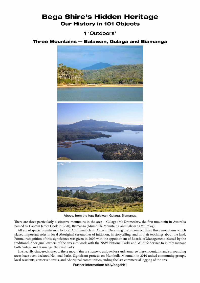
There are three particularly distinctive mountains in the area – Gulaga (Mt Dromedary, the first mountain in Australia named by Captain James Cook in 1770), Biamanga (Mumbulla Mountain), and Balawan (Mt Imlay).
All are of special significance to local Aboriginal clans. Ancient Dreaming Trails connect these three mountains which played important roles in local Aboriginal ceremonies of initiation, in storytelling, and in their teachings about the land. Formal recognition of this significance was given in 2007 with the appointment of Boards of Management, elected by the traditional Aboriginal owners of the areas, to work with the NSW National Parks and Wildlife Service to jointly manage both Gulaga and Biamanga National Parks.
The heavily-timbered slopes of these mountains are home to unique flora and fauna, so these mountains and surrounding areas have been declared National Parks. Significant protests on Mumbulla Mountain in 2010 united community groups, local residents, conservationists, and Aboriginal communities, ending the last commercial logging of the area.
Further information: bit.ly/begahh1
Three Mountains — Balawan, Gulaga and Biamanga
Above, from the top: Balawan, Gulaga, Biamanga
Bega Shire’s Hidden HeritageOur History in 101 Objects
1 ‘Outdoors’
Bega Shire’s Hidden Heritage Page 3
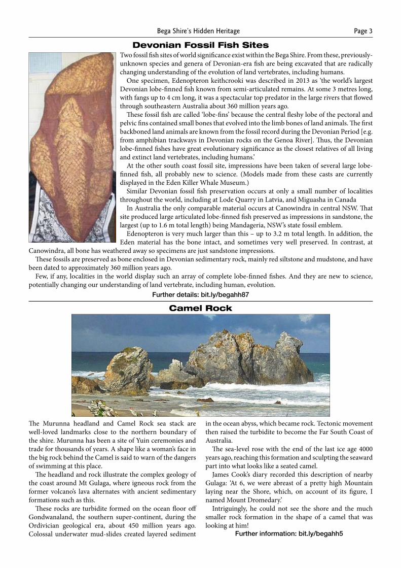
Devonian Fossil Fish SitesTwo fossil fish sites of world significance exist within the Bega Shire. From these, previously-unknown species and genera of Devonian-era fish are being excavated that are radically changing understanding of the evolution of land vertebrates, including humans.
One specimen, Edenopteron keithcrooki was described in 2013 as ‘the world’s largest Devonian lobe-finned fish known from semi-articulated remains. At some 3 metres long, with fangs up to 4 cm long, it was a spectacular top predator in the large rivers that flowed through southeastern Australia about 360 million years ago.
These fossil fish are called ‘lobe-fins’ because the central fleshy lobe of the pectoral and pelvic fins contained small bones that evolved into the limb bones of land animals. The first backboned land animals are known from the fossil record during the Devonian Period [e.g. from amphibian trackways in Devonian rocks on the Genoa River]. Thus, the Devonian lobe-finned fishes have great evolutionary significance as the closest relatives of all living and extinct land vertebrates, including humans.’
At the other south coast fossil site, impressions have been taken of several large lobe-finned fish, all probably new to science. (Models made from these casts are currently displayed in the Eden Killer Whale Museum.)
Similar Devonian fossil fish preservation occurs at only a small number of localities throughout the world, including at Lode Quarry in Latvia, and Miguasha in Canada
In Australia the only comparable material occurs at Canowindra in central NSW. That site produced large articulated lobe-finned fish preserved as impressions in sandstone, the largest (up to 1.6 m total length) being Mandageria, NSW’s state fossil emblem.
Edenopteron is very much larger than this – up to 3.2 m total length. In addition, the Eden material has the bone intact, and sometimes very well preserved. In contrast, at
Canowindra, all bone has weathered away so specimens are just sandstone impressions.These fossils are preserved as bone enclosed in Devonian sedimentary rock, mainly red siltstone and mudstone, and have
been dated to approximately 360 million years ago.Few, if any, localities in the world display such an array of complete lobe-finned fishes. And they are new to science,
potentially changing our understanding of land vertebrate, including human, evolution.Further details: bit.ly/begahh87
The Murunna headland and Camel Rock sea stack are well-loved landmarks close to the northern boundary of the shire. Murunna has been a site of Yuin ceremonies and trade for thousands of years. A shape like a woman’s face in the big rock behind the Camel is said to warn of the dangers of swimming at this place.
The headland and rock illustrate the complex geology of the coast around Mt Gulaga, where igneous rock from the former volcano’s lava alternates with ancient sedimentary formations such as this.
These rocks are turbidite formed on the ocean floor off Gondwanaland, the southern super-continent, during the Ordivician geological era, about 450 million years ago. Colossal underwater mud-slides created layered sediment
in the ocean abyss, which became rock. Tectonic movement then raised the turbidite to become the Far South Coast of Australia.
The sea-level rose with the end of the last ice age 4000 years ago, reaching this formation and sculpting the seaward part into what looks like a seated camel.
James Cook’s diary recorded this description of nearby Gulaga: ‘At 6, we were abreast of a pretty high Mountain laying near the Shore, which, on account of its figure, I named Mount Dromedary.’
Intriguingly, he could not see the shore and the much smaller rock formation in the shape of a camel that was looking at him!
Further information: bit.ly/begahh5
Camel Rock
Bega Shire’s Hidden HeritagePage 4
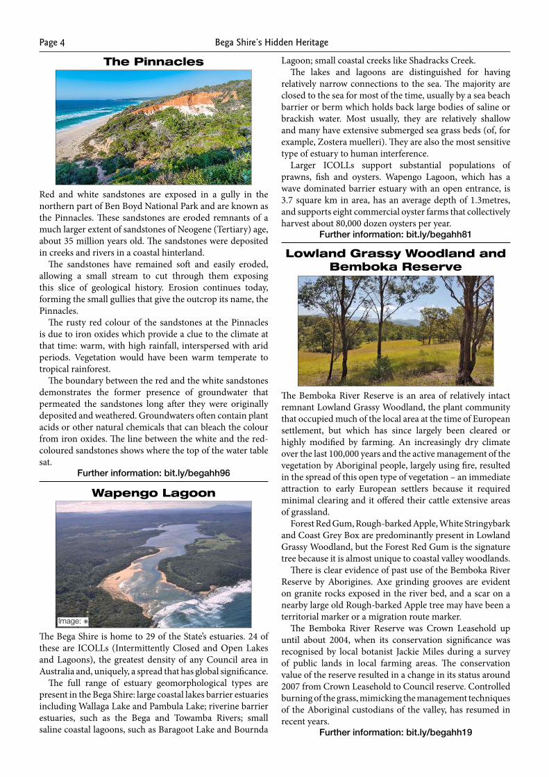
The Pinnacles
Red and white sandstones are exposed in a gully in the northern part of Ben Boyd National Park and are known as the Pinnacles. These sandstones are eroded remnants of a much larger extent of sandstones of Neogene (Tertiary) age, about 35 million years old. The sandstones were deposited in creeks and rivers in a coastal hinterland.
The sandstones have remained soft and easily eroded, allowing a small stream to cut through them exposing this slice of geological history. Erosion continues today, forming the small gullies that give the outcrop its name, the Pinnacles.
The rusty red colour of the sandstones at the Pinnacles is due to iron oxides which provide a clue to the climate at that time: warm, with high rainfall, interspersed with arid periods. Vegetation would have been warm temperate to tropical rainforest.
The boundary between the red and the white sandstones demonstrates the former presence of groundwater that permeated the sandstones long after they were originally deposited and weathered. Groundwaters often contain plant acids or other natural chemicals that can bleach the colour from iron oxides. The line between the white and the red-coloured sandstones shows where the top of the water table sat.
Further information: bit.ly/begahh96
Wapengo Lagoon
The Bega Shire is home to 29 of the State’s estuaries. 24 of these are ICOLLs (Intermittently Closed and Open Lakes and Lagoons), the greatest density of any Council area in Australia and, uniquely, a spread that has global significance.
The full range of estuary geomorphological types are present in the Bega Shire: large coastal lakes barrier estuaries including Wallaga Lake and Pambula Lake; riverine barrier estuaries, such as the Bega and Towamba Rivers; small saline coastal lagoons, such as Baragoot Lake and Bournda
Lagoon; small coastal creeks like Shadracks Creek.The lakes and lagoons are distinguished for having
relatively narrow connections to the sea. The majority are closed to the sea for most of the time, usually by a sea beach barrier or berm which holds back large bodies of saline or brackish water. Most usually, they are relatively shallow and many have extensive submerged sea grass beds (of, for example, Zostera muelleri). They are also the most sensitive type of estuary to human interference.
Larger ICOLLs support substantial populations of prawns, fish and oysters. Wapengo Lagoon, which has a wave dominated barrier estuary with an open entrance, is 3.7 square km in area, has an average depth of 1.3metres, and supports eight commercial oyster farms that collectively harvest about 80,000 dozen oysters per year.
Further information: bit.ly/begahh81
Lowland Grassy Woodland and Bemboka Reserve
The Bemboka River Reserve is an area of relatively intact remnant Lowland Grassy Woodland, the plant community that occupied much of the local area at the time of European settlement, but which has since largely been cleared or highly modified by farming. An increasingly dry climate over the last 100,000 years and the active management of the vegetation by Aboriginal people, largely using fire, resulted in the spread of this open type of vegetation – an immediate attraction to early European settlers because it required minimal clearing and it offered their cattle extensive areas of grassland.
Forest Red Gum, Rough-barked Apple, White Stringybark and Coast Grey Box are predominantly present in Lowland Grassy Woodland, but the Forest Red Gum is the signature tree because it is almost unique to coastal valley woodlands.
There is clear evidence of past use of the Bemboka River Reserve by Aborigines. Axe grinding grooves are evident on granite rocks exposed in the river bed, and a scar on a nearby large old Rough-barked Apple tree may have been a territorial marker or a migration route marker.
The Bemboka River Reserve was Crown Leasehold up until about 2004, when its conservation significance was recognised by local botanist Jackie Miles during a survey of public lands in local farming areas. The conservation value of the reserve resulted in a change in its status around 2007 from Crown Leasehold to Council reserve. Controlled burning of the grass, mimicking the management techniques of the Aboriginal custodians of the valley, has resumed in recent years.
Further information: bit.ly/begahh19
Image: ✳
Bega Shire’s Hidden Heritage Page 5
Flora Indigenous to the Shire
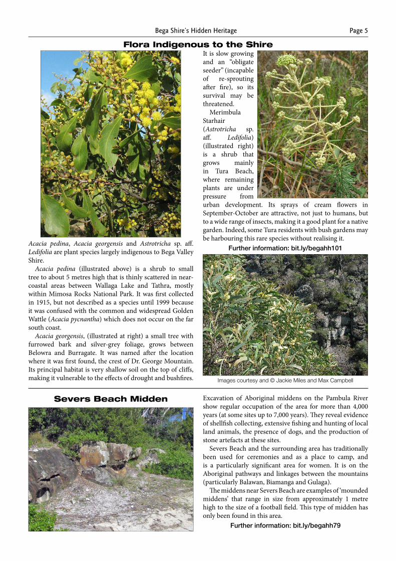
Acacia pedina, Acacia georgensis and Astrotricha sp. aff. Ledifolia are plant species largely indigenous to Bega Valley Shire.
Acacia pedina (illustrated above) is a shrub to small tree to about 5 metres high that is thinly scattered in near-coastal areas between Wallaga Lake and Tathra, mostly within Mimosa Rocks National Park. It was first collected in 1915, but not described as a species until 1999 because it was confused with the common and widespread Golden Wattle (Acacia pycnantha) which does not occur on the far south coast.
Acacia georgensis, (illustrated at right) a small tree with furrowed bark and silver-grey foliage, grows between Belowra and Burragate. It was named after the location where it was first found, the crest of Dr. George Mountain. Its principal habitat is very shallow soil on the top of cliffs, making it vulnerable to the effects of drought and bushfires.
It is slow growing and an “obligate seeder” (incapable of re-sprouting after fire), so its survival may be threatened.
Merimbula Starhair (Astrotricha sp. aff. Ledifolia) (illustrated right) is a shrub that grows mainly in Tura Beach, where remaining plants are under pressure from urban development. Its sprays of cream flowers in September-October are attractive, not just to humans, but to a wide range of insects, making it a good plant for a native garden. Indeed, some Tura residents with bush gardens may be harbouring this rare species without realising it.
Further information: bit.ly/begahh101
Severs Beach Midden Excavation of Aboriginal middens on the Pambula River show regular occupation of the area for more than 4,000 years (at some sites up to 7,000 years). They reveal evidence of shellfish collecting, extensive fishing and hunting of local land animals, the presence of dogs, and the production of stone artefacts at these sites.
Severs Beach and the surrounding area has traditionally been used for ceremonies and as a place to camp, and is a particularly significant area for women. It is on the Aboriginal pathways and linkages between the mountains (particularly Balawan, Biamanga and Gulaga).
The middens near Severs Beach are examples of ‘mounded middens’ that range in size from approximately 1 metre high to the size of a football field. This type of midden has only been found in this area.
Further information: bit.ly/begahh79
Images courtesy and © Jackie Miles and Max Campbell
Bega Shire’s Hidden HeritagePage 6
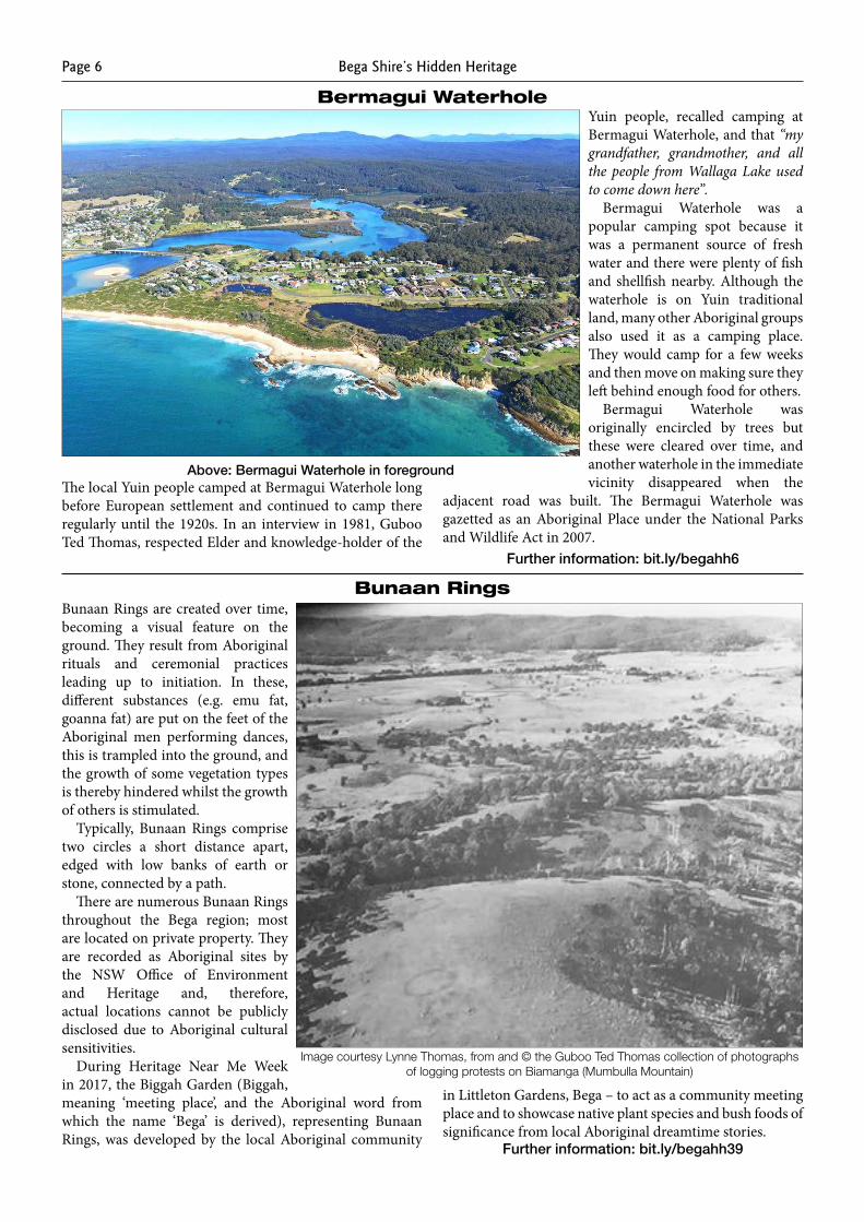
Bermagui Waterhole
The local Yuin people camped at Bermagui Waterhole long before European settlement and continued to camp there regularly until the 1920s. In an interview in 1981, Guboo Ted Thomas, respected Elder and knowledge-holder of the
Yuin people, recalled camping at Bermagui Waterhole, and that “my grandfather, grandmother, and all the people from Wallaga Lake used to come down here”.
Bermagui Waterhole was a popular camping spot because it was a permanent source of fresh water and there were plenty of fish and shellfish nearby. Although the waterhole is on Yuin traditional land, many other Aboriginal groups also used it as a camping place. They would camp for a few weeks and then move on making sure they left behind enough food for others.
Bermagui Waterhole was originally encircled by trees but these were cleared over time, and another waterhole in the immediate vicinity disappeared when the
adjacent road was built. The Bermagui Waterhole was gazetted as an Aboriginal Place under the National Parks and Wildlife Act in 2007.
Further information: bit.ly/begahh6
Bunaan Rings are created over time, becoming a visual feature on the ground. They result from Aboriginal rituals and ceremonial practices leading up to initiation. In these, different substances (e.g. emu fat, goanna fat) are put on the feet of the Aboriginal men performing dances, this is trampled into the ground, and the growth of some vegetation types is thereby hindered whilst the growth of others is stimulated.
Typically, Bunaan Rings comprise two circles a short distance apart, edged with low banks of earth or stone, connected by a path.
There are numerous Bunaan Rings throughout the Bega region; most are located on private property. They are recorded as Aboriginal sites by the NSW Office of Environment and Heritage and, therefore, actual locations cannot be publicly disclosed due to Aboriginal cultural sensitivities.
During Heritage Near Me Week in 2017, the Biggah Garden (Biggah, meaning ‘meeting place’, and the Aboriginal word from which the name ‘Bega’ is derived), representing Bunaan Rings, was developed by the local Aboriginal community
in Littleton Gardens, Bega – to act as a community meeting place and to showcase native plant species and bush foods of significance from local Aboriginal dreamtime stories.
Further information: bit.ly/begahh39
Above: Bermagui Waterhole in foreground
Bunaan Rings
Image courtesy Lynne Thomas, from and © the Guboo Ted Thomas collection of photographs of logging protests on Biamanga (Mumbulla Mountain)
Bega Shire’s Hidden Heritage Page 7
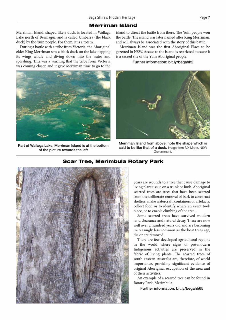
Merriman IslandMerriman Island, shaped like a duck, is located in Wallaga Lake north of Bermagui, and is called Umbarra (the black duck) by the Yuin people. For them, it is a totem.
During a battle with a tribe from Victoria, the Aboriginal elder King Merriman saw a black duck on the lake flapping its wings wildly and diving down into the water and splashing. This was a warning that the tribe from Victoria was coming closer, and it gave Merriman time to go to the
island to direct the battle from there. The Yuin people won the battle. The island was later named after King Merriman, and will always be associated with the story of this battle.
Merriman Island was the first Aboriginal Place to be gazetted in NSW. Access to the island is restricted because it is a sacred site of the Yuin Aboriginal people.
Further information: bit.ly/begahh2
Part of Wallaga Lake, Merriman Island is at the bottom of the picture towards the left
Merriman Island from above, note the shape which is said to be like that of a duck. Image from SIX Maps, NSW
Government.
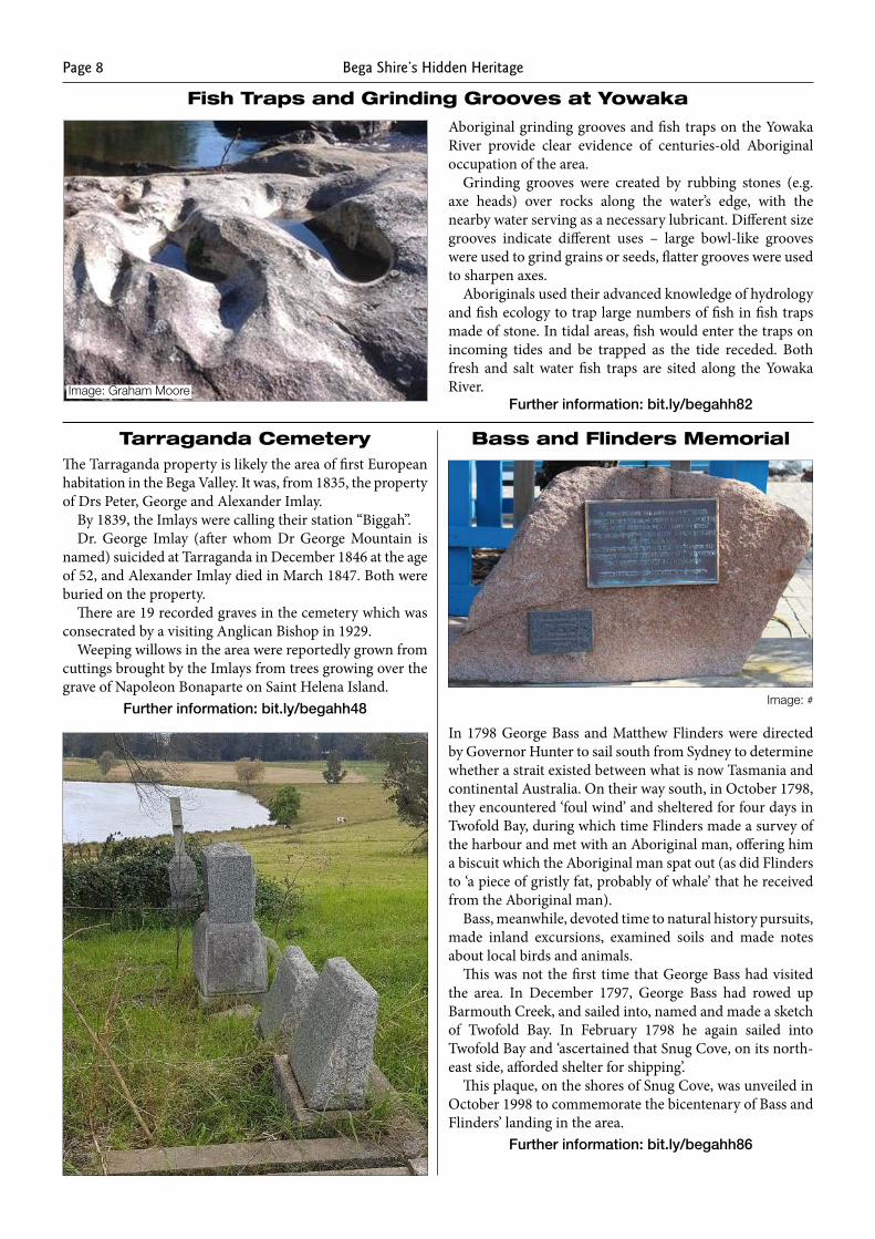
Scar Tree, Merimbula Rotary Park
Scars are wounds to a tree that cause damage to living plant tissue on a trunk or limb. Aboriginal scarred trees are trees that have been scarred from the deliberate removal of bark to construct shelters, make watercraft, containers or artefacts, collect food or to identify where an event took place, or to enable climbing of the tree.
Some scarred trees have survived modern land clearance and natural decay. These are now well over a hundred years old and are becoming increasingly less common as the host trees age, die or are removed.
There are few developed agricultural regions in the world where signs of pre-modern Indigenous activities are preserved in the fabric of living plants. The scarred trees of south eastern Australia are, therefore, of world importance, providing significant evidence of original Aboriginal occupation of the area and of their activities.
An example of a scarred tree can be found in Rotary Park, Merimbula.
Further information: bit.ly/begahh65
Bega Shire’s Hidden HeritagePage 8
Fish Traps and Grinding Grooves at Yowaka
Aboriginal grinding grooves and fish traps on the Yowaka River provide clear evidence of centuries-old Aboriginal occupation of the area.
Grinding grooves were created by rubbing stones (e.g. axe heads) over rocks along the water’s edge, with the nearby water serving as a necessary lubricant. Different size grooves indicate different uses – large bowl-like grooves were used to grind grains or seeds, flatter grooves were used to sharpen axes.
Aboriginals used their advanced knowledge of hydrology and fish ecology to trap large numbers of fish in fish traps made of stone. In tidal areas, fish would enter the traps on incoming tides and be trapped as the tide receded. Both fresh and salt water fish traps are sited along the Yowaka River.
Further information: bit.ly/begahh82
Tarraganda CemeteryThe Tarraganda property is likely the area of first European habitation in the Bega Valley. It was, from 1835, the property of Drs Peter, George and Alexander Imlay.
By 1839, the Imlays were calling their station “Biggah”.Dr. George Imlay (after whom Dr George Mountain is
named) suicided at Tarraganda in December 1846 at the age of 52, and Alexander Imlay died in March 1847. Both were buried on the property.
There are 19 recorded graves in the cemetery which was consecrated by a visiting Anglican Bishop in 1929.
Weeping willows in the area were reportedly grown from cuttings brought by the Imlays from trees growing over the grave of Napoleon Bonaparte on Saint Helena Island.
Further information: bit.ly/begahh48
In 1798 George Bass and Matthew Flinders were directed by Governor Hunter to sail south from Sydney to determine whether a strait existed between what is now Tasmania and continental Australia. On their way south, in October 1798, they encountered ‘foul wind’ and sheltered for four days in Twofold Bay, during which time Flinders made a survey of the harbour and met with an Aboriginal man, offering him a biscuit which the Aboriginal man spat out (as did Flinders to ‘a piece of gristly fat, probably of whale’ that he received from the Aboriginal man).
Bass, meanwhile, devoted time to natural history pursuits, made inland excursions, examined soils and made notes about local birds and animals.
This was not the first time that George Bass had visited the area. In December 1797, George Bass had rowed up Barmouth Creek, and sailed into, named and made a sketch of Twofold Bay. In February 1798 he again sailed into Twofold Bay and ‘ascertained that Snug Cove, on its north-east side, afforded shelter for shipping’.
This plaque, on the shores of Snug Cove, was unveiled in October 1998 to commemorate the bicentenary of Bass and Flinders’ landing in the area.
Further information: bit.ly/begahh86
Bass and Flinders Memorial
Image: #
Image: Graham Moore
Bega Shire’s Hidden Heritage Page 9
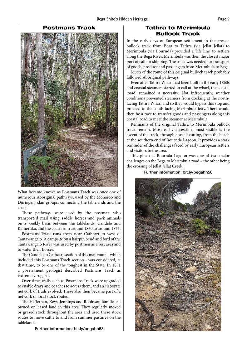
Postmans Track
What became known as Postmans Track was once one of numerous Aboriginal pathways, used by the Monaroo and Djiringanj clan groups, connecting the tablelands and the coast.
These pathways were used by the postman who transported mail using saddle horses and pack animals on a weekly basis between the tablelands, Candelo and Kameruka, and the coast from around 1850 to around 1875.
Postmans Track runs from near Cathcart to west of Tantawangalo. A campsite on a hairpin bend and ford of the Tantawangalo River was used by postmen as a rest area and to water their horses.
The Candelo to Cathcart section of this mail route – which included this Postmans Track section - was considered, at that time, to be one of the toughest in the State. In 1851 a government geologist described Postmans Track as ‘extremely rugged’.
Over time, trails such as Postmans Track were upgraded to enable drays and coaches to access them, and an elaborate network of trails evolved. These also then became part of a network of local stock routes.
The Heffernan, Keys, Jennings and Robinson families all owned or leased land in this area. They regularly moved or grazed stock throughout the area and used these stock routes to move cattle to and from summer pastures on the tablelands.
Further information: bit.ly/begahh63
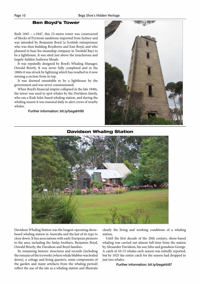
Tathra to Merimbula Bullock Track
In the early days of European settlement in the area, a bullock track from Bega to Tathra (via Jellat Jellat) to Merimbula (via Bournda) provided a ‘life line’ to settlers along the Bega River. Merimbula was then the closest major port of call for shipping. The track was needed for transport of goods, produce and passengers from Merimbula to Bega.
Much of the route of this original bullock track probably followed Aboriginal pathways.
Even after Tathra Wharf had been built in the early 1860s and coastal steamers started to call at the wharf, the coastal ‘road’ remained a necessity. Not infrequently, weather conditions prevented steamers from docking at the north-facing Tathra Wharf and so they would bypass this stop and proceed to the south-facing Merimbula jetty. There would then be a race to transfer goods and passengers along this coastal road to meet the steamer at Merimbula.
Remnants of the original Tathra to Merimbula bullock track remain. Most easily accessible, most visible is the ascent of the track, through a small cutting, from the beach at the southern end of Bournda Lagoon. It provides a stark reminder of the challenges faced by early European settlers and visitors to the area.
This pinch at Bournda Lagoon was one of two major challenges on the Bega to Merimbula road – the other being the crossing of Jellat Jellat Creek.
Further information: bit.ly/begahh56
Bega Shire’s Hidden HeritagePage 10
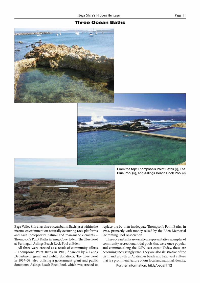
Ben Boyd’s Tower
Built 1845 – c.1847, this 23-metre tower was constructed of blocks of Pyrmont sandstone imported from Sydney and was intended by Benjamin Boyd (a Scottish entrepreneur who was then building Boydtown and East Boyd, and who planned to base his steamship company in Twofold Bay) to be a lighthouse. It was sited just above the treacherous and largely-hidden Seahorse Shoals.
It was reputedly designed by Boyd’s Whaling Manager, Oswald Brierly. It was never fully completed and in the 1860s it was struck by lightning which has resulted in it now missing a section from its top.
It was deemed unsuitable to be a lighthouse by the government and was never commissioned.
When Boyd’s financial empire collapsed in the late 1840s, the tower was used to spot whales by the Davidson family, who ran a Kiah Inlet-based whaling station, and during the whaling season it was manned daily to alert crews of nearby whales.
Further information: bit.ly/begahh95
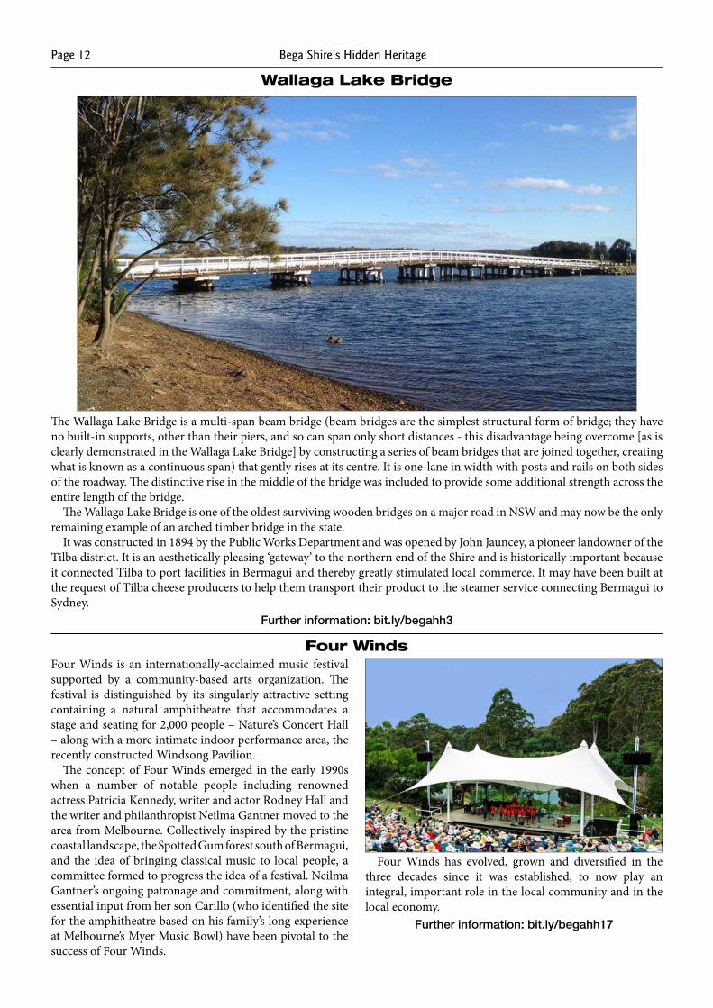
Davidson Whaling Station
Davidson Whaling Station was the longest-operating shore-based whaling station in Australia and the last of its type to close down. It has associations with early European pioneers to the area, including the Imlay brothers, Benjamin Boyd, Oswald Brierly, the Davidson and Boyd families.
Its remaining historic structures and records (including the remains of the tryworks [where whale blubber was boiled down], a cottage and living quarters, some components of the garden and many artefacts from the whaling period) reflect the use of the site as a whaling station and illustrate
clearly the living and working conditions of a whaling station.
Until the first decade of the 20th century, shore-based whaling was carried out almost full-time from the station by Alexander Davidson, his son John and grandson George. A catch of 10-15 whales each season was initially reported, but by 1925 the entire catch for the season had dropped to just two whales.
Further information: bit.ly/begahh97
Bega Shire’s Hidden Heritage Page 11
Three Ocean Baths
Bega Valley Shire has three ocean baths. Each is set within the marine environment on naturally occurring rock platforms and each incorporates natural and man-made elements – Thompson’s Point Baths in Snug Cove, Eden; The Blue Pool at Bermagui; Aslings Beach Rock Pool at Eden.
All three were erected as a result of community efforts – Thompson’s Point Baths in 1905, financed by a Lands Department grant and public donations; The Blue Pool in 1937–38, also utilising a government grant and public donations; Aslings Beach Rock Pool, which was erected to
replace the by-then inadequate Thompson’s Point Baths, in 1961, primarily with money raised by the Eden Memorial Swimming Pool Association.
These ocean baths are excellent representative examples of community recreational tidal pools that were once popular and common along the NSW east coast. Today, these are becoming increasingly rare. They are also illustrative of the birth and growth of Australian beach and later surf culture that is a prominent feature of our local and national identity.
Further information: bit.ly/begahh12
From the top: Thompson’s Point Baths (#), The Blue Pool (✳), and Aslings Beach Rock Pool (#)
Bega Shire’s Hidden HeritagePage 12
Wallaga Lake Bridge
The Wallaga Lake Bridge is a multi-span beam bridge (beam bridges are the simplest structural form of bridge; they have no built-in supports, other than their piers, and so can span only short distances - this disadvantage being overcome [as is clearly demonstrated in the Wallaga Lake Bridge] by constructing a series of beam bridges that are joined together, creating what is known as a continuous span) that gently rises at its centre. It is one-lane in width with posts and rails on both sides of the roadway. The distinctive rise in the middle of the bridge was included to provide some additional strength across the entire length of the bridge.
The Wallaga Lake Bridge is one of the oldest surviving wooden bridges on a major road in NSW and may now be the only remaining example of an arched timber bridge in the state.
It was constructed in 1894 by the Public Works Department and was opened by John Jauncey, a pioneer landowner of the Tilba district. It is an aesthetically pleasing ‘gateway’ to the northern end of the Shire and is historically important because it connected Tilba to port facilities in Bermagui and thereby greatly stimulated local commerce. It may have been built at the request of Tilba cheese producers to help them transport their product to the steamer service connecting Bermagui to Sydney.
Further information: bit.ly/begahh3
Four WindsFour Winds is an internationally-acclaimed music festival supported by a community-based arts organization. The festival is distinguished by its singularly attractive setting containing a natural amphitheatre that accommodates a stage and seating for 2,000 people – Nature’s Concert Hall – along with a more intimate indoor performance area, the recently constructed Windsong Pavilion.
The concept of Four Winds emerged in the early 1990s when a number of notable people including renowned actress Patricia Kennedy, writer and actor Rodney Hall and the writer and philanthropist Neilma Gantner moved to the area from Melbourne. Collectively inspired by the pristine coastal landscape, the Spotted Gum forest south of Bermagui, and the idea of bringing classical music to local people, a committee formed to progress the idea of a festival. Neilma Gantner’s ongoing patronage and commitment, along with essential input from her son Carillo (who identified the site for the amphitheatre based on his family’s long experience at Melbourne’s Myer Music Bowl) have been pivotal to the success of Four Winds.
Four Winds has evolved, grown and diversified in the three decades since it was established, to now play an integral, important role in the local community and in the local economy.
Further information: bit.ly/begahh17
Bega Shire’s Hidden Heritage Page 13
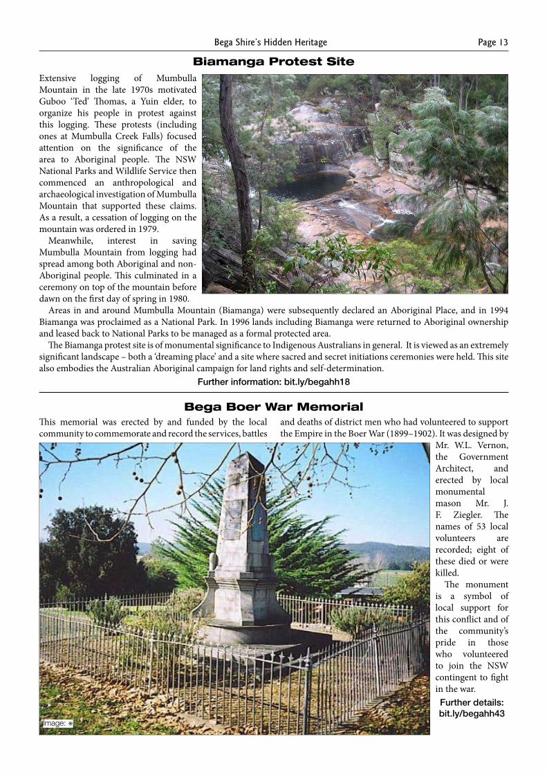
Biamanga Protest SiteExtensive logging of Mumbulla Mountain in the late 1970s motivated Guboo ‘Ted’ Thomas, a Yuin elder, to organize his people in protest against this logging. These protests (including ones at Mumbulla Creek Falls) focused attention on the significance of the area to Aboriginal people. The NSW National Parks and Wildlife Service then commenced an anthropological and archaeological investigation of Mumbulla Mountain that supported these claims. As a result, a cessation of logging on the mountain was ordered in 1979.
Meanwhile, interest in saving Mumbulla Mountain from logging had spread among both Aboriginal and non-Aboriginal people. This culminated in a ceremony on top of the mountain before dawn on the first day of spring in 1980.
Areas in and around Mumbulla Mountain (Biamanga) were subsequently declared an Aboriginal Place, and in 1994 Biamanga was proclaimed as a National Park. In 1996 lands including Biamanga were returned to Aboriginal ownership and leased back to National Parks to be managed as a formal protected area.
The Biamanga protest site is of monumental significance to Indigenous Australians in general. It is viewed as an extremely significant landscape – both a ‘dreaming place’ and a site where sacred and secret initiations ceremonies were held. This site also embodies the Australian Aboriginal campaign for land rights and self-determination.
Further information: bit.ly/begahh18
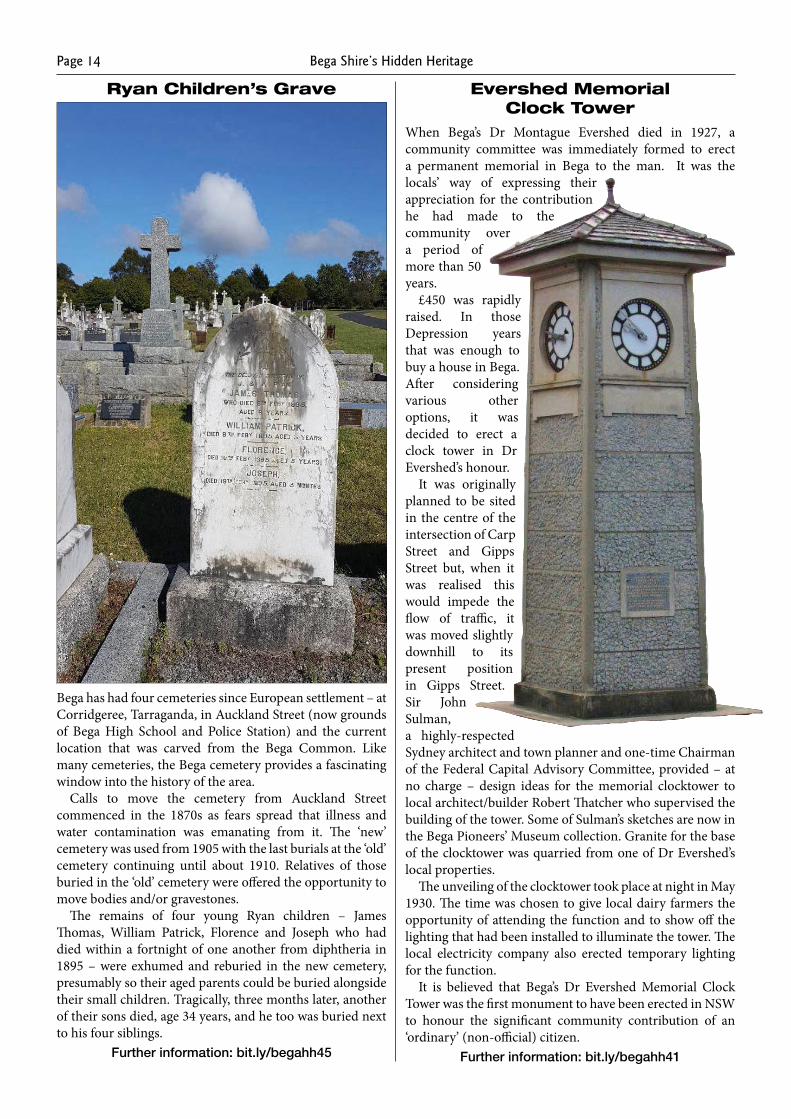
Bega Boer War MemorialThis memorial was erected by and funded by the local community to commemorate and record the services, battles
and deaths of district men who had volunteered to support the Empire in the Boer War (1899–1902). It was designed by
Mr. W.L. Vernon, the Government Architect, and erected by local monumental mason Mr. J. F. Ziegler. The names of 53 local volunteers are recorded; eight of these died or were killed.
The monument is a symbol of local support for this conflict and of the community’s pride in those who volunteered to join the NSW contingent to fight in the war.Further details: bit.ly/begahh43
Image: ✳
Bega Shire’s Hidden HeritagePage 14
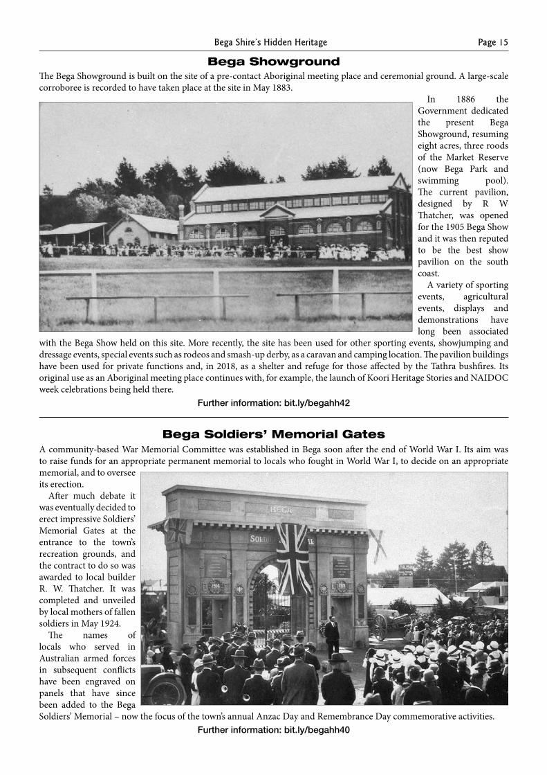
Ryan Children’s Grave
Bega has had four cemeteries since European settlement – at Corridgeree, Tarraganda, in Auckland Street (now grounds of Bega High School and Police Station) and the current location that was carved from the Bega Common. Like many cemeteries, the Bega cemetery provides a fascinating window into the history of the area.
Calls to move the cemetery from Auckland Street commenced in the 1870s as fears spread that illness and water contamination was emanating from it. The ‘new’ cemetery was used from 1905 with the last burials at the ‘old’ cemetery continuing until about 1910. Relatives of those buried in the ‘old’ cemetery were offered the opportunity to move bodies and/or gravestones.
The remains of four young Ryan children – James Thomas, William Patrick, Florence and Joseph who had died within a fortnight of one another from diphtheria in 1895 – were exhumed and reburied in the new cemetery, presumably so their aged parents could be buried alongside their small children. Tragically, three months later, another of their sons died, age 34 years, and he too was buried next to his four siblings.
Further information: bit.ly/begahh45
Evershed Memorial Clock Tower
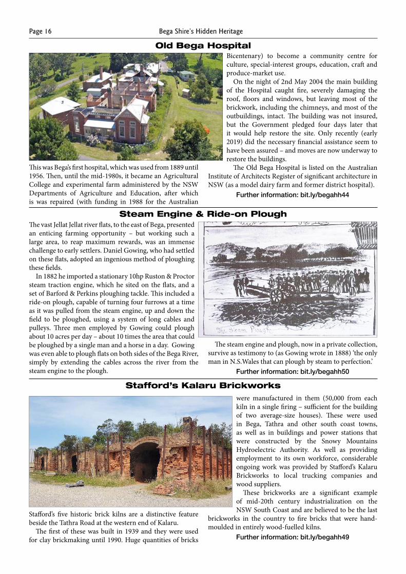
When Bega’s Dr Montague Evershed died in 1927, a community committee was immediately formed to erect a permanent memorial in Bega to the man. It was the locals’ way of expressing their appreciation for the contribution he had made to the community over a period of more than 50 years.
£450 was rapidly raised. In those Depression years that was enough to buy a house in Bega. After considering various other options, it was decided to erect a clock tower in Dr Evershed’s honour.
It was originally planned to be sited in the centre of the intersection of Carp Street and Gipps Street but, when it was realised this would impede the flow of traffic, it was moved slightly downhill to its present position in Gipps Street. Sir John Sulman, a highly-respected Sydney architect and town planner and one-time Chairman of the Federal Capital Advisory Committee, provided – at no charge – design ideas for the memorial clocktower to local architect/builder Robert Thatcher who supervised the building of the tower. Some of Sulman’s sketches are now in the Bega Pioneers’ Museum collection. Granite for the base of the clocktower was quarried from one of Dr Evershed’s local properties.
The unveiling of the clocktower took place at night in May 1930. The time was chosen to give local dairy farmers the opportunity of attending the function and to show off the lighting that had been installed to illuminate the tower. The local electricity company also erected temporary lighting for the function.
It is believed that Bega’s Dr Evershed Memorial Clock Tower was the first monument to have been erected in NSW to honour the significant community contribution of an ‘ordinary’ (non-official) citizen.
Further information: bit.ly/begahh41
Bega Shire’s Hidden Heritage Page 15
The Bega Showground is built on the site of a pre-contact Aboriginal meeting place and ceremonial ground. A large-scale corroboree is recorded to have taken place at the site in May 1883.
In 1886 the Government dedicated the present Bega Showground, resuming eight acres, three roods of the Market Reserve (now Bega Park and swimming pool). The current pavilion, designed by R W Thatcher, was opened for the 1905 Bega Show and it was then reputed to be the best show pavilion on the south coast.
A variety of sporting events, agricultural events, displays and demonstrations have long been associated
with the Bega Show held on this site. More recently, the site has been used for other sporting events, showjumping and dressage events, special events such as rodeos and smash-up derby, as a caravan and camping location. The pavilion buildings have been used for private functions and, in 2018, as a shelter and refuge for those affected by the Tathra bushfires. Its original use as an Aboriginal meeting place continues with, for example, the launch of Koori Heritage Stories and NAIDOC week celebrations being held there.
Further information: bit.ly/begahh42
A community-based War Memorial Committee was established in Bega soon after the end of World War I. Its aim was to raise funds for an appropriate permanent memorial to locals who fought in World War I, to decide on an appropriate memorial, and to oversee its erection.
After much debate it was eventually decided to erect impressive Soldiers’ Memorial Gates at the entrance to the town’s recreation grounds, and the contract to do so was awarded to local builder R. W. Thatcher. It was completed and unveiled by local mothers of fallen soldiers in May 1924.
The names of locals who served in Australian armed forces in subsequent conflicts have been engraved on panels that have since been added to the Bega Soldiers’ Memorial – now the focus of the town’s annual Anzac Day and Remembrance Day commemorative activities.
Further information: bit.ly/begahh40
Bega Showground
Bega Soldiers’ Memorial Gates
Bega Shire’s Hidden HeritagePage 16
Old Bega Hospital
This was Bega’s first hospital, which was used from 1889 until 1956. Then, until the mid-1980s, it became an Agricultural College and experimental farm administered by the NSW Departments of Agriculture and Education, after which is was repaired (with funding in 1988 for the Australian
Bicentenary) to become a community centre for culture, special-interest groups, education, craft and produce-market use.
On the night of 2nd May 2004 the main building of the Hospital caught fire, severely damaging the roof, floors and windows, but leaving most of the brickwork, including the chimneys, and most of the outbuildings, intact. The building was not insured, but the Government pledged four days later that it would help restore the site. Only recently (early 2019) did the necessary financial assistance seem to have been assured – and moves are now underway to restore the buildings.
The Old Bega Hospital is listed on the Australian Institute of Architects Register of significant architecture in NSW (as a model dairy farm and former district hospital).
Further information: bit.ly/begahh44
Steam Engine & Ride-on Plough
Stafford’s Kalaru Brickworks
The vast Jellat Jellat river flats, to the east of Bega, presented an enticing farming opportunity – but working such a large area, to reap maximum rewards, was an immense challenge to early settlers. Daniel Gowing, who had settled on these flats, adopted an ingenious method of ploughing these fields.
In 1882 he imported a stationary 10hp Ruston & Proctor steam traction engine, which he sited on the flats, and a set of Barford & Perkins ploughing tackle. This included a ride-on plough, capable of turning four furrows at a time as it was pulled from the steam engine, up and down the field to be ploughed, using a system of long cables and pulleys. Three men employed by Gowing could plough about 10 acres per day – about 10 times the area that could be ploughed by a single man and a horse in a day. Gowing was even able to plough flats on both sides of the Bega River, simply by extending the cables across the river from the steam engine to the plough.
The steam engine and plough, now in a private collection, survive as testimony to (as Gowing wrote in 1888) ‘the only man in N.S.Wales that can plough by steam to perfection.’
Further information: bit.ly/begahh50
Stafford’s five historic brick kilns are a distinctive feature beside the Tathra Road at the western end of Kalaru.
The first of these was built in 1939 and they were used for clay brickmaking until 1990. Huge quantities of bricks
were manufactured in them (50,000 from each kiln in a single firing – sufficient for the building of two average-size houses). These were used in Bega, Tathra and other south coast towns, as well as in buildings and power stations that were constructed by the Snowy Mountains Hydroelectric Authority. As well as providing employment to its own workforce, considerable ongoing work was provided by Stafford’s Kalaru Brickworks to local trucking companies and wood suppliers.
These brickworks are a significant example of mid-20th century industrialization on the NSW South Coast and are believed to be the last
brickworks in the country to fire bricks that were hand-moulded in entirely wood-fuelled kilns.
Further information: bit.ly/begahh49
Bega Shire’s Hidden Heritage Page 17
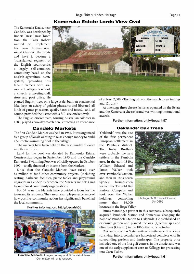
Kameruka Estate Lords View OvalThe Kameruka Estate, near Candelo, was developed by Robert Lucas Lucas-Tooth from the 1860s. Robert wanted to implement his own humanitarian social ideals on the Estate and have it become a ‘transplanted segment of the English countryside; a largely self-contained community based on the English agricultural estate system’, ‘providing his tenant farmers with six-roomed cottages, a school, a church, a meeting-hall, store and post office. He planted English trees on a large scale, built an ornamental lake, kept an aviary of golden pheasants and liberated all kinds of game: pheasants, quails, hares and foxes’… and, of course, provided the Estate with a full-size cricket oval!
The English cricket team, touring Australian colonies in 1885, played a two-day match here, attracting an attendance
of at least 2,000. (The English won the match by an innings and 12 runs.)
At one stage three cheese factories operated on the Estate and the Kameruka cheese brand was winning international awards.
Further information: bit.ly/begahh57
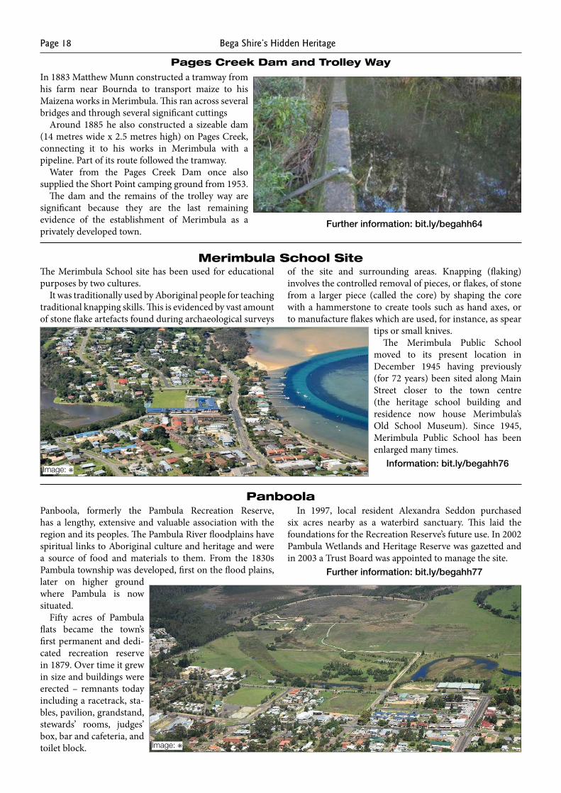
The first Candelo Market was held in 1982. It was organized by a group of locals wanting to raise enough money to build a 50-metre swimming pool in the village.
The markets have been held on the first Sunday of every month ever since.
Land for the pool was donated by Kameruka Estate. Construction began in September 1993 and the Candelo Kameruka Swimming Pool was officially opened in October 1997 – totally financed by income from the Markets.
Since then the Candelo Markets have raised over $1-million to fund other community projects, (including seating, barbecue facilities, picnic tables and playground upgrades in Candelo Park where the Markets are held) and to assist local community organisations.
For 37 years the Markets have provided a focus for the town and its residents. They are an example par-excellence of how positive community action has significantly benefited the local community.
Further information: bit.ly/begahh58
Candelo Markets. Image courtesy and © Candelo Market Committee. All rights reserved
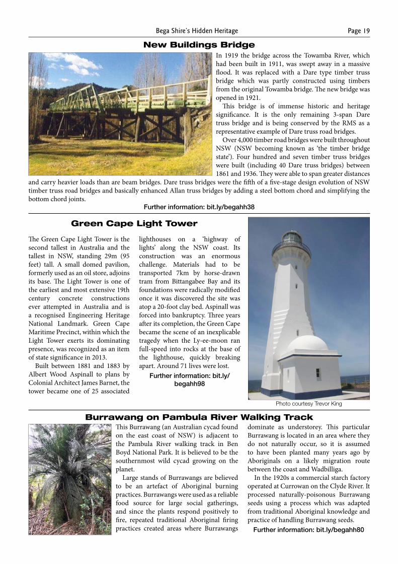
Candelo Markets Oaklands’ Oak Trees‘Oaklands’ was the site of the first permanent European settlement in the Pambula district. The Imlay Brothers were probably the first settlers in the Pambula area. In the early 1840s, William, Edward and James Walker took over Pamboola Station, and then in 1853 seven Sydney businessmen formed the Twofold Bay Pastoral Company and took over the Walker holdings, controlling more than 16,000 hectares in the Bega Valley.
James Manning, a partner in this company, subsequently acquired Pamboola Station and Kameruka, changing the name of Pamboola Station to Oaklands. He established an extensive garden and planted the oak (Quercus sp.) and olive trees (Olea sp.) in the 1860s that survive today.
Oaklands now has State heritage significance. It is a rare surviving, intact, colonial-era homestead complete with its surrounding gardens and landscapes. The property once included one of the first golf courses in the district and was one of the early suppliers of corn to Kelloggs for processing into Corn Flakes.
Further information: bit.ly/begahh61
Photograph: Suzanna Plowman (for OEH)
Bega Shire’s Hidden HeritagePage 18
Pages Creek Dam and Trolley WayIn 1883 Matthew Munn constructed a tramway from his farm near Bournda to transport maize to his Maizena works in Merimbula. This ran across several bridges and through several significant cuttings
Around 1885 he also constructed a sizeable dam (14 metres wide x 2.5 metres high) on Pages Creek, connecting it to his works in Merimbula with a pipeline. Part of its route followed the tramway.
Water from the Pages Creek Dam once also supplied the Short Point camping ground from 1953.
The dam and the remains of the trolley way are significant because they are the last remaining evidence of the establishment of Merimbula as a privately developed town.
Further information: bit.ly/begahh64
Merimbula School SiteThe Merimbula School site has been used for educational purposes by two cultures.
It was traditionally used by Aboriginal people for teaching traditional knapping skills. This is evidenced by vast amount of stone flake artefacts found during archaeological surveys
of the site and surrounding areas. Knapping (flaking) involves the controlled removal of pieces, or flakes, of stone from a larger piece (called the core) by shaping the core with a hammerstone to create tools such as hand axes, or to manufacture flakes which are used, for instance, as spear
tips or small knives.The Merimbula Public School
moved to its present location in December 1945 having previously (for 72 years) been sited along Main Street closer to the town centre (the heritage school building and residence now house Merimbula’s Old School Museum). Since 1945, Merimbula Public School has been enlarged many times.
Information: bit.ly/begahh76
PanboolaPanboola, formerly the Pambula Recreation Reserve, has a lengthy, extensive and valuable association with the region and its peoples. The Pambula River floodplains have spiritual links to Aboriginal culture and heritage and were a source of food and materials to them. From the 1830s Pambula township was developed, first on the flood plains, later on higher ground where Pambula is now situated.
Fifty acres of Pambula flats became the town’s first permanent and dedi-cated recreation reserve in 1879. Over time it grew in size and buildings were erected – remnants today including a racetrack, sta-bles, pavilion, grandstand, stewards’ rooms, judges’ box, bar and cafeteria, and toilet block.
In 1997, local resident Alexandra Seddon purchased six acres nearby as a waterbird sanctuary. This laid the foundations for the Recreation Reserve’s future use. In 2002 Pambula Wetlands and Heritage Reserve was gazetted and in 2003 a Trust Board was appointed to manage the site.
Further information: bit.ly/begahh77
Image: ✳
Image: ✳
Bega Shire’s Hidden Heritage Page 19
New Buildings BridgeIn 1919 the bridge across the Towamba River, which had been built in 1911, was swept away in a massive flood. It was replaced with a Dare type timber truss bridge which was partly constructed using timbers from the original Towamba bridge. The new bridge was opened in 1921.
This bridge is of immense historic and heritage significance. It is the only remaining 3-span Dare truss bridge and is being conserved by the RMS as a representative example of Dare truss road bridges.
Over 4,000 timber road bridges were built throughout NSW (NSW becoming known as ‘the timber bridge state’). Four hundred and seven timber truss bridges were built (including 40 Dare truss bridges) between 1861 and 1936. They were able to span greater distances
and carry heavier loads than are beam bridges. Dare truss bridges were the fifth of a five-stage design evolution of NSW timber truss road bridges and basically enhanced Allan truss bridges by adding a steel bottom chord and simplifying the bottom chord joints.
Further information: bit.ly/begahh38
Green Cape Light Tower
The Green Cape Light Tower is the second tallest in Australia and the tallest in NSW, standing 29m (95 feet) tall. A small domed pavilion, formerly used as an oil store, adjoins its base. The Light Tower is one of the earliest and most extensive 19th century concrete constructions ever attempted in Australia and is a recognised Engineering Heritage National Landmark. Green Cape Maritime Precinct, within which the Light Tower exerts its dominating presence, was recognized as an item of state significance in 2013.
Built between 1881 and 1883 by Albert Wood Aspinall to plans by Colonial Architect James Barnet, the tower became one of 25 associated
lighthouses on a ‘highway of lights’ along the NSW coast. Its construction was an enormous challenge. Materials had to be transported 7km by horse-drawn tram from Bittangabee Bay and its foundations were radically modified once it was discovered the site was atop a 20-foot clay bed. Aspinall was forced into bankruptcy. Three years after its completion, the Green Cape became the scene of an inexplicable tragedy when the Ly-ee-moon ran full-speed into rocks at the base of the lighthouse, quickly breaking apart. Around 71 lives were lost.
Further information: bit.ly/begahh98
Burrawang on Pambula River Walking TrackThis Burrawang (an Australian cycad found on the east coast of NSW) is adjacent to the Pambula River walking track in Ben Boyd National Park. It is believed to be the southernmost wild cycad growing on the planet.
Large stands of Burrawangs are believed to be an artefact of Aboriginal burning practices. Burrawangs were used as a reliable food source for large social gatherings, and since the plants respond positively to fire, repeated traditional Aboriginal firing practices created areas where Burrawangs
dominate as understorey. This particular Burrawang is located in an area where they do not naturally occur, so it is assumed to have been planted many years ago by Aboriginals on a likely migration route between the coast and Wadbilliga.
In the 1920s a commercial starch factory operated at Currowan on the Clyde River. It processed naturally-poisonous Burrawang seeds using a process which was adapted from traditional Aboriginal knowledge and practice of handling Burrawang seeds.
Further information: bit.ly/begahh80
Photo courtesy Trevor King
Bega Shire’s Hidden HeritagePage 20
Boundary Marker on the Black-Allan Line
The Black-Allan Line is the straight-line border between NSW and Victoria that runs from the most easterly source of the Murray River in Kosciuszko National Park to Cape Howe on the coast. It was named after two of three surveyors (Alexander Allan and Alexander Black; the third surveyor, who was not acknowledged in the Line’s name, was William Turton) who physically surveyed and set the state boundary between 1870 and 1872.
Some of their original surveying marks have survived, and the Line is commemorated by a plaque adjacent to the Princes Highway.
Black, Allan and Turton’s task in laying the actual boundary on the land has been described as one of the most ‘difficult and arduous undertakings of any colonial surveyor,’ not least because the terrain they were traversing was so rugged. The men returned home once every six months and with ‘no fixed hours for work … if it were necessary, the
work would be carried on from daylight to dark.’ They even worked on Christmas Day.
Further information: bit.ly/begahh99
Woolingubrah InnThis historic inn is hidden away in Coolangubra State Forest, near Cathcart.
‘Woolingubrah’ is an Aboriginal word for windy place, a most appropriate name, as the inn is located on an exposed peak of the Big Jack range of mountains. Established in 1860 as a halfway hotel for people heading to the gold fields in Kiandra from coastal towns including Tathra, Merimbula and Eden, the inn is thought to be one of only a few remaining buildings of its type in Australia.
Consisting of a bar, dining room, kitchen and six bedrooms, the inn was prefabricated and shipped from the USA in sections, was unloaded at Eden and
transported up to the site where it stands today. The building has been conserved and many of its original features are still intact.
Further information: bit.ly/begahh78
Bermagui Sawmill EngineTimber milling has been an important
industry in Bermagui from the time the first mill was erected in the 1870s on the northern banks of Bermagui River, near the present Primary School. A second mill was established in Carnago Street, Bermagui South, by a partnership, Maloney, Adamson & Warn, around 1900.
Early mills were operated by steam engines which were expensive and labour intensive to run. The large Clyde Sawmilling Company bought the mill in 1940 and installed this Crossley engine in 1945. The engine, a Crossley 1926 model O.E.223, a 160HP with a 2.56 metre diameter flywheel weighing 8.9 tonnes, had previously been used at the Junee Flour Mill.
The engine drove belts to power saw benches in the timber mill until the closure of the Clyde Sawmill in 1977.
Bega & District Historical Machinery Club Inc. is the
present owner of the engine. It is being restored to running condition to become a tourist attraction.
Further information: bit.ly/begahh46
The Crossley engine prior to relocation and restoration.
Photo Dave Cotton
Bega Shire’s Hidden Heritage Page 21
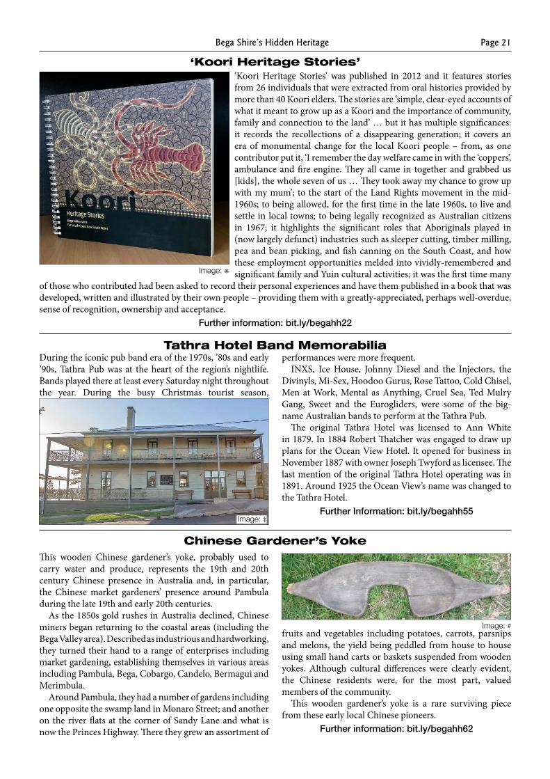
‘Koori Heritage Stories’ was published in 2012 and it features stories from 26 individuals that were extracted from oral histories provided by more than 40 Koori elders. The stories are ‘simple, clear-eyed accounts of what it meant to grow up as a Koori and the importance of community, family and connection to the land’ … but it has multiple significances: it records the recollections of a disappearing generation; it covers an era of monumental change for the local Koori people – from, as one contributor put it, ‘I remember the day welfare came in with the ‘coppers’, ambulance and fire engine. They all came in together and grabbed us [kids], the whole seven of us … They took away my chance to grow up with my mum’; to the start of the Land Rights movement in the mid-1960s; to being allowed, for the first time in the late 1960s, to live and settle in local towns; to being legally recognized as Australian citizens in 1967; it highlights the significant roles that Aboriginals played in (now largely defunct) industries such as sleeper cutting, timber milling, pea and bean picking, and fish canning on the South Coast, and how these employment opportunities melded into vividly-remembered and significant family and Yuin cultural activities; it was the first time many
of those who contributed had been asked to record their personal experiences and have them published in a book that was developed, written and illustrated by their own people – providing them with a greatly-appreciated, perhaps well-overdue, sense of recognition, ownership and acceptance.
Further information: bit.ly/begahh22
‘Koori Heritage Stories’
Tathra Hotel Band Memorabilia
Image: ✳
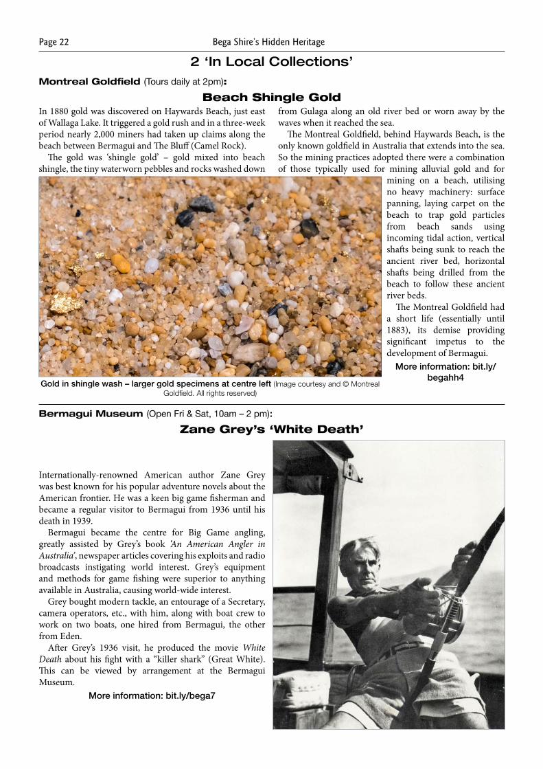
During the iconic pub band era of the 1970s, ’80s and early ’90s, Tathra Pub was at the heart of the region’s nightlife. Bands played there at least every Saturday night throughout the year. During the busy Christmas tourist season,
performances were more frequent.INXS, Ice House, Johnny Diesel and the Injectors, the
Divinyls, Mi-Sex, Hoodoo Gurus, Rose Tattoo, Cold Chisel, Men at Work, Mental as Anything, Cruel Sea, Ted Mulry Gang, Sweet and the Eurogliders, were some of the big-name Australian bands to perform at the Tathra Pub.
The original Tathra Hotel was licensed to Ann White in 1879. In 1884 Robert Thatcher was engaged to draw up plans for the Ocean View Hotel. It opened for business in November 1887 with owner Joseph Twyford as licensee. The last mention of the original Tathra Hotel operating was in 1891. Around 1925 the Ocean View’s name was changed to the Tathra Hotel.
Further Information: bit.ly/begahh55Image: ‡
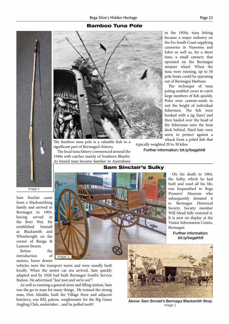
Chinese Gardener’s YokeThis wooden Chinese gardener’s yoke, probably used to carry water and produce, represents the 19th and 20th century Chinese presence in Australia and, in particular, the Chinese market gardeners’ presence around Pambula during the late 19th and early 20th centuries.
As the 1850s gold rushes in Australia declined, Chinese miners began returning to the coastal areas (including the Bega Valley area). Described as industrious and hardworking, they turned their hand to a range of enterprises including market gardening, establishing themselves in various areas including Pambula, Bega, Cobargo, Candelo, Bermagui and Merimbula.
Around Pambula, they had a number of gardens including one opposite the swamp land in Monaro Street; and another on the river flats at the corner of Sandy Lane and what is now the Princes Highway. There they grew an assortment of
fruits and vegetables including potatoes, carrots, parsnips and melons, the yield being peddled from house to house using small hand carts or baskets suspended from wooden yokes. Although cultural differences were clearly evident, the Chinese residents were, for the most part, valued members of the community.
This wooden gardener’s yoke is a rare surviving piece from these early local Chinese pioneers.
Further information: bit.ly/begahh62
Image: #
Bega Shire’s Hidden HeritagePage 22
2 ‘In Local Collections’Montreal Goldfield (Tours daily at 2pm):
In 1880 gold was discovered on Haywards Beach, just east of Wallaga Lake. It triggered a gold rush and in a three-week period nearly 2,000 miners had taken up claims along the beach between Bermagui and The Bluff (Camel Rock).
The gold was ‘shingle gold’ – gold mixed into beach shingle, the tiny waterworn pebbles and rocks washed down
from Gulaga along an old river bed or worn away by the waves when it reached the sea.
The Montreal Goldfield, behind Haywards Beach, is the only known goldfield in Australia that extends into the sea. So the mining practices adopted there were a combination of those typically used for mining alluvial gold and for
mining on a beach, utilising no heavy machinery: surface panning, laying carpet on the beach to trap gold particles from beach sands using incoming tidal action, vertical shafts being sunk to reach the ancient river bed, horizontal shafts being drilled from the beach to follow these ancient river beds.
The Montreal Goldfield had a short life (essentially until 1883), its demise providing significant impetus to the development of Bermagui.
More information: bit.ly/begahh4
Gold in shingle wash – larger gold specimens at centre left (Image courtesy and © Montreal Goldfield. All rights reserved)
Beach Shingle Gold
Zane Grey’s ‘White Death’
Internationally-renowned American author Zane Grey was best known for his popular adventure novels about the American frontier. He was a keen big game fisherman and became a regular visitor to Bermagui from 1936 until his death in 1939.
Bermagui became the centre for Big Game angling, greatly assisted by Grey’s book ‘An American Angler in Australia’, newspaper articles covering his exploits and radio broadcasts instigating world interest. Grey’s equipment and methods for game fishing were superior to anything available in Australia, causing world-wide interest.
Grey bought modern tackle, an entourage of a Secretary, camera operators, etc., with him, along with boat crew to work on two boats, one hired from Bermagui, the other from Eden.
After Grey’s 1936 visit, he produced the movie White Death about his fight with a “killer shark” (Great White). This can be viewed by arrangement at the Bermagui Museum.
More information: bit.ly/bega7
Bermagui Museum (Open Fri & Sat, 10am – 2 pm):
Bega Shire’s Hidden Heritage Page 23
Bamboo Tuna Pole
The bamboo tuna pole is a valuable link to a significant part of Bermagui’s history.
The local tuna fishery commenced around the 1940s with catches mainly of Southern Bluefin. As tinned tuna became familiar to Australians
in the 1950s, tuna fishing became a major industry on the Far South Coast supplying canneries in Narooma and Eden as well as, for a short time, a small cannery that operated on the Bermagui steamer wharf. When the tuna were running, up to 50 pole boats could be operating out of Bermagui Harbour.
The technique of tuna poling enabled crews to catch large numbers of fish quickly. Poles were custom-made to suit the height of individual fishermen. The fish were hooked with a jig (lure) and then hauled over the head of the fisherman onto the boat deck behind. Hard hats were worn to protect against a whack from a poled fish that
typically weighted 20 to 30 kilos.Further information: bit.ly/begahh8
Image ‡
Sam Sinclair’s Sulky
Sam Sinclair came from a blacksmithing family and arrived in Bermagui in 1903, having served in the Boer War. He established himself as Blacksmith and Wheelwright on the corner of Bunga & Lamont Streets.
Before the introduction of motors, horse drawn vehicles were the transport norm and were usually built locally. When the motor car era arrived, Sam quickly adapted and by 1928 had built Bermagui South’s Service Station. He advertised “Just toot and we’re oot”!
As well as running a general store and filling station, Sam was the go-to man for many things. He trained the strong man, Don Athaldo, built the Village Store and adjacent butchery, was RSL patron, weighmaster for the Big Game Angling Club, undertaker…and he pulled teeth!
On his death in 1964, the Sulky, which he had built and used all his life, was bequeathed to Bega Pioneers’ Museum who subsequently donated it to Bermagui Historical Society. Society member Will Mead fully restored it. It is now on display at the Visitor Information Centre, Bermagui.
Further information: bit.ly/begahh9
Above: Sam Sinclair’s Bermagui Blacksmith Shop Image:
Image: ‡
Bega Shire’s Hidden HeritagePage 24
Pearl Corkhill’s Camera
This Eastman No3 Folding Kodak Camera with Bellows Lens and Viewfinder belonged to Pearl Corkhill of Tilba who joined the Australian Imperial Force as a staff nurse in July 1915 and became one of only eight WW1 Australian nurses to receive the Military Medal. This was for courage and devotion while under air attack.
After the War, she moved back to the South Coast, and was Senior Sister at Bega Hospital from February 1951 until her retirement in October 1961.
Her father was famous Tilba photographer William Henry Corkhill. Pearl’s camera accompanied her to Egypt and the Western Front. The taking of personal photographs while on service was unusual, so Pearl’s photographs provide interesting insights into her story.
Pearl retired to Akolele, overlooking Wallaga Lake. She was greatly respected and loved and was often asked to preside at local functions. She died on 4th December 1985, aged 98.
Further information: bit.ly/begahh10
Image: ‡
In 1825 Governor Brisbane was instructed to undertake a general survey of NSW and to divide it into counties (there are now 141 of these) and parishes (now 7,459 of them).
The earliest cadastral map of Bermaguee in the County of Dampier shows proposed lots for sale in 1868. It is an important historic record of the birth of the town.
A larger and later survey map from 1888, on display in the Bermagui Museum, names the villages ‘Bermaguee’ (at left) and ‘Bermaguee South’ (at right).
Before towns and villages were gazetted and plots of land were sold, government surveys were carried out for topographical and cadastral (the official registration of property boundaries) use. Registration of property ownership and definition of property boundaries has relied on this data ever since – and, because some of the surveyed ‘villages’ were never built, these early surveys occasionally present significant land use challenges to today’s owners!
More information: bit.ly/begahh11
Bermaguee Map
Image:
Infant’s Bassinet
Cobargo District Museum (Open Tue – Fri 10am – 2pm; Sat 10am – 1pm):
One way the CWA in NSW responded to the need for education and support from rural women was to be responsible for Baby Health Centres. At Cobargo a Baby Health Centre Auxiliary was formed in 1945. The Cobargo CWA assumed responsibility for developing and supporting the Baby Health Centre when it formed in 1946.
The first baby clinics in Cobargo were held in 1948 in the now Well Thumbed Books building. All furnishings and equipment required approval from the State Health Department. With community support and fundraising, the Cobargo CWA provided necessary items – including this ‘Reedtex’ woven cane bassinet. An associated cotton pillow cover is embroidered “Cobargo Clinic”.
By 1954 the Cobargo CWA was lobbying for a resident doctor, at a time when an average of 12 mothers and babies were attending the Baby Health Centre clinics. All babies in the Cobargo area who attended the service would have spent time in this bassinet being assessed and weighed.
Further information: bit.ly/begahh13
Image: ‡

Bega Shire’s Hidden Heritage Page 25
Portable Shearing PlantThis R. A. Lister and Company (of Gloucester, England) portable shearing plant is one of at least two known to have been used in the Cobargo area. The Lister company were major suppliers of equipment to the dairy and other farming industries in the early 20th century, with their range of product including cream separators, milk churns, wooden butter barrels, petrol and diesel engines.
This portable shearing plant was operated manually and could be taken anywhere on a property. It required one person to wind the arm powering the motor and another to wield the handpiece. The shearing blades could be changed depending upon the texture of fleece or coat of the animal being trimmed.
A photograph from c.1920 in the Cobargo District Museum depicts a Lister shearing plant being used by local farmer William Barlow and his son, Jack, grooming a dairy cow for display at the Cobargo Show.
Further information: bit.ly/begahh14 Image: ‡
Wooden Cheese-Making VatThis simple wooden cheese vat is a historic reminder of the many small-scale dairy operations that were a common feature of the area in the 19th and 20th centuries.
In the 19th century, cheese and butter provided dairy farmers with the only practical way to get their milk and cream output to markets outside of their immediate vicinity. Because cheese kept for longer and was easier to handle whilst being transported, cheese manufacturing was (in times when it was a profitable enterprise) often preferred to butter making. Cheese making could also be undertaken on a relatively small scale by individual farming families.
Wooden cheese vats, perhaps similar to this one that is believed to have been used on a dairy farm in the Cobargo area, had been used for centuries in Europe. Wooden vats have the advantage that production of cheese from raw milk can be undertaken in them without requiring starter cultures (animal rennet paste, instead, is used to assist curdling; and John Marshall Black of Ayrdale was then one major local supplier of rennet), because the wooden vat surfaces host all the necessary microbial biofilms that include the desirable lactic acid bacteria for transformation of milk curd into cheese.
Further information: bit.ly/begahh15
Showjumping CupAgricultural shows have been an integral part of Australian rural life ever since the first show was held in Hobart, Tasmania in 1822. The first agricultural shows on the Far South Coast were held in Pambula in the 1850s and in Bega and Moruya in 1872, and the first show organised by the Cobargo AP&H Society was held on 27th and 28th March 1889. The population of Cobargo at the time was only 197, including children. The show, however, attracted more than 1,300 entries and over 1,000 attendees each day of the show. A concert and ball were held at the Cobargo School of Arts on each night of the show.
This Cup, from that first Cobargo Show, was the 1st Prize award for Lady Rider and was presented to Miss K McDonald, a local.
Further information: bit.ly/begahh16
Image: ‡
Image: ‡
Bega Shire’s Hidden HeritagePage 26
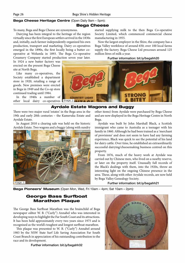
Bega CheeseTo many, Bega and Bega Cheese are synonymous.
Dairying has been integral to the heritage of the region virtually since the first European settlers arrived in the 1830s and, initially, each farmer independently organized his own production, transport and marketing. Dairy co-operatives emerged in the 1890s, the first locally being a butter co-operative at Wolumla in 1893. The Bega Co-operative Creamery Company started production seven year later. In 1924 a new butter factory was erected on the present Bega Cheese site at North Bega.
Like many co-operatives, the Society established a department store in 1920, retailing a range of goods. New premises were erected in Bega in 1949 and the Co-op store continued trading until 1984.
In the 1940s a number of other local dairy co-operatives
started supplying milk to the then Bega Co-operative Society Limited, which commenced commercial cheese manufacturing in 1955.
Now the largest employer in the Shire, the company has a Bega Valley workforce of around 650; over 100 local farms supply the factory. Bega Cheese Ltd processes around 125 million litres of milk a year.
Further information: bit.ly/begahh20
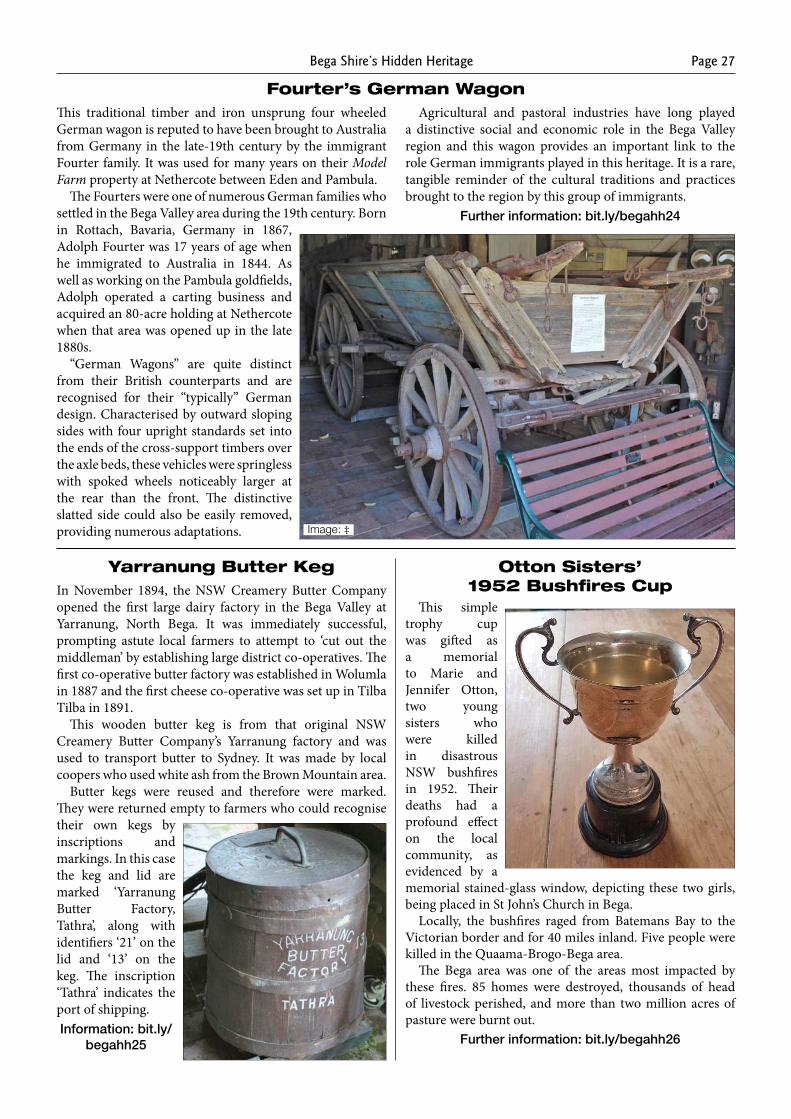
Ayrdale Estate Wagons and BuggyThere were two major rural ‘estates’ in the Bega area in the 19th and early 20th centuries – the Kameruka Estate and Ayrdale Estate.
In August 2010 a clearing sale was held on the historic Ayrdale Estate. Two wagons and a buggy (along with sundry
other items) from Ayrdale were purchased by Bega Cheese and are now displayed in the Bega Heritage Centre in North Bega.
Ayrdale was built by John Marshall Black, a Scottish immigrant who came to Australia as a teenager with his family in 1860. Although he had been trained as a ‘merchant of provisions’ and does not seem to have had any farming experience, Black was quick to see the potential of his land for dairy cattle. Over time, he established an extraordinarily successful dairying/cheesemaking business centred on this property.
From 1876, much of the heavy work at Ayrdale was carried out by Chinese men, who lived on a nearby reserve, or later on the property itself. Unusually full records of the Black’s dealings with them, into the 1920s, throw an interesting light on the ongoing Chinese presence in the area. These, along with other Arydale records, are now held by Bega Valley Genealogy Society.
Further information: bit.ly/begahh21
Bega Cheese Heritage Centre (Open Daily 9am – 5pm):
George Bass Surfboat Marathon Plaque
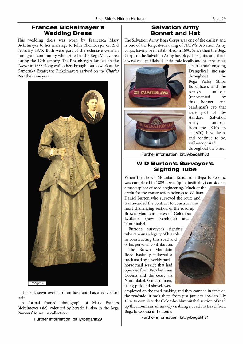
The George Bass Surfboat Marathon was the brainchild of Bega newspaper editor W. B. (“Curly”) Annabel who was interested in developing ways to highlight the Far South Coast and its attractions. It has been held approximately every two years since 1975 and is recognised as the world’s toughest and longest surfboat marathon.
This plaque was presented to W. B. (“Curly”) Annabel around 1983 by the NSW State Surf Life Saving Association Far South Coast Branch in appreciation of his outstanding contribution to the race and its development.
Further information: bit.ly/begahh32
Image: ‡
Image: ‡
Bega Pioneers’ Museum (Open Mon, Wed, Fri 10am – 4pm; Sat 10am – 2pm):
Bega Shire’s Hidden Heritage Page 27
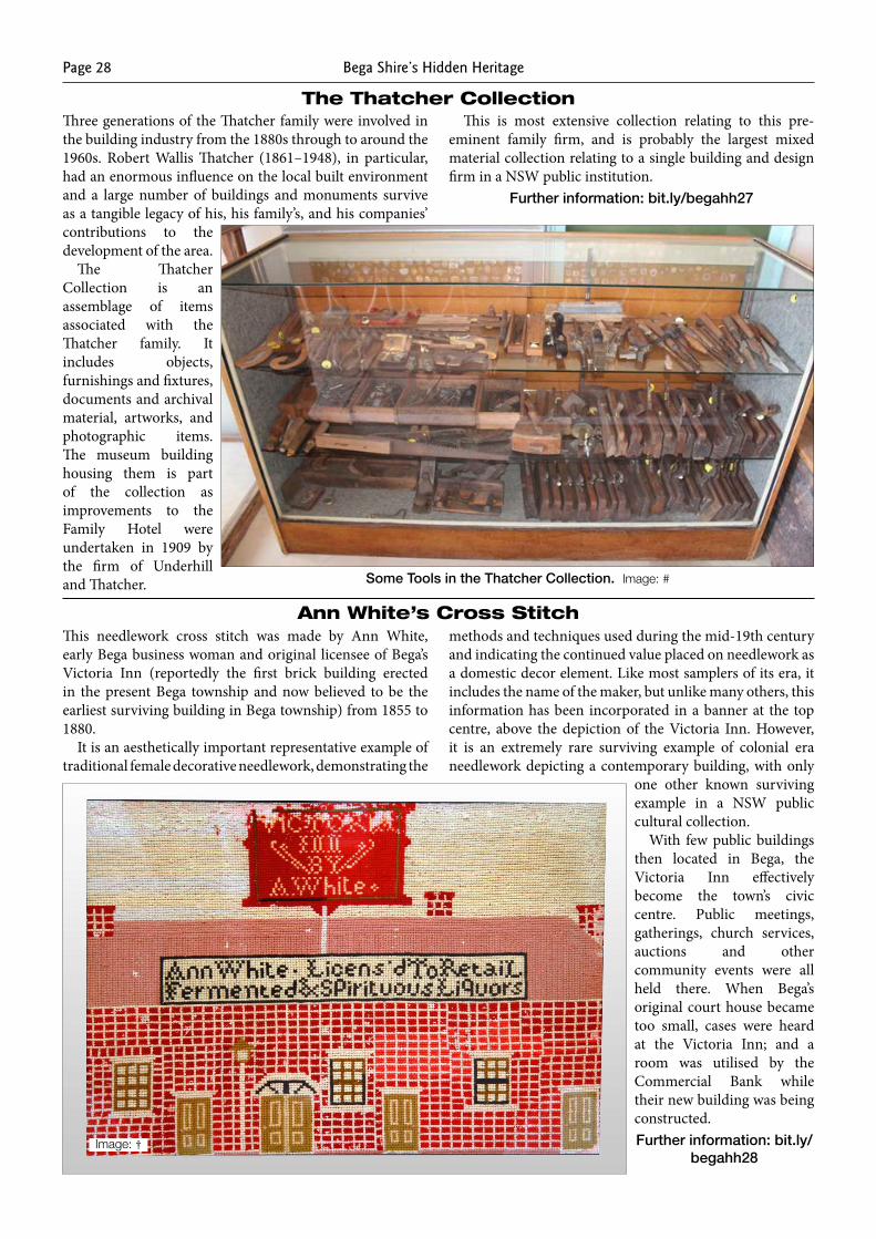
Fourter’s German WagonThis traditional timber and iron unsprung four wheeled German wagon is reputed to have been brought to Australia from Germany in the late-19th century by the immigrant Fourter family. It was used for many years on their Model Farm property at Nethercote between Eden and Pambula.
The Fourters were one of numerous German families who settled in the Bega Valley area during the 19th century. Born in Rottach, Bavaria, Germany in 1867, Adolph Fourter was 17 years of age when he immigrated to Australia in 1844. As well as working on the Pambula goldfields, Adolph operated a carting business and acquired an 80-acre holding at Nethercote when that area was opened up in the late 1880s.
“German Wagons” are quite distinct from their British counterparts and are recognised for their “typically” German design. Characterised by outward sloping sides with four upright standards set into the ends of the cross-support timbers over the axle beds, these vehicles were springless with spoked wheels noticeably larger at the rear than the front. The distinctive slatted side could also be easily removed, providing numerous adaptations.
Agricultural and pastoral industries have long played a distinctive social and economic role in the Bega Valley region and this wagon provides an important link to the role German immigrants played in this heritage. It is a rare, tangible reminder of the cultural traditions and practices brought to the region by this group of immigrants.
Further information: bit.ly/begahh24
Image: ‡
Yarranung Butter Keg Otton Sisters’ 1952 Bushfires CupIn November 1894, the NSW Creamery Butter Company
opened the first large dairy factory in the Bega Valley at Yarranung, North Bega. It was immediately successful, prompting astute local farmers to attempt to ‘cut out the middleman’ by establishing large district co-operatives. The first co-operative butter factory was established in Wolumla in 1887 and the first cheese co-operative was set up in Tilba Tilba in 1891.
This wooden butter keg is from that original NSW Creamery Butter Company’s Yarranung factory and was used to transport butter to Sydney. It was made by local coopers who used white ash from the Brown Mountain area.
Butter kegs were reused and therefore were marked. They were returned empty to farmers who could recognise their own kegs by inscriptions and markings. In this case the keg and lid are marked ‘Yarranung Butter Factory, Tathra’, along with identifiers ‘21’ on the lid and ‘13’ on the keg. The inscription ‘Tathra’ indicates the port of shipping. Information: bit.ly/
begahh25
This simple trophy cup was gifted as a memorial to Marie and Jennifer Otton, two young sisters who were killed in disastrous NSW bushfires in 1952. Their deaths had a profound effect on the local community, as evidenced by a memorial stained-glass window, depicting these two girls, being placed in St John’s Church in Bega.
Locally, the bushfires raged from Batemans Bay to the Victorian border and for 40 miles inland. Five people were killed in the Quaama-Brogo-Bega area.
The Bega area was one of the areas most impacted by these fires. 85 homes were destroyed, thousands of head of livestock perished, and more than two million acres of pasture were burnt out.
Further information: bit.ly/begahh26
Bega Shire’s Hidden HeritagePage 28
The Thatcher CollectionThree generations of the Thatcher family were involved in the building industry from the 1880s through to around the 1960s. Robert Wallis Thatcher (1861–1948), in particular, had an enormous influence on the local built environment and a large number of buildings and monuments survive as a tangible legacy of his, his family’s, and his companies’ contributions to the development of the area.
The Thatcher Collection is an assemblage of items associated with the Thatcher family. It includes objects, furnishings and fixtures, documents and archival material, artworks, and photographic items. The museum building housing them is part of the collection as improvements to the Family Hotel were undertaken in 1909 by the firm of Underhill and Thatcher.
This is most extensive collection relating to this pre-eminent family firm, and is probably the largest mixed material collection relating to a single building and design firm in a NSW public institution.
Further information: bit.ly/begahh27
Some Tools in the Thatcher Collection. Image: #
Ann White’s Cross StitchThis needlework cross stitch was made by Ann White, early Bega business woman and original licensee of Bega’s Victoria Inn (reportedly the first brick building erected in the present Bega township and now believed to be the earliest surviving building in Bega township) from 1855 to 1880.
It is an aesthetically important representative example of traditional female decorative needlework, demonstrating the
methods and techniques used during the mid-19th century and indicating the continued value placed on needlework as a domestic decor element. Like most samplers of its era, it includes the name of the maker, but unlike many others, this information has been incorporated in a banner at the top centre, above the depiction of the Victoria Inn. However, it is an extremely rare surviving example of colonial era needlework depicting a contemporary building, with only
one other known surviving example in a NSW public cultural collection.
With few public buildings then located in Bega, the Victoria Inn effectively become the town’s civic centre. Public meetings, gatherings, church services, auctions and other community events were all held there. When Bega’s original court house became too small, cases were heard at the Victoria Inn; and a room was utilised by the Commercial Bank while their new building was being constructed.Further information: bit.ly/
begahh28Image: †
Bega Shire’s Hidden Heritage Page 29
Frances Bickelmayer’s Wedding Dress
This wedding dress was worn by Francezca Mary Bickelmayer to her marriage to John Rheinberger on 2nd February 1875. Both were part of the extensive German immigrant community who settled in the Bega Valley area during the 19th century. The Rheinbergers landed on the Caesar in 1855 along with others brought out to work at the Kameruka Estate; the Bickelmayers arrived on the Charles Ross the same year.
It is silk-sewn over a cotton base and has a very short train.
A formal framed photograph of Mary Frances Bickelmeyer (sic), coloured by herself, is also in the Bega Pioneers’ Museum collection.
Further information: bit.ly/begahh29
Image: ‡
Salvation Army Bonnet and Hat
The Salvation Army Bega Corps was one of the earliest and is one of the longest-surviving of N.S.W.’s Salvation Army corps, having been established in 1890. Since then the Bega Corps of the Salvation Army has played a significant, if not always well-publicised, social role locally and has presented
a substantial ongoing Evangelical message throughout the Bega Valley Shire. Its Officers and the Army’s uniform (represented by this bonnet and bandsman’s cap that were part of the standard Salvation Army uniform from the 1940s to c. 1970) have been, and continue to be, well-recognised throughout the Shire.
Further information: bit.ly/begahh30
W D Burton’s Surveyor’s Sighting Tube
When the Brown Mountain Road from Bega to Cooma was completed in 1889 it was (quite justifiably) considered a masterpiece of road engineering. Much of the credit for the construction belongs to William Daniel Burton who surveyed the route and was awarded the contract to construct the most challenging section of the road up Brown Mountain between Colombo/Lyttleton (now Bemboka) and Nimmitabel.
Burton’s surveyor’s sighting tube remains a legacy of his role in constructing this road and of his personal contribution.
The Brown Mountain Road basically followed a track used by a weekly pack-horse mail service that had operated from 1867 between Cooma and the coast via Nimmitabel. Gangs of men, using pick and shovel, were employed on the road-making and they camped in tents on the roadside. It took them from just January 1887 to July 1887 to complete the Colombo-Nimmitabel section of road up the mountain, ultimately enabling a coach to travel from Bega to Cooma in 18 hours.
Further information: bit.ly/begahh31
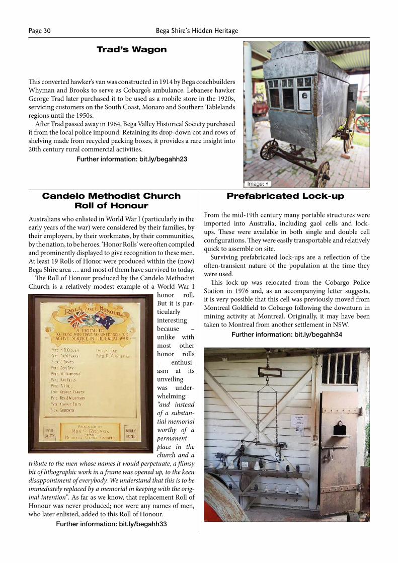
Bega Shire’s Hidden HeritagePage 30
Candelo Methodist Church Roll of Honour
Australians who enlisted in World War I (particularly in the early years of the war) were considered by their families, by their employers, by their workmates, by their communities, by the nation, to be heroes. ‘Honor Rolls’ were often compiled and prominently displayed to give recognition to these men. At least 19 Rolls of Honor were produced within the (now) Bega Shire area … and most of them have survived to today.
The Roll of Honour produced by the Candelo Methodist Church is a relatively modest example of a World War I
honor roll. But it is par-ticularly interesting because – unlike with most other honor rolls – enthusi-asm at its unveiling was under-whelming: “and instead of a substan-tial memorial worthy of a permanent place in the church and a
tribute to the men whose names it would perpetuate, a flimsy bit of lithographic work in a frame was opened up, to the keen disappointment of everybody. We understand that this is to be immediately replaced by a memorial in keeping with the orig-inal intention”. As far as we know, that replacement Roll of Honour was never produced; nor were any names of men, who later enlisted, added to this Roll of Honour.
Further information: bit.ly/begahh33
Prefabricated Lock-up
From the mid-19th century many portable structures were imported into Australia, including gaol cells and lock-ups. These were available in both single and double cell configurations. They were easily transportable and relatively quick to assemble on site.
Surviving prefabricated lock-ups are a reflection of the often-transient nature of the population at the time they were used.
This lock-up was relocated from the Cobargo Police Station in 1976 and, as an accompanying letter suggests, it is very possible that this cell was previously moved from Montreal Goldfield to Cobargo following the downturn in mining activity at Montreal. Originally, it may have been taken to Montreal from another settlement in NSW.
Further information: bit.ly/begahh34
Trad’s Wagon
This converted hawker’s van was constructed in 1914 by Bega coachbuilders Whyman and Brooks to serve as Cobargo’s ambulance. Lebanese hawker George Trad later purchased it to be used as a mobile store in the 1920s, servicing customers on the South Coast, Monaro and Southern Tablelands regions until the 1950s.
After Trad passed away in 1964, Bega Valley Historical Society purchased it from the local police impound. Retaining its drop-down cot and rows of shelving made from recycled pack ing boxes, it provides a rare insight into 20th century rural comm ercial activities.
Further information: bit.ly/begahh23
Image: †
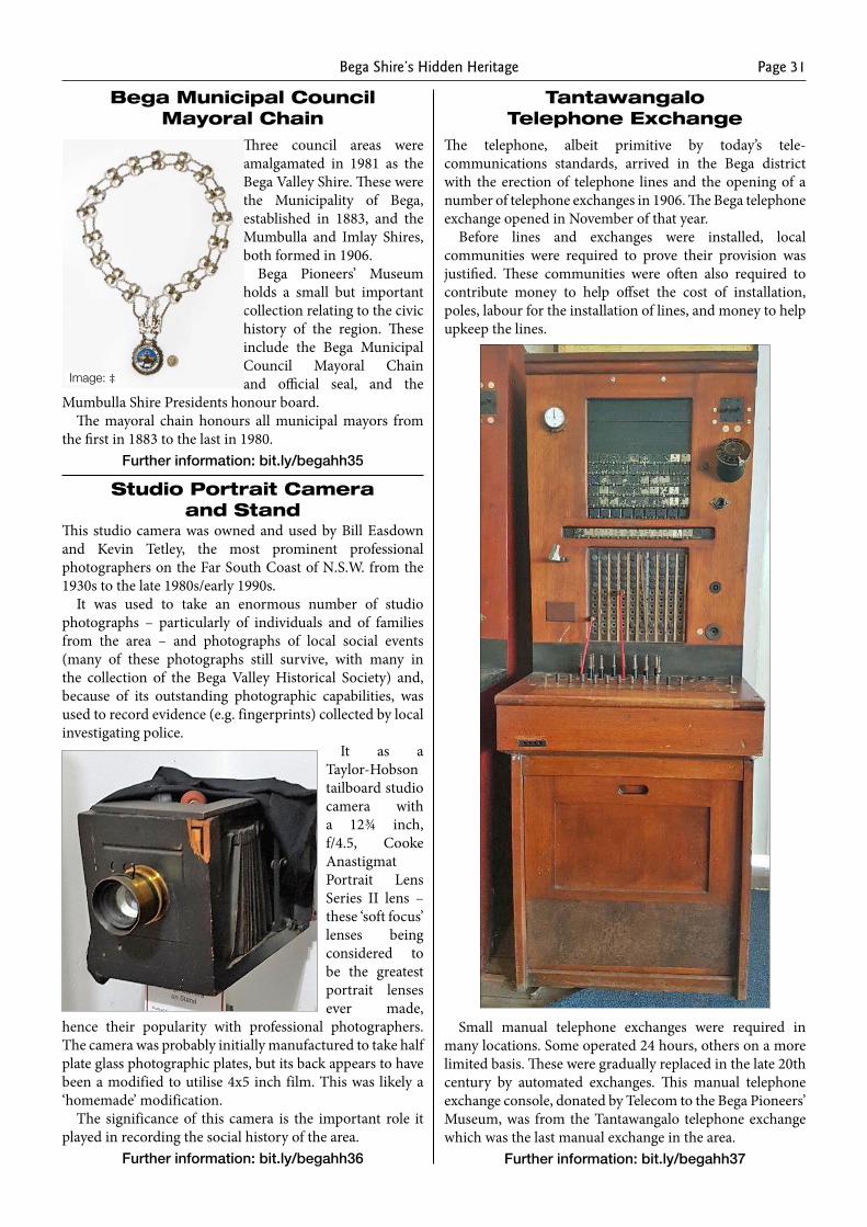
Bega Shire’s Hidden Heritage Page 31
Bega Municipal Council Mayoral Chain
Three council areas were amalgamated in 1981 as the Bega Valley Shire. These were the Municipality of Bega, established in 1883, and the Mumbulla and Imlay Shires, both formed in 1906.
Bega Pioneers’ Museum holds a small but important collection relating to the civic history of the region. These include the Bega Municipal Council Mayoral Chain and official seal, and the
Mumbulla Shire Presidents honour board. The mayoral chain honours all municipal mayors from
the first in 1883 to the last in 1980.Further information: bit.ly/begahh35
Studio Portrait Camera and Stand
This studio camera was owned and used by Bill Easdown and Kevin Tetley, the most prominent professional photographers on the Far South Coast of N.S.W. from the 1930s to the late 1980s/early 1990s.
It was used to take an enormous number of studio photographs – particularly of individuals and of families from the area – and photographs of local social events (many of these photographs still survive, with many in the collection of the Bega Valley Historical Society) and, because of its outstanding photographic capabilities, was used to record evidence (e.g. fingerprints) collected by local investigating police.
It as a Taylor-Hobson tailboard studio camera with a 12¾ inch, f/4.5, Cooke Anastigmat Portrait Lens Series II lens – these ‘soft focus’ lenses being considered to be the greatest portrait lenses ever made,
hence their popularity with professional photographers. The camera was probably initially manufactured to take half plate glass photographic plates, but its back appears to have been a modified to utilise 4x5 inch film. This was likely a ‘homemade’ modification.
The significance of this camera is the important role it played in recording the social history of the area.
Further information: bit.ly/begahh36
Tantawangalo Telephone Exchange
The telephone, albeit primitive by today’s tele-communications standards, arrived in the Bega district with the erection of telephone lines and the opening of a number of telephone exchanges in 1906. The Bega telephone exchange opened in November of that year.
Before lines and exchanges were installed, local communities were required to prove their provision was justified. These communities were often also required to contribute money to help offset the cost of installation, poles, labour for the installation of lines, and money to help upkeep the lines.
Small manual telephone exchanges were required in many locations. Some operated 24 hours, others on a more limited basis. These were gradually replaced in the late 20th century by automated exchanges. This manual telephone exchange console, donated by Telecom to the Bega Pioneers’ Museum, was from the Tantawangalo telephone exchange which was the last manual exchange in the area.
Further information: bit.ly/begahh37
Image: ‡
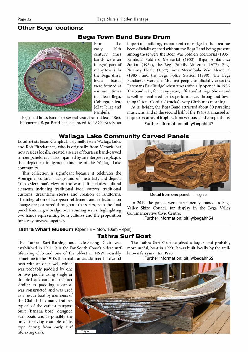
Bega Shire’s Hidden HeritagePage 32
Other Bega locations:
Bega Town Band Bass DrumFrom the early 19th century brass bands were an integral part of many towns. In the Bega shire, brass bands were formed at various times in at least Bega, Cobargo, Eden, Jellat Jellat and Pambula.
Bega had brass bands for several years from at least 1865. The current Bega Band can be traced to 1899. Barely an
important building, monument or bridge in the area has been officially opened without the Bega Band being present; among these were the Boer War Soldiers Memorial (1905), Pambula Soldiers Memorial (1935), Bega Ambulance Station (1954), the Bega Family Museum (1977), Bega Nursing Home (1979), new Merimbula War Memorial (1985), and the Bega Police Station (1990). The Bega Bandsmen were also ‘the first people to officially cross the Batemans Bay Bridge’ when it was officially opened in 1956. The band was, for many years, a ‘fixture’ at Bega Shows and is well-remembered for its performances throughout town (atop Ottons Cordials’ trucks) every Christmas morning.
At its height, the Bega Band attracted about 30 parading musicians, and in the second half of the 1940s it amassed an impressive array of trophies from various band competitions.
Further information: bit.ly/begahh47
Wallaga Lake Community Carved PanelsLocal artists Jason Campbell, originally from Wallaga Lake, and Rob Fitzclarence, who is originally from Victoria but now resides locally, created a series of fourteen hand-carved timber panels, each accompanied by an interpretive plaque, that depict an indigenous timeline of the Wallaga Lake community.
This collection is significant because it celebrates the Aboriginal cultural background of the artists and depicts Yuin /Merriman’s view of the world. It includes cultural elements including traditional food sources, traditional customs, dreamtime stories and creation of landforms. The integration of European settlement and reflections on change are portrayed throughout the series, with the final panel featuring a bridge over running water, highlighting two hands representing both cultures and the proposition for a way forward together.
In 2019 the panels were permanently loaned to Bega Valley Shire Council for display in the Bega Valley Commemorative Civic Centre.
Further information: bit.ly/begahh54
Tathra Surf BoatThe Tathra Surf-Bathing and Life-Saving Club was established in 1911. It is the Far South Coast’s oldest surf lifesaving club and one of the oldest in NSW. Possibly sometime in the 1910s this small canvas-skinned hardwood boat with an open well, which was probably paddled by one or two people using single or double blade oars in a manner similar to paddling a canoe, was constructed and was used as a rescue boat by members of the Club. It has many features typical of the earliest purpose built “banana boat” designed surf boats and is possibly the only surviving example of its type dating from early surf lifesaving days.
The Tathra Surf Club acquired a larger, and probably more useful, boat in 1920. It was built locally by the well-known ferryman Jim Preo.
Further information: bit.ly/begahh52
Image: ‡
Detail from one panel. Image: ✳
Tathra Wharf Museum (Open Fri – Mon, 10am – 4pm):
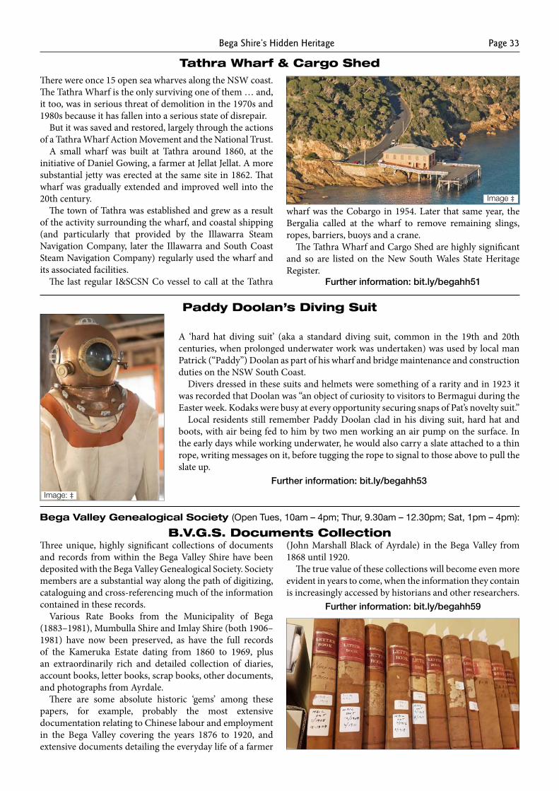
Bega Shire’s Hidden Heritage Page 33
There were once 15 open sea wharves along the NSW coast. The Tathra Wharf is the only surviving one of them … and, it too, was in serious threat of demolition in the 1970s and 1980s because it has fallen into a serious state of disrepair.
But it was saved and restored, largely through the actions of a Tathra Wharf Action Movement and the National Trust.
A small wharf was built at Tathra around 1860, at the initiative of Daniel Gowing, a farmer at Jellat Jellat. A more substantial jetty was erected at the same site in 1862. That wharf was gradually extended and improved well into the 20th century.
The town of Tathra was established and grew as a result of the activity surrounding the wharf, and coastal shipping (and particularly that provided by the Illawarra Steam Navigation Company, later the Illawarra and South Coast Steam Navigation Company) regularly used the wharf and its associated facilities.
The last regular I&SCSN Co vessel to call at the Tathra
wharf was the Cobargo in 1954. Later that same year, the Bergalia called at the wharf to remove remaining slings, ropes, barriers, buoys and a crane.
The Tathra Wharf and Cargo Shed are highly significant and so are listed on the New South Wales State Heritage Register.
Further information: bit.ly/begahh51
Tathra Wharf & Cargo Shed
Image ‡
Paddy Doolan’s Diving Suit
A ‘hard hat diving suit’ (aka a standard diving suit, common in the 19th and 20th centuries, when prolonged underwater work was undertaken) was used by local man Patrick (“Paddy”) Doolan as part of his wharf and bridge maintenance and construction duties on the NSW South Coast.
Divers dressed in these suits and helmets were something of a rarity and in 1923 it was recorded that Doolan was “an object of curiosity to visitors to Bermagui during the Easter week. Kodaks were busy at every opportunity securing snaps of Pat’s novelty suit.”
Local residents still remember Paddy Doolan clad in his diving suit, hard hat and boots, with air being fed to him by two men working an air pump on the surface. In the early days while working underwater, he would also carry a slate attached to a thin rope, writing messages on it, before tugging the rope to signal to those above to pull the slate up.
Further information: bit.ly/begahh53
Three unique, highly significant collections of documents and records from within the Bega Valley Shire have been deposited with the Bega Valley Genealogical Society. Society members are a substantial way along the path of digitizing, cataloguing and cross-referencing much of the information contained in these records.
Various Rate Books from the Municipality of Bega (1883–1981), Mumbulla Shire and Imlay Shire (both 1906–1981) have now been preserved, as have the full records of the Kameruka Estate dating from 1860 to 1969, plus an extraordinarily rich and detailed collection of diaries, account books, letter books, scrap books, other documents, and photographs from Ayrdale.
There are some absolute historic ‘gems’ among these papers, for example, probably the most extensive documentation relating to Chinese labour and employment in the Bega Valley covering the years 1876 to 1920, and extensive documents detailing the everyday life of a farmer
(John Marshall Black of Ayrdale) in the Bega Valley from 1868 until 1920.
The true value of these collections will become even more evident in years to come, when the information they contain is increasingly accessed by historians and other researchers.
Further information: bit.ly/begahh59
B.V.G.S. Documents CollectionBega Valley Genealogical Society (Open Tues, 10am – 4pm; Thur, 9.30am – 12.30pm; Sat, 1pm – 4pm):
Image: ‡
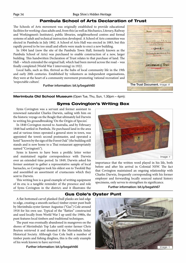
Bega Shire’s Hidden HeritagePage 34
Pambula School of Arts Declaration of TrustThe Schools of Arts movement was originally established to provide educational facilities for working-class adults and, from this (as well as Mechanics, Literary, Railway and Workingmen’s Institutes), public libraries, neighbourhood centres and formal systems of adult and technical instruction developed. A School of Arts committee was elected in Pambula in July 1882. A School of Arts Hall was erected in 1883, but this rapidly proved to be too small and efforts were made to erect a new building.
In 1904 land (now the site of the Pambula Town Hall, formerly known as the Pambula School of Arts) was purchased to enable construction of a new, larger building. This handwritten Declaration of Trust relates to that purchase of land. The Hall – which extended the original hall, which had been moved across the road – was finally completed (World War I intervening) in 1922.
Local halls, such as this, thrived as the hubs of local community life in the 19th and early 20th centuries. Established by volunteers as independent organisations, they were at the heart of a community movement promoting ‘rational recreation’ and ‘respectable culture’.
Further information: bit.ly/begahh60
Merimbula Old School Museum (Open Tue, Thu, Sun, 1.30pm – 4pm):
The Trust Document. Image: #
Syms Covington’s Writing BoxSyms Covington was a servant and former assistant to
renowned naturalist Charles Darwin, sailing with him on the historic voyage on the Beagle that ultimately led Darwin to writing his groundbreaking ‘On the Origin of Species’.
In 1840 Covington moved to Australia, and by February 1848 had settled in Pambula. He purchased land in the area and at various times operated a general store in town, was appointed the town’s second postmaster, and operated a hotel “known by the sign of the Forest Oak” (the building still stands and is now home to a Thai restaurant appropriately named “Covington’s”).
Syms is known to have been a prolific letter writer and maintained regular correspondence with Darwin over an extended time period. In 1849, Darwin asked his former assistant to gather a representative sample of local barnacles, so Covington took his oldest son to Twofold Bay and assembled an assortment of crustaceans which they sent to Darwin.
This writing box is a good example of writing equipment of its era; is a tangible reminder of the presence and role of Syms Covington in the district; and it illustrates the
importance that the written word played in his life, both before and after his arrival in Colonial NSW. The fact that Covington maintained an ongoing relationship with Charles Darwin, frequently corresponding with his former employer and forwarding locally sourced natural history specimens, only serves to strengthen its significance.
Further information: bit.ly/begahh67
Image: †
Gus Cole’s Oyster PuntA flat-bottomed carvel planked (hull planks are laid edge
to edge, creating a smooth surface) timber oyster punt built by Merimbula oyster farmer Augustus (“Gus”) Cole around 1918 for his own use. Typical of the “flatties” constructed and used locally from World War I up until the 1980s, the punt features local timbers and traditional techniques.
The punt was eventually abandoned in mangroves on the shores of Merimbula’s Top Lake until oyster farmer Chris Boyton retrieved it and donated it the Merimbula Imlay Historical Society. Although Gus Cole built a number of timber punts and fishing dinghies, this is the only example of his work known to have survived.
Further information: bit.ly/begahh66 Image: †
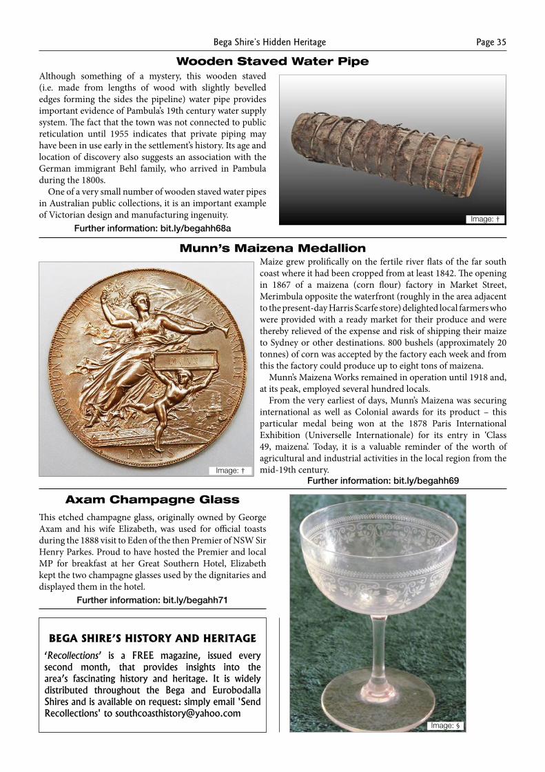
Bega Shire’s Hidden Heritage Page 35
Wooden Staved Water PipeAlthough something of a mystery, this wooden staved (i.e. made from lengths of wood with slightly bevelled edges forming the sides the pipeline) water pipe provides important evidence of Pambula’s 19th century water supply system. The fact that the town was not connected to public reticulation until 1955 indicates that private piping may have been in use early in the settlement’s history. Its age and location of discovery also suggests an association with the German immigrant Behl family, who arrived in Pambula during the 1800s.
One of a very small number of wooden staved water pipes in Australian public collections, it is an important example of Victorian design and manufacturing ingenuity.
Further information: bit.ly/begahh68aImage: †
Munn’s Maizena MedallionMaize grew prolifically on the fertile river flats of the far south coast where it had been cropped from at least 1842. The opening in 1867 of a maizena (corn flour) factory in Market Street, Merimbula opposite the waterfront (roughly in the area adjacent to the present-day Harris Scarfe store) delighted local farmers who were provided with a ready market for their produce and were thereby relieved of the expense and risk of shipping their maize to Sydney or other destinations. 800 bushels (approximately 20 tonnes) of corn was accepted by the factory each week and from this the factory could produce up to eight tons of maizena.
Munn’s Maizena Works remained in operation until 1918 and, at its peak, employed several hundred locals.
From the very earliest of days, Munn’s Maizena was securing international as well as Colonial awards for its product – this particular medal being won at the 1878 Paris International Exhibition (Universelle Internationale) for its entry in ‘Class 49, maizena’. Today, it is a valuable reminder of the worth of agricultural and industrial activities in the local region from the mid-19th century.
Further information: bit.ly/begahh69Image: †
Axam Champagne Glass
This etched champagne glass, originally owned by George Axam and his wife Elizabeth, was used for official toasts during the 1888 visit to Eden of the then Premier of NSW Sir Henry Parkes. Proud to have hosted the Premier and local MP for breakfast at her Great Southern Hotel, Elizabeth kept the two champagne glasses used by the dignitaries and displayed them in the hotel.
Further information: bit.ly/begahh71
Image: §
Bega Shire’S hiStory and heritage
‘Recollections’ is a FREE magazine, issued every second month, that provides insights into the area’s fascinating history and heritage. It is widely distributed throughout the Bega and Eurobodalla Shires and is available on request: simply email 'Send Recollections' to [email protected]
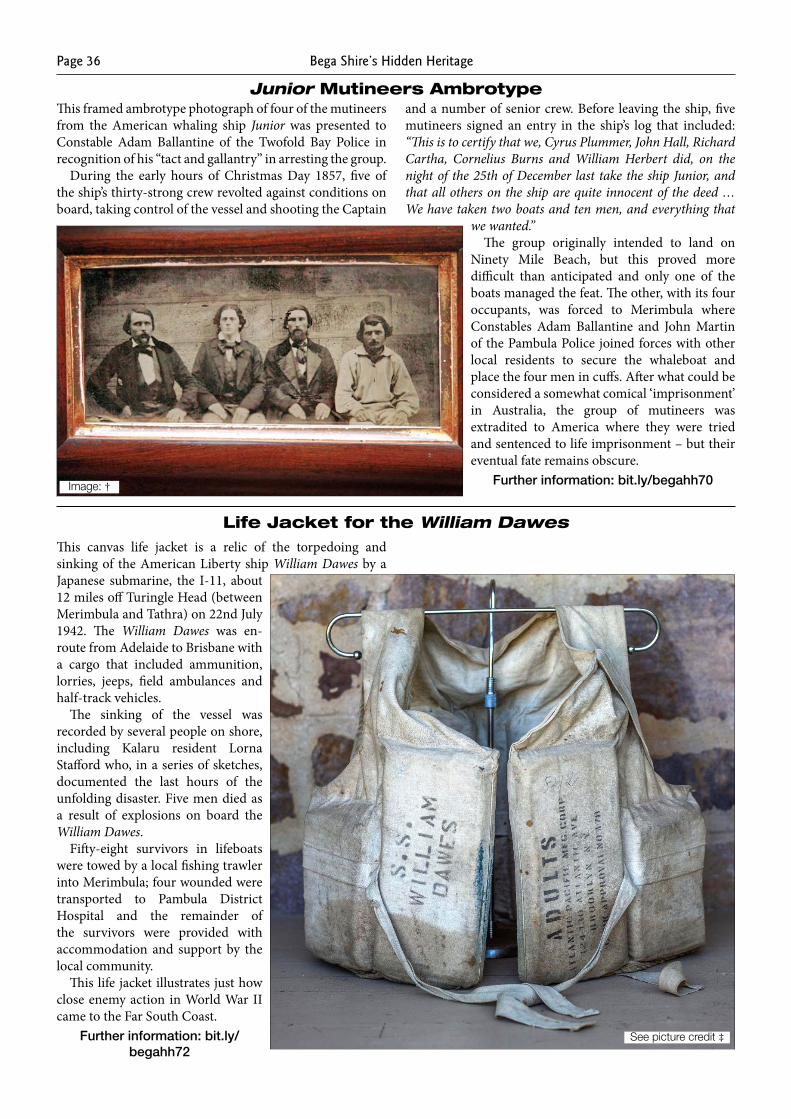
Bega Shire’s Hidden HeritagePage 36
Junior Mutineers AmbrotypeThis framed ambrotype photograph of four of the mutineers from the American whaling ship Junior was presented to Constable Adam Ballantine of the Twofold Bay Police in recognition of his “tact and gallantry” in arresting the group.
During the early hours of Christmas Day 1857, five of the ship’s thirty-strong crew revolted against conditions on board, taking control of the vessel and shooting the Captain
and a number of senior crew. Before leaving the ship, five mutineers signed an entry in the ship’s log that included: “This is to certify that we, Cyrus Plummer, John Hall, Richard Cartha, Cornelius Burns and William Herbert did, on the night of the 25th of December last take the ship Junior, and that all others on the ship are quite innocent of the deed … We have taken two boats and ten men, and everything that
we wanted.”The group originally intended to land on
Ninety Mile Beach, but this proved more difficult than anticipated and only one of the boats managed the feat. The other, with its four occupants, was forced to Merimbula where Constables Adam Ballantine and John Martin of the Pambula Police joined forces with other local residents to secure the whaleboat and place the four men in cuffs. After what could be considered a somewhat comical ‘imprisonment’ in Australia, the group of mutineers was extradited to America where they were tried and sentenced to life imprisonment – but their eventual fate remains obscure.
Further information: bit.ly/begahh70
Life Jacket for the William DawesThis canvas life jacket is a relic of the torpedoing and sinking of the American Liberty ship William Dawes by a Japanese submarine, the I-11, about 12 miles off Turingle Head (between Merimbula and Tathra) on 22nd July 1942. The William Dawes was en-route from Adelaide to Brisbane with a cargo that included ammunition, lorries, jeeps, field ambulances and half-track vehicles.
The sinking of the vessel was recorded by several people on shore, including Kalaru resident Lorna Stafford who, in a series of sketches, documented the last hours of the unfolding disaster. Five men died as a result of explosions on board the William Dawes.
Fifty-eight survivors in lifeboats were towed by a local fishing trawler into Merimbula; four wounded were transported to Pambula District Hospital and the remainder of the survivors were provided with accommodation and support by the local community.
This life jacket illustrates just how close enemy action in World War II came to the Far South Coast.
Further information: bit.ly/begahh72
Image: †
See picture credit ‡
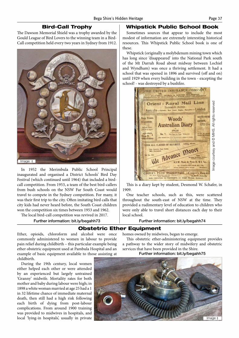
Bega Shire’s Hidden Heritage Page 37
Bird-Call TrophyThe Dawson Memorial Shield was a trophy awarded by the Gould League of Bird Lovers to the winning team in a Bird-Call competition held every two years in Sydney from 1912.
In 1952 the Merimbula Public School Principal inaugurated and organised a District Schools’ Bird Day Festival (which continued until 1964) that included a bird-call competition. From 1953, a team of the best bird-callers from bush schools on the NSW Far South Coast would travel to compete in the Sydney competition. For many, it was their first trip to the city. Often imitating bird calls that city kids had never heard before, the South Coast children won the competition six times between 1953 and 1962.
The local bird-call competition was revived in 2017.Further information: bit.ly/begahh73
Image: ‡
Sometimes sources that appear to include the most modest of information are extremely interesting historical resources. This Whipstick Public School book is one of these.
Whipstick (originally a molybdenum mining town which has long since ‘disappeared’ into the National Park south of the Mt Darrah Road about midway between Lochiel and Wyndham) was once a thriving settlement. It had a school that was opened in 1896 and survived (off and on) until 1929 when every building in the town - excepting the school! - was destroyed by a bushfire.
This is a diary kept by student, Desmond W. Schafer, in 1909.
One teacher schools, such as this, were scattered throughout the south-east of NSW at the time. They provided a rudimentary level of education to children who were only able to travel short distances each day to their local school.
Further information: bit.ly/begahh74
Whipstick Public School Book
Ether, opioids, chloroform and alcohol were once commonly administered to women in labour to provide pain relief during childbirth – this particular example being ether obstetric equipment used at Pambula Hospital and an example of basic equipment available to those assisting at childbirth.
During the 19th century, local women either helped each other or were attended by an experienced but largely untrained ‘Granny’ midwife. Mortality rates for both mother and baby during labour were high; in 1898 a white woman married at age 25 had a 1 in 32 lifetime chance of immediate maternal death, then still had a high risk following each birth of dying from post-labour complications. From around 1900 training was provided to midwives in hospitals, and local ‘lying-in hospitals’, usually in private
homes owned by midwives, began to emerge.This obstetric ether-administering equipment provides
a pathway to the wider story of midwifery and obstetric services that have been provided in the Shire.
Further information: bit.ly/begahh75
Obstetric Ether Equipment
Image ‡
Imag
e co
urte
sy a
nd ©
MIH
S. A
ll rig
hts
rese
rved
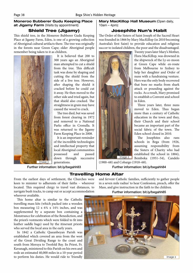
Bega Shire’s Hidden HeritagePage 38
Moneroo Bubberer Gudu Keeping Place at Jigamy Farm (Visits by appointment):
Shield Tree (Jigamy)This shield tree, in the Moneroo Bubberer Gudu Keeping Place at Jigamy Farm, Eden, is one of a growing collection of Aboriginal cultural artifacts there. The tree was originally in the forests near Green Cape; older Aboriginal people remember being taken to it as children.
It is believed that 200 to 300 years ago an Aboriginal man attempted to cut a shield from the tree. This difficult task was done by shaping and cutting the shield from the side of a live tree. However, after shaping the shield it cracked before he could cut it away. He then moved to the other side and tried again, but that shield also cracked. The straightness in grain may have caused the wood to crack.
The tree died, but was saved from forest clearing in 1972 and removed to a National Parks office in Cronulla. It was returned to the Jigamy Farm Keeping Place in 2008.
It is an important reminder of the incredible technologies and intellectual property that local Aboriginal communities possessed and passed down through successive generations.
Further information: bit.ly/begahh83
Mary MacKillop Hall Museum (Open daily, 10am – 4pm):
Josephite Nun’s HabitThe Order of the Sisters of Saint Joseph of the Sacred Heart was founded in 1866 by Mary MacKillop (in 2010 becoming Australia’s first Saint) to provide education and religious succor to isolated children, the poor and the disadvantaged.
Twenty years later Mary’s Mother, Flora MacKillop, was drowned in the shipwreck of the Ly-ee-moon at Green Cape while en-route from Melbourne to Sydney to help her daughter and Order of nuns with a fundraising venture. Hers was the only body recovered that bore no marks from shark attack or pounding against the rocks. As a result, Mary promised to establish a Convent and school in Eden.
Three years later, three nuns moved to Eden. Thus began more than a century of Catholic education in the town and they, their Church and their school became an important part of the social fabric of the town. The Eden school closed in 2010.
The Josephites also rans schools in Bega (from 1926, assuming responsibility from the Sisters of Charity who had established the school in 1884), Bemboka (1951–54), Candelo
(1900–68) and Cobargo (1918–68).Further information: bit.ly/begahh84
Travelling Home AltarFrom the earliest days of settlement, the Churches were keen to minister to adherents of their faiths – wherever located. This required clergy to travel vast distances, to navigate bush tracks, to camp out or accept accommodation wherever available.
This home altar is similar to the Catholic travelling mass kits (which packed into a wooden box measuring 12 x 6¾ x 14½ inches, and was supplemented by a separate box containing a Monstrance for celebration of the Benediction, and the priest’s vestments which were folded to fit into leather saddle bags) used by the itinerant priests who served the local area in the early years.
In 1842 a Catholic Queanbeyan Parish was established which covered an area from the west of the Great Dividing Range to the coast and south from Moruya to Twofold Bay. Its Priest, Fr. Kavanagh, ministered to this Parish on his own and rode an estimated 40,000 miles in a 10-year period to perform his duties. He would ride to ‘friendly
and fervent Catholic families, sufficiently to gather people in a seven mile radius’ to hear Confession, preach, offer the Mass, and give instruction in the faith to the children.
Further information: bit.ly/begahh85
Image ‡
Image ‡
Image ‡
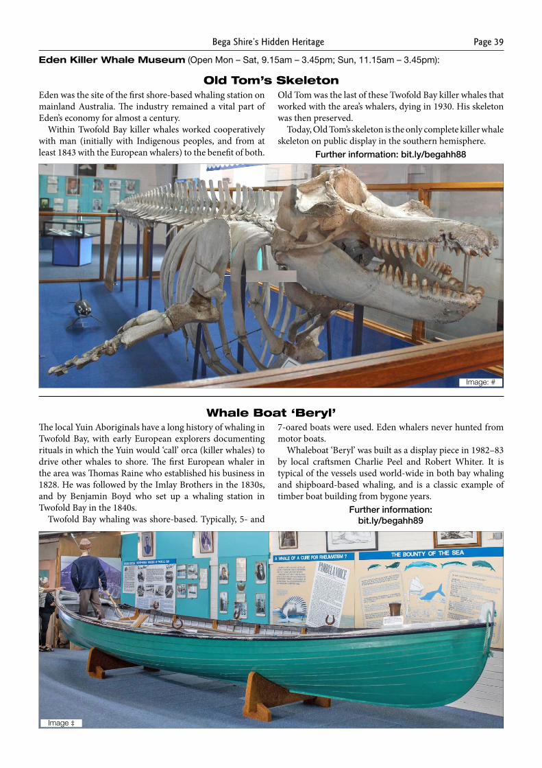
Bega Shire’s Hidden Heritage Page 39
Eden Killer Whale Museum (Open Mon – Sat, 9.15am – 3.45pm; Sun, 11.15am – 3.45pm):
Old Tom’s SkeletonEden was the site of the first shore-based whaling station on mainland Australia. The industry remained a vital part of Eden’s economy for almost a century.
Within Twofold Bay killer whales worked cooperatively with man (initially with Indigenous peoples, and from at least 1843 with the European whalers) to the benefit of both.
Old Tom was the last of these Twofold Bay killer whales that worked with the area’s whalers, dying in 1930. His skeleton was then preserved.
Today, Old Tom’s skeleton is the only complete killer whale skeleton on public display in the southern hemisphere.
Further information: bit.ly/begahh88
Whale Boat ‘Beryl’The local Yuin Aboriginals have a long history of whaling in Twofold Bay, with early European explorers documenting rituals in which the Yuin would ‘call’ orca (killer whales) to drive other whales to shore. The first European whaler in the area was Thomas Raine who established his business in 1828. He was followed by the Imlay Brothers in the 1830s, and by Benjamin Boyd who set up a whaling station in Twofold Bay in the 1840s.
Twofold Bay whaling was shore-based. Typically, 5- and
7-oared boats were used. Eden whalers never hunted from motor boats.
Whaleboat ‘Beryl’ was built as a display piece in 1982–83 by local craftsmen Charlie Peel and Robert Whiter. It is typical of the vessels used world-wide in both bay whaling and shipboard-based whaling, and is a classic example of timber boat building from bygone years.
Further information: bit.ly/begahh89
Image: #
Image ‡
Bega Shire’s Hidden HeritagePage 40
Timber Railway Sleeper
Timber has been, and continues to be, a major South Coast industry, with timber-related products in many forms—including railway sleepers, construction materials, poles and girders, hardwood props for mines, wattlebark, eucalyptus oil, charcoal, firewood, woodchip—harvested and exported from the area.
The construction of the Sydney to Granville railway in the 1850s initiated sleeper-cutting in NSW forests. Sleeper-cutting on the South Coast became a major industry from around the 1890s and reached its peak in the late 1940s and early 1950s. In the Bermagui area, for example, around 50 sleeper cutters were employed.
Until mechanisation was introduced from the 1950s, sleepers were cut and shaped manually using crosscut saws, broadaxes, hammers and wedges. Teams of horses and bullocks would ‘snig’ the hardwood sleepers from the forests and, until trucks were introduced in the mid-1930s, transport the sleepers to nearby ship loading facilities
Large sleeper ‘dumps’ were a feature of the waterfront. Thousands of sleepers would be stacked, then inspected, then transported to wharves (often specifically built to enable loading of sleepers) and loaded onto steamers for transport to Australian and overseas destinations.
Further information: bit.ly/begahh90
Image ‡
Relics from the Ly-ee-moon Shipwreck
Why the comfortable, speedy – and therefore popular – steamer, the Ly-ee-moon, ran into the rocks near the base of the new and functioning Green Cape Light Tower at Green Cape at around 9 pm on Sunday 30th May 1886, whilst en-route from Melbourne to Sydney, remains a mystery. Around 71 of the estimated 86 on board perished – making this one of New South Wales’ worst maritime disasters.
The ship rapidly split in half, essentially condemning to death all those in steerage in the aft part of the ship. The forepart, including the saloon, drifted to rest on the rocky shore, giving passengers and crew in that part of the ship a slim chance of escape. Lighthouse staff used ropes in attempts to bring some of these people to shore.
The bodies of 25 people were recovered and interred in a small graveyard about 300 yards from the shipwreck site.
Some small relics were salvaged from the remnant wreckage which now lies in a hazardous diving site in water of up to 13 metres in depth.
Further information: bit.ly/begahh91
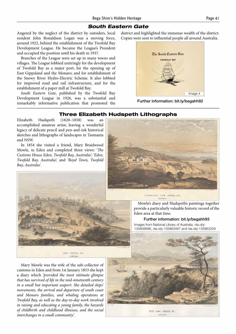
Bega Shire’s Hidden Heritage Page 41
South Eastern GateAngered by the neglect of the district by outsiders, local resident John Ronaldson Logan was a moving force, around 1922, behind the establishment of the Twofold Bay Development League. He became the League’s President and occupied the position until his death in 1937.
Branches of the League were set up in many towns and villages. The League lobbied untiringly for the development of Twofold Bay as a major port; for the opening up of East Gippsland and the Monaro; and for establishment of the Snowy River Hydro-Electric Scheme. It also lobbied for improved road and rail infrastructure, and for the establishment of a paper mill at Twofold Bay.
South Eastern Gate, published by the Twofold Bay Development League in 1926, was a substantial and remarkably informative publication that promoted the
district and highlighted the immense wealth of the district. Copies were sent to influential people all around Australia.
Further information: bit.ly/begahh92
Elizabeth Hudspeth (1820–1858) was an accomplished amateur artist, leaving a wonderful legacy of delicate pencil and pen-and-ink historical sketches and lithographs of landscapes in Tasmania and NSW.
In 1854 she visited a friend, Mary Braidwood Mowle, in Eden and completed three views: ‘The Customs House Eden, Twofold Bay, Australia’; ‘Eden, Twofold Bay, Australia’; and ‘Boyd Town, Twofold Bay, Australia’.
Mary Mowle was the wife of the sub-collector of customs in Eden and from 1st January 1853 she kept a diary which ‘provided the most intimate glimpse that has survived of life in the mid-nineteenth century in a small but important seaport. She detailed ships’ movements, the arrival and departure of south coast and Monaro families, and whaling operations at Twofold Bay, as well as the day-to-day work involved in raising and educating a young family, the hazards of childbirth and childhood illnesses, and the social interchanges in a small community’.
Mowle’s diary and Hudspeth’s paintings together provide a particularly valuable historic record of the Eden area at that time.
Further information: bit.ly/begahh93
Three Elizabeth Hudspeth Lithographs
Images from National Library of Australia. nla.obj-135856696, nla.obj-135863487 and nla.obj-135863329
Image #
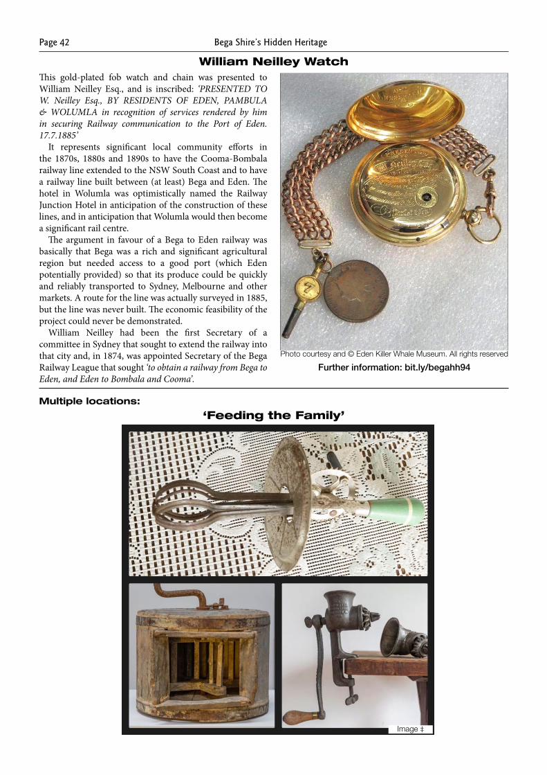
Bega Shire’s Hidden HeritagePage 42
William Neilley WatchThis gold-plated fob watch and chain was presented to William Neilley Esq., and is inscribed: ‘PRESENTED TO W. Neilley Esq., BY RESIDENTS OF EDEN, PAMBULA & WOLUMLA in recognition of services rendered by him in securing Railway communication to the Port of Eden. 17.7.1885’
It represents significant local community efforts in the 1870s, 1880s and 1890s to have the Cooma-Bombala railway line extended to the NSW South Coast and to have a railway line built between (at least) Bega and Eden. The hotel in Wolumla was optimistically named the Railway Junction Hotel in anticipation of the construction of these lines, and in anticipation that Wolumla would then become a significant rail centre.
The argument in favour of a Bega to Eden railway was basically that Bega was a rich and significant agricultural region but needed access to a good port (which Eden potentially provided) so that its produce could be quickly and reliably transported to Sydney, Melbourne and other markets. A route for the line was actually surveyed in 1885, but the line was never built. The economic feasibility of the project could never be demonstrated.
William Neilley had been the first Secretary of a committee in Sydney that sought to extend the railway into that city and, in 1874, was appointed Secretary of the Bega Railway League that sought ‘to obtain a railway from Bega to Eden, and Eden to Bombala and Cooma’.
Further information: bit.ly/begahh94
Multiple locations:
‘Feeding the Family’
Photo courtesy and © Eden Killer Whale Museum. All rights reserved
Image ‡
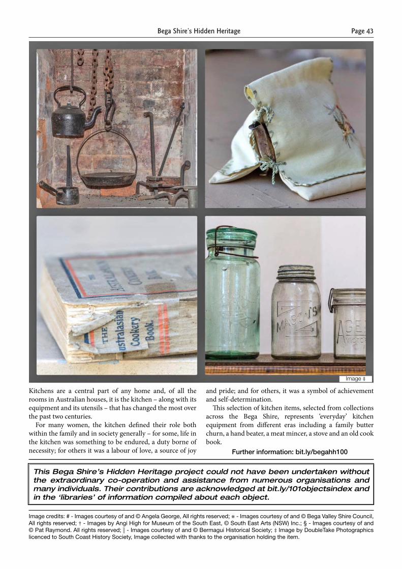
Bega Shire’s Hidden Heritage Page 43
Kitchens are a central part of any home and, of all the rooms in Australian houses, it is the kitchen – along with its equipment and its utensils – that has changed the most over the past two centuries.
For many women, the kitchen defined their role both within the family and in society generally – for some, life in the kitchen was something to be endured, a duty borne of necessity; for others it was a labour of love, a source of joy
and pride; and for others, it was a symbol of achievement and self-determination.
This selection of kitchen items, selected from collections across the Bega Shire, represents ‘everyday’ kitchen equipment from different eras including a family butter churn, a hand beater, a meat mincer, a stove and an old cook book.
Further information: bit.ly/begahh100
Image credits: # - Images courtesy of and © Angela George, All rights reserved; ✳ - Images courtesy of and © Bega Valley Shire Council, All rights reserved; † - Images by Angi High for Museum of the South East, © South East Arts (NSW) Inc.; § - Images courtesy of and © Pat Raymond. All rights reserved; - Images courtesy of and © Bermagui Historical Society; ‡ Image by DoubleTake Photographics licenced to South Coast History Society, Image collected with thanks to the organisation holding the item.
This Bega Shire’s Hidden Heritage project could not have been undertaken without the extraordinary co-operation and assistance from numerous organisations and many individuals. Their contributions are acknowledged at bit.ly/101objectsindex and in the ‘libraries’ of information compiled about each object.
Image ‡
Bega Shire’s Hidden HeritagePage 44
Enquiries: [email protected]; phone 0448 160 852
Licensed to South Coast History Society Inc. under a Creative Commons Attribution-NonCommercial-ShareAlike 4.0 International License.
This project is assisted by the NSW Government through
the Heritage Near Me program.