geophysical investigations of ice-sheet internal layering and deformation in the dome c region of...
TRANSCRIPT
J ournal qJClaciologJ\ foL. 4·6, . \ 0. 152,2000
Geophysical investigations of ice-sheet internal layering and defortnation in the Dotne C region of central East Antarctica
RICHARD HODGKINS, I MARTIN]. SIEGERT/ JULIAN A. DOWDESW E LL 2
I De/Ja r/lIlen l qJC;eogra/J/~J " Ro.J'al H oIIOl./I(I)" Cn lz'ersi{J' q[ Londoll , l:'g/W III . SUlTl,)' Tf 1'20 OE.\', England 2 Brislol Glaci%gy Cenlre, School qJGeogmphical Sciences, l 'nil'Prsi{J' o[ Brislol, Brislol BS8 JSS. Englalld
ABSTRACT. i\ew m ap s a rc present ed o rthree interna l icc-,sh ee t radi o-echo so unding (RES ) layers in thr region 73.5- 75.75° S, 120 127 E (56 000 km 2
) a round Dome C , centra l East Ant a rc tica . These laye rs represent hori zons of enhanced a cidity res ultin g [i'om \'01-ca nic ae roso l depos ition, ide lllifi ed fi'om ana logue RES d a ta . They a re continuo us mT r th e entire m apped a rea, a nd constitute defo rmati on marke rs in the ice column. Intern al RES laye rs were initi a ll y ide ntifi ed from discre te rada r p o w e r renection coe ffi c ient profil es a nd subsequ entl y di g iti zed direc tly from prints of ice-sh ee t cross-secti o ns, acquired by continuous RES pro filing. G eo refer enced \'ecto r d a ta arc used to ge n e ra te a 5 km g ridce ll raster o f" depth fo r each int erna l RES layer, as a basis fo r contour m a pping. Ice defo rm a ti on in th e Dom e C region is sig nifi cant because thi s is the loca ti o n of th e European Proj ect for Ice C o ring in Anta rctica. Since intern a l layers a re isochron o us, th e onc-dimen sio na l ice-co re data a t Dome C ca n be co rrela ted o \'e r the sunT)' a rea to produce a threc--climcnsiona l context.
INTRODUCTION internal reOee to rs a rc di screte a nd continuous o\,er di sta nces
on the order o f 100 km. Electrom agneti c (e/m ) reOecti o ns o f"
thi s type occ ur in ice a t bounda ri es o f di electri c cont ras t. The
causes of the ren ections a re unde rstood to be ice-densit y
cha nges (at depth s o f < 1000 m ) a nd acid ice resulting from
\'oleanic ae roso l de position. At de pths of > 1000111, radi o
echo layering is causecl principa ll y by ac id labelling o f di s
crete stratigra phic hori zo ns \\'ithin th e ice shee t ( ;\Jill a r,
1981; Siege rt a nd o thers, 1998b).
This paper uses radio-echo so unding (R ES ) d a ta to prm'icle
ne\\·. three-dimensiona l info rm ati on on inte rna l ice-shee t
structure for the Dome C oncordi a (Dom e C ) region o f"
central Eas t Anta rctica (Fig. I). An extensive a na logue RES
da tase t of th e Anta rctic ice shee ts, coll ected by the Scott Pola r
Resea rch 1 nstit ute (SPRI ) U. S. :\ati ollal Sc ience Founda
lion (NSF)-1cc hni cal Uni"ersity of" Denm a rk (T UD ) con
so rtium be twee n 1968 a nd 1979, is held in a rchi ve a t SPR I,
L'ni w rsil y of C ambridge. U. K. \ Drew r)', 1983). Approx i
mately 50(1.) of the area of the ice sheets is cO\ 'C red by RES
ni ght tracks, with a foc us on the western pa rt o r E as t Anta rc
tica . A pen 'as iH' f'c atu re o f the data is the occurrence of
strong ren ec ti ons from within the ice. Se\'e ra l indi\'iclua l
The 0 0111(' C region ( Fig. I) is of panicul a r int (' res t
beca use of its po te ntia l significancc fo r pa laeoe l1\'i ro nl11 cnta l
studi es. TIlt' 2700 111 ice corc taken from Vostok station, cent ral
East Anta rctica, has prm' icled be nchma rk t'\ ·idence o f pa
laeoc limate fo r the las t glacia l interglacia l cyc le ( Lor ius
a nd ot hers. 1985; J o uzel and othe rs, 1989, 199::1 1. A 3300 111 ice
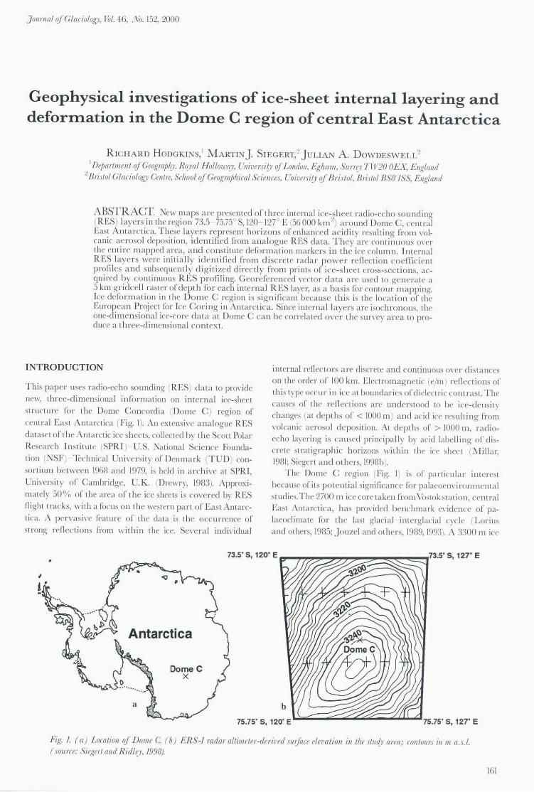
73.5" S, 120' E .,.....,.~,.,~..,.~_~_~_~..,73.5· S, 121" E
,
DomeC X
L,,;;;;;;;;;;;;;;.,-.o;;;.""";;;;'''';;;;''';;;;''-''''''''''~''''''75.75 · S, 127' E
J'l'g. 1. ( a ) Lo({[lion qJ DOllle C (b) ERS-! radar allilll eler-derived ,nI/face elel'{lliol7 ill Ihe slu~)' area: (o ll lollrs ill 11/ a.s.!. (.\Ol/ ree: Siegerl and Ridl!,)" J998).
161
J ournal qfGlaciologJ'
core from Dome C (about 550 km from Vostok sta ti on) is to be obtained through the Europea n Project for lee Coring in Anta rctica (EPICA) Uouzel and others, 1996). T his is likely to yield similarl y importa nt palaeoclimate data. Siegen and others (1998a) traced fi n' promi nent internal layers, identifi ed from RES data, for >500 km across the East A nta rctic ice sher t, betwee n Vostok and the nrw ice-core site a t D ome C. This correlated the stratigraphy and depth age relati onship between the t wo sites. The present paper enha nces understanding of the glac iologica l context of the futu re D ome C ice co re by mapping the th rer-d imensional, interna l iceshee t structu re in the region.
A 9600 km 2 a rea a round the D ome C ice-core site has been mapped using 60 l\LHz radi o-echo sounding (Ta bacco a nd others, 1998). J n thi s survey, the surface and subg lac ial topography \\'as established. Although internal layering was obse rved in the RES data, no three-dimensiona l representati on of interna l ice-sheet structure was dC\"Cloped. The present pape r, therefore, re presents the fi rs t attempt to m ap R ES layering in th ree dimensions within cent ral East A ntarc tica, and to identi f y interna l ice-shee t a rchitectu re accord i ng ly.
ACQUIRING INTERNAL RES LAYER DATA
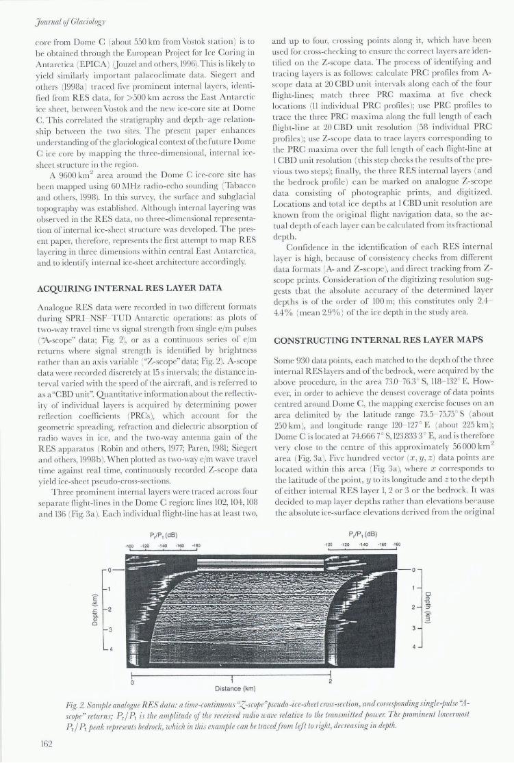
A nalogue RES data wrre recorded in two di ffe rent formats during SPRI ~SF-T IJD Anta rctic operat ions: as plots of two-way travel time vs signal streng th from single elm pulses (''l\-scope'' data; Fig. 2), or as a continuous series of elm returns where signal strength is identified by br ightness rather than an axis " ari able ("Z-scope" data; Fig. 2). A-scope data were recorded di sc retely at 15 s inten 'a ls; the di sta nce inten 'a l ,'aried with the speed of the a ircraft , and is referred to as a "CBD unit ". Quantit ati \'e information about the renec ti vity of indi"idua l layers is acquired by determining power renection coefficients (PRCs), which account fo r the geometric spreading, refract ion a nd di electric absorption of radio wa\'es in ice, and the two-way antenna gain of the R ES appa ratus (Robin and others, 1977; Pa ren, 1981; Siegr rt and others, 1998 b). 'Vhen plotted as two-way elm wavr tra,'c1 time against real time, continuously recorded Z-scope data yield ice-shee t pseudo-cross-sec tions.
Three prominent intern al layers were traced across four sepa rate night-lines in the Dome C region: lines 102, 10+, 108 a nd 136 (Fig. 3a). E ach individua l night-line has a t least two,
E :2S
o
.<:: 2 0.. Ql o
3
P/ P , (dB)
Distance (km)
and up to fo ur, crossing p oints along it, which have been used fo r cross-checking to ensure the correct layers are ide ntified on the Z-scope d a ta. T hr process o f identifying a nd tracing laye rs is as fo llows: calculate PRC profil es from Ascop e d a ta at 20 CBD unit intervals a long each of the fo ur night-lines; match three PRC maxima at fi ve check locations (11 individua l PRC profiles); use PRC profi Ies to trace the three PRC m axima a long the full length of each night-line at 20 CBD un it resolution (58 indi" idua l PRC pro files ); use Z-scope d a ta to trace layers co rrespond ing to the PRC maxima over the full length of cach night-line a t I CBD unit resoluti on ( this step checks the results of the previous two steps); fin a ll y, th r threr RES interna l laye rs (and the bedrock profile) can b e marked on a nalogue Z-scope data consisting o f" photographic pri nts, and digitized. Locations and total ice depths at 1 CBD unit resolution a re known from the origi na l night navigatio n data, so the a ctual depth o f" each layer can be calculated from it s fract iona l depth.
Confidence in the identifi cati on of each RES intern a l layer is high, because of consistency checks from different data fo rm ats (A- a nd Z-scope), a nd direct tracking from Zscope pr ints. Consiclet-ation of the digitiz ing resolution suggests tha t the abso lu te accuracy of the determined layer depths is of the order of 100 m; this consti tutes onl y 2.4 ·lA% (mean 2.9% ) of the ice depth in the study area.
CONSTRUCTING INTERNAL RES LAYER MAPS
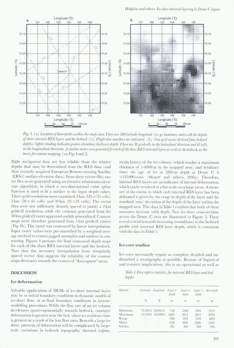
Some 930 data points, each matched to the depth of the three interna l RES laye rs a nd of the bedrock, were acquired by the abo\ 'e p rocedure, in the a rea 73.0- 76.3 S, 118-132 c. Ho\\!e\ 'er, in order to ac hi eve the densrst cove rage of data points centred a round Dome C, the mapping exercise focuses on a n area delimited by the latitude range 73.5 75.75° S (about 250 km ), and longitude rangr 120- 127° E (about 225 km ); Dome C is located at 74.6667 S, 123.8333 E, and is th r refore very close to the centre of thi s approxim a tely 56 000 km 2
area (Fig. 3a). Five hundred \'ector (x. y, z) data points a rc loca ted within thi s a rea (Fig. 3(1 ), where x corresponds to the latitude of the point, y to its longitude a nd z to the depth of either internal R ES layer 1,2 or 3 or the bedroc k. It was decided to map layer depths rather than elevations berause the a bsolute ice-surface elevati ons deri ved from the ori gina l
PI P , (dB)
· ,00 · tzo -140 -160
-0
0 Cll "0
2 3'
'" 2-3
4
Fig. 2. Sample analogue RES data: a time-continuous 'Z-scope "/JSelldo -ice-sheel cross-sec lion, and co rresjJonding single-jJuLse '~lscojJe" relurns; F.. I Pt is Ihe amplitude qf the received radio wave relative 10 Ihe Irallsmilled power. The jJrominent lowmnost Prl Pt peak represenls bedrock. which inlhis e\ample call be tmeedfrom lift 10 right, decreasing in depth.
162
Hodgkins and others: Ja -shee/ in /em al la.)'frillg ill DOll1e C regioll
Longitude ("E) b Longitude (" E) a
121 122 123 124 125 126 121 122 123 124 125 126
73.75 73.75 73.
74 .00 74.00
74.25 74 .25
• .1-,
(j) r- r-'- 74.50 74 .50 ~ ~ Q) C <ll C
"0 Q. "0 Q.
.~ <1> :~ <1> [)aooC ' 7ii 74 .75 74.75 :0 <ii .0 -' -'
~,
75 .00 75.00 ,1.,)":'0.
75.25 75.25
75.50 75 .50
,-,,'
121 122 123 124 125 126
Longitude ("E) Longitude ("E) 0 25 50 75 100 km 0 25 50 75 100 km i
, i
Fig 3. (a ) Loea/ioll q/da/a poillls wi/h ill th e stud)' area. There are 500 latitllde/ lollgitude ( :c, y ) loeations, eacli le ith the de/J/Ii s if three intcrl/al RES layers and the bedrock ( z). Flight-line numbers are illdicated. ( b) 5 kill grid raster deril'edfi"O/lI bedrock de/Jths; Lighter shading indicates greater elevation/ lhallower de/J /iz. T here are 50 gridceLls ill the latitlldinaL direct 1011 and 45 eel Ls ill /he LOllgi/udilla! direction. A similar ras/er was genera /edfor each q//he three RES in tern et! h~J 'm as well as /h e bedrock, as /h e basisJor call/our map/ling (see Figs 4 and 5).
night na vigati o n data a rc less reli a bl e tha n th c relative depths th a t may be de termincd from thc RES d a ta (a nd
than recentl y acquired Europea n Remote-se nsing Sa tellit e
(ERS-l) surface ele\'a ti o n d a ta ). From th ese \ '('c to r fil es, raster fi les we re generated using a n it era ti\ 'e Il1inimLlIl1-cun'a
ture a lgorithm , in wh ich a two-dimensiona l c ubic sp line
runcti on is used to fit a surfa ce to th e input d e pth va lues. Three g rid resolutions wer e examined : 2 kill (125 x III cell s),
5 kill (50 x +5 cell s) a nd [0 km (25 x 23 cell s). The \ 'ecto r
da ta were not sufficientl y de nsely spaced to justify a 2 km
g ridcell r eso lution , while the co nto urs gen er a ted from the
IQ km g ridcell ras ter a ppea r ed undu ly gener a li zed. COlllour m a ps were th e refore ge ne rated Cram S km g ridce ll rastcrs
(Fi g. 3b ). The ras ter was contoured by linear inte rpolation.
Input ras te r va lues were pre-smooth ed by a we ig hted a\'tT
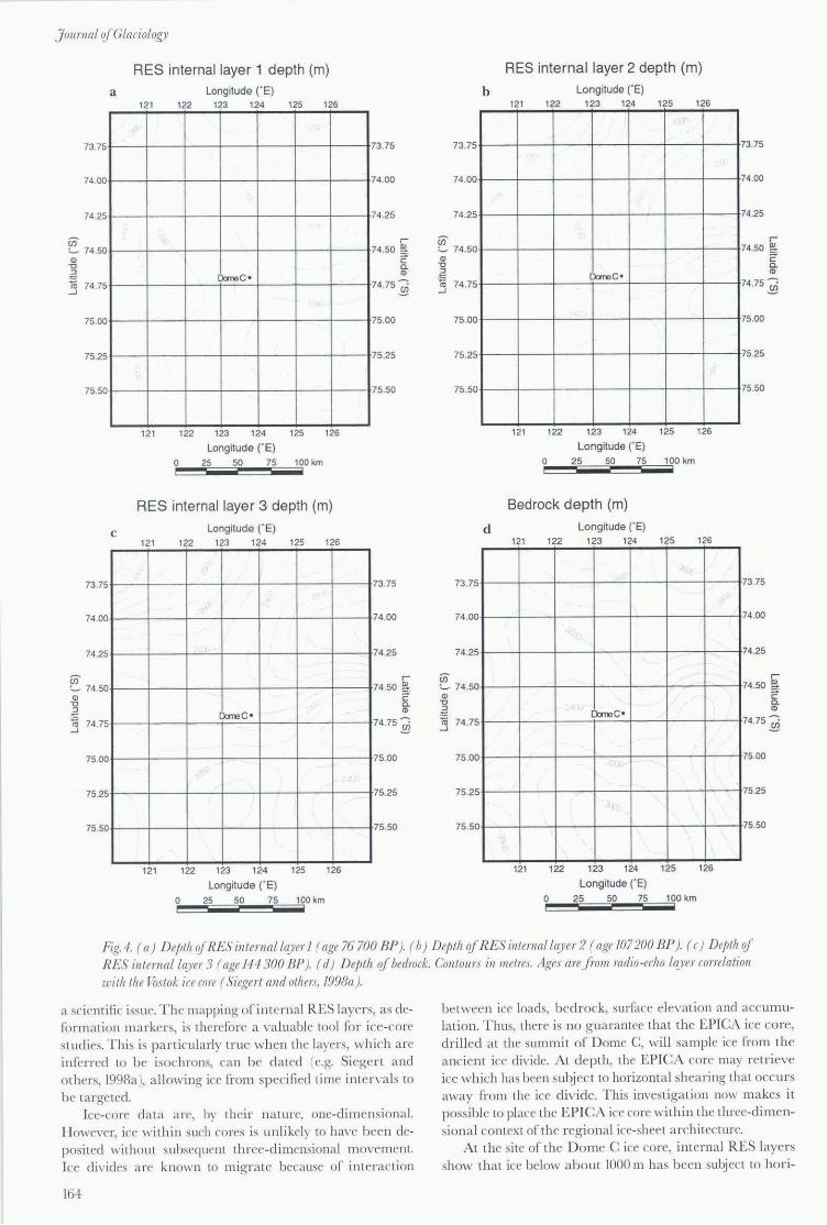
age me thod to remO\T j agged a no ma lies a nd o utli ers in conto uring. Fig ure + presents the fin a l cont oured depth maps
ror each of the three RES interna l layers a nd th e bedrock.
No te th a t the necessar y inte rpolati o n fro m irregul a rl y spaced \ '('c tor da ta sugges ts the reliabi lit y oC th e contour
m aps decreases towa rd s th e cent res of "da ta-sp a rse" a reas.
DISCUSSION
Ice d efo rmati on
Valu able a pplications of DEMo of ice-shee t inte rn al layers
ma)' be as initi a l bounda ry cond iti ons in d yna mic models of
ice-shee t fl ow, o r as fin a l bo unda ry conditio ns in im'erse
modelling proccdures. \ Vhil e the fl ow rate oC an ice column decelera tes C]u as i-expon entia lly towa rd s bedrock, ClI lII lIla/ille deform a tion is g reates t nea r the bed, where iee rcs idence time
is g reates t as a res ult orthc low now rates. Benea th a la rge ice
shee t, pa tt e rns o r dcf(JrIn a tion wi ll bc complicated by large
scale \ 'a ri a tions in bedrock to pog raphy, th e rma l regime,
strain history o f th e ice co lumn (whi ch reaches a maximum
thickness of > 4 000 m in the m apped a rea ) and res idence ti me: I he age o r ice a t 2200 III depth at D om e C is
> 1+5 000 \Ta rS (Si egert a nd othe rs, 1998a ). The refore, int crnal RES layers a re an indica tor oCinterna l defo rma tion,
which ca n be reso h-ed at a fin e sca le O\ 'er la rge a reas. A m eas
ure or the ex tent to whi ch eac h int erna l RES laye r h as been
dcro rmed is g i\,(, 11 by the range in depth of the laycr a nd th e sta nd a rd (rms) dL'\ 'iation of the de pth of th e laye r within th e
m apped a rea. The d a ta in Table I confirm I hat bo th o f t hese
m eas ures increase with depth . Two ice-shee t cross-sec tions across the Do m e C a rea a re illustra ted in Figure S. These re \'eal a trend to wa rd s increas ing resemblance to th e bedrock
profile with inte rn a l RES layer d epth , which is consistent with the data in Ta ble I.
Ice -core studies
Ice cores necessaril y require as complete, deta iled and un
di sturbed a stra ti g ra phy as poss ible. Beca use o f logis tica l a nd reso urce implications, thi s is a n o perationa l as well as
Table I. Desmjl/ive s/aliJ/ics/or ill ternal RES !co'er and bed de/J/lis
Slal;',lil
I\lini l11l1 111 I\l ax illl ulll R a ll ff(,
" 1\ lea 11
Std dCI·.
L alill/d,' / .ol/gill/rlr La )'" /
rlr/il;'
S E III
7:>.:109:1 12(1.011 (i 73:2 75.7·18 () 12Ii.989fi IG89
9.-)8
1 1.~8
201
LlI l'rr :!
rlrl";'
III
129B 2G73
m+ IBOI 30G
L al'l'r 3 8 "d r/I'IIIiI ,ft/ill!
III III
I.)(H 22:) ·1 :,07:2 +093 1178 1839
2281i :1+23 328 3~G
163
JournalofGlaciolof,J1
73.75
74 .00
74 .25
Cii '- 74.50 m "0 . .g iii 74.75 ....J
75.00
75.25
75.50
73.75
74.00
74.25
Cii '- 74.50 m -0
:~ j 74.75
75.00
75.25
75.50
a
c
RES internal layer 1 depth (m) Longitude ("E)
121 122 123 124 125 126
DareC ·
121 122 123 124 125 126
Longitude ("E) 0 25 50 75 100 km I
RES internal layer 3 depth (m)
121
121
o ;
Longitude r E) 122 123 124 125 126
Dare C '
122 123 124 125 126
Longitude (" E) 25 50 75 100 km
73.75
74.00
74 .25
r 74.50 2>-
~ a. C1l
74.75 :0
75.00
75 .25
75 .50
73 .75
74 .00
74 .25
r 74 .50 ~
C-a. m
74.75 :0
75.00
75.25
75.50
b
73.75
74.00
74 .25
Cii '- 74.50 m -0
:~ iii 74.75 ....J
75.00
75.25
75 .50
d
73.75
74.00
74 .25
Cii '- 74.50 m -0 ~ ~ 74.75 ....J
75 .00
75 .25
75.50
RES internal layer 2 depth (m) Longitude (,E)
121 122 123 124 125
OcmeC '
121 122 123 124 125
Longitude (' E) 0 25 50 75 100 km ;
Bedrock depth (m)
121
121
o I
Longitude (' E) 122 123 124 125
OcmeC '
122 123 124 125
Longitude ('E) 25 50 75 100km
126
126
126
126
73.75
74 .00
74.25
r 74.50 ~
C-a. m
74.75:0
75.00
75.25
75.50
73.75
74 .00
74 .25
r 74.50 ~.
C-a. m
74 .75 ~
75.00
75.25
75.50
Fig. 4. ( a) Depth of RES internalla.),er I ( age 76700 BP). ( b) Depth of RES illtemal Layer 2 ( age 107200 BP). ( c) DeJJth of RES inlemaL la..}'er 3 ( age 144 300 BP). ( d) Depth qf bedrock. Contours il111letres . .-lges are.from radio -echo la.)'er conelatioll with the roslok ice core ( Siegerl and others, 1998a).
a scientific issue. T he mapping o[ interna l R ES layers, as defo rmation markers, is therefore a valuable tool [or ice-core studies. This is pa rticul arl y true when the layers, which a re inferred to be isochrons, can be d ated (e.g. Siegert and o thers, 1998a), a llowing ice from sp ecified time inter vals to be ta rge ted.
Ice-core data a rc, by their natu re, one-d imensiona l. H owever, ice withi n such cores is unlikely to have been deposited without subsequent three-dimensional movement. Ice divides a rc known to migrate because of interac tion
164
between ice loads, bedrock, surface elevation and accumula tion. T hus, there is no g ua rantee tha t the EPICA ice co re, drilled at the summit of Dome C, will sample ice [ra m the ancient ice divide. At depth, the EPIC A core may retri eve ice which has been subj ect to horizonta l shearing that occ urs away from the ice divide. This investigation now makes it possible to place the EPICA ice core within the three-dimensiona l context of the regional ice-sheet a rchitecture.
At the site of the D o me C ice core, interna l RES laye rs show tha t ice below about 1000 m has been subjec t to hori-
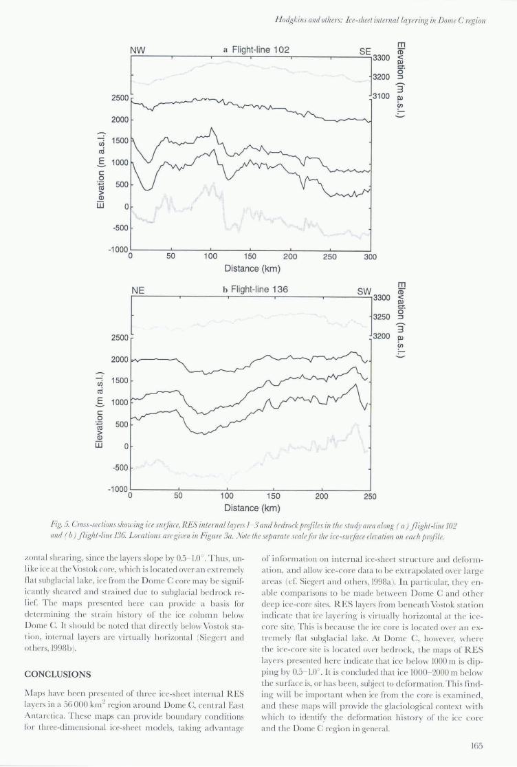
J-/odgkills alld olhers: Ire-shel'l ill lerna / I~J 'erillg ill Dome C regioll
NW a Flight-line 102 m
SEj3300 ~ a l 2500
2000 ....... Cl)
cri
S c 0
'';::; Cl) > Cl> ill 0
-500
-1000 0 50 100 150 200 250
o· 3200 ::J
"3 3100 !l'
Cl)
300
Distance (km)
b Fl ight-line 136 m
51:::: a> < NE a o· ::J
"3 3200 !l' ,J
Cl)
-2000 ....... Cl) 1500 cri E 1000 -c .Q
500 ro > Cl> ill 0
-500
-1000 0 50 100 150 200 250
Distance (km)
10j;.5. Cms.1 -seclioll.uitol(' illg ice .I /lljrll'e. RES illlel'l/al ho'en I 3 and bedrock J! rq(ill's inlhe .11 U({J' ([ rea alollg ( a ) j 7igitl-lillf J()2 and ( b) }lighl-lill f 136. Localioll.) are giL'ell ill Figure 3a . . \ ;)11' Ihe sejJa rail' scale/or Ih e ic{' -.Iu lj(/(e ela ([l ioll 011 each jiroji"le.
zomal shearing, since the laye rs slope by Oj 1.0 . Thus, un
like ice a t the Vos to k co re, which is loca ted O\'er a n extremely na t subglac ia ll a ke, ice fro m th e D o m e C co re may be sig nif
icantl y shea red a nd stra ined due to subglacia l bedrock rcI ieC The ma ps present ed here can prm'ide a b as is ff)!"
d e termining the stra in hi story oC th e ice column below D omc C. It sho uld be noted tha t direnlv below \ 'ostok stat io n, interna l layers are \'irtua ll y ho rizonta l (Siege rt a nd
o thers, 1998b ).
CONCLUSIONS
;\ Iaps ha\'(' been prcsent ed of three ice-shect interna l RES layers in a 56 000 km ~ rcgion a round Dome C, ccntra l Eas t
Anta rctica. Thcse m aps can prO\'idc bounda ry conditions (o r threc-d imcnsional ice-shec t m odel s, taking ad\ 'a lllage
of inf(lrmation on interna l ice-shee t structure and defo rm
a ti o n, a nd a llo\\' ice-core data to be extrap o lated 0\'('1' la rge a reas (c r. Si rge rt a nd Ol hers, 1998a . In pa rticul a r, they en
able co mpa risons to b e made bet \\'ec n DOl11e C a nd o ther deep ice-core sit es. RES layers ["mm ben ea th \ 'ostok sta ti o n
indicate th at ice layning is \'irtua lly hori zont a l at th e icecorc sit e. This is because the ice core is located m'er a n ext rclll e ly na t subglac ia l la ke. 1\t Dome C, hO\\'('\'tT, w here
t he ice-co re sit c is located ()\,('r bedroc k, t he maps o r RES laye rs present ed here indicate tha t ice below 1000 m is dip
ping by 0 .. ) 1.0 . It is concluckd th a t ice 1000 2000 III bel ow the surface is. or has been, subj ec t to defo rma ti on. Thi s (j nding wi ll be importa nt ,,·hen ice from the co re is examined ,
a nd these maps wi ll provide th e glaciological contex t with
wh ich to identi fy the d eform ation hi story of the ice co re a nd the Dome C regio n in genera l.
165
J ournal ofDlaciology
ACKNOWLEDGEMENTS
This study was funded by U. K. Natural Environment Resea rch Council grant CR9/2532. We thank the Director of SPRI, Uniyersity of Cambridge, for access to the RES database. The soft ware employed for the mapping work was ~Vli crolm ages Ine. TNTlite®> Version 5.8 geospati al data analysis so ft ware. We tha nk the sc ientific editors, D. Dahl:Jensen a nd l\1. Sturm, a nd C. Alien a nd another, anonymous reviewer for their constructive COlTIments on this paper.
REFERENCES
Drewr)", D.j. , N/. 1983 . . III/arc/ira: gla(iologiral alld geopl!)'si{{/IJolio. Cambridge. Uni\'crs ity of Cambridge. SCOll Po la r Research Institute.
J ouzel.]. alld 9 a/hers. 1989. A compa ri son of deep Anta rct ic ice cores and their implicat ions for clim ate be tween 65,000 and 15,000 yea rs ago. Qpa/. ReJ., 31 (2), 1 35~ 150.
J ouzel. j. and 16 a/hers. 1993. Extendi ng the VoslOk ice-core record of pa l3eo-
climate to the penul t ima te glac ia l period . . \ rt/lIrl'. 364 (6436), 407~411.
J ouzcl , j. . C. Orombelli a nd C. Lorius. 1996. Europea n Project fo r Ice Coring in An ta rctica (EPICA ). 1frra A II/ar/ica , 3 (1),49 .14.
Lorills, C. and 6 a/hers. 1985. A 1.10,OOO-yea r climat ic record fro m A nt a rct ic ice .. \ a/lIre, 316 (6029), 591 ~596.
Mill a r. D. 1-1 . ~1. 1981. R ad io-echo layering in po la r ice shee ts. ( Ph .D. thesis, Cni\'Crs iIY of Ca mbridge.)
Pa ren, j. C. 1981. Correspondence. Refl ection coe fTi cient at a dielec tri c interface. J. Glaciol., 27 (95), 203- 204.
Robin, C. de Q, D..J. Drewry and D. T. ~leldrllm . 1977. Int ernational studi es of ice sheet and bedrock. Philos. 7/"GIIS. R. Soc. LOlldoll. Sn B., 279 (963). 185 196.
Si egert. ~1..J. and]. K. Rid ley. 1998. Determining basa l ice-shee t condi tions in the Dome C regio n of East Anta rct ica using satell ite rada r a ltim ctry a nd airborne radio-echo sound ing. J. Glacial., 44 (1461.1 - 8.
Si ege rt, ~J.J. R. Hodg kins andJ. i\. Dowdcswell. 1998a. A chronology for the Dome C deep iC f"-cnrc sil e through radio-echo layer correla lio n with the \'ostok ice core, Anta rctica. GeojJhys. R es. Lell., 25 (7 ) , 10I 9~ 1022.
Siege rt, HJ. . R. H od g kins and ]. A. D o\\"deswcl l. 1998b. Interna l radioecho layering at Vostok stat ion, Anta rctica, as an independent st rat ig raphic control on the ice-core record. Ann. Glacial., 27. 360~364.
Ta bac("o, I. E., A Passe rini , F COl'belli a nd :vi. Corman. 1998. Correspo ndence. Determina tion of the surface a nd becltopography a t DOl11 e C. East Anta rctica.] Glacio/., 44 (146), 1 85~ 19 1.
illS received 18 11ugust 1998 and accepted ill revisedJorm 14 October 1999
166