geophysical exploration for buried buildings
TRANSCRIPT

Geophysical exploration for buried buildings
This is a pre-publication version of an article that was later published in the journal,Historical Archaeology, 2006, volume 40, number 4, pages 27 - 50. That publishedarticle is available at:http://www.jstor.org/stable/25617382?seq=1#page_scan_tab_contentsWhile the abstract is also at:https://sha.org/publications/sha-volume-indices/contents_abstracts_vol_40/#winterab
This pre-publication version lacks some final copy-editing. The figures here have ahigher resolution than in the publication, and some of them are now colored. Thisversion includes bookmarks to the sections of the article and to the figures. There arealso hyperlinks (with blue text) to the figures which follow the text. Furthermore, thereare links (invisible) between the sites mentioned in the main text to their further detailsin the appendix. Finally, there are hyperlinks (also invisible) from the appendix back tothe main text.
Page 1
Geophysical Exploration for Buried BuildingsBruce W. Bevan
AbstractCellars are usually easy to detect, but wall foundations can be difficult to find. A
scatter of rubble in the soil may reveal the former location of a building; buried buildings aremost commonly detected this way. It appears that chemical changes to the soil nearbuildings may also allow the locations of those buildings to be estimated; perhaps thesebuildings may be located even if no artifacts or features remain. Auxiliary features, such asburied roads, paths, wells, or privies, may suggest that a building was once nearby. Anappraisal of several dozen of my geophysical surveys suggests that they have had a 50 %chance of locating buildings.
IntroductionFor historical archaeology, the most common application of geophysical exploration is
a search for buildings whose remanents are now buried and no longer visible at the surface. Geophysics can be successful for these searches; this is because the remanents of buildingscan cover a large area and form a thick deposit. The search for a building is more likely to besuccessful than a search for small features such as graves or privies.
A summary of many different surveys is given here. Both successful and failedgeophysical searches are described here; this may keep the conclusions from being affectedby unusual conditions at a few sites. Therefore, this summary can suggest the reliability ofsurveys at a wide variety of sites.
Geophysical surveys at domestic houses are emphasized here; this is only becausethese houses are most frequently sought. While few examples are included here, thefindings should apply to many commercial, industrial, farming, religious, and militarybuildings. Almost all of the examples here are from the northeastern part of the U.S.; this isprimarily due to the fact that archaeologists in this area applied geophysical surveys earlierand more frequently than archaeologists in other parts of the country. Known or anticipateddifferences in geophysical practices will be described for regions that have different soils andgeology.
While this summary is written primarily for archaeologists, an appendix includestechnical details that may aid those individuals who do geophysical surveys.
Tools for the SearchBefore a geophysical survey is attempted, simple procedures that may be successful
should first be considered. Historical maps and photographs can give more accuratelocations for former buildings than is possible with geophysics. The main disadvantage ofthis historical approach is that it does not allow an estimate of what remains underground. Also, maps and photos may only determine the relative locations of nearby buildings. Thiswould be true if the modern landscape no longer has enough clues to the historicallandscape; for example, the trees or buildings that are visible in a historical photograph mayno longer be standing. While aerial photographs rarely reveal the locations of formerbuildings, it is easy and inexpensive to make an oblique photograph of an historic area from a

Tools for the search
Page 2
rented airplane.Other alternatives to geophysical surveys should also be considered. Shovel test pits
and soil probing (McManamon 1984) can be cost-effective and they have a long history ofsuccessful searches for buildings. A tile probe (steel T-bar) is particularly suitable fordetecting foundations at a depth of 1 ft or so. This exploration may only be practical wherethe soil is soft and contains few stones.
A search with a metal detector (Connor and Scott 1998) should always be consideredbefore a geophysical survey. A scan with a metal detector is both more economical andmuch faster than a typical geophysical survey; an initial scan with a metal detector may alsoreduce the area that needs to be explored with a geophysical survey. While metal mayaccumulate in the vicinity of historical buildings, concentrations of metal may also be found inareas of trash disposal. Geophysical surveys, also, cannot usually distinguish a midden froma building.
With formal geophysical surveys, recorded measurements may be made along aseries of straight lines that allow the mapping of a rectangular area. Informal orreconnaissance geophysical surveys are quick searches that are made without recording themeasurements or perhaps their locations; this procedure is also called the method of freesearch (Smekalova et al. 1993:88). With these reconnaissance surveys, unusual readingsare noted by watching the display on the geophysical instrument; the area where thesereadings are found can be explored in more detail. These informal surveys can speed theexploration of large areas, but they may be poor for defining the shape of buried features andthey do not usually allow a detailed interpretation.
The following paragraphs describe the advantages and disadvantages of severaldifferent geophysical instruments that could be applied to a search for buildings. Furthercomparisons of these techniques are in the publications by Clark (1996), Heimmer and DeVore (1995), or Bevan (1996a).
Ground-penetrating radar detects a wide variety of underground features and allowsan approximation of the cross-section of some features. A set of radar profiles that arerecorded along parallel lines can generate rough three-dimensional views of buried features. Except for this 3D geometry, ground-penetrating radar is not very good for identifying thematerials that are underground; metal may appear to be identical to wood, ceramic, or an aircavity. The radar's information on the relative depth of features is particularly important. Aswith other archaeological findings, greater depth can mean greater age; shallow features canbe modern. Radar is usually the best instrument if an air-filled void is sought; undergroundchambers and tunnels can be detected.
A ground-penetrating radar is composed of several components. The main part is theantenna that transmits and receives the radio pulse; this antenna is typically mounted in abox that is pulled or pushed along the ground like a sled. These antenna boxes typicallyrange in size from 0.2 to 1 m in width. Smaller boxes are for antennas that operate at ahigher frequency; this allows them to detect smaller and shallower features. The radar alsoincludes electronics for the transmitter and receiver and the equipment for displaying andrecording the radar echoes.
Ground-penetrating radar is excellent for surveys on the coastal plain of the U.S. In

Tools for the search
Page 3
this area, the shallow, archaeological zone of the soil column is typically rather sandy, but thesoil becomes increasingly clayey with greater depth; stones are not natural in this soil and theradar usually reveals little evidence of soil strata. All of these factors aid a radar survey. Stones and natural strata confuse the patterns on radar profiles. While clay attenuates theradar signal, a cellar or other pit that has been dug into clay that is below a sandy layer canbe very apparent on a radar profile.
While the eastern coast of the U.S. is generally excellent for a radar survey, much ofthe rest of this country is less suitable for radar. The silt of the Midwest can cause theprofiling depth of the radar to be too shallow; this same problem may be found with salinesoils in irrigated areas and with calcareous soils, such as those in the Southwest. Glacial andperiglacial soils in the north can be so complex that small features cannot be isolated. Theshelly sediments of Florida and the sands of the north-central U.S. can be excellent for radarsurveys.
The major difficulty with radar surveys is that the soil can attenuate the radar pulse somuch that the depth of profiling is too shallow; while loam may allow a profiling depth of 3 m(10 ft), clay may limit the profiling depth to less than 0.5 m (1 ft). This attenuation factor canbe estimated in the U.S. from special soil maps (Doolittle et al. 2003). Measurements of theelectrical resistivity of the soil are also a good predictor of profiling depth with a radar. Inaddition to this attenuation factor, radar surveys are affected by the stratigraphic complexityof the soil; if the soil is naturally stony, small archaeological features may be masked on radarprofiles by the echoes that are caused by clusters of stones. The roots of large trees (withtrunk diameters greater than 1 ft or 0.3 m) cause a similar difficulty in the vicinity of thosetrees.
On the coastal plain of the U. S., a magnetic survey is often complementary to a radarsurvey; the two surveys detect very different features and the findings have little unnecessaryduplication. At any location, a magnetic survey should have high priority if iron artifacts orburned structures are sought. A magnetic survey will probably fail if there is magnetic rock inthe ground; black igneous stone such as basalt or diabase usually makes it impossible tosucceed with a magnetic survey. A geological map can reveal these igneous areas; it isconventional for them to be colored red on the map. Magnetic surveys are ideal in the searchfor kilns and furnaces. While a magnetometer will detect brick, it is not necessarily a goodinstrument for this search. Modern pipes, fences, and building roofs that contain iron arestrongly detected by a magnetic survey and cause interference for those surveys.
While a radar survey is impossible where there is brush at the surface, magneticsurveys can sometimes be done in brushy areas; this is because the magnetic sensor iscarried above the surface of the soil and the sensor can be small enough that it can bepushed into a bush for a measurement. There are many different types of magnetometers,and these are described by technical terms such as fluxgate, proton, cesium, or Overhauser;each of these types of magnetometer can be suitable for archaeological surveys. With amagnetic survey, a magnetic sensor is carried around the area of interest, and point-by-pointmeasurements of the earth’s magnetic field are recorded. At many historical sites, there is agood quantity of modern iron trash in the soil; the magnetic patterns of these unwantedartifacts can confuse the patterns from the archaeological features of interest.

Tools for the search
Page 4
Metallic objects are almost invisible to a resistivity survey. However, resistivity surveyscan be impossible if there is a hard pavement at the surface. This is because each resistivityinstrument has four metallic electrodes that must make a good electrical contact to the soil. These four electrodes can be arranged in many different patterns, called arrays, and all ofthese arrays (such as the Wenner, twin electrode, and pole-pole array) are suitable forarchaeological surveys. During the operation of a resistivity meter, an electrical current issent through the earth between one pair of the four electrodes; a voltage is measured at theother pair of electrodes. The ratio of this measured voltage to the applied current increaseswith the electrical resistivity of the soil.
Resistivity instruments can be the least expensive of the instruments that arecommonly used for archaeological surveys; resistivity surveys are good for beginners, forthere are fewer errors to make as compared to other types of geophysical survey. Whileresistivity surveys are difficult or impossible if the soil is very hard, dry, or stony, thesesurveys can be done in a wider range of sites than other geophysical surveys, for a resistivitysurvey has relatively few restrictions on soil, geology, and electrical interference. Resistivitysurveys are excellent for searching for organic trash pits in sandy soil and also foraccumulations of stone in silt or clay; in both of these cases, there is a large difference inresistivity between the archaeological feature and the surrounding natural soil.
Conductivity surveys detect many of the same features as do resistivity surveys, butconductivity surveys are much faster and easier to do than resistivity surveys. Unlike aresistivity survey, a conductivity survey strongly detects shallow metal objects (less than 0.2m underground) that are the size of a tin can lid or larger. A conductivity instrument alsoreadily detects buried wires and metallic pipes, and these can be common at historic sites. Finally, a conductivity instrument receives more interference from nearby electric wires thando other geophysical instruments.
Conductivity meters are similar to one type of metal detector; these meters have a pairof coils of wire, called the transmitter and receiver coils, that are separated at a distance of 1- 3 m. An oscillating magnetic field is generated at the transmitter coil; this passes throughthe soil and is detected at the receiver coil. The coupling of this magnetic field through thesoil increases with the electrical conductivity of the soil. Conductivity is simply the reciprocalof resistivity; this is why conductivity and resistivity surveys detect so many of the samefeatures.
Geophysical surveys may be done of the same area with more that one geophysicalinstrument. This can increase the reliability of a survey, and also the number and variety offeatures that are detected, but the cost of the survey also increases. If one geophysicalinstrument is known to be excellent for detecting the features that are sought, there is littlereason to try any other instrument. A compromise between cost and completeness can beconsidered: For example, one may apply three-quarters of the geophysical effort to theprincipal (most suitable) geophysical instrument, and the remaining time to the second besttechnique.
A general limitation of geophysical surveys is that small features cannot be detected ifthey are deep. As a rule, features will be invisible if they are deeper than their size. Forexample, a wall foundation that has a width of 0.5 m cannot usually be detected if it is deeper
Indications: cellar
Page 5
that 0.5 m underground. With some features or artifacts (such as metal), radar, conductivity,and magnetic instruments can detect objects that are deeper than their size.
Indications of Buried BuildingsThere are several different aspects of the underground remains of buildings that allow
buildings to be detected. These include a cellar, a floor, a foundation, a scatter of debris, afireplace, a change in soil chemistry, and auxiliary features (such as paths or pipes). Theseaspects will be discussed next, in that order.
CellarIf a building once had a cellar, this will greatly aid the location of that building's
remains. Cellars are usually easy to detect with a geophysical survey; this is primarilybecause they are larger than other features at historic sites. The debris within a cellar mayalso extend to a good depth; cellars are unusual in that there are many shallow features atarchaeological sites, but there may be few deep ones. Cellars do not appear to be ascommon as a geophysicist would wish.
A chaotic mixture of rubble within a filled cellar can be detected with most geophysicalinstruments. While a rubble-filled cellar allows a more certain detection of a building than anyother aspect, some cellars remain invisible to a geophysical survey. Examples of bothsuccesses and failures follow. Each of my surveys is listed with the postal abbreviation of thesite's state; this is followed by a sequence number that shows the order of the surveys ineach state. Further details about these examples are included in an appendix.
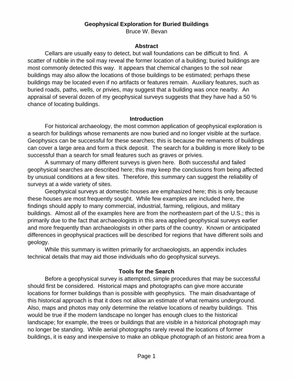
Figure 1 illustrates how a cellar may be revealed with a ground-penetrating radar. Thisis the cellar of the priest's house at the Chapel Field in St. Mary's City (MD04). Few othercellars have been revealed as clearly by geophysics as this one. The complex radar echoesin Figure 1 result from the reflection of the radar pulse from many different lenses of soil anddebris within the cellar fill. The radar profile suggests that the cellar is 16 ft. (5 m) long; theprofile also indicates that the rubble begins at a depth of 1 - 2 ft. (0.5 m). The profile does notprovide reliable information about the depth to the bottom of the rubble. While this depth maybe roughly 6 ft. (2 m), echoes extend to a much greater apparent depth (which is actuallyecho delay time); these repeated echoes are a reverberation of the radar pulse betweenlenses of different materials.
If a cellar hole was filled recently, the modern debris in the fill likely contains a largequantity of metal, in particular, iron. The known cellar of an ice house at the RobinsonFarmstead on the Manassas Civil War battlefield (VA10) was readily detected by magneticand radar surveys because of the modern fill. The cellar of the Bullock House (VA14) on theChancellorsville battlefield was also detected with radar, magnetic, and conductivity surveysbecause of the large quantity of metal that it contained. A magnetic survey at Fort Ellis inMontana clearly detected a root cellar with sides that were about 5 m (15 ft.) long (Weymouth1996); this cellar contained some brick, and this was at least partly the reason why thisfeature was more magnetic than the surrounding soil.
The larger a rubble-filled cellar is, the easier it is to detect. A small cellar, 1.5 by 3 ft.(0.5 by 1 m) in size, was detected with a radar survey at Fairfield (VA19) because the nearby

Indications: cellar
Page 6
soil strata showed few other complex features at a shallow depth.While the identification of a rubble-filled cellar is often reliable with a geophysical
survey, it is not certain. Geophysical identification is more difficult than detection: Detectionmeans that a geophysical instrument found a difference in the soil within an area;identification means that this difference was interpreted to be significant and that theunderground feature could be named. Perhaps archaeological information has alreadysuggested that certain types of features may be located in the area of survey; this informationwill increase the reliability of an identification.
A radar profile across the cellar of the Master Armorer's Quarters at Springfield Armory(MA01) revealed a span with complex soil strata and another span with simple and planarstrata; the natural soil was complex at this site, and the strata within the cellar fill were simple. Since it was anticipated that the cellar fill would have complex soil strata, the identification ofthe cellar was in error. Within the Gallows Green area of St. Mary's City (MD04), a radarsurvey reliably located complex strata at a depth of 3 ft. (1 m) in an area of 30 by 40 ft. (10 by12 m); excavations revealed that this feature may be a sawing pit. This feature was clearlydetected by geophysics, but it could not be identified. A magnetic survey at Saint-GaudensNational Historic Site (NH01) found large and deep masses of iron in an area where the cellarof the sculptor's studio was thought to have burned; while it is possible that the iron was fromthe armatures within clay models, the iron masses did not reliably define the location of thestudio. Radar was not successful at this site because the stony soil caused the radar profilesto be complex everywhere.
Geophysical surveys have also failed to detect cellars. A root cellar that wasexcavated near Benjamin Bannecker's cabin (MD03) contained large stones to a depth of 5ft. (1.5 m), but this was not detected by a radar survey. The cabin was also not revealed bythe radar, even though a quantity of stone was found near the foundation. These failuresmay have been due to three factors: The soil was rather conductive (limiting the profilingdepth with the radar). Bedrock was perhaps at a depth of a few feet (about 1 m) and thestoniness of the soil caused the radar profiles to be complex. Finally, the spacing betweenthe radar profiles was 10 ft. (3 m) in order to allow a large area to be explored; small featureswere lost between the profiles.
At Johnson Hall (NY04), the area of a wooden cellar was adequately explored with aradar, but no trace of it was detected. The cause of this failure is unknown.
It is generally the rubble within cellars that makes them distinctive to a geophysicalsurvey. In a few cases, the detection of a cellar floor has suggested the location of a formerbuilding. Ground-penetrating radar is probably the only geophysical instrument that might besuccessful in this search. However, radar will likely fail at sites where natural soil strata arefairly horizontal and discontinuous. Geophysics will then give too many false alarms.
A radar survey at the site of the Dawson House (DE01) could not identify thehistorically-important cellar floor that was later discovered by excavation. While this earlyfloor was detected by the radar, natural soil strata in the area gave similar patterns at thesame depth. Therefore, the fragment of the cellar that was detected could not be identifiedas a cultural feature.
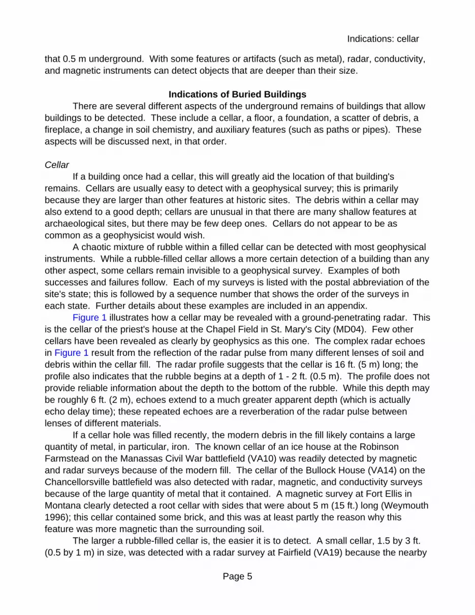
The U-shaped echo band in Figure 2 reveals the cellar floor of an early building at
Indications: floor
Page 7
Appomattox Manor (VA03); there is almost no hint of rubble within this cellar. This floor isabout 14 ft. (4.3 m) long and 6 ft. (2 m) underground. The slight dip in the middle of the flooris exaggerated by the large compression (eleven-fold) of the horizontal scale of the radarprofile. While the other profiles within this article show findings that are unusually clear, theecho from this cellar floor is typical of several other cellar floors that have been detected witha radar.
On Jamestown Island, the cellar floors of some 17th-century buildings have beendetected with radar surveys. One edge of Structure S-105 was first located by excavationsthat were made by the National Park Service (NPS) in the 1930's or 1950's. Theunexcavated floor of the cellar of this building was clearly detected by the radar (VA06);rather little rubble was detected within the cellar. The contrasting fill within this cellar wasalso revealed by resistivity and conductivity surveys.
On another part of Jamestown Island, a radar survey detected the cellar floor of anearth-fast building from the period of the James Fort (VA08). The radar revealed this cellar tobe a broad basin; a geophysical estimate of the outer boundary of the cellar differed by 2 - 5ft. (0.8 - 1.5 m) from the boundary that was determined by later excavation. Several other17th-century cellar floors that are similar to this one at Jamestown were revealed by a radarsurvey at Westmoreland Berry Farm (VA20) on the Rappahannock River.
At Mount Pleasant (VA18), southwest of Jamestown Island, two cellars were detectedduring a radar survey. While a thick zone of rubble revealed one cellar, the other wasidentified by a floor at a depth of 5 ft. (1.5 m).
Geophysical surveys are valuable for an exploration below depressions that are visibleat the surface. At Appomattox Court House (VA16), there is a depression next to the PeersHouse that is 2 ft. (0.6 m) deep and 30 ft. (10 m) in diameter. Neither radar nor conductivitysurveys could find any suggestion of a cellar at this location. Excavations could notdetermine a cultural origin for the depression either.
While cellars can be detected with magnetic, radar, conductivity, and resistivitysurveys, they should also be detectable with a seismic refraction survey; seismic surveys areslow, but they are excellent for detecting the difference between natural soils (which can becompact and cemented) and fill soils (which are loose and porous).
FloorExcept at the base of cellars, floors are seldom detected by geophysical surveys. This
appears to be due to the shallow depth of floors; they may have been broken up by rodents,plowing, or other landscaping. Any of the geophysical instruments are probably suitable forthe search for the remains of shallow floors. The known buried floor of a modern buildingwas readily identified with a radar survey at the site of the Dawson House (DE01).
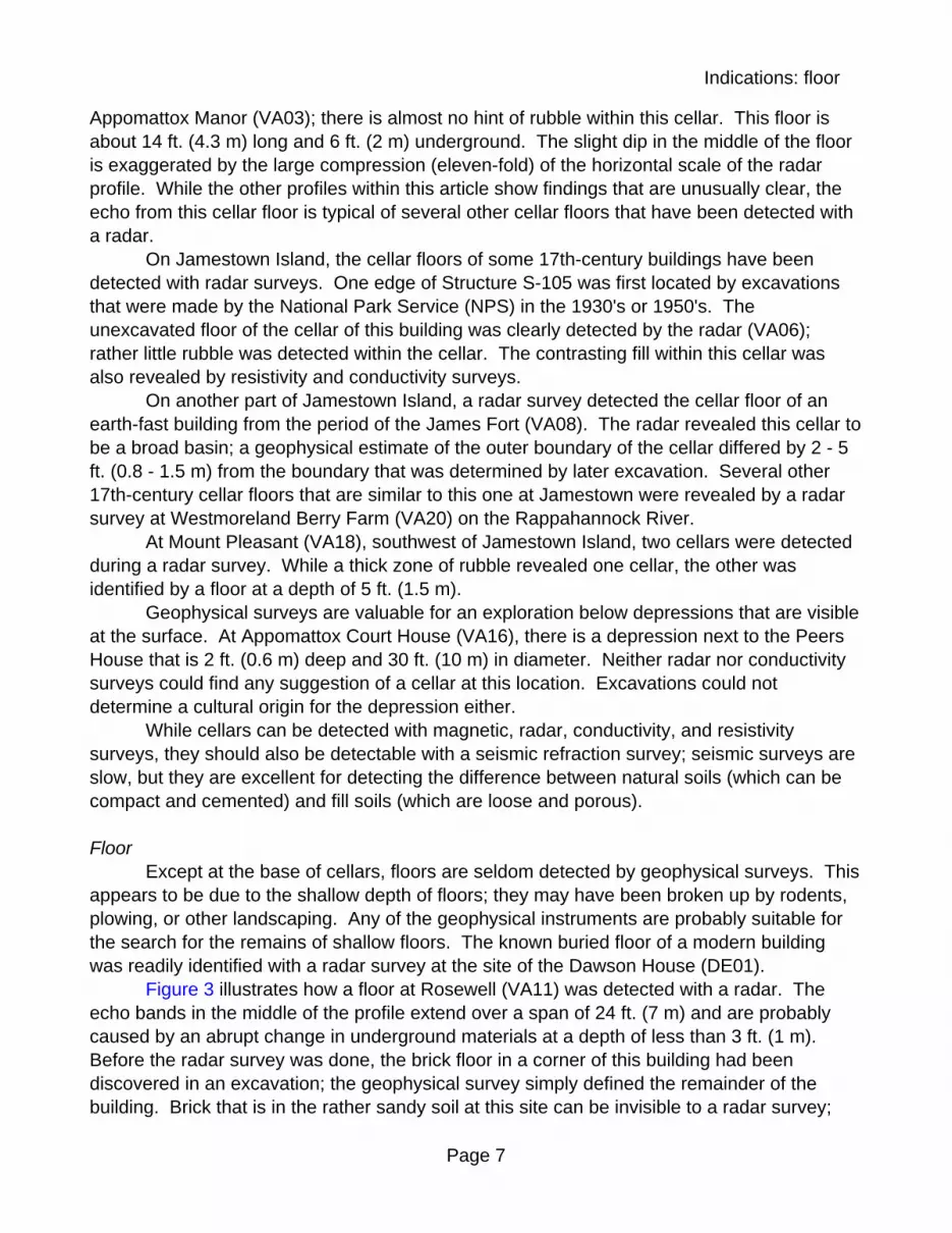
Figure 3 illustrates how a floor at Rosewell (VA11) was detected with a radar. Theecho bands in the middle of the profile extend over a span of 24 ft. (7 m) and are probablycaused by an abrupt change in underground materials at a depth of less than 3 ft. (1 m). Before the radar survey was done, the brick floor in a corner of this building had beendiscovered in an excavation; the geophysical survey simply defined the remainder of thebuilding. Brick that is in the rather sandy soil at this site can be invisible to a radar survey;
Indications: foundation
Page 8
therefore the source of the radar echo could be a layer of fill that is below the brick floor. Clay or cinders are possible materials that could cause the strong echo and the reverberationof the radar pulse.
A layer of bricks from a former structure could not be identified by either a magnetic ora radar survey at the Watt House (VA13) on the Richmond National Battlefield. Iron debris inthe soil and iron in a nearby garage had a large effect on the magnetic survey. Whilecomplex echoes caused by tree roots affected the radar survey, it is possible that part of thefloor was detected by the radar.
A dairy barn at the Gilpin House at Brandywine (PA07) was known from historicalphotographs; this barn was constructed after 1910. A radar survey detected the floor of thisformer barn as a simple and planar interface.
In Japan, a radar survey readily revealed the basin-like floors of early buildings (Imaiet al. 1987); these floors were about 6 m (20 ft.) wide and 1 m (3 ft.) underground. There wasa large contrast between the floors and the volcanic ash that covered them. The stone floorof a cabin was found to give high readings with a resistivity survey (Kvamme 2001); the stonefoundations of the cabin were visible at the surface and had high resistivity also.
FoundationFoundations have rarely been revealed by my geophysical surveys. This is because
there is typically so much construction rubble around foundations that the foundation cannotbe isolated within a complex pattern in the geophysical data. The linear extent of afoundation is an aid to its identification; this identification is more certain if eitherperpendicular or parallel lineaments are revealed by geophysics. Foundations are typicallynarrow and this makes the search more difficult. The builder's trench may be as detectableas the foundation itself.
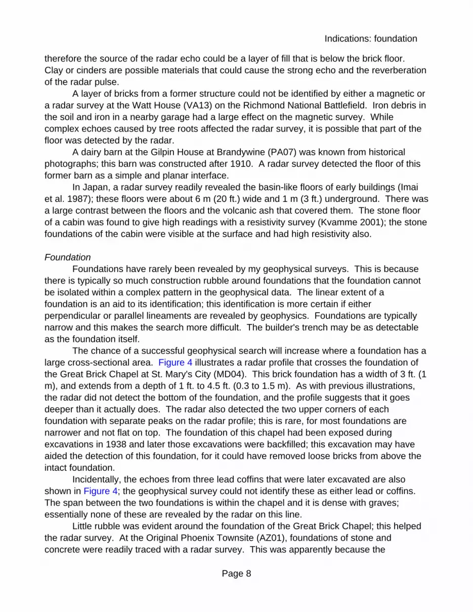
The chance of a successful geophysical search will increase where a foundation has alarge cross-sectional area. Figure 4 illustrates a radar profile that crosses the foundation ofthe Great Brick Chapel at St. Mary's City (MD04). This brick foundation has a width of 3 ft. (1m), and extends from a depth of 1 ft. to 4.5 ft. (0.3 to 1.5 m). As with previous illustrations,the radar did not detect the bottom of the foundation, and the profile suggests that it goesdeeper than it actually does. The radar also detected the two upper corners of eachfoundation with separate peaks on the radar profile; this is rare, for most foundations arenarrower and not flat on top. The foundation of this chapel had been exposed duringexcavations in 1938 and later those excavations were backfilled; this excavation may haveaided the detection of this foundation, for it could have removed loose bricks from above theintact foundation.
Incidentally, the echoes from three lead coffins that were later excavated are alsoshown in Figure 4; the geophysical survey could not identify these as either lead or coffins. The span between the two foundations is within the chapel and it is dense with graves;essentially none of these are revealed by the radar on this line.
Little rubble was evident around the foundation of the Great Brick Chapel; this helpedthe radar survey. At the Original Phoenix Townsite (AZ01), foundations of stone andconcrete were readily traced with a radar survey. This was apparently because the

Indications: foundation
Page 9
above-ground parts of the buildings were cleanly removed during demolition; there was littlerubble in the fill to hide the foundations.
A fire can aid the search for a foundation. The firing can magnetize the brick orperhaps the stone of a foundation; a magnetic survey can then be ideal. The Taylor Houseburned during the first stage of the Civil War siege of Petersburg (VA01); the brick foundationof the house was clearly defined by a magnetic survey. This building was unusual in howdistinctly it was detected. The foundation walls were revealed by magnetic, radar, andresistivity surveys. The magnetic and radar surveys allowed estimates of the height of thecellar wall that remained; these surveys also agreed in their estimates of the orientation of thebuilding. The radar survey detected the cellar floor. Resistivity, conductivity, and radarsurveys revealed the fill within the cellar.
The main house at the Robinson Farmstead on the Manassas battlefield (VA10) wasdestroyed in a 1993 fire; however, a magnetic survey found no distinctive anomalies in thearea of the house. Neither radar nor magnetic surveys could detect three sandstonefoundations that were found nearby during later excavations. A cinderblock foundation thatwas later excavated at this site was moderately magnetic; this foundation was not identifiedby the geophysical survey.
Almost all brick is magnetic, even if it has not been burned in a house fire. While brickfoundations can be detected by a magnetic survey, typical small foundations cause complexpatterns and the foundation may not be delineated. Even the large foundation of the GreatBrick Chapel (MD07) was detected as a lumpy and irregular pattern on a magnetic map;similar patterns are found in the magnetic maps of basalt walls (Barba et al. 1996). Thesecomplex patterns are caused by the random directions of the remanent magnetization of thebrick or stone. On the coastal plain of the U.S., brick foundations can be difficult to detectwith a radar or resistivity survey; this is because the electrical properties of brick can be verysimilar to the surrounding soil. At Mount Pleasant (VA18) and on Jamestown Island (VA08),brick foundations were invisible to the radar.
Stone foundations may be detectable with any of the geophysical instruments. Interestingly, foundations of non-magnetic stone such as limestone or quartzite can bedetected with a magnetic survey (Smekalova and Maslennikov 1993; Gaffney et al. 2000;Clay 2001). For this survey to succeed, the surrounding soil must be magnetic; thesemagnetic soils are typically found in areas that have limestone bedrock or river-depositedclay. For the greatest likelihood of success, the foundations should be large and shallow. Stone typically has a higher electrical resistivity than the surrounding soil; this allows it to bedetected by a resistivity or conductivity survey. Possible stone foundations were traced witha resistivity survey in New York state (Kvamme 2003). High resistivity was found along the 4by 7 m (12 by 20 ft.) rectangle of the underground foundation of a powder magazine at FortAtkinson (Weymouth 1996) near Omaha, Nebraska. A magnetic survey at Fort Ellis(Weymouth 1996) near Bozeman, Montana, revealed intermittent parallel lines spaced by 20m (60 ft.) that were caused by the foundations of a building.
At the site of Ink's Tavern (PA08) on the Fort Necessity battlefield, a cellar holecontaining stone rubble is visible. A magnetic survey of this area revealed broad anomalieswith no archaeological significance; the intact stone walls that were buried could not be

Indications: debris scatter
Page 10
detected. The rock that is native to this area is sedimentary and non-magnetic; the cause ofthe geophysical failure is not known.
A tile probe is particularly good for tracing the tops of foundations that are at a shallowdepth. Aerial photography may also be suitable for locating shallow foundations. It appearsthat remanents of the foundations of 19th-century buildings were revealed at Fort McHenry(MD01) in aerial photos taken of a mown lawn. With the radar, foundations that are shallowmay be more difficult to detect than deeper foundations. At Stenton Mansion (PA02), a radarsurvey detected the lower surfaces of schist foundations, rather than the tops, which wereonly 0.5 ft. (15 cm) underground.
Linear foundations are much easier to identify with a geophysical survey than areseparated piers of stone or brick. Post molds that mark the wooden pillars of buildings areeven more difficult to detect and identify. At the site of Grant's cabin (VA02) near Petersburg,these post molds were much too small to be detected by a radar and magnetic survey.
In addition to hard foundations of stone, brick, or concrete, some buildings may havehad a simple wooden sill foundation or have been constructed with sod or adobe. Traces ofthese foundations may sometimes be detectable with geophysical surveys. At Fort Lowell(AZ02), a resistivity survey found low readings at or near the buried remanent of an adobewall.
Debris ScatterThe aspect of a buried building that is most commonly detected by a geophysical
survey is the rubble that overlies and surrounds the building. This rubble may contain stone,brick, metal, and other refuse. The area of rubble may be diffuse, and without sharpboundaries. The geophysical patterns of rubble may be identical to those caused by debrismiddens or by natural clusters of stones in the soil; therefore, these geophysical patterns donot have a high reliability for identifying former buildings.
Any of the geophysical instruments can be suitable for detecting rubble. Ground-penetrating radar is particularly good for identifying cultural soils by their stratigraphiccomplexity and this instrument is excellent for locating structural debris. Figure 5 combinesthe findings of a radar, magnetic, and conductivity survey that detected three areas of rubbleinside Fort Griswold (CT01), a stone fortification from the time of the Revolutionary War. Thethree dotted areas mark where complex soil strata were detected. Note that these areas arejust blobs; they reveal no rectangular patterns that suggest foundations. This finding istypical.
The geophysical evidence is that buildings were once located at the three areas thatare dotted in Figure 5. Historical records and also excavations after the geophysical surveyindicate that a blockhouse stood at the middle anomaly, while a barracks was at thesoutheast. Both of these structures were found to have rubble-filled cellars. The geophysicalsurvey did not identify these as cellars; they simply appeared to be concentrations of debris. No cellar was found at the northeastern anomaly, and this area was disturbed by a barracksfrom World War II.
Geophysical surveys have correctly suggested the locations of buildings by aconcentration of debris at many sites. At Raritan Landing (NJ01), the radar was suitable

Indications: fireplace
Page 11
even though the soil was silty and therefore had a high attenuation for the radar pulse. AtPeachfield (NJ03), the radar detected a midden-like feature that appears to be debris from anearlier building. At the Abraham Van Wyck House (NY05), magnetic, resistivity, and radarsurveys each suggested a concentration of debris on the east side of a standing building; anhistorical photograph and prior excavations had already indicated that there was once anearlier structure there. At Valley Forge (PA03), stone rubble from an unknown 18th-centurystructure was detected by radar and resistivity surveys. At the site of the Widow Tapp House(VA05), a thin scatter of debris was noticeable with magnetic and conductivity instruments. At the Stevens House (VA07), excavations confirmed that a zone of debris (detected by aradar survey) marked the building that was sought; the analysis of an historical map agreedwith this. At the site of the Academy Dwelling at Appomattox Court House (VA16), a clusterof magnetic anomalies appear to define the original extent of the former building. During amagnetic search for traces of the city of Sybaris (Ralph et al. 1968) in Italy, the roof tiles ofdestroyed buildings were readily detected.
Geophysical surveys have also falsely suggested that regions of debris located formerbuildings. Around the Gilpin House on the Brandywine battlefield (PA07), a radar surveycould not distinguish between zones of building rubble and lenses of other debris. Othersurveys have also been failures: At Pluckemin (NJ02), the native granitic stone is magneticand thick in the soil; neither magnetic nor radar surveys revealed the locations of buildingsfrom a Revolutionary War encampment. At the Emlen Physick Estate (NJ04), the naturalsandy soil at this coastal location was unexpectedly complex on radar profiles and the surveyhad little success in suggesting the former locations of buildings.
At some sites, geophysical surveys have detected concentrations of debris that couldbe remanents of buildings; however, excavations that followed the geophysical surveys havesometimes revealed neither buildings nor a cause for the geophysical findings. This was thecase at Salem Maritime National Historic Site (MA02), Long Hill (MD06), the Shapiro Houseat Strawbery Banke (NH02), the Robinson Farmstead on the Manassas battlefield (VA10),and the West House (VA22) on the Richmond Civil War battlefield.
A resistivity survey at Fort Riley in Kansas revealed that some concrete foundationsand accumulations of building debris had high resistivity (Hargrave et al. 2002); buildingdebris was also detected as high values of resistivity. In Haiti, stone rubble from buildingswas apparent as high resistivity (Shapiro 1984).
The success of a geophysical search for rubble will increase where the soil itself hasonly a simple stratification (the soil should not be stony and not have been glaciated);success will also be better at sites with little modern debris (particularly metallic objects).
FireplaceA fireplace and its chimney may contain more stone or brick than any other part of a
house; therefore, the detection of chimney rubble or an intact fireplace base or hearth mayprovide a good indicator of the location of a house. Since a fireplace may be either in themiddle of a house or at its outer edge, the detection of a fireplace alone may not define theexact location or extent of a house.
On Jamestown Island (VA08), a radar survey revealed complex strata where

Indications: soil chemistry
Page 12
excavations later found a dense concentration of brick rubble from a fallen chimney. Thissurvey did not detect an intact brick foundation that was nearby.
At the site of the Fairview Cabin (VA15) on the Chancellorsville battlefield of the CivilWar, one quadrant of the stone base of a fireplace was detected with a radar survey. Excavations could not determine why the rest of the fireplace was invisible; it could be due toa difference in the type of stone or perhaps due to changes in the soil above or below thestone. Some of the stone that is native to this area is magnetic, and a magnetic survey failedto detect any part of this fireplace or the cabin. At Fort Lennox, in Canada, a resistivitysurvey (Ralph 1969) revealed high readings at a pair of stone hearths within a formerhospital.
Geophysical surveys with radar, resistivity, and conductivity instruments all failed todetect the intact stone base of a chimney that was later excavated at the Academy Dwellingat Appomattox Court House (VA16).
At New Windsor Cantonment (NY02), a magnetic survey detected the stones in threehearths that were within huts, but failed to detect three other hearths that were found byexcavation. At this site, a radar survey was unsuccessful because of the natural stoniness ofthe soil.
A magnetic survey at Valley Forge (PA03) was done over the burned earth of a hearththat had earlier been exposed by an excavation; this test showed that such a hearth could bedetected by a magnetic survey. However, this hearth was not detected by an earlier surveybecause the magnetic pattern of the hearth was completely obscured by four modern irontent pegs that were buried in the soil.
While the cellar of the Bullock House (VA14) at Chancellorsville was readily detectedwith radar, magnetic, and conductivity surveys, the brick bases of three chimneys wereinvisible to each of the instruments. These fireplaces were only revealed by laterexcavations. Brick is moderately magnetic, but it is much less magnetic than iron or steel; asmall amount of iron will readily mask the detection of nearby brick. When a cluster of brickshas been fired in place, it becomes about ten times more magnetic than it would be if it wasnot refired. Magnetic tests have been made on the bases of two fireplaces on JamestownIsland (VA21). These tests showed that the brick of these fireplaces was not remagnetizedby the heat of the fires that burned there; it is possible that the earth below the base cooledthe brick or that ash on the hearth insulated the brick so well that it did not become heatedenough to be remagnetized. It is possible that the brick higher on the side of a fireplace mayhave been heated more, but this part of a fireplace is not preserved during destruction.
Soil ChemistryThe remanents of buildings that have been described above would all be visible to the
eye of the excavator. While it has not been proven, it appears likely that geophysical surveysmay be able to detect the former locations of buildings even where nothing unusual would bevisible in an excavation, not even an increase in the spatial density of artifacts.
Geophysical surveys can detect contrasts that are caused by cultural modification ofthe soil. This may be an increase in the soil's organic matter or porosity, or perhaps there isa greater quantity of cultural refuse in the soil. While chemical surveys have been successful

Indications: soil chemistry
Page 13
for this type of search, geophysical surveys are faster.Conductivity and resistivity instruments are likely to be the most suitable geophysical
tools for this search. Ground-penetrating radar is the least suitable; radar is best at detectingabrupt soil interfaces, and these chemical boundaries are blurred and diffuse. The commontype of magnetic survey is not usually appropriate for locating these soil contrasts either. While most magnetic instruments measure how iron-containing materials indirectly affect theEarth's magnetic field, an instrument that is called a magnetic susceptibility meter directlydetects magnetic materials. Magnetic susceptibility measurements are excellent for definingcultural soils (Dalan and Banerjee 1998); these susceptibility readings may also benefit theanalysis of the soils in shovel test pits. Geophysical evaluations of these soil contrasts maybe confused by fertilization and landscaping, and also by middens.
These geophysical searches are based on the assumption that the soil near and overa buried building may be more conductive or more magnetic than the natural soil in the area. An apparent example of this is shown in Figure 6; this is a conductivity profile that crossesthe cellar of the Bullock House at the Chancellorsville battlefield (VA14). Two differentconductivity instruments were used for this test; one explored to the shallow depth of 5 ft. (1.5m), while the other explored to a depth of 20 ft. (6 m). Both instruments reveal an abruptchange where the cellar of the building was later found by excavation; these large changeswere caused by modern metal-containing debris within the cellar fill. It is the gradual rise inthe conductivity values for a distance of 100 ft. (30 m) from the building's location that is mostimportant. While there could be a natural cause for this rise, the higher conductivity readingsmay also be due to organic debris that was once discarded in the vicinity of the house. Asimilar rise in conductivity was found around the nearby Fairview cabin (VA15), although partof that conductivity increase was probably caused by an accumulation of topsoil in theshallow basin at the cabin.
At the Richmond National Battlefield, a geophysical search located two slave quarters(VA17) near the Crewes-Mettart House. A radar survey was not successful, but conductivityand magnetic susceptibility surveys detected the two buildings. The buildings could beidentified on the geophysical maps because the relative locations of two geophysical patternscoincided with the separation of the buildings on an historical map. Figure 7 illustrates threelines of conductivity measurement. Excavations located one building near the left side of thefigure, at N30; a brick pier was unearthed at this location, and the land in this area was neverplowed. The second building was discovered near the middle of Figure 7; this area had beenplowed, and only small fragments of brick and other artifacts were revealed in excavations.
At a later date, another geophysical survey was done about 200 yards (200 m) east ofthis site on the Richmond National Battlefield, searching for former buildings near the WestHouse (VA22). While radar, magnetic, and conductivity surveys gave estimates of wheresome buildings might have stood, no hints of buildings were found by later excavations. Thegeophysical patterns appear to be caused by natural features such as contrasts insedimentation and filled-in gullies.
A resistivity survey near the Provost Office at Harpers Ferry (WV01), detected an areaof low readings where an historical map indicates that a stable once stood. A conductivitysurvey at Red Hill (VA23) found unusually high readings in the vicinity of standing buildings.
Indications: auxiliary features
Page 14
High readings of conductivity are equivalent to low readings of resistivity.A high conductivity anomaly within West's field at St. Mary's City (MD08) marked the
probable location of Phillip West's house, which was occupied for a period of less than 20years. However, other conductivity anomalies at this site appear to have been caused bygeological effects, such as a changes in the thickness of soil over a layer of sand and gravel. A radar survey at Brookhaven (NY07) revealed a zone where the radar signal wasattenuated; this area was centered on a visible depression. While excavations discoveredthat the soil at this location was unusually silty to a depth of about 4 ft. (1.2 m) , it is notknown if a building once stood there. A conductivity survey in the vicinity of theConnor-Sweeney Cabin at Appomattox Court House (VA16) detected bands of high readingsnext to the standing cabin. These conductive bands continued along lines that suggested anextension of the cabin in one direction. However, excavations could find no structuralevidence in the area of the possible extension.
Therefore, it is not certain if soil changes by themselves will allow buried buildings tobe reliably detected by geophysical surveys. Further investigations of this geophysicaltechnique are necessary.
Auxiliary FeaturesBuried roads, paths, pipes, and wires may be aligned toward a house and therefore
may allow the location of the house to be estimated. These long and linear features are ofteneasy to detect with a geophysical survey. Privies and wells may be situated near a house,and are always important to find. However, these features are usually difficult to detect withgeophysical exploration. While they extend to a good depth, their surface area is small.
Paths quickly subside into grass-covered soil; they may also wander about a garden,without pointing to a house. If the buried path has a moderately thick and dense layer ofgravel, cinders, or perhaps shell, it may be very apparent with a resistivity or radar survey. The left side of Figure 2 shows how a buried path was revealed at Appomattox Manor(VA03); the clues are a shallow and rather flat interface that is a few feet (1 m) wide andwhich extends as a ribbon for a good length. A similar interface that is deeper may insteadbe caused by the gravel-lined trench of a French drain; these features were detected during aradar survey at Mount Vernon (VA04). Gravel-bottomed trenches are also found in modernseptic drain fields; these parallel bands were readily traced with a radar survey at the BullockHouse (VA14) and the West House (VA22). If several parallel trenches are detected, theidentification of a drain field is almost certain.
Linear paths were identified with a radar survey at Monteplier Mansion (MD05) and atthe Shapiro House at Strawbery Banke (NH02). At the Travis site (VA09) on JamestownIsland, a possible buried path was traced but this feature did not reveal the location of thelarge house that was sought. At Gunston Hall (VA12), a radar survey suggested that aburied path was three times wider than the path that is visible at the surface. At Long Hill(MD06) a buried shell path was not detected with a high resolution radar; other evidence alsosuggests that shell paths, particularly where they are thin, can be invisible to geophysics, atleast in sandy soil. Aerial photography should always be considered during the search forpaths; at Lemon Hill Mansion (PA01) in Philadelphia, the locations of paths were suggested

Indications: auxiliary features
Page 15
in aerial photographs.Buried roads may be detected with any of the geophysical instruments. Part of a road
known from an historical map appears to have been delineated by a radar survey at Fairfield(VA19); irregular soil stratification was found along a band that was 10 ft. (3 m) wide. AtFriendship Hill (PA06), the radar revealed that the underground part of a road was offset by10 ft. (3 m) from the gravel band that is visible at the surface. At Fort Necessity (PA08), radarand resistivity surveys sought the location of the Braddock Road in a span where it is notvisible. Neither survey found any hint of the road.
Metal pipes and underground wires are usually traced by geophysical surveys mucheasier than is wished; they are typically modern and unimportant. They can also be so densethat other features are masked by the geophysical patterns of the utility lines; this finding isparticularly true for magnetic and conductivity surveys. Buried utility lines are unusuallydense at Mount Vernon (VA04). Magnetic surveys strongly detect iron pipes, whileconductivity surveys can cause huge anomalies near metallic pipes and wires. While radarsurveys detect these buried utility lines, nearby features can still be isolated. A resistivitysurvey detects little metal.
Wooden or ceramic pipes are easiest to find with a radar. A brick-arched drain atRosewell (VA11) was easily traced with a radar; a magnetic survey also detected this drain. A stone drain at Smith's Castle (CT02) was not detected by a radar survey, perhaps becauseof other stones and tree roots in the soil. At Johnson Hall (NY04), parallel lines of stone wallsdefined 18th-century drains; these double lines could partially be traced with a radar survey. The locations of two former privies at this site were revealed by the radar because of thecomplex patterns caused by the stone rubble. At Harpers Ferry (WV01), neither resistivity,conductivity, nor magnetic surveys detected two of three privies that were later excavated;the third privy had a large magnetic anomaly that the excavations could not explain. Perhapsprivies have been detected by geophysical surveys at other sites, but none have beenidentifiable as privies from the geophysical data. In principle, the dripline adjacent to a formerbuilding may be detectable with a geophysical survey because of the greater sandiness of thesoil along that line; in practice, other features should be much easier to detect.
Wells are also rarely identified by geophysics. In one unusual case, a well could bepositively identified because the dug shaft was filled with iron; this well was at the Petersburgbattlefield (VA01), and a magnetic survey allowed the identification (a mass of iron that isvertical in the earth causes a unique magnetic anomaly). A radar survey may sometimesreveal the subsidence cone of fill soil around a former well. In principle, vertically-alignedechoes on a radar profile may reveal debris within the shaft of a well; even whenreverberations of the radar signal are discounted, this pattern appears to be unreliable.
If air-filled tunnels or vaults are sought, radar is the geophysical instrument that is mostlikely to have success. A known underground vault was readily detected at Stenton Mansion(PA02). An air-filled cistern was detected (although not identified) during a radar survey atMount Vernon (VA04). A tunnel was revealed by the radar at the Evans-Mumbower Mill(PA10), even though this tunnel was filled with silt. Rodent dens cause clear and interestingradar echoes; they are readily confused with valuable archaeological features, such asrefilled pits. It appears that the air voids of rodent dens caused strong radar echoes near the

Special considerations
Page 16
Crewes-Mettart House (VA17) at Malvern Hill, and at Fairfield (VA19). The air voids in rodentdens may last for decades after the animal has departed.
Special ConsiderationsGeophysical surveys are least likely to succeed in cities. Rubble from several
generations of buildings is probably thick and dense over the earlier buildings that are sought. Electrical interference from wires, electrified trains, industries, and transmitters will usually besevere. With a radar, higher frequency antennas (for example, 300 MHz, rather than 200MHz) may find less radio interference. A radar survey in downtown Philadelphia (PA04)failed because the conductive and complex soil severely limited the profiling depth. Identicalproblems were found with the radar at two locations where early Dutch buildings were soughtin lower Manhattan (NY01, NY03). A radar survey at Rose Hill Manor (NY06) in the Bronxdid not find a problem with profiling depth, but the soil strata were too complex for reliableinterpretation. While resistivity surveys may detect only minor electrical interference and maynot be severely affected by underground metallic debris, the thickness of the debris willprobably cause resistivity surveys to fail also.
Fill soil, even if it is homogeneous and contains no debris, can reduce the success of ageophysical survey. This is because the features are now deeper underground. For allinstruments (except sometimes radar), features are easiest to detect where they are mostshallow. Surveys may also be less successful at sites where buildings have been occupiedinto recent times; this is because there is likely to be a large quantity of metallic debris atthese modern sites (Clay 2003) that may mask the detection of earlier structures. Whilefarming contributes some metal to a site, modern occupation adds more metal. In general,the farming of an abandoned site appears to aid its geophysical evaluation; St. Mary’s City inMaryland is an example. Perhaps plowing homogenizes the topsoil and decreases thenumber of rodent dens.
In addition to detecting buildings, geophysical surveys may also attempt to map entiretowns or cities; then, the roads that define blocks of buildings may be most apparent. Whilesome work with this goal has been done in North America (Hargrave et al. 2002; Kvamme2003) much more work has been done in Europe (Gaffney et al. 2000). Early surveys oftowns or cities were done in about 1968 by Elizabeth Ralph (University of Pennsylvania) atElis, Greece, by Richard Linington (Lerici Foundation) at Metapontum, Italy, and by IrwinScollar (Laboratory for Field Archaeology, Bonn) at Colonia Ulpia Trajana in Germany.
Modern landscaping has an effect on geophysical surveys at many historicalproperties. Perhaps flowerbeds must not be walked through; if this is the case, there will begaps in the data and the survey will be slower. Fences cause similar problems, althoughwooden fences may sometimes be dismantled. Beds of ivy or bark mulch may cover part ofthe earth; these materials appear to diminish the profiling depth of a radar.
In principle, the burning of a building should aid in its location. Many artifacts andbuilding materials could have been destroyed and are now buried with the building. Evenbetter, the fire could have caused the burned materials to become much more magnetic(McPherron and Ralph 1970). The sites that are described here have not had significantlygreater geophysical success as a result of burning. This is probably because radar surveys

Special considerations
Page 17
have generally worked well at these sites, and radar findings are not significantly improved bya fire. The effect of fires on foundations has already been described; other effects arementioned here. At Franklin Mill (MD02) in Baltimore, amorphous magnetic anomalies werefound inside some structures; a 1934 fire may have contributed to these patterns. The PriorWright House at Appomattox Court House (VA16) was destroyed in a fire, but no trace of itwas detectable with a magnetic survey. Benjamin Bannecker's cabin (MD03) burned in 1806,but it could not be detected with a radar survey; a magnetic survey was not tried becausebedrock there is magnetic (gneiss or igneous intrusive stone).
The remanents of small buildings, such as typical outbuildings, will always be moredifficult to detect than larger buildings. Most of the buildings that are described here weremoderately large. Near the Taylor House (VA01), on the Petersburg battlefield, excavationsand historical maps indicate that there were 2 to 4 outbuildings in the area of survey; asmokehouse and a dairy might have been in this group. While some remanent of thesmokehouse may have been detected by geophysics, none of the other buildings wererevealed.
Geophysical surveys rarely succeed in close proximity to standing buildings. Thegreatest amount of debris may be found in this area, and there may be a strong geophysicaleffect from the building itself. Brick and metal in the building cause the greatest problem. Bushes and utility lines are common close to buildings, and these complicate a survey;bushes limit access to the area and buried pipes and wires cause complex geophysicalpatterns.
Geophysical surveys may be done inside buildings, perhaps searching for foundationsbelow a cellar; again, metal within the building may have a large effect. Radar and resistivitysurveys on the basement floors of two buildings in Philadelphia (PA09) were not successful. The radar was limited by conductive soils, and also by echoes from overhead ceilings; theresistivity measurements were limited by rubble in the soil and the area available for work. Radar profiles in the cellar of the Shapiro House (NH02) at Strawbery Banke detected anunderground feature where a junction between two adjoined buildings was anticipated. Geophysical surveys may be done on the walls of standing buildings, perhaps searching foran air void behind a stone wall. Resistivity and radar surveys may be most suitable for theseexplorations. A seismic study of the stone columns of a Roman temple allowed estimates ofthe weathering of the stone (Cardarelli and de Nardis 2001).
A geophysical evaluation was made in the U.S. Capitol (DC01), trying to find aprocedure for detecting a silver plate below the foundation of the building. While a metaldetector or a chemical exploration of the soil may have some success, normal geophysicalprocedures would not be suitable because of the difficult architectural geometry and aproximity to other metal. If a cornerstone is sought, then radar or conductivity surveys can betried if a scan with a metal detector is not successful.
The cast iron facade of an historic building in Philadelphia (PA05) was saved in athen-dry water reservoir. The location of the facade was lost after the reservoir was filled withsoil. A magnetic survey found a clear anomaly; the analysis of this magnetic patternsuggested an iron mass whose quantity, dimensions, and depth were reasonable for thefacade. Excavation found only incinerated trash.
Conclusions
Page 18
It may be valuable to find where no buildings were once located; perhaps a newvisitors' center is planned for an historical property. This type of survey may be done almostthe same as a search for buildings. An evaluation of the geophysical data may suggestlocations where buried buildings and other cultural features are least likely. However, ageophysical survey may fail at this search also; the survey may suggest that no building wasin the survey area, while excavations reveal one.
ConclusionsThe aspect of a buried building that is most commonly detected by a geophysical
survey is the scatter of demolition rubble at and near the location of the former building. Thesuccess of this survey will be lower where the soil is naturally stony; the stones can mimic therubble of buildings. Rubble-filled cellars, or cellar floors without rubble, can give clearindications of a former building. Wall foundations are seldom delineated. The rectangularshape of a typical building is seldom revealed by a geophysical survey. This is because ofthe low spatial resolution of geophysical maps; the remains of the building are probablyfragmentary and the geophysical patterns are confused by rubble.
The examples here have suggested that my chance of successfully detecting a buriedbuilding has been about 50 % with a geophysical survey. This success rate is higher thanthat of a search for unmarked graves, which may be 30 %.
Some factors must be considered that could cause this low rate of success. First, halfof the surveys of mine that are evaluated here were done before 1990; instruments andanalyses have improved since the early work. The major change is that geophysicalinstruments have become faster, and this allows surveys to be done with a closermeasurement spacing; this means that it is now practical to detect smaller features. Thesecond factor that must be considered is the economy of geophysical surveys. Thesesurveys would have been more reliable if more time could have been devoted to them.
These conclusions about the success of geophysics apply to the author's surveys butnot necessarily to the surveys of others; the success of a geophysical survey will change withexpertise and funding. The success of geophysical surveys may also be different in otherparts of the country. While rates of success will differ with location and the geophysicist, onemust not assume that buildings will be detected by geophysical surveys.
While my chance of detecting a building is about 50 %, the likelihood that I have beenable to identify a building with a geophysical survey is only about 25 %. Identification meansthat a geophysical pattern is reasonably and reliably interpreted as being caused by abuilding; identification does not mean that the owner or the date of a building could bedetermined by geophysics. Rectangular foundation lines and cellar floors provide the mostcertain identification of buildings. The detection of rubble allows only an uncertainidentification of a building unless there is confirming evidence from history or archaeology. While it would be valuable if the reliability of identifying a building was higher, the geophysicaldetection of the possible locations of buildings allows a thoughtful and economical placementof archaeological excavations.
Except for the surveys in cities, the examples here have been done in areas that weregenerally favorable for geophysical surveys. If a greater fraction of these surveys had been

Appendix: survey sites
Page 19
done in glaciated areas, or at locations with igneous rock, or where the soil was clayey orsaline, or in cities, the success rate would have dropped. If smaller buildings were soughtmore frequently, the success rate would also have been lower.
The examples here have illustrated sites that have been more suitable for radarsurveys than normal; this is because many of the surveys were done on the coastal plain ofthe U.S. The rather sandy and weakly stratified soil provides excellent conditions for radarsurveys.
A major point has not been answered in this article. How cost-effective aregeophysical surveys relative to alternative methods of exploration, such as excavation orshovel tests? The best evidence that geophysical exploration is cost-effective is that itcontinues to be applied to archaeology. Even if they are not cost-effective, geophysicalsurveys can aid archaeology by allowing a greater part of an archaeological site to remainpreserved in the soil.
The cause of the failure (and sometimes the success) of a geophysical survey is oftenunknown. The discipline of geophysics as applied to historical investigations would benefit ifgeophysical evaluations of the findings of excavations were possible. On-site tests in openexcavations would be most valuable. These tests could determine if a feature encountered inan excavation was the entire source of the geophysical pattern. Measurements of thegeophysical parameters of features in excavations will increase the reliability of futuregeophysical interpretations.
AppendixA listing of sites and surveys that illustrate my searches for buildings is included here.
This information allows the sites to be located. If a survey is considered for a site that isnearby, or at a location that has similar geology, soils, or archaeological features, the findingswith the survey here may guide considerations for the neighboring site.
Each listing starts with the state's abbreviation and a sequence number; this isfollowed by the site's location and the starting date of the survey. Next, the names of theindividuals and organizations involved in the surveys are given; my thanks go to these peopleand groups for their interest in applying geophysical surveys. I particularly appreciate themany archaeologists who have sent me reports on the findings of their excavations thatfollowed my surveys. The affiliations listed here apply to the time of the survey. For furtherinformation about a survey, or to request the report of the geophysical survey, please contactthe archaeologist in charge of the project.
Geophysical parameters and anomaly amplitudes are included in order to benefitgeophysicists who may work in nearby areas or search for similar features. Electricalresistivity of the soil is an average through the archaeological zone; it has usually beendetermined from the analysis of resistivity soundings. Radar pulse velocity has beenestimated by geometrical measurements of the hyperbolic echo arcs from undergroundobjects. The magnetic moments of features have been estimated by an analysis of magneticmaps.
Finally, cross-references are given at the end of each listing to the sections in the maintext where the survey is described. These headings are abbreviated to one word: Cellar,

Appendix: survey sites
Page 20
Floor, Foundation, Debris (scatter), Fireplace, Soil (chemistry), Auxiliary (features), Special(considerations).
The listing is in order of state names; the secondary sorting is by the date of survey.
ArizonaAZ01, Original Phoenix Townsite, Phoenix, 2 Sep 80. Survey for Lyle Stone
(Archaeological Research Services). The geophysical survey was described by Bevan(1984). Foundation.
AZ02, Fort Lowell, Tucson, 20 Apr 00. Survey for Steven De Vore (NPS). Apseudosection found a resistivity of about 60 ohm-m near the adobe wall, but 140 ohm-moutside the area of the wall. Foundation.
ConnecticutCT01, Fort Griswold, Groton, 3 May 84. Survey for Ricardo Elia (Office of Public
Archaeology, Boston University). The survey and excavations are described by Elia (1985). The survey was done within the grassy interior of this fort; Figure 5 also shows features thatwere visible at the surface. A conductivity survey (Geonics EM31) found high values at thecentral structure, but low values at the southeastern structure; anomalies were 0.5 mS/mabove or below a background of 3 mS/m. The line spacing of the radar and magneticsurveys was 5 ft. (1.5 m), while the spacing between conductivity lines was 10 ft. (3 m). Bedrock in the area is shallow, granitic, and moderately magnetic. Radar pulse velocity = 9.1cm/ns. Debris.
CT02, Smith's Castle, Cocumscussoc, near Wickford, 18 Jul 91. Survey for PatriciaRubertone (Brown University). Radar pulse velocity = 15.5 cm/ns; soil resistivity = 1800ohm-m. Auxiliary.
District of ColumbiaDC01, Capitol cornerstone, Washington, 13 Mar 90. Evaluation for Kara
Schoenberger (Office of the Architect of the Capitol). Special.
DelawareDE01, Dawson House site, Dover, 22 Jul 97. Survey for John Bedell and Charlie
LeeDecker (Louis Berger). Excavations at this site are described by Bedell andScharfenberger (2000) and Bedell (2001). Radar pulse velocity = 14 cm/ns; soil resistivity =3000 ohm-m. Cellar.
MassachusettsMA01, Springfield Armory, Springfield, 1 Jul 84. Survey for Dana Linck (NPS). The
survey is summarized in Bevan (1996b). Cellar.MA02, Salem Maritime National Historic Site, Salem, 4 Apr 90. Survey for Michael
Alterman (Louis Berger) (Alterman et al. 1995); funded by the NPS. Radar pulse velocity =7.6 cm/ns; soil resistivity = 700 ohm-m. Debris.

Appendix: survey sites
Page 21
MarylandMD01, Fort McHenry, Baltimore, 21 Aug 74. Photographs for Harry O'Bryant (NPS).
Foundation.MD02, Franklin Mill, Dickeyville Historic District, Baltimore, 9 Nov 83. Survey for
Elizabeth Comer and Charles Cheek (Office of the City Archaeologist, Baltimore). Site andexcavations are described by Weber (1984). Special.
MD03, Benjamin Bannecker cabin, near Ellicott City, 5 Sep 85. Survey for KristenPeters, Robert Hurry, and Elizabeth Brown (Maryland Historical Trust). Site 18BA282. Thesoil was moderately conductive and magnetic (EM38 reading: 12 mS/m and 0.002 in SIunits). Radar pulse velocity = 8.5 cm/ns. Cellar, Special.
MD04, St. Mary's City, Chapel Field and Gallows Green, 15 May 89. Survey for HenryMiller (Historic St. Mary's City) (Chaney and Miller 1989). The radar profile in Figure 1 isalong line W1145 in the archaeological coordinates of the site; the profile in Figure 4 is alongline W1045. Electrical resistivity of the soil at Gallows Green is about 1000 ohm-m in theupper 1.5 m, but 40 ohm-m below that; radar pulse velocity = 8.5 cm/ns; predominantfrequency of radar pulse = 315 MHz. Cellar, Foundation.
MD05, Montpelier Mansion, Laurel, 6 Nov 89. Survey for Francine Bromberg(Engineering-Science). Late 18th-century residence of Thomas Snowden II. Soil resistivity =180 ohm-m; radar pulse velocity = 7.6 cm/ns. Auxiliary.
MD06, Long Hill, Wetipquin, 25 Apr 91. Survey for Michael Trostel and Mrs. DonaldGraham; excavations by Hettie Ballweber (ACS Consultants) (Ballweber 1991). Radar pulsevelocity = 10.7 cm/ns; soil resistivity = 1900 ohm-m. Debris, Auxiliary.
MD07, St. Mary's City, Great Brick Chapel, 7 Apr 92. Survey for Henry Miller (HistoricSt. Mary's City). The magnetic survey is described in Bevan (1994). Foundation.
MD08, West's field, St. Mary's City, 29 May 01. Survey for Henry Miller (Historic St.Mary's City); the survey and excavations described by Mitchell and Miller (2001). The EM38conductivity anomaly at the probable location of Phillip West's house was 5.8 mS/mcompared to a background of 4.5 mS/m. Soil.
New HampshireNH01, Saint-Gaudens National Historic Site, Cornish, 18 Sep 91. Survey for Jim
Mueller (NPS); excavations by Joseph Balicki (John Milner) (Balicki 1991). The survey wasdescribed by Bevan (1996b). Soil resistivity = 750 ohm-m; radar pulse velocity = 10.7 cm/ns. Cellar.
NH02, Shapiro House, Strawbery Banke, Portsmouth, 6 Jul 95. Survey for MarthaPinello (Strawbery Banke Museum). Radar pulse velocity = 7.7 cm/ns; soil resistivity = 150ohm-m. Debris, Auxiliary, Special.
New JerseyNJ01, Raritan Landing, Piscataway, 12 Jun 78. Survey for Joel Grossman (Rutgers
Archaeological Survey Office). Warehouse from the 18th century. This survey wasdescribed by Grossman (1980). Debris.
NJ02, Pluckemin, 6 Nov 79. Survey for John Seidel (Drew University). Winter

Appendix: survey sites
Page 22
encampment (1778-1779) and artillery park for General Knox. This site has been describedby Seidel (1983). Debris.
NJ03, Peachfield, near Mount Holly, 4 May 88. Survey for Elizabeth Heyl and AnnaLouise Rudner (National Society of the Colonial Dames); excavations by Edward Larrabeeand Susan Kardas (Historic Sites Research) (Kardas and Larrabee 1988). Soil resistivity =400 ohm-m; radar pulse velocity = 8.2 cm/ns. Debris.
NJ04, Emlen Physick Estate, Cape May, 20 Apr 94. Survey for Diane Cripps(Mid-Atlantic Center for the Arts). Radar pulse velocity = 10.1 cm/ns; soil resistivity = 550ohm-m. Debris.
New YorkNY01, near Fraunces Tavern, Broad and Pearl Streets, Manhattan, 14 Aug 79. Test
for Cathryn Mish (NYC Landmarks Commission). The electrical resistivity of nearby soil wasfound to be 4 - 14 ohm-m. Special.
NY02, New Windsor Cantonment, Vails Gate, 14 Sep 81. Survey for Charles Fisher(NY State Parks and Recreation). Area of the final winter encampment of the ContinentalArmy in 1782-1783. The total magnetic moment of all of the fired stones in each of thehearths was about 0.2 Am2. This survey has been described by Sopko (1983). Fireplace.
NY03, 100 Broadway, Manhattan, 19 Oct 83. Survey for Joel Grossman (GreenhouseConsultants). The electrical conductivity of the earth was generally over 50 mS/m (GeonicsEM31) and the profiling depth with a radar was less than 1.2 m. Special.
NY04, Johnson Hall, Johnstown, 21 May 84. Survey for Lois Feister (NY State Officeof Parks, Recreation and Historic Preservation); she also provided a summary of excavationfindings. Radar pulse velocity = 11.0 cm/ns; soil resistivity = 150 ohm-m. Cellar, Auxiliary.
NY05, Abraham Van Wyck House, East Fishkill, 12 Jul 84. Survey for RobertaWingerson (Cultural Resource Surveys). Building constructed in 1802. The electricalresistivity increased from 150 to 500 ohm-m at the location of the complex strata. A magneticprofile revealed 200 nT anomalies at the boundary of this feature (sensor height = 75 cm). Debris.
NY06, Rose Hill Manor, Bronx, 16 Jan 85. Survey for Allan Gilbert (FordhamUniversity). The profiling depth with the radar was adequate (about 1.5 m with a 315 MHzantenna). Special.
NY07, Brookhaven site G, Long Island, 4 Oct 94. Survey for Mark LoRusso(Anthropology Survey, Cultural Education Center, New York State). Radar pulse velocity =13.1 cm/ns; soil resistivity = 3000 ohm-m. Soil.
PennsylvaniaPA01, Lemon Hill Mansion, Fairmount Park, Philadelphia, 14 Jun 74. Photographs for
Betty Cummin (Colonial Dames of America). Auxiliary.PA02, Stenton Mansion, Philadelphia, 12 Jul 75. Survey for Jeff Kenyon (University of
Pennsylvania) and described in Bevan and Kenyon (1975). Foundation, Auxiliary.PA03, Valley Forge Historical Park, 4 Jan 78. Survey for the NPS and directed by
Elizabeth Ralph (University of Pennsylvania). The magnetic moment of the hearth in a

Appendix: survey sites
Page 23
soldier's hut from the 1777-1778 encampment was 0.1 Am2; the hearth was a square about1.2 m on a side. Survey with Diana Bermingham and Harold Spaulding (University ofPennsylvania). Information about the survey is available in Parrington (1979). The structurecomposed of stone rubble had a resistivity of 1000 ohm-m above a background of 250ohm-m. Debris, Fireplace.
PA04, Area F (between Front and Second Streets and north of Sansom), Philadelphia,23 Mar 79. Survey for Brooke Blades, NPS. Soil resistivity = 15 - 45 ohm-m. Special.
PA05, George's Hill, Fairmount Park, Philadelphia, 4 Oct 80. Survey for Craig Blakely(Philadelphia Historic Preservation Corporation). The building was once located in the 100block of Arch Street. The survey was done with Diana Bermingham, Helen Schenck, andMichael Parrington (University of Pennsylvania). Magnetic interpretation suggested thatabout 30,000 kg of iron was buried within a depth span of 2 - 3 m. The estimatedconcentration of iron in the excavation was 10 - 50 %. Special.
PA06, Friendship Hill, near Uniontown, 24 Sep 84. Survey for David Orr (NPS). Sitewas the home of Albert Gallatin and the buildings were constructed in 1789-1823. The soilresistivity was 1000 ohm-m in the upper 0.4 m and 350 ohm-m below; radar pulse velocity =9.4 cm/ns. Auxiliary.
PA07, Gilpin House, Brandywine Battlefield, Chadds Ford, 12 May 87. Survey forStephen Warfel (State Museum of Pennsylvania); excavations by Mark McConaughy (1989). Radar pulse velocity = 8.8 cm/ns; soil resistivity = 150 ohm-m. Floor, Debris.
PA08, Ink's Tavern site, Fort Necessity National Battlefield, near Uniontown, 27 May88. Survey for David Orr (NPS); excavations by Kenneth Basalik (Cultural Heritage ResearchServices) (Basalik 1990). Foundation, Auxiliary.
PA09, Merchants Exchange and Bishop White House, Philadelphia, 29 Jul 97. Surveyfor Paul Inashima (NPS). Soil resistivity = 10-300 ohm-m. Special.
PA10, Evans-Mumbower Mill, Lower Gwynedd Township, 20 April 01. Survey for theMillbrook Society; survey coordinated by Gerald Ames. Radar pulse velocity = 7.6 cm/ns. Auxiliary.
VirginiaVA01, Taylor House, Petersburg National Battlefield, 19 Sep 79 (a larger survey
started 23 Jan 91). Survey for David Orr (NPS). The total magnetic moment of the brickfoundation was interpreted to be 41 Am2. The cellar fill was detected as high conductivitywith an EM38 (5.5 mS/m compared to a background of 3 mS/m) and an EM31 (10.25 mS/mcompared to a background of 7.5 mS/m). A resistivity survey detected part of the wall as lowresistivity (225 ohm-m compared to a background of 375 ohm-m) and an EM38 susceptibilitysurvey revealed the shallow part of the brick foundation as high susceptibility (1 pptcompared to a background of 0.5 ppt). Details are in Bevan (1996a) and Bevan et al. (1984). Foundation, Auxiliary, Special.
VA02, Grant's cabin, City Point, Hopewell, 2 Nov 81. Survey for David Orr and BrookeBlades (NPS). The location of the cabin that was the residence of General Grant during the1864 siege of Petersburg was sought (Bevan 1996b). Soil resistivity was 100 ohm-m below adepth of 0.15 m; radar pulse velocity = 11.3 cm/ns. Foundation.

Appendix: survey sites
Page 24
VA03, Eppes Mansion, City Point, Hopewell, 2 May 83. Survey for David Orr (NPS). The radar profile in Figure 2 is along line N3280 in a coordinate system set up by the NPS(Bevan 1996b). Soil resistivity = 100 ohm-m; radar pulse velocity = 10.1 cm/ns; predominantfrequency of the radar pulse = 180 MHz. Cellar, Auxiliary.
VA04, Mount Vernon, 17 Dec 84. Survey for Alain C. Outlaw (Virginia HistoricLandmarks Commission) and sponsored by The Mount Vernon Ladies Association of theUnion. The information about the cistern was from Esther C. White (Mount Vernon Ladies’Association). The French drains caused flat echoes on the radar profiles at a depth of about2 ft. (0.6 m); they were about 3 ft. (1 m) wide. Radar pulse velocity = 9.1 cm/ns; soilresistivity = 340 ohm-m. Auxiliary.
VA05, Widow Tapp House, Fredericksburg and Spotsylvania National Military Park, 27Apr 89. Survey for Wilson Greene and David Orr (NPS) (Bevan 1996b). Debris.
VA06, Jamestown Island, settlement area, 17 Feb 93. Survey for Marley Brown III(Colonial Williamsburg Foundation) and the NPS. The cellar floor of structure S-105 wasdetected with an EM38 survey (as a conductivity low of 11 mS/m compared to a backgroundof 14 mS/m); it was also partially detected as high resistivity (180 ohm-m compared to abackground of 140 ohm-m) in a survey by Andrew Edwards, Greg Brown, AudreyHorning-Kossler, Fred Smith, Christina Adinolphi, Jeff Watts, Pegeen McLaughlin-Pullins, andMeredith Moodey. Radar pulse velocity = 7.9 cm/ns; soil resistivity = 190 ohm-m. Cellar.
VA07, Stevens House, Fredericksburg, 9 Mar 93. Survey for David Orr and NoelHarrison (NPS) (Bevan 1996b). Debris.
VA08, Jamestown Island (near church), 28 Jun 94. Survey for David Orr (NPS) andWilliam Kelso (Jamestown Rediscovery); excavation findings from Eric Deetz (JamestownRediscovery). The brick rubble of a fallen chimney was part of structure 163. The cellar floorwas part of a former building (pit 4, JR 158, structure 165). Radar pulse velocity = 11.3cm/ns; soil resistivity = 400 ohm-m in upper 0.4 m and 180 ohm-m below. Cellar,Foundation, Fireplace.
VA09, Travis site, Jamestown Island, 19 Jun 95. Survey for Jane Sundberg and JimHaskett (NPS); shovel test pits by Dennis Blanton (College of William and Mary). Auxiliary.
VA10, Robinson Farmstead, Manassas Battlefield, 25 Sep 95. Survey for Terry Klein(Greiner) and Stephen Potter (NPS); the survey and excavations are described by Parsons(2001). Soil resistivity = 100 ohm-m in the upper 0.6 m and 20 ohm-m deeper; radar pulsevelocity = 9.1 cm/ns. Cellar, Foundation, Debris.
VA11, Rosewell, near White Marsh, 7 Apr 97. Survey for the Rosewell Foundation;sponsored by the Garden Club of Virginia; survey coordinated by Nicholas Luccketti and RudiFavretti. A summary of earlier excavations is given in Luccketti and Wood (1994). The radarprofile in Figure 3 is along line W90; while the archaeological grid was applied, the N0E0point was at the front door of the mansion. Soil resistivity = 160 ohm-m in upper 0.3 m and40 ohm-m below; radar pulse velocity = 7.3 cm/ns; predominant frequency of radar pulse =180 MHz. Floor, Auxiliary.
VA12, Gunston Hall, Mason Neck, 5 Oct 98. Survey for Andrew Veech and ThomasLainhoff (Gunston Hall Plantation); sponsored by the Garden Club of Virginia and GunstonHall Plantation. Radar pulse velocity = 10.4 cm/ns; soil resistivity = 100 ohm-m. Auxiliary.

Appendix: survey sites
Page 25
VA13, Watt House, Old Cold Harbor, 12 Oct 99. Survey for Allen Cooper (NPS);excavations by Maggie Tyler (Sweet Briar College). Radar pulse velocity = 8.5 cm/ns; soilresistivity = 90 ohm-m within a depth span of 0.3 to 1 m but 400 ohm-m above and belowthat. Floor.
VA14, Bullock House, Chancellorsville, 10 Apr 00. Survey for Robert Krick and NoelHarrison (NPS); excavations by Clarence Geier (James Madison University) (Geier andSancomb 2000). The conductivity profiles in Figure 6 were along line N30 (grid east wasparallel to Bullock Road, and point N150 E370 is at the middle of a wooden pole for a highvoltage power line near the corner of Bullock Road and Highway 610). The measurementspacing with the conductivity instruments was 2.5 ft. (0.8 m) and the magnetic dipoles of theinstruments were vertical; instrument heights were 0.3 m for the EM38 and 0.9 m for theEM31. The EM38 detected the metal fill as a high positive reading because the cellar wasrather deep relative to the exploration depth of the instrument; the EM31 gave negativereadings (truncated in the figure) because the metal appeared to be nearby to thatinstrument. Radar pulse velocity = 8.5 cm/ns; soil resistivity = 400 ohm-m. Cellar, Fireplace,Soil.
VA15, Fairview cabin, Chancellorsville, 10 Apr 00. Survey for Robert Krick, NoelHarrison, and Eric Mink (NPS); excavations by Clarence Geier (James Madison University). Fireplace, Soil, Auxiliary.
VA16, Appomattox Court House, 21 Sep 00. Survey for Allen Cooper and JoeWilliams (NPS); excavations by Mark Kostro (Kostro 2002) and Marley Brown III (ColonialWilliamsburg). Radar pulse velocity = 7.9 cm/ns; soil resistivity = 40 ohm-m. Cellar, Debris,Fireplace, Soil, Special.
VA17, slave quarters, Crewes-Mettart House, Malvern Hill, 27 Nov 00. Survey forDonna Seifert (John Milner) and NPS; excavations by Joseph Balicki (John Milner). Radarpulse velocity = 8.8 cm/ns; soil resistivity = 270 ohm-m. The readings in Figure 7 were madewith a Geonics EM38 conductivity meter with a measurement spacing of 1 ft (0.3 m) ; themagnetic dipoles were vertical and the base of the instrument was elevated by 0.2 m abovethe surface. Three lines of measurement are plotted in the figure (W37.5, W40, and W42.5ft) in a grid set up by Milner. The conductivity is slightly elevated between the two buildings. Small undulations on the curves are caused primarily by electrical interference. The EM38measured a magnetic susceptibility high of about 50 ppm at the location of the northernbuilding. An historical map located the two buildings to an accuracy of about 50 ft (15 m). The spatial density of trees in the area was 181 per acre. Soil, Auxiliary.
VA18, Mount Pleasant, near Surry, 4 Jan 01. Survey for Nicholas Luccketti (JamesRiver Institute for Archaeology). Radar pulse velocity = 10.1 cm/ns; soil resistivity = 300ohm-m. Cellar, Foundation.
VA19, Fairfield, near White Marsh, 8 Jan 01. Survey for David Brown (GloucesterHistorical Society). Natural, geological strata were shallower, more evident, and were morecomplex than is usual at sites on the coastal plain. Radar pulse velocity = 9.8 cm/ns; soilresistivity = 200 ohm-m. Cellar, Auxiliary.
VA20, Westmoreland Berry Farm, near Leedstown, 28 Mar 01. Survey for NicholasLuccketti (James River Institute for Archaeology). Radar pulse velocity = 8.8 cm/ns; soil

References
Page 26
resistivity = 80 ohm-m. Cellar.VA21, Jamestown Island, 13 Nov 01. Survey for Eric Deetz (Jamestown
Rediscovery). Survey at structure 165. Fireplace.VA22, West House, Malvern Hill, Richmond Battlefield, 10 Dec 01. Survey for
Benjamin Ford (Rivanna Archaeological Consulting) and Allen Cooper (NPS). Soil resistivity= 130 ohm-m; radar pulse velocity = 10.1 cm/ns. Debris, Soil, Auxilliary.
VA23, Red Hill, Brookneal, 19 Feb 02. Survey for Jon Kukla (Patrick Henry MemorialFoundation). EM38 conductivity survey found high conductivity (>10 mS/m compared to abackground of 5 mS/m) in the vicinity of standing buildings; these high values were notcaused by metal within the buildings. Radar pulse velocity = 7.6 cm/ns. Soil.
West VirginiaWV01, near Provost Office, Harpers Ferry, 24 Apr 89. Survey for Paul Shackel and
Susan Frye (NPS). The survey is described in Shackel (1993) and Bevan (1996b). Soil,Auxiliary.
ReferencesAlterman, Michael L., Bruce Bevan, and J. Lee Cox, Jr., 1995, Terrestrial and Marine
Archeological Remote Sensing and Archeological Monitoring, Salem Maritime NationalHistoric Site, Salem, Massachusetts. Report to National Park Service, Eastern AppliedArcheology Center, Silver Spring, MD, from Cultural Resources Group, Louis Berger,East Orange, NJ.
Balicki, Joseph, 1991, Management Report, Phase I Archeological Investigations at theStudio of the Caryatids, Saint-Gaudens National Historic Site, Cornish, NewHampshire. Report to National Park Service, Eastern Applied Archeology Center,Rockville, MD, from John Milner Associates, Alexandria, VA.
Ballweber, Hettie L., 1991, Archaeological Investigations at Long Hill, Wicomico, Maryland. Report to Mrs Donald C. Graham, York, PA, from ACS Consultants, Columbia, MD.
Barba, Luis, Karl Link, Agustin Ortiz, and Albert Hesse, 1996, Magnetic Study ofArchaeological Stone Foundations at Loma Alta, Michoacan, Mexico. In ExpandedAbstracts with Biographies, 1996 Technical Program, pp. 786-789. Society ofExploration Geophysicists, Tulsa, OK.
Basalik, Kenneth J., 1990, Archaeological Survey, Fort Necessity National Battlefield Site,Farmington, Pennsylvania. Report to the National Park Service, Philadelphia, fromCultural Heritage Research Services, North Wales, PA.
Bedell, John, 2001, Delaware Archaeology and the Revolutionary Eighteenth Century. Historical Archaeology, 35(4):83-104.
Bedell, John, and Gerard P. Scharfenberger, 2000, Ordinary and Poor People in18th-Century Delaware. Northeast Historical Archaeology, 29:23-48.
Bevan, Bruce W., 1984, Looking Backward: Geophysical Location of Historic Structures. InThe Scope of Historical Archaeology, David G. Orr and Daniel G. Crozier, editors, pp.284 - 302. Temple University, Philadelphia, PA.
Bevan, Bruce W., 1994, The Magnetic Anomaly of a Brick Foundation. Archaeological

References
Page 27
Prospection, 1(2):93-104.Bevan, Bruce W., 1996a, Geophysical Exploration for Archaeology. Geosight Technical
Number 4. Geosight, Weems, VA.Bevan, Bruce W., 1996b, Geophysical Exploration in the U.S. National Parks. Northeast
Historical Archaeology, 25:69-84.Bevan, Bruce, and Jeffrey Kenyon,1975, Ground-Penetrating Radar for Historical
Archaeology. MASCA Newsletter, 11(2):2-7.Bevan, Bruce W., David G. Orr, and Brooke S. Blades, 1984, The Discovery of the Taylor
House at the Petersburg National Battlefield. Historical Archaeology, 18(2):64-74.Cardarelli, Ettore, and Rita de Nardis, 2001, Seismic Refraction, Isotropic and Anisotropic
Seismic Tomography on an Ancient Monument (Antonino and Faustina Temple AD141). Geophysical Prospecting, 49(2):228-240.
Chaney, Edward, and Henry M. Miller, 1989, Archaeological Reconnaissance and Testing atthe Gallows Green Site (18ST1-112), St. Mary’s City, Maryland. Report to St. Mary’sCollege of Maryland, St. Mary’s City, MD, from Historic St. Mary’s City, St. Mary’s, MD.
Clay, R. Berle, 2001, Complementary Geophysical Survey Techniques: Why Two Ways AreAlways Better Than One. Southeastern Archaeology, 20(1):31-43.
Clay, R. Berle, 2003, Conductivity (EM) Survey: A Survival Manual. Cultural ResourceAnalysts, Lexington, Kentucky.
Clark, Anthony, 1996, Seeing Beneath the Soil. B. T. Batsford, London, England.Connor, Melissa, and Douglas D. Scott, 1998, Metal Detector Use in Archaeology: An
Introduction. Historical Archaeology, 32(4):76-85.Dalan, Rinita A., and Subir K. Banerjee, 1998, Solving Archaeological Problems Using
Techniques of Soil Magnetism. Geoarchaeology, 13(1):3-36.Doolittle, James A., Fred E. Minzenmayer, Sharon W. Waltman, and Ellis C. Benham, 2003,
Ground Penetrating Radar Soil Suitability Maps. Journal of Environmental and Engineering Geophysics, 8(2):49-56.
Elia, Ricardo J., 1985, The Fort on Groton Hill: An Archaeological Survey of Fort GriswoldState Park in Groton, Connecticut. Report to the State of Connecticut, Department ofEnvironmental Protection, Hartford, from the Office of Public Archaeology, BostonUniversity, Boston.
Gaffney, C. F., J. A. Gater, P. Linford, V. L. Gaffney, and R. White, 2000, Large-scaleSystematic Fluxgate Gradiometry at the Roman City of Wroxeter. ArchaeologicalProspection, 7:81-99.
Geier, Clarence R., and Kimberly Sancomb, 2000, Proposed House Structure Locations:Fairview and Bullock Archaeological Sites, Chancellorsville Battlefield, Fredericksburgand Spotsylvania National Military Park. Report to National Park Service,Fredericksburg and Spotsylvania National Military Park, Fredericksburg, VA, from theDepartment of Sociology and Anthropology, James Madison University, Harrisonburg,VA.
Grossman, Joel W., 1980, Defining Boundaries and Targeting Excavation withGround-Penetrating Radar: The Case of Raritan Landing. Environmental ImpactAssessment Review, 1(2): 145-166.

References
Page 28
Hargrave, Michael L., Lewis E. Somers, Thomas K. Larson, Richard Shields, and JohnDendy, 2002, The Role of Resistivity Survey in Historic Site Assessment andManagement: An Example from Fort Riley, Kansas. Historical Archaeology,36(4):89-110.
Heimmer, Don H., and Steven L. De Vore, 1995, Near-Surface, High Resolution GeophysicalMethods for Cultural Resource Management and Archeological Investigations. National Park Service, Denver, Colorado.
Imai, Tsuneo, Toshihiko Sakayama, and Takashi Kanemori, 1987, Use of Ground-ProbingRadar and Resistivity Surveys for Archaeological Investigations. Geophysics,52(2):137-150.
Kardas, S., and E. Larabee, 1988, Preliminary Archaeological Survey at Peachfield, 1988Season. Report to the National Society of Colonial Dames of American in the State ofNew Jersey, Mount Holly, NJ, from Historic Sites Research, Princeton, NJ.
Kostro, Mark, 2002, Archaeological Identification Study and Evaluation of GeophysicalProspecting at Appomattox Court House National Historical Park, Appomattox,Virginia. Report to National Park Service, Appomattox Court House National HistoricalPark, Appomattox, VA, from the Colonial Williamsburg Foundation, Williamsburg, VA.
Kvamme, Kenneth L., 2001, Current Practices in Archaeogeophysics. In Earth Sciences andArchaeology, Paul Goldberg, Vance T. Holliday, and C. Reid Ferring, editors, pp.353-384. Kluwer Academic, New York.
Kvamme, Kenneth L., 2003, Geophysical Surveys as Landscape Archaeology. AmericanAntiquity, 68(3):435-457.
Luccketti, Nicholas, and Margaret Wood, 1994, Archaeology of Rosewell. In DiscoveringRosewell, Rachel Most, editor, pp. 25-52. Rosewell Foundation, Gloucester, VA.
Mitchell, Ruth M., and Henry M. Miller, 2001, Results of a Phase I and Phase IIArchaeological Survey of the West’s Field Tract in St. Mary’s City, Maryland, aPreliminary Report. Report for St. Mary’s College of Maryland, St. Mary’s City, MD,from Historic St. Mary’s City, St. Mary’s City, MD.
McConaughy, Mark A., 1989, The 1987 Archaeological Investigations Around the GideonGilpin House (36De84), Brandywine Battlefield Park, Delaware County, Pennsylvania. Manuscript, State Museum of Pennsylvania, Pennsylvania Historical and MuseumCommission, Harrisburg, PA.
McManamon, Francis P., 1984, Discovering Sites Unseen. In Advances in ArchaeologicalMethod and Theory, vol. 7, Michael B. Schiffer, editor, pp. 223-292. Academic Press,New York, NY.
McPherron, Alan, and Elizabeth K. Ralph, 1970, Magnetometer Location of Neolithic Housesin Yugoslavia. Expedition, 12(2):10-17.
Parrington, Michael, 1979, Geophysical and Aerial Prospecting Techniques at Valley ForgeNational Historical Park, Pennsylvania. Journal of Field Archaeology, 6(2):193-201.
Parsons, Mia T. (editor), 2001, Archeological Investigations of the Robinson House Site44PW288: A Free African-American Domestic Site Occupied from the 1840s to 1936. National Park Service, National Capital Region, Occasional Report No. 17,Washington, DC.

References
Page 29
Ralph, Elizabeth K., 1969, Archaeological Prospecting. Expedition, 11(2):14-21.Ralph, Elizabeth K., Frank Morrison, and Douglas P. O'Brien, 1968, Archaeological Surveying
Utilizing a High-Sensitivity Difference Magnetometer. Geoexploration, 6:109-122.Seidel, John L., 1983, Archaeological Research at the 1778-79 Winter Cantonment of the
Continental Artillery, Pluckemin, New Jersey. Northeast Historical Archaeology,12:7-14.
Shackel, Paul A. (editor), 1993, Interdisciplinary Investigations of Domestic Life inGovernment Block B: Perspectives on Harpers Ferry’s Armory and CommercialDistrict. National Park Service, National Capital Region, Occasional Report No. 6,Washington, DC.
Shapiro, Gary, 1984, A Soil Resistivity Survey of 16th-Century Puerto Real, Haiti. Journal ofField Archaeology, 11(1):101-110.
Smekalova, T. N., and A. A. Maslennikov, 1993, Cadaster of Geophysical Maps of BosporSites in the Coast of Asov Sea. In Geophysical Exploration of Archaeological Sites,Andreas Vogel and Gregory N. Tsokas, editors, pp. 27-35. Vieweg Publishing,Braunschweig, Germany.
Smekalova, T., O. Voss, N. Abrahamsen, 1993, Magnetic Investigation of Iron-SmeltingCentres at Snorup, Denmark. Archaeologia Polona 31:83-103.
Sopko, Joseph, 1983, Geophysical and Soil Chemical Investigations at New WindsorCantonment. Northeast Historical Archaeology, 12:24-30.
Weber, Carmen A., 1984, A Phase I / Phase II Archaeological Reconnaissance Survey forthe Gwynns Falls Sewer Interceptor, Baltimore, Maryland. Report to the BaltimoreCity Department of Public Works, Baltimore, from the Baltimore Center for UrbanArchaeology, Baltimore.
Weymouth, John, 1996, Digs Without Digging: Exploring Archaeological Sites withGeophysical Techniques. Geotimes, 41(11):16-19.
Bruce W. BevanGeosight356 Waddy DriveWeems, VA 22576-2004

FIGURE 1. The radar profile of a debris-filled cellar. The depth to the bottom of the cellarcannot reliably be determined. The length of the profile is 45 ft. (14 m). St. Mary's City,priest's house at Chapel Field (MD04).

FIGURE 2. The radar profile of a cellar floor. It appears to be 0.5 ft. (0.15 m) deeper in the middle; the horizontal compressionof the profile exaggerates the dip of the floor. Eppes Mansion at City Point, Hopewell (VA03).

FIGURE 3. The radar profile of a shallow floor. A large and abrupt contrast in the soil at orbelow the floor causes a reverberation: The series of echoes that appear deeper. Rosewell(VA11).

FIGURE 4. The radar profile of two foundations of a building. The tops of the foundation were readily detected, but not theirbottoms. St. Mary's City, Great Brick Chapel (MD04).
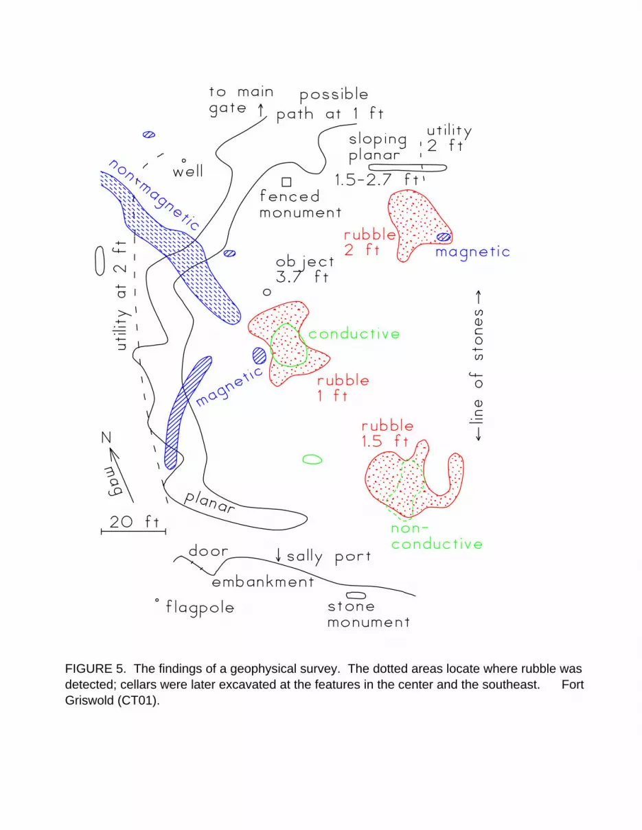
FIGURE 5. The findings of a geophysical survey. The dotted areas locate where rubble wasdetected; cellars were later excavated at the features in the center and the southeast. FortGriswold (CT01).

0
10
20
30
40
App
aren
t con
duct
ivity
, mS
/m
0 50 100 150 200 250 300East coordinate, ft
EM38, shallowEM31, deep
build
ing
FIGURE 6. Electrical conductivity across a debris-filled cellar. The gradual rise in thereadings for a long distance suggests that there is a cultural modification of the soil aroundthe building. Bullock House site, Chancellorsville battlefield (VA14).

0 50 100 150 200 250 300North coordinate, ft
-10
0
10
20
App
aren
t con
duct
ivity
, mS
/m
EM38 conductivity profiles
building
FIGURE 7. Electrical conductivity at a former building. It is revealed by the slight rise in themiddle of this graph, at N160. An excavation in this area located fragments of brick and otherartifacts, but no intact part of the former structure. Extremely high and low readings arecaused by metallic objects at a depth of less than 1 ft (0.3 m). Slave quarters, Malvern Hill (VA17).