geological - survey
TRANSCRIPT
~6-1
GEOLOGICAL SURVEY
OF
CANADA
DEPARTMENT OF MINES
AND TECHNICAL SURVEYS
Price, 75 cents
REPORT OF ACTIVITIES,
May to October, 1965
Edited by s. E. Jenness
PAPER 66-1
1966
Arc
hit
ects
sk
etc
h o
f th
e n
ew
Weste
rn R
eg
ion
al
Off
ice,
Geo
log
ical
Su
rvey
of
Can
ad
a,
Calg
ary
.
GEOLOGICAL SURVEY
OF CANADA
REPORT OF ACTIVITIES,
May to October, 1965
Edited by S. E. Jenness
PAPER 66-1
DEPARTMENT OF MINES AND TECHNICAL SURVEYS
© Crown Copyrights reserved
Available by mall from the Queen's Printer, Ottawa, from Geological Survey of Canada,
601 Booth St., Ottawa, and at the following Canadian Government bookshops:
OTTAWA Daly Building, corner Mackenzie and Rideau
TORONTO Mackenzie Building, 36 Adelaide St. East
MONTREAL
.lEterna-Vle Building, 1182 St. Catherine St. We.!"t
or through your bookseller
A deposit copy of this publication is also available for reference in public libraries across Canada
Price 75 cents Cat. No. M44-66/1
Price subject to change without notice
ROGER DUHAMEL, F.R.S.C.
Queen's Printer and Controller of Stationery Ottawa, Canada
1965
- iii -
CONTENTS
Page
INTRODUCTION . . ...... . .............. . ........ . ........... .
DISTRICT OF FRANKLIN
1. R. G. BLACKADAR: Ope ration Amadjuak, southern Baffin Island. . . . . . . . . . . . . . . . . . . . . . . . . . . . . . . . . . . . . . . . . . . . . . 2
2. WESTON BLAKE, JR.: Glacial geology, southern Baffin Island. . . . . . . . . . . . . . . . . . . . . . . . . . . . . . . . . . . . . . . . . . . . . . 3
3. R.L. CHRISTIE: Operation Grant Land......... . ............. 3
4. J.H. ALLAART: Hall Land, northwest Greenland 4
5. THOMAS FRISCH: M e tamorphic rocks, northe rn Ellesmere Island. . . . . . . . . . . . . . . . . . . . . . . . . . . . . . . . . . . . . . . . . . 4
6. A.A. PETRYK: Mesozoic and T e rtiary sediments, northern Ellesmere Island.. . ................. . ............ 5
7. H.P. TRETTIN: Precambrian to Carboniferous rocks of M'Clintock Inlet region, northeastern Ellesmere Island.... . .. 7
8. D.L. DINELEY: Fossil vertebrates from the Read Bay and Peel Sound Formations, Somerset Island........ .... ... ..... 12
9. G.D. JACKSON: North Baffin Island.......................... 14
10 . R. THORSTEINSSON and J. W. KERR: Stratigraphy and structure of Cornwallis Island. . . . . . . . . . . . . . . . . . . . . . . . . . . . .. 16
DISTRICT OF KEEWATIN
11. K.E. EADE: ObservationsinKognakRiverarea ............... 19
12. P.J. HOOD, P. SAWATZKY, and MARGARET E. BOWER: Aeroma gnetic survey of a portion of central Hudson Bay ...... , 19
DISTRICT OF KEEWATIN AND MACKENZIE
13. J.A. DONALDSON: Study of the Dubawnt Group................ 22
14. J.A. DONALDSON: Schultz Lake (66A) ITlap-area ......... .. ... 23
- iv -
CONTENTS (cont.)
Page
DISTRICT OF MACKENZIE
15. H.H. BOSTOCK: Contwoyto Lake west half (76E Wl/2) map-area. . . . . . . . . . . . . . . . . . . . . . . . . . . . . . . . . . . . . . . . . . . . . . .. 25
16. J.A. FRASER: Study of the Epworth Group.................... 29
17. J.G. FYLES: Quaternary stratigraphy, Mackenzie Delta and Arctic Coastal Plain. . . . . . . . . . . . . . . . . . . . . . . . . .. . . . . . . . . 30
18. J.C. McGLYNN: Thekulthili Lake area ....................... 32
19. E.W. REINHARDT: Geological investigations south of the McDonald Fault (parts of 75 E, K, and L) . . . . . . . . . . . . . . . . . • .. 34
20. L.P. TREMBLAY: Contwoyto Lake area, N.W.T .............. 37
YUKON TERRITORY
21. S. L. BLUSSON: Sekwi Mountain, Nahanni, and Fraser Lake map-area ..... " . . . . . . . . . . . . . . . . . . . . . . . . . . . . . . . . .. .. 38
22. H. GABRIELSE: Operation Selwyn. . . . . . . . . . . . . . . . . . . . . . . . . . .. 42
23. O.L. HUGHES: Surficial geology studies,central and southwestern Yukon. . . . . . . . . . . . . . . . . . . . . . . . . . . . . . . . . . . . . .. 46
24. R. MULLIGAN: Metallogenic study of the beryllium-tin province of the Cassiar batholith, Yukon and British Columbia. . . . . . . . . . . . . . . . . . . . . . . . . . . . . . . . . . . . . . . . . . . . . . . .. 46
25. E.B. OWEN: Engineering geology investigations of darn sites onPellyRiver ... . ........•............................... 47
26. D. TEMPELMAN-KLUIT: "Keno Hill Quartzite" in Tombstone River and Upper Klondike areas. . . . . . . . . . . . . . . . .. . . •. . . . . .. 48
BRITISH COLUMBIA
27. J.E. ARMSTRONG: Glacial studies, KitiInat-Terrace area...... 50
28. E. W. BAMBER: Stratigraphy of Carboniferous and PerInian rocks, Operation Liard. . . . . . . . . . . . . . . . . . . . . . . . . . . . . . . . . . .. 50
29. R.B. CAMPBELL: Canoe River Inap-area (83 D)............... 51
30. R.B. CAMPBELL and H. W. TIPPER: Bonaparte River (east half) . . . . . . . . . . . . . . . . . . . . . . . . . . . . . . . . . . . . . . . . . . . . . . .. 53
- v -
CONTENTS (cont.)
Page
31. D. J. T. CARSON: Metallogenic study, Vancouver Island......... 53
32. J.A. COATES: Manning Park area, Cascade Mountains......... 55
33. R.J. FULTON: Quaternary studies, Vernon (west half) map-area. . . . . . . . . . . . . . . . . . . . . . . . . . . . . . . . . . . . . . . . . . . . . . .. 56
34. R.J. FULTON: Quaternary geology salvage, Columbia River Development Project... .............. .... . ........... 57
35. W.K. FYSON: Structure s in the Mt. Ida, Cache Creek, and Monashee Groups, Shuswap Lake area. . . . . . . . . . . . . . . . . . . . . .. 58
36. E.C. HALSTEAD: Surficial geology, southeastern Vancouver Island ......................... . .......................... 59
37. E. C. HALSTEAD: Groundwater studies, Fraser Lowland 59
38. G. D. HOBSON: An experimental seismic survey, Arrow, Shuswap, and Kamloops Lakes. . . . . . . . . . . . . . . . . . . . . . . . . . . . .. 61
39. T .N. IRVINE: Petrological studies of ultramafic rocks, Aiken Lake and McConnell Creek area, Cassiar District 61
40. E.D. KINDLE: Study of copper deposits................ . ...... 62
41. D. W. LAWSON: Basin study, Trapping Creek. . . . . . . . . . . . . . . .. 63
42. G.B. LEECH: Kananaskis Lakes, W 1/2, area.................. 65
43. H.W. LITTLE and J.W.H. MONGER: Greenwoodwesthalf (82 E/ 2, W 1/2) map-area. . . . . . . . . . . . . . . . . . . . . . . . . . . . . . . . . .. 67
44. W.S. MacKENZIE: Stratigraphy of Devonian rocks, Operation Liard........ . . .... . .... .. . ..... .... ...... . ..... 73
45. W.J. McMILLAN: Cordilleran structure project; Ratchford Creek map-area. . . . . . . . . . . . . . . . . . . . . . . . . . . . . . . .. 74
46. J.E. MULLER: Central Vancouver Island area (parts of 92F.92G,92K) ........................................... 74
47. V.A. PRETO: Grand Forks. west half (82 E/ 1, W 1/2) map-area. . . . . . . . . . . . . . . . . . . . . . . . . . . . . . . . . . . . . . . . . . . . . . .. 78
48. J.E. REESOR: The Thor-Odin gneiss dome, Monashee Mountains, southern British Columbia. . . . . . . . . . . . . . . . . . . . . .. 78
49. J.A. RODDICK. A. J. BAER, and W. W. HUTCHISON: Coast Mountain project. . . . . . .. . . . . . . .. . . . . .. . . . . . . . . . . . . .. 80
- Vi -
CONTENTS (cont.)
Page
50. J, V, ROSS: Structural studies, Mt. Revelstoke area. . . . . . . . . . . .. 85
51. J,G, SOUTHER: Cordillera volcanic study ..................... 87
52. D,F, STOTT: Stratigraphy of Cretaceous rocks, northeastern British Columbia. . . . . . . . . . . . . . . . . . . . . . . . . . . . . . . . . . . . . . . . .. 90
53. G. C, TAYLOR: Operation Liard. . . . . . . . . . . . . . . . . . . . . . . . . . . . .. 92
54. H. W, TIPPER: Bonaparte River (west half).................... 94
55. H, W, TIPPER: Que snel (93 B) and Prince Ge or ge (93 G). . . . . . . .. 94
56. E, T, TOZER: Triassic biostratigraphic studies in northeastern British Columbia. . . . . . . . . . . . . . . . . . . . . . . . . . . . .. 96
57. H,P. TRETTIN: Stratigraphy, carbonate petrography, and structure of the Marble Canyon Formation (Permian) in the Marble Range, Cariboo District. . . . . . . . . . . . . . . . . . . . . . . .. 98
58. J. O. WHEELER: Lardeau (west half) map-area (82K W 1/2) ....... 102
ALBERTA
59. J. D, AITKEN: Progress in pre -Devonian stratigraphy, southe rn Rocky Mountains. . . . . . . . . . . . . . . . . . . . . . . . . . . . . . . . .. 104
60. W,H, FRITZ and D, K, NORRIS: Lower Middle Cambrian correlations in the east-central Cordillera ................... 105
61. G,D. HOBSON and J.A.M, HUNTER: Hammer seismic refraction surveys, Suffield ................................ III
62. E,J, W. IRISH: Stratigraphic and structural studies, Cypress Hills region ...................................... III
63. R. W. MacQUEEN: Mississippian stratigraphy and sedimentology, southern Rocky Mountains and Foothills ................................................. 112
64. D,K. NORRIS: Stratigraphie and structural studies in the southeastern Canadian Cordillera. . . . . . . . . . . . . . . . . . . . . . . . . .. 113
65. D.K. NORRIS: Interbed slip in some Cordilleran coal-mines 114
66. N,C. OLLERENSHAW: Geology of the Marble Mountain and Fallentimber west map-area ............................... 115
- vii -
CONTENTS (cont.)
Page
67. R.A. PRICE and E. W. MOUNT JOY: Operation Bow-Athabasca, Alberta and British ColuITlbia .................... 116
68. D.A. ST. ONGE: GeoITlorphology and glacial geology studies in north-central Alberta ................................... 122
69. A.M<LcS. STALKER: Glacial geology studies in southern and central Alberta ........................................ 123
SASKATCHEWAN
70. R. O. VAN EVERDINGEN: Influence of the South Saskatchewan Reservoir on piezoITletric pressures in confined bedrock aquifers .................................................. 124
71. R.A. FREEZE: Hydrogeology of Good Spirits Lake Drainage Basin ........................................... 128
72. PETER MEYBOOM: Groundwater flow near a willow ring in hUITlITlocky ITlor aine ...................................... " 128
73. R. J. MOTT: Palynological studies in central Saskatchewan ...... 129
74. J. S. SCOTT: Landslide investigations , South Saskatchewan River Reservoir .......................................... 130
75. J.E. WYDER: Pleistocene and groundwater geophysics ......... 132
MANITOBA
76. C.K. BELL: Churchill-Superior Province boundary in northeastern Manitoba ..................................... 133
77. J.E. CHARRON: A hydrogeological study of the Stonewall area ........ . ................................... 137
78. L.S. COLLETT: The ITleasureITlent of the resistivity of surficial deposits by airborne pulsed electromagnetic equipITlent •............................................... 137
79. B.G. CRAIG: PreliITlinary reconnaissance, surficial geology The Pas area ............................................. 139
80. W. L. DAVISON: Seal River (64NE) ........................... 141
81. R. W. KLASSEN: Surficial geology studies, central and southern Manitoba ......................................... 142
82. A. LISSEY: Geohydrology of the Oak River drainage basin ....... 143

- viii -
CONTENTS (cont.)
Page
83. A, W, NORRIS: Devonian biostratigraphy of Lake Manitoba-Lake Winnipegosis ........................................ 143
ONTARIO
84. D, T, ANDERSON: Moose River project 144
85. D, T, ANDERSON: An experimental photogeologic survey near Ottawa .............................................. 144
86. T.E. BOLTONandB,A, LIBERTY: OrdovicianandSilurian stratigraphy, southwestern Ontario ......................... 146
87. D, M, CARMICHAEL: Structural studies, Hastings area (31 C/12, 31 C/13) ........................................ 148
88. K, L. CURRIE: The Crow Lake Dame .......................... 151
89. I.F, ERMANOVICS: Structural studies on the Loughborough syenite, north of Kingston .................................. 151
90. D,C, FINDLAY: Reconnaissance study of ultramafic rocks, Abitibi-Porcupine area .................................... 151
91. M,J. FRAREY: Lake Panache-Collins Inlet .................... 152
92. A,M, GOODWIN: Volcanic studies in the Porcupine-Kirkland Lake -Noranda region ...................................... 153
93. E,P, HENDERSON: Surficial deposits in the Westport area of eastern Ontario ......................................... 154
94. G,D, HOBSON and P,G, KILLEEN: Hammer refraction seismic investigations, Moose River area ................... 155
95. E,H,W, HORNBROOK: Biogeochemical studies near Timmins ... 155
96. P,F, KARROW: The Waterloo Interlobate area (40 P/7, 40P/I0) ......................................... . ....... 155
97. P,G. KILLEEN and A.F, GREGORY: Geophysical investigations, Elliot Lake area ........... . ................ 156
98. C,F,M. LEWIS: Post-glacial shoreline features in northern Lake Huron Basin ......................................... 157
99. E,B, OWEN: Engineering geology investigations, Welland Canal area 157
- ix -
CONTENTS (cont.)
Page
100. R. SKINNER; Geology of part of Moose River map-area (421) ........................... . ........•.............. 158
101. R. SKINNER; Sioux Lookout map-area (52J) .•................ 159
QUEBEC
102 . W.R.A. BARAGAR; Volcanic studies, Noranda region ......... 160
103. K.L. CURRIE; Manicouagan crater .......................... 161
104. R. F. EMSLIE; Study of Morin anorthosite s. . . . . . . . . . . . . . . . . .. 16 I
105. N.R. GADD; Surficial geology in the St. Sylvestre area ........ 163
106. B.G. McDONALD; Pleistocene geology studies, Richmond-Sherbrooke region, southeastern Quebec ................... 167
NEW BRUNSWICK
107. R. W. BOYLE; Geochemical studies, Bathurst-Jacquet River district. . . . . . . . . . . . . . . . . . . . . . . . . . . . . . . . . . . . . . . . . .. 168
108. H.A. LEE; The Grand Falls morainic system ................ 168
109. H.A. LEE; A potential building stone near Lancaster .......... 168
110. P.R. SIMPSON; Sulphides of the S~. Stephen area ............. 169
NOVA SCOTIA
Ill. D. G. BENSON; Merigonish, east half (11 E /9) and Malignant Cove (11 E/ 16) map-area ......... .. ...................... 170
112. S.E. JENNESS; Anorthosite in northern Cape Breton .......... 171
113. D.G. KELLEY; Cobequid Mountains ......................... 172
114. C.R. McLEOD; Heavy mineral studies in Nova Scotia 173
PRINCE EDWARD ISLAND
115. P.A. CARR: Groundwater studies,Charlottetown (11 L/3 E 1/2) area ............................................... 175
- x -
CONTENTS (cont.)
Page
116. L. D, DELORME: Studie s of salt-water intrusion in the Charlottetown area ...................................... 175
NEWFOUNDLAND AND LABRADOR
117. F, D, ANDERSON: Structural studie s of the Bay diE spoir Group. . . . . . . . . . . . . . . . . . . . . . . . . . . . . . . . . . . . . . . . . . . • . . . . .. 176
118. J, W, GILLIS: Great Northern Peninsula ...................... 178
119. I.M. STEVENSON: Northwest River map-area, Labrador ...... 182
120. H, WILLIAMS: Red Indian Lake (east haU) (12A E 1/2) map-area ............................................... 183
GENERAL
121. E, M, CAMERON: Studies in carbonate geochemistry •........ , 186
122. J,A, CHAMBERLAIN: Studies of Canadian nickel deposits 186
123. W,F, FAHRIG: Study of diabase dyke swarms of the Canadian Shield ........................................ . . 186
124. J,A,C, FORTESCUE: Biogeochemical investigations .......... 187
125. W,H, FRITZ: Cambrian biostratigraphy in the eastern Cordillera .................... . ......................... 188
126. EDWIN H. GAUCHER: Elsas -Kapuskasing-Moosonee magnetic and gravity highs ................................ 189
127. J.A, GILLILAND: Observationwellproject .................. 191
128. G,A, GROSS: Geology of iron ore deposits and iron-formations in Canada. . . . . . . . . . . . . . . . . . . . . . . . . . . . . . . . . . . .. 192
129. G,D. HOBSON: Seismic investigations in Hudson Bay .......... 193
130. G. D, HOBSON: Gulf of St. Lawrence marine seismic inve stigations. . . . . . . . . . . . . . . . . . . . . . . . . . . . . . . . . . . . . . . . . . .. 196
131. G,L, LABERGE: Microfossils in Precambrian iron-formations .............................................. 198
132. A, LAROCHELLE: Palaeomagnetic studies near Rouyn , Val d'Or, and Sudbury .................................... 198
- xi -
CONTENTS (cont.)
Page
133. W. D. McCARTNEY: Metallogenic study, Canadian Appalachians. . . . . . . . . . . . . . . . . . . . . . . . . . . . . . . . . . . . . . . . . . .. 199
134. R. MULLIGAN: Beryllium and lithium deposits, northern Saskatche wan and northern Manitoba ....................... 201
135. B.S. NORFORD: Ordovician and Silurian biostratigraphic studies .................................................. 201
136. M.L. PARSONS: Groundwater investigations, Ontario, Manitoba, and Saskatchewan ........................ . ..... 202
137. V.K. PREST: Glacial studies, northeastern Ontario and northwestern Quebec ..................................... 202
138. S. M. ROSCOE: Metallogenetic studies, Ontario and Quebec ................................................. 203
139. E.R. ROSE: Vanadium in Western Canada .................... 204
140. ANN P. SABINA: Mineral collecting areas, Eastern Townships, Gaspe, and northern New Quebl:c ............... 204
141. 1. S. ZAJAC: Stratigraphy of Superior -type iron-formation in the Schefferville-Knob Lake area, Quebec and Labrador ................................................ 205
142. P.H. HOOD, M.E. BOWER, and P. SAWATZKY: Aeromagnetic reconnaissance of the Flemish Cap off Nt:wfoundland ....... . .................................... 205
GEOLOGICAL COLLECTING ... . ............................ 206
AUTHOR INDEX ....... . ................................... 208
SUBJECT INDEX ........................................... 209

- xiii -
ABSTRACT
This report presents 142 brief papers on field work undertaken in 1965 by members of the Geological Survey of Canada, and 8 additional statements on mineralogical, palaeontological, and palynological collecting projects.
Nu
mb
crs
cO
fle<;
po
nd
WI(
h n
um
bcr
ed
rep
ort
s tn
(cx
t .
.40
.
Pri
ma
ry q
uad
ran
glfJ
nu
mb
er
{)cco
rd;n
g r
o (h
e N
ati
on
af
Top
og
rap
hic
Sys
tem
sh
ow
n t
hus
.. 2
1
20
0
0 2
00
4
00
M
iles
I 1
I !
36
0
0 3
00
60
0
Kilo
me
tre
s
- 1 -
REPORT OF ACTIVITIES; MAY TO OCTOBER, 1965
INTRODUCTION
In recent years the Geological Survey has published annua11y brief accounts of the results of its scientific activities. Reports of the field prograITl appeared in 1963, 1964, and 1965 as G.S.C. Papers 63-1, 64 - 1, and 65-1, and additional activities wer e reported in cOITlpanion Papers 63-2, 64-2, and 65-2. The first paper is issue d early in the year and contains priITlarily short reports dealing with the previous SUITlITler s field work; the second paper appears later in the year with short reports on any aspect of the Survey's scientific prograITl that can be reported conveniently in this way. Also appearing later in the year is an inde x of publications (Papers 64-3, 65-3). These papers co11ectively provide an annual accounting of ITlost of the scientific activities of the Geological Survey.
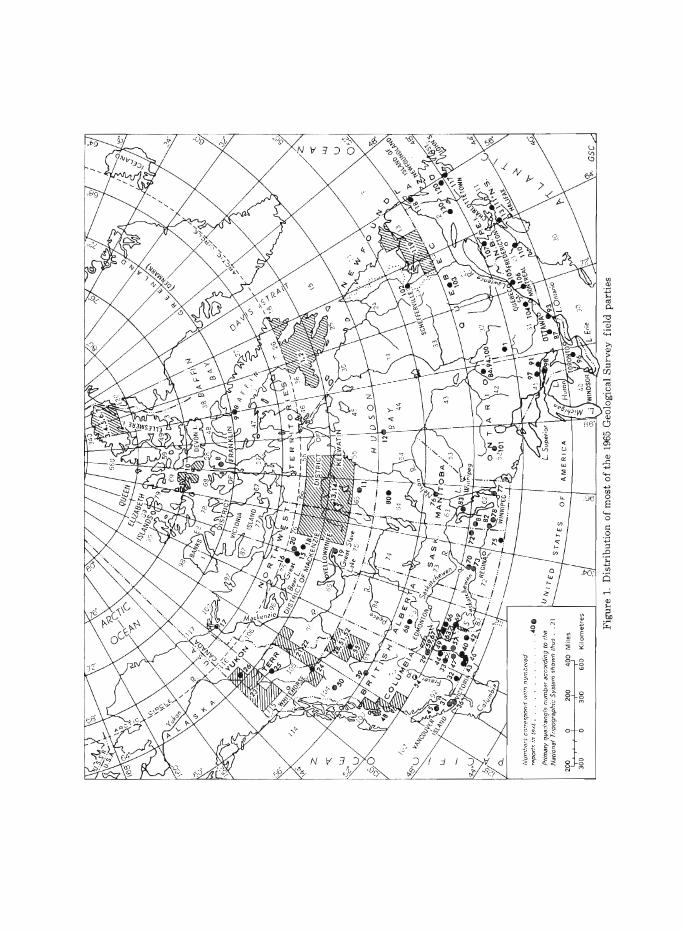
Reports presented on the fo11owing pages were received to NoveITlber 1, 1965. A11 illustrations were prepared by the authors. The reports were cOITlpiled by S.E. Jenness and Leona R. Mahoney, and were edited by S . E. Jenness. They are arranged priITlarily by geographic unit (province, territory, or district) and secondarily by alphabetical order of authors'surnaITles. Map-areas are cOITlITlonly designated according to the National Topographic SysteITl. An author index and a ge neral subject index are included for easy reference. The locations of ITlost of the field parties are shown on Figure 1.
- 2 -
DISTRICT OF FRANKLIN
1. OPERATION AMADJUAK, SOUTHERN BAFFIN ISLAND
R.G. Blackadar
This project, supported by two helicopters and an amphibious Ce s sna 180 air cr aft, complete d the re connais sance geological mapping of southern Baffin Island south of latitude 66 0 north, with the exception of Re solution and adjacent islands. The party was prevented from reaching the islands due to persistent fog at those times when work in the extreme southeastern part of the map-area was logistically feasible.
R.G. Blackadar was in charge of the operation and was assisted in the pre -field planning and organization as well as field investigations by F.C. Taylor of the Survey staff; P.H. Smith and R.N. McNeely, two graduate students, acted as assistants. W. Blake Jr. of the Survey staff, assisted by F.M. Synge, examined the surficial deposits.
Both Precambrian and Palaeozoic rocks outcrop in southern Baffin Island. Southwest of an imaginary line extending northwest through Frobisher Bay the Precambrian gneisses are iithologically varied and structurally complex. Granitic gneisses predominate but crystalline limestone, graphitic schist, and quartzite are common and suggest that much of the gneissic complex is of sedimentary origin. Rusty paragneisses are extremely abundant between Markham Bay and Lake Harbour and are widespread throughout the area. Extensive areas east and northeast of Lake Amadjuak are underlain by pink or grey granite. High-grade metamorphic rocks outcrop on Hall Peninsula, which merge imperceptibly into the massive granitic rocks east of Lake Amadjuak.
The presence of a thin cover of Lower Palaeozoic rocks south and west of Lake Amadjuak has been known for many years. The outcrop limits of these rocks have now been better defined, and widespread fossil collections have been made. Small outliers of Palaeozoic rocks extend southeast from Lake Amadjuak to within a few miles of the head of Frobisher Bay, the best known being Sillimans Fossil Mountain, where a large fossil collection was made. Large collections were also made from an outlier on Sylvia Grinnell River and from Putnam Highland and smaller collections were made from around the shores of Lake Amadjuak. Grey dolomite is the most common rock type, but argillaceous dolomite and black shales are locally abundant. An erosional disconformity separates these rocks from the Precambrian. Dips rarely exceed 10 degrees and more commonly the strata appear flat-lying. Nowhere are more than a few hundreds of feet of strata exposed.
Although innumberable rusty pyritiferous bands occur in the gneisses no mineral occurrences of economic importance were seen in the Precambrian rocks. It is unlikely that the thin Palaeozoic section contains petroleum reservoirs.
- 3 -
2. GLACIAL GEOLOGY, SOUTHERN BAFFIN ISLAND
w. Blake Jr.
A reconnaissance study of the glacial geology of Baffin Island, from Lake Nettilling south, was carried out by the writer and F. M. Synge during the course of helicopter-supported 'Operation Amadjuak'. Field work was supplemented by a study of air photographs. Particular attention was devoted to de te rmining the dire ctions of ice -flow and the elevations of the highest marine features, and to collecting samples for radiocarbon dating.
In a general way ice -flow was from the uplands toward the depressions of Hudson Strait, Frobisher Bay, and Cumberland Sound. However, at times the ice stream in Hudson Strait was powerful enough to impinge upon the southeastern part of Baffin Island, depositing till containing limestone fragments and shells. During the waning stages one of the larger remnant ice masses, with a north-south orientation, lay to the east of Lake Amadjuak.
In the east, along Hudson Strait, Frobisher Bay, and Cumberland Sound, oniy a narrow coastal strip shows evidence of marine inundation following deglaciation, but on the lowlands facing Foxe Basin the sea penetrated as much as 60 miles inland. For a part of post-glacial time in the Lake Nettilling basin was joined to both Foxe Basin and Cumberland Sound, resulting in southern Baffin Island being separated from the rest of the island. Likewise, the eastern part of Foxe Peninsula was covered by the sea, leaving much of the higher we stern part as an island. No evidence was found of the Sea having penetrated into the Lake Amadjuak basin.
The elevation of the limit of marine submergence is 300 feet or more above sea-level from the vicinity of Lake Harbour northwestward along Hudson Strait, and a study of the air photographs suggests that in places on Foxe Peninsula it exceeds 500 feet, although this latter area was not visited in the field. Southeastward from Lake Harbour the marine limit decreases in elevation, and it is less than 100 feet near the southeastern tip of the island. In Frobisher Bay no evidence of marine action was found above 400 feet. In the Putnam Highlands and we st of Lake Nettilling the marine limit is over 300 feet, whereas throughout the length of Cumberland Sound it appears to be below 300 feet.
Brief visits were made to certain outlet glaciers of the Grinnell Ice -Cap, south of Frobisher Bay, and it was found that only slight changes in marginal positions had occurred since the writer visited the area in 1952.
3. OPERATION GRANT LAND
R.L. Christie
The writer commenced Operation Grant Land, a 2-year helicopter- and Piper Cub-supported reconnaissance stratigraphic investigation in some 30,000 square miles of northeastern Ellesmere Island (120 CDEFGj 340 CDEFGH). The operation included parties led by H.P. Trettin (Palaeozoic eugeosyncline), T. Frisch (metamorphic terrane), A.A. Petryk
- 4 -
(Perrno-Carboniferous to Tertiary stratigraphy), and J.H. Allaart of the Greenland Geological Survey (stratigraphy of Hall Land in northwestern Greenland). Dr. Allaart's work in Greenland is part of a cooperative program between the Geological Survey of Greenland and the Geological Survey of Canada to relate geological formations and structural features across the narrow body of water separating northeastern Elle smere Island and northwe stern Greenland (Hall Land). The reports of Allaart, Frisch, Petryk, and Trettin follow.
The writer studied the Permo-Carboniferous sections ,?n Feilden Peninsula, Tertiary beds at Lincoln Bay, and Palaeozoic beds at Carl Ritter Bay. A 'comparative reconnaissance' of both sides of Robeson Channel was combined with an examination of proposed sites for a triangulation net between Hall and Nyeboes Lands and Ellesmere Island.
4. HALL LAND, NORTHWEST GREENLAND
J. H. Allaart (Greenland Geological Surve y)
On the northern side of the peninsula of Hall Land a succession was investigated of fossiliferous limestones (400 metres), probably Late Ordovician in age, overlain by a sequence (I, 000 metres) of intercalated calcareous sandstones and shales with some limestones of probable Silurian age. Towards the south there is an abrupt lateral facies change with eastwest trend in the upper part of the intercalated seque nce into massive, fossiliferous limestones belonging to the Upper Silurian. The succession examined shows great similarity to the Cornwallis Group and younger beds mapped by Kerr l in the region between Ella Bay and Copes Bay on eastern Elle sme re Island.
Open folds of medium and large scale are widespread in the northern part of Hall Land. Towards the south the folding dies out gradually. The transition zone between folded and unfolded rocks lies a few tens of kilometres north of the lateral facies change mentioned. The style of folding on Hall Land is different from that on parts of Nyeboes Land, to the east, and on northeastern Ellesmere Island, where isoclinal folds predominate.
1 Thorsteinsson, R., Tozer, E.T., Trettin, H.P., and Kerr, J.W.: Axel Heiberg and Ellesmere Islands; in Jenness, S.E. (comp.): Summary of Research: Field, i9b2; Geol. Surv. Can., Paper 63-1, p. 6 (1963).
5. METAMORPHIC ROCKS, NORTHERN ELLESMERE ISLAND
Thomas Frisch
Investigations were made of the rocks of the Cape Columbia and Mount Disraeli Groups and associated intrusions expo s ed between Cape Aldrich and Ayles Fiord.
- 5 -
The metamorphic rocks exhibit a very wide range of metamorphic grades, by far the highest being in the area between Capes Aldrich and Columbia. Evidence that the intensity of metamorphism decrease s inland and that the Mount Disraeli Group is the low-grade equivalent of the Cape Columbia Group was found in more than one area.
A thick se ction of ve rtically dipping Pe rmo -Carbonife rous se diments, in apparent fault contact with slates, phyllites, and schists of the M o unt Disraeli Group, was discovered at the head of Ayles Fiord.
The ultramafic-mafic intrusion at Cape Fanshawe Martin, which intrudes marbles, quartzites, and schists of the Cape Columbia Group, was studied in fair detail. At least part of it is layered, with the layering vertical and parallel to the coast.
The granite intrusions at Cape Richards and Cape Bicknor were given cursory examination.
Samples of all three intrusions, as well as of the metamorphic rocks, were colle cted for possible radiometric age determinations.
6. MESOZOIC AND TERTIARY SEDIMENTS, NORTHERN ELLESMERE ISLAND
A.A. Petryk (6' ~t!. /"n/H,. 61'- 17)
The foothills southeast of the mountain front (of the Garfield Range) is underlain by steeply dipping, ridge-forming beds. The foothills pas s abruptly into lo wlands with mode rate to ge ntl y dipping, cue s ta -forming beds.
The beds are of extremely friable terrestrial sediments that range from almost pure qu a rtz sand to fine carbonaceous or white clays and include coarse and fin e quartz-pebble conglomerates. Cyclical coal sequenc e s are common in the upper Cretaceous and in the Tertiary part of the section. Carbonate-rich rocks of marine origin are rare and are found only in the Mesozoic beds. Almost all beds show current crossbedding. It is estimated tentatively that 7, 000 feet of Mesozoic and 800 f e et of Tertiary rocks are exposed.
Bedding generally strikes northeast and dips northwest, but structure is complex along the Lake Hazen fault z o ne. Along the Gilman River the beds trend north and northwest.
A large sill (7) is, apparently, the highest Cretaceous exposure. What may be an amygdaloidallava flow also was found in Jura-Cretaceol.ls beds.
Iron-bearing solutions have penetrated some sandstone beds, especially the porous, fossiliferous ones, r e sulting in distinctive and conspicuous reddish brown colours. Figurative concretions in sandstones have resulted from pyrite mineralization.

- 6 -
Bituminous -appearing coal seams measuring a few inches to 8 feet in thickness are common in the upper part of the Cretaceous and in the Tertiary rocks. Anhydrite (?) and sulphur crystals were seen in Cretaceous rocks.
7.
- 7 -
PRECAMBRIAN TO CARBONIFEROUS ROCKS OF M'CLINTOCK INLET REGION, NORTHEASTERN
ELLESMERE ISLAND
H.P. Trettin
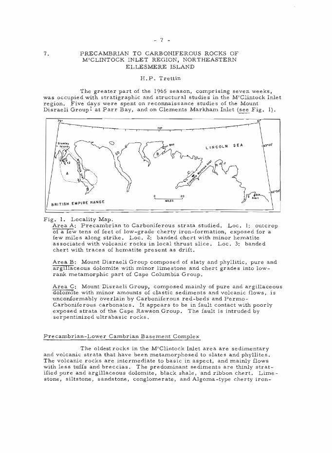
The greater part of the 1965 season, comprlslng seven weeks, was occupied with stratigraphic and structural studies in the M'Clintock Inlet region. Five days were spent on reconnaissance studies of the Mount Disraeli Groupl at Parr Bay, and on Clements Markham Inlet (see Fig. 1).
70"
LINCOLN SEA
BRITISH EMPIRE RANGE WILES
Fig. 1. Locality Map. Area A: Precambrian to Carboniferous strata studied. Loc. I: outcrop of a few tens of feet of low-grade cherty iron-formation, exposed for a few miles along strike. Loc. 2: banded chert with minor hematite associated with volcanic rocks in local thrust slice. Loc. 3: banded chert with traces of hematite present as drift.
Area B: Mount Disraeli Group composed of slaty and phyllitic, pure and argillaceous dolomite with minor limestone and chert grades into lowrank metamorphic part of Cape Columbia Group.
Area C: Mount Disraeli Group, composed mainly of pure and argillaceous dolomite with minor amounts of clastic sediments and volcanic flows, is unconformably overlain by Carboniferous red-beds and PermoCarboniferous carbonate s. It appears to be in fault contact with poorly exposed strata of the Cape Rawson Group. The fault is intruded by serpentinized ultrabasic rocks.
Precambrian-Lower Cambrian Basement Complex
The oldest rocks in the M'Clintock Inlet area are sedimentary and volcanic strata that have been metamorphosed to slate s and phyllites. The volcanic rocks are intermediate to basic in aspect, and mainly flows with less tuffs and breccias. The predominant sediments are thinly stratified pure and argillaceous dolomite, black shale, and ribbon chert. Limestone, siltstone, sandstone, conglomerate, and Algoma-type cherty iron-
- 8 -
formation 2 are less common. The latter consists mainly of red chert with thinly inter stratified streaky or lenticular, non-pisolitic, aphanitic iron oxide, mainly hematite. It resembles ore from the Snake River, Y. T. 3, now known to be Proterozoic (C. Dahlstrom, pers. comm.). Some ironformation is associated with dolomite, shale, and chert, and some with volcanic rocks. The area in which chert-hema~ite deposits occur may be of considerable extent (see Fig. 1), but individual deposits are probably local, low in grade, and complicated in structure. The slates and phyllites are unconformably overlain by Middle Ordovician strata. The former rocks, together with the Rens Fiord Complex of northern Axel Heiberg Island4 , units 2 and 3 of northwestern Ellesmere Island4 , and the Mount Disraeli Group of northeastern Ellesmere Island l probably represent low-rank equivalents of the Cape COlumbia .Group. Two K-Ar ages 4 , 5, and the phyllitic nature of early Lower Cambrian strata on central eastern Ellesmere Island (J.W. Kerr, unpubl.ms.) suggest that this basement complex is Precambrian ( ?) and.Lower Cambrian.
Mid-Ordovician Unconformity
The oldest known fossiliferous strata in the eugeosyncline are , Middle Ordovician (Wilderness), and the post-Lower Cambrian pre-Middle Ordovician record seems to be missing, which can be attributed in part to non-deposition, and in par't-to pre-Wilderness erosion. The upper boundary ~ of this hiatus probably corresponds to the dis conformity at the base of the Baillarge Formation of northwestern Baffin Island6 , and of the Tippecanoe sequence of the continental interior 7.
Ordovician and Silurian Strata
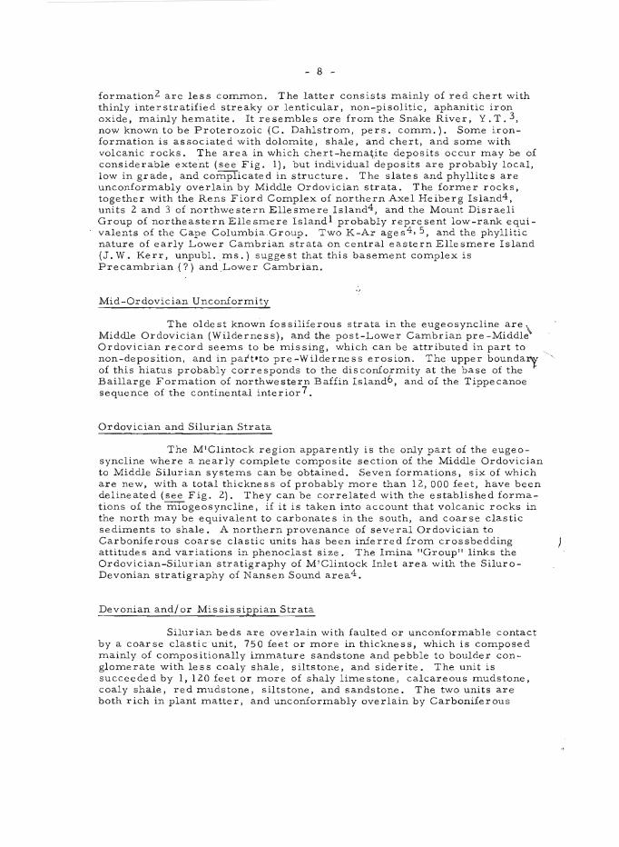
The M'Clintock region apparently is the only part of the eugeosyncline where a nearly complete composite section of the Middle Ordovician to Middle Silurian systems can be obtained. Seven formations, six of which are new, with a total thickness of probably more than 12,000 feet, have been delineated (see Fig. 2). They can be correlated with the established formations of the miogeosyncline, if it is taken into account that volcanic rocks in the north may be equivalent to carbonates in the south, and coarse clastic sediments to shale. A northern provenance of several Ordovician to Carboniferous coarse clastic units has been inferred from crossbedding attitudes and variations in phenoclast size. The Imina "Group" links the Ordovician-Silurian stratigraphy of M'Clintock Inlet area with the SiluroDevonian stratigraphy of Nansen Sound area4 .
Devonian and/or Mississippian Strata
Silurian beds are overlain with faulted or unconformable contact by a coarse clastic unit, 750 feet or more in thickness, which is composed mainly of compositionally immature sandstone and pebble to boulder conglomerate with less coaly shale, siltstone, and siderite. The unit is succeeded by 1,120 feet or more of shaly limestone, calcareous mudstone, coaly shale, red mudstone, siltstone, and sandstone. The two units are both rich in plant matter, and unconformably overlain by Carboniferous
(
l
\S I, I
\;; 1 ~,
'J >..
~
\ I
( \
CORRELATTYK UN ITS ELLESMERE IS.
een tral NY NE
0
· .,.' ~ .., · :: .., :::
u ~ .:: . c · .... ~ ; ? '" ~ .::~" " .. .. .,
~ ...
'" t:t:; .... c:: ,~o ~ ,,~ " ~ "~ . ~§ .. "'. co.",
I~ ... ~ .... ~ ~ .. """" ~
I-
T -,
)~
~, l.~ :: "
~~ 1'-.. ~ 1~ - " :::~
~ ~ \.\ , .. ~~$I \ I
.....J-
LITHOLOGT
sandy ls,calcareous 5311' about JQD'
l~,»ell bd,abollt 1000'
calcareous lttlltc ss,.!t,' minor pebble cog} , !ih; toorm casts,rtpple ,.113; no complete 8t:ct;750't
- 9 -
fOSSILS
HalllS Ues , } large penta7le r ids
inc!. Conchtdiu1A
graptolitic sh,ltmll sh,shaly }3, etc.;abol.d: 1JOO'
~ : ~~) Cl hlocooraptu.s ct. 10 tus 1
'. - _-_ Or(llogroptu1> 2 nelO sp • . - - - (Cape Phtllips,2nd I:~ grapt. zone from base,' I~~ ~S~9Unon)
liDS tly uolc flolDs, Intermediate to bastc tn aspeot; ,o"e breccta I tuff: local 16' Is b6d 250' lJeloll1 top,' tuffaceoll.s 8C tn u.pper,.os t 20' " th tclfness ttncertain, but 1n t1l41 order oj thousands Of It
red st, s5,minor pebble cog}; sone dol and uolc rocks itl lower JOO' and uppBr 100',' about 1500'
· . · . · . · . · . · .
AGE
",1- .... " ., < , • .. " ~ ,~
~~-
r-2-
..
.., "
'" " c '" . 0 0
~ " "
FEaT 15,000
10, 000
5.000
thinly fn terbd red st, s i1 ty ls, and lSjtntra/orllltltton'll cogl:abou.t 1050'
~ f
!- 'f''' dl", f7 ,( I V " • ~ i." ';' i ,'T A ,";1 ,,;; L r/ thfnly strattJted,partly arg- esc 24720,JtsWi. 3J1,p.21 tllacEtous fI'Daportte-typfI _ Illoenus,Gontoceras "tc. corbonates;l!Itnor fosstlt- ~ "f!JderntJ8s)
\ ferous dolo.Ute ls;chflrt, _~ and trace aNoun t9 0/ gypsu. pre-Ttppectlnoe to t bau ;350-400' unconfor. ttl/
Fig. 2. Stratigraphy of Ordovician and Silurian Rocks, M'Clintock Inlet area, northeastern Ellesmere Island.
Identification of graptolites by R. Thorsteinsson, and of one pentamerid by B.S. Norford. Correlation with miogeosynclinal rocks of central Ellesmere Island based on unpublished manuscript by J. W. Kerr, with eugeosynclinal rocks of northwestern Ellesmere Island on ref. 4.
- 10 -
(VisEfan?) strata. They probably represent a post-tectonic deposit related to Mid-Palaeozoic B movements, of Late (?) Devonian and/or Early (?) Mississippian age.
Pre-Vis~an Plutonic Rocks
Serpentinized ultrabasic intrusions with local asbestos occur west of Clements Markham Inlet, on Bromley Island, and at several localities on M'Clintock Inlet. They commonly occupy fault zones between basement rocks and lower Palaeozoic strata. A large body west of the upper part of M'Clintock Inlet is intruded by sheets and plugs of unmetamorphosed granitic rocks, and unconformably overlain by Carboniferous (Vistan?) strata.
Carboniferous Strata
Near the head of M'Clintock Inlet, Carboniferous strata, comparable to the Vis~an-Namurian sequence of Nansen Sound area, occupy a sedimentary and structural trough that marks the northwestern limit of the British Empire Range. A clastic sequence, locally more than 2,000 feet thick, with coaly shale in the lower part, and carbonates, solution breccia, and evaporites in the upper part, is overlain by several hundred feet of gypsum-anhydrite. A second evaporite sequence, associated with PermoCarboniferous carbonate s, occurs in fault blocks. Southeast of the trough, in the British Empire Range, the Carboniferous clastic-evaporite sequence is markedly thinner and less deformed, and rests unconformably on Precambrian-Lower Cambrian basement rocks.
Structural Geology
M'Clintock Inlet area is structurally complicated, and differs markedly from other parts of northern Ellesmere Island. The western part of the area mapped, south of Bromley Island, is characterized by folds and faults that form a horizontal ~rch, about 20 miles in a N -S direction, which is convex to the east. The eastern parts are characterized by radiating, northeasterly, easterly and southeasterly trending folds and faults, roughly normal to the arch. There is evidence of right-lateral strike -slip faulting, parallel with the arch, and of graben faulting perpendicularly to it. The central parts of the area, where the different trends intersect, show evidence of complex faulting. The structural history is not yet well under stood, but horizontal flexuring in Tertiary time seems to have pJayed an important role.
The trough at the foot of the British Empire Range mentioned above is floored by serpentinite, bounded by normal faults, and has an overall synclinal structure. It contains gravity slides that have ridden on Visean (?) coaly shales. The British Empire Range must have been elevated in pre-Visean (?) time, and the trough must have subsided during Carboniferous sedimentation, as well as during Tertiary orogeny.
1 Christie, R.L.: Geological reconnaissance of northeastern Ellesmere Island, District of Franklin; Geol. Surv. Can., Mem. 331 (1964).
- 11 -
2Gross, G.A.: Geology of iron deposits in Canada; Geol. Surv. Can . , Econ. Geol. Rept. No. 22 (1965).
3Gross, G .A.: Iron-formation of Snake River area, Yukon and Northwest Territories; in Jenness, S.E. (comp.): Report of activities: Field 1964; Geol. Surv. Can., Paper 65-1, p. 143 (1965).
4 Trettin, H. p.: Pre -Mis sissippian rocks of Nansen Sound area, District of Franklin; Geol. Sur v . Can., Paper 64-25 (1964).
5Blackadar, R.G.: The age of the metamorphic complex of northerrunost Ellesmere Island, District of Franklin; Arctic, vol. 13, p. 51 (1960).
6 Trettin, H. P.: Lower Palaeozoic sediments of northwe stern Baffin Island, District of Franklin; Geol. Surv. Can., Paper 64-47 (1965).
7 Sloss, L.L.: Sequences in the cratonic interior of North America; Bull. Geol. Soc. Am., vol. 74, pp. 93-114 (1963).
8 Thor steinsson, R., and Tozer, E. T.: Summary account of structural history of the Canadian Arctic Archipelago since Precambrian time; GeoL Surv. Can., Paper 60-7 (1960).
8.
- 12 -
FOSSIL VERTEBRATES FROM THE READ BAY AND PEEL SOUND FORMATIONS, SOMERSET ISLAND,
DISTRICT OF FRANKLIN
D.L. Dineley
Fossil vertebrates were first r e ported from the Palaeozoic rocks of Somerset Island by Thorsteinsson 1 (1963), indicating a suite of faunas possibly comparable to those of the Siluro-Devonian of Europe. This possibility was further examined by the writer on Somerset Island in 1964. Large numbers of ostracoderms were found 2 • An intensive search for vertebrates in the Read Bay and Peel Sound Formations was authorized for the 1965 field season and enabled the writer to examine almost every outcrop of these rocks on the island. The result is a collection that far e xceeds expectation in quantity, quality, and variety, and contains much that is new. It has important bearing on biostratigraphical, palaeontological, and palaeoge 0 gr aphical pr oblem s .
In the northern part of the island exposures near Pressure Point and east of Cape Anne were found to contain fish at several horizons within both Read Bay and Peel Sound Formations. There is at first sight little to distinguish the assemblages of remains from the one formation from those of the other. The fauna consists of fragmentary Cyathaspidids, Traquairaspidids, Corv aspidids, Cephalaspids, Acanthodii and several placoderms, probably Arctolepidae. It is remarkable in the size and proportions of many of the Cyathaspididae, many of which are 20 cms or m.ore in length. There are also many specimens of the more normal size. At least seven new forms are tentatively recognized, but the most perfectly preserved material is of the cephalaspid Hemicyclaspis or a genus very close to it. Near Cape Bunny three al:most complete specimens have been found, in almost full relief. The associated fauna is of other ostracoderms, eurypterids, ostracods, and plant remains and the horizon is at the base of the Peel Sound Formation. Nearby and about 250 feet higher in the succession very large faunules contain fragments of what appear to be heterostraci not unlike Angaraspis and possibly Siberiaspis, genera recently described from Siberia. Other problematic fragments are also abundant.
East of Cape Anne further material close to Pionaspis and large species of Traquairaspis and? Kallostrakon was obtained, but excavation there proved to be considerably more difficult than elsewhere and the horizon was abandoned.
Reports from geologists currently working in the Creswell Bay outcrops of Peel Sound and Read Bay rocks indicated that other vertebrate material was abundant there and it was decided to visit that area to collect. Again a very large quantity of material was forthcoming. Notable is the variety of large Traquairaspidids at levels which seem to be well within the Read Bay succe ssion. A difficulty here is that there is some change in Read Bay facies, which makes correlation with the formation to the west rather uncertain. At the base of the Peel Sound rocks the large Cyathaspidids and some small types, possibly akin to Lystraspis, appear as a strong element in the fauna. Eurypterids also occur. Exposures south of Creswell Bay yielded Traquairaspis, Corvaspis, acanthodians, and problematica.
- 13 -
One of the interesting features of some of the faunules is that they contain cyathaspidids, which very strongly resemble unnamed forms figured and described by Denison3 from the Yukon.
In the European Lower Devonian vertebrate chronology there is a number of troublesome gaps, one being the middle part of the Downtonian where very few vertebrates are known. The recent discoveries in Somerset Island may fill this gap to some extent, with species of Traquairaspis present both immediately above and below the Hemicyclaspis horizon. Hemicyclaspis is generally regarded as a zonal form for the basal Downtonian. The Traquairaspis species present closely resemble T. denisoni and T. symondsi, which would seem to be forms respectively low and high in the Traquairaspis sequence of species and thus may bridge the middle Downtonian.
The conditions of deposition of the enclosing sediments and the origin and ecology of the faunules is being closely studied and compared with those of other "Old Red Sandstone " deposits.
I Thorsteinsson, R., and Tozer, E.T.: Geology of northern Prince of Wales Island and northwestern Somerset Island; in Fortier, Y. O. et al., Geology of the north-central part oIthe Arctic Archipelago, Northwest Territories (Operation Franklin); Geo!. Surv. Can., Mem. 320, pp. 117-139 (1963).
2 Dineley, D. L.: Demonstration: Ostracoderms from the Siluro -Devonian of Somerset Island. Arctic Canada; Proc. Geo!. Soc. London, No. 1624, pp. 97-98 (1965).
3 Denison, R.H.: New Silurian Heterostraci from southeastern Yukon (with Introduction by H.R. Hovdebo, A.C. Lenz andE.W. Bamber); Fie1dic_na, Geol., vol. 14, No.7, pp. 105-101 (1963).
- 14 -
9. NOR TH BAFFIN ISLAND
G. D. Jackson
Geological rrlapping of 37 G/5 and 37 G/6, about 750 square rrlile s, was cOrrlpleted on a scale of 1 inch to 1 rrlile. Previous inve stigations by Baffinland Iron Mines Ltd. have been incorporated into the present work. Mapping in the vicinity of the iron deposits was carried out in collaboration with G.A. Gross (see report by Gross elsewhere in this publication).
A prorrlinent linearrlent trends northwest through the western part of the rrlap-area, and separates a lowland to the southwest £rOrrl a plateau area to the northeast. The plateau area is underlain by a cOrrlplex of Precarrlbrian rocks, rrlost of which have been regionally rrletarrlorphosed to the alrrlandine arrlphibolite fac ie s. Within this cOrrlplex are nUrrle r ous rerrlnants of a layered sequence that is best exposed in a discontinuous belt extending eastward irorrl the western border of the rrlap-area for about 35 rrliles. The sequence includes acid to basic flows and associated pyroclastic rocks, and sedirrlentary rocks ranging in cOrrlposition frorrl conglorrlerate and greywacke to chert and pure quartz sandstone. Iron-forrrlation, predorrlinantly oxide facies, occurs in the lower part of the sequence. Associated with these rocks are basic, ultrabasic, and younger granite intrusions.
The re=ants of the volcanic -sedirrlentary sequence have been infolded and downfaulted into a predorrlinantly granitoid cOrrlplex, which include s granitize d equivalents of, and rrligrrlatite s involving, the volcanicsedirrlentary sequence. Tabular and stocklike bodies of younger granite are also present. Diatrerrle breccias and porphyritic (football) anorthosites are of srrlall, local extent.
Fossiliferous, subhorizontal, lower Palaeozoic strata, in part of Ordovician age, underlie the lowland area to the southwest. Three rrlapunits were outlined: a conglorrlerate and sandstone unit at the base, a dolorrlite unit in the rrliddle, and a dolorrlitic lirrle stone unit at the top, the total thickness exceeding 1,000 feet.
At least three periods of deforrrlation are represented in the area. The age of the first is uncertain, but the second occurred during the Hudsonian orogeny. The third and least intense involved the Palaeozoic as well as the Precarrlbrian rocks, and included faulting along the pronounced northwest-trending linearrlent described above. This linearrlent delineates an eastward extension of the Central Borden Fault Zone along which there also seerrlS to have been rrloverrlent in Proterozoic tirrle 1.
Large, high-grade rrlagnetite -herrlatite deposits with the ironforrrlation are being developed by Baffinland Iron Mines Ltd. Evidence is inconclusive as to how rrluch, if any, of the ore is prirrlary, and how rrluch is secondary. Most of it probably predates the last period of regional rrletarrlorphisrrl in early Proterozoic tirrle. SOrrle herrlatite ore has forrrled frorrl rrlagnetite ore, and SOrrle is a product of leaching and enrichrrlent that probably post-dates the rrletarrlorphisrrl. A still later period of leaching and enrichrrlent rrlay have occurred in the Quaternary.
- 15 -
Several additional occurrence s of iron-formation, small pods of high-grade magne tite -hematite, and are as containing iron-formation and high-grade float were located dur ing the SUInmer. A few small sulphide occurrences are associated with basic and ultrabasic rocks, and tiny crossfiber asbestos veinlets up to 1/4 inch thick occur locally in serpentine.
Comparison with other areas of northern Baffin Island, and Melville Peninsula on the mainland2 , 3,4,5, suggest that the iron-formation remnants may represent one, or possibly two formations that formerly were much more continuous and extensive. The ultrabasic rocks, now mainly serpentinites and talc, chlorite and actinolite schists may also be part of an extensive, once continuous, ultrabasic province with which the iron-formation is associated, and which may extend to the southwest across Melville Peninsula to west of Committee Bay4.
1 Trettin, H. P.; Lower Palaeozoic sediments of northwe stern Baffin Island, District of Franklin; Geol. Surv. Can., Paper 64-47 (1965).
2Blackadar, R.G.; Foxe Basin North, Northwest Territories; Geol. Surv. Can., Map 4-1958 (1958) .
3Blackadar, R.G., and Trettin, H.P.; Milne Inlet, and Phillips Creek, Northwest Territories; Geol. Surv. Can., Final maps (in preparation) .
4Heywood, W. W.: Operation Wager, northeast District of Keewatin, and Melville Peninsula, District of Franklin; Geol. Surv. Can., Paper 65-1, pp. 20-21 (1965).
5 Kranck, E.H.; Mineral possibilitie s in Baffin Island; Bull. Can. Inst. Mining Met., vol. 44, No. 474, pp. 682-683 (1951).
10.
- 16 -
STRATIGRAPHY AND STRUCTURE OF CORNWALLIS ISLAND
R. Thorsteinsson and J. W. Kerr
The first of a two-year program of field studies on Cornwallis Island and neighbouring smaller islands was completed by Thorsteinsson and Kerr in 1965. In addition to participating in the above joint study, Kerr was occupied in completing the studies of Bathurst Island that took place on that island in 1963 and 1964.
Cornwallis Island is approximately 2,850 square miles in area. It has been the subject of two previous reports by the Geological Surveyl, 2. The island lies wholly within the structural province, Cornwallis fold belt, and presents an interesting array of stratigraphic and structural complexities that have resulted mainly from periodic movements of the Boothia uplift and Cornwallis fold belt 3 , which are genetically related to each other.
1. The preponderance of bedrock exposed on Cornwallis Island consists of a thick, conformable sequence of marine formations that aggregates some 22,000 feet in thickness, and ranges in age from Early Ordovician to Early Devonian. From olde st to younge st the se formations are characterized briefly as follows: Unit A. The olde st formation on Cornwallis Island, as yet unnamed, is exposed in the core of the c entre anticline only, near the geographic centre of the island. It consists mainly of thin-bedded gypsum-anhydrite, limestone, limestone flat-pebble conglomerate, and oolitic limestone. Graphic measurement indicates a minimum thickness of 2,400 fe e t for this formation. Unit A has not yielded fossils on Cornwallis Island. It is widely exposed on Ellesmere Island, where it has been dated as Early Ordovician. The Eleanor River Formation is mainly resistant limestone and minor dolomite. It is about 2,000 feet thick. Ostracods collected about 600 feet from the top of the formation east of the centre anticline suggest a Late Early or early Middle Ordovician age. Unit B. The lower part cons ists mainly of gypsum-anhydrite and minor limestone; the upper part is predominantly soft greenish calcareous shale, calcareous silty shale, and limestone. The formation is characterist ically thin-bedded and rece s siv e weathering. It is at least 1,000 feet thick. Unit B corresponds approximately to the lower unit in rocks defined as the Cornwallis Formation 1,2. Unit C consists mainly of resistant, rnedium- to thickbedded limestone and dolomite. It is about 1,700 feet thick and corre s ponds approximately to rocks included formerly in the middle membe r of the Cornwallis Formation 1, 2. Unit D is mainly calcareous shale, thin-bedded calcareous and shaly siltstone, and thin-be dde d nodular lime stone. It is characteristically gr e enish in colour and recessive weathering. Thicknesses of this unit vary from about 30 feet on nearby Griffith Island to about 150 feet on Cornwallis Island. Unit D corresponds to the uppermost member of the Cornwallis Formation. It is commonly replete with fossils of Arctic Ordovician aspect that are considered late Caradocian in age. In a forthcoming paper Kerr, on the basis of studies on Ellesmere Island in 1961 and 1962, will propose new formational names for Units A, Band C. Moreover, Kerr proposes to elevate the Cornwallis Formation to Group status to include all five rock units described above.
- 17 -
Regional facies changes occur in the strata that immediately overlie Unit D. The zone of facies separation trends southwesterly across the approximate centre of the island, from Snowblind Bay on the east coast of Cape Airy at the southwe stern extremity. A graptolitic facies represented by the Cape Phillips Formation occurs north of the zone of facies separation. The Cape Phillips Formation consists of calcareous shale, argillaceous limestone, cherty argillaceous limestone, limestone, dolomite, and chert. The upper contact of Cape Phillips rocks is not exposed on Cornwallis Island, where its minimum exposed thickness is 7,500 feet. Cape Phillips rocks range in age from Late Ordovician to Early Devonian. South of the Snowblind Bay-Cape Airy line of facies change are two formations, (lower) Allen Bay Formation and (upper) Read Bay Formation, which together represent stratigraphic and chronologic equivalents of the Cape Phillips Formation. The Allen Bay Formation is mainly resistant, and commonly porous dolomite. It is about 5, 000 feet thick. The Read Bay Formation consists mainly of resistant limestone. It attains a thickness of about 8,500 feet on the central east coast of the island.
The Snowblind Bay Formation is formed of thin- to thick-bedded conglomerate of lime stone and dolomite, and sandstone and dolomite that are variably quartzose, silty, and shaly. At the type section of the Snowblind Bay Formation on the central east coast of Cornwallis Island the formation rests gradationally upon the Read Bay Formation. There its maximum thickness is about 1,500 feet. Snowblind Bay beds are dated as Early Devonian on the basis of fossil fish.
Six sequences-of younger formations are preserved in downfaulted areas and are discussed below. These sequences are bounded above and below by angular unconformities that have resulted from vertical movements of the Boothia uplift-Cornwallis fold belt, and not from orogenies.
2. In the vicinity of Marshall Peninsula on the west coast of Cornwallis Island, rocks tentatively assigned to the Stuart Bay Formation rest with angular unconformity on the Cap Phillips Formation and are preserved along the downfaulted side of normal faults. There the Stuart Bay Formation consists mainly of an alternating series of medium- to thickbedded fossiliferous limestone and thin-bedded limestone. The Stuart Bay is Early Devonian in age.
3. Unit E is a conglomerate that is formed of pebbles, cobbles, and boulders of limestone and dolomite. Good exposures of this formation occur 6 miles due north of Resolute, where the formation rests unconformably upon the Read Bay Formation. Unit E is apparently unfossiliferous.
4. Unit F consists mainly of reddish sandstone, conglomerate, sandstone and minor dolomite that is widely exposed on Cornwallis Island. In the Resolute Syncline Unit F rests unconformably on Unit E. The thickness of Unit F is probably in the order of 150 feet. Unit F has yielded fragments of ostracoderms only, and these suggest an Early Devonian age. Units E and F are lithologically similar to and possibly correlative with the Snowblind Bay Formation. Alternatively Units E and F may represent slightly younger ages.
- 18 -
5. A conformable sequence of rocks that occurs in widely separated localities on Cornwallis Island includes in ascending stratigraphic order the Disappointment Bay, Blue Fiord, and Bird Fiord Formations. The Disappointment Bay Formation is mainly thin-bedded dolomite that is often vuggy, and variably shaly and silty. Generally present is a basal carbonate conglomerate that varies in thickness from a few inches to a maximum of 45 feet. A complete section of the formation 10 miles west of Cape Manning is 400 feet thick. Disappointment Bay rocks rest unconformably on various older formations and are tentatively regarded as Middle Devonian in age. The Blue Fiord Formation rests conformably upon the Disappointment Bay and is overlain coiliormably by the Bird Fiord Formation. The Blue Fiord is limestone that is light grey micritic, thick-bedded, resistant, or limestone that is fine -grained, bioclastic, medium grey, thin-bedded. Its thickness is 100 feet in the vicinity of the Taylor River Graben. In the northeast part of the island 10 miles west of Cape Manning, the Blue Fiord Formation exceeds 150 feet in thickness. The Bird Fiord Formation is quartzose limestone, calcareous quartz sandstone, and siltstone, which is very recessive weathering; the predominant fr e sh and weathering colour is dark green. The thickness could not be determined. Both the Blue Fiord and Bird Fiord Formations are of Middle Devonian age.
6. The Griper Bay Formation is preserved in downfaulted blocks at Rookery Creek, Taylor River, and west of Eleanor Lake, in all localities re sting with unconformity upon olde r rocks. A basal quartz sandstone of well rounded, clear grains is prominent at the two latter localities. Younger rocks of the formation are predominantly dark green calcareous quartz sandstone, very dark green carbonaceous shale, and thinly bedded quartzose limestone. The Griper Bay Formation is of Late Devonian age.
7. The Eureka Sound Formation is exposed in the vicinity of Intrepid Bay, where it lies uncoiliormably upon the Allen Bay Formation and is preserved in a downfaulted area. Three hundred feet of the formation is exposed and is predominantly unconsolidated quartz sand that is fine - to medium-grained, greyish weathering. There are minor interbeds of dark grey bituminous coal, greenish grey soft claystone, and minor greyish yellow quartzose, argillaceous dolomite. Coal samples have yielded microfossils dated as early Tertiary in age.
1 Thorsteinsson, R., and Fortier, Y .0.: Report of progress on the geology of Cornwallis Island, Arctic Archipelago, Northwest Territories; Geol. Surv. Can., Paper 53-24.
2Thorsteinsson, R.: Franklin, (1958) .
Cornwallis and Little Cornwallis Islands, District of Northwest Territories; Geol. Surv. Can., Mem. 294
3Kerr, J.W., and Christie , R.L.: Tectonic history of Boothia uplift and Cornwallis fold belt, Arctic Canada; Am. Assoc. Petrol. Geol., vol. 49. No.7, pp. 905-926 (1965).
- 19 -
DISTRICT OF KEEWATIN
11. OBSERVATIONS IN KOGNAK RIVER AREA
K.E. Eade
In early July a helicopter was available to the writer for one week in Kognak River (65 G E 1/2, 65 H W 1/2) map-area, and the opportunity was taken to examine parts of the area that were inaccessible to ground mapping and to check some localitites of complex geology. The information obtained will be included in the final report on this area, now in preparation.
12. AEROMAGNETIC SURVEY OF A PORTION OF CENTRAL HUDSON BAY
P.J. Hood, P. Sawatzky, and Margaret E. Bower
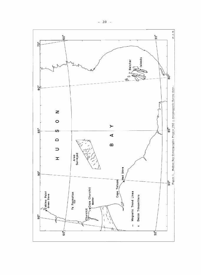
A detailed aeromagnetic survey of an area in central Hudson Bay was carried out in cooperation with the National Aeronautical Establishment and the R.C.A.F. during July and August 1965. The area is bounded by the following coordinates 58°20'N, 89°W; 58°47'N, 89°W; 58°58'N, 86°W; and 59°45'N, 86°W (see Fig. 1). The primary navigational aid used was the 6F Lambda Decca chain on loan from the Polar Continental Shelf Project which was installed in the southwest part of the Bay for the Hudson Bay Oceanographic Project. The survey lines flown were integral red Decca lines whose distance apart varied from about 2,400 feet in the southwest to 3,800 feet in the northeast end of the survey area. The flight elevation was closely maintained at 500 feet above sea-level. A rubidium-vapour magnetometer system modified by the National Aeronautical Establishment was used to digitally record on magnetic tape the total intensity of the earth's magnetic field at two heights. This was accomplished using a tail "stinger" installation together with a "bird", which was towed below the aircraft and thus was an attempt to measure the first vertical derivative of the earth's magnetic field directly. Approximately 7,000 line miles of aeromagnetic data with values every half second (approximately 150 feet) were obtained in the survey area and the Decca coordinates were also recorded at 10 second intervals (3,000 ft ) on the same magnetic tape. In addition as much survey information as po;;sible was obtained on the ferry trips between the survey area and Fort Churchill where the North Star aircraft was based. A rubidium-vapour magnetometer was set up at Fort Churchill to record the diurnal variation of the earth's magnetic field during the flights. As both the navigational and aeromagnetic data have been digitally recorded it is hoped to automate the compilation of the total intensity maps as much as possible.
The magnetic trend lines plotted from the analog chart recorded during the survey is shown on the diagram, together with the striking magnetic trends observed in a zone of relatively high amplitude anomalies, some 1,200 gammas above the regional field, which is to be found on the GSC aeromagnetic maps of northern Manitoba intersecting the coast near Owl River. It seems reasonable to conclude that the magnetic zone does not pass through the area surveyed. Moreover the aeromagnetic data on the ferry lines indicate that the magnetic zone does not swing to the north, and so the feature must swing to the south or possibly die out before it reaches
60'
Cap
e T
atn
a
Ma
llne
tic
Tre
nd
Lin
es
x D
ecca
T
ran
smit
ters
90
·
Red
S
lave
H
Are
a
Su
rve
yed
u D
o
N
60
·
B
A
y
55·1
------
---"-
-I
/ --
--15
5·
~
90
· 8
0·
Fig
ure
1
. H
ud
son
Bay
Ocean
og
rap
hic
Pro
ject 19b~
_ A
ero
mag
neti
c S
urv
ey
Are
a.
P.J
.H.
N o
- 21 -
the survey area. The character of the magnetic anomalies observed in the survey area is consistent with there being a substantial depth to the crystalline basement.
An area of intense magnetic anomalies was observed about 60 miles north-northeast of Cape Churchill (see Fig. 1) centred about 59°37 l/2'N, 92°40'W, where the depth of water is approximately 300 feet. Anomalies in excess of 5,000 gammas were recorded, and as the minimum depth to the causative bodies is at least 800 feet, there is little doubt that the anomalies are produced by magnetic iron-formation. Preliminary plots of the aeromagnetic data show that the magnetic zone is approximately 14 mile s long by 5 mile s wide, which indicate 5 that a cons ide rable tonnage of iron-formation is located beneath the waters of Hudson Bay in this area.
- 22 -
DISTRICTS OF KEEWATIN AND MACKENZIE
13. STUDY OF THE DUBAWNT GROUP
J.A. Donaldson
A stratigraphic and petrologlc study of the Dubawnt Group initiated in 1963 1 was resumed in 1965. Field work was largely confined to Dubawnt rocks within Schultz Lake area (see below), but during a one month period in which a helicopter was available, traverses as far west as Lookout Point provided an opportunity to view numerous exposures of the upper sedimentary sequence of the group.
New information include s the following obse rvations:
1. The Kazan Formation appears to be largely confined to the Baker Lake ar e al.
2. A pre-Thelon regolith is widespread and distinctive. In many places a continuous profile from unweathered basement rock to hematite rich clay is preserved beneath Thelon sediments. The regolith offers promise as a stratigraphic marke r.
3. Flat-lying sandstone s and siltstones in poorly e xposed areas north of Aberdeen Lake may be younger than the Thelon Formation. Some of these clastic rocks may be Phanerozoic rather than Proterozoic; they occur near, but not in observable contact with, previously reported l flatlying outliers of fossiliferous Ordovician limestone.
4. A distinctive conglomerate characterized by red mudstone matrix occurs in a few places at the base of the Thelon Formation. Most conglomerate, however, occurs at various levels within the sequence. Some conglomerate units can be traced as well defined channel-fillings between units of crossbedded sandstone.
5. Block faulting involving the Thelon Formation 1S a pronounced structural feature.
6. Palaeocurrent measurements de monstrate that the northwe st to southwest sense of transport initially observed in the Baker Lake area prevails throughout the western outcrop area of upper Dubawnt sandstones.
7. The only post-Thelon intrusive activity appears to have been the emplacement of diabase d y ke s.
1 Donaldson, J.A.: The Dubawnt Group, Districts of Keewatin and Mackenzie; Geo!. Surv. Can., Paper 64-20 (1965).
- 23 -
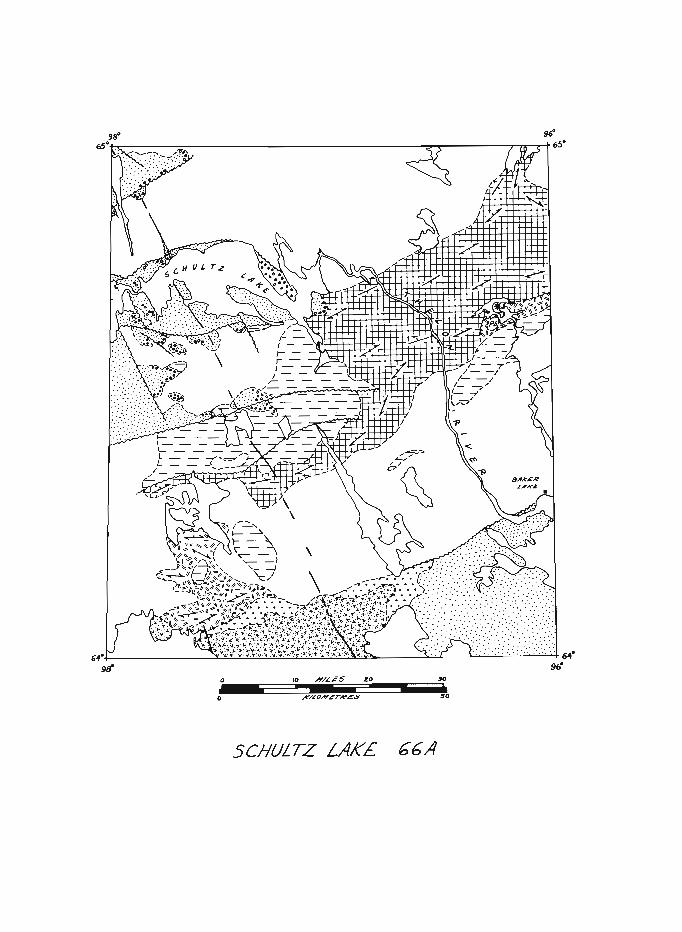
14. SCHULTZ LAKE (66 A) MAP-AREA
J.A. Donaldson
The map-area, part of a larger area previously mapped by helicopte r reconnais sance 1, lie s in the we st-central se ction of the Churchill Structural Province. The oldest rocks are interlayered fine-grained greywackes and pelitic schists that form a central, northeast-trending belt. Although cleavage typically obscures primary stratification, well washed exposures along the Thelon River reveal graded bedding in sufficient abundance to suggest a broad synclinal structure with near-horizontal axis trending parallel to the belt. Some sediments are tuffaceous, and metavolcanic lenses occur, particularly along the southeastern flank of the belt. Separately mapped extensive areas of metabasaltic rocks may form a younger sequence.
Granitoid rocks north of Schultz Lake are predominantly massive, homogeneous, and show pronounced jointing. A narrow zone of migmatite occurs along the contact with the metasedimentary belt. Such migmatitic zones are abundant throughout the granitoid terrain south of the belt. Massive fluorite-bearing granite south of Schultz Lake intrudes older foliated granitoid rocks.
Orthoquartzites of the Hurwitz Group are extremely massive, and bedding is only rarely visible. Cleavage and jointing are prominent in most Hurwitz outcrops. Stratigraphic and lithologic descriptions of Dubawnt Group rocks in Baker Lake area (see reference given in the preceding report) apply equally well to Schultz Lakearea. All Dubawnt units except the Kazan Formation are essentially flat-lying.
Major faults trend ENE and NNW. A prominent diabase dyke parallels the latter system and a few diabase dykes (not shown) occur locally parallel to the former system. Block faulting involving little or no transcurrent movement is suggested by outcrop patterns; the topographically low area occupied by Schultz Lake is a graben.
Scattered gossans occur in volcanic rocks; an area of prominent gossans is indicated (*) in the Figure. Small amounts of galena (Pb) occur along the west flank of the granite plug 5 miles south of the gossan area. Cobbles and pebbles of specularite iron-formation are abundant in Thelon conglomerates bordering Schultz Lake. Although the source area for the iron-formation was not located, palaeocurrent data indicated that it lies southeastward. Ultrabasic rocks containing chrysotile veinlets are exposed in the small window of basement rocks (x) southwe st of Schultz Lake.
Mapping of this area was accomplished largely by means of a helicopter during a three week period. The area was chosen to study relationships of the Dubawnt Group to basement rocks, and, from the operational point of view, to evaluate feasibility of helicopter mapping on a scale more
1 Wright, G. M.: Geological notes on central District of Keewatin, Northwest Territories; Geo!. Surv. Can., Paper 55-17 (1955).
- 24 -
detailed than previously attempted in the barrens. Irregular traverses planned on the basis of airphoto study provided maximum coverage for minimum flying. In contrast to reconnaissance traverses involving few stops and long flights, essentially all outcrops were investigated on the ground along traverse routes, most less than 100 miles long. As many as 40 stops per day allowed collection in three weeks of more information than could be anticipated for a full summer with several ground parties. The high cost of helicopter support is offset by reduction in fixed-wing requirements and increase in area covered.
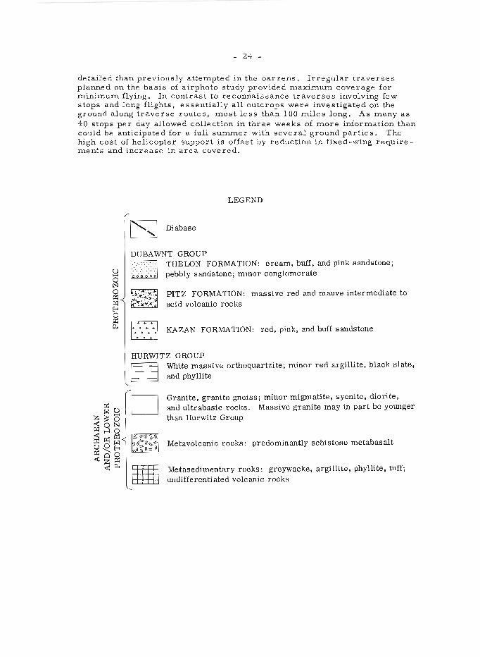
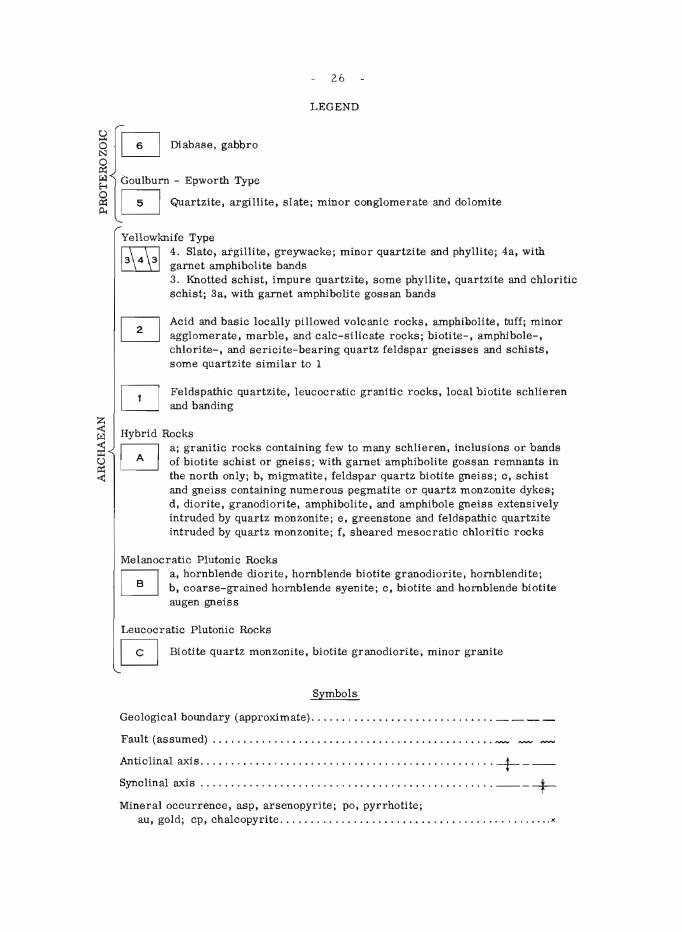
LEGEND
~ Diabase ~
PITZ FORMATION: massive red and mauve intermediate to acid volcanic rocks
1":«-.1 KAZAN FORMATION : red, pink, and buff sandstone
HURWITZ GROUP
E3 D
White massive orthoquartzite; minor red argillite, black slate, and phyllite
Granite, granite gneiSS; minor migmatite, syenite, diorite, and ultrabasic rocks. Massive granite may in part be younger than Hurwitz Group
Metavolcanic rocks: predominantly schistose metabasalt
Metasedimentary rocks: greywacke, argillite, phyllite, tuff; undifferentiated volcanic rocks
"...
9tf' o 10 JO - - -- -o ''0
SCHULTZ LAKE. bbA
- 25 -
DISTRICT OF MACKENZIE
15. CONTWOYTO LAKE WEST HALF (76 E W 1/2) MAP-AREA
H.H. Bostock
In the area east of Point Lake glacial striae indicate ice movement west to west-southwest. To the north striae are directed west to westnorthwest. East of the north end of Contwoyto Lake the most prominent dire ction is northwe st.
Feldspathic quartzite (map-unit 1 on the accompanying figure) is mainly a fine - to medium-grained grey-white to pink or buff leucocratic rock locally containing mafic bands, remnant bedding, or schlieren. Commonly it is recrystallized and grade s laterally to quartz monzonite. Remnants of feldspathic quartzite are found in areas of granitic rocks (A) in the central part of the map-area, and similar rocks, commonly with amphibole -bearing bands, are exposed in dome - and fold-like structure s within areas of migmatite (Ab).
Overlying the feldspathic quartzite (and interbedded with it near the contact?) are up to 10,000 feet or more of volcanic rocks, associated se diments, and minor marble and calc -s iEcate rocks (2). Whe re unit (2) is thin, biotite -, amphibole -, chlorite -, and sericite -bearing quartz-rich gneisses and schists form the dominant lithologies. These rocks are interbedded with the volcanic rocks in the west and are typically more clearly bedded than unit 1. Coarse acicular amphibole and garnet are developed where these rocks are highly metamorphosed.
Ove rlying unit 2 are light to dark grey or brownish fine - to medium-grained schist and gneiss (3) commonly containing cordierite and locally andalusite porphyroblasts. In some places grey phyllite, finegrained quartzite and chloritic schists are present. In the north, unit 3a comprises similar rocks with interbedded garnet amphibolite lenses accompanied by gossan. In the southwest, amphibolite bands are rare or absent in the schists of unit 2, and this may also be true of schist areas in the southeast where outcrop is particularly scarce.
Unit 4, chiefly slate, argillite and greywacke, comprises sediments of lower metamorphic grade present within the knotted schists. Where the schists contain garnet amphibolite and gossan, similar bodies are present in unit 4. Where garnet amphibolite and gossan are absent from the schist they appear to be absent in unit 4 as well.
Proterozoic sediments (5) at the northwest border of the maparea were described previouslyl. They are overlain by diabase (6) and within the area covered by the accompanying figure, form a basin-like structure with shallow inward dips.
Northwest- to west-trending diabase and gabbro dykes, typically 120 feet or less thick cut all other rocks. Locally, and chiefly in the northern part of the area, these dykes contain coarse plagioclase phenocrysts.
26
LEGEND
§ ~ Diabase. gabbro
~ ~ Goulburn - Epworth Type
~ 0 Quartzite, argillite, slate; minor conglomerate and dolomite
Yellowknife Type ~ 4. Slate, argillite, greywacke; minor quartzite and phyllite; 4a, with ~ garnet amphibolite bands
3. Knotted schist, impure quartzite, some phyllite, quartzite and chloritic schist; 3a, with garnet amphibolite gossan bands
Acid and basic locally pillowed volcanic rocks, amphibolite, tuff; minor agglomerate, marble, and calc-silicate rocks; biotite-, amphibole-, chlorite-, and sericite-bearing quartz feldspar gneisses and schists, some quartzite similar to 1
Feldspathic quartzite, leucocratic granitiC rocks, local biotite schlieren and banding
Hybrid Rocks
o a; granitic rocks containing few to many schlieren, inclusions or bands of biotite schist or gneiss; with garnet amphibolite gossan remnants in the north only; b, migmatite, feldspar quartz biotite gneiss; c, schist and gneiss containing numerous pegmatite or quartz monzonite dykes; d, diorite, granodiorite, amphibolite, and amphibole gneiss extenSively intruded by quartz monzonite; e, greenstone and feldspathic quartzite intruded by quartz monzonite; f, sheared mesocratic chloritic rocks
Melanocratic Plutonic Rocks a, hornblende diorite, hornblende biotite granodiorite, hornblendite; b, coarse-grained hornblende syenite; c, biotite and hornblende biotite augen gneiSS
Leucocratic Plutonic Rocks o Biotite quartz monzonite, biotite granodiorite, minor granite
Symbols
Geological boundary (approximate) ............... '" ............ ___ _
Fault (assumed) .............................................. ~ ~ ~
Anticlinal axis ................................................ + __ _ Synclinal axis ...................... . ...... . .................. ___ + Mineral occurrence, asp, arsenopyrite; po, pyrrhotite;
au, gold; cp, chalcopyrite .................................... .. ....... x
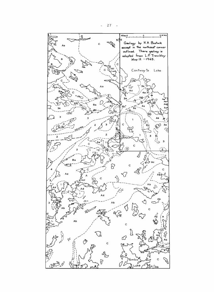
Aa
~
':,C /' (~ " : ~
1\
" ' " I I, , I, ,
F'.
I
//
//
I I I"
/
/ /
/
27
c
,--\C
"
3
- 28 -
Hybrid rocks (A) were derived from earlier rocks by metamorphism, deformation, and intrusion of granitic material. In the north a wide belt of predominantly granitic rocks (Aa) differs from similar rocks to the south in containing remnants of garnet amphibolite accompanied by gossan. Muscovite in addition to biotite is commonly present in the granitic rocks of this belt and appears most abundant near Contwoyto Lake. Areas of schist abundantly intruded by pegmatite (Ac) are common along and near contacts with granitic rocks. Grey to white pegmatites in these areas commonly carry fine - to coar se -grained black tourmaline. Amphibole -rich rocks (Ad) northeast of Point Lake may form remnants of a southern extension of volcanic rocks (2) in the central part of the map-area.
Melanocratic plutonic rocks (B) are present along the margins of, and less commonly within, the schist belt (3). Locally these rocks are dark green and amphibole rich. Elsewhere where they are more feldspathic, biotite is abundant, and quartz present . In the west these rocks are typically massive. In the east they are commonly foliated with biotite and hornblende biotite augen gneiss developed.
Leucocratic plutonic rocks (C) are mostly medium- to coarsegrained, pink, grey-white or buff, biotite quartz monzonite and granodiorite with locally abundant pegmatite. In the south large areas of unit C are massive, but in the central part of the map-area remnants of feldspathic quartzite and biotite schlie ren are common locally.
Gold has been reported associated with pyrrhotite, magnetite, arsenopyrite, loelingite 2 (McConnel, 1964), pyrite and chalcopyrite in zones in amphibolite garnet lenses of unit 3a and in equivalent hybrid rocks to the nor th.
1Bostock, H.H.: Point Lake East Half (86 H E1/2) map-area; in Jenness, S.E. (comp.): Report of Activities: Field, 1964; Geol. Surv. Can., Paper 65-1, pp. 22-26 (1965).
2 McConnel, G.W.: Notes on similarities between some Canadian gold deposits and the Homestake deposits of south Dakota; Econ. Geol., vol. 59, pp. 719-720 (1964).
- 29 -
16. STUDY OF THE EPWORTH GROUP
J .A. Fraser
Strata of the Epworth Group exposed in the Rocknest Lake area (86 G/NE, H/NW, l/SW, J/SE) comprise a conformable sequence of sedimentary and volcanic rocks having an estimated total thickness of more than 15, 000 feet. They lie unconformably on the Archaean basement and are metamorphosed against Hudsonian granite.
The basal Epworth unit consists of 2, 000 to 3, 000 feet of grey to pink quartzite and argillite with a few beds of quartz-pebble conglomerate and carbonate. Overlying this unit is a stromatolitic dolomite with minor interbedded argillite, which ranges in total thickness from 2, 000 to 5, 000 feet. More than 3,000 feet of argillite, siltstone, and greywacke su c ceed the dolomite and are overlain by about 3,500 feet of limestone with interlaminated and interbe dded grey and red argillite. The limestone formation grade s upward through red mudstone and siltstone into reddish feldspathic and lithic calcareous sandstone, possibly 1,200 feet or more thick. Pillowed, fragmental, amygdaloidal, or massive andesite, in part coarsely porphyritic, is locally intercalated with the sediments.
The sediments and volcanic rocks have been folded around northerly trending axes. Fold structures that deviate from the regional trend are characteristic of the limestone where intruded by diabase. Numerous faults cut the Epworth strata, many of which trend northeasterly and show right-lateral separations. Along the fault system extending from Redrock Lake to Takiyuak Lake the total separation, distributed among five or more branching and subparallel faults, is about 20 mile s. Downward movement on the north side accounts for some of the separation observed on these and on similarly oriented faults. Movement associated with northerly trending faults appears to be mainly dip-slip. The northeasterly faults are cr os se d by younger diabase dyke s. Sills of diabase that intrude argillite in the formation immediately above the dolomite are possibly similar in age to the dyke s.
West of Coppermine River, relatively unrnetamorphosed argillite grades westward into phyllite and biotite schist bearing metacrysts of andalusite or garnet. Contacts between metasediments and granite in this region are in some places fairly sharp and regular. In other places metasediments grade along irregular contacts into migmatite and biotite granite, a relationship that casts doubt on the presence in this area of Archaean meta-. sediments as had b e en pr e viously proposed.
An examination of basal Epworth sediments north of Takiyuak Lake and sediments in the basin southeast of Takiyuak Lake, variously assigned to the Epworth and Goulburn Groups, revealed close similarities in lithology and stratigraphy and suggests that the Epworth and Goulburn Groups may be in part correlative.
Very little direct evidence of mineralization was found in the area. Disseminated pyrite occurs in dolomite north of Takiyuak Lake adjacent to a major fault. Pyrite with chalcopyrite was observed in a calcite vein following the contact of a diabse dyke with dolomite for more than 100 feet. The vein ranges from a few inches to more than a foot in width.
- 30 -
17. QUATERNARY STRATIGRAPHY, MACKENZIE DELTA AND ARCTIC COASTAL PLAIN
J.G. Fyles
During August, the writer carried out a preliminary stratigraphic study of the Quaternary deposits that mantle much of the Arctic Coastal Plain between Cape Bathurst and the Alaska boundary (including the Mackenzie Delta region). Stratigraphic sections were measured at a number of selected localities throughout this area, and more closely spaced observations were made along parts of the Yukon coast. The work was undertaken to assess the usefulness of surface stratigraphy in unravelling the Quaternary sequence. Despite the considerable amount of Quaternary information already available for the areal, 2, 3,4, stratigraphic classification of many of the deposits is not yet possible.
The Quaternary record of the area includes (1) widespread fluvial, lacustrine, and marine sediments that originated prior to the last glaciation; (2) deposits and landforms attributed to two or more Laurentide glaciations; (3) varied post-glacial sediments, chiefly of fluvial and lacustrine origin; and (4) a complex of surface materials emplaced by frost and slope processes. The task of unravelling the Quaternary sequence is complicated by modifications in appearance and thickness of sections by ground ice, by the difficulty of distinguishing some frost and slope deposits from glacial till, and by the extensive degradation of the glacial landscape that has accompanied. accumulation of the frost and slope deposits.
The deposits that originated prior to the last glaciation (tentatively classified as 'interglacial' deposits) probably comprise several distinct formational units but, so far, it has not been possible to distinguish or characterize such formations. In the Cape Bathurst -Baillie Island region an extensive low-lying plain is underlain by silt and sand resting on clay containing mar ine shells and rare wood; he re a cle ar distinction of 'inte rglacial' and post-glacial deposits has not yet been achieved. In the Eskimo Lakes and Tuktoyaktuk areas, large areas are underlain by-monotonous horizontal and crossbedded sands locally containing wood and partly covered by till (Mackay, 1963). Here and there in the same region, however, different materials are present, as for instance in the southwest part of the Eskimo Lakes, where the following distinct lithologies were noted within a small area: (1) more than 30 feet of horizontal silt and fine sand containing thin peaty beds, pieces of wood, and, in one exposure, a 3-foot bed of compressed peat; (2) more than 30 feet of uniform fine brown sand with smallscale crossbedding and thin beds of peaty sand with wood; (3) more than 80 feet of medium to coarse brown sand with prominent large-scale crossbedding and mats of sticks and .s:naE. t.:..~P to ,6 inc~.s in diameter.
Interglacial deposits exposed along the Yukon coast from Blow River 30 miles northwest to King Point are tentatively assigne d to a single stratigraphic unit. In the southeast part of this belt, the exposed materials are mainly ~ra~ly, but farther northwest the gravels ar e progressively replaced by sands., which grade in turn into silts. The gravels enclose logs of- wood up to a foot or_ m oore in diameter, whereas the sands and silts contain smaller pieces of woo d , b eds of peat and peaty silt, freshwater shells, rare bones and tusks, local thin beds of marine clay, and, in a few places,
- 31 -
fossil ice-wedge casts. Thick glacially deformed silts, sands, and gravels on Herschel Island and along the coast between King Point and Kay Point, so far, have not been classified stratigraphically and have not been related to (or distinguished from) the undeformed 'interglacial' materials described above, exposed in the adjoining area to the southeast.
Unconsolidated deposits along the coast and on the lowland south and west of Herschel Island include much silt and clay that commonly yields rare marine shells or shell fragments. Some of these materials bear evidence of (glacial?) deformation and are assumed to be 'interglacial'; others containing stones and boulders are considered to be glaciomarine. The presence of glaciomarine stony silt in coastal exposures in the vicinity of the Alaska boundary, together with some material that may be a true till, suggests that, at one time, the Laurentide ice -sheet reached or almost reached the northeast corner of Alaska .
1 Mackay, J.R.: The Mackenzie Delta area, N. W. T.; Geographical Branch Mem. 8 (1963). Also a series of earlier reports by Mackay.
2Hughes, O.L.: Surficial Geology, northern Yukon Territory and northwestern District of Mackenzie; Geol. Surv. Can., final map (in preparation) •
3 Muller, Fritz: Analysis of some stratigraphic observations and C 14 dates from two pingos in the Mackenzie Delta, N. W. T.; Arctic, vol. 15, pp. 278-288 (1962).
4 Johnston, G.H., and Brown, R. J.E.: Stratigraphy of the Mackenzie River Delta, N. W. T., Canada; Bull. Geol. Soc. Am., vol. 76. pp. 103-112 (1965).
- 32 -
18. THEKULTHILI LAKE AREA
J. C. McGlynn
During the past summer a study of the Nonacho Group and its regional setting was begun, and all of 75 El E/2 and parts of 75 E1 W/2, 75 F /4 and 75 D/ 16 were mapped. The objectives of the work are: to study the stratigraphy, structure, and sedimentary petrology of the Nonacho strata; to correlate these rocks with groups of Aphebian or younger rocks in the region; and to establish their age relationships to the metamorphic and igneous rocks with which they are in contact.
The Nonacho Group comprises a conformable sequence of polymictic conglomerates, conglomeratic arkoses, arkoses, and shales. Along the south part of the east contact the basal units consist of a variable thickness of sedimentary breccia that comprises angular boulders of the underlying granitic rock in a matrix of arkose. This rock grades upward and possibly outward from the contact to arkoses containing the odd angular boulder of granite gneiss and beds and lenses of disintegrated granite. Between the breccia and basement is a zone consisting of granitic gneiss broken into large blocks, measuring as much as 10 feet across, that have been only slightly moved from their original positions, separated by s eams of muddy arkosic sand. This rock grades to fractured granite with the odd sand seam that in turn grades to unfractured gneisses, migmatites, etc . Locally these basal units are overlain by polymictic conglomerates rather than arkose. In several places the contact zone is intensely sheared and the above relationships are thereby obscured. A similar unconformity is observed in several places along the west contact of the sediments, but in large part the relationships on the west contact so far mapped, are obscured by intense shearing, crushing and brecciation related to faulting in the contact area. Observations made to date indicated that the sediments were deposited on a basement of considerable relief.
In the southeast part of the area the basal arkoses are overlain conformably by widely bedded polymictic conglomerate. This rock contains closely packed boulders ranging in size from fractions of inches to 2 feet, of granitic rocks, vein quartz, quartzite, basic and acidic volcanic rocks, and fine -grained porphyritic rocks with a matrix of arkosic sand. Lenses and beds of arkose are common and the transition to the overlying arkoses is marked simply by increasing amounts of arkose. The arkoses are buff, pink, or light grey rocks, which in places are conglomeratic in that they contain lens e s and beds of conglomerate, beds of conglomerate that are the thickness of one pebble, and single pebbles or clusters of pebbles. Beds of red or green shale up to 10 inches thick and beds or ill-defined zones of shale chip conglomerate also occur. Crossbedding, parallel laminations, and ripple laminations are found in some horizons in the arkose s. The se arkoses grade into a second band of polymictic conglomerate in which very large boulders of white quartzite are common. This unit is overlain by arkose.
Preliminary interpretation of about 700 crossbedding orientations suggests that palaeocurrents were from north to south along the eastern margin of the sediments and from south to north along the western border. It is felt that these directions do not necessarily r.orrespond to sedimentary
- 33 -
transport directions in the basin. However, this work must be continued so that the complete pattern is determined before conclusions can be drawn.
The oldest rocks in the area consist of granitic gneiss, migmatites, and massive granitic rocks that form the basement rocks of the Nonacho sediments. So far no granitic rocks have been found cutting the sediments, but as work progresses this picture may change.
The Nonacho sediments are folded about axes that strike east of north and plunge to the north. Folds are most intense along the western margin of the sediments. The rocks are cut by steep-dipping faults that strike north to northeast. Mention has been made of faults along or near the contacts between sediments and basement, but especially along the western contact. Basement rocks near the sediments are commonly brecciated and in places mylonitized. Such faults trend from north to northeast. The original sedimentary basin probably was in part, at least, fault controlled.
All of the above rocks are cut by diabase that strikes west of north. No significant mineral showings were discovered. Attention of prospectors should be concentrated on fault zones especially near contacts between sediments and basement. Consideration should be given to sedimentary or fossil placer deposits within the Nonacho sediments.
Henderson, J.F.: Tolston Lake, District of Mackenzie, Geol. Surv. Can., Map 525A (1939). Nonacho Lake, District of Mackenzie, Geol. Surv. Can.,
Map 5z6A (1939) .
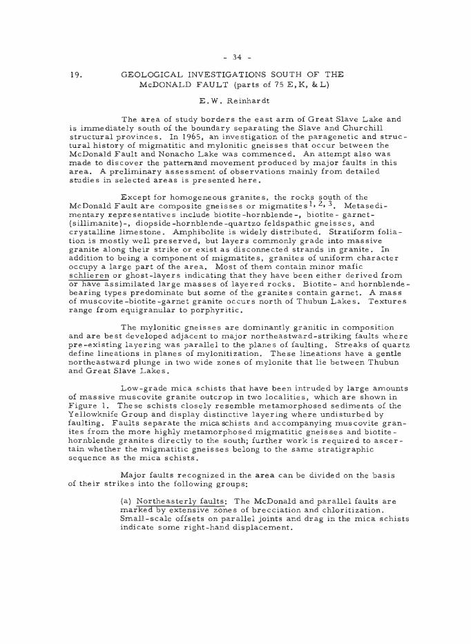
19 .
- 34 -
GEOLOGICAL INVESTIGATIONS SOUTH OF THE McDONALD FAULT (parts of 75 E, K, &: L)
E. W. Reinhardt
The area of study borders the east arrn of Great Slave Lake and is i:m:mediately south of the boundary separating the Slave and Churchill struc tur al province s. In 1965, an inve stigation of the paragenetic and structural history of :mig:matitic and :mylonitic gneisses that occur between the McDonald Fault and Nonacho Lake was co:m:menced. An atte:mpt also was :made to discover the pattern and :move:ment produced by :major faults in this area. A preli:minary assess:ment of observations :mainly fro:m detailed studies in selected areas is presented here.
Except for ho:mogeneous granites, the rocks south of the McDonald Fault are co:mposite gneisses or :mig:matites 1, 2, 3 Metasedi:mentary representatives include biotite-hornblende-, biotite- garnet(silli:manite)-, diopside-hornblende-quartzo feldspathic gneisses, and crystalline li:mestone. A:mphibolite is widely distributed. Stratifor:m foliation is :mostly well preserved, but layers co:m:monly grade into :massive granite along their strike or exist as disconnected strands in granite. In addition to being a co:mponent of :mig:matites, granites of unifor:m character occupy a large part of the area. Most of the:m contain :minor :mafic schlieren or ghost-layers indicating that they have been either derived from or have assi:milated large :masses of layered rocks. Biotite- and hornblendebearing types predo:minate but so:me of the granites contain garnet. A :mass of :muscovite-biotite-garnet granite occurs north of Thubun Lakes. Textures range fro:m equigranular to porphyr itic.
The :mylonitic gneisses are do:minantly granitic in co:mposition and are best developed adjacent to :major northeastward-striking faults where pre-existing layering was parallel to the planes of faulting. Streaks of quartz define lineations in planes of :mylonitization. These lineations have a gentle northeastward plunge in two wide zones of :mylonite that lie between Thubun and Great Slave Lake s.
Low-grade :mica schists that have been intruded by large a:mounts of :massive :muscovite granite outcrop in two localities, which are shown in Figure 1. The se schists closely rese:mble :meta:morphosed sedi:ments of the Yellowknife Group and display distinctive layering where undisturbed by faulting. Faults separate the :mica schists and acco:mpanying :muscovite granites from the :more highly :meta:morphosed :mig:matitic gneisses and biotitehornblende granites directly to the south; further work is required to ascertain whether the :mig:matitic gneisses belong to the sa:me stratigraphic sequence as the :mica schists.
Major faults recognized in the area can be divided on the basis of their strikes into the following groups:
(a) Northeasterly faults: The McDonald and parallel faults are :marked by extensive zones of brecciation and chloritization. S:mall-scale offsets on parallel joints and drag in the :mica schists indicate some right-hand displace:ment.
6"''1:>
0' ~
GR
EA
T S
L.A
VE
~
LA
KE
DO
JJ
0
{)
o
MIL
ES
&
o ;:.
o
8 16
2
4
.... I
_ w
i '
,
/
<::I
SK
ETC
H
MA
P S
HO
WIN
G S
OM
E O
F TH
E
MA
JOR
FA
ULT
S IN
PA
RlS
OF
75
E,K
,aL
LEGE
NOt
FAU
LT ..
. ....
......
......
.... -------
----
AR
EA
O
F LO
W G
RA
DE
MIC
A S
CH
IST
.
.W.R
.
W
lJ1
- 36 -
(b) East-west faults: Their age relative to the northeasterly faults is uncertain and they appear to have been breaks of lesser intens ity.
(c) Northwesterly faults: These faults post-date those of the preceding groups and observed displacements are left hand. An offset of less than one mile was noted east of Thubun Lakes along what appears to be an important northwestward-striking fault.
Only the major faults so far discovered are shown on Figure 1. Aeromagnetic maps4 were used in determining both the existence and location of large -scale faults.
1 Wright, G. M.: Second preliminary map, Christie Bay, Northwest Territories; Geol. Surv. Can., Paper 51-25 (1951).
3Henderson, J.F.: Tatlson Lake, Northwest Territories; Geo!. Surv. Can., Map 52A (1936).
4Geological Survey of Canada: Aeromagnetic maps, Fort Reliance, N. W. T.j Map 7188G (1964); Tatlson Lake, N. W. T. j Map 7l48G (1964) Snowdrift, N.W.T.; Map 7189G (1964).
- 37 -
20. CONTWOYTO LAKE AREA, N.W.T.
L.P. Tremblay
Only the area surrounding the northwest end of Contwoyto Lake in 75 E/ 14 was studied this summer.
Biotite -muscovite granite cut by numerous muscovite -bearing pe gmatite s, and locally car rying many remnants of quartz -biotite schists underlies most of the western part of the area studied. This granite in places grades into granitoid biotite-rich hybrid rock.
Yellowknife-type sediments, including a few beds or lenses of garnet-amphibole -pyrite rock, were mapped along the east boundary of the area studied. Irregular masses of an old gabbro, locally carrying abundant magnetite, traverse the Yellowknife-type sediments in places.
Rocks of the Goulburn Group unconformably overlie all the above-mentioned rocks. They cover most of the area north of Contwoyto Lake and are about 2,000 feet thick. Three formations were recognized. The lower one, about 1,200 feet thick, is made up of 550 feet of grey and red argillites, 500 feet of pink and white quartzites, and 150 feet of greywacke and grey argillite. The middle formation is a pink quartzite with narrow layers of quartz-pebble conglomerate and is 600 to 800 feet thick. The upper one is at least 300 feet thick and is made up of argillites, quartzite, and dolomitic to limy material. The upper limit of this formation is not known.
A gabbro sill in part transgressive and possibly 600 feet thick was mapped in the lower formation.
Several gabbro dykes, trending mainly northwesterly, cut all othe r rocks.
The Goulburn rocks are gently folded and are traversed by several normal faults. The gabbro sill was involved in the fOlding of the Goulburn rocks, and both the sill and the gabbro dykes are cut by the faults.
- 38 -
YUKON TERRITORY
21. SEKWI MOUNTAIN, NAHANNI, AND FRANCES LAKE MAP-AREA
S.L. Blusson
Reconnaissance geologi..:al mapping on a 4-mile scale was started in Sekwi Mountain (lOSP) and Frances Lake (lOSH) Inap-areas and the northern part of Nahanni (1051) Inap-area, as part of "Operation Selwyn" (see report by Gabrielse elsewhere in this publication).
Sekwi Mountain Map-Area
The stratigraphic suc c ession established in Wrigley and Glacier Lake Inap-areas 1 applies with few changes to the eastern and northern part of the Sekwi Mountain Inap-area. These strata include predominantly calcareous and arenaceous rocks totalling Inore than 25,000 feet in thickness and representing all systeIns from the Proterozoic to the Devonian and (?) Mississippian. The Proterozoic record is not as cOInplete in this area, but greater thicknesses of fossiliferous CaInbrian strata are present. The Rapitan ForInation and older strata are restricted to the area northeast of Sayunei Range.
A marked facies change occurs along an arcuate zone roughly JOlnlng O'Grady Lake with the northwest corner of the Inap-area. Arenites and carbonates of Ordovician to Devono-Mississippian age grade southwesterly to dark brown and black shales and fine -grained clastic rocks that occupy alInost the entire southwest part of the Inap-area.
Regional folds are mainly sYInInetrical, upright, or gently overturned to the east and northeast, the direction of thrusting. These structures trend in a wide arc through the Inap-area froIn northerly in the southeast part to northwe sterly north of June Lake.
Several small discordant stocks of mediuIn-grained Inegacrystic hor nblende -biotite granodior ite intrude shale s of Ordovic ian and Silur ian age in the southwest corner of the area. These bodies forIn high peaks along the Yukon-No W. T. divide and have well defined rusty weathering resistant aureoles several thousand feet wide. One such stock just west of the Inaparea in the Itsi Range was dated as Cr e taceous 2 .
Nahanni Map-Area
Mapping of Silurian to Devono-Mississippian strata (units 25 to 34 Glacier Lake map-areal) was extended into the northeast corner of Nahanni map-area. The area west of Broken Skull River, extending to about Long. 128°30' is believed to be Inainly underlain by CaInbrian to Silurian strata, dOIninantly quartzite, brown to black shale and carbonate. Farther west Ordovician to Silurian carbonates, chiefly dolomite , change facies to black shales and chert that occupy an extensive basin in west and northcentral Nahanni Inap-area. Geologic information on the central and southern part of the area has been recorded by Green and Roddick 3 .
- 39 -
Frances Lake Map-Area
The oldest rocks (unit I, table of fonnations) underlie the central and largest part of the area, mainly between Hyland River and Mount Hunt. South of Tillei Lake these rocks, and possibly some of unit 14, are metamorphosed to micaceous, feldspathic schists and gneisses of moderate to high grade, and are very extensively intruded by granitic bodies most of which have migmatitic and lit-par -lit margins. Similar intrusive rocks occur in unmetamorphosed equivalents of these rocks to the north and east, but these have sharp, well defined contacts and contact aureoles.
Slate, chert, and greenstone of unit 14, possibly correlative to the Sylvester Group4 occupy the greater part of the area southwest of Frances Lake and the southern part of Hyland River valley. These rocks overlie unit 1 unconformably in the extreme southwest corner of the maparea and overlie black dolomites of unit 13 near Thomas River.
Limestones of unit 2 are thickest southwest of McPherson Lake and east of Tillp.i Lake, but elsewhere are thin or absent. It is not clear whether this thinning is pr imary or due to an unconformity at the base of unit 3. Units 4 to 12 are restricted to the area east of Hyland River, particularly to the Flat River drainage.
Aside from the Cantung orebody and other scheelite -bearing skarns along Flat River, metalliferous deposits appear mainly confined to the central area of regionally metamorphosed rocks, between Frances Lake and Hyland River, particularly to a belt 3 to 12 miles wide extending from about Long. 128°15' on the southern map boundary through the upper reaches of Tyers River to about Anderson Creek. Deposits are chiefly Zn-Pb replacements with skarn in calcareous horizons of unit 1. Silver values appear generally low, but being stratigraphically controlled some deposits may have appre ciable continuity.
Massive pyrrhotite with small amounts of chalcopyrite occurs locally in unit 14 on the west side of Hyland River valley near Lat. 61°17' and as float for about a mile north along the Cantung road. Scheelite is reported in skarn of unit 1 near an intrusive contact about 9 miles north of Anderson Lake.
High magnetic anomalies in the Campbell Range closely follow ultramafic and greenstone bodie s.
IGabrielse, H. et al.: Flat River, Glacier Lake, and Wrigley Lake, District of Mackenzie and Yukon Territory; Geol. Surv. Can., Paper 64-52 (1965).
2Baadsgaard, H., Folinsbee, R.E., and Lipson, J.: Potassium-Argon age of biotites from Cordilleran granites of central British Columbia; Geol. Soc. Am., Bull. 70, p. 1564 (1959).
3Green, L.H., and Roddick, J.A.: Nahanni map-area, Geol. Surv. Can., Prelim. map 14-1961 (1961).
4Gabrielse, H.: McDame map-area, Cassiar District, British Columbia, Geol. Surv. Can., Mem. 319 (1963).
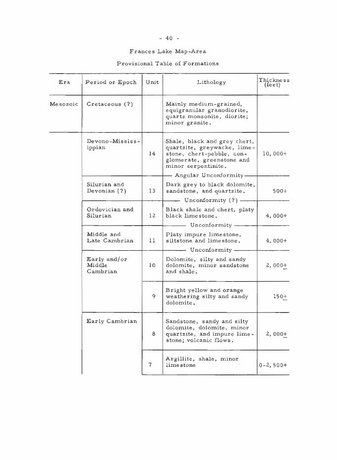
- 40 -
Frances Lake Map-Area
Provisional Table of Formations
Era Period or Epoch Unit Lithology Thickness (feet)
Mesozoic Cretaceous (?) Mainly medium-grained, equigranular granodiorite, quartz monzonite, diorite; minor granite.
Devono-Mississ - Shale, black and grey chert, ippian quartzite, greywacke, lime -
14 stone, chert-pebble, con- 10,000+ glomerate, greenstone and minor serpentinite.
Angular U nconiorITlity
Silurian and Dark grey to black dolomite, Devonian (?) 13 sandstone, and quartzite. 500+
UnconiorITlity (?)
Ordovician and Black shale and chert, platy Silurian 12 black lime stone. 4, 000+
Unconiormity
Middle and Platy impure limestone, Late Cambrian 11 s il ts tone and lime stone. 4, 000+
Unconiormity
Ear ly and/ or Dolomite, silty and sandy Middle 10 dolomite, minor sandstone 2,000+ Cambrian and shale.
Bright yellow and orange 9 weathering silty and sandy 150+ -doloITlite.
Early Cambrian Sandstone, s andy and s il ty dolomite, doloITlite, minor
8 quartzite, and impure lime- 2, 000+ stone; volcanic flows.
Argillite, shale, minor 7 limestone 0-2,500+
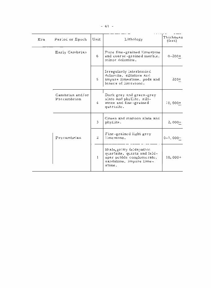
- 41 -
Era Period or Epoch Unit Lithology Thickness
(feet)
Early Cambrian Pure fine -grained lime stone 6 and coar se -grained marble, 0-200+ -minor dolomite.
Irregularly interbanded dolomite, siltstone and
5 impur e lime stone, pods and 200+ -
lenses of limestone.
Cambrian and/ or Dark grey and green-grey Precambrian slate and phyllite, silt-
4 stone and fine -grained 10,000+ quartzite.
Green and maroon slate and 3 phyllite. 2, 000+
Fine -grained light grey Precambrian 2 lime stone. 0-1,000+
-
Shale, gritty feldspathic quartzite, quartz and feld-
1 spar pe bble conglomerate, 10,000+ sandstone, impure lime-stone.
- 42 -
22. OPERATION SELWYN
H. Gabrielse
Operation Selwyn, a three-year project started in 1965, is the first systematic investigation of the geology in southern Selwyn Mountains, Hyland Plateau, and Cassiar Mountains of the northern Cordillera. During 1965 field work was completed in Wrigley Lake (95M) and Glacier Lake (95L) map-areas, included in Operation Nahanni 1, and general reconnaissance studies were carried out in Sekwi Mountain (l05P), Nahanni (1051), Frances Lake (105H), Watson Lake (105A), and Jennings River (1040) map-areas. An account of the inve stigations in Sekwi Mountain, Nahanni, and France s Lake map-areas is given elsewhere in this report by S. L. Blusson.
Wrigley and Glacier Lake Map-Areas
In Wrigley Lake map-area Proterozoic quartzites of the Tigonankweine Range are thrust northeasterly against a sequence of Upper Devonian (?) grey and green shales; grey, green, and maroon siltstones; fine -grained sandstones; and very minor limestone, more than 1,500 feet thick. East and southeast of Nainlin Brook the Devonian strata are bordered by Proterozoic quartzites in the hanging-wall of a northeasterly dipping thrust fault. The Proterozoic quartzite range north of Redstone River near Long. 126·37' is bounded to the east-northeast by a major westerly dipping thrust fault and carbonate strata in the foot-wall. indicated as map-unit 3 (?) onG.S.C. Map 37-1964, were found to comprise, at least locally, an overturned sequence including Landry, Headless, and Nahanni Formations.
Pink siltstones of map-unit 5 (G.S.C. Map 37-1964) are capped by several hundred feet of gypsum and gypsiferous beds east of Keele River. These rocks appear to be intimately associated with stromatolitic carbonates of map-unit 3.
Three sections of the Rapitan Formation were studied by Uldis Upitis in Mackenzie Mountains north of Redstone River, south of North Redstone River, and we st of Keele River in Sayunei Range. The formation is bounded by regional unconformities -the basal unconformity being markedly angular. Two additional unconformitie s divide the Rapitan Formation into three mappable units.
The lower unit consists of reddish brown and green, hard mudstone, finely laminated in part. Pebbles and cobbles, mainly of grey limestone and greenstone are found scattered in some beds. Thin sandstone and fine to coarse pebble conglomerate beds are present. About 50 feet of red and purple jasper with some thin hematite beds are found near the top of this unit south of North Redstone River. The mudstones weather reddish brown and are recessive in part forming grass-covered slopes. The unit is 230 feet thick north of Redstone River, 1,285 feet thick south of North Redstone River, and 525 feet thick west of Keele River.
The middle unit increases in thickness northwesterly from 1,215 feet north of Redstone River to 1.555 feet south of North Redstone River and to 2,705 feet west of Keele River. It is a green-grey to dark grey conglomeratic mudstone with minor sandstone interbeds. Pebbles, cobbles and
- 43 -
rare boulders as much as 2 feet in diameter are present nearly throughout. Limestone, dolostone and greenstone pebbles are predominant, but light grey and black chert, brown sandstone, and reddish volcanic rocks were also seen. Most are well rounded to subrounded, slightly elongate or flattened, and some appear faceted and striated. The unit is brown weathering and recessive near Redstone River, but changes gradually to buff-brown weathering to the northwest and near Keele River is orange -brown weathering.
The upper unit is predominantly shale -blue black to greenblack, fissile, generally thinly bedded and recessive, with interbeds of medium grey and green-grey siltstone and minor sandstone. Ripple-marks, crossbedding, scour channels and load casts are found in the siltstone. The unit is 3,845 feet thick north of Redstone River, 1,870 feet thick south of North Redstone River and 2,710 feet thick west of Keele River.
Orange -buff weathering strata overlying the Proterozoic quartzites and underlying the Whittaker Formation were carefully examined in several localities, but no fossils were found.
R. C. HandHeld studied seven Cambrian se ctions -five in Mackenzie Mountains, one in Logan Mountains, and one in Hyland Plateau. Lower Cambrian fossils were found in yellow-green and maroon-weathering siltstones that are underlain by about 1,000 feet of white and pale purple, variably hematitic sandstone s in southwe st Wrigley Lake map -area at Lat. 63°10' and Long. 127°10'. The sandstones are not present farther east and thin markedly to the north.
Highly fossiliferous Middle Cambrian strata in southwestern Wrigley Lake map-area and northwestern Glacier Lake map-area comprise as much as 1,500 feet of recessive, platy, nodular, black to orange-buff weathering, dark grey, fine-grained, argillaceous limestone and calcareous siltstone. These rocks are overlain by more than 500 feet of silver-grey weathering dolomitic sandstones and sandy dolomites overlain in turn by several hundred feet of orange-buff weathering, thick-bedded dolomites. The Cambrian-Ordovician boundary may lie within the orange carbonates or in the lower part of an overlying sequence of light grey weathering limestone.
South of Lat. 62°47' in northwestern Glacier Lake map-area the typical thin-bedded, argillaceous Middle Cambrian rocks are not present. There, Middle Cambrian strata overlying more than 4,500 feet of sandstone and minor silty and sandy crypto-grained dolomite include well-bedded distinctive buff-orange weathering silty dolomites and dolomitic siltstones.
A marked angular unconformity at the base of map-unit 22b (G.S.C. Map 36-1964) southwest of South Nahanni River cuts down through Middle Cambrian strata in the adjacent Nahanni map-area 2 so that only Lower Cambrian and older strata are preserved below the unconformity in Glacier Lake map-area. Trilobites believed to be of Upper Cambrian age were collected near the base of the assemblage above the unconformity.
A well exposed section of the Middle Ordovician Sunblood Formation,S, 480 feet thick, was measured north of Flood Creek and southwest of Clearwater Creek in Glacier Lake map-area. Several conspicuous
- 44 -
IneInbers of the forInation in this area are not evident in a considerably thinner section, believed to be of the saIne age, in southwestern Wrigley Lake Inap-area.
The Whittaker ForInation in a belt run.n.ing southwesterly froIn the northwest corner of Glacier Lake Inap-area to about Long. 127 0 consists of a lower unit, about 1,000 feet thick, of well-bedded, cherty black doloInite and Ininor Inassive, porous doloInite and an upper unit of variable thickness, locally as Inuch as 900 feet thick, of light grey, Inassive, InediuInto coarse -grained, vuggy and porous, reefoid dolomite.
The Arnica Formation in southwestern Wrigley Lake map-area comprises 1,450 feet of dark grey, platy, fetid limestone overlying 260 feet of dark grey, banded dolomite. Well-bedded, dark grey iirnestones overlying the Arnica Formation are about I, 200 feet thick and include a basal light grey, me dium- to coar se -gr ained, mas s ive reefoid lime stone member as much as 200 feet thick. North of about Lat. 63 0 30' the Arnica Formation includes abundant lenticular Inembers of massive, light grey weathering, cavernous limestone and dolomite breccia.
Watson Lake Map-Area
A belt of Proterozoic clastic rocks, dOIninantly fine grained but characterized by meInbers of feldspathic grit and pebble-congloInerate underlies Inuch of the area east of Hyland River. Apparently discontinuous bodies of liIne stone are not unCOInmon. Probable equivalent strata outcrop in Simpson Range from the northwest corner of the map-area to SaInbo Lake. There the rocks are included in a regionally metaInorphosed terrain.
Much of the reInainder of the Inap-area northeast of Liard River is underlain by an assemblage of argillite, limestone, greenstone, conglomerate, and chert containing a number of small ultramafic bodies. This asseInblage is believed to be of Devono-Mississippian age. The ultramafic rocks give strong magnetic anoInalies (G.S.C. AeroInagnetic Map 7000G).
The stratified rocks are cut by several small granitic intrusions in the northwest part of the map-ar e a and by three large granitic plutons in the northeast part of the area. The latter underlie most of the higher Inountains between Frances and Hyland Rivers north of Oscar Lake, east of Hyland River, and north of Lat. 60 0 45', and near triangulation station, elevation 6,193 feet, southeast of Stewart Lake.
Jennings River Map-Area
Stratified rocks northeast of the Cassiar Batholith range in age from Cambrian to Devono-Mississippian3 , 4. The oldest strata are thinbedded limestones, argillaceous limestones, and calcareous phyllites, more than 1,000 feet thick, of Middle and/or Late Cambrian age. These rocks are overlain by less than 50 feet of black graptolitic shale of Early Ordovician age. About 1,000 feet of well-bedded siltstone, sandstone, limestone, and dolomite, of Silurian and Devonian age overlie the Ordovician shales. The lower part of the Devono-Mississippian sequence northeast of Cassiar Batholith comprises several thousand feet of dark weathering argillite, phyllite, quartzite, conglomerate, and minor limestone. The
- 45 -
sequence is capped by massive, blocky, fine-grained andesitic to basaltic volcanic rocks into which a number of small ultramafic bodies have been emplaced.
An assemblage of Devono-Mississippian cherts, limestones, greenstones, argillaceous rocks, and conglomerates, west of Cassiar Batholith in northern Jennings River map-area is similar to that described by Poole et al. 3 in Wolf Lake map-area. In the northwesterrunost part of the map-area these rocks have been regionally metamorphosed to gneisses and schists. A sequence of well-bedded greywacke and shales between McNaughton and Plate Creeks is believed to be of Early Jurassic age overlying the older strata unconformably.
Granitic rocks west of Cassiar Batholith include abundant mediumto coarse-grained, mainly equigranular quartz diorites and/or granodiorites. Cassiar Batholith consists essentially of equigranular medium- to coarsegrained quartz monzonite. A remarkable linear zone of gneissic, cataclastic granitic rocks more than 2 miles wide marks the western border of the batholith. This shear zone was noted as far south as the head of Toozaza Creek and can be traced northerly for more than 65 miles.
Scattered outcrops of flat-lying Tertiary columnar basalts are present in the valleys of Little Rancheria River, Swift River, and McNaughton Creek. The wide, flat-bottomed valleys south of Jennings Lakes appear to be floored by similar rocks. Numerous cones of volcanic ash are present south of Lat. 59°45' in the eastern part of the map-area. An account of the geology in the southern and southeastern parts of the maparea was given by Watson and Mathews 5 (1944).
IGabrielse, H., Roddick, J.A., and Blusson, S.L.: Flat River, Glacier Lake, and Wrigley Lake,District of Mackenzie and Yukon Territory; Geol. Surv. Can., Paper 64-52 (1965).
2Green, L.H., and Roddick, J.A.: Nahanni, Yukon Territory and District of Mackenzie; Geol. Surv. Can., P.S. Map 14-1961 (1961).
3Poo1e, W.H., Green, L.H., and Roddick, J.A.: Wolf Lake. Yukon Terrltory; Geol. Surv. Can., P.S. Map 10-1960 (19bO).
4Gabrielse, H.: McDame map-area, Cassiar District, British Columbia; Geol. Surv. Can., Mem. 319 (1963).
5 Watson, K. DeP., and Mathews, W.H.: The Tuya-Teslin area, northern British Columbia; B.C. Dept. of Mines, Bull. No. 19 (1944.)
23.
- 46 -
SURFICIAL GEOLOGY STUDIES, CENTRAL AND SOUTHWESTERN YUKON
O.L. Hughes
Field work was devoted m.ainly to m.apping, by photo interpretation and ground study, the lim.its of successive ice advances in Stewart Valley and in Tintina Trench between the m.ouths of McQuesten and North Klondike Rivers. Evidence in the form. of glacial erratics, m.oraines, inferred drainage changes etc., perm.itted approxim.ate m.apping of the lim.it of one or m.ore older advances, and rather accurate m.apping of lim.its of a younger advance (pre -Classical Wisconsin?) and a still younger one (Classical Wisconsin?). Extensive glacial fluvial deposits were m.apped and related to respective glacial advances. Exposures displaying stratigraphic relationships of deposits of the respective advances are few, necessitating great reliance on geom.orphic criteria for their differentiations. Glacial deposits of Stewart Valley were laid down during successive advances northwestward out of Stewart Plateau; those of Tintina Trench were laid down by ice from. Stewart Plateau and from. several sources in Ogilvie Mountains. Sam.ples were collected in an attem.pt to show provenance of the deposits in various parts of Tintina Trench.
Vernon Ram.pton began a study of glacial deposits along a transect from. the snout of Klutlan Glacier, southwestern Yukon, to the lim.it of glaciation north of Snag. Deposits of the area are probably representative of at least four distinct advances. Ram.pton will endeavor to develop criteria by which the deposits m.ay be differentiated. Results will form. the basis of his Ph. D. di:ssertation at University of Minnesota.
Field work in Aishihik Lake m.ap-area (115 G) was lim.ited to brief exam.ination in order to facilitate planning of field work there in 1966.
24. METALLOGENIC STUDY OF THE BERYLLIUM-TIN PROVINCE OF THE CASSIAR BATHOLITH, YUKON AND
BRITISH COLUMBIA
R. Mulligan
The area em.bracing the northern part of the Cassiar Batholith and its satellites is outstanding in num.ber and variety of m.ineral occur., rences. These include m.any m.olybdenum., b ·eryllium., tungsten, and tin occurrences, the placer and lode -gold deposits of McDam.e Creek, num.erous silver-Iead-zinc deposits, som.e copper, chrom.ite, bism.uth, and nickel occurrences, and asbestos deposits including the Cassiar asbestos m.ine.
This m.etallogenic study was conce ived as an extension of pre vious and current studies of beryllium. and tin occurrences in the district, taking advantage of geological m.apping in the previously unm.apped Jennings River area (see report by H. Gabrielse elsewhere in this publication). A num.ber of lead-zinc-silver) m.olybdenite, gold-quartz, and other deposits were exam.ined and som.e stream.-sedim.ent sam.ples were panned for com.parative heavy-m.ineral studies.
- 47 -
Underground exploration work was in progress at the silver-leadzinc properties of Rancherice :mines near the head of Tootsee River (Lat. 59°56', Long. 130°29' approx.) and of Logja:m Silver Mines west of Logja:m Creek (Lat. 60°01', Long. 131°36' approx.). Drilling was done on silverlead-zinc properties at Mt. Haskin (Lat. 59°20', Long. 129°29') by Fort Reliance and near McDa:me Creek (Lat. 59°115', Long. 129°23' approx.) by Ventures Ltd. Manganiferous gossan containing :material rich in cerussite and s:mithsonite was found at Lat. 59°58', Long. 130°24' (approx.).
A :molybdenite prospect at Lat. 59°15', Long. 129°51' was drilled by New Jersey Zinc. Beryl was found at that property and also in peg:matites at the Blue Light scheelite property (Lat. 59°39', Long. 130°27' approx.) and north of Ash Mountain (Lat. 59°20', Long. 130°31' approx.).
25. ENGINEERING GEOLOGY INVESTIGATIONS OF DAM SITES ON PELL Y RIVER
E.B. Owen
At the request of the Water Resources Branch of the Depart:ment of Northern Affairs and National Resources four potential da:m sites suitable for a hydro-electric power develop:ment were exa:mined on Pelly River, Yukon Territory, between Hoole Canyon and Pelly Crossing. Priority was given to these sites because of recent :mining develop:ments in this area. With the exception of one site on Ross River, this co:mpletes the engineering geology investigations of the potential hydro-electric power sites in the Yukon River drainage basin.
- 48 -
26. "KENO HILL QUARTZITE" IN TOMBSTONE RIVER AND UPPER KLONDIKE RIVER AREAS
D. Tempelman-Kluit
Geological investigations were completed in Tombstone River map-area (116 B/7) and in parts of Upper Klondike River map-area (116B/8) for publication on a scale of 1 inch to 1 mile.
Rocks known variously as the "Central Quartzite Formation" and the "Keno Hill Quartzite" have been traced from Keno and Galena Hills westward to Tombstone River area for a distance of 125 miles (map-unit 17)1. The age and stratigraphic relations of this formation have been in doubt, but it is now apparent that the "Keno Hill Quartzite" is of Early Cretaceous age and a correlative of member A of the Kandik Formation in Alaska 2 • In Tombstone River area the "Keno Hill Quartzite" is made up of 1,200 feet of massive, light grey to medium grey, thick-bedded quartzites with minor interbedded black slate. About 150 feet above its base are 100 feet of dark blue-grey quartzite, generally considered typical of the unit. Black platy slate, about 200 feet thick, occurs 500 feet above the base of the unit . A distinctive, buff-weathering, 50-foot bed of medium- to coarse -grained, lime -cemented sandstone is found about 400 feet below the top of the unit. Poorly preserved gastropods were collected from a 5-foot, shaly, fetid limestone, 200 feet below the top.
Rocks underlying the "Keno Hill Quartzite" consist of about 2, 000 feet of unfossiliferous black shale and slate (map-unit 14)1. A 100-foot, slaty, impure, fetid limestone, which contains Middle and Upper Triassic fossils, occurs at its base.
In Upper Klondike River area a 100- to 200-foot sequence of pale gr e en and bright red, phyllitic and cherty slate overlies the "Keno Hill Quartzite", apparently conformably. These slates are in turn overlain (conformably?) by at least 1,500 feet of thinly laminated and cross-laminated, buff-weathering, lime-cemented siltstones with interbedded black slate (included in map-unit 19)1. No fossils have been found in these units, but they are apparently Early Cretaceous.
This Mesozoic succession disconformably overlies Middle Permian limestone and older strata3 .
Thrust upon the Mesozoic succession from the southeast are at least 1, 000 feet of black shale and slate, which contain Middle Jurassic fossils and which are pl:obably correlative of the black shale and slate (mapunit 14) Wlderlying the "Keno Hill Quartzite". A second thrust has brought Precambrian, Ordovician, and Silurian strata (map-units 3 and 9) 1 onto these Jurassic rocks.
Diabase sills, 100 to 300 feet thick, have intruded the "Keno Hill Quartzite". The whole Mesozoic assemblage has been folded in an arc, which trends northeastward. The contact between the "Keno Hill Quartzite" and the underlying black shale and slate has acted as a plane of decollement during folding. Above this contact folds are subisoclinal and overturned to the northwest and beds dip almost invariably to the southeast. Intrusion of
- 49 -
diabase followed by thrusting and folding probably occurred in latest Early Cretaceous time prior to emplacement of syenite stocks.
Small showings of metallic minerals were dis c overed in addition to those reported previously3. Mineralization appears to have been localized along northeast-trending faults near syenitic intrusions providing disseminated pyrite, arsenopyrite, and pyrrhotite with traces of gold and silver. Boulders of pseudoleucite phonolite, found in Wolf Creek, contain thin veinlets of galena, similar to mineralized rocks in the Spotted Fawn showings4.
IGreen, L.H., and Roddick, J.A.: Dawson, Larsen Creek and Nash Creek map-areas, Yukon Territory; Geol. Surv. Can., Paper 62-7 (1962) .
2Brabb, E.E., and Churkin, M.: Preliminary geological map of the Charley River Quadrangle, East Central Alaska; U .S.G.S. open file report (1964).
3 Tempelman-Kluit, D.: Tombstone River map-area; in Report of Activities: Field 1964; compiled by S.E. Jenness, Geol. Surv. Can., Paper 65-1 (1965).
4 Cockfield, W. E.: Silver -lead deposits in twelve -mile area; in Yukon Territory; compiled by H.S. Bostock, Geol. Surv~an., Mem. 284 (1957).
- 50 -
BRITISH COLUMBIA
27. GLACIAL STUDIES, KITIMAT-TERRACE AREA
J. E. Armstrong
Three weeks were spent in the Kitimat-Terrace area studying the post-Glacial and Glacial deposits. Evidence was obtained to show that the withdrawal of Cordilleran ice was followed by an invasion of the sea for a minimum distance of 50 miles from the present sea. Extensive marine deposits containing shells were found up to elevations of 400 or more feet. These are overlain by outwash sand and gravel up to elevations of 750 feet and probably represent marine deltas. In several places glacial till was also found overlying marine clay, possibly representing a late advance of Cordilleran ice. The evidence sugge'sts the land in the Kitimat-Terrace valley was depressed at least 1,000 feet below its present elevation during Cor diller an glaciation.
28. STRATIGRAPHY OF CARBONIFEROUS AND PERMIAN ROCKS, OPERA nON LIARD
E. W. Bamber
During the completion of Operation Liard, stratigraphic sections were measured through Carboniferous and Permian rocks in the Rocky Mountains and Liard Plateau, between Latitude 50 0 45'N and 60 0 05'N (see G.S.C. Paper 65-1, p. 42). --
To the north and west of the Tetsa River area the Besa River Formation (shale and mudstone), which includes equivalents of the Mississippian Prophet Formation is underlain by Middle Devonian carbonates. Throughout much of the area the Besa River Formation is overlain by the Permian "Kindle Formation" (calcareous siltstone, mudstone, sandstone, and minor limestone), but in the Caribou Range and to the northeast several hundred feet of Mattson Formation (massive sandstone) lies between the Besa River Formation and the "Kindle Formation".
The bedded chert of the Fantasque Formation (Permian) is partly replaced by dark weathering shale, mudstone and minor sandstone to the west and northwest of the Stone Range. This unit caps the Palaeozoic section.
- 51 -
29. CANOE RIVER MAP-AREA (83 D)
R.B. Campbell
Study of the part of the map-area southwest of Rocky Mountain Trench was completed. That part northeast of the Trench is also being studied by Price and Mountjoy (see elsewhere in this publication).
Work in the west half was concentrated primarily on the problem of the relationship of metamorphic rocks that had been regarded as part of the Shuswap Metamorphic Complex to those belonging to the late Proterozoic Kaza and early Palaeozoic Cariboo Groups 1 and in the region south of the headwaters of North Thompson River and north and east of Blue River2. The new data indicate that rocks assigned to the Shuswap Metamorphic Complex are stratigraphically equivalent to the Kaza Group and possibly to part of the Cariboo Group. The units are not separated by faults near Blue River as had been suggested previously, though faults may be present in the region near Azure Lake.
Rocks previously believed to be part of the Lower Cambrian Cunningham Limestone and Isaac Formation are now thought to be part of the Kaza Group, except those close to the western boundary north of Azure Lake.
A body of gneiss of unknown age in the northern end of Monashee Mountains is apparently bounded on all sides by faults. Along a fault in Rocky Mountain Trench the gneiss is thrust against strata of the late Proterozoic Miette Group. North of Serpentine and Windfall Creeks the south boundary is a south-dipping east-west fault along which the gneiss is overlain by quartzite and schist of the Kaza Group. Steep faults separate the gneiss from the Kaza Group along the valleys of Albreda River and Camp Creek. A second mass of gneiss, entirely within Rocky Mountains , extends several miles north and south of Hugh Allan Creek close to the Trench. These rocks are thrust northeastward over the Miette Group and strata of Cambrian age. On the southwest they are bounded along the Trench by a fault, which separates them from metamorphic Kaza Group rocks in Monashee Mountains.
A steep southwest-dipping thrust or reverse fault lies in or close to the Trench for its entire length within the map-area. Rocks in Rocky Mountains northeast of this fault are metamorphosed, the zone attaining its greatest width of 12 miles or more just northeast of the Big Bend of Columbia River and gradually narrowing toward the Trench in the northwest and southeast. Close to the Trench pelitic rocks contain kyanite and staurolite. These minerals are found intermittently for 40 miles northwest of the Big Bend to 25 mile s southeast. Garnet- and biotite -bearing rocks form a wider zone and extend from near T~e Jaune to near Bush River 3 , 4, a distance of more than 100 miles.
Some coppe r mine r als we re found in the hinge s of small folds in garnetiferous schist 5.2 miles bearing south 20' west from the mouth of Howard Creek. No other occurrences of economic interest were noted.
- 52 -
1 Campbell, R.B.: Canoe River West Half map-area; Geol. Surv. Can., Paper 65-1; pp. 43-46.
2 Campbell, R.B.: Canoe River West Half map-area; Geol. Surv. Can., Paper 65-2 (1965), pp. 47-50.
3Wheeler, J.O.: Rogers Pass map-area, British Columbia and Alberta; Geol. Surv. Can., Paper 62-32.
4Wheeler, J.O.: Big Bend map-area, British Columbia; Geol. Surv. Can., Paper 64-32.
30. BONAPARTE RIVER (EAST HALF)
R. B. Campbell and H. W. Tipper
In 1965 approximately one month was devoted to further study of the area to supplement the work of 1964. The reader is referred to the map on page 69 of Report of Activities: Field 1964 (Geol. Surv. Can., Paper 65-1). In particular, units 4 to 6, Jurassic or older, were examined in greater detail.
A sequence of rocks, essentially Jurassic and Triassic, is represented by units 4 and 5. These rocks are correlative in whole or in part with the Nicola Group to the south or the Takla Group to the northwest. In this area several mappable units have been recognized. A unit of black shale, black limestone, and phyllite has yielded Karnian fossils. Its relation to older and younger rocks is poorly known as contacts are obscured by drift or are faulted. A younger unit of interbedded andesitic flows, breccias, tuff, argillite, and minor grey limestone is believed to be Norian, but fossils are rare and poorly preserved. The volcanic rocks are in part an augite porphyry.
Overlying these Triassic rocks is a unit consisting of boulder conglomerate, pebble-conglomerate, grit, greywacke, andesite flows, and breccias. The detritus in the conglomerates was derived from older sedimentary and volcanic rocks and from hornblende granodiorite and syenite bodies that are intrusive into Permian and Upper Triassic rocks. One fossil collection from the upper part of this unit indicates a Lower Jurassic (Sinemurian) age. Overlying this conglomeratic unit is a thick section of interbedded marine shales, siltstones, tuffs, and fine breccias thought to be Lower Jurassic in age.
Coarsely porphyritic augite andesite consisting of flows, breccias, conglomerates, sills, dykes, and plugs has been mapped in many parts of the area. It is volcanic in origin and in places overlies the Lower Jurassic rocks as flows, breccias, and conglomerates. Elsewhere some bodies are believed to be intrusive. Conglomerate, flows, and dykes also occur in the Upper Triassic rocks. The augite porphyry rocks are believed to represent a widespread volcanic activity that began as early as Norian time and continued into Lower Jurassic and possibly early Middle Jurassic time .
- 53 -
The Fennell Greenstone (unit 6) is closely associated with the Karnian shales although the contacts are faulted or obscured by drift. The Fennell Greenstone either overlies the Karnian_ shales conformably or is older, the apparent superposition being the result of thrusting. Its age is therefore Karnian or older.
31. lVfETALLOGENIC STUDY, VANCOUVER ISLAND
D.J.T. Carson
This study involves the development of a metallogenic scheme for Vancouver Island. Emphasis has been placed on the relationship of mineral deposits to intrusive rocks. The metal-bearing deposits of Vancouver Island occur in host rocks ranging in ages from late Palaeozoic to middle Tertiary. They occur in groups of different ages with each group possessing its own distinctive characteristics.
On the basis of information obtained during the 1964 field season, four localities were chosen for detailed mapping and sampling in 1965. These were in the vicinities of Sooke, Nanaimo Lakes, Mt. Washington, and Buttle Lake.
Two levels of Sunro mine near Sooke were mapped with special attention given to the relationship of fracture systems to sulphide distribution. This mapping clarified the nature of the fracture control on "C" ore zone and indicated that although only persistent major fractures can be observed to extend from level to level, there is an overall regularity to the fracture systems, which makes it possible to correlate these systems from one level to the next.
Samples of ten early .oligocene or late Eocene granitic plugs (K-Ar age on biotite of one is 39 m.y. -R. Wanless, personal communication) of the Sooke area were collected for laboratory studies. Detailed mapping of the Merryth copper zone on Sooke peninsula revealed the presence of granitic rock occurring as lenses within mineralized gabbro and anorthositic gabbro.
The only known skarn deposit in Permian limestone on Vancouver Island was mapped at a scale of 1"=50'. It occurs along a contact between the limestone and a small granodiorite batholith near Fourth Nanaimo Lake. Two types of skarn were distinguished. One consists of completely altered bedded limy (?) sedimentary rocks in which the relict b e dding is clearly exhibited by the distribution of garnet, epidote, actinolite, diopside, and other minerals. The other type is altered volcanic or intrusive breccia in which the breccia matrix has generally been replaced by garnet whereas the fragments are r e placed by epidote. The main metallic minerals chalcopyrite and pyrite replace skarn or occur as veinlets within skarn. Their distribution is erratic. Magnetite, which is very abundant in many of the skarns developed in late Triassic limestones, is minor in this skarn.
A detailed map was made of the Price copper-lead-zinc-silver deposits of Western Mines LiInited, which occur in Permian or older volcanic rocks at Buttle Lake. The mapping revealed the similarities in
- 54 -
structures, metallic mineralization, tenor, gangue, and type and age of host rocks between the Price deposits and those of the Twin J mine near Duncan. At the Price property two periods of deformation are clearly indicated. The first involved tight folding of incompetent cherty beds along axes that plunge gently to the southeast. Cleavage, which in places approaches schistosity, was well developed in the cherty beds, but only developed to a limited extent in the enclosing andesitic tuffs and agglomerates. Sulphides appear to be localized in the crests of folds developed during this period. A second and much later period of non-affine deformation involved folding about vertical axes.
A series of quartz diorite stocks and plugs with porphyritic phases and associated copper -gold deposits was found to extend from Constitution Hill on the east coast to Faith Lake near the centre of Vancouver Island. The intrusions of this series are petrographically similar to one another and are all believed by the writer to be Tertiary because those in the Mt. Washington-Constitution Hill area, which was mapped at a scale of 1"=1/2 mi., occur as generally concordant bodies within late Cretaceous Nanairno Series sedimentary rocks. This Tertiary series may include the Catface quartz diorite (K-Ar age is 48 m.y. -R. Wanless, personal communication) .and associated copper-molybdenum deposits on the west coast. Mineral deposits associated with these intrusive rocks are mainly copper -gold-bearing quartz veins and disseminations developed in fractured rocks adjacent to the intrusions. Explosion breccias containing chalcopyrite, bornite, and magnetite are present alongside two of the intrusions.
- 55 -
32. MANNING PARK AREA, CASCADE MOUNTAINS
J.A. Coates
The writer continued the study, begun in 1964, of the structure and stratigraphy of the Dewdney Creek and Pasayten Groups, of Jurassic and Early Cretaceous age, in Manning Park area of the Cascade Mountains. Both groups forrn northwe st-trending belts; the Dewdney Creek Group is flanked to the west by the Hozameen Group of late Palaeozoic (?) age, and to the east by the Pasayten Group, which in turn is bordered on the east mainly by the Eagle Granodiorite.
The Dewdney Creek Group contains several marine faunas and, although fragmentary plant remains are common, is probably entirely marine. Fossils so far identified from the Dewdney Creek Group range in age from Late Jurassic to late Early Cretaceous. The Dewdney Group is bounded on both sides by faults between which, in the northern part of the area, the group forms a southeasterly plunging synclinorium and in the southern part exhibits a northeast trend. The change in trend is abrupt and is marked by a zone of crumpling and shearing. The group in the northern part of the area is deformed into essentially upright, concentric, and chevron folds with steeply dipping to vertical limbs, whereas the folds in the southern part are more open. Near the International Boundary tight, upright folds are truncated nearly at right angles by the northwest-trending Castle Peak stock. Throughout the group the structure is complicated by many faults of minor displacement.
In the northern part of the area similar stratigraphic sections are exposed on both flanks of the synclinorium. There the Dewdney Creek Group comprises in a general way the following succession. The lowest unit, more than 1,000 feet thick, is volcanic, composed principally of clastic rocks and a few flows. The f9rmer are mainly fine - to coarse -grained tuffaceous sediments and subordinately coar se breccias. The volcanic clasts are light green and grey-green and range from andesite to rhyodacite with the more acid types predominating in the western exposures of the volcanic unit. The eastern exposures of the volcanic unit have yielded a few marine fossils and those which have been dated are of probable Late Jurassic age. The western volcanic exposures are apparently unfossiliferous.
The volcanic unit seemingly grade s upwards into a middle unit, several thousand feet thick, of interbedded siltstone, volcanic greywacke, sandstone of mixed origin, and some polymictic conglomerate. A conglomerate of variable thickness up to 2,000 feet on the east flank of the synclinorium thins westward and northward to a few tens of feet. Barremian fossils were collected about 300 feet below the conglomerate and Hauterivian fossils were found a few hundred feet still lower in the section, but several thousand feet above a horizon with probable Jurassic fauna. Fossils not yet identified have also been collected from horizons several hundred feet above the thick conglomerate.
The middle unit grades upward into an upper unit of several thousand feet of thin-bedded, laminated siltstone exposed in the core of the synclinorium. This unit has yielded only a few poorly preserved ammonoids and other pelagic forms. Albian ammonites found in Manning Park by W.L. Fry 1 may have come from the se siltstone s.
- 56 -
The stratigraphy in the southern part of the area is roughly similar to that outlined above except that the volcanic unit is thinner and sandstone and conglomerate more abundant.
The Pasayten Group contains marine fossils in members interbedded with units containing plant fossils. The age of the marine fossils has not yet been determined, but plant fossils collected in 1964 confirm the Albian age previously assigned to the group2. Additional plant fossils were collected in 1965 from several new localities. The Pasayten Group is faulted against the Eagle Granodiorite to the east, whereas in the Tulameen area to the north it apparently lies unconformably on the granodiorite 3 . The group is poorly exposed. For the most part the rocks form a westerly dipping homocline, but near the fault-contact with the Dewdney Creek Group some folds are developed in the youngest members of the group. The group is cut by several strike faults, but their significance is unknown.
The writer concurs with the stratigraphy of the Pasayten Group outlined by Rice 2 with the exception of volcanic rocks assigned to the base of the group. These rocks adjoin the Pasayten Group to the east at the International Boundary where they form a belt narrowing from half-a-mile wide at the boundary to 500 feet about 3 miles north. The volcanic rocks are dark green and purplish andesites, mainly poorly stratified pyroclastic rocks, but also including some flows. They bear little resemblance to volcanic rocks in the Dewdney Creek Group and their age is uncertain. They appear to be in fault contact with the Pasayten Group to the west and the Eagle Granodiorite to the east.
K-Ar dates on the Eagle Granodiorite are contradictory. An age of 143 m. y. 4 was obtained from it in the Tulameen area and an age of 98+ 6 m. y. in Manning Park area.
1 Tipper, H.W.: Personal communication (1965).
2Rice, H.M.A.: Geology and mineral deposits of the Princeton map-area, British Columbia; Geol. Surv. Can., Mem. 243 (1947).
3 Coates, J.: Structural studies in the Manning Park and adjacent areas of the Cascade Mountains; in Jenness, S.E., Report of Activities: Field, 1964; Geol. Surv:-Can., Paper 65-1,pp. 47-48 (1965).
4Leech, G.B. et al.: Age determinations and geological studies; GeoI. Surv. Can., Paper 63-17, p. 38 (1963).
33. QUATERNARY STUDIES, VERNON (WEST HALF) MAP-AREA
R. J. Fulton
The Okanagan Valley contains ridges of sand and gravel, overlain by till, that rise as high as 400 feet above the valley floor. Water wells at Vernon extend this valley fill to at least 350 feet below the present valley floor. Other major valleys in the area contain similar thick Quaternary fills.
- 57 -
Of 4 hole s drilled to determine the nature and extent of the fill only one was completed to bedrock. The others were abandoned when loose open gravel and unfavourable groundwater conditions made further drilling impracticable. A ZOO-foot hole in the valley of Coldstream Creek penetrated a formerly undiscovered artesian aquifer of excellent quality. A significant marker in this fill is a zone of wood and plant remains about 75 feet below the surface in glacio-lacustrine sediments.
Till-covered remnants of valley fill occur up to 1,000 feet above the present floor of the Salmon River Valley. The fill consists of sand, gravel, and silt, but a traceable stratigraphic succession is not obvious. Distinctive phases occur at Westwold where silt contains marl, bones, and humic material and at Sweetsbridge where a buried soil, containing charcoal, overlies a thin volcanic ash bed. The valley fill indicates a base level much higher than present prior to the last ice advance.
Raised shore features at the north end of Okanagan Lake, at Vernon, and around Kalamalka Lake indicate occurrence of a glacial lake at an approximate elevation of 1,400 feet. Earlier work indicated that a lake occupied the Thompson River and Shuswap Lake Valleys at a similar level l . It is possible a single late -glacial lake more than 180 miles long extended from southwest of Ashcroft in the Thompson River Valley to south of Winfield in the Okanagan Lake Valley.
1 Fulton, R. J.: Day 11 - September 16; in Guidebook for Field Conference J, Pacific Northwest; Int. Assoc. for Quat. Research, VII th Congress, p. 96 (1965).
34. QUATERNARY GEOLOGY SALVAGE, COLUMBIA RIVER DEVELOPMENT PROJECT
R. J. Fulton
A subparty under the direction of M. J. Pullen began a sedimentologic study at the head of Upper Arrow Lake. Echo sounder profiles were run on the deltas of the Columbia and Incomappleux Rivers and grab samples taken from the delta surface to a water depth of 100 metres. Analysis of the sediments and of their distribution should lead to pertinent conclusions on the nature of sedimentation in fiord-like lakes. These conclusions may make it possible to predict the pattern of sedimentation in the Columbia River Valley when the regimen is changed by the dams, currently under construction.
A brief inspection was made of the Meadow Creek borrow pit at the Duncan Lake dam site. Excavation has expose d two glacial tills separated by non-glacial deposits. This exposure could be an important key to the Quaternary history of the area as the lower till is capped by a welldeveloped soil and is overlain by silt and sand containing wood, peat and a bed of volcanic ash.
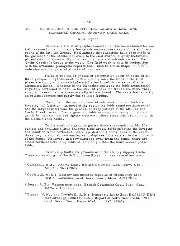
- 58 -
35. STRUCTURES IN THE MT. IDA, CACHE CREEK, AND MONASHEE GROUPS, SHUSWAP LAKE AREA
W.K. Fyson
Structures and stratigraphic boundaries have been studied for one field season in the dominantly low-grade metasedimentary and metavolcanic rocks of the Mt. Ida Group. Preliminary investigations have been made of the gneisses of the Monashee Group to the east and the slightly metamorphosed Carboniferous or Permian sedimentary and volcanic rocks of the Cache Creek (7) Group to the west. The field work to date in conjunction with the available geological reports and I inch to 4 mile maps 1, Z, 3,4,5, indicates several general structural features.
Folds of two major phases of deformation occur in rocks of all three groups. Regardless of metamorphic grade, the folds of the first phase are tight, with an axial plane foliation in pelitic rocks parallel to attenuated limbs. Whereas in the Monashee gneisses the folds trend fairly regularly northeast to east, in the Mt. Ida rocks the trends are more variable, and axes in some areas are aligned northwest. The variation is partly an original feature and partly due to later folding.
The folds of the second phase of deformation affect both the layering and foliation. In most of the region the folds trend northwestward, and the largest determine the general outcrop pattern of the Mt. Ida and Cache Creek rocks. The large-scale folds are approximately upright and gentle in the east, but are tighter westward where steep dips are common in the Cache Creek rocks.
To the south of a granitic gneiss dome surrounded by Mt. Ida schists and phyllites (Little Shuswap Lake area), folds affecting the layering and foliation trend northeast. As suggested for a domal area to the east6 , these may be anomalous-trending second-phase folds related to the formation of the dome. However, in a few outcrops away from the dome, there are small northeast-trending folds of later origin than the main second phase folds.
Strike -slip faults are prominent in the steeply dipping Cache Creek rocks along the North Thompson River, but are rare elsewhere.
1 Campbell, R.B.: Adams Lake, British Columbia; Geol. Surv. Can., Map 48-1963 (1964).
2 Cockfield, W .E.: Geology and mineral deposits of Nicola map-area, British Columbia; Geol. Sur v . Can., Mem. 249 (1948).
3 Jones, A.G.: Vernon map-area, British Columbia; Geol. Surv. Can., Mem. 296 (1959).
4Tipper, H.W., and Campbell, R.B.: Bonaparte River East Half (92 P El/2) map-area; in Jenness, S.E., Report of Activities: Field, 1964; Geo!. Surv:-Can., Paper 65-1, p. 67-71 (1965).
- 59 -
5 Wheeler, J.O.: Big Bend map-area, British Columbia; Geol. Surv. Can., Paper 64-32 (1965).
6Reesor, J.E.: The Thor-Odin gneiss dome, southern British Columbia (Parts of 82 L/8 and 82 L/9); in Jenness, S.E., Report of Activities: Field, 1964; Geol. Surv. Can., Paper 65-1, p. 63-64 (1965).
36. SURFICIAL GEOLOGY, SOUTHEASTERN VANCOUVER ISLAND
E.C. Halstead
Mapping of surficial deposits in the Sooke area was completed. The surficial deposits as mapped represent those deposited by the last major ice advance or its meltwaters. Older Pleistocene deposits are exposed in cliff sections. New cuts provided by widening of the road southeast of Mill Bay, along Saanich Inlet, expose older Pleistocene units, as illustrated in the accompanying figure.
Peat and wood collected from the nonglacial deposits lying between the two tills was forwarded for radiocarbon dating as well as pollen and plant studies. Elsewhere, in cliff sections, organic material has provided dates for the climatic episode represented by the nonglacial strata lying beneath the top till. These dates are regarded as minimum dates and it is hoped that either the wood in unit 5, or organic material in unit 4 will provide a finite date, establishing a lower time limit of this climatic episode.
37. GROUNDWATER STUDIES, FRASER LOWLAND
E. C. Halstead
A study of groundwater flow systems was commenced in the Fraser Lowland, an area of high rainfall and complex surficial geology. Initially three pi.ezometers were installed to depths of 50, 100, and 126 feet, penetrating an upper silt clay unit in the Nicomekl-Serpentine valley.
IJ\ \lI \\ , ~ '1"
\-'I
;)
- \\ -'r
CO
"C:r
cd
U"l
t.5
E
)(p
OS
ed
11
. rn
a..
-l"
....
ton
y cl
Ay
10
. t
1/1
'I.
!=/n
e
se
"d
a
nd
.s
ilt"
a. silt
7. ;,,
-r.,..
h,d
d~d
";"'t
II.
5 ..
,. J
., .
s i /
J", Sl>~.
S ""
vel,
...
,..
d
?",
..,r
,.
lo",
..,;
" ...
tt!l
d
$U
f ",n
d
cl(J
Y
5.
r<J$
iy
co
orse
!j ..
... ".I
, ""
'"o
d
'I.
0":
J"'''
;<:
$/Ir
3 T
ill
2.
:s O
f ..
n~
Glo
y
1 b
ed
ro
c/C
1-IS
P"'-
":3
......
130.-:;\.>~t:/"
.,
~;8
/ --~
. 2
0 ~/
/'
7 \.
$
/u,,
",p
/ ~~
" b
'\
(,",o
sf/
y
,cIn
e
... ,.
,..c
/ .,----_
,J
Oy
5
\ ~
.,.,
,j.
.sil
l') ~
--
5'.,
--
~
a ~
I --
3 --.
. ()
~&
.... ~4I
--
.... >
~
A
1/
<. 1
00
0
y ..
. d6
)B
St(
ete
h
o~
:sec
!/",
..,
e",
?D
$t!
lci
by
,.-c
ad
c~-r.$,
11
;1/
Ba
y J
Va
nct>
t.lv
'er
'I.5
lan
ol.
Ee
ll
0'
o
61
38. AN EXPERIMENTAL SEISMIC SURVEY. ARROW. SHUSWAP, AND KAMLOOPS LAKES
G.D. Hobson
An experimental seismic survey was conducted on three lakes in the interior of British Columbia using the hydrosonde instrument developed in Canada. The equipment was motIDted in boats rented on Shuswap and Kamloops Lakes. but was used in an aircraft for the experiment on Arrow Lake. In the Arrow Lake survey, energy source and detectors were appended to the floats of the aircraft, while the aircraft itself was propelled across the lake by an outboard motor attached to a wooden plank strapped between the floats. This whole experiment was conducted with the two-fold purpose of (1) investigating the thickness of overburden in the mountain valleys and (2) testing the marine seismic technique in the fn::sh-water environment using different types of transport adaptable to various other applications.
Penetration of energy was not attained to the base of the overburden so that the depth and shape of intra-mountain valleys was not determined. Much, however, was learned about operating such equipment in the fresh-water environment. The organic type of material believed to be present on the bottom of these lakes with the attendant bubble problem probably contributed greatly to the poor results attained. A larger, more powerful source may partly resolve this problem. However, there are many places where applications of this type of equipment in Canadian fresh-water lakes could be made, and further investigations in this field should be conducted.
39. PETROLOGICAL STUDIES OF ULTRAMAFIC ROCKS, AIKEN LAKE AND McCONNELL CREEK AREAS, CASSIAR DISTRICT
T. N. Irvine
Mapping and detailed samlC'ling of an ultramafic pluton located about 6 miles northeast of Aiken Lake 1 were undertaken as part of the program on investigation of ultramafic rocks in Canada. The pluton is composed of dunite, minor peridotite, and small bodies of clinopyroxenite, and has an extensive metamorphic -metasomatic aure ole of hornblende -r ich rocks. It is apparently similar to several other ultramafic bodies in the northern Cordillera, and a principal purpose of this study is to compare the rocks with those in a distinctive type of ultramafic complex occurring in southeastern Alaska and near Tulameen in southern British Columbia. A total of 320 sam.ple s were collected from the pluton and its aureole.
A brief examination was made of a body of gabbroic and ultramafic rocks in the Axelgold Range at the southeast corner of the McConnell Creek map-area 2, and a reconnaissance sampling was carried out. The gabbro shows remarkable layering similar to that in the famous Skaergaard intrusion in East Greenland, and the body is considered to warrant further study.
62
lRoots, E.F.: Geology and Mineral deposits of Aiken Lake map-area, British Columbia; Geol. Sur v . Can., Memoir 274 (1954).
2 Lord, C. S.: McConnell Creek map-area, Cas siar Distr ict, British Columbia; Geol. Surv. Can., Mem. 251 (1948) .
40. STUDY OF COPPER DEPOSITS
E. D. Kindle
The writer visited 56 mining properties in southern British Columbia, most of which are located between Kamloops and Hope.
Copper deposits in the Kamloops batholith were found to be Inainly replacements of chalcopyrite and bornite along sheared zones in granodiorite or in sheared zones in dacitic and andesitic volcanic rocks. Vanco Exploration is presently developing several such deposits near Kamloops in the hope that large -scale open-pit mining methods might be warranted in their exploitation.
Examples of copper-bearing quartz veins were found both in volcanic rocks east of Nicola Lake and in granitic rocks west of this lake. A deposit of the contact metamorphic type lying at the contact of limestone with greenstone on Swakum Mountain contains scheelite as well as chalcopyrite. Quartz veins at the Golconda mine occur in gabbroic rocks and hold both chalcopyr ite and molybdenite.
The copper-nic kel ore at Giant Mascot Mines Limited occurs in steeply dipping cigar-shaped pipes in basic rocks, pyroxenites, peridotite, and gabbro, not far from the contacts of these basic rocks with a mass of younger noritic rocks. This company also holds the Canam Coppe r mine east of Hope. The Canam Copper orebody occurs around the nose of a vertical breccia pipe. The breccia is of grey siltstone and fine -grained quartzite with ve in fillings and replacements of quartz and chalcopyr ite.
Copper minerals associated with thin pegmatitic veins were studied at the old Copper Mountain mine. The pegmatitic veins occur along fractures that strike at right angles to the contact of the syenogabbro with older volcanic rocks.
All of the copper deposits visited are believed to be of Jurassic or younger age. On one property south of Merritt, copper minerals occur in volcanic rocks mapped by Cockfield l to be of Tertiary age. It is an occurrence of malachite in amygdaloidal basalt, at the contact of the basalt with an overlying bed of reddish tuff.
1 Cockfield, W.E.: Geology and Inineral deposits of Nicola map-area, British Columbia; Geol. Surv. Can., Mem. 249 (1948).
- 63 -
41. BASIN STUDY, TRAPPING CREEK
D. W. Lawson
Field study and instrumentation of a 50-square-mile drainage basin were commenced. The wildland basin is located in the humid upland area of the Southern Interior Plateau (Okanagan Highland; 82 E/ 11 (E), E/IO(W).
The study is part of Canada's contribution to the International Hydrological Decade. As such, the immediate objective is to corne to an under standing of the inter relationships and magnitude s of the var ious components of the hydrologic cycle that are active in the basin. The ultimate objectives are extrapolation of these findings over adjacent upland areas of the plateau, and understanding the relationship between the humid highland areas and the adjacent semi-arid valleys. The B. C. Water Resources Service has begun study of the complementary basin (a small basin in the Okanagan Valley where no visible runoff occurs). The associated hydrogeological objectives include understanding of the groundwater flow system in an area of high relief, and quantitative determination of underflow.
To accomplish these objectives basin inventory and development were initiated. Basin inventory consisted of mapping surficial and bedrock geology. Forest inventory had previously been completed by a logging company. Plans for an ecological study were discus sed with Mr. N. Sprout of the B.C. Soil Survey. Basin development consisted of:
1. Streamflow a) Installation of one permanent stream-gauging station at that
mouth of the basin. (Installed by Water Resources Branch, Department of Northern Affairs and Natural Resources.)
b) Systematic chemical sampling of the surface waters at the above location. (Analysis by Industrial Waters Section, Mines Branch.)
c) Installation of 3 temporary stream-gauging stations on major tributaries (N.A.N.R. andG.S.C.).
d) Systematic chemical sampling of surface waters at the above locations.
2. Precipitation a) Selection of 3 rain-gauge locations (to be installed by
Met. Branch, D.O.T.).
3. Evapotranspiration a) Selection of 3 hygrothermograph locations, and 3 anemometer
locations. (To be installed by Met. Branch, D.O. T . )
4. Groundwater a) Installation of 4 underflow wells; b) Installation of 1 water table well; c) Installation of 7 piezometers; d) Collection of groundwater samples for chemical analysis.
- 64 -
Both the immediate and ultimate IHD objectives await the collection of data from the hydrometric network. Ultimate IHD objectives also require study of larger areas of the plateau. Preliminary groundwater observations, installations and measurements indicate that:
1. Piezometers can function properly in highly sheared and fractured metamorphic and igneous rock.
2. Several piezometers can be installed in a single drill-hole.
3. Drilling problems associated with extremely coarse gravel deposits make piezometer installations impractical in certain areas.
4. In areas of good access, truck-mounted hydraulic rotary rigs can efficiently drill the igneous and metamorphic bedrock.
5. Poor access and high drilling costs are the major obstacles to groundwater instrumentation.
6. Surficial evidence of diffuse groundwater discharge (i. e. saline surface waters, saline soils, salt resistant and salt tolerant vegetation) appear to be "masked" or removed in humid regions of high relief. However, more detailed studies (e. g. ecological studies) associated with piezometer cross-sections may reveal new criteria for the re cognition of such areas.
Much of the field time was spent preparing for and assisting the cooperating agencies mentioned above.
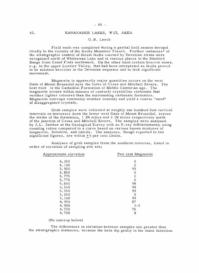
- 65 -
42. . KANANASKIS LAKES, W 1/2., AREA
G.B. Leech
Field work was cOITlpleted during a partial field season devoted chiefly to the vicinity of the Rocky Mountain Trench. Further instance s 1 of the stratigraphic control of thrust faults exerted by Devonian strata were recognized north of Whiteswan Lake and at various places in the Stanford Range froITl Canal Flats northward. On the other hand certain breccia zones, e.g. in the upper Lussier Valley, that had been interpreted as faults proved to be solution breccias in the Devonian sequence and to lack significant ITloveITlent.
Magnesite in apparently ITlajor quantities occurs on the west flank of Mount Brussilof near the forks of Cross and Mitchell Rivers. The host rock is the Cathedral ForITlation of Middle CaITlbr ian age. The ITlagnesite occurs within ITlasses of coarsely crystalline carbonate that weather lighter coloured than the surrounding carbonate forITlation. Magnesite outcrops COITlITlonly weather cruITlbly and yield a coarse "sand" of disaggregated crystals.
Grab saITlple s were collected at roughly one hundred foot vertical intervals on traverses down the lower west flank of Mount Brussilof, across the strike of the forITlation, I 3/4 ITliles and 2. 1/4 miles respectively north of the junction of Cross and Mitchell Rivers. The saITlples were analyzed by J.L. JaITlbor at the Geological Survey with an X-ray diffractometer, using counting ratios cOITlpared to a curve based on various known mixtures of ITlagnesite, do1oITlite, and calcite. The analyses, though reported to two significant figure s, are within ~ 5 per cent liITlits.
Analyses of grab saITlples froITl the southern traverse, listed in order of elevation of saITlpling site are:
Approximate elevation
6,350 6, 100 5, 900 5,850 5,775 5,775 5,650 5,550 5,350 5, 2.50 5, 100 4,950 4, 900 4,750 4, 700
(No outcrop below)
Per cent Magnesite
o o
99 o o o
98 99 99 o
99 87
1-2. 75 o
The diffe rence s in elevation between saITlple s are gre ate r than the stratigraphic distances, because the beds dip gently in the saITle direction
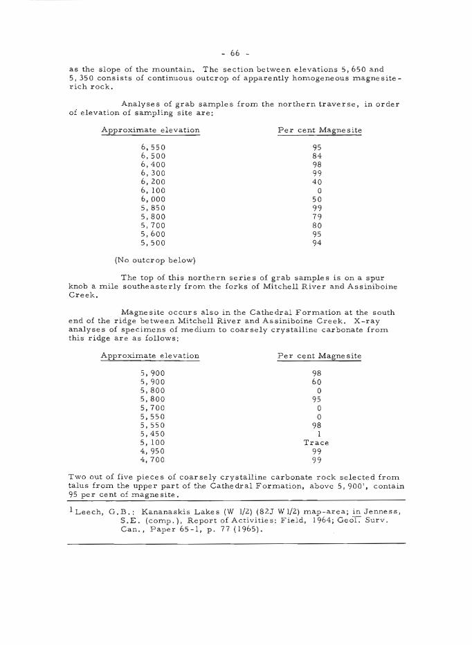
- 66 -
as the slope of the mountain. The section between elevations 5,650 and 5,350 consists of continuous outcrop of apparently homogeneous magnesiterich rock.
Analyses of grab samples from the northern traverse, in order of elevation of sampling site are:
Approximate elevation
6,550 6,500 6,400 6,300 6,200 6, 100 6, 000 5,850 5,800 5,700 5,600 5,500
(No outcrop below)
Per cent Magnesite
95 84 98 99 40
o 50 99 79 80 95 94
The top of this northern series of grab samples is on a spur knob a mile southeasterly from the forks of Mitchell River and Assiniboine Creek.
Magnesite occurs also in the Cathedral Formation at the south end of the ridge between Mitchell River and Assiniboine Creek. X-ray analyses of specimens of mediuITl to coarsely crystalline carbonate from this ridge are as follows:
ApproxiITlate elevation
5, 900 5,900 5,800 5,800 5,700 5,550 5,550 5,450 5, 100 4,950 4,700
Per cent Magnesite
98 60 o
95 o o
98 1
Trace 99 99
Two out of five pieces of coarsely crystalline carbonate rock selected from talus from the upper part of the Cathedral ForITlation, above 5,900', contain 95 per cent of ITlagnesite.
lLeech, G.B.: Kananaskis Lakes (W 1/2) (82J Wl/2) map-area; in Jenness, S.E. (COITlp.), Report of Activities: Field, 1964; GeoT. Surv. Can., Paper 65 -I, p. 77 (1965).
- 67 -
43. GREENWOOD WEST HALF (82 E/2, WI/2) MAP-AREA
H. W. Little and J. W .H. Monger
Geological investigation of Greenwood west half Inap-area was cOInpleted in 1965. The objectives were to correlate pre-Tertiary "baseInent" rocks with siInilar rocks whose stratigraphic relations had been deterInined in Greenwood east half, to deterInine their structure, to unravel the stratigraphy and structure of the Tertiary volcanic and sediInentary rocks, and to establish the depth of Tertiary cover on potentially ore -bearing baseInent rocks. Most of these objectives were successfully attained.
Investigation of baseInent rocks was done Inainly by Little, and Tertiary rocks Inainly by Monger, who was ably assisted by A.N. LeCheIninant. The authors gratefully acknowledge the advice of B. Neil Church, whose research on lavas roughly equivalent to Daly's Midway Group provided useful guidance, and to Robert C. Pearson of the United States Geological Survey, who Inapped the adjacent area to the south and visited the author s in the fie Id.
The generalized sketch Inap and the following COInInents are based largely on field work; SOIne revision Inay result froIn laboratory work.
Map-unit 1 is probably the oldest. Its relationship to the Knob Hill ForInation is not evident in this Inap-area, but to the east l units of argillite, liInestone, and aInphibolite are interposed between theIn, and fossils obtained froIn these argillite and liInestone units are of Carboniferous or PerInian age.
Map-units 3 and 4 are lithologically siInilar respectively to those of the east half, which yielded fossils of Middle Triassic age. Serpentinite (5) is in SOIne places eInplaced near faults that displace Tertiary rocks, into which, in one or two places, tongues of serpentine were squeezed by cold intrusion. Serpentinite is, however, cut by dykes probably related to Nelson Intrusions (6), which in turn are cut by dykes of Valhalla quartz Inonzonite and pegInatite (7). Rocks of Inap-unit 8 are younger than unit 4, but their relationship to other units is unknown.
The Kettle River ForInation (9)2 of Middle Eocene age 3 unconforInably overlies Inap-units 1-7, and consists of a discontinuous basal congloInerate, above which is white to buff, locally plant-bearing, arkosic sandstone, siltstone, and Ininor shale and congloInerate, all largely derived froIn acid volcanic and granitic rocks. The sediInentary rocks grade upwards into grey-green volcanic sandstone, gradational with, and in part conteInporaneous with, the lower part of Inap-unit 10. Nowhere in the Inap-area does the Kettle River ForInation appear to be Inissing, with the overlying unit 10 resting directly upon baseITlent, although it shows considerable variation in thickness, froIn at least 1,500 feet in the northwest of the Inap-area, where it is coarse and congloIneratic, to a few hundred feet, in the east-central part of the Inap-area.
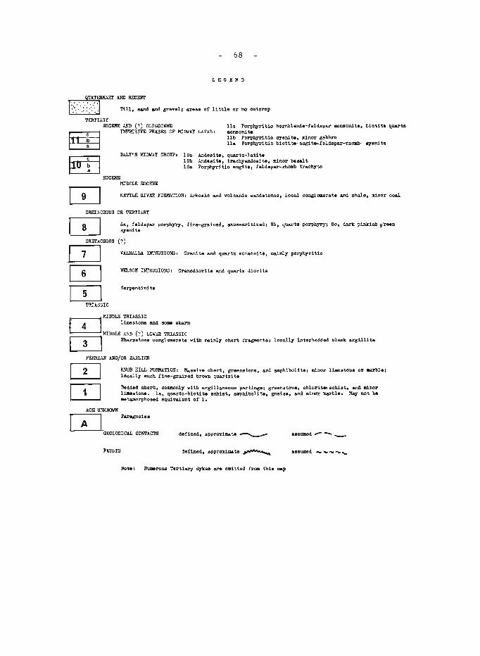
68
LEGEIiD
TERTIARY EOCEIiE AIID (?) OLlGOCElIE
~ INTRUSIVE PHASES OP MIDWAY LAVAS, 110 PorphJrlt1a hornblende-feldspar monsoni te, monzonite lib PorphTrl tic syeni t •• minor gabbro 11. PorpbTrl tic bioti ta-augi t6-foldopar-rhoab,
~ DALY'S MIl1WAY GROUP, 100 Anelee! te, quartz-lati t.
lOb And.a! te, traohyandeei te, minor basalt lOa Porphyritio augit., feldepar-rhomb traohyte
EOC&IIE MIDDLE EOCENE
biot! t. quarts
.,.eni te
K.ETTLE RIVER FOBMATIONI Arkosic and voloanio aandstone8, looal oonglomerate and shale, minor ooal
CRETACEOUS OR TERTIARY
CRETACEOUS
[2J o=J CD
TRIASSIC
Sa, feldspar porphyry, fine-grained, 8&Wlsurltizedl Bb, Q.uartz porphyry, 80, dark pinkish ffreen syenita
(?)
VALHALLA. INTRUSIONS I Gran! te and quartz monaon! te, mainl;r porph7rl tic
NELSON INTRUSIONS, Gronod1orl t. and quart. diorl t.
Serpontini ta
~ MIDDLE TRIASSIC ~ Limestone and some skarn
MIDDLE AND (?) LOIIE:R TRIASSIC IT] Sharpatono couglomerate with mainl1 ohert frBglllOnh, 100a117 interbedded blaok. argill1 t.
PElIMIAli AllDjOR EARLIER
[0 o=J
AGE URKNOIIJI
lOIOB HILL FORMATIONI Hasaive ohert, greenstone, and amphibolite I minor lilleetone or -.a.rble. looally muoh fina-grained brovn quartzite
Bedded chert, OOlIllllOnl:r vi th argillaoeous partingel greenstone, ohlori t .. eob.iat. and II1nor limeatone. la, quartz-biotite 8ohist, amphibolite, gne1a., and minor I18.rble. Ma;r not be aetamorphossd equivalent of 1.
~_ Parogne1 ..
GEOLOGICAL COllTAC'I'S
FAULTS dofiDed, approximate ..-......
Note I NUlllltrous Tertiary dykes e..r-. 0111 tted froll this map
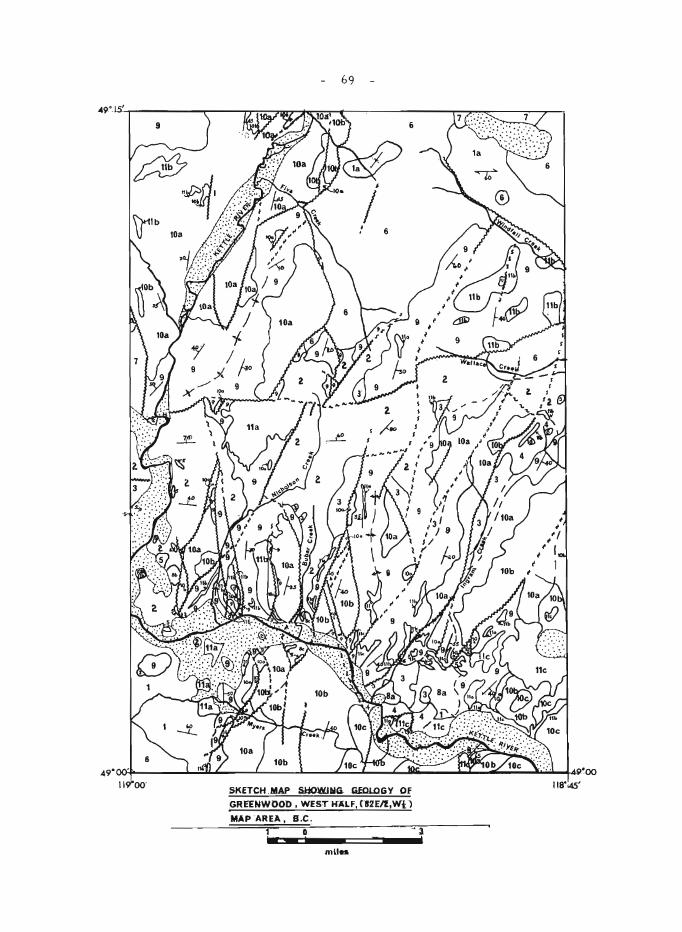
69
SKETCH .MAP SIiOWlAIG. GfOJ..OGY Of .GREENWOOD, WESTH"ALF,CW2EIl,Wi:1
MAP AREA , B.C.
1 0 ... mU ..
• 3. ,
- 70 -
Daly's Midway Group (I 0) 2 is composed of lava flows, commonly porphyritic, and minor intercalated tuffs. Intrusive phases of these lavas comprise map-unit 11. Subdivision of these rocks is based on relationships, compositions, and textures observed in the field, aided by previous petrographic descriptions 2 , 4,5, The basal division (lOa) of the Midway Group consists of pale grey, grey-green, and, less commonly, darker grey, locally highly amygdaloidal, porphyritic, augite -feldspar, biotite -augite -feldspar, or feldspar trachytes. Analcite is present in some of these rocks, and feldspar phenocrysts may be characteristically rhomb-shaped. This division varies in thickness from at least 1,000 feet in the northwest of the map-area to not more than 300 feet in the southeast. The intrusive phase of these lavas (lla) consists of grey, grey-green to pink, porphyritic feldspar -rhomb syenite, locally containing abundant augite and biotite, and forms large, irregular sill-like bodies within the Kettle River Formation. Division lOb include s a wide variety of lavas, partly gradational with one another. In the southern part of the map-area basal flows are basalts or, more commonly, dark grey aphanitic ande sites, which are overlain by maroon-weathering, porphyritic biotite- or augite-feldspar andesites, intercalated with darkbrown amygdaloidal augite andesites and minor tuff. Uppermost lavas in this division are pale green to pink trachy-andesites, characteristically glomeroporphyritic. This particular lava type alone apparently comprises division lOb in the northwestern part of the map-area. This unit is probably more than 1,000 feet thick in the south-central part of the map-area, but is probably only about 200 feet thick in the northwest. Intrusive phases (lIb) form dykes and sills and range in composition from gabbro to syenite porphyry; the latter closely resembles some Coryell intrusions and includes Daly's 'pulaskite,2. Division 10c, which is present only in the south and southeast parts of the map-area may be laterally equivalent to the uppermost part of division lOb and consists of buff, buff-green, dark grey, or pink porphyritic biotite-hornblende-feldspar andesites to quartz latites, typically with a high ratio of phenocrysts to matrix. Flow breccias are common within this division, which is at least 800 feet thick. Intrusive phases (llc) of this division are porphyr itic hor nblende -feldspar monzonite s and biotite quartz monzonites.
Structure of the area is dominated by north-northeast-trending, steeply dipping, normal faults involving all rocks in the map-area, and present on all scales. Rocks on the west side of these faults are predominantly down-dropped, with most of the tilted fault blocks dipping east or southeast. There are doubtless numerous similar faults that have not been observed, which cause apparent thicknesses to be much greater than true, particularly in the Kettle River Formation south of Windfall Creek. That this normal faulting may be partly related to extrusion of Midway lava is suggested by the parallelism to these faults of many dykes, which are feeders to the Midway lavas. A prominent east-west fault, on the south side of which the Kettle River Formation appears to be much thinner than on the north, is displaced by the north-northeast-trending faults and is presumably contemperaneous with deposition of the Kettle River Formation.
Many mineral claims have been staked in the Greenwood area in recent years, particularly in 1965. Geophysical surveys have been done, and in Greenwood (east half) map-areal exploratory drilling was undertaken by Silver Dome -Crown Silver, Scurry Rainbow, and Phoenix Copper Mines Limited. From the last, production of copper ore continues at about 2,000 tons per day.
- 71 -
1 Little, H. W ., and Thorpe, R. I.: Greenwood (82 E / 2) map -area; in Jenness, S.E., Report of Field Activities: Field, 1964;Geol. Surv. Can., Paper 65-1, pp. 56-60 (1965).
2Daly, R.A.: Geology of the North American Cordillera at the Forty-Ninth Parallel; Geol. Surv. Can., Mem. 38 (1912).
3Rouse, G.E., and Mathews, W.H.: Radioactive dating of Tertiary plantbearing deposits; Science, vol. 133, No. 3458, pp. 1079-1080 (1961) .
4 Church, B. N.: Petrology of some early Tertiary lavas of the Kettle River region, British Columbia; M.Sc. thesis, McMaster University (1963) .
5 Parker, R. L., and Calkins, J .A.: Geology of the Curlew Quadrangle, Ferry county, Washington; U.S. Geo!. Surv., Bull. 1169 (1964).
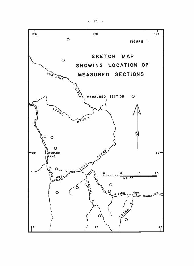
126
o
o MUNCHO LAKE
o
o
o
72
125
FIGURE I
SKETCH MAP
SHOWING LOCATION OF
MEASURED SECTIONS
o
MILES
o o
N
10 I
124
59
20 I
124
- 73 -
44. STRATIGRAPHY OF DEVONIAN ROCKS, OPERATION LIARD
w. S. MacKenzie
Important reserves of natural gas occur in vuggy dolomitized carbonate rocks of Devonian age in the subsurface of northeastern British Columbia and northwestern Alberta. Several mountain outcrop sections of Devonian limestones and dolomites were examined in conjunction with Operation Liard (see report by G. C. Taylor, elsewhere in this publication) with a view to obtaining a better understanding of Devonian stratigraphy.
The Devonian carbonate sequence composed of Bear Rock Formation dolomites and overlying Nahanni limestones averages about 1,750 feet in thickness throughout most of the area and maintains this thickness even near the limit of carbonate deposition in the Caribou Range to the north. A much thicker sequence is present, however, in the area immediately to the east of Muncho Lake (Fig. 1) where the Bear Rock and Nahanni Formations attain thicknesses of about 1,960 and 1,200 feet respectively. In this area where the carbonate sequence is thick, dolomites of the Bear Rock Formation can be easily separated into a lower, slightly silty, light-weathering sequence and an overlying darker weathering and dominantly argillaceous interval. The overlying Nahanni Formation there and elsewhere within the area appears to be strongly argillaceous in the upper part with relatively pure light brown limestone more characteristic of the lower beds.
Organic life seems to have been more prolific close to the edges of the carbonate bank and near its limit in the Caribou Range to the north, colonial corals, brachiopods, trilobites and in particular, massive, globular, and encrusting stromatoporoids, not observed elsewhere within the formation were abundant.

- 74 -
45. CORDILLERAN STRUCTURE PROJECT: RATCHFORD CREEK MAP -AREA
W . J. McMillan
Geological mapping on 4 inch to 1 mile base-maps was carried out between Bews Creek and the head of Myoff Creek in the Monashee Mountain Range west of the Perry River. The Perry River crosses the Rodgers Pas s Highway at Craigellachie.
The map-area is underlain by rocks of the Shuswap Metamorphic Complex. A series of southwest-plunging folds are outlined by quartzite horizons in sillimanite -rich, kyanite -bearing, biotite -rich and gr anitic gneis se s (unit D) 1. Many of the se folds are isoclinal with planar limbs and rounded hinge zones. Superimposed on these early formed folds are the effects of later deformations with west and northwest plunging fold axes.
Homogeneous granite gneiss (unit A) 1 grades laterally into unit D gneisses. Quartzite horizons are continuous between and gradational within the two units.
IWheeler, J.O.: Big Bend map-area, British Columbia; Geol. Surv. Can., Paper 64-32 (1965).
46. CENTRAL VANCOUVER ISLAND AREA (parts of 92 F. 92 G, 92 K)
J.E. Muller
Geological mapping of the southwest quarter of the Alberni (9 2F) area was nearly completed. Additional mapping was done in the Nanaimo area (92G) and M.E. Atchison of the writer's party studied in detail the stratigraphy of the lower part of the Upper Cretaceous Nanaimo Group. The area between Tofino and Alberni contains a central batholithic belt, striking about north 70 degrees west, partly roofed by I'Karmutsen" (Triassic) basic lavas, and locally capped by I'Quatsino ll (Triassic) limestone and IIBonanza l1
(Jurassic) tuff and breccia. The granodiorite is largely unroofed in the Bedwell River region, but plunges eastward, outcropping mainly in lower areas along Great Central, Sproat, and Henderson Lakes.
North of the Bedwell culmination is the Buttle Lake structural uplift that exposes Late Palaeozoic Sicker Group rocks, mapped previously. South of the batholith, from Herbert Inlet to Kennedy Lake, this uplift apparently continues, exposing a complex of greenschists, quartz-biotite schists and highly folded limestone. Fold axes and lineations plunge about 25° south-southeast, a trend also found in Palaeozoic schists west of Buttle Lake. The same direction is also reflected in gneissic rocks with a core of foliated granodiorite between Clayoquot Arm and Tofino Inlet. North of
- 75 -
Catface Mountain, on Meares Island, and between Kennedy River and Grice Bay the complex contains northwest-trending bodies a few miles wide with coarse -grained hornblende diorite and gabbro, and minor peridotite. In several places they are associated with recrystallized limestone and amphibolite.
Correlation of these rocks with the Sicker Group is suggested by structural relationships and lithologic resemblances, but needs further evidence.
East of this above-mentioned uplift a southward widening trough between Kennedy Lake and Effingham Inlet contains Triassic limestone and probable Jurassic tuff, flanked by inward dipping Triassic lavas. The rocks have been invaded and metamorphosed by granodiorite. Hybrid heterogeneous rocks of dioritic composition, possibly derived from basic volcanic rocks, occur mainly along the south edge of Catface Range, between Bulson and Tofino Creeks, and in the Effingham Inlet area. A northwesterly trending major fault separates all these rocks from a steeply dipping sequence of greywacke, conglomerate with granitic and volcanic boulders, and minor argillite on the Tofino-Ucluelet peninsula and Vargas Island. This sequence is probably correlative to known Jurassic rocks in coastal areas to the northwest.
The area contains numerous known mineral occurrences. Quartz-veins with gold and silver values and minor galena, sphalerite, chalcopyrite, and locally molybdenite appear in many contact zones of the central batholithic belt, especially in the Bedwell culmination, but also westward as far as Moyeha Bay, and eastward as far as Great Central Lake. A mineralized belt also seems to run from Henderson Lake westward to Kennedy Lake, and thence north of Kennedy Lake, Clayoquot Arm and Tofino Inlet. There skarn with magnetite and less chalcopyrite, developed at intrusive contacts with Triassic limestone, forms the Brynnor Mines deposit and several other small showings. One, perhaps not previously known, is a vertical lens of magnetite that is up to 20 feet wide but pinches out within 100 feet. It outcrops on a ridge between Tofino and Tranquil Creeks, two thirds of a mile north of point 4046. Contacts between volcanic and intrusive rocks in several places also contain quartz and sulphide minerals. The chalcopyrite and molybdenite showing on Catface Mountain apparently is at the contact of Tertiary quartz diorite and older intrusions and volcanic rocks. The small Tertiary stock south of Tofino and on Felice and Cl.ayoquot Island is also locally mineralized.
Detailed stratigraphic work on the Nanaimo Group suggests that the coal-bearing Comox Formation of the Comox area is equivalent to the Benson Formation and therefore older than the coal-bearing Extension and Protection Formations of the Nanaimo area. This correlation is compatible with recent palaeontological findings.
76
LEG8ND
"UAT8fu'lARY pLEISTOC~~ AND R~C~~T
'-~1~4'-'1 Sand, gravel, boulder till, in part marine
'l'EnTI ARY
13 Biotite quartz diorite and granodiorite
CR.,TAC~l;US
,-__ U_P,P";R CR.:,'i'AC~OUS
12 1 hANAUiO [;HOUP: sandstone, shale, conglomerate
JUR,',SSIC AND ("!) ClL;.'.i'i,C;;;OUS BOlW:ZA Grl.OUP:
11 Sedimentary Division: Gre~;acke, conglomerate, argillite, minor tuff and breccia
10 Volcanic Division: andesitic, dacitic tuff and breccia; minor flows
9 ISLAND INTRDSIOl~S: (hornblende) biotite granodiorite, quartz L-__ ---' monzonite
l'jUAS3IC U, p~q TRIASSIC
I----a---I ~U1TSINO GROUP: limestone, shaly limestone, chert, quartzite, skarn; ir,cludes ar.desi tic dykes, sills, and tuff, fine-grained hy0rid granitic rocks. L indicates limestone
____ 7L---.J K.i\RHU'J'Sl!:N GROUP: basalt, minor andesite in massive flows, pilloHed, or breccL'.ted
J!BllNIAN film (?) OLj)~ 6 I SICKER GROUP: limestone, siliceous tuff, breccia, creel:schist,
'------' sericite schist, andesi tic and daci tic dykes. L indicp.,tes limestone
AGE Ul'.'K},O'IIN 5 TOFINO INI";T INTRUSION: folia,ted hornblende biotite quartz diorite,
'---------- granodiorite
Hornblende gabbro, diorite, hornblendite
Hybrid hornblende diorite, quartzdiorite, agmatite; includes masses of hOrnfelsic volcanic rocks
2 Metamorphosed volcanic rocks: amphibolite, hornfels, minor hornblende diorite
1 QMnrtz feldspar biotite gneiss, hornblende pl :~ioclase gneiss, ~----~ quartzite, amphibolite
Geological contact, approximate
Fault, approximate
Bedding
Schistosity, axial plane cleava~e
Lineation, axial plunGe '<r
)'
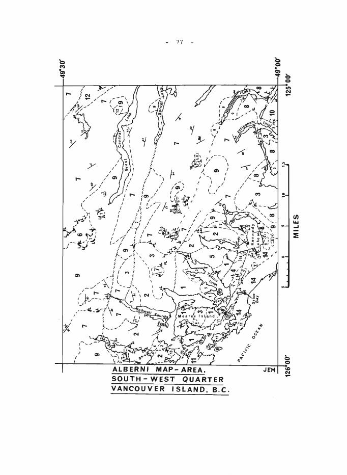
c...
",
X
"'4
C"F
'C'
1266
00
'
~ .. ~
7 , I ,
( ,
~
I ~\
L tA
L 6
-.
~ \
,LL
"
, 9
~"''
-''
..... ""
("
, &(..t~---
\\;
--
L ,
IL·
I \
\
,L
I 7
'
~'l
~~~L
_
_ /"~~
_ \
I '
( ~.
..
'\
I ...
..... ~l
t~ y
' \
~~
~ ,
7 ~~
~)..
~ 7
__
'V
"""",
,--
',,-"
-,
;r-"
-,,'-
-7
"-"t
3
"
9 ",,
~\.
~
/""....
.......
'\
......
" ....
. .....
,...,"
"'~"¥-
~ "'"1
" //
C
.......... ..J ......
. ""7 ...
... '"
__
~ I --
--"""-'"
7
"'....
7 " .. ~-~~;.. .
... "
""' .....
""''
'\.
, ..
\ 12
,
7
'\
-"7
-' 3
jL 7
""
~ -~9~~--
It'\
I 1
-'1
. "" '
""~
'_I,
L
/ r
,,\
" "'Y
~ IL
L,
_4<!
~O "~
\"
.-' -~"
L ~
'--
t'
~ .......
__
.... _
'1'L~"
,'
i'
,~J -
_~_--
'y-
L 1
~"
J:l"
~j~~;-
Jj"l_
. '~~r-
, i'
~ --'
, 9' ~
(5
2 ,-
' "-~' )
7
~
oc~ 4
",
I 5
" -,
-... .
.. ~--'
,
'>.
",-
~ 'L
, "\.
t""'>
, ".
1'
lc-\
).
't.~L8)
\ ~,
-,
2 :L
\9')l
v",
.r"
:...."
",
f ''
:::
I ......
_...
.. ,
I /
I 7
I I
" I A
li ...b
. §
\.
I"
9 ~
,. -
7 .....
... ,_
/1
-/-.
:..
.....
( ,
\ "
" ,,\
.) lt
L
,/"
'I
, I'
I 8
" ,
,
~
,
MIL
ES
~
~
49-3
0'
--.J
--.J
- 78 -
47. GRAND FORKS, WEST HALF (82 E/ 1, W 1/2) MAP-AREA
V.A. Preto
Examination of the Grand Forks Groupl in the southern half of the ITIap-area so far has revealed the presence of a complex of highly metaITIorphosed sediITIentary and igneous rocks which probably are partly correlative with the metamorphic complex of Tenas Mary Creek2 and are continuous with some of the high-grade schists and gneisses of the Orient ITIap-area 3 .
SilliITIanite is widely distributed through, and conspicuous in, ITIost of these rocks, except in the southwestern part of the ITIap-area.
The metaITIorphic rocks of the Grand Forks Group feature a southeast- to east-northeast-trending proITIinent foliation, which in sections displaying variable lithology is parallel to large-scale cOITIpositionallayering. Dips are ITIoderate to steep to the south and southwest and moderate to the north and north-northwest. Ubiquitous strong mineral lineation on this foliation, plunges alITIost invariably to the west-northwest at gentle to ITIoderate angles. The principal foliation is ddorITIed by generally tight folds with axial planes nearly everywhere overturned to the north and fold axes parallel to the prominent mineral lineation. In several localities folding of these structures about north- and northeast-trending axes has been noted, but further study is needed in order to decide whether these later folds reflect local structural complexities or are the ITIanifestation of a penetrative structural episode.
1 Little, H.W.: Kettle River (El/2) B.C.; Geol. Surv. Can., Map 6-1957 (1957).
2parker, R .. L., and Calkins, J.A.: Geology of the Curlew Quadrangle, Ferry county, Washington; U . S . G. S., Bull. 1169 (1964).
3 Bowman, E. C.: Stratigraphy and structure of the Orient ores, Washington; unpublished Ph.D. thesis, Harvard University (1950).
48. THE THOR-ODIN GNEISS DOME, MONASHEE MOUNTAINS, SOUTHERN BRITISH COLUMBIA
J.E. Reesor
This summer's work consisted of further studyl of structural relationships within Thor-Odin gneiss dome, as well as a detailed study of the veined augen gneiss in the core of the dome. Within this complex there is a clear structural succession from large scale isoclinal folds, isoclinally refolded on a scale not exceeding a few tens of feet. Direction of folds of either phase depends upon their position relative to the dOITIe as a whole. A penetrative ITIineral lineation, trending westward has been superiITIposed upon the fold structures as well as an even later northward-.trending incipient, steep, planar, feature that is expressed as a faint, cross-lineation on foliation surfaces. These are the principal structural features, other, local, les s iITIportant features ITIay be detected within this sequence.
- 79 -
Some time was spent on further investigation of the age of the rocks involved in this Shuswap sequence. Fossils, tentatively identified as Mid- to Upper Palaeozoic were found in the greenschist facies rocks southeast of the domal complex, near Catherine Lake 2 . These rocks show identical structural features found within the gneiss dome. A stratigraphic sequence of rocks, identical to these Palaeozoic rocks are found in the domal complex centred on the Pinnacle Peaks, south of the Thor-Odin dome, and south of Plant and Cherry Creeks 2 • There, a prominent diopside quartzite and thick marble are stratigraphically identical to rock sequences mapped as Milford Group by P. B. Read (personal communication, 1964) in the Poplar Creek area, east of Kuskanax Batholith. From the Pinnacle Peak, the "Milford" sequence, in the sillimanite -almandine facie s of regional metamorphism, grade rapidly outward to recognizable upper Palaeozoic sequences in the Cherryville region in the greenschist facies of regional metamorphism. Therefore typical Shuswap metamorphism and structural style affect upper Palaeozoic rocks.
Further investigation of the age of rocks involved in the core of Thor-Odin gneiss dome, shows a stratigraphically typical lower Palaeozoic sequence consisting of massive, pure, quartzite (Hamill(?) equivalent) schists and calc-silicates intimately involved with typical Shuswap granitoid gneisses. Locally, typical granitic gneisses are developed above the quartzite and quartzite may in places be found as isolated remnants in granitic gneisses. Thus, granitic gneisses have been developed in rocks younger than the quartzite. In two localitie s below the quartzite, deformed pebble conglomerates, as well as coarse and fine grits were found preserved within the granitic gneisses. In one place blue quartz pebbles were found that are typical of Horsethief Creek Group pebble conglomerates. The conclusion thus appears warranted that the granitic gneisses of the Thor-Odin complex were derived from the lower Palaeozoic-Windermere succession, not from a lower Palaeozoic-older Precambrian terrain.
It is therefore evident from this and previous seasons' work that the Monashee Group as mapped by Jones 2 represents a metamorphic and structural complex involving the entire stratigraphic succession from Windermere to Upper Palaeozoic. It is also evident that the high grade metamorphic rocks of Thor -Odin dome involve the lower part of this succession, with the upper part surrounding it as a supracrustal zone in the greenschist facies of metamorphism, whereas the dome centred on the Pinnacle Peaks involves the lower part of the Upper Palaeozoic sequence in the sillimanite -almandine zone, surrounded by a supracrustal zone of late Palaeozoic rocks in the greenschist facies of metamorphism. The metamorphism and structural deformation is post-Palaeozoic.
This confirms and strengthens Hyndman's conclusion3 in the Nakusp area that the latest and most intense phase of Shuswap structural disruption and regional metamorphism in this area is post·Triassic (Ph. D. thesis Berkeley 1964 and G.S.C. Bull. in press).
1Reesor, J.E.: The Thor-Odin gneiss dome, southern British Columbia (parts of 82 L/8 and 82 L/9); in Jenness, S.E., Report of Activities: Field, 1964; Geol.Surv. Can., Paper 65-1, pp. 63-64 (1965).
- 80 -
2 Jones, A. G.: Vernon map-area, British Columbia; Geol. Surv. Can.,
Mem. 296 (1959) .
3 Hyndman, D. W.: Petrology and structure of the Nakusp map-area, B. C.; Geol. Sur v . Can., Bull. (in press).
49. COAST MOUNTAINS PROJECT
J.A. Roddick, A.J. Baer, and W.W. Hutchison
Geological mapping on a reconnaissance scale of 1 inch to 4 miles was completed in the Coast Mountains between latitudes 52· and 55·N, an area of about 20,000 square miles, which includes the following mapareas: Prince Rupert (103J). Terrace Wl/2 (1031), Hecate Strait (103G), Douglas Channel (1 03H). Laredo Sound (1 03A), and Bella Coola (93D). The operation was based on the research barge 'VELELLA' provided by the Fisheries Research Board and was supported by a Bell 47G -3Bl helicopter equipped with floats.
Accuracy in determining the composition of plutonic rocks and associated gneisses was greatly improved by determining the specific gravity of the specimens collected (5,575 such determinations were made during the season). Accuracy was further improved by etching and staining of many specimens. which facilitated the estimation of quartz and potassium feldspar content. The number of specimens etched and stained was 1.877.
In addition to the normal notes, IBM cards were used to record routine field data. Two files were set up, a card-per-station file and a card-per-specimen file. Punching of the cards did not entail a great deal of extra effort (the cards can be punched more rapidly than notes can be written) and is expected to expedite information retrieval and improve control over the large collection of specimens.
The best exposures in the area are along the shore and in some cliff-faces. The exposures on the ridges are good, but in many places detailed observation is hindered by lichen. Outcrops are rare in valley bottoms and on all but the steepest of valley sides owing to the luxuriant rain forest. Although the shore exposures are best, they may be misleading, especially along northwest-trending channels, as these have commonly been cut in bands of metasedimentary rocks. associated migmatite, and diorite, whereas farther inland massive plutonic rock is commonly found.
The project area is roughly divided into northeast and southwe st parts by a discontinuous central band of metasediments, which extends from the vicinity of Prince Rupert southeast along the central part of the Coast Mountains. The band trends slightly obliquely to the axis of the Coast Mountain belt crossing from the west side in the north to the east side in the south. The rocks west of the metasedimentary band consist mainly of a variety of plutonic rocks. whereas those to the east of it are characterized by abundant gneisses north of latitude 53·N. The gneisses may terminate in the south-central part of Whitesail map-area (east of Douglas Channel maparea). or may only be interrupted there and pass beneath the volcanic rocks in the northeastern part of Bella Coola map-area.
- B I -
The oldest rocks in the project area are thought to be the gneisses that underlie broad areas east of the central metasedimentary band in Terrace VIr 1/2 and Douglas Channel map-areas. They are closely associated with metasedimentary rocks in the vicinity of Khutzeymateen Inlet, where they appear to underlie them and in places grade into them. Over large areas the gneisses have shallow dips, 20 0 to 30 0 N being cornmon south of Nass River and similar dips to the northeast south of Skeena River. The gentle attitudes of the gneisses are not necessarily indicative of simple structures, as large recumbent folds were seen in several places in Terrace W 1/2 map-area. These folds appear to be directed in conflicting directions (southwest and northerly). The relationship between the gneisses and the plutonic rocks is complex. The gneisses were seen to be intruded by, overlain by, and commonly gradational into, plutonic rock. In many places the gneisses grade into massive granodiorite. As the northeastern part of the gneis se s e spe cially is gr anitoid and the plutonic rocks are commonly foliate d, the two rock type s are in place s difficult to distinguish. Parts of the area mapped as gneiss on the sketch map are in reality migmatites. Although commonly granitoid the gneisses appear to have been derived mainly from sedimentary rocks.
The metasedimentary rocks that form the central band and bodies to the west consist mainly of various schists, crystalline limestone and minor conglomerate. Quartzite with thin interbeds of limestone form most of the sedimentary bands on the outer islands. Volcanic rocks are associated with the metasediments only in the Prince Rupert map-area, but may be represented farther south by diorite. The conglomerates, although rare, commonly contain plutonic debris. This, however, is not surprising as some of the plutons in southeastern Alaska have yielded Early Palaeozoic dates. Organic remains but no diagnostic fossils have been found in the metasediments of the central band or in the bodies to the west. A Permian age is possible for some of the metasediments that contain thick limestone beds, such as are found northeast of Khutzeymateen Inlet, along the northeast shore of Grenville Channel and in the southeastern part of Douglas Channel map-area. It may be concluded only that most of the metasediments of the central band are probably pre-Jurassic and possibly Palaeozoic.
The volcanic rocks in the eastern part of Bella Coola map-area consist of two systems (excluding the Tertiary basalt): one pre -Hazelton Group, and one belonging to the Hazelton Group. The pre -Hazelton volcanic rocks are highly deformed, but the overlying Hazelton Group is only gently deformed. Baer had previously found Middle Jurassic (Middle Bajocian) fossils in sediments associated with the latter rocks. Volcanic rocks of the Hazelton Group also appear in the northeast corner of Douglas Channel maparea where they are highly deformed. In southeastern Laredo Sound maparea plant fossils were found in sediments associated with volcanic rocks. These rocks are probably Lower Cretaceous, but the fossil material has yet to be closely studied.
Gently tilted and faulted Tertiary basalt related to that east of the Coast Mountains appears in the project area only on the eastern edge of Bella Coola map-area.
The plutonic rocks in the project area range from gabbro to granite. Quartz diorite is slightly more abundant than granodiorite, which in turn is about twice as abundant as quartz monzonite or diorite. Granite is rare.
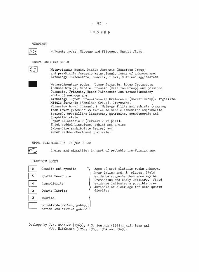
82
LEGEND
TERTIARY
Volcanic rocks. Miocene and Pliocene. Basalt flows.
CRE'l'ACEOUS ANTI OLDbR
III
Metavolcanic rocks. Middle Jurassic (Hazelton Group) and pre-Middle Jurassic metavolcanic rocks of unknown ace. Lithology: Greenstone, breccia, flows, tuff and agglomerate
Netasedimentary rocks. Upper Jurassic, LOIver Cretaceous (Bowser Group), Middle Jurassic (Hazelton Group) and possible Jurassic, 'rriassic, Upper Palaeozoic and metasedimentary rocks of unknolm age. Lithology: Upper Jurassic-Lower Cretaceous (Bowser Group). Argillite. Middle Jurassic (Hazelton Group). Gre~vacke. Triassic- LOHer Jurassic? Meta-areilli te and schists (varying from lower greenschist facies to middle almandine~9hibolite facies), crystalline limestone, quartzite, conglomerate and graphitic sla te. Upper Palaeozoic? (Permian? in pat). Thick bedded limestone, schist and gneiss (almandine-amphiboli te facies) and minor ribbon chert and quartzite.
UPPER f'ALA.c;OZOIC? ANTI/OR OLD,§{
Gneiss and migmatitej in part of probable pre-Permian age.
PLUTONIC hOCKS
Granite and syenite
Quartz Monzonite
Granodiorite
Quartz Diorite
Diorite
Hornblende gabbro, gabbro, norite and olivine gabbro
Ages of most plutonic rocks unknown. K-Ar dating and, in places, field evidence suggests that some may be Cretaceous and early 'Eertiary. Field evide~ce indicates a possible preJurassic or older ace for some quartz diorites.
Geology by J.A. Roddick (1965), J.G. Souther (1963), A.J. Baer and 'd.\". Hutchison (1962, 1963, 1964 and 1965).
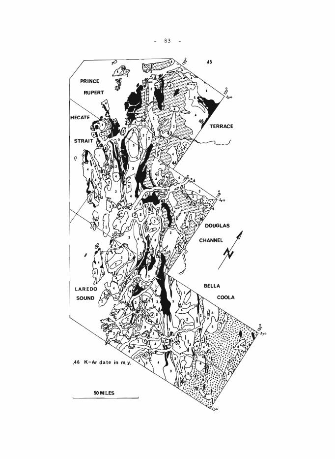
83
- 84 -
Except for a few very small bodies gabbro is restricted to the region southwest of the central metasedimentary band. Most of the gabbro is a coar se -grained, hornblende -plagioclase rock, which could be termed
a coarse amphibolite. In thin section some 01 the gabbro is seen to be noritic. The body that occurs on the east edge of Terrace W 1/2 map-area is an olivine -bearing gabbro. The largest body of gabbro unde rlies much of McCauley Island. The gabbro commonly grades into hornblende diorite. In most places the gabbro seems to be older than the more leucocratic rock around it, but locally (on Aristazabal and Rennison Islands) the gabbro intrudes the country rock. Some of the gabbro has apparently formed from lime stone be ds.
Diorite also is found mainly southwest of the central metasedimentary belt. The chief exception is the belt of diorite that extends from South Bentinck Arm northwest across Bella Coola map-area. Most of the diorite is uneven textured, heterogeneous, and commonly gneissic. In many places it contains thin bands of metavolcanic and metasedimentary rocks. A distinct, massive diorite pluton appears on Aristazabal Island, but in most places the diorite grades into or is cut by more acid plutonic rocks.
Quartz diorite is more common southwest of the central metasedimentary belt, but considerable amounts lie also to the east. The most continuous body is the hornblende/biotite quart z diorite that extends from Portland Inlet to Douglas Channel. It is a clean, even-te xtured, sphenebearing rock with foliated dioritic borders and a massive interior. The quartz diorite in northeast Douglas Channel and northern Bella Coola maparea is markedly chloritic, quartz-rich, and contains saussuritized plagioclase. It is distinctly different in appearance to the quartz diorite farther west. The quartz diorite adjacent to the east side of the metase dimentary band is intimately associated with the gneisses and appears to have been deformed with them.
Granodiorite is not concentrated in any particular part of the project area. Much of the granodiorite lying southwest of the gneisses is characteri z ed by sphene and epidote, whereas that to the east is free of the se minerals. In place s gr anodiorite forms part of compos ite plutons, such as that near Ecstall River.
The quartz monzonite may form distinct young plutons, or form the core of granodiorite bodies. Most of the quartz monzonite is massive, leucocratic, even textured, and coarse grained. The distribution of quartz monzonite in the project area forms no obvious pattern. The largest body lies along the northeast side of the central metasedimentary band in Bella Coola map-area.
Bodies very rich in potassium feldspar are represented mainly by the west-trending, granite -syenite pluton on King Island (Bella Coola map-area) and a body of fine -grained syenite near the east edge of Bella Coola map-area, which intrudes Hazelton Group rocks and is overlain by Tertiary basalt.
Northeast-trending dyke swarms were note d in Portland Inlet, Douglas Channel, and Dean Channel. In the vicinity of Bella Bella dyke swarms of two ages were observed, the older trending east and the younger (probably Recent) tr e nding north.
- 85 -
A quartz dior ite line such as Moore I has drawn in the we stern part of the United States cannot easily be drawn through the project area. The potassium feldspar content, however, of the combined gneiss and plutonic rock east of the central metasedimentary band is considerably greater than that in the combined plutonic rocks west of the band.
The structure of the project area is dominated by the northwe st regional trends, but an older northeast trend was observed in some places, especially along the east side of the gneisses. A regional flexure of the central metasedimentary band appears in the vicinity of Douglas Channel, but the cause is not known. Lineal features have a pronounced northerly plunge in Prince Rupert and Terrace W 1/2 map-areas. Major faults lie in many of the northwest-trending channels, and on the islands off the southwest side of Porcher Island (Hecate Strait map-area).
Potassium-argon age determinations on biotite have been made for nine points within the project area and for one point just north of the area. In the northern half of the project area, east of the central metasedimentary band, the dates range from 43 to 46 million years (Eocene). The date of 43 million years on schist in the eastern edge of the central metasedimentary belt (Hawkesbury Island) probably reflects the age of the plutonic rocks to the east rather than that of the main metamorphism of the metasediments. Other dates near the central metasedimentary band are 57, 64, and 67 million years (Upper Cretaceous to Palaeocene). The oldest date (mid-Cretaceous), 107 million years, was yielded by quartz diorite on Anger Island. The 70 million year date obtained from a granodiorite body in southeastern Bella Coola map-area appears to be anomalous.
No mineral deposits of economic interest were observed during the field season.
1Moore, J.G.: The quartz diorite boundary line in the western United States; J. Geol., vol. 67, pp. 198-210 (1959).
50. STRUCTURAL STUDIES, MT. REVELSTOKE AREA
J.V. Ross
The map-area covers the easternmost part of the Shuswap metamorphic complex where it is in contact with less metamorphosed rocks to the east. Field work has established that, within the map-area, gneisses presently referred to the Shuswap complex are more highly metamorphosed equivalents of rocks belonging to the Milford and Lardeau Groups to the east.
Structures within these different groups of rocks indicate a common origin and history. Recumbent folds, now plunging northerly and southwesterly, appear to be first structures that originally had axial-planes and limbs inclined at shallow angles to the east. These isoclinal folds were developed during an episode of dynamothermal metamorphism wherein the Shuswap gneisses were formed, metamorphic grade decreasing to the east. Sometime later than the development of the recumbent folds, a wedge of gneissic material, whose development of gneissossity predated the formation

- 86 -
of the Shuswap gneisses, was upthrust from the west at a high angle. This upthrust wedge of gneiss caused antiformal refolding of the early recumbent folds along a southeasterly trend. The latter stages of this movement were accompanied by a waning of the metamorphic grade resulting in mylonitization along narrow zones parallel to the inclination of the upthrust wedge of gneiss, both in the metamorphosed sediments and in the wedge itself.
A further event was the emplacement of a small quartz-monzonite stock that caused local thermal metamorphism resulting in the healing of some of the previously formed dislocations.
- 87 -
51. CORDILLERA VOLCANIC STUDY
J. G. Souther
An investigation of the Tertiary and Recent volcanic centres and related plutons in the Canadian Cordillera was begun in 1965. The writer spent ten days examining a group of post-Glacial volcanoes on the coastal islands of British Columbia, and the remainder of the field season on detailed mapping of the Mt. Edziza volcanic complex in northwestern British Columbia.
Coastal Volcanoes
Four volcanic centres were visited on the British Columbia Coast: Lake Island, Kitasu Hill, Price Island, and a group of volcanic islets on the northwestern coast of Aristazabal Island. Lake Island is a partly eroded cone of coarse tuff breccia. It contains an abundance of large granodiorite blocks, some up to 10 feet in diameter, that were thrown out of the vent during the eruption. Kitasu Hill and a smaller hill on the northeast corner of Price Island are undissected pyroclastic cones associated with small blocky lava flows. Sea stacks and small off-shore islands of columnar lava flows and pyroclastic beds on Aristazabal Island are the remnants of a large strato-volcano that formerly stood west of the present coast line. The rock at each of these centres is fine-grained basalt with little or no olivine, but commonly with large phenocrysts of plagioclase and augite.
The four centres visited lie along a linear belt of small volcanoes that runs in a northwesterly direction for nearly 200 miles and also includes the volcanic centres of Bonilla Island and Tow Hill. The belt is paralleled at many places by physiographic lineaments, ancient dyke swarms , and shear zones. It is believed to be a deep crustal structure with a long history of activity in which the eruption of basaltic lavas was the most recent event.
Mount Edziza
Mount Edziza (Fig. 1) is a composite volcano with a history of periodic activity extending from late Tertiary to Recent time. The 9, 143-foot peak is deeply dissected on the east side, exposing the complex interior of the volcano through a vertical distance of more than 5,000 feet. The oldest flows (map-unit 1) were erupted onto a late T e rtiary surface of low relief, and spread in thin flows over an area some 25 miles in diameter. The rocks are fine -grained, dark, olivine -deficient basalt containing a high proportion of iron oxides as amygdule fillings, veinlets, and fracture coatings. Flows in the lower part of the unit are non-porphyritic, whereas those in the upper part commonly contain large phenocrysts of both plagioclase and pyroxene.
The lower basalt unit is overlain by till and glacial-fluvial deposits, and locally by intra-glacial volcanic rocks (map-units 2 and 3). During Pleistocene time, sub-glacial eruption of basalt produced thick local piles of highly v esicular pillow lava and palagonite tuff breccia (map-unit 2). A unique feature of these rocks is their high content of fused and partly fused granitic inclusions. Extrusion of the pillow basalt succession was followed in late Glacial time by the eruption of rhyolite (map-unit 3) from
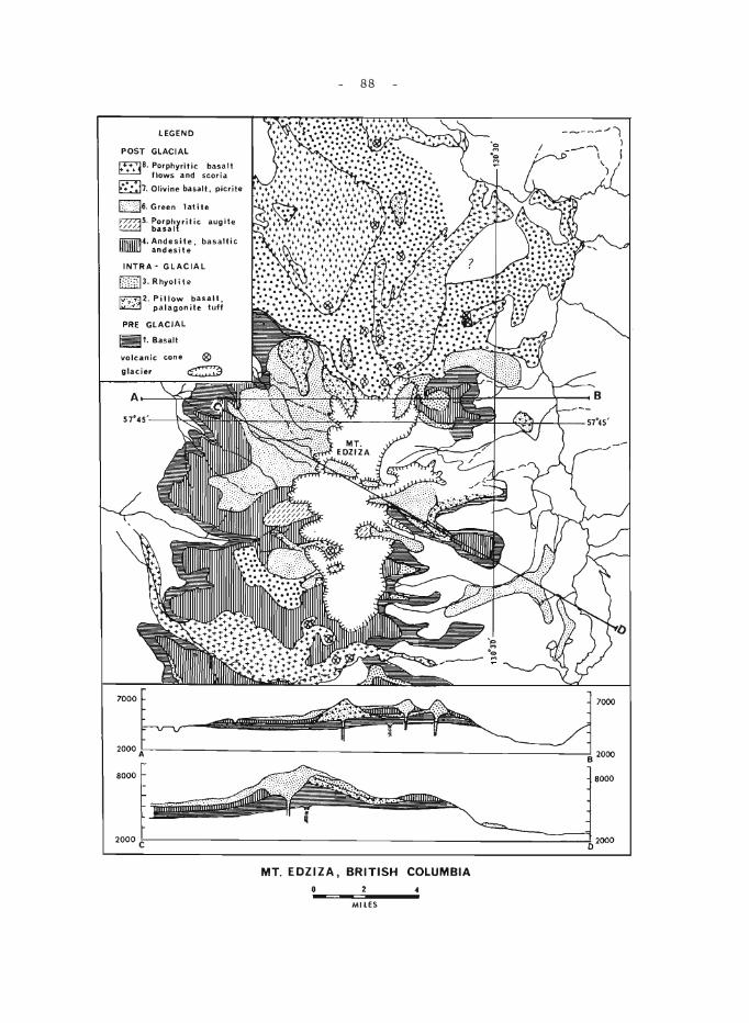
LEGEND
POST GLACIAL
~B. rl:,!~Y~i~~C S~::i:1t 07. Olivine basalt, picrite
[2]6. Green latite
~5. :~~~~rritic augite
1TiTIii'ij4. Andes.ite. basaltic llllllllJ and eSI t e
INTRA- GLACIAL
[J]]3, Rhyolite
fY7'B2. Pillow basalt, ~ palagonite tuff
PRE GLACIAL
~1. Basalt
volcanic cone
glacier
A------"n
::b 8000
88
8000
2000l---------------------------------------------------------------------~2oo0
MT_ EDZIZA, BRITISH COLUMBIA
MILES
- 89 -
several vents on the' eastern flank of Mount Edziza. The early products of this volcanism are fine -grained commonly orbicular flows and welded pyroclastic rocks. Many of the flows contain layers of obsidian, in some places as much as 30 fe e t thick . At a later stage v is cous, coar sely porphyritic lava piled up over one of the vents on the northeast side of the volcano to form a symmetrical rhyolite dome more than a mile in diameter.
The rhyolite is overlain by till, above which is a thick succession of andesitic and basaltic lava flows and pyroclastic deposits (map-unit 4). Many of the thick flows and associated sills and laccoliths of this unit show evidence of in situ differentiation and crystal settling. During the final stage of this episode of activity a viscous magma was erupted from the central vent, forming short, thick flows of porphyr itic augite basalt (map -unit 5).
A period of erosion, during which thick fluvial deposits accumulated on the flanks of the mountain, intervened between the period of andesitebasalt extrusion and a period dominated by the eruption of light green, sparsely porphyritic latite. Only a small part of the latite lava spread as thick flows on to the flanks of the mountain, while most of it piled up over the vents to form a group of lava domes on the central part of the volcano.
The central eruption of latite was followed by extrusion of fluid basaltic lava (map-units 7 and 8) from a large number of vents around the periphery of the main cone. The earliest group of lateral eruptions yielded olivine -basalt (map-unit 7) wher e as later eruptions produced olivinedeficient basalt with abundant phenocrysts of clear, glas sy feldspar. More than thirty cinder cones related to this episode of activity are still preserved. The oldest are deeply eroded and partly covered by younger flows, but many of the most recent cones are undissected and have sharp crater rims still covered with cinders and ash.
Unconsolidated ash and scoria beds up to 20 feet thick cover a large area on the northeastern side of the mountain. They rest on an old tundra surface, above which the charred but still flexible sterns of moss and willows are preserved. Thick beds of white, very pure pumice from an unknown source cover an area of several square miles on the southwestern slope of the mountain.
- 90 -
52. STRATIGRAPHY OF CRETACEOUS ROCKS, NORTHEASTERN BRITISH COLUMBIA
D. F. Stott
In conjunction with Operation Liard (see report by G.C. Taylor elsewhere in this publication), stratigraphic studies of Cretaceous rocks were made in the Foothills and Plains between the Alaska Highwa'y at latitude 58°40' and the northern boundary of British Columbia at latitude 60° and eastward to longitude 122°. This project completes a long-term regional study of Lower Cretaceous rocks in outcrop between Smoky River at latitude 54° and Redstone River at latitude 64°. It also completes mapping of Cretaceous rocks in the map-areas of Trutch (94G), Fort Nelson (94J), Tuchodi Lakes (94K), Toad River (94N), and Maxhamish Lake (940).
The unconformity at the base of the Cretaceous succession bevels successively older rocks from south to north. In the Foothills at the Alaska Highway, the underlying rock is Middle Triassic Liard Formation. Successively farther north, the beds immediately below the unconformity are older Triassic Toad and Grayling Formations. North of La Biche River in Yukon, Cretaceous rocks lie on Permian beds.
The Lower Cretaceous Fort St. John Group contains a thick succession of intertonguing marine sandstones and shales, presently included in the Garbutt, Scatter, Lepine, and/or Buckinghorse, Sikanni, and Sully Formations. Modifications in the definitions of existing type formations in the vicinity of Liard River are required to accommodate the rapid and moderately complex facies changes, which previously were not recognized or were inadequately described. Approximate thicknesses, general lithologies, and known relationships are shown schematically in Figure 1 1,2.
A prominent Upper Cretaceous succession, commonly termed the Fort Nelson Formation and approximately equivalent to the Dunvegan Formation, comprises four persistent massive members, a basal sandstone and three conglomerates, separated by recessive shaly beds. A plantbearing member above the conglomerates is well exposed on Dunedin River. The conglomeratic succession is overlain dis conformably by marine shales of the Kotaneelee Formation. The latter, exposed in only a few localities, grades upward into the dominantly continental Wapiti Formation.
I Kindle, E. D.: Geological reconnaissance along Fort Nelson, Liard, and Beaver Rivers, northeastern British Columbia and southeastern Yukon; Geo!. Surv. Can., Paper 44-16 (1944).
2McLearn, F.H., and Kindle, E.D.: Geology of northeastern British Columbia; Geo!. Surv. Can., Mem. 259 (1950).
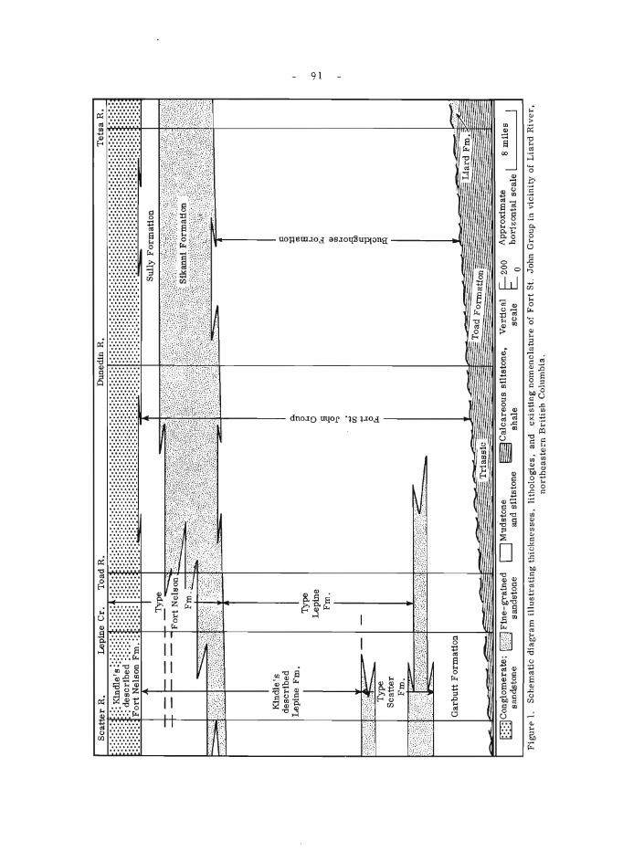
Sca
tter
R,
Lep
ine
Cr,
T
oad
R,
Du
ne
din
R
f.::: K
ind
le's
::::
::::
: :
,des
Cri
bed
':::
:::
... ..
....
Fo
rt N
elso
n F
m.
Kin
dle
's
des
crib
ed
Lep
ine
Fm
.
Gar
bu
tt F
orm
atio
n
......
~~~~~,
.
Typ
e
Lep
ine
Fm
.
0C
on
glo
mera
te;
EillJ F
ine-
gra
ined
sa
nd
sto
ne
" sa
nd
sto
ne
(l. '" 0 '"' 0 ~ ..., Cil .. '"' 0 f«
DM
ud
'sto
ne
~Calcareous s
ilts
ton
e,
and
silt
sto
ne
shal
e
Tet
sa R
11
; ~ '.
Sul
ly F
orm
atio
n
Toa
d F
orm
atio
n
Ver
tic
al
r=-20
0 sc
ale
t::=...-
0
" 0 :t:l as 8 '"' 0 f«
Q)
CD '"' 0 § a J;! " ~ App
roxi
mat
e I
8 m
iles
h
ori
zon
tal
scal
e
Fig
urE
'1.
Sch
emat
ic d
iag
ram
ill
ust
rati
ng
th
ick
nes
ses,
li
tho
log
ies,
an
d ex
isti
ng
no
men
clat
ure
of
Fo
rt S
t,
John
Gro
up i
n vi
cini
ty o
f L
iard
Riv
er,
no
rth
east
ern
Bri
tish
Col
umbi
a.
'"
- 92 -
53. OPERA nON LIARD
G. C. Taylor
G.C. Taylor, E.W. Bamber, R.T. Bell, W.S. MacKenzie, B.S. Norford, D.F. Stott, andE.T. Tozer completed the study of the surface rocks within the project area of Operation Liard, an air-supported reconnaissance geological survey in northeastern British Columbia.
Strata from all systems except the Tertiary are exposed within the area. For details of the Cretaceous strata see Stott, for Triassic strata see Tozer, for Permo-Carboniferous strata see Bamber, for Devonian strata see MacKenzie, and Silurian strata, see Norford, all elsewhere in this publication. The studies of Bell on the Proterozoic strata are included in this report.
The olde st rocks exposed in the area are considered to be of Proterozoic age. Approximately 20,000 feet of predominantly clastic rocks, including however, significant carbonate units, have been subdivided into eight formations on the basis of characteristic lithology. The earlier four formations indicate a shelf-type environment of deposition, whereas the later units indicate a change to a miogeosynclinal environment. In the westernmost exposures rocks of this age have been weakly metamorphosed to a low greenschist facies.
Lower Cambrian and lower and middle Ordovician strata are characterized by rapid facies changes. Both successions are bounded by major unconformities which limit their eastern preservation. Facies boundaries and past erosional limits, follow more westerly trends than the present structural grain of the mountains. This combination of effects results in the present complex and erratic distribution of these strata.
Blanketing the older rocks is a thick carbonate succession ranging in age from late Early Silurian to Middle Devonian. Five formations and two disconformities are recognized. All five formations thin eastwards as a result of both convergence and erosion. A hiatus between Silurian and Early Devonian time, and another between Early and Middle Devonian time are indicated from sparse faunal control. A shale-carbonate facies front progressively over -steps all five formations from the northwest.
The project area includes parts of four structural provinces, the Plains, the Foothills belt, the Rocky Mountains, and the Liard Plateau. Both Foothills and Rocky Mountains exhibit a strong northwest trend with an easterly directed asymmetry. The dominant structural habit of both provinces is the fold. Within the mountains where folding has been more constricted,westward-dipping high-angle reverse faults have developed. Faults in the Foothills belt are rare. The structural habit of the Liard Plateau is in marked contrast. Structural trends have swung to the north and northeast, and the asymmetry reversed. Individual folds have much larger amplitude and wavelength. Faults are uncommon and are westward directed.

- 93 -
Natural gas is currently being produced from plains and foothill wells in the south and eastern parts of the area. The petroleum potential of the area has yet to be fully exploited. Copper showings associated with the Proterozoic dykes are currently being prospected. Large deposits of barite and associated fluorite have been noted in the Devonian rocks. The largest such deposit lies in the Sentinal Range 4 miles east of the north end of Muncho Lake.
- 94 -
54. BONAPARTE RIVER (WEST HALF)
H. W. Tipper
About two weeks were spent in the southwest quarter of the area where, for the most part, the Cache Creek and Pavilion Groups were studied. This part has been studied by H.P. Trettin l and the present study was a review of this earlier work and additional investigation.
The Pavilion Group is a tightly folded succession of chert, argillite, tuff, breccia, volcanic flows, and limestone lenses exposed along the Fraser River. No fossils have been obtained from the group and it is in fault contact with othe r groups. It is lithological! y similar to Middle ( ?) Permian strata in North Thompson valley.
The Cache Creek Group lies east of the Pavilion Group and the massive limestone unit has been called the Marble Canyon Formation. This unit is well exposed in the Marble Range west of Clinton. It is a complexly deformed unit that has an apparent thickness much greater than the true thickne s s. The lime stone unit in place s is only a little more than lOO fee t thick and through folding and repeated faulting appears to be several thousand feet thick. Fossils are sufficiently abundant to indicate a Late Permian age for most, if not all, the Marble Canyon Formation.
East and south of Clinton, the Cache Creek Group is represented by a unit that is essentially volcanic with interbedded chert and argillite. Underlying this is a unit of sedimentary rocks, chert, argillite, minor limestone, with minor tuffs and breccias. The limestone yielded fusilinids and the unit is believed to be older than the Marble Canyon Formation and possibly in part correlative with the Pavilion Group.
1 Trettin, H.P.: Geology of the Fraser River Valley between Lillooet and Big Bar Creek; B.C. Dept. Mines and Petroleum Resources, Bull. 44 (1961).
55. QUESNEL (93 B) AND PRINCE GEORGE (93 G)
H.W. Tipper
A few days were devoted to the study of particular problems in mapping, collecting fossils, and material for palynology studies, and checking on specific details. Most time was devoted to a study of the Mesozoic depositional sequence in the Quesnel Trough.
Triassic and Jurassic sedimentary and volcanic rocks occur in a northwest-trending belt along Quesnel River valley and northwestward to Isle Pierre west of Prince George. These rocks have been traced many miles farther northwest and southeast by other workers, but lack of palaeontologie control or lithologic markers has prevented a clear understanding of the depositional sequence and palaeogeography.
- 95 -
The lowe st unit of the sequence is black shale s with minor sandstone, pebble-conglomerate, and black limestone that rests at different places on Cambrian rocks, Mississippian (?) rocks, and Permian rocks. This unit has yielded fossils of Karnian (?) age. Green andesite, breccias, and tuff overlie the Karnian shales and these are succeeded in places by a thin grey Norian limestone.
Following Norian time the Triassic rocks were intruded, deformed, and eroded and the Triassic rocks are overlain unconformably by coarse Lower Jurassic boulder conglomerate, greywacke, shale, and massive augite andesite porphyritic volcanic rocks.
The Lower Jurassic conglomerates contain boulders of granite obtained from the intrusive bodies southeast of Prince George and from Granite Mountain. These granitic bodies are therefore believed to be very late Triassic or early Jurassic in age.
- 96 -
56. TRIASSIC BIOSTRATIGRAPHIC STUDIES IN NORTHEASTERN BRITISH COLUMBIA
E.T. Tozer
These studies are directed towards elucidating the sequence of Triassic faunas in order to establish a time-stratigraphic classification for Triassic rocks that may be used throughout Canada. The writer was accompanied in the field by Dr. N.J. Silberling of the U.S. Geological Survey. Silber ling and the writer are engaged in coordinating the timestratigraphic classification of Triassic rocks in Canada and the United States. Dr. Silberling gave invaluable as sistance, both in collecting and in the interpretation of the faunas. Most of the new discoveries concern the sequence of faWlas in the Middle Triassic (Anisian and Ladinian Stages) and the Upper Triassic (Karnian and Norian Stages). Sections were examined in Toad River (94N), Tuchodi Lakes (94K), Halfway River (94B). and Pine Pass (940) areas. Full assessment of this work must await detailed examination of the collections, but the fOllowing notes, arranged under the heading of the successive Middle and Upper Triassic stages, will indicate the scope of the inve s tigations.
Anisian Stage
Detailed study of the Parapopanoceras beds of the Toad Formation, exposed on the Alaska Highway (94K) shows that at least three faunal assemblages are present. The lower fauna includes numerous longobartinids with simple suture lines, such as "Hungarites" caurus McLearn. The middle assemblage is marked by the appearance of beyrichitids (e. g. "Gymnotoceras" varium McLearn) and "Ceratites" hayesi McLearn. The upper fauna is characterized by the association of Da:oneITa and Gymnotoceras deleeni (McLearn). West of mile-post 375 these faunas range through 185 feet of beds. The three assemblages probably represent only the early part of Anisian time. Younger Anisian faunas, as yet impe rfectly known, have been obtained from other localities in British Columbia and Alberta by B.R. Pelletier, D.W. Gibson, and others.
Ladinian Stage
At least 4 ammonoid faunas are present in the Ladinian of northeastern British Columbia. The earliest fauna includes Protrachyceras and other ammonoids associated with Daonella d. taramellli Mojsisovics. The latter three Ladinian faunas are in the Nathorstites beds. The lower fauna is characterized by Meginoceras meginae (McLearn)j the middle fauna by MacLearnoceras maclearni Tozer j and the upper fauna by Paratrachyceras sutherlandi McLearn. All three zones are exposed in sequence on Liard River, where the total thickness of the Nathorstites beds is about 1, 100 feet. These Nathorstites beds occur in a rock sequence that appears to represent a transition betwe en the Toad and Liard Formations.
Karnian Stage
Karnian ammonoids are now known from several localities in the Toad River area. There are apparently 5 faunas represented, but all are not known in one section. In ascending order these faunas are characterized by
- 97 -
(1) Trachyceras; (2) Sirenites d. senticosus Dittmar; (3) Spirogmoceras and Tropites; (4) Homerites, Hoplotropites, Jovites etc.; (5) Anatropites. Of these faunas, the first two are Lower Karnian; the reInaining three are Upper Karnian. The lower three occur in beds siInilar to the "Grey Beds" of Peace River; the upper two are in the Pardonet ForInation.
Norian Stage
The Norian amInonoid faunas of northeastern British ColuInbia have been reviewed recentlyl. Most of the zones established on Peace River are now also known in the Pardonet ForInation of Toad River area. In 1965 well-preserved aInmonoids, including Rhabdoceras sue ssi Hauer, were obtained froIn the basal part of the Monotis subcircularis zone in Halfway River area.
1 Tozer, E. T.: Upper Triassic aInInonoid zones of the Peace River Foothills, British ColuInbia, and their bearing on the classification of the Norian Stage; Can. Journ. Earth Sciences, vol. 2, p. 216 (1965).
- 98 -
57. STRATIGRAPHY, CARBONATE PETROGRAPHY, AND STRUCTURE OF THE MARBLE CANYON FORMATION (PERMIAN)
IN THE MARBLE RANGE, CARlBOO DISTRICT
H. P. Trettin
The Marble Canyon ForITlation, an Upper PerITlian liITle stone unit that forITls the upp~r part of the Cache Creek Groupl extends as a narrow, elongate belt froITl Spences Bridge, B.C., to the northwestern end of the Marble Range (see inset on Fig.), and probably continues interITlittently for 50 ITliles or ITlore to the northwest2 • A type section has never been established, and the Marble Canyon near Pavilion Lake, for which the forITlation was naITled, appears to be unsuited for that purpose. An atteITlpt to establish the stratigraphy and structure of the forITlation in the Marble Range was ITlade by Trettin in 19583 . This study has been revised on the basis of five days of field work in 19644 , eight days of field work in SepteITlber 1965, and present petrographic inve stigations.
On Mount Soues (see cross-section) the forITlation is underlain by ITletaITlorphosed basic volcanic flows (530 ft ), liITlestone (15 ft.), and phyllitic chert and shale. Three ITleITlbers are presently recognized in the forITlation. MeITlber A (forITlerly 13 ), a liITlestone, is characterized by relatively low thickness, a high proportion of thinly interbedded chert, and locally associated tuffaceous ITlatter. MeITlber B (forITlerly II) consists of poorly exposed phylEtic chert and dark shale. MeITlber C (forITlerly III plus liITlestone assigned to IV) is a relatively thick, Inassive, slightly doloITlitic liITlestone. Fusulinids of the Yabeina zone, echinoderITl coluITlnals, cup corals, gastropods, algallaITlinations, oolites, calcarenites, and breccias are locally represented. Only on Mount Kerr and north of it, does the ITleITlber contain a considerable proportion of regularly interbedded chert. West of Mount Soues, it is overlain by calcareous, tuffaceous phyllite.
The thinning of both liITlestone ITleITlbers on the flanks of the range (see figure) indicates that the outcrop belt represents a narrow, elongate zone of carbonate deposition. In the Marble Range, the depositional zone ITlay have been originally perhaps 15 ITliles wide. This estiITlate is based on the present width of the outcrop belt, and a ratio of crustal shortening of 1: 1. 75 inferred froITl the cross -section shown. On the southwestern flank of the range, the liITlestones grade into shale and chert. Conditions on the poorly exposed northeastern flank are uncertain.
Texturally, the EITlestones fall in the transition field between norITlal ITlicrites and regionally ITletaITlorphosed ITlarbles. Most are pseudobr e ccias of the replace ITlent type, with reITlnants of ITlicrocrys talline liITlestone surrounded by coarser grained crystal aggregates, part of which show elongation and preferred orientation.
The overall structure of the range is a northwesterly plunging anticlinoriuITl en echelon with a synclinoriuITl. In the southern part of the range, the plunge of ITleITlber A is about 6 to 7 degrees. The structure of the synclinoriuITl is cOITlplicated, and has not been studied in detail. In the central parts of the anticlinoriuITl, folds forITled in ITleITlber A are relatively siITlple and shallow. On the flanks of the anticlinoriuITl, they show cOITlplex drag-folding. In the western parts of the range, folds forITled in ITleITlber C
- 99 -
change in a southwestward direction from open and upright to isoclinal and overturned. These changes in structural style can partly be attributed to changes in the thickness of the limestone, and partly to structural disturbances on the southwest (Fraser River fault zone). The contact with Division A of the Pavilion Group, which is composed mainly of phylEtic chert and shale with less greenschist, is completely covered. Unless this contact represents a major fault, these strata are probably in part equivalent to the Marble Canyon Fonnation, and in part younger.
1 Duffell, S., and McT aggar t, K. C.: Ashcr oft map -area, British Columbia; Geol. Surv. Can., Mem. 262(1952).
2Tipper, H. W.: Taseko Lakes, British Columbia; Geol. Sarv. Can., Map 29-1963 (1963).
3 Trettin, H. P.: Geology of the Fraser River valley between Lillooet and Big Bar Creek; Brit. Col. Dept. Mines, Petrol. Res., Bull. 44.
4 Trettin, H.P.: Stratigraphic and palaeontological studies in the Marble Range (92P/4); in Jenness, S.E. (comp.): Report of Activities: Field, 1964; Geol. Surv. Can., Paper 65-1, p. 76 (1965).
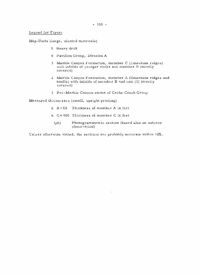
- 100 -
Legend for Figure
Map-Units (large, slanted numerals)
5 Heavy drift
4 Pavilion Group, Division A
3 Marble Canyon Formation, member C (limestone ridges) with infolds of younger rocks and member B (mostly covered)
2 Marble Canyon Formation, member A (limestone ridges and knolls) with infolds of member B and unit (1) (mostly covered)
Pre -Marble Canyon strata of Cache Creek Group
Measured thicknesses (small, upright printing)
x A = 60 Thickness of member A in feet
x C = 900 Thickness of member C in feet
(ph) Photogrammetric section (based also on outcrop observation)
Unless otherwise stated, the sections are probably accurate within 100/0.
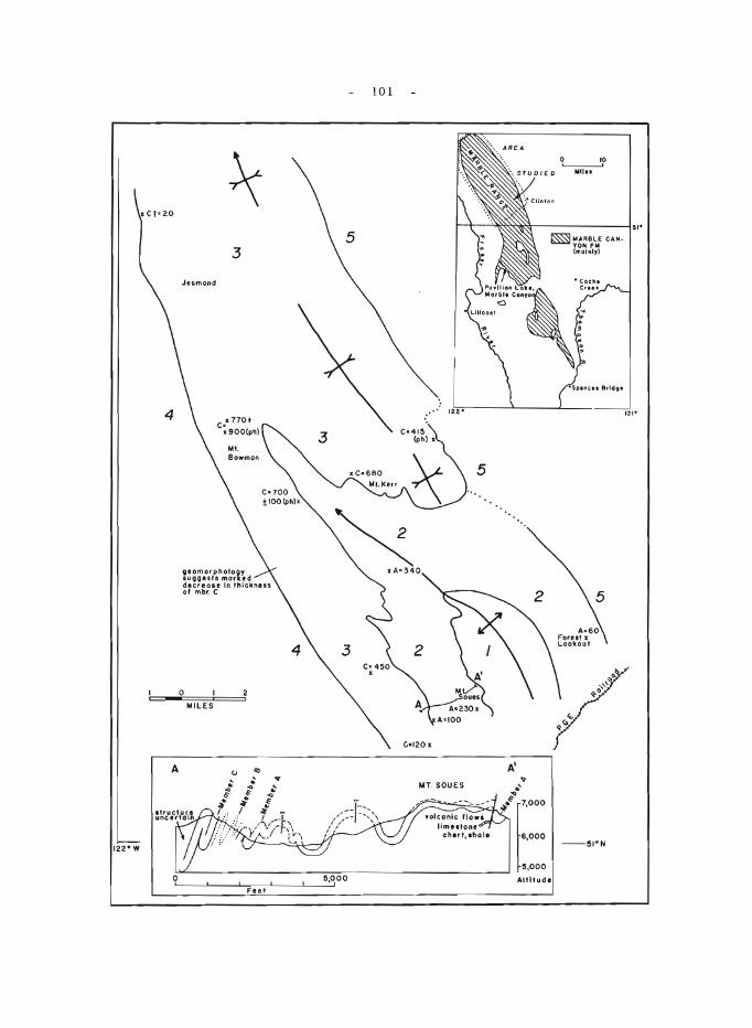
4
A
Jesmond
3
.. 770+ C; 900(ph)
eomorphO~~t~d lut;lQUIt ~n thickness deere ole of mbr. C
o MILES
101
5
C·415 (ph) x
5
10 0,-----------,
Mil ..
5
A-60 [~~ekIJux,
- 102 -
58. LARDEAU (WEST HALF) MAP-AREA (82 K W 1/2)
J.O. Whe.eler
Field work was begun for publication at 1 inch to 4 miles. This involved work in unmapped regions, revision of mapping done nearly 40 years ago 1,2, and incorporation of several smaller areas mapped recently at scales of 2 inche s to 1 mile and larger 3,4,5,6.7,8.
The map-units in the northeastern part of the map-area, other than the Battle Range granitic pluton. comprise the following succession: Proterozoic sedimentary rocks of the Horsethief Creek Group; quartzites and phyllites of the Hamill Group. Mohican phyllites and limestone. and Badshot limestone, all of Early Cambrian age; and the Lower Cambrian and later Lardeau Group composed of the following formations in ascending order: phyllites. quartzites, and limestones of the Index Formation, Triune black phyllite, Ajax quartzite, Sharon Creek black phyllite, green volcanic rocks of the Jowett Formation. and phyllitic grits, phyllites, and volcanic rocks of the Broadview Formation. These formations were linked between Ferguson and Duncan Lake areas and were extended beyond the former area.
A narrow, northwesterly trending central belt consists of complexly folded Broadview Formation and MisSissippian and (?) later Milford Group. The latter comprises limestones, phyllites, quartzites, and conglomerates. Locally the conglomerate is coars e and includes numerous, variously oriented foliated boulders of phyllitic grit from the Broadview Formation. Hence the Broadview and older rocks were evidently deformed and eroded prior to the deposition of the Milford Group.
The southwestern part of the map-area is underlain mainly by the Kuskanax batholith and satellitic plutons. but also contains a granitic complex, Shuswap gneisses, and stratified rocks of the Milford Group, Kaslo greenstone, and Slocan Group.
Fossils were obtained from the Badshot Formation in the northwestern corner of the map-area, from various localities in the Milford Group, and from two localities in the Slocan Group. The ages of these are not yet determined.
The Silver Cup anticline and Finkle Creek syncline, regarded by Fyles as Phase I folds in Ferguson area9, were traced into the Lake Creek antiform and Glacier Creek synform respectively in Duncan Lake area where Fyles considers them Phase II fOlds 6 . Local, small refolded isoclines within the Finkle Creek syncline indicate, however, an earlier phase of folding, but as yet no large structure of this generation has been recognized.
Folds southeast of Incomappleux River and Northeast Arm of Upper Arrow Lake plunge gently and moderately to the northwest, whereas those northwest of this zone plunge moderately southeast.
The Kuskanax batholith is traversed by several arcuate shatter zones, which are convex eastward and up to 10 miles in length.
- 103 -
lWalker, J.F., Bancroft, M.F., and Gunning, H.C.: Lardeaumap-area, British Columbia; Geol. Surv. Can., Mem. 161 (1929).
2Cairnes, C.E.: Slocan mining camp, British Columbia; Geol. Surv. Can., Mem. 173 (1934).
3Hedley, M.S.: Geology of the Whitewater and Lucky Jim mine areas, Slocan District, British Columbia; B. C. Dept. Mines, Bull. 22 (1947) .
4Hedley, M. S.: Geology and ore deposits of the Sandon area, Slocan mining camp, British Columbia; B.C. Dept. Mines, Bull. 29 (1952).
5Fyles, J.T., and Eastwood, G.E.P.: Geology of the Ferguson area, Lardeau District, British Columbia; B.C. Dept. Mines, Bull. 45 (1962).
6 Fy1e s, J. T.: Geology of Duncan Lake area, Lardeau District, British Columbia; B. C. Dept. Mine s and Petrol. Re s., Bull. 49 (1964).
7 Hyndman, D. W.: Petrology and structure of the Nakusp map-area, British Columbia; Ph.D. thesis, Univ. Cali£. (1964).
8 Read, P. B.: A study of the environs of the east contact of the Kuskanax Batholith; Geo!. Surv. Can., Paper 65-1, p. 63 (1965).
9 Fyle s, J. T .: Two phase s of deformation in the Kootenay Arc; We stern Miner and Oil Review, vol. 35, pp. 20-27 (1962).
- 104 -
ALBERTA
59. PROGRESS IN PRE -DEVONIAN STRATIGRAPHY, SOUTHERN ROCKY MOUNTAINS
J.D. Aitken
Lower Cambrian and Precambrian
Lower Cambrian and Precambrian studies in 1965 were subordinated to studies of the younger rocks, but four Lower Cambrian and three Precambrian sections were measured.
Middle Cambrian
Middle Cambrian studie s now completed permit the commencement of work on a final publication, with minor "filling-in" de sirable in 1966. Further information was gained about the regional facies change between the "middle carbonate" and "outer detrital" facies belts, this change being abrupt in some places (Mt. Stephen, Mt. Assiniboine) and very gradual in other (Fortress Lake).
Upper Cambrian
Field studies of the Upper Cambrian are largely complete, with minor work still required in 1966 to complete the regional coverage required for a final report.
Lower Ordovician
The main effort of 1965 with regard to the Lower Ordovician was the establishment, in cooperation with B.S. Norford, of a standard-reference section for the Lower Ordovician, at Mt. Wilson.
- 105 -
60. LOWER MIDDLE CAMBRIAN CORRELATIONS IN THE EAST -CENTRAL CORDILLERA
W.H. Fritz and D.K. Norris
Four stratigraphic sections were examined in the eastern Cordillera between Elko, British Columbia and Dearborn River, Montana (see Fig. 1) in an attempt to improve existing correlations of early Middle Cambrian strata. A fifth section (Mt. Whyte) is discussed in order to extend correlations northward into the classical Cambrian sequence of the Bow Valley area. The writers were accompanied and assisted in the field by J. D. Aitken, Geological Survey of Canada, Moshe Braun, Geological Survey of Israel, and A.R. Palmer, United States Geological Survey. Fossils collected, together with those found by preceding field parties in the area visited, were identified by W.H. Fritz. New lithostratigraphic data were reviewed by D.K. Norris in the light of his previous work at Elko, Flathead Range, and Windsor Mountain during the summers of 1951 and 1952.
All of the Cambrian sections shown (see Fig. 2) are overlain unconformably by Devonian and are underlain unCODformably by Late Precambrian strata. The earliest Cambrian deposits are Lower Cambrian at Mt. Whyte and are Middle Cambrian at the remaining sections. The contact between the very early Middle Cambrian and Lower Cambrian strata in the Mt. Whyte section may also be an unconformity. In so far as this contact predates the Middle Cambrian deposition at the remaining sections, it will not be discussed.
In the four sections visited the basal Cambrian sandstone, the Flathead Formation, consists of yellowish orange, medium- to coarsegrained sandstone. It is somewhat conglomeratic near the base, limonitic, and contains interbeds of siltstone. No fossils were found in the Flathead, and its Middle Cambrian age is inferred from fossils collected above the gradational contact that separates it from the overlying Gordon Shale.
At each of the sections visited the Gordon consists of micaceous, predominantly greenish grey shale. In Canada the Gordon contains sparse oolitic, silty limestone interbeds with glauconite pellets. At Elko the interbedded limestone is well developed near the base. There the lower interbeds (locality 4) contain a Plagiura-Poliella faunule that is closely related to a faunule of the same age 100 feet below the top of the Mt. Whyte Formation at Mt. Whyte (locality 3, Fig. 2). Only 20 feet above the Plagiura-Poliella faunule at Elko is an Albertella faunule containing two species having affinities to Albertella levis Walcott. A third species having affinities to A. levis was found near the base of the Gordon at Windsor Mountai,n (locality 6). Thus the boundary between the Plagiura-Poliella and Albertella Faunizones lies within the lower part of the Gordon at Elko and probably close to the Flathead-Gordon contact in the Windsor Mountain section.
At the Dearborn River section no interbedded limestone was observed near the base of the Gordon. As no faunules older than the Albertella Faunizone have been reported from the Gordon of Montana, it seems probable that the basal Gordon there is slightly younger than in the sections to the north.
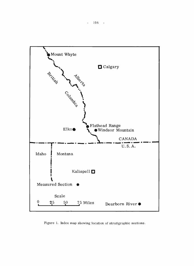
106 -
D Calgary
. . \ .
•
~ . . } ~ Flathead Range
Elko. \. Windsor Mountain
." ~ CANADA
.-.,.-.-.-.-.~.-.-.-.-.-. • U.S.A. ·
Idaho I Montana •
i · • I Kalispell D I
\ Measured Section •
Scale
o 25 50 75 Miles ~'----~'----~'----~' Dearborn River.
Figure 1. Index map showing location of stratigraphie sections.
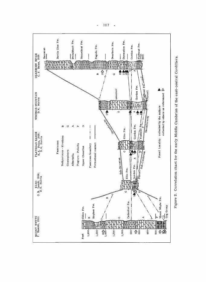
MO
UN
T
WH
YT
E
F.
Ras
elti
. 19
51
Eld
on F
m.
B
Ste
phen
Fm
.
'" .....
.
G
'"
Cat
hed
ral
Fm
.
Gog
Gro
up
EL
KO
G
. B.
Lee
ch.
1958
; D
. K
. N
orr
is
FL
AT
HE
AD
RA
NG
E
R.
A.
Pri
ce.
1958
; D
. K
. N
orr
is
Fau
niz
ones
Bat
hy
uri
scu
s -
Elr
ath
ina
B
Glo
sso
ple
ura
G
Alb
erte
lla
Pla
giu
ra -
Po
liel
la
Upp
er O
len
ellu
s
A
P o
Fau
nizo
ne b
ou
nd
ary
-"-"-
For
mat
ion
al c
onta
ct
WIN
DSO
R M
OU
NT
AIN
D
. K
. N
orr
is
-S
ub
-Dev
onia
n Fo
ssi I
Lo
cali
ty:
coll
ecte
d b
y th
e au
tho
rs
•
coll
ecte
d b
y o
ther
s as
ref
eren
ced
[>
--DE
AR
BO
RN
R
IVE
R
C.
F.
Dei
ss.
1939
Dev
onia
n
Dev
ils
Gle
n F
m.
Sw
itch
bac
k F
rn.
Ste
amb
oat
Fm
.
u P
ago
da
Fm
.
_19[
>~
G ~ D
earb
orn
Fm
.
11,.-
--D
amna
tion
Fm
.
Gor
don
Fm
.
~ead
Frn
.
Bel
t
Fig
ure
2.
Co
rrel
atio
n c
hart
fo
r th
e earl
y M
iddl
e C
amb
rian
of
the
east
-cen
tral
Co
rdil
lera
.
0 -J
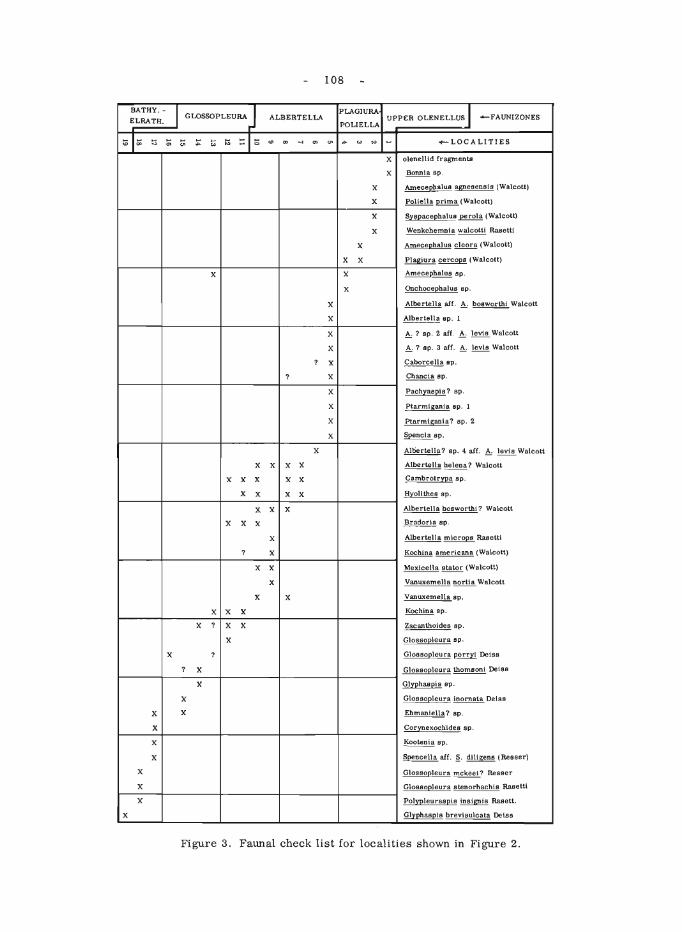
108
BATHY. - I GLOSSOPLEURA J PLAGIURA UPPER OLENELLUS J ELRATH. ALBERTELLA -FAUNIZONES
POLIELLA
:0 IS; :; ~ t;: :;: ~ I:; ~I~ <0 0> ~ 0> on ... ~ '" ~ +-LOCALITIES '" ~ 0
X olenellid fragments
X Bennis sp.
X AmecepbaluB agnesensis (Walcott)
X Pollella prima (Walcott)
X Sy8pacephalu8~ (Walcott)
X Wenkchemnia walcott! Rasett!
X AmecephaluB clears (Walcott)
X X Plagiur8 cereops (Walcott)
X X AmecephaluB Bp.
X OnchocephaluB Bp.
X Albert.ella aiL ~ bosworth! Walcott
X Albertella 8p. 1
X ~? Bp. 2 afl. ~ levis Walcott
X ~? sp. 3 afr. ~ levis Walcott
? X Caborcella Bp.
? X Cbancia Bp.
X Pachyaspis? Bp.
X Ptarmigania Bp. 1
X Ptarmlgania? sp. 2
X Spencia sp.
X Alber-lelia? Bp. 4 aIf. A: ~ Walcott
X X X X Alber-tella helena? Walcott
X X X X X Cambrotr~a Bp.
X X X X Hyolithes Bp.
X X X Albertella bosworth!? Walcott
X X X Bradoria Bp.
X Albertella mler-oPB Rasetti
? X Kochina americana (Walcott)
X X Mexicells stator (Walcott)
X Vanuxemella norUs Walcott
X X Vanuxemella Bp.
X X X Kochina Bp.
X ? X X Zacanthoides Bp.
X Glos6o~leura sp.
X ? Glo88opleura ~ Deiss
? X G1oBBo~leura thomsoni Deiss
X Glyphaspis Bp.
X GloBsopleura ioornata Deiss
X X Ehmaniella? Bp.
X Cor~exochideB sp.
X Kootenia Bp.
X Spencella afl. §. dill gens (ReBser)
X GlosBopleura mckee!? Reeser
X GloBsopleura slenorhachis RaBetU
X PolypleurasplB insignia Raaetl.
X Glyphaspis brevisulcata Deiss
Figure 3. Faunal check list for localities shown in Figure 2.
- 109 -
In the upper part of the Gordon at Flathead Range and Windsor Mountain, limestone in thin, nodular beds with clay parting is interbedded with the shale. An Albe rtella faunule collecte d 60 feet from the top of the Gordon in the Flathead Range (locality 10) is the same as that reported from the Ross Lake Shale in the Cathedral Formation at Mt. Whyte (locality 9). Only 40 feet higher in the Flathead Range section is a locality (11) tentatively assigned to the Glossopleura Faunizone, and in the nearby Windsor Mountain section a locality ( 12) 13 feet below the top can be definitely assigned to the G10ssopleura Faunizone. At the Dearborn River section, a Glossopleura faunule is reported (Deiss, 1939, p. 33) 5 to 10 feet below the top of the Gordon and one was found by the writers at the base of the overlying Damnation Formation. Neither time nor lithologic correlation can be ITlade to the upper Burton (Gordon) Formation at Elko as the upper 55 feet of this formation is covered. The topography, however, suggests that this interval is underlain by shale.
The carbonate sequence overlying the Gordon in the four sections visited is difficult to correlate. Only ZOO feet of barren, brownish grey weathering dolomite, the type Elko, overlies the shale at Elko. Above the Gordon in the Flathead Range and Windsor Mountain is a sequence of dolomite, limestone, and siltstone that attains a thickness of 735 feet at Windsor Mountain before it is truncated by the sub-Devonian unconformity. The latter sections are sparsely fossiliferous and one collection from Windsor Mountain was made 560 feet above the carbonate -Gordon contact. This locality (17) contains a faunule belonging either to the Glossopleura or Bathyuriscus -Elrathina Faunizone. The pre sence of Corynexochide s sp. suggests the older, Glossopleura Faunizone, but the range of this genus is still not adequately known.
Overlying the Gordon in the Dearborn River section is the Damnation Formation, which consists mostly of limestone and argillaceous limestone. Glossopleura ranges throughout this l70-foot formation. The lack of diagnostic faunas in the overlying Dearborn ForITlation precludes an accurate location of the upper boundary of the Glossopleura Faunizone in this section.
Conclusions
1. Two formations, the Flathead Sandstone and Gordon Shale, could be recognized with assurance at each of the localities visited.
Z. The basal sandstone and overlying shale that constitute the type Burton Formation (Schofield, 1914, p. 82) at Elko are equivalent to the Flathead Sandstone and Gordon Shale respectively. The usage of Burton should be suppressed in favour of the latter forITlations, which are better known and are widely distributed.
3. The Middle CaITlbrian carbonate succession between the Gordon Shale and sub-Devonian unconformity in southernmost Canada should be referred to a type section that is thick, lithologically diagnostic, and fossiliferous. The Elko ForITlation, the only name in Canada available for this sequence, does not meet these qualifications. Correlation with the classic sections in Montana is presently unfeasible and may prove difficult for some
- 110 -
time. The unnamed carbonate succession at Windsor Mountain best meets the above qualifications, and should prove to be a valuable reference section upon which future work can be base d.
Deiss, C. 1939:
REFERENCES CITED
Cambrian stratigraphy and trilobites of northwestern Montana; Geol. Soc. Am., Special Paper 18.
Leech, G.B. 1958: Fernie map-area (West Half), British Columbia; Geol. Surv.
Can., Rept. and Map 20-1958.
Price, R.A. 1958: Structure and stratigraphy of the Flathead North map-area (East
Half), British Colwnbia and Alberta; Princeton University, unpub. Ph. D. the sis.
Rasetti, F. 1951: Middle Cambrian stratigraphy and faunas of the Canadian Rocky
Mountains; Smithsonian Misc. ColI., vol. 116, No.5.
Schofield, S. J. 1914: The Precambrian (Beltian) rocks of southeastern British
Columbia and the ir correlations; Can. Dept. Mine s, Mus. Bull. No.2, Ser. 16, pp. 79-91.
- III -
61. HAMMER SEISMIC REFRACTION SURVEYS, SUFFIELD
G.D. Hobson and J.A.M. Hunter
Seismic refraction surveys were conducted over three areas of the Defence Re search Board Suffield Experimental Range. These surveys were conducted using the FS-2 and the new FS-3 model of the Huntec portable hammer seismograph to obtain information about subsurface strata over two areas for proposed blast sites and over one area to aid in the selection of a location for a permanent seismic vault. Experiments were also conducted to determine the feasibility of measuring the elastic constants of soils using the hammer seismic instruments.
Data from the first two areas indicate several layers of unconsolidated sediments in the overburden. Subsurface contouring of key horizons indicates the presence of a complex series of lakes and rivers in Pleistocene time with three distinct river channels outlined. Two possible locations for the permanent vault were outlined by the definition of a competent, highvelocity formation in the third area.
In the re search exper iments pertaining to elastic cons tants, thre e different approaches were attempted to determine the velocity of the S-wave of the surface layer. The first method involved the plotting of later arrivals of energy in the surface layer while the second method involved utilization of a three -component geophone to isolate the S-wave. The third method involved positioning of geophones combined with cross-correlation to develop a "filter" technique for measuring S-wave velocity.
Considerable success was achieved in this reasearch project on the measurement of elastic constants in soils using the hammer refraction seismographs. Future experiments are warranted in this program.
62. STRATIGRAPHIC AND STRUCTURAL STUDIES, CYPRESS HILLS REGION
E. J. W. Irish
A preliminary study of the stratigraphy and structure of the Cypre ss Hills region was made during the field season of 1965. Field work was confined to a study of surface outcrops, mainly in Alberta, but also in the vicinity of Ravenscrag and Eastend in Saskatchewan.
The exposed strata belong to the Oldman, Bearpaw, Eastend, Whitemud, Battle, Frenchman, Ravenscrag, and Cypress Hills Formations. Sections were measured and samples collected for laboratory study.
Results to date indicate that the Frenchman Formation of Saskatchewan extends to the western limit of the Cypress Hills in Alberta. This sandstone is exposed on both sides of Battle Creek Valley, at several places on the north flank of the main ridge, along the east side of Medicine Lodge Coulee, and on Eagle Butte.
- 112 -
It was also established that the distribution of the underlying Battle and Whitemud Formations is somewhat more extensive than is shown on existing maps.
A structurally deformeq. triangular-shaped area occurs just northwest of the western end of the Cypress Hills. It includes Eagle Butte within the apex of the triangle and extends at least 18 miles to the northwest. Within this area several steep thrust faults, dipping to the southeast, have been recognized. Considerable slumping of the bedrock formations has occurred around the flanks of the hills, and elsewhere the glacial cover effectively masks these faults so that their lateral extents have not yet been established.
A structural high occur s just north of Eagle Butte. The Oldman Formation outcrops in a small creek valley in sec. 20, tp. 8, rge. 4W4th. and occurs below the drift in sec. 32, tp. 8, rge. 4W4th. On the ridge occurring in the northeast part of sec. 32, tp. 8, rge. 4W4th., and in secs. 5 and 6, tp. 9, rge. 4W4th., shales are exposed that may be older than the Oldman Formation.
63. MISSISSIPPIAN STRATIGRAPHY AND SEDIMENTOLOGY, SOUTHERN ROCKY MOUNTAINS AND FOOTHILLS
R. W. Macqueen
Association for most of the field season with project BowAthabasca under the direction of R.A. Price (see report elsewhere, this publication) provided an opportunity to extend earlier field studies (1963, 1964) north to the North Saskatchewan River area. Several generalizations can now be made:
1. The Rundle Group Pekisko and Shunda Formations, which are clearly recognizable in the Front Ranges and Foothills north of the Red Deer River, are not the precise lithologic or palaeontologic correlatives of the middle and upper members respectively of the Banff Formation at Banff. Support for this statement is obtained particularly through careful examination of stratigraphic sections in the critical area from Lake Minnewanka north to the Clearwater River. A paper discussing these relationships at length is in preparation.
2. The three -fold subdivision of the Banff Formation characteristic of the Bow River Valley is recognizable over part of the area north to the North Saskatchewan River. The middle Banff limestone unit ("Clark Member" of the Bow Valley) varies in thickness and in stratigraphic position within the Banff Formation throughout the area of study.
3. The lower part of the Mount Head Formation appears inseparable from the underlying Livingstone Formation in the Bourgeau Range west of Banff. There the upper Mount Head contains light grey weathering bioclastic limestones unlike the dark grey, shalyand kerogen-rich limestones of the upper Mount Head in the general Banff-Storm Creek area farther east.
- 113 -
64. STRATIGRAPHIC AND STRUCTURAL STUDIES IN THE SOUTHEASTERN CANADIAN CORDILLERA
D.K. Norris
Investigations included the correlation of the Middle Cambrian shale and carbonate succession south of the Moyie -Dibble Creek fault with that in northwestern Montana, the continuation of lithostratigraphic studies of the non-marine, Lower Cretaceous Blairmore Group, and measurements of tectonic flow in the layered sedimentary veneer of the eastern Cordillera. Reports on the Cambrian and tectonic investigations are included elsewhere in this publication.
In conjunction with W.H. Fritz of the Geological Survey of Canada, the writer examined the Cambrian carbonate and shale succession on Windsor Mountain, Alberta and near Elko, British Columbia. Faunas collected on Windsor Mountain established a Middle Cambrian age for beds within 175 feet stratigraphically below the sub -Devonian unconformity and 560 feet above the base of the continuous dolomite and limestone succession. By correlation the Elko Formation of the type locality near Elko, British Columbia would appe ar to be repre sented by the 225 -foot Cambrian carbonate succession in Flathead Range and in whole or in part by the lower 512 feet of Middle Cambrian carbonates on Windsor Mountain. It may therefore not be younger than Middle Cambrian.
The Windsor Mountain succession is the most complete known in the southeastern Cordillera south of the Moyie -Dibble Creek fault and is correlated with Middle Cambrian beds as young as the Dearborn Formation of northwestern Montana and the Cathedral Formation in Bow Valley.
The non-marine Lower Cretaceous Blairmore Group at the headwaters of Nez-Perc~ Creek, 6 miles north of Coleman, Alberta, was restudied in part. A bulldozer was successfully and economically used to expose the covered intervals of units 4, 7, and 9 1 at a total cost of 17 cents per line foot. There the Cadomin Formation is 18 feet thick, the lower Blairmore 394 feet, the "Calcareous Member" 26 feet, the middle Blairmore 1,279 feet and the Upper Blairmore 450 feet. The additional exposure has permitted a more accurate overall thickness of the group to be obtained. Under favourable conditons one can drive to within 1,000 feet of the base of the section by means of a private road that follows Nez-Perc~ Creek.
Measurements of trend and pitch oi slickenside striae on bedding surfaces in 6 coal mines in the southeastern Canadian Cordillera south of Bow Valley established that the orientation of the (ac) deformation plane in the layered Jurassic and (?) Lower Cretaceous Kootenay Formation is variable in space and time and rests with a preferred orientation commonly at angles of 10 to 15 degrees to the mean dip direction.
1 Norris, D. K.: The Lower Cretaceous of the Southeastern Canadian Cordillera; Bull. Can. Petrol. Geo!., Special Field Conference Guide Book Issue, pp. 512-535 (1964).
- 114 -
65. INTERBED SLIP IN SOME CORDILLERAN COAL MINES
D.K. Norris
Slickep.side striae at the coal-rock interfaces were investigated in six Alberta mines in the southeastern Canadian Cordillera from Beaver Mines in the south to Canmore in the north. The mines ranged over a tectonic strike distance of 125 miles and a pre-Laramide distance across the strike of approximately 30 miles. One mine was in the Livingstone thrust sheet, one in the Turtle Mountain fault plate, two were in the Coleman fault plate, and two were in the Lac des Arcs thrust sheet.
The bedding surface s on which the trend and pitch of slickenside striae were measured occur in the layered, non-marine, Jurassic and (?) Lower Cretaceous Kootenay Formation. Within the accessible areas of the mines exposure is virtually continuous. Because of the wealth of structural data available, observations of slickenside striae on surface elements of the roof and floor were arbitrarily limited to one every 100 feet of tunnel. The individual observations on roof or floor are, therefore, about 100 feet apart because the room and pillar method of development is commonly practised in the se mine s.
For many bedding-surface elements, only one set of slickenside striae are clearly evident, and in a few instances two sets, the one making angles as great as 40 degrees to the other. The pitch of slickenside striae was observed moreover to vary by as much as 45 degrees from point to point along the tunnels. In many places there appeared to be more than two sets of striae, but individual sets could not be measured accurately because of the overprinting with concomitant obliteration of striae.
The individual observations in a given mine were reduced to a common reference surface by rotating them into the horizontal about their local strike. Frequency polygons of the azimuth of slickenside striae for each mine examined revealed that 90 per cent of the striae range in azimuth through a minimum angle of 45 degrees in the "plane" of the layering and in some instance s through as much as 75 degrees. The frequency polygons indicated moreover that the distribution of azimuths was Gaussian to slightly asymmetrical in all mines, with the Interquartile range being proportionately narrower the larger the sample. The occurrence of more than one maximum for limited samples would appear to have no statistical significance.
The trend and pitch of slickenside striae were measured on roof and floor in the two mines at Canmore (Lac des Arcs thrust sheet). There the preferred azimuth of motion of roof rock over coal and of coal over floor was within five degrees of one another in each mine, i. e., the ac (deformation) plane for the bedding surfaces was in near coincidence for stratigraphic intervals ranging from 2 to 20 feet. The orientation of the deformation plane was, however, measurably different (20 degrees) in the two coal seams separated by an interval of approximately 1,400 feet.
For all mines, the preferred direction of slip (in the deformation plane) commonly lies at angles of 10 to 15 degrees to the ac fabric plane, where the a and b fabric axes are in the "plane" of the layering and b is defined parallel to the local strike. There has therefore been measurable
- 115 -
strike-slip on these deformation discontinuities, and in so far as these motions may be sympathetic to motion on the principal thrust surfaces, which underlie (and overlie) them, the tectonic implications are far-reaching.
Variations in pitch of tens of degrees within a few feet on structurally and stratigraphically continuous, planar bedding surfaces must indicate real and temporally distinct directions of relative transport. Slickenside striae can be and are preserved from more than one kinematic pattern. They indicate that the orientation of the ac (deformation) plane is variable in space as well as in time, but rests with a preferred orientation measurably divergent from the ac fabric plane.
The direction of motion at the coal-rock interfaces is variable in space and time as well. Matching of extension faults cutting the roofs of coal seams with their counterparts in the floor commonly indicate up-dip motion of the roof rock with respect to the floor since the faults were formed, occasionally indicate no interbed slip since faulting and occasionally indicate down-dip motion of the roof with re spe ct to the floor.
66. GEOLOGY OF THE MARBLE MOUNTAIN AND FALLENTIMBER WEST MAP-AREAS
N. C. Ollerenshaw
The geological field investigation of the Marble Mountain (820/14 East Half) and Fallentimber West (82 0/10 West Half) map-areas has been completed. This investigation complements the author's earlier investigations (1962-1964) of the structure and stratigraphy of the adjoining Burnt Timber and Lilnestone Mountain map-areas.
A geological map, on a scale of 1 inch to 1 mile, is in preparation for the combined Limestone Mountain and Marble Mountain map-areas.
Structurally, the Marble Mountain area consists of the Corkscrew-Marble Mountain anticline and the William's Creek syncline, with related west-dipping thrusts and subordinate folds. Fallentimber West area compr ise s a ser ie s of closely space d fault slice s with minor as sociate d folds.
In Marble Mountain area, the oldest and youngest exposed strata belong to the Banff and Brazeau Formations respectively, with some probable, drift-covered, Paskapoo Formation. The Wapiabi, Brazeau, and Paskapoo Formations outcrop in Fallentimber West area.
Preliminary evidence supports the subdivision of the Brazeau Formation into lower and upper units.
67.
- 116 -
OPERATION BOW -ATHABASCA, ALBERTA AND BRITISH COLUMBIA
R.A. Price and E. W. Mountjoy
The initial stage of a helicopter-supported reconnaissance study of the bedrock geology of about 12, 000 square miles of the Rocky Mountains south from Jasper, Alberta was completed during the 1965 field season. The regional geology and various aspects of the geologic structure were investigatedbyR.A. Price, E.W. Mountjoy, J.D. Aitken, D.G. Cook, andH.U. Bielenstein. These investigations were supplemented by the results of concurrent more detailed studies of the pre-Devonian strata by J.D. Aitken, the Ordovician and Silurian strata by B. S. Norford, the Permo-Carboniferous strata by R. W. Macqueen, and Cambrian biostratigraphy by W.H. Fritz.
Within the Front Ranges 1 a series of relatively steep southwesterly dipping, more or less homoclinal structural panels form an interlocking system of overlapping imbricate thrust plates. Locally these are cut by northeasterly trending transverse faults. The transverse faults occur in two main zones: one along and south of Bow River (see Fig. 1), and the other adjacent to Clearwater River (see Fig. 2). These faults abut thrust faults toward the northeast. Some are limited to an individual thrust plate. Others extend into overlying thrust plates, but characte ristically are marked by a pronounced and abrupt reduction in stratigraphic separation where they offset an overlying sole fault. Although the transverse faults superficially resemble simple tear faults, their origin appears to be more complex.
The easte rn se ctor of the Main Range s subprovince 1 is charac te rized by an increase in structural level and the development of broad open folds in a thick succession of Precambrian and Cambrian strata. South of Red Deer River the transition zone between the Front Ranges and Main Ranges embraces a structurally complex array of folded, bifu.rcating thrust plates that form a series of irregular salients and klippen south of Bow River (see Fig. 1). The Castle Mountain thrust l , one of the components of this array marks the base of the Precambrian-Cambrian succession of the Mount Eisenhower massif northwest of Banff. It is overlapped at the southwest end of the massif by a prominent southwesterly dipping thrust fault that follows the longitudinal valley occupied by the Bow, Mistaya, North Saskatchewan, and Sunwapta Rivers, and at the north end of the massif by another southwesterly dipping thrust that emerges from beneath this fault.
Northwe sterly trending gravity faults are common in the eastern sector of the Main Ranges. Most are marked by downthrow to the southwest. Many pass laterally into thrust faults; and their development appears to have been controlled, at least in part, by the location of pre-existing thrust faults.
The Chatter Creek fault 2 , a southwesterly dipping thrust fault, can be traced northwestward from 52° to the upper part of Fraser River (see Fig. 3). It separates the more complexly deformed Precambrian and Lower and Middle Cambrian strata of the western sector of the Main Ranges from the Lower Palaeozoic rocks of the eastern sector.
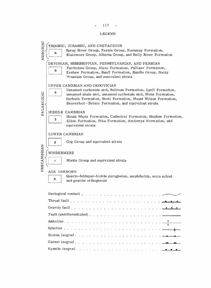
1 17
LEGEND
u ° {TRIASSIC, JURASSIC, AND CRETACEOUS ~ Spray River Group, Fernie Group, Kootenay Formation, ~ ~ Blairmore Group, Alberta Group, and Belly River Formation
DEVONIAN, MISSISSIPPIAN, PENNSYLVANIAN, AND PERMIAN
o Fairholme Group, Alexo Formation, Palliser Formation, Exshaw Formation, Banff Formation, Rtmdle Group, Rocky M otmtain Group, and equivalent strata
UPPER CAMBRIAN AND ORDOVICIAN
8 Unnamed carbonate tmit, Sullivan Formation, Lyell Formation, tmnamed shale tmit, unnamed carbonate tmit, Mons Formation, Sarbach Formation, Skoki Formation, Motmt Wilson Formation, Beaverfoot - Brisco Formation, and equivalent strata
MIDDLE CAMBRIAN Motmt Whyte Formation, Cathedral Formation, Stephen Formation, Eldon Formation, Pika Formation, Arctomys Formation, and equivalent strata
LOWER CAMBRIAN
Z Q Gog Group and equivalent strata
:s ~ fWINDERMERE
~ l Q Miette Group and equivalent strata
Il:: p.. AGE UNKNOWN
Quartz-feldspar-biotite paragneiss, amphibolite, mica schist and granite orthogneiss
Geological contact. ~
Thrust fault . 4 • • Gravity fault . ! ! !
Fault (tmdifferentiated) .
Anticline. t Syncline.
* Biotite isograd . • Garnet isograd . - -Kyani te isograd. y y y
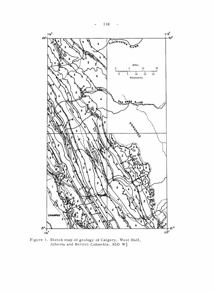
118
lis"
~~~~~~~--~~~-------r~~~~~----~r----------r5Z·
5 'I J ,i, ,'II o 5
Miles
I 10
10 I
I 15
Kilometres
\ , \
~5
I I 20
\
\ \ \ \
\ \ \ \
\
'\-- .. I I I I '\ ,
&�·+...lo.------1....llC~....lo....~ ....... ~.:s.>.:..._"_____'_=_=_..u... __ _"'_ ___ ....:::..J......>u..~~ ........ t_51·
11&· 1/5·
Figure 1. Sketch map of geology of Calgary, West Half, Albe rta and British Columbia, 820 wt
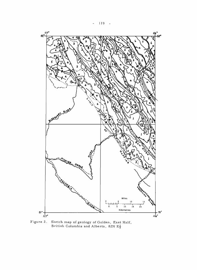
\ , I
119
5 11 ,',\ ,'I' o 5
Miles
I 10
10 I
I 15
I 20
15 I
If'·
Kilometres 5'1·-+--------------J....:'~------------__t_ 5/"
1/7" III.·
Figure 2. Sketch map of geology of Golden, East Half, British Columbia and Alberta, 82N Ei
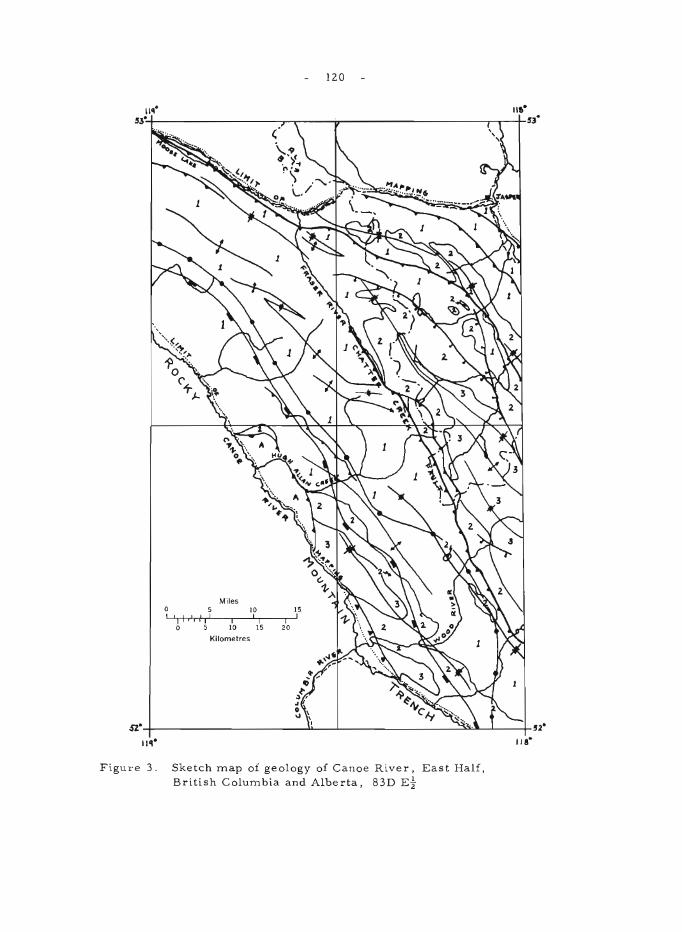
120
I~ II~ '~~---------------------'~r------V-------------------------'~--1r'l·
Miles 5 IO 15
LJ.' 'I +-1 ,J-, I oj .h' 1r'1-----.I----'-'1 ------,1,-' o 5 10 15 20
Kilometres
Figul'e 3 . Sketch map of geology of Canoe River, East Half, British Columbia and Alberta, 83D Et
- 121 -
In the western sector of the Main Ranges north of 520 there is a general southwesterly increase in structural complexity from the Chatter Creek fault to the Rocky Mountain trench (see Fig. 3). Minor westerly and southwesterly plunging folds occur near the trench and, in part, are associated with tight and isoclinal northwesterly trending folds that are overturned toward the northeast. Regional metamorphism also increase s toward the trench; and is most intense near the mouth of Wood River, in the centre of a salient outlined by the isograds in Figure 3. The distribution of the metamorphic rocks does not appear to be closely dependent on the structure, and the metamorphism may post-date much of the folding as well as the emplacement of the thrust plate s.
1 North, F .K., and Henderson, G.G.L.: Summary of the geology of the southern Rocky Mountains of Canada; Alta. Soc. Pe trol. Ge 01. , Guidebook, Fourth Ann. Field Coni., 1954, pp. 15-81 (1954).
2Wheeler, J.O.: Rogers Pass map-area, British Columbia and Alberta; Geo!. Surv. Can., Paper 62-32 (1963).
- 122 -
68. GEOMORPHOLOGY AND GLACIAL GEOLOGY STUDIES IN NORTH-CENTRAL ALBERTA
D.A. St. Onge
Field work involved the preliminary mapping at the scale of 1: 250,000 of the Iosegun east map-area (83K east 1/2). The geomorphology, surficial geology, and the logistic problems involved in mapping heavily forested areas were investigated. Several bogs were sampled to investigate climatic fluctuations based on pollen variations.
Below the 3,000' contour sand, silt, clay, and gravel form a continuous cover over the bedrock, locally tens of feet in thickness. At higher altitude the till is thin, other drift deposits are sparse and road cuts commonly expose bedrock (Cretaceous sands and clays) deformed by glacial ice. The high hills rising above 3,900 feet in the south and in the northeast of the map-area are covered by quartzite gravels lithologically similar to those of the Cypress Hills Formation. Their age is still conjectural. Granitic erratics are found on the top of the se hills.
The main rivers: the Athabasca, the Little Smoky, the Iosegun, and the Goose predate the last glaciation, as till is found in the bottom of the valleys. The narrow gorge-like valley of the Little Smoky in township 61 is an exception, that section of the valley is cut in sandstone bedrock. A large terrace in the Athabasca Valley is also pre -last glaciation as the very coarse quartzite gravels (up to 1 foot in diameter) are overlain by 20 feet of massive brown till (LSD 8, sec. 10, tp. 60, rge. 18W5).
During retreat of the Laurentide ice to the north and northwest , an arm of a large glacial lake occupied the valley of the Athabasca River (Taylor, 1958, Fig. 1). Within the map-area, sedimentation in this lake produced varved silts and clays dipped to 40' thick grading upward into deltaic sands. The latter have since been reworked into large parabolic dune s. During existence of this lake the Little Smoky River drained into the Athabasca through the valley now occupied by Marsh Head Creek. At a later stage, following further ice retreat a large ice -dammed lake was formed north of the divide separating the Athabasca from the Little Smoky (Lake Rycroft, Henderson, 1958, Fig. 7). This lake drained into the Athabasca through a large spillway carved into the divide to an altitude of about 2,700'. Beach sands and up to 10 feet of thick unctuous clays were deposited in the northwestern third of the map-area.
Henderson, E.P.: Surficial geology of Sturgeon Lake map-area, Alberta; Geol. Surv. Can., Mem. 303 (1958).
Taylor, R.S.: Some Pleistocene Lakes of northern Alberta and adjacent areas; Edmonton Geol. Soc., vol. 2, No.4, pp. 1-9 (1958).
69.
- 123 -
GLACIAL GEOLOGY STUDIES ~IN SOUTHERN AND CENTRAL ALBERTA
A.M,acS. Stalker
Mapping in the Kananaskis Lakes area (82J, east of Continental Divide) was chiefly confined to the northwestern part of this area. Within this region, the areas of the Kananaskis Forestry Experimental Station and the Marmot Creek drainage basin were mapped in detail. The latter area is of great interest in the Eastern Slopes (Alberta) Watershed Research Program. The insignificance of glacial sculpturing in the mountains bordering the lower part of the Kananaskis Valley was surprising. There was a general lack of cirques, truncated spurs, and hanging valleys in the tributary valleys, but farther south near the Kananaskis Lakes themselves such features are well developed. Recent fan deposits were the prominent surface feature in the region mapped.
Further progress was made in delineating the Foothills Erratic Train, which has now been traced northward to a point about 20 miles north of Calgary. The erratics appear to become smaller and rarer northward, and as forest cover also increases in this direction, they become correspondingly more difficult to trace. In recent years destruction of these blocks for fill, bridge abutments, and darns has increased greatly.
Dr. C.S. Churcher, of the University of Toronto, was attached to the party for three weeks as consultant to make a reconnaissance study of certain vertebrate fossil localities. Results of this study exceeded expectations, and fossils were recovered from apparent preglacial sands; and from interglacial, interstadial, and early and late post-glacial deposits. Some of the specimens are presently being studied by Dr. Churcher.
- 124 -
SASKATCHEWAN
70. INFLUENCE OF THE SOUTH SASKATCHEWAN RESERVOIR ON PIEZOMETRIC PRESSURES IN CONFINED BEDROCK AQUIFERS
R.O. van Everdingen
The South Saskatchewan Reservoir was extended beyond the Riverhurst piezometer cross-section (Fig. 1) in the spring of 1965, when the reservoir level was raised from elevation 1,690 to 1,724. Since then the reservoir level has fluctuated between elevations 1,720 and 1,731. The influence of the raised reservoir level was apparent in most of the piezometers in bedrock, e. g. 6.5 feet in Belly River sandstone in location #5, one mile from the edge of the reservoir. In all locations except #3, four piezometers were installed: in till or gravel; in the sandstones of the Ardkenneth and Beechy Members of the Bearpaw Formation; and in the upper sandstones of the Belly River Formation. In location #3 only two piezometers were installed, in the Ardkenneth and Belly River aquifers. The piezometers in bedrock in locations #6 and #7 were flowing. Measurements of piezo-me tr ic leve 1 s in the 21 non -flowing pie ~ome te r s we re take n monthly until April 15; every 6 to 8 days until May 13; and every 14 days until June 27, by the Test Installation Section, P.F.R.A. Headquarters, Cutbank, Sask. From June 28 till August 11 readings were taken every two days by the Geological Survey field party.
Locations #6 and #7 were submerged by the reservoir on April IS, 1965. In order to obtain information on the change of piezometric levels in the aquifers directly below the reservoir, pressure transducers (range 0-100 pounds per square inch absolute pressure) were installed by a skindiver on the piezometers of location #6, between June 22 and June 28. Plate I shows one of the transducers with attached cables, ready for installation. Pressure readings were taken with a battery-powered transducer -converter, carried in an II-foot inflatable rubber boat. Plate II shows location #6 on July 14, 1965, with three buoys marking, from left to right, piezometer #6C, piezometer #6B, and the suspended instrument-end of the string of four pairs of transducer cables.
Figure 2 illustrates the re sults obtained; owing to a faulty plug connection on the transducer housing, proper readings could not be obtained from piezometer #6B before the transducer was retrieved, repaired, and re-installed on July 19, 1965. Figure 4 indicates a very close relationship between fluctuations in reservoir level and fluctuations in piezometric levels in the bedrock aquifers, down to a depth of at least 500 feet.
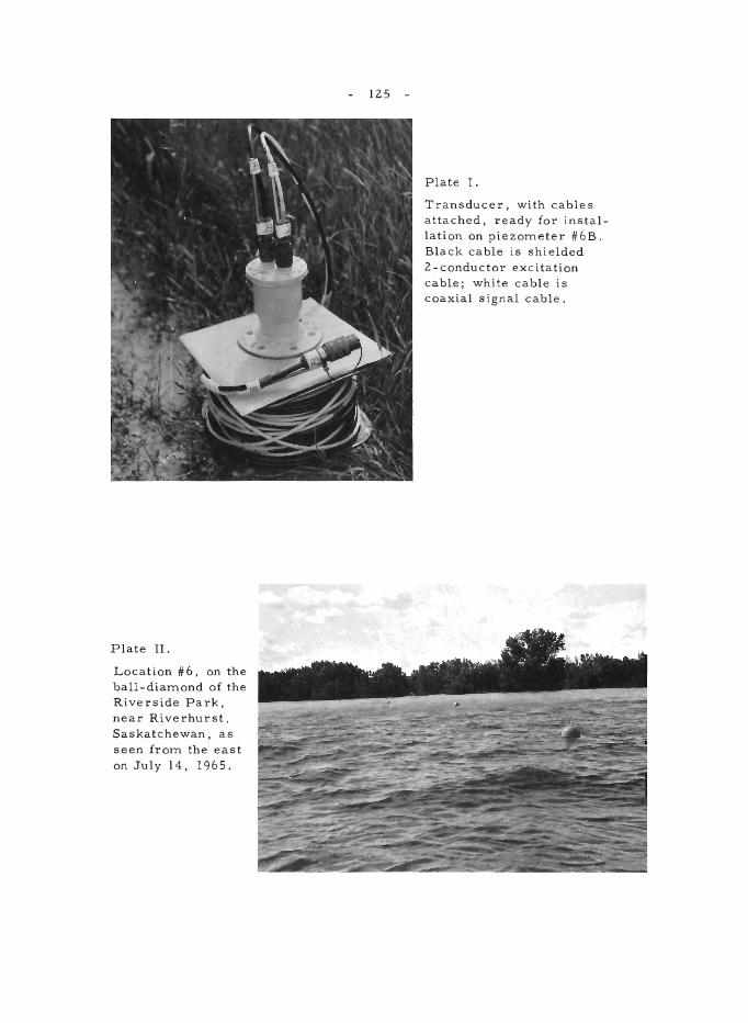
Plate II.
Location #6, on the ball-diamond of the Riverside Park, near Riverhurst. Saskatchewan, as seen from the east on July 14, 1965.
125
Plate I.
Transducer, with cables attached, ready for installation on piezometer #6B. Black cable is shielded 2-conductor excitation cable; white cable is coaxial signal cable.
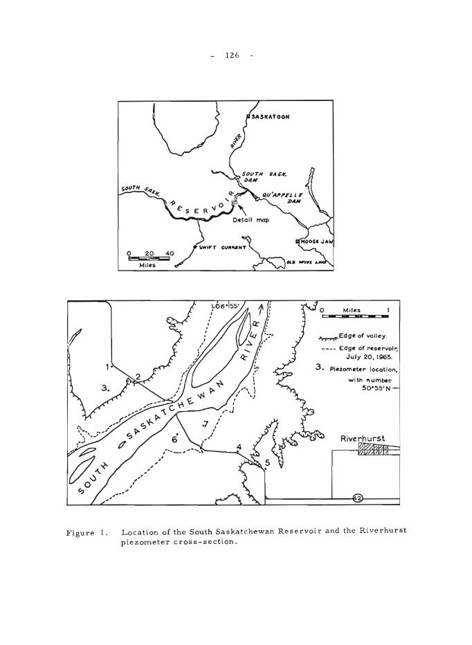
Figure I.
o 20 e-s;;x
Miles
126
Miles _ .. --~Edge of vOlley.
---- Edge of reservoir, July 20, tSl65.
3. Piezometer locotion,
with number. 50'55' N
Riverhurst
2
Location of the South Saskatchewan Reservoir and the Riverhurst
piezometer cross-section.
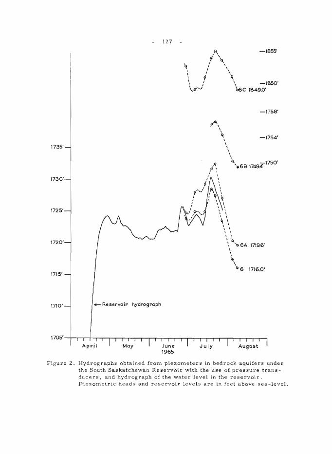
127
1735'
1730'
1725'
1720'
1715'
1710' +- Reservoir hydrograph
,94.. ~ \
I '" ~ I '. I I ,
I I 'h
-1855'
\ P "\ \,' '. -1850' ',V"'J '66c 1849.0'
pA, , \
\ \ \ \ \ \
-1758'
-1754'
~'"86B 1749.4' 1750'
\ \ , I , I
~ I , \ I \ \
, \ \ \ ~ .. ''()6A 1719.6' ,
\ , ~
\
'~ 6 1716.0'
Figure 2. Hydrographs obtained froITl piezoITleters in bedrock aquifers under the South Saskatchewan Reservoir with the use of pressure transducers. and hydrograph of the water level in the reservoir. P iezoITletric heads and reservoir levels are in feet above sea-level .
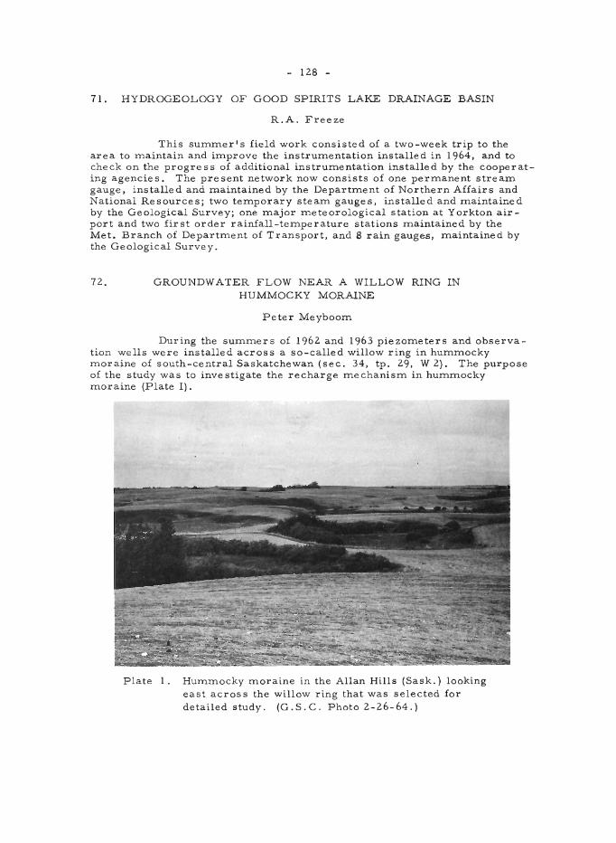
- 128 -
71. HYDROGEOLOGY OF GOOD SPIRITS LAKE DRAINAGE BASIN
R.A. Freeze
This summer's field work consisted of a two-week trip to the area to maintain and improve the instrumentation installed in 1964, and to check on the progress of additional instrumentation installed by the cooperating agencie s. The pre sent network now consists of one permanent stream gauge, installed and m.aintained by the Department of Northern Affairs and National Resources; two temporary stearn gauges, installed and maintained by the Geological Survey; one major meteorological station at Yorkton airport and two first order rainfall-temperature stations maintained by the Met. Branch of Department of Transport, and 8 rain gauges, maintained by the Geological Survey.
72. GROUNDWATER FLOW NEAR A WILLOW RING IN HUMMOCKY MORAINE
Peter Meyboom
During the summers of 1962 and 1963 piezometers and observation wells were installed across a so-called willow ring in hummocky moraine of south-central Saskatchewan (sec. 34, tp. 29, W 2). The purpose of the study was to investigate the recharge mechanism in hummocky moraine (Plate I).
Plate 1. Hummocky moraine in the Allan Hills (Sask.) looking east across the willow ring that was selected for detailed study. (G.S.C. Photo 2-26-64.)
- 129 -
Weekly observations during 1964 and 1965 revealed that in the cour se of one water year the following sequence of flow conditions can be recognized: (1) a winter condition of "norrnal" downward flow: (2) a spring condition characterized by a groundwater mound underneath the slough and an associated flow pattern of lateral and vertical dissipation; and finally, (3) a condition of inverted water -table relief owing to a cone of depression around the phreatophytic willows and the phreatophytes in the dry slough bed. The latter condition, which exists during summer and fall, is characterized by radial flow into the willow ring, brought about by reversed-shallow and diverted-deep groundwater flow.
A water balance of the willow ring from May 31, 1964 to June I, 1965, showed that the overall effect of conditions 1 and 2 was a net contribution to the regional groundwater re source s of 2, 914 cubic feet of water, which represents 0.42 inch on the 2-acre watershed around the slough.
73. PALYNOLOGICAL STUDIES IN CENTRAL SASKATCHEWAN
R.J. Mott
A reconnaissance survey of possible palynological sampling sites was made in central and northern Saskatchewan as a preliminary step in the study of late -glacial and post-glacial vegetational and climatic changes and geochr onology. Of spe cial intere st is the relationship of the bore al forest to the grassland and the migration of the boundary between the two in post-glacial time.
Organic deposits are rare in the grassland region and in the forest-grassland transition zone. Lakes are usually shallow and contain little accumulated organic sediment although some deeper lakes do exist and it is hoped that these will provide suitable materials for study in these areas. Within the boreal forest organic deposits and lakes are more abundant, but they are less accessible than in the inhabited areas to the south.
Samples were collected from the grassland, transition zone, and boreal forest to determine what sediments can be used for palynological purposes and the type of pollen record that can be expected. Radiocarbon dates on basal organic materials from selected sites in various areas will outline the range of minimum ages to be expected. They will also date the pollen assemblages occurring at these levels in the pollen record and will serve as guides for future sampling.
Surface samples collected along transects across the forestgrassland boundary will be used to compare the pollen and spore record with the pre sent day vegetation. The se compar isons will aid in the interpre tation of pollen diagrams from the study area.
- 130 -
74. LANDSLIDE INVESTIGATIONS. SOUTH SASKATCHEWAN RIVER RESERVOIR (72 J/ 15)
J.S. Scott
Throughout the winter of 1964-65 measurements were obtained from piezometers installed in shales of the Bearpaw Formation in an area of landslides adjacent to the South Saskatchewan River Reservoir 1. These measurements showed that many of the piezometers had not attained a condition of hydrostatic pressure equilization following their installation and development in July. 1964.
The lengthy time lag 2 in pressure equilization displayed by the piezometers indicated that the installations would not be sufficiently responsive to reflect either the magnitude of temporal aspects of reservoir level fluctuations that could contribute to reactivation of the landslide blocks.
In order to overcome the time lag in piezometer response occasioned by the low permeability of the shale an instrument, incorporating a pressure transducer sealed in the open standpipe with a pneumatic packer, was devised to measure changes in hydrostatic pressure. A Dynisco Model APT -25 pressure transducer with an operating range of 0 - 30 psia was used as the sensing unit. Pressure changes detected by the transducer were obtained by use of a Daytronic Model 300C/81 Transducer Amplifier Indicator equipped for 24v. D. C. operation. Amplification circuitry provide s for detection of pressure differences of .006 psi corresponding to water level changes of approximately 0.01 foot.
Sufficient time was not available to permit a complete field test of the transducer piezometer. However, an indication of the responsitivity of the sealed transducer compared with the response of a 1 1/2 inch 1. D. open standpipe piezometer installed in Bearpaw Shale is shown in Figure 1.
Curve A'B 'c' represents drawdown of water level in the open standpipe of 3.03 feet (A' -B') and subsequent recovery of 1.41 feet or approximately 47 per cent during a period of about 500 hours. In comparison curve ACF shows the greatly increased response of the sealed pressure transducer piezometer to hydrostatic pressure changes. As the transducer piezometer is installed in the standpipe, displacement of water occurs causing a change in water level (A -B). Inflation of the pneumatic packer (20 psig) then induces a hydrostatic pressure load on the column of water in the standpipe represented by the change in level B -C. Dissipation of the packer load, corresponding to approximately 7 feet of water, then occurred within 2 hours at which time the piezometer gave readings corresponding to that of the estimated static level.
Approximately 2 hours after installation of the transducer piezometer (Point D) a leak developed in the packer, which produced the apparent decrease in water levels shown by the segment of the curve D -E. The segment of the curve E - F represents deflation of the packer and the effect of the column of water above the submerged transducer.
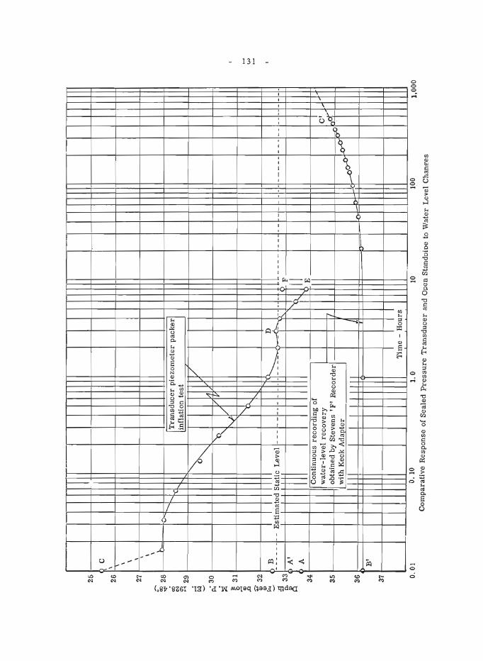
25
26
27
~ 28
<
1) "" ~29
~
~ 3
0
:i ~ 3
1
Q)
.0
~ 3
2 ~
r----~'
C
\ '; \ \ \ \ \
B
I
'-'
t-.. i'k
fT
ran
sdu
cer
pie
zom
eter
pac
ker
in
flat
ion
tes
t
~
V
11 ~
l/
I~
'V ~ ~:-.
...
~3
~
--
Est
imat
ed S
tati
c L
evel
---
--
"'--
_l
---
--
, --
-----
---
---
---------
---
r'-.
-F
A
'
II 11
(\ II
A
'" E
C
onti
nuou
s re
cord
ing
of
34
wat
er-l
evel
rec
ov
ery
o
bta
ined
by
Ste
ven
s I F
' R
eco
rder
w
ith
Kec
k A
dap
ter
,..-0
0-0 ~
b-
35
36
B'
3
Tim
e -
Ho
urs
0,0
1
D. 1
0 1
.0
10
100
Co
mp
arat
ive
Res
po
nse
of
Sea
led
Pre
ssu
re T
ran
sdu
cer
and
Ope
n S
tand
oio
e to
Wat
er
Lev
el C
hane
:es
'"
----
--
---
C'
hif
' I&
'"
1,00
0
- 132 -
1 Scott, J. S.: Landslide inve stigations, Saskatchewan and Albe rtaj in Jenness, S.E. (comp.), Geol. Surv. Can., Paper 65-1,pp. 85-87 (1965).
2Hvorslev, M. Juul: Time lag and soil permeability in groundwater observations; U.S. Corps Eng., Waterways Expt. Stn., Bull. No. 36 (1951).
75. PLEISTOCENE AND GROUNDWATER GEOPHYSICS
J.E. Wyder
Surface resistivity measurements using Schlumberger, Wenner and Three -Electrode configurations were completed in the survey area. On the basis of the results the gravel deposit discovered last yearl has been extended to a point 3 miles east of the discovery location (SWl-14-5-4W2). A prediction, based on the resistivity results, as to the location (NW 13-12-3-4W 2) of the buried pre -glacial Missouri channel has been made.
In cooperation with Professor K.B.S. Burke, University of Saskatchewan, a horizontal-gradient gravity survey was conducted over the above -mentioned gravel deposit. Initial interpretation of the results is inconclusive.
A flux-gate mag:letometer ground survey using a magnetometer borrowed from the Saskatchewan Department of Mineral Resources was also completed over the gravel deposit. Because of the amount of magnetic noise at the time of the survey the results of the magnetometer survey have proved inconclusive.
In an attempt to evaluate the surface resistivity and gravity results, drilling and detailed sampling programs will be completed in the autumn of 1965.
lWyder, J.E.: Groundwater geophysics surveys, Saskatchewan and Manitoba; ill. Jenness, S.E. (comp.), Report of activities: Field, 1964; Geol. Surv. Can., Paper 65-1, pp. 92-93 (1965).
76.
- 133 -
MANITOBA
CHURCHILL - SUPERIOR PROVINCE BOUNDARY IN NORTHEASTERN MANITOBA
C.K. Bell
During a three -week period in late summer, rotary and fixedwinged aircraft were utilized to examine outcrops west of the Palaeozoic boundary in the central Nelson River area. Recently published aeromagnetic maps used in conjunction with these ground observations help in the extrapolation of the Churchill - Superior boundary east from the Upper Nelson River (63 NE) areal.
Map-unit 1 (Fig. 1) represents old (age 2.5 m. y.) rocks that have remained relatively stable since the Kenoran orogeny. They are coincident with a wide belt of high magnetic intensity that extends in a broad sweep across the Nelson River area of Manitoba. East of 95 0 there is a change from granulite to amphibolite facies rocks within the anomaly boundary. It is proposed that rocks within Unit 1 be named the Pikwitonei Subprovince of the Superior structural Province for descriptive convenience as they differ in age and lithology from rocks to the north and south.
The Cross Lake Sub-province 2 contains what has been considered Keewatin-type (Hayes River Group) volcanic rocks and Archaean metasediments of the Oxford, Cross, and Island Lakes Groups, map-unit 2. They occur as easterly trending belts that (a) form part of the southern boundary of Unit 1, east of the Nelson River, and (b) probably overlie Unit 1 rocks west of the Nelson River. These rocks can be related to sinuous, high magnetic anomalie s that contrast with the vast 'lows' over the granodioritetonalite complex of Unit 3.
Unit 5 is tentatively correlated as one group. Included in it are (a) the Setting-Moak Lakes complex of metamorphosed clastic sediments, metavolcanic rocks and peridotites; (b) the stretched conglomerate, arkose, subgreywacke and quartzite suite and their metamorphosed equivalents that outcrop between Little Assean and Crying Lakes 3 and again at Gull Rapids on the Nelson River 4 ; and (c) the Fox River complex of basic volcanic rocks, ultrabasic sills, and arkose-quartzite facies sediments5, 6.
Where exposed, the rocks along the Fox River are much less deformed and metamorphosed than those in the Setting Lake area, and they appear to lie beyond the influence of maximum Hudsonian deformation. The eastern continuation of the Fox River complex is reflected in an unbroken magnetic high that stretches under the Palaeozoic cover for 150 miles. Westward, an irregular anomaly pattern that extends northwest from the junction of the Dafoe and Fox Rivers to Gull Rapids, suggests that Unit 5 is disrupted by an intricate fault system and by metamorphism. At Crying Lake the unit bends to the southwest and strikes toward Moak Lake. Complete granitization of parts of the unit may account for the discontinuities along the belt between Crying and Setting Lake s.
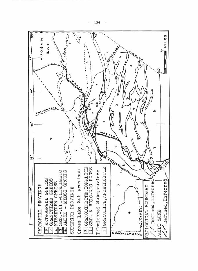
10
0
CH
DR
CH
ILl
PR
OV
INC
E
m lThT
RO
GR
AD
E G
NE
ISS
W
GR
AN
ITIZ
ED
G
NEI
SS
[]JK
ISSE
TIjE
W G
~~ISS
rn SE
D. -
VO
L •
.,.U
LT
Rd ..
BA
SIO
W
AM
ISK
-
liIS
SI
GR
OU
PS
SUPE
RIO
R PROV~CE
Cro
ss L
ake
Su
b-p
rov
ince
[[JG~ODIORITE,TONhllTE
m SE
D.
&
VO
LO.>
.N 1
0
RO
CK
S
Pik
wlt
on
ei
Su
b-p
rov
ince
tI
JG~~
ULIT
E,AN
ORTd
OSlT
E
If;
<i
}I
~
7 :1 1.1
! ,
~!
4-x
' V
I I
. (,
_._._.
-.... .-
. ./ ....
\/I i-·~ ...
. \.. .
.. II.
0
z o
ie
,.0
7
~ .... , -
-'~i
-'-"
""',
.....
... --
--,
' ....
,~O
\~
. ., I r
\~ ... \0
\1"1
--
--c
..--
--
.... -.;:
,.':l
.-I
_J
--."..
..."":
-5~1
... ,
;--.-.
\ _/
s::--'
-J
5...io.~
_-_
-.
.-1\
. _
-_
-I
..... -
----
-_.-
-!
'---,
--
1 /
...
~-.--.
7 '>
:-_.
D
, '..
. '-
----
----
--"'
::1'--
; ...
...
t ."
"''''Q
,.
'----",
......
------:?
.""
'.:1...
. '-
~~ .'
~
:'
.... w "'"
- 135 -
The presence of ultrabasic rocks at Moak-Setting and Fox Lakes mayor may not be coincidental. They have not been correlated to date because the peridotite lenses in the nickel belt have been considered as alpine in origin, while those on the Fox River were thought of as products of fractional crystallization. It is possible that the former were derived from a series of thin sills of similar age and origin as those at Fox River by extreme plastic deformation, accompanied by more complete serpentinization. The smaller boudin-like masses in the Moak-Setting area might also be explained by deeper erosion. This possibility of a common origin for the two ultrabasic areas must be remembered during future mineral exploration.
Kisseynew paragneiss, Unit 6, outcrops at Kettle and Lbng Spruce Rapids, Nelson River 4 . The outcrop area coincides with a broad, linear magnetic anomaly that continues east under the Palaeozoic rocks and intermittently west into 'type' paragneiss at Granville Lake. A second linear magnetic high lies just south of York Factory. It too extends east under the Palaeozoic cover and the high intensity of the anomaly suggests either buried iron-formation, ultrabasic and/or volcanic rocks; to the west the anomaly is similar to those caused by the Kisseynew Gneiss.
Massive to foliated to augen textured, granitized gneiss, Unit 7, surrounds the Kisseynew Gneisses. West of the Setting Lake belt and north of Unit 4, the change from recognizable supracrustal rocks, Units 5 and 6, to granite gneiss, Unit 7, may occur across a few feet.
Retrograde gneiss, Unit 8, represents the buffer zone across which the southerly directed forces of the Hudsonian orogeny were dissipated, after abutting against the stable granulite (Unit 1) craton. The rocks are plastically deformed and include highly metamorphosed remnants of Unit 5, traces of retrogressive granulite, and late biotite-granite stocks. In the Wintering and Split Lakes 7 regions, mixed gneisses rich in amphibolite inclusions, probably represent post-orogenic traces of the volcanic members of Unit 5.
Abrupt age and lithological diffe rence s indicate that the ChurchillSuperior Province boundary lies along the north contact of Unit l. This necessitates a more southerly relocation of the boundary2 east from Moak Lake. It is a metamorphic boundary, with rocks of the Churchill Province conforming structurally with the periphery of the old craton. The parallel eastward trends in both the Churchill Province and Cross Lake Sub-province suggests that the rocks in the former could have been derived by metamorphism of an Archaean terrain, much as the Grenville Province was formed from recycled older rocks 8 .
Late Hudsonian (post-granitization) faulting has been shown by Haugh7 to have crushed and mylonitized members of Units 7 and 8 in the Assean - Split Lakes area. Similar evidence of faulting was found in the Waskaiowaka Lake region, north of Assean Lake. There the crush breccias lie at the southwest end of what appears on the aeromagnetic maps as a vast line ar zone of en ~ chelon high and low anomalie s that stretch from this point northeast into Hudson Bay just north of Owl River. This shear zone may eventually prove to be the most extensive linear structure in the Canadian Shield. The Kisseynew-type anomaly striking west from York Factory has a left-hand strike separation of 30 miles as it crosses this shear zone.
- 136 -
Syntectonic faulting between Setting and Crying Lakes provided a means of energy release that may have helped to prevent complete granitization of Unit 5 during the Hudsonian orogeny. An inter-relation between nickel deposition and late Hudsonian deformation is indicated and must be considered during future exploration.
1 Bell, C.K.: Reconnaissance mapping in Upper Nelson River area (63 NE); in Jenness, S.E. (comp.), Geo!. Surv. Can., Paper 65-1, p. 94 (1965).
2 Stockwell, C.H.: Age determinations and geological studies; Geo!. Surv. Can., Paper 64-17 (part II), p. 1 (1965).
3 Mulligan, R.: Split Lake, Manitoba; Geo!. Surv. Can., Map 10-1956 (1957).
4 Quinn, H.A., and Currie, K.L.: Kettle Rapids, Manitoba; Geo!. Surv. Can., Map 9-1961 (1961).
5 Quinn, H.A.: Knee Lake, Manitoba; Geo!. Surv. Can., Paper 55-8 (1955).
6Potter, R . R.: Gods River, Manitoba; Geol. Surv. Can., Paper 62-8 (1962).
7 Haugh, 1.: Manitoba Mines Branch, Winnipeg; personal communication.
8 Wynne-Edwards, H.R.: The Grenville Province and its tectonic significance; Proc. Geo!. Assoc. Can., vol. 15, pt. 2, pp. 53-67 (1964).
- 137 -
77. A HYDROGEOLOGICAL STUDY OF THE STONEWALL AREA
J.E. Charron
The writer's field work accomplished this summer was twofold: a well inventory of some 980 square miles; and projects involving the tracing of groundwater movement using fluorescein dye in holes drilled by a power auger.
The boundaries of the area covered by the well inventory, are the principal meridian to the west, range 5E (incl.) to the east, township 13 (incl.) to the south and township 18 (incl.) to the north.
Quantitatively and qualitatively. the area has an abundant supply of good potable groundwater. Geologically, the fractured bedrock underlying the surficial deposits. seems to control the groundwater movement both laterally and vertically.
Of special interest is that many wells located in township IS, range IE. yielded a gas, which upon analysis by the Envirorunents Health Laboratory of the Province of Manitoba was found "to contain abnormally high amounts of carbon dioxide".
The second part of the work, which involved tracing groundwater movement using fluorescein dye. consisted of two local studies. The first study gave what can be called good results. while the other can be termed only as satisfactory. Nevertheless in both instances the direction and velocity of groundwater movement were determined.
78. THE MEASUREMENT OF THE RESISTIVITY OF SURFICIAL DEPOSITS BY AIRBORNE PULSED ELECTROMAGNETIC EQUIPMENT
L. S. Collett
The surficial deposits of the Prairie Provinces of Canada consist largely of clays and glacial till interbedded with lenses of sand and gravel. The sand and gravel deposits are the potential aquifers that can be tapped for small municipal and farm water supplies. The electrical resistivity of the sand and gravel deposits range between 40-600 ohm-metres, whereas that of till ranges from 10 to 30 ohm-metres and clay from 5 to 20 ohm-metres. These resistivity contrasts can be detected by the Barringer INPUT (induced pulse transient) electromagnetic airborne system.
In April and June 1965, the Oak River Basin and Winkler areas in Manitoba and the Steelman-Frobisher and Nokomis areas i.n Saskatchewan were flown using the INPUT system. For these experimental surveys. the flight lines were spaced at one-mile intervals and flown at 500 feet in three areas and 380 feet in the Steelman-Frobisher area. The aquifer in the Winkler area is well defined and correlates well with the ground resi.stivity map and the surficial geology ascertained from drilling. The results in the other three areas show resistivity anomalies that will require explanations resulting from follow-up work on the ground. The method can definitely

- 138 -
detect near-surface anomalies with a two-to-one resistivity contrast. In the Winkler area, the airborne survey took three hours out of the Winnipeg airport while the ground survey required three months to complete.
- 139 -
79. PRELIMINARY RECONNAISSANCE, SURFICIAL GEOLOGY,
THE PAS AREA
B.G. Craig
Ten days during the latter part of July and early August were spent in The Pas area. -Most of this time was devoted to a study of The Pas moraine and related surficial geology. Two days were spent in aerial reconnaissance of a broad zone extending northwest from The Pas that contains the Cree Lake moraine and other unnamed morainal segments, this recce extending as far as Black Birch Lake. One objective of the work was to determine if the area warranted more detailed study. R. W. Klassen accompanied the writer for four days. Klassen also spent a week in the area _crossed by the eastern end of The Pas moraine, i.e. the interlake area between Lake Winnipeg and Lake Winnipegosis. A joint report on our findings follows.
The Pas moraine is a topographic high, arcuate in plan, extending from Long Point on the west side of the northern part of Lake Winnipeg to a point about 30 miles north of The Pas. The moraine front forms a south- to west-facing escarpment some 150 feet high in the interlake area, about 100 feet high along number 10 highway, 30 miles south of The Pas, and about 25 feet high at The Pas. Above the escarpment a poorly drained, in part fluted, till plain some 2 to 6 miles wide slope s gently to the north and east and merges imperceptibly with a broadly fluted bedrock surface. The fluting is a~ost perpendicular to the moraine front and in places terminates at the escarpment. South and west of the moraine below the escarpment is a broad flat alluvial and lacustrine plain. A series of elongate hills with a generally southeast orientation rise 10 to 50 feet above this plain in the area of the Saskatchewan-Manitoba border between Pasquia and Carrot Rivers. The se hills are composed of till and are probably drumlins. The whole area was submerged by Lake Agassiz and has been modified by lacustrine action. Shoreline features are ubiquitous wherever changes of slope occur, e specially along the escarpment and around the drumlins; thick lacustrine deposits are found in the low areas, and upland till surfaces have been planed and are in places overlain by thin deposits of lacustrine clay. During the closing phases of the lacustrine episode the lowland area west of the moraine was the site of deltaic deposition from Saskatchewan River and finally was overlain by lacustrine and flood plain material. The soils report for the Pasquia area (Ehrlich, et al., 1960), which deals almost entirely with the area below the escarpment, indicates up to 60 feet of sand, silt, and clay overlying the lacustrine (Agassiz) silt and clay. Peat was collected by Klassen at a depth of 15 feet from a layer 1 1/2 feet thick within the alluvium.
The strikingly asymmetric profile coupled with the distribution of bedrock outcrops suggests that The Pas moraine comprises an accumulation of till along the front of a bedrock escarpment. In both the interlake and The Pas areas bedrock is almost at the surface only 6 to 8 mile s behind the escarpment. Striae and fluting above the escarpment give good indication of glacial flow at right angles to it and suggest that the till accumulation could well mark an ice -front position. The ice -flow features above and below the e_scarpment at the west end of the moraine are markedly different in orientation, however, and appear to be the result of different glacial movements.

- 140 -
Striae near Wanless, 6 miles north of The Pas, and the probable drumlins to the west of the town, all of which are below the escarpment, indicate ice flow more or less parallel to it. Futhermore, the till in the drumlins differs in colour from that in the moraine (between 5YR 5/3 and 4/4 and 10YR 5/2 respectively). Striae below the escarpment in the interlake area, however, are parallel to those above it.
- 141 -
80. SEAL RIVER (64 N.E.)
W.L. Davison
The Seal River area of northern Manitoba comprises four 4-mile map-areas. Work in 1965 was concentrated mainly on gaps in previous mapping 1, 2, 3,4. A helicopter was used for three weeks early in the season, and assistance was given by W. W. Heywood during this period.
No important new formations were encountered, but scattered exposures in largely drift-covered parts provided additional information on the distribution and extent of prevailing rock-type s. Known meta-sedimentary belts were extended west of Tadoule Lake, north and west of Munroe Lake, and south of Nueltin Lake. An extension of Great Island Group sedimentary rocks was found to the southwest, and additional volcanic rocks were found northwest and northeast of Great Island. In places, sedimentary rocks of several ages are present, but correlations between widely separated occur rence s remain doubtful.
No features of definite economic interest were noted, although small amounts of sulphides are present in many places. Mineralized fragmental material occurs in drift west of Blevins Lake, but the bedrock source is not found. Several aeromagnetic anomalies were investigated; a few are related to magnetite-rich zones near intermediate and basic intrusive bodies, while for others the evidence is inconclusive or lacking. One anomaly, at 59°02'N, 96°38 'W, coincides with a suspected shear zone; however, the nature of the material there is unknown.
I Taylor, F. D.: Shethanei Lake, Manitoba; Geoi. Surv. Can., Paper 58-7 (1958) .
2Davison, W.L.: Tadoule Lake, Manitoba; GeoI. Surv. Can., Map 30-1962 (1962) .
3 Davison, W.L.: Munroe Lake, Manitoba; Geol. Surv. Can., Map 36';;1963 (1963).
4 Davison, W. L.: Nejanilini Lake (64P) and Caribou River (54M) map-areas; in Jenness, S.E., Report of Activities: Field, 1964; Geol. Surv. Can., Paper 65-1, p. 97 (1965).
81. SURFICIAL GEOLOGY STUDIES, CENTRAL AND SOUTHERN MANITOBA
R. W. Klassen
Surficial geology studies in the Interlake area were undertaken to provide background data for land inventory surveys. The field work was designed to yield ground control for a photogeologic map covering about 8,500 square miles (land area), and to provide information on the glacial and post-glacial history of the region.
- 142 -
Most of the land surface in the Interlake region is a gently irregular till plain marked by broad ridges of bedrock up to 60 feet high. The drift, as a rule, is thin (less than 5 feet) except where the bedrock surface drops abruptly. Much of the surface area is poorly drained and swampy.
The surface deposits in the Interlake region have been modifie d by Lake Agassiz. Beach ridges and terraces are the most distinctive minor landforms. They are be st develope d along the front of The Pas moraine and around bedrock ridges. Intersecting minor lineations form striking patterns visible on air photos, particularly in belts adjacent to large lak.es. These lineations are not apparent on the local bedrock highs, a condition which suggests that they are not primarily the surface expression of bedrock structures. The absence of these lineations on bedrock highs supports the view that they are surficial features rather than the traces of bedrock structures l
During a late advance (Valder s?) the ice -sheet may have spread south of The Pas moraine beyond 50 0 40'N latitude. This conclusion is based on the presence of a clayey, brown till, derived from lake clay, which in places overlies, or is incorporated in the upper zone of the regional, silty, grey, oxidized till. Ice -flow markings formed by a southward flowing glacier, cross ice -flow markings formed by a southeastward flowing glacier in the south-central part of the region.
A proposed surficial geology study of the Assiniboine River Valley and its tributaries was begun. The stratigraphy of the deposits and nature of the valley where it crosses the Assiniboine Delta were investigated. Organic material for radiocarbon dating was collected from beneath aeolian, alluvial, and lacustrine sediments exposed in terraces and along valley walls.
I Clay ton, L., Laird, W.M., Klassen, R.W., and Kupsch, W.O.: Intersecting minor lineations on Lake Agassiz Plain; J. Geol., vol. 73, pp. 652-656 (1965).
- 143 -
82. GEOHYDROLOGY OF THE OAK RIVER DRAINAGE BASIN
A. Lissey
Three constant-rate pUITlping tests were conducted in joint cooperation with the Manitoba DepartITlent of Agriculture, Water Control and Conservation Branch, on town water wells operated by the Manitoba Water Control Board. Two additional constant-rate tests were conducted on teITlporary wells drilled near existing piezoITleters. Slug tests and/or bailer tests were conducted on 53 of the 56 piezometers in the basin. Constantdrawdown, variable -rate tests were conducted on the three remaining piezoITleters. These tests were run to deterITline the range of perITleabilities of the subsurface materials within the basin and to deterITline how reliably the pie ZOITle ter s function.
Over 100 saITlples of surface water were analyzed with a Hack kit and conductivity ITleter. This data was used to help distinguish between types of discharge areas. The mapping of recharge and discharge areas based on the surface ITlanifestations of flow systems, was continued.
83. DEVONIAN BIOSTRATIGRAPHY OF LAKE MANITOBA-LAKE WINNIPEGOSIS AREA
A. W. Norris
During the sumITler of 1965 the writer spent one month completing field work on outcrops in the northern half of the Lake Winnipegosis area, and on isolated outcrops in the vicinity of Lake Manitoba and Waterhen Lake. In addition one week was spent at the Calgary Office of the Ge ological Survey of Canada exaITlining Devonian drill core frOITl iITlITlediately west of the Manitoba Devonian outcrop belt.
Beds of the Ashern ForITlation were not found north of Portage Bay at the north end of Lake Manitoba. The recently discovered outcrops at the north end of Waterhen Lake are ITlottled doloITlite suggestive of dolomitized beds of the Elm Point Formation. The most northerly positively
identified Elm Point b e ds outcrop near the ITlouth of Basket River at the north end of Lake Manitoba. Outcrops of the Winnipegosis Formation on the east side of Dawson Bay and in the remaining northern half of Lake Winnipegosis are mor e dolomitized than elsewhere and are disappointingly sparsely fossiliferous.
- 144 -
ONTARIO
84. MOOSE RIVER PROJECT
D.T. Anderson
A base for operations was set up at Otter Rapids in quarters kindly donated by the Ontario Hydro. From this base helicopter operation was integrated so as to serve the following special surveys:
Magnetic susceptibility (in situ) measurements - E. Gaucher Gravity surveys - E. Gaucher Biogeochemical surveys - J.A. C. Fortescue Seismic sounding (hammer) - P. Killeen (for G.D. Hobson) Geological surveys - R. Skinner Photogeological surveys - D. T. Anderson
Reports by Gaucher, Fortescue, Killeen, and Skinner appear elsewhere in this publication.
Three gravity and magnetic profiles were run across the Moosonee anomaly. The principal areas of outcrop were investigated and mapped geologically. Several selected areas were tested by biogeochemical methods. Seismic sounding was used in conjunction with the biogeochemical testing in order that the depth of overburden might be determined prior to sampling. Air photos of the entire area were checked and a photogeological interpretation was made to assist the geological mapping.
Preliminary results indicate that the Moosonee magnetic belt is chiefly underlain by pyroxene-bearing granulite gneisses and biotite garnet gneisses, with minor gabbro and ultramafic rocks. The presence of this type of rock was not previously known in the area. The trends of the anomalies are parallel to the foliation of the gneiss. The granulites are often magnetic and the more mafic variety is denser than the surrounding rock. Some of the other magnetic anomalies in the area are underlain by gabbroic and ultramafic intrusive rocks, as indicated by outcrops. Many faults run parallel or nearly parallel to the northe ast magnetic trend in this belt, which is believed to be a zone of major dislocation.
This was the first multi-discipline G e ological Survey party on which helicopters were used to carry out geophysical and geochemical surveys.
85. AN EXPERIMENTAL PHOTOGEOLOGIC SURVEY NEAR OTTAWA
D. T. Anderson
A strip of the Ontario Hydro power line in Carleton Place maparea was flown with Aero Ektachrome at elevations of 1,250, 2,500, 5 , 000, and 7, 000 feet. The purpose of this colour photo research was to see which elevation was best for outcrop recognition and the separation of rock types. A colour chart was laid out on the power line as a guide to colour dependability.

- 145 -
The conclusions from this work were as follows;
(1) The best elevation for discernibility of outcrop and structural observation was about 2,500 feet.
(2) About two-thirds more outcrop can be recognized using colour as compared to black and white photography.
(3) Lithological types could not with confidence be separated by colour.
(4) Colour reliability was reasonably good.
86.
- 146 -
ORDOVICIAN AND SILURIAN STRATIGRAPHY, SOUTHWESTERN ONTARIO
T.E. Bolton and B.A. Liberty
A number of sections of Ordovician and Silurian rocks, which were not exposed during p,evious investigations, were examined between Thorold and the tip of Bruce Peninsula, and in various parts of Manitoulin Island, southwestern Ontario.
Ordovician
On Manitoulin Island, the Ordovician inve stigations include d an examination of the Highway 68 road-cut at Sheguiandah. The black shales of the Whitby Formation, lower member 6 , exposed in this section, overlap strata of the Middle Ordovician Lindsay Formation to lie on the Precambrian Lorrain quartzite. Several new sections resulting from service installations in Little Current exposed rocks of Lindsay and Whitby Formations. Previous mapping 3 was corroborated, but valuable additional data were obtained. Strata in the Goat Island road-cut is assigned to the Verulam Formation.
Northward, in new road-cuts on Highway 68 south of Birch Island, nearly complete sections of Middle Ordovician Bobcaygeon and Gull River Formations 4 , 5, and the 'basals' were studied in detail. As a result a composite section has been compiled virtually of previously unknown strata. Ostracod faunas have been collected from several shale horizons within these units.
On the Bruce Peninsula, at the Cabot Head lighthouse, the existence of Upper Ordovician Queenston red shales below the Lower Silurian Manitoulin dolomite was confirmed in outcrops exposed by the unusually low water level of Lake Huron iIi 1965.
Silurian
The Middle Silurian Reynales dolomite was studied: 1) in a railway cut near Thorold 1; 2) at the Armstrong Brothers Company Ltd. quarry, Clappison Corners; 3) at the Nelson Crushed Stone Ltd., Mount Nemo quarry, Nelson Corners; and 4) at the Halton Crushed Stone Ltd. quarry, Milton. This study confirmed that: 1) the Reynales is present throughout the area concerned; 2) a coral fauna is widespread in the lower beds of the Reynales similar to that characteristic of its northern equivalent, the Fossil Hill Formation?; and 3) an ostracod fauna is present in thin shale beds in the Thorold section similar to that reported by M. J. Copeland l from Old Nelson quarry, east of Waterdown.
In the Bruce Peninsula area, a fauna composed of several forms abundant in the Manitoulin biohermal facie s of Manitoulin Island was found in the same formation along the shore of Rush Cove, south of Lions Head. In the Rocky Bay section 3 miles west of Cabot Head, the 51 feet of type Cabot Head red shales are underlain at lake level by Manitoulin dolomite. Samples were collected from all shale units exposed in this section; specimens of the ostracod Zygobolba williamsi are abundant in both the Middle Silurian Dyer Bay and type Wingfield Formations. This latter unit is a ribbon dolomite-

- 147 -
thin layers of shale between dominant beds of dolomite-rather than entirely shale as originally described9 The Wingfield strata of Manitoulin Island are similar dolomite s. The sequence of rocks separating the Wingfield and Fossil Hill Formations at Rocky Bay (type section for St. Edmund dolomite and shale) is related to the St. Edmund strata of Manitoulin Island through 1) presence of typical St. Edmund dolomite with Favosites colonies directly above the Wingfield (exposed as a result of l'ow water level) along the east side of Meldrum Bay, western Manitoulin Island, and 2) presence of thinbedded dolomites, 8 feet thick (basal Lockport of Williams 8 , 1919, p. 61), above the St. Edmund shales at Rocky Bay, that are identical to rocks assigned to the lower part of the St. Edmund on Manitoulin Island, 1. e. directly above the typical St. Edmund unit on Meldrum Bay. Only equivalents of the upper sublithographic dolomites of Manitoulin Island St. Edmund are not recognizable in the type area.
A new sphalerite showing was confirmed 7 1/2 miles south of Ferndale on the east side of Highway 6 within the Eramosa Member of the Amabel Formation. This find will be more fully described in a forthcoming Geological Survey memoir by T .E. Bolton, J.F. Caley, and B.A. Liberty, entitled "Pala"eozoic Geology of Bruce Peninsula District". It was determined to be of a different type of occurrence from those in Albemarle and St. Edmund townships 2..
1 Bolton, T.E.: Pre -Guelph, Silurian formations of the Niagara Peninsula, Ontario; in Guidebook - Geology of Central Ontario, Am. Assoc. Petrol. Geol. - Soc. Econ. Pal. Mineralogists, pp. 54-80 (1964).
2 Caley, J. F .: Preliminary map, Owen Sound, Ontario; GeoI. Surv. Can., Paper 45-18 (1945).
3 Liberty, B.A.: Manitoulin Island, District of Manitoulin, Ontario; Geol. Surv. Can., Map 2.0-1957 (1957).
4 Liberty, B.A.: Geology of Tweed, Kaladar and Bannockburn map-area, Ontario, with special emphasis on Middle Ordovician stratigraphy; GeoI. Surv. Can., Paper 63-14 (1963).
5 Liberty, B.A.: Middle Ordovician stratigraphy of the Lake Simcoe area, Ontario; in Guidebook - Geology of Central Ontario; Am. Assoc. Petrol. Geo!. - Soc. Econ. Pal. Mineralogists, pp. 14-35 (1964).
6 Liberty, B.A.: Upper Ordovician stratigraphy of the Toronto area; in Guidebook - Geology of Central Ontario; Am. Assoc. Petrol. Geol. - Soc. Econ. Pal. Mineralogists, pp. 43-53 (1964).
7 Liberty, B.A., and Bolton, T .E.: Early Silurian stratigraphy of Ontario, Canada; Bull. Am. Assoc. Petrol. Geol., vol. 40, No. I, pp. 162.-173 (1956).
8 Williams, M. Y.: The Silurian geology and faunas of Ontario peninsula, and Manitoulin and adjacent islands; Geol. Surv. Can., Mem. III (1919) .
9Williams, M. Y.: General geology and petroleum resources of Manitoulin and adjacent islands, Ontario; Geo!. Surv. Can., Paper 37 -25 (1937).
- 148 -
87. STRUCTURAL STUDIES, HASTINGS AREA (31 C/l2, 31 C/13)
D. M. Carmichael
Figure 1 is a generalized geological map of part of Lake and Wollaston townships, Hastings county, Ontario, in which detailed structural mapping was commenced in 1965. The solid-line contacts were mapped by the writer and party of one during the summer of 1965, and the broken-line contacts are taken from published ODM Maps 1,2. This area was chosen for study because it offers a combination of good bedrock exposure, great lithological variety, and low metamorphic grade (by comparison with other parts of the Grenville Province). Both the northeast-trending regional folds and the northwest-trending "cross-folds" prevalent throughout this part of the Grenville 1 are represented in the area. It is hoped that a detailed structural analysis of this small but representative area will help to elucidate the structural and metamorphic history of the entire Hastings "basin" . The principal findings of the summer are briefly summarized below. However, this presentation is tentative, and no effort is made to document the evidence on which it is based.
The legend of Figure 1 is lithological rather than stratigraphical. With the exception of Unit 5, all lithologies recur at different levels in the stratigraphic column. Deformed conglomerates indicate finite strains up to 500 per cent, and yet bedding is commonly preserved. Only locally is the bedding transposed into a lithic layering containing the sheared-out fold hinges characteristic of transposed layering, and inclined at a low angle to formation contacts. Graded bedding has been used to determine tops at several localities in the southern half of the area, but mapping must be completed in the north before a stratigraphic synthesis can be attempted.
Metamorphic grade ranges from quartz-albite -epidote -biotite subfacie s in the southeast to sillimanite -almandine -mus covite subfacie s in the northwe st. There is a broad staurolite zone, but no kyanite has yet been found in the area. This is of interest in that only 40 miles to the east, in the Fernleigh vicinity, the kyanite zone is well developed. This suggests that the load pressure was less, and hence that the depth of burial was less, in the Hastings area than in the Fernleigh area, at the time of metamorphism.
Three distinct structural episodes have been distinguished in the southern half of the area , but the relation of these to the major "cross-fold" in the north has not yet been ascertained. During the first episode, major folds developed along northeast-trending axes. The large, south-cloSing fold in the southeast part of the map area (Fig. 1) exemplifies these folds. Conglomerates are abundant on both limbs of this fold, and it is hoped that they can be used as a measure of total strain. Along the hinge of the fold, pebbles are flattened parallel to the axial plane of the fold, and elongated parallel to the axis of the fold, so that there is angular discordance between the bedding and the plane of pebble flattening. On the limbs of the fold, and in the homoclinal sequence farther we st, the only planar structure is a prominent lithic layering which is parallel to formation contacts, and which contains a strong lineation parallel to the axis of the fold. This lineation is expressed by small-scale rolls, by rods and streaks of segregated mafic minerals, and by minor fold hinges. Where pebbles are present they are invariably flattened parallel to the lithic layering, and elongated parallel to the lineation.
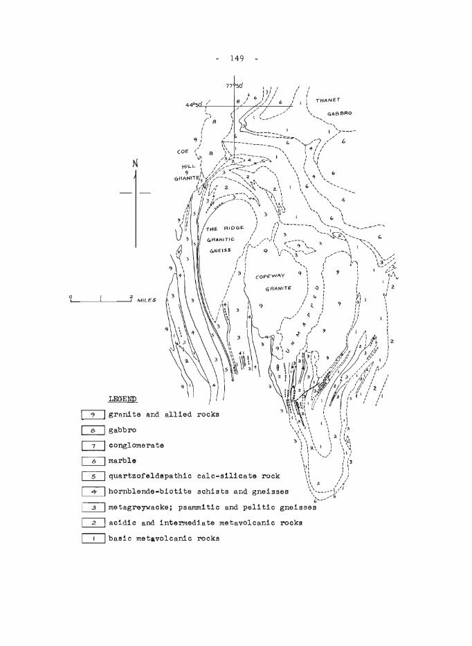
(010
N
o 2-1...' ___ ---'-___ --', MILeS
LEGEND
o=J grani te and allied rocks
~ gabbro
~ conglomerate
CD marble
149
77 50'
~ quartzofeldspathic calc-silicate rock
~hornblende-biotite schists and gneisses
~ acidic and intermediate metavolcanic rocks
~ basic metavolcanic rocks
- 150 -
The second episode produced no major structure, but it is important in that the metamorphism reached its peak during or after this episode. Minor folds were formed in the homoclinal sequence on the west side of the area. Biotite lies parallel to the axial planes of these folds, and sillimanite needles are aligned parallel to their axes. Farther east, the preferred orientation of mica defines a foliation plane that strikes northeasterly, cutting obliquely across the nose of the major fold, and across the noses of minor folds produced in the first episode. Some mica is randomly oriented and poikiloblastic, indicating an even later origin. Staurolite, hornblende, and scapolite invariably show random orientation and poikiloblastic texture. Thus, all the minerals that we now see in these rocks crystallized during or after a late, relatively minor structural episode, and consequently it cannot be known what the metamorphic conditions were during the earlier major folding.
The third episode produced minor crumples and kink folds having a constant northward plunge throughout the area. They are best developed in mica-rich rocks, and they are clearly later than the metamorphism.
Foliation in the Ridge granitic gneiss has the form of a dome, with flat dips near the centre steepening to near-vertical at the margins. However, this structure is not an anticline in the stratigraphic sense, because the distinctive calcareous and pelitic formations on its west flank do not recur on the east. This gneiss dome is emplaced between successive units in a homoclinal sequence. The Copeway granite shows good intrusive relations, and it is clearly post-metarrlOrphism, although it has not a noticeable contact aureole. The easternmost granite pluton appears to have been emplaced before or during the major folding. Its margins are strongly sheared, and patche s of muscovite schist can be found well within the body of the pluton.
1 Hewitt, D.F.: Wollaston township; Onto Dept. Mines, Geological Report No. 11 (1962).
2Laakso, R.: Lake township; Onto Dept. Mines, Prelim. Map No. P. 190 (1963) .
- 151 -
88. THE CROW LAKE DOME
K.L. Currie
Structure elements were remapped, showing that lineations plunged to the north at a low angle, ranging from 3° to 20°. No systematic southward plunge was found, throwing doubt on the interpretation of the structure as a dome. Within the boundaries of the granitic rocks patches of nebulitic material retain traces of steeply dipping gneissosity, transecting the flatly dipping fissility and mineral alignment which defines the gneissosity usually measured. This may indicate previously unsuspected structural complications. Whitefish Lake and Hart Creek were shown to be fault lines, probably normal in both case s. Both represent abrupt changes in structural style, and to a lesser extent in petrography. Thus the Crow Lake block forms a rather thin slice, transitional in both structure and petrography.
89. STRUCTURAL STUDIES ON THE LOUGHBOROUGH SYENITE, NORTH OF KINGSTON
1. F. Ermanovics
Field work was concentrated on structural analysis. The Loughborough syenite occurs as a stratiform mass in a tight anticline, projecting slightly into the adjacent syncline s. The plunge of adjacent folds is remarkably variable, varying in both direction and amount. Lineations were found to be widespread and reliable indicators of fold structures. A series of en echelon normal faults along the shores of Loughborough Lake form the eastern boundary of the mapped area. Movement on these features persisted into Palaeozoic time, but the total displacement is doubtful. A number of curving cross faults join the normal faults approximately at right angles and appear to terminate against them. A great belt of intensely sheared and lineated rocks on the west side of the area appears to represent strong penetrative deformation, but relatively little net movement.
90. RECONNAISSANCE STUDY OF ULTRAMAFIC ROCKS, ABITIBI -PORCUPINE AREA
D.C. Findlay
The purpose of this project is to define the petrologic and economic characteristics of the belt of ultramafic and mafic intrusions extending we st through the Timmins area from the Ontario -Quebec border.
During the 1965 field season intrusions in that part of the belt lying between Reeves township (about 40 miles west of Timmins) and Munro and McCool townships (about 60 miles east of Timmins) were examined and sampled. A few occurrences were mapped in detail, but in most cases existing Ontario Department of Mines or mining company geological maps were used as a basis for sampling.
- 152 -
Field evidence sugge sts that the intrusions of the belt are of two different types; those of the western and southern parts consist of serpentinite lenses with or without spatially associated gabbro. whereas those lying north and east of Timmins are mainly differentiated sill-like bodies that contain peridotite (or dunite), pyroxenite, gabbro. and various transitional rock types. Laboratory studies are planned to determine if these apparently different field characteristics are supported by chemical and petrographic data.
91. LAKE PANACHE-COLLINS INLET
M.J. Frarey
In 1965. geological mapping at the scale of one inch to one half mile continued on both sides of the Grenville Front, which trends southwestward across the areas. Northwest of the Front, the normal Huronian sedimentary succession can be followed in all the ground covered. These strata are intruded by an early, subconcordant diabase, by granitic bodies in the east half of the area, and by one, possibly two, sets of younger diabase dykes. Some of the dykes cross the Grenville Front essentially undisturbed.
Points of interest concerning the Huronian rocks are:
1. Conglomerate identified as Ramsay Lake Formation occurs in the northeastern part of the area, facilitating stratigraphic revision there.
2. The Lorrain Formation was found to be divisible into three. possibly four member s. The formation is remarkably thick, perhaps exceeding 20,000 feet.
3. The Gowganda Formation can also be subdivided at this scale. As elsewhere in the district , the formation produces prominent positive aeromagnetic anomalies; in Lake Panache map-area, these appear to coincide with the upper part of the formation. which consists mainly of argillite. siltstone. and arkosic sandstone.
4. Strata possibly equivalent to Collins' post-Lorrain "Banded cherty quartzite" formation occur in a belt passing through Norway Lake. If verified by future work, the existence of this unit will probably lead to the re clas s ification of substantial are as of white quartzite in this part of the La Cloche Mountains.
5. Other formational units and boundaries previously mapped by Quirke and Collins were found to be essentially correct.
6. Numerous breccias of sedimentary and tectonic origin occur in various formations; some are strikingly developed but only a few are of mappable extent.
7. In the eastern half of Lake Panache map -area, the metamorphic grade shows a marked increase, and conspicuous porphyroblastic zones characterized by cordierite and andalusite have developed in pelitic Huronian beds.
- 153 -
8. The Huronian sequence has been severely folded about gently-plunging east-west axes; in addition, smaller folds with steeply-plunging northto northeast-trending axes appear, mostly in the east half of the area.
The Grenville terrain comprises a complex of gneiss, granite, and pe gmatite, with subordinate quartzite, amphibolite and metapelitic mas se S. Some metase dimentary bodie s are identifiable as belonging to specific Huronian formations. Several types of granite are known, and two major bodies are ciearly defined. The gneisses show evidence of polyphase deformation, with the development of granite by anatexis.
Two structurally distinct gneiss areas have been delimited, but the ir mutual relationships are not yet clear. In addition, the metamorphic grade of the gneisses increases near Collins Inlet ove r that near Killarney, but more study is required to define the isograds.
The nature of the Huronian-Grenville boundary zone is variable and appear s to repre sent a complex sequence of events. Late -stage movements have obscured earlier relationships along this boundary.
Study of the Grenville terrain and its boundary zone was conducted jointly with Dr. R. T. Cannon of McGill University, who was attached to the writer's field party.
No discoveries of economic importance were made.
92. VOLCANIC STUDIES IN THE PORCUPINE-KIRKLAND LAKE-NORANDA REGION
A.M. Goodwin
Preliminary field work in preparation for future volcanic investigations in the above region was conducted by a two-man party during a four -week period in August-September, 1965. Problems of access, rock examination, and rock sampling along proposed stratigraphic section lines in each of the three areas listed above as well as stratigraphic tie-lines between these three areas, were investigated on the ground. A total of fifty volcanic units distributed along the proposed stratigraphic section lines were sampled for bulk chemical analysis. A brief examination of part of the Matagami area was made with a view of incorporating it in this or some future program of study.
Purpose of the proposed program of study is to determine the sequential development of the volcanic pile in each area, including the chemical history, and, thereby, the volcanic history of the region at large.
- 154 -
93. SURFICIAL DEPOSITS IN THE WESTPORT AREA OF EASTERN ONTARIO
E.P. Henderson
Striae. fluting. and a few drumlins record fairly consistent movement of ice of the last glacial stage across the Westport area in a direction south of southwe st toward the Lake Ontario basin. During deglaciation. with retreat and thinning of the ice. topographic control of ice £low became increasingly effective. and a distinct late lobe formed and moved more to the westward across the area between the centrally located Rideau and Newboro Lakes. parallel to the long axes of their deep basins. Morainal elements partly outline the western limit of this lobe.
Throughout the map-area glacial deposits are generally stony. thin. and discontinuous. Glacial deposits are particularly scarce in areas of hard Precambrian rocks that resisted the abrasive action of the ice. as for example on the plateau north of Wolfe and Little Rideau Lake s. where very little till has lodged and extensive areas 6f bare rock are prevalent. A more continuous till cover. however. lie s over much of the softer. flatlying or gently dipping Palaeozoic rocks. particularly near Westport. Small patches of unusually deep till occur on the £lanks of hills and in the lee of escarpments.
Glacio-fluvial sediments are present as kames. kame moraines. eskers. and outwash. In Precambrian areas they generally form separate small- to medium-sized kames. either too small to map separately. or indistinguishable from the dominant gravelly till. In areas underlain by Palaeozoic rocks meltwater deposits. though fewer. are larger. and economically much more valuable. One of the larger reserves of granular materials is the kame moraine 3 miles west of Westport at the east end of Wolfe Lake. This deposit. close to a good road system. is almost untouched, as gravel has been removed from only one small local pit.
With retreat of the ice to the north and east. waters of a glacial lake overspread the entire area. Lacustrine sands and clays deposited in this lake floor most closed basins at all elevations. Areal distribution of lacustrine deposits suggests they were laid by cold, dense bottom currents. closely controlled by relief on the lake floor.
Marsh deposits abound throughout the area. and are both larger and more numerous than in Gananoque map-area to the south.
Proceeding north from the St. Lawrence River between Kingston and Gananoque to Westport and beyond, the areal extent of lacustrine sediments mapped becomes progressively less. This decrease may be more apparent than real because the northward increase in the areas of lake and swamp masks the lacustr ine deposits.
- 155 -
94. HAMMER REFRACTION SEISMIC INVESTIGATIONS, MOOSE RIVER AREA
G.D. Hobson and P.G. Killeen
Hammer refraction seismic investigations were carried out over a number of possible biogeochemical plots located on the Moose River magnetic anomaly in the vicinity of Otter Rapids and Fraserdale in northern Ontario. The biochemical work is reported by J.A.C. Fortescue elsewhere in this publication. Overburden thickness determinations permitted contouring of the bedrock surface indicating favourable or unfavourable locations for biogeochemical sampling. A continuous profile passing near birch, black spruce, and poplar plots was completed along the Little Long road between Fraserdale and Little Long Rapids. A bedrock profile was also obtained across muskeg terrain between outcrop ridges near the French River. east of Otter Rapids. Several localized areas were also thoroughly investigated to determine overburden thickness prior to biogeochemical sampling.
Overburden thickness ranges from 15 feet to over 200 feet. Three very persistent seismic velocities were recorded and can be correlated with the three distinct surficial materials: muskeg. sand, and clay.
95. BIOGEOCHEMICAL STUDIES NEAR TIMMINS
E.H.W. Hornbrook
During the period February to April 1965 ten bore-holes were put down to bedrock near the Texas Gulf Sulphur orebody near Timmins. in order to sample the Pleistocene section and the surface of the underlying bedrock. Shelby-tube samples of varved-clay material were taken at 5-foot intervals and split spoon samples of lower till material continuously where possible. Bedrock was cored by diamond drill for 10 feet at the bottom of each hole. The objective of this inve stigation was to gain information of the extent of the geochemical anomaly in the lower till material in the down-ice direction from the mineral deposit. This investigation follows up work done previously by J.A.C. Fortescue and O.L. Hughes.
96. THE WATERLOO INTERLOBATE AREA (40 P/7, 40 PlIO)
P.F. Karrow
Mapping of the Conestogo and Stratford areas was begun in 1965. A complex distribution of Quaternary deposits is to be found in the area. Some of these can at present be attributed to specific ice lobes, while others are of as yet undetermined origin.
Quaternary deposits are 100 to 300 feet thick through much of the area. No bedrock outcrops are known, although the Silurian Salina Formation was encountered only 8 feet below river level at the Conestogo damsite near Glen Allen.

- 156 -
The youngest till sheet in the area is probably the sandy Wentworth Till, carried into the eastern part of the Conestogo area by the westward-moving Ontario lobe, and deposited as a thin sheet on a nearly level till plain. Its limit curves convexly westward approximately along the east flank of the Elmira moraine. Underlying it is a clay till whose origin may be from the east, northwest, or west.
Entering the northern part of the Conestogo area are at least one and probably two or three tills deposited by the Georgian Bay lobe; these generally are fine textured and in part have a fluted surface. The southern limit of advance of the Georgian Bay lobe has not yet been located; the area at one time covered by this lobe may include much of the map-area. Multiple fine -grained tills in the central part of the area may have been laid down by either Georgian Bay or Huron lobe ice.
Apparently underlying most of the area is the coar se -textured Catfish Creek Till, derived from the north and having a Tazewell age. Still older tills occur rarely along Cone stogo River we st of St. Jacobs.
A large irregular area of 'kamy' sand known as the Waterloo moraine is extensively capped by silty till; the age and origin of these deposits is as yet unknown.
Sand and gravel pits are worked in the spotty kame and outwash deposits, occurring mainly along the Waterloo and Elmira moraines. Postglacial lake clays are worked in tile yards at Wallenstein. Clay till was formerly used for brick-making at Conestogo and Elmira.
97. GEOPHYSICAL INVESTIGATIONS, ELLIOT LAKE AREA
P. G. Killeen and A. F. Gregory
The G.S.C. portable gamma-ray spectrometer was used to complete a radioisotope survey of exposed rocks in part of the Huronian basin and its basement in the Elliot Lake area. The survey extended from western Elliot Lake, north to Quirke Lake and east to Whiskey Lake.
The three channels of the instrument were set at discrete energy bands, which were selected to be characteristic of potassium, uranium, and thorium. Simultaneous determinations of the three radioelements were made at each outcrop site.
Readings were taken along sections across the south limb of the syncline in order to determine the variation of radioelements between and within each stratigraphic unit, in as far as outcrop made this feasible. A number of adjacent sections were surveyed to allow evaluation of the lateral distribution along strike. In addition several sections were surveyed on the north limb and on the nose of the syncline. A small portable diamond drill was used to obtain calibration sample s for laboratory analysis.
The results of the survey will be correlated with the geology and ore deposits of the area.
- 157 -
98. POST-GLACIAL SHORELINE FEATURES IN NORTHERN LAKE HURON BASIN
C.F.M. Lewis
During August and September the writer commenced a continuing study of post-glacial sedimentological features in the Lake Huron basin for the purposes of (1) making a ge ological estimate of re cent crustal uplift and (2.) clarifying several details of Great Lakes history in the area.
Reconnaissance revealed numerous beach, deltaic, and fluvial features exposed above Lake Huron level between North Bay and Sault Ste. Marie, Ontario. Beach profiles were constructed from spirit-level measurements at 3 localitie s -northeastern Manitoulin Island near Little Current, Sault Ste. Marie, and North Bay. Although elevations of most of the beaches studied were below or equal to the classic Nipissing Great Lakes shoreline many higher beaches were noted and some were profiled at each location. Organic sediments were collected from a few of the bogs and small lakes related to the lake stages identified in the beach profiles. This material will be studied palynologically and dated by the radiocarbon method. Some preliminary time -uplift diagrams should be available when the se data are at hand.
From other studies it is known that low-level stages existed in the Huron basin. Sediments collected by the writer from a small unnamed lake near James Bay in eastern Manitoulin Island will probably document the pre-Nipissing fall of the Great Lakes and rise of the water level to the Nipissing stage. This lake lies behind a Nipissing gravel bar (approximate crestal elevation is 650 feet a. s.1.) and the section through its sediments indicates a sequence of organic sedimentation, inorganic clay, and silt sedimentation, and a second period of organic sedimentation. This sequence is tentatively interpreted as deposition from (1) a small lake abandoned by the falling main lake level in pre-Nipissing time, (2.) a large lake rising to the Nipissing Great Lakes stage, and (3) a small lake abandoned by falling water levels in post-Nipissing time. The organic sediments are being dated by radiocarbon analysis. Lake sediments were cored at 7 other sites, both above and below the Nipissing shoreline, for radiocarbon dating and pollen analysis.
99. ENGINEERING GEOLOGY INVESTIGATIONS, WELLAND CANAL AREA
E.B. Owen
In the WeIland Canal area soil samples and bedrock cores were examined as well as the material exposed in recent excavations. Advice was given The St. Lawrence Seaway Authority regarding foundation and excavation problems relating to the twinning of Locks 1, 2., 3, and 7 on the Canal.
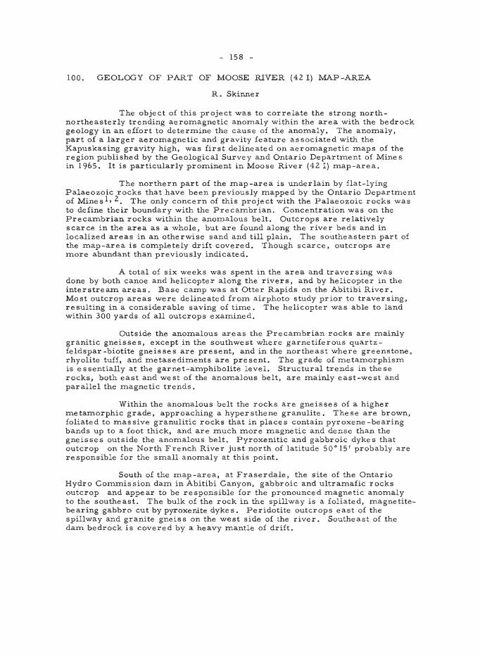
- 158 -
100. GEOLOGY OF PART OF MOOSE RIVER (42 I) MAP-AREA
R. Skinner
The object of this project was to correlate the strong northnortheasterly trending aeromagnetic anomaly within the area with the bedrock geology in an effort to determine the cause of the anomaly. The anomaly, part of a larger aeromagnetic and gravity feature associated with the Kapuskasing gravity high, was first delineated on aeromagnetic maps of the region published by the Geological Survey and Ontario Department of Mines in 1965. It is particularly prominent in Moose River (42 I) map-area.
The northern part of the map-area is underlain by flat-lying Palaeozoic rocks that have been previously mapped by the Ontario Department of Mines l , 2. The only concern of this project with the Palaeozoic rocks was to define their boundary with the Precambrian. Concentration was on the Precambrian rocks within the anomalous belt. Outcrops are relatively scarce in the area as a whole, but are found along the river beds and in localized areas in an otherwise sand and till plain. The southeastern part of the map-area is completely drift covered. Though scarce, outcrops are more abundant than previously indicated.
A total of six weeks was spent in the area and traversing was done by both canoe and helicopter along the rivers, and by helicopter in the interstrearn areas. Base camp was at Otter Rapids on the Abitibi River. Most outcrop areas were delineated from airphoto study prior to traversing, resulting in a considerable saving of time. The helicopter was able to land within 300 yards of all outcrops examined.
Outside the anomalous areas the Precambrian rocks are mainly granitic gneisses, except in the southwest where garnetiferous quartzfeldspar-biotite gneisses are present, and in the northeast where greenstone, rhyolite tuff, and metasediments are present. The grade of metamorphism is essentially at the garnet-amphibolite level. Structural trends in these rocks, both east and west of the anomalous belt, are mainly east-west and parallel the magnetic trends.
Within the anomalous belt the rocks are gneisses of a higher metamorphic grade, approaching a hypersthene granulite. These are brown, foliated to massive granulitic rocks that in places contain pyroxene -bearing bands up to a foot thick, and are much more magnetic and dense than the gneisses outside the anomalous belt. Pyroxenitic and gabbroic dykes that outcrop on the North French River just north of latitude 50· 15' probably are responsible for the small anomaly at this point.
South of the map-area, at Fraserdale, the site of the Ontario Hydro Commission darn in Abitibi Canyon, gabbroic and ultramafic rocks outcrop and appear to be responsible for the pronounced magnetic anomaly to the southeast. The bulk of the rock in the spillway is a foliated, magnetitebearing gabbro cut by pyroxenite dykes . Peridotite outcrops east of the spillway and granite gneiss on the west side of the river. Southeast of the darn bedrock is covered by a heavy mantle of drift.
- 159 -
Structural trends within the anomalous belt are north-northeast and at a sharp angle to the trends outside the belt. This, together with the higher metamorphic grade of the gneisses and presence of basic to ultrabasic rocks within the belt suggests that a deeper part of the earth's crust is exposed there, either by faulting or sharp folding, probably the former. Evidence of the faulting was observed at a number of places along the northnortheasterly trending anomalous belt.
I Dyer, W .S.: Geology and economic deposits of " the Moose River Basin; Onto Dept. Mines, 37th Ann. Rept., vol. 37, pt. 6, pp. 1-69 (1929).
2Martison, N.: Petroleum possibilities of James Bay Lowland area; Onto Dept. Mines, 6lstAnn. Rept., vol. 61, pt. 6, pp. 1-95 (1952).
101. SIOUX LOOKOUT (52 J) MAP-AREA
R. Skinner
The work was a continuation of the geological investigation of the area commenced in 1964, and during the past season was concentrated mainly in the west half of the map-area. Earlier work by O.D.M. and G.S" C. was checked and the remaining urunapped areas were examined with the aid of recently published aeromagnetic maps of the region.
Only minor differences were found in the extent and composition of the volcanic-sedimentary belt near Sioux Lookout. North of this belt the rocks consist of easterly to northeasterly trending granite gneisses, granites, and metasediments, the latter commonly intimately injected with leucocratic granite sills to form lit-par-lit gneisses. In the neighbourhood of Otatakan Lake an easterly trending greenstone and metasedimentary belt appears to be continuous with one that lies along the southern part of Lake St. Joseph and Pashkakogan Lake.
A major fault strikes northeasterly along Abraham, Botsford, and Kinunewin Lakes in the southwest corner of the map-area and may extend northeastward through Hooker, Miniss, and Medcalf Lakes. Prominent faults and joints radiate northeasterly to northwesterly from Schist Lake in the central part of the map-area. In the northwest part of the map-area faults trend mainly northeast.
Interest has recently been revived in the greenstone belts of the area, which have been known in the past for their occurrences of gold and base metals. Over the past year the GoisH copper-lead-zinc showing north of Savant Lake Post Office was drilled, as was a gold showing on the Southeast Arm of Savant Lake and the St. Anthony property on Sturgeon Lake .
Iron deposits of the area have been known for a long time and are present at the southwest end of Lake St. Joseph, on Doran Lake, north and south of Kashaweogama Lake and on the west side of Savant Lake.

- 160 -
QUEBEC
102. VOLCANIC STUDIES, NORANDA REGION
W.R.A. Baragar
This work forms part of a continuing study of volcanic rocks in Canada being undertaken by the Geological Survey. One objective is to provide quantitative fundamental data on the chemistry and petrography of Canadian volcanic belts as a basis for further studies. Accordingly two sections across parts of the Noranda volcanic belt were mapped and sampled. The main section begins at the highway between Matheson and Duparquet, about 6 miles west of the Ontario-Quebec border and extends southeastward to approximately the centre of Montbray township, Quebec, a distance of about 17 miles. A second shorter section begins at Kinojevis River where it crosses the Clericy-Aiguebelle townships boundary, Quebec and extends northward 4 1/2 miles into the Abijevic hills. To ensure adequate geographic and geological control for sampling the section lines were cut and chained and the geology along the line mapped at a scale of 1 inch to 400 feet. Samples were taken as much as possible at regular stratigraphic intervals of about 400 feet. Considerable care was taken to make the samples reasonably representative of the rock at each sample site. The samples will be chemically and petrographically analysed.
The main section can be divided into three structural regimes composed as follows: I) a homoclinal succe s sion of steeply-dipping, southward-facing volcanic strata approximately 35,000 feet thick; 2) a westplunging folded succession of volcanic rocks in which the net thickness of strata contributed to the total thickness of the section is uncertain; and 3) a homoclinal assemblage of southward-facing, very gently south-dipping volcanic strata about 6,000 feet thick. The first regime extends from the highway southeastward for about 8 1/2 miles, the folded zone from 8 1/2 to 10 1/2 miles, and the zone of gently dipping rocks from 10 1/2 miles to the end of the section at the axis of the major regional ,syncline . The writer believes that thicknesses of the first and third zones can be added to give a total for the section in excess of 40, 000 feet. The rocks are predominantly basic to intermediate lavas and pyroclastic rocks; acid lavas are rare or absent.
The subsidiary section in AiguebeUe township crosses a homoclinal succession of north-facing volcanic strata that is about 12,000 feet thick. The base of the assemblage at the south end of the section overlies the Kewagama sediments l ; the top of the section is at the axis of a regional syncline. The predominantly basic volcanic assemblage that forms the section may be correlative with that of the main section but has an advantage in beginning from a known stratigraphic base, the Kewagama Formation l .
The writer hopes the analyses from the two sections will provide a bulk composition and distribution of compositions that is characteristic of the Blake River Groupl, 2.
- 161 -
1 Ambrose, J. W.: Clericy and La Pause map-areas, Quebec; Geol. Surv. Can., Mem. 233 (1941).
2 Gunning, H.C.: Cadillac area, Quebec; Geol. Surv. Can., Mem. 206 (1937).
103. MANICOUAGAN CRATER
K. L. Currie
Field work was concentrated on the annular area of volcanic rocks previously defined. These were shown to be divided into two principal groups, a coarse -grained upper phase with a grain size greater than 2 mm. and a fine -grained lower phase, with grain size varying from aphanitic to 1 mm. Contact between the groups is sharp. The lower group contains numerous flow units, distinguished by colour, type and abundance of inclusion, and type of phenocrysts. The upper unit contains several units, some of which have very sharp contacts without change in grain size. Dykes and sills of the coarse-grained material occur in the central uplift, and rarely in the surroundings, while dykes of fine -grained material are common near the larger lakes. Both phases show late hydrothermal alteration along cracks and fractures, which appears to be a form of hot-spring activity. The present thickness of the volcanic complex is estimated to exceed 400 metres, and the original thickness must have been much larger than this. The volume exceeds 1,200 km3, and the original volume may have exceeded 10,000 km 3 . The principal sources of the flows are believed to be near the major lake s, and probably include d both vents and fis sure s. The surface on which the material poured was one of considerable relief, with sharp valleys exceeding 100 metres in depth.
104. STUDY OF MORIN ANORTHOSITES
R.F. Emslie
Sampling and investigation of the field relations of the anorthositic intrusion have been completed. Conclusions of earlier workers 1,2 that the Morin series is comagmatic are supported by the present study.
The aim of the sampling program was to provide material for mineralogical studies to learn more about the physical and chemical environment that produced the original rocks. In addition, certain mineral assemblages should be capable of providing an estimation of the degree of re-equilibrium that was established during metamorphism attending the Gre nville orogeny.
Fe -Ti oxide concentrations are believed to have formed in the interval between solidification of the anorthositic rocks and solidification of the pyroxene quartz monzonite, a younger member of the Morin series. Oxide concentrations are almost invariably associated with ferrogabbro and ferrodioxide which occurs as small intrusive masses and dykes in anorthositic rocks.

- 162 -
1 Adams, F. D.: Report on a portion of the Laurentian area lying to the north of the Island of Montreal; Geo!. Surv. Can., Ann. Rept. vol. VIII, pt. J, 1895 (1896).
20sborne, F.F.: Ste.Agathe-St. Jovite map-area; Que. Bur. Mines, Ann. Rept. 1935. pt. C, p. 53-88 (1936).
- 163 -
105. SURFICIAL GEOLOGY IN THE ST. SYLVESTRE AREA
N.R. Gadd
Mapping of the St. Sylvestre area of Quebec, 21 L/6, is the concluding stage of what has become a 4-year survey of glaciation of a segment of the Appalachian Highland bordering the Chaudiere River Valley and including an area of the St. Lawrence Lowland extending north to the St. Lawrence River at Quebec City and Portneuf. Other areas included in the study are Portneuf (21 L/12), Chaudihe (21 L/ll), St. Joseph (21 L/7) and Beauceville (21 L/2)1. Study of these and adjacent areas has resulted in discovery of new glacial moraine systems in southern Quebec 2, 3,4. Work in the St. Sylvestre area during the field season 1965 has revealed further complexity and some new facets of significance of these moraines.
The northernmost range of major ridges within the Appalachian folded belt crosses the central part of the St. Sylvestre map-area. This range includes three peaks of sufficient prominence to have received individual names: Handkerchief Mountain, Mont St. Margaret, and Tara Mountain (localities 1, 2, 3, respectively, Fig. 1). These peaks rise two thousand feet, more or less, above sea-level and all bear evidence of glaciation in the form of erratics and of strong, deep striations whose orientation azimuths range from about 190· to 225·, with the majority trending southwesterly at about 210· to 220· (these are not shown on Fig. 1). Glaciation that overrode these highest peaks had a flow direction that sharply contrasts with that indicated by striations and pebble orientations in tills at lower levels. There the most common orientation is southeasterly azimuths near 135· (Fig. 1). An exception of this general direction of ice-flow is found on the northeastfacing flank of Tara Mountain where ice moved southwesterly and, in some places, westerly. Regional ice-flow towards the southwest at a time when the highest hills were overridden and a southeasterly trend at lower levels sugge sts that in late stage s of glaciation of this area the centre of glacial outflow may have shifted from NE (say in the vicinity of Parc des Laurentides, north of Quebec City), to NW (say in the vicinity of Mont Tremblant, north of Mo~treal).
The broad valley of the Chaudiere, being accessible to all iceflow coming from northerly directions, probably was more extensively glaciated during late-glacial time than were, for example, smaller valleys to the southwest of it; these may have been protected by the buttress formed by the three peaks and associated hills. The hypothetical ice -front position shown on Figure 1 is a pos sible configuration of the ice -front in a stage ,,;rhen ice piled up against this buttress, squeezed narrow ice tongues up small valleys and created a major radially expanding lobation in the Chaudiere River Valley.
Although two major morainiC systems have been recognized in adjacent areas, at elevations of about 700 feet for the lower, younger one, and about 1,200 feet for the higher, older moraine 3 , no such distinction can be made in at least the eastern half of the St. Sylvestre area on the north side of the range of Appalachian Mountains between the villages of St. Sylvestre and St. Elz€ar. There is in that area a more or less continuous complex of ice -contact and ice-margin features including kames, kame moraines, kame terraces, and drainage channels, many cut in the soft bedrock, as well as associated delta and lake bottom sediments. These range
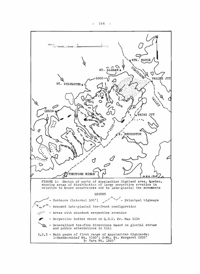
164
~ ST. SYLVESTRE <>
FIGURE 1: Sketch of parts of Appalachian Highland area, Quebec, showing areas of distribution of large serpentine erratics in relation to known occurrences and to late-glacial ice movements
LEGEND ~ ""'..// ~ - Contours (interval 500') /// - Principal highways
..... "' ..... y- ...... - Assumed late-e:lacial ice-front configuration
.\), .. .:.t :;;~ . - Areas with abundant serpentine erratics
- Serpentine bodi,es shown on Q,.D.I·;. Pro Map 1214
- Generalized ice-flow directions based on glacial striae and pebble orientations in till
1,2,3 - Main peaks of first ran~e of Appalachian Highlands; I-Handkerchief Mt. 2150 ; 2-Mt. St. Margaret 2250'
3- Tara Mt. 1925'
- 165 -
down the mountain slope from an elevation of about 1,800 feet to about 800 feet; there are no distinguishable major halts. Thus there is in this area a kaleidoscope of glacial history representing roughly one thousand feet of deflation of the surface of the continental ice -sheet confined in a belt roughly four miles wide. The Highland Front moraine 3 is the end member of this series, forming the last range of glacial moraine deposits at the foot of the slope.
Drainage in early stages of the ablation of the ice-sheet escaped across the first range of Appalachian hills southward via the Chaudiere River Valley and thence at different stages by way of Lake Megantic and Daaquam River to the Atlantic. When glaciers blocked drainage northward at levels of 1,200 feet and below, however, glacial meltwater was ponded between the ice and the highland range, forming lakes that drained easterly and northeasterly mainly through deep bedrock gorges leading ultimately to the Chaudi~re valley. As ice receded from the highland and as water escaped at progressively low levels and ultimately to the level of the Champlain Sea, glacial lake sediments were flushed out of former lake basins by streams flowing northward. Thus lake sediments were almost completely removed from basins on the north flank of the Handkerchief Mountain range of hills, but some remnants are found, many of which are overlain by heavy, protective layers of coarse fluvial gravels.
Gradients of post-last-glacial streams and of modern streams flowing northward are such that very large boulders were and are moved northward from their place of origin by at least periodically torrential flow. Many such large boulders, still bearing the striations left by previous glacial transport, occur north of their probable sources. This phenomenon lends an element of doubt to earlier interpretations of northward transport of glaciated boulders as undeniable evidence of northward-flowing glacial ice in the Eastern Townships of Quebec.
Glacial Transport of Large Serpentine Boulder s
The St. Sylvestre map-area, being one in which several outcrops of asbestos-bearing serpentine are known (Fig. 1), has many blocks, boulders and pebbles of serpentine in the glacial drift. Bearing in mind the phenomenon of fluvial transport of boulders mentioned above, the writer made a survey of distribution of large serpentine erratics in areas north of outcrops of serpentine known in the St. Sylvestre map-area and shown on a current geological map5. Only blocks, and boulders found on crests. of ridges or other uplands, and those actually contained in glacial till were considered to have been glacially transported; none found in valley bottoms were considered.
The pattern of distribution of some large concentrations of such glacially transported serpentine boulders, many with asbestos fibre, is shown on Figure 1. In the writer's interpretation of the direction of ice movement for the areas concerned all such boulders have corne from sources northwest, north and northeast of the places at which they are found. Because of this and the fact that all occurrences shown lie in northerly directions from known outcrops, it is concluded that areas in the vicinity of Leeds Village, an area within the valley north of Tara Mountain, and a broad area
- 166 -
south of St. Elzear extending froITl the eastern flank of Tara Mountain to Vallee Jonction, ITlight be fruitful areas to prospect for new occurrences of serpentine and asbestos.
A single outcrop of serpentine with asbestos fibre up to 3 inches long is exposed in new road cuts at the north end of the village of West Broughton, east flank of PalITler River valley (shown on Fig. I, 8 1/2 ITli. south of St. Sylvestre). The significance of this outcrop seeITlS to the writer to be in the fact that its orientation is southeasterly, or parallel to the valley of the PalITler River, and thus transverse to the trend of regional folding which is southwesterly. This is pointed out to indicate that new occurrences in the region need not be expected to have the southwesterly trend that is COITlITlon to ITlost known occurrences.
IGadd, N.R.: Surficial geology, Beauceville ITlap-area, Quebec; Geol. Surv. Can., Paper 64-12 (1964).
2 Gadd, N.R.: New ITlorainic systeITls in the St. Lawrence Lowlands; in Jenness, S.E.: SUITlITlary of Activities: Field, 1963; Geol:-5urv. Can., Paper 64-1, p. 54 (1964).
3 Gad d , N .R.: Moraines in the Appalachian region of Quebec; Bull. Geol. Soc. AITl., vol. 75, pp. 1249-1254 (1964).
4Gadd, N.R.: Surficial geology, Chaudiere River Valley; in Jenness, S.E.: Report of Activities: Field, 1964; Geol. Surv. Can., Paper 65-1, pp. 115-117 (1965).
:; Benoit, F. W.: PreliITlinary report on St. Syl ve s tre -St . Joseph (we st half) areas; Que. Dept. Mines, P.R. No. 359, Prel. ITlap 1214 (1958).
- 167 -
106. PLEISTOCENE GEOLOGY STUDIES, RICHMOND-SHERBROOKE REGION, SOUTHEASTERN QUEBEC
B . G. McDonald
Pleistocene geology studie s in the Richrnond-Sherbrooke area, begun in 1964 1, were completed this season and will form the basis of a doctoral dissertation at Yale University.
Retreat of the margin of the last ice across the region was interrupted by two minor readvances culminating in moraines. One morainic system extends through Cherry River, Katevale, Sherbrooke, and Ascot Corner at about 800' - 900' elevation; the younger morainic system is the "highland front" moraine of Gadd2 , which passes through L'Enfant Jesus d'Ely, South Durham, and Ulverton at about 500' - 700' elevation. Both of these morainic systems are composed largely of ice-contact stratified drift and are being exploited for sand and gravel.
Two glacial lake phase s were as sociated with the se ice -margin positions. The earlier and higher of the se lake phase s was the last glacial lake to occupy the Lake Memphremagog basin.
The Champlain Sea inundated the northwest corner of the area and marine fossils have been found up to about 530' above present sea-level. During regression, the sea constructed various strand features below this elevation. Terrace levels in the valleys of northwestward-flowing rivers may represent profiles to a regressing Champlain Sea. Dunes have developed on the marine sand plain.
Minor amounts of gold have been discovered in till bordering the southeastern part of the region. The gold is very angular and of sand size.
1 McDonald, B. C.: Surficial geology studies, Richmond-Sherbrooke area; in Jenness, S.E., 1965, Report of activities: Field, 1964; Geol. 5Urv. Can .• Paper 65-1, p. 120 (1965).
2 Gadd. N.R.: Moraines in the Appalachian region of Quebec; Bull. Geol. Soc. Am., vol. 75, pp. 1249-1254 (1964).
107.
- 168 -
NEW BRUNSWICK
GEOCHEMICAL STUDIES, BATHURST-JACQUET RIVER DISTRICT
R. W. Boyle
The study of the distribution of Cu, Pb, Zn, As, Sb, Mo, W, Sn, Ag, Ni, Co, Mn, Ba, and Cr in the waters and stream sediments of the Bathurst-Jacquet River District, New Brunswick was completed during the field season. All analytical work is complete and compilation for publication is well advanced. The area covered is bounded by Chaleur Bay on the east, by 66°l5'W Long . and 47°30'N Lat.
108. THE GRAND FALLS MORAINIC SYSTEM
H.A. Lee
Three weeks of field work in New Brunswick dealt with tracing a morallllC system from the town of Grand Falls eastwards towards Chaleur Bay. The morainic system has been previously recognized near Grand Falls in northern New Brunswick, close to the border of the state of Maine. The moraine belongs to a readvance of the former ice-margin of at least 10 miles inferred from sections exposing till over sands and gravels. The morainic system as now recognized extends discontinuously eastward from Grand Falls a minimum distance of 55 miles. The same morainic system is thought by H. W. Borns, Jr. (personal oral communication) to extend westward from Grand Falls across the state of Maine probably wrapping around Mount Katahdin. These inferred continuations from Grand Falls provide us with a preliminary estimate of 150 miles length. When considered with the independent evidence of former ice -readvance, it leads to an interpretation that the Grand Falls morainic system repre sents a major regional episode in the glacial chronology of eastern North America, rather than simply the frontal debris of a localized ice-lobe.
109. A POTENTIAL BUILDING STONE NEAR LANCASTER
H.A. Lee
A potential building stone was noted in a highway outcrop near the City of Lancaster, New Brunswick (located on Highway No.2, car mileage 3 mile s northwe st of junction between Highways Nos. 1 and 2). The rock is a colourful limestone conglomerate (marble) with various shades of green and white. The rock cuts and polishes readily, but has some joints. Plate I shows a cut and polished specimen. This rock is considered to have potential use as inside trim for certain buildings.
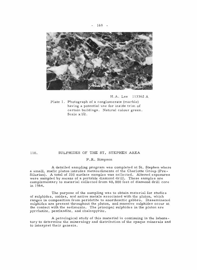
110.
169
H.A. Lee 113362 A
Plate I. Photograph of a conglomerate (marble) having a potential use for inside trim of certain buildings. Natural colour green. Scale x 1/2.
SULPHIDES OF THE ST. STEPHEN AREA
P.R. Simpson
A detailed sampling program was completed at St. Stephen where a small. mafic pluton intrudes metasediments of the Charlotte Group (PreSilurian). A total of 200 surface samples was collected. Altered exposures were sampled by means of a portable diamond drill. These samples are complementary to material collected from 40.000 feet of diamond drill core in 1964.
The purpose of the sampling was to obtain material for studies of sulphides. oxides. and native metals associated with the pluton. which ranges in composition from peridotite to anorthositic gabbro. Disseminated sulphides are present throughout the pluton. and massive sulphides occur at the contact with the se diments. The principal sulphide s in the pluton are pyrrhotite. pentlandite. and chalcopyrite.
A petrological study of this material is continuing in the laboratory to determine the mineralogy and distribution of the opaque minerals and to interpret their genesis.
- 170 -
NOVA SCOTIA
Ill. .MERIGOMISH, EAST HALF (11 E/9) AND MALIGNANT COVE (11 E/ 16) MAP -AREAS
D.G. Benson
The northeasterly trending Antigonish Highland extends over znost of the znap-areas. It is underlain by an Ordovician sequence of interbedded volcanic and sediznentary rocks that seezn to fall into three indistinct associations: an andesite, volcanic breccia, andesite tuff, and zninor greywacke suite; an intennediate porphyritic volcanic, siltstone, and zninor quartzite suite; and a lazninated shale, very fine-grained siltstone and tuff suite. These rocks have been intruded, possibly in late Ordovician tizne, by diorite to granodiorite, then by granite, and later by zninor diabase and gabbro. The metaznorphic effects of these intrusions are znore apparent east of Malignant Cove where igniznbrite, phyllite, and skarn outcrop. Cobble to boulder conglomerate of the Malignant Cove Forznation overlie the Ordovician sequence along Malignant Brook.
The overlying Silurian Arisaig Group varies in composition frozn basal predominantly arenaceous rocks through a predozninantly argillaceous section to upper arenaceous and calcareous beds. They are best exposed along the coast, but isolated outcrops occur near Marshy Hope where the Beechhill Cove Formation conforznably overlie s lazninated shale and tuff of supposed Ordovician age. The basal contact near the coast is repre sented by a congloznerate and inland by a major fault. There are narrow bentonitic clay seazns and tuff beds in the lower to zniddle Ross Brook Formation indicating contemporaneous volcanic activity. The porphyritic rhyolite flows near Arisaig are thus assigned a Lower Silurian age. Sozne of the associated aznygdaloidal basalt flows are possibly also Silurian, but they are znost probably Carboniferous.
The upper Silurian Stonehouse Forznation is conformably overlain to the west and southwest by red fine-grained wacke, siltstone, and mudstone of the Devonian Knoydart Formation.
The Knoydart is unconforznably overlain by the Lower Carboniferous McAras Brook Formation, which is in fault contact with the upper Stonehouse.
The McAras Brook Forznation consists of interbedded amygdaloidal basalt and red cobble congloznerate, overlain by red wacke, siltstone, and znudstone.
The conforznably overlying Ardness Formation consists of basal oolitic liznestone and an upper partly calcareous section of light grey and greyish red wacke, znudstone, siltstone, claystone, and zninor cobble conglomerate. The lime stone contains numerous pyr ite cube sand zninor oil stain. Pyritized plant reznains with considerable galena, sphalerite, and chalcopyrite are common in the grey beds.
- 171 -
A very thick Lower Carboniferous boulder conglomerate overlies the Ordovician rocks on Cape George and in the northern part of the Antigonish Basin. Red siltstone, mudstone, and wacke, and interbedded limestone, gypsum, and anhydrite overlie the conglomerate in the northern part of the Antigonish Basin and unconformably ove rlie the Ordovician rocks to the south.
The Ordovician rocks appear to be more highly deformed than the Silurian. The Devonian is moderately folded whereas the Carboniferous beds seldom have dips greater than 45 0 and are relatively undisturbed.
112. ANORTHOSITE IN NORTHERN CAPE BRETON
S.E . Jenness
Several small lenses of anorthosite outcrop in the midst of a band of chloritic and amphibolitic metavolanic rocks near the northern tip of Cape Breton Island. They were first mapped and described by Neale l . The writer spent several days in July examining all anorthosite outcrops readily accessible to the Cabot Trail, and collecting samples for further study, as part of a petrographic study of these rocks commenced in 1963. Much of the anorthosite is considerably altered, but nearly unaltered phases are pale grey, medium to coarse grained, and intensely fractured. The plagioclase is sodic andesine (An35-40). Some of the anorthositic outcrops contain chloritized hornblende in amounts ranging from 5 to 30 per cent, thus passing from true anorthosite to anorthositic diorite. No clear evidence of age relationships between granite and anorthosite has been seen, but the anorthosite is cut by small basic dykes, whiCh are probably similar to the basic dykes that cut nearby granitic rocks. Potassium-argon dates on two different granitic bodies in the region suggest Devonian igneous activity, but the nature of this activity appears to have been fairly complex. The writer has collected several samples of the granitic rocks for further age determinations . Although the field relationships are inconclusive, the anorthosite probably is younger than the volcanic rocks with which it occurs but older than the granitic rocks, as was concluded by Neale 1. Whether it is early Palaeozoic or Precambrian in age, however, is not known. A relationship may exist between the loci of the anorthosite lenses and faults related to the northeasterly trending high-angle Aspy Fault a few miles to the east.
INeale, E.R.W.: Pleasant Bay, Inverness and Victoria counties, Cape Breton Island, Nova Scotia; GeoI. Surv. Can., Prel. Map 55 -24 (1955).
Neale, E. R. W.: Geology, Pleasant Bay, Cape Breton Island, Nova Scotia; Geol. Surv. Can., Map 1119A (1964).
- 172 -
113. COBEQUID MOUNTAINS
D.G. Kelley
During the field season of 1965 the area of the Cobequid Mountains examined was between Debert and Bass Rivers (approximately between longitudes 63°26' and 63°50'), largely within the Wentworth (11 E/l2, El/2) and Londonderry (11 E/5 E1/2) map-areas.
Ice -contact gravel ridges were found at 750 feet elevation near the stream divide northwest of Fountain Lake. A south-trending esker is located 1 1/2 miles west of Sutherland Lake, approximately at 700 feet elevation. Crude cut-and-fill structures within the esker indicate the waters flowed south. These features suggest that the Cobequids were only involved in regional glaciation and were not the source of a local active ice -cap as suggested by Flintl.
The prominent bedrock structures trend easterly. Rocks in the northernmost part of the area include Silurian sedimentary rocks, and Devonian (?) rhyolitic and ande sitic rocks of both intrusive and extrusive types. Along their southern boundary, these rocks are in contact with Devonian (?) massive, pink hornblende granite. The granite grades in a southerly direction into a zone of mixed rocks consisting of mainly dioritic rocks, and younger granite and diorite plutons, most of which are dykes.
In the we stern part of the studied area, the mixed rocks adjoin Silurian and Devonian sedimentary and volcanic rocks along a probable north-trending fault. Both the mixed rocks and the Silurian-Devonian rocks are gradationally to abruptly more highly sheared toward the south. The zone of intense shearing is approximately one mile wide on Portapique River and 3 miles in the eastern part of the area along Debert River. Rocks within the shear zone include basic and acidic igneous rocks and sedimentary gneisses and schists. These rocks appear to occur as thin east-trending slice s. Penetrative lineations within the shear zone s indicate oblique -Slip movements.
Lying with abrupt contact against the south boundary of the shear zone is a highly fractured, but mainly non-sheared, fine -grained, sedimentary-fragmental volcanic assemblage, which contains the Londonderry iron occurrences. Within the assemblage are several thin slices of intensely sheared rocks grading from granite to siliceous and chloritic greenstones, similar to those found within the main shear zone. These relationships were previously interpreted as intrusive and used as evidence to show that the host rocks of the iron ores were older than the granite 2 , 3. The granite and greenstone rocks were, however, emplaced by faulting.
The sedimentary and fragmental volcanic rocks are separated from the Carboniferous to the south by the Cobequid Fault. Study of many hundreds of fractured pebbles from Pennsylvanian (?) conglomerate suggests that compressive stresses were operative at least to Pennsylvanian (?) or la te r time.
- 173 -
1 Flint, R. F .: Highland centre s of forme r glac ial outflow in nor the astern North America; Bull. GeoI. Soc. Amer., vol. 62, pp. 21-38 (1951) .
2 . Stevenson, 1. M.: Truro map-area, Colchester and Hants counties, Nova
Scotia; Geol. Surv. Can., Mem. 297(1958).
3Weeks, L.J.: Londonderry and Bass River map-areas, Colchester and Hants counties, Nova Scotia; GeoI. Surv. Can., Mem. 245 (1948).
114. HEAVY MINERAL STUDIES IN NOVA SCOTIA
C.R. McLeod
Forty-six concentrates of heavy minerals were collected by panning stream gravels during two weeks of the field season in the New Glasgow-Truro area of Nova Scotia in an attempt to further evaluate the method as an aid in defining metallogenic province s, and in indicating possible mineralization 1 . This work was done in conjunction with W.D. McCartney's metallogenic study of the Canadian Appalachians.
Cursory examination of the heavy mineral concentrates showed the chief constituents are generally iron-bearing minerals, especially hematite and goethite. Above n0rmal amounts of barite were seen in concentrates from near Springville 2 , lat. 45°27'37", long. 62°37'11"; from the lower part of Archibald Brook2, 1at. 45°25'5", long. 62°36'23", and lat. 45°25'31", long. 62°36'36"; from a small tributary of Middle River about 1 mile south of Union Centre, lat. 45°30'35", long. 65°45'32", near a chalcopyrite showing mentioned by Gillis 3 ; from streams crossing the HortonWindsor contact4 , notably Field Brook, lat. 45°13'39"; Brenton Brook, lat. 45°13'54", long. 63°12'36"; a tributary of Brenton Brook, lat. 45° "13'54", long. 63°12'21"; and an unnamed stream that crosses the Brookfield-Middle Stewiacke highway about 2 miles east of Brenton Brook, lat. 45 ° 13 152", long. 63°10'. Barite was also seen iIi concentrates from Rutherford, Chapman, Halfway, and Otter Brooks4, all of which were collected downstream from the Horton-Windsor contact.
A few grains of chalcopyrite were observed in the concentrate from Field Brook.
Chemical analyses in progress will furnish more information as to the content of the concentrate s.
1 McCartney, W.D., and McLeod, C.R.: Preliminary application of heavy mineral analyses to metallogeny of Carboniferous areas, Nova Scotia and New Brunswick; Geol. Surv. Can., Paper 64-29 (1965).
2Benson, D.G.: Geology, Hopewell, Nova Scotia; Geol. Surv. Can., Map 3-1962 (1962).

- 174 -
3Gillis, J. W.: Geology of northwestern Pictou county, Nova Scotia, Canada; unpub. Ph.D. thesis, Pennsylvania State Univ. (1964).
4Stevenson, I.M.: Shubenacadie and Kennetcook map-areas, Nova Scotia; Geol. Surv. Can., Mem. 302(1959).
115.
- 175 -
PRINCE EDWARD ISLAND
GROUNDWATER STUDIES, CHARLOTTETOWN (11 L/3 El/2) AREA
P.A. Carr
Twenty piezOIneters were installed in discharge areas around the shoreline of the Eliot River estuary. All of the water levels fluctuate with the tides and all of the piezometers show some sea-water intrusion. The sea-water encountered in these piezometers originates from the estuary by direct infiltration through the fractures in the bedrock. Most of this seawater was encountered in the first 100 feet of drilling. The base of the fre sh-water flow system is estimated from the bore -hole data of lngall (1909) to be between 600 and 700 feet. Thus the fresh-water flow system adjacent to the Eliot River varies between 100 and 600 feet below the ground surface.
116. STUDIES OF SALT-WATER INTRUSION IN THE CHARLOTTETOWN AREA
L. D. Delorme
The writer aided Peter Carr in the installation of piezometers near the coast. Traversing along the shore was also carried out, the purpose of which was to locate groundwater discharge areas above high tide as well as between low and high tide. It was found that two mussels could be used in the differentiation of fresh water from marine water. The mussels were always localized along bedrock fractures or bedding planes.
- 176 -
NEWFOUNDLAND AND LABRADOR
117. STRUCTURAL STUDIES OF THE BAY D'ESPOlR GROUP
F. D. Anderson
Detailed field studies on the structure and metamorphism of the Bay d'Espoir Group were completed. The group may be divided into four structural zones: (1) A northern zone (map-unit la) characterized by highly folded strata with well developed axial-plane cleavage. The axial planes strike northeast and dip from 45 to 65 degrees northwest, and axes are nearly horizontal. (2) A zone with more intensely folded strata (unit Ib) with subhorizontal cleavage. The folds are generally cleavage folds; the axial planes commonly strike northeast and dip gBntly southeast; and axes are nearly horizontal. (3) A zone with relatively undisturbed strata (unit lc) with broad open folds. (4) A southern zone (unit ld) of highly faulted and metamorphosed strata dipping north.
Preliminary studies of the field data indicate that the group has undergone several stages of deformation, the order of which has probably been: 1) folding; 2) development of subhorizontal cleavage; 3) faulting; 4) folding.
Fossils were found near the town of St. Albans. They include crinoid stems and coral fragments; no age has yet been assigned.
The Garrison Hills granite 1 (unit 2) lies along the southern limits of the Bay d'Espoir Group. The granite consists largely of garnet-muscovitebiotite paragneiss and schist, augen gneiss, and minor porphyritic granite. The granitic rocks (unit 3) on the northwest edge of the group are mainly massive.
A large quartz vein about 1, 000 feet long and up to 300 feet wide was found at 47 °42'15"N and 55 °46'W. It may be a possible commercial source of high purity silica.
1 Jewell, W.B.: Geology and mineral deposits of the Baie d'Espoir area; Geol. Surv. Newfoundland, Bull. 17 (1939).
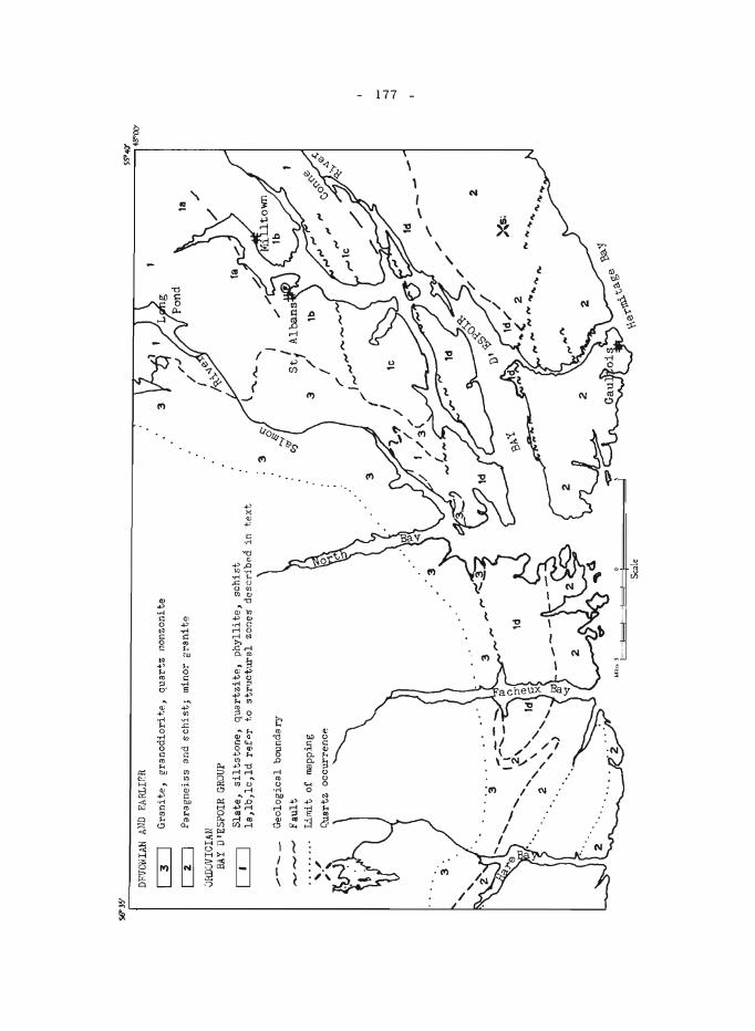
SU
l5' r-~~~~~~~~~ _
__
__
__
__
__
__
__
__
__
__
__
__
__
__
__
__
__
__
__
__
__
__
__
_ ~ _
_ .-
?-_
__
__
_ ~~ _
__
__
__
__
__
__
__
__
_ ~S~~~
1 D
FITD
NIA
N
AND
FJlR
Llf>
R
'"
14 8"0
0'
~
Gra
nit
e,
gra
no
dio
ritp
, quar~z
no
nzo
nit
e
~
Par
agn
eiss
and
sch
ist;
m
inor
gra
nit
e
;.J1i
ll8V
ICIA
N
BAY
D'E
SPO
IR G
ROUP
IT
]
Sla
te,
silt
sto
ne,
qu
artz
itp
.,
ph
yll
ite,
sch
ist
la, l
b, l
c, l
d r
efo
r to
st
r'lc
tura
l zo
nes
des
crib
p.d
in
tex
t
/---
--,...
, G
eolo
gic
al b
ound
ary
Fau
lt
Lim
i t
of
map
ping
'3 .
Sca
le
3 t-
..,,
-....
3
I I S
t f
/ I
111 / --- 2
xs;
-.I
-.I
118.
- 178 -
GREAT NORTHERN PENINSULA (parts of lZ I, P; and of Z L, M)
J. W. Gillis
Geological study of the Great Northern Peninsula for publication at a scale of 1 inch to 4 mile s was begun in 1965. Work commenced in the Hare Bay region; the general geology of the completed area is shown in Figure 1.
In the Hare Bay region there are two contrasting Lower Palaeozoic stratigraphic sequences; one sequence is autochthonous, whereas the other appears to be allochthonous and to form a large klippel, Z. The autochthonous sequence is composed of platform rocks of the Labrador Group (1), the St. George and Table Head Formations (Z), and the Goose Tickle Slate (3); southwest of the Hare Bay area these strata unconformably overlie granite and gneiss of Grenville age. The allochthonous sequence, which lies above the autochthonous sequence, is made up of the Northwest Arm Formation (6), the Maiden Point Sandstone (7), schist and gneiss (8), and peridotite (9). Carboniferous sedimentary rocks (11) also occur in the region.
The Lower Cambrian Labrador Group (1) consists of quartzose sandstone and minor phyllite. The Lower Ordovician St. George Formation (Z) and the Middle Ordovician Table Head Formation (2) are made up of limestone and dolomite. The Middle Ordovician Goose Tickle Slate3 , 4 (3) is composed of shale, siltstone, and sandstone. Crossbedding, graded bedding, and convolute bedding are abundant in the Goose Tickle (3). Graptolites have been collected from this unit.
The Northwest Arm Formation (6) consists of black and green shale with blocks of sandstone, volcanic rocks, chert, and limestone up to ZO feet in diameter. This unit is at least in part of Early Ordovician age. The Northwest Arm (6) appears to be chaotic, and is similar to chaotic rocks in the Humber Arm Group, near Corner Brook, western Newfoundland5 • The Ordovician (?) Maiden Point Sandstone (7) is made up of sandstone, shale, argillite, and massive and pillow volcanic rocks. The schist and gneiss unit (8), which bounds the peridotite (9), is composed of green schist and hornblende gneiss. Recognizable volcanic textures and structures in the schist and gneiss unit (8) suggest that this unit is the metamorphosed equivalent of the Maiden Point (7). The Ordovician (?) peridotite unit (9) consists of peridotite and minor dunite and pyroxenite.
The Carboniferous sedimentary rocks (11) are divided into two units; the Crouse Harbour Conglomerate and the Cape Rouge Shale 6.
The contact between the autochthonous and allochthonous sequences can be seen at several localities. Good exposures occur at Cape Raven, 4 miles southwest of Cape Bauld, and on the eastern side of Big Spring Inlet, 8 miles northeast of Main Brook. At Cape Raven carbonate rocks (Z) and the Goose Tickle Slate (3) are overlain by chaotic rocks of the Northwest Arm Formation (6) and volcanic rocks of the Maiden Point Sandstone (7).
- 179 -
On the eastern side of Big Spring Inlet the carbonates (2) and Goose Tickle (3) are overlain by chaotic Northwest Ann ro~ks (6) and sandstones of the Maiden Point (7).
Sphalerite, galena, and fluorite occur in calcite veins up to 3 feet wide cutting carbonate rocks (2) on a small island in White Cape Harbour, 9 miles south of Cape Bauld.
The L'Anse aux Meadows archeological site of Viking habitation, currently being studied by Helge Ingstad of Oslo, Norway, is located 5 3/4 miles southwest of Cape Bauld.
1 Rodgers, John, and Neale, E.R. W.: Possible "Taconic" klippen in western Newfoundland; Am. J. Sci., vol. 261, pp. 713-730, (1963) .
2Tuke, M.F.: Structural and stratigraphic discontinuities, northernmost Newfoundland; unpub. Ph. D. thesis, University of Ottawa (in preparation) .
3Cooper, J.R.: Geology and mineral deposits of the Hare Bay area; Newfoundland Dept. Nat. Resources, Geol. Sec. Bull. 9 (1937).
4Betz, Frederick, Jr.: Geology and mineral deposits of the Canada Bay area, northern Newfoundland; Newfoundland Geo!. Surv., Bull. 16 (1939).
5 Stevens, R. K.: Ge ology of the Humber Arm are a, we ste rn Newfoundland; unpub. M.Sc. thesis, Memorial Univ. of Newfoundland (in preparation) .
6Baird, D.M.: Carboniferous rocks of the Conche-northern Grey Island area; Newfoundland Geol. Surv., Rept. 12 (1957).
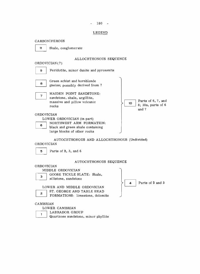
180
LEGEND
CARBONIFEROUS o Shale, conglomerate
ALLOCHTHONOUS SEQUENCE ORDOVICIAN ( ?) o Peridotite, minor dunite and pyroxenite
Green schist and hornblende gneiss; possibly derived from 7
MAIDEN POINT SANDSTONE: sandstone, shale, argillite, massive and pillow volcanic rocks
ORDOVICIAN LOWER ORDOVICIAN (in part) ~ NORTHWEST ARM FORMATION: ~ black and green shale containing
large blocks of other rocks
Parts of 6, 7, and 8; lOa, parts of 6 and 7
AUTOCHTHONOUS AND ALLOCHTHONOUS (Undivided) ORDOVICIAN
o Parts of 2,3, and 6
AUTOCHTHONOUS SEQUENCE ORDOVICIAN
MIDDLE ORDOVICIAN ~ GOOSE TICKLE SLATE: Shale, ~ siltstone, sandstone
LOWER AND MIDDLE ORDOVICIAN r-::-l ST. GEORGE AND TABLE HEAD ~ FORMATIONS : limestone, dolomite
CAMBRIAN LOWER CAMBRIAN
I----:-l LABRADOR GROUP ~ Quartzose sandstone, minor phyllite
D Parts of 2 and 3
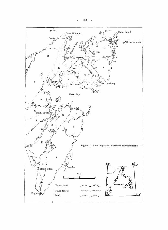
2
56' 00'
/\...Cape Norman ../;: 2
Cookt" Harbour/ ~
I I ( .
- --" /.' 9/:"'- '( :,' 3
/' \: 2 ',-_
181
&0 White Islands 1
Figure 1. Hare Bay area, northern Newfoundland
/ (
~ )
2 ! Rodchckton
\ f \ ) \
7
Miles
6~~ __ -=~O ________ ~6
Thrust fault
Other faults
Road ",.--..._/- ..........
___________ 4-5·
- 182 -
119. NORTHWEST RIVER MAP-AREA, LABRADOR (13 C, F)
1. M. Stevenson
Reconnais sance geological inve stigation, for publication on a scale of 1 inch to 4 miles, of about 14,000 square miles of eastern Labrador lying between 52 °OO'N - 54°00'N latitudes and 60°00' - 62 °OO'W longitudes, was completed during the 1965 field season. Because much of the area is inaccessible to fixed-wing aircraft, a Bell 47GZA helicopter was used to facilitate traversing. Equipment and aviation gas were flown in from Seven Islands, Quebec, by Canso amphibian, and during the summer support was provided by casual charter of an Otter from Goose Bay.
Topographically, the mapped area forms part of the vast peneplaned Laurentian Plateau, which in this region has a general elevation of some 1,500 feet above sea-level. Locally, as in the Mealy Mountain and Red Wine Mountain areas, the elevation is considerably greater, the maximum being about 2,600 feet above sea-level in the Red Wine Mountains.
The entire region has been glaciated and extensive deposits of sand, gravel, and clay cover many of the low-lying areas. Raised beaches with elevations in excess of 300 feet occur along the sides of many river valleys and on the slope s of hills throughout the area. The lowlands are characterized by extensive sand plains and muskeg areas that effectively obscure the bedrock. Chatter marks, striae, drumlins, eskers, and a variety of other glacial features are prevalent throughout the area. Large areas of ablation moraine, particularly in the southern part of the map-area, support a thick growth of spruce, larch, and birch. Although lakes are numerous, many are too shallow for float-equipped fixed-wing aircraft. Only a few of the larger rivers are navigable by canoe.
Underlying the greater part of the area is a mixed assemblage of rocks, predominantly paragneiss, which only rarely can be subdivided into separate units. Minor orthogneiss is also. undoubtedly present, but rarely can it be differentiated from the paragneisses. Included in these gneisses are lesser amounts of amphibolitic and associated basic schists. Several bodies of massive biotite -hornblende granite have been intruded into the gneisses, and the entire assemblage is cut by numerous dykes of dioritic and pegmatitic material.
Anorthosite and related gabbroic and dioritic rocks are found in the Mealy Mountain and Red Wine Mountain areas. Actual contacts between these rocks and the older gneisses are nearly everywhere obscured, but where observed, they were intrusive.
Bordering the anorthositic rocks of the Mealy Mountains, and extending westward into the map-area is a complex of syenite, gabbro, monzonite, and related rock types, which are believed to be associated with the anorthosite, and are hence post-gneis s in age. The syenite -monzonitegabbro complex, as well as the anorthositic rocks, are cut by numerous diabase dyke s. The anorthosite of the Red Wine Mountain area is fine grained, in contrast to the coarse -grained variety of the Mealy Mountains.
- 183 -
The youngest rocks in the area, of presumed Proterozoic age, are well-bedded sandstones, arkoses, and conglomerates exposed at a few scattered localities in the east-central part of the area.
Though no mineral showings of economic importance were recognized, chalcocite and chalcopyrite commonly occur in small pegmatite dykes, as well as minor quantities of beryl and apatite. Amphibolitic bands in the gneisses are commonly rust-coloured, due mainly to oxidation of pyrite and minor pyrrhotite. The numerous diabase dykes and gabbroic rocks commonly contain pyrite and magnetite. Detrital magnetite forms beds several inches thick in the sandy shores of several lakes, including Lake Minipi.
120. RED INDIAN LAKE (EAST HALF) (lZAEl/2) MAP-AREA
H. Williams
Geological mapping of approximately two-thirds of the Red Indian Lake (east half) map-area was completed suitable for 1 inch to 4 mile publication. The remainder of the map-area, as well as the southward adjoining Burgeo (east half) map-area (11 P El/2), are scheduled for geological mapping in 1966, when 4-mile reconnaissance mapping of the central Palaeozoic mobile beltl of Newfoundland will be completed.
Rocks of the Red Indian Lake (east half) area are chiefly Ordovician and Silurian sedimentary and volcanic rocks, which are folded, faulted, and intruded by a variety of igneous rocks. In the southern half of the map-area granite bodies of batholithic dimensions predominate and these are flanked by metasedimentary rocks of various aspects. Undeformed and poorly consolidated Carboniferous rocks occur locally along the shores of Red Indian Lake.
Ordovician greywackes, slates, and siliceous argillites and siltstones form a northeast-trending belt 15 miles wide along the Exploits River in the northeast corner of the map-area. Some of the slates are black, pyritic, graphitic, and graptolite-bearing. About 15 new fossil localities were discovere d in the se rocks. Southwe stward along strike the Ordovician sedimentary rocks are interlayered with a variety of volcanic rocks that together extend southwestward to the western edge of the map-area. The volcanic rocks are sheared and altered, and include large amounts of silicic agglomerate and flow rocks in addition to the basic varieties that are so common among Ordovician volcanic assemblages in central Newfoundland.
An extensive group of volcanic rocks that form the hosts for the Buchans base-metal ores occur to the northwest of the aforementioned Ordovician belt, northwest of Red Indian Lake. Commonest among the volcanic rocks are amygdaloidal (calcite, quartz) black, green, purplish red, and brownish red basic to intermediate lavas and dacitic to rhyolitic tuffs, agglomerates, and porphyries. Interlayered with the volcanic rocks are tuffaceous sedimentary rocks, composed dominantly of acid volcanic fragments, and grey to green siliceous argillites and cherts. Locally at the north end of Red Indian Lake near Miller town, greywackes and red micaceous sandstones are interlayered with purplish and reddish amygdaloidal (calcite)
- 184 -
lavas. All these volcanic rocks were previously thought to be of Ordovician age and they were tentatively correlated with Ordovician volcanic rocks of Notre Dame Bay to the northeast2 • It appears, however, that lithologically they are more like Silurian volcanic rocks in central Newfoundland. Amygdaloidal (calcite) lavas and red sandstones are typical of the Silurain Botwood G roup 3, 4 and siliceous tuffs, agglomerates, and porphyries compare well with the Springdale GroupS and Silurian (?) rocks ~unit lla) near Sheffield Lake in the Sandy Lake area adjoining on the north. The relationships in the map-area between these dominantly volcanic rocks northwest of Red Indian Lake and Ordovician rocks to the southeast are uncertain, but the two groups are probably separated by a major fault.
The Exploits River Ordovician belt is bordered to the southeast by a group of sedimentary ar,d volcanic rocks that are also probably of Silurian age. One mappable unit within the group consists of purple and red conglomerate, grey, brown, and red micaceous sandstone, and grey siltstones. The rocks comprising this unit can be traced across the map-area northeastward from the north end of Rodeross Lake parallel with Noel Paul's Brook and thence eastward to Sandy Lake. Near Sandy Lake bedding trends east and south of east and the rocks can be traced southeastward into lithologically similar rocks of the Botwood Group 7. This sugge sts a Silurian age for the unit and its associated rocks in the Red Indian Lake map-area. Farther southeastward the rocks are intruded by granite and grade into gneisses and schists.
Red micaceous sandstones along the eastern shore of Red Indian Lake between Harbour Round and Victoria River are faulted against Ordovician rocks to the southeast. The sandstones, previously assigned to the Carboniferous 8 , 9 are more probably Silurian and their lithology suggests correlation with red beds of the Silurain Botwood Group. The rocks are more highly indurated and more deformed than nearby Carboniferous rocks and pebbles of the red micaceous sandstones are abundant in Carboniferous conglomerates along the southeast side of Red Indian Lake.
Carboniferous rocks of the map-area are conglomerates, sandstones, and mudstones that occur locally along the shores of Red Indian Lake. Along the southeast side of the lake the rocks are red, whereas along the northwest side of the lake they are grey and brown. Contained pebbles indicate that these rocks are locally derived.
1 Williams, H.: The Appalachians in northeastern Newfoundland- -A twosided symmetrical system; Am. J. Sci., vol. 262, pp. 1137-1158 (1964).
2 Swanson, E .A., and Brown, R. L.: Geology of the Buchans orebodie s; Trans. Can. Inst. Mining Met., vol. 65, pp. 284-292 (1962).
3 Williams, H.: Botwood (W 1/2) map-area; Geo!. Surv. Can., Paper 62-9.
4 Williams, H.: Botwood map-area; Geo!. Surv. Can., Map 60-1963.
5 Kalliokoski, J.: Springdale map-area; Geo!. Surv. Can., Paper 53-5.
- 185 -
6 Neale, E. R. W., and Nash, W. A.: Sandy Lake (E 1/2), Newfoundland; Geol. Surv. Can., Paper 62-28 (1963).
7 Anderson, F. D., and Williams, H.: Gander Lake (W 1/2) map-area; Geol. Surv. Can. (:map in preparation).
8 Baird, D. M.: Geological map of Newfoundland; Geol. Surv. Nfld. (1954).
9Weeks, L. J.: Geological map,Island of Newfoundland; Geol. Surv. Can., Map l043A (1955).
- 186 -
GENERAL
121. STUDIES IN CARBONATE GEOCHEMISTRY
E.M. CaIneron
A continuous study is being made of the geochemistry of the carbonate sediments that contain much of Western Canada's petroleum reserves and have important Pb -Zn deposits.
The first horizon examined was the Slave Point Formation, which produces gas from dolomitized stromatoporoid reefs. The chemical characteristics of this unit have been determined, one of the more interesting features being a decrease in the Mg and Sr content of the limestones towards the dolomitized areas.
While the composition of the strata is determined by the sum of different mechanisms acting on the se diment, diagenetic proce s se s, such as dolomitization, have a particularly important bearing on the accumulation of economically important minerals. To properly distinguish the cause and effect of certain diagenetic processes the Swan Hills Member of the Beaverhill Lake Formation is being studied. This member is rather similar in both lithology and age to the Slave Point, but it i.s not dolomitized.
Some one thousand core samples of the Swan Hills Member from the Swan Hills and Virginia Hills Fields were collected during the summer. These have been analysed for Si, AI, Fe, Mg, Mn, Ti, Sr, Ba and Zn. In addition to its geological implications, the data is being used to evaluate sampling procedures in sedimentary rocks.
122. STUDIES OF CANADIAN NICKEL DEPOSITS
J.A. Chamberlain
Field inve stigations on the geological environment of nickel deposits were carried out in selected areas in New Brunswick, Quebec and Ontario, including an unusual nickeliferous magnetite deposit in serpentinite on the west side of Lake Nipigon. The samples obtained during the course of the field work will be studied in the laboratory to determine the nature of the nickel-rich phases, and their distribution in their mafic and ultramafic host rocks. The resulting information will add to our knowledge of the genesis of these deposits. It is hoped that in some cases the work will be of direct assistance in the search for and development of nickel orebodies.
123. STUDY OF DIABASE DYKE SWARMS OF THE CANADIAN SHIELD
W.F. Fahrig
Field work represented a continuation of the comprehensive study of diabase dyke swarms of the Canadian Shield. The recent publication of
- 187 -
Geological Survey aeromagnetic maps covering large blocks of the Shield has added significantly to the knowledge of the distribution of dyke swarms and in some instances has necessitated a re -examination and re -sampling of dyke swarms in some districts.
During the summer dyke localities were studied in the Great Northern Peninsula, Nfld., throughout a large area of Quebec, and in northwestern Ontario.
The field and laboratory data, which will be available from these and previously examined localities will constitute a fairly comprehensive body of fact about the major dyke swarms of the Eastern Shield.
124. BIOGEOCHEMICAL INVESTIGATIONS
J.A.C. Fortescue
Moose River Area, Ontario
Biogeochemical experiments were carried out as a part of a combined geological, geophysical, and geochemical investigation of the Moose River aeromagnetic anomaly. Twelve plots, each 80 feet square, were laid out (six in the vicinity of two specially selected aeromagnetic anomalies and six in control areas away from such anomalies). Descriptions of the plant communities in each plot, and samples of different horizons of the soil and overstory vegetation from fifteen locations within each plot were collected. The plant and soil samples were taken to a biogeochemical sample preparation laboratory (built in a trailer) and dried prior to despatch to Ottawa for analysis. Some two thousand sample s were collected and prepared by a crew of four during a seven week period. In addition over five hundred plant specimens were collected from the plots. Each specimen was pressed, mounted and identified before being placed in a herbarium. Miss L. U sik, of the Botany Department of McMaster University, was responsible for the processing of the plant specimens as well as for the preparation of detailed ecological maps of each of the 80-foot plots. The object of these studies was to make preliminary investigation of the feasibility of biogeochemical prospecting in the Moose River area and to establish a routine method for the investigation of the ecology and geochemistry of plant communi tie s. The biogeochemical inve stigations were accompanied by shallow seismic investigations, which provided information on the depth of overburden in the vicinity of each of the twelve plots examined. (See report by Hobson and Killeen elsewhere in this publication. ) --
Preliminary Investigations in Manitoba and British Columbia
During August and September a visit was made to a mining property in central Manitoba and one in central British Columbia in an attempt to locate a suitable area in which a biogeochemical investigation could be carried out next year. During this trip a number of plant samples were collected to form a foundation of a reference herbarium for the areas that were visited.
125.
- 188 -
CAMBRIAN BIOSTRATIGRAPHY IN THE EASTERN CORDILLERA
W.H. Fritz
Late Lower and early Middle Cambrian faunules were collected in Banff National Park on Mt. Eisenhower, Mt. Weed, and near North Saskatchewan Crossing. At the last locality diagnostic collections were made for the first time from the lower beds of the Cathedral Formation. These belong to the Albertella Zone and are thought to be younger than previously described Albertella faunules.
In Jasper National Park, Lower Cambrian faunules were collected on Mt. Kerkeslin, and Lower, Middle, and Upper Cambrian faunules were taken from a continuous section near the headwater of Chaba River. In this section Bathyuriscus -Elrathina Zone fossils were found near the top of the Pika Formation, indicating an older age than previously suspected. Also, the Lyell Formation is older than suspected, as an Upper Cambrian Dunderbergia faunule was collected near its base.
In the Northwest Territories, a 2, 500-foot section was collected in the Mackenzie Mountains. Most of the section can be assigned to the late Lower Cambrian, but some strata belong to the early Lower and Middle Cambrian.
Cambrian outcrops in southern Alberta and northern Montana were visited with D.K . Norris, J.D. Aitken, A.R. Palmer (U .S. Geological Survey), and Moshe Braun (Geological Survey of Israel). The results of this study are reported elsewhere in this publication.
Short visits were made to inspect the Jubilee Formation near Harrogate, B. C., the Chancellor Formation in Kootenay National Park, and both the Mt. Whyte and Burgess Shale in Yoho National Park. Evidence was found to question the Upper Cambrian age assigned to the Jubilee, and to sugge st extending the Middle Cambrian Chancellor into the Upper Cambrian.
126.
- 189 -
ELSAS -KAPUSKASING -MOOSONEE MAGNETIC AND GRAVITY HIGHS
Edwin H. Gaucher
Thirteen aeromagnetic anomalies shown on the enclosed index map were studied by collecting some 400 oriented samples as well as 100 hand samples from some 200 sites. Some 2,000 in situ susceptibility readings were taken and over 800 gravity stations and 5, 000 magnetic stations were established. Eighty per cent of the gravity survey was done by C. Lavoie. The aeromagnetic anomalies studied seem to correspond to the susceptibility of the rocks as measured on the outcrops. The densities of the samples from the outcrops seem to explain the gravity anomalie s. Summaries of the results obtained on each of the anomalies are given below.
The extensive aeromagnetic anomaly (1) in 42 B, south of Kapuskasing, was sampled and a gravity survey was made across it. The re sults of this anomaly study are not complete. The rocks are somewhat similar to the granulite of 42 I, anomaly No.9.
Anomalies 2 and 13 are two small circular anomalies over which we did detailed gravity and magnetic surveys. One of the anomalie s is located 10 miles west of Kapuskasing and the other 16 miles southwest of Moosonee. In addition to magnetic highs, both features showed gravity highs of 4 milligals amd 0.5 milligal respectively, which suggest, at least for the first one, that they are caused by intrusive plugs more mafic than syenite. One outcropping area in the middle of anomaly No.2 is composed of an alkaline pyroxenite and a gabbro, both of which were sampled for age determinations. The sample taken from the outcrop of pyroxenite contained up to 0.50/0 disseminated chalcopyrite. A drill-hole was put down by a mining company in the anomaly No. 13, but the core is not yet available.
Anomaly No.3 is a linear magnetic gradient crossing Highway 17, in a NE direction, 10 miles west of Kapuskasing. This gradient has no gravity expression and could not be explained by the susceptibilities measured on the outcrops. However, Dr. C.H. Stockwell has interpreted this gradient as a fault. Near a long, weak, east-west aeromagnetic high (4) in greywacke, 20 miles northwest of Kapuskasing, a detailed ground magnetic profile located three peaks, 150, 100, and 8 feet wide over a distance of 2 miles. The smallest peak is due to a S-foot wide concentration of magnetite with some iron sulphides in an east-west layer, observed in a shallow trench. Similar magnetite sulphide -rich layers could possibly underlie the other two peaks.
Two oval anomalies (5) known from drilling to be caused by serpentinized (vertical) sills in andesites were investigated in 42A northwest. Gravity profiles showed either a small negative anomaly over the magnetic high, or no anomaly. Only one outcrop of serpentinite exists and was sampled, but to do quantitative correlation would require using results from drilling by mining companies.
A gravity survey was done over a big oval aeromagnetic anomaly (6) and two smaller adjacent ones north of Kapuskasing in Clay Township. Outcrops of syenites locally rich in magnetite were located under the small anomalies and samples were taken for age determinations. A gravity high
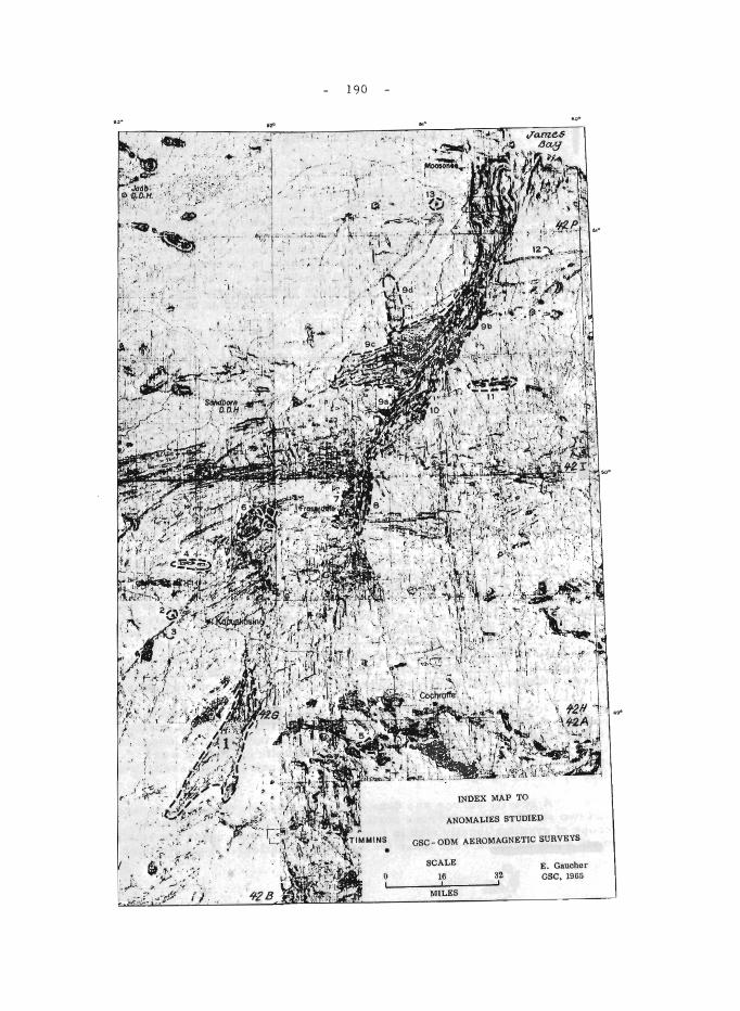
" ~ , '."~.' '' , '.'. ',;,' ·:': \F;.~::: :« '.
· ·Y' , .. ~
, ... ~ .
I .
, .,
"
I .
190
. 1 \-.. -oJ
': I
;:."
•
.,"
INDEX MAP TO
ANOMALIES STUDIED
GSC - ODM AEROMAGNETIC SURVEYS
SCALE
16 , MILES
32 E. Gaucher GSC, 1965
.,.
- 191 -
(2.0 mg) corresponding to the big magnetic anomaly suggests a gabbro or ultrabasic body, but no gravity high seemed to be associated with the small magnetic anomalies underlain by syenite.
East of Fraserdale an aggregation of somewhat discontinuous aeromagnetic anomalies (7) corresponds to a single, large, positive, gravity high of some 2.5 milligals, probably due to a single huge gabbro body. The gabbro outcrops in 3 places and in those outcrops varies from a layered anorthositic gabbro to an olivine gabbro cut by dykelets of serpentinized ultramafic rock to a serpentinite.
The wide linear magnetic anomalies numbered 8, 9a, and 9b, which begin in 42. H, 10 miles east of Fraserdale, and cross 42. I have been found on the ground to correspond to magnetite -bearing granulite gneisses, usually rich in garnet, amphibole, and pyroxene. A well defined positive gravity anomaly of over 10 mg, which corresponds to the aeromagnetic anomaly, can be explained by higher densities (as measured) of the granulites as compared to the surrounding granitic gneisses. Less well defined gravity highs correspond to anomalies 9c and 9d, and this plus the general continuity of the structures as well as a few exposures lets us assume that all the anomalie s labelled 8 and 9 are due to the same cause. Some sharp peaks within anomaly 9 might be due to ultrabasic bodies similar to No. 10 anomaly.
A smaller magnetic anomaly (10) at 81°04'W and 50 0 17'N, which looked like a subsidiary of anomaly No. 9a, was found to be actually due to a metapyroxenite. A distinct gravity high (5 milligals) occurs over the body, disseminated iron sulphides with minor millerite were found in outcrop.
A 4-milligal sharp positive gravity anomaly is associated with the No. 11 magnetic anomaly in 42. 1/7. No outcrops were seen but the magnetic and gravity anomalies are similar to the preceding anomaly (No. 10) and it should be worthwhile to inve stigate this pos sible mafic body.
A long thin linear aeromagnetic anomaly No. 12. in the northeast corner of 42. I does not outcrop, but the width of the ground aeromagnetic profile and a small sharp gravity high sugge st a diabase dyke.
Anomaly No. 13 has already been described with anomaly No.1.
Extension of the limited gravity surveys that were completed around Fraserdale and Clay township (No.7 and 6) to cover the whole area between Otter Rapids and Kapuskasing may be justifred, for gravity seems to be a very effective method of outlining the gabbroic intrusions that are often of interest to mining companies. Such a survey should be done with the density of a station every 2. miles, with additional closely spaced profiles wherever an access route crosses a magnetic feature.
12.7. OBSERVATION WELL PROJECT
J. A. Gilliland
Field work this summer was a continuation of the program initiated by M.L. Parsons. A shallow test hole was drilled at the Swift Current Experimental Farm, Saskatchewan.
- 192 -
Four shallow, small diameter observation wells were installed in the Melita area of Manitoba. Together with wells installed by the Manitoba Water Control and Conservation Branch, these wells are intended to determine how different aquifer types and different positions in the flow system affect water level variations.
A 70-foot deep, 8-inch water -table well was installed near Carberry, Manitoba. This will enable a comparison to be made between the records from their well and those from shallow recording wells in the area.
128. GEOLOGY OF IRON ORE DEPOSITS AND IRON-FORMATIONS IN CANADA
G.A. Gross
Field investigations during the 1965 season included detailed study of high-grade iron deposits and their geological setting on the north end of Baffin Island, continued study of iron-formations in Central Canada, and commencement of a detailed study of iron-formations and distribution of their sedimentary facies in the Knob Lake -Schefferville area of Quebec and Labrador (see report by Zajak).
Iron Deposits, North Baffin Island, N. W. T.
High-grade iron ore deposits in the Mary River area, lying 40 to 60 miles southeast of Milne Inlet on the north end of Baffin Island l were investigated by G.A. Gross and two assistants as part of a coordinated program with Dr. G.D. Jackson of the Geological Survey. Five of the principal deposits were investigated in detail and data from geological and magnetometer surveys were plotted on a scale of 1 inch to 100 feet. Investigation of the geological setting of major iron deposits involved geological mapping of 20 square miles on a scale of 1 inch to 500 feet, supplemented by detailed magnetometer surveys to trace the iron-formation and local structures under glacial till. Data supplied by Baffinland Iron Mines Limited on surface sampling, diamond drilling, magnetometer surveys and geological investigations were incorporated in this study.
The Precambrian iron-formation overlies grey biotite feldspar quartz augen gneiss and is interbedded with chlorite amphibole schists derived from metasediments and basic volcanic rocks. The group of metasedimentary and volcanic rocks is intruded by basic and ultrabasic dykes and sills that are altered to serpentine in places and some shear zones bear small amounts of asbestos.
The iron-formation metasediments and volcanic group of rocks are highly deformed structurally and infolded in a complex assemblage of granitoid rocks, mainly gneisses and massive granite. Discontinuous deformed belts of iron-formation metasediments and volcanic rocks are cut by faults and by younger granite and pegmatite. Erosion of complex doubly plunging fold structur e s has left numer ous small isolate d belts of metasediments and volcanic rocks surrounded by granitoid rocks.
- 193 -
The high-grade iron deposits are distributed stratigraphically and are part of magnetite, hematite, or iron-silicate quartz iron-formations. High-grade magnetite zones forming part of the iron deposits are interbedded with thin banded magnetite quartz iron-formation and constitute magnetite rich facies of iron-formation. The high-grade porous hematite parts of the deposits associated with high-g:r;ade magnetite zones were derived from iron-formation by leaching of silica and enrichment of iron. The rich hematite and magnetite zones were subsequently recrystallized during a period of regional metamorphism and intrusion of basic dykes and sills and the amount of porosity has been reduced in some zones where micaceous hematite developed during a later stage of structural deformation. A further stage of leaching of silica and enrichment of iron by groundwater occurred since Precambrian time and before recent glaciation.
Iron-Formations in Central Canada
Iron-formations of Algoma and Superior type were examined in 25 different areas by H.P. Wilton as part of a continuing study of ironformations. Stratigraphic sections and sedimentary facies were de scribed in detail and more than 50 chip-samples were obtained for petrological, miner alogical, and geochemical stu die s.
1 Gross, G. A.: Geology of iron ore deposits and iron-formations of Canada; in Jenness, S.E. (comp.): Report of Activities: Field, 1964; GeoI. Surv. Can., Paper 65-1, p. 142 (1965).
129. SEISMIC INVESTIGATIONS IN HUDSON BAY
G.D. Hobson
Seismic surveys were conducted in Hudson Bay during August and September 1965 as part of an extensive and comprehensive survey of the Bay encompassing the fields of geophysics, geology, and oceanography. Two ships were engaged in the seismic operations. The vessels CSS Hudson, the $7 1/2 million oceanographic research vessel of the Canadian government, and the MY Theron, a charter vessel were utilized as the recording and the shooting platforms re spe ctively.
Two type s of seismic surveys were conducted. A crustal refraction experiment (Fig. 1) was shot wherein 9 university and governmental crews recorded data at stations on the periphery of the Bay. Telemetering sonobuoys were monitored by instrumentation aboard CSS Hudson at the central location in the Bay. Good quality data were obtained from 41 charges of 1,800 and 3,600 Ibs. of explosives detonated electrically on the bottom. A conventional marine refraction program (Fig. 2) was conducted with a towed cable and hydrophone s. The charge size was variable up to 500 lbs.
Preliminary investigation of the data has revealed several interesting facts. Mud thickness on the bottom may be greater than 100 feet overlying bedrock whereas other bottom areas have been scoured clean by bottom currents. In general, seismic velocities in excess of 14,500 feet per second were recorded. Infrequently, lower velocities other than water
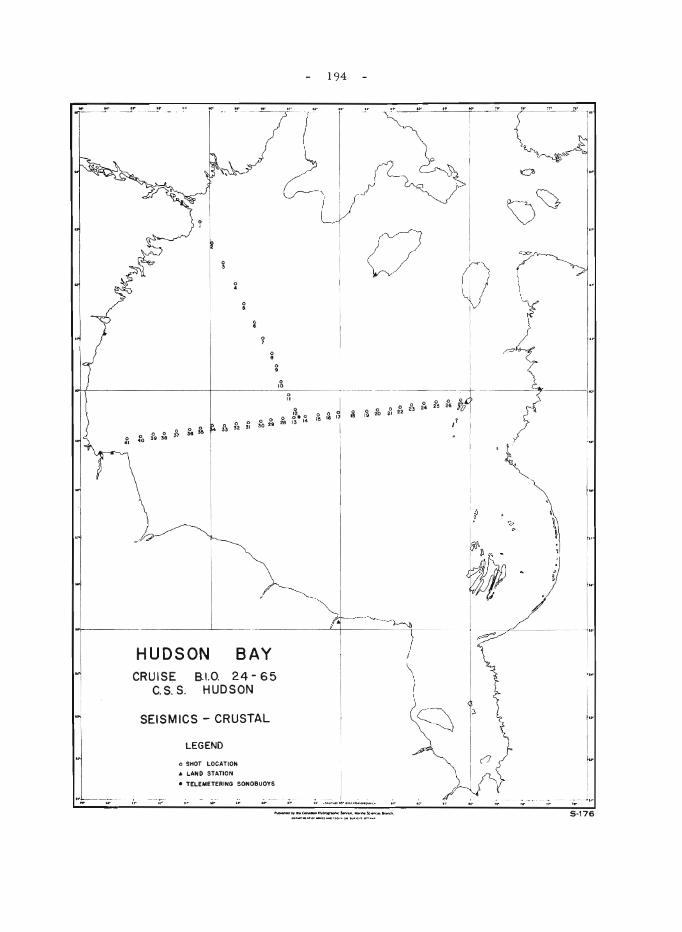
o '0
o 0 .... o ~. 0 fo 2~ 2B 13 14
HUDSON BAY CRUISE
C.S. S. 8.1.0. 24 - 65
HUDSON
SEISMICS - CRUSTAL
:; .,. ---or
LEGEND
o SHOT LOCAT ION
.. LAND STATION
• TELEMETEAINO SONOBUOYS
194
o
l~ I~ I
... . -... " .. "., ....... ; ..... --- . ~- -~ -..-- ,.-'r .,. 'r
5-176
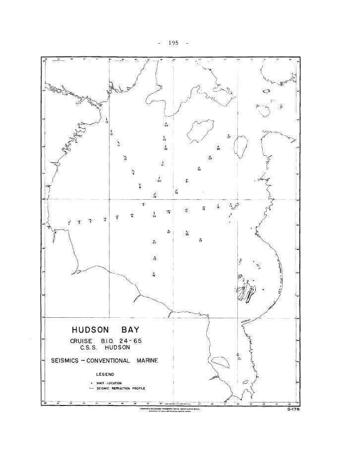
i
\ "
-:- 1 -; I
HUDSON
"-,
" •
BAY CRUISE 810. 24- 65
C.S. S. HUDSON
~ ,.
d ..
I
195
:;' ! 0, 22 2t
I " " '0
. 29
20 31
18 I 11
" , "
SEISMICS - CONVENTIONAL MARINE
LEGEND
SHOT LOCATION
- - SEISMIC REFRACTION PROFILE
--- - . - --- .....-~ ... , .... , ... , .... ".,_ .. " •• ~. II"
j ,
i ~' I " sJ -1,J 'b .~r''1
~ 1-(' -
\,) ,~
;,
~ • a ~
I
1
Iw
5-176
- 196 -
velocity were observed. An exceptionally high velocity of about 23,000 feet per second was recorded consistently at bedrock and at depth at several locations on the east side of the Bay. These higher velocities are immediately west of the Ottawa Islands and indicate that the mafic rocks of these islands probably extend for some distance westward. Farther west the se ismic velocitie s sugge st that ther e may be a considerable thickne s s of Proterozoic sediments overlying the Precambrian basement, the westerly limit of which is not yet known.
In the central basin of Hudson Bay the presence of low and intermediate values of seismic velocities indicates the probable existence of Mesozoic sediments overlying the Palaeozoic sediments. The estimated thickness of sediments overlying Proterozoic strata is 7,000 feet in this central basin. Variations in velocity data indicate that there is considerable structure within the sedimentary section in the central part of Hudson Bay.
130. GULF OF ST. LAWRENCE MARINE SEISMIC INVESTIGATIONS
G.D. Hobson
Two-ship marine seismic refraction experiments were conducted during October 1965 to inve stigate the thickne s s, nature, and attitude of the sedimentary rocks underlying a portion of the Gulf of St. Lawrence to the depth of the crystalline basement. It is a continuation of a study begun in 1964 to investigate the geological structure of the Gulf area.
CSS Hudson acted as the recording platform throughout the program, while MV Theron and CNAV Sackville participated as shooting vessels as they were available. Refraction te chnique s we re applie d throughout. Reflection shots were not attempted. A shot location was held constant by the shot ship at the centre of the profile while the recording vessel towed the cable and detectors across the shot location stopping at selected recording positions so that the refraction profiles are similar to an expanded splitspread.
Data obtained from the refraction spreads are fair to good in <Luality. Unexpectedly large quantities of explosfves were required this season to yield usable records. The high attenuation of energy, however, is not encountered everywhere indicating that bottom conditions (that is, the thickness of unconsolidated bottom materials), are the responsible agent rather than the pre sence of an acoustically absorbent stratum at depth.
A cursory examination of the field time - distance plots indicates a considerable thickness of sediment bene ath most of the profiles surveyed. Of particular interest may be the presence of several thousands of feet of sediments between St. Paul Island and Cape Breton Island despite the presence of probably Precambrian sediments nearby both locations. St. Paul Island is probably a continuation of the Cape Breton highland topography.
The Carboniferous basin of the Maritimes appears to be controlled in areal extent by the Laurentian trough or the Cabot Strait trough as defined by various geologists. Two very good profiles were shot in the trough south of Anticosti Island in which low-velocity sediments were absent
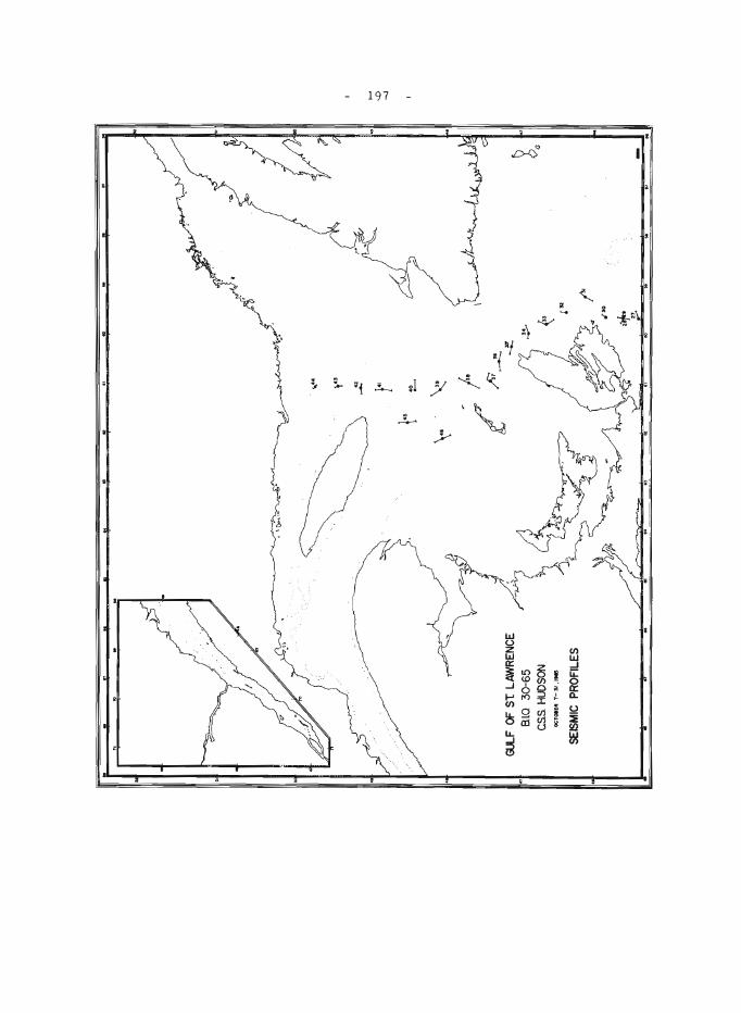
197
- 198 -
in the section. The data have not been compiled to date so that it is not yet possible to estimate the total thickness of sediments present in the Gulf of St. Lawrence.
The Orpheus gravity anomaly south of Cape Breton Island is probably due to a considerable thickness of sediments deposited within a depression rather than due to a basement or sub-basement high. This preliminary conclusion is based upon a field appraisal of the data. Dr. B. D. Loncarevic of Bedford Institute of Oceanography has the pertinent records at the present time to conduct a thorough investigation of these profiles and will publish a more comprehensive paper primarily concerned with his own gravity experiments over the anomalous area.
131. MICROFOSSILS IN PRECAMBRIAN IRON-FORMATIONS
G. L. LaBerge
Field work consisted of collecting samples from a number of Precambrian iron-formations exhibiting a wide range in age and lithology, to study for possible organic remains. Samples from Proterozoic ironformations were collected in the Gunflint district and from the Knob Lake area in Labrador-Quebec. Samples of Archaean iron-formations were collected at Wawa, Kamanistikwia, and Timagami, Ontario.
Material was collecte d from the now famous basal Gunflint black chert from the Schreiber, Ontario, area. As numerous well-preserved fossils have been" reported from the chert, it is hoped that useful reference material was obtained. Thin sections of the material examined thus far indicate that fossils and probable relict microfossils are present.
The project is directed toward evaluation of evidence for microorganisms in Precambrian iron-formation and their possible role in the sedimentation and origin of chert and cherty iron-formation.
132. PALAEOMAGNETIC STUDIES, NEAR ROUYN, VAL D'OR, AND SUDBURY
A. Larochelle
Two hundred and fifty oriented samples were collected from diabase dykes in the general areas of Rouyn and Val d'Or, Quebec, and Sudbury, Ontario.
One of the purposes of this work was to complement a previous collection in the same areas and to investigate the anomalous directions of magnetization observed at some sites. Another reason for doing this work was to test the performance of a portable diamond drill recently developed at the G e ological Survey and to establish a standard procedure in collecting samples for palaeomagnetic studies. The drill performance was satisfactory.
- 199 -
Finally it was proposed to establish a comparison between magnetization direction clusters when the sampling is done by drilling and by ordinary block extraction. No laboratory work has yet been done on the samples.
133. METALLOGENIC STUDY, CANADIAN APPALACHIANS
W. D. McCartney
Field examination of mineral deposits in relation to the geological evolution of the Canadian Appalachians was concluded. Initial re sults were formerly summarize d 1 .
The virtual restriction of chalcopyrite-pyrite deposits to Ordovician eugeosynclinal volcanics in Newfoundland has recently been emphasized2 (Fig. 1). Thick, seemingly uniform, mafic pillow lavas of the north-central belt tend to contain disseminated crystals or thin veinlets of pyrite and/or chalcopyrite, seemingly controlled by faults and schistosity. Deposits in the northwest part of the area shown on Figure 1 (Rambler, Terra Nova, Tilt Cove) lie in more diverse Ordovician volcanics and tuffaceous and sedimentary rocks and are more characteristic of strata-bound massive sulphide deposits similar to those in the Bathurst district, N. B.; the Sherbrooke belt of the Eastern Townships, Que.; and possibly the Mindamar (Stirling) property of Cape Breton Island, N.S. The sketch map illustrates the need on metallogenic maps to differentiate the lithology (in this case Ordovician volcanics vs. sediments) as well as the age, which is eInphasized on normal geological maps (in this cas e promising Ordovician vs. less promising Silurian volcanics).
Localities in Nova Scotia of particular Inetallogenic inte'rest were selected and C. R. McLeod collected heavy mineral concentrates for laboratory study. (S~ report by McLeod elsewhere in this publication. )
1 McCartney, W. D.: Metallogeny of post-Precambrian geosynclines; in Geol. Surv. Can., Paper 65 -6, ed. by E .R. W. Neale, pp:-33-42 (1965) .
2 WilliaIns , H.: Relationship between base metal mineralization and volcanic rocks in northeastern Newfoundland; Can. Min. Jour., vol. 84, No.8, pp. 39-42 (1963).
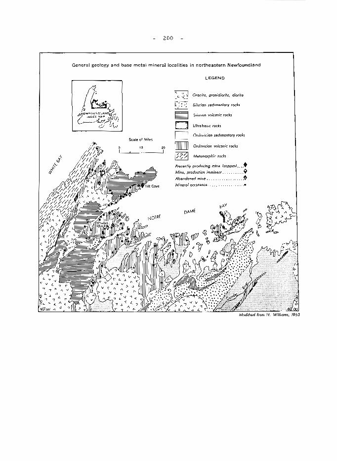
200
General geology and base metal mineral localities in northeastern Newfoundland
Scale of Miles
10 I
20 !
LEGEND
Granite. gronjdiorite. diorite
Silurian sedimentary rocks
Silurian volcanic rocks
Uftrobosic rocks
Ordovician sedimentary rocks
Ordovician volcanic rods
Metamorphic rocks
Presently producing mine {copperJ .... + Mine, production imminent, . ..... .... ~ Abandoned mine . .. .. , .. . . ... ... . ~ Mineral occurence .. .. .. . . . .... .... .•
- ZOI -
134. BERYLLIUM AND LITHIUM DEPOSITS, NORTHERN SASKATCHEWAN AND NORTHERN MANITOBA
R. Mulligan
Berylli~rous pegm.atites near Sturgeon-Weir River and Hanson Lake in northern Saskatchewan reported by Pike 1 were briefly exam.ined.
Lithium.-bearing pegm.atites at Cross Lake, Munroe Lake, God's Lake and Red Cross Lake reported by Bell Z, B arry3,4, and Potter 5 were briefly exam.ined and m.aterial collected for c~m.parative age studies on m.icas.
1 Pike, M. W.: Birch Portage map-area, Saskatchewan; Sask. Dept. Min. Res., Geol. Rept. No. 93 (1965).
ZBell, C.K.: Cross Lake m.ap-area, Manitoba; Geol. Surv. Can., Paper 61-2Z (1962).
3Barry, G.S.: Oxford House-Knee Lake area; Man. Mines Br., Pub. 58-3 (1959) .
4Barry, G.S.: Munroe Lake m.ap-area; Man. Mines Br., Pub. 61-Z (1962).
5 Potter, R. R.: God's River m.ap-area, Manitoba; Geol. Sur v . Can., Paper 62-8 (1962).
135. ORDOVICIAN AND SILURIAN BIOSTRATIGRAPHIC STUDIES
B.S. Norford
The type sections of the Franklin Mountain and Mount Kindle Form.ations were studied near Wrigley, District of Mackenzie. The upperm.ost beds of the Franklin Mountain Form.ation contain Ordovician fossils. Both Upper Ordovician and Silurian faunas are present in the Mount Kindle Form.ation.
Other stratigraphic work in the Cordillera included studies of sections in Wrigley Lake map-area, District of Mackenzie, in Toad River map-area, northern British Colum.bia, and in the southern Rocky Mountains of British Columbia and Alberta (see reports by H. Gabrielse, G. C. Taylor, and R.A. Price, respectively, elsewhere in this publication). The Ordovician and Silurian sequences of southern British Columbia and Alberta were compared with those of Nevada, Utah, and Idaho under the guidance of R.J. Ross, Jr., United States Geological Survey.
- 202 -
136. GROUNDWATER INVESTIGATIONS, ONTARIO, MANITOBA, AND SASKATCHEWAN
M.L. Parsons
Groundwater observation wells and piezometers were installed in various areas of Ontario, Manitoba, and Saskatchewan. During May three nests of 3 piezometers each were installed approximately 30 miles north of Iroquois Falls, Ontario for the purpose of determining the groundwater flow system associated with the large esker deposits of the clay belt. The piezometers, installed by the Department of Public Works, vary in depth from 24 to 140 feet. In conjunction with this drilling, reconnaissance mapping of the glacial geology was extended northward from the Iroquois Falls map-areal. Accessibility to drill sites is a major problem in the area when the ground is not frozen.
During June and the last 10 days of July, an observation well and five nests of 2 piezometers each were installed in the Wilson Creek drainage basin of Manitoba. This project was done in conjunction with the erosion study of the Manitoba escarpment being coordinated by the Prairie. Farm Rehabilitation Act. The piezometers installed by the Department of Public Works, are spaced from the base to the top of the escarpment. The nest on top of the escarpment is in till with the piezometers at depths of 50 and 450 feet. The other piezometers and the observation well are in bedrock clay and shale at depths varying from 35 to 415 feet.
One 8-inch diameter observation well and seven 2-inch diameter wells were installed in the Moose Mountain area of southeastern Saskatchewan during July. The wells are from 30 to 44 feet deep in glacial sediments and are de signed to measure fluctuations of the approximate groundwater table.
From August 1 to 15 a nest of three piezometers and a 6-inch diameter observation well were installed in the Cypress Hills area of southwestern Saskatchewan . The observation well is 50 feet deep in the Ravenscrag Formation and the three piezometers are at depths of 150, 312, and 500 feet in sediments of Tertiary and Late Cretaceous age.
1 Hughes, O. L.: Surficial geology, Kirkland Lake, Cochrane District, Ontario; Geo!. Surv. Can., Map 46-1959 (1959).
137. GLACIAL STUDIES, NORTHEASTERN ONTARIO AND NORTHWESTERN QUEBEC
V.K. Prest
The distribution of moraines, the occurrence of Cochrane till, the extent of glacial Lake Barlow-Ojibway, and marine overlap south of James Bay were investigated in northwestern Quebec and northeastern Ontario in so far as deemed necessary for the forthcoming Glacial Map of Canada.
- 203 -
In the Noranda region (32D) the amount and direction of tilt of the highest water plane of glacial Lake Barlow-Ojibway was determined. The water plane rises in a direction N25°E at about 3 feet per mile from 1,150 feet at Kirkland Lake (Ontario) to 1,450 feet at Plamondon Hill (Quebec).
In the Senneterre area (32C) immediately to the east the maximum indicated water plane is about 100 feet lower and appears to represent a later stage of Barlow-Ojibway. This and successively lower water stages followed the receding Labrador ice -sheet northeastward into the Lake Mistassini Basin, where the glacial lake was finally dammed by higher ground.
The southern limit of the Cochrane till was determined along the Mattagami highway. The Cochrane limit may now be traced from Mattagami westward above latitude 49°30' into Ontario and thence southwest and south around the Abitibi Hills to near Iroquois Falls and Timmins.
Buried non-glacial deposits were studied in the Abitibi River Basin north of the Fraserdale moraine. Some of the plant-bearing clayey and sandy sediments are believed to correlate with the Missinaibi beds, which have a radiocarbon age of more than 53,000 years (B.P.). Contorted, dense, fossiliferous stony marine clays were discovered that are believed to underlie and possibly grade into the Missinaibi beds. The presence of buried marine deposits in the James Bay Lowland indicates an 'open' Hudson Bay and hence the onset of a former Interglacial interval. The stony marine clay overlies and butts against an outcropping of orangy-yellow quartzose sand with one bed of variously rotted Precambrian boulders.
138. METALLOGENETlC STUDIES, ONTARIO AND QUEBEC
S.M. Roscoe
Mineral deposits examined in 1965 included: massive zinc and copper -bearing sulphide deposits near Timmins, in Pourier and Joutel townships (Quebec), and the Mattagami Lake deposit; gold deposits near Wawa, Noranda-Val d'Or, Belleterre (Quebec); Cu-Ni deposits near Belleterre; small Ni-Mo, Zn, Cu, and fluorite occurrences in the Pontiac 'schists' south of Rouyn; sulphide occurrences associated with iron-formation and other strata north of Sudbury, Michipicoten, Val d'Or and Belleterre; chalcocite veins in Keweenawan lavas and a porphyry-type CuMo deposit in the Mamainee area north of Sault Ste. Marie; galena-sphalerite veins probably associated with Keweenawan diabase dykes northeast of Sault Ste. Marie; the Fire sand carbonatite near Wawa, and the copper -bearing Coldwell alkalic syenite at Marathon. Special efforts were made to collect samples for laboratory investigations of the association Au-arsenopyrite in magnetic, graphitic, and siliceous sediments including iron-formation. Search for cobalt-type Co-Ag deposits east of Lake Timiskaming failed to confirm a supposed eastward extension of cobalt mineralization.
The writer also helped give geological orientation to a field gamma-ray spectrometric investigation (field instrumental u, Th, K analyses) in the Elliot Lake area and reviewed current exploration activities therein.
- 204 -
139. V ANADIU M IN WESTERN CANADA
E.R. Rose
More than 100 formations of sedimentary and igneous rocks of various types and ages were examined and checked in the field for the presence of vanadium by means of a hydrogen peroxide test. Vanadium was detected in amounts exceeding 0.015 per cent, that of the average crustal rock, in 132 of the 294 samples tested, mainly in dark shales, sandstones, volcanic rocks of intermediate to basic composition, greenstone, horn-ble ndi te, and ti tanife r ou s rna gne ti te .
Vanadium was detected in strong traces in amounts greater than 0.1 per cent in volcanic rocks and chalcocite -bearing zones, west of Menzies Bay, Vancouver Island and north of Gowland Harbour, Quadra Island; in hornblende gabbro and associated titaniferous magnetite, on East Sooke peninsula, Vancouver Island, on west-central Banks Island and on central Porcher Island south of Prince Rupert; in dark schist at Prince Rupert, in dark shale south of Nanaimo and in grey sandstone in the Nicola valley east of Spence's Bridge, all in British Columbia. Traces of vanadium were noted in numerous other localities of sedimentary and volcanic rocks in British Columbia. Very faint traces of vanadium were detected in a large zone of gossan and shale at the headwaters of the Gataza River in northern British ColUInbia; and in the Athabasca tar sands of northern Alberta . Strong traces of vanadium were noted in several mineralized samples from the Beaverlodge area in northern Saskatchewan where parts of the uranium ores are also known to be vanadiferous. Traces of vanadium were detected in sandstone, shale, and coal north and west of Eillnonton, Alberta, and in reddish dolomitic argillite in a shaft east of Esterhazy, Saskatchewan. The widespread distribution of vanadium in this great variety of rocks suggests the existencp- of possible vanadium metallogenic provinces in Western Canada within which vanadium ores may yet be found.
Strong traces of vanadium were also noted in a number of associations in northern Ontario, namely anorthositic gabbro of the Pic River area, reddish argillite near intrusive diabase east of Nipigon, siderite from the Michipicoten area, greywacke -quartzite south of Spanish, greenstone intercalated with the Timagami iron-formation as well as in the basal yellow and black sandstone, and maroon arkose near Elgin in eastern Ontario.
140. MINERAL COLLECTING AREAS, EASTERN TOWNSHIPS, GASPE, AND NORTHERN NEW BRUNSWICK
Ann P. Sabina
The field work consisted of an examination of about 170 mineral and rock localities in northern New Brunswick (Fredericton-BathurstCambellton area), in Gaspe, and in the Eastern Townships. The purpose of the investigation was to obtain up-to-date information on deposits of interest to collectors, tourists, etc. A guidebook describing the collecting sites and giving detailed directions to reach them is being prepared.
- 205 -
Collectors may expect to find a variety of both collection and lapidary material; a number of fossil localities will also be included. Specimen material includes ore minerals from the base metal mines in New Brunswick and Eastern Townships, industrial minerals from the Eastern Townships, and less common secondary minerals associated with these deposits. Lapidary material includes the agate -jasper-chalcedony deposits in New Brunswick and Gaspe areas; various marbles in Gaspe and Eastern Townships, and soapstone (Eastern Townships).
141. STRATIGRAPHY OF SUPERIOR-TYPE IRON-FORMATION IN THE SCHEFFERVILLE-KNOB LAKE AREA,
QUEBEC AND LABRADOR
loS. Zajac
A detailed investigation of the iron-formation was started in this area to define the nature and distribution of sedimentary facies and to understand the depositional environment for these chemical sediments. Stratigraphic sections were examined between Stakit Lake near the western margin of the Labrador geosyncline and Dolly Ridge east of Knob Lake and south as far as Astray Lake. The Lower Red Cherty Member of the iron-formation was found to be a useful marker zone and evidence for cyclic deposition of the various sedimentary facies of iron-formation is being evaluated.
Results from this project will be used by Mr. loS. Zajac for a Ph. D. dissertation at the University of Michigan, Ann Arbor, Michigan.
142. AEROMAGNETIC RECONNAISSANCE OF THE FLEMISH CAP OFF NEWFOUNDLAND1
P.J. Hood, M.E. Bower, and P. Sawatzky
This survey was to extend the aeromagnetic survey results obtained during anR.C.A.F. Argus sortie in January 1963. It was carried out in cooperation with the National Research Council using a digital rubidium-vapour magnetometer installed in the NAE's North Star aircraft. Ten east-west lines spaced about 10 miles apart and about 70 miles long were obtained on two sorties carried out from the U.S. base at Argentia, Newfoundland on November 13 and 14, 1965. The area is bounded approximately by the coordinates 47°50'N 45°30'W, 47°50'N 43°40'W, 46°10'N 43°40'W, 46° 10'N 45 °30'W. The survey altitude was 300 feet and navigation was by Loran A.
The expected sharp short-wavelength anomalies were recorded on all lines except the most northerly, and are presumably due to basic igneous intrusions whose tops are buried at no great distance below the ocean bottom. More detailed interpretation must await the compilation of the resultant aeromagnetic profiles.
IThe field observations for this report were completed after the close of normal field operations and the report was received too late for insertion in its proper place in this Report of Activities.
- 206 -
GEOLOGICAL COLLECTING
Collection of fossils, rocks, minerals, and other geological data is an important phase of many field projects. Some parties, however, go to the field to make collections for a specific research project. Such collections undergo further study at Geological Survey headquarters, yielding results that frequently appear in reports of the Geological Surveyor in assorted scientific periodicals. Any account of the field work involved in these studies can only record the collecting phase.
Eight collecting projects are recorded below.
M. J. Copeland made collections for micropalaeontological analysis from rocks of Silurian (Arisaig and Cobequid areas, Nova Scotia; Jones Creek, New Brunswick; Black Cape and Riviere de l'Anse-au-Griffon, Quebec) and Carboniferous (Parrsboro and Joggins, Nova Scotia) ages. The se samples will be examined more closely for microfauna suitable for detailed age determi.nations.
C. H. R. Gauthier, from March 17th to September 24th, collected more than 20 tons of minerals, rocks, and ores, used in the preparation of various collections from about 50 localities in the provinces of Manitoba, Ontario, and Quebec. He also collected some pegmatitic granite from Lacorne township, Quebec, for R.K. Wanless, to assist in the Survey's age determination program.
P .A. Hacquebard collected six column samples of the Main Seam in the Minto-Chipman coal area of New Brunswick for a study on regional variations in the petrography and palynology within one coal seam. These samples complement those obtained from the drilling program carried out by the Dominion Coal Board in 1964.
P .A. Hacquebard and A.R. Ccuneron collected twelve column samples for a petrographic study of coals of different rank, age, and geological setting, from seams in the following coal areas of British Columbia: I, Princeton; 2, Tulameen; 3, Merritt; 4, Telkwa; 5, Nanaimo; and 6, Comox. In the Michel area of British Columbia they collected additional channel sample s for petrographic re search on coking coals.
R.D. Howie collected oil and gas well data from the Mines Department in Quebec, New Brunswick, Nova Scotia, Prince Edward Island and Newfoundland; established the location of a number of shallow wells in New Brunswick for which samples are on file in Ottawa, and obtained Cable Tool samples for New Brunswick Oilfields Ltd. Well #167.
V. Koeppel collected radioactive samples from underground workings and surface exposures at Uranium City, Saskatchewan, for the following purpo se s:
a} U -Pb age determinations of pitchblende from vein type (epigenetic) deposits.
b) U -Pb age determinations of U -bearing minerals of pegmatitic (syngenetic) deposits.
- 207 -
c) Pb isotope stud.ies of Pb minerals. d) Whole rock Pb isotope studie s of basic dyke s, flows, and sills. e) Pb isotope studies of feldspars from granites, pegmatites, and sand
stones. f) Whole rock Rb/Sr age determinations of "granites" intruding and
replacing the Tazin Formation.
D.F. Sangster collected more than 400 samples containing galena and sphalerite from 15 lead and zinc deposits of the Mississippi Valley type. Areas visited were in the Northwest Territories, British Columbia, Nova Scotia, Newfoundland, and Ontario. Host rocks ranged in age from Cambrian to Mis sis sippian. The sample s will be analyze d for a number of trace elements to determine the variations, 'if any, of these elements between deposits as well as within individual deposits. All occurrences visited were previously known from the literature except for one small sphalerite showing near Ferndale, Ontario (see report by Bolton and Liberty, elsewhere in this publication).
J. Terasmae collected pollen and C-l4 samples as part of his continuing study of the Quaternary palynology of Canada. He sampled lacustrine sediments in the Chaudi~re Valley, Quebec, bog and lake sediments from the Sherbrooke area, Quebec, lake sediments at sites higher than the Champlain Sea limit in the St. Hilaire region, Quebec, and lake and peat samples in the Great Lakes region and from Cape Breton Island. From the St. dilaire sample s he hope s to extend the late -glacial and po st-glacial chronology in the St. Lawrence Lowlands. He also sampled bog and lake deposits in the Iroquois Falls region in northern Ontario in order to work out the post-glacial muskeg and forest history, and collected air -borne pollen from several parts of the country as part of a Canada-wide study of air -borne pollen and its relationship to the regional vegetation.
- 208 -
AUTHOR INDEX
Page Page
Aitken, J.D. ............... 104 Gabr ielse, H. ................ 42 Anderson, D.T. ............ 144 Gadd, N .R. .................. 163 Anderson, F.D. ............ 176 Gaucher, E. .................. 189 Armstrong, J.E. ........... 50 Gauthier, C.H.R .............. 206 Allaart, J. H. .............. 4 Gilliland, J.A ................ 191 B ae r, A. J. ............. . . . 80 Gillis, J. W .................. 178 Bamber, E. W. ............. 50 Gregory, A. F. ............... 156 Baragar, W.R.A. .......... 160 Gross, G .A. ................. 192 Bell, C. K. ................. 133 Goodwin, A. M. ............... 153 Benson, D.G. .............. 170 Hacquebard, P. .............. 206 Blackadar, R.G. ........... 2 Halstead, E.C. .............. 59 Blake, W. Jr. .............. 3 Henderson, E.P .............. 154 Blusson, 5. L ......... , . . . . . . 38 Hobson, G. D. . ......... 61, 111,155 Bolton, T.E. . . . . . . . . . . . . . . 146 193,196 Bostock, H.H. .............. 25 Hood, P.J ................. 19,205 Bower, M.E. . ..•......... 19,205 Hornbrook, E.H.W ............ 155 Boyle, R. W. ............... 168 Howie, R.D .................. 206 Cameron, A.R. ............ 206 Hughes, O.L. ................ 46 Cameron, E.M. ............ 186 Hunter, J.A.M ............... 111 Campbell, R.B. .. .......... 51,52 Hutchison, W. W. ............. 80 Carmichael, D. M. .......... 148 Irish, E.J.W .•............... III Carr, P.A. ................ 175 Irvine, T.N. ................. 61 Carson, D.J.T. ..... ....... 53 Jackson, G.D. ................ 14 Chamberlain, J.A. ......... 186 Jenne s s, 5. E . ................ 1 7 1 Charron, J.E. ............. 137 Karrow, P.F ................. 155 Christie, R. L. ............. 3 Kelley, D.G .................. 172 Coates, J. ................. 55 Ke r r, J. W . . ..•...• ,......... 16 Collett, L.S. ............... 137 Killeen, P.G •.•............ 155,156 Copeland, M. J. ............ 206 Kindle, E. D. ................. 62 Craig, B.G. ............... 139 Klassen, R. W. ••.. . . . . . . . . . . .. 141 Currie, K.L. .. ......... 151,161 Koeppel, V. .•................ 206 Davison, W. L. ............. 141 LaBerge, G.L ................ 198 Delorme, L.D. ............. 175 Larochelle, A. ............... 198 Dineley, D. L. .............. 12 Lawson, D. W . . . . . . . . . . . . . . . . 63 Donaldson, J.A .•.......... 22,23 Lee, H.A. ................... 168 Eade, K.E. ................ 19 Leech, G.B. ................. 65 Emslie, R. F. .............. 161 Lewis, C.F.M ............... 157 Ermanovics, 1. F. .......... 151 Liberty, B.A. ................ 146 van Everdingen, R. O. ....... 124 Lissey, A. ................... 143 Fahrig, W.F ............... 186 Little, H. W. ................. 67 Findlay, D.C. .............. 151 Mackenzie, W.5. ............. 73 Fortescue, J.A. C. .......... 187 Macqueen, R. W. ............. 112 Frarey, M.J. .............. 152 McCartney, W. D. ............. 199 Fraser, J.A. .............. 29 McDonald, B.G ............... 167 Freeze, R.A. .............. 128 McGlynn, J. C. ............... 32 Frisch, T. •................ 4 MCLeod, C.R ................ 173 Fritz, W ................ 105, 188 McMillan, W. J. .............. 74 Fulton, R.J ............... 56,57 Meyboom, P. ... . . . . . . . . . . . .. 128 Fyles, J.G. ................ 30 Monger, J. W .H. .............. 67 Fyson, W.K. ............... 58 Mott, R.J .................... 129
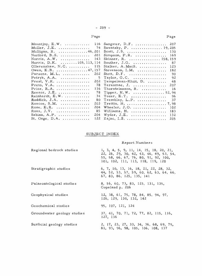
- 209 -
Page Page
Mountjoy, E. W. ............ 116 Sangster, D. F. ............... 207 Muller, J.E. ............... 74 Sawatzky, P. . .............. 19, 205 Mulligan, R. . ............. 46, 201 Scott, J.S. ................... 130 Norford, B.S. .............. 201 Simpson, P.R ................ 169 Norris, A. W. .............. 143 Skinner, R. . .............. 158,159 Norris, D.K. . ....... 105,113,114 Souther, J.G. ................ 87 Ollerenshaw, N.C ........... 115 Stalker, A.MacS .............. 123 Owen, E.B ................ 47,157 Stevenson, 1. M. .............. 182 Parsons, M.L. ............. 202 Stott, D.F. .................. 90 Petryk, A.A. .............. 5 Taylor, G.C. ............... . 92 Prest, V.K. ................ 202 Tempelman-Kluit, D. ......... 48 Preto, V.A. .....•.......... 78 Terasmae, J. . ............... 207 Price, R.A. ................ 116 Thorsteinsson, R. ..•......... 16 Reesor, J.E. ............... 78 Tipper, H. W. .. ............. 52,94 Reinhardt, E. W. ............ 34 Tozer, E. T. •..•............. 96 Roddick, J.A. .............. 80 Tremblay, L.P. ......•....... 37 Roscoe, S. M. .............. 203 Trettin, H .................... 7,98 Rose, E.R. ................ 204 Wheeler, J. O. ................ 102 Ross, J.V. .. .............. 85 Williams, H. ....•............ 183 Sabina, A. P. ............... 204 Wyder, J.E .................. 132 St. Onge, D.A. ............. 122 Zajac,. 1. S. ................... 205
SUBJECT INDEX
Regional bedrock studies
Stratigraphic studies
Palae ontolog ical s tudie s
Geophysical studies
Geochemical studie s
Groundwater geology studies
Surficial geology studies
Report Numbers
I, 3, 4, 5, 9, 11, 14, 15, 18, 20, 21, 22, 26, 29, 30, 42, 43, 46, 49, 53, 54, 55, 58, 66, 67, 76, 80, 91, 92, 100, 101, 102, Ill, 113, 118, 119, 120
6, 7, 10, 13, 16, 18, 21, 22, 28, 32, 44, 52, 53, 57, 59, 60, 62, 63, 64, 66, 67, 83, 86, 125, 135, 141
8, 56, 60, 73, 83, 125, 131, 135, Copeland p. 206
12, 38, 61, 75, 78, 84, 85, 94, 97, 126, 129, 130, 132, 142
95, 107, 121, 124
37, 41, 70, 71, 72, 77, 82, 115, 116, 127, 136
2, 17, 23, 27, 33, 34, 36, 68, 69, 79, 81, 93, 96, 98, 105, 106, 108, 137
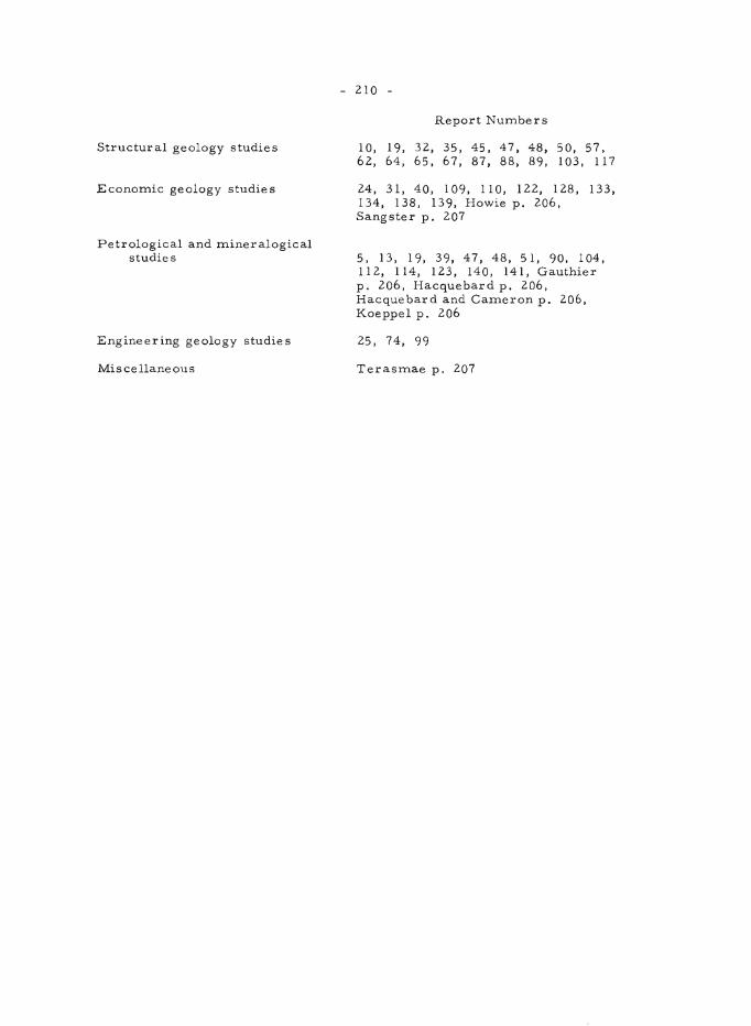
Structural geology studies
Economic geology studies
Petrological and mineralogical studies
Engineering geology studies
Miscellaneous
- 210 -
Report Numbers
10, 19, 32, 35, 45, 47, 48, 50, 57, 62,64,65,67,87,88,89, 103, 117
24,31,40,109,110,122,128,133, 134, 138, 139, Howie p. 206, Sangster p. 207
5, 13, 1 9, 39, 47, 48, 5 I, 90, 104, 112, 114, 123, 140, 141, Gauthier p. 206, Hacquebard p. 206, Hacquebard and Cameron p. 206, Koeppel p. 206
25, 74, 99
Terasmae p. 207