briefing book - geological survey of india
TRANSCRIPT
BRIEFING BOOK (UPDATED UPTO SEPTEMBER 2013)
GEOLOGICAL SURVEY OF INDIANORTHERN REGION
LUCKNOW
1
Central crystalline
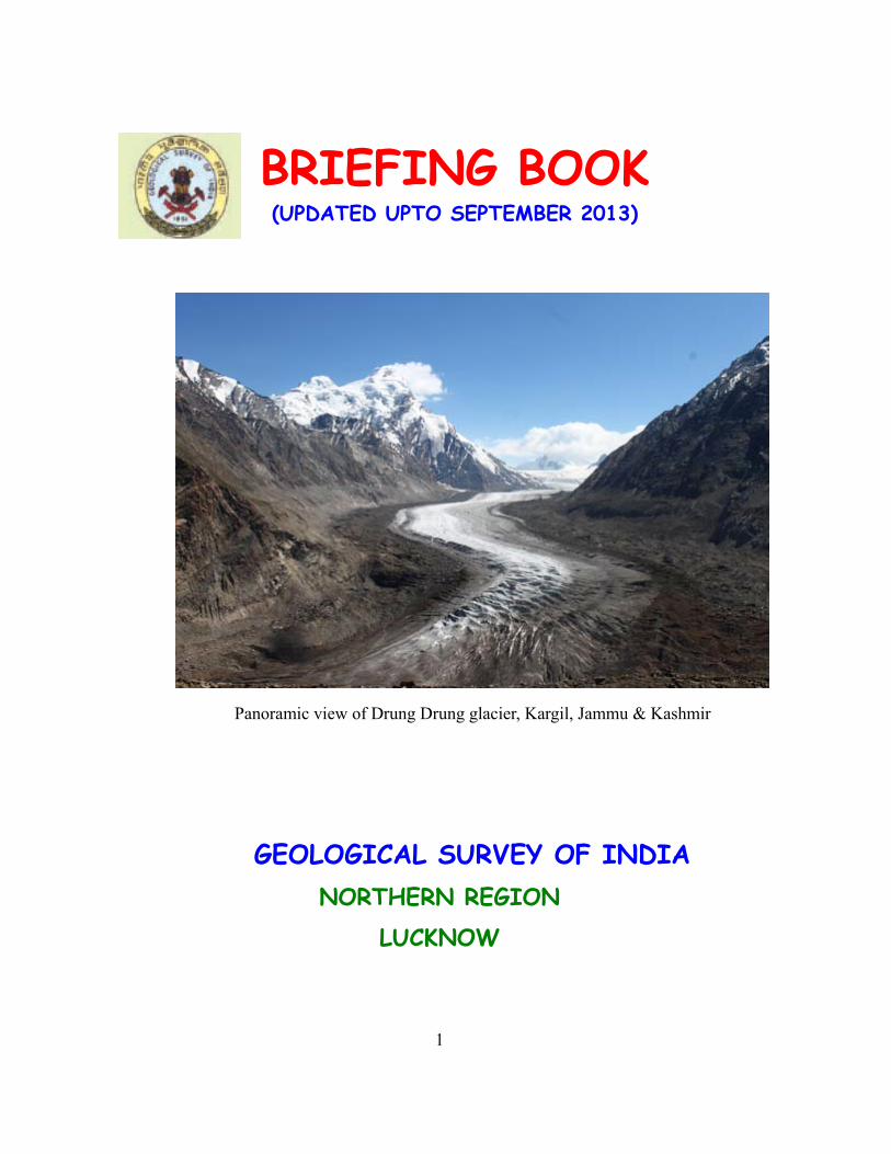
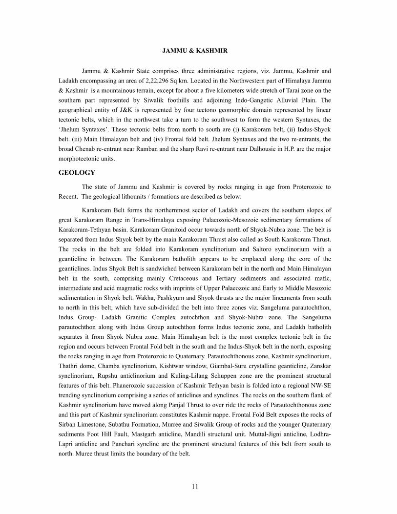
Panoramic view of Drung Drung glacier, Kargil, Jammu & Kashmir
BRIEFING BOOK (UPDATED UPTO SEPTEMBER 2013)
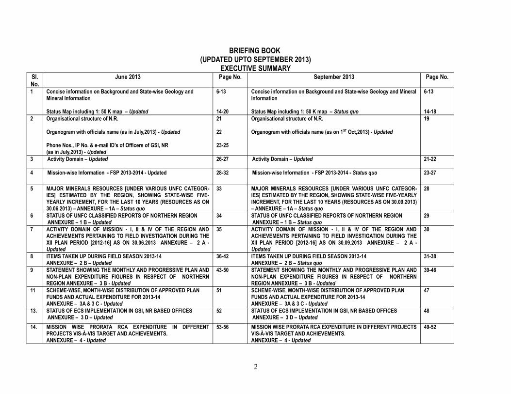
EXECUTIVE SUMMARYSl.No.
June 2013 Page No. September 2013 Page No.
1 Concise information on Background and State-wise Geology and Mineral Information
Status Map including 1: 50 K map – Updated
6-13
14-20
Concise information on Background and State-wise Geology and Mineral Information
Status Map including 1: 50 K map – Status quo
6-13
14-182 Organisational structure of N.R.
Organogram with officials name (as in July,2013) - Updated
Phone Nos., IP No. & e-mail ID’s of Officers of GSI, NR(as in July,2013) - Updated
21
22
23-25
Organisational structure of N.R.
Organogram with officials name (as on 1ST Oct,2013) - Updated
19
3 Activity Domain – Updated 26-27 Activity Domain – Updated 21-22
4 Mission-wise Information - FSP 2013-2014 - Updated 28-32 Mission-wise Information - FSP 2013-2014 - Status quo 23-27
5 MAJOR MINERALS RESOURCES [UNDER VARIOUS UNFC CATEGOR-IES] ESTIMATED BY THE REGION, SHOWING STATE-WISE FIVE-YEARLY INCREMENT, FOR THE LAST 10 YEARS (RESOURCES AS ON 30.06.2013) – ANNEXURE – 1A – Status quo
33 MAJOR MINERALS RESOURCES [UNDER VARIOUS UNFC CATEGOR-IES] ESTIMATED BY THE REGION, SHOWING STATE-WISE FIVE-YEARLY INCREMENT, FOR THE LAST 10 YEARS (RESOURCES AS ON 30.09.2013) – ANNEXURE – 1A – Status quo
28
6 STATUS OF UNFC CLASSIFIED REPORTS OF NORTHERN REGION ANNEXURE – 1 B – Updated
34 STATUS OF UNFC CLASSIFIED REPORTS OF NORTHERN REGION ANNEXURE – 1 B – Status quo
29
7 ACTIVITY DOMAIN OF MISSION - I, II & IV OF THE REGION AND ACHIEVEMENTS PERTAINING TO FIELD INVESTIGATION DURING THE XII PLAN PERIOD [2012-16] AS ON 30.06.2013 ANNEXURE – 2 A - Updated
35 ACTIVITY DOMAIN OF MISSION - I, II & IV OF THE REGION AND ACHIEVEMENTS PERTAINING TO FIELD INVESTIGATION DURING THE XII PLAN PERIOD [2012-16] AS ON 30.09.2013 ANNEXURE – 2 A - Updated
30
8 ITEMS TAKEN UP DURING FIELD SEASON 2013-14ANNEXURE – 2 B – Updated
36-42 ITEMS TAKEN UP DURING FIELD SEASON 2013-14ANNEXURE – 2 B – Status quo
31-38
9 STATEMENT SHOWING THE MONTHLY AND PROGRESSIVE PLAN AND NON-PLAN EXPENDITURE FIGURES IN RESPECT OF NORTHERN REGION ANNEXURE – 3 B - Updated
43-50 STATEMENT SHOWING THE MONTHLY AND PROGRESSIVE PLAN AND NON-PLAN EXPENDITURE FIGURES IN RESPECT OF NORTHERN REGION ANNEXURE – 3 B - Updated
39-46
11 SCHEME-WISE, MONTH-WISE DISTRIBUTION OF APPROVED PLAN FUNDS AND ACTUAL EXPENDITURE FOR 2013-14ANNEXURE – 3A & 3 C - Updated
51 SCHEME-WISE, MONTH-WISE DISTRIBUTION OF APPROVED PLAN FUNDS AND ACTUAL EXPENDITURE FOR 2013-14ANNEXURE – 3A & 3 C - Updated
47
13. STATUS OF ECS IMPLEMENTATION IN GSI, NR BASED OFFICES ANNEXURE – 3 D – Updated
52 STATUS OF ECS IMPLEMENTATION IN GSI, NR BASED OFFICES ANNEXURE – 3 D – Updated
48
14. MISSION WISE PRORATA RCA EXPENDITURE IN DIFFERENT PROJECTS VIS-À-VIS TARGET AND ACHIEVEMENTS. ANNEXURE – 4 - Updated
53-56 MISSION WISE PRORATA RCA EXPENDITURE IN DIFFERENT PROJECTS VIS-À-VIS TARGET AND ACHIEVEMENTS. ANNEXURE – 4 - Updated
49-52
2

15. PROGRESS & PENDENCY REPORT OF CHEMICAL ANALYSES OF NGCM SAMPLES, GSI,NR, LKO ANNEXURE – 5 - Updated
57-60 PROGRESS & PENDENCY REPORT OF CHEMICAL ANALYSES OF NGCM SAMPLES, GSI,NR, LKO ANNEXURE – 5 - Updated
53-56
16. STATUS OF REPORTS (As on 1.7.2013) ANNEXURE – 6 - Updated 61-65 STATUS OF REPORTS (As on 1.10.2013) ANNEXURE – 6 - Updated 57-64
17. --------- ---- ---------18. CASE STUDIES FROM GEOLOGICAL SURVEY OF INDIA, NORTHERN
REGION UPLOADED IN GSI PORTAL ANNEXURE – 8 – Updated66-67 CASE STUDIES FROM GEOLOGICAL SURVEY OF INDIA, NORTHERN
REGION UPLOADED IN GSI PORTAL ANNEXURE – 8 – Status quo65-66
19. DETAILS OF PUBLICATIONS BROUGHT OUT BY THE NORTHERN REGION IN THE LAST FIVE YEARS. ANNEXURE – 9 – Updated
68-69 DETAILS OF PUBLICATIONS BROUGHT OUT BY THE NORTHERN REGION IN THE LAST FIVE YEARS. ANNEXURE – 9 – Updated
67-68
20. TRAINING PROGRAMMES CONDUCTED BY THE REGIONAL TRAINING INSTITUTE and FTC, NR, DURING 2013-14 (As on 30.06.2013) ANNEXURE – 10 - Updated
70-71 TRAINING PROGRAMMES CONDUCTED BY THE REGIONAL TRAINING INSTITUTE and FTC, NR, DURING 2013-14 (As on 30.09.2013) ANNEXURE – 10 - Updated
69-70
21. LIST OF RAC / OAC / STAGE REVIEW / SGPB / TERM REVIEW MEETINGS WITH DATE AND STATUS OF UPLOADING OF MINUTES ANNEXURE – 11 - Updated
72 LIST OF RAC / OAC / STAGE REVIEW / SGPB / TERM REVIEW MEETINGS WITH DATE AND STATUS OF UPLOADING OF MINUTES ANNEXURE – 11 - Updated
71
22. EMPLOYMENT POSITION IN THE NORTHERN REGION ANNEXURE – 12 – Updated
73 EMPLOYMENT POSITION IN THE NORTHERN REGION ANNEXURE – 12 – Updated
72
23. VEHICLE POSITION IN NORTHERN REGION AND AGE WISE STATUS OF VEHICLES ANNEXURE – 13 - Updated
74 VEHICLE POSITION IN NORTHERN REGION AND AGE WISE STATUS OF VEHICLES ANNEXURE – 13 - Updated
73
24. STATUS OF CASES UNDER ME/IT/R&D/INVESTIGATION/MISSION SUR-VEY & MAPPING/OE/ANTARCTICA HEADS ANNEXURE – 14 - Updated
75-77 STATUS OF CASES UNDER ME/IT/R&D/INVESTIGATION/MISSION SUR-VEY & MAPPING/OE/ANTARCTICA HEADS ANNEXURE – 14 - Updated
74-76
25. DETAILS OF EXISTING DRILLING EQUIPMENTS AND PROGRESS ANNEXURE – 15 A & B – Updated
78-79 DETAILS OF EXISTING DRILLING EQUIPMENTS AND PROGRESS ANNEXURE – 15 A & B – Updated
77-78
26. LIST OF THE COURT CASES ANNEXURE – 16 – Updated 80-81 LIST OF THE COURT CASES ANNEXURE – 16 – Updated 79-81
3
CONTENTS
I INTRODUCTION
A. BRIEF INTRODUCTION ABOUT THE REGION 6 – 7
B. GEOLOGY AND MINERAL RESOURCES 8 – 13
C. STATUS MAP (S) 14-18
II ORGANISATIONAL STRUCTURE OF N.R. 19
ORGANOGRAM OF NORTHERN REGION 20
III ACTIVITY DOMAIN 21-22
IV MISSION -WISE INFORMATION - FIELD SEASON 2013-2014 23-27
ANNEXURES
Annexure-1A MAJOR MINERALS RESOURCES [UNDER VARIOUS UNFC CATEGORIES] ES-TIMATED BY THE REGION, SHOWING STATE-WISE FIVE-YEARLY INCREMENT, FOR THE LAST 10 YEARS (RESOURCES AS ON 30.09.2013)
28
Annexure-1 B STATUS OF UNFC CLASSIFIED REPORTS OF NORTHERN REGION 29
Annexure-2 A ACTIVITY DOMAIN OF MISSION - I, II & IV OF THE REGION AND ACHIEVEMENTS PER-TAINING TO FIELD INVESTIGATION DURING THE XII PLAN PERIOD [2012-16] AS ON 30.09.2013
30
Annexure-2B ITEMS TAKEN UP DURING FIELD SEASON 2013-14 31-38
Annexure-3 B STATEMENT SHOWING THE MONTHLY AND PROGRESSIVE PLAN AND NON-PLAN EXPENDITURE FIGURES IN RESPECT OF NORTHERN REGION
39-46
Annexure-3 A & 3C
SCHEME-WISE, MONTH-WISE DISTRIBUTION OF APPROVED PLAN FUNDS AND ACTUAL EXPENDITURE FOR 2013-14
47
Annexure-3D STATUS OF ECS IMPLEMENTATION IN GSI, NR BASED OFFICES (As on 30.09.2013)
48
Annexure-4 MISSION WISE PRORATA RCA EXPENDITURE IN DIFFERENT PROJECTS VIS-À-VIS TARGET AND ACHIEVEMENTS (As on 30.09.2013)
49-52
Annexure-5 PROGRESS & PENDENCY REPORT OF CHEMICAL ANALYSES OF NGCM SAMPLES, GSI,NR, LKO
53 - 56
Annexure-6 STATUS OF REPORTS 57-64
Annexure-8 CASE STUDIES FROM GEOLOGICAL SURVEY OF INDIA, NORTHERN REGION UPLOADED IN GSI PORTAL
65 - 66
Annexure-9 DETAILS OF PUBLICATIONS BROUGHT OUT BY THE NORTHERN REGION IN THE LAST FIVE YEARS.
67- 68
Annexure-10 TRAINING PROGRAMMES CONDUCTED BY RTI, NR AND FTC’s, BHIMTAL 2013-14 (JULY-SEPTEMBER 2013)
69-70
Annexure-11 LIST OF RAC / OAC / STAGE REVIEW / SGPB/ TERM REVIEW MEETINGS WITH DATE AND STATUS OF UPLOADING OF MINUTES
71
4
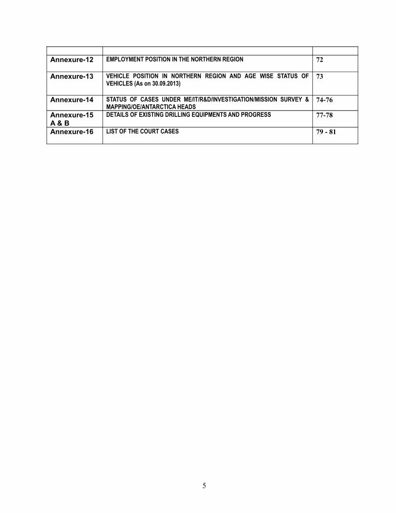
Annexure-12 EMPLOYMENT POSITION IN THE NORTHERN REGION 72
Annexure-13 VEHICLE POSITION IN NORTHERN REGION AND AGE WISE STATUS OF VEHICLES (As on 30.09.2013)
73
Annexure-14 STATUS OF CASES UNDER ME/IT/R&D/INVESTIGATION/MISSION SURVEY & MAPPING/OE/ANTARCTICA HEADS
74-76
Annexure-15 A & B
DETAILS OF EXISTING DRILLING EQUIPMENTS AND PROGRESS 77-78
Annexure-16 LIST OF THE COURT CASES 79 - 81
5
GEOLOGICAL SURVEY OF INDIA NORTHERN REGION
I. INTRODUCTION
A. BRIEF INTRODUCTION ABOUT THE REGION
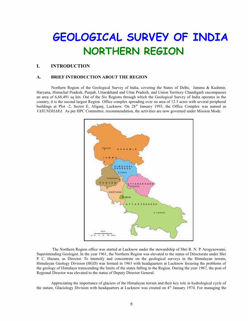
Northern Region of the Geological Survey of India, covering the States of Delhi, Jammu & Kashmir, Haryana, Himachal Pradesh, Punjab, Uttarakhand and Uttar Pradesh, and Union Territory Chandigarh encompasses an area of 6,68,491 sq km. Out of the Six Regions through which the Geological Survey of India operates in the country, it is the second largest Region. Office complex spreading over on area of 12.5 acres with several peripheral buildings at Plot -2, Sector E, Aliganj, Lucknow. On 28 th January 1993, the Office Complex was named as VASUNDHARA. As per HPC Committee, recommendation, the activities are now governed under Mission Mode.
The Northern Region office was started at Lucknow under the stewardship of Shri R. N. P. Arogyaswami, Superintending Geologist. In the year 1961, the Northern Region was elevated to the status of Directorate under Shri P. C. Hazara, as Director. To intensify and concentrate on the geological surveys in the Himalayan terrain, Himalayan Geology Division (HGD) was formed in 1963 with headquarters at Lucknow focusing the problems of the geology of Himalaya transcending the limits of the states falling in the Region. During the year 1967, the post of Regional Director was elevated to the status of Deputy Director General.
Appreciating the importance of glaciers of the Himalayan terrain and their key role in hydrological cycle of the nature, Glaciology Division with headquarters at Lucknow was created on 4 th January 1974. For managing the
6
environment, the Environmental Geology Division was created on 1st January 1975 with headquarters at Lucknow. In 1985, Map Compilation, Publication and Information Division (MCPI) was split into two separate Divisions, viz. Map and Cartography Division and Publication Division. It was at this time that the Publication Divisions of the regions were entrusted with the responsibility of bringing out GSI publications. It is noteworthy that the Regional Library at Lucknow continues to get enriched with the scientific books, journals, unpublished departmental reports, etc. NR library possesses more than 20,500 books and 21,504 unclassified and 7066 classified unpublished reports at present, in addition to the journals. National and International Journals are being subscribed by the Library.
The Himalayan Mountain Ranges extend for about 2500 km (with an average width of about 240 km) all along the northern border of the Indian sub-continent, from Jammu and Kashmir in the west to Arunachal Pradesh in the east, constituting the Extra-Peninsular region. The Himalaya is broadly divided into (i) Foothill or Outer Himalaya, (ii) Lesser Himalaya, (iii) Higher Himalaya and (iv) Tethyan or Trans-Himalaya across its length. The major rivers that originate from the great Himalayan Mountain Ranges are the Indus, Ganges and their various tributaries. The average elevation of the Indo-Gangetic plain lying between Peninsular and Extra-Peninsular India is 150 m with a low gradient from about 300 m in the Upper Ganga plain of Punjab to at main sea level at the Sunderbans delta of Bengal.
The region exposes diverse geology with different rock types representing the complete spectrum ranging in age from Archaean metamorphites /granitoids to the youngest Quaternary alluvium. The Region is tectonically and physiographically divided into three broad domains i.e. the Peninsular India, the Extra-Peninsular India and the Indo-Gangetic Plain. Indo-Gangetic plain is sandwiched between the shield area of the Peninsular India and the highly deformed suites of the Himalaya of Extra-Peninsular India, comprising essentially the younger metasediments. The tectonic trough (foreland basin) sandwiched between peninsular shield in the south and Himalayan Mountains in the north formed due to upliftment of the latter, has been filled up by sediments derived from both sides, especially from the Himalaya. Structurally the Himalayan mountain chain occurring all along northern part of India can be divided into four contrasting longitudinal litho-cum-morphotectonic belts from south to north, viz. i) foothill belt, ii) Main Himalayan belt, iii) Indus-Shyok belt and iv) Karakoram belt. The foothill Himalaya is a 10- to 50 km wide Miocene to Lower Pleistocene Molasse sequence represented by Siwalik, Murree and Subathu Group of rocks. The belt is a domain of active tectonics having participated in the terminal phase of the Himalayan Orogeny. This is followed to the north by the Lesser and Higher Himalaya, represented by geological sequences of Proterozoic age with Phanerozoic cover of varying thickness in different parts. The foothill Himalaya is overlain by alluvium and separated from the Lesser Himalaya by the north-dipping fault commonly known as the Main Boundary Fault (MBF) or the Main Boundary Thrust (MBT) in Garhwal, Kumaon, Nepal, Darjeeling, Bhutan and Arunachal Pradesh Himalaya. The Main Frontal Thrust (MFT) limits the margins of the Siwalik Zone against the Ganga Plains.
The Lesser Himalaya is 60 to 80 km wide and is a discontinuous belt stretching between the MBT in the south and the Main Central Thrust (MCT) in the north. It consists of autochthonous Late Proterozoic sediments, thrust over by three vast nappes that are built up successively of Palaeozoic sediments, Precambrian epi-metamorphics and mesograde metasediments. The epi-metamorphic and meso-metamorphic nappes throughout their extent are characterized by Early Proterozoic (= 1900 Ma) and Early Palaeozoic granitic bodies of large dimension. The MCT separates the Lesser Himalaya from the Higher Himalaya to its north. The Higher Himalaya marks the region of the highest peaks of the Himalaya (Nunkun, Leopargial, Kedarnath, Badrinath, Nanda Devi, Api, Dhaulagiri, Mt. Everest, Kanchanjunga), made up of 10-15 km thick Precambrian crystallines exhumed up and intruded by granites, some of which are Tertiary in age. The Indus Shyok belt / the Tethys Himalaya extend to the south of the Trans-Himalayan Karakoram belt and comprise ophiolite mélange (Indus ophiolite and associated formation) and plutonic rocks (Ladakh Granitoid Complex) of the Indus Shyok belt. These predominantly fossiliferous sediments range in age from Late Proterozoic to Eocene. Sporadic occurrences of chromite have been reported from the ultrabasic rocks associated with Dras volcanics from Ophiolite-Melange zone. Karakoram belt, the northernmost zone, comprises Palaeozoic and Mesozoic sedimentary sequence on a metamorphic basement of unknown age. This Trans-Himalayan belt lies to the north of the Indus suture Zone in Ladakh region and extends eastward into Tibet. No important mineral occurrence is known from this belt.
7
B. GEOLOGY AND MINERAL RESOURCES
Geologically, under Northern Region, the states of Haryana, Himachal Pradesh, Jammu and Kashmir, Punjab, Uttarakhand and Uttar Pradesh encompasses diverse lithology ranging in age from the oldest Archaean metamorphites/ granitoids to the youngest Quaternary alluvium. The stratigraphic succession of the rocks exposed is given in the Map-1 (See page No.14).
HARYANA AND DELHI
Haryana State has an area of 44,222 Sq km and Delhi covers an area of 1483 Sq. km. Haryana State physiographically divisible into two geomorphic domain viz. Sub-Himalayan region and the Indo-Gangetic Plain. Geomorphological features of Delhi area are represented by denudational hills and alluvial fill and sandy plains. Geologically 95% of the area of this State is covered by the Quaternary sediments and the rest 5% comprises the Proterozoic rocks occurring in south and west and the Tertiary rocks in the northeast. The Proterozoic rocks are represented by Alwar and Ajabgarh groups of Delhi Supergroup. The Alwar Group is represented by Bayal - Panchnota Formation. It has been divided into two units, the basal unit consisting of thickly bedded felspathic gritty and micaceous quartzite and the upper unit comprises of ripple marked massive quartzite. The Ajabgarh Group comprises predominantly of argillaceous sediment, comprising slate, phyllite, pelitic schist, limestone and quartzite. These rocks grade from calcareous facies to argillaceous facies upward. Lithologically, Ajabgarh Group is divisible into five formations, each with characteristic lithounits. These are represented by Golwa-Gangutana Formation, Deota-Dantal Formation, Thanagazi Formation, Asarwas Formation and Tasing Formation. Delhi Supergroup rocks are intruded by basic and acid magmatic rocks. The plutonic phase of acid magmatism is represented by granite, pegmatite and quartz veins while the volcanic phase is represented by rhyolite and hypabyssal feldspar porphyry & aplite. Neo-Proterozoic rocks referred as Tundapathar Formation belonging to Shali Group occur in the northeastern part of Haryana along the contact between the Siwalik belt and the Palaeocene belt marking the Main Boundary Fault. The Palaeogene sediments comprising Subathu, Dagshai and Kasauli formations occur in the northern part of Haryana. Tertiary rocks occur over the Proterozoic basement in the western part near Hissar. It is an isolated outcrop measuring about 300m in length and 20m wide, at Daha, 15 km northwest of Tosham. The Siwalik in Haryana are mainly represented by Lower, Middle and Upper Siwalik, stretching from Kalka in northwest to Kala Amb in the southeast. Lower Siwalik is exposed along a NW-SE trending linear belt forming low flanking ridges near Kalka. These consist of coarse red and purple coloured gritty clay & fine to coarse-grained hard earthy sandstone. Middle Siwalik, are present in detached patches as Saketi Formation. Upper Siwalik comprises red and orange variegated clays and interbanded friable grey sandstone. Around Delhi Ajabgarh Group of rocks exposed as detached hillocks and ridges trending NE-SW expose purple and white quartzite interbedded with phyllite and slate. The Alwar Group comprises quartz amphibole quartzite, subordinate schist and minor limestone. They are well developed in the hill ranges of Bayal, Panchnota, Madhogarh, Khodana etc in the southwestern part of the state. Quaternary sediments cover almost the whole of Haryana and along the Yamuna River in parts of Delhi. The Quaternary has been classified as Older Alluvium and Newer Alluvium. Older Alluvium is represented by alternating sequence of sand and clay layers with small kankar nodules. Newer alluvium comprises loose grey sand and silt deposited along the Yamuna and Ghaghar and their tributaries and the carbonate and sulphate bearing lake deposits. In the southern and western borders of Haryana, the Aeolian deposits occur in the form of sand dunes/sheets constituting the northeastern fringe of Thar desert.
8
HIMACHAL PRADESH
Geologically rocks ranging from Proterozoic to Quaternary are exposed and represent classic geological sequence. Undifferentiated Proterozoic mostly confined to the Lesser Himalaya, are represented by Jutogh and Vaikrita groups. Jutogh Group comprises Panjerli, Manal, Bhotli, Khirki, Taradevi, Kanda, Naura, Badrol, Rohru, Chirgaon and Jaknoti formations comprising a thick sequence of carbonaceous phyllite, quartzite, slate, phyllite, schist and gneisses whereas the Vaikrita Group comprises Kharo, Morang, Shiasu and Chamba formations made up a thick pile of garnetiferous staurolite-kynite schist and gneisses, sillimanite gneiss, migmatite, quartzite marble, calc-silicate rocks and amphibolite.
Palaeo-Proterozoic: The Jeori-Wangtu Banded Gneissic Complex and Kulu, Naraul, Sundernagar and Rampur groups represent the Palaeo-Proterozoic in the Himachal Pradesh. The Jeori – Wangtu Granitoid Gneiss is strongly foliated with well-developed augen-gneisses, mylonitic gneiss and porphyroblastic biotite gneiss with non-foliated granitoids in the central part. The Kulu Group, one of the three principal crystalline nappes of Himachal Pradesh, comprises Khamrada, Gahr and Khokan formations consisting of schist, gneiss, quartzite, quartz schist, slate, phyllite and garnetiferous schist. The Naraul Group consists of quartzarenite phyllite, shale, slate and diamictite whereas the Sundernagar Group comprises dominantly purple coloured arenaceous sediments with argillities and characterized by interstratified basic lava flows of the Mandi-Darla Volcanics. The Rampur Group presents an association of metabasalts and metasediments dominated by clastics. It is divisible into three formations namely, Bhallan, Banjar and Manikaran. Meso-Proterozoic in the Himachal Himalaya are represented by Larji and Shali groups. The Larji Group consists of lower Hurla Formation and upper Aut Formation, broadly comprising a sequence of slate, quartzarenite, diamictite and stromatolitic carbonate rocks. The Shali Group has been divided into eight formations namely Ropri, Khaira, Khatpul, Sorgharwari, Tattapani, Makri, Parnali and Bandla consisting of shale, siltstone, quartzarenite, massive dolomite, limestone, cherty dolomite, green and purple shale, grey limestone and white quartzarenite. The upper part of Meso-Proterozoic is represented by Darla-Tattapani (Peontra Volcanic) represented by quartzite, slate and basic flows. The Neo-Proterozoic era has been divided into two as Lower and Upper. The Lower Neo-Proterozoic era is represented by Jaunsar, Simla and Haimanta groups whereas the Upper Neo-Proterozoic era is represented by Guma, Blaini, Infrakrol, Krol, Manjir and Katarigali formations. The Jaunsar Group is typically developed in the Deoban structural belt and is divisible into three formations namely Mandhali, Chandpur and Nagthat. Mandhali Formation is composed of limestone, argillite, arenite and conglomerate. The Chandpur Formation is represented by alternate sequence of argillite and arenite. The Nagthat Formation comprises sandstone, arkose quartzarenite, grits, conglomerate, grey, purple and green shale, slate and phyllite. The Simla Group is divisible into four formations, Basantpur, Kunihar, Chhaosa and Sanjauli. The Basantpur Formation is characterized by the abundant interbeds of limestone and dolomite within argillite and siltstone whereas Kunihar Formation comprises lenticular interbeds of stromatolite-bearing limestone with fissile shales. The Chhaosa Formation is characterized by a thick rhythmic sequence of shale, siltstone and greywacke. The Sanjauli Formation is divisible into Lower and Upper members, on the basis of characteristic lithological associations. The Haimanta Group comprises Batal Formation, is broadly made up of phyllite, quartzite, pyritous carbonaceous phyllite. The Krol Group is divisible into A, B, C, D and E formations. The Krol A Formation comprises alternation of greenish grey calcareous shale and argillaceous limestone with variable gradation. Krol B Formation is characterized by thinnly laminated purple to red shales with green shale intercalations and thin interbeds of thin dolomite and cherty limestone. Krol C Formation is represented by dolomite, cherty limestone and shale, Krol D Formation comprises an alternation of cherty limestone and shale whereas Krol E is the topmost lithostratigraphic unit with a dominant banded grey and pale cream white calclutite to dololutite with a rugged appearance. In the Spiti / Kinnaur and Higher Himalayas, the Cambrian rocks represented by Kunzamla and Parahio formations. The Permian in Himachal Pradesh is represented by Kuling Group in the Spiti / Kinnaur area whereas in Chamba area it is represented by
9

Salooni Formation. The Kuling Group is divisible into fossiliferous Gechang and Gungri formations. The Gechang Formation is consisting of brown to grey, pale grey, coarse-grained weakly bioturbated, cross bedded, calcareous sandstone with local conglomerate and / or shell lag at base. The Gungri Formation comprises black shale, calcareous silty shale, phosphatic, cherty and calcareous nodules and thin limestone. The Salooni Formation is represented by black shale, slate, calcareous slate and lenticles of limestone and is fossiliferous.
PUNJAB
The Punjab state comprises an area of 50,362 Sq km forming the part of Indo-Gangetic basin. The two broad geomorphic entity viz. the Siwalik foothills towards the northeast part of the state and alluvial fill of Indus drainage basin characterise the physiographic setting of the Punjab state. The dominant physiographic high are i) Lahore - Sargodha Ridge in the west; ii) Delhi – Jagadhari Ridge in the east; iii) Delhi – Lahore Ridge in the south and iv) Siwalik ridges in the northeast. Chandigarh covers an area of 114 km.
GEOLOGY
The Neogene and Quaternary units are classified as i) Siwalik Supergroup and ii) the Quaternary alluvium comprising older alluvium and newer alluvium. The maximum depth of Quaternary sediment recorded to 4500m. The base configuration indicates that the Punjab basin appears to be deeper in the northern side and shallower southward and deepest being towards NW. The Siwalik Supergroup is classified into three groups namely Lower / Middle and Upper Siwalik groups The rocks of Lower and Middle Siwalik Group are exposed as NW-SE trending ridges in the northeastern part of Gurdaspur district while the Upper Siwalik rocks are exposed in Ropar, Hoshiarpur and Gurdaspur districts. The Lower Siwalik Group, represented by the Chinji Formation, is chiefly composed of fine to medium grained, sporadically pebbly sandstone and chocolate to maroon claystone. The Middle Siwalik Group comprises Nagri and Dhok Pathan formations. The Nagri Formation comprises alternating conglomerate and red clay. The Dhok Pathan Formation consisting of poorly sorted massive, grey, coarse grained and micaceous sandstone with minor conglomerate. The Upper Siwalik Group is made up of coarse gravel and boulder conglomerate alternating with clay bands and sandstone. Its contact with the overlying Quaternary sediments is unconformable. The Quaternary Alluvium of the state can be divided into three chronostratigraphic units viz. (i) Older Alluvium (ii) Newer Alluvium and (iii) Aeolian Deposit. The Older Alluvium is formed by the depositional processes of the pre-existing palaeo-drainage of Middle to Late Pleistocene period, comprising admixture of reddish clay, silt, sand with kankar, grey medium to coarse calcareous sand with kankar and subrounded to subangular unsorted pebble, gravel and cobble beds. The Newer Alluvium is formed of present day streams, representing Holocene/Recent period. It is chiefly composed of blue to white-grey micaceous sand with alluvium interbands of purple and red clay. The Aeolian Deposits are spread throughout the Punjab, except in the areas covered by the hard rocks of Siwalik Supergroup. Broadly, these are the undifferentiated aeolian flats/dunes/sand sheet and newer dunes. Based on the degree of consolidation, these can be divided into following three categories (i) stabilized and consolidated older dunes (ii) intermediate and semi-consolidated dunes and (iii) newer, mobile and reversible dunes.
10
JAMMU & KASHMIR
Jammu & Kashmir State comprises three administrative regions, viz. Jammu, Kashmir and Ladakh encompassing an area of 2,22,296 Sq km. Located in the Northwestern part of Himalaya Jammu & Kashmir is a mountainous terrain, except for about a five kilometers wide stretch of Tarai zone on the southern part represented by Siwalik foothills and adjoining Indo-Gangetic Alluvial Plain. The geographical entity of J&K is represented by four tectono geomorphic domain represented by linear tectonic belts, which in the northwest take a turn to the southwest to form the western Syntaxes, the ‘Jhelum Syntaxes’. These tectonic belts from north to south are (i) Karakoram belt, (ii) Indus-Shyok belt. (iii) Main Himalayan belt and (iv) Frontal fold belt. Jhelum Syntaxes and the two re-entrants, the broad Chenab re-entrant near Ramban and the sharp Ravi re-entrant near Dalhousie in H.P. are the major morphotectonic units.
GEOLOGY
The state of Jammu and Kashmir is covered by rocks ranging in age from Proterozoic to Recent. The geological lithounits / formations are described as below:
Karakoram Belt forms the northernmost sector of Ladakh and covers the southern slopes of great Karakoram Range in Trans-Himalaya exposing Palaeozoic-Mesozoic sedimentary formations of Karakoram-Tethyan basin. Karakoram Granitoid occur towards north of Shyok-Nubra zone. The belt is separated from Indus Shyok belt by the main Karakoram Thrust also called as South Karakoram Thrust. The rocks in the belt are folded into Karakoram synclinorium and Saltoro synclinorium with a geanticline in between. The Karakoram batholith appears to be emplaced along the core of the geanticlines. Indus Shyok Belt is sandwiched between Karakoram belt in the north and Main Himalayan belt in the south, comprising mainly Cretaceous and Tertiary sediments and associated mafic, intermediate and acid magmatic rocks with imprints of Upper Palaeozoic and Early to Middle Mesozoic sedimentation in Shyok belt. Wakha, Pashkyum and Shyok thrusts are the major lineaments from south to north in this belt, which have sub-divided the belt into three zones viz. Sangeluma parautochthon, Indus Group- Ladakh Granitic Complex autochthon and Shyok-Nubra zone. The Sangeluma parautochthon along with Indus Group autochthon forms Indus tectonic zone, and Ladakh batholith separates it from Shyok Nubra zone. Main Himalayan belt is the most complex tectonic belt in the region and occurs between Frontal Fold belt in the south and the Indus-Shyok belt in the north, exposing the rocks ranging in age from Proterozoic to Quaternary. Parautochthonous zone, Kashmir synclinorium, Thathri dome, Chamba synclinorium, Kishtwar window, Giambal-Suru crystalline geanticline, Zanskar synclinorium, Rupshu anticlinorium and Kuling-Lilang Schuppen zone are the prominent structural features of this belt. Phanerozoic succession of Kashmir Tethyan basin is folded into a regional NW-SE trending synclinorium comprising a series of anticlines and synclines. The rocks on the southern flank of Kashmir synclinorium have moved along Panjal Thrust to over ride the rocks of Parautochthonous zone and this part of Kashmir synclinorium constitutes Kashmir nappe. Frontal Fold Belt exposes the rocks of Sirban Limestone, Subathu Formation, Murree and Siwalik Group of rocks and the younger Quaternary sediments Foot Hill Fault, Mastgarh anticline, Mandili structural unit. Muttal-Jigni anticline, Lodhra-Lapri anticline and Panchari syncline are the prominent structural features of this belt from south to north. Muree thrust limits the boundary of the belt.
11
UTTAR PRADESH AND UTTARAKHAND
The Uttar Pradesh covers an area of 2,47,933 Sq km represented by vast alluvial fill of middle Ganga drainage system. The southern part of Uttar Pradesh is characterized by rocky upland. The northern fringe area represented by Tarai and Bhabhar geomorphic units flanking the Siwalik Foothills. Uttarakhand covers an area of 46480 Sq km and represents the Western Himalayan domain divisible into Sub or Outer Himalaya, the Lesser Himalaya, the Higher Himalaya and the Tethys Himalaya from south to north.
GEOLOGY
In Uttar Pradesh, geologically the rocks ranging in age from Archean to Holocene have been been found. The oldest crystalline rocks are confined to the southern and southeastern part of the state and are extensions of sequences exposed in the M.P., Bihar and Jharkhand. These are dominantly represented by basement gneisses, older metamorphites with younger granitoids as intrusives; metasedimentaries; sedimentaries and the alluvial. The metamorphites include various types of schist, quartzite, marble and gneiss. In general, the metasedimentaries belong to Palaeo and Palaeo-Mesoproterozoic period. The sedimentaries include rocks of the Vindhyan Supergroup represent Meso to Neoproterozoic period and Gondwana Supergroup, Late Palaeozoic period. Basic volcanic flows of Late Mesozoic - Early Tertiary period are occurring as capping over earlier sequences as detached outcrops. A major part of the state is covered by Ganga Alluvium. Several mineral deposits of economic importance occur in association with the above rock units in the state. Gneisses with metasedimentarty enclaves along with intrusive granite and other igneous rocks constitute the dominant lithology and represent the oldest suite of rocks. These are confined to the southern part of the state and exposed in the Bundelkhand and Sonbhadra regions. The natural relationship between different lithounits in these oldest rocks has been obliterated by metamorphism, migmatisation, granitisation and repeated deformation. In Bundelkhand region, granite-gneiss and granitoids constitute the dominant rock types and the assemblage is known as Bundelkhand Granitoid Complex (BGC). In Sonbhadra region, gneiss is the dominant rock and the assemblage is termed as Dudhi Gneissic Complex (DGC). The Bundelkhand Granitoid Complex (BGC) contains a wide variety of plutonic and hypabyssal rocks dominated by granites of several generations, gneisses, migmatites and leucogranites. Among the enclaves, metabasic rocks are widespread. Rafts of schists and metasediments are also present. Migmatites, different types of granite, quartz reefs and younger basic intrusives have been identified and assigned to various types. Quartz reefs trending NE -SW and forming wall like ridges rising upto 175m above the ground are common. Dolerite dykes trending NW-SE are very common. The Dudhi Gneissic Complex consists mainly of granite gneiss, migmatites and non-foliated, massive younger granite with enclaves of metamorphites and veins of pegmatite, aplite and quartz. This is the westward continuation of the Chhotanagpur Granite Gneiss Complex (CGC) of Bihar/Jharkhand. Metasedimentary and meta-igneous enclaves occur with their long axes parallel to the foliation of the enclosing gneiss which is generally ENE -WSW. Dykes of doleritic/gabbroic composition transect the gneissic country. Rocks of Mahakoshal Group, Bijawar Group and Vindhyan Supergroup constitute the Proterozoic sequence. The Mahakoshal Group includes metasediments with interlayered metavolcanics and granitic bodies intruding it. Bijawar Group is represented by a sequence of ferruginous quartzite, carbonate, phosphorite, sandstone and tuffaceous rocks. Isolated outcrops of Ajabgarh Group occur around Mathura area. Metabasalts, tuffs, agglomerates and ultramafic (Kimberlite ?) plugs occur within a linear tectonic belt in the Jungel valley of Mirzapur - Sonbhadra area. The Jungel volcanics and sedimentaries are
12
supposed to represent Palaeo to Meso Proterozoic period. The Vindhyan sequence - resting unconformably over the Mahakoshal and Bijawar groups - has been divided into four groups viz. Semri, Kaimur, Rewa and Bhander in the ascending order. The Semri Group includes carbonates, tuffs, shale and minor sandstone, often glauconitic. The Kaimur Group consists of a thick arenite - argillite sequence. The Rewa Group is represented by alternate sequence of argillite and arenite. The Bhander Group is consisting of shale, greenish shale, siltstone, reddish brown to purple pink, spotted sandstone with shale partings and quartz arenite at top. Rocks belonging to the Gondwana Supergroup of Permo-Carb period, are exposed in a small area in Sonbhadra district. It is composed of conglomerate, sandstone, gritty at places, pink and pale green shales. Detached outcrops of basic volcanics (dolerite to basalt), representing the Deccan Trap, are found as capping over Bundelkhand Granitoid Complex, Bijawar Group and Vindhyan Supergroup in Bundelkhand region, southern Uttar Pradesh.
13
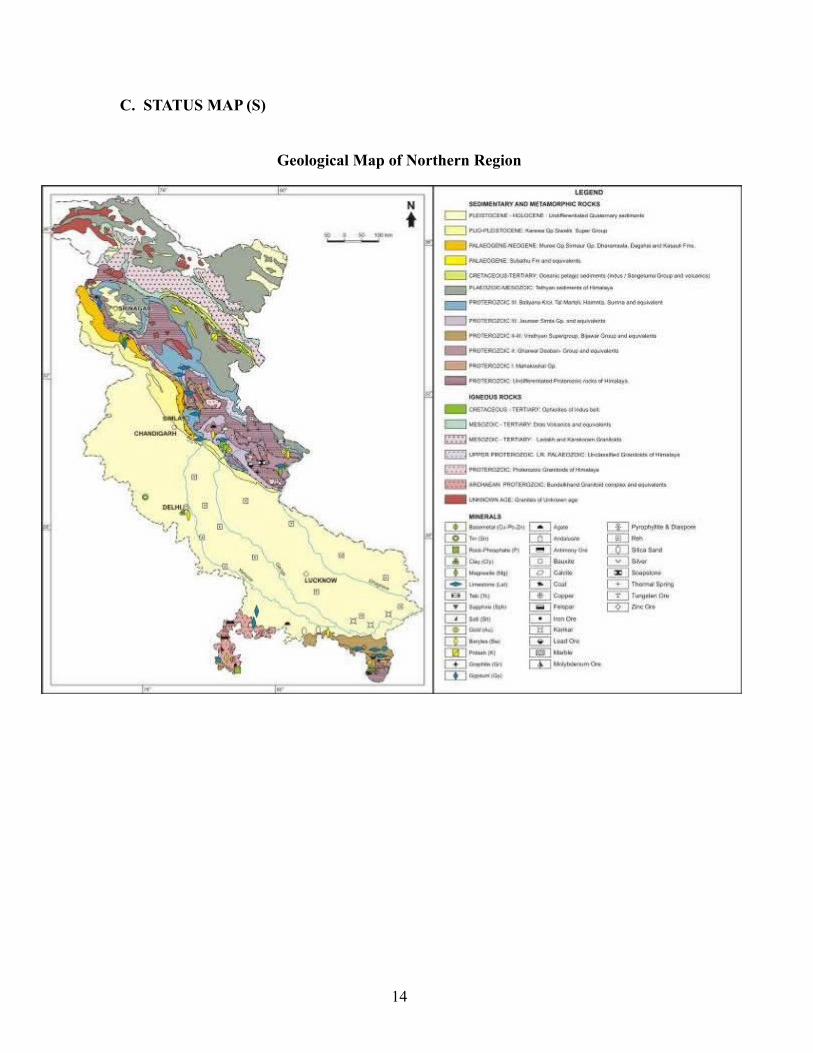
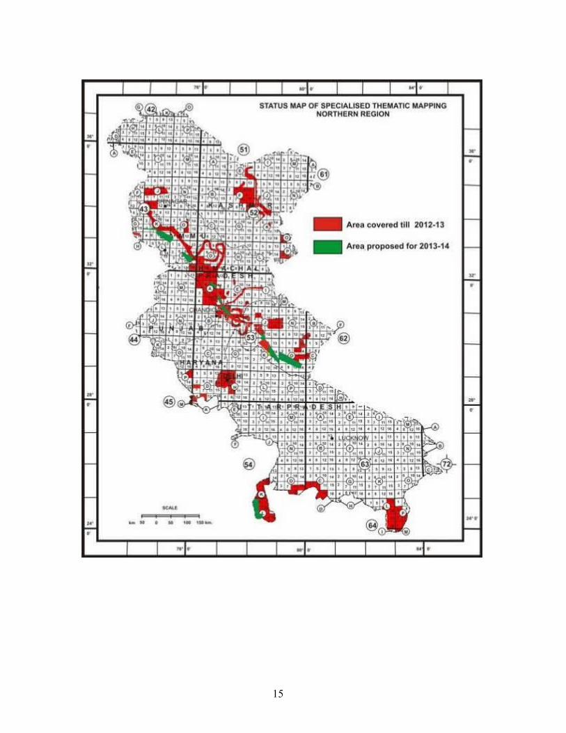
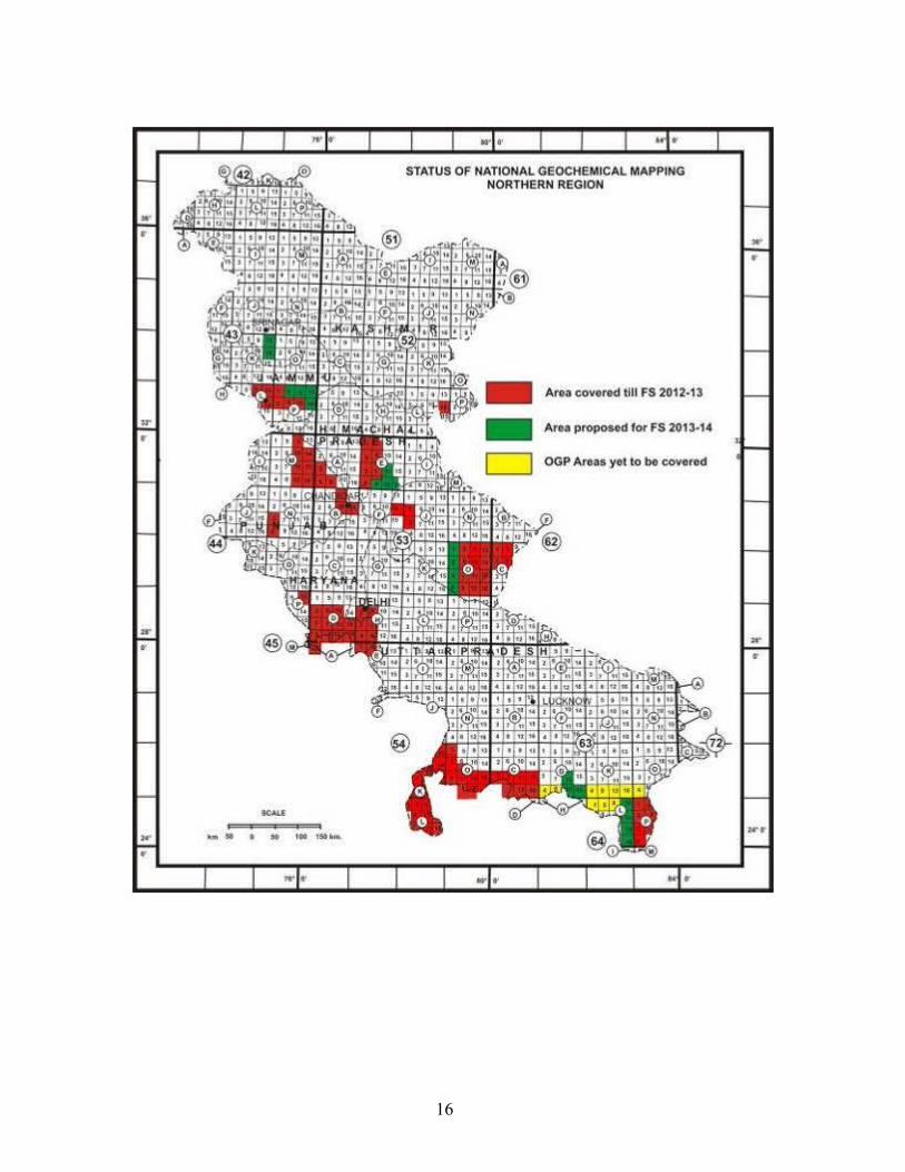
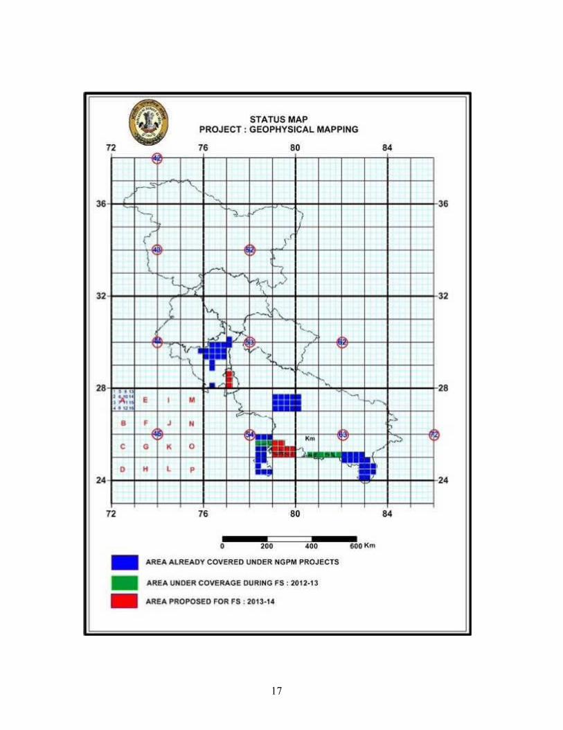
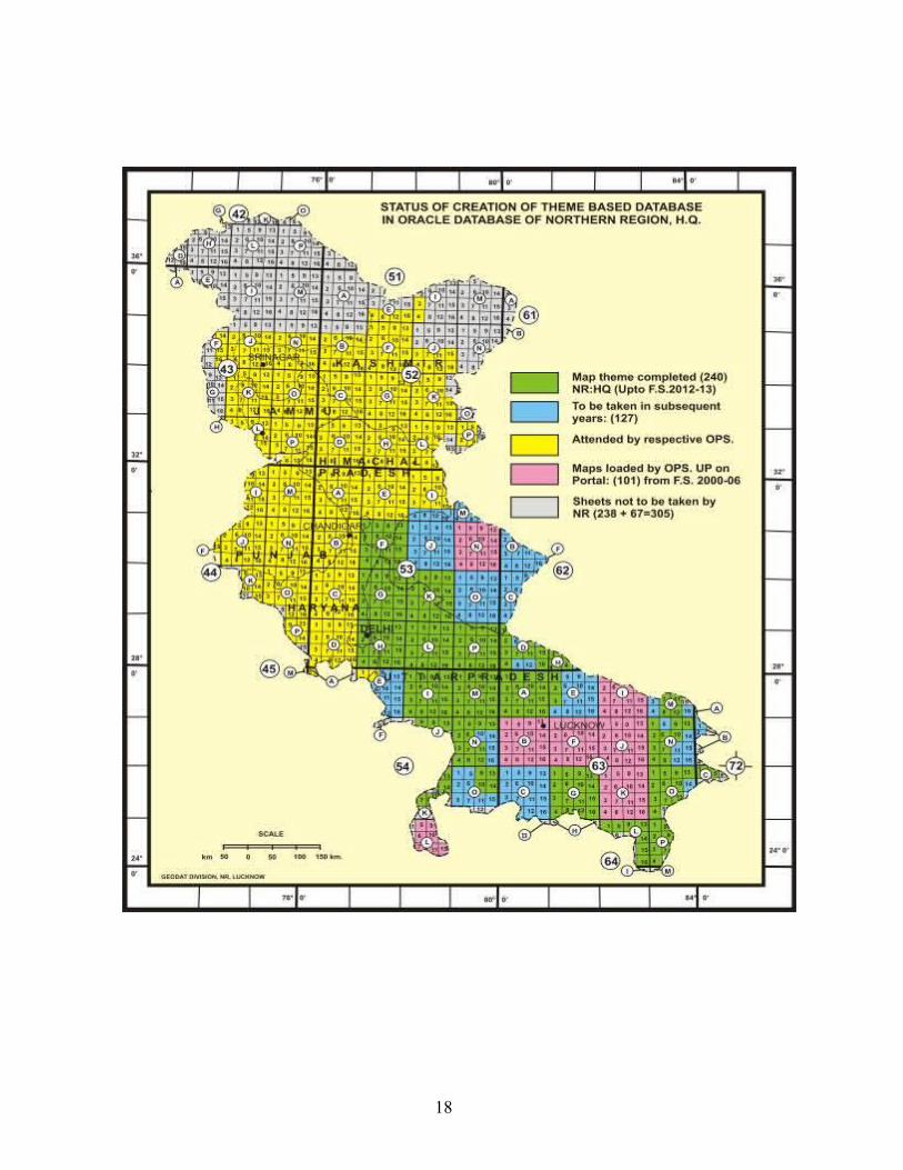
C. STATUS MAP (S)
Geological Map of Northern Region
14
15
16
17
18
II. ORGANISATIONAL STRUCTURE OF NORTHERN REGION
The Northern Region went through several phases of re-structuring and re-organisation with a view to optimising its scientific output and facing the challenges of ever changing work needs depending upon the priorities and thrust areas as per the policies adopted by the Government of India from time to time. The present organisational set-up of the Region is given below in Organogram and the present strength of the technical as well as non-technical personnel is shown in Annexure- 12.
19

ORGANOGRAM OF NORTHERN REGION
20
DDG & HoD: S.P. Bhartiya
Geophysical DivisionGeophysics (Coordination)
L.N. Singh
Northern Region HeadquartersS.P.Bhartiya, DDG
SU: UP Subodh Sharma, DDG
SU: UK Joginder Singh, DDG
SU: Haryana, F’bad S.P.Bhartiya, DDG
SU. Punjab & HP: C’garh Joginder Singh, DDG
SU. : J & K T.S. Pangtey ,D.D.G.
MISSION-ID.Bhattacharya, GPM-I (UP I)
Dr.Sagina Ram, GPM II ( UP II)Narendra Singh, GPM-III (UP III)
Siddharth Swaroop, PSS-I, NR.Rajendra Sanwal, PSS-II , NR
Alok Chitranshi, PSS II, NRP.K.Yadav, PSS I, NR
Md. Fahim, TCS Dn.MISSION-I
S.P. Nim, DDG & RMH, NRV.P.Gaur, RM II, Secretariat.
D.D.Joshi, Remote Sensing . Dn.
MISSION-III N.K. Dhir, DDG & RMH, NR
R.D.Mehrotra, RM III SecretariatRajesh Kumar, Geodata Dn.
R. Joshi, Proj: GeoinformaticsS.K. Kar, Pub.& Lib. DnC.M. Bindal, M&C Dn.V.S.Yadav, M&C Div.Sadhna, M & C Div.
MISSION-IIL.N.Singh, Proj. BH. Log & Min.
Invest. Geophy
MISSION-IIINarendra Singh Proj: Geoinf.
Geophy.
STSSS.K. Mishra, Geophysical Lab.
Jai Kamal ,Geophy InsttMISSION-IV
N.C Sharma, DDG & RMH, NRG.C.Kandpal, RM-IV Secretariat
A.P. Rai, Palaeontology Dn.D.D.Joshi ,Petrology Dn.
A.Chaturvedi, Glaciology DnK.C.Joshi LHZP & EQ.Geol Dn.
P. Mawar, Geotech Lab.Alok Kumar, Min. Phy. Dn.
R.K.Aggarwal, Him. Geol Dn Dr. Gyan Chand (Core Lib.)
PSSM.P. Shrivastava
MISSION-IS.C.Tripathi, Proj.: STM
G.S. Tiwari, Proj.: RGM (EP) Brijesh Kumar, Proj : RGM (P) &
Regional Geochemical Dn.
MISSION-IIAsfar Hakim, Proj : Min. Invest.
MISSION-IVAshok Kumar, Engg. Geol. Dn.
R.P. Rai, Env. Geol. Dn.Dr. P.K.Singh, Env. Geology Dn.
G.S. Agarwal, Quaternary. Geol. Dn. S.K.Tripathi, Proj : LHZ. & Engg Geol.I
,Dn. ,D’Dun PVS Rawat, Engg. Geol. II Dn., D’Dun
Chemical Dn. G.C.Srivastava, Co-ord.
K.K.NarangA.K. Johari, STSS, NR
Director Finance NR
Engg. (Services) Dn.A.K.Johari, Drilling Management
A.K.Agarwal, Vehicle Management
Geotechnical Lab.P. Mawar
A.P. & M. Dn.A.K. Johari
Shatrughna DCOS
Sona Sett, ASS, NR, HoO, NR Hq & Grievance Cell
Jai Kamal, HoO Geophy. DnA. K. Johari HoO Engg DnV.K.Mathur, HoO ,RTI, Lko.P. Mawar, CPIO Cell Jai Kamal, Vigilance CellRajendra Sanwal, Nodal Officer, APAR Cell
NR HqD.Sen, Nodal Office, Legal cellA.K. Agarwal, Estate/Liaison CPWDJai Kamal, Liaison Off., SC/ST CellJaya Singh, Liaison Off., Women Cell
MISSION-VV.K. Mathur, RTI, Lucknow Dr. J.S.Mehta, FTC, Bhimtal
Dr. Shailendra Singh, FTC,BhimtalInder Singh, FTC Saketi
PSSH.S. Saini, PSS, F’bad
Baldev Singh, PSS, C’garh
MISSION-IBaldevSingh, Proj : STM, C’garhN.K. Punj, Proj :RGM. C’garh
Hemant Kumar, Proj: STM, F’badA.K. Gupta, RGM Proj. F’bad
MISSION-IIR Asthana, Proj.: Min Inv., F’badP.S.Gill, Proj.: Min Inv. ,C’garh
MISSION-III Baldev Singh, Proj. : Map Comp.,
C’garhN.K.Punj, Proj: Geoinfo., C’garh
S.P. Shukla, Geodata and M C& P Div., F’bad
MISSION-IVRakesh Kumar, Pet & Rk Pr Lab, F’bad
P.S.Gill, Eng. Geol Div. , C’garh
STSSH.S.Saini TL/OSL Lab, F’bad A.Kundu,
EPMA Lab. F’badR.K. Agarwal, XRD Lab F’badRenu Gupta, Chem Lab, F’bad
N.K.Tiwari, Chem Lab. F’bad Ashwini Kumar, Chem Lab., F’bad Baldev Singh, Chem Lab
C’garh
PSSSom Nath
MISSION-ISom Nath, Proj :RGM
S.K.Tangri, Proj: .STM
MISSION-II Janak Raj, Proj. Min.
Invest.
MISSION-IIIS.K.Tangri, Geodata. A.K.Shali, MC&P Div.
.
MISSION-IVV.K.Sharma, Engg. Geol. &
Landslide Division
ASSR.K.Agarwal HoO F’badN.K.Punj, HoO C’garh
ASSJanak Raj, HoO
ASS M.P.Shrivastava, HoO, Lucknow
S.K. Tripathi, HoO, Dehradun
MISSION-IVS.K. Mishra, Geophy. (Seismotec)
MISSION-IISubodh Kr. Sharma, DDG &RMH,NR
D.B.Guha, RM-II SecretariatR.K.Aggarwal,Geothermal Resource
Proj.R.K.Aggarwal, Him. Geol.&
Geothermal Res. Proj
Explaination:C’garh =Chandigarh Office
F’bad =Faridabad Office D’Dun=Dehradun Office
Rk.Pr.Lb. =Rock Process.Lab
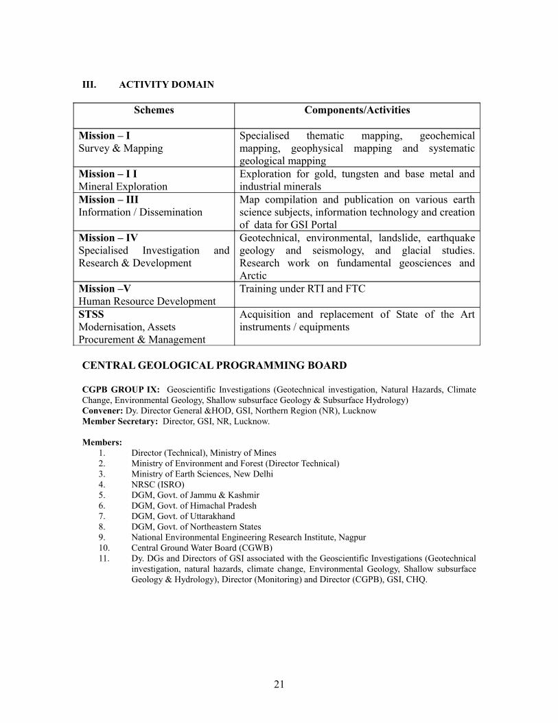
III. ACTIVITY DOMAIN
Schemes Components/Activities
Mission – I Survey & Mapping
Specialised thematic mapping, geochemical mapping, geophysical mapping and systematic geological mapping
Mission – I IMineral Exploration
Exploration for gold, tungsten and base metal and industrial minerals
Mission – IIIInformation / Dissemination
Map compilation and publication on various earth science subjects, information technology and creation of data for GSI Portal
Mission – IVSpecialised Investigation and Research & Development
Geotechnical, environmental, landslide, earthquake geology and seismology, and glacial studies. Research work on fundamental geosciences and Arctic
Mission –VHuman Resource Development
Training under RTI and FTC
STSSModernisation, Assets Procurement & Management
Acquisition and replacement of State of the Art instruments / equipments
CENTRAL GEOLOGICAL PROGRAMMING BOARD
CGPB GROUP IX: Geoscientific Investigations (Geotechnical investigation, Natural Hazards, Climate Change, Environmental Geology, Shallow subsurface Geology & Subsurface Hydrology)Convener: Dy. Director General &HOD, GSI, Northern Region (NR), LucknowMember Secretary: Director, GSI, NR, Lucknow.
Members:1. Director (Technical), Ministry of Mines2. Ministry of Environment and Forest (Director Technical)3. Ministry of Earth Sciences, New Delhi4. NRSC (ISRO)5. DGM, Govt. of Jammu & Kashmir6. DGM, Govt. of Himachal Pradesh7. DGM, Govt. of Uttarakhand8. DGM, Govt. of Northeastern States9. National Environmental Engineering Research Institute, Nagpur10. Central Ground Water Board (CGWB)11. Dy. DGs and Directors of GSI associated with the Geoscientific Investigations (Geotechnical
investigation, natural hazards, climate change, Environmental Geology, Shallow subsurface Geology & Hydrology), Director (Monitoring) and Director (CGPB), GSI, CHQ.
21
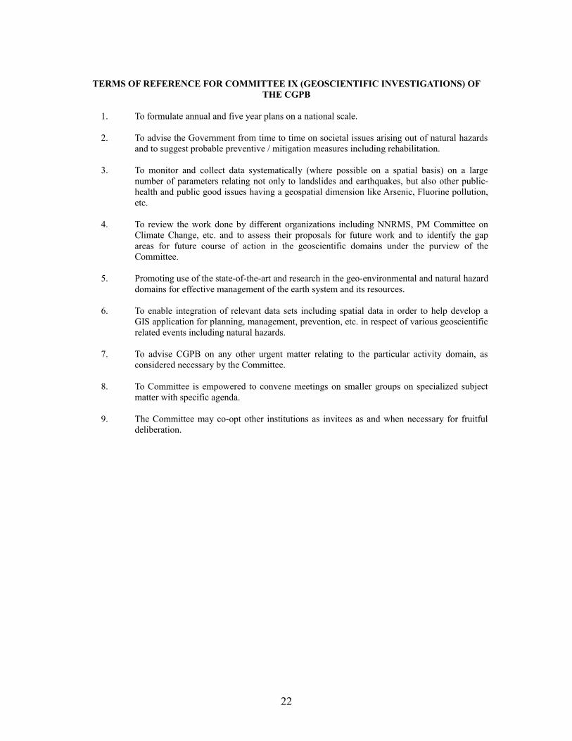
TERMS OF REFERENCE FOR COMMITTEE IX (GEOSCIENTIFIC INVESTIGATIONS) OF THE CGPB
1. To formulate annual and five year plans on a national scale.
2. To advise the Government from time to time on societal issues arising out of natural hazards and to suggest probable preventive / mitigation measures including rehabilitation.
3. To monitor and collect data systematically (where possible on a spatial basis) on a large number of parameters relating not only to landslides and earthquakes, but also other public-health and public good issues having a geospatial dimension like Arsenic, Fluorine pollution, etc.
4. To review the work done by different organizations including NNRMS, PM Committee on Climate Change, etc. and to assess their proposals for future work and to identify the gap areas for future course of action in the geoscientific domains under the purview of the Committee.
5. Promoting use of the state-of-the-art and research in the geo-environmental and natural hazard domains for effective management of the earth system and its resources.
6. To enable integration of relevant data sets including spatial data in order to help develop a GIS application for planning, management, prevention, etc. in respect of various geoscientific related events including natural hazards.
7. To advise CGPB on any other urgent matter relating to the particular activity domain, as considered necessary by the Committee.
8. To Committee is empowered to convene meetings on smaller groups on specialized subject matter with specific agenda.
9. The Committee may co-opt other institutions as invitees as and when necessary for fruitful deliberation.
22
IV. MISSION-WISE INFORMATION - FIELD SEASON 2013-2014
MISSION – I
Baseline Geoscience Data generation is the fundamental requirement of Mission - I. Specialised Thematic Mapping (STM), Geochemical Mapping (GCM) and Geophysical Mapping (GPM) are the core activities of this mission under the purview of the Region. Overall it includes the following activities:
IA.Ground Surveys:
• Geological Survey• Geophysical Survey• Geochemical Survey
Marine & Coastal Surveys: Marine Survey Coastal Survey Marine Geotech
IB.Remote Sensing and Aerial Surveys:
• Geomorphological Survey• Hyperspectral Survey, etc.• Airborne Mineral Survey• Photo Geology & Remote Sensing
A total of 26 regular field items, four service items and one research project are proposed to be taken up under the canopy of Mission – I, NR. During Field Season 2013-14, an area of 23822 sq km will be covered in the states of Uttar Pradesh, Uttarakhand, Himachal Pradesh, Punjab, Jammu & Kashmir, Haryana and parts of NCT, Delhi, under various disciplines of Ground Surveys. As recommended by FSP Review Committee, GSI, CHQ, Kolkata, three GCM Items are proposed for RGM (Punjab) and RGM (Haryana), in the areas falling in parts of Rajasthan and Madhya Pradesh. Sixty two geologists, nine geophysicists and twelve chemists are involved to accomplish the activities of Mission – I, NR.
During the current Field Season Programme, 11 items pertaining to Specialised Thematic Mapping will be taken up under Ground Geological Survey covering 2660 sq km with the objective to resolve the problems of lithostratigraphy and tectonics of the intricate areas. It mainly includes: Magmatic and geochemical evolution of Chirpatyakhal and Thati-Kathur Granite, Kumaun Lesser Himalaya; STM studies of Siwalik Belt; STM studies of Subathu and its relationship with adjoining units; STM in parts of Bundelkhand Granitoid Complex; and Delineation of litho stratigraphic units of Siwalik belt.
Geological Survey of India has been acquiring Gravity data under various projects of National and International importance since independence and revising the maps from time to time. These maps helped in various applications such as geodetic studies, regional tectonic studies and mineral exploration as well and have become most valuable input for any geo-scientific investigation of the earthscience community. An integration of the Specialised Thematic Mapping, the National Geochemical Mapping and Geophysical Mapping would help in better understanding of various complicated and interesting geological jig - saw especially in covered areas.
Systematic Geophysical Mapping which commenced in the year 2003 will be continued. An area of 8750 Sq km in parts of UP-MP, and Haryana-Delhi will be covered under 3 regular items. The data thus collected as well as available data shall be analysed and interpreted which will help in launching new programmes for mineral investigations.
Under the National Geochemical Mapping Programme, 12 items covering an area of 12412 sq km in the states of Uttar Pradesh, Uttarakhand, Himachal Pradesh, Jammu & Kashmir and parts of NCT Delhi.
23
As recommended by FSP Review Committee, GSI, CHQ, Kolkata, three GCM Items are proposed for RGM (Punjab) and RGM (Haryana), in the areas falling in parts of Rajasthan and Madhya Pradesh. The upgradation of NGCM reports of the previous field seasons, to final status, shall be taken up concurrently, depending on the availability of analytical data.
One Service Item as a part of the Regional Geochemical Division, NR, is also proposed for formulation / evaluation of NGCM Programme and maintenance of Regional NGCM database.
The NGLM programme (in collaboration with ISRO), initiated in the year 2009, will be continued during F.S. 2013-14, to carry out Geomorphological and Lineament Mapping on 1:50K scale using satellite data. The Service Item by Remote Sensing Division envisages procurement of data products, maintenance of lab infrastructure and assistance, processing and related services - Data Preparation – Geocoding (Geo referencing and Image rectification) of digital/ raster data; Digital Image Processing (Enhancement); Maintenance of lab infrastructure, support to Divisions/ Projects of Northern Region in interpretation of satellite data and generation of thematic maps.
MISSION - II
NATURAL RESOURCE ASSESSMENTThe demand for natural resource like minerals is growing day by day. Mineral resources being
location specific searches and estimation of minerals resources are a challenging job and forms main activities of the GSI.
Mission-II encompasses following core activities:
Mission-II- Natural Resources Assessment
A. Mineral Resource Assessment
B. Natural Energy Resources (except Oil & Gas)
C. Subsurface Hydrology, etc.
Search for minerals is the continuous thrust area of GSI for which a total ten items of mineral investigation will be taken up under the aegis of Natural Resource Assessment. Total nine items have been proposed for F.S. 2013-14 under natural resource assessment Mission-IIA. One item has been proposed under Natural energy resources, Mission-II-B. Under IIA, seven new investigations will be taken up and one investigation will be continued from the last field season. Four items fall under tribal area.
The items being taken up during field season 2013-2014 have been envisaged with a view to comply CGPB recommendation emphasising investigation for Industrial and Fertilizer minerals/ Parliamentary Standing Committee recommendations for taking up items in J&K/request from DGM, H.P. Accordingly, two items for assessment of Industrial Minerals viz., Andalusite, Pyrophylite/Diaspore in UP, one item each on Limestone investigation in J&K and H.P. and one item on resource survey for dimension stone granite in Ladakh shall be taken up in F.S. 2013-14. One item for assessment of resources of Fertilizer mineral- Potash will be taken up in Sonbhadra district of Uttar Pradesh.
A new investigation for Copper mineralization in Mahendragarh district of Haryana will be carried out in association with Geophysics Division, NR. An item on Search for iron and sulphide mineralization in undifferentiated Ramgarh Group has been taken up in district Nainital, Uttarakhand.
The exploration for gold mineralization in Mahakoshal, Parsoi area, Sonbhadra district is continued item included in the Field season Programme.
In view of thrust for non-conventional energy resources and request from DRDO, a collaborative item on Investigation for geothermal Resource assessment at Chhumathang Geothermal Field, Leh district, Ladakh, J&K shall also be taken up.
The demand for natural resources like minerals, water is growing day by day. Search, location and estimation of mineral resources too are one of the main activities of the GSI.
24
MISSION - IIIGEOINFORMATICS
Mission-III covers the activities of ‘Geoinformatics’ which include:
Data Repository and Management-(a) Geoscientific database; (b) Map compilation
Information Delivery- (a) GSI Net Portal; (b) Publication Advanced Spatial Data Systems, etc.
Development of Management Information Systems covering the entire administrative processes and scientific data management lies under the Portal Project. Major workload in NR is Portal management, preparation of layout of the geological maps of 1:50 K series, preparation of New Series (Second Edition) of Geological Quadrangle Maps based on the recently uploaded 1:50 K GMS maps, Updation and linking of Oracle database with 50K GMS (Geological Map Series) spatial database and additional data entry in Geoscientific database, creation of an archival of geophysical data base, creation of theme based data base and maintenance of LAN, WAN and portal.
The main objective of the Mission is to build an enterprise level spatial database through collation of geological data sets generated through systematic geological mapping on scale 1:50 K carried out by GSI since its inception. Under the project of map compilation and digitisation, 1:50 K scale geological maps covering the entire Region have been compiled and digitised. In Northern Region, there are 864 sheets falling in 70 degree sheets. The layout of these 1:50 K series maps are under preparation in a standardized format as per CHQ guidelines as a service item. These layouts will be available in the GSI Portal as Map Service.
During the FS 2013-14, a total of 23 nos. of standard as well service item including one service item pertaining to Mission directorate will be taken up by the Mission-III, NR; in which 10 items are related to Geodata Division./ Project Geoinformatics, 10 items are related to M&C Division while 2 items are related to Publication Division.
Out of 10 items related to Geodata Division./ Project Geoinformatics, three items pertain to Oracle database, four service items pertain to execution and maintenance of LAN, WAN, one item pertains to layout preparation and one item related to Integration of available data. In addition an integrated database item pertaining to Online Core Business Integrated System (OCBIS) has been formulated as per the DPR submitted by NISG (National Institute of Smart Governance) to facilitate the day to day core business process of GSI.
Out of 10 items related to M&C Division, four items pertain to preparation of the New Series (Second Edition) of Geological Quadrangle Maps based on the recently uploaded 1:50 K GMS maps, four service items pertain to maintenance/ issue of maps and all type of cartography work, one item pertains to compilation of DRM’s and under one item edge matching of inter- regional maps of Northern Region with ER, WR and CR will be carried out. Besides, two items pertaining to Publication Division will also be taken up in the region. In all thirty six officers will be involved to accomplish the target of Mission-III.
MISSION – IV
FUNDAMENTAL AND MULTIDISPLINARY GEOSCIENCE
Fundamental and Multidisciplinary Geosciences and special studies are placed under Mission – IV. Multidisciplinary Geosciences currently encompasses many broad fields like engineering geology (geotechnical investigations), natural hazard studies, climate change and related studies, environmental geology etc.
25
Mission-IV encompasses following activity areas of GSI:
Geotechnical, Landslide & Seismic Climate Change impact & Fragile eco- systems Biogeochemistry & Medical Geology Fundamental Geoscience Crustal Evolution Stratigraphic Correlation Palaeobiology Deep Geology Isotope Geology and Geochronology Meteoritic & Planetary Studies Polar Studies, etc.
Under this Mission a total 39 items, which also include10 service items and 1 linkage item and 6 research items, will be taken up during F.S.2013-14. The regular field items include 12 items of Geotechnical investigations; 1 items of Landslide Hazard Studies; 1 item each for Seismic Microzonation and Active Fault studies; 2 items for Geoenvironmental hazard studies (Bio and Chemical Geohazards); and 3 items pertaining to Glaciological studies. Fifty two geologists and two geophysicists are involved to accomplish the targets of Mission – IV.
Geotechnical investigations continues to be an area of importance, where outside agencies required GSI to carry out the investigations in projects including evaluation of water resource development, communication and transportation, various civil structures, flood damage, landslide and stability of slopes on national highways and railway alignment. In Northern Region, twelve Geotechnical investigations will be taken up during current field season in U.P., Uttarakhand, Himachal, Punjab and J&K. Some of the important projects are: Tapovan - Vishnugad HEP, Srinagar Hydel Project, Bansagar Project, Kashang Hydel Project, Luhri Hydel Project, Sawra-Kuddu Hydel Project, Kol Dam Project, Sainj Hydel Project and Ujh Multipurpose Project. The Katra-Qazigund Rail Line Project is one of the important communication projects.
Landslide Hazard Zonation (on macro- scale), site specific studies of important slides and communication routes are prominent investigations that will be taken up during F.S. 2013-14. It include Landslide Hazard Zonation mapping on macro-scale of Pithoragarh districts, Uttarakhand continuing since last FSP. Besides, emergent investigation of the critical landslides on communication route or damages to the demographic centre in Uttarakhand, Himachal Pradesh, Haryana, Punjab and Jammu & Kashmir will also be taken up. Seismic microzonation studies of major urban agglomerations have been launched throughout the country. DST, Government of India, has identified 38 cities for carrying out these studies. The finding of studies of Delhi, Dehradun and Chandigarh urban agglomerations has already been published in the form of Special Publications of GSI. In Northern Region, the Seismic Microzonation Studies of Panchkula urban agglomeration has been taken up in this field season. Neotectonic Studies along Satlitta (Soan) Thrust in Himalayan Frontal Belt, Punjab and Himachal Pradesh is the new item taken up to study active tectonics. Besides, a linkage item with Seismic Microzonation Studies of Panchkula urban agglomeration will also be taken up under Geophysical studies.
The ongoing geoenvironmental appraisal of Bhatinda and Mansar district, Punjab will be continued along with the groundwater contamination studies in parts of Urban and Suburban area of Agra. In addition an item on Geoenvironmental appraisal of arsenic prone areas in parts of Ghazipur and Chandauli districts, UP has also been taken up as per the request of CGWB.
Glaciological studies in F.S. 2013-14 include: Generation of primary baseline field-data and also some repeat monitoring data from glaciers in the gap areas of remote tribal districts of Kargil and Leh in Jammu & Kashmir and Lahaul & Spiti district in Himachal Pradesh; Long - term monitoring of mass balance studies of Hamtah glacier in Lahaul and Spiti district, H.P. and Compilation of a monograph on Mass Balance studies carried out by GSI in Northwest Himalaya..
Under research projects of various disciplines, six items will be carried out during field season 2013-14. It includes: Study of Late Quaternary stratigraphy and geomorphic evolution of the alluvial plain
26
along the Ghagghar river, Haryana; Quaternary geological studies along Bhagirathi and Bhilangna rivers, Uttarkashi and Tehri Garhwal Districts, Uttarakhand; Search and study of Quaternary vertebrate fossils from Gangetic alluvium in Jalaun and Kanpur Dehat districts of Uttar Pradesh and their bearing on palaeoclimate; Elucidation of tectono-magmatic regime for mafic dyke swarms in Jhansi- Mahoba-Lalitpur sector, Bundelkhand province using bulk and phase chemistry; Tectonic discrimination and petrogenesis of the granitoids of Bhiwani and Mahendragarh districts, Haryana and its implication on the Proterozoic Crustal Evolution; and Felsic and mafic magma interaction in Paleozoic granite of Mandi, Himachal Pradesh and Champawat, Uttarakhand and its implication in understanding mixing process in magma chambers.
MISSION – V
TRAINING AND CAPACITY BUILDINGTraining and Capacity Building are the main activity of this Mission. Seven courses
including workshops will be taken up under the activities of Mission-V during F.S. 2013-14. The major activities will be 36 th Orientation Course for Geologist in Bhimtal - Saketi Modules.
SCIENTIFIC AND TECHNICAL SUPPORT SYSTEM (STSS)
The STSS provides technical support to inter-regional projects and divisions. Seven nos. of Service items and one linkage item will be taken up during F.S. 2013-14. Out of these 7 items; 3 service items related to chemical stream and lab network pertaining to analysis of NGCM and Non-NGCM samples whereas, 4 other service items pertain to geological and geophysical lab network.
The linkage item is associated with Drilling Division, to carry out the drilling activities of Mission-II and Mission-IV. A total of four such items will be taken up during F.S. 2013-2014 which includes one continued item.
POLICY SUPPORT SYSTEM (PSS)
The Policy Support system (PSS) deals with perspective planning and technical coordination; formulation, implementation and monitoring of Annual Programme; monitoring of submission of progress reports their scrutiny, processing and final distribution; monitoring of items for data generation for CGPB, SGPB and IGCP Projects; conducting and organising quarterly review meetings besides providing logistic support. Eight Service items (including 1 item of Technical consultancy Services) are taken up during F.S. 2013-14.
ADMINISTRATIVE SUPPORT SYSTEM (ASS)
The Administrative Support System (ASS) deals with the administrative planning and coordination, besides monitoring / maintenance of Siwalik Fossil Park, Saketi Museum and Core library.
27
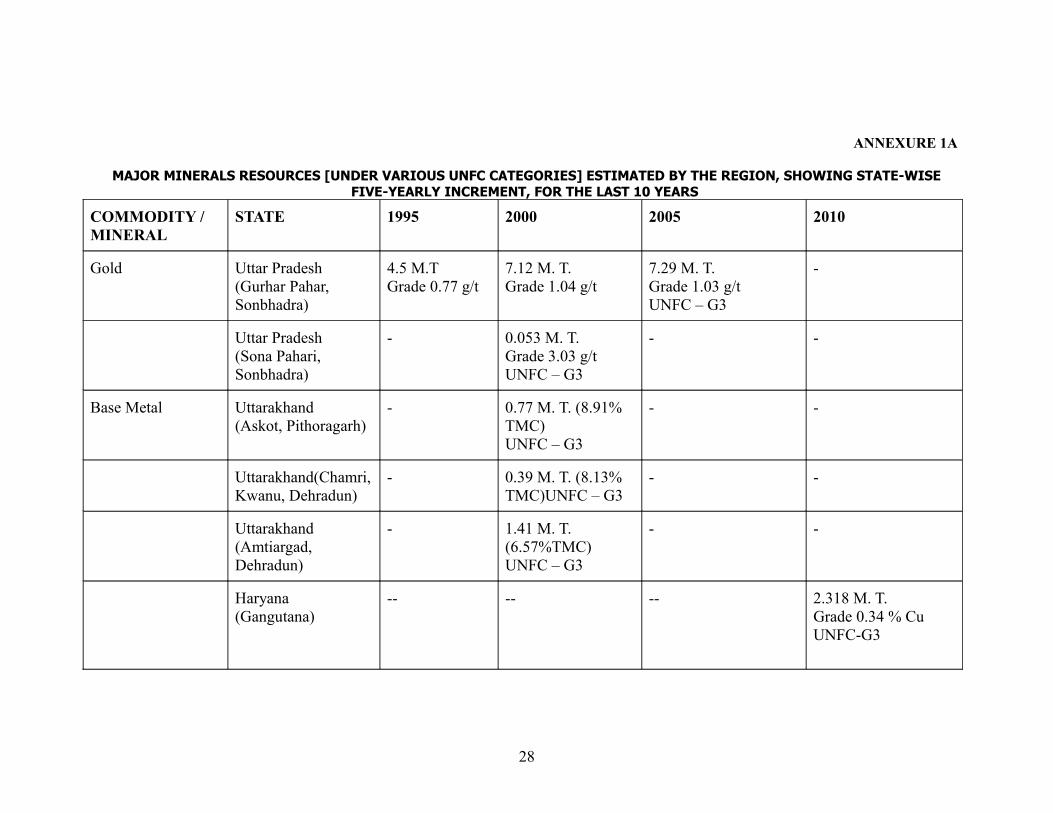
ANNEXURE 1A
MAJOR MINERALS RESOURCES [UNDER VARIOUS UNFC CATEGORIES] ESTIMATED BY THE REGION, SHOWING STATE-WISE FIVE-YEARLY INCREMENT, FOR THE LAST 10 YEARS
COMMODITY / MINERAL
STATE 1995 2000 2005 2010
Gold Uttar Pradesh (Gurhar Pahar, Sonbhadra)
4.5 M.T Grade 0.77 g/t
7.12 M. T. Grade 1.04 g/t
7.29 M. T. Grade 1.03 g/tUNFC – G3
-
Uttar Pradesh (Sona Pahari, Sonbhadra)
- 0.053 M. T. Grade 3.03 g/t UNFC – G3
- -
Base Metal Uttarakhand(Askot, Pithoragarh)
- 0.77 M. T. (8.91% TMC)UNFC – G3
- -
Uttarakhand(Chamri, Kwanu, Dehradun)
- 0.39 M. T. (8.13% TMC)UNFC – G3
- -
Uttarakhand(Amtiargad, Dehradun)
- 1.41 M. T. (6.57%TMC) UNFC – G3
- -
Haryana (Gangutana)
-- -- -- 2.318 M. T.Grade 0.34 % CuUNFC-G3
28
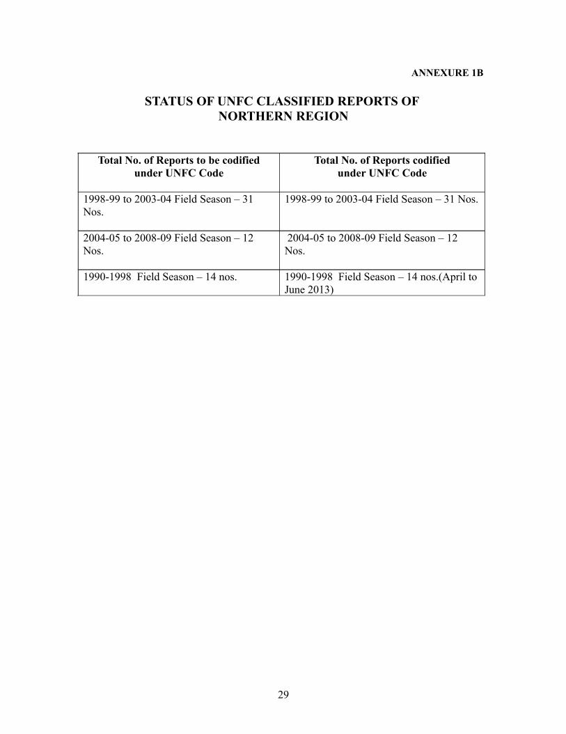
ANNEXURE 1B
STATUS OF UNFC CLASSIFIED REPORTS OF NORTHERN REGION
Total No. of Reports to be codified under UNFC Code
Total No. of Reports codifiedunder UNFC Code
1998-99 to 2003-04 Field Season – 31 Nos.
1998-99 to 2003-04 Field Season – 31 Nos.
2004-05 to 2008-09 Field Season – 12 Nos.
2004-05 to 2008-09 Field Season – 12 Nos.
1990-1998 Field Season – 14 nos. 1990-1998 Field Season – 14 nos.(April to June 2013)
29
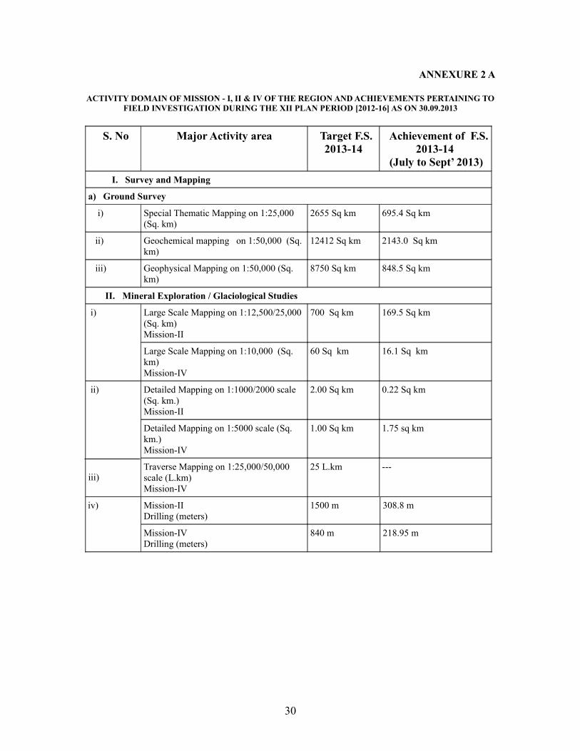
ANNEXURE 2 A
ACTIVITY DOMAIN OF MISSION - I, II & IV OF THE REGION AND ACHIEVEMENTS PERTAINING TO FIELD INVESTIGATION DURING THE XII PLAN PERIOD [2012-16] AS ON 30.09.2013
S. No Major Activity area Target F.S. 2013-14
Achievement of F.S. 2013-14
(July to Sept’ 2013) I. Survey and Mapping
a) Ground Survey
i) Special Thematic Mapping on 1:25,000 (Sq. km)
2655 Sq km 695.4 Sq km
ii) Geochemical mapping on 1:50,000 (Sq. km)
12412 Sq km 2143.0 Sq km
iii) Geophysical Mapping on 1:50,000 (Sq. km)
8750 Sq km 848.5 Sq km
II. Mineral Exploration / Glaciological Studies
i) Large Scale Mapping on 1:12,500/25,000 (Sq. km) Mission-II
700 Sq km 169.5 Sq km
Large Scale Mapping on 1:10,000 (Sq. km) Mission-IV
60 Sq km 16.1 Sq km
ii)
iii)
Detailed Mapping on 1:1000/2000 scale (Sq. km.)Mission-II
2.00 Sq km 0.22 Sq km
Detailed Mapping on 1:5000 scale (Sq. km.)Mission-IV
1.00 Sq km 1.75 sq km
Traverse Mapping on 1:25,000/50,000 scale (L.km)Mission-IV
25 L.km ---
iv) Mission-IIDrilling (meters)
1500 m 308.8 m
Mission-IVDrilling (meters)
840 m 218.95 m
30
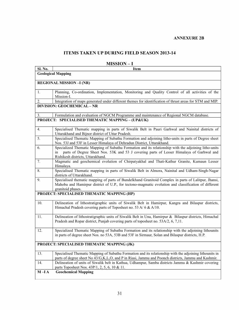
ANNEXURE 2B
ITEMS TAKEN UP DURING FIELD SEASON 2013-14
MISSION – ISl. No. ItemGeological Mapping
REGIONAL MISSION –I (NR)
1. Planning, Co-ordination, Implementation, Monitoring and Quality Control of all activities of the Mission-I.
2. Integration of maps generated under different themes for identification of thrust areas for STM and MIP.DIVISION: GEOCHEMICAL – NR
3. Formulation and evaluation of NGCM Programme and maintenance of Regional NGCM database. PROJECT: SPECIALISED THEMATIC MAPPING – (UP&UK)
4. Specialised Thematic mapping in parts of Siwalik Belt in Pauri Garhwal and Nainital districts of Uttarakhand and Bijnor district of Uttar Pradesh.
5. Specialised Thematic Mapping of Subathu Formation and adjoining litho-units in parts of Degree sheet Nos. 53J and 53F in Lesser Himalaya of Dehradun District, Uttarakhand.
6. Specialized Thematic Mapping of Subathu Formation and its relationship with the adjoining litho-units in parts of Degree Sheet Nos. 53K and 53 J covering parts of Lesser Himalaya of Garhwal and Rishikesh districts, Uttarakhand.
7. Magmatic and geochemical evolution of Chirpatyakhal and Thati-Kathur Granite, Kumaun Lesser Himalaya.
8. Specialised Thematic mapping in parts of Siwalik Belt in Almora, Nainital and Udham-Singh-Nagar districts of Uttarakhand.
9. Specialised thematic mapping of parts of Bundelkhand Granitoid Complex in parts of Lalitpur, Jhansi, Mahoba and Hamirpur district of U.P., for tectono-magmatic evolution and classification of different granitoid phases.
PROJECT: SPECIALISED THEMATIC MAPPING (HP)
10. Delineation of lithostratigraphic units of Siwalik Belt in Hamirpur, Kangra and Bilaspur districts, Himachal Pradesh covering parts of Toposheet no. 53 A/ 6 & A/10.
11. Delineation of lithostratigraphic units of Siwalik Belt in Una, Hamirpur & Bilaspur districts, Himachal Pradesh and Ropar district, Punjab covering parts of toposheet no. 53A/2, 6, 7,11.
12. Specialized Thematic Mapping of Subathu Formation and its relationship with the adjoining lithounits in parts of degree sheet Nos. no 53A, 53B and 53F in Sirmaur, Solan and Bilaspur districts, H.P.
PROJECT: SPECIALISED THEMATIC MAPPING (JK)
13. Specialised Thematic Mapping of Subathu Formation and its relationship with the adjoining lithounits in parts of degree sheet No 43/G,K,L,O, and P in Riasi, Jammu and Poonch districts, Jammu and Kashmir.
14. Delineation of units of Siwalik belt in Kathua, Udhampur, Samba districts Jammu & Kashmir covering parts Toposheet Nos. 43P/1, 2, 5, 6, 10 & 11.
M –I A Geochemical Mapping
31
PROJECT: REGIONAL GEOCHEMICAL MAPPING (P) - (UP&UK)
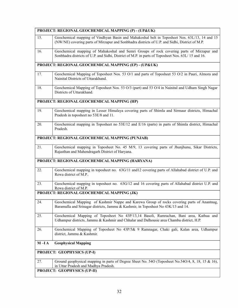
15. Geochemical mapping of Vindhyan Basin and Mahakoshal belt in Toposheet Nos. 63L/13, 14 and 15 (NW/NE) covering parts of Mirzapur and Sonbhadra districts of U.P. and Sidhi, District of M.P.
16. Geochemical mapping of Mahakoshal and Semri Groups of rock covering parts of Mirzapur and Sonbhadra districts of U.P. and Sidhi, District of M.P. in parts of Toposheet Nos. 63L/ 15 and 16.
PROJECT: REGIONAL GEOCHEMICAL MAPPING (EP) - (UP&UK)
17. Geochemical Mapping of Toposheet Nos. 53 O/1 and parts of Toposheet 53 O/2 in Pauri, Almora and Nainital Districts of Uttarakhand.
18. Geochemical Mapping of Toposheet Nos. 53 O/3 (part) and 53 O/4 in Nainital and Udham Singh Nagar Districts of Uttarakhand.
PROJECT: REGIONAL GEOCHEMICAL MAPPING (HP)
19. Geochemical mapping in Lesser Himalaya covering parts of Shimla and Sirmaur districts, Himachal Pradesh in toposheet no 53E/8 and 11.
20. Geochemical mapping in Toposheet no 53E/12 and E/16 (parts) in parts of Shimla district, Himachal Pradesh.
PROJECT: REGIONAL GEOCHEMICAL MAPPING (PUNJAB)
21. Geochemical mapping in Toposheet No. 45 M/9, 13 covering parts of Jhunjhunu, Sikar Districts, Rajasthan and Mahendragarh District of Haryana.
PROJECT: REGIONAL GEOCHEMICAL MAPPING (HARYANA)
22. Geochemical mapping in toposheet no. 63G/11 and12 covering parts of Allahabad district of U.P. and Rewa district of M.P..
23. Geochemical mapping in toposheet no. 63G/12 and 16 covering parts of Allahabad district U.P. and Rewa district of M.P.
PROJECT: REGIONAL GEOCHEMICAL MAPPING (JK)
24. Geochemical Mapping of Kashmir Nappe and Karewa Group of rocks covering parts of Anantnag, Baramulla and Srinagar districts, Jammu & Kashmir, in Toposheet No 43K/13 and 14.
25. Geochemical Mapping of Toposheet No 43P/13,14 Basoli, Ramrachan, Bani area, Kathua and Udhampur districts, Jammu & Kashmir and Chhalar and Dalhousie area Chamba district, H.P.
26. Geochemical Mapping of Toposheet No 43P/5& 9 Ramnagar, Chaki gali, Kalan area, Udhampur district, Jammu & Kashmir.
M –I A Geophysical Mapping
PROJECT: GEOPHYSICS (UP-I)
27. Ground geophysical mapping in parts of Degree Sheet No. 54O (Toposheet No.54O/4, 8, 18, 15 & 16), in Uttar Pradesh and Madhya Pradesh.
PROJECT: GEOPHYSICS (UP-II)
32
28. Ground Geophysical Mapping in parts of Degree Sheet No. 54O (Toposheet nos. 54O/2,3,6,7 & 11) in Uttar Pradesh and Madhya Pradesh.
PROJECT: GEOPHYSICS (UP-III)
29. Ground Geophysical Mapping in parts of Degree Sheet No. 53H (Toposheet nos. 53H/2,3 & 4) in Delhi and Haryana.
REMOTE SENSING AND AERIAL SURVEYS
DIVISION: REMOTE SENSING
30. National Mission on Geomorphological and Lineament mapping on 1:50,000 scale using satellite data.
31. Support to Divisions/ Projects of Northern Region in interpretation of satellite data and generation of thematic maps. Procurement of data products, maintenance of lab infrastructure and assistance. Processing and related services - Data Preparation – Geocoding (Georeferencing and Image rectification) of digital/ raster data; Digital Image Processing (Enhancement); Maintenance of lab infrastructure
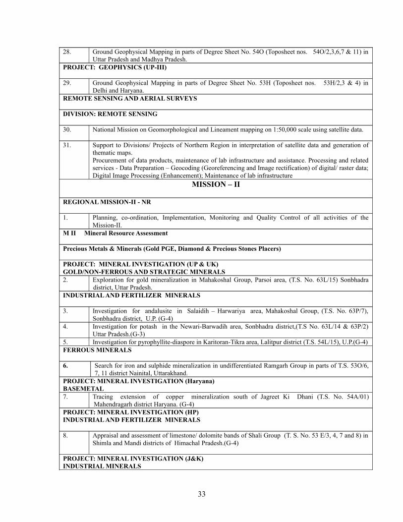
MISSION – II
REGIONAL MISSION-II - NR
1. Planning, co-ordination, Implementation, Monitoring and Quality Control of all activities of the Mission-II.
M II Mineral Resource Assessment
Precious Metals & Minerals (Gold PGE, Diamond & Precious Stones Placers)
PROJECT: MINERAL INVESTIGATION (UP & UK)GOLD/NON-FERROUS AND STRATEGIC MINERALS2. Exploration for gold mineralization in Mahakoshal Group, Parsoi area, (T.S. No. 63L/15) Sonbhadra
district, Uttar Pradesh.INDUSTRIAL AND FERTILIZER MINERALS
3. Investigation for andalusite in Salaidih – Harwariya area, Mahakoshal Group, (T.S. No. 63P/7), Sonbhadra district, U.P. (G-4)
4. Investigation for potash in the Newari-Barwadih area, Sonbhadra district,(T.S No. 63L/14 & 63P/2) Uttar Pradesh.(G-3)
5. Investigation for pyrophyllite-diaspore in Karitoran-Tikra area, Lalitpur district (T.S. 54L/15), U.P.(G-4)FERROUS MINERALS
6. Search for iron and sulphide mineralization in undifferentiated Ramgarh Group in parts of T.S. 53O/6, 7, 11 district Nainital, Uttarakhand.
PROJECT: MINERAL INVESTIGATION (Haryana)BASEMETAL7. Tracing extension of copper mineralization south of Jagreet Ki Dhani (T.S. No. 54A/01)
Mahendragarh district Haryana. (G-4)PROJECT: MINERAL INVESTIGATION (HP)INDUSTRIAL AND FERTILIZER MINERALS
8. Appraisal and assessment of limestone/ dolomite bands of Shali Group (T. S. No. 53 E/3, 4, 7 and 8) in Shimla and Mandi districts of Himachal Pradesh.(G-4)
PROJECT: MINERAL INVESTIGATION (J&K)INDUSTRIAL MINERALS
33
9. Resource Survey for dimensional and decorative stone granite in Ladakh Granitoid Complex, Southeast Ladakh, J&K (On Expedition basis) (G-4 ).
10 Resource Survey for Limestone of Zanskar basin of Ladakh Region, J&K. (On Expedition basis) (G-4)
M IIB – NATURAL ENERGY RESOURCES GEOTHERMAL
11 Assessment of geothermal Resource at Chhumathang Geothermal Field, Leh district, Ladakh, J&K; on expedition basis.Monitoring of discharge parameters of hot springs in Himalaya belt of Uttarakhand and Himachal Pradesh for assessment of geothermal resource for direct heat utilization.
PROJECT: GEOPHYSICS (BOREHOLE LOGGING)12. Geophysical logging of boreholes and mise-a-la-masse survey in Northern Region, as and when
required. (Linkage item)
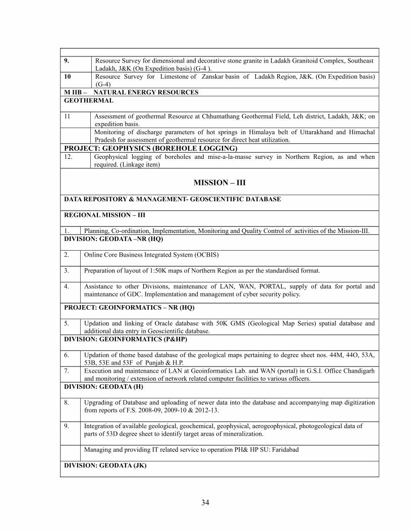
MISSION – III
DATA REPOSITORY & MANAGEMENT- GEOSCIENTIFIC DATABASE
REGIONAL MISSION – III
1. Planning, Co-ordination, Implementation, Monitoring and Quality Control of activities of the Mission-III.DIVISION: GEODATA –NR (HQ)
2. Online Core Business Integrated System (OCBIS)
3. Preparation of layout of 1:50K maps of Northern Region as per the standardised format.
4. Assistance to other Divisions, maintenance of LAN, WAN, PORTAL, supply of data for portal and maintenance of GDC. Implementation and management of cyber security policy.
PROJECT: GEOINFORMATICS – NR (HQ)
5. Updation and linking of Oracle database with 50K GMS (Geological Map Series) spatial database and additional data entry in Geoscientific database.
DIVISION: GEOINFORMATICS (P&HP)
6. Updation of theme based database of the geological maps pertaining to degree sheet nos. 44M, 44O, 53A, 53B, 53E and 53F of Punjab & H.P.
7. Execution and maintenance of LAN at Geoinformatics Lab. and WAN (portal) in G.S.I. Office Chandigarh and monitoring / extension of network related computer facilities to various officers.
DIVISION: GEODATA (H)
8. Upgrading of Database and uploading of newer data into the database and accompanying map digitization from reports of F.S. 2008-09, 2009-10 & 2012-13.
9. Integration of available geological, geochemical, geophysical, aerogeophysical, photogeological data of parts of 53D degree sheet to identify target areas of mineralization.
Managing and providing IT related service to operation PH& HP SU: Faridabad
DIVISION: GEODATA (JK)
34
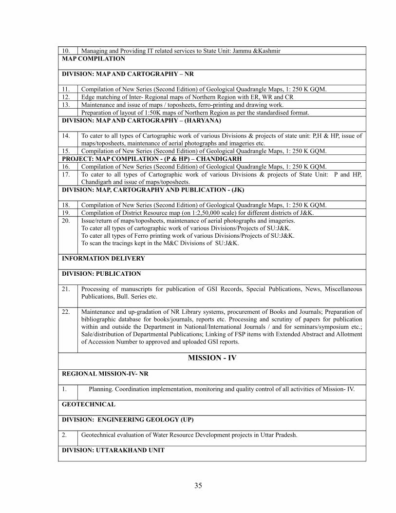
10. Managing and Providing IT related services to State Unit: Jammu &KashmirMAP COMPILATION
DIVISION: MAP AND CARTOGRAPHY – NR
11. Compilation of New Series (Second Edition) of Geological Quadrangle Maps, 1: 250 K GQM.12. Edge matching of Inter- Regional maps of Northern Region with ER, WR and CR13. Maintenance and issue of maps / toposheets, ferro-printing and drawing work.
Preparation of layout of 1:50K maps of Northern Region as per the standardised format.DIVISION: MAP AND CARTOGRAPHY – (HARYANA)
14. To cater to all types of Cartographic work of various Divisions & projects of state unit: P,H & HP, issue of maps/toposheets, maintenance of aerial photographs and imageries etc.
15. Compilation of New Series (Second Edition) of Geological Quadrangle Maps, 1: 250 K GQM. PROJECT: MAP COMPILATION - (P & HP) – CHANDIGARH16. Compilation of New Series (Second Edition) of Geological Quadrangle Maps, 1: 250 K GQM.17. To cater to all types of Cartographic work of various Divisions & projects of State Unit: P and HP,
Chandigarh and issue of maps/toposheets.DIVISION: MAP, CARTOGRAPHY AND PUBLICATION - (JK)
18. Compilation of New Series (Second Edition) of Geological Quadrangle Maps, 1: 250 K GQM.19. Compilation of District Resource map (on 1:2,50,000 scale) for different districts of J&K.20. Issue/return of maps/toposheets, maintenance of aerial photographs and imageries.
To cater all types of cartographic work of various Divisions/Projects of SU:J&K. To cater all types of Ferro printing work of various Divisions/Projects of SU:J&K.To scan the tracings kept in the M&C Divisions of SU:J&K.
INFORMATION DELIVERY
DIVISION: PUBLICATION
21. Processing of manuscripts for publication of GSI Records, Special Publications, News, Miscellaneous Publications, Bull. Series etc.
22. Maintenance and up-gradation of NR Library systems, procurement of Books and Journals; Preparation of bibliographic database for books/journals, reports etc. Processing and scrutiny of papers for publication within and outside the Department in National/International Journals / and for seminars/symposium etc.; Sale/distribution of Departmental Publications; Linking of FSP items with Extended Abstract and Allotment of Accession Number to approved and uploaded GSI reports.
MISSION - IV
REGIONAL MISSION-IV- NR
1. Planning. Coordination implementation, monitoring and quality control of all activities of Mission- IV.
GEOTECHNICAL
DIVISION: ENGINEERING GEOLOGY (UP)
2. Geotechnical evaluation of Water Resource Development projects in Uttar Pradesh.
DIVISION: UTTARAKHAND UNIT
35
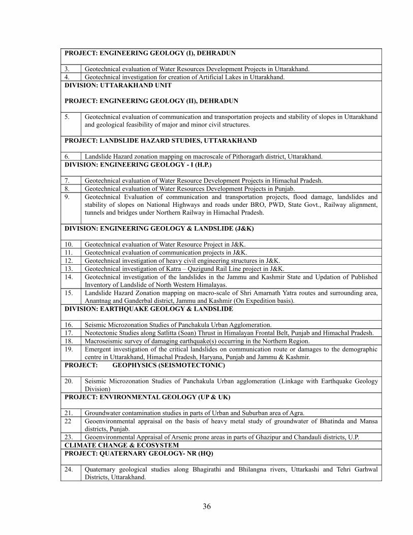
PROJECT: ENGINEERING GEOLOGY (I), DEHRADUN
3. Geotechnical evaluation of Water Resources Development Projects in Uttarakhand.4. Geotechnical investigation for creation of Artificial Lakes in Uttarakhand.DIVISION: UTTARAKHAND UNIT
PROJECT: ENGINEERING GEOLOGY (II), DEHRADUN
5. Geotechnical evaluation of communication and transportation projects and stability of slopes in Uttarakhand and geological feasibility of major and minor civil structures.
PROJECT: LANDSLIDE HAZARD STUDIES, UTTARAKHAND
6. Landslide Hazard zonation mapping on macroscale of Pithoragarh district, Uttarakhand.DIVISION: ENGINEERING GEOLOGY - I (H.P.)
7. Geotechnical evaluation of Water Resource Development Projects in Himachal Pradesh.8. Geotechnical evaluation of Water Resources Development Projects in Punjab.9. Geotechnical Evaluation of communication and transportation projects, flood damage, landslides and
stability of slopes on National Highways and roads under BRO, PWD, State Govt., Railway alignment, tunnels and bridges under Northern Railway in Himachal Pradesh.
DIVISION: ENGINEERING GEOLOGY & LANDSLIDE (J&K)
10. Geotechnical evaluation of Water Resource Project in J&K.11. Geotechnical evaluation of communication projects in J&K.12. Geotechnical investigation of heavy civil engineering structures in J&K.13. Geotechnical investigation of Katra – Qazigund Rail Line project in J&K.14. Geotechnical investigation of the landslides in the Jammu and Kashmir State and Updation of Published
Inventory of Landslide of North Western Himalayas.15. Landslide Hazard Zonation mapping on macro-scale of Shri Amarnath Yatra routes and surrounding area,
Anantnag and Ganderbal district, Jammu and Kashmir (On Expedition basis).DIVISION: EARTHQUAKE GEOLOGY & LANDSLIDE
16. Seismic Microzonation Studies of Panchakula Urban Agglomeration.17. Neotectonic Studies along Satlitta (Soan) Thrust in Himalayan Frontal Belt, Punjab and Himachal Pradesh.18. Macroseismic survey of damaging earthquake(s) occurring in the Northern Region.19. Emergent investigation of the critical landslides on communication route or damages to the demographic
centre in Uttarakhand, Himachal Pradesh, Haryana, Punjab and Jammu & Kashmir.PROJECT: GEOPHYSICS (SEISMOTECTONIC)
20. Seismic Microzonation Studies of Panchakula Urban agglomeration (Linkage with Earthquake Geology Division)
PROJECT: ENVIRONMENTAL GEOLOGY (UP & UK)
21. Groundwater contamination studies in parts of Urban and Suburban area of Agra.22 Geoenvironmental appraisal on the basis of heavy metal study of groundwater of Bhatinda and Mansa
districts, Punjab.23. Geoenvironmental Appraisal of Arsenic prone areas in parts of Ghazipur and Chandauli districts, U.P.CLIMATE CHANGE & ECOSYSTEMPROJECT: QUATERNARY GEOLOGY- NR (HQ)
24. Quaternary geological studies along Bhagirathi and Bhilangna rivers, Uttarkashi and Tehri Garhwal Districts, Uttarakhand.
36
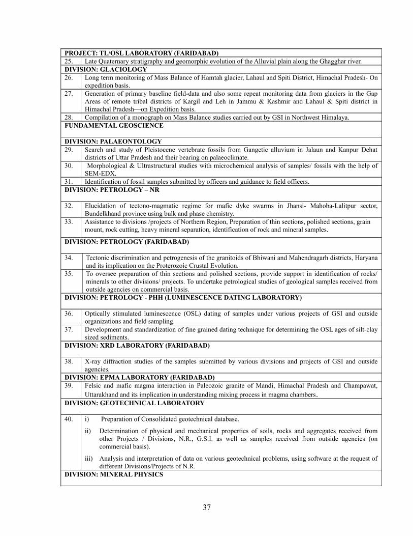
PROJECT: TL/OSL LABORATORY (FARIDABAD)25. Late Quaternary stratigraphy and geomorphic evolution of the Alluvial plain along the Ghagghar river.DIVISION: GLACIOLOGY26. Long term monitoring of Mass Balance of Hamtah glacier, Lahaul and Spiti District, Himachal Pradesh- On
expedition basis.27. Generation of primary baseline field-data and also some repeat monitoring data from glaciers in the Gap
Areas of remote tribal districts of Kargil and Leh in Jammu & Kashmir and Lahaul & Spiti district in Himachal Pradesh—on Expedition basis.
28. Compilation of a monograph on Mass Balance studies carried out by GSI in Northwest Himalaya.FUNDAMENTAL GEOSCIENCE
DIVISION: PALAEONTOLOGY29. Search and study of Pleistocene vertebrate fossils from Gangetic alluvium in Jalaun and Kanpur Dehat
districts of Uttar Pradesh and their bearing on palaeoclimate.30. Morphological & Ultrastructural studies with microchemical analysis of samples/ fossils with the help of
SEM-EDX.31. Identification of fossil samples submitted by officers and guidance to field officers.DIVISION: PETROLOGY – NR
32. Elucidation of tectono-magmatic regime for mafic dyke swarms in Jhansi- Mahoba-Lalitpur sector, Bundelkhand province using bulk and phase chemistry.
33. Assistance to divisions /projects of Northern Region, Preparation of thin sections, polished sections, grain mount, rock cutting, heavy mineral separation, identification of rock and mineral samples.
DIVISION: PETROLOGY (FARIDABAD)
34. Tectonic discrimination and petrogenesis of the granitoids of Bhiwani and Mahendragarh districts, Haryana and its implication on the Proterozoic Crustal Evolution.
35. To oversee preparation of thin sections and polished sections, provide support in identification of rocks/ minerals to other divisions/ projects. To undertake petrological studies of geological samples received from outside agencies on commercial basis.
DIVISION: PETROLOGY - PHH (LUMINESCENCE DATING LABORATORY)
36. Optically stimulated luminescence (OSL) dating of samples under various projects of GSI and outside organizations and field sampling.
37. Development and standardization of fine grained dating technique for determining the OSL ages of silt-clay sized sediments.
DIVISION: XRD LABORATORY (FARIDABAD)
38. X-ray diffraction studies of the samples submitted by various divisions and projects of GSI and outside agencies.
DIVISION: EPMA LABORATORY (FARIDABAD) 39. Felsic and mafic magma interaction in Paleozoic granite of Mandi, Himachal Pradesh and Champawat,
Uttarakhand and its implication in understanding mixing process in magma chambers.DIVISION: GEOTECHNICAL LABORATORY
40. i) Preparation of Consolidated geotechnical database.
ii) Determination of physical and mechanical properties of soils, rocks and aggregates received from other Projects / Divisions, N.R., G.S.I. as well as samples received from outside agencies (on commercial basis).
iii) Analysis and interpretation of data on various geotechnical problems, using software at the request of different Divisions/Projects of N.R.
DIVISION: MINERAL PHYSICS
37
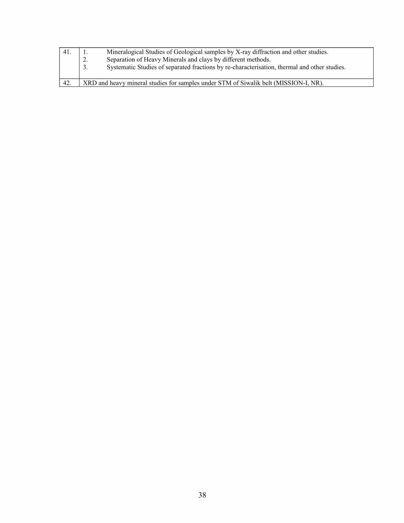
41. 1. Mineralogical Studies of Geological samples by X-ray diffraction and other studies.2. Separation of Heavy Minerals and clays by different methods. 3. Systematic Studies of separated fractions by re-characterisation, thermal and other studies.
42. XRD and heavy mineral studies for samples under STM of Siwalik belt (MISSION-I, NR).
38
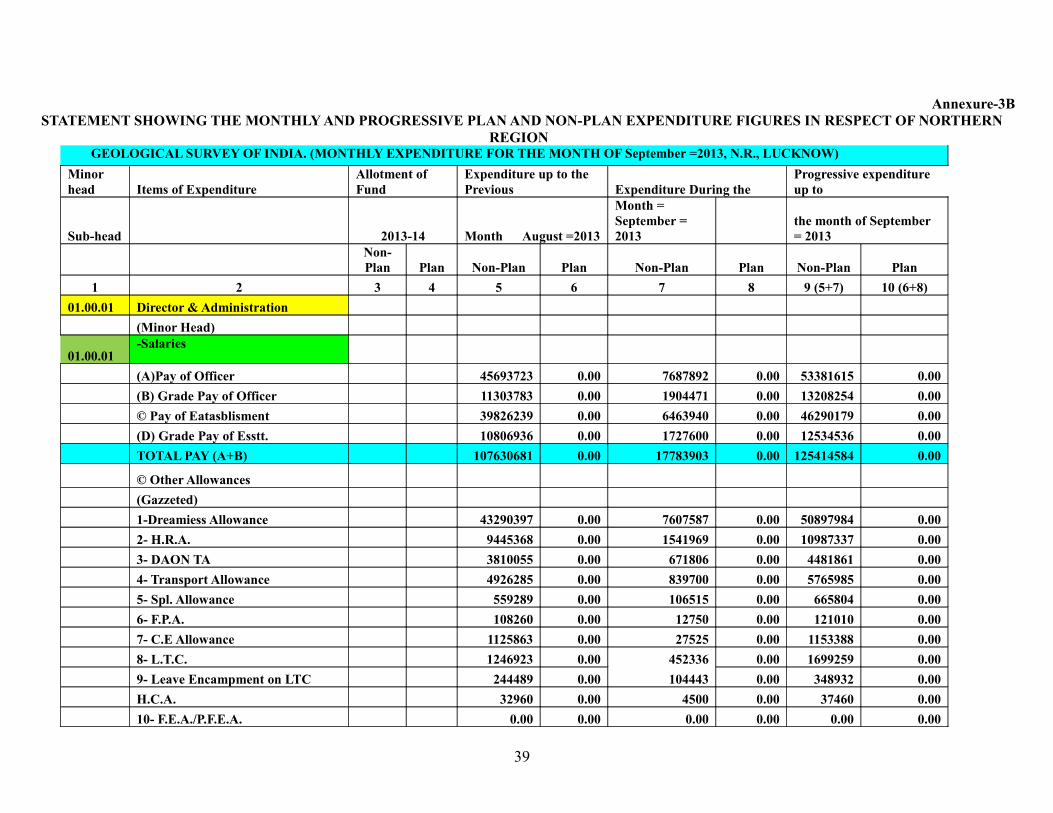
Annexure-3BSTATEMENT SHOWING THE MONTHLY AND PROGRESSIVE PLAN AND NON-PLAN EXPENDITURE FIGURES IN RESPECT OF NORTHERN
REGION GEOLOGICAL SURVEY OF INDIA. (MONTHLY EXPENDITURE FOR THE MONTH OF September =2013, N.R., LUCKNOW)Minor head Items of Expenditure
Allotment of Fund
Expenditure up to the Previous Expenditure During the
Progressive expenditure up to
Sub-head 2013-14 Month August =2013
Month = September = 2013
the month of September = 2013
Non-Plan Plan Non-Plan Plan Non-Plan Plan Non-Plan Plan
1 2 3 4 5 6 7 8 9 (5+7) 10 (6+8)01.00.01 Director & Administration (Minor Head)
01.00.01-Salaries
(A)Pay of Officer 45693723 0.00 7687892 0.00 53381615 0.00 (B) Grade Pay of Officer 11303783 0.00 1904471 0.00 13208254 0.00 © Pay of Eatasblisment 39826239 0.00 6463940 0.00 46290179 0.00 (D) Grade Pay of Esstt. 10806936 0.00 1727600 0.00 12534536 0.00 TOTAL PAY (A+B) 107630681 0.00 17783903 0.00 125414584 0.00
© Other Allowances (Gazzeted) 1-Dreamiess Allowance 43290397 0.00 7607587 0.00 50897984 0.00 2- H.R.A. 9445368 0.00 1541969 0.00 10987337 0.00 3- DAON TA 3810055 0.00 671806 0.00 4481861 0.00 4- Transport Allowance 4926285 0.00 839700 0.00 5765985 0.00 5- Spl. Allowance 559289 0.00 106515 0.00 665804 0.00 6- F.P.A. 108260 0.00 12750 0.00 121010 0.00 7- C.E Allowance 1125863 0.00 27525 0.00 1153388 0.00 8- L.T.C. 1246923 0.00 452336 0.00 1699259 0.00 9- Leave Encampment on LTC 244489 0.00 104443 0.00 348932 0.00 H.C.A. 32960 0.00 4500 0.00 37460 0.00 10- F.E.A./P.F.E.A. 0.00 0.00 0.00 0.00 0.00 0.00
39
11 -Con. Allowance 0.00 0.00 0.00 0.00 0.00 0.00 12-Honorarium 500 0.00 0.00 0.00 500 0.00 13- Festival Allowance 0.00 0.00 0.00 0.00 0.00 0.00 14- DA Arrears (1) 3154866 0.00 0.00 0.00 3154866 0.00 15- DA Arrears (II) 0.00 0.00 0.00 0.00 0.00 0.00 16- Any Other Arrear 93988 0.00 274008 0.00 367996 0.00
TOTAL ALLOWANCE 68039243 0.00 11643139 0.00 79682382 0.00
40
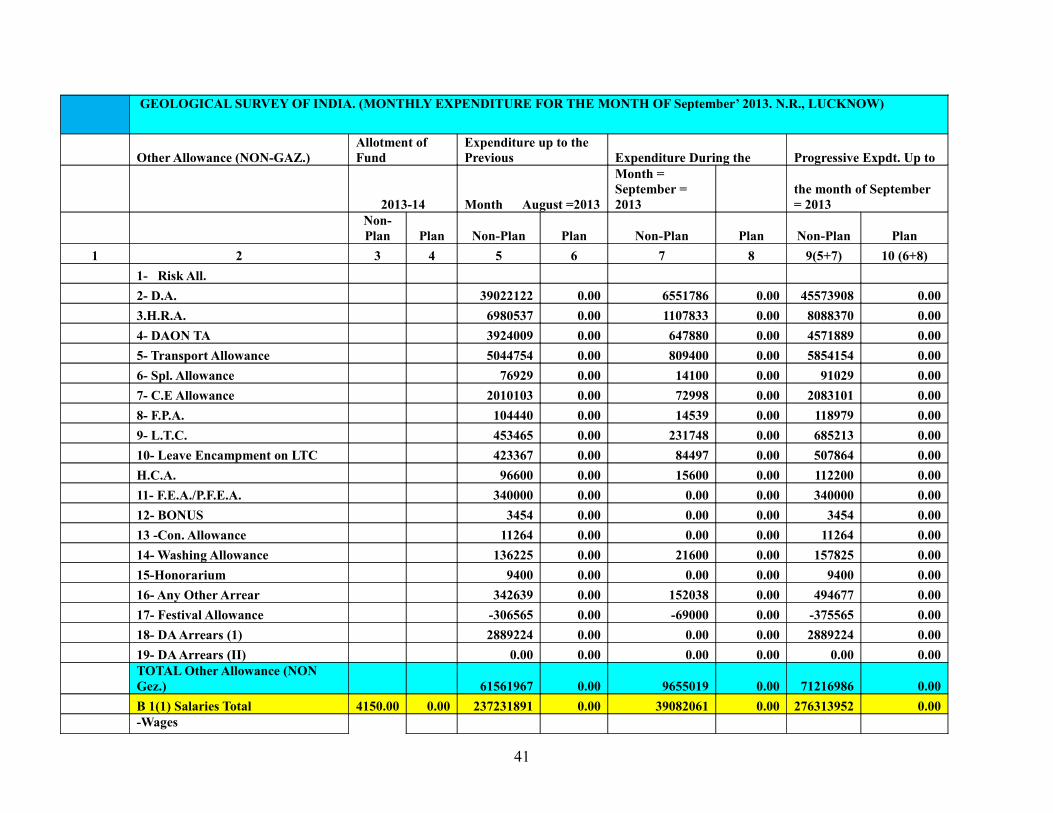
GEOLOGICAL SURVEY OF INDIA. (MONTHLY EXPENDITURE FOR THE MONTH OF September’ 2013. N.R., LUCKNOW)
Other Allowance (NON-GAZ.)Allotment of Fund
Expenditure up to the Previous Expenditure During the Progressive Expdt. Up to
2013-14 Month August =2013
Month = September = 2013
the month of September = 2013
Non-Plan Plan Non-Plan Plan Non-Plan Plan Non-Plan Plan
1 2 3 4 5 6 7 8 9(5+7) 10 (6+8) 1- Risk All. 2- D.A. 39022122 0.00 6551786 0.00 45573908 0.00 3.H.R.A. 6980537 0.00 1107833 0.00 8088370 0.00 4- DAON TA 3924009 0.00 647880 0.00 4571889 0.00 5- Transport Allowance 5044754 0.00 809400 0.00 5854154 0.00 6- Spl. Allowance 76929 0.00 14100 0.00 91029 0.00 7- C.E Allowance 2010103 0.00 72998 0.00 2083101 0.00 8- F.P.A. 104440 0.00 14539 0.00 118979 0.00 9- L.T.C. 453465 0.00 231748 0.00 685213 0.00 10- Leave Encampment on LTC 423367 0.00 84497 0.00 507864 0.00 H.C.A. 96600 0.00 15600 0.00 112200 0.00 11- F.E.A./P.F.E.A. 340000 0.00 0.00 0.00 340000 0.00 12- BONUS 3454 0.00 0.00 0.00 3454 0.00 13 -Con. Allowance 11264 0.00 0.00 0.00 11264 0.00 14- Washing Allowance 136225 0.00 21600 0.00 157825 0.00 15-Honorarium 9400 0.00 0.00 0.00 9400 0.00 16- Any Other Arrear 342639 0.00 152038 0.00 494677 0.00 17- Festival Allowance -306565 0.00 -69000 0.00 -375565 0.00 18- DA Arrears (1) 2889224 0.00 0.00 0.00 2889224 0.00 19- DA Arrears (II) 0.00 0.00 0.00 0.00 0.00 0.00
TOTAL Other Allowance (NON Gez.) 61561967 0.00 9655019 0.00 71216986 0.00
B 1(1) Salaries Total 4150.00 0.00 237231891 0.00 39082061 0.00 276313952 0.00 -Wages
41
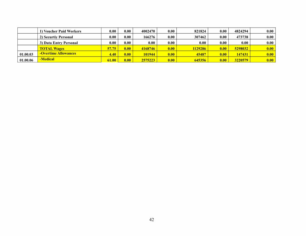
1) Voucher Paid Workers 0.00 0.00 4002470 0.00 821824 0.00 4824294 0.00 2) Securtiy Personal 0.00 0.00 166276 0.00 307462 0.00 473738 0.00 3) Data Entry Personal 0.00 0.00 0.00 0.00 0.00 0.00 0.00 0.00 TOTAL Wages 57.75 0.00 4168746 0.00 1129286 0.00 5298032 0.0001.00.03 -Overtime Allowances 4.40 0.00 101944 0.00 45487 0.00 147431 0.0001.00.06 -Medical 61.00 0.00 2575223 0.00 645356 0.00 3220579 0.00
42
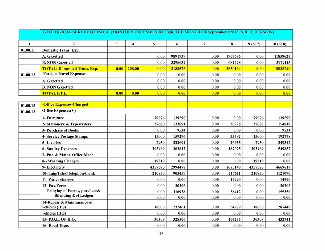
GEOLOGICAL SURVEY OF INDIA. (MONTHLY EXPENDITURE FOR THE MONTH OF September =2013, N.R., LUCKNOW)
1 2 3 4 5 6 7 8 9 (5+7) 10 (6+8)01.00.11 Domestic Trans. Exp. A. Gazetted 0.00 9891939 0.00 1967686 0.00 11859625 B. NON Gazetted 0.00 3296637 0.00 682478 0.00 3979115 TOTAL: Domes ted Trans. Exp. 0.00 208.00 0.00 13188576 0.00 2650164 0.00 1583874001.00.12 Foreign Travel Expenses 0.00 0.00 0.00 0.00 0.00 0.00 A. Gazetted 0.00 0.00 0.00 0.00 0.00 0.00 B. NON Gazetted 0.00 0.00 0.00 0.00 0.00 0.00 TOTAL F.T.E. 0.00 0.00 0.00 0.00 0.00 0.00 0.00 0.00
01.00.13 -Office Expenses-Charged 01.00.13 Office Expenses(V) 1- Furniture 79076 139590 0.00 0.00 79076 139590 2- Stationery & Typewriters 37080 133091 0.00 20928 37080 154019 3- Purchase of Books 0.00 9534 0.00 0.00 0.00 9534 4- Service Postage Stamps 15000 159296 0.00 33482 15000 192778 5- Liveries 7950 322692 0.00 26655 7950 349347 6- Sundry Expenses 203469 362812 0.00 187025 203469 549837 7- Pur. & Maint. Office Mech 0.00 0.00 0.00 0.00 0.00 0.00 8-- Washing Charges 19219 0.00 0.00 0.00 19219 0.00 9- Electricity 4357580 2994477 0.00 1675140 4357580 4669617 10- Taig/Talex/Telephon/trunk 210850 903459 0.00 217611 210850 1121070 11- Water charges 0.00 0.00 0.00 14990 0.00 14990 12- Fax/Zerox 0.00 20206 0.00 0.00 0.00 20206 Prinying of Forms, purchase&
Bilending &of Ledgen 0.00 116938 0.00 38412 0.00 155350
0.00 0.00 0.00 0.00 0.00 0.00
14-Repair & Maintanance of vehlcles (HQ) 18000 232461 0.00 54979 18000 287440
vehlcles (HQ) 0.00 0.00 0.00 0.00 0.00 0.00 15- P.O.L. OF H.Q. 30308 328506 0.00 104235 30308 432741 16- Road Texas 0.00 0.00 0.00 0.00 0.00 0.00
43
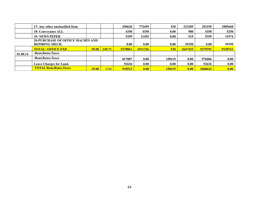
17- Any other unclassified Item 290620 772459 530 233209 291150 1005668 18- Conveyance ALL 4350 4350 0.00 900 4350 5250 19- NEWS PEPER 5359 11455 0.00 519 5359 11974
20-PURCHASE OF OFFICE MACHIN AND REPIRING MECH. 0.00 0.00 0.00 39350 0.00 39350
TOTAL: OFFICE EXP. 59.00 149.71 5278861 6511326 530 2647435 5279391 915876101.00.14 -Rent,Rates,Taxes -Rent,Rates,Taxes 817887 0.00 158119 0.00 976006 0.00 Leave Charges for Land. 92636 0.00 0.00 0.00 92636 0.00 TOTAL Rent,Rates,Taxes 29.00 0.00 910523 0.00 158119 0.00 1068642 0.00
44
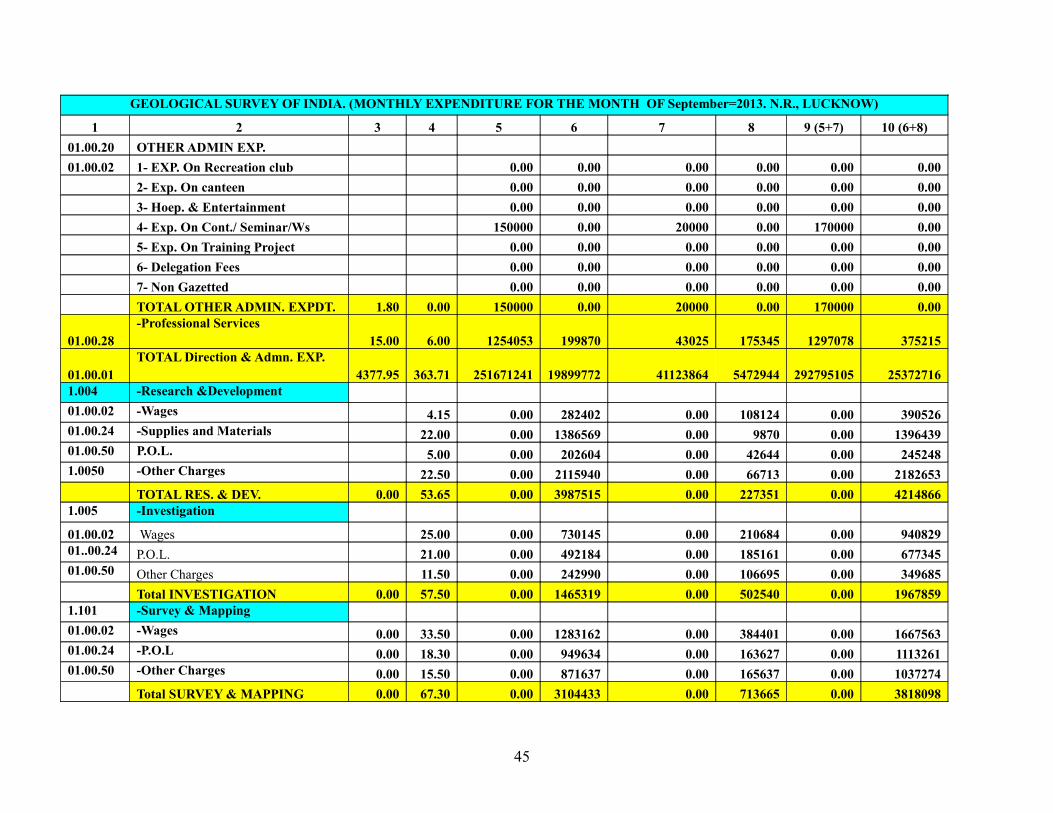
GEOLOGICAL SURVEY OF INDIA. (MONTHLY EXPENDITURE FOR THE MONTH OF September=2013. N.R., LUCKNOW)
1 2 3 4 5 6 7 8 9 (5+7) 10 (6+8)01.00.20 OTHER ADMIN EXP. 01.00.02 1- EXP. On Recreation club 0.00 0.00 0.00 0.00 0.00 0.00 2- Exp. On canteen 0.00 0.00 0.00 0.00 0.00 0.00 3- Hoep. & Entertainment 0.00 0.00 0.00 0.00 0.00 0.00 4- Exp. On Cont./ Seminar/Ws 150000 0.00 20000 0.00 170000 0.00 5- Exp. On Training Project 0.00 0.00 0.00 0.00 0.00 0.00 6- Delegation Fees 0.00 0.00 0.00 0.00 0.00 0.00 7- Non Gazetted 0.00 0.00 0.00 0.00 0.00 0.00 TOTAL OTHER ADMIN. EXPDT. 1.80 0.00 150000 0.00 20000 0.00 170000 0.00
01.00.28-Professional Services
15.00 6.00 1254053 199870 43025 175345 1297078 375215
01.00.01TOTAL Direction & Admn. EXP.
4377.95 363.71 251671241 19899772 41123864 5472944 292795105 253727161.004 -Research &Development 01.00.02 -Wages 4.15 0.00 282402 0.00 108124 0.00 39052601.00.24 -Supplies and Materials 22.00 0.00 1386569 0.00 9870 0.00 139643901.00.50 P.O.L. 5.00 0.00 202604 0.00 42644 0.00 2452481.0050 -Other Charges 22.50 0.00 2115940 0.00 66713 0.00 2182653 TOTAL RES. & DEV. 0.00 53.65 0.00 3987515 0.00 227351 0.00 42148661.005 -Investigation 01.00.02 Wages 25.00 0.00 730145 0.00 210684 0.00 94082901..00.24 P.O.L. 21.00 0.00 492184 0.00 185161 0.00 67734501.00.50 Other Charges 11.50 0.00 242990 0.00 106695 0.00 349685 Total INVESTIGATION 0.00 57.50 0.00 1465319 0.00 502540 0.00 19678591.101 -Survey & Mapping 01.00.02 -Wages 0.00 33.50 0.00 1283162 0.00 384401 0.00 166756301.00.24 -P.O.L 0.00 18.30 0.00 949634 0.00 163627 0.00 111326101.00.50 -Other Charges 0.00 15.50 0.00 871637 0.00 165637 0.00 1037274 Total SURVEY & MAPPING 0.00 67.30 0.00 3104433 0.00 713665 0.00 3818098
45
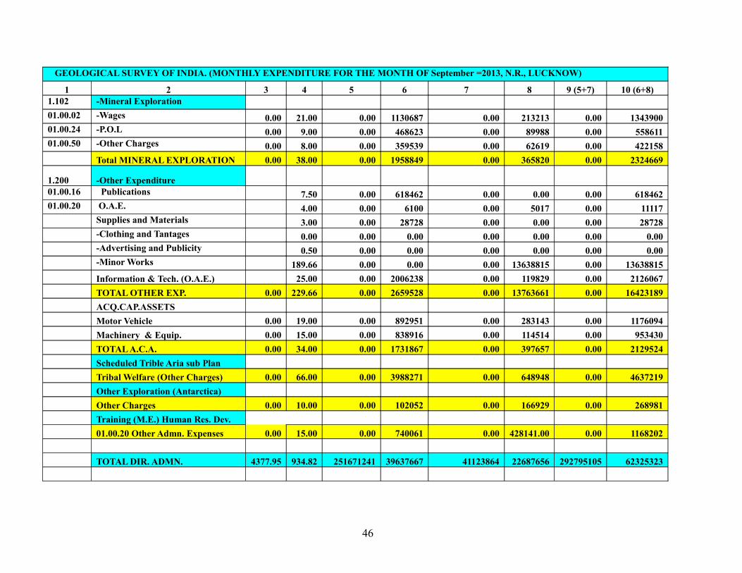
GEOLOGICAL SURVEY OF INDIA. (MONTHLY EXPENDITURE FOR THE MONTH OF September =2013, N.R., LUCKNOW)
1 2 3 4 5 6 7 8 9 (5+7) 10 (6+8)1.102 -Mineral Exploration 01.00.02 -Wages 0.00 21.00 0.00 1130687 0.00 213213 0.00 134390001.00.24 -P.O.L 0.00 9.00 0.00 468623 0.00 89988 0.00 55861101.00.50 -Other Charges 0.00 8.00 0.00 359539 0.00 62619 0.00 422158 Total MINERAL EXPLORATION 0.00 38.00 0.00 1958849 0.00 365820 0.00 2324669
1.200 -Other Expenditure 01.00.16 Publications 7.50 0.00 618462 0.00 0.00 0.00 61846201.00.20 O.A.E. 4.00 0.00 6100 0.00 5017 0.00 11117 Supplies and Materials 3.00 0.00 28728 0.00 0.00 0.00 28728 -Clothing and Tantages 0.00 0.00 0.00 0.00 0.00 0.00 0.00 -Advertising and Publicity 0.50 0.00 0.00 0.00 0.00 0.00 0.00 -Minor Works 189.66 0.00 0.00 0.00 13638815 0.00 13638815 Information & Tech. (O.A.E.) 25.00 0.00 2006238 0.00 119829 0.00 2126067 TOTAL OTHER EXP. 0.00 229.66 0.00 2659528 0.00 13763661 0.00 16423189 ACQ.CAP.ASSETS Motor Vehicle 0.00 19.00 0.00 892951 0.00 283143 0.00 1176094 Machinery & Equip. 0.00 15.00 0.00 838916 0.00 114514 0.00 953430 TOTAL A.C.A. 0.00 34.00 0.00 1731867 0.00 397657 0.00 2129524 Scheduled Trible Aria sub Plan Tribal Welfare (Other Charges) 0.00 66.00 0.00 3988271 0.00 648948 0.00 4637219 Other Exploration (Antarctica) Other Charges 0.00 10.00 0.00 102052 0.00 166929 0.00 268981 Training (M.E.) Human Res. Dev. 01.00.20 Other Admn. Expenses 0.00 15.00 0.00 740061 0.00 428141.00 0.00 1168202 TOTAL DIR. ADMN. 4377.95 934.82 251671241 39637667 41123864 22687656 292795105 62325323
46
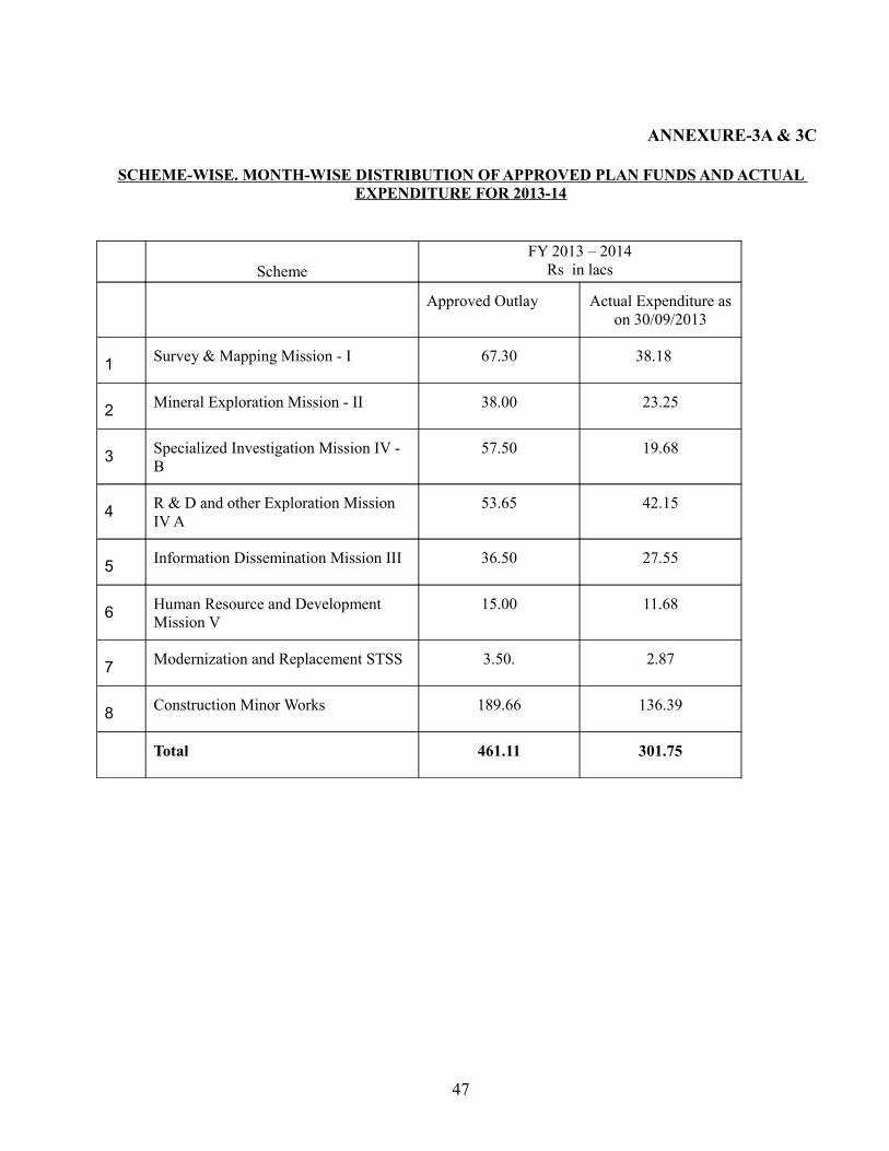
ANNEXURE-3A & 3C
SCHEME-WISE. MONTH-WISE DISTRIBUTION OF APPROVED PLAN FUNDS AND ACTUAL EXPENDITURE FOR 2013-14
SchemeFY 2013 – 2014
Rs in lacs
Approved Outlay Actual Expenditure as on 30/09/2013
1 Survey & Mapping Mission - I 67.30 38.18
2 Mineral Exploration Mission - II 38.00 23.25
3 Specialized Investigation Mission IV - B
57.50 19.68
4 R & D and other Exploration Mission IV A
53.65 42.15
5 Information Dissemination Mission III 36.50 27.55
6 Human Resource and Development Mission V
15.00 11.68
7 Modernization and Replacement STSS 3.50. 2.87
8 Construction Minor Works 189.66 136.39
Total 461.11 301.75
47
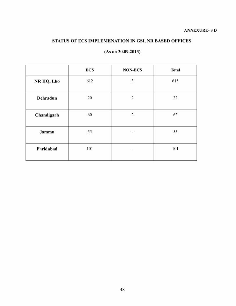
ANNEXURE- 3 D
STATUS OF ECS IMPLEMENATION IN GSI, NR BASED OFFICES
(As on 30.09.2013)
ECS NON-ECS Total
NR HQ, Lko 612 3 615
Dehradun 20 2 22
Chandigarh 60 2 62
Jammu 55 - 55
Faridabad 101 - 101
48
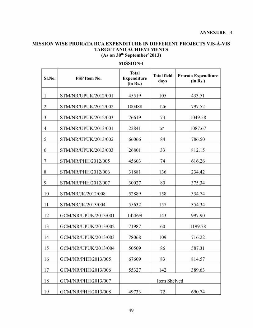
ANNEXURE – 4
MISSION WISE PRORATA RCA EXPENDITURE IN DIFFERENT PROJECTS VIS-À-VIS TARGET AND ACHIEVEMENTS
(As on 30th September’2013)MISSION-I
Sl.No. FSP Item No.Total
Expenditure (in Rs.)
Total field days
Prorata Expenditure (in Rs.)
1 STM/NR/UPUK/2012/001 45519 105 433.51
2 STM/NR/UPUK/2012/002 100488 126 797.52
3 STM/NR/UPUK/2012/003 76619 73 1049.58
4 STM/NR/UPUK/2013/001 22841 21 1087.67
5 STM/NR/UPUK/2013/002 66066 84 786.50
6 STM/NR/UPUK/2013/003 26801 33 812.15
7 STM/NR/PHH/2012/005 45603 74 616.26
8 STM/NR/PHH/2012/006 31881 136 234.42
9 STM/NR/PHH/2012/007 30027 80 375.34
10 STM/NR/JK/2012/008 52889 158 334.74
11 STM/NR/JK/2013/004 55632 157 354.34
12 GCM/NR/UPUK/2013/001 142699 143 997.90
13 GCM/NR/UPUK/2013/002 71987 60 1199.78
14 GCM/NR/UPUK/2013/003 78068 109 716.22
15 GCM/NR/UPUK/2013/004 50509 86 587.31
16 GCM/NR/PHH/2013/005 67609 83 814.57
17 GCM/NR/PHH/2013/006 55327 142 389.63
18 GCM/NR/PHH/2013/007 Item Shelved
19 GCM/NR/PHH/2013/008 49733 72 690.74
49
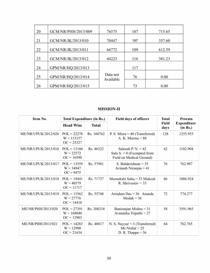
20 GCM/NR/PHH/2013/009 76575 107 715.65
21 GCM/NR/JK/2013/010 70447 197 357.60
22 GCM/NR/JK/2013/011 66772 109 612.59
23 GCM/NR/JK/2013/012 44223 116 381.23
24 GPM/NR/HQ/2013/013Data not Available
117
25 GPM/NR/HQ/2013/014 76 0.00
26 GPM/NR/HQ/2013/015 73 0.00
MISSION-II
Item No. Total Expenditure (in Rs.) Field days of officers Total Field days
Prorata Expenditure
(in Rs.)Head Wise Total
ME/NR/UPUK/2012/026 POL = 22278W = 113157OC = 25327
Rs. 160762 P. S. Misra = 40 (Transferred)A. K. Murmu = 88
128 1255.953
ME/NR/UPUK/2013/016 POL = 13160W = 22572OC = 10590
Rs. 46322 Saleeah P. N. = 42Salu S. = 0 (Exempted from Field on Medical Ground)
42 1102.904
ME/NR/UPUK/2013/017 POL = 13559W = 34947OC = 9475
Rs. 57981 S. Balakrishnan = 35Avinash Niranjan = 41
76 762.907
ME/NR/UPUK/2013/018 POL = 19441W = 40579OC = 11717
Rs. 71737 Meenakshi Sahu = 33 Mukesh R. Shrivastav = 33
66 1086.924
ME/NR/UPUK/2013/019 POL = 13562W = 27776OC = 14410
Rs. 55748 Arindam Das = 36 Ananda Modak = 36
72 774.277
ME/NR/PHH/2013/020 POL = 27391W = 168040OC = 12903
Rs. 208334 Baniranjan Mishra = 31 Avanatika Tripathi = 27
58 3591.965
ME/NR/PHH/2013/021 POL = 14283W = 12900OC = 21634
Rs. 48817 N. S. Nayyar = 3 (Transferred) Ms Nishat = 25
D. R. Thappa = 36
64 762.765
50
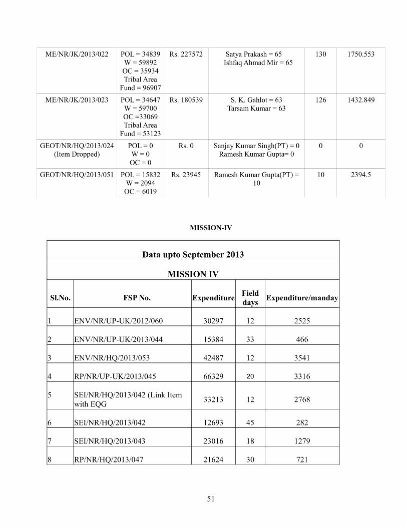
ME/NR/JK/2013/022 POL = 34839W = 59892OC = 35934Tribal Area
Fund = 96907
Rs. 227572 Satya Prakash = 65 Ishfaq Ahmad Mir = 65
130 1750.553
ME/NR/JK/2013/023 POL = 34647W = 59700OC =33069 Tribal Area
Fund = 53123
Rs. 180539 S. K. Gahlot = 63Tarsam Kumar = 63
126 1432.849
GEOT/NR/HQ/2013/024(Item Dropped)
POL = 0W = 0OC = 0
Rs. 0 Sanjay Kumar Singh(PT) = 0Ramesh Kumar Gupta= 0
0 0
GEOT/NR/HQ/2013/051 POL = 15832W = 2094OC = 6019
Rs. 23945 Ramesh Kumar Gupta(PT) = 10
10 2394.5
MISSION-IV
Data upto September 2013
MISSION IV
Sl.No. FSP No. Expenditure Field days Expenditure/manday
1 ENV/NR/UP-UK/2012/060 30297 12 2525
2 ENV/NR/UP-UK/2013/044 15384 33 466
3 ENV/NR/HQ/2013/053 42487 12 3541
4 RP/NR/UP-UK/2013/045 66329 20 3316
5 SEI/NR/HQ/2013/042 (Link Item with EQG 33213 12 2768
6 SEI/NR/HQ/2013/042 12693 45 282
7 SEI/NR/HQ/2013/043 23016 18 1279
8 RP/NR/HQ/2013/047 21624 30 721
51
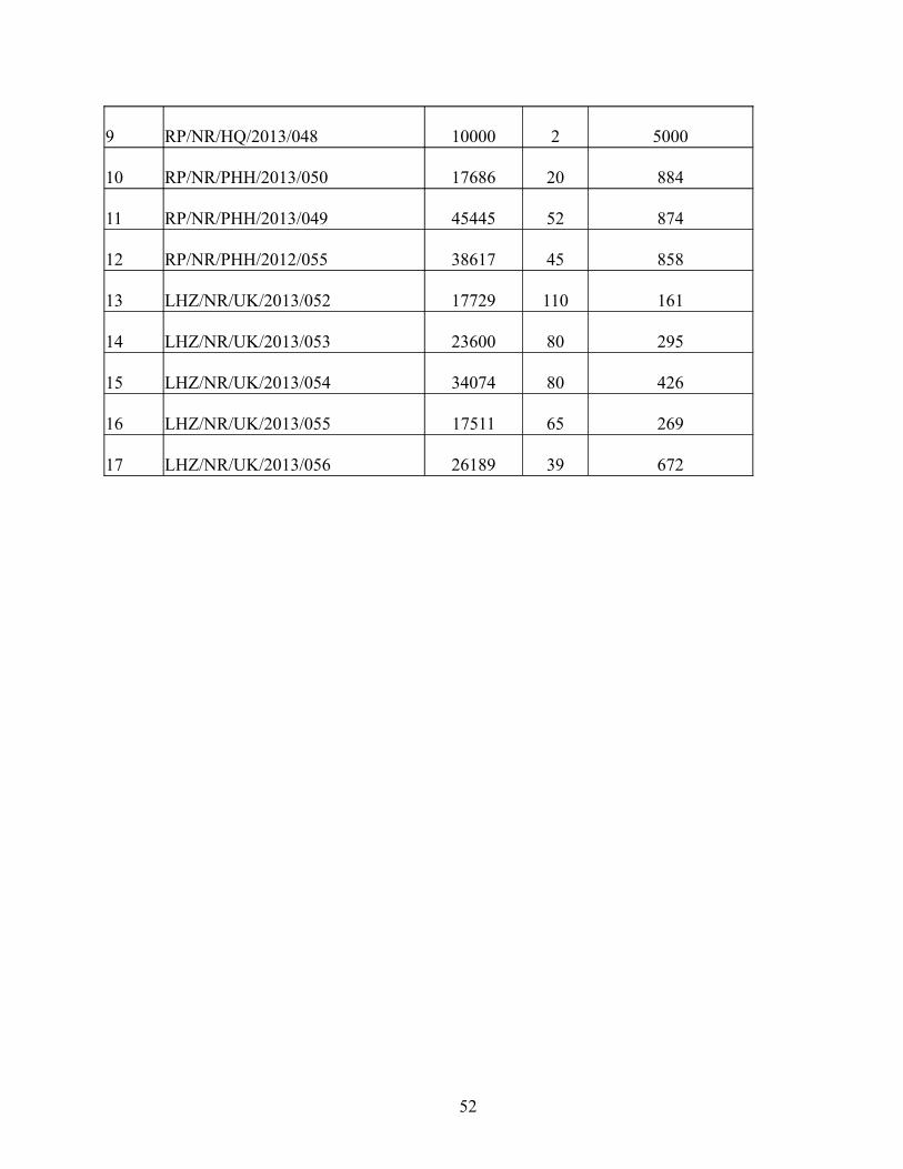
9 RP/NR/HQ/2013/048 10000 2 5000
10 RP/NR/PHH/2013/050 17686 20 884
11 RP/NR/PHH/2013/049 45445 52 874
12 RP/NR/PHH/2012/055 38617 45 858
13 LHZ/NR/UK/2013/052 17729 110 161
14 LHZ/NR/UK/2013/053 23600 80 295
15 LHZ/NR/UK/2013/054 34074 80 426
16 LHZ/NR/UK/2013/055 17511 65 269
17 LHZ/NR/UK/2013/056 26189 39 672
52
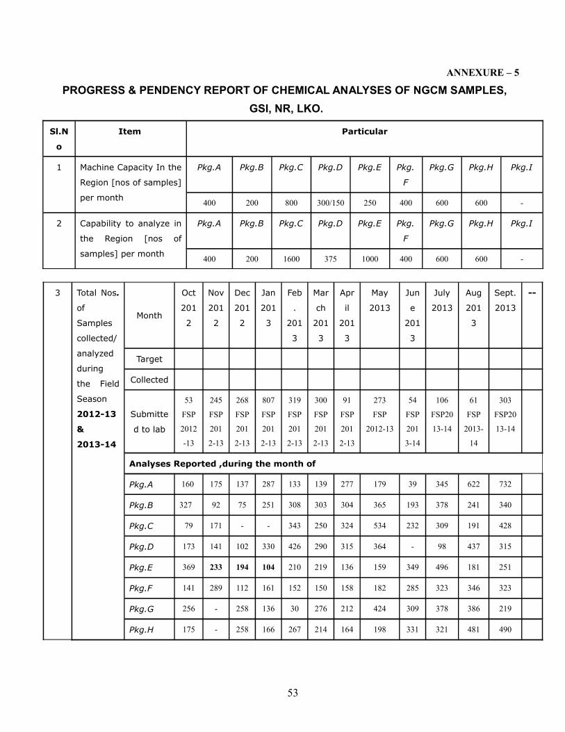
ANNEXURE – 5
PROGRESS & PENDENCY REPORT OF CHEMICAL ANALYSES OF NGCM SAMPLES, GSI, NR, LKO.
Sl.N
o
Item Particular
1 Machine Capacity In the
Region [nos of samples]
per month
Pkg.A Pkg.B Pkg.C Pkg.D Pkg.E Pkg.
F
Pkg.G Pkg.H Pkg.I
400 200 800 300/150 250 400 600 600 -
2 Capability to analyze in
the Region [nos of
samples] per month
Pkg.A Pkg.B Pkg.C Pkg.D Pkg.E Pkg.
F
Pkg.G Pkg.H Pkg.I
400 200 1600 375 1000 400 600 600 -
3 Total Nos.
of
Samples
collected/
analyzed
during
the Field
Season
2012-13
&
2013-14
Month
Oct
201
2
Nov
201
2
Dec
201
2
Jan
201
3
Feb
.
201
3
Mar
ch
201
3
Apr
il
201
3
May
2013
Jun
e
201
3
July
2013
Aug
201
3
Sept.
2013
--
Target
Collected
Submitte
d to lab
53
FSP
2012
-13
245
FSP
201
2-13
268
FSP
201
2-13
807
FSP
201
2-13
319
FSP
201
2-13
300
FSP
201
2-13
91
FSP
201
2-13
273
FSP
2012-13
54
FSP
201
3-14
106
FSP20
13-14
61
FSP
2013-
14
303
FSP20
13-14
Analyses Reported ,during the month of
Pkg.A 160 175 137 287 133 139 277 179 39 345 622 732
Pkg.B 327 92 75 251 308 303 304 365 193 378 241 340
Pkg.C 79 171 - - 343 250 324 534 232 309 191 428
Pkg.D 173 141 102 330 426 290 315 364 - 98 437 315
Pkg.E 369 233 194 104 210 219 136 159 349 496 181 251
Pkg.F 141 289 112 161 152 150 158 182 285 323 346 323
Pkg.G 256 - 258 136 30 276 212 424 309 378 386 219
Pkg.H 175 - 258 166 267 214 164 198 331 321 481 490
53
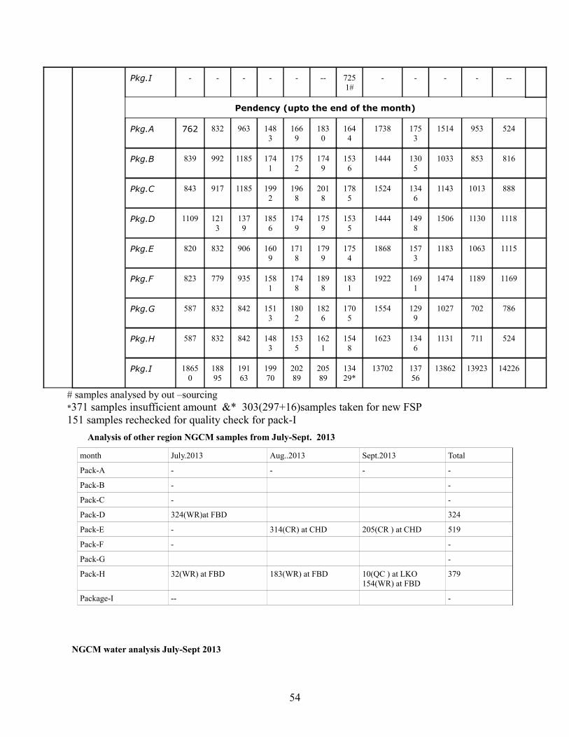
Pkg.I - - - - - -- 7251#
- - - - --
Pendency (upto the end of the month)
Pkg.A 762 832 963 1483
1669
1830
1644
1738 1753
1514 953 524
Pkg.B 839 992 1185 1741
1752
1749
1536
1444 1305
1033 853 816
Pkg.C 843 917 1185 1992
1968
2018
1785
1524 1346
1143 1013 888
Pkg.D 1109 1213
1379
1856
1749
1759
1535
1444 1498
1506 1130 1118
Pkg.E 820 832 906 1609
1718
1799
1754
1868 1573
1183 1063 1115
Pkg.F 823 779 935 1581
1748
1898
1831
1922 1691
1474 1189 1169
Pkg.G 587 832 842 1513
1802
1826
1705
1554 1299
1027 702 786
Pkg.H 587 832 842 1483
1535
1621
1548
1623 1346
1131 711 524
Pkg.I 18650
18895
19163
19970
20289
20589
13429*
13702 13756
13862 13923 14226
# samples analysed by out –sourcing *371 samples insufficient amount &* 303(297+16)samples taken for new FSP 151 samples rechecked for quality check for pack-I Analysis of other region NGCM samples from July-Sept. 2013
month July.2013 Aug..2013 Sept.2013 Total
Pack-A - - - -
Pack-B - -
Pack-C - -
Pack-D 324(WR)at FBD 324
Pack-E - 314(CR) at CHD 205(CR ) at CHD 519
Pack-F - -
Pack-G -
Pack-H 32(WR) at FBD 183(WR) at FBD 10(QC ) at LKO154(WR) at FBD
379
Package-I -- -
NGCM water analysis July-Sept 2013
54
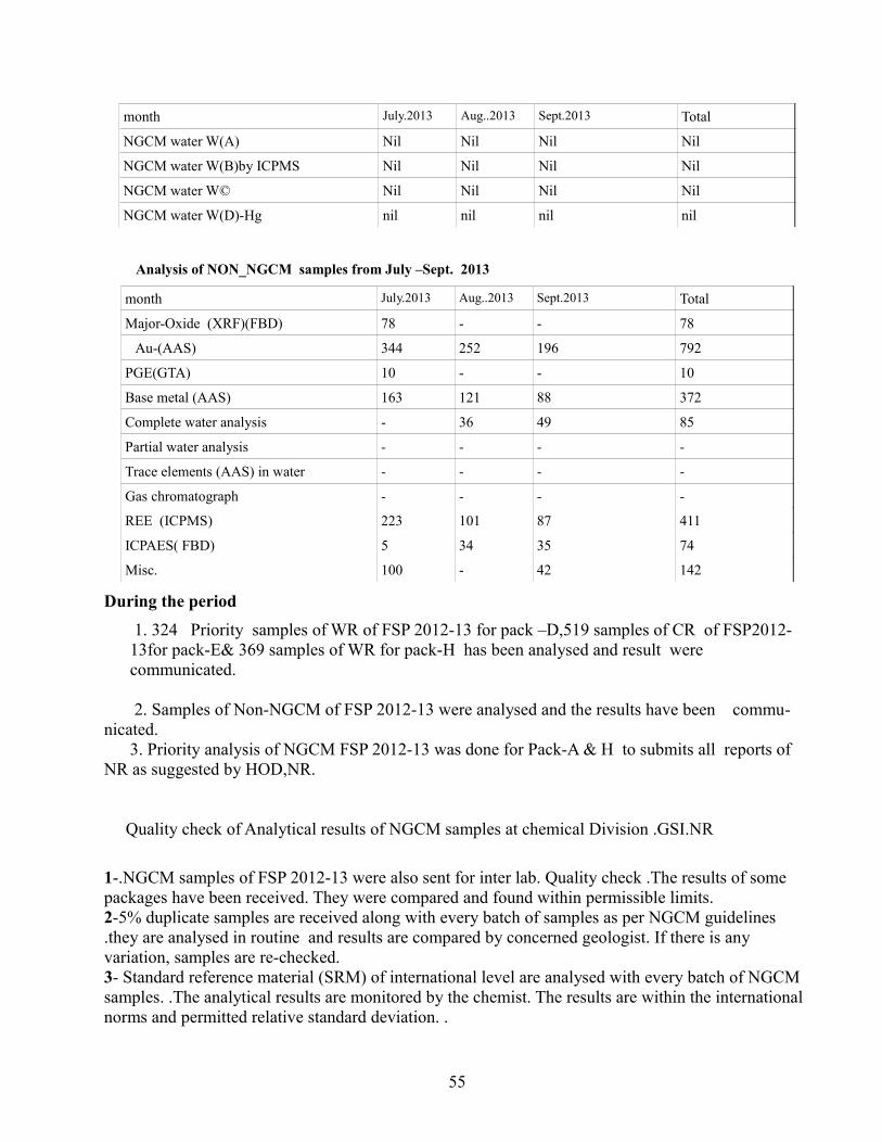
month July.2013 Aug..2013 Sept.2013 Total
NGCM water W(A) Nil Nil Nil Nil
NGCM water W(B)by ICPMS Nil Nil Nil Nil
NGCM water W© Nil Nil Nil Nil
NGCM water W(D)-Hg nil nil nil nil
Analysis of NON_NGCM samples from July –Sept. 2013
month July.2013 Aug..2013 Sept.2013 Total
Major-Oxide (XRF)(FBD) 78 - - 78
Au-(AAS) 344 252 196 792
PGE(GTA) 10 - - 10
Base metal (AAS) 163 121 88 372
Complete water analysis - 36 49 85
Partial water analysis - - - -
Trace elements (AAS) in water - - - -
Gas chromatograph - - - -
REE (ICPMS) 223 101 87 411
ICPAES( FBD) 5 34 35 74
Misc. 100 - 42 142
During the period 1. 324 Priority samples of WR of FSP 2012-13 for pack –D,519 samples of CR of FSP2012-13for pack-E& 369 samples of WR for pack-H has been analysed and result were communicated.
2. Samples of Non-NGCM of FSP 2012-13 were analysed and the results have been commu-nicated. 3. Priority analysis of NGCM FSP 2012-13 was done for Pack-A & H to submits all reports of NR as suggested by HOD,NR.
Quality check of Analytical results of NGCM samples at chemical Division .GSI.NR
1-.NGCM samples of FSP 2012-13 were also sent for inter lab. Quality check .The results of some packages have been received. They were compared and found within permissible limits.2-5% duplicate samples are received along with every batch of samples as per NGCM guidelines .they are analysed in routine and results are compared by concerned geologist. If there is any variation, samples are re-checked. 3- Standard reference material (SRM) of international level are analysed with every batch of NGCM samples. .The analytical results are monitored by the chemist. The results are within the international norms and permitted relative standard deviation. .
55

4- 10 Priority samples of Quality check for pack- H has been analysed and result were communicated
56
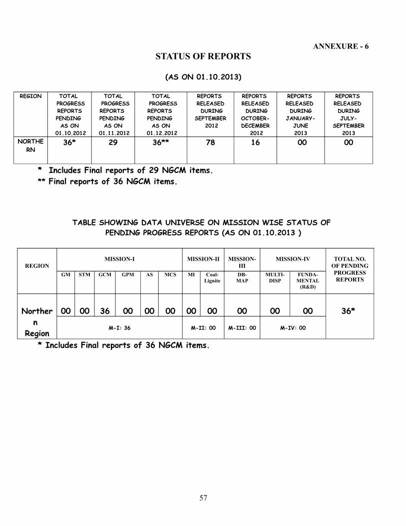
ANNEXURE - 6STATUS OF REPORTS
(AS ON 01.10.2013)
REGION TOTAL PROGRESS REPORTS PENDING AS ON
01.10.2012
TOTAL PROGRESS REPORTS PENDING AS ON
01.11.2012
TOTAL PROGRESS REPORTS PENDING AS ON
01.12.2012
REPORTS RELEASED DURING
SEPTEMBER 2012
REPORTS RELEASED DURINGOCTOBER-DECEMBER
2012
REPORTS RELEASED DURING
JANUARY-JUNE2013
REPORTS RELEASED DURINGJULY-
SEPTEMBER2013
NORTHERN
36* 29 36** 78 16 00 00
* Includes Final reports of 29 NGCM items.** Final reports of 36 NGCM items.
TABLE SHOWING DATA UNIVERSE ON MISSION WISE STATUS OF PENDING PROGRESS REPORTS (AS ON 01.10.2013 )
* Includes Final reports of 36 NGCM items.
REGIONMISSION-I MISSION-II MISSION-
IIIMISSION-IV TOTAL NO.
OF PENDINGPROGRESS REPORTS
GM STM GCM GPM AS MCS MI Coal-Lignite
DB-MAP
MULTI-DISP
FUNDA-MENTAL
(R&D)
Northern
Region
00 00 36 00 00 00 00 00 00 00 00 36*
M-I: 36 M-II: 00 M-III: 00 M-IV: 00
57

TABLE SHOWING YEAR WISE STATUS OF PENDING PROGRESS REPORTS (ALL REPORTS AS WELL AS MINERAL INVESTIGATION)
AS ON 01.10.2013
REGIONTOTAL NO.
OF PROGRESS REPORTS
PENDING AS ON
01.10.201320
02-0
3
2003
-04
2004
-05
2005
-06
2006
-07
2007
-08
2008
-09
2009
-10
2010
-12
TOTA
L
NR 36*ALL
REPORTS
02 07 03 07 03 03 01 03 07 36*
ONLY MI
- - - - - - - - - -
ONLY NGCM
02 07 03 07 03 03 01 03 07 36
* Final reports of 36 NGCM items.
TABLE SHOWING NGCM REPORT STATUS UPTO SEPTEMBER 2013Region Data
universe since
inception(F.S.
2001-02 to
2010-12)
Progress reports
released up to
December
2011
Interim reports released up to March
2012
Interim reports released during
April-June2012
reports released duringJuly-
September2012
Interim reports released during
October-December
2012
Interim reports released during
January-June2013
Interim reports released duringJuly-
September2013
Finalreports
circulated
Northern 36* 24 27 02 00 07 00 00 NIL* Includes seven reports of F.S. 2010-12.
TABLE SHOWING GPM REPORT STATUS UPTO SEPTEMBER 2013
REGI
ON DATA
UNIVERSE SINCE
INCEPTION( Field Season 2001-02
to 2010-12)
REPORTS RELEASED
UPTO DECEMBER
2009
REPORTS RELEASED DURING
JANUARY- DECEMBER
2010
REPORTS RELEASED DURING
JANUARY-DECEMBER
2011
REPORTS RELEASED DURING
JANUARY-DECEMBER
2012
REPORTS RELEASED DURING
JANUARY-SEPTEMBER
2013
TOTAL REPORTS PENDING
NR 13 05 02 02 04 00 00
58
REPORTS CIRCULATED DURING THE MONTHAUGUST 2013
Mission S. No.
CODE F.S. TITLE OF REPORT AUTHOR/S REMARKS
M-IV 01 RP/NR/HQ/2010/040 2010-12 to 2012-13
Detailed studies of Neoproterozoic and Early Cambrian Eggs/Embryos from Chambaghat Formation, Krol Group and Basal Part of Tal Group in Lesser Himalaya of Himachal Pradesh and Uttarakhand
S.Shome,Shambhu Nath
DISTRIBUTED VIDE 4374
M-IV 02 RP/NR/HQ/2012/058 2012-13
Palaeontological studies of Papro Formation(Infratrappean) of Lalitpur district, Uttar Pradesh
S.Shome,R.S.Chandel
DISTRIBUTED VIDE 4375
REPORTS CIRCULATED DURING THE MONTHSEPTEMBER 2013
Mission S. No.
CODE F.S. TITLE OF REPORT AUTHOR/S REMARKS
M-IV 01 Additional Item 2012-13
Report on the preliminary geotechnical investigations for the Baghain Dam Project, Banda district, Uttar Pradesh
Mridul Srivastava and Neetu Chauhan
DISTRIBUTED VIDE 4376
M-IV 02 EG/C/NR/UPUK/2012/040 2012-13
Report No. 4 on the construction stage geotechnical investigations for the Pahari Dam Project, Jhansi district, Uttar Pradesh
Mridul Srivastava and Neetu Chauhan
DISTRIBUTED VIDE 4377
M-IV 03 EG/C/NR/UPUK/2012/040 2012-13
Report No. 3 on construction stage geotechnical investigations of the Pahuj Dam Project,Jhansi district, Uttar Pradesh
Mridul Srivastava and Neetu Chauhan
DISTRIBUTED VIDE 4378
M-I 04 GPM/NR/HQ/2012/024 2012-13
Report on the Ground geophysical mapping in parts of Degree Sheet Nos. 63 C& G (Toposheet Nos.63C/12 and16; 63G/ 4) in Uttar Pradesh and Madhya Pradesh
Arun S.K., A. Awasthi and Anil Jayal
DISTRIBUTED VIDE 4379
M-II 05 ME/NR/ UPUK/2012/027 2012-13
Report on investigation for tungsten and associated mineralisation in Bundelkhand Granitoid Complex, Jhansi and Mahoba districts, Uttar Pradesh( G-4 Stage)
Minakhsi Sahu, Arindam Das and P.S.Misra
DISTRIBUTED VIDE 4380
M-II 06 ME/NR/UPUK/2012/025 2012-13
Report on Search for gold and tungsten mineralisation at the contact zone of Mahakoshal Group
Avinash Ranjan and
Maheshkumar
DISTRIBUTED VIDE 4381
59
and Dudhi Granitoid Complex in parts of Sonbhadra district of Uttar Pradesh
Rajkumar Shrivastav
M-I 07 STM/NR/UPUK/2010/002 2010-12 & 2012-13
Report on Specialised Thematic mapping of Siwalik Belt in parts of Saharanpur and Bijnor districts of Uttar Pradesh and Dehradun, Haridwar and Garhwal districts of Uttarakhand.
Nathu Singh, Shailendra Singh, Bishakha, Pratibha Singh, Suman Das, G.S. Agrawal and R.S.Chadel
DISTRIBUTED VIDE 4382
M-I 08 STM/NR/UPUK/2012/004 2012-13
Report on Specialised Thematic Mapping of a part of the Agastmuni Formation of Garhwal Group in Kharpatiyakhal area, Rudraprayag district, Uttarakhand
A.K. Kujar and A.C.Patra
DISTRIBUTED VIDE 4383
M-II 09 ME/NR/UPUK/2012/028 2012-13
Report on Investigation for gold and associated mineralisation in Chopra-Bhatwari area, Rudraprayag district, Uttarakhand(G-4Stage)
S.Balakrishnan, Zahid Majeed
and Abhisek Anand
DISTRIBUTED VIDE 4384
M-IV 10 RP/NR/HQ/2012/054 2012-13
Report on Study of intrabasinal terraces in the Mandakini Basin, Rudraprayag district, Uttarakhand
G.S.Agarwal and Prathvi
Singh
DISTRIBUTED VIDE 4385
M-I 11 GCM/NR/UPUK/2012/010 2012-13
Interim Report on Regional Geochemical Mapping of Toposheet Nos. 53 O/7 (part), 53 O/8 and 53 O/12 in Nainital and Udhamsingh Nagar districts of Uttarakhand
M.Rogibala,N.Surdas Singh, S.K.Sharma, S.Bhowmik,
Resmi S.
To be DISTRIBUTED VIDE 4386
M-I 12 GPM/NR/HQ/2012/022 2012-13
Report on Ground geophysical mapping in parts of Degree Sheet No. 54K (Toposheet Nos.54K/6, 10 & 14) in Uttar Pradesh and Madhya Pradesh
Alok Kumar Singh, Babita Yadav, A.Mishra
To beDISTRIBUTED VIDE 4387
M-I 13 GPM/NR/HQ/2012/023 2012-13
Report on the Ground geophysical mapping in parts of Degree Sheet No. 63 G (Toposheet Nos.63 G/ 8, 12 & 16) in Uttar Pradesh and Madhya Pradesh
Om Prakash, A.Saha, Ritu Singh
To beDISTRIBUTED VIDE 4388
M-IV 14 SEI/NR/HQ/2009/001 2009-10 to 2012-13
Report on Seismic microzonation studies of Jalandhar Urban Agglomerate
K.C.Joshi, G.C.Kandpal, Harish Kumar, S.P. Chaubey, Praveen Sharma and S.K.Mishra
To beDISTRIBUTED VIDE 4389
M-IV 15 SEI/NR/HQ/2010/036 2010-12 &
Report on Active Fault Studies in Himalayan Frontal Belt in Kala
Abhinandan Srivastava,
To be DISTRIBUTE
60
2012-13
Amb area, H.P.and Haryana
Arindam Roy and D.D.Joshi
D VIDE 4390
M-IV 16 GL/NR/HQ/2012/057 2012-13
Glaciogeomorphological studies in the Pro-Glacial Region of Gepang Gath Glacier, Lahul and Spiti district, Himachal Pradesh-On Expedition Basis
Muneer Ahmad Mukhtar and Om Prakash
To beDISTRIBUTED VIDE 4391
M-IV 17 GL/NR/HQ/2010/038 2010-12 & 2012-13
Inter-Annual documentation of recessional pattern of glaciers of Ghagra Basin,Uttrakhand Himalaya- On Expedition Basis
Om Prakash, Rakesh Mishra, Devender Singh and Muneer Ahmad Mukhtar
To beDISTRIBUTED VIDE 4392
M-IV 18 RP/CHQ/M-IV/2012/056 2012-13
Integrated Monitoring of Vastre Broggerbeen Glacier, Svalbard, Arctic
Ajai Kumar To beDISTRIBUTED VIDE 4393
M-IV 19 SER/NR/HQ/2010/026 2010-12 & 2012-13
Identification of Signatures of Palaeontological, Change in Climate, Availability of Water Resources and Future Scenerio in Ganga Basin
S.P.Shukla and Rakesh Mishra
To beDISTRIBUTED VIDE 4394(REPORT IN HINDI )
M-III 20 SER/NR/HQ/2012/015 2012-13
Report on Creation of theme based database of the sheet Nos. 63L/15; 63P/5,6,7 and 54K/7,11,13,14
S.C.Shukla, Tapan Ghosh, Pankaj Mala Bhattacharya, C.N.Verma and Mridula Chauhan
To beDISTRIBUTED VIDE 4395
M-I 21 STM/NR/HQ/2010/003 2010-12 & 2012-13
Report on Specialised Thematic Mapping to establish lithostratigraphy and tectonic setting of Bhilangana Formation vis-a-vis Central Crystalline Group
D.S.Chauhan ,Bhrigu Shankar and Ritu Chauhan
To be DISTRIBUTED VIDE 4396
M-IV 22 EG/C/NR/UPUK/2012/040 2012-13
Report No. 2 on pre-construcxtion stage geotechnical investigations for the Bhaoni dam project, district Lalitpur, Uttar Pradesh
Mridul Srivastava and Neetu Chauhan
To beDISTRIBUTED VIDE 4397
M-IV 23 Additional Item 2012-13
Report No. 2 on the post-construction stage geotechnical investigations of Maro Irrigation tank, Chitrakoot district, Uttar Pradeh
Mridul Srivastava and Neetu Chauhan
To beDISTRIBUTED VIDE 4398
M-III 24 DB/NR/PHH/2012/034 2012-13
Report on Upgrading of data base and uploading of newer data into the database and accompanying map digitisation for Golwa-Gangutana and Tosham mineral belts
Mukesh Nagar and Moumita Mitra Sinha
To beDISTRIBUTED VIDE 4399
M-I 25 STM/NR/PHH/2012/059 2012-13
Report on Specialized Thematic Mapping of Subathu and associated lothounits in parts of
Pawan Kumar and Vineeta Rawat
To beDISTRIBUTED VIDE 4400
61
Panchkula district in Haryana and Solan district of Himachal Pradesh
M-II 26 ME/NR/PHH/2012/029 2012-13
Report on Investigation to demarcate host rock units of copper mineralization in the unexplored areas, north of Bakrija (Sareli area), Mahendragarh district, Haryana(G-3 Stage)
Baniranjan Mishra, Avantika Tripathi and J.S.Kumar
To beDISTRIBUTED VIDE 4401
M-II 27 ME/NR/JK/2012/031 2012-13
Report on Investigation for quartzite in Parautochthonous Zone, Banjal - Bhund area, Kathua District, J & K
Nagendra Gautam,A.S.Pandey and A.A.Bhat
To beDISTRIBUTED VIDE 4402
M-II 28 MIP/NR/JK/2009/002 2010-12 & 2012-13
Final report on Detailed investigation for lead-zinc deposit of Buniyar area, Baramulla district. J&K
Satya Prakash, S.K. Gahlot, I. A. Mir, N.A.Bhat
To beDISTRIBUTED VIDE 4403
M-I 29 STM/NR/JK/2012/061 2012-13
Report on Specialized Thematic Mapping of Ladakh Batholith in Taru Phu - Phyang area and sampling of alluvial deposits derived from Giamchu / Rupshu Granites in Lato-Rumtse area, Ladakh, Jammu & Kashmir
Nirmal Gujar and Alok Chauhan
To beDISTRIBUTED VIDE 4404
M-I 30 GCM/NR/JK/2012/020 2012-13
Interim Report on Regional Geochemical Mapping of the Toposheet No. 43P/10, Kathua and Udhampur districts, Jammu & Kashmir
Desraj Trivedi, Gladson Bage
To beDISTRIBUTED VIDE 4405
M-I 31 GCM/NR/JK/2012/021 2012-13
Interim Report on Regional Geochemical Mapping of the Toposheet No. 43P/1, Udhampur and Reasi districts, Jammu & Kashmir
Arun Dev andDevantu Das
To beDISTRIBUTED VIDE 4406
M-IV 32 Under : EG/C/NR/JK/2012/050
2012-13
A geotechnical report on the feasibility of Digdual-Urnihal approach road, Katra- Qazigund rail line project, Ramban district, J & K
V.K.Sharma To beDISTRIBUTED VIDE 4407
M-IV 33 Under : EG/C/NR/JK/2012/050
2012-13
A geotechnical report on the feasibility of Bakkal-Kauri Section between KM 48.500 and KM 50.300, Katra- Qazigund rail line project, Ramban district, J & K
V.K.Sharma To beDISTRIBUTED VIDE 4408
M-IV 34 EG/C/NR/JK/2012/050 2012-13
A geotechnical report on the feasibility of the alternative bridge alignment across Anji nala, Reasi district, J & K
V.K.Sharma To beDISTRIBUTED VIDE 4409
62
M-IV 35 EG/C/NR/JK/2012/048 2012-13
Report No.-2 on the detailed geological investigation of Ujh Multipurpose Hydel Project, Kathua district, J & K
Ajay Kumar and N.K.Nayak
To beDISTRIBUTED VIDE 4410
M-IV 36 EG/C/NR/JK/2012/048 2012-13
Report on the detailed geotechnical investigation of Ujh Barrage, Ujh Multipurpose Hydel Project, Kathua district, J & K
Ajay Kumar To beDISTRIBUTED VIDE 4411
M-II 37 ME/NR/PHH/2012/030 2012-13
Report on delineation and assessment of limestone/dolomite bands in Upper Krol Formation in Sirmaur and Solan districts of H.P.
N.S. Nayyar and D.R.Thapa
To beDISTRIBUTED VIDE 4412
M-III 38 DB/NR/PHH/2012/033 2012-13
Report on Creation of theme based database of the geological maps pertaining to degree sheet Nos. 43P, 52C, 52D, and 53A of H.P.
Satinder Dhillon and Sanjiv Kumar
To beDISTRIBUTED VIDE 4413
M-I 39 GCM/NR/PHH/2012/012 2012-13
Interim Report on Regional Geochemical Mapping in toposheet No. 53E/6 covering parts of Kullu and Mandi districts, Himachal Pradesh
Sachin V. Pachpor, P.S.Sethi and Km Renuka
To beDISTRIBUTED VIDE 4414
M-I 40 GCM/NR/PHH/2012/013 2012-13
Interim Report on Regional geochemical mapping in Toposheet No. 53E/5 in parts of Kullu district, Himachal Pradesh.By F.S. 2012-13; Code :
R.Laishram and S.P.Rout
To beDISTRIBUTED VIDE 4415
M-I 41 GCM/NR/PHH/2012/014 2012-13
Interim Report on Regional geochemical mapping in Toposheet No. 53E/7 in parts of Kullu, Mandi and Shimla districts, Himachal Pradesh.
Maykhee and Tamaghno Ghosh
To beDISTRIBUTED VIDE 4416
M-IV 42 EG/C/NR/HQ/2012/052 2012-13
Report on the detailed stage geological investigations of Luhri Hydroelectric project, district Mandi, Kullu and Shilma, Himachal Pradesh
Bhupendra Singh, P.S.Sethi and D.P.Dangwal
To beDISTRIBUTED VIDE 4417
M-IV 43 EG/C/NR/PHH/2012/046 2012-13
A report on the detailed slope stability evaluation of the Chandikotla landslide, district Panchkula, Haryana
Pradeep Singh and P.S.Sethi
To beDISTRIBUTED VIDE 4418
M-IV 44 EG/C/NR/PHH/2012/045 2012-13
Report on the detailed geological investigation of Shongtong -Karchham hydroelectric project, district Kinnaur, Himachal Pradesh
Bhupendra Singh
To beDISTRIBUTED VIDE 4419
M-IV 45 EG/C/NR/PHH/2012/045 2012-13
Progress report N0.-10 on the construction stage geological investigation of the Kol dam project, district Bilaspur, Himachal
D.P. Dangwal, R.R.Mahapatra and Bhupender
To beDISTRIBUTED VIDE 4420
63
Pradesh Singh
M-IV 46 EG/C/NR/PHH/2012/045 2012-13
Progress report on detailed stage geological investigations of Renukaji dam project, district Sirmaur, Himachal Pradesh
D.P.Dangwal and D.R. Thapa
To beDISTRIBUTED VIDE 4421
M-IV 47 EG/C/NR/PHH/2012/045 2012-13
Report on the feasibility stage geological investigation of the Triveni-Mahadev ( Beri-Nichli) hydroelectric project, district Mandi and Kangara, Himachal Pradesh
D.P.Dangwal, D.R.Thapa and Bhupendra Singh
To beDISTRIBUTED VIDE 4422
M-IV 48 Under : EG/C/NR/PHH/2012/045
2012-13
Report on thePre- feasibility stage geological investigations of the Thana- Plaun hydroelectric project, district Mandi, Himachal Pradesh
D.P.Dangwal,D.R.Thapa and Bhupendra Singh
To beDISTRIBUTED VIDE 4423
M-IV 49 EG/C/NR/PHH/2012/045 2012-13
Progress report No.2 on the construction stage geological investigations of Sainj hydroelectric project, district Kullu, Himachal Pradesh
R.R.Mahapatra To beDISTRIBUTED VIDE 4424
M-I 50 GCM/NR/PHH/2012/015 2012-13
Interim Report on Regional geochemical mapping in Toposheet No. 44N/4, Bhatinda district, Punjab.
Tarsham Kumar and Girdhari Das
To beDISTRIBUTED VIDE 4425
64
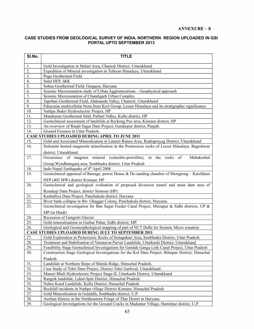
ANNEXURE – 8
CASE STUDIES FROM GEOLOGICAL SURVEY OF INDIA, NORTHERN REGION UPLOADED IN GSI PORTAL UPTO SEPTEMBER 2013
Sl.No. TITLE
1. Gold Investigation in Malari Area, Chamoli District, Uttarakhand2. Expedition of Mineral investigation in Tethyan Himalaya, Uttarakhand3. Puga Geothermal Field4. Salal HEP, J&K5. Sohna Geothermal Field, Gurgaon, Haryana6. Seismic Microzonation study of Urban Agglomerations – Geophysical approach7. Seismic Microzonation of Chandigarh Urban Complex8. Tapoban Geothermal Field, Alaknanda Valley, Chamoli, Uttarakhand9. Ediacaran multicellular biota from Krol Group, Lesser Himalaya and its stratigraphic significance10. Nathpa Jhakri Hydroelectric Project, HP11. Manikaran Geothermal field, Parbati Valley, Kullu district, HP12. Geotechnical assessment of landslide at Reckong Peo area, Kinnaur district, HP13. An overview of Ranjit Sagar Dam Project, Gurdaspur district, Punjab.14. Ground Fissures in Uttar Pradesh.CASE STUDIES UPLOADED DURING APRIL TO JUNE 201115. Gold and Associated Mineralisation in Lameri-Ratura Area, Rudraprayag District, Uttarakhand16. Dolomite hosted magnesite minerlisation in the Proterozoic rocks of Lesser Himalaya, Bageshwar
district, Uttarakhand.17. Occurrence of tungsten mineral (scheelite-powellite), in the rocks of Mahakoshal
Group,Wyndhamganj area, Sonbhadra district, Uttar Pradesh18. Indo-Nepal Earthquake of 4th April 200819. Geotechnical appraisal of Barrage, power House & De-sanding chamber of Shongtong – Karchham
HEP (402 MW) district Kinnaur, HP20. Geotechnical and geological evaluation of proposed diversion tunnel and main dam area of
Renukaji Dam Project, district Sirmour (HP)21. Kashalliya Dam Project, Panchukula district, Haryana22. River bank collapse in Bir- Ghaggar Colony, Panchukula district, Haryana.23. Geotechnical investigation for Ban Sagar Feeder Canal Project, Mirzapur & Sidhi districts, UP &
MP (in Hindi)24. Recession of Gangotri Glacier25. Gold mineralisatiion in Gurhar Pahar, Sidhi district, MP.26. Geological and Geomorphological mapping of part of NCT Delhi for Seismic Micro zonationCASE STUDIES UPLOADED DURING JULY TO SEPTEMBER 201127. Gold Exploration in Proterozoic Rocks of Sonapahari Area, Sonbhadra District, Uttar Pradesh28. Treatment and Stabilisation of Varunavat Parvat Landslide, Uttarkashi District, Uttarakhand29. Feasibility Stage Geotechnical Investigations for Gandak Ganga Link Canal Project, Uttar Pradesh30. Construction Stage Geological Investigations for the Kol Dam Project, Bilaspur District, Himachal
Pradesh31. Landslide at Northern Slope of Shimla Ridge, Himachal Pradesh.32. Case Study of Tehri Dam Project, District Tehri Garhwal, Uttarakhand.33. Maneri Bhali Hydroelectric Project Stage-II, Uttarkashi District, Uttarakhand34. Rangrik landslide, Lahul-Spiti District, Himachal Pradesh35. Nehru Kund Landslide, Kullu District, Himachal Pradesh.36. Rockfall incidents in Nathpa village District Kinnaur, Himachal Pradesh37. Gold Mineralisation in Gulaldih, Sonbhadra district, U.P.38. Aeolian History at the Northeastern Fringe of Thar Desert in Haryana.39. Geological Investigations for the Ground Cracks in Madarpur Village, Hamirpur district, U.P.
65
CASE STUDIES UPLOADED DURING OCTOBER TO 15th DECEMBER, 201140. Active Fault Mapping of Spiti Valley Fault by Micro-earthquake Survey41. Bundelkhand Granitoid Complex – A potential zone for Tungsten MineralisationCASE STUDIES UPLOADED IN 201242. Geological investigation for Meja Thermal Power Plant near Meja Tehsil, Allahabad (UP)43. Koteshwar HEP, district Tehri Garhwal, Uttarakhand44. Orbicular Structure in Bundelkhand CratonCASE STUDIES UPLOADED IN 2013 (JAN. TO MARCH 2013)45. Gypsum in Bundelkhand Region46. Preventive measures to mitigate the potential risk of GLOF hanging over Manali-Leh national
Highway and Sissu village, H.P.CASE STUDIES UPLOADED IN 2013 (APRIL TO SEPTEMBER,2013)47. Record of fossil assemblage from Papro Formation (Lalitpur Infratrappean), Uttar Pradesh
66
ANNEXURE – 9
DETAILS OF PUBLICATIONS BROUGHT OUT BY THE NORTHERN REGION IN THE LAST FIVE YEARS
YEAR - 2008
SL No. Title/ Name of Publication1 GSI Records Volume -140, Part 82 GSI NR News Volume -27(2)3 GSI Misc.Pub.No.30:Geology and Mineral Resources of the States of India Part- XV :
Punjab and Chandigarh (Hindi Version) 4 GSI Spl. Pub. No.91:Pan African event of India and Antarctica5 GSI NR News Volume -28(1)6 GSI NR Annual Programme (FSP) - 2008-09
YEAR – 2009
SL No. Title/ Name of Publication1 GSI Records Volume -141, Part 82 GSI NR News Volume -28(2)3 GSI Spl. Pub. No.34: Inventory of the Himalayan Glaciers – A Contribution to the
International Hydrological Programme (An Updated Edition)4 GSI NR Annual Programme (FSP) – 2009 - 105 Departmental Telephone Directory, 2009 (Public Utility Services)
YEAR – 2010
SL No. Title/ Name of Publication1 GSI Records Volume -142, Part 82 GSI NR News Volume -29 (1&2)3 GSI Misc.Pub.No.30:Geology and Mineral Resources of the States of India Part- XIII : UP
and Uttarakhand (Hindi Version) 4 GSI Spl. Pub. No.66: Neotectonic and Isoseismal Atlas of North India5 GSI Bull.Ser. C, No.8 :A compilation on physio-mechanical properties of soils,rocks and
aggregates tested in GT Lab.NR6 GSI NR Annual Programme (FSP) - 2010-127 GSI Records Volume -143 Part 88 GSI Misc.Pub.No.30:Geology and Mineral Resources of the States of India Part- X :Jammu
and Kashmir (Hindi Version)
67
YEAR – 2011
SL No. Title/ Name of Publication1 GSI Records Volume -144, Part 8
2 Brochure highlighting Activities of Northern Region
3 Brochure highlighting Geotourism in Ladakh
4 Pictorial Arctic Catalogue (in Hindi)
5 Departmental Telephone Directory, 2011 (Public Utility Services)YEAR – 2012
SL No. Title/ Name of Publication1 GSI Misc.Pub.No.30:Geology and Mineral Resources of the States of India Part- X :Jammu and
Kashmir (2nd Revised Edition)
2 GSI Misc.Pub.No.30:Geology and Mineral Resources of the States of India Part- XIII: UP and Uttarakhand (2nd Revised Edition)
3 GSI Misc.Pub.No.30:Geology and Mineral Resources of the States of India Part- XVII : Himachal Pradesh(2nd Revised Edition)
4 GSI Misc.Pub.No.30:Geology and Mineral Resources of the States of India Part- XVIII: Haryana (2nd Revised Edition)
5 GSI NR News Volume -30,31(1&2)
6 GSI NR Annual Programme (FSP) – 2012 - 13
7 Pictorial Arctic Catalogue “GSI in Arctic”(Updated Version)
8 Uttarakhand Rajya ki Vibhinya Jal Vidyuta Pariyojanao avam Pramukh Bhuskhalan Apada ke Nivaran me Bharatiya Bhuvaigyanik Sarvekanksan ,Dehradun ka Yogdan(in Hindi)
YEAR – 2013 (January to September )
SL No. Title/ Name of Publication1 GSI Misc.Pub.No.30:Geology and Mineral Resources of the States of India Part- XV: Punjab and
Chandigarh (2nd Revised Edition)
2 GSI Misc.Pub.No.30:Geology and Mineral Resources of the States of India Part- XVI: Delhi (2nd
Revised Edition)
3 GSI Records Volume - 144 -145 Part 8
4 GSI NR News Volume -32 (1&2)
5 GSI Spl. Pub.No.92: Uttarakhand ke Himnadiya Sansadhan (in Hindi)
6 GSI Bull. Ser. A,No.61:Gold Minerlisation in Son Valley Gold Belt, parts of Sidhi and Sonbhadra district of Madhya Pradesh and Uttar Pradesh
7 GSI Catalogue Ser. No.8:A Catalogue on Fossils in Museum at Siwalik Fossil Park ,Saketi, Himachal Pradesh
8 Workshop Proceedings: Regional Workshop on Landslide Disaster Management,19-20 June, Shimla,Himachal Pradesh
68
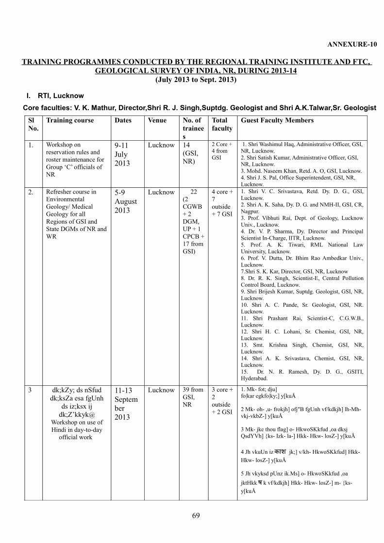
ANNEXURE-10
TRAINING PROGRAMMES CONDUCTED BY THE REGIONAL TRAINING INSTITUTE AND FTC, GEOLOGICAL SURVEY OF INDIA, NR, DURING 2013-14
(July 2013 to Sept. 2013)
I. RTI, Lucknow Core faculties: V. K. Mathur, Director,Shri R. J. Singh,Suptdg. Geologist and Shri A.K.Talwar,Sr. Geologist
Sl No.
Training course Dates Venue No. of trainees
Total faculty
Guest Faculty Members
1. Workshop on reservation rules and roster maintenance for Group ‘C’ officials of NR
9-11 July 2013
Lucknow 14 (GSI, NR)
2 Core + 4 from GSI
1. Shri Washimul Haq, Administrative Officer, GSI, NR, Lucknow.2. Shri Satish Kumar, Administrative Officer, GSI, NR, Lucknow.3. Mohd. Naseem Khan, Retd. A. O, GSI, Lucknow.4. Shri J. S. Pal, Office Superintendent, GSI, NR, Lucknow.
2. Refresher course in Environmental Geology/ Medical Geology for all Regions of GSI and State DGMs of NR and WR
5-9 August 2013
Lucknow 22(2 CGWB + 2 DGM, UP + 1 CPCB + 17 from GSI)
4 core + 7 outside + 7 GSI
1. Shri V. C. Srivastava, Retd. Dy. D. G., GSI, Lucknow.2. Shri A. K. Saha, Dy. D. G. and NMH-II, GSI, CR, Nagpur.3. Prof. Vibhuti Rai, Dept. of Geology, Lucknow Univ., Lucknow.4. Dr. V. P. Sharma, Dy. Director and Principal Scientist In-Charge, IITR, Lucknow.5. Prof. A. K. Tiwari, RML National Law University, Lucknow.6. Prof. V. Dutta, Dr. Bhim Rao Ambedkar Univ., Lucknow.7.Shri S. K. Kar, Director, GSI, NR, Lucknow8. Dr. R. K. Singh, Scientist-E, Central Pollution Control Board, Lucknow.9. Shri Brijesh Kumar, Suptdg. Geologist, GSI, NR, Lucknow.10. Shri A. C. Pande, Sr. Geologist, GSI, NR. Lucknow.11. Shri Prashant Rai, Scientist-C, C.G.W.B., Lucknow.12. Shri H. C. Lohani, Sr. Chemist, GSI, NR, Lucknow.13. Smt. Krishna Singh, Chemist, GSI, NR, Lucknow.14. Shri A. K. Srivastava, Chemist, GSI, NR, Lucknow.15. Dr. N. R. Ramesh, Dy. D. G., GSITI, Hyderabad.
3 dk;kZy; ds nSfud dk;ksZa esa fgUnh
ds iz;ksx ij dk;Z’kkyk@
Workshop on use of Hindi in day-to-day
official work
11-13 September 2013
Lucknow 39 from GSI, NR
3 core + 2 outside + 2 GSI
1. Mk- fot; dju] fo|kar egkfo|ky;] y[kuÅ
2 Mk- oh- ,u- frokjh] ofj"B fgUnh vf/kdkjh] lh-Mh-vkj-vkbZ-] y[kuÅ
3 Mk- jke thou flag] o- HkwoSKkfud ,oa dksj QsdYVh] {ks- Izk- la-] Hkk- Hkw- losZ-] y[kuÅ
4 Jh vkuUn iz काश jk;] v/kh-�श jk;] v/kh- HkwoSKkfud] Hkk- Hkw- losZ-] y[kuÅ
5 Jh vkyksd pUnz ik.Ms] o- HkwoSKkfud ,oa jktHkk ष k vf/kdkjh] Hkk- Hkw- losZ-] m- {ks- y[kuÅ
69

I. Field Training Center, Bhimtal (U.K.) (Hqrs. At: Lucknow)
Core faculties: Dr. J. S. Mehta, Suptdg. Geologist and Dr. Shailendra Singh, Suptdg. Geologist
1. 36th OCG Batch ‘E’ and ‘F’ and ‘A’ completed.Spl. field module for Himalayan Geology and Glaciological mapping continued
II. Field Training Center, Saketi (H.P.) (Hqrs. At: Chandigarh)Core faculties: Shri Inder Singh, Director and Shri Pradeep Singh, Suptdg. Geologist
1. 36th OCG Batch ‘H’ and ‘B’ completed.
70
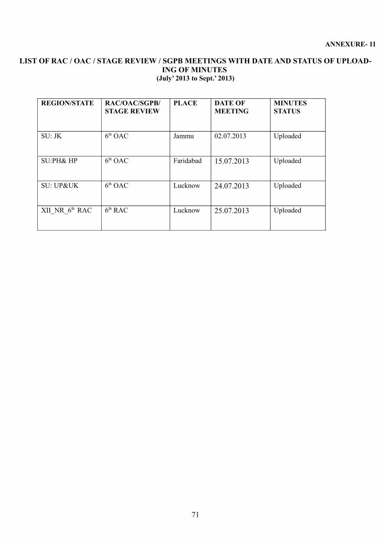
ANNEXURE- 11
LIST OF RAC / OAC / STAGE REVIEW / SGPB MEETINGS WITH DATE AND STATUS OF UPLOAD-ING OF MINUTES
(July’ 2013 to Sept.’ 2013)
REGION/STATE RAC/OAC/SGPB/ STAGE REVIEW
PLACE DATE OF MEETING
MINUTES STATUS
SU: JK 6th OAC Jammu 02.07.2013 Uploaded
SU:PH& HP 6th OAC Faridabad 15.07.2013 Uploaded
SU: UP&UK 6th OAC Lucknow 24.07.2013 Uploaded
XII_NR_6th RAC 6th RAC Lucknow 25.07.2013 Uploaded
71
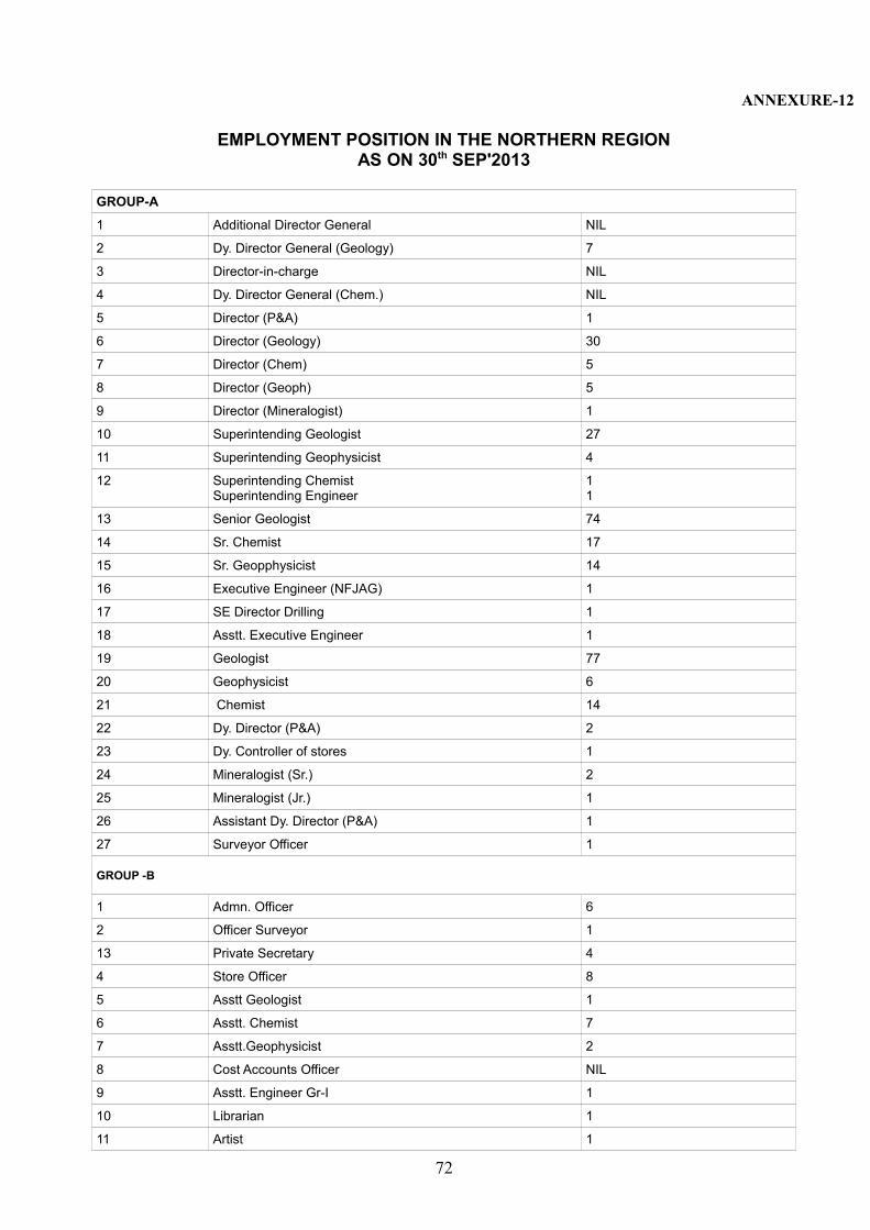
ANNEXURE-12
EMPLOYMENT POSITION IN THE NORTHERN REGIONAS ON 30th SEP'2013
GROUP-A
1 Additional Director General NIL
2 Dy. Director General (Geology) 7
3 Director-in-charge NIL
4 Dy. Director General (Chem.) NIL
5 Director (P&A) 1
6 Director (Geology) 30
7 Director (Chem) 5
8 Director (Geoph) 5
9 Director (Mineralogist) 1
10 Superintending Geologist 27
11 Superintending Geophysicist 4
12 Superintending ChemistSuperintending Engineer
11
13 Senior Geologist 74
14 Sr. Chemist 17
15 Sr. Geopphysicist 14
16 Executive Engineer (NFJAG) 1
17 SE Director Drilling 1
18 Asstt. Executive Engineer 1
19 Geologist 77
20 Geophysicist 6
21 Chemist 14
22 Dy. Director (P&A) 2
23 Dy. Controller of stores 1
24 Mineralogist (Sr.) 2
25 Mineralogist (Jr.) 1
26 Assistant Dy. Director (P&A) 1
27 Surveyor Officer 1
GROUP -B
1 Admn. Officer 6
2 Officer Surveyor 1
13 Private Secretary 4
4 Store Officer 8
5 Asstt Geologist 1
6 Asstt. Chemist 7
7 Asstt.Geophysicist 2
8 Cost Accounts Officer NIL
9 Asstt. Engineer Gr-I 1
10 Librarian 1
11 Artist 1
72
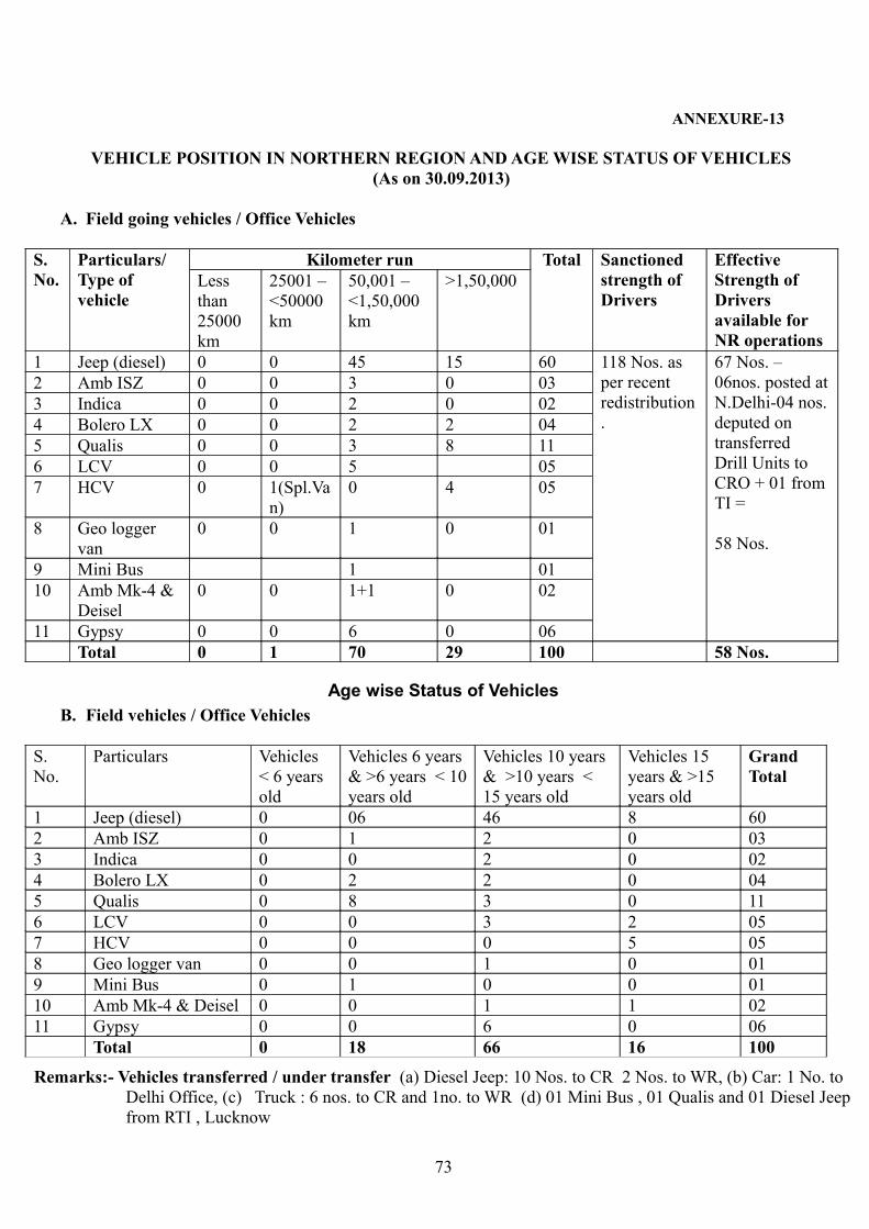
ANNEXURE-13
VEHICLE POSITION IN NORTHERN REGION AND AGE WISE STATUS OF VEHICLES (As on 30.09.2013)
A. Field going vehicles / Office Vehicles
S. No.
Particulars/ Type of vehicle
Kilometer run Total Sanctioned strength of Drivers
Effective Strength of Drivers available for NR operations
Less than 25000 km
25001 – <50000 km
50,001 – <1,50,000 km
>1,50,000
1 Jeep (diesel) 0 0 45 15 60 118 Nos. as per recent redistribution.
67 Nos. – 06nos. posted at N.Delhi-04 nos. deputed on transferred Drill Units to CRO + 01 from TI =
58 Nos.
2 Amb ISZ 0 0 3 0 033 Indica 0 0 2 0 024 Bolero LX 0 0 2 2 045 Qualis 0 0 3 8 116 LCV 0 0 5 057 HCV 0 1(Spl.Va
n)0 4 05
8 Geo logger van
0 0 1 0 01
9 Mini Bus 1 0110 Amb Mk-4 &
Deisel0 0 1+1 0 02
11 Gypsy 0 0 6 0 06Total 0 1 70 29 100 58 Nos.
Age wise Status of VehiclesB. Field vehicles / Office Vehicles
S. No.
Particulars Vehicles < 6 years old
Vehicles 6 years & >6 years < 10 years old
Vehicles 10 years & >10 years < 15 years old
Vehicles 15 years & >15 years old
Grand Total
1 Jeep (diesel) 0 06 46 8 602 Amb ISZ 0 1 2 0 033 Indica 0 0 2 0 024 Bolero LX 0 2 2 0 045 Qualis 0 8 3 0 116 LCV 0 0 3 2 057 HCV 0 0 0 5 058 Geo logger van 0 0 1 0 019 Mini Bus 0 1 0 0 0110 Amb Mk-4 & Deisel 0 0 1 1 0211 Gypsy 0 0 6 0 06
Total 0 18 66 16 100
Remarks:- Vehicles transferred / under transfer (a) Diesel Jeep: 10 Nos. to CR 2 Nos. to WR, (b) Car: 1 No. to Delhi Office, (c) Truck : 6 nos. to CR and 1no. to WR (d) 01 Mini Bus , 01 Qualis and 01 Diesel Jeep from RTI , Lucknow
73
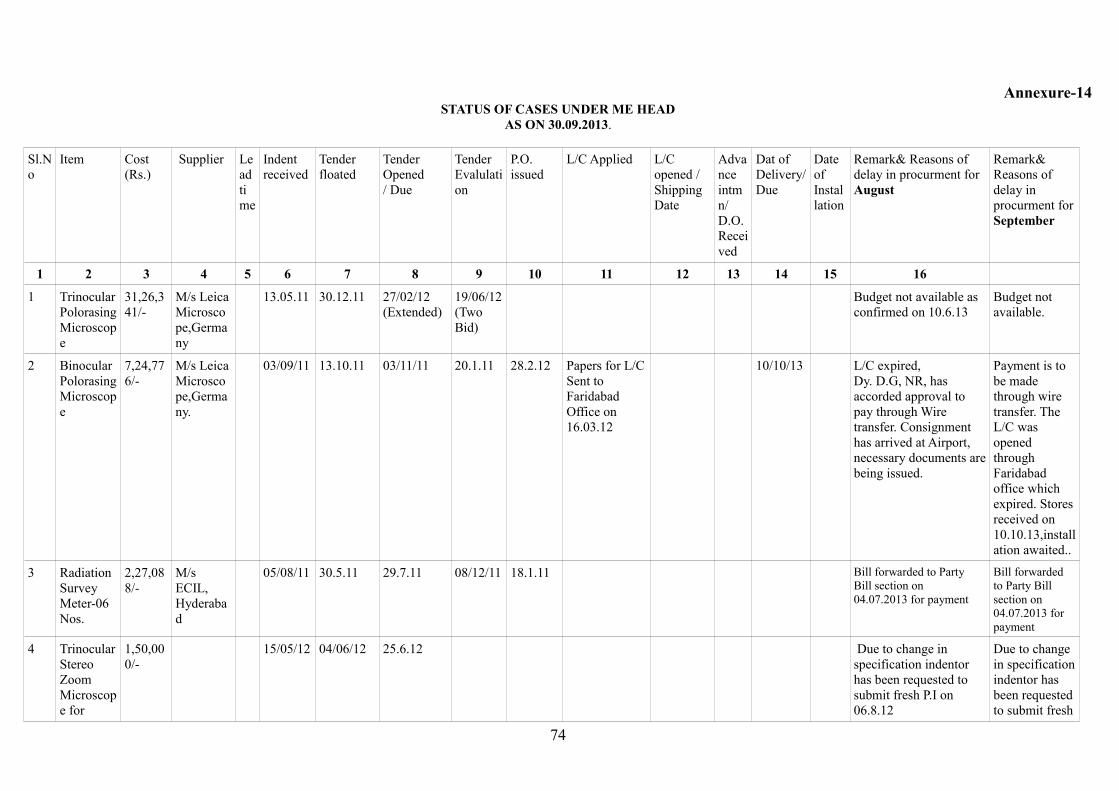
Annexure-14STATUS OF CASES UNDER ME HEAD
AS ON 30.09.2013.
Sl.No
Item Cost (Rs.)
Supplier Lead time
Indent received
Tender floated
Tender Opened/ Due
Tender Evalulation
P.O. issued
L/C Applied L/C opened / Shipping Date
Advance intmn/ D.O. Received
Dat of Delivery/ Due
Date of Installation
Remark& Reasons of delay in procurment for August
Remark& Reasons of delay in procurment for September
1 2 3 4 5 6 7 8 9 10 11 12 13 14 15 16
1 Trinocular Polorasing Microscope
31,26,341/-
M/s Leica Microscope,Germany
13.05.11 30.12.11 27/02/12 (Extended)
19/06/12 (TwoBid)
Budget not available as confirmed on 10.6.13
Budget not available.
2 Binocular Polorasing Microscope
7,24,776/-
M/s Leica Microscope,Germany.
03/09/11 13.10.11 03/11/11 20.1.11 28.2.12 Papers for L/C Sent to Faridabad Office on 16.03.12
10/10/13 L/C expired,Dy. D.G, NR, has accorded approval to pay through Wire transfer. Consignment has arrived at Airport, necessary documents are being issued.
Payment is to be made through wire transfer. The L/C was opened through Faridabad office which expired. Stores received on 10.10.13,installation awaited..
3 Radiation Survey Meter-06 Nos.
2,27,088/-
M/s ECIL, Hyderabad
05/08/11 30.5.11 29.7.11 08/12/11 18.1.11 Bill forwarded to Party Bill section on 04.07.2013 for payment
Bill forwarded to Party Bill section on 04.07.2013 for payment
4 Trinocular Stereo Zoom Microscope for
1,50,000/-
15/05/12 04/06/12 25.6.12 Due to change in specification indentor has been requested to submit fresh P.I on 06.8.12
Due to change in specification indentor has been requested to submit fresh
74
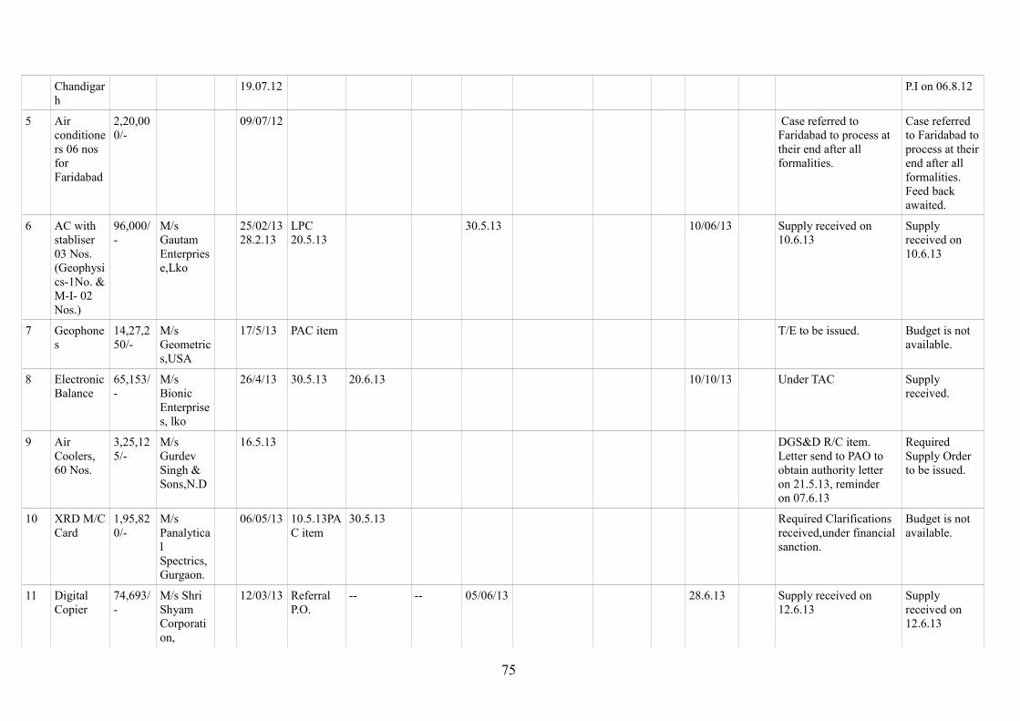
Chandigarh
19.07.12 P.I on 06.8.12
5 Air conditioners 06 nos for Faridabad
2,20,000/-
09/07/12 Case referred to Faridabad to process at their end after all formalities.
Case referred to Faridabad to process at their end after all formalities. Feed back awaited.
6 AC with stabliser 03 Nos.(Geophysics-1No. & M-I- 02 Nos.)
96,000/-
M/s Gautam Enterpriese,Lko
25/02/1328.2.13
LPC20.5.13
30.5.13 10/06/13 Supply received on 10.6.13
Supply received on 10.6.13
7 Geophones
14,27,250/-
M/s Geometrics,USA
17/5/13 PAC item T/E to be issued. Budget is not available.
8 Electronic Balance
65,153/-
M/s Bionic Enterprises, lko
26/4/13 30.5.13 20.6.13 10/10/13 Under TAC Supply received.
9 Air Coolers, 60 Nos.
3,25,125/-
M/s Gurdev Singh & Sons,N.D
16.5.13 DGS&D R/C item.Letter send to PAO to obtain authority letter on 21.5.13, reminder on 07.6.13
Required Supply Order to be issued.
10 XRD M/C Card
1,95,820/-
M/s Panalytical Spectrics,Gurgaon.
06/05/13 10.5.13PAC item
30.5.13 Required Clarifications received,under financial sanction.
Budget is not available.
11 Digital Copier
74,693/-
M/s Shri Shyam Corporation,
12/03/13 Referral P.O.
-- -- 05/06/13 28.6.13 Supply received on 12.6.13
Supply received on 12.6.13
75
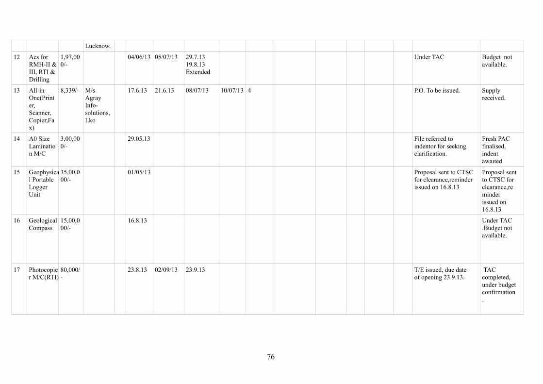
Lucknow.
12 Acs for RMH-II & III, RTI & Drilling
1,97,000/-
04/06/13 05/07/13 29.7.1319.8.13Extended
Under TAC Budget not available.
13 All-in-One(Printer, Scanner, Copier,Fax)
8,339/- M/s Agray Info-solutions, Lko
17.6.13 21.6.13 08/07/13 10/07/13 4 P.O. To be issued. Supply received.
14 A0 Size Lamination M/C
3,00,000/-
29.05.13 File referred to indentor for seeking clarification.
Fresh PAC finalised, indent awaited
15 Geophysical Portable Logger Unit
35,00,000/-
01/05/13 Proposal sent to CTSC for clearance,reminder issued on 16.8.13
Proposal sent to CTSC for clearance,reminder issued on 16.8.13
16 Geological Compass
15,00,000/-
16.8.13 Under TAC.Budget not available.
17 Photocopier M/C(RTI)
80,000/-
23.8.13 02/09/13 23.9.13 T/E issued, due date of opening 23.9.13.
TAC completed, under budget confirmation.
76
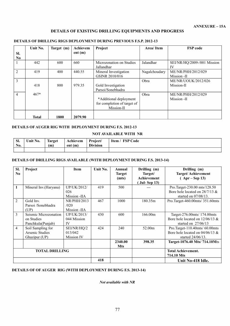
ANNEXURE – 15ADETAILS OF EXISTING DRILLING EQUIPMENTS AND PROGRESS
DETAILS OF DRILLING RIGS DEPLOYMENT DURING PREVIOUS F.S.P. 2012-13
Sl. No
Unit No. Target (m) Achievement (m)
Project Area/ Item FSP code
1 442 600 660 Microzonation on Studies Jallandhar
Jalandhar SEI/NR/HQ/2009-/001 Mission IV
2 419 400 440.55 Mineral Investigation GSINR 2010/016
Nagalchoudary ME/NR/PHH/2012/029Mission -II
3418
467*
800 979.35 Gold InvestigationParsoi/Sonebhadra
Obra ME/NR/UOUK/2012/026Mission-II
4*Additional deployment
for completion of target of Mission-II
Obra ME/NR/PHH/2012/029Mission -II
Total 1800 2079.90
DETAILS OF AUGER RIG WITH DEPLOYMENT DURING F.S. 2012-13
NOT AVAILABLE WITH NR
Sl. No.
Unit No. Target (m)
Achievement (m)
Project/Division
Item / FSP Code
DETAILS OF DRILLING RIGS AVAILABLE (WITH DEPLOYMENT DURING F.S. 2013-14)
Sl. No
Project Item Unit No. Annual Target(mts)
Drilling (m)Target/
Achievement( Jul- Sep 13)
Drilling (m)Target/ Achievement
( Apr – Sep 13)
1 Mineral Inv.(Haryana) UP/UK/2012/026Mission -IIA
419 500 --- Pro.Target-230.00 mts/128.50 Bore hole located on 28/7/13 &
started on 07/08/13.2 Gold Inv.
Parsoi /Sonebhadra (UP)
NR/PHH/2013/020Mission -IIA
467 1000 180.35m Pro.Target-460.00mts/ 351.60mts
3 Seismic Microzonation on Studies Panchkula(Punjab)
UP/UK/2013/044 Mission IV
430 600 166.00m Target-276.00mts/ 174.00mtsBore hole located on 12/06/13 &
started on 27/06/134 Soil Sampling for
Arsenic Studies Ghazipur (UP)
SEI/NR/HQ/2013/042 Mission IV
424 240 52.00m Pro.Target-110.40mts/ 60.00mtsBore hole located on 04/06/13 &
started 24/06/13.2340.00
Mts 398.35 Target-1076.40 Mts/ 714.10Mts
TOTAL DRILLING Total Achievement. 714.10 Mts
418 Unit No-418 Idle.
DETAILS OF OF AUGER RIG (WITH DEPLOYMENT DURING F.S. 2013-14)
Not available with NR
77

ANNEXURE 15B
STATUS OF EXISTING DRILLING AND OTHER HIGH-END (RS. >1 CORE) EQUIPMENTS TO BE PROCURED DURING FY 2013-14
Nil
Type of instrument
Indenting Region
Qty Cost Lead Time
PAC/ Sr. PAC
DG’s approval & CPMC recommendation
Tendering/ Re-tendering
TEC TAC PO Placed
LC opened
Delivery to be or Received
Geophysical[STSS-MI, MII & MIV]
Nil
TOTALGeology[STSS- MI, MII & MIV]
Nil
TOTALFIELD/ SURVEY[STSS – MI, MII & MIV]
Nil
Drilling Nil
TOTAL
GRAND TOTAL
78
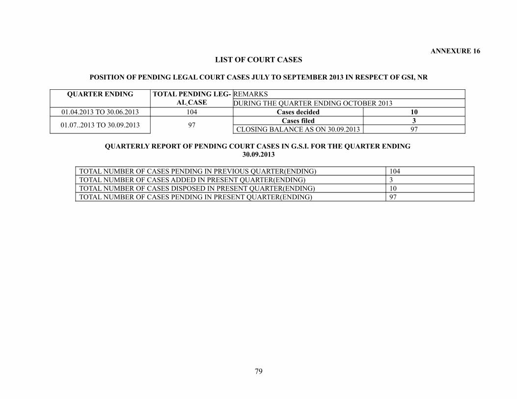
ANNEXURE 16LIST OF COURT CASES
POSITION OF PENDING LEGAL COURT CASES JULY TO SEPTEMBER 2013 IN RESPECT OF GSI, NR
QUARTER ENDING TOTAL PENDING LEG-AL CASE
REMARKSDURING THE QUARTER ENDING OCTOBER 2013
01.04.2013 TO 30.06.2013 104 Cases decided 10
01.07..2013 TO 30.09.2013 97 Cases filed 3CLOSING BALANCE AS ON 30.09.2013 97
QUARTERLY REPORT OF PENDING COURT CASES IN G.S.I. FOR THE QUARTER ENDING 30.09.2013
TOTAL NUMBER OF CASES PENDING IN PREVIOUS QUARTER(ENDING) 104TOTAL NUMBER OF CASES ADDED IN PRESENT QUARTER(ENDING) 3TOTAL NUMBER OF CASES DISPOSED IN PRESENT QUARTER(ENDING) 10TOTAL NUMBER OF CASES PENDING IN PRESENT QUARTER(ENDING) 97
79
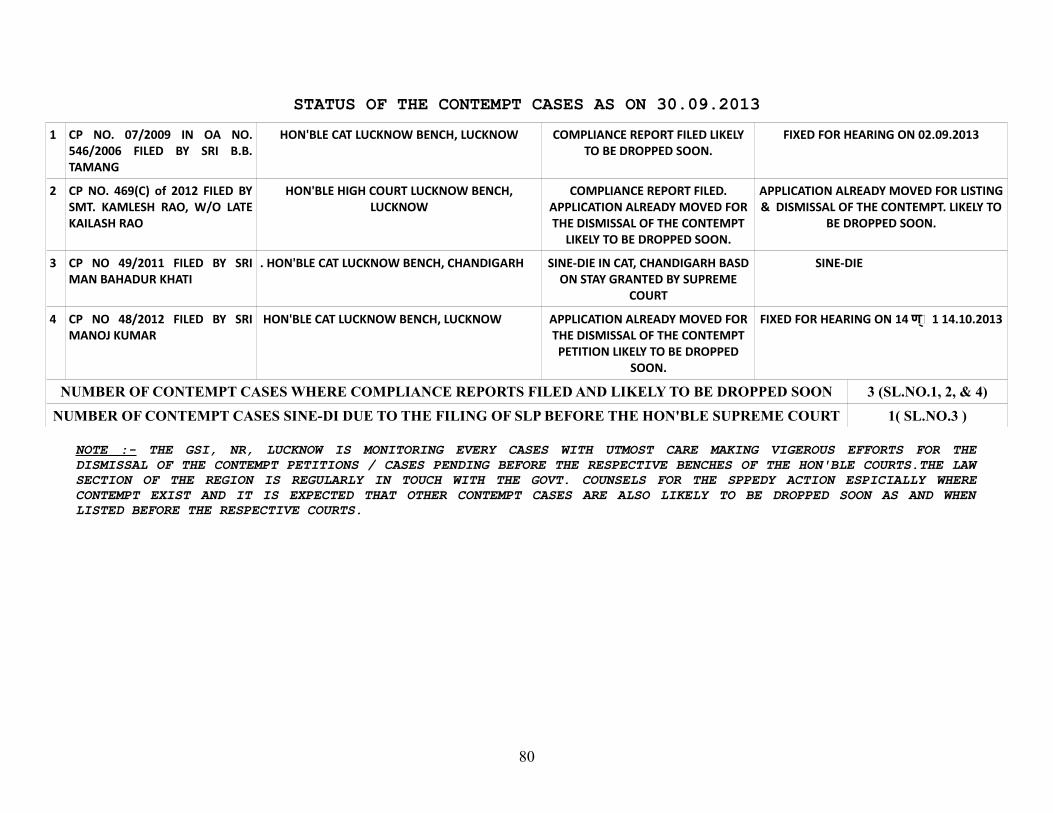
STATUS OF THE CONTEMPT CASES AS ON 30.09.20131 CP NO. 07/2009 IN OA NO.
546/2006 FILED BY SRI B.B. TAMANG
HON'BLE CAT LUCKNOW BENCH, LUCKNOW COMPLIANCE REPORT FILED LIKELY TO BE DROPPED SOON.
FIXED FOR HEARING ON 02.09.2013
2 CP NO. 469(C) of 2012 FILED BY SMT. KAMLESH RAO, W/O LATE KAILASH RAO
HON'BLE HIGH COURT LUCKNOW BENCH, LUCKNOW
COMPLIANCE REPORT FILED. APPLICATION ALREADY MOVED FOR THE DISMISSAL OF THE CONTEMPT
LIKELY TO BE DROPPED SOON.
APPLICATION ALREADY MOVED FOR LISTING & DISMISSAL OF THE CONTEMPT. LIKELY TO
BE DROPPED SOON.
3 CP NO 49/2011 FILED BY SRI MAN BAHADUR KHATI
. HON'BLE CAT LUCKNOW BENCH, CHANDIGARH SINE-DIE IN CAT, CHANDIGARH BASD ON STAY GRANTED BY SUPREME
COURT
SINE-DIE
4 CP NO 48/2012 FILED BY SRI MANOJ KUMAR
HON'BLE CAT LUCKNOW BENCH, LUCKNOW APPLICATION ALREADY MOVED FOR THE DISMISSAL OF THE CONTEMPT PETITION LIKELY TO BE DROPPED
SOON.
FIXED FOR HEARING ON 14 Sण �� 1 14.10.2013
NUMBER OF CONTEMPT CASES WHERE COMPLIANCE REPORTS FILED AND LIKELY TO BE DROPPED SOON 3 (SL.NO.1, 2, & 4)NUMBER OF CONTEMPT CASES SINE-DI DUE TO THE FILING OF SLP BEFORE THE HON'BLE SUPREME COURT 1( SL.NO.3 )
NOTE :- THE GSI, NR, LUCKNOW IS MONITORING EVERY CASES WITH UTMOST CARE MAKING VIGEROUS EFFORTS FOR THE DISMISSAL OF THE CONTEMPT PETITIONS / CASES PENDING BEFORE THE RESPECTIVE BENCHES OF THE HON'BLE COURTS.THE LAW SECTION OF THE REGION IS REGULARLY IN TOUCH WITH THE GOVT. COUNSELS FOR THE SPPEDY ACTION ESPICIALLY WHERE CONTEMPT EXIST AND IT IS EXPECTED THAT OTHER CONTEMPT CASES ARE ALSO LIKELY TO BE DROPPED SOON AS AND WHEN LISTED BEFORE THE RESPECTIVE COURTS.
80
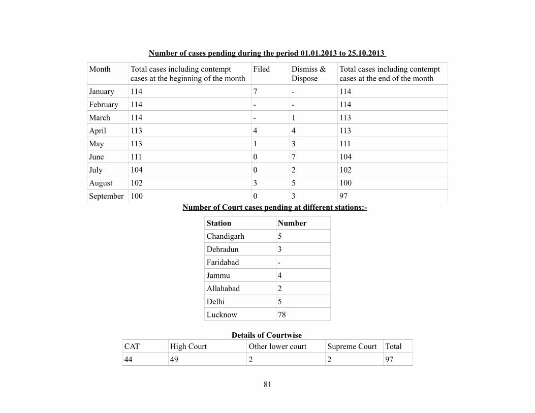
Number of cases pending during the period 01.01.2013 to 25.10.2013
Month Total cases including contempt cases at the beginning of the month
Filed Dismiss & Dispose
Total cases including contempt cases at the end of the month
January 114 7 - 114February 114 - - 114March 114 - 1 113April 113 4 4 113May 113 1 3 111June 111 0 7 104July 104 0 2 102August 102 3 5 100September 100 0 3 97
Number of Court cases pending at different stations:-
Station NumberChandigarh 5Dehradun 3Faridabad -Jammu 4Allahabad 2Delhi 5Lucknow 78
Details of Courtwise CAT High Court Other lower court Supreme Court Total44 49 2 2 97
81

82