geological survey of india - gsi
TRANSCRIPT

भारतीय भूवैज्ञानिक सवेक्षण, Geological Survey of India
पूवोत्तर के्षत्र North Eastern Region
BBrriieeffiinngg BBooookk (tqykbZ/July’13 - flrEcj/September’13)
Cover Page Photo: SSaatteelllliittee iimmaaggeerryy ooff NNoorrtthh EEaasstteerrnn RReeggiioonn ((ssoouurrccee--iinntteerrnneett))
CCoorrrreessppoonnddeennccee aaddddrreessss::
‘‘SSHHYYLLLLAA’’ BBUUIILLDDIINNGG,, NNOONNGGRRIIMM HHIILLLLSS SSHHIILLLLOONNGG –– 779933000033
PPhhoonnee:: 00336644--22552200222288,, FFaaxx:: 00336644--22552200003333 EEmmaaiill:: hhoodd..nneerr@@ggssii..ggoovv..iinn
EXECUTIVE SUMMARY- BRIEFING BOOK, GSI, NER SEPTEMBER, 2013 (JULY’13 TO SEPT’13)
MISSION-I & IA
STM: 202.7 sq.km completed.
SGM: 179 sq.km completed.
GCM: 446 sq.km completed.
GPM: 60 sq.km completed.
MISSION-II
LSM: 38.5 sq.km completed
Drilling: 714.75 m drilling completed (including extended item.) DM: 0.6 Sq.km LIMESTONE INVESTIGATIONS: Study in Larket block(northern), litang valley, jaintia hills district (on 1:5,000 scale with 5m contour interval) and ishamati block of shella - bholaganj belt, East Khasi Hills district (1:2000 scales), Meghalaya are in progress. Investigation for Limestone in Umphyrluh Block, Litang valley, Jaintia Hills District also in progress as an extended item of FS 2012-13.
COAL EXPLORATION: Study in Gondwana Coal in Sukchar-Singrimari Block, Singrimari Coal Field, Dhubri
district, Assam, at the border of Assam and Meghalaya (G3) in progress & two coal seam of thickness 0.55 m and 2.15 m have been encountered at 257.90 m and 262.70 m depth respectively. Borehole SN-05 was closed at a depth of 281 m on 22.05.13. Another exploration study in the area adjacent to Sukchar-Singrimari Block, Singrimari Coal Field is in progress. During regional traverses along Garobhada-Singrimari, several Tertiary sequences were noticed, near Jamali, in a road section. A shale-siltstone alteration was noticed containing with thin bands of probably lignite coal. Study in Coal Zone in Tertiary sequence is in progress around Shalibhuin in Dhubri district, Assam and Nakaigiri-Ujanggiri in West Garo Hills, Meghalaya. The Tertiary sequence trends NW-SE with very low dips varying from 5 to 10° towards SW. Based on these coal pits, one scout borehole USD-01 has been fixed and is under progress. USD-01 commenced on 03.07.2013 and has achieved a depth of 74.00 m as on 30th Sept. 2013. A basic dyke of about 10m width and also another ultramafic dyke of about 5m width, intrusive within the gneissic complex have been mapped near Shalibhuin. REE INVESTIGATION: Preliminary investigation for REE in parts of Nongpoh pluton, Ri-Bhoi district, Meghalaya (G4) is in progress. LSM: 16 sq.km. covered during the FS 2013-14. TITANIFEROUS-VANADIFEROUS MAGNETITE INVESTIGATION: The study around Rambrai in West Khasi Hills district, Meghalaya is in progress. The area exposes meta norite, light grey to pink granite gneiss banded gneiss within gneissic complex intrusive of non-porphritic granite were demarcated. During mapping delineated meta norite body associated with titaniferous-vanadiferous magnetite bands. This body trending N550W-S550E and with 1800m long X 300m wide. The analytical results of 9 bed rock samples collected from meta norite body shows TiO2 values ranges from 1.33% to 4.3% with average value of 2.45%, Vanadium values ranges from 214ppm to 1177ppm with average value of 512ppm, Cu values ranges from 3ppm to 566ppm with average value of 179ppm and Zr valves ranges from 47ppm to 1802ppm with average value of 400ppm.
MISSION-III
DRM: compilation of DRMs of Lakhimpur, Jorhat, Nagaon and North Cachar Hills, Assam, Jainitia Hills, Meghalaya, Aizawl and Champhai, Mizoram are under progress. Compilation of DRM of Bongaigaon district, Assam, Tamenglong & Ukhrul, Manipur is completed. Digitization of DRMs of Karbi Anglong district,
Kamrup district (FS 2010-12) through outsourcing is in progress. QGM of 78O is in progress.
AGR Vol 145-146 pt 1 sent to PID, CHQ for publication on 23.07.2013
Ext. Abst. Vol. 147, Pt. 4 (FS 2012-13) & GSI, NER, e-News publication, Vol. 23, AGR, Vol. 147, Pt. 1 are under processing. Updated Accession numbers for ‘Completed Reports’ for FS 2009-2010(3report) ,
2010-2012(7 out of 43 reports) and 2012-2013(two report)
Library Services = Procured 14 nos. new geology books and 91 nos. of journals in Regional Library. Nine (9) Scientific Papers and 11 abstracts were processed for different National and International Seminars/ Journals. Generated Rs 3502 through sale of GSI publications. Distributed 578 copies of GSI publications to
all the Regions of GSI in India. Extended Library facilities to departmental officers and others.
Geoinformatics: Scrutiny and finalization of geological maps of 3 toposheets submitted by State Unit: Assam was completed. Creation of theme based database 15 toposheets of 78O (50K theme) is completed
and rest is in progress. Legend for lithology level is in progress.
MISSION-IV
Palaeontological Studies:: Egg like fossils were recovered from Upper Mahadek Formation of Upper Cretaceous age. These egg like fossils are 4-7 inch in diameter. Upper Mahadek Fm is considered to be marine origin. If these fossils are confirmed as egg fossils, it will be the first time report of marine reptile egg fossil from Indian sediments. Thin section study suspects egg shell. SEM study is proposed for confirmation. Geotechnical Investigations: Request from Kameng H.E.Project, West Kameng district, Arunachal Pradesh, Tuirial H E Project, District Kolasib, Mizoram & Mawblei H.E.P, West Khasi Hills District were attended. Medical Geology: Systematic spot analysis of groundwater and surface water samples by Merck Arsenic Field kit were carried out in the field in Toposheet 83 B/12 & B/16 to study of arsenic contamination in water and soil in parts of nagaon and marigaon districts, Assam. Landslide Hazard Zonation: Updation of existing landslide inventory of NER, Macro scale Landslide Hazard Zonation in along road corridor of Anjaw district, Arunachal Pradesh & road corridor of Sikkim, Site Specific Geological Studies of the landslides near Tawang Monastery, Tawang district, Arunachal Pradesh & Proposed Pakyong Airport Area, Sikkim, Detailed Study of the 13th Mile Landslide on Gangtok-Nathula Road, East District, Sikkim are in progress. Earthquake Studies: The Seismic & Landslide Hazard Assessment of Aizawl town, Mizoram and Kohima city, Nagaland is in progress. Study of SRTM data to delineate different geomorphic /morphotectonic units and Lineaments for Seismic Hazard Assessment of Gangtok and surrounding areas of Sikkim is in progress.
MISSION-V
Training Institute: 36th OCG Batches was conducted at RTI, Shillong and FTC, Aizawl in connection with
Sedimentary and Granitoid mapping for the officers of GSI, NER. Capsule course on chemical analysis of rock samples & Refresher course for petrology training for Geologist of DGM and GSI, NER were conducted
at RTI, Shillong.
SUPPORT SYSTEM–I: STSS
Petrology Lab: 139 nos. thin sections and 11 nos polished sections were prepared and studied besides gem testing of 16 nos. samples. Internal resource generated for Rs 10640.00.
Chemical Lab: Total 435 samples were received for chemical study under different packages. 3152 samples were analysed and 37387 determinations were carried out.
SUPPORT SYSTEM–II: ASS
Administration:
a) Pay-roll data regularly updated.
b) HRMIS data is being updated regularly.
c) Tour applications of all gazetted officers are processed through portal.
d) Leave Module in portal implemented.
e) Claims Module in portal implemented.
f) Purchases under ME & IT Heads are being monitored. PAC and TAC are being held regularly.
SUPPORT SYSTEM–III: PSS
RAC: 6th RAC on 05-09-13.
Government of India Geological Survey of India
North Eastern Region
BRIEFING BOOK (Updated up to September, 2013)
C O N T E N T
Page No.
1. Introduction
(i) State-wise Geology and Mineral Resources
(ii) Status Map (s)
1
1
5
2. Organisational Structure of the Region (updated) 9
3. Activity Domain of the Region 10
4. Mission Wise Information For Field Season 2013-14 (updated) 11
5. Financial Performance (updated) 24
6. Mission Wise RCA Expenditure (updated) 24
7. Scientific workshops / Meetings / Seminars / Symposium, Exhibitions etc., organised / participated (updated)
24
8. HRD, Establishment, Payroll, HRMIS, e-service book, etc. (updated) 24
9. Vehicles & Transport Infrastructure including outsourcing and age of vehicles, Vehicles MIS (updated)
24
10. Modernization 24
11. Drilling Infrastructure (updated) 24
12. Outsourcing of routine services [housekeeping, security, garden, etc.] 25
13. Other Activities (updated) 25
14. Special Scientific Study. 25
15. Perception Management Activies in NER (updated) 25
16. Savottam (updated) 25
17. Consolidated List of Group A & B (Gaz.) Officers in NER (as on 30.09.2013) (updated) 25 ANNEXURES (updated):
Annexure-1A : MAJOR MINERALS RESOURCES [UNDER VARIOUS UNFC CATEGORIES] ESTIMATED BY THE REGION, SHOWING STATE-WISE FIVE-YEARLY INCREMENT, FOR THE LAST 15 YEARS.
26
Annexure-1B : NATIONAL MINERAL INVENTORY – NO. OF REPORTS CONVERTED AS PER UNFC COMPLIANCE
26
Annexure-2A : ACTIVITY DOMAIN PERTAINING TO MISSION I & II OF THE REGION AND ACHIEVEMENTS [FSP RELATED ITEMS] DURING THE XI PLAN PERIOD [2007-12] & XII PLAN PERIOD
27
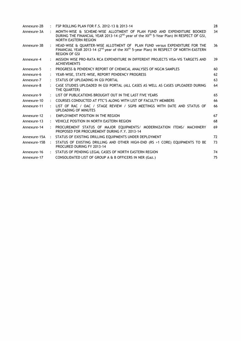
Annexure-2B : FSP ROLLING PLAN FOR F.S. 2012-13 & 2013-14 28
Annexure-3A : MONTH-WISE & SCHEME-WISE ALLOTMENT OF PLAN FUND AND EXPENDITURE BOOKED DURING THE FINANCIAL YEAR 2013-14 (2nd year of the XIIth 5-Year Plan) IN RESPECT OF GSI, NORTH EASTERN REGION
34
Annexure-3B : HEAD-WISE & QUARTER-WISE ALLOTMENT OF PLAN FUND versus EXPENDITURE FOR THE FINANCIAL YEAR 2013-14 (2nd year of the XIIth 5-year Plan) IN RESPECT OF NORTH-EASTERN REGION OF GSI
36
Annexure–4 : MISSION WISE PRO-RATA RCA EXPENDITURE IN DIFFERENT PROJECTS VISA-VIS TARGETS AND ACHIEVEMENTS
39
Annexure-5 : PROGRESS & PENDENCY REPORT OF CHEMICAL ANALYSES OF NGCM SAMPLES 60
Annexure-6 : YEAR-WISE, STATE-WISE, REPORT PENDENCY PROGRESS 62
Annexure-7 : STATUS OF UPLOADING IN GSI PORTAL 63
Annexure-8 : CASE STUDIES UPLOADED IN GSI PORTAL (ALL CASES AS WELL AS CASES UPLOADED DURING THE QUARTER)
64
Annexure-9 : LIST OF PUBLICATIONS BROUGHT OUT IN THE LAST FIVE YEARS 65
Annexure-10 : COURSES CONDUCTED AT FTC’S ALONG WITH LIST OF FACULTY MEMBERS 66
Annexure-11 : LIST OF RAC / OAC / STAGE REVIEW / SGPB MEETINGS WITH DATE AND STATUS OF UPLOADING OF MINUTES
66
Annexure-12 : EMPLOYMENT POSITION IN THE REGION 67
Annexure-13 : VEHICLE POSITION IN NORTH EASTERN REGION 68
Annexure-14 : PROCUREMENT STATUS OF MAJOR EQUIPMENTS/ MODERNIZATION ITEMS/ MACHINERY PROPOSED FOR PROCUREMENT DURING F.Y. 2013-14
69
Annexure-15A : STATUS OF EXISTING DRILLING EQUIPMENTS UNDER DEPLOYMENT 72
Annexure-15B : STATUS OF EXISTING DRILLING AND OTHER HIGH-END (RS >1 CORE) EQUIPMENTS TO BE PROCURED DURING FY 2013-14
73
Annexure-16 : STATUS OF PENDING LEGAL CASES OF NORTH EASTERN REGION 74
Annexure-17 CONSOLIDATED LIST OF GROUP A & B OFFICERS IN NER (Gaz.) 75
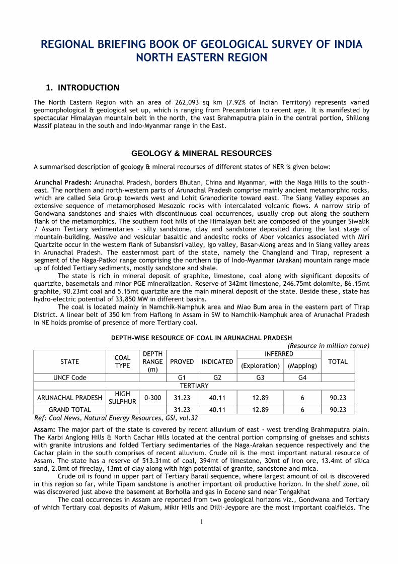
1
REGIONAL BRIEFING BOOK OF GEOLOGICAL SURVEY OF INDIA NORTH EASTERN REGION
1. INTRODUCTION
The North Eastern Region with an area of 262,093 sq km (7.92% of Indian Territory) represents varied geomorphological & geological set up, which is ranging from Precambrian to recent age. It is manifested by spectacular Himalayan mountain belt in the north, the vast Brahmaputra plain in the central portion, Shillong Massif plateau in the south and Indo-Myanmar range in the East.
GEOLOGY & MINERAL RESOURCES
A summarised description of geology & mineral recourses of different states of NER is given below: Arunchal Pradesh: Arunachal Pradesh, borders Bhutan, China and Myanmar, with the Naga Hills to the south-east. The northern and north-western parts of Arunachal Pradesh comprise mainly ancient metamorphic rocks, which are called Sela Group towards west and Lohit Granodiorite toward east. The Siang Valley exposes an extensive sequence of metamorphosed Mesozoic rocks with intercalated volcanic flows. A narrow strip of Gondwana sandstones and shales with discontinuous coal occurrences, usually crop out along the southern flank of the metamorphics. The southern foot hills of the Himalayan belt are composed of the younger Siwalik / Assam Tertiary sedimentaries - silty sandstone, clay and sandstone deposited during the last stage of mountain-building. Massive and vesicular basaltic and andesitc rocks of Abor volcanics associated with Miri Quartzite occur in the western flank of Subansisri valley, Igo valley, Basar-Along areas and in Siang valley areas in Arunachal Pradesh. The easternmost part of the state, namely the Changland and Tirap, represent a segment of the Naga-Patkoi range comprising the northern tip of Indo-Myanmar (Arakan) mountain range made up of folded Tertiary sediments, mostly sandstone and shale.
The state is rich in mineral deposit of graphite, limestone, coal along with significant deposits of quartzite, basemetals and minor PGE mineralization. Reserve of 342mt limestone, 246.75mt dolomite, 86.15mt graphite, 90.23mt coal and 5.15mt quartzite are the main mineral deposit of the state. Beside these, state has hydro-electric potential of 33,850 MW in different basins.
The coal is located mainly in Namchik-Namphuk area and Miao Bum area in the eastern part of Tirap District. A linear belt of 350 km from Haflong in Assam in SW to Namchik-Namphuk area of Arunachal Pradesh in NE holds promise of presence of more Tertiary coal.
DEPTH-WISE RESOURCE OF COAL IN ARUNACHAL PRADESH
(Resource in million tonne)
STATE COAL TYPE
DEPTH RANGE
(m) PROVED INDICATED
INFERRED TOTAL
(Exploration) (Mapping)
UNCF Code G1 G2 G3 G4
TERTIARY
ARUNACHAL PRADESH HIGH
SULPHUR 0-300 31.23 40.11 12.89 6 90.23
GRAND TOTAL 31.23 40.11 12.89 6 90.23
Ref: Coal News, Natural Energy Resources, GSI, vol.32
Assam: The major part of the state is covered by recent alluvium of east - west trending Brahmaputra plain. The Karbi Anglong Hills & North Cachar Hills located at the central portion comprising of gneisses and schists with granite intrusions and folded Tertiary sedimentaries of the Naga-Arakan sequence respectively and the Cachar plain in the south comprises of recent alluvium. Crude oil is the most important natural resource of Assam. The state has a reserve of 513.31mt of coal, 394mt of limestone, 30mt of iron ore, 13.4mt of silica sand, 2.0mt of fireclay, 13mt of clay along with high potential of granite, sandstone and mica.
Crude oil is found in upper part of Tertiary Barail sequence, where largest amount of oil is discovered in this region so far, while Tipam sandstone is another important oil productive horizon. In the shelf zone, oil was discovered just above the basement at Borholla and gas in Eocene sand near Tengakhat
The coal occurrences in Assam are reported from two geological horizons viz., Gondwana and Tertiary of which Tertiary coal deposits of Makum, Mikir Hills and Dilli-Jeypore are the most important coalfields. The
2
Tertiary coal deposits of Makum, Dilli –Jeypore and Mikir Hills area are the major coal resource of the state. The coal deposits in Mikir Hills occur within Sylhet Formation of Jaintia Group and are located in the southern part of Mikir Hills and to the north of the railway line between Lumding and Dimapur.
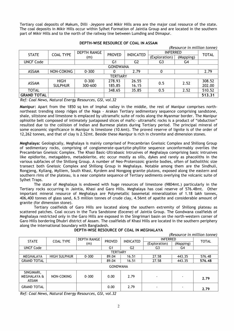
DEPTH-WISE RESOURCE OF COAL IN ASSAM
(Resource in million tonne)
STATE COAL TYPE DEPTH RANGE
(m) PROVED INDICATED
INFERRED TOTAL
(Exploration) (Mapping)
UNCF Code G1 G2 G3 G4
GONDWANA
ASSAM NON-COKING 0-300 0 2.79 0 2.79
TERTIARY
ASSAM HIGH
SULPHUR 0-300
300-600 278.93 185.85
26.55 16.15
0.5 2.52 308.52 202.00
TOTAL 348.65 35.85 0.5 2.52 510.52
GRAND TOTAL 513.31
Ref: Coal News, Natural Energy Resources, GSI, vol.32
Manipur: Apart from the 1850 sq km of Imphal valley in the middle, the rest of Manipur comprises north-northeast trending steep ridges of the Naga - Arakan Tertiary sedimentary sequence comprising sandstone, shale, siltstone and limestone is emplaced by ultramafic suite of rocks along the Myanmar border. The Manipur ophiolite belt composed of intimately juxtaposed slices of mafic- ultramafic rocks is a product of “obduction” resulted due to the collision of Indian and Burmese plates during Tertiary period. The principal mineral of some economic significance in Manipur is limestone (10.6mt). The proved reserve of lignite is of the order of 12,262 tonnes, and that of clay is 2.52mt. Beside these Manipur is rich in chromite and dimension stones. Meghalaya: Geologically, Meghalaya is mainly comprised of Precambrian Gneissic Complex and Shillong Group of sedimentary rocks, comprising of conglomerate-quartzite-phyllite sequence unconformably overlies the Precambrian Gneissic Complex. The Khasi Basic-Ultrabasic Intrusives of Meghalaya comprising basic intrusives like epidiorite, metagabbro, metadolerite, etc occur mostly as sills, dykes and rarely as phacoliths in the various subfacies of the Shillong Group. A number of Neo-Proterozoic granite bodies, often of batholithic size transect both Gneissic Complex and Shillong Group in Meghalaya. Notable among them are the Sindhuli, Rongjeng, Kyllang, Mylliem, South Khasi, Kyrdem and Nongpog granite plutons, exposed along the eastern and southern rims of the plateau, is a near complete sequence of Tertiary sediments overlying the volcanic suite of Sylhet Traps.
The state of Meghalaya is endowed with huge resources of limestone (9804mt.) particularly in the Tertiary rocks occurring in Jaintia, Khasi and Garo Hills. Meghalaya has coal reserve of 576.48mt. Other important mineral resource of Meghalaya are Polymetallic basemetal mineralization of 1.18 lakh tonnes, 406,400 tonnes of glass sand, 6.5 million tonnes of crude clay, 4.56mt of apatite and considerable amount of granite (for dimension stone).
Tertiary coalfields of Garo Hills are located along the southern extremity of Shillong plateau as scattered patches. Coal occurs in the Tura Sandstone (Eocene) of Jaintia Group. The Gondwana coalfields of Meghalaya restricted only in the Garo Hills are exposed in the Singrimari basin on the north-western corner of Garo Hills bordering Dhubri district of Assam. The coalfields of Khasi Hills are located in the southern periphery along the international boundary with Bangladesh.
DEPTH-WISE RESOURCE OF COAL IN MEGHALAYA (Resource in million tonne)
STATE COAL TYPE DEPTH RANGE
(m) PROVED INDICATED
INFERRED TOTAL
(Exploration) (Mapping)
UNCF Code G1 G2 G3 G4
TERTIARY
MEGHALAYA HIGH SULPHUR 0-300 89.04 16.51 27.58 443.35 576.48
GRAND TOTAL 89.04 16.51 27.58 443.35 576.48
GONDWANA
SINGIMARI, MEGHALAYA &
ASSAM NON-COKING 0-300 0.00 2.79 - -
2.79
GRAND TOTAL 0.00 2.79 - -
2.79
Ref: Coal News, Natural Energy Resources, GSI, vol.32

3
Inferred reserve is 406,400 tonnes of white sandstone useful in glass industry occur in Cherrapunjee and Laitryngew areas. Inferred reserve of 6.5 million tonnes crude clay is reported 2.4 km west of Sohrarim on Cherrapunjee Road. White clay is also reported from Nongalbibre in South Garo Hills and Rongrengre in East Garo Hills districts. Good quality Kaolin occurs around Smit and Laitlyngkot in East Khasi Hills, Thandlaskein, Shangpung, Mulieh and Mynsngat in Jaintia Hills and Darugiri in East Garo Hills districts. China clay, suitable for pottery manufacture, has been reported from several places in Sutnga area in Sylhet Sandstone. Mizoram: A repetitive succession of young Tertiary sediments, mostly shale, siltstone and sandstone, tightly folded into a ridge and valley sequence comprise the whole state. Along the somewhat broad valleys in the northern part, bordering Assam, recent alluvium covers the sediments. There is some potential for oil and gas, lignite, decorative shell limestone, sandstone slabs (as dimension stone) and clay body within the sedimentaries.
There is some potential for oil and gas accumulation in the folded sedimentaries. There is scope for hydel power generation in the state on a large scale along the Kolodyne and Tuivai rivers and as microhydel schemes along many smaller streams. Indication of oil, saline springs and a few gas seepages in the central part of Mizoram are reported. Salt spring has been located north of Sabual village in western part of Mizoram.
Occurrence of 3 metres long and 10 cms thick, grey, pyrite-bearing, lignite patch in ferruginous, brownish, yellow, soft, Bokabil sandstone has been reported south of Chubel village. About 6.5 kms southeast of Ngopa, a few lenticular pockets of coal have been recorded. Streaks, stringers and patches of coal are found in the Upper Bhuban Sandstone. The Mizoram state Department of Industries (Geology and Mining Wing) has proved 5200 cubic metres of decorative shell limestone at Ngrum Lui near Turial Bridge and 6000 cubic metres at Sesawang. A thin horizon of clay is noticed northwest of Borai, near Momchera and in the valley near Plura village. The clay has a vast potential for making bricks. Nagaland : Geologically, Nagaland comprises Tertiary sedimentary rocks of Disang, Barail, Surma and Tipam Groups that form the northern extension of Arakan-Yoma ranges, while the younger alluvial sediments occupy valley areas. NNE-SSW trending ophiolite suite of rocks represented by mafic- ultramafic sequence is juxtaposed with Naga metamorphic belt along the eastern margin all along the contact with Myanmar.
In Nagaland, occurrences of major minerals are limestone (375mt.), coal (315.41mt.) and nickel-cobalt bearing magnetite. Sulphide (Cu-Fe) occurrences are noted in chert-volcanics and mafic-ultramafic association of ophiolite belt at some places of Phek and Tuensang Districts. Oil and natural gas occur in western foothill areas and Schuppen Belt, being trapped in fractured and weathered basement rocks, and in the overlying Tertiary cover sediments of Kopili / Barail / Surma / Tipam rocks.
Coal deposits, which occur in Tikak Parbat / Jenam Formations of Barail Group, are located in Borjan-Tiru areas of Mon district, Changki-Chongliyimsen and Lakhuni areas of Mokokchung district, Leo Longidang area of Wokha district and Konya area of Tuensang district.
DEPTH-WISE RESOURCE OF COAL IN NAGALAND (Resource in million tonne)
STATE COAL TYPE DEPTH
RANGE (m) PROVED INDICATED
INFERRED TOTAL
(Exploration) (Mapping)
UNCF Code G1 G2 G3 G4
TERTIARY
NAGALAND HIGH SULPHUR 0-300 8.76 0 8.6 298.05 315.41
Ref: Coal News, Natural Energy Resources, GSI, vol.32
Sikkim: The state is mostly comprises low to medium grade Precambrian metamorphites of Daling Group, high grade Darjeeling gneiss and Kanchendzonga gneiss, quartzite, calc-silicate rock, marble and graphite schist of Chungthang Formation. Daling Group of rocks are classified into Gorubathan, Reyang and Buxa Formations. Dolomitic limestone and stromatolitic limestone occurs in Buxa Formation. "Lingtse Gneiss" occurs as a NE-SW to N-S trending strip and forms a general line of separation between the Daling and the high grade Kanchendzonga gneiss. The folded Tethyan sedimentaries, exposed in the northern part of Sikkim are fossiliferous at places and represented by Everest Formation (shale/phyllite), Mount Everest Limestone Formation, Lachi Formation (conglomerate with thick diamictite base) and Tso Lhamo Formation (calcareous shale, limestone band, calcareous sandstone). The Gondwana Supergroup consists of sandstone, shale, and carbonaceous shale with occasional thin bands of coal and pebbly shale horizon are best exposed at Namchi, South District of Sikkim.
Strata bound basemetal occurrences are located at Rangpo (Bhotang), Pachekhani- Rorathang, and Dikchu. The copper-zinc vein type mineralization of Dikchu area (thickness-1.25m, strike length-600m and depth of 100m) occurs in the garnet-staurolite-quartz-mica schist of Daling Group at the contact with Central Crystalline Gneissic Complex. Coal seams of Gondwana Supergroup are exposed at Namchi & Rishi area.
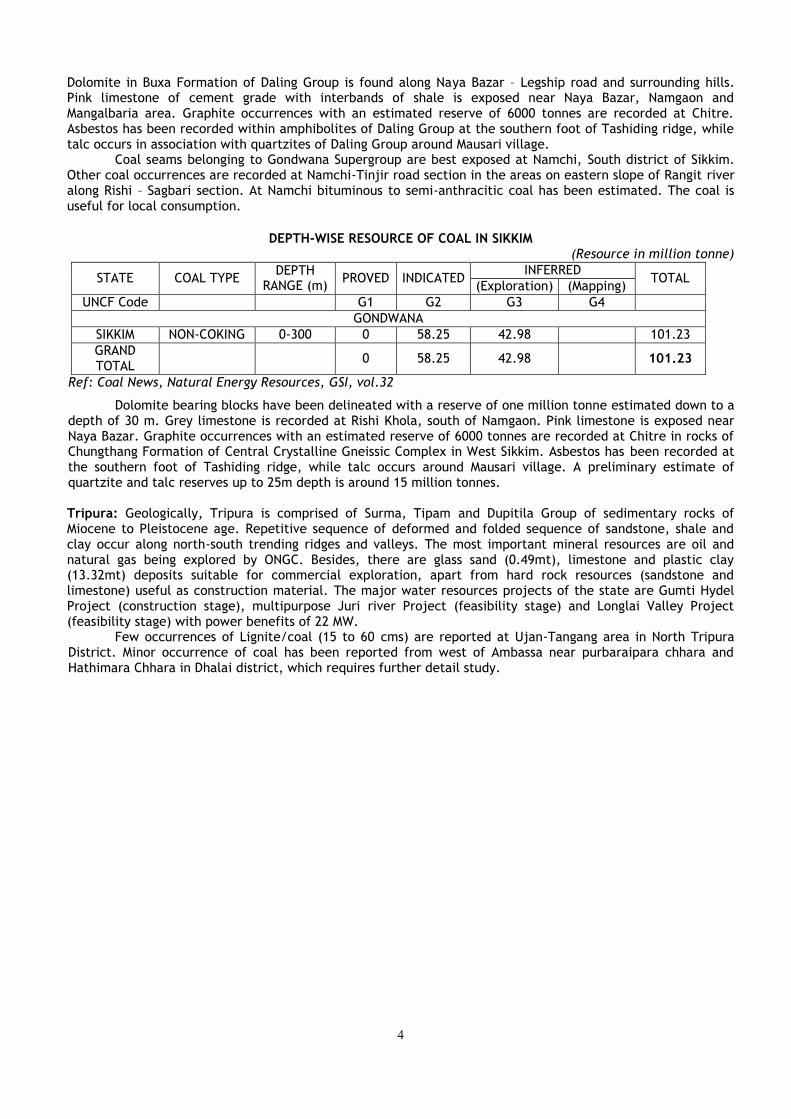
4
Dolomite in Buxa Formation of Daling Group is found along Naya Bazar – Legship road and surrounding hills. Pink limestone of cement grade with interbands of shale is exposed near Naya Bazar, Namgaon and Mangalbaria area. Graphite occurrences with an estimated reserve of 6000 tonnes are recorded at Chitre. Asbestos has been recorded within amphibolites of Daling Group at the southern foot of Tashiding ridge, while talc occurs in association with quartzites of Daling Group around Mausari village.
Coal seams belonging to Gondwana Supergroup are best exposed at Namchi, South district of Sikkim. Other coal occurrences are recorded at Namchi-Tinjir road section in the areas on eastern slope of Rangit river along Rishi – Sagbari section. At Namchi bituminous to semi-anthracitic coal has been estimated. The coal is useful for local consumption.
DEPTH-WISE RESOURCE OF COAL IN SIKKIM
(Resource in million tonne)
STATE COAL TYPE DEPTH
RANGE (m) PROVED INDICATED
INFERRED TOTAL
(Exploration) (Mapping)
UNCF Code G1 G2 G3 G4
GONDWANA
SIKKIM NON-COKING 0-300 0 58.25 42.98 101.23
GRAND TOTAL
0 58.25 42.98 101.23
Ref: Coal News, Natural Energy Resources, GSI, vol.32
Dolomite bearing blocks have been delineated with a reserve of one million tonne estimated down to a depth of 30 m. Grey limestone is recorded at Rishi Khola, south of Namgaon. Pink limestone is exposed near Naya Bazar. Graphite occurrences with an estimated reserve of 6000 tonnes are recorded at Chitre in rocks of Chungthang Formation of Central Crystalline Gneissic Complex in West Sikkim. Asbestos has been recorded at the southern foot of Tashiding ridge, while talc occurs around Mausari village. A preliminary estimate of quartzite and talc reserves up to 25m depth is around 15 million tonnes. Tripura: Geologically, Tripura is comprised of Surma, Tipam and Dupitila Group of sedimentary rocks of Miocene to Pleistocene age. Repetitive sequence of deformed and folded sequence of sandstone, shale and clay occur along north-south trending ridges and valleys. The most important mineral resources are oil and natural gas being explored by ONGC. Besides, there are glass sand (0.49mt), limestone and plastic clay (13.32mt) deposits suitable for commercial exploration, apart from hard rock resources (sandstone and limestone) useful as construction material. The major water resources projects of the state are Gumti Hydel Project (construction stage), multipurpose Juri river Project (feasibility stage) and Longlai Valley Project (feasibility stage) with power benefits of 22 MW.
Few occurrences of Lignite/coal (15 to 60 cms) are reported at Ujan-Tangang area in North Tripura District. Minor occurrence of coal has been reported from west of Ambassa near purbaraipara chhara and Hathimara Chhara in Dhalai district, which requires further detail study.
5
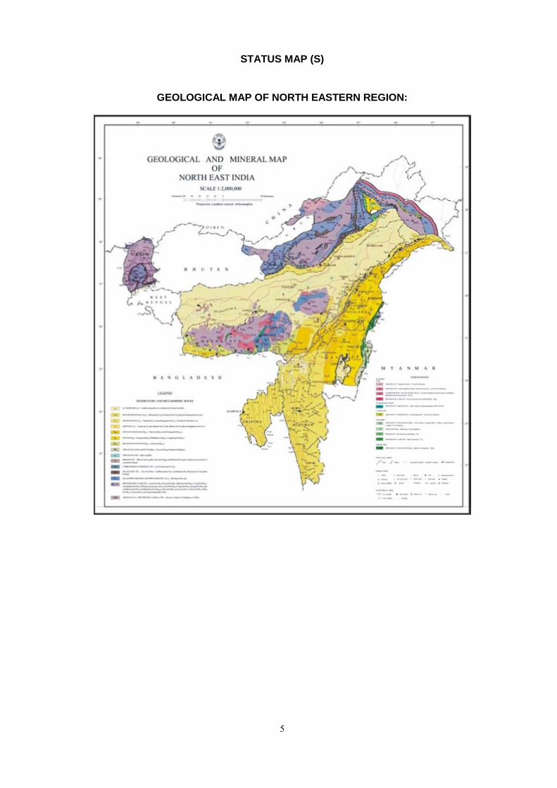
STATUS MAP (S)
GEOLOGICAL MAP OF NORTH EASTERN REGION:

6
STATUS MAP OF SYSTEMATIC GEOLOGICAL MAPPING IN NER
STATUS OF SPECIALISED THEMATIC MAPPING IN NER
7
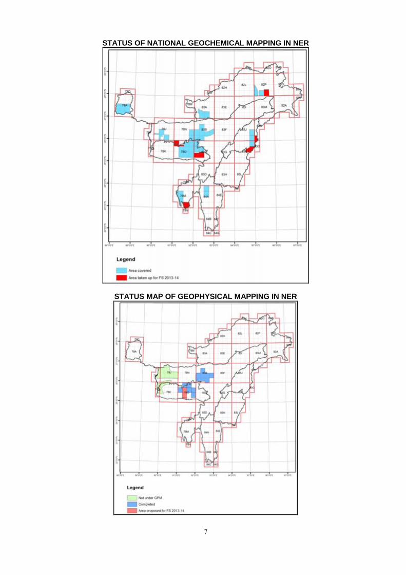
STATUS OF NATIONAL GEOCHEMICAL MAPPING IN NER
STATUS MAP OF GEOPHYSICAL MAPPING IN NER
8
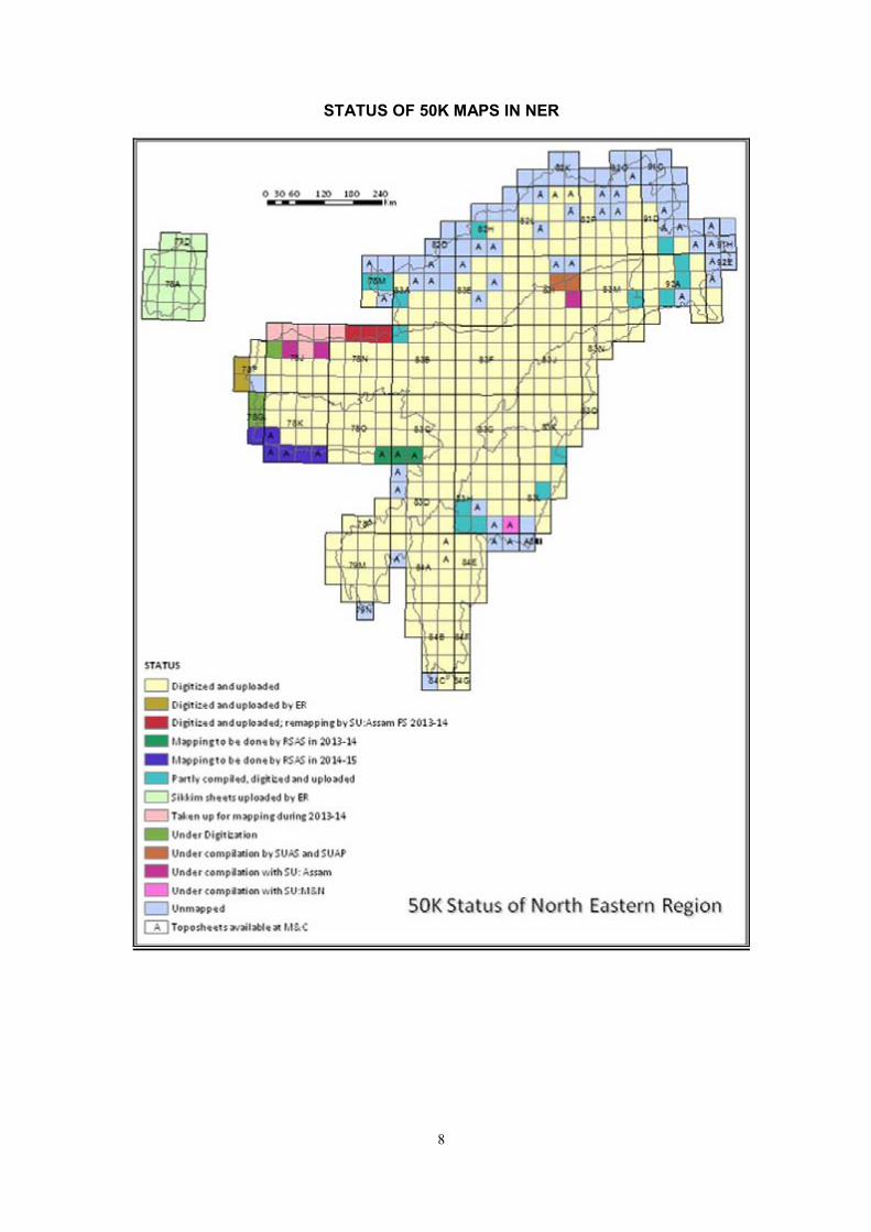
STATUS OF 50K MAPS IN NER
9
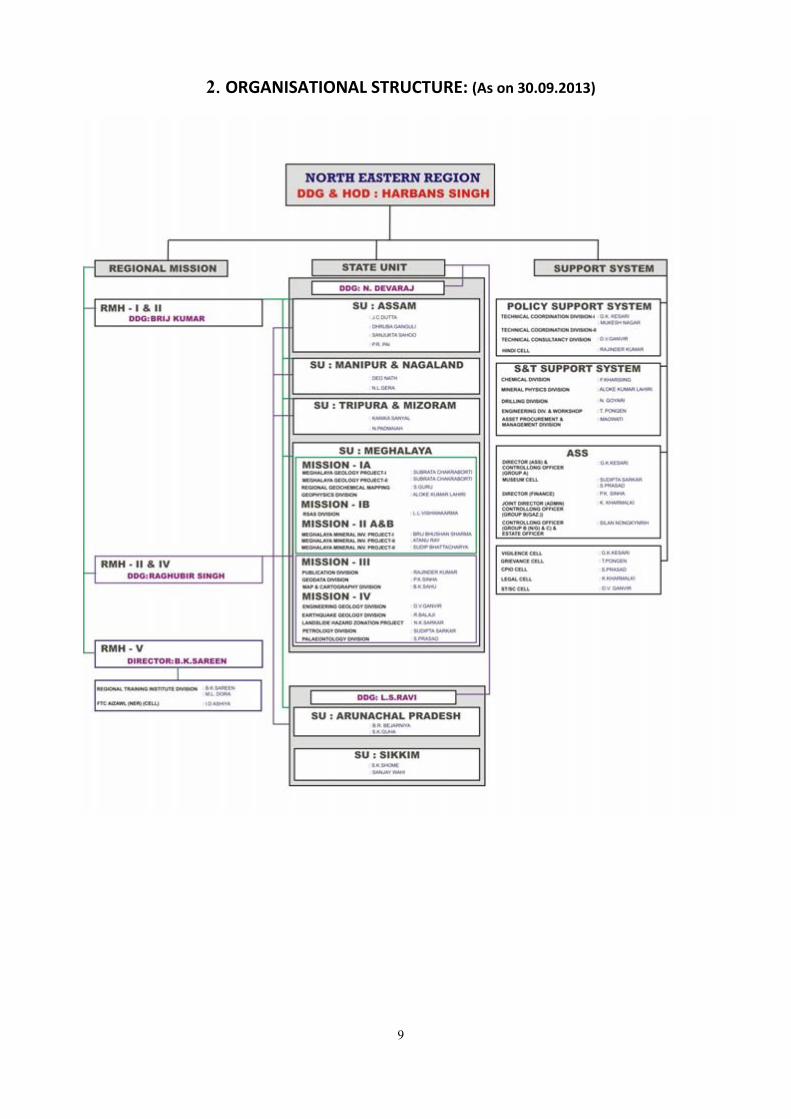
2. ORGANISATIONAL STRUCTURE: (As on 30.09.2013)
10
3. ACTIVITY DOMAIN OF THE REGION
Geological Survey of India, NER encompasses states of Arunachal Pradesh, Assam, Meghalaya, Tripura, Mizoram, Nagaland, Manipur and Sikkim and has carried out surveys in NER.
The important activities of NER includes –
Mission–I : SURVEY & MAPPING
Mission - I, IA Systematic geological mapping, Specialised thematic studies,
Geochemical mapping, Geophysical mapping / surveys
Mission - IB Airborne Mineral Survey,Photogeology and Remote Sensing
Mission–II : MINERAL EXPLORATION
Mission – IIA Mineral Resource assessment
Mission – IIB Natural Energy Resource (Coal)
Mission–III : INFORMATION / DISSEMINATION
Mission - III Geodata and Geoinformatics,
Map compilation and map publication,
Publication and Information delivery
Mission–IV : SPECIAL INVESTIGATION, RESEARCH & DEVELOPMENT
Mission - IV Fundamental Science (Petrology, Palaeontology and Mineral Physics), Multidisciplinary Geoscience (Engineering Geology, Landslide Hazard Zonation and Earthquake Geology, Environmental Geology, Glaciology)
Mission–V : HUMAN RESOURCES DEVELOPMENT
Mission - V Regional Training Institute, Shillong
Field Training Centre, Aizawl
STSS : MODERNISATION, ASSETS PROCUREMENT & MANAGEMENT
Support System - I Analytical Chemistry and Chemical Laboratory network
Drilling & Workshop, Transport
Capital Asset Procurement & Management
Map & Cartography, Infrastructure & Connectivity
Laboratory Network (Geophysical Instrumentation)
Laboratory Network (Petrology Division)
Laboratory Network (Palaeontology Division)
Laboratory Network (Mineral Physics Division)
Support System -II (ASS)
Finance, Personnel, Legal Cell, HRD, Information and Publication, Libraries, Park and Museum, Estate
Policy Support System - III
Science Policy & Coordination , Planning & Monitoring
CGPB Secretariat, Commercial Operation,
Geoscience Partnership

11
4. MISSION WISE INFORMATION FOR FIELD SEASON 2013-14
MISSION-WISE ITEMS (FS 2013-14)
MISSION-WISE ITEMS IN PROGRESS (FS 2013-14)
Mission–I A: SURVEY & MAPPING

12
Systematic Geological Mapping (SGM):
Systematic Geological Mapping of 2,08,357 sq.km (1,44,966 sq.km hard rock and 61,987 sq.km
quaternary) of North Eastern Region has been completed. (2,06,953 sq.km). SGM was taken up in
Nagaland and Manipur and 606 sq.km completed in F.S. 2013-2014.
Specialised Thematic Mapping (STM):
Multidisciplinary specialised thematic mapping was undertaken in the geologically critical areas,
mineral potential areas covering Arunachal Pradesh, Meghalaya, Mizoram, Sikkim and Tripura. 359 sq.km
completed in F.S. 2013-2014.
National Geochemical Mapping (NGCM):
GSI has launched National Geochemical Mapping of the entire country from FS 2000-01 onwards
with a view to generate baseline data, which will be useful in locating/developing natural resources and
in wide application in environmental studies, agriculture, public health and other social concerns.
Geochemical mapping is conceived as a multistage procedure involving analysis of systematically
collected Stream-Sediment-Samples for 66 Elements and creation of a database and national as well as
regional level geochemical maps – all aimed at delineating scale dependent geochemical patterns. When
fully documented these maps will portray the geochemical diversity of the earth’s land surface and cater
to a wide range of needs related to sustainable long term management of environment and natural
resources. The geochemical database can be utilised for targeting mineral exploration, land use,
agriculture, forestry, management of environment, animal and human health etc.
An area of 25196 sq.km (Assam: 7970 sq.km, Arunachal Pradesh: 3631 sq.km, Meghalaya: 8346
sq.km, Mizoram: 1136 sq.km, Nagaland: 1150 sq.km, Sikkim: 2963 sq.km and Tripura: 1746 sq.km) has
been covered till f.s.2012-13. A total of 846 sq.km area completed in F.S. 2013-2014.
Geophysical Mapping:
North Eastern Region of the Geological Survey of India has capability of high precision, high
resolution geophysical equipments, which have put us to a new digital era of Geophysical Surveys on land.
Now, it is possible to utilize Gravity and Magnetic Surveys also in the areas of Environmental Studies,
Landslides, Geotechnical and Seismotectonics surveys.
Gravity-Magnetic mapping have been conducted over the last few years in parts of Meghalaya and
Assam to generate gravity and magnetic maps on 1:50,000 scale. GPM 390 sq.km area completed. Gravity-
magnetic Survey has been carried out along different roads and tracks in 1: 50,000 scale pertaining to
toposheet no. 78O/6, 7 and parts of 8 in west Khasi hills in order to delineate subsurface geological
structures and preparations of G-M maps.
RSAS:
Sl. No.
Item Utility
1. ERADAS Image 2010 installed Digital image processing and interpretation for geological studies.
ERDAS IMAGINE version 2010, classic interface.
Digital image processing and interpretation for geological studies.
2. Geo-coded IRS Images of area part of NER
219 No
3. IRS Images soft copy Total 112 No, For geological studies and survey work.
4. Aerial photographs on 1;50,000 and 30,000 scale
For Geological mapping and studies.
5. Mirror Stereoscopes Total 4 No, For generating optical model of the terrain and study of geology and structure.
6 CARTOSAT-1 (IRS-P5) Terrain modeling , mapping in different terrain, monitoring of environmental parameters, glacial monitoring etc.
13
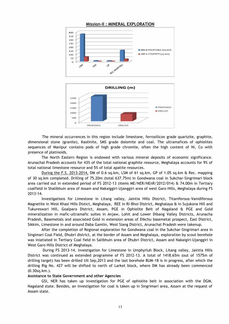
Mission–II : MINERAL EXPLORATION
The mineral occurrences in this region include limestone, ferrosilicon grade quartzite, graphite,
dimensional stone (granite), Kaolinite, SMS grade dolomite and coal. The ultramafices of ophiolites
sequences of Manipur contains pods of high grade chromite, often the high content of Ni, Co with
presence of platinoids.
The North Eastern Region is endowed with various mineral deposits of economic significance.
Arunachal Pradesh accounts for 43% of the total national graphite resource, Meghalaya accounts for 9% of
total national limestone resource and 5% of total apatite resources.
During the F.S. 2013-2014, DM of 0.6 sq.km, LSM of 61 sq.km, GP of 1.05 sq.km & Rec. mapping
of 30 sq.km completed. Drilling of 75.20m (total 637.75m) in Gondwana coal in Sukchar-Singrimari block
area carried out in extended period of FS 2012-13 (items ME/NER/NEnR/2012/014) & 74.00m in Tertiary
coalfield in Shalibhuin area of Assam and Nakaiggiri-Ujanggiri area of west Garo Hills, Meghalaya during FS
2013-14.
Investigations for Limestone in Litang valley, Jaintia Hills District, Titaniferous-Vanidiferous
Magnetite in West Khasi Hills Distict, Meghalaya, REE in Ri-Bhoi District, Meghalaya & in Sujukona Hill and
Tukureswari Hill, Goalpara District, Assam, PGE in Ophiolite Belt of Nagaland & PGE and Gold
mineralization in mafic-ultramafic suites in Anjaw, Lohit and Lower Dibang Valley Districts, Arunacha
Pradesh, Basemetals and associated Gold in extension areas of Dikchu basemetal prospect, East District,
Sikkim, Limestone in and around Daba Gamlin, West Siang District, Arunachal Pradesh were takenup.
After the completion of Regional exploration for Gondwana coal in the Sukchar-Singrimari area in
Singimari Coal Field, Dhubri district, at the border of Assam and Meghalaya, exploration by scout borehole
was iniatiated in Tertiary Coal field in Salibhuin area of Dhubri District, Assam and Nakaigiri-Ujanggiri in
West Garo Hills District of Meghalaya.
During FS 2013-14, Investigation for Limestone in Umphyrluh Block, Litang valley, Jaintia Hills
District was continued as extended programme of FS 2012-13. A total of 1418.65m (out of 1575m of
drilling target) has been drilled till Sep,2013 and the last borehole BUM-18 is in progress, after which the
drilling Rig No. 427 will be shifted to north of Larket block, where DM has already been commenced
(0.30sq.km.).
Assistance to State Government and other Agencies
GSI, NER has taken up investigation for PGE of ophiolite belt in association with the DGM,
Nagaland state. Besides, an investigation for coal is taken up in Singrimari area, Assam at the request of
Assam state.
14
Mission–III : INFORMATION / DISSEMINATION
Publication:
GSI, NER has brought out several publications in the form of books and maps to disseminate
information in earth science. The region has already published the miscellaneous publication No. 30 for
the states of Meghalaya & Assam, Arunachal Pradesh, Nagaland- Manipur and Tripura and Mizoram.
GSI record Vol. 147, Part 4 (Ext. Abst.FS 2012-13) is under compilation.
AGR, Vol. 145-146, Pt. 1 sent to PID, CHQ, Kolkata to publish on 23.07.13.
GSI News Vol.23 is under compilation.
Library Services = 14 nos. geology new books and 91 nos. of journals were procured.
Map & Cartography :
Standardised seamless map of Lithology layer of NER (except SU: Sikkim), upto Formation level
uploaded 346 sheets to GSI Portal.
NER legend compiled and circulated.
DRM have been compiled for Karimganj, Dibrugarh, Dhemaji, Golaghat, Sibsagar, Tinsukia,
Cachar, Hailakandi, Marigaon and Sonitpur of Assam, West and South Garo Hills , Ri-Bhoi and East Garo
Hills districts of Meghalaya, Kohima, Wokha, Phek, Zunheboto, Mon, Tuensang and Mokokchung of
Nagaland and 2 DRMs were circulated for East & West Khasi Hills districts, Meghalaya. During FS 2013-14,
compilation of DRMs of Lakhimpur, Jorhat, Nagaon and North Cachar Hills districts of Assam, Jainitia Hills,
Meghalaya, Aizawl and Champhai districts of Mizoram, Senapti district of Manipur are under progress.
Compilation of DRM of Bongaigaon district, Assam & Tamenglong & Ukhrul districts of Manipur is
completed. Digitization of DRMs of Karbi Anglong district, Kamrup district (FS 2010-12) through
outsourcing is in progress.
QGM of 78O of Meghalaya is in progess.
Scrutiny and finalization of geological maps of 3 toposheets submitted by State Unit: Assam was
completed and submitted to Geodata Division, NER for digitization. Creation of metadata for all the 3
toposheets is in progress. Preparation of unified legend for the entire north eastern region for lithology is
in progress. Creation of attribute database for the 3 geological maps is in progress.
Under Geoinformatics all the relevant progress reports pertaining to different themes – lithology,
structure, mineral resources, drilling etc. have been collected. Data on 50K theme for 15 toposheets –
have been extracted from the reports. Intialization of the above 15 toposheets has been done in the data
entry forms. Data entry pertaining to 50K theme is in progress.
Geodata : There are two linked program with M&C Division for Geodata component. Edge-matching of
different feature elements of graphic geological data and extraction of unpublished reports under
Geoinformatics item is in progress.
Mission–IV : SPECIAL INVESTIGATION, RESEARCH & DEVELOPMENT
Palaeontological Studies:: Search for Micro Mammals, Micro vertebrates and Invertebrate fossils in the intertrappeans of
Sylhet Traps in areas around Thalan, Dewsaw and Shella, East Khasi Hills of Meghalaya” was conducted.
During the F.S. 2013-2014, Section mapping 4 l.km & Rec.survey of 7 sq.km completed.
Egg like fossils were recovered from Upper Mahadek Formation of Upper Cretaceous age.
These egg like fossils are 4-7 inch in diameter. Upper Mahadek Fm is considered to be marine origin. If
these fossils are confirmed as egg fossils, it will be the first time report of marine reptile egg fossil from
Indian sediments. Thin section study suspects egg shell. SEM study is proposed for confirmation.
Geotechnical investigations:
NER may be termed as the ‘power house’ of India as it possesses hydropower potential, which is
about 30% of the total hydel potential of the country. The hydel potential of major river basin of
Arunachal Pradesh like Kameng, Subansiri, Siang, Lohit and Dibang totals production of 34920 MW at 60%
load factor (CEA) i.e. about 90% of the total hydropower resources of NER.
15
A large number of major and minor hydroelectric projects have been completed or are under
various stages of investigation/construction with the active help and support of geoscientific inputs by the
GSI, e.g. Ranganadi, Doyang, Umiam (Barapani), Pare, Kopili, Turial, Kameng, communication projects
and border roads.
Arunachal Pradesh contributes a major share of the water of the Brahmaputra river system and
the high relief offers extensive scope for hydel power generation.
Geotechnical evaluation of water resources development projects in North Eastern Region has
been taken up at the request of the project authorities. GSI has carried out geotechnical studies for
various hydro power projects in the NER:
Feasibility studies: (Dihang (AP), Pare (A.P.), Dikrong (AP), Subansiri (AP), Lohit Dam Project, (A.P),
Dimwe (AP.), Kameng (AP), Atnring (Assam), Amuna (Assam), Kulsi (Assam), Dalaima (Assam), Loktak
(Manipur),Barak (Manipur))
Pre-construction and detailed investigations: (Sessri (AP.), Ranganadi Stage-II, (A.P.), Kamleng (AP.),
Lower Kopili ((Assam)),Intermediate Barapani (Meghalaya), Pagladiya Dam Project (Assam), Tuivai Project
(Mizoram), Tunal Project (Mizoram), Doleswari (Bharvi) project (Mizoram), Mat Valley Project, (Mizoram),
Kolodyne Stage-I, (Mizoram), Kolodyne Stage-II, (Mizoram), Kapak Leyak H.E. Project, Arunachal Pradesh,
Mawhu H.E. Project, Meghalaya, Myntdu – Leshka H.E. Project Stage-II, Meghalaya, Myntdu – Leshka H.E.
Project Stage-II, Meghalaya, Umngot Combined Stage-I & II, H.E. Project, Meghalaya, Umngi H.E. Project
Stage-I, Meghalaya, New Umtru H.E. Project, Meghalaya, Ganol H.E. Project, Meghalaya, Simsang
(Someswari) Multipurpose Project, Meghalaya, Kynshi (Jadukata) Multipurpose Project (Stage-I),
Meghalaya
Construction Stage investigations :Ranganadi (AP.), Kameng HEP (AP), Kopili (Assam), Lower Borpani
(Assam), Doyang HEP, (Nagaland),Thoubal Project (Manipur), Singda Project, (Manipur), Khuga Project
(Manipur),Myntdu – Leshka H.E. Project Stage-I, Meghalaya)
Geotechnical evaluation of Water Resource Development Projects were taken up during FS 2013-14 in
Kameng H.E.Project, West Kameng District, Arunachal Pradesh, Kulsi Multipurpose Dam Project, Kamrup
District, Assam, Turial H.E.Project, Aizawl District, Mizoram and Mawblei H.E.Project, West Khasi Hills
District, Meghalaya.
Landslide Hazard Studies:
Landslide Hazard Zonation Project (LHZP) was formed during 1995 to exclusively cater to the
needs of landslide studies in NER by GSI. Subsequently GSI was declared nodal agency for landslides by
Govt. of India in 2004. GSI has undertaken studies related to landslide at specific request from State
Governments and other organizations. The information has been often used by Government and other
organizations for better planning of their infrastructures, developmental activities and disaster
preparedness.
The problem of landslide hazard is multiplied in recent times due to increased developmental
activities like construction of road, building and various infrastructures. GSI has covered major part of
urban agglomerations, road corridors of the vulnerable hilly terrain in NE India through macro scale
landslide susceptibility mapping. GSI undertakes site specific landslide investigation for containing the
distressing in the hill slopes, comprehensive understanding of the processes, and formulation of both short
and long term mitigation measures. GSI also attempted monitoring of few conspicuous slides in Sikkim and
Meghalaya. GSI, NER regularly updates the landslide database of the entire NE regions through landslide
inventory work. After became a declared nodal agency for understanding the coordinating landslide
investigation and formulation for mitigation measures. GSI’s activity for Landslide Hazard Risk Mitigation
in region includes Pre-Disaster Study, Landslide Zonation Mapping, Landslide Inventory Work, Detailed Site
Specific Study of landslide for identifying causative factor and most suitable remedial measures, Landslide
monitoring/real time monitoring by instrumentation for development of an early warning system.
16
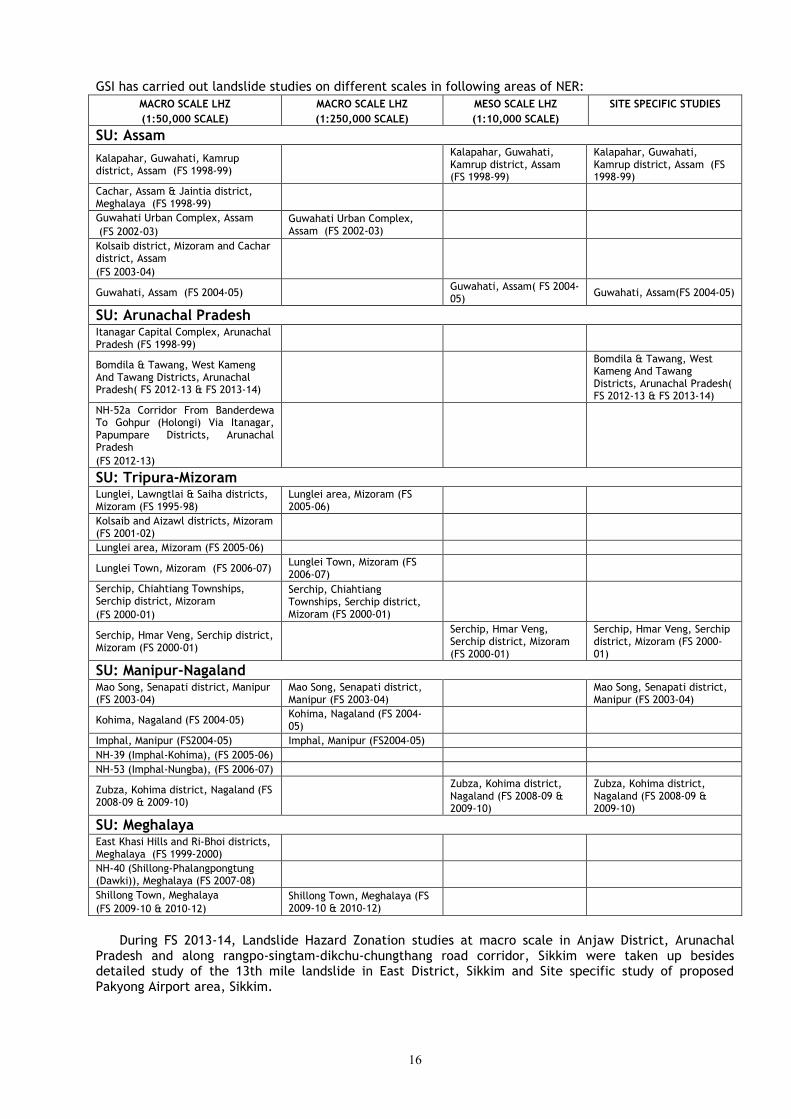
GSI has carried out landslide studies on different scales in following areas of NER:
MACRO SCALE LHZ
(1:50,000 SCALE)
MACRO SCALE LHZ
(1:250,000 SCALE)
MESO SCALE LHZ
(1:10,000 SCALE)
SITE SPECIFIC STUDIES
SU: Assam
Kalapahar, Guwahati, Kamrup district, Assam (FS 1998-99)
Kalapahar, Guwahati, Kamrup district, Assam (FS 1998-99)
Kalapahar, Guwahati, Kamrup district, Assam (FS 1998-99)
Cachar, Assam & Jaintia district, Meghalaya (FS 1998-99)
Guwahati Urban Complex, Assam
(FS 2002-03)
Guwahati Urban Complex, Assam (FS 2002-03)
Kolsaib district, Mizoram and Cachar district, Assam
(FS 2003-04)
Guwahati, Assam (FS 2004-05) Guwahati, Assam( FS 2004-05)
Guwahati, Assam(FS 2004-05)
SU: Arunachal Pradesh
Itanagar Capital Complex, Arunachal Pradesh (FS 1998-99)
Bomdila & Tawang, West Kameng And Tawang Districts, Arunachal Pradesh( FS 2012-13 & FS 2013-14)
Bomdila & Tawang, West Kameng And Tawang Districts, Arunachal Pradesh( FS 2012-13 & FS 2013-14)
NH-52a Corridor From Banderdewa To Gohpur (Holongi) Via Itanagar, Papumpare Districts, Arunachal Pradesh
(FS 2012-13)
SU: Tripura-Mizoram
Lunglei, Lawngtlai & Saiha districts, Mizoram (FS 1995-98)
Lunglei area, Mizoram (FS 2005-06)
Kolsaib and Aizawl districts, Mizoram (FS 2001-02)
Lunglei area, Mizoram (FS 2005-06)
Lunglei Town, Mizoram (FS 2006-07) Lunglei Town, Mizoram (FS 2006-07)
Serchip, Chiahtiang Townships, Serchip district, Mizoram
(FS 2000-01)
Serchip, Chiahtiang Townships, Serchip district, Mizoram (FS 2000-01)
Serchip, Hmar Veng, Serchip district, Mizoram (FS 2000-01)
Serchip, Hmar Veng, Serchip district, Mizoram (FS 2000-01)
Serchip, Hmar Veng, Serchip district, Mizoram (FS 2000-01)
SU: Manipur-Nagaland
Mao Song, Senapati district, Manipur (FS 2003-04)
Mao Song, Senapati district, Manipur (FS 2003-04)
Mao Song, Senapati district, Manipur (FS 2003-04)
Kohima, Nagaland (FS 2004-05) Kohima, Nagaland (FS 2004-05)
Imphal, Manipur (FS2004-05) Imphal, Manipur (FS2004-05)
NH-39 (Imphal-Kohima), (FS 2005-06)
NH-53 (Imphal-Nungba), (FS 2006-07)
Zubza, Kohima district, Nagaland (FS 2008-09 & 2009-10)
Zubza, Kohima district, Nagaland (FS 2008-09 & 2009-10)
Zubza, Kohima district, Nagaland (FS 2008-09 & 2009-10)
SU: Meghalaya
East Khasi Hills and Ri-Bhoi districts, Meghalaya (FS 1999-2000)
NH-40 (Shillong-Phalangpongtung (Dawki)), Meghalaya (FS 2007-08)
Shillong Town, Meghalaya
(FS 2009-10 & 2010-12)
Shillong Town, Meghalaya (FS 2009-10 & 2010-12)
During FS 2013-14, Landslide Hazard Zonation studies at macro scale in Anjaw District, Arunachal
Pradesh and along rangpo-singtam-dikchu-chungthang road corridor, Sikkim were taken up besides detailed study of the 13th mile landslide in East District, Sikkim and Site specific study of proposed Pakyong Airport area, Sikkim.
17
Earthquake Studies: During FS 2013-14, study of Seismic and Landslide Hazard Assessment of Aizwal town, Mizoram &
Kohima City, Nagaland and Gangtok and surrounding areas of Sikkim were taken up.
Aizwal town, Mizoram Field work carried out in and around the Aizawl master plan area and covered 15 sq. km area by surface geological mapping on 1:25,000 scales. One rock sample for geotechnical studies was collected. Geological mapping revealed that the lithological units are trending NNW-SSE to NNE-SSW with varying amounts of easterly and westerly dip. The litho- stratigraphic succession within the Aizawl master plan area shows the special distribution of various litho units belonging to the Bhuban Formation of Surma Group of Miocene age. The repetitive sequence of alternating siltstone, shale and sandstone belonging to Bhuban Formation are exposed in the road cutting section and Quarry sites. Overall geological structure along and across the elongated hill on which the town is located is represented by N-S trending anticline and corresponding syncline. These are traversed by sets of E-W trending fault systems which are having distinct geomorphic expressions of faulting. Different slope forming materials like highly weathered mantle rocks and colluvial materials ranging its thickness from 1 to 8 m thick were studied and mapped for arriving at the site response / landslide hazard assessment. A few tiny old and fresh landslide incidences within the master plan area were studied and recorded. These slides appear to have occurred due to planar failure and wedge failures along the adversely disposed litho‐units consisting of sandstone, siltstone with thin band of shale. Load of the building constructed on the dip slope face appears to aggravate the slope failure as it appears that there has been no effective restrain at the base of the failed slope. The rain water lubricated the interface of the overburden material exposed above the rock units and the interfaces of the rock units exposed at these places. Besides this, collected 9 years rainfall data studied the master plan area and collected demographic information for the preparation of land use and land cover map. Collection, collation & Synthesis of the past seismicity data within the 300 km radius in and around Aizwal area was undertaken. Finalisation and processing of reports pertaining to the FS 2009-13 entitled “Active Fault studies around foot hills of Assam-Arunachal Himalaya / Mishmi Block, Arunachal Pradesh” for uploading and circulation was also carried out. Kohima City, Nagaland
Preliminary analysis of seismicity data from the year 1897 to 2013 around 300 kms radius of Kohima was carried out to identify and delineate Seismic source zone for the site, Kohima. The analysis has indicated high seismic activity along the Eastern Boundary Thrust Fault which is located about 83kms south/southeast of Kohima. Moderately high seismic activity along the Belt of Schuppen, Kopili Fault and Shillong massif Seismogenic zone was also observed, which is located within 100kms and 200kms respectively from the Kohima area.
Kohima Master Plan area map with information on existing and proposed land use was collected from the Department of Urban Development, Government of Nagaland and studied / synthesised the baseline data for planning of the future course of work within the master plan area. Study and synthesis of rainfall data for 30 years of the study area, provided by the Department of Soil and water conservation, Government of Nagaland was also undertaken.
Surface Geological mapping on 1:25,000 scale covering 10 Sq.Km in the south western part of the Master Plan was undertaken. The disposition of different slope forming material likes the younger loose debris, weathered rock etc with respect to the bedrock were delineated. The rocks of Disang Group mainly constituted by black carbonaceous shale are conformably overlain by the sandstones of Laisong Formation of the Barail group in the study area.
Study of active landslide incidences within the Master plan area like the Phesama slide, old dumping slide along NH-29 and Merema slide along NH-61 were also undertaken and the causative factors of the slide, morphology of the slide, etc. were studied and appropriate remedial measures were suggested.
Preparation of slope morphometry map and collection of data (05 sq. km) on different geofactors like lithology, structure, land use/cover, hydrological condition etc for landslide hazard zonation.
Gangtok, Sikkim -Study of toposheet and SRTM data to delineate different geomorphic /morphotectonic units and Lineaments. Seismic Hazard Assessment of Gangtok and surrounding areas of Sikkim were initiated by State Unit: Sikkim. Recording of ambient noise for Seismic site response study in Gangtok and surrounding areas was carried out.35 stations have been completed. Processing of acquired raw data pertaining to the area is in progress.
18
The Seismic Observatories installed at Agartala (Tripura), Itanagar (Arunachal Pradesh) and Adampool, Gangtok (Sikkim), which are equipped with broadband seismographs, are being used to record the seismicity round the clock of the North Eastern Region and its adjoining neighboring countries, such as Bhutan, Nepal, Bangladesh, and Myanmar. These Observatories are very useful for providing potential information on earthquake genesis of the eastern Himalayan region as well as sub-oceanic earthquakes from the Bay of Bengal, which will be helpful in evolving earthquake mitigation model for the region as a long-term goal.
Mission–V : HUMAN RESOURCES DEVELOPMENT
Sl no
Month Title of the course conducted
Location of training
Duration Of training
No of Participant
Remark
1. July,13 36th OCG, Batch-H FTC-Aizwal 11 days from 24.06.13 to 04.07.13
26 Conducted Training for 36th OCG-Batch-H and Capsule course on chemical training for DGM, NER and refresher course on petrology for DGM and GSI,NER
2. July,13 36th OCG, Batch-H RTI, Shillong
19 days from 05.07.13 To 23.07.13
26
3. Aug,13 Capsule course on chemical analysis of rock samples for DGM ,NER
RTI, Shillong
6 days from 19.8.13 to 24.8.13
Total-10 DGMs- ASSAM-3; MEG-2; MAN-2; NAG-1; GSI-MEG-2
4. Sep,13 Refresher course for petrology training for Geologist of DGM and GSI,NER
RTI, Shillong
12 days from 26.8.13 to 6.9.13
15 DGMs- ASSAM-2 MEG-1 NAG-2 GSI-NER-10
19
STSS : MODERNISATION, ASSETS PROCUREMENT & MANAGEMENT
Chemical Lab: Sl. NO. Instruments Description
1 XRF Analysis of Package ‘A’ of NGCM samples and Non-NGCM samples
2 AAS Flame Analysis of Package ‘C’ of NGCM samples and Non-NGCM samples
3 AAS FIAS Analysis of Package ‘D’ of NGCM samples and Non-NGCM samples
4 Ion Analyser Analysis of Package ‘E’ of NGCM samples and Non-NGCM samples
5 D.M.A Analysis of Package G of NGCM and Non-NGCM samples
Output:
April 2013 to June 2013 3152 samples with 37,387 determination Norms Achieved
July 2013 to September 2013 3127 samples with 26,707 determination Norms Achieved
Note: Above output includes analysis of NGCM & NON-NGCM Samples AMC:
INSTRUMENTS PERIOD NO. OF VISITS AMOUNTS (Rs.)
XRF (CAMC) 01.05.2013 to 31.10.2013 2 5,61,800/- (2nd Installment)
AAS 01.07.2013 to 31.12.2013 2 49,438/- (1st Installment)
UPS for the above Instruments
01.10.2012 to 30.09.2013 On Call No. limit 53,933
Budget:
2013 - 2014 36.10 Lakhs
20
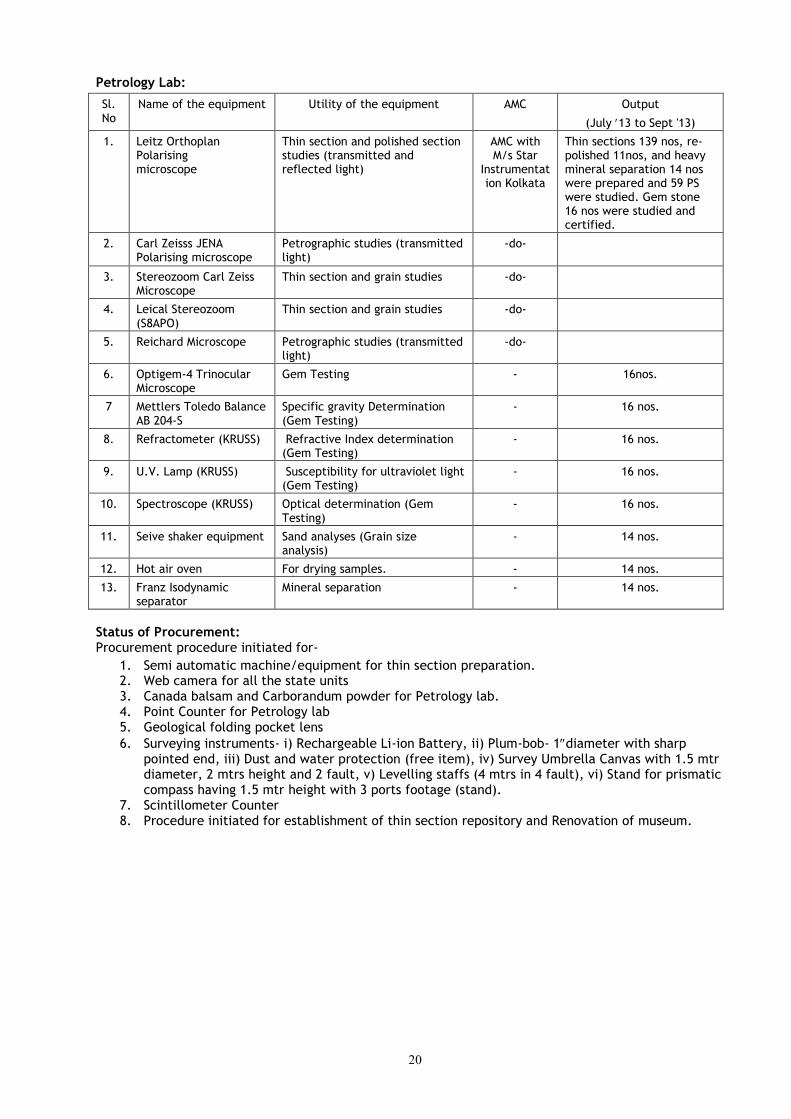
Petrology Lab:
Sl. No
Name of the equipment Utility of the equipment AMC Output
(July 13 to Sept '13)
1. Leitz Orthoplan Polarising microscope
Thin section and polished section studies (transmitted and reflected light)
AMC with M/s Star
Instrumentation Kolkata
Thin sections 139 nos, re-polished 11nos, and heavy mineral separation 14 nos were prepared and 59 PS were studied. Gem stone 16 nos were studied and certified.
2. Carl Zeisss JENA Polarising microscope
Petrographic studies (transmitted light)
-do-
3. Stereozoom Carl Zeiss Microscope
Thin section and grain studies -do-
4. Leical Stereozoom (S8APO)
Thin section and grain studies -do-
5. Reichard Microscope Petrographic studies (transmitted light)
-do-
6. Optigem-4 Trinocular Microscope
Gem Testing - 16nos.
7 Mettlers Toledo Balance AB 204-S
Specific gravity Determination (Gem Testing)
- 16 nos.
8. Refractometer (KRUSS) Refractive Index determination (Gem Testing)
- 16 nos.
9. U.V. Lamp (KRUSS) Susceptibility for ultraviolet light (Gem Testing)
- 16 nos.
10. Spectroscope (KRUSS) Optical determination (Gem Testing)
- 16 nos.
11. Seive shaker equipment Sand analyses (Grain size analysis)
- 14 nos.
12. Hot air oven For drying samples. - 14 nos.
13. Franz Isodynamic separator
Mineral separation - 14 nos.
Status of Procurement: Procurement procedure initiated for-
1. Semi automatic machine/equipment for thin section preparation. 2. Web camera for all the state units 3. Canada balsam and Carborandum powder for Petrology lab. 4. Point Counter for Petrology lab 5. Geological folding pocket lens
6. Surveying instruments- i) Rechargeable Li-ion Battery, ii) Plum-bob- 1diameter with sharp pointed end, iii) Dust and water protection (free item), iv) Survey Umbrella Canvas with 1.5 mtr diameter, 2 mtrs height and 2 fault, v) Levelling staffs (4 mtrs in 4 fault), vi) Stand for prismatic compass having 1.5 mtr height with 3 ports footage (stand).
7. Scintillometer Counter 8. Procedure initiated for establishment of thin section repository and Renovation of museum.
21
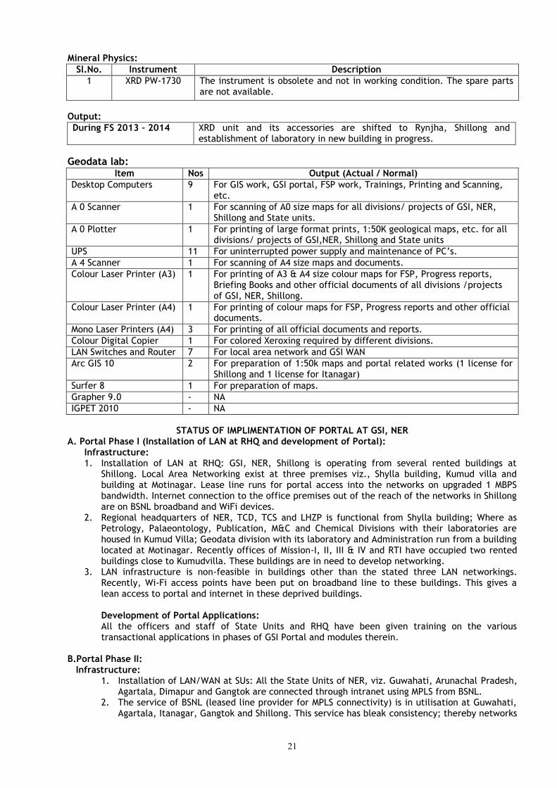
Mineral Physics:
Sl.No. Instrument Description
1 XRD PW-1730 The instrument is obsolete and not in working condition. The spare parts are not available.
Output:
During FS 2013 – 2014 XRD unit and its accessories are shifted to Rynjha, Shillong and establishment of laboratory in new building in progress.
Geodata lab: Item Nos Output (Actual / Normal)
Desktop Computers 9 For GIS work, GSI portal, FSP work, Trainings, Printing and Scanning, etc.
A 0 Scanner 1 For scanning of A0 size maps for all divisions/ projects of GSI, NER, Shillong and State units.
A 0 Plotter 1 For printing of large format prints, 1:50K geological maps, etc. for all divisions/ projects of GSI,NER, Shillong and State units
UPS 11 For uninterrupted power supply and maintenance of PC’s.
A 4 Scanner 1 For scanning of A4 size maps and documents.
Colour Laser Printer (A3) 1 For printing of A3 & A4 size colour maps for FSP, Progress reports, Briefing Books and other official documents of all divisions /projects of GSI, NER, Shillong.
Colour Laser Printer (A4) 1 For printing of colour maps for FSP, Progress reports and other official documents.
Mono Laser Printers (A4) 3 For printing of all official documents and reports.
Colour Digital Copier 1 For colored Xeroxing required by different divisions.
LAN Switches and Router 7 For local area network and GSI WAN
Arc GIS 10 2 For preparation of 1:50k maps and portal related works (1 license for Shillong and 1 license for Itanagar)
Surfer 8 1 For preparation of maps.
Grapher 9.0 - NA
IGPET 2010 - NA
STATUS OF IMPLIMENTATION OF PORTAL AT GSI, NER
A. Portal Phase I (Installation of LAN at RHQ and development of Portal): Infrastructure: 1. Installation of LAN at RHQ: GSI, NER, Shillong is operating from several rented buildings at
Shillong. Local Area Networking exist at three premises viz., Shylla building, Kumud villa and building at Motinagar. Lease line runs for portal access into the networks on upgraded 1 MBPS bandwidth. Internet connection to the office premises out of the reach of the networks in Shillong are on BSNL broadband and WiFi devices.
2. Regional headquarters of NER, TCD, TCS and LHZP is functional from Shylla building; Where as Petrology, Palaeontology, Publication, M&C and Chemical Divisions with their laboratories are housed in Kumud Villa; Geodata division with its laboratory and Administration run from a building located at Motinagar. Recently offices of Mission-I, II, III & IV and RTI have occupied two rented buildings close to Kumudvilla. These buildings are in need to develop networking.
3. LAN infrastructure is non-feasible in buildings other than the stated three LAN networkings. Recently, Wi-Fi access points have been put on broadband line to these buildings. This gives a lean access to portal and internet in these deprived buildings.
Development of Portal Applications:
All the officers and staff of State Units and RHQ have been given training on the various transactional applications in phases of GSI Portal and modules therein. B.Portal Phase II:
Infrastructure: 1. Installation of LAN/WAN at SUs: All the State Units of NER, viz. Guwahati, Arunachal Pradesh,
Agartala, Dimapur and Gangtok are connected through intranet using MPLS from BSNL. 2. The service of BSNL (leased line provider for MPLS connectivity) is in utilisation at Guwahati,
Agartala, Itanagar, Gangtok and Shillong. This service has bleak consistency; thereby networks

22
provide off and on intermittent / frequently disrupted sessions on internet, so the portal access. Comprehensive AMC of LAN/WAN equipment is awarded to M/s Hue Service Pvt. Ltd, Guwahati.
3. IP phones installed at all locations and video conferencing installed at RHQ.
4. IT infrastructure, videoconferencing & IP telephony: MLLN link is commissioned at Shylla Building, Kumud Villa Complex and Motinagar Building in Shillong and at Guwahati, Gangtok, Dimapur and at Itanagar offices. Video conferencing unit is installed at Dy.D.G office, Shylla building, Shillong. The bandwidth for the link at Shylla building, Kumud Villa complex and Motinagar office was upgraded from 128 kbps to 1 Mbps now. IP telephones are installed where MLLN link is commissioned and are being used for inter office communication.
5. GSI portal is accessible through WAN at Shillong (Shylla bldg, Kumud Villa complex and Motinagar bldg.), Guwahati, Itanagar, Gangtok and Dimapur offices.
6. Connectivity issue/Networking and progress: GSI, Itanagar is under pursuance with BSNL authorities and CHQ for upgrading the bandwidth for GSI Portal connectivity.
Upgradation of Network 2013: A project titled “Replacement, upgradation and augmentation of networking devices at different offices of GSI” has been taken up by CHQ. ‘Nodal Officer’ for each and every independently located LAN were identified.Devices for replacement/upgradation of existing Network Devices were received through HCL Comnet and taken into Stock. Installation and temporary configuration attempts were made in Shylla bldg and Motinagar bldg.
C. Uploading of data and Portal Applications:
1.Uploading of 1:50K maps to GSI Portal: 346nos. of 1:50k map layers and metadata have been uploaded in GSI portal till date.
D. Transactional Applications: Transactional Applications on HRMIS, Payroll, FSPMIS and Claims modules are operational and are being used by various users in NER.
i) HRMIS: Four new MTS staff was inducted in RHQ, Shillong and their HRMIS data were uploaded Data of all employees of NER uploaded and is being updated regularly. ii) FSPMIS: Geodata extended its help to officers of different Projects/Divisions/ State units for uploading FSP programs and FSP Technical Reports through FSPMIS. Iii) PAYROLL: Pay is being processed through portal at RHQ, Shillong, SU: Guwahati and SU: Dimapur. Payroll data entered at SU: Agartala. iv) TOUR and LEAVE: Applications of all officers & employees are being submitted through portal. v) CLAIMS: RCA/NRCA is being processed by Accounts Sections on portal at RHQ, Shillong. Geodata helps the Accounts Sections Staff in case of any problem faced by them.
The current usage is limited due to poor or intermittent connectivity and limited awareness about the usage of transactional modules. Efforts are being made to resolve the problems of intermittent WAN connectivity and poor services by providing alternate resources. Other services rendered by Geodata division
Geodata provides software support, scanning on A0 size, other computer related services and plotting and printing of documents for the officers of divisions of GSI, NER. Besides, Geodata maintains the stock registers for the computer hardware and software. Geodata also has a role extended towards maintenance of hardware and software in the Divisions on AMC.
Geodata extend its service as a collaborator in the training course on GSI Portal applications to the users in the usage of Transactional modules, conducted by RTI, NER.
Geophysical Instrumentation lab: Geophysical Instrumentation division of NER is mainly entrusted with the work of repairs, servicing, preventive maintenance, Testing and calibration of various Geophysical field, laboratory test & measuring instruments/Generators. Personnel of Instrumentation division are actively associated with geophysical exploration work & in maintaining instruments in the field and lab. The division is also engaged in preparation of technical specifications for procurement of advanced geophysical instruments and providing logistic support for commissioning/installation of newly procured Geophysical equipments.
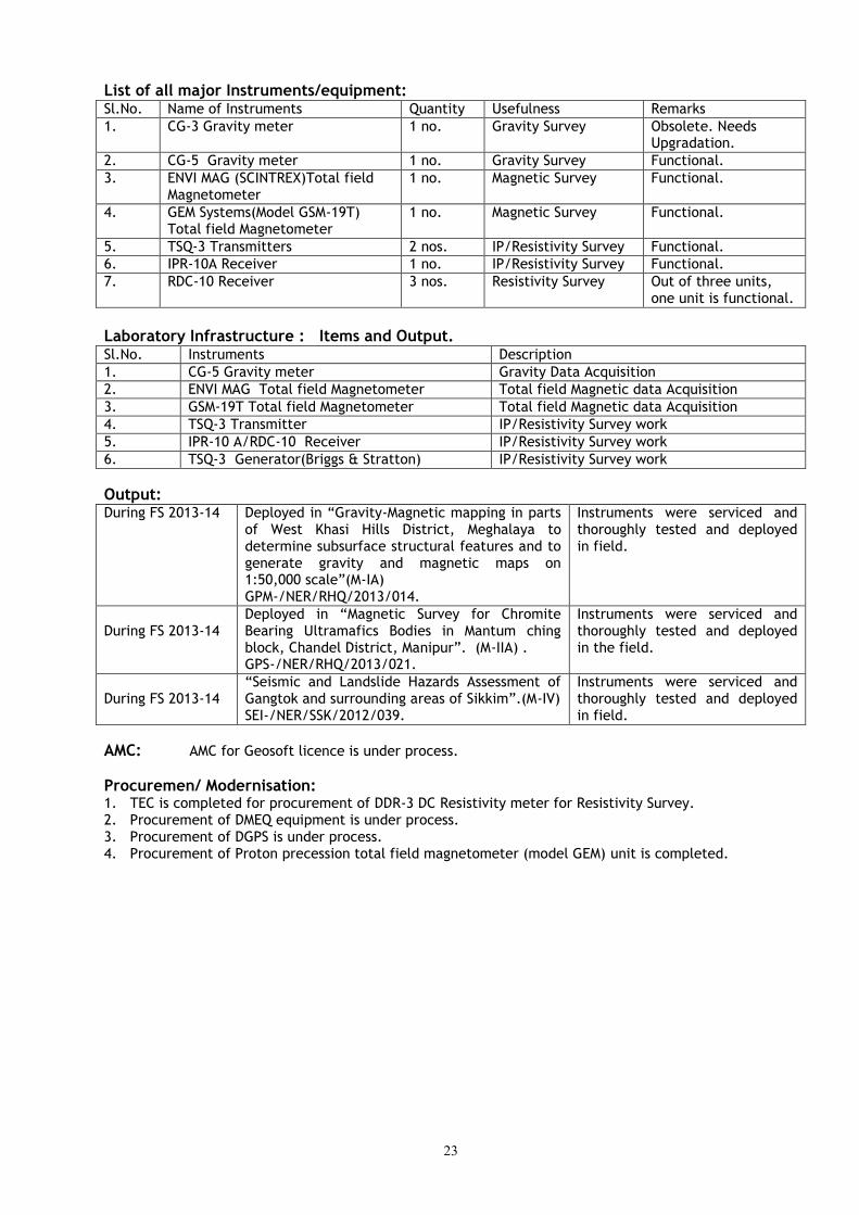
23
List of all major Instruments/equipment: Sl.No. Name of Instruments Quantity Usefulness Remarks
1. CG-3 Gravity meter 1 no. Gravity Survey Obsolete. Needs Upgradation.
2. CG-5 Gravity meter 1 no. Gravity Survey Functional.
3. ENVI MAG (SCINTREX)Total field Magnetometer
1 no. Magnetic Survey Functional.
4. GEM Systems(Model GSM-19T) Total field Magnetometer
1 no. Magnetic Survey Functional.
5. TSQ-3 Transmitters 2 nos. IP/Resistivity Survey Functional.
6. IPR-10A Receiver 1 no. IP/Resistivity Survey Functional.
7. RDC-10 Receiver 3 nos. Resistivity Survey Out of three units, one unit is functional.
Laboratory Infrastructure : Items and Output. Sl.No. Instruments Description
1. CG-5 Gravity meter Gravity Data Acquisition
2. ENVI MAG Total field Magnetometer Total field Magnetic data Acquisition
3. GSM-19T Total field Magnetometer Total field Magnetic data Acquisition
4. TSQ-3 Transmitter IP/Resistivity Survey work
5. IPR-10 A/RDC-10 Receiver IP/Resistivity Survey work
6. TSQ-3 Generator(Briggs & Stratton) IP/Resistivity Survey work
Output: During FS 2013-14 Deployed in “Gravity-Magnetic mapping in parts
of West Khasi Hills District, Meghalaya to determine subsurface structural features and to generate gravity and magnetic maps on 1:50,000 scale”(M-IA) GPM-/NER/RHQ/2013/014.
Instruments were serviced and thoroughly tested and deployed in field.
During FS 2013-14
Deployed in “Magnetic Survey for Chromite Bearing Ultramafics Bodies in Mantum ching block, Chandel District, Manipur”. (M-IIA) . GPS-/NER/RHQ/2013/021.
Instruments were serviced and thoroughly tested and deployed in the field.
During FS 2013-14
“Seismic and Landslide Hazards Assessment of Gangtok and surrounding areas of Sikkim”.(M-IV) SEI-/NER/SSK/2012/039.
Instruments were serviced and thoroughly tested and deployed in field.
AMC: AMC for Geosoft licence is under process.
Procuremen/ Modernisation: 1. TEC is completed for procurement of DDR-3 DC Resistivity meter for Resistivity Survey. 2. Procurement of DMEQ equipment is under process. 3. Procurement of DGPS is under process. 4. Procurement of Proton precession total field magnetometer (model GEM) unit is completed.
24
Technical Consultancy Services Sponsoring Agencies namely Brahmaputra Board, MeECL, NEEPCO, NF Railway, CWC, NHPC etc for
current project works were interacted for resource generationand recovery of service tax. The cost estimate for raising the bills in respect of geotechnical investigation item taken up during FS 2012-13 has been carried out. In addition, bills pertaining to petrological and chemical analysis were computed and raised as and when samples were received from the party. As a government policy, the pricing of the reports of restricted area were carried out as and when the demand was placed by the user agencies. Besides these bills, subsequent reminders were sent to the sponsoring agencies for the payment of pending service taxes particularly for the period between 2000 and 2005.
The internal resource generated in FS 2013-14 is given in following table:
Internal Resource: Rs.19,84,475/- (Rupees Nineteen lacs sixty six thousand five hundred and sixty
eight only)
Service Tax: Rs.1,43,366/- (Rupees One lac fourty three thousand three hundred and sixty
six only)
Pending Service: Tax
(2000-05)
Rs.63,162/- (Rupees Sixty three thousand one hundred and sixty two only)
Amount Received: Rs. 21,91,003/- (Rupees Twenty one lacs ninety one thousand three only)
5. FINANCIAL PERFORMANCE Financial outlay and expenditure during XI plan period has been given in Annexure -3A. Scheme-
wise, quarter-wise distribution of approved plan funds and actual expenditure during 2013-14 (2ND quarter) are given in Anneure-3b &3C.
6. MISSION WISE RCA EXPENDITURE The details of RCA expenditure in different projects visa-vis targets and achievements of FS 2013-14 are given in annexure-04.
7. SCIENTIFIC WORKSHOPS / MEETINGS / SEMINARS / SYMPOSIUM, EXHIBITIONS ETC., ORGANISED / PARTICIPATED. State Geological Programming Board (SGPB)/ RAC/OAC Meetings SGPB/RAC meetings for different states of NER were held from time to time the detail of which is given in annexure-11.
8. HRD, ESTABLISHMENT, PAYROLL, HRMIS, E-SERVICE BOOK, ETC. Statement on RTI Act : 8 cases received, 7 replied, pendin 1 case
Statement on Grievance cases : No case is pending on Grievance. Statement on Vigilance cases : No case is pending on Vigilance.
Statement of pending VIP reference cases in the Region : Nil The information on Employment position in the Region is given in Annexure – 12. The HRMIS
details in respect of Group A, B & C have already been uploaded to GSI Portal.
9. VEHICLES & TRANSPORT INFRASTRUCTURE INCLUDING OUTSOURCING AND AGE OF VEHICLES, VEHICLES MIS.
The required information is given in the attached Annexure – 13.
10. MODERNIZATION As a part of the efforts for meeting emerging challenges, GSI is constantly upgrading its technology both for field and laboratory equipments and efforts are being made to modernize the Geodata, Petrology and Chemical Laboratories
11. DRILLING INFRASTRURE Status of drilling activities, performance and cost effectiveness The status of drilling in NER during FS 2013-14 is given in Annexure – 15A.
25
Efforts for Modernizing Drilling Machinery Indents are being prepared for replacement of old machineries and accessories keeping in view the type of drilling assignment to be taken up in the near future.
12. OUTSOURCING OF ROUTINE SERVICES (HOUSKEEPING, SECURITY, GARDEN, ETC.)
The housekeeping of GSI offices in NER is being done by the Departmental personnel. Security at GSI, Itanagar office is outsourced. Contractural workers are employed for durwan duty, other office work as and when required.
13. OTHER ACTIVITIES
Details of Museums and curatorial activities in the Region and operational units: Nodal officer with Museum committee visited Don Bosco Museum for Surveying, which would
provide guidance to establish geological museum in NER, Shillong. Other procedures of sample selection/ collection and arrangement for display etc are in progress. Two Museums each in Petrology and Palaeontology Division, RHQ, Shillong are being maintained by respective units. One Rock Garden, GSI, Itanagar is being maintained by SU: Arunachal Pradesh, GSI, Itanagar. Nodal Officers in all State Units have been nominated for maintenance/upkeep for museum. Library: Library facilities are available in the Publication Division, RHQ, Shillong and in all the State Units of North Eastern Region. Core Library: The Cores of Litang Valley Limestone investigation, Jaintia Hills district, Meghalaya and Mawmaram basemetal investigation, East Khasi hills district have been skeletonised and preserved at Shillong. Core Library formation is being initiated. The phase lifting of core shed at GSI Guwahati campus is under process.
14. SPECIAL SCIENTIFIC STUDY: NA
15. PERCEPTION MANAGEMENT ACTIVIES IN NER
RTI, Shillong organized training for Officers of State DGMs of North Eastern Region. (Photographs of training given in field, lab and lectures in classroom are in back page.
16. SAVOTTAM: Service Quality Improvement initiative was taken & declared DDG & RMH as Nodal
Officer for Quality Management. They will look after implementation of an appropriate Service Quality Management System i.e - Successful implementation of Citizen’s Charters, identification of services rendered, the quality of service delivery process, its control and delivery requirements. NER also has a good Public Grievance Redress Mechanism headed by Joint Director (P&A).
17. CONSOLIDATED LIST OF GROUP A & B OFFICERS IN NER (GAZETTED)
Please see attached Annexure – 17.

26
ANNEXURE-1A
MAJOR MINERALS RESOURCES [UNDER VARIOUS UNFC CATEGORIES] ESTIMATED BY THE REGION, SHOWING STATE-WISE FIVE-YEARLY INCREMENT, FOR THE LAST 15 YEARS.
COMMODITY/ MINERAL
STATE 1995 -2000 2001- 2005 2006-2012
Limestone Meghalaya 3062.71mt (332)
2678.24mt. (332)
Annual Increment to National Inventory
ANNEXURE-1B NATIONAL MINERAL INVENTORY
NO. OF REPORTS CONVERTED AS PER UNFC COMPLIANCE Nodal Officer: Shri Brij Kumar, DDG & RMH, GSI, NER, Shillong.
Upto December 2010 Upto March 2012
Meghalaya 2004 – 05 onwards – 08 nos. Completed
Pre-F.S. 2004-05 – 22 nos. Completed
Arunachal Pradesh 2004 – 05 onwards – Nil Nil
Pre-F.S. 2004-05 – 05 nos. Completed
Agartala 2004 – 05 onwards – Nil Nil
Pre-F.S. 2004-05 – 18 nos. Completed
Guwahati 2004 – 05 onwards – Nil Nil
Pre-F.S. 2004-05 – 06 nos. Completed
Sikkim 2004 – 05 onwards – Nil Nil
Pre-F.S. 2004-05 – 04 nos. Completed
Dimapur 2004 – 05 onwards – Nil Nil
Pre-F.S. 2004-05 – 05 nos. Completed

27
ANNEXURE-2A
ACTIVITY DOMAIN PERTAINING TO MISSION I & II OF THE REGION AND ACHIEVEMENTS [FSP RELATED ITEMS] DURING
THE XII PLAN PERIOD [2012-17] (AS ON 30.09.2013)
Sl.
No
Major Activity area Progra-mme Target
F.S. 2012-13
Achieve-ment of
F.S. 2012-13
Progra-mme Target
F.S. 2013-14
Achieve-ment of
F.S. 2013-14
Progra-mme Target
F.S. 2014-15
Achieve-ment of
F.S. 2014-15
Progra-mme Target
F.S. 2015-16
Achieve-ment of
F.S. 2015-16
I. Survey and Mapping
a) Ground Survey
i) Special Thematic Mapping
(sq. km) (1:25000) 3520 3594.5 3295 359
ia) Systematic Geological Mapping (sq. km) (1:50000)
1280 1289 2640 606
ii) Geochemical mapping
(sq. km) 3892 3697 4850 846
iii) Geophysical Mapping
(sq. km) 700 700 1750 390
II. Mineral Exploration
i) Large Scale Mapping
(sq. km.) (1:12,500) 332 341 369.5 60.4
ia) Reconnoitary geological traverse mapping
(sq. km.) (1:50000)
150 150 150 30
ii) Detailed Mapping
(sq. km.) (1:5000/2000) 5 5 8.5 .6
iii) Drilling (metre) (M-IIA) 1575 1418.65* 1600 54.75
Drilling (metre) (M-IIB) 800 637.75* 900 74.00-
Drilling extended in FS 2013-14 (as per decission of MTR)
28
ANNEXURE-2B
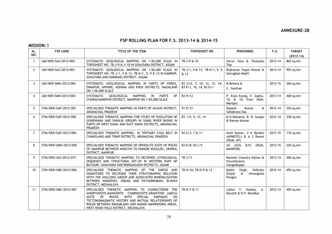
FSP ROLLING PLAN FOR F.S. 2013-14 & 2014-15 MISSION: I
SL. NO.
FSP CODE TITLE OF THE ITEM TOPOSHEET NO PERSONNEL F.S. TARGET
(2013-14)
1 GM/NER/SAS/2012/003 SYSTEMATIC GEOLOGICAL MAPPING ON 1:50,000 SCALE IN TOPOSHEET NO. 78 J/9 & J/10 IN GOALPARA DISTRICT, ASSAM
78 J/9 & 10 Varun Vara & Yhunyelo Tep
2013-14 865 sq.km
2 GM/NER/SAS/2013/001 SYSTEMATIC GEOLOGICAL MAPPING ON 1:50,000 SCALE IN TOPOSHEET NO. 78 J/1, 5 & 13, 78 N/1, 5, 9 & 13 IN KAMRUP, GOALPARA AND DARRANG DISTRICT, ASSAM
78 J/1, 5 & 13; 78 N/1, 5, 9
& 13
Rajkumar Tapon Kumar & Satrughan Majhi
2013-14 955 sq.km
3 GM/NER/SMN/2013/002 SYSTEMATIC GEOLOIGICAL MAPPING IN PARTS OF PEREN, DIMAPUR, KIPHIRE, KOHIMA AND PHEK DISTRICTS, NAGALAND ON 1:50,000 SCALE
83 G/6, 7, 10, 12, 13, 14; 83 K/1, 10, 14; 83 O/1
B.Behera &
C. Yanthan
2013-15 360 sq.km
4 GM/NER/SMN/2013/003 SYSTEMATIC GEOLOIGICAL MAPPING IN PARTS OF CHURACHANDPUR DISTRICT, MANIPUR ON 1:50,000 SCALE
83 H/12 P. Enos Ezung, V. Zaphu, 1G & 1G from DGM, Manipur
2013-14 460 sq.km
5 STM/NER/SAP/2012/001 SPECIALISED THEMATIC MAPPING IN PARTS OF ANJAW DISTRICT, ARUNACHAL PRADESH
91 D/12 Rupesh Kumar & Sebabrata Das
2012-14 220 sq.km
6 STM/NER/SAP/2012/002 SPECIALISED THEMATIC MAPPING FOR STUDY OF EVOLUTION OF GONDWANA AND SIWALIK GROUPS IN SIANG RIVER BASINS IN PARTS OF WEST SIANG AND EAST SIANG DISTRICTS, ARUNACHAL PRADESH
83 I/5, 9, 13, 14 B.N.Mahanta, B. R. Syngai & Raman Kumar
2012-14 330 sq.km
7 STM/NER/SAP/2013/004 SPECIALISED THEMATIC MAPPING IN TERTIARY COAL BELT IN CHANGLANG AND TIRAP DISTRICTS, ARUNACHAL PRADESH
92 A/3, 7 & 11 Amit Kumar, V K Bendre (APMDTCL) & A S Rawat (DGM, AP)
2013-15 110 sq.km
8 STM/NER/SMN/2013/005 SPECIALISED THEMATIC MAPPING OF OPHIOLITE SUITE OF ROCKS OF MANIPUR BETWEEN NINGTHI TO NUNGBI KHULLEN, UKHRUL DISTRICT, MANIPUR
83 K/8; 83 L/5 2G (GSI) &1G (DGM, MANIPUR)
2013-15 220 sq.km
9 STM/NER/SAS/2012/077 SPECIALIZED THEMATIC MAPPING TO DECIPHER LITHOLOGICAL SEQUENCE AND STRUCTURAL SET-UP IN WESTERN PART OF BATGURI, GOALPARA AND BONGAIGAON DISTRICTS, ASSAM
78 J/11 Ramesh Chandra Kishan & Parusharama Gangaikoppa
2013-14 300 sq.km
10 STM/NER/SME/2012/006 SPECIALISED THEMATIC MAPPING OF THE GNEISS AND GRANITOIDS TO DECIPGER THEIR STRATIGRAPHIC RELATION WITH THE SHILLONG GROUP AND ASSOCIATED MINERALISATION BETWEEN NONGPOH, JIRANG AND PATHARKHMAH, RI-BHOI DISTRICT, MEGHALAYA
78 N/16; 78 O/9 & 13 Balbir Singh, Vekhoto Shijoh & Imrongtola Pongen
2012-14 450 sq.km
11 STM/NER/SME/2012/007 SPECIALISED THEMATIC MAPPING TO CHARACTERISE THE ANORTHOSITE-MANGERITE- CHARNOCKITE-GRANITOID (AMCG) SUITE OF ROCKS WITH SPECIAL EMPHASIS ON TECTONOMAGMATIC HISTORY AND MUTUAL RELATIONSHIPS OF ROCKS BETWEEN RANGBLANG AND MANAD MAWBIDONG AREAS, WEST KHASI HILLS DISTRICT, MEGHALAYA
78 O/7 & 11 Lalboi T. Haokip, A. Ranjith & N.P. Khedkar
2012-14 450 sq.km
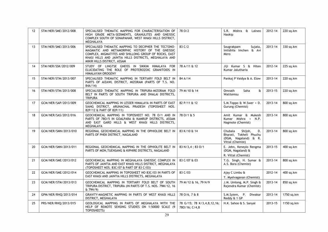
29
12 STM/NER/SME/2012/008 SPECIALISED THEMATIC MAPPING FOR CHARACTERISATION OF HIGH GRADE META-SEDIMENTS, GRANULITES AND GNEISSIC COMPLEX SOUTH OF SONAPAHAR, WEST KHASI HILLS DISTRICT, MEGHALAYA
78 O/2 S.R. Mishra & Lalneo Haokip
2012-14 220 sq.km
13 STM/NER/SME/2013/006 SPECIALISED THEMATIC MAPPING TO DECIPHER THE TECTONO-MAGMATIC AND METAMORPHIC HISTORY OF THE GNEISSIC COMPLEX, MIGMATITES AND SHILLONG GROUP OF ROCKS, EAST KHASI HILLS AND JAINTIA HILLS DISTRICTS, MEGHALAYA AND MIKIR HILLS DISTRICT, ASSAM
83 C/2 Sougrakpam Sujata, Imlishila Imchen & Avi Mero
2013-14 330 sq.km
14 STM/NER/SSK/2012/009 STUDY OF LINGTSE GNEISS IN SIKKIM HIMALAYA FOR ELUCIDATING THE ROLE OF PROTEROZOIC GRANITOIDS IN HIMALAYAN OROGENY
78 A/11 & 12 Jiji Kumar S & Hiten Kumar Jalutharia
2012-14 225 sq.km
15 STM/NER/STM/2013/007 SPECIALISED THEMATIC MAPPING IN TERTIARY FOLD BELT IN PARTS OF AIZAWL DISTRICT, MIZORAM (PARTS OF T.S. NO. 84A/14)
84 A/14 Pankaj P Vaidya & A. Elow 2013-14 220 sq.km
16 STM/NER/STM/2013/008 SPECIALISED THEMATIC MAPPING IN TRIPURA-MIZORAM FOLD BELT IN PARTS OF SOUTH TRIPURA AND DHALAI DISTRICTS, TRIPURA
79 M/10 & 14 Omnath Saha & Watitemsu
2013-15 220 sq.km
17 GCM/NER/SAP/2013/009 GEOCHEMICAL MAPPING IN LESSER HIMALAYA IN PARTS OF EAST SIANG DISTRICT, ARUNACHAL PRADESH (TOPOSHEET NOS. 82P/12 & PART OF 82P/11)
82 P/11 & 12 S.M.Toppo & W.Swer + D. Gurung (Chemist)
2013-14 800 sq.km
18 GCM/NER/SAS/2012/016 GEOCHEMICAL MAPPING IN TOPOSHEET NO. 78 O/1 AND IN PARTS OF 78O/5 IN GOALPARA & KAMRUP DISTRICTS, ASSAM AND EAST GARO HILLS & WEST KHASI HILLS DISTRICTS, MEGHALAYA
78 O/1 & 5 Amit Kumar & Mukesh Kumar Mishra + N.P. Nagmote (Chemist)
2013-14 800 sq.km
19 GCM/NER/SMN/2013/010 REGIONAL GEOCHEMICAL MAPPING IN THE OPHIOLOIE BELT IN PARTS OF PHEK DISTRICT, NAGALAND
83 K/10 & 14 Chubala Shijoh, D. Bharati, Tokheli Phuchu (DGM, Nagaland) & R. Vittal (Chemist)
2013-14 800 sq.km
20 GCM/NER/SMN/2013/011 REGIONAL GEOCHEMICAL MAPPING IN THE OPHIOLITE BELT IN PARTS OF MON,TUENSANG & KIPHIRE DISTRICTS, NAGALAND
83 N/3,4 ; 83 O/1 E. John, Keneylo Rengma (DGM, Nagaland) &
R. Vittal (Chemist)
2013-15 400 sq.km
21 GCM/NER/SME/2013/012 GEOCHEMICAL MAPPING IN MEGHALAYA GNEISSIC COMPLEX IN PARTS OF JAINTIA AND EAST KHASI HILLS DISTRICT, MEGHALAYA (TOPOSHEET NOS. 83C/07 & PART OF 83 C/03)
83 C/07 & 03 T.G. Singh, H. Sumar & A.S. Bora (Chemist)
2013-14 800 sq.km
22 GCM/NER/SME/2012/014 GEOCHEMICAL MAPPING IN TOPOSHEET NO 83C/03 IN PARTS OF EAST KHASI AND JAINTIA HILLS DISTRICTS, MEGHALAYA
83 C/03 Ajay C Limbu &
T. Myelvaganan (Chemist)
2012-14 400 sq.km
23 GCM/NER/STM/2013/013 GEOCHEMICAL MAPPING IN TERTIARY FOLD BELT OF SOUTH TRIPURA DISTRICT, TRIPURA (IN PARTS OF T.S. NOS. 79M/12, 16 & 79N/9)
79 M/12 & 16, 79 N/9 J.M. Umlong, M.P. Singh & Rajendra Kumar (Chemist)
2013-14 850 sq.km
24 GPM/NER/RHQ/2013/014 GRAVITY-MAGNETIC MAPPING IN PARTS OF WEST KHASI HILLS DISTRICT, MEGHALAYA
78 O/6, 7 & 8 S.M.Syiem, P. Diwakar Reddy & 1 GP
2013-14 1750 sq.km
25 PRS/NER/RHQ/2013/015 GEOLOGICAL MAPPING IN PARTS OF MEGHALAYA WITH THE HELP OF REMOTE SENSING STUDIES ON 1:50000 SCALE (9 TOPOSHEETS)
78 G/15; 78 K/3,4,8,12,16;
78O/16; C/4,8
H.K. Sahoo & S. Sanyal 2013-15 1150 sq.km

30
MISSION: II
SL. NO.
FSP CODE TITLE OF THE ITEM TOPOSHEET NO PERSONNEL F.S. TARGET
(2013-14)
1 ME/NER/SAP/2013/016 PRELIMINARY APPRAISAL OF ECONOMIC POTENTIAL OF LIMESTONE/ DOLOMITIC LIMESTONE IN EAST SIANG DISTRICT, ARUNACHAL PRADESH (G4)
83 P/4 & 8 Bendangnuchit,
Rita Thurr & V.K.Bendre (APMDTCL)
2013-14 LSM 75 sq.km
2 ME/NER/SAP/2013/017 PRELIMINARY ASSESSMENT FOR LIMESTONE IN AND AROUND DABA GAMLIN, WEST SIANG DISTRICT, ARUNACHAL PRADESH (G3)
82 L/12 2G (GSI) & 1G (DGM, Arunachal Pradesh)
2013-15 LSM 50 sq.km
3 ME/PM/NER/SAP/2012/026 INVESTIGATION FOR PGE AND GOLD MINERALIZATION IN MAFIC-ULTRAMAFIC SUITES, ANJAW, LOHIT AND LOWER DIBANG VALLEY DISTRICTS, ARUNACHAL PRADESH (G4)
91 D/12 & 16; 92 A/5
Ravi Negi & Hiruj Saikia 2012-14 LSM 50 sq.km
DM : 2.5 sq.km
4 ME/NER/SAS/2012/084 PRELIMINARY INVESTIGATION FOR REE IN SOUTHERN PART OF AGIA AROUND SUJUKONA HILL AND TUKURESWARI HILL IN PARTS OF GOALPARA DISTRICT, ASSAM (G4)
78 J/12 Akshaya Kumar Mishra & M. Shyamkumar Singh
2013-14 LSM 50 sq.km
DM : 1.5
5 ME/PM/NER/SMN/2012/028 PRELIMINARY INVESTIGATION FOR PLATINIUM GROUP OF ELEMENTS IN OPHIOLITE BELT OF NAGALAND (G4)
83 K/10, 13, 14, 15 ; 83 N/3, 4 ; 83 O/1,2
N. Meribemo Yanthan 2012-14 Rec.Traverse : 150 sq.km
6 ME/F/NER/SME/2012/023 INVESTIGATION FOR TITANIFEROUS-VANADIFEROUS MAGNETITE AROUND RAMBRAI IN WEST KHASI HILLS DISTRICT, MEGHALAYA (G4)
78O/6 V. Sreenivasiah 2012-14 LSM 25 sq.km
DM : 1.5 sq.km
7 ME/NER/SME/2013/018 INVESTIGATION FOR LIMESTONE IN NORTH OF LARKET BLOCK, LITANG VALLEY, JAINTIA HILLS DISTRICT, MEGHALAYA (G3)
83C/7 & 11 Pius Sarkar &
T.G. Singh
2013-15 DM : 1.5 sq.km
D : 800 m
8 ME/NER/SME/2013/019 ASSESSMENT OF LIMESTONE IN THE EXTENSION AREA OF MAWLONG - ISHAMATI BLOCK OF SHELLA - BHOLAGANJ BELT, EAST KHASI HILLS DISTRICT, MEGHALAYA (G3)
78 O/12 Aravind & Rajesh Kumar
2013-15 DM : 1.5 sq.km
D : 800 m
9 ME/NER/SME/2013/020 PRELIMINARY INVESTIGATION FOR REE IN PARTS OF NONGPOH PLUTON, RI-BHOI DISTRICT, MEGHALAYA (G4)
78 O/13 Mohd Sadiq & Ravi Kumar Umrao
2013-14 LSM 60 sq.km
10 GPS/NER/RHQ/2013/021 MAGNETIC SURVEY FOR CHROMITE BEARING ULTRAMAFICS IN MANTUM CHING, CHANDEL DISTRICT, MANIPUR, (G4)
83 L/7 K.V. Sathyanarayana
M.K. Rai
2013-14 GP : 5.6 sq.km
11 ME/BM/NER/SSK/2012/027 PRELIMINARY STUDY FOR THE BASE METALS AND ASSOCIATED GOLD IN EXTENSION AREAS OF DIKCHU BASEMETAL PROSPECT, EAST DISTRICT, SIKKIM (G4)
78 A/11 Kailash Singh, Tangtirenba Longchari & 1G (DMMG)
2012-14 LSM 50 sq.km
12 ME/NER/NEnR/SAS/2012/030 PRELIMINARY APPRAISAL TO LOCATE POTENTIAL COAL ZONE IN TERTIARY SEQUENCE BY LARGE SCALE GEOLOGICAL MAPPING ON 1:10,000 SCALE IN PARTS OF TOPOSHEET NO. 78G/14 AROUND SHALIBHUIN IN DHUBRI DISTRICT OF ASSAM AND NAKAIGIRI-UJANGGIRI IN WEST GARO HILLS OF MEGHALAYA (G4)
78 G/14 Vizolto Sakhrie (P/T) & D.V. Whourie
2013-14 LSM 6.5 sq.km
D : 300 m
13 ME/NER/NEnR/SME/2013/022 REGIONAL EXPLORATION FOR GONDWANA COAL IN THE AREA ADJACENT TO SUKCHAR - SINGRIMARI AREA, SINGRIMARI COALFIELD, DHUBRI DISTRICT, ASSAM AT THE BORDER OF ASSAM & MEGHALAYA
78 G/13 Vizolto Sakhrie (P/T) & D.V. Whourie
2013-14 LSM 3 sq.km
D : 600 m
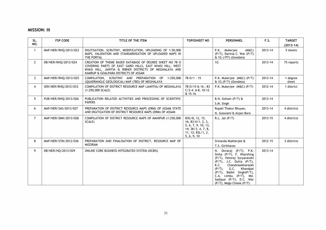
31
MISSION: III
SL. NO.
FSP CODE TITLE OF THE ITEM TOPOSHEET NO PERSONNEL F.S. TARGET
(2013-14)
1 MAP/NER/RHQ/2013/023 DIGITISATION, SCRUTINY, MODIFICATION, UPLOADING OF 1:50,000 MAPS, VALIDATION AND STANDARDISATION OF UPLOADED MAPS IN THE PORTAL
P.K. Mukerjee (M&C) (P/T), Darinia C. War (P/T) & 1G (/PT) (Geodata)
2013-14 5 sheets
2 DB/NER/RHQ/2013/024 CREATION OF THEME BASED DATABASE OF DEGREE SHEET NO 78 O COVERING PARTS OF EAST GARO HILLS, EAST KHASI HILL, WEST KHASI HILL, JAINTIA & RIBHOI DISTRICTS OF MEGHALAYA AND KAMRUP & GOALPARA DISTRICTS OF ASSAM
1G 2013-14 75 reports
3 MAP/NER/RHQ/2013/025 COMPILATION, SCRUTINY AND PREPARATION OF 1:250,000 (QUADRANGLE GEOLOGICAL) MAP (78O) OF MEGHALAYA
78 O/1 - 15 P.K. Mukerjee (M&C) (P/T) & 1G (P/T) (Geodata)
2013-14 1 degree sheet
4 SER/NER/RHQ/2012/033 COMPILATION OF DISTRICT RESOURCE MAP (JAINTIA) OF MEGHALAYA (1:250,000 SCALE)
78 O/15 & 16 ; 83 C/2-4. 6-8, 10-12 & 15-16
P.K. Mukerjee (M&C) (P/T) 2012-14 1 district
5 PUB/NER/RHQ/2013/026 PUBLICATION RELATED ACTIVITIES AND PROCESSING OF SCIENTIFIC PAPERS
B.N. Gohain (P/T) &
S.M. Singh
2013-14
6 MAP/NER/SAS/2013/027 PREPARATION OF DISTRICT RESOURCE MAPS (DRM) OF ASSAM STATE AND DIGITIZATION OF DISTRICT RESOURCE MAPS (DRM) OF ASSAM
Rupali Thakur Bhuyan,
N. Goswami & Anjan Bora
2013-14 4 districts
7 MAP/NER/SMN/2013/028 COMPILATION OF DISTRICT RESOURCE MAPS OF MANIPUR (1:250,000 SCALE)
83G/8, 12, 15, 16; 83 H/1, 2, 3, 5, 6, 7, 9, 10, 13, 14; 3K/3, 4, 7, 8, 11, 12; 83L/1, 2, 5, 6, 9, 10
R.L. Jat (P/T) 2013-15 4 districts
8 MAP/NER/STM/2012/036 PREPARATION AND FINALISATION OF DISTRICT, RESOURCE MAP OF MIZORAM
Srinanda Mukherjee &
T.S. Giritharan
2012-15 3 districts
9 DB/NER/HQ/2013/029 ONLINE CORE BUSINESS INTEGRATED SYSTEM (OCBIS) N. Devaraj (P/T), P.K. Sinha (P/T), F. Kharshing (P/T), Hemraj Suryavanshi (P/T), J.C. Dutta (P/T), K.C. Chandrasekharaiah (P/T), G.C. Khandpal (P/T), Balbir Singh(P/T), C.A. Limbu (P/T), Md. Sadique (P/T), D.C. War (P/T), Mego Chasie (P/T)
2013-14
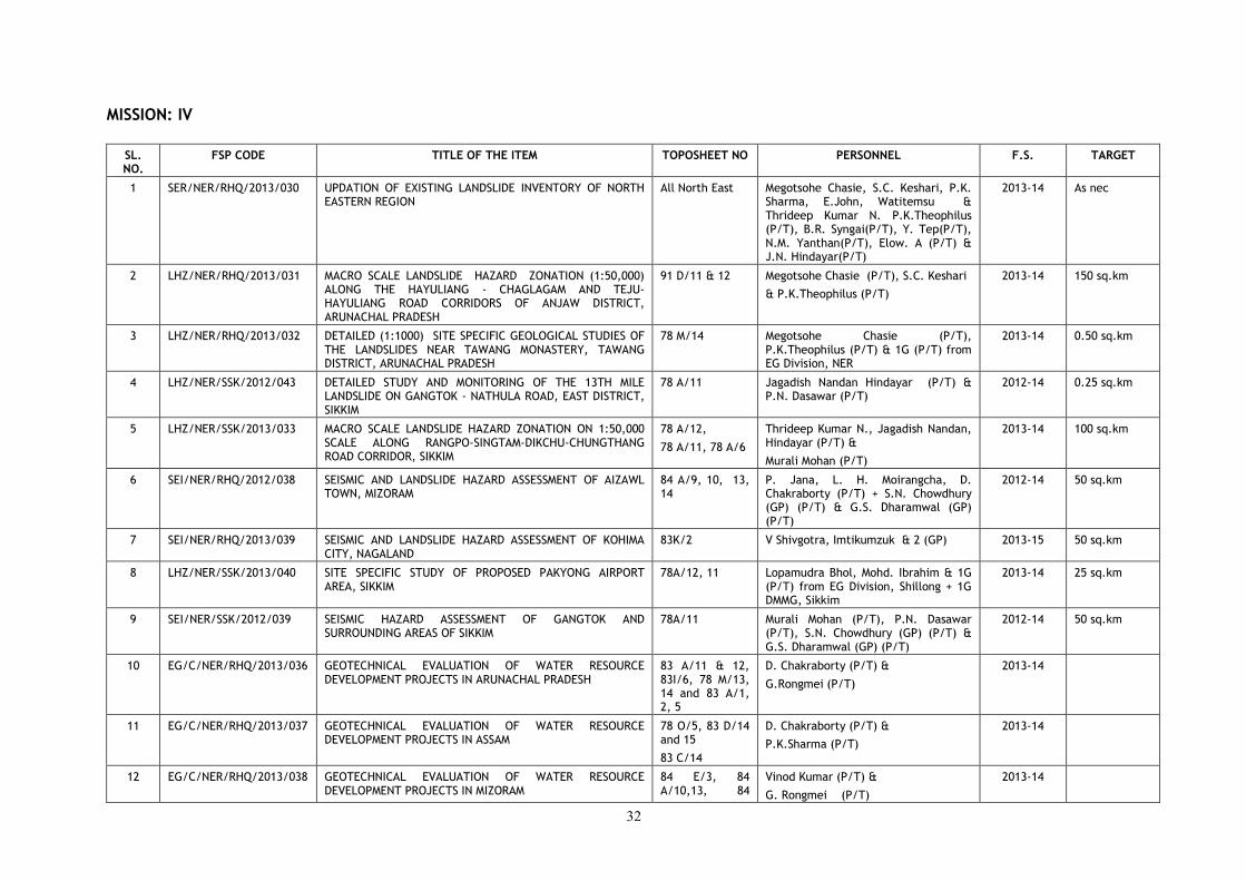
32
MISSION: IV
SL. NO.
FSP CODE TITLE OF THE ITEM TOPOSHEET NO PERSONNEL F.S. TARGET
1 SER/NER/RHQ/2013/030 UPDATION OF EXISTING LANDSLIDE INVENTORY OF NORTH EASTERN REGION
All North East Megotsohe Chasie, S.C. Keshari, P.K. Sharma, E.John, Watitemsu & Thrideep Kumar N. P.K.Theophilus (P/T), B.R. Syngai(P/T), Y. Tep(P/T), N.M. Yanthan(P/T), Elow. A (P/T) & J.N. Hindayar(P/T)
2013-14 As nec
2 LHZ/NER/RHQ/2013/031 MACRO SCALE LANDSLIDE HAZARD ZONATION (1:50,000) ALONG THE HAYULIANG - CHAGLAGAM AND TEJU-HAYULIANG ROAD CORRIDORS OF ANJAW DISTRICT, ARUNACHAL PRADESH
91 D/11 & 12 Megotsohe Chasie (P/T), S.C. Keshari
& P.K.Theophilus (P/T)
2013-14 150 sq.km
3 LHZ/NER/RHQ/2013/032 DETAILED (1:1000) SITE SPECIFIC GEOLOGICAL STUDIES OF THE LANDSLIDES NEAR TAWANG MONASTERY, TAWANG DISTRICT, ARUNACHAL PRADESH
78 M/14 Megotsohe Chasie (P/T), P.K.Theophilus (P/T) & 1G (P/T) from EG Division, NER
2013-14 0.50 sq.km
4 LHZ/NER/SSK/2012/043 DETAILED STUDY AND MONITORING OF THE 13TH MILE LANDSLIDE ON GANGTOK - NATHULA ROAD, EAST DISTRICT, SIKKIM
78 A/11 Jagadish Nandan Hindayar (P/T) & P.N. Dasawar (P/T)
2012-14 0.25 sq.km
5 LHZ/NER/SSK/2013/033 MACRO SCALE LANDSLIDE HAZARD ZONATION ON 1:50,000 SCALE ALONG RANGPO-SINGTAM-DIKCHU-CHUNGTHANG ROAD CORRIDOR, SIKKIM
78 A/12,
78 A/11, 78 A/6
Thrideep Kumar N., Jagadish Nandan, Hindayar (P/T) &
Murali Mohan (P/T)
2013-14 100 sq.km
6 SEI/NER/RHQ/2012/038 SEISMIC AND LANDSLIDE HAZARD ASSESSMENT OF AIZAWL TOWN, MIZORAM
84 A/9, 10, 13, 14
P. Jana, L. H. Moirangcha, D. Chakraborty (P/T) + S.N. Chowdhury (GP) (P/T) & G.S. Dharamwal (GP) (P/T)
2012-14 50 sq.km
7 SEI/NER/RHQ/2013/039 SEISMIC AND LANDSLIDE HAZARD ASSESSMENT OF KOHIMA CITY, NAGALAND
83K/2 V Shivgotra, Imtikumzuk & 2 (GP) 2013-15 50 sq.km
8 LHZ/NER/SSK/2013/040 SITE SPECIFIC STUDY OF PROPOSED PAKYONG AIRPORT AREA, SIKKIM
78A/12, 11 Lopamudra Bhol, Mohd. Ibrahim & 1G (P/T) from EG Division, Shillong + 1G DMMG, Sikkim
2013-14 25 sq.km
9 SEI/NER/SSK/2012/039 SEISMIC HAZARD ASSESSMENT OF GANGTOK AND SURROUNDING AREAS OF SIKKIM
78A/11 Murali Mohan (P/T), P.N. Dasawar (P/T), S.N. Chowdhury (GP) (P/T) & G.S. Dharamwal (GP) (P/T)
2012-14 50 sq.km
10 EG/C/NER/RHQ/2013/036 GEOTECHNICAL EVALUATION OF WATER RESOURCE DEVELOPMENT PROJECTS IN ARUNACHAL PRADESH
83 A/11 & 12, 83I/6, 78 M/13, 14 and 83 A/1, 2, 5
D. Chakraborty (P/T) &
G.Rongmei (P/T)
2013-14
11 EG/C/NER/RHQ/2013/037 GEOTECHNICAL EVALUATION OF WATER RESOURCE DEVELOPMENT PROJECTS IN ASSAM
78 O/5, 83 D/14 and 15
83 C/14
D. Chakraborty (P/T) &
P.K.Sharma (P/T)
2013-14
12 EG/C/NER/RHQ/2013/038 GEOTECHNICAL EVALUATION OF WATER RESOURCE DEVELOPMENT PROJECTS IN MIZORAM
84 E/3, 84 A/10,13, 84
Vinod Kumar (P/T) &
G. Rongmei (P/T)
2013-14
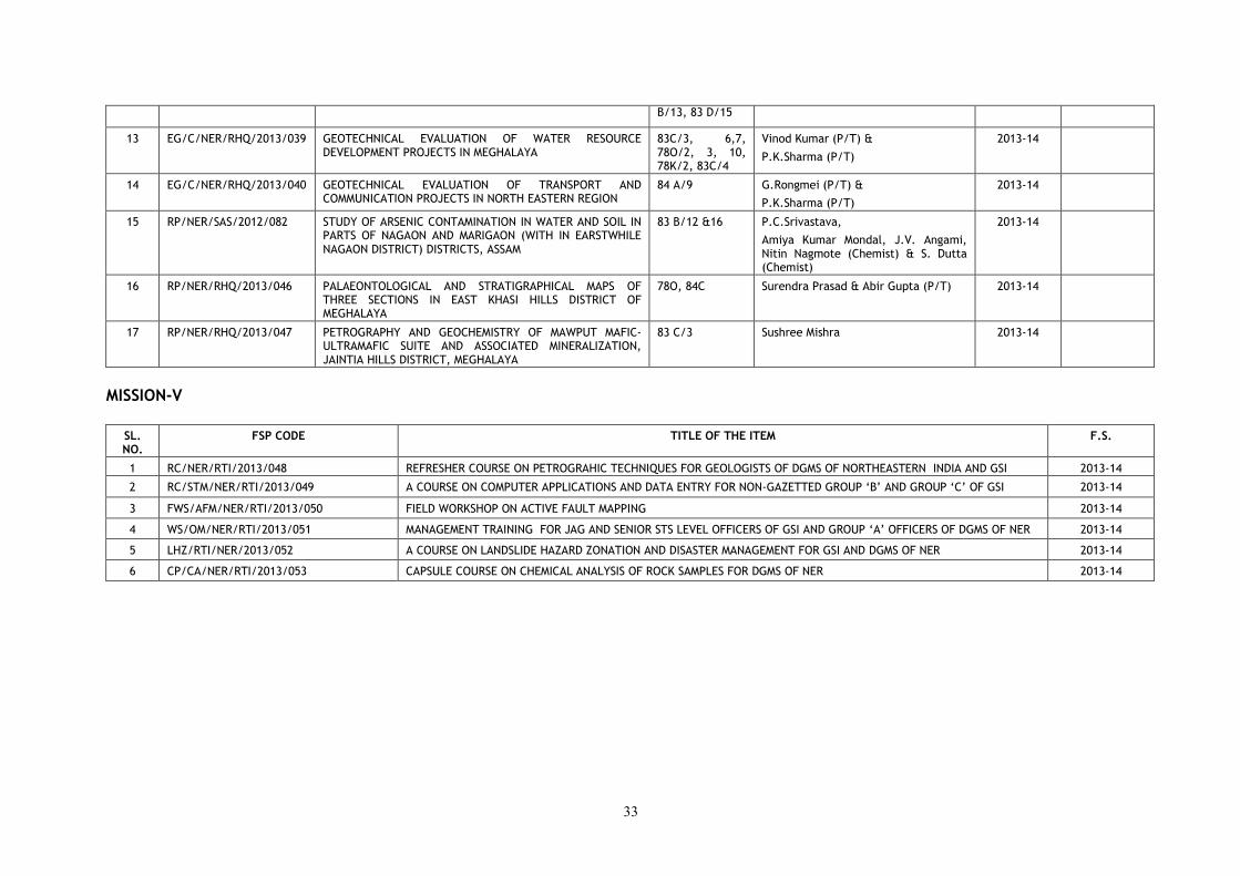
33
B/13, 83 D/15
13 EG/C/NER/RHQ/2013/039 GEOTECHNICAL EVALUATION OF WATER RESOURCE DEVELOPMENT PROJECTS IN MEGHALAYA
83C/3, 6,7, 78O/2, 3, 10, 78K/2, 83C/4
Vinod Kumar (P/T) &
P.K.Sharma (P/T)
2013-14
14 EG/C/NER/RHQ/2013/040 GEOTECHNICAL EVALUATION OF TRANSPORT AND COMMUNICATION PROJECTS IN NORTH EASTERN REGION
84 A/9 G.Rongmei (P/T) &
P.K.Sharma (P/T)
2013-14
15 RP/NER/SAS/2012/082 STUDY OF ARSENIC CONTAMINATION IN WATER AND SOIL IN PARTS OF NAGAON AND MARIGAON (WITH IN EARSTWHILE NAGAON DISTRICT) DISTRICTS, ASSAM
83 B/12 &16 P.C.Srivastava,
Amiya Kumar Mondal, J.V. Angami, Nitin Nagmote (Chemist) & S. Dutta (Chemist)
2013-14
16 RP/NER/RHQ/2013/046 PALAEONTOLOGICAL AND STRATIGRAPHICAL MAPS OF THREE SECTIONS IN EAST KHASI HILLS DISTRICT OF MEGHALAYA
78O, 84C Surendra Prasad & Abir Gupta (P/T) 2013-14
17 RP/NER/RHQ/2013/047 PETROGRAPHY AND GEOCHEMISTRY OF MAWPUT MAFIC-ULTRAMAFIC SUITE AND ASSOCIATED MINERALIZATION, JAINTIA HILLS DISTRICT, MEGHALAYA
83 C/3 Sushree Mishra 2013-14
MISSION-V
SL. NO.
FSP CODE TITLE OF THE ITEM F.S.
1 RC/NER/RTI/2013/048 REFRESHER COURSE ON PETROGRAHIC TECHNIQUES FOR GEOLOGISTS OF DGMS OF NORTHEASTERN INDIA AND GSI 2013-14
2 RC/STM/NER/RTI/2013/049 A COURSE ON COMPUTER APPLICATIONS AND DATA ENTRY FOR NON-GAZETTED GROUP ‘B’ AND GROUP ‘C’ OF GSI 2013-14
3 FWS/AFM/NER/RTI/2013/050 FIELD WORKSHOP ON ACTIVE FAULT MAPPING 2013-14
4 WS/OM/NER/RTI/2013/051 MANAGEMENT TRAINING FOR JAG AND SENIOR STS LEVEL OFFICERS OF GSI AND GROUP ‘A’ OFFICERS OF DGMS OF NER 2013-14
5 LHZ/RTI/NER/2013/052 A COURSE ON LANDSLIDE HAZARD ZONATION AND DISASTER MANAGEMENT FOR GSI AND DGMS OF NER 2013-14
6 CP/CA/NER/RTI/2013/053 CAPSULE COURSE ON CHEMICAL ANALYSIS OF ROCK SAMPLES FOR DGMS OF NER 2013-14
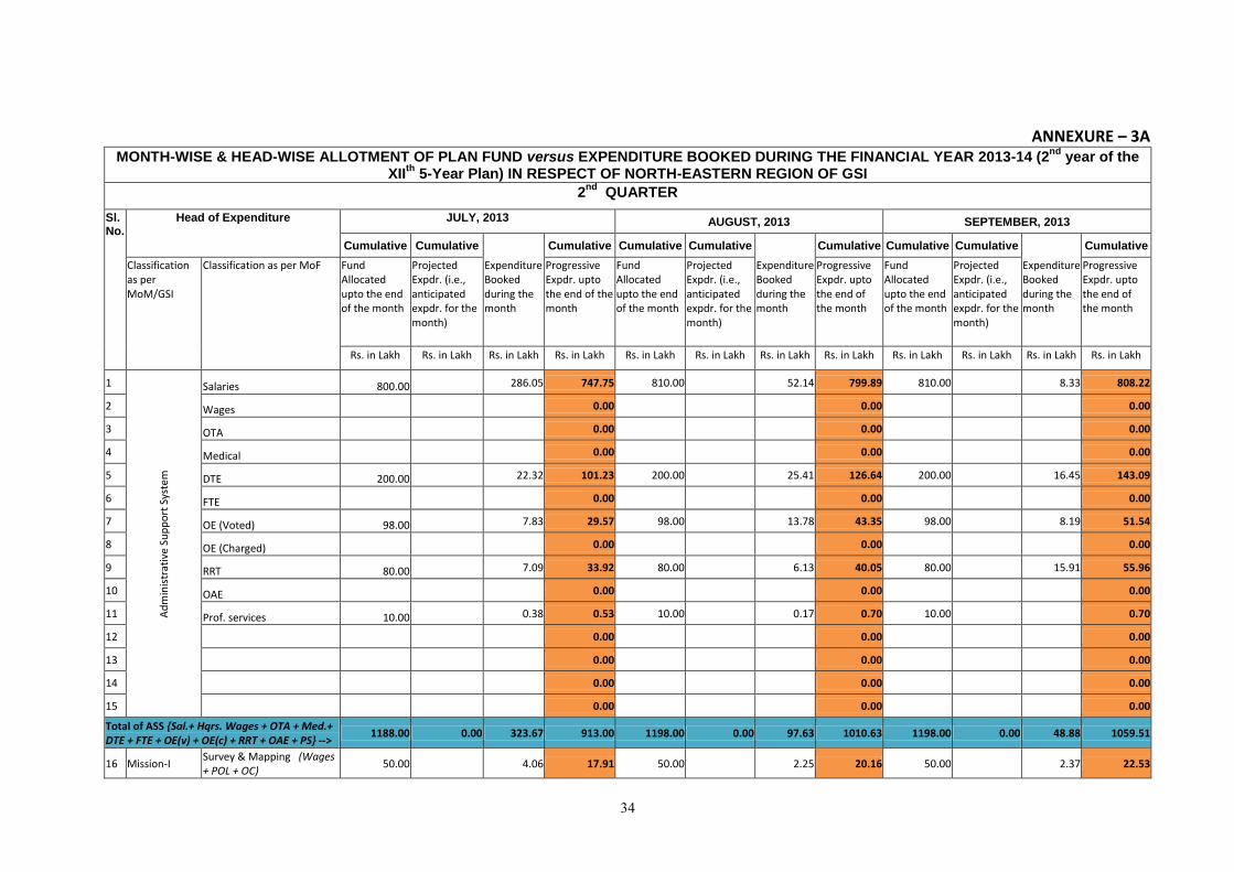
34
ANNEXURE – 3A MONTH-WISE & HEAD-WISE ALLOTMENT OF PLAN FUND versus EXPENDITURE BOOKED DURING THE FINANCIAL YEAR 2013-14 (2
nd year of the
XIIth
5-Year Plan) IN RESPECT OF NORTH-EASTERN REGION OF GSI
2nd
QUARTER
Sl. No.
Head of Expenditure JULY, 2013 AUGUST, 2013 SEPTEMBER, 2013
Cumulative Cumulative Cumulative Cumulative Cumulative Cumulative Cumulative Cumulative Cumulative
Classification as per MoM/GSI
Classification as per MoF Fund Allocated upto the end of the month
Projected Expdr. (i.e., anticipated expdr. for the month)
Expenditure Booked during the month
Progressive Expdr. upto the end of the month
Fund Allocated upto the end of the month
Projected Expdr. (i.e., anticipated expdr. for the month)
Expenditure Booked during the month
Progressive Expdr. upto the end of the month
Fund Allocated upto the end of the month
Projected Expdr. (i.e., anticipated expdr. for the month)
Expenditure Booked during the month
Progressive Expdr. upto the end of the month
Rs. in Lakh Rs. in Lakh Rs. in Lakh Rs. in Lakh Rs. in Lakh Rs. in Lakh Rs. in Lakh Rs. in Lakh Rs. in Lakh Rs. in Lakh Rs. in Lakh Rs. in Lakh
1
Ad
min
istr
ativ
e Su
pp
ort
Sys
tem
Salaries 800.00 286.05 747.75 810.00 52.14 799.89 810.00 8.33 808.22
2 Wages 0.00 0.00 0.00
3 OTA 0.00 0.00 0.00
4 Medical 0.00 0.00 0.00
5 DTE 200.00 22.32 101.23 200.00 25.41 126.64 200.00 16.45 143.09
6 FTE 0.00 0.00 0.00
7 OE (Voted) 98.00 7.83 29.57 98.00 13.78 43.35 98.00 8.19 51.54
8 OE (Charged) 0.00 0.00 0.00
9 RRT 80.00 7.09 33.92 80.00 6.13 40.05 80.00 15.91 55.96
10 OAE 0.00 0.00 0.00
11 Prof. services 10.00 0.38 0.53 10.00 0.17 0.70 10.00 0.70
12 0.00 0.00 0.00
13 0.00 0.00 0.00
14 0.00 0.00 0.00
15 0.00 0.00 0.00
Total of ASS {Sal.+ Hqrs. Wages + OTA + Med.+ DTE + FTE + OE(v) + OE(c) + RRT + OAE + PS} -->
1188.00 0.00 323.67 913.00 1198.00 0.00 97.63 1010.63 1198.00 0.00 48.88 1059.51
16 Mission-I Survey & Mapping (Wages + POL + OC)
50.00 4.06 17.91 50.00 2.25 20.16 50.00 2.37 22.53

35
17 Mission-II Mineral Exploration (Wages + POL + OC)
50.00 6.05 29.59 50.00 5.00 34.59 50.00 5.26 39.85
18 Mission-III (Information Dissemination)
Other Expdr. (Pubn. + OAE + Adv. & Publicity)
25.00 0.25 1.49 25.00 1.14 2.63 25.00 1.55 4.18
Other Expdr. {IT (OAE)} 20.00 4.79 10.72 20.00 1.77 12.49 20.00 0.43 12.92
Total of Mission III ----> 45.00 0.00 5.04 12.21 45.00 0.00 2.91 15.12 45.00 0.00 1.98 17.10
19 Mission-IV A Research & Development (Wages + Sup. & Mat. + POL + OC)
30.00 2.72 7.30 30.00 2.40 9.70 30.00 1.11 10.81
20 Mission-IV B Investigation (Wages + POL + OC)
25.00 0.30 1.45 25.00 2.11 3.56 25.00 0.33 3.89
21
Mission-V (Human Resource Development)
Training & Capacity Building (OC) 5.00 0.03 15.00 4.25 4.28 15.00 4.28
Total of Mission I, II, III, IVA, IVB & V ----> 205.00 0.00 18.17 68.49 215.00 0.00 18.92 87.41 215.00 0.00 11.05 98.46
22
STSS (Modernisation & Replacement)
Other Expdr. (Sup. & Mat.+ Clothing & Tentage)
2.00 0.00 2.00 0.00 2.00 0.00
Capital Assets (MV + ME) 360.00 2.87 51.27 360.00 20.39 71.66 360.00 7.81 79.47
Total of STSS ------------> 362.00 0.00 2.87 51.27 362.00 0.00 20.39 71.66 362.00 0.00 7.81 79.47
Total of ASS, all Missions, STSS ------> 1755.00 0.00 344.71 1032.76 1775.00 0.00 136.94 1169.70 1775.00 0.00 67.74 1237.44
23
Minor Works (Minor Civil or Electrical Exp. related to protection/ maintenance/ addition/ alteration /modification etc. of Govt. properties)
25.00 6.38 6.38 68.12 0.49 6.87 68.12 6.87
24
Major Works (Major Civil Exp. related to development of new premises/ complexes/ compounds/ new Construction or New cum Major Electrical Installations etc.)
0.00 0.00 0.00
25 SC/ST Welfare related Expdr. (OC) 40.00 0.00 40.00 3.56 3.56 40.00 2.78 6.34
Total of ASS, all Missions, STSS, Minor Works, Major Works, SC/ST Welfare --->
1820.00 0.00 351.09 1039.14 1883.12 0.00 140.99 1180.13 1883.12 0.00 70.52 1250.65
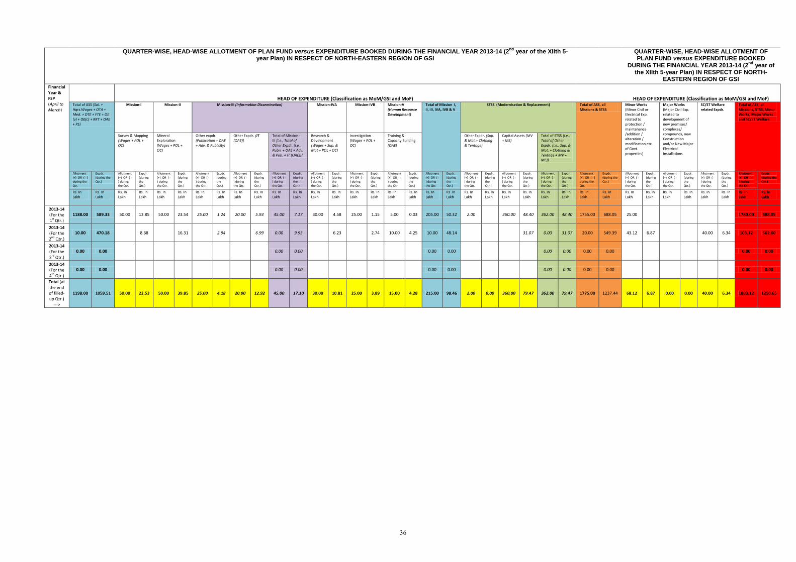
36
QUARTER-WISE, HEAD-WISE ALLOTMENT OF PLAN FUND versus EXPENDITURE BOOKED DURING THE FINANCIAL YEAR 2013-14 (2nd
year of the XIIth 5-year Plan) IN RESPECT OF NORTH-EASTERN REGION OF GSI
QUARTER-WISE, HEAD-WISE ALLOTMENT OF PLAN FUND versus EXPENDITURE BOOKED
DURING THE FINANCIAL YEAR 2013-14 (2nd
year of the XIIth 5-year Plan) IN RESPECT OF NORTH-
EASTERN REGION OF GSI
Financial Year & FSP (April to March)
HEAD OF EXPENDITURE (Classification as MoM/GSI and MoF) HEAD OF EXPENDITURE (Classification as MoM/GSI and MoF) Total of ASS {Sal. + Hqrs.Wages + OTA + Med. + DTE + FTE + OE (v) + OE(c) + RRT + OAE + PS}
Mission-I Mission-II Mission-III (Information Dissemination) Mission-IVA Mission-IVB Mission-V (Human Resource Development)
Total of Mission I, II, III, IVA, IVB & V
STSS (Modernisation & Replacement) Total of ASS, all Missions & STSS
Minor Works (Minor Civil or Electrical Exp. related to protection / maintenance /addition / alteration / modification etc. of Govt. properties)
Major Works (Major Civil Exp. related to development of new premises/ complexes/ compounds, new Construction and/or New Major Electrical Installations
SC/ST Welfare related Expdr.
Total of ASS, all Missions, STSS, Minor Works, Major Works and SC/ST Welfare
Survey & Mapping (Wages + POL + OC)
Mineral Exploration (Wages + POL + OC)
Other expdr. (Publication + OAE + Adv. & Publicity)
Other Expdr. {IT (OAE)}
Total of Mission - III [i.e., Total of Other Expdr. {i.e., Pubn. + OAE + Adv. & Pub. + IT (OAE)}]
Research & Development (Wages + Sup. & Mat + POL + OC)
Investigation (Wages + POL + OC)
Training & Capacity Building (OAE)
Other Expdr. (Sup. & Mat.+ Clothing & Tentage)
Capital Assets (MV + ME)
Total of STSS {i.e., Total of Other Expdr. (i.e., Sup. & Mat. + Clothing & Tentage + MV + ME)}
Allotment (+) OR ( - ) during the Qtr.
Expdr. (during the Qtr.)
Allotment (+) OR ( - ) during the Qtr.
Expdr. (during the Qtr.)
Allotment (+) OR ( - ) during the Qtr.
Expdr. (during the Qtr.)
Allotment (+) OR ( - ) during the Qtr.
Expdr. (during the Qtr.)
Allotment (+) OR ( - ) during the Qtr.
Expdr. (during the Qtr.)
Allotment (+) OR ( - ) during the Qtr.
Expdr. (during the Qtr.)
Allotment (+) OR ( - ) during the Qtr.
Expdr. (during the Qtr.)
Allotment (+) OR ( - ) during the Qtr.
Expdr. (during the Qtr.)
Allotment (+) OR ( - ) during the Qtr.
Expdr. (during the Qtr.)
Allotment (+) OR ( - ) during the Qtr.
Expdr. (during the Qtr.)
Allotment (+) OR ( - ) during the Qtr.
Expdr. (during the Qtr.)
Allotment (+) OR ( - ) during the Qtr.
Expdr. (during the Qtr.)
Allotment (+) OR ( - ) during the Qtr.
Expdr. (during the Qtr.)
Allotment (+) OR ( - ) during the Qtr.
Expdr. (during the Qtr.)
Allotment (+) OR ( - ) during the Qtr.
Expdr. (during the Qtr.)
Allotment (+) OR ( - ) during the Qtr.
Expdr. (during the Qtr.)
Allotment (+) OR ( - ) during the Qtr.
Expdr. (during the Qtr.)
Allotment (+) OR ( - ) during the Qtr.
Expdr. (during the Qtr.)
Rs. In Lakh
Rs. In Lakh
Rs. In Lakh
Rs. In Lakh
Rs. In Lakh
Rs. In Lakh
Rs. In Lakh
Rs. In Lakh
Rs. In Lakh
Rs. In Lakh
Rs. In Lakh
Rs. In Lakh
Rs. In Lakh
Rs. In Lakh
Rs. In Lakh
Rs. In Lakh
Rs. In Lakh
Rs. In Lakh
Rs. In Lakh
Rs. In Lakh
Rs. In Lakh
Rs. In Lakh
Rs. In Lakh
Rs. In Lakh
Rs. In Lakh
Rs. In Lakh
Rs. In Lakh
Rs. In Lakh
Rs. In Lakh
Rs. In Lakh
Rs. In Lakh
Rs. In Lakh
Rs. In Lakh
Rs. In Lakh
Rs. In Lakh
Rs. In Lakh
2013-14 (For the 1st Qtr.)
1188.00 589.33 50.00 13.85 50.00 23.54 25.00 1.24 20.00 5.93 45.00 7.17 30.00 4.58 25.00 1.15 5.00 0.03 205.00 50.32 2.00
360.00 48.40 362.00 48.40 1755.00 688.05 25.00
1780.00 688.05
2013-14 (For the 2nd Qtr.)
10.00 470.18
8.68
16.31
2.94
6.99 0.00 9.93
6.23
2.74 10.00 4.25 10.00 48.14
31.07 0.00 31.07 20.00 549.39 43.12 6.87
40.00 6.34 103.12 562.60
2013-14 (For the 3rd Qtr.)
0.00 0.00
0.00 0.00
0.00 0.00
0.00 0.00 0.00 0.00
0.00 0.00
2013-14 (For the 4th Qtr.)
0.00 0.00
0.00 0.00
0.00 0.00
0.00 0.00 0.00 0.00
0.00 0.00
Total (at the end of filled-up Qtr.)
--->
1198.00 1059.51 50.00 22.53 50.00 39.85 25.00 4.18 20.00 12.92 45.00 17.10 30.00 10.81 25.00 3.89 15.00 4.28 215.00 98.46 2.00 0.00 360.00 79.47 362.00 79.47 1775.00 1237.44 68.12 6.87 0.00 0.00 40.00 6.34 1883.12 1250.65
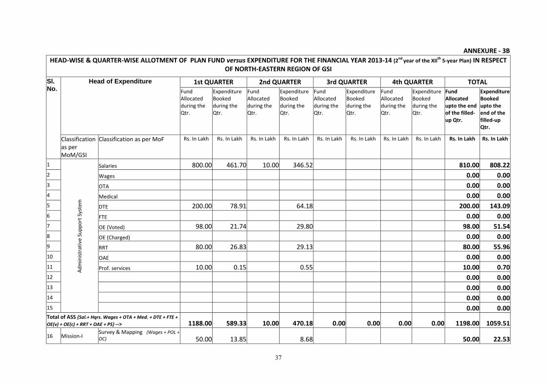
37
ANNEXURE - 3B
HEAD-WISE & QUARTER-WISE ALLOTMENT OF PLAN FUND versus EXPENDITURE FOR THE FINANCIAL YEAR 2013-14 (2nd year of the XII
th 5-year Plan) IN RESPECT
OF NORTH-EASTERN REGION OF GSI
Sl. No.
Head of Expenditure 1st QUARTER 2nd QUARTER 3rd QUARTER 4th QUARTER TOTAL
Fund Allocated during the Qtr.
Expenditure Booked during the Qtr.
Fund Allocated during the Qtr.
Expenditure Booked during the Qtr.
Fund Allocated during the Qtr.
Expenditure Booked during the Qtr.
Fund Allocated during the Qtr.
Expenditure Booked during the Qtr.
Fund Allocated upto the end of the filled-up Qtr.
Expenditure Booked upto the end of the filled-up Qtr.
Classification as per MoM/GSI
Classification as per MoF Rs. In Lakh Rs. In Lakh Rs. In Lakh Rs. In Lakh Rs. In Lakh Rs. In Lakh Rs. In Lakh Rs. In Lakh Rs. In Lakh Rs. In Lakh
1
Ad
min
istr
ativ
e Su
pp
ort
Sys
tem
Salaries 800.00 461.70 10.00 346.52 810.00 808.22
2 Wages 0.00 0.00
3 OTA 0.00 0.00
4 Medical 0.00 0.00
5 DTE 200.00 78.91 64.18 200.00 143.09
6 FTE 0.00 0.00
7 OE (Voted) 98.00 21.74 29.80 98.00 51.54
8 OE (Charged) 0.00 0.00
9 RRT 80.00 26.83 29.13 80.00 55.96
10 OAE 0.00 0.00
11 Prof. services 10.00 0.15 0.55 10.00 0.70
12 0.00 0.00
13 0.00 0.00
14 0.00 0.00
15 0.00 0.00 Total of ASS {Sal.+ Hqrs. Wages + OTA + Med. + DTE + FTE +
OE(v) + OE(c) + RRT + OAE + PS} --> 1188.00 589.33 10.00 470.18 0.00 0.00 0.00 0.00 1198.00 1059.51
16 Mission-I Survey & Mapping (Wages + POL +
OC) 50.00 13.85 8.68 50.00 22.53
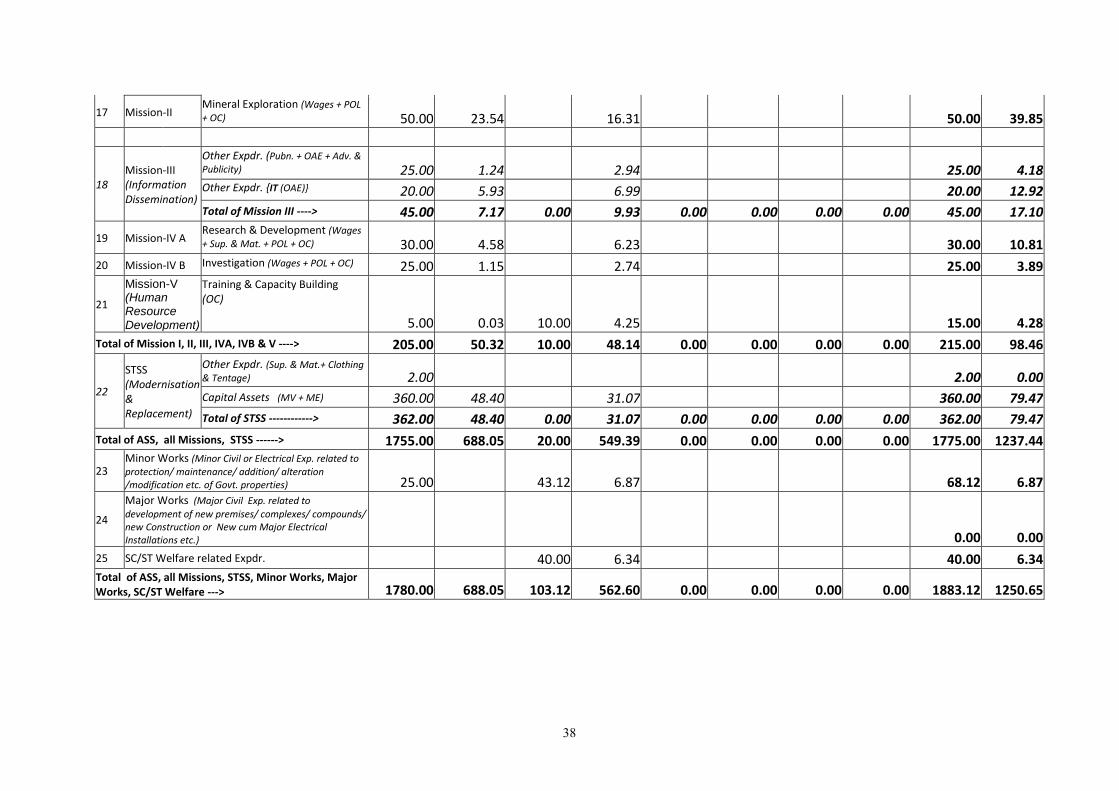
38
17 Mission-II Mineral Exploration (Wages + POL
+ OC) 50.00 23.54 16.31 50.00 39.85
18 Mission-III (Information Dissemination)
Other Expdr. (Pubn. + OAE + Adv. & Publicity) 25.00 1.24 2.94 25.00 4.18 Other Expdr. {IT (OAE)} 20.00 5.93 6.99 20.00 12.92
Total of Mission III ----> 45.00 7.17 0.00 9.93 0.00 0.00 0.00 0.00 45.00 17.10
19 Mission-IV A Research & Development (Wages
+ Sup. & Mat. + POL + OC) 30.00 4.58 6.23 30.00 10.81
20 Mission-IV B Investigation (Wages + POL + OC) 25.00 1.15 2.74 25.00 3.89
21
Mission-V
(Human Resource Development)
Training & Capacity Building (OC)
5.00 0.03 10.00 4.25 15.00 4.28
Total of Mission I, II, III, IVA, IVB & V ----> 205.00 50.32 10.00 48.14 0.00 0.00 0.00 0.00 215.00 98.46
22
STSS (Modernisation & Replacement)
Other Expdr. (Sup. & Mat.+ Clothing
& Tentage) 2.00 2.00 0.00
Capital Assets (MV + ME) 360.00 48.40 31.07 360.00 79.47
Total of STSS ------------> 362.00 48.40 0.00 31.07 0.00 0.00 0.00 0.00 362.00 79.47
Total of ASS, all Missions, STSS ------> 1755.00 688.05 20.00 549.39 0.00 0.00 0.00 0.00 1775.00 1237.44
23 Minor Works (Minor Civil or Electrical Exp. related to protection/ maintenance/ addition/ alteration /modification etc. of Govt. properties) 25.00 43.12 6.87 68.12 6.87
24
Major Works (Major Civil Exp. related to
development of new premises/ complexes/ compounds/ new Construction or New cum Major Electrical Installations etc.) 0.00 0.00
25 SC/ST Welfare related Expdr. 40.00 6.34 40.00 6.34 Total of ASS, all Missions, STSS, Minor Works, Major Works, SC/ST Welfare ---> 1780.00 688.05 103.12 562.60 0.00 0.00 0.00 0.00 1883.12 1250.65
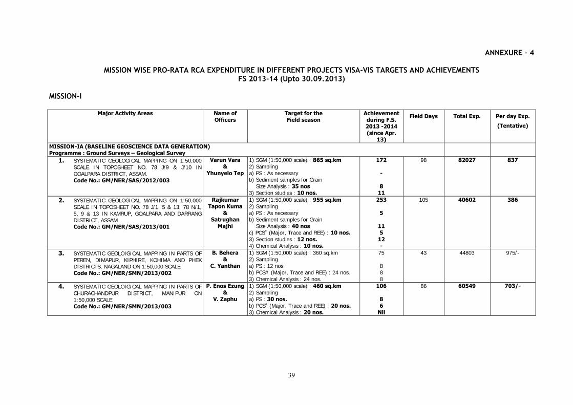
39
ANNEXURE – 4
MISSION WISE PRO-RATA RCA EXPENDITURE IN DIFFERENT PROJECTS VISA-VIS TARGETS AND ACHIEVEMENTS FS 2013-14 (Upto 30.09.2013)
MISSION-I
Major Activity Areas Name of Officers
Target for the Field season
Achievement during F.S. 2013 -2014 (since Apr.
13)
Field Days Total Exp. Per day Exp.
(Tentative)
MISSION-IA (BASELINE GEOSCIENCE DATA GENERATION) Programme : Ground Surveys – Geological Survey
1. SYSTEMATIC GEOLOGICAL MAPPING ON 1:50,000 SCALE IN TOPOSHEET NO. 78 J/9 & J/10 IN GOALPARA DISTRICT, ASSAM. Code No.: GM/NER/SAS/2012/003
Varun Vara &
Yhunyelo Tep
1) SGM (1:50,000 scale) : 865 sq.km 2) Sampling a) PS : As necessary b) Sediment samples for Grain Size Analysis : 35 nos 3) Section studies : 10 nos.
172 -
8 11
98 82027 837
2. SYSTEMATIC GEOLOGICAL MAPPING ON 1:50,000 SCALE IN TOPOSHEET NO. 78 J/1, 5 & 13, 78 N/1, 5, 9 & 13 IN KAMRUP, GOALPARA AND DARRANG DISTRICT, ASSAM Code No.: GM/NER/SAS/2013/001
Rajkumar Tapon Kuma
& Satrughan
Majhi
1) SGM (1:50,000 scale) : 955 sq.km 2) Sampling a) PS : As necessary b) Sediment samples for Grain Size Analysis : 40 nos c) PCS# (Major, Trace and REE) : 10 nos. 3) Section studies : 12 nos. 4) Chemical Analysis : 10 nos.
253
5
11 5
12 -
105 40602 386
3. SYSTEMATIC GEOLOIGICAL MAPPING IN PARTS OF PEREN, DIMAPUR, KIPHIRE, KOHIMA AND PHEK DISTRICTS, NAGALAND ON 1:50,000 SCALE Code No.: GM/NER/SMN/2013/002
B. Behera &
C. Yanthan
1) SGM (1:50,000 scale) : 360 sq.km 2) Sampling a) PS : 12 nos. b) PCS# (Major, Trace and REE) : 24 nos. 3) Chemical Analysis : 24 nos.
75 8 8 8
43 44803 975/-
4. SYSTEMATIC GEOLOIGICAL MAPPING IN PARTS OF CHURACHANDPUR DISTRICT, MANIPUR ON 1:50,000 SCALE Code No.: GM/NER/SMN/2013/003
P. Enos Ezung &
V. Zaphu
1) SGM (1:50,000 scale) : 460 sq.km 2) Sampling a) PS : 30 nos. b) PCS# (Major, Trace and REE) : 20 nos. 3) Chemical Analysis : 20 nos.
106
8 6
Nil
86 60549 703/-
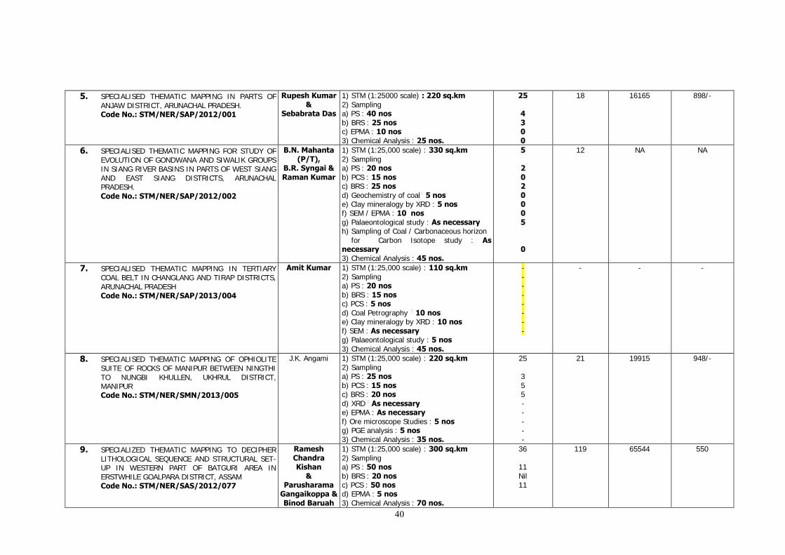
40
5. SPECIALISED THEMATIC MAPPING IN PARTS OF ANJAW DISTRICT, ARUNACHAL PRADESH. Code No.: STM/NER/SAP/2012/001
Rupesh Kumar &
Sebabrata Das
1) STM (1:25000 scale) : 220 sq.km 2) Sampling a) PS : 40 nos b) BRS : 25 nos
c) EPMA : 10 nos 3) Chemical Analysis : 25 nos.
25
4 3 0 0
18 16165 898/-
6. SPECIALISED THEMATIC MAPPING FOR STUDY OF EVOLUTION OF GONDWANA AND SIWALIK GROUPS IN SIANG RIVER BASINS IN PARTS OF WEST SIANG AND EAST SIANG DISTRICTS, ARUNACHAL PRADESH. Code No.: STM/NER/SAP/2012/002
B.N. Mahanta (P/T),
B.R. Syngai & Raman Kumar
1) STM (1:25,000 scale) : 330 sq.km 2) Sampling a) PS : 20 nos b) PCS : 15 nos
c) BRS : 25 nos
d) Geochemistry of coal : 5 nos
e) Clay mineralogy by XRD : 5 nos
f) SEM / EPMA : 10 nos g) Palaeontological study : As necessary
h) Sampling of Coal / Carbonaceous horizon for Carbon Isotope study : As necessary 3) Chemical Analysis : 45 nos.
5
2 0 2 0 0 0 5
0
12 NA NA
7. SPECIALISED THEMATIC MAPPING IN TERTIARY COAL BELT IN CHANGLANG AND TIRAP DISTRICTS, ARUNACHAL PRADESH Code No.: STM/NER/SAP/2013/004
Amit Kumar 1) STM (1:25,000 scale) : 110 sq.km 2) Sampling a) PS : 20 nos b) BRS : 15 nos c) PCS : 5 nos d) Coal Petrography : 10 nos
e) Clay mineralogy by XRD : 10 nos
f) SEM : As necessary g) Palaeontological study : 5 nos
3) Chemical Analysis : 45 nos.
- - - - - - - -
- - -
8. SPECIALISED THEMATIC MAPPING OF OPHIOLITE SUITE OF ROCKS OF MANIPUR BETWEEN NINGTHI TO NUNGBI KHULLEN, UKHRUL DISTRICT, MANIPUR Code No.: STM/NER/SMN/2013/005
J.K. Angami 1) STM (1:25,000 scale) : 220 sq.km 2) Sampling a) PS : 25 nos b) PCS : 15 nos c) BRS : 20 nos d) XRD : As necessary
e) EPMA : As necessary f) Ore microscope Studies : 5 nos g) PGE analysis : 5 nos
3) Chemical Analysis : 35 nos.
25 3 5 5 - - - - -
21 19915 948/-
9. SPECIALIZED THEMATIC MAPPING TO DECIPHER LITHOLOGICAL SEQUENCE AND STRUCTURAL SET-UP IN WESTERN PART OF BATGURI AREA IN ERSTWHILE GOALPARA DISTRICT, ASSAM Code No.: STM/NER/SAS/2012/077
Ramesh Chandra Kishan
& Parusharama
Gangaikoppa & Binod Baruah
1) STM (1:25,000 scale) : 300 sq.km 2) Sampling a) PS : 50 nos b) BRS : 20 nos c) PCS : 50 nos d) EPMA : 5 nos 3) Chemical Analysis : 70 nos.
36
11 Nil 11
119 65544 550
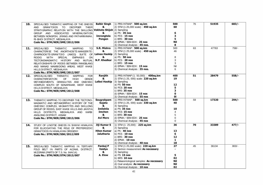
41
10. SPECIALISED THEMATIC MAPPING OF THE GNEISS AND GRANITOIDS TO DECIPGER THEIR STRATIGRAPHIC RELATION WITH THE SHILLONG GROUP AND ASSOCIATED MINERALISATION BETWEEN NONGPOH, JIRANG AND PATHARKHMAH, RI-BHOI DISTRICT, MEGHALAYA Code No.: STM/NER/SME/2012/006
Balbir Singh &
Vekhoto Shijoh &
Imrongtola Pongen
1) PRS:INTMAP : 500 sq.km 2) STM (1:25,000 scale) : 450 sq.km 2) Sampling a) PS : 35 nos b) PCS : 15 nos c) BRS : 30 nos d) EPMA / SEM-EDX : 25 nos 3) Chemical Analysis : 45 nos.
500 60
6 3 5
Nil 8
76 51935 683/-
11. SPECIALISED THEMATIC MAPPING TO CHARACTERISE THE ANORTHOSITE-MANGERITE- CHARNOCKITE-GRANITOID (AMCG) SUITE OF ROCKS WITH SPECIAL EMPHASIS ON TECTONOMAGMATIC HISTORY AND MUTUAL RELATIONSHIPS OF ROCKS BETWEEN RANGBLANG AND MANAD MAWBIDONG AREAS, WEST KHASI HILLS DISTRICT, MEGHALAYA Code No.: STM/NER/SME/2012/007
S.R. Mishra &
Lalneo Haokip &
N.P. Khedkar
1) PRS:INTMAP : 500 sq.km 2) STM (1:25,000 scale) : 450 sq.km 2) Sampling a) PS : 50 nos b) PCS : 20 nos c) BRS : 15 nos d) EPMA / SEM-EDX : 15 nos 3) Chemical Analysis : 35 nos.
500 46 8 3 3 Nil 6
63 47763 758/-
12. SPECIALIALISED THEMATIC MAPPING FOR CHARACTERISATION OF HIGH GRADE METASEDIMENTS, GRANULITES AND GNEISSIC COMPLEX SOUTH OF SONAPAHAR, WEST KHASI HILLS DISTRICT, MEGHALAYA Code No.: STM/NER/SME/2012/008
Ranjith &
Lalboi Haokip
1) PRS:INTMAP (1: 50,000) : 400sq.km 2) STM (1:25, 000) scale: 220 sq.km 3) Sampling a) PS: 50 nos b) PCS: 20 nos
c) BRS: 35 nos
d) EPMA / SEM-EDX : 15 nos 3) Chemical Analysis : 55 nos
400 19
12 5 3 0 0l
51 28479 558/-
13. THEMATIC MAPPING TO DECIPHER THE TECTONO-MAGMATIC AND METAMORPHIC HISTORY OF THE GNEISSIC COMPLEX, MIGMATITES AND SHILLONG GROUP OF ROCKS, EAST KHASI HILLS AND JAINTIA HILLS DISTRICTS, MEGHALAYA AND KARBI ANGLONG DISTRICT, ASSAM Code No.: STM/NER/SME/2013/006
Sougrakpam Sujata
& Imlishila Imchen
& Avi Mero
1) PRS:INTMAP : 500 sq.km 2) STM (1:25, 000) scale: 330 sq.km 3) Sampling a) PS: 35 nos b) PCS: 15 nos
c) BRS: 30 nos
d) EPMA / SEM-EDX : 25 nos 3) Chemical Analysis : 45 nos
500 40
10 4 5 0 0
59 17320 294/-
14. STUDY OF LINGTSE GNEISS IN SIKKIM HIMALAYA FOR ELUCIDATING THE ROLE OF PROTEROZOIC GRANITOIDS IN HIMALAYAN OROGENY. Code No.: STM/NER/SSK/2012/009
Jiji Kumar S &
Hiten Kumar Jalutharia
1) STM (1: 25,000) : 225 sq.km 2) Sampling a) PS : 40 nos b) PCS : 10 nos
c) BRS : 30 nos d) EPMA : 10 nos 3) Chemical Analysis : 40 nos
36
13 6
12 1
18
70 33389 477/-
15. SPECIALISED THEMATIC MAPPING IN TERTIARY FOLD BELT IN PARTS OF AIZAWL DISTRICT, MIZORAM (PARTS OF T.S. No. 84A/14). Code No.: STM/NER/STM/2013/007
Pankaj P Vaidya
& A. Elow
1) STM (1:25,000 scale): 220 sq.km 2) Section measurement As necessary 3) Sampling: a) PS: 15 nos b) BRS: 10 nos c) Palaeontological samples: As necessary d) Coal analysis: As necessary 3) Chemical Analysis : 10 nos
27 -
5 02 Nil Nil 02
45 36134 803/-
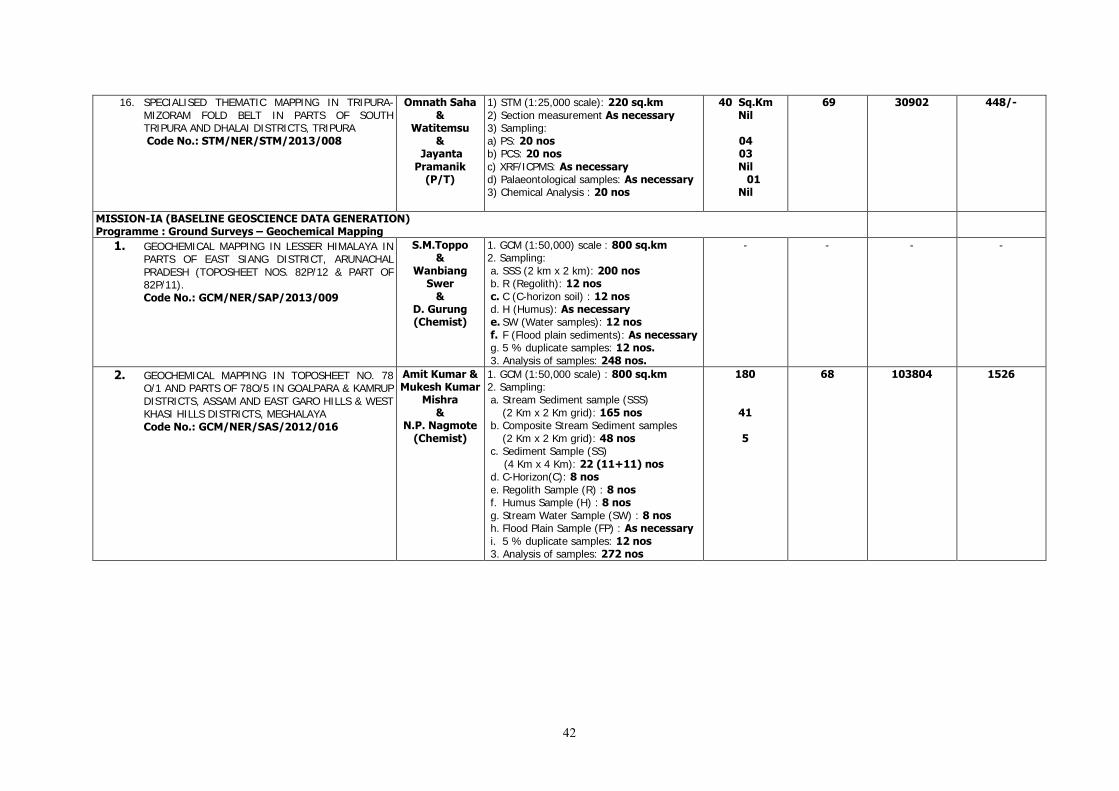
42
16. SPECIALISED THEMATIC MAPPING IN TRIPURA-MIZORAM FOLD BELT IN PARTS OF SOUTH TRIPURA AND DHALAI DISTRICTS, TRIPURA Code No.: STM/NER/STM/2013/008
Omnath Saha &
Watitemsu &
Jayanta Pramanik
(P/T)
1) STM (1:25,000 scale): 220 sq.km 2) Section measurement As necessary 3) Sampling: a) PS: 20 nos b) PCS: 20 nos c) XRF/ICPMS: As necessary d) Palaeontological samples: As necessary 3) Chemical Analysis : 20 nos
40 Sq.Km Nil
04 03 Nil
01 Nil
69 30902 448/-
MISSION-IA (BASELINE GEOSCIENCE DATA GENERATION) Programme : Ground Surveys – Geochemical Mapping
1. GEOCHEMICAL MAPPING IN LESSER HIMALAYA IN PARTS OF EAST SIANG DISTRICT, ARUNACHAL PRADESH (TOPOSHEET NOS. 82P/12 & PART OF 82P/11). Code No.: GCM/NER/SAP/2013/009
S.M.Toppo &
Wanbiang Swer
& D. Gurung (Chemist)
1. GCM (1:50,000) scale : 800 sq.km 2. Sampling: a. SSS (2 km x 2 km): 200 nos b. R (Regolith): 12 nos c. C (C-horizon soil) : 12 nos d. H (Humus): As necessary e. SW (Water samples): 12 nos f. F (Flood plain sediments): As necessary g. 5 % duplicate samples: 12 nos. 3. Analysis of samples: 248 nos.
- - - -
2. GEOCHEMICAL MAPPING IN TOPOSHEET NO. 78 O/1 AND PARTS OF 78O/5 IN GOALPARA & KAMRUP DISTRICTS, ASSAM AND EAST GARO HILLS & WEST KHASI HILLS DISTRICTS, MEGHALAYA Code No.: GCM/NER/SAS/2012/016
Amit Kumar & Mukesh Kumar
Mishra &
N.P. Nagmote (Chemist)
1. GCM (1:50,000 scale) : 800 sq.km 2. Sampling: a. Stream Sediment sample (SSS)
(2 Km x 2 Km grid): 165 nos b. Composite Stream Sediment samples
(2 Km x 2 Km grid): 48 nos c. Sediment Sample (SS) (4 Km x 4 Km): 22 (11+11) nos d. C-Horizon(C): 8 nos e. Regolith Sample (R) : 8 nos f. Humus Sample (H) : 8 nos g. Stream Water Sample (SW) : 8 nos h. Flood Plain Sample (FP) : As necessary i. 5 % duplicate samples: 12 nos 3. Analysis of samples: 272 nos
180
41
5
68 103804 1526

43
3. REGIONAL GEOCHEMICAL MAPPING IN THE OPHIOLOIE BELT IN PARTS OF PHEK DISTRICT, NAGALAND Code No.: GCM/NER/SMN/2013/010
Chubala Shijoh
& D. Bharati
& R.Vittal
(Chemist)
1. GCM (1:50,000 scale) : 800 sq.km 2. Sampling: a. Stream Sediment Sample (SSS)
(2 Km X 2 Km) : 200 nos b. Soil Sample (C-horizon) : 12 nos c. Regolith Sample (R) : 12 nos d. Humus Sample (H) : As necessary e. Stream Water Sample (SW) : 24 nos f. Duplicate SSS (3 to 5% of the area) :
12 nos 3. Analysis of samples: 260 nos
222
60 2 2
45 38213 849/-
4. REGIONAL GEOCHEMICAL MAPPING IN THE OPHIOLITE BELT IN PARTS OF MON,TUENSANG & KIPHIRE DISTRICTS, NAGALAND Code No.: GCM/NER/SMN/2013/011
E. John &
R.Vittal (Chemist)
1. GCM (1:50,000 scale) : 400 sq.km 2. Sampling: a. Stream Sediment Sample (SSS)
(2 Km X 2 Km) : 100 nos b. Soil Sample (C-horizon) : 6 nos c. Regolith Sample (R) : 6 nos d. Humus Sample (H) : As necessary e. Stream Water Sample (SW) : 12 nos f. Duplicate SSS (3 to 5% of the area) : 6
nos 3. Analysis of samples: 130 nos
120
30 1 1
1
32 31960 999/-
5. GEOCHEMICAL MAPPING IN MEGHALAYA GNEISSIC COMPLEX IN PARTS OF JAINTIA AND EAST KHASI HILLS DISTRICT, MEGHALAYA (TOPOSHEET NOS. 83C/07 & PART OF 83 C/03) Code No.: GCM/NER/SME/2013/012
H.K. Sahoo &
H. Sumar &
A.S.Bora (Chemist)
1. GCM (1:50,000) scale: 800 sq.km 2. Sampling: a. SSS (Stream sediment sample): 416 nos b. Composite samples:208 nos c. R (Regolith): 11 nos d. C (C-horizon soil): 11 nos e. H (Humus): As necessary f. SW ( Water samples) : 22 nos g. F (Flood plain sediments): As necessary h. 5 % duplicate samples: 11 composites 3. Analysis of samples: 263 nos
108
54 27 0 0 0 0 0 1
22 39000 1773/-
6. GEOCHEMICAL MAPPING IN TOPOSHEET NO 83C/03 IN PARTS OF EAST KHASI HILL AND JAINTIA HILL DISTRICTS, MEGHALAYA. Code No.: GCM/NER/SME/2012/014
Ajay C. Limbu & T.
Myelvaganan (Chemist)
1. GCM (1:50,000) scale: 400 sq.km 2. Sampling: a. SSS (Stream sediment sample): 208 nos b. Composite Samples: 104 nos c. R (Regolith): 5 nos d. C (C-horizon soil): 5 nos e. H (Humus): As necessary f. SW (Water samples): 10 nos g. F (Flood plain sediments): As necessary h. 5 % duplicate samples: 5 composites 3. Analysis of samples: 129 nos
108
54 27 2 2 0 0 0 0 0
18 69408 3856/-
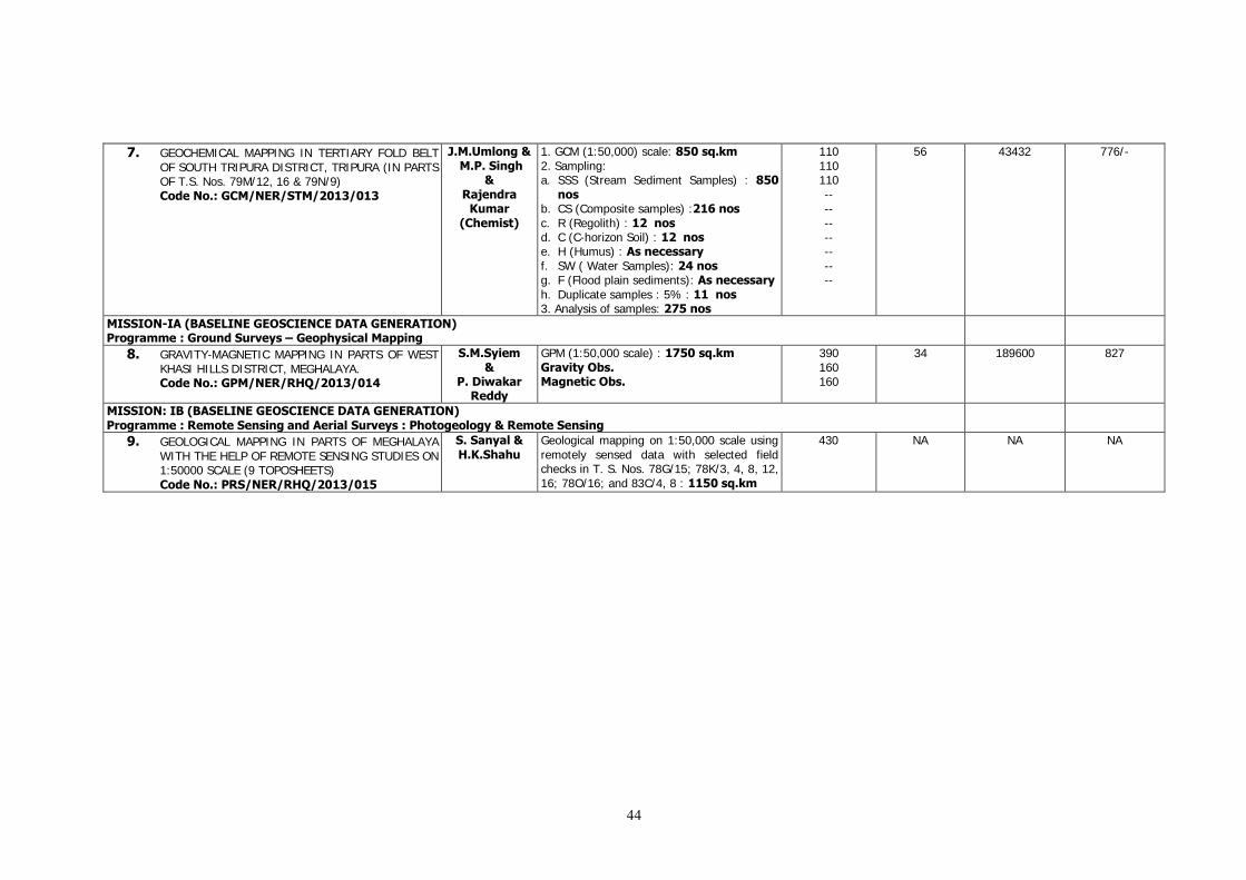
44
7. GEOCHEMICAL MAPPING IN TERTIARY FOLD BELT OF SOUTH TRIPURA DISTRICT, TRIPURA (IN PARTS OF T.S. Nos. 79M/12, 16 & 79N/9) Code No.: GCM/NER/STM/2013/013
J.M.Umlong & M.P. Singh
& Rajendra
Kumar (Chemist)
1. GCM (1:50,000) scale: 850 sq.km 2. Sampling: a. SSS (Stream Sediment Samples) : 850
nos b. CS (Composite samples) :216 nos c. R (Regolith) : 12 nos d. C (C-horizon Soil) : 12 nos e. H (Humus) : As necessary f. SW ( Water Samples): 24 nos g. F (Flood plain sediments): As necessary h. Duplicate samples : 5% : 11 nos 3. Analysis of samples: 275 nos
110 110 110 -- -- -- -- -- -- --
56 43432 776/-
MISSION-IA (BASELINE GEOSCIENCE DATA GENERATION) Programme : Ground Surveys – Geophysical Mapping
8. GRAVITY-MAGNETIC MAPPING IN PARTS OF WEST KHASI HILLS DISTRICT, MEGHALAYA. Code No.: GPM/NER/RHQ/2013/014
S.M.Syiem &
P. Diwakar Reddy
GPM (1:50,000 scale) : 1750 sq.km Gravity Obs. Magnetic Obs.
390 160 160
34 189600 827
MISSION: IB (BASELINE GEOSCIENCE DATA GENERATION) Programme : Remote Sensing and Aerial Surveys : Photogeology & Remote Sensing
9. GEOLOGICAL MAPPING IN PARTS OF MEGHALAYA WITH THE HELP OF REMOTE SENSING STUDIES ON 1:50000 SCALE (9 TOPOSHEETS) Code No.: PRS/NER/RHQ/2013/015
S. Sanyal & H.K.Shahu
Geological mapping on 1:50,000 scale using remotely sensed data with selected field checks in T. S. Nos. 78G/15; 78K/3, 4, 8, 12, 16; 78O/16; and 83C/4, 8 : 1150 sq.km
430 NA NA NA
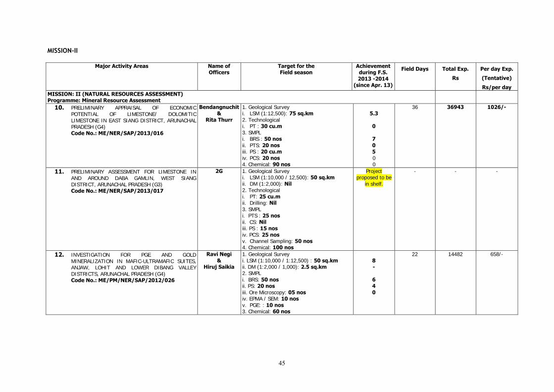
45
MISSION-II
Major Activity Areas Name of Officers
Target for the Field season
Achievement during F.S. 2013 -2014
(since Apr. 13)
Field Days Total Exp.
Rs
Per day Exp.
(Tentative)
Rs/per day
MISSION: II (NATURAL RESOURCES ASSESSMENT) Programme: Mineral Resource Assessment
10. PRELIMINARY APPRAISAL OF ECONOMIC POTENTIAL OF LIMESTONE/ DOLOMITIC LIMESTONE IN EAST SIANG DISTRICT, ARUNACHAL PRADESH (G4) Code No.: ME/NER/SAP/2013/016
Bendangnuchit &
Rita Thurr
1. Geological Survey i. LSM (1:12,500): 75 sq.km 2. Technological i. PT : 30 cu.m 3. SMPL i. BRS : 50 nos ii. PTS: 20 nos iii. PS : 20 cu.m iv. PCS: 20 nos 4. Chemical: 90 nos
5.3
0
7 0 5 0 0
36 36943 1026/-
11. PRELIMINARY ASSESSMENT FOR LIMESTONE IN AND AROUND DABA GAMLIN, WEST SIANG DISTRICT, ARUNACHAL PRADESH (G3) Code No.: ME/NER/SAP/2013/017
2G 1. Geological Survey i. LSM (1:10,000 / 12,500): 50 sq.km ii. DM (1:2,000): Nil 2. Technological i. PT: 25 cu.m ii. Drilling: Nil 3. SMPL i. PTS : 25 nos ii. CS: Nil iii. PS : 15 nos iv. PCS: 25 nos v. Channel Sampling: 50 nos 4. Chemical: 100 nos
Project proposed to be
in shelf.
- - -
12. INVESTIGATION FOR PGE AND GOLD MINERALIZATION IN MAFIC-ULTRAMAFIC SUITES, ANJAW, LOHIT AND LOWER DIBANG VALLEY DISTRICTS, ARUNACHAL PRADESH (G4) Code No.: ME/PM/NER/SAP/2012/026
Ravi Negi &
Hiruj Saikia
1. Geological Survey i. LSM (1:10,000 / 1:12,500) : 50 sq.km ii. DM (1:2,000 / 1,000): 2.5 sq.km 2. SMPL i. BRS: 50 nos ii. PS: 20 nos iii. Ore Microscopy: 05 nos iv. EPMA / SEM: 10 nos v. PGE: : 10 nos 3. Chemical: 60 nos
8 -
6 4 0
22 14482 658/-

46
13. PRELIMINARY INVESTIGATION FOR REE IN SOUTHERN PART OF AGIA AROUND SUJUKONA HILL AND TUKURESWARI HILL IN PARTS OF GOALPARA DISTRICT, ASSAM (G4) Code No.: ME/NER/SAS/2012/084
Arup Kumar Bora
& M. Shyamkumar
Singh &
A.K.Mishra (Transferred
w.e.f 30.06.2013)
1. Geological Survey i. LSM (1:12,500) : 50 sq.km ii. DM (1:2,000): 1.5 sq.km 2. Sampling i. BRS: 50 nos ii. SSS: 80 nos iii. PS: 25 nos iv. EPMA: 15 nos v. PCS: : 25 nos 3. Chemical: 155 nos
15 0
4 36 6 0 5
45
115 82148 714
14. PRELIMINARY INVESTIGATION FOR PLATINUM GROUP OF ELEMENT IN OPHIOLITE BELT OF NAGALAND (G4) Code No.: ME/PM/NER/SMN/2012/028
N. Meribemo Yanthan
& 1G (Petrology)
(P/T)
1. Geological Survey i. Reconnoitary Geological Traverse Mapping on 1:50,000 scale. :150 sq.km 2. SMPL i. PS: 25 nos ii. OM: 10 nos iii. EPMA / SEM :15 nos iv. PCS (Major/Trace/REE): 30 nos v. PGE: 25 nos vi. Channel Sampling: As necessary 3. Chemical: 55 nos
30
7 3 4 8 8 0 0
40 35208 880/-
15. INVESTIGATION FOR TITANIFEROUS-VANADIFEROUS MAGNETITE AROUND RAMBRAI IN WEST KHASI HILLS DISTRICT, MEGHALAYA (G4) Code No.: ME/F/NER/SME/2012/023
V.Sreenivasiah
1. Geological Survey i. LSM (1;10,000 / 1:12,500) : 25 sq.km ii. DM (1:2,000): 1.5 sq.km 2. Technological i. PT: 25 cu.m 3. Geophysical Survey i. GP (Magnetic): 10 L.km 4. SMPL i. BRS: 50 nos ii. PS : 10 nos
iii. OM: 05 nos
iv. EPMA : 05 nos
v. PCS (PGE) : 05 nos
vi. PCS (REE) : 05 nos 5. Chemical: 60 nos
6.5 0 0 0 9 7 3 1 1 9
29 59670 2057/-
16. INVESTIGATION FOR LIMESTONE IN NORTH OF LARKET BLOCK, LITANG VALLEY, JAINTIA HILLS DISTRICT, MEGHALAYA (G3) Code No.: ME/NER/SME/2013/018
Pius Sakhar &
T.G.Singh
1. Geological Survey i. DM (1:5,000) : 1.50 sq.km 2. Technological i. Drilling (RD-30; Unit No:427) : 800 m 3. SMPL i. CS: 300 nos ii. PS: 05 nos 4. Baseline Parameters on Environment i. Surface Water (SW): 06 nos ii. Soil samples (SS): 06 nos
0.30
0.00
0.00 0.00
0.00 0.00
NA NA NA
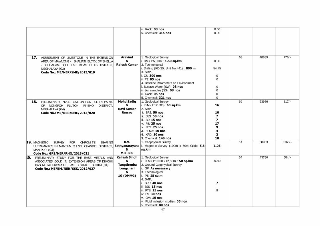
47
iii. Rock: 03 nos 5. Chemical: 315 nos
0.00 0.00
17. ASSESSMENT OF LIMESTONE IN THE EXTENSION AREA OF MAWLONG - ISHAMATI BLOCK OF SHELLA - BHOLAGANJ BELT, EAST KHASI HILLS DISTRICT, MEGHALAYA (G3) Code No.: ME/NER/SME/2013/019
Aravind &
Rajesh Kumar
1. Geological Survey i. DM (1:5,000) : 1.50 sq.km 2. Technological i. Drilling (RD-30; Unit No:441) : 800 m 3. SMPL i. CS: 300 nos ii. PS: 05 nos 4. Baseline Parameters on Environment i. Surface Water (SW): 08 nos ii. Soil samples (SS): 08 nos iii. Rock: 05 nos 5. Chemical: 321 nos
0.30
54.75
0 0 0 0 0 0
63 48889 776/-
18. PRELIMINARY INVESTIGATION FOR REE IN PARTS OF NONGPOH PLUTON, RI-BHOI DISTRICT, MEGHALAYA (G4) Code No.: ME/NER/SME/2013/020
Mohd Sadiq &
Ravi Kumar Umrao
1. Geological Survey i. LSM (1:12,500): 60 sq.km 2. SMPL i. BRS: 50 nos ii. SSS: 50 nos iii. SS: 15 nos iv. PS: 25 nos v. PCS: 25 nos vi. EPMA: 10 nos vii. XRD: 10 nos 3. Chemical: 140 nos
16
10 7 7
17 9 4 2
10
66 53986 817/-
19. MAGNETIC SURVEY FOR CHROMITE BEARING ULTRAMAFICS IN MANTUM CHING, CHANDEL DISTRICT, MANIPUR, (G4) Code No.: GPS/NER/RHQ/2013/021
K.V. Sathyanarayana
& M.K. Rai
1. Geophysical Survey i. Magnetic Survey (100m x 50m Grid): 5.6 sq.km
1.05
14 68903 3163/-
20. PRELIMINARY STUDY FOR THE BASE METALS AND ASSOCIATED GOLD IN EXTENSION AREAS OF DIKCHU BASEMETAL PROSPECT, EAST DISTRICT, SIKKIM (G4) Code No.: ME/BM/NER/SSK/2012/027
Kailash Singh &
Tangtirenba Longchari
& 1G (DMMG)
1. Geological Survey i. LSM (1:10,000/12,500) : 50 sq.km 2. Ground Geophysical Survey i. GP: As necessary 3. Technological i. PT: 25 cu.m 4. SMPL i. BRS: 40 nos ii. SSS: 15 nos iii. PTS: 25 nos iv. PS: 30 nos v. OM: 10 nos vi. Fluid inclusion studies: 05 nos 5. Chemical: 80 nos
8.80
7 9
64 43786 684/-
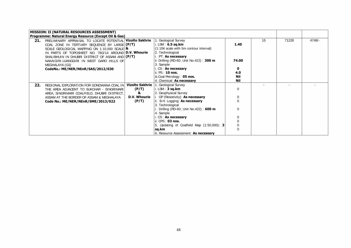
48
MISSION: II (NATURAL RESOURCES ASSESSMENT) Programme: Natural Energy Resource (Except Oil & Gas)
21. PRELIMINARY APPRAISAL TO LOCATE POTENTIAL COAL ZONE IN TERTIARY SEQUENCE BY LARGE SCALE GEOLOGICAL MAPPING ON 1:10,000 SCALE IN PARTS OF TOPOSHEET NO. 78G/14 AROUND SHALIBHUIN IN DHUBRI DISTRICT OF ASSAM AND NAKAIGIRI-UJANGGIRI IN WEST GARO HILLS OF MEGHALAYA (G3) CodeNo.: ME/NER/NEnR/SAS/2012/030
Vizolto Sakhrie (P/T) & D.V. Whourie (P/T)
1. Geological Survey i. LSM : 6.5 sq.km (1:10K scale with 5m contour interval) 2. Technological i. PT: As necessary ii. Drilling (RD-60; Unit No:422) : 300 m 3. Sample i. CS : As necessary ii. PS : 10 nos. iii.Coal Petrology : 05 nos. 4. Chemical: As necessary
1.40
74.00
0 4.0 Nil Nil
15 71228 4748/-
22. REGIONAL EXPLORATION FOR GONDWANA COAL IN THE AREA ADJACENT TO SUKCHAR - SINGRIMARI AREA, SINGRIMARI COALFIELD, DHUBRI DISTRICT, ASSAM AT THE BORDER OF ASSAM & MEGHALAYA Code No.: ME/NER/NEnR/SME/2013/022
Vizolto Sakhrie (P/T)
& D.V. Whourie
(P/T)
1. Geological Survey i. LSM : 3 sq.km 2. Geophysical Survey i. GP (Resistivity): As necessary ii. B.H. Logging: As necessary 3. Technological i. Drilling (RD-60; Unit No:422) : 600 m 4. Sample i. CS : As necessary ii. CPS : 03 nos. 5. Updating of Coalfield Map (1:50,000): 3 sq.km 6. Resource Assessment: As necessary
0 0 0 0 0 0 0 0
- - -

49
MISSION-IV
Major Activity Areas Name of Officers
Target for the Field season
Achievement during F.S. 2013 -2014 (since Apr.
13)
Field Days Total Exp.
Rs
Per day Exp.
(Tentative)
Rs/per day
MISSION: IV (FUNDAMENTAL AND MULTIDISCIPLINARY GEOSCIENCE AND SPECIAL STUDIES) Programme : Geotechnical, Landslide & Seismic
1. UPDATION OF EXISTING LANDSLIDE INVENTORY OF NORTH EASTERN REGION Code No.: SER/NER/RHQ/2013/030
Megotsohe Chasie &
S.C.Keshari & P.K.
Sarma & E.John &
Watitemsu & Thrideep Kumar N. &
P. K. Theophilus
& B.R.Syngai & Yhunyelo
Tep & N.Meribemo Yanthan & Elow A. & Jagdish Nandan
Hindayar
Preparation of Landslide Inventory of all the reported landslides in all the eight states of NER and updation of inventory with index maps and photographs: As necessary
Identified 7 nos. of landslides in the state of Nagaland which included 1 Slope failure, 1 Rock fall & 5 Debris slides.
Reported 1 Earth-Soil slide in the state of Assam by SU: Assam. inventory of three debris
slide was done in Hayuliang
sector of Arunachal Pradesh
36 1,0003/- 277/-
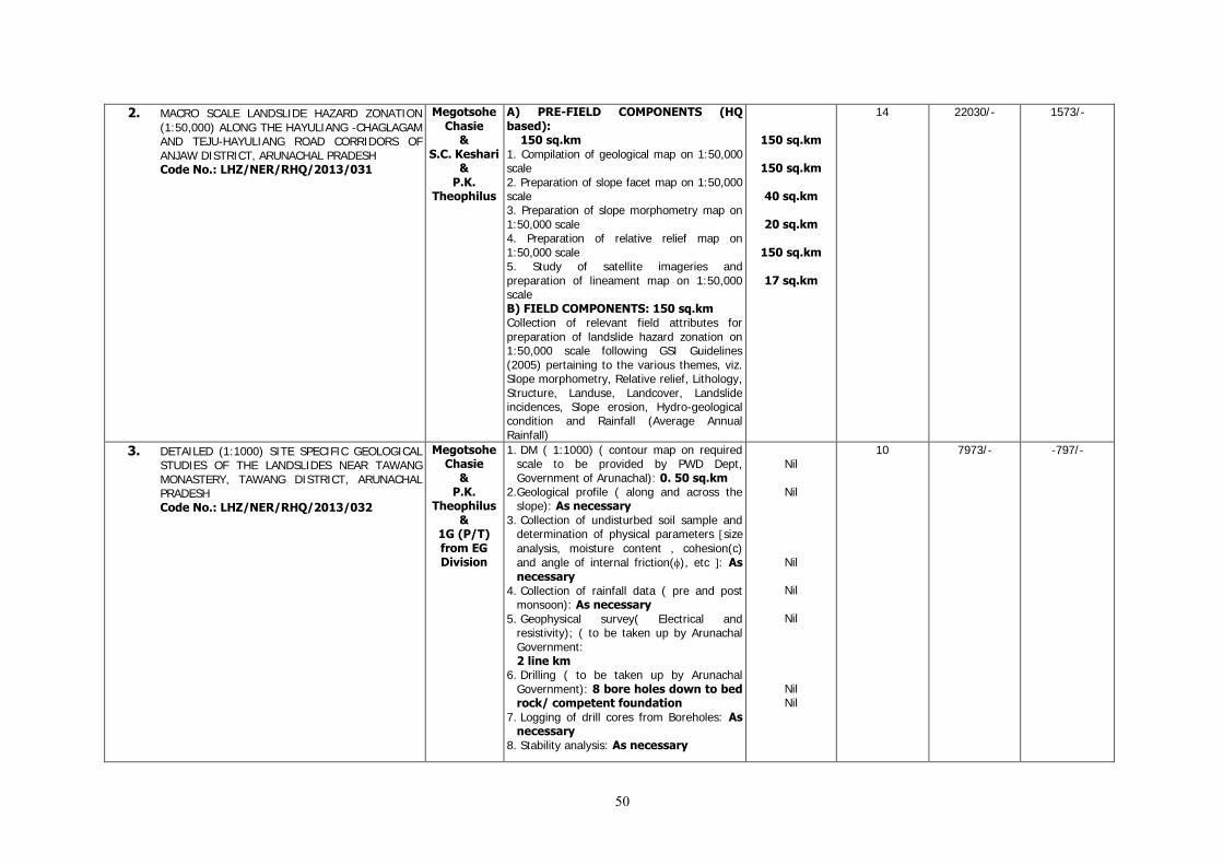
50
2. MACRO SCALE LANDSLIDE HAZARD ZONATION (1:50,000) ALONG THE HAYULIANG -CHAGLAGAM AND TEJU-HAYULIANG ROAD CORRIDORS OF ANJAW DISTRICT, ARUNACHAL PRADESH Code No.: LHZ/NER/RHQ/2013/031
Megotsohe Chasie
& S.C. Keshari
& P.K.
Theophilus
A) PRE-FIELD COMPONENTS (HQ based): 150 sq.km 1. Compilation of geological map on 1:50,000 scale 2. Preparation of slope facet map on 1:50,000 scale 3. Preparation of slope morphometry map on 1:50,000 scale 4. Preparation of relative relief map on 1:50,000 scale 5. Study of satellite imageries and preparation of lineament map on 1:50,000 scale B) FIELD COMPONENTS: 150 sq.km Collection of relevant field attributes for preparation of landslide hazard zonation on 1:50,000 scale following GSI Guidelines (2005) pertaining to the various themes, viz. Slope morphometry, Relative relief, Lithology, Structure, Landuse, Landcover, Landslide incidences, Slope erosion, Hydro-geological condition and Rainfall (Average Annual Rainfall)
150 sq.km
150 sq.km
40 sq.km
20 sq.km
150 sq.km
17 sq.km
14 22030/- 1573/-
3. DETAILED (1:1000) SITE SPECIFIC GEOLOGICAL STUDIES OF THE LANDSLIDES NEAR TAWANG MONASTERY, TAWANG DISTRICT, ARUNACHAL PRADESH Code No.: LHZ/NER/RHQ/2013/032
Megotsohe Chasie
& P.K.
Theophilus &
1G (P/T) from EG Division
1. DM ( 1:1000) ( contour map on required scale to be provided by PWD Dept, Government of Arunachal): 0. 50 sq.km
2.Geological profile ( along and across the slope): As necessary
3. Collection of undisturbed soil sample and determination of physical parameters size
analysis, moisture content , cohesion(c) and angle of internal friction(), etc : As necessary
4. Collection of rainfall data ( pre and post monsoon): As necessary
5. Geophysical survey( Electrical and resistivity); ( to be taken up by Arunachal Government: 2 line km
6. Drilling ( to be taken up by Arunachal Government): 8 bore holes down to bed rock/ competent foundation
7. Logging of drill cores from Boreholes: As necessary
8. Stability analysis: As necessary
Nil
Nil
Nil
Nil
Nil
Nil Nil
10 7973/- -797/-
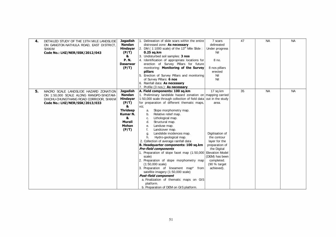
51
4. DETAILED STUDY OF THE 13TH MILE LANDSLIDE ON GANGTOK-NATHULA ROAD, EAST DISTRICT, SIKKIM Code No.: LHZ/NER/SSK/2012/043
Jagadish Nandan
Hindayar (P/T)
& P. N.
Dasarwar (P/T)
1. Delineation of slide scars within the entire distressed zone: As necessary
2. DM ( 1:1000 scale) of the 13th Mile Slide : 0.25 sq.km
3. Undisturbed soil samples: 3 nos 4. Identification of appropriate locations for
erection of Survey Pillars for future monitoring: Monitoring of the Survey pillars
5. Erection of Survey Pillars and monitoring of Survey Pillars: 6 nos
6. Rainfall data: As necessary 7. Profile (3 nos.): As necessary
7 scars delineated
Under progress Nil
8 no.
8 nos pillars erected
Nil Nil
47 NA NA
5. MACRO SCALE LANDSLIDE HAZARD ZONATION ON 1:50,000 SCALE ALONG RANGPO-SINGTAM-DIKCHU-CHUNGTHANG ROAD CORRIDOR, SIKKIM Code No.: LHZ/NER/SSK/2013/033
Jagadish Nandan
Hindayar (P/T)
& Thrideep Kumar N.
& Murali Mohan (P/T)
A. Field components: 100 sq.km 1. Preliminary landslide hazard zonation on 1:50,000 scale through collection of field data for preparation of different thematic maps, viz;
a. Slope morphometry map. b. Relative relief map. c. Lithological map. d. Structural map. e. Landuse map. f. Landcover map. g. Landslide incidences map. h. Hydro-geological map.
2. Collection of average rainfall data B. Headquarter components: 100 sq.km Pre-field components 1. Preparation of slope facet map (1:50,000
scale) 2. Preparation of slope morphometry map
(1:50,000 scale) 3. Preparation of lineament map* from
satellite imagery (1:50,000 scale) Post-field component
a. Finalization of thematic maps on GIS platform.
b. Preparation of DEM on GIS platform.
17 sq.km mapping carried out in the study
area.
Digitisation of the contour layer for the
preparation of the Digital
Elevation Model (DEM) has been
completed. (90 % target achieved).
35 NA NA
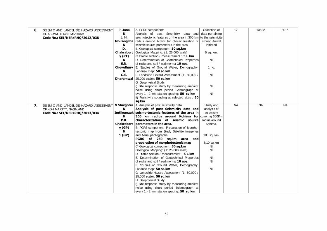
52
6. SEISMIC AND LANDSLIDE HAZARD ASSESSMENT OF AIZAWL TOWN, MIZORAM Code No.: SEI/NER/RHQ/2012/038
P. Jana &
L. H. Moirangcha
& D.
Chakraborty (PT)
& S.N.
Chowdhury &
G.S. Dharamwal
A. PGRS component: Analysis of past Seismicity data and seismotectonic features of the area in 300 km radius around Aizawl for characterization of seismic source parameters in the area B. Geological component: 50 sq.km Geological Mapping: (1: 25,000 scale) C. Profile section / measurement : 5 L.km D. Determination of Geotechnical Properties of rocks and soil / sediments: 10 nos. E. Studies of Ground Water, Demography, Landuse map: 50 sq.km F. Landslide Hazard Assessment (1: 50,000 / 25,000 scale): 50 sq.km G. Geophysical Study: i) Site response study by measuring ambient noise using short period Seismograph at every 1 - 2 km. station spacing: 50 sq.km ii) Resistivity sounding at selected sites : 50 sq.km
Collection of data pertaining to the seismicity around Aizwal
initiated
5 sq. km.
Nil
1 no.
Nil
Nil
Nil
17 13622 801/-
7. SEISMIC AND LANDSLIDE HAZARD ASSESSMENT OF KOHIMA CITY, NAGALAND Code No.: SEI/NER/RHQ/2013/034
V Shivgotra &
Imtikumzuk &
P.K. Chakrabort
y (GP) &
1 (GP)
A. Analysis of past seismicity data: Analysis of past Seismicity data and seismo-tectonic features of the area in 300 km radius around Kohima for characterization of seismic source parameters in the area. B. PGRS component: Preparation of Morpho-tectonic map from Study Satellite imageries and Aerial photographs PGRS of 250 sq.km area and preparation of morphotectonic map C. Geological component: 50 sq.km Geological Mapping: (1: 25,000 scale) D. Profile section / measurement : 5 L.km E. Determination of Geotechnical Properties of rocks and soil / sediments: 10 nos. F. Studies of Ground Water, Demography, Landuse map: 50 sq.km G. Landslide Hazard Assessment (1: 50,000 / 25,000 scale): 50 sq.km H. Geophysical Study: i) Site response study by measuring ambient noise using short period Seismograph at every 1 - 2 km. station spacing: 50 sq.km
Study and analysis of seismicity
covering 300Km radius around
Kohima.
100 sq. km.
N10 sq.km Nil Nil
Nil Nil
Nil
NA NA NA
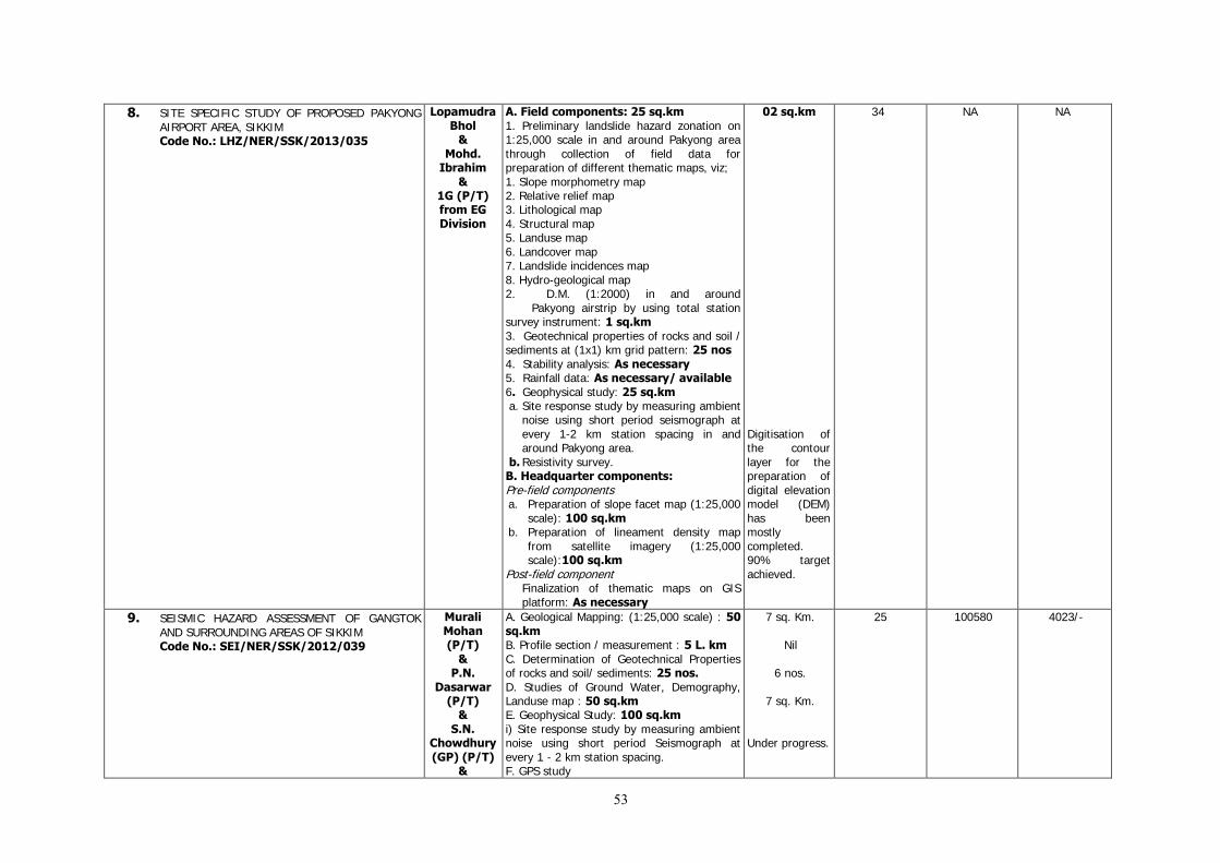
53
8. SITE SPECIFIC STUDY OF PROPOSED PAKYONG AIRPORT AREA, SIKKIM Code No.: LHZ/NER/SSK/2013/035
Lopamudra Bhol
& Mohd.
Ibrahim &
1G (P/T) from EG Division
A. Field components: 25 sq.km 1. Preliminary landslide hazard zonation on 1:25,000 scale in and around Pakyong area through collection of field data for preparation of different thematic maps, viz; 1. Slope morphometry map 2. Relative relief map 3. Lithological map 4. Structural map 5. Landuse map 6. Landcover map 7. Landslide incidences map 8. Hydro-geological map 2. D.M. (1:2000) in and around Pakyong airstrip by using total station survey instrument: 1 sq.km 3. Geotechnical properties of rocks and soil / sediments at (1x1) km grid pattern: 25 nos 4. Stability analysis: As necessary 5. Rainfall data: As necessary/ available 6. Geophysical study: 25 sq.km a. Site response study by measuring ambient
noise using short period seismograph at every 1-2 km station spacing in and around Pakyong area.
b. Resistivity survey. B. Headquarter components: Pre-field components a. Preparation of slope facet map (1:25,000
scale): 100 sq.km b. Preparation of lineament density map
from satellite imagery (1:25,000 scale):100 sq.km
Post-field component Finalization of thematic maps on GIS platform: As necessary
02 sq.km Digitisation of the contour layer for the preparation of digital elevation model (DEM) has been mostly completed. 90% target achieved.
34 NA NA
9. SEISMIC HAZARD ASSESSMENT OF GANGTOK AND SURROUNDING AREAS OF SIKKIM Code No.: SEI/NER/SSK/2012/039
Murali Mohan (P/T)
& P.N.
Dasarwar (P/T)
& S.N.
Chowdhury (GP) (P/T)
&
A. Geological Mapping: (1:25,000 scale) : 50 sq.km B. Profile section / measurement : 5 L. km C. Determination of Geotechnical Properties of rocks and soil/ sediments: 25 nos. D. Studies of Ground Water, Demography, Landuse map : 50 sq.km E. Geophysical Study: 100 sq.km i) Site response study by measuring ambient noise using short period Seismograph at every 1 - 2 km station spacing. F. GPS study
7 sq. Km.
Nil
6 nos.
7 sq. Km.
Under progress.
25 100580 4023/-
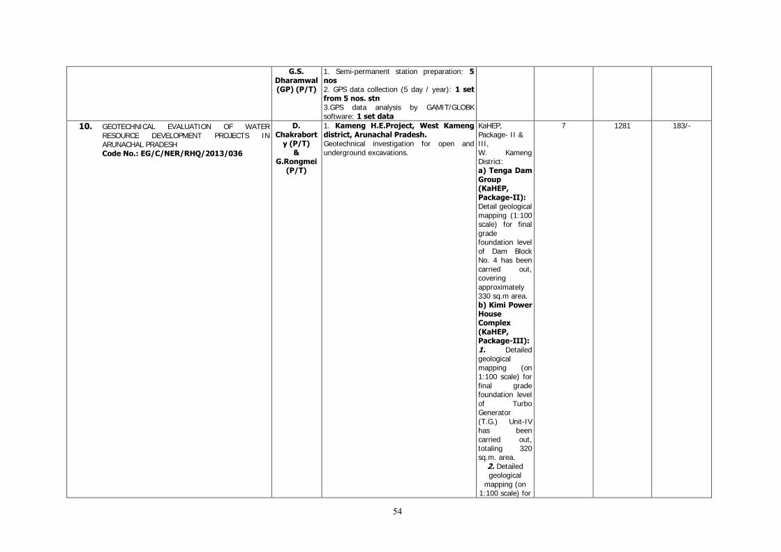
54
G.S. Dharamwal (GP) (P/T)
1. Semi-permanent station preparation: 5 nos 2. GPS data collection (5 day / year): 1 set from 5 nos. stn 3.GPS data analysis by GAMIT/GLOBK software: 1 set data
10. GEOTECHNICAL EVALUATION OF WATER RESOURCE DEVELOPMENT PROJECTS IN ARUNACHAL PRADESH Code No.: EG/C/NER/RHQ/2013/036
D. Chakrabort
y (P/T) &
G.Rongmei (P/T)
1. Kameng H.E.Project, West Kameng district, Arunachal Pradesh. Geotechnical investigation for open and underground excavations.
KaHEP, Package- II & III, W. Kameng District: a) Tenga Dam Group (KaHEP, Package-II): Detail geological mapping (1:100 scale) for final grade foundation level of Dam Block No. 4 has been carried out, covering approximately 330 sq.m area. b) Kimi Power House Complex (KaHEP, Package-III): 1. Detailed geological mapping (on 1:100 scale) for final grade foundation level of Turbo Generator (T.G.) Unit-IV has been carried out, totaling 320 sq.m. area.
2. Detailed geological
mapping (on 1:100 scale) for
7 1281 183/-
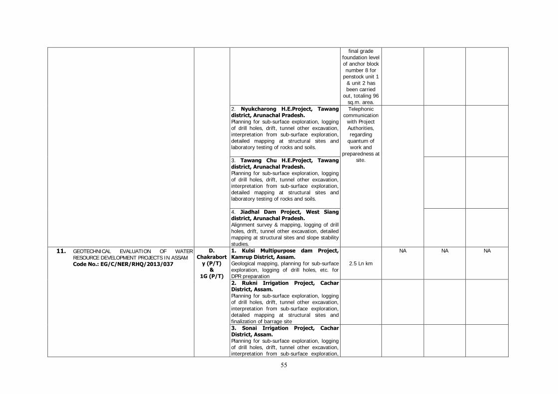
55
final grade foundation level of anchor block number 8 for
penstock unit 1 & unit 2 has been carried
out, totaling 96 sq.m. area.
2. Nyukcharong H.E.Project, Tawang district, Arunachal Pradesh. Planning for sub-surface exploration, logging of drill holes, drift, tunnel other excavation, interpretation from sub-surface exploration, detailed mapping at structural sites and laboratory testing of rocks and soils.
Telephonic communication
with Project Authorities, regarding
quantum of work and
preparedness at site.
3. Tawang Chu H.E.Project, Tawang district, Arunachal Pradesh. Planning for sub-surface exploration, logging of drill holes, drift, tunnel other excavation, interpretation from sub-surface exploration, detailed mapping at structural sites and laboratory testing of rocks and soils.
4. Jiadhal Dam Project, West Siang district, Arunachal Pradesh. Alignment survey & mapping, logging of drill holes, drift, tunnel other excavation, detailed mapping at structural sites and slope stability studies.
11. GEOTECHNICAL EVALUATION OF WATER RESOURCE DEVELOPMENT PROJECTS IN ASSAM Code No.: EG/C/NER/RHQ/2013/037
D. Chakrabort
y (P/T) &
1G (P/T)
1. Kulsi Multipurpose dam Project, Kamrup District, Assam. Geological mapping, planning for sub-surface exploration, logging of drill holes, etc. for DPR preparation
2.5 Ln km
NA NA NA
2. Rukni Irrigation Project, Cachar District, Assam. Planning for sub-surface exploration, logging of drill holes, drift, tunnel other excavation, interpretation from sub-surface exploration, detailed mapping at structural sites and finalization of barrage site
3. Sonai Irrigation Project, Cachar District, Assam. Planning for sub-surface exploration, logging of drill holes, drift, tunnel other excavation, interpretation from sub-surface exploration,

56
detailed mapping at structural sites and finalization of barrage site
4. Lower Kopili H.E.Project, North Cachar Hills District, Assam. Alignment survey, planning for sub-surface exploration, logging of drill holes, tunnel other excavation, interpretation from sub-surface exploration, detailed mapping at structural sites and slope stability studies.
Lr. Kopili Hydro-electric Project:
Telephonic communication
with Project Authorities, regarding
quantum of work and
preparedness at site.
5. Amring Hydro Electric Project, Karbi Anglong District, Assam. Alignment survey, planning for sub-surface exploration, logging of drill holes, tunnel other excavation, interpretation from sub-surface exploration, detailed mapping at structural sites and slope stability studies.
6. Killing Multipurpose Project, Karbi-Anglong district, Assam. (Addl. Item): Geotechnical investigation towards proposed surge shaft, penstock, power house and TRT area.
Geotechnical investigation of
Killing Multipurpose Project (Addl. Item) towards various project components.
12. GEOTECHNICAL EVALUATION OF WATER RESOURCE DEVELOPMENT PROJECTS IN MIZORAM Code No.: EG/C/NER/RHQ/2013/038
Vinod Kumar (P/T)
& G.Rongmei
(P/T)
1.Tuipui H.E.Project, Champhai dist, Mizoram Planning for sub-surface exploration, logging of drill holes, drift, tunnel other excavation, interpretation from sub-surface exploration, detailed mapping at structural sites
1. Communicated to the project authorities seeking quantum of geotechnical work upto September, 13. 2 Turial H E Project: Geological mapping of Power House site was taken up, particularly the area affected by slide. Traverse along benches
5 NA NA
2. Turial H.E.Project, Aizawl District, Mizoram Geological mapping of dam and spillway area, geological mapping/ logging of High Pressure Tunnel (HPT).
3. Tlawng H.E Project, Aizawl District, Mizoram Planning for sub-surface exploration, logging of drill holes, drift, tunnel other excavation, interpretation from sub-surface exploration, detailed mapping at structural sites.
4. Tuichang H.E.Project, Hnahthial District, Mizoram Logging of drill holes, detailed mapping at

57
structural sites and survey for constructural material.
at various elevations were also taken up to examine the cracks, seepage and stability of slope. The power house pit is located in fine sandy shale of greenish grey colour and steel grey shale alternation belonging to Surma Group (Mio-Pliocene age). The dip of bedding in this rock ranges from N80W to N45W by amount 15o-20o. Joint / discontinuities are not very prominent in these rocks. However, bedding joint can be seen at places. Another set seen occasional is 62: S30oE. Total Quantum: 20,000 sq. m. mapping on 1:250 scale.
5. Mat-Sekawi H.E.Project, Lunglei District, Mizoram. Logging of drill holes.
13. GEOTECHNICAL EVALUATION OF WATER RESOURCE DEVELOPMENT PROJECTS IN MEGHALAYA Code No.: EG/C/NER/RHQ/2013/039
Vinod Kumar (P/T)
& 1G (P/T)
1. Selim H.E.Project, Jaintia Hills District, Meghalaya. Alignment survey and mapping, planning of sub-surface exploration ,logging of drill holes, drift, tunnel/other excavation, preliminary geological mapping of structural sites.
- - -
2. Mawblei H.E.Project, West Khasi Hills District, Meghalaya Alignment survey and mapping, planning of
Mawblei H.E.P, West Khasi Hills District:
NA NA NA
58
sub-surface exploration, logging of drill holes, drift, tunnel/other excavation, preliminary geological mapping of structural sites and interpretation from sub-surface exploration.
Geological line traverse mapping has been carried out on 1:2500 scale along the water conductor system from Ch. 0.00m to power house area covering ~2800.00 LM.
3. Upper Khri Diversion Project, West Khasi Hills District, Meghalaya Alignment survey and mapping, planning of sub-surface exploration, logging of drill holes, drift, tunnel/other excavation, preliminary geological mapping of structural sites, interpretation from sub-surface exploration and interpretation from sub-surface exploration.
Upper Khri Diversion H.E.P, West Khasi Hills District: Carried drill core logging of bore hole no.7&8 for 70.05m.
NA NA NA
4. Ganol Stage-II H.E.Project, West Garo Hill District, Meghalaya Alignment survey and mapping, planning of sub-surface exploration, logging of drill holes, drift, tunnel/other excavation, preliminary geological mapping of structural sites, interpretation from sub-surface exploration and interpretation from sub-surface exploration.
- - -
5. Myntdu – Leshka H.E. Project Stage-II, Jaintia Hills district, Meghalaya. Logging of drill holes, drift, tunnel other excavation, preliminary geological mapping of structural sites and interpretation from sub-surface exploration.
- - -
6. Simsang M.P. Project, South Garo Hills, Meghalaya. Alignment survey & mapping, logging of drill holes, drift, tunnel other excavation, detailed mapping at structural sites and slope stability studies.
- - -
7. Myntang H.E Project, Jaintia Hills District, Meghalaya. Alignment survey & mapping, logging of drill holes, detailed mapping at structural sites and slope stability studies.
- - -
59
14. GEOTECHNICAL EVALUATION OF TRANSPORT AND COMMUNICATION PROJECTS IN NORTH EASTERN REGION Code No.: EG/C/NER/RHQ/2013/040
G.Rongmei (P/T)
& Vinod Kumar
(P/T)
Communicated to the project authorities seeking quantum of geotechnical work upto September, 13.
Communicated to the project authorities
seeking quantum of geotechnical
work upto March 2014. Response
awaited from sponsors.
- - -
15. STUDY OF ARSENIC CONTAMINATION IN WATER AND SOIL IN PARTS OF NAGAON AND MARIGAON (WITH IN ERSTWHILE NAGAON DISTRICT) DISTRICTS, ASSAM Code No.: RP/NER/SAS/2012/082
P.C. Srivastava,
G.C.Saramah, Amiya Kumar
Mondal (Withdrawn
from this project to
PSS) &
John Kevi Angami
& S. Dutta (STA-(C)
1. INTMAPSPL (1:50,000): 1000 sq.km 2. Sampling: (i) Water analysis by arsenic kit: 500 nos (ii)Chemical analysis for As, major and trace elements in:
(a) Surface water: 50 nos (b) Ground water: 100 nos
(iii) Soil (‘C’ - Horizon): 10 nos (iv) BRS: 5 nos (v) Collection of relevant data from Govt. / non-Govt. agencies: As necessary
300
150
Nil Nil Nil 5
Nil
90 154331 1715
16. STUDIES AND PREPARATION OF PALAEONTOLOGICAL AND STRATIGRAPHICAL SECTIONS ALONG SHILLONG – SOHRA, SHILLONG – MAWSYRAM AND SHILLONG – DAWKI IN EAST KHASI HILLS DISTRICT OF MEGHALAYA Code No.: RP/NER/RHQ/2013/041
Surendra Prasad
& Abir Gupta
(P/T)
Preparation of three sections 1. L.km mapping (1:50,000 scale): 10 L.km 2. Reconnoitary survey (1:50,000): 20 sq.km 3. Section measurement: As necessary 4. Collection, Maceration and study of fossils: As necessary
2 L. Km. 5 sq. km.
Nil 5
7 12583 1798/-
17. PETROGRAPHY AND GEOCHEMISTRY OF MAWPUT MAFIC-ULTRAMAFIC SUITE AND ASSOCIATED MINERALIZATION, JAINTIA HILLS DISTRICT, MEGHALAYA Code No.: RP/NER/RHQ/2013/042
Sushree Mishra
1.Traverse Mapping on (1: 12,500): 10 L.km 2. SAMPLE PS: 40 nos PCS: 25 nos (Major/Traces/REE analysis) 3. Trace elements & REE by ICP-MS: 25 nos 4. PGE & Au : 15 nos (by Fire-assay and ICP-MS) 5. SEM/EDS: 10 nos 6. EPMA: 20 nos 7. Chemical analyses : 25 nos (Whole rock and trace elements)
Nil - - -
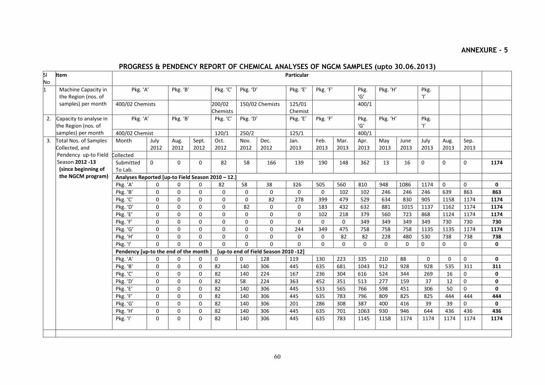
60
ANNEXURE - 5
PROGRESS & PENDENCY REPORT OF CHEMICAL ANALYSES OF NGCM SAMPLES (upto 30.06.2013) Sl No
Item Particular
1 Machine Capacity in the Region (nos. of samples) per month
Pkg. ‘A’
Pkg. ‘B’ Pkg. ‘C’ Pkg. ‘D’ Pkg. ‘E’ Pkg. ‘F’ Pkg. ‘G’
Pkg. ‘H’ Pkg. ‘I’
400/02 Chemists 200/02 Chemists
150/02 Chemists 125/01 Chemist
400/1
2. Capacity to analyse in the Region (nos. of samples) per month
Pkg. ‘A’
Pkg. ‘B’ Pkg. ‘C’ Pkg. ‘D’ Pkg. ‘E’ Pkg. ‘F’ Pkg. ‘G’
Pkg. ‘H’ Pkg. ‘I’
400/02 Chemist 120/1 250/2 125/1 400/1
3. Total Nos. of Samples Collected, and Pendency up-to Field Season 2012 -13
(since beginning of the NGCM program)
Month July 2012
Aug. 2012
Sept. 2012
Oct. 2012
Nov. 2012
Dec. 2012
Jan. 2013
Feb. 2013
Mar. 2013
Apr. 2013
May 2013
June 2013
July 2013
Aug. 2013
Sep. 2013
Collected
Submitted To Lab.
0 0 0 82 58 166 139 190 148 362 13 16 0 0 0 1174
Analyses Reported [up-to Field Season 2010 – 12.]
Pkg. ‘A’ 0 0 0 82 58 38 326 505 560 810 948 1086 1174 0 0 0
Pkg. ‘B’ 0 0 0 0 0 0 0 0 102 102 246 246 246 639 863 863
Pkg. ‘C’ 0 0 0 0 0 82 278 399 479 529 634 830 905 1158 1174 1174
Pkg. ‘D’ 0 0 0 0 82 0 0 183 432 632 881 1015 1137 1162 1174 1174
Pkg. ‘E’ 0 0 0 0 0 0 0 102 218 379 560 723 868 1124 1174 1174
Pkg. ‘F’ 0 0 0 0 0 0 0 0 0 349 349 349 349 730 730 730
Pkg. ‘G’ 0 0 0 0 0 0 244 349 475 758 758 758 1135 1135 1174 1174
Pkg. ‘H’ 0 0 0 0 0 0 0 0 82 82 228 480 530 738 738 738
Pkg. ‘I’ 0 0 0 0 0 0 0 0 0 0 0 0 0 0 0 0
Pendency [up-to the end of the month ] [up-to end of Field Season 2010 -12]
Pkg. ‘A’ 0 0 0 0 0 128 119 130 223 335 210 88 0 0 0 0
Pkg. ‘B’ 0 0 0 82 140 306 445 635 681 1043 912 928 928 535 311 311
Pkg. ‘C’ 0 0 0 82 140 224 167 236 304 616 524 344 269 16 0 0
Pkg. ‘D’ 0 0 0 82 58 224 363 452 351 513 277 159 37 12 0 0
Pkg. ‘E’ 0 0 0 82 140 306 445 533 565 766 598 451 306 50 0 0
Pkg. ‘F’ 0 0 0 82 140 306 445 635 783 796 809 825 825 444 444 444
Pkg. ‘G’ 0 0 0 82 140 306 201 286 308 387 400 416 39 39 0 0
Pkg. ‘H’ 0 0 0 82 140 306 445 635 701 1063 930 946 644 436 436 436
Pkg. ‘I’ 0 0 0 82 140 306 445 635 783 1145 1158 1174 1174 1174 1174 1174

61
4. Total Nos. of Samples Collected/ analysed during the current Field Season 2013-14
Month July 2012
Aug. 2012
Sept. 2012
Oct. 2012
Nov. 2012
Dec.2012 Jan. 2013
Feb. 2013
Mar. 2013
Apr. 2013
May 2013
June 2013
July 2013
Aug. 2013
Sep. 2013
Total
Collected
Submitted To Lab.
0 0 0 0 0 0 0 0 0 0 0 67 0 14 15 96
Analyses Reported [up-to the month of ]
Pkg. ‘A’ 0 0 0 0 0 0 0 0 0 0 0 0 0 67 81 81
Pkg. ‘B’ 0 0 0 0 0 0 0 0 0 0 0 0 0 0 0 0
Pkg. ‘C’ 0 0 0 0 0 0 0 0 0 0 0 0 0 0 81 81
Pkg. ‘D’ 0 0 0 0 0 0 0 0 0 0 0 0 0 67 29 29
Pkg. ‘E’ 0 0 0 0 0 0 0 0 0 0 0 0 0 67 67 67
Pkg. ‘F’ 0 0 0 0 0 0 0 0 0 0 0 0 0 0 0 0
Pkg. ‘G’ 0 0 0 0 0 0 0 0 0 0 0 0 0 23 23 23
Pkg. ‘H’ 0 0 0 0 0 0 0 0 0 0 0 0 0 0 0 0
Pkg. ‘I’ 0 0 0 0 0 0 0 0 0 0 0 0 0 0 0 0
Pendency [up-to the end of the month]
Pkg. ‘A’ 0 0 0 0 0 0 0 0 0 0 0 67 67 14 15 15
Pkg. ‘B’ 0 0 0 0 0 0 0 0 0 0 0 67 67 81 96 96
Pkg. ‘C’ 0 0 0 0 0 0 0 0 0 0 0 67 67 81 15 15
Pkg. ‘D’ 0 0 0 0 0 0 0 0 0 0 0 67 67 14 67 67
Pkg. ‘E’ 0 0 0 0 0 0 0 0 0 0 0 67 67 14 29 29
Pkg. ‘F’ 0 0 0 0 0 0 0 0 0 0 0 67 67 81 96 96
Pkg. ‘G’ 0 0 0 0 0 0 0 0 0 0 0 67 67 58 73 73
Pkg. ‘H’ 0 0 0 0 0 0 0 0 0 0 0 67 67 81 96 96
Pkg. ‘I’ 0 0 0 0 0 0 0 0 0 0 0 67 67 81 96 96
62
ANNEXURE - 6 YEAR-WISE, STATE-WISE, PROGRESS REPORT PENDENCY
(2002-03 to 2012-13) (As on 30.09.13)
Region Total no. of
Progress Reports
Released up to
31.03.13
Total no. of
Reports generated
in F.S.2012-13
Total no. of Reports
Released Up to
30.06.13
NER 202 nos
(including EG
Reports)
37 nos 233 nos (including EG
Reports)
MISSION-WISE PENDENCY (As on 30.09.13)
REGION MISSION-I MISSION-
II
MISSION-IV TOTAL
NO. OF
PROGRESS
REPORTS
PENDING
STM SGM GCM GPM RSAS ME GPS LHZ RP SEI ENG SER
NER 6 2 5 1 2 5 1 2 3 1 7 2 6
Total –
37 nos!
16 nos 6 nos 6 nos 7
nos
2
nos
6
6 nos report pending for quarter ending Sept’13
(Schedule date of circulation of pending reports is Nov’13)
Total Non-NGCM Reports: 32 nos
Total NGCM Reports: 5 nos
STM= SPECIALISED THEMATIC MAPPING, SGM= SYSTEMATIC GEOLOGICAL MAPPING, GCM= GEOCHEMICAL
MAPPING, RSAS= REMOTE SENSING AND AERIAL SURVEYS, ME = MINERAL EXPLORATION, GPS= GEOPHYSICAL
SURVEY, LHZ= LANDSLIDE HAZARD ZONATION , RP= RESEARCH PROJECT, SEI= SEISMIC, ENG= ENGINEERING, SER=SERVICE
YEAR-WISE PENDENCY (as on 30.09.13)
Region Total no. of Progress Reports Pending up to 30.06.13
2008-09
earlier
2009-10
2010-12
2012-13
NER All Reports Nil Nil Nil 6
Only MI Nil Nil Nil Nil
Only @GCM Nil Nil Nil 5
@ All NGCM reports up to 2009-10 have been upgraded as per the
comments/suggestions/modifications by the external peer reviewers and
have been circulated.
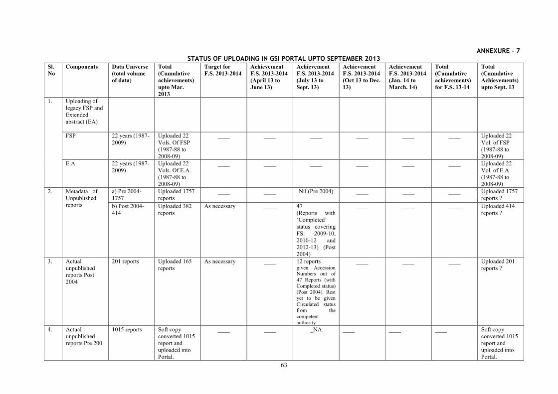
63
ANNEXURE – 7 STATUS OF UPLOADING IN GSI PORTAL UPTO SEPTEMBER 2013
Sl. No
Components Data Universe (total volume of data)
Total (Cumulative achievements) upto Mar. 2013
Target for F.S. 2013-2014
Achievement F.S. 2013-2014 (April 13 to June 13)
Achievement F.S. 2013-2014 (July 13 to Sept. 13)
Achievement F.S. 2013-2014 (Oct 13 to Dec. 13)
Achievement F.S. 2013-2014 (Jan. 14 to March. 14)
Total (Cumulative achievements) for F.S. 13-14
Total (Cumulative Achievements) upto Sept. 13
1. Uploading of legacy FSP and Extended abstract (EA)
FSP 22 years (1987-2009)
Uploaded 22 Vols. Of FSP (1987-88 to 2008-09)
____ ____ ____ ____ ____ ____ Uploaded 22 Vol. of FSP (1987-88 to 2008-09)
E.A 22 years (1987-2009)
Uploaded 22 Vols. Of E.A. (1987-88 to 2008-09)
____ ____ ____ ____ ____ ____ Uploaded 22 Vol. of E.A. (1987-88 to 2008-09)
2. Metadata of Unpublished reports
a) Pre 2004-1757
Uploaded 1757 reports
____ ____ Nil (Pre 2004) ____ ____ ____ Uploaded 1757 reports ?
b) Post 2004-414
Uploaded 382 reports
As necessary ____ 47 (Reports with ‘Completed’ status covering FS: 2009-10, 2010-12 and 2012-13) (Post 2004)
____ ____ ____ Uploaded 414 reports ?
3. Actual unpublished reports Post 2004
201 reports Uploaded 165 reports
As necessary ____ 12 reports given Accession Numbers out of 47 Reports (with Completed status) (Post 2004). Rest yet to be given Circulated status from the competent authority
____ ____ ____ Uploaded 201 reports ?
4. Actual unpublished reports Pre 200
1015 reports Soft copy converted 1015 report and uploaded into Portal.
____ ____ _NA ____ ____ ____ Soft copy converted 1015 report and uploaded into Portal.
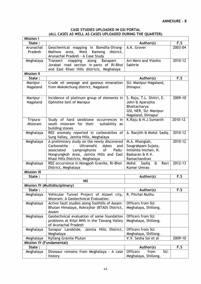
64
ANNEXURE – 8
CASE STUDIES UPLOADED IN GSI PORTAL (ALL CASES AS WELL AS CASES UPLOADED DURING THE QUARTER)
Mission I
State : Author(s) F.S
Arunachal Pradesh
Geochemical mapping in Bomdila-Dirang-Mathow area, West Kameng district, Arunachal Pradesh - A Case Study
A.K. Grover 2003-04
Meghalaya Transect mapping along Barapani – Jorabat road section in parts of Ri-Bhoi and East Khasi Hills districts, Meghalaya
Avi Mero and Vizolto Sakhrie
2010-12
Mission II
State : Author(s) F.S
Manipur - Nagaland
Crude oil seepage and gaseous emanation from Mokokchung district, Nagaland
SU: Manipur-Nagaland, Dimapur.
Manipur - Nagaland
Incidence of platinum group of elements in Ophiolite belt of Manipur
S. Raju, T.L. Shitiri, E. John & Aparajita Bhattacharya GSI, NER, SU: Manipur–Nagaland, Dimapur
2009-10
Tripura-Mizoram
Study of hard sandstone occurrences in south mizoram for their suitability as building stones
K.Raju & N.J.Sumanth 2010-12
Meghalaya REE anomaly reported in carbonatites of Sung Valley, Jaintia Hills, Meghalaya
A. Ranjith & Mohd. Sadiq 2010-12
Meghalaya A preliminary study on the newly discovered Carbonatite - Ultramafic dykes and associated Lamprophyres of Padu-Nongryngkoh Area, Jaintia Hills and East Khasi Hills Districts, Meghalaya
M.A. Khonglah, Sougrakpam Sujata, Imlishila Imchen, R. Baskaran & K.V. Ramachandran
2010-12
Meghalaya REE occurrence in Nongpoh Granite, Ri-Bhoi District, Meghalaya
Mohd. Sadiq & Ravi Kumar Umrao
2012-13
Mission III
State : Author(s) F.S
Nil
Mission IV (Multidisciplinary)
State : Author(s) F.S
Meghalaya Vehicular Tunnel Project of Aizawl city, Mizoram: A Geotechnical Evaluation.
R. Pitchai Muthu
Meghalaya Active fault studies along foothills of Assam- Bhutan Himalaya, Kokrajhar (BTAD) District, Assam
Officers from SU: Meghalaya, Shillong.
Meghalaya Geotechnical evaluation of some foundation problems at Kitpi MHS in the Tawang Valley of Arunachal Pradesh
Officers from SU: Meghalaya, Shillong.
Meghalaya Sonapur Landslide, Jaintia Hills District, Meghalaya
Officers from SU: Meghalaya, Shillong.
Meghalaya Kyllang Granite Pluton V.V. Sesha Sai et al 2009-10
Mission IV (Fundamental)
State : Author(s) F.S
Meghalaya Dinosaur remains from Meghalaya - A case history
Officers from SU: Meghalaya, Shillong.
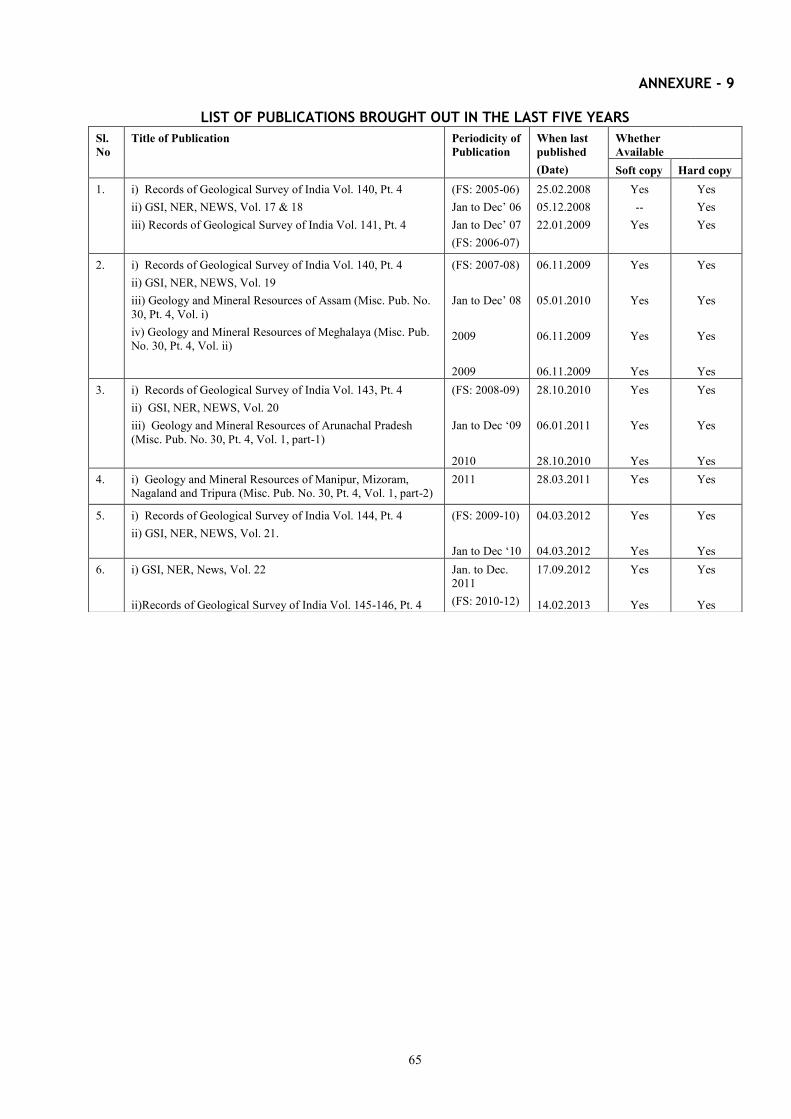
65
ANNEXURE - 9
LIST OF PUBLICATIONS BROUGHT OUT IN THE LAST FIVE YEARS
Sl.No
Title of Publication Periodicity of Publication
When last published (Date)
Whether Available
Soft copy Hard copy 1. i) Records of Geological Survey of India Vol. 140, Pt. 4
ii) GSI, NER, NEWS, Vol. 17 & 18 iii) Records of Geological Survey of India Vol. 141, Pt. 4
(FS: 2005-06) Jan to Dec’ 06 Jan to Dec’ 07 (FS: 2006-07)
25.02.2008 05.12.2008 22.01.2009
Yes --
Yes
Yes Yes Yes
2. i) Records of Geological Survey of India Vol. 140, Pt. 4 ii) GSI, NER, NEWS, Vol. 19 iii) Geology and Mineral Resources of Assam (Misc. Pub. No. 30, Pt. 4, Vol. i) iv) Geology and Mineral Resources of Meghalaya (Misc. Pub. No. 30, Pt. 4, Vol. ii)
(FS: 2007-08) Jan to Dec’ 08 2009 2009
06.11.2009 05.01.2010 06.11.2009 06.11.2009
Yes
Yes
Yes
Yes
Yes
Yes
Yes
Yes 3. i) Records of Geological Survey of India Vol. 143, Pt. 4
ii) GSI, NER, NEWS, Vol. 20 iii) Geology and Mineral Resources of Arunachal Pradesh (Misc. Pub. No. 30, Pt. 4, Vol. 1, part-1)
(FS: 2008-09) Jan to Dec ‘09 2010
28.10.2010 06.01.2011 28.10.2010
Yes
Yes
Yes
Yes
Yes
Yes 4. i) Geology and Mineral Resources of Manipur, Mizoram,
Nagaland and Tripura (Misc. Pub. No. 30, Pt. 4, Vol. 1, part-2) 2011 28.03.2011 Yes
Yes
5. i) Records of Geological Survey of India Vol. 144, Pt. 4
ii) GSI, NER, NEWS, Vol. 21. (FS: 2009-10) Jan to Dec ‘10
04.03.2012 04.03.2012
Yes
Yes
Yes
Yes 6. i) GSI, NER, News, Vol. 22
ii)Records of Geological Survey of India Vol. 145-146, Pt. 4
Jan. to Dec. 2011 (FS: 2010-12)
17.09.2012 14.02.2013
Yes
Yes
Yes
Yes
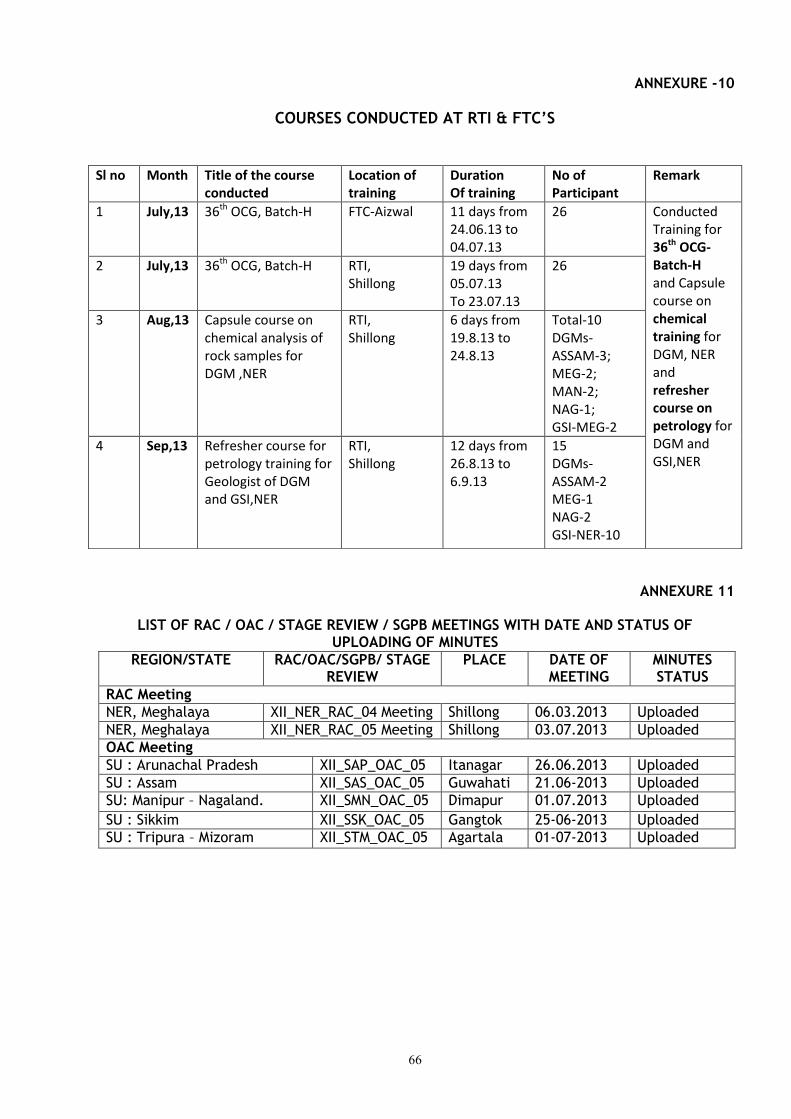
66
ANNEXURE -10
COURSES CONDUCTED AT RTI & FTC’S
ANNEXURE 11
LIST OF RAC / OAC / STAGE REVIEW / SGPB MEETINGS WITH DATE AND STATUS OF UPLOADING OF MINUTES
REGION/STATE RAC/OAC/SGPB/ STAGE REVIEW
PLACE DATE OF MEETING
MINUTES STATUS
RAC Meeting
NER, Meghalaya XII_NER_RAC_04 Meeting Shillong 06.03.2013 Uploaded
NER, Meghalaya XII_NER_RAC_05 Meeting Shillong 03.07.2013 Uploaded
OAC Meeting
SU : Arunachal Pradesh XII_SAP_OAC_05 Itanagar 26.06.2013 Uploaded
SU : Assam XII_SAS_OAC_05 Guwahati 21.06-2013 Uploaded
SU: Manipur – Nagaland. XII_SMN_OAC_05 Dimapur 01.07.2013 Uploaded
SU : Sikkim XII_SSK_OAC_05 Gangtok 25-06-2013 Uploaded
SU : Tripura – Mizoram XII_STM_OAC_05 Agartala 01-07-2013 Uploaded
Sl no Month Title of the course conducted
Location of training
Duration Of training
No of Participant
Remark
1 July,13 36th OCG, Batch-H FTC-Aizwal 11 days from 24.06.13 to 04.07.13
26 Conducted Training for 36th OCG-Batch-H and Capsule course on chemical training for DGM, NER and refresher course on petrology for DGM and GSI,NER
2 July,13 36th OCG, Batch-H RTI, Shillong
19 days from 05.07.13 To 23.07.13
26
3 Aug,13 Capsule course on chemical analysis of rock samples for DGM ,NER
RTI, Shillong
6 days from 19.8.13 to 24.8.13
Total-10 DGMs- ASSAM-3; MEG-2; MAN-2; NAG-1; GSI-MEG-2
4 Sep,13 Refresher course for petrology training for Geologist of DGM and GSI,NER
RTI, Shillong
12 days from 26.8.13 to 6.9.13
15 DGMs- ASSAM-2 MEG-1 NAG-2 GSI-NER-10
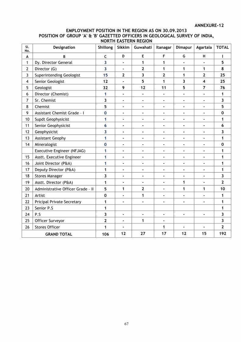
67
ANNEXURE-12 EMPLOYMENT POSITION IN THE REGION AS ON 30.09.2013
POSITION OF GROUP 'A' & 'B' GAZETTED OFFICERS IN GEOLOGICAL SURVEY OF INDIA, NORTH EASTERN REGION
Sl. No.
Designation Shillong Sikkim Guwahati Itanagar Dimapur Agartala TOTAL
A B C D E F G H I
1 Dy. Director General 3 - 1 1 - - 5
2 Director (G) 3 - 2 1 1 1 8
3 Superintending Geologist 15 2 3 2 1 2 25
4 Senior Geologist 12 - 5 1 3 4 25
5 Geologist 32 9 12 11 5 7 76
6 Director (Chemist) 1 - - - - - 1
7 Sr. Chemist 3 - - - - - 3
8 Chemist 5 - - - - - 5
9 Assistant Chemist Grade – I 0 - - - - - 0
10 Supdt Geophysicist 1 - - - - - 1
11 Senior Geophysicist 6 - - - - - 6
12 Geophysicist 3 - - - - - 3
13 Assistant Geophy 1 - - - - - 1
14 Mineralogist 0 - - - - - 0
Executive Engineer (NFJAG) 1 - - - - - 1
15 Asstt. Executive Engineer 1 - - - - - 1
16 Joint Director (P&A) 1 - - - - - 1
17 Deputy Director (P&A) 1 - - - - - 1
18 Stores Manager 3 - - - - - 3
19 Asstt. Director (P&A) 1 - - - 1 - 2
20 Administrative Officer Grade – II 5 1 2 - 1 1 10
21 Artist 0 - 1 - - - 1
22 Pricipal Private Secretary 1 - - - - - 1
23 Senior P.S 1 1
24 P.S 3 - - - - - 3
25 Officer Surveyor 2 - 1 - 3
26 Stores Officer 1 - 1 - - 2
GRAND TOTAL 106 12 27 17 12 15 192

68
ANNEXURE 13 Vehicle Position as on 30.09.2013 in North Eastern Region
A. Field going vehicles / Office Vehicles
S. No.
Particulars/ Type of vehicle
Kilometre run
Total Sanctioned strength of
Drivers
Drivers in
position Less than 25000 km
25001 – <50000
km
50,001 – <1,50,000
km
>1,50,000 km
1 Amb. Cars 08 08 52 41
2 Petrol Jeep 03 03
3 Diesel Jeep / Bolero / Armada
10
39 49
4 Gypsy 02 02
5 Toyota Qualis 02 02
6 Pick-up (Diesel) 02 02
7 LCV 05 05
8 HCV 03 03
Total 74 52 41
Age wise Status of Vehicles
B. Field vehicles / Office Vehicles
S. No.
Particulars Vehicles less than 6 years
old
Vehicles 6 years & less than 10 years
old
Vehicles more than 10 years & less than 15
years old
More than 15 years
1 Amb. Cars 02 01 05
2 Petrol Jeep 03
3 Diesel Jeep / Bolero / Armada
10
01 33 05
4 Gypsy 02
5 Toyota Qualis 02
6 Pick-up (Diesel) 02
7 LCV 05
8 HCV 03
Total 74
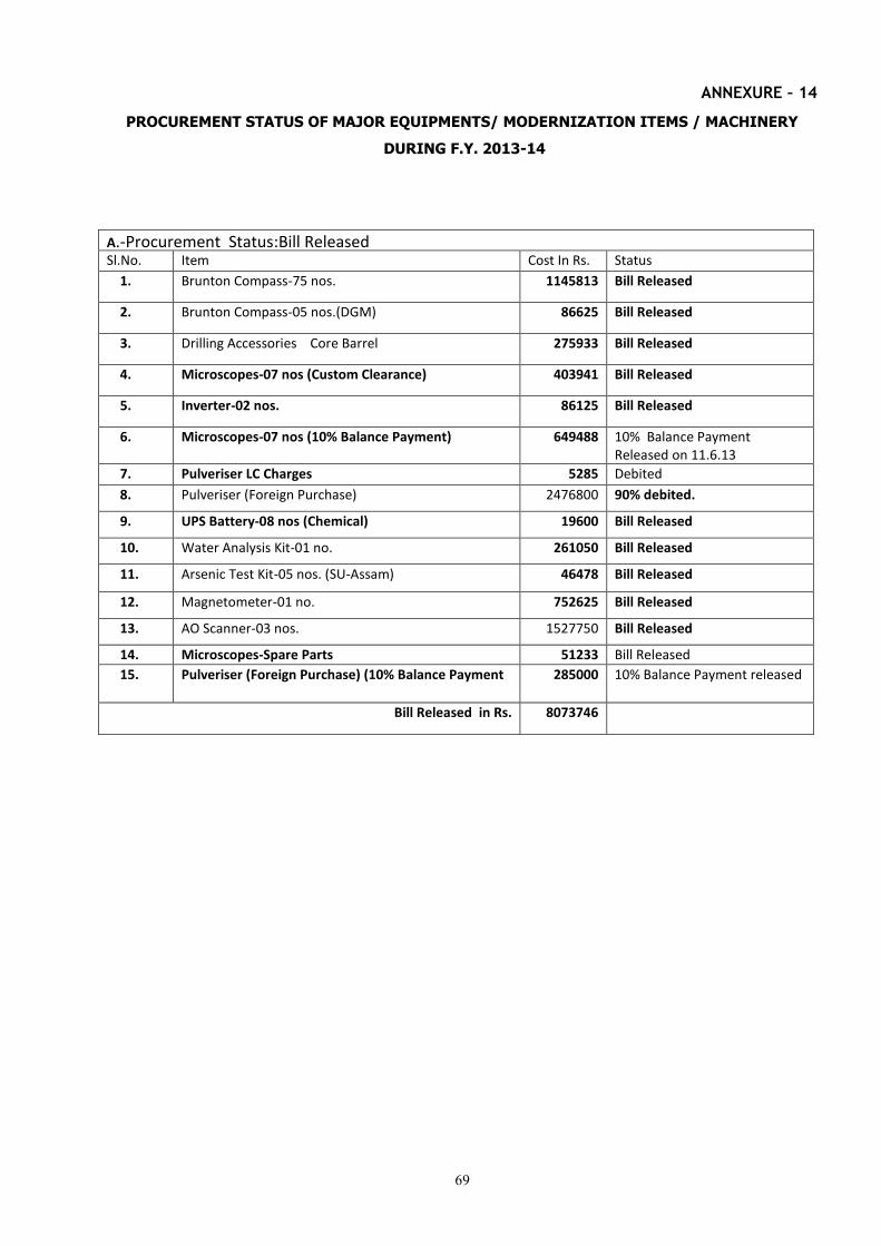
69
ANNEXURE – 14
PROCUREMENT STATUS OF MAJOR EQUIPMENTS/ MODERNIZATION ITEMS / MACHINERY
DURING F.Y. 2013-14
A.-Procurement Status:Bill Released Sl.No.
Item
Cost In Rs.
Status
1. Brunton Compass-75 nos. 1145813 Bill Released
2. Brunton Compass-05 nos.(DGM) 86625 Bill Released
3. Drilling Accessories Core Barrel 275933 Bill Released
4. Microscopes-07 nos (Custom Clearance) 403941 Bill Released
5. Inverter-02 nos. 86125 Bill Released
6. Microscopes-07 nos (10% Balance Payment) 649488 10% Balance Payment Released on 11.6.13
7. Pulveriser LC Charges 5285 Debited
8. Pulveriser (Foreign Purchase) 2476800 90% debited.
9. UPS Battery-08 nos (Chemical) 19600 Bill Released
10. Water Analysis Kit-01 no. 261050 Bill Released
11. Arsenic Test Kit-05 nos. (SU-Assam) 46478 Bill Released
12. Magnetometer-01 no. 752625 Bill Released
13. AO Scanner-03 nos. 1527750 Bill Released
14. Microscopes-Spare Parts 51233 Bill Released
15. Pulveriser (Foreign Purchase) (10% Balance Payment 285000 10% Balance Payment released
Bill Released in Rs. 8073746
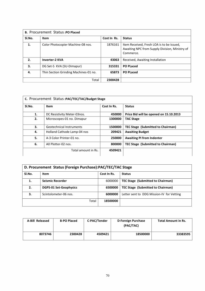
70
B. Procurement Status :PO Placed
Sl.No.
Item
Cost In Rs.
Status
1. Color Photocopier Machine-08 nos. 1876161 Item Received, Fresh LOA is to be issued, Awaiting NPC from Supply Division, Ministry of Commerce.
2. Inverter-2 KVA 43063 Received, Awaiting Installation
3. DG Set-5 KVA (SU-Dimapur) 315331 PO PLaced
4. Thin Section Grinding Machines-01 no. 65873 PO PLaced
Total 2300428
C. Procurement Status :PAC/TEC/TAC/Budget Stage
Sl.No.
Item
Cost In Rs. Status
1. DC Resistivity Meter-03nos. 450000 Price Bid will be opened on 15.10.2013
2. Microscopes-01 no. Dimapur 1300000 TAC Stage
3. Geotechnical Instruments 1500000 TEC Stage (Submitted to Chairman)
4. Holland Cathode Lamp-04 nos 209421 Awaiting Budget
5. A-3 Color Printer-01 no. 250000 Awaiting PI from Indenter
6. A0 Plotter-02 nos. 800000 TEC Stage (Submitted to Chairman)
Total amount in Rs. 4509421
D. Procurement Status (Foreign Purchase):PAC/TEC/TAC Stage
Sl.No.
Item
Cost In Rs.
Status
1. Seismic Recorder 6000000 TEC Stage (Submitted to Chairman)
2. DGPS-01 Set-Geophysics 6500000 TEC Stage (Submitted to Chairman)
3. Scintolometer-06 nos. 6000000
Letter sent to DDG Mission-IV for Vetting
Total 18500000
A-Bill Released B-PO Placed C-PAC/Tender D-Foreign Purchase
(PAC/TAC)
Total Amount in Rs.
8073746 2300428 4509421 18500000 33383595
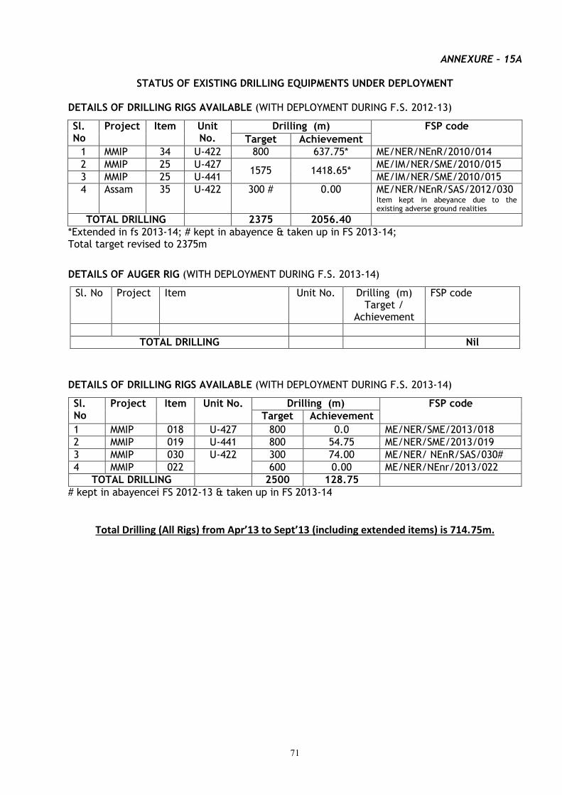
71
ANNEXURE – 15A
STATUS OF EXISTING DRILLING EQUIPMENTS UNDER DEPLOYMENT
DETAILS OF DRILLING RIGS AVAILABLE (WITH DEPLOYMENT DURING F.S. 2012-13)
Sl. No
Project Item Unit No.
Drilling (m) FSP code
Target Achievement
1 MMIP 34 U-422 800 637.75* ME/NER/NEnR/2010/014
2 MMIP 25 U-427 1575 1418.65*
ME/IM/NER/SME/2010/015
3 MMIP 25 U-441 ME/IM/NER/SME/2010/015
4 Assam 35 U-422 300 # 0.00 ME/NER/NEnR/SAS/2012/030 Item kept in abeyance due to the existing adverse ground realities
TOTAL DRILLING 2375 2056.40
*Extended in fs 2013-14; # kept in abayence & taken up in FS 2013-14; Total target revised to 2375m
DETAILS OF AUGER RIG (WITH DEPLOYMENT DURING F.S. 2013-14)
Sl. No Project Item Unit No. Drilling (m) Target /
Achievement
FSP code
TOTAL DRILLING Nil
DETAILS OF DRILLING RIGS AVAILABLE (WITH DEPLOYMENT DURING F.S. 2013-14)
Sl. No
Project Item Unit No. Drilling (m) FSP code
Target Achievement
1 MMIP 018 U-427 800 0.0 ME/NER/SME/2013/018
2 MMIP 019 U-441 800 54.75 ME/NER/SME/2013/019
3 MMIP 030 U-422 300 74.00 ME/NER/ NEnR/SAS/030#
4 MMIP 022 600 0.00 ME/NER/NEnr/2013/022
TOTAL DRILLING 2500 128.75
# kept in abayencei FS 2012-13 & taken up in FS 2013-14
Total Drilling (All Rigs) from Apr’13 to Sept’13 (including extended items) is 714.75m.

72
ANNEXURE 15B
STATUS OF EXISTING DRILLING AND OTHER HIGH-END (RS >1 CORE) EQUIPMENTS TO BE PROCURED DURING FY 2013-14
Type of instrument Indenting Region
Qty Cost Lead Time
PAC/ Sr. PAC
DG’s approval & CPMC
recommendation
Tendering/ Re-tendering
TEC TAC PO Placed
LC opened
Delivery to be or Received
Utility of the
Instrument [Mission-
wise]
Geophysical [STSS-MI, MII & MIV]
NER NIL --- --- --- --- --- --- --- --- --- --- ---
TOTAL NER NIL --- --- --- --- --- --- --- --- --- --- ---
Geology [STSS- MI, MII & MIV]
NER NIL --- --- --- --- --- --- --- --- --- --- ---
TOTAL NER NIL --- --- --- --- --- --- --- --- --- --- ---
FIELD/ SURVEY [STSS – MI, MII & MIV]
NER NIL --- --- --- --- --- --- --- --- --- --- ---
Drilling NER NIL --- --- --- --- --- --- --- --- --- --- ---
TOTAL NER NIL --- --- --- --- --- --- --- --- --- --- ---
GRAND TOTAL NER NIL --- --- --- --- --- --- --- --- --- --- ---
73
ANNEXURE – 16 STATUS OF PENDING LEGAL CASES OF NORTH EASTERN REGION AS ON 30.09.2013
Sl.
No.
No of Court Case Name of the Court/Bench Remarks.
1. 3 Nos. CAT, Guwahati Bench (i) OA No. 331 of 2012. (ii) OA No. 86/2013. (iii) OA No. 265/2013.
2. 1 No High Court Shillong Bench (i) WP No. 3381/2009
3. 1 No. High Court Imphal Bench (i) WP No. 328/2000
4. 3 Nos. MACT, Silchar (i) MACT No. 781/2007 (ii) MACT No. 782/2007 (iii) MACT No. 783/2007.
5. 1 No. Court of the Assistant District Judge
Shillong
(i) Money suit No. (H) of 2012.
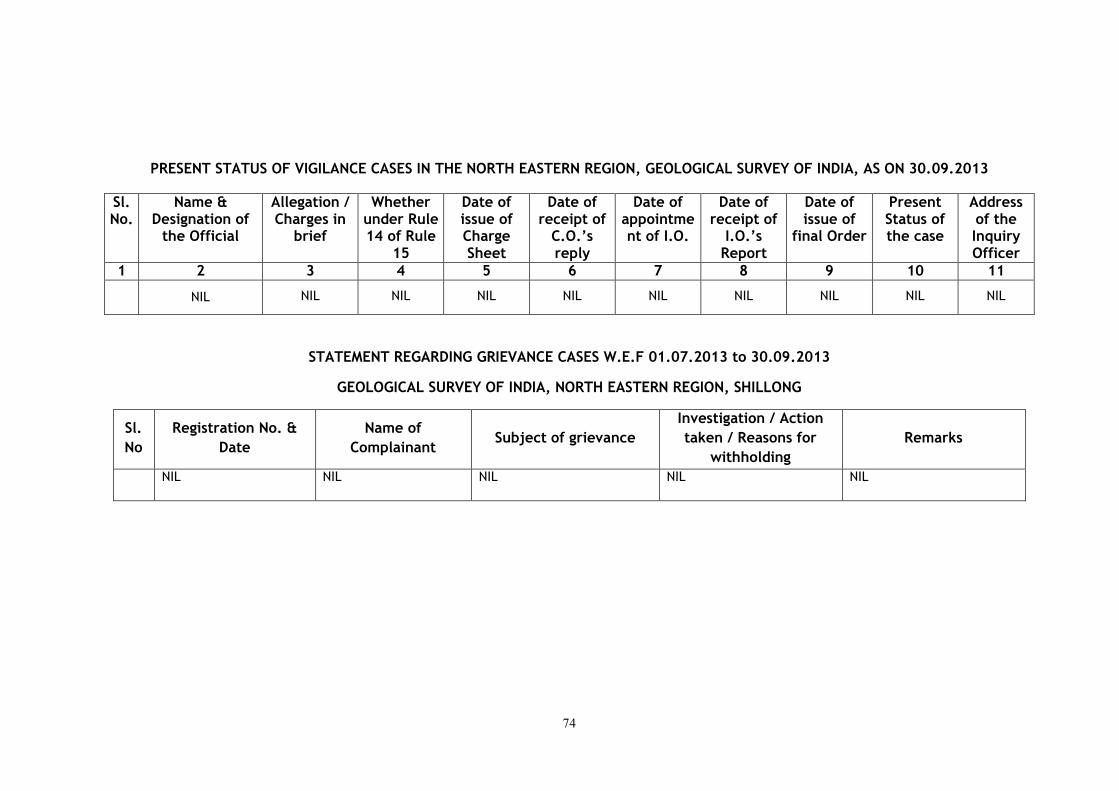
74
PRESENT STATUS OF VIGILANCE CASES IN THE NORTH EASTERN REGION, GEOLOGICAL SURVEY OF INDIA, AS ON 30.09.2013
Sl. No.
Name & Designation of
the Official
Allegation / Charges in
brief
Whether under Rule 14 of Rule
15
Date of issue of Charge Sheet
Date of receipt of
C.O.’s reply
Date of appointment of I.O.
Date of receipt of
I.O.’s Report
Date of issue of
final Order
Present Status of the case
Address of the Inquiry Officer
1 2 3 4 5 6 7 8 9 10 11
NIL NIL NIL NIL NIL NIL NIL NIL NIL NIL
STATEMENT REGARDING GRIEVANCE CASES W.E.F 01.07.2013 to 30.09.2013
GEOLOGICAL SURVEY OF INDIA, NORTH EASTERN REGION, SHILLONG
Sl.
No
Registration No. &
Date
Name of
Complainant Subject of grievance
Investigation / Action
taken / Reasons for
withholding
Remarks
NIL NIL NIL NIL NIL
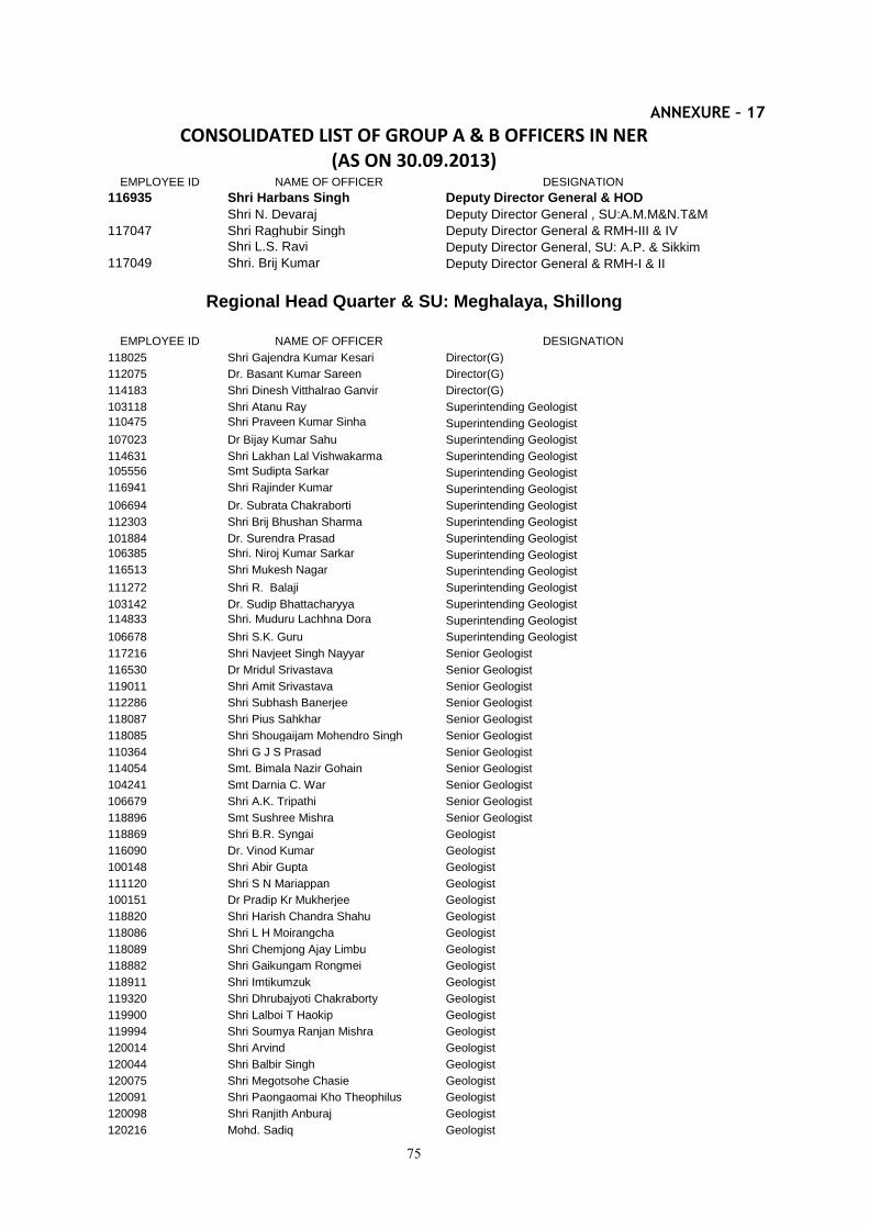
75
ANNEXURE – 17
CONSOLIDATED LIST OF GROUP A & B OFFICERS IN NER (AS ON 30.09.2013)
EMPLOYEE ID NAME OF OFFICER DESIGNATION
116935 Shri Harbans Singh Deputy Director General & HOD
Shri N. Devaraj Deputy Director General , SU:A.M.M&N.T&M
117047 Shri Raghubir Singh Deputy Director General & RMH-III & IV
Shri L.S. Ravi Deputy Director General, SU: A.P. & Sikkim
117049 Shri. Brij Kumar Deputy Director General & RMH-I & II
Regional Head Quarter & SU: Meghalaya, Shillong
EMPLOYEE ID NAME OF OFFICER DESIGNATION
118025 Shri Gajendra Kumar Kesari Director(G)
112075 Dr. Basant Kumar Sareen Director(G)
114183 Shri Dinesh Vitthalrao Ganvir Director(G)
103118 Shri Atanu Ray Superintending Geologist
110475 Shri Praveen Kumar Sinha Superintending Geologist
107023 Dr Bijay Kumar Sahu Superintending Geologist
114631 Shri Lakhan Lal Vishwakarma Superintending Geologist
105556 Smt Sudipta Sarkar Superintending Geologist
116941 Shri Rajinder Kumar Superintending Geologist
106694 Dr. Subrata Chakraborti Superintending Geologist
112303 Shri Brij Bhushan Sharma Superintending Geologist
101884 Dr. Surendra Prasad Superintending Geologist
106385 Shri. Niroj Kumar Sarkar Superintending Geologist
116513 Shri Mukesh Nagar Superintending Geologist
111272 Shri R. Balaji Superintending Geologist
103142 Dr. Sudip Bhattacharyya Superintending Geologist
114833 Shri. Muduru Lachhna Dora Superintending Geologist
106678 Shri S.K. Guru Superintending Geologist
117216 Shri Navjeet Singh Nayyar Senior Geologist
116530 Dr Mridul Srivastava Senior Geologist
119011 Shri Amit Srivastava Senior Geologist
112286 Shri Subhash Banerjee Senior Geologist
118087 Shri Pius Sahkhar Senior Geologist
118085 Shri Shougaijam Mohendro Singh Senior Geologist
110364 Shri G J S Prasad Senior Geologist
114054 Smt. Bimala Nazir Gohain Senior Geologist
104241 Smt Darnia C. War Senior Geologist
106679 Shri A.K. Tripathi Senior Geologist
118896 Smt Sushree Mishra Senior Geologist
118869 Shri B.R. Syngai Geologist
116090 Dr. Vinod Kumar Geologist
100148 Shri Abir Gupta Geologist
111120 Shri S N Mariappan Geologist
100151 Dr Pradip Kr Mukherjee Geologist
118820 Shri Harish Chandra Shahu Geologist
118086 Shri L H Moirangcha Geologist
118089 Shri Chemjong Ajay Limbu Geologist
118882 Shri Gaikungam Rongmei Geologist
118911 Shri Imtikumzuk Geologist
119320 Shri Dhrubajyoti Chakraborty Geologist
119900 Shri Lalboi T Haokip Geologist
119994 Shri Soumya Ranjan Mishra Geologist
120014 Shri Arvind Geologist
120044 Shri Balbir Singh Geologist
120075 Shri Megotsohe Chasie Geologist
120091 Shri Paongaomai Kho Theophilus Geologist
120098 Shri Ranjith Anburaj Geologist
120216 Mohd. Sadiq Geologist
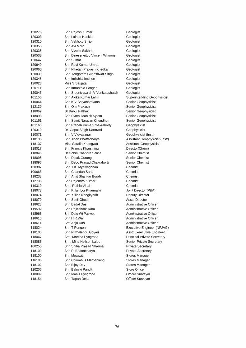
76
120276 Shri Rajesh Kumar Geologist
120303 Shri Lalneo Haokip Geologist
120310 Shri Vekhoto Shijoh Geologist
120355 Shri Avi Mero Geologist
120335 Shri Vizolto Sakhrie Geologist
120538 Shri Dzieseneituo Vincent Whuorie Geologist
120647 Shri Sumar Geologist
120649 Shri Ravi Kumar Umrao Geologist
120065 Shri Niketan Prakash Khedkar Geologist
120039 Shri Tongbram Guneshwar Singh Geologist
120348 Smt Imlishila Imchen Geologist
120028 Miss S.Saujata Geologist
120711 Shri Imrontolo Pongen Geologist
120045 Shri Sreenivasaiah V Venkateshaiah Geologist
101156 Shri Aloke Kumar Lahiri Superintending Geophysicist
110064 Shri K V Satyanarayana Senior Geophysicist
112139 Shri Om Prakash Senior Geophysicist
118069 Dr Babul Pathak Senior Geophysicist
118098 Shri Syntai Manick Syiem Senior Geophysicist
101161 Shri Sumit Narayan Choudhuri Senior Geophysicist
101163 Shri Pranab Kumar Chakraborty Geophysicist
120319 Dr. Gopal Singh Darmwal Geophysicist
110071 Shri V Vidyasagar Geophysicist (Instt)
118138 Shri Jiban Bhattacharya Assistant Geophysicist (Instt)
118137 Miss Saralin Khongwar Assistant Geophysicist
118017 Shri Francis Kharshiing Director(Chem)
118046 Dr Gobin Chandra Saikia Senior Chemist
118095 Shri Dipak Gurung Senior Chemist
118096 Shri Debo Prasad Chakraborty Senior Chemist
120387 Shri T.K. Myelvaganan Chemist
100668 Shri Chandan Saha Chemist
118233 Shri Amit Shankar Borah Chemist
112738 Shri Rajendra Kumar Chemist
110319 Shri. Rathla Vittal Chemist
118073 Shri Khlainbor Kharmalki Joint Director (P&A)
118074 Smt. Silian Nongkynrih Deputy Director
118079 Shri Sunil Ghosh Asstt. Director
118628 Shri Badal Das Administrative Officer
119592 Shri Rajkishore Ram Administrative Officer
118963 Shri Dale Wi Paswet Administrative Officer
118613 Shri H.R.War Administrative Officer
118611 Smt Anju Das Administrative Officer
118024 Shri T Pongen Executive Engineer (NFJAG)
118103 Shri Nirmalendu Goyari Asstt.Exeecutive Engineer
118047 Smt. Martina Pyngrope Principal Private Secretary
118083 Smt. Mina Neilson Laloo Senior Private Secretary
100255 Shri Shiba Prasad Sharma Private Secretary
118109 Shri P. Bhattacharya Private Secretary
118100 Shri Moawati Stores Manager
116106 Shri Columbus Marbaniang Stores Manager
118102 Shri Bijoy Dey Stores Manager
120206 Shri Balmiki Pandit Store Officer
118099 Shri Ioanis Pyngrope Officer Surveyor
118154 Shri Tapan Deka Officer Surveyor
77
SU: Assam, Guwahati
EMPLOYEE ID NAME OF OFFICER DESIGNATION
Shri J.C. Dutta, Director Director (G)
Shri Dhruba Ganguly Director (G)
Smt. Sanjukta Sahoo Superintending Geologist
Shri P.R.Pai, Superintending Geologist
Shri Anjan Bora Superintending Geologist
Shri Binod Boruah Senior Geologist
Shri P.K. Sarma Senior Geologist
Shri G.C. Sarmah Senior Geologist
Shri A. K. Bora Senior Geologist
Smt. Rupali Thakur Bhuyan Senior Geologist
Shri N. Goswami Geologist
Shri Amiya Kumar Mondal Geologist
Shri P.C. Srivastava, Geologist
Shri M.Shyam Kr.Singh Geologist
Shri Amit Kumar Geologist
Shri Varun Vara Geologist
Shri R.C. Kishan Geologist
Shri P. C. Gangaikoppa Geologist
Shri Rajkumar Tapon Kumar Geologist
Shri Yhunyelo Tep Geologist
Shri Satrughan Majhi Geologist
Shri Mukesh Kumar Mishra Geologist
Shri Dwijendra Nath Borah Artist
Shri N. Borah Officer Surveyor
Shri Ratan Baran Dey Administrative Officer
Shri Rajesh Ghose Administrative Officer
SU: Arunachal Pradesh, Itanagar
EMPLOYEE ID NAME OF OFFICER DESIGNATION
Dr. B. R. Bejarniya Director
Shri Swapan Kumar Guha Superintending Geologist
Shri Prem Shanker Misra Superintending Geologist
Shri Bashab Nandan Mahanta Senior Geologist
Shri Subash Chandra Keshari Geologist
Shri Bendangnuchit Geologist
Dr. James Pebam Geologist
Shri Ravi Negi Geologist
Shri Rupesh Kumar Geologist
Shri Sudeep Manish Toppo Geologist
Miss Rita Thurr Geologist
Shri Sebabrata Das Geologist
Shri Raman Kumar Geologist
Shri Amit Kumar Geologist
Shri Hiruj Saikia Geologist
Shri Kaisar Wankhar Store Officer

78
SU: Manipur & Nagaland, Dimapur
EMPLOYEE ID NAME OF OFFICER DESIGNATION
Shri Deo Nath Director (G)
Shri N.L. Gera Superintending Geologist
Shri J.K. Angami Senior Geologist
Shri R.L. Jat Senior Geologist
Shri C. Yanthan Senior Geologist
Shri E. John Geologist
Shri N. Meribemo Yanthan Geologist
Shri P. Enos Ezung Geologist
Ms. Visahono Zaphu Geologist
Ms. Chubala Shijoh Geologist
Mrs. Sentimongla Ao Asstt.Director(P&A)
Shri L. S. Ngaihte Administrative Officer
SU: Tripura & Mizoram, Agartala
EMPLOYEE ID NAME OF OFFICER DESIGNATION
Dr. Kanika Sanyal Director (G)
Shri Ishwar Dan Ashiya Superintending Geologist
Shri N. Padmaiah Superintending Geologist
Smt. Srinanda Mukherjee Senior Geologist
Shri Benudhar Behera Senior Geologist
Dr. T.S. Giritharan Senior Geologist
Shri S. Venkateswara Rao Senior Geologist
Shri Jayanta Pramanik Geologist
Shri Pankaj Pralhadrao Vaidya Geologist
Shri Omnath Saha Geologist
Shri Jefferson Mylliem Umlong Geologist
Shri Watitemsu Geologist
Shri A. Elow Geologist
Shri M P Singh Geologist Geologist
Shri Utpal Halder Administrative Officer
SU: Sikkim, Gangtok
EMPLOYEE ID NAME OF OFFICER DESIGNATION
105534 Dr. S. K. Som Superintending Geologist
118970 Dr. Sanjay Wahi Superintending Geologist
120094 Mrs. Lopamudra Bhol Geologist
120043 Shri Kailash Singh Geologist
119997 Shri S. Jijikumar Geologist
118875 Shri N. Thredeep Kumar Geologist
120329 Shri Murli Mohan Geologist
120318 Shri Jagadish Nandan Hindayar Geologist
120631 Shri Hiten Kumar Jalutharia Geologist
120703 Shri Tangtirenba Longchari Geologist
120689 Shri Mohd. Ibrahim Geologist
120243 Ms P.N. Dasarwar Geologist
118606 Shri Dahiram Kalita Administrative Officer
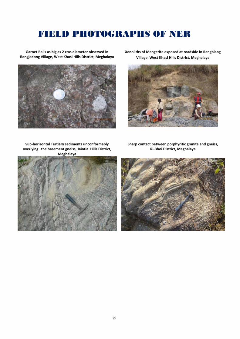
79
FIELD PHOTOGRAPHS OF NER
Garnet Balls as big as 2 cms diameter observed in
Rangjadong Village, West Khasi Hills District, Meghalaya Xenoliths of Mangerite exposed at roadside in Rangblang
Village, West Khasi Hills District, Meghalaya
Sub-horizontal Tertiary sediments unconformably overlying the basement gneiss, Jaintia Hills District,
Meghalaya
Sharp contact between porphyritic granite and gneiss, Ri-Bhoi District, Meghalaya
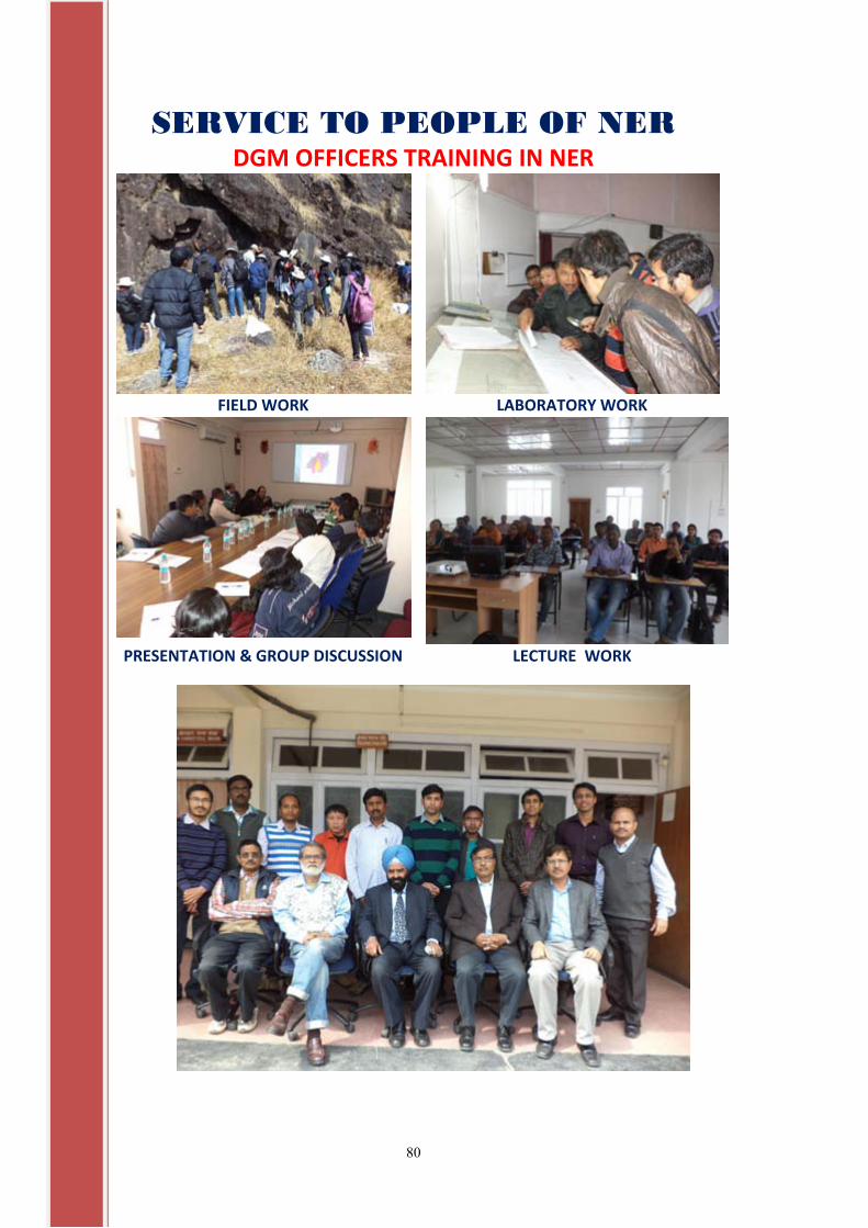
80
SERVICE TO PEOPLE OF NER DGM OFFICERS TRAINING IN NER
FIELD WORK LABORATORY WORK
PRESENTATION & GROUP DISCUSSION LECTURE WORK