geological survey research 1962 - usgs publications
TRANSCRIPT
Geological Survey
Research 1962Synopsis of Geologic, Hydrologic, and Topographic Results
GEOLOGICAL SURVEY PROFESSIONAL PAPER 450-A

Geological Survey
Research 1962THOMAS B. NOLAN, Director
GEOLOGICAL SURVEY PROFESSIONAL PAPER 450
Asynopsis of results of geologic, hydro logic, and topo
graphic investigations for fiscal year 1962, accom
panied by short papers in the fields of geology,
hydrology, topography, and allied sciences. Pub
lished separately as Chapters A, B, C, D, and E
UNITED STATES GOVERNMENT PRINTING OFFICE, WASHINGTON : 1962

FOREWORD
The reception accorded the 1960 and 1961 Annual Reviews of Geological Survey research has encouraged us to prepare this volume, "Geological Survey Research, 1962," in a con tinuing effort to publish more quickly the significant results of our current investigations. We continue to consider these reports as experimental and have again this year modified the content, format, and frequency of release of chapters in an attempt to serve better the interests of the users of the reports. The comments and suggestions of these users are here solicited and will be considered carefully as future volumes are planned.
The current Annual Review consists of five chapters (Chapters A through E) of Pro fessional Paper 450. As in the preceding two Annual Reviews, Chapter A is a synopsis of recent findings in the many and varied lines of study pursued by Survey personnel. Chap ters, B, C, D, and E of this volume are collections of short articles in geology, hydrology, topography, and allied fields. These articles are numbered as follows:
Prof. Paper 450-B Articles 1-59 Prof. Paper 450-C Articles 60-119 Prof. Paper 450-D Articles 120-179 Prof. Paper 450-E Articles 180-239
These four chapters have been released at about three-month intervals during the year (Chap ter E is in preparation as this foreword is written) so that timely articles could reach the reader more quickly.
Results of research presented in this chapter, Chapter A, are representative of our many projects; complete coverage of all projects would result in an unwieldy volume. A com plete list of our publications during fiscal year 1962 can be found on pages A197 to A250 Readers interested in learning of our current work in certain geographic areas or on specific topics will find a complete listing of investigations in progress in the Geologic and Water Resources Divisions during fiscal year 1962 on pages A137 to A186. The status of mapping by the Topographic Division is included this year for the first time, on pages A187 to A195, Addresses of our main centers and field offices and names of officials in charge are presented on pages A128 to A132 for readers who wish to contact our personnel directly.
During fiscal year 1962, the services of the Geological Survey were utilized by or were supported financially in part by, the numerous Federal, State, County and City agencies listed on pages A133 to A136. Some work reported in these chapters may be a direct result of cooperative investigations in previous years with agencies not shown on the current list. Cooperating agencies are acknowledged in the articles in Chapters B, C, D, and E, but space limitations preclude mention of individual cooperators in the summary statements in Chapter A. \
The current Annual Review represents the combined efforts of many individuals. Arthur B. Campbell assumed overall responsibility for the preparation of the report and assembled Chapter A from information supplied by many project chiefs and program leaders. He was assisted by Joshua I. Tracey, Jr., who critically reviewed the manuscripts for Chapters B, C, D, and E. Marston Chase was responsible for all technical editing, preparation of indexes, and for the myriad tasks required to convert author's manuscript to printed article. Edith Becker assisted in these duties at times during final preparation of manuscripts for the Government Printing Office and in the handling of proof copy. William H. Elliott was responsible for planning and preparing illustrations for all chapters. Michael S. Chappars served as an advisor during the preparation of the volume. Robert A. Weeks, James R. Randolph, and John B. Rowland assembled lists of cooperating agencies, the list of investi gations in progress, and status of topographic surveys and maps. Margaret Cooper and her
in
IV FOREWORD
staff compiled the list of publications. Nancy Pearre prepared the instructions for ordering Geological Survey publications. Robert B. Raup, Jr., and George H. Davis, who acted as technical reviewers of Chapter A, were helpful in the selection, organization, and expression of the material presented in that chapter. I am pleased to acknowledge the contributions of the many persons who presented the result of their scientific work in this volume.
THOMAS B. NOLAN, Director.
Synopsis of Geologic
Hydrologic, and
Topographic ResultsPrepared by members of the Geologic, Topographic, and Water Resources Divisions
GEOLOGICAL SURVEY RESEARCH 1962
GEOLOGICAL SURVEY PROFESSIONAL PAPER 4SO-A
A summary of recent scientific and economic results,
accompanied by a list of publications released in fiscal
I96 2, a list of geologic and hydro logic investigations
in progress, and a report on the status of topo
graphic mapping
UNITED STATES GOVERNMENT PRINTING OFFICE, WASHINGTON : 1962
UNITED STATES DEPARTMENT OF THE INTERIOR
STEWART L. UDALL, Secretary
GEOLOGICAL SURVEY
Thomas B. Nolan, Director
For sale by the Superintendent of Documents, U.S. Government Printing Office Washington 25, D.C. - Price $1.75
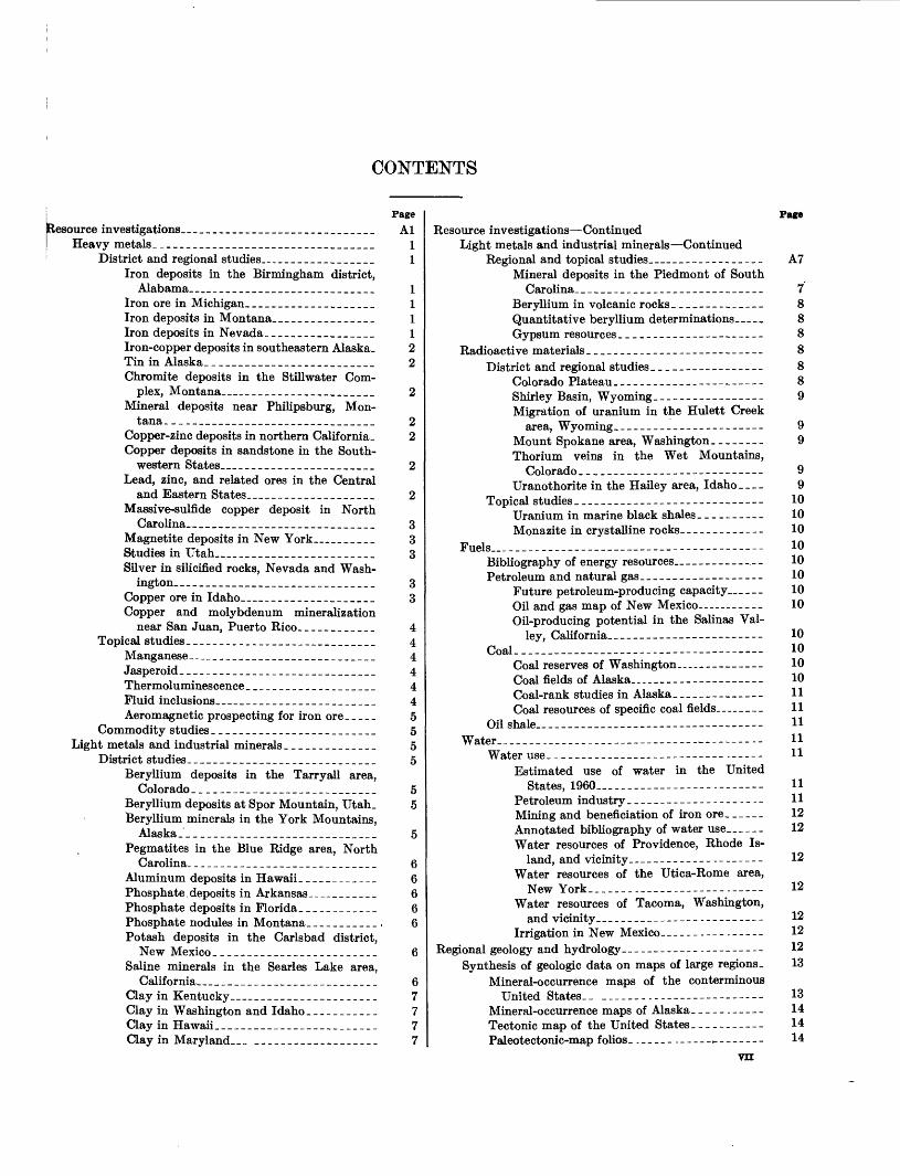
CONTENTS
Resource investigations._____________________________Heavy metals._________________________________
District and regional studies._________________Iron deposits in the Birmingham district,
Alabama___________________________Iron ore in Michigan.___________________Iron deposits in Montana....____________Iron deposits in Nevada_________________Iron-copper deposits in southeastern Alaska- Tin in Alaska._________________________Chromite deposits in the Stillwater Com
plex, Montana__ ___________________Mineral deposits near Philipsburg, Mon
tana. _______________________________Copper-zinc deposits in northern Calif ornia_ Copper deposits in sandstone in the South
western States_ _____________________Lead, zinc, and related ores in the Central
and Eastern States__________________Massive-sulfide copper deposit in North
Carolina.._ __________________________Magnetite deposits in New York_______Studies in Utah_______________________Silver in silicified rocks, Nevada and Wash
ington. ______________________________Copper ore in Idaho___________________Copper and molybdenum mineralization
near San Juan, Puerto Rico. ___________Topical studies _____________________________
Manganese.. ___________________________Jasperoid._________________. ._..._....Thermoluminescence_ ___________________Fluid inclusions______________________Aeromagnetic prospecting for iron ore_____
Commodity studies _________________________Light metals and industrial minerals ______________
District studies.____________________________Beryllium deposits in the Tarryall area,
Colorado ____________________________Beryllium deposits at Spor Mountain, Utah_ Beryllium minerals in the York Mountains,
Alaska._____________________________Pegmatites in the Blue Ridge area, North
Carolina. ____________________________Aluminum deposits in Hawaii ____________Phosphate deposits in Arkansas.__________Phosphate deposits in Florida.___________Phosphate nodules in Montana.___________Potash deposits in the Carlsbad district,
New Mexico _________________________Saline minerals in the Searles Lake area,
California_ _________________________Clay in Kentucky_____________________Clay in Washington and Idaho ___________Clay in Hawaii.________________________Clay in Maryland_ ___---____--_______
PageAl
11
111122
Resource investigations ContinuedLight metals and industrial minerals Continued
Regional and topical studies________________Mineral deposits in the Piedmont of South
Carolina. ____________________________Beryllium in volcanic rocks ______________Quantitative beryllium determinations.____Gypsum resources_____-__-_----_-----__
Radioactive materials_____-____---_-_-----------District and regional studies_______---_--_-__
Colorado Plateau.________-------------_Shirley Basin, Wyoming..---------------Migration of uranium in the Hulett Creek
area, Wyoming._---.-_---------------Mount Spokane area, Washington. _______Thorium veins in the Wet Mountains,
Colorado _____-_____--_--------------Uranothorite in the Hailey area, Idaho
Topical studies_________-__-_---_-----------Uranium in marine black shales__________Monazite in crystalline rocks_____________
Fuels_________-_-----_-_-- _._____---__--Bibliography of energy resources ___________Petroleum and natural gas___-_--------------
Future petroleum-producing capacity ___ Oil and gas map of New Mexico..---------Oil-producing potential in the Salinas Val
ley, California. ________-_-_-----------Coal.______-----_---_---_-------------
Coal reserves of Washington._ _________Coal fields of Alaska----____-__----------Coal-rank studies in Alaska______________Coal resources of specific coal fields.-...---
Oil shale..______-___-----_-----------------Water_____.___. ----- ________-__-- --
Water use. ___________________-------.-----Estimated use of water in the United
States, 1960__________ ----- Petroleum industry.____________---_----Mining and beneficiation of iron ore_____-Annotated bibliography of water use______Water resources of Providence, Rhode Is
land, and vicinity.------------ --------Water resources of the Utica-Rome area,
New York.______.___-_.--_----._----Water resources of Tacoma, Washington,
and vicinity_____________-.---------Irrigation in New Mexico- _ ___-._-_.__---
Regional geology and hydrology.-_______-__----------Synthesis of geologic data on maps of large regions.
Mineral-occurrence maps of the conterminousUnited States._ _______._-_-_------------
Mineral-occurrence maps of Alaska.____.___-_Tectonic map of the United States.----------Paleotectonic-map folios. ._____._--- -------
vn
Page
A7
7888888
1010101010101010
101010101111111111
11111212
12
12
12121213
13141414
VIII CONTENTS
Page Regional geology and hydrology Continued
Synthesis of geologic data, etc Continued.Tectonic setting of uranium deposits in the
Cordilleran foreland______________________ A15Synthesis of hydrologic data for large regions___--_- 15
Thermal springs of the world-________________ 15Ground water in the United States.___________ 15Flood frequency in the United States________ 15Chemical quality of river water in the contermi
nous United States______________________ 15New England and eastern New York region________ 16
Geologic and geophysical studies in Maine.____ 16Geologic and geophysical studies in Massa
chusetts _________________________________ 16Geologic mapping in Rhode Island-___________ 18Geologic mapping in Connecticut___________ 18Geophysical studies in New Hampshire._______ 19Regional geophysical studies_________________ 19Ground water in Rhode Island _______________ 19Quality of water in the St. Lawrence River
basin__________________________________ 19Appalachian region______________________________ 19
Geologic mapping___________________________ 19Structural and tectonic studies _______________ 20Stratigraphic studies ________________________ 20Geophysical studies_-_________.______________ 20Hydrologic studies._________________________ 21
Atlantic Coastal Plain region_____________________ 21Regional stratigraphy and structure_________ 21Stratigraphic studies._______________________ 21Hydrologic studies._________________________ 22Origin of the Carolina Bays._________________ 22
Eastern Plateau region._________________________ 22Geologic and geophysical studies in Kentucky __ 22 Geologic studies in Pennsylvania._____________ 23Geologic studies in New York._______________ 23Geologic studies in Alabama.________________ 23Surface-water studies in Kentucky ____________ 24Quaternary geology of the lower Ohio River
valley.__________________________________ 24Quality of ground water, Delaware County,
New York_._____________________________ 24Shield area and upper Mississippi Valley region__ _ 24
Geologic and geophysical studies____________ 24Hydrologic studies._________________________ 25
Gulf Coastal Plain and Mississippi Embaymentregion _______________________________________ 26
Aerial radiological studies, southeast Texas. _ _ _ 26 Subsurface geology, Little Rock, Arkansas, to
Cairo, Illinois____________________________ 26Faulting in western Kentucky._______________ 26Southeastern Gulf Coastal Plain studies _______ 26Miss'ssippi Embayment hydrologic and geologic
studies----_-__-________.____.___________ 26Hydrologic studies in Arkansas and Texas.-___ 27
Ozark region and Eastern Plains region__________ 27Geologic studies in southeast Missouri_ _ _____ 27Stratigraphic studies in Arkansas _____________ 27Aeromagnetic survey in the Wichita Mountains. 27 Aerial radiological measurements in New Mex
ico..-.. _____________________________ 27Geologic mapping in Texas_________________ 28Ground-water recharge, Arkansas River valley,
Arkansas--_---._-_______________.._____. 28
Page Regional geology and hydrology Continued
Ozark region and Eastern Plains region Continued Water-table decline, Grant and Stanton Coun
ties, Kansas__---__--------------_-------- A28Fresh water at great depth in Oklahoma_______ 28Ground-water recharge, High Plains, New
Mexico._________-_-_-------____--------_ 28Ground water in the Entrada Sandstone____-_- 29Post-Rustler red beds correlated-_____________ 29Sources of salinity in the upper Brazos River
basin, Texas_-___---_--_--___------------ 29Northern Rockies and plains region.______________ 29
Geologic and geophysical studies in northeasternWashington and northern Idaho.___-___-__- 29
Geologic and geophysical studies in centralIdaho._______-_-----_-------____------_- 30
Geologic and geophysical studies in westernMontana-.-..-.------------------_-_---_- 30
Geologic and geophysical studies of the BearpawMountains, Montana------------------.--- 31
Geologic and geophysical studies in parts ofsoutheastern Idaho, Wyoming, and SouthDakota-.----..______ ___________________ 31
Stratigraphic studies of Paleozoic rocks..___-__ 32 Stratigraphic studies of Mesozoic rocks--_____- 32Ground-water investigations in Montana.___._ 33 Ground-water investigations in Wyoming. _ _ _ . _ 33 Ground-water investigations in North Dakota. _ 33 Ground-water investigations in South Dakota. . 34
Southern Rockies and plains region.______________ 34Geology of Precambrian rocks__________ _.- 34Stratigraphic and paleontologic studies..------ 35Geology of volcanic terranes in Colorado and
New Mexico.----------------------------- 36Studies of intrusive igneous rocks in Colorado-- 36 Dating of Laramide features.________________ 36Aerial radioactivity survey in Colorado._ .--___ 37 Ground-water recharge..--____- ______________ 37Ground-water storage..-.-------------- ------ 37Formation and deposition of clay balls, Rio
Puerco, New Mexico___ _________________ 37Colorado Plateau region.__.______________----_-- 37
Stratigraphy and paleontology _____-__-_-- 37Structural history__ ________-______-__---- 38Igneous rocks._________._-_____-------_---- 39Physiography. ________________-_-----_----- 39Hydrologic problems in San Juan County, New
Mexico._________-_--._-______-__----_--. 39Hydrogeology near Los Alamos, New Mexico-- 40 Erosion and sedimentation in northwestern New
Mexico._______-____------.--_----------- 40Faulting and its relation to ground water in the
Flagstaff area, Arizona.______________-.--- 40Basin and Range region.______________-___._---- 40
Structural geology Arizona_____--______---- 40Structural geology and geophysical studies
Nevada_______ ._-____ _____-__.------ 40Structural geology Utah and Idaho __________ 41Stratigraphy Arizona. ______________--_-..- 42Stratigraphy Nevada and California.________ 42Stratigraphy and structural geology New Mex
ico..----.------------------------------- 43Igneous rocks Mojave Desert_________-_.--_ 43Cenozoic rocks and history._ ___-__- ______ 44
CONTENTS IX
Page Regional geology and hydrology Continued
Basin and Range region ContinuedHydrogeology of basins..____________________ A45Ground water in pre-Tertiary rocks ___________ 45Interbasin movement of ground water_________ 45Hy drogeochemistry _________________________ 46Estimating porosity from specific gravity ______ 46
Columbia Plateau and Snake River Plains region. __ 46 Gravity studies in Oregon and Idaho._________ 46Structural and stratigraphic studies in Oregon
and Idaho.______________________________ 46Ground water in basalts of Washington and
Idaho. _____--_---.__-_._____________ 47Pacific Coast region______________-.._____________ 48
Geologic studies in Washington...____________ 48Geologic and geophysical studies in Oregon..... 48Geology of Klamath Mountains, Cascade Range,
Coast Ranges, and coastal area of California. 48 Geologic and geophysical studies in the Sierra
Nevada_ _______________________________ 49Hydrologic studies in California_____________ 50Hydrologic studies in Washington___________ 50
Alaska. ____ ---------_-__-___-__________ 50Northern Alaska__________________________ 5QWest-central Alaska_______________________ 52East-central Alaska.________________________ 52Southwestern Alaska________________________ 53Southern Alaska____________________________ 53Southeastern Alaska._______________________ 53Cenozoic stratigraphy of Alaska ______________ 54
Hawaii. _______________________________________ 55Eruptions of Kilauea Volcano in 1961 _________ 55Lava lake in Makaopu hi Crater ______________ 55Recent growth of Halemaumau Crater, Kilauea
Volcano.________________________________ 55Lava lake in Kilauea Iki___________________ 56Gravity studies___________________________ 56Ground water in southern Oahu______________ 56Ground water in the Waianae district, Oahu___ 56 Water resources of windward Oahu ___________ 56Rain-catchment studies____________________ 57
Indian Reservations and National Parks_________ 57Geologic and hydrologic studies in Indian
Reservations. ____________________________ 57Ground-water study in Grand Teton National
Park__________________________________ 57Puerto Rico____________________________________ 53
Preliminary geologic map.___________________ 58Limestone _________________________________ 58Aerial radioactivity survey.__________________ 58Hydrologic studies._________________________ 58
Western Pacific islands._________________________ 59Marine geology of Guam, Mariana Islands. _ _ _ _ 59Paleontologic studies._______________________ 59Ground-water supplies in American Samoa_____ 61Hydrologic studies on Guam.________________ 61Saline-water intrusion on Angaur Island _______ 61
Antarctica.____________________________________ 61Geology of the Thiel (Mountains______________ 62Glaciology and glacial igeblogy of the Thiel
Mountains. _________ __.___L ______________ 62Paleobotany and coal studies.._______________ 62Reconnaissance geologic traverses.____________ 64Geologic reconnaissance of the Eights Coast_ _ 64
Regional geology and hydrology Continued Antarctica Continued
Saline features in Taylor Valley.________Age of moraines in McMurdo Sound area- Topographic field operations ____________Aerial photography.___________________Cartographic activities.________________Antarctica relief model.________________
Geologic and hydrologic investigations in other countries- iron-ore deposits, Minas Gerias, Brazil ____________Lead-zinc deposits, Bahia, Brazil _________________Tin, tungsten, and copper studies, Bolivia.________Geomorphology and metallogenic map, Chile_______Mineral deposits near Torreon, Coahuila, Mexico. __ Mineral-resource studies in Libya.________________Ground water in the Libyan desert of western Egypt.Ground-water investigations in Kordofan Province,
Sudan-__-__--________--__---_-______________Iron deposits of Yugoslavia._____________________Cooperative mineral exploration and paleontologic
studies in Pakistan_--__-_______-_______-______Hydrologic regimen in the Punjab region, West
Pakistan..._ _________________________________Mineral investigations in Thailand-_______________Engineering-geology studies in Indonesia _______Chromite investigations in western Luzon, Zambales
Province, Republic of the Philippines---_________Refractory-kaolin deposits, Kinmen (Quemoy) Is
land, Taiwan-________________________________Ground-water studies for U.S. Navy at Poro Point,
Luzon. Republic of the Philippines._____________Astrogeologic studies._______________________________
Photogeologic mapping of the moon.______________Lunar stratigraphy_.___________________----_Structural features.____--___-----------_-__-
Terrestrial and experimental impact and cratering phenomena.___________---_-__---------_-----
Terrestrial craters and structures _____________Experimental cratering phenomena.___________
Extraterrestrial materials.____-_-_---------------Investigations of geologic and hydrologic processes and
principles.________-______------------------------Paleontology.______________-------_------------
Evolution.____________--------_------------Paleoecology._____________----__-----------Morphology and systematic paleontology.-----Stratigraphic paleontology.____.__--_---_---_
Geomorphology ________________-_-------_-_-Morphology of stream channels ___-___-_-- Geomorphology related to ground water..____>_Geomorphology and geology in relation to
streamflow. ------------------------------Morphology of alluvial fans_ -----------------
Plant ecology___________-----_-----------------Relation of vegetation to soil moisture _____Forests and geomorphology------------------Effects of coal strip mining on forests_____----Trees as indicators of floods._______-_-_------
Glaciology and glacial geology -----------------Studies of existing glaciers.____-____---------Glacier hydrology _ -----------------------Glacial geology._____------_----------------
Page
A64 64 64 66 66 66 6666676767676767
6769
68
686969
69
70
70707071
71717273
737474747475757676
7677777777777778787878
CONTENTS
Page Investigations of geologic and hydrologic, etc. Continued
Oceanography and marine geology________________ A79National ocean-survey program.______________ 79Analysis of preliminary Mohole samples, Guada-
lupe site.________________________________ 79Marine geology..___________________________ 79Marine geophysics....______________________ 80Marine geochemistry_____________________.__ 80
Permafrost studies._____________________________ 80Geophysics _ -__--_----_-_---_-_-------__-___ 81
Theoretical and experimental geophysics--..--- 81Paleomagnetism. _______________________ 81Magnetic properties of rocks _____________ 81Stress waves in solids__________________ 81Rock deformation_____________________ 82Thermochemical data___________________ 82Electrical investigations _________________ 82Electrical properties of the earth's crust-_- 82Induced polarization.___________________ 83Luminescence. _________________________ 83Interpretation methods._________________ 83Geophysical Abstracts_________________ 84
Major crustal studies______________________ 84Long-range seismic refraction_____.___._ 84Eastern Colorado and New Mexico. _ _____ 84California and Nevada..___.________._._ 84Gravity studies of the Snake River Plain. _ 85Secular deformation of the Great Basin.... 85Sierra Nevada________________________ 85
Geochemistry, mineralogy, and petrology__________ 85Experimental geochemistry and mineralogy.___ 85
Mineralogical studies and description of newminerals._--__-___.__________________ 85
Crystal chemistry_____________________ 86Experimental geochemistry______.-.-____ 87Chemistry of natural water ______________ 88
Field geochemistry and petrology _____________ 88Studies of igneous rocks.________________ 88Studies of metamorphic rocks ____________ 88Studies of sedimentary rocks_____________ 89Environments of ore deposition.__________ 89Geochemistry of hot springs and hydro-
thermal areas_______________________ 89Geochemical distribution of the elements in
water_ _____________________________ 90Hydrochemical facies in ground water_____ 90Origin of minerals in natural water______ 91
Organic geochemistry.._____________________ 91Organic content of rocks_________________ 91Organic pollutants in water ______________ 92Iron and manganese in water and plants. __ 92
Synthesis of geochemical data ________________ 92Distribution of minor elements _______________ 92
Beryllium in silicic volcanic rocks.________ 92Heavy metals in shales._________________ 92Abundance of scandium in volcanic rocks __ 92Rare earths in apatites._________________ 92Thorium and uranium in some alkalic rocks
from Virginia and Texas._____ _-_-___ 92Isotope and nuclear studies._____________________ 93
Geochronology _ ____________________________ 93Carbon-14 age determinations.___________ 93Protactinium-thorium dating.____________ 93
PageInvestigations of geologic and hydrologic, etc. Continued
Isotope and nuclear studies Continued Geochronology Continued
Dating of uranium accumulation and migration. ___________________________
Potassium-argon and rubidium-strontium dating,______________________________
Lead-alpha age measurements_____-______Deuterium and tritium studies _______________
Deuterium in natural waters_____________Tritium in fallout--_---_-_------------_-Tritium tracer studies, Lake McMillan,
New Mexico_________________________Tritium tracer studies in ground water,___
Lead isotopes.___________--___--__-_-------Solid-state studies________-__-_----__-----__
Luminescence and thermoluminescence studies.____________-____--_-----_--.
Magneto-acoustic studies ________________Magnetic properties of ice______-_-__-___
Hydraulic and hydrologic studies_________________Open-channel hydraulics and fluvial sediments __
Distribution of velocity _______________Dispersion in natural channels_--_--_-_--- Solution of unsteady-flow problems. ______Measurement of water discharge and sedi
ment transport- ______----------------Resistance to flow and sediment transport
in alluvial channels.____--__----------Surface-water hydrology-.______---_---------
Distribution and characteristics of stream- flow________--_--_-----------------
Magnitude and frequency of floods ___- Flood-inundation mapping_______________Floods in the Southeastern States _____Floods in Nevada______-----------------Floods in Alaska _-_-____---_---------Low flows and flow duration.___-_----__-
Statistical methods___-_---__----------------Use of correlation for augmenting autocor-
related streamflow information.________Information content of the mean.________
Mechanics of flow through porous media ___ Flow in the unsaturated zone ____________Salt water in coastal aquifers-----------------Aquifer compaction under stress-________-__--
Limnological studies.._____-_-_-----------------Evapotranspiration studies. ----------------------Ground-water occurrence in limestone terranes -
Geology and hydrology applied to problems in the field ofengineering. __________-__---_-_-------------------
Construction problems _-_-_-_-----------------Urban geology _ -------------------------Highway geology in Alaska. _____-_--------Harold D. Roberts tunnel, Colorado.-.-- ._.--- Underground air storage..--------------- ----Subsidence..____________----------------- -
Engineering problems related to rock failure _ .___ Erosion....-___-__--__-------------------------
Urban growth and sediment discharge... ------Coastal erosion.__--_--_--------------------
A93
9494949495
95969697
9797979797979798
98
9898
989999999999100100
100100100101101102102103103
104104104105105105105106106106106
CONTENTS XI
Page((Jeology and hydrology applied to engineering Con.
1 Geologic studies for defense and peaceful uses ofatomic energy.___._._____-______________._.. A106
Geology and hydrology related to underground nuclear tests, Nevada Test Site. ____________ 107
Reactor development-------.-__-_______ ______ 108Peaceful uses and detection of nuclear explosions. 108 Project GNOME... ._.___._.__.__._..__._ 108Project CHARIOT....__.___.._.____._._._._ 109Project SHOAL....._._......_..____._..__. 109Project GROUNDHOG...__._________ 109Project DRIBBLE______.__________ 109
Analysis of hydrologic data..........___.__._.._. 109Estimating long-term runoff from short-term
records.. _______ _________________ 110Extending streamflow data by using precipita
tion records-_______-__.__________________ 110Floods_________________________ 110Ground water____._-_-__.__________________ 110Interrelations of surface water and ground
water.__________________________________ 110Low flows__------_---___--_____-________ 112Time of travel of water____________________ 112
Evaporation suppression_______________________ 112Artificial recharge of aquifers___--_-____-_._____ 112
Spreading basins__________________________ 112Sinkholes._____-.____________... 112Recharge wells-______-_---.________________ 112
Geology and hydrology applied to problems in the field of public health_____-____________________.__________ 112
Studies related to disposal of radioactive wastes. . __ 112 Laboratory investigations__________________ 113Geologic and hydrologic field studies__________ 113Geophysical investigations.__________________ 115
Distribution of elements as related to health.______ 115Anthracite mine drainage._______________________ 115Chemical and biological aspects of water pollution. _ 115
Analytical and other laboratory techniques__________ 116Analytical chemistry._._-_--__---_____-_________ 116
Methods of systematic silicate-rock analysis.. __ 116 Determination of rhenium---------.---.--.-- 116Minor elements in the Pierre Shale___.-_._-- 116 The beryllium-morin system. ________________ 117Fluorescence studies______________________ 117Determination of boron in waters containing
fluorine________________________________ 117Flame photometric determination of calcium in
thermal waters__-_--_____________________ 117Determination of lead in sphalerite__.-_____ 117Apparatus for ferrous iron determination._____ 117Alkali metals in micas__________.____________ 117Silica in tektites and glasses________________ 117Selective solution of fluorite__________________ 117Standard samples___.-______________________ 117Extracting water from cores for chloride analysis. 118
Spectroscopy.__________________________________ 118Spectrochemical analysis of small samples ______ 118Semiquantitative Spectrochemical analysis of
rocks, minerals, andore8_-___._____________ 118Quantitative spectrographic analysis for selected
minor elements in Pierre Shale.____________ 118Direct-reading spectrochemical-methods devel
opment ----------_----_-__-__-________ 119X-ray fluorescence analysis___--.-_-___-.-_. 119
PageAnalytical and other laboratory techniques Continued
Spectroscopy ContinuedElectron-probe X-ray microanalyser_________ A119Identification of thalenite by means of absorption-
band spectra.____________________________ 120Mineralogic and petrographic techniques___--____ 120
Development of exploration and recording techniques. _ _ 121 Geochemical and botanical exploration ____________ 121Application of isotope geology to exploration.______ 122
Isotope geology of hydrogen_______________ 122Isotope geology of oxygen_________________ 122
Hydrologic measurements______________________ 122Welllogging____________________ 122Instrument design and application____________ 123
Research and development in topographic surveys and mapping_ _ ______________________________________ 123
Field surveys_________________--____-____-_--- 123Portable surveying tower__________-___------ 123Airborne control system.____________----_--- 123Target design for photoidentification of control. 124 Elevation meter_______---_-----__---------- 124Standards for pendulum alidades_________-_-- 124
Photogrammetric surveys..-----.---------------- 124Aerial-camera calibration___________------_-- 124Super-wide-angle photogrammetric system _____ 125Half-base convergent photography.___________ 125Astronomic positions in Antarctica _________ 125Contrast control for diapositives______-__----_ 125Analytical aerotriangulation_____--__-_-__-__- 125Visual fatigue in photogrammetric operations . 125 Orthophotography _ _ _________-_--_-_-------- 125Instrument development____.____--_---_--- 126
Cartographic procedures.._____-___--__---------- 126Edge isolation____________________-----_ 126Airbrush shading for ice features ___-_---__ 126 Brown channel symbolization for desert terrain. 126 Map content and presentation __.___---___ 126 Relief models_____.___ _ ----- 127
U.S. Geological Survey offices..____________-_--__---- 128Main centers----------------------------------- 128Public inquiries offices___________-__--__------- 128Geologic Division field offices in the United States
and Puerto Rico_________-.___-_-_--.------_ 128Selected list of Water Resources Division field offices
in the United States and Puerto Rico__---_- ._-- 129Geological Survey offices in other countries. ___-_-_ 132
Geologic Division____-_____-----------..----- 132Water Resources Division____----_-_-------- 132
Cooperating agencies..__ ______.,_-______--_------.- 133Federal agencies._____._.__--_____--__-__---.___ 133State, county, and municipal agencies.____________ 133
Investigations in progress in the Geologic and Water Re sources Divisions.._____.-____._-__---.-------_ - 137
Regional investigations....______._.____.__-_.--- 137Topical investigations.-------------------------- 169
\ Status of surveys v and mapping by the TopographicDivision.______._______-________-_--------------- 187
Mapping accomplishments.___- ._______-_-_---__- 187Objectives of the National Topographic Mapping
Program....._-_-_____-.-___-_-_---_----- 187Series and scales.-.__-_-__-_----_---_------- 187Coverage of the Nation .____.._._-...-._-- 187
XII CONTENTS
PageStatus of surveys and mapping, etc. Continued
Mapping accomplishments ContinuedMap revision and maintenance _______________ A1871:250,000-scale mapping.____________________ 187State maps.---.____________________________ 187Urban-area maps___________________________ 187National park maps__________-_-___-_____-__ 193Million-scale maps__________________________ 193
National atlas._________________________________ 193Geographic names._____________________________ 193
Page How to obtain Geological Survey publications__________ A196
Ordering book reports.__---__-____._____________ 196Ordering maps and charts-----_____-_-_-__-______ 196Open-file reports----_---___--_--_---_----_--____ 196
Publications in fiscal year 1962_______________________ 197List of corrections to Professional Papers 400-A, 400-B,
424-A, 424-B, 424-C, 424-D, and 450-B ____________ 251Index. _______________________________________ 253
ILLUSTRATIONS
Page FIGTTBE 1. Index map of the conterminous United States showing boundaries of regions referred to on accompanying pages. A14
2. Index map of Alaska showing boundaries of regions referred to on accompanying pages... __________________ 513. Index map of western Pacific islands showing areas investigated by the U.S. Geological Survey__-___-_--____ 604. Index map of part of Antarctica showing areas of geologic mapping, geologic studies, and geologic reconnais
sance by the U.S. Geological Survey, 1957 through 1962_________________________________ 635. Index map of Antarctica showing status of topographic mapping by the U.S. Geological Survey as of June 30,
1962.__________________________________________________________________________________________ 656. Progress of 7Vz- and 15-minute quadrangle mapping____-________________-___-____________________-_____ 1887. Status of ly-f and 15-minute quadrangle mapping-._________-_____________________________________-____ 1898. Status of revision of large-scale mapping-.____________________________________________________________ 1909. Status of 1:250,000-scale mapping___._______________________________________________________ 191
10. Status of State maps--_-__-_-_______________--_---_-_-_---_--_-_____-______-__________-_-__-----___ 19211. Status of l:l,000,000-scale topographic maps__-_-__-________-__________--___-______-_____________--._- 194
GEOLOGICAL SURVEY RESEARCH 1962
SYNOPSIS OF GEOLOGIC, HYDROLOGIC, AND TOPOGRAPHIC RESULTS
RESOURCE INVESTIGATIONS
In response to the ever-changing but ever-growing demands for minerals and mineral fuels, the Geological Survey is placing more emphasis on the compilation and analysis of resource information and is accelerat ing research on problems bearing on their discovery, appraisal, and effective development. Water is like wise a critical resource, and the Survey is expanding its programs of basic research to improve capabilities for analyzing and solving water-supply problems.
To achieve coordination of the varied mineral-re source studies underway or planned, and to provide timely and comprehensive information on mineral sup plies for both government and industry use, the Geo logical Survey formed a Resources Research Group in April 1962. A major aim of this group is to stimulate the preparation and publication of authoritative re ports on mineral commodities but, in addition, it will undertake studies of a wide variety of topical problems relating to the origin of mineral deposits and the means to find them.
Another important development in the resource field is the instigation of a program to accelerate collation and synthesis of data on the distribution of elements in the earth's crust (particularly those of economic significance and those bearing on the incidence of dis ease) and on the processes by which they are concen trated.
In the field of water resources, the Survey is making a special effort to stimulate hydrologic education be cause of the inadequate number of men sufficiently trained in hydrology and the water sciences. Steps be ing taken include working with universities toward the improvement of college curricula and sponsoring ad vanced training activities.
New findings in the fields of heavy metals, light metals and industrial minerals, radioactive materials, fuels, and water are summarized in the following pages.
HEAVY METALS
DISTRICT AND REGIONAL. STUDIES
Iron deposits in the Birmingham district, AlabamaR. P. Sheldon has found that the deposition and
character of the hematite ores of the Birmingham dis
trict were closely controlled by physical sedimenta tion during Silurian time when they were deposited. Sedimentary structures, lithology, and stratigraphy in dicate that the ores are related to barrier islands built by southwestward longshore drift of sand from the northeast. The self-fluxing calcareous ores were de posited on the lagoon side; this calcite-hematite facies grades southeastward in part into a siderite-chamosite reduced facies and in part into a dark claystone facies. Seaward (to the northeast) the hematite facies grades into hematite-quartz sandstone, which makes up most of the barrier islands, and this in turn grades into ma rine nonferruginous sandstone.
Iron ore in MichiganIn a comprehensive report on the geology of central
Dickinson County, Mich., H. L. James and others (1961) estimate that the principal iron-formation, the Vulcan, contains 450 million tons of material averaging about 35 percent iron. The authors emphasize that much of this is at best potential ore, but note that high- grade pelletized concentrates are being produced from this material at one mine in the area.
Iron deposits in MontanaAccording to H. L. James and K. L. Wier, the Rams-
horn iron deposit in the Tobacco Root Range, Madison County, Mont., is another metamorphosed sedimentary iron-formation like the Carter Creek and Kelly de posits reported last year (U.S. Geological Survey, 1961 w, p. Al). The iron-formation here, which is about 50 feet thick, occurs in a sequence of Precambrian dolo mite, quartz-mica-garnet schist, quartzite, and amphi- bolite. The deposit has the form of an overturned syncline, open to the north, whose west limb is cut off by intrusive rock.
Iron deposits in Nevada
Iron ore occurs in a volcanic sequence of Jurassic (?) age in the northern Cortez Mountains, Eureka County, Nev., according to L. J. P. Muffler, who has divided the sequence into a graywacke unit (lower), an ash-flow tuff unit, and a flow unit (upper). Hydrothermal al teration and mineralization have affected all the units, but the potentially commercial deposits are restricted to the upper unit.
Al
A2 GEOLOGICAL SURVEY RESEARCH 1962 SYNOPSIS OF RESULTS
Iron-copper deposits in southeastern Alaska
L. A. Warner and E. N. Goddard (1961) estimate that the iron and copper-bearing deposits of Kasaan Peninsula, Prince of Wales Island, southeastern Alaska, have reserves of about 4 million long tons of ore averag ing 50 percent iron and 1.5 million short tons of copper ore, most of which contains less than 2 percent copper. Magnetite, pyrite, and chalcopyrite in a garnet-epidote- diopside-hornblende gangue replaced brecciated green stone and interbedded clastic sedimentary rocks. The broader regional setting of these deposits and of occur rences of gold, silver-lead-zinc, molybdenum, and pal ladium are described by Condon (1961) in a report on the geology of the Craig quadrangle.
Tin in Alaska
Sulfide-bearing greisen on the north side of a body of granite 1 mile southeast of the Lost River mine in the York Mountains was re-examined by C. L. Sains- bury, who found it to be identical to greisen at the Lost River mine that contains economic deposits of cassite- rite. The greisen is intersected by an altered dike that is also sulfide bearing. Geologic similaries between this recently examined area and the Lost River mine give new economic importance to the area.
Chromite deposits in the Stillwater Complex, Montana
E. D. Jackson (1962) has correlated the five major chromite-bearing zones of the Stillwater Complex, south-central Montana, and has shown that they can be traced along strike at least 15 miles. Total iron in the chromite from the footwalls of these zones is almost constant along the strike of any one zone but decreases regularly upward from the lower zones toward the middle ones and then increases again. On the other hand, the ratio of ferric iron to total iron in the chro mite is almost constant from zone to zone but decreases laterally from each end of the complex toward the center. The regularity of these variations, together with the within-zone changes reported by Jackson, Dinnin, and Bastron (U.S. Geological Survey, 1961w, p. Al), should aid in locating commercial-grade chro mite.
Mineral deposits near Philipsburg, Montana
W. C. Prinz has recognized several stages of miner alization in the Philipsburg district, Montana. The most important are, from oldest to youngest: zinc, lead, silver-copper, and manganese. Variation in composi tion, character, and distribution of the ore bodies and the crude zoning within the district are explained by progressive changes both in time and space in structural conditions and composition of the ore solutions. The mineral composition of an individual deposit was gov erned by the stages of mineralization during which its
controlling structures were open to receive ore solu tions, and the type of deposit (steeply dipping vein, bedding vein, or irregular replacement) by the struc tural conditions that existed when the solutions were introduced. Copper-zinc deposits in northern California
J. P. Albers and J. F. Robertson (1961) believe, as did earlier geologists, that the copper-zinc-bearing massive-sulfide deposits of the East Shasta district, California, were formed by replacement of intrusive igneous, volcanic, and sedimentary rocks. They sug gest, however, the following alternatives to the tradi tional magmatic source for the mineralizing solutions. The greenstones and andesites of the eugeosynclinal assemblage in which the deposits occur contain metals in ample quantities to account for the sulfide deposits and undoubtedly trapped large amounts of sea water that could have been heated and mobilized by deep burial, radioactivity, or proximity to a magma. Gran- itization of the mafic rocks, for which there is some evidence, would also release metals from ferromagne- sian minerals and make them available for concentra tion into ore bodies. Copper deposits in sandstone in the Southwestern States
C. B. Read divides the numerous copper deposits in sandstone of the Southwestern States into two groups on the basis of their structural character and the pres ence or absence of associated organic material. De posits of one group are in fractures or permeable zones, organic material is absent or rare, and evidence for hydrothermal activity suggests primary mineralization by telethermal solutions. Deposits of the other group occur in sandstone or shale with carbonaceous or, in places, bituminous material and syngenetic iron sulfide or carbonate laid down under reducing conditions. Subsequent introduction of the copper and replacement of part of the iron may have been by hydrothermal solu tions but most commonly seem to have been by meteoric water.Lead, zinc, and related ores in the Central and Eastern States
A. V. Heyl, Jr., and M. R. Brock (Art. 148) 1 have found the first known zinc deposit in Ohio at Serpent Mound. Coarse-grained yellow and orange sphalerite occurs in Silurian limestone in a 2-acre area of shatter breccia near the center of this well-known explosion structure. A complex history of brecciation, cemen tation, faulting and introduction of cherty jasperoid, renewed brecciation and deposition of sphalerite, and final fracturing of the sphalerite indicates that Serpent
1 Article 148 In Professional Paper 450-D. All references to articles in Chapters B, C, and D are given In this style. Articles 1-59 are in Chapter B, articles 60-119 are In Chapter C, and articles 120-179 are in Chapter D.
HEAVY METALS A3
Mound developed in successive stages rather than dur ing a single explosive event.
Epithermal fluorite and lead-zinc veins in the centra] Kentucky district seem to be related to fractures devel oped on the collapsed Lexington Dome, according to Janice Jolly and A. V. Heyl, Jr. Fluorite is more abundant in the center and lead-zinc minerals at the periphery of the district; this zonal pattern is similar to that of the Cumberland district, England.
The zinc deposits at Friedensville, Pa., have been examined by A. V. Heyl, Jr., M. E. Brock, D. M. Pinckney, and E. W. Eoedder, who report that the ore is in replacement veins along northeast-trending faults and in bedding planes, in crackle breccia as open-space filling, and in a major mylonite zone that dips under the ore body at a low angle. Microcline in quartz veins, fluid-inclusion measurements, and the presence of minor amounts of copper suggest a fairly high-temperature origin.
Massive-sulfide copper deposit in North Carolina
A. E. Kinkel finds that at the Ore Knob copper mine, Ashe County, N.C., ore textures give little clue to origi nal mineral relations because the sulfides and adjoining gneiss have been recrystallized. Unoriented micas and other silicates, mutual growth of sulfides and silicates, coarsening of grain size, and probable change from pyrite to pyrrhotite followed by late growth of pyrite porphyroblasts suggest recrystallization under rising temperature.
Magnetite deposits in New York
Further chemical studies by B. F. Leonard and A. C. Vlidsidis (1961) on the minerals of the Jayville mag netite deposit, St. Lawrence County, N.Y., have shown that a borate mineral, presumably vonsenite, is a major constituent of part of the ore. Core from one drill hole contained 4.80 percent B2O3, equivalent to about 36 weight percent vonsenite if all the boron is present in that mineral.
Studies in Utah
In a comprehensive description of the stratigraphy of the East Tintic Mountains, which provides the back ground for a detailed report on the structure and deep ore zones of the Tintic mining district that is in prep aration, H. T. Morris and T. S. Levering (1961, p. 99-104) give data on the vanadiferous phosphatic shale member of the Deseret Limestone. Parts of this mem ber approach, in composition and thickness, some phos phorites utilized commercially in the thermal-reduction method of producing elemental phosphorus. In other areas vanadium is already being recovered from the slags produced from similar phosphorites of the Phos- phoria Formation.
H. T. Morris (Art. 60), together with J. A. Anderson of the Bear Creek Mining Co., worked out the pre- volcanic topography of the Tintic-East Tintic district from surface and subsurface data. The volcanic rocks were laid down on an old erosion surface having relief of more than 4,400 feet. This information will help the search for additional concealed ore bodies by show ing in which areas the blanket of barren lavas is rela tively thin.
M. D. Crittenden, Jr., and others (1961) note that intense hydrothermal-alteration effects, sanded dolo mite, and jasperoid bodies in the Drum Mountains, west-central Utah, closely resemble alteration effects associated with ore in the Tintic district. They sug gest that abundant near-surface manganese carbonate and sulfide mineralization may give way to propor tionally larger amounts of base metals in depth.
Geologic mapping by M. D. Crittenden, Jr., east of Park City shows that the youngest intrusive rocks near Keetley intrude the base of the adjoining volcanic rocks. Recognition that the contact is intrusive rather than sedimentary increases the economic interest in areas of marked alteration. Silver in silicified rocks, Nevada and Washington
Silver-bearing deposits in the Taylor mining district, 15 miles southeast of Ely, Nev., are restricted to silicified Paleozoic limestone, particularly to thin-bedded or shaly limestone beneath thick shale formations, accord ing to Harald Drewes (Art. 1). The silicification and introduction of sulfide ore minerals appear to have been related to faulting. The mineralization may also be related to porphyritic rhyolitic dikes trending in the same general north to northeast direction as the faults and silicified zones.
In the Bodie Mountain quadrangle, northeastern Washington, E. C. Pearson has mapped an extensive silicified zone at the contact of Tertiary volcanic rocks with older metamorphic rocks. The zone, explored only by shallow prospect pits, contains minor amounts of silver and is paralleled by narrow quartz veins, in cluding the silver-bearing Zala M. vein.Copper ore in Idaho
At the Empire mine, near Mackay, Idaho, replace ment bodies of primary and secondary copper ores occur within or near tactite, along an arcuate contact between granitic rocks of early Tertiary age and limestones of Carboniferous age. In the lower levels of this mine, T. H. Kiilsgaard has found that steeply plunging, irregular, pipelike bodies of primary ore form where northeast-trending premineralization faults cut the tactite, and he reasons that the jointed and fractured tactite was more permeable to mineralizing solutions ascending along the faults than were the limestones
A4 GEOLOGICAL SURVEY RESEARCH 1962 SYNOPSIS OF RESULTS
and granitic rocks. Kiilsgaard's conclusions support, in part, the earlier conclusions of Umpleby.2
Copper and molybdenum mineralization in San Juan, Puerto Rico
A belt of jnineralized quartz diorite porphyry adja cent to a large west-northwest-trending fault has been found by M. H. Pease, Jr., near La Muda, about 8 miles due south of the center of San Juan. The ore minerals occur as sulfides, chiefly chalcopyrite, but with signifi cant amounts of molybdenite as well. Pyrite is found both in the intrusive rocks and in the adjacent volcanic rocks, but the copper and molybdenum sulfides appear to be concentrated in veinlets trending at an angle to the principal fault. Companies that hold exploration per mits granted by the Puerto Rico Mining Commission are using geochemical and physical methods to prospect the La Muda area as well as the earlier known Lares and Utuado mineralized areas.
TOPICAL STUDIBS
Manganese
D. F. Hewett has continued his studies of the man ganese-oxides reported earlier by Hewett and Fleischer.3 Semiquantitative spectrographic analyses of the heavy- metal content of 32 vein oxides thought to be of hypogene origin strengthen his conclusion that the veins of manganese oxides in early and middle Tertiary vol canic rocks in New Mexico, Arizona, Nevada, and southern California may be succeeded in depth by veins with abundant rhodochrosite and rhodonite and sulfides of lead, zinc, copper, and silver. The analyses show noteworthy contents of tungsten, lead, copper, arsenic, antimony, thallium, barium, and strontium, whereas the sulfide-bearing manganese carbonate and silicate veins contain huebnerite, base-metal sulfides, sulfarsen- ides, sulf antimonides, and barite.Jasperoid
T. G. Lovering and J. C. Hamilton (Art. 63) have made a statistical study of the physical, mineralogical, and chemical characteristics of jasperoid samples from various districts in western conterminous United States to learn whether they can be useful in the search for sulfide ore deposits. They find that 19 characteristics are significantly more abundant in ore-related samples and 8 in non-ore-related samples. The most significant physical and mineralogical characteristics of ore-related jasperoid are: phaneritic texture, abundant vugs, wide range in size of quartz grains, presence of abundant elongated quartz grains, and presence in oxidized samples of orange goethite and jarosite. Semiquanti-
a Umpleby, J. B., 1917, Geology and ore deposits of the Mackay region, Idaho: U.S. Geol. Survey Prof. Paper 97, p. 44-49.
8 Hewett, D. P., and Fleischer, Michael, 1960, Deposits of the man ganese oxides: Bcon. Geology, v. 55, no. 1, p. 1-55.
tative spectrographic analyses of these samples show that concentrations of the following elements are highly significant of ore-related jasperoid: Ag>0.00015 per cent; Pb>0.0015 percent; Zn>0.015 percent, Cu> 0.003 percent; Mo>0.0007 percent, and Bi>0.0007 per cent. The recognition and evaluation of these characteristics should aid the exploration geologist in identifying jasperoid bodies that may have a close proximity to blind ore deposits.
ThermoluminesccnceC. H. Eoach, G. R. Johnson, and J. G. McGrath
report that the white and dark-gray dolomite phases of the principal host rock at the Eagle mine, Gilman, Colo., have significantly different thermoluminescent characteristics. Glow curves of the dark-gray dolomite consistently have two peaks, whereas those of the white dolomite have only one. Although the intensity of thermoluminescence of the dark-gray dolomite does not vary systematically with distance from ore, that of the white dolomite does, being low near ore and increasingly higher away from it. Systematic variation in one thin marker bed extends outward 8,000 feet from ore and indicates that thermoluminescence might be useful in exploration at Gilman.Fluid inclusions
Minute cavities in ore and gangue minerals contain fluids believed to be samples of the original mineraliz ing solutions. Techniques for determining the chemi cal and isotopic nature of these solutions and their temperatures at the time of ore deposition have been applied to minerals from various districts. W. E. Hall and I. E. Friedman report that ores in the Illinois- Kentucky fluorspar-zinc district and the Wisconsin zinc-lead district were deposited from concentrated brines rich in sodium, calcium, and chlorine. The deuterium content of the solutions decreases in the later minerals. E. W. Eoedder and D. M. Pinckney find that the temperature of formation in the Mississippi Valley-type ores ranged from 185° C to 207° C in east Tennessee, 120° C to 160° C in southern Illinois^ was about 120° C in the Tri-State district, Oklahoma- Kansas-Missouri, and ranged from 80° to 100° C in Wisconsin.
Fluid-inclusion and mineralogical studies by D. M. Pinckney of numerous veins in the northern part of the Boulder batholith, Montana, have shown that the veins belong to a gradational series arranged in a broad zonal pattern, rather than to two distinct types of different ages as was previously thought. The temperature of formation ranged from 300° C for the central type, which consists largely of quartz and sulfides, to about 200° C for the peripheral type, made up chiefly of chalcedony and rhombic carbonates.
LIGHT METALS AND INDUSTRIAL MINERALS A5
E. W. Roedder reports the unexpected discovery of liquid CO2 in primary fluid inclusions in quartz crystals from the Red Devil mercury-antimony mine, south western Alaska. The wide range of CO2-H2O ratios in different inclusions, plus the uniform homogenization temperatures for the CO2 liquid and gas phases, im plies the existence, at the time of ore deposition, of two immiscible fluids globules of a dense supercritical CO2 phase in a water phase at pressures nearly equal to the rock pressure.Aeromagnetic prospecting for iron ore
G. D. Bath has found that in the Mesabi area of northern Minnesota the aeromagnetic anomalies that occur over bedded iron-formations of Precambrian age can be satisfactorily explained only after considering the effects of both induced and remanent magnetization. The induced magnetization, which is related to the mag netite content of the rock, will not explain all of the anomalies, and it must be concluded, therefore, that a magnetic anomaly may not give a reliable indication of magnetite content. At the present time the utility of the magnetic method of prospecting, and in particu lar its ability to indicate magnetite content, is of fun damental importance to the mining industry. The pur pose of a recently completed report 4 is to present the magnetization data that are required to explain the anomalies from the Biwabik Iron-Formation of the Mesabi area and to suggest that this evaluation of the induced and remanent magnetization of an iron-forma tion of known magnetite content may help to explain the magnetic anomalies over similar iron-formations elsewhere in the world. This valuation can be used as a basis for explaining aeromagnetic anomalies from correlatives of the Biwabik Iron-Formation in the Gun- flint, Cuyuna, and Gogebic districts of the Lake Supe rior region.
COMMODITY STUDIES
R. P. Fischer (1961) has analyzed statistical data on the production, shipment, and consumption of vana dium, which show a changing and puzzling picture. Until 1955, United States exports were small, but in recent years certain European countries and Japan have been taking quantities greatly in excess of the amounts that traditional uses for alloying with steel would require. Some new use or uses may have been developed, but none is known that seems to account for the upsurge in demand, and the future of the vanadium industry is uncertain.
E. T. McKnight has assembled data on the history of silver production in the United States and on resources
* Bath, G. D., 1962, Magnetic anomalies and magnetizations in the Biwabik Iron Formation, Mesabi area, Minnesota: Geophysics. (In press.)
to meet future needs. The greater part of our output now is derived as a byproduct or coproduct of base- metal mining and therefore is dependent on the prices and demand for lead and copper. He foresees that an nual domestic capacity should remain above 30,000,000 ounces for a number of years.
LIGHT METALS AND INDUSTRIAL MINERALS
DISTRICT STUDIES
Beryllium deposits in the Tarryall area, ColoradoGeologic mapping by C. C. Hawley in the Tarryall
quadrangle, Colorado, shows that the Pikes Peak Gran ite occurs as a large lobe-like body extending south ward from the main Pikes Peak batholith, as numerous dikes, and as a small stock cutting older Precambrian rocks. The Boomer mine beryllium deposit is associ ated with this stock. Mapping in the large lobe-like body has shown that three main types of granite can be distinguished on the basis of texture, grain size, and type of inclusion: medium-to-coarse-grained granular rocks form the outer part of the lobe, and concentrically within are fine- or medium-grained seriate porphyritic granite and aplite. All of the known beryllium deposits in this lobe are in greisens associated with the latter two rock types. Beryllium deposits at Spor Mountain, Utah
Beryllium deposits in the Thomas Range, Utah, are on the west and east sides of Spor Mountain. All the beryllium deposits contain fluorite, but the high-grade fluorite deposits on the central part of Spor Mountain contain only trace amounts of beryllium. Most of the beryllium deposits are in tuff, although a little beryl lium has been found by M. H. Staatz and W. R. Grif- fitts (1961) in dolomite adjacent to the tuff. Studies by Staatz suggest that the beryllium deposits are related to the magma that formed fluorine-rich rhyolite in the region. The field relations suggest that the Spor moun tain deposit may be another in which beryllium was transported by a soluble complex fluorine ion that was stabilized by excess fluorine in the solution. The high- grade fluorite deposits would thus represent precipita tion of this excess fluorine in the central part of the area permeated by hydrothermal solutions, and the pe ripheral beryllium deposits would represent precipita tion from these outward-moving solutions after the ex cess fluorine was lost. Beryllium minerals in the York Mountains, Alaska
Geologic mapping by C. L. Sainsbury in the York Mountains, Alaska, has disclosed an extensive area, hitherto unknown, containing beryllium minerals in fluoritized limestones similar to those associated with the Lost River mine 5 miles to the east (Sainsbury and others, 1961).
661513 O 62
A6 GEOLOGICAL SURVEY RESEARCH 1962 SYNOPSIS OF RESULTS
Pegmatites in the Blue Ridge area, North CarolinaF. G. Lesure has found that the pegmatites of the
Franklin-Sylva district contain cataclastic structures similar to the structures in the Spruce Pine pegmatites that he reported previously.5 Preliminary study of data on 1,500 mica mines in all the districts of the Blue Ridge of North Carolina and Georgia indicates that the Blue Ridge pegmatites in general are more severely deformed than similar pegmatites in the southeastern Piedmont.
Aluminum deposits in Hawaii
Investigations by S. H. Patterson of alumina-rich soil and weathered rock in deeply weathered basalt lava flows of Kauai, Hawaii, show that the thoroughly weathered rock at the surface is rich in gibbsite (trihy- drate of alumina) and secondary iron minerals, and that very fine grained titanium minerals are common. The clay-mineral halloysite is a minor component of the rock at the surface but increases in abundance with depth, and in general the downward increase in halloy site is accompanied by a decrease in gibbsite. Resources of low-grade ferruginous bauxite in surficial deposits are estimated at 110 million tons. The principal chemi cal components of this resource, in percent, are approxi mately 4.7 SiO2 , 25.9 A12O3 , 39.4 Fe2O3, 6.7 TiO2, and 20.0 combined water. Also present are very large ton nages of weathered rock having similar percentages of alumina but undesirably higher percentages of silica.
Phosphate deposits in Arkansas
Investigation by J. B. Cathcart of the Peyton Creek phosphate deposit in Arkansas has shown that the de posit is apparently a channel filling of Mississippian age. Although the exposed phosphorite ranges from 1 to 23 feet in thickness, the top of the bed is almost a plane. The extent of the deposit is not known. This one deposit is probably not large enough to be economic, but there may be other similar deposits in the area at this stratigraphic horizon, and together they might con stitute a workable resource.
Phosphate deposits in Florida
The phosphate deposits of the land-pebble district of Florida are mostly in the lower unit of the Bone Val ley Formation of Pliocene age. Studies by J. B. Cathcart have shown that the eastern extent of these de posits was limited by a low ridge in the Hawthorn For mation of Miocene age. The sea in which the Bone Valley Formation was deposited was temporarily re stricted by this ridge, and the phosphorite of the forma tion thins markedly on its western flank. The upper
Lesure, F. G., 1959, Deformation in pegmatites of the Spruce Fine district, North Carolina [abs.] : Oeol. Soc. American Bull., v. 70, no. 12, pt. 2, p. 1766.
unit of the Bone Valley Formation extends across the ridge.
Although the lower unit of the Bone Valley Forma tion grades into the upper unit in most of the phosphate district, small outliers of the lower unit in the northern most part of the district indicate an erosional uncon formity between the two units. The sea in which the lower unit of the Bone Valley was deposited probably withdrew slightly and then readvanced beyond its pre vious shoreline, so that the upper unit of the formation overlapped both the lower unit and the ridge in the Hawthorn Formation, and extended to the area under lain by the Tampa Limestone of Miocene age north of the land-pebble district.Phosphate nodules in Montana
A zone of phosphatic nodules in the basal 30 feet of the Colorado Shale exposed in the Bearpaw Mountains, Mont., is reported by W. T. Pecora, B. C. Hearn, Jr., and Charles Milton (Art. 12). The nodules, which can be easily removed from the unweathered shale, constitute less than 2 percent of the shale but contain: an estimated 33 percent P2O5. Potash deposits in the Carlsbad district, New Mexico
Data compiled by C. L. Jones and B. M. Madsen from the Carlsbad potash district, New Mexico, continue to furnish evidence of large-scale replacement of evapo- rites by potassium-bearing minerals. This concept supersedes those held when the district was discovered, and provides an improved basis for exploration within the district and possibly elsewhere. The replacement occurred in two distinct stages: (1) a diagenetic stage characterized by development of dolomite or magnesite at the expense of calcite, and anhydrite at the expense of gypsum, and (2) a metasomatic stage involving an influx of potassium- and magnesium-bearing brines re sulting in the development of polyhalite at the expense of anhydrite, and sylvite arid associated bittern salts at the expense of primary halite.Saline minerals in the Searles Lake area, California
Mapping and X-ray studies by G. I. Smith show that evaporite minerals are common in the upper Quaternary lake sediments exposed around the edge of Searles Val ley, Calif. Valuable deposits of contemporaneous salines lie beneath the surface of Searles Lake, in the center of this valley. The evaporite minerals most commonly found in the exposed sediments are fine grained aragonite, calcite, halite, and dolomite, and efflorescent thenardite and ulexite. Many of the lower Wisconsin(?) sediments contain calcite and only sub ordinate aragonite, whereas the upper Wisconsin (?) and Recent sediments contain aragonite and subordinate calcite. This probably reflects an increasing salinity in the younger lakes. The mineralogy, lithology, and dis-
LIGHT METALS AND INDUSTRIAL MINERALS A7
tribution of some of the exposed sediments also indicate that the large lakes in which they formed were stratified, with the dense brines created during the previous low stand of the lake constituting the lower layer. These indications of increasing salinity and stratification re flect the large quantities of soluble salts that accumu lated in the basin during late Quaternary time, and criteria indicating this history in other areas may 'be useful in appraising the likelihood of concealed salines in those basin centers.
Clay in KentuckyA subsurface-contour map has been made of the Olive
Hill Clay Bed of Crider 6 of northeastern Kentucky in a cooperative study with the Kentucky Geological Sur vey. According to J. W. Hosterman, the clay bed was deposited throughout the area except where the under lying Upper Mississippian limestone units formed positive areas during the time of clay accumulation, or where clay minerals were not formed by leaching and recrystallization because there was no swamp environ ment. Parts of this clay bed are also missing where removed along channels eroded prior to deposition of the sandstone f acies of the Lee Formation of Pennsyl- vanian age.
Clay in Washington and IdahoGeologic studies by J. W. Hosterman have delineated
several areas of clay in a belt across the southern part of the Greenacres quadrangle, Washington and Idaho. Four types of clay can be distinguished on the basis of their parent material or extent of transport. Three are residual clays formed during the Tertiary by intense weathering processes that affected (1) metamorphic rocks of probable Belt or pre-Belt age, (2) granodiorite and related rocks of Late Jurassic or Cretaceous age, and (3) Columbia River Basalt of Miocene to Plio cene (?) age. The fourth type is transported clay which occurs in the Latah Formation ot Miocene age. Some of the clay in the Latah Formation, however, may be residual.
Clay in Hawaii
A byproduct of other studies by S. H. Patterson in Kauai, Hawaii, has been the discovery of scattered de posits of plastic clay associated with peat deposits in swamps. The clay consists chiefly of halloysite and gibbsite, with minor amounts of iron minerals, titanium minerals, and probably aluminous silica gels. Re sources of the clay at 5 localities are estimated at 5 million tons. Much of the clay has a low iron content, but it is likely to have high shrinking and cracking
« Crider, A. P., 1913, The flre clays and flre clay industries of the Olive Hill and Ashland districts of northeastern Kentucky: Kentucky Geol. Survey, ser. 4, v. 1, pt. 2, p. 592-711.
characteristics during drying and firing which would reduce its value for ceramic purposes. Clay in Maryland
Shale specimens obtained in 1961 by M. M. Knechtel from outcrops of several formations of Paleozoic age in western Maryland have been subjected to bloating tests by H. P. Hamlin, of the U.S. Bureau of Mines, in cooperation with the Maryland Department of Geology, Mines, and Water Resources. When quick-fired in a small electric kiln to temperatures of 2,000° F, 2,100° F, and 2,200° F, specimens of Martinsburg Shale (Ordovi- cian) from a locality in Washington County, Md., formed bloated products comparable in lighteness, strength, and low water-absorption capacity to many rotary-kiln-fired materials that are marketed as light weight aggregate. The products closely resemble ma terials reported 7 to have formed when Martinsburg Shale from Frederick County, Va., was fired in a rotary test kiln wherein the temperature fluctuated between 1,925° F and 2,020° F. &iale from the McKenzie For mation (Silurian), exposed at a locality in Allegany County, Md., also gave promising test results, and shale from several other formations in western Maryland expanded enough to suggest that additional sampling and testing might result in discovery of new sources of raw material for rotary-kiln-fired lightweight aggre gate. The only such source heretofore reported 8 from Maryland is the St. Marys Formation (Miocene), which crops out in the coastal plain.
REGIONAL, AND TOPICAL STUDIES
Mineral deposits in the Piedmont of South CarolinaInvestigations by W. C. Overstreet and Henry Bell 3d
show that the rocks exposed in the Piedmont of South Carolina represent many grades and types of meta- morphism, ranging from upper amphibolite-grade gneiss and plutonic igneous rocks to slightly meta morphosed argillite and tuff intruded by near-surface bodies of granite. This geologic environment is more diverse than implied by the conventional concept that the Piedmont exposes only the deep roots of ancient mountains characterized by high grades of metamor- phism. Exceptional regional zoning of mineral de posits is known, and the zones approximately coincide with metamorphic-zone patterns. For example, sheet muscovite, sillimanite, and monazite are found in high- rank metamorphic rocks; kyanite and tungsten miner als are found in intermediate-rank metamorphic rocks; and gold is found in low-rank rocks. These zones
7 Calver, J. L., Hamlin, H. P., and Wood, R. S., 1961, Analyses of clay, shale and related materials northern counties: Virginia Dlv. Mineral Resources, Mineral Resources Rept. 2, p. 66-67.
s Knechtel, M. M., Hosterman, J. W., and Hamlin, H. P., 1960, Bloat ing clay In. Miocene .strata of Maryland, New Jersey and Virginia: Art. 29 in U.S. Geol. Survey Prof. Paper 400-B, p. B59-B62.
A8 GEOLOGICAL SURVEY RESEARCH 1962 SYNOPSIS OF RESULTS
might be better delineated than at present by appro priate methods of regional geochemical and heavy- mineral reconnaissance prospecting.Beryllium in volcanic rocks
Data collected by D. E. Shawe continue to support the premise that beryllium in Cenozoic volcanic rocks in the western conterminous United States has a markedly provincial distribution. Field and laboratory work by E. E. Coats, P. E. Barnett, and N. M. Conklin has shown that glassy silicic volcanic rocks with abnormal amounts of beryllium (10-30 ppm) occur in two gen eral areas: western Utah-eastern Nevada to southeast ern Idaho, and western New Mexico to trans-Pecos Texas-northern Coahuila, Mexico. The only known potentially commercial deposits of beryllium associated with volcanic rocks are in these areas, one at Spor Mountain, Utah (see p. A5), and one in Mexico.9 It has been known that beryllium deposits generally con tain uncommon amounts of fluorine-bearing minerals, and investigations by W. E. Griffiths show that most fluorite deposits in the western conterminous United States lie within the high-beryllium provinces.Quantitative beryllium determinations
A new laboratory-type analyzer for quantitative beryllium determinations has been designed and con structed by W. W. Vaughn. The counting chamber consists of a moderator and a ring of B10 proportional counters, with the sample and Sb124 source arranged in a concentric pattern inside the chamber. Initial test ing indicates that samples of rock containing as little as a few parts per million of beryllium can be quickly and cheaply analyzed.Gypsum resources
Eesource studies by C. F. Withington of the minable gypsum resources of the United States resulted in an estimate of 50 billion tons of material that average 85 percent gypsum. This represents a supply adequate for many centuries at the current rate of use, and shows that enough raw materials are available to support new uses for this resource.
RADIOACTIVE MATERIALS
DISTRICT AND REGIONAL, STUDIES
Colorado Plateau
Most of the uranium deposits in the Ambrosia Lake district, New Mexico, are in two belts that have no recog nizable relation to the Ambrosia dome or to the trend of other flexures of post-Dakota age that deform the rocks (Granger and others, 1961). These deposits are older
8 Levinson, A. A., 1962, Beryllium-fluorine mineralization at Aguachile Mountain, Coahuila, Mexico: Am. Mineralogist, v. 47, p. 67-74.
than, and are displaced by, faults that are either the same age or younger than the folds. Other deposits younger than the faults are localized along them. These contain more vanadium and less organic matter and molybdenum than the pref ault deposits.
H. C. Granger (Art. 124) and E. S. Santos report that montmorillonite is the dominant clay mineral in the Westwater Canyon Member of the Morrison For mation in samples collected away from uranium de posits in the Ambrosia Lake district, New Mexico, where the Westwater Canyon Member is overlain by the Brushy Basin Member. Within layers of pref ault ore, however, chlorite is the principal clay mineral, and the ratio of chlorite to chlorite plus montmorillonite roughly correlates with uranium and carbon contents of the ore. Where the Westwater Canyon Member is truncated and directly overlain by the Dakota Sand stone on the north flank of the Zuni Mountains, the sandstone beds consist of quartz and alkali feldspars in a kaolinite matrix and lack other clay minerals, calcic plagioclase, and iron-bearing minerals. At other near by places, Leopold 10 and Schlee and Moench (1961) have also noted a kalonite-rich zone in rocks on which the Dakota rests. According to E. H. Moench and H. C. Granger, the origin of the ore deposits at Laguna, N. Mex., and at Ambrosia Lake may be related in some manner to the development of this argillized and leached zone.
Eesults of geologic studies in the Uravan mineral belt by D. E. Shawe (Art. 62) suggest that warping during deposition of the Salt Wash Member of the Morrison Formation formed a large basin in western Colorado and eastern Utah. In this basin a subsidiary alluvial fan was developed on the much larger fan of the whole Salt Wash Member. The configuration of this subsidiary fan determined the shape and extent of the mineral belt.
From a study of heavy-mineral suites in sandstone beds of the Salt Wash Member of the Morrison Forma tion, H. E. Bowers and D. E. Shawe (1961) conclude that proximity to mineralized rock in the Disappoint ment Valley area, Colorado, is indicated by the almost complete absence of black opaque minerals in light-gray carbonaceous sandstone of the ore-bearing unit.
Exploration for uranium deposits in the Moab-Inter- river area, Utah, could be improved by use of field analyses for cobalt, according to E. N. Hinrichs. In this area, about three-quarters of the large deposits near the base of the Chinle Formation contain significant amounts of cobalt. A halo of cobalt extends as much
10 Leopold, L. B., 1943, Climatic character of the interval between the Jurassic and Cretaceous in New Mexico and Arizona : Jour. Geology, v. 51, no. 1, p. 56-62.
RADIO ACTIVE. MATERIALS A9
as 80 feet into sandstone around at least one deposit. Such a halo could be detected by analyses of drill core or cuttings.
A. T. Miesch (1961b) has shown, from compositional and abundance relations between uranium ore and the altered sandstone lens in which the ore occurs at the Frenchy Incline mine, San Miguel County, Colo., that most of the extrinsic elements in the ore could have been transported from the altered sandstone by either solute diffusion or flowing solutions. The uranium and prob ably the vanadium, however, could not have been de rived entirely from the altered sandstone lens and must have been transported greater distances by flowing solution. Configurations of the ore bodies suggest that solute diffusion played some part in their formation. L. C. Huff and F. G. Lesure (1962) interpret zoned structure in similar deposits in the Salt Wash Member of the Morrison Formation in Montezuma Canyon, Utah, to be the result of diffusion transport of metals just prior to their deposition.Shirley Basin, Wyoming
Major uranium deposits in the Shirley Basin, Wyo., are in a well-defined mineral belt and are mainly along the curved margins of an extensive interface between altered sand and the enclosing unaltered sand, accord ing to E. N. Harshman (Art. 122). The altered sand is greenish yellow and contains nontronite clay and al tered, incoherent, coalified plant debris. Pyrite, mag netite, and ilmenite, once present in the sand, have been almost completely destroyed. In contrast, the sur rounding unaltered sand is gray and contains mont- morillonite, unaltered, coherent, coalified plant debris, pyrite, magnetite, and ilmenite. Geochemistry of the alteration is not fully understood, but the alteration is thought to be directly related to deposition of uranium. Association of ore with altered sand makes the altered sand an excellent exploration guide.Migration of uranium in the Hulett Creek area, Wyoming
C. S. Kobinson and J. N. Kosholt interpret radio- chemical and other analyses of samples from uranium deposits in the Hulett Creek area, Wyoming, as indi cating that the deposits have had a complex history in the last 250,000 years (Kosholt, 1961, and Kobinson and Kosholt, 1961). Those deposits above the water table were formed more than 250,000 years ago but under went oxidation, migration of uranium, and some secondary enrichment between 80,000 and 10,000 years ago. In equally old deposits at the water table these processes have continued to the present. In deposits below the water table uranium began to accumulate about 180,000 years ago and has continued nearly to the present even though some of the uranium has re mained in these deposits only temporarily.
Mount Spokane area, WashingtonGeologic mapping by A. E. Weissenborn has shown
that there are two principal units of intrusive rock in the Mount Spokane quadrangle, Washington. Ura nium deposits are confined to muscovite-rich quartz monzonite, the less abundant unit, which contains numerous pegmatites and appears to be a metasomatic replacement of the more abundant biotite-rich quartz monzonite. Thorium veins in the Wet Mountains, Colorado
Dikes of mafic lamprophyre and glassy rhyolite that are closely associated with thorium-bearing veins in the Wet Mountains, Colo., and are involved in the wallrock alteration of the veins are probably of Tertiary age, according to George Phair and F. G. Fischer. The dikes are older than the ore and are chemically, minera- logically, and texturally indistinguishable from similar dikes that cut volcanic rocks of Tertiary age in the Mount Tyndall area. Furthermore, the abundance of lead isotopes in galena from the thorium-bearing veins is similar to that of leads from deposits of known Tertiary age (Phair and Mela 11 ) in the Front Range and is markedly different from leads of known Precam- brian age. These relations suggest that the thorium deposits are Tertiary in age and indicate a need for a revision in thought concerning what constitutes favor able ground for thorium prospecting in this general area.
Some of the thorium-bearing veins in the Wet Mountains area contain 0.3 percent niobium, and the altered zone adjacent to the Antrim vein contains as much as 0.5 percent. Uranothorite in the Hailey area, Idaho
D. L. Schmidt has determined that uranothorite is commonly a sparsely distributed accessory mineral in a large mass of intrusive granodiorite of the Idaho batholith near Hailey, Idaho, but in detail much of the uranothorite is in local segregations a few feet across. Uranothorite is 10 to 1,000 times as abundant in the segregations as it is in the bulk of the rock, yet the segregations are otherwise indistinguishable from ad jacent rock. The segregations were formed during late or postmagmatic endomorphic alteration that released an estimated 1 percent of the thorium initially held in other positions in the rock to crystallize as uranothorite. Potentially economic placer deposits of uranothorite occur downstream from places where the segregations are most numerous.
11 Phair, George, and Mela, Henry, Jr., 1956, The isotopic variation of common lead in galena from the Front Range [Colo.] and its geological significance : Am. Jour. Sci., v. 254, no. 7, p. 420-428.
A10 GEOLOGICAL SURVEY RESEARCH 1962 SYNOPSIS OF RESULTS
TOPICAL STUDIES
Uranium in marine black shalesThe results of many investigations of uranium in
marine black shales by the Geological Survey have been reviewed and interpreted by V. E. Swanson (1961). Besides pointing out the greater potential economic significance of the Chattanooga Shale, more completely documented by Conant and Swanson (1961), as com pared to any other domestic uraniferous marine black shale, the author arrives at carefully reasoned, though tentative, conclusions. Chief among these are (1) sea water that contained only about 3 parts per billion uranium, like modern sea water, was the source; (2) uranium was collected partly by humic materials pre served in a reducing bottom environment and partly by precipitation by H2S evolved from decaying organic remains in this environment; and (3) in some similar environments where pH was between 7.5 and 8.0, phosphorite also was precipitated and uranium was preferentially fixed in the phosphatic particles rather than in the surrounding black muds.Monazite in crystalline rocks
A review of the literature by W. C. Over-street shows that most reported occurrences of monazite in crystal line rocks are in rocks of Precambrian age. This dis tribution reflects mainly the greater proportion of high- grade metamorphic and plutonic rocks, favored hosts of monazite, in Precambrian terranes than in younger parts of the crust (Overstreet 12 ). Eocks petrologically favorable as hosts for monazite are monazite bearing regardless of age, and petrologically unfavorable rocks of Precambrian age are as lean in monazite as are sim ilar rocks of younger age.
FUELS
Many studies carried on within the Geological Sur vey contribute information useful to those engaged in the search for organic fuels. This information in cludes the results of fundamental studies of regional geology and stratigraphy reported under the regional headings starting on page A12, and the reports on studies of processes and principles starting on page ATS. Only studies pertaining to fuels or areas of fuel resources are reported here.
BIBLIOGRAPHY OF ENERGY RESOURCES
An annotated bibliography of selected sources of information on domestic and world energy resources by James Trumbull (1961) summarizes many publications relating to resources and productive capacity of coal,
12 Overstreet, W. C., 1960, Metamorphic grade and the abundinue of ThOa In monazite: Art. 27 in U.S. Qeol. Surrey Prof. Paper 400-B. p. B53-B57.
petroleum and natural gas, and oil shale in the United States.
PETROLEUM AND NATURAL GAS
Future petroleum-producing capacityAs a result of a study of the data available, A. D.
Zapp (1962) concludes that the factors contributing to the rate of growth in the petroleum-producing capacity of the United States in the years following World War II are the only realistic factors usable for future pro- ducing-capacity predictions. The quantity of undis covered oil is large, but the rate of increase of produc ing capacity will be dependent primarily on economic incentives that encourage exploration.Oil and gas map of New Mexico
A map prepared in cooperation with the New Mexico Institute of Mining and Technology, State Bureau of Mines and Mineral Resources, shows the extent of pe troleum and natural-gas exploration and development in New Mexico. The map, compiled by Sophie Vlissides and E. A. Bieberman (1961), shows the loca tion of oil and gas fields, pipelines, and dry holes. Stratigraphic sections in four parts of the State are also included on the map. Oil-producing potential in the Salinas Valley, California
D. L. Durham reports that potential oil-producing folds in the area of the Salinas Valley, Monterey Coun ty, Calif., may be confined to the fault blocks. Map ping on the west side of the valley has shown that most of the folds in the Monterey Shale are in fault blocks and are not folds that have been offset by faulting.
COAL
Coal reserves of Washington
The Geological Survey's program to estimate the coal reserves of the United States, which has been summar ized by Paul Averitt (1961), was advanced during the year by the publication of a new estimate of the coal re serves for the State of Washington. This report, pre pared by H. M. Beikman, H. D. Gower, and T. A. Dana (1961) in cooperation with the State of Washington, indicates that an estimated 6 billion tons of coal re serves remained in the ground as of January 1, 1960. Most of this coal is bituminous and some of it has cok ing qualities. The estimate is conservative because large areas underlain by coal-bearing rocks have not been mapped in sufficient detail to permit accurate coal- reserve estimates. Coal fields of Alaska
A new map of the coal fields of Alaska prepared by F. F. Barnes 13 shows, on a scale of 1: 5,000,000, the dis-
«Barnes, F. F., 1961, Coal fields of the United States, sheet 2 Alaska: U.S. Geol. Survey.
WATER All
tribution of coal-bearing areas according to the rank of coal. Insert maps and diagrams show the age of coal- bearing formations in the State, the basis of rank clas sification, the original reserves, and production up to January 1,1959, of the various coal fields.
Coal-rank studies in AlaskaVariation in the rank of coals of Tertiary age in the
Cook Inlet basin, Alaska, has been studied by F. F. Barnes (Art. 65). Evidence indicates that age, depth of burial, and regional metamorphism have been fac tors in advancing the rank of the coal in parts of that area but that no single factor was dominant for the whole area.
Coal resources of specific coal fields
In a recently published report on the geology and fuel resources of the Orderville-Glendale area, Kane County, Utah, W. B. Cashion (1961a) estimates that the original reserves of high-volatile C bituminous coal in the area totaled about 3.5 billion short tons.
K. B. Johnson (1961a) reports that coal beds of Late Cretaceous and early Tertiary age in the Trinidad coal field of southern Colorado contain an estimated 16,367 million short tons of nonagglomerating high-volatile C and agglomerating high-volatile A and B bituminous coal. Production up to 1957 was at least 217" million short tons.
Field studies by F. F. Barnes in the southern part of the Beluga-Yentna district, Alaska, have shown that coal beds 10 to 50 feet thick are exposed at many places within a 125-square-mile area and may extend into a much larger area. The coals range in rank from lignite to subbituminous and in age from Miocene to middle Oligocene.
OEL SHALE
Studies of outcrops and cored sections by W. C. Cul- bertson have shown that the Tipton Shale Member of the Green River Formation is continuous and uniform over a large area in the southern part of the Green Kiver basin, Sweetwater County, Wyol Using assay data by the U.S. Bureau of Mines, he estimates that the top 43 feet of the Tipton has a potential oil yield rang ing from 15 to 30 gallons of oil per ton under an area of about 1,400 square miles, for a total potential oil yield of about 60 billion barrels of oil.
Recent work by W. B. Cashion has led to a better un derstanding of the geometry of the gilsonite veins in the Uinta basin and has shown a relation between the width of the vein and the thickness of the sandstone beds in the wallrock. These factors have allowed a more re fined estimate of the gilsonite reserves. Indicated re serves of gilsonite in veins having estimated maximum depths ranging from 200 to 1,300 feet and lying be
tween long. 109° and 109°15' W. in the basin are about 30 million tons.
WATER
WATER USE
Estimated use of water in the United States, 1960In 1960 almost 270,000 million gallons of water per
day, not including the amount of water used to develop waterpower, was used in the United States according to K. A. MacKichan and J. C. Kammerer (1961); an ad ditional 2,000,000 mgd was used to develop waterpower. Of the 270,000 mgd withdrawn, only 61,000 mgd was discharged to the atmosphere or incorporated into products. About 220,000 mgd was taken from surface- water sources and 47,000 mgd from ground-water sources.
Public water-supply systems served about 136 mil lion people an average of 151 gallons per day per per son. Rural use of water totaled about 3,600 mgd, of which 1,600 mgd was for livestock and 2,000 mgd was for domestic use. Water was withdrawn for irrigation at the rate of 110,000 mgd to irrigate 39 million acres, including 23,000 mgd lost in conveyance between the points of diversion and use. Industry used an average of 140,000 mgd of self-supplied water, including 100,000 mgd for thermoelectric power.
Since 1955 the use of saline water has doubled, the amount of water used for generation of electric power has increased 33 percent, and the withdrawal of water for uses other than electric power has increased 12 percent.Petroleum industry
Petroleum refineries required about 3,500 mgd of water in 1955, or about 3 percent of the total estimated daily withdrawal of water by industry in the United States. These estimates are based on a survey by L. E. Otts of 61 various-sized refineries throughout the Na tion. About 91 percent of the water withdrawn was for cooling. One-third of the refineries reused their cooling water from 1 to more than 50 times. Refineries with recirculating cooling systems consumed about 24 times more water per barrel of charge than refineries using once-through cooling systems, but withdraw about 25 times less makeup water.
The refining of a barrel of crude oil requires an aver age of 468 gallons of water; the range was from 6.5 to 3,240 gallons and the median was 95 gallons of water per barrel of crude oil. Noncracking refineries used an average of 375 gallons of water per barrel of crude oil and refineries with cracking facilities required an aver age of 471 gallons per barrel. The water requirements of refinery processing units varied from about 125 gal lons per barrel for polymerization and alkylation units to 15.5 gallons per barrel for distillation units.
A12 GEOLOGICAL SURVEY RESEARCH 1962 SYNOPSIS OF RESULTS
Surface-water sources provided 86 percent of the water demand and reprocessed municipal sewage pro vided less than 1 percent.Mining and beneficiation of iron ore
About 2,150 million gallons of water was used in mining iron ore and 166,000 million gallons was used at iron-ore beneficiation plants during 1956 according to O. D. Mussey.14 About 50 percent of the water used in mining iron ore was consumed, and about 2 percent of the water used in concentrating iron ore was con sumed; therefore, about 4,400 million gallons of water was consumed in these operations. In mining and beneficiating iron ore, about 1,700 gallons of water was required per ton of iron concentrates or direct smelting ore. Mussey estimates that the water used for mining and beneficiating iron ore will increase 65 percent dur ing the period 1956 to 1980.Annotated bibliography of water use
An annotated bibliography of water-use data, by States, for 1960 was prepared by Lois E. Kandall (1961).Water resources of Providence, Rhode Island, and vicinity
In 1954 public water-supply systems in the Provi dence, K.I., area furnished an average of 66 mgd to a population of 648,000. According to H. N. Halberg, C. E. Knox, and F. H. Pauszek (1961), about 61 mgd was obtained from surface water and 5.5 mgd from ground water. About 52 percent of the water furnished by the public supply system was used by industry, 42 percent was used for domestic purposes, and 6 per cent was used by municipal governments or was lost by leakage. Industry also withdrew 7.5 mgd of ground water and 35 mgd of fresh surface water from private sources exclusive of water withdrawn for water power (356 mgd of saline water for condensing water for thermoelectric-power production). About 0.9 mgd, obtained from privately-owned sources, was used for domestic supplies by 18,000 people.Water resources of the Utica-Rome area, New York
Municipal water systems supplied about 57 percent of the 48.5 mgd used in 1954 in the Utica-Rome area, New York, according to H. N. Halberg, O. P. Hunt, and F. H. Pauszek.15 Of the 27.4 mgd furnished by public water supplies, about 35 percent was supplied to industry, about 43 percent was for domestic use, and the remaining 22 percent was for all other uses. More than 99 percent of the total of 29.1 mgd used by industry was obtained from surface sources. The larger users
"Mussey, O. D., 1961, Water Its role in mining and beneficiating iron ore: New York, Am. Inst. Mining Metall. Engineers, Soc. Mining Engineers Preprint 61H81.
16 Halberg, H. N., Hunt, O. P., and Pauszek, F. H., 1962, water re sources of the Utica-Roma area, New York: U.S. Geol. Survey Water- Supply Paper 1499-Cx (In press.)
of industrial water were producers of metal, paper, and textile products. The small amount of ground water (0.2 mgd) withdrawn for industrial use was from pri vate wells and was principally for light industrial oper ations such as bottling plants. Water was used for miscellaneous agricultural purposes, irrigation, and do mestic use on farms at an average rate of 0.8 mgd. About 6.2 million gallons was used for irrigation dur ing the year. Based on an estimated per-capita con sumption of 65 gallons per day, the 15,700 people living outside areas served by public water supplies used about 1 mgd of water.Water resources of Tacoma, Washington, and vicinity
Public water supplies in the Tacoma, Wash., area withdrew an average of 70.1 mgd in 1955 to serve an estimated population of 290,000 people. According to W. C. Griffin, J. E. Sceva, H. A. Swenson, and M. J. Mundorff (1962), about 70 percent of the water was withdrawn from streams. Industry withdrew an aver age of about 27 mgd from wells and about 20 mgd from surface-water supplies. Kural families in this area used between 180 to 225 gpd for domestic use. The total rural demand for domestic and livestock use ranged from 2.2 to 3.6 mgd. The average annual use of water for irrigation in the area probably does not exceed 20 mgd.Irrigation in New Mexico
W. C. Ballance and others (1962) estimate that 860,- 000 acres was irrigated in New Mexico in 1960, of which 440,000 acres was irrigated with ground water and 130,000 acres was irrigated with a combination of ground water and surface water. About 1,070,000 acre- feet of ground water was applied in 1960, about 85,000 acre-feet less in 1959.
The above-average precipitation in the eastern part of the State in 1960 reduced the demand on ground water for irrigation. Water levels declined as much as 14. feet in parts of the Koswell basin in 1959 but rose as much as 10 feet in the same area in 1960. Water levels declined in 1959 throughout the irrigated area in Quay County, whereas' in 1960 rises were noted in most of the area. Water-level changes in Koosevelt and Lea Counties were similar to the Koswell basin in that large areas of water-level rise were noted in 1960 in areas where declines occurred in 1959.
The precipitation in the western part of the State was below average in 1960, resulting in increased pump- age of ground water for irrigation with the resul^ that ground-water levels in that part of the State reached record lows.
REGIONAL GEOLOGY AND HYDROLOGY
A principal mission of the Geological Survey is to increase our knowledge of the regional geology of the
SYNTHESIS OF GEOLOGIC DATA ON MAPS OF LARGE REGIONS A13
United States. The more we know about the composi tion, age, physical properties, origin, and distribution of the countless rock units of the Nation, the more readily and cheaply can we direct geology to the service of mankind. The preceding pages contain numerous examples of the application of geology to human needs in the fields of mineral and water resources, and it is reasonable to assume from past experience that new uses of geologic knowledge will continue to be found as long as man lives on and derives his sustenance from the earth. All these applications are dependent, for their successful use, on some prior knowledge of the geology of specific areas. Study of geologic maps, for example, may show that an Area A contains the same sort of association of rocks as is found at a major ore deposit, which makes it a likely spot to test various exploration techniques. Prior studies of the geology of the region around an Area B may provide the start ing point for site selection and subsequent detailed geo logic studies for a major engineering project. An existing geologic map could suggest that certain sand stone beds that crop out in an Area C may be valuable aquifers at shallow depth farther east. Kegional geo logic studies, therefore, are most effective when the work is done and the results are available before need for them arises.
Some of the regional geologic and geophysical map ping carried on by the Geological Survey is directly related to specific resources or engineering investiga tions, but a far greater part is conducted with the im mediate aim of upgrading our knowledge of the re gional geology of the United States in anticipation of future need. In the pages immediately following, no attempt is made to record all the areas in which regional geologic and geophysical investigations have been car ried on (for a list of these, see p. A137 to A168), but these pages, instead, report only some of the more sig nificant additions to our knowledge of the geology of specific areas or regions.
Studies of the quality, quantity, and availability of surface and ground water are largely by specific area, generally counties, districts, regions, or drainage basins. These studies include the various aspects of the geologic and hydrologic environment that relate to the occur rence and movement of water on the surface and under ground. Such studies stress evaluation of sources of water, determination of how it occurs in the area, its chemical and physical composition, computation of the quantity of water available for use, description of its direction and rates of movement, evaluation of fluctua tions in flow, and determination of disposition of the water supply as use or waste in the area or outflow from the area.
Kesults of regional geologic and hydrologic studies are classified in the following sections according to the subdivision of the conterminous United States shown on figure 1.
SYNTHESIS OF GEOLOGIC DATA ON MAPS OF LARGE REGIONS
Compilation of geologic maps of large regions or of national scope continued as a small but important func tion of the Geological Survey. Such maps depend on data from mapping and topical studies by Geological Survey personnel, on published data, and on unpub lished data generously provided by State geological surveys, private companies, and universities. Some maps of this type are prepared, and in some instances published, by the Geological Survey in collaboration with national and international scientific organizations. Collaborative maps nearing completion include:1. Geologic map of North America, scale 1:5,000,000.
This map is being compiled by a committee of the Geological Society of America, E. N. Goddard, University of Michigan, chairman.
2. Basement-rock map of North America from lat 20°- 60° N. scale, 1: 5,000,000. This map is being com piled by a committee of the American Association of Petroleum Geologists, P. T. Flawn, University of Texas, Bureau of Economic Geology, chairman.
3. Absolute-gravity map of the United States, scale 1: 2,500,000. This map is being compiled by the American Geophysical Union Committee for Geo physical and Geological Study of the Continents, G. P. Woollard, University of Wisconsin, chair man. A preliminary compilation of maps for each of the 48 conterminous states is nearly complete; these maps will be used to prepare the published version of the gravity map of the United States.
4. Tectonic map of North America. This map is being compiled for the Subcommission for the Tectonic Map of the World, International Geological Con gress, under the direction of P. B. King.
Collaborative maps published during the year or nearing completion are described below. Mineral-occurrence maps of the conterminous United States
A group of 20 mineral-occurrence maps that show the location of important metallic and nonmetallic miner al-producing areas in the conterminous United States has been published in the Mineral Kesources series of the Geological Survey (MK-13 through MB^31, and MK-33). The project was under the joint direction of P. W. Guild, serving as Vice President for North America of the Subcommission for the Metallogenic Map of the World, International Geological Congress, and W. L. Newman.
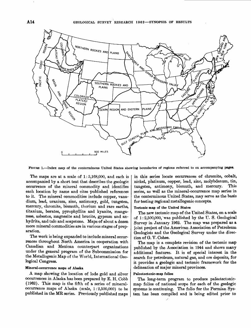
A14 GEOLOGICAL SURVEY RESEARCH 1962 SYNOPSIS OF RESULTS
FIGTJBE 1. Index map of the conterminous United States showing boundaries of regions referred to on accompanying pages.
The maps are at a scale of 1:3,168,000, and each is accompanied by a short text that describes the geologic occurrence of the mineral commodity and identifies each location by name and cites published references to it. The mineral commodities include copper, vana dium, lead, uranium, zinc, antimony, gold, tungsten, mercury, chromite, bismuth, thorium and rare earths, titanium, borates, pyrophyllite and kyanite, manga nese, asbestos, magnesite and brucite, gypsum and an hydrite, and talc and soapstone. Maps of about a dozen more mineral commodities are in various stages of prep aration.
The work is being expanded to include mineral occur rences throughout North America in cooperation with Canadian and Mexican counterpart organizations under the general program of the Subcommission for the Metallogenic Map of the World, International Geo logical Congress.
Mineral-occurrence maps of Alaska
A map showing the location of lode gold and silver occurrences in Alaska has been prepared by E. H. Cobb (1962). This map is the fifth of a series of mineral- occurrence maps of Alaska (scale, 1:2,500,000) to be published in the ME series. Previously published maps
in this series locate occurrences of chromite, cobalt, nickel, platinum, copper, lead, zinc, molybdenum, tin, tungsten, antimony, bismuth, and mercury. This series, as well as the mineral-occurrence map series in the conterminous United States, may serve as the basis for testing regional metallogenic concepts.Tectonic map of the United States
The new tectonic map of the United States, on a scale of 1:2,500,000, was published by the U. S. Geological Survey in January 1962. The map was prepared as a joint project of the American Association of Petroleum Geologists and the Geological Survey under the direc tion of G. V. Cohee.
The map is a complete revision of the tectonic map published by the Association in 1944 and shows many additional features. It is of special interest in the search for petroleum, natural gas, and ore deposits, for it provides a geologic and tectonic framework for the delineation of major mineral provinces.Paleotectonic-map folios
The long-term program to produce paleotectonic- map folios of national scope for each of the geologic systems is continuing. The folio for the Permian Sys tem has been compiled and is being edited prior to
SYNTHESIS OF HYDROLOGIC DATA FOR LARGE REGIONS A15
publication. This folio focuses attention on prominent transverse trends of major tectonic elements in the conterminous United States during late Paleozoic time. The longest and most conspicuous structural features, including both positive and negative belts, trend north east. Shorter, less prominent northwest-trending structures may represent offsets or jogs in the major northeast trends. These structural belts apparently controlled transgressions and regressions of the sea, the location of evaporite basins, and the distribution of detrital materials.
Work on the folio for the Pennsylvanian System has been confined mainly to data compilation. With the intent of accelerating production of the paleotectonic folios, preliminary work on the Mississippian System was started in 1962.
Tectonic setting of uranium deposits in the Cordilleran foreland F. W. Osterwald and B. G. Dean (1961) relate the
position of uranium deposits to large-scale tectonic features and many small structures in the central part of the Cordilleran foreland northward from central Colorado. Their portrayal and synthesis of a large amount of tectonic and structural data also provide a framework for analyzing distribution of other mineral commodities in the region.
SYNTHESIS OF HYDBOLOGIC DATA FOB LARGE REGIONS
The synthesis of hydrologic data for the entire United States, for North America, and for the world is a con tinuing function of the Geological Survey. The bulk of the data is either gathered in the program for collec tion of basic hydrologic records throughout the Nation, collected as part of local and regional investigations of hydrologic conditions, or compiled from sources out side the Geological Survey.
Reports containing much of these data are published in one of the following U.S. Geological Survey Water- Supply Paper series:
"Surface Water Supply of the United States" "Ground-Water Levels in the United States" "Quality of Surface Waters of the United States"
The first two are published at 5-year intervals and the last is published annually.
Additional interpretive and descriptive studies are listed under separate headings below.Thermal springs of the world
A report by G. A. Waring on the thermal springs of the world is being prepared for publication. Infor mation on the location of thermal springs, water temperature, rate of flow, chemical character of the
evolved gases, and the uses of the water will be tabulated by countries or other geographic areas. Brief descrip tions of the geologic setting and maps showing location of the springs will accompany the tabulations. An extensive bibliography including annotated references to the literature on thermal springs is planned.
Ground water in the United StatesA report on the ground-water situation in the United
States, prepared in a draft for the President's Water Resources Policy Commission and published in 1951 as Geological Survey Circular 114, is being brought up to date by C. L. McGuinness. The report will review, region by region and State by State, the ground-water situation, problems, and prospects for the future. This review is timely because of the increased awareness of water problems, as recognized during the past few years by the establishment of a number of governmental commissions and committees to study and recommend solutions to present and anticipated water problems.
Descriptions of the hydrologic cycle and the ground- water regions of the United States will be accompanied by descriptions of the occurrence, availability, quality, and use of ground water in each of the 50 States.Flood frequency in the United States
Nationwide reports of flood frequency are being pre pared in cooperation with numerous State and local agencies. Tl^e reports describe the frequency of floods at selected stream-gaging stations and extend the data to ungaged sites on major and minor streams. Recur rence intervals for annual floods and the mean annual flood (a flood having a recurrence interval of 2.33 years) are calculated for the gaging stations. Definition of the relation between the mean annual flood and drain age-basin characteristics enable the.mean annual flood to be predicted at any point in the drainage basin. The reports will be published in the Water-Supply Paper series in several parts corresponding to the drainage- basin subdivisions used in "Surface Water Supply of the United States."
Chemical quality of river water in the conterminous United States
Three maps showing (1) prevalent dissolved solids and concentrations, (2) prevalent chemical type, and (3) mean annual discharge-weighted sediment concen tration of rivers in the conterminous United States are being prepared by F. H. Rainwater. These maps, which will be published as a Geological Survey Hydrologic Atlas, should be useful to the water consumer, the ad ministrator, the scientist who is not a specialist in this field, and to people who are searching for general infor mation on water.
A16 GEOLOGICAL SURVEY RESEARCH 1962 SYNOPSIS OF RESULTS
NEW ENGLAND AND EASTERN NEW YORE REGION
Cooperative geologic-mapping programs are pres ently being carried on with the Commonwealth of Mas sachusetts and with the States of Rhode Island and Connecticut. Geophysical and geochemical surveys, and field studies related to mineral deposits, are in progress in these States and in Maine, Vermont, and New Hamp shire. Water-resources investigations in New England and New York are carried on largely through coopera tive agreements with the various States.
Results of geologic and hydrologic studies in this area are summarized below. Other information per taining directly to New England and easter New York may be found on other pages as follows: water re sources of Providence, R.I., page A12; marine geology, page A79; electrical properties of the earth's crust, page A82; coastal erosion, page A106; and geochemical prospecting in Maine, page A121.Geologic and geophysical studies in Maine
The Ordovician succession in Maine is now known to contain rocks ranging in age from the lower middle part of the Ordovician System (Llanvirn) through the upper part (Ashgill), according to studies made by R. B. Neuman, in cooperation with several university paleontologists. Although the sequence is not complete in any one section, it can be pieced together from several areas. The oldest fossiliferous rocks, in the Shin Pond area, are now considered to be early Middle Ordovician (Llanvirn). Later Middle Ordovician rocks with shelly faunas include the Kennebec Formation of Boucot 16 of the Moosehead Lake region; sandstone and conglom erate of the Spider Lake quadrangle, discovered by Bradford Hall, of Yale University, and the "ribbon rock" of Aroostook County near Fort Fairfield, in which brachiopods were found by W. H. Forbes, of Washburn. Graptolites, conodonts, and radiolaria associated with these rocks are being studied. Trilobites and brach iopods in Ordovician rocks of the Presque Isle quad rangle are of Late Ordovician (Ashgill) age.
A major fault, which probably originated in De vonian time, was mapped by R. H. Moench in the Phillips quadrangle. The fault strikes about N. 70° E. and dips steeply north. Displaced rock units and meta- morphic zones indicate an apparent right-lateral off set of about 1 mile, but most observed slickenside striae are oriented downdip, suggesting that some dip-slip movement took place.
Most of the Greenville quadrangle is underlain by two sedimentary units of probable Silurian or Early Devonian age, according to G. H. Espenshade and E. L. Boudette. In the absence of usable fossils, wide-
16 Boucot, A. J., 1961, Stratigraphy of the Moose River synclinorium, Maine: U.S. Geol. Survey Bull., 1111-E, p. 153-188.
spread graded bedding has provided the key to struc tural and stratigraphic relations. A differentiated mafic intrusion extends northeasterly for about 10 miles across the northern part of the quadrangle and is part of a large intrusion that may be as much as 53 miles long. Age determinations by Henry Faul on biotite from the gabbro and a nearby granitic intrusion indicate Early Devonian ages.
A broad belt containing conductive black slates was traced by E. B. Ekren and F. C. Frischknecht from the Smyrna Mills quadrangle across the Island Falls quad rangle and into the Sherman and Shin Pond quad rangles by electromagnetic methods. The largest elec tromagnetic anomaly in the Island Falls quadrangle is caused by a distinctive unit of interbedded black chert and slate containing graptolites of Middle Ordovician age. Similar conductive rocks containing the same fos sils have been found in the Danf orth and Howe Brook quadrangles.
Geologic and geophysical studies in MassachusettsE-an Zen, in a long-term field study of the Taconic
sequence, is comparing the stratigraphic and structural relations of the Taconic sequence at its south end in northwestern Connecticut with those at the north end in west-central Vermont. Results to date suggest that the northern and southern areas are underlain by two different sequences of argillite and carbonate rock. An argillite sequence of the "high Taconics" in western Massachusetts is of obscure age and structural relation to a surrounding carbonate sequence. New data on the carbonate sequence indicate the similarity of sedimen tary conditions in Middle Ordovician time and conti nuity of the Middle Ordovician unconformity between central Vermont and southwestern Massachusetts.
N. P. Cuppels has mapped a quartzo-f eldspathic unit of the Marlboro Formation in the Concord quadrange that is similar in lithology to a f acies of the Newbury Formation mapped by R. O. Castle in the Salem quad rangle to the northeast.
R. N. Oldale mapped the distribution of unmeta- morphosed red arkose and shale fragments in the Pleistocene deposits of the Salem quadrangle (Art. 71). This material closely resembles the Triassic sedimentary rocks of the Connecticut Valley and may indicate the presence of previously unknown Triassic bedrock in northeastern Massachusetts. The high concentration of arkose and shale in the drift in the northwestern part of the quadrangle suggests that the bedrock source is nearby, presumably concealed by drift.
A hitherto unknown small inlier of granite in the Pennsylvanian sedimentary rocks of the Narragansett Basin was discovered near Attleboro by J. P. Schafer.
NEW ENGLAND AND EASTERN NEW YORK REGION A17
The inlier is bounded on one side by a fault and on the other by a nearly vertical disconformity.
Deep drilling in Harwich on Cape Cod, done by1 the Raytheon Co. under contract to the Air Force
Cambridge Research Laboratory, and logged and inter preted by Carl Koteff and John Cotton, has revealed 435 feet of Pleistocene deposits consisting of 160 feet of fine sand, 153 feet of bluish-gray silt, 116 feet of bouldery till, and a 6-foot iron-stained zone that may be the base of the till. The rock below this, penetrated to 565 feet below the iron-stained zone, is gray seri- citized phylitic schist. The bedrock is of unknown age, but it is lithologically similar to both the Rhode Island Formation of Pennsylvanian age and the Black- stone Series of Precambrian (?) age. A second 1,000- foot drill hole in nearby Brewster revealed 433 feet of Pleistocene deposits overlying granite gneiss, samples of which have been taken for age determination.
, Although the paleontologic work on Upper Creta ceous and Tertiary sediments of western Martha's Vine yard has not been completed, C. A. Kaye is able to present a tentative stratigraphic section. Both the Raritan and Magothy Formations are probably present. A recently discovered greensand may belong to the upper part of the Magothy Formation, the Matawan Group, or the Monmouth Group. The distribution of fossiliferous glauconitic and ferruginous sands of prob able Matawan age in the drift gives a general idea of the former outcrop of these beds and indicates a north east strike of the coastal plain sediments. As yet there is no paleontologic evidence of Eocene sediments. Re cent potassium-argon dating of a tektite found on the surface at Gay Head " indicates a late Eocene or early Oligocene age for the glass. This does not necessarily mean that deposits of that age are present. The Mio cene is represented by a richly fossillferous greensand whose exact position in the Miocene has not yet been determined. Above the Miocene greensand is a sul- fide-rich, somewhat glauconitic clay in which no fos sils have yet been found. It may be Pliocene, and may be the source of several Pliocene vertebrate fossils that have been found at Gay Head.
In companion studies, good correlation between min eralogy and stratigraphy has been found in the Gay Head cliffs of Martha's Vineyard by J. C. Hathaway. Where both Tertiary and Pleistocene sediments are glauconitic, they can be distinguished by the presence of chlorite and a higher content of mixed-layer mica- montmorillonite in the Tertiary and the near absence of these minerals in the Pleistocene. Of the nonglauconi-
17 Kaye, C. A., Schnetzler, C. C., and Chase, J. N., 1961, A tektite from Gay Head, Martha's Vineyard, Massachusetts: Geol. Soc. America Bull., v. 72, no. 2, p. 339-340.
tic deposits in the cliffs, the Cretaceous deposits are characterized by abundant kaolinite, the Tertiary by chlorite, mica, and mixed-layer mica-montmorillonite, but little or no feldspar; and the Pleistocene by the same assemblage as the Tertiary, but with abundant feldspar. Electron-microscope study of phosphate nodules from the Miocene of the cliffs showed significant amounts of organic materials, abundant diatom fragments, and a wide range in particle size of apatite. These findings suggest that the nodules originated as fecal material, perhaps from small whales, whose fossil remains are common in these beds.
The Pleistocene stratigraphic section of western Martha's Vineyard, according to C. A. Kaye, consists of 6 tills and 3 units of sorted sediments. The oldest deposit is a till made up almost entirely of rock detritus from Coastal Plain sediments and is thought to belong to the Nebraskan Glaciation. A littoral marine unit above this comprises three sedimentary facies and is placed in the Af tonian Interglaciation. This unit prob ably correlates with the fossil-bearing sediments on Long Island that have been called the Gardiners Clay and with the shell-bearing beds of Sankaty Head, Nan- tucket. The section contains three stratigraphically distinct clays. Besides the Nebraskan and Aftonian, the following stratigraphic subdivisions of the Pleisto cene are thought to be present: Kansan, Yarmouth(?), Illmoian, and Wisconsin (Farmdale( ?), lowan, and Tazewell).
Studies of surficial deposits in the Rowe and Heath quadrangles by J. H. Hartshorn have shown that the steep and narrow Deerfield River valley was filled with proglacial outwash to a height of approximately 80 feet above the present stream gradient. The outwash has been extensively reworked and terraced by late-glacial and postglacial stream erosion and in numerous places 4 to 6 terraces occur in flights. A group of high kame deposits at different altitudes above the cut terraces pro vide evidence of a series of glacial lakes that were prob ably held in by ice dams, and of kame terraces graded to now-vanished base levels on a glacier tongue.
R. B. Colton and R. V. Cushman (1962) have mapped numerous narrow bodies of gravel and sand flanking till hills and drumlins in the Connecticut River valley be tween Hartford, Conn., and Springfield, Mass. Most of these deposits project beyond the southern ends of the hills as southwestward-curving "tails." They are in terpreted as beach deposits formed at or 'below the highest strand line of glacial Lake Hartford. This strand line now rises northward about 4 feet per mile because of postglacial tilting.
Evidence of late-glacial and early post-glacial eolian activity in Massachusetts is provided by a very wide spread surface layer of windblown sand and silt, by
A18 GEOLOGICAL SURVEY RESEARCH 1962 SYNOPSIS OF RESULTS
ventifacts in this material, by wind-abraded surfaces on a few bedrock outcrops, and by stabilized sand dunes. J. H. Hartshorn (1962) reports that fluted bedrock surfaces at six localities in eastern Massachusetts were cut during late-glacial time by winds mostly from the north to northeast.
C. R. Tuttle (1962), in connection with seismic in vestigations done in cooperation with the Massachusetts Department of Public Works, has described a seismic layer with a compressional-wave speed of 5,000-8,000 feet per second, which he calls high-speed till. It is ordinarily found beneath a surface layer of till in which the speed is 2,000-4,500 feet per second. The seismic speeds obtained in this work must be used with caution as indicators of lithology, because high-speed materials interpreted as till have proved in a few places to be sheared phyllite, fracture-cleaved siltstone, or granodio- rite containing unconsolidated clastic dikes.
E. A. Sammel (1962b), mapping surficial deposits in connection with ground-water investigations in the Ipswich, Newburyport East, and Newburyport West quadrangles, has extended the known occurrences and relations of late or postglacial marine clays in north eastern Massachusetts. These clays occur as much as 80 feet above sea level, and are clearly interbedded with ice-contact deposits at a number of localities.
A continuous seismic profile (Sammel, Art. 156) along about 20 miles of the Merrimack River from Plum Island to Haverhill, Mass., shows that the present chan nel of the river, flowing over unconsolidated sediments, crosses a number of deep places in the underlying bed rock surface. In the 6 miles below Haverhill, the bed rock beneath several reaches may lie more than 200 feet below sea level. In about the lowermost 2 miles, near the ocean, the bedrock is more than 150 feet below sea level at 4 places and more than 200 feet at 1 of the 4. The full geologic implications of these data await fur ther mapping and testing.
Dense aggregates of beaver-felled conifer wood at or near the base of four relatively thick peat bodies in southeastern New England are reported by C. A. Kaye. Two of these bodies are exposed in sea cliffs on Block Island and Martha's Vineyard and two were exposed during the excavation of an underground garage in the Boston Common. Radiocarbon ages of the beaver-felled wood as determined by Meyer Rubin range from about 11,000 to 12,100 years. From the size of the toothmarks it is inferred that the beavers were the present Cana dian beaver (Castor canadensis). It is possible that these early postglacial beavers dammed fairly well graded stream courses and that much of the swampland of present New England is the direct result of this.
Geologic mapping in Rhode IslandG. E. Moore, Jr., has discovered well-crystallized
graphite in muscovite schist from a drill core at Tucker- town and in metaconglomerate from west of Worden Pond in the Kingston guadrangle. The Rhode Island Formation contains much graphite, or meta-anthracite, whereas the Blackstone Series does not, at least in this quadrangle. The rocks at these two localities, therefore, are thought to belong to the Rhode Island Formation and to occur in two separate small basins to the west of the main body of the Rhode Island Formation of the Narragansett Basin.
Several exposures near Westerly, studied by J. P. Schafer, show bedrock that was deeply decomposed in pre-Wisconsin (perhaps pre-Pleistocene) time. This weathered rock was strongly affected by solifluction, probably both before and after the last glaciation of the area. Geologic mapping in Connecticut
Mapping in the Hampton and adjacent quadrangles by H. R. Dixon has shown that the Pomfret Phyllite and the Woodstock Quartz Schist of Gregory 18 are not valid units but are continuations of the Hebron Gneiss and the Scotland Schist.
The Willimantic dome, an elliptical structure 8 by 16 miles in diameter in eastern Connecticut, has been mapped in detail by G. L. Snyder. The rocks within the dome, previously mapped as the Willimantic Gneiss of Gregory, are now divided into units that are correlated with formations elsewhere in eastern Connecticut. From the center of the dome outward these units are (correlative formation names in parentheses): alaskite (Sterling Granite Gneiss), hornblende gneiss (Monson Gneiss and Middletown Gneiss), a politic gneiss (Put- nam Gneiss and Brimfield Schist) with a medial calc- silicate and marble member (Fly Pond Member of the Putnam Gneiss), a binary granite (Canterbury Gneiss), and a calc-silicate rock and biotite schist (Hebron Gneiss).
H. R. Dixon has identified a conglomeratic zone in the Putnam Gneiss in the Plainfield quadrangle that appears to mark a transition between overlying alumi nous schists and a lower thick series of layered amphibo- lites and quartz-biotite gneiss. The conglomerate is composed of pebbles and cobbles of various granites, quartzite, schist, and pegmatite in a matrix of silli- manite-pyrite schist. It is highly deformed and, locally at least, the pebbles and cobbles are stretched. The ex tent of the conglomerate along strike is not yet known, but at this horizon a highly aluminous pyritic schist is
is Rice,. W. N., and Gregory, H. E., 1906, Manual of the geology of Connecticut: Connecticut Geol. Survey Bull. 6, 273 p.
APPALACHIANS REGION A19
known to extend southward to the Honey Hill fault and northward into Massachusetts, and may prove to be a good marker unit within the Putnam Gneiss.
C. E. Fritts has revised and refined the stratigraphy i of the metasedimentary rocks of pre-Triassic age north west of New Haven (Art. 128). The Milford Chlorite Schist of Gregory 19 probably underlies the Orange Phyllite of Gregory; previously the Milford was thought to be the youngest formation of pre-Triassic age in the southeastern part of the western highlands of Connecticut. The main part of the Orange Phyllite of former usage, now called the Wepawaug Schist, is be lieved to occupy a tight syncline plunging gently north- northeast. Tentative correlations have been made with well-established formations in Vermont.
Geophysical studies in New Hampshire ! Detailed gravity measurements by M. F. Kane over several New Hampshire ring dikes show extremely sharp anomalies with gradients as high as 40 milligals per mile. Data over the southwest edge of the Merry- meeting stock suggest that a near-surface mafic dike is present along the margin of the intrusive.
Andrew Griscom has made aeromagnetic studies of five intrusions of the White Mountain Plutonic- Volcanic Series. Analysis of the anomalies, which are as large as 4,000 gammas, has provided considerable information concerning the subsurface shape of the intrusions. It was demonstrated from studies of the magnetic properties of samples that two of these intru sions possess a similar anomalous direction of remanent magnetization, down and to the southwest. This direc tion is very different from that of other rocks of a similar age.
Regional geophysical studiesGravity profiles across ancient river channels covered
by glacial deposits show small but measurable negative anomalies. M. F. Kane suggests that these are caused by the high porosity of the overburden, and that gravity measurements should prove useful in problems con cerned with the subsurface configuration of the bedrock.
Results of aeroradioactivity studies by Peter Popo- noe in the New England-New York area point up the potential use of airborne radioactivity measurements as an aid to regional geologic mapping in glaciated areas. The studies indicate a local derivation of a large part of the glacial material that mantles the bedrock, so that many bedrock units may be traced by their characteristic level of radioactivity. For instance, the new Hampshire Plutonic Series and the surrounding Ordovician volcanic rocks have a low radioactivity level of 250 to 400 counts per second and may be traced across
* See footnote, p. A18.
New Hampshire, Massachusetts, and Connecticut by this level. At two localities departures from the charac teristic low level occur: the Croydon Dome of New Hampshire (550-950 cps) and the Glastonbury Gneiss 20 in the vicinity of Meshomasic Mountain in Connecticut (500-1,000 cps).Ground water in Rhode Island
In an appraisal of the ground-water reservoir areas of Rhode Island, S. M. Lang (1961a) divided the State into 17 areas, most of them consisting of one major ground-water reservoir and the stream-drainage area contributing to it. For each of these areas an appraisal was made of (1) the size of the ground-water reservoir, (2) the amount of natural replenishment, (3) present development of the water in the area, and (4) possible conflict between established water uses and future ground-water developments. Of these 17 areas, 9 are considered to have ground-water reservoirs large enough and potential water use great enough to warrant detailed investigations leading to a quantitative evalua tion of the amount of water available. Such investiga tions are presently underway in three of these areas.Quality of water in the St. Lawrence River basin
A. L. Mattingly has assembled data on the chemical and physical quality of waters in 12 streams tributary to the St. Lawrence River and the St. Lawrence itself in New York, and from about 30 wells in the drainage area. The dissolved-solids content of the surface water generally ranges from 28 to 94 ppm (parts per million) and the hardness from 12 to 70 ppm. The dissolved- solids content of the ground water ranges from 236 to 1770 ppm and the hardness from 221 to 345 ppm. These variations probably are related to the different types of bedrock that underlie the drainage area.
APPALACHIAN REGION
Results of some of the current geologic, geophysical, and hydrologic studies in the Appalachian region are presented below. Discussion of some topical studies in this area may be found as follows: iron deposits in Alabama, page Al; copper in North Carolina, page A3; pegmatites in North Carolina, page A6; geomor- phology in southeastern Pennsylvania, page A76; lime stone hydrology, page A107; and radioactive-waste disposal, page A114.Geologic mapping
Mapping near the Delaware River in New Jersey and Pennsylvania by A. A. Drake, Jr., and J. B. Epstein strongly suggests that the ridges of Precambrian rocks in the Reading Prong may be detached parts of a single thrust sheet. The contact between the Shawangunk
90 See footnote, p. A18.
A20 GEOLOGICAL SURVEY RESEARCH 1962 SYNOPSIS OF RESULTS
Conglomerate of Silurian age and the underlying Martinsburg Shale of Middle and Late Ordovician age may be a decollement as well as an unconformity.
Mapping by E. G. Eay in nothern Virginia has shown a series of complex, overturned folds in the Weverton Quartzite foothills on the western side of the Blue Eidge. Recognition in aerial photographs of these folds, extending into the Shenandoah Valley, suggests conformity of the basal clastic rocks with the over lying carbonate rocks, as mapped by Charles Butts, instead of a thrust relation as suggested in earlier reports.
Structural and tectonic studiesJ. C. Eeed, Jr., and J. L. Jolly have demonstrated
that the rocks of the Maryland Piedmont have been affected by at least two periods of regional metamor- phism. Rocks of medium- and high-grade regional metamorphism altered by retrogressive metamorphism have previously been mapped as low-grade metamor- phic rocks.
In the Grandfather Mountain area of North Carolina, J. C. Eeed Jr., and Bruce Bryant have shown that structures of several generations are present in both the autochthonous and allochthonous sequences. Some of the structures formed prior to thrusting and some during thrusting.
Recent mapping by R. L. Miller (Art. 139) has re vealed an exposure of the Pine Mountain overthrust fault zone in the "Genessee" black shale near Big Stone Gap, Va., about 20 miles from the nearest previously known exposures.
Stratigraphic studiesDetailed studies in the western part of the Pennsyl
vania anthracite region by G. H. Wood, Jr., J. P. Trex- ler, and H. H. Arndt (Art. 74) have demonstrated that the upper member of the Mauch Chunk Formation intertongnes with the lowest beds of the Pottsville, and is therefore, at least in part, of Early Pennsylvanian age. The same authors (Art. 72) have subdivided the Catskill Formation in this area into members on the basis of tonguing of marine and continental facies, and have demonstrated that the upper gray member is of Early Mississippian age (also see Art. 73).
Preliminary interpretation of geologic mapping and stratigraphic sections in the Northern anthracite field of Pennsylvania by M. J. Bergin, T. M. Kehn, and J. R. Robertson indicates that the Pocono Formation and the overlying Mauch Chunk Formation intertongue along the northwestern edge of the field, and that the Mauch Chunk Formation thins out abruptly toward the northeast.
Lead-alpha measurements by T. W. Stern on zircon collected by A. A. Stromquist and A. M. White from
felsic crystal tuffs in the volcanic-slate belt of the central North Carolina Piedmont have confirmed a previously inferred Ordovician age for these unfos- siliferous rocks.
Study of the breccias in the upper part of the Knox Dolomite of eastern Tennessee and southwestern Vir ginia by Helmuth Wedow, Jr., suggests that much of the matrix consists of the following: (a) graded clastic sediments, including insoluble residues of dissolved limestones, (b) "sanded" dolomite rhombs from the alteration of limestone, and (c) other detritus, includ ing volcanic material, washed down through solution channels from the paleokarst surface at the top of the Knox.
Comparison of well data from central and eastern Kentucky with exposed sections in northeastern Ten nessee and southwestern Virginia by L. D. Harris shows that the limestones of the Conasauga Group thin and finger out to the northwest and that the younger Cambrian rocks transgress northwestward across the older, so that the basal sandstone probably ranges in age from Early Cambrian in northeastern Tennessee to Middle Cambrian in central Kentucky.
Petrographic studies of two arenaceous formations of Early Cambrian age in the Philadelphia, Pa., area, by Jane Wallace, have revealed significant differences between them. In the samples examined, the Chickies Quartzite contains not more than 5 percent feldspar in grains up to 1 mm in maximum dimension; but the Antietam. Quartzite contains about 50 percent feldspar in grains that average 0.1 mm in size. In addition, the Chickies has a pronounced preferential elongation of grains that is lacking in the Antietam.
Geophysical studiesFive lithologic zones have been identified in the base
ment rocks of eastern Tennessee as a result of study of aeromagnetic and Bouguer gravity-anomaly maps by J. S. Watkins (Art. 69). Four of these zones strike slightly east of north. A major basement fault which strikes approximately parallel to surface faults of the Valley and Ridge province truncates the zones. Over 400 density determinations by Y. Yuval show that the mean density of the lower Paleozoic limestone and shale sequence of the Valley and Ridge province is between 2.70 and 2.75 g per cc and that the mean density of the Knox Dolomite is between 2.80 and 2.85 g per cc.
Interpretation of aeromagnetic surveys in the Green wood Lake and Sloatsburg quadrangles, New York and New Jersey, by Anna Jesperson and Andrew Gris- com shows that the magnetic pattern duplicates the northeasterly geologic trend, differentiates areas of ex posed or near-surface crystalline rocks from areas of
ATLANTIC COASTAL PLAIN REGION A21
sedimentary rocks, and differentiates the three prin- tcipal units within the crystalline rocks.
Interpretation of gravity and aeromagnetic surveys in the Allentown quadrangle, Pennsylvania, by R. W. Bromery suggests that the Precambrian rocks east of Saucon Valley are denser and more highly magnetic than the apparently similar Precambrian rocks west of the valley.
R. G. Bates (1962b,c) has shown that the average aeroradioactivity levels or patterns of radioactivity units delineate the three major geologic subdivisions in eastern Tennessee and Kentucky. He also shows that within the Valley and Ridge province, the north west edge of the high radioactivity units (Rome For mation and Conasauga Shale) accurately delineates the traces of the thrust faults that separate these rocks from the younger, less radioactive, largely carbonate rocks.
In the Savannah River area of South Carolina and Georgia, R. G. Schmidt (1961b, 1962) has shown that aeroradioactivity of the granites and some metamorphic rocks is high, that of the adjacent Upper Cretaceous and Eocene rocks is moderate to high, and that of the slate-belt rocks and the post-Eocene formations is gen erally low. J. A. MacKallor 21 has shown that, in this same area, there is a good correlation between counts per second recorded during flight and percent equiva lent uranium (eTJ) in soil samples collected directly Under the flight path of the aircraft; also there is a definite correlation between eTJ of the soil and the kind ojf underlying bedrock.Hydrologic studies
J. W. Stewart (Art. 43) used tests of core samples and pressure tests of core holes in computing the water- yielding potential of metamorphic crystalline rocks in the Piedmont province north-northeast of Atlanta, Ga.
C. L. Dodson has found that sustained yields of water from wells in the Murphy Marble are higher than would generally be expected from wells in the metamor phic rocks of the Murphy area, North Carolina. Only a small part of the area is underlain by marble, but this small part, in addition to having a potentially large ground-water supply for industrial development, is strategically located near railroads and in the widest valleys.
ATLANTIC COASTAL PLAIN REGION
Only findings of regional geologic and hydrologic studies in the Atlantic Coastal Plain are discussed in this section. Additional information on the following topical studies may be found elsewhere in this book:
a MacKallor, J. A., 1962, Aeroradioactivity (ARMS-1) and general geology of the Georgia Nuclear Laboratory area, northern Georgia : U.S. Atomic Energy Comm. Report CEX- 58.4.8.
phosphate deposits, page A6; clay deposits, page A7; paleontology, page A74; geomorphology, page A76; plant ecology, page A77; lead-isotope studies, page A96; saltwater encroachment, page A101; coastal ero sion, page A106; artificial recharge of aquifers, page All2; and water pollution, page All5.Regional stratigraphy and structure
H. E. LeGrand (1961) has made a compilation of gross lithologic and major structural features of the Atlantic Coastal Plain. Interpretation of the regional stratigraphy and structure by him indicates that (1) eastward and southeastward-dipping beds lie on a base ment, of crystalline rocks and, less commonly, on Paleo zoic and Triassic sedimentary rocks; (2) the basement is a shallow, nearly flat platform beneath the updip or inner half of the coastal plain, but in southern New Jersey and eastern North Carolina the basement plat form steepens eastward and adjoins the west side of a northward-trending trough; (3) the Peninsular arch of Florida and the Cape Fear arch of North Carolina are two northwestward-trending positive elements, with an embayment in southeastern Georgia between them; (4) marine sand and clay predominate in Mesozoic rocks north of Florida and in Cenozoic rocks north of North Carolina; (5) near-surface calcareous rocks of Eocene age extend from Florida through North Carolina; and (6) pre-Pleistocene coastal plain rocks of Florida are largely carbonates.Stratigraphic studies
Regional subsurface maps of the Upper Cretaceous sedimentary rocks in the coastal plain of Georgia and Florida aid in clarifying some of the episodes in the geologic history of the area. Mapping by Paul and Esther Applin indicate that the sand, shale, and chalky marl of Navarre (Late Cretaceous) age in Georgia, and the lithologically and faunally distinct Lawson Lime stone (Late Cretaceous) in the Florida peninsula rep resent contemporaneous deposition in closely associated areas of dissimilar environment. The Applins inter pret their data as indicating that the two types of sedi ments were separated by an upwarped barrier in the older beds of Taylor and Austin age. The barrier, which extended west-southwestward across southern Georgia and western Florida during the latter part of the Late Cretaceous, was apparently downwarped in Tertiary time. Contemporizing these units will have a significant effect on future Atlantic coast stratigraphy.
Preliminary sampling and analysis of the "Tusca- loosa," Black Creek, and Peedee Formations along the Cape Fear, Neuse, and Tar Rivers, N.C., by Linn Hoover and others indicate that marked differences oc cur in the sedimentary components, but the persistency
661513 O 62
A22 GEOLOGICAL SURVEY RESEARCH 1962 SYNOPSIS OF RESULTS
and the degree and direction of change in each unit has not been established.
Surface and shallow subsurface mapping of Quater nary deposits in seven T1/^-minute quadrangles in New Jersey by J. P. Owens and J. P. Minard has shown that the classical division of the Quaternary into three stages during which terrace deposits were laid down is not applicable to the area. Most of the Quaternary de posits are recognized by internal structures such as stream-channel and overbank deposits, and they show close lithologic correlation with source rocks nearby. The location of the deposits is related not to a sequence of terraces of decreasing altitude but to the gradients of individual streams.
S. M. Herrick (Art. 21) has identified a middle Eo cene fauna, characterized by Marginulina vacaviUensis (Hanna), in a test well drilled in Camden County, N.J. The fauna occurred in the Manasquan Formation, which is considered by Herrick to bear strong lithologic and faunal similarity to the Weches Greensand Mem ber of the Mounty Selman Formation of Texas and the Cook Mountain Formation of Louisiana.
D. R. Rima, correlating by means of gamma-ray logs, has traced the marine Upper Cretaceous formations of New Jersey southwestward along the strike through Delaware. Rima's work substantiates previous strati- graphic interpretations in the area based on lithologic and faunal studies.
Examination of deep-Well cores from Florida by J. M. Schopf revealed microscopic Chitinozoa similar to forms from Oklahoma in the Sylvan Shale of Late Ordovician (Richmond) age. These problematic acid- resistant microfossils are being compared also with as semblages from the Upper Ordovician in Ohio and Kentucky.Hydrologic studies
E. R. Lubke (1961a) has prepared a contour map of the buried Cretaceous surface in the Huntington- Smithtown area of Suffolk County, Long Island, N.Y., that depicts 5 major buried valleys, one of which is cut 450 feet below sea level. These valleys are potential conduits for the movement of salt water from Long Island Sound into Cretaceous aquifers. John Isbister has recognized the presence of similar valleys in north eastern Nassau County, Long Island.
P. R. Seaber has divided the sequence of coastal plain sediments in New Jersey into eight major geohydrologic units that comprise arealy extensive artesian-aquifer systems, aquiclude systems, and a water-table aquifer system. At least two aquifer systems are available for development in any section of the coast plain.
According to H. B. Counts and M. J. McCollum, current-meter tests in deep wells in the principal ar
tesian aquifer in the vicinity of Savannah, Ga., have defined 4 permeable zones (totaling 100 to 150 feet in thickness) within a 600- to 700-foot-thick section of limestone. The relative permeability of each zone, the approximate contribution of water to the well from each zone, and the approximate water velocity in each zone have been determined as an aid to studies of salt water encroachment in the Savannah-Brunswick area, Georgia.Origin of the Carolina Bays
A survey of the literature on segmented lagoons and elliptical lakes by E. C. Robertson indicates that the segmented-lagoon hypothesis advanced in 1934 by C. Wythe Cooke to explain the Carolina Bays of the At lantic Coastal Plain deserves renewed consideration. Robertson (Art. 92) reviews recent studies of elliptical lakes, including some lakes in the Chukotsky Peninsula of Siberia, and describes the segmentation of lagoons by the growth of cuspate spits. The prevailing wind direction is perpendicular to the elliptical lagoon seg ments. The new hypothesis explains some features of the bays not explained in the original lagoon hypothesis of Cooke and, if correct, means that the bays must have formed as the sea retreated from the Atlantic Coastal Plain.
EASTERN PLATEAU REGION
Recent geologic, hydrologic, and geophysical work of regional significance is summarized below. Much of this work is carried on in cooperation with various State agencies. Additional summary statements on topical subjects may be found as follows: mineral de posits, pages A2 and A7; water resources, Utica-Rome area, New York, page A12; plant ecology, page A77; limestone hydrology, page A103; and water pollution, page A115. Geologic and geophysical studies in Kentucky
During mapping of coal-bearing strata in the vicinity of Jackson in eastern Kentucky, W. R. Hansen and others (Art. 76) have defined the Frozen Sandstone as a new member of the Middle Pennsylvania Breathitt Formation. The Frozen Sandstone Member is about 40 feet thick, and its base is about 80 to 100 feet above the base of the Breathitt Formation. Because it is both widely exposed and easily recognized in an area of generally poor outcrops, the Frozen Sandstone Mem ber is an excellent stratigraphic marker within the thick Breathitt Formation.
Detailed mapping and stratigraphic studies of the Lower Pennsylvanian Lee Formation in the Middles- boro area of southeastern Kentucky by K. J. Englund show a previously unrecognized unconformity in the upper part of the formation. The erosional surface,
EASTERN PLATEAU REGION A23
which truncates about 300 feet of underlying strata, is accompanied by a reversal in depositional trend above the unconformity. Sandstone tongues of the Lee below the unconformity wedge out toward the northwest; those above the unconformity wedge out to the east or southeast. This is interpreted as indicating a change from an eastern or southeastern source to a northwest ern source, the latter source originating from uplift and cannibalism of previously deposited Lee sediments in the general region of the Cincinnati arch. The possi bility that this unconformity is regional is significant in that it may be related to the Mississippian-Pennsyl- vanian boundary of the midcontinent region.
Work by R. A. Sheppard and Ernest Dobrovolny near Carter Cave State Park, northeastern Kentucky, has demonstrated that a sandstone lithologically simi lar to sandstones of the Lee Formation of Early Penn sylvanian age occurs in the underlying Pennington Formation of Late Mississippian age. The sandstone lies upon limestone older than the Pennington and is overlain by more than 10 feet of fossiliferous shale and thin-bedded limestone typical of the Pennington For mation. Stratigraphic and paleontologic evidence sug- gpsts that sands which are similar to, if not part of, the Lee Formation were accumulating during Late Mississippian time. This accords with the intertongu- ing of the Pennington and Lee Formations in south eastern Kentucky as described by Englund and Smith.22
J. S. Watkins has recently completed a Bouguer gravity map of Kentucky which was begun by R. W. Johnson, Jr. Study of the gravity map indicates that the basement beneath the Jessamine dome (northern part of the Cincinnati arch) is composed of low-density sialic rock, and that the persistent high structural posi tion of the dome may be due to partial isostatic com pensation of the low-density mass. The addition of new data to that already available in eastern Kentucky shows that several small anomalies are elongate paral lel to the Appalachian structures. Previous data had tended to suggest that there was little or no relationship between the basement and surface Appalachian struc tures in Kentucky. Of the numerous faults in Ken tucky, only those in the central part of the Rough Creek fault zone appear to be associated with significant base ment faults.Geologic studies in Pennsylvania
Current geologic mapping and Stratigraphic studies in Washington County, Pa., by H. L. Berryhill, Jr., and V. E. Swanson (Art. 75) have yielded data that permit a revised nomenclature and classification for the
82 Englund, K. J., and Smith, H. L., I960, Intertonguing and lateral gradation between the Pennington and Lee Formations in the tri-State area of Kentucky, Tennessee, and Virginia: Geol. Soc. America Bull., v. 71. p. 2015.
Pennsylvanian and Permian rocks. Mapping has dem onstrated that coal beds are the most distinctive and most easily correlated units; further, the many inter vening sandstone and limestone units are so similar that they can be correlated only when related to an under lying or overlying coal bed. Therefore, the basic map ping unit for field classification includes the several rock types between coal beds, and the basic units repre sent a sedimentary cycle. These units have been desig nated as members and, where possible, the member has been assigned the name of the coal bed at its base. In Washington County, the formation boundaries have been placed at the bases of the most important and per sistent thick coal beds, and the name assigned to the formation is that of the major coal bed at its base. Each formation includes two or more members that represent sets of similar and related sedimentary cycles. In ascending order, the stratigraphic units defined are: the Monongahela Group, which includes the Pittsburgh (5 members) and Uniontown (2 members) Formations of Pennsylvanian age; the Dunkard Group, which in cludes the Waynesburg Formation (3 members) of Pennsylvanian and Permian age; and the Washington (3 members) and Greene Formations of Permian age.
Preliminary data collected by G. W. Colton in the Cedar Run quadrangle, Lycoming and Tioga Counties, Pa., suggest that the Upper Devonian Catskill Forma tion can be divided into several mappable units which possibly will be designated as formations at a later date. Recognition of these units has aided in delineating the structure of the area and should aid in interpreting the stratigraphy of Upper Devonian rocks in north-central Pennsylvania and contiguous areas.Geologic studies in New York
Subsurface stratigraphic studies by Wallace de Witt, Jr., show that the Genesee, Sonyea, West Falls, Java, and Perrysburg Formations of Late Devonian age can be recognized in the subsurface of southwestern New York. Several members, which are composed largely of black shale, have been traced widely in Schuyler, Steuben, and parts of adjacent counties.
Paleontologic studies of compound rugose corals of the Onondaga Limestone by W. A. Oliver, Jr., support a Middle Devonian age for the formation. The co lonial corals are most abundant in the reef facies, com mon in biostrome facies, but rare in other parts of the Onondaga.Geologic studies in Alabama
A geomorphologic study by J. T. Hack of the Rus sell Cave National Monument, Ala., in the limestone region near the southern end of the Cumberland Pla teau distinguishes the geologic featues that apparently controlled the location of the cave, as well as other
A24 GEOLOGICAL SURVEY RESEARCH 1962 SYNOPSIS OF RESULTS
caves of the region. The valley walls in the area are about 1,000 feet high. The lower 750 feet is mostly limestone of Mississippian age and the upper 250 feet is shale, coal, and massive sandstone of the Pottsville Formation of Pennsylvania age. The sandstone that caps the plateau is the source of numerous aprons of talus and inactive slides that extend to the valley floor. The floors of the limestone valleys are completely blanketed by cobbles of the sandstone. Because of the large quantity of sandstone debris shed onto the valley floor, the stream channels tend to migrate toward the sides of the valley where they are captured by sinks and carried off downdip in the limestone. Numerous undrained depressions in the gravelly floor of the val ley indicate that much of the erosion is by solution, and the gravel is removed only during floods that do not run off underground. Surface-water studies in Kentucky
C. R. Collier and J. J. Musser found that weathering and subsequent erosion of the spoil banks formed by strip mining for coal in the Cane Branch basin, Mc- Creary County, Ky., has greatly increased the sediment load of Cane Branch. The sediment yield of the Cane Branch basin (6 percent strip mined) at the measuring station was 1,900 tons per square mile of drainage area in the 1958 water year. In contrast, the nearby Helton Branch basin had no strip mining and yielded less than 30 tons per square mile of drainage area.
Quaternary geology of the lower Ohjo River valleyA completed study by L. L. Ray has demonstrated
that each zone of the profile of weathering developed on thick well-drained sections of Peorian Loess adja cent to the Ohio Valley between Louisville, Ky., and Cairo, 111., is characterized by a distinctive silt-clay ratio. -Continuing studies indicate that with increasing distance from the valley, deposits become thinner and commonly less well drained, and that there is a pro gressive change in the silt-clay ratio from one zone to another within the weathering profile.
Quality of ground water, Delaware County, New YorkGround water containing moderate to large amounts
of hydrogen sulfide, chloride, and natural gas is report ed by J. Soren in wells tapping Upper Devonian con tinental rocks in Delaware County, N.Y. Excessively hard water has also been pumped from wells in these rocks. In most instances the wells yielding objection able constituents are located near crests of eroded low anticlines. The constituents are believed to migrate with ground water through faults and joints from un derlying marine Middle and Lower Devonian rocks.
SHIELD AREA AND UPPER MISSISSIPPI VALLEY REGION
Results of recent geologic, geophysical, and hydro- logic studies in the Shield area and in the upper Missis sippi Valley region are described in the following para graphs. Much of this work was done in cooperation with State agencies. Additional information on min eral deposits is presented on page Al, aeromagnetic prospecting on page A5, glacial geology on page A78, rubidiumstrontium age determinations on page A94, limnological studies on page A103, airborne radio activity surveying on page A115, and isotope geology on page A122. Geologic and geophysical studies
Some of the conglomerate at the base of the We we Slate south of Goose Lake in the eastern part of the Marquette district, Michigan, has been found to con sist of rounded and angular granitic cobbles and peb bles in a matrix of thinly laminated slate. J. E. Gair believes that the cobbles and pebbles were ice-rafted into the area and were deposited in accumulating thinly layered, possibly varved, muds.
The Quinnesec Formation in southern Florence Coun ty Wis., was described by Van Hise and Leith 23 as overlying and interbedded with sedimentary rocks of middle Precambrian age (upper Huronian of that re port), but stratigraphic equivalents in Wisconsin and Michigan have recently been tentatively considered to be of early Precambrian age. Investigation of critical areas in Florence County by C. E. Dutton revealed that pillows in metabasalt of the Quinnesec Formation show that the top of the unit is northward toward middle Precambrian quartzite in which crossbedding indicates that its top is southward. A major fault with relative uplift of the south side is inferred to pass between these two stratigraphic units, and the early Precambrian age of the Quinnesec Formation remains likely. A met- arhyolite that lies between the metabasalt and the inferred fault appears to be a younger part of the Quin nesec Formation. Interbedded volcanic and sedimen-. tary rocks present north of the fault are apparently part of the Michigamme slate of middle Precambrian age.
J. R. Henderson reports that aeromagnetic-contour maps will be prepared and interpreted geologically for a 15,000-square-mile area of that part of the "midconti- nent gravity anomaly" that crosses Iowa. This spec tacular gravity feature extends for about 800 miles southwest ward from Lake Superior to the Salina Basin
23 Van Hlse, C. R. and Leith, C. K., 1911, The geology of the Lake Superior region: U.S. Geol. Survey Mon. 52, 641 p., 49 pi.
SHIELD AREA AND UPPER MISSISSIPPI VALLEY REGION A25
of Kansas. Mathematical analysis of the aeromagnetic data will permit estimates of total thickness of the Paleozoic and Mesozoic sedimentary section and pro vide a basis for speculation about the character, con figuration, and distribution of basement rocks.
Radioactivity levels in part of Ohio and Indiana ranged from 300 to 1,000 cps (counts per second) and averaged 450 to 500 cps, according to R. G. Bates. The (iause of a 700- to 1,000-cps high reading a few miles northwest of Columbus, Ohio, is not known, but the high values may be due to fertilizers used on the fields of the Ohio State Experimental Farm. No correlation of radioactivity levels and bedrock geologic units has yet been noted because of the masking effect of glacial deposits that cover all but the southeast corner of the survey area. Neither has any correlation between Radioactivity levels and morainal and outwash deposits tyeen noted, probably owing to the loess cover that man- tjles much of the area, Preliminary study indicates that the radioactivity level over belts of boulders trans ported from Canada by the Wisconsin ice is slightly higher than over the surrounding glacial deposits. Radioactivity levels over urban areas were generally 50 cps lower than over the surrounding countryside.
A survey of part of Illinois and Indiana shows that the level of aeroradioactivity of the Chicago area is low to moderate, and G. M. Flint, Jr., reports that Specific correlations with geology are precluded by gen- 0ral homogeneity of the Pleistocene surficial material. In general, however, dune-sand deposits and old lake- beds have low radioactivity, whereas morainal materials probably derived in part from the Paleozoic sedimen tary rocks that constitute the floor of Lake Michigan have comparatively moderate radioactivity.
An aerial radiological-measurement survey of Min nesota and Wisconsin covered 10,000 square miles cen tered at the nuclear reactor of the Rural Cooperative Power Association at Elk River, Minn., and included metropolitan Minneapolis-St. Paul. According to J. A. Pitkin the area surveyed is characterized by low to mod erate levels of background radioactivity. A distinctive radioactivity low north of Minneapolis-St: Paul is as sociated with the Anoka sand plain. This plain is composed dominantly of poorly stratified fine-grained quartzose sand with lenses of gravel and is the result of the eastward diversion of the Mississippi River by a late Pleistocene ice sheet.Hydrologic studies
L. W. Howells estimates that 2,200,000 acre-feet of water is stored in the 2 glacial-outwash aquifers in west ern and northern Sanborn County, S. Dak. More than 20,000 acre-feet of water could be withdrawn annually without exceeding average recharge. The western
aquifer contains water under both water-table and ar tesian conditions and is recharged within the county, but the eastern aquifer contains water under artesian conditions only and does not receive recharge within the county.
Well logs and water analyses indicate that the Dakota Sandstone in Sanborn County, S. Dak., may be divided into three water-bearing zones. The shallowest and the deepest zones contain dissimilar chemical types of water and the middle zone contains water of intermediate chemical character. The zonation may be modified or destroyed over or near highs in the Precambrian surface and locally where corroded well casings may permit leakage of water between zones.
In an investigation of the Skunk Creek-Lake Madi son drainage basin the amount of water available from the glacial outwash was estimated by M. J. Ellis and D. Adolphson to be about 154,000 acre-feet annually. Natural discharge from the basin is by surface flow and underflow into the Big Sioux River and into the out- wash deposits along its valley near the city of Sioux Falls, S. Dak.
Studies in Ohio by G. D. Dove have established that fairly large amounts of ground water are available from outwash sand and gravel in the valley of the Hocking River in Fairfield County. The river is a potential source of recharge to the aquifer. The largest user of water in the valley is the city of Lancaster, which pumps about 2^ mgd from 6 wells.
An interesting method of determining the flow sys tem from the Miami River at Dayton, Ohio, to a well field tapping the valley-train deposits was developed by S. E. Norris and A. M. Spieker (Art. 42). The technique consists of precise measurements of the tem perature-depth relation in wells. Changes in tempera ture indicate the depth of relatively impermeable till layers and their effect on the movement of ground water. i
Reconnaissance investigations of ground-water re sources in Minnesota recently have revealed previously unknown sources of ground water from glacial deposits. Studies by G. R. Schiner and others in the northern part of the Lake Agassiz basin in Minnesota have shown that large quantities of good-quality ground water are available from glacial-outwash aquifers underlying a Lake Agassiz beach ridge. The economic development of the region has been hindered by scarce water supplies and poor-quality water. Further studies suggest that additional outwash aquifers, capable of producing at least moderate supplies of water, underlie or are in line with other beach ridges in the area.
Robert Maclay reports that large amounts of ground water are available in a narrow channel of buried out-
A26 GEOLOGICAL SURVEY RESEARCH 1962 SYNOPSIS OF RESULTS
wash at Aurora, Minn. The channel, which contains 2 outwash bodies about 30 feet in thickness, extends southward from the Mesabi Range in St. Louis County to the St. Louis River.
GULF COASTAL PLAIN AND MISSISSIPPI EMBAYMENT REGION
The geologic, geophysical, and hydrologic studies in the Gulf Coastal Plain and Mississippi Embayment region discussed below illustrate the diversity of activ ity of Geological Survey personnel in this large area. In addition to these studies of a more regional nature, the following topical subjects are summarized on the pages indicated: floods, page A99; low flows, page A100; stratigraphlc paleontology, page A75; hydro- chemical facies, page A90; and underground nuclear testing in Mississippi, page A109.
Aerial radiological studies, southeast TexasR. M. Moxham and D. H. Eargle (1961) in making
a comparison of airborne radioactivity studies with mapped geologic units in southeast Texas show that many stratigraphic units can be distinguished on the basis of radioactivity intensities, but not where the units are covered by more than a few feet of residual soils or surficial deposits. This finding suggests the possi bility that airborne radioactivity studies may prove val uable in preparing regional and reconaissance maps in areas where conditions are similar to those in southeast Texas.
Subsurface geology, Little Rock, Arkansas, to Cairo, IllinoisAeromagnetic mapping in the vicinity of Little Rock,
Ark., and northward to Cairo, 111., indicates a near- surface nepheline syenite mass a few miles southeast of Little Rock, in an area that may contain an accumula tion of bauxite. Magnetic anomalies between Little Rock and Cairo are interpreted as expressions of the Precambrian crystalline basement, a mile or two beneath the surface. Lower and Middle Cambrian sedimentary rocks are believed to be very thin or absent within the area of study.
Faulting in western KentuckyGeologic investigations in the Jackson Purchase area
of western Kentucky by U.S. Geological Survey per sonnel have revealed that several faults with throws of as much as 150 feet have displaced beds ranging in age from Ordovician to Recent. One fault with about 30 feet of displacement reportedly formed during the New Madrid earthquake of 1811-12. Most of the faults trend west-southwest and northwest and are continua tions of known faults that displace Paleozoic rocks in adjacent areas north and east of the Tennessee River.
Southeastern Gulf Coastal Plain studies
L. D. Toulmin and P. E. LaMoreaux have described and differentiated rocks of Tertiary age cropping out along the Chattahoochee River. Exposures of these rocks, which provide the only continuous unweathered geologic section in southwestern Georgia and southeast ern Alabama, soon will be largely covered by back waters of dams now under construction. The section serves as a connecting link between geologic units to the east and west that have been differentiated in outcrop. The determination of rock types will aid in locating the formations in the subsurface of adjacent areas where some are sources of large quantities of ground water.
R. H. Musgrove and others have studied the water resources of Escambia and Santa Rosa Counties in northwestern Florida. This expanding industrial area has many streams with high base flows and two produc tive aquifers. Development of ground water is princi pally from a sand-and-gravel aquifer several hundred feet thick which overlies the Floridan aquifer. Salt water encroachment is being detected in coastal estuaries and some stream channels.
Mississippi Embayment hydrologic and geologic studiesE. M. Gushing and E. H. Boswell report that, ac
cording to electric logs of wells and oil tests, all sands above the Paleozoic rocks probably contain fresh water in northeastern Arkansas, Missouri, Illinois, Kentucky, Tennessee, northeastern Mississippi, and northwestern Alabama. These sands are of Late Cretaceous age and younger. Sands of Late Cretaceous age are used as a source of water supply in only about one half of this area of approximately 30,000 square miles. The study also indicates that sands of Early Cretaceous age in a small area in east-central Mississippi may be a potential source of fresh water. In several small areas within the embayment, fresh-water-bearing sands occur below sands containing moderately mineralized water.
A study of Upper Cretaceous gastropods of north eastern Mississippi by N. F. Sohl affords a sound basis for correlating the lower part of the Coffee Sand with the middle part of the Blufftown Formation of Georgia and Alabama, and with the Wolfe City Sand Member of the Taylor Marl in Texas. Scaphites hipprocrysis- like ammonites in the middle part of the Blufftown suggest correlation with the New Jersey Merchantville Formation.
S. M. Herrick has identified Robulus inornatus (d'Orbigny) in the Cane River Formation of eastern Arkansas. Owing to its association with Marginulina vacavillensis (Hanna) elsewhere in the Mississippi Embayment this discovery permits a part of the Cane River Formation of Arkansas to be correlated with the Winona Formation in Mississippi.
OZARK REGION AND EASTERN PLAINS REGION A27
After correlating the results of chemical analyses of [low-flow water samples from the Mississippi Embay- ment area of Alabama and Mississippi, W. J. Welborne reports that streams (at low flow) originating in out crop areas of the Eutaw Formation and Tuscaloosa Group of Cretaceous age in northeast Mississippi and northwest Alabama contain water of extremely low mineral content. In general, stream mineralization in creases south and west toward the Mississippi Eiver as the result of water draining from younger, less leached formations.
Hydrologic studies in Arkansas and TexasGeohydrologic studies made by D. E. Albin show that
the Porters Creek Clay of the Midway Group is the fresh-water "basement" of the 2,000 square mile area of Bradley, Calhoun, and Ouachita Counties in south- central Arkansas. - At least small supplies of ground water can be developed in the outcrop areas of all geologic units above the Porters Creek Clay. The Sparta Sand of the Claiborne Group, the most impor tant aquifer in the area, dips eastward approximately 30 feet per mile toward the axis of the Mississippi trough. About 5 mgd of sodium-bicarbonate type water is withdrawn from the Sparta Sand in the 3 counties. The Sparta in the eastern part of the three-county area is capable of supporting much larger pumpage.
L. A. Wood has mapped a previously unknown body of fresh to slightly saline ground water in the Trinity Group in the lower Eed Eiver and Sulphur Eiver basins of Texas. In much of this area no usable water overlies the newly discovered aquifer, which is 2,000 to 3,600 feet below the land surface.
The effect of salt springs and seeps on the quality of water in the Brazos Eiver is described by B. Irelan and H. B. Mendieta (Art. 54). They report that the average load of chloride during base flow from the Salt Croton Creek basin was computed to be 400 tons per day. (Also see p. A29.)
OZABK REGION AND EASTERN PLAINS REGION
Current work in the Ozark region and Eastern Plains region includes geologic, geophysical, and hydrologic studies of both regional and local interest. Some of the important recent results of this work are discussed below. In addition, specific references to other studies in this area may be found on the following pages: pot ash deposits, page A6; paleontology, page A74; geo- morphology, page A76; limestone hydrology, page A103; underground nuclear testing, page A108; ground water in Oklahoma, page Alll; evaporation suppres sion, page A112; and artificial recharge of aquifers, page A112.
Geologic studies in southeast MissouriIn the Lesterville quadrangle of southeast Missouri,
T. H. Kiilsgaard has mapped the Black fault a distance of 8.5 miles southeastward beyond the point where the fault previously was believed to terminate. Dolomitic rocks of Late Cambrian age have been displaced along this steeply dipping normal fault; those on the south west side have been dropped at least 260 feet.
Kiilsgaard also found that near Lesterville a white coarse-textured vuggy to cavernous dolomite facies transgresses the Bonneterre, Davis, and Derby and Doe Eun Formations, and extends into the lower part of the Potosi Dolomite where the different formations lap onto hills of Precambrian igneous rocks. It remains to be determined whether the facies is of organic origin, such as a series of reefs that originally were anchored to the Precambrian hills, grew through successive pe riods of sedimentation, and then subsequently were dolomitized, or whether the facies originated from dolomitization in an environment influenced by Pre cambrian topography.Stratigraphic studies in Arkansas
Mapping in the Snowball quadrangle in north-cen tral Arkansas by S. E. Frezon has shown that there are three sets of fluvial valley-fill deposits of Pleistocene (?) age along the Buffalo Eiver. The deposits indicate that several cycles of deposition and erosion occurred along the larger streams in the Ozark region in Pleisto cene ( ?) time. These deposits are similar to and may be related to cyclic deposits of Pleistocene age in the Mississippi Eiver valley.Aeromagnetic survey in the Wichita Mountains
Andrew Griscom and Anna Jespersen have found that magnetic anomalies in the Wichita Mountains system of Oklahoma and Texas result from the Pre cambrian basement rocks. Some of the anomalies indi cate the presence of significant remanent magnetization. The aeromagnetic patterns show that in general the Precambrian rocks, which are in uplifted fault blocks, extend outward from their areas of outcrop at relatively shallow depth for distances of a mile or two. Steep magnetic gradients mark the position of the faults at the margins of these blocks. The complexity of the fault pattern and the variety in depth of burial of the blocks of Precambrian rocks indicate a highly frac tured basement. Aerial radiological measurements in New Mexico
J. A. MacKallor has found that aerial radiological measurements over a playa, Eed Lake, in Eddy County, N. Mex., show radioactivity of 500 to 600 counts per second in contrast to 300 to 400 counts per second over the surrounding area. He suggests that the anomaly
A28 GEOLOGICAL SURVEY RESEARCH 1962 SYNOPSIS OF RESULTS
may result from small amounts of potassium salts that may have been concentrated in the playa deposits.Geologic mapping in Texas
Geologic mapping by Eargle,24 Stafford, 25 26 Ter- riere,27 and D. A. Myers has shown that the Cisco Group (Pennsylvanian) and the lower part of the Wichita Group (Permian) contain many discontinuous channel-fill deposits of sandstone and conglomerate, all of which mark local disconformities. There is no evi dence to indicate a widespread unconformity at the boundary between the Pennsylvanian and Permian Systems in the area between the Colorado River and the Clear Fork of the Brazos River in north-central Texas.
Geologic mapping by D. A. Myers in the Wayland quadrangle, Stephens and Eastland Counties, Tex., has shown an increase in amount of channel-fill sandstone and conglomerate in the Cisco Group from south to north. This is in keeping with data presented by Eargle 24 for the Colorado River drainage basin on the south, and with that presented by Lee and others 28 for and area to the north of the Wayland quadrangle where a large part of the Cisco Group is a chaotic sequence of channel-fill deposits.
Geologic mapping by V. L. Freeman in the Shumla quadrangle, Texas, has revealed more details about the effects of the Terrell arch on the thickness and distribu tion of sedimentary strata. Near Comstock the George town Limestone is overlain by the Del Rio Clay, of former usage but northward the Del Rio pinches out against the arch, and the overlying Buda Limestone rests on the Georgetown. The problematical "yellow ish marl" of northern Val Verde County was found to be a weathered phase of the middle unit of the Buda Limestone, as has been recognized by several geologists working in the area. It is separated from the George town Limestone locally by less than 1 foot of the lower part of the Buda.Ground-water recharge, Arkansas River valley, Arkansas
A recent study by M. S. Bedinger, L. F. Emmett, and H. G. Jeffery of ground-water conditions in the al luvium along the 200-mile segment of the Arkansas River between Fort Smith and Little Rock, Ark., has
84 Eargle, D. H., 1960, Stratigraphy of Pennsylvanian and lower Per mian rocks of Brown and Coleman Counties, Texas: U.S. Geol. Survey Prof. Paper 315-D, p. 55-78.
25 Stafford, P. T., 1960, Geology of the Cross Plains quadrangle, Brown, Callahan, Coleman, and Eastland Counties, Texas: U.S. Geol. Survey Bull. 1096-B, p. 39-72, pis. 4-5, figs. 7-14. [1961]
28 Stafford, P. T., 1960, Stratigraphy of the Wichita Group in part of the Brazos River valley, North Texas: U.S. Geol. Survey Bull. 1081-G, p. 261-280. [1961]
87 Terriere, R. T., 1960, Geology of the Grosvenor quadrangle, Brown and Coleman Counties, Texas: U.S. Geol. Survey Bull. 1096-A, p. 1-35.
29 Lee, Wallace, and others, 1938, Stratigraphic and paleontologic studies of the Pennsylvanian and Permian rocks in north-central Texas: Texas Univ. Bull. 3801, 252 p.
shown that the present pumpage of 3.2 mgd from the aquifer in the alluvial deposits represents less than 3 percent of the quantity of ground water available from natural recharge. The aquifer is recharged by direct penetration of rainfall at an estimated rate of 10 inches per year.
Extensive test augering has shown the aquifer to be continuous and in hydraulic connection with the river. Thus the quantity of water potentially available by inducing recharge from the river is many times that available from natural recharge along the river.Water-table decline, Grant and Stanton Counties, Kansas
Ground water pumped for irrigation in Grant and Stanton Counties, Kans., is obtained primarily from storage, according to S. W. Fader, E. D. Gutentag, D. H. Lobmeyer, and W. R. Meyer. About 248,000 acre- feet of water is pumped annually for irrigation from unconsolidated deposits of Pliocene and Pleistocene age. From 1940 to 1960 the water table declined about 40 feet in part of the area, and the decline averaged 8.2 feet for both counties. The two counties are underlain by about 55 million acre-feet of ground water in storage.Fresh water at great depth in Oklahoma
D. L. Hart, Jr., reports that a zone of fresh water extends to depths greater than 3,000 feet in the Lime stones of the Arbuckle Group, in the Arbuckle Plateau region of Johnson, Pontotoc, and Murray Counties, Okla. Although the lateral limits have not yet been delineated, the zone probably underlies about seven townships. Fresh water in adjacent areas generally is available to depths of only 600 feet or less. The large contrast in depths at which fresh water occurs is probably a result of the large recharge area and the rel atively high permeability of the limestone, which allows fresh water to circulate to great depths and to flush and dilute the mineralized water in the aquifer.Ground-water recharge, High Plains, New Mexico
During 1960 two periods of excess rainfall and cessa tion of pumpage due to extensive hail damage to crops caused significant rises in ground-water levels through out the High Plains of Lea County, N. Mex. Prelimi nary estimates by J. S. Havens show a net gain of about 483,000 acre-feet of resaturated sediments. If a spe cific yield of 20 percent is assumed, this represents about 100,000 acre-feet of apparent recharge to the aquifer, the Ogallala Formation of Tertiary age. Estimated total withdrawal of water from the aquifer was 124,000 acre-feet for the same period. If it is assumed that this amount must be added to the aquifer before any rises in the water table are shown, recharge to the Ogallala Formation in Lea County totaled 220,000 acre-feet for 1960.
NORTHERN ROCKIES AND PLAINS REGION A29
Ground water in the Entrada SandstoneF. D. Trauger and F. X. Bushman report that ground
water occurs under water-table conditions in the allu vium but generally is tinder artesian conditions in the Entrada Sandstone of Jurassic age, which is the prin cipal aquifer for the city of Tucumcari, N. Mex., and the area southwest and west of the city. The Entrada Sandstone in the structural basins west of Tucumcari and the older alluvium underlying the city together contain available ground water of good quality suffi cient to supply the city and rural domestic and stock needs for several hundred years at the current rate of use.
The coefficient of transmissibility of the Entrada Sandstone is about 1,500 gallons per day per foot. Pumping tests show that drawdown of water levels in the Entrada Sandstone tends to be excessive, and interference between closely spaced wells is compara tively great.
The rate of movement of water through the Entrada Sandstone is slow because of the relatively low perme ability of the formation. Calculations for 2 general areas in the structural basin show the rate of movement to be about 15 feet per year for both areas. It would require about .1,700 years at the rate of 15 feet per year for water to move from the areas of recharge on the periphery of the structural basin to the city well fields.
Post-Rustler red beds correlated
The age and correlation of the post-Kustler red beds of southeast New Mexico have been in question since 1935. J. B. Cooper (Art. 9) suggests that these red beds are most closely associated with rocks of Permian age and are correlative with the Dewey Lake Redbeds. "Pierce Canyon Redbeds," the name given to this unit in the past, has been abandoned in favor of Dewey Lake Redbeds.
Sources of salinity in the upper Brazos River basin, TexasAn investigation of the salt load in the Brazos River
in Texas by R. C. Baker, L. S. Hughes, and I. D. Yost, shows that more than 50 percent of the chloride load at Possum Kingdom Reservoir originates in the Salt Croton and Croton Creek basins. The source of the salt is the Permian rocks from which the salt springs and seeps discharge. The source of the water discharg ing in the Croton Creek basin is precipitation in the Duck Creek basin. The collection and disposal, either by evaporation or by subsurface disposal, of the total flow of Salt Croton Creek would reduce the chloride load of the Brazos River by about 45 percent; disposal of the baseflow of Salt Croton Creek would result in a reduction of about 30 percent. (Also see Art. 54.)
NORTHERN ROCKIES AND PLAINS REGION
Current investigations of the Geological Survey are extremely varied in this area that includes large parts of North Dakota, South Dakota, Montana, Idaho, and Wyoming, and small parts of Washington, Utah, Colo rado, and Nebraska. Some recent findings of regional studies are presented in this section and additional in formation on topical studies may be found as follows: mineral deposits are described in the sections starting on pages Al, A5, and A10; oil shale, page All; paleon tology, page A74; plant ecology, page A77; Pierre Shale studies, page A89; geochemistry of hot springs, page A89; and geochemistry of surface water, page A90.Geologic and geophysical studies in northeastern Washington
and northern IdahoIn northern Stevens County, Wash., R. G. Yates has
found swarms of lamprophyre and related felsic dikes, which intruded Tertiary albite granite late in the igneous and tectonic cycle. Chemical analysis of the dike rocks indicates that they are part of a pronounced differentiation sequence of alkaline character, and thin- section study shows abundant carbonate, probably of primary origin, and disequilibrium relations among the mafic minerals.
In the Hunters quadrangle, Washington, A. B. Campbell has mapped a stratigraphic unit composed of graptolite-bearing thin-bedded dark-gray impure limestone and black slate. According to R. J. Ross, Jr., the graptolites are from the Climacograptus bicomis zone, Early Caradoc stage of the Middle Ordovician. The unit is thus equivalent, at least in part, to the Led- better Slate of the Metaline mining district, and its occurrence in the Hunters quadrangle extends con siderably the known distribution of Ordovician rocks in northeastern Washington.
In the Wilmont Creek quadrangle, Washington, ad jacent to the Hunters quadrangle on the west, G. E. Becraft has shown that metamorphic rocks in the north- central part of the quadrangle originally included in the Covada Group by J. T. Pardee 29 are distinctly different from rocks farther north and east that Pardee also included in the Covada Group. The rocks mapped by Becraft apparently were originally shale, sandy shale, and calcareous shale, and do not contain the large amount of greenstone and conglomeratic graywacke present in the Covada Group farther east.
A reconnaissance gravity survey by W. T. Kinoshita and W. E. Davis in Ferry and Stevens Counties, north eastern Washington, has shown that the boundary be-
29 Pardee, J. T., 1918, Geology and mineral deposits of the Colville In dian Reservation, Washington: U.S. Geol. Survey Bull. 677, 186 p., 12 pis.
A30 GEOLOGICAL SURVEY RESEARCH 1962 SYNOPSIS OF RESULTS
tween miogeosynclinal rocks of early Paleozoic age and eugeosynclinal rocks of late Paleozoic and Mesozoic age is marked by a broad northeast-trending gravity high, and that the Tertiary volcanic rocks exposed near Wauconda and in the Eepublic graben are marked by gravity lows. A two-dimensional analysis of the major low, which occurs over the graben and has an amplitude of about 25 milligals, indicates that the volcanic rocks near West Fork are about 7,000 feet thick.
P. L. Weis and A. E. Weissenborn have concluded from mapping in the Greenacres and Mt. Spokane quadrangles, Washington, that the Osburn fault prob ably extends westward beneath the alluvial nil in the Spokane Valley from its last surface exposure near Coeur d'Alene, Idaho. Their conclusion is supported by the structural and stratigraphic discontinuity re flected in the dissimilar rocks on either side of the valley.
In the Pend Oreille area of northern Idaho, J. E. Harrison's studies of Precambrian Belt Series rocks show that regional metamorphic grade increases sys tematically with stratigraphic depth, from the chlorite- sericite zone at the top to the biotite zone at the bottom. The transition from the chlorite-sericite rocks to com pletely reconstituted biotite rocks occurs through about 14,000 feet of section. Preliminary calculations sug gest that the transition took place under an increase in load pressure of about 1 kildbar and an increase in temperature of about 140°C.
Geologic and geophysical studies in central IdahoIn the Biggins area of west-central Idaho, mapping
by W. B. Hamilton has shown that a Late Jurassic orogen of metamorphic rocks, stocks, and small batho- liths trends northeastward into a younger complex formed by the north-trending west margin of the Idaho batholith and its broad border zone of schist and gneiss. The intrusion of the Idaho batholith and the accom panying metamorphism occurred in middle Cretaceous time, and the Jurassic orogen was truncated obliquely, overthrust from the east, and remetamorphosed during the Cretaceous orogeny.
In the Big Creek quadrangle, B. F. Leonard (Art. 5) has mapped epidote-amphibolite facies of metavol- canic rocks that include mafic schists, felsic hornfels with relicit phenocrysts, and reconstituted elongate- pebble breccias and conglomerates. These metavol- canic rocks represent flows, tuffs, and volcanic breccias of Belt( ?) age that were intruded by a syenite complex, perhaps of Paleozoic age, and were isoclinally folded before emplacement of the Idaho batholith. The se quence of rocks resembles in some respects the Precam brian coarse clastic rocks and greenstones and Cam brian quartzite of northeastern Washington and south
eastern Idaho, and represents a group of rocks that had not been recognized before in central Idaho. The syenites that intruded the metavolcanic rocks are sat urated, alkalic varieties that in places contain rare earths and niobium in accessory minerals; location of the rocks may thus be useful in prospecting for rare- earth and niobium deposits in bedrock or in placers.
The southwest face of the Beaverhead Eange in the northern part of the Leadore quadrangle is bounded by a zone of generally northwest-trending range-front faults; according to E. T. Euppel, this zone of frontal faults is cut by nearly vertical north-trending faults that have an apparent horizontal displacement of a few hundred feet to as much as 6,000 feet. The latest move ments on both sets of faults have displaced Quaternary alluvial deposits as well as older rocks, and clearly in dicate rather recent tectonic activity. The frontal faults are part of a major system of faults that define the Lemhi Valley in the Leadore quadrangle and ad jacent areas, and are reflected by steep gradients in gravity anomalies along the mountain fronts. W. T. Kinoshita has made a brief gravity survey of the Lemhi Valley in this area and has found that a major gravity low extends southeast from the vicinity of Leadore to near Nicholia; he infers that the bedrock surface in the center of the valley lies at a depth of about 9,000 feet.
Geologic and geophysical studies in western MontanaIn a reconnaissance study of the Centennial Valley
in southwestern Montana, W. B. Myers and W. B. Hamilton have recognized the much-deformed shore line of a large lake that filled the valley in latest Pleis tocene or early Eecent time. The shoreline cuts talus of late Pinedale (very late Wisconsin) age, yet despite this youth it is warped as much as 60 feet and is broken by fault scarps 10 to 20 feet high. This deformation changed the drainage outlet of the lake from the north east to the west end of the valley, and drained the lake down to the level of the present small Eed Eock Lakes.
Eeconnaissance by Hamilton has also shown that the south end of the Madison Eange, near Targhee Pass, is underlain partly by tuffs and flows that contain pollen genera and species considered by E. B. Leopold as of probable Oligocene age (Art. 10). These tuffs and flows overlie rocks that range from middle (?) Precam brian to Early Cretaceous in age, and are in turn over lain by rhyolite tuffs of Pliocene(?) and Pleistocene age.
In the Tepee Creek quadrangle, I. J. Witkind (Art. 3) has mapped two parallel bedding faults that are similar in many respects to the detachment faults of northwestern Wyoming, and that may have formed at about the same time and from the same upland. Al though little is yet known about direction of movement
NORTHERN ROCKIES AND PLAINS REGION A31
of the Tepee Creek faults, their similarities with the TjTyoming detachment faults suggest that movement on the Tepee Creek faults was southwestward from a break-away point possibly near an ancestral high near the north edge of Yellowstone National Park. The age of the faults has been provisionally determined as post-Early Cretaceous and pre-early Eocene.
Between Divide and Silver Star, south of Butte, Mont., H. W. Smedes and M. R. Klepper have shown that the contacts between pre-Belt metamorphic rocks and younger rocks, including both Belt rocks and, in places, Paleozoic rocks, are thrust faults rather than depositional contacts as earlier considered. At least two major thrust faults are present, both of them older than the rocks of the Boulder batholith. Recent mapping by Klepper has also shown that the steeply dipping pre- batholith fault that bounds the Boulder batholith on the east for 45 miles north of Big Pipestone Creek is preserved south of Big Pipestone Creek in a discontin uous screen of metamorphosed Upper Cretaceous vol canic rocks and Cambrian sedimentary rocks between two major plutons of the batholith.
In the Boulder and Whitetail Valleys, south of Boulder, Mont., gravity measurements by W. T. Kino- shita suggest that the sedimentary deposits in these valleys are little more than a few thousand feet thick, and that the fault-bounded trough in the southern part of the Boulder Valley is relatively shallow. Similarly, aeromagnetic and gravity studies by Kinoshita and W. E. Davis in the Clarkston Valley and in the south western arm of the Townsend Valley suggest the pres ence of a few thousand feet of valley-filling sedimentary deposits, and place the bedrock several thousand feet higher than that underlying the main part of the Town- send Valley.
In the Maudlow area, B. A. Skipp has recognized that part of the Livingston Formation consists of primary volcanic rocks erupted from a local source. The Maud- low area is thus another source for some of the younger epiclastic volcanic debris of the Livingston Formation in the Crazy Mountains basin to the east.
In the Wolf Creek area, the upper part of the Two Medicine Formation of Late Cretaceous age consists mainly of clastic volcanic rocks and lava flows. Con glomerate beds in this sequence contain abundant peb bles and cobbles of welded tuff that R. G. Schmidt, M. R. Klepper, and H. W. Smedes consider megas- copically similar to welded tuffs in the Elkhorn Moun tains Volcanics in their type area about 50 miles farther south. The similarity of the welded tuffs suggests that at least some, and perhaps most, of the clastic volcanic rocks of the Two Medicine Formation have been de rived from the Elkhorn Mountains Volcanics.
Geologic and geophysical studies of the Bearpaw Mountains, MontanaIn the southeastern Bearpaw Mountains, detailed
geologic mapping by W. T. Pecora and B. C. Hearn, Jr., of a belt of intrusions and deformed sedimentary rocks almost devoid of intrusions, has supported pre vious conclusions that recurrent collapse is a dominant structural factor in those areas now underlain by vol canic rocks.
Analysis of magnetic-property data from igneous rocks by K. G. Books indicates that both the older vol canic rocks and the intrusive rocks in the Bearpaw Mountains of Montana acquired their permanent mag netization in a field significantly different from the present geocentric dipole field. The paleomagnetic pole position for the mean geocentric dipole field calculated for the older volcanic rocks of Eocene age is at lat 57° N., long 157° E. In terms of the earth's magnetic poles it is a north magnetic pole in the northern hemisphere. The paleomagnetic pole position calculated for the in trusive rocks of Eocene age is at lat 66° N., long 131° W. and is a south magnetic pole in the northern hemisphere. Both of the paleomagnetic pole positions calculated are in general agreement with Eocene pole positions com puted by others from European and North American data.Geologic and geophysical studies in parts of southeastern Idaho,
Wyoming, and South DakotaAlkali basalts of three different ages and chemical
compositions have been recognized in the Soda Springs quadrangle, southeastern Idaho, by F. C. Armstrong. A plot of the chemical composition of some of them falls along the differentiation path of the intermediate an- karamite basalt series postulated by K. J. Murata.30 These data thus support the idea of an intermediate dif ferentiation series and help define its path into the more magnesia-rich ankaramite end of the series. The middle member of the differentiated sequence has a chemical composition similar to that of the Snake River basalt clan identified by H. A. Powers, which suggests that the Snake River basalts may also belong to the ankara mite differentiation series. These suggested conclusions are tentative as they are based on only a few chemical analyses and on samples from a small part of the total amount of basalt in the area.
Field studies by W. C. Culbertson have demonstrated that the Tower Sandstone Lentil of the Green River Formation in the Green River area, Wyoming, is not a single bed as earlier supposed, but rather is a series of lenses occurring at many horizons in the lower 400 feet of the Laney Shale Member (Art. 78). The Tower
so Murata, K. J., I960, A new method of plotting chemical analyses of basaltic rocks: Am. Jour. Scl. Bradley Volume, v. 258-A, p. 247-252.
A32 GEOLOGICAL SURVEY RESEARCH 1962 SYNOPSIS OF RESULTS
Sandstone Lentil is therefore abandoned. Culbertson has also noted that two oil-shale zones near the base of the Laney Shale Member locally have potential oil yields that are high enough to be of possible future commercial value.
In the vicinity of Jackson, Wyo., studies by J. D. Love show that the Quaternary rocks have been deformed as a result of crustal adjustments, and that one of the youngest Quaternary units, a loess that is believed to be 10,000 to 20,000 years old, has been downdropped at least 200 feet (Art. 160). Mild earthquakes are com mon in this area, and it seems likely that the crustal ad justments are continuing and should be considered in the planning, design, and location of major construction projects.
Surface and subsurface studies by W. R. Keefer and J. D. Love of lower Eocene rocks along the north and east margins of the Wind River Basin, Wyo., indi cate the presence of three distinct stratigraphic units. The oldest of these was overridden by major reverse faults along the south margin of the Owl Creek Moun tains and the west margin of the Casper arch. The other two units were deposited after the faulting had taken place, and reflect only the slight to moderate folding of the basin margins in post-early Eocene time. A parallel structural history for the Granite Mountains is suggested by surface work and drilling which show that a thrust sheet of Precambrian rocks moved south ward over a thick sequence of earliest Eocene rocks.
In his study of the origin of detachment faults in northwestern Wyoming, W. G. Pierce had shown that the South Fork fault is older than the Reef Creek fault. Pierce's earlier work 31 had shown that the Heart Mountain fault was younger than either the South Fork or Reef Creek faults, but the relative age of the last two faults was unknown. By mapping the "early acid breccia" unit, he has been able to determine the relative ages of these two faults, and to confirm that the volcanic source of the breccia probably was north-northwest of its presently known occurrence.
Study of crossbedding in the Lakota Formation of Cretaceous age in part of Wyoming and South Dakota by W. J. Mapel and C. L. Pillmore has indicated prob able deposition by meandering streams with general northward flow (Art. 13).
Mapping of Precambrian rocks in the central Black Hills, S. Dak., by J. C. Ratte, has shown the presence of a shear zone about half a mile wide trending N. 34° W. across the northeastern corner of the Hill City quadrangle. The zone, which cuts across the general north to northeast trend of structures in the rest of
81 Pierce, W. G., 1960, Reef Creek detachment fault in northwestern Wyoming [abs.] : Geol. Soc. America Bull., v. 71, no. 2, p. 1944.
the quadrangle, consists of a number of narrow shears that contain a few small quartz veins.
Stratigraphic studies of Paleozoic rocks
Stratigraphic and faunal studies by J. T. Dutro, Jr., and W. J. Sando of a Mississippian sequence in the Chesterfield Range, southeastern Idaho, provide a key to the nature of rocks previously called Brazer in this area. Two new formations are recognized: a 1,000- foot-thick clastic sequence below and a 900-foot-thick carbonate sequence above. The clastic sequence is divided into a sandstone member overlain by a sandy limestone member. The carbonate sequence is divided into the following three members, from bottom to top: massive limestone, medium-bedded limestone, and cherty limestone. Three faunal-assemblage zones are also recognized, the lower two of which are probable Meramec equivalents and the upper of which is appar ently of Chester age.
Studies of regional Devonian stratigraphy by C. A. Sandberg suggest that the Englewood Limestone may be partly of Late Devonian age in the Black Hills, rather than entirely of Early Mississippian age. A local angular unconformity between the Englewood and the overlying Pahasapa Limestone suggests that the earliest Mississippian orogeny of the Williston Basin area extended at least as far south as the northern Black Hills.
Stratigraphic studies of Permian rocks in Wyoming by E. K. Maughan have shown that carbonate rocks of Permian age in the Owl Creek Mountains of central Wyoming are transitional from laminated argillaceous dolomite in the east, through oolitic and pelletal lime stone (bahamaite), to richly organic skeletal limestone in the west. The dolomite facies is believed by Maughan to have been deposited in a lagoon environ ment, the oolitic and pelletal limestone in an offshore bar environment, and the skeletal limestone on the sea ward side of the offshore bars.
Stratigraphic studies of Mesozoic rocks
A distinctive ostracode species, previously known only from Wyoming, has been noted by I. G. Sohn in the lower part of the Morrison Formation of Montana and in the Salt Wash Member of the Morrison Forma tion in Colorado. This suggests the possible extension of Salt Wash equivalents to Wyoming and Montana.
Stratigraphic studies of rocks of the Montana Group of Cretaceous age in the southern half of Wyoming by A. D. Zapp (Art. 134) have shown that tongues of non- marine and marine strata reflect five significant re- gressive-transgressive cycles. Associated fossils and lateral tracing serve to establish the correlation of more of these tongues with those recently described in north-
NORTHERN ROCKIES AND PLAINS REGION A33
western Colorado and northeastern Utah.32 Two local Unconformities within the rocks of the Montana Group were recognized near the point common to Sweetwater, Fremont, and Carbon Counties, Wyo. One is at the base of the Lewis Shale; the other is in the lower part of the Montana Group.
C. F. Dyer and A. J. Goehring found that the Da kota Sandstone of the type area in northeastern Ne braska, southeastern South Dakota, and northwestern Iowa grades westward into the Mowry Shale and New castle Sandstone in the Black Hills area. A few tens <j)f miles east of the Black Hills the sandstones and snales of the Inyan Kara Group thin and the Newcastle Sandstone apparently thickens at the expense of the intervening Skull Creek Shale. Near Chamberlain in central South Dakota the Skull Creek becomes very thin and the Dakota Sandstone apparently merges with the uppermost -sandstone of the Inyan Kara Group, fhe lowermost sandstone of the Inyan Kara probably is not present east of a line between Chamberlain and Aberdeen, S. Dak.
As a result of field investigations by J. K. Gill in the western part of the Powder River basin, Wyoming, and in central and western Montana, study is nearly com pleted of an east-west section across the north-trending Jjate Cretaceous Pierre seaway, from the stable eastern $helf area to the Late Cretaceous land area in western Montana. In the center of the seaway, the deposits consist of westward-thickening wedges of marine Regressive sandstone separated by westward-thinning wedges of marine shale, with each wedge representing a major change in the position of the western strand line. Further west, regressive marine deposits give way to thick brackish-water beds or entirely non- marine beds that contain an abundance of volcanic material. From east to west the marine transgressive deposits thin, become more sandy, contain much vol canic material and finally merge into brackish-water and non-marine deposits.Ground-water investigations in Montana
A study by L. J. Hamilton has revealed that water is under artesian pressure in the alluvial gravel under lying the irrigated central part of the Bighorn Valley. The principal recharge to this aquifer is leakage from a canal along the lower part of a scarp rising to a higher terrace. Artesian pressure, prevents downward perco lation of irrigation water, thus causing waterlogging and salt accumulation on the poorly drained clayey alluvium. Additional waterlogging may occur in the future if higher terraces are extensively irrigated,
88 Zapp, A. D., and Cobban, W. A., 1960, Some Late Cretaceous strand lines in northwestern Colorado and northeastern Utah: Art. 112 in U.S. Geol. Survey Prof. Paper 400-B, p. B246-B249.
unless provision is made to intercept and control ground-water discharge.
Investigation of the Bluewater Springs area, Car bon County, by Everett Zimmerman indicated that water from many springs and one flowing well ap parently comes from the Tensleep Sandstone and the Chugwater Formation. Leakage from the Madison Limestone probably supplies some water to these aquifers. Springs from the Tensleep generally are along fault lines; those from the Chugwater issue from joints. These sources are believed adequate to supply additional water needed for a proposed Federal fish- rearing station.
An investigation by Everett Zimmerman revealed that the southern Judith Basin is underlain by several artesian aquifers. The shallowest of these the Koo- tenai Formation of Cretaceous age yields natural flows of as much as 100 gpm of soft water to some wells. Oil tests indicate that deeper artesian aquifers contain water of poor quality. Domestic and livestock supplies are obtained principally from terrace deposits and alluvium, which yield water of good quality but harder than that from the Kootenai.
Ground-water investigations in Wyoming
An investigation in Sheridan County and northern Johnson County by M. E. Lowry and others indicated that small supplies of ground water can be obtained from beds of sandstone and coal in the Fort Union and Wasatch Formations of Tertiary age. The pre-Ter- tiary formations are deeply buried throughout most of the area; however, many wells penetrating these for mations in the outcrop area flow, and as much as 600 gpm has been pumped from the Tensleep Sandstone. The alluvium yields small quantities of water.
C. E. Sloan's reconnaissance hydrogeologic study of the Desert Grazing Unit, in the northern part of the Bridger Basin, Wyo., shows that ample supplies of stock water can be developed from shallow depths in the alluvium of larger stream valleys. Wells in the upland areas generally can obtain supplies at depths of less than 300 feet from the Wasatch and Green Kiver Formations of Eocene age. In local areas of high topographic relief, where the depth to ground water is excessive, reservoirs to collect and store storm-water runoff afford a practical source of stock water.
Ground-water investigations in North Dakota
Studies by P. G. Kandich revealed that relatively large quantities of ground water are available in aquifers beneath terraces along the east side of the Missouri River near Bismarck, N. Dak., and in buried glaciofluvial deposits in south-central Burleigh County.
A34 GEOLOGICAL SURVEY RESEARCH 1962 SYNOPSIS OF RESULTS
H. M. Jensen reported that test drilling in northern Traill County revealed only small supplies of ground water of relatively poor quality in the glacial drift.
Studies by C. J. Huxel, Jr., indicated that in Stuts- man County large supplies of ground water are ob tainable from outwash plains, valley outwash, and buried preglacial or interglacial channels that contain stratified sand and gravel.Ground-water investigations in South Dakota
An investigation by C. F. Dyer and M. J. Ellis revealed that pre-Cretaceous rocks yield large supplies of good-quality water to flowing and nonflowing arte sian wells in and near the outcrop area surrounding the Black Hills. These rocks underlie much of western South Dakota, but only a few wells outside of the Black Hills area are known to obtain water from them. Records of oil tests and a few water wells indicate that the Mississippian Mission Canyon Limestone and the Ordovician Red River Formation probably are the major untapped sources of water in a large part of western South Dakota.
SOUTHERN BOOKIES AND PLAINS REGION
Geologic and hydrologic investigation in the South ern Rockies and plains region during the fiscal year 1962 led to advances in the several fields summarized below. Additional information on the region is in cluded under other headings in this report: mineral deposits, pages A4 and A5; coal deposits, page All; paleontology, page A74; major crustal studies, page A84; ore-solution studies, Creede, Colo., page A89; potassium-argon age determinations, page A94; lead- alpha age determinations, page A94; lead-isotope stud ies, page A96; ground water, Kearney, Nebr., page A110.
Geology of Precambrian rocksCurrent knowledge of the two stages of folding rec
ognized in the Precambrian rocks of the Idaho Springs- Central City area in the Front Range west of Denver, Colo., has recently been summarized by R. H. Moench, J. E. Harrison, and P. K. Sims (1962). Continuing studies by R. B. Taylor, W. A. Braddock, and P. K. Theobald, have shown that these 2 stages of deformation are recognizable across the entire 40-mile width of the range, and moreover, that each stage is characterized by intrusive igneous rocks similar to those of the Idaho Springs-Central City area.
D. J. Gable has recently discovered that cordierite is a widespread constituent of gneisses in the vicinity of diorite and granodiorite bodies in the Central City quadrangle. The diorite and granodiorite are related to the Boulder Creek Granite, the older of the two main classes of igneous rocks recognized in this part of the
Front Range. The cordierite occurs in biotite gneiss that contains sillimanite, garnet, a little spinel, and er ratically distributed microcline. This assemblage sug gests a more intense metamorphism than had previously been recognized in these rocks.
P. K. Sims and R. B. Taylor (Art. 154) report the discovery of hypersthene gabbro, a mafic intrusive rock not previously known in the Front Range. The gabbro forms subconcordant plutons southwest of Fraser, Colo., and a phacolithic body near Apex, north of Central City. It is a product of the same period of Precambrian intrusion as the granodiorite of the Boulder Creek, but younger than the granodiorite. Near Fraser, the gab bro transformed adjoining biotite gneiss to rocks of the pyroxene hornfels facies of metamorphism, and locally melted the gneisses, forming hornfelsic contact breccia.
Near the mountain front, Boulder Creek Granite and a related but younger quartz monzonite along the southern end of the Boulder Creek batholith have an anticlinal internal structure. Studies by J. D. Wells have shown that the southeastern flank of the anticline is defined by a foliation produced principally by cata- clasis, and the northwestern flank by a foliation pro duced by igneous flow. The foliations are apparently contemporaneous, and they formed at a stage when an outer shell of the batholith was solid enough to fracture, and the inner part was liquid enough to flow.
M. C. Van Lewen reports that a well for disposal of chemical wastes at the Rocky Mountain Arsenal, Derby, Colo., was completed at a depth of 12,045 feet. The well, the deepest ever drilled in the Denver Basin, en tered fractured Precambrian biotite granite gneiss at 11,974 feet. A sequence of orange quartzite, maroon shale, and pink to white dolomite, probably of Cam brian or Ordovician age, was penetrated between 11,895 feet and the contact with the Precambrian.
The Silver Plume Granite, which is younger than the Boulder Creek Granite and related granodiorite, forms a large pluton in the west-central part of the Front Range, near Berthoud Pass. Studies by P. K. Theo bald indicate that the pluton is composite and is made up of three texturally different varieties of the granite, which were intruded in sequence. A pegmatite zone more than 3,000 feet wide and 10,000 feet long lies near the northern edge of the pluton, near Winter Park. The pegmatite is mineralogically simple and contains many large inclusions of gneiss, but it may have commercial value as a source of scrap mica.
Precambrian rocks in the western part of the Poncha Springs quadrangle, near Salida, Colo., have been found by R. E. Van Alstine to include mica schist, biotite gneiss, hornblende gneiss, marble, quartzite, and calc- silicate rock. Farther east, near a mafic intrusive body, dark gneisses made up principally of magnesian silicate
SOUTHERN ROCKIES AND PLAINS REGION A35
minerals predominate. The gneisses enclose large sill- like bodies of granitic rock, and smaller bodies of peg matite that contain muscovite, tourmaline, and beryl. The sulfide minerals chalcopyrite and sphalerite occur in replacement deposits in the schists and gneisses. Immediately east of the quadrangle these sulfide min erals also occur in quartz veins that contain scheelite.
Stratigraphic and paleontologic studiesThe coarsely clastic Minturn and Maroon Formations
of Pennsylvanian and Permian age are separated by the Jacque Mountain Limestone Member of the Min turn. In the northwest part of the Minturn quad rangle, Colorado, where slumping and cover obscure the geologic relations, deailed study by T. S. Levering and W. W. Mallory showed that all three of these units intertongue with gypsum and gypsiferous mudstones. This evaporitic equivalent of part of the Maroon and Minturn has been named the Eagle Valley Evaporite (Art. 132).
Sedimentary structures in certain rocks of the Boul der quadrangle, Colorado, have been studied by R. F. Wilson to determine the origin of the rocks and the direction to their source. The Lyons Sandstone, of Permian age, was deposited largely as sand dunes by winds blowing'in a southerly direction. The upper most member of the overlying Lykins Formation (Per mian? and Triassic?) was deposited by confined and unconfined water currents flowing in a northeasterly direction. The lower sandy part of the Morrison For mation, of Late Jurassic age, was deposited by streams flowing in a northeasterly direction, and at least a part of the Fountain formation (Pennsylvanian and Per mian) had a similar northeasterly direction of transport.
Marine Jurassic deposits and some accompanying Upper Triassic rocks in a triangular area extending from Boulder, Colo., northward and northwestward to Douglas and Lander, Wyo., are currently under study by G. N. Pipiringos. Near Lander, the thickness of Triassic and Jurassic rocks between the Alcova Lime stone Member of the Chugwater Formation, of Triassic age, and the Morrison Formation, of Late Jurassic age, is about 1,000 feet. This sequence thins eastward to about 300 feet near Douglas, and it thins southward to about 35 feet near Boulder. The Jelm Formation (Up per Triassic) of southeastern Wyoming has been traced into the Lander area, where its upper member is over lain by the lower part of the Popo Agie Member of The Chugwater Formation (Upper Triassic) without intertonguing. Similarly, the Nugget Sandstone (Lower Jurassic) of the Lander area overlies the Popo Agie without the intertonguing sometimes ascribed to these formations. A disconformity separates the lower
or Callovian part of the Sundance Formation (Upper Jurassic) from the upper or Oxfordian part. Farther south in Colorado, in the Trinidad coal field, R. B. Johnson has found a sequence of gypsum and limestone lying between the Entrada Sandstone (Upper Juras sic) and the fluvial deposits typical of the Morrison Formation (Art. 77).
Detailed paleontologic and Stratigraphic studies of the Niobrara Formation (Upper Cretaceous) at Pueblo, Colo., have led G. R. Scott and W. A. Cobban to divide the formation into eight members. Each member is identifiable both by lithology and by fossils. Twelve f aunal zones are recognized in the Niobrara Formation. Genera of Inoceramus and Scaphites predominate, but other genera have equal value as guide fossils. The ammonite Haresiceras indicates that the upper part of the formation at Pueblo is Campanian in age (Art. 22). Clioscaphites saxitonianus was found to form a sep arate scaphite zone rather than to occur with C. vermi- formis as formerly supposed (Art. 90). In work on the Niobrara Formation farther south, C. H. Dane and W. A. Cobban found that glauconitic sandstone of early Niobrara age in Rio Arriba County, N. Mex., grades northward into limestone typical of the Fort Hays Limestone Member of the Niobrara Formation near Pagosa Springs, Colo. Dane has also found that un conformity between rocks of Carlile and Niobrara age extends farther south on the east side of the San Juan basin in New Mexico than believed previously, although the geographic limits have not yet been defined.
Study of the stratigraphy and paleontology of the Pierre Shale (Upper Cretaceous) in eastern Colorado is being made by W. A. Cobban and G. R. Scott. Near Pueblo, the base of the Pierre Shale contains the zone of Baculites cf. aquilaensis and the upper half of the zone of Scaphites hippocrepis. The base of the Sharon Springs Member of the Pierre Shale in this area is coincident with the base of the zone of ScapMtes spiniger.
The Green Mountain Formation of LeRoy 33 in Jef ferson County, Colo., has been found by J. H. Smith to be predominantly sandstone, siltstone, and claystone, rather than conglomerate as previously supposed. Plant fossils from a claystone 100 to 150 feet above the base of the formation have been provisionally dated by H. D. MacGinitie of Humboldt State College, Calif., as not younger than Paleocene.
In Valley County, Nebr., R. D. Miller and T. C. Nichols have found terrace-like erosion surfaces at three levels beneath a cover of the Loveland, Peorian, and Bignell Loesses. The erosion surfaces mark stages of
88 LeRoy, L. W., 1946, Stratigraphy of the Golden-Morrlson area, Jef ferson County, Colorado: Colorado School Mines Quart., v. 41, no. 2, p. 101, 111-113.
A36 GEOLOGICAL SURVEY RESEARCH 1962 SYNOPSIS OF RESULTS
valley cutting in pre-Illinoian time, probably during the early Pleistocene. In the Golden quadrangle, Colo rado, a sequence of soils and erosion surfaces has been found by Richard Van Horn to represent most of Pleis tocene and Recent time. A volcanic ash in this sequence has been correlated with ash of late Kansan age in Kansas, and it thus provides a stratigraphic tie with the standard Pleistocene sequence of the Plains region. A few miles south of the Golden quadrangle, a remark able deposit of vertebrate fossils and associated arti facts of early man is under study by G. E. Lewis in company with members of the U. S. National Museum. The fossiliferous deposit was the site of a bog in which many animals became mired in late Wisconsin time. More than a ton of fossils, principally of mammoth and bison, has been collected and is being prepared for study.Geology of volcanic terranes in Colorado and New Mexico
Further study of the volcano-tectonic depression occupied by the Silverton and Lake City calderas of the western San Juan Mountains, Colo., has been made by W. S. Burbank and R. G. Luedke, and a map of one of the quadrangles bordering the depression has been published (Luedke and Burbank, 1962b). Recent find ings indicate that the mass of Precambrian granite be tween the two calderas is not a fault block as previously mapped but an ancient hill within the volcano-tectonic depression. This hill guided the movement of volcanic materials in the central part of the depression. Large volcanic domes within the peripheral ring-fault zone of the volcano-tectonic depression were extruded after the subsided core of the depression was domed. Similar relations have ben observed in the Creede caldera to the east by T. A. Steven and J. C. Ratte. Recent studies by Steven and Ratte show further that several ash-flow sheets related to the Creede caldera formed from suc cessive ash flows that accumulated so rapidly near the source that they welded together to form single cooling units, whereas toward the margins they formed mul tiple cooling units. They are thus composite ash-flow sheets according to the classification of R. L. Smith.34
In the Powderhorn district, near the northern margin of the San Juan volcanic field, J. C. Olson and D. C. Hedlund have found that several welded and non- welded tuff units of probably Miocene age rest on older Tertiary laharic breccias, Mesozoic sedimentary rocks, and Precambrian rocks. On the south side of the Gun- nison River, the ash flows dip about 2° N., but on the north side they dip gently southward, parallel to the surface on which they were deposited. In contrast, the underlying Mesozoic rocks dip gently northward on both sides of the river.
84 Smith, R. L., 1960, Ash flows: Geol. Soc. America Bull., v. 71, p. 795-842.
Volcanic flows and thick masses of volcanic breccia in the Rabbit Ears Range, between Middle Park and North Park, Colo., have been found by W. J. Hail to be basaltic and andesitic in composition. Dikes and plug- like masses that probably were feeders for the volcanic rocks are mainly andesitic and dacitic, as are associated sills. Some of the sills are greatly thickened at their updip margins, and the prominent peaks of the western part of the range were carved from them.
Continuing studies of the Valles caldera in the Jemez Mountains, N. Mex., by R. L. Smith and R. A. Bailey have provided new evidence on the nature and timing of caldera collapse. Although the collapse resulted from extrusion of the great volume of rock classed as Bandelier Tuff, distribution of the upper ash-flow unit of this tuff indicates that the subsidence did not occur until after all the tuff had been extruded. Thus there was no gradual subsidence concurrent with eruption, but rapid subsidence after eruption ceased. This suggests that some force existed temporarily to support the roof of the partially emptied magma chamber until eruption ended.
Studies of intrusive igneous rocks in ColoradoThe Empire stock in the Front Range west of Denver
has been found by W. A. Braddock to be a composite body made up of four kinds of rock, each of which was intruded separately. From oldest to youngest, these rocks are nepheline-bearing pyroxene monzonite, py roxene-hornblende mozonite, leucocratic quartz-bearing monzonite, and porphyritic adamellite or granite. The stock, of Laramide age, caused marked contact meta- morphism of the Precambrian wallrocks and xenoliths. Cordierite formed in some rocks; biotite broke down to an aggregate of sanidine, corundum, and magnetite; and perthitic microcline was transformed to untwinned non- perthitic orthoclase.
Stocks in the San Miguel Mountains of southwestern Colorado also are composite. The Mt. Wilson stock, studied by C. S. Bromfield, consists of microgranogab- bro, granodiorite, and quartz mionzonite, intruded in that order. The nearby Dolores Peaks stock, studied by A. L. Bush and C. S. Bromfield, consists of an older granodiorite and a younger quartz monzonite. Tuf- faceous volcanic rocks recently found near the western edge of the stock may be related to two pipelike bodies of quartz latite that cut the granodiorite.
Dating of Laramide featuresIn the Leadville area, Colorado, most of the known
faults formed during the part of the Laramide orogeny when porphyries of many kinds were intruded. Ages of the oldest and one of the youngest porphyries have been determined by R. C. Pearson and others (Art. 87), using the potassium-argon method. If correct,
COLORADO PLATEAU REGION A37
the age figures indicate that in the Leadville area the climax of the Laramide orogeny, marked by porphyry intrustipn and the formation of faults, occurred in the interval between 64 and 70 million years ago.Aerial radioactivity survey in Colorado
An aerial radioactivity survey of 6,000 traverse miles at 1-mile spacing was made immediately, east of the Front Range, Colo., by J. A. MacKallor. In most of the area, radioactivity is between 650 and 1,000 counts per second, and there is little correlation between bed rock and radioactivity. Radiation highs of 1,000 to 1,400 cps are correlated with rhyolite flows near Castle Rock, and with granitic alluvial material derived from the Front Range.Ground-water recharge
About 12,000 acres in the Mirage Flats area in north western Nebraska was irrigated with water diverted from the Niobrara River in 1961, according to C. F. Keech. Because of infiltration of part of the irriga tion water, ground-water levels have risen. About 50 irrigation wells have been installed to supplement the supply of surface water.
Little if any precipitation on Frijoles Mesa, N. Mex., percolates through the soil mantle into the underlying tuff, and the infiltration of arroyo flow on the mesa is negligible after bank and channel material become sat urated, according to J. E. Weir, Jr., and W. D. Purty- man. During arroyo flow, the moisture content increased in the channel material and underlying tuff
! to a depth of 3.5 feet but decreased rapidly after the flow ended, owing to evaporation and to capillary re turn to the surface. The large number of open joints, mapped in large-diameter drill holes by special tech niques (Baltz and Weir, 1961), are the dominant fac tors influencing the permeability of the Bandolier Tuff.Ground-water storage
An additional 18,000 acre-feet of water can be pumped annually from the Arikaree Formation in the Wheatland Flats area, Wyoming. E. P. Weeks reports that (a) the pumping lift under the new equilibrium conditions resulting from the additional pumping would range from about 185 to 190 feet, and that (b) the flow in the Laramie River eventually would be re duced 6,000 to 7,000 acre-feet per year.
An analysis by G. E. Welder of the results of test- hole drilling in the vicinity of Glendo, Wyo., indicates that the Hartville Formation is incapable of yielding large quantities of water to wells for irrigation and that Recent stream deposits in parts of the area are capable of yielding only moderate amounts of water to wells.
Formation and deposition of clay balls, Rio Puerco, New MexicoThe environment of the Rio Puerco in New Mexico
is ideally suited to the formation of clay balls, accord ing to C. F. Nordin, Jr., and W. F. Curtis (Art. 14). They found numerous clay balls in a reach of the Rio Puerco near Bernardo in 1961. All the balls exhibited a high degree of sphericity. Some were armored and others were not. Most had no perceivable internal structure, whereas other had various types of struc ture concentric, laminated, and composite. Cores having structure must have been dry during transpor tation, otherwise plastic deformation would have dis torted or destroyed the structure.
COLORADO PLATEAU REGION
Geologic and hydrologic work in the Colorado Pla teau region during fiscal year 1962 has yielded signifi cant results in the fields of stratigraphy and paleontol ogy, structural history, emplacement of igneous rocks, rock alteration, physiography, ground water, and sur face water. Some of these results are summarized be low. Others are reported as follows: uranium deposits, page A8; thorium-bearing veins, page A9; coal re sources, page All; paleontology, page A75; geomor- phology, page A76; rock mechanics in mining, page A106; and botanical studies, page All5.Stratigraphy and paleontology
As part of the study of the Redwall Limestone in the Grand Canyon region, Arizona (see McKee 35 ), J. T. Dutro, Jr., has analyzed the brachiopod fauna and B. A. L. Skipp is analyzing the Foraminifera. Dutro reports that most of the formation can be correlated with upper Kinderhook and Osage (Early Mississip- pian) equivalents elsewhere; that Meramec (Late Mis- sissippian) faunal elements are found in the upper part of the Redwall in the western Grand Canyon region; and that an assemblage of Chester age (late Late Mis- sissippian) occurs at one locality in beds immediately overlying the Redwall. Skipp reports the identifica tion of the following stratigraphically restricted genera of calcareous Foraminifera, previously described only from Lower Carboniferous rocks of the Soviet Union: Carbonella Dain 1953, ChemysMnella, Lipina 1955, Septaglomospiranella, Lipina 1955, Septatournayella Lipina 1955, and Towrnayella, Dain 1953.
W. J. Sando has recognized several marker coral horizons in the Lower Mississippian Redwall Limestone of northern Arizona. The upper part of this forma tion locally was eroded or telescoped by solution and
85 McKee, E. D., 1960, Lithologic subdivisions of the Redwall Lime stone in northern Arizona their paleogeographic and economic signifi cance : Art. 110 in U.S. Geol. Survey Prof. Paper 400-B, p. B243-B245.
661513 O 62 4
A38 GEOLOGICAL SURVEY RESEARCH 1962 SYNOPSIS OF RESULTS
collapse prior to Pennsylvanian deposition. A resid uum containing silicified corals from the Redwall was reworked by the Pennsylvanian sea. The lower two members of the Redwall were not recognized south of the Defiance uplift.
In a compilation and analysis of findings at Circle Cliffs, in south-central Utah, E. S. Davidson has found that major channel systems of the Shinarump Member of the Chinle Formation, of Triassic age, extend as much as 10 miles and may be inferred to extend another 10 miles. Parts of the channel system are logical tar gets for uranium prospecting.
In his study of the San Raf ael Group of Jurassic age, J. C. Wright has recognized an ancient barrier beach that separates a marine facies characteristic of the Carmel Formation from a littoral facies characteristic of the Entrada Sandstone. The barrier beach, which lies south of Green River, Utah, comprises lenses of sandstone 5 to 15 feet thick and 1,000 to 3,000 feet broad. Pale-reddish-gray limey clay-shale west of the beach grades within 2 to 4 miles to greenish-gray limestone that contains marine fossils and is typical of the Carmel Formation. Massive reddish-brown siltstone east of the beach is a facies of the lower part of the Entrada Sandstone.
Recent work by J. R. Donnell indicated that red claystone beds and lenticular sandstone beds similar to the fluviatile Wasatch and Bridger Formations overlie the uppermost lacustrine beds of the Green River For mation at one locality near the southeast corner of Grand Mesa, Colo. This is the only place in the Piceance Creek basin where beds of the Wasatch or Bridger have been found overlying the upper part of the Green River Formation.
The Burro Canyon Formation is widely distributed in the central and northeastern parts of the plateau. The upper part of the formation has been well-dated as Early Cretaceous by Simmons.36 The age of the lower part of the formation, however, has been in doubt. R. B. O'Sullivan recently obtained fossils from the Karla Kay Conglomerate, locally the basal member of the Burro Canyon. The fossils, examined by R. A. Scott and D. W. Taylor, indicate that the Karla Kay is of Early Cretaceous age.
The Salt Wash Member of the Morrison Formation, one of the principal host rocks of uranium deposits on the Colorado Plateau, has long been known to have been deposited in the form of a gigantic alluvial fan that thins to the northeast. A smaller fan, characterized by a distinct lithology, is superposed on the large one in
86 Simmons, G. C., 1957, Contact of Burro Canyon Formation with Dakota Sandstone, Slick Rock district, .Colorado, and correlation of Burro Canyon Formation: Am. Assoc. Petroleum Geologists Bull., v. 41, no. 11, p. 2519-2529.
southwest Colorado. The toe of the smaller fan marks a change in lithology and coincides with the Uravan mineral belt of uranium deposits in southwest Colorado, according to D. R. Shawe (Art. 62). The fan likely resulted from accelerated streamflow caused by local down warping in Jurassic time.
Structural historyNew data on the amount of pre-Tertiary structural
movement in the Colorado Plateau has recently become available.
Continued studies of the Carrizo Mountains, Ariz., near the center of the Colorado Plateau by J. D. Strobe!! indicate that the ridgelike basement "high" recognized earlier is the crest of a tilted fault block. The ridge trends northwest from the mountains and is bounded on the northeast by a fault that has been active inter mittently since the Devonian and has possibly existed since Precambrian time. The Ouray Limestone of Devonian age is displaced a total of 1,550 feet by the fault, but stratigraphic changes indicate that this dis placement was achieved in steps, as follows: 500 feet in Devonian (Elbert) or pre-Devonian time; 600 feet just prior to or during Pennsylvanian (Paradox) and Permian (Cutler) time; 200 feet in Mesozoic time; 250 feet in Laramide time. During the Laramide orogeny lower beds were faulted, whereas shallower beds were only folded. The ridge may be a northern element of the Defiance uplift, a positive area that existed in north eastern Arizona during Pennsylvanian time. As pro jected, the ridge would intersect a ridge of northeast trend, also of Pennsylvanian age, beneath the complex of intrusive rocks that underlie the Carrizo Mountains, and this intersection apparently localized the intrusive center. The ridge and its boundary fault influenced migration of oil and gas, helium, and presumably other fluids of deep origin within the Paradox basin. It may be coincidental that a cluster of uranium deposits over lies these deep structures.
At the northeastern edge of the Colorado Plateau, in the Black Canyon of the Gunnison River, Colo., W. E. Hansen has mapped two sets of high-angle faults. One set trends west-northwest, and the other, north to east. One fault of the west-northwest set is more than 20 miles long and an echelon to the great Cimarron fault. Some of the faults of both sets clearly show two periods of movement. The first movement occurred before Jur assic time, perhaps when the Uncompahgre highland was elevated during Pennsylvanian time. This early movement was strike-slip, left lateral on the west-north west set and right lateral on the north to east set, and displacements are measured in thousands of feet. The second and smaller movement occurred in early Ter tiary time, before extensive volcanism began. Move-
COLORADO PLATEAU REGION A39
ments at this time were vertical, on some faults pivotal, and displacements measure a few hundreds to a few thousands of feet; some faults with large pre-Jurassic displacement pass upward into partly ruptured mono clines of Tertiary age.
At the south-central edge of the Colorado Plateau, in the eastern Mogollon Rim of Arizona, mapping by T. L. Finnell (Art. 143) has also demonstrated two periods of fault movement. A vertical fault trends northward, parallel to one of the dominant structural trends marked by diabase dikes of Precambrian age. The first move ment displaced the Martin and Naco Limestones, re spectively, of Devonian and Pennsylvanian age, as much as 1,200 feet up on the west. The second movement ap pears to have displaced gravel and basalt of Tertiary or Quaternary age as much as 1,400 feet down on the west. The fault is probably a member of the Basin and Range structure system that projects into the plateau from the south.Igneous rocks
In their study of the Ute Mountains of southwest Colorado, E. B. Ekren and F. N. Houser have found in trusive masses in the core of a large structural dome apparently formed by the forceful injection of three stocks.. The alinement of the stocks appears to be con trolled by a north-northeast-trending zone of fractures which may reflect structure in the underlying Precam brian rocks. The igneous rocks rich in hornblende, range from gabbro to quartz monzonite. They may have formed as a result of differentiation during crys tal settling of a fused and partly fused hornblende substratum.
W. R. Hansen has mapped the Curecanti Granite of Precambrian age in the upper part of the Black Can yon of the Gunnison River, Colo. The pluton is dis cordant, somewhat mushroom shaped, and about 3l/2 miles long and 2 miles wide. Undulatory but mainly subhorizontal contacts of floor and roof cut across steeply dipping foliation of the Precambrian meta- morphic wallrocks. An exposed thickness of 1,200 feet of granite west of the center of the pluton suggests deep roots there.Physiography
W. R. Hansen has determined that the impressive gorge of the Black Canyon of the Gunnison River is the result of several geologic events. Following the Lara- mide orogeny, when the Gunnison uplift was formed, consequent streams flowed westward across the area from the Continental Divide. By about middle Ter tiary time, erosion had reduced the area to a nearly flat plane, and streams flowed at random across the under lying structure. Volcanoes building up over the site of the West Elk Mountains crowded the drainage south
ward against the accumulating San Juan volcanic piles. At the cessation of volcanic activity a syncline formed over the site of the Black Canyon, possibly as a result of subsidence of the West Elk Mountains. The Gunnison River shifted laterally to occupy this syncline, en trenched, and superposed itself through the volcanic and sedimentary rocks onto the hard Precambrian rocks. Meanwhile, rapid degradation of the Mancos Shale in the valleys of the North Fork of the Gunnison and the Uncompahgre River provided the main stem of the Gun nison with the steep gradient needed to cut its canyon into the hard Precambrian core of the Gunnison uplift. The narrowest and most awesome parts of the canyon are incised into granitic rocks that intruded the meta- morphic complex.
In parts of the Colorado River system of Arizona and Utah, M. E. Cooley (Art. 18) has found that multi ple periods of alluviation, erosion, and terracing record the geologic events of late Pleistocene and Recent time. Although the amount and type of alluviation and ero sion vary from one locality to another, the alluvial- erosional sequence generally is similar and is recog nizable in many drainge systems.
G. G. Parker reports that in certain arid and semiarid lands, piping is a major factor in the erosive process and plays an important role in the shaping of minor landf orms. Also, in some areas, it creates serious land- stability problems. Piping, sometimes called natural tunneling, is the development of subsurface drainage tubes in certain soils or in weakly consolidated shale and silt. Runoff, instead of following surface channels to trunk streams, disappears into the soil through sink holes, commonly producing a miniature karst topog raphy. An example of this is on the low hills of the Chinle Formation near Chinle and Cameron, Ariz., where the crowns of many hills are sieved with sink holes into which surface water runs. Discharge is through wet-weather seeps and springs into surface channels at or near the bases of the hills. Rodent holes, root holes, and deep cracks may start pipes in some areas, but in general, pipes seem to develop without initial holes or cracks in the ground.
Hydrologic problems in San Juan County, New Mexico
Ground water of good quality is available only locally in San Juan County, N. Mex., according to F. D. Trau- ger; although many geologic formations yield ground water in small to large quantities, the water quality generally ranges from poor to unusable for any pur pose. Most water used in the county, therefore, is river water.
The three greatest hydrologic problems are allevi ation of waterlogging in irrigated areas, locating addi tional potable ground water in areas distant from rivers,
A40 GEOLOGICAL SURVEY RESEARCH 1962 SYNOPSIS OF RESULTS
and protection of both surface water and ground water from contamination and pollution. Completion of the Navajo Dam will provide additional surface water and should solve some of the problems.
Hydrogeology near Los Alamos, New MexicoHydrogeologic data gathered and analyzed by R. L.
Griggs in the Los Alamos area, New Mexico, show that wells drilled into the Santa Fe Group of Middle(?) Miocene to Pleistocene (?) age, yield about 500 gpm (gallons per minute) with a specific capacity of 3 to 7 gpm per foot of drawdown. Thus, several wells prop erly spaced to minimize pumping interference can sup ply Los Alamos with adequate water 'for municipal use.
Much of the Los Alamos area is underlain by tufface- ous rock identified as Bandelier Tuff. According to Griggs, the tuff comprises the following members in a ascending order: (1) Guaje Member, an unconsolidated deposit of pebble-sized pumice; (2) Otowi Member, a massive aggregate of poorly sorted, pumiceous, rhyolite- tuff breccia; and (3) Tshirege Member, a cliff-forming welded rhyolite tuff.
Erosion and sedimentation in northwestern New MexicoD. E. Burkham, reporting on the results of a 10-year
study of the hydrology of Cornfield Wash, in north western New Mexico, has discovered an apparent change in the precipitation and runoff pattern for that part of New Mexico beginning in 1955. Prior to that time, most of the precipitation occurred as torrential down pours from thunderstorms of small areal extent. Since 1955 most of the precipitation has occurred as small showers or from frontal storms of large areal extent with low precipitation intensity.
The lowered intensity of precipitation after 1955 has changed the runoff pattern, and hence the erosion effects. The reduction in the ratio of seasonal runoff to pre cipitation, after 1955, amounts to approximately 55 per cent. Analysis of long-term precipitation and runoff records suggests that a significant change in the ratio of seasonal runoff to rainfall occurs at intervals of about 10 years.
Faulting and its relation to ground water in the FlagstafiF area, Arizona
During an investigation for additional water sup plies for the city of Flagstaff, Ariz., J. P. Akers (Art. 39) found that wells tapping fractured rocks of the Coconino Sandstone in the vicinity of major faults yield 10 to 50 times as much water as those tapping similar rocks that are unfractured. Aquifer tests at the sites of four municipal (Flagstaff) wells indicate that transmissibility, hence fracturing, increases toward the fault zones. Transmissibility determined at the 4 sites ranged from 5,000 to 50,000 gpd per foot, whereas
away from fault zones transmissibility generally is less than 1,000 gpd per foot. Similarly, the specific capac ity of the 4 city wells ranged from 2.5 to 8.6 gpm per foot of drawdown, whereas the specific capacity of nearly all wells in the area tapping unfractured Coconi no Sandstone is less than 1 gpn) per foot of drawdown.
BASIN AND RANGE REGION
Geologic and geophysical investigations during fiscal 1962 have been concentrated in central and eastern Nevada, western Utah, southeastern Arizona, and the Death Valley-Mojave Desert area of California, and some of the significant results are given below. Results of hydrologic investigations recently completed or in progress in these same States are also presented. Re sults of additional studies are summarized on other pages as follows: mineral deposits in sections beginning on pages Al and A5; floods, page A99; paleontology, page A75; geomorpholgy, page A76; major crustal studies, page A84; evapotranspiration studies, pages A101 and A103; potassium-argon age determinations, page A94; geological and hydrologic work at the Ne vada Test Site on page A105 and in the section begin ning on page A106; ground water at the Nevada Test Site, page A110; and radioactive-waste disposal, page A115.
Structural geology ArizonaIn the Klondyke quadrangle, F. S. Simons and D. B.
Brooks have mapped the Grand Reef fault, a large normal fault, extending along the west side of the Turn- bull-Santa Teresa Mountains block but not delimiting that block. Volcanic rocks of Late Cretaceous or early Tertiary age west of the fault are dropped down against rocks ranging in age from early Precambrian to Penn- sylvanian; the stratigraphic throw appears to be at least 1,300 feet.
Structural geology and geophysical studies NevadaMapping in the southern part of Esmeralda County,
by J. P. Albers, J. H. Stewart, and E. H. McKee has revealed a prominent easterly structural trend marked by elongate bodies of granitic rock, by folds associated with these intrusive bodies, and by high-angle faults. The largest eastward-trending fault passes just north of the village of Gold Point and has a stratigraphic separation of at least 6,000 feet.
Also from fieldwork by Albers and Stewart, in addi tion to studies by H. C. Cornwall in Nye County, evi dence is growing that a strike-slip fault, originally recognized by H. G. Ferguson and S. W. Muller, ex tends for about 150 miles from Soda Springs Valley southeastward across Clayton Valley, under Sarcobatus Flat, and along the southwest margin of Bare Mountain. The fault is believed to have a right-lateral slip of the
BASIN AND RANGE REGION A41
order of 4 to 10 miles and to represent one of at least 3 subparallel structures that constitute major elements of the Walker Lane.
Further study by C. K. Longwell during late 1961 of structural features adjacent to the Arrowhead fault in the Muddy Mountain area rules out a previously favored concept that movement on that fault had an im portant strike-slip component. Kesults of the recent study confirm that the Muddy Mountain thrust is pres ent north of the Arrowhead fault, though it is concealed there beneath the downthrown block of the faulted thrust plate (Art. 144).
G. A. Thompson and D. E. White report that in the Basin and Range province near and south of Reno the ranges were formed by a combination of warping and block faulting, starting in Pliocene time. Extensive volcanism was concentrated largely in the ranges, and uplift and volcanism may be genetically related.
R. E. Wallace and N. J. Silberling have determined that the complex structure in the Antelope Springs or Pershing area at the southern end of the Humboldt Range is a large fan fold at least 5 miles across and 6 miles long and having flanks overturned both northeast and southwest. The structure involves beds of lower Jurassic age and is cut by diorite of possible Late Juras sic or Early Cretaceous age.
Ha-rold Masursky has recognized that the areal dis tribution of Tertiary rocks in the Cortez and Shoshone Ranges of central Nevada indicates a shift in the high- angle or basin-range fault pattern from east-west in Oligocene time, to N. 20° W. in Miocene and Pliocene time, to north-south and N. 50° E. in Pliocene and Pleistocene time.
From his work in the Schell Creek Range, Harald Drewes believes that part of the complexity of the thrust faults in eastern Nevada is a result of over lapping of several types of faults: huge slumps, low- angle normal faults, bedding-plane thrust faults, and, locally, high-angle normal faults. The apparently con flicting interpretations of direction, age, and genesis of movement show promise of resolution with careful sep aration of these structural types. Article 1 discusses the stratigraphic and structural controls in the Taylor mining district in the Schell Creek Range.
Geologic mapping by A. L. Brokaw in the Egan Range south of Ely reveals that the structure of Ward Mountain consists of a pair of major folds, trending northwest and overturned to the east. The fold belt is truncated at both ends by faults. The structural pat tern suggests a relation to large-scale thrust faulting, but faults of this type have not yet been recognized within this block. Northwest and west of Ward Moun tain, however, Mississippian to Permian rocks are thrust over rocks of Devonian to Permian age, and
north of Water Canyon slicing along thrust faults has removed about 1,500 feet of the lower part of the Guil- mette Formation.
The East Range fault, Humboldt and Pershing Coun' ties, Nev., extends at least 2 miles farther northward than previously mapped, according to Philip Cohen, (Art. 4). Evidence for the extension of the fault in cludes alined springs, a localized ground-water mound, highly mineralized thermal water, hydrothermal alter ation of alluvium and consolidated rocks, and a buried bedrock high.
Offsets of extensive aeromagnetic and gravity anom alies are being used by I). R. Mabey to infer the amount and direction of lateral movement along some major faults and fault zones in the Basin and Range province. Lateral displacement of 3 miles along a fault in central Nevada has been inferred on the basis of mag netic anomalies. An apparent offset of gravity anoma lies is consistent with the postulated 40-mile displace ment along the Garlock fault based on geologic evidence.
A regional Bouguer-anomaly map of Nevada was compiled at a scale of 1:500,000 using U.S. Geological Survey data. The map has a 10-milligal contour inter val and will be used as part of the gravity map of the United States now in preparation. Parts of the map are generalized from larger scale maps prepared by M. F. Kane, D. L. Healey and D. R. Mabey. The larger local anomalies are produced by the density con trast between the sedimentary and volcanic rocks of Cenozoic age and the more dense older rocks. The more extensive anomalies are related to regional topography.
Structural geology Utah and IdahoW. J. Carr and D. E. Trimble have recognized an
east-dipping thrust zone in the American Falls-Poca- tello area of Idaho that they believe may extend south ward to join the Willard thrust of northern Utah. This thrust zone is the western margin of a belt of older rocks bounded on the east by the Bannock thrust zone.
The Oquirrh Formation in the northern Oquirrh Mountains, Utah, differs markedly from the section of equivalent age span in the central and southern parts of the range, according to E. W. Tooker and R. J. Roberts. The sections are separated by the North Oquirrh thrust. North of the thrust the Oquirrh Formation aggregates about 10,100 feet in thickness and has been divided into 6 units ranging in age from possible Late Mississippian to Early Permian, althoug'h no fossils of Late Penn- sylvanian age have been recognized. In contrast, the stratigraphic section south of the thrust contains faunas representative of all the stages in the Pennsylvanian and Early Permian, and is more than 24,000 feet thick.
A42 GEOLOGICAL SURVEY RESEARCH 1962 SYNOPSIS OF RESULTS
A map of the Boulter Peak quadrangle, Utah, by A. E. Disbrow (1961) shows that a right-lateral strike- slip fault trending northeast offsets the axis of the north Tintic anticline at least 4,000 feet. Stratigraphy Arizona
Mapping by P. M. Blacet in the Mt. Union quad rangle revealed a foliated quartz diorite unconformably below the Texas Gulch Formation of the Yavapai Series. This is the first known occurrence of a plutonic rock older than the Yavapai Series and calls for a reap praisal of the early Precambrian history of the Southwest.
A. F. Shride and Madora Krieger have concluded that the Cambrian rocks in the region between the Holy Joe Peak quadrangle and the Globe-Superior area con sist of the lower units of the Abrigo Formation and locally of the underlying Bolsa Quartzite.
In the Whetstone Mountains, S. C. Creasey has rec ognized about 25 feet of relief on the surface of the unconformity separating the Abrigo Formation and the Martin Limestone, in decided contrast to the unus ual stability displayed during this part of geologic time in the Dragoon Mountains 20 miles to the east.
In the southeastern part of the Canelo Hills in south eastern Arizona, several lenses of upper Paleozoic sedi mentary rocks crop out in a terrane of silicic volcanic rocks of probably Tertiary age. These lenses are believed by F. S. Simons to be slabs that were trans ported on or within flows of silicic lava. The lenses consist mainly of carbonate rocks with subordinate quartzite and are up to 1,300 feet in greatest dimension.
In mapping the Superior quadrangle, D. W. Peter- son has divided rocks previously considered to be "Cam brian Troy Quartzite" into Precambrian Troy Quartz ite and quartzites of Cambrian age in accord with the concepts of M. H. Krieger.
J. R. "Cooper has shown that the volcanic pile of the Sierrita Mountains was formed at essentially the same time as the volcanic pile of the Cerro Colorado but was derived from a different center of eruption.Stratigraphy Nevada and California
Precambrian and Cambrian rocks of Esmeralda County, Nev., at least 13,000 feet thick and lying in a structurally conformable sequence, have been described by J. P. Albers and J. H. Stewart (Art. 126). At least 3,600 feet of the sequence is of Precambrian age, 7,500 feet is of Early Cambrian age, and 1,900 feet is of Middle and Late Cambrian age.
Fieldwork by A. R. Palmer and J. H. Stewart in southern Nevada and southeastern California shows that the Zabriskie Quartzite of Hazzard 37 is a region ally distributed formational unit varying strikingly in thickness from less than 100 feet in the Nopah Range,
Calif., and Spring Mountains, Nev., to about 1,000 feet at Bare Mountain, Nev. Farther northwest in south ern Esmeralda County, beds possibly representing the Zabriskie are less than 100 feet thick, and the forma tion is not recognizable in the central part of the county. Beds previously reported 38 to be the trilobite- bearing Johnnie Formation are now believed by Palmer and Stewart to belong to the Wood Canyon Formation.
R. J. Ross, Jr., has made studies of laterally chang ing Ordovician faunas just below the Eureka Quartzite across southern Nevada. On the east, the unfossilif- erous Eureka Quartzite rests on the Anomalorthis zone (Whiterock Stage), whereas to the west presumably younger faunal elements of the Manner and Ashby Stages occupy this interval. Either the strata immedi ately under the Eureka become progressively younger toward the west, or the observed faunal differences are partly a function of lateral facies change rather than one of age.
Research on Great Basin fusulinid Foraminifera by R. C. Douglass has been concentrated on rocks on Penn- sylvanian age. A preliminary study of fusulinids from the Egan Range, Nev., indicates possible occur rence of Late Pennsylvanian strata in the Ely Lime stone east of Lund. Species of Triticites found below the chert-pebble conglomerate at the base of the Riepe Spring Limestone 39 seemingly bridge the reported unconformity between Middle Pennsylvanian and Permian.
Geologic mapping by D. H. Whitebread shows that the Pioche Shale is exposed for a strike length of about 10 miles in the northern half of the Garrison quadrangle, Nevada. The "Wheeler Limestone" unit of the Pioche, which is the host rock for beryllium minerals in the Mount Wheeler mine, averages 8 to 12 feet in thickness in this area.
Comparison by Harold Masursky of the Upper Ordovician, Silurian, and Devonian carbonate rocks in the Cortez and Horse Creek Valley quadrangles, Nevada, with the standard section at Eureka, Nev., in dicates a change from 75 percent dolomite at Eureka to* less than 5 percent dolomite at Cortez. This facies change indicates that the 200-mile-wide zone of shelf dolomites of eastern Nevada gives way to deeper water limestones within 30 miles.
N. J. Silberling in collaboration with D. B. Tatlock has discovered new fossil occurrences in western Persh-
87 Hazzard, J. C., 1937, Paleozoic section In the Nopah and Resting Springs Mountains, Inyo County, California: California Jour. Mines and Geology, v. 33, no. 4, p. 273-339.
88 U.S. Geol. Survey, 1960, Synopsis of geologic results: U.S. Geol. Survey Prof. Paper 400-A, p. A40.
88 Steel, Grant, 1960, Pennsylvanian-Permlan stratigraphy of east- central Nevada and adjacent Utah: Intermountain Assoc. Petroleum Geologists Guidebook, llth Ann. Field Conf., p. 93 (chart 1), p. 102.
BASIN AND RANGE REGION A43
ing County, Nev., that indicate an early Mesozoic age for previously undated metasedimentary rocks sporad ically distributed over an area of 2,500 square miles. Tatlock also has tentatively correlated a metavolcanic sequence at the north end of the Selenite Kange with similar rocks at Black Kock known to be of late Early Permian age.
Near Winnemucca, Nev., five lithologic units of Lake Lahontan age are recognized by Philip Cohen (Art. 81) in the Humboldt River valley the lower silt and clay, alluvium, the medial gravel, the upper silt and clay, and gravel-bar deposits. The lower silt and clay unit was deposited in an early deep-lake stage. The alluvium and the medial gravel units were deposited largely by streams during a period of desiccation, and the upper silt and clay and gravel-bar units were de posited during a second and final deep-lake stage.
Recent stratigraphic studies by N. J. Silberling in the Humboldt Range, Nev., demonstrate marked lateral variation in the composition of the Star Peak Group, which includes the Prida and Natchez Pass Formations of Middle and early Late Triassic age. The upper part of the Prida Formation thickens from south to north at the expense of the overlying Natchez Pass Formation. During latest Middle and earliest Late Triassic time, when shallow-water carbonate rock was being deposited at the site of the southern Humboldt Range, deeper water limestone was still accumulating to the north. This and other stratigraphic evidence augments the paleogeographic interpretation of shore ward deposition toward the southeast and offshore deposition toward the northwest during Middle and Late Triassic time in northwestern Nevada.
Continued mapping, fossil collecting, and paleon- tologic study by C. W. Merriam indicate that the prob lematic vanadium-bearing shales and sandstones of the Cockalorum Wash quadrangle, Nevada, are of Devon ian age and, in part, possibly Early Mississippian. These vanadium-bearing rocks are in fault contact with Middle and Late Devonian dolomite and limestone of the Nevada and Devils Gate Formations.
Geologic mapping in the Carlin quadrangle, Nevada, by J. F. Smith, Jr., and K. B. Ketner, disclosed a shale facies of Late Mississippian age that contains well- preserved ostracodes. Preliminary study of the ostra- codes by I. G. Sohn indicates that the lower part of this section is of Meramec equivalent and the upper part is of Chester equivalent.
Geologic mapping in the Pancake Range, northern Nye County, Nev., by F. J. Kleinhampl has revealed that the Pilot Shale of Devonian and Mississippian age extends into the central part of the range. There the Pilot appears to be represented by only about 5 to 15 feet of calcareous to siliceous shale and siltstone,
considerably less than that reported in the northern part of the Pancake and Grant Ranges or in the Eureka and Hamilton mining districts.
J. H. 'Stewart (Art. 79) finds that in areas in the southern Diamond Mountains and in the northern Pan cake Range, White Pine County, Nev., the Chainman and Diamond Peak Formations consist of several thous and feet of siltstone and minor amounts of sandstone, conglomerate and silty limestone, divisible into several major lithologic units. Thick pale-yellowish-brown sandstone beds are a distinctive part of the formation in the areas studied.
Examination by C. R. Longwell of the sedimentary section exposed in Frenchman Mountain, Las Vegas and Henderson quadrangles, Nevada, confirms the con clusion that no identifiable rocks of Ordovician age are in that structural block. Only 6 miles to the north, across the course of the Las Vegas shear zone, an ex posed but incomplete section dated as Ordovician repre sents the Pogonip Group, the Eureka Quartzite, and the Ely Spring Dolomite.
Discovery by D. C. Ross of Lower Ordovician grap- tolites (identified by R. J. Ross, Jr) in the Indepen dence quadrangle, California, marks the first recogni tion of Lower Ordovician strata in the Inyo Mountains, and helps to bridge a gap previously believed unfossili- ferous in the geologic column of the Inyo Mountains.
Geologic mapping in the Blanco Mountain quad rangle, California, by C. A. Nelson has resulted in rec ognition of rocks of the Middle and Upper Cambrian Emigrant Formation in this part of the Inyo Moun tains. Stratigraphy and structural geology New Mexico
Studies by G. O. Bachman show that Pennsylvanian rocks that are probably equivalent to rocks of Missouri age in the midcontinent region (zone of Triticites ohioensis and T. irregularis) may attain a total thick ness of more than 600 feet in local areas in the extreme southern part of the Oscura Mountains. This is un usually thick for rocks of this age in southern New Mexico with the exception of the Sacramento Moun tains, where similar thicknesses have been reported by other workers.
At the southern end of the San Andres Mountains, Bachman also has discovered, high-angle east-trending reverse faults which may have broken through the sur face locally and shed landslide blocks.Igneous rocks Moj ave Desert
Geologic mapping of the Ord Mountains in the south- central part of the Mojave Desert region in California by T. W. Diblee, Jr., has revealed quartz monzonite of Mesozoic age that has intruded gneiss of Precam- brian(?) age and associated hornblendite. Andesitic
A44 GEOLOGICAL SURVEY RESEARCH 1962 SYNOPSIS OF RESULTS
or latitic porphyry dikes of Mesozoic age intruded this complex; and on East Ord Mountain rocks of andesitic or latitic composition, including breccia and devitri- fied obsidian, appear to form a large plug.
Cenozoic rocks and history
Reconnaissance mapping by G. W. Walker and C. A. Repenning in Lake and Harney Counties, Oreg., as well as preliminary study of fossil vertebrates from several new localities, has established a Miocene and older age for volcanic and tuffaceous sedimentary rocks exposed in Steens Mountain and the Pueblo Mountains. In recent years, these rocks have been considered Plio cene in age. Also, several fossil mammals new to the Miocene of Oregon were found.
Interpretation by W. T. Kinoshita and W. E. Davis of gravity data across the valley west of Lakeview, Oreg., indicates that the basin fill is about 9,000 feet thick in the eastern part of the valley, and that a hidden north-trending fault zone lies along the east side.
Preliminary study by D. M. Lemmon of hydrother- mal alteration of Tertiary volcanic rocks south of Squaw Pass in the Frisco quadrangle, San Francisco district, Utah, indicates that the principal products in the areas studied are quartz and kaolinite; alunite is present in the bleached areas about White Mountain, and cristobalite occurs southwest of White Mountain.
Anomalous Foraminifera in Cenozoic strata of the Mojave and Colorado Deserts have been investigated by Patsy Smith. Outcrop and well samples from lo calities along the Colorado River and adjacent dry lakes reveal the presence of Foraminifera characteristic of lagoonal or estuarine environments. Some of these fine-grained foram-bearing sediments have been traced laterally into subaerial fanglomerates.
Study of glaciation features in Little Cottonwood and Bells Canyons, Utah, by G. M. Richmond suggests that the west front of the Wasatch Mountains was up lifted more than 6,000 feet relative to the adjacent Great Salt Lake basin in Pleistocene time. Deposits of 2 middle Pleistocene glaciations were recognized and moraines of 2 late Pleistocene glaciations are present in the canyons. Outwash deposits of the two sets of moraines (early and late stages of Bull Lake Glacia tion) at the mouths of Little Cottonwood and Bells Canyons intertongue with and are overlapped by de posits of the two high stands of Lake Bonneville (Al pine and Bonneville Formations).
A. L. Brokaw reports that the distribution of Terti ary sedimentary rocks in the Ely quadrangle, Nevada, indicates that the Sheep Pass (Eocene) basin of deposi tion may have been more extensive than shown by other workers in the area. Scattered patches of rocks, lithologically and faunally similar to the Sheep Pass
Formation of Winfrey,40 have been mapped on both sides of the range and within the range. The distribu tion of these patches suggests that before faulting and subsequent erosion the beds covered the area now occu pied by the mountain mass.
In the Holy Joe Peak quadrangle, Arizona, Madora Krieger has divided the rocks of Miocene (?) to Pleisto cene ( ?) age into 14 units including basaltic or andesitic flows; silicic ash flows composed of welded and non- welded tuffs; rhyolitic flows, tuffs, and plugs; and interbedded sedimentary rocks.
Study of the Cenozoic history of the Duncan-Clifton and Gila-San Simon Basins, Ariz., by R. B. Morrison has shown that in pre-Gila River time there was a long relatively arid interval followed by a shorter wet inter val, probably coeval with a major Pleistocene glacia tion, when lakes rose several hundred feet in each basin. The lakes probably overflowed the basin divides and initiated this portion of the Gila River at this time.
E. S. Davidson reports that basin parameters in the Safford Basin, Ariz., were formed by erosion preceding and contemporaneous with block faulting and that both erosion and faulting were major contributors to basin development. Post-block-faulting drainage in the Safford Basin was largely interior from late Tertiary or early Pleistocene to middle Pleistocene time and re sulted in deep accumulations of sediment in the basin. Lithofacies mapping of these sediments shows that gravels deposited on alluvial fans should not be ex pected to coalesce along entire mountain fronts, as formerly thought. Regional uplift, tilting, and accom panying minor faulting began province-wide erosion and development of through drainage which persists to this day.
In the Cibola area of southwestern Arizona, D. G. Metzger has found that degradation by a through- flowing stream probably the Colorado during Plio cene (?) time dissected earlier basin deposits. Ag gradation by the Colorado River during the early Pleistocene, or perhaps starting in the Pliocene, resulted in an accumulation of deposits to at least 900 feet above the present sea level. Later in the Pleistocene, degra dation by the Colorado River removed much of the material. Smaller scale degradation and aggradation along the flood plain resulted in the present flood-plain topography.
A series of climate-controlled late Quaternary lakes in Searles Valley, Calif., dried up to form layers of economically recoverable salines. Mapping by G. I. Smith (Art. 82) of the laterally equivalent sediments
«Winfrey, W. M., Jr., 1958, Stratigraphy, correlation, and oil poten tial of the Sheep Pass Formation, east-central Nevada: Am. Assoc. Petroleum Geologists Rocky Mtn. Sec. Geol. Record, 8th Ann. Meeting, p. 77-82.
BASIN AND RANGE .REOION A45
exposed around the edges of the valley indicate several fluctuations of the larger lakes that are not evident in the subsurface record. The distribution of exposed de posits supports the inference that the lake has not over flowed the basin since early Wisconsin time.
In the Imperial Valley of southeastern California, J. H. Robison has found geomorphic evidence of shore lines of possible marine origin at 140 to 160 feet above sea level. The body of water associated with these shorelines would antedate Lake Cahuilla, of probable late Pleistocene to Recent age, whose shorelines lie 30 to 40 feet above sea level.Hydrogeology of basins
Hydrologic studies in the Las Vegas, Nev., ground- water basin recently completed by G. T. Malmberg (1961) indicate about 38,000 acre-feet of recharge to the ground-water reservoir from all sources in 1961. The estimated ground-water discharge from wells in 1961 was about 45,000 acre-feet and evapotranspiration losses from ground water were about 23,000 acre-feet for a total of about 68,000 acre-feet, or almost twice the rate of replenishment to the ground-water reservoir. With drawals have lowered water levels as much as 100 feet, and the decline in head has resulted in a cessation of flow from most artesian wells and springs. Reduction of artesian pressure due to withdrawal of artesian water has resulted in some land subsidence.
Investigations by R. L. Mower show that artesian heads in Pavant Valley, Millard County, Utah, declined 3 to 35 feet during the period 1950-60, owing to in creased use of ground water for irrigation and below- normal precipitation. In 1960 about 67,000 acre-feet of ground water was discharged through wells. The larg est withdrawal was in the Flowell area, where a large cone of depression has formed in the piezometric surface. Smaller cones of depression have formed in the McCornic, Greenwood, and Kanosh areas, where withdrawals of ground water are smaller. The pie zometric surface and water table declined about 3 to 5 feet in the areas between the cones of depression owing to below-normal precipitation.
On the basis of ground-water studies in Grant County, N. Mex., F. D. Trauger reports that the Gila Conglomerate of Quaternary and Tertiary age, bolson fill of Quaternary age, and stream-valley alluvium of Recent age furnish the principal ground water for do mestic, stock, municipal supply, industrial supply, and irrigation use in the county.
The sequence of rocks commonly referred to as the Gila Conglomerate in Grant County can be divided into three members. These members can be distinguished locally in outcrops and in well cuttings, but they cannot be easily mapped at the land surface over any appreci
able distance. The lower member in general is firmly consolidated and locally is much deformed; the middle member is poorly consolidated and in general is only slightly deformed; and the upper member is uncon- solidated and undeformed. The thickness of the lower and middle members is measured in hundreds and per haps thousands, of feet, whereas the upper member generally is only tens of feet thick.
Ground water in pre-Tertiary rocks
S. L. Schoff and I. J. Winograd (1961,1962, and Art. 105) concluded from a study of records of core holes at the Nevada Test Site that the carbonate rocks of Paleo zoic .age are not necessarily barriers to the movement of ground water, as previously had been implied. Rather, fractures in these rocks, where saturated, may be capa ble of yielding substantial quantities of water to wells finished in them.
The Madera Limestone of the Magdalena Group of Pennsylvania age, which is the only important aquifer in the Manzano Mountains, N. Mex., has a maximum yield of a few tens of gallons per minute, according to studies by F. B. Titus, Jr. Numerous dry holes have been drilled into the Madera in the eastern part of the Manzano Mountains. Data are being collected that will allow outlining the area in which production from the Madera is not reliable. In the Sandia Mountains the Madera is important as an aquifer only in the northern and extreme southeastern parts. Elsewhere in the San- dias the following formations all yield water locally to wells: the Abo Formation, Glorieta Sandstone, and San Andres Limestone of Permian age; the Santa Rosa Sandstone and Chinle Formation of Triassic age; the Entrada Sandstone and Moriison Formation of Juras sic age; and the Dakota Sandstone, Mancos Shale, and Mesaverde Formation of Cretaceous age.
Interbasin movement of ground water
G. W. Sandberg reports that recent investigations of ground water in five basins of southwestern Utah indicate that the basins are connected hydraulically even though each is separated geologically. Water- level contours of a composite area made up of the five basins and connecting areas indicate that ground water moves from the high basins Parowan Valley, the Beryl-Enterprise district, Cedar City Valey, and Beaver Valley thence converging on the basin of lowest al titude, the Milford district, which is located north and west of the others. Water-level contours also indicate that some water is moving out of the lowest basin. Water levels are declining appreciably only where there is considerable pumping. Unpumped areas cover nearly as much land as do pumped areas and represent sites of possible new development.
A46 GEOLOGICAL SURVEY RESEARCH 1962 SYNOPSIS OF RESULTS
I. J. Winograd (1962a, b, and Art. 104) has shown that ground water in alluvium and tuff beneath Yucca Flat, Nev., is semiperched above thick, nearly imper meable, zeolitized tuff. The water moves away first by drainage downward through the tuff into underlying carbonate rocks. Presumably it then moves laterally out of the Yucca Flat area through the carbonate rocks.Hydrogeochemistry
A. M. Diaz reports that investigations in the Great Salt Lake basin establish that during the 1960 water year, almost 2 million tons of salt was contributed to Great Salt Lake by streams, springs, and drains carry ing industrial and municipal waste. Although the runoff in the basin was below normal for 1960, the pres ent findings are about twice the magnitude of estimates of past hydrologic investigations.
Philip Cohen (Art. 114) reports that bleached rocks are the source of practically all of the sulf ate in most of the ground water of the Truckee Meadows area in the vicinity of Reno, Nev. The sulf ate content of the water of the area tends to decrease with increasing distance from the areas of bleached rock.
Studies in Tooele Valley, Utah, by J. S. Gates show that a well-defined 1- to 5-mile-wide tongue of ground water of relatively low mineral content extends from the southwest corner of the valley to about 3 miles from Great Salt Lake. A similar but less well-defined tongue of ground water extends from the southeast cor ner of the valley to within about 2 miles of the lake. These tongues of ground water are bounded by water of greater mineral content and probably occur in per meable stream-channel deposits. It has also been dis covered (Art. 142) that a northwest-trending fault di vides the Erda ground-water district of northeastern Tooele Valley into hydraulically separate areas. Estimating porosity from specific gravity
Oohen (Art. 15) reports that the porosity of samples of the flood-plain deposits of the Humboldt River val ley near Winnemucca, Nev., can be estimated from the dry unit weight of the samples within about ± 1.5 per cent if the average absolute specific gravity of the sam ples is known. The relation between these parameters may prove useful in future studies for estimating porosity.
Structural and stratigraphic studies continue in the John Day area of Oregon and the Snake River Plains of southern Idaho. Considerable progress has been made in the continuing studies of the availability and quality of ground water in parts of Washington, Idaho, and Oregon. Results of other studies in this area are
reported elsewhere in this chapter as follows: uraniumdeposits, page A9; paleontology, page A75; gravitystudies, page A85; and radioactive waste disposal, pageA114.Gravity studies in Oregon and Idaho
A study by W. T. Kinoshita of gravity data in Bear Valley north of Seneca, Oreg., suggests that the valley is bounded by faults of an east-trending graben about 4,000 feet deep.
A reconnaissance geologic map of the west-central Snake River Plain, Idaho, recently completed by H. E. Malde, C. H. Marshall, and H. A. Powers, shows a close relation between geologic structure and the gravity dis tribution as reported by D. P. Hill and others (1961). The principal structural feature is a northwest-trend ing graben about 30 miles broad, bounded on the north and south by volcanic highlands of early Pliocene age. Within this structural depression, the contours that outline several elongated areas of high gravity are nearly parallel to faults that give shape to the moun tain fronts. One "gravity high southwest of the Bru- neau Valley matches a niche defined by the faulted out line of the lower Pliocene volcanic rocks, although the surface rocks in the niche are low gravity sedimentary rocks of middle Pliocene age. These relations seem to demonstrate that the gravity highs and the graben were formed simultaneously, mainly before middle Pliocene time. The regional geology suggests that the concealed heavy rocks causing the gravity hights are more plau sibly explained as fissure fillings by material injected from the mantle rather than as down-faulted lava flows.Structural and stratigraphic studies in Oregon and Idaho
Late Cenozoic normal faults in western Idaho and northeastern Oregon are controlled by the character of pre-Mesozoic rock complexes, according to a study by W. B. Hamilton. The massive Idaho batholith is little deformed, whereas its western border zone of schist and gneiss is broken by many normal faults that are mostly semiconcordant to the general northerly strike and eastward dip of the older rocks. West of this belt is the Columbia Plateau province of irregular anticlinal uplifts and northwest-trending normal faults that are superimposed across a complex of east- to northeast-trending relatively incompetent low-grade metamorphic rocks intruded by small plutons of Late Jurassic(?) age.
Detailed mapping by T. P. Thayer and C. E. Brown showed that Ironside Mountain, 45 miles east of John Day, Oreg., is a 3- by 6-mile fault block of complexly folded basaltic to rhyolitic lavas of Lower Tertiary age dropped down into impermeable foliated sedimentary and metavolcanic rocks of Jurassic and Triassic age. The block of Tertiary lavas constitutes a potentially
COLUMBIA PLATEAU AND .SNAKE RIVER PLAINS REGION A47
important ground water reservoir. The Ironside Moun tain boundary fault is believed to be pre-middle Mio cene in age, and unrelated to Pliocene and Pleistocene faulting that raised a larger structural mass of which Ironside Mountain is a part.
A reconnaissance field and petrologic study of the large Island Park caldera in the northeastern Snake River Plain was made by W. B. Hamilton. A circular mass 18 miles in diameter was dropped during late Pleistocene time from the center of a shield volcano of rhyolite tuff, and the collapsed area was flooded by intercalated rhyolite and basalt erupted from vents interspersed within the caldera. The eruptive pattern and sequence show that basalt and rhyolite magmas were present simultaneously within the large magma chamber beneath the caldera.
According to I. G. Sohn, the abundant silicified ostra- codes in the Permian Coyote Butte Formation of east ern Oregon belong to species of Leonard age.
Volcanic ash in local surficial and terrace deposits in the John Day area of Oregon is attributed by Ray Wilcox and Howard Powers to the great Mazama erup tion of Crater Lake, generally regarded on the basis of radiocarbon dating as having occurred about 6,500 years ago. These particular Recent ash deposits in the John Day region match the known Mazama material of the Crater Lake area in chemical, spectrographic, and opti cal properties of the glass as well as in optical proper ties of phenocrysts. The Mazama material has been compared with material of other Recent source vents in the Pacific Northwest and found to differ sufficiently to enable its recognition even at distant localities in Washington, Idaho, Montana, and Nevada, where lo cally it provides a convenient marker horizon for dating
rgeomorphic and archeological events.
Ground water in basalts of Washington and Idaho
At least six stratigraphically distinct units have been distinguished in the Yakima Basalt of central Wash ington by M. T. Grolier and J. W. Bingham. The major aquifers in the area are permeable zones at and adjacent to the contacts between these units.
Rapid expansion of ground-water use for irrigation in eastern Idaho during the past decade has caused a water-level decline of 1 to 15 feet in the basalt aquifer of the Snake River Plain. M. J. Mundorff estimates that in 1961, an area of about 720,000 acres was irri gated with about 2,300,000 acre-feet of ground water. Natural discharge from the aquifer has declined only slightly because of the very large volume of water in storage and the distance from pumped areas to dis charge areas.
Information collected by E. G. Crosthwaite in the Artesian City area east of Twin Falls, Idaho, shows
that water levels have declined 5 to 100 feet during the past 7 years (1954 to 1961) because of pumping ground water to irrigate about 25,000 acres. Water levels have declined moderately in basalt; the largest declines have been in aquifers in silicic volcanic rocks.
The basalt in central Twin Falls County, Idaho, yields much smaller quantities of ground water to irri gation wells than the basalt in the main part of the Snake River Plain. E. G. Crosthwaite concludes that only a limited amount of a sizable arable acreage can be irrigated with contiguous ground water, and that water from other sources or areas will have to be im ported for extensive agricultural development.
Birch Creek, in a basin tributary to the Snake River Plain along its north flank, is a stream with a remark ably uniform discharge that rises from a group of springs behind a hydrologic barrier about midway be tween the head and mouth of the basin. Studies by M. J. Mundorff indicate a large storage capacity in the aquifer. Pumping from storage behind the barrier would reduce natural outflow to some extent, but the total amount of water available during the irrigation season could be increased twofold or threefold by this means.
Results of studies of the hydrology of radioactive- waste disposal at the National Reactor Testing Station, Idaho, by P. H. Jones show that the local direction of ground-water flow is more closely related to the geom etry (thickness and areal continuity) of the aquifer system in the Snake River Group than to the regional hydraulic gradient.
P. R. Stevens reports that ground water is the chief source of water for irrigation of more than 60,000 acres in the Mud Lake basin in the northeastern part of the Snake River Plain. The annual withdrawal from 200 wells exceeds 300,000 acre-feet annually. The average yield of wells is about 4,500 gpm, and specific capaci ties average about 1,500 gpm per foot of drawdown. Pumping has caused a net decline in the water level of 5 or 6 tenths of a foot a year since 1955.
That large amounts of ground water can be obtained from gravel and basalt aquifers underlying the eastern end of the Snake River Plain from St. Anthony south- westward to the Snake River is shown by an investiga tion in that area by M. J. Mundorff. Withdrawals from the regional aquifer probably will not affect water levels in overlying perched aquifers, and hence will not interfere with return flow to Henrys Fork and Snake River. Large withdrawals, however, would eventually reduce inflow to American Falls Reservoir, 60 to 70 miles downgradient, where the regional aquifer dis charges nearly 2 million acre-feet of water annually.
A48 GEOLOGICAL SURVEY RESEARCH 1962 SYNOPSIS OF RESULTS
PACIFIC COAST REGION
Some of the recent findings of geologic, geophysical, and hydrologic investigations in parts of California, Oregon, and Washington are summarized below. Ad ditional information of a more topical nature is pre sented on other pages as follows: mineral deposits, page A2; oil and coal, page A10; water resources, Ta- coma, Wash., page A12; paleontology, page A74; geo- morphology, page A77; glaciers and glacial hydrology, page A78; glacial geology, page A79; major crustal studies, page A84; potassium-argon age determinations, page A94; aquifer compaction, page A102; engineering geology, page A104; and subsidence, page A105.Geologic studies in Washington
Stratigraphic studies southeast of Seattle by J. D. Vine and H. D. Gower indicate that nearly 6,000 feet of coal-bearing strata in the Eocene Puget Group south of the Cedar Eiver correlate with 14,000 feet of strata north of the river, which contain abundant clastic vol canic material. This northern sequence includes a wedge of marine rocks, as much as 3,000 feet thick, at the base of the exposed section. The volcanic-rich northern facies was deposited in a rapidly subsiding trough whose southern margin is located near the pres ent Cedar Eiver.
D. F. Crowder and R. W. Tabor find that the impos ing Glacier Peak volcanic cone in the northern Cascade Mountains consists of only 3,000 feet of Pliocene and Quaternary lavas; these cap a ridge of basement rocks that is 7,000 feet high. The youngest flows from the ancient volcano partially fill glacial valleys cut in older lavas and basement rocks.
In central Pierce County geologic mapping and ex amination of well logs by K. L. Walters and G. E. Kimmel have revealed that lacustrine and fluviatile Tertiary Sediments that formerly were believed to be somewhat restricted in areal occurrence were found to be relatively extensive. Fossil plants collected from several localities were identified by J. A. Wolf e as being late-middle to late Miocene. The flora from one of the Pierce County localities is correlative with a flora found in the Wilkes Formation of the Toledo-Castle Rock area. A nonglacial unit has been found to occur be tween Vashon Drift and Salmon Springs Drift in the southern Puget Sound lowland. Radiocarbon dating suggests that this unit was deposited between 28,000 and 37,000 years ago.
Geologic and geophysical studies in OregonThe geologic map of Oregon west of the 121st merid
ian (F. G. Wells and D. L. Peck, 1961) shows the inter relations of the thick marine Tertiary sequence of the
Coast Range and the Tertiary and Quaternary conti nental volcanic rocks of the Cascade Range; to the south both marine and continental rocks overlap Mesozoic and Paleozoic metamorphic and plutonic rocks of the Klamath Mountains. The northeast structural grain of the rocks in the Klamath Mountains is reflected in the trend of folds and faults in Tertiary rocks in the western Cascade Range and in the Coast Range south of Tillamook; however, structures trend predominantly north to northwest in northwestern Oregon and east of the crest of the Cascade Range.
Interpretation by P. D. Snavely, Jr., of 40 chemical analyses of basalt from three Tertiary volcanic se quences of different age in the Coast Range indicates that these rocks are distinct chemically as well as pet- rographically. Basalt of the Siletz River Volcanic Series of early Eocene age contains less SiO2 (average 48 percent on a water-free basis) and more MgO (aver age 6.7 percent) and CaO (average 11.4 percent) than younger basalts. The andesine basalt of the Nestucca Formation of late Eocene age contains more A12O3 (average about 17 percent) than rocks of the other sequences. The middle Miocene tholeiitic basalt at Government Point is chemically and petrographically similar to the Yakima Basalt east of the Cascade Range. A plot of the analyses shows that the magmas of early and middle Miocene age evolved along the trend of the Hawaiian tholeiitic basalt series, but the older magma progressed much further in differentiation.
Aeromagnetic and gravity studies show pronounced magnetic anomalies and a broad gravity high near the Oregon coast between Waldport and Haceta Head (Bromery 1962). Although this anomalous area coin cides in part with the areal outcrop of upper Eocene volcanic rocks, the total thickness of these flows ranges only from 1,500 to 2,000 feet and could not be respon sible for the geophysical anomalies. The anomalous area possibly represents a structural high of rocks of the Siletz River Volcanic Series of early Eocene age, al though this hypothesis is not supported by geologic evidence. Further analysis of gravity data indicates that the middle(?) to upper Eocene sedimentary and volcanic rocks and Oligocene strata attain a thickness of approximately 10,000 feet in the central part of the Nehalem River basin, and the post-Tillamook sequence is over 20,000 feet thick in the central part of the Tualatin Basin.
Geology of Klamath Mountains, Cascade Range, Coast Ranges, and coastal area of CaliforniaIn the Condrey Mountain quadrangle, Siskiyou
County, P. E. Hotz has mapped an eastward-dipping high-angle reverse fault that separates quartz-mica schist of the pre-Silurian Abrams Mica Schist from a
PACIFIC COAST REGION A49
younger sequence of amphibolite, quartzite, and marble. A few occurrences of cinnabar near the fault suggest that it guided the flow of mercury-bearing solutions and therefore warrants the attention of prospectors.
W. P. Irwin and P. W. Lipman (Art. 67) report that an extensive subhorizontal sheet of ultramafic rocks of Late Jurassic or older age in the eastern Klamath Mountains separates Paleozoic strata to the east from the underlying metamorphic Abrams and Sal mon Formations. The regional discordance of the Paleozoic strata with the ultramafic rocks suggests that the sheet may have been intruded along a thrust fault or that the Paleozoic strata were later thrust over the sheet.
Geologic mapping by G. A. MacDonald north of Lassen Volcanic National Park, Calif., has revealed that andesite and rhyodacite lava flows of Pliocene (?) age, overlying the Tuscan Formation, were gently folded along nearly east-west axes and were faulted and eroded before deposition on them of a series of volcanic rocks ranging in composition from basalt to dacite. Eruptions of basalt, andesite, and dacite lavas recurred without any single definite sequence of types through Pleistocene and into historic time.
G. D. Bath finds that tabular masses of ultramafic rock are almost continuous along several major fault zones in the San Francisco Bay area. The extent of these partially buried masses is revealed by prominent anomalies mapped by an aeromagnetic survey. The anomalies indicate that thin ultramafic sheets extend almost continuously along the Hay ward and Pilarcitos faults, and that serpentine along the shear zone crossing San Francisco extends at least 10 miles to the southeast beneath the sediments of the bay; however, only dis continuous masses occur along the San Andreas fault.
Investigations of Pacific Border province Silurian faunas by C. W. Merriam indicate close relationship of Atrypella-be&ring faunas in the Klamath Mountains, Calf., to Silurian faunas of the southeast Alaska is lands. These faunal affinities are consistent with close similarity of rock facies. In both regions the Pacific Border Silurian facies comprise graywackes, sand stones, thick conglomerates, pure limestones, and volcanic rocks. Unlike "stable shelf" Silurian carbo nate rocks of the Great Basin, these Pacific Border geosynclinal Silurian strata include very little dolomite.
Patsy Smith has studied Foraminifera from a measured section through the Pliocene of the Los Angeles Basin. The forams represent shallow waiter at the top of the column and deeper water (to 4,000 feet) down lower in the column, and are very similar to Eecent foram assemblages living off the California coast.
Geologic and geophysical studies in the Sierra Nevada
In the canyon of the North Fork of the American Eiver, graywacke and slate of probable Silurian age are overlain with pronounced angular unconformity by strata of Mesozoic age (L. D. Clark and others, Art. 6). The older beds were complexly folded, regionally metamorphosed, and deeply eroded during late Paleozoic or Triassic time.
J. G. Moore and F. C. Dodge (Art. 7) describe the occurrence along the Kings Eiver of marine fossils of Triassic or Jurassic age in a large metamorphic pendant in the Sierra Nevada batholith. The pendant, which is composed of metamorphosed arkosic sandstone, silt- stone, and marble, is one of a group of similar metamor phic remnants that extends northward from Mineral King through the dominantly granitic terrane. These fossils, together with previously reported Upper Triassic fossils from near Mineral King, suggest that the strata of this group of pendants are all of Mesozoic rather than of Paleozoic age. This belt of pendants may extend at least 50 miles north of the Kings River. At Iron Lakes, near the southern boundary of Yosemite National Park, D. L. Peck and N. K. Huber find quartz ite and marble interbedded with eastward-dipping metavolcanic rocks; farther east, across the trough of the Sierra Nevada synclinorium, Lower Jurassic fossils have been found in the metavolcanic rocks.
F. C. Calkins and D. L. Peck (1962) point out that the variety of sculpture of the walls of the Yosemite Valley resulted from the varied nature of the bedrock principally the different degrees to which the various rocks are jointed. The more siliceous rocks are less jointed and therefore form the larger monoliths, such as El Capitan, Cathedral Eocks, and Half Dome. Broad talus slopes flank cliffs of the closely jointed, less siliceous rocks, such as the diorite of the Eock Slides.
Clyde Wahrhaftig (1962) concludes that the free- plunging falls in recesses in the walls of the Yosemite Valley were formed from cascades by the spalling of flat sheets along the cascades. The sheeting was ap parently induced both by wetting and drying and by freezing and thawing.
Analysis by P. C. Bateman (1961b) of data gathered by W. D. Johnson in 1907 shows that the faulting near Lone Pine during the 1872 Owens Valley earthquake in volved both dip-slip and right-lateral components of movement. This pattern of movement is opposed to the recent postulate of regional systematic left-lateral movement along the east side of the Sierra Nevada during the Cenozoic, but does not prove systematic right-lateral movement. The total amount of strike- slip movement since the Cretaceous is limited to a few miles by the correlation of two physically similar gra-
A50 GEOLOGICAL SURVEY RESEARCH 1962 SYNOPSIS OF RESULTS
nitic plutons on adjacent sides of Owens Valley (D. C. Eoss, Art. 145).
An analysis of releveling data obtained from the U.S. Coast and Geodetic Survey indicates that there has been a significant amount of internal deformation within the Sierra Nevada between surveys in 1940 and 1957. Changes in the elevation of bench marks west of Tenaya Lake are quite small and within the limits of probable error, but the eastern Sierra has been tilted upward to the east at an average rate of 0.1 /*rad per year. This tilt rate is comparable to the current rate of isostatic rebound from glacial loading in Fen- noscandia but is probably of tectonic origin. These data tend to confirm an earlier conclusion,41 based on gravity observations, that the eastern half of the Sierra is slightly over-compensated.
Additional study of gravity and seismic measure ments in the Sierra Valley, Calif., by W. H. Jackson suggests that this is an area of greater structural com plexity than previously reported (Jackson and others, -1961). A prominent gravity minimum was found to conform to the general outline of the valley, with some major exceptions. Contrary to the northwest regional trend in this area, the anomaly has a northeast trend, which may represent a structural trend not yet detected at the surface. A chain of small gravity highs across the center of the valley is probably the expression of hills of pre-Tertiary rock and (or) dense Cenozoic vol canic rocks buried beneath lighter Cenozoic stream, transported sediments. These hills may form a partial "dam," which may affect the flow of ground water in Sierra Valley. The gravity field in parts of the Sierra Valley area suggests that the valley limit may be much greater than that shown by topographic expression.Hydrologic studies in California
F. H. Olmsted and G. H. Davis (1961) have described the geologic features and ground-water storage capac ity of the Sacramento Valley. Twenty geologic units have been identified, of which 9 yield little water and 11 yield water freely to wells. For 21 subareas, aver age-well discharge ranges from 250 to nearly 1,700 gpm; average specific capacity ranges from 21 to 106 gpm per foot of drawdown; and average well depth ranges from 120 to 494 feet.
The Sacramento Valley is in the northern part of a large structural trough, a downwarped basin of deposition filled with 20,000 feet of sedimentary mate rials, which range in age from Cretaceous to Eecent. In general, the deposits contain fresh water to depths of 1,000 to 2,000 feet. The estimated total ground-
tt Oliver, H. W., 1960, Gravity anomalies at Mt. Whitney, California: Art. 146 in U.S. Geol. Survey Prof. Paper 400-B, p. B313-B315.
water storage capacity of the zone, 20 to 200 feet below land surface, based on physiography, soils, and lithol- ogy, is about SS1/^ million acre-feet.
A. I. Johnson and D. A. Morris (Art. 16) have de scribed the relation of volumetric shrinkage to clay content of the deposits in the Los Banos-Kettleman City area, San Joaquin Valley. They state that the volume of fine-grained deposits decreases continuously as the water content decreases until reaching the shrink age limit, which is the transition point between the semisolid and solid states. This study is part of a broad-scale program on the mechanics of land sub sidence being made under the direction of J. F. Poland.
A preliminary analysis of the hydrology of San An tonio Valley, Santa Barbara County, Calif., by K. S. Muir suggests that the perennial yield is in excess of 5,000 acre-feet. Much of the supply is now lost by evapotranspiration near the downstream end of the valley.
A reappraisal of the water supply of the Carpenteria and Goleta Basins, Santa Barbara County, Calif., by E. E. Evenson, K. S. Muir, and H. D. Wilson indicates that the perennial yield of both basins is somewhat larger than estimated 10 years ago. Subsurface inflow from the adjacent Santa Ynez Mountains, larger amounts of irrigation return water, and larger storage capacity of the deposits are being studied as the possible sources of the additional water.Hydrologic studies in Washington
Studies of the White Eiver valley train below Em- mons Glacier, Mount Eainier, Wash., show a marked response of the train to flows produced by the high temperatures of July 1961.
A significant event of June 1961 was a mudflow that covered 50,000 square yards of the valley train near the glacier. The deposit contained an estimated 30,000 cubic yards of material from the prominent lateral moraine of the Emmons Glacier. The White Eiver im mediately began to remove the mudflow but left behind large boulders that could be construed by future ob servers as stream deposits.
AT.AgTTA
Figure 2 is an index map of Alaska showing the boundaries of the regions referred to in the following summary of significant scientific and economic findings of recent geologic, geophysical, and hydrologic studies. Mineral deposits are discussed on pages A2 and A5, coal on page A10, floods on page A99, glacial geology on page A78, permafrost on page A81, highway geol ogy on page A105, and Project CHAEIOT on page A109.
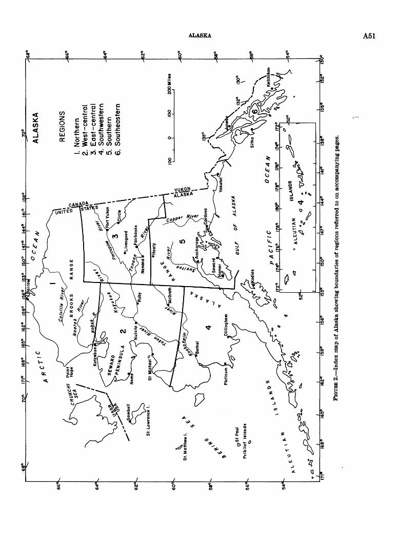
68°
70°
171°
16
8°
165°
16
2°
159°
15
6°
153°
IS
O0
147°
14
4°
141°
13
8°70°
. N
orth
ern
2. W
est-
cent
ral
3. E
ast
-ce
ntr
al
4. S
outh
wes
tern
5. S
outh
ern
6. S
outh
east
ern
74°
176°
17
165°
16
2°
159°
15
6°
153°
15
0°
147°
14
4°
141°
13
8
FICH
TBE
2. In
dex
nia
p of
Ala
ska
show
ing
boun
dari
es o
f re
gion
s re
ferr
ed to
on
acco
mpa
nyin
g pa
ges.
w p
A52 GEOLOGICAL .SURVEY RESEARCH 1962 SYNOPSIS OF RESULTS
Northern AlaskaRegional studies of the structural knot at the north
west end of the Brooks Range province were recently begun by I. L. Tailleur. Lower Cretaceous and Juras sic rocks, comparable to those mapped in regions to the east and deformed along trends that swing from east erly to northerly going west, were found in the saddle between the nose of the DeLong Mountains and the Lisburne Hills. Within and along the east side of the Lisburne Hills the rocks are similar to those mapped at the CHARIOT test site and similarly exhibit im bricate faults. Coal-bearing rocks, intertongued with the base of the Mississippian Lisburne Group, and pos sibly subjacent graywacke that are unique to the Lis burne Peninsula, were found west of the Lisburne Hills. High-rank(?) bitumious coal in seams up to 10 feet thick that aggregate 70 feet of the carbonaceous sec tion may have economic potential.West-central Alaska
In evaluating previous aerial radiological measure ment surveys, R. G. Bates obtained radioactivity values as high as 1,600 counts per second over stream gravels along streams draining to the north off the mountains south of Selawik Lake, Selawik quadrangle. These values indicate anomalous concentrations of radioactive minerals in the stream gravels and suggest that deposits of economic significance may exist within the drainage area.
On Seward Peninsula, detailed geologic mapping by C. L. Sainsbury has shown evidence of widespread thrust faulting in the York Mountains, and fossil col lections indicate that the contact between Lower Or- dovician argillaceous limestone and Middle Ordovician shales, shaly limestone, and arenaceous limestone prob ably is transitional. The Ordovician rocks are not conformable with the underlying slate, which probably is Precambrian or lowermost Cambrian in age.
Mapping by J. M. Hoare and W. H. Condon in the lower Yukon-Norton Sound region revealed that some of the areas previously mapped 42 as Quaternary basalt south of Norton Sound are interbedded calcareous sand stone and conglomerate of early Late Cretaceous age and andesitic volcanic rocks of probable Jurassic or Early Cretaceous age. Similar volcanic rocks of Mes- ozoic age commonly form the flanks of geanticlinal areas farther north around the edge of the Koyukuk Basin. This fact, plus the fact that the nearby conglomerate contains cobble-sized clasts of chert and quartzite of probable Paleozoic age, indicate a western source for some of the Cretaceous rocks that crop out between the Yukon River and Norton Sound.
42 Dutro, J. T., Jr., and Payne, T. G., 1957, Geologic map of Alaska: U.S. Geol. Survey.
In the Candle and Selawik quadrangles, mapping by W. W. Patton, Jr., and A. R. Tagg (Patton and Grantz, 1962) suggests that the middle Cretaceous Koyukuk geosyncline was not, as previously supposed, a single depositional trough between the Brooks Eange and the Yukon Delta, but consisted of a narrow east- trending trough along the Kobuk and upper Koyukuk Rivers and a larger southwest-trending trough that extended from the lower Koyukuk to the Yukon Delta. The two troughs were separated by the east-trending Hogatza High along lat. 66° N. The volcanic and granitic intrusive rocks of Late Jurassic and Early Cretaceous age now exposed along the geanticlinal trend were an important source of sediments in both troughs.
In the White Mountain area, near McGrath, C. L. Sainsbury and others report the existence of Middle (?) Ordovician and older rocks previously unknown in this area. The section consists of marine carbonate and clastic rocks approximately 4,500 to 5,000 feet thick dated by fossils as Middle (?) Ordovician and Silurian (?) in age. Along the Farewell fault these marine strata are in contact with 8,100 feet of quartz conglom erate of Cretaceous (?) age which may be correlative with the Cantwell Formation. The rocks are unmeta- morphosed and may be important in petroleum explora tion.
East-central AlaskaAnalysis of fossils from the Upper Devonian clastic
sequence in the central and eastern Brooks Range by J. T. Dutro, Jr., and W. A. Oliver, Jr., supports rela tions suggested by the physical stratigraphy. Work by W. P. Brosge and others has indicated a complex sequence of intertonguing and intergrading units. Fossil assemblages of Frasnian and Famennian age are identified from a limestone-siltstone unit, a slate- sandstone unit, and, at the top, the Kanayut Conglo merate. These magnaf acies apparently cut across time lines, becoming older in a general southward direction. Below this sequence the Skajit Limestone, of late Middle (?) and early Late Devonian Age, probably straddles the Middle-Upper Devonian boundary.
Reconnaissance of the Black River in east-central Alaska by E. E. Brabb has shown the need for a major revision of the geologic map of Alaska in that area. Bedrock exposures along the river from the United States-Canada border to Chalkyitsik (Fishhook) in clude quartzites of probable Precambrian age and basalt of Cenozoic age near Chalkyitsik, and limestone of Late Ordovician and Devonian age and argillite of Cre- taceous(?) age near Salmon Village. Some of the coral faunas in the limestone are similar to the Big horn-Red River faunas of the Rocky Mountain and Manitoba regions, according to W. A. Oliver, Jr.
ALASKA A53
Trilobite collections made by E. E. Brabb in north east Alaska have been identified by A. E. Palmer and provide the first knowledge of early Upper Cambrian faunas in that part of the world. The Alaska trilobites reveal affinity to species from Queensland, Australia.
Discovery by gravimeter work of very thick deposits of low-gravity sediments in the basin west of Nenana by D. F. Barnes (1961) has attracted the attention of major oil companies. Land has been leased and a test hole will be drilled in early 1962. Field mapping in 1961 has proved conclusively that the hills a short dis tance to the southwest of the drilling site are underlain by nonmarine Tertiary beds found farther south in the foothills of the Alaska Eange.Southwestern Alaska
The gelogy of the lower Kuskokwim region has been summarized by J. M. Hoare (1961). The region in cludes part or all of 2 technically positive elements and part of 2 tectonically negative belts which were first formed in middle Mesozoic and older strata; the negative or geosynclinal belts contain strata ranging in age from Late Jurassic to Late Cretaceous which were derived locally from the positive elements and deposited under tectonically active conditions. Traces of copper, antimony, quicksilver, zinc, and gold were found by Hoare. Quicksilver and antimony mineral ization was much less extensive than in the adjoining Central Kuskokwim region. Placer gold probably offers the best chance for expanding economic interest. The low porosity of the highly deformed rocks indi cates a low petroleum potential.
Metamorphic rocks along the eastern margin of the Aleutian Range batholith that were formerly mapped as paleozoic (?) are now considered to be of Triassic age, as a result of the work of E. L. Detterman. Eocks be lieved to be equivalent are found east of the contact- metamorphic zone; some of these unmetamorphosed rocks have a poorly preserved Late Triassic fauna con sisting of Halobia sp. and Monotis sp. Detterman has also shown that the Iliamna region was the center of volcanism in southern Alaska during Early Jurassic time. The Talkeetna Formation in the Iliamna region consists almost entirely of lava flows, agglomerate, vol canic breccia, and tuff. North and south of the region this sequence of rocks contains thick interbeds of fos- siliferous sedimentary rock.
E. E. Wilcox (1961) attributes the albite in the spilitic and keratophyric volcanic rocks of the Aleutian Islands mainly to albitization since emplacement of the rocks, rather than to primary crystallization from soda- rich magmas. He concludes this from the fact that the coexisting pyroxenes are normal types rather than soda rich as would be expected if their source magma had been soda rich.
Southern AlaskaIn the McCarthy area D. J. Miller and E. S. MacColl
have delineated widespread marine Cretaceous sedimen tary rocks in the northern two-thirds of the McCarthy A-4 quandrangle. Supported by D. L. Jones' paleon- tologic studies, they have been able to demonstrate that 3 formations ranging from Albian to Maestrichtian (?) in age are represented, and that at least 1 unconformity is present. In the McCarthy C-5 quadrangle, geologic mapping by E. M. MacKevett, Jr., and M. C. Blake indicates that a section of marine strata approximately 8,500 feet thick, previously considered to be Late Trias sic and Cretaceous in age, is Early, Middle (?), and Late Jurassic in age on the basis of fossil identifications by E. W. Imlay (Art. 133). In addition, they have dis covered a previously unreported granodiorite (?) plu- ton cutting volcanic flows and intercalated sedimentary rocks near the base of the Wrangell Lava. Fossil leaves collected from continental sedimentary rocks interca lated with the basal Wrangell Lavas were dated as Oligocene by Jack Wolf e.
Foraminifera from the Matanuska Formation in the Squaw Creek-Nelchina Eiver area of south-central Alaska are mainly of Campanian age, but the sequence studied by H. E. Bergquist (1961a) may range from late Turonian to Maestrichtian in age. Five tentative microfossil zones are indicated. According to A. Grantz, the formation contains several lithologic units and probably should be raised to group rank.
Issuance of two maps by A. Grantz (1961 a, b) com pletes the publication of geologic maps at 1:48,000 scale of the Nelchina area, in the western part of the Copper Eiver basin, one of the possible petroleum provinces of Miller, Payne, and Gryc.43
Test drilling at Cordova has shown that glacial de posits extend to a depth of more than 140 feet in a small area between Eyak Lake and Orca Inlet, according to K. L. Walters. Sand and gravel beds penetrated by two test holes are of rather low permeability but should yield sufficient water to supply the city. Cordova for many years has used a surface-water supply, which, during the winter months entered the distribution sys tem at a temperature of about 32 °F. The ground- water temperature is about 42 °F and should help to eliminate the problem of frozen water mains.
Southeastern AlaskaStudy by J. A. Wolfe of a collection of the flora of
Tertiary (Eocene and younger) rocks exposed on Ad miralty Island ** has shown that the coal-bearing rocks
43 Miller, D. J., Payne, T. G., and Gryc, G., 1959, Geology of possible petroleum provinces in Alaska: U.S. Geol. Survey Bull. 1094.
44 Lathram, E. H., Loney, R. A., Berg, H. C., and Pomeroy, J. S., 1960, Progress map of the geology of Admiralty Island, Alaska: U.S. Geol. Survey Misc. Geol. Inv. Map 1-323.
661513 O 62 5
A54 GEOLOGICAL SURVEY RESEARCH 1962 SYNOPSIS OF RESULTS
near Kootznahoo Inlet were deposited in a continuous sequence beginning in latest Eocene time. The young est plants collected, which are of late Oligocene age, are overlain by a considerable thickness of sedimentary rocks that may, therefore, be of Miocene age. Further, the volcanic rocks on the south end of the island are underlain by plant-bearing beds of late Eocene age, and one collection from the volcanic rocks is of middle Oligocene age. Hence, the volcanics were extruded at the same time as sediments were being deposited in the Kootznahoo Inlet region.
During regional mapping on Chichagof and Baranof Islands, R. A. Loney, H. C. Berg, J. S. Pomeroy, and D. A. Brew found fossils of Jurassic or Cretaceous age on Emmons Island in Hoonah Sound, southern Chicha gof Island, in slate and graywacke interbedded with volcanic rocks. These rocks were previously mapped as a part of the belt of Paleozoic rocks called the Prince of Wales geanticline by Payne.45 This occurrence of Mesozoic rocks within the geanteicline tends to substan tiate the suggested Mesozoic age for the chert, slate, graywacke, and greenstone sequence in northeastern Baranof Island (U.S. Geological Survey, 1961w, p. A43). This sequence is exposed about 15 miles to the southeast of Emmons Island along the regional struc tural trend and near the axis of the Prince of Wales geanticline. Thus, the areal extent of Paleozoic rocks may be greatly narrowed in the vicinity of southern Chichagof and northern Baranof Islands, and Mesozoic rocks may have originally extended eastward entirely across the Prince of Wales geanticline in this area, con necting with an abrupt westward salient of the eastern belt of Mesozoic rocks (Seymour geosyncline) near the southern tip of Admiralty Island.
The North Bradfield River iron prospect, examined by E. M. MacKevett, Jr., consists of several magnetite- rich bodies of pyrometasomatic origin that are localized in skarn. The skarn is part of a sequence of metamor- phic rocks consisting mainly of gneiss, granulite, schist, and marble that forms a northwest-trending roof pend ant within the composite Coast Range batholith.
MacKevett also reports that the Sumdum copper- zinc prospect is on numerous sulfide replacements and disseminations localized in gneiss and schist, and less extensively in fault zones. In order of general decreas ing abundance, the sulfide minerals are pyrite, pyrrho- tite, sphalerite, chalcopyrite, and bornite.Cenozoic stratigraphy of Alaska
A remarkably complete record of Pleistocene cli matic fluctuations, sea-level changes, and glacial events is preserved along the coasts of Seward Peninsula and
* Payne, T. G. (compiler), 1955, Mesozoic and Cenozoic tectonic elements of Alaska: U.S. Geol. Survey Misc. Geol. Inv. Map 1-84.
Kotzebue Sound in western Alaska. Field investi gations by D. M. Hopkins, D. S. McCulloch, and R. J. Janda (1962) and studies of the molluscan fauna by F. S. MacNeil demonstrated that "Submarine Beach," "Third Beach-Intermediate Beach," and "Second Beach," the three well-known marine units at Nome, are probably of Pliocene and Pleistocene, Aftonian (First Interglaciation) and Sangamon (Third Interglaci- ation) age, respectively. The presence of a fourth marine unit, "Fourth Beach," was confirmed at Nome and it was tentatively correlated with a newly dis covered and highly fossiliferous marine deposit of definite Yarmouth (Second Interglaciation) age ex posed on the shores of eastern Kotzebue Sound. Pale- obotanical studies had previously shown that taiga (northern forest) vegetation extended into these tundra regions during the Sangamon interglaciation interval and during a brief warm period about 10,000 years ago. Additional palynological studies by Estella Leopold have now shown that during Submarine Beach (Plio cene and Pleistocene) time, pine, fir, and hickory grew near Nome in addition to species now characteristic of the taiga of central Alaska. Although the vegetation and the molluscan faunas have changed appreciably during the interval of time represented by the Pleis tocene sediments at Nome and in the Kotzebue Sound area, the foraminiferal fauna has changed little, if at all; nearly all the species recognized in a series of specimens studied by Patsy Smith, representing all of the marine units recognized in the Nome-Kotzebue Sound area, live in adjacent waters at the present time.
Paleontological and stratigraphic studies carried out during the last decade have resulted in radical changes in the age assigments of Alaskan Tertiary marine and nonmarine sediments; the results are summarized in a recent publication by F. S. MacNeil and others (1961). Palynological studies recently conducted by Estella Leopold have contributed further to the solution of correlation problems, especially in the later part of the Tertiary period, and have begun to reveal the broad outlines of the developmental history of the tundra and taiga vegetation in the American Arctic. Pollen floras of probable Oligocene age consist dominantly of broad-leafed tree genera now restricted to temperate latitudes. Pollen floras of probable late Miocene or early Pliocene age consist chiefly of coniferous-tree genera, some of which are now restricted to more tem perate latitudes. Several species of broad-leafed trees are also present. Pollen floras of probable Pliocene and Pleistocene age consist chiefly of pine, spruce, and fir with smaller quantities of pollen from broad-leaved trees that are alive today in central Alaska; but hickory a genus now nearly restricted to the eastern part of the conterminous United States is also present
HAWAII A55
in small but significant quantities. It appears that the Northern vegetation has developed largely by slow sub- iraction of tree species incapable of surviving in a severe climate, with an accompanying proliferation of Shrubby and herbaceous plants.
Recent stratigraphic and paleontological studies of radiocarbon-dated sediments of late Pleistocene age in the Tofty Placer districts by C. A. Repenning, D. M. Hopkins, and Meyer Rubin have shown that timberline was at altitudes of 600 feet and lower during various parts of the Wisconsin Glaciation in this part of central Alaska. Timberline evidently rose to its present altitude of 2,000 feet about 6,800 years ago.
A compilation being made by T. L. Pewe of the extensive deposits of loess in Alaska reveals that the deposits range in thickness from a film to more than 200 feet at Fairbanks and are as thick as those reported elsewhere in the United States. Further, this is one of the largest areas of loess in the United States. The loess is confined mainly to lowlands bordering the major rivers, all of which drained extensively glaciated areas in the past. In addition to the Quaternary loess, windblown dust is currently being deposited in many areas today.
HAWAII
Investigations in Hawaii during fiscal 1962 included observations on volcanoes, geologic and water-resources Studies of specific areas, and the collection of basic records on surface and ground water. Water-resources work was carried on in cooperation with the Division of Water and Land Development of the Hawaii Department of Land and Natural Resources, and a part of the volcanologic studies was done in cooperation with the U.S. National Park Service.
Results of studies of aluminum desposits are dis cussed on page A6, a statement on clay resources is given on page A7, and results of recent paleomagnetic studies on lavas are presented on page A81.Eruptions of Kilauea Volcano in 1961
In August 1960, soon after the great subsidence of the Kilauea dome in early 1960, J. P. Eaton and H. L. Krivoy detected new tumescence at tiltmeter stations over the summit area. The rate of tumescence remained low until late October 1960, when it acceler ated rapidly immediately after a swarm of deep (50 km) earthquakes accompanied by swarms of shallower (10-15 km) earthquakes and by tremor. The rapid tumescence had abated by early November 1960, and from then until September 1961 it continued at a high but fairly constant rate. The tumescence between November 1960 and September 1961 could be attained by the addition of about 10 million cubic yards of
magma per month to the magma reservoir within the volcano.
The first of three summit eruptions in 1961 began on February 24, in a small collapse pit on the floor of Halemaumau Crater and lasted less than a day. The second began on March 3 in the same pit and continued until March 25, filling the pit with 400,000 cubic yards of lava. This feeble outpouring of lava had little effect on the overall tilt picture, and the volcanic dome continued to inflate. The third eruption began on the night of July 10, 1961, spurting lava from a discon tinuous rift extending halfway across the floor of Halemaumau. This eruption stopped on July 17. During the activity more than 17 million cubic yards of lava poured into Halemaumau.
The Kilauea dome continued to inflate, and on Sep tember 21,1961, a swarm of large, shallow earthquakes began to emanate from the upper end of the east rift zone of Kilauea. By the following morning several small eruptions had occurred along the east rift, between 7 and 14 miles from the summit, and measure ments at 2 tilt stations indicated that rapid detumes- cence of the summit area was in progress. In the next 2 days additional minor outbreaks, concurrent with strong faulting, took place farther down the rift zone, but all activity virtually had ceased by the night of September 24. Although the detumescence indicated a withdrawal of about 70 million cubic yards of magma from beneath the summit, less than 2 million cubic yards remained on the surface.
Petrographic studies by D. H. Richter and J. G. Moore of the 1961 lavas suggest that the lavas erupting at different altitudes along the rift zone came from different levels in the volcanic magma chamber. The lavas that erupted low on the rift zone contain abundant phenocrysts of olivine, but those high on the rift zone and in the summit area are devoid of olivine.Lava lake in Makaopuhi Crater
The prehistoric 225-foot-deep lava lake in Makaopuhi crater on the east right of Kilauea Volcano is being studied by J. G. Moore. Detailed examinations of a vertical section through the lake-filling lavas have re vealed a zone of horizontal silica-rich veins between 20 and 125 feet below the lake surface, and an accumula tion of olivine in the bottom 90 feet of the lake.Recent growth of Halemaumau Crater, Kilauea Volcano
A recent study by D. H. Richter, J. G. Moore, and R. T. Haugen (Art. 20), in cooperation with the U.S. National Park Service, has shown that landsliding has enlarged the area of Halemaumau Crater by almost 6 percent in the last 33 years. The average annual growth since 1928 has been about 1,700 square yards, equivalent to an average rate of recession of the rim of
A56 GEOLOGICAL SURVEY RESEARCH 1962 SYNOPSIS OF RESULTS
about 1.5 feet per year. The growth pattern has been neither consistent nor regular, however, and about 15 percent of the rim that existed in 1928 still is standing. Landsliding and rapid opening of cracks peripheal to the crater rim occur during detumescence of the Ki- lauea dome.
Lava lake in Kilauea IkiTemperature studies in the 365-foot-deep lava lake
formed in Kilauea Iki Crater during the 1959 eruption have been continued by W. U. Ault, D. H. Kichter, and D. B. Stewart (1962). A second hole drilled through the lake's crust on April 13, 1961, entered molten lava at a depth of 29.7 feet. When the hole was deepened on October 4, 1961, it entered the melt at a depth of 35.0 feet. The maximum temperature measured in the molten lava was 1,106°C at the bottom of a probe forced 4 feet into the melt. Observations made during earlier and recent drilling show that the base of the crust is at the 1,065°C isotherm, regardless of depth. The 1,065°C isotherm moved downward more than 12 feet between August 1960 and October 1961, resulting in a crustal thickening of about 0.94 foot per month. The thermal gradient in October 1961 was 19°C per foot in the lower 23 feet of the crust and 5°C per foot in the melt. The rate of cooling of the melt at a depth of 39.2 feet during a 22-day period was 0.5°C per day.
Gravity and seismic-refraction studies on the surface of the lava lake have been started by H. L. Krivoy and J. P. Eaton. The thickness of the lake's crust as de termined from seismic data is in accord with the thick ness found in drilling. A preliminary magnetic survey by R. W. Decker shows relatively uniform vertical mag netic intensities over the central part of the lake, and extreme changes of more than 5,000 gammas along the margin of the lake.
Gravity studiesReconnaissance gravity studies of the Island of
Hawaii, begun in 1960 by H. L. Krivoy and J. P. Eaton (1961), have been extended by Krivoy and R. R. Mc Donald to cover most of the northeast half of the island. Local Bouguer anomalies of as much as +70 milligals have been found to overlie the summit areas of the two active volcanoes, Kilauea and Mauna Loa, and the dis sected dome of extinct Kohala Volcano. The anomal ies appear to be attributable to a complex of dense intrusive masses within the cores of the volcanoes. On Mauna Kea, data suggests that a high positive anomaly overlies the south flank of the volcano rather than its present summit area. D. R. Mabey and W. T. Kino- shita completed gravity coverage of Hawaii in early 1962 and made a regional gravity survey of the island of Maui.
Ground water in southern OahuStudies by F. N. Visher in southern Oahu show that
increased pumping in the area has resulted in a lower ing of the fresh-water head by about 3 feet. The low ering of the head has resulted in a decrease in natural ground-water discharge that is roughly equal to the increase in pumping. The long-term pattern of fluctu ations of the water level measured in a deep piezometer extending into salt water under the fresh-water lens is about the same as that in nearby fresh-water wells. The water level in the deep piezometer was as high as 3 feet above sea level in 1958 and dropped to as low as 2 feet below sea level in 1961. The salt water that this piezometer measures apparently has poor hydraulic connection with the ocean. This poor connection may greatly retard the salt-water encroachment that would be expected to result from lowering of the fresh-water head. Ground water in the Waianae district, Oahu
In hydrologic studies in the Waianae area of Oahu, C. P. Zones finds that the flow of ground water into streams and thence into the sea is small. The presence of brackish ground water under the coastal lowlands indicates that the discharge of ground water directly into the sea also is small. The major natural discharge of ground water is by transpiration through phreato- phytes growing in the lowland. Most of the wells in the area also are in the lowland, where they compete with the phreatophytes and where withdrawal of fresh water has caused sea-water intrusion. Eventual maxi mum development of the fresh-water lens probably will be in wells drilled farther inland where the lens is rela tively thick and the water table is too deep for large withdrawal by phreatophytes.Water resources of windward Oahu
Studies by K. J. Takasaki, George Yamanaga, and E. R. Lubke (1962) on the windward (northeast) side of Oahu show that the minimum base-flow water supply in the area, before diversion and use, is about 82 mgd. (million gallons per day). The flow available for development, after diversion, is about 38 mgd. Most of the ground water in the area appears in streams before it flows into the sea.
In an analysis of records of flow of streams on wind ward Oahu, G. T. Hirashima (Art. 108) found evidence that the excavation of a 1,200-foot water-development tunnel in the valley of Haiku Stream caused a reduc tion in the base flow of Kahaluu Stream 2i/£ miles away. The valleys of the two streams, which are transverse to the axis of the Koolau Range, cut deeply into dike compartments containing high-level ground water. Draining of the ground water by the Haiku tunnel caused a shift of the ground-water divide toward and
INDIAN RESERVATIONS AND NATIONAL PARES A57
a reduction of ground-water discharge into Kahaluu Stream.Rain-catchment studies
Preliminary studies of records of runoff from an artificial catchment in the North Kona district of Hawaii by D. E. Havelka and S. S. Chinn show that about 84 percent of the rainfall on the catchment can be recovered. The average yield from the quarter-acre catchment, which is in an area having a mean annual rainfall of about 80 inches, was about 2,000 gallons per day during the period 1958-61. Continuous sup plies of 600 to 2,000 gallons per day from the catchment would require storage capacities ranging from 60,000 to 240,000 gallons.
INDIAN RESERVATIONS AND NATIONAL PARKS
jreologic and hydrologic studies in Indian Reservations
A hydrogeologic study of the Pine Ridge Indian Eeservation, S. Dak., recently has been completed by M. J. Ellis. Results of the study indicate that the Arikaree Formation, of Miocene age, is the principal Aquifer there, and that wells developed in this aquifer will yield up to 100 gallons per minute. In areas where the Arikaree Formation is not present, moderate quantities of ground water are available in alluvium of the White and Cheyenne Rivers and from undrained gravel terraces capping sediments of the White River Group, of Oligocene age.
An investigation of the Milk River valley in the Fort Belknap Indian Reservation, Mont., by W. B. Hop- kins and O. J. Taylor indicated that most ground water from post-Cretaceous rocks is too saline for use. Water from the Cretaceous Judith River Formation contains considerable dissolved solids but is usable. The irri gated land is waterlogged because it is underlain by SO to 40 feet of relatively impermeable fine-grained flood-plain deposits. These deposits are underlain by sand containing artesian water. Studies indicated that reducing the artesian pressure by pumping or draining would not alleviate waterlogging of the overlying deposits, but that reducing the artesian pressure by pumping from a few sand lenses in the flood-plain deposits would reduce waterlogging locally.
F. J. Kleinhampl reports that springs watering the Duckwater Indian Reservation, northern Nye County, Nev., issue from a terrace comprised of tufa and traver tine that was originally a sinter deposit. This deposit has an area of about 2.5 square miles with a maximum length of about 3 miles and a width of 1.5 miles. The thickness is unreported, but areally it ranks among the large thermal-spring deposits of the United States.
P. W. Johnson has completed a study of the char acter and thickness of exposed volcanic flows in the
vicinity of Hotosan Vo Village (Charco 27), Papago Indian Reservation, Ariz. The study was aimed pri marily at establishing a suitable water supply for domestic use. A test well was drilled through a series of volcanic flows to a depth of 716 feet. Potable water under artesian pressure and of sufficient quantity was found at 625 to 650 feet and rose to 575 feet in the well.
G. A. Dinwiddie and W. S. Motts recently have com pleted a study of the hydrogeology of parts of the Acoma and Laguna Indian Reservations, N. Mex. They report that ground water in sufficient quantities for irrigation requirements and domestic supplies is available both in alluvial and basalt aquifers of the Rio San Jose valley and in tributaries to that valley. Addi tional out smaller supplies may be developed in the more permeable parts of the Tres Hermanos Sandstone Mem ber of the Mancos Shale. Ground water in the alluvial and basalt aquifers near the streams is hydraulically continuous with water of the streams. Inasmuch as the Rio/San Jose is a perennial stream in the stretch be tween McCartys, N. Mex., and the western boundary of the Acoma Reservation, aquifers in this reach are best supplied with water. This reach, therefore, is the most favorable area for development of additional large water supplies.
J. B. Cooper reports that the development of sources of ground water in southeastern McKinley County, N. Mex., for use by Navajo Indians living off the main reservation, is of great benefit. Since 1958 the Navajo Tribe, on the basis of hydrogeologic information sup plied by the Survey, has developed an accelerated work program by means of which a number of successful new wells have been drilled and many long-used springs have been cleaned and rehabilitated.
The Ojo Alamo Sandstone, the Nacimiento Forma tion, and the San Jose Formation contain thick beds of sandstone in the southern part of the Jicarilla Apache Indian Reservation, N. Mex., and in adjacent regions to the south and west, according to E. H. Baltz, S. W. West, and S. R. Ash (Art. 171). The cumula tive thickness of sandstone ranges from 80 to 1,840 feet, and a well tapping all the sandstone possibly would yield as much as 3,500 gallons per minute.
Ground-water study in Grand Teton National ParkAn investigation near Jackson Lake, Grand Teton
National Park, Wyo., by E. D. Gordon has revealed that moderate quantities of ground water of suitable quality for domestic and public supplies are available from Quaternary rocks along the east side of Jackson Lake. Larger ground-water supplies of similar quality are available from alluvium in part of the Pilgrim Creek Valley near Jackson Lake.
A58 GEOLOGICAL SURVEY RESEARCH 1962 SYNOPSIS OF RESULTS
PUERTO RICO
The Geological Survey is carrying out a continuing investigation in cooperation with the Department of Industrial Eesearch of the Puerto Eico Economic De velopment Administration to prepare detailed geologic maps and to study the mineral resources of Puerto Rico.
Preliminary geologic mapA geologic map of Puerto Rico has been compiled by
R. P. Briggs at a scale of 1:240,000. Although the map has not yet been published, it is on open file and avail able for public use.
In the mountainous central core volcanic and sedi mentary rocks of Early and Late Cretaceous and early Tertiary age are cut by numerous large faults and intruded by several plutons of dioritic rocks and by serpentine. Dipping gently seaward on the northern and southern flanks of the core are slightly deformed marine limestone and clastic formations of Oligocene and Miocene age. A wide variety of surficial forma tions mantle the older rocks, especially along the coasts of the island. Of special interest are widespread de posits of sand and clay that cover much of the northern coastal belt. Briggs (1962) believes that these sands were deposited by a retreating sea and then were trapped in a developing karst topography and thus could not be removed by surface runoff.
LimestoneThe limestone sequence of northern Puerto Rico con
tains lenses of sand and gravel deposited as river-mouth bars and on river flood plains during late Oligocene and early Miocene time. Many of these lenses are due north of the headwaters of major rivers that now cross the limestone belt many miles from the lenses. W. H. Monroe (1962b) believes that these headwater reaches are as old as Oligocene, and that extensive multiple stream piracy has since diverted them. The thick Aymamon Limestone near the top of the sequence con sists of chemical-grade limestone, 95 to 99 percent CaCOs (Monroe, 1962a), that apparently was deposited at a time when Puerto Rico had been eroded to a low island from which streams were removing very little debris.
Large quantities of a marble-like algal limestone of early Tertiary age are available in southern Puerto Rico in the Coamo and Salinas quadrangles (Glover, 1961a, b).Aerial radioactivity survey
An Aerial Radiological Measurement Survey (ARMS) of Puerto Rico was made in November and December 1961 as part of a cooperative program with the Division of Biology and Medicine, U.S. Atomic Energy Commission. The radioactivity of the Island
has a wide range; initial study reveals delineation of several broad geologic features by aerial radioactivity measurements. The Utuado and San Lorenzo plutons, both of granodioritic composition and of Cretaceous or Tertiary age, have low to moderate levels of radioac tivity. Adjacent to the plutons, Lower(?) Cretaceous rocks have low radioactivity and Upper Cretaceous rocks have low to moderate radioactivity. Moderate to high levels of radioactivity were measured over Tertiary calcareous rocks in the northwest part of the island. These levels have no immediate geologic ex planation, as they trend north-south over the east-west trending Tertiary rocks.
Hydrologic studiesPeak discharge of streams in Puerto Rico may exceed
the 100 percent Meyer rating and they rank with the highest known peaks in the world. Base flow of the streams ranges between 0.3 and 1.0 cubic feet per sec ond per square mile in much of the interior upland area, but may be as low as 0 in the south coastal plain and as high as 2.0 cfs per square mile in the wettest mountains. Calcium and bicarbonate are the predomi nate ions in the water. Sediment discharge in some streams appears to be in the magnitude of 1,000 to 6,000 tons per square mile annually.
Production of more than 2,000 large wells individu ally ranges from about 0 to 4,000 gallons per minute. The low-producing wells generally are in the interior upland area and the high-producing wells generally are in the coastal lowlands area, particularly between Ponce and Patillas. Dissolved solids in ground water commonly are in the range of 65 and 250 parts per million. Salt-water intrusion is not a significant problem.
About 818 million gallons per day of surface water and about 257 mgd of ground water was used in 1960 for all purposes. Of the 69 inches of average annual rainfall on Puerto Rico, about 23 inches may be called the controllable supply, of which only a little more than 3 inches, or about 14 percent, was used consumptively in 1960. Most of the major rivers are not fully ex ploited, considerably more ground water can be pumped, and the total available supply is adequate for antici pated needs. The quality of the water is good for almost all purposes.
A preliminary appraisal of the water resources of the Jobos area is presently underway on Puerto Rico's south coast between Salinas and Guayama. The area is a coastal plain, mantled by alluvial gravels and clays overlying fractured and creviced bedrock. The allu vium is less than 50 feet thick at the east end of the area and more than 250 feet thick near the west end. Much of the streamflow from the hinterland enters the
WESTERN PACIFIC ISLANDS A59
ground-water aquifers at the north edge of the plain i and is-generally released to the stream channels near the sea where the water table intersects the ground surface. The aquifers have very high coefficients of transmissibility, and about 40,000 to 50,000 acre-feet of ground water is pumped annually in this relatively small area. Because of the seasonally large streamflow and the local rainfall (averaging 45 inches annually), however, the water table throughout the area has shown no indication of decline over the last 30 years.
WESTERN PACIFIC ISLANDS
During the past fiscal year, the U.S. Geological Sur vey continued analyses of data and specimens collected during detailed field surveys of selected islands within the western Pacific Ocean between 1946 and 1958 (Fig. 3).Preliminary results of surveys of 11 islands and island groups which were cooperative projects of the U.S. Geological Survey, the U.S. Army Corps of Engi neers, and other agencies, have been published in a limited-edition series of "Military Geology Eeports" that have recently been distributed to selected public and university libraries in the United States. Eesults of present studies are adding new information that will be useful in developing resources and interpreting the geologic history of an oceanic area comparable in size to that of the conterminous United States.
Hydrologic studies during the past year were limited to Guam, American Samoa, and Angaur Island (Palau Islands).
Marine geology of Guam, Mariana IslandsK. O. Emery 46 has made a detailed study of the off
shore slopes, reefs, Cocos Lagoon, and the shoreline of Guam. He reports the existence of 4 distinct subma rine terraces that are nearly continuous around the island at depths of 55, 105,195, and 315 feet. The ter races have veneers of loose shallow-water calcareous sediments that have probably been derived from the reef edge. The reef is incised by large channels that appear to have a close relation to the island's present drainage but are probably ancient features that have persisted during growth of the reef. Muddy fresh water now supplied by the streams floats on sea water above the channels, rather than flowing downward through the channels. Sediments within Cocos Lagoon at the south end of Guam consist chiefly of sands composed of coral and algal fragments. The abundance of sediment types differs from that of atoll lagoons of the Marshall Is lands because of shallower depths and a larger ratio of reef to lagoon area. On reef flats, diurnal heating of
48 Emery, K. O., 1962, Marine geology of Guam: U.S. Geol. Survey Prof. Paper 403-B.
sea water and photosynthesis may produce supersatura- tion and deposition of some calcium carbonate; how ever, the amount is small compared to deposition by organisms. At the shore, solution of limestone by sea water may result from vertical solution gradients at the water-limestone interface and may involve com- plexing of the calcium so that it does not enter diurnal reactions comparable to those on reef flats. Discharge of brackish ground water of low calcium carbonate con tent prevents formation of beach rock at many places along the coast and explains the relative paucity of this type of deposit at Guam as contrasted to atolls where less ground water of higher carbonate content dis charges, and beach rock is abundant.Paleontologic studies
Paleontologic studies by W. S. Cole, H. S. Ladd, and others confirm earlier age determinations for the upper Teritiary limestones of the Palau Islands and permit reappraisal of the distribution and depositional history of these limestones. Tertiary / (upper middle Mio cene) limestones appear to be confined to the southern end of the island group where they form the cores and highest elevations of the islands and are flanked by younger limestones. In the central part of the group, basal Tertiary g (upper Miocene) limestones are over lain and flanked by uppermost Tertiary and Quater nary limestones. Cole, Ladd, and Gilbert Corwin be lieve a close relation exists between tectonic movements of the Palau Islands arc, progressive growth and de struction of coral reefs, and present distribution of limestones within the island group.
J. H. Johnson (1961) describes and discusses 90 spe cies of fossil calcareous algae, belonging to 16 genera, from holes drilled on Eniwetok, Funafuti, and Kita- Dait5-Jima of the western Pacific Ocean. The fossil algae have contributed notably to reef construction and, on the basis of habitats on existing reefs, have consid erable value as paleoecologic indicators. The algal floras from Quaternary, Miocene, and Eocene units are distinct and with one exception have no species in common.
On the basis of distribution and abundance of smaller Foraminifera in Eecent shallow-water reef and lagoon sediments from Onotoa Atoll, Gilbert Islands, Euth Todd (1961 a) recognizes two major distinctive habi tats: surfaces and adjacent slopes of the reefs, and limesand bottom of the lagoon. In general, the Onotoa fauna shows a close correspondence in species composi tion to faunas of other shallow-water reef and lagoon areas of the central Pacific. Foraminifera tests within the stomach and gut contents of 22 fish suggest a rather localized feeding area for each fish.
Continued study of the subfossil pigs from Ishigaki, Eyukyu Islands, by F. C. Whitmore, Jr., which were
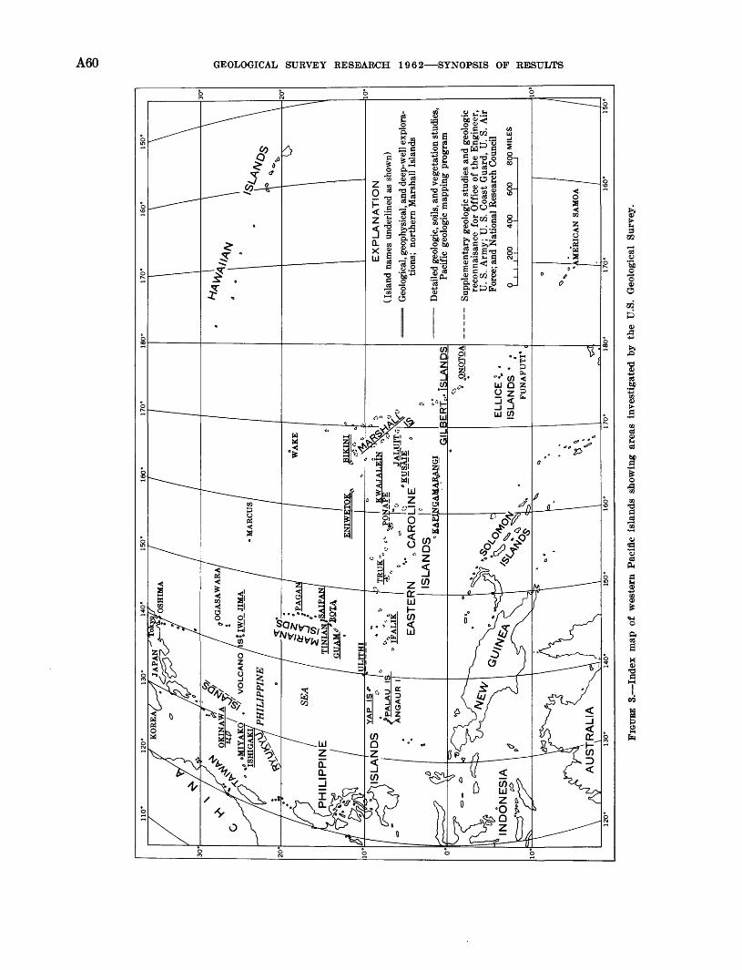
20
10'
:FAL
IK|~
E
AS
TE
RN
"
ft C
AR
OL
!NE
ISL
AN
DS
T
' K
API
NG
AM
A_R
AN
GI
GIL
BE
RT
^..
ISL
AN
DS
'* .Q
NQ
TQ
A
ELLIC
E !
. .
ISLA
ND
S '
jF
UN
AF
UT
I* ,
EX
PL
AN
AT
ION
(I
slan
d na
mes
und
erlin
ed a
s sh
own)
Geo
logi
cal,
geop
hysi
cal,
and
deep
-wel
l exp
lora
tio
ns;
nort
hern
Mar
shal
l Is
land
s
Det
aile
d ge
olog
ic, s
oils
, and
veg
etat
ion
stud
ies,
Pa
cifi
c ge
olog
ic m
appi
ng p
rogr
am
Sup
plem
enta
ry g
eolo
gic
stud
ies
and
geol
ogic
re
conn
aisa
nce
for
Off
ice
of t
he E
ngin
eer,
U
. S.
. Arm
y; U
. S.
Coa
st G
uard
, U
. S.
Air
Fo
rce;
and
Nat
iona
l R
esea
rch
Cou
ncil
400
600
800 M
ILE
S_I
o W
tjd^
AM
ER
ICA
N S
AM
OA
FIG
URE
3.
Ind
ex m
ap o
f w
este
rn P
acif
ic i
slan
ds s
how
ing
area
s in
vest
igat
ed b
y th
e U
.S.
Geo
logi
cal
Surv
ey.
ANTARCTICA A61
first reported in Professional Paper 400-B (p. B372- B374) seems to indicate that they are closest to the liv ing species Sits taivanus Swinhoe, which now inhabits northern Taiwan, rather than Sits leucomystax Tem- minck & Schlegel, the modern wild pig of Japan. It is not yet certain, however, whether these pigs migrated to the island or were introduced by early man.
Evidence for an earlier faunal connection between the southern Ryukyus and areas to the south and west is furnished by the presence on Ishigaki of the small deer Metacervulus astylodon (Matsumoto). This genus, occurring in beds of Pliocene and Pleistocene age, has been found elsewhere only in Shansi Province, China, and in Java. It probably migrated to the Ry- tukyus from China during a low stand of sea level in the ^Pleistocene. Its southern origin is further indicated by the fact that Metacervulus is found only south of Takara Strait, a deep passage crossing the arc which probably has formed a barrier to the migration of land animals since some time in the Tertiary.
Forty angiosperm pollen types, 3 fern spore types, and 2 kinds of simple algae have been recognized by Estella Leopold from drill cores on Eniwetok Atoll, Marshall Islands. The pollen-bearing sediments are of Miocene age, based on Foraminifera also present in them. Seventeen of the angiosperm genera have been identified; 6 of these now grow on the atoll, but 1 of these probably was reintroduced by man. Ten now exotic angiosperm genera identified by fossil pollen now grow in the western and (or) central Micronesia. High pollen density and the presence of shoreline algae in deep levels of drill holes lend supporting evidence to the hypothesis that the coral atoll has undergone sub sidence since Miocene time.Ground-water supplies in American Samoa
A reconnaissance study of Tutuila, Aunu'u Ofu, Olo- sega, and Ta'u Islands in American Samoa by D. A. Davis suggests that both high-level and basal ground- water supplies could be developed on most of the islands. The islands are volcanic in origin and are composed of lava flows, dikes, tuff, and breccia, and minor amounts of colluvium, alluvium, and calcareous sand and gravel.Hydrologic studies on Guam
The water supply of Guam Island was. studied brief ly in 1961 by G. F. Worts, Jr. Guam is about 30 miles long and 7 miles wide, covering an area of roughly 200 square miles. The northern half of the island is a lime stone plateau, which contains a basal fresh-water lens floating on salt water. Kainfall is about 100 inches per year, and little of it runs off most recharges the fresh water lens by sinking into the limestone or forming short streams that flow into sink holes. Shaft and tubes wells have yields in excess of 2,000 gpm, but
many, particularly those near the edge of the island, are saline.
The southern half of the island is composed largely of volcanic rocks, which contain little ground water. The numerous small streams have extremely large dis charges for their size, producing as much as 4,000 cfs per square mile according to S. H. Hoffard. One stream has been developed (the Fena Reservoir system) by the Navy as a source of water supply, and several others offer potential sources of supply when their de velopment is required.
Total water use on the island in 1961 for a population of nearly 70,000 was approximately 11 mgd. Springs and wells in the northern part of the island supplied somewhat more than 3 mgd to military installations and a few residential tracts; diversions from springs, streams, and a few dug wells around the southern part of the island supplied considerably less than 1 mgd to the several municipalities and rural areas; and the Fena Reservoir system supplied about 7 mgd to Naval in stallations and to the Government of Guam for distribu tion to municipalities and rural areas in the northern part of the island. The Fena Reservoir system re portedly has a firm yield of 9 to 14 mgd, and therefore is capable of supplying the total current water require ments, except during extended droughts. The water- distribution system, however, would have to be enlarged at considerable expense to convey water to all principal water users on the island. Saline-water intrusion on Angaur Island
Studies of Angaur Island by Ted Arnow (1961a) in dicate that open-pit mining of phosphate ore created large water-table lakes, which became filled with saline water. It was determined that the earthy phosphate formed a seal over the underlying highly permeable limestone which contains saline water. Removal of the phosphate allowed the saline water to enter the excavations.
The possibility of the saline water spreading to sur rounding areas and causing damage to agricultural land and the water supply was evaluated. To reduce the possibility of saline-water intrusion into the surround ing fresh-water aquifers, the excavations were back filled with rubble. In less than a year recharge from rainfall substantially reduced the salinity, and a fresh water lens had been established in the former sites of the saline lakes.
ANTARCTICA
A geologic-mapping program in Antarctica by the Geological Survey was begun in the 1960-61 austral summer and was continued in 1961-62 in cooperation with the U.S. Antarctic Research Program of the Na-
A62 GEOLOGICAL SURVEY RESEARCH 1962 SYNOPSIS OF RESULTS
tional Science Foundation. Areal geologic mapping at a scale of 1: 50,000 has been done in the Thiel Mountains (formerly referred to as eastern Horlick Mountains) in the interior of the continent. Glaciological studies have also been made in the Thiel Mountains. A Survey coal geologist accompanied a party from Ohio State University in the Ohio Eange of the Horlick Moun tains. Studies in petrology, tectonics, coal geology, and glacial geology begun in previous years have been continued.
The topographic mapping of Antarctica, carried on as part of the U.S. Antarctic Eesearch Program of the National Science Foundation, was expanded during fiscal year 1962. Six topographic engineers went to Antarctica during the 1961-62 austral summer to obtain geodetic control for topographic mapping, and one aerial-photograph specialist was assigned to the Navy in an advisory capacity. In addition to the conven tional practice of using solar observations for position determinations, daylight observations were made on stars, with an expectation of greater accuracy in the final results.Geology of the Thiel Mountains
A five-man Survey party has completed the areal geologic mapping of the Thiel Mountains (fig. 4). A. B. Ford, J. M. Aaron, R. W. Tabor, B. G. Andersen, and R. W. Elliott have found that hypersthene-bearing quartz monzonite porphyry comprising the main massif has been intruded by very coarse grained biotite granite porphyry. Pegmatite and aplite dikes are very rare. Petrographic studies by Ford and Tabor show that unusually euhedral porphyroblasts of cordierite have developed in the quartz monzonite. Indistinct light and dark layers forming local antiforms and syn- forms within the quartz monzonite suggest that it has been folded.
The age of the plutonic complex is unknown, but large samples were collected for absolute age determi nations. The Devonian and younger strata that over lie crystalline basement rocks in the Horlick Mountains are not exposed in the Thiel Mountains. The southern most bedrock outcrops, however, show abundant errat ics of sedimentary rocks resembling those of the Horlick Mountains. The erratics lie on diabase, and therefore it is probable that later Paleozoic strata and related intrusive diabase are buried beneath plateau ice on the south flank of the range.
Weakly metamorphosed sedimentary rocks in the southernmost group of nunataks have been intruded by quartz diorite. Quartzite, argillite, and spotted argillite predominate. Sills of dacite occur locally. These rocks are mostly unfossiliferous, but Aaron
found probable organic materials in black argillite at one locality. The sedimentary and related intrusive rocks are not folded or are only very gently folded, but they have been involved in high-angle faulting.Glaciology and glacial geology of the Thiel Mountains
A network of stakes on the ice sheet was surveyed by B. G. Andersen during the 1960-61 season and resur- veyed the following season to determine annual ice movement. Seasonal movements of the steeper glaciers were measured in the 1961-62 summer. Although final calculations have not been made, ice movement was found to be extremely slow. The annual snow accumu lation during 1961 was about l1/^ feet; stratigraphic studies in snow pits indicate that it has been about the same for the past 15 years. Erratics and glacial stria- tions on nunataks show that the ice sheet has been at least 1,500 feet thicker than it is today.
The mean annual air temperature is about 37°C, as inferred from the temperature at the bottom of a 30- foot-deep bore hole. Daily summer air-temperature variation is generally less than 5°C, but daily variation of temperatures oi rock surfaces which are shaded part of the day was found to be as much as 40°C and varied from about 15°0 to about +25°C. Chemical weath ering as well as mechanical weathering by frost action seem to be significant processes even in this polar environment.Paleobotany and coal studies
Additional collections of fossil plants from the Ohio Range of the Horlick Mountains and from the Mackay Glacier area in Victoria Land by J. M. Schopf have added new elements to the flora. These include ScMzo- neura, Vertebraria, coniferous twigs, and cone scales. The rhizomes of Vertebrcma attest to the local growth of vegetation, but "root" zones are not evident below coal beds. The new plants reinforce earlier tentative conclusions as to the probably Permian age of the Antarctic coal measures. Early Devonian psilophytic plants occur in dark shale intercalated between sandy fossiliferous marine beds in the Ohio Range. An alteration of littoral and paludal f acies is indicated.
In the laboratory, reflectance studies of coal from be neath igneous sills show evidence of coke structure and indicate that the coke formed from high-rank bitumi nous coal. Further coal analytic data show variation in analytic values down to about low-volatile bitumi nous rank, depending on distance from igneous intrusion.
Fish plates were found by John Mulligan in 1961 in an erratic of black shale on the Mackay Glacier and are comparable with those described by Smith Wood-
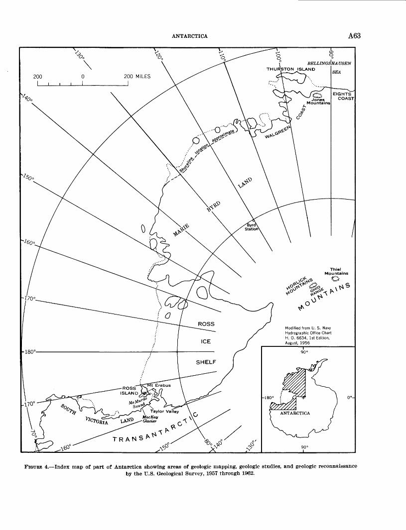
ANTARCTICA A63
Modified from U. S. Navy Hydrographic Office Chart H. 0. 6634, 1st Edition, August, 1956
\ Taylor Valley MacKay \ Glacier f \
FIGURE 4. Index map of part of Antarctica showing areas of geologic mapping, geologic studies, and geologic reconnaissanceby the U.S. Geological Survey, 1957 through 1962.
A64 GEOLOGICAL SURVEY RESEARCH 1962 SYNOPSIS OF RESULTS
ward 47 from the same area. This material probably indicates the existence of Upper Devonian deposits. Reconnaissance geologic traverses
The occurrence of lithologically similar alkaline ba salts and trachytes of probable Quaternary age in Marie Byrd Land, the Koss Island area, and South Victoria Land has been interpreted by W. B. Hamilton and E. L. Boudette to be a highly alkaline volcanic province pet- rologically, but not tectonically similar to the African rift valleys. This criterion along with the potassic character of the basement rock, the lack of a submarine trench, and an appropriate volcanic alinement, all in the province, preclude that the ice-submerged "is lands" of Marie Byrd Land and the Ross Sea Islands are part of an andesitic island arc of the circum-Pacific type.Geologic reconnaissance of the Eights Coast
Five areas of bedrock exposure were examined by A. A. Drake, Jr., a member of the U.S. 1961 icebreaker expedition along the Eights Coast of the Bellings hausen Sea. The principal rock present in all these exposures is diorite that apparently is the same unit described from Thurston Island by Craddock and Hub- bard.48 The unit is of batholithic size and has a max imum dimension of more than 120 miles. Specimens of granite or quartz monzonite collected from one ex posure suggest that the batholith may have potassic dif ferentiates. The age of this unit is unknown, but it is almost certainly not related to the Andean intrusives of the Palmer Penninsula that have an entirely different character. The batholith probably belongs to the series of Paleozoic intrusives so common in west Antarctica. Petrographic and petrochemical affinities have not as yet been determined. Inclusions of metamorphic rock were found within the batholith near lat 72°35'27" S., long 95°07'00" W. This rock is composed principally of high-calcium plagioclase and orthopyroxene (prob ably hypersthene) and has charnockitic affinities. The batholith is overlain by basaltic volcanic rocks in the Jones Mountains.
This expedition confirmed the presence of a number of islands in this part of Antarctica. These islands, however, are of plutonic rocks and not of volcanic rocks as had been postulated previously. Saline features in Taylor Valley
W. B. Hamilton, I. C. Frost, and P. T. Hayes report (Art. 28) that a small ice platform lying at the north
47 Woodard, A. S., 1921, Fish remains from the Upper Old Red Sand stone of Granite Harbour, Antarctica: British Antarctic ("Terra Nova") Expedition, 1910, Natural History Kept., Geol., v. 1, no. 2, p. 51-62.
48 Craddock, Campbell, and Hubbard, H. A., 1961, Preliminary geologic report on the 1960 U.S. expedition to Bellingshausen Sea: Science, v. 133, no. 3456, p. 886-887.
side of the snout of Taylor Glacier, between the glacier and Bonney Lake, has numerous small saline pools upon it, and the till at its edge is thickly encrusted with halite. The platform, probably an ice delta formed by refreezing of meltwater streams from the Rhone and Taylor Glaciers, has a fretted surface due to the ac cumulation of saline waters; the total relief is 6 feet. The surface is stained yellowish brown by minute gran ules of iron oxide, in striking contrast to the clean white ice of lake and glacier. Depressions contain sul- fatic water and are floored by a precipitate of calcite and iron oxide. At the edge of the platform, inso lation holes around boulders contain saline water. Evaporites, mostly halite, encrust the boulders and also form a surface crust and subsurface caliche in the till at the edge of the ice. A preliminary concentration of the solutions as a saline residuum after freezing is likely, the solutes remaining in the last freezing por tion. Evaporation must control the precipitation of calcite, iron, and salts. Age of moraines in McMurdo Sound area
The presence of ice cores in youthful-appearing mo raines mapped by T. L. Pewe during the 195Y-58 season indicates their considerable age. Ice-cored moraines as old as 6,000 years occur in the area. In addition, fully developed contraction-crack polygons with trenches 3 to 4 feet wide are present on the moraines. Such fea tures probably take hundreds of thousands of years to develop. Mummified seals up to 2,000 years old have been found near and on these moraines, indicating a minimum age for the deposits. Topographic field operations
W. H. Chapman, W. C. Elder, and E. R. Soza used electronic distance-measuring equipment to establish mapping control in the mountains between Hallett Sta tion and Plunket Point, near the head of the Beardmore Glacier (fig. 5). In addition to the U.S. Navy logistics support furnished to all USARP field parties, this par ticular group was closely supported by a U.S. Army helicopter detachment. Successful completion of the 1,500-mile traverse resulted in the establishment of con trol for mapping 100,000 square miles of mountainous terrain.
While operating with a USARP party jointly fielded by the Universities of Michigan and Minnesota, T. E. Taylor established control along the west edge of the Ross Ice Shelf near the Nimrod Glacier, the Liv Glacier-Amundsen Glacier area, and Mulock Inlet.
C. G. Merrick, a member of the USARP Antarctic Peninsula Traverse, obtained geodetic positions for ap proximately 100 peaks in Ellsworth Land between the Jones Mountains and the base of the Palmer Peninsula. Several mountain ranges were observed and located,
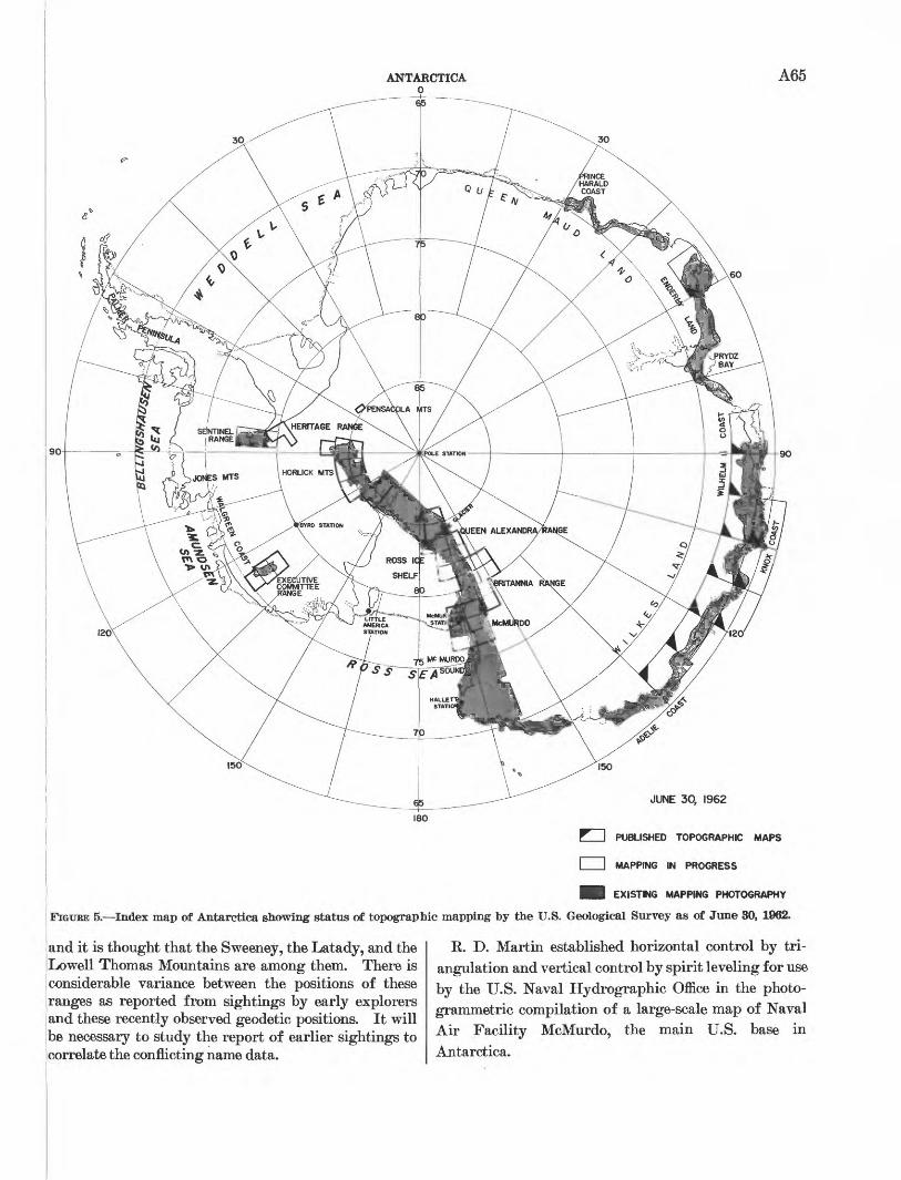
ANTARCTICA 0
A65
JUNE 30, 1962
T1 I PUBLISHED TOPOGRAPHIC MAPS
I I MAPPING IN PROGRESS
B EXISTING MAPPING PHOTOGRAPHY
FIGTJBE 5. Index map of Antarctica showing status of topographic mapping by the U.S. Geological Survey as of June 30, 1962.
land it is thought that the Sweeney, the Latady, and the Lowell Thomas Mountains are among them. There is
I considerable variance between the positions of these i ranges as reported from sigh tings by early explorers and these recently observed geodetic positions. It will be necessary to study the report of earlier sightings to correlate the conflicting name data.
R. D. Martin established horizontal control by tri- angulation and vertical control by spirit leveling for use by the U.S. Naval Hydrographic Office in the photo- grammetric compilation of a large-scale map of Naval Air Facility McMurdo, the main U.S. base in
Antarctica.
A66 GEOLOGICAL SURVEY RESEARCH 1962 SYNOPSIS OF REiSTJLTS
Stellar observations for geodetic position were made at the marker designating the South Geographic Pole by R. D. Martin and at the new Byrd Station by W. H. Chapman. The latter position was tied by electronic surveys to the old Byrd Station, the site of an observa tion made by Chapman during the winter of 1959. Both positions are on the moving polar icecap. An approximation of the annual rate of ice movement may be possible by comparing positions determined in dif ferent years.
Additional astronomic observations in Antarctica are reported on page A125.
Aerial photography
U.S. Navy Air Development Squadron Six obtained aerial photography in accordance with Geological Sur vey specifications. W. R. MacDonald was assigned to the Navy Photographic Laboratory at Christchurch, New Zealand, to advise on the quality of developed photography and to assist on planning and necessary reflights.
Early in the season, one of the three Neptune P2V's used for Antarctic photographic missions crashed at Wilkes Station, killing five men. Because of this loss, severe operational restrictions were placed on the two remaining aircraft. Final analysis of the season's photography indicates that an area of about 105,000 square miles was photographed acceptably for use in the Survey's mapping program.
Cartographic activities
Three 1:500,000-scale topographic maps along the coast of Wilkes Land were published, making a total of 11 sheets now available in this area.
Three 1:250,000-scale topographic maps of the Sen tinel Range of the Ellsworth Mountains were published in shaded-relief editions. These sheets are the first of a series designed to cover those areas of interest to Ant arctic scientists. Mapping at the same scale is in prog ress for 33 other maps covering the Horlick Mountains, Executive Committee Range, McMurdo area, Britannia Range, and Queen Alexandria Range (fig. 5).
Uncontrolled planimetric manuscripts are being com piled of part of the Pensacola Mountains, and of the Heritage Range of the Ellsworth Mountains, to support geologic investigations by the Survey and the University of Minnesota.
Antarctica relief model
Compilation was completed and a contract was let for a 2-layer multicolored plastic relief model of Antarc tica, at a scale of 1:10,000,000 with a vertical exaggera tion of 25:1. The lower part of the model will show the submarine floor, the subice topography, and ice-free mountain areas on the continent. The upper and re
movable section of the model, which will be semitrans- parent, will show the sea-level surface and the surface of the continental ice mass. The projections of moun tain masses through the ice will also be shown on the upper section.
GEOLOGIC AND HYDROLOGIC INVESTIGATIONS IN OTHER COUNTRIES
Under the auspices of the U.S. Department of State Agency for International Development, the Geological Survey continued to play an important role in support ing and furthering United States foreign policy by extending scientific and technical assistance to nations whose future development depends largely on full utili zation of their source of greatest wealth minerals and water. Programs undertaken or continuing in fiscal 1962 in 20 countries were fundamentally designed to assist in establishing permanent governmental units capable of carrying forward national mineral and water basic-data gathering and analysis activities. Such basic scientific data are now recognized as the foundation for sound economic development, enabling the expansion, diversification, and conservation of these resources for the ultimate benefit of the people.
The Geological Survey's activities are of several kinds: (a) geologic training of students of other coun tries, accomplished by assigning them to field parties and laboratories in the U.S., or by sending experienced American geologists to foreign universities or geologi cal surveys as instructors or training officers; (b) ad visory services in the establishment of geologic surveys; and (c) cooperative systematic geologic investigations of areas favorable for the occurrence of mineral and water resources.
Although the advisory and training activities are of great signifiance, they do not yield new geologic infor mation directly and are not described here (see p. A167- 168 for a list of the activities). Some of the new infor mation from cooperative field studies abroad is here summarized with emphasis on items of broad scientific and economic interest.
Iron-ore deposits, Minas Gerais, BrazilAn ore control of the high-grade hematite deposits of
the Quadrilatero Ferrifero has been established by re cent geologic studies. It has been known for some years that folds in the itabirite host rock were an important structural control of the metasomatic high-grade hema tite ore (66 percent Fe or more). Also known was that marked steepening of the lineation in the rocks was characteristic of some ore bodies. However, localiza tion of several ore bodies, ranging in size to more than 200 million tons, still could not be explained, and it was thought that internal folding within the iron-formation
GEOLOGIC AND SYDROLOGIC INVESTIGATIONS IN OTHER COUNTRIES A67
localized these bodies. Now, mapping of the Moeda Plateau by R. M. Wallace shows that bodies of high- grade hematite were localized at the intersection of obscure cross folds, which occur in two systems, with the generally north-trending flanks of the major Moeda syncline. The lineation was steepened by this intersec tion. G. C. Simmons then recognized that ore occurred at crossf old intersections in the Brumadinho area, and J. V. N. Dorr recognized such relations in the Jangada-
, Samambaia area in the Serra do Curral. Thus, all the [thoroughly explored, major deposits of high-grade j hematite in the Quadrilatero Ferrifero are now known | to be localized on or near the axes of folds and, in many cases, at the intersection of major and minor folds. Folds are both anticlinal and synclinal.
Lead-zinc deposits, Bahia, BrazilR. F. Johnson (1960) has studied and reported on the
Boquira lead-zinc deposits in south-central Bahia, Bra zil. These deposits, among the largest known in that
I country, occur as veins in lenses of iron-rich meta- sedihientary rocks of probable Precambrian age. Ex tremely rich near-surface ozidized lead ore has furnished | most of the production to date, but sulfide minerals have |been found at depth.
Tin, tungsten, and copper studies, Bolivia
Among the several demonstration field projects cur rently under way in Bolivia are the geological investi gations and mapping in the Cordillera Tres Crucos '(Quimza Cruz), an important tin- and tungsten- iproducing area of great potential. A study of a part k)f the Altiplano copper belt, including 2,800 square kilometers of mapping at a scale of 1:50,000, has been completed. Two veins were discovered by Bolivian ;geologists, Henry C. Meyer and Jose E. Murillo, [through geochemical prospecting, and three additional veins were discovered through electromagnetic studies.
Geomorphology and metallogenic map, Chile
Recent studies by Kenneth Segerstrom (Art. 93) in dicate that the dune deposits, consisting of sand chains tand barchans which extend from Chile's Pacific coast inland to the area northeast of Copiapo (Atacama province), are derived from deflation of an elevated marine terrace. The terrace consists mainly of sand- Stones and coquina beds that rest unconformably on the granitic bedrock. The dune chains lie near the east margin of the deflated area and extend inland on a bearing of approximately N. 70° E., parallel to the dominant present-day wind direction.
A metallogenic map of Chile has been compiled jointly with the Institute de Investigationes Geologicas kind is now being prepared for publication.
Mineral deposits near Torreon, Coahuila, MexicoAbundant deposits of industrial-grade gypsum in
commercial quantities, located in the easily accessible border areas of the Sierra de Texas, were studied by B. H. Kent during the mapping of the San Pedro quad rangle. Transportation facilities are good and an adequate supply of gypsum is available for any exten sive new industrial use in the Torreon area, State of Coahuila. The Sierra de Texas, in the central part of the quadrangle, consists of two formations: the Upper Cretaceous Indidura Formation, conformably overly ing the Lower Cretaceous Aurora Limestone. Numer ous vein deposits of high-quality barite and fluorite were found throughout the range, although none con tains adequate ore to be considered commercial.Mineral-resource studies in Libya
The compilation of a new base map and a geological map of Libya at scale of 1:2,000,000, in addition to the completion of a summary report on the geology and mineral resources of Libya (exclusive of petroleum), marked the end of cooperative field investigations begun in 1955. Many detailed geological data were supplied by private oil concessionaires through the Petroleum Commission of the Ministry of Petroleum Affairs in Libya. During the course of the work a financially self-supporting minerals-testing laboratory (chemical) with a 10-man staff was permanently established.Ground-water in the Libyan desert of western Egypt
Ground-water investigations to date in the New Valley project in the Libyan desert of western Egypt have revealed 3 or more thick and productive artesian sandstone aquifers at depths of 100 to 700 meters be neath the Kharga Oasis. These aquifers yield water generally containing less than 250 milligrams per liter of total dissolved solids. Twenty of the projected 27 wells have been completed for geohydrologic explora tion and pilot development. All wells in the lower part of the oasis flow with artesian heads as much as 100 feet above land surface. The total developed flow from the 20 wells measured approximately 120,000 cubic meters per day.Ground-water investigations in Kordofan Province, Sudan
Cooperative ground-water reconnaissance of Kordo fan Province, Sudan, has shown that ground water occurs in deeply weathered Precambrian crystalline rocks over about 55 percent of the province and in Cretaceous sandstone and Pliocene and Pleistocene sand throughout the remainder of the area. In most places, ground water is of good to fair chemical quality; in some parts of the province, however, the water is not potable.
A68 GEOLOGICAL SURVEY RESEARCH 1962 SYNOPSIS OF RESULTS
Iron deposits of YugoslaviaThe principal iron deposits of Yugoslavia, in the 'Re
public of Bosnia-Hercegovina, have been examined by Carl Button. At Vares, near Sarajevo, a hematite layer with an average thickness of 50 feet and an under lying siderite layer with an average thickness of 200 feet are gently to moderately inclined, are part of a sequence between thrust faults, and are separated into three main ore bodies by other faults. At Ljubija, in the northwestern part of the republic, a siderite layer with an average thickness of 150 feet is gently folded, faulted, and locally is extensively altered to limonite; other limonite deposits as much as 135 feet thick appear to be in disconnected basins on the bedrock surface and are believed to be transported and reaccumulated material.
In the eastern part of the Republic of Macedonia, magnetite deposits in tilted sandstone near andesite occur in an area 2,500 feet by 150 feet and are being developed for concentration. In the western part of the republic, chamositic layers in phyllite near Kicevo are as much as 60 feet thick and are being developed for possible use. The strata are gently folded and com plexly faulted.
In the southern part of the Republic of Serbia, 2 deposits that contain magnetite lenses as much as 150 feet long and 60 feet wide in marble are being explored and developed for probable production.
Iron deposits of large tonnage, but of only possible potential value because of excessive amounts of nickel and chromium, occur along the boundary of Bosnia- Hercegovina and central Serbia and in southern Mace donia. Chamosite and limonite are at the first locality and magnetite, hematite, and limonite at the second. The deposits are on or near serpentinized peridotite from which they were derived and reaccumulated chem ically and mechanically in predominantly clastic strata.
Cooperative mineral exploration and paleontologic studies in Pakistan
Reconnaissance investigations of the Hazara District, West Pakistan, by S. T. Ali, J4 A. Calkins, T. W. Offield, and K. W. Stauffer, indicate the presence of a number of promising mineral occurrences. Most nota ble are glass sands (metamorphosed quartzose sand stones containing variable amounts of carbonate) at Manda Kuchha, and bedded iron and manganese de posits at Galdanian. Reserves of glass sand are esti mated to be 155 million tons. The iron and manganese deposits occur as hematite and manganese-rich beds within a persistent red-bed sequence. Reserves are un known. Other promising mineral commodities are kaolin, scheelite, and pegmatite minerals, including beryl. Analyses of heavy minerals from stream sands
indicate high concentrations of scheelite from the drain age basin southeast of Batgram.
A detailed survey of the Makarwal coal field in West Pakistan was recently completed by Ibrahim Shah and W. Danilchik. This work indicates that the small but important coal field is nearly exhausted of its developed reserve, but that another 3 million long tons remains to be developed above the water table. The total remain ing reserve in all categories is 19,217,000 long tons.
Beach placers containing monazite, ilmenite, zircon, and other heavy minerals extend 100 miles southeast ward along the shores of the Bay of Bengal from Chit- tagong to the Burma border. Comprehensive field in vestigations by S. A. Asad and R. G. Schmidt, includ ing airborne radiometric surveys of the entire area, were begun in November 1961 and are continuing. The placers consist of sand generally containing 10 to 30 percent heavy minerals and locally with lenses that con tain as much as 96 percent minerals exceeding 2.80 specific gravity (Art. 64).
Field investigations by Habib Abbas and M. G. White of a copper-nodule occurrence in the Central Salt Range reported in the early geological literature on the region resulted in the discovery of apparently extensive copper mineralization. The occurrences are found in the "Speckled sandstone" (late Paleozoic) in the Central and Western Salt Range. To date all localities checked between Nammal gorge to the west and Nilawan gorge to the east contain copper. This presents an inferred strike length of about 65 miles of possible copper- mineralized rock. In general the mineralization as in dicated by the presence of malachite and cuprite was weak. One to four beds of weakly mineralized sand stone from a few inches to 6 feet thick in a section as much as 100 feet thick have been found in the upper part of the "Speckled sandstone." Extensive sampling at four widely separated localities has been completed, and laboratory work on the samples is in progress.
A large deposit of barite has been located near Khuz- dar, in Kalat Division, West Pakistan. Detailed map ping of the deposit by M. I. Ahmad and F. L. Klinger shows the deposit to be a steeply dipping lens of bedded barite, 1,200 feet long and up to 60 feet thick. It is the largest of a series of similar deposits that follow a zone of strong rock alteration in Jurassic limestone and shale. The structure of the barite deposits is con formable with that of the wallrocks, and although the deposits resemble sedimentary beds they may be of hydrothermal origin. The larger deposit contains at least 500,000 tons of barite. An additional 200,000 tons is probably available from a group of smaller deposits. Most of this tonnage can be mined from opencuts.
GEOLOGIC AND HYDROLOGIC INVESTIGATIONS IN OTHER COUNTRIES A69
Large-scale geologic mapping by Roger van Vloten in the chromite deposits of the Hindubagh mining dis trict has revealed that the chromite ore occurs in the lower part of a layered basic intrusive complex. The lowest exposed part of the intrusive complex is olivine- rich rock, greatly serpentinized. Veins and lenses of chromite seem to occur mainly near the contact with an overlying pyroxenite layer. On top of the pyroxe- nite a previously unsuspected mass of gabbro was found. The olivine rock is dissected by a diabase dike swarm that does not continue into the gabbro. A large number of faults strike approximately perpendicular to the trend of the dikes, and preliminary results indi cate that the chromite veins are parallel to these faults.
Studies by D. H. Dunkle of vertebrate fossils col lected by personnel of the Geological Survey of Pak istan have resulted in the recognition of faunal zones in the lower Pleistocene sequence of rocks exposed in the Chandhar anticline, adjacent to the Mangla Dam. site near the Kashmir border. Dunkle also found three stratigraphic-paleontologic stages of associated marine invertebrate and continental vertebrate fossils that will be useful to geologists studying middle and upper Ter tiary sediments of the lower Indus Basin, east of the axial belt in Kalat, Karachi, and Hyderabad Divisions, West Pakistan.Hydrologic regimen in the Punjab region, West Pakistan
Detailed geologic and hydrologic investigations were completed in Rechna and Chaj doabs of the Punjab region. Indications are that about 95 percent of a total area of 27 million acres is underlain by saturated al luvium to a depth of 1,000 feet or more. A high- capacity well yielding 5 cubic feet per second or more can be developed at almost any given site. Hydro- chemical studies show that the water quality is gen erally acceptable for irrigation in 80 percent of the area and that the average concentration of dissolved solids is generally less than 1,000 parts per million. The average potential rate of recharge from the existing irrigation system, according to hydrologic studies, may be 0.5 feet of water per year, and the component of re coverable natural recharge may range from. 0.2 to 0.3feet of water per year.
iMineral investigations in Thailand
i The cooperative effort in Thailand is directed toward I the eventual diversification of the mining industry. (Thailand has 200 operating mines of which all except ill new mines are producing tin and tungsten. The new mines, placed in operation under the present pro- !gram, produce gypsum, manganese, ceramic materials, jcoal, and iron ore for local manufacturing. Fluorite is now mined for export. In addition, the first scien- i tific and economic studies of Thailand's tin deposits are
now underway. Detailed systematic studies in strati- graphic and structural geology are being carried out for the first time concurrent with these studies in economic geology.Engineering-geology studies in Indonesia
A detailed geologic study by H. H. Waldron was com pleted at the Djatiluhur damsite of the Tiitarum River, West Java (Art. 125). The river at the damsite has cut a gorge through a thick sequence of folded marine sedimentary rocks of Tertiary age. The foundation consists principally of a silty shale, with some inter- beds of siltstone, fine sandstone, and thin beds and lenses of limestone. A minor anticlinal fold on the south flank of a major anticline underlies part of the damsite. The rock-fill structure will be the first multi purpose dam in Indonesia. When completed, it will be 100 meters high and have a total volume in excess of 10 million cubic meters. Rock-fill is to be derived from nearby masses of intrusive andesitic rock.Chromite investigations in western Luzon, Zambales Province,
Republic of the PhilippinesThe Zambales mafic complex, exposed over an area
150 miles long and 30 miles wide, has been the subject of study by Darwin Rossman. The rock units are be lieved to be tabular in shape and to lie one above the other in a succession whose structure is dome shaped that is, coincidental with the profile of the Zambales Range. The exposed rocks probably are part of a much larger mass. The thickness of the lowest unit, saxonite, is unknown, but the exposed part is probably no more than 5,000 feet thick. The saxonite is overlain by a dunitic zone that ranges from 30 to 1,000 feet in thickness. Gabbro lies over the dunite and has a maxi mum thickness of 5,000 feet. The bulk of the gabbro is norite, but near the geographic center of the exposed part of the complex the basal part of the gabbro grades into olivine gabbro. The shape of the olivine gabbro is lenticular, and the maximum known thickness is about 1,OOQ feet.
Diamond drilling on the Zambales Government Re serve has proved 600,000 tons of good refractory grade chromite and twice this amount of probable ore. All known deposits lie below the gabbro in a 1,000-foot- thick zone that includes the dunite and upper part of the saxonite. Refractory-kaolin deposits, Kinmen (Quemoy) Island, Taiwan
Geologic investigations by Sam Rosenblum on Kin- men (Quemoy) Island, Fukien Province, led to the discovery of at least 65 million metric tons of shallow refractory koalin containing less than 5 percent sand. In addition 30 drill holes indicated several hundred million metric tons of clay containing 5 to 50 percent sand. Iron content for the whole deposit is estimated
661513 O 62 6
A70 GEOLOGICAL SURVEY RESEARCH 1962 SYNOPSIS OF RESULTS
to be from 0.5 to 4.5 percent. The clay and sand layers are apparently recent blankets partly covering a mature granitic gneiss terrane.
Ground-water studies for U.S. Navy at Poro Point, Luzon, Re public of the Philippines
The water supply at Poro Point is obtained from a fresh water lens floating on salt water in limestone and sand. Several tube wells tap this source but the water becomes brackish in May, at the end of the 6-month dry season during which rainfall totals only 4% inches. Tests and analysis of the data suggest that (a) recharge is derived wholly from precipitation and is about 1,000 to 2,000 acre-feet per year, or between one-third and one-half of the 92 inches of rain that falls from May through October; (b) the amount of ground water stored in the fresh-water lens ranges from about 2,000 acre-feet at the end of the dry season to about 3,500 acre-feet at the end of the wet season; (c) pumpage in 1961 was only about 100 acre-feet; (d) most of the ground water is discharged by natural processes through seeps and submarine springs around Poro Point; and (e) the coefficient of transmissibility is about 200,000 gallons per day per foot, and the coeffi cient of storage is about 0.13. The field coefficient of permeability may exceed 10,000 gallons per day per square foot.
One shaft well, extending only 3 to 5 feet into the fresh-water lens, obtains potable water the year around. Similar wells, properly spaced along the axis of Poro Point, also could be expected to yield potable water throughout the year. To minimize the possibility of sea-water intrusion, the yield of any single shaft well probably should not exceed 100 gallons per minute. In termittent pumping causes a surging action in the fresh water lens and results in a thickening of the transition zone between the fresh and salt water. Thus, to reduce further the threat of sea-water encroachment the wells should be pumped continuously at the minimum rate re quired to meet the needs for water.
ASTROGEOLOGIC STUDIES
The Geological 'Survey is continuing its investigations in support of the space exploration program of the Na tional Aeronautics and Space Administration. The emphasis to date has been on research related to prob lems of the lunar surface. Three main approaches are being followed: geologic mapping of the Moon by means of information obtained from visual, photographic, and photometeric studies with telescopes; investigation of terrestrial and experimental impact and cratering phenomena; and study of extraterrestrial materials that may originate from or occur on the Moon.
PHOTOGEOLOGIC MAPPING OF THE MOON
The earthward face of the Moon is being mapped geologically at a scale of 1:1,000,000. The first maps that have been prepared cover the nominal target area for the Eanger spacecraft of the National Aeronautics and Space Administration. Telescopic photographs are an important source of the information used in map ping, and good progress has been made in assembling a working library of copies of the best available lunar photography. Lunar stratigraphy
Continued detailed mapping has extended the distri bution of the five major stratigraphic divisions of lunar surface rocks recognized in the first detailed mapping (Shoemaker, 1962c). The lunar time scale correspond ing to these divisions, which have been termed systems, is as follows:
(Present time)Oopernican PeriodEratosthenian PeriodProcellarian PeriodImbrian Periodpre-Imbrian time(Beginning of lunar history)
Recent work by E. J. Hackman, E. E. Eggleton, and C. H. Marshall has resulted in the establishment of two formal stratigraphic subdivisions of the Imbrian Sys tem, which have been named the Apenninian Series and the Archimedian Series (Shoemaker, 1962a). The Apenninian (named for the type area in the lunar Apennine Mountains) comprises a great sheet of mate rial occupying upland areas surrounding the Mare Imbrium Basin. Eggleton and Marshall have found that this unit is more widespread than was recognized earlier; about 80 percent of the earthside hemisphere of the Moon lies within the farthest known limits of the unit. The topographic characteristics of the Apen- nianian vary with distance from Mare Imbrium. A continuously hummocky f acies extends outward 300 to 500 kilometers from the edge of Mare Imbrium. At this distance the hummocky facies grades into a smooth facies with isolated hummocky patches. On the basis of the way the Apenninian fills in older craters, Eggle ton has estimated that its thickness in the nominal Eanger target area (selenographic latitude 16° N.-160 S. and selenographic longitude 10°-50° W.) ranges from approximately 500 to 2,000 meters, generally increasing toward Mare Imbrium. These data support the interpretation of the Apenninian Series as an extensive blanket of ejecta derived from the Mare Imbrium Basin.
The Archimedian Series (named for the type area around the crater Archimedes, which is being studied by
ASTRGGEOLOGIC STUDIES A71
Hackman) is composed mainly of the rim materials of craters of post-Apenninian and pre-Procellarian age. The number and size of these craters indicate that the Archimedian Epoch must represent a significant inter val of time that intervened between the formation of the Mare Imbrium Basin and its filling by mare material of Procellarian age.
All exposed mare material has been assigned to the Procellarian System, and the major mare areas are ap parently of about the same age. Recently, however, Eggleton and Marshall have found numerous restricted areas with marelike topography which are overlain by the Apenninian Series. Pre-Imbrian marelike material presumably occurs in these areas at relatively shallow depth. If the mare material is of volcanic origin, as is generally supposed, the occurrence of pre-Imbrian marelike material suggests that volcanism of the mare type was not restricted to a single episode in the Moon's history.
W. A. Fischer and T. M. Sousa have found that the major stratigraphic units on the Moon may be dis criminated by the use of several statistical parameters derived from microdensitometer traverses of full-moon photographs. In further investigations, the data ob tained in analog form were converted manually to digital form for preliminary analyses by R. G. Hender- son with the use of a high-speed digital computer. Fre quency analyses using Fourier transforms, and studies of the autocorrelation function and second derivatives of the densitometer traverses, were carried out. Both frequency and autocorrelation analysis appear promis ing for use in distinguishing and describing lunar strati- graphic units.Structural features
E. M. Shoemaker (1962c) compared lunar craters with terrestrial impact craters and maars. Both im pact and volcanic craters are probably present on the Moon, and discrimination between the two types by earth-based observations rests chiefly on secondary characteristics of the crater rim material. The charac teristics of ray craters, such as Copernicus, match those predicted from a simplified theoretical model of impact cratering. In a further use of the model the expected variation in thickness of the ejecta surrounding an im pact crater was derived (Shoemaker, 1961a). The thickness of the ejecta blanket calculated for the crater Copernicus is consistent with observations.
In a study of the distribution of craters of Copernican and Eratosthenian ages, C. H. Marshall has found that the areal density of postmare craters is greater near the center of the lunar disk than near the limb, as would be expected for craters formed by impacting objects
traveling in asteroidal orbits, which would be focused by the earth's gravitational field. D. E. Gault, of the National Aeronautics and Space Administration, and C. H. Marshall have restudied the volumetric relations of lunar craters on the basis of topographic data con tained in lunar charts prepared by the Air Force Aero nautical Chart and Information Center. They found that the volume of the crater rims is nearly twice the volume of the craters rather than being approximately equivalent, as has been assumed for over a century and a half (Schroeter's Rule).
Although much of the lunar surface may be covered by low-density, possibly noncohesive materials, it is of some interest to consider the thermomechanical effects of the monthly temperature variation that might be expected if rock comparable in strength to ordinary terrestrial rocks were exposed. If such rock responds elastically to the monthly expansion and contraction, surficial tensile stresses an order of magnitude greater than the tensile strength would develop in unf ractured rock. On the basis of a recently developed theory, A. H. Lachenbruch (1961a) has found that the resulting tension cracks could be as much as 200 feet deep. At first sight this result is somewhat surprising, as the stresses would be dominated by gravitational compres sion at depths greater than 15 or 20 feet in unf ractured lunar rocks.
The importance of highly instrumented unmanned spacecraft in testing the landing sites and in determin ing the scientific objectives for the manned lunar ex ploration was analysed by Shoemaker (1962a). A spacecraft in orbit around the Moon could be instru mented to provide data necessary for detailed geologic mapping of the Moon's surface.
TERRESTRIAL AND EXPERIMENTAL IMPACT AND CRATERING PHENOMENA
The high-speed impact of objects of a great range of size has been a major factor in the development of the Moon's surface, and has played a lesser but appreciable role in the development of the Earth's surface. Accord ingly, the Geological Survey is studying both terrestrial meteorite impact craters and experimentally produced impact crater^.Terrestrial craters and structures
A second high-pressure polymorph of silica has been found occurring with coesite in shocked sandstone at Meteor Crater, Ariz. (Chao, Fahey and others, 1962). This mineral has been named stishovite, after S. M. Stishov, who together with S. V. Popova first synthe sized this newly discovered phase of silica in 1961 at a pressure of about 110 to 120 kilobars and a temperature of 1,200°C to 1,400°C. Stishovite, in submicron-size
A72 GEOLOGICAL SURVEY RESEARCH 1962 SYNOPSIS OF RESULTS
grains, forms up to about half a percent of the more strongly shocked sandstone. It is tetragonal with a structure closely related to that of rutile, in which the silicon atoms are in 6-fold rather than the usual 4-fold coordination. The calculated specific gravity is 4.28, much greater than the specific gravity of quartz (2.66) or coesite (2.93). The pressure at which stishovite was synthesized is equivalent to that at a depth of about 400 kilometers in the earth; its presence at Meteor Crater is attributed to the transient shock pressure accompanying meteorite impact.
Small amounts of coesite have been found by Janet Littler, J. J. Fahey, and D. J. Milton in glassy ejecta collected by E. M. Shoemaker from the Scooter Crater produced by the underground explosion of 500 tons of TNT in alluvium at the Nevada Test Site. The peak pressure to which this material was subjected was cal culated to be close to 150 kilobars.
Thermoluminescence of the rocks exposed in the rim of Meteor Crater, Ariz., has been found by C. H. Roach, G. R. Johnson, J. G. McGrath, and T. S. Sterrett (Art. 149) to have been markedly affected by the shock pro duced by impact. Thermoluminescence characteristics of samples taken from three separate beds at various points along the crater rim indicate that the southeast quadrant of the crater rim received stronger shock than the-northern part of the rim. Rocks at a greater depth in the southeast part of the crater wall also appear to have been more strongly shocked than elsewhere. Bulk density of rocks from a given bed tends to vary directly with inferred shock strength. The observed relations suggest that the point of entry of the meteorite into the ground may have been closer to the southeast quad rant than to other points on the crater rim, as would be expected if the meteorite were moving from a south erly or southeasterly direction toward the north or northwest.
On a reconnaissance trip to the New Quebec Crater, Quebec, under the auspices of the Dominion Observa tory of Canada, E. M. Shoemaker found that sheeting in the crystalline rocks in which the crater is formed is turned up sharply where the bedrock is exposed near the crest of the crater rim. The structure is in this way analogous to that at Meteor Crater, Ariz. Rocks ejected from the crater apparently have been preserved locally on the crest of the eastern rim and possibly elsewhere on the outer flanks of the rim.
At Kofels, in the Tyrolean Alps of Austria, a crater- like hanging valley in an area of intensely fractured rock is blocked by several cubic miles of rubble, at the edge of which is a dike of vesicular glass. The dike has been attributed to vulcanism of late Quaternary age by most Austrian geologists, but an impact origin has also been suggested for the valley and associated
features. The dike rock was studied by D. J. Milton and features were found, notably the melting of quartz grains without solution in the matrix glass, that do not occur in volcanic products but are found at larger meteorite craters. Comparison with the Neptune nu clear crater on a steep slope in the Nevada Test Site suggests that some unusual structural features of the Kofels area may in part be caused by meteorite impact on a steep mountain side.
E. M. Shoemaker and R. E. Eggleton have found tha,t Cretaceous rocks at the Sierra Madera disturbance, Texas, were intensely deformed together with Permian rocks. This leads to a simplification of the structural history over previous interpretations. Detailed map ping in a radial sector of the roughly circular structure shows outward overthrusting and overturned and asymmetrical folding diminishing in intensity outward. Reconnaissance suggests that similar relations hold in other sectors around the structure. Both the inferred single period of intense disturbance and the character of the deformation are consistent with an impact origin of the structure. Experimental cratering phenomena
An experimental study of cratering by impact of hypervelocity projectiles in rock is being carried out jointly by the Geological Survey and the Ames Re search Center of the National Aeronautics and Space Administration. Investigation of the characteristics of particles ejected from the craters formed by impact led to the development by E. M. Shoemaker, D. E. Gault,49 and H. J. Moore of a mathematical model in closed analytical form for the production of lunar particles by impact of interplanetary particles. On the basis of estimates of the velocity, space density, and mass distribution of the interplanetary particles, the flux of lunar particles at the lunar surface was found to be sufficiently great to warrant investigation. This will be attempted by means of instruments placed on the spacecraft being designed for soft landing on the lunar surface under the Surveyor project of the Nation al Aeronautics and Space Administration. Both the television system on the Surveyor spacecraft and the acoustical detectors were recommended for this pur pose. Investigation of the flux is of considerable im portance to the national space program because it appears to constitute a possibly severe hazard not only to exposed optical surfaces but also to men placed on the Moon.
Faint clouds reportedly observed by K. Kordylewski in the Earth-Moon triangular-libration regions were suggested by Shoemaker (1962b) to be composed of
49 Ames Research Center, National Aeronautics and Space Adminis tration.
ASTROGEOLOGIC STUDIES A73
particles ejected at escape velocity from the Moon. A program for studying and sampling these clouds was suggested and a photographic investigation to confirm their existence has been initiated by E. C. Morris and H. G. Stephens. On the basis of the experimental- cratering data, an estimate of the possibilities of tele scopic observation of the nonluminous ejecta that will be produced by the impact of the Kanger spacecraft was prepared by Shoemaker and Moore. It was con cluded that there was a reasonable but marginal chance that the event could be observed from Earth-based telescopes.
EXTRATERRESTRIAL MATERIALS
In 1962, work on extraterrestrial materials was largely restricted to tektites. Evidence is accumulating to indicate that tektites are the product of large-scale impacts (Choa, Adler, and others, 1962), and the prob ability is good that the impacts occurred on the Moon, Current work is chiefly directed toward systematic studies of the chemical composition, petrography, and physical properties of tektites from the known major strewn fields.
Support for the impact origin of tektites was obtained from petrographic study of material from a large crater of probable impact origin (Shoemaker and Chao, 1961). In the Otting quarry at the Ries Crater, Germany, Chao found small amounts of a dense impactite glass inter mediate in petrographic characteristics between typical impactite glass and tektites. The glass contains inclu sions of lechatelierite and shows flow structures similar to those of tektites. Its magnetic susceptibility, meas ured by F. E. Senftle, is 6.62 X 10~6 emu per g, similar to that of some indochinites and philippinites. The glass, however, contains crystal fragments, which are not found in tektites.
As a part of a systematic investigation of the chem istry of tektites, a method was developed by M. K. Car- ron and Frank Cuttitta (Art. 30) for accurate deter mination of silica in small samples of tektites by volatilization (see also p. A117. The method is appli cable to tektites because of their very low content of volatile constituents.
The major and minor chemical constituents of 21 selected Texas tektites (bediasites) and 4 Philippine tektites (philippinites) have been determined by a monitored system of high-precision methods by Frank Cuttitta, M. K. Carron, and Janet Fletcher. Alumina, ferrous iron, and titania increase with increasing index of refraction and magnetic susceptibility and decrease with increasing silica content. The silica content of the bediasites ranges from 71 to 81 percent. The chem ical evidence suggests that all the tektites of Texas belong to a single shower. Ferric-ferrous ratios of the
analyzed bediasites are much less than those found in fused terrestrial rocks. This suggests that tektites were fused in an environment where the partial pres sure of oxygen was many orders of magnitude less than that on the surface of our planet.
The composition of bediasites may be compared with that of terrestrial rocks by recalculating the chemical analyses on a water-free basis with respect to a standard rock cell containing 160 oxygen atoms. Differences in composition shown in terms of "gain" and "loss" nec essary to make a pre-existing rock into a tektite can then be compared with the chemical changes that might be expected as a result of fractional volatilization. Bediasites are more similar to rhyolitic igneous rocks than to graywacke sandstones, with which they had been compared previously. Meteorite impact on an extraterrestrial body with widespread rocks of rhyolitic composition should be considered as a likely origin of tektites.
Complete physical and chemical data for a single tektite discovered on Martha's Vineyard, Mass.,50 and one of the rare tektites from Georgia were obtained in a joint study with the U. S. National Museum (Clarke and Carron, 1961). The two objects are closely similar to the most siliceous bediasites from Texas.
New measurements of the magnetic susceptibilities of australites, bediasites, and philippinites by F. E. Senftle, A. N. Thorpe, and Alfred Hoyt, extend the known range for each group. The susceptibilities, which range from 4.00 X 10"6 to 8.60 X 1Q-6 emu per g, correlate well with the FeO content. Electrical conduc tivities of tektites, measured between 100°C and 150°C and corrected to room temperature, show a range from 9.34 X lO'16 to 2.56 X 1Q-13 ohm-1 cm-1 . The thermal conductivity of a philippinite was measured by E. C. Robertson as 2.79 X 10~3 cal per cm sec deg C, near that of other silicate glasses.
INVESTIGATIONS OF GEOLOGIC AND HYDROLOGIC PROCESSES AND PRINCIPLES
Although the following discussion of investigations of fundamental processes and principles in various phases of geology and hydrology is presented separately from sections on resource investigations and regional studies, all these studies are closely interrelated in the overall program of the Geological Survey. Coordina tion of applied and theoretical work is maintained so that each contributes significantly to the other. Owing to this interrelation of activities, it is difficult to separate clearly the results of the topical studies from those of a more regional nature. Thus, the reader may find addi-
, C. A., Schnetzler, C. C., and Chase, J. N., 1961, A tektite from Gay Head, Martha's Vineyard, Massachusetts: Geol. Soc. America Bull., v. 72, no. 2, p. 339-340.
A74 GEOLOGICAL SURVEY RESEARCH 1962 SYNOPSIS OF RESULTS
tional topical studies as applied to specific geographic areas reported in proceeding sections.
PALEONTOLOGY
Paleontologic studies bearing mainly upon regional problems are discussed in other sections of this review. Keported here are findings which have to do with evolu tion, paleoecology, morphology and systematic paleon tology, and stratigraphic paleontology.Evolution
Findings of Geological Survey paleontologists dur ing 1962 shed new light on the evolution and migration of whales and mollusks.
A 50-foot whalebone whale, excavated jointly by F. C. Whitmore, Jr., of the Geological Survey, and pale ontologists of the Smithsonian Institution, reveals ad vanced evolutionary features not previously recorded among Miocene Cetacea. The new form, recovered from the upper Miocene Yorktown Formation at Hamp ton, Va., has cervical vertebrae that are fused together; the skull rostrum has the bow-shaped profile of a mod ern baleen whale. Although the genus Balaena, to which the Yorktown Miocene specimen is related, oc curs in the European Pliocene, it has not previously been reported below the Pleistocene in the western hemi sphere. The well-known middle Miocene cetotheres of the Calvert Formation in Maryland are a more primitive group ancestral to whalebone whales; these cetotheres are much smaller than the Yorktown speci men, lack the bow-shaped skull profile, and have sepa rate rather than fused neck vertebrae. If the York- town upper Miocene whalebone whales evolved from the Calvert middle Miocene cetotheres, evolution must have been rapid. More tenable, perhaps, is a theory that the balaenids developed elsewhere in the world dur ing early Miocene or even earlier Cenozoic time, and were contemporaneous with primitive cetotheres.
The gastropod Neptunea is indigenous to the Pacific Ocean. F. S. MacNeil's studies of evolution and mi gration of this genus in Alaska and regions adjoining the North Pacific indicate its earliest occurrence in lower Cenozoic rocks of East Asia. By Oligocene time, Neptunea was present in Alaska, the'hce migrating southward in the Miocene. Other Neptunea stocks spread through the Arctic regions during the Pliocene and Pleistocene, reaching Europe in preglacial Pleisto cene time. A Neptunea stock populated the North Atlantic coast of America in the late Pleistocene. The Arctic dispersal pattern of this differentiating Pacific gastropod may apply as well to other Cenozoic orga nisms which reached Atlantic waters relatively late.
Detailed evolutionary studies of Gulf coast Upper Cretaceous gastropods by N. F. Sohl seem to indicate
that the large molluscan fauna of the Exogyra costata zone (Campanian-Maestrichtian) did not arise by sud den invasion of new types, but was the product of evolu tionary development from lineages already well estab lished in the Gulf coast region as early as Coniacian.
PaleoecologyW. J. Sando's investigations of Madison Lower Mis-
sissippian corals from wells in the Williston basin of North Dakota give evidence of biologic response of bottom faunas to changing ecologic conditions. Coral impoverishment in the Lodgepole Limestone toward the north is apparently related to increased clay content and decreasing grain size of limestone as the basin center is approached; in that vicinity, water circulation is believed to have been poor. Coral faunas of the over lying Mission Canyon Limestone, however, are dis tributed more uniformly, suggesting well-aerated bottoms. In late Madison time (Charles Formation) the coral distribution pattern again shifted in response to northward increase of evaporites and restriction of the sea.
Fossil bison and mammoth bones associated with human artifacts were collected at the Lamb site south west of Littleton, Colo., by G. E. Lewis, with C. L. Gazin and Waldo Wedel, U.S. National Museum. These finds confirm Lewis' earlier interpretation of the site as a late Wisconsin bog containing a stratigraphic succession of late Pleistocene, faunas.
Six floral zones have been recognized by J. A. Wolfe (Art. 89) in a sequence of volcanic rocks from the Cascade Mountains in northern Oregon. These rocks, representing much of the Miocene Series, contain both leaves and plant microfossils. The pollen and spores indicate the gradual replacement of a broad-leafed forest by a coniferous forest during the Miocene; by latest Miocene time this coniferous forest was the dom inant vegetation in the Cascade Range.
A remarkable concentration of Permian amphibian remains was discovered in north Texas by S. H. Mamay. This occurrence, associated with fossil plants in the Vale Formation, has produced approximately 300 skulls. It constitutes the richest Permian vertebrate deposit of its kind yet found in North America. The fauna, consisting of several species, evidently was con centrated in the waters of a drying pond, where the animals expired because of their inability to walk on land.
Morphology and systematic paleontologyK. E. Grant has described unusual and previously
unknown attachment structures of Linoproductus augustus King. This study of brachiopod structure is a byproduct of Grant's comprehensive systematic work on Texas Permian brachiopods carried out jointly with
GEOMORPHOLOOY A75
G. A. Cooper of the Smithsonian Institution. Unlike many productids, this linoproductid species developed
I spines solely along the cardinal margin. The spines (grew in opposing pairs, locking the brachiopod per- ; manently in suspended attachment to a crinoid column or other cylindrical object.
In systematic studies of upper Paleozoic ostracodes, ; I. G. Sohn has revised classification of a stratigraphi- 1 cally useful group, including Aechminella, Amphissites, and related genera, providing range charts and identification keys to species and genera.
Collections of Permian plants were made by S. H. Mamay f om the Admiral and Vale Formations at sev eral north Texas localities. Plants from the Admiral, the first obtained from this formation, fill an important gap in the sequence of Permian floras known in North
1 America. The plants in the Vale include new forms of Gigantopteris that contribute significantly to under standing this botanical complex.
| Stratigraphic paleontologyi J. M. Berdan's studies of lower Paleozoic ostracodes from Nevada suggest that at least three stratigraphi- cally useful assemblages are present in the Silurian and
; Devonian. One, characterized by Mesomphalus, is i probably Late Silurian, but possibly is Early Devonian [in age. Another assemblage, characterized by Thlip- \sura, appears to be Early Devonian, and in several col lections is associated with brachiopods referable to
1 Leptocoelia. The third assemblage, characterized by Hanaites and other hollinid genera, is Middle Devonian.
Compound rugose corals of the Onondaga Limestone in New York, described by W. A. Oliver, Jr., support a Middle Devonian age. These corals are locally con centrated, being most abundant in reef facies, common
i in biostrome facies, but rare in the greater part of this extensive limestone unit.
! Correlation of American stratal units with those of ,the Old World is always significant. New vertebrate i evidence regarding correlation of the Cutler Formation in Colorado with Permian rocks of France and Ger many is brought forth by discovery of a new pelycosaur in the Cutler. The Cutler haptodontine pelycosaur, as described by G. E. Lewis and P. P. Vaughn, is closely related to Haptodus of the Autunian in France and the :Eothliegende of Germany.
Studies by R. W. Imlay of ammonites from the John tDay region, eastern Oregon, demonstrate that Early i Jurassic strata previously regarded as Upper Triassic ! in that region were incorrectly assigned. Middle and iLate Jurassic ammonites from the Bedford Canyon Formation, Santa Anna Mountains, Calif., have been ishown by Imlay to be related to European Tethyan species, and are without affinity to ammonites of corre
sponding age in higher latitudes of northern California, Oregon, and Alaska. Early and Middle Jurassic am monites were collected by Imlay in the Sailor Canyon Formation of the Sierra Nevada, Calif.
W. A. Cobban has been able to subdivide Cretaceous rocks in the lower part of the Montana Group (Art. 22) on the basis of ammonites. The Scaphites Jiippo- crepis Range Zone now can be subdivided into an early subzone characterized by Haresiceras montanense (Reeside), a middle subzone marked by Haresiceras placentiforme Reeside, and a late subzone that has as its guide fossil Haresiceras natronense Reeside.
The value of the Oligocene as a worldwide geologic series has frequently been questioned, particularly in North America where this subdivision is poorly under stood. F. S. MacNeil's researches upon the Vicksburg mollusk faunas of Mississippi are therefore of signifi cance. MacNeil recognizes a very close genetic relation between upper Eocene and Oligocene molluscan faunas of Europe and those of the Gulf coast, wherein the Mint Spring Marl Member of the Marianna Limestone correlates with the European Rupelien. Vague simi larities also exist between the Vicksburg faunas and those of the Peruvian Oligocene, although both may be descendants of stocks isolated since Eocene. MacNeil's studies reveal no close relation between Vicksburg Oligocene mollusks and those of western North America.
Studies by Ruth Todd of planktonic Foraminif era in deep-sea cores from a guyot adjoining Eniwetok Atoll in the Marshall Islands suggest that certain species may be useful in establishing ages from late Miocene to Recent. Globoquadrina altispira (Cushman and Jar- vis) is indicative of late Miocene age. Globigerinoides sacGulifer fistulosa (Schubert), in the absence of the Re cent species Grloborotdlia, trwficatuLinoides (d'Orbigny), is indicative of early Pliocene age. Approximate cor relation of late Miocene sections is possible between the central Pacific, the West Indies, the Mediterranean re gion, and Australia.
GEOMORPHOLOGY
Studies of ancient and modern landforms are im portant in helping to reconstruct geologic and hydro- logic history. Consideration of landforms and the proc esses involved in their development may also have practical applications in problems such as ground- water supplies, construction engineering, erosion, and radioactive-waste disposal. Results of some studies in geomorphology involved in these problems and others are discussed in this section. Studies of a more region al nature are summarized under regional headings else where in this chapter.
A76 GEOLOGICAL SURVEY RESEARCH 1962 SYNOPSIS OF RESULTS
Morphology of stream channels
Study of the channel geometry of a small tidal chan nel by R. M. Myrick, L. B. Leopold, and W. B. Lang- bein yielded data on the down-channel change of width, depth, and velocity with discharge as discharge changes through a tidal cycle. The field measurements agreed closely with a theoretical development based on the con cept that such a channel system tends toward a uniform distribution of energy and a minimum rate of work in the system as a whole.
Landforms of the Lebanon Valley (part of the Great Valley in southeastern Pennsylvania) are interpreted by H. Meisler to be the result of erosion within two separate stream systems Swatara Creek and the an cestral Quittapahilla Creek in which streams and in ter-fluvial area.s were in a state of erosional equilibrium. The land surface in equilibrium with the ancestral Quittapahilla Creek is at a higher elevation than adja cent land surfaces that were in equilibrium with Swa tara Creek. Accordance of summits is the result of uniform erosion of uniform rocks in basins whose dis charge points are at the same elevation. Lack of ac cordant summits on uniform rocks is the result of erosion in basins whose discharge points differ in elevation.Geomorphology related to ground water
H. E. LeGrand (1962a) states that a careful exami nation and evaluation of landforms can solve many problems concerning ground-water supply, disposal of radioactive wastes, and engineering geology. For ex ample, in the Atlantic and Gulf Coastal Plains an effect of stream entrenchment is the steepening of the hydrau lic gradient and the consequent increase in the rate of flow in valleys where ground water discharges (Le Grand, 1962b). He states that the ground-water dis charge and the base flow of streams in the coastal plain is derived from the water table and, locally, the upper most artesian aquifer.
L. A. Heindl (Art. 109) demonstrates that the heterogeneity of alluvial deposits is not necessarily ran dom along the Santa Cruz River south of Tucson, Ariz. He points out that ground-water shadows, areas of low yield bounded either by areas of higher yield or by nearly impermeable rocks, reflect the influence of the depositional environment on local ground-water con ditions. Better sorted and more permeable materials are deposited in the central parts of valleys where trunk streamflow is concentrated, whereas the less permeable materials are deposited adjacent to ridges by less competent streams. Ground-water shadows also occur beneath buried ridges and valleys.
During evaluation of the Queen Lake depression in Eddy County, N. Mex., as a storage basin for brine, E.
R. Cox and J. S. Havens found that the depression probably was formed during late Quaternary time by solution and collapse of rocks in the lower part of the Rustler Formation of Permian age. The depression was partly filled by alluvium derived from nearby ma terial. Collapse breccia beneath the depression extends downward almost to the top of the salt of the Salado Formation.
Geomorphology and'geology in relation to streamflow
Studies in northern Arizona and southern Utah by M. E. Cooley (Art. 18) show that tributaries of the Colorado River in this area cut"their channels as much as 800 to 1,500 feet deeper during Quaternary time. Five cycles of downcutting and alluviation occurred in Pleistocene. Two prominent and two secondary ero sion cycles occurred in Recent time. He recognizes 5 Recent alluvial units, dating from before A.D. 500 to the present based on cultural materials, and he believes that the lowest 2 of these units, units 4 and 5, are roughly correlative with the Tsegi Formation 51 of Jeddito Valley. The first prominent erosion cycle of Recent time, from A.D. 1100 to A.D. 1400, terminated deposi tion of unit 4. Deposition of unit 3, which is probably correlative with the Naha Formation,51 followed. Events associated with the present episode of arroyo cutting, which started about A.D. 1850, abruptly termi nated deposition of unit 3. Units 1 and 2 have been deposited during this last period of arroyo cutting.
W. J. Schneider, in a study of two areas in Georgia (Art. 47), has found that streams there become peren nial at the beginnings of incised stream channels. Each of the areas is a sample of a physiographic province of Georgia, one in the Coastal Plain and the other in the Piedmont. He noted that first- and second-order streams in the Piedmont have convex profiles if peren nial and concave profiles if ephemeral.
In an investigation of the relation of geology of the base runoff of streams in an area of 134 square miles in the Piedmont of Georgia, O. J. Cosner reports that streams having highest base runoff are in an area of low, rounded hills underlain by biotite gneiss and horn blende gneiss. The effect of geology on base runoff, however, is masked by evapotranspiration, which ac counts for about two-thirds of the annual precipitation. Areas with the highest base runoff also have the least evapotranspiration. Small basins of the Piedmont generally have two aquifers: a ridge-section aquifer and a flood-plain aquifer. Water-table contours in the flood-plain aquifer are parallel to the stream and show that water moves across this aquifer from the ridge
51 Hack, J. T., 1941, Dunes of the western Navajo Country: Geog. Rev., v. 31, no. 2, p. 262-263.
PLANT ECOLOGY A77
Section to the stream. Underflow parallel to the stream s practically nil in the flood-plain aquifer.
i According to F. A. Kilpatrick, who is making a de- failed study of the source of base runoff in a 1-squara mile basin in the Piedmont of Georgia, transmissibili- Ities range from less than 100 to nearly 1,000 gallons per (day per foot in both the ridge-section and the flood- ^>lain aquifers. Tests completed to date indicate leaky J ^rtesian conditions in both aquifers. \ In the parts of the Black Earth Creek basin, Wiscon sin, covered by glacial drift, the ground-water dis charge to streams was found by D. R. Cline to be (significantly higher than in the driftless areas.
Morphology of alluvial fans
Alluvial-fan sizes, slopes, and shapes reflect the erosional and tectonic histories of their drainage basins. Studies in western Fresno County, Calif., by W. B. Bull (Art. 19) show that fan morphology in this area is affected by such factors as drainage-basin size, li- jthology, and uplift. Fans derived from mudstone- or Ishale-rich drainage basins are steeper than fans of Similar area that are derived from sandstone-rich basins, and are roughly twice as large as the fans derived [from sandstone-rich basins of comparable size. Studies pf topographic profiles show that intermittent uplift of the mountains in western Fresno County has steepened the stream gradients and has caused most fan deposits to accumulate at steeper slopes than before uplift. The resulting fans have radial profiles that are segmented.
PLANT ECOLOGY
A knowledge of the distribution of plants and de velopment of the present vegetation is necessary to a |full understanding of geomorphic and hydrologic Sprocesses because past climatic trends can be recon structed from analyses of the present vegetation.
Relation of vegetation to soil moisture
As part of the continuing program to investigate the relations between plant communities and soil moisture iin the semi-arid West, F. A. Branson and R. S. Aro jare studying vegetation in connection with various itypes of land treatment. In a project designed to de termine the effects of eradication of juniper and pinyon |in parts of Arizona, they found at Apache Pond near iShow Low that the herbaceous vegetation has increased in density since the trees were removed. | A 10-year study of the effect of contour furrowing, grazing intensity, and soil on range vegetation near JFort Peck, Mont., shows that almost no increase in jvegetation resulted from different treatments of poor
having a sodium-dispersed zone near the surface
(Branson, Miller, and McQueen, 1962). On the better soils, however, furrowing resulted in the establishment of a satisfactory stand of desert wheatgrass following seeding. Heavy grazing caused a marked reduction in the yield of all herbaceous plants, as well as desert wheatgrass, during a dry year but only a slight reduc tion in yield during a moist year.
Forests and geomorphology
Studies by J. C. Goodlett and W. J. Schneider in the Yellow River drainage basin of the Piedmont region of Georgia show that the highly variable wild vegeta tion can be described in terms of differences in bedrock, soils, the size of the valley, the shape of the valley pro file, and topographic form. Forests on crests and ridges contain many tree species absent from valley floors of higher order streams. Forests in first-order valleys contain most of the tree species that grow on crests and on floors of higher order valleys but show pronounced changes in composition from their heads to mouths. These changes presumably reflect adjust ments within the plant cover to differences in the pres ent environments within the valleys and chiefly to dif ferences in moisture regimes. The presence of pure stands of pine trees, however, is most closely related to past use of the land rather than to physical character istics of the environment.
Effects of coal strip mining upon, forests
As part of a project to determine the hydrologic and related effects of coal strip mining in eastern Kentucky, R. S. Sigafoos (in Collier, 1962) has studied the effect of acid drainage from the mined area upon the growth of trees in the surrounding forest. Results show that trees irrigated by the drainage are growing faster than they did before mining and faster than those not irri gated by the drainage. The high concentrations of mineral matter in the drainage are believed to be the cause of the increased growth. Trees as indicators of floods
In a continuing study of botanical evidence of floods, R. S. Sigafoos has found evidence of every high flow since the maximum flood of record on March 19, 1936, along one short reach of the Potomac River near Wash ington, D.C. Some evidence of the 1924, 1889, and 1861 floods also has been found. This consists of the age of sprouts from inclined trunks and scars in cross sections of stems. Preliminary results indicate that boxelder and silver maple trees grow only on fine grained alluvium on flood plains, whereas shingle, swamp white, and swamp chestnut oaks grow only on bedrock surfaces that are flooded as frequently as the flood plains.
A78 GEOLOGICAL SURVEY RESEARCH 1962 SYNOPSIS OF REiSULTS
GLACIOLOGY AND GLACIAL GEOLOGY
About 10 percent of the earth's surface is now covered by perennial icefields and snowfields. During past geo logic epochs glacial activity involved much larger areas, including a large part of the United States. Studies of glaciers and glacial deposits are important not only for their purely scientific value but also in their application to many problems in water resources, agriculture, mining, and construction engineering. Studies of existing glaciers
Detailed studies of the regimen of South Cascade Glacier, Wash., by M. F. Meier and W. V. Tangborn showed the unusual character of the glacier budget in 1960-61. Because of deficient snow at low altitudes and a prolonged ablation season, the specific net budget for the glacier averaged about 44 inches of water, but reached 293 inches of water near the terminus. This is the largest net deficit at low elevations ever measured on this glacier. Surface elevation changes and ablation studies on Nisqually and other glaciers showed similar results.
A recent result of the South Cascade Glacier work was the discovery that the accumulation-area ratio is directly related to the average glacier net budget. This hypothesis was applied by M. F. Meier and A. S. Post to derive information on the net budget of many hun dreds of glaciers in northwest North America by using simple aerial-reconnaissance photography. The results showed that glacier net budgets during 1960-61 were generally positive only in the Coast Range from south eastern Alaska to British Columbia, and that glacier net budgets were generally negative away from this area.
Analysis of the glacial regime in Greenland north of lat 76° N. by W. E. Davis and D. B. Krinsley indicates that below an altitude of 3,000 feet, melt greatly ex ceeds snow deposition and ice flow from adjacent ice caps. In this zone, glaciers are now in retreat. Gla ciers that terminate on land have retreated from 100 to more than 1,500 feet from their end moraines of 1892- 1900. Glaciers afloat have retreated from several hun dred feet to more than 2,000 feet. The maximum posi tion of glaciers afloat was reached in the early 1920's. The present retreat is counter to observations on the ice cap above an altitude of 3,000 feet, where there is a net balance of snow accumulation. Glacier hydrology
Water-budget data were obtained by M. F. Meier and W. V. Tangborn from the South Cascade Glacier basin, Washington. For the part of the basin that contains the glacier, runoff was about 200 inches and precipita tion only 156 inches during the 1960-61 budget year; the difference of 44 inches was due to withdrawal of
water from ice storage because of the abnormal melt. A small drainage basin that does not contain a glacier
adjacent to and having approximately the same area- altitude distribution as the South Cascade Glacier basin was studied by W. V. Tangborn. He showed that this basin's yearly hydrograph was strikingly different from the hydrograph of the South Cascade Glacier basin: storm-runoff timing was different, runoff was more di rectly related to precipitation, and water losses were more noticeable in the basin not covered by a glacier.Glacial geology
Fieldwork and analytical studies of so-called tillites of pre-Pleistocene age in North America, and a review of published descriptions of the pre-Pleistocene tillites of Africa, Australia, India, Russia, South America, and Tasmania by A. E. J. Engel and C. G. Engel indicate that these rocks are largely graywackes, argillites, and graywacke conglomerates. Most of these rocks appear to be products of debris and turbidity flows and mud slides, commonly associated with subareal and subma rine vulcanism. Hence, these "tillites" must be reexamined to evaluate whether glaciers are involved either directly, or incidentally, in the rock-forming process. Conclusions from these studies may suggest important modifications in existing concepts of the secular variations in climates.
Recent exposures of the internal structure of end moraines in Ohio have shown them to be made up of several discrete till sheets, according to studies by G. W. White (Art. 95). Apparently the moraines themselves may have limited the spread of the ice, and they antedate the last ice advance.
T. L. Pewe and L. Burbank, in an analysis of the glacial features of the Yukon-Tanana upland in central Alaska, find at least two glaciations of the upland by small alpine-type glaciers. The area has no glaciers today. The orientation of 1,088 cirques was plotted, and it was found that most of the cirques face in a di rection between north and N. 20° E.
The extensive deposits of loess in Alaska range in thickness from a film to more than 200 feet at Fairbanks, according to a compilation of data by T. L. Pewe. The deposits in Alaska are as thick as those reported else where in the United States and are among the largest in area. The loess is mainly confined to lowlands bordering the major rivers, all of which drained exten sively glaciated areas in the past. In addition to the Quaternary loess, windblown dust is currently being deposited in many areas.
Drift sheets of three alpine glaciations of Wisconsin (post-Sangamon) age and at least one of pre-Wisconsin age have been found by D. R. Crandell and R. D. Miller along the Nisqually River valley between Mount
OCEANOGRAPHY AND MARINE GEOLOGY A79
Rainier and the Puget Sound lowland in western Wash ington. Differences in weathering features in the drifts support assignments to three separate glaciations in Wisconsin time. The two older glaciers of Wisconsin age formed icecaps on part of the Cascade Range, but during the most recent glaciation a valley glacier headed in cirques in the Cascades and on Mount Rainier.
D. R. Crandell found evidence of three glaciations of the southwestern part of the Olympic Peninsula, Wash.,
i in Wisconsin (post-Sangamon) time. During the first two glaciations, piedmont lobes heading in icecaps in the Olympic Mountains reached to within a few miles of the Pacific Ocean, and a lobe from the Hoh River
! valley probably extended westward beyond the present1 shoreline. During the last glaciation of Wisconsin time, glaciers were much smaller and few even reached
I the southwest front of the Olympic Mountains.D. V. Harris and R. K. Fahnestock have restudied the
lower Pleistocene Prairie Divide Till 52 in Colorado and conclude that it was emplaced by an icecap glacier mov ing from the Cameron Pass area (35 miles away) over topography radically different from that of the present (Art. 17).
OCEANOGRAPHY AND MARINE GEOLOGY
Investigations by the Geological Survey related to oceanography and marine geology continue to increase
! and to be characterized by the diversity of subjects and I geographic areas investigated, and by the close collabo ration with other organizations, notably the Coast and Geodetic Survey, the Navy Hydrographic Office, the Atomic Energy Commission, and the Coast Guard.
National ocean-surrey program
During fiscal year 1962, five Geological Survey scien tists were abroad the Coast and Geodetic Survey ship Pioneer during several cruises in the North Pacific. These were the first operations in a long-range national and international program to make systematic observa tions of broad oceanic areas and eventually to produce detailed scientific maps and charts of the entire world ocean. Geochemical studies of bottom sediments and ocean water by G. W. Moore and C. E. Roberson, of the Geological Survey, and H. D. Nygren, of the Coast and Geodetic Survey (Art. 33), showed that the carbon dioxide content of the sediments is relatively constant and is not a function of latitude. Deep-sea manganese nodules were collected from eight widely separated lo calities and all proved to be composed of the mineral todorokite. Gravity observations made cooperatively by the Coast and Geodetic Survey on the ship and the
62 Bryan, Kirk, and Ray, L. L., 1940, Geologic antiquity of the Linden- meier site in Colorado: Smlthsonian Misc. Coll., v. 99, no. 2, 76 p.
Geological Survey along the Alaska Peninsula shoreline indicate that a gravity low associated with Kodiak Is land broadens and deepens southwest of the island. There is no indication in the Shelikof Strait area of the pronounced gravity low associated with the Cook Inlet geosyncline. Atmospheric aerosol and rainwater sam ples were taken in plastic-lined collectors mounted on the flying bridge, and will be chemically and radiologi- cally analyzed. Analysis of preliminary Mohole samples, Guadalupe site
A number of Geological Survey scientists have been studying samples from the preliminary drilling phase of the Mohole project under the coordination of H. S. Ladd and J. R. Balsley, Co-chairmen of the Panel on Scientific Objectives and Measurements of the AMSOC Committee of the National Academy of Sciences. The coring operations near Guadalupe Island and the cores recovered in deep water have been described by Riedel, Ladd, Tracey, and Bramlette (1961). The chemical composition, CIPW norm, and approximate mode of a basalt sample from about 565 feet below the ocean bot tom have been determined by C. G. Engel and A. E. J. Engel (1961). The mode in volume percent as based on 500 counts is augite 49, plagioclase 41, olivine 1, opaque minerals 5, calcite 1, and chlorite, serpentine, palagonite, and zeolite, total of 3.
Other Geological Survey work being done on samples from the Guadalupe site includes isotopic investiga tions of dolomite and interstitial waters by Irving Friedman, and magnetic measurements by George Keller and Charles Zablocki, and by A. V. Cox and R. R. Doell. Chemical work on samples is being coordi nated by K. J. Murata, complete chemical analyses of sediment samples are being made by Leonard Shapiro, and clay mineralogy and ion-exchange characteristics are being determined by Dorothy Carroll. Microfossils from the sediment cores included a few ostracodes, which have been studied by I. G. Sohn.
Marine geologyRadiocarbon dates determined by Meyer Rubin from
the sloping base of salt-marsh peat in an excavation for an underground garage in the Boston Common, combined with dates of samples from other Boston localities, indicate that the postglacial sea-level rise reached to within 3 feet of the present datum about 2,500 years ago. As part of this study C. A. Kaye has noted that the compression of peat under its own weight is considerable and must be taken into account by a compression factor when referring radiocarbon dates of marsh peat to former sea levels.
Another study by Kaye shows that the present sea- level rise recorded by tide gages probably dates back no further than the late 19th century. Comparison
A80 GEOLOGICAL SURVEY RESEARCH 1962 SYNOPSIS OF RESULTS
of 19th-century and modern levels of the intertidal barnacle zone has indicated that the present rise of sea level is greater than the barnacle-zone rise rate of about 3 inches in 80 years. The lag of the barnacle zone is the result of a sea-level stillstand during at least much of the 19th century.
Organic material (USGS Lab. NQ. W-945) collected by J. E. Upson and C. W. Spencer from cores for bridge borings for the Connecticut Turnpike across the Quin- nipiac River at New Haven has a radiocarbon age of 5,900 ± 200 years B.P. according to determination by Meyer Rubin. The material came from a depth of 30 to 31.5 feet below mean sea level, and suggests a rela tive rise of sea level of roughly that amount in the past 6,000 years. Pollen from this sample and from other samples at about the same depth, analyzed at the Den ver laboratory of the Geological Survey and re ported by E. B. Leopold, probably falls in the B or C-l pollen zone of Deevey.53 A sample of peat (USGS Lab. No. W-1082) collected from 13.6 feet below mean sea level at Mystic Harbor, Conn., was determined to be 2,850 ±260 years old. The two points help define a curve of relative sea-level rise that generally agrees with other sea-level curves for southern New England.
Intraformational recumbent folding, a common fea ture of the Nubian sandstone of North Africa, Shina- rump Member of the Chinle Formation, and other sandstones, has been reproduced in the Denver sedi mentation laboratory of E. D. McKee by forcing sand masses of flood action across a set of submerged f oresets (Arts. 164, 165). Basic differences between these structures and such others as convolute bedding and contorted bedding have thus been clarified.Marine geophysics
A study of Arctic aeromagnetic data was conducted jointly with the Coast and Geodetic Survey has yielded a wealth of information on 1,350,000 square miles of Arctic Ocean in the Western Hemisphere between the North Pole and the North American continent. Ex amination of 23,000 miles of aeromagnetic profiles by E. R. King has shown that most of the high-amplitude anomalies are in a single large area west of the 90° meridian. The edge of this zone is especially sharp where it crosses the continental shelf off the Canadian Archipelago, suggesting faulted margins. Faults may also be an important factor within the zone, particu larly along the flanks of the Alpha Rise. The presence of large negative anomalies, and the great size of the anomalies characteristic of this zone, indicate rocks with strong remanent magnetization typical of many volcanic areas. The persistent magnetic anomaly over
68 Deevey, E. S., Jr., 1939, Studies on Connecticut lake sediments: Am. Jour. Sci., v. 237, p. 691-724.
the Lomonosov Ridge, the dominant topographic fea ture of the Arctic Basin, is relatively small and indi cates rocks with low but rather uniform magnetic susceptibility. Abnormally flat profiles over the Nan- sen Sill between Greenland and Spitsbergen suggest the presence of nearly nonmagnetic rocks, and there is no magnetic indication here of the midoceanic ridge that has been inferred from earthquake-epicenter data.
Preliminary trials of a radiometric technique for con tinuous-traverse measurement of gamma radioactivity and bulk density of in-situ bottom sediments were con ducted from a Coast Guard cutter in Lake Superior by C. M. Bunker and M. D. Shutler. The radioactivity measurements were proved feasible, and the bulk- density measurements can probably be made following instrument modification.Marine geochemistry
Dorothy Carroll has determined the mineralogy, grain-size distribution, and ion-exchange capacity of numerous sea-floor sediment cores collected by the Navy Hydrographic Office from near the Gulf of St. Lawrence and by the Coast and Geodetic Survey and the Atomic Energy Commission off the east coast of the United States. The northern sediments are mostly silty clays containing chlorite and detrital mica. Cores from off the New Jersey coast are mostly Globigerina oozes, but the lower part of a core from 2,000 fathoms is probably red mud. There is more clay 2 to 3 feet below the surface than at the surface, and the deeper clay minerals are better crystallized. Chlorite is prob ably largely detrital but may also be authigenic. Organic carbon is not abundant in the Atlantic cores. The ion-exchange capacity of the sediments ranges from 3 to 30 milliequivalents per 100 grams.
About 35 glauconite samples ranging in age from Cambrian to Recent have been examined by X-ray dif fraction (Fe-Ka radiation). They range from micas that have a crystallinity very similar to that of Fithian illite, to mixtures of mica and chlorite, mica-chlorite- montmorillonite, and chlorite (chamosite?).
A sample of clean pellet-form glauconite put under a pressure of 3,000 psi for 1 month by E. G. Robertson was unchanged in appearance, and X-ray patterns be fore and after treatment were identical, indicating that some glauconite is stable under load pressure. Experi ments are continuing at increased pressures.
The Deuterium content of ocean water is discussed on page A95.
PERMAFROST STUDIES
Data obtained in 1960 from reconnaissance observa tions of the active zone of permafrost in Kronprins Christian Land and Peary Land, North Greenland,
GEOPHYSICS A81
shows that the ice-cemented soil is separated from the permanently frozen ground by a dry, ice-free layer from an inch to over 6 inches in thickness. This layer occurs in soils ranging in texture from clay through pebbly and sandy gravel. The area under considera tion is extremely arid, and the moisture content of the active zone is generally 20 percent or less during the height of the melting season.
Only one small remnant of permafrost was noted, at a depth of 30 feet, in the out wash deposits in the immedi ate vicinity of Big Delta, Alaska, T. L. Pewe and G. W. Holmes report. However, they think the deposits were formerly perennially frozen to a depth of at least 100 feet and have subsequently been thawed by water per- jcolating through the more permeable sediments.
Temperature measurements to depths of 1,000 feet in permafrost at high latitudes yield information on re cent secular trends in mean annual ground-surface tem perature. The data are easily analyzed by heat-conduc tion theory in the absence of the complicating effects of heat transfer by moving fluids. In a well near Barrow, Alaska, A. H. Lachenbruch, G. W. Greene, and V. B. Marshall report that a recent increase in surface tem perature has affected earth temperature to a depth of about 300 feet. Measurements taken during the past 12 years yield the total warming at each depth since the start of the change, and the rate at which the warming is currently taking place. From these data the thermal diffusivity of the permafrost and the history of the surface change can be estimated. The mean annual ground-surface temperature has evidently increased about 4°C since about 1850, with about half of the in crease occurring since 1930. Data from other wells under study in northern Alaska indicate that this sec ular warming is general along the Arctic coast, al though it is subject to local variation.
GEOPHYSICS
The following discussion of some recent results from the Geological Survey's program in the field of geo physics is presented under the general headings of theoretical and experimental geophysics and major crustal studies. Findings from regional geophysical studies are related in the previous sections on regional geology and hydrology where they augment the results of other regional field studies.
THEORETICAL. AND EXPERIMENTAL. GEOPHYSICS
Paleomagnetism
Results of recent paleomagnetic studies on Hawaiian lavas, the age of Hawaiian volcanoes, and the nature of the earth's magnetic field in this region have been described by R. R. Doell and A. V. Cox (1961b).
Wide lateral and stratigraphic sampling has failed to locate rocks possessing reversed polarities; thus, all lavas on Hawaii now above sea level probably were ex truded since the magnetic field last had a reversed polarity. The age of the "reversal" zone is not pre cisely known, but it probably occurred about half a million years ago. These paleomagnetic results have also shown that secular variation in this region is mate rially less than it has been elsewhere during the last 200 years, and was also probably quite low for long pe riods in prehistoric times.
Magnetic properties of rocksDetailed magnetic measurements by A. V. Cox, R. R.
Doell, and Y. Arai of basalt cores taken from the bot tom of test hole EM-T, Guadalupe Island, show that: (1) the basalt layer is reversely magnetized, (2) the natural remanent magnetization is extremely stable and of thermoremanent origin, (3) induced magnetization is less than 5 percent of the remanent magnetization, decreasing to about y2 percent at the upper surface, and (4) the Curie temperature is several hundred degrees below that for pure magnetite. These data strongly suggest that average magnetic properties cannot be properly determined from measurement of material dredged from the top of submarine lava flows, and that interpretation of magnetic anomalies in oceanic areas must be based on remanent magnetism, not induced magnetism.
A magnetic-susceptibility and vertical magnetic-field strength probe was designed and used by C. J. Zablocki in preliminary hole EM-9 of the Mohole project near Guadalupe Island. No appreciable amounts of mod erately paramagnetic or ferromagnetic minerals were detected in the zones of sedimentary rock above the basalt. The bottom section of the hole filled and pre vented logging of the basalt layer.
Stress waves in solidsMeasurements by L. Peselnick and R. Meister of the
8 and P waves as a function of density for a monomin- eralic material (limestone) has shown a linear depend ence of the velocity with density.
Because of conflicting data in the literature on the elastic constants of calcite, new measurements were made by Peselnick and R. A. Robie. Their results agree with the earlier work of Voigt 54 and Bhimase- nachar 55 and disagree with the recently published data of Reddy and Subrahmanyam.56
M Voigt, Waldemar, 1910, Lehrbuch der kristallphysik : B. G. Teubner, Bedin.
55 Bhimasenachar, J., 1945, Elastic constants of calcite and sodium ni trate : Indian Acad. Sci. Proc., v. 22, sec. A, no. 4, p. 199-208.
M Reddy, .P. J., and Subrahmanyam, S. V., 1960, Thermo-elastic be havior of calcite: Acta Cryst., v. 13, p. 493-494.
A82 GEOLOGICAL SURVEY RESEARCH 1962 SYNOPSIS OF RESULTS
Rock deformationLaboratory observations have been made of fracture
and flow of rocks under a large variety of conditions, of creep and rupture of metals tested under various con ditions, and of a few incidental observations of rock breakage in mines. E. C. Robertson states that it is possible to make some generalizations about the defor mation of all these materials in terms of strain, tempera ture, stress, and time, and in terms of ductility versus brittleness. For a given strain rate, at least in the region of observation, of 10~8 sec-1 to 10s sec"1, an in crease of temperature compensates for increase of stress difference for the sample to remain ductile; at a given temperature, a decrease of strain rate compensates for an increase of stress difference to maintain ductility; and the effect of decreasing the hydrostatic pressure, for constant strain rate and stress difference, can be compensated by increasing temperature, to maintain ductility.
Thermochemical dataR. A. Robie is evaluating thermochemical data from
the literature, paying special attention to the sulndes. The thermodynamic properties of 30 minerals and re lated* substances have been tabulated for 100° intervals. A tabulation of molar volumes and densities and unit- cell parameters has been prepared, in collaboration with Phillip Bethke, for the Geological Society of America's "Handbook of Physical Constants."
Electrical investigations
Model studies for the turam method, using graphite and carbon models immersed in a brine-filled tank, were made by G. I. Evenden and F. C. Frischknecht. Com parison of results using a large insulated loop with those using a long grounded wire show that the contri bution to anomalies from ground-return currents may be large when using a long grounded wire as a source.
Electrical-resistivity logs were made by C. J. Za- blocki in 13 deep prospect drill holes penetrating meta- sedimentary and igneous rocks of the Adirondack area of New York. Because these rocks have relatively low permeability from fracturing and consequently have a low water content, they are less conductive than the igneous rocks of the Western United States.
Electrical properties of the earth's crust
In cooperation with the Advanced Research Projects Agency, Department of Defense, G. V. Keller and others have started an intensive study to determine the electrical properties of the earth's crust by means of several concurrent investigations: (1) compilation from electrical well logs of the resistivity of near-surface rocks; (2) measurement of resistivity of rocks from 5 to 50 miles deep by large-scale resistivity soundings and
by the magneto-telluric method; 57 (3) observation of telluric currents and their relations with local geology; and (4) observation of the characteristics and attenu ation of electromagnetic signals generated by under ground nuclear explosions.
Preliminary work has indicated that the electrical properties of a rock may be predicted within fairly close limits when its lithology, geologic age, and tectonic en vironment are known data which are generally avail able from the geologic literature. Because the proce dures of sampling rocks usually alter their electrical properties, laboratory determinations are unsuitable for predicting their in-place electrical respone. Better data for establishing the nominal electrical properties of rocks of varying lithology, geologic age, and tectonic environment are afforded by electrical logs of oil wells and prospect drill holes. Selected groups of logs are being obtained and processed for analysis by a digital computer.
Few data are available on the electrical properties of the deeper layers of the crust, so resistivity soundings are being made on an unprecedentedly large scale. For obtaining information about rocks several tens of kilo meters deep, a direct-current dipole is set up with 100 electrodes grounded at each end of a heavy cable 3 miles long and attached to storage batteries adequate to force currents of 5 to 20 amperes through the ground. The resulting electric-potential field is measured with a short dipole of potential-measuring electrodes at dis tances as great as 35 miles from the current dipole. Deep soundings have been made in central New Hamp shire, in northwestern Maine, in southern Nevada, and in central Arizona.
In the White Mountains of central New Hampshire, a surface layer about 50 meters thick is composed of weathered granite and has low resistivity; the massive granite at greater depths has very high resistivity. At a depth of somwhat less than 10 kilometers the resistiv ity is again low, probably because of a lithologic change. In northwestern Maine, the metamorphosed sedimen tary rocks at one location and the igneous rocks (includ ing granite and felsite) at another location gave electri cal results similar to those in the White Mountains, despite the lithologic differences. In southern Nevada, near-surface Paleozoic carbonate rocks about 12 kilo meters thick have moderately high resistivity and over lie basement rock, possibly volcanic, of considerably lower resistivity. In central Arizona, alluvium and volcanic rocks of very low resistivity comprise a surface layer as thick as several kilometers and overlie a high- resistivity basement thicker than 40 kilometers.
f Cagnlard, Louis, 1953, Basic theory of the magneto-telluric method of geophysical prospecting: Geophysics, v. 18, no. 3, p. 605-635.
GEOPHYSICS A83
; A preliminary survey of the telluric field in an area |of the Front Range west of Denver, Colo., revealed [strong polarization of the electric field perpendicular to the contact between the resistive rocks of the Front Range and the conductive sediments of the Denver- Julesburg Basin.
Transient electromagnetic signals generated by un derground nuclear explosions were observed at various (distances from ground zero of some of the winter 1961- 62 series of tests at the Nevada Test Site. With broa-d- Isand recording, the electromagnetic signal decreased to the ambient noise level about 10 miles from ground zero.
Induced polarizationi Induced polarization contributed by overvoltage ef- ffects in pyritic sandstones has been found to depend [upon current density, the size and distribution of the [metallic grains, and resistivity of the matrix as well as total sulfide content. Laboratory studies have shown [that all these variables affect polarization as expected. iOvervoltage measurements by L. A. Anderson and G. V. Keller on a single-crystal of pyrite showed that |the specific surface resistance of the crystal decreases (rapidly as the current density is increased. Measure- paents on natural samples in the laboratory indicate that fairly large amounts of pyrite are necessary to provide polarization in excess of background level caused by electrolytic polarization. A field survey, however, [demonstrated the effectiveness of the induced-polariza- ttion method in detecting volume percentages of pyrite (as low as 2 percent. The most reliable approach to [polarization analysis is believed to be through over- voltage measurements that provide the basic data neces- isary for distinguishing between electrometallic and [electrolytic polarization.
LuminescenceBarnes 58 has shown that a wide variety of minerals
[fluoresce in the infrared part of the spectrum, upon excitation by visible light. His instrumentation, how ever, did not permit examination of phosphorescence. R. H. Barnett and R. M. Moxham 89 devised laboratory instruments to observe and record inf rared phosphores cence, using a pulsed-excitation technique. Kyanite, fluorite, and scheelite, among a dozen minerals exam ined, have phosphorescence decay times on the order of ia few milliseconds that are detectable with an infrared- i sensitive photomultiplier. The laboratory instruments are being adapted for field exploration.
68 Barnes, D. P., 1958, Infrared luminescence of minerals: U.S. Geol. [Survey Bull. 1052-C.I *» Barnett, R. H., and Moxham, R. M., 1961, Infrared phosphorescence ! detection using pulsed excitation: Rev. Sci. Instruments, v. 32, no. 2, p. 740-741.
Interpretation methodsIn magnetic interpretation it is desirable to distin
guish anomalies due to basement relief (suprabasement anomalies) from those due essentially to susceptibility contrasts within the basement complex (intrabasement anomalies). R. G. Henderson, using the electronic computer, simulated theoretical fields typical of the two cases, and applied the downward-continuation option of his "comprehensive system" 60 to compute the fields at the level of the basement surface. Preliminary re sults, obtained thus far only for the suprabasement anomaly, show a characteristic pattern.
To obtain geologically significant residual anomalies from complex geophysical maps, it has been found nec essary to fit the regional effects with least-squares poly nomial surfaces of relatively high degree. The com puter program has been accordingly extended by W. L. Anderson to include surfaces up to the 15th degree. Studies by Henderson are directed toward establishing criteria for the degree appropriate to a given map.
Power spectral-density analyses have been investi gated by Henderson with a view to preparing computer programs for treating digitized seismic and other time- function data. An elaborate system for interpreting seismic reflection and refraction reversed profiles in crustal-studies investigations has been outlined and flow-charted by B. F. Grossling and is being pro grammed by W. L. Anderson.
Quantitative interpretation of aeromagnetic anom alies has been based for the most part on the use of physical models in which the direction of magnetiza tion is parallel to that of the earth's field, although laboratory results show that this assumption is invalid for many rock units. I. Zietz reports that magnetic fields have been calculated for inclinations of magneti zation significantly different from that of the earth's present field. The calculations are for a rectangular flat-topped mass with infinite vertical sides and a 75° inclination of the earth's field. Several significant empirical relations between tjie physical model and the computed fields have been obtained. For low dips of magnetization the maximum and minimum points, rather than the points of inflection, mark the edges of the rock masses. The depth-calculation techniques de scribed by Vacquier and others 61 are based on the as sumption of induced polarization, but these same em pirical rules can be applied equally well to the total- intensity field when remanent magnetization is present. This probably explains the success of the methods when applied to observed aeromagnetic anomalies over sedi-
60 Henderson, R. G. 1960, A comprehensive system of automatic com putation in magnetic and gravity interpretation: Geophysics, v. 25, no. 3, p. 569-585.
81 Vacquier, V., and others, 1951, Interpretation of aeromagnetic maps : Geol. Soc. America Mem. 47, 151 p.
A84 GEOLOGICAL SURVEY RESEARCH 1962 SYNOPSIS OF RESULTS
mentary basins. For rock units having large remanent magnetization, the dip of the magnetization may be estimated from the ratio between the maximum- and minimum-anomaly amplitudes, and the declination may be approximated from the horizontal line between the locations of the extreme values. The method has been successfully applied to aeromagnetic data taken over volcanic buttes near the Bearpaw Mountains, Mont.
Geophysical Abstracts
The Geological Survey continued quarterly publica tion of Geophysical Abstracts for its 34th year. Ab stracts were derived from more than 500 journals in 20 languages, and increased by approximately 200 ab stracts over the number published in 1961. The staff and volunteer abstractors cover literature pertaining to physics of the solid earth, application of physical methods and techniques to geologic problems, and geo physical exploration.
MAJOR CRTJSTALi STUDIES
Long-range seismic refraction
With the support of the VELA UNIFORM Program of the Advanced Research Projects Agency, Depart ment of Defense, the Geological Survey has undertaken a seismic-refraction exploration of the continental crust of western conterminous United States. An immediate goal of this exploration is the determination of im proved traveltime curves needed in the evaluation of some fundamental problems in nuclear-test detection. Long-range objectives include the measurement of the gross physical properties of the crust and upper mantle and the correlation of these parameters with physio graphic provinces and major geologic structures. The methods used are those that were used by the Carnegie Institution of Washington in its pioneering work on the exploration of the crust and, later, by the University of Wisconsin and others.
The 1961 field effort was concentrated in the Cali fornia-Nevada region, whare a contractor, United Elec- troDynamics, Inc., provided major support for the field program and the preliminary interpretation of the records. Seventy-six chemical explosions ranging in size from 250 pounds to 10,000 pounds were detonated in bodies of water or in drill holes at 10 shotpoints to provide signals for more than 3,500 km of refraction coverage along 6 major profiles.
A preseason training and procedure-development exercise in eastern Colorado provided 600 km of profile along 2 lines from a series of chemical explosions in Nee Granda Reservoir. The post season GNOME nu clear explosion was recorded by 10 Survey units and 1 Colorado School of Mines unit at ranges of 31 km to 431 km along a line extending northward from Carlsbad in eastern New Mexico.
Eastern Colorado and New MexicoAssuming a crust composed of uniform flat-lying
layers, each having a P-wave speed greater than that in any layer above it, W. H. Jackson, S. W. Stewart, and L. C. Pakiser deduced an approximate structure of the crust in eastern Colorado from the traveltime curve of the unreversed profile extending northward from Nee Granda Reservoir to Sterling, Colo. P-wave speeds and thicknesses of the major layers are: near-surface material, 3.9-5.2 km per sec, 2.3 km; upper crustal layer, 5.8 km per sec, 9.7 km; lower crustal layer, 6.1 km per sec, 19.1 km; intermediate layer, 6.7 km per sec, 17.2 km; upper mantle, about 8.0 km per sec. The depth to the top of the mantle is 48.3 km.
Pakiser and Stewart computed a very similar struc ture for the crust in eastern New Mexico from the GNOME traveltime data. Augmenting the GNOME data with that from pre-GNOME experiments which established a near-surface speed of about 4.6 km per sec, the speed and thickness of the crustal layers were found to be: near-surface material, 4.6 km per sec, 4.0 km; major crustal layer, 6.2 km per sec, 19.4 km; inter mediate layer, 7.0 km per sec, 25.2 km; upper mantle, 8.2 km per sec. The depth to the top of the mantle is 48.6 km, in rather close correspondence to that in eastern Colorado.
Along both of these profiles, particularly that from GNOME, waves refracted along the top of an inter mediate layer were first arrivals over a range of several tens of kilometers.
California and NevadaRefraction lines in California and Nevada, reported
by J. H. Healy and others, traversed a number of physiographic provinces: Basin and Range, Sierra Nevada, Central Valley of California, and Coast Ranges. Except for lines shot from San Francisco, where the low apparent speed of 5.4 km per sec for the major crustal layer was indicated by data from a pro file between San Francisco and Fallen, Nev., the ap parent speed of Pg lay between 5.9 km per sec and 6.3 km per sec, with an average near 6.1 km per sec. Ap parent speeds of Pn were low (7.6 to 7.8 km per sec) in the Basin and Range province and higher (8.0 to 8.4 km per sec, average about 8.1 km per sec) along the Pacific coast. With the possible exception of lines shot from San Francisco, an intermediate layer with a speed near 7.0 km per sec was not represented by first arrivals on the California-Nevada profiles. Prominent secondary arrivals along some profiles, such as Eureka, Nev., to Fallon, Fallon to Eureka, and Fallen to San Francisco, suggest an intermediate layer with a speed near 6.9 km per sec.
A simple flat-layer interpretation of the Eureka to Fallon traveltime data yields the following crustal
GEOCHEMISTRY, MINERALOGY, AND PETROLOGY A85
structure: near-surface layer, 4.8 km per sec, 2.7 km; major crustal layer, 5.9 km per sec, 14.8 km; intermedi ate layer, 6.9 km per sec, 17.4 km; upper mantle, 7.7 km ] >er sec. The depth to the top of the mantle is 34.9 km. A crust of nearly the same total thickness was com- ] >uted from the Fallon to San Francisco profile for the Sierra Nevada (along Highway 50). Beneath the re- Ifion of Carson Sink, however, the depth to the top of the mantle appears to be somewhat less than 30 km on the basis of the Fallon to Eureka profile.
Very high apparent speeds in first arrivals between '. 20 and 160 km and relatively early first arrivals be yond 160 km on the San Francisco to Fallon profile sjuggest a large structural anomaly beneath the central jj>art of the Central Valley of California. Possible ex planations of these traveltime anomalies include that of s,n "antiroot" beneath the Central Valley, with the rfiantle bulging upward beneath the deep valley sedi ments.
Gravity studies of the Snake River Plain
| Significant gravity anomalies over the eastern Snake ]jliver Plain described by T. R. LaFehr and L. C. Pak- ijster are: (1) a broad high which is an extension of the Ijarge gravity highs of the western plain; (2) a set of alternating, elongated lows and highs normal to the t(rend of the eastern plain; and (3) a prominent low c^ver Mud Lake.
i The low-amplitude anomalies of the eastern plain con- tjrast sharply with the high-amplitude en-echelon grav ity highs of the western plain reported by D. P. Hill, H. L. Baldwin, and L. C. Pakister (1961), and suggest g, structural dissimilarity between the eastern and western parts of the plain.
Secular deformation of the Great Basin
; A value of approximately 1021 poises for the viscosity Of the mantle beneath the eastern Great Basin has been derived by M. D. Crittenden, Jr., from a study of the itate of isostatic recovery of Lake Bonneville. Curves representing the deflection at the center of the changing lload of Lake Bonneville water, where this changing Ijoad of water was deduced from curves by Roger Morri- sjon (1961d) showing the variation in lake level during tjhe last 60,000 years, were constructed for various as- Sumed viscosities. Comparison of these curves with the amount and timing of observed uplift permitted tfhe selection of the appropriate viscosity, which is lim ited in accuracy to about one order of magnitude by Uncertainties in the dating of Lake Bonneville events.
Sierra NevadaAn analysis of releveling data in the central Sierra
Nevada obtained from the U.S. Coast and Geodetic Sur- ^fey indicates that there has been a significant amount of internal deformation within the mountain range be
tween surveys in 1940 and 1957. Changes in the eleva tion of bench marks west of Tenaya Lake are quite small and within the limits of probable error, but the eastern Sierra has been tilted upward to the east at the average rate of 0.1 ju,rad per year. This tilt rate is comparable to the current rate of isostatic rebound from the glacial loading in Fennoscandia, but is probably of tectonic origin. These data support the conclusion by H. W. Oliver 62 based on gravity observations that the eastern half of the Sierra is slightly overcompensated.
GEOCHEMISTRY, MINERALOGY, AND PETROLOGY
Many members of the Geological Survey are presently occupied in both field and laboratory studies in geo chemistry, mineralogy, and petrology. This work is concerned prim.irily with such topics as the descrip tion of new minerals, crystal structure of minerals, physical and chemical properties of rocks and minerals, distribution and abundance of the elements in minerals, rocks, and water, physical and chemical conditions dur ing ore deposition, and studies of organic processes and materials. Results from many of these general areas of investigation are reported in the following section. Research in these subjects may also be reported elsewhere in this chapter, such as, isotope and nuclear studies page A93; resource investigation, page Al; geochemical and botanical exploration, page A121; radioactive-waste disposal, page A112; marine geo chemistry, page A80; spectroscopy, page A118; and distribution of elements as related to health, page A115.
EXPERIMENTAL GEOCHEMISTRY AND MINERALOGY
Mineralogical studies and description of new mineralsG. T. Faust and J. J. Fahey (1962) have restudied the
serpentine-group minerals by a variety of physical and chemical techniques and have determined the structural formula of this group to be XMYmO10 (OH) 8, where X is a divalent ion and n ranges in value from 6.04 to 5.81, and Y is mostly Si and m ranges in value from 4.00 to 4.09.
Margaret Foster has calculated the structural formu las of vermiculites and hydrobiotites from modern chemical analyses. She finds that these minerals resem ble phlogopites and magnesian biotites in structural composition, although with certain interpretable differ ences. On the basis of composition and charge relations, vermiculites may be considered as formed from phlogo pites or magnesian biotites by replacement of K by Mg.
The compound Cui.96S, previously known only as a synthetic compound, has been identified in nature by E.
«2 Oliver, H. W., 1960, Gravity anomalies at Mt. Whitney, California: Art. 146 in U.S. Geol. Survey Prof. Paper 400-B, p. B313-M315.
661513 O 62
A86 GEOLOGICAL SURVEY RESEARCH 1962 SYNOPSIS OF RESULTS
H. Roseboom. The mineral, named djurleite, has been found to occur in a number of places, including locali ties in Mexico, Peru, southwest Africa, and Butte, Mont. Although the mineral should prove to be a widespread occurrence, its similarity in appearance to chalcocite will slow down its recognition. The two minerals, how ever, can be differentiated by X-ray diffraction methods. Djurleite may well be a significant temperature indica tor, because it is unstable above 100°C.
Charles Milton has studied a nearly monomineralic carbonate rock extruded from the active Oldoinyo Len- gai volcano, Tanganyika, Africa. The new, unnamed mineral comprising the bulk of the rock has the composition
(Ca. 94Sr 05Ba.01 ) CO3 . (Na2 . 03K.40 ) [ (CO3 )i.i2 (SO4 ) .oe (C1).01 (F).01 (OH).04)].
In cooperation with the Geological Survey of Israel, Milton has investigated the remarkable mineralization of the "limestone" rocks of the Hatrurim region near the southern end of the Dead Sea. These rocks consist largely of such minerals as spurrite, 2 Ca2SiO4 CaCO3, hydrogarnets, 3CaO-Al2O 3 -6H2O and SCaO-Fe^- 6H2O, and barite, BaSO4, enclosing such garnets. Pre sent in some rocks are portlandite, Ca(OH) 2, afwil- lite Ca3 (SiO3OH) 2 -2H2O, ettringite, Ca6Al2 [(OH) 4 (SO4] 3 26H2O, vaterite, CaCO3, tobermorite Ca5H2 (Si3O9 ) 2 -2H2O, plombierite, Ca5H2 (Si3 O9 ) 2 -6H2O, and several new species as yet unnamed.
In a study of the alkalic dike rocks of Augusta County, Va., Milton and collaborators have isolated and identified well-crystallized bastnaesite, and probably also labuntsovite-nenadkevichite (complex Ti-Nb sili cates). Milton has shown that northupite, Na3Mg- (CO3 ) 2C1, may contain ferrous iron substituting for magnesium, amounts up to that given by the ratio Fe:Mg=3:7.
X-ray diffraction studies by D. E. Appleman have proved the validity of melanophlogite as a mineral. It is essentially a cubic polymorph of SiO2 (a= 13.41 A), apparently having a zeolite-like structure that can accommodate an appreciable amount of elementary sul fur, which can be driven off with heat without destroy ing the silica framework.
A new mineral, wegscheiderite, having the formula Na2CO3 3NaHCO3, has been described by J. J. Fahey, K. P. Yorks, and D. E. Appleman (1962) from oc currences in the Green River Formation, Sweetwater County, Wyo.
Single-crystal X-ray studies by Marie Lindberg have permitted the complete characterization of two new vanadium minerals and a new uranium molybdate mineral, initially investigated by Alice Weeks and co- workers. The first of these is found in Montrose
County, Colo.j and is a calcium vanadyl vanadate of formula Ca2HzV£4+*)Vklz)O24.8H2O, where a^O.l. The second, found in vanadium-uranium deposits in Mon trose County, Colo., is a potassium vanadyl vanadate; the purplish-blue uranium molybdate occurs in western Karnes County, Tex.
Potentiometric studies by A. M. Pommer and Dorthy Carroll of a hydrogen-montmorillonite, using hydrogen- and cation-sensitive glass electrodes, indi cate that the clay functions as a mixture of two acids because of the presence of two types of exchange sites, interlayer and edge, both occupied by hydrogen ions. The interlayer sites, which hold the hydrogen ions less tightly, cause the stronger acid function, and the edge sites, which form stronger hydrogen bonds, cause the weaker acid function. In the case of beidellites, the pattern is reversed. Application to the clay of Eisen- man's theory, of an atomic selectivity suggests that the stronger acid sites are more likely to hold cesium pref erentially. This would be of interest in considering the problem of disposal of radioactive cesium-137 in wastes.
J. J. Fahey (1962) has published the results of an extensive study of the mode of occurrence of the saline minerals in the Green River formation, the paragenetic relation of the minerals, and the economic importance of the trona deposits. Also included is a section by Mary Mrose on X-ray powder data for saline minerals. Crystal chemistry
Further studies aimed at a better understanding of structural states and the nature of aluminum-silicon or dering in feldspars have been made. A more detailed examination has been made of reedmergnerite, the boron analog of feldspar, by D. E. Appleman and Joan Clark, and of the iron synthetic analogs of the feldspars by D. R. Wones and D. E. Appleman (1962). It appears most probable that the degree of order in low-tempera ture feldspars, if not complete, is much greater than has heretofore been considered.
C. L. Christ and Joan Clark have continued their sys tematic study of the structure and crystal chemistry of the hydrated borate minerals. In collaboration with D. E. Appleman, the crystal structures of the five cal cium borates in the series 2CaO-3B 2O3 -wH2O, with n= I (synthetic, sheet structure), 5 (colemanite, chain), 7 (meyerhofferite, polyion), 9 (synthetic, polyion), and 13 (inyoite, polyion), all of which have been previously solved in this program, were subjected to intensive re finement to determine positions with high accuracy. This work was carried out with a comprehensive new least-squares analysis program written for the Geolog ical Survey's B220 computer by D. E. Appleman and J. Marsheck, using some 15,000 independent X-ray data.
GEOCHEMISTRY, MINERALOGY, AND PETROLOGY A87
As a result, the most accurate distances and angles ever measured for borate structures have been obtained, and these data should eventually provide the basis for a chemical-bond theory for borates as well as an explana tion for the hydrogen bonding found in these crystals.
A new structure analysis of sarcopside by Mary Mrose land D. E. Appleman shows that its essential composi- ^ion is (FerMn,Ca) 3 (PO4 ) 2 . A close structural rela tion was found between this monoclinic mineral and the jorthorhombic minerals lithiophyllite, LiMnPO4, hetero- site, (Fe,Mn)PO4 , and lithiophosphate, Li3PO4.
Malcolm Ross and H. T. Evans, Jr., (1962) have con tinued their investigation of the detailed crystal struc ture of the members of the metatorbernite group, in cluding K(UO2AsO4 )-3H2O (abernathyite), NH4 i(UO2AsO4).3H2O, K(H3O)(UO2AsO4 ) 2.6H2O, and Cu(UO2PO4 ) 2 -8H2O (metatorbernite).
Malcolm Ross has completed a critical and compre- ihensive review of the crystal chemistry of all known beryllium minerals, in a study directed toward the es tablishment of ideas that may be useful in the search for beryllium. He found that beryllium, like silicon, always occurs in tetrahedral coordination with oxygen, with the Be-O bond length about 1.64 A. Beryllium will proxy for silicon, but only under certain favorable conditions of charge balance in the crystal structure.
{Experimental geochemistryResearch was continued on the system NaAlSi3O8-
LiAlSiO4-SiO2-H2O by D. B. Stewart. The rarity of petalite (LiAlSi4Oi0 ) reflects its very limited field of Stability; many of the intergrowths of spodumene (LiAlSi2O6 ) and quartz reported from lithium peg- faiatites have the same composition as petalite and have pecrystallized from petalite during slow cooling of peg- jnatite. In zoned pegmatites, feldspar-petalite assem blages may be the high temperature-low pressure chem ical equivalent of the more abundant feldspar- Spodumene-quartz assemblages.
Stewart has discovered that at least 25 weight percent LiAlSiO4 can occur stably in solid solution in quartz. At 2 kilobars the solid solution can coexist with siliceous /?-spodumene solid solutions or petalite, and is stable from at least 650°C to 830°C. Quartz from lithium- fich pegmatites does not contain significant amounts of Uthium or aluminum, thus it is probable that the quartz (Crystallized at low temperatures, or recrys,tallized at faw temperatures from any solid solution initially present. -x
The point where albite, quartz, silicate frielt, and gas Coexist in the system NaAlSi3O8-SiO2-H2O has been redetermined by Stewart to be 735 ±5° C at 2 kilobars H2O pressure, and the ratio of solid components in the Baelt is NaAlSi8O8 : SiO2=62: 38.
H. R. Shaw (1962) has calculated the solubility of H2O in silicate melts by the methods of statistical ther modynamics. Binary, or approximately binary, por tions of the system CaAl2Si2O8-KAlSi3O8-NaAlSi3O8- SiO2-H2O were considered, and with the limited experi mental data available agreement was obtained with theory.
J. J. Hemley (1962) has continued his investigations of the systems Na2O-Al2O3-SiO2-H2O and K2O-A12O3- SiO2-H2O at elevated temperatures and pressures, with consideration being given to extrapolation of results of lower temperatures to provide information important to chemical weathering of rocks.
Results of investigations of the system K2O-A12O3- SiO2-H2O-SO8 by Hemley and A. J. Gude have yielded stability relations for the phases muscovite, alunite, and kaolinite at temperatures of 100°C to 400°C. These data are consistent with the occurrence of the assem blage alunite-kaolinite found in many acid-sulfate hot springs.
P. B. Hostetler (1962) has completed a study on the thermodynamic stability and surface energy of brucite in water at 25°C. Hostetler and R. M. Garrels (1962) have completed a study on the mechanism of the trans portation of uranium and vanadium in low-temperature aqueous solutions and the deposition of minerals of these elements from such solutions in sandstone-type deposits.
R. O. Fournier and J. J. Rowe 63 have determined the solubility of cristobalite in liquid water to tempera tures up to 250°C. At 25°C the solubility is 27 ppm and at 250°C it is 730 ppm.
Extensive studies on various geochemical aspects of the origin and mechanism of ore deposition have con tinued. P. Toulmin, 3d, and P. B. Barton, Jr., (1962) have obtained data through the use of the electrum tarnish method that permits derivation of an equation relating the fugacity of sulfur, the temperature, and the mole fraction of FeS dissolved in pyrrhotite. Barton and others (1962) have examined the conceptual prob lems attendant upon applying experimental data obtained on sulfide minerals under equilibrium condi tions to actual mineral assemblages; Bethke and others (1962) have considered the results of detailed exam ination of ore-mineral suites from fissure veins to cor relate the laboratory results.
J. S. Wahlberg and J. H. Baker are studying the adsorption of strontium on clay materials. They have found that for the adsorption of strontium from a cal cium solution, the exchange can be described by the mass-action equation. However, for the adsorption of
68 Fournier, R. O., and Rowe, J. J., 1962, The solubility of cristobalite along the three-phase curve, gas plus liquid plus cristobalite: Am. Min eralogist (In press).
A88 GEOLOGICAL SURVEY RESEARCH 1962 SYNOPSIS OF RESULTS
strontium from a sodium-plus-calcium solution, the exchange is more exactly described by the electric dou ble-layer theory.
In studies by Wayne Hall and Irving Friedman, analyses of sodium, potassium, calcium, magnesium, chloride, sulfate, boron, and relative deuterium content have been made of fluid inclusions from ore and gangue minerals from the Illinois-Kentucky fluorite district and the Upper Mississippi Valley district. Changes in composition seem to reflect changes in the nature and composition of the ore-depositing solution.
E. H. Roseboom has completed measurement of the cell edges of the natural and synthetic diarsenides of Co and Fe(safflorite-loellingite). The mutual solu bilities of PbS and PbTe, and the solubility of CdS in galena, were investigated by Philip Bethke. Brian Skinner and Roseboom have synthesized hauerite (MnS2 ) by hydrothermal methods. This is a key com pound in the systems Zn-Mn-S and Fe-Mn-S.
The problem of the thermodynamic characterization of a random mixed-layer clay mineral has been con sidered* by E-anZen.64 Zen (1962) has continued his studies of the system CaSO4-NaCl-H2O at low tempera tures and 1 atmosphere.
A. H. Truesdell (1962b) has investigated the chemi cal alteration of natural glasses through their behavior as membrane electrodes.
Chemistry of natural waterA provisional equilibrium constant of 10'82 - 0 was ob
tained by W. L. Polzer for the reaction
kaolinite=2 A1+3 (aq) +2H4SiO4(aq) + 60H
silicic acid
for the system kaolinite-water in the laboratory at room temperature and under 1 atmosphere pressure of carbon dioxide.
The solubility of kaolinite is apparently increased by using finely ground (passing 100 mesh) material. Dis turbance of the surfaces of the kaolinite produced by grinding is probably responsible for this effect.
Concentrations of manganese common in natural water generally can be attributed to Mn+2 ionic species complexed to some extent with HCCV1 and SO4-2. Small amounts of these forms are stable in aerated water below about pH 8.0. At high pH or with strong oxidation, Mn+3 and Mn+4 oxides are formed. The rate of oxidation is increased by raising the pH and de creased by raising HCCV1 and SO4' 2 activities. These
84 Zen, B-an, 1962, Problem of the thermodynamic status of the mixed- layer minerals : Geochim. et Cosmochim. Acta (In press).
relationships have been summarized in graphical form byJ.D.Hem(1962a).
FIELD GEOCHEMISTRY AND PETROLOGY
Studies of igneous rocksR. E. Wilcox (1961) has concluded from a study of
volcanic rocks of the Aleutian Islands that albite in spilitic and keratbphyric rock suites is attributed mainly to albitization after emplacement rather than to primary crystallization from soda-rich magma. This conclusion is based on the fact that the coexisting pyroxenes are not sodic types as might be expected from crystallization of soda-rich magma, but instead are common augite, typical of normal labradorite-bearing basalt.
T. P. Thayer and C. E. Brown have found evidence of at least two generations of flow layering in gabbro and peridotite in the John Day district, Oregon. The layering is characterized by parallel foliation and linea- tion and by contrasts in mineral composition that are not found in stratiform complexes, and it cuts across major rock boundaries without deviation. Layering in relict folds cut by the dominant foliation and lineation shows similar mineralogic variations. All of the layer ing now found is believed, therefore, to have been formed by flowage which destroyed all traces of any primary layering due to crystal settling.
Studies of metamorphic rocksComparative studies of unmetamorphosed rock se
quences and their metamorphic equivalents by A. E. J. Engel and Celeste Engel show that both metamorphic differentiation and mafic metasomatism are ubiquitous and quantitatively important processes in rocks recon stituted above the epidote-amphibolite facies. In general, these metamorphic terranes contain many more lenses and layers of granitic and amphibolitic (basaltic) composition than their unmetamorphosed analogs. That much of the granite is of metasomatic, meta morphic, and anatectic origin, that is, the result of incipient melting and granitization of pre-existing rock types in these terranes, is demonstrable and widely recognized. In contrast, amphibolitization of equally diverse rock types is not generally recognized although it is complementary to, and as common a process as, granitization. Field and laboratory studies by the Engels of rocks from many parts of the world show that most thinner amphibolite interlayers and mafic granulites have formed from less mafic sedimentary and igneous parent rocks by metamorphic differentia tion and mafic metasomatism.
Field, petrographic, mineralogical, and chemical studies by R. G. Coleman, R. C. Erd, and D. E. Lee show that three different types of Franciscan glauco- phane-bearing schists occur in the Cazadero area, Cali-

GEOCHEMISTRY, MINERALOGY, AND PETROLOGY A89
fornia. These three types, although not defined as s|ubf acies within the glaucophane schist f acies, do reflect ^, range of progressive metamorphic conditions, and ijhey appear to have developed by isochemical metamor- i)hism from the same original rock types (mostly basalt dnd graywacke). They also have discovered that much <j>f the confusion that has attended the Franciscan glaucophane schist problem to date results from the fact that the higher grade schists do not occur in place sis mappable units, but owe their anomalous position <j)verlying lower grade types to active landsliding in the $rea under study.
Recent studies of the occurrence of scapolite in the Wallace Formation of the Precambrian Belt Series, southern Shoshone County, Idaho, by Anna Hietanen- Makela, have revealed that the scapolite in these rocks originated by recrystallization of evaporites inter- bedded with the original sediments and not by introduc- tion of chlorine from magmatic sources as is common elsewhere. The scapolite is distributed in thin biotite- rich layers, parallel to bedding and continuous for several miles, in a host sequence of quartzites, biotite ^ranofelses, and phlogopite-rich quartzose carbonate feeds. The stratigraphic sequence is analogous to de posits of quartz sand, mud, and evaporites in present- clay salinas.
i Studies of sedimentary rocks
Mineralogical analyses by L. G. Schultz, carried on ns part of a comprehensive geochemical study of the Rerre Shale with H. A. Tourtelot and J. R. Gill, in dicate that nearshore and nonmarine equivalents of the Pierre Shale in central Wyoming and Montana are mineralogically similar to the offshore marine f acies of the Great Plains region. The nonmarine and near- $hore f acies contain larger amounts of the coarser grain Constituents quartz, illite, kaolinite, chlorite, and feldspar and the nearshore marine facies contain in Addition more dolomite. Volcanic-rich sediments in the Livingston Formation and other similar Pierre Equivalents contain abundant montmorillonite, mixed- Jayer clay, and almost as much feldspar as quartz.
| E. W. Roedder, using the microscope cooling stage, Ijias found in samples from the Salina (salt) Forma tion, Goderich, Ontario, minute fluid inclusions that appear to be truly primary and represent samples of seawater of Salina age. They can be distinguished from much-larger secondary inclusions of considerably Different composition that occur in nearly all samples. Jptudies of such inclusions may eventually help delineate tjhe environment under which these extensive salt de posits in the United States and Canada crystallized
later recrystallized.
As part of his study of the Moab 1-degree by 2-degree quadrangle, Colorado and Utah, P. L. Williams has been istudying alteration of the Entrada Sandstone. He finds that red, pink, and orange are the "original" colors, whereas white, yellow, and brown colors result from epigenetic processes. Samples of unaltered rock are much richer in heavy minerals than samples of altered rock. In suites of heavy minerals from unal tered rock, detrital grains of magnetite-hematite and ilmenite make up more than half the "heavies," whereas in suites from altered rocks these minerals are sparse or absent, and limonite (pseudopyrite?) is abundant. Among the spectrographically determined components, iron is less abundant in altered sandstone. Although the most permeable rock the Moab Member tends to be more altered than the least permeable rock the Dewey Bridge Member, mapping shows zones of domi- nantly altered rocks that cut across the three members of the Entrada. Trends and spatial distribution of these zones show no simple relation to the major Lara- mide (Tertiary) folds, but zones of altered Entrada are common adjacent to faults.Environments of ore deposition
P. B. Barton, Jr., and Martha Toulmin have experi mentally determined the vertical component of the rate of movement of ore solutions that deposited sphal erite and hematite in veins at Creede, Colo. By meas uring the settling rates of hematite flakes that occurred as accumulations on the presumed tops of growth zones in sphalerite, they calculated a vertical component of the order of 0.5 centimeters per second, which is in fairly good agreement with indirect estimates made by E. W. Roedder 66 for ore deposits in general.
E. W. Roedder, by means of a detailed study of fluid inclusions in a variety of hydrothermal minerals, is adding important data on the composition of ore solu tions. His work confirms the fact that many such min erals are formed from saline solutions rich in Nad, but he finds that some solutions are rich also in other salts such as CaCl2. Salt concentrations in inclusions in base-metal deposits range from 0 to 15 percent. Salt concentrations in inclusions from Mississippi Valley- type deposits show generally higher but more variable concentrations. He finds that most inclusions in com mercial quartz crystal deposits (Brazil, Arkansas, North Carolina) contain 0.1 to 1 molar NaCl equiva lent solutions and considerable CO2 . Geochemistry of hot springs and hydrothermal areas
Studies by G. W. Morey, F. O. Fournier, and J. J. Rowe in Yellowstone National Park indicate that the
86 Roedder, B. W., 1960, Fluid inclusions as samples of ore-forming fluids: Internat. Geol. Cong., 21st, Copenhagen 1960, Proc., sec. 16, p. 218-229.
A90 GEOLOGICAL SURVEY RESEARCH 1962 SYNOPSIS OF RESULTS
chemical composition of the waters in many of the springs and geysers has remained remarkably constant, whereas in others it has changed drastically since the time the waters were first analyzed in 1888. Prelimi nary analysis of the data indicates that major changes have not come about gradually but rather have oc curred in short times as a result of catastrophic events such as the Hebgen Lake earthquake of 1959.
Examination of drilling records showing the occur rence of epidote in hydrothermal areas in various parts of the world has led D. E. White to suggest that epi dote may be an important indicator of depth of forma tion of some hydrothermal alterations. The meager data at hand suggest that epidote may form only at depths greater than 1,500 feet, and that the minimum depth increases with decreasing temperature. Because epidote is a characteristic mineral of "propylitic" alter ation of mafic and intermediate volcanic rocks in many epithermal gold and silver deposits, it may be an im portant clue to the minimum depth of formation of some ore deposits.
Two apparently new ammonium aluminum silicate minerals, one a zeolite and the other a clay, have been discovered by D. E. White and R. C. Erd, at Sulfur Bank, Calif., one of the world's largest ore deposits associated with active hot springs. Their discovery is the result of an active search, stimulated by the fact that ammonium ion constitutes about 30 percent of the total cations in the present thermal waters.Geochemical distribution of the elements in water
Some tributaries draining the Black Hills in Soutn Dakota contribute heavy metals and other minor con stituents to the Belle Fourche Eiver, according to L. R. Petri. Iron, manganese, copper, lead, zinc, arsenic, selenium, cyanides, boron, or sulfides seldom exceed 0.5 ppm, or about 1.5 pounds per acre-foot of water. The concentration of many of the constituents seems to be independent of water discharge, dissolved-solids content of the water, relative percentages of the major constituents in the water, and seasons. A slight de pendency on discharge and on dissolved solids is indi cated for manganese, arsenic, cyanide, boron, and fluo- ride, and on seasons for cyanides and managanese. The suspended sediments contain appreciable amounts of some of the minor constituents, and significant amounts of these constituents can be brought into solu tion by leaching. The amount of minor constituents likely to be added in solution during an average irriga tion season is less than 2 pounds per acre; however, the amount likely to be added through the sediments is much greater.
In a joint study of the world's large rivers with the International Union of Geodesy and Geophysics, W. H.
Durum and Joseph Haffty observe that median values of ratios Ba/Sr, Ni/Cr, and Ni/Cu are reasonably consistent (within a factor of two) in principal drain age from North America. Median values range from about 1.3 to 2.6. The ratio is slightly greater, how ever, in global northern latitudes than in southern lati tudes. A regression line of best fit to plots of the ra tio, #, of M to Cu, versus latitude Z, takes the form /?, = 0.055Z 0.56, and the standard error, Sv equals 1.2 (units of ratio). Median values for aluminum, bar ium, copper, lead, molybdenum, and silver in runoff of North America are the same order as published world averages for ocean water.Hydrochemical fades in ground water
Research on the hydrology of radioactive-waste dis posal at the National Reactor Testing Station in Idaho has included detailed study of the chemical quality of water in basalt aquifers in an area of 894 square miles. Analyses of samples of water from 88 scattered wells, collected from depths a few feet to 200 feet below the regional water table, have enabled F. H. Olmstead to describe 4 distinct hydrochemical facies.
Gerald K. Moore (Art. 115) has shown that the domi nant cation facies in the "500-foot" sand of western Tennessee is the calcium magnesium facies and that the bicarbonate type is the major anion facies.
In the Baton Rouge area of Louisiana, C. C. Morgan and M. O. Winner, Jr. (Art. 50) have found that analyses from the recharge area show the cation facies in the ground water to be sodium calcium and the anion facies to be chloride plus sulfate bicarbonate. Due in part to the movement of water through ion-exchange material, the sodium facies occurs near the interface be tween salt water and fresh water. The bicarbonate facies occurs near the salt-water interface, as it does in the Atlantic Coastal Plain.
P. R. Seaber (Art. 51) has demonstrated that the cation hydrochemical facies present in the ground water in the Englishtown Formation of Late Creta ceous age in the coastal plain of New Jersey are depend ent upon ground-water movement, geology, and topography. A calcium magnesium hydrochemical facies occurs in the subsurface recharge area of the for mation underlying a topographic high. A sodium po tassium hydrochemical facies occurs at depth in the formation, presumably as a result of ion exchange with montmorillonite.
In a test well drilled near Brunswick, Ga., under the supervision of R. L. Wait, hydrochemical facies in a vertical section were as follows: calcium bicarbonate facies in upper 1,000 feet, brackish water of the sodium chloride facies in the next 330 feet, and magnesium sulfate facies in the lower 360 feet.
GEOCHEMISTRY, MINERALOGY, AND PETROLOGY A91
| Preliminary results of laboratory studies by B. B. Hanshaw of the behavior of compacted clays as semi- permeable or osmotic membranes indicated that they ire capable of affecting the chemistry of subsurface waters and the fluid pressure. Ultrafiltration or salt iltering occurs when a saline solution is forced through compacted clay. Hanshaw suggests that where a pres sure differential exists across a body of shale, this proc ess may be effective in increasing the salinity on the Aigh-pressure side of the shale. The ability of shale 1 ;o act as an osmotic membrane could also be a factor in the occurrence of anomalously low fluid pressures in parts of some of the sedimentary basins of western con terminous United States and Canada.
Origin of minerals in natural waterDecrease in sulfate content of ground waters with
increasing distance down-gradient from areas of hydro- thermally altered rock in Truckee Meadows, Nev., has jseen observed by Philip Cohen (Art. 114). The change is referred to mixture of the sulfate waters from the ftltered-rock area with dilute water applied for irriga tion on the Meadows. The sulfate in water near the feleached-rock zones is derived from the products of the ^Iteration, rather than from gypsum contained in the pluvial materials.
A. K Leonard and P. E. Ward (Art. 52) have shown that the water of salt springs in the Arkansas and Ked piver basins of western Oklahoma, Kansas, and Texas <pan be distinguished from oil-field brines on the basis of the Na/Cl ratio. Brine from salt springs has a ratio (^lose to 62/100, whereas the ratio for connate oil-field trine is consistently less than 60/100 and averages fcbout 50/100. The salt-bearing strata are in red beds of Permian age and occur in all units from the Welling- ^on Formation to the Whitehorse Group.
In the Beaver Creek strip-mining area, Kentucky, Gr. W. Whetstone and J. J. Musser have found (Art. 63) that the aluminum content of surface waters is controlled by the pH of the waters in accord with theoretical considerations. The West Fork Cane Branch, having a median pH of 6.0, contains 0.0 to 0.2 ppm (parts per million) of aluminum. The Helton Branch, median pH 6.7, ranges from 0.0 to 0.4 ppm Al; but the Cane Branch, median pH 3.2, ranges from 0.0 to 85 ppm Al, and has a median Al content of 5.5 ppm. Sulfuric acid derived from weathering pyrite in the Strip-mine waste dumps causes the low pH of Cane Branch. Ground waters in the region conform to the pattern set by the surface waters in content of Al rela tive to pH.
H. T. Mitten, C. H. Scott, and P. G. Rosene have found that although concentration of dissolved solids generally varies inversely with lake volume in any of
the lakes in the Devils Lake chain in North Dakota, the percentage of equivalents per million of individual ions does not vary significantly. Water entering the lake chain is of the calcium carbonate type. In a down stream direction, a change from calcium-magnesium to sodium-potassium predominance, and from bicarbon ate-carbonate to sulfate predominance was observed. In the last lake of the chain, precipitation of sodium sulfate causes an increase in the proportion of mag nesium but little or no increase in calcium, and there is an increase in chloride plus fluoride and nitrate.
Water from nonthennal springs rising in granitic terrane of the Sierra Nevada, California and Nevada, is dominantly bicarbonate and has mixed cation con tents. Breakdown of plagioclase and orthoclase feld spars provides early contents predominantly of sodium and potassium. With additional contact with the rocks, calcium and magnesium increase, presumably as the PCO2 of the water diminishes through reaction with the minerals, and secondary carbonate minerals, more readily soluble, are attacked. Silica is abun dantly available throughout the course traveled by the waters. J. H. Feth, C. E. Roberson, and W. L. Polzer, reporting the above, note that the chloride content is characteristically less than 1 ppm, and in half the sam ples it is less than the mean chloride content of snows earlier sampled and analyzed. Possibly anion sorption may remove small quantities of chloride from the circu lating waters.
ORGANIC GEOCHEMISTRY
Organic content of rocksOrganic material derived from plant debris on the
barrier bar of Choctawhatchee Bay on the northern Florida Gulf coast is carried down through the dune sand by natural waters and redeposited at the fresh water-salt water interface. The deposited material, termed "hasemanite" by earlier workers, was once thought to be a progenitor of asphalt and petroleum. Studies by V. E. Swanson have shown that the material has a low hydrogen and a high carboxyl content, and that it is not genetically related to petroleum.
The hydrogen content of the organic fraction of shale is suggested by I. A. Breger as a means of determining the area of maximum aquatic organic contribution in a basin. This'in turn may indicate the most likely area for petroleum formation.
Soluble extracts from both the Pierre Shale and a Brazilian Precambrian phyllite studied by I. A. Breger appeared to contain long-chain unsaturated fatty acids, suggesting that certain basic marine biochemical proc esses may not have changed appreciably since the Pre cambrian.
A92 GEOLOGICAL SURVEY RESEARCH 1962 SYNOPSIS OF RESULTS
Organic pollutants in water
The synthetic detergent alkylbenzenesulfonate (ABS) is removed from solution by adsorption on sur faces of quartz grains. C. H. Wayman (Art. 117) found that the amount adsorbed on the quartz is less than equivalent to a monomolecular layer of ABS when the surface area of the quartz is greater than 50 cm2 per g and the concentration of ABS is less than 100 mg per liter.Iron and manganese in water and plants
When aquatic plants form a dense cover over a water surface, they may prevent oxygen from going into solu tion in the water by excluding air. E. T. Oborn and J. D. Hem (1962) reported that redox potential de creased and iron content of water increased during the growing season in tanks where water-stargrass, parrot- feather, and associated floating vegetation were present.
Aquatic vegetation was found by Oborn to have a high manganese content, compared to corresponding parts of land plants.
SYNTHESIS OP GEOCHEMICAL DATA
Good progress was made on the revision of Clarke's "Data of Geochemistry." The revised edition will be published separately in 36 chapters as each is ready. Six chapters are now in press.
During the past fiscal year a unit in the Geological Survey was established to collate and synthesize the vast geochemical and geobotanical data being gathered by the Survey. D. F. Davidson is studying the feasi bility of coding and retrieving geologic and geochemi cal data by machine. Work has consisted of establish ing a workable code and a format of punch cards for sample description and storage of data for rocks, min erals, soils, waters, and plants.
Philip Bethke compiled a list of 200 best-available unit-cell dimensions for sulfide, sulfosalt, and related minerals. Where precise determinations have been reported by several laboratories, the agreement in re ported values is usually very good. Bethke and Barbara Hammond have also determined precise cell dimensions for the following compounds: HgSe, HgTe, CdSe, CdTe, ZnTe, PbTe, PtS, and NiS2 .
DISTRIBUTION OF MINOR ELEMENTS
Beryllium in silicic volcanic rocks
R. R. Coats, P. R. Barnett, and N. M. Conklin have found that the beryllium content of glassy silicic vol canic rocks in the western conterminous United States ranges from 0 to 20 ppm. The median value is about 3.6 ppm, slightly less than the value found by other investigators for granitic rocks. There is a positive correlation of beryllium with fluorine in these rocks.
The higher beryllium concentrations are in a belt trending southwest from central Montana into north eastern Nevada and a belt in western New Mexico and central Colorado. Some rocks of high beryllium con tent have been found in the Big Bend region of Texas.
Heavy metals in shalesD. F. Davidson and H. W. Lakin (Art. 85) now have
analytical data for the heavy-metal contents of marine- shale units from 15 geologic formations of the western conterminous United States. Data for six geologic formations were previously reported (Davidson and Lakin, 1961). Some samples contain as much as 1.5 percent zinc, 5 percent vanadium, 1 to 2 percent nickel, and 0.7 percent selenium. These metal contents are comparable to those of shale units considered "ore" in other parts of the world.
Of particular interest is the occurrence of approxi mately 5 ppm of tellurium in a sample of the so-called vanadiferous shale in the Phosphoria Formation of Wyoming. This is apparently the first time tellurium has been recognized in marine shales.Abundance of scandium in volcanic rocks
Using Rittman's classification to determine the clan, V. C. Fryklund, Jr., and Michael Fleischer suggest the following scandium abundance figures: basalts, 38 ppm; andesites, 34 ppm; dacites, 21 ppm; rhyodacites, 14 ppm; quartz latites, 11 ppm; and rhyelites, 5 ppm. Using Poldervaart's suggested ratio of rock types,67 they suggested a content of 30 ppm scandium in the earth's crust. Rare earths in apatites
Z. S. Altschuler has studied marine-apatite mineral separates from Florida and Morocco phosphorites, including composite samples representing extensive de posits. Total rare earths ranged from 0.04 to 0.1 per cent. The marine apatites from these platform phosphorites are characterized by the dominance of lanthanum in contrast to igneous and pegmatitic apatite, which generally contain Ce>Nd>La.Thorium and uranium in some alkalic rocks from Virginia and
TexasResults of studies of the distribution of thorium and
uranium in suites of alkalic rocks from Virginia and Texas by David Gottfried, Roosevelt Moore, and Alice Caemmerer (Art. 27) support the view of Phair ^ that those products of crystal f ractionation notably enriched in these minor elements are distinguished by an ex tremely low content of CaO. These studies provide a
97 Poldervaart, Arie, 1955, Chemistry of the earth's crust, in Crust of the earth: Geol. Soc. America. Spec. Paper 62. p. 155-169.
88 Phair, George, 1952, Radioactive Tertiary porphyries in the Central City district, Colorado, and their bearing upon pitchblende deposition: U.S. Geol. Survey TBI-247, 53 p., issued by U.S. Atomic Energy Comm., Tech. Inf. Service Ext., Oak Ridge, Tenn.
ISOTOPE AND NUCLEAR STUDIES A93
chemical guide for possibly delineating areas of alkalic igneous rocks that would be significantly enriched in lihorium and uranium.
| ISOTOPE AND NUCLEAR STUDIES
I Isotope and nuclear investigations provide new modes j>f attack on many geologic programs. Radioactivity- fating techniques provide a measure of geologic time. peuterium analyses of natural waters and of water extracted from minerals and rocks permit new insight i nto hydrologic and petrologic problems. Lead isotopes provide data useful in interpreting the history of rocks, metamorphic and ore-deposition processes, and the evo- 'ution of the crust of the earth. Solid-state studies afford new approaches to mineralogy and to the study of phenomena such as luminescence and thermolumines- 'jence. Current results of some studies are summarized
GEOCHRONOLOGY
i Investigations in radioactivity dating are being con tinued with objectives of improving the basic tech- tiiques, extending their application to cover all of geologic time, and finding geologic explanations for Apparently anomalous results. C14 age determinations brovide a large amount of useful data for a variety of ptudies back to approximately 40,000 years B.P. (Be fore Present). The dating of deep-sea cores by the protactinium-thorium method now permits extension £>f age determinations back to approximately 200,000 jyears B.P., gradually closing the gap with the K-Ar, [Rb-Sr, and U-Pb methods that range back to the oldest Precambrian.Carbon-14 age determinations
j A. T. Fernald (Art. 11) has used radiocarbon dates to limit the time of deposition of a widespread volcanic ash deposit in eastern Alaska to between 1,750 and 1,520 [years B.P.
A report by W. G. Pierce (1961) describes perma- [frost and thaw depressions in a peat deposit in the Beartooth Mountains, Wyo. The age of the top of the [peat according to a C14 age determination is 7,500 ±500 3rears B.P. A C14 age determination of a sample 11 feet ilower stratigraphically has been reported by Meyer ;Rubin as 8,600 ±300 years B.P., thus indicating a rate tof peat accumulation of about 1 foot per 100 years.
Radiocarbon dates (12,700 to 12,030 years B.P.) for buried peat at North Branch, Minn., indicate that the ^Vfankato Stade preceded the Two Creeks Interstade father than followed it. The study of the pollen in |the peat, the areal geology, and the relation of the dates to those from the classical Midwest sections ap pear in an article by M. Fries, H. E. Wright, Jr., and M. Rubin (1961).
The sources of organic pollution in streams are being investigated by the C14 laboratory in cooperation with the Department of Health, Education, and Welfare. The method is similar to that used to detect the source of air pollution in smog studies. Samples of the organic pollutants are collected by passing thousands of gal lons of the stream water through charcoal filters. The trapped material is removed by suitable solvents, and then its C14 activity is measured by the normal process. If the source of pollution is industrial waste, the sample has a very low C14 content. If the pollutant is from sewage, the activity is high, very close to that of present- day carbon. The method has been tested in several streams and one lake, and the results bear out antici pated pollution estimates.
To test the validity of C14 ages from snail shells, a tracer study using C14 labeled CaCO3 was made by Meyer Rubin, U.S. Geological Survey, and R. C. Likens and E. G. Berry, National Institutes of Health. The labeled CaCO3 was dusted on the food and added to the water in which the snails lived. The radioactivity of the new growth of the shell was measured, and it was found that up to 12 percent uptake of inorganic carbon is possible. This would yield an uncertainty of approx imately 1,000 years in C14 ages from snails.
Protactinium-thorium datingStudies in the dating of deep-sea cores have been con
tinued in cooperation with the Marine Laboratory of the University of Miami. Results obtained by J. N. Rosholt, Jr., C. Emiliani, J. Geiss, F. F. Koczy, and P. J. Wangersky in the Pa231/Th230 dating and O18/O16 temperature analysis of core A 254-Beata Ridge C are in good agreement with earlier results 69 for other Caribbean cores.
Attempts to date European stalagmites and Key Largo limestones by the Pa231/U, Th230/U method were made by Rosholt in collaboration with P. Antal of the Marine Laboratory of the University of Miami. Re sults are in poor agreement with the ages estimated from stratigraphic relations. Dating of uranium accumulation and migration
The method of dating the time of migration of ura nium in sandstone deposits developed by J. N. Rosholt, Jr.,70 has been extended to the study of uranium migra tion in sandstones above, at, and below the water table (Rosholt, 1961). A detailed study of the time of ura nium migration in deposits of the Hulett Creek area, Wyoming, by C. S. Robinson and Rosholt (1961) indi-
«» Rosholt, J. N., Jr., Emiliani, C., Geiss, J., Koczy, F. F., and Wanger sky, P. J., 1961, Absolute dating of deep-sea cores by the Pa^/Th230 method: Jour. Geology, v. 69, no. 2, p. 162-185.
70 Rosholt, J. N., Jr., 1961, Late Pleistocene and Recent accumulation of uranium in ground water saturated sandstone deposits: Econ. Ge ology, v. 56, no. 2, p. 423-430.
A94 GEOLOGICAL SURVEY RESEARCH 1962 SYNOPSIS OF RESULTS
cates that the first uranium deposition occurred more than 250,000 years ago for the deposits now at or above the water table. These deposits were oxidized, leached, and locally enriched 60,000 to 80,000 years ago. For the deposits below the water table the calculated ages indicate that the uranium accumulation probably did not begin before 180,000 years ago and has continued to the present.Potassium-argon and rubidium-strontium dating
R. C. Pearson and Ogden Tweto (Art. 87) are using K-Ar age determinations to limit the time of faulting in the Leadville area, Colorado. Many faults can be dated geologically by their relations to Laramide por phyries. The latter have been dated by the K-Ar method.
Isotopic age studies of plutons in the central Sierra Nevada are being continued by R. W. Kistler and P. C. Bateman. K-Ar and Rb-Sr determinations range from 60 to 100 million years for IT individual plutons.
Biotite from a phase of the Mountain City pluton in northern Nevada gives an apparent age of 81 ±5 m.y. by the K-Ar method, and zircon from the same rock is dated by the lead-alpha method at TO ±20 m.y. This batholith has been correlated by earlier workers with the Idaho batholith for which Larsen and Schmidt 71 reported an average lead-alpha age of 108 m.y. Studies of the Mountain City batholith are being continued by R. R. Coats.
Rb-Sr dating of K-feldspars and of whole rock sam ples from the Minnesota River valley in Minnesota indicates an original age of 2.5 to 2.6 billion years for the Montevideo Granite Gneiss of Lund.72 The K-Ar and Rb-Sr ages of 1.6 to 1.8 b.y. reported by Goldich and others 73 for mica samples from the gneiss are meta- morphic ages. The Montevideo Granite Gneiss was intruded by small granite plutons. Rb-Sr ages on feld spar and on whole rock samples from one of these late granitic intrusives north of Granite Falls, Minn., are in good agreement with the previous K-Ar and Rb-Sr ages of 1.65 b.y. on biotite.Lead-alpha age measurements
New lead-alpha ages on zircon from rocks collected in North and South Carolina are discussed by W. C. Overstreet, T. W. Stern, Charles Annell, and Harold Westley in Article 88 of this volume. The new results are in good agreement with data presented earlier by Overstreet and others (1961).
71 Larsen, E. E., Jr., and Schmidt, R. G., 1958, A reconnaissance of the Idaho batholith and comparison with the southern California batho-
,11th : U.S. Geol. Survey Bull. 1070-A.n Lund, E. H., 1956, Igneous and metamorphic rocks of the Minnesota
River Valley: Geol. Soc. America Bull., v. 67, no. 11, pi. 2-3, p. 1482, 1484-1485.
73 Goldich, S. S., Nier, A. O., Baadsgaard, H., Hoffman, J. H., and Krieger, H. W., 1961, The Precambrian geology and geochronology of Minnesota: Minnesota Geol. Survey Bull. 41.
Lead-alpha ages on zircon are commonly in good agreement with K-Ar or Rb-Sr age determinations on micas or feldspars from the same rock ; however, some sharply discordant ages are found. Lead-alpha ages for zircon are much greater than K-Ar ages for biotite in some rocks from the Leadville area, Colorado. R. C. Pearson, Ogden Tweto, T. W. Stern, and H. H. Thomas (Art. 8T) conclude . that the zircons in porphyry dike rocks of that area probably were derived from older rocks.
DEUTERIUM AND TRITIUM STUDIES
Deuterium in natural watersExperimental data in a collaborative investigation by
Irving Friedman, of the Geological Survey, and Lester Machta and Ralph Soller, of the U.S. Weather Bureau, show that deuterium and tritium in raindrops exchange rapidly with atmospheric moisture. Rain samples, therefore, may not always be representative of the cloud system, but more nearly of the lower 1,000 feet or less of atmosphere.
Samples of stratospheric water collected by airplane and balloon flights by the U.S. Air Force and Weather Bureau show a deuterium concentration that is too high for water derived by normal meteorological processes. The possibility that this stratospheric water forms by oxidation of atmospheric hydrogen gas is being investigated.
Deuterium analyses of individual raindrops collected by A. H. Woodcock of Woods Hole Oceanographic Institute show a relation between drop size and deute rium concentration, the small drops being enriched in deuterium as compared to the larger drops. This de pendence of deuterium on drop size is in accordance with theory and experimental findings on the rate of isotopic equilibrium of water drops with their environment.
Deuterium analyses of two samples of Nile River water collected at Khartoum and at Cairo during high stage at both sites showed that less than 5 percent evap oration occurred in the 1,900 miles travel between the 2 cities.
One application of deuterium research in hydrology is the estimation of the rate of evaporation in saline lakes. The following equation describes the process:
where Ri= ratio deuterium to water, inflow;Qi = rate of inflow to lake ;R0 ratio deuterium to water outflow;$0 = rate of outflow;Rv= ratio deuterium to water in evaporate; andQv=rate of evaporation.
This reduces to :
DII
ISOTOPE AND NUCLEAR STUDIES A95
Where RL = ratio in lake" if mixing is complete, when the lake has no outlet and losses to the ground are neg ligible. Values for a were found to fall within the fange 0.90 to 0.94 for several lakes. Application of the deuterium-balance equation to Lake Tahoe indicated that only 38 percent of the inflow remained to escape as outflow. This conclusion is also supported by the salt balance for the lake. The hydrology of a series of lakes in central Washington which occupy the abandoned gorge of the Columbia River below Dry Falls was ana lyzed by the salt content and AD/H (deuterium to hydrogen) ratio of the waters. It was concluded that Deep Lake and Falls Lake are entirely fed by ground water, Alkali Lake which has a high deuterium con tent and relatively low salinity appears to be fed by Surface flow. Lake Lenore and Soap Lake appear to be at least 95 percent ground water.
Deuterium analyses of ocean waters collected at three equatorial Atlantic stations were completed. Several distinct ocean-water masses characterized by their D/H fatio and salinity can be identified at each station.
Twenty-five samples of surface waters of the Pacific Ocean were analyzed for deuterium. These samples, together with others previously analyzed, show that there is less evaporation from the Pacific Ocean than from similar latitudes in the Atlantic.
A group of samples of water and ice were analyzed for D/H to determine the isotopic fractionation that Occurs during the freezing of fresh water under a Variety of natural conditions. The fractionations found were less than the theoretical and less than had feeen found for freezing of sea water.
Atmospheric hydrogen before explosion of a hydro gen-bomb and atmospheric methane after the explosion were analyzed by Hans Suess. The results show that atmospheric hydrogen before the explosion had a sim ilar deuterium content to samples after the explosion, Whereas the tritium content was somewhat lower be fore the explosion. Atmospheric methane also has a high tritium content.
A series of water samples obtained by drying small Samples of cores from the preliminary test drilling at the Guadalupe and LaJolla sites of the Mohole pro ject showed a depletion in deuterium relative to present. Ocean water, and that large variations in deuterium oc- <&ur from sample to sample.
Deuterium analyses by Irving Friedman and Orn Grardarsson of over 150 water samples collected in Ice land at different seasons of the year from surface waters, rain, and boreholes in hot-spring areas indicate that the source water of adjacent boreholes can be quite different, and that the recharge area may be many tens Of miles away. Source areas for some of the thermal waters may possibly be identified by deuterium data.
The water and deuterium in the phenocrysts of glassy silicic volcanic rocks from the Jemez Mountains, N. Mex., were studied by Friedman in cooperation with R. L. Smith. The water content of biotite ranges from 4.5 "to 0.9 percent by weight, and that of hornblende, from 1.5 to 0.3 percent water. The relative deuterium content varies inversely with the water content. These data suggest a relation between water-vapor pressure in the melt and the total water and deuterium content of the biotite and hornblende. Light hydrogen is lost preferentially during cooling and crystallization of some lavas, causing the formation of oxybiotite and oxyhornblende and concentrating deuterium in the re maining hydroxyl in the minerals.
Biotites, hornblendes, and chlorites were separated from a suite of rocks from the southern California batholith and the relative deuterium content of their structural water determined. No relation was found between the silica content of the rock and the water content of the minerals. The relative deuterium con centration was found to increase as the silica content of the host rock decreased. Deuterium extracted from biotites and hornblendes of mafic inclusions found in the Bonsall Tonalite revealed that the water had not completely exchanged isotopically with the water of the enclosing tonalite.Tritium in fallout
Tritium isotopic research conducted by L. L. Thatch- er and coworkers has involved documentation of new tritium fallout resulting from the nuclear weapons test series of the Soviet Union in the fall of 1961. The pre vious test series was in the fall of 1958 so that the new tests provide a 3-year interval marker on the tritium time scale. This precisely known spacing of tritium atmospheric pulses with a quiescent period in between should be very useful in current and future ground- water-movement studies. The variation of average tritium concentration in precipitation, progressing in land from the coast, should be of great importance in the analysis of marine-moisture distribution over the continent of North America.
E. H. Walker reports that water with a high content of tritium resulting from nuclear tests (1954 and later) has moved a few miles into the basalt aquifer of the western Snake River Plain in Idaho from main sources of rechage such as streams and large irrigated tracts. The average velocity of ground-water movement through the aquifer is estimated to be about 1 mile a year. The water is stratified, and minor recharge from precipitation in the central parts of the plain has also raised the tritium content of the upper layers.Tritium tracer studies, Lake McMillan, New Mexico
A hydrologic tracer study using artificially injected tritium was begun at Lake McMillan in New Mexico in
A96 GEOLOGICAL SURVEY RESEARCH 1962 SYNOPSIS OF KESULTS
April 1961. Objectives of the project were threefold: estimation of the amount of leakage through solution holes in the lake bottom, measurement of the travel- time of leakage water from the lake to the suspected outlet in a springs area, and estimation of the geometry of the ground-water reservoir associated with the lake. The lake was dosed with 150 curies of tritiated water supplied by the Atomic Energy Commission. A criss cross pattern of dispensing from a slowly moving boat was used to get relatively uniform distribution of the tritium and avoid the possibility of concentrated areas. Through the following 2 weeks more than 100 samples were taken at various depths and surface locations in the lake to follow the rate of mixing of the isotope.
The tracer was followed through the hydrologic system consisting of Lake McMillan, the Pecos River entering and issuing from the lake, the Southern Canal issuing from Lake Avalon, and associated springs and wells. The tritium tracer in the lake decreased from 2,000 T.U. (1 T.U. is equivalent to 1 tritium atom in 10M atoms of protium) to 1,000 T.U. in 1 month and then decreased to 100 T.U. in the following 6 weeks. There was an accompanying rise of tritium in the Pecos south of McMillan and in the Southern Canal. In June and July the tritium peak passed through Twin Boil springs. Although it apparently did not appear in the other springs, the tritium rise in the Pecos seems to be associated with some underground channel that con ducted the tracer into the river in the springs area. The tritium levels appeared to have reached equilib rium by the following year, indicating that the tracer had passed completely through the system. Hydrologic analysis of the data is now in progress.Tritium tracer studies in ground water
Paul Jones and L. L. Thatcher have successfully used tritium tracing techniques to analyze the ground-water movement pattern in the National Reactor Test Site area in Idaho. The pattern indicates the areas subject to potential contamination by hazardous radioisotopes from underground disposal of the reactor wastes.
A study of ground-water movement in the area around Bellevue, Ohio, involves (a) the practical con sideration of ground-water contamination by a sewage- disposal system that enters a limestone aquifer and (b) the theoretical consideration of ground-water move ment rates in limestone. By means of tritium-fallout measurements it appears possible to estimate the time of movement from the Bellevue area to surrounding agricultural districts and thereby estimate the magni tude of sewage movement. Measurements at selected wells gave 95 T.U. from a depth of 90 feet and 9.4 T.U. from a depth of 185 feet. Both measurements reveal that at least part of the pumpage from these wells con sists of water that fell as precipitation after the large
H-bomb explosion of 1954, which indicates relatively rapid water movement in the limestone.
A study of temperature fluctuations in ground water of the Schenectady area, New York, was carried out by John Winslow, who interpreted the variations as indi cation of infiltration from the Mohawk River (Art. Ill). The river water shows annual variations through a range of 45 °F, and the ground water shows a decreasing annual temperature range as a function of distance from the river. This evidence of infiltration was later confirmed by tritium measurements, which indicated that the ground water contained a high pro portion of recent water. Recharge from the Mohawk River appears to be the only possible explanation for the high tritium values in the ground water.
LEAD ISOTOPES
B. R. Doe in cooperation with S. R. Hart, of the Department of Terrestrial Magnetism, Carnegie In stitution of Washington, has studied the effect of contact metamorphism by the Eldora Quartz Monzonite stock on the isotopic composition of lead in potassium feldspars of the Idaho Springs Formation near Boulder, Colo. It was shown that lead entered the feldspars of the contact zone to about 250 feet from the intrusion. The intrusion is about 8,000 feet across. In addition, it was conclusively shown that not all the lead added to the feldspars could have come from the stock. The source of lead was probably from rock immediately surrounding the potassium feldspar.
In collaboration with G. R. Tilton, of the Geophysical Laboratory, Carnegie Institution of Washington, Doe has studied the isotopic constitution of lead in potassium feldspars from charnokite from Shenandoah National Park, Va., and from the Appalachian Province approxi mately 100 miles northeast, near Baltimore. In potas sium feldspar from the charnokite which was subjected to regional metamorphism about a billion years ago, the lead-isotope constitution is fairly uniform and yields Precambrian model lead ages. Near Baltimore, where severe metamorphism occurred 300-450 m.y. ago in addition to the billion-year event, the isotopic composi tion of lead in the feldspars ranges considerably, and the model lead ages generally are younger than in rocks at Shenandoah National Park. These results suggest that lead was added to the feldspars near Baltimore during the later metamorphism.
Regional variations in the abundance ratios of lead isotopes from galena deposits of the Eastern United States are being investigated by A. V. Heyl and M. R. Brock in collaboration with J. J. Warr and Maryse Delevaux. Data from the Wisconsin-Illinois-Iowa dis trict show large ranges for the isotope ratios of lead. The preliminary results suggest systematic variations
HYDRAULIC AND HYDROLOGIC STUDIES A97
with a radial distribution from the center of the dis trict outward.ij SOLID-STATE STUDIES
Luminescence and thermoluminescence studiesUsing a fast electronic system, P. Martinez and
F. Senftle have completed a study on the decay time of alpha-particle pulses in cesium iodide. Three modes 0f decay have been observed in thallium-activated (besium iodide and two in the pure material. Low-tem perature thermal de-excitation studies have also been linade using alpha particles, X-rays, and ultra-violet light. The thermal de-excitation curves are different Depending on whether the cesium iodide is activated with alpha particles or X-ray excitation. Spectral measurements of the emitted light are also being made. [t is hoped that the combination of these several techniques will yield data which will aid in the inter pretation of the basic luminescence mechanisms.
Magneto-acoustic studies
[ It is well known that the attenuation of ultrasonic ^vaves in a metal is considerably enhanced if the speci- itnen is in a transverse magnetic field. By adjusting ihe field strength and the wavelength, a resonance con- $ition of maximum attenuation can be achieved from which the Fermi surface can be determined. A study <pf the Fermi. surf ace of crystalline materials yields a Jneasure of the band energies from which many physical properties such as light absorption can be computed, puch studies of several metals such as copper and silver Jiave been successful, but owing to experimental dif ficulties nothing has been done on the alkali metals. JA. F. Hoyte, in cooperation with Catholic University, is now undertaking magneto-acoustic studies on metal lic potassium. A large ultrapure single crystal has been grown for the investigation.
Magnetic properties of ioe
i The study on the magnetic properties of ice by F. E. ifSenftle and A. N. Thorpe has been extended in an ef fort to determine the anomalous temperature-dependent diamagnetism previously reported. It was found that t>xygen is chemically absorbed on the ice surface below & temperature of 150°K and that this was the cause of jthe increase in diamagnetism observed earlier. Special Equipment designed to exclude oxygen from the system Was constructed, and new magnetic measurements Showed that ice has a diamagnetism of (-0.683±0.001) X 15 6 emu per g from 77° K to 235° K.
A cell for fast freezing has been devised to make (X-ray pattern studies down to 77°K. With the use of Ithis technique it has been demonstrated that small amounts of organic substances such as alcohol retard the rate of crystallization of the ice to such an extent
that "glassy" ice can be made by normal "slow" freezing methods. Further work in this direction is planned for hydrous minerals.
HYDRAULIC AND HYDBOLOGIC STUDIES
Increasing demands for water for industrial, agri cultural, and domestic uses have stimulated research in the problems of supply and movement of water, both on the surface and underground. Kesults of much of this research are reported in earlier sections of this chap ter under the appropriate regional headings. The fol lowing section presents findings of more general application.
OPEN-CHANNEL HYDRAULICS AND FLUVIAL SEDIMENTS
Distribution of velocityBy laboratory study H. J. Tracy and C. M. Lester
defined a central region of flow in a rectangular flume in which the traverse velocity gradient is zero and the vertical velocity distribution is proportional to the log of the distance from the channel bed. Within this zone of two dimensional flow, the "universal" constant in the Karman-Prandtl velocity equation varies with the aspect ratio of the channel if the usual assumption is made that the bed shear is equal to the product of the specific weight, depth, and slope of the fluid.
Dispersion in natural channelsK. G. Godfrey and B. J. Frederick conducted 11
dispersion tests in 5 reaches of natural channels and 1 canal using a line source injection of a radiotracer. The dispersion patterns were compared with the patterns predicted by the theroretical models previously devel oped by other investigators for one-dimensional flow. The theoretical models do not adequately describe the dispersal pattern, nor the dispersion coefficient in large open channels. The time-concentration distributions do not follow the normal law as predicted by theory, and are highly skewed. The dispersion coefficients are 2 to 30 times greater than expected from a theoretical one-dimensional model.
D. W. Hubbell and W. W. Sayre have conducted bed- material dispersion tests in a large laboratory flume and in a reach of a natural channel in Nebraska. Tenta tively, it has been concluded that the distribution of particles dispersed from a plane source is a composite of individual distributions and that each individual distribution, which is for a narrow size range, can be described with the statistical function called the gamma distribution. In addition, the discharge of bed-mate rial particles can be computed from measured distribu tions of tracer particles, provided the tracer particles have the same transport characteristics as the bed mate rial and are dispersed from a plane source. Because of
A98 GEOLOGICAL SURVEY RESEARCH 1962 SYNOPSIS OF RESULTS
the relation between dispersion and transport, the pros pects of determining dispersion distributions from known or independently computed transport rates are promising and depend on the extent to which param eters in the gamma distribution can be predicted.Solution of unsteady-flow problems
S. E. Kantz (Art. 46) developed a coaxial correlation method to describe the momentary discharge of tide- affected streams. Discharges of the Sacramento Kiver at Sacramento, Calif., computed by this method com pare satisfactorily with the measured flow.Measurement of water discharge and sediment transport
A control structure for the measurement of the water discharge and sediment transport in the Kio Grande Conveyance Channel near Bernardo, N. Mex., was de signed on the basis of a model study by E. V. Richardson and D. D. Harris (Art. 175). The stage-discharge re lation for the structure is unaffected by the sediment discharge or changes in bed configuration of the canal. The structure should be suitable for installation on other sand-bed streams to improve water and sediment discharge records.
The use of radioisotopes to measure water discharge by the dilution method was evaluated in laboratory tests by B. J. Frederick and others (Art. 176). Discharge through a pipe was measured by the dilution method, and volumetrically. The tests indicate that an accu racy of 1 percent can be attained by relative counting of the isotope concentrations in a standard volume.Resistance to flow and sediment transport in alluvial channels
Flume studies of sand-bed channels, by D. B. Simons, E. V. Richardson, and W. L. Haushild, show that both physical size and fall velocity of bed material are im portant variables in the study of resistance to flow and sediment transport. Physical size is related to grain roughness, and fall velocity is related to form roughness and sediment transport. The relative roughness de pends on the type of form roughness. Ripple ampli tude is independent of depth, and the relative roughness decreases as depth increases. Dune amplitude tends to increase with depth but relative roughness does not change. Where the bed roughness is due to ripples and (or) dunes, if depth is corrected for the separation zones downstream of the ripples and dunes, a much more precise resistance to flow relation can be estab lished. Gradation of bed material has a definite effect upon both resistance to flow and sediment transport. A bed material composed of a large range in sand sizes has a smaller resistance to flow and a higher transport rate than a bed material that has the same median dia meter but only a small range in sizes. The study fur ther indicates why the gradation of bed material of sand-bed streams is relatively constant.
Flow in the Rio Grande may be classed as lower re gime flow over a dune bed configuration and upper regime flow over a plane bed, with a transition zone between where the bed configuration is unpredictable. C. F. Nordin, Jr., found that the transition from lower to upper flow regime may be abrupt at individual cross sections for the Rio Grande near Bernalillo, N. Mex., but the transition in terms of average flow conditions through a sufficiently long reach is gradual. The tran sition is effected by lateral nonuniformity of velocity and depth at a cross section and by nonuniformity longitudinally through the reach.
Various transport theories have been studied using both flume and field data. Current analyses made by D. B. Simons, E. V. Richardson, and W. L. Haushild indicate that several of the theories yield good results within the lower flow regime, but they require rather drastic modifications to extend their usefulness to the upper flow regime. In general, best results have been achieved with a modification of the Einstein bed-load function for sediment transport. Using this procedure a transport theory has evolved which yields good results for both laboratory and field conditions.
C. F. Nordin, Jr., and G. R. Dempster find that both vertical-velocity and suspended-sediment distribution are influenced by bed configuration for several reaches of the Rio Grande. Vertical-velocity distribution is more uniform for flow over a dune bed than for flow over a plane bed, while suspended-sediment distribution is more uniform in flow over a plane than in flow over a dune bed.
H. J. Koloseus and J. Davidian have shown that uni form open-channel flow is unstable at Froude numbers greater than about 1.6. The instability is character ized by roll waves on the water surface, and by an in crease in energy loss as compared to flow at lower Froude numbers. The increase in energy loss has been defined as a function of the Froude number for flow over cubical roughness elements.
SURFACE-WATER HYDROLOGY
Surface-water hydrology is the study of the occur rence and variability of streamflow in relation to physio graphic, geologic, and meteorologic factors. If the basic relations governing the occurrence and variability of streamflow can be defined, the runoff from ungaged areas can be predicted from physical and meteorologic factors alone, and the changes in runoff regimen related to changes in physical conditions can 'be forecast.Distribution and characteristics of streamflow
Fluctuations of streamflow depend on the variations of precipitation and on geologic and topographic fea tures that tend to delay runoff. In some basins, for example, the opportunity for infiltration and storage
HYDRAULIC AND HYDROLOGIC STUDIES A99
lof water in the ground is so great that the effects of variations in precipitation do not appear as variations !in streamflow for several months. One kof the problems |in defining streamflow characteristics is to separate Jbasin effects from the effects of variations in precipi- ftation so that short records can be used to estimate long- Iterm expectancy.; Characteristics of streamflow are commonly affected by works of man that regulate or divert water after it reaches a stream channel. In some basins even the [amount of runoff generated over an area is affected by [changes in land use, such as urbanization. In other (basins withdrawal of ground water affects the amount K>f flow that reaches stream channels. The flow of |Kahaluu Stream, Oahu, Hawaii, for example, is shown by G. T. Hirashima (Art 108) to have been decreased 26 percent by the construction of Haiku tunnel 2i/£ miles away. In a similar study, S. E. Eantz (1961a) and (1962) 74 shows that although one spring in Santa [Barbara County, Calif., ceased to flow after the con- istruction of the Tecolote tunnel, the flow of other springs and streams in the area was not noticeably affected.
In some areas the most critical characteristic with regard to water supply is the amount of water that can
i be recovered either as streamflow or by ground-water discharge. For San Nicolas Island, Calif., for example, Walter Hofmann and W. C. Peterson determined from
I a study of precipitation and water losses that the ! amount of water that could be recovered annually ranges from 0.8 inch in the northeastern part of the ^sland to 2.1 inches along the southern coast.
G. E. Harbeck, Jr., concluded from studies of thermal loading of the Holston Eiver in Tennessee that a sub stantial amount of heat was conducted from the water into the stream bottom. In considering the interchange of energy by conduction between water surface and atmosphere in thermally loaded streams he concluded that the Bowen ratio concept is invalid for large air- water temperature differences and that a revision of the theory developed for thermal loading of streams appears desirable.
{Magnitude and frequency of floodsNationwide reports by the Geological Survey on
magnitude and frequency of floods provide a basis for estimating the magnitude of floods of selected fre quency, usually up to 50 years, at any site, gaged or not
, gaged. The reports contain descriptions and lists of peak stages and discharges for all gaging stations that are not materially affected by storage or diversions, and
» Rantz, S. B., 1962, Flow of springs and small streams in the Tecolote Tunnel area of Santa Barbara County, California: U.S. Geol. Survey Water-Supply Paper 1619-R (In press).
that have five or more years of flood record. The parts of the country discussed^ in these reports correspond to the drainage-basin subdivisions of the United States used by the Geological Survey.Flood-inundation mapping
Flood-inundation maps showing the limits of past inundation, flood profiles of principal streams, stage- frequency relations, and descriptive text have been pub lished for the following urban areas: Springfield, Newark, Fremont, Barberton, and Canton, Ohio; Har- risburg, Pa.; and Boulder, Colo. (Jenkins, C. T., 1961). (See "List of Publications" under entry "U.S. Geologi cal Survey" for listing of Hydrologic Investigations Atlases for specific cities.)Floods in the Southeastern States
Disastrous floods occurred in the Southeastern States during February-March 1961, when large streams pro duced rare record-breaking peaks and prolonged inun dation, according to H. H. Barnes, Jr., and W. P. Somers.75 J. D. Shell 76 reported record-breaking floods and extensive damage centered in Mississippi during December 1961. Floods in Nevada
Unseasonally warm rains falling for several days on low-altitude (4,500-7,000 feet) snow resulted in record- breaking floods in northern Nevada during the period February 9-17, 1962, according to E. D. Lamke. Pro visional data show that a series of peaks occurred on the main stem of the Humboldt Eiver and a number of its tributaries. The peak (6,610 cfs) at the Palisade gaging station on the Humboldt Kiver exceeded by 360 cfs the previous high recorded during the 55-year period of record. An unmeasured flood in 1910, however, may have produced a higher peak discharge.
An even greater peak discharge (10,400 cfs) was recorded at the gaging station at Devil's Gate on the North Fork of the Humboldt Kiver. This peak ex ceeded the previous peak of 2,450 cfs recorded during a 27-year period for this station.
Severe property damage in the town of Battle Moun tain resulted from a flood of the usually-dry lower Eeese Eiver. During the time of the peak discharge of nearly 5,000 cfs, several square miles of lowland were inun dated. An unmeasured flood of approximately this same magnitude occurred in 1910.Floods in Alaska
Streams in southeastern Alaska had an unusual num ber of flood peaks during 1961, according to E. E. Marsh. Eecord-breaking floods occurred on some
18 Barnes, H. H., Jr., and Somers, W. P., 1961, Floods of February- March 1961 in the Southeastern States: U.S. Geol. Survey Circ. 452.
70 Shell, J. D., 1962, Floods of December 1961 in Mississippi and ad joining states: U.S. Oeol. Survey Circ. 465.
A100 GEOLOGICAL SURVEY RESEARCH 1962 SYNOPSIS OF RESULTS
streams in the Juneau area in August and in the Ketchi- kan area in October. No floods of any great magnitude were recorded in the central east-to-west belt across southeastern Alaska during either of these storm periods.
Peak flow resulting from the annual breakout of ice- dammed Lake George in south-central Alaska nearly equaled that of the record flood of 1958, although the volume of water in storage in the lake prior to the break out was only about 80 percent of that stored in 1958. For the second successive year the breakout was caused by lake water overtopping the ice dams rather than by seeping through them.
Low flows and flow duration
Investigations by L. V. Page show that the average yields at low flow of streams in Louisiana range from 0.4 cfs per square mile in the eastern and west-central parts to zero in some other parts of the State.
Recent studies of low-flow characteristics of streams in the Mississippi Embayment in Mississippi and Ala bama by H. G. Golden and J. F. Patterson show that the relatively high base flow of streams in the Fall Line Hills, which cut into the sand and gravel of the Cre taceous System, is sustained by discharge of ground water from the Tuscaloosa Group in the interstream areas. The highly permeable terrace deposits along the Black Warrior River contribute to the high base flows of streams in that area. In the extreme northern part of the Central Plateau some of the tributaries to the Tallahatchie River show median annual 7-day low flows exceeding 1.00 cfs per square mile, the highest index of any low-flow yield in the study area.
STATISTICAL! METHODS
Use of correlation for augmenting autocorrelated streamflow information
N. C. Matalas, of the Geological Survey, and J. R. Rosenblatt, of the National Bureau of Standards, have investigated the use of regression analysis for improv ing the estimate of the mean for the dependent variable under the assumption that the dependent and the inde pendent variables are nonrandom. The reliability of the mean based on observations and regression estimates relative to the mean based on observation varies directly with the crosscorrelation and indirectly with the auto correlation of the variables. Large values of cross- correlation can offset the loss of reliability due to large values of autocorrelation.Information content of the mean
N. C. Matalas and W. B. Langbein have studied the information content of the mean for various types of hydrologic series by adopting a random series as the standard of information. The information content of
the mean is a function of the intradependence of the ob servations ; the greater this dependence, the lower is the information content. In the extreme case, however, as the intradependence approaches unity, its upper limit, the intradependence can be put to effective use. This situation arises when the outflow from a given system is a function of the inflows to the system over long periods of time. In such a case, relatively few observations can establish the mean.
MECHANICS OF FLOW THROUGH POROUS MEDIA
In connection with radioactive-waste disposal, W. N. Palmquist, Jr., and A. I. Johnson (Art. 119) studied, by means of a hydraulic model, the pattern of downward flow of liquid through the vadose zone beneath a simu lated disposal pit. Their tests, which apply chiefly to arid areas, show that the amount of lateral spread of the liquid is largely dependent on the number and thick ness of horizontally stratified layers with different per meability.
A. Nelson Sayre and W. O. Smith (Art. 118) have demonstrated by experiment that the concept of pellicu- lar water masses retained on the surfaces of individual spheres after draining, as considered by some hydrol- ogists, is not valid. Photographs of an arrangement of spheres, which was saturated and then drained by gravity, show no visible moisture except in the area where individual spheres are in contact.
J. M. Cahill and H. E. Skibitzke have used un- cemented sand models to forecast ground-water move ment in specific ground-water reservoirs, under proposed water development or waste-disposal prac tices. The sand model is dimensionally proportioned to the prototype system. Fluid is introduced and re moved at rates scaled to represent rate of flow in the prototype. Colored inks or dyes are used to trace the fluid movement in selected parts of the flow system; and color time-lapse photography records the sequence of events displayed in the model.
At the request of the Scientific Adviser to the Secre tary of the Interior, for the White House-Interior Panel on the water logging and salinity problem of West Pakistan, a theoretical study of ground-water movement in the Punjab Region of the Indus Basin of Pakistan was started by H. E. Skibitzke, R. H. Brown, and J. A. daCosta. They constructed an electrical analog model of a representative section of the aquifer in which measurements of electrical properties are made to represent hydraulic properties of the ground-water system as follows: electrical conductance represents transmissibility of the aquifer, capacitance represents the storage coefficient of the aquifer, voltage represents hydraulic pressure, and amperage represents flow of
HYDRAULIC AND HYDROLOGIC STUDIES A101
water. Various solutions to the field problems are being jtested with the model.i J. E. Keed and M. S. Bedinger (1961) have shown that for steady-flow conditions in a finite water-table aquifer, the hydraulic head can be considered the sum (of two components of head the boundary component and accretion component. In an aquifer of given hy draulic characteristics, the boundary component is de termined by the stream stage and areal shape of the aquifer; the accretion component of head is determined by vertical gain or loss of water to the aquifer and by the areal shape of the aquifer. The effect of changed Stream stages on the water table may be obtained by adding the accretion component of head to a new bound ary component of head caused by changed stream stages.
J. E. Keed and M. S. Bedinger (Art. 35) have re ported that for steady-flow conditions in an extensive lomogeneous aquifer, the head-change distribution pro duced by impoundment of a hydraulically connected stream, where the head change in the stream is linear, is defined by an equation derived from the Fourier integral.
In order to obtain information on the underground [movement of water from the Lake McMillan reservoir, near Carlsbad, N. Mex., the reservoir water was "la beled" with 150 curies of tritium on April 24, 1961. The tritium was considered to be well mixed in the water by about May 4, 1961, when the tritium content, according to samples, was about 2,000 T.U. (1 T.U. is equivalent to 1 tritium atom in 1018 atoms of protium). [From subsequent sampling, tracer tritium was first de tected in one of the springs (Twin Boil Spring, one of a group of springs called Major Johnson Springs) in July 1961 and continued to show tracer tritium through the summer. Major Johnson Springs are 3 miles down- istream from Lake McMillan. Tracer tritium, however, 'was not detected in any of the three intercept wells be tween Major Johnson Springs and Lake McMillan.
The tritium content of ground water in the Ogallala Formation in Lea County, N. Mex., indicates that water that collects in some, but not all, of the surface depres sions percolates downward to the water table. Tritium analyses also show that recharge occurs in some places beneath the relatively level land away from the depressions.
FLOW IN THE UNSATURATKD ZONK
An annotated bibliography on specific yield and re lated properties has been prepared by A. I. Johnson, [D. A. Morris, and K. C. Prill.77
77 Johnson, A. I., Morris, D. A., and Prill, R. C., 1960, Specific yield and related properties an annotated bibliography, Part 1: U.S. Geol. Survey open-file report, 259 p.
661513 O 62 8
Soil-moisture contents and soil temperatures ob served by A. O. Waananen and C. T. Snyder in Colum bus Salt Marsh, near Coaldale, Nev., show identifiable diurnal fluctuations in the 3%-foot-deep unsaturated zone. Water loss from the playa occurs principally by evapotranspiration from the bare soil and vegetation on the fringe of the playa. The diurnal changes in the soil-moisture profile and a comparison of the observed changes in soil-moisture content above the water table with pan-evaporation rates suggest that significant quantities of water moving upward from the water table are discharged by evaporation at the land surface.
K. "W. Stallman designed a sensitive bridge for meas uring the resistance of thermistors in the field. It was installed for test purposes at Elk City, Okla., for measuring the vertical distribution of temperature at shallow depths in a study of the movement of vapor and liquid in the unsaturated zone, and vertical com ponents of flow in the upper part of the saturated zone.
Preliminary analysis of temperature profiles by K. W. Stallman and K. M. McCullough near Elk City, Okla., indicates that movement of moisture in the vapor phase may play a predominant role in the distribution of water relatively near the water table in the unsat urated zone. Significant dependence of moisture con tent on temperature, and perhaps on barometric pres sure, voids the application of the specific-yield concept in microhydrology.
A nuclear soil-moisture meter has been applied by Walter Meyer to observe specific yield in pumping tests on unconfined aquifers near Garden City, Kans. Early test results indicate that specific yield is variable with time during pumping in a relatively thin aquifer having a transmissibility of about 120,000 gallons per day per square foot.
SALT WATER IN COASTAL AQUIFERS
H. K. Henry (Art. 34) has completed a preliminary mathematical analysis of the transitory movements of the salt-water front in an extensive artesian aquifer. The analysis indicates that a movement of the salt water front caused by a change in sea level may con tinue for many thousands of years after the sea level has become essentially stable. The significance of this is that in extensive artesian aquifers, such as the Florid- an aquifer of Florida and adjacent States, the salt wa ter may still be moving slowly landward as a result of a rise in sea level that occurred in Pleistocene time.
N. J. Lusczynski (1961b) introduced the concept of environmental-water head in ground water of variable density. He defined the environmental-water head at a given point as the elevation of the water level in a well ending at this point and filled with water whose density corresponds at all depths with that of the water in the
A102 GEOLOGICAL SURVEY RESEARCH 1962 SYNOPSIS OF RESULTS
aquifer along a vertical line from the top of the zone of saturation to the given point. The concept is used as a basis for demonstrating the limitations of the Ghyben- Herzberg and Hubbert equations for the position of the interface between salt water and fresh water. The hydraulic gradient along the vertical is defined by dif ferences in environment-water heads, and that along the horizontal by differences in pressure expressed in terms of heads of fresh water.
N. J. Lusczynski and W. V. Swarzenski report that in the Cedarhurst-Woodmere area of Nassau County, N.Y., the salty water at the bottom of a deep artesian aquifer advanced about 2,000 feet between 1952 and 1958. Elsewhere in southern Nassau County the salty water advanced more slowly. A seaward flow of salty water in the zone of diffusion probably retards the rate of advance.
From the results of test drilling, N. M. Perlmutter and F. A. DeLuca (1961) have found that in glacial- outwash deposits underlying till beneath Montauk Point, Long Island, N.Y., the top of the zone of diffu sion ranged from sea level to about 130 feet below sea level. The water in the lower part of the zone of dif fusion had a chloride content of as much as 11,300 parts per million. Because the occurrence of salty water at these shallow depths creates a danger of encroachment into existing ground-water supplies, it was suggested that the average rate of pumping from individual wells not exceed 35 gallons per minute.
Beneath the' barrier beaches of southern Nassau County, N.Y., water having a chloride content of as much as 16,000 parts per million occurs not only in the permeable deposits but also in the clay deposits (Lus czynski and Swarzenski, 1961). At Atlantic Beach and Lido Beach, N.Y., three distinct bodies of salty water alternating with bodies of fresh water were iden tified by analyses of water extracted from core samples. The zones of diffusion are as much as 5 miles wide and range from 200 to 300 feet in thickness. The salty water has penetrated into most of the 180-foot thickness of the clay member of the Earitan Formation between Atlantic Beach and Lido Beach. The findings indicate that this salty water is probably moving very slowly downward toward the Lloyd Sand Member, which is presently a source of water supply.
G. W. Leve indicates that salt-water encroachment, as a result of heavy pumping in the vicinity of Fer- nandina and Jacksonville, Fla., is by lateral movement of water from mineralized zones within the major fresh-water aquifer rather than from mineralized zones lying beneath the fresh-water aquifer as previously suggested.
AQUIFER COMPACTION UNDER STRESS
In the Santa Clara Valley, Calif., aquifer compaction (and corresponding land-surface subsidence) due to artesian-pressure decline exceeded 10 feet from 1912 to 1960. Computations by J. H. Green (Art. 172) based on laboratory tests of core samples indicate that part of the area will subside another 3 to 4 feet eventually, if the artesian head were to remain at the 1960 level. Green has found that compaction reduces the porosity of the finer grained beds of the aquifer system, and that this reduction is greater near the top of the system than near the bottom. Because most of the compaction is inelastic, the coefficient of storage determined from sub sidence during the first artesian-pressure decline greatly exceeds that determined from a subsequent decline through the same pressure range.
Analysis of precise leveling in the Memphis area, Tennessee, by G. H. Da vis indicates that there has been no significant land subsidence due to decline of artesian pressure despite lowering of artesian head of as much as 100 feet before 1955. Subsidence on the order of 150 mm is indicated by bench marks on a railroad fill cross ing the Mississippi bottoms west of Memphis, evidently due to settlement of the fill.
Analysis of consolidation and rebound tests of selected cores from unconsolidated water-bearing de posits in the San Joaquin and Santa Clara Valleys, Calif., by J. F. Poland, has indicated that porosity of the sediments tested increased about 5 percent on the average from the effective stress at the field-loaded con dition to the unloaded condition. The depths of core holes ranges from 1,000 to 2,000 feet. Eebound of sands is less than that of clayey silt and silty clay.
Using highly sensitive liquid-level tiltmeters, F. S. Eiley has observed that minute land-surface subsidence may begin to develop around a pumped artesian well immediately after discharge commences, but that the rate of development of the "cone of subsidence" lags appreciably behind the development of the cone of artesian-pressure decline. This suggests that much of the subsidence may be attributable to delayed leakage of water from the semipervious interbeds which com pact as the water escapes. In terms of the experi mentally determined compressibility of common rocks and minerals, however, the observed subsidence seems anomalously small, particularly if attributed to the entire thickness tapped by the well.
LIMNOLOGICAL STUDIES
Study of a small calcite-depositing stream in Cali fornia by Ivan Barnes and K. V. Slack showed that: (1) dissolved-oxygen concentration and discharge varied inversely with air temperature; (2) the point at
GROUND-WATER OCCURRENCE IN LIMESTONE TERRANES A103
which the stream disappeared into the alluvium fluc tuated 40 meters during one 24-hour period in May, but the dissolved-solids content showed that less than 10 percent of the water was lost by direct evaporation; (3) although photosynthesis by sessile algae and moss resulted in a net production of more than 3.3 g 02 per m2 per day during controlled experiments, the principal controls on dissolved-oxygen concentration were temp erature and shallow, turbulent flow; (4) calcite precip itation increased downstream and reduced the habitats for invertebrate animals; and (5) spectrographic analysis of RivuLaria,, a calcite-encrusted bluegreen alga, detected Al, Fe, Ti, Mn, B, Ba, Cu, Li, and Sr.
Devils Lake in North Dakota is shallow and has a relatively large surface area. H. T. Mitten, C. H. Scott, and P. G. Rosene found that the temperature changes little either horizontally or vertically in the lake when it is not frozen. During the summer, a maximum difference of 5.5° F. was observed in about 15 feet of water on a calm day. Most of the tempera ture change occurred between the surface and mid- depth. During windy weather, however, the water in
; the lake rapidly becomes mixed, and there is only slight thermal stratification; a maximum difference of less than 1° F was observed 'between surface water and bottom water.
EVAPOTRANSPIRATION STUDIES
T. E. A. van Hylckama has been measuring the amount of water used by saltcedar (Toman® pentan- dra) in six large evapotranspirometer tanks in Arizona.
I Outside the tanks, where the water table was 10 feet below the surface, no increase in branch length or de velopment of new fronds was observed following a prolonged drought; but during the same period, branches grew as much as 3 inches per week and new fronds formed regularly on saltcedars within the tanks, where the water table was high. Likewise, in an area occasionally flooded by the Pecos Biver, E. R. Cox
i found that saltcedar is unable to take water directly from the water table if the depth to water exceeds about 13 feet.
Wide differences in the consumptive use of ground water by two species of phreatophytes, greasewood and willow, grown in evapotranspirometers in Nevada were noted by T. W. Robinson. The differences in evapo- transpiration rates appear to result from differences in transpiration rates per unit of leaf surface and dif ferences in total leaf surface per unit of ground area. In the 5-foot zone between the water table and the surface of these same tanks, diurnal variations in soil moisture amounting to about 1 percent of water by volume were measured by A. O. Waananen. These
changes were mostly in the bottom half of the profile because of moisture withdrawals by the roots; changes near the surface were relatively small.
The top layer of ground water in the alluvium under lying the Bio Grande valley in Valencia County, N. Mex., has a high dissolved-solids content, according to F. B. Titus, Jr. The maximum specific conductance of water in this top 10-foot layer of high concentration is 4,080 micromhos, whereas water below that layer has a conductance of only 600 to 900 micromhos. The high concentration near the surface is attributed to the re moval of water by evapotranspiration, leaving behind most of the dissolved solids.
K. A. Young and C. H. Carpenter have estimated that about 100,000 acre-feet of water is consumed annually by evapotranspiration from areas of phreatophyte growth in the central Sevier Valley in Utah, of which a substantial part could be salvaged if the water table were lowered by pumping from wells.
Evaporation from wet, salt-encrusted barren lands along the east shore of Great Salt Lake was only about 1 percent of pan evaporation. This was determined by J. H. Feth and K. J. Brown (Art. 40), in cooperation with the U.S. Bureau of Reclamation, by measuring the rate of accumulation of salt crust. This crust formed by evaporation of water from the brine with 93,000 ppm dissolved solids that moves upward, under artesian pres sure, through the mud a few thousandths of a foot per day. Even so, the total discharge of water by leakage from the area (60,000 acres of mud flats) during the year was about 6,000 acre-feet of water.
GROUND-WATER OCCURRENCE IN LIMESTONE TEBBANES
Studies in the Niagara Falls, N.Y., area by Richard H. Johnston (Art. 110) have indicated that ground water occurs principally in seven zones of open bed ding joints in the Lockport Dolomite. The open bed ding joints are developed in very thin-bedded units overlain by massive beds. These zones are much more permeable than the remainder of the formation and, in effect, constitute seven separate and distinct artesian aquifers.
Fresh water has been found to depths of more than 3,000 feet in limestone aquifers of the Arbuckle Group in the Arbuckle Mountain region of Oklahoma in a study by D. L. Hart, Jr. This condition is somewhat local in nature, being known only under about seven townships. The depth of fresh water in adjacent areas is normally only about 600 feet or less. It is believed that the abnormal depths of fresh water results from the relatively high permeability of the limestone and heavy recharge, which allows fresh water to circulate
A104 GEOLOGICAL SURVEY RESEARCH 1962 SYNOPSIS OF RESULTS
to greater depths to flush the mineralized water from the aquifer or to dilute it.
Largely on the basis of a field study in the Lebanon Valley in Pennsylvania, but checked with published data, Harold Meisler has formulated a new theoretical approach to limestone hydrology. It is a concept of dynamic equilibrium in which processes of solution, clay filling and collapse of solution openings, and lower ing of the land surface are in a steady state of balance. Certain basic assumptions are required, but under a wide range of natural conditions where these may not be completely fulfilled the steady-state system appears to be maintained. The vertical distribution of second arily developed porosity in a steady-state system is believed to have the following characteristics: (a) po rosity is a function of depth below the land surface and does not vary with time; (b) the slope of the curve of porosity versus depth at any depth is proportional to the time rate of change of porosity (solution rate minus plugging rate) of a volume of rock at that depth the constant of proportionality being the reci procal of the rate of lowering of the land surface.
Using tritium for determining the age of ground water in the Roswell basin, New Mexico, James W. Hood has found that in all 37 samples analysed the water entered the ground-water reservoir in the 30- year period preceding 1959. Most samples had entered the aquifer between 1954 and 1959. This graphically demonstrates the rapidity of circulation of water in the cavernous limestone beds which are the principal aquifers of the area. These data also suggest that the specific yield of the San Andres Limestone is low and the system would be subject to decreasing yields during prolonged periods of drought.
Water was found in 1960 in limestone of late Paleo zoic age at the margin of the Snake River Plain south east of Twin Falls, Idaho. E. G. Crosthwaite reports that several wells tapping the limestone yield l,500_to 3,000 gpm. Preliminary data suggest that the supply is limited.
GEOLOGY AND HYDROLOGY APPLIED TO PROBLEMS IN THE FIELD OF ENGINEERING
Various problems related to engineering are receiv ing attention from personnel of the Geological Survey. Important among these are problems in the selection of sites for and the construction of buildings, highways, dams, and tunnels. Investigations are being conducted concerning the feasibility of underground storage of fluids. The resumption of underground nuclear testing has involved the efforts of geologists and hydrologists in the many aspects of test-site selection and evaluation of the tests. The expanding population and modern
technology have greatly increased problems dealing with water. Many of these, such as the following, are related to engineering: floods, erosion, pollution, evapo ration suppression, artificial recharge of aquifers, and radioactive-waste disposal. Some examples of research related to such problems are presented in this section.
CONSTRUCTION PROBLEMS
Urban geology
A map by J. Schlocker (1962) showing bedrock con tours and the depth to bedrock in selected borings within the San Francisco North quadrangle has been released for public inspection.
Continuing studies by D. R. Mullineaux in coopera tion with the Municipality of Metropolitan Seattle have disclosed the presence of several ancient landslides along the route of a major sewage-disposal system. As a result, a longer tunnel will be driven, avoiding the slides, rather than the previously planned combination of short tunnel and trenches.
Detailed geologic mapping in the southern part of the Malibu Beach and Point Dume quadrangles, Cali fornia, done by J. E. Schoellhamer and R. F. Yerkes in cooperation with the County of Los Angeles, has shown that the area is traversed by a steeply dipping strike- slip fault, flanked by older low-angle thrust faults. These faults make up an east-trending zone about 1 mile wide that parallels the Pacific coast along the south flank of the central Santa Monica Mountains. Numerous landslides in sedimentary and igneous rocks chiefly of Miocene age have been recognized along this zone. The delineation of these on geologic maps (Scho ellhamer and Yerkes, 1961) is proving valuable in the planning for land development and use in this rapidly expanding urban area.
At the request of the Federal Housing Authority, M. G. Bonilla and G. O. Gates investigated earthquake hazards to structures in the marshlands on the south west side of San Francisco Bay. In common with other marshlands around the bay, the area will be subject to ground motion of large amplitude and long duration during future strong earthquakes that originate on the San Andreas or Hayward faults. The studies indicate that further research is needed on the possible effects of earthquakes on San Francisco Bay sediments. Specific problems include whether failure by lateral spreading can be induced by seismic forces acting on bay deposits containing thin beds of sand or silt; whether subsidence will occur by compaction or flow of sand beds; whether the sensitivity of the bay mud has been increased locally as the result of leaking by fresh-water aquifers and, if so, how the mud will react under seismic stress.
GEOLOGY AND HYDROLOGY APPLIED TO PROBLEMS IN THE FIELD OF ENGINEERING A105
pighway geology in Alaska
Possible routes suitable for the construction of a road from the vicinity of Talkeetna in the Susitna Valley, to McGrath were investigated by F. K. Weber (1961). JThe road would go over the Alaska Kange not far from Mount McKinley through rugged mountain terrain With narrow passes subject to landslides and avalanches, ftnd would cross many tumultuous mountain rivers. In the lower country there are poorly drained areas and $ome sections subject to the destructive effects of peren- jiially frozen ground and to intense seasonal frost action.
Harold D. Roberts tunnel, Colorado
As a result of the engineering-geology investigations of the Harold D. Koberts tunnel, Colorado, several geo logic factors of regional importance have been deter mined. E. E. Wahlstrom has concluded from structural malyses of the geology of the western part of the tunnel i;hat the Williams Eange thrust fault, a major struc tural element on the west side of the Front Range, is a gravity fault. From an analysis of the geology of the eastern part of the tunnel, which is in Precambrian rocks, L. A. Warner has established that the metasedi- tnents were subjected to two major periods of Precam brian deformation, which is in agreement with the findings of other workers in the Front Range. Surface Snapping along the line of the tunnel by C. S. Robinson has shown that the emplacement at depth of the Ter tiary Montezuma stock was in part controlled by a pre- pxisting shear zone, probably of Precambrian age.
s L. A. Warner has used such geologic features as rock Itype, foliation, and the attitude and density of joints and faults to derive a rock-competency factor that can be directly related to the rate of progress and the [amount of support required in tunnel excavation. E. E. Wahlstrom has compiled, for some of the western part of the tunnel, the overbreak during tunneling opera tions as related to the rock type and structural features. This information indicates how drilling patterns may by modified to reduce the amount of overbreak, and consequently the amount of cement for lining a tunnel. Preliminary results of laboratory swell-pressure tests [on fault gouge from the tunnel indicate that there is a sdirect relation between the swell pressure and the amount of steel required for support, and that probably [the swell pressure is related to the type of rock that the [faults cut. Thus, predictions as to the probable pres sures perhaps may be made on the basis of surface geo logic mapping.
One of the most significant of the engineering-geology results to date is a preliminary comparison of the sur face and underground geology. From this it has been possible to determine the appropriate scale of surface
mapping, width of area to be mapped, and the type of features to be observed in order to predict accurately on a statistical basis the geologic conditions at depth of a proposed underground opening.Underground air storage
Site selection and construction of a pilot underground high-pressure air-storage chamber for the Pluto nu clear reactor at the Nevada Test Site has been aided by field and laboratory studies of the Geological Survey. These studies have shown that the rocks are dacite porphyry that has been highly jointed and fractured. Weathering and hydrothermal alteration have been most active along these fractures and have created local variations in the physical and chemical characteristics of the rock. Joints are locally sealed by calcite, iron oxides, and clay, but some of the fractures are open. The clay is montmorillonite and fills fractures that range in size from minute cracks to regional joints. The site selected for the pilot chamber was near that test hole at which the rocks tested were stronger and were least variable in strength. The rocks are as highly fractured at the selected site as elsewhere. Structural analysis and engineering laboratory tests on the rocks have influenced the design of the chamber and the min ing methods. The design has been altered to compen sate for the highly jointed and variable physical nature of the rock, and it has been suggested that all vertical walls be supported during mining to compensate for squeezing that may result from the high swelling capacity of the clays and the blocky and seamy proper ties of the rock. Subsidence
In the San Joaquin Valley in California, subsidence has accelerated or expanded in response to increase in ground-water withdrawals and decline of artesian head caused by 3 years of subnormal precipitation and run off. Releveling by the U.S. Coast and Geodetic Survey early in 1962 shows that in the Arvin-Maricopa area south of Bakersfield subsidence since 1959 has affected about 400 square miles or about twice as large an area as was subsiding from 1957 to 1959. The maximum rate is 0.5 foot per year. In the Tulare-Wasco area, north of Bakersfield, at least 800 square miles of land is subsiding at rates up to 0.7 foot per year. B. E. Lof- gren has found that 300 square miles of irrigated land that had been relatively stable for several years prior to 1959 is again subsiding at rates of as much as 0.1 foot per year.
Subsidence is reported in several areas of intensive pumping of ground water in Arizona. In the Eloy area, southeast of Phoenix, releveling by the Coast and Geodetic Survey indicates maximum subsidence of about 5 feet from 1952 to 1960,1 mile south of Eloy.
A106 GEOLOGICAL SURVEY RESEARCH 1962 SYNOPSIS OF RESULTS
ENGINEERING PROBLEMS BELATED TO BOCK FAILURE
Two maps showing the structure, lithology, and top ography of the Sunnyside No. 1 coal mine area, Carbon County, Utah, have been prepared by F. W. Osterwald (1962a) as part of continuing research on the geologic factors that influence coal-mine bumps. Underground mapping in the Sunnyside No. 1 mine indicates that some observable geologic features in the mine may be re lated directly or indirectly to bumps, and that other features may be used to infer stress distribution around workings that will aid in design of roof-support meas ures (Osterwald, 1962b).
Detailed study of bump areas and roof caves in the Sunnyside district revealed a correlation of roof, rib, and floor failures with lithology. Numerous shear fractures that curve into ribs and increase in dip down ward are formed where coal moves into workings by slipping along a roof of shale or thin-bedded siltstone. Ribs are bulged and buckled where coal adheres to sand stone or coarse-grained siltstone in roofs and floors. Thin-bedded rocks in floors and roofs are bent into anticlines and synclines respectively. Roofs contain ing thick sandstone channels may cave, failing along shear fractures that decrease in dip downward because of high lateral compressive stress.
Roofs of thin-bedded siltstone and shale may fail along curved fractures similar to those formed during bumps. Siltstone or sandstone roofs containing sand grains that are separated by silt or clay shear easily, causing rib failures similar to those at places where the coal moves laterally beneath the roof. Correlation of the different types of rib, roof, and floor failure with lithology may enable engineers to take advantage of such geologic features in design of roof supports and mine layouts ahead of mining.
EBOSION
Urban growth and sediment dischargeA study by F. J. Keller (Art. 113) on the effects of
urban growth on sediment discharge in the Northwest Branch of the Anacostia River, Md., has shown that the suspended-sediment concentrations are as much as six times higher and persist for longer durations in water draining from urban-growth lands than in water draining from rural lands.Coastal erosion
C. A. Kaye reports that a steep sea cliff on a drumlin island (Long Island) in Boston harbor, has been re ceding at an average rate of 0.3 feet per year during the course of 3i/£ years of measurements. The cliff is cut in compact oxidized till of early Wisconsin (lowan?) age and stands 45 feet high at the maximum, with a slope
of about 57°. Most of the erosion is the result of rilling by rainwash in the summer and the sloughing off of water-saturated material in early spring as the frozen layer melts. Wave erosion occurs only during high- tide storms, which generally are barely capable of wash ing away the talus that accumulates at the toe of the cliff between storms.
Intertidal erosion of a hard gabbro diorite at Nahant, Mass., has been measured by C. A. Kaye for a period of nearly 4 years. Here the erosional rate is variable, depending on inclination of surface and frequency of storm waves. A maximum erosional rate of 0.15 inches per year and a minimum rate of 0.01 inches per year were recorded. Most of this erosion is the result of pebble grinding.
A reconnaissance study of the coasts of Georgia and northern Florida made by C. A. Kaye for the U.S. Study Commission, Southeast River Basin, showed that the coast could be subdivided into erosional and dep- ositional units. Criteria were recognized for identify ing stable shores, mobile shores, shores of net retreat, and shores of net advance. Relatively stable shores, such as that of the long barrier beach of western Flor ida, are characterized by large dune fields or high fore- dunes. Shores that have undergone a net retreat dur ing the present sea-level stand, such as those in the vicinity of Panama City and along several of the sea islands of the Georgia coast, are cliffed into higher Pleistocene terraces. A shore of steady advance is the almost waveless marsh shore of northwest Florida. Highly mobile shores, such as those along most of the coast of Georgia, characterized by alternating intervals of erosion and deposition but representing a net shore advance, can be recognized by the series of old beach ridges in the coastal belt. The study also brought out the importance of large sand-circulation cells fronting each of the sea islands of Georgia as factors controlling erosion and deposition.
GEOLOGIC STUDIES FOB DEFENSE AND PEACEFUL USES OF ATOMIC ENERGY
The underground testing and experimentation of nu clear devices and the generation of power by nuclear reactors releases radioactive products to the geologic and hydrologic environments. To safeguard the pub lic welfare, the distribution, movement, and concentra tion of these products must be determined and the potential danger evaluated. Foremost in such a study is the definition of the environment of underground test and reactor sites. Since 1955 the Geological Survey has provided geologic and hydrologic data and evalua tions of these data for the Atomic Energy Commission testing facility at the Nevada Test Site and at sites of the Plowshare experiments in other parts of the United
GEOLOGY AND HYDROLOGY APPLIED TO PROBLEMS IN THE FIELD OF ENGINEERING A107
States. During 1961, this phase of its work was inten sified, in part because of the resumption of nuclear test ing by the United States *nd in part by an increased 'rate of preparation for tests of various peaceful appli cations of nuclear explosions and the application of nu- iclear energy to space programs.
IGeology and hydrology related to underground nudear tests, Nevada Test Site
Detailed geologic mapping of the entire Nevada Test iSite, needed for all purposes from site selection to an understanding of the ultimate capability of the test site [for testing purposes, continued at an accelerated rate. 3Vtaps of three T^-minute quadrangles and of two 15- minute quadrangles were released during the year (Barnes, Houser, and Poole, 1961; Orkild, 1961; Orkild
[and Pomeroy, 1961; Hinrichs and Gibbons, 1962). ! Geologic mapping at the Nevada Test Site and re- ^onnaissance of some of the surrounding area shows that the Oak Spring geologic unit comprises at least 6 lithogenetic units and more than 30 mappable litho- logic units. Because of diversity in composition, mode of deposition, and source areas of these units, the Oak Spring has been raised to the rank of group (F. G. Poole and F. A. McKeown, Art. 80), parts of which have been subdivided into the Indian Wash Formation and the overlying Piapi Canyon Formation. The group, with an aggregate thickness in excess of 10,000 feet, consists of tuffaceous sedimentary rocks, andesitic flows and flow breccias, simple and compound cooling units of multiple flows of rhyolitic nonwelded and iwelded tuff, and associated ash-fall tuffs. It also in cludes complexly intercalated rhyolite lava flows and intrusives, basalt flows, tuffaceous caldera alluvial fill, and relatively thin simple cooling units of nonwelded and welded tuffs. At least three source areas for the volcanics of the Oak Spring Group seem to be indi cated : the Timber Mountain area west of the Nevada Test Site, where evidence suggests a collapsed caldera; an area west of Frenchman Flat, near Cane Spring; and the Kawitch Valley region, now largely buried beneath valley fill, north of the test site. New paleon- tologic and geomorphologic evidence indicates that the Oak Spring Group ranges in age from Eocene to Plio cene or younger.
Significant post-Tertiary faults, recognized as the result of recent mapping, are tens of miles long and have several thousands of feet of left lateral movement. These trend north to northeast and appear to terminate south of the test site in a zone that may be a north western extension of the Las Vegas shear zone. Recent mapping has also shown that thrust faults are more common than previously known, and may be an impor tant controlling factor in ground-water movement.
Mapping and stratigraphic studies of the Cambrian rocks have resulted in correlating a part of the section with the Carrara Formation (Barnes and others, Art. 127) and in recognizing the Johnnie Formation east of Yucca Flat.
Regional gravity data have defined the configuration of thie buried Paleozoic bedrock surface in the major valleys at the Nevada Test Site and surrounding region. Within the test site, maximum depth to bedrock under Yucca Valley is 4,700 feet, under Frenchman Valley it is 4,500 feet, and in Jackass Flats it is 3,000 feet. The depth to bedrock in valleys adjacent to the test site ranges from 3,000 to more than 4,000 feet but generally from 3,000 to 3,500 feet. For the valleys within the Nevada Test Site, gravity data have aided in the defi nition of through-going faults that have displaced the Paleozoic rocks. Most of these faults have normal displacements and trend northeast.
Parts of the Oak Spring Group, much of which is a desirable medium for underground tests, have been found by W. J. Dempsey to have strong remanent mag netization. Large negative magnetic anomalies are doubtless caused by some member with reverse rem anent magnetism. A sampling program now underway should give more information on the magnetic proper ties of these rocks and lead to better understanding of subsurface relations.
Except for one test in salt in New Mexico (Project GNOME, described below) and one test in granite at the Nevada Test Site, all underground nuclear tests by the Atomic Energy Commission have been at the Nevada Test Site in tuff and alluvium.
The bulk physical and chemical nature of the enclos ing rocks necessarily forms a basis for prediction and evaluation of the geologic effects of underground nuclear explosions. Geologic studies in Yucca Valley have enabled the preparation of structure and isopach maps of the alluvium, the principal testing medium in this area. Laboratory studies correlated in part with interpretation of geophysical logs were completed to aid in defining the in-situ properties of the medium. Such data have proved useful in evaluating the capa bility of continued underground-testing programs for the whole of Yucca Valley. Similar geological and laboratory studies were conducted for the test sites in granite (Houser, 1961; Houser, Davis, and Emerick, 1961; and Allingham and Zietz, 1962) and tuff (Ha zel wood, 1961; Emerick and Dickey, 1962; and Emerick and Bunker, 1962).
Hydrologic investigations at the Nevada Test Site have been enlarged in scope to obtain a more thorough understanding of regional ground-water flow so that the possibility of contamination of off-site water supplies by underground nuclear explosions can be evaluated
A108 GEOLOGICAL SURVEY RESEARCH 1962 SYNOPSIS OF RE'SUI/DS
adequately. Early studies emphasized the movement of water in the alluvium, which has a maximum known thickness of 1,870 feet, and in the underlying tuff of the Oak Spring Group. Most of the tuff is underlain by limestones and dolomites of Paleozoic age; the hydraulic head is lower in the Paleozoic rocks than in the tuff, which indicates a downward movement of water from the tuff. S. L. Schoff and I. J. Winograd (1962) have shown that at some places the Paleozoic rocks are more permeable than the tuff and that water may travel laterally through these carbonate rocks.
During 1962, emphasis was on deep-test drilling in the Paleozoic rocks; the objective was to test enough sites so that the general features of the hydrologic sys tem could be determined without an excessive number of test wells and an unnecessary amount of detail.
I. J. Winograd (1962a, b) points out that ground water in the alluvium and tuff is semiperched with respect to water in the underlying and locally more permeable Paleozoic carbonate strata. Three inter- montane basins at the Nevada Test Site Yucca, Frenchman, and Jackass Flats appear to be hydrau- lically connected through intensely jointed and faulted zones in the carbonate rocks. Evidence of this connec tion is the nearly identical altitudes of piezometric surfaces, the permeability of Paleozoic rocks, and data from adjacent areas. Winograd suggests that water from these basins may discharge eventually in Ash Meadows, 25 to 30 miles southwest of the site, or in Death Valley, 40 to 45 miles farther southwest.
J. E. Moore (1961) compiled logs of water wells at the Nevada Test Site which had not been published. These logs and related hydrologic data on 18 wells drilled prior to 1960 will supplement future interpretative reports.
Reactor development
Static tests of certain nuclear reactors that are under development for use in the space program call for stor age of large quantities of air under high pressures. This requirement has led to a novel application of geol ogy to engineering investigation of the feasibility of air storage below ground, either in excavated and lined cavities or in naturally or artifically permeable rocks. Detailed geologic mapping and vertical-resistivity profiling techniques established the suitability of a site for a planned experiment, reducing the cost and time needed for more definitive exploratory methods. Moreover, in-situ and laboratory analyses of the rocks have provided the basic parameters on which the design for an air chamber has been based.
Peaceful uses and detection of nuclear explosions
In addition to investigations of sites for underground tests and reactor development at the Nevada Test Site, the Geological Survey is involved in a variety of pro grams elsewhere that are aimed either at peaceful appli cations of nuclear explosions (the PLOWSHARE program) or at detection of nuclear explosions (the VELA program).
One unexpected byproduct of underground tests at the Nevada Test Site is the observation that moderately low yield contained explosions in alluvium result in large surface depressions, or sinks. The feasibility of developing harbors by creation of such sinks, or of pre- consolidating alluvium by contained nuclear explosions in advance of construction, is suggested by F. N. Houser and E. B. Eckel (Art. 66).Project GNOME
Project GNOME, the first experiment designed to explore peaceful uses of nuclear explosions, was a 5-KT nuclear device, detonated in salt beds of the Permian Salado Formation at a site selected by the Geological Survey near Carlsbad, N. Mex. The Survey provided many of the basic geologic and geophysical data required to define the preshot physical and geologic characteristics of the salt and other rocks affected by the explosion, as well as preshot and postshot informa tion regarding ground-water conditions.
Detailed geologic mapping and lithologic descriptions of drill cores enabled engineers to predict conditions that would be encountered in construction of the 1,200- foot shaft and the 1,100-foot drift. Survey geologists who were logging, sampling, and photographing the rocks in the shaft and mapping the drift provided on- the-spot advice to the engineers on geologic and hydro- logic problems during mining and construction.
Four hydrologic test holes were monitored at dis tances of 2,000 feet southwest, 3,150 feet west, 4,950 feet west, and 11,000 feet southwest of ground zero. These wells had already provided information on the subsurface hydrologic characteristics of the water over lying the Salado salt. At the time of the explosion the water level in the nearest well rose 3.97 feet almost immediately, and in the next nearest well it rose 2.20 feet. The rise in the two more distant wells is not known because the automatic gages were rendered inop erable by the ground shock. Within 12 hours the water levels had subsided to preshot levels. These and other data indicate that no appreciable water is leaking from or into the aquifer at the GNOME site. Moreover, radioactivity measurements made in water wells and other holes 3 weeks after the explosion indicate no increase in radioactivity in the aquifers. Results of
GEOLOGY AND HYDROLOGY APPLIED TO PROBLEMS IN THE FIELD OF ENGINEERING A109
he Survey's studies for Project GNOME are reported y J. B. Cooper and others (1962a).
Project CHARIOTj Project CHARIOT is a proposed experiment to cre- Me an excavation on the coast of northwestern Alaska by means of nuclear explosions. Recent Geological [Survey investigations have been directed toward refin- ^ng geologic, hydrologic, oceanographic, and geophysi- |cal data obtained in prior years (see, for example, Ka- bhadoorian, 1961 a, b), and toward possible effects of tfallout.
Distribution coefficients for carrier-free cesium, stron- ^ium, and iodine were determined on 17 samples of soil and rock from the CHARIOT site by J. H. Baker and W. A. Beetem. High-percentage uptake of these ions was measured, with strontium adsorption found to be related to the concentration of calcium and magnesium and iodine adsorption related to the amount of organic matter. No direct relation between cesium uptake and kind of soil or rock was noted.
Appraisal of the possibility of fissi,on products en tering streams and other natural waters is an impor tant consideration in determining the feasibility of the CHARIOT experiment. The probable concentration iof radioactive nuclides that would enter nearby waters tender a variety of assumed conditions was studied by A. M. Piper. He estimates that, according to season (and fallout pattern, part of the dissolved fission prod- iucts would become fixed on earth materials and vege tation. The unfixed fission products would remain in |solution in the surface waters. Their concentration in these waters would be greatest if fallout took place jon saturated tundra just before freezeup and least with i fallout on dry tundra followed by heavy precipitation. Project SHOAL
The Atomic Energy Commission requested the Geo logical Survey to advise in the selection of a suitable site for Project SHOAL, a proposed underground nu clear detonation in either granitic rock or volcanic tuff and in an active earthquake area. The primary objec tive of the proposed Shoal experiment is to compare the seismic energy propagated from an underground ,nuclear explosion with that generated from a natural learthquake.
Earthquake records since 1945 were compiled by W. S. Twenhofel, R. A. Black, and D. F. Balsinger (1961) for all active seismic areas in the conterminous United States, and the geology and hydrology of the more seismic areas were further evaluated to determine their suitability for the experiment. Promising sites were inspected and evaluated in the field.
The site recommended for Project SHOAL is the [northern Sand Spring Range, about 30 miles southeast
of Fallen, Churchill County, Nev.; it has received ap proval by the Atomic Energy Commission and was pub licly announced late in 1961 (Twenhofel, Moore, and Black, 1961). The Geological Survey has planned and recommended a program for further exploratory drill ing and appraisal of the site.
Project GROUNDHOGThe Geological Survey was asked by the Defense
Atomic Support Agency, Department of Defense, to advise on the selection of sites in the conterminous Western United States that would be suitable for chem ical explosions underground in a variety of geologic environments. Sites were needed in limestone, sand stone, granite, volcanic tuff, and salt, as well as in two active earthquake areas. Following field and literature study by L. M. Gard, the Geological Survey recom mended sites for each of these geological environments.
Project DRIBBLEProject DRIBBLE is a planned series of nuclear
tests in manmade cavities in salt, to determine the effect of decoupling on the detectability of underground ex plosions. The Tatum salt dome in Lamar County, Miss., has been selected for the site and has been the subject of intensive hydrologic, geologic, and geophysi cal study by the Geological Survey on behalf of the Atomic Energy Commission. Whereas most previous studies of salt domes have been confined to the rocks above them (for petroleum or sulfur resources), or to those around the domes at great depths (for petroleum resources), Project DRIBBLE is yielding detailed knowledge of the shape and character of the salt in the upper part of the dome itself. The salt consists of nearly vertical beds of clear halite, alternating with cloudy beds of anhydrite-bearing salt. The 600-foot- thick caprock consists of an upper 150-foot zone of cavernous limestone and a lower 450-foot zone of mas sive anhydrite. Hydrologic studies show that the aquifers around and above the dome are capable of pro ducing prolific water supplies if needed to leach a cavern in the salt.
Geophysical studies of the rocks in southern Missis sippi show that alternating zones with high and low seismic velocity are present in the upper Tertiary rocks; the underlying Cretaceous rocks are chiefly high ve locity. These results show that the dome is of such size, shape, and structure as to be suitable for moder ately intense nuclear tests.
ANALYSIS OF HYDROLOGIC DATA
Analysis of the large amount of raw data collected during hydrologic studies permits predictions of both high- and low-water flow conditions and may enable forecasting the effects of such activities as water-reser-
A110 GEOLOGICAL SURVEY RESEARCH 1962 SYNOPSIS OF RESULTS
voir development, irrigation, and urbanization. The findings reported below concern a few specific applica tions of such analyses; other are reported elsewhere in this chapter under various hydrologic-studies headings. Estimating long-term runoff from short-term records
W. S. Eisenlohr, Jr., has developed a procedure for estimating the runoff for a base period of many years from a short-term record, provided that sufficient gaging-station records are available to define a regional cumulative distribution of total runoff for the base period (Art. 173). A table of regional cumulative yearly runoff in percent of the total runoff for the base period furnishes factors for computing base-period runoff from a short-term record.Extending streamflow data by using precipitation records
R. O. R. Martin has found, from a study of 3 pairs of concurrent 30-year streamflow records, that the standard error of estimate of monthly streamflow can be significantly reduced by including precipitation difference as a parameter in the regression between concurrent monthly streamflows at pairs of stations. The optimum length of record for definition of the regression was found to be 15 years.Floods
Research in the hydrology of floods involves the study of factors responsible for the variability of flood occurrence and the relative importance of such factors. Such studies generally have been based on field data. The limitations of uncontrolled field data, however, have led to current studies of synthetic flood hydrology by electronic-analog methods.
M. A. Benson 78 has defined relations between flood peaks of various recurrence intervals and watershed and climatic characteristics, in a humid region. Sim ilar studies relating to a semiarid region have also recently been completed by Benson.
In Michigan, S. W. Wiitala (1961) has studied the effect of urbanization on runoff by use of records of two adjacent small drainage areas, one urbanized, the other not. Indications are that in the urbanized water shed the lag time has been reduced to about one-third of the natural value and the peak discharge has been increased by two to three times, though no change can be detected in the total runoff. F. F. LeFever reports somewhat similar results for two streams in Nebraska. Urbanization in the basin of East Meadow Brook in Nassau County on Long Island, N.Y., is shown by R. M. Sawyer (1962a) to have more than doubled the amount of direct runoff so that it now averages about 17 percent of the total runoff.
78 Benson, M. A., 1962, Factors influencing the occurrence of floods in a humid region of diverse terrain: U.S. Geol. Surrey Water-Supply Paper 158O-B. (In press)
In the Cameron Run basin of northern Virginia, a flood inundation study by D. G. Anderson has led to the delineation of areas that will be inundated by floods having recurrence intervals of between 10 and 100 years. Effects of suburban development on flood flows have been evaluated, so that the areas delineated represent conditions expected to exist when the basin has been completely developed.Ground water
C. F. Keech and J. B. Hyland have observed that the water table continues to rise in the loess-plain region west of Kearney, Nebr. This region has been irrigated with water diverted from the Platte River since 1938, and seepage losses have caused the water table to rise as much as 100 feet in some areas. In contrast to this condition, in the loess-plain region east of Kearney and south of the Platte River, where irrigation is almost wholly by ground water, the water table has persistently declined since heavy pumping began about 1955.
Recent studies in the Green Bay area, Wisconsin, by D. B. Rnowles, have shown that the coefficients of transmissibility and storage of the sandstone aquifer, determined from a 3-year period of water-level re covery, agree very closely with those obtained from aquifer performance tests of a few days' duration.
F. C. Koopman, J. H. Irwin, and E. D. Jenkms (Art. 44) used a rubber inflatable straddle-packer assembly to isolate and test pump each of 5 sandstone and silt- stone aquifers in an 8-inch diameter, 1,014-foot test hole near Las Animas, Colo.
I. J. Winograd (Art. 104) analyzed the potentio- metric surfaces and the permeabilities of the rock units beneath three intermontane basins at the Nevada Test Site. The data suggest that the three basins are hy- draulically connected through intensely jointed and faulted zones in the Paleozoic carbonate rocks that flank and underlie the basins. At Yucca Flat the data indi cate that ground water moves downward through the Cenozoic aquifers into the more permeable Paleozoic carbonate rocks and then laterally out of the Valley.
The piezometric surface of brine in sandstone of the Delaware Mountain Group near Carlsbad, N. Mex., is anomalously low in places. However, according to E. R. Cox, reported water levels may not represent static conditions because the sandstone has low perme ability.Interrelations of surface water and ground water
Effluent streams in southwestern Suffolk County, Long Island, N. Y., flow on highly permeable Pleistocene outwash deposits; their low flows are well sustained by ground-water discharge. E. J. Pluhowski and I. H. Kantrowitz have found that about 70 percent of the outflow from the ground-water reservoir appears in
GEOLOGY AND HYDROLOGY APPLIED TO PROBLEMS IN THE FIELD OF ENGINEERING Alll
the streams and is discharged directly to tidewater, line remaining discharge of ground water is in marshes Hear the shore or as submarine outflow.
The relatively high rate of stream-flow accretion along the middle reach of Champlin Creek in south- yestern Suffolk County, Long Island, N.Y., is at tributed to lateral rather than upward ground-water movement according to a study by E. J. Pluhowski and I. H. Kantrowitz (Art. 38). Upward movement of water is restricted to a thin zone whose boundaries are controlled by aquifer permeability and the difference in hydrostatic head between the aquifer and stream.
Water levels in a network of piezometers in the bed of Mullica River, Wharton Tract, N.J., were used by S. W. Lang and E. C. Rhodehamel (Art. 36) to deter mine areas of upward seepage of ground water to the triver. Marked differences in head between the 1-foot and 2-foot level beneath the streambed indicate im portant areas of upward movement of ground water.
Ground-water levels, climatological data, and dry- weather stream flow of Pond Creek, Okla., have been correlated by W. E. Clark. The correlation charts may be used to forecast dry-weather flow of Pond Creek for several months. These correlations can also be used to compute the reduction in streamflow for any day due to evapotranspiration from the bottom lands, the rate of evapotranspiration of ground water from the bottom lands for any day, the approximate magnitude of change in bank storage for any day, and the average rate of recharge to the Hush Springs Sandstone. Also, a method is outlined for determining the effect on iStreamflow of any large withdrawals of ground water in the basin. The techniques and concepts can be ap plied to a variety of basins by changing the techniques ito suit the individual basin.
In studies of movement of perched ground water in the alluvium in Mortandad Canyon near Los Alamos, N. Mex., J. H. Abrahams, Jr., E. H. Baltz, and W. D. Purtymun (Art. 37) found that snowmelt water filter ing downward in sand beneath the stream accretes to the front of a ground-water mound, causing the front to advance faster than the ground-water body as a whole. Such complexities should not be overlooked in investigations of the rate of water movement, in the use of tracers, and in studies of chemical quality of ground water.
Ground-water temperatures along the flood plain of the Mohawk Kiver in the vicinity of the adjacent well fields of the city of Schenectady and the town of Rot terdam, N.Y., have been used by J. D. Winslow (Art. Ill) to demonstrate that the river recharges the sand and gravel aquifer underlying the flood plain, and to delineate the principal flow paths between the Mohawk
Kiver and the well fields. Variation of ground-water temperature with depth has revealed a wide difference in permeability between different beds within the aquifer.
The quantity of water available by induced infiltra tion of river water to a well field commonly is limited by layers of material of low permeability within the aquifer. S. E. Norris and A. M. Spieker (Art. 41) show that the lag and dampening of the annual water-tem perature wave may be used as an indicator of the pres ence of beds of low permeability.
Analysis by M. J. Mundorff of ground-water levels, reservoir stage, and ground-water inflow to American Falls Reservoir, Idaho, indicates a direct relation be tween water levels and inflow to the reservoir, but gives little or no indication of seepage losses. That seepage losses are small is also suggested by geologic evidence obtained from many well logs, and measurements of spring discharge downstream from the reservoir.
According to E. R. Cox, lowering the water level in the alluvium under the flood plain of the Rio Grande south of Williamsburg, N. Mex., by spur drains or by straightening and deepening the channel of the river will not affect water levels and artesian heads of thermal water in the Magdalena Group of Pennsylvanian and Permian age and overlying alluvium in and near the town of Truth or Consequences. These two aquifers are separated by a ridge of relatively impermeable Precambrian rocks. Lowering the water level in the shallow aquifer near the river would lower the head in nonthermal artesian aquifers; but the lowering of head due to lowering water levels near the river probably would be small compared with the expected lowering of head in the artesian aquifers due to continued pump ing of water from the artesian system.
An equation for estimating the changes in ground- water level resulting from impoundment of a stream is given by J. E. Reed and M. S. Bedinger (Art. 35). The equation applies to steady-state conditions in a semi- infinite aquifer. -
Ground-water levels in the Kirwin, Kans., area, have risen as the result of construction of the Kirwin Reser voir in 1955. According to M. S. Bedinger and H. H. Tanaka, water levels in 1961 were as much as 40 feet above those of 1945-46. Water-level changes caused by impoundment of the river are attributed to the change in boundary component of head resulting from a rise in stage of the surface-water boundary of the aquifer, the change in accretion component of head resulting from a change in the geometric shape of the aquifer, and the change in accretion component resulting from an increase in transmissibility of the aquifer.
A112 GEOLOGICAL SURVEY RESEARCH 1962 SYNOPSIS OF RESULTS
According to studies by Philip Cohen (1961a), gains and losses of streamflow of the Humboldt Kiver in Northern Nevada coincide with changes of ground water in storage in the deposits underlying and border ing the flood plain of the river. Seasonal increase of ground water in storage and subsequent evapotrans- piration are estimated to have accounted for about 10,000 acre-feet of the average annual decrease in streamflow in the Winnemucca section of the Humboldt River. Low flows
Frequency curves of annual values of the lowest mean discharge of streams for periods of various lengths are easily prepared from data processed by a high-speed digital computer. C. H. Hardison and J. K. Crippen (Art. 45) use these frequency curves to estimate the number of days the flow of a stream remains less than a given discharge.
The frequency of low flows at various points on the Eed River of the North, North Dakota and Minnesota, has been determined by H. M. Erskine. Frequency interpretations are made for the present schedule of regulation and for a projected schedule.Time of travel of water
B. J. Frederick and P. H. Carrigan, Jr., found that under steady-flow conditions on the Clinch River near Oak Ridge, Tenn., the peak concentration of gold-198 radiotracer traveled about 10 percent faster than the mean velocity in the reach. R. G. Godfrey obtained similar results for steady-flow conditions on smaller streams and found that the center of gravity of the concentration traveled at the same speed as the mean velocity of the water in the stream. In the Clinch River study, the maximum level of radioactivity was reduced about 500 times in the first 3.7 miles of travel but was reduced less than 10-fold in the remaining 13 miles of the study reach.
EVAPORATION SUPPRESSION
Results of field tests made in Texas by G. E. Koberg and others using monomolecular films to suppress evap oration from small stock-water reservoirs were disap pointing. Laboratory research produced dispersions of alkanols that were reasonably satisfactory insofar as dispersing and spreading were concerned. The use of a monomolecular film to suppress evaporation from stock ponds probably will not be economically feasible, because of the large amount of replenishment material needed to provide good film coverage.
ARTIFICIAL RECHARGE OP AQUIPERS
The Geological Survey investigated the feasibility of artificially recharging underground reservoirs in
three different hydrogeological environments. These studies included recharge through wells and recharge through spreading basins and natural depressions called sinkholes. Spreading basins
Studies by D. H. Boggess and D. R. Rima (1961) made at Newark, Del., show that little or no recharge to the principal aquifer would result from spreading water in shallow excavations owing to the presence of a zone of low permeability about 15 feet below the sur face. The sands and gravels above the zone of low permeability, however, could be used for temporary storage of a large volume of storm runoff. Sinkholes
Studies by W. S. Motts and R. L. Cushman made in the Roswell Basin of southeastern New Mexico show that sinkholes in the basin recharge area could be used for artificial recharge. The floors of some sinkholes are highly permeable and have the capacity to put more water underground than enters the sinkholes naturally. The floors of other sinkholes are relatively imperme able, but recharge wells drilled through the impermea ble material would permit drainage into the aquifer.Recharge wells
Data obtained by A. A. Garrett (Art. 107) from a recent series of recharge tests in a well in basalt at Walla Walla, Wash., show that well clogging by dis solved air may be minimized or eliminated if injection is restricted to short periods and the well is pumped between injection periods.
GEOLOGY AND HYDROLOGY APPLIED TO PROBLEMS IN THE FIELD OF PUBLIC HEALTH
The growth of population, urbanization, and indus trialization, and the increasing use of radioactive ma terials have created problems involving public health and safety. The Geological Survey has been active in research concerning various aspects of some of these problems. Reported in this section are some recent findings in the fields of radioactive-waste disposal, dis tribution of elements as related to health, mine drain age, and pollution of water.
STUDIES RELATED TO DISPOSAL OF RADIOACTIVE WASTES
Studies related to disposal of radioactive wastes con tinued during the year on behalf of the Atomic Energy Commission. Included were investigations of mecha nisms of ion-exchange and chemical transport and con centration, compilation of geologic information on sedimentary basins, gamma-ray logging, and physical properties of rocks and minerals.
GEOLOGY AND HYDROLOGY APPLIED TO PROBLEMS IN THE FIELD OF PUBLIC HEALTH A113
Laboratory investigationsDorothy Carroll made a preliminary study of the
mineralogy, grain-size distribution, and ion-exchange capacity of sea-floor sediments in cores from near the Gulf of St. Lawrence, Newfoundland, and the coasts of Massachusetts and New Jersey. Samples from the cores were found to be mostly silty clays containing detrital mica and chlorite. Some samples contained sufficient mica for separation and X-ray examination. Cores sup plied by the AEC from off the New Jersey coast were found to be mostly Globigerina oozes, but the lower part of a core collected about 250 miles from the coast in 2,000 fathoms of water was largely a red mud. More clay was found to exist 2 to 3 feet below the surface of the sea floor than at the surface, and the clay minerals were better crystallized. Chlorite in the samples was largely detrital, but there might also have been some that was authigenic. Small amounts of heavy minerals included blue-green amphibole, garnet, epidote and zoisite, and a little andalusite, sillimanite, and kyanite; opaque minerals were magnetite and pyrite. Zircon and rutile were very scarce and there was some tourmaline. Organic carbon was not abundant in the more southern cores. The ion-exchange capacity of these sediments ranged from 3 to 30 meq (milliequivalents) per 100 g with the highly micaceous samples averaging 10-11 meq per 100 g for the northern samples, and 3 to 11 meq per 100 g for the more southern samples.
In continuing studies of glauconite mineralogy, Dorothy Carroll examined by X-ray diffraction using Fe-K a radiation about 25 samples of glauconite rang ing in age from Cambrian to Recent. The glauconites ranged from micas that have a crystallinity very similar to that of Fithian illite, to mixtures of mica and chlorite, and mica-chlorite-montmorillonite, and chlorite (cham- osite ?). A sample of clean pellet-form glauconite from Dunkirk, Md., was subjected to a pressure of 3,000 psi for 1 month by E. C. Robertson. This glauconite was :unchanged in appearance, and X-ray patterns obtained before and after treatment were identical. Some iglauconite, is, therefore, very stable under heavy pressure.
Dorothy Carroll also found evidence in experiments with Fithian illite that some of the previously reported results of titration of the H-form with NaOH are in fluenced by decomposition of the mineral. The super natant solution contains appreciable amounts of K2O and SiO2, and smaller amounts of A12O3 . The titration curves for illite differ from those of vermiculite, sug gesting mineralogical control of exchange mechanisms, iln other experiments she found that reaction of sea water with vermiculite showed that the amounts of K
that can replace Mg in interlayer positions is apparently limited by the relation between the charge deficiency of the vermiculite and the concentration of K to Mg and Ca in sea water. Vermiculite only partially reverts to biotite in sea water.
W. A. Schneider, H. Hughes, and E. C. Robertson found that each of two natural-salt samples tested showed a drop in thermal conductivity from 0.021 to 0.008 cal per cm sec deg C as a function of temperature from O°C to 300°C. The salt samples were from the floor of the Carey salt mine, Hutchinson, Kans., where tests are being conducted by the Atomic Energy Com mission and Oak Ridge National Laboratories to de termine the thermal behavior of radioactive wastes on the walls of chambers in salt beds. The salt is in the Wellington Formation of Permian Age. Values of the reciprocal of conductivity (the thermal resistivity) for the 2 samples fall on a straight line expressed by the equation l/5T==0.277T +4:3, where K is thermal conduc- tvity and T is temperature in °C. This relation is predicted by theory in statistical mechanics and shows that phonon conduction is the principal mechanism of heat flow for natural salt in the temperature range 0°C to 300°C. Geologic and hydrologic field studies
Current thoughts on the storage of radioactive wastes underground and on management of radioactive wastes in a basalt terrane were reviewed by R. L. Nace (1961a, b). H. E. LeGrand (1962b) reviewed various geo- hydrologic factors in waste management and sum marized the Geological Survey's function in this field (LeGrand, 1962d).
An imminent problem in waste management is the selection of sites for waste disposal; this consists of not only the designation of a site but also the estab lishment of criteria to be used in evaluating areas (Peckham and Belter, 1962). R. M. Richardson (1962) described two conditions which impair the suitability of sites in the northeastern United States for disposal operations: the effect of the humid climate and the lack of detailed information on the sorptive capacity of earth materials. H. E. LeGrand (1962d) stated that parts of northeastern North Carolina and south eastern Virginia appear favorable for confinement of wastes by deep-well disposal. He also recognized, how ever, that confinement is a relative term and that es sentially complete confinement from the standpoint of conventional hydrology might involve unacceptable leakage from the waste standpoint.
In summarizing the geology of the Appalachian Basin, G. W. Colton concludes that structural features could be expected to be dominant factors in disposal of liquid radioactive wastes underground in this area. In
A114 GEOLOGICAL SURVEY RESEARCH 1962 SYNOPSIS OF RESULTS
the eastern parts of the basin, faults are common and well-developed axial-plane cleavage occurs in many areas in the older formations. Porosity is low in these formations as a result of metamorphic processes al though, locally, highly porous areas may be found where joints and other fractures have developed.
Great thicknesses of Cambrian and Ordovician lime stones and dolomites are found in the lower part of the basin. These are followed in ascending order by thick Ordovician clastic noncarbonate sediments which may offer much greater promise locally for waste disposal because they are more permeable in some areas where extensively fractured. In most areas these noncar bonate rocks are of no commercial value in the sub surface. Silurian and younger rocks contain coal or oil, gas, and other economic deposits that would re quire careful consideration if disposal of radioactive wastes in these formations should be proposed. Also, many of these formations have been extensively drilled in all but the deepest part of the basin. Three rock sequences may deserve more careful consideration: the early Silurian "Clinton" sands, evaporites of the Salina Group, and the sandstones, shales, and mudrocks of the Blbomsburg Eedbeds.
Throughout most of their extent in the Appalachian Basin, the rocks of the Mississippian, Pennsylvanian, and Permian Systems generally are not believed suitable for waste disposal. Commonly they crop out or are close to the surface. Only in some areas, where the coal-bearing Pennsylvanian System is preserved, does the Mississippian System occur at depth. In most of the areas where this is the case, the Mississippian rocks have been densely drilled for oil and gas.
Statistical studies of relative dilution in the Clinch River near Oak Eidge, Tenn., were begun by P. H. Car- rigan to determine ultimately the capacity of the river to dilute radioactive releases from Whiteoak Creek. The daily-dilution factor, the ratio of discharges of Clinch Eiver near Scarboro, Tenn., to those of Whiteoak Creek at Whiteoak Dam near Oak Eidge, Tenn., for the period 1950-60 ranged from 5.1 to 4,330; the mean was about 450. The daily minimum-dilution factor for a recurrence interval of 10 years was 5.6; the monthly minimum was 68. The mean monthly dilution factor has been less than 450 for 5 months of a year.
The effect of variation of flow in Clinch Eiver due to power releases from Norris Eeservoir on the dispersion of radioactive releases from Whiteoak Creek near Oak Eidge, Tenn., also has been investigated by P. H. Carri- gan. At a point 15.3 miles downstream from the point of release to the river the average concentration of radioactivity varied less than 10 percent in a 24-hour period while the discharge ranged from 1,700 to 7,700
cfs. For several days prior to the test the concentration and load of release from Whiteoak Creek had decreased very gradually and a series of similar power releases had been made.
Preliminary geologic studies of the Williston, Powder Eiver, and Anadarko Basins have been made by C. A. Sandberg, Helen Beikman, and Marjorie MacLachlan, respectively, in evaluation of the possibilities of subsur face disposal of radioactive wastes. Sandberg con cludes that in the Williston Basin (N. Dak., S. Dak., and Mont.), the Winnepeg Formation should be considered as a deep-horizon possibility, Permian and Jurassic salt beds as moderate-depth possibilities, and the Newcastle Sandstone as a moderate- to shallow-depth possibility. Beikman concludes that in the Powder Eiver Basin (Wyo.), numerous sandstone beds, particularly the Newcastle Sandstone, should be considered as natural- reservoir possibilities. For storage of liquid wastes in artificially fractured shale or of fused or sintered waste in mined cavities, several Cretaceous shale beds, particu larly the Mowry Shale, should be considered. Mac Lachlan concludes that sandstone beds of Late Pennsyl vanian age, and salt beds common to five formations of late Early Permian age appear to be the most suitable zones in the Anadarko Basin (Okla., Tex., Kans., and Colo.). Units of Mississippian age and older lie at ex cessive depths in the trough, and detailed information on lithologic relations is not available.
Detailed field investigations of waste-disposal hydrology are in progress at the Idaho Chemical Processing Plant and the Materials Testing Eeactor facilities, National Eeactor Testing Station, Idaho, by P. H. Jones and Eugene Shuter (Art. 106). Modified oil-well testing techniques and geophysical tests in drill holes have been used effectively in the appraisal of the capacity of basalt aquifers and associated sedi ments to receive and attenuate radioactive waste (Jones, 1962a). The aquifers, accessible to waste, have been identified and correlated for distances greater than a mile. Their ability to transmit water and the hydrau lic head and quality of water in the aquifers have been determined.
The relation between the physical properties of the volcanic Bandelier Tuff in the Los Alamos area, New Mexico, and the movement of water through the tuff with regard to the disposal of radioactive wastes have been studied by J. H. Abrahams, Jr. The porosity of the tuff is high, but the coefficient of permeability is relatively low because of the fine-grained texture. Cyclic layers containing sublayers of varying porosity exist throughout the upper member of the tuff and are traceable laterally across much of the Los Alamos area. These cyclic layers retard the vertical movement of
GEOLOGY AND HYDROLOGY APPLIED TO PROBLEMS IN THE FIELD OF PUBLIC HEALTH A115
water through the zone of aeration, which is about 1,000 feet thick. Secondary porosity developed along interconnected joints, however, allows rapid movement of water containing wastes through these nonporous
i zones in the tuff. Geophysical investigations
A series of gamma-ray logs was obtained by C. M. Bunker in drill holes in and adjacent to a drainage field at Jackass Flats, Nevada Test Site, during the past 3 lyears. The logs were obtained at various time intervals iduring which a radioactive tracer and radioactive waste from a reactor rocket were released through tile into the field. Although the amount of radioactive material used was insufficient for a complete study of the distribution and rate of flow through the alluvium surrounding the tile, the data show that the fluid-borne radioisotopes were retained within a horizontal distance of 4 feet from the tile. The logs show no significant vertical movement of the radioisotopes. Vertical move ment may be prevented by cemented zones which essen tially parallel the original ground surface.
Equipment for making continuous measurements of radioactivity of lake and ocean sediments along pre determined traverses was field tested by Carl Bunker in Lake Superior. Although this was a preliminary investigation, the results indicate that measurements of this type are feasible. Similar measurements might be used to determine natural radioactivity of proposed [waste-disposal areas and to monitor the areas after waste is deposited.
DISTRIBUTION OF ELEMENTS AS BELATED TO HEALTH
The Geological Survey is making available to the public, geological data that may be useful in the field of public health. In addition to maintaining liaison be tween health agencies and the Geological Survey, Sam Eosenblum is reducing radiometric data of the AEMS (aerial radiological measurement surveys) to contour maps.
Airborne radioactivity surveys were made in parts of Minnesota, Wisconsin, and Puerto Rico during the past year as the Geological Survey continued the AEMS program on behalf of the Atomic Energy Com mission. This brings the total traverse miles flown between July 1958 and January 1962 up to 174,000, sur veying about 186,000 square miles in 23 areas in the United States and Puerto Eico. The surveys were made in the vicinity of nuclear facilities primarily to estab lish a datum of background radioactivity for evalu ating the effect on health in these areas. Further dis cussions of specific AEMS surveys may be found in the section "Eegional Geology and Hydrology."
A study has been made by Helen Cannon of the absorption of vanadium by plants because vanadium has been shown to be important in human and animal nutrition. The absorption of vanadium by plants and the tolerance of plants to large amounts of vanadium in the soil were found to differ markedly in different species. The greatest tolerance was found in selenium- absorbing legumes, and the greatest concentration of vanadium occurred in the roots. The average content of vanadium in plant ash is about 20 ppm; herbaceous plants on the Colorado Plateau contained an average of about 170 ppm. Collections from areas containing va- nac^ium deposits and from experimental garden plots showed that the vanadium content is abnormally low in plants rooted in calciferous rocks and abnormally high in those growing on seleniferous ground.
In support of public health studies, water samples from southern Wisconsin were analyzed for their minor-element content. Preliminary data supplied by H. T. Schacklette indicated that the iodine content of water from Precambrian and Paleozoic rocks of the Driftless Area of Wisconsin averages 0.009 ppm, and that water from the glacial drift averages 0.001 ppm. The strontium content of water from Ordovician and drift-covered areas is generally less than 0.02 ppm; water from Cambrian and Precambrian terranes ranges from 0.03 to 0.08 ppm.
ANTHRACITE MINE DRAINAGE
Hydrologic studies by W. T. Stuart and geologic studies by T. M. Kehn and J. F. Eobertson show that improvements in surface drainage result in a reduction of the amount of water recharging the anthracite mines in Pennsylvania, thereby decreasing the pumping re quired and reducing the volume of acid and mineralized water being discharged into the surface streams. Fifteen projects completed under Public Law 162, 84th Congress, were designed to reduce inflow into the mines by restoring natural drainage. This was accomplished by backfilling strip-mine areas, and by lining stream channels to prevent seepage losses.
Owing to restoration of natural runoff, an estimated 400 million gallons of water annually per square mile, or 760 gpm, is being diverted from the mines of the Northern and Southern anthracite fields. Channel seepage loss of as high as 280 million gallons annually has been checked in one area by lining the stream channel.
CHEMICAL AND BIOLOGICAL ASPECTS OF WATER POLLUTION
In 1958 the development of the Greensburg oil field in Kentucky introduced a large amount of brine into the Green Eiver. Chloride loads of the Green Eiver at
A116 GEOLOGICAL SURVEY RESEARCH 1962 SYNOPSIS OF RESULTS
Munfordville were computed based on daily chloride analyses and streamflow records. The double-mass curve technique of Searcy and Hardison 79 was far su perior to the use of chloride concentrations in showing the degradation and improvement in brine pollution of the river. Brine pollution cf the Green Eiver reached a maximum in the summer of 1959. Since then, water quality of the river has improved each year.
In a study of foaming characteristics of synthetic- detergent solutions, C. H. Wayman, J. B. Eobertson, and H. G. Page (Art. ITS) report that stable foams are formed with as little as 2 to 3 ppm of anionic and non- ionic surfactants. Foam stability is enhanced by bac teria and low temperature and varies with pH.
The behavior of anionic alkylbenzenesulfonate (ABS), one of the chief components in commercial de tergent formulations, toward soil minerals is of interest in pollution studies. Theoretically, ABS is adsorbed as a monomolecular layer at the surface of sand grains. From studies with sized fractions of 20-30 mesh Ottawa sand, C. H. Wayman (Art. 11Y) suggests that ABS adsorption on sand surfaces greater than 50 cm2 per g probably takes place at less than a monolayer for dilute solutions containing as much as 100 mg ABS per liter. In such dilute solutions of ABS, experimental adsorp tion is equivalent to 50 percent of a monolayer of coverage.
As a part of a study being made on the behavior of detergents and other pollutants in soil-water environ ments, H. G. Page, C. H. Wayman, and J. B. Eobertson have compared three commonly used methods of count ing bacteria. They report (Art. 99) that the photom eter method gives highly accurate and reproducible estimates within a few minutes as compared to about 48 hours by the gas-generation (MPN) and plate-count methods.
For studies of surface-active agents in natural water supplies, C. H. Wayman, J. B. Eobertson, and H. G. Page (Art. 98) have designed a simple apparatus to measure foaming characteristics of aqueous solutions. The unit consists of a chromatographic column (5.8 cm outside diameter by 30 cm length and graduated to 0.5 cm) connected to a lower tube (1.0 cm outside diameter by 18.5 cm length) by a 55/35 tube-socket ground-glass point; a coarse-porosity fritted disc is sealed to the upper end of the lower tube.
The apparatus can be operated by releasing air or nitrogen at a constant flow rate into a solution contain ing a surface-active agent in the chromatographic column and observing the height of foam formation as a function of time. Foam stability can be determined
79 Searcy, J. K., and Hardison, C. H., 1960, Doubles-mass curves: U.S. Geol. Survey Water-Supply Paper 1541-B, p. 31-65.
by interrupting the gas flow through the system and ob serving the decrease in foam height as a function of time.
A study of the source of organic pollution in streams is discussed on page A93.
ANALYTICAL AND OTHER LABORATORY TECHNIQUES
Many factual data from the analytical laboratories of the Geological Survey have a direct bearing on a par ticular geologic or hydrologic project, so many findings from the laboratories have been reported earlier in this chapter under other headings. A very important part of the work in these laboratories, however, involves re search in development and testing of new or modified analytical methods. Some of these methods are re ported below together with some new developments in mineralogic and petrographic techniques.
ANALYTICAL CHEMISTRY
Methods of systematic silicate-rock analysisL. C. Peck is preparing a manual that will present
complete directions for the systematic analysis of sili cate minerals and will include the description of special equipment developed and used in the laboratory.Determination of rhenium
F. S. Grimaldi and F. O. Simon developed an im proved method for the determination of rhenium based on the rhenium-catalyzed reaction between stannous chloride and sodium tellurate. The method is applicable to the determination of a few tenths of a part per mil lion or more of rhenium in a few milligrams aliquot of mineralized rocks, mixtures of sulfides, rock-forming minerals, and molybdenite concentrates. The practical- quantity limit of detection is 2XlO~10g of rhenium. Eocks or molybdenite concentrates are decomposed with a flux consisting of a mixture of CaO, CaCl2 , and MgO. The MgO acts as a combustion aid, the CaCl2 decom poses silicates, and the CaO converts molybdenum to insoluble CaMoO4 . On leaching the melt, all the con stituents of the sample are rendered insoluble except for a small amount of molybdenum and calcium that pass into the filtrate. Eesidual molybdenum is removed by extraction with 8-quinolinol in chloroform. A de contamination factor of molybdenum from rhenium of at least 107 is obtained. The determination is com pleted spectrophotometrically by measuring the ab- sorbance of the tellurium sol formed by the reduction of tellurate by stannous chloride under the catalytic in fluence of rhenium.Minor elements in the Pierre Shale
A study of the analytical precision of chemical meth ods for determining selected minor elements in the Pierre Shale was reported by L. F. Eader and F. S.
ANALYTICAL AND OTHER LABORATORY TECHNIQUES A117
(jrrimaldi (1961). Detailed procedures for determining titanium, vanadium, chromium, manganese, cobalt, riickel, copper, zinc, lead, arsenic, selenium, molybde- ilum, tungsten, uranium, carbonate carbon, total carbon, a|nd organic matter are described. The precision of the analytical methods was established from replicate de- t^rminations made on different days by one chemist, rbplicate determinations by one chemist on paired hid- djen splits, and crosscheck determinations on 10 selected s&mples by different chemists, laboratories, and meth ods. Graphic comparisons were made of determinations by different chemists to indicate either the agreement or tjhe bias of results.The beryllium-morin system
Mary Fletcher has found three beryllium-morin com plexes in aqueous solution. The beryllium-morin ratio was determined for each of the three complexes; equilib- num constants were calculated for two of them and a tentative value for the third. The absorption spectra for morin and its beryllium complexes are so nearly alike that fluorimetric measurements had to be relied o|n entirely for the resolution of the system.Fluorescence studies
A theoretical study was completed by Mary Fletcher which evaluates fluorimetry with a vertical-axis trans- nkission fluorimeter and compares it with spectropho- tometry for the study of multicomponent mixtures. This study shows how for some systems the general equation for fluorescence previously derived by Milkey a|id Fletcher 80 can be transformed into a much simpler expression analogous to and amendable to the same njianipulations as its counterpart for the total absorb- ahce of multicomponent mixtures. With this equation o)ae can readily select experimental conditions for a fltuorimetric analytical method giving maximum sensi tivity and reliability with minimum complications from diverse ions.Determination of boron in waters containing fluorine
J. J. Eowe (Art. 48) showed that fluorine is vola tilized during the sulfuric acid evaporation step and does not interfere in the dianthrimide spectrophotomet- r|c procedure for determining boron. Sulfuric acid so lutions of the samples are evaporated overnight in an ojven at 90 °C. Tests made with up to 1 mg of fluorine showed no interference with as little as 0.004 mg boron.Flame photometric determination of calcium in thermal waters
The radiation interferences of silica antl sulfate on tljie flame-photometric determination of calcium in ther- ityal waters was investigated by J. J. Kowe. A flame- pjiotometric method, without any chemical separations,
80 Milkey, R. G., and Fletcher, M. H., 1957, Fluorimetric study of the fluorine-morin system: Am. Chem. Soc. Jour., v. 79, p. 5425-5435.
was developed. An addition technique was coupled with the use of magnesium as a releasing agent to overcome the depression of calcium emission caused by silica and sulfate.Determination of lead in sphalerite
C. A. Kinser adapted the dithizone method to the determination of trace amounts of lead in sphalerite. His procedure is capable of detecting as little as 5 ppm lead in 25- to 50-mg samples. Further extension of the sensitivity is being studied, as is the application of the procedure to the determination of lead in various sili cate minerals.Apparatus for ferrous iron determination
An instrument to aid in the routine determination of ferrous iron was designed and built by L. Shapiro and F. Eosenbaum (Art. 100). It consists of a motor- driven wheel which rotates slowly over an electric strip-heater. Twenty samples, in platinum crucibles containing HF-H2SO4, are seated in holes along the periphery of the wheel and move slowly over the heater. A sample is available to be titrated every 3 minutes, after having been boiled for 10 to 12 minutes.Alkali metals in micas
D. N. Eimal, International Cooperation Administra tion doctoral student from Nepal, working with the assistance of J. Dinnin, determined flame photometri cally the lithium, rubidium, cesium, potassium, and sodium content of 50 micas from New Mexico.Silica in tektites and glasses
A method for determining the silica content of tek tites and similar glasses by the direct volatilization of silica as SiF4 with HF was developed by M. K. Carron and Frank Cuttitta (Art. 30). The resulting fluorides in the residue are converted to nitrates which in turn are decomposed with formaldehyde. The residue is ignited to constant weight at 750°C±15°C. A correc tion for the FeO content of the glass must be applied to the silica result.Selective solution of fluorite
E. E. Stevens and others (Art. 96) found that fluorite can be removed from powdered samples by boiling in a 50 percent w/v solution of A1C13 -6H2O. The for mation of an aluminum complex with fluoride results in the solution of fluorite without attack on silicate min erals. The procedure is being used on samples from Alaska that contain phenacite, beryl, chrysoberyl, and tourmaline to obtain better X-ray patterns for identify ing and confirming the beryllium minerals.Standard samples
J. I. Dinnin found that by measuring the titanium peroxide color at pH 2.0, rather than in 10 to 20 percent acid, the vanadium interference in this determination
661513 O 62
A118 GEOLOGICAL SURVEY RESEARCH 1962 SYNOPSIS OF BBSULTS
can be greatly reduced. This method, as well as a Tiron-EDTA procedure, was used to determine 0.01 to 0.05 percent Ti in five samples of ferrochrome which are to be used as fluorescent X-ray standards in connec tion with commercial-specification analysis of domestic ferrochrome. The values checked well with results ob tained spectrographically by H. Bastron. The chemical methods were also used to obtain a value of 0.014 per cent Ti in the National Bureau of Standards Standard Ferrochrome 64b for which no previous Ti value was available.Extracting water from cores for chloride analysis
During an investigation of salt-water encroachment in southern Nassau County, Long Island, N.Y., a filter press was used to obtain water from drill-core sections (Lusczynski, 1961a). It was found suitable not only for extracting water from sand and silt, but also from clay. The interstitial water was extracted from the core, and the filtrate was subsequently analyzed for chloride by titration in the field within minutes after the core was brought to the land surface.
SPECTBOSCOPY
Spectrochemical analysis of small samplesA method of spectroscopic analysis of very small
samples (1 mg or less) that has been extremely useful for mineralogical and chemical studies has been re ported by C. L. Waring and Helen Worthing (1961). Visual estimates of othe concentrations of 68 elements are made from comparisons of the photographic records of the spectra of the samples with reference spectra made with known standards. A simple device built into the plate holder of the spectrograph permitted limiting the exposure of the long wavelength region to the early part of the arcing period, during the time the alkali elements are in the vapor. Overexposure of that region thus is avoided and the simultaneous determina tion of all elements implemented.
Semiquantitative speetrochemical analysis of rocks, minerals, and oresA report by A. T. Myers and others 81 brought up to
1961 details of the procedure for the Semiquantitative spectrographic determination of minor elements in geologic materials. The method provides for the simultaneous determination of 68 elements by a visual- comparison procedure in which concentrations were estimated to ^ of an order of magnitude, that is, 0.7 percent, 0.3, 0.10, 0.07, etc. The speed of the analysis and the method of reporting results made this proce-
a Myers, A. T., Havens, R. G., and Dunton, P. J., 1961, A spectro- chemical method for the Semiquantitative analysis of rocks, minerals, and ores: U.S. Geol. Survey Bull. 1084-1, p. 207-229.
dure of great value in reconnaissance studies. A 10-mg powdered sample buffered with graphite and sometimes silica is burned iii a d-c arc. Concentrations were esti mated from comparisons with reference spectra. Ex perience in applying this method to many samples indicated the feasibility of extending the reporting precision to six steps per order of magnitude; that is, 0.7 percent, 0.5, 0.3, 0.2, 0.15, 0.10, 0.07, 0.05, etc. To prevent this change from making the procedure exces sively complex, especially the problem of standards, the number of elements routinely reported was reduced to 51. Three additional elements are reported if re quested, and 15 others if certain "indicator" elements are found to be present.
The need for expanded analytical services of the type described above raises the question of the applicability of direct-reading instrumentation for recording spectra. There would be a large saving in time and labor for such analyses if the photographic part of the proce dure were eliminated. Considerations of the spectral lines to be used and the degree of spectral complexity that can be handled by direct-reading instruments cur rently manufactured has indicated this approach to be feasible. An instrument to determine 22 elements with a single exposure is being installed in the Denver laboratory. The instrument capabilities later may be expanded to determine an additional 22 elements. Fourteen standards containing 26 elements to be used for direct-reading work have been prepared.
Quantitative spectrographic analysis for selected minor ele ments in Pierre ShaleThe availability of a large number of similar samples
on which much analytical work, chemical as well as spectroscopic, will have been done, gave P. R. Barnett (1961) an excellent opportunity to make a detailed study of the precision of the conventional d-c arc proce dure for 10 minor elements as applied to shales. He determined from 80 samples the following values for the precision of a single determination (in terms of the coefficient of variation of a single determination): boron, 10 percent; barium, 11; cobalt, 7; chromium, 9; gallium, 20; nickel, 7; scandium, 10; strontium, 13; titanium, 6; and zirconium, 10 percent. Eight of these elements in 10 samples were also determined by a second spectographic laboratory. The precision between lab oratories was as follows: boron, 10 percent; barium, 12; cobalt, 16; chromium, 11; gallium, 16; scandium, 12; strontium, 10; and titanium, 10. Comparisons were also available with values obtained by chemical meth ods yielding the following coefficients of variation be tween determinations by chemical and by spectographic methods: barium, 34 percent; cobalt, 12; chromium, 10; nickel, 7; and titanium, 10 percent.
ANALYTICAL AND OTHER LABORATORY TECHNIQUES A119
Direct-reading spectrochemical-methods development
In a continuing program at the Washington, D.C., laboratory, A. W. Helz and others have been studying fexcitation conditions favorable for high precision as well as capable of extension to lower concentrations. The lithium tetraborate fusion pellet method was found to give poor precision with chromite ores. It may be Significant that after fusion these materials produced a devitrified product rather than a clear glass. Very even burning was obtained in the d-c arc with electrode charges consisting of 1 part sample, 0.5 parts MnO2 , and 6 parts C. This work was conducted with direct- reading observations of Fe, Cr, Si, Al, and Mn lines. In order to diminish self-reversal of the spectral lines, tests were made with the stallwood jet and a jet de- Signed to use both air and argon-oxygen mixtures. High d-c arc precision relative to a time of burning Schedule was obtained but not relative to a manganese internal-standard schedule.
In another direct-reading study, detectability tests Were made with volcanic-glass standards for Ta, Mo, W, Be, V, Cu, and Zn. The conventional d-c arc was used. The following exit slits were set up: Ta, 2714.67 A; Mo, 2816.15 A; W, 2946.98 A; Be, 3131.07 A; V, 8185.40 A; Cu, 3247.54 A; and Zn, 3345.02 A. These were not the most favorable lines for Ta, Mo, and W, but they were used because of compromises necessitated by space limitations at the focal curve of the particular instrument used. Excellent analytical curves were ob tained which indicated that the procedure without mod ification would yield the following detectabilities, in percent (the numbers in parentheses are detectabilities for the conventional photographic procedure): Ta, 0.01 (0.02); Mo, 0.002 (0.0002); W, 0.003 (0.02); Be, 0.0004 (0.0001); V, 0.0002 (0.0005); Cu, 0.0001 (0.0001); and
Zn, 0.005 (0.03).X-ray fluorescence analysis
A procedure for the determination of all the major elements of atomic numbers above 11 in silicate and carbonate rocks has been established by H. J. Rose, Jr., Isadore Adler, and F. J. Flanagan (Art. 31). The method of sample preparation is a Li2B4O7 fusion tech nique with the addition of La2O3 to minimize variable- absorption effects. Notable features of the procedure are the speed of analysis and accuracy of the results. An application to the analysis of tektites for Si, Al, Fe, Oa, K, Mn, and Ti and comparison of results with those Of chemical methods indicates coefficients of variation for each element, expressed as percent standard devia- ^ion of a single determination of about 2 percent. The Variation for SiO2 determinations (Art. 30) is less than 1 percent. In a special application to the determina tion to thallium in manganese ores (Rose and Flanagan,
Art. 32) 100 mg of the powdered sample is mixed and pelletized with 900 mg of H3BO3 ; the fusion was un necessary to obtain results in excellent agreement with chemical values. Standards were prepared for this ap plication with a matrix similar to that of the material analyzed.
The X-ray fluorescence method is well suited for rapid and automated analysis. For this purpose a new instrument has been obtained to record nine elements simultaneously. The first application of this X-ray spectrometer was the analysis of a sample of sidero- phyllite from Minas Gerais, Brazil. The results com pared with those of chemical values previously obtained are given below, in percent.
X-ray fluorescence Chemical
SiO2 ._________________ 33.4 33.38 A12O3-.________________ 17.6 18.18 Fe2<X __________________ 35.2 35.15 K2O__________________ 7.60 7.60TiO2___________________ 1.72 1.71MnO, CaO and MgO below 0.1
The time required for such an analysis, including grinding the sample, fusion, homogenization, pelletiz- ing, and instrumental run is 45 minutes.Electron-probe X-ray microanalyzer
The mineral mackinawite found in the Mackinaw mine, Washington, in the form of microscopic grains of about 5 X15 microns cross section, has been analyzed by means of the electron probe by Cynthia Wooster and Isidore Adler. The question of its relation to valleriite, a mineral from Kavelthrope, Sweden, has been under study for some time. It was possible to demonstrate that these minerals are not related and that mackina wite is a new iron-nickel sulfide mineral containing 63 percent iron, 34 percent sulfur, and 3 percent nickel. The formula (Fe, Ni) 9S8 was suggested, which com pares with the synthetic mineral kansite, Fe9S8. This is in accord with X-ray diffraction data.
Other noteworthy applications of the electron probe by Isidore Adler and E. J. Dwornik are: (1) A large number of crystals of iron-nickel phosphide (schreiber- site) in the Canyon Diablo meteorite were analyzed for iron and nickel; it was shown that these grains were variable in composition. (2) The successful applica tion to several natural platinum-alloy samples demon strated the value of this technique as a nondestructive method for study of natural platinum alloys, mixed phases, and included minerals. (3) White inclusions of 1 micron diameter and less in a fragment of Martha's Vineyard tektite were shown by a traversing technique to contain about 17 percent zirconium. (4) The pres ence of iron and phosphorous and the absence of nickel in 1- to 5-micron-diameter inclusions in spherules in
A120 GEOLOGICAL SURVEY RESEARCH 1962 SYNOPSIS OF RESULTS
Philippine tektites was proved. (5) Heated and un- heated bornite were studied to determine compositional variation in and surrounding blebs of chalcopyrite ; the copper, iron, and sulfur concentrations were found to be constant.Identification of thalenite by means of absorption-band spectra
The rare yttrium silicate, thalenite, has been identi fied by J. W. Adams and others (Art. 121) as a constituent of a rare-earth mineral assemblage in a peg matite in Teller County, Colo. Thalenite closely re sembles quartz in appearance and its occurrence in other deposits could be overlooked. Recognition of the mineral is facilitated by the absorption bands of erbium, which are apparent when thalenite is examined with a band spectroscope or microspectroscope.
MINEKALOGIC AND PETROGBAPHIC TECHNIQUES
Phillip Bethke and Paul Barton have developed a scheme for preparing polished slabs of transparent ore minerals such as sphalerite on a fairly routine basis. These sections, viewed in transmitted and reflected light, provide a wealth of paragenetic details unob tainable in reflected light alone.
R. A. Cadigan has developed an empirical system of classification of the relations between particle size (mean grain size) and tectonic uplift or energy level, and between sorting (standard deviation of grain-size distributions) and rate of subsidence or accumulation. Each sample can be classified in terms of the local rate of application of energy (energy level) and local rate of accumulation in the area of transportation and depo sition. The tectonic environment classification which is now in the test stage, is based on a "V-shaped" grid superimposed over a phi mean grain size (a?) phi standard deviation (y} grid. Intensity of energy ap plication or energy level is measured from parallels to the right arm of the "V" ; the formula for these paral lels is x = 1.666y + C. Rate of accumulation is measured from parallels to the left arm of the "V" ; the formula for these parallels is
where so is the phi grain size, y is the phi standard devia tion, C is the constant integer of the phi grain size, and nlO.
Measure of intensity of energy increases as the values of C go from positive to negative. Measure of rate of accumulation increases as values of C go from negative to positive values. The two measures are re defined on a regional scale as intensity of tectonic sub sidence in the area of sediment deposition (accumula
tion ). An algebraic numeral or a symbol on each paral lel of the "V" grid makes it possibe to assign an energy- environment index and a rate-of-deposition index to each sample. Interpretations are thus more objective and can be made more rapidly.
F. C. Calkins (Art. 102) has developed two instru ments an open loop and a "contact" pipet for han dling relatively uniform small amounts of liquids for use in refractive-index work or in microchemical tests.
T. F. Beckers and B. C. Colby have shown that a commercial instrument can be used to determine ac curately the concentration and size distribution of sus pended sediment in the size range 1 to 200 microns. The instrument operates on the change of electric re sistance in a small aperature as particles in a dilute suspension in a conductive liquid pass through. In general, the analyses take longer than those made by pipet or bottom-withdrawal tube methods.
D. B. Stewart (Art. 29) has studied the fusion method for determining the SiO2 content of Hawaiian rocks and for possible use in distinguishing the differ entiates of the tholeiitic and alkali basalt magmas. About a gram of the representative rock, ground to pass a 200-mesh sieve, was fused for 90 seconds in a 5-ampre 220-volt d-c arc. The index of refraction was measured to ±0.002 on the crushed beads using white light and freshly calibrated immersion oils and white light. De^- terminations made on 19 analyzed Hawaiian rocks indi cate low accuracy for the determination of SiO2 content. The tholeiitic glasses tend to have a higher index of refraction than glasses fused from alkali basalts, but overlapping of ranges of the two series precludes the assignment of an unknown rock to either.
The mutual solubility of the mineral pair, paragonite- muscovite in the two coexistent phases depends on the metamorphic grade, and the solubility is sensitivity re flected in the basal (001) spacings, which can be ac curately measured. E-an Zen has measured and com piled such pairs of spacings on coexistent muscovite and paragonite from samples collected in New England and elsewhere in the United States and in Europe. A good least-square straight line can be fitted to all the data; the slope of the line is very far from unity and suggests considerable asymmetry to the solvus. A major complicating factor is the component CaAl2Al2- Si2Oio(OH) 2 (end member phase is margarite); the possible influence of this component can only be guessed at now, but may account for the scatter of the observed data. More chemical data are needed to settle this point and may be available from an unusually good paragonite sample (less than 2 percent of other phases) which has been separated for chemical analysis.
DEVELOPMENT OF EXPLORATION AND RECORDING TECHNIQUES A121
(DEVELOPMENT OF EXPLORATION AND RECORDING | TECHNIQUES| The development of new exploration and recording techniques and new applications of known techniques receive the attention of many members of the Geological purvey. Working together on many such studies are (scientists of various disciplines including chemistry, iphysics, botany, and mathematics in addition to geology ^.nd hydrology. Equipment design and application are an integral part of efforts to improve methods of jtneasuring and recording geologic and hydrologic data.
GEOCHEMICAL AND BOTANICAL EXPLORATION
! Present information suggests that zinc-rich magnet ites are derived from igneous rocks that are genetically (related to ore deposits. Studies by P. K. Theobald, Jr., Bind C. E. Thompson (Art. 84) have shown that (1) the tine content of magnetite generally falls into 1 of 3 anges: background below 100 ppm, (parts per mil- ion), (2) threshold range from 100 to 300 ppm, and (3) potential association with zinc ore above 300 ppm. If continued work supports this apparent relation, it could Drovide a powerful new tool for geochemical pros- jpecting.
Geochemical work at the Getchell mine, Nevada, by E. L. Erickson and others has demonstrated that arsenic, mercury, and tungsten anomalies occur in residual soil, caliche, and fracture coatings in barren bedrock over concealed gold ore. The anomalies are not broad halos but are restricted to the mineralized area. Preliminary paragenesis observations suggest that gold deposition is intermediate in time between earlier arsenic tungsten and later mercury, and overlaps both. Thus, a coinci dence of high arsenic, mercury, and tungsten anomalies Is a more favorable indicator of concealed gold ore than single anomalies of these metals.: L. E. Patten and F. N. Ward (Art. 101) report that the reaction between beryllium and morin to form a fluorescent compound is practically specific and is the basis for a field method for determining as little as 1 ppm beryllium in soils and rocks. After the sample is fused with ammonium bifluoride, followed by leaching with nitric acid and complexing of interfering ions, the fluorescence is measured by visual comparison with Standards.
Using this new beryllium procedure, W. R. Griffitts and John Cieslewicz found that the beryllium content of alluvium in limestone terranes seldom exceeds 5 ppm, even within one-quarter mile of 'beryllium de posits. Soils near the deposits, however, may contain 50 ppm or more.
Field studies by H. T. Shacklette in the mineralized part of the Driftless Area of Wisconsin have shown
consistently greater amounts of zinc in the A horizon of undisturbed soils not over known ore deposits than were found in the B or C horizons. This concentration in the A horizon is apparently the result of the growth and decomposition of vegetation and is evident both in soils that develop on loess and in soils that develop directly on weathered bedrock. Thus, in the Driftless Area the zinc content of the A soil horizon should be more useful in reconnaissance geochemical prospecting than the zinc content of the other soil horizons.
Appraisal by F. C. Canney of geochemical data ob tained from the resampling by L. Pavlides of several molybdenum stream-sediment anomalies in the Smyrna Mills quadrangle, Aroostook County, Maine, suggests a possible correlation between anomaly intensity and climatic variations, with the anomaly contrast dimin ishing during periods of high rainfall and runoff.
The geochemical-prospecting field procedure for zinc has been revised as the result of a limited restudy of the method by F. C. Canney and G. A. Nowlan. The re vised procedure is believed to give more reliable data in the lower concentration ranges, and especially with samples containing higher-than-average amounts of aluminum.
Additional chemical studies by L. C. Huff in the Puna mining district of Arizona have revealed that mesquite, a deep-rooted tree, accumulates zinc, lead, silver, barium, and strontium, in addition to copper and molybdenum. The analysis of mesquite leaves and twigs, therefore, may be useful in the search for ore hidden beneath alluvium in the Basin and Range province.
L. S. Hilpert finds, from 85 samples taken in and near uranium ore in the Todilto Limestone of northwestern New Mexico, that the average content of vanadium in the ore is about 0.15 percent and shows a progressive decrease outward through weakly mineralized ground and through 3 barren zones to about 0.002 percent in the outermost zone, about 1 mile from mineralized ground. Phosphate averages about 0.01 percent in the ore, 0.04 percent in weakly mineralized ground, and then shows a progressive decrease outward through the barren zones to about 0.03 percent in the outermost zone. By contrast, the average contents of sulfur and organic carbon are about 0.04 and 0.1 percent, respec tively, in the ore, and show an increase to about 0.3 and 0.7 percent, respectively, in the outermost zone. No data are available on organic carbon for weakly mineralized ground and the inner barren zone. All four of these substances may be useful as regional guides to hidden ore deposits in the Todilto. Vana dium is particularly useful because of the more distinc tive differences in content between sample zones; how-
A122 GEOLOGICAL SURVEY RESEARCH 1962 SYNOPSIS OF RESULTS
ever, the four should be used collectively to be most effective.
APPLICATION OF ISOTOPE GEOLOGY TO EXPLORATION
Investigations being made on the isotopic composi tion of carbon, hydrogen, lead, and oxygen have shown large differences that are shedding new light on the origin of mineral deposits. The application of isotope geology to geochronology is discussed on pages A93 to A94.Isotope geology of hydrogen
The variation in isotopic composition of hydrogen in primary fluid inclusions in ore and gangue minerals from Mississippi Valley-type deposits is being investi gated by Irving Friedman and W. E. Hall. They have found that fluid inclusions in minerals in the Upper Mississippi Valley lead-zinc deposits have a variation similar to that in the southern Illinois fluorite district (U.S. GeoL. Survey Prof. Paper 400-A, p. A69). Water extracted from early ore minerals is heavy and has a relative deuterium concentration typi cal of connate water. Fluid inclusions in later minerals are successively depleted in deuterium.Isotope geology of oxygen
R. N. Clayton and S. Epstein 82 have shown that if there is isotopic equilibrium between coexisting mineral pairs, the relation of the isotopic fractionation of oxy gen between the minerals is a function of temperature. The application of this principle to the study of altera tion halos in carbonate rocks around mineral deposits is apparent.
T. S. Lovering, J. H. McCarthy, Jr., and H. W. Lakin are working on the falling-drop method of density determination to determine the relative differ ences in oxygen isotope ratios in carbonate rocks. Car bon dioxide is released from the rocks and reacts with hydrogen gas to produce water and methane. The density of the water, which is a function of the O18/O16 ratio in the rock, is then measured by the rate that it falls through an immiscible liquid of nearly the same density. During the year, different methods of decom posing the rock have been investigated. Rapid thermal decomposition of the carbonates to evolve carbon diox ide is currently under investigation. The method is designed to provide a rapid and inexpensive means of obtaining oxygen isotopic data for geochemical exploration.
88 Clayton, R. N., and Epstein, S., 1958, The relationship between O18/©16 ratios In coexisting quartz, carbonate, and Iron oxides from vari ous geologic deposits: Jour. Geology, v. 88, p. 352-373.
W. E. Hall, Irving Friedman, and A. V. Heyl are investigating the variation in isotopic composition of carbonate host rocks around Mississippi Valley-type ore deposits. They find very little difference in isotopic composition of coexisting calcite and dolomite in alter ation zones about ore bodies in the Upper Mississippi Valley lead-zinc district. Both minerals are slightly depleted in O18 nearer ore bodies.
HYDROLOGIC MEASUREMENTS
Well loggingThousands of water wells in the Atlantic and Gulf
Coastal Plains have been logged by subsurface geo physical methods, mainly electrical and gamma ray. A. N. Turcan (Art. 116) finds that the relation of the salinity of water in selected aquifers of Tertiary age in Louisiana to the resistivity reading on electrical logs of wells in a given area can be established empirically, using chemical analyses of water from a large number of wells for which electric logs are available.
G. E. Srple has observed that beds of sand in the Tus- caloosa Formation of Cretaceous age and overlapping sediments of Tertiary age in South Carolina show both high resistivity on the electrical logs and high intensity on the gamma-ray logs. This is in contrast to the usual low intensity of gamma radiation logged for beds of sand, and is believed to indicate the abundance of radio active mineral grains in the sands. Gamma-ray logs show this feature for wells over the entire belt, from the Savannah River on the south to the Pee Dee River on the north.
Geochemical studies of ground-water f acies in basalt aquifers at the National Reactor Testing Station, Idaho, based on temperature and water-resistivity logs and complete chemical analyses of water from many of the wells, have provided new information on the source, direction of flow, and the geochemical effect of the rock environment on ground water. F. H. Olmsted has con verted temperature and electrical-resistivity logs of water wells to specific-conductance logs, and has ob tained accurate values for the sum of ionized constitu ents in the water, which ranges from about 200 to 540 ppm in the 90 square-mile area studied. Waters that can be readily identified on the specific-conductance logs of wells are (1) return flows from adjacent irrigated lands, (2) waste water from nuclear test facilities and a chemical processing plant, (3) underflow from nearby valleys draining mountain areas to the north, and (4) mineralized water that may be derived from subsurface thermal springs. The effect of seasonal changes in the distribution and character of these geochemical f acies is observed by logging the wells every 3 months.
RESEARCH AND DEVELOPMENT IN TOPOGRAPHIC SURVEYS AND MAPPING A123
Instrument design and applicationThe acoustic velocity meter 83 using ultrasonic waves
for continuous recording of the mean integrated Velocity on a horizontal line within a stream is now being investigated on the basis of a cycled-pulse tech- nique. The difference in transit time of upstream and downstream pulses (function of water velocity) can be Recorded at discrete intervals on punched tape for final analysis by computer.
G. F. Smoot, using miniature strain gages developed by Battelle Memorial Institute, has designed equipment io measure turbulence-induced pressure fluctuations in flowing water. The sensing probe consists of a 0.5- inch-diameter sphere with 0.001-inch X 0.25-inch dia- )hragms mounted on each of the 3 axes. Strain gages
attached to the inside of each diaphragm thus respond 1 *> the three components of turbulence.
The magnetic-switch contact chamber, designed by G. F. Smoot and S. E. Kickly, replaces the regular con tact chamber of the standard Price current meter and Allows the use of a small battery-operated counter. A small magnet, mounted on the vertical shaft of the meter, is rotated beneath a sealed "Glaswitch," causing two contact closures per revolution of the meter rotor.
E. G. Barron and G. F. Smoot have improved the de sign of a vertical-vane-type meter (previously worked on by A. H. Frazier and others) to produce a satisfac tory meter for use in measuring the velocity of water flowing under ice cover. The four vertical vanes of the rotor are less affected by vertical movement of the taeter or vertical components in the flow, and the smaller $ize allows the meter to be inserted through a 5-inch hole drilled in the ice. The meter is also equipped with the magnetic-switch contact chamber described above.
Equipment for the measurement of water level in small-diameter wells was designed and evaluated by Eugene Shuter and A. I. Johnson (1961). Two models were determined to be satisfactory for additional field testing prior to advocating widespread field use.
H. H. Stevens, Jr., and B. C. Colby have developed and tested an intermittent pumping sampler that auto matically pumps samples from a stream at preset time intervals. Although the primary objective was the de termination of suspended-sediment concentration in a Stream, the samples could be retained for other pur poses. In addition to the retention of individual Samples for subsequent analysis, a camera was used to photograph periodically the volume of sediment that settled out of a pumped sample in a given period, or the accumulated weight of sediment was recorded.
«* Wires, H. O., 1961, Development of an nltrasonic method for measur ing stream velocities: Art. 27, in U.S. Geol. Survey Prof. Paper 424-B, p. B58-B60.
RESEARCH AND DEVELOPMENT IN TOPOGRAPHIC SURVEYS AND MAPPING
All major phases in the preparation of topographic quadrangle maps benefited by research and develop ment during 1962. To provide guidance for this re search effort and to evaluate procedures, standards, and instruments, the Geological Survey carries on an accu racy-testing program. In this program a representa tive 10 percent of the quadrangles is tested by special surveys for both position and elevation accuracy. The tests are designed to give results that can be subjected to statistical analysis. The evaluated test findings are an important aid in selecting optimum methods for new mapping, in designing research in operations, and in formulating standard procedures.
Long-range research has been devoted to improving the basic information content of topographic maps by the addition of photoimagery and to producing map supplements or map substitutes based on orthophotog- raphy in various forms.
The highlights of research accomplishments in topo graphic surveys and mapping are summarized below.
FIELD SURVEYS
Portable surveying towerLightweight, portable towers for control surveys have
been designed by J. L. Buckmaster and others. The tubular aluminum towers are triangular in cross sec tion and can be built from 14 to 74 feet high in 6-foot increments. Each foot of height of the tower weighs approximately 5 pounds. A unit consists of an outer tower to support the observer, and an independent in ner tower to support the instrument. The towers can be transported assembled as a trailer, by truck, or by helicopter.
The tower itself serves as the trailer when it is transported trailer-fashion, and the wheels attached to the outer tower remain in place when the tower is erected. A 2-man team can' erect an assembled 50-foot tower in approximately 2 hours by means of a small hand winch and a boom. For long moves it can be completely disassembled and transported by pickup truck. The tower meets the requirements of a wide range of surveying operations using theodolites, signal lights, and electronic distance-measuring instruments.
In recent experiments assembled 36- and 50-foot towers have been mounted on pickup trucks. These truck-mounted towers, with outriggers and a winch, can be erected by one man in less than 15 minutes, saving considerable field time in selecting station sites.
Airborne control systemPreliminary field tests have been completed success
fully by J. L. Buckmaster and others on a new system
A124 GEOLOGICAL SURVEY RESEARCH 1962 SYNOPSIS OF RESULTS
of establishing horizontal and vertical mapping control in which positions are established by coordinated angle and distance determinations from several known con trol stations to a helicopter hovering above the desired station.
In operation, the helicopter serves both as an aerial platform over the station for which a position will be determined and an elevated target for measuring hori zontal and vertical angles. The helicopter is equipped with a high-intensity rotating beacon, to serve as an aiming point; a height indicator, to enable the pilot to maintain a specified height above the ground; and a hoversight, an optical viewing device, to enable the pilot to position the helicopter directly over the station. Distances to the helicopter from two or more ground stations of known position are determined by an elec tronic distance measuring instrument, and vertical and horizontal angles are measured by theodolites.
Distances have been determined accurate to 1 part in 20,000 with reasonable consistency for hover heights up to 200 feet, but the accuracy of elevation determinations has not yet been established.Target design for photoidentification of control
Data to improve the design of targets used for photo- identification of ground control were obtained from tests carried out in 1960 and 1961 by David Landen (Art. 58) and others. Targets of various sizes, pat terns, and materials were laid out in a test area, then photographed at various flight heights with a standard mapping camera. In addition, supplemental black-and- white and color photographs were obtained with a short-focal-length 35-millimeter camera. The target photographs were evaluated by observation in a stereomodel to determine the best configurations, mini mum sizes, and most suitable materials. Elevation meter
Two new elevation meters for determining supple mental control elevations for topographic mapping were acquired in 1061. The meters, which were built by the Sperry-Sun Well Surveying Co., based on specifica tions developed jointly with J. L. Speert (Art. 59) and others, are transistorized, electromechanical vehicle- borne devices for measuring differences of elevation along a traversed route. Instantaneous slope is meas ured continuously by a sensitive electronic pendulum, while distance traveled is measured by a calibrated fifth wheel in contact with the ground. The product of slope distance and the sine of the inclination angle is in tegrated continuously by a built-in electronic computer to yield the elevation differences.
In normal operations over good roads, the elevation meter may be driven at speeds up to 25 miles an hour. On soft or rough roads it is necessary to reduce the
speed to protect the equipment and maintain accuracy. Average daily traverses range from 30 to 50 miles. Ac curacies within 1 to 2 feet of elevation are readily at tainable with proper planning and control.Standards for pendulum alidades
The planetable alidade with a spirit-level bubble has been superseded by an alidade using a pendulum level datum. Two methods of reference to a level datum have been developed. The first was the Geological Survey's liquid-damped pendulum-alidade conversion unit, and the second was a commercial development, in cooperation with the Survey, of an air-damped self- indexing alidade. The selfindexing alidade has been adopted as the new standard alidade of the Survey, and more than 300 are now in use. The sensitivity of the level device, improved optics in the telescope, and magnified optical reading of the arc contribute to an indicated reproducibility of about 15 seconds of arc. The reproducibility of the spirit-level alidade is about 30 seconds of arc.
Field tests in 1961 planned by C. S. Maltby indicated that, with the proper precautions, lengths of inclined sights and the maximum angle of inclination may be in creased over the limits imposed with the old standard alidade.
PHOTOGKAMMETRIC SURVEYS
Aerial-camera calibrationAerial photography used in the compilation of topo
graphic maps is procured from private contractors in accordance with the Geological Survey specifications. To ascertain whether the aerial cameras will perform satisfactorily in the Survey's photogrammetric system, it is necessary that each camera be checked on a camera calibrator designed by E. K. Bean and R. E. Ask.
The calibrator consists of an arrangement of 49 opti cal collimators whose axes converge upwards towards a central point. The camera to be tested is mounted on the calibrator so the lens is at the point of convergence. An image of each collimator target is formed in the camera focal plane and recorded on film. The angular positions of the collimators permit a pair of diaposi- tives made from film exposed on the camera calibrator to be oriented in a plotting instrument. Stereoscopic measurements can be made on nine points in the model area to detect such defects in the photogrammetric sys tem as lack of flatness of the camera-magazine platen, failure of the film-flattening system, and distortion in the camera, printer, or plotter lenses. Modification of the calibrator to permit testing of cameras equipped with super-wide-angle lenses is nearly complete. This modification consists of extending the angular field from 90° to 120°.
RESEARCH AND DEVELOPMENT IN TOPOGRAPHIC SURVEYS AND MAPPING A125
JBuper-wide-angle photogrammetric systemSuper-wide-angle aerial cameras with angular cover-
ige of 120° present challenging possibilities for econ- smy in photogrammetric mapping. To investigate the Applications of a super-wide-angle photogrammetric ^ystem to its operations, the Geological Survey has pur- bhased from Wild Heerbrugg Instruments, Inc., two JRC-9 cameras equipped with Super-Aviogon lenses. Procurement of super-wide-angle projectors has been initiated. Provisional standards for flight design to obtain super-wide-angle photography have been formu lated, and a limited amount of orthophotography has been made from super-wide-angle photography in an- jicipation of possible future applications. Additional : research and operational tests on super-wide-angle equipment are scheduled for 1963.
Half-base convergent photographyHalf-base convergent photography is a modification
of 20° twin-low-oblique convergent photography in which the base-height ratio is set at 0.62 instead of the standard ratio of 1.23. Edmund Swasey has made a i study of the feasibility, limitations, and advantages of this type of photography and has found that the half- oase stereoscopic model used with the EK-55 plotter is superior in illumination and resolution to the stand ard vertical or convergent model. An increase in the density of tree crown cover which can be tolerated has been demonstrated; for example, a 50-percent timber crown cover creates difficulties in contour placement with standard convergent photography, whereas 75 percent can be tolerated with the half-base photography.
Astronomic positions in AntarcticaDuring 1961 D. R. Lee and others evaluated the azi-
jnuth method of geographic-position determination as proposed by Ney 84 in order to improve astronomic-ob- fcerving techniques. The method appeared applicable to the determination of astronomic positions in Ant arctica where previous positions based on altitude meas urements of the sun were influenced by the effects of un certain variable refraction.
A series of daylight stellar observations made in the Washington area indicated that this method would yield fesults at least comparable with those attainable by ^Ititude measurements on the stars, and superior to those attainable by round-the-clock altitude measurements On the sun. During the 1961-62 season, astronomic ob servations based on both azimuth and vertical-angle tneasurements were made at eight Antarctic stations. In addition to providing data on the effect of vertical tefraction, it may be possible to use the separate solu-
84 Ney, C. H., 1954, Geographical positions from stellar azimuths : Am. Geophys. Union Trans., v. 35, no. 3, p. 391-397.
tions to evaluate the relative merits of the altitude or azimuth methods.
Contrast control for diapositivesJ. G. Lewis has compared projected stereoimage char
acteristics produced with both undodged diapositives and diapositives prepared with two systems of dodg ing electronic feedback and infrared quenching. Both dodging systems improved interpretability, but the in frared-quenching system proved to be slightly better. It was concluded that an automatic dodging system should be an integral part of the diapositive printers used by the Survey.
Analytical aerotriangulationSeveral analytical-aerotriangulation systems are un
der development whereby high-speed electronic com puters solve mathematical equations in establishing con trol points for map compilation. The photocoordinates of image points are observed on a precise comparator, and these coordinates, along with other pertinent data, comprise the input for computing the horizontal posi tions and elevations of the control points. A test of the "direct geodetic restraint" method of analytical aero triangulation, using actual photographic and ground- control data, is reported by R. C. Eller and M. L. Mc- Kenzie (Art. 56) to demonstrate the potential of this method to perform acceptable aerotriangulation for use in topographic mapping.
Visual fatigue in photogrammetric operationsA pilot study of the visual problems of 10 selected
stereocompilers was conducted in the Rocky Mountain Area office in 1958-59 under the direction of Wendell E. Bryan, O.D., Denver, Colo. The study reported by Dwyer 85 showed that visual refractive corrections and improved ambient illumination conditions resulted in generally improved operator efficiency and was reflected in higher production rates. A second project involving 60 Rocky Mountain Area stereocompilers is in progress, again under the direction of Bryan.Orthophotography
Since the first orthophotographs (uniform-scale photographs) were produced in 1953, there has been gradual improvement in their accuracy and image qual ity, and substantial improvement in instruments and techniques for their production. The model U-60 orthophotoscope (Art. 57) was designed by R. K. Bean and others to be compatible with automatic photogram- metric-mapping systems. By the addition of synchro- motors, profile data from each scan may be used, either simultaneously or subsequently, to operate image-resti-
85 Dwyer, R. F., Jr., 1960, Visual factors in stereoscopic plotting: Photogrammetric Engineering, v. 26, no. 4, p. 557 564.
A126 GEOLOGICAL SURVEY RESEARCH 1962 SYNOPSIS OF RESULTS
tution or model-carving equipment, and to extract hypsometric information in digital or analog form.
During 1962, a group headed by J. G. Lewis has been developing additional uses for orthophotography. The three principal areas of potential use are: (1) appraisal of the position accuracy of maps before revision, (2) a means of adding map features during revision or new mapping, and (3) a form of map substitute. Studies are in progress on scribing orthophotographs and on super-wide-angle orthophotographs.Instrument development
Among the improvements in instrumentation during 1962 are the completion of the model T-61 orthophoto- scope, the model E EK-55 projector, and a universal support assembly for stereoplotters.
The model T-61 orthophotoscope is a less complex unit than the U-60 (Art. 57) model, and consequently less expensive to manufacture. The prototype instru ment will undergo operational testing during 1962.
The latest design in the ER-55 projector family, model E, is the product of cooperative efforts of engi neers of Bausch & Lomb, Inc., and the Geological Sur vey. The major changes in the model E are: (1) addition of a thennostatic switch to prevent overheat ing; (2) a cast-aluminum reflector to replace the coated- plastic type; (3) a redesigned lens-canting mechanism to provide more positive action; and (4) improvements in the diapositive plateholder.
The universal support assembly is a basic structure that will accommodate various types of stereoplotting projectors that have projection distances ranging from 400 to 760 mm. Unique design features are structural rigidity, free support of a flat granite slab, and a uni versal pantograph mount. The electrical control sys tem, suited to both ER-55 and Kelsh-type projectors, also provides automatic light-balance control.
CARTOGRAPHIC PROCEDURES
Edge isolation
With practical procedures available for the produc tion of orthophotographs, development effort is being directed toward the use of enhanced photographic imagery as a map substitute or as a replacement for graphic symbols for certain types of map features. A promising photolaboratory technique leading toward these objectives has been developed by A. B. Clarke (Art. 166). In this procedure, called edge isolation, a film positive or print may be produced that has extremely opaque image edges, with other tonal gradu ations suppressed. The edge-isolated print is made by a semiautomatic two-step process, using the infrared quenching action of a photographic contact printer. The resulting product has many of the characteristics
of a line print and it may be reproduced by lithography without screening. When the original is an ortho- photograph, the edge-isolated print shows buildings, roads, woodland, and other features by line images in true position. Patterns useful to geologists and photo- interpreters are often more easily identified than on a continuous-tone print.Airbrush shading for ice features
Interest and activity in Antarctic mapping have resulted in the development of improved representation of various kinds of ice features by adapting the air brush techniques of relief shading. Among the ice fea tures depicted by shading, or a combination of shading and line symbols, are valley glaciers, wall-sided glaciers, channel glaciers, ice shorelines, meltwater lakes, ice cliffs, icebergs, ice shelves, hinge-line depressions, sastrugi, and crevasses. A group of the symbols and treatments developed by C. E. Grossman and others are used on current Antarctic mapping. These were sub mitted to the Working Group on Geodesy and Cartogra phy of the Scientific Committee on Antarctic Research, by C. D. Whitmore, Chief Topographic Engineer.
Brown channel symbolization for desert terrain
In an effort to incorporate some of the graphic detail of aerial photographs into topographic maps, a proce dure has been developed by R. E. Altenhof en and others for representing dry desert channels by a brown sand pattern. These channels are not adequately represented by contours in flat or gently sloping terrain, nor is it appropriate to show them by the blue drainage sym bols. With the proposed procedure they can be traced from aerial photographs and depicted by a brown dot pattern, preserving the arid appearance of the topogra phy. The procedure will be applied, for the most part, on maps of arid and semiarid regions of the West.
Map content and presentationFor the past 2 years a group headed by J. B. Row
land has been reviewing and revising the standards for selecting, classifying, and symbolizing features on topo graphic quadrangle maps. The objectives are to (1) improve the value of quadrangle maps by adding detail that is beneficial to map users, and (2) revise map treat ment and symbolization to conform to modern compila tion and cartographic techniques. These studies are based on a recent extensive survey of map uses, and on about 10 years of experience in map production under the present standards.
Revised standards resulting from this project have been issued for the mapping of buildings and populated places, fencelines, powerlines, and other linear features, industrial plant areas, mines and related features, geo graphic names, and boundaries. Studies are being
RESEARCH AND DEVELOPMENT IN TOPOGRAPHIC SURVEYS AND MAPPING A127
!made on revised standards for mapping roads, rail roads, public-land subdivisions, hydrographic features, relief features, and woodland. In general, revised standards increase useful map content by the addition of permanent features of interest, and increase map accuracy by more precise and realistic symbols.Relief models
A simple but effective procedure for constructing re lief models from contour maps has been devised by
Eugene Zang. The model is built up of plastic sheets, interleaved with map sections cut out along successive contour lines. The product is a more faithful rendition than the usual relief model, can be prepared without special skills or equipment, and gives a remarkable illusion of reality, particularly when shaded-relief maps are used. A model of the Ries Crater in Germany was constructed by this method for exhibit at the Geneva Conference for the Peaceful Uses of Outer Space.
A128 GEOLOGICAL SURVEY RESEARCH 1962 SYNOPSIS OF RESULTS
U.S. GEOLOGICAL SURVEY OFFICES
MAIN CENTERS
U.S. Geological Survey, Main Office, General Services Building, 18th and F Streets, N.W., Washington 25, D.C., Republic 7-1820.U.S. Geological Survey, Rocky Mountain Center, Federal Center, Denver 25, Colorado, Belmont 3-3611.
U.S. Geological Survey, Pacific Coast Center, 345 Middlefield Road, Menlo Park, California, Davenport 5-6761.
Location
Alaska, Anchorage California, Los Angeles
California, San Francisco
Colorado, Denver
Utah, Salt Lake City Texas, Dallas
Washington, Spokane
PUBLIC INQUIRIES OFFICES
Official in charge and telephone number
Margaret I. Erwin (Broadway 2-8791) Lucy E. Birdsall (Richmond 9-4711, ext.
1255) Jean V. Molleskog (Yukon 6-3111, ext.
481) Lorene C. Young (Keystone 4-4151, ext.
379)Maurine Clifford (Davis 8-2911, ext. 428) Mary E. Reid (Riverside 8-5611, ext. 3230)
Eva M. Raymond (Temple 8-2084, ext. 30)
Address
503 Cordova Building. 1031 Bartlett Building, 215 West 7th Street.
232 Appraisers Building.
468 New Custom House.
437 Federal Building.Room 602 Thomas Building, 1314 Wood
Street. South 157 Howard Street.
GEOLOGIC DIVISION FIELD OFFICES IN THE UNITED STATES AND PUEBTO RICO
Location
Alaska, College California, Los Angeles Hawaii, Hawaii National Park Hawaii, Honolulu Kansas, Lawrence
Kentucky, Lexington Maryland, Beltsville
Massachusetts, Boston Mississippi, Jackson New Mexico, Albuquerque
Ohio, Columbus
Ohio, New Philadelphia
Pennsylvania, Mt. Carmel Puerto Rico, Roosevelt Tennessee, Knoxville Utah, Salt Lake City Washington, Spokane Wisconsin, Madison Wyoming, Laramie
[Temporary offices not included]
Geologist in charge and telephone number
Florence L. Weber (3263)John T. McGill (Granite 3-0971, ext. 9881)James G. MooreCharles G. JohnsonWilliam D. Johnson, Jr. (Viking 3-2700)
Paul W. Richards (4-2473)Sam H. Patterson (Tower 9-6430, ext. 470)
Lincoln R. Page (Kenmore 6-1444) Esther R. Applin (Fleetwood 5-3223) Charles B. Read (Chapel 7-0811, ext. 483)
James M. Schopf (Axminister 4-1810)
James F. Pepper (4-2353)
Jacques F. Robertson (339-4390) Watson H. Monroe (San Juan 6-5340) Robert A. Laurence (2-7787) Lowell S. Hilpert (Empire 4-2552) Albert E. Weissenborn (Temple 8-2084) Carl E. Dutton (Alpine 5-3311, ext. 2128) William R. Keefer (Franklin 5-4495)
Address
P.O. Box 4004; Brooks Memorial Building.Geology Building, University of California.Hawaiian Volcano Observatory.District Building 96, Fort Armstrong.% State Geological Survey, Lindley Hall,
University of Kansas.496 Southland Drive.U.S. Geological Survey Building, Depart
ment of Agriculture Research Center.270 Dartmouth Street, Room 1.1202y2 North State Street.P.O. Box 4083, Station A; Geology Building,
University of New Mexico.Orton Hall, Ohio State University, 155
South Oval Drive.P.O. Box 272; Muskingum Watershed Con
servancy Building, 1319 Third Street, N.W.
P.O. Box 366; 56 West 2d Street.P.O. Box 803.11 Post Office Building.231 East 4th Street, South.South 157 Howard Street.213 Science Hall, University of Wisconsin.Geology Hall, University of Wyoming.
U.S. GEOLOGICAL SURVEY OFFICES A129
SELECTED LIST OF WATER RESOURCES DIVISION FIELD OFFICES IN THE UNITED STATES AND PUERTORICO
Location
Alabama, University
Alaska, Anchorage
Alaska, Juneau
Jilaska, Palmer Arizona, Phoenix
Arizona, Tucson
Arizona, Yuma Arkansas, Little Bock
California, Sacramento
^Connecticut, Hartford Connecticut, Middletown Delaware, Dover Delaware, Newark Florida, Ocala
Florida, Tallahassee
Georgia, Atlanta
i
Hawaii, Honolulu
Idaho, Boise
Illinois, Champaign Indiana, Indianapolis
Iowa, Iowa City
Kansas, Lawrence
Kansas, Topeka Kentucky, Louisville
(Louisiana, Baton Rouge
[Temporary offices not included ; list current as of February 3, 1962]
Official in charge* and telephone number
William J. Powell (g) and Lamar E. Carroon(s), (Plaza 2-8104)
Roger M. Waller (g), (Broadway 2-8333)
Ralph E. Marsh (s), (Juniper 6-2815, ext.61)
Robert G. Schupp (q), (Pioneer 5-3450) Herbert E. Skibitzke (g), (261-3456)
P. Eldon Dennis (g) and Douglas D. Lewis(s), (Main 3-7731, ext. 291 and 294)
Charles C. McDonald (g), (Sunset 3-7841) Richard T. Sniegocki (g), (Franklin 2-4361,
ext. 270) John H. Bubble (q), (Franklin 2-4361, ext.
219) Ivan D. Yost (s), (Franklin 2-4361, ext.
246) Fred Kunkel (g), (449-2563) and Eugene
Brown (q), (449-3174) John Horton (s), (Jackson 7-3281, ext. 257) John A. Baker (g), (Diamond 6-6986) Philip P. Fannebecker (s), (Redfield 4-2506) Donald R. Rima (g), (Endicott 8-1197) Kenneth A. MacKichan (q) and Archibald
O. Patterson (s), (Marion 2-6513) Clyde S. Conover (g), (223-1693, 223-2636)
Harlan B. Counts (g), (Murray 8-5996) Albert N. Cameron (s), (Trinity 6-^3311, ext.
5218) Dan A. Davis (g), (58-831, ext. 260, 261)
Howard S. Leak (s), (58-831, ext. 251)
Wayne I. Travis (s), (344-4031) Maurice J. Mundorff (g), (342-5441) William D. Mitchell (s), (Fleetwood 6-5221) Malcolm D. Hale (s), (Melrose 8-5541) and
Claude M. Roberts (g), (Melrose 2-1457) Vernal R. Bennion (s), (337-9345) Walter L. Steinhilber (g), (338-1173) Vinton C. Fishel (g), (Lawrence 2700, ext.
559)Edward J. Kennedy (s), (Central 3-0521) Robert V. Cushman (g) and Floyd F. Schra-
der (s), (Juniper 4-1361, ext. 8235 and8236)
Fay N. Hansen (s), (924-4215)
Stanley F. Kapustka (q), (924-4215)
Rex R. Meyer (g), (Dickens 3-2873)
Address
P.O. Box V; Building 6, Smith Woods, Uni versity of Alabama.
Room 501, Cordova Building, 555 Cordova Street.
P.O. Box 2659; Room 111, 311 Fifth Street
P.O. Box 36, Wright Building.Room 4018, Federal Building, 230 North 1st
Avenue.P.O. Box 4070; Geology Building, Univer
sity of Arizona.P.O. Box 1488; 16 West 2nd StreetRoom 2307, Federal Building.
Room 2007, Federal Building.
Room 2301, Federal Building.
Room 8024, Federal Building, 650 CapitolAvenue.
P.O. Box 715; Room 203, Federal Building. Room 204, Post Office Building. P.O. Box 707, 604 Fairview Avenue. P.O. Box 24; 92 East Main Street Room 244, Federal Building.
P.O. Drawer 110, Gunter Building (cornerof Tennessee and Woodward Streets).
Room 416, 19 Hunter Street, South West. Room 609, 805 Peachtree Street Building.
Room 332, First Insurance Building, 1100Ward Avenue.
Room 330, First Insurance Building, 1100Ward Avenue.
Room 215, 914 Jefferson Street. Room 205, 914 Jefferson Street. 605 South Neil Street. Room 407, 611 North Park Avenue.
508 HydrauUc Laboratory.Geology Annex-State University of Iowa.c/o University of Kansas.
P.O. Box 856; Room 403, Federal Building. Room 310, Center Building, 522 West Jeffer
son Street.
Room 215, Prudential Building, 6554 Florida Boulevard.
Room 201, Prudential Building, 6554 Florida Boulevard.
P.O. Box 8516 ; University Station, Room 43, Atkinson Hall, Louisiana State Univer sity.
*The small letter in parentheses following each official's name signifies his branch affiliation in the Water Resources Division as follows: g Ground Water Branch; q Quality of Water Branch; s Surface Water Branch; h General Hy drology Branch.
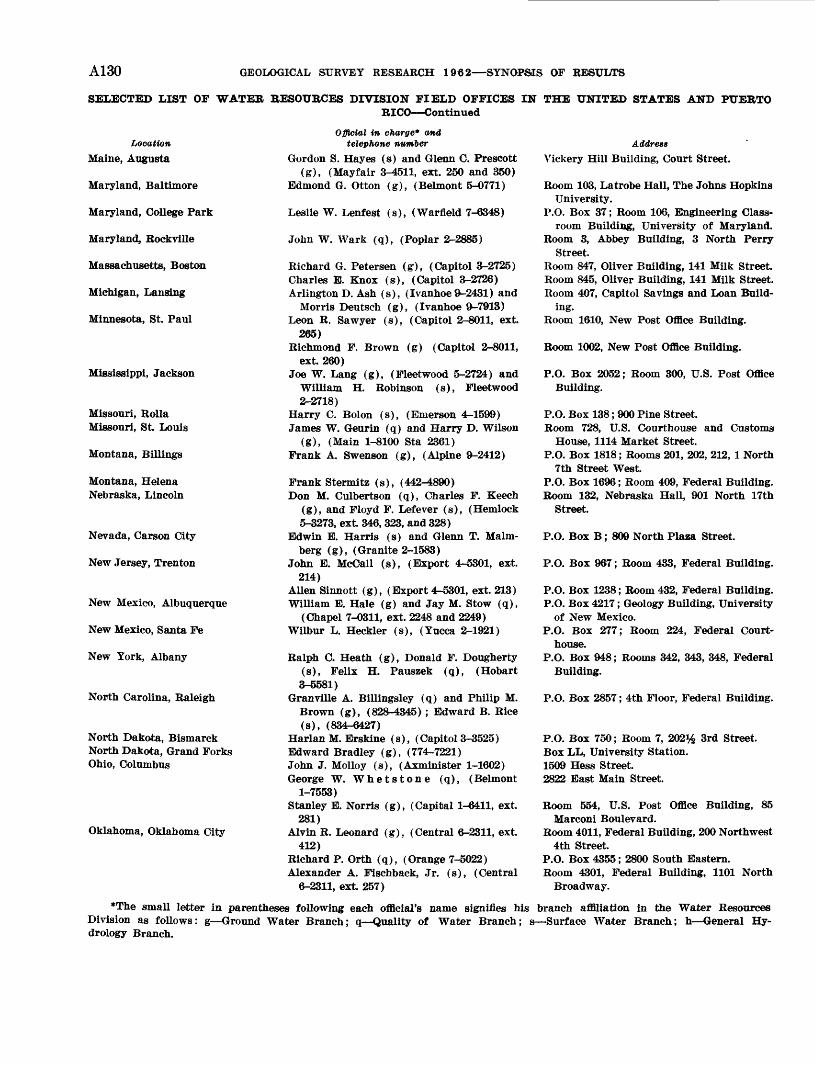
A130 GEOLOGICAL SURVEY RESEARCH 19«2 SYNOPSIS OF RESULTS
SELECTED LIST OF WATER BESOUBCES DIVISION FIELD OFFICES IN THE UNITED STATES AND PUEBTORICO Continued
Location Maine, Augusta
Maryland, Baltimore
Maryland, College Park
Maryland, Rockville
Massachusetts, Boston
Michigan, Lansing
Minnesota, St. Paul
Mississippi, Jackson
Missouri, Holla Missouri, St. Louis
Montana, Billings
Montana, Helena Nebraska, Lincoln
Nevada, Carson City
New Jersey, Trenton
New Mexico, Albuquerque
New Mexico, Santa Fe
New York, Albany
North Carolina, Raleigh
North Dakota, Bismarck North Dakota, Grand Forks Ohio, Columbus
Oklahoma, Oklahoma City
Official in charge* and telephone number
Gordon S. Hayes (s) and Glenn C. Prescott (g), (Mayfair 3-4511, ext. 250 and 350)
Edmond G. Otton (g), (Belmont 5-0771)
Leslie W. Lenfest (s), (Warfield 7-6348)
John W. Wark (q), (Poplar 2-2885)
Richard G. Petersen (g), (Capitol 3-2725) Charles E. Knox (s), (Capitol 3-2726) Arlington D. Ash (s), (Ivanhoe 9-2431) and
Morris Deutsch (g), (Ivanhoe 9-7913) Leon R. Sawyer (s), (Capitol 2-8011, ext
265) Richmond F. Brown (g) (Capitol 2-8011,
ext 260) Joe W. Lang (g), (Fleetwood 5-2724) and
William H. Robinson (s), Fleetwood2-2718)
Harry C. Bolon (s), (Emerson 4-1599) James W. Geurin (q) and Harry D. Wilson
(g), (Main 1-8100 Sta 2361) Frank A, Swenson (g), (Alpine 9-2412)
Frank Stermitz (s), (442-4890)Don M. Culbertson (q), Charles F. Keech
(g), and Floyd F. Lefever (s), (Hemlock 5-3273, ext. 346, 323, and 328)
Edwin E. Harris (s) and Glenn T. Malm- berg (g), (Granite 2-1583)
John E. McCall (s), (Export 4-5301, ext. 214)
Alien Sinnott (g), (Export 4-5301, ext. 213)William E. Hale (g) and Jay M. Stow (q),
(Chapel 7-0311, ext. 2248 and 2249)Wilbur L. Heckler (s), (Yucca 2-1921)
Ralph C. Heath (g), Donald F. Dougherty(s), Felix H. Pauszek (q), (Hobart3-5581)
Granville A. Billingsley (q) and Philip M.Brown (g), (828-4345) ; Edward B. Rice(s), (834-6427)
Harlan M. Erskine (s), (Capitol3-3525) Edward Bradley (g), (774-7221) John J. Molloy (s), (Axminister 1-1602) George W. Whetstone (q), (Belmont
1-7553) Stanley E. Norris (g), (Capital 1-6411, ext.
281) Alvin R. Leonard (g), (Central 6-2311, ext.
412)Richard P. Orth (q), (Orange 7-5022) Alexander A. Fischback, Jr. (s), (Central
6-2311, ext. 257)
Address Yickery Hill Building, Court Street.
Room 103, Latrobe Hall, The Johns Hopkins University.
P.O. Box 37; Room 106, Engineering Class room Building, University of Maryland.
Room 3, Abbey Building, 3 North Perry Street.
Room 847, Oliver Building, 141 Milk StreetRoom 845, Oliver Building, 141 Milk Street.Room 407, Capitol Savings and Loan Build
ing.Room 1610, New Post Office Building.
Room 1002, New Post Office Building.
P.O. Box 2052; Room 300, U.S. Post Office Building.
P.O. Box 138; 900 Pine Street.Room 728, U.S. Courthouse and Customs
House, 1114 Market Street. P.O. Box 1818; Rooms 201, 202, 212, 1 North
7th Street West.P.O. Box 1696; Room 409, Federal Building. Room 132, Nebraska Hall, 901 North 17th
Street.
P.O. Box B; 809 North Plaza Street.
P.O. Box 967; Room 433, Federal Building.
P.O. Box 1238; Room 432, Federal Building.P.O. Box 4217; Geology Building, University
of New Mexico.P.O. Box 277; Room 224, Federal Court
house.P.O. Box 948; Rooms 342, 343, 348, Federal
Building.
P.O. Box 2857; 4th Floor, Federal Building.
P.O. Box 750; Room 7, 202% 3rd Street. Box LL, University Station. 1509 Hess Street. 2822 East Main Street.
Room 554, U.S. Post Office Building, 85Marconi Boulevard.
Room 4011, Federal Building, 200 Northwest4th Street.
P.O. Box 4355; 2800 South Eastern. Room 4301, Federal Building, 1101 North
Broadway.
*The small letter in parentheses following each official's name signifies his branch affiliation in the Water Resources Division as follows: g Ground Water Branch; q Quality of Water Branch; s Surface Water Branch; h General Hy drology Branch.
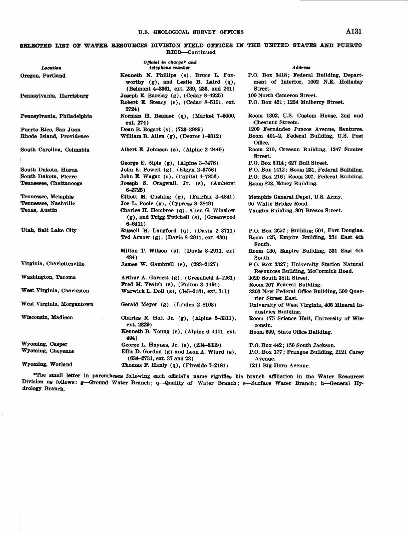
U.S. GEOLOGICAL SURVEY OFFICES A131
SELECTED LIST OF WATER RESOURCES DIVISION FIELD OFFICES IN THE UNITED STATES AND PUERTORICO Continued
Location Oregon, Portland
Pennsylvania, Harrisburg
Pennsylvania, Philadelphia
Puerto Rico, San Juan Rhode Island, Providence
South Carolina, Columbia
South Dakota, Huron South Dakota, Pierre Tennessee, Chattanooga
Tennessee, Memphis Tennessee, Nashville Texas, Austin
Utah, Salt Lake City
Virginia, Charlottesville
Washington, Tacoma
West Virginia, Charleston
West Virginia, Morgantown
Wisconsin, Madison
Wyoming, Gasper Wyoming, Cheyenne
Wyoming, Worland
Official in charge* and telephone number
Kenneth N. Phillips (s), Bruce L. Fox- worthy (g), and Leslie B. Laird (q), (Belmont 4-3361, ext. 239, 236, and 241)
Joseph E. Barclay (g), (Cedar 8-4925) Robert E. Steacy (s), (Cedar 8-5151, ext.
2724) Norman H. Beamer (q), (Market 7-6000,
ext 274)DeanB. Bogart (s), (723-3989) William B. Alien (g), (Dexter 1-9312)
Albert E. Johnson (s), (Alpine 2-2449)
George E. Siple (g), (Alpine 3-7478) John E. Powell (g), (Elgyn 2-3756) John E. Wagar (s), (Capital 4-7856) Joseph S. Oragwall, Jr. (s), (Amherst
6-2725)EUiott M. Gushing (g), (Fairfax 3-4841) Joe L. Poole (g), (Cypress 8-2849) Charles H. Hembree (q), Alien G. Winslow
(g), and Trigg Twichell (s), (Greenwood6-6411)
Russell H. Langford (q), (Davis 2-3711) Ted Arnow (g), (Davis 8-2911, ext. 436)
Milton T. Wilson (s), (Davis 8-2911, ext.434)
James W. GambreU (s), (293-2127)
Arthur A. Garrett (g), (Greenfleld 4-4261) Fred M. Veatch (s), (Fulton 3-1491) Warwick L. Doll (s), (343-6181, ext. 311)
Gerald Meyer (g), (Linden 2-8103)
Charles R. Holt Jr. (g), (Alpine 5-3311),ext 2329)
Kenneth B. Young (s), (Alpine 6-4411, ext.494)
George L. Haynes, Jr. (s), (234-6339) Ellis D. Gordon (g) and Leon A. Wiard (s),
(634-2731, ext. 37 and 23) Thomas F. Hanly (q), (Fireside 7-2181)
Address
P.O. Box 3418; Federal Building, Depart ment of Interior, 1002 N.E. Holladay Street
100 North Cameron Street.P.O. Box 421; 1224 Mulberry Street.
Room 1302, U.S. Custom House, 2nd and'Chestnut Streets.
1209 Fernandez Juncos Avenue, Santurce. Room 401-2, Federal Building, U.S. Post
Office. Room 210, Creason Building, 1247 Sumter
Street.P.O. Box 5314; 627 Bull Street. P.O. Box 1412; Room 231, Federal Building. P.O. Box 216; Room 207, Federal Building. Room 823, Edney Building.
Memphis General Depot, U.S. Army.90 White Bridge Road.Vaughn Building, 807 Brazos Street.
P.O. Box 2657; Building 504, Fort Douglas.Room 125, Empire Building, 231 East 4th
South.Room 130, Empire Building, 231 East 4th
South.P.O. Box 3327; University Station Natural
Resources Building, McCormick Road.3020 South 38th Street.Room 207 Federal Building.3303 New Federal Office Building, 500 Quar-
rier Street East.University of West Virginia, 405 Mineral In
dustries Building.Room 175 Science Hall, University of Wis
consin.Room 699, State Office Building.
P.O. Box 442; 150 South Jackson.P.O. Box 177; Frangos Building, 2121 Carey
Avenue. 1214 Big Horn Avenue.
*The small letter in parentheses following each official's name signifies his branch affiliation in the Water Resources Division as follows: g Ground Water Branch; q Quality of Water Branch; s Surface Water Branch; h General Hy drology Branch.
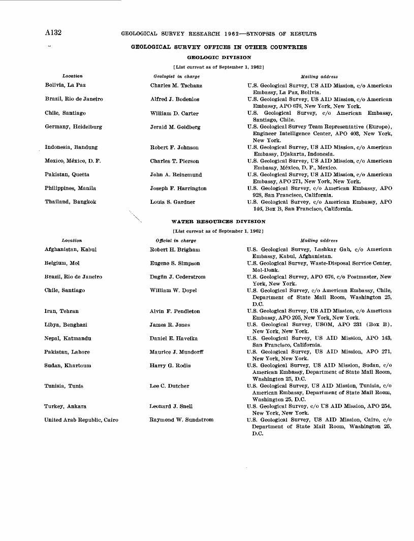
A132 GEOLOGICAL SURVEY RESEARCH 1962 SYNOPSIS OF REiSULTS
GEOLOGICAL SURVEY OFFICES IN OTHER, COUNTRIES
GEOLOGIC DIVISION
[List current as of September 1, 1962]
Location
Bolivia, La Paz
Brazil, Bio de Janeiro
Chile, Santiago
Germany, Heidelburg
Indonesia, Bandung
Mexico, Mexico, D. F.
Pakistan, Quetta
Philippines, Manila
Thailand, Bangkok
Location
Afghanistan, Kabul
Belgium, Mol
Brazil, Bio de Janeiro
Chile, Santiago
Iran, Tehran
Libya, Benghazi
Nepal, Katmandu
Pakistan, Lahore
Sudan, Khartoum
Tunisia, Tunis
Turkey, Ankara
United Arab Republic, Cairo
Geologist in charge
Charles M. Tschanz
Alfred J. Bodenlos
William D. Carter
Jerald M. Goldberg
Robert F. Johnson
Charles T. Pierson
John A. Reinemund
Joseph F. Harrington
Louis S. Gardner
Mailing address
U.S. Geological Survey, US AID Mission, c/o AmericanEmbassy, La Paz, Bolivia.
U.S. Geological Survey, US AID Mission, c/o AmericanEmbassy, APO 676, New York, New York.
U.S. Geological Survey, c/o American Embassy,Santiago, Chile.
U.S. Geological Survey Team Representative (Europe),Engineer Intelligence Center, APO 408, New York,New York.
U.S. Geological Survey, US AID Mission, c/o AmericanEmbassy, Djakarta, Indonesia.
U.S. Geological Survey, US AID Mission, c/o AmericanEmbassy, Mexico, D. F., Mexico.
U.S. Geological Survey, US AID Mission, c/o AmericanEmbassy, APO 271, New York, New York.
U.S. Geological Survey, c/o American Embassy, APO928, San Francisco, California.
U.S. Geological Survey, c/o American Embassy, APO146, Box B, San Francisco, California.
WATER RESOURCES DIVISION
[List current as of September 1, 1962]
Official in charge
Robert H. Brlgham
Eugene S. Simpson
Dagfin J. Cederstrom
William W. Doyel
Alvin F. Pendleton
James R. Jones
Daniel E. Havelka
Maurice J. Mundorff
Harry G. Rodis
Lee C. Dutcher
Leonard J. Snell
Raymond W. Sundstrom
Mailing address
U.S. Geological Survey, Lashkar Gah, c/o AmericanEmbassy, Kabul, Afghanistan.
U.S. Geological Survey, Waste-Disposal Service Center,Mol-Donk.
U.S. Geological Survey, APO 676, c/o Postmaster, NewYork, New York.
U.S. Geological Survey, c/o American Embassy, Chile,Department of State Mail Room, Washington 25,D.C.
U.S. Geological Survey, US AID Mission, c/o AmericanEmbassy, APO 205, New York, New York.
U.S. Geological Survey, USOM, APO 231 (Box B),New York, New York.
U.S. Geological Survey, US AID Mission, APO 143,San Francisco, California.
U.S. Geological Survey, US AID Mission, APO 271,New York, New York.
U.S. Geological Survey, US AID Mission, Sudan, c/oAmerican Embassy, Department of State Mail Room,Washington 25, D.C.
U.S. Geological Survey, US AID Mission, Tunisia, c/oAmerican Embassy, Department of State Mail Room,Washington 25, D.C.
U.S. Geological Survey, c/o US AID Mission, APO 254,New York, New York.
U.S. Geological Survey, US AID Mission, Cairo, c/oDepartment of State Mail Room, Washington 25,D.C.
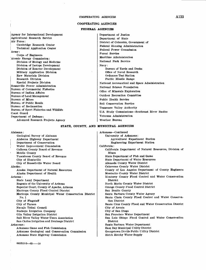
COOPERATING AGENCIES A133
COOPERATING AGENCIES
FEDERAL AGENCIES
Agency for International DevelopmentAgricultural Research ServiceAir Force:
Cambridge Research Center Technical Application Center
Army:Corps of Engineers
Atomic Energy Commission:Division of Biology and Medicine Division of Isotope Development Division of Reactor Development Military Application Division Raw Materials Division Research Division Special Projects Division
Bonneville Power AdministrationBureau of Commercial FisheriesBureau of Indian AffairsBureau of Land ManagementBureau of MinesBureau of Public RoadsBureau of ReclamationBureau of Sport Fisheries and WildlifeCoast GuardDepartment of Defense:
Advanced Research Projects Agency
Department of Justice Department of State District of Columbia, Government of Federal Housing Administration Federal Power Commission Forest Service Maritime Administration National Park Service Navy:
Bureau of Yards and DocksOffice of Naval ResearchOrdnance Test StationPacific Missile Range
National Aeronautical and Space Administration National Science Foundation Office of Minerals Exploration Outdoor Recreation Committee Public Health Service Soil Conservation Service Tennessee Valley AuthorityU.S. Study Commissions Southeast River Basins Veterans Administration Weather Bureau
STATE, COUNTY, AND MUNICIPAL AGENCIES
Alabama:Geological Survey of AlabamaAlabama Highway DepartmentDepartment of ConservationWater Improvement CommissionCalhoun County Board of RevenueMobile CountyTuscaloosa County Board of RevenueCity of HuntsvilleCity of Russellville Water Board
Alaska:Alaska Department of Natural ResourcesAlaska Department of Health
Arizona:State Land DepartmentRegents of the University of ArizonaSuperior Court, County of Apache, ArizonaMaricopa County Flood Control DistrictMaricopa County Municipal Water Conservation District
No. 1City of FlagstaffCity of TucsonNavajo Tribal CouncilBuckeye Irrigation CompanyGila Valley Irrigation DistrictSalt River Valley Water Users AssociationSan Carlos Irrigation and Drainage District
Arkansas:Arkansas Game and Fish CommissionArkansas Geological and Conservation CommissionArkansas State Highway Commission
Arkansas ContinuedUniversity of Arkansas:
Agricultural Experiment Station Engineering Experiment Station
California:California Department of Natural Resources, Division of
MinesState Department of Fish and GameState Department of Water ResourcesAlameda County Water DistrictCalaveras County Water DistrictCounty of Los Angeles Department of County EngineersMontecito County Water DistrictMonterey County Flood Control and Water Conservation
DistrictNorth Marin County Water DistrictOrange County Flood Control DistrictSan Benito CountySanta Barbara County Water AgencySanta Clara County Flood Control and Water Conserva
tion DistrictSanta Cruz County Flood and Water Conservation DistrictCity of ArcataCity of San DiegoSan Francisco Water DepartmentSan Luis Obispo Flood Control and Water Conservation
DistrictSanta Barbara Water DepartmentEast Bay Municipal Utility DistrictGeorgetown Divide Public Utility DistrictHetch Hetchy Water Supply
661513 O 62- -10
A134 GEOLOGICAL SURVEY RESEARCH 1962 SYNOPSIS OF RESULTS
STATE, COUNTY, AND MUNICIPAL AGENCIES Continued
California ContinuedImperial Irrigation DistrictMetropolitan Water District of Southern CaliforniaPalo Verde Irrigation DistrictSan Bernardino Valley Water Conservation DistrictSanta Maria Valley Water Conservation DistrictVentura River Municipal Water District
Colorado:Department of Natural ResourcesOffice of State Engineer, Division of Water ResourcesColorado State Metal Mining Fund BoardColorado Water Conservation BoardColorado Agricultural Experiment StationBoard of County Commissioners, Boulder CountyColorado Springs Department of Public UtilitiesDenver Board of Water CommissionersArkansas River Compact AdministrationColorado River Water Conservation DistrictRio Grande Compact CommissionSoutheastern Colorado Water Conservancy District
Connecticut:Connecticut Geological and Natural History SurveyState Highway DepartmentState Water Resources CommissionGreater Hartford Flood CommissionHartford Department of Public WorksNew Britain Board of Water CommissionersEngineering Department City of Torrington
Delaware:Delaware Geological SurveyState Highway Department
District of Columbia:District of Columbia Department of Sanitary Engineering
Florida:Florida Geological SurveyState Board of Parks and Historic MemorialsState Road Department of FloridaBroward County Board of County CommissionersCollier County Board of County CommissionersDade County Board of County CommissionersHillsborough County Board of County CommissionersOrange County Board of County CommissionersPinellas County Board of County CommissionersPolk County Board of County CommissionersCity of Fort LauderdaleCity of Jacksonville, Office of the City EngineerCity of Jacksonville, City CommissionCity of Miami Department of Water and SewerageCity of Miami BeachCity of NaplesCity of PensacolaCity of PerryCity of Pompano BeachCity of TallahasseeCentral and Southern Florida Flood Control DistrictTrustees of Internal Improvement Fund
Georgia:State Division of Conservation, Department of Mines, Min
ing and Geology State Highway Department
Hawaii:State Department of Land and Natural ResourcesHonolulu, City and County of
Idaho:Idaho Department of HighwaysIdaho Department of Reclamation
Illinois:State Department of Public Works and Buildings:
Division of Highways Division of Waterways
State Department of Registration and EducationCook County Department of HighwaysFountain Head Drainage DistrictNorthwest Illinois Metropolitan Planning Commission
Indiana:State Department of Conservation Division of Water Re
sources State Highway Commission
Iowa:Iowa Geological SurveyIowa State Conservation CommissionIowa Natural Resources CouncilIowa State Highway CommissionIowa Institute of Hydraulic ResearchIowa State University Agricultural Experiment StationLinn County Board of SupervisorsCity of Fort Dodge Department of Utilities
Kansas:State Geological Survey of Kansas, University of KansasState Board of Agriculture, Division of Water ResourcesState Board of HealthState Highway CommissionState Water Resources BoardCity of Wichita:
Water Supply and Sewage Treatment Division Metropolitan Area Planning Department
Kentucky:Kentucky Geological Survey, University of Kentucky
Louisiana:State Geological SurveyState Department of ConservationState Department of HighwaysState Department of Public WorksSabine River Compact Commission
Maine:Maine Public Utilities Commission
Maryland:State Department of Geology, Mines, and Water ResourcesMaryland National Capital Park and Planning CommissionCommissioners of Charles CountyCity of BaltimoreWashington Suburban Sanitary Commission
Massachusetts:State Department of Public Works:
Division of WaterwaysDivision of Highways
Massachusetts Water Resources Commission Boston Metropolitan District Commission
COOPERATING AGENCIES A135
STATE, COUNTY, AND MUNICIPAL AGENCIES Continued
Michigan.:Department of Conservation, Geological Survey Division State Highway Department State Water Resource Commission.esota:State Department of Conservation, Division of WatersState of Minnesota Department of HighwaysBoard of County Commissioners of Hennepin CountyDepartment of Iron Range Resources and Rehabilitation
Mississippi:Mississippi Board of Water CommissionersMississippi State Highway Department
; Jackson County, Mississippi, Port AuthorityCity of Corinth
i City of JacksonMississippi Industrial and Technological Research
Commission Missouri:
Division of Geological Survey and Water ResourcesMissouri State Highway CommissionCurators of the University of Missouri
Montana:Montana Bureau of Mines and GeologyState EngineerState Fish and Game CommissionState Highway CommissionState Water Conservation Board
Nebraska:Department of Water ResourcesDepartment of RoadsUniversity of Nebraska Conservation and Survey DivisionNebraska Mid-State Reclamation DistrictSanitary District Number One of Lancaster County
[Nevada:Nevada Bureau of Mines, University of NevadaDepartment of Conservation and Natural ResourcesDepartment of Highways
New Hampshire:New Hampshire Water Resources Board
New Jersey:Department of AgricultureState Department of Conservation and Economic Develop
mentDepartment of HealthRutgers University, the State University of New JerseyNorth Jersey District Water Supply CommissionPassaic Valley Water Commission
New Mexico:State Engineer and School of MinesState Highway DepartmentNew Mexico Institute of Mining and TechnologyInterstate Stream CommissionPecos River CommissionPecos Valley Artesian Conservation DistrictRio Grande Compact Commission
New York:State Conservation DepartmentState Department of Commerce
! State Department of HealthState Department of Public WorksNew York Water Resources Commission
New York ContinuedBoard of Hudson River-Black River Regulating DistrictCounty of Dutchess Dutchess County Board of Super
visorsCounty of Nassau Department of Public WorksOnondaga County Public Works CommissionOnondaga County Water AuthorityRockland County Board of SupervisorsSuffolk County Board of SupervisorsCounty of Suffolk Suffolk County Water AuthorityCounty of Westchester Department of Public WorksCity of Albany Department of Water and Water SupplyCity of Auburn Water DepartmentCity of Jamestown Board of Public UtilitiesNew York City Board of Water SupplyNew York City Department of Water Supply; Gas and
ElectricityVillage of Nyack Board of Water CommissionersSchenectady Water DepartmentBrighton Sewer District #2Oswegatchie-Cranberry Reservoir Commission
North Carolina:North Carolina Department of Conservation and Develop
mentState Department of Water ResourcesState Highway CommissionMartin County Board of County CommissionersCity of AshevilleCity of BurlingtonCity of CareyCity of CharlotteCity of DurhamCity of GreensboroCity of Waynesville
North Dakota:North Dakota Geological SurveyState Highway DepartmentState Water Conservation Commission
Ohio:Ohio Department of HealthOhio Department of HighwaysOhio Department of Natural Resources:
Division of Geological SurveyDivision of Water
City of Columbus Department of Public Service Miami Conservancy District Ohio River Valley Water Sanitation Commission
Oklahoma:Oklahoma State Department of HealthOklahoma Water Resources BoardOklahoma City Water Department
Oregon:Oregon Agricultural Experiment StationState EngineerState Highway DepartmentBoard of Higher EducationOregon State Colleg* Department of Fish and Game Man
agementOregon State Sanitary AuthorityOregon Water Resources DepartmentCounty Court of Douglas County

A136 GEOLOGICAL SURVEY RESEARCH 1962 SYNOPSIS O'F RESULTS
STATE, COUNTY, AND MUNICIPAL AGENCIES Continued
Oregon ContinuedCounty Court of Josephine CountyCounty Court of Lane CountyCounty Court of Morrow CountyCity of DallasCity of Dalles CityCity of Eugene Water and Electric BoardCity of McMinnville Water and Light DepartmentCity of PortlandCity of ToledoCoos Bay North Bend Water BoardTalent Irrigation District
Pennsylvania:Bureau of Topographic and Geologic Survey, Department
of Internal AffairsState Department of AgricultureState Department of Forests and WatersState Department of HealthCity of BethlehemCity of HarrlsburgCity of PhiladelphiaConestoga Valley Association, Inc.
Rhode Island:State of Rhode Island and Providence PlantationsRhode Island Water Resources Coordinating BoardState Department of Public Works Division of Harbors
and Rivers South Carolina:
State Development BoardState Highway DepartmentState Public Service AuthorityState Water Pollution Control AuthorityCity of Spartanburg Public Works Department
South Dakota:State Geological SurveySouth Dakota Department of HighwaysSouth Dakota Water Resources Commission
Tennessee:Tennessee Department of Conservation and Commerce:
Division of Geology Division of Water Resources
Tennessee Game and Fish CommissionTennessee Department of Highways and Public WorksTennessee Department of Public Health Stream Pollution
ControlCity of ChattanoogaMemphis Board of Light, Gas, and Water Commissioners,
Water Division Texas:
Texas Department of AgricultureTexas A & M Research FoundationTexas Water CommissionPecos River CommissionRio Grande Compact CommissionSabine River Compact AdministrationCity of Dallas
Utah:Utah State EngineerUtah Water and Power BoardState Department of Fish and GameState Road Commission of UtahUniversity of Utah
Utah ContinuedSalt Lake CountyBear River Compact Commission
Vermont:State Water Resources Board
Virginia:Department of HighwaysCounty of ChesterfieldCounty of FairfaxCity of AlexandriaCity of CharlottesvilleCity of Newport News Department of Public UtilitiesCity of Norfolk Division of Water SupplyCity of RoanokeCity of Staunton
Washington:State Department of Conservation :
Division of Mines and Geology Division of Water Resources
State Department of FisheriesState Department of GameState Department of HighwaysState Pollution Control CommissionMunicipality of Metropolitan SeattleCity of SeattleCity of Tacoma
West Virginia:State Conservation CommissionState Geological and Economic SurveyState Road CommissionState Water Resources CommissionClarksburg Water Board
Wisconsin:Wisconsin Conservation DepartmentWisconsin Geological and Natural History Survey, Univer
sity of WisconsinState Highway CommissionPublic Service Commission of WisconsinState Committee on Water PollutionMadison Metropolitan Sewerage District
Wyoming:Geological Survey of WyomingState Engineer's OfficeWyoming Highway DepartmentWyoming Natural Resource BoardCity of Cheyenne Board of Public Utilities
Commonwealth:Puerto Rico:
Aqueduct and Sewer Authority Department of Public Works Economic Development Administration Industrial Development Company Water Resources Authority
Unincorporated Territories:American Samoa:
Government of American SamoaGuam:
Government of GuamVirgin Islands of the United States :
Government of the Virgin Islands
GEOLOGICAL SURVEY RESEARCH 1962 SYNOPSIS OF RESULTS A137
INVESTIGATIONS IN PROGRESS IN THE GEOLOGIC AND WATER RESOURCES DIVISIONS
| Investigations in progress in the Geologic and Water Resources Divisions during the fiscal year 1962 are listed below, together with the names and headquarters \>f the individuals in charge of each. The list includes $ome projects that have been completed except for publication of final results, and a few that have been temporarily recessed. Headquarters for major offices are indicated by the initials (W) for Washington, D.C., (D) Denver, Colo., and (M) for Menlo Park, Calif. Headquarters in other cities are indicated by name; see list of offices on preceding pages for addresses. For projects in the Water Resources Division, a lowercase ietter before the city initial or name indicates the unit mder which the project is administered: g, Branch of jrround Water; s, Branch of Surf ace Water; q, Branch )f Quality of Water; h, Branch of General Hydrology; md w, Water Resources Division.
Projects that include a significant amount of geologic mapping are indicated by asterisks. One asterisk (*) indicates mapping at a scale of a mile to the inch or larger, and two asterisks (**) indicate mapping at a scale smaller than a mile to the inch.
The projects are classified by State or similar unit and are repeated as necessary to show work in more than one State. However, projects that deal with areas involving four or more States are listed only under the heading "Large Regions of the United States."
Topical investigations, such as commodity studies and studies of geologic and hydrologic processes and methods, are listed under the single most appropriate topical heading, even though the work may deal with more than one subject. Topical investigations that involve specific areas are also listed under regional headings.
REGIONAL INVESTIGATIONS
Large regions of the United States: Geologic map of the United States
P. B. King (M) Gravity map of the United States
H. B. Joesting (W) Paleotectonic map folio Permian System
E. D. McKee (D) Paleotectonic map folio Mississippian System
L. 0. Craig (D) Paleotectonic map folio Pennsylvanian System
E. D. McKee (D) Bibliography of North American geology
M. Cooper (W) Subsurface-data center
L. C. Craig (D)Correlation of airborne radioactivity data and areal geology J. A. Pitkin (W) Cross-country aeromagnetic profiles
E. B. King (W)Synthesis of geologic data on Atlantic Coastal Plain and
Continental ShelfJ. E. Johnston (W)
Geology of the Piedmont region of the Southeastern States (monazite)
W. C. Overstreet (W) Igneous rocks of Southeastern United States
C. Milton (W)Geology of the Appalachian Basin with reference to disposal
of high-level radioactive wastesG. W. Colton (W)
Aerial radiological monitoring surveys, Northeastern United States
P. Popenoe (W)Middle and Late Tertiary history of parts of the Northern
Bocky Mountains and Great PlainsN. M. Denson (D)
Mesozoic stratigraphic paleontology, Pacific coastD. L. Jones (M)
Large regions of the United States ContinuedCretaceous stratigraphy and paleontology, western interior
United StatesW. A. Cobban (D)
Jurassic stratigraphic paleontology of North AmericaB. W. Imlay (W)
Midcontinent Devonian investigationsE. B. Landis (D)
Silurian and Devonian stratigraphic paleontology of the Great Basin and Pacific coast
C. W. Merriam (W)Ordovician stratigraphic paleontology of the Great Basin
and Bocky MountainsB. J. Boss, Jr. (D)
Thermal pollution of streamsG. E. Harbeck (h. D)
Changes below dams (river channels)M. G. Wolman (h, Baltimore)
Hydrology of the public domainH.V. Peterson (h, M)
Fluvial denudation in the United StatesA. W. Gambell, Jr. (q, Arlington, Va.)
General studies of erosion and sedimentationG. G. Parker (h, D)
Effect of mechanical treatment on arid land in the Western United States
F. A. Branson (h, D)Chemical characteristics of larger public water supplies in
the United StatesC. N. Durfor (q, W)
Geohydrology of the Mississippi EmbaymentW. J. Wellborne (q, Fayetteville, Ark.)
Collection of basic records on chemical quality and sedi ment of surface waters of the United States
S. K. Love (q, W) Variance in water quality and environment
A. W. Gambell, Jr. (q, Arlington, Va.)
A138 GEOLOGICAL SURVEY RESEARCH 1962 SYNOPSIS OF RESULTS
Large regions of the United States ContinuedReconnaissance of fluvial sediment in the Potomac River
basinJ. W. Wark (q, Rockville, Md.)
Water-supply exploration on the public domain (WesternStates)
N.J.E3ng(g,D) Summary of the ground-water situation in the United
StatesC. L. McGuinness (g, W)
Geochemistry of water in carbonate rocksW. Back (g, W)
Geology and hydrology of the Central and Northeastern States as related to the management of radioactive materials
W. C. Basmnssen (g, Newark, Del.) Mississippi Embayment hydrology
E. M. dishing (g, Memphis, Tenn.) Geology and hydrology of Great Plains States as related to
the management of radioactive materials W. C. Basmussen (g, Newark, Del.)
Geology and hydrology of the Western States as related tothe management of radioactive materials
R. W. Maclay (g, St. Paul, Minn.) Alabama:
Coal resourcesW. C. Culbertson (D)
Clinton iron ores of the southern AppalachiansB, P. Sheldon (D)
Pre-Selma Cretaceous rocks of Alabama and adjacent statesL. a Conant (Tripoli, Libya)
Mesozoic rocks of Florida and the eastern Gulf coastE. B, Applin (Jackson, Miss.)
*Warrior quadrangle, (coal)W. C. Culbertson (D)
Geomorphology of Bussell GaveJ. T. Hack (W)
Subsurface geologic study of AlabamaW. J. Powell (g, Tuscaloosa, Ala.)
Limestone-terrane hydrologyF. A. Swenson (g, D)
Artesian water in Tertiary limestones in Florida, southern Georgia, and adjacent parts of Alabama and South Carolina
" V. T. Stringfleld (w, W) Precipitation records
L. K. Carroon (s, Tnacaloosa, Ala.) Stream profiles (surface water)
L. B. Peirce (s, Tnacaloosa, Ala.) Reconnaissance of chemical quality of Alabama streams
B. N. Cherry (q, Ocala, Fla.) Flood gaging
L. E. Carroon (s, Tnscaloosa, Ala.) Local floods
L. B. Peirce (s, Tnscaloosa, Ala.) Temperatures of lake waters
L. EL Carroon (s, Tnscaloosa, Ala.) Unit graphs and infiltration rates (surface water)
L. B. Peirce (s, Tnscaloosa, Ala.) Bridge-site studies (water)
L. B. Peirce (s, Tuscaloosa, Ala.) Geologic and hydrologic profile along the Chattahoochee
River L. D. Tonlmin (g, Tnscaloosa, Ala.)
Alabama ContinuedAutauga County (ground water)
J. C. Scott (g, Tuscaloosa, Ala.) Bullock County (ground water)
J. C. Scott (g, Tuscaloosa, Ala.) Calhoun County (ground water)
J. C. Warman (g, Tuscaloosa, Ala.) Cherokee County (ground water)
L. V. Causey (g, Tuscaloosa, Ala.) Calhoun County surface-water resources
J. B. Harkins (s,Tuscaloosa, Ala.) Geologic and hydrologic profiles in Clarke County
L. D. Toulmin (g, Tuscaloosa, Ala.) Colbert County (ground water)
H. B. Harris (g, Tuscaloosa, Ala.) Escambia County (ground water)
J. W. Cagle (g, Tuscaloosa, Ala.) Etowah County (ground water)
L. V. Causey (g, Tuscaloosa, Ala.) Franklin County (ground water)
B. B. Peace (g, Tuscaloosa, Ala.) Hale County (ground water)
Q. F. Paulson (g, Tuscaloosa, Ala.) Lauderdale County (ground water)
H. B. Harris (g, Tuscaloosa, Ala.) Limestone County (ground water)
W. M. McMaster (g, Tuscaloosa, Ala.) Lawrence County (ground water)
W. F. Harris (g, Tuscaloosa, Ala.) Marshall County (ground water)
T. H. Sanford (g, Tuscaloosa, Ala.) Morgan County (ground water)
C. L. Dodson (g, Tuscaloosa, Ala.) Pickens County (ground water)
J. G. Newton (g, Tuscaloosa, Ala.) Bussell County (ground water)
J. C. Scott (g, Tuscaloosa, Ala.) St. Clair County (ground water)
L. V. Causey (g, Tuscaloosa, Ala.) Tuscaloosa County (ground water)
Q. F. Paulson (g, Tuscaloosa, Ala.) Athens and vicinity (ground water)
W. M. McMaster (g, Tuscaloosa, Ala.) Elkmont quadrangle, Limestone County (geology)
W. M. McMaster (g, Tuscaloosa, Ala.) Huntsville and Madison County (ground water)
T. H. Sanford (g, Tuscaloosa, Ala.) Bussellville and vicinity (ground water)
B. B. Peace (g, Tuscaloosa, Ala.) Salem quadrangle, Limestone County (geology)
W. M. McMaster (g. Tuscaloosa, Ala.) Sylacauga area (ground water)
G. W. Swindel (g, Tuscaloosa, Ala.) Alaska:
General geology: Index of literature on Alaskan geology
E. H. Cobb(M) Geologic map
G. O. Gates (M) Tectonic map
G. Gryc (W) Glacial map
D. M. Hopkins (M)
REGIONAL INVESTIGATIONS IN PROGRESS, GEOLOGIC AND WATER RESOURCES DIVISIONS A139
Alaska Continued General geology Continued
LandformmapH. W. Coulter (W)
Physiographic diyisionsC. Wahrhaftig (M)
Bock-types mapL. A. Vehle (W)
Engineering soils mapT. N. V. Karlstrom (W)
Climatic mapA. T. Feraald (W)
Vegetation mapL. A. Spetxman (W)
Compilation of geologic maps, 1:2oO,000 quadranglesW. H. Gondon (M)
Mesozoic stratigraphyW. W. Patton and A. Grantz (M)
Cenozoic mollusksF. S. MacNeil (M)
"Central and northern Alaska CenozoicD. M. Hopkins (M)
Aleutian Trench Trinity IslandG. W. Moore (M)
'Eastern Aleutian IslandsR. E. Wilcox (D)
'Western Aleutian IslandsB. E. Wilcox (D)
*Bnckland and Huslia Bivers area, west-central Alaska W. W. Patton, Jr. (M)
*Charley River quadrangle E. E. Brabb (M)
*Delong Mountains and Point Hope quadrangles I. L. Tailleur (M)
Fairbanks quadrangleF. B. Weber (College, Alaska)
Petrology and volcanism, Katmai National Monument G. H. Cttrtis (M)
Diamna quadrangleB. L. Detterman (M)
" Livengood quadrangleB. Taber (M)
Mount Michelson areaE. G. Sable (Elizabethtown, Ky.)
Cretaceous Foraminif era of the Nelchina area H. B. Bergqnist (W)
Shungnak-Hnghes area W. W. Patton, Jr. (M)
Windy-Curry area B. Kachadoorian (M)
Southern Wrangeil Mountains E. M. MacKevett, Jr. (M)
Lower Yukon-Norton Sound regionJ. M. Hoare (M)
Mineral resources: Metallogenic provinces
C. L. Sainsbury (M) Geochemical prospecting techniques
B. M. Chapman (D) Begional geology and mineral resources, southeastern
AlaskaR.A.Loney (M)
Uranium-thorium reconnaissance E. M. MacKevett, Jr. (M)
Alaska Continued Mineral resources Continued *Klukwan iron district
E. C. Bobertson (W)Quicksilver deposits, southwestern Alaska
E. M. MacKevett, Jr. (M) Southern Brooks Range (copper, precious metals)
W. P. Brosge" (M) Nome C-l and D-l quadrangles (gold)
C. L. Hummel (Bangkok, Thailand) Tofty placer district (gold, tin)
D. M. Hopkins (M) Seward Peninsula tin investigations
P. L. Killeen (W) Lost Biver mining district (tin and beryllium)
C. L. Sainsbury (M) Heceta-Tnxekan area (high-calcium limestone)
G.D.Eberlein(M) Gulf of Alaska Tertiary province (petroleum)
G. Plafker (M) Northern Alaska petroleum investigations
G. Gryc (W) Iniskin-Tnxedni region
B. L. Detterman (M) *Nelchina area (petroleum)
A. Grantz (M) Lower Tukon-Koyukuk area (petroleum)
W. W. Patton, Jr. (M) Beluga-Yentna area (coal)
F. F. Barnes (M) Matanuska coal field
F. F. Barnes (M)Matanuska stratigraphic studies (coal)
A. Grantz (M) Nenana coal investigations
C. Wahrhaftig (M) Engineering geology and permafrost:
Surflcial and engineering geology studies and constructionmaterials sources
T. L. Pew£ (College, Alaska)Origin and stratigraphy of ground ice in central Alaska
T. L. Pew6 (College, Alaska) Surflcial geology of the Anchorage-Matanuska Glacier
area (construction-site planning) T. N. V. Karlstrom (W)
Surflcial geology of the Barter Island-Mi. Chamberlin areaC. B. Lewis (W)
Surflcial geology of the Bristol Bay area (construction-siteplanning)
H. B. Schmoll (W) Nuclear test-site evaluation, Chariot
G. D. Eberlein (M) Surflcial geology of the lower Chitina Valley (construction-
site planning) L. A. Yehle (W)
Surflcial geology of the northeastern Copper Biver (con struction-site planning)
O. J. Ferrians, Jr. (Glennallen, Alaska) Surflcial geology of the southeastern Copper Biver (con
struction-site planning) D.B.Nichols(W)
Snrficial geology of the southwestern Copper Biver basin(construction-site planning)
J. B. Williams (W)
A140 GEOLOGICAL SURVEY RESEARCH 1962 SYNOPSIS OF REiSULTS
Alaska ContinuedEngineering geology and permafrost Continued
* Surficial geology of the eastern Denali Highway (construc tion-site planning)
D. R. Nichols (W)* Surficial geology of the Johnson River district (construc
tion-site planning) H. L. Foster (W)
**Surficial geology of the Kenai lowland (construction-siteplanning)
T. N. V. Karlstrom (W)**Kobuk River valley (construction-site planning)
A. T. Fernald (W)*Mt. Hayes D-3 and D-4 quadrangles (construction-site
planning) T. L. Pew6 (College, Alaska)
* Surficial geology of the Seward-Portage Railroad (construc tion-site planning)
T. N. V. Karlstrom (W)Surficial geology of the Stiese Highway area (construction-
site planning) W. E. Davies (W)
*Surficial geology of the Upper Tanana River (construction- site planning)
A. T. Fernald (W)Surficial geology of the Taylor Highway area (construction-
site planning) H. L. Foster (W)
* Surficial geology of the Valdez-Tiekel belt (construction- site planning
H. W. Coulter (W) Surficial geology of Yukon Flats area (construction-site
planning) T. N. V. Karlstrom (W)
**Engineering geology of Yukon-Koyukuk lowlandF. R. Weber (College, Alaska)
Geophysical studies: Aeromagnetic surveys
D. F. Barnes (M) Regional gravity surveys
D. F. Barnes (M) Aerial radiological monitoring surveys, Chariot site
R. G. Bates (W) Water resources:
General inventory of ground waterR. M. Waller (g, Anchorage, Alaska)
Relationship of permafrost to ground water J. R. Williams (g, Anchorage, Alaska) Water-supply investigations for U.S. Air Force
A. J. Feulner (g, Anchorage, Alaska) Anchorage area (ground water)
D. J. Cederstrom (g, W) Water utilization at Anchorage
R. M. Waller (g, Anchorage, Alaska) Project Chariot (ground water)
R. M. Waller (g, Anchorage, Alaska) Chugiak area (ground water)
R. M. Waller (g, Anchorage, Alaska) Cordova area (ground water)
R. M. Waller (g, Anchorage, Alaska) Fairbanks area (ground water)
D. J. Cederstrom (g, W) Homer area (ground water)
R. M. Waller (g, Anchorage, Alaska)
Arizona: General geology:
Diatremes, Navajo and Hopi Indian ReservationsE. M. Shoemaker (M)
Terrestrial impact structures, Meteor CraterE. M. Shoemaker (M)
Devonian rocks and paleogeography of central ArizonaC. Teichert (D)
Devonian rocks of northwestern ArizonaC. Teichert (D)
Stratigraphy of the Redwall limestoneE. D. McKee (D)
History of Supai-Hermit formationsE. D. McKee (D)
*Cibecue-Grasshopper area T. L. Finnell (D)
* Southern Cochise County P. T. Hayes (D)
*Elgin quadrangleR. B. Raup (D)
"Upper Gila River basin, Arizona-New MexicoR. B. Morrison (D)
*Heber quadrangle E. J. McKay (D)
*Holy Joe Peak quadrangle M. H. Krieger (M)
*Mount Wrightson quadrangle H. Drewes (D)
*Show Low quadrangleE. J. McKay (D)
Colorado Plateau regional geophysical studiesH. R. Joesting (W)
Safford Valley geophysical studiesG. E. Andreason (W)
Mineral resources:Geochemical halos of mineral deposits
L. C. Huff (D)*McFadden Peak and Blue House Mountain quadrangles
(asbestos)A. F. Shride (D)
""Christmas quadrangle (copper, iron)C. R. Willden (M)
*Bradshaw Mountains (copper) C. A. Anderson (W)
*Globe-Miami area (copper) D. W. Peterson (M)
*Klondyke quadrangle (copper) F. S. Simons (D)
*Contact-metamorphic deposits of the Little Dragoons area(copper)
J. R. Cooper (D)*Mammoth and Benson quadrangles (copper)
S. C. Creasey (M)*Prescott-Paulden area (copper)
M. H. Kreiger (M)*Twin Buttes area (copper)
J. R. Cooper (D)*Lochiel and Nogales quadrangles (lead, zinc, copper)
F. S. Simons (D)*Fuels potential of the Navajo Reservation, Arizona and
Utah R. B. O'Sullivan (D)
REGIONAL INVESTIGATIONS IN PROGRESS, GEOLOGIC AND WATER RESOURCES DIVISIONS A141
Arizona ContinuedMineral resources Continued"""Compilation of Colorado Plateau geologic maps (uran
ium, vanadium) D. G. Wyant (D)
Stratigraphic studies, Colorado Plateau (uranium,vanadium)
L. C. Craig (D) Lithologic studies, Colorado Plateau
R. A. Cadigan (D) Clay studies, Colorado Plateau
L. G. Schultz (D) Triassic stratigraphy and lithology of the Colorado Plateau
(uranium, copper) J. H. Stewart (M)
San Rafael Group stratigraphy, Colorado Plateau(uranium)
J. C. Wright (W) Studies of uranium deposits
H. C. Granger (D) *Carrizo Mountains area, Arizona-New Mexico (uranium)
J. D. Strobell (D)Relative concentrations of chemical elements in rocks and
ore deposits of the Colorado Plateau (uranium, vanadium, copper)
A. T. Miesch (D) Uranium-vanadium deposits in sandstone, with emphasis
on the Colorado Plateau R. P. Fischer (D)
Uranium deposits of the Dripping Spring Quartzite ofsoutheastern Arizona
H. C. Granger (D) Water resources:
The geohydrologic environment as related to water utiliza tion in arid lands
E. S. Davidson (g, Tucson, Ariz.) Lower Colorado River Basin hydrology
C. C. McDonald (g, Yuma, Ariz.) Evapotranspiration theory and measurement
O. E. Leppanen (h, Phoenix, Ariz.)Use of water by saltcedar in evapotranspirometer compared
with energy budget and mass transfer computation (Buckeye)
T. E. A. Van Hylckama (h, Phoenix, Ariz.) Effect of removing riparian vegetation, Cottonwood Wash
(water)J. E. Bowie (s, Tucson Ariz.)
Piping, an erosional phenomenon in certain silty soils ofarid and semi-arid regions
G. G. Parker, R. C. Miller, and I. S. McQueen (h, D) Flood investigations, Maricopa County
J. E. Bowie (s, Tucson, Ariz.) Sycamore Creek basin (water)
A. Wilson (s, Tucson, Ariz.) Study of channel flood-plain aggradation of Tusayan
WashesR. F. Hadley (h, D)
Central Apache County (ground water)J. P. Akers (g, Tucson, Ariz.)
Northwestern Pinal County- (ground water)W. F. Hardt (g, Tucson, Ariz.)
Big Sandy valley (ground water)W. Kam (g, Tucson, Ariz.)
Flagstaff area (ground water) J. P. Akers (g, Tucson, Ariz.)
Arizona ContinuedWater resources Continued
Fort Huachuca (ground water)H. G. Page (g, Tucson, Ariz.)
Luke Air Force Base (ground water)J. M. Cahill (g, Tucson, Ariz.)
Navajo Indian Reservation (ground water)M. E. Cooley (g, Tucson, Ariz.)
Papago Indian Reservation (ground water)L.A. Heindl (g, W)
Rainbow Valley Waterman Wash (ground water)F. R. Twenter (g, Tucson, Ariz.)
Deep aquifers in the Salt River valleyD. G. Metzger (g, Tucson, Ariz.)
San Simon basin (ground water)N. D. White (g, Tucson, Ariz.)
Verde Valley (ground water)D. G. Metzger (g, Tucson, Ariz.)
Willcox basin (ground water)S. G. Brown (g, Tucson, Ariz.)
Arkansas:Aeromagnetic interpretation, Wichita Mountains system
A. Griscom (W) Aeromagnetic prospecting for bauxite
A. Jesperson (W) Barite deposits
D. A. Brobst (D)* Arkansas Basin (coal)
B. R. Haley (D)*Ft. Smith district, Arkansas and Oklahoma (coal and gas)
T. A. Hendricks (D)*Northern Arkansas oil and gas investigations
E. E. Glick (D) Magnet Cove niobium investigations
L. V. Blade (Paducah, Ky.) Artificial recharge of aquifers
R. T. Sniegocki (g, Little Rock, Ark.) Flood investigations
R. C. Christensen (s, Fort Smith, Ark.) Low-flow frequency studies
J. L. Patterson (s, Fort Smith, Ark.) Arkansas River valley (ground water)
M. S. Bedinger (g, Little Rock, Ark.) Arkansas River valley reconnaissance (ground water)
R. M. Cordova (g, Little Rock, Ark.) Bradley, Calhoun, and Ouachita Counties (ground water)
D. R. Albin (g, Lifole Rock, Ark.) Crittenden County (ground water)
R. O. Plebuch (g, Little Rock, Ark.) Artificial recharge, Grand Prairie region (ground water)
R. T. Sniegocki (g, Little Rock Ark.) Pea Ridge Military Park (ground water)
R. O. Plebuch (g, Little Rock, Ark.) Ouachita Mountains (ground water)
R. M. Cordova (g, Little Rock, Ark.)Ground water along U.S. Highway 70 from Pulaski County
to Crittenden CountyH. N. Halberg (g, Little Rock, Ark.)
Reconnaissance study of quality of water in Smackover
CreekJ. P. Reer (q, Fayetteville, Ark.)
Surface-water resources of the White River basin, 1948-59J. W. Hubble (q, Fayetteville, Ark.)
A142 GEOLOGICAL SURVEY RESEARCH 1962 SYNOPSIS OF RESULTS
California: General geology:
Genozoic Foraminifera of CaliforniaP. J. Smith (M)
Foraminif era of the Lodo Formation M. C. Israelsky (M)
*San Andreas faultL. F. Noble (Valyermo, Calif.)
Glacial geology of the west-central Sierra Nevada region F. M. Fryxell (Rock Island, 111.)
* South-central Mojave Desert T. W. Dibblee, Jr. (M)
*California Coast Range ultramaflc rocksE. H. Bailey (M)
Glaucophane schist terranes within the Franciscan For mation
R. G. Coleman (M)*Ash Meadows quadrangle, California and Nevada
C. S. Denny (W)*Big Maria Mountains quadrangle
W. B. Hamilton (D)*Blanco Mountain quadrangle
C. A. Nelson (Los Angeles, Calif.)*Petrology of the Burney area
G. A. MacDonald (Honolulu, Hawaii)*Condrey Mountain quadrangle
P. B. Hotz (M)Geology and paleontology of the Cuyama Valley area
G. Vedder (M)*Death Valley
C. B. Hunt (Baltimore, Md.)*Funeral Peak quadrangle
H. D. Drewes (D)*Independence quadrangle
D. C. Ross (M)*Merced Peak quadrangle
D. L. Peck (M)*Mt. Pinchot quadrangle
J. G. Moore (M)*Northwest Sacramento Valley (petroleum)
R. D. Brown, Jr. (M)*Salinas Valley
D. L. Durham (M)*San Nicolas Island
J. G. Vedder (M)*Shuteye Peak area
N. K. Huber (M) Structural geology of the Sierra foothills mineral belt
(copper, zinc, gold, chromite) L. D. Clark (M)
*Weaverville, French Gulch, and Hayfork quadrangles,southern Klamath Mountains
W. P. Irwin (M) Mineral resources:
Origin of the borate-bearing marsh deposits of California,Oregon, and Nevada (boron)
W. C. Smith (M)*Furnace Creek area (boron)
J. F. McAllister (M)*Western Mojave Desert (boron)
T. W. Dibblee, Jr. (M)*Geology and origin of the saline deposits of Searles Lake
(boron) G. I. Smith (M)
California Continued Mineral resources Continued
Chromite deposits of northern California F. G. Wells (W)
*Panamint Butte quadrangle, including special geochemicalstudies (lead-silver)
W. B. Hall (W)*New York Butte quadrangle (lead-zinc)
W. C. Smith (M)Lateritic nickel deposits of the Klamath Mountains, Oregon-
California P. B. Hotz (M)
* Eastern Los Angeles basin (petroleum) J. B. Schoellhamer (W)
*Mt Diablo area (quicksilver, copper, gold, silver) B. H. Pampeyan (M)
*Bishop tungsten district P. C. Bateman (M)
*Geologic study of the Sierra Nevada batholith (tungsten,gold, base metals)
P. C. Bateman (M)*Bastern Sierra tungsten area: Devil's Postpile quadrangle
(tungsten, base metals) N. K. Huber (M)
Western oxidized-zinc depositsA. V. Heyl (W)
Engineering geology:*Surficial geology of the Beverly Hills, Venice, and Topanga
quadrangles, Los Angeles (urban geology) J. T. McGill (Los Angeles, Calif.)
*Malibu Beach quadrangle (urban geology)R. F. Yerkes (M)
"Oakland Bast quadrangle (urban geology)D. H. Radbruch (M)
*Point Dume quadrangle (urban geology) J. B. Schoellhamer (W)
*San Francisco Bay area, San Francisco North quadrangle(urban geology)
J. Schlocker (M)*San Francisco Bay area, San Francisco South quadrangle
(urban geology) M. G. Bonilla (M)
* San Mateo quadrangle (urban geology)G. O. Gates (M)
Geophysical studies:Rocks and structures of the Los Angeles basin, and their
gravitational effectsT. H. McCulloh (Riverside, Calif.)
Aerial radiological monitoring surveys, Los AngelesK. G. Brooks (W)
Sacramento Valley and Coast Range geophysical studiesG.D.Bath (M)
Geophysical studies, San Francisco Bay areaG. D. Bath (M)
Aerial radiological monitoring surveys, San FranciscoJ. A. Pitkin (W)
Sierra Nevada geophysical studiesH. W. Oliver (M)
Water resources: Lower Colorado River Basin hydrology
C. C. McDonald (g, Yuma, Ariz.) Agricultural Research Service soil-moisture study
R. B. Bvenson (g, Sacramento, Calif.)
REGIONAL INVESTIGATIONS IN PROGRESS, GEOLOGIC AND WATER RESOURCES DIVISIONS A143
I California ContinuedWater resources Continued
Springs of CaliforniaRobert Brennan (q, Sacramento, Calif.)
Water-loss and water-gain studies in CaliforniaW. C. Peterson (s,M)
Floods from small areas in CaliforniaL. B. Young (s, M)
Natural water loss, southern CaliforniaW. Hofmann (s, M)
North Pacific coast area (surface water)W. Hofmann (s,M)
Occurrence and distribution of minor elements in fresh and saline waters of California
W. D. Silvey (q, Sacramento, Calif.)Solute composition and minor-element distribution in
lacustrine closed basinsB. F. Jones (q, W)
Solute-solid relations in lacustrine closed basins of the al kali-carbonate type
B.F.Jones (q,W) Clastic sedimentation in a bolson environment
L. K. Lustig (q, Boston, Mass.) Cache Creek sediment investigation
George Porterfield (q, Sacramento, Calif.) Stony Gorge Reservoir sedimentation survey
C. A. Dunnam (q, Sacramento, Calif.) Snowmelt hydrology of a Sierra Nevada stream
W. Hofmann (s, M) Flood inundation, Lower Bel River
W. Hofmann (s, M) Camp Pendleton Marine Corps Base (ground water)
J. S. Bader (g, Sacramento, Calif.) Death Valley National Monument (ground water)
F. Kunkel (g, Sacramento, Calif.) Bdwards Air Force Base (ground water)
W. R. Moyle (g, Sacramento, Calif.) Inyokern Naval Ordnance Test Station (ground water)
F. Kunkel (g, Sacramento, Calif.) Lower Mojave area, west part (ground water)
G. M. Hogenson (g, Sacramento, Calif.) Dale Lake area (ground water)
G. M. Hogenson (g, Sacramento, Calif.) Ducor-Famoso area (ground water)
G. & Hilton (g, Sacramento, Calif.) Furnace Creek and Pinto Basin (ground water)
G. M. Hogenson (g, Sacramento, Calif.) Kaweah-Tule area (ground water)
M. G. Croft (g, Sacramento, Calif.) Kern River fan (ground water)
R. H. Dale (g, Sacramento, Calif.)Livermore Valley investigation (Alameda Creek basin)
(water resources)R. T. Riser (q, Sacramento, Calif.)
Lompoc Plain (ground water)R. B. Bvenson (g, Santa Barbara, Calif.)
Oak Mountain Air Force Facility (ground water)G. A. Miller (g, Sacramento, Calif.)
Point Arguello (ground water)R. B. Evenson (g, Sacramento, Calif.)
Point Mugu area (ground water)R. W. Page (g, Sacramento, Calif.)
San Antonio Valley (ground water)R. B. Bvenson (g, Sacramento, Calif.)
California ContinuedWater resources Continued
San Francisco Bay barriers (ground water)G. M. Hogenson (g, Sacramento, Calif.)
San Nicholas Island (ground water)R. W. Page (g, Sacramento, Calif.)
Santa Barbara County (ground water)R. B. Bvenson (g, Sacramento, Calif.)
Reservoir evaporation, San Diego CountyW. Hofmann (s, M)
Santa Maria Valley (ground water)R. E. Bvenson (g, Sacramento, Calif.)
Sierra Ordnance Depot (ground water)G. S. Hilton (g, Sacramento, Calif.)
South coast basins (ground water)R. E. Evenson (g, Sacramento, Calif.)
A study of some effects of diversion works on the Trinity River
George Porterfield (q, Sacramento)Twentynine Palms Marine Corps Training Center (ground
water)H. B. Dyer (g, Sacramento, Calif.)
Colorado: General geology:
Upper Cretaceous stratigraphy, northwestern Colorado andnortheastern Utah
A.D. Zapp (D) Tuffs of the Green River Formation
R. L. Griggs (D)Investigation of Jurassic stratigraphy, south-central Wyo
ming and northwestern Colorado G. N. Pipiringos (D)
Pennsylvanian and Permian stratigraphy, Front RangeE. K. Maughn (D)
Stratigraphy and paleontology of the Pierre Shale, FrontRange area, Colorado and Wyoming
W. A. Cobban and G. R. Scott (D) Lithologic studies, Colorado Plateau
R. A. Cadigan (D) Clay studies, Colorado Plateau
L. G. Schultz (D) "Berthoud Pass quadrangle
P. K. Theobald (D) "Bottle Pass quadrangle
R. B. Taylor (D) Petrology and geochemistry of the Boulder Creek batholith,
Colorado Front Range G. Phair (W)
"Boulder quadrangleR. F. Wilson and C. T. Wrucke (D)
"Cameron Mountain quadrangle M. G. Dings (D)
"Central City quadrangleP. K. Sims (Minneapolis, Minn.)
"Eldorado Springs quadrangleJ. D. Wells (D)
"Empire quadrangleW. A. Braddock (D)
"Glenwood Springs quadrangleN. W. Bass (D)
*Precambrian rocks in Idaho Springs area R. H. Moench (D)
A144 GEOLOGICAL SURVEY RESEARCH 1962 SYNOPSIS OF RESULTS
Colorado ContinuedGeneral geology Continued
Petrology an<l geochemistry of the Laramide intrusives inthe Colorado Front Range
G. Phair (W)*Mountain front area, east-central Front Range
D. M. Sheridan (D)* Squaw Pass quadrangle
D. M. Sheridan (D) Distribution of elements in Mount Princeton area
P. Toulmin (W) "Upper South Platte River, North Fork
G. R. Scott (D) Colorado National Monument (general geology)
S. W. Lohman (g, D) Mineral resources:
*Lake George district (beryllium) C. C. Hawley (D)
*Poncha Springs and Bonanza quadrangles (fluorspar)R. E. Van Alstine (W)
Western oxidized zinc deposits A. V. Heyl (W)
* Central City-Georgetown area, including studies of the Pre- cambrian history of the Front Range (base, precious, and radioactive metals)
P. K. Sims (Minneapolis, Minn.)* Volcanic and economic geology of the Creede caldera (base
and precious metals, fluorspar) T.A. Steven (D)
*Holy Cross quadrangle and the Colorado mineral belt(lead, zinc, silver, copper, gold)
O. Tweto (D)*Minturn quadrangle (zinc, silver, copper, lead, gold)
T. S. Lpvering (D)*Rico district (lead, zinc, silver)
E. T. McKnight (W)*San Juan mining area, including detailed study of the
Silverton Caldera (lead, zinc, silver, gold, copper) R. G. Luedke (W)
*Tenmile Range, including the Kokomo mining district(base and precious metals)
A. H. Kosehmann (D)*Powderhorn area, Gunnison County (thorium)
J. C. Olson (D)*Wet Mountains (thorium, base and precious metals)
M. R. Brock (D) Wallrock alteration and its relation to thorium deposition
in the Wet Mountains G. Phair (W)
Uranium-vanadium deposits in sandstone, with emphasis onthe Colorado Plateau
R. I. Fischer (D)Relative concentrations of chemical elements in rocks and
ore deposits of the Colorado Plateau (uranium, vanadium, copper)
A. T. Miesch (D) """Compilation of Colorado Plateau geologic maps (uranium,
vanadium) D, G. Wyant (D)
Stratigraphic studies, Colorado Plateau (uranium, va nadium )
L. C. Craig (D) Triassic stratigraphy and lithology of the Colorado Plateau
(uranium, copper) J. H. Stewart (M)
Colorado ContinuedMineral resources Continued
San Rafael Group stratigraphy, Colorado Plateau (ura nium)
J. C. Wright (W)*Baggs area, Wyoming and Colorado (uranium)
G. E. Prichard (D)*Bull Canyon district (vanadium, uranium)
C. H. Roach (D) Exploration for uranium deposits in the Gypsum Valley
district C. F. Withington (W)
*La Sal area, Utah-Colorado (uranium, vanadium)W. D. Carter (Santiago, Chile)
" Lisbon Valley area, Utah-Colorado (uranium, vanadium, copper)
G. W. Weir (Berea, Ky.)*Maybell-Lay area, Moffat County (uranium)
M. J. Bergin (W) " Ralston Buttes (Uranium)
D. M. Sheridan (D) " Western San Juan Mountains (uranium, vanadium, gold)
A. L. Bush (W) ""Slick Rock district (uranium, vanadium)
D. R. Shawe (D) Uravan district (vanadium, uranium)
R. L. Boardman (W)*Ute Mountains (uranium, vanadium)
E. B. Ekren (D)" Animas River area, Colorado and New Mexico (coal, oil,
and gas)H. Barnes (D)
" Carbondale coal fieldJ. R. Donnell (D)
" Eastern North Park (coal, oil, and gas)D. M. Kinney (W)
" Western North Park (coal, oil, and gas)W. J. Hail (D)
" Trinidad coal fieldR. B. Johnson (D)
" Oil shale investigationsD. C. Duncan (W)
" Grand-Battlement Mesa oil shaleJ. R. Donnell (D)
Engineering geology and geophysical studies:*Air Force Academy (construction-site planning)
D. J. Varnes (D) Black Canyon of the Gunnison River (construction-site
planning) W. R. Hansen (D)
" Upper Green River valley (construction-site planning)W. R. Hansen (D)
" Denver metropolitan area (urban geology)R. M. Lindvall (D)
" Golden quadrangle (urban geology)R. Van Horn (D)
" Morrison quadrangle (urban geology)J. H. Smith (D)
" Pueblo and vicinity (urban geology)G.R. Scott (D)
Engineering geology of the Roberts TunnelC. S. Robinson (D)
Colorado Plateau regional geophysical studies H. R. Joesting (W)
INVESTIGATIONS IN PROGRESS, GEOLOGIC AND WATER RESOURCES DIVISIONS A145
Colorado ContinuedEngineering geology and geophysical studies Continued
Aerial radiological monitoring surveys, Rocky FlatsJ. A. MacKallor (W)
Water resources: Occurrence and development of ground water in Colorado
J. A. McConaghy (g, D) Characteristics of municipal water supplies in Colorado
E. A. Moulder (g, D)Use of plant species or communities as indicators of soil-
moisture availabilityF. A. Branson (h, D)
Study of the mechanics of hillslope erosionS. A. Schumm (h, D)
Effects of sediment characteristics on fluvial morphology hydraulics
S. A. Schumm (h, D) Effects of grazing exclusion in Badger Wash area
G. C. Lusby (h, D) Bent County (ground water)
J. H. Irwin (g, D)Ogallala Formation, eastern Cheyenne and Kiowa Counties
(ground water)A. J. Boettcher (g, D)
Huerfano County (ground water)T. G. McLaughlin (g, D)
Kit Carson County (ground water)G. H. Chase (g, D)
Otero County and part of Crowley County (ground water)W. G. Weist (g, D)
Prowers County (ground water)P. T. Voegel (g, D)
Pueblo and Fremont Counties (ground water)H. E. McGovern (g, D)
Washington County (ground water)H. E. McGovern (g, D)
Yuma County (ground water)W. G. Weist (g, D)
Hydrology of Arkansas River basin Canon City to State line
C. T. Jenkins (g, D) Arkansas River basin (surface water)
C. T. Jenkins (s, D) Big Sandy valley below Limon (ground water)
D. L. Coffin (g, D) Cache La Poudre valley (ground water)
L. A. Hershey (g, D) Denver Basin (ground water)
G. H. Chase (g, D) Fountain and Jimmy Camp Valleys (ground water)
E. D. Jenkins (g, D) Fluvial sedimentation and runoff in Kiowa Creek
J. C. Mundorff (q, Lincoln, Nebr.)Investigation of trap efficiencies of K-79 Reservoir, Kiowa
Creek basinJ. C. Mundorff (q, Lincoln, Nebr.)
North and Middle Parks (ground water)P. T. Voegel (g, D)
Rocky Mountain Arsenal (ground water)M. C. Van Lewen (g, D)
Ute Mountain-Ute Indian Reservation (ground water)J. H. Irwin (g. D)
Connecticut: General geology:
* Stratigraphy and structure of Taconic rocks E-an Zen (W)
*Ansonia, Mount Carmel, and Southington quadrangles; bed rock geologic mapping
C. E. Fritts (D)*Ashley Falls and Bashbish Falls quadrangles, Massa
chusetts and Connecticut, and Egremont quad rangle, Massachusetts; surficial geologic mapping
J. H. Hartshorn (Boston, Mass.)*Ashaway quadrangle, Rhode Island and Connecticut; bed
rock geologic mapping T. G. Feininger (Boston, Mass.)
*Ashaway and Watch Hills quadrangles, Connecticut andRhode Island; surficial geologic mapping
J. P. Schafer (Boston, Mass.)*Bristol and New Britain quadrangles, bedrock geologic
mapping H. E. Simpson (D)
*Broad Brook and Manchester quadrangles R. B. Colton (D)
*Columbia, Fitchville, Marlboro, and Willimantic quad rangles ; bedrock geologic mapping
G. L. Snyder (D)*Durham quadrangle
H. E. Simpson (D)*Hampton, Plainfield, and Scotland quadrangles; bedrock
geologic mapping H. R. Dixon (Boston, Mass.)
*Meriden quadrangle; bedrock geologic mapping P. M. Hanshaw (Boston, Mass.)
*Montville, Mystic, New London, Niantic, and Uncasvillequadrangles; bedrock geologic mapping
R. Goldsmith (Boston, Mass.)*Mystic, New London, and Niantic quadrangles; surficial
geologic mapping R. Goldsmith (D)
*New Hartford quadrangle R. W. Schnabel (D)
*Southwick quadrangle, Massachusetts and Connecticut R. W. Schnabel (D)
* Springfield South quadrangle, Massachusetts and Con necticut
J. H. Hartshorn and C. Koteff (Boston, Mass.)*Tariffville and Windsor Locks quadrangles; bedrock geo
logic mapping R. W. Schnabel (D)
*Thompson quadrangle, Connecticut and Rhode Island P. M. Hanshaw and H. R. Dixon (Boston, Mass.)
*Voluntown quadrangle, Rhode Island and Connecticut T. G. Feiniger (Boston, Mass.)
*Watch Hill quadrangle, Connecticut-Rhode Island; bedrockgeologic mapping
G. E. Moore, Jr. (Columbus, Ohio)*West Springfield quadrangle, Massachusetts and Connec
ticutR. B. Colton (D) and J. H. Hartshorn (Boston, Mass.)
Hartford North quadrangleR. V. Cushman (g, Middletown, Conn.)
Recognition of late glacial substages in New England andNew York
J. E. Upson (g, Mineola, N.Y.)
A146 GEOLOGICAL SURVEY RESEARCH 1962 SYNOPSIS OF RESULTS
Connecticut Continued Water resources:
North-central Connecticut (ground water)R. V. Cushman (g, Middletown, Conn.)
Bristol-Plainville-Southington area (ground water)A. M. LaSala, Jr. (g, Middletown, Conn.)
Fannington-Granby area (ground water)A. D. Randall (g, Middletown, Conn.)
Water resources of Connecticut Part 1, Quinebaug River basin
Chester E. Thomas, Jr. (q. Albany, N.Y.) Water resources, Quinebaug River basin
A. D. Randall (g, Albany, N.Y.) Lower Quinnipiac and Mill River lowlands (ground water)
A. M. LaSala, Jr. (g, Middletown, Conn.) TarinMlle quadrangle (surficial geology)
A. D. Randall (g, Middletown, Conn.) Watch Hill quadrangle (ground water)
K. B. Johnson (g, Providence, R.I.) Waterbury-Bristol area (ground water)
B. V. Cushman (g, Middletown, Conn.) Delaware:
Water-table and engineering mappingD. H. Boggess (g, Newark Del.)
Chemical quality Natural waters of DelawareP. W.* Anderson (q, Philadelphia, Pa.)
Salinity conditions of lower Delaware River basinD. McCartney (q, Philadephia, Pa.)
Salt-water encroachment in the Lewes-Rehoboth areaD. B. Rima (g, Newark, Del.)
New Castle County (ground water)D. R. Rima (g, Newark, Del.)
Newark area (ground water)D. B. Bima (g, Newark, Del.)
Bed Clay Valley (ground water)D. H. Boggess (g, Newark, Del.)
Florida:Mesozoic rocks of Florida and eastern Gulf Coast
E. R. Applin (Jackson, Miss.) Subsurface Paleozoic rocks of Florida
J. M. Berdan (W) *Land-pebble phosphate deposits
J. B. Cathcart (D) Phosphate deposits of northern Florida
G. H. Espenshade (W) Bridge-site studies (surface water)
R. W. Pride (s, Ocala, Fla.)Artesian water in Tertiary limestones in Florida, southern
Georgia, and adjacent parts of Alabama and South Carolina
V. T. Stringfield (w, W) Physical characteristics of selected Florida lakes
W. E. Kenner (s, Ocala, Fla.) Mechanics of diffusion, fresh and salt water
H. H. Cooper (g, Tallahassee, Fla.) Special studies, surface water
R. W. Pride (s, Ocala, Fla.)Alachua, Bradford, Clay, and Union Counties (water
resources)W. E. Clark (g, Tallahassee, Fla.)
Alachua, Bradford, Clay, and Union Counties (surface water)
B. W. Pride (s, Ocala, Fla.) Central Broward County (ground water)
H. Klein (g, Tallahassee, Fla.)
Florida ContinuedNortheastern Broward County (ground water)
G. R. Tarver (g, Tallahassee, Fla.) Collier County (ground water)
H. J. McCoy (g, Tallahassee, Fla.) Dade County (ground water)
H. Klein (g, Tallahassee, Fla.) Salt-water encroachment studies in Dade County
H. Klein (g, Tallahassee, Fla.) Area B, Dade County (ground water)
C. B. Sherwood (g, Tallahassee, Fla.) Duval, Nassau, and Baker Counties (ground water)
Tarver, G. (g, Tallahassee, Fla.) Glades and Hendry Counties (ground water)
W. F. Lichtler (g, Tallahassee, Fla.) Orange County (water resources)
W. F. Lichter (g, Tallahassee, Fla.) Polk County (ground water)
H. G. Stewart (g, Tallahassee, Fla.) St. Johns, Flagler, and Putnam Counties (ground water)
D. W. Brown (g, Tallahassee, Fla.) Enconflna Creek basin area (water resources)
R. H. Musgrove (s, Ocala, Fla.) Salinity in the Miami River
S. D. Leach (s, Ocala, Fla.) Water resources of Myakfca River basin
K. A. MacKichan (q, Ocala, Fla.) Snake Creek Canal salinity study
F. A. Kohout (g, Tallahassee, Fla.)Snapper Creek, Snake Creek, and Levee 30 studies (ground
water)C. B. Sherwood (g, Tallahassee, Fla.)
Water resources of the Tampa Bay areaK. A. MacKichan (q, Ocala, Fla.)
Georgia:Clinton iron ores of the southern Appalachians
R. P. Sheldon (D) Mesozoic rocks of Florida and eastern Gulf coast
E. R. Applin (Jackson, Miss.) Pre-Selma Cretaceous rocks of Alabama and adjacent States
L. C. Conant (Tripoli, Libya)Aerial radiological monitoring surveys, Georgia Nuclear
Aircraft LaboratoryJ. A. MacKallor (W)
Aerial radiological monitoring surveys, Savannah River Plant, Georgia and South Carolina
R. G. Schmidt (W)Artesian water in Tertiary limestones in Florida, southern
Georgia, and adjacent parts of Alabama and South Carolina
V. T. Stringfield (w, W) River-systems studies
A. N. Cameron (s, Atlanta, Ga.) Relation of geology to low flow
O. J. Cosner (s, Atlanta, Ga.) Low-flow studies
R. F. Carter (s, Atlanta, Ga.) Areal flood studies
C. M. Bunch (s, Atlanta, Ga.) Flood gaging
C. M. Bunch (s, Atlanta, Ga.) Bridge-site investigations (surface water)
C. M. Bunch (s, Atlanta, Ga.)
REGIONAL rNVBSTI<3ATIONS IN PROGRESS, GEOLOGIC AND WATER RESOURCES DIVISIONS A147
j Georgia ContinuedStratigraphy of the Trent marl and related units
P. M. Brown (g, Raleigh, N.C.)Solution subsidence of a limestone terrane in southwest
GeorgiaS. M. Herrick (g, Atlanta, Ga.)
Paleozoic rock area, Bartow CountyM. G. Croft (g, Atlanta, Ga.)
Paleozoic rock area, Chattooga County (ground water)C. W. Cressler (g, Atlanta Ga.)
Floyd County (ground water)H. B. Counts (g, Atlanta, Ga.)
Lee and Sumter Counties (ground water)V. Owen (g, Atlanta, Ga.)
Mitchell County (ground water)V. Owen (g, Atlanta, Ga.)
Seminole, Decatur, and Grady Counties (ground water)V. Owen (g, Atlanta, Ga.)
Paleozoic rock area, Walker County (ground water)C. W. Cressler (g, Atlanta, Ga.)
'Salt-water encroachment in the Brunswick areaR. L. Wait (g, Atlanta, Ga.)
Georgia Nuclear Laboratory area (ground water)J*. W. Stewart (g, Atlanta, Ga.)
Maconarea (ground water)H. E. LeGrand (w, W)
Salt-water encroachment in the Savannah areaH. B. Counts (g, Atlanta, Ga.)
Hawaii:Geological, geochemical, and geophysical studies of Hawai
ian volcanologyD. H. Richter (Hawaii)
High-alumina weathered basalt on Kauai, HawaiiS. H. Patterson (W)
Hydrologic studiesG. T. Hiroshima (s, Honolulu, Hawaii)
Effects of land and water use on ground waterF. N. Visher (g, Honolulu, Hawaii)
Flood gaging, OahuE. Pearson (s, Honolulu, Hawaii)
Central and southern Oahu (ground water)F. N. Visher (g, Honolulu, Hawaii)
Mokuleia-Waialua area, Oahu (ground water) I D. A. Da vis (g, Honolulu, Hawaii) | Waianae district, Oahu (ground water)
F. N. Visher (g, Honolulu, Hawaii) Windward Oahu (ground water)
K. J. Takasaki (g, Honolulu, Hawaii) Idaho:
General geology:**South-central Idaho
C. P.Ross (D)*Bancroxt quadrangle
S. S. Oriel (D)*Geochemistry and metamorphism of the Belt Series, Clark
Fork and Packsaddle Mountain quadrangles, Idaho and Montana
J. E. Harrison (D)*Big Creek quadrangle
B. F. Leonard (D)*Doublesprings quadrangle
W. J.Mapel (D)* Jarbidge area, Nevada and Idaho
R. R. Coats (M)
Idaho Continued General geology Continued
*Leadore and Patterson quadrangles E. T. Ruppel (D)
**Mackay quadrangle C. P. Ross (D)
*Morrisson Lake quadrangle, Montana and Idaho E. T. Cressman (Lexington, Ky.)
*Metamorphism of the Orofino area A. Hietanen-Makela (M)
*Owyhee and Mt City quadrangles, Nevada-Idaho R.R. Coats (M)
*Riggins quadrangle W. B. Hamilton (D)
**Regional geology and structure of the central Snake Riverplain
H. A. Powers (D)* Snake River valley, American Falls region
D. E.Trimble (D)* Snake River valley, western region
H. A. Powers (D)Petrology of volcanic rocks, Snake River valley
H. A. Powers (D)**Geologic mapping of the Spokane-Wallace region, Washing
ton-Idaho A. B. Griggs (M)
*Yellow Pine quadrangleB. F. Leonard (D)
Mineral resources:*Greenacres quadrangle, Washington-Idaho (high-alumina
clays) P. L. Weis (Spokane, Wash.)
*Blackbird Mountain area (cobalt) J. S. Vhay (Spokane, Wash.)
*Coeud d'Alene mining district (lead, zinc, silver) S. W. Hobbs (W)
*Thunder Mountain niobium area, Montana-Idaho R. L. Parker (D)
*Aspen Range-Dry Ridge area (phosphate) V. E. McKelvey (W)
*Soda Springs quadrangle, including studies of the Bannockthrust zone (phosphate)
F. C. Armstrong (Spokane, Wash.)*Radioactive placer deposits of central Idaho
D. L. Schmidt (D)*Mt Spokane quadrangle, Washington and Idaho (uranium)
A. E. Wiessenborn (Spokane, Wash.) Geophysical studies:
Pacific Northwest geophysical studiesW. E. Davis (M)
Aerial radiological monitoring surveys, National ReactorTesting Station
R. G. Bates (W) Water resources:
Flood investigationsS. O. Decker (s, Boise, Idaho)
Aberdeen-Springfield area (ground water)H. G. Sisco (g, Boise, Idaho)
American Falls (ground water)M. J. Mundorff (g, Boise, Idaho)
Artesian City area (ground water)E. G. Corsthwaite (g, Boise, Idaho)
Challis area (ground water) M. J. Mundorff (g, Boise, Idaho)
A148 GEOLOGICAL SURVEY RESEARCH 1962 SYNOPSIS OF RESULTS
Idaho ContinuedWater resources Continued
Little Lost River basin (water resources)M. J. Mundorff (g, Boise, Idaho)
Michaud Flats (ground water)E. G. Crosthwaite (g, Boise, Idaho)
Mud Lake Basin (ground water)P. R. Stevens (g, Boise, Idaho)
Geology, hydrology, and waste disposal at the National Reactor Testing Station
R.L. Nace (w, W)Hydrology of subsurface waste disposal, National Reactor
Testing StationP. H. Jones, (g, Boise, Idaho)
Research on hydrology, National Reactor Testing StationE. H. Walker (g, Boise, Idaho)
Unsaturated flow, National Reactor Testing StationP. H. Jones (g, Boise, Idaho)
Teton Basin (ground water)M. J. Mundorff (g, Boise, Idaho)
Salmon Falls Creek area (ground water)E. G. Crosthwaite (g, Boise, Idaho)
Sand Point area (ground water)E. H. Walker (g, Boise, Idaho)
Spokane River valley (ground water)M. J. Mundorff (g, Boise, Idaho)
Feasibility of artificial recharge of the Snake Plain aquiferM. J. Mundorff (g, Boise, Idaho)
Tipper Star Valley (ground water)M. J. Mundorff (g, Boise, Idaho)
Lower Teton Basin (ground water)E. G. Crosthwaite (g, Boise, Idaho)
Upper Weiser basin (ground water)M. J. Mundorff (g, Boise, Idaho)
Illinois:Aerial radiological monitoring surveys, Chicago
G. M. Flint, Jr. (W) Geologic development of the Ohio River valley
L. L. Ray (W)* Stratigraphy of the lead-zinc district near Dubuque
J. W. Whitlow (W)*Wiseonsin zinc-lead mining district
J. W. Whitlow (W) Low-flow frequency analyses
W. D. Mitchell (s, Champaign, 111.) Low-flow partial-record investigation
D. W. Ellis (s, Champaign, 111.) Floods from small areas
W. D. Mitchell (s, Champaign. 111.) Bridge-site studies (surface water)
W. D. Mitchell (s, Champaign. 111.) Northeastern Illinois inundation mapping
W. D. Mitchell (s, Champaign. 111.) Indiana:
Geologic development of the Ohio River valleyL. L. Ray (W)
*Quaternary geology of the Owensboro quadrangle. Kentuckyand Indiana
L. L. Ray (W) Lake mapping and stabilization (surface water)
D. C. Perkins (s, Indianapolis, Ind.) Low-flow characteristics
R. E. Hoggatt (s, Indianapolis, Ind.)
Indiana ContinuedNorthwestern Indiana (ground water)
J. S. Rosenshein (g, Indianapolis, Ind.) Southeastern Indiana (ground water)
J. S. Rosenshein (g, Indianapolis, Ind.) West-central Indiana (ground water)
F. A. Watkins (g, Indianapolis, Ind.) Adams County (ground water)
F. A. Watkins (g, Indianapolis, Ind.)Clay, Greene, Owen, Sullivan, and Vigo Counties (ground
water)F. A. Watkins (g, Indianapolis, Ind.)
Fountain, Montgomery, Parke, Putnam, and Vermillion Counties (ground water)
F. A. Watkins (g, Indianapolis, Ind.) Bunker Hill Air Force Base (ground water)
F. A. Watkins (g, Indianapolis, Ind.) Iowa:
Coal resources of IowaE. R. Landis (D)
* Stratigraphy of the lead-zinc district near Dubuque J. W. Whitlow (W)
* Wisconsin zinc-lead mining districtJ. W. Whitlow (W)
Central Iowa aeromagnetic survey J. R. Henderson (W)
*Omaha-Council Bluffs and vicinity, Nebraska and Iowa (urban geology)
R. D. Miller (D) Low-flow frequency studies
H. H. Schwob (s, Iowa City, Iowa) Channel-geometry studies (surface water)
H. H. Schwob (s, Iowa City, Iowa) Flood profiles and flood frequency studies
H. H. Schwob (s, Iowa City, Iowa) Floods from small areas
H. H. Schwob (s, Iowa City, Iowa) The Mississippian aquifer of Iowa
W. L. Steinhilber (g, Iowa City, Iowa) Cerro Gordo County (ground water)
W. L. Steinhilber (g, Iowa City, Iowa) Linn County (ground water)
R. E. Hansen (g, Iowa City, Iowa) Kansas:
Trace elements in rocks of Pennsylvanian age, Oklahoma, Kansas, Missouri (uranium, phosphate)
W. Danilchik (Quetta, Pakistan) Tri-State lead-zinc district, Oklahoma, Missouri, Kansas
E. T. McKnight (W) Paleozoic stratigraphy of the Sedgwick Basin (oil and gas)
W. L. Adkison (Lawrence, Kans.)*Shawnee County (oil and gas)
W. D. Johnson, Jr. (Lawrence, Kans.)* Wilson County (oil and gas)
H. C. Wagner (M) Flood investigations
L. W. Furness (s, Topeka, Kans.)Effects of sediment characteristics on fluvial morphology
hydraulicsS. A. Schumm (h, D)
Northwestern Kansas (ground water)S. W. Fader (g, Lawrence, Kans.)
Southwestern Kansas (ground water)S. W. Fader (g, Lawrence, Kans.)
REGIONAL INVESTIGATIONS IN PROGRESS, GEOLOGIC AND WATER RESOURCES DIVISIONS A149
Kansas ContinuedBrown County (ground water)
C. K. Bayne (g, Lawrence, Kans.) Cowley County (ground water)
C. K. Bayne (g, Lawrence, Kans.) Decatur County (ground water)
J. M. McNellis (g, Lawrence, Kans.) Ells worth County (ground water)
W. Ives (g, Lawrence, Kans.) Finney, Kearny, and Hamilton Counties (ground water)
S. W. Fader (g, Lawrence, Kans.) Grant and Stanton Counties (ground water)
S. W. Fader (g, Lawrence, Kansas) Johnson County (ground water)
H. G. O'Connor (g, Lawrence, Kans.) Linn County (ground water)
W. J. Seevers (g, Lawrence, Kans.) Miami County (ground water)
D. M. Miller (g, Lawrence, Kans.) Neosho County (ground water)
W. J. Jungman (g, Lawrence, Kans.) Montgomery County (ground water)
H. G. O'Connor (g, Lawrence, Kans.) Pratt County (ground water)
C. W. Lane (g, Lawrence, Kans.) Rush County (ground water)
t J. McNellis (g, Lawrence, Kans.) Sedgwick County (ground water)
C. W. Lane (g, Lawrence, Kans.) Trego County (ground water)
W. G. Hodson (g, Lawrence, Kans.) Wallace County (ground water)
W. G. Hodson (g, Lawrence, Kans.) i Fluvial sediment in the Arkansas River basin
James C. Mundorff (q, Lincoln, Nebr.) Sedimentation in the Little Arkansas River basin
J. C. Mundorff (q, Lincoln, Nebr.) i Fluvial sediment in the Lower Kansas River basin
J. C. Mundorff (q, Lincoln, Nebr.)Chemical quality of water in the South Fork Ninnescah
River basinA. M. Diaz (q, Lincoln, Nebr.)
Chemical quality of surface waters and sedimentation in the Saline River drainage basin
P. R. Jordan (q, Lincoln, Nebr.) Chemical quality of water in the Walnut River basin
Robert F. Leonard (q, Lincoln, Nebr.) Emergency water supplies in the Wichita area
C. W. Lane (g, Lawrence, Kans.) Kentucky:
* Geologic mapping in KentuckyP. W. Richards (Lexington, Ky.)
Geologic development of the Ohio River valley L. L. Ray (W)
*Quaternary geology of the Owensboro quadrangle, Ken tucky-Indiana
L. L. Ray (W)Clay deposits of the Olive Hill bed of eastern Kentucky
J. W. Hosterman (W)*Eastern Kentucky coal investigations
K. J. Englund (W)Fluorspar deposits of northwestern Kentucky
R. D. Trace (Princeton, Ky.)
Kentucky Continued*Geology of the southern Appalachian folded belt, Kentucky,
Tennessee, and VirginiaL. D. Harris (W)
Geophysical studies in KentuckyJ. S. Watkins (W)
Aerial radiological monitoring surveys, Oak Ridge National Laboratory area
R. G. Bates (W) Public and industrial water supplies of Kentucky
H. T. Hopkins (g, Louisville, Ky.) Geochemistry of natural waters of Kentucky
G. E. Hendrickson (g, Louisville, Ky.) Hydrology of large springs in Kentucky
T. W. Lambert (g, Louisville, Ky.) Flood-frequency study
J. A. McCabe (s, Louisville, Ky.) Bridge-site studies (surface water)
C. H. Hannum (s, Louisville, Ky.) Low-flow frequency and flow duration
J .A. McCabe (s, Louisville, Ky.) Drainage-area compilation
H. C. Beaber (s, Louisville, Ky.) Rainfall-runoff relations
J. A. McCabe (s, Louisville, Ky.)Study of the hydrologic and related effects of strip mining
in Beaver Creek watershedJ. J. Musser (q, Columbus, Ohio)
Alluvial terraces of the Ohio River (ground water)W. E. Price (g, Louisville, Ky.)
Jackson Purchase area (ground water)L. M. MacCary (g, Louisville, Ky.)
Louisville area (ground water)E. A. Bell (g, Louisville, Ky.)
Mammoth Cave area (water resources)G. E. Hendrickson (g, Louisville, Ky.)
Louisiana:Flood investigations
L. V. Page (s, Baton Rouge, La.) AVater-supply characteristics of Louisiana streams
L. V. Page (s, Baton Rouge, La.) Public water supplies in Louisiana
J. L. Snider (g, Baton Rouge, La.) Compilation of quality of surface water records in
LouisianaS. F. Kapustka (q, Baton Rouge, La.)
Southeastern Louisiana (ground water)M. D. Winner (g, Baton Rouge, La.)
Southwestern Louisiana (ground water)A. H. Harder (g, Baton Rouge, La.)
Bossier-Caddo Parishes (water resources)L. V. Page (s, Baton Rouge, La.)
Bossier and Caddo Parishes (ground water)H. C. May (g, Baton Rouge, La.)
East and West Feliciana Parishes (ground water)C. O. Morgan (g, Baton Rouge, La.)
Natehitoches Parish (ground water)R. Newcome (g, Baton Rouge, La.)
Rapides Parish (ground water)R. Newcome (g, Baton Rouge, La.)
Rapides Parish (water resources)L. V. Page (s, Baton Rouge, La.)
Red River Parish (ground water)R. Newcome (g, Baton Rouge, La.)
661513 O 62 11
A150 GEOLOGICAL SURVEY RESEARCH 1962 SYNOPSIS OF RESULTS
Louisiana ContinuedSabine Parish (ground water)
R. Newcome (g, Baton Rouge, La.) Vernon Parish (ground water)
J. E. Rogers (g, Baton Rouge, La.) Baton Rouge area (ground water)
C. O. Morgan (g,. Baton Rouge, La.) Baton Rouge-New Orleans valley area (ground water)
G. T. Cardwell (g, Baton Rouge, La.) Trap efficiency of reservoir on Bayou Dupont watershed
S. F. Kapustka (q, Baton Rouge, La.) Ouachita River basin (quality of surface waters)
D. E. Everette (q, Baton Rouge, La.)Reconnaissance study, quality of water, vicinity of Monroe,
La.S. F. Kapustka (q, Baton Rouge, La.)
Tallulah area (ground water)A. N. Turcan, Jr. (g, Baton Rouge, La.)
Maine:*Regional Paleozoic stratigraphy
R. B. Neuman (W) Aeromagnetic surveys
J. W. Allingham (W) Gravity studies, northern Maine
M. F. Kane (W)* Southeastern Aroostook County (manganese)
L. Pavlides (W)*Attean quadrangle
A. L. Albee (Pasadena, Calif.)*Bedrock geology of the Danforth, Forest, and Vanceboo
quadrangles D. M. Larrabee (W)
* Greenville quadrangle G. H. Espenshade (W)
*Electromagnetic and geologic mapping in Island Falls quad rangle
F. C. Frischknecht (D)*Kennebago Lake quadrangle
E. L. Boudette (W)* Phillips quadrangle
R. H. Moench (D)* Geophysical and geologic mapping in the Stratton quad
rangle A. Griscom (W)
*The Forks quadrangleF. C. Canney and E. V. Post (D)
Coastal area of southwestern Maine (ground water)G. C. Prescott (g, Augusta, Maine)
Maryland:Clay deposits
M. M. Knechtel (W)Aerial radiological monitoring surveys, Belvoir area, Vir
ginia and Maryland S. K. Neuschel (W)
*Allegany County (coal) W. de Witt, Jr. (W)
*Beltsville quadrangle (urban geology)C. F. Withington (W)
Geophysical studies, Montgomery CountyA. Griscom (W)
Engineering geology, Washington metropolitan areaH. W. Coulter (W)
Low-flow analysesL. W. Lenfest (s, College Park, Md.)
Maryland ContinuedMass movement and surface runoff in an upland wooded
hillslopeL. B. Leopold (w, W)
Scour of river beds during high flowL. B. Leopold (w, W)
Allegany and Washington Counties (ground water)T. H. Slaughter (g, Baltimore, Md.)
Anne Arundel County (ground water)F. K. Mack (g, Baltimore, Md.)
Charles County (ground water)T. H. Slaughter (g, Baltimore, Md.)
Northern and western Montgomery County (ground water)P. M. Johnston (g, Baltimore, Md.)
Prince Georges County (ground water)F. K. Mack (g, Baltimore, Md.)
Fort George G. Meade (ground water)E. G. Otton (g, Baltimore, Md.)
Potomac River basin (ground water)P.M. Johnston (g, W)
Sharpsburg area (ground water)E. G. Otton (g, Baltimore, Md.)
Massachusetts:Geophysical studies in Massachusetts
R. W. Bromery (W)Research and application of geology and seismology to
public works planningC. R. Tuttle and R. N. Oldale (Boston, Mass.)
Sea-cliff erosion studiesC. A. Kaye (Boston, Mass.)
Central Cape Cod, subsurface studiesR. N. Oldale, C. R. Tuttle, and C. Koteff (Boston, Mass.)
* Stratigraphy and structure of Taconic rocks E-an Zen (W)
*Ashley Falls and Bashbish Falls quadrangles, Massachusetts and Connecticut, and Egremont quadrangle, Mas sachusetts ; surficial geologic mapping
J. H. Hartshorn (Boston, Mass.)*Assawompsett Pond quadrangle
C. Koteff (Boston, Mass.)*Athol quadrangle
D. F. Eschman (Ann Arbor, Mich.)*Ayer quadrangle; bedrock geologic mapping
R. H. Jahns (University Park, Pa.)*Bellerica, Lowell, Tyngsboro, and Westford quadrangles
R. H. Jahns (University Park. Pa.)*Blue Hills quadrangle
N. E. Chute (Syracuse, N.Y.)* Clinton and Shrewsbury quadrangles; bedrock geologic
mapping R. F. Novotny (Boston, Mass.)
* Concord quadrangleN. P. Cuppels and C. Koteff (Boston, Mass.)
*Duxbury and Scituate quadrangles N. E. Chute (Syracuse, N.Y.)
* Georgetown quadrangleN. P. Cuppels (Boston, Mass.)
*Greenfield quadrangle; surficial geologic mapping R. H. Jahns (University Park, Pa.)
*Lawrence, Reading, South Groveland, and Wilmingtonquadrangles; bedrock geologic mapping
R. O. Castle (Los Angeles, Calif.) Norwood quadrangle
N. E. Chute (Syracuse, N.Y.)
REGIONAL INVESTIGATIONS IN PROGRESS, GEOLOGIC AND WATER RESOURCES DIVISIONS A151
I|Iassachusetts ContinuedI *Plainfield quadrangle; bedrock geologic mapping i P. H. Osberg (Orono, Maine)
* Reading and Salem quadrangles; surficial geologic mapping R. N. Oldale (Boston, Mass.)
*Rowe and Heath quadrangles, Massachusetts and Vermont A. H. Chidester (D) and J. H. Hartshorn (Boston, Mass.)
* Salem quadrangle; bedrock geologic mapping P. Toulmin, III (W)
*Southwick quadrangle, Massachusetts and Connecticut R. W. Schnabel (D)
* Springfield South quadrangle, Masschusetts and Connecticut J. H. Hartshorn and C. Koteff (Boston, Mass.)
*Taunton quadrangleJ. H. Hartshorn (Boston, Mass.)
*West Springfield quadrangle, Massachusetts and ConnecticutR. B. Colton (D) and J. H. Hartshorn (Boston, Mass.)
Low-flow characteristicsG. K. Wood (s, Boston, Mass.)
Southeastern Massachusetts (ground water)O. M. Hackett (g, Boston, Mass.)
Western Massachusetts (ground water)O. M. Hackett (g, Boston, Mass.)
Assabet River basin (ground water),R. G. Peterson (g, Boston, Mass.)
Brockton-Pembroke area (ground water)R. G. Peterson (g, Boston, Mass.)
Ipswich River drainage basin (ground water)J. A. Baker (g, Boston, Mass.)
Lowell area (ground water)O. M. Hackett (g, Boston, Mass.)
Lower Merrimack valley (ground water)J. A. Baker (g, Boston, Mass.)
Wilmington-Reading area (ground water)O. M. Hackett (g, Boston, Mass.)
Parker and Rowley River drainage basins (ground water)J. A. Baker (g, Boston, Mass.)
Southern Plymouth County (ground water)J. M. Weigle (g, Boston, Mass.)
Michigan:Geophysical studies in the Lake Superior region
G. D. Bath (M)*Lake Algonquin drainage
J. T. Hack (W)*Michigan copper district
W. S. White (W)* Southern Dickinson County (iron)
R. W. Bayley (M)*Eastern Iron County (iron)
K. L. Wier (D)*Iron River-^Crystal Falls district (iron)
H. L. James (Minneapolis, Minn.)* East Marquette district (iron)
J. E. Gair (D)*Negaunee and Palmer quadrangles, (iron)
J. E. Gair (D) Alger County (ground water)
K. S. Vanlier (g, Lansing, Mich.) Battle Creek area (ground water)
M. Deutsch (g, Lansing, Mich.) North Branch Clinton River basin (surface water)
S. W. Wiitala (s, Lansing, Mich.) Elsie area (ground water)
K. E. Vanlier (g, Lansing, Mich.)
Michiga n C ontinuedJordan River National Fish Hatchery (ground water)
R. F. Brown (g, St. Paul, Minn.) Artificial recharge at Kalamazoo
J. E. Reed (g, Lansing, Mich.) Marquette Iron Range (water resources)
S. W. Wiitala (s, Lansing, Mich.) Menominee County (gound water)
K. E. Vanlier (g, Lansing, Mich.)Minnesota:
Geophysical studies in the Lake Superior regionG. D. Bath (M)
Aerial radiological monitoring surveys, Elk RiverJ. A. Pitkin (W)
*Cuyuna North Range (iron)R. G. Schmidt (W)
Flood-frequency analysisC. H. Prior (s, St. Paul, Minn.)
Small-area flood gagingC. H. Prior (s, St. Paul, Minn.)
Clay County (ground water)R. F. Brown (g, St. Paul, Minn.)
Kittson, Marshall, and Roseau Counties (ground water)G. R. Schiner (g, St. Paul, Minn.)
Nobles County and part of Jackson County (ground water)R. F. Norvitch (g, St. Paul, Minn.)
Water resources in the vicinity of municipalities in the Mesabi Range area
R. D. Cotter (g, St. Paul, Minn.) Surficial geology of Mesabi Vermilion Iron Range
R. D. Cotter (g, St. Paul, Minn.)Bedrock topography of the eastern Mesabi Range area, St.
Louis CountyE. L. Oakes (g, St. Paul, Minn.)
Bedrock topography of the western Mesabi Range, Itasca County
E. L. Oakes (g, St. Paul, Minn.) Aurora area (ground water)
R. W. Maclay (g, St. Paul, Minn.) Duluth Air Force Base (ground water)
J. E. Rogers (g, St. Paul, Minn.) Grand Rapids area (ground water)
E. L. Oakes (g, St. Paul, Minn.) Hibbing area (ground water)
R. F. Norvitch (g, St. Paul, Minn.) Mountain Iron-Virginia area (ground water)
R. D. Cotter (g, St. Paul, Minn.) Nett Lake area (ground water)
R. F. Norvitch (g, St. Paul, Minn.) Redwood Falls area (ground water)
G. R. Schiner (g, St. Paul, Minn.) Twin Cities area (ground water)
R. F. Brown (g, St. Paul, Minn.)
Mississippi:Mesozoic rocks of Florida and eastern Gulf coast
E. R. Applin (Jackson, Miss.) Pre-Selma Cretaceous rocks of Alabama and adjacent States
L. C. Conant (Tripoli, Libya) Oligocene gastropods and pelecypods
F. S. MacNeil (M)Geologic and hydrologic environment of Tatum salt dome
(test-site evaluation)W. S. Twenhofel (D)
A152 GEOLOGICAL SURVEY RESEARCH 1962 SYNOPSIS OF RESULTS
Mississippi ContinuedDrainage-area determination
J. D. Shell (s, Jackson, Miss.) Floods from small basins
K. V. Wilson (s, Jackson, Miss.) Bridge-site studies (surface water)
K. V. Wilson (s, Jackson, Miss.) Low-flow characteristics
H. G. Golden (s, Jackson, Miss.) Salt-water encroachment along the Mississippi Gulf coast
J. W. Lang (g, Jackson, Miss.) Southwestern Mississippi (water resources)
B. J. Harvey (g, Jackson, Miss.) Cretaceous aquifers in Mississippi
J. W. Lang (g, Jackson, Miss.) Alcorn County (ground water)
E. H. Boswell (g, Jackson, Miss.) Lauderdale County (ground water)
E. H. Boswell (g, Jackson, Miss.)Geohydrologic studies of salt domes with emphasis on
Tatum DomeC. A. Armstrong (g, Jackson, Miss.)
Delta area (ground water)B. E. Wasson (g, Jackson, Miss.)
Pascagoula River basin (ground water)E. J. Harvey (g, Jackson, Miss.)
Water resources of Pascagoula River basinE. J. Harvey (g, Jackson, Miss.)
Pearl River basin (ground water)B. E. Ellison (g, Jackson, Miss.)
Missouri:Trace elements in rocks of Pennsylvanian age, Oklahoma,
Kansas, Missouri (uranium, phosphate)W. Danilchik (Quetta, Pakistan)
"Lead deposits of southeastern MissouriT. H. Kiilsgaard (W)
Tri-State lead-zinc district, Oklahoma, Missouri, KansasE. T. McKnight (W)
Correlation of aeromagnetic studies and areal geology, southeast Missouri
J. W. Allingham (W) Terrestrial impact structures, Decaturville Dome
D.J.Milton (M) Sediment transport, Mississippi River at St. Louis, Mo.
P. R. Jordan (q, Lincoln, Nebr.) Flood investigations on small areas
E. H. Sandhaus (s, Rolla, Mo.) Low-flow characteristics of Missouri streams
H. C. Bolon (s, Rolla, Mo.)Montana:
General geology:Mesozoic stratigraphic paleontology of northwestern
MontanaW. A. Cobban (D)
Stratigraphy of the Belt SeriesC. P. Ross (D)
Chemical and physical properties of the Pierre Shale, Mon tana, North Dakota, South Dakota, Wyoming, and Nebraska
H. A. Tourtelot (D)* Alice Dome-Sumatra area
H. R. Smith (D)* Petrology of the Bearpaw Mountains
W. T. Pecora (W)
Montana Continued General geology Continued'Geochemistry and inetamorphism of the Belt Series, Clark
Fork and Packsaddle Mountain quadrangles, Idaho and Montana
J. E. Harrison (D)*Big Sandy Creek area
R. M. Lindvall (D)*Quaternary geology of the Browning area and the east slope
of Glacier National Park G. M. Richmond (D)
*Duck Creek Pass quadrangleW. H. Nelson (Hopkinsville, Ky.)
*Gravelly Range-Madison RangeJ. B. Hadley (W)
Earthquake investigations, Hebgen Lake J. B. Hadley (W) and I. J. Witkind (D)
*Maudlow quadrangle B. Skipp (D)
*Morrison Lake quadrangle, Montana and IdahoE. T. Cressman (Lexington, Ky.)
Petrology and chromite resources of the Stillwater ultra- mafic complex
E. D. Jackson (W)*Sun River Canyon area
M. R. Mudge (D)* Tepee Creek quadrangle
I. J. Witkind (D)*Three Forks quadrangle
G. D. Robinson (D)*Toston quadrangle
G. D. Robinson (D)*Willis quadrangle
W. B. Myers (D)* Petrology of the Wolf Creek area
R. G. Schmidt (W) Mineral resources:
Ore deposits of southwestern Montana H. L. James (Minneapolis, Minn.)
*Boulder batholith area (base, precious, and radioactivemetals)
M. R. Klepper (W) Manganese deposits of the Philipsburg area (manganese
and base metals) W. C. Prinz (W)
*Thunder Mountain niobium area, Montana and Idaho R. L. Parker (D)
*Livingston-Trail Creek area (coal)A. E. Roberts (D)
Powder River coal fieldsR. P. Bryson (W)
Stratigraphy and resources of the Phosphoria Formation in southwestern Montana (phosphate, minor ele ments)
E. R. Cressman (Lexington, Ky.) Phosphate deposits of south-central Montana
R. W. Swanson (Spokane, Wash.)* Geology of the Winnett-Mosby area (oil and gas)
W. D. Johnson, Jr. (Lawrence, Kans.) Williston Basin oil and gas studies, Wyoming, Montana,
North Dakota and South Dakota C. A. Sandberg (D)
REGIONAL INVESTIGATIONS IN PROGRESS, GEOLOGIC AND WATER RESOURCES DIVISIONS A153
5 [on tana Continued Engineering geology:
* Great Falls area (urban geology) R. W. Lemke (D)
*Wolf Point area (construction-site planning) R. B. Colton (D)
*Fort Peck area (construction-site planning)H. D. Varnes (D)
Geology of the Williston Basin with reference to the dis posal of high-level radioactive wastes
C. A. Sandberg (D) Geophysical studies :
Geophysical studies, Pacific NorthwestW. E. Davis (M)
Gravity and magnetic studies, western MontanaW. T. Kinoshita (M)
Correlation of aeromagnetic studies and areal geology, Bear- paw Mountains
K. G. Books (W) Aeromagnetic and gravity studies of the Boulder batholith
W. E. Davis (M) Water resources:
Floods from small areasF. C. Boner (s, Helena, Mont.)
Effects of sediment on the propagation of trout in smallstreams
A. R. Gustafson (q, Worland, Wyo.) Study of water application and use on a range water
spreader in northeast Montana F. A. Branson (h, D)
Hailstone, Halfbreed, and Lake Mason Wildlife Refuges(ground water)
F. A. Swenson, (g, Billings, Mont.) Bitterroot Valley, Ravalli County (ground water)
R. G. McMurtrey (g, Billings, Mont.) Lower Bighorn River valley (Hardin Unit) (ground water)
L. J. Hamilton (g, Billings, Mont.) Northeastern Blaine County (ground water)
E. A. Zimmerman (g, Billings, Mont.) Blue Water Springs area (ground water)
F. A. Swenson (g, Billings, Mont.) Deer Lodge Valley (ground water)
R. L. Konizeski (g, Billings, Mont.) Fort Belknap Indian Reservation (ground water)
j D. C. Alverson (g, Billings, Mont.)Southern part of the Judith Basin (ground water)
E. A. Zimmerman (g, Billings, Mont.) Milk River bottoms, Fort Belknap area (ground water)
W. B. Hopkins (g, Billings, Mont.) Missoula Valley (ground water)
R. G. McMurtrey (g, Billings, Mont.) Two Medicine irrigation project (ground water)
Q. F. Paulson (g, Billings, Mont.) Jfebraska:
i Chemical and physical properties of the Pierre Shale, Mon tana, North Dakota, South Dakota, Wyoming, and Nebraska
H. A. Tourtelot (D)*Lower Republican River
R. D. Miller (D) , *Valley County 1 R. D. Miller (D)
Central Nebraska basin (oil and gas) G. E. Prichard (D)
Nebraska ContinuedOmaha-Council Bluffs and vicinity, Nebraska and Iowa
(urban geology)R. D. Miller (D)
Peak discharges from small areasE. W. Beckman (s, Lincoln, Nebr.)
Bridge-site studies (surface water)E. W. Beckman (s, Lincoln, Nebr.)
Investigation of some sedimentation charactersisics of a sand-bed stream
D. M. Culbertson (q, Lincoln, Nebr.) Evapotranspiration study
O. E. Leppanen (h, Phoenix, Ariz.)Erosion, sedimentation, and landform development in arid
and semi-arid regionsG. G. Parker, R. C. Miller, and I. S. McQueen (h, D)
Trap efficiencies of reservoir 1 and 1A, Brownell Creek Subwatershed
J. C. Mundorff (q, Lincoln, Nebr.) Hall County (ground water)
C. F. Keech (g, Lincoln, Nebr.) Hamilton County (ground water)
C. F. Keech (g, Lincoln, Nebr.) York County (ground water)
C. F. Keech (g, Lincoln, Nebr.)Channel patterns and terraces of the Loup Rivers in
NebraskaJ. C. Brice (q, Lincoln, Nebr.)
Erosion and deposition in Medicine Creek basin, NebraskaJ. C. Brice (q, Lincoln, Nebr.)
Quality of water in the Niobrara River basinCloyd H. Scott (q, Lincoln, Nebr.)
Ground water near the Platte River south of ChapmanC. F. Keech (g, Lincoln, Nebr.)
Cedar River valley in the lower Platte River basin (ground water)
J. B. Hyland (g, Lincoln, Nebr.) Upper Salt Creek drainage basin (ground water)
C. F. Keech (g, Lincoln, Nebr.)
Nevada: General geology:**Clark County
C. R. Longwell (M)**Esmeralda County
J. P. Albers (M)**Eureka County
R. J. Roberts (M)**Humboldt County
C. R. Willden (M)**Lincoln County
C. M. Tschanz (La Paz, Bolivia)*Lyon, Douglas, and Ormsby Counties
J. G. Moore (Hilo, Hawaii)**Northern Nye County
F. J. Kleinhampl (M)**Southern Nye County
H. R.Cornwall (M)**Pershing County
D. B. Tatlock (M)*Ash Meadows quadrangle, California and Nevada
C. S. Denny (W)*Cortez quadrangle
J. Gilluly (D)
A154 GEOLOGICAL SURVEY RESEARCH 1962 SYNOPSIS OF RESULTS
Nevada ContinuedGeneral geology Continued*Eureka quadrangle
T. B. Nolan (W)*Fallon area
R. B. Morrison (D)*Frenchie Creek quadrangle
L. J. P. Muffler (D)*Horse Creek Valley quadrangle
H. Masursky (D)* Lower Mesozic stratigraphy and paleontology, Humboldt
Range N. J. Silberling (M)
*Jarbidge area, Nevada and Idaho R. R. Coats (M)
*Kobeh ValleyC. W. Merriam (W)
*Las Vegas-Lake Mead area C. R. Longwell (M)
*Mt. Lewis and Crescent Valley quadrangles J. Gilluly (D)
*Pinto Summit and Bellevue Peak quadrangles T. B. Nolan (W)
*Railroad mining district, and the Dixie Flats, Pine Valley,and Robinson Mountain quadrangles
J. F. Smith, Jr. (D)*Schell Creek Range
H. D. Drewes (D) Northern Sonoma Range
J. Gilluly (D)*Owyhee and Mt. City quadrangles, Nevada and Idaho
R. R. Coats (M) Mineral resources:
Western oxidized-zinc depositsA. V. Heyl (W)
Geochemical halos of mineral deposits, Utah and Nevada R. L. Erickson (D)
* Antler Peak quadrangle (base and precious metals)R. J. Roberts (M)
Distribution of beryllium, Mt. Wheller mine areaD. E. Lee (M)
Origin of the borate-bearing marsh deposits of California,Oregon, and Nevada (boron)
W. O. Smith (M) ^Regional geologic setting of the Ely district (copper, lead,
zinc) A. L. Brokaw (D)
*Beatty area (fluorite, bentonite, gold, silver)H.R.Cornwall (M)
Iron-ore depositsR. G. Reeves (Alegro, Brazil)
*Unionville and Buffalo Mountain quadrangles, HumboldtRange (iron, tungsten, silver, quicksilver)
R. E. Wallace (M) lone quadrangle (lead, quicksilver, tungsten)
C. J. Vitaliano (Bloomington, Ind.)Stratigraphy and resources of the Phosphoria and Park
City Formations in Utah and Nevada (phosphate, minor elements)
K. M. Tagg (M)*Wheeler Peak and Garrison quadrangles, Snake Range
(tungsten, beryllium) D. H. Whitebread (M)
Nevada ContinuedMineral resources Continued*Osgood Mountains quadrangle (tungsten, quicksilver)
P. E. Hotz (M)*Eureka mining district (zinc, lead, silver, gold)
T. B. Nolan (W)Engineering geology and geophysical studies :
Central Nevada geophysical studiesD. R. Mabey (M)
Gravity investigations, Clark CountyM. F. Kane (W)
Geophysical studies of Nevada Test SiteR. M. Hazelwood (D)
Aeromagnetic surveys, Nevada Test SiteW. J. Dempsey (W)
Aerial radiological monitoring surveys, Nevada Test SiteJ. L. Meuschke (W)
*Geologic and hydrologic environment, Nevada Test Site F. A. McKeown (D)
*Engineering geology of the Nevada Test Site areaV. R. Wilmarth (D)
Post-shot investigations, Nevada Test SiteV. R. Wilmarth (D)
Buckboard Mesa basalt studies, Nevada Test SiteV. R. Wilmarth (D)
Rainier Mesa-Climax stock investigations, Nevada Test SiteV. R. Wilmarth (D)
Site evaluation, underground air storage, Nevada Test SiteR. B. Johnson (D)
Yucca Valley and Frenchman Valley engineering geology, Nevada Test Site
F. N. Houser (D) Water resources:
Flood investigationsE. E. Harris (s, Carson City, Nevada)
Statewide reconnaissance of ground-water basinsT. E. Eakin (g, Carson City, Nev.)
Northwestern basins (ground water)W. C. Sinclair (g, Carson City, Nev.)
Nevada Test Site (ground water)S. L. Schoff (g, D)
Desert valley (ground water)W. C. Sinclair (g, Carson City, Nev.)
Fernley-Wads worth area (ground water)W. C. Sinclair (g, Carson City, Nev.)
Fillmore County (ground water)C. F. Keech (g, Lincoln, Nebr.)
Granite Basin (ground water)W. C. Sinclair, (g, Carson City, Nev.)
Hydrology of a portion of the Humboldt River valleyT. W. Robinson (h, M)
Kings River valley (ground water)C. P. Zones (g, Carson City, Nev.)
Las Vegas basin (ground water)G. T. Malmberg (g, Carson City, Nev.)
Long Valley (ground water)W. C. Sinclair (g, Carson City, Nev.)
Pahmmp Valley (ground water)G. T. Malmberg (g, Carson City, Nev.)
Pine Forest Valley (ground water)W. C. Sinclair (g, Carson City, Nev.)
Lower Reese River valley (ground water)O. J. Loeltz (g, Carson City, Nev.)
REGIONAL INVESTIGATIONS IN PROGRESS, GEOLOGIC AND WATER RESOURCES DIVISIONS A155
Nevada Continued Water resources Continued
Sarcobatus Flat, Nye County (ground water)G. T. Malmberg (g, Carson City, Nev.)
Truckee Meadows (ground water)O. J. Loeltz (g, Carson City, Nev.)
New Hampshire:Uranium and thorium in the White Mountain magma series
A. P. Butler, Jr. (D) Seacoast region (ground water)
J. M. Weigle (g, Boston, Mass.) Hydrology of small streams
C. E. Knox (s, Boston, Mass.) Lower Merriniack River basin (ground water)
J. M. Weigle (g, Boston, Mass.) New Jersey:
*Lower Delaware River basin, New Jersey and Pennsylvania J. P. Owens (W)
*Middle Delaware River basin, New Jersey and Pennsyl vania
A. A. Drake, Jr. (W)Correlation of aeromagnetic studies and aerial geology,
New York-New Jersey HighlandsA. Jesperson (W)
Flood and base-flow gagingE. G. Miller (s, Trenton, N.J.)
Flood-plain inundation studiesR. H. Tice (s, Trenton, N.J.)
Streamflow records analyzed by electronic computerE. G. Miller (s, Trenton, N.J.)
Flow probability of New Jersey streamsE. G. Miller (s, Trenton, N.J.)
Flood dataJ. E. McCall (s, Trenton, N.J.)
Flood warningJ. E. McCall (s, Trenton, N.J.)
Chloride in ground waterP. R. Seaber (g, Trenton, N.J.)
Geochemistry of ground water in the English FormationP. R. Seaber (g, Trenton, N.J.)
Quality of water, Delaware River, Trenton, New JerseyL. T. McCarthy, Jr. (q, Philadelphia, Pa.)
Trap efficiency of the Baldwin Creek reservoirJ. R. George (q, Harrisburg, Pa.)
Raritan River basin (quality of surface water)J. R. George (q, Harrisburg, Pa.)
Burlington County (ground water)F. E. Rush (g, Trenton, N.J.)
Camclen County (ground water)E. Donsky (g, Trenton, N.J.)
Cape May County (ground water)H. E. Gill (g, Trenton, N.J.)
Essex County (ground water)J. Vecchioli (g, Trenton, N.J.)
Gloucester County (ground water)W. F. Hardt (g, Trenton, N.J.)
Mercer County (ground water)J. Vecchioli (g, Trenton, N.J.)
Monmouth County (ground water)A. Sinnott (g, Trenton, N.J.)
Morris County (ground water)H. E. Gill (g, Trenton, N.J.)
Ocean County (ground water)C. A. Appel (g, Trenton, N.J.)
New Jersey ContinuedSalem County (ground water)
J. C. Rosenau (g, Trenton, N.J.) Passaic Valley (ground water)
J. Vecchioli (g, Trenton, N.J.) Phillipsburg area (ground water)
J. R. Randolph (g, Trenton, N.J.) Pine Barrens (ground water)
E. C. Rhodehamel (g, Trenton, N.J.) Rahway area (ground water)
H. R. Anderson (g, Trenton, N.J.) Sayreville area (ground water)
C. A. Appel (g, Trenton, N.J.)Fluvial sedimentation in the Stony Book watershed, Prince-
tonJ. R. George (q, Harrisburg, Pa.)
Wharton Tract (ground water)E. C. Rhodehamel (g, Trenton, N.J.)
New Mexico: General geology:
State geologic mapC. H. Dane (W)
**Photogeologic mappingA. B. Olson (W)
Stratigraphic studies, Colorado Plateau (uranium, vana dium)
L. C. Craig (D) Lithologic studies, Colorado Plateau
R. A. Cadigan (D) Clay studies, Colorado Plateau
L. G. Schultz (D) Diatremes, Navajo and Hopi Indian Reservations
E. M. Shoemaker (M)*Upper Gila River basin, Arizona and New Mexico
R. B. Morrison (D) Guadalupe Mountains
P. T. Hayes (D)*Manzano Mountains
D. A. Myers (D)* Southern Oscura, northern San Andres Mountains
G. O. Bachman (D)*Philmont Ranch quadrangle
G. D. Robinson (D)*Petrology of the Valles Mountains
R. L. Smith (W) Mineral resources:
Geochemical halos of mineral deposits, Arizona and NewMexico
L. C. Huff (D) Colorado Plateau botanical-prospecting studies
F. J. Kleinhampl (M) Botanical research, San Juan County
H. L. Cannon (D)*Animas River area, Colorado and New Mexico (coal, oil,
and gas) H. Barnes (D)
*Raton Basin coking coal G. H. Dixon (D)
*Western Raton coal basin C. L. Pillmore (D)
*East side San Juan Basin (coal, oil and gas)C. H. Dane (W)
Oil and gas fields D. C. Duncan (W)
A156 GEOLOGICAL SURVEY RESEARCH 1962 SYNOPSIS OF RESULTS
New Mexico Continued Mineral resources Continued*Franklin Mountains, New Mexico and Texas (petroleum)
R. L. Harbour (D)* Silver City region (copper, zinc)
W. R. Jones (D) Potash and other saline deposits of the Carlsbad area
C. L. Jones (M) **Compilation of Colorado Plateau geologic maps (uranium,
vanadium) D. G. Wyant (D)
Uranium-vanadium deposits in sandstone, with emphasis onthe Colorado Plateau
R. P. Fischer (D)Relative concentrations of chemical elements in different
rocks and ore deposits of the Colorado Plateau (uranium, vanadium, copper)
A. T. Miesch (D) Regional relation of the uranium deposits of northwestern
New MexicoL. S. Hilpert (Salt Lake City, Utah)
Triassic stratigraphy and lithology of the Colorado Plateau(uranium, copper)
J. H. Stewart (M) San Rafael Group stratigraphy, Colorado Plateau
(uranium) J. C. Wright (W)
Ambrosia Lake district (uranium) H. C. Granger (D)
*Carrizo Mountains area, Arizona and New Mexico(uranium)
J. D. Strobell (D)*Grants area (uranium)
R. E. Thaden (Columbia, Ky.)Mineralogy of uranium-bearing rocks in the Grants area
A. D. Weeks (W)*Laguna district (uranium)
R. H. Moench (D) Alteration in relation to uranium deposits, Laguna district
R. H. Moench (D) Engineering geology and geophysical studies :*Engineering geology of Gnome Test Site
L. M. Gard (D)*Nash Draw quadrangle (test-site evaluation)
J. D. Vine (M) Colorado Plateau regional geophysical studies
H. R. Joesting (W) Geophysical studies in the Upper Rio Grande
G. E. Andreasen (W) Aerial radiological monitoring surveys, Gnome test site
J. A. MacKallor (W) Water resources:
Flood-frequency relationsL. A. Wiard (s, Santa Fe, N. Mex.)
Hydrologic almanac of StateW. B. Hale (g, Albuquerque, N. Mex.)
Use of water by muncipalitiesG. A. Dinwiddle (g, Albuquerque, N. Mex.)
Recharge studies on the High PlainsJ. S. Havens (g, Albuquerque, N. Mex.)
Tritium as a tracer in the Ogallala Formation in the High Plains, Lea County
H. O. Reeder (g, Albuquerque, N. Mex.)
New Mexico Continued Water resources Continued
Effects of sediment characteristics on fluvial morphology hydraulics
S. A. Schumm (h, D)Piping, an erosional phenomenon in certain silty soils of
arid and semi-arid regionsG. G. Parker, R. C. Miller and I. S. McQueen (h, D)
Study of precipitation runoff and sediment yield in Corn field Wash
D. E. Burkham (h, Albuquerque, N. Mex.) Scour of river beds during high flow
L. B.Leopold (w, W)Particle movement and channel scour and fill of an
ephemeral arroyo near Santa FeL.B.Leopold (w, W)
Maps showing quality of water by countiesF. D. Trauger (g, Albuquerque, N. Mex.)
Grant County (ground water)F. D. Trauger (g, Albuquerque, N. Mex.)
Guadalupe County (ground water)A. Clebsch, Jr. (g, Albuquerque, N. Mex.)
Southern Luna County (ground water)G. C. Doty (g, Albuquerque, N. Mex.)
Southeastern McKinley County (ground water)J. B. Cooper (g, Albuquerque, N. Mex.)
Quay County (ground water)F. D. Trauger (g, Albuquerque, N. Mex.)
Northern San Juan County (ground water)F. D. Trauger (g, Albuquerque, N. Mex.)
Eastern Valencia County (ground water)F. B. Titus (g, Albuquerque, N. Mex.)
Canoncito School facility (ground water)B. W. Maxwell (g, Albuquerque, N. Mex.)
Carlsbad area (ground water)L. J. Bjorklund (g, Albuquerque, N. Mex.)
Gallup area (ground water)S. W. West (g, Albuquerque, N. Mex.)
Ground-water studies in conjunction with project Gnome, Eddy County
J. B. Cooper (g, Albuquerque, N. Mex.) Hondo Valley (ground water)
W. A. Mourant (g, Albuquerque, N. Mex.) Southern Jicarilla Indian Reservation (ground water)
E. H. Baltz (g, Albuquerque, N. Mex.) Northern Lea County (ground water)
H. O. Reeder (g, Albuquerque, N. Mex.) Water supply for Los Alamos
R. L. Cushman (g, Albuquerque, N. Mex.) Los Alamos area (ground water)
R. L. Cushman (g, Albuquerque, N. Mex.) Evaluation of well-field data at Los Alamos
R. L. Cushman (g, Albuquerque, N. Mex.) Waste-contamination studies at Los Alamos (ground water)
J. H. Abrahams (g, Albuquerque, N. Mex.) Movement of water and radioactive materials in the Ban-
delier Tuff, Los AlamosJ. H. Abrahams (g, Albuquerque, N. Mex.)
Tritium as a tracer in the Lake McMillan underground reservoir
H. O. Reeder (g, Albuquerque, N. Mex.) McMillan delta area (ground water)
E. R. Cox (g, Albuquerque, N. Mex.)
REGIONAL INVESTIGATIONS IN PROGRESS, GEOLOGIC AND WATER RESOURCES DIVISIONS A157
New Mexico Continued Water resources Continued
Ground-water conditions between Lake McMillan and Carlsbad Springs
B. R. Cox (g, Albuquerque, N. Mex.) Mortandad Canyon (ground water)
R. L. Cushman (g, Albuquerque, N. Mex.) Feasibility of Queen Lake as a disposal area for brine
E. R. Cox (g, Albuquerque, N. Mex.) Rio Grande basin (surface water)
W. L. Heckler (s, Santa Fe, N. Mex.) Rio Grande Valley near Hot Springs (ground water)
E. R. Cox (g, Albuquerque, N. Mex.) Tritium in ground water in the Roswell Basin
J. W. Hood (g, Albuquerque, N. Mex.) Ground-water pumpage in the Roswell Basin
R. M. Mower (g, Albuquerque, N. Mex.) Ground-water recharge in the Roswell Basin
R. L. Cushman (g, Albuquerque, N. Mex.) Sandia and Manzano Mountains area (ground water)
F. B. Titus (g, Albuquerque, N. Mex.) Three Rivers area (ground water)
J. W. Hood (g, Albuquerque, N. Mex.) Ground-water structural basins west of Tucumcari
F. D. Trauger (g, Albuquerque, N. Mex.) Walker Air Force Base (ground water)
J. W. Hood (g, Albuquerque, N. Mex.) Northern White Sands Integrated Range (ground water)
J. E. Weir (g, Albuquerque, N. Mex.) New York:
* Selected iron deposits of the Northeastern StatesA. F. Buddington (Princeton, N.J.)
Correlation of aeromagnetic studies and areal geology,Adirondacks area
J. R. Balsley (W) Correlation of aeromagnetic studies and areal geology,
New York-New Jersey Highlands A. Jespersen (W)
*Surflcial geology of Dannermora and Plattsburgh quad rangles
C. S.Denny (W)Stratigraphy of the Dunkirk and related beds, New York
W.deWitt, Jr. (W)*Glacial geology of the Elmira-Williamsport area, New York
and Pennsylvania C. S.Denny (W)
Metamorphism and origin of mineral deposits, Gouverneurarea
A. E. J. Engel (Pasadena, Calif.)*Mooers and Ohio quadrangles
D. R. Wiesnet (W)*Richville quadrangle
H. M. Bannerman (W)* Stratigraphy and structure of Taconic rocks
E-an Zen (W)Recognition of late glacial substages in New England and
New YorkJ. E. Upson (g, Mineola, N.Y.)
Small streams (surface water)O. P. Hunt (s, Albany, N. Y.)
Flood and low-flow gaging, Rockland CountyG. R. Ayer (s, Albany, N. Y.)
Low-flow analysisB. Dunn (s, Albany, N.Y.)
New York ContinuedChemical quality of Glowegee Creek at AEG reservation
near West MiltonF. H. Pauszek (q, Albany, N.Y.)
Chemical and physical quality of water resources in the Housatonic River basin
E. H. Salvas (q, Albany, N.Y.)St. Lawrence River basin (chemical and physical quality
of water resources)A. L. Mattingly (q, Albany, N.Y.)
Experimental recharge basin (surface water)R. M. Sawyer (s, Albany, N.Y.)
Delaware County (ground water)J. Soren (g, Albany, N.Y.)
Cadmium-chromium contamination in ground water in Nassau County
N. J. Lusczynski (g, Albany, N. Y.) Northeast Nassau County (ground water)
J. Isbister (g, Albany, N.Y.) Nassau County (ground water)
N. M. Perlmutter (g, Mineola, N.Y.) Salt-water encroachment in southern Nassau County
N. J. Lusczynski (g, Albany, N.Y.) Orange and Ulster Counties (ground water)
R. D. Duryea (g, Albany, N.Y.) Queens County (ground water)
N. M. Perlmutter (g, Albany, N.Y.) Schodack terrace, Rensselaer County (ground water)
J. Joyce (g, Albany, N.Y.) Saratoga County (ground water)
R. C. Heath (g, Albany, N.Y.) Eastern Schenectady County (ground water)
J. D. Winslow (g, Albany, N.Y.) Mid-island area, western Suffolk County (ground water)
N. M. Perlmutter (g, Albany, N.Y.) Babylon-Islip area, Suffolk County (ground water)
I. H. Kantrowitz (g, Albany, N.Y.) Babylon-Islip area (surface water)
E. J. Pluhowski (s, Albany, N.Y.) Huntington-Smithton area (ground water)
E. R. Lubke (g, Albany, N.Y.) Jamestown area (ground water)
R. A. Wilkens (g, Albany, N.Y.) Massena-Waddington area (ground water)
F. W. Trainer (g, Albany, N.Y.) Montauk Air Force Station (ground water)
N. M. Perlmutter (g, Albany, N.Y.) Niagara Frontier (ground water)
R. H. Johnston (g, Albany, N.Y.) Southhold (ground water)
H. C. Crandell (g, Albany, N.Y.) Syracuse area (ground water)
J. A. Tannenbaum (g, Albany, N.Y.) West Milton well field
J. D. Winslow (g, Albany, N.Y.) West Milton area (ground water)
F. K. Mack (g, Albany, N.Y.) North Carolina:
Mica deposits of the southern Blue Ridge MountainsF. G. Lesure (W)
* Investigations of the Volcanic Slate SeriesA. A. Stromquist (D)
Concord quadrangle, geophysical studiesR. G. Bates (W)
A158 GEOLOGICAL SURVEY RESEARCH 1962 SYNOPSIS OF RESULTS
North Carolina ContinuedMassive sulfide deposits of the Ducktown district, Tennessee
and adjacent areas (copper, iron, sulfur) R. M. Hernon (D)
*Grandfather Mountain B. H. Bryant (D)
*Great Smoky Mountains, Tennessee and North Carolina J. B. Hadley (D)
*Hamme tungsten depositJ. M. Parker, 3d (Raleieh, N.C.)
*Mount Rogers area, Virginia, North Carolina, and Tennessee D. W. Rankin (W)
* Central Piedmont H. Bell (W)
*Shelby quadrangle (monazite) W. C. Overstreet (W)
* Geologic setting of the Spruce Pine pegmatite district(mica, feldspar)
D. A. Brobst (D)Pegmatites of the Spruce Pine and Franklin-Sylva districts
F. G. Lesure (Knoxville, Tenn.)* Swain County copper district
G. H. Espenshade (W) Utility of public water supplies
K. F. Harris (q, Raleigh, N.C.) Salt-water intrusion in coastal streams
J. C. Chemerys (q, Raleigh, N.C.)Chemical and physical quality characteristics of public
water suppliesK. F. Harris (q, Raleigh, N.C.)
Stream-channel characteristicsW. E. Forrest (s, Raleigh, N.C.)
Stream sanitation and water supplyG. C. Goddard (s, Raleigh, N.C.)
Flood gagingH. G. Hinson (s, Raleigh, N.C.)
Flood-frequency studiesW. E. Forrest (s, Raleigh, N.C.)
Interpretation of data (surface water)G. C. Goddard (s, Raleigh, N.C.)
Stratigraphy of the Trent Marl and related unitsP. M. Brown (g, Raleigh, N.C.)
Diagenesis and hydrologic history of the Tertiary limestone of North Carolina
H. E. LeGrand (w, W) Northwestern North Carolina (ground water)
P. M. Brown (g, Raleigh, N.C.) Asheville area (ground water)
P. M. Brown (g, Raleigh, N.C.) Blue Ridge Parkway construction sites (ground water)
J. O. Kimrey (g, Raleigh, N.C.) Cape Hatteras National Park (ground water)
G. W. Lutz (g, Raleigh, N.C.) Cape Hatteras National Park (quality of ground water)
K. F. Harris (q, Raleigh, N.C.) City of Gary (ground water)
P. M. Brown (g, Raleigh, N.C.) Chowan County (ground water)
P. M. Brown (g, Raleigh, N.C.) Craven County (ground water)
P. M. Brown (g, Raleigh, N.C.) Durham area (ground water)
P. M. Brown (g, Raleigh, N.C.)
North Carolina ContinuedFredericksburg and Richmond National Parks (ground
water)G. G. Wyrick (g, Raleigh, N.C.)
Hartford-Elizabeth City area (ground water)P. M. Brown (g, Raleigh, N.C.)
Marion area (ground water)P. M. Brown (g, Raleigh, N.C.)
Martin County (ground water)G. G. Wyrick (g, Raleigh, N.C.)
Monroe area (ground water)E. O. Floyd (g, Raleigh, N.C.)
Surface-water resources, Neuse River headwatersW. E. Forrest (s, Raleigh, N.C.)
Murphy area (ground water)P. M. Brown (g, Raleigh, N.C.)
Plymouth area (ground water)H. Peek (g. Raleigh, N.C.)
Raleigh area (ground water)J. O. Kimrey (g, Raleigh, N.C.)
Southport area (grourd water)P. M. Brown (g, Raleigh, N.C.)
Waynesville area (ground water)P. M. Brown (g, Raleigh, N.C.)
North Dakota:Chemical and physical properties of the Pierre Shale, Mon
tana, North Dakota, South Dakota, Wyoming, and Nebraska
H. A. Tourtelot (D)Williston Basin oil and gas studies, Wyoming, Montana,
North Dakota and South DakotaC. A. Sandberg (D)
Geology of the Williston Basin with reference to the dis posal of high-level radioactive wastes
C. A. Sandberg (D) Peak discharges from small areas
O. A. Crosby (s, Bismarck, N. Dak.) Low-flow frequency, Red River of the North
H. M. Erskine (s, Bismarck, N. Dak.) Hydrology of prairie potholes
W. S. Eisenlohr (h, D)Special streamflow measurements of the Souris River at
MinotE. Bradley (g, Grand Forks, N. Dak.)
Barnes County (ground water)Q. F. Paulson (g, Grand Forks, N. Dak.)
Burleigh County (ground water)Jack Kume (g, Grand Forks, N. Dak.)
Glacial valleys in Divide, Williams, and McKenzie Counties (ground water)
E. Bradley (g, Grand Forks, N. Dak.) Kidder County (ground water)
E. Bradley (g, Grand Forks, N. Dak.) Stutsman County (ground water)
C. J. Huxel (g, Grand Forks, N. Dak.) Traill County (ground water)
H. M. Jensen (g, Grand Forks, N. Dak.) Bowbells area (ground water)
H. M. Jensen (g, Grand Forks, N. Dak.) Cheyenne and Standing Rock Indian Reservations (ground
water)J. E. Powell (g, Huron, S. Dak.)
Devils Lake area (ground water)P. D. Akin (g, Grand Forks, N. Dak.)
REGIONAL INVESTIGATIONS IN PROGRESS, GEOLOGIC AND WATER RESOURCES DIVISIONS A159
North Dakota ContinuedI Chemical quality of surface waters, Devils Lake area
P. G. Rosene (q, Lincoln, Nebr.)Chemical quality of surface waters and sedimentation in
the Heart River drainage basinM. A. Maderak (q, Lincoln, Nebr.)
Heimdal Valley, Wells, Eddy, and Foster Counties (ground water)
E. Bradley (g, Grand Forks, N. Dak.) Lakota area (ground water)
E. Bradley (g, Grand Forks, N. Dak.) Reynolds area (ground water)
H. M. Jensen (g, Grand Forks, N. Dak.) Strasburg-Linton area (ground water)
P. Randich (g, Grand Forks, N. Dak.) Ohio:
Seismic survey for buried valleysR. M. Hazlewood (D)
Geology and coal resources of Belmont CountyH. L. Berryhill, Jr. (D)
Aerial radiological monitoring surveys, ColumbusR. G. Bates (W)
Low flow and storage requirementsW. P. Cross (s, Columbus, Ohio)
Glacial mapping in OhioG. W. White (g, Columbus, Ohio)
Northeastern Ohio (ground water)J. L. Rau (g, Columbus, Ohio)
Mapping of buried valleysS. E. Norris (g, Columbus, Ohio)
Fairfield County (ground water)G. D. Dove (g, Columbus, Ohio)
Geauga County (ground water)J. Baker (g, Columbus, Ohio)
1 Portage County (ground water)J. D. Winslow (g, Columbus, Ohio)
Canton area (ground water) I J. D. Winslow (g, Columbus, Ohio)
Dayton area (ground water)S. E. Norris (g, Columbus, Ohio)
Hamilton-Middletown area (ground water)S. E. Norris (g, Columbus, Ohio)
Miami River basin (ground water)A. M. Spieker (g, Columbus, Ohio)
Venice area (ground water)A. M. Spieker (g, Columbus, Ohio)
Oklahoma:Trace elements in rocks of Pennsylvanian age, Oklahoma,
Kansas, Missouri (uranium, phosphate)W. Danilchik (Quetta, Pakistan)
Tri-State lead-zinc district, Oklahoma, Missouri, KansasE. T. McKnight (W)
Permian stratigraphy of northern Texas and southern Oklahoma
E. J. McKay (D) Anadarko Basin, Oklahoma and Texas (oil and gas)
W. L. Adkison (Lawrence, Kans.) ^Geology of the Anadarko Basin with reference to disposal
of high-level radioactive wastesM. MacLachlan (D)
McAlester Basin (oil and gas)S. E. Frezon (D)
*Ft. Smith district, Arkansas and Oklahoma (coal and gas)T. A. Hendricks (D)
Oklahoma ContinuedAeromagnetic interpretation, Wichita Mountains system
A. Griscom (W) Land-use evaluation
F. W. Kennon (h, Oklahoma City, Okla.) Thickness of the fresh ground-water zone
D. L. Hart (g, Norman, Okla.) Municipal and industrial water supplies
A. R. Leonard (g, Norman, Okla.) Low-flow frequency analysis
W. F. Busch (s, Harrisburg, Pa.)Ground water in the Arbuckle Limestone in the northeast
ern Arbuckle MountainsI. W. Marine (g, Norman, Okla.)
Beaver County (ground water)I. W. Marine (g, Norman, Okla.)
Garber Sandstone in Cleveland and Wellington Counties (ground water)
A. R. Leonard (g, Norman, Okla.) Woodward County (ground water)
B. L. Stacy (g, Norman, Okla.)Water-quality conservation in the Arkansas and Red River
basinsP. E. Ward (g, Norman, Okla.)
Upper Arkansas River basin (quality of surface waters)R. P. Orth (q, Oklahoma City, Okla.)
Arkansas and Verdigris River valleys (ground water)H. H. Tanaka (g, Norman, Okla.)
Quality of water in the Arkansas River at the Arkansas- Oklahome State line
J. J. Murphy (q, Oklahoma City, Okla.) Little River basin (quality of surface water)
G. Bednar (q, Oklahoma City, Okla.)Water quality reconnaissance of Verdigris River basin
above Caney RiverR. P. Orth (q, Oklahoma City, Okla.)
Washita River basin (quality of surface water)J. J. Murphy (q, Oklahoma City, Okla.)
Beaver Creek basin (surface water)L. L. Laine (s, Oklahoma City, Okla.)
Clinton-Sherman Air Force Base (ground water)A. R. Leonard (g, Norman, Okla.)
Cottonwood Creek basin (surface water)L. L. Laine (s, Oklahoma City, Okla.)
Elk Creek basin (surface water)A. O. Westfall (s, Oklahoma City, Okla.)
Otter Creek basin (surface water)A. O. Westfall (s, Oklahoma City, Okla.)
Otter and Elk Creek basins (ground water)J. R. Hollowell (g, Norman, Okla.)
Ground water in the Rush Springs SandstoneH. H. Tanaka (g, Norman, Okla.)
Oregon:Oregon State geologic map
G. W. Walker (M) Cenozoic mollusks
E. J. Moore (M)Origin of the borate-bearing marsh deposits of California,
Oregon, and Nevada (boron)W. C. Smith (M)
*Canyon City 2-degree quadrangle T. P. Thayer (W)
*John Day area (chromite) T. P. Thayer (W)
A160 GEOLOGICAL SURVEY RESEARCH 1962 SYNOPSIS OF RESULTS
Oregon ContinuedLateritic nickel deposits of the Klamath Mountains, Ore
gon and California P. E. Hotz (M)
*Monument quadrangle R. E. Wilcox (D)
*Newport Embayment P. D. Snavely, Jr. (M)
*Ochoco Reservation, Lookout Mountain, Eagle Rock, andPost quadrangles (quicksilver)
A. C. Waters (Baltimore, Md.)*Portland industrial area, Oregon and Washington (urban
geology) D. E. Trimble (D)
*Quartzburg district (cobalt)J. S. Vhay (Spokane, Wash.)
Pacific Northwest geophysical studiesW. E. Davis (M)
Aeromagnetic and gravity studies in west-central OregonR. W. Bromery (W)
Aerial radiological monitoring surveys, Hanford areaR. G. Schmidt (W)
An appraisal of water quality and water-quality problems of certain streams in Oregon
R. J. Madison (q, Portland, Oreg.) Lower Columbia River Basin (quality of surface water)
J. F. Santos (q, Portland, Oreg.) Suspended sediment production of forested watersheds
R. C. Williams (q, Portland, Oreg.) Columbia River Basalt hydrology
R. C. Newcomb (g, Portland, Oreg.) Artificial recharge of basalt aquifers at the Dalles
B. L. Foxworthy (g, Portland, Oreg.) Eola and Amity Hills (ground water)
D. Price (g, Portland, Oreg.) Florence area (ground water)
E. R. Hampton (g, Portland, Oreg.) Fort Rock basin (ground water)
E. R. Hampton (g, Portland, Oreg.) French Prairie (ground water)
D. Price (g, Portland, Oreg.) East Portland area (ground water)
B. L. Foxworthy (g, Portland, Oreg.) West Portland area (ground water)
S. G. Brown (g, Portland, Oreg.) Raft River basin water records (ground water)
M. J. Mundorff (g,.Portland, Oreg.) Artificial recharge of basalt acquifers at Salem Heights
B. L. Foxworthy (g, Portland, Oreg.) Tumalo District, Deschutes County (ground water)
B. L. Foxworthy (g, Portland, Oreg.)Northern Willamette valley east of Pudding River (ground
water)E. R. Hampton (g, Portland, Oreg.)
Pennsylvania:*Devonian stratigraphy of Pennsylvania
G. W. Colton (W)*Bituminous coal resources
E. D. Patterson (W)*Geology in the vicinity of anthracite-mine drainage projects
J. F. Robertson (Mt. Carmel, Pa.)*Flood control, Anthracite region
M. J. Bergin (Mt. Carmel, Pa.)
Pennsylvania Continued* Southern anthracite field
G. H. Wood, Jr. (W)*Western Middle anthracite field
H. H. Arndt (W) Washington County (coal)
H. Berryhill, Jr. (D) Selected studies of uranium deposits
H. Klemic (Bowling Green, Ky.)*Leighton quadrangle (uranium)
H. Klemic (Bowling Green, Ky.)*Glacial geology of the Elmira-Williamsport area, New York
and Pennsylvania C. S. Denny (W)
*Lower Delaware River basin, New Jersey and Pennsylvania J. P. Owens (W)
*Middle Delaware River basin, New Jersey and Pennsylvania A. A. Drake, Jr. (W)
*"Investigations of the Lower Cambrian of the Philadelphia district
J. H. Wallace (W)Correlation of aeromagnetic studies and areal geology,
Triassic areaR. W. Bromery (W)
Aerial radiological monitoring surveysR. W. Johnson (Knoxville, Tenn.)
Mining hydrologyW. T. Stuart (g, W)
Chemical quality of water, StatewideD. McCartney (q, Philadelphia, Pa.)
Chemical quality of water, Allegheny River basinD. McCartney (q, Philadelphia, Pa.)
Hydrology and sedimentation of Bixler Run watershedJ. R. George (q, Harrisburg, Pa.)
Sedimentation in the Conestoga Creek watershedJ. R. George (q, Harrisburg, Pa.)
Hydrology and sedimentation of Corey Creek and Elk Run watersheds
J. R. George (q, Harrisburg, Pa.) Chemical characteristics of Delaware River water
D. McCartney (q, Philadelphia, Pa.) Quality of water, Delaware River, Trenton, New Jersey
L. T. McCarthy, Jr. (q, Philadelphia, Pa.) Salinity of the Delaware Estuary
W. B. Keighton (q, Philadelphia, Pa.) Dissolved-solids transported by the Delaware River
W. B. Keighton (q, Philadelphia, Pa.) Quality of water, Lehigh River basin
W. B. Keighton (q, Philadelphia, Pa.) Potomac River basin (ground water)
P. M. Johnston (g, W) V Chemical quality of Schuylkill River basin
M. J. McGonigle (q, Philadelphia, Pa.) Chemical character of the Susquehanna River at Harrisburg
P. W. Anderson (q, Philadelphia, Pa.) Chemical quality, West Branch Susquehanna River
E. F. McCarren (q, Philadelphia, Pa.)Chemical quality, West Branch Susquehanna River near
Curwensville (a reconnaissance study)E. F. McCarren (q, Philadelphia, Pa.)
Brunswick Formation (ground water)S. M. Longwill (g, Harrisburg, Pa.)
REGIONAL INVESTIGATIONS IN PROGRESS, GEOLOGIC AND WATER RESOURCES DIVISIONS A161
Pennsylvania ContinuedI Hydrology of limestones in the Lebanon Valley | H. Meisler (g, Harrisburg, Pa.)
Martinsburg Shale (ground water)L. D. Carswell (g, Harrisburg, Pa.)
| Mercer and Neshannock quadrangles (ground water) 1 C. W. Poth (g, Harrisburg, Pa.)
New Oxford Formation (ground water)P. R. Wood (g, Harrisburg, Pa.)
Red Clay Valley (ground water) D. H. Boggess (g, Newark, Del.)
Khode Island:*Ashaway quadrangle, Rhode Island and Connecticut; bed
rock geologic mapping T. G. Feininger (Boston, Mass.)
*Ashaway and Watch Hills quadrangles, Connecticut andRhode Island; surficial geologic mapping
J. P. Schafer (Boston, Mass.) i 'Carolina and Quonochontaug quadrangle; surficial geologic
mapping J. P. Schafer (Boston, Mass.)
*Chepachet, Crompton, and Tiverton quadrangles; bedrockgeologic mapping
A. W. Quinn (Providence, R.I.) "Conventry Center, Kingston, Newport, and Prudence Island
quadrangles; bedrock geologic mapping G. E. Moore, Jr. (Columbus, Ohio)
'Thompson quadrangle, Connecticut and Rhode Island P. M. Hanshaw and H. R. Dickson (Boston, Mass.)
*Voluntown quadrangle, Rhode Island and Connecticut T. G. Feininger (Boston, Mass.)
*Watch Hill quadrangle, Connecticut and Rhode Island;bedrock geologic mapping
j G. E. Moore, Jr. (Columbus, Ohio) | *Wickford quadrangle; bedrock geologic mapping I R. B. Williams (Lawrence, Kans.)
Temperature of selected surface watersF. H. Pauszek (q, Albany, N.Y.)
Stream-temperature recordsC. E. Knox (s, Boston, Mass.)
Ashaway quadrangle (ground water) K. E. Johnson (g, Providence, R.I.)
i Chepachet quadrangle (ground water)K. E. Johnson (g, Providence, R.I.)
Oneco quadrangle (ground water)K. E. Johnson (g, Providence, R.I.)
Upper Pawcatuck basin (ground water)W. B. Alien (g, Providence, R.I.)
Potowomut-Wickford area (ground water)W. B. Alien (g, Providence, R.I.)
Watch Hill quadrangle (ground water)K. E. Johnson (g, Providence, R.I.)
South Carolina: j Crystalline rocks
W. C. Overstreet (W) Aerial radiological monitoring surveys, Savannah River
Plant, Georgia and South Carolina R. G. Schmidt (W)
Analyses of streamflow charactersiticsA. E. Johnson (s, Columbia, S.C.)
Compilation of streamfiow recordsA. E. Johnson (s, Columbia, S.C.)
Low-flow gagingA. E. Johnson (s, Columbia, S.C.)
South Carolina Continued Flood-frequency studies
F. H. Wagener (s, Columbia, S.C.) Drainage-area determinations
W. M. Bloxham (s, Columbia, S.C.) Flood-plain aquifers
G. E. Siple (g, Columbia, S.C.)Artesian water in Tertiary limestones in Florida, southern
Georgia and adjacent parts of Alabama and South Carolina
V. T. Stringfield (w, W) Stratigraphy of the Trent Marl and related units
P. M. Brown (g, Raleigh, N.C.) Northeastern coastal plain (ground water)
G. E. Siple (g, Columbia, S.C.) Salt-water intrusion in the Lower Edisto River basin
G. A. Billingsley (q, Raleigh, N.C.) Santee River basin flood study
A. E. Johnson (s, Columbia, S.C.) Savannah River AEC plant (ground water)
N. C. Koch (g, Columbia, S.C.)South Dakota:
Chemical and physical properties of the Pierre Shale, Mon tana, North Dakota, South Dakota, Wyoming, and Nebraska
H. A. Tourtelot (D) Williston Basin oil and gas studies, Wyoming, Montana,
North Dakota, and South Dakota C. A. Sandberg (D)
Geology of the Williston Basin with reference to the dis posal of high-level radioactive wastes
C. A. Sandberg (D) Landslide studies in the Fort Randall Reservoir area
H. D. Varnes (D)'Southern Black Hills (pegmatite minerals)
J. J. Norton (W) Pegmatites of the Custer district
J. A. Redden. (Blacksburg, Va.)* Structure and metamorphism, Hill City quadrangle (pegma
tite minerals) J. C. Ratt<§ (D)
'Southern Black Hills (uranium)G. B. Gott (D)
Regional gravity studies in uranium geology, Black Hillsarea
R. M. Hazlewood (D) "Harding County, and adjacent areas (uraniferous lignite)
G. N. Pipiringos (D) Peak discharges from small areas
R. E. West (s, Pierre, S. Dak.) Low-flow data collection
J. E. Wagar (s, Pierre, S. Dak.) Hydrology of prairie potholes
W. S. Eisenlohr (h, D) Studies of artesian wells and selected shallow aquifers
C. F. Dyer (g, Huron, S. Dak.) Hydrology of glacial drift in selected drainage basins in
easternJSouth Dakota M. J. Ellis (g, Huron, S.Dak.)
Dakota Sandstone (ground water)C. F. Dyer (g, Huron, S. Dak.)
Minor constituents in the Belle Fourche River L. R. Petri (q, Lincoln, Nebr.)
A162 GEOLOGICAL SURVEY RESEARCH 1962 SYNOPSIS OF RESULTS
South Dakota ContinuedChemical quality of surface waters and sedimentation in
the Grand River drainage basin P. R. Jordan (q, Lincoln, Nebr.)
Quality of water in the Niobrara River basinCloyd H. Scott (q, Lincoln, Nebr.)
Beadle County (ground water)L.W. Howells (g, Huron S. Dak.)
Cheyenne and Standing Rock Indian Reservations (groundwater)
J. E. Powell (g, Huron, S. Dakr) Flandreau area (ground water)
J. E. Powell (g, Huron, S. Dak.) Pine Ridge Indian Reservation (ground water)
M. J. Ellis (g, Huron, S. Dak.) Sanborn County (ground water)
L. W. Howells (g, Huron, S. Dak.) Shadehill Reservoir area (ground water)
J. E. Powell (g, Huron, S. Dak.)
Tennessee:Central eastern Tennessee geophysical studies
R. W. Johnson (Knoxville, Tenn.) Aerial radiological monitoring surveys, Oak Ridge National
Laboratory R. G. Bates (W)
Origin and depositional control of some Tennessee andVirginia zinc deposits
H. Wedow, Jr. (Knoxville, Tenn.) Clinton iron ores of the southern Appalachians
R. P. Sheldon (D)Massive sulfide deposits of the Ducktown district, Ten
nessee, and adjacent areas (copper, iron, sulfur) R. M. Hernon( D)
*East Tennessee zinc studiesA. L. Brokaw (D)
Ivydell, Pioneer, Jellico West, and Ketchen quadrangles(coal)
K. J. Englund (W)*Geology of the southern Appalachin folded belt, Kentucky,
Tennessee, and Virginia L. D. Harris ( W)
* Great Smoky Mountains, Tennessee and North Carolina J. B. Hadley (D)
*Knoxville and vicinity (urban geology) J. M. Cattermole (Columbia, Ky.)
*Mount Rogers area, Virginia, North Carolina, and Ten nessee
D. W. Rankin (W) Bridge-site studies (surface water)
I. J. Hickenlooper (s, Chattanooga, Tenn.) Flood-frequency analysis
W. J. Randolph (s, Chattanooga, Tenn.) Low-flow studies
J. S. Cragwall, Jr. (s, Chattanooga, Tenn.) Flood profiles, Chattanooga Creek
A. M. F. Johnson (s, Chattanooga, Tenn.) Large springs of eastern Tennessee
P. C. Sun (g, Nashville, Tenn.) Western Tennessee (ground water)
G. K. Moore (g, Nashville, Tenn.) Dover area (ground water)
M. V. Marcher (g, Nashville, Tenn.) Germantown-Collierville area (ground water)
P. C. Sun (g, Nashville, Tenn.)
Tennessee ContinuedHighland Rim Plateau (ground water)
M. V. Marcher (g, Nashville, Tenn.) Madison County (ground water)
D. J. Nyman (g, Nashville, Tenn.) Memphis area (ground water)
P. C. Sun (g, Nashville, Tenn.)
Texas:Aerial radiological monitoring surveys, Fort Worth
J. A. Pitkin (W) Permian stratigraphy of northern Texas and southern
Oklahoma E. J. McKay (D) Anadarko Basin, Oklahoma and Texas (oil and gas)
W. L. Adkison (Lawrence, Kans.)* Texas coastal-plain geophysical and geological studies
D. H. Eargle (Austin, Tex.) Mineralogy of uranium-bearing rocks in Karnes and
Duval Counties A. D. Weeks (W)
*Del Rio areaV. L. Freeman (D)
* Franklin Mountains, New Mexico and Texas (petroleum) R. L. Harbour (D)
*Sierre Blanca area J. F. Smith, Jr. (D)
* Sierra Diablo regionP. B. King (M)
Terrestrial impact structures, Sierre Madera B. M. Shoemaker (M)
*Wayland quadrangle (oil and gas investigations)D. A. Myers (D)
Flood-frequency studiesW. H. Goines (s, Austin, Tex.)
Low-flow investigationsW. H. Goines (s, Austin, Tex.)
Drainage-area determinationsP. H. Holland (s, Austin, Tex.)
Special flood and hydrologic investigationsW. H. Goines (s, Austin, Tex.)
Special hydrologic studiesW. B. Mills (s, Austin, Tex.)
Reconnaissance sediment investigationsL. S. Hughes (q, Austin, Tex.)
Chemical composition of surface watersL. S.Hughes (q, Austin, Tex.)
Reconnaissance study of the chemical quality of streamsL. S. Hughes (q, Austin, Tex.)
Chemical quality oif surface waters of the Brazos River basin
L. S. Hughes (q, Austin, Tex.)Hydrologic investigations, small watersheds, Trinity,
Brazos, Colorado, and San Antonio Rivers basinsW. H. Goines (s, Austin, Tex.)
Hydrologic effect of small reservoirs, Honey CreekF. W. Kennon (h, Oklahoma City, Okla.)
Sedimentation in the uppei Trinity River basinC. H. Hembree (q, Austin, Tex.)
Escondido Creek Trap efficiency studyC. H. Hembree (q, Austin, Tex.)
Sources of salinity in the upper Brazos River basinR. C. Baker (g, Austin, Tex.)
High Plains north of the Canadian River (ground water)W. H. Alexander (g, Austin, Tex.)
REGIONAL INVESTIGATIONS IN PROGRESS, GEOLOGIC AND WATER RESOURCES DIVISIONS A163
Texas ContinuedCarson and adjoining counties (ground water)
G. McAdoo (g, Austin, Tex.) El Paso area (ground water)
M. B. Davis (g, Austin, Tex.) Galveston area (ground water)
R. B. Anders (g, Austin, Tex.) Haskell and Knox Counties (ground water)
W. Ogilbee (g, Austin, Tex.) Hardin County ground water)
B. T. Baker, Jr. (g, Austin, Tex). Houston district (ground water)
R. B. Anders (g, Austin, Tex.) Northern Jim Wells County and adjacent areas (ground
water)C. C. Mason (g, Austin, Tex.)
Refugio County (ground water) C. C. Mason (g, Austin, Tex.)
Upper and lower Rio Grande basins, Brazos, Red, and GulfCoast basins (ground water)
L. A. Wood (g, Austin, Tex.) Middle Rio Grande basin, Colorado, Trinity, and Sabine
River basins (ground water) R. C. Peckham (g, Austin, Tex.)
San Antonio area (ground water)S. Garza (g, Austin, Tex.)
Utah:General geology:
Upper Cretaceous stratigraphy, northwestern Colorado andnortheastern Utah
A. D. Zapp (D)Tuffs of the Green River Formation
R. L. Griggs (D) Northern Bonneville Basin
J. S. Williams (Provo, Utah) "Confusion Range
R. K. Hose (M) Lehi quadrangle
M. D. Crittenden, Jr. (M) "Little Cottonwood area
G. M. Richmond (D) "Park City area
M. D. Crittenden, Jr. (M) "Promontory Point
R. B. Morrison (D) "Strawberry Valley and Wasatch Mountains
A. A. Baker (W) "Utah Valley, south half
H. J. Bissell (Provo, Utah) Engineering geology and geophysical studies:
"Geologic factors related to coal-mine bumps F. W. Osterwald (D)
"Upper Green River valley (construction-site planning) W. R. Hansen (D)
"Surficial geology of the Oak City areaD. J. Varnes (D)
Colorado Plateau regional geophysical studiesH. R. Joesting (W)
Mineral resources:L. S. Hilpert (Salt Lake City, Utah)
Geochemical halos of mineral deposits, Utah and NevadaR. L. Erickson (D)
Colorado Plateau botanical-prospecting studiesF. J. Kleinhampl (M)
Utah ContinuedMineral resources Continued
"Marysvale district (alunite) R. L. Parker (D)
San Francisco Mountains (base metals, tungsten) D. M. Lemmon (M)
"Cedar Mountain quadrangle, Iron County (coal)P. Averitt (D)
Hurricane fault, southwestern Utah (coal) P. Averitt (D)
"Southern Kolob Terrace coal field W. B. Cashion (D)
"Fuels potential of the Navajo Reservation, Arizona andUtah
R. B. O'Sullivan (D) "Regional geologic setting of the Bingham Canyon district
(copper) R. J. Roberts (M)
"Thomas and Dugway Ranges (fluorspar, beryllium) M. H. Staatz (D)
Alta quadrangle (lead, silver, phosphate rock) M. D. Crittenden, Jr. (M)
"East Tintic lead-zinc district, including geochemical studies H. T, Morris (M)
"Uinta Basin oil shale W. B. Cashion (D)
Stratigraphy and resources of the Phosphoria and Park City Formations in Utah and Nevada (phosphate, minor elements)
K. M. Tagg (M) "Wheeler Peak and Garrison quadrangles, Snake Range,
Nevada and Utah (tungsten, beryllium) D. H. Whitebread (M)
Uranium-vanadium deposits in sandstone, with emphasison the Colorado Plateau
R. P. Fischer (D)Relative concentrations of chemical elements in different
rocks and ore deposits of the Colorado Plateau (uranium, vanadium, copper)
A. T. Miesch (D) ""Compilation of Colorado Plateau geologic maps (uranium,
vanadium) D. G. Wyant (D)
Triassic stratigraphy and lithology of the Colorado Plateau(uranium, copper)
J. H. Stewart (M) San Rafael Group stratigraphy, Colorado Plateau
(uranium) J. C.Wright (W)
Stratigraphic studies, Colorado Plateau (Uranium,vanadium)
L. C. Craig (D) Lithologic studies, Colorado Plateau
R. A. Cadigan (D) Clay studies, Colorado Plateau
L. G. Schultz (D) Abajo Mountains (uranium, vanadium)
I. J. Witkind (D) "Circle Cliffs area (uranium)
E. S. Davidson (Tucson, Ariz.) Deer Flat area, White Canyon district (uranium, copper)
T. L. Finnell (D) Elk Ridge area (uranium)
R. Q. Lewis (Columbia, Ky.)
A164 GEOLOGICAL SURVEY RESEARCH 1962 SYNOPSIS OF RESULTS
Utah Continued Mineral resouces Continued
*La Sal area, Utah and Colorado (uranium, vanadium) W. D. Carter (Santiago, Chile)
*Lisbon Valley area, Utah and Colorado (uranium, vana dium, copper)
G. W. Weir (Berea, Ky.)*Moab-Interriver area, east-central Utah (uranium)
E. N. Hinrichs (D)* Orange Cliffs area (uranium)
F. A. McKeown (D)*Sage Plain area (uranium, vanadium)
L. C. Huff (D)Uranium ore controls of the San Rafael Swell
C. C. Hawley (D)* White Canyon area (uranium, copper)
R. E. Thaden (Columbia, Ky.) Western oxidized-zinc deposits
A. V. Heyl (W) Water resources:
Flood gagingV. K. Berwick (s, Salt Lake City, Utah)
Study of the mechanics of hillslope erosionS. A. Schumm (h, D)
Piping, an erosional phenomenon in certain silty soils of arid and semi-arid regions
G. G. Parker, R. C. Miller and I. S. McQueen (h, D) Pumping districts of southern Utah (ground water)
G. W. Sandberg (g, Salt Lake City, Utah) Dissolved-mineral contributions to Great Salt Lake
R. H. Langford (q, Salt Lake City, Utah) Dinosaur National Monument (ground water)
R. E. Smith (g, Salt Lake City, Utah) Jordan Valley (ground water)
I. W. Marine (g, Salt Lake City, Utah) Pavant Valley (ground water)
R .W. Mower (g, Salt Lake City, Utah) Price area (ground water)
H. D. Goode (g, Salt Lake City, Utah) Sevier Desert (ground water)
R. W. Mower (g, Salt Lake City, Utah) Central Sevier Valley (ground water)
R. A. Young (g, Salt Lake City, Utah) Upper Servier Valley (ground water)
R. A. Young (g, Salt Lake City, Utah) East Shore area (ground water)
R. E. Smith (g, Salt Lake City, Utah) Tooele Valley (ground water)
J. S. Gates (g, Salt Lake City, Utah) Uinta Basin (ground water)
H. D. Goode (g, Salt Lake City, Utah) Northern Utah Valley (ground water)
S. Subitzky (g, Salt Lake City, Utah) Weber Basin (ground water)
J. H. Feth (g, Salt Lake City, Utah)Evaluation of sediment barrier on Sheep Creek, Paria River
basin, near TropicG. C. Lusby (h,D)
Vermont:*Rowe and Heath quadrangles, Massachusetts and Vermont
A. H. Chidester (D) and J. H. Hartshorn (Boston, Mass.)
*Talc and asbestos deposits of north-central Vermont W. M. Cady (D)
Virginia:*Potomac Basin studies, Virginia and West Virginia
J. T. Hack (W)*Geology of the southern Appalachian folded belt, Kentucky,
Tennessee, and Virginia L. D. Harris (W)
*Mount Rogers area, Virginia, North Carolina, and Tennes see
D. W. Rankin (W) Origin and depositional control of some Tennessee and
Virginia zinc deposits H. Wedow, Jr. (Knoxville, Tenn.)
Massive sulfide deposits of the Ducktown district, Tennes see, and adjacent areas (copper, iron, sulfur)
R. M. Hernon (D)*Big Stone Gap district (coal, oil, and gas)
R. L. Miller (W)Aerial radiological monitoring surveys, Belvoir area, Vir
ginia and Maryland S. K. Neuschel (W)
*Herndon quadrangle (construction-site planning)R. E. Eggleton (D)
Engineering geology, Washington metropolitan areaH. W. Coulter (W)
Flood investigationsC. W. Lingham (s, Charlottesville, Va.)
The hydraulic geometry of a small tidal estuaryL. B. Leopold (w, W)
Hydrologic and hydraulic studiesC. W. Lingham (s, Charlottesville, Va.)
Flood hydrology, Fairfax County and Alexandria CityD. G. Anderson (s, Charlottesville, Va.)
Potomac River basin (ground water)P. M. Johnson (g, W)
Washington:Pacific Northwest geophysical studies
W. E. Davis (M) Geophysical studies, northwestern Washington
W. T. Kinoshita (M) Gravity survey of western Washington
D. J. Stuart (D) Aerial radiological monitoring surveys, Hanford
R. G. Schmidt (W) Eastern Washington clay studies
J. W. Hosterman (W)*Bald Knob quadrangle
M. H. Staatz (D)*Bodie Mountain quadrangle
R. C. Pearson (D)*Chewelah area (magnesite)
I. Campbell (San Francisco, Calif.)* Glacier Peak quadrangle
D. F. Crowder (M)*Grays Harbor basin (oil and gas)
H. D. Gower (M)*Greenacres quadrangle, Washington and Idaho (high-
alumina clays) P. L. Weis (Spokane, Wash.)
*Holden and Lucerne quadrangles, northern Cascade Moun tains (copper)
F. W. Cater (D)*Hunters quadrangle (magnesite, tungsten, base metals,
barite) A, B. Campbell (D)
REGIONAL INVESTIGATIONS IN PROGRESS, GEOLOGIC AND WATER RESOURCES DIVISIONS A165
1 Washington ContinuedMaple Valley, Hobart and Cumberland quadrangles, King
County (coal) J. D. Vine (M)
*Metaline lead-zinc district M. G. Dings (D)
*Mt. Spokane quadrangle, Washington and Idaho (uranium) A. E. Weissenborn (Spokane, Wash.)
*Eastern Olympic Peninsula W. M. Cady (D)
*Northern Olympic Peninsula R. D. Brown, Jr. (M)
*Portland industrial area, Oregon and Washington D. E. Trimble (D)
*Puget Sound Basin (urban geology) D. R. Crandell (D)
* Republic quadrangleR. L. Parker (D)
Engineering geologic studies of Seattle D. R. Mullineaux (D)
**Geologic mapping of the Spokane-Wallace region, Washing ton and Idaho
A. B. Griggs (M)*Stevens County lead-zinc district
R. G. Yates (M)*Turtle Lake quadrangle, (uranium)
G.E. Becraft (D)*Wilmont Creek quadrangle
G.E. Becraft (D) Glacialogical research
M. F. Meier (h, Tacoma, Wash.) Geomorphology of glacier streams
R. K. Fahnestock (h, Fort Collins, Colo.) Cedar River basin (surface water)
F. M. Veatch (s, Tacoma, Wash.) Chelalis River basin (surface water)
E. G. Bailey (s, Tacoma, Wash.) Columbia River Basalt, hydrology
R. C. Newcomb (g, Portland, Oreg.) Artificial recharge of basalt aquifers, Walla Walla
A. A. Garrett (g, Tacoma, Wash.)Relationship of ground-water storage and streamflow, Co
lumbia River basinA. A. Garrett (g, Tacoma, Wash.)
Columbia Basin Irrigation Project (ground water)J. W. Bingham (g, Tacoma, Wash.)
Lower Columbia River basin (quality of surface water)J. F. Santos (q, Portland, Oreg.)
Hydrology of Lower Flett Creek basinF. M. Veatch (s, Tacoma, Wash.)
Grant, Adams, and Franklin Counties (ground water)M. J. Grolier (g, Tacoma, Wash.)
Southwest King County (ground water)K. L. Walters (g, Tacoma, Wash.)
Central Pierce County (ground water)K. L. Walters (g, Tacoma, Wash.)
Thurston County (ground water)E. F. Wallace (g, Tacoma, Wash.)
Whitman County (ground water)K. L. Walters (g, Tacoma, Wash.)
Whitman National Monument (ground water)J. W. Bingham (g, Tacoma, Wash.)
West Virginia:*Potomac Basin studies, Virginia and West Virginia
J. T. Hack (W) General hydrology
W. L. Doll (s, Charleston, W. Va.) Potomac River basin (ground water)
P. M. Johnston (g, W) Ohio County (ground water)
G. Meyer (g, Morgantown, W. Va.) Lower Kanawha River valley (ground water)
B. M. Wilmoth (g, Morgantown, W. Va.) Teays Valley (ground water)
E. C. Rhodehamel (g, Morgantown, W. Va.)
Wisconsin:Geophysical studies in the Lake Superior region
G.D.Bath (M)* Florence County (iron)
C. E. Dutton (Madison, Wis.) Correlation of aeromagnetic studies and areal geology,
Florence County E.R.King (W)
* Wisconsin zinc-lead mining district J. W. Whitlow (W)
* Stratigraphy of the lead-zinc district near DubuqueJ.W. Whitlow (W)
Geochemical survey of the Drif tless AreaH. T. Shacklette (D)
Low-flow frequency analyses'K. B. Young (s, Madison, Wise.)
Regional flood frequencyD. W. Ericson (s, Madison, Wis.)
Northwestern Wisconsin (ground water)R. W. Ryling (g, Madison, Wis.)
Dane County (ground water)D. R. Cline (g, Madison, Wis.)
Green Bay area (ground water)D. B.Knowles (g, Madison, Wis.)
Milwaukee area (ground water)R. W. Ryling (g, Madison, Wis.)
Little Plover River basin (ground water)D. B. Knowles (g, Madison, Wis.)
Portage County (ground water)C. L. R. Holt (g, Madison, Wis.)
Rock County (ground water)E. F. LeRoux (g, Madison, Wis.)
Waupaca County (ground water)C. F. Berkstresser (g, Madison, Wis.)
Waushara County (ground water)W. K. Summers (g, Madison, Wis.)
Wyoming: General geology and engineering geology:
Geology and paleolimnology of the Green River FormationW. H. Bradley (W)
Mineralogy and geochemistry of the Green River FormationC. Milton (W)
Tuffs of the Green River FormationR. L. Griggs (D)
Upper Cretaceous stratigraphyA. D. Zapp
Chemical and physical properties of the Pierre Shale, Mon tana, North Dakota, South Dakota, Wyoming, and Nebraska
H. A, Tourtelot (D)
661513 O 62
A166 GEOLOGICAL SURVEY RESEARCH 1962 SYNOPSIS OF RESULTS
Wyoming Continued General geology and engineering geology Continued
Stratigraphy and paleontology of the Pierre Shale, FrontRange area, Colorado and Wyoming
W. A. Cobban and G. R. Scott (D)*Regional stratigraphic study of the Inyan Kara Group,
Black Hills W. J. Mapel (D)
Investigation of Jurassic stratigraphy, south-central Wyo ming and northwestern Colorado
G. N. Pipiringos (D) Permian stratigraphy
E. K. Maughan (D) Pennsylvanian and Permian stratigraphy, Front Range
E. K. Maughan (D) Chemical composition of thermal waters in Yellowstone
Park G. W. Morey (W)
*Big Piney area S. S. Oriel (D)
*Clark Fork area W. G. Pierce (M)
*Cokeville quadrangleW. W. Rubey (Los Angeles, Calif.)
*Fort Hill quadrangle S. S. Oriel (D)
*Fossil basin, southwest Wyoming J. I. Tracey, Jr. (W)
*Geology of Grand Teton National Park J. D. Love (Laramie, Wyo.)
*Upper Green River valley (construction-site planning)W. R. Hansen (D)
Geology of the Powder River Basin with reference to thedisposal of high-level radioactive wastes
H. Beikman (D)Geology of the Williston Basin with reference to the dis
posal of high-level radioactive wastes C. A. Sandberg (D)
*Quaternary geology of the Wind River MountainsG.M.Richmond (D)
Mineral resources:* Atlantic City district (iron, gold)
R. W. Bayley (M)*Beaver Divide area (oil and gas)
F. B. Van Houten (Princeton, N.J.)*Crowheart Butte area (oil and gas)
J. F. Murphy (D) _* Shotgun Butte (oil and gas) ^
W. R. Keefer (Laramie, Wyo.)*Whalen-Wheatland area (oil and gas)
L. W. McGrew (Laramie, Wyo.) Williston Basin oil and gas studies, Wyoming, Montana,
North Dakota, and South Dakota C. A. Sandberg (D)
Regional geology of the Wind River Basin (oil and gas) W. R. Keefer (Laramie, Wyo.)
*Green River Formation, Sweetwater County (oil shale,
W. C. Culbertson (D)Stratigraphy and resources of Permian rocks in western
Wyoming (phosphate, minor elements)R. P. Sheldon (D)
Titaniferous black sands in Upper Cretaceous rocksR. S. Houston (Laramie, Wyo.)
Wyoming ContinuedMineral resources Continued
Uranium and phosphate in the Green River Formation W. R. Keefer (Laramie, Wyo.)
*Baggs area, Wyoiring and Colorado (uranium) G. E. Prichard (D)
*Crooks Gap area, Fremont County (uranium) J. G. Stephens (D)
*Gas Hills district (uranium) H. D. Zeller (D)
*Hiland-Clarkson Hills area (uranium) E. I. Rich (M)
*Pumnkin Bnttes area, Powder River Basin (uranium) W. N. Sharp (D)
* Southern Powder River Basin (uranium) W.N. Sharp (D)
*Red Desert area (uranium in coal) G. N. Pipiringos (D)
*Shirley Basin area (uranium) E. N. Harshman (D)
* Storm Hill quadrangle (uranium)G. A. Izett (D)
Strawberry Hill quadrangle (uranium)R. E. Da vis (D)
Regional gravity studies in uranium geology, Black Hills area
R. M. Hazlewood (D) Water resources:
Flood gagingJ. R. Carter (s, Cheyenne, Wyo.)
Bridge-site studiesJ. R. Carter (s, Cheyenne, Wyo.)
Effects of exposure on slope morphologyR. F. Hadley (h, D)
Scour of river beds during high flowL. B.Leopold (w, W)
Mining hydrologyW. T. Stuart (g,W)
Sedimentation and chemical quality of surface waters in the Bighorn River basin, Wyoming and Montana
T. F. Hanly (q, Worland, Wyo.) Chemical quality of ground water in Johnson County
T. R. Cummings (q, Worland, Wyo.) Quality of water in the Niobrara River basin
Cloyd H. Scott (q, Lincoln, Nebr.) Chemical quality of ground water in Sheridan County
T. R. Cummings (q, Worland, Wyo.)Sedimentation and chemical quality of surface waters in
the Wind River BasinT. F. Hanly (q, Worland, Wyo.)
Cheyenne area (ground water)E. D. Gordon (g, Cheyenne, Wyo.)
Northern and western Crook County (ground water)H. A. Whitcomb (g, Cheyenne, Wyo.)
Devils Tower National Monument (ground water)E. D. Gordon (g, Cheyenne, Wyo.)
Glendo area, hydrologic studiesE. P. Weeks (g, Cheyenne, Wyo.)
Grand Teton National Park (ground water)E. D. Gordon (g, Cheyenne, Wyo.)
Northern Johnson County (ground water)R. A. McCullough (g, Cheyenne, Wyo.)
Lyman-Mountain View area (ground water)C. J. Robinove (g, Cheyenne, Wyo.)
REGIONAL INVESTIGATIONS IN PROGRESS, GEOLOGIC AND WATER RESOURCES DIVISIONS A167
Wyoming ContinuedWater resources Continued
! Niobrara County (ground water) ; H. A. Whitcoinb (g, Cheyenne, Wyo.)
Sheridan County (ground water)M. E. Lowry (g, Cheyenne, Wyo.)
Upper Star Valley (ground water) M. J. Mundorff (g, Boise, Idaho)
Wheatland Flats area (ground water)E. P. Weeks (g, Cheyenne, Wyo.)
Bridge Bay, Tellowstone National Park (ground water)E. D. Gordon (g, Cheyenne, Wyo.)
Puerto Rico and Caribbean area:*Geology and mineral resources of Puerto Rico
W. H. Monroe (San Juan, Puerto Rico) Carbonate sediments, Bahama Banks
P. E. Cloud (Minneapolis, Minn.) Recent Foraminifera, Central America
P. J. Smith (M) Geophysical studies in Puerto Rico
A. Griscom (W) Aerial radiological monitoring surveys
J. A. Pitkin (W) Puerto Rico (surface water)
D. B. Bogart (s, San Juan, Puerto Rico) Flood-inundation mapping
D. B. Bogart (s, San Juan, Puerto Rico) Lower Tallaboa Valley, Puerto Rico (ground water)
I. G. Grossman (g, San Juan, Puerto Rico) Use of water by industry
J. W. Crooks (q, San Juan, Puerto Rico) Jobosarea (water resources)
N. E. McClymonds (g, San Juan, Puerto Rico) Humacaoarea (flood-inundation mapping)
M. A. L6pez (s, San Juan, Puerto Rico) Guayanilla area (water resources)
J. W. Crooks (q, San Juan, Puerto Rico) Bayam6n area (flood-inundation mapping)
M. A. L6pez (s, San Juan, Puerto Rico) Guantanamo Bay, Cuba (ground water)
H. Sutcliffe (g, Tallahassee, Fla.) St. Croix, Virgin Islands (water resources)
G. E. Hendrickson (g, Christiansted, Virgin Islands of the U.S.)
Western Pacific Islands:Cenozoic mollusks, western Pacific Islands
H. S. Ladd (W) Cenozoic smaller Foraminifera, Pacific Ocean and islands
M. R. Todd (W) Cenozoic gastropods and pelecypods, Pacific islands
F. S. MacNeil (M) American Samoa (ground water)
K. J. Takasaki (g, Honolulu, Hawaii)*Bikini and nearby atolls
H. S. Ladd (W)*Guam
J. I. Tracey, Jr. (W) Guam (ground water)
D. A. Da vis (g, Honolulu, Hawaii)*Ishigaki, Ryukyu Islands
H. L. Foster (W)*"Okinawa
G. Corwin (W)
Western Pacific Islands Continued Southern Okinawa (ground water)
D. A. Davis (g, Honolulu, Hawaii) "Pagan Island
G. Corwin (W) "Palau Islands
G. Corwin (W) Tinian
D. B. Doan (W) Truk
J. T. Stark (Recife, Brazil) Yap and Caroline Islands
C. G. Johnson (Honolulu, Hawaii) Pacific Islands vegetation
F. R. Fosberg (W) Antarctica:
""Reconnaissance geology of western Antarctica E. L. Boudette (W)
Horlick Mountains A. B. Ford (W)
Reconnaissance geology along the Eights and WalgreenCoasts
A. A. Drake, Jr. (W)Geologic and hydrologic investigations in other nations:
Afganistan ground-water investigatory programmingP. E. Dennis (w, Kabul, Afganistan)
Afganistan surface-water resources of Helmand Riverbasin
R. H. Brigham (w, Lashkar Gah, Afganistan) Belgium radiohydrology
E. S. Simpson (w, Mons, Belgium) Bolivia mineral resources and geologic mapping (advising
and training) C. M. Tschanz (LaPaz, Bolivia)
"Brazil iron and manganese resources, Minas Gerais J. V. N. Dorr II (Belo Horizonte, Brazil)
"Brazil base-metal resourcesA. J. Bodenlos (Rio de Janeiro, Brazil)
Brazil geological educationA. J. Bodenlos (Rio de Janerio, Brazil)
Brazil education in ground-water geology and hydrologyD. J. Cederstrom (w, Rio de Janeiro, Brazil)
"Chile mineral resources and national geologic mappingW. D. Carter (Santiago, Chile)
Chile ground-water investigations and hydrogeologicmapping
R. J. Dingman (w, Santiago, Chile) " "Greenland, eastern surficial geology (construction-site
planning) W. E. Da vies (W)
IndonesiaR. F. Johnson
Iran nationwide river-basin surveys A. F. Pendleton (w, Teheran, Iran)
" "Libya industrial minerals and national geologic mapG. H. Goudarzi (Tripoli, Libya)
Libya nationwide ground-water investigation and pilotdevelopment
J. R. Jones (w, Benghazi, Libya) Mexico training in regional geologic mapping
C. T. Pierson (Mexico, D.F., Mexico) Nepal nationwide surface-water reconnaissance
F. M. Veatch (w, Katmandu, Nepal)
A168 GEOLOGICAL SURVEY RESEARCH 1962 SYNOPSIS OF RESULTS
Geologic and hydrologic investigations in other nations Con. Pakistan mineral-resources development (advisory and
training)J. A. Reinemund (Quetta, Pakistan)
Pakistan hydrologic investigations related to waterloggingand salinity control
D. W. Greenman (w, Lahore, Pakistan)**Philippines iron, chromite and nonmetallic mineral re
sources J. F. Harrington (Manila, P.I.)
** Saudi Arabia national geologic map G. F. Brown (Jidda, Saudi Arabia)
Sudan ground-water investigations Kordofan ProvinceH. G. Rodis (w, Khartoum, Sudan)
Thailand economic geology and mineral industry expan sion (advisory)
L. S. Gardner (Bangkok, Thailand) Tunisia ground-water investigations and hydrogeologic
mappingH. E. Thomas (w, Tunis, Tunisia)
Turkey Geological education, University of Istanbul(training)
Q. D. Singewald (Istanbul, Turkey) Turkey nationwide surface-water investigations
L. J. Snell (w, Ankara, Turkey) United Arab Republic (Egypt) ground-water investigation
and pilot development in the Kharga Oasis H. A. Waite (w, Cairo, Egypt)
Extraterrestrial studies Lunar geology, tektites, and meteor ites:
Photogeology of the moon stratigraphy and structure ofthe Kepler region
R. J. Hackman (W) Photogeology of the moon stratigraphy and structure of
the Letronne and Riphaeus Mountains regions C. H. Marshall (M)
Extraterrestrial studies Lunar geology tektites, and meteor ites Continued
Terrane study of the moonC. R. Warren (W)
Photogeology of the moon lunar photometryW. A. Fischer (W)
Lunar physical properties, measuring techniquesE. M. Shoemaker (M)
X-ray fluorescence equipment for lunar studiesL Adler (W)
Terrestrial impact structures Decaturville Dome, Mo.D. J. Milton (M)
Terrestrial impact structures Meteor Crater, Ariz.E. M. Shoemaker (M)
Terrestrial impact structures Sierra Madera, Tex.E. M. Shoemaker (M)
Shock-phase studiesD. J. Milton (M)
Experimental hypervelocity impact studiesH. J.Moore (M)
Impact metamorpWsmE. C. T. Chao (W)
Diatremes, Navajo and Hopi Indian ReservationsE. M. Shoemaker (M)
Age determination of tektitesP. Signer (Minneapolis, Minn.)
Chemistry of tektitesF. Cuttita (W)
Mineralogy and petrology of meteorites and tektitesE. C. T. Chao (W)
Thermoluminescence and mass physical propertiesC. H. Roach (D)
TOPICAL INVESTIGATIONS IN PROGRESS, GEOLOGIC AND WATER RESOURCES DIVISIONS
TOPICAL INVESTIGATIONS
A169
Heavy metals: District studies:
Ferrous and ferro-alloy metals:*Selected iron deposits of the Northeastern States
A. F. Buddington (Princeton, N.J.) Clinton iron ores of the southern Appalachians
R. P. Sheldon (D)* Southern Dickinson County, Michigan (iron)
R. W. Bay ley (M)* Florence County, Wisconsin (iron)
C. E. Dutton (Madison, Wis.)*East Marquette district, Michigan (iron)
J. E. Gair (D)*Eastern Iron County, Michigan (iron)
K. L. Wier (D)*Iron River-Crystal Falls district, Michigan (iron)
H. L. James (Minneapolis, Minn.)*Negaunee and Palmer quadrangles, Michigan (iron)
J. E. Gair (D)*Cuyuna North Range, Minnesota (iron)
R. G. Schmidt (W) Deposits of Nevada (iron)
R. G. Reeves (Alegro, Brazil)* Atlantic City district, Wyoming (ir6n, gold)
R. W. Bayley (M)*Unionville and Buffalo Mountain quadrangles, Humboldt
Range, Nevada (iron, tungsten, silver, quicksilver) R. E. Wallace (M)
Ore deposits of southwestern Montana (iron) H. L. James (Minneapolis, Minn.)
**Klukwan iron district, Alaska E. C. Robertson (W)
*Southeastern Aroostook County, Maine (manganese)L. Pavlides (W)
Philipsburg area, Montana (manganese and base metals)W. C. Prinz (W)
John Day area, Oregon (chromite)T. P. Thayer (W)
Northern California (chromite)F. G. Wells (W)
Lateritic nickel deposits of the Klamath Mountains,Oregon-California
P. E. Hotz (M)*Hamme tungsten deposit, North-Carolina
J. M. Parker, 3d (Raleigh, N.C.)*Wheeler Peak and Garrison quadrangles, Snake Range,
Nevada and Utah (tungsten and beryllium) D. H. Whitebread (M)
*Osgood Mountains quadrangle, Nevada (tungsten, quick silver)
P. E. Hotz (M)*Bishop tungsten district, California
P. C. Bateman (M)*Eastern Sierra tungsten area, California: Devil's Post-
pile (tungsten, base metals) N. K. Huber (M)
*Geologic study of the Sierra Nevada batholith, California(tungsten, gold, base metals)
P. C. Bateman (M)*Blackbird Mountain area, Idaho (cobalt)
J. S. Vhay (Spokane, Wash.)*Quartzburg district, Oregon (cobalt)
J. S. Vhay (Spokane, Wash.)
Heavy metals ContinuedDistrict studies Continued*Thunder Mountain niobium area, Montana and Idaho
R. L. Parker (D) Magnet Cove niobium investigations, Arkansas
L. V. Blade (Paducah, Ky.) Base and precious metals: "Swain County copper district, North Carolina
G. H. Espenshade (W)Massive sulfide deposits of the Ducktown district, Ten
nessee, and adjacent areas (copper, iron, sulfur) R. M. Hernon (D)
*Michigan copper districtW. S. White (W)
Copper deposits in sandstone C. B. Read (Albuquerque, N. Mex.)
*Bradshaw Mountains, Arizona (copper) C. A. Anderson (W)
*Klondyke quadrangle, Arizona (copper)F. S. Simons (D)
" Christmas quadrangle, Arizona (copper, iron)C. R. Willden (M)
Contact-metamorphic deposits of the Little Dragoons area,Arizona (copper)
J. R. Cooper (D)* Globe-Miami area, Arizona (copper)
D. W. Peterson (M)*Mammoth and Benson quadrangles, Arizona (copper)
S. C. Creasey (M)*Prescott-Paulden area, Arizona (copper)
M. H. Krieger (M)*Twin Buttes area, Arizona (copper)
J. R. Cooper (D) " Regional geologic setting of the Bingham Canyon district,
Utah (copper) R. J. Roberts (M)
" Regional geologic setting of the Ely district, Nevada(copper, lead, zinc)
A. L. Brokaw (D) Structural geology of the Sierra foothills mineral belt,
California (copper, zinc, gold, chromite) L. D. Clark (M)
" Holden and Lucerne quadrangles, Northern CascadeMountains, Washington (copper)
F. W. Cater (D)**Southern Brooks Range, Alaska (copper, precious metals)
W. P. Brosg<§ (M) " Volcanic and e'conomic geology of the Creede caldera,
Colorado (base and precious metals, fluorspar) T. A. Steven (D)
*Lochiel and Nogales quadrangles, Arizona (lead, zinc, copper)
F. S. Simons (D) " Silver City region, New Mexico (copper, zinc)
W. R. Jones (D)*San Francisco Mountains, Utah (base metals, tungsten)
D. M. Lemmon (M)*East Tintic lead-zinc district, Utah, including geochem-
ical studies H. T. Morris (M)
*Minturn quadrangle, Colorado (zinc, silver, copper, lead,gold)
T. S. Lovering (D)
A170 GEOLOGICAL SURVEY RESEARCH 1962 SYNOPiSIS OF RESULTS
Heavy metals ContinuedDistrict studies Continued
*Rico district, Colorado (lead, zinc, silver) B. T. McKnight (W)
*Tenmile Range, including the Kokomo mining district,Colorado (base and precious metals)
A. H. Koschmann (D)*Bureka mining district, Nevada (zinc, lead, silver, gold)
T. B. Nolan*Boulder batholith area, Montana (base, precious, and
radioactive metals) M. R. Klepper (W)
*Antler Peak quadrangle, Nevada (base and precious metals) R. J Roberts (M)
*Bast Tennessee zinc studieslA. L. Brokaw (D)
Origin and depositional control of some Tennessee andVirginia zinc deposits
H. Wedow, Jr. (Knoxville, Tenn.)*Wisconsin zinc-lead mining district
J. W. Whitlow (W)* Stratigraphy of the lead-zinc district near Dubuque,
Iowa J. W. Whitlow (W)
*Southeastern Missouri (lead)T. H. Kiilsgaard (W)
Tri-State lead-zinc district, Oklahoma, Missouri, Kansas B. T. McKnight (W)
*Alta quadrangle, Utah (lead, silver, phosphate rock) M. D. Crittenden, Jr. (M)
*Coeur d'Alene mining district, Idaho (lead, zinc, silver)S.W.Hobbs (Wj
lone quadrangle, Nevada (lead, quicksilver, tungsten) C. J. Vitaliano (Bloomington, Ind.)
*New York Butte quadrangle, California (lead-zinc) W. C. Smith (M)
*Panamint Butte quadrangle, California, including specialgeochemical studies (lead-silver)
W.B.Hall (W)*Metaline lead-zinc district, Washington
M. G. Dings (D)*Stevens County, Washington, lead-zinc district
R. G. Yates (M)*Mt. Diablo area, California (quicksilver, copper, gold,
silver)E. H. Pampeyan (M)
Quicksilver deposits, southwestern Alaska E. M. MacKevett, Jr. (M)
*Ochoco Reservation, Lookout Mountain, Eagle Rock, andPost quadrangles, Oregon (quicksilver)
A. C. Waters (Baltimore, Md.)*Nome C-l and D-l quadrangles, Alaska (gold)
C. L. Hummel (Bangkok, Thailand)*Tofty placer district, Alaska (gold, tin)
D. M. Hopkins (M)**Regional geology and mineral resources, southeastern
AlaskaR. A. Loney (M)
Seward Peninsula, Alaska (tin) P. L. Killeen (W)
*Lost River mining district, Alaska (tin, berylium) C. L. Sainsbury (M)
Heavy metals Continued Commodity and topical studies:
Mineral-resource information and researchH. Kirkemo (W)
Mineral exploration, Northwestern United StatesD. R. MacLaren (Spokane, Wash.)
U.S. Mineral Resource mapsW. L. Newman (W)
Resource study and appraisal of base and precious metalsA. R. Kinkel, Jr. (W)
Resource study and appraisal of ferrous and ferro-alloy metals
T. P. Thayer (W) Origin of the Mississippi Valley type ore deposits
A. V. Heyl (W) Alaskan metallogenic provinces
C. L. Sainsbury (M) Resources and geochemistry of rare-earth elements
J. W. Adams (D) Refractory-metals resources
V. C. Frylund, Jr. (W) Western oxidized-zinc deposits
A. V. Heyl (W) Statistical techniques in the analysis of drilling data
H. Wedow, Jr. (Knoxville, Tenn.) Massive sulfide deposits
A. R. Kinkel, Jr. (W) Molybdenum-rhenium resource studies
R. U. King (D) Tantalum-niobium resources of the United States
R. L. Parker (D)*San Juan mining area, Colorado, including detailed study
of the Silverton Caldera (lead. zinc, silver, gold, copper)
R. G. Luedke (W)*Holy Cross quadrangle, Colorado, and the Colorado min
eral belt (lead, zinc, silver, copper, gold) O. Tweto (D)
*Central City-Georgetown area, Colorado including studies of the Precambrian history of the Front Range (base, precious, and radioactive metals)
P. K. Sims (Minneapolis, Minn.)
Light metals and industrial minerals:Resource study and appraisal, light metals and industrial
minerals J. J. Norton (W)
Titaniferous black sands in Upper Cretaceous rocks,Wyoming
R. S. Houston (Laramie, Wyo.)*Marysvale district, Utah (alunite)
R. L. Parker (D)*McFadden Peak and Blue House Mountain quadrangles,
Arizona (asbestos) A. F. Shride (D)
*Talc and asbestos deposits of north-central VermontW. M. Cady (D)
Barite deposits of ArkansasD. A. Brobst (D)
Bauxite deposits of the Southeastern StatesE. F. Overstreet (W)
Eastern Washington clay studiesJ. W. Hosterman (W)
TOPICAL INVESTIGATIONS IN PROGRESS, GEOLOGIC AND WATER RESOURCES DIVISIONS A171Light metals and industrial metals Continued
*Greenacres quadrangle, Washington and Idaho (high- alumina clays)
P. L. Weis (Spokane, Wash.) High-alumina weathered basalt on Kauai, Hawaii
S. H. Patterson (W) Clay deposits of Maryland
M. M. Knechtel (W) Clay deposits of the Olive Hill bed of eastern Kentucky
J. W. Hosterman (W) Clay studies, Colorado Plateau
L. G. Schultz (D)*Lake George district, Colorado (beryllium)
C. C. Hawley (D) Beryllium in volcanic rocks, Western United States
D. R. Shawe (D) Fluorspar deposits of northwestern Kentucky
R. D. Trace (Princeton, Ky.)*Poncha Springs and Bonanza quadrangles, Colorado
(fluorspar) R. E. VanAlstine (W)
*Thomas and Dugway Ranges, Utah (fluorspar-beryllium) M. H. Staatz (D)
*Beatty area, Nevada (fluorite, bentonite, gold, silver) H. R. Cornwall (M)
* Western Mojave Desert, California (boron) T. W. Dibblee, Jr. (M)
* Furnace Creek area, California (boron)J. F. McAllister (M)
Origin of the borate-bearing marsh deposits of California,Oregon, and Nevada (boron)
W. C. Smith (M)*Geology and origin of the saline deposits of Searles Lake,
California (boron) G. I. Smith (M)
Potash and other saline deposits of the Carlsbad area,New Mexico
C. L. Jones (M)*Heceta-Tuxekan area, Alaska (high-calcium limestone)
G. D. Eberlein (M)*Chewelah area, Washington (magnesite)
I. Campbell (San Francisco, Calif.)*Hunters quadrangle, Washington (magnesite, tungsten,
base metals, barite) A. B. Campbell (D)
Mica deposits of the southern Blue Ridge MountainsF. G. Lesure (W)
Pegmatites of the Spruce Pine and Franklin-Sylva dis tricts, North Carolina
F. G. Lesure (Knoxville, Tenn.)* Geologic setting of the Spruce Pine pegmatite district,
North Carolina (mica, feldspar) D. A. Brobst (D)
* Southern Black Hills, South Dakota (pegmatiteminerals)
J. J. Norton (W)*Pegmatites of the Custer district, South Dakota
J. A. Redden (Blacksburg, Va.) "Structure and metamorphism, Hill City quadrangle,
South Dakota (pegmatite minerals) J. C. Ratte (D)
Resources and geochemistry of seleniumD. F. Davidson (D)
Phosphate reserves, Southeastern United States J. B. Cathcart (D)
Light metals and industrial metals Continued Phosphate deposits of northern Florida
G. H. Espenshade (W)* Florida land-pebble phosphate deposits
J. B. Cathcart (D) Geochemistry and petrology of westhern phosphate
deposits R. A. Gulbrandsen (M)
*Aspen Range-Dry Ridge area, Idaho (phosphate) V. E. McKelvey (W)
*Soda Springs quadrangle, Idaho, including studies of theBannock thrust zone (phosphate)
F. C. Armstrong (Spokane, Wash.) Stratigraphy and resources of Permian rocks in western
Wyoming (phosphate, minor elements) R. P. Sheldon (D)
Phosphate deposits of south-central MontanaR. W. Swanson (Spokane, Wash.)
Stratigraphy and resources of the Phosphoria Formation in southwestern Montana (phosphate, minor elements)
E. R. Cressman (Lexington, Ky.)Stratigraphy and resources of the Phosphoria and Park
City Formations in Utah and Nevada (phosphate, minor elements)
K. M. Tagg (M) Geology of monazite
W. C. Overstreet (W) Geology of the Piedmont region of the Southeastern
States (monazite) W. C. Overstreet (W)
*Shelby quadrangle (monazite)W. C. Overstreet (W)
Radioactive minerals:District studies:
Uranium-thorium reconnaissance, AlaskaE. M. MacKevett, Jr. (M)
Mineralogy of uranium-bearing rocks in Karnes andDuval Counties, Texas
A. D. Weeks (W)Selected studies of uranium deposits, Pennsylvania
H. Klemic (Bowling Green, Ky.)*Lehighton quadrangle, Pennsylvania (uranium)
H. Klemic (Bowling Green, Ky.) Uranium and thorium in the White Mountain magma
series, New Hampshire A. P. Butler, Jr. (D)
Uranium-vanadium deposits in sandstone, with emphasison the Colorado Plateau
R. P. Fischer (D)Relative concentrations of chemical elements in rocks and
ore deposits of the Colorado Plateau (uranium, vanadium, copper)
A. T. Miesch (D) **Compilation of Colorado Plateau geologic maps (uranium,
vanadium) D. G. Wyant (D)
Triassic stratigraphy and lithology of the ColoradoPlateau (uranium, copper)
J. H. Stewart (D) San Rafael Group stratigraphy, Colorado Plateau
(uranium) J. C. Wright (W)
A172 GEOLOGICAL SURVEY RESEARCH 1962 SYNOPSIS OF RESULTS
Radioactive minerals Continued District studies Continued
Studies of uranium deposits in ArizonaH. C. Granger (D)
Uranium deposits of the Dripping Spring Quartzite ofsoutheastern Arizona
H. C. Granger (D)*Carrizo Mountains area, Arizona and New Mexico
(uranium) J. D. Strobell (D)
*Maybell-Lay area, Moffat County, Colorado (uranium) M. J. Bergin (W)
*Bull Canyon district, Colorado (vanadium, uranium)C. H. Roach (D)
Exploration for uranium deposits in the Gypsum Valleydistrict, Colorado
C. F. Withington (W)*Ralston Buttes, Colorado (uranium)
D.M.Sheridan (D)*Western San Juan Mountains, Colorado (uranium, va
nadium, gold) A. L. Bush (W)
* Slick Rock district, Colorado (uranium, vanadium)D. R. Shawe (D)
Uravan district, Colorado (vanadium, uranium) R. L. Boardman (W)
*Ute Mountains, Colorado (uranium, vanadium) E. B. Ekren (D)
*Powderhorn area, Gunnison County, Colorado (thorium) J. C. Olson (D)
*Wet Mountains, Colorado (thorium, base, and preciousmetals)
M R. Brock (D)Regional relations of the uranium deposits of northwest
ern New MexicoL. S. Hilpert (Salt Lake City, Utah)
Ambrosia Lake district, New Mexico (uranium) H. C. Granger (D)
*Grants area, New Mexico (uranium)R. E. Thaden (Columbia, Ky.)
Mineralogy of uranium-bearing rocks in the Grantsarea, New Mexico
A. D. Weeks (W)*Laguna district, New Mexico (uranium)
R. H. Moench (D)Alteration in relation to uranium deposits, Laguna dis
trict, New Mexico R. H. Moench (D)
*Tucumcari-Sabinoso area, New Mexico (uranium) R. L. Griggs (D)
*Abajo Mountains, Utah (uranium, vanadium) I. J. Witkind (D)
*"Circle Cliffs area, Utah (uranium) E. S. Davidson (Tucson, Ariz.)
*Deer Flat area, White Canyon district, Utah (uranium,copper)
T. L. Finnell (D)*Elk Ridge area, Utah (uranium)
R. Q. Lewis (Columbia, Ky.)*La Sal area, Utah and Colorado (uranium, vanadium)
W. D. Carter (Santiago, Chile)" Lisbon Valley area, Utah and Colorado (uranium, vana
dium, copper)G. W. Weir (Berea, Ky.)
Radioactive minerals Continued District studies Continued
*Moab-Interriver area, east-central Utah (uranium) E. N. Hinrichs (D)
*Orange Cliffs area, Utah (uranium) F. A. McKeown (D)
*Sage Plain area, Utah (uranium, vanadium)L. C. Huff (D)
Uranium ore controls of the San Rafael Swell, Utah C. C. Hawley (D)
*White Canyon area, Utah (uranium, copper) R. E. Thaden (Columbia, Ky.)
*Baggs area, Wyoming and Colorado (uranium) G. E. Prichard (D)
*Crooks Gap area, Fremont County, Wyoming (uranium) J. G. Stephens (D)
*Gas Hills district, Wyoming (uranium) H. D.Zeller (D)
*HilandjClarkson Hills area, Wyoming (uranium) E. I. Rich (M)
*Pumpkin Buttes area, Powder River Basin, Wyoming(uranium)
W. N. Sharp (D)* Southern Powder River Basin, Wyoming (uranium)
W. N. Sharp (D)*Red Desert area, Wyoming (uranium in coal)
G. N. Pipiringos (D)*Shirley basin area, Wyoming (uranium)
E. N. Harshman (D)Strawberry Hill quadrangle, Wyoming (uranium)
R. E. Davis (D)* Storm Hill quadrangle, Wyoming (uranium)
G. A. Izett (D) Uranium and phosphate in the Green River Formation,
Wyoming W. R. Keefer (Laramie, Wyo.)
*"Southern Black Hills, South Dakota (uranium) G. B. Gott (D)
*Harding County, South Dakota, and adjacent areas(uraniferous lignite)
G. N. Pipiringos (D)*"Radioactive placer deposits of central Idaho
D. L. Schmidt (D)*"Turtle Lake quadrangle, Washington (uranium)
G. E. Becraft (D)*Mt. Spokane quadrangle, Washington and Idaho
(uranium >A. E. Weissenborn (Spokane, Wash.)
Commodity and topical studies:Resource studies and appraisals of radioactive raw ma
terialsA. P. Butler (D)
Uranium-bearing veinsG. W. Walker (D)
Uranium in natural watersP. W. Fix (W)
Processes of formation and redistribution of uranium de posits
K. G. Bell (D) Uranium and oil in the Chattanooga Shale
A. Brown (W) Trace elements in rocks of Pennsylvanian age (uranium,
phosphate) W. Danilchik (Quetta, Pakistan)
TOPICAL INVESTIGATIONS IN PROGRESS, GEOLOGIC AND WATER RESOURCES DIVISIONS A173
Fuels:District studies:
Petroleum and natural gas:*Big Stone Gap district, Virginia (oil and gas)
B. L. Miller (W)*Northern Arkansas oil and gas investigations, Arkansas
E. E. Glick (D) Central Nebraska basin (oil and gas)
G. E. Prichard (D) Paleozoic stratigraphy of the Sedgwick Basin, Kansas
(oil and gas) W. L. Adkinson (Lawrence, Kans.)
*Shawnee County, Kansas (oil and gas) W. D. Johnson, Jr. (Lawrence, Kans.)
* Wilson County, Kansas (oil and gas)H. C. Wagner (M)
McAlester Basin, Oklahoma (oil and gas)S. E. Frezon (D)
Anadarko Basin, Oklahoma and Texas (oil and gas)W. L. Adkison (Lawrence, Kans.)
*Wayland quadrangle, Texas (oil and gas) D. A. Myers (D)
*Franklin Mountains, New Mexico and Texas (petroleum)R. L. Harbour (D)
Oil and gas fields, New MexicoD. C. Duncan (W)
Williston Basin oil and gas studies, Wyoming, Montana,North Dakota, South Dakota
C. A. Sandberg (D)*Geology of the Winnett-Mosby area, Montana (oil and
W. D. Johnson, Jr. (Lawrence, Kans.)*Beaver Divide area, Wyoming (oil and gas)
F. B. Van Houten (Princeton, N.J.)*Crowheart Butte area, Wyoming (oil and gas)
J. F. Murphy (D)* Shotgun Butte, Wyoming (oil and gas)
W. B. Keefer (Laramie, Wyo.)*Whalen-Wheatland area, Wyoming (oil and gas)
L. W. McGrew (Laramie, Wyo.) Begional geology of the Wind Biver Basin, Wyoming (oil
and gas) W. B. Keefer (Laramie, Wyo.)
*Fuels potential of the Navajo Beservation, Arizona andUtah
B. B. O'Sullivan (D)*Bastern Los Angeles basin, California (petroleum)
J. B. Schoellhamer (M)*Northwest Sacramento Valley, California (petroleum)
B. D. Brown, Jr. (M)*Gulf of Alaska Tertiary province, Alaska (petroleum)
G. Plafker (M)**Nelchina area, Alaska (petroleum)
A. Grantz (M)*Iniskin-Tuxedni region, Alaska (petroleum)
B. L. Detterman (M)"""Lower Yukon-Koyukuk area, Alaska (petroleum)
W. W. Patton, Jr. (M)* ""Northern Alaska petroleum investigations
G. Gryc (W) Coal:
* Warrior quadrangle, Alabama (coal)W. C. Culbertson (D)
Coal resources of AlabamaW. C. Culbertson (D)
Fuels Continued Coal Continued*Ivydell, Pioneer, Jellico West, and Ketchen quadrangles,
Tennessee (coal) K. J. Englund (W)
*Bastern Kentucky coal investigations K. J. Bnglund (W)
*Allegany County, Maryland (coal) W. deWitt, Jr. (W)
*Bituminous coal resources of PennsylvaniaE. D. Patter son (W)
Washington County, Pennsylvania (coal) H. Berryhill, Jr. (D)
* Southern Anthracite field, Pennsylvania G. H. Wood, Jr. (W)
*Western Middle Anthracite field, Pennsylvania H. H. Arndt (W)
*Geology and coal resources of Belmont County, Ohio H. L. Berryhill, Jr. (D)
*Ft. Smith district, Arkansas and Oklahoma (coal and gas)T. A. Hendricks (D)
" Arkansas Basin coal investigationsB. B. Haley (D)
Coal resources of IowaE. B. Landis (D)
" Baton Basin coking coal, New MexicoG. H. Dixon (D)
" Western Baton coal basin, New MexicoC. L. Pillmore (D)
" Bast side San Juan Basin, New Mexico (coal, oil, gas)C. H. Dane (W)
" Animas Biver area, Colorado and New Mexico (coal, oil,
H. Barnes (D) " Carbondale coal field, Colorado
J. B. Donnell (D) " Eastern North Park, Colorado (coal, oil, gas)
D. M. Kinney (W) " Western North Park, Colorado (coal, oil, gas)
W. J. Hail (D) " Trinidad coal field, Colorado
B. B. Johnson (D) Powder Biver coal fields, Montana
B. P. Bryson (W) " Cedar Mountain quadrangle, Iron County, Utah (coal)
P. Averitt (D) " Southern Kolob Terrace coal field, Utah
W. B. Cashion (D) Hurricane faults, southwestern Utah (coal)
P. Averitt (D)*Livingston-Trail Creek area, Montana (coal)
A. E. Boberts (D)" Maple Valley, Hobart, and Cumberland quadrangles, King
'County, Washington (coal)J.D. Vine (M)
*Beluga-Yentna area, Alaska (coal) F. F. Barnes (M)
* Matanuska coal field, AlaskaF. F. Barnes (M)
Matanuska stratigraphic studies, Alaska (coal)A. Grantz (M)
" Nenana coal investigations, AlaskaC. Wahrhaftig (M)
A174 GEOLOGICAL SURVEY RESEARCH 1962 SYNOPSIS OF RESULTS
Fuels Continued Oil shale:**Oil shale investigations in Colorado
D. C. Duncan (W)*Grand-Battlement Mesa oil shale, Colorado
J. R. Donnell (D)*Uinta Basin oil shale, Utah
W. B. Cashion (D)*Green River Formation, Sweetwater County, Wyoming
(oil shale, salines)W. C. Culbertson (D)
Resource studies: Fuel-resource studies
D. C. Duncan (W) Geology of the continental shelves
J. F. Pepper (New Philadelphia, Ohio) Energy resources of the United States
T. A. Hendricks (D)Synthesis of geologic data on the Atlantic Coastal Plain
and Continental ShelfJ*. E. Johnston (W)
Geology and geochemistry of humatesV. E. Swanson (D)
Water:Distribution and characteristics of streamflow:
Small streams, AlabamaL. E. Carroon (s, Tuscaloosa, Ala.)
Calhoun County surface-water resources, AlabamaJ. R. Harkins (s, Tuscaloosa, Ala.)
Sycamore Creek basin, Arizona (water resources)A. Wilson (s, Tucson, Ariz.)
North Pacific Coast area (surface water)W. Hofmann (s, M)
Arkansas River basin, Colorado (surface water)C. T. Jenkins (s, D)
Salinity in the Miami RiverS. D. Leach (s, Ocala, Fla.)
Alachua, Bradford, Clay and Union Counties, Florida (surface water)
R. W. Pride (s, Ocala, Fla.) Enconflna Creek basin area, Florida (water resources)
R. H. Musgrove (s, Ocala, Fla.) Lake mapping and stabilization, Indiana (surface water)
D. C. Perkins (s, Indianapolis, Ind.) Water-supply characteristics of Louisiana streams
L. V. Page (s, Baton Rouge, La.) Bossier-Caddo Parishes, Louisiana (watef^fesources)
L. V. Page (s, Baton Rouge, La.) Vernon Parish Louisiana (water resources)
L. V. Page (s, Baton Rouge, La.) Rapides Parish, Louisiana (water resuorces)
L. V. Page (s, Baton Rouge, La.)North Branch Clinton River basin, Michigan (surface
water)S. W. Wiitala (s, Lansing, Mich.)
Hydrology of a portion of the Humboldt River valley, Nevada
T.W.Robinson (h, M) Flood and base-flow gaging, New Jersey
E. G. Miller (s, Trenton, N.J.) Rio Grande basin, New Mexico (surface water)
W. L. Heckler (s, Santa Fe, N. Mex.) Surface-water resources, Neuse River headwaters, North
CarolinaW. E. Forrest (s, Raleigh, N.C.)
Water ContinuedDistribution and characteristics of streamflow Continued
Beaver Creek basin, Oklahoma (surface water)L. L. Laine (s, Oklahoma City, Okla.)
Cottonwood Creek basin, Oklahoma (surface water)L. L. Laine (s, Oklahoma City, Okla.)
Otter Creek basin, Oklahoma (surface water)A. O. Westfall (s, Oklahoma City, Okla.)
Elk Creek basin, Oklahoma (surface water)A. O. Westfall (s, Oklahoma City, Okla.)
Puerto Rico (surface water)D. B. Bogart (s, San Juan, Puerto Rico)
Stream temperature records, Rhode IslandC. E. Knox (s, Boston, Mass.)
Compilation of streamflow records, South CarolinaA. E. Johnson (s, Columbia, S.C.)
Hydrologic investigations, small watersheds, Trinity, Brazos, Colorado, and San Antonio River basins, Texas
W. H. Goines (s, Austin, Tex.) Chehalis River basin, Washington (surface water)
E. G. Bailey (s, Tacoma, Wash.) Cedar River basin, Washington (surface water)
F. M. Veatch (s, Tacoma, Wash.) Floods:
Flood frequency, nationwideT. Dalrymple (s, W)
Manual on indirect measurementsT. Dalrymple (s, W)
Local floods, AlabamaL. B. Peirce (s, Tuscaloosa, Ala.)
Flood gaging, AlamabaL. E. Carroon (s, Tuscaloosa, Ala.)
Flood investigations, Maricopa County, ArizonaJ. E. Bowie (s, Tucson, Ariz.)
Flood investigations, ArkansasR. C. Christensen (s, Fort Smith, Ark.)
Floods from small areas in CaliforniaL. E. Young (s, M)
Flood gaging, GeorgiaC. M. Bunch (s, Atlanta, Ga.)
Flood gaging, OahuE. Pearson (s, Honolulu, Hawaii)
Floods from small areas, IllinoisW. D. Mitchell (s, Champaign, 111.)
Floods from small areas, IowaH. H. Schwob (s, Iowa City, Iowa)
Flood investigations, LouisianaL. V. Page (s, Baton Rouge, La.)
Small-area flood gaging, MinnesotaC. H. Prior (s, St. Paul, Minn.)
Floods from small basins, MississippiK. V. Wilson (s, Jackson, Miss.)
Flood investigations on small areas, MissouriE. H. Sandhaus (s, Rolla, Mo.)
Floods from small areas, MontanaF. C. Boner (s, Helena, Mont.)
Peak discharges from small areas, NebraskaE. W. Beckman (s, Lincoln, Nebr.)
Flood data in New JerseyJ. E. McCall (s, Trenton, N.J.)
Flood gaging, North CarolinaH. G. Hinson (s, Raleigh, N.C.)
TOPICAL INVESTIGATIONS IN PROGRESS, GEOLOGIC AND WATER RESOURCES DIVISIONS A175
Water Continued Floods Continued
Peak discharges from small areas, North DakotaO. A. Crosby (s, Bismarck, N. Dak.)
Peak discharges from small areas, South DakotaR. E. West (s, Pierre, S. Dak.)
Flood gaging, UtahV. K. Berwick (s, Salt Lake City, Utah)
Flood investigations, VirginiaC. W. Lingham (s, Charlottesville, Va.)
Flood gaging, WyomingJ. R. Carter (s, Cheyenne, Wyo.)
Low flow and flow duration:Precipitation records, Alabama
L. E. Carroon (s, Tuscaloosa, Ala.) Low-flow partial-record investigation, Illinois
D. W. Ellis (s, Champaign, 111.) Low-flow gaging, South Carolina
A. E. Johnson (s, Columbia, S.C.) Low-flow data collection, South Dakota
J. E. Wagar (s, Pierre, S. Dak.) Low-flow investigations, Texas
W. H. Goines (s, Austin, Tex.) Water use:
Water managementC. W. Reck (s, W)
Water-supply exploration on the public domain (Western States)
C. T. Snyder (g, M) Paleontology:
Systematic paleontology: Ecology of Foraminifera
M. R. Todd (W) Vertebrate paleontologic studies
F. C. Whitmore, Jr. (W) Vertebrate paleontologic studies, Western United States
G. E. Lewis (D) Diatom studies
K. E. Lohman (W)Stratigraphic paleontology:
Cenozoic geology and paleontology, Atlantic and Gulf Coastal Plains
D. Wilson (W) Recent Foraminifera, Central America
P. J. Smith (M) Cenozoic Foraminifera of California
P. J. Smith (M) Foraminifera of the Lodo Formation, California
M. C. Israelsky (M) Cenozoic smaller Foraminifera, Pacific Ocean and islands
M. R. Todd (W) Cenozoic mollusks, Alaska
F. S. MacNeil (M) Cenozoic mollusks, Oregon
E. J. Moore (M) Cenozoic mollusks, western Pacific islands
H. S. Ladd (W) Cenozoic nonmarine mollusks
D. W. Taylor (W) Cenozoic gastropods and pelecypods, Pacific islands
F. S. MacNeil (M) Oligocene gastropods and pelecypods, Mississippi
F. S. MacNeil (M)
Paleontology ContinuedStratigraphic paleontology Continued
Stratigraphy of the Trent Marl and related unitsP. M. Brown (g, Raleigh, N. C.)
Mesozoic Stratigraphic paleontology, Pacific coastD. L. Jones (M)
Mesozoic Stratigraphic paleontology of northwestern Mon tana
W. A. Cobban (D) Mesozoic gastropods
N. F. Sohl (W)Cretaceous stratigraphy and paleontology, western in
terior United StatesW. A. Cobban (D)
Upper Cretaceous ForaminiferaM.R. Todd (W)
Cretaceous Foraminifera of the Nelchina area, AlaskaH. R. Bergquist (W)
Post Paleozoic larger ForaminiferaR. C. Douglass (W)
Jurassic Stratigraphic paleontology of North AmericaR. W. Imlay (W)
* Lower Mesozoic stratigraphy and paleontology, Humboldt Range, Nevada
N. J. Silberling (M) Marine Triassic faunas and stratigraphy
N. J. Silberling (M)Stratigraphy and paleontology of the Pierre Shale, Front
Range area, Colorado and WyomingW. A. Cobban and G. R. Scott (D)
Upper Paleozoic brachiopodsJ. T. Dutro, Jr. (W)
Permian brachiopodsR. E. Grant (W)
Upper Paleozoic bryozoa and coralsH. Duncan (W)
Upper Paleozoic cephalopodsM. Gordon (M)
Upper Paleozoic conodontsJ. W. Huddle (W)
Upper Paleozoic coralsW. J. Sando (W)
Upper Paleozoic ForaminiferaL. G. Henbest (W)
Upper Paleozoic fusuline ForaminiferaR. C. Douglass (W)
Paleozoic gastropodsE. L. Yochelson (W)
Ostracodes, Upper Paleozioc and youngerI. G. Sohn (W)
Fossil wood and general paleobotanyR. A. Scott (D)
Cenozoic pollen and sporesE. B. Leopold (D)
Tertiary paleobotanical studiesJ. A. Wolfe (M)
Paleozoic and Mesozoic pollen and sporesR. H. Tschudy (D)
Paleozoic paleobotanyS. H. Mamay (W)
Upper Paleozoic paleobotanyC. B. Read (Albuquerque, N. Mex.)
Coal lithology and paleobotanyJ. M. Schopf (Columbus, Ohio)
A176 GEOLOGICAL SURVEY RESEARCH 1962 SYNOPSIS OF RESULTS
Paleontology ContinuedStratigraphic paleontology Continued
Subsurface Paleozoic rocks of FloridaJ. M. Berdan (W)
Lower Paleozoic corals W. A. Oliver, Jr. (W)
Lower Paleozoic ostracodesJ. M. Berdan (W)
Upper Silurian and Lower Devonian stratigraphy ofEastern United States
J. M. Berdan (W) Silurian and Devonian Stratigraphic paleontology of the
Great Basin and Pacific coast C. W. Merriam (W)
Ordovician Stratigraphic paleontology of the Great Basinand Rocky Mountains
J. Ross, Jr. (D) Cambrian faunas and stratigraphy
A. R. Palmer (W) Geomorphology and plant ecology:
Basic research in vegetation and hydrologyR. S. Sigafoos (h, W)
Landform map of AlaskaH. W. Coulter (W)
Vegetation map of AlaskaL. A. Spetzman (W)
Pacific islands vegetationF. R. Fosberg (W)
Interrelationships between ion distribution and watermovement in soils and the associated vegetation
R. F. Miller (h, D)Plant species or communities as indicators of soil-
moisture availability F. A. Branson (h, D)
Effects of exposure on slope morphologyR. F. Hadley (h, D)
Mass movement and surface runoff in an upland woodedhill slope
L.B.Leopold (w,W) The hydraulic geometry of a small tidal estuary
L.B.Leopold (w,W) Stream profiles, Alabama (surface water)
L. B. Peirce (s, Tuscaloosa, Ala.) Channel-geometry studies, Iowa (surface water)
H. H. Schwob (s, Iowa City, Iowa) Erosion, sedimentation, and landform development in
arid and semi-arid regionsG. G. Parker, R. C. Miller, and I. S. McQueen (h, D)
Piping, an erosional phenomenon in certain silty soils ofarid and semi-arid regions
G. G. Parker, R. C. Miller and I. S. McQueen (h, D) Scour of river beds during high flow
L. B.Leopold (w,W) Particle movement and channel scour and fill of an
ephemeral arroyo near Santa Fe, New Mexico L. B. Leopold (w, W)
Stream-channel characteristics, North CarolinaW. E. Forrest (s, Raleigh, N.C.)
Solution subsidence of a limestone terrane in southwestGeorgia
S. M. Herrick (g, Atlanta, Ga.) Diagenesis and hydrologic history of the Tertiary lim»-
stone of North Carolina H. E. LeGrand (w, W)
Geomorphology and plant ecology Continued Interpretation of hydrogeologic factors
C. W. Carlston (s, W) Source of base flow of streams
F. A. Kilpatrick (s, Atlanta, Ga.) River-systems studies, Georgia
A. N. Cameron (s, Atlanta, Ga.) Relation of geology to low flow, Georgia
O. J. Cosner (s, Atlanta, Ga.) Glaciology and glacial geology:
Glaciological researchM. F. Meier (h, Tacoma, Wash)
Geomorphology of glacier streamsR. K. Fahnestock (h, Fort Collins, Colo.)
Recognition of late glacial substages in New England and New York
J. E. Upson (g, Mineola, N.Y.) Hydrology of glacial terrane in the Great Lakes area
R. Schneider (g, W) Permafrost studies:
Distribution and general characteristics of permafrostW. E. Davies (W)
Relationship of permafrost to the occurrence of ground water
J. R. Williams (g, Anchorage, Alaska) Geophysics:
Theoretical and experimental geophysics: Heat flow and thermal properties
A. H. Lachenbruch (M) Heat flow in Appalachian Mountains
W. H. Diment (W) Tension fractures and thermal investigation
A. H. Lachenbruch (M) Investigation of remanent magnetization of rocks
R. R.Doell (M) Magnetic properties of rocks
A. Griscom (W) Analysis of gravity and magnetic anomalies
W. H. Diment (W) Magnetic model studies
I.Zietz (W) Polar charts for 3-dimensional magnetic anomalies
R. G. Henderson (W)Research in geophysical-data interpretation using elec
tronic computersR. G. Henderson (W)
Propagation of seismic waves in porous mediaJ. A. daCosta (g, Phoenix, Ariz.)
Electrical properties of rocksG. V.Keller (D)
Development of electrical methodsC. J. Zablocki (D)
Electrical effects of nuclear explosionsG. V. Keller (D)
Geologic behavior of radonA. B. Tanner (W)
Development of electromagnetic methodsF. C. Frischknecht (D)
Rock behavior at high temperature and pressureE. C. Robertson (W)
Heat transfer in saltE. C. Robertson (W)
Thermodynamic propertiesR. A. Robie (W)
TOPICAL INVESTIGATIONS IN PROGRESS, GEOLOGIC AND WATER RESOURCES DIVISIONS A177
Geophysics ContinuedTheoretical and experimental geophysics Continued
Phase relations in rocks and experimental systemsF. Barker (W)
Evaporite-mineral equilibriaE. Zen (W)
Elastic and anelastic properties of earth materialsL. Peselnick (W)
Ice strengthD. F. Barnes (M)
Geophysical studies of ultramafic intrusionsG. A. Thompson (M)
Infrared and ultraviolet radiation studiesR. M. Moxham (W)
Remote sensingW. A. Fischer (W)
Nuclear-irradiation studiesC. M. Bunker (D)
Regional geophysical studies:Gravity map of the United States
H. R. Joesting (W) Geophysical abstracts
J. W. Clarke (W) Cross-country aeromagnetic profiles
E. R. King (W)Correlation of airborne radioactivity data and areal
geologyJ. A. Pitkin (W)
Aeromagnetic surveys, Eastern United StatesR. W. Bromery (W)
Aerial radiological monitoring surveys, Northeastern United States
P. Popenoe (W) Geophysical studies, New England
M. F. Kane (W) Geophysical studies of the folded Appalachians
A. Griscom (W) Aeromagnetic surveys, central United States
J. W. Henderson (W) Tectonic patterns, Eastern Central United States
I. Zietz (W) Geophysical studies, Lake Superior region
G. D. Bath (M)Regional gravity studies in uranium geology, Black Hills
areaR. M. Hazel wood (D)
Regional geophysical studies, Colorado PlateauH. R. Joesting (W)
Geophysical studies, Pacific SouthwestD. R. Mabey (M)
Aeromagnetic surveys, Colorado Plateau and southern Rocky Mountains
H. R. Joesting (W) Aeromagnetic surveys, Pacific Southwest
D. R. Mabey (M) Geophysical studies, Pacific Northwest
W. E. Da vis (M) Aeromagnetic surveys, Pacific Northwest
W. E. Da vis (M) Geophysical studies, Arctic
I. Zietz (W) Geophysical studies, Pacific Ocean
D. F. Barnes (M)
Geophysics Continued Regional geophysical studies Continued
Regional gravity surveys, AlaskaD. F. Barnes (M)
Aeromagnetic surveys, AlaskaD. F. Barnes (M)
Aerial radiological monitoring surveys, Chariot site,Alaska
R. G. Bates (W) Geophysical studies, Safford Valley, Arizona
G. E. Andreason (W) Aeromagnetic prospecting for bauxite, Arkansas
A. Jesperson (W) Aerial radiological monitoring surveys, Los Angeles,
California K. G. Books (W)
Geophysical studies, Sacramento Valley and Coast Range,California
G.D.Bath (M) Geophysical studies, San Francisco Bay area, California
G.D.Bath (M) Aerial radiological monitoring surveys, San Francisco,
California J. A. Pitkin (W)
Geophysical studies, Sierra Nevada, CaliforniaH. W. Oliver (M)
Aerial radiological monitoring surveys, Rocky Flats,Colorado
J. A. MacKallor (W) Aerial radiological monitoring surveys, Georgia Nuclear
Aircraft Laboratory J. A. MacKallor (W)
Aerial radiological monitoring surveys, Savannah RiverPlant, Georgia and South Carolina
B. G. Schmidt (W) Aerial radiological monitoring surveys, National Reactor
Testing Station, Idaho R.G. Bates (W)
Aerial radiological monitoring surveys, Chicago, IllinoisG. M. Flint, Jr. (W)
Central Iowa aeromagnetic surveyJ. R. Henderson (W)
Geophysical studies, KentuckyJ. S.Watkins (W)
Aeromagnetic surveys, MaineJ. W. Allingham (W)
Gravity studies, northern Maine M. F. Kane (W)
*Geophysical and geologic mapping in the Stratton quad rangle, Maine
A. Griscom (W)* Electromagnetic and geologic mapping in the Island Falls
quadrangle, Maine F. C. Frischknecht (D)
Geophysical studies, Montgomery County, MarylandA. Griscom (W)
Geophysical studies, MassachusettsR. W. Bromery (W)
Aerial radiological monitoring surveys, Elk River, Min nesota
J. A. Pitkin (W) Aeromagnetic and gravity studies of the Boulder batho-
lith, Montana W. E. Davis (M)
A178 GEOLOGICAL SURVEY RESEARCH 1962 SYNOPSIS OF RESULTS
Geophysics Continued Regional geophysical studies Continued
Gravity and magnetic studies, western MontanaW. T. Kinoshita (M)
Geophysical studies, central NevadaD. R. Mabey (M)
Gravity investigations, Clark County, NevadaM. F. Kane (W)
Geophysical studies, Nevada Test SiteR. A. Black (D)
Aeromagnetic surveys, Nevada Test SiteW. J. Dempsey (W)
Aerial radiological monitoring surveys, Nevada Test SiteJ. L. Meuschke (W)
Geophysical studies, Upper Rio Grande, New MexicoG. E. Andreasen (W)
Aerial radiological monitoring surveys, Gnome test site, New Mexico
J. A. MacKallor (W)Correlation of aeromagnetic studies and areal geology,
Adirondacks area, New YorkJ1. R. Balsey (W)
Correlation of aeromagnetic studies and areal geology, New York-New Jersey Highlands
A. Jespersen (W) Geophysical studies, Concord quadrangle, North Carolina
R. G. Bates (W) Seismic survey for buried valleys in Ohio
R. M. Hazlewood (D) Aerial radiological monitoring surveys, Columbus, Ohio
R. G. Bates (W)Aeromagnetic interpretation, Wichita Mountains system,
Oklahoma and ArkansasA. Griscom (W)
Aeromagnetic and gravity studies, west-central OregonR. W. Bromery (W)
Aerial radiological-monitoring surveys, Pittsburgh, Pennsylvania
R. W. Johnson (Knoxville, Tenn.) Geophysical studies, Puerto Rico
A. Griscom (W) Aerial radiological-monitoring surveys, Puerto Rico
J. A. Pitkin (W) Geophysical studies, central eastern Tennessee
R. W. Johnson (Knoxville, Tenn.)Aerial radiological monitoring surveys Oak Ridge Na
tional Laboratory, TennesseeR. G. Bates (W)
* Geophysical and geological studies, Texas coastal plainD. H. Eargle (Austin, Tex.)
Aerial radiological monitoring surveys, Forth Worth, Tex.J. A. Pitkin (W)
Aerial radiological monitoring surveys, Belvoir area, Virginia and Maryland
S. K. Neuschel (W) Geophysical studies, northeastern Washington
W. T. Kinoshita (M)Aerial radiological monitoring surveys, Hanford, Wash
ingtonR. G. Schmidt (W)
Gravity survey, western WashingtonD. J. Stuart (D)
Geophysics ContinuedRegional geophysical studies Continued
Correlation of aeromagnetic studies and areal geologynear Wausau, Wisconsin
J. W. Allingham (W) Major crustal studies :
Major crustal studiesL. C. Pakiser (D)
Gravity studies of major crustal unitsD. J. Stuart (D)
Long seismic profiling W. H. Jackson (D)
Seismic network, Rocky Mountain areaJ. P. Eaton (D)
Traveltime data analysis of seismic wavesJ. C. Healy (D)
Geochemistry and mineralogy :Experimental geochemistry hydrothermal silicate sys
tems D. B. Stewart, D. R. Wones, and H. R. Shaw (W), and
J. Hemley and P. Hostetler (D) Compositions of supercritical fluids in the system
C. J. Spengler (q, Arlington, Va.)Experimental geochemistry metallic sulfldes and sul-
fosalt systemsB. J. Skinner, E. H. Roseboom, Jr., P. B. Barton, Jr.,
P. M. Bethke, and P. Toulmin, III (W) Experimental geochemistry alkali and alkaline earth
salt systemsE-an Zen (W)
Thermodynamic properties of mineralsR. A. Robie, B. J. Skinner, P. B. Barton, Jr., P. M.
Bethke, and P. Toulmin, III (W) Geologic thermometry
B. J. Skinner (W) Solubilities of minerals in aqueous fluids
C. A. Kinzer and P. B. Barton, Jr. (W) and J. Hemleyand P. Hostetter (D)
Solution-mineral equilibriaC. L. Christ (W)
Hydrothermal solubilityG. W. Morey (W)
Chemical composition of thermal waters in Yellowstone Park
G. W. Morey (W) Environment of ore deposition
P. M. Bethke (W) Fluid inclusions in minerals
E. W. Roedder (W) Experimental studies on rock weathering and alteration
J. J. Hemley (D) Sedimentary mineralogy
J. C. Hathaway (D) Crystal chemistry
H. T: Evans, Jr. (W) Mineralogical studies and description of new minerals
D. E. Appleman (W) Crystal chemistry of borate minerals
J. R. Clark and C. L. Christ (W)Experimental mineralogy and crystal chemistry phos
phate mineralsD. E. Appleman (W)
TOPICAL INVESTIGATIONS IN PROGRESS, GEOLOGIC AND WATER RESOURCES DIVISIONS A179
Geochemistry and mineralogy ContinuedCrystal chemistry of phosphate minerals
M. E. Mrose (W) Experimental mineralogy and crystal chemistry rock-
forming silicate minerals D. E. Appleman (W)
Crystal chemistry of uranium mineralsH. T. Evans (W)
Petrological services and researchC. Milton (W)
Mineralogy and geochemistry of the Green River Forma tion, Wyoming
C. Milton (W) Mineralogic services and research
A. D. Weeks (W) Mineralogic services and research
T. Botinelly (D) Mineralogical studies and description of new minerals
micas and chlorites M. D. Foster (W)
Field geochemistry and petrology :Geological, geochemical, and geophysical studies of
Hawaiian volcanology D. H. Richter (Hawaii)
Studies of welded tuff R. L. Smith (W)
*Petrology of the Valles Mountains, New Mexico R. L. Smith (W)
*Petrology of the Bearpaw Mountains, MontanaW. T. Pecora (W)
Petrology and chromite resources of the Stillwater ultra- mafic complex, Montana
E. D. Jackson (M)
*Petrology of the Wolf Creek area, MontanaR. G. Schmidt (W)
Petrology of volcanic rocks, Snake River Valley, IdahoH. A. Powers (D)
^Petrology and volcanism, Katmai National Monument,Alaska
G. H. Curtis (M)
*Petrology of the Burney area, California G. A. Macdonald (Honolulu, Hawaii)
Petrology and geochemistry of the Laramide intrusivesin the Colorado Front Range
G. Phair (W)
Wallrock alteration and its relation to thorium depositionin the Wet Mountains, Colorado
G. Phair (W)
Petrology and geochemistry of the Boulder Creek batho-lith, Colorado Front Range
G. Phair (W)
Origin and characteristics of thermal and mineral watersD E. White (M)
Investigation of hydrothermal jasperoidT. G. Lovering (D)
Metamorphism and origin of mineral deposits, Gouv-erneur area, New York
A. E. J. Engel (Pasadena, Calif.)
Glaucophane schist terranes within the FranciscanFormation, California
R. G. Coleman (M)
Field geochemistry and petrology Continued*Geochemistry and metamorphism of the Belt Series;
Clark Fork and Packsaddle Mountain quadrangles, Idaho and Montana
J. E. Harrison (D)*Metamorphism of the Orofino area, Idaho
A. Hietanen-Makela (M)Chemical and physical properties of the Pierre Shale,
Montana, North Dakota, South Dakota, Wyoming, and Nebraska
H. A. Tourtelot (D)Geology and paleolimnology of the Green River Forma
tion, WyomingW. H. Bradley (W)
Stratigraphy and mineralogy of cave depositsW. E. Davies (W)
Sedimentary-petrology laboratoryH. A. Tourtelot (D)
Model studies Sfstructures in sedimentsE. D. McKee (D)
Geochemical distribution of the elements :Geochemical distribution of elements
M. Fleischer (W) Geochemical compilation of rock analyses
M. Hooker (W) Chemical composition of sedimentary rocks
H. A. Tourtelot (D) Geochemistry of minor elements
G. Phair (W) Minor elements in volcanic rocks
R. R. Coats (M) Minor elements in coal
P. Zubovic (W)Occurrence and distribution of minor elements in fresh
and saline waters of CaliforniaW. D. Silvey (q, Sacramento, Calif.)
Coding and retrieval of geologic dataD. F. Davidson (D)
Synthesis of ore-mineral dataW. E. Hall (W)
Geochemical sampling and statistical analysis of dataA. T. Miesch (D)
Distribution of elements in Mount Princeton area, Colorado
P. Toulmin (W)
Distribution of beryllium, Mt. Wheeler mine area, NevadaD. E. Lee (M)
Geochemical survey of the Driftless Area, WisconsinH. T. Shacklette (D)
Geochemistry of water:Mineral constituents in ground water and their origin
J. H. Feth (g, M)
Hydrosolic metals in natural waterJ. D. Hem (q, D)
Spatial distribution of chemical constituents in ground water, Eastern United States
W. Back (g, W)
Organic substances in waterW. L. Lamar (q, M)
Occurrence and distribution of the rare halogensI. Barnes (q, Arlington, Va.)
A180 GEOLOGICAL SURVEY RESEARCH 1962 SYNOPSIS OF RESULTS
Geochemistry of water ContinuedOccurrence and distribution of strontium in natural water
M. W. Skougstad (q, D) Geochemistry of ground water in the Englishtown
FormationP. R. Seaber (g, Trenton, N.J.)
Fluoride in ground waters of Horry County area, SouthCarolina
N. Baker (q, Arlington, Va.) Quality of water as controlled by weathering of clay
mineralsI. Barnes (q, Arlington, Va.)
Compacted clay minerals as semipermeable membranesand their effect on water chemistry
B. B. Hanshaw (g, W) Mineralogy and exchange capacity of fluvial sediments
V. C. Kennedy (q, D)The petrology and chemistry of the San Andres Lime
stone and their relation to the quality of water in the Acoma-Laguna area, Valencia County, New Mexico
H. B. Koester (q, Albuquerque, N. Mex.) Fluvial denudation in the United States. Phase 2.
Variance in water quality and environment F. H. Rainwater (q, W)
Solute composition and minor-element distribution inlacustrine closed basins
B. F. Jones (q, W) Solute-solid relations in lacustrine closed basins of the
alkali-carbonate type B. F. Jones (q, W)
Isotope and nuclear studies:Stable isotopes of light elements in rocks, minerals and
watersI. Friedman (W)
Isotope ratios in rocks and mineralsI. Friedman (W)
Radioactive nuclides in mineralsF. E. Senftle (W)
Isotope geology of lead R. S. Cannon, Jr. (D)
Isotopes in studies of crustal processesB. Doe (W)
Investigations in isotopic hydrologyL. L. Thatcher (q, W)
Tritium in ground water in the Roswell Basin, NewMexico
J. W. Hood (g, Albuquerque, N. Mex.) Tritium as a tracer in the Ogallala Formation in the High
Plains, Lea County, New Mexico H. O. Reeder (g, Albuquerque, N. Mex.)
Tritium as a tracer in the Lake McMillan undergroundreservoir, New Mexico
H. O. Reeder (g, Albuquerque, N. Mex.) Occurrence and distribution of radioelements in water
R. C.Scott (q, D) Removal of radionuclides from water by earth materials
of the Nevada Test Site W. A. Beetem (q, D)
Magnetic susceptibility of mineralsF. E. Senftle (W)
Measurement of magnetic properties of rocks A. N. Thorpe (W)
Isotope and nuclear studies Continued Nuclear irradiation
C. M. Bunker (D) Electronics laboratory
W. W. Vaughn (D) Instrument development
F. J. Jurceka (D)Density comparison method for determining oxygen
isotope ratiosJ. H. McCarthy, Jr. (D)
Oxygen-isotope geothermometryH. L. James (Minneapolis, Minn.)
Geochronology:Geologic-time scale
S. S. Goldich (W) Geochronology: carbon-14 method
M. Rubin (W) Geochronology: lead-alpha ages of rocks
T. W. Stern (W) Geochronology: lead-uranium ages of mineral deposits
L.R. Stieff (W) Geochronology: K/A and Rb/Sr methods
H. H. Thomas and C. Hedge (W), and R. Kistler (M) Radiogenic daughter products
J. N. Rosholt (D) Hydraulic and hydrologic studies:
General hydrology:Hydrology of the public domain (small basins)
H. V. Peterson (h, M) Textbook on ground-water geology
A. N. Sayre (w, W) Problems in quantitative hydrology
M. I. Rorabaugh (g, Tallahassee, Fla.) Analog-model unsteady-state flow
H. E. Skibitzke (g, Phoenix, Ariz.) Statistical inferences
N. C.Matalas (s, W) Effects of heterogeneity
H. E. Skibitzke (g, Phoenix, Arix.) Correlation of monthly streamfiow
R. O. R. Martin (s, W) Automatic data processing
W. L. Isherwood (s, W) Modification of digital recorders
W. L. Isherwood (s, W)Open-channel hydraulics and fluvial sediments:
Theory of multiphase flow applicationsR. W. Stallman (g,D)
Sediment transport and channel roughness in natural and artificial channels
T. Maddock, Jr. (h,W) Turbulence diffusion
N. Yotsukura (s, W) Influence of smooth boundaries on shear
H. J. Tracy (s, Atlanta, Ga.) Distribution of shear
J. Davidian (s, W) Unsteady flow in natural channels
C. Lai (s, W) Variation in velocity-head coefficient
H,Hulsing (s, M) Verification of hydraulic techniques
J. S. Cragwall, Jr. (s, Chattanooga, Tenn.)
TOPICAL INVESTIGATIONS IN PROGRESS, GEOLOGIC AND WATER RESOURCES DIVISIONS A181
Hydraulic and hydrologic studies ContinuedOpen-channel hydraulics and fluvial sediments Continued
Eflfects of sediment characteristics on fluvial morphologyhydraulics
S. A. Schumm (h, D) Changes below dams (river channels)
M. G. Wolman (h, Baltimore, Md.) Evaluation of sediment barrier on Sheep Creek, Paria
River Basin, near Tropic, Utah G. C.Lusby (h,D)
Roughness in alluvial channels and sediment trans portation
D. B. Simons (q, Fort Collins, Colo.) Factors affecting sediment transport graphical repre
sentation of factors affecting bed-material dis charge of sand-bed streams
B. R. Colby (q, Lincoln, Nebr.) Sediment-transport parameters in sand-bed streams
C. F. Nordin, Jr. (q, Albuquerque, N. Mex.) Flow phenomena and sediment transport in streams with
high concentrations of fine material C. F. Nordin (q, Albuquerque, N. Mex.)
Techniques for utilization of sediment reconnaissancedata
H. P. Guy (q, W) Sediment manual
R. B.Vice (q.A)Study of precipitation runoff and sediment yield in Corn
field Wash, New Mexico D. E. Burkham (h, Albuquerque, N. Mex.)
Study of channel flood-plain aggradation, TusayanWashes, Arizona
R. F. Hadley (h, D) General studies of erosion and sedimentation
G. G. Parker (h, D) Mechanics of hillslope erosion
S. A. Schumm (h, D) Hydrologic effect of vegetation modification, Arizona
R. C. Culler (s, Tucson, Ariz.) Effect of removing riparian vegetation, Cottonwood Wash,
Arizona (water) J. E. Bowie (s, Tucson, Axiz.)
Surface-water hydrology: Synthetic hydrology
M. A. Benson (s, W) River-systems gaging
H. C. Riggs (s,W) Analog models of flood flows
J. Shen (s, Tucson, Ariz.) Long-term chronologies of hydrologic events (nationwide)
W. D. Simons (s, Tacoma, Wash.) Natural diurnal fluctuations in streams
R. E. Oltman (s, W) Ice in streams
R. W. Carter (s, W) Hydrologic effect of urbanization
A. O. Waananen (h, M) Hydrologic effect of vegetation modification
R. C. Culler (h, Tucson, Ariz.) Snowmelt hydrology of a Sierra Nevada stream
W. Hofmann (s, M) Special studies, surface water, Florida
R. W. Pride (s, Ocala, Fla.)
Hydraulic and hydrologic studies Continued Surface-water hydrology Continued
Hydrologic studies, HawaiiG. T. Hirashima (s, Honolulu, Hawaii)
Hydrology of small streams, New HampshireC. E. Knox (s, Boston, Mass.)
Analyses of streamflow characteristics, South CarolinaA. E. Johnson (s, Columbia, S.C.)
Special hydrologic studies, TexasW. B. Mills (s, Austin, Tex.)
Special flood and hydrologic investigations, TexasW. H. Goines (s, Austin, Tex.)
Hydrologic and hydraulic studies, VirginiaC. W. Lingham (s, Charlottesville, Va.)
Hydrology of lower Flett Creek basin, WashingtonF. M. Veatch (s, Tacoma, Wash.)
General hydrology, West VirginiaW. L. Doll (s, Charleston, W. Va.)
Ground-water flow studies:Mechanics of fluid flow in porous media
A. Ogata (g, Honolulu, Hawaii)Mechanics of aquifers principles of compaction and
deformationJ. F. Poland (g, Sacramento, Calif.)
Mechanics of diffusion, fresh and salt waterH. H. Cooper (g, Tallahassee, Fla.)
Treatise on ground-water mechanicsJ. G. Ferris (g, W)
Theory of unsaturated flowH. E. Skibitzke (g, Phoenix, Ariz.)
Unsaturated flow in porous mediaW. O. Smith (g, W)
Unsaturated flow, National Reactor Testing StationP. H. Jones (g, Boise, Idaho)
Transient flow in saturated porous mediaW. O. Smith (g, W)
Specific-yield researchA. I. Johnson (g, D)
Liquid movement in claysH.W.Olsen (g,W)
Mechanics of artesian systems and aquifersS. W. Lohman (g, D)
Agricultural Research Service soil-moisture studyR. E. Evenson (g, Sacramento, Calif.)
Directional permeability of marine sandstonesR. R. Bennett (g, W)
Mathematical relationships of directional permeability and of nonhomogeneity
J. A. daCosta (g, Phoenix, Ariz.) Columbia River Basalt hydrology
R. C. Newcomb (g, Portland, Oreg.) Limestone-terrane hydrology
F. A. Swenson (g, D) Glacial-terrane hydrology
R. Schneider (g, W)Geohydrologic environment as related to water utiliza
tion in arid landsE. S. Davidson (g, Tucson, Ariz.)
Geohydrologic environmental studyJ. N. Payne (g, Baton Rouge, La.)
Hydrologic and physical properties of soils and rocksD. A. Morris (g, D)
661513 O 62- -13
A182 GEOLOGICAL SURVEY RESEARCH 1962 SYNOPSIS OF RESULTS
Hydraulic and hydrologic studies Continued Ground-water flow studies Continued
Lower Colorado River Basin hydrology C. C. McDonald (g, Yuma, Ariz.) Artificial recharge, Grand Prairie region, Arkansas
(ground water)R. T. Sniegocki (g, Little Rock, Ark.)
Artificial recharge of aquifersR. T. Sniegocki (g, Little Rock, Ark.)
Feasibility of artificial recharge of the Snake Plainaquifer, Idaho
M. J. Mundorff (g, Boise, Idaho) Artificial recharge at Kalamazoo, Michigan
J. E. Reed (g, Lansing, Mich.) Recharge studies on the High Plains, New Mexico
J. S. Havens (g, Albuquerque, N. Mex.) Artificial recharge of basalt aquifers at The Dalles,
OregonB. L. Foxworthy (g, Portland, Oreg.)
Artificial recharge of basalt aquifers at Salem Heights,Oregon
B. L. Foxworthy (g, Portland, Oreg.) Artificial recharge of basalt aquifers, Walla Walla,
WashingtonA. A. Garrett (g, Tacoma, Wash.)
Limnological problems:Temperature of lake waters, Alabama
L. E. Carroon (s, Tuscaloosa, Ala.) Physical characteristics of selected Florida lakes
W. E. Kenner (s, Ocala, Fla.) Hydrology and hydrochemistry of Lake Abert, Oregon
K. N. Phillips (s, Portland, Oreg.) Hydrology of prairie pot holes
Wm. S. Eisenlohr (h, D) Evapotranspiration:
Mechanics of evaporationJ. S. Meyers (s, D)
Evaporation measurementJ. S. Meyers (s, D)
Evapotranspiration theory and measurementO. E. Leppanen (h, Phoenix, Ariz.)
Evapotranspiration studyO. E. Leppanen (h, Phoenix, Ariz.)
Natural water loss, southern CaliforniaW. Hofmann (s, M)
Reservoir evaporation, San Diego County, CaliforniaW. Hofmann (s, M)
Use of water by saltcedar in evapotranspirometer com pared with energy-budget and mass-transfer computation
T. E. A. Van Hylckama (h, Phoenix, Ariz.) Study of water application and use on a range water
spreader in northeast Montana F. A. Branson (h, D)
Geology applied to construction and terrain problems : Engineering soils map of Alaska
T. N. V. Karlstrom (W) Rock-types map of Alaska
L. A. Yehle (W)*Surficial- and engineering-geology studies and construc
tion-materials sources, Alaska T. L. Pewe" (College, Alaska)
Geology applied to construction and terrain problems Con.*Surficial geology of the Anchorage-Matanuska Glacier
area, Alaska (construction-site planning) T. N. V. Karlstrom (W)
Surflcial geology of the Bristol Bay area, Alaska (con struction-site planning)
H. R. Schmoll (W)*Surficial geology of the lower Chitina Valley, Alaska
(construction-site planning) L. A. Yehle (W)
*Surficial geology of the northeastern Copper River basin,Alaska (construction-site planning)
O. J. Ferrians, Jr. (Glennallen, Alaska)* Surflcial geology of the southeastern Copper River basin,
Alaska (construction-site planning) D. R. Nichols (W)
*Surficial geology of the southwestern Copper River basin,Alaska (construction-site planning)
J. R. Williams (W)*Surficial geology of the eastern Denali Highway, Alaska
(construction-site planning) D. R. Nichols (W)
*Surficial geology of the Johnson River district, Alaska(construction-site planning)
H. L. Foster (W)*Surficial geology of the Kenai lowland. Alaska (construc
tion-site planning) T. N. V. Karlstrom (W)
**Kobuk River valley, Alaska (construction-site planning) A. T. Fernald (W)
*Mt. Hayes D-3 and D-4 quadrangles, Alaska (construc tion-site planning)
T. L. P6w<§ (College, Alaska)*Surficial geology of the Seward-Portage Railroad belt,
Alaska (construction-site planning) T. N. V. Karlstrom (W)
Surficial geology of the Stiese Highway area, Alaska(construction-site planning)
W. E. Davies (W)* Surficial geology of the Upper Tanana River, Alaska
(construction-site planning) A. T. Fernald (W)
Surficial geology of the Taylor Highway area, Alaska(construction-site planning)
H. L. Foster (W)* Surficial geology of the Valdez-Tiekel belt, Alaska (con
struction-site planning) H. W. Coulter (W)
Surficial geology of the Yukon Flats area, Alaska (con struction-site planning)
T. N. V. Karlstrom (W)** Engineering geology of the Yukon-Koyukuk lowland,
Alaska F. R. Weber (College, Alaska)
*Air Force Academy, Colorado (construction-site planning) D. J. Varnes (D)
*Black Canyon of the Gunnison River, Colorado (construc tion-site planning)
W. R. Hansen (D)Engineering geology of the Roberts Tunnel, Colorado
C. S. Robinson (D)*Fort Peck area, Montana (construction-site planning)
H D. Varnes (D)
TOPICAL INVESTIGATIONS IN PROGRESS, GEOLOGIC AND WATER RESOURCES DIVISIONS A183
Geology applied to construction and terrain problems Con.*Wolf Point area, Montana (construction-site planning)
i R. B. Colton (D)*Upper Green River Valley, Utah (construction-site
planning) W. R. Hansen (D)
*Surflcial geology of the Oak City area, Utah (construc tion-site planning)
D. J. Varnes (D)*Herndon quadrangle, Virginia (construction-site plan
ning)R. E. Eggleton (D)
Urban areas:*Surflcial geology of the Beverly Hills, Venice, and
Topanga quadrangles, Los Angeles, California (urban geology)
i J. T. McGill (Los Angeles, Calif.)*Malibu Beach quadrangle, California (urban geology)
R. F. Yerkes (M)*Oakland East quadrangle, California (urban geology)
D. H. Radbruch (M)*Point Dume quadrangle, California (urban geology)
J. E. Schoellhamer (M)*San Francisco Bay area, San Francisco South quad
rangle, California (urban geology) M.G. Bonilla (M)
*San Francisco Bay area; San Francisco North quad rangle, Calif ornia (urban geology)
J. Schlocker (M)*San Mateo quadrangle, California (urban geology)
G. O. Gates (M)*Denver metropolitan area, Colorado (urban geology)
R. M.Lindvall (D)*Golden quadrangle, Colorado (urban geology)
R. Van Horn (D)*Morrison quadrangle, Colorado (urban geology)
J. H. Smith (D)*Pueblo and vicinity, Colorado (urban geology)
G. R. Scott (D)*Beltsville quadrangle, Maryland (urban geology)
C. F. Withington (W) Research and application of geology and seismology to
public-works planning, Massachusetts C. R. Tuttle and R. N. Oldale (Boston, Mass.)
*Greats Falls area, Montana (urban geology) R .W. Lemke (D)
*Omaha-Council Bluffs and vicinity, Nebraska and Iowa(urban geology)
R. D. Miller (D)*Portland industrial area, Oregon and Washington (urban
geology) D. E. Trimble (D)
*Knoxville and vicinity, Tennessee (urban geology) J. M. Cattermole (Columbia, Ky.)
*Puget Sound Basin, Washington (urban geology)D. R. Crandell (D)
Engineering geologic studies of Seattle, WashingtonD. R. Mullineaux (D)
Engineering geology, Washington, D.C., metropolitan areaH. W. Coulter (W)
Engineering problems related to rock failure: Geologic factors involved in subsidence
A. S. Alien (W)
Engineering problems related to rock failure Continued Deformation research
S.P.Kanizay (D) Engineering-geology laboratory
T. C. Nichols, Jr. (D) Mulflow studies
D. R. Crandell (D) Sea-cliff erosion studies
C. A. Kaye (Boston, Mass.) Mining hydrology
W. T. Stuart (g, W)*Geologic factors related to coal-mine bumps, Utah
F. W. Osterwald (D) Landslide studies in the Fort Randall Reservoir area,
South Dakota H. D. Varnes (D)
Nuclear test-site studies:Nuclear-explosion effects
W. E.Hale (D) Site-selection studies
J. D. Friedman (W) Test-site evaluation, seismic-improvement studies
L. M.Gard (D)Geologic studies of active seismic areas
W. S. Twenhofel (D)*Nuclear test-site evaluation, Chariot, Alaska
G. D. Eberlein (M)*Engineering geology of Gnome Test Site, New Mexico
L. M. Gard (D)*Nash Draw quadrangle, New Mexico (test-site evalua
tion)J. D.Vine (M)
Geologic and hydrologic environment of Tatum salt dome,Mississippi (test-site evaluation)
W. S. Twenhofel (D)*Engineering geology of the Nevada Test Site area
V. R. Wilmarth (D) Post-shot investigations, Nevada Test Site
V. R. Wilmarth (D) Buckboard Mesa basalt studies, Nevada Test Site
V. R. Wilmarth (D) Rainier Mesa-Climax stock investigations, Nevada Test
SiteV.R. Wilmarth (D)
Yucca Valley and Frenchman Valley engineering geology,Nevada Test Site
F. N. Houser (D) Site-evaluation, underground air storage, Nevada Test
Site R. B. Johnson (D)
Analysis of hydrologic data :Photointerpretation to aid hydrologic studies
W. J. Schneider (s, W) Electronic-equipment development
J.E.Eddy (g, W) Analog-model unsaturated flow
H. E. Skibitzke (g, Phoenix, Ariz.) Land-use evaluation
F. W. Kennon (h, Oklahoma City, Okla.) Effect of mechanical treatment on arid land in the West
ern United StatesF. A. Branson (h, D)
Hydrologic effect of small reservoirs, Honey Creek, TexasF. W. Kennon (h, Oklahoma City, Okla.)
A184 GEOLOGICAL SURVEY RESEARCH 1962 SYNOPSIS OF RESULTS
Analysis of hydrologic data ContinuedEffects of grazing exclusion in Badger Wash area,
ColoradoG. C. Lusby (h, D)
Use of flood-volume dataG. A. Kirkpatrick (s, W)
Unit graphs and infiltration rates, Alabama (surface water)
L. B. Peirce (s, Tuscaloosa, Ala.) Bridge-site studies, Alabama (water resources)
L. B. Peirce (s, Tuscaloosa, Ala.) Flood inundation, Lower Eel River, California
W. Hofmann (s, M) Bridge-site studies, Florida (surface water)
R. W. Pride (s, Ocala, Fla.) Areal flood studies, Georgia
C. M. Bunch (s, Atlanta, Ga.) Bridge-site investigations, Georgia (surface water)
C. M. Bunch (s, Atlanta, Ga.) Flood investigations, Idaho
S. O. Decker (s, Boise, Ida.) Bridge-site studies, Illinois (surface water)
W. D. Mitchell (s, Champaign, 111.) Northeastern Illinois inundation mapping
W. D. Mitchell (s, Champaign, 111.) Flood profiles and flood-frequency studies, Iowa
H. H. Schwob (s, Iowa City, Iowa) Flood investigations, Kansas
L. W. Furness (s, Topeka, Kans.) Flood-frequency study, Kentucky
J. A. McCabe (s, Louisville, Ky.) Bridge-site studies, Kentucky (surface water)
C. H. Hannum (s, Louisville, Ky.) Drainage-area compilation, Kentucky
H. C. Beaber (s, Louisville, Ky.) Rainfall-runoff relations, Kentucky
J. A. McCabe (s, Louisville, Ky.) Flood-frequency analysis, Minnesota
C. H. Prior (s, St. Paul, Minn.) Drainage-area determination, Mississippi
J. D. Shell (s, Jackson, Miss.) Bridge-site studies, Mississippi (surface water)
K. V. Wilson (s, Jackson, Miss.) Bridge-site studies, Nebraska (surface water)
E. W. Beckman (s, Lincoln, Nebr.) Flood investigations, Nevada
E. E. Harris (s, Carson City, Nevada) Flood-plain inundation studies, New Jersey
R. H. Tice (s, Trenton, N.J.) Flood warning, New Jersey
J. E. McCall (s, Trenton, N.J.) Flow probability of New Jersey streams
E. G. Miller (s, Trenton, N.J.) Flood-frequency relations, New Mexico
L. A. Wiard (s, Santa Fe, N. Mex.) Flood-frequency studies, North Carolina
W. E. Forrest (s, Raleigh, N.C.) Flood-inundation mapping, Puerto Rico
D. B. Bogard (s, San Juan, Puerto Rico) Drainage-area determinations, South Carolina
W. M. Bloxham (s, Columbia, S.C.) Flood-frequency studies, South Carolina
F. H. Wagener (s, Columbia, S.C.)
Analysis of hydrologic data ContinuedSantee River basin flood study, South Carolina
A. E. Johnson (s, Columbia, S.C.) Flood-frequency analysis, Tennessee
W. J. Randolph (s, Chattanooga, Tenn.) Bridge-site studies, Tennessee (surface water)
I. J. Hickenlooper (s, Chattanooga, Tenn.) Flood profiles, Chattanooga Creek, Tennessee
A. M. F. Johnson (s, Chattanooga, Tenn.) Drainage-area determinations, Texas
P. H. Holland (s, Austin, Tex.) Flood-frequency studies, Texas
W. H. Goines (s, Austin, Tex.)Flood hydrology, Fairfax County and Alexandria City,
VirginiaD. G. Anderson (s, Charlottesville, Va.)
Regional flood frequency, WisconsinD. W. Ericson (s, Madison, Wise.)
Bridge-site studies, WyomingJ. R. Carter (s, Cheyenne, Wyo.)
Bank-seepage studiesE. C. Pogge (s, Iowa City, Iowa)
Water-loss and water-gain studies in CaliforniaW. O. Peterson (s, M)
Marquette Iron Range, Michigan (water resources)S. W. Wiitala (s, Lansing, Mich.)
Low-flow frequency studies, ArkansasJ. L. Patterson (s, Fort Smith, Ark.)
Low-flow studies, GeorgiaR. F. Carter (s, Atlanta, Ga.)
Low-flow frequency analysesW. D. Mitchell (s, Champaign, 111.)
Low-flow characteristics, IndianaR. E. Hoggatt (s, Indianapolis, Ind.)
Low-flow frequency studies, IowaH. H. Schwob (s, Iowa City, Iowa)
Low-flow frequency and flow duration, KentuckyJ. A. McCabe (s, Louisville, Ky.)
Low-flow analyses, MarylandL. W. Lenfest (s, College Park, Md.)
Low-flow characteristics, MassachusettsG. K. Wood (s, Boston, Mass.)
Low-flow characteristics, MississippiH. G. Golden (s, Jackson, Miss.)
Low-flow characteristics of Missouri streamsH. C. Bolon (s, Rolla, Mo.)
Streamflow records analyzed by electronic computerE. G. Miller (s, Trenton, N.J.)
Interpretation of data, North Carolina (surface water)G. C. Goddard (s, Raleigh, N.C.)
Low-flow and storage requirements, OhioW. P. Cross (s, Columbus, Ohio)
Low-flow frequency, Red River of the North, North Dakota
H. M. Erskine (s, Bismarck, N. Dak.) Low-flow frequency analysis, Pennsylvania
W. F. Busch (s, Harrisburg, Pa.) Low-flow studies, Tennessee
J. S. Cragwall, Jr. (s, Chattanooga, Tenn.) Low-flow frequency analyses, Wisconsin
K. B. Young (s, Madison, Wis.) Evaporation suppression
G. E. Koberg (s, D)
TOPICAL INVESTIGATIONS IN PROGRESS, GEOLOGIC AND WATER RESOURCES DIVISIONS A185
Analysis of hydrologic data ContinuedStream sanitation and water supply, North Carolina
I G. C. Goddard (s, Raleigh, N.C.) Thermal pollution of streams
G. E. Harbeck (h, D) Model studies (water)
E. V. Richardson (s, Fort Collins, Colo.) Data measurement and instrumentation (water)
C. R. Damn (s, D) Instrumentation research (water)
E. G. Barren (s, Columbus, Ohio) Ultrasonic measuring equipment
W. Hofmann (s, M) Automation and processing techniques for water-quality
dataG. A. Billingsley (q, Raleigh, N.C.)
A study of methods used in measurement and analysis ofsediment loads in streams
B. C. Colby (q, Minneapolis, Minn.) Discharge characteristics of weirs and dams
C. E. Kindsvater (s, Atlanta, Ga.) Radioactive waste disposal investigations:
Geochemical problems of radioactive-waste disposalH. H. Waesche (W)
Geology of the Anadarko Basin, Oklahoma, with refer ence to disposal of high-level radioactive wastes
M. MacLachlan (D)Geology of the Appalachian Basin with reference to dis-
\ posal of high-level radioactive wastes | G. W. Colton (W)
Geology of the Powder River basin, Wyoming, with refer ence to the disposal of high-level radioactive wastes
! H. Beikman (D)Geology of the Williston Basin with reference to the dis
posal of high-level radioactive wastes C. A. Sandberg (D)
Distribution and concentration of radioactive waste instreams by fluvial sediments
D. W. Hubbell (q, Fort Collins, Colo.) Exchange phenomena and chemical reactions of radio
active substances J. H. Baker (q, D)
Geology and ground-water hydrology of the Atlantic and Gulf Coastal Plains as related to disposal of radio active wastes
H. E. LeGrand (w, W)Geology and hydrology of the Central and Northeastern
States as related to the management of radioactive materials
W. C. Rasmussen (g, Newark, Del.)Geology and hydrology of the Great Plains States as
related to the management of radioactive materials W. C. Rasmussen (g, Newark, Del.)
Geology and hydrology of the Western States as relatedto the management of radioactive materials
R. W. Maclay (g, St. Paul, Minn.) Geology, hydrology, and waste disposal at the National
Reactor Testing Station, Idaho R. L. Nace (w, W)
Hydrology of subsurface waste disposal, National ReactorTesting Station, Idaho
P. H. Jones (g, Boise, Idaho)
Radioactive waste disposal investigations ContinuedResearch on hydrology, National Reactor Testing Sta
tion, IdahoE. H. Walker (g, Boise, Idaho)
Ground-water studies in conjunction with Project Gnome,Eddy County, New Mexico
J. B. Cooper (g, Albuquerque, N. Mex.) Movement of water and radioactive materials in the
Bandelier Tuff, Los Alamos, New Mexico J. H. Abrahams (g, Albuquerque, N. Mex.)
Waste-contamination studies at Los Alamos (groundwater)
J. H. Abrahams (g, Albuquerque, N. Mex.) Rocky Mountain Arsenal, Colorado (ground water)
M. C. Van Lewen (g, D) Nevada Test Site (ground water)
S. L. Schoff (g, D)Distribution of elements as related to health :
Distribution of radioactivityS. Rosenblum (W)
Botanical exploration and researchH. L. Cannon (D)
Botanical research, San Juan County, New MexicoH. L. Cannon (D)
Colorado Plateau botanical-prospecting studiesF. J. Kleinhampl (M)
Cadmium-chromium contamination in ground water inNassau County, New York
N. J. Lusczynski (g, Albany, N.Y.) Behavior of detergents and other pollutants in soil-water
environments C. H. Wayman (q, D)
Effects of organisms on water quality of streamsK. V. Slack (q, Arlington, Va.)
Water-quality conservation in the Arkansas and RedRiver basins, Oklahoma
P. E. Ward (g, Norman, Okla.) Mine drainage:
*Geology in the vicinity of anthracite-mine drainage proj ects, Pennsylvania
J. F. Robertson (Mt. Carmel, Pa.)*Flood control, Anthracite region, Pennsylvania
M. J. Bergin (Mt. Carmel, Pa.) Geochemical exploration methods:
Hydrogeochemical prospectingF. C. Canney (D)
Geochemical prospecting techniques, AlaskaR. M. Chapman (D)
Geochemical halos of mineral deposits, Arizona and NewMexico
L. C. Huff (D) Geochemical halos of mineral deposits, Utah and
NevadaR. L. Erickson (D)
Dispersion pattern of minor elements related to igneousintrusions
W. R. Griffitts (D) Geochemical-exploration abstracts and information
E. L. Markward (D) Analytical chemistry:
Rock and mineral chemical analysisJ. J. Fahey (W)
General rock chemical analysis L. C. Peck (D)
A186 GEOLOGICAL SURVEY RESEARCH 1962 SYNOPSIS OF RESULTS
Analytical chemistry ContinuedRapid rock chemical analysis
L. Shapiro (W) Analytical methods water chemistry
M. W. Skougstad (q, D) Research on trace analysis methods
F. N. Ward (D) Trace analysis service and research
F. N. Ward (t>) Analytical services and research
I.May (W) Analytical services and research
L. F. Rader, Jr. (D) Analytical services and research
R. B. Stevens (M)
Analytical chemistry ContinuedOrganic geochemistry and infrared analysis
I. A. Breger (W) Speetroscopy:
X-ray spectroscopy of ore mineralsI. Adler (W)
Spectrographic analytical services and researchA. W. Helz (W)
Spectrographic services and researchA. T. Myers (D)
Spectrographic services and researchH. Bastron (M)
GEOLOGICAL SURVEY RESEARCH 1962 SYNOPSIS OF RESULTS
STATUS OF SURVEYS AND MAPPING BY THE TOPOGRAPHIC DIVISION
A187
MAPPING ACCOMPLISHMENTS
Objectives of the National Topographic Mapping Program
The major function of the Topographic Division is the preparation and maintenance of the National Topo graphic Map Series covering the United States and out lying areas. This map series, comprising several series of quadrangle maps at different scales, is a fundamental part of the background research required to inventory, develop, and manage the natural resources of the coun try. Other Division functions are the production of related maps; periodic revision and maintenance of maps and publications; and research to improve map jproducts, engineering techniques, and instrumental Equipment.
In addition to the maps described below, the Topo graphic Division prepares shaded-relief maps, U.S. base maps, special maps, and also a few planimetric maps.
Procedures for obtaining copies of the maps and map products of the Survey are given on page A196.Series and scales
All topographic surveys, except those in Alaska, are being made to standards of accuracy and content re quired for map publications at a scale of 1:24,000. Initial publication may be either at a scale of 1: 24,000 or 1: 62,500, depending on the need. If 1: 62,500-scale maps are published initially, the 1: 24,000-scale surveys in the form of photogrammetric compilation sheets are available on open file, and for future publication at that scale. For maps in Alaska the publication scale is 1: 63,360 or "inch-to-the-mile."Coverage of the Nation
Sixty-three percent of the total area of the 50 States, Puerto Rico, and Virgin Islands is covered by topo graphic surveys at scales of 1:24,000, 1:62,500, and 1:63,360 (only in Alaska). These surveys have been published as standard quadrangle maps for 55 percent of the total area. Topographic surveys for the other 8 percent are available on open file.
During fiscal 1962, 468 maps of unmapped areas equivalent to 1.3 percent of the total area were pub lished. Another 0.6 percent heretofore covered by 15- minute maps compiled at obsolete standards was re
placed by 386 new maps at 1:24,000-scale standards (fig. 6).
For the extent and location of map coverage see figure 7.
Map revision and maintenance
During 1961, 59,300 square miles of T^-minute map ping was added to the growing backlog of maps requir ing revision. During fiscal 1962, the backlog was diminished by revising 11,300 square miles of mapping, leaving 272,600 square miles of 7^-minute mapping requiring revision at the end of the year (fig. 8).
1:250,000-scale mapping
The 48 conterminous States and Hawaii are 99 per cent covered by 1:250,000-scale maps originally pre pared as military editions by the Army Map Service. As these maps are completed, civil editions are pre pared for distribution to the public. The civil editions will be kept up to date by the Topographic Division. Maps of Alaska at this scale are being prepared and published by the Geological Survey. Coverage of the 50 States, Puerto Rico, and the Virgin Islands of the United States by 1:250,000-scale maps and the work in progress are shown on figure 9.
State maps
State maps are published at scales of 1: 500,000 and 1:1,000,000 except for Alaska, which is covered by base maps published at scales of 1:1,584,000 and 1:2,500,000, and Hawaii, which is not yet covered by any of these maps.
State maps for 26 States, compiled on modern stand ards, have been published in a new series entailing as many as four editions: base, base and highways, base and highways and contours, and shaded relief on a modified base. As shown in figure 10, other con terminous States are covered by an earlier series.
Urban-area maps
Urban-area maps are prepared by combining on one or more sheets the 7^-minute quadrangles that cover an urban area. Maps of 53 urban areas have been pub lished, including 1 new and 1 revised map that were completed during fiscal 1962. Work in progress in cludes 3 new maps and the revision of 4 others.
A188 GEOLOGICAL SURVEY RESEARCH 1962 SYNOPSIS OF RESULTS
PUBLISHED
Albuquerque, N. Mex. Atlanta, Ga. Austin, Tex. Baton Rouge, La. Bridgeport, Conn. Buffalo, N.Y. Champaign-Urbana, 111. Chattanooga, Tenn. Chicago, 111. (3 sheets) Cincinnati, Ohio Cleveland, Ohio Columbus, Ohio Davenport-Rock Island-
Moline, Iowa and Illinois Dayton, Ohio Denver, Colo. Detroit, Mich. (2 sheets) Duluth-Superior, Minnesota
and Wisconsin
Fort Worth, Tex.Gary, Ind.Hartford-New Britain, Conn.Honolulu, HawaiiHouston, Tex.Indianapolis, Ind.Juneau, AlaskaKnoxville, Tenn.Little Rock, Ark.Los Angeles-Long Beach,
Calif. (3 sheets) Louisville, Ky. Madison, Wis. Milwaukee, Wis. Minneapolis-St. Paul, Minn. New Haven, Conn. New Orleans, La. New York, N.Y. (8 sheets)
Norfolk-Portsmouth-NewportNews, Va.
Oakland-San Francisco,Calif. (2 sheets)
Peoria, 111. Pittsburgh, Pa. Philadelphia, Pa. (2 sheets) Portland-Vancouver, Oregon
and Washington Rochester, N.Y. Salt Lake City, Utah
San Diego, Calif. San Juan, P.R. Seattle, Wash. Shreveport, La. Spokane, Wash. Toledo, Ohio Washington, D.C. Wilkes-Barre-Pittstown, Pa. Wilmington, Del. Worcester, Mass. Youngstown, Ohio
IN PROGRESS
New maps
Amchorage, Alaska Boston, Mass. Wichita, Kans.
Revision Gary, Ind. Indianapolis, Ind. Louisville, Ky. Washington, D.C.
i Mapping of the 50 States, Puerto Rico,I and Virgin Islands is included; also,; mapping prepared in part by other agencies
* Replacement of 15-minute series with 7Js-minute series
* * 15-minute series at 7^-minute standards
mmmmmmmx^x^x^xX^ 7^-MINUTE SERIES
XXX REPLACEMENT, 7k-MINUTE SERIES
E SERIES (PRE-1947)
x\\\\ 7|-MINUTE SERIES (PRE-1947). Nv\.XXX XXX'X X X X %. %. NlX. XX
52 53 54 55 56
FIGURE 6. Progress of 7%- and 15-minute quadrangle mapping.
STATUS OF SURVEYS AND MAPPING BY THE TOPOGRAPHIC DIVISION A189
be.a
1
t-«H Occ5c3
-4-J
32
t^
co
o
JUN
E 3
0, 1
962
7^-
Min
ute
Map
ping
Bes
t q
ua
lity
El
In n
eed
of r
evis
ion
Rev
isio
n in
pro
gres
s
FIGU
RE 8
. Sta
tus
of r
evis
ion
of l
arge
-sca
le m
appi
ng.
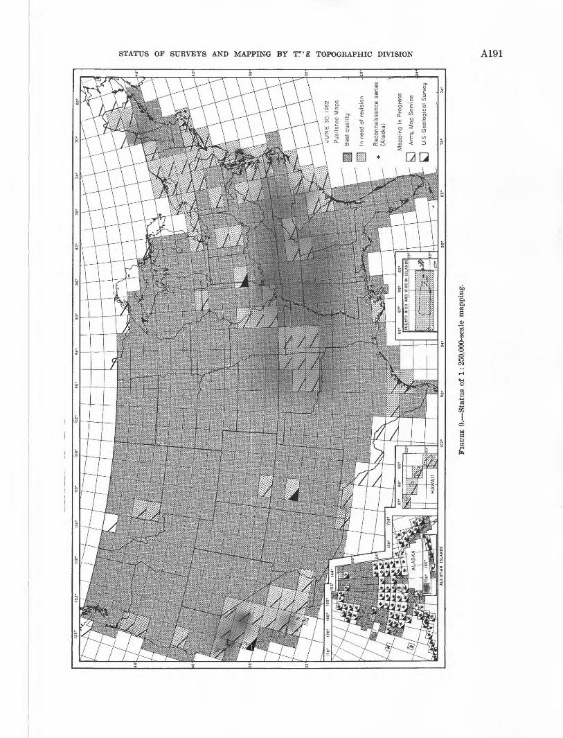
STATUS OF SURVEYS AND MAPPING BY T~E TOPOGRAPHIC DIVISION A191
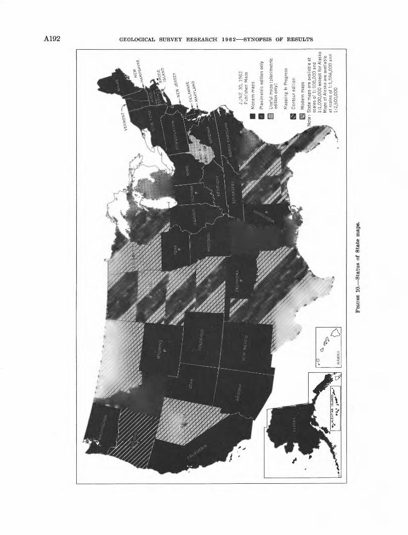
CO to
JUN
E
30,
1962
P
ublis
hed
Map
s
Mod
ern
map
s
Pla
nim
etr
ic e
ditio
n on
ly
Use
ful
map
s (p
lan
ime
tric
ed
ition
on
ly)
Map
ping
In
Pro
gres
s
Con
tour
ed
itio
n
Mod
ern
map
s
Sta
te m
aps
are
avai
labl
e at
sc
ales
of
1: 5
00,0
00 a
nd
1:1
,00
0,0
00
exc
ept
for
Ala
ska
Map
s of
Ala
ska'
are
ava
ilabl
e at
sca
les
of 1
:1,5
84
,00
0 a
nd
1:2
,50
0,0
00
H
FIGU
RE 1
0. S
tatu
s of
Sta
te m
aps.
STATUS OF SURVEYS AND MAPPING BY THE TOPOGRAPHIC DIVISION A193
National park maps, Maps of 43 of the 184 national parks, monuments, historic sites, and other areas administrated by the Na tional Park Service have been published. These usually are made by combining all existing quadrangle maps into one map sheet, but occasionally surveys are made covering only the park area. Published maps in this series include:Acadia National Park, MaineBandelier National Monument,
N. Mex.Black Canyon of the Gunnison
j National Monument, Oolo.Bryce Canyon National Park,
i UtahCanyon de Chelly National
| Monument, Ariz.Carlsbad Caverns National
I Park, N. Mex.Cedar Breaks National Monu
ment, UtahChicamauga and Chattanooga
| National Military Park, Ga.Colonial National Historical
Park (Yorktown), Pa.Colorado National Monument,
i Oolo.Crater Lake National Park
; and Vicinity, Oreg.(praters of the Moon National
Monument, Idaho Duster Battlefield, Mont.Devils Tower National Monu
ment, Wyo.Dinosaur National Monument,
Utah-ColoradoFranklin D. Roosevelt Na
tional Historic Site, N.Y.Glacier National Park, Mont.Grand Canyon National Monu
ment, Ariz.Grand Canyon National Park,
Ariz. (2 sheets)Grand Teton National Park,
Wyo.Great Sand Dunes National
i Monument, Colo.Great Smoky Mountains Na
tional Park, North Carolina and Tennessee (2 sheets)
Hot Springs and Vicinity, Ark.Isle Royale National Park,
Mich.Lassen Volcanic National
Park, Calif.Mammoth Cove National Park,
Ky.Mesa Verde National Park,
Oolo.Mount McKinley National
Park, AlaskaMount Rainier National Park,
Wash.Olympic National Park and Vi
cinity, Wash.Petrified Forest National Mon
ument, Ariz.Rocky Mountain National
Park, Oolo.Scotts Bluff National Monu
ment, Nebr.Sequoia and King's Canyon
National Parks, Calif.Shenandoah National Park,
Va. (2 sheets)Shiloh National Military Park,
Tenn.Vanderbilt Mansion National
Historic Site, N.Y.Vicksburg National Military
Park, Miss.Wind Cave National Park, S.
Dak.Yellowstone National Park,
Wyoming, Montana and Idaho
Yosemite National Park, Calif.Zion National Park (Kolob
Section), UtahZion National Park (Zion Can
yon Section), Utah
] Million-scale maps
The worldwide million-scale series of topographic quadrangle maps was originally sponsored by the In ternational Geographical Union and designated the In ternational Map of the World on the Millionth Scale (IMW). The conterminous United States will be cov ered by 53 maps, 17 of which were produced before 1955. At that time the Army Map Service began mili tary series at 1:1,000,000 scale. Eventually these AMS
maps will be modified slightly and published in the IMW series (fig. 11).
Two of the maps, Hudson River and San Francisco Bay, are no longer available as IMW but are covered by AMS maps. Both the IMW and AMS series are available for Mt. Shasta, Point Conception, Mississippi Delta (White Lake-AMS), Hatteras, Chesapeake Bay, and Boston. In addition, the American Geographical Society published the Sonora, Chihuahua, and Mon terrey maps, and Canada, the Regina and Montreal maps. Puerto Rico is covered by two maps, each com piled and published by the American Geographical Society and the Army Map Service.
NATIONAL ATLAS
In 1961 the Secretary of the Interior approved a recommendation of the National Academy of Sciences to have the Geological Survey undertake the produc tion of a national atlas. During 1962, arrangements have been completed with the Library of Congress for the loan of Arch C. Gerlach, Chief of the Map Division and Incumbent of the Chair of Geography at the Library of Congress, to serve for at least 2 years as the chief of the Geological Survey's atlas project. Work on the new atlas will continue under close coordination with other agencies, professional organizations, and authorities on atlases.
Studies are in progress to determine the most ap propriate organization, specifications, content, optimum sources of information, and most effective methods of presenting this information. Actual production opera tions will be started in fiscal year 1963.
GEOGRAPHIC NAMES
As part of normal mapping operations, fieldmen and editors investigate the names of places and natural fea tures appearing on topographic maps. The name in general use by local residents is accepted when such usage is unanimous and not in conflict with names ap pearing on previously published maps and publications. When a name conflict is discovered, the evidence gath ered during the field investigation, with the name rec ommended by the Geological Survey, is referred to the Board on Geographic Names for a decision.
The Board on Geographic Names, with the Secretary of the Interior, is responsible for maintaining uniform geographic nomenclature on Federal maps and publica tions. Problems concerning names in the United States and its possessions are handled by the Domestic Names Committee of this board. The Committee consists of one representative each from the Departments of Agri-
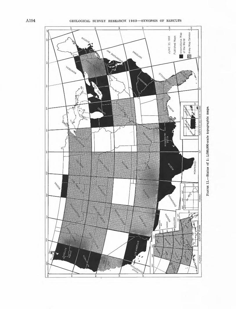
> I I CD
FIGU
RE 1
1. S
tatu
s of
1:1
,000
,000
-sca
le t
opog
raph
ic m
aps.

STATUS OF SURVEYS AND MAPPING BY THE TOPOGRAPHIC DIVISION A195
culture, Commerce, and Interior, and the Post Office Department and the Government Printing Office. Names approved by the Board on Geographic Names are published in decision lists issued three or more times each year and distributed to government agencies and the public free upon request.
Staff assistance to the Domestic Names Committee has been provided by the Geological Survey since 1958. The assistance includes background research on name questions and the preparation of decision lists for pub lication. Ten decision lists, containing a total of 4,929 approved names, have been published since 1958.
A196 GEOLOGICAL SURVEY RESEARCH 1962 SYNOPSIS OF RESULTS
HOW TO OBTAIN GEOLOGICAL SURVEY PUBLICATIONS
All book publications, maps, and charts published by the Survey are listed in "Publications of the Geo logical Survey," and in supplements, which keep the list up to date. New releases are announced each month in "New Publications of the Geological Survey." All of these lists of publications are free upon request to the GEOLOGICAL SURVEY, WASHINGTON 25, D.c. They may be consulted at many public and educational-institution libraries, and at the Geological Survey offices named below.
Books, maps, charts, and folios that are out of print can no longer be purchased from any official source. They may be consulted at many libraries, and some can be purchased from dealers in second-hand books.
ORDERING BOOK REPORTS
Professional papers, bulletins, water-supply papers and miscellaneous book publications can be purchased from the SUPERINTENDENT OF DOCUMENTS, GOVERNMENT PRINTING OFFICE, WASHINGTON 25, D.C. Prepayment is required and may be made by money order or check payable to that office, or in cash exact amount at sender's risk. Postage stamps are not accepted. Book publications also may be purchased on an over-the- counter basis from the following Geological SurveyOffices: 468 NEW CUSTOMHOUSE, DENVER, COLO. J 437 FED
ERAL BUILDING, SALT LAKE CITY, UTAH; 602 THOMAS
BUILDING, DALLAS, TEX.; 1031 BARTLETT BUILDING, LOS
ANGELES, CALIF.; 232 APPRAISERS BUILDING, SAN FRAN
CISCO, CALIF.; SOUTH 157 HOWARD ST., SPOKANE, WASH.;
and 503 CORDOVA BUILDING, ANCHORAGE, ALASKA.
Circulars may be obtained free on application to theGEOLOGICAL SURVEY, WASHINGTON 25, D.C.
ORDERING MAPS AND CHARTS
Maps, charts, folios, and hydrologic atlases are sold by the Geological Survey. Mail orders for those cover ing areas east of the Mississippi Kiver should be ad dressed to the GEOLOGICAL SURVEY, WASHINGTON 25, D.C.,and for areas west of the Mississippi River to the GEO LOGICAL SURVEY, FEDERAL CENTER, DENVER 25, COLO. Re-mittances should be sent by check or money order made payable to the Geological Survey or in cash exact amount at the sender's risk. Postage stamps are not accepted. Retail prices are quoted in lists of publica tions and, for topographic maps, in indexes to topo graphic mapping for individual states. On an order amounting to $10 or more at the retail price, 20 per
cent discount is allowed; on orders of $60 or more, 40 percent discount is allowed. These publications also may be obtained, on an area basis, by over-the-counter sale (but not by mail) from the other Geological Sur vey offices mentioned above. Residents of Alaska may order Alaska maps from the GEOLOGICAL SURVEY, 520ILLINOIS ST., FAIRBANKS, ALASKA. Most geologic HiapS
are available flat, or folded in envelopes. - The various types of maps and map products pre
pared by the Topographic Division are discussed in the section beginning on page A187.
Indexes to topographic-map coverage of the various States are released periodically and are free on appli cation. The release of revised indexes is announced in the monthly list of new publications of the Geological Survey. Each State index shows the areas mapped and gives lists of Geological Survey offices from which maps may be purchased and of local agents who sell the maps.
Advance material available from current topo graphic mapping is indicated on quarterly releases of State index maps. This material, including such items as aerial photography, geodetic-control data, and pre liminary maps in various stages of preparation and editing, is available for purchase. Information con cerning the ordering of these items is given on each State index. Requests for indexes or inquiries concern ing availability of advance materials should be di rected tO the MAP INFORMATION OFFICE, U.S. GEOLOGICAL SURVEY, WASHINGTON 25, D.C.
OPEN-FILE REPORTS
Open-file reports are a nonpermanent form of publication. They include unpublished manuscript reports, maps, and other material made available for public consultation and use. Arrangements can gen erally be made to reproduce them at private expense. The date and places of availability for consultation by the public are given in press releases or other forms of public announcement. In general, open-file reports are placed in one or more of the three Geological Sur vey libraries: ROOM 1033, GENERAL SERVICES BLDG.,WASHINGTON, D.C.; BLDG. 25, FEDERAL CENTER, DENVER,
COLO.; and 345 MIDDLEFIELD ROAD, MENLO PARK, CALIF. Other depositories may include one or more of the Geological Survey offices listed on page A128 to A132, or interested State agencies. Many open-file reports are replaced later by formally printed publications.
GEOLOGICAL SURVEY RESEARCH. 1962 SYNOPSIS OF RESULTS
PUBLICATIONS IN FISCAL YEAR 1962
A197
i Listed below are citations of technical reports not listed in either Professional Papers 400-A or of the Conservation, Geologic^ Topographic, and 424-A. It does not include a few articles that are Water Resources Divisions published or otherwise dated prior to July 1, 1962, but were released after released to the public during the fiscal year 1962. that date. The list also includes some publications that were
Abrahams, J. H., Jr., Baltz, E. H., Jr., and Purtymun, W. D., 1962, Movement of perched ground water in alluvium near Los Alamos, New Mexico: Art. 37 in U. S. Geol. Survey Prof. Paper 450-B, p. B93-B94.
Abrahams, J. H., Jr., Weir, J. E., Jr., and Purtymun, W. D., 1961, Distribution of moisture in soil and near-surface tuff on the Pajarito Plateau, Los Alamos County, New Mexico: Art. 339 in U. S. Geol. Survey Prof. Paper 424-D, p. D142-D145. /
Adams, J. K., and Boggess, D. H., 1962, Water-table, surface- drainage, and engineer ing soils map of the St. Georges area, Delaware: U. S. Geol. Survey open-file report.
Adams, J. W., and Young, E. J., 1961, Accessory bastnaesite in the Pikes Peak granite, Colorado: Art. 254 in U. S. Geol. Survey Prof. Paper 424-C, p. C292-C294.
Akin, P. D., Murray, C. R., and Theis,^ C. V., 1962, Five ground-water investigations for U. S. Army Airfield near Fort Sumner, New Mexico: New Mexico State Engineer, 16th-17th Bienn. Repts., July 1, 1942-June 30, 1946, p. 293-322.
Adler, Isidore, andDwornik, E. J., 1961, Electronprob&analysis of schreibersite (rhabdite) in the Cany on Diablo meteorite: Art. 112 in U. S. Geol. Survey Prof. Paper 424-B, p. B263- B265.
Adler, Isidore, andMassoni, C. J., 1962, SimpleX-Y translation stage and indexing mechanism: Rev. Sci. Instruments, v. 33, no. 2, p. 247.
Adolphson, D. G., 196la, Geology and ground-water resources of the Drake area, McHenry County, North Dakota: North Dakota State Water Conserv. Comm., North Dakota Ground - Water Study 14, 44 p.
196Ib, Glacial drift aquifers in the Cackle area, Logan and Stutsman Counties, North Dakota: North Dakota State Water Conserv. Comm., North Dakota Ground-Water Study 33, 16 p.
1962, Ground water in the Hatton area, Trailland SteeleCounties, North Dakota: North Dakota State Water Conserv. Comm., North Dakota Ground-Water Study 15, 23 p.
Akers, J. P., 1961, The geology of the central part of Apache County, Arizona A preliminary report: Arizona Geol. Soc. Digest, v. 4, p. 49-57.
1962, Relation of faulting to the occurrence of ground water in the Flagstaff area, Arizona: Art. 39 in U. S. Geol. Survey Prof. Paper 450-B, p. B97-B100.
Akers, J. P., Irwin, J. H., Stevens, P. R., and McClymonds, N. E., 1962, Geology of the Cameron quadrangle, Arizona, with a section on Uranium deposits, by W. L. Chenoweth: U. S. Geol. Survey Geol. Quad. Map GQ-162.
Akers, J. P., McClymonds, N. E., andHarshbarger, J. W., 1962, Geology and ground water of the Red Lake area, Navajo Indian Reservation, Arizona and New Mexico: U. S. Geol. Survey Water-Supply Paper 1576-B, p. B1-B12.
Albee, A. L., 1961, Boundary Mountain anticlinorium, west- central Maine and northern New Hampshire: Art. 168 in U. S. Geol. Survey Prof. Paper 424-C, p. C51-C54.
Albee, A. L., and Boudette, E. L., 1961, Preliminary geologic map of the Attean quadrangle, Somerset County, Maine: U. S. Geol. Survey open-file report.661513 O 62 14
Albers, J. P., 1961, Gold deposits in the French Gulch-Deadwood district, Shasta and Trinity Counties, California: Art. 147 in U. S. Geol. Survey Prof. Paper 424-C, p. C1-C4.
Albers, J. P., and Robertson, J. F., 1961, Geology and ore deposits of east Shasta copper-zinc district, Shasta County, California: U. S. Geol. Survey Prof. Paper 338, 107 p. [1962].
Albin, D. R., 1961, Ground water--The earth is a reservoir and an endless cycle keeps it supplied: Arkansas Gazette, Little Rock, Aug. 6, p. 2E.
1962a, Geologic section of Bradley, Calhoun, Ouachita, and part of Nevada Counties, Arkansas: Arkansas Acad. Sci. Proc. 1961, p. 38-54.
1962b, Special ground-water report number 1, Murfrees-boro area, Arkansas: U. S. Geol. Survey open-file report, 21 p.
Albritton, C. C., and Smith, J. F., Jr., 1957, The Texas linea ment: Internal. Geol. Cong., 20th, Mexico, D. F., 1956, [Trabajos], sec. 5, p. 501-518 [1961].
Alexander, W. H., Jr., 1961, Geology and ground-water re sources of the Northern High Plains of Texas, Progress Report No. 1: Texas Board Water Engineers Bull. 6109, 34 p.
Alien, C. R., Kamb, W. B., Meier, M. F., and Sharp, R. P., 1961, Structure of the lower Blue Glacier, Washington [abs.]: Internal. Assoc. Sci. Hydrology Pub. (Louvain, Belgium), no. 54, p. 545.
Allingham, J. W., 1961, Aeromagnetic interpretation of zoned intrusions in northern Maine: Art. 387 in U. S. Geol. Survey Prof. Paper 424-D, p. D265-D266.
Allingham, J. W., and Bates, R. G., 1961, Use of geophysical data to interpret geology in Precambrian rocks of central Wisconsin: Art. 394 in U. S. Geol. Survey Prof. Paper 424-D, p. D292-D296.
Allingham, J. W., and Zietz, Isidore, 1962, Geophysical data on the Climax stock, Nevada Test Site, Nye County, Nevada [abs.]: Soc. Explor. Geophysicists Yearbook 1962, p. 265-266.
Anders, R. B., and Baker, E. T., Jr., 1961, Ground-water geology of Live Oak County, Texas: Texas Board Water Engineers Bull. 6105, 119 p.
Anders, R. B., and Naftel, W. L., 1962, Pumpage of ground water and fluctuation of water levels in the Houston district and the Baytown-La Porte area, Texas, 1957- 1961: Texas Water Comm. Bull. 6211, 52 p.
Anderson, C. A., 1961, Activities of the Geologic Division, U. S. Geological Survey, in California: California Div. Mines, 57th Rept. State Mineralogist, p. 119-124.
Anderson, E. L, 1961, Errors in streamflow measurement: Art. 161 in U. S. Geol. Survey Prof. Taper 424-C, p. C37- C39.
Anderson, J. A., 1962a, Conservation activities of the Geological Survey as they pertain to leasable minerals: Interstate Oil Compact Comm., Comm. Bull., v. 4, no. 1, p. 1-11.
1962b, Oil and gas on Federal and Indian land--New Mexico and Four Corners: Am. PetroleumInst. Drilling and Production Practice 1961, p. 177-187.
A198 GEOLOGICAL SURVEY RESEARCH 1962 SYNOPSIS OF RESULTS
Anderson, L. A., 1961a, A remanent magnetometer and magnetic susceptibility bridge; Art. 282 in U. S. Geol. Survey Prof. Paper 424-C, p. C370-C372.
1961b, Overvoltage characteristics of a pyrite crystal: Art. 416 in U. S. Geol. Survey Prof. Paper 424-D, p. D362- D364.
Andreasen, G. E.,andKane,M. F., 1961, Isostatic compensation in the Sangre de Cristo Mountains, New Mexico: Art. 391 in U. S. Geol. Survey Prof. Paper 424-D, p. D277-D281.
Andreasen, G. E., Kane, M. F., and Zietz, Isidore, 1962, Aeromagnetic and gravity studies of the Precambrian in northeastern New Mexico: Geophysics, v. 27, no. 3, p. 343- 358.
Andreasen, G. E., and Petrafeso, Frank, 1962a, Aeromagnetic map of Georgetown and vicinity, east-central Texas: U. S. Geol. Survey open-file report.
1962b, Aeromagnetic map of the Llano uplift, Mason- Burnet area, central Texas: U. S. Geol. Survey open-file report.
Andreasen, G. E., and Pitkin, J. A., 1962, Aeromagnetic maps of the Twin Buttes area, Pima and Santa Cruz Counties, Arizona, flown at 500 feet above ground and flown at 4,000 feet barometric elevation: U. S. Geol. Survey open-file report, 2 sheets.
Andrews, D. A., Schoechle, G. L., and Brown, G. W., 1962, U. S. Geological Survey training program for foreign geologists [abs.]: Geol. Soc. America Spec. Paper 68, p. 128-129.
Annell, C. S., and Helz, A. W. t 1961, A constant-feed direct- current arc: U. S. Geol. Survey Bull. 1084-J, p. 231-251.
Antweiler, J. C., 1961, Methods for decomposing samples of silicate rock fragments: Art. 138 in U. S. Geol. Survey Prof. Paper 424-B, p. B322-B324.
Appel, C. A., 1962, Salt-water encroachment into aquifers of the Raritan formation in the Sayreville area, Middlesex County, New Jersey, with a section on a proposed tidal dam on the South River: U. S. Geol. Survey open-file report, 84 p.
Arad, Arnon, 1962, Bibliography on artificial recharge of ground water from 1954 through 1961, with a section on related subjects: U. S. Geol. Survey open-file report, 82 p.
Armstrong, C. A., and McMillion, L. G., 1961, Geology and ground-water resources of Pecos County, Texas: Texas Board Water Engineers Bull. 6106, v. l,229p.; v. 2, 295 p.
Arnold, R. G., and Reichen, L. E., 1962, Measurement of the metal content of naturally occurring, metal-deficient, hexagonal pyrrhotite by an X-ray spacing method: Am. Mineralogist, v. 47. nos. 1-2, p. 105-111.
Arnow, Ted, 196 la, Effects of phosphate mining on the ground water of Angaur, Palau Islands, Trust Territory of the Pacific Islands: U. S. Geol. Survey Water-Supply Paper 1608-A, p. A1-A39.
196Ib, Water-bearing properties of the rocks in the Arecibo-Barceloneta area, Puerto Rico: Art. 221 in U. S. Geol. Survey Prof. Paper 424-C, p. C201-C202.
Ash, S. R., 1961, Indians, ancient andmodern, in the Albuquer que country, in New Mexico Geol. Soc., Guidebook of the Albuquerque country, 12th Field Cont, Oct. 1961,p. 75-8L,
Ash, S. R., and Clebsch, Alfred, Jr., 1961, Cretaceous rocks in Lea County, New Mexico: Art. 338 in U. S. Geol. Survey Prof. Paper 424-D, p. D139-D142.
Ault, W. U., 1961, Isotopic geochemistry of sulfur [abs.]: Dissert. Abs., v. 22, no. 1, p. 227-228.
Ault, W. U., Richter, D. H., and Stewart, D. B., 1962, A temperature-measurement probe in the melt of Kilauea Iki lava lake, Hawaii [abs.]: Am. Geophys. Union, 43d Ann. Mtg., Washington, D. C., Apr. 1962, Program, p. 72.
Austin, C. R., 1960, Earthquake fluctuations in wells in NewJersey: New Jersey Dept. Conserv. and Econ. Develw
. Div. Water Policy and Supply, Water Resources Circ. 5,13 p. [1961].
Averitt, Paul, 1961, Coal reserves of the United States Aprogress report, January 1, 1960: U. S. Geol. SurveyBull. 1136, 116 p.
1962, Geology and coal resources of the Cedar Mountain quadrangle, Iron County, Utah: U. S. Geol. Survey Prof. Paper 389, 72 p.
Bachman, G. G.,1961, Pre-Pennsylvanian Paleozoic strati graphy, Mockingbird Gap quadrangle, New Mexico: Art. 51 in U. S. Geol. Survey Prof. Paper 424-B, p. B119-B122.
Back, William, 1961, Techniques for mapping of hydrochemical facies: Art. 423 in U. S. Geol. Survey Prof. Paper 424-D, p. D380-D382.
Back, William, and Barnes, Ivan, 1961, Equipment for field measurement of electrochemical potentials: Art. 280 hi U, S. Geol. Survey Prof. Paper 424-C, p. C366-C368.
Bailey, E. H., >962a, Mercury in the United States, exclusive of Alaska and Hawaii: U. S. Geol. Survey Mineral Inv. Re source Map MR-30.
1962b, Metamorphic facies of the Franciscan formationof California and their geologic significance [abs.]: Geol.Soc. America Spec. Paper 68, p. 4-5.
Bailey, E. H., Snavely, P. D. Jr., and White, D. E., 1961,Chemical analyses of brines and crude oil, Cymric field,Kern County, California: Art 398 in_U. S. Geol. Survey Prof.Paper 424-D, p. D306-D309.
Bailey, R. A., 1961, Hot springs and solfataric areas in theValles caldera, Jemez Mountains, New Mexico: U. S. Geol.Survey open-file report, [Map].
1962, Zones and zonal variations in ash flows of the Matahina Formation, North Island, New Zealand [abs.]: Internat. Symposium Volcanology, Tokyo, May, 1962, Sci. Council Japan, Abs., p. 2-3.
Baker, J. A., and Healy, H. G., 1961, Records and logs of selected wells and test holes, chemical analyses of water, and water levels in observation wells in the Wilmington- Reading area, Massachusetts: U. S. Geol. Survey open-file report, 196 p.
Baker, J. A., and Samuel, E. A., 1961, Wi 1mington-Reading area Records and logs of selected wells and test holes, chemical analyses of water, and water levels in observa tion wells in the Wilmington-Readingarea, Massachusetts: U. S. Geol. Survey Massachusetts Basic-Data Rept. 1, Ground-Water Ser., 50 p. (Prepared in coop, with Massa chusetts Dept. Public Works.)
Baker, J. A., and Petersen, R. G., 1962,Lowell area Records and logs of selected wells and test holes, records of selected springs, and chemical analyses of water in the Lowell area, Massachusetts: U. S. Geol. Survey Massachu setts Basic-Data Rept. 3, Ground-Water Ser., 28 p. (Pre pared in coop, with Massachusetts Dept. Public Works.)
Baldwin, E. M., 1961, Geologic map of the lower Umpqua River area, Oregon: U. S. Geol. Survey Oil and Gas Inv. Map OM-204.
Ballance, W. C., and others, 1962, Ground-water levels in New Mexico, 1960, with a section on Pecos Valley Artesian Conservancy District recorder wells, by P. D. Akki: U. S. Geol. Survey open-file report, 216 p.
Balsley, J. R., Jr., 1962a, Aeromagnetic map of the Oxbow quadrangle, Aroostook and Penobscot Counties, Maine: U. S. Geol. Survey Geophys. Inv. Map GP-289.
1962b, Aeromagnetic map of the Howe Brook quadrangle, Aroostook County, Maine: U. S. Geol. Survey Geophys. Inv. Map GP-290.
PUBLICATIONS IN FISCAL YEAR 1962 A199
Balsley, J. R., Jr., Meuschke, J. L.,andBlanchett, Jean, 1962, Aeromagnetic map of the Eagle Harbor quadrangle, Kewee- naw County, Michigan: U. S. Geol. Survey Geophys. Inv. Map GP-314.
Baltz, E. H., Jr., and Weir, J. E., Jr., 1961, A method of re cording and representing geologic features from large- diameter drill holes: Art. 137 in U. S. Geol. Survey Prof. Paper 424-B, p. B319-B321.
Baltzer, R. A., and Shen, John, 1961, Computation of homoge neous flows in tidal reaches by finite-difference method: Art. 162 in U. S. Geol. Survey Prof. Paper 424-C, p. C39- C41.
1962, Computation of flows in tidal reaches by finite- difference technique, in Natl. Coastal and Shallow Water Re search Conf., 1st, Oct. 1961, Proc.: Tallahassee, Florida, Natl. Sci. Found, and Office Naval Research, p. 258-264; abs., p. 75.
Barker, F. B., 1960, Determination of radioactive materials in water: Am. Soc. Testing Materials Spec. Tech. Pub. 273, p. 22-32.
Barker, F. B., and Scott, R. C., 1961, Uranium and radium in ground water from igneous terranes of the Pacific North west: Art. 128 in U. S. Geol. Survey Prof. Paper 424-B, p. B298-B299.
Barker, Fred, 1961a, Anthophyllite-biotite-hypersthene-rhodo- lite assemblage, Mason Mountain, North Carolina: Art. 270 in U. S. Geol. Survey Prof. Paper 424-C, p. C336-C338.
1961b, Cordierite hornfels from Litchfield, Connecticut: Art. 268 in U. S. Geol. Survey Prof. Paper 424-C, p. C331- C333.
1961c, Phase relations in cordierite-garnet-bearing Kinsman quartz monzonite and the enclosing schist, Love- well Mountain quadrangle, New Hampshire: Am. Mineral ogist, v. 46, nos. 9-10, p. 1166-1176.
Barnell, R. L., and DeLuca, F. A., 1961, Ground-water levels in Long Island. New York, 1958-1959: U. S. Geol. Survey open-file report, 66 p.
Barnes, D. F., 1961, Gravity low at Minto Flats, Alaska: Art. 383 in U. S. Geol. Survey Prof. Paper 424-D, p. D258- D259.
Barnes, D. F., Alien, R. W.,andBennett, H. F., 1961, Prelimi nary results of gravity surveys in Interior Alaska [abs.]: Alaskan Sci. Conf., llth, Anchorage, Aug. 29-Sept. 2, I960, Proc., p. 164-165.
Barnes, F. F., 1962a, Geologic map of lower Matanuska Valley, Alaska: U. S. Geol. Survey Misc. Geol. Inv. Map 1-359.
1962b, Topographic and geologic map of the Knob Creek area of the Wishbone Hill district, Matanuska coal field, Alaska: U. S. Geol. Survey Coal Inv. Map C-51.
Barnes, Harley, and Byers, F. M., Jr., 1961, Windfall forma tion (Upper Cambrian) of Nevada Test Site and vicinity, Nevada: Art 188 in U. S. Geol. Survey Prof. Paper 424-C, p. C103-C106.
Barnes, Harley, Houser, F. N., and Poole, F. G., 1961, Geolo gic map of Oak Spring quadrangle, Nye County, Nevada: U. S. Geol. Survey open-file report.
Barnes, Harley, and Palmer, A. R., 1961, Revision of strati- graphic nomenclature of Cambrian rocks, Nevada Test Site and vicinity, Nevada: Art. 187 in U. S. Geol. Survey Prof. Paper 424-C, p. C100-C103.
Barnes, Ivan, 1962, Geochemistry of Birch Creek, California [abs.]: Am. Geophys. Union, 43d Ann. Mtg., Washington, D. C., Apr. 1962, Program, p. 82.
Barnett, P. R., 1961, Spectrographic analysis for selected minor elements in Pierre shale: U. S. Geol. Survey Prof. Paper 391-B, p. B1-B10.
Barraclough, J. T., 1962, Ground-water resources of Seminole County, Florida: Florida Geol. Survey Rept. Inv. 27, 91 p.
Barraclough, J. T., and Marsh, O. T., 1962a, Aquifers and quality of ground water along the Gulf Coast of western Florida: U. S. Geol. Survey open-file report, 35 p.
1962b, Aquifers and quality of ground water along theGulf Coast of western Florida [abs.]: Geol. Soc. AmericaSpec. Paper 68, p. 131-132.
Barton, P. B., Jr., Bethke, P. M., and Toulmin, Priestley, 3d,1962, Equilibrium in sulfide deposits, I, Concepts [abs.]:Am. Mineralogist, v. 47, nos. 1-2, p. 185; Internal.Mineralog. Assoc., 3d Gen. Mtg., Washington, D. C., Apr.1962, Program, p. 185. \
Barton, P. B., Jr., and Toulmin, Priestley, 3d, 1961, Somemechanisms for cooling hydrothermal fluids: Art. 412 inU. S. Geol. Survey Prof. Paper 424-D, p. D348-D352.
Bateman, P. C., 1961a, Granitic formations in the east-centralSierra Nevada near Bishop, California: Geol. Soc. AmericaBull., v. 72, no. 10, p. 1521-1537.
196lb, Willard D. Johnson and the strike-slip component of fault movement in the Owens Valley, California, earth quake of 1872: Seismol. Soc. America Bull., v. 51, no. 4, p. 483-493.
Bates, R. G., 1962a, Airborne radioactivity surveys--A geologic exploration tool: Southeastern Geology, v. 3, no. 4,p. 221- 230.
1962b, Correlation of aeroradioactivity data and areal geology in eastern Tennessee and Kentucky [abs.]: Geol. Soc. America Spec. Paper 68, p. 65.
1962c, Natural gamma aeroradioactivity of the Oak Ridge National Laboratory area, Tennessee and Kentucky: U. S. Geol. Survey Geophys. Inv. Map GP-308.
Bayley, R. W., and Janes, W. W., 1961,Geochemical surveying for gold veins in the Atlantic district, Wyoming: Art. 405 in U. S. Geol. Survey Prof. Paper 424-D, p. D332-D333.
Beamer, N. H., 1962a, Chemical quality of water in Pennsyl vania streams, in Natl. Coastal and Shallow Water Re search Conf., 1st, Oct. 1961, Proc.: Tallahassee, Florida, Natl. Sci. Found, and Office Naval Research, p. 265.
1962b, Continuous recording of salinity in an estuary, in Natl. Coastal and Shallow Water Research Conf., 1st, Oct. 1961, Proc.: Tallahassee, Florida, Natl. Sci. Found, and Office Naval Research, p. 266-268; abs., p. 19.
Bean, R. K., 1962, U. S. Geological Survey camera calibrator [abs.]: Photogrammetric Eng., v. 28, no. 2, p. 346.
Beck, H. V., 1961, A buried valley northwest of Manhattan, Kansas: Art. 351 in U. S. Geol. Survey Prof. Paper 424-D, p. D182-D185.
Beckman, E. W., and Furness, L. W., 1962, Flow characteris tics of Elkhorn River near Waterloo,Nebraska:U.S. Geol. Survey Water-Supply Paper 1498-B, p. B1-B34.
Beckman, E. W., and Hutchison, N. E., 1962, Floods in Nebras ka on small drainage areas, magnitude and frequency :U. S. Geol. Survey Circ. 458, 33 p.
Bedinger,. M. S., 1961a, Arkansas' caves--They're a source of major interest to scientists and "spelunkers" alike: Arkan sas Gazette, Little Rock, June 18, p. 2E.
1961b, Relation between median grain size and perme ability in the Arkansas River valley, Arkansas: Art. 157 in U. S. Geol. Survey Prof. Paper 424-C, p. C31-C32.
Bedinger, M. S., and Jeffery, H. G., 1962, Ground water in the lower Arkansas River valley, Arkansas: U. S. Geol. Survey open-file report, 25 p.
Bedinger, M. S., and Sniegocki, R. T., 1961, Ground-water problems in Missouri: U. S. Geol. Survey open-file report, 16 p.
Bedinger, M. S., Stephens, J. W., and Edds, Joe, 1960, Decline of water levels in the Pine Bluff area: Arkansas Geol. and Conserv. Comm., Spec. Ground-Water Rept. 2, 10 p. [1962].
A200 GEOLOGICAL SURVEY RESEARCH 1962 SYNOPSIS OF RESULTS
Beikman, H. M., Gower, H. D., and Dana, T. A. M., 196].. Coal reserves of Washington: Washington State Div. Mines and Geology Bull. 47, 115 p.
Benninghoff, W. S., and Holmes, G. W., 1961, Preliminary report on Upper Cenozoic carbonaceous deposits in the Johnson River area, Alaska Range [abs.], in Raasch, G. O., ed., Geology of the Arctic; Internal. Symposium Arctic Geology, 1st, Calgary, Alberta, Jan. 1960, Proc., v. 1, Toronto, Ontario, Univ. Toronto Press, p. 599.
Benninghoff, W. S., Holmes, G. W., and Hopkins, D. M., 1961, Newly recovered Upper Tertiary non-marine sediments in Alaska [abs.], iri Raasch, G. O., ed., Geology of the Arctic: Internat. Symposium Arctic Geology, 1st, Calgary, Alberta, Jan. 1960, Proc., v. 1, Toronto, Ontario, Univ. Toronto Press, p. 598.
Benson, M. A., 1962, Evolution of methods for evaluating the occurrence of floods: U. S. Geol. Survey Water-Supply Paper 1580-A, p. A1-A29.
Berdan, J. M., 1961, Paleozoic families, in Moore, R. C., ed., Treatise on invertebrate paleontology, Pt. Q, ArthropodaS: Lawrence, Kansas, Geol. Soc. America and Univ. Kansas Press, p. Q122-Q123, Q207, Q371-Q373.
Berdan, J. M., and Sohn, I. G., 1961, Family Pachydomellidae Berdan & Sohn, n. fam., in Moore, R. C., ed., Treatise on invertebrate paleontology, Pt. Q, Arthropoda 3: Lawrence, Kansas, Geol. Soc. America and Univ. Kansas Press, p. Q373-Q374.
Berg, J. W., Jr., and Cook, K. L., 1962, Energies, magnitudes, and amplitudes of seismic waves from quarry blasts at Promontory and Lakeside, Utah [abs}; Geol. Soc, America Spec. Paper 68, p. 6-7.
Bergquist, H. R., 196la, Early Cretaceous (middleNeocomian) microfossils in south-central Alaska: Art. 374 in U. S. Geol. Survey Prof. Paper 424-D, p. D236-D237. ~~
1961b, Foraminiferal zonation in Matanuska formation. Squaw Creek-Nelchina River area, south-central Alaska: Am. Assoc. Petroleum Geologists Bull., v. 45, no. 12, p. 1994-2011.
Bermes, B. J., 1960, Applications of analog computing methods in hydrology [abs.]: Colorado River Water Users' Assoc., 17th Ann. Mtg., Las Vegas, Nevada, Dec. 1960, Proc., p. 55 [1961].
Bermes, B. J., Leve, G. W., and Tarver, G. R., 1962, Geology and ground-water resources of Flagler, Putnam, and St. Johns Counties, Florida: U. S. Geol. Survey open-file report, 131 p.
I962b, Ground-water records of Flagler, Putnam, and St. Johns Counties, Florida: U. S. Geol. Survey open-file report, 19 p.
Berryhill, H. L., Jr., 1961, Ash-flow deposits. Ciales quadran gle, Puerto Rico, and their significance; Art, 9.3 in U.S. Geol. Survey Prof. Paper 424-B, p. B224-B226.
1962, Lithology and tectonic implications of Upper Cre taceous clastic volcanic rocks, northeast Puerto Rico [abs.]: Caribbean Geol. Conf., 3d, Kingston, Jamaica, Apr. 2-11, 1962, Programme, p. 17-18.
Berwick, V. K., 1962, Floods in Utah, magnitude and frequency: U. S. Geol. Survey Circ. 457, 24 p.
Bethke, P. M., and Barton, P. B., Jr., 1961, Unit-cell dimen sions versus composition, .in the systems: Pbs-CdS, PbS-PbSe, ZnS-ZnSe, andCuFeS. -CuFeSe i 9Q : Art. 114 in U. S. Geol. Survey Prof. Papel- 424-B, p. B266-B270.
Bethke, P. M., Barton, P. B., Jr., and Toulmin,1 Priestley, 3d, 1962, Equilibrium in sulfide deposits, II, Natural assem blage [abs.]: Am. Mineralogist, v. 47, nos. 1-2, p. 185- 186; Internat. Mineralog. Assoc., 3d Gen. Mtg., Washington, D. C., Apr. 1962, Program, p. 185-186.
Bieber, P. P., 1961, Ground-water features of Berkeley and Jefferson Counties, West Virginia: West Virginia Geol. and Econ. Survey Bull. 21, 81 p.
Billingsley, G. A., 1962, Salt water encroachment in the estu aries and coastal streams in North Carolina, in Natl. Coastal and Shallow Water Research Conf., 1st, Oct. 1961, Proc.: Tallahassee, Florida, Natl. Sci. Found, and Office Naval Research, p. 268-270.
Bishop, E. W., and Dee, L. L., Jr., 1961, Rocks and minerals of Florida--A guide to identification, occurrence, produc tion and use: Florida Geol. Survey Spec. Pub. 8, 41 p.
Bjorklund, L. J., 1961, Semiannual report of water levels in selected observation wells in Utah, October 1961; U. S. Geol. Survey open-file report, 1 p.
Bjorklund, L. J., and Maxwell, B. W., 1961, Availability of ground water in the Albuquerque area, Bernalillo and Sandoval Counties, New Mexico: New Mexico State Engineer Tech. Rept. 21, 117 p.
Black, R. A., and Roller, J. C., 1961, Relation between gravity and structure of part of the western flank of the Black Hills, South Dakota and Wyoming: Art. 243 in U. S. Geol. Survey Prof. Paper 424-C, p. C260-C262.
Bodhaine, G. L., 1961, Cooperative highway programs, in Am. Assoc. State Highway Officials, Operating Comm. Design, Regional Conf., Aug. 1961, Papers: Boise, IdahoDept. High ways, 7 p., paged separately.
Boerngen, J. G., 1961, Table of common logarithms and their squares: U. S. Survey open-file report, 25 p. [1962].
Boggess, D. H., and Adams, J. K., 1962, Water-table, surface- drainage, and engineering soils map of the Newark area, Delaware: U. S. Geol. Survey open-file report.
Boggess, D. H., and Rima, D. R., 1961, Experiments in water spreading at Newark, Delaware: U. S. Geol. Survey open- file report, 27 p.
Bonilla, M. G., 1961, City College fault, San Francisco, Cali fornia: Art. 217 in U. S. Geol. Survey Prof. Paper 424-C, p. C190-C192.
Books, K. G., 1962a, Natural gamma aeroradioactivity of the Los. Angeles region, California: U. S. Geol. Survey Geophys. Inv. Map GP-309.
1962b, Remanent magnetism as a contributor to someaeromagnetic anomalies: Geophysics, v. 27, no. 3, p. 359-375.
Bowers, H. E., and Shawe, D. R., 1961, Heavy minerals asguides to uranium-vanadium ore deposits in the Slick Rockdistrict, Colorado: U. S. Geol. Survey Bull. 1107-B,p. 169-218.
Brabb, E. E., 1961, Reconnaissance of the Kandik and .NationRivers, east-central Alaska: Art. 90 in U. S. Geol. SurveyProf. Paper 424-B, p. B218.
1962, Preliminary geologic map of part of the Charley River quadrangle, east-central Alaska: U. S. Geol. Survey open-file report.
Brabb, E. E., Bowen, O. E., Jr., and Hart, E. W., 1962, Field trip 2, San Francisco to Monterey via California highways 1, 5, 17 and connecting routes, in Geologic guide to the gas and oil fields of northern California: California Div. Mines and Geology Bull. 181, p. 381-390.
Brabb, E. E., and Miller, D. J., 1962, Reconnaissance traverse across the Eastern Chugach Mountains, Alaska: U. S. Geol. Survey Misc. Geol. Inv. Map 1-341.
Bradley, Edward, 1961, Ground-water resources of south eastern New Hampshire: U. S. Geol. Survey open-file re port, 176 p.
Bradley, Edward, and Jensen, H. M., 1962, Test drilling near Beulah, Mercer County, North Dakota: North Dakota State Water Conserv. Comm., North Dakota Ground-Water Study 40, 19 p.
PUBLICATIONS IN FISCAL YEAR 1962 A201
Bradley, Edward, and Petersen, R. G., 1962, Southeastern area--Records and logs of selected wells and test holes,
I records of selected springs, chemical analyses of water, and water levels in observation wells in southeastern New Hampshire: U. S. Geol. Survey New Hampshire Basic-Data Rept. 1, Ground-Water Ser., 53 p. (Prepared in coop, with New Hampshire Water Resources Board.)
Bradley, W. H., 1961, Geologic map of part of southwestern Wyoming and adjacent States; U. S. Geol. Survey Misc. Geol. Inv. Map 1-335.
> 1962a, Chloroplast in Spirogyra. from the Green River formation of Wyoming: Am. Jour. Sci., v. 260, no. 6, p. 455-459.
1962b, Esper Signius Larsen, 3d (1912-1961) [Memorial]:Geol. Soc. America Bull., v. 73, no. 4, p. P35-P37.
Bramkamp, R. A., Gierhart, R. D., Owens, L. D., and Ramirez,L. F., 1962, Geographic map of the western Rub al Khali
! quadrangle, Kingdom of Saudi Arabia: U. S. Geol. SurveyJ Misc. Geol. Inv. Map I-218B..Bramkamp, R. A., and Ramirez, L. F., 1961, Geology of the
[ northeastern Rub Al Khali quadrangle, Kingdom of Saudi I Arabia: U. S. Geol. Survey Misc. Geol. Inv. Map 1-214A.
^ranson, F. A., Miller, R. F., and McQueen,!. S., 1961a, Soil- moisture storage characteristics and infiltration rates as indicated by annual grasslands near Palo Alto, California: Art. 76 in U. S. Geol. Survey Prof. Paper 424-B, p. B184- B186.
196lb, Soil-water availability and use by grasslands on adjacent stony and shale-derived soils in Colorado: Art. 239 in U. S. Geol. Survey Prof. Paper 424-C, p. C251-C253.
1962, Effects of contour furrowing, grazing intensity, and soils on infiltration rates, soil moisture, and vegetation near Fort Peck, Montana: Jour. Range Management, v. 15, no. 3.
Breger, I. A., [1961], Preliminary studies of coalified wood associated with uranium on the Colorado Plateau, in Nova Scotia Dept. Mines and Nova Scotia Research Found., 3d Conf. Origin and Constitution of Coal, Circle Cliffs, June 20-22, 1956, p. 356-380; discussion, p. 380-385.
Brew, D. A., 1961a, Lithologic character of the Diamond Peak formation (Mississippian) at the type locality, Eureka and White Pine Counties, Nevada: Art. 190 in U.S. Geol. Survey Prof. Paper 424-C, p. C110-C112.
196 Ib, Relation of Chainman shale to Bold Bluff thrust fault, southern Diamond Mountains, Eureka and White Pine Counties, Nevada: Art. 191 in U. S. Geol. Survey Prof. Paper 424-C, p. C113-C115.
Briggs, R. P., 196la, Geology of Kewanee Interamerican Oil Company test well number 4 CPR, northern Puerto Rico, iri Oil and gas possibilities of northern Puerto Rico: San Juan, P. R., Puerto Rico Mining Comm., p. 1-23.
196lb, Preliminary geologic map of Puerto Rico and adjacent islands: U. S. Geol. Survey open-file report.
1962, The blanket sands of northern Puerto Rico [abs.]: Caribbean Geol. Conf., 3d, Kingston, Jamaica, Apr. 2-11, 1962, Programme, p. 18.
Brobst, D. A., 1961, Geology of the Dew ey quadrangle, Wyoming- South Dakota: 4 U. S. Geol. Survey Bull. 1063-B,p.J3-60 [1962].
Brock, M. R.,andHeyl, A. V.,Jr., 1961, Post-Cambrian igneous rocks of the central craton, western Appalachian Mountains and Gulf Coastal Plain of the United States: Art. 306 in U. S. Geol. Survey Prof. Paper 424-D, p. D33-D35.
Broeker, M. E. ,and Fishel, V. C., 1961, Ground-water levels in observation wells in Kansas, 1960: Kansas Geol. Survey Bull. 153, 183 p.
Bromery, R. W,, 1961, Preliminary interpretation of aeromag- netic data in the Allentown quadrangle, in Pennsylvania Geologists, 26th Mtg., Oct. 1961, Guidebook, p. 37-40.
1962a, Aeromagnetic map of the Grand Lake Seboeis quadrangle, Aroostook and Penobscot Counties, Maine: U. S. Geol. Survey Geophys. Inv. Map GP-288.
1962b, Aeromagnetic map of part of the Shin Pond quadrangle, Penobscot County, Maine: U. S. Geol. Survey Geophys. Inv. Map GP-292.
1962c, Preliminary interpretation of an aeromagneticmap of the Albany-Newport area, Oregon: U. S. Geol. Sur vey open-file report, 12 p.
Bromery, R. W., Natof, N. C., and others, 196la, Aeromagne tic map of the Middletown quadrangle, Dauphin, Lancaster, Lebanon, and York Counties, Pennsylvania; U. S. Geol. Survey Geophys. Inv. Map GP-269.
196 Ib, Aeromagnetic map of the Gettysburg quadrangle and part of the Taneytown quadrangle, Adams County, Pennsylvania: U. S. Geol. Survey Geophys. Inv. Map GP- 284.
196lc, Aeromagnetic map of the McSherrystown quadran gle and part of the Littlestown quadrangle, Adams County, Pennsylvania: U. S. Geol. Survey Geophys. Inv. Map GP-285.
196 Id, Aeromagnetic map of the Hanover quadrangle and part of the Manchester quadrangle, Adams and York Counties, Pennsylvania: U. S. Geol. Survey Geophys. Inv. Map GP-286. x
196le, Aeromagnetic map of the Seven Valleys quadrangle and part of the Lineboro quadrangle, York County, Pennsylvania: U. S. Geol. Survey Geophys. Inv. Map GP- 287.
Bromery, R. W., White, B. L., and others, 1961, Aeromagnetic map of part of the Fairfield quadrangle and part of the Emmitsburg quadrangle, Adams County, Pennsylvania, and Frederick County, Maryland: U. S. Geol. Survey Geophys. Inv. Map GP-283.
Bromery, R. W., Zandle, G. L., and others, 196la, Aeromag netic map of part of the Alburtis quadrangle, Lehigh, Berks, and Northampton Counties, Pennsylvania: U. S. Geol. Sur vey Geophys. Inv. Map GP-266.
196lb, Aeromagnetic map of part of the Hummelstown quadrangle, Dauphin County, Pennsylvania: U. S. Geol. Survey Geophys. Inv. Map GP-267.
196lc, Aeromagnetic map of part of the Palmyra quad rangle, Dauphin and Lebanon Counties, Pennsylvania:U.S. Geol. Survey Geophys. Inv. Map GP-268.
1961d, Aeromagnetic map of the York quadrangle, York County, Pennsylvania: U. S. Geol. Survey Geophys. Inv. Map GP-270.
196le, Aeromagnetic map of the Red Lion quadrangle, York County, Pennsylvania: U. S. Geol. Survey Geophys. Inv. Map GP-271.
196lf, Aeromagnetic map of the Glen Rock and part of the New Freedom quadrangles, York County, Pennsylvania: U. S. Geol. Survey Geophys. Inv. Map GP-272.
196lg, Aeromagnetic map of part of the Bernville ; quadrangle, Berks County, Pennsylvania: U. S. Geol. Sur
vey Geophys. Inv. Map GP-273. 196lh, Aeromagnetic map of part of the Mechanicsburg
quadrangle, Cumberland and York Counties, Pennsylvania: U. S. Geol. Survey Geophys. Inv. Map GP-274.
196li, Aeromagnetic map of the New Cumberland quad rangle, Cumberland, Dauphin, and York Counties, Pennsyl vania: U. S. Geol. Survey Geophys. Inv. Map GP-275.
A202 GEOLOGICAL SURVEY RESEARCH 1962 SYNOPSIS OF RESULTS
Bromery, R. W., Zandle, G. L., and others, 1961 j, Aeromag- netic map of part of the Mount Holly Springs quadrangle, Adams, Cumberland and York Counties, Pennsylvania: U. S. Geol. Survey Geophys. Inv. Map GP-276.
1961k, Aeromagnetic map of part of the Dillsburg quad rangle, Adams, York, and Cumberland Counties, Pennsyl vania: U. S. Geol. Survey Geophys. Inv. Map GP-277.
19611, Aeromagnetic map of part of the Arendtsville quadrangle, Adams and Cumberland Counties, Pennsylva nia; U. S. Geol. Survey Geophys. Inv. Map GP-278.
1961m, Aeromagnetic map of the Biglerville quadrangle. Adams County, Pennsylvania: U. S. Geol. Survey Geophys. Inv. Map GP-279.
196ln, Aeromagnetic map of the Hampton quadrangle, Adams and York Counties, Pennsylvania: U. S. Geol. Survey Geophys. Inv. Map GP-280.
1961o, Aeromagnetic map of the Abbottstown quadrangle, Adams and York Counties, Pennsylvania: U. S. Geol. Survey Geophys. Inv. Map GP-281.
196lp, Aeromagnetic map of the West York quadrangle,
Counties, Texas; U. S. Geol. Survey Geophys. Inv. Map GP-24.9.
1961b, Preliminary aeroradioactivity and geologic map
York County, Pennsylvania: U. S. Geol. Survey Geophys. Inv. Map GP-282.
Bromfield, C. S., 1961, Emplacement of the Wilson Peak stock and associated intrusive rocks, San Miguel Mountains, Colorado: Art. 198 in U. S. Geol. Survey Prof. Paper 424-C, p. C137-C139.
Bromfield, C. S., andWrucke, C. T., 1961, Reconnaissance geo logic map of the Cedar Mountains, Grant and Luna Counties, New Mexico: U. S. Geol. Survey Mineral Inv. Field Studies Map MF-159.
Brookhart, J. W., and Powell, J. E., 1961, Reconnaissance of geology and ground water of selected areas in North Dakota--Areas of investigation, Rolla-St. John area and Mylo area, Rolette County; Minto-Forest River area, Walsh County; Powers Lake area, Burke County; Maddock area,
,. Benson County; Hunter area, Cass County: North Dakota State Water Conserv. Comm., North Dakota Ground-Water Study 28, 91 p.
Brosge", W. P., and Reiser, H. N., 1962a, Geologic map of the Chandalar quadrangle, Alaska: U. S. Geol. Survey open-file report.
1962b, Preliminary geologic map of the Christian quad rangle, Alaska: U. S. Geol. Survey open-file report.
Brown, Andrew, 1961a, Geologic investigations of radioactive deposits, 1942-1960--A bibliography of U. S. Geological Survey publications on the geology of radioactive deposits: U. S. Geol. Survey Rept. TEI-777, 86 p. (Report prepared for U. S. Atomic Energy Commission.)
1961b, Geology and the Gettysburg campaign: GeoTimes, v. 6, no. 1, p. 8-12.
Brown, C. E., 1961, Prehnite-Pumpellyite metagraywacke facies of Upper Triassic rocks, Aldrich Mountains, Oregon: Art. 201 in U. S. Geol. Survey Prof. Paper 424-C, p. C146- C147.
Brown, D. W., 1961, Water resources of Brevard County, Florida: U. S. Geol. Survey open-file report, 183 p.
Brown, D. W., Kenner, W. E., Crooks, J. W., and Foster, J. B., 1962, Water-resource records of Brevard County, Florida: Florida Geol. Survey Inf. Circ. 32, 180 p.
Brown, Eugene, Brennan, Robert, and Porterfield, G., 1962, Investigations of water along the California coast by the U. S. Geological Survey, in Natl. Coastal and Shallow Water Research Conf., 1st, Oct. 1961, Proc.: Tallahassee, Florida, Natl. Sci. Found, and Office Naval Research, p. 270-271; abs., p. 78.
Brown, R. D., Jr., Eargle, D. H., and Moxham, R. M., 1961a, Preliminary aeroradioactivity and geologic map of the Falls City NW quadrangle, Atascosa, Karnes, and Wilson
of the Falls City NE quadrangle, Karnes and Wilson Counties, Texas: U. S. Geol. Survey Geophys. Inv. Map GP-250.
Brown, R. D., Jr., and Rich, E. I., 1961, Geologic map of the Lodoga quadrangle, Glenn and ColusaCounties, California: U. S. Geol. Survey Oil and Gas Inv. Map OM-210.
Brown, R. H., 1962, Hydrologic factors pertinent to ground- water contamination, in U. S. Public Health Service, 1961 Symposium on Ground-water Contamination: Robert A. Taft Sanitary Eng. Center Tech. Rept. W61-5, p. 7-16.
Browne, R. G., and Herrick, S. M., 1962, Smaller Paleocene Foraminifera from Reidland, Kentucky [abs.]: Geol. Soc. America Spec. Paper 68, p. 142.
Bryant, B. H., and Reed, J. C., Jr., 1961, The Stokes and Surry Counties quartzite area, North Carolina--A window?: Art. 316 in U. S. Geol. Survey Prof. Paper 424-D, p. D61-D63.
1962, Structural and metamorphic history of the Grand father Mountain area, North Carolina A preliminary re port: Am. Jour. Sci., v. 260, no. 3, p. 161-180.
Bryant, D. L., and McClymonds, N. E., 1961, Permian Concha limestone and Rainvalley formation, southeastern Arizona; Am. Assoc. Petroleum Geologists Bull., v. 45, no. 8,, p. 1324-1333.
Buddington, A. R., and Baker, D. R., 1961, Geology of the Franklin and part of the Hamburg quadrangles, New Jersey: U. S. Geol. Survey Misc. Geol. Inv. Map 1-346.
Bull, W. B., 196la, Alluvial fans and near-surface subsidence, western Fresno County, California: U. S. Geol. Survey open-file report, 285 p.; abs., Dissert. Abs., v. 22, no. 10, p. 3602-3603.
1961b, Causes and mechanics of near-surface subsidence in western Fresno County, California Art. 77 in_ U. S. Geol. Survey Prof. Paper 424-B, p. B187-B189.
1961c, Tectonic significance of radial profiles of alluvial fans in western Fresno County, California: Art. 75 in U. S. Geol. Survey Prof. Paper 424-B, p. B182-B184.
1962a, Effect of stream-channel shape on alluvial-fan deposition in western Fresno County, California [abs.]: Geol. Soc. America Spec. Paper 68, p. 11-12.
1962b, Erosion of the Arroyo Ciervo drainage basin in western Fresno County, California [abs.]: Jour. Geophys. Research, v. 67, no. 4, p. 1630; Am. Geophys. Union, 1st Western Natl. Mtg., Los Angeles, California, Dec. 1961, Program, p. 53.
1962c, Relations of alluvial-fan size and slope to drain age-basin size and lithology in western Fresno County, California: Art. 19 in U. S. Geol. Survey Prof. Paper 450-B, p. B51-B53.
1962d, Relation of textural (CM) patterns todepositionalenvironment of alluvial-fan deposits: Jour. Sed. Petrology, v. 32, no. 2, p. 211-216.
Bumgarner, J. G., Ricketts, J. E., Houston, P. K., and Wedow, Helmuth, Jr., 1962, Habit of the Rocky Valley thrust fault in the West New Market area, Mascot-Jefferson City zinc district, Tennessee [abs.]: Geol. Soc. America Spec. Paper 68, p. 66.
Bunker, C. M., and Bradley, W. A., 1961, Measurement of bulk density of drill core by gamma-ray absorption: Art. 134 in U. S. Geol. Survey Prof. Paper 424-B, p. B310-B313.
Burbank, W. S., and Luedke, R. G., 1961, Origin and evolution of ore and gangue-forming solutions, Silverton caldera, San Juan Mountains, Colorado: Art 149 in U. S. Geol. Sur vey Prof. Paper 424-C, p. C7-C11.
PUBLICATIONS IN FISCAL YEAR 1962 A203
Burchard, E. F., 1961, Russellville brown iron ore district, Franklin County, Alabama, with Introduction and annota tions, by H. D. Pallister: Alabama Geol. Survey Bull. 70, 96 p.
Burger, T. C., 1961, Use of the elevation meter in topographic surveying: Surveying and Mapping, v. 21, no. 4,p. 481-485.
Busch, W. F., and Shaw, E. C., 1961, Floods in Pennsylvania, frequency and magnitude: U. S. Geol. Survey open-file report, 231 p.
Bush, A. L., Bromfield, C. S., Marsh, O.T., and Taylor, R. B., 1961, Preliminary geologic map of the Gray Head quadran gle, San Miguel County, Colorado: U. S. Geol. Survey Mineral Inv. Field Studies Map MF-176.
Butler, A. P., Jr., 1961, Ratio of thorium to uranium in some plutonic rocks of the White Mountain plutonic-volcanic series, New Hampshire: Art. 31 in U.S. Geol. Survey Prof. Paper 424-B, p. B67-B69.
Butler, A. P., Jr., Finch, W. I., and Twenhofel, W. S., 1962, Epigenetic uranium in the United States, exclusive of Alaska and Hawaii: U. S. Geol. Survey Mineral Inv. Re source Map MR-21.
Byers, F. M., Jr., 1962, Porosity, density, and water content data on tuff of the Oak Spring formation from the U12e tunnel system, Nevada Test Site, Nye County, Nevada: U. S. Geol. Survey Rept. TEI-811, open-file report, 27 p. (Report prepared for U. S. Atomic Energy Commission.)
Byers, F. M., Jr., Barnes, Harley, Poole, F. G., and Ross, R. J., Jr., 1961, Revised subdivision of Ordoviciansystem at the Nevada Test Site and vicinity, Nevada: Art. 189 in U. S. Geol. Survey Prof. Paper 424-C, p. C106-C110.
Cadigan, R. A., 1962, Geologic interpretation of grain-size dis tribution measurements of Colorado Plateau sedimentary rocks--A reply: Jour. Geology, v. 70, no. 3, p. 376-378. (Reply to discussion by W. F. Tanner, p.375-376.)
Cady, W. M., Albee, A. L., and Murphy, J. F., 1962, Bedrock geology of the Lincoln Mountain quadrangle, Vermont: U. S. Geol. Survey Geol. Quad. Map GQ-164.
Caldwell, D. W., 1962, Description, composition, and tenor of unconsolidated sediments in monazite-bearing tributaries to the Savannah and Saluda Rivers in the western Piedmont of South Carolina: U. S. Geol. Survey open-file report, 19 p.
Calkins, F. C., and Peck, D. L., 1962, Granitic rocks of the Yosemite Valley area, California, in Geologic guide to the Merced Canyon and Yosemite Valley . . .: California Div. Mines and Geology Bull. 182, p. 17-24.
Callaghan, Eugene, and Parker, R. L., 196la, Geologic map of part of the Beaver quadrangle, Utah: U. S. Geol. Survey Mineral Inv. Field Studies Map MF-202.
1961b, Geology of the Monroe quadrangle, Utah: U. S. Geol. Survey Geol. Quad. Map GQ-155.
1962a, Geology of the Delano Peak quadrangle, Utah: U. S. Geol. Survey Geol. Quad. Map GQ-153.
1962b, Geology of the Sevier quadrangle, Utah: U.S. Geol.Survey Geol. Quad. Map GQ-156.
Callahan, J. T., 1962, The yield of sedimentary aquifers of theCoastal Plain river basins in the southeastern Stales[abs.]: Geol. Soc. America, Southeastern Sec., Ann. Mtg.,Atlanta, Georgia, Apr. 1962, Program, p. 13.
Campbell, lan, and Loofbourow, J. S., Jr., 1962, Geology of themagnesite belt of Stevens County, Washington: U. S. Geol.Survey Bull. 1142-F, p. F1-F53.
Campbell, R. H., 196la, Thrust faults in the southern LisburneHills, northwest Alaska: Art. 354 in U. S. Geol. Survey Prof.Paper 424-D, p. D194-D196.
196 Ib, Transfer of geologic data from aerial photographsto topographic maps by direct tracing: Art. 281 in U. S.Geol. Survey Prof. Paper 424-C, p. C368-C370.
Canney, F. C., 1961, Geochemical study of soil contamination in the Coeur d'Alene district, Shoshone County, Idaho: Am.. Inst. Mining, Metall., and Petroleum Engineers Trans. 1959, p. 214.
Canney, F. C., Ward, F. N., and Bright, M. J., Jr., 1961, Molybdenum content of glacial drift related to molybdenite- bearing bedrock, Aroostook County, Maine: Art. 117 in U. S. Geol. Survey Prof. Paper 424-B, p. B276-B278.
Cannon, H. L., 1959, Advances in botanical methods of pros- pecting for uranium in western United States, in Garcfa Rojas, A., Symposium de exploracidn geoqufmica, Tomo2: Internal. Geol. Gong., 20th, Mexico, D. F., 1956, p. 235- 241 [1962].
1961, Botanical prospecting for ore deposits: Virginia Minerals, v. 7, no. 1, p. 1-11. (Reprinted from Science, v. 132, no. 3427, p. 591-598, 1960.)
1962, Botanical methods of prospecting for ore deposits:The Green Thumb, v. 19, no. 6, p. 186-188.
Carlson, J. E., 1961, Geology of the Montfortand Linden quad rangles, Wisconsin: U. S. Geol. Survey Bull. 1123-B,p. 95- 138 [1962].
Carlston, C. W., 1961, Bomb tritium in the hydrologic cycle [abs.]: Jour. Geophys. Research, v. 66, no. 8,p. 2518; Am. Geophys. Union, 42d Ann. Mtg., Washington, D. C., Apr. 1961, Program, p. 72.
1962, Drainage density and stream flow [abs.]: Geol. Soc.America Spec. Paper 68, p. 145-146.
Carr, W. J., and Trimble, D. E., 1961, Upper Paleozoic rocksin the Deep Creek Mountains, Idaho: Art 213 in U. S. Geol.Survey Prof. Paper 424-C, p. C181-C184.
Carrigan, P. H., Jr., 1961, River surveys for nuclear powerplants: Nuclear Safety, v. 3, no. 2, p. 60-65.
Carroll, Dorothy, 1961, Mineralogy of micaceous laminae insandstones of Paleozoic age in Florida: Art. 400 in U. S.Geol. Survey Prof. Paper 424-D, p. D311-D316.
1962, Mica in silty sandstones of Paleozoic age in Florida [abs.]: Geol. Soc. America Spec. Paper 68, p. 67.
Carron, M. K., and Cuttitta, Frank, 1962, Determination of silica in tektites and similar glasses by volatilization: Art. 30 in U. S. Geol. Survey Prof. Paper 450-B, p. B78- B79. -
Carron, M. K., and Lowman, P. D., Jr., 1961, Analysis of a supposed clay fulgurite from Ontario: Nature (London), v. 190, no. 4770, p. 40.
Carswell, L. D., and Bennett, G. D., 1962, Geology and hydrol ogy of the Neshannock quadrangle in northwest Pennsyl vania: U. S. Geol. Survey open-file report, 197 p.
Carter, R. W., 1961, Magnitude and frequency of floods in subur ban areas: Art. 5 in U. S. Geol. Survey Prof. Paper 424-B, p. B9-B11.
1962, Summary of research activities relating to coastal shallow water, in Natl. Coastal and Shallow Water Research Conf., 1st, Oct. 1961, Proc.: Tallahassee, Florida, Natl. Sci. Found, and Office Naval Research, p. 272-275.
Carter, W. D., P<§rez, E., and Aliste, N., 1961, Definition and age of Patagua formation, Province of Aconcagua, Chile: Am. Assoc. Petroleum Geologists Bull., v. 45, no. 11, p. 1892-1896.
Case, J. E., and Joesting. H. R., 196l,Precambrian structures in the Blanding basin and Monument upwarp, southeast Utah: Art. 393 in U. S. Geol. Survey Prof. Paper 424-D, p. D287-D291.
1962, Northeast-trending Precambrian structures inthe central Colorado Plateau [abs.]: Geol. Soc. AmericaSpec. Paper 68, p. 85.
Cashion, W. B., 1961a, Geology and fuels resources of theOderville-Glendale area, Kane County, Utah: U. S. Geol.Survey Coal Inv. Map C-49.
A204 GEOLOGICAL SURVEY RESEARCH 1962 SYNOPSIS OF RESULTS
Cashion, W. B., 1961b, Potential oil-shale reserves of the GreenRiver formation in the southeastern Uinta Basin, Utah andColorado: Art. 154in_U.S. Geol. Survey Prof. Paper 424-C,p. C22-C24.
Castle, R. O., 1962, Problems in engineering geology in thenorthwest Los Angeles basin [abs.]: Geol. Soc. AmericaSpec. Paper 68, p. 13-14.
Cattermole, J. M., 1962, Geology of the Maryville quadrangle.Tennessee: U. S. Geol. Survey Geol. Quad. Map GQ-163.
Causey, L. V,^ 1961, Ground-water resources of Etowah County,Alabama A reconnaissance: Alabama Geol. Survey Inf.Ser. 25, 63 p.
Cederstrom, D. J., 196la, Ground-water hydrology in Alaska,in Raasch, G. O., ed., Geology of the Arctic: Internal.Symposium Arctic Geology, 1st, Calgary, Alberta, Jan.1960, Proc., v. 2, Toronto, Ontario, Univ. Toronto Press,p. 1014-1019.
196lb, Origin of a salt-water lens in permafrost atKotzebue, Alaska: Geol. Soc. America Bull., v. 72, no. 9,p. 1427-1431.
196lc, Some uses of the sodium-adsorption-ratio diagram: Art. 422 in U. S. Geol. Survey Prof. Paper 424-D, p. D379-D380.
Chamberlain, J. E., 1961, Mountain-climbing motor scooters: Surveying and Mapping, v. 21, no. 2, p. 210.
Chao, E. C. T., 1961, Progress and outlook of geology, in Sciences in Communist China: Am. Assoc. Adv. Sci. Pub. 68, p. 497-522.
1962, Coesite, in McGraw-Hill Yearbook of Science and Technology: New York, New York, McGraw-Hill Book Co., Inc., p. 169-171.
Chao, E. C. T., Adler, Isidore, Dwornik, E. J., and Littler, Janet, 1962, Metallic spherules in tektites from Isabela, Philippine Islands: Science, v. 135, no. 3498, p. 97-98.
Chao, E. C. T., Fahey, J. J., Littler, Janet, and Milton, D. J., 1962, Stishovite, Si02, a very high pressure new mineral from Meteor Crater, Arizona: Jour. Geophys. Research, v. 67, no. 1, p. 419-421; [abs.]: same, no. 4, p. 1631.
Chao, E. C. T., and Littler, Janet, 1962, The petrography of impactites and tektites [abs.]: Am. Geophys. Union, 43d Ann. Mtg., Washington, D. C., Apr. 1962, Program,p. 110- 111.
Chapman, R. M., and Cooley, E. F., 1962, Semiquantitative spectrographic analyses of sediment samples from streams in Alaska [abs.]: Geol. Soc. America Spec. Paper 68, p. 112- 113; Alaskan Sci. Conf., 12th, College, Aug. 28-Sept. 1, 1961, Proc., p. 144-146.
Chapman, R. M., and Sable, E. G., I960, Geology of the Utukok- Corwin region, northwestern Alaska: U. S. Geol. Survey Prof. Paper 303-C, p. 47-167 [1961].
Chappars, M. S., and Bloom, Barbara, 1961, Subject-author index, Pt. 1 of Index, Journal of Paleontology, V. 1-25, 1927-1951: Soc. Econ. Paleontologists and Mineralogists Spec. Pub. 8, p. 3-65.
Chase, G. H., 1962, Artesian aquifers of the Denver basin, Colorado [abs.]: Geol. Soc. America Spec. Paper 68, p. 310.
Chase, G. H., Burtis, V. M., and Major, T. J., 1962, Records, logs, and water-level measurements of selected wells and test holes, description of the physical properties of repre sentative formation materials, and chemical analyses of ground water in Kit Carson County, Colorado; contains records of selected wells in northern Lincoln County, Colorado: Colorado Water Conserv. Board [Ground-Water Ser.] Basic-Data Rept. 10, 69 p.
Chew, R. T., 3d, and Mitten, H. T., 1962, Geochemical prospect ing in northwest Montana [abs-.]: Geol. Soc. America Spec. Paper 68, p. 85-86.
Chidester, A. H., and Shride, ,A. F., 1962, Asbestos in the United States, exclusive of Alaska and Hawaii: U. S. Geol. Survey Mineral Inv. Resource Map MR-17.
Chidester, A. H.,'and Worthington, H. W., 1961, Talc and soap- stone in the United States: U. S. Geol. Survey open-file report. [Map.]
Chodos, A. A., and Engel, C. G., 1961, Fluorescent X-ray spectrographic analyses of amphibolite rocks and constit uent hornblendes: Denver Univ., Denver Research Inst. Indus. Applications X-ray Analysis, 9th Ann. Conf., Denver, Colorado, Aug. 10-12, 1960, Proc., p. 401-413; Advances in X-ray Analysis, V. 4, New York, New York, Plenum Press, p. 401-413.
Clark, L. D., 1962a, Origin and tectonic orientation of rock- fragment lineations in the western Sierra Nevada metamor- phic belt, California [abs.]: Geol. Soc. America Spec. Paper 68, p. 150.
1962b, Summary of the pre-Tertiary geology of the west ern Sierra Nevada metamorphic belt, California, in Geologic guide to the Merced Canyon and Yosemite Valley . . .: California Div. Mines and GeologyBull., 182,p. 15-16.
Clark, L. D., Imlay, R. W., McMath, V. E., and Silberling, N. J., 1962, Angular unconformity between Mesozoic and Paleozoic rocks in the northern Sierra Nevada, California: Art. 6 in U. S. Geol. Survey Prof. Paper 450-B, p. B15- B19.
Clark, W. E., Musgrove, R. H.,Menke,C. G., and Cagle, J. W., 1962, Interim report on the water resources of Alachua, Bradford, Clay, and Union Counties, Florida: U. S. Geol. Survey.open-file report, 105 p.
Clarke, J. W., Vitaliano, D. B., Neuschel, V. S., and others, 1961a, Geophysical Abstracts 185, April-June 1961: U. S. Geol. Survey Bull. 1146-B, p. 171-350.
196lb, Geophysical Abstracts 186, July-September 1961: U. S. Geol. Survey Bull. 1146-C, p. 351-530 [1962].
1961c, Index to Geophysical Abstracts 180-183, 1960:U. S. Geol. Survey Bull. 1116-E, p. 637-695.
Clarke, R. S., Jr., andCarron.M. K., 1961, Comparison of tek- tite specimens from Empire, Georgia, and Martha's Vine yard, Massachusetts: Smithsonian Misc. Colln., v. 143, no. 4, L8 p.; abs., Jour. Geophys. Research, v. 66, no. 8, p. 2520; Am. Geophys. Union, 42d Ann. Mtg., Washington, D. C., Apr. 1961, Program, p. 55.
Clebsch, Alfred, Jr., 1961, Tritium-age of ground water at the Nevada Test Site, Nye County, Nevada: Art. 194 in U. S. Geol. Survey Prof. Paper 424-C, p. C122-C125.
Cloud, P. E., Jr., 1962, Pre-metazoan evolution [abs.]: Geol. Soc. America Spec. Paper 68, p. 153.
Cloud, P. E., Jr., and Abelson, P. H., 1961, Woodring confer ence on major biologic innovations and the geologic record: Natl. Acad. Sci. Proc., v. 47, no. 11, p. 1705-1712.
Coats, R. R., 1961, Magma type and crustal structure in the ^Aleutian arc [abs.]: Pacific Sci. Gong., 10th, Honolulu,
Hawaii, Aug. 21-Sept. 6, 1961, Abs. Symposium Papers, p. 390.
Coats, R. R., Nelson, W. H., Lewis, R. Q., and Powers, H. A., 1961, Geologic reconnaissance of Kiska Island, Aleutian Islands, Alaska: U. S. Geol. Survey Bull. 1028-R, p. 563- 581.
Cobb, E. H., 1962, Lode gold and silver occurrences in Alaska: U. S. Geol. Survey Mineral Inv. Resource Map MR-32.
Cobb, E. H., and Kachadoorian, Reuben, 1961, Index of metallic and nonmetallic mineral deposits of Alaska compiled from published reports of Federal and State agencies through 1959: U. S. Geol. Survey Bull. 1139, 363 p.
Cobban, W, A., 1961, The ammonite family Binneyitidae Ree- side in the western interior of the United States: Jour. Paleontology, v. 35, no. 4, p. 737-758.
PUBLICATIONS IN FISCAL YEAR 1962 A205
Cobban, W. A., 1962, New baculites from the Bearpaw shale and equivalent rocks of the Western Interior: Jour. Paleon-
I tology, v. 36, no. 1, p. 126-135.Cobban, W. A., Scott, G. R., and Gill, J. R., 1962, Recent dis
coveries of the Cretaceous ammonite Haresiceras and their stratigraphic significance: Art. 22 in U. S. Geol. Survey Prof. Paper 450-B, p. B58-B60.
Coffay, E. W., 1962, Throughfall in a forest: Internal. Assoc. Sci. Hydrology Bull. (Louvain, Belgium), 7e anne"e, no. 2, p. 10-16.
Cohen, Philip, 196la, A preliminary evaluation of the ground- water hydrology of the valley of the Humboldt River, near Winnemucca, Nevada A summary: Nevada Water Conf., 15th, Carson City, Sept. 28-29, 1961, Proc., p. 1-7 [1962].
- 196lb, An evaluation of uranium as a tool for studying the hydrogeochemistry of the Truckee Meadows area, Nevada: Jour. Geophys. Research, v. 66, no. 12, p. 4199-
i 4206.- 196lc, Specific yield of sediments of the Humboldt River
Valley, Humboldt County, Nevada: Art. 164 in U. S. Geol. Survey Prof, Paper 424-C, p. C43-C45.
* 1962a, Estimating porosity from specific gravity: Art. 15 in U. S. Geol. Survey Prof. Paper 450-B, p. B41-B43.
* 1962b, Ground Water Branch: Nevada Dept. Conserv., Humboldt River Research Project, 3d Prog. Rept.,p. 9-13.
1962c, Hydrogeologic evidence of the extension of the East Range fault, Humboldt and Pershing Counties, Nevada: Art. 4 in U. S. Geol. Survey Prof. Paper 450-B, p. B9-B11.
i 1962d, Preliminary results of hydrogeologic investiga tions in the valley of the Humboldt River near Winnemucca, Nevada: U. S. Geol. Survey open-file report, 124 p.
" 1962e, Relation of surface water to ground water in Humboldt River valley near Winnemucca, Nevada [abs.]: Geol. Soc. America Spec. Paper 68, p. 153-154.
Colbert, J. L., 1961, Review of waterpower withdrawals in McKenzie River basin, Oregon: U. S. Geol. Survey open- file report, 31 p.
Colby, B. R., 1961, Effect of depth of flow on discharge of bed material: U. S. Geol. Survey Water-Supply Paper 1498-D, p. D1-D12.
Cole, W. S., 196la, An analysis of certain taxonomic problems in the larger Foraminifera: Bulls. Am. Paleontology, v. 43, no. 197, p. 373-407.
< 196lb, Names of and variation in certain Indo-Pacific earnerinids--No. 2, a reply: Bulls. Am. Paleontology, v. 43, no. 195, p. 111-128.
i 196lc, Some nomenclatural and stratigraphic problems involving larger Foraminifera: Cushman Found. Foram. Research Contr., v. 12, pt. 4, p. 136-147.
1962, Embryonic chambers and the subgenera of Lepido- cyclina: Bulls. Am. Paleontology, v. 44, no. 200, p. 29-60.
Cole, W. S., and Applin, E. R., 1961, Stratigraphic and geo graphic distribution of larger Foraminifera occurring in a well in Coffee County, Georgia: Cushman Found. Foram. Research Contr., v. 12, pt. 4, p. 127-135.
Coleman, R. G., and Erd, R. C., 1961, Hydrozircon from the Wind River formation, Wyoming: Art. 256 in U. S. Geol.
, Survey Prof. Paper 424-C, p. C297-C300.Coleman, R. G., and Lee, D. E., 1962, Metamorphic aragonite
in the glaucophane schists of Cazadero, California [abs.]: Geol. Soc. America Spec. Paper 68, p. 16.
Collier, C. R., and others, 1962, Influence of strip mining on the hydrologic environment of parts of Beaver Creek basin, Kentucky: U. S. Geol. Survey open-file report, 276 p.
Collins, F. R., 1961, Core tests and test wells, Barrow area,, Alaska, with a section on Temperature measurement stud ies, by M. C. Brewer: U. S. Geol. Survey Prof. Paper 305-K, p. 569-644.
Colton, G. W., 1962, Geologic summary of the Appalachian Basin, with reference to the subsurface disposal of radio active waste solutions: U. S. Geol. Survey Rept. TEI-791, open-file report, 121 p. (Report prepared for U.S. Atomic Energy Commission.)
Colton, R. B., 1962, Geology of the Otter Creek quadrangle, Montana: U. S. Geol. Survey Bull. 1111-G, p. 237-288.
Colton, R. B., and Cushman, R. V., 1962, Lacustrine features in north-central Connecticut [abs.]: Geol. Soc. America Spec. Paper 68, p. 155.
Colton, R. B., Lemke, R. W.,andLindvall,R. M., 1961, Glacial map of Montana east of the Rocky Mountains: U. S. Geol. Survey Misc. Geol. Inv. Map 1-327.
Conant, L. C., ed., 1962, Excursion to Yugoslavia, May 12-16, 1962: Petroleum Explor. Soc. Libya, 83 p.
Conant, L. C., and Swanson, v. E.. 1961, Chattanooga shale and related rocks of central Tennessee and nearby areas: U. S. Geol. Survey Prof. Paper 357, 91 p.
Condon, W. H., 1961, Geology of the Craig quadrangle, Alaska: U. S. Geol. Survey Bull. 1108-B, p. B1-B43 [1962].
Conley, J. F., 1961, Geology of the pyrophyllite deposits at Glendon, Moore County, North Carolina [abs.]: Elisha Mitchell Sci. Soc. Jour., v. 77, no. 2, p. 110-111.
Conover, C. S., 1961a, Ground water in the arid and semi-arid zone--Its source, development, and management, in Ground water in arid zones: Internal. Assoc. Sci. Hydrol. Pub. (Louvain, Belgium), no. 57, p. 513-529.
196 Ib, Ground-water resources--Development and man agement: Western Resources Conf. [2d], Ground-Water Sec., Boulder, Colorado, Aug. I960, Paper, 11 p.; also pub lished as U. S. Geol. Survey Circ. 442.
Conover, C. S., Reeder, H. O., and Willett, J. R., 1962, Sum mary of changes in water levels in observation wells, 1942 to 1946, New Mexico: New Mexico State Engineer, 16th-17th Bienn. Repts., July 1, 1942-June 30, 1946, p_ 369-390.
Cook, K. L., andBerg, J. W., Jr., 1961, Regional gravity survey along the central and southern Wasatch Front, Utah: U. S. Geol. Survey Prof-. Paper 316-E, p. 75-89.
Cooley, M. E., 1962, Late Pleistocene and Recent erosion and alluviation in parts of the Colorado River system, Arizona and Utah: Art. 18 in u' S. Geol. Survey Prof. Paper 450-B, p. B48-B50.
Cooley, M. E,, and Akers, J. P., 1961a, Ancient erosional cycles of the Little Colorado River, Arizona and New Mexico: Art. 237 in U. S. Geol. Survey Prof. Paper 424-C, p. C244-C248.
196lb, Late Cenozoic geohydrology in the central and southern parts of Navajo and Apache Counties, Arizona: Arizona Geol. Soc. Digest, v. 4, p. 69-77.
Cooley, M. E., and Hardt, W. F., 1961, The relation of geology to hydrology in the Segi Mesa area, Utah and Arizona: Arizona Geol. Soc. Digest, v. 4, p. 59-68.
Cooper, H. H., Jr., 1961, Type curves for nonsteady radial flow in an infinite leaky aquifer [abs.]: Jour. Geophys. Research, v. 66, no. 8, p. 2522; Am. Geophys. Union, 42d Ann. Mtg., Washington, D. C., Apr. 1961, Program, p. 72.
1962a, Investigation of coastal ground water by theU. S. Geological Survey, in Natl. Coastal and Shallow Water Re search Conf., 1st, Oct. 1961, Proc.: Tallahassee, Florida, Natl. Sci. Found, and Office Naval Research, p. 275-277.
1962b, The movements of sea water in coastal aquifers,in Natl. Coastal and Shallow Water Research Conf., 1st, Oct. 1961, Proc.: Tallahassee, Florida, Natl. Sci. Found, and Office Naval Research, p. 277-280; abs., p. 43.
Cooper, J. B., 1960, Ground water in the Causey-Lingo area, Roosevelt County, New Mexico: New Mexico State Engineer Tech. Rept. 14, 51 p.
A206 GEOLOGICAL SURVEY RESEARCH 1962 SYNOPSIS OF RESULTS
Cooper, J. B., 1962a, Ground-water investigations of the Project Gnome area, Eddy and Lea Counties, New Mexico: U. S. Geol. Survey Kept. TEI-802, open-file report, 67 p. (Report prepared for U. S. Atomic Energy Commission.)
1962b, Note on post-Rustler red beds of Permian age of southeast New Mexico and west Texas: Art. 9 in U. S. Geol. Survey Prof. Paper 450-B, p. B24-B26.
1962c, Observations of water levels during the Gnome event: U. S. Atomic EnergyComm. Rept. PNE-130P,p. 14- 19. (Report prepared for U. S. Atomic Energy Commission by U. S. Geological Survey for Project Gnome.)
1962d, Road log from Carlsbad, New Mexico, to Project Gnome site: U. S. Geol. Survey open-file report, 10 p.
1962e, Test holes drilled in support of ground-water in vestigations, Project Gnome, Eddy County, New Mexico-- Basic data report: U. S. Geol. Survey Rept. TEI-786, open- file report, 116 p. (Report prepared for U. S. Atomic Energy Commission.)
Cooper, J. R., 1961, The turkey-track porphyry--A possible guide for correlation of Miocene rocks in southeastern Arizona: Arizona Geol. Soc. Digest, v. 4, p. 17-33.
1962, Bismuth in the United States, exclusive of Alaskaand Hawaii: U. S. Geol. Survey Mineral Inv. Resource MapMR-22.
Cordova, R. M., 1961, Our high Ouachitas were once part of aprehistoric inland sea bottom: Arkansas Gazette, LittleRock, Dec. 17, p. 4E.
1962, Well records, depth-to-water measurements and logs of selected wells and test holes, and chemical analy ses of ground water in the Arkansas Valley region, Arkan sas: U. S. Geol. Survey open-file report, 233 p.
Cornwall, H. R., and Kleinhampl, F. J., 1961a, Geology of the Bare Mountain quadrangle, Nevada: U. S. Geol. Survey Geol. Quad. Map GQ-157 [1962].
196lb, Preliminary geologic map and sections of the Bullfrog quadrangle, Nevada-California: U. S. Geol. Survey Mineral Inv. Field Studies Map MF-177.
Corwin, Gilbert, 1961, Volcanic suite of Pagan, Marianas Is lands: Art. 223 in U. S. Geol. Survey Prof. Paper 424-C, p. C204-C206.
Coskery, O. J., 1961a, Water levels in Delaware, 1957: Delaware Geol. Survey Water-Level Rept. 6, 22 p.
1961b, Water levels in Delaware, 1958: Delaware Geol. Survey Water-Level Rept. 7, 17 p.
1961c, Water-level report no. 8--Water levels in Dela ware in 1959: U. S. Geol. Survey open-file report, 44 p.
1962, Water levels in Delaware in 1961:U.S. Geol. Survey open-file report, 46 p.
Cosner, O. J., 1962, Ground water in the Wupatki and Sunset Crater National Monuments, Coconino County, Arizona: U. S. Geol. Survey Water-Supply Paper 1475-J, p. 357-374.
Coulter, H. W., and Coulter, E. B., 1961, Geology of the Valdez (A-5) quadrangle, Alaska: U. S. Geol. Survey Geol. Quad. Map GQ-142.
Counts, H. B., and Donsky, Ellis, 1961, Salt-water encroach ment, geology, and ground-water resources of Savannah area, Georgia and South Carolina: U. S. Geol. Survey open- file report, 189 p.
Cox, Allan, and Doell, R. R., 1961, Palaeomagnetic evidence relevant to a change in the Earth's radius: Nature (London), v. 189, no. 4758, p. 45-46; discussion by S. W. Carey and reply by authors, v. 190, no. 4770, p. 36-37.
1962a, Paleomagnetism of historic lava eruptions on Hawaii [abs.]: Jour. Geophys. Research, v. 67, no. 4, p. 1633; Am, Geophys. Union, 1st Western Natl. Mtg., Los Angeles, California, Dec. 1961, Program, p. 37-38.
1962b, Preliminary paleomagnetic results from Hawaii [abs.]: Geol. Soc. America Spec. Paper 68, p. 156.
Cox, E. R., and Reeder, H. O., 1962, Ground-water conditions in the Rio Grande Valley between Truth or Consequences and Las Palomas, Sierra County, New Mexico: New Mexico State Engineer Tech. Rept. 25, 47 p.
Cragwall, J. S., Jr., and Poole, J. L., 1961, General water situation in Tennessee, in Tennessee Water Resources Conf., Knoxville, May 1961, Proc.: Univ. Tennessee Bur. Public Adm., p. 38-50.
Craig, F. C., 1961, Tide-affected flow of Sacramento River at Sacramento, California: Art. 214 in U. S. Geol. Survey Prof. Paper 424-C, p. C184-C186.
Craig, L. C., Ekren, E. B., Houser, F. N., Shawe, D. R., Simmons, G. C., and Katich, P. J., Jr., 1961, Dakota group of Colorado Plateau [discussion]: Am. Assoc. Petroleum Geologists Bull., v. 45, no. 9, p. 1582-1590.
Crandell, D. R., and Varnes, D. J., 1961, Movement of the Slumgullion earthflow near Lake City, Colorado: Art. 57 in U. S. Geol. Survey Prof. Paper 424-B, p. B136-B139.
Crandell, H. C., 1961, Geology and ground-water resources of the town of Southold, Suffolk County, New York: U. S. Geol. Survey open-file report, 59 p.
1962, Geology and ground-water resources of PlumIsland, Suffolk County, New York: U. S. Geol. Survey Water-Supply Paper 1539-X, p. X1-X35.
Crary, A. P., Field, W. O., andMeier,M. F., 1962, The UnitedStates glaciological researches during the InternationalGeophysical Year: Jour. Glaciology (Cambridge, England),v. 4, no. 31, p. 5-24.
Cressler, C. W., 1962a, Geology and ground-water resourcesof the Paleozoic rock area, Chatooga County, Georgia: U. S.Geol. Survey open-file report, 41 p.
1962b, Geology and ground-water resources of Walker County, Georgia: U. S. Geol. Survey open-file report, 54 p.
Crittenden, M. D., Jr., 1961a, Isostatic deformation of Bonne- ville shorelines: U. S. Geol. Survey open-file report, 4 p.
1961b, Magnitude of thrust faulting in northern Utah: Art. 335 in U. S. Geol. Survey Prof. Paper 424-D, p. D128- D131.
Crittenden, M. D., Jr., and Pavlides, Louis, 1962, Manganese in the United States, exclusive of Alaska and Hawaii: U. S. Geol. Survey Mineral Inv. Resource Map MR-23.
Crittenden, M. D., Jr., Straczek, J. A., and Roberts, R. J., 1961, Manganese deposits in the Drum Mountains, Juab and Millard Counties, Utah: U. S. Geol. Survey Bull. 1082-H, p. 495-544.
Croft, M. G., 1961, Geology and ground-water resources of Dade County, Georgia: U. S. Geol. Survey open-file report, 56 p.
Cronin, J. G., 1961, A summary of the occurrence and develop ment of ground water in the Southern High Plains of Texas: Texas Board Water Engineers Bull. 6107, 85 p.
Cserna, Zoltan de, and Kent, B. H., 1961, Mapa geologico de reconocimiento y secciones estructurales de la regi6n de San Bias y El Fuerte, Estados deSinaloay Sonora: Mexico Univ. Nac. Inst. Geologfa Cams Geol. y Mineras, no. 4.
Culbertson, W. C., 1961, Stratigraphy of the Wilkins Peak mem ber of the Green River formation, Firehole Basin quadran gle, Wyoming: Art. 348 in U. S. Geol. Survey Prof. Paper 424-D, p. D170-D173.
Culler, R. C., 1961, Hydrology of stock-water reservoirs in upper Cheyenne River basin: Chap. A in U. S. Geol. Survey Water-Supply Paper 1531, p. 1-136.
Culler, R. C., Hadley, R. F., andSchumm,S. A., 1961, Hydrol ogy of the upper Cheyenne River basin: U. S. Geol. Survey Water-Supply Paper 1531, 198 p. (Contains two chapters.
PUBLICATIONS IN FISCAL YEAH 1962 A207
each cited separately under Culler, R. C., and Hadley R. F.)
Cummings, J. C., Touring, R. M., and Brabb, E. E., 1962, Geology of the northern Santa Cruz Mountains, California, in Geologic guide to the gas and oil fields of northern California: California Div. Mines and Geology Bull. 181, p. 179-220.
Cuppels, N. P., 1961, Post-Carboniferous deformation of meta- morphic and igneous rocks near the Northern Boundary fault, Boston Basin, Massachusetts: Art. 310 inU. S. Geol. Survey Prof. Paper 424-D, p. D46-D48.
1962, Geologic environment of an oxidized uranium de posit in the Black Hills of South Dakota: U. S. Geol. Survey Bull. 1063-C, p. 61-83.
Cushman, R. V., 1961, Ground-water resources of north-central Connecticut: U. S. Geol. Survey open-file report, 274 p.
Cuttitta, Frank, 1961, Dithizone mixed-color method for de termining small amounts of thallium in manganese ores; Art. 290 in U. S. Geol. Survey Prof. Paper 424-C, p. C384- C385.
Cuttitta, Frank, Carron, M. K., and Chao, E. C. T., 1962, New Chemical data on Texas tektites--!. Major elements [abs.]:
_4,nj, Geophys. Union, 43d Ann. Mtg., Washington, D. C., Apr. 1962, Program, p. 110.
Cuttitta, Frank, and Warr, J. J., 1961, Use of bathophenanthro- line for determining traces of iron in zircon: Art. 289 in U. S. Geol. Survey Prof. Paper 424-C, p. C383-C384.
Dalrymple, Tate, 1961a, Cooperative highway programs, in Am. Assoc. State Highway Officials, Operating Comm. Design, Regional Conf., Aug. 1961, Papers: Boise, Idaho Dept. Highways, p. 1-7, paged separately.
1961b, Cooperative programs of the United States Geological Survey and State Highway Departments, in Bridge Eng. Conf., 2d Ann., Prop.: Fort Collins, Colorado State Univ., p. 41-54.
1962, Flood, in McGraw-Hill Yearbook of Science andTechnology: New York, New York, McGraw-Hill Book Co.,Inc., p. 224-226.
Dane, C. H., 1961a, John Bernard Reeside, Jr., June 24, 1889-July 2, 1958 [Memorial]: Natl. Acad. Sci. Biog. Mem.,v. 35, p. 272-291.
1961b,The La Ventana-Chacro Mesa coal field [abs.],Pt. 3 of Geology and fuel resources of the southern partof the San Juan Basin, New Mexico, in New Mexico Geol.Soc., Guidebook of the Albuquerque country, 12th FieldConf., Oct. 1961, p. 129-130.
Dane, C. H., and Bachman, G. O., 1961, Preliminary geologicmap of the southwestern part of New Mexico: U. S. Geol.Survey Misc. Geol. Inv. Map 1-344.
Danilchik, Walter, 1961, The iron formations of the Surgharand western Salt Ranges, Mianwali district, West Pakistan:Art. 371 in U. S. Geol. Survey Prof. Paper 424-D, p. D228-D231.
Darling, J. M., 1962, Maryland streamflow characteristics:Maryland Dept. Geology, Mines and Water ResourcesBull. 25, 136 p.
Davidian, Jacob, and Benson, M. A., 1961, Distance betweenbasins versus correlation coefficient for annual peak dis charge of streams in New England: Art. 33 in U. S. Geol.Survey Prof. Paper 424-B, p. B71-B72.
Davidian, Jacob, Carrigan, P. H., Jr., and Shen, John, 1962,Flow through openings in width constrictions: U. S. Geol.Survey Water-Supply Paper 1369-D, p. 91-122.
Davidian, Jacob, and Carter, R. W., 1961, Discussion of"Roughness spacing in rigid open channels," by W. W.Sayre and M. L. Albertson (Am. Soc. Civil Engineers Proc.,v. 87, Jour. Hydraulics Div., no. HY 3, pt. 1, p. 121-150):
Am. Soc... Civil Engineers Proc., v. 87, Jour. Hydraulics Div., no. HY 6, pt. 1, p. 267-269.
Davidson, D. F., and Lakin, H. W., 1961, Metal content of some black shales of the western United States: Art. 267 in U. S. Geol. Survey Prof. Paper 424-C, p. C329-C331.
1962, Metalliferous shales in the United States [abs.]: Geol. Soc. America Spec. Paper 68, p. 18.
Davidson, E. S., 1961, Facies distribution and hydrology of intermontane basin fill, Safford basin, Arizona: Art. 204 in U. S. Geol. Survey Prof. Paper 424-C, p. C151-C153.
1962, Origin of sediments in the intermontane Safford basin, Graham County, Arizona [abs.]: Geol. Soc. America Spec. Paper 68, p. 18.
Davies, W. E., 196la, Arctic terrain research for low cost airfield sites--History and results: U. S. Air Force Cambridge Research Labs., Geophysics Research Directo rate Kept. AFCRL 436, or Research Note 55, p. 8-14.
1961b, Glacier caves in Svartisen, Norway: Natl. Speleol. Soc. Bull., v. 23, pt. 2, p. 75-76.
1961c, Polygonal features on bedrock, North Greenland: Art. 366 in U. S. Geol. Survey Prof. Paper 424-D, p. D218- D219.
1961d, Surface features of permafrost in arid areas, inRaasch, G. O., ed., Geology of the Arctic: Internal. Sympo sium Arctic Geology, 1st, Calgary, Alberta, Jan. 1960, Proc., v. 2, Toronto, Ontario, Univ. Toronto Press, p. 981- 987.
Davis, M. E., 1961, Ground-water reconnaissance of theMarfa area, Presidio County, Texas: Texas Board Water Engi neers Bull. 6110, 37 p.
Davis, R. E., Williams, W. P., Johnson, R. B., and Emerick, W. L., 1961, Preliminary results of a survey for thick high-calcium limestone deposits in the United States, with a section on Possible Alaskan sites for nuclear reaction experiment in limestone, by G. D. Eberlein: U. S. Geol. Survey Rept. TEI-780, open-file report, 45 p. (Report prepared for U. S. Atomic Energy Commission.)
Davis, R. O., 1961, Report of the Topographic Division, U. S. Geological Survey: Nevada Water Conf., 15th, Carson City, Sept. 28-29, 1961, Proc., p. 119-120 [1962].
Dawdy, D. R., 1961, Variation of flood ratios with size of drain age area: Art. 160inU. S. Geol.Survey Prof. Paper 424-C, p. C36-C37.
DeBuchananne, G. D., 1962, The well driller's position in a national emergency: Water Well Jour., v. 16, no. 5, p. 37- 39, 60.
DeBuchananne, G. D., and LaMoreaux, P. E., 1962, Geologic controls related to ground-water contamination, in U. S. Public Health Service, 1961 Symposium on Ground-water Contamination: Robert A. Taft Sanitary Eng. Center Tech. Rept. W61-5, p. 3-7; Water Well Jour., v. 16, no. 3, p. 40- 44.
Decker, R. W., 1962, Magnetic studies onKilauealki lava lake, Hawaii [abs.]: Internat. Symposium Volcanology, Tokyo, May 1962, Sci. Council Japan, Abs., p. 6-7.
DeCook, K. J., 1961, A reconnaissance of the ground-water resources of the Marathon area, Brewster County, Texas: Texas Board Water Engineers Bull. 6111, 45 p.
Dempsey, W. J., 1962a, Aeromagnetic mapoftheHoulton quad rangle, Aroostook County, Maine: U. S. Geol. Survey Geophys. Inv. Map GP-295.
1962b, Aeromagnetic map of the Is land Falls quadrangle, Aroostook and Penobscot Counties, Maine: U. S. Geol. Survey Geophys. Inv. Map GP-293.
1962c, Aeromagnetic map of the Smyrna Mills quadran gle, Aroostook County, Maine: U. S. Geol. Survey Geophys. Inv. Map GP-294.
A208 GEOLOGICAL SURVEY RESEARCH 1962 SYNOPSIS OF RESULTS
Dennis, P. E., 1961, Ground water in the Sabi Valley, SouthernRhodesia: Art. 372 in U.S. Geol. Survey Prof. Paper 424-D,p. D231-D234.
Denny, C. S., 1961, Landslides east of Funeral Mountains, nearDeath Valley Junction, California: Art. 323 in U. S. Geol.Survey Prof. Paper 424-D, p. D85-D89.
Denson, N. M., and Bergendahl, M. H., 1961, Middle and upperTertiary rocks of southeastern Wyoming and adjoiningareas: Art. 209 in U. S. Geol. Survey Prof. Paper 424-C,p. C168-C172.
Deutsch, Morris, 1961, Hydrogeologic aspects ofground-waterpollution: Water Well Jour., v. 15, no. 9, p. 10-11, 35-39.
1962a, Controlled induced-recharge tests at Kalamazoo,Michigan: Am. Water Works Assoc. Jour., v. 54, no. 2,p. 181-196.
1962b, Incidents of chromium contamination of groundwater in Michigan, in U. S. Public Health Service, 1961 Symposium on Ground-water Contamination: Robert A. Taft Sanitary Eng. Center Tech. Rept. W61-5, p. 98-104.
Deutsch, Morris, and Vanlier, K. E., 1961, Ground water for Michigan's future--A proposed program of appraisal and research on Michigan's vital ground-water resource: U. S. Geol. Survey open-file report, 42 p.
Dibblee, T. W., Jr., 1961a, Evidence of strike-slip movement on northwest-trending faults in Mojaye Desert, California: Art. 82 in U. S. Geol. Survey Prof. Paper 424-B, p. B197- B199.
leader, 1961b, Guidebook, 1961 Spring field trip, Geology and paleontology of the southern border of the San Joaquin Valley, Kern County, California, May 12-13, 1961: Soc. Econ. Paleontologists and Mineralogists, Pacific Sec., 42 p.
Dickey, D. D., and Emerick, W. L., 1961, Interim report on geologic investigations of the U12b tunnel system, Nevada Test Site, Nye County, Nevada: U. S. Geol. Survey Rept. TEI-799, open-file report, 13 p. (Report prepared for U. S. Atomic Energy Commission.)
Dickey, D. D., and Johnson, R. B., 1961, Influence of natural fractures on the shape of explosion-produced craters: Art. 278 in U. S. Geol. Survey Prof. Paper 424-C, p. C361- C363.
Dinnin, J. I., 1961a, Flame photometric determination of stron tium with the use of releasing agents: Art. 429 in U. S. Geol. Survey Prof. Paper 424-D, p. D392-D394.
1961b, Gravimetric determination of silica in chromite and chrome ore: Art. 433 inU. S. Geol. Survey Prof. Paper 424-D, p. D397-D399.
196lc, Use of releasing agents in the flame photometric determination of magnesium and barium: Art. 428 in U. S. Geol. Survey Prof. Paper 424-D, p. D391-D392.
Dinnin, J. I., and Kinser, C. A., 1961, Indirect semiautomatic determination of alumina with EDTA: Art. 142 in U. S. Geol. Survey Prof. Paper 424-B, p. B329-B331.
Dinnin, J. I., and Williams, E. G., 1961, Chemical aid for distinguishing chromite, ilmenite, and magnetite: Art. 430 in U. S. Geol. Survey Prof. Paper 424-D, p. D394.
Dinwiddie, G. A., and Motts, W. S., 1962, Availability of ground water in parts of the Acoma and Laguna Indian Reserva tions, New Mexico: U. S. Geol. Survey open-file report, 150 p.
Disbrow, A. E., 1961, Geology of the Boulter Peak quadrangle, Utah: U. S. Geol. Survey Geol. Quad. Map GQ-141.
Dobrovolny, Ernest, and Lemke, R. W., 1961, Engineering geology and the Chilean earthquakes of I960: Art. 276 in U. S. Geol. Survey Prof. Paper 424-C, p. C357-C359.
Dodson, C. L., and Harris, W. F., Jr., 1961, Interim report on the geology and ground-water resources of Morgan County, Alabama: Alabama Geol. Survey Inf. Ser. 24, 129 p.
Doe, B. R., and Tilton, G. R., 1962, Isotopic composition of lead in potassium feldspars from the Appalachian province in Maryland and Virginia [abs.]: Am. Geophys. Union, 43d Ann. Mtg., Washington, D. C., Apr. 1962, Program, p. 66- 67.
Doell, R. R., and Cox, Allan, 1961a,Paleomagnetism, in V. 8 of Landsberg, H. E., ed., Advances in Geophysics: New York, New York, Academic Press, p. 221-313.
1961b, Paleomagnetism of Hawaiian lava flows: Nature (London), v. 192, no. 4803, p. 645-646.
1962, Magnetic properties of the basalt layer in test holeEM7, Mohole Project [abs.]: Jour. Geophys. Research, v. 67, no. 4, p. 1635; Am. Geophys. Union, 1st Western Natl. Mtg., Los Angeles, California, Dec. 1961, Program, p. 38.
Donnell, J. R., 1961, Tr ipartition of the Wasatch formation near De Beque in northwestern Colorado: Art. 61 in U. S. Geol. Survey Prof. Paper 424-B, p. B147-B148.
Dooley, J. R., Jr., and Hathaway, J. C., 1961, Two occurrences of thorium-bearing minerals with rhabdophane-like struc ture: Art. 271 in U. S. Geol. Survey Prof. Paper 424-C, p. C339-C341.
Dove, G. D., 1960, Water resources of Licking County, Ohio: Ohio Div. Water Bull. 36, 96 p. [1961].
1961, A hydrologic study of the valley-fill deposits in the Venice area, Ohio: Ohio Div. Water Tech. Rept. 4, 82 p.
1962, Hydrologic study of valley-fill deposits in Venicearea, Ohio [abs.]: Geol. Soc. America Spec. Paper 68, p. 166-167.
Drake, A. A., Jr., 1962, Preliminary geologic report on the 1961 U. S. expedition to Bellingshausen Sea, Antarctica: Science, v. 135, no. 3504, p. 671-672.
Drescher, W. J., 1962, Aspects of ground-water investigations as related to contamination, in U. S. Public Health Service, 1961 Symposium on Ground-water Contamination: Robert A. Taft Sanitary Eng. Center Tech. Rept. W61-5, p. 26-31.
Drewes, Harald, 1962, Stratigraphic and structural controls of mineralization in the Taylor mining district near Ely, Nevada: Art. 1 in U. S. Geol. Survey Prof. Paper 450-B, p. B1-B3.
Drewes, Harald, Fraser, G. D., Snyder, G. L., and Barnett, H. F., Jr., 1961, Geology of Unalaska Island and adjacent insular shelf, Aleutian Islands, Alaska: U. S. Geol. Survey Bull. 1028-S, p. 583-676 [1962].
Duncan, Helen, 1961, Corals from Permian rocks of the northern Rocky Mountain region: Art. 99 in U. S. Geol. Survey Prof. Paper 424-B, p. B235-B236.
Durum, W. H., and Haffty, Joseph, 1962, Implications of the minor-element content of some major streams of the world [abs.]: Geol. Soc. America Spec. Paper 68, p. 311.
Durum, W. H., and Heidel, S. G., 1962, The influence of conti nental water quality on shallow marine waters, in Natl. Coastal and Shallow Water Research Conf., 1st, Oct. 1961, Proc.: Tallahassee, Florida, Natl. Sci. Found, and Office Naval Research, p. 281-287; abs., p. 23-24.
Durum, W. H., Heidel, S. G., andTison, L. J., 1961, Worldwide runoff of dissolved solids: Art. 266 in U. S. Geol. Survey Prof. Paper 424-C, p. C326-C329.
Dury, G. H., 1961, Bankfull discharge An example of its statistical relationship: Internal. Assoc. Sci. Hydrology Bull. (Louvain, Belgium), 6e anne'e, no. 3, p. 48-55.
Dutro, J. T., Jr., 1961a, Correlation of the Arctic Permian: Art. 231 in U. S. Geol. Survey Prof. Paper 424-C, p. C225- C228.
1961b, Correlation of Paleozoic rocks in Alaska [abs.], in Raasch, G. O., ed., Geology of the Arctic: Internal. Sym posium Arctic Geology, 1st, Calgary, Alberta, Jan. 1960, Proc., v. 1, Toronto, Ontario, Univ. Toronto Press, p. 597.
PUBLICATIONS IN FISCAL YEAR 1962 A209
Dutro, J. T., Jr., and Douglass, R. C., 1961, Pennsylvanian rocks in southeastern Alaska; Art. 101 _inU. S. Geol. Survey Prof. Paper 424-B, p. B239-B241.
Dutro, J. T., Jr., and Yochelson, E. L., 1961, New occurrences of Leptodus (Brachiopoda) in the Permian of the western United States: Jour. Paleontology, v. 35, no. 5,p. 952-954.
Dyer, C. F., 1961, Geology and occurrence of ground water at Jewel Cave National Monument, South Dakota: U. S. Geol. Survey Water-Supply Paper 1475-D, p. 139-157.
Eakin, T. E., 1961, Ground-water appraisal of .Long Valley, White Pine and Elko Counties, Nevada: Nevada Dept. Con- serv. and Nat. Resources, Ground-Water Resources-- Reconn. Ser. Rept. 3, 35 p.
1962a, Ground-water appraisal of Diamond Valley, Eureka and Elko Counties, Nevada: Nevada Dept. Conserv. and Nat. Resources, Ground-Water Resources--Reconn. Ser. Rept. 6, 59 p.
1962b, Ground-water appraisal of the Imlay area, Hum- boldt River basin, Pershing Cuounty, Nevada: Nevada Dept. Conserv. and Nat. Resources, Ground-Water Resources-- Reconn. Ser. Rept. 5, 54 p.
1962c, Ground-water appraisal of Independence Valley, western Elko County, Nevada: Nevada Dept. Conserv. and Nat. Resources, Ground-Water Resources--Reconn. Ser. Rept. 8, 31 p.
1962d, Ground-water appraisal of Gabbs Valley, Mineral and Nye Counties, Nevada: Nevada Dept. Conserv. and Nat. Resources, Ground-Water Resources--Reconn. Ser. Rept. 9, 27 p.
Eargle, D. H., Brown, R. D., Jr., and Moxham, R. M., 1961, Preliminary aeroradioactivity and geologic map of the Falls City SW quadrangle, Atascosa, Karnes, and Live Oak Counties, Texas: U. S. Geol. Survey Geophys, Inv. Map GP-252.
Eargle, D. H., and Moxham, R. M., 1961, Preliminary aero- radioactivity and geologic map of the Falls City SE quad rangle, Atascosa, Karnes, and Live Oak Counties, Texas: U. S. Geol. Survey Geophys. Inv. Map GP-253.
Eargle, D. H., Trumbull, J. V. A., and Moxham, R. M., 196la, Preliminary aeroradioactivity and geologic map of the Floresville SE quadrangle, Karnes and Wilson Counties, Texas: U. S. Geol. Survey Geophys. Inv. Map GP-246.
196lb, Preliminary aeroradioactivity and geologic map of the Karnes City NW quadrangle, Karnes County, Texas: U. S. Geol. Survey Geophys. Inv. Map GP-251.
196lc, Preliminary aeroradioactivity and geologic map of the Stockdale SE quadrangle, Karnes, De Witt, and Wilson Counties, Texas: U. S. Geol. Survey Geophys. Inv. Map GP-248.
Eargle, D. H., and Weeks, A. D., 196la, Possible relation be tween hydrogen sulfide-bearing hydrocarbons in fault-line oil fields and uranium deposits in the southeast Texas Coastal Plain: Art. 295 in U. S. Geol. Survey Prof. Paper 424-D, p. D7-D9.
196lb, Uranium-bearing clays and tuffs of south-central Texas, in Folk, R. L., Field excursion, central Texas, Oct. 1961: Texas Univ. Bur. Econ. Geology Guidebook 3, p. 19-30.
Easton, W. H., 1962, Carboniferous formations and faunas of central Montana: U. S. Geol. Survey Prof. Paper 348, 126 p.
Eaton, J. P., 1962, Internal structure and eruptive mechanism of Kilauea volcano [abs.]: Internal. Symposium Volcanology, Tokyo, May 1962, Sci. Council Japan, Abs., p. 9-10.
Eaton, J. P., Pakiser, L. C., Jackson, W. H., Stewart, S. W., and Stuart, D. J., 1962, Exploring the continental crust of western United States [abs.]: Am. Assoc. Petroleum Geolo gists Bull., v. 46, no. 2, p. 265.
Eaton, J, P., and Richter, D. H., 1961, The 1959 eruption of Kilauea, revised, in Leet, L.D.,The world of geology: New York, New York, McGraw-Hill Book Co., Inc., p. 167-174. (Originally published in GeoTimes, v. 4, no. 5, p. 24-27, 45, 1960.)
Eckel, E. B., 1961, Minerals of Color ado--A 100-Year record: U. S. Geol. Survey Bull. 1114, 399 p.
1962, Probe West Indies for volcanic raw materials:Rock Products, v. 65, no. 2, p. 108-110, 113.
Eckhardt, C. V., 1962, Field mapping in Yemen: Surveying andMapping, v. 22, no. 2, p. 259-264.
Eggleton, R. E., and Shoemaker, E. M., 1961, Breccia at SierraMadera, Texas: Art. 342 in U. S. Geol. Survey Prof. Paper424-D, p. D151-D153.
1962, Breccia at Sierra Madera, Texas [abs.]: Geol. Soc. America Spec. Paper 68, p. 169-170.
Ekren, E. B., 1961, Volcanic rocks of Ordovician age in the Mount Chase ridge, Island Falls quadrangle, Maine: Art. 309 in U. S. Geol. Survey Prof. Paper 424-D, p. D43-D46.
Elberg, E. L., Gierhart, R. D., andRamirez, L. F., 1962, Geo graphic map of the eastern Rub Al Khali quadrangle, King dom of Saudi Arabia: U. S. Geol. Survey Misc. Geol. Inv. MapI-215B.
Eller, R. C., and McKenzie, M. L., 1962, A test of the direct geodetic restraint method of analytical aerotriangulation: Art. 56 in U. S. Geol. Survey Prof. Paper 450-B, p. B133- B135.
Ellis, D. W., 1962, Floods at Wichita, Kansas:U. S. Geol. Sur vey open-file report, 7 p.
Elston, D. P., and Shoemaker, E. M., 1961, Preliminary struc ture contour map on top of salt in the Paradox member of the Hermosa formation in the salt anticline region, Colorado and Utah: U. S. Geol. Survey Oil and Gas Inv. Map OM-209.
Emerick, W. L., and Bunker, C. M., 1962, Interim geological investigations in the U12e.06 tunnel, Nevada Test Site, Nye County, Nevada: U. S. Geol. Survey Rept. TEI-773, open- file report, 42 p. (Report prepared for U.S. Atomic Energy Commission.)
Emerick, W. L., and Dickey, D. D., 1962, Interim geological investigations in the U12e.03a and U12e.03b tunnels, Nevada Test Site, Nye County, Nevada: U. S. Geol. Survey Rept. TEI-806, open-file report, 29 p. (Report prepared for U. S. Atomic Energy Commission.)
Emmett, L. F., 1961, A report on bauxite in Arkansas, in Geology and you: Arkansas Gazette, Little Rock, Jan. 1, p. 3D.
Emmett, W. W., 1961, Influence of piezometer hole diameter on depth determinations in a smooth open channel: Art. 158 in U. S. Geol. Survey Prof. Paper 424-C, p. C32-C34.
Engel, A. E. J., 1962, Precambrian geology and talc deposits of the Balmat-Edwards district, northeast Adirondack Mountains, New York: U. S. Geol. Survey open-file report, 357 p.
Engel, A. E. J., Engel, C. G., and Havens, R. G., 1961, Varia tions in properties of hornblendes formed during pro gressive metamorphism of amphibolites, northwest Adi rondack Mountains, New York: Art. 262 in U.S. Geol. Sur vey Prof. Paper 424-C, p. C313-C316.
Engel, C. G., and Engel, A. E. J., 1961, Composition of basalt cored in Mohole Project (Guadalupe Site): Am. Assoc. Petroleum Geologists Bull., v. 45, no. 11, p. 1799.
Englund, K. J., 1961, Rotational block of the Cumberland over- thrust sheet in southeastern Kentucky and northeastern Tennessee: Art. 177 in U. S. Geol. Survey Prof. Paper 424-C, p. C74-C76.
1962, Regional relation of the Lee formation to overlying formations in southeastern Kentucky and adjacent areas of Tennessee [abs.]: Geol. Soc. America Spec. Paper 68, p. 69-70.
A210 GEOLOGICAL SURVEY RESEARCH 1962 SYNOPSIS OF RESULTS
Englund, K. J., Smith, H. L., Harris, L. D., and Stephens, J. G., 1961, Geology of the Ewing quadrangle, Kentucky and Virginia: U. S. Geol. Survey Geol. Quad. Map GQ-172.
Erd, R. C., McAllister, J. F., and Vlisidis, A. C., 1961, Nob- leite, another new hydrous calcium borate from the Death Valley region, California: Am. Mineralogist, v. 46, nos. 5-6, p. 560-571.
Erd, R. C., Morgan, Vincent, and Clark, J. R., 1961, Tunellite, a new hydrous strontium borate from the Kramer borate district, California: Art. 255 in U. S. Geol. Survey Prof. Paper 424-C, p. C294-C297.
Ericksen, G. E., 1961, Rhyolite tuff, a source of the salts of northern Chile: Art. 230 in U. S. Geol. Survey Prof. Paper 424-C, p. C224-C225.
Erickson, R. L., and Marranzino,.A. P.,1961, Hydrogeochemi- cal anomalies, Fourmile Canyon, Eureka County, Nevada: Art. 124 in U. S. Geol. Survey Prof. Paper 424-B, p. B291- B292.
Erickson, R. L.,Masursky, Harold, Marranzino, A. P., and Oda, Uteana, 1961, Geochemical anomalies in the upper plate of the Roberts thrust near Cortez, Nevada: Art. 401 in U. S. Geol. Survey Prof. Paper 424-D, p. D316-D320.
Ericson, D. W., 196la, Floods in Wisconsin, magnitude and fre quency: U. S. Geol. Survey open-file report, 109 p.
196lb, Wisconsin River near Dekorra, Wisconsin, flood- flow characteristics at proposed bridge site on the Wiscon sin freeway in Columbia County: U. S. Geol. Survey open- file report, 13 p.
Erskine, H. M., 1962, Frequency of low flows, Red River of the North, North Dakota-Minnesota: North Dakota State Con- serv. Comm., 25 p.
Espenshade, G. H., 1962, Pyrophyllite, and kyanite and related minerals in the United States, exclusive of Alaska and Hawaii: U. S. Geol. Survey Mineral Inv. Resource Map MR-18.
Espenshade, G. H., and Hamlin, H. P., 1961, Slate from the Greenville quadrangle, Maine, as potential lightweight aggregate material: Art. 152 in U. S, GeoL Survey Prof. Paper 424-C, p. C18-C20.
Eugster, H. P., and Wones, D. R., 1962, Stability relations of the ferruginous biotite, annite: Jour. Petrology (London), v. 3, no. 1, p. 82-125.
Evans, H. T., Jr., 1960, Square pyramid coordination in poly- vanadate complexes [abs.]: Acta Cryst., v. 13, no. 12, p. 1019.
1961, An X-ray diffraction study of tetragonal barium titanite: Acta Cryst., v. 14, no. 10, p. 1019-1026.
Evenson, R. E., 1961a, Availability of ground water, Point Pedernales area, California: U. S. Geol. Survey open-file report, 52 p.
196lb, Ground-water conditions, Naval Missile Facility, Point Arguello, California, June 1960-June 1961: U. S. Geol. Survey open-file report, 21 p.
1962, Ground-water reconnaissance at Pinnacles National Monument, California: U. S. Geol. Survey Water-Supply Paper 1475-K, p. 375-382. /
Fahey, J. J., 1961a, A method for determining the specific gravity of sand and ground rocks or minerals: Art. 283 in U. S. Geol. Survey Prof. Paper 424-C, p. C372-C373.
1961b, Determination of ferrous iron in magnetite and ilmenite in the presence of amphiboles and pyroxenes: Art. 291 in U. S. Geol. Survey Prof. Paper 424-C, p. C386-C387.
1962, Saline minerals of the Green River formation, with a section on X-ray powder data for saline minerals of the Green River formation, by M. E. Mrose: U. S. Geol. Survey Prof. Paper 405, 50 p.
Fahey, J. J., Yorks, K. P., and Appleman, D. E., 1962, Wegscheiderite, a new saline mineral from the Green River formation, Wyoming [abs.]: Geol. Soc. America Spec. Paper 68, p. 173.
Fahnestock, R. K., 1961, Competence of a glacial stream: Art. 87 in U, S. Geol. Survey Prof. Paper 424-B, p. B211-B213.
Fahnestock, R. K., and Haushild, W. L., 1962, Flume studies on the transport of pebbles and cobbles on a sand bed [abs.]: Geol. Soc. America Spec. Paper 68, p. 173-174.
Paul, Henry, 1962, History of intrusion and metamorphism in the Appalachians and in the Urals [abs.]: Geol. Soc. America Spec. Paper 68, p. 176.
Faust, G. T., and Fahey, J. J., 1962, The serpentine-group minerals: U. S. Geol. Survey Prof. Paper 384-A, p. 1-92.
Feltis, R. D., 1961, Semiannual report of water levels in select ed observation wells in Utah, April 1961.-U.S. Geol. Survey open-file report, 1 p.
Feltis, R. D., and Goode, H. D., 1961, Production and use of fresh water from the Ashley Valley oil field, Uintah County, Utah: Art. 184 in U. S. Geol. Survey Prof. Paper 424-C, p. C90-C93.
Fennell, E. J., 1961, Surveying and Mapping Division, 1926- 1960: Am. Soc. Civil Engineers Proc., v. 87, paper 2859, Jour. , Surveying and Mapping Div., no. SU 2;p.29-35.
Fernald, A. T., 1962, Radiocarbon dates relating to a wide spread volcanic ash deposit, eastern Alaska: Art. 11 in U. S. Geol. Survey Pro! Paper 450-B, p. B29-B30.
Ferris, J. G., Knowles, D. B., Brown, R. H., and Stallman, R. W., 1962, Theory of aquifer tests: U. S. Geol. Survey Water-Supply Paper 1536-E, p. 69-174.
Feth, J. H., 196la, A new map of western conterminous United States showing the maximum known or inferred extent of Pleistocene lakes: Art. 47 in U. S. Geol. Survey Prof. Paper 424-B, p. B110-B112.
196Ib, Effects of rainfall and geology on the chemical composition of water in coastal streams of California: Art. 84 in U. S. Geol. Survey Prof. Paper 424-B, p. B202-B204.
1962, Empirical studies of water from "monolithologicterranes": U. S. Geol. Survey open-file report, 39 p.
Feth, J. H., and Brown, R. J., 1962, Method for measuring up ward leakage from artesian aquifers using rate of salt-crust accumulation: Art. 40 in U. S. Geol. Survey Prof. Paper 450-B, p. B100-B101.
Feth, J. H., Roberson, C. E., Rogers, S. M., Whitehead, H. C., and Van Denburgh, A. S., 1962, Westerlies, dust storms, and runoff--A geochemical glimpse [abs.]: Geol. Soc. America Spec. Paper 68, p. 25-26.
Feulner, A. J., 1961a, Cyclic-fluctuation methods for determin ing permeability as applied to valley-train deposits in the Mad River valley in Champaign County, Ohio: Ohio Jour. Sci., v. 61, no. 2, p. 99-106.
1961b, Data on wells at Ladd Air Force Base, Alaska: Alaska Dept. Health and Welfare, Water Hydrol. Data Rept. 3, 41 p. [1962].
196 Ic, Data on wells at Ladd Air Force Base, Alaska,1960: U. S. Geol. Survey open-file report, 41 p.
Fischer, R. P., 1961, This is vanadium pentoxide--Where isit all going?: Mining World, v. 23, no. 8, p. 30-32.
1962, Vanadium in the United States, exclusive of Alaskaand Hawaii: U. S. Geol. Survey Mineral Inv. Resource MapMR-16.
Fischer, W. A., I960, Interpretation of geology from aerialphotographs, in United Nations Seminar on Aerial SurveyMethods and Equipment, Bangkok, Jan.-Feb. 1960, Proc.:United Nations Econ. Comm. Asia and Far East MineralResources Devel. Ser., no. 12, p. 102-107.
PUBLICATIONS IN FISCAL YEAR 1962 A211
Fischer, W. A., 1962, Color aerial photography in geologic in vestigations --Some results of recent studies: Photogram-
, metric Eng., v. 28,, no. 1, p, 133-139.Fischer, W. A., and Ray, R. G., 1962, Are aerial photographs
obsolete?: Photogrammetric Eng., v. 28, no. 1, p. 94-96.Fishel, V. C., 1961, Soil water and ground water in areas of
low precipitation [abs.]: Jour. Geophys. Research, v. 66, no. 10, p. 3565.
Fisher, R. V., andDibblee, T. W., Jr., 1961, Geology and possi ble tectonic significance of Munson Creek fault, San Rafael Mountains, California: Am. Assoc. Petroleum Geologists Bull., v. 45, no. 9, p. 1572-1577.
Flanagan, F. J., 1961, Fatigue in scintillation counting: Art. 139 in U. S. Geol. Survey Prof. Paper 424-B, p. B324-B326.
Fleischer, Michael, 1961a, Germanium content of enargite and other copper sulfide minerals: Art. 110 inU. S. Geol. Sur vey Prof. Paper 424-B, p. B259-B261.
< 196lb, Speed of abstracting and country of origin of ab stracts published in Section 8 of Chemical Abstracts: Jour. Chem. Documentation, v. 1, no. 2, p. 36-37.
[Fleischer, Michael, Richmond, W. E., and Evans, H. T., Jr.,I 1962, Studies of the manganese oxides, 5. Ramsdellite,
MnC-2, an orthorhombic dimorph of pyrolusite: Am. Min eralogist, v. 47, nos. 1-2, p. 47-58.
(Fleischer, Michael, and Stevens, R. E., 1962, Summary of new data on rock samples G-l and W-l: Geochim. et Cosmo- chim. Acta, v. 26, p. 525-543.
Flint, R. F., and Brandtner, Friedrich, 1961, Outline of clima tic fluctuation since the last interglacial age: New York Acad. Sci. Annals, v. 95, art. 1, p. 457-460.
Forrest, W. E., and Speer, P. R., 1962, Floods in North Carolina, magnitude and frequency: U. S. Geol. Survey open- file report, 195 p.
Fosberg, F. R., I960, Leroledela ve'ge'tation dans la conserva tion du sol et de 1'eau: Internal. Union Conserv. Nature and Nat. Resources, 7th Tech. Mtg., Athens, Greece, Sept. 1958, v. 2, p. 31-36.
< 1961a, A classification of vegetation for general pur poses; Tropical Ecology (Allahabad, India), v. 2, nos. 1-2, p. 1-28.
1961b, An inventory of the rare and vanishing plants of the Pacific Basin [abs.]: Pacific Sci. Cong., 10th, Honolulu, Hawaii, Aug. 21-Sept. 6, 1961, Abs. Symposium Papers, p. 131-132.
196lc, A project for mapping the humid tropics, in Delimitation of the humid tropics: Geog. Rev., v. 51, no. 3, p. 333-338.
1961d, Conservation, in Reinhold Encyclopedia of the Biological Sciences: New York, New York, Reinhold Pub. Co., p. 270-273.
1961e, Description of Heron Island, in Her on Island, Cap ricorn Group, Australia: Atoll Research Bull., no. 82, p. 1-4.
1961f, Plant dispersal in the Pacific [abs.]: Pacific Sci. Cong., 10th, Honolulu, Hawaii, Aug. 21-Sept. 6, 1961, Abs. Symposium Papers, p. 225-226.
1961g, Qualitative description of the coral atoll ecosys tem: Atoll Research Bull. 81, lip.
1961h, The ecosystem concept Introduction [abs.]: Pacific Sci. Cong., 10th, Honolulu, Hawaii, Aug. 21- Sept. 6, 1961, Abs. Symposium Papers, p. 473-474.
196li, Vegetation-free zone on dry mangrove coasts: Art. 365 in U. S. Geol. Survey Prof. Paper 424-D, p. D216- D218.
< 1961 j, What should we map?: France Centre Natl. Recherche Sci. (Paris), Colloques Internal. 97, p. 23-25.
1962, Heredity, environment, and culture [Letter to edi tor]: Science, v. 136, no. 3519, p. 915.
Fosberg, F. R., and others, 1961. Guide to Excursion 3, 10th Pacific Science Congress, August 20, 1961: Honolulu, Iflth Pacific Sci. Cong. and Univ. Hawaii, 207 p.
Fosberg, F. R., and Thorne, R. F., 1961, Vascular plants of Heron Island, in Heron Island, Capricorn Group, Australia: Atoll Research Bull., no. 82, p. 5-13.
Foster, H. L., 1962a, Cenozoic volcanic rocks and their struc tural setting in the Yukon-Tanana upland, Alaska [abs.]: Internal. Symposium Volcanology, Tokyo, May 1962, Sci. Council Japan, Abs., p. 11-12.
1962b, Sedimentary basins and petroleum exploration in Japan [abs.]: Am. Assoc. Petroleum Geologists Bull., v. 46, no. 2, p. 267; Oil and Gas Jour., v. 60, no. 13, p. 113-114.
Foster, J. B., 1961, Well design as a fact or contributing to loss of water from the Floridan aquifer--Eastern Clay County, Florida: U. S. Geol. Survey open-file report, 12 p.
Foster, M. D., 1961, A critical review of analyses of chloritoid: Art. 259 in U. S. Geol. Survey Prof. Paper 424-C, p. C306- C309.
1962, Interpretation of the composition and a classifica tion of the chlorites: U. S. Geol. Survey Prof. Paper 414-A, p. A1-A33.
Foster, M. D., and Evans, H. T., Jr., 1962, New study of cryophyllite: Am. Mineralogist, v. 47, nos. 3-4,p. 344-352.
Foster, R. W., and Stipp, T. F., 1961, Preliminary geologic and relief map of the Precambrian rocks of New Mexico: New Mexico Bur. Mines and Mineral Resources Circ. 57, 37 p.
Fournier, R. O., 1961, Regular inter layered chlorite-vermicu- lite in evaporite of the Salado formation, New Mexico: Art. 403 in U. S. Geol. Survey Prof. Paper 424-D, p. D323- D327.
Foxworthy, B. L., 1961, Deformed basaltic caprockasan aqui fer at Cow Valley, Oregon: Art. 203 in U. S. Geol. Survey Prof. Paper 424-C, p. C150-C151.
1962, Geology and ground-water resources of the Ahta- num Valley, Yakima County, Washington: U. S. Geol. Survey Water-Supply Paper 1598, 100 p.
Frazier, A. H., 1961, Care and rating of current meters: U. S. Geol. Survey open-file report, 28 p.
Frederick, B. J., and Godfrey, R. G., 1961, The effect of finite boundaries on measurement of gold-198 with a scintillation detector: Art. 425 in U. S. Geol. Survey Prof. Paper 424-D, p. D385-D386.
Frederick, W. V., 1961, Snow cover and runoff forecasts, Washington: Columbia River Basin Water Forecast Comm., 24th Ann. Mtg., Spokane, Washington, Apr. 1961, Minutes, p. 20.
Frezon, S. E., 1961, Correlation ofpre-DesMoinesrocks from the Arbuckle Mountains to western Arkansas, in The Arkoma Basin, Proc. of 7th Bienn. Geol. Symposium, Univ. Oklahoma, Norman, p. 41-59.
1962, Correlation of Paleozoic rocks from Coal County, Oklahoma, to Sebastian County, Arkansas: Oklahoma Geol. Survey Circ. 58, 53 p.
Frezon, S. E., and Schultz, L. G., 1961, Possible bentonite beds in the Atoka formation in Arkansas and Oklahoma: Art. 181 in U. S. Geol. Survey Prof. Paper 424-C, p. C82-C84.
Friedman, Irving, 1962a, Dating methods--Obsidian (rock hy- dration), in McGraw-Hill Yearbook of Science and Tech nology: New York, New York, McGraw-Hill Book Co., Inc., p. 194-195.
1962b, Recent applications of deuterium abundance measurements to the earth sciences [abs.]: Jour. Geophys. Research, v. 67, no. 4, p. 1637; Am. Geophys. Union, 1st Western Natl. Mtg., Los Angeles, California, Dec. 1961, Program, p. 42.
1962c, Water contents of eruptive magmas [abs.]: Inter nal. Symposium Volcanology, Tokyo, May 1962, Sci.'Council Japan Abs., p. 12-13.
A212 GEOLOGICAL SURVEY RESEARCH 1962 SYNOPSIS OF RESULTS
Friedman, Irving, and Harris, Joseph, 1961, Fluorine during hydration of rhyolitic glass: Art. 258 in U.S. Geol. Survey Prof. Paper 424-C, p. C304-C305.
Friedman, Irving, Machta, Lester, and Seller, Ralph, 1962, Water vapor exchange between a water droplet and its en vironment [abs.]: Am. Geophys. Union, 43d Ann. Mtg., Washington, D. C., Apr. 1962, Program, p. 80-81.
Friedman, Irving, and Redfield, A. C., 1961, Applications to hy drology of deuterium variation in natural waters [abs.]: Jour. Geophys. Research, v. 66, no. 8, p. 2530; Am. Geo phys. Union, 42d Ann. Mtg., Washington, D. C., Apr. 1961, Program, p. 73.
Friedman, Irving, Smith, R. L., and Levin, Betsy, 1962, Water and deuterium in phenocrysts in glassy silicic volcanic rocks [abs.]: Am. Geophys. Union,43dAnn. Mtg., Washing ton, D. C., Apr. 1962, Program, p. 73.
Fries, Magnus, Wright, H. E., Jr., and Rubin, Meyer, 1961, A late Wisconsin buried peat at North Branch, Minnesota: Am. Jour. Sci., v. 259, no. 9, p. 679-693.
Frischknecht, F. C., and Ekren, E. B., I96la, Electromagnetic studies in the Twin Buttes quadrangle, Arizona: Art. 385 in U. S. Geol. Survey Prof. Paper 424-D, p. D259-D261.
I961b, Electromagnetic studies of iron formations in the Lake Superior region: Mining Eng., v. 13, no. 10, p. 1157- 1162.
Fritts, C. E., 1962, Bedrock geology of the Mount Carmel and Southington quadrangles, Connecticut: U. S. Geol. Survey open-file report, 203 p.
Frost, I. C., 1961, Evaluation of the use of dichromate oxidation to estimate the organic carbon content of rocks: Art. 285 m U. S. Geol. Survey Prof. Paper 424-C, p. C376-C377.
Fryklund, V. C., Jr., 1961, General features of the ore deposits of the Coeur d'Alene district, Idaho, in Guidebook to the geology of the Coeur d'Alene mining district: Idaho Bur. Mines and Geology Bull. 16, p. 6-8.
Gair,.J. E.^Thaden, R. E., and Jones, B. F., 1961a, Folds and faults in the eastern part of the Marquette iron range, Michigan: Art. 178 in U. S. Geol. Survey Prof. Paper 424-C, p. C76-C78.
1961b, Silicification of the Kona dolomite in the eastern part of the Marquette iron range, Michigan: Art. 179 in U. S. Geol. Survey Prof. Paper 424-C, p. C78-C80.
Garber, M. S., and Thordarson, William, 1962, Ground-water test well C, Nevada Test Site, Nye County, Nevada: U. S. Geol. Survey Rept. TEI-818, open-file report, 74 p. (Re port prepared for U. S. Atomic Energy Commission.)
Garber, M. S., and Walker, G. E., 1962, Ground-water test well D, Nevada Test Site, Nye County, Nevada: U. S. Geol. Survey Rept. TEI-803, open-file report, 53 p. (Reportpre- pared for U. S. Atomic Energy Commission.)
Card, L. M., Jr., compiler, 1962, Properties of the salt medium: U. S. Atomic Energy Comm. Rept. PNE-130P, p. 37-49. (Report prepared for U. S. Atomic Energy Commission by U. S. Geological Survey for Project Gnome.)
Card, L. M., Jr., and Bowles, C. G., 1962, Description of rocks in the Gnome drift: U. S. Atomic Energy Comm. Rept. PNE- 130P, p. 33-36. (Report prepared for U. S. Atomic Energy Commission by U.S. Geological Survey for Project Gnome.)
Card, L. M., Jr., and Cooper, J. B., 1962, Introduction and general geologic setting: U. S. Atomic Energy Comm. Rept. PNE-130P, p. 2-6. (Report prepared for U. S. Atomic Energy Commission by U. S. Geological Survey for Project Gnome.)
Card, L. M., Jr., and Mourant, W. A., 1962, Description of rocks penetrated by Gnome shaft: U. S. Atomic Energy Comm. Rept. PNE-130P, p. 7-13. (Report prepared for U. S. Atomic Energy Commission by U. S. Geological Sur vey for Project Gnome.)
Garza, Sergio, 1961, Recharge, discharge, and changes in ground-water storage in the Edwards and associated lime stones, San Antonio area, Texas--A progress report of studies, 1955-59: Texas Board Water Engineers Bull. 6201, 139 p.
Gaskill, D. L., 1961, Age of the Ohio Creek conglomerate, Gunnison County, Colorado: Art. 96 in U. S. Geol. Survey Prof. Paper 424-B, p. B230-B231.
Gaskill, D. L., and Horn, G. H., 1961, Northeast Rangely coal area, Rio Blanco and Moffat Counties, Colorado: U. S. Geol. Survey open-file report, 49 p.
Geyne, A. R., Fries, Carl, Jr., Segerstrom, Kenneth, Black, R. F., and Wilson, I. F., 1961, Pachuca mining district, Hidalgo, Mexico: Art. 368 in U. S. Geol. Survey Prof. Paper 424-D, p. D221-D222.
Gildersleeve, Benjamin, 1962, Magnesite and brucite in the United States, exclusive of Alaska and Hawaii: U. S. Geol. Survey Mineral Inv. Resource Map MR-27.
Gill, H. E., 1962a, Ground-water resources of Cape May Coun ty, New Jersey--Salt-water invasion of principal aquifers: U. S. Geol. Survey open-file report, 228 p.
1962b, Records of wells, well logs, and summary ofstratigraphy of Cape May County, New Jersey: U. S. Geol.Survey open-file report, 81 p.
Gill, J. R., 1962, Tertiary landslides, northwestern SouthDakota and southeastern Montana: Geql. Soc. AmericaBull., v. 73, no. 6, p. 725-735.
Gill, J. R., and Cobban, W. A., 1961, Stratigraphy of lower andmiddle parts of the Pierre shale, northern Great Plains:Art. 352 in U. S. Geol. Survey Prof. Paper 424-D, p. D185-D191.
1962, Red Bird Silty Member of the Pierre Shale, a new stratigraphic unit: Art. 8 in U. S. Geol. Survey Prof. Paper 450-B, p. B21-B24.
Giroux, P. R., and Thompson, Ted, 1961, Summary of ground- water conditions in Michigan, 1960: Michigan Geol. Survey Div., Water Supply Rept. 5, 74 p.
Click, E. E., 1961, Regional geology of post-Pitkin to pre- Hartshorne rocks of Carboniferous age in northern Arkan sas, in The Arkoma Basin, Proc. of 7thBienn. Geol. Sym posium, Univ. Oklahoma, Norman, p. 103-111.
Glover, Lynn, 3d, 196 la, Preliminary geologic map of the Sali- nas quadrangle, Puerto Rico: U.S. Geol. Survey Misc. Geol. Inv. Map 1-337.
1961b, Preliminary report on the geology of the Coamoquadrangle, Puerto Rico: U. S. Geol. Survey Misc. Geol.Inv. Map 1-335.
Godfrey, R. G., 1961, Observation of unsteady phenomena in anopen channel: Art. 163 in U. S. Geol. Survey Prof. Paper424-C, p. C42-C43.
Goldich, S. S., and Hedge, C. E., 1962a, Dating of the Precam-brian of the Minnesota River valley, Minnesota [abs.]: Am.Geophys. Union, 43d Ann. Mtg., Washington, D. C., Apr.1962, Program, p. 65.
1962b, Investigations in Rb-Sr dating [abs.]: Jour. Geo phys. Research, v. 67, no. 4, p. 1638; Am. Geophys. Union, 1st Western Natl. Mtg., Los Angeles, California, Dec. 1961, Program, p. 48.
Goldsmith, Richard, 1961, Axial-plane folding in southeastern Connecticut: Art. 169 in U. S. Geol. Survey Prof. Paper 424-C, p. C54-C57.
1962, Surficial geology of the Montville quadrangle, Connecticut: U. S. Geol. Survey Geol. Quad. Map GQ-148.
Goldsmith, Richard, Snyder, G. L., and Conklin, N. M., 1961, Sphene in granitic gneisses of southeastern Connecticut: Art. 399 in U. S. Geol. Survey Prof. Paper 424-D, p. D310- D311.
PUBLICATIONS IN FISCAL YEAR 1962 A213
Goldthwait, R. P., White, G. W., and Forsyth, J. L., 1961, Gla cial map of Ohio: U. S. Geol. Survey Misc. Geol. Inv. Map
, 1-316.Goode, H. D., and Feltis, R. D., 1962, Water production from
oil wells of the Uinta Basin, Uintah and Duchesne Coun ties, Utah: Utah Geol. and Mineralog. Survey Water-Re sources Bull. 1, 29 p.
Gjordon, E. D., 1961, Geology and ground-water resources of the Grants-Bluewater area, Valencia County, New Mexico: New Mexico State Engineer Tech. Kept. 20, 109 p.
Gordon, E. D., McCullough, R. A., and Weeks, E. P., 1962, Ground water at Grant Village site, Yellowstone National Park, Wyoming: U. S. Geol. Survey Water-Supply Paper 1475-F, p. 173-200.
Gordon, Mackenzie, Jr., 1962a, Distribution of nautiloids in the Carboniferous of Arkansas [abs.]: Geol. Soc. America Spec. Paper 68, p. 183.
1962b, Species of Goniatites in the Caney shale of Oklahoma: Jour. Paleontology, v. 36, no. 2, p. 355-357.
Gordon, Mackenzie, Jr., and Duncan, Helen, 1961, Early Mississippian faunas in southwestern ElkoCounty, Nevada: Art. 234 in U. S. Geol. Survey Prof. Paper 424-C, p. C233- C234.
GDrdon, Mackenzie, Jr., and Merriam, C. W., 1961, Late Per mian ammonoids in the Inyo Range, California, and their significance: Art. 375 in U. S. Geol. Survey Prof. Paper
< 424-D, p. D238-D239.Gottfried, David, Jenkins, Lillie, and Grimaldi, F. S., 1961,
Distribution of niobium in three contrasting comagmatic series of igneous rocks: Art. 108 in U. S. Geol. Survey Prof. Paper 424-B, p. B256-B258.
Gottfried, David, Moore, Roosevelt, and Caemmerer, Alice, 1962, Thorium and uranium in some alkalic igneous rocks from Virginia and Texas: Art. 27 in U. S. Geol. Survey Prof. Paper 450-B, p. B70-B72.
GOttschall, Irwin, 1962, Bibliography of maps of the Civil War battlefield areas: U. S. Geol. Survey Circ. 462, 33 p.
Granger, H. C., Santos, E. S., Dean, B. G., and Moore, F. B., 1961, Sandstone-type uranium deposits at Ambrosia Lake, New Mexico--An interim report: Econ. Geology, v. 56, no. 7, p. 1179-1210.
Grantz, Arthur, 1961a, Geologic map and cross sections of the Anchorage (D-2) quadrangle and northeasternmost part of the Anchorage (D-3) quadrangle, Alaska: U. S. Geol. Survey Misc. Geol. Inv. Map 1-342.
196lb, Geologic map of the north two-thirds of Anchorage (D-l) quadrangle, Alaska: U. S. Geol. Survey Misc. Geol. Inv. Map 1-343.
Grantz, Arthur, and Wolfe, J. A., 1961, Age of Arkose Ridge formation, south-central Alaska: Am. Assoc. Petroleum Geologists Bull., v. 45, no. 10, p. 1762-1765.
Gxeenman, D. W., Rima, D. R., Lockwood, W. N., and Meisler, Harold, 1961, Ground-water resources of the Coastal Plain area of southeastern Pennsylvania with special reference to the effects of human activities on the quality of water in the Coastal Plain sediments: Pennsylvania Topog. and Geol.
1 Survey Bull. W13, 375 p.Gregg, D. O., 1962, Artificial ground-water recharge--An aid
to better water management [abs.]: Geol. Soc. America Spec. Paper 68, p. 311-312.
Gregg, D. O., Meyer, E. L., Targy, M. M., and Moulder, E. A., 1961, Public water supplies of Colorado, 1959-60: Colorado State Univ. Agr. Expt. Sta. Gen. Ser. 757, 128 p.
Griffin, M. S., and Clark, E.N., 1961, Bibliography of technical report, articles, and memoranda published or otherwise released by the Ground Water Branch during the calendar year, I960: U. S. Geol. Survey open-file report, 38 p.
Griffin, W. C., 1961, Modified conveyance-slope applied to de velopment of stage-fall-discharge ratings: Art. 11 in U.S. Geol. Survey Prof. Paper 424-B, p. B23-B24.
Griffin, W. C., Sceva, J. E., Swenson, H. A., and Mundorff, M. J., 1962, Water resources of the Tacoma area, Washing ton: U. S. Geol. Survey Water-Supply Paper 1499-B, p. B1-B101.
Griffitts, W. R., 1961, Prospecting for beryllium [abs.]: Econ. Geology, v. 56, no. 8, p. 1492; Mining Eng., v. 13, no. 11, p. 1257-1258.
Griffitts, W. R., and Cooley, E. F., 1961, Beryllium content of cordierite: Art 109 in U. S. Geol. Survey Prof. Paper 424-B, p. B259.
Griffitts, W. R., and Patten, L. E., 1961, Determining the dis tribution of beryllium in rocks by a contact-print method: Art. 286 in U. S. Geol. Survey Prof. Paper 424-C, p. C378.
Griggs, R. L., 1962, Geology and ground-water resources of the Los Alamos area, New Mexico, with a section on the Quality of the water, by J. D. Hem: U. S. Geol. Survey open-file report, 204 p.
Grimaldi, F. S., and Helz, A. W., 1961, Trace element sensi tivities: Art. 427 in U. S. Geol. SurveyProf. Paper 424-D, p. D388-D391.
Griscom, Andrew, 1962, Aeromagnetic evidence for the struc ture of stocks and ring dikes in New Hampshire and Ver mont [abs.]: Geol. Soc. America Spec. Paper 68, p. 186.
Griscom, Andrew, and Peterson, D. L., 1961, Aeromagnetic, aeroradioactivity, and gravity investigations of Piedmont rocks in the Rockville quadrangle, Maryland: Art. 388 in U. S. Geol. Survey Prof. Paper 424-D, p. D267-D271.
Grolier, M. J., and Foxworthy, B. L., 1961, Geology of the Moses Lake North quadrangle, Washington: U. S. Geol. Survey Misc. Geol. Inv. Map 1-330.
Grossman, I. G., 1961, Ground-water conditions in the lower Tallaboa Valley, Puerto Rico: Art. 222 in U. S. Geol. Survey Prof. Paper 424-C, p. C202-C203.
1962a, Chemical quality of ground water in St. Thomas, Virgin Islands: Art. 55 inU. S. Geol. Survey Prof. Paper 450-B, p. B131-B133.
1962b, Fluctuations of groundwater levels in Puerto Ricoresulting from earthquakes [abs.]: Caribbean Geol. Conf., 3d, Kingston, Jamaica, Apr. 2-11,1962, Programme,p. 25- 26.
Gryc, George, 1961, Progress report A study of tectonics of Alaska [abs.], in Raasch, G. O., ed., Geology of the Arctic: Internal. Symposium Arctic Geology, 1st, Calgary, Alberta, Jan. 1960, Proc., v. 1, Toronto, Ontario, Univ. Toronto Press, p. 596.
Gude, A. J., 3d, and Hathaway, J. C., 1961, A diffractometer mount for small samples: Am. Mineralogist, v. 46, nos. 7-8, p. 993-998; Norelco Reporter, v. 9, no. 1, p. 10-11.
Guy, H. P., and Ferguson, G. E., 1962, Sediment in small reservoirs due to urbanization: Am. Soc. Civil Engineers Proc., v. 88, Jour. Hydraulics Div., no. HY 2, pt. 1, p. 27-37.
Hack , J. T., and Durloo, L. H., Jr., 1962, Geology of Luray Caverns, Virginia: Virginia Div. Mineral Resources Rept. Inv. 3, 43 p.
Hackett, O. M., 1962, The role of ground water in the United States: New Mexico Water Conf., 6th, University Park, Nov. 1961, Proc., p. 4-10.
Hackman, R. J., and Mason, A. C., 1961, Engineer special study of the surface of the moon--Sheet 1, Generalized photogeologic map of the moon; Sheet 2, Lunar rays; Sheet 3, Physiographic divisions of the moon; and Sheet 4, Description and evaluation of the physiographic regions: U. S. Geol. Survey Misc. Geol. Inv. Map 1-351.
661513 O 62 15
A214 GEOLOGICAL SURVEY RESEARCH 1962 SYNOPSIS OP RESULTS
Hadley, R. F., 1961a, Influence of riparian vegetation on channel shape, northeastern Arizona: Art. 156 inU. S. Geol. Survey Prof. Paper 424-C, p. C30-C31.
196lb, Some effects of microclimate on slope morphology and drainage basin development: Art. 16 in U. S. Geol. Survey Prof. Paper 424-B, p. B32-B34.
Hadley, R. F., McQueen, 1. S., and others, 1961, Hydrologic effects of water spreading in Box Creek basin, Wyoming: U. S. Geol. Survey Water-Supply Paper 1532-A,p. A1-A48.
Hadley, R. F., and Schumm, S. A., 1961, Sediment sources and drainage-basin characteristics in upper Cheyenne River basin: Chap. B in U. S. Geol. Survey Water-Supply Paper 1531, p. 137-196.
Haffty, Joseph, and Helz, A. W., 1961, Direct-reading spectro- metric technique for determining major constituents in natural water: Art. 144 in U. S. Geol. Survey Prof. Paper 424-B, p. B333-B334.
Hahn, G. W., 1961, Ground-water resources in the vicinity of Wallum Lake, Rhode Island: Rhode Island Water Resources Coordinating Board Geol. Bull. 12, 34 p.
Hahn, G. W., and Hansen, A. J., Jr., 1961, Ground-water map of the Chepachet quadrangle, Rhode Island, showing water bearing formations and related ground-water data: Rhode Island Water Resources Coordinating Board Ground-Water Map GWM 15.
Halberg, H. N., Knox, C. E., and Pauszek, F. H., 1961, Water resources of the Providence area, Rhode Island: U.S. Geol. Survey Water-Supply Paper 1499-A, p. A1-A50.
Hale, W. E., 1962a, Availability of ground water in New Mexico: New Mexico Water Conf., 6th, University Park, Nov. 1961, Proc., p. 11-22.
1962b, Ground-water conditions in the vicinity of Carls bad, New Mexico: New Mexico State Engineer, 16th-17th Bienn. Repts., July 1,1942-June 30, 1946, p. 195-260.
Hale, W. S., Abrahams, J. H., and Baltz, E. H., Jr., 1962, Geology and hydrology of the UHTREX site [New Mexico]: Los Alamos Scientific Lab., N. Mex., Rept. LA-2689, Appendix B, p. 143-144. (Report prepared for U. S. Atomic Energy Commission.)
Haley, B. R., 1961a, Post-Atoka rocks of northwestern Arkan sas, in The Arkoma Basin, Proc. 7th Bienn. Geol. Sympo sium, Univ. Oklahoma, Norman, 1961, p. 115-125.
196 Ib, Thickness trends in the Hartshorne sandstone and the McAlester formation in northwestern Arkansas: Art. 180 in U. S. Geol. Survey Prof. Paper 424-C, p. C80-C81.
Hall, F. R., 1961, Geology and ground water of a portion of eastern Stanislaus County, San Joaquin Valley, California [abs.]: Dissert. Abs., v. 21, no. 11, p. 3419.
Hall, W. E., 1961, Unit-cell edges of cobalt- and cobalt-iron- bearing sphalerites: Art. 115 in U. S. Geol. Survey Prof. Paper 424-B, p. B271-B273.
Hamilton, Warren, 1961a, Geology of the Richardson Cove and Jones Cove quadrangles, Tennessee: U. S. Geol. Survey Prof. Paper 349-A, p. A1-A55 [1962].
196lb, Origin of the Gulf of California: Geol. Soc. America Bull., v. 72, no. 9, p. 1307-1318.
196lc, Petrochemistry of probable Paleozoic granitic rocks from the Ross Sea region, Antarctica: Art. 225 in U. S. Geol. Survey Prof. Paper 424-C, p. C209-C212.
1962a, Island Park caldera of basalt and rhyolite, Idaho, U. S. A. [abs.]: Internat. Symposium Volcanology, Tokyo, May 1962, Sci. Council Japan, Abs., p. 17-18.
1962b, Late Cenozoic structure of west-central Idaho: Geol. Soc. America Bull., v. 73, no. 4, p. 511-515.
1962c, Strike-slip control of tectonics of coastal California [abs.]: Geol. Soc. America Spec. Paper 68, p. 30.
Hamilton, Warren, and Boudette, E. L., 1962, Quaternary alka line basalt-trachyte province, Marie Byrd Land and South
Victoria Land, Antarctica [abs.]: Internat. Symposium Volcanology, Tokyo, May 1962, Sci. Council Japan, Abs., p. 18-19.
Hamilton, Warren, Frost, I. C., and Hayes, P. T., 1962, Saline features of a small ice platform in Taylor Valley, Antarc tica: Art. 28 in U. S. Geol. Survey Prof. Paper 450-B, p. B73-B76.
Hamilton, Warren, and Hayes, P. T., 1961, Structure of Lower Taylor Glacier, South Victoria Land, Antarctica: Art. 224 in U. S. Geol. Survey Prof. Paper 424-C, p. C206-C209.
Hamilton, Warren, and Leopold, E. B., 1962, Volcanic rocks of Oligocene age in the southern part of the Madison Range, Montana and Idaho: Art. 10 in U. S. Geol. Survey Prof. Paper 450-B, p. B26-B29.
Hampton, E. R., 1961, Ground water from coastal dune and beach sands: Art. 85 in U. S. Geol. Survey Prof. Paper 424-B, p. B204-B206.
1962, Geologic factors that control the occurrence and availability of ground water in the Fort Rock basin, Lake County, Oregon: U. S. Geol. Survey open-file report, 107 p.
Hansen, W. R., 1961, Landslides along the Uinta fault east of Flaming Gorge, Utah: Art. 132 in U. S. Geol. Survey Prof. Paper 424-B, p. B306-B307.
Hanshaw, P. M., 1962, Surficial geology of the Meriden quad rangle, Connecticut: U. S. Geol. Survey Geol. Quad. Map GQ-150.
Hanshaw, P. M., and Snyder, G. I., 1962, Surficial geology of the Norwich quadrangle, Connecticut: U. S. Geol. Survey Geol. Quad. Map GQ-165.
Harbeck, G. E., Jr., 1962, A practical field technique for measuring reservoir evaporation utilizing mass-transfer theory: U. S. Geol. Survey Prof. Paper 272-E, p. 101-105.
Harbour, R. L., 1961, Precambrian rocks at North Franklin Mountain, Texas [abs.], in New Mexico Geol. Soc., Guide book of the Albuquerque country, 12th Field Conf., Oct. 1961, p. 193.
Harder, A. H., 1961, Water levels and water-level contour maps for southwestern Louisiana, 1959 and spring 1960, with a discussion of ground-water withdrawals: Louisiana Geol. Survey Water Resources Pamph. 10, 25 p.
Hardison, C. H., 1961, Lowest multi-year moving average compared with minimum independent multi-year means: Art. 166 in U. S. Geol. Survey Prof. Paper 424-C, p. C47- C49.
Hardison, C. H., and Crippen, J. R., 1962, Estimating days of continuously deficient discharge: Art. 45 in U. S. Geol. Survey Prof. Paper 450-B, p. B110-B111.
Hardt, W. F., 1962, Public water supplies in Gloucester County, New Jersey: U. S. Geol. Survey open-file report, 154 p.
Harris, D. V., 1961, Late Quaternary alluviation and erosion in Boxelder Creek valley, Larimer County, Colorado [abs.]: Dissert. Abs., v. 21, no. 10, p. 3056-3057.
Harris, D. V., and Fahnestock, R. K., 1962a, Lower Pleistocene Prairie Divide till, Larimer County, Coloiado: Art. 17 in U. S. Geol. Survey Prof. Paper 450-B, p. B45-B47.
1962b, Prairie Divide moraine, Larimer County, Colo rado [abs.]: Geol. Soc. America Spec. Paper 68, p. 192-193.
Harris, E. E., 1961, Surface-water investigations in Nevada: Nevada Water Conf., 15th, Carson City, Sept. 28-29, 1961, Proc., p. 113-115 [1962].
Harris, H. B., Moore, G. K., and West, L. R., 1962, Geology and ground-water resources of Colbert County, Alabama: U. S. Geol. Survey open-file report, 100 p.
Harris, H. B., Peace, R. R., Jr., and Harris, W. F., Jr., 1962, Geology and ground-water resources of Lauderdale County, Alabama: U. S. Geol. Survey open-file report, 340 p.
PUBLICATIONS IN FISCAL YEAR 1962 A215
Harris, K. F., 1962, Inventory of published and unpublished sediment-load data, United States and Puerto Rico, 1950-60: U. S. Geol. Survey Water-Supply Paper 1547, 117 p.
Harris, L. D., 1962, Disconformity between lower and middle Ordovician rocks in southwest Virginia and northern Tennessee [abs.]:Geol. Soc. America Spec. Paper 68, p. 72- 73.
Harrison, J. E., Jobin, D. A.,andKing, E. R., 1961, Structure of the Clark Fork area, Idaho-Montana: Art. 67inU. S. Geol. Survey Prof. Paper 424-B, p. B159-B163.
Harrison, L. P., Friedman, Irving, and Saylor, C. P., I960, Report on ice fall from clear sky in Georgia, October 26, 1959: Washington, D. C., U. S. Dept. Commerce, Weather Bur., 39 p.
Harshbarger, J. W., and others, 1961, Maps of Navajo Indian Reservation and vicinity, Arizona: U. S. Geol. Survey open-file report.
Harshman, E. N., 1961, Paleotopographic control of a uranium mineral belt, Shirley Basin, Wyoming: Art. 148 in U. S. Geol. Survey Prof. Paper 424-C, p. C4-C6.
Hartshorn, J. H., 1961a, Evidence for local glacier stagnation in East Greenland: Art. 227 in U. S. Geol. Survey Prof. Paper 424-C, p. C216-C218.
1961b, Introduction, Pt. 1 of Investigations of ice-free sites for aircraft landings in East Greenland, 1959: U. S. Air Force Cambridge Research Labs., Geophysics Re search Directorate Rept. AFCRL 1026, or Air Force Surveys Geophysics, no. 127, p. 1-12.
1962, Late-glacial eolian activity in Massachusetts[abs.]: Geol. Soc. America Spec. Paper 68, p. 194.
Hartwell, J. H., 1962, Review of studies relating to coastal waters, in Natl. Coastal and Shallow Water Research Conf., 1st, Oct. 1961, Proc.: Tallahassee, Florida, Natl. Sci. Found, and Office Naval Research, p. 288-289.
Harvey, E. J., and Callahan, J. A., 1962, Memorandum on the ground-water potential of the Vicksburg industrial-park area, Vicksburg, Mississippi: Mississippi Board Water Commissioners, 7 p. (Prepared by U. S. Geological Survey in coop, with Mississippi Board Water Commissioners and Mississippi Indus, and Technol. Research Comm.)
Harvey, E. J., Callahan, J. A., and Wasson, B. E., 1961, Ground-water resources of Hinds, Madison, and Rankin Counties, Mississippi, Pt. 2, Basic data: Mississippi Board Water Commissioners Bull. 61-2, 146 p.
Hass, W. H., 1962, Conodonts, in Moore, R. C., ed., Treatise on invertebrate paleontology, Pt. W, Miscellanea: Lawrence, Kansas, Geol. Soc. America and Univ. Kansas Press, p. W3-W69.
Hathaway, J. C., and Robertson, E. C., 1961, Microtexture of artificially consolidated aragonitic mud: Art. 257 in U. S. Geol. Survey Prof. Paper 424-C, p. C301-C304.
Haushild, W. L., and Kruse, Gordon, 1961, Unsteady flow of ground water into a surface reservoir: Am. Soc. Civil Engineers Proc., v. 87, Jour. Hydraulics Div., no. HY 5, pt. 1, p. 211-213. (Reply to discussion of paper in v. 86, no. HY 7, pt. 1, 1960, p. 13-20.)
Haushild, W. L., Simons, D. B., and Richardson, E. V., 1961, The significance of the fall velocity and effective fall diameter of bed materials: Art. 300 in U. S. Geol. Survey Prof. Paper 424-D, p. D17-D20.
Havens, J. S., 1961, Preliminary results of test drilling in depressions on the High Plains, Lea County, New Mexico: Art. 52 in U. S. Geol. Survey Prof. Paper 424-B, p. B123- B125.
Hay, R. L., 1962, Diagenetic facies in the John Day formation of Oregon [abs.]: Geol. Soc. America Spec. Paper 68, p. 31-32.
Ha yes, P. T., and Landis, E. R., 1961, Lower member of Mural limestone of Early Cretaceous age, Bisbee quadrangle, Ari
zona: Art. 53. in U. S. Geol. Survey Prof. Paper 424-B, p. B125-B127.
Haynes, D. D., andMatzko, J. J., 1961, Results of investigations for uranium in the Tucano basin, Bahia, Brazil: Art. 363 in U. S. Geol. Survey Prof. Paper 424-D, p. D213-D214.
Haynes, D. D., and Mau, Henry, 1958, Reconnaissance for radio active rocks in the Paulo Afonso region, Bahia, Brazil: U. S. Geol. Survey Rept. TEM-1104, 8 p. [1961]. (Report prepared for U. S. Atomic Energy Commission.)
Haynes, D. D., Mau, Henry, and White, M.G., 1958, Radioactive manganese occurrences in the lower Rio Itapicurd valley, Bahia, Brazil: U. S. Geol. Survey Rept. TEM-567, 12 p. [1961]. (Report prepared for U. S. Atomic Energy Commis sion.)
Haynes, D. D., and Pierson, C. T., 1957, Uraniferous coal and carbonaceous shale in northeast Parana", Brazil: U. S. Geol. Survey Rept. TEM-1097, 20 p. [1961]. (Report pre pared for U. S. Atomic Energy Commission.)
Haynes, D. D., Pierson, C. T., and White, M. G., 1958, Recon naissance for uranium in the coal of Sao Paulo, Santa Catarina, and Rio Grande doSul,Brazil:U.S. Geol. Survey Rept. TEM-943, 18 p. [1961]. (Report prepared for U. S. Atomic Energy Commission.)
Hazlewood, R. M., 1961, Interim report on seismic velocities of the Oak Spring formation, U12e and U12b tunnel systems, Nevada Test Site, Nye County, Nevada: U. S. Geol. Survey Rept. TEI-795, open-file report, 12 p.
Healy, H, G., 1962a, Piezometric surface of the Floridan aquifer in Florida, July 6-17, 1961: Florida Geol. Survey Map Ser., no. 1.
1962b, Water levels in artesian and nonartesian aquifers of Florida in 1960: Florida-Geol. Survey Inf. Circ. 33, 19 p.
Heath, R. C., 1961, Surface water resources of Polk County, Florida: Florida Geol. Survey Inf. Circ. 25, 123 p.
Heath, R. C.,andSalvas,E. H., 1961, Some geochemical aspects of ground water in northern St. Lawrence County, New York: Art. 251 in U. S. Geol. Survey Prof. Paper 424-C, p. C283-C286.
Heckmiller, I. A., 1961, Stream-gaging problems in Afghanistan: Internal. Assoc. Sci. Hydrology Bull. (Louvain, Belgium), 6e anne"e, no. 3, p. 35-37.
Hedlund, D. C., and Olson, J. C., 1961, Four environments of thorium-, niobium- and rare-earth-bearing minerals in the Powderhorn district of southwestern Colorado: Art. 121 in U. S. Geol. Survey Prof. Paper 424-B, p. B283- B286.
Heindl, L. A., and Cosner, O. J., 1961, Hydrologic data and drillers' logs, Papago Indian Reservation, Arizona, with a section on Chemical quality of the water, by L. R. Kister: Arizona State Land Dept., Water Resources Rept. 9,116 p.
Heindl, L. A., and McCullough, R. A., 1961, Geology and the availability of water in the lower Bonita Creek area, Graham County, Arizona: U. S. Geol. Survey Water-Supply Paper 1589, 56 p.
Hely, A. G., 1961, The surface-water supply of the lower Colo rado River area: U. S. Geol. Survey open-file report, 16 p.
Hely, A. G., Nordenson, T. J., and others, 1961, Precipitation, water loss, and runoff in the Delaware River basin and New Jersey: U. S. Geol. Survey Hydrol. Inv. Atlas HA-11.
Helz, A. W., andAnnell, C. S., 1961, Determination of beryllium with a direct-reading spectrograph: Art. 288 in U. S. Geol. Survey Prof. Paper 424-C, p. C380-C382.
Hem, J. D., 1961, Chemical behavior of bicarbonate and sulfate complexes of manganese: Art. 415 in U. S. Geol. Survey Prof. Paper 424-D, p. D360-D361.
1962a, Chemical equilibria affecting the behavior of man ganese in natural water [abs.]: Am. Geophys. Union, 43d Ann. Mtg., Washington, D. C., Apr. 1962, Program, p. 82.
A216 GEOLOGICAL SURVEY RESEARCH 1962 SYNOPSIS OF RESULTS
Hem, J. D., 1962b, Quality of water in the Rio Grande and Pecos River basins, New Mexico, 1942-1945: New Mexico State Engineer, 16th- 17th Bienn. Repts., July 1, 1942-June 30, 1946, p. 171-193.
Hemley, J. J., 1962, Alteration studies in the systems Na^O- Al203-Si02 -H2 C and K2O-A12O3-S1O2-H2O [abs.]: Geol. Soc. America Spec. Paper 68, p. 196.
Hemley, J. J., Meyer, Charles, and Richter, D. H., 1961, Some alteration reactions in the systemNa2O-Al203-SiO2-H2O: Art. 408 in U. S. Geol. Survey Prof. Paper 424-D, p. D338- D340.
Henderson, J. R., Jr., 1962, Aeromagnetic map of the Bridge- water quadrangle, Aroostook County, Maine: U. S. Geol. Survey Geophys. Inv. Map GP-291.
Hendricks, E. L., 1962, Hydrology: Science, v. 135, no. 3505, p. 699-705.
Hendricks, T. A., 1961, Abnormal bedding in the Savanna sand stone and Boggy shale in southeastern Oklahoma: Art. 49 in U. S. Geol. Survey Prof. Paper 424-B, p. B114-B117.
Hendrickson, G. E., 1962a, Investigations of ground-water re sources of the lower Colorado River: U. S. Geol. Survey open-file report, 7 p.
196lb, Sources of water in Styx and Echo Rivers, Mam moth Cave, Kentucky: Art. 308 in U. S. Geol. Survey Prof. Paper 424-D, p. D41-D43.
1962, Development of the ground-water resources of St.Croix, Virgin Islands: U. S. Geol. Survey open-file report,84 p.
Henry, H. R., 1960, Salt intrusion into coastal aquifers: Internat.Assoc. Sci. Hydrology Pub. (Louvain, Belgium), no. 52,p. 478-487.
1961, Sea water encroachment with uniform verticalrecharge [abs.]: Jour. Geophys. Research, v. 66, no. 8,p. 2535; Am. Geophys. Union, 42d Ann, Mtg., Washington,D. C., Apr. 1961, Program, p. 72.
1962, Transitory movements of the salt-water front inan extensive artesian aquifer; Art. 34inU. S. Geol. Survey Prof. Paper 450-B, p. B87-B88.
Herrick, S. M., 196la, A stratigraphically significant associa tion of smaller Foraminifera from western Florida: Art. 376 in U. S. Geol. Survey Prof. Paper 424-D, p. D239.
1961b, Well logs of the Coastal Plain of Georgia: Georgia Geol. Survey Bull. 70, 462 p.
1962a, A marginal sea of Middle Eocene age in New Jersey [abs.]: Geol. Soc. America, Southeastern Sec., Ann. Mtg., Atlanta, Georgia, Apr. 1962, Program, p. 20.
1962b, Marginal sea of Middle Eocene age in New Jersey:Art. 21 in U. £. Geol. Survey Prof. Paper 450-B, p. B56- B58.
Hershey, L. A., and Schneider, P. A., Jr., 1962, Ground-water investigations in the lower Cache La Poudre River basin, Colorado: U. S. Geol. Survey open-file report, 34 p.
Herz, Norman, 1961, Bedrock geology of the North Adams quad rangle, Massachusetts-Vermont: U. S. Geol. Survey Geol. Quad. Map GQ-139.
1962, Metamorphic history of the Quadrildtero Ferrffero, Minas Gerais, Brazil [abs.]: Geol. Soc. America Spec. Paper 68, p. 196-197.
Herz, Norman, Hurley, P. M., Pinson, W. H., and Fairbairn, H. W., 1961, Age measurements from a part of the Brazilian shield: Geol. Soc. America Bull., v. 72, no. 7, p. 1111-1119.
Heyl, A. V., Jr., and Brock, M. R., 1961, Structural framework of the Illinois-Kentucky mining district and its relation to mineral deposits: Art. 294 in U. S. Geol. Survey Prof. Paper 424-D, p. D3-D6.
Hickling, Nelson, Cuttitta, Frank, and Meyrowitz, Robert, 1961, N, N-Dimethylformamide, a new diluent for bromoform used as a heavy liquid: Am. Mineralogist, v. 46, nos. 11-12, p. 1502-1503.
Hietanen, Anna, 1961a, A proposal for clarifying the use of plutonic calc-alkalic rock names: Art. 409 in U. S. Geol. Survey Prof. Paper 424-D, p. D340-D342.
196 Ib, Metamorphic facies and style of folding in the Belt series northwest of the Idaho batholith: Finlande Comm. Geol. Bull., no. 196, p. 73-103.
1961c, Relation between deformation, metamorphism, metasomatism, and intrusion along the northwest border zone of the Idaho batholith, Idaho: Art. 345 in U. S. Geol. Survey Prof. Paper 424-D, p. D161-D164.
1961d, Superposed deformations northwest of the Idahobatholith: Internat. Geol. Cong., 21st, Copenhagen, I960, Proc., pt. 26, Supp. Vol., Sec. 18, p. 87-102.
Hildebrand, F. A., 196la, Andalusite-topazgreisennearCaguas, east-central Puerto Rico: Art. 92 in U. S. Geol. Survey Prof. Paper 424-B, p. B222-B224.
1961b, Hydrothermally altered rocks in eastern Puerto Rico: Art. 91 in U. S. Geol. Survey Prof. Paper 424-B, p. B219-B221.
Hill, D. P., Baldwin, H. L., Jr., and Pakiser, L. C., 1961, Gravity, volcanism, and crustal deformation in the Snake River Plain, Idaho: Art. 105 in U. S. Geol. Survey Prof. Paper 424-B, p. B248-B250.
Hilpert, L. S., 1961, Structural control of epigenetic uranium deposits in carbonate rocks of northwestern New Mexico: Art. 3 in U. S. Geol. Survey Prof. Paper 424-B, p. B5-B8.
Hinrichs, E. N., and Gibbons, A. B., 1962, Geologic map of the Whiterock Spring quadrangle, Nye County, Nevada: U. S. Geol. Survey open-file report, 3 sheets.
Hinrichs, E. N., and Orkild, P. P., 1961, Eight members of the Oak Spring formation, Nevada Test Site and vicinity, Nye and Lincoln Counties, Nevada: Art. 327 in U.S. Geol. Survey Prof. Paper 424-D, p. D96-D103.
Hite, R. J., 1961, Potash-bearing evaporite cycles in the salt anticlines of the Paradox basin, Colorado and Utah: Art. 337 in U. S. Geol. Survey Prof. Paper 424-D, p. D135-D138.
Hoare, J. M., 1961, Preliminary geology along the lower Yukon River, Alaska: U. S. Geol. Survey open-file report [Map].
Hoare, J. M., and Condon, W. H., 1962, Preliminary map of geology of part of the lower Yukon-Norton Sound region, Alaska: U. S. Geol. Survey open-file report, 14 p.
Hoare, J. M., and Coonrad, W. L., 1961, Geologic map of the Goodnews quadrangle, Alaska: U. S. Geol. Survey Misc. Geol. Inv. Map 1-339.
Hoffman, J. F., 1961, Hydrology of the shallow ground-water reservoir of the Town of Southold, Suffolk County, Long Island, New York: New York Water Resources Comm. Bull. GW-45, 49 p.
Hofmann, R. B., 1961, Aftershock-energy release versus tidal effects, Hebgen Lake earthquake, Montana: Art. 246 in U. S. Geol. Survey Prof. Paper 424-C, p. C267-C270.
Hofmann, Walter, 1962, Coastal shallow water research acti vities, U. S. Geological Survey, Surface Water Branch, California District, in Natl. Coastal and Shallow Water Research Conf., 1st, Oct. 1961, Proc.: Tallahassee, Florida, Natl. Sci. Found, and Office Naval Research, p. 289-291.
Hollowell, J. R., 196la, Ground water in the alluvium of Elk Creek basin, Oklahoma: U. S. Geol. Survey open-file report, 27 p.
196 Ib, Ground water in the alluvium of Otter Creek basin, Oklahoma: U. S. Geol. Survey open-file report, 21 p.
PUBLICATIONS IN FISCAL YEAR 1962 A217
Hollowell, J. R., 1961c, Ground water in the vicinity of Roose velt, Oklahoma: U. S. Geol. Survey open file report, 9 p.
Holmberg, G. D., 1961, Status of ground water storage in 1961: Columbia River Basin Water Forecast Comm., 24th Ann. Mtg., Spokane, Washington, Apr. 1961, Minutes, p. 14-18.
Hood, J. W., 1961, Water wells in Frenchman and Yucca Valleys, Nevada Test Site, Nye County, Nevada: U. S. Geol. Survey Rept. TEI-788, open-file report, 58 p. (Report prepared for U. S. Atomic Energy Commission.)
Hooker, Marjorie, 1962, Published writings of Esper Signius Larsen, Jr.: Geol. Soc. America Bull., v. 73, no. 4, p. P29- P33.
jHopkins, D. M., 1962, Asymmetrical valleys in central Alaskai [abs.]: Geol. Soc. America Spec. Paper 68, p. 33.JHopkins, D. M., and Taber, Bond, 1962, Asymmetrical valleysI in central Alaska [abs.]: Geol. Soc. America Spec. Paper
68, p. 116; Alaskan Sci. Conf., 12th, College, Aug. 28- Sept. 1, 1961, Proc., p. 146-147.
iHopkins, D. M., McCulloch, D. S., and Janda, R. J., 1962, Pleistocene stratigraphy and structure of Baldwin Penin sula, Kotzebue Sound, Alaska [abs.]: Geol. Soc. America Spec. Paper 68, p. 116; Alaskan Sci. Conf., 12th, College, Aug. 28-Sept. 1, 1961, Proc., p. 150-151.
Horr, C. A., 1962, Flame-photometric determination of stron tium in natural water: U. S. Geol. Survey Water-Supply Paper 1496-C, p. 33-53.
Hose, R. K., 1961, Physical characteristics of Upper Cambrian stromatolites in western Utah: Art. 380 in U. S. Geol. Survey Prof. Paper 424-D, p. D245-D248. ~
Hosman, R. L., 1962, Correlation of the Carrizo Sand in Arkansas and adjacent States: Geol. Soc. America Bull., v. 73, no. 3, p. 389-393.
Hosterman, J. W., and Patterson, S. H., 1961, Mineralogy of the Olive Hill clay bed, Kentucky: Art. 120 in U. S. Geol. Survey Prof. Paper 424-B, p. B280-B282.
Hosterman, J. W., Patterson, S. H., and Huddle, J. W., 1961, Geology of the Wrigley quadrangle, Kentucky: U. S. Geol. Survey Geol. Quad. Map GQ-170.
[Hostetler, P. B., 1962, Magnesium in natural bicarbonate- bearing waters [abs.]: Am. Geophys. Union, 43dAnn. Mtg., Washington, D. C., Apr. 1962, Program, p. 82.
Hostetler, P. B., and Garrels, R. M., 1962, Transportation and precipitation of uranium and vanadium at low temperatures, with special reference to sandstone-type uranium deposits: Econ. Geology, v. 57, no. 2, p. 137-167.
Hotz, P. E., 1961, Weathering of peridotite, southwest Oregon: Art. 404 in U. S. Geol. Survey Prof. Paper 424-D, p. D327- D331.
Houser, F. N., 1961, Lithologic logs of three exploration core holes, U15b area, Climax stock, Nevada Test Site, Nye County, Nevada: U. S. Geol. Survey Rept. TEI-792, open- file report, 67 p. (Report prepared for U.S. Atomic Energy Commission.)
1962, Outline of the geology of the U12k and U12k.01 tunnels, Area 12, Nevada Test Site, Nye County, Nevada: U. S. Geol. Survey Rept. TEI-817, open-file report, 36 p. (Report prepared for U. S. Atomic Energy Commission.)
Houser, F. N.,Davis,R. E.,andEmerick, W. L., 1961, Geologic reconnaissance of granitic intrusive masses at Gold Mea dows, Tern Piute, and Trappman's Camp, Lincoln and Nye Counties, Nevada, and comparison with the Climax stock at Nevada Test Site: U. S. Geol. Survey Rept.TEI-793, open- file report, 15 p. (Report prepared for U.S. Atomic Energy Commission.)
Houser, F. N., and Poole, F. G., 1961, Age relations of the1 Climax composite stock, Nevada Test Site, Nye County,
Nevada: Art. 73 in U. S. Geol. Survey Prof. Paper 424-B, p. B176-B177.
Hubbell, D. W., and Ali, K. A-S., 1961, Qualitative effects of temperature on flow phenomena in alluvial channels: Art. 301 in U. S. Geol. Survey Prof. Paper 424-D, p. D21-D23.
Huddle, J. W., and Patterson, S. H., 1961, Origin of Pennsyl- vanian underclay and related seat rocks: Geol. Soc. America Bull., v. 72, no. 11, p. 1643-1660.
Huff, L. C., 1960, Comparison of soil analysis with other pros pecting methods at a small high-grade copper lode, in Symposium de exploraci6n geoqufmica, Tomo 3: Internal. Geol. Gong., 20th, Mexico, D. F., 1956, p. 487-500.
Huff, L. C., and Lesure, F. G., 1962, Diffusion features of uranium-vanadium deposits in Montezuma Canyon, Utah: Econ. Geology, v. 57, no. 2, p. 226-237.
Huff, L. C., Lover ing, T. G., Lakin, H. W., and Myers, A. T., 1961, A comparison of analytical methods used in geochem- ical prospecting for copper: Econ. Geology, v. 56, no. 5, p. 855-872.
Huff, L. C., andMarranzino, A. P., 1961, Geochemical prospect ing for copper deposits hidden beneath alluvium in the Pima district, Arizona: Art. 133 in U.S. Geol. Survey Prof. Paper 424-B, p. B308-B310.
Huffman, Claude, Jr., and Skinner, D. L., 196 ̂ Determination of copper in plant ash with neo-cuproine: Art. 143 in U. S. Geol. Survey Prof. Paper 424-B, p. B331-B332.
Hughes, G. H., 1961, Determining evaporation from the Salton Sea by the energy-budget method: U. S. Geol. Survey open- file report, 12 p.
Hummel, C. L., 1961, Regionally metamorphosed metalliferous contact-metasomatic deposits near Nome, Alaska: Art. 356 in U. S. Geol. Survey Prof. Paper 424-D, p. D198-D199.
1962a, Preliminary geologic map of the NomeC-l quad rangle, Seward Peninsula, Alaska: U. S. Geol. Survey Mineral Inv. Field Studies Map MF-247.
1962b, Preliminary geologic map of the NomeD-l quadrangle, Seward Peninsula, Alaska: U. S. Geol. Survey Mineral Inv. Field Studies Map MF-248.
Hunt, C. B., 1961a, Stratigraphy of desert varnish: Art. 80 in U. S. Geol. Survey Prof. Paper 424-B, p. B194-B195.
1961b, The Mount Taylor coal field [abs.], Pt. 2 of Geology and fuel resources of the southern part of the San Juan Basin, New Mexico, in New Mexico Geol. Soc., Guide book of the Albuquerque country, 12th Field Conf., Oct. 1961, p. 129.
Hunt, C. B., and Hunt, A. P., 1961, Use of archeology in Recent stratigraphy: Art. 81 in U. S. Geol. Survey Prof. Paper 424-B, p. B195-B197.
Huxel, C. J., Jr., 196la, Artesian water in the Spiritwood buried valley complex, North Dakota: Art. 350 in U.S. Geol. Survey Prof. Paper 424-D, p. D179-D181.
1961b, Ground-water supply problems in the Sanborn area, Barnes County, North Dakota: North Dakota State Water Conserv. Comm., North Dakota Ground-Water Study 32, 21 p.
Hyland, J. B., 1961, Basic-data report, lower Cedar River drainage basin, Nebraska: Nebraska Univ. Conserv. and Survey Div., Nebraska Water-Survey Paper 10, 92 p.
Imlay, R. W., 196la, Characteristic Lower Cretaceous mega- fossils from northern Alaska: U. S. Geol. Survey Prof. Paper 335, 74 p. [1962].
1961b, Jurassic (Bathonian or early Callovian) ammo nites from Alaska and Montana: U. S. Geol. Survey Prof. Paper 374-C, p. C1-C32 [1962].
1961c, Late Jurassic ammonites from the western Sierra Nevada, California: U. S. Geol. Survey Prof. Paper 374-D, p. D1-D30 [1962],
A218 GEOLOGICAL SURVEY RESEARCH 1962 SYNOPSIS OF RESULTS
Imlay, R. W., 1962, Late Bajocian ammonites from the Cook Inlet region, Alaska: U. S. Geol. Survey Prof. Paper 418-A, p. A1-A15.
Indermuhle, V. C., 1961, Preliminary report on the waterpower resources of Snow River, Nellie Juan Lake and Lost Lake, Kenai Peninsula, Alaska: U. S. Geol Survey open-file report, 55 p.
Ingerson, Earl, I960, Estudios fundamentals de la sub- divisi6n de geoqufmica y petrologfa del U. S. Geological Survey en apoyo de la polftica nacional de los Estados Unidos sobre minerales, in Symposium de exploraci6n geoqufmica, Tomo 3: Internal. Geol. Cong., 20th, Mexico, D. F., 1956, p. 711-725.
Irelan, Burdge, 1961, Quality of water considerations, lower Colorado River area: U. S. Geol. Survey open-file report, 7 P.
Irelan, Burdge, and Mendieta, H. B., 1962, Chemical quality of surface waters in the Brazos River basin, Texas: Art. 54 in U. S. Geol. Survey Prof. Paper 450-B, p. B129-B131.
Irwin, J. H., Akers, J. P., and Cooley, M. E., 1962, Geology of the Leupp quadrangle, Arizona: U. S. Geol. Survey Misc. Geol. Inv. Map 1-352.
Irwin, W. P., 1961, Specific gravity of sandstones in the Franciscan and related Upper Mesozoic formations of California: Art. 78 in U.S. Geol. Survey Prof. Paper 424-B, p. B189-B191.
Irwin, W. P., and Bath, G. D., 1962, Magnetic anomalies and ultramafic rock in northern California: Art. 25 in U. S. Geol. Survey Prof. Paper 450-B, p. B65-B67. ~
Izett, G. A., Pillmore, C. L., and Mapel, W. J., 1961, Evidence for Early Cretaceous folding in the Black Hills, Wyoming: Art. 66 in U. S. Geol. Survey Prof. Paper 424-B, p. B156- B-158.
Jablonski, L. A., I960, Factual data for public-supply wells and selected irrigation wells in Monmouth County, New Jersey: New Jersey Dept. Conserv. and Econ. Devel., Div. Water Policy and Supply, Water Resources Circ. 4, 29 p. [1961].
Jackson, B. L., 1961, Potential waterpower of Lake Chaka- chamna, Alaska: U. S. Geol. Survey open-file report, 20 p.
Jackson, E. D., 1961, X-ray determinative curve for some natural plagioclases of composition An^0 g5 : Art. 252 in U. S. Geol. Survey Prof. Paper 424-C,"p. C286-C288.
1962, Stratigraphic and lateral variation of chromite compositions in the Stillwater Complex [abs.]: Am. Min eralogist, v. 47, nos. 1-2, p. 193-194; Internat. Mineralog. Assoc., 3d Gen. Mtg., Washington, D. C., Apr. 1962, Pro gram, p. 193-194.
Jackson, R. O., Bogue, R. G., Brown, G. F., and Gierhart, R. D., 1962, Geographic map of the southern Najd quadrangle, Kingdom of Saudi Arabia: U. S. Geol. Survey Misc. Geol. Inv. Map I-21 IB.
Jackson, W. H., Shawe, F. R.,andPakiser,L. C., 1961, Gravity study of the structural geology of Sierra Valley, California: Art. 107 in U. S. Geol. Survey Prof. Paper 424-B, p. B254- B256.
James, H. L., Clark, L. D., Lamey, C. A., and Pettijohn, F. J., in collaboration with Freedman, Jacob, Trow, James, and Wier, K. L., 1961, Geology of central Dickinson County, Michigan: U. S. Geol. Survey Prof. Paper 310, 176 p.
James, H. L., and Wier, K. L., 1961a, Carter Creek iron de posit, Madison and Beaverhead Counties, Montana: U. S. Geol. Survey open-file report [Map, 2 sheets].
1961b, Geologic map of the Kelly iron deposit, Madison County, Montana: U. S. Geol. Survey open-file report, 2 sheets.
Jenkins, C. T., 1961, Preliminary report on floods on Boulder Creek below Boulder, Colorado: U. S. Geol. Survey open- file report, 25 p.
Jenkins, E. D., 1961a, Ground water in Fountain and Jimmy Camp Valleys, El Paso County, Colorado: U. S. Geol. Sur vey open-file report, 160 p.
1961b, Records, logs, and water-level measurements of selected wells and test holes, and chemical analyses of ground water in Fountain, Jimmy Camp, and Black Squirrel Valleys, El Paso County, Color ado : xColor ado Water Con serv. Board, Ground-Water Ser., Basic-Data Rept. 3,25p.
1961c, Records and logs of selected wells and test holes, and chemical and radiometric analyses of ground water in the Boulder area, Colorado: Colorado Water Conserv. Board [Ground-Water Ser.] Basic-Data Rept. 5, 30 p.
1962, Engineering and geology as an aid in solvingground-water litigation [abs.]: Geol. Soc. America Spec. Paper 68, p. 313.
Jenkins, E. D., and Moulder, E. A., 1962, Ground-water tech nology and litigation problems: Am. Soc. Civil Engineers Prov., v. 88, paper 3166, Jour. Irrigation and Drainage Div., no. IR 2, pt. 1, p. 21-32.
Jensen, H. M., 1961a, Ground-water occurrences in the Alexan der area, McKenzie County, North Dakota: North Dakota State Water Conserv. Comm., North Dakota Ground-Water Study 35, 23 p.
1961b, Ground-water sources in the vicinity of North- wood, Grand Forks County, North Dakota: North Dakota State Water Conserv. Comm., North Dakota Ground-Water Study 34, 26 p.
Joesting, H. R., 1962, Discussion of "Gravity andaeromagnetic exploration in the Paradox basin," by N. C. Steenland (Geophysics, v. 27, no. 1, p. 73-89, 1962): Geophysics, v. 27, no. 3, p. 396-398.
Joesting, H. R., Case, J. E., and Cordell, L. E., 1961, The Rio Grande trough near Albuquerque, New Mexico: Art. 392 in U. S. Geol. Survey Prof. Paper 424-D, p. D282-D286; also preprinted, in New Mexico Geol. Soc., Guidebook of the Albuquerque country, 12th Field Conf., Oct. 1961, p. 148- 150.
Johnson, A. I., 1961, A field method for measurement of infil tration: U. S. Geol. Survey open-file report, 49 p.
1962, Methods of measuring soil moisture in the field:U. S. Geol. Survey Water-Supply Paper 1619-U,p. U1-U25.
Johnson, A. I., and Morris, D. A., 1961, Research on specificyield [abs.]: California Assoc. Eng. Geologists, 4th Ann.Mtg., Sacramento and Davis, Oct. 13-15, 1961, Program,p. 10.
1962a, Physical and hydrologic properties of water -bear ing deposits in the Los Banos-Kettleman City area, Cali fornia: U. S. Geol. Survey open-file report, 179 p.
1962b, Relation of volumetric shrinkage to clay contentof sediments from the San Joaquin Valley, California: Art.16 in U. S. Geol. Survey Prof. Paper 450-B, p. B43-B44.
Johnson, A. I., Prill, R. C., and Morris, D. A., 1961, Specificyield--Column drainage and centrifuge moisture content:U. S. Geol. Survey open-file report, 117 p.
Johnson, Arthur, 1962, Glacier observations, Glacier NationalPark, Montana, 1961: U. S. Geol. Survey open-file report,16 p.
Johnson, F. A., 1961, Waterpower resources of the BradleyRiver basin, Kenai Peninsula, Alaska: U. S. Geol. SurveyWater-Supply Paper 1610-A, p. A1-A25.
1962a, Some recent climatic anomalies and their possi ble effect on hydrologic studies [abs.]: Am. Geophys. Union, 43d Ann. Mtg., Washington, D. C., Apr. 1962, Program, p. 77.
1962b, Waterpower resources near Petersburg and Juneau, southeastern Alaska: U. S. Geol. Survey Water- Supply Paper 1529, 104 p4
PUBLICATIONS IN FISCAL TEAR 1962 A219
Johnson, J. H., 1961, Fossil algae from Eniwetok, Funafuti andKita-Daito-Jima: U. S. Geol. Survey Prof. Paper 260-Z,p. 907-950 [1962].
Johnson, K. E., 196la, Ground-water levels in Rhode Island,1958-1959: Rhode Island Water Resources CoordinatingBoard Hydrol. Bull. 4, 46 p.
196lb, Ground-water map of the Rhode Island part of the Ashaway quadrangle and some adjacent areas of Connecti cut, showing water-bearing formations and related ground- water data: Rhode Island Water Resources Coordinating Board Ground-Water Map GWM-16.
196lc, Ground-water map of the Watch Hill quadrangle, Rhode Island-Connecticut, showing water-bearing forma tions and related ground-water data: Rhode Island Water Resources Coordinating Board Ground-Water Map GWM- 14.
Johnson, P. W., 1962a, Availability of additional water for Chiricahua National Monument, Cochise County, Arizona: U. S. Geol. Survey Water-Supply Paper 1475-H,p. 209-216.
1962b, Water in the Coconino sandstone for the Snowflake- Hay Hollow area, Navajo County, Arizona: U.S.Geol. Sur vey Water-Supply Paper 1539-S, p. S1-S46.
Johnson, R. B., 1960, Brief description of the igneous bodies of the Raton Mesa region, south-central Colorado, in Geol. Soc. America, Guide to the geology of Colorado, p. 117- 120.
196la, Coal resources of the Trinidad coal field in Huer- fano and Las Animas Counties, Colo.: U. S. Geol. Survey Bull. 1112-E, p. 129-180.
196lb, Spheroidal coal in the Trinidad coal field, south- central Colorado: Art. 153 in U. S. Geol. Survey Prof. Paper 424-C, p. C20-C21.
Johnson, R. F., 1960, Lead-zinc deposits of the Boquira dis trict, State of Bahia, Brazil: U. S. Geol. Survey Bull. 1110-A, p. 1-33 [1962].
Johnson, R. F., andSukamto, Rab., 1961, Cave deposits of phos phate rock in central Java, Indonesia: Art 367 in U. S. Geol. Survey Prof. Paper 424-D, p. D219-D221.
Johnston, P. M., 196la, Basic data, ground-water resources and geology of Washington, D. C., and vicinity: U. S. Geol. Survey open-file report, 320 p.
196lb, Ground-water resources and geology of Washing ton, D. C., and vicinity, with a section on the chemical quality of the water, by D. E. Weaver and Leonard Siu: U. S. Geol. Survey open-file report, 499 p. (Condensation published as a visitor's guide to the geology of the National Capital area: Internal. Mineralog. Assoc., 3d Gen. Mtg., Washington, D. C., Apr. 1962, 32 p.)
1962a, Ground water in the Washington, D. C.,area, and a brief history of the public water supply: Washington Acad. Sci. Jour., v. 52, no. 5, p. 101-110.
1962b, The geology of Washington, D. C., and vicinity: Washington Acad. Sci. Jour., v. 52, no. 3, p. 57-68.
Johnston, P. M., and Otton, E. G., 1962, Availability of ground water for urban and industrial development in upper Mont gomery County, Maryland: U. S. Geol. Survey open-file report, 73 p.
Jones, B. F., 1961, Zoning of saline minerals at Deep Spring Lake, California: Art. 83 in U. S. Geol. Survey Prof. Paper 424-B, p. B199-B202.
Jones, F. 0., Embody, D. R., andPeterson, W. L., 1961, Land slides along the Columbia River valley, northeastern Washington, with a section on Seismic^surveys, by R. M. Hazelwood: U. S. Geol. Survey Prof. Paper 367, 98 p. [1962].
Jones, P. H., 196la, Hydrology of radioactive-waste disposal at the Idaho Chemical Processing Plant, National Reactor
Testing Station, Idaho: Art. 420 in U. S. Geol. Survey Prof. Paper 424-D, p. D374-D376. 1961b, Storage and movement of water between adjacent surface- and ground-water reservoirs [abs.]: Jour. Geo- phys. Research, v. 66, no. 10, p. 3566. 1962a, Application of bore-hole geophysics inhydrologic investigations in a volcanic terrane [abs.]: Geol. Soc. America Spec. Paper 68, p. 33-34.
1962b, Geophysical research at the National ReactorTesting Station, in Ground Disposal of Radioactive Wastes Conf., 2d, Chalk River, Canada, Sept. 26-29, 1961, Proc.: U. S. Atomic Energy Comm. Rept. TID-7628, p. 99-114.
Jones, P. H., and Schmalz, B. L., 1962, Distribution of radionu- clides in ground water at the National Reactor Testing Sta tion, with particular reference to tritium [abs.]: Am. Geophys. Union, 43d Ann. Mtg., Washington, D. C., Apr. 1962, Program, p. 85.
Jones, W. R., Hernon, R. M., and Pratt, W. P., 1961, Geologic events culminating in primary metallization in the Central mining district, Grant County, New Mexico: Art. 150 in U. S. Geol. Survey Prof. Paper 424-C, p. C11-C16.
Jopling, A. V., 1961a, An experimental study on the mechanics of bedding: U. S. Geol. Survey open-file report, 358 p.
196lb, Origin of regressive ripples explained in terms of fluid-mechanic processes: Art. 299 in U. S. Geol. Survey Prof. Paper 424-D, p. D15-D17.
1962, Mechanics of small-scale delta formation A laboratory study, in Natl. Coastal and Shallow Water Research Conf., 1st, Oct. 1961, Proc.: Tallahassee, Florida, Natl. Sci. Found and Office Naval Research, p. 291-295.
Kachadoorian, Reuben, 1961a, Geologic aspects of the November 1960 high-explosives test at the Project Chariot site, north western Alaska: U. S. Geol. Survey Rept. TEI-784, open- file report, 15 p. (Report prepared for U.S. Atomic Energy Commission.)
196lb, Geologic results of November I960 Project Char iot high-explosives cratering experiment, Cape Thompson, Alaska: Art. 418 in U. S. Geol. Survey Prof. Paper 424-D, p. D368-D371.
Kane, M. F., 1961, Structure of plutons fromgravity measure ments: Art. 242 in U. S. Geol. Survey Prof. Paper 424-C, p. C258-C259.
1962a, A comprehensive system of terrain corrections using a digital computer [abs.]: Soc. Explor. Geophysicists Yearbook 1962, p. 266.
1962b, Gravity measurements in west-central Maine[abs.]: Geol. Soc. America Spec. Paper 68, p. 207-208.
Kane, M. F., and Carlson, J. E., 1961, Gravity anomalies, isos-tasy, and geologic structure in Clark County, Nevada: Art.390 in U. S. Geol. Survey Prof. Paper 424-D, p. D274-D277.
Kane, M. F., and Peterson, D. L., 1961, Preliminary interpre tation of gravity data in west-central Maine: U. S. Geol.Survey open-file report, 10 p.
Kanizay, S. P., 1962, Mohr's theory of strength and Prandtl'scompressed cell in relation to vertical tectonics: U. S.Geol. Survey Prof. Paper 414-B, p. B1-B16.
Karlstrom, T. N. V., 196la, Pleistocene and post-Pleistoceneclimatic variations in Alaska and western Canada [abs.J:Pacific Sci. Cong., 10th, Honolulu, Hawaii, Aug. 21-Sept. 6,1961, Abs. Symposium Papers, p. 300.
1961b, Pleistocene physical and biologic environments of Pacific southcentral and southwestern Alaska [abs.], in Raasch, G. O., ed., Geology of the Arctic: Internal. Sympo sium Arctic Geology, 1st, Calgary, Alberta, Jan. 1960, Proc., v. 2, Toronto, Ontario, Univ. Toronto Press, p. 895.
196 Ic, The glacial history of Alaska--Its bearing on paleoclimatic theory: New York Acad. Sci. Annals, v. 95, art. 1, p. 290-340.
A220 GEOLOGICAL SURVEY RESEARCH 1962 SYNOPSIS OF RESULTS
Kaye, C. A., 1961, Pleistocene stratigraphy of Boston, Massa chusetts: Art. 34 in U. S. Geol. Survey Prof. Paper 424-B, p. B73-B76.
Keech, C. F., 1962a, Ground-water resources of Hamilton County, Nebraska, with a section on the Chemical quality of the water, by P. G. Rosene: U. S. Geol. Survey Water-Supply Paper 1539-N, p. N1-N64.
1962b, Relation of water levels and ground-water with drawals in Nebraska: U. S. Geol. Survey open-file report, 14 p.
1962c, The program of ground-water investigations in Nebraska: Nebraska Univ. Conserv. and Survey Div., Nebraska Water-Survey Paper 11, 47 p.
Keech, C. F., and Hyland, J. B., 1962, Water levels in obser vation wells in Nebraska, 1961: Nebraska Univ. Conserv. and Survey Div., Nebraska Water-Survey Paper 12, 164 p.
Keefer, W. R., 1961a, The Meeteese, Lance, and Fort Union formations, southern Wind River Basin, Wyoming, in Symposium on Late Cretaceous rocks of Wyoming: Wyoming Geol. Assoc., 16th Ann. FieldConf., Aug. 2-5,1961, Guide book, p. 180-186.
1961b, The Waltman shale and Shotgun members of the Fort Union formation (Paleocene) in the Wind River Basin, Wyoming: Am. Assoc. Petroleum Geologists Bull., v. 45, no. 8, p. 1310-1323.
Keighton, W. B., 1962, Transport of dissolved minerals by the Delaware River and its tributaries, in Natl. Coastal and Shallow Water Research Conf., 1st, Oct. 1961, Proc.: Tallahassee, Florida, Natl. Sci. Found, and Office Naval Research, p. 296.
Keller, G. V., 1961, Electrical properties of a part of the Portage Lake lava series, Houghton County, Michigan: Art. 389 in U. S. Geol. Survey Prof. Paper 424-D, p. D272-D274.
1962, Electrical resistivity of rocks in the Area 12tunnels, Nevada Test Site, Nye County, Nevada: Geophysics,v. 27, no. 2, p. 242-252.
Keller, G. V., and Frischknecht, F. C., 1961, Induction andgalvanic resistivity studies on the Athabasca Glacier,Alberta, Canada, in Raasch, G. O., ed., Geology of theArctic; Internal. Symposium Arctic Geology, 1st, Calgary,Alberta, Jan. 1960, Proc., v. 2, Toronto, Ontario, Univ.Toronto Press, p. 809-832.
Keller, W. D., 1961, Glauconitic mica in the Morrison formationin Colorado, U. S. A., inPetrologfaymineralogfa: Internal.Geol. Cong., 20th, Mexico, D. F., 1956 [Trabajos], sec.11-A, p. 121-131.
Kelley, V. C., Baltz, E. H., Jr., and Bailey, R. A., 1961, Roadlog, Jemez Mountains and vicinity, iii New Mexico Geol.Soc., Guidebook of the Albuquerque country, 12th FieldConf., Oct. 1961, p. 46-47.
Kennedy, V. C., 1961, Geochemical studies of mineral depositsin the Lisbon Valley area, San Juan County, Utah: U. S.Geol. Survey open-file report, 157 p.
1962, Geochemical studies of mineral deposits in the Lisbon Valley area, San Juan County, Utah [abs.]: Dissert. Abs., v. 22, no. 9, p. 3154-3155.
Kenner, W. E., 1961, Stage characteristics of Florida lakes: Florida Geol. Survey Inf. Circ. 31, 82 p.
1962, Tidal flow investigations--St. Johns River at Jack sonville, Florida, in Natl. Coastal and Shallow Water Research Conf., 1st, Oct. 1961, Proc.: Tallahassee, Florida, Natl. Sci. Found, and Office Naval Research, p. 297-298.
Kennon, F. W., 1961, Reservoir evaporation and seepage, Honey Creek, Texas: Art. 50 in U. S. Geol. Survey Prof. Paper 424-B, p. B117-B119.
Kilpatrick, F. A., 1961, Bankfull depth and depth of flow formean annual flood, Piedmont Province: Art. 167 in U. S.Geol. Survey Prof. Paper 424-C, p. C49-C50.
King, E. R., 1961, An aeromagnetic profile from Anchorage toNome, Alaska: Geophysics, v. 26, no. 6, p. 716-726.
King, E. R., Zietz, Isidore, and Dempsey, W. J., 1961, Thesignificance of a group of aeromagnetic profiles off theeastern coast of North America: Art. 396 in U. S. Geol.Survey Prof. Paper 424-D, p. D299-D303.
King, N. J., 1961, An example of channel aggradation induced byflood control: Art. 15 in U. S. Geol. Survey Prof. Paper424-B, p. B29-B32.
King, P. B., 1961a, History of the Ouachita system, in TheOuachita system: Texas Univ. Pub. 6120, p. 175-190.
196 Ib, Summary reports on selected wells penetrating Paleozoic rocks in the southeastern States, Pt. 3 of Appen dix, in The Ouachita system: Texas Univ. Pub. 6120, p. 347-361.
1961c, The subsurface Ouachita structural belt east of the Ouachita Mountains, in The Ouachita system: Texas Univ. Pub. 6120, p. 83-98.
1961d, Systematic pattern of Triassic dikes in the Appa lachian region: Art. 41 in U. S. Geol. Survey Prof. Paper 424-B, p. B93-B95.
1962a, Geologic and topographic maps of Marble Cany on- Mine Canyon area, Sierra Diablo, Culberson County, Texas: U. S. Geol. Survey open-file report, 2 sheets.
1962b, Leonard and Wolfcamp Series of the Sierra Diablo, Texas, in Leonardian facies of the Sierra Diablo region, West Texas, Guidebook, 1962 Field Trip: Soc. Econ. Pale ontologists and Mineralogists, Permian Basin Sec., Pub. 62-7, p. 42-65.
1962c, Neotectonic map of U. S. S. R. [abs.]: Geol. Soc. America Spec. Paper 68, p. 34.
King, R. R., Jussen, V. M., Loud, E. S., Mead, M. C., de Chadenedes, E. H., and Oftedahl, F. V., 1961, Bibliography of North American geology, 1959; U. S. Geol. Survey Bull. 1145, 605 p. [1962].
Kinkel, A. R., Jr., and Peterson, N. P., 1962, Copper in the United States, exclusive of Alaska and Hawaii: U. S. Geol. Survey Mineral Inv. Resource Map MR-13.
Kinney, D. M., 1961, Employment trends and predictions: GeoTimes, v. 6, no. 4, p. 20-21.
Kinoshita, W. T., 1962, A gravity survey of part of the Long Valley district, Idaho: U. S. Geol. Survey open-file report, Up.
Klein, Howard, and Sherwood, C. B., 1961a, Hydrologic condi tions in the vicinity of Levee 30, northern Dade County, Florida: Florida Geol. Survey Rept. Inv. 24, pt. 1, 24 p.
196Ib, Underseepage along Levee 30, Dade County, Florida: Art. 317 in U. S. Geol. Survey Prof. Paper 424-D, p. D36-D41.
Klemic, Harry, 1962, Uranium occurrence in sedimentary rocks in Pennsylvania: U. S. Geol. Survey Bull. 1107-D, p. 243- 287.
Knechtel, M. M., Hamlin, H. P., Hosterman, J. W., and Car roll, Dorothy, 1961, Physical properties of nonmarine Creta ceous clays in the Maryland Coastal Plain: MarylandDept. Geology, Mines and Water Resources Bull. 23, 11 p.
Knechtel, M. M., and Patterson, S. H., 1962, Bentonite deposits of the northern Black Hills district, Wyoming, Montana, and South Dakota: U. S. Geol. Survey Bull. 1082-M,p. 893-1030.
Knowles, D. B., Reade, H. L., Jr., and Scott, J. C., 1960, Geology and ground-water resources of Montgomery Coun ty, Alabama, with special reference to the Montgomery area, basic data: Alabama Geol. Survey Bull. 68, pt. B, 493 p. [1961].
PUBLICATIONS IN FISCAL YEAR 1962 A221
Koberg, G. E., 1961, Evaluation of evaporation suppression field test at Lake Sahuaro, in I960 Evaporation reduction studies at Sahuaro Lake, Arizona, and 1959 monolayer behavior studies at Lake Mead, Arizona-Nevada, and Sahuaro Lake, Arizona: U. S. Bur. Reclamation Chem. Eng. Lab. Rept. SI-32, p. 6-10.
1962, U. S. Geological Survey evaluation of evaporation savings accomplished during Lake Cachuma, California, field tests, in Water loss investigations, Lake Cachuma, 1961--Evaporation reduction investigations: U. S. Bur. Reclamation Chem. Eng. Lab. Rept. SI-33, p. 33-41.
Koberg, G. E., and Daum, C. R., 1961, The Koberg-Daum wind-direction and wind-velocity recorder: Art. 146 in
: U. S. Geol. Survey Prof. Paper 424-B, p. B337-B3387{Cohout, F. A., 1961a, Case history of salt water encroachment
caused by a storm sewer in Miami: Am. Water Works Assoc. Jour., v. 53, no. 11, p. 1406-1416.
" 1961b, Dispersion-motivated fluctuations of ground- water levels in wells: Art. 302 in U. S. Geol. Survey Prof.
j Paper 424-D, p. D24-D26.j 1961c, Fluctuations of ground-water levels caused by
1 dispersion of salts: Jour. Geophys. Research, v. 66, no. 8, | p. 2429-2434; abs., Am. Geophys. Union, 42d Ann. Mtg.,
Washington, D. C., Apr. 1961, Program, p. 69-70. 1962a, Relation of seaward and landward flow of ground
water to salinity of Biscayne Bay at Miami, Florida [abs.],in Natl. Coastal and Shallow Water Research Conf., 1st,Oct. 1961, Proc.: Tallahassee, Florida, Natl. Sci. Found.and Office Naval Research, p. 44.
H 1962b, Salt-water-encroachment studies in the Miamiarea, Florida--A review of research, in Natl. Coastal
i and Shallow Water Research Conf., 1st, Oct. 1961, Proc.: i Tallahassee, Florida, Natl. Sci. Found, and Office Naval
Research, p. 298-300. Kohout, F. A., and Hoy, N. D., 1962, Some aspects of sampling
salty ground in coastal aquifers: Natl. Water Well Assoc.,Tech. Div., 1961 Activities, p. 21-36.
|Coloseus, H. J., 1961, Discussion of "Flume studies of flow insteep, rough channels," by D. F. Peterson and P. K.Mohanty (Am. Soc. Civil Engineers Proc., v. 86, Jour.Hydraulics Div., no. HY 9, pt. 1, 1960,p. 55-76): Am. Soc.Civil Engineers Proc., v. 87, Jour. Hydraulics Div., no. HY4, pt. 1, p. 250-251.
| 1962, Discussion of "Roughness spacing in rigid openchannels," by W. W. Sayre and M. L. Albertson (Am. Soc.Civil Engineers Proc., v. 87, Jour. Hydraulics Div., no.HY 3, pt. 1, p. 121-150): Am. Soc. Civil Engineers Proc.,
; v. 88, Jour. Hydraulics Div., no. HY 1, pt. 1, p. 97-102. jColoseus, H. J., and Davidian, Jacob, 1961, Flow in an artifi
cially roughened channel: Art. 12 in U. S. Geol. SurveyProf. Paper 424-B, p. B25-B26. ~~
Konizeski, R. L., 1961, Paleoecology of an early Oligocenebiota from Douglass Creek basin, Montana: Geol. Soc.America Bull., v. 72, no. 11, p. 1633-1642.
Koopman, F. C., Irwin, J. H., and Jenkins, E. D., 1962, Use ofinflatable packers in multiple-zone testing of water wells:Art. 44 in U. S. Geol. Survey Prof. Paper 450-B, p. B108-B109.
Koschmann, A. H., and Bergendahl, M. H., 1962, Gold in theUnited States, exclusive of Alaska and Hawaii: U. S.Geol. Survey Mineral Inv. Resource Map MR -24.
Koteff, Carl, 1961, A frost-wedged bedrock locality in south eastern Massachusetts: Art. 170 in U.S. Geol. Survey Prof.Paper 424-C, p. C57-C58. ~~
Kremp, G. O. W.,andAmes, H. T., 1961, Mesozoic and Tertiaryspores and pollen, V. 14 of Catalog of fossil spores andpollen: University Park, Pennsylvania, Palynolog. Labs.,Pennsylvania State Univ., 177 p.
Krieger, M. H., 1961, Troy quartzite (younger Precambrian) and Bolsa and Abrigo formations (Cambrian), northern Galiuro Mountains, southeastern Arizona: Art. 207 in U. S. Geol. Survey Prof. Paper 424-C, p. C160-C164.
1962, Younger Precambrian "Troy" quartzite and the Cambrian formations in the northern end of the Galiuro Mountains, Arizona [abs.]: Geol. Soc. America Spec. Paper 68, p. 35-36.
Krieger, R. A., 1961, Chemical quality conditions of the Green River at Munfordville, Kentucky, October 1956-September 1961: U. S. Geol. Survey open-file report, 5 p.
Krinsley, D. B., 1961a, Late Pleistocene glaciation in northeast Greenland, in Raasch, G. 0., ed., Geology of the Arctic: Internal. Symposium Arctic Geology, 1st, Calgary, Alberta, Jan. 1960, Proc., v. 2, Toronto, Ontario, Univ. Toronto Press, p. 747-751.
1961b, Limnological investigations at Centrum S0, north east Greenland: Polarforschung 1960 (Holzminden, Ger many), Jahrg. 30, Band 5, Heft 1-2, p. 24-32.
1961c, Thermal regime during the thaw of Centrum S0, northeast Greenland: Art. 228 in U. S. Geol. Survey Prof. Paper 424-C, p. C219-C221.
1962, Thermal regime in the raised delta of Centrum Sj6,northeast Greenland: Art. 24 in U. S. Geol. Survey Prof.Paper 450-B, B62-B65.
Krivoy, H. L., and Eaton, J. P., 1961, Preliminary gravitysurvey of Kilauea volcano, Hawaii: Art. 360 in U. S. Geol.Survey Prof. Paper 424-D, p. D205-D208.
Kulp, W. K., 1961, Dispersion with oscillating flow in a granularmaterial: Art. 303 in U.S. Geol. Survey Prof. Paper 424-D,p. D26-D28.
Kunkel, Fred, 1962, Preliminary map showing valley-fill areasand source, occurrence, and movement of ground water inthe western part of the Mojave Desert region, California:U. S. Geol. Survey Hydrol. Inv. Atlas HA-31.
Lachenbruch, A. H., 1961a, Depth and spacing of tensioncracks: Jour. Geophys. Research, v. 66, no. 12, p. 4273-4292.
196Ib, Mechanical aspects of the contraction theory of ice-wedge polygons [abs.], in Raasch, G. 0., ed., Geology of the Arctic: Internal. Symposium Arctic Geology, 1st, Calgary, Alberta, Jan. 1960, Proc., v. 2, Toronto, Ontario, Univ. Toronto Press, p. 1020.
Lachenbruch, A. H., and Brewer, M. C., 1962, Geothermal evidence for recent climatic change near Barrow, Alaska [abs.]: Geol. Soc. America Spec. Paper 68,p. 117; Alaskan Sci. Conf., 12th, College, Aug. 28-Sept. 1, 1961, Proc., p. 127;
Lachenbruch, A. H., Greene, G. W., and Marshall, B. V., 1961, Preliminary results of geothermal studies of Ogoturuk Creek, AEC Project Chariot Test Site, northwestern Alaska [abs.]: Alaskan Sci. Conf., llth, Anchorage, Aug. 29- Sept. 2, 1960, Proc., p. 167.
Ladd, H. S., 1961, Reef building: Science, v. 134, no. 3481, p. 703-715.
1962, Memorial to Julia Anna Gardner (1882-1960): Geol. Soc. America Proc. 1960, p. 87-92.
LaFehr, T. R., 1961, Gravity survey in the eastern Snake River Plain, Idaho--A progress report: U. S. Geol. Survey open- file report, 49 p. [1962].
1962, The estimation of depth using gravity data [abs.]: Soc. Explor. Geophysicists Yearbook 1962, p. 267.
Laird, L. B., 1962, Sediment transport as related to radioiso- tope movement in the Columbia River and Columbia River estuary, in Natl. Coastal and Shallow Water Research Conf., 1st, Oct. 1961, Proc.: Tallahassee, Florida, Natl. Sci. Found, and Office Naval Research, p. 300-301.
A222 GEOLOGICAL SURVEY RESEARCH 1962 SYNOPSIS OF RESULTS
Lakin, H. W., 1961a, Geochemistry of selenium in relation to agriculture, in Anderson, M. S., Selenium in agriculture: U. S. Dept. Agriculture, Agriculture Handb. 200, p. 3-12.
196Ib, Selenium content of soils, in Anderson, M. S., Selenium in agriculture: U. S. Dept. Agriculture, Agricul ture Handb. 200, p. 27-34.
196Ic, Vertical and lateral distribution of selenium insedimentary rocks of western United States, in Anderson, M. S., Selenium in agriculture: U. S. Dept. Agriculture, Agriculture Handb. 200, p. 12-24.
Landen, David, 1962, Research on target design for photoiden- tification of control: Art. 58 in U. S. Geol. Survey Prof. Paper 450-B, p. B137-B140.
Landis, E. R., 1962, Uranium and other trace elements in Devonian and Mississippian black shales in the central Mid- continent area: U. S. Geol. Survey Bull. 1107-E,p. 289-336.
Landis, E. R., Shoemaker, E. M., and Elston, D. P., 1961, Early and late growth of the Gypsum Valley salt anticline, San Miguel County, Colorado: Art. 197 in U. S. Geol. Sur vey Prof. Paper 424-C, p. C131-C136.
Lane, C. W.,Reavis, E. L.,andStramel, G. J., 1962, Emergency water supplies in the Wichita area, Kansas: U. S. Geol. Survey Hydrol. Inv. Atlas HA-58.
Lang, J. W., 1961, Ground water in Eocene rocks in the Jackson dome area, Mississippi: Art. 312 in U. S. Geol. Survey Prof. Paper 424-D, p. D50-D52. ~
Lang, S. M., 196la, Appraisal of the ground-water reservoir areas in Rhode Island: Rhode Island Water Resources Coordinating Board Geol. Bull. 11, 38 p.
196lb, Methods for determining the proper spacing of wells in artesian aquifers: U. S. Geol. Survey Water-Supply Paper 1545-B, p. B1-B16.
196 Ic, Natural movement of ground water at a site on theMullica River in the Wharton Tract, southern New Jersey:Art. 313 in U. S. Geol. Survey Prof. Paper 424-D, p. D52-D54.
Lang, S. M., and Rhodehamal, E. C., 1962, Movement of groundwater beneath the bed of the Mullica River in the WhartonTract, southern New Jersey: Art. 36 in U. S. Geol. SurveyProf. Paper 450-B, p. B90-B92.
Langbein, W. B., 1961a, Reservoir storage--General solution ofa queue model: Art. 298 in U. S. Geol. Survey Prof. Paper424-D, p. D13-D15.
1961b, Salinity and hydrology of closed lakes: U. S. Geol. Survey Prof. Paper 412, 20 p. [1962].
1962a, Hydraulics of river channels as related to navi gability: U. S. Survey Water-Supply Paper 1539-W, p. Wl- W30.
1962b, Progress report on an international decade for hydrology: Am. Geophys. Union Trans., v. 43, no. 1, p. 9.
1962c, The water supply of arid valleys in intermountain regions in relation to climate: Internat. Assoc. Sci. Hydrology Bull. (Louvain, Belgium), 7e ann6e.no. l,p. 34- 39.
Larsen, E. S., Jr., and Gottfried, David, 1961, Distribution of uranium in rocks and minerals of Mesozoic batholiths in Western United States: U. S. Geol. Survey Bull. 1070-C, p. 63-103.
LaSala, A. M., Jr., 196la, Ground-water levels in Connecticut, 1956-1959: Connecticut Water Resources Comm., Connect icut Water Resources Bull. 2, 33 p.
196lb, Surficial geology of the Southington quadrangle, Connecticut: U. S. Geol. Survey Geol. Quad. Map GQ-146.
Laurence, R. A., 1961, Report of igneous rock near Rome, Georgia, is erroneous: Georgia Mineral Newsletter, v. 14, nos. 2-3, p. 39-41.
Lee, D. E., 1962, Grossularite-spessartite garnet from the Victory mine, Gabbs, Nevada: Am. Mineralogist, v. 47, nos. 1-2, p. 147-151. .
Lee, K.-Y., and Powell, J. E., 1961, Geology and ground-water resources of glacial deposits in the Flandreau area, Brookings, Lake, and Moody Counties, South Dakota: South Dakota Geol. Survey Rept. Inv. 87, 117 p.
LeFever, F. F., 1961, Some hydraulic and hydrologic aspects of Nebraska floods: Nebraska State Irrigation Assoc., 68th Ann. Convention, Sidney, Nebraska, Dec. 1960, Proc., p. 129-142.
Leggat, E. R., 1962, Development of ground water in the El Paso district, Texas, 1955-60, Progress Report no. 8: Texas Water Comm. Bull. 6204, 56 p.
Leggat, E. R., Lowry, M. E., and Hood, J. W., 1962, Ground- water resources of the lower Mesilla Valley, Texas, and New Mexico: Texas Water Comm. Bull. 6203, 191 p.
LeGrand, H. E., 1961, Summary of geology of Atlantic Coastal Plain: Am. Assoc. Petroleum Geologists Bull., v. 45, no. 9, p. 1557-1571.
1962a, Geology and ground-water hydrology of the Atlantic and Gulf Coastal Plain as related to disposal of radioactive wastes: U. S. Geol. Survey Rept. TEI-805, 169 p. (Report prepared for U. S. Atomic Energy Commis sion.)
1962b, Graphic evaluation of hydrogeologic factors in management of radioactive wastes, in Ground Disposal of Radioactive Wastes Conf., 2d, Chalk River, Canada, Sept. 26-29, 1961, Proc.: U. S. Atomic Energy Comm. Rept. TID-7628, p. 67-76.
1962c, Observational hydrogeology [abs.]: Geol. Soc. America Spec. Paper 68, p. 216-217.
1962d, Research on radioactive-waste disposal in theU. S. Geological Survey, in Natl. Coastal and Shallow WaterResearch Conf., 1st, Oct. 1961, Proc.: Tallahassee,Florida, Natl. Sci. Found, and Office Naval Research,p. 301-304.
Leher, R. E., Tagg, K. M., Bell, M. M., and Roberts, R. J.,1961, Preliminary geologic map of Eureka County, Nevada:U. S. Geol. Survey Mineral Inv. Field Studies Map MF-178[1962].
Lemmon, D. M., and Tweto, O. L., 1961, Tungsten in the UnitedStates: U. S. Geol. Survey open-file report.
Leo, G. W., 1961, The plutonic and metamorphic rocks of BenLomond Mountain, Santa Cruz County, California [abs.]:Dissert. Abs., v. 22, no. 2, p. 539-540.
Leonard, A. R., 1960a, Problems in protecting and developingunderground waters in Oklahoma: Oklahoma Water, Sewage,and Indus. Wastes Assoc., AnmMtg., Still water, Nov. 1960,Proc., p. 51-55 [1961].
1960b, Underground water supplies: Oklahoma Water,Sewage, and Indus. Wastes Assoc., Ann. Mtg., Stillwater,Nov. 1960, Proc., p. 113-117 [1961],
Leonard, A. R., and Ward, P. E., 1962, Use of Na/Cl ratios todistinguish oil-field from salt-spring brines in westernOklahoma: Art. 52 in U.S. Geol. Survey Prof. Paper 450-B,p. B126-B127.
Leonard, B. F., 1962, Old metavolcanic rocks of the Big Creekarea, central Idaho: Art. 5inU. S. Geol. Survey Prof. Paper450-B, p. B11-B15.
Leonard, B. F., and Buddington, A. F., 1961, Iron ores of St.Lawrence County, northwest Adirondacks, New York: Art.35 in U. S. Geol. Survey Prof. Paper 424-B, p. B76-B80.
Leonard, B. F., and Vlisidis, A. C., 1961, Vonsenite at theJayville magnetite deposit, St. Lawrence County, New York:Am. Mineralogist, v. 46, nos. 7-8, p. 786-811.
PUBLICATIONS EST FISCAL YEAR 1962 A223
Leopold, L. B., 1962a, A national network of hydrologic bench marks: U. S. Geol. Survey Circ. 460-B, 4 p.
1962b, The man and the hill: U. S. Geol. Survey Circ. 460-A, 5 p.
1962c, The vigil network: Internat. Assoc. Sci. HydrologyBull. (Louvain, Belgium), ?e ann6e, no. 2, p. 5-9. (Basedon U. S. Geol. Survey Circ. 460-A, 1962.)
Leopold, L. B., and Hendricks, E. L., 1961, Philosophy forwater development: Georgia Mineral Newsletter, v. 14,nos. 2-3, p. 58-60.
Leopold, L. B., and Langbein, W. B., 1962, The concept ofentropy in landscape evolution: U. S. Geol. Survey Prof.Paper 500-A, p. A1-A20.
Leppanen, 0. E., 1961, Methods for study of evapotranspira-tion: Art. 21 in U. S. Geol. Survey Prof. Paper 424-B,p. B43-B45.
Lester, C. M., 1961, Variation of Manning's n in a smoothrectangular open channel: Art. 159 in U. S. Geol. SurveyProf. Paper 424-C, p. C34-C35.
Leve, G. W., 1961, Preliminary investigation of ground-waterresources of northeast Florida: Florida Geol. Survey Inf.Circ. 27, 28 p.
Levin, Betsy, and Friedman, Irving, 1962, Deuterium in hydrousminerals of the southern California batholith [abs.]: Am.
1 Geophys. Union, 43d Ann. Mtg., Washington, D. C., Apr.1962, Program, p. 73.
Lewis, C. R., 1962, Icing mound on Sadlerochit River, Alaska:Arctic, v. 15, no. 2, p. 145-150.
Lewis, D. D., 1961, The use of water by riparian vegetation:Arizona Watershed Symposium, 5th Ann., Phoenix, Sept.1961, Proc. p. 27-31.
Lewis, G. E., 1960, Fossil vertebrates and sedimentary rocksof the Front Range foothills, Colorado, in Geol. Soc.America, Guide to the geology of Colorad67p. 285-288.
Lewis, G. E., Irwin, J. H., and Wilson, R. F., 1961, Age of theGlen Canyon group (Triassic and Jurassic) on the ColoradoPlateau: Geol. Soc. America Bull., v. 72, no. 9, p. 1437-1440.
Lewis, J. G., 1961, Contrast control for diapositives: Photo- i grammetric Eng., v. 27, no. 4, p. 605-611. Lichler, W. F., 1962, Contour map of Orange County, Florida,
showing the piezometric surface at average conditions,July 1961: U. S. Geol. Survey open-file report.
Lieberman, J. A., andSimpson, E. S., I960, Practices and prob lems in disposal of radioactive washes into the ground:Internat. Assoc. Sci. Hydrology Pub. (Louvain, Belgium),no. 52, p. 581-591.
Liesch, B. A., and Norvitch, R. F., 1961, Map of the Chisholm-Dewey Lake area, Minnesota, showing surficial geology andcontours on the piezometric surface: U. S. Geol. Surveyopen-file report.
Lindberg, M. L., 1962, Manganoan lipscombite from the Sapu-caia pegmatite mine, Minas Gerais, Brazil--First occur rence of lipscombite in nature: Am. Mineralogist, v. 47,nos. 3-4, p. 353-359.
Lindvall, R. M., 1961, Geology of the Boxelder quadrangle,Montana: U. S. Geol. Survey Misc. Geol. Inv. Map 1-338[1962].
1962a, Geology of the Eagle Buttes quadrangle, ChoteauCounty, Montana: U. S. Geol. Survey Misc. Geol. Inv. Map1-349.
1962b, Geology of the Eskay quadrangle, Chouteau and
Littler, Janet, Fahey, J. J., Dietz, R. S., and Chao, E. C. T.,1962, Coesite from the Lake Bosumtwi Crater, Ashanti,Ghana [abs.]: Geol. Soc. America Spec. Paper 68, p. 218.
Loeltz, O. J., 1961, Ground-water investigations in Nevada:Nevada Water Conf., 15th, Carson City, Sept. 28-29, 1961,Proc., p. 81-83 [1962].
Loeltz, O. J., and Malmberg, G. T., 1961, The ground-watersituation in Nevada, 1960: Nevada Dept. Conserv. and Nat.Resources, Ground-Water Resources Inf. Ser. Rept. 1,20 p.
Loeltz, O. J., Morgan, A. M., Murray, C. R., and Theis, C. V.,1962, Four ground-water studies near Lordsburg, NewMexico; New Mexico State Engineer, 16th-17th Bienn.Repts., July 1, 1942-June 30,. 1946, D. 261-291.
Lofgren, B. E., 1961, Measurement of compaction of aquifersystems in areas of land subsidence: Art. 24 in U. S. Geol.Survey Prof. Paper 424-B, p. B49-B52.
1962, Map showing land subsidence in theTulare-Wascoarea, California, 1959-62: U. S. Geol. Survey open-filereport.
Lohman, K. E., 1961, Geologic ranges of Cenozoic nonmarinediatoms: Art. 373 in U. S. Geol. Survey Prof. Paper 424-D,p. D234-D236.
1962, Stratigraphic and paleoecologic significance ofTertiary diatoms of California and Nevada [abs.]: Am.Assoc. Petroleum Geologists Bull., v. 46, no. 2, p. 271-272.
Lohman, S. W., 1960, Colorado National Monument and ad jacentareas, in Geol. Soc. America, Guide to the geology ofColorado, p. 86-88.
196la, Abandonment of Unaweep Canyon, Mesa County, Colorado, by capture of the Colorado and GunnisonRivers: Art. 60 in U. S. Geol. Survey Prof. Paper 424-B, p. B144- B146.
196lb, Compression of elastic artesian aquifers: Art. 23in U. S. Geol. Survey Prof. Paper 424-B, p. B47-B49.
Loney, R. A., 1961, Structure and stratigraphy of the Pybus-Gambier area, Alaska: U. S. Geol. Survey open-file re port, 200 p.
Long, A. T., 1962, Ground-water geology of Edwards County,Texas: Texas Water Comm. Bull. 6208, 123 p.
Long, R. A., 1962, Ground-water conditions, in St. CharlesParish resources and facilities: Louisiana Dept. PublicWorks, p. 28-29.
Love, J. D., 1961a, Definition of Green River, Great Divide,and Washakie basins, southwestern Wyoming: Am. Assoc.Petroleum Geologists Bull., v. 45, no. 10, p. 1749-1755.
1961b, Reconnaissance study of Quaternary faults in and south of Yellowstone National Park, Wyoming: Geol. Soc. America Bull., v. 72, no. 12, p. 1749-1764.
196 Ic, Split Rock formation (Miocene) and Moonstone formation (Pliocene) in central Wyoming: U. S. Geol. Sur vey Bull. 1121-1, p. 11-139.
1961d, Vanadium and associated elements in the Phos-
Blaine Counties, Montana: U. S. Geol. Survey Misc. Geol. Inv. Map 1-353.
Litsey, L. R., 1960, Geology near Orient mine, Sangre de Cristo Mountains, Colorado, in Geol. Soc. America, Guide to the geology of Colorado, p. 129-131.
phoria formation in the Afton area, western Wyoming: Art. 250 in U. S. Geol. Survey Prof. Paper 424-C, p. C279- C282.
Love, S. K., 1961, Water quality definitions and research: Am. Water Works Assoc. Jour., v. 53, no. 11, p. 1366-1370.
Lovering, T. G., 1961, A glossary of statistical terms and sym bols used in geological reports: GeoTimes, v. 6, no. 3, p. 45-48.
Lubke, E. R., 1961a, Hydrogeology oftheHuntington-Smithtown area, Suffolk County, New York: U. S. Geol. Survey open- file report, 125 p.
A224 GEOLOGICAL SURVEY RESEARCH 1962 SYNOPSIS OF RESULTS
Lubke, E. R., 196lb, Relation of discharge rate to drawdown in wells in Oahu, Hawaii: Art. 359in_U. S. Geol. Survey Prof. Paper 424-D, p. D204-D205.
Luedke, R. G., and Burbank, W. S., 1961, Central vent ash-flow eruption, western San Juan Mountains, Colorado: Art. 326 in U. S. Geol. Survey Prof. Paper 424-D, p. D94-D96.
1962a, Evolution of the Silvertoncaldera [abs.]: Internal. Symposium Volcanology, Tokyo, May 1962, Sci. Council Japan, Abs., p. 32-33.
1962b, Geology of the Ouray quadrangle, Colorado: U. S.Geol. Survey Geol. Quad. Map GQ-152.
Lusby, G. C., 1961, Hydrology of small grazed and ungrazeddrainage basins,/ Badger Wash area, western Colorado:Art. 59 in U. S. Geol. Survey Prof. Paper 424-B, p. B-141-B143.
Lusczynski, N. J., 196 la, Filter-press method of extractingwater samples for chloride analysis: U. S. Geol. SurveyWater-Supply Paper 1544-A, p. A1-A8.
196lb, Head and flow of ground water of variable density:Jour. Geophys. Research, v. 66, no. 12, p. 4247-4256.
1962, Further investigation of salt-water encroachmentin coastal aquifers in southern Nassau County, Long Island, New York, in Natl. Coastal and Shallow Water Research Conf., 1st, Oct. 1961, Proc.: Tallahassee, Florida, Natl. Sci. Found, and Office Naval Research, p. 305-306.
Lusczynski, N. J., andSwarzenski, W. V., 1961, Fresh and salty ground water beneath the barrier beaches of southwestern Long Island, New York: U. S. Geol. Survey open-file re port, 43 p.
1962, Fresh and salty ground water beneath the barrier beaches of southwestern Long Island, New York, in Natl. Coastal and Shallow Water Research Conf., 1st, OctTl96l, Proc.: Tallahassee, Florida, Natl. Sci. Found, and Office Naval Research, p. 307.
Lyons, J. B., 1961, Uranium and thorium in the older plutonic rocks of New Hampshire: Art. 32 in U. S. Geol. Survey Prof. Paper 424-B, p. B69-B71.
Mabey, D. R., 1961, Regional magnetic and gravity anomalies in the Darwin area, California: Art. 249 in U. S. Geol. Survey Prof. Paper 424-C, p. C276-C279.
McAllister, J. F., 1961, Sborgite in the Furnace Creek area, California: Art. 129 in U. S. Geol. Survey Prof. Paper 424-B, p. B299-B301.
McCarren, E. F., Wark, J. W., and George, J. R., 1961, Hydro- logic processes diluting and neutralizing acid streams of the Swatara Creek basin, Pennsylvania: Art. 317 in U. S. Geol. Survey Prof. Paper 424-D, p. D64-D67.
McCarthy, J. H., Jr., Levering, T. S., and Lakin, H. W., 1961, Density comparison method for the determination of Q18/Q16 ratios in prepared waters: Art. 292 in U. S. Geol. Survey Prof. Paper 424-C, p. C387-C389.
MacCary, L. M., and Lambert, T. W., 1962, Reconnaissance of ground-water resources of the Jackson Purchase region. Kentucky: U. S. Geol. Survey Hydrol. Inv. Atlas HA-13, 9 p.
McClymonds, N. E., 1961, Effects of a buried anticline on ground water in Nava jo sandstone in the Copper Mine-Preston Mesa area, Coconino County, Arizona: Art. 321 in U. S. Geol. Survey Prof. Paper 424-D, p. D79-D81.
McCoy, H. J., 1962, Ground-water resources of Collier County, Florida: U. S. Geol. Survey open-file report, 98p.
McDonald, C. C., 1961, Studies of the hydrology of the lower Colorado River area: U. S. Geol. Survey open-file report, 8 p.
Macdonald, G. A., and Hubbard, D. H., 1961, Volcanoes of the National Parks in Hawaii: 2d ed., revised, Hawaii Nat. History Assoc., in coop, with U. S. Natl. Park Service, 41 p.
McGovern, H. E., 1961, Records, logs, and water-level meas urements of selected wells and test holes, and chemical analysis of ground water in Washington County, Colorado: Colorado Water Conserv. Board [Ground-Water Ser.] Basic-Data Rept. 6, 26 p.
McGovern, H. E., and Coffin, D. L., 1962, How much do we know about ground water in the Colorado High Plains? [abs.]: Geol. Soc. America Spec. Paper 68, p. 314-315.
McKee, E. D., 1962, Inorganic sedimentary structures [abs.]: Geol. Soc. America Spec. Paper 68, p. 228.
McKee, E. D., and Sterrett, T. S., 1961, Laboratory experi ments on form and structure of longshore bars and beaches, in Peterson, J. A., and Osmond, J. C., eds., Geometry of sandstone bodies A Symposium: Tulsa, Okla homa, Am. Assoc. Petroleum Geologists, p. 13-28.
McKeown, F. A., and Dickey, D. D., 1961, Interim report on geologic investigations of the U12e tunnel system, Nevada Test Site, Nye County, Nevada: U. S. Geol. Survey open- file report, 16 p.
Mack, F. K., and Richardson, C. A., 1962, Ground-water sup plies for industrial and urban development in Anne Arundel County, Maryland: U. S. Geol. Survey open-file report, 126 p.
Mack, L. E., 1962, Geology and ground-water resources of Ottawa County, Kansas: Kansas Geol. Survey Bull. 154, 145 p.
MacKichan, K. A., and Kammerer, J. C., 1961, Estimated use of water in the United States, 1960: U.S. Geol. Survey Circ. 456, 44 p. [1962].
McKnight, E. T., Newman, W. L., and Heyl, A. V., Jr., 1962a, Lead in the United States, exclusive of Alaska and Hawaii: U. S. Geol. Survey Mineral Inv. Resource Map MR-15.
1962b, Zinc in the United States, exclusive of Alaska and Hawaii: U. S. Geol. Survey Mineral Inv. Resource Map MR-19.
McLaughlin, T. G., 196la, Activities of the U. S. Geological Survey in the development of the water resources of the South Platte Basin: Missouri Basin Inter-Agency Comm., 120th Mtg., Fort Collins, Colorado, Aug. 1961, Minutes, App. P.
196lb, Cooperative ground-water programs in the west ern states: Assoc. Western States Engineers, 34th Ann. Mtg., Bismarck, North Dakota, Aug. 1961, Proc., p. 108- 112.
1962, Development of ground water in an interior basin,U.S.A.: U. S. Geol. Survey open-file report, 22 p.
McMaster, W. M., I960, Interim report on ground-water studiesin the Athens area, Alabama, through January 1960: Ala bama Geol. Survey Inf. Ser. 23, 72 p.
1962, Geology and ground-water resources of the Athensarea, Alabama: U. S. Geol. Survey open-file report, 77 p.
McMillion, L. G., 1961, A review of the major ground waterformations in Texas: Western Resources Conf. [2d],Ground Water Sec., Boulder, Colorado, Aug. 1960, 10 p.
McMurtrey, R. G., 1961, Ground-water functions in the yieldsof type stream basins [abs.]: Jour. Geophys. Research,v. 66, no. 10, p. 3566.
MacNeil, F. S., 1961, Lituyapecten (New subgenus of Patin-opecten) from Alaska and California: U. S. Geol. SurveyProf. Paper 354-J, p. 225-239 [1962].
MacNeil, F. S., Wolfe, J. A., Miller,D. J., and Hopkins, D. M.,1961, Correlation of Tertiary formations of Alaska: Am.Assoc. Petroleum Geologists Bull., v. 45, no. 11, p. 1801-1809.
McQueen, I. S., 1961, Some factors influencing streambankerodibility: Art. 14 in U. S. Geol. Survey Prof. Paper424-B, p. B28-B29.
PUBLICATIONS IN FISCAL YEAR 1962 A225
McQueen, I. S., and Daum, C. R., 1961, Direct-reading con ductivity bridge: Art. 29 in U. S. Geol. Survey Prof. Paper 424-B, p. B63-B65.
Maddock, Thomas, Jr., 1960, Erosion control on Five Mile Creek, Wyoming: Internat. Assoc. Sci. Hydrology Pub. (Louvain, Belgium), no. 53, p. 170-181.
Malde, H. E., 1961, Patterned ground of possible solifluction origin at low altitude in the western Snake River Plain, Idaho: Art. 71 in U. S. Geol. Survey Prof. Paper 424-B, p. B170-B173.
Mallory, W. W., I960, Outline of Pennsylvanian stratigraphy of Colorado, in Geol. Soc. America, Guide to the geology of Colorado, p. 23-33.
Malmberg, G. T., 1961, A summary of the hydrology of the Las Vegas ground-water basin, Nevada, with special reference to the available supply: Nevada Dept. Conserv. and Nat. Resources, Water Resources Bull. 18, 23 p.
Mamay, S. H., and Yochelson, E. L., 1962, Occurrence and sig nificance of marine animal remains in American coal balls: U, S. Geol. Survey Prof. Paper 354-1, p. 193-224.
Mapel, W. J., and Pillmore, C. L., 1962, Stream directions in the Lakota Formation (Cretaceous) in the northern Black Hills, Wyoming and South Dakota: Art. 13 inU. S. Geol. Survey Prof. Paper 450-B, p. B35-B37.
Marcher, M. V., 1961, The Tuscaloosa gravel in Tennessee and its relation to the structural development of the Mississippi embayment syncline: Art. 40 hi U. S. Geol. Survey Prof. Paper 424-B, p. B90-B93.
1962a, Crinoidal bioherms in the Fort Payne chert (Mississippian) along Caney Fork River, Tennessee [abs.]: Geol. Soc. America, Southeastern Sec., Ann. Mtg., Atlanta, Georgia, Apr. 1962, Program, p. 22-23.
1962b, Petrography of Mississippian limestones andcherts from the northwestern Highland Rim, Tennessee[abs.]: Geol. Soc. America Spec. Paper 68, p. 77.
Marine, I. W., 1961a, Correlation of water-level fluctuationswith climatic cycles in the Oklahoma Panhandle: U. S.Geol. Survey open-file report, 17 p.
1961b, Subdividing the Jordan Valley ground-water basin,Utah: Art. 336 in U. S. Geol. Survey Prof. Paper 424-D,p. D132-D134.
1962, Water-supply possibilities at Capitol Reef NationalMonument, Utah: U. S. Geol. Survey Water-Supply Paper1475-G, p. 201-208.
Marine, I. W., and Schoff, S. L., 1962, Ground-water resourcesof Beaver County, Oklahoma: Oklahoma Geol. Survey Bull.97, 74 p.
Marsh, O. T., 1961, Reliability of rotary-drilling samples fromclay beds: Water Well Jour., v. 15, no. 10, p. 8-9, 36-38.
1962a, Geology of the western Florida panhandle [abs.]: Geol. Soc. America Spec. Paper 68, p. 224.
1962b, Relation of Bucatunna Clay Member (Byram Formation, Oligocene) to geology and ground water of westernmost Florida: Geol. Soc. America Bull., v. 73, no. 2, p. 243-251.
Marshall, C. H., 1961, Thickness of the Procellarian system, Letronne region of the Moon: Art. 361 inU. S. Geol. Survey Prof. Paper 424-D, p. D208-D211. ~~
1962, Thickness of the Procellarian System, Letronne region of the Moon [abs.]: Geol. Soc. America Spec. Paper 68, p. 225.
Marvin, R. F., Shafer, G. H., and Dale, O. C., 1962, Ground- water resources of Victoria and Calhoun Counties, Texas: Texas Board Water Engineers Bull. 6202, 139 p.
Mason, C. C., 1962, Availability of ground water from the Goliad Sand in the Alice area, Texas: U. S. Geol. Survey open-file report, 130 p.
Matalas, N. C., 1962, Statistical properties of tree ring data: Internat. Assoc. Sci. Hydrology Bull. (Louvain, Belgium), 7e anne'e, no. 2, p. 39-47.
Matalas, N. C., and Benson, M. A., 1961, Effect of interstation correlation on regression analysis: Jour. Geophys. Re search, v. 66, no. 10, p. 3285-3293.
Mattingly, A. L., 1961, Chemical and physical quality of water resources in the St. Lawrence River Basin, New York State: New York State Dept. Commerce Bull. 4, 96 p.
Mattson, P. H., 1962a, Unconformity between Cretaceous and Eocene rocks in central Puerto Rico [abs.]: Geol. Soc. America Spec. Paper 68, p. 226.
1962b, Unconformity between Cretaceous and Eocene rocks in central Puerto Rico [abs.]: Caribbean Geol. Conf., 3d, Kingston, Jamaica, Apr. 2-11,1962,Programme,p.29.
Maughan, E. K., 1961, Geology of the Vaughn quadrangle, Montana: U. S. Geol. Survey Geol. Quad. Map GQ-135.
Maughan, E. K., and Wilson, R. F., 1960, Pennsylvanian and Permian strata in southern Wyoming and northern Colo rado, in Geol. Soc. America, Guide to the geology of Colorado, p. 34-42.
Maxwell, B. W., and Devaul, R. W., 1962, Reconnaissance of ground-water resources in the Western Coal Field region, Kentucky: U. S. Geol. Survey Water-Supply Paper 1599, 34 p.
Maxwell, C. H., 1962, Major structural features of the Minas Series in central Minas Gerais, Brazil [abs.]: Geol. Soc. America Spec. Paper 68, p. 227.
May, Irving, and Cuttitta, Frank, 1961, Completeness ofpreci- pitation of selenium as the element: Art. 431 in U. S. Geol. Survey Prof. Paper 424-D, p. D394-D395.
May, Irving, and Grimaldi, F. S., 1961, Determination of beryllium in ores and rocks by a dilution-fluorometric method with morin: Anal. Chemistry, v. 33, no. 9, p. 1251- 1253.
May, Irving, Schnepfe, Marian, and Naeser, C. R., 1961, Inter action of anhydrite with solutions of strontium and cesium: Art. 407 in U. S. Geol. Survey Prof. Paper 424-D, p. D336- D338.
Meade, R. H., Jr., 1961a, Compaction of montmorillonite-rich sediments in western Fresno County, California: Art. 324 in U. S. Geol. Survey Prof. Paper 424-D, p. D89-D92.
196lb, X-ray diffractometer method for measuringpre- ferred orientation in clays: Art. 116 in U. S. Geol. Survey Prof. Paper 424-B, p. B273-B276.
196lc, Compaction and development of preferred orientation in clayey sediments [abs.]: Dissert. Abs., v. 21, no. 11,p. 3421.
Meier, M. F., 196la, Distribution and variations of glaciers inthe United States exclusive of Alaska: Internat. Assoc. Sci.Hydrology Pub. (Louvain, Belgium), no. 54, p. 420-429.
1961b, Mass budget of South Cascade Glacier, 1957-60:Art. 86 in U. S. Geol. Survey Prof. Paper 424-B, p. B206-B211.
Meier, M. F., and Johnson, J. N., 1962, The kinematic wave onNisqually Glacier, Washington [abs.]: Jour. Geophys. Re search, v. 67, no. 2, p. 886.
Meier, M. F., andTangborn, W. V., 1961, Distinctive character istics of glacier runoff: Art. 7 in U. S. Geol. Survey Prof.Paper 424-B, p. B14-B16.
Meinschein, W. G., Sagan, Carl, and Sis ler, F. D., 1961, Organicmatter and life in meteorites: Lunar and Planetary Explor.Colloquium Proc., v. 2, no. 4, p. 49-73. (For section byF. D. Sisler, see p. 67-72.)
Meisler, Harold, 1962, Origin of the erosional surfaces in theLebanon Valley, Pennsylvania [abs.]: Geol. Soc. AmericaSpec. Paper 68, p. 229.
A226 GEOLOGICAL SURVEY RESEARCH 1962 SYNOPSIS OF RESULTS
Meisler, Harold, and Longwill, S. M., 1961, Ground-water re sources of Olmsted Air Force Base, Middletown, Pennsyl vania: U. S. Geol. Survey Water-Supply Paper 1539-H, p. H1-H34.
Menke, C. G., 1962, Removal of natural color-causing sub stances in laboratory analyses: Am. Water Works Assoc. Jour., v. 54, no. 3, p. 303-306.
Merewether, E. A., 1961, Thickening of the Atoka formation in the central part of the Arkansas Valley, northwestern Arkansas: Art. 182 in U. S. Geol. Survey Prof. Paper 424-C, p. C85-C87.
Merriam, C. W., 1961, Silurian and Devonian rocks of the Kla- math Mountains, California: Art. 216 in U. S. Geol. Survey Prof. Paper 424-C, p. C188-C190.
Merritt, P. M., 1961, Water levels in observation wells in Santa Barbara County, California, in 1960: U. S. Geol. Survey open-file report, 51 p.
Mertie, J. B., Jr., 1961, Analytic classification and quadri- planar charting of analyses with nine or more components: Am. Mineralogist, v. 46, nos. 5-6, p. 613-628.
1962, Memorial to Louis Marcus Prindle (1865-1956): Geol. Soc. America Proc. 1960, p. 139-141.
Mesnier, G. N., Oltman, R. E., and Langbein, W. B., 1961, Reservoir storage for short-period streamflow regulation: Art. 297 in U. S. Geol. Survey Prof. Paper 424-D, p. D12- D13.
Metzger, D. G., 196la, Geohydrologic investigations of the lower Colorado River valley: U. S. Geol. Survey open-file report, 8 P.
196lb, Geology in relation to availability of water along the south rim, Grand Canyon National Park, Arizona: U. S. Geol. Survey Water-Supply Paper 1475-C, p. 105-138.
Meuschke, J. L., McCaslin, W. E., and others, 1962, Aero- magnetic map of part of the Pend Oreille area, Idaho: U. S. Geol. Survey open-file report, 2 sheets.
Meyer, Gerald, 1960, Chemical composition of fresh ground water in West Virginia: West Virginia Acad. Sci. Proc. 1960, v. 32, p. 162-166.
Meyers, J. S., 1962, Evaporation from the 17 Western States, with a section on Evaporation rates, by T. J. Nordenson, U. S. Weather Bureau: U. S. Geol. Survey Prof. Paper 272-D, p. 71-100.
Meyrowitz, Robert, and Ross, D. R., 1961, The synthesis of large crystals of andersonite: Art. 113 in U. S. Geol. Sur vey Prof. Paper 424-B, p. B266.
Meyrowitz, Robert, and Westley, Harold, 1961, The stability of the arsenic tribromide immersion liquids during stor age: Am. Mineralogist, v. 46, nos. 5-6, p. 761-762.
Miesch, A. T., 196la, Classification of elements in Colorado Plateau uranium deposits and multiple stages of minerali zation: Art. 123 in U. S. Geol. Survey Prof. Paper 424-B, p. B289-B291.
1961b, Geochemistry of the Frenchy Incline uranium deposit, San Miguel County, Colorado: U. S. Geol. Survey open-file report, 112 p.
1962a, Compositions of sandstone host rocks of uranium deposits: Soc. Mining Engineers [of AIME] Trans., v. 223, no. 2, p. 178-184; abs., Mining Eng.,v. 13, no. 11, p. 1256.
1962b, Computing mineral compositions of sedimentary rocks from chemical analyses: Jour. Sed. Petrology, v. 32, no. 2, p. 217-225.
1962c, Geochemistry of the Frenchy Incline uranium deposit, San Miguel County, Colorado [abs.]: Dissert. Abs., v. 22, no. 9, p. 3156.
Miesch, A. T., and Riley, L. B., 1961, Basic statistical meas ures used in geochemical investigations of Colorado Pla teau uranium deposits: Am. Inst. Mining, Metal., and Petroleum Engineers Trans. 1961, v. 220, p. 247-251;
correction, Soc. Mining Engineers [of AIME] Trans.,v. 223, no. 2, 1962, p. 137.
Miller, D. J., 1961, Stratigraphic occurrence of Lituyapectenin Alaska: U. S. Geol. Survey Prof. Paper 354-K, p. 241-249 [1962].
Miller, E. G., 1962, Statement of proceedings of First NationalShallow Water Research Conference, October 1961, inNatl. Coastal and Shallow Water Research Conf., 1st, Oct.1961, Proc.: Tallahassee, Florida, Natl. Sci. Found, andOffice Naval Research, p. 308-309.
Miller, E. G., and McCall, J. E., 1961, New Jersey streamflowrecords analyzed with electronic computer: New JerseyDept. Conserv. and Econ. Devel., Div. Water Policy andSupply, Water Resources Circ. 6, 91 p.
Miller, J. C., 1962a, Geology of waterpower sites on CraterLake, Long Lake, and Speel River near Juneau, Alaska:U. S. Geol. Survey Bull. 1031-D, p. 71-101.
1962b, Geology of waterpower sites on Scenery, Cascade, and Delta Creek near Petersburg, Alaska: U.S. Geol. Sur vey Bull. 1031-E, p. 103-125.
Miller, J. P., 1961, Solutes in small streams draining rock types, Sangre de Cristo Range, New Mexico: U. S. Geol. Survey Water-Supply Paper 1535-F, p. F1-F23.
Miller, R. D., 1961, Economic significance of a buried bedrock bench beneath the Missouri River flood plain near Council Bluffs, Iowa: Art. 130 in U. S. Geol. Survey Prof. Paper 424-B, p. B301-B303.
Miller, R. D., Parshall, E. E., and Crandell, D. R., 1961, Me chanical control for the time-lapse motion-picture photog raphy of geologic processes: Art. 135 in U. S. Geol. Sur vey Prof. Paper 424-B, p. B313-B316.
Miller, R. D., and Scott, G. R., 1961, Late Wisconsin age of terrace alluvium along the North Loup River, central Nebraska A revision: Geol. Soc. America Bull., v. 72, no. 8, p. 1283-1284.
Miller, R. E., 1961a, Compaction of an aquifer system computed from consolidation tests and decline in artesian head: Art. 26 in U. S. Geol. Survey Prof. Paper 424-B, p. B54-B58.
1961b, Land subsidence in the Los Banos-Kettleman City area, 1957-59: U. S. Geol. Survey open-file report [Map].
Miller, R. F.,Branson, F. A.,McQueen,I.S., and Culler, R. C., 1961, Soil moisture under juniper and pinyon compared with moisture under grassland in Arizona: Art. 98 in U. S. Geol. Survey Prof. Paper 424-B, p. B233-B235.
Miller, R. F., and Ratzlaff, K. W., 1961, Water movement and ion distribution in soils: Art. 22 in U.S. Geol. Survey Prof. Paper 424-B, p. B45-B46.
Milton, Charles, 1961, Mineralogy and petrology of the Green River formation of Wyoming, Utah, and Colorado: New York Acad. Sci. Trans., ser. 2, v. 23, no. 7, p. 561-567.
Milton, Charles, Ingram, B. L., and Blade, L. V., 1961, Kim- zeyite, a zirconium garnet from Magnet Cove, Arkansas: Am. Mineralogist, v. 46, nos. 5-6, p. 533-548.
Milton, D. J., 1961, Geology of the Old Speck Mountain quad rangle, Maine: U. S. Geol. Survey open-file report, 190 p.
Minard, J. P., 1961, End moraines on Kittatinny Mountain, Sussex County, New Jersey: Art. 172 in U. S. Geol. Survey Prof. Paper 424-C, p. C61-C64.
Minard, J. P., Owens, J. P., andTodd, Ruth, 1961, Redefinition of the Mount Laurel sand (Upper Cretaceous) in New Jersey: Art. 173 in U. S. Geol. Survey Prof. Paper 424-C, p. C64- C67.
Mink, J. F., 1962, Rainfall and runoff in the leeward Koolau Mountains, Oahu, Hawaii: Pacific Sci., v. 16,no. 2, p. 147- 159.
Miser, H. D., 1962, Memorial to George Willis Stose (1869- 1960): Geol. Soc. America Proc. I960, p. 143-149.
PUBLICATIONS IN FISCAL YEAR 1962 A227
Mitchell, W. D., 1961, Eflect ot artiticial storage on peak flow; Art. 6 in U. S. Geol. Survey Prof. Paper 424-B, p. B12- B14.
1962, Effect of reservoir storage on peak flow; U. S.Geol. Survey Water-Supply Paper 1580-C, p. C1-C25.
Moench, R. H., 1962a, Properties and par agenesis of coffinitefrom the Woodrow mine, New Mexico: Am. Mineralogist,v. 47, nos. 1-2, p. 26-33.
1962b, Vanadium-rich garnet from Laguna, New Mexico:Art. 26 in U. S. Geol. Survey Prof. Paper 450-B,p.B67-B69.
Moench, R. H., Harrison, J. E., and Sims, P. K., 1962, Pre-cambrian folding in the Idaho Springs-Central City area.Front Range, Colorado: Geol. Soc. America Bull., v. 73,no. 1, p. 35-58.
Mohler, F. C., and Bishop, E. W., 1961, Gulf coast basinsreconnaissance study: Tallahassee, Florida Dept. WaterResources, [45] p.
Monroe, W. H., 1962a, Geology of the Manati quadrangle, i Puerto Rico: U. S. Geol. Survey Misc. Geol. Inv. Map I 1-334. 1962b, Stratigraphic relations and sedimentation of the
Oligocene and Miocene formations of northern Puerto Rico [abs.]: Caribbean Geol. Conf., 3d, Kingston, Jamaica, Apr. 2-11, 1962, Programme, p. 32.
Monroe, W. H., and Pease, M. H., Jr., 1962, Preliminary geologic map of the Bayamon quadrangle, Puerto Rico: U. S. Geol. Survey Misc. Geol. Inv. Map 1-347.
Moore, G. W., 1961a, Sinterbildung aus Dolomit (dolomite speleothems) [California and Nevada]: Hohle (Vienna), Jahrg. 12, Heft 4, p. 150-151, in German and English.
196lb, Sorting of beach sediment, northwestern Alaska: Art. 220 in U. S. Geol. Survey Prof. Paper 424-C, p. C198- C200.
Moore, G. W., and Giddings, J. L., 1962, Record of 5000 years of Arctic wind direction recorded by Alaskan beach ridges [abs.]: Geol. Soc. America Spec. Paper 68, p. 232.
Moore, G. W., Roberson, C. E., and Nygren, H. D., 1962, Electrode determination of the carbon dioxide content of sea water and deep-sea sediment: Art. 33 in U. S. Geol. Survey Prof. Paper 450-B, p. B83-B86.
Moore, H. J., 2d, Gault, D. E., Lugn, R. V., and Shoemaker, E. M., 1961, Hypervelocity impact of steel into Coconino sandstone, in Proceedings of the Geophysical Laboratory- Lawrence Radiation Laboratory Cratering Symposium, Washington, D. C., March 28-29, 1961: California, Univ., Livermore, Lawrence Radiation Lab. Rept. UCRL-6438, Pt. 2, Paper N, p. N1-N23. (Report prepared for U. S. Atomic Energy Commission.)
Moore, H. J., 2d, and Morris, E. C., 1962, "Silicone compound," a substitute for vaseline as a powder binder for glass fiber mounts in X-ray diffraction cameras: Am. Mineralogist, v. 47, nos. 5-6, p. 779-781.
Moore, J. E., 1961, Records of wells, test holes and springs in the Nevada Test Site and surrounding area: U.S. Geol. Sur vey Rept. TEI-781, 22 p. (Report prepared for U. S. Atomic Energy Commission.)
1962, Selected logs and drilling records of wells and test holes drilled at the Nevada Test Site prior to I960: U. S. Geol. Survey Rept. TEI-804, open-file report, 53 p. (Re port prepared for U. S. Atomic Energy Commission.)
Moore, J. E., and Garber, M. S., 1962, Ground-water test well B, Nevada Test Site, Nye County, Nevada: U. S. Geol. Sur[ vey Rept. TEI-808, open-file report, 39 p. (Report prepared for U. S. Atomic Energy Commission.)
Moore, J. G., 1961, Preliminary geologic map of Lyon, Douglas, Ormsby, and part of Washoe Counties, Nevada: U.S. Geol. Survey Mineral Inv. Field Studies Map MF-80.
1962, K/Na ratio of Cenozoic igneous rocks of the west ern United States: Geochim. et Cosmochim. Acta, v. 26, p. 101-130.
Moore, J. G., and Dodge, F. C., 1962, Mesozoic age of meta- morphic rocks in the Kings River area, southern Sierra Nevada, California: Art. 7 in U. S. Geol. Survey Prof. Paper 450-B, p. B19-B21.
Moore, J. G., Grantz, Arthur, and Blake, M. C., Jr., 1961, The quartz diorite line in northwestern North America: Art. 183 in U. S. Geol. Survey Prof. Paper 424-C, p. C87-C90.
Moore, J. G., and Peck, D. L., 1962, Accretionary lapilli in volcanic rocks of the western continental United States: Jour. Geology, v. 70, no. 2, p. 182-183.
Moore, S. L., 1961, Geology of the Austin quadrangle, Kentucky: U. S. Geol. Survey Geol. Quad. Map GQ-173.
Morey, G. W., and Fournier, R. O., 1961,The decomposition of microcline, albite and nepheline in hot water: Am. Min eralogist, v. 46, nos. 5-6, p. 688-699.
Morey, G. W., Fournier, R. O., Hemley, J. J., and Rowe, J. J., 1961a, Field measurements of silica in waters from hot springs and geysers in Yellowstone National Park: Art. 269 in U. S. Geol. Survey Prof. Paper 424-C, p. C333- C336.
1961b, Silica in the thermal waters of Yellowstone Park [abs.]: Jour. Geophys. Research, v. 66, no. 8,p. 2548; Am. Geophys. Union, 42d Ann. Mtg., Washington, D. C., Apr. 1961, Program, p. 60.
Morgan, C. O., 1961, Ground-water conditions in the Baton Rouge area, 1954-59, with special reference to increased pumpage: Louisiana Geol. Survey Water Resources Bull. 2, 78 p.
Morgan, C. O., and Winner, M. D., Jr., 1962, Hydrochemical facies in the "400-foot" and "600-foot" sands of the Baton Rouge area, Louisiana: Art. 50 in U. S. Geol. Survey Prof. Paper 450-B, p. B120-B123.
Morris, D. A., and Johnson, A. I., 1960, Correlation of Atter- berg limits with geology of deep cores from subsidence areas in California: Am. Soc. Testing Materials Spec. Tech. Pub. 254, p. 183-189.
Morris, D. A., andKulp, W. K., 1961,Mechanical uniform pack ing of porous media: Art. 305 in U. S. Geol. Survey Prof. Paper 424-D, p. D31-D32.
Morris, H. T., 1962, Geologic map of the Mammoth mine area, Tintic district, Utah: U. S. Geol. Survey open-file report.
Morris, H. T., and Lovering, T. G., 1961, Stratigraphy of the East Tintic Mountains, Utah, with a section on Quaternary deposits, by H. D. Goode: U. S. Geol. Survey Prof. Paper 361, 145 p. [1962].
Morrison, R. B., 196la, A suggested Pleistocene-Recent (Holocene) boundary for the Great Basin region, Nevada- Utah: Art. 330 in U. S. Geol. Survey Prof. Paper 424-D, p. D115-D116.
1961b, Correlation of the deposits of Lakes Lahontan and Bonneville and the glacial sequences of the Sierra Nevada and Wasatch Mountains, California, Nevada, and Utah: Art. 332 in U. S. Geol. Survey Prof. Paper 424-D, p. D122-D124.
1961c, Lake Lahontan stratigraphy and history in the Carson Desert (Fallon) area, Nevada: Art. 329 m U. S. Geol. Survey Prof. Paper 424-D, p. D111-D114.
196 Id, New evidence on the history of Lake Bonnevillefrom an area south of Salt Lake City, Utah: Art. 333 in U. S. Geol. Survey Prof. Paper 424-D, p. D125-D127.
Mosburg, Shirley, Ross, D. R., Bethke, P. M., and Toulmin, Priestley, 3d, 1961, X-ray powder data for herzenbergite, teallite, and tin trisulfide: Art. 273 in U. S. Geol. Survey Prof. Paper 424-C, p. C347-C348.
A228 GEOLOGICAL SURVEY RESEARCH 1962 SYNOPSIS OF RESULTS
Moston, R. P., and Johnson, A. I., 1961, Geophysical explora tion of wells as an aid in location of salt-water leakage, Alameda Plain, California: Art. 386 in U. S. Geol. Survey Prof. Paper 424-D, p. D262-D264. ~~
Motts, W. S., 1961, Reliability of the hydrochloric-acid field test for dolomite and limestone: Oklahoma Geology Notes, v. 21, no. 6, p. 176-178.
Moulder, E. A., 1962a, Legal and management problems related to the development of an artesian ground-water reservoir: Colorado Water Conserv. Board Ground-Water Circ. 6, 11 p.
1962b, Legal and management problems related to the development of an artesian ground-water reservoir [abs.]: Geol. Soc. America Spec. Paper 68, p. 315.
Mount joy, Wayne, and Lipp, H. H., 1961, Some factors affect ing the determination of beryllium by the gamma-ray acti vation method: Art. 287 in U. S. Geol. Survey Prof. Paper 424-C, p. C379-C380.
Mower, R. W., 1961, Relation of the deep and shallow artesian aquifers near Lynndyl, Utah: Art. 185 inU. S. Geol. Survey Prof. Paper 424-C, p. C94-C97.
Mower, R. W., Hood, J. W., Cushman, R. L., and others, 1961, An appraisal of the potential ground-water salvage along the Pecos River between Acme and Artesia, New Mexico: U. S. Geol. Survey open-file report, 181 p.
Moxham, R. M., and Eargle, D. H., 1961, Airborne radioactivity and geologic map of the Coastal Plain area, southeast Texas: U. S. Geol. Survey Geophys. Inv. Map GP-198.
Moyle, W. R., Jr., 1961a, Data on water wells in the Dale Valley area, San Bernardino and Riverside Counties, Cali fornia: California Dept. Water Resources Bull. 91-5, 55p.
196lb, Ground-water inventory for 1960, Edwards Air Force Base, California: U. S. Geol. Survey open-file report, 44 p.
Mrose, M. E., and Appleman, D. E., 1962, The crystal struc tures and crystal chemistry of vayrynenite(Mn,Fe)Be(P04) (OH), and euclase, AlBe(SiO4) (OH): Zeitschr. Kristallo- graphie (Frankfurt am Main, Germany), Band 117, Heft 1, p. 16-36.
Mrose, M. E., and Rose, H. J., Jr., 1962, Behierite (Ta, Nb) BO4 f a new mineral from Manjaka, Madagascar [abs.]: Geol. Soc. America Spec. Paper 68, p. 235.
Muffler, L. J. P., 1962, Geology of the Frenchie Creek quadran gle, north-central Nevada: U. S. Geol. Survey open-file report, 175 p.
Muir, K. S., 1962, Water levels in observation wells in Santa Barbara County, California, in 1961: U. S. Geol. Survey, Ground Water Branch, in coop, with Santa Barbara County Water Agency, 52 p.
Mullens, T. E., andlzett, G. A., 1961, Preliminary geologic map of the Paradise quadrangle, Utah: U. S. Geol. Survey open- file report.
Mullineaux, D. R., 1961, Geology of the Renton, Auburn, and Black Diamond quadrangles, Washington: U. S. Geol. Survey open-file report, 202 p.
1962, Geology of the Renton, Auburn, and Black Diamond quadrangles, Washington [abs.]: Dissert. Abs., v. 22, no. 9, p. 3157.
Mundorff, M. J., 1961, The water yield of drainage basins, with particular reference to the ground-water component [abs.]: Jour. Geophys. Research, v. 66, no. 10, p. 3566-3567.
1962, Feasibility of artificial recharge in the Snake River basin, Idaho: U. S. Geol. Survey open-file report, 98 p.
Mundorff, M. J., and others, I960, Statement for inclusion in Idaho Department of Reclamation biennial report: Idaho Dept. Reclamation, 21st Bienn. Rept. 1959-60, p. 24-39 [1961].
Mundorff, M. J., and Travis, W. I., 1962, Water supply for a fish-hatchery site, Clearwater Valley, Idaho: U. S. Geol. Survey open-file report, 36 p.
Murata, K. J., and Richter, D. H., 1961, Magmatic differentia tion in the Uwekahuna laccolith, Kilauea Caldera, Hawaii: Jour. Petrology (Oxford, England), v. 2, no. 3, p. 424-437.
1962, Relationship between differentiation of Kilauean magmas and their thermal history, as shown in the 1959-60 eruption [abs.]: Internat. Symposium Volcanology, Tokyo, May 1962, Sci. Council Japan, Abs., p. 42-43.
Murray, C. R., 1962a, Test drilling in the Miesse area east of Deming, New Mexico: New Mexico State Engineer, 16th-17th Bienn. Repts., July 1,1942-June30,1946,p. 391- 396.
1962b, Two memoranda on the water supply and recent ground-water development at Tucumcari, New Mexico: New Mexico State Engineer, 16th-17th Bienn. Repts., July 1, 1942-June 30, 1946, p. 335-347.
Musgrove, R. H., Barraclough, J. T., and Marsh, O. T., 1961, Interim report on the water resources of Escambia and Santa Rosa Counties, Florida: Florida Geol. Survey Inf. Circ. 30, 89 p.
Mussey, O. D., 1961, Water requirements of the copper in dustry: U. S. Geol. Survey Water-Supply Paper 1330-E, p. 181-219.
Myers, A. T., and Hamilton, J. C., 1961, Rhenium in plant samples from the Colorado Plateau: Art. 122 in U. S. Geol. Survey Prof. Paper 424-B, p. B286-B288.
Myers, A. T., and Hamilton, Warren, 1961, Deformation accompanying the Hebgen Lake, Montana, earthquake of August 17, 1959--Single-basin concept: Art. 347 in U. S. Geol. Survey Prof. Paper 424-D, p. D168-D170.
Nace, R. L., 1961a, The water around us, in Noblin, J. E., Jr., ed., Our nuclear future: Mississippi Indus, and Technol. Research Comm. Pub. 10, p. 99-121.
1961b, Underground storage of radioactive wastes: Inter state Oil Compact Comm., Comm. Bull., v. 3, no. 1, p. 20- 34.
1962, Management of radioactive waste in a basaltterrane, Idaho [abs.]: Geol. Soc. America Spec. Paper 68, p. 315-316.
Nace, R. L., and others, 1961, Water resources of the Raft River basin, Idaho-Utah: U. S. Geol. Survey Water-Supply Paper 1587, 138 p.
Naeser, C. R., 1961, Ion exchange research by the U. S. Geolog ical Survey, in Ground Disposal of Radioactive Wastes Conf. [1st], Berkeley, California, Aug. 25-27, 1959, Proc.: Berkeley, Sanitary Eng. Research Lab., Univ. California, p. 117-119.
1962, Geocnemical studies pertaining to ground studies of radioactive wastes, in Ground Disposal of Radioactive Wastes Conf., 2d, Chalk River, Canada, Sept. 26-29, 1961, Proc.: U. S. Atomic Energy Comm. Rept. TID-762 8, p. 237- 247.
Neal, D. W., 1961a, Review of waterpower withdrawals in Middle Fork Willamette River basin, Oregon: U. S. Geol. Survey open-file report, 19 p.
1961b, Waterpower resources of the Wilson River basin, Oregon, with a section on Geology, by D. L. Gaskill: U. S. Geol. Survey Water-Supply Paper 1329-B, p. 31-62 [1962].
Nelson, A. E., 1962, Volcanic rocks in theCorozal quadrangle, Puerto Rico [abs.]: Caribbean Geol. Conf., 3d, Kingston, Jamaica, Apr. 2-11, 1962, Programme, p. 33.
Nelson, W. H., and Dobell, J. P., 1961, Geology of the Bonner quadrangle, Montana: U. S. Geol. Survey Bull. 1111-F, p. 189-235.
PUBLICATIONS IN FISCAL YEAR 1962 A229
Neuerburg, G. J., 1961, A method of mineral separation using hydrofluoric acid: Am. Mineralogist, v. 46, nos. 11-12, p. 1498-1503.
Newcomb, R. C., 1961a, Age of the Palouse Formation in the Walla Walla and Umatilla River basins, Oregon andWash- ington: Northwest Sci., v. 35, no. 4, p. 122-127.
1961b, Ground water in the western part of Cow Creek and Soldier Creek grazing units, Malheur County, Oregon: U. S. Geol. Survey Water -Supply Paper 1475-E, p. 159-172.
196lc, Storage of ground water behind subsurface dams in the Columbia River basalt, Washington, Oregon, and Idaho: U. S. Geol. Survey Prof. Paper 383-A, p. A1-A15 [1962],
196 Id, Structural barrier reservoirs of ground water in
Norris, S. E., and Spieker, A. M., 1961, Geology and hydrology of the Piqua area, Ohio: U. S. Geol. Survey Bull. 1133-A, A1-A33.
1962a, Seasonal temperature changes in wells as indica tors of semiconfining beds in valley-train aquifers: Art. 41 in U. S. Geol. Survey Prof. Paper 450-B, p. B101-B102.
1962b, Temperature-depth relations in wells as indica-
the Columbia River basalt: Art. 88 in U. S. Geol. SurveyProf. Paper 424-B, p. B213-B215.
Newcomb, R. C., and Brown, S. G., 1961, Evaluation of bankstorage along the Columbia River between Richland andChina Bar, Washington: U. S. Geol. Survey Water-SupplyPaper 1539-1, p. 11-113.
Newcome, Roy, Jr., 1961, Sources of emergency water supplyin the Alexandria area, Louisiana: Baton Rouge, LousianaGeol. Survey, 7 p.
Newport, T. G., 1962, Geology and ground-water resources ofFond du Lac County, Wisconsin: U. S. Geol. Survey Water -Supply Paper 1604, 52 p.
Newton, J. G., Sutcliffe, Horace, Jr., and LaMoreaux, P. E.,1961, Geology and ground-water resources of MarengoCounty, Alabama: Alabama Geol. Survey County Rept. 5,443 p.
Nichols, D. R., and Yehle, L. A., 1961a, Analyses of gas andwater from two mineral springs in the Copper River Basin,Alaska: Art. 353 in U. S. Geol. Survey Prof. Paper 424-D,p. D191-D194.
1961b, Highway construction and maintenance problemsin permafrost regions, in Symposium on geology as appliedto highway engineering, 12th Ann., Feb. 1961: TennesseeUniv. Eng. Expt. Sta. Bull. 24, p. 19-29.
196lc, Mud volcanoes in the Copper River Basin, Alaska,in Raasch, G. O., ed., Geology of the Arctic: Internal.Symposium Arctic Geology, 1st, Calgary, Alberta, Jan.1960, Proc., v. 2, Toronto, Ontario, Univ. Toronto Press,p. 1063-1087.
Nichols, T. C., Jr., 1961, A simplified methodof concentratingand preparing carbonate shells for C*4 age determinations:Art. 140 in U. S. Geol. Survey Prof. Paper 424-B, p. B326-B327.
Nicholson, Alexander, Jr., 1961, Chimney Rock, a Permianoutcrop: Oklahoma Geology Notes, v. 21, no. 1, p. 2-3.
Nicholson, Alexander, Jr., and Clebsch, Alfred, Jr., 1961,Geology and ground-water conditions in southern LeaCounty, New Mexico: New Mexico Bur. Mines and MineralResources, Ground-Water Rept. 6, 123 p.
Nolan, T. B., 1961, Importance of research in creating mineralresources: Mining Gong. Jour., v. 47, no. 10, p. 88-92.
1962, Role of the geologist in the National Economy:Geol. Soc. America Bull., v. 73, no. 3, p. 273-278.
Nordin, C. F., Jr., and Culbertson, J. K., 1961, Particle-sizedistribution of stream bed material in the Middle RioGrande basin, New Mexico: Art. 265 in U. S. Geol. SurveyProf. Paper 424-C, p. C323-C326.
Nordin, C. F., Jr., and Curtis, W. F., 1962, Formation anddeposition of clay balls, Rio Puerco, New Mexico: Art. 14in U. S. Geol. Survey Prof. Paper 450-B, p. B37-B40.
Norris, S. E., 1961, Hydrogeology of a spring in a glacialterrane near Ashland, Ohio: U. S. Geol. Survey Water -Supply Paper 1619-A, p. A1-A17.
tors of semiconfining beds in valley-train aquifers: Art. 42 in U. S. Geol. Survey Prof. Paper 450-B, p. BIOS-BIOS.
Norris, S. E., and White, G. W., 1961, Hydrologic significance of buried valleys in glacial drift: Art. 17 in U. S. Geol. Survey Prof. Paper 424-B, p. B34-B35.
Norvitch, R. F., 1962, Geology and ground-water resources of Nobles County and part of Jackson County, Minnesota :U. S. Geol. Survey open-file report, 144 p.
Novotny, R. F., 1961, A regional fault in east-central Massa chusetts and southern New Hampshire: Art. 311 in U. S. Geol. Survey Prof. Paper 424-D, p. D48-D49.
Oborn, E. T., 1961, Iron content of soils and trees, Beaver Creek strip mining area, Kentucky: Art. 119 in U. S. Geol. Survey Prof. Paper 424-B, p. B279-B280.
Oborn, E. T., and Hem, J. D., 1962, Some effects of the larger types of aquatic vegetation on iron content of water: U. S. Geol. Survey Water-Supply Paper 1459-1, p. 237-268.
Ogata, Akio, and Banks, R. B., 1961, A solution of the differen tial equation of longitudinal dispersion in porous media: U. S. Geol. Survey Prof. Paper 411-A, p. A1-A7.
Ogilbee, William, and Osborne, F. L., Jr., 1961, Ground-water resources of Haskell and KnoxCounties,Texas:U.S. Geol. Survey open-file report, 230 p.
Cgilbee, William, and Wesselman, J. B., 1961, Geology and ground-water resources of Reeves County, Texas, with a section on Quality of water, by Burdge Irelan: U. S. Geol. Survey open-file report, 441 p.
Oldale, R. N., 1961, Late-glacial marine deposits in the Salem quadrangle, Massachusetts: Art. 171 in U. S. Geol. Survey Prof. Paper 424-C, p. C59-C60.
Oliver, H. W., Pakiser, L. C., and Kane, M. F., 1961, Gravity anomalies in the central Sierra Nevada, California: Jour. Geophys. Research, v. 66, no. 12, p. 4265-4271.
Oliver, W. A., Jr., 1962, The Onondaga limestone in south eastern New York, in Trip A of New York State Geol. Assoc., Guidebook, 34th Ann. Mtg., Port Jervis, May 1962, p. A2-A6, A16-A20, A24.
Olmsted, F. H., and Davis, G. H., 1961, Geologic features and ground-water storage capacity of the Sacramento Valley, California: U. S. Geol. Survey Water-Supply Paper 1497, 241 p.
1962, Geologic map of Sacramento Valley, California, Plate 11 iri Geologic guide to the gas and oil fields of northern California: California Div. Mines and Geology Bull. 181. (Reprinted from U.S. Geol. Survey Water-Supply Paper 1497, 1961.)
Olmsted, F. H., and Hely, A. G., 1962, Relation between ground water and surface water in Brandywine Creek basin, Penn sylvania: U. S. Geol. Survey Prof. Paper 417-A, p. A1-A21.
Olson, J. C., and Adams, J. W., 1961,Thorium and rare earths in the United States: U. S. Geol. Survey open-file report [Map],
Orem, H. M., 1961a, Base flow and summary of streamflow conditions in the Pacific Northwest since October 1, I960: Columbia River Basin Water Forecast Comm., 24th Ann. Mtg., Spokane, Washington, Apr. 1961, Minutes, p. 7-8.
1961b, Computation of the total flow of the Columbia River at the mouth: Art. 202 in U. S. Geol. Survey Prof. Paper 424-C, p. C148-C149.
661513 O 62
A230 GEOLOGICAL SURVEY RESEARCH 1962 SYNOPSIS OF RESULTS
Oriel, S. S., 1961, Tongues of the Wasatch and Green River formations, Fort Hill area, Wyoming: Art. 63 in U. S. Geol. Survey Prof. Paper 424-B, p. B151-B152.
1962, MiddleTriassicproblem[abs.]: Geol. Soc. America Spec. Paper 68, p. 242.
Oriel, S. S., and Craig, L. C., 1960, Lower Mesozoic rocks in Colorado, in Geol. Soc. America, Guide to the geology of Colorado, p. 43-58.
Orkild, P. P., 1961, Geologic map of Tippipah Spring quadrangle, Nye County, Nevada: U. S. Geol. Survey open-file report.
Orkild, P. P., and Pomeroy, J. S., 1961, Geologic reconnais sance of the Topopah Spring and Timber Mountain quadran gles, Nye County, Nevada; U.S. Geol. Survey Kept. TEI-757, open-file report, 20 p. (Report prepared for U. S. Atomic Energy Commission.)
Osterwald, F. W., 1961, Deformation and stress distribution around coal mine workings in Sunnyside No. 1 mine, Utah: Art. 274 in U. S. Geol. Survey Prof. Paper 424-C, p. C349- C353.
1962a, Preliminary lithologic and structural map of Sunnyside No. 1 mine area, Carbon County, Utah: U. S. Geol. Survey Coal Inv. Map C-50.
1962b, USGS relates geologic structures to bumps anddeformation in coal mine workings: Mining Eng., v. 14, no. 4, p. 63-68.
Osterwald, F. W., and Dean, B. G., 1961, Relation of uranium deposits to tectonic pattern of the Central Cordilleran foreland: U. S. Geol. Survey Bull. 1087-1, p. 337-390.
Overstreet, W. C., 1962a, A review of regional heavy-mineral reconnaissance and its application in the Southeastern Piedmont: Southeastern Geology, v. 3, no. 3, p. 133-173.
1962b, Saprolite, in McGraw-Hill Yearbook of Scienceand Technology: New York, New York, McGraw-Hill BookCo., Inc., p. 447-448.
Overstreet, W. C., and Bell, Henry, 3d, 1962a, A neglectedgeologic map of South Carolina: South Carolina State Devel.Board Div. Geology, Geol. Notes, v. 6, no. 2, p. 15-19.
1962b, Provisional geologic map of the crystalline rocks of South Carolina: U. S. Geol. Survey open-file report, lip.
Overstreet, W. C., Bell, Henry, 3d, Rose.H. J., Jr., and Stern, T. W., 1961, Recent lead-alpha age determinations on zircon from the Carolina Piedmont: Art. 45 in U. S. Geol. Survey Prof. Paper 424-B, p. B103-B107.
Owen, Vaux, Jr., 1961a, Geology and ground-water resources of Mitchell County, southwest Georgia: U. S. Geol. Survey open-file report, 93 p.
1961b, Stratigraphy and ground-water resources of Mitchell County, Georgia--Summary: Georgia Mineral Newsletter, v. 14, nos. 2-3, p. 41-51.
Owens, J. P., and Minard, J. P., 1962, Pre-Quaternary geology of the Columbus quadrangle, New Jersey: U. S. Geol. Survey Geol. Quad. Map GQ-160.
Owens, J. P., Minard, J. P.,andBlackmon, P. D., 1961, Distri bution of clay-sized sediments in the Coastal Plain forma tions near Trenton, New Jersey: Art. 263 in U. S. Geol. Survey Prof. Paper 424-C, p. C317-C319.
Page, H. G., 1962, Water regimen in the inner valley of the San Pedro River near Mammoth, Arizona (a pilot study): U. S. Geol. Survey open-file report, 50 p.
Page, J. J., and Larrabee, D. M., 1962, Beryl resources of New Hampshire: U. S. Geol. Survey Prof. Paper 353, 49 p.
Page, R. W., 1961a, Ground-water conditions during I960 at the U. S. Naval Air Station, Point Mugu, California: U. S. Geol. Survey open-file report, 58 p.
1961b, Test-well drilling, San Nicolas Island, California: U. S. Geol. Survey open-file report, 26 p.
Pakiser, L. C., 1961, Gravity, volcanism, andcrustaldeforma tion in Long Valley, California: Art. 106 in U. S. Geol. Survey Prof. Paper 424-B, p. B250-B253.
Pakiser, L..C.»_and Baldwin, H. L., Jr., 196.1, Gravity, volcan ism, and crustal deformation in and near Yellowstone National Park: Art. 104 in U. S. Geol. Survey Prof. Paper 424-B, p. B246-B248.
Pakiser, L. C., Healy, J. H., Jackson, W. H., and Stewart, S. W., 1962, Seismic refraction exploration of the continental crust in eastern Colorado and the Basin and Range province [abs.]: Jour. Geophys. Research, v. 67, no. 4,p. 1652; Am. Geophys. Union, 1st WesternNatl. Mtg., Los Angeles, Cali fornia, Dec. 1961, Program, p. 29.
Pakiser, L. C., Healy, J. H., and Roller, J. C., 1962, Crustal structure in the western United States [abs.]: Am. Geophys. Union, 43d Ann. Mtg., Washington, D. C., Apr. 1962, Pro gram, p. 33.
Pakiser, L. C., Jackson, W. H., Roller, J. C., and Warrtck, R. E., 1962, A new seismic-refraction system for crustal studies--Preliminary results [abs.]: Soc. Explor. Geophy- sicists Yearbook 1962, p. 268.
Pakiser, L. C., and Kane, M. F., 1962, Geophysical study of Cenozoic geologic structures of northern Owens Valley, California: Geophysics, v. 27, no. 3, p. 334-342.
Palmer, A. R., 1962, Comparative ontogeny of some opistho- parian, gonatoparian and proparian Upper Cambrian trilo- bites: Jour. Paleontology, v. 36, no. 1, p. 87-96.
Pangborn, M. W., Jr., 1961, Geology and geologists in fiction: Washington Acad. Sci. Jour., v. 51, no. 4,p. 49-53; reprint ed, GeoTimes, v. 6, no. 4, p. 14-16, 39.
Parker, R. L., 1962, Isomorphous substitution in natural and synthetic alunite: Am. Mineralogist, v. 47, nos. 1-2,p. 127- 136.
Pashley, E. F., Jr., 1961, Subsidence cracks in alluvium near Casa Grande, Arizona: Arizona Geol. Soc. Digest, v. 4, p. 95-101.
Patten, L. E., 1961, Field determination of beryllium contents of soils and rocks [abs.]: Econ. Geology, v. 56, no. 8, p. 1493.
Patterson, E. D., and Van Lieu, J. A., 1962, Geologic map of Butler County, Pennsylvania: U. S. Geol. Survey open-file report.
Patterson, J. L., 1962, Floods in Arkansas, magnitude and fre quency: U. S. Geol. Survey open-file report, 128 p.
Patterson, S. H., and Hosterman, J. W., 1961, Geology of the Haldeman quadrangle, Kentucky: U. S. Geol. Survey Geol. Quad Map GQ-169 [1962].
Patterson, S. H., and Roberson, C. E., 1961, Weathered basalt in the eastern part of Kauai, Hawaii: Art. 219 in U. S. Geol. Survey Prof. Paper 424-C, p. C195-C198.
Patton, W. W., Jr., and Grantz, Arthur, 1962, Tectonic impli cations of some new Mesozoic stratigraphic data on Alaska [abs.]: Am. Assoc. Petroleum Geologists Bull., v. 46, no. 2, p. 274-275.
Pauls'on, Q. F., Miller, J. D., Jr., and Drennen, C. W., 1961, Ground-water resources and geology of Tuscaloosa County, Alabama: U. S. Geol. Survey open-file report, 99 p.
Pavlides, Louis, Neuman, R. B., and Berry, W. B. N., 1961, Age of the "ribbon rock" of Aroostook County, Maine: Art. 30 in U. S. Geol. Survey Prof. Paper 424-B, p. B65-B67.
Peace, R. R., Jr., 1962, Geology and ground-water resources of the Russellville area, Alabama--An interim report: Alabama Geol. Survey Inf. Ser. 28, 29 p.
Pease, M. H., Jr., 1962, Characteristics of copper mineralisa tion in Puerto Rico [abs.]: Caribbean Geol. Conf., 3d, King ston, Jamaica, Apr. 2-11, 1962, Programme, p. 33.
PUBLICATIONS IN FISCAL YEAR 1962 A231
Peck, D. L., 1961, John Day formation near Ashwood, north- central Oregon: Art. 343 in U. S. Geol. Survey Prof. Paper 424-D, p. D153-D156.
Peck, D. L., Wahrhaftig, Clyde, and Calkins, F. C., 1962, Road log 3, El Portal to Wawona Tunnel and a circuit of Yosemite Valley, California, in Geologic guide to the Merced Canyon and Yosemite Valley...: California Div. Mines and Geology Bull. 182, p. 61-68.
Peck, L. C., and Smith, V. C., 1961, Removal of manganese from solutions prior to determination of calcium and mag nesium: Art. 435 in U. S. Geol. Survey Prof. Paper 424-D, p. D401-D402.
Peckham, A. E., 1961, Underground waste disposal studies, Chemical Processing Plant area, in Ground Disposal of Radioactive Wastes Conf. [1st], Berkeley, California, Aug. 25-27, 1959, Proc.: Berkeley, Sanitary Eng. Re search Lab., Univ. California, p. 157-166.
Peckham, A. E., and Belter, W. G., 1962, Considerations for selection and operation of radioactive waste burial sites, in Ground Disposal of Radioactive Wastes Conf., 2d, Chalk River, Canada, Sept. 26-29, 1961, Proc.: U. S. Atomic Energy Comm. Rept. TID-7628, p. 428-436.
iPecora, W. T., 1961, Introduction, in Proceedings of the Geo physical Laboratory-Lawrence Radiation LaboratoryCra- tering Symposium, Washington, D. C., March 28-29, 1961: California, Univ., Livermore, Lawrence Radiation Lab. Rept. UCRL-6438, Pt. 1, p. vi-vii. (Report prepared for U. S. Atomic Energy Commission.)
1962a, Esper Signius Larsen, Jr. (1879-1961), with bibliography by Marjorie Hooker: Geol. Soc. America Bull., v. 73, no. 4, p. P27-P33.
1962b, Memorial of Esper Signius Larsen, 3d [1912- 1961]: Am. Mineralogist, v. 47, nos. 3-4, p. 460-463.
Pecora, W. T., Hearn, B. C., Jr., and Milton, Charles, 1962, Origin of spherulitic phosphate nodules in basal Colorado Shale, Bearpaw Mountains, Montana: Art. 12 in U.S. Geol. Survey Prof. Paper 450-B, p. B30-B35.
Perlmutter, N. M., and DeLuca, F. A., 1961, Availability of fresh ground water, Montauk Air Force Station and vicini ty, Suffolk County, Long Island, New York: U. S. Geol. Survey open-file report, 52 p.
Petersen, R. G., 1962a, Generalized surficial geologic map of the Ware, Quaboag, Quinnebaug, and French River basins, Massachusetts, showing distribution of principal water bearing units: U. S. Geol. Survey open-file report.
1 1962b, Records of selected wells, test holes, ponds, and streams in the Brockton-Pembroke area, Massachusetts: U. S. Geol. Survey open-file report, lip.
Petersen, R. G., and Hackett, O. M., 1962, Relationship of gla cial geology to occurrence of ground water in New England [abs.]: Geol. Soc. America Spec. Paper 68, p. 244-245.
Petersen, R. G., and Shaw, C. E., Jr., 1961, Ground-water favorability map of the Brockton-Pembroke area, Massa chusetts: Massachusetts Water Resources Comm. Hydrol. Inv. Chart HI-1.
Peterson, D. W., 1961a, Dacitic ash-flow sheet near Superior and Globe, Arizona [abs.]: Dissert. Abs., v. 22, no. 2, p. 542.
1961b, Descriptive modal classification of igneous rocks, AGI Data Sheet 23: GeoTimes, v. 5, no. 6, p. 30-36.
196Ic, Flattening ratios of pumice fragments in an ash-
Peterson, H. V., 1962, Discussion of "Total sediment transport in the lower Colorado River," by J. R. Sheppard (Am. Soc. Civil Engineers Proc., v. 87, Jour. Hydraulics Div., no. HY 6, pt. 1, 1961, p. 139-153): Am. Soc. Civil Engineers Proc., v. 88, Jour. Hydraulics Div., no. HY 3, pt. 1, p. 271-273.
Peterson, H. V., and Hadley, R. F., 1960, Effectiveness of ero sion abatement practices on semiarid rangelands in West ern United States: Internal. Assoc. Sci. Hydrology Pub. (Louvain, Belgium), no. 53, p. 182-191.
Peterson, W. L., and Scott, G. R., 1960, Precambrian rocks and structure of the Platte Canyon and Kassler quadrangles, Colorado, in Geol. Soc. America, Guide to the geology of Colorado, p. 181-183., T. L., 1961a, Multiple glaciation in the headwaters area
of the Delta River, central Alaska: Art. 357 in U. S. Geol. Survey Prof. Paper 424-D, p. D200-D201.
1961b, Multiple glaciation in the McMurdo Sound region, Antarctica A progress report: 1GY Glaciological Rept. Ser., no. 4, p. 25-49.
1961c, Quaternary climatic variations in Antarctica as suggested by glacier fluctuations [abs.]: Pacific Sci. Cong., 10th, Honolulu, Hawaii, Aug. 21-Sept. 6,1961, Abs. Sympo sium Papers, p. 301.
1962, Age of moraines in Victoria Land, Antarctica: Jour.
flow sheet near Superior, Arizona: Art. 322 in U. S. Geol. Survey Prof. Paper 424-D, p. D82-D84.
Peterson, D. W., and Roberts, R. J., 1962, Relations between the crystal content of welded tuffs and the chemical and magmatic composition [abs.]: Internal. SymposiumVolcan- ology, Tokyo, May 1962, Sci. Council Japan, Abs., p. 59-60.
Glaciology (Cambridge, England), v. 4, no. 31, p. 93-100. , T. L., and Burbank, Lawrence, 1961, Multiple glaciation
in the Yukon-Tanana Upland, Alaska--A photogeologic in terpretation [abs.]: Alaskan Sci. Conf., llth, Anchorage, Aug. 29-Sept. 2, I960, Proc., p. 162. , T. L., and Rivard, N. R., 1961, Geologic map and section
of the Fairbanks D-3quadrangle, Alaska: U. S. Geol. Survey Geol. Inv. Map 1-340.
Phair, George, and Fisher, F. G., 1961, Potassicfeldspathiza- tion and thorium deposition in the Wet Mountains, Colorado: Art. 293 inU. S. Geol. Survey Prof. Paper 424-D, p. D1-D2.
Phinney, W. C., andStewart, D. B., 1961,Some physical proper ties of bikitaite and its dehydration and decompositionpro- ducts: Art. 413 in U. S. Geol. Survey Prof. Paper 424-D, p. D353-D357.
Phoenix, D. A., 1961, Proposed classification of ground-water provinces, hydrologic units, and chemical types of ground water in the Upper Colorado River Basin: Art. 195 in U. S. Geol. Survey Prof. Paper 424-C, p. C125-C127.
Pierce, A. P., and Rosholt, J. N., Jr., 1961, Radiation damage and isotopic disequilibria in some uranium-bearing asphal- tite nodules in back-reef dolomites, Carlsbad, New Mexico: Art. 402 in U. S. Geol. Survey Prof. Paper 424-D, p. D320- D323.
Pierce, W. G., 1961, Permafrost and thaw depressions in a peat deposit in the Beartooth Mountains, northwestern Wyoming: Art. 65 in U. S. Geol. Survey Prof. Paper 424-B, p. B154- B156.
Pierson, C. T., Haynes, D. D., and Ribeiro, Evaristo, Filho, 1957, Reconnaissance for radioactive minerals in the south ern part of Brazil: U. S. Geol. Survey Rept. TEM-1098, 19 p. [1961]. (Report prepared for U. S. Atomic Energy Commission.)
Piper, A. M., 1962, Potential effects of Project Chariot on local water supplies: U. S. Geol. Survey Rept. TEI-810, open- file report, 76 p. (Report prepared for U.S. Atomic Energy Commission.)
Pipiringos, G. N., 1961, Uranium-bear ing coal in the central part of the Great Divide Basin: U. S. Geol. Survey Bull. 1099-A, p. A1-A104 [1962].
Plebuch, R. 0., 1962a, Fresh-water aquifers of Crittenden County, Arkansas: U. S. Geol. Survey open-file report, 192 p.
A232 GEOLOGICAL SURVEY RESEARCH 1962 SYNOPSIS OF RESULTS
Plebuch, R. O., 1962b, Special ground-water report number 3,Jacksonville area, Arkansas: U. S. Geol. Survey open-filereport, 65 p.
Plouff, Donald, 1961a, Gravity profile along Roberts Tunnel,Colorado: Art. 244 in U.S. Geol. Survey Prof. Paper 424-C,p. C263-C265.
1961b, Gravity survey near Tucson, Arizona: Art. 384 in U. S. Geol. Survey Prof. Paper 424-D, p. D258-D259.
Plouff, Donald, Keller, G. V., Frischknecht, F. C., and Wahl, R. R., 1961, Geophysical studies on IGY Drifting Station Bravo, T-3, 1958 to 1959, inRaasch, G. O., ed., Geology of the Arctic: Internat. Symposium Arctic Geology, 1st, Cal gary, Alberta, Jan. 1960, Proc., v. 1, Toronto, Ontario, Univ. Toronto Press, p. 709-716.
Pluhowski, E. J., 1961, Variation in temperature of two streams on Long Island, New York: Art. 314 in U. S. Geol. Survey Prof. Paper 424-D, p. D55-D58.
Pluhowski, E. J., and Kantrowitz, I. H., 1961, Hydrology of the Babylon-Islip area, Suffolk County, Long Island, New York: U. S. Geol. Survey open-file report, 118 p.
1962, Source of ground-water runoff at Champlin Creek, Long Island, New York: Art. 38 in U. S. Geol. Survey Prof. Paper 450-B, p. B95-B97.
Poland, J. F., 1961, The coefficient of storage in a region of major subsidence caused by compaction of an aquifer sys tem: Art. 25 in. U. S. Geol, Survey Prof. Paper 424-B, p. B52-B54.
Poland, J. F., and Green, J. H., 1962, Subsidence in the Santa Clara Valley, California--A progress report: U. S. Geol. Survey Water-Supply Paper 1619-C, p. C1-C16.
Pommer, A. M., 1961, Measurement of sodium activities in clay suspensions with cationic-sensitive electrodes: Art. 284 in U. S. Geol. Survey Prof. Paper 424-C, p. C373-C376.
Poole, F. G., 1961, Stream directions in Triassic rocks of the Colorado Plateau; Art. 199 in U. S. Geol. Survey Prof. Paper 424-C, p. C139-C141.
Poole, F. G., Houser, F. N., and Orkild, P. P., 1961, Eleana formation of Nevada Test Site and vicinity, Nye County, Nevada: Art. 328 in U. S. Geol. SurveyProf. Paper 424-D, p. D104-D111.
Poole, J. L., 196 la, Ground-water resources of East Carroll and West Carroll Parishes, Louisiana: Baton Rouge, Louisiana Dept. Public Works, 174 p.
196lb, Water-resources reconnaissance of Hoopa Valley, Humboldt County, California: U. S. Geol. Survey. Water- Supply Paper 1576-C, p. C1-C18.
Post, E. V., and Bell, Henry, 3d, 1961, Chilson member of the Lakota formation in the Black Hills, South Dakota and Wyo ming: Art. 349 in U. S. Geol. Survey Prof. Paper 424-D, p. D173-D178.
Poth, C. W., 1962, The occurrence of brine in western Pennsyl vania: Pennsylvania Geol. Survey, 4th ser., Bull. M 47, 53 p.
Powell, J. E., and Paulson, Q. F., 1961, Geology and ground- water resources of the Richardtonarea, Stark County, North Dakota: North Dakota State Water Conserv. Comm., North Dakota Ground-Water Study 29, 40 p.
Powers, H. A., 1961a, Chlorine and fluorine in silicic volcanic glass: Art. Ill in U. S. Geol. Survey Prof. Paper 424-B, p. B261-B263.
1961b, The emerged shoreline at 2-3 meters in the Aleutian Islands, in Russell, R. J., chm., Pacific island terraces--Eustatic?: Zeitschr. Geomorphologie (Berlin), Supplementband 3, p. 36-38.
1961c, The emerged shoreline ar two to three meters in the Aleutian Islands [abs.]: Pacific Sci. Cong., 10th, Hono lulu, Hawaii, Aug. 21-Sept. 6, 1961, Abs. Symposium Papers, p. 294.
Powers, H. A., and Malde, H. E., 1961, Volcanic ash beds as stratigraphic markers in basin deposits near Hagerman and Glenns Ferry, Idaho: Art. 70 in U. S. Geol. Survey Prof. Paper 424-B, p. B167-B170.
Pratt, W. P., 1961, Local evidence of Pleistocene to Recent oro geny in the Argentine Andes: Geol. Soc. America Bull., v. 72, no. 10, p. 1539-1550.
Pratt, W. P., and Jones, W. R., 1961, Trap-door intrusion of the Cameron Creek laccolith, near Silver City, New Mexico: Art. 208 in U. S. Geol. SurveyProf. Paper 424-C, p. C164- C167.
Price, C. E., and Thordarson, William, 1962, Ground-water test well A, Nevada Test Site, Nye County, Nevada A sum mary of lithologic data, aquifer tests, and construction: U. S. Geol. Survey Rept. TEI-800, open-file report, 59 p. (Report prepared for U. S. Atomic Energy Commission.).
Price, Don, 1961, Records of wells, water levels, and chemical quality of ground water in the French Prairie-Mission Bot tom area, northern Willamette Valley area, Oregon: Ore gon [State Engineer] Ground Water Rept. 1, 314 p.
Price, W. E., Jr., Kilburn, Chabot, and Mull, D. S., 1962, Avail ability of ground water in Breathitt, Floyd, Harlan, Knott, Letcher, Martin, Magoffin, Perry, and Pike Counties, Kentucky--Sheet 1, Geologic map; Sheet 2, Ground water; Sheet 3, Generalized columnar section: U. S. Geol. Survey Hydrol. Inv. Atlas HA-36.
Prill, R. C., 1961, Comparison of drainage data obtained by the centrifuge and column drainage methods: Art. 434 in U. S. Geol. Survey Prof. Paper 424-D, p. D399-D401.
Prill, E. C., and Johnson, A. I., I960, Effect of temperature on moisture contents as determined by centrifuge and tens ion techniques: Am. Soc. Testing Materials Spec. Tech. Pub. 254, p. 340-349.
Prinz, W. C., 1961, Manganese oxide minerals at Philipsburg, Montana: Art. 127 in U. S. Geol. Survey Prof. Paper 424-B, p. B296-B297.
Prior, C. H., and Hess, J. H., 1961, Floods in Minnesota, mag nitude and frequence: Minn. Div. Waters Bull. 12, 142 p.
Quinn, A. W., and Oliver, W. A., Jr., 1962, Pennsylvanian rocks of New England, in Branson, C. C., ed., Pennsylvanian sys tem in the United States: Tulsa, Oklahoma, Am. Assoc. Petroleum Geologists, p. 60-73.
Rabon, J. W., 1961, Flow duration of Georgia streams: U. S. Geol. Survey open-file report, 326 p.
Rader, L. F., and Grimaldi, F. S., 1961, Chemical analyses for selected minor elements in Pierre shale: U. S. Geol. Survey Prof. Paper 391-A, p. A1-A45.
Radlinski, W. A., 1961, Mapping of Antarctica: Surveying and Mapping, v. 21, no. 3, p. 325-331.
Rainwater, F. H., and Guy, H. P., 1961, Some observations on the hydrochemistry and sedimentation of the Chamberlin Glacier area, Alaska: U. S. Geol. Survey Prof. Paper 414-C, p. C1-C14.
Ramirez, L. F., Elberg, E. L., and Helley, H. H., 1962a, Geo graphic map of the South Central Rub Al Khali quadrangle, Kingdom of Saudi Arabia: U. S. Geol. Survey Misc. Geol. Inv. Map I-219B.
1962b, Geographic map of the Southeastern Rub Al Khali quadrangle, Kingdom of Saudi Arabia: U. S. Geol. Survey Misc. Geol. Inv. Map I-220B.
Ramsahoye, L. E., and Lang, S. M., 1961, A simple method for determining specific yield from pumping tests: U. S. Geol. Survey Water-Supply Paper 1536-C, p. 41-46.
Randall, A. D., 1961, Ground-water basic data, Farmington- Granby area, Connecticut: U. S. Geol. Survey open-file re port, 95 p.
Randall, L. E., 1961, Annotated bibliography of water-use data, 1960: U. S. Geol. Survey Circ. 455, 14 p.
PUBLICATIONS IN FISCAL YEAR 1962 A233
Randich, P. G., 1961, Ground-water conditions in the vicinity of Ashley, Mclntosh County, North Dakota: North Dakota State Water Conserv. Comm., North Dakota Ground-Water Study 37, 20 p.
Rantz, S. E., 1961a, Effect of tunnel construction on flow of springs and small streams in the Tecolote Tunnel area of Santa Barbara County, California: Art. 277 in U. S. Geol. Survey Prof. Paper 424-C, p. C360-C361.
; 1961b, Surface-water hydrology of coastal basins of northern California, in relation to geology and topography: Art. 325 in U. S. Geol. Survey Prof. Paper 424-D, p. D92- D93.
1962a, An empirical method of determining momentary discharge of tide-affected streams: U. S. Geol. Survey open-file report, 47 p.
: 1962b, An empirical method of determining momentary j discharge of tide-affected areas [abs.], m Natl. Coastal j and Shallow Water Research Conf., 1st, Oct. 1961, Proc.: j Tallahassee, Florida, Natl. Sci. Found, and Office Naval
Research, p. 309-310. 1962c, Determination of tide-affected discharge of the
Sacramento River at Sacramento, California: Art. 46 in U. S. Geol. Survey Prof. Paper 450-B, p. B111-BH3.
Rantz, S. E., and Richardson, Donald, 1961, Interchange of sur face water and ground water along tributary streams in the Central Valley, California: Art. 215 in U.S. Geol. Sur vey Prof. Paper 424-C, p. C186-C187.
Read, C. B., and Ash, S. R., 1961a, Stratigraphic significance of the Cretaceous fern Tempskya in the western contermi nous United States: Art. 382 in U. S. Geol. Survey Prof. Paper 424-D, p. D250-D254.
1961b, The Stratigraphic significance of the fossil fern Tempskya in the Western States [abs.], in New Mexico Geol. Soc., Guidebook of the Albuquerque country, 12th Field Conf., Oct. 1961, p. 198.
Read, C. B., and Wanek, A. A., 1961a, Correlation of Permian rocks in northeastern Arizona and adjoining parts of New Mexico and Utah: Art. 206 in U. S. Geol. Survey Prof. Paper 424-C, p. C156-C160.
1961b, Permian stratigraphy of northwestern New Mexico and adjacent parts of Arizona and Utah [abs.], in New Mexi co Geol. Soc., Guidebook of the Albuquerque Country, 12th Field Conf., Oct. 1961, p. 198.
1961c, Stratigraphy of outcropping Permian rocks in parts of northeastern Arizona and adjacent areas: U. S. Geol. Survey Prof. Paper 374-H, p. H1-H10.
Reed, J. C., Jr., 1961, Geology of the Mount McKinley quadran gle, Alaska: U. S. Geol. Survey Bull. 1108-A, p. A1-A36.
Reed, J. C., Jr., Johnson, H. S., Jr., Bryant, B. H., Bell, Henry, 3d, and Overstreet, W. C., 1961, The Brevard fault in North and South Carolina: Art. 174 in U. S. Geol. Survey Prof. Paper 424-C, p. C67-C70.
1962, Brevard fault in North Carolina, South Carolina, and Georgia [abs.]: Geol. Soc. America Spec. Paper 68, p. 79.
Reed, J. E., and Bedinger, M. S., 1961, Projecting the effect of changed stream stages on the water table: Jour. Geophys. Research, v. 66, no. 8, p. 2423-2427; abs., Jour. Geophys. Research, v. 66, no. 8, p. 2554-2555, and Am. Geophys. Union, 42d Ann. Mtg., Washington, D. C., Apr. 1961, Pro gram, p. 71.
1962, Estimating the effects of stream impoundment onground-water levels: Art. 35 in U. S. Geol. Survey Prof.Paper 450-B, p. B88-B89.
Reeder, H. O., and others, 1961, Ground-water levels in NewMexico, 1957: New Mexico State Engineer Tech. Rept. 22,306 p.
1962, Ground-water levels in New Mexico, 1958: New Mexico State Engineer Tech. Rept. 23, 288 p.
Reeves, R. G., 1961a, Geologic map and sections of the Andrade mine, Monlevade quadrangle, Minas Gerais, Brazil: U. S. Geol. Survey open-file report.
196Ib, Geologic map of the Monlevade quadrangle, Minas Gerais, Brazil: U. S. Geol. Survey open-file report.
1961c, Geologic map of the Rio Piracicaba quadrangle,Minas Gerais, Brazil: U. S. Geol. Survey open-file report.
Reeves, R. D., and Lee, F. C., 1962, Ground-water geology of Bandera County, Texas: Texas Water Comm. Bull. 6210, 73 p.
Remson, Irwin, McNeary, S. S., and Randolph, J. R., 1961, Water levels near a well discharging from an unconfined aquifer: U. S. Geol. Survey Water-Supply Paper 1536-B, p. 27-39.
Repenning, C. A., 1962,The giant ground squirrel Paenemar- mota : Jour. Paleontology, v. 36, no. 3, p. 540-556.
Repenning, C. A., and Vedder, J. G., 1961, Continental verte brates and their Stratigraphic cor relation with marine mol- lusks, eastern Caliente Range, California: Art. 235 in U. S. Geol. Survey Prof. Paper 424-C, p. C235-C239.
Richardson, Donald, and Rantz, S. E., 1962, Inter change of sur face and ground water along tributary streams in the Cen tral Valley, California: U. S. Geol. Survey open-file report, 253 p.
Richardson, E. E., 1961, Geologic and structure map of the North Fork oil field Kaycee dome, and vicinity, Johnson County, Wyoming: U. S. Geol. Survey Oil and Gas Inv. Map OM-206.
Richardson, E. V., 1962, Hydraulic model studies--Stream gag ing control structure for Carrizo-Corduroy Project, Ari zona: U. S. Geol. Survey open-file report, 42 p.
Richardson, E. V., Simons, D. B., and Haushild, W. L., 1962, Boundary form and resistance to flow in alluvial channels: Internat. Assoc. Sci. Hydrology Bull. (Louvain, Belgium), 7e anne~e, no. 1, p. 48-52.
Richardson, R. M., 1962, Northeastern burial ground studies, in Ground Disposal of Radioactive Wastes Conf., 2d, Chalk River, Canada, Sept. 26-29, 1961, Proc.: U. S. Atomic Energy Comm. Rept. TID-7628, p. 460-461.
Richmond, G. M., 1961, New evidence of the age of Lake Bonne- ville from the moraines in Little Cottonwood Canyon, Utah: Art. 334 in U. S. Geol. Survey Prof. Paper 424-D, p. D127- D128.
1962, Quaternary stratigraphy of the La Sal Mountains, Utah: U. S. Geol. Survey Prof. Paper 324, 135 p.
Richmond, G. M., and Bradley, W. C., 1960, Pleistocene geol ogy of the eastern slope of Rocky Mountain National Park, Colorado Front Range, in Geol. Soc. America, Guide to the geology of Colorado, p. 200.
Richter, D. H., Moore, J. G., and Haugen, R. T., 1962, Recent growth of Halemaumau, Kilauea Volcano, Hawaii: Art. 20 in U. S. Geol. Survey Prof. Paper 450-B, p. B53-B56.
Richter, D. H., and Murata, K. J., 1961, Xenolithic nodules in tfie 1800-180tKaupulehu flow of Hualalai Volcano: Art. 89 jffU. S. Geol. Survey Prof. Paper 424-B, p. B215-B218.
Riedel, W. R., Ladd, H. S., Tracey, J. I., Jr., and Bramlette, M. N., 1961, Preliminary drilling phase of Mohole Project, 2, Summary of coring operations (Guadalupe Site): Am. Assoc. Petroleum Geologists Bull., v. 45, no. 11, p. 1793- 1798.
Riggs, H. C., 1961a, Rainfall and minimum flows along the Tallapoosa River, Alabama: Art. 42 in U. S. Geol. Survey Prof. Paper 424-B, p. B96-B98.
1961b, Regional low flow frequency analysis: Art. 10 in U. S. Geol. Survey Prof. Paper 424-B, p. B21-B23.
A234 GEOLOGICAL SURVEY RESEARCH 1962 SYNOPSIS OF RESULTS
Riggs, H. C., 196lc, Discussion of "Forecasting river runoff by coastal flow index," by D. M. Rockwood and C. E. Jencks (Am. Soc. Civil Engineers Proc., v. 87, Jour. Hydraulics Div., no. HY 2, pt. 1, 1961, p. 121-148): Am. Soc. Civil Engineers Proc., v. 87, Jour. Hydraulics Div., no. HY 4, pt. 1, p. 261-262.
Riley, F. S., 1961, Liquid-level tiltmeter measures uplift pro duced by hydraulic fracturing: Art. 136 in U. S. Geol. Sur vey Prof. Paper 424-B, p. B317-B319.
Riley, F. S., and Bader, J. S., 1961, Data on water wells on Marine Corps Base, Twentynine Palms, California: U. S. Geol. Survey open-file report, 18 p.
Rima, D. R., Coskery, O. J., and Anderson, P. W., 1962, Ground-water resources of the southern New Castle Coun ty, Delaware: U. S. Geol. Survey open-file report, 117 p.
Rima, D. R., Meisler, Harold, and Longwill.S.M., 1961, Geol ogy and hydrology of the Stockton formation in SE Pennsyl vania: U. S. Geol. Survey open-file report, 156 p.
Rivard, N. R., and PeVe1 , T. L., 1962, Origin and distribution of mirabilite, McMurdo Sound region, Antarctica [abs.]: Geol. Soc. America Spec. Paper 68, p. 119; Alaskan Sci. Conf., 12th, College, Aug. 28-Sept. 1, 1961, Proc., p. 129- 130.
Roach, C. H., Johnson, G. R., McGrath, J. G., and Spence, F. H., 1961, Effects of impact on thermoluminescence of Yule marble: Art. 272 in U. S. Geol. Survey Prof. Paper 424-C, p. C342-C346.
Roberson, C. E., 1961, Geographic distribution of major constit uents in stream waters of the western conterminous United States; Art. 406 in U. S. Geol. Survey Prof. Paper 424-D, p. D334-D335.
Roberts, A. E., 1961, Insoluble residues and Ca:Mg ratios in the Madison group, Livingston, Montana: Art. 126 in U. S. Geol. Survey Prof. Paper 424-B, p. B294-B296.
Roberts, R. J., and Peterson, D. W., 1961,Suggested magmatic differences between welded "ash" tuffs and welded crystal tuffs, Arizona and Nevada: Art. 320 in U. S. Geol. Survey Prof. Paper 424-D, p. D73-D79.
Roberts, R. J., and Tooker, E. W., 1961, Structural geology of the north end of the OquirrhMountains, Utah, in Utah Geol. Soc., Guidebook to the geology of Utah, no. 16, Geology of the Bingham mining district and northern Oquirrh Moun tains, p. 36-48.
1962, Structural geology of the northern Oquirrh Range, Utah [abs.]: Geol. Soc. America Spec. Paper 68, p. 52.
Robinove, C. J., and Cummings, T. R., 1962, Ground-water re sources and geology of the Lyman-Mountain View area, Uinta County, Wyoming: U.S. Geol. Survey open-file report, 66 p.
Robinson, B. P., 1962, Ion-exchange minerals and disposal of radioactive wastes--A survey of literature: U. S. Geol. Survey Water-Supply Paper 1616, 132 p.
Robinson, C. S., 1961a, Pre-Pennsylvanian stratigraphy of the Monarch district, Chaffee County, Colorado, in Rocky Mtn. Assoc. Geologists, Symposium on Lower and Middle Paleo zoic rocks of Colorado, 12th Field Conf., 1961,p. 119-124.
1961b, Surficial geology of the North Scituate quad^ngle, Rhode Island: U. S. Geol. Survey Geol. Quad. Map GQ-143.
Robinson, C. S., and Rosholt, J. N., Jr., 1961, Uranium migra tion and geochemistry of uranium deposits in sandstone above, at, and below the water table, Part 2, Relationship of uranium migration dates, geology, and chemistry of the uranium deposits: Econ. Geology, v. 56, no. 8, p. 1404- 1420.
Robinson, G. B., Jr., 1962, Leonardian Pequop formation (Permian) in central Pequop Mountains, Nevada [abs.]: Geol. Soc. America Spec. Paper 68, p. 98.
Robinson, G. D., 1961, Origin and development of the Three Forks basin, Montana: Geol. Soc. America Bull., v. 72, no. 7, p. 1003-1013.
Robinson, T. W., and Hunt, C. B., 1961, Some extremes of cli mate in Death Valley, California: Art. 79 in U. S. Geol. Survey Prof. Paper 424-B, p. B192-B194.
Robinson, T. W., and Johnson, A. I., 1961, Selected bibliography on evaporation and transpiration: U. S. Geol. Survey Water- Supply Paper 1539-R, p. R1-R25.
Robison, F. L., 1961, Floods in New York, magnitude and fre quency: U. S. Geol. Survey Circ. 454, 10 p.
Robison, J. H., 1961, The geohydrologic appraisal of the Im perial Valley, Arizona: U. S. Geol. Survey open-file report, 6 p.
Rodis, H. G., 1961, Use of water-well data in interpreting oc currence of aquifers in northeastern Lyon County, Minneso ta: Geol. Soc. America Bull., v. 72, no. 8, p. 1275-1278.
Roedder, Edwin, 1962, The composition of quartz-forming fluids in nature [abs.]: Am. Mineralogist, v. 47, nos. 1-2, p. 201; Internal. Mineralog. Assoc., 3d Gen. Mtg., Washington, D. C., Apr. 1962, Program, p. 201.
Rogers, C. L., de Cserna, Zoltan, van Vloten, Roger, Tavera Amezcua, Eugenic and Ojeda Rivera, Jesus, 1961,Recono- cimiento geologico y dep6sitos de fosfatos del norte de Zacatecas y areas adyacentes en Coahuila, Nuevo Le6n, and San Luis Potosf: Me'xico ConsejoRecursos Nat. noRenova- bles Bol. 56, pt. 1, text, 322 p; pt. 2, maps and sections [1962],
Rogers, C. L., and Jaster, M. C., 1961, Titanium in the United States: U. S. Geol. Survey open-file report. [Map.]
Rogers, C. L., Tavera Amezcua, Eugenic, Ojeda River a, Jesds, de Cserna, Zoltan, and van Vloten, Roger, 1961, Marine phosphorites of north-central Mexico: Art. 369 iii U. S. Geol. Survey Prof. Paper 424-D. p. D222-D224.
Rogers, J. E., 1962, Reconnaissance of ground-water conditions in the Duluth Muncipal Airport area, Minnesota: U.S. Geol. Survey open-file report, 18 p.
Rogers, W. B., andShawe, D. R., 1962, Exploration for uranium- vanadium deposits by U. S. Geological Survey, 1948-56, in western Disappointment Valley area, Slick Rock district, San Miguel County, Colorado: U. S. Geol. Survey Mineral Inv. Field Studies Map MF-241, 3 sheets.
Roller, J. C., and Black, R. A., 1961, Determination of thick ness of a basalt flow by electrical resistivity method on Buckboard Mesa, Nevada Test Site, Nye County, Nevada: Art. 247 in U. S. Geol. Survey Prof. Paper 424-C, p. C271- C273.
Rorabaugh, M. I., 1961, Infiltration from surface water [abs.]: Jour. Geophys. Research, v. 66, no. 10, p. 3567.
Rose, H. J., Jr., Adler, Isidore, and Flanagan, F. J., 1962, Use of LC^OS as a heavy absorber in the X-ray fluorescence analysis of silicate rocks: Art. 31 in U. S. Geol. Survey Prof. Paper 450-B, p. B80-B82.
Rose, H. J., Jr., Cuttitta, Frank, Carron, M. K., and Flanagan, F. J., 1962, X-ray fluorescence analysis of tektites[abs.]: Am. Geophys. Union, 43d Ann. Mtg., Washington, D. C., Apr. 1962, Program, p. 110.
Rose, H. J., Jr., and Flanagan, F. J., 1962, X-ray fluorescence determination of thallium in manganese ores: Art. 32 in U. S. Geol. Survey Prof. Paper 450-B, p. B82-B83.
Roseboom, E. H., Jr., 1962, Skutterudites (Co,Ni,Fe)As 3 _x-- Composition and cell dimensions: Am. Mineralogist, v.47, nos. 3-4, p. 310-327.
Rosenshein, J, S,, 1961, Ground-water resources of northwest ern Indiana--Preliminary report, Lake County: Indiana Div. Water Resources Bull. 10, 229 p.
PUBLICATIONS IN FISCAL YEAR 1962 A235
|Rosenshein, J. S., 1962, Observation of ground-water levels:Outdoor Indiana, v. 5, no. 10, p. 3-6.
Rosenshein, J. S., and Hunn, J. D., 196la, Ground-water re- I sources of northwestern Indiana Preliminary report,
LaPorte County: U. S. Geol. Survey open-file report, 166 p. 196lb, Ground-water resources of northwestern Indiana--
Preliminary report, St. Joseph County: U. S. Geol. Survey open-file report, 248 p.
1962a, Ground-water resources of northwestern Indiana--Preliminary report, Fulton County: U. S. Geol. Survey open-file report, 86 p.
1962b, Ground-water resources of northwestern Indiana-Preliminary report, Jasper County: U. S. Geol. Survey open-file report, 91 p.
1962c, Ground-water resources of northwestern Indiana--Preliminary report, Marshall County: U. S. Geol. Survey open-file report, 144 p.
1962d, Ground-water resources of northwestern Indiana-Preliminary report, Newton County: U. S. Geol. Survey open-file report, 82 p.
1962e, Ground-water resources of northwestern Indiana--Preliminary report, Pulaski County: U. S. Geol. Survey open-file report, 84 p.
1962f, Ground-water resources of northwestern Indiana Preliminary report, Starke County: U. S. Geol. Survey open-file report, 99 p.
Rosholt, J. N., Jr., 1961, Uranium migration and geochemistry of uranium deposits in sandstone above, at, and below the water table, Part 1, Calculation of apparent dates of ura nium migration in deposits above and at the water table: Econ. Geology, v. 56, no. 8, p. 1392-1403.
1962, Dating methods--Pleistocene dating with Th and Pa isotopes, in McGr aw-Hill Yearbook of Science and Tech nology: New York, New York, McGraw-Hill Book Co., Inc., p. 196.
Ross, C. P., 1961, A redefinition and restriction of the term Challis volcanics: Art. 212 in U. S. Geol. Survey Prof. Paper 424-C, p. C177-C180.
1962a, Paleozoic seas of central Idaho: Geol. Soc. America Bull., v. 73, no. 6, p. 769-793.
1962b, Stratified rocks in south-central Idaho: Idaho Bur. Mines and Geology Pamph. 125, 126 p.
1962c, Upper Paleozoic rocks in central Idaho: Am.Assoc. Petroleum Geologists Bull.,v. 46, no. 3,p. 384-387.
Ross, C. S., 1962a, Microlites in glassy volcanic rocks: Am.Mineralogist, v. 47, nos. 5-6, p. 723-740.
1962b, Pristine water in volcanic glass [abs.]: Am.Geophys. Union, 43d Ann. Mtg., Washington, D. C., Apr.1962, Program, p. 72-73.
1962c, Valle Grande: 'New Mexico Mag,, v. 40,. no. 1,p. 8-11, 35.
Ross, C. S., Smith, R. L., and Bailey, R. A., 1961, Outline of the geology of the Jemez Moutains, New Mexico, in New Mexico Geol. Soc., Guidebook of the Albuquerque country, 12th Field Conf., Oct. 1961, p. 139-143.
Ross, D. C., 1961, Geology and mineral deposits of Mineral County, Nevada: Nevada Bur. Mines Bull. 58, 98 p.
Ross, Malcolm, 1962, The crystallography, crystal structure, and crystal chemistry of various minerals and compounds belonging to the torbernite mineral group: U. S. Geol. Survey open-file report, 179 p.
Ross, Malcolm, and Evans, H.T., Jr., 1962, The crystal struct ure and crystal chemistry of various members of the meta- torbernite group [abs.]: Am. Mineralogist, v. 47, nos. 1-2, p. 202; Internat. Mineralog. Assoc., 3d Gen. Mtg., Washing ton, D. C., Apr. 1962, Program, p. 202.
Ross, R. J., Jr., and Cornwall, H. R., 1961, Bioherms in the upper part of the Pogonip in southern Nevada: Art. 97 in U. S. Geol. Survey Prof. Paper 424-B, p. B231-B233.
Rowe, J. J., 1962, Determination of boron in waters containing fluoride: Art. 48 in U. S. Geol. Survey Prof. Paper 450-B, p. B114-B116.
Rubey, W. W., Oriel, S. S., andTracey, J. I., Jr., 196la, Age of the Evanston formation, western Wyoming: Art. 64 in U. S. Geol. Survey Prof. Paper 424-B, p. B153-B154.
1961b, Age of the Evanston formation, western Wyoming, in Symposium on Late Cretaceous rocks of Wyoming: Wyo ming Geol. Assoc., 16th Ann. Field Conf., Aug. 2-5, 1961, Guidebook, p. 68-69.
Rubin, Meyer, and Berthold, S. M., 1961, U.S. Geological Sur vey radiocarbon dates, VI: Radiocarbon (formerly Am. Jour. Sci., Radiocarbon Supp.), v. 3, p. 86-98.
Ruiz Fuller, Carlos, Aguirre, Luis, Corvaldn, Jos6, Rose, H. J., Jr., Segerstrom, Kenneth, and Stern, T. W., 1961, Ages of batholithic intrusions of northern and central Chile: Geol. Soc. America Bull., v. 72, no. 10, p. 1551- 1559.
Ruiz Fuller, Carlos, and Ericksen, G. E., 1962,Metallogenetic provinces of Chile, S. A.: Econ. Geology, v. 57, no. 1, p. 91-106.
Ruppel, E. T., 1961, Reconnaissance geologic map of the Deer Lodge quadrangle, Powell, Deer Lodge, and Jefferson Counties, Montana: U. S. Geol. Survey Mineral Inv. Field Studies Map MF-174.
Ruppel, E. T., and Hait, M. H., Jr., 1961, Pleistocene geology of the central part of the Lemhi Range, Idaho: Art. 68 in U. S. Geol. Survey Prof. Paper 424-B, p. B163-B164.
Ryling, R. W., 1961, A preliminary study of the distribution of- saline water in the bedrock aquifers of eastern Wisconsin: Wisconsin Geol. and Nat. History Survey Inf. Circ. 5, 23 p.
Sable, E. G., 1961, Recent recession and thinning of. Okpilak Glacier, northeastern Alaska: Arctic, v. 14, no. 3, p. 176- 187.
Sachet, M. H., 1960, Histoire de Tile Clipperton: Cahiers Pacifique (Paris), no. 2, p. 1-32.
1962a, Flora and vegetation of Clipperton Island: Cali fornia Acad. Sci. Proc., ser. 4, v. 31, no. 10, p. 249-307.
1962b, Geography and land ecology of Clipperton Island: Atoll Research Bull., no. 86, p. 1-115.
1962c, Monographie physique et biologique de 1'ileClipperton: Annales Inst. Oceanog. (Paris), tome 15, fasc. 1, p. 1-108.
Sainsbury, C. L., 1961, Geology of part of the Craig C-2 quad rangle and adjoining areas, Prince of Wales Island, south eastern Alaska: U.S. Geol. Survey Bull. 1058-H, p. 299-362.
1962a, A new occurrence of beryllium minerals on the Seward Peninsula, Alaska: U.S. Geol. Survey open-file report, 14 p.
1962b, Helvite near Beaver, Utah: Am. Mineralogist, v. 47, nos. 3-4, p. 395-398.
Sainsbury, C. L., Helz, A. W., Annell, C. S., and Westley, Harold, 1961, Beryllium in stream sediments from the tin- tungsten provinces of the Seward Peninsula, Alaska: Art. 151 in U.S. Geol. Survey Prof. Paper 424-C, p. C16-C17.
St. Amand, Pierre, 1962a, Field observations of the Chilean earthquakes of 1960 [abs.]: Geol. Soc. America Spec. Paper 68, p. 53.
1962b, Geologic and tectonic framework of the Chilean earthquakes of May 1960 [abs.]: Geol. Soc. America Spec. Paper 68, p. 53-54.
A236 GEOLOGICAL SURVEY RESEARCH 1962 SYNOPSIS OF RESULTS
Sammel, E. A., 1962, Parker and Rowley River basins-- Records of wells, materials tests, and chemical analyses of water in the Parker and Rowley River basins, Massa chusetts ;- U.S. Geol. Survey Massachusetts Basic-Data Rept., no. 4, Ground-Water Ser., 33 p. (Prepared in coop, with Massachusetts Dept. Public Works.)
1962a, Lower Ipswich River basin Records of wells, materials tests, and chemical analyses of water in the lower Ipswich River basin, Massachusetts: U.S. Geol. Survey Massachusetts Basic-Data Rept. 2, Ground-Water Ser., 47 p. (Prepared in coop, with Massachusetts Dept. Public Works.)
1962b, Occurrence of ground water in relation to late- glacial history of the coastal area of northeastern Massa chusetts [abs.]: Geol. Soc. America Spec. Paper 68, p. 259-260.
Sandberg, C. A., 1961a, Distribution and thickness of Devonian rocks in Williston basin and in central Montana and north- central Wyoming: U.S. Geol. Survey Bull. 1112-D, p. 105- 127 [1962].
1961b, Widespread Beartooth Butte formation of earlyDevonian age in Montana and Wyoming and its paleogeo-graphic significance: Am. Assoc. Petroleum GeologistsBull., v. 45, no. 8, p. 1301-1309.
Sandberg, G. W., 1961, Ground-water conditions in the Milfordand Beryl-Enterprise districts and in Cedar City andParowan Valleys, Utah, 1954-I960: U.S. Geol. Survey open- file report, 84 p.
Sando, W. J., 1961, Revised identifications of some Mississip-pian corals described in U.S.G.S. Bulletin 1071-F: Jour.Paleontology, v. 35, no. 5, p. 1088-1089.
Sanford, T. H., Jr., Malmberg, G. T., and West, L. R., 1961,Geology of the Huntsville quadrangle, Alabama: U.S. Geol.Survey Misc. Geol. Inv. Map 1-329.
Sanford, T. H., Jr., and West, L. R., I960, Ground-water levelsin Madison County, Alabama, July 1956 to July 1959:Alabama Geol. Survey Inf. Ser. 22, 42 p.
Savini, John, and Kammerer, J. C., 1961, Urban growth and thewater regimen: U.S. Geol. Survey Water-Supply Paper1591-A, p. A1-A43.
Sawyer, R. M., 1962a, Effect of urbanization on storm dischargein Nassau County, New York: U.S. Geol. Survey open-filereport, 19 p.
1962b, Progress report on streamflow investigations inSuffolk County, Long Island, New York, 1953-57: U.S. Geol.Survey open-file report, 159 p.
Schafer, J. P., 1961a, Correlation of end moraines in southernRhode Island: Art. 318 in U.S. Geol. Survey Prof. Paper424-D, p. D68-D70.
1961b, Surficial geology of the Narragansett Pier quad rangle, Rhode Island: U.S. Geol. Survey Geol. Quad. Map GQ-140.
196Ic, Surficial geology of the Wickford quadrangle, Rhode Island: U.S. Geol. Survey Geol. Quad. Map GQ-136.
1962, Pleistocene frost action in and near northwestern Iowa [abs.]: Geol. Soc. America Spec. Paper 68, p. 262.
Schaller, W. T., Stevens, R. E., and Jahns, R. H., 1962, An unusual beryl from Arizona: Am. Mineralogist, v. 47, nos. 5-6, p. 672-699.
Scher, M. B., 1962, Research activity with the U-60 ortho- photoscope: Art. 57 in U.S. Geol. Survey Prof. Paper 450-B, p. B135-B137.
Schiner, G. R., and Schneider, Robert, 1962, Geology and ground-water conditions of the Redwood Falls area, Red wood County, Minnesota: U.S. Geol. Survey open-file re port, 93 p.
Schipf, R. G., 1961, Geology and ground-water resources of the Fayetteville area: North Carolina Dept. Water Resources Ground-Water Bull. 3, 99 p.
Schlee, J. S., and Moench, R. H., 1961, Properties and genesis of "Jackpile" sandstone, Laguna, New Mexico, in Peterson, J. A., and Osmond, J. C., eds., Geometry of sandstone bodies A symposium: Tulsa, Oklahoma, Am. Assoc. Petroleum Geologists, p. 134-150.
Schlocker, Julius, 1962, Bedrock-surface map of the San Fran cisco North quadrangle, California: U.S. Geol. Survey open- file report.
Schlocker, Julius, and Bonilla, M. G., 1962, Field trip 4, San Francisco Peninsula, in Geologic guide to the gas and oil fields of northern California: California Div. Mines and Geology Bull. 181, p. 399-406.
Schmidt, D. L., 1962a, Quaternary geology of the Bellevue area in Blaine and Camas Counties, Idaho: U.S. Geol. Sur vey open-file report, 135 p.
1962b, Quaternary geology of the Bellevue area inBlaine and Camas Counties, Idaho [abs.]: Dissert. Abs.,v. 22, no. 11, p. 3984-3985.
Schmidt, R. A. M., 1961, Recession of Portage Glacier,Alaska: Art. 358 in U.S. Geol. Survey Prof. Paper 424-D,p. D202-D203.
Schmidt, Robert George, and Zubovic, Peter, 1961, CobernMountain overthrust, Lewis and Clark County, Montana:Art. 211 in U.S. Geol. Survey Prof. Paper424-C, p. C175-C177.
Schmidt, Robert Gordon, 1961a, Aeroradioactivity of the Han-ford Plant area, Washington and Oregon: U.S. Geol. SurveyGeophys. Inv. Map GP-307.
1961b, Natural gamma aeroradioactivity of the Savannah River Plant area, South Carolina and Georgia: U.S. Geol. Survey Geophys. Inv. Map GP-306.
1962, Aeroradioactivity survey and areal geology of theSavannah River Plant area, South Carolina and Georgia (ARMS-1): U.S. Atomic Energy Comm. Rept. CEX-58.4.2, March, 41 p. (Report prepared for U.S. Atomic Energy Commission, Civil Effects Test Operations series, by U.S. Geological Survey.)
Schmoll, H. R., 1961, Orientation of phenoclasts in laminated glaciolacustrine deposits, Copper River Basin, Alaska: Art. 218 in U.S. Geol. Survey Prof. Paper 424-C, p. C192- C195.
Schmoll, H. R., and Bennett, R. H., 1961, Axiometer--A me chanical device for locating and measuring pebble and cobble axes for macrofabric studies: Jour. Sed. Petrology, v. 31, no. 4, p. 617-622.
Schnabel, R. W., 1962, Surficial geology of the Avon quadrangle, Connecticut: U.S. Geol. Survey Geol. Quad. Map GQ-147.
Schneider, P. A., Jr., 1962, Records and logs of selected wells and test holes, and chemical analyses of ground wa ter in the South Platte River basin in western Adams and southwestern Weld Counties, Colorado: Colorado Water Conserv. Board [Ground-Water Ser.] Basic-Data Rept. 9, 84 p.
Schneider, P. A., Jr., and Hers hey, L. A., 1961, Records and logs of selected wells and test holes, and chemical analyses of ground water in the lower Cache la Poudre River basin, Colorado: Colorado Water Conserv. Board [Ground-Water Ser.] Basic Data Rept. 8, 63 p.
Schneider, Robert, 1962a, An application of thermometrytothe study of ground water: U.S. Geol. Survey Water-Supply Paper 1544-B, p. B1-B16.
1962b, Use of thermometry in hydrologic studies of glacial deposits at Worthington, Minnesota [abs.]: Geol. Soc. America Spec. Paper 68, p. 263-264.
Schneider, Robert, and Rodis, H. G., 1961, Aquifers in melt- water channels along the southwest flank of the Des Moines lobe, Lyon County, Minnesota: U.S. Geol. Survey Water-Supply Paper 1539-F, p. F1-F11.
PUBLICATIONS IN FISCAL YEAR 1962 A237
Schneider, W. J., 1961a, A note on the accuracy of drainage densities computed from topographic maps: Jour. Geophys. Research, v. 66, no. 10, p. 3617-3618.
1961b, Annual minimum streamflows in a permeable basin in Ohio: Art. 175 _in U.S. Geol. Survey Prof. Paper 424-C, p. C70-C71.
196 Ic, Changes in snowmelt runoff caused by reforesta tion: Western Snow Conf., 29th Ann. Mtg., Spokane, Wash ington, Apr. 1961, Proc., p. 44-50.
196Id, Flood frequency as related to land use: Internat. Assoc. Sci. Hydrology Bull. (Louvain, Belgium), 6e anne'e no. 4, p. 36-39.
1961e, Precipitation as a variable in the correlation of runoff data: Art. 9 in U.S. Geol. Survey Prof. Paper 424-B, p. B20-B21.
1961f, Reduction in peak discharges associated with re forestation: Forest Science, v. 7, no. 3, p. 232-237.
1962, Points of origin of perennial flow in Georgia: Art. 47 in U.S. Geol. Survey Prof. Paper 450-B, p. B113- B114.
Schoellhamer, J. E., and Yerkes, R. F., 1961, Preliminary geologic map of the coastal part oftheMalibu Beach quad rangle, Los Angeles County, California: U.S. Geol. Survey open-file report.
Schoff, S. L., and Winograd, I. J., 1961, Hydrologic significance of six core holes in carbonate rocks of the Nevada Test Site, with appendix, Lithologic logs, by W. Thordarsonand F. N. Houser: U.S. .Geol. Survey Rept. TEI-787, 97 p. (Report prepared for U.S. Atomic Energy Commission.)
1962, Hydrologic significance of six core holes in car bonate rocks, Nevada Test Site [abs.]: Geol. Soc. America Spec. Paper 68, p. 317.
Scholl, D. W., and Sainsbury, C. L., 1961a,Marine geology and bathymetry of the Chukchi shelf off the Ogotoruk Creek area, northwest Alaska, in Raasch, G. O., ed., Geology of the Arctic: Internat. Symposium Arctic Geology, 1st, Calgary, Alberta, Jan. I960, Proc., v. 1,Toronto,Ontario, Univ. Toronto Press, p. 718-732.
1961b, Subaerially carved Arctic seavalley under a mod ern epicontinental sea: Geol. Soc. America Bull., v. 72, no. 9, p. 1433-1435.
Schopf, J. M., 1961, Coal-ball occurrences in eastern Kentucky: Art. 95 in U.S. Geol. Survey Prof. Paper 424-B, p. B228- B230.
1962a, A preliminary report on plant remains and coal of the sedimentary section in the central range of the Hor- lick Mountains, Antarctica: Ohio State Univ. Research Foundation Project RF 1132 [Rept.], Feb., 61 p.
1962b, Russian palynology today--Literature and application to exploration [abs.]: Am. Assoc. Petroleum Geolo gists Bull., v. 46, no. 2, p. 278.
Schopf, J. M., andSchopf, T. J. M., 1962, Acid-resistant micro- fossils from the Cynthiana formation and Eden group (Ordovician) [abs.]: Geol. Soc. America Spec. Paper 68, p. 264-265.
Schultz, L. G., 1961, Preliminary report on the geology and mineralogy of clays on the Pine Ridge Indian Reservation, South Dakota, with a chapter on Usability tests, by H. P. Hamlin: U.S. Geol. Survey open-file report, 60 p.
Schultz, L. G., and Mapel, W. J., 1961, Clays in the Inyan Kara group (Cretaceous), Black Hills, Wyoming and South Da kota: Art. 210 in U.S. Geol. Survey Prof. Paper 424-C, p. C172-C175.
Schumm, S. A., 1961, Dimensions of some stable alluvial chan nels: Art. 13 in U.S. Geol. Survey Prof. Paper 424-B, p. B26-B27.
1962, Erosion on miniature pediments in Badlands Na tional Monument, South Dakota: Geol. Soc. America Bull., v. 73, no. 6, p. 719-724.
Schumm, S. A., and Lichty, R. W., 1961, Recent flood-plain formation along the Cimarron River in Kansas: Art. 48 in U.S. Geol. Survey Prof. Paper 424-B, p. B112-B114.
Scott, G. R., 1960, Quaternary sequence east of the Front Range near Denver, Colorado, in Geol. Soc. America, Guide to the geology of Colorado, p. 206-211.
1961, Preliminary geologic map of the Indian Hills quad rangle, Jefferson County, Colorado: U.S. Geol. Survey Misc. Geol. Inv. Map 1-333.
Scott, R. A., 1961, Fossil woods associated with uranium on the Colorado Plateau: Art. 55 in U.S. Geol. Survey Prof. Paper 424-B, p. B130-B132.
Scott, R. C., and Barker, F. B., 1961, Ground-water sources* containing high concentrations of radium: Art. 414 m U.S. Geol. Survey Prof. Paper 424-D, p. D357-D359.
Scott, R. C.,andVoegeli,P.T.,Sr., 1961, Radiochemical analy ses of ground and surface water in Colorado, 1954-1961: Colorado Water Conserv. Board [Ground-Water Ser."] Basic-Data Rept. 7, 27 p.
Seaber, P. R., 1962a, Cation hydrochemical facies of ground' water in the Englishtown Formation, New Jersey: Art. 51 in U.S. Geol. Survey Prof. Paper 450-B, p. B124-B126.
1962b, Hydrochemical facies in the Englishtown Forma - tion, New Jersey: U.S. Geol. Survey open-file report, 68 p.
Sears, J. D., Hunt, C. B., and Hendricks, T. A., 1961, Trans- gressive and regressive Cretaceous deposits in southern San Juan Basin, New Mexico [abs.], in New Mexico Geol. Soc., Guidebook of the Albuquerque country, 12th Field Conf., Oct. 1961, p. 130-131, with a note on Cretaceous fossils, by S. A. Northrop. [Abs. from U.S. Geol. Survey Prof. Paper 193-F, 1941.]
Segerstrom, Kenneth, 1961a, Deceleration of erosion at Parfw cutin, Mexico: Art. 370 in U.S. Geol. Survey Prof. Paper 424-D, p. D225-D227.
1961b, Estratigraffa del drea Bernal-Jalpan, Estado de Quere'taro: Asoc. Mexicana Ge61ogos Petroleros Bol., v. 13, nos, 5-6, p. 183-206.
1961c, Facies change in Neocomian rocks of the Teresita- Chulo area, Atacama Province, Chile: Art. 229 in U.S. Geol. Survey Prof. Paper 424-C, p. C221-C223.
1961d, Geologfa del suroeste del Estado de Hidalgo y del noreste del Estado de Mexico: Asoc. Mexicana Ge61ogos Petroleros Bol., v. 13, nos. 3-4, p. 147-168.
1961e, Geology of the Bernal-Jalpan area, Estado deQuere'taro, Mexico: U.S. Geol. Survey Bull. 1104-B, p. 19-86.
Segerstrom, Kenneth, and Ruiz Fuller, Carlos, 1962, Cuadran- gulo Copiapo, Provincia de Atacama: Chile, Inst. Inv. Geol., Carta Geol. Chile (Santiago), v. 3, no. 1, Il5p.
Senftle, F. E., and Thorpe, Arthur, 1962, Oxygen adsorption and the magnetic susceptibility of ice at low temperatures: Nature (London), v. 194, no. 4829, p. 673-674.
Senftle, F. E., Thorpe, Arthur, and Cuttitta, Frank, 1962, Magnetic-susceptibility studies of the Fe+2 ion in tektites and the determination of and amount of Fe+2 and^Fe+3 [abs.]: Am. Geophys. Union, 43d Ann. Mtg., Washington, D. C., Apr. 1962, Program, p. 110.
Sever, C. W., 1962a, Geologic, hydrologic, physiographic, and geophysical data indicating a regional structure transect ing the Coastal Plain of Georgia [abs.]: Geol. Soc. America, Southeastern Sec., Ann. Mtg., Atlanta, Georgia, Apr. 1962, Program, p. 26.
A238 GEOLOGICAL SURVEY RESEARCH 1962 SYNOPSIS OF RESULTS
Sever, C. W., 1962b, Geology and ground-water resources of crystalline rocks, Dawson County, Georgia: U. S. Geol. Survey open-file report, 102 p.
1962c, Water-quality differences used in mapping geo logic structures in the Coastal Plain of Georgia [abs.]: Georgia Acad. Sci. Bull., v. 20, nos. 1-2, p. 12.
Shacklette, H. T., 1961, Physiographic processes of sedge meadow pool formation on Latouche Island, Alaska: Art. 355 in U.S. Geol. Survey Prof. Paper 424-D, p. D197- D198.
1962a, Biotic implications of Alaskan biogeochemical distribution patterns: Ecology, v. 43, no. 1, p. 138-139.
1962b, Problems of interpreting element content of
Kept. UCRL-6438, Pt. 2, Paper Q, p. Q1-Q31. (Report prepared for U.S. Atomic Energy Commission.) 1961b, Impact mechanics at the Meteor Crater, Arizona
j.l: Dissert. Abs., v. 21, no. 9, p. 2676-2677.
plants in relation to underlying objects [abs.]: Symposium on Detection of Underground Objects, Materials, and Prop erties, U.S. Army Research and Devel. Labs., Ft. Belvoir, Virginia, Abstracts, p. 6-7.
Shapiro, Leonard, and Toulmin, M. S., 1961, Colorimetric de termination of iron in small samples of sphalerite: Art. 141 in U.S. Geol. Survey Prof. Paper 424-B, p. B328-B329.
Sharp, W. N., 1961, Euclase in greisen pipes and associated deposits, Park County, Colorado: Am. Mineralogist, v. 46, nos. 11-12, p. 1505-1508.
Shaw, H. R., 1962, Solubility of H2O in silicate melts, a theoretical discussion [abs.]: Am. Geophys. Union, 43d Ann. Mtg., Washington, D.C., Apr. 1962, Program, p. 70.
Shawe, D. R., 1961, Rhyolites in the Egan range south of Ely, Nevada: Art. 74 in U.S. Geol. Survey Prof. Paper 424-B, p. B178-B181.
Shawe, D. R., Simmons, G. C., and Archbold, N. L., 1962, Measured sections of some Triassic and Jurassic strata in the Slick Rock district, San Miguel and Dolores Counties, Colorado: U.S. Geol. Survey open-file report, 55 p.
Shawe, D. R., Simmons, G. C., and Rogers, W. B., 1961, Pre liminary geologic map of the Slick Rock district, San Miguel and Dolores Counties, Colo.: U.S. Geol. Survey Mineral Inv. Field Studies Map MF-203.
Sheldon, R. P., Maughan, E. K., and Cressman, E. R., 1962, Sedimentation in Wyoming and adjacent areas during Leonard (Permian) time [abs.]: Geol. Soc. America Spec. Paper 68, p. 100-101.
Shen, John, 1961, Characteristics of seiches on Oneida Lake, New York: Art. 36 in U.S. Geol. Survey Prof. Paper 424-B, p. B80-B81.
Shepard, A. O., 1961, A heulandite-like mineral associated with clinoptilolite in tuffs of Oak Spring formation, Nevada Test Site, Nye County, Nevada: Art. 264 in U.S. Geol. Survey Prof. Paper 424-C, p. C320-C323.
Sheppard, R. A., 1962, Iddingsitization and recur rent crystalli zation of olivine in basalts from the Simcoe Mountains, Washington: Am. Jour. Sci., v. 260, no. 1, p. 67-74.
Sheppard, R. A., and Perm, J. C., 1962, Geology of the Argil- lite quadrangle, Kentucky: U.S. Geol. Survey Geol. Quad. Map GQ-175.
Sherwood, C. B., and Klein, Howard, 1961, Ground-water re sources of northwestern Collier County, Florida: Florida Geol. Survey Inf. Circ. 29, 44 p.
1962, Use of analog plotter in water-control problems: National Water Well Assoc., Tech Div., 1961 Activities, p. 13-20.
Sherwood, C. B., and Leach, S. D., 1961, Hydrologic studies in the Snapper Creek Canal area, Dade County, Florida: U.S. Geol. Survey open-file report, 32 p.
Shoemaker, E. M., 1961a, Ballistics and throwout calculations for the lunar crater Copernicus, in Proceedings of the Geo physical Laboratory-Lawrence Radiation Laboratory Crat- ering Symposium, Washington, D.C., March 28-29, 1961: California, Univ., Livermore, Lawrence Radiation Lab.
1962a, Exploration of the Moon's surface: Am. Scientist, v. 50, no. 1, p. 99-130. 1962b, Sampling the moon through Kordylewski's clouds [abs.]: Jour. Geophys. Research, v. 67, no. 4, p. 1656- 1657; Am. Geophys. Union, 1st Western Natl. Mtg., Los Angeles, California, Dec. 1961, Program, p. 24.
1962c, Interpretation of lunar craters, inKopal, Zdenek,ed., Physics and astronomy of the Moon: New York, Aca demic Press, p. 283-359.
Shoemaker, E. M., and Chao, E.C.T4 , 196la, New evidence for the impact origin of the Ries Basin, Bavaria, Germany, in Proceedings of the Geophysical Laboratory-Lawrence Ra diation Laboratory Cratering Symposium, Washington, D.C., March 28-29, 1961: California, Univ., Livermore, Lawrence Radiation Lab. Rept. UCRL-6438, Pt. 1, Paper B, p. B1-B13. (Report prepared for the U.S. Atomic Energy Commission.)
1961b, New evidence for the impact origin of the Ries Basin, Bavaria, Germany: Jour. Geophys. Research, v. 66, no. 10, p. 3371-3378.
Shoemaker, E. M., and Eggleton, R. E., 1961, Terrestrial features of impact origin, in Proceedings of the Geophysical Laboratory-Lawrence Radiation Laboratory Cratering Symposium, Washington, D.C., March 28-29, 1961: Cali fornia, Univ., Livermore, Lawrence Radiation Lab. Rept. UCRL-6438, Pt. 1, Paper A, p. A1-A27. (Report prepared for U.S. Atomic Energy Commission.)
Shoemaker, E. M., Gault, D. E., and Lugn, R. V., 1961, Shatter cones formed by high speed impact in dolomite: Art. 417 in U.S. Geol. Survey Prof. Paper 424-D, p. D365-D368.
Shride, A. F., 1961, Some aspects of younger Precambrian geology in southern Arizona: U.S. Geol. Survey open-file report, 387 p.
1962, Some aspects of younger Precambrian geology in southern Arizona [abs.]: Dissert. Abs., v. 22, no. 7, p. 2362.
Shuter, Eugene, and Johnson, A. I., 1961, Evaluation of equip ment for measurement of water level in wells of small diameter: U.S. Geol. Survey Circ. 453, 12 p.
Sigafoos, R. S., 1961, Vegetation in relation to flood frequency near Washington, D.C.: Art. 238 in U.S. Geol. Survey Prof. Paper 424-C, p. C248-C250.
Sigvaldason, G. E., and White, D. E., 1961, Hydrothermal al teration of rocks in two drill holes at Steamboat Springs, Washoe County, Nevada: Art. 331 in U.S. Geol. Survey Prof. Paper 424-D, p. D116-D122.
Silberling, N. J., 1962, Stratigraphic distribution of Middle Triassic ammonities at Fossil Hill, Humboldt Range, Nevada: Jour. Paleontology, v. 36, no. 1, p. 153-160.
Silberling, N. J., and Irwin, W. P., 1962, Triassic fossils from the southern Klamath Mountains, California: Art. 23 in U.S. Geol. Survey Prof. Paper 450-B, p. B60-B61.
Silberling, N. J., Schoellhamer, J. E., Gray, C. H., Jr., and Imlay, R. W., 1961, Upper Jurassic fossils from Bedford Canyon formation, southern California: Am. Assoc. Pe troleum Geologists Bull., v. 45, no. 10, p. 1746-1748.
Silvey, W. D., 1961, Concentration method for the spectro- chemical determination of minor elements in water: U.S. Geol. Survey Water-Supply Paper 1540-B, p. 11-22.
Silvey, W. D.> and Brennan, Robert, 1962, Concentration method for the spectrochemical determination of seventeen minor elements in natural water: Anal. Chemistry, v. 34, no. 7, p. 784-786.
PUBLICATIONS IN FISCAL YEAR 1962 A239
Simons, D. B., and Richardson, E. V., 1960, Resistance to flow in alluvial channels: Am. Soc. Civil Engineers Proc., v. 86,
, Jour. Hydraulics Div., no. HY 5,pt. l,p. 73-99; discussion by Thomas Maddock, Jr., W. B. Langbein, R. H. Taylor, Jr., and N. H. Brooks, v. 87, no.HY 1, pt. 1, 1961, p. 237- 256; reply by authors, v. 88, no. HY 3, pt. 1, 1962, p. 185- 197.
1961, Forms of bed roughness in alluvial channels: Am. Soc. Civil Engineers Proc., v. 87, Jour. Hydraulics Div., no. HY 3, pt. 1, p. 87-105; discussion by C. F. Nordin, Jr., J. K. Culbertson, and A. V. Jopling, paper 3000, no. HY 6, pt. 1, p. 233-241.
1962, The effect of bed roughness on depth-discharge re lations in alluvial channels: U.S. Geol. Survey Water-Supply Paper 1498-E, p. E1-E26. ,
Simons, D. B., Richardson, E. V., and Haushild, W. L., 1961, Variable depth-discharge relations in alluvial channels:
1 Art. 165 in U.S. Geol. Survey Prof. Paper 424-C, p. C45- C47.
Simons, W. D., 196la, Outcome of 1960 volume forecasts: Columbia River Basin Water Forecast Comm., 24th Ann. Mtg., Spokane, Washington, Apr. 1961, Minutes, p. 1-3.
196lb, Recent hydrologic trends in the Pacific Northwest: Art. 8 in U.S. Geol. Survey Prof. Paper 424-B, p. B17-B20.
Simpson, E. S., 196la, A ground-water mechanism for the de position of glacial till: Internal. Geol. Gong., 21st, Copen hagen, 1960, Proc., pt. 26, Supp. Vol., Sec. 21, p. 103-107.
196lb, Transverse dispersion in liquid flow through porous media [abs.]: Dissert. Abs., v. 21, no. 7, p. 1914.
1962a, Investigations on the movement of radioactive substances in the ground, Pt. 1, Geohydrology and general considerations, in Ground Disposal of Radioactive Wastes Conf., 2d, Chalk River, Canada, Sept. 26-29, 1961, Proc.: U.S. Atomic Energy Comm. Kept. TID-7628, p. 145-154.
1962b, Transverse dispersion in liquid flow through porous media: U.S. Geol. Survey Prof. Paper 411-C, p. C1-C30.
Simpson, H. E., 1961, Surficial geology of the Bristol quad rangle, Connecticut: U.S. Geol. Survey Geol. Quad. Map GQ-145.
Simpson, T. A., 1961, Stress model for the Birmingham red iron-ore district, Alabama: Art. 43 in U.S. Geol. Survey Prof. Paper 424-B, p. B98-B100.
Sims, P. K., 1960, Geology of the Central City-Idaho Springs area, Front Range, Colorado, in Geol. Soc. America, Guide to the geology of Colorado, p. 279-285.
Sims, P. K., and Barton, P. B., Jr., 1961, Some aspects of the geochemistry of sphalerite, Central City district, Colorado, with a section on Analysis, by P. R. Barnett: Econ. Geology, v. 56, no. 7, p. 1211-1237.
Sims, P. K., and Toulmin, Priestley, 3d, 1961, Temperature of formation of a Precambrian massive sulfide deposit, Cop per King mine, Front Range, Colorado: Art. 1 in U.S. Geol. Survey Prof. Paper 424-B, p. B1-B2.
Sims, P. K., Young, E. J., and Sharp, W. N., 1961, Coffinite in uranium vein deposits of the Front Range, Colorado: Art. 2 in U.S. Geol. Survey Prof. Paper 424-B, p. B3-B5.
Sinclair, W. C., 1960, Reconnaissance of the ground-water re sources of Delta County, Michigan: Michigan Geol. Survey Div. Prog. Rept. 24, 93 p.
1962a, Ground-water resources of Desert Valley, Hum- boldt and Pershing Counties, Nevada: Nevada Dept. Con- serv. and Nat. Resources, Ground-Water Resources-- Reconn. Ser. Rept. 7, 22 p.
1962b, Ground-water resources of Pine Forest Valley, Humboldt County, Nevada: Nevada Dept. Conserv. and Nat. Resources, Ground-Water Resources--Reconn. Ser. Rept. 4, 19 p.
1962c, Pre-Pleistocene channel in nor them Peninsula of Michigan [abs.]: Geol. Soc. America Spec. Paper 68, p. 272-273.
Sinnott, Alien, and Tibbitts, G. C., Jr., 1961, Pleistocene ter races on the Eastern Shore peninsula, Virginia: Art. 381 in U.S. Geol. Survey Prof. Paper 424-D, p. D248-D250.
Sinnott, Alien, and Whetstone, G. W., 1962, Fluoride in well waters of the Virginia Coastal Plain: Virginia Minerals, v. 8, no. 1, p. 4-11.
Siple, G. E., 1961, Piezometric levels in the Cretaceous sand aquifer of the Savannah River basin: South Carolina State Devel. Board Div. Geology, Geol. Notes, v. 5, no. 4, p. SI- 57. [Reprinted from Georgia Mineral Newsletter, v. 13, no. 4, I960.]
1962, Ground-water investigations in South Carolina, 1961: South Carolina State Devel. Board Div. Geology, Geol. Notes, v. 6, no. 2, p. 15-19.
Sisco, H. G., and Luscombe, R. W., 1961, Records of wells and water-level fluctuations in the Aberdeen-Springfield area, Bingham and Power Counties, Idaho, in 1960: U.S. Geol. Survey open-file report, 16 p.
Sisler, F. D., 1961, Electrical energy from biochemical fuel cells: New Scientist (London), v. 12, p. 110-111.
Skibitzke, H. E., 1961, Temperature rise within radioactive liquid wastes injected into deep formations: U.S. Geol. Survey Prof. Paper 386-A, p. A1-A8.
Skibitzke, H. E., Bennett, R. R., da Costa, J. A., Lewis, D. D., and Maddock, Thomas, Jr., 1961, Symposium on history of development of water supply in an arid area in south western United States, Salt River Valley, Arizona, in Ground water in arid zones: Internal. Assoc. Sci. Hy drology Pub. (Louvain, Belgium), no. 57, p. 706-742.
Skibitzke, H. E., and Brown, R. H., 1962, Analysis of hydrologic systems: Bienn. Conf. Ground Water Recharge, Univ. Cali fornia, Berkeley, June 28-29, 1961, Proc., 10 p.
Skibitzke, H. E., and da Costa, J. A., 1962, The ground-water flow system in the Snake River Plain, Idaho--An idealized analysis: U.S. Geol. Survey Water-Supply Paper 1536-D, p. 47-67.
Skinner, B. J., 1961, Unit-cell edges of natural and synthetic sphalerites: Am. Mineralogist, v. 46, nos. 11-12, p. 1399- 1411.
Skinner, B. J., and Bethke, P. M., 1961, The relationship be tween unit-cell edges and composition of synthetic wurt- zites: Am. Mineralogist, v. 46, nos. 11-12, p. 1382-1398.
Skinner, B. J., Clark, S. P., Jr., and Appleman, D. E., 1961, Molar volumes and thermal expansions of andalusite, kyanite, and sillimanite: Am. Jour. Sci., v. 259, no. 9, p. 651-668.
Skipp, B. A. L., 1961, Stratigraphic distribution of endothyrid Foraminifera in Carboniferous rocks of the Mackay quad rangle, Idaho: Art. 236 in U.S. Geol. Survey Prof. Paper 424-C, p. C239-C244.
Skougstad, M. W., 1961, Copper-spark method for spectro- chemical determination of strontium in water: U.S. Geol. Survey Water-Supply Paper 1496-B, p. 19-31.
Slaughter, T. H., 1961, Ground-water resources of Allegany and Washington Counties, Maryland: U.S. Geol. Survey open-file report, 367 p.
Slaughter, T. H., and Darling, J. M., 1962,The water resources of Allegany and Washington Counties--The ground-water resources, by T. H. Slaughter; The surface-water re sources, by J. M. Darling: Maryland Dept. Geology, Mines, and Water Resources Bull. 24, 408 p. (Prepared in coop, with U.S. Geological Survey.)
Sloss, Raymond, 1961, Surface water resources in La Salle Parish, in La Salle Parish, Louisiana, resources and facilities: Louisiana Dept. Public Works and La Salle Parish Devel. Board, p. 47-55.
A240 GEOLOGICAL SURVEY RESEARCH 1962 SYNOPSIS OF RESULTS
Smedes, H. W., 1962a, Lowland Creek volcanics, an upper Oligocene formation near Butte, Montana: Jour. Geology, v. 70, no. 3, p. 255-266.
1962b, Preliminary geologic map of the northern. Elk- horn Mountains, Jefferson and Broadwater Counties, Mont.: U.S. Geol. Survey Mineral Inv. Field Studies Map MF-243.
1962c, Relations between volcanism and faulting in the Lowland Creek Volcanics, Montana, U.S.A. [abs.]: Internat. Symposium Volcanology, Tokyo, May 1962, Sci. Council Japan, Abs., p. 66-67.
Smedes, H. W., Klepper, M. R., Pinckney, D. M., Becraft, G. E., and Ruppel, E. T., 1962, Preliminary geologic map of the Elk Park quadrangle, Jefferson and Silver Bow Counties, Montana: U.S. Geol. Survey Mineral Inv. Field Studies Map MF-246.
Smith, F. A., Compiler, 1961, Nebraska water survey--Logs of test holes in Lancaster County: Nebraska Univ. Conserv. and Survey Div. Test Hole Rept. 4, 95 p.
Smith, G. I., 1962, Large lateral displacement on Gar lock fault, California, as measured from offset dike swarm: Am. Assoc. Petroleum Geologists Bull., v. 46, no. 1, p. 85-104.
Smith, R. E., 1961, Records and water-level measurements of selected wells and chemical analyses of ground water, East Shore area, Davis, Weber, and Box Elder Counties, Utah: Utah State Engineer Basic-Data Rept. 1, 35 p.
Smith, R. L., and Bailey, R. A., 1962, Resurgent cauldrons-- Their relation to granitic ring complexes and large volume rhyolitic ash-flow fields [abs.]: Internat. Symposium Vol canology, Tokyo, May 1962, Sci. Council Japan, Abs., p. 67-68.
Smith, R. L., Bailey, R. A., and Ross, C. S., 1961, Structural evolution of the Valles caldera, New Mexico, and its bear ing on the emplacement of ring dikes: Art. 340 in U.S. Geol. Survey Prof. Paper 424-D, p. D145-D149.
Smith, W. C., 1962, Borates in the United States, exclusive of Alaska and Hawaii: U.S. Geol. Survey Mineral Inv. Re source Map MR-14.
Smith, W. O., 1961, Mechanism of gravity drainage and its re lation to specific yield of uniform sands: U.S. Geol. Survey Prof. Paper 402-A, p. A1-A12.
Smith, Winchell, 1961, Optical current meter: Art. 424 in U.S. Geol. Survey Prof. Paper 424-D, p. D383-D384.
Smith, Winchell, and Haines, C. F., 1962, Flow duration and high- and low-flow tables for California streams: U.S. Geol. Survey open-file report, 600 p.
Snavely, P. D., Jr., and Wagner, H. C., 1961, Differentiated gabbroic sills and associated alkalic rocks in the central part of the Oregon Coast Range, Oregon: Art. 344 in U.S. Geol. Survey Prof. Paper 424-D, p. D156-D161.
1962, Tertiary geologic history of western Oregon and Washington [abs.]: Am. Assoc. Petroleum Geologists Bull., v. 46, no. 2, p. 280; Oil and Gas Jour., v. 60, no. 13, p. 109- 110.
Snider, J. L., and Forbes, M. J., 1961, Pumpage of water in Louisiana, 1960: Louisiana Dept. Public Works, Dept. Conserv., and Geol. Survey, 6 p.
Sniegocki, R. T., 1962, Ground-water recharge, natural and artificial, in U.S. Public Health Service, 1961 Symposium on Ground-Water Contamination: Robert A. Taft Sanitary Eng. Center Tech. Rept. W61-5, p. 16-20.
Sniegocki, R. T., Bayley, F. H., 3d, and Engler, Kyle, 1961, Equipment and controls used in studies of artificial re charge in the Grand Prairie region, Arkansas: U.S. Geol. Survey open-file report, 52 p.
Sniegocki, R. T., and Reed, J. E., 1962, Studies of artificial recharge in the Grand Prairie region, Arkansas Princi
ples of siphons with respect to the artificial-recharge studies: Bienn. Conf. Ground Water Recharge, Univ. California, Berkeley, June 28-29, 1961, Proc., [31] p.
Snyder, C. T., and Langbein, W. B., 1962, The Pleistocene lake in Spring Valley, Nevada, and its climatic implica tions: Jour. Geophys. Research, v. 67, no. 6, p. 2385- 2394.
Snyder, G. L., 1961, Geologic map of the Norwich quadrangle, Connecticut: U.S. Geol. Survey Geol. Quad. Map GQ-144.
Sohn, I. G., 1961a, Aechminella, Amphissites, Kirkbyella, and related genera: U.S. Geol. Survey Prof. Paper 330-B, p. 107-160 [1962].
196 Ib, Ostracodes and conodonts from the Getaway limestone member of the Cherry Canyon formation (Per mian), Texas: Art. 379 in U.S. Geol. Survey Prof. Paper 424-D, p. D244-D245.
1961c, Paleozoic families, in Moore, R. C.,ed., Treatise on invertebrate paleontology, Pt. Q, Arthropoda 3t Law rence, Kansas, Geol. Soc. America and Univ. Kansas Press, p. Q125-Q127, Q131, Q163-Q165, Q167-Q169, Q177- Q178, Q181-Q187, Q374-Q377, Q404.
1961d, Techniques for preparation and study of fossil ostracodes, m Moore, R. C., ed., Treatise on invertebrate paleontology, Pt. Q, Arthropoda 3: Lawrence, Kansas, Geol. Soc. America and Univ. Kansas Press, p. Q64-Q70.
1962a, Genetic control of surface ornaments in an ostracode species [abs.]: Geol. Soc. America Spec. Paper 68, p. 276-277.
1962b, Memorial to Wilbert Henry Hass (1906-1959):Geol. Soc. America Proc. 1960, p. 105-106.
Sohn, I. G., and Berdan, J. M., 1961, ?Family Berounellidae Sohn & Berdan, 1960, in Moore, R. C., ed., Treatise on invertebrate paleontology, Pt. Q, Arthropoda 3: Lawrence, Kansas, GeoL Soc. America and Univ. Kansas Press, p. Q260.
Sohn, I. G., Herrick, S. M., and Lambert, T. W., 1961, Re placed Paleocene Foraminifera in the Jackson Purchase area, Kentucky: Art. 94 in U.S. Geol. Survey Prof. Paper 424-B, p. B227-B228.
Soister, P. E., 1962, Stratigraphy of Wind River formation (Lower Eocene), Gas Hills uranium district, Wind River basin, Wyoming [abs.]: Geol. Soc. America Spec. Paper 68, p. 101-102.
Soren, Julian, 1961, The ground-water resources of Sullivan County, New York: New York Water Resources Comm. Bull. GW-46, 66 p.
Souffriau, J., Simpson, E. S., Baetsle, L., and Dejonghe, P., 1962, Investigations on the movement of radioactive sub stances in the ground, Pt. 2, The copper-rod method for measuring ground-water flow, in Ground Disposal of Radioactive Wastes Conf., 2d, Chalk River, Canada, Sept. 26-29, 1961, Proc.: U.S. Atomic Energy Comm. Rept. TID- 7628, p. 155-165.
Soward, K. S., 1961, Geologic investigations of proposed power- sites at Baranof and Carbon Lakes, Baranof Island, Alas ka: U.S. Geol. Survey Bull. 1031-B, p. 25-46 [1962].
1962, Geology of waterpower sites on the Bradley River, Kenai Peninsula, Alaska: U.S. Geol. Survey Bull. 1031-C, p. 47-70.
Speert, J. L., 1962, New elevation meter for topographic sur veys: Art. 59 in U.S. Geol. Survey Prof. Paper 450-B, p. B141-B142.
Spencer, C. W., 1960, Method for mounting silt-size heavy minerals for identification by liquid immersion: Jour. Sed. Petrology, v. 30, no. 3, p. 498-500.
Spencer, F. D., 1961, Bedrock geology of the Louisville quad rangle, Colorado: U.S. Geol. Survey Geol. Quad. Map GQ- 151.
PUBLICATIONS IN FISCAL YEAR 1962 A241
Spieker, A. M., 1961, A guide to the hydrogeology of the Milli Creek and Miami River valleys, Ohio, with a section on
the Geomorphology of the Cincinnati area, by R. H. Dur- rell: Geol. Soc. America, Guidebook for field trips, Cin cinnati Mtg., Nov. 1, 1961, p. 217-251.
Spieker, A. M., and Norris, S. E., 1962, Hydrogeology of val ley-train aquifers in the Dayton area, Ohio [abs.]: Geol. Soc. America Spec. Paper 68, p. 278.
Staatz, M. H., and Griffitts, W. R., 1961, Beryllium-bearing tuff in the Thomas Range, Juab County, Utah: Econ. Geology, v. 56, no. 5, p. 941-950.
Stacy, B. L, 1961, Ground-water resources of the alluvial de posits of the Canadian River Valley near Norman, Okla homa: U.S. Geol. Survey open-file report, 65 p.
Stadnichenko, Taisia, Zubovic, Peter, and Sheffey, N. B., 1961, Beryllium content of American coals: U.S. Geol. Survey Bull. 1084-K, p. 253-295.
Stafford, P. T., I960, Geology of the Cross Plains quadrangle, Brown, Callahan, Coleman, and Eastland Counties, Texas: U.S. Geol. Survey Bull. 1096-B, p. 39-72 [1961].
Stager, H. K., 1962, Geology of the Ano quadrangle, Kentucky: U.S. Geol. Survey Geol. Quad. Map GQ-171.
Stallman, R. W., 1961a, Boulton's integral for pumping-test analysis: Art. 155 in U.S. Geol. Survey Prof, Paper 424-C, p. C24-C29.
1961b, Preliminary design of an electric analog of liquid flow in the unsaturated zone: Art. 28 in U.S. Geol. Survey Prof. Paper 424-B, p. B60-B63.
1961c, Relation between storage changes at the water table and observed water-level changes: Art. 19 in U.S. Geol. Survey Prof. Paper 424-B, p. B39-B40.
196 Id, Significance of the unsaturated zone in hydrology [abs.]: Jour. Geophys. Research, v. 66, no. 10, p. 3568.
1961e, The significance of vertical flow components in the vicinity of pumping wells in unconfined aquifers: Art. 20inU.S. Geol. Survey Prof. Paper 424-B, p. B41-B43.
1962a, Electrical analog model for analyzing water- supply problems: New Mexico Water Conf., 6th University Park, Nov. 1961, Proc., p. 48-55.
1962b, Pond water for domestic use [abs.]: Geol. Soc.America Spec. Paper 68, p. 318.
Stallman, R. W., and Moston, R. P., 1961, New equipment formeasurements in the unsaturated zone: Art. 279 in U.S.Geol. Survey Prof. Paper 424-C, p. C363-C365.
Steinhilber, W. L., Van Eck, O. J., and Feulner, A. J., 1961,Geology and ground-water resources of Clayton County,Iowa: Iowa Geol. Survey Water-Supply Bull. 7, 142 p.
Stephens, J. W., and Halberg, H. N., 1961, Use of water inArkansas, 1960: U.S. Geol. Survey open-file report, 6 p.
Stern, T. W., and Rose, H. J., Jr., 1961, New results fromlead-alpha age measurements: Am Mineralogist, v. 46,nos. 5-6, p. 606-612.
Stevens, P. R., 1962, Effect of irrigation on ground water insouthern Canyon County, Idaho: U.S. Geol. Survey Water-Supply Paper 1585, 74 p.
Stewart, D. B., 1962, Index of refraction measurements of fusedHawaiian rocks: Art. 29 in U.S. Geol. Survey Prof. Paper450-B, p. B76-B78.
Stewart, D. B., and Roseboom, E. H., Jr., 1962, Lower temper ature terminations of the three-phase region plagioclase-alkali feldspar-liquid: Jour. Petrology (Oxford, England),v. 3, pt. 2, p. 280-315.
Stewart, H. G., Jr., 1961, Map of Polk County, Florida, showingcontours on the piezometric surface of the Floridan aqui fer: U.S. Geol. Survey open-file report.
Stewart, J. E., and Bodhaine, G. L, 1961, Floods in the SkagitRiver basin, Washington: U.S. Geol. Survey Water-SupplyPaper 1527, 66 p.
Stewart, J. H., 1961a, Origin of cross-strata in fluvial sand stone layers in the Chinle formation (Upper Triassic) on the Colorado Plateau: Art. 54 in U.S. Geol. Survey Prof. Paper 424-B, p. B127-B129.
1961b, Stratigraphy and origin of the Chinle formation(Upper Triassic) on the Colorado Plateau [abs.]: Dissert.Abs., v. 22, no. 2, p. 543.
Stewart, J. W., 1961, Tidal fluctuations of water levels in wellsin crystalline rocks in north Georgia: Art. 46 in U.S.Geol. Survey Prof. Paper 424-B, p. B107-B109.
1962a, Results of infiltration and permeability studies of weathered crystalline rocks at the Radiation Effects Lab oratory, Georgia Nuclear Laboratory, Dawson County, Georgia: U.S. Geol. Survey open-file report, 112 p.
1962b, Water-yielding potential of weathered crystallinerocks at the Georgia Nuclear Laboratory: Art. 43 in U.S. Geol. Survey Prof. Paper 450-B, p. B106-B107.
Stewart, S. W., and Diment, W. H., 1961, Frequency content of seismograms of nuclear explosions and aftershocks: Art. 103 in U.S. Geol. Survey Prof. Paper 424-B, p. B243- B246.
Stipp, T. F., 1961, Major structural features and geologic his tory of Southeastern New Mexico, in Roswell Geol. Soc., The oil and gas fields of Southeastern New Mexico, I960 supplement A symposium, p. xxvi-xxx.
Stoertz, G. E., 1961, Analysis of soil strength data from East Greenland sites, App. 1 of Investigations of ice-free sites for aircraft landings in East Greenland, 1959: U.S. Air Force Cambridge Research Labs., Geophysics Research Directorate Rept. AFCRL 1026, or Air Force Survey Geo physics, no. 127, p. 101-117.
Stoertz, G. E., and Hartshorn, J. H., 1961a, Areas of low-level aerial reconnaissance and hasty field investigations, Pt. 2 of Investigations of ice-free sites for aircraft landings in East Greenland, 1959: U.S. Air Force Cambridge Re search Labs., Geophysics Research Directorate Rept. AFCRL 1026, or Air Force Surveys Geophysics, no. 127, p. 13-35.
196lb, Investigation of ice-free sites for aircraft land ings in the Storelv area, Pt. 4 of Investigations of ice-free sites for aircraft landings in East Greenland, 1959: U.S. Air Force Cambridge Research Labs., Geophysics Re search Directorate Rept. AFCRL 1026, or Air Force Surveys Geophysics, no. 127, p. 63-99.
Stoertz, G. E., Hartshorn, J. H., and Kover, A. N., 1961, Investigation of ice-free sites for aircraft landings in the Scoresbysund area, Pt. 3 of Investigations of ice-free sites for aircraft landings in East Greenland, 1959: U.S. Air Force Cambridge Research Labs., Geophysics Re search Directorate Rept. AFCRL 1026, or Air Force Surveys Geophysics, no. 127, p. 37-62.
Stow, J. M., 1962, Quality of ground-water--Changes and problems: New Mexico Water Conf., 6th, University Park, Nov. 1961, p. 56-69.
Straczek, J. A., and Ganeshan, K., 1960, Geochemical studies in the Zawar zinc-lead area, Udaipur district, Rajasthan, India, in Symposium de exploracion geoqufmica, Tomo 3: Internat. Geol. Cong., 20th, Mexico, D. F., 1956, p. 555- 584.
Straczek, J. A., Srikantan, B., and Adyalkar, P.G., I960, Geo chemical prospecting in the Khoh-Dariba copper area, Alwar district, Rajasthan, India, in Symposium de ex- ploraci6n geoqufmica, Tomo 3: Internat. Geol. Cong., 20th Mexico, D. F., 1956, p. 510-520.
Streeter, V. L., and Lai, Chintu, 1962, Water-hammer analysis including fluid friction: Am. Soc. Civil Engineers Proc., v. 88, Jour. Hydraulics Div., no. HY 3, pt. 1, p. 79-112.
A242 GEOLOGICAL SURVEY RESEARCH 1962 SYNOPSIS OF RESULTS
Stringfield, V. T., 1962, Geologic and hydrologic problems on the continental shelf of Florida, Georgia, and South Caro lina, in Natl. Coastal and Shallow Water Research Conf., 1st, Oct. 1961, Proc.: Tallahassee, Florida, Natl. Sci. Found, and Office Naval Research, p. 310-312.
Stuart, D. J., 1961, Gravity study of crustal structure in western Washington: Art. 248 in U.S. Geol. Survey Prof. Paper 424-C, p. C273-C276.
Stuart, D. J., and Wahl, R. R., 1961, A detailed gravity profile across the southern Rocky Mountains, Colorado: Art. 245 in U.S. Geol. Survey Prof. Paper 424-C, p. C265-C267.
Stuart, W. T., and Simpson, T. A., 1961, Variations of pH with depth in anthracite mine-water pools in Pennsylvania: Art. 37 in U.S. Geol. Survey Prof. Paper 424-B, p. B82- B84.
Subitzky, Seymour, 1961, Residual sea water in the basement complex of the Fall Zone in the vicinity of Fredericksburg, Virginia: Art. 319 in U.S. Geol. Survey Prof. Paper 424-D, p. D71-D72.
1962, Records of selected wells and springs, selected drillers' logs of wells, and chemical analyses of ground and surface waters, northern Utah Valley, Utah County, Utah: Utah State Engineer Basic-Data Rept. 2, 14 p.
Summers, W. K., 1962, Water temperatures in a well near Wild Rose, Wisconsin: Wisconsin Acad. Sci., Arts, and Letters Trans. 1961, v. 50, p. 221-232.
Svenson, H. K., 1961, Opportunities for botanical study, in Symposium on Galapagos Islands [abs. ]: Pacific Sci. Cong., 10th, Honolulu, Hawaii, Aug. 21-Sept. 6, 1961, Abs. Sym posium Papers, p. 470.
Swanson, V. E., 1961, Geology and geochemistry of uranium in marine black shales--A review: U.S. Geol. Survey Prof. Paper 356-C, p. 67-112.
Swenson, F. A., 1961, Geohydraulics of type discharges to the surface from confined, unconfined, and perched ground water [abs.]: Jour. Geophys. Research, v. 66, no. 10, p. 3568.
1962, Ground-water resources in Chouteau County: Montana Farmer Stockman, Mar. 1, p. 18, 20.
Swenson, H. A., 1962, Water research by the Geological Survey: Mil. Engineer, v. 54, no. 359, p. 177-178.
Swindel, G. W., and Hodges, A. L., Jr., 1962, Emergency ground-water supplies in Calcasieu Parish, Louisiana: Louisiana Dept. Conserv., Geol. Survey, and Louisiana Dept. Public Works, 9 p.
Takasaki, K. J., Yamanaga, George, and Lubke, E. R., 1962, Preliminary summary of findings in water-resources studies of windward Oahu, Hawaii: Hawaii Div. Water and Land Devel., Water Resources Circ. 10, 15 p.
Tanaka, H. H., and Davis, L. V., 1962, Ground-water re sources of the Rush Springs sandstone and associated strata in Caddo and parts of adjacent counties, Oklahoma: U.S. Geol. Survey open-file report, 113 p.
Tatlock, D. B., 196la, Rapid quantitative estimates of quartz and total iron in silicate rocks by X-ray diffraction: Art. 145 in U.S. Geol. Survey Prof. Paper 424-B, p. B334- B337.
196lb, Redistribution of K, Na and Al in some felsicrocks in Nevada and Sweden [abs.]: Mining Eng.,v. 13, no.11, p. 1256.
Tatlock, D. B., andBerkland, J. O., 1962, Leona "Soda" rhyolite,Alameda County, California--Primary or metasomatic?[abs.]: Geol. Soc. America Spec. Paper 68,.p. 58-59.
Taylor, A. R., 1960, Bedrock geology of Antarctica: Washington,D.C., U.S. Antarctic Projects Officer, U.S. Navy, 20 p.
Taylor, D. W., and Herrington, H. B., 1962, The freshwaterclam Pisidium tremperi (Hannibal): The Veliger, v. 4,no. 3, p. 129-131.
Teichert, Curt, 1961, Authorship of gastropod genus Aspidoth- eca: Jour. Paleontology, v. 35, no. 4, p. 880-881.
Teichert, Curt, and Sweet, W. C., 1962, Qctamerella, new generic name for a Silurian oncocerid cephalopod: Jour. Paleontology, v. 36, no. 3, p. 611-613.
Thaden, R. E., Lewis, R. Q., Cattermole, J. M., and Taylor, A. R., 1961, Reefs in the Fort Payne formation of Missis- sippian age, south-central Kentucky: Art. 39 in U.S. Geol. Survey Prof. Paper 424-B, p. B88-B90.
Thatcher, L. L., 1961a, Distribution of tritium fall following the 1958 weapons tests [abs.]: Jour. Geophys. Research, v. 66, no. 8, p. 2566; Am. Geophys. Union, 42d Ann. Mtg., Wash ington, D. C., Apr. 1961, Program, p. 73.
1961b, Evaluation of hydrologic tracers, Art. 432 in U.S. Geol. Survey Prof. Paper 424-D, p. D396-D397.
1962a, New tritium fallout over North America from the 1961 U.S.S.R. nuclear tests [abs.]: Am. Geophys. Union, 43d Ann. Mtg., Washington, D.C., Apr. 1962, Program, p. 81.
1962b, The distribution of tritium fallout in precipitationover North America: Internal. Assoc. Sci. Hydrology Bull. (Louvain, Belgium), 7e anne'e, no. 2, p. 48-58.
Thatcher, L. L., Rubin, Meyer, and Brown, G. F., 1961, Dating desert ground water: Science, v. 134, no. 3472, p. 105-106.
Thayer, T. P., 1961, The magnifying single-prism stereo scope, virtually a new field instrument: Art. 426 in U.S. Geol. Survey Prof. Paper 424-D, p. D386-D387.
1962a, Chapter 2, Mineralogy and Geology, and Chapter 3, World Resources, in Materials Survey, Chromium: Washington, D.C., U.S. Dept. Commerce, Business and Defense Services Adm., Iron and Steel Div., p. 3-25.
1962b, Flow layering in alpine-type peridotite-gabbro complexes [abs.]: Am. Mineralogist, v. 47, nos. 1-2, p. 204-205; Internat. Mineralog. Assoc., 3d Gen. Mtg., Washington, D.C., Apr. 1962, Program, p. 204-205.
1962c, The magnifying single prism stereoscope Anew field instrument: GeoTimes, v. 6, no. 8, p. 17. [Re printed from U.S. Geol. Survey Prof. Paper 424-D, 1961.]
Thayer, T. P., and Brown, C. E., 1961, Is the Tinaquillo, Venezuela "pseudogabbro" metamorphic or magmatic?: Geol. Soc. America Bull., v. 72, no. 10, p. 1565-1569.
Thayer, T. P., and Miller, M. H., 1962, Chromite in the United States, exclusive of Alaska and Hawaii: U.S. Geol. Survey Mineral Inv. Resource Map MR-26.
Theis, C. V., 1961, Dispersion due to geologic factors [abs.]: Jour. Geophys. Research, v. 66, no. 10, p. 3568-3569.
1962a, Memorandum on ground-water conditions at car bon-black plants near Eunice, Lea County, New Mexico:. New Mexico State Engineer, 16th-17th Bienn. Repts., July 1, 1942-June 30, 1946, p. 323-334.
1962b, Notes on dispersion in fluid flow by geologic features, in Ground Disposal of Radioactive Wastes, Conf., 2d, Chalk River, Canada, Sept. 26-29, 1961, Proc.: U.S.. Atomic Energy Comm. Rept. TID-7628, p. 166-178.
Theis, C. V., and Conover, C. S., 1962, Pumping tests in the Los Alamos Canyon well field near Los Alamos, New Mexico: U.S. Geol. Survey Water-Supply Paper 1619-1, p. 11-124.
Theobald, P. K., Jr., and Thompson, C. E., 1961, Relations of metals in lithosols to alteration and shearing at Red Mountain, Clear Creek County, Colorado: Art. 58 in U.S. Geol. Survey Prof. Paper 424-B, p. B139-B141.
Thomas, D. M., 1962a, Extent and frequency of inundation of flood plain in vicinity of Bound Brook in Somerset and Middlesex Counties, New Jersey: U.S. Geol. Survey open- file report, 21 p.
PUBLICATIONS IN FISCAL YEAR 1962 A243
Thomas, D. M., 1962b, Extent and frequency of inundation of Millstone River flood plain in Somerset County, New Jersey: U. S, Geol. Survey open-file report, 19 p.
Titus, F. B., Jr., 1961, Ground-water geology of the Rio Grande trough in north-central New Mexico, with sections on the Jemez caldera and the Lucero uplift, in New Mexi co Geol. Soc., Guidebook of the Albuquerque country, 12th Field Conf., Oct. 1961, p. 186-192.
Todd, Ruth, 196la, Foraminifera from Onotoa Atoll, Gilbert Islands: U.S. Geol. Survey Prof. Paper 354-H, p. 171- 191 [1962].
1961b, On selection of lectotypes and neotypes: Gush- man Found. Foram. Research Contr., v. 12, pt. 4, p. 121- 122.
1961c, Recent literature on the Foraminifera: Cushman Found. Foram. Research Contr., v. 12, pt. 1, p. 27-32; pt. 2, p. 71-76; pt. 3, p. 115-119; pt. 4, p. 149-152.
1962, Recent literature on the Foraminifera: CushmanFound. Foram. Research Contr., v. 13, pt. 1, p. 24-30; pt. 2, p. 64-69.
Tolozko, L. R., 1961, Preliminary isoradioactivity map of the Tordilla Hill-Deweesville area, Karnes County, Texas: U.S. Geol. Survey open-file report.
Tooker, E. W., and Roberts, R. J., 1961a, Preliminary geologic map and sections of the north end of the Oquirrh Range (Mills Junction, Garfield, and Magna 7J4-minute quad rangles), Tooele and Salt Lake Counties, Utah: U.S. Geol. Survey Mineral Inv. Field Studies Map MF-240.
1961b, Road log, Pt. 2--The northern Oquirrh Mountains, Utah, in Utah Geol. Soc., Guidebook to the geology of Utah, no. 16, Geology of the Bingham mining district and northern Oquirrh Mountains, p. 143-145.
1961c, Stratigraphy of the north end of the Oquirrh Moun tains, Utah, in Utah Geol. Soc., Guidebook to the geology of Utah, no. 16, Geology of the Bingham mining district and northern Oquirrh Mountains, p. 17-35.
1962, Stratigraphy of the northern Oquirrh Range, Utah[abs.]: Geol. Soc. America Spec. Paper 68, p. 60.
Toulmin, Priestley, 3d, and Barton, P. B., Jr., 1962, Thermo- dynamic study of pyrrhotite and pyrite [abs.]: Am. Miner alogist, v. 47, nos. 1-2, p. 205-206; Internal. Mineralog. Assoc., 3d, Gen. Mtg., Washington, D.C., Apr. 1962, Program, p. 205-206.
Tourtelot, H. A., 1962, Preliminary investigation of the geologic setting and chemical composition of the Pierre shale, Great Plains region: U.S. Geol. Survey Prof. Paper 390, 74 p.
Tourtelot, H% A., Schultz^ L. G., and Huffman, Claude, Jr., 1961, Boron in bentonite and shale from the Pierre shale. South Dakota, Wyoming, and Montana: Art. 253 in U.S. Geol. Survey Prof. Paper 424-C, p. C288-C292.
Trace, R. D., 1962, Section across part of the Salem quadrangle, Crittenden County, Kentucky, in Selected features of the Kentucky fluorspar district and the Barkley dam site: Geol. Soc. Kentucky Field Trip, May 1962 [Guidebook], p. 16.
Tracey, J. I., Jr., Oriel, S. S., and Rubey, W. W., 1961, Dia- mictite facies of the Wasatch formation in the Fossil ba sin, southwestern Wyoming: Art. 62 in U.S. Geol. Survey Prof. Paper 424-B, p. B149-B150.
Tracy, H. J., and Lester, C. M., 1961, Resistance coefficients and velocity distribution, smooth rectangular channel: U.S. Geol. Survey Water-Supply Paper 1592-A, p. A1-A18.
Trainer, F. W., 1962, Ground water in glacial drift in northern St. Lawrence County, New York [abs.]: Geol. Soc. America Spec. Paper 68, p. 285-286.
Trainer, F. W., and Heath, R. C., 1961, Effect of Lake St. Lawrence on ground water in the Beekmantown dolomite, northern St. Lawrence County, New York: Art. 315 in U.S. Geol. Survey Prof. Paper 424-D, p. D58-D60.
Trauger, F. D., and Herrick, E. H., 1962, Ground water in central Hachita Valley, northeast of the Big Hatchet Mountains, Hidalgo County, New Mexico: New Mexico State Engineer Tech. Rept. 26, 21 p.
Trexler, J. P., Wood, G. H., Jr., and Arndt, H. H., 1961, Angular unconformity separates Catskill and Pocono for mations in westernpartof Anthracite region, Pennsylvania: Art. 38 in U.S. Geol. Survey Prof. Paper 424-B, p. B84- B88.
Trimble, D. E., and Carr, W. J., 1961a, Late Quaternary history of the Snake River in the American Falls region, Idaho: Geol. Soc. America Bull., v. 72, no. 12, p. 1739- 1748.
1961b, The Michaud delta and Bonneville River near Pocatello, Idaho: Art. 69 in U.S. Geol. Survey Prof. Paper 424-B, p. B164-B166.
Truesdell, A. H., 1962a, Cation-sensitive electrodes as a tool in determining equilibrium in mineral-water relations [abs.]: Am. Geophys. Union, 43d Ann. Mtg., Washington, D.C., Apr. 1962, Program, p. 83.
1962b, Study of natural glasses through their behavior as membrane electrodes: Nature(London), v. 194,no. 4823, p. 77-79.
Trumbull, J.V.A., 1961, Selected sources of information on U.S. and world energy resources--An annotated bibliography: U.S. Geol. Survey Circ. 447, 8 p.
Trumbull, J.V.A., Eargle, D. H., and Moxham, R. M., 1961, Preliminary aeroradioactivity and geologic map of the Stockdale SW quadrangle, Karnes and Wilson Counties, Texas: U.S. Geol. Survey Geophys. Inv. Map GP-247.
Tschanz, C. M., and Pampeyan, E. H., 1961, Preliminary geologic map of Lincoln County, Nev.--Sheet 1, Geologic map and stratigraphic correlation across southern Lincoln County; Sheet 2, Index map, references cited, and the ex planation: U.S. Geol. Survey Mineral Inv. Field Studies Map MF-206.
Tschudy, R. H., 1962, Palynology and time-stratigraphic de terminations [abs.]: Am. Assoc. Petroleum Geologists Bull., v. 46, no. 2, p. 282.
Tuttle, C. R., 1962, Seismic high-speed till in Massachusetts [abs.]: Geol. Soc. America Spec. Paper 68, p. 288-289.
Tuttle, C. R., Alien, W. B., and Hahn, G. W., 1961, A seismic record of Mesozoic rocks on Block Island, Rhode Island: Art. 240 in U.S. Geol. Survey Prof. Paper 424-C, p. C254- C256.
Twenhofel> W. S., Black, R. A., and Balsinger, D. F., 1961, Frequency of earthquakes for selected areas in the western United States for the period 1945-59: U.S. Geol. Survey Rept. TEI-782, 38 p. [1962], (Report prepared for U.S. Atomic Energy Commission.)
Twenhofel, W. S., Moore, J. E., and Black, R. A., 1961, Pre liminary evaluation of the seismicity, geology, and hy drology of the northern Sand Springs Range, Churchill County, Nevada, as a possible site for Project Shoal: U.S. Geol. Survey Rept. TEI-796, 21 p. [1962]. (Reportprepared for U.S. Atomic Energy Commission.)
Twenter, F. R., 1961, Miocene and Pliocene history of central Arizona: Art. 205 in U.S. Geol. Survey Prof. Paper 424-C, p. C153-C156.
Tweto, Ogden, 1961, Late Cenozoic events of the Leadville district and upper Arkansas Valley, Colorado: Art. 56 in U.S. Geol. Survey Prof. Paper 424-B, p. B133-B135.
A246 GEOLOGICAL SURVEY RESEARCH 1962 SYNOPSIS OF RESULTS
Wahrhaftig, Clyde, 1962, Geomorphology of the Yosemite Val ley region, California, in Geologic guide to the Merced Canyon and Yosemite Valley, . . .: California Div. Mines and Geology Bull. 182, p. 33-46.
Wahrhaftig, Clyde, and Clark, L. D., 1962, Road log 2, Tracy to El Portal via Patterson and Turlock, California, in_ Geologic guide to the Merced Canyon and Yosemite Valley, . . .: California Div. Mines and Geology Bull. 182, p. 55-60.
Wait, R. L., 1962, Interim report on test drilling and water sampling in the Brunswick area, Glynn County, Georgia: U.S. Geol. Survey open-file report, 57 p.
Waite, H. A., andIdris, Hussein, 1961, Status of hydrogeological investigations in the New Valley Project, Western Desert, Egyptian Region, United Arab Republic: Internal. Assoc. Sci. Hydrology Pub. (Louvain, Belgium), no. 56, p. 214-225.
Waldron, H. H., 1961a, Geologic reconnaissance of Frosty Peak volcano and vicinity, Alaska: U.S. Geol. Survey Bull. 1028-T, p. 677-708.
1961b, Geology of the Poverty Bay quadrangle, Washing ton: U.S. Geol. Survey Geol. Quad. Map GQ-158.
1962, Geology of the Des Moines quadrangle, Washing ton: U.S. Geol. Survey Geol. Quad. Map GQ-159.
Waldron, H. H., Liesch, B. A.,Mullineaux, D. R., and Crandell, D. R., 1962, Preliminary geologic map of Seattle and vi cinity, Washington: U.S. Geol. Survey Misc. Geol. Inv. Map 1-354.
Walker, E. H., 1961, The quality of ground water in the upper Snake River, in Water quality in Columbia River Basin: Water Quality Conf., Pullman, Washington, Nov. 1960, Proc., p. 79-93.
Walker, G. E., 1962, Ground water in the Climax Stock, Nevada Test Site, Nye County, Nevada: U.S. Geol. Survey Rept. TEI-813, open-file report, 48 p. (Report prepared for U.S. Atomic Energy Commission.)
Walker, G. W., 1961, Soda rhyolite (pantellerite?) from Lake County, Oregon: Art. 200 in U.S. Geol. Survey Prof. Paper 424-C, p. C142-C145.
1962, Some aspects of the regional geology of south- central Oregon [abs.]: Ore Bin, v. 24, no. 2, p. 17-18.
Wallace, E. F., and Molenaar, Dee, 1961, Geology and ground- water resources of Thurston County, Washington, V. 1: Washington State Div. Water Resources, Water Supply Bull. 10, 254 p.
Wallace, R. E., 1961, Deflation in Buena Vista Valley, Per- shing County, Nevada: Art. 378 in U.S. Geol. Survey Prof. Paper 424-D, p. D242-D244.
Wallace, R. E., Griggs, A. B., Campbell, A. B., and Hobbs, S. W., 1961, Tectonic setting of the Coeur d'Alene dis trict, Idaho, in Guidebook to the geology of the Coeur d'Alene mining district: Idaho Bur. Mines and Geology Bull. 16, p. 3-5. (Reprint of Art. 13 in U.S. Geol. Survey Prof. Paper 400-B.)
Wallace, R. E., and Tatlock, D. B., 1962, Suggestions for prospecting in the Humboldt Range and adjacent areas, Nevada: Art. 2 in U.S. Geol. Survey Prof. Paper 450-B, p. B3-B5.
Wallace, R. E., Tatlock, D. B., Silberling, N. J., and Irwin, W. P., 1962, Preliminary geologic map of the Unionville quadrangle, Nevada: U.S. Geol. Survey Mineral Inv. Field Studies Map MF-245.
Waller, R. M., 1961, Water for an expanding Anchorage [abs.]: Alaskan Sci. Conf., llth, Anchorage, Aug. 29-Sept. 2, 1960, Proc., p. 51.
1962a, Hydrology and the effects of increasing pumping in the Anchorage area, Alaska: U.S. Geol. Survey open-file report, 48 p.
1962b, Preliminary report on ground-water conditions at Homer, Alaska: U.S. Geol. Survey open-file report, 15 p.
1962c, Winter hydrology of a small Arctic stream [abs.]:Geol. Soc. America Spec. Paper 68, p. 122-123; Alaskan Sci. Conf., 12th, College, Aug. 28-Sept. 1, 1961, Proc., p. 134-136.
Waller, R. M., Cederstrom, D. J., and Trainer, F. W., 1961, Data on wells in the Anchorage area, Alaska: U.S. Geol. Survey open-file report, 228 p.
Waller, R. M., Feulner, A. J.,andTisdel, F. E., 1962, Ground- water movement in the Fort Greely area, Alaska [abs.]: Geol. Soc. America Spec. Paper 68, p. 123; Alaskan Sci. Conf., 12th, College, Aug. 28-Sept. 1, 1961, Proc., p. 133.
Waller, R. M., and Selkregg, Lidia, 1962, Data on wells and springs along the Glenn Highway (State 1), Alaska: Alaska Dept. Health and Welfare, Water Hydrol. Data Rept. 15, 23 p.
Walton, W. C., and Stewart, J. W., 1961, Aquifer tests in the Snake River basalt: Am. Soc. Civil EngineersTrans. 1961, v. 126, pt. 3, p. 612-632 [1962].
Wanek, A. A., 1962a, Geology and fuel resources of the south western part of the Raton coal field, Colfax County, New Mexico: U.S. Geol. Survey open-file report, 1 map (6 pieces).
1962b, Reconnaissance geologic map ofpartsofHarding, San Miguel, and Mora Counties, N. Mex.: U.S. Geol. Survey Oil and Gas Inv. Map OM-208.
Ward, P. E., 196la, Shallow halite deposits in northern Wood ward and southern Woods Counties, Oklahoma: Oklahoma Geology Notes, v. 20, no. 10, p. 275-277.
1961b, Water in Guam: Mil. Engineer, v. 53, no. 354, p. 270-272.
Ward, P. E., and Leonard, A. R., 1961, Hypothetical circulation of ground water around salt springs in western Oklahoma, Texas, and Kansas: Art. 341 in U.S. Geol. Survey Prof. Paper 424-D, p. D150-D151.
Waring, C. L., 1962, The microspectrochemical analysis of minerals II: Am. Mineralogist, v. 47, nos. 5-6,p. 741-743.
Waring, C. L., and Worthing, H. W., 1961,Microspectrochemi cal analysis of minerals, with accompanying Mineralogical note, by A. D. Weeks: Am. Mineralogist, v. 46, nos. 9-10, p. 1177-1185.
Warman, J. C., and Causey, L. V., 1961, Relation of springs to thrust faults in Calhoun County, Alabama: Alabama Acad. Sci. Jour., v. 32, no. 2, p. 87-94.
1962, Geology and ground-water resources of Calhoun County, Alabama: U.S. Geol. Survey open-file report, 131 p.
Warner, L. A., Goddard, E. N., and others, 1961, Iron and copper deposits of Kasaan Peninsula, Prince of Wales Is land, southeastern Alaska: U.S. Geol. Survey Bull. 1090, 136 p.
Warrick, R. E., Hoover, D. B., Jackson, W. H., Pakiser, L. C., and Roller, J. C., 1961, The specification and testing of a seismic-refraction system for crustal studies: Geophysics, v. 26, no. 6, p. 820-824.
Warrick, R. E., and Jackson, W. H., 1961, Poisson's ratio of rock salt and potash ore: Art. 102 in U.S. Geol. Survey Prof. Paper 424-B, p. B241-B242.
Watkins, F. A., Jr., and Jordan, D. G., 1961a, Ground-water resources of west-central Indiana Preliminary report, Clay County: U.S. Geol. Survey open-file report, 244 p.
196lb, Ground-water resources of west-central Indi ana--Preliminary report, Greene County: Indiana Div. Water Resources Bull. 11, 255 p.
1961c, Ground-water resources of west-central Indi ana Preliminary report, Owen County: U.S. Geol. Survey open-file report, 97 p.
PUBLICATIONS IN FISCAL YEAR 1962 A247
Watkins, F. A.', Jr.', 196Id, Ground-water resources of west- central Indiana--Preliminary report, Sullivan County: U.S. Geol. Survey open-file report, 274 p.
1962a, Ground-water resources of west-central Indi ana--Preliminary report, Fountain County: U.S. Geol. Sur vey open-file report, 101 p.
1962b, Ground-water resources of west-central Indi ana--Preliminary report, Montgomery County: U.S. Geol. Survey open-file report, 110 p.
1962c, Ground-water resources of west-central Indiana Preliminary report, Parke County: U.S. Geol. Survey open-file report, 120 p. 1962d, Ground-water resources of west-central Indi ana--Preliminary report, Putnam County: U.S. Geol. Sur vey open-file report, 91 p.
1962e, Ground-water resources of west-central Indi ana--Preliminary report, Vermillion County: U.S. Geol. Survey open-file report, 88 p.
Watkins, F. A., Jr., and Ward, P. E., 1962, Ground-water resources of Adams County, Indiana; Indiana Div. Water Resources Bull. 9, 67 p.
Watkins, J. S., 1962, Gravity observations by the U.S. Geological Survey in Kentucky prior to October 1, 1961: U.S. Geol. Survey open-file report, 10 p.
Wayman, C. H., 1961, Hydrate equilibrium in soil profiles: Soil Science, v. 92, no. 5, p. 322-330.
1962, Limitations of the methylene blue method for ABS determinations: Art. 49 in U.S. Geol. Survey Prof. Paper 450-B, p. B117-B120.
Weber, F. R., 1961, Reconnaissance engineering geology for selection of highway route from Talkeetna to McGrath,
i Alaska: U.S. Geol. Survey open-file report, 1 map, 2 sheets
Weber, F. R.,andPe'we',T. L, 196la, Engineering geology prob- lejns. in ..the Yuko'h-Koyukuk lowland, Alaska: Art. 419 in U.S. Geol. Survey Prof. Paper 424-D, p. D371-D373T
196lb, Reconnaissance engineering geology for highway location in Alaska [abs.]: Alaskan Sci. Conl, llth, Anch orage, Aug. 29-Sept. 2, I960, Proc., p. 165-166.
Wedow, Helmuth, Jr., 1961, Thorium and rare earths in the Pocos de Caldas zirconium district, Brazil: Art. 364 in U.S. Geol. Survey Prof. Paper 424-D, p. D214-D216.
1962, "Laterization" of allanite in the Morro do Ferro rare-earth and thorium deposit, Pocos de Caldas Plateau, Brazil [abs.]: Geol. Soc. America Spec. Paper 68, p. 293.
Weeks, A. D., Lindberg, M. L., and Meyrowitz, Robert, 1961, Grantsite, a new hydrated sodium calcium vanadyl vanadate from New Mexico and Colorado--A preliminary descrip tion: Art. 125 in U.S. Geol. Survey Prof. Paper 424-B, p. B293.
Weigle, J. M., and Foxworthy, B. L., 1962, Geology and ground- water resources of west-central Lewis County, Washington: Washington State Div. Water Resources Water Supply Bull. 17, 248 p.
Weir, G. W., Kennedy, V. C.,Puffett, W. P., and Dodson, C. L., 1961, Preliminary geologic map and section of the Mount Peale 2 NW quadrangle, San Juan County, Utah: U.S. Geol. Survey Mineral Inv. Map MF-152.
Weir, G. W., Puffett, W. P., and Dodson, C. L., 1961, Collapse structures of southern Spanish Valley, southeastern Utah: Art. 72 in U.S. Geol. Survey Prof. Paper 424-B, p. B173- B175.
Weir, J. E., Jr., and Dyer, H. B., 1962, Ground-water condi tions during 1961 at the Marine Corps Base, Twentynine Palms, California: U.S. Geol. Survey open-file report, 50 p.
Weis, P. L., 1961, Bleaching in the Coeur d'Alene district, Idaho, in Guidebook to the geology of the Coeur d'Alene mining district: Idaho Bur. Mines and Geology Bull. 16, p. 11-13.
Weist, W. G., Jr., 1962, Water in the Dakota and Purgatoire formations in Otero County and the southern part of Crowley County, Colorado: U.S. Geol. Survey open-file report, 28 p.
Weld, B. A., Asselstine, E. S., and Johnson, Arthur, 1961, Reports and maps of the Geological Survey released only in the open files, I960: U.S. Geol. Survey Circ. 448, 15 p.
1962, Reports and maps of the Geological Survey re leased only in the open files, 1961: U.S. Geol. Survey Circ. 463, 14 p.
Welder, F. A., 1961, Igneous sedimentary relationships in Uvalde County, Texas in Gulf Coast Assoc. Geol. Socs., llth Ann. Mtg., Oct. 1961, Field Trip Guidebook, p. A7- A9.
Welder, F. A., and Reeves, R. D., 1962, Geology and ground- water resources of Uvalde County, Texas: South Texas Geol. Soc. Bull., v. 2, no. 4, p. [13-32].
Wells, F. G., and Peck, D. L., 1961, Geologic map of Oregon west of the 121st meridian: U.S. Geol. Survey Misc. Geol. Inv. Map 1-325.
Wells, J. D., 1960, Petrography of radioactive Tertiary igneous rocks, Front Range mineral belt, Colorado: U.S. Geol. Survey Bull. 1032-E, p. 223-272 [1961].
Wells, J. D., Sheridan, D. M., and Albee, A. L., 1961, Meta- morphism and structural history of the Coal Creek area, Front Range, Colorado: Art. 196 in U.S. Geol. Survey Prof. Paper 424-C, p. C127-C131.
Wells, J. V. B. [1961], Some new programs of the United States Geological Survey: Nevada Water Conf., 14th Ann., Carson City, Sept. 29-30, I960, Proc., p. 1-7.
Wentworth, C. K., 1961, Glaciation on Mauna Kea as evidence of Pleistocene climatic conditions [abs.]: Pacific Sci. Gong., 10th, Honolulu, Hawaii, Aug. 21-Sept. 6, 1961, Abs. Symposium Papers, p. 302-303.
Wentworth, C. K., Powers, H. A., and Eaton, J. P., 1961, Feasibility of a lava-diver ting barrier at Hilo, Hawaii: Pacific Sci., v. 15, no. 3, p. 352-357.
West, S. W., 1961, Disposal of uranium-mill effluent near Grants, New Mexico: Art. 421 in U.S. Geol. Survey Prof. Paper 424-D, p. D376-D379.
West, S. W., and Kilburn, Chabot, 1962, Ground water data for part of the Fort Hall Indian Reservation, Bannock, B ing- ham, and Power Counties, Idaho: U.S. Geol. Survey Ground- Water Rept., Idaho, no. 1, 45 p. (Prepared in coop, with U.S. Bur. Indian Affairs and Idaho Dept. Reclamation.)
West, W. S., and Klemic, Harry, 1961, Relation of fold struc tures to distribution of lead and zinc mineralization in the Belmont and Calamine quadrangles, Lafayette County, Wis consin: Art. 296 in U.S. Geol. Survey Prof. Paper 424-D, p. D9-D12.
Wetterhall, W. S., Stewart, H. G., Jr., and Meyer, F. W., 1961, Map showing piezometric surface of the Floridan aquifer in Pasco County and adjacent areas, Florida: U.S. Geol. Survey open-file report.
Whelan, J. A., and Goldich, S. S., 1961, New data for hisinge- rite and neotocite: Am. Mineralogist, v. 46, nos. 11-12, p. 1412-1423.
Whetstone, G. W., and Musser, J. J., 1962, Relation between aluminum content and pH of water, Beaver Creek strip- mining area, Kentucky: Art. 53 in U.S. Geol. Survey Prof. Paper 450-B, p. B127-B128.
A248 GEOLOGICAL SURVEY RESEARCH 1962 SYNOPSIS OF RESULTS
Whitcomb, H. A., 1962, Ground-water resources and geology of Niobrara County, Wyoming, with a section on Chemical quality of the ground water, by T. R. Cummings: U.S. Geol. Survey open-file report, 167 p.
Whitcomb, H. A., and Morris, D. A., 1962, Ground-water re sources and geology of northern and western Crook Coun ty, Wyoming, with a section on the Chemical quality of the water, by R. H. Langford: U.S. Geol. Survey open-file report, 168 p.
White, A. M., and Stromquist, A. A., 1961, Anomalous heavy minerals in the High Rock quadrangle, North Carolina: Art. 118 in U.S. Geol. Survey Prof. Paper 424-B, p. B278- B279.
White, D. E., 1962, Antimony in the United States, exclusive of Alaska and Hawaii: U.S. Geol. Survey Mineral Inv. Re source Map MR-20.
White, D. E., and Waring, G. A., 1961, A review of the chemi cal composition of gases from volcanic fumaroles and igneous rocks: Art. 261 in U.S. Geol. Survey Prof. Paper 424-C, p. C311-C312.
White, G. W., 1961, Classification of glacial deposits in the Killbuck lobe, northeast-central Ohio: Art. 176 in U.S. Geol. Survey Prof. Paper 424-C, p. C71-C73. ~~
1962, Buried valleys in glacial drift [abs.]: Geol. Soc. America Spec. Paper 68, p. 294-295.
White, M. G., 1961, Origin of uranium and gold in the quart- zite-conglomerate of the Serra de Jacobina, Brazil: Art. 4 in U.S. Geol. Survey Prof. Paper 424-B, p. B8-B9.
White, M. G., and Pierson, C. T., 1961, Revision of the geology of diamond districts in Bahia, Brazil: Art. 362 in U.S. Geol. Survey Prof. Paper 424-D, p. D211-D213. ~
White, N. D., 1961, Analysis and evaluation ofavailable hydro- logic data for San Simon Basin, Cochise and Graham Counties, Arizona: U.S. Geol. Survey open-file report, 63 p.
White, N. D., Stulik, R. S., Morse, E. K., and others, 1961, Annual report on ground water in Arizona, Spring 1960 to Spring 1961: Arizona State Land Dept. Water Resources Rept. 10, 93 p. (Other authors are J. P. Akers, S. G. Brown, M. E. Cooley, E. S. Davison, W. F. Hardt, G. E. Hendrickson, E. T. Hollander, P. W. Johnson, D. D. Lewis, E. F. Pashley, Jr., and W. D. Potts.)
White, W. F., and Durum, W. H., 1962, Investigations by the Quality of Water Branch, U.S. Geological Survey, along the Atlantic coast, in Natl. Coastal and Shallow Water Re search Conf., 1st, Oct. 1961, Proc.: Tallahassee, Florida, Natl. Sci. Found, and Office Naval Research, p. 315-316.
Whitebread, D. H., Griggs, A. B., Rogers, W. B., and Mytton, J. W., 1962, Preliminary geologic map and sections of the Wheeler Peak quadrangle, White Pine County, Nevada: U.S. Geol. Survey Mineral Inv. Field Studies MapMF-244.
Whitebread, D. H., and Lee, D. E., 1961, Geology of the Mount Wheeler mine area, White Pine County, Nevada: Art. 193 in U.S. Geol. Survey Prof. Paper 424-C, p. C120-C122.
Whitehead, H. C., and Feth, J. H., 1961, Chemical character of precipitation at Menlo Park, California: Art. 304 in U.S. Geol. Survey Prof. Paper 424-D, p. D29-D30.
1962, Recent chemical analyses of waters from several closed-basin lakes and their tributaries in the western United States: Geol. Soc. America Bull., v. 72, no. 9, p. 1421-1425.
Whitlow, J. W., 1962, Red iron-ore beds of Silurian age in northeastern Alabama, northwestern Georgia, and eastern Tennessee: U.S. Geol. Survey Mineral Inv. Field Studies Map MF-175.
Whitmore, F. C., Jr., 1962, Treasure house of the past con cealed in colored sands: The Vineyard Gazette, Martha's Vineyard, Mass., v. 117, no. 1, May 4, p. D1-D2.
Whittier, W. H., and Becker, R. C., 1945, Geologic map and sections of the bituminous sandstone deposits in the P. R. Springs area, Grand and Uintah Counties, Utah: U.S. Geol. Survey open-file report [1962],
Wiitala, S. W., 1961, Some aspects of the effect of urban and suburban development upon runoff: U.S. Geol. Survey open- file report, 28 p.
Wiitala, S. W., Jetter, K. R., and Sommerville, A. J., 1961, Hydraulic and hydrologic aspects of flood-plain planning: U.S. Geol. Survey Water-Supply Paper 1526, 69 p.
Wilcox, R. E., 1961, Igneous rocks of the Near Islands, Aleutian Islands, Alaska: Internal. Geol. Gong., 20th, Mexico, D. F., 1956 [Trabajos], sec. 11-A, p. 365-378.
Wilkins, E. E., 1962a, Solving the "serials record" problem: Spec. Libraries, v. 53, no. 5, p. 258-261.
1962b, U.S. Geological Survey Library, Menlo Park,California: Spec. Libraries Assoc., San Francisco BayRegion Chap., Bull., v. 32, no. 4, p. 15.
Willard, M. E., and Callaghan, Eugene, 1962, Geology of theMarysvale quadrangle, Utah: U.S. Geol. Survey Geol. Quad.Map GQ-154.
Willden, C. R., 1961a, Composition of the iron-formation ofDevonian age in the Christmas quadrangle, Arizona: Art.397 in U.S. Geol. Survey Prof. Paper 424-D, p. D304-D306.
196lb, Geology of the Jackson Mountains, Humboldt County, Nevada [abs.]: Dissert. Abs., v. 21, no. 9, p. 2677.
196lc, Major westward thrusting of post-Middle Triassicage in northwestern Nevada: Art. 192 in U.S. Geol. Survey Prof. Paper 424-C, p. C116-C120.
Williams, J. R., and Ferrians, O. J., Jr., 1961, Late Wisconsin and Recent history of the Matanuska Glacier, Alaska: Arctic, v. 14, no. 2, p. 82-90.
Williams, P. L., 1961, Glacial geology of the Stanley Basin: Idaho Bur. Mines and Geology Pamph. 123, 29 p.
Wilmarth, V. R., and Johnson, D. H., 1962, Preliminary recon naissance survey for thorium, uranium, and rare-earth oxides, Bear Lodge Mountains, Crook County, Wyoming: U.S. Geol. Survey Rept. TEI-172, open-file report, 26 p. (Report prepared for U.S. Atomic Energy Commission.)
Wilmoth, B. M., Jr., I960, Particle-size and permeability stud ies of the Quaternary alluvium in Kanawha County, West Virginia: West Virginia Acad. Sci. Proc. I960, v. 32, p. 174-179.
1961, Movement of ground water in the Kanawha River alluvium in West Virginia [abs.]: West Virginia Acad. Sci. Proc. 1961, v. 33, p. 86.
1962, Study of movement of ground water in KanawhaValley alluvium: West Virginia Geol. Survey Newsletter, 2d issue, p. [8-9].
Wilshire, H. G., 1962, Internal structure of a differentiated teschenite intrusion, Prospect Hill, New South Wales [abs.]: Am. Mineralogist, v. 47, nos. 1-2, p. 207; Internal. Mineralog. Assoc., 3d, Gen. Mtg., Washington, D.C., Apr. 1962, Program, p. 207.
Wilson, Druid, 1962, Julia Anna Gardner, 1882-1960 [Memorial]: Nautilus, v. 75, no. 3, p. 122-123.
Wilson, K. V., 1961, Floods of 1958 in Mississippi: U.S. Geol. Survey open-file report, 35 p.
Wilson, K. V., and Trotter, I. L., Jr., 1961, Floods in Missis sippi, magnitude and frequency: Mississippi State High way Dept. Traffic and Plan. Div., 326 p.
Winograd, I. J., 1962a, Interbasin movement of ground water at the Nevada Test Site: U.S. Geol. Survey Rept. TEI-807, open-file report, 11 p. (Report prepared for U.S. Atomic Energy Commission.)
PUBLICATIONS IN FISCAL YEAR 1962 A249
Winograd, I. J., 1962b, Interbasin movement of ground water at the Nevada Test Site [abs.]: Geol. Soc. America Spec. Paper 68, p. 300-301.
Winslow, A. G., 1961, Ground water in the Houston region, in Geology of Houston and vicinity: Houston, Texas, Houston Geol. Soc. Academic and Libr. Comm., p. 33-35.
Winslow, J. D., and White, G. W., 1962, Geology and ground - water resources of Portage County, Ohio: U.S. Geol. Sur vey open-file report, 268 p.
Winterer, E. L., and Durham, D. L., 1962, Geology of south eastern Ventura basin, Los Angeles County, Calif.: U.S. Geol. Survey Prof. Paper 334-H, p. 275-366.
Wires, H. O., 1961, Development of an ultrasonic method for measuring stream velocities: Art. 27 in U.S. Geol. Survey Prof. Paper 424-B, p. B58-B60.
Withington, C. F., 1961, Origin of mottled structure in bedded calcium sulfate: Art. 410 in U.S. Geol. Survey Prof. Paper 424-D, p. D342-D344.
1962, Gypsum and anhydrite in the United States, ex clusive of Alaska and Hawaii: U.S. Geol. Survey Mineral Inv. Resource Map MR-33.
Witkind, I. J., 1961a, Deformation of the epicentral area, Hebgen Lake, Montana, earthquake of August 17, 1959-- Dual-basin concept: Art. 346 in U.S. Geol. Survey Prof. Paper 424-D, p. D165-D168.
1961b, The uranium-vanadium ore deposit at the Monu ment No. 1-Mitten No. 2 mine, Monument Valley, Navajo County, Arizona: U.S. Geol. Survey Bull. 1107-C, p. 219- 242.
1962, Possible detachment faults in the Tepee Creek quadrangle, Gallatin County, Montana: Art. 3 in U.S. Geol. Survey Prof. Paper 450-B, p. B6-B8.
Witkind, I. J., Myers, W. B., Hadley, J. B., Hamilton, Warren, and Eraser, G. D., 1962, Geologic features of the earth quake at Hebgen Lake, Montana, August 17, 1959:Seismol. Soc. America Bull., v. 52, no. 2, p. 163-180.
Wolcott, D. E., Bowles, C. G., Brobst, D. A., and Post, E. V., 1962, Geologic and structure map of the Minnekahta NE quadrangle, Fall River and Custer Counties, South Da kota: U.S. Geol. Survey Mineral Inv. Field Studies Map MF-242.
Wolfe, J. A., 1961, Age of theKeechelusandesitic series of the Cascade Range, Washington: Art. 232 in U.S. Geol. Survey Prof. Paper 424-C, p. C228-C230.
1962, New name for Cardiopteris Schimper: Taxon(Utrecht, Netherlands), v. 11, no. 4, p. 141.
Wolfe, J. A., Gower, H. D., and Vine, J. D., 1961, Age andcorrelation of the Puget group, King County, Washington:Art. 233 in U.S. Geol. Survey Prof. Paper 424-C, p. C230-C232.
Wolman, M. G., and Brush, L. M., Jr., 1961, Factors controllingthe size and shape of stream channels in coarse nonco-hesive sands: U.S. Geol. Survey Prof. Paper 282-G,p. 191-210 [1962].
Wones, D. R., 1962, Distribution of iron and aluminum betweenpotassium feldspar and magnetite [abs.]: Am. Geophys.Union, 43d Ann. Mtg., Washington, D.C., Apr. 1962,Program, p. 69.
Wones, D. R., and Appleman, D. E., 1961, X-ray crystallographyand optical properties of synthetic monoclinic KFeSi3Og,iron-sanidine: Art. 260 in U.S. Geol. Survey Prof. Paper424-C, p. C309-C310.
1962, Iron-feldspar polymorphs in the system K^O- FeO-Fe2O3-Si02-H2O [abs.]: Am. Mineralogist, v. 47, nos. 1-2, p. 209; Internal. Mineralog. Assoc., 3d Gen. Mtg., Washington, D.C., Apr. 1962, Program, p. 209.
Wood, L. A., Gabrysch, R. K., and Marvin, R. F., 1962, Re connaissance of the ground-water resources of the Gulf Coast region, Texas: U.S. Geol. Survey open-file report, 178 p.
Wright, T. L., 1962, The alkali feldspars of a shallow granitic batholith [abs.]: Am. Geophys. Union, 43d Ann. Mtg., Wash ington, D.C., Apr. 1962, Program, p. 75.
Wrucke, C. T., 1961, Paleozoic and Cenozoic rocks in the Al- pine-Nutrioso area, Apache County, Arizona: U.S. Geol. Survey Bull. 1121-H, p. H1-H26.
Wrucke, C. T., and Bromfield, C. S., 1961, Reconnaissance geologic map of part of the southern PeloncilloMountains, Hidalgo County, New Mexico: U.S. Geol. Survey Mineral Inv. Field Studies Map MF-160.
Wyrick, G. G., 1961, Records of wells in Volusia County, Florida: Florida Geol. Survey Inf. Circ. 24, 96 p.
Wyrick, G. G., and Floyd, E. O., 1961, Microtime measure ments in aquifer tests on open-hole artesian wells: U.S. Geol. Survey Water-Supply Paper 1545-A, p. Al-All.
Yates, R. G., 1962, Quicksilver deposits of the Terlingua dis trict, Texas [abs.]: Dissert. Abs., v. 22, no. 10, p. 3611- 3612.
Yochelson, E. L., 1961, Occurrences of the Permian gastropod Omphalotrochus in northwestern United States: Art. 100 in U. S. Geol. Survey Prof. Paper 424-B, p. B237-B239.
1962, Gastropods from the Redwall limestone (Missis - sippian) in Arizona: Jour. Paleontology, v. 36, no. 1, p. 74- 80.
Young, R. A., 1961, Hydrogeologic evaluation of stream-flow records in the Rogue River basin, Oregon: U. S. Geol. Survey open-file report, 119 p.
Young, R. A., and Carpenter, C. H., 1961, Plan to salvage evapotranspiration losses in the central Sevier Valley, Utah: Art. 18 in U. S. Geol. Survey Prof. Paper 424-B, p. B36-B38.
Young, R. S., and Wedow, Helmuth, Jr., 1962, Geologic setting of the Myers zinc prospect, Smyth County, Virginia [abs.]: Geol. Soc. America Spec. Paper 68, p. 82.
Zablocki, C. J., 1961, Electrical properties of sulfide-miner- alized gabbro, St. Louis County, Minnesota: Art. 241 in U. S. Geol. Survey Prof. Paper 424-C, p. C256-C258.
Zablocki, C. J., and Keller, G. V., 1961, Some observations of the seismic-electric effect: Art. 395 in U. S. Geol. Survey Prof. Paper 424-D, p. D296-D299.
Zadnik, V. E., 1961, Petrography of the Upper Cambrian dolo mites of Warren County, New Jersey [abs.]: Dissert. Abs., v. 21, no. 11, p. 3425-3426.
Zapp, A. D., 1962, Future petroleum producing capacity of the United States: U. S. Geol. Survey Bull. 1142-H,p. H1-H36.
Zen, E-an, 1962, Phase-equilibrium studies of the system CaSO4-NaCl-H2O at low temperatures and 1 atmosphere pressure [abs.]: Geol. Soc. America Spec. Paper 68, p. 306.
Zietz, Isidore, and Books, K. G., 1961, Aeromagnetic interpre tation and remanent magnetization [abs.]: Jour. Geophys. Research, v. 66, no. 8, p. 2571-2572.
Zones, C. P., 1961a, Discharge of ground water by phreatophytes in the Waianae district, Oahu, Hawaii: Art. 377 in U. S. Geol. Survey Prof. Paper 424-D, p. D240-D242.
1961b, Ground-water potentialities in the Crescent Valley, Eureka and Lander Counties, Nevada: U. S. Geol. Survey Water-Supply Paper 1581, 50 p.
1961c, Ground-water reconnaissance of Winnemucca Lake Valley, Pershing and Washoe Counties, Nevada: U. S. Geol. Survey Water-Supply Paper 1539-C, p. C1-C18; Nevada Dept. Conserv. and Nat. Resources Water Resource Bull. 15, p. C1-C18.

A250 GEOLOGICAL SURVEY RESEARCH 1962 SYNOPSIS OF RESULTS
Zubovic, Peter, Stadnichenko, Taisia, andSheffey, N. B., 1961a, 1961b, Geochemistry of minor elements in coals of the Chemical basis of minor-element associations in coal and Northern Great Plains coal province: U. S. Geol. Survey other carbonaceous sediments; Art. 411 in U. S. Geol. Bull. 1117-A, p. A1-A58. Survey Prof. Paper 424-D, p. D345-D348.
CORRECTIONS TO PROFESSIONAL PAPERS 400, 424, AND 450-B A251
LIST OF CORRECTIONS TO PROFESSIONAL PAPERS 400-A, 400-B, 424-A, 424-B, 424-C, 424-D, AND 450-B
Following is a list of corrections of the significant errors that have appeared in "Geological Survey Re search 1960" (Professional Papers 400-A and -B), "Geological Survey Kesearch 1961" (Professional Papers 424 A, B, C, and -D), and in Chapter B of this volume. Readers are urged to note these corrections in their copies of previous chapters.
Corrections to the text are located by volume, page, article, left or right column, and line as counted from the top of the column in that article (all equations counted as one line only). Corrections to figures are located by volume, page, article, and figure number.Professional Paper 400-A
a. Page A63, line 2 of footnote 2: change "186" to "1.86."
Professional Paper 400-B
a. Page B38, article 19, figure 19.1: in title, change "acres" to "areas."
b. Page B48, article 24: in authorship, change "Hoyle" to "Hoye."
c. Page B51, article 24, right column, line 2: change "12" to "8."
d. Page B55, article 26, left column, line 9: change . "6,450-level" to "6,400-level."
e. Page B202, article 89, right column, line 13: change "fig. 89.2" to "fig. 89.3."
f. Page B203, article 89, left column, line 1: change "fig. 89.1a" to "fig. 89.1."
g. Page B203, article 89, left column, line 8: change "figure 89.1b" to "figure 89.2."
h. Page B203, article 89, left column, line 34: change "fig. 89.3" to "fig. 89.4."
i. Page B232, article 104, right column, line 41 (7th line from bottom): change "Pennsylvanian" to "Mississippian."
j. Page B499, article 227, figure 227.2: correct title should read as follows "Spectra, cyanogen re gion, of silicate rock standards containing tungsten, thallium, and ruthenium: #, in con trolled atmosphere of 4 parts of argon and 1 part of oxygen, 6, in air."
k. Page B503, article 229, figure 229.1: all numbers in upper abscissa ("Millivolt reading with sodium-sensitive electrode") should be pre ceded by minus sign.
Professional Paper 424-A
a. Page A78, left column, line 10: line should read "with A12O3 increasing toward and K2O in creasing away."
Professional Paper 424-B
a. Pages B18 and B19, article 8, figures 8.2 and 8.3: titles of these 2 figures should be reversed.
b. Page B48, article 23, left column, line 17: change "lbft-2"to"lbin-V
c. Page B63, article 29, right column, lines 19 and 20: correct to read as follows "in which Rtn is the resistance of the thermistor. This means
that when measuring resistance the dial reads directly from 0 to 10,000 ohms - - - -."
d. Page B168, article 70, figure 70.1: in strati- graphic column 1 change sample number from "G3043" to "G3123."
Professional Paper 424-C
a. Page C43, article 164: in title of article change "Special" to "Specific."
b. Page C88, article 183, figure 183.1: table 183.1, referred to in figure, was omitted from article. This article will be reprinted in full hi Pro fessional Paper 450-E.
c. Page C150, article 203, right column, line 17: change "joined" to "jointed."
d. Page C197, article 219, table 219.2, second column from right: change "microhms" to "mi- cromhos."
e. Page C222, article 229, figure 229.1: in explana tion of section, change "chert" to "flow breccia."
f. Page C252, article 239, table 239.1: add the fol lowing to the upper part of table:
Vegetation
Stony soil
Percent compo sition
Hits per 100 pins
Shale-derived soil
Percent compo sition
Hits per 100 pins
Grasses
Agropyron smithii (Rydb.) West ern wheatgrass__ _______ ____
Andropogon gerardi (Vitman.) Big
Andropogon scoparius (Michx.)
Bouteloua curtipendula (Michx.) Torr. Sideoats grama _________
Bouteloua gracilis (H.B.K.) Lag.
Bouteloua hirsuta (Lag.) Hairy
Buchloe dactyloides (Nutt.)
Bromus japonicus (Thunb.) Japa-
Koeleria cristata (L.) Pers. June- grass _. ___ ___-_____-_--____
7.4
6.8
8.4
14. 1
7.0
2.2
6.7
6. 1
7.6
12.8
6.4
2.0
13.2
6.0
25.4
41.8
13.1
6.0
25.2
41.4
Professional Paper 424-Da. Page D46, article 310, right column, lines 16 and
17: should read "here indicates that the east
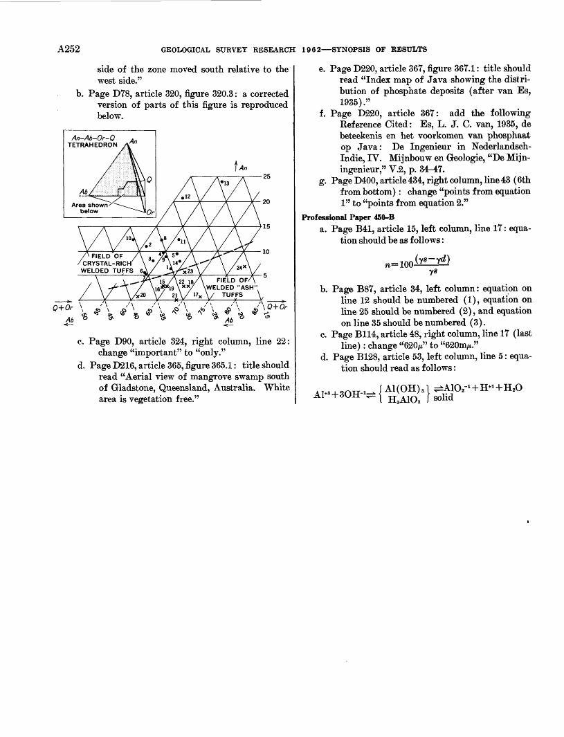
A252 GEOLOGICAL SURVEY RESEARCH 1962 SYNOPSIS OF RESULTS
side of the zone moved south relative to the west side."
b. Page D78, article 320, figure 320.3: a corrected version of parts of this figure is reproduced below.
Q+Or
An-Ab-Or-Q TETRAHEDRON
FIELD OF WELDED "ASH" / TUFFS V
c. Page D90, article 324, right column, line 22:change "important" to "only."
d. Page D216, article 365, figure 365.1: title shouldread "Aerial view of mangrove swamp southof Gladstone, Queensland, Australia. Whitearea is vegetation free."
e. Page D220, article 367, figure 367.1 : title should read "Index map of Java showing the distri bution of phosphate deposits (after van Es, 1935)."
f. Page D220, article 367: add the following Eef erence Cited : Es, L. J. C. van, 1935, de beteekenis en het voorkomen van phosphaat op Java: De Ingenieur in Nederlandsch- Indie, IV. Mijnbouw en Geologie, "De Mijn- ingenieur," V.2, p. 34-47.
g. Page D400, article 434, right column, line 43 (6th from bottom) : change "points from equation 1" to "points from equation 2."
Professional Paper 450-Ba. Page B41, article 15, left column, line 17 : equa
tion should be as follows :
b. Page B87, article 34, left column: equation on line 12 should be numbered (1), equation on line 25 should be numbered (2), and equation on line 35 should be numbered (3).
c. Page B114, article 48, right column, line 17 (last line) : change "620/t" to "620mAt."
d. Page B128, article 53, left column, line 5 : equa tion should read as follows :
H3A103
INDEX
[See also "Regional Investigations," p. A137-A168, and "Topical Investigations," p. A169-A186]
PageAcoustic meter, for measuring water velocity. A123Aerial photography, half-base convergent__ 125
instruments.._______________ 124-125target design. __.____________ 124
Aeromagnetic surveys, regional_______ 25,80See Geophysics under Slate names for district
surveys.Aeroradioactivity surveys, district_____ 19,21,
25,26,27-28,37.52.58regional-_____.___________ 115
Aerotriangulation, analytical..____...... 125Air storage, underground. _______ 105,108Alabama, cooperating agencies________ 133
geologic history____... ._...._. lgeomorphology...__ ______.._ 23-24 ground water_____.___........_ 26,101iron deposits__________. ___. __ 1 quality of water.-....--.-.__...._ 27stratigraphy..__.___.__..... . 26surface water_______________ 26,100
Alaska, beryllium. ___._____._ J.__ 5cooperating agencies._..._........_. 133coal._............................... 10-11,52copper.. . ----..-.-.-.....-.-.--..... 2,54floods..... - .. ---. 99geochronology____.____._.--.-. 93 geologic maps___________.-.--.-. 53 geophysics- _ _____-..-. 52,79
! glacial geology..________..___.. 78 gold............. ...................... 53ground water, Cordova.-.. ...____ 53 highway construction....._______.. 105iron deposits_____________. _ 2,54 marine geology. ______________ 79 nuclear test site____________.... 109paleontology__________. _ 52-53,54-55 permafrost_____________.__ 81 petroleum_______________.... 52,53petrology. . ..... .............. 53,88stratigraphy . .... 52,53,54,55structural geology ________. ___ 52zinc___________________.. 54
Algae ...___ ______.. 59Alidades, pendulum___. ________.. 124Alkali metals, determination in micas........ 117Alluvial channels, sediment transport... _.. 98 Alluvial fans, morphology.. ___ 77 Aluminum, district studies__________ 6 American Samoa, cooperating agency.. ._ 136
ground water. __... __.____ 61 Ammonites. ________________ 35,75 Anguar Island, ground water. .. 61 Antarctica, aerial photography............... 66
azimuth position determination.......... 125coal__.__________________ 62 geologic maps._______________ 62 geologic reconnaissance_ _ - _____ 64 glacial geology.. _ 64 glaciology.._ __ . _____ 62 paleobotany________________ 62 paleontology.....__ _______ 62,64relief model________________ 66 saline features....._ __...___... 64topographic field operations..______ 64-66 topographic maps_ ___________ 66
PageApatites, rare-earth content A92Aquifers, analog models... 100-101
artificial recharge_. _____. _ __ 112compaction... ... 50,102,105effect of nuclear explosions 108-109effect of sinkholes.. .... .. 112effect of spreading basins. 112limestone hydrology, theoretical 103-104mechanics of flow in . .... 96,100-101salt-water encroachment____ 22,100-102,122
Arctic Ocean, aeromagnetic surveys_ 80Arizona, cooperating agencies_____...__ 133
crater studies 71-72erosion_ 39evapotranspiratlon__....._ . .... 103geochemical prospecting 121geologic history 39,44,76geophysics 82ground water, Flagstaff 40
Papago Indian Reservation.... 57Tucson area_._.____....___ 76
land subsidence 105paleontology. _____ __ 37-38stratigraphy. 42,44,76structural geology 38,39,40,44
Arkansas, cooperating agencies... 133geophysics . _______ 26ground water______________ 26,27,28paleontology_._________ .. 26phosphate deposits_ 6stratigraphy _________ 26,27
Austria, crater studies___...._..._... 72
B
Barite, district studies____.......__._ 67Basalt, magnetic properties__._... 81
radioactive-waste disposal...___.._.. 113 Basement-rock map, North America.. .. 113 Bediasites. See Tektites.Beryllium, complexes in aqueous solutions_ 117
district studies..____ __.__ 5,8,42,68field determination. . 121laboratory determination_. _.. . 8
Beryllium minerals, structure.. . 87Bison, association with human artifacts___ 74Bolivia, copper, tin, tungsten_____.__ 67Borate minerals, crystal structure.._ 86-87Boron, determination in water..._ .. .... 117Botanical exploration_..____... 121Brachiopods, attachment structures... .. 74-75Brucite, stability in water______ 87Brazil, iron deposits__________. __. 66-67
lead-zinc deposits.-... . 67
Calcite, elastic constants___..--..--- 81 Calcium, determination in thermal waters . 117 California, construction problems__....... 104
cooperating agencies..------------- 133-134copper_ -.__----- . 2evapotranspiration._.____. 50 geochronology____.... ._.. »4geomorphology_.___.__ .. 45.49,77
. - - 50,84-85
PageCalifornia Continued
ground water, quality.. . A91Sacramento Valley. 50San Nicolas Island- 99Santa Barbara County. -... 50,99
land subsidence-. ......... 50.102,105limnology_______ 102-103mercury.. . . 48-49 paleontology . -- - 43,49,75 petroleum.. ... 10 petrology... .. . - - 88-89 saline minerals- __ 6-7,44-45 stratigraphy. 43,48-49structural geology..... 43-44,48-49,50surface water, Sacramento River 98
San Nicolas Island ... . 99 Carbonate rocks, monomineralic unnamed
mineral__.. .... 86oxygen-isotope ratios. 122
Carbon-14 dating method, applications.... 93Carboniferous. See Mississippian, Pennsyl-
vanian.Carolina Bays, origin. 22 Cartography, procedures 126-128 Caves, geomorphology- 23-24 Cesium, disposal of wastes 86 Chemical weathering, geochemistry 87 Chemistry, analytical_.... 116-118
crystal. 86-87natural water 88organic. 91-92
Chile, metallogenic map.. 67sand dunes. 67
Chloride analysis, drill cores 118Chromite, district studies.. 2,69Clay, as an osmotic membrane 90
relation of content to shrinkage of deposits. 50Clay balls, formation and deposition 37Clay minerals, adsorption of cesium 86
adsorption of strontium 87-88district studies... 7,69-70new mineral- 90
Coal, bibliography 10 district studies_ -_ 10-11,52,62,68 mine bumps. 106 mine drainage.. 115 reserves 10,11 strip mining, effect on forests 77 effect on surface water. 24,91 variation in rank, causes. 11
Cobalt, as an indicator of uranium . 8-9 Coesite, in glassy ejecta from nuclear ex
plosions__ 71-72 Colorado, archaeology.. 35-36,74
beryllium__ 5 chemical-waste disposal 34 coal.... .. 11cooperating agencies 134 floods..... 99geochemistry 96 geochronology. 36-37,94,96geologic history 8,35,39 geomorphology 39 geophysics.. 4,37,83,84glacial geology.. 35-36,79
A253
A254 INDEX
PageColorado Continued
ground water, Las Animas__ __.. A110 helium___ _______ ____ 38 mineralogy. _ . ___ 86 natural gas. _ _____________ 38 paleontology 32,35,36,43,47,75petroleum.. ... 38 petrology. . . 34-35,36,37,38stratigraphy.. ..... ........ 34-35,36,38structural geology.....-- .. 34-35,36,38-39thorium_ __ ..___ 9uranium_________________ 9,15,38
Connecticut, cooperating agencies. _.___ 134geochronology ._ 80geophysics ... 18-19marine geology... ___ 80stratigraphy- ________.____ 18-19
Copper, district studies_______ 2,3-4, 54,67,68Corals....... 23,37-38,74,75Cores, extraction of interstitial water _____ 118 Craters, experimental__ ./...._____ 72-73
lunar. ... . . ____ 71terrestrial__ _..___________ 71-72
Cristobalite, stabih'ty in water________ 87Crustal properties, electrical.. ___ 82-83
gravimetric _____________ 85isostatic . .. 85seismic..- . . ___ 84-85viscous. ___ 85
Crystal chemistry________________ 86-87Current meters ________...___ 123
D
Delaware, cooperating agencies __ _____ 193ground water, Newark___ ____ 112stratigraphy.. _____.......____ 22
Desert terrain, map symbols_ ..____ 126 Detergents, adsorption by quartz_ ____ 92,116
foaming characteristics. __. ____ 116Deuterium, in natural waters___...____ 94-95
in ore minerals______________ 122Diapositives, contrast control_______.. 125Discharge, tide-afEected streams _______ 98Dispersion tests, open channels _______ 97-98District of Columbia, cooperating agency.__ 134
flood studies_________ _____.. 77Djurleite, natural occurrence.._______ 85-86
E
Earthquake hazards, structures in marsh lands. ..._____________ 104
Edge isolation .....___.._____ 126 Egypt, ground water, Kharga Oasis. ____ 67
surface water, Nile River_________ 94 Electrical-resistivity studies. ___. ____ 82-83
See Geophysics under State names for districtstudies.
Elevation meter, vehicle-mounted_____. 124 Epidote, depth of formation. _________ 90 ER-55 projectors, improvements..._____ 126 Erosion_. _________________ 39,106 Evaporation, suppression______-..__ 112 Evaporite minerals, district studies____ 6-7 Evapotranspiration, effect on ground water. 101,103 Evolution, topical studies...__..___.. 74 Exploration techniques.__________ 121-122
Fallout, effect on surface water...... __. _ 109tritium content______________ 95
Faults, relation to ground water........__. 40Feldspars, lead isotopes in..-----------_... 96
structure._________________.. 86Floods, botanical evidence__-.... ....... 77
factors affecting................._._.. nofrequency and magnitude in the United
States.______________ 15inundation mapping__ ..__..._. 99
PageFlorida, cooperating agencies..... . ... A134
geochemistry.-..---._._._---------- 91geomorphology-__.. -.. - .. 106 ground water, Escambia County. -------- 26
Fernandina.. - - ---- --- - 102Jacksonville..--------.--------------- 102salt-water encroachment_. - . 101,102Santa Rosa County--,.---. .. - 26
paleontology,---.----_-.__------ 22phosphate..-... ----------- ... - 6stratigraphy..-.----------------- - - 6,21structural geology..________- 21 surface water, Escambia and Santa Rosa
Counties.. I. ------------ 26Fluid inclusions, composition.-...---__ 88,89,122
nature and temperature of formation... ._ 4-5Fluorescence, determination . . 117 Fluorine, effect on determination of boron.... 117Fluorite, district studies........... . 3,5,67,69
removal from samples-...._ ----------- 117Folding, laboratory studies.._. -__------- 80Foraminifera.- ... . 37,42,43,44,49,53,54,59,75Fuels. See particular type.Funafuti, paleontology._ - - 59
G
Galena, lead isotopes in.......__. . .. 96-97See also Lead.
Gastropods---..---.-----.-------------------- 26-74Geochemical exploration. ------------- 121-122Geochemistry, experimental----.---..--.- ... 87-88
field - - 89-91marine.,.----.--- ----------------------- 80synthesis of data.... ...... . 92See. also under State names.
Geologic map, North America. ...... 13Geomorphology, relation to ground water.... 76
relation to streamflow.. ___ ... 76 relation to vegetation... .. . . . 77 stream channels..------------------------ 39,76See also under State names.
Geophysics, major crustal studies...-.----. 84-85experimental and theoretical .-..., 81-84 See also wider State names.
Georgia, cooperating agencies -------------- 134geomorphology- - - - 76,106geophysics . 21ground water, Atlanta area. 21
Brunswick . . . - 90Piedmont__ 76-77quality._...... . ... . 90salt-water encroachment . 101Savannah area 22
plant ecology. - 77stratigraphy.-.--.---- 21,26structural geology - - 21 surface water, Piedmont 76,77
Germany, crater studies 73 Gilbert Islands, paleontology. . 59 Gilsonite, district studies. 11 Glaciers, hydrology and regimen... 62,78 Glass sand, district studies..... 68Glauconite, composition.. 80,113 Gold ore, indicators.... . . 121Qraptolites 29,43Gravity map, absolute, United States 13Greenland, glaciology 78
permafrost..____ ...- 80-81Ground water, chemistry of 88
effect, of nuclear explosions_____ 95,108-109effect of stream impoundment 101, 111effect of tunnels....- ..... . ... 56-57,99hydrochemical fades.. 90 minor-element content- . - 91,115 movement.-..._-__--___- 95-96.100-101 radioactive-waste disposal. 114-115 relation to faults. 40 relation to geomorphology-. 76
FaceGround water Continued
relation to surface water AllO-111 situation in the United States. 15 temperature relations.. 25, 111 tracer studies. . . . 95-96 use in I960. _ .... 11 See also Aquifers and under State names.
Guadalupe Island, coring and core analysis. 79 deuterium content of ocean samples. 95 magnetic properties of the rocks 81
Guam, cooperating agency.. 136 marine geology.. 59 water resources 61
Gypsum, district studies.-- 67 resource study of United States 8
Hauerite, synthesis 8Hawaii, aluminum 6
clay deposits . 7cooperating agencies 134geophysics 56ground water, Oahu.. 56-57surface water, Oahu 57,99volcanism 55
Heavy metals, in shale 92Helium, district studies.. 38Hematite, deposition.. 1,89Highway construction, geologic problems 105Hot springs, composition of the water.... 89-90
mineral assemblages 87,90Hydrobiotite, structural formula 85Hydrogen, isotope geology 122
Ice, deuterium content.. 95magnetic properties 97
Ice features, map symbols 126Iceland, hydrologic studies 95Idaho, beryllium . 8
cooperating agencies 134copper 3-4geochronology 94geophysics - - 30,85ground water, American Falls Reservoir.. Ill
National Reactor Testing Station 47,90,96,114,122
quality 90,122Snake River Plain.. - 47,95,104
petrology- 30,89 stratigraphy 7,30,32.48structural geology.... . 30,31,46,47surface water, Birch Creek... 47uranothorite. 9
Illinois, cooperating agencies 134geophysics 25,26glacial geology 24ground water 26
Ilmenite, district studies . - - 68Index of refraction, relation to SiO 2 content 120Indiana, cooperating agencies 134
geophysics 25Indonesia, damsite studies 69Industry, water use.. 11-12Iodine, in ground water.... 115Iowa, cooperating agencies. 134
geophysics 24-25stratigraphy.. - 33
Iron, ferrous, determination 117in water and plants. - - 92
Iron deposits, aeromagnetic prospecting- .. 5district studies... 1-2,5, 54,66-67,67-68
Iron ore, reserves 1water use in mining and beneflciation.... 12
Irrigation, water use, summary - 11 Isostasy... - - --- --- 85 Israel, geochemical studies -- ----- 86
INDEX A255
Jasperoid, as an ore guide-Page
... A4
K
Kansas, cooperating agencies.-------- . . 134ground water, Garden City. .-- - --- 101
Grant County_____________ 28 Kirwin area.. --- ----- 111quality -- -- - 91tstanton County. 28
Kaolin, district studies. __ . . 68Kaolinite, solubility in water__.______ 88Kelsh projectors, support assembly 126Kentucky, cooperating agencies... .. 134
fluorite._.________________ 3geophysics_ 21,23glacial geology - - . 24ground water_.__ ... . .- 26 plant ecology .. ..- 77 stratigraphy-___ . 7,20,22-23 structural geology.... . 26surface water, Beaver Creek mining area. 24,91
Green River......-..------- -.... 115-116quality-.-.-.-----.-.-.-..._...._. 24,91
Kita-Daito-Jima, paleontology___-..--._ 59 Kyanite, district studies___________.. 7
Lakes, chemical content and temperaturestudies....__.--..-..-.--.--.- 102-103
Land subsidence, compaction of aquifers. 45,50,102,105 Lavas, magnetic properties.__._____ 81 Lead, determination in sphalerite_..-..-.-. 117
district studies...____________.. 2,3,67 Lead isotopes, in feldspars and galena ... 96-97 Libya, mineral-resource studies .... _____ 67Lightweight aggregates, shale_ . _ 7Limestone, commercial, district studies___ 58
ground water in..__________. 103-104Sand Pwaves.__ __________ 81
Liquids, handling small amounts____... 120Loess, seepage of irrigation water..._____ 110
weathering profile.____________ 24Los Alamos, N. Mex., geologic and hydrologic
studies.... _------- 40,111,114-115Louisiana, cooperating agencies__..__... 134
geophysics... -....__._ 122ground water, quality__________ 90,122surface water_______________ 100
Luminescence, interpretation of mechanisms. 97measurement . 83
M
Mackinawite, formula.. __ 119 Magnetic anomalies, interpretation..____ 83-84 Magnetic studies, ice. .__________ 97
volcanic rocks__..___.________ 81 Magnetite, district studies......_______ 3,5
magnetic anomalies__ . _____ 5zinc content.. __ 121
Magneto-acoustic studies, on metals_____ 97Maine, cooperating agency.... .._____ 134
geochemical prospecting.. ___ 121geophysics 16,82paleontology and stratigraphy. __ 16structural geology..., ______ 16
Mammoths, association with human artifacts. 358Manganese, district studies__ _______ 2,68
in plants..... ..______ 92in water _________ 88,92vein oxide studies. _.._________ 4
Mantle, viscosity ..._________ 85Mapping, equipment and procedures___ 123-124
standards . ________ 126-127See also Photogrammetry.
Maps, symbols. _____ 126 Marine geology. See Oceanography. Marine shale, tellurium content.......___ 92Marshall Islands, Eniwetok Atoll, paleon
tology............................ 59,75
PageMaryland, cooperating agencies.. A134
lightweight aggregates 7petrology. . . . 20surface water, Anacostia River... 106
Massachusetts, cooperating agencies 134geochronology.. 18,79geomorphology. 106geophysics . 17-18ground water, northeast.. 18marine geology- 18,79-80,113stratigraphy 16-18tektites______________..___ 73
Melanophlogite, structure.. 86Mesquite, as an indicator of ores_______ 121Metamorphism, processes .. 88Metatorbernite, structure.. .. 87Meteors, crater studies. 71-72Mexico, barite. . . __ 67
beryllium. .... 8fluorite, gypsum_.__ ......____ 67
Michigan, cooperating agencies. 135 iron deposits i stratigraphy______ ....--.-..__ 24surface water. .... . __ 110
Mine bumps___.______________ 106Mine drainage- .. 115Mineral-occurrence maps, United States___ 13-14Mineralogy, description of new minerals___ 86Minnesota, cooperating agencies .. 135
geochronology______... _.___ 93,94geophysics . . 5,25,115ground water, Aurora.. 25-26
Lake Agassiz basin. ____ 25iron deposits_ ...... 5surface water, Red River__.______ 112
Minor elements, chemical analysis. 116-117distribution_____ __..........__ 92-93spectrochemical analysis.. __ usspectrographic analysis 118
Mississippi, cooperating agencies_ .... 135floods..__________________ 99 geophysics - 109 ground water, east-central and northeastern. 26 nuclear test site._.............____ 109paleontology and stratigraphy . 26,75 structural geology.... .... 109surface water, Mississippi Embayment_ 100
northeast _ __ 27 Mississippi Embayment, geologic and hydro-
logic studies_ ___ 26,100 Mississippian, paleotectonic map __ 15 Missouri, cooperating agencies. .....__ 135
geophysics_ ______.______ 26 ground water.... ... _____ 26stratigraphy.. __ 27structural geology. _ ___ 27
Mohole project. See Guadalupe Island.Molybdenum, district studies.. 4
stream-sediment anomalies. _______ 121Monazite, district studies_ .._____ 7-8,10
in crystalline rocks_ ..____ 10Montana, chromite_____.....______ 2
cooperating agencies _. ___ 135geophysics .._. 31glacial geology.. . 30ground water, Bighorn Valley______ 33
Bluewater Springs area .. 33Fort Belknap Indian Reservation. _ 57
iron deposits. .... ilead__________._________ 2 manganese.._ __ 2 mineralogy..__........__.______ 85-86paleontology________________ 30,32 petrology_________________ 89 phosphate ...._... _._... 6plant ecology______ ..____ 77 silver. ______ ____. 2 stratigraphy______________ 31,33 structural geology. ____________ 30-31 zinc................___. ...,.__,... 2
PageMoon, clouds A72-73
photogeologic mapping... 70stratigraphy.. 70-71structural features 71
Moraines, internal structure.. 78Morin, in field determination of beryllium . 121Muscovite, district studies.._ 7-8
solubility in paragonite. 120
N
National atlas.. . 193 National Reactor Testing Station, Idaho,
hydrologic studies.. 47,90,114,122Natural gas, bibliography. 10
district studies__. 10,38exploration and development. 10
Nebraska, cooperating agencies 135glacial geology.. 35-36ground water, Kearney area 110
Mirage Flats area 37stratigraphy.. 33
Nevada, beryllium... 8,42cooperating agencies 135evapotranspiration 101,103floods.___ 99geochronology 94geophysics ... . 41,82,83,84-85,107ground water, Duckwater Indian Reserva
tion___ 57 Las Vegas.. 45 Nevada Test Site... .- 46,107-108,110 quality- - ... - 46,91Reno. . 46Truckee Meadows.. 91Winnemucca. 46
iron deposits- 1nuclear test sites....... . - 107-108,109paleontology____ 42-43,75,107 silver. 3 stratigraphy . 42-43,44,107structural geology. _ 40-41,107 surface water, Humboldt River 112
Nevada Test Site, geologic and hydrologicstudies.... .___ 45,107-108,110,115
New Hampshire, cooperating agency. 135geophysics__.. 19,82
New Jersey, cooperating agencies 135geophysics_ 20-21ground water, coastal plain 22,90
quality..... 90Wharton Tract.... . . 111
marine geology.. 80,113paleontology and stratigraphy 22structural geology. 19-20
New Mexico, beryllium 8New Mexico, cooperating agencies.. . 135
geochemical prospecting. 121-122geomorphology 76geophysics__..... 27-28,84ground water, Carlsbad area 110
Frijoles Mesa.... - 37Grant County.. 45
' High Plains_______-_-- - 28Lake McMillanarea. 95-96,101Los Alamos area. 40, 111, 114-115Manzano Mountains 45 quality 103Roswell basin... 12,104San Juan County.... 39-40Statewide... 12Tucumcari_ - - 29Valencia County. 103Williamsburg area 111
natural gas_ 10nuclear test site.- .. -. 108-109petroleum 10potash.... 6sedimentation 37,40 stratigraphy .......... 29,35,40,43.45structural geology . 36,43
A256 INDEX
Page New Mexico Continued
surface water, Lake McMillan_. ___ A95-96 Statewide._....__________ 12
uranium__________________ 8New York, cooperating agencies______.. 135
geophysics..._...___________ 20-21ground water, Delaware County.- ____ 24
Long Island.. ....___ 22,102,110-111Niagara Falls area__________ 103 Rotterdam_____________ 111quality...-.______________ 19St. Lawrence River area_____... 19Schenectady area__________ 96, inUtica-Rome area_ ________.. 12
magnetite.________________ 3paleontology.--.._____________ 23,75stratigraphy...____________... 23surface water, Long Island_. ____ 110-111
quality. -.___________ 19St. Lawrence River.----...--.-...... 19Utica-Rome area.____--.-.-______ 12
North Carolina, cooperating agencies. ___. 135 copper.. ..__.........___.. 3geochronology_____-..-.___........ 20,94ground water, Murphy area..._..._.. 21 stratigraphy..._----------___._.... 21-22structural geology......._.__....._ 6,20
North Dakota, cooperating agencies.......... 135ground water, Bismarck area..-.-.-.. .... 33-34
Burleigh, Stutsman, and TraillCounties.-----------.---..._... 33-34
limnology..-.---..--.._................ 103paleontology--..-._-------_.......... 74surface water, Devils Lake... 91
quality...--......--..--.-..-...-...-. 91Red River of the North.............. 112
Nuclear explosions, underground, detection.. 83,84,108.109
underground, effect on aquifers......... 108-109geologic and hydrologic studies .... 107-109in alluvium and tuff...___...... 107-108insalt... ............... ..- 108,109peaceful uses. ___................ 108,109
Nuclear reactors, underground air storage.... 108
O
Oak Ridge, Tenn., hydrologic studies.-.-.- 112,114 Ocean water, deuterium content_--...-._ 95 Oceanography, investigations--..--.---,.._ 79-80 Ohio, cooperating agencies..--.---_........ 135
floods.----.--_____-..-.__...._. 99geophysics.-..-._-_ 25glacial geology.-..-.-.---------.--.._.. 78ground water, Bellevue_............._ 96
Dayton..__...._................ 25zinc.. ..._---------------_....._ 2-3
Oil shale, bibliography........_........_ 10district studies...._................. 11,31-32
Oklahoma, cooperating agencies.------------- 135geophysics.. . -..._.........._ 27,101ground water, Arbuckle Plateau.._ 28.103-104
Arkansas and Red River basins...... 91quality.._...._______... ....-_ 91surface water, Pond Creek-...--... .... in
Oligocene, as a worldwide geologic series...... 75Open-channel flow, hydraulics.....__...... 97-98
velocity meters....... -.-.- .--........ 123Ore deposition, environments.-------_..... 87,89Oregon, cooperating agencies............... 135-136
geochemistry...---._................_ 48geophysics.-..------.--..-.---... 44,46,48paleobotany__________......... 74paleontology._..____._______ 47,75 petrology. .....__.................... 88stratigraphy.. _______.. 47,47,48 structural geology........._......_ 46-47,48
Orthophotoscopes, improvement.....___ 125-126Ostracodes.-. .__..__.........._ 32.43,47,75Oxygen, isotope geology.___......__.... 122
PagePacific Ocean, deuterium content______ A95
ocean-survey program. __________ 79Pakistan, ground water..________ 69,100-101
mineral deposits____________ 68-69paleontology._______________ 68
Palau Islands, paleontology._________ 59Paleoecology, topical studies. ...__ 74Paleomagnetism, igneous rocks. _______ 31,81Paleotectonic-map folios, United States.. .. 14-15Paragonite, solubility in muscovite. ... 120Particle size, relation to uplift________ 120Peat, radiocarbon dates._ ________ 80,81,93Pegmatites, district studies. _... 6
mineral assemblages____ -______ 87Pelycosaurs__________________ 75Pennsylvania, cooperating agencies 136
floods_.________ ___.___ 99geomorphology________._____ 76geophysics_ . . . .. 21mine drainage________--... ___ 115petrography 20stratigraphy____________.___ 20,23structural geology.... 19-20zinc__ __ . ...... 3
Pennsylvania!!, paleotectonic map . .. 15Permafrost, depth and temperature__... 80-81Permian, paleotectonic map.. . . .. 14-15Petroleum, bibliography. 10
district studies_________ - _ 10,52-53exploration and development- 10origin... ... 91production potential . 10
Petroleum industry, water use. 11-12Petrology, field_____..._...._.__... 88-89
See also under State names.Philippines, chromite..._ 69
ground water, Luzon 70 Philippinites. See Tektites. Phosphate, district studies..... 6Phosphorescence, measurement 83 Phosphorite. See Phosphate deposits. Photogrammetry, equipment and procedures. 124-126
See also Mapping.Phreatophytes, use of ground water. 103 Pipets, contact... 120 Piping, role in erosion. 39 Plants, fossil._______.. . . . 62,74,75
See also Vegetation.Playas, radioactivity. ~ 27-28 Polarization, induced, laboratory studies 83 Polished sections, transparent ore minerals 120 Pollen.. - - --- - 61-74 Pollution, water, chemical and organic.. 93,115-116 Porosity, estimation from specific gravity. 46 Potash, district studies. 6 Potassium, magneto-acoustic studies - 97 Potassium-argon dating method, applications. 94 Precipitation, deuterium content 94,95 Proactinium-thorium dating method, appli
cations_ 93 Project CHARIOT, geologic and hydrologic
studies- 109 Project DRIBBLE, geologic and hydrologic
studies... 109 Project GNOME, geologic and hydrologic
studies... ----- 108-109Project GROUNDHOG, site selection....... 109Project SHOAL, site selection.. ....... . 109Public water use, United States. nPuerto Rico, cooperating agencies. 136
copper . 4geologic map... 58geophysics.... 58,115limestone, commercial 58 stratigraphy.. .. 58 structural geology.-.. 58 water resources. - - - 58-59
Quebec, crater studies. 72
RPage
Radioactive waste, cesium. _________ A86 Radioactive-waste disposal____ 100-101,112-115 Radioactivity surveys, ARMS program___ 115 Rain, deuterium content.. ..______ 94 Rare earths, in apatites____.____ ___ 92 Relief models, preparation__________ 127 Rhenium, determination in rocks______ lie Rhode Island, cooperating agencies. __ 136
ground water_______________ 19 Statewide Providence area........___ 12surface water, Providence area......___ 12stratigraphy.. 18
Rock deformation, in mines.... ___ 106laboratory studies.. . 82
Runoff, effect of urbanization ___ 110estimation_ . .. 110near glaciers 78
Ryukyu Islands, paleontology. .. 59,61
Saline minerals, district studies. 6-7 mode of occurrence 86
Saline water, deuterium content.. 94-95 from open-pit mining 61 in aquifers... .. 22,101-102,110,122 origin.. . . ..... .. .... 91use. 11
Salt, radioactive-waste disposal 114 thermal conductivity. 113 underground nuclear explosions in ... 108,109
Samplers, stream, automatic. 123 Sand, retention of water in 100 Sandstone, radioactive-waste disposal 114 Sarcopside, structure 87 Scandium, in volcanic rocks 92 Scheelite, district studies. 68 Sea coasts, erosion 106 Sea-floor sediments, Atlantic coast 80,113 Sea-level changes, rate.. 79-80 Sea water, deuterium content 95 Sedimentation studies, folding 80 Sediments, measurement of concentration and
size distribution . 120transport 97-98
Seismic refraction, long-range 84power spectral-density analysis 83
Serpentine minerals, structural formula 85Shale, as an osmotic membrane 91
heavy-metal content 92radioactive-waste disposal 114
Silica, in tektites.. - - - - 73,117Silicate rocks, methods of analysis 116Sillimanite, district studies 7-8Silver, district studies. - 2,3
production 5 Sinkholes, effect on aquifers.. 112 Sinks, formed by nuclear explosions.. 108 Snail shells, validity of CM ages.. 93Soil moisture, instruments for measuring.. 101
relation to vegetation 77Solid-state studies. --- 97Sorting, relation to subsidence 120South Carolina, cooperating agencies.. 136
geochronology.. 94geophysics 21,122mineral resources 7-8
South Dakota, cooperating agencies.... .. 136ground water, Black Hills area. - ... 34
Pine Ridge Indian Reservation ...... 57Sanborn County...- - ---- 25Sioux Fallsarea..- - ---- 25
stratigraphy ---- 32,33structural geology - 32surface water, Belle Fourche River. 90
Big Sioux River.... - 25quality. .. - ---- 90
Specific gravity, in estimating porosity....... 46Specific yield, bibliography ...----- ----- 101
INDEX A257Page
Specific yield Continuedfactors affecting_..___...____._.__ A101
Spectrochemical analysis, direct-readinginstruments.--..-...----.___ 118,119
minerals, rocks, ores__.___..-._... 118 Spectrochemical analysis, small samples.__ H8 Spectroscopy....----.-.---.------------..-. 118-120Sphalerite, deposition.....____._.-.-.-. 89Spreading basins, effect on aquifers.... _.... 112Stereocompilers, visual fatigue..--....-------- 125Stishovite, in shocked sandstone. ..._---- 71-72Strain gages, for measuring pressure fluctua
tions in flowing water............ 123Stream channels, morphology.... __ _ 39,76Stream samplers, automatic. .._-_- . 123 Stream velocity, measurement......-- _.- 123Streamflow, autocorrelatedinformation....... 100
effect on radioactivity of water....-....-- 114factors affecting......_.__.-_.-...--. 98-99low flow____...____.--_.__ 100,112 relation to geomorphology...--------- 76relation to ground water..--------- .- 110-112
Stress waves, in solids___ __. 81Strontium, in ground water.----------------- 115Sudan, ground water.. _ _...__ . 67 Surface water, deuterium content__------- 94-95
distribution of elements. _-.-.._.-.__ 90,92 drainage into mines__-.-.-...-.--....-- 115effect of strip mining...-.--._..._.... 91effect of tunnels.....__._..__.. 56-57,99origin of minerals..-.---.__._....--- 91,92radioactive-waste disposal....------------ 114relation to geomorphology and geology... 76 relation to ground water...... ..___ 110-111thermal loading....__..._........._ 99tracer studies..._.._.--......... ...- 95-96use in 1960......_..... 11See also Floods, Streamflow.
Surveying, portable towers..----------------- 123Swamps, origin._____....._............ 18
T Taiwan, kaolin__.___................... 69-70Tectonic maps, North America_..-.-.-.-._. 13
United States... .......-........... 14Tektites, origin_______................ 73
composition and properties.............. 73,117Tellurium, in marine shale..-.-.... --.-...- 92Tennessee, cooperating agencies.............. 136
geophysics._..... ..:.....-........... 2lground water_.--.--..-----.----.---.-.- 26,90land subsidence......................_. 102petrography --_-------.-----_----_- 20quality of water..__.................... 90surface water, Clinch Creek...._..... 112,114
Holston River__....__............ 99Texas, cooperating agencies_-..._.-..---.- 136
crater studies .___..._.-.._-.... 72geochemistry...___...._.__.__. 92-93geophysics_________________. 26,27ground water, Arkansas River basin__ 91
Red River basin.-.........---..--.-- 27,91Sulphur River basin__._-------- 27
mineralogy.______--.__.---..-. 86 paleobotany________.............. 75paleontology.-----------.----------..- 74-75quality of water..__...__.....__ 27,29,91stratigraphy -.--.----.--..--.---.- 28surface water, Brazos River basin____ 29
Thailand, mineral resources.....____.._ 69Thalenite, identification..-.-. .___.._ __ 120 Thermal springs, United States and other
countries.__.__._....__ 15,57Thermochemical data, physical constants.... 82Thermoluminescence, as an ore guide. _.... 4
interpretation of mechanisms. .-..__.. 97 relation to impact.------------_-_ 72
Thorium, district studies..._...._.__... 9inalkalicrocks....__.........___.. 92-93
PageTillites, description and origin________ A78 Tin, district studies..____________ 2,67,69 Titanium, determination__._______ 117-118 Transmissibility, relation to faulting.. ____ 40 Trees. See Vegetation.Trllobites.-... . . .. ... _ 53 Tritium, in determining ground-water move
ment..... _..._ 95-96,101,104 in fallout..____._.._______.. 95
Tuff, radioactive-waste disposal.._____ 114-115 Tungsten, district studies.. ________ 7-8,67, 69 Tunnels, effect on ground water____. __ 56-57
effect on surface water_________ 56-57,99 geologic factors in excavating..... ____ 105
U
Uranium, dating of accumulation and migra tion....-... _...... ...... 9,93-94
in alkalicrocks...... ...__ _.__ 92-93in marine black shales__________ 10 new mineral_..____________ 86 transportation and deposition........__ 9,87
Uranium deposits, district studies....__ 8-9,93-94 ore controls__-_____-_______ 8 ore guides . 8-9,121-122 tectonic setting. . .. ...... 15
Uranothorite, district studies... ______ 9Urbanization, effect on erosion__. ____ 106
effect on runoff. ..._ noUtah, base metals_..____.__,.____ 3
beryllium.___._____________ 5,8 coal.. . _._ ......_... 11cooperating agencies...._ ......___ 136evapotranspiration.._____..____ 103 fluorite . ...... 5geologic history...._.._. . ___ 38geomorphology 39,76 gilsonite n glacial geology- . . ...... 44ground water, Millard County....___ 45
Sevier County . 103 southwest.. . ..... 45Tooele Valley__ _ _.___ 46
mining engineering- . 106 petrology . . . . 44,89 stratigraphy 3,38,76 structural geology. _ ..... 41-42surface water, Great Salt Lake._.___ 46 uranium . 8-9 uranothorite__-____________ 9 vanadium___.._.__......____ 3
Vadose zone, flow through 100Vanadium, absorption by plants. __ . 115
as indicator of uranium__. _____ 121-122 district studies . 3 new minerals. . .. .. 86 production_ . -. ...... 5
Vegetation, as an indicator of floods...___ 77 effect of strip mining...__.._ __... 77 elements in. 92.115,121 relation to geomorphology-- _.__... 77 relation to soil moisture . 77
Vermiculite, structural formula. .. _... 85Vermont, cooperating agency... __... 136
stratigraphy. . 16,19Virgin Islands of the United States, cooperat
ing agency_____ 136Virginia, cooperating agencies..._ . 136
floods... .- .................... 110geochemistry-_______.______ 92 geochronology.__....__._.___ 96mineralogy.__...____________ 86 paleontology_.__..___._____ 74 petrography-..__...._..._...._ 20structural geology...___...__.__... 20
PageVolcanic rocks, beryllium content-. _____ A92
deuterium content__________._ 95 paleomagnetism............._..... . 81scandium content....___...____ 92
Volcanoes, Kilauea_________. ____ 77-78 Vonsenite, in magnetite ores_____. __.. 3
W
Washington, coal.........._______.__ 10cooperating agencies. ___________ 136 construction problems..______. 104geophysics......... . _.___._._.. 29-30,85glacial geology-----.-..-.--... -... 78-79glaciology....._.__.________.. 78ground water, central___________ 47
Tacoma area...____________ 12 petrology ______________ 29 silver_.._..______________ 3 stratigraphy.. . ... . 7,29-30,48 structural geology......--___.____ 30surface water, Tacoma area________ 12
White River......-.....-.. ....... 50uranium.__...__._....___... 9
Water discharge, measurement._____.... 98Water use, bibliography_. _________ 12
United States, I960. . nWater velocity, instruments for measuring_ 123Waterpower, water use.........._______ 11Wegscheiderite, formula___________ 86Wells, effect of nuclear explosions on levels. 108-109
logging.... . . 122pumping tests .... 110recharge- . ..___ 112water-level measurement-. . _.___ 123
West Virginia, cooperating agencies_____ 136Whales, evolution and migration.. __ ___ 74Wisconsin, cooperating agencies.. . .... 136
geochemical prospecting. ...._____ 121geophysics 25,115 ground water, Black Earth Creek basin.. 77 Driftless Area....... .. .. . _. 115Green Bay area_____......._____ HOquality of water . 115 stratigraphy. ... 24 structural geology.... . _. 24zinc_. . - . .... .. 121
Wyoming, cooperating agencies .- 136 geochemistry. . .... 86,89-90geochronology L............... 93-94geophysics . .. 85 ground water, Bridger Basin____.__ 33 Qtendo area.. 37 Jackson Lake area . 57 Johnson County .. 33 Sheridan County 33 Wheatland Flats area__ 37 mineralogy 86 oil shale___ - 11,31-32 petrology 89 stratigraphy... 31-33,35 structural geology.. 31-32 uranium_______________ 9,93-94
X
X-ray fluorescence analysis 119 X-ray microanalyzer, electron-probe 119-120
Yugoslavia, iron deposits.
Zeolites, new mineral .. 90 Zinc, district studies. 2-3,54,67
field determination.. 121 in soU 121
Zircon, district studies 68 lead-alpha measurements 20
U.S. GOVERNMENT PRINTING OFFICE: 1962 O 6615T3