efficient location strategy for airport surveillance using mode-s multilateration systems
TRANSCRIPT
This is an author version (draft pre-refereeing)!
The final paper appears in the International Journal of Microwave and Wireless
Technologies published by Cambridge University Press. Copyright Cambridge University
Press.
Please refer to http://dx.doi.org/10.1017/S1759078712000104 for the full paper
Efficient Location Strategy for Airport
Surveillance using Mode-S Multilateration
Systems
Ivan A. Mantilla-Gaviria1, Mauro Leonardi
2, Gaspare Galati
2, Juan V. Balbastre-Tejedor
1,
Elías de los Reyes Davó1
1ITACA Research Institute, Universidad Politécnica de Valencia, Camino de Vera S/N, 46022
Valencia, Spain.
2DISP, “Tor Vergata” University, via del Politecnico 1, 00131 Rome, Italy.
In this paper, the use of regularization methods to solve the location problem in
multilateration systems, using Mode-S signals, is studied, evaluated and developed. The
Tikhonov method has been implemented as a first application to solve the classical system of
hyperbolic equations in multilateration systems. Some simulations are obtained and the
results are compared with those obtained by the well established Taylor linearization and
with the Cramér-Rao Lower Bound analysis. Significant improvements, for the accuracy,
convergence and the probability of location, are found for the application of Tikhonov
method.
Keywords:
Corresponding author: Ivan A. Mantilla-Gaviria; email: [email protected]
I. INTRODUCTION
Nowadays, Mode-S Multilateration systems are a feasible option to be used in the Air Traffic
Control (ATC) technological infrastructures, so much so that the European Organization for
the Safety or Air Navigation (EUROCONTROL) published in its report “The ATM
Surveillance Strategy for ECAC” [1] that these systems will be one of three pillars of the
ground based surveillance infrastructure for 2020. These systems exploit the transmitted

signals from the on-board transponder of the Secondary Surveillance Radar in the Selective
and Conventional mode, i.e SSR Mode-S (and Mode A/C) , in order to calculate the position
of aircrafts and vehicles in the coverage area. As a matter of fact, each mobile (aircraft,
vehicle) to be detected and localized has an SSR Mode-S transponder on board, emitting
standard signals at regular, but unknown, time intervals. A number of receiving and
measurement stations in the surveillance area generates a set of Time Of Arrival (TOA)
measurements, from which the localization is performed by solving a system of hyperbolic
equations based on Time Difference of Arrival (TDOA) technique; the pertaining algorithms
run at real time in a CPS (Central Processor System) [2]. This is sketched in Fig. 1, which, for
the sake of simplicity, refers to the 2-dimensional case.
Fig. 1. A pictorial view (2D) of TDOA localization.
Station 1
(REFERENCE)
Station 2
Station 3
TARGET
TOA(2)-TOA(1)
TOA(3)-TOA(1)
(Intersection of Constant-TDOA lines)

In some scenarios, it is common to find a numerical problem when solving the system of
hyperbolic equations; i.e., the coefficient matrix has a very large condition number [3]. This
problem is defined in the literature as an ill-conditioned problem and the consequence of this
is that, when the system of equations is solved, the solution is not correct or it has a big error.
The mathematical interpretation of this problem goes back to the three conditions of Jacques
Hadamard [4], namely, the solution exists, the solution is unique and the solution depends
continuously on the data. If at least one of these conditions is not satisfied the problem
becomes ill-conditioned. On the other hand, the effects of this problem in the multilateration
systems accuracy have been highlighted in [5-6].
Some ill-conditioned problems can be also found in other fields as image processing [7],
electromagnetic scattering [8] or geophysics [9]. In these fields, this problem has been solved
by applying a group of methods called regularization methods. These methods basically
convert the ill-conditioned problem in a well-conditioned problem where the three
Hadamard’s conditions are satisfied. In this paper, we study and apply one of these methods
to solve the ill-conditioned problem in multilateration systems.
This paper is organized as follows: in section II, the general aspects and the classical solution
for the location problem, in Mode-S Multilateration, are shown. Then, in section III the
location strategy as proposed in this work, is fully described whereas, in section IV some
simulations and results are shown for two different scenarios. Finally, section V gives the
main conclusions.
II. LOCATION PROBLEM IN MODE-S MULTILATERATION
In Mode-S multilateration (MLAT) systems, a number of ground stations (at least three for
2D or four for 3D localization) are placed in some strategic locations around the airport or the
area to be covered. The system uses the Mode-S transmission and asynchronous transponder
(Mode-S) replies as well as the responses to interrogations elicited by the MLAT system.
Then, the received signal is sent to a CPS (Central Processing Station) where the transponder
position is calculated. This calculation is based on the TDOA method, where the intersections
of multiples hyperboloids, which have been created with the relative time differences, are
computed. Each of these hyperboloids follows the expression :
𝑇𝐷𝑂𝐴𝑖,1 =1
𝑐√(𝑥 − 𝑥𝑖)
2 + (𝑦 − 𝑦𝑖)2 + (𝑧 − 𝑧𝑖)2 −
1
𝑐√(𝑥 − 𝑥1)2 + (𝑦 − 𝑦1)2 + (𝑧 − 𝑧1)2 (1)
where c is the speed of light, (x,y,z) the unknown target position (aircraft position) and
(xi,yi,zi) is the known position of the ith station (i=1 denotes the reference station). Linearizing
(1) by Taylor series expansion [10-11] is the most accepted strategy to solve these hyperbolic
equations, for estimating the target position. In the current literature, the solution of this
inverse problem has been presented as an iterative procedure in the sense of the Least-Squares
(LS) [10-11]. Denoting the unknown target position as 𝜽 = [𝑥, 𝑦, 𝑧]𝑇 and comprising the
system measurements (for a number of 𝑁𝑠 ground stations) in a 𝑁𝑠 − 1 vector �̂� =
[𝑇𝐷𝑂𝐴𝑖,1, … , 𝑇𝐷𝑂𝐴𝑁𝑠,1]𝑇, the final formulation can be summarized as follows

�̂�𝑘 = (𝑮(�̂�𝑘−1)𝑻
𝑮(�̂�𝑘−1))−1
𝑮(�̂�𝑘−1)𝑻
�̂�𝜟(�̂�𝑘−1) + �̂�𝑘−1 (2)
where 𝑘 = 1, … , 𝐾; 𝑮 is the (𝑁𝑠 − 1) × 3 Jacobian matrix of the 𝑁𝑠 − 1 hyperbolic equations
(1), �̂�0 is the starting point required for this method, �̂�𝛥 ≜ �̂� − 𝒎(�̂�𝑘−1) and 𝒎(�̂�𝑘−1) is a
(𝑁𝑠 − 1) × 1 vector comprising the TDOA (see (1)) quantities evaluated at the partial solution
�̂�𝑘−1. Finally, because this method is based on an iterative procedure, K is the number of
refinement iterations, in practice set by the maximum acceptable residual error.
The solution provided by (2) is the minimum residual norm solution and the matrices product
(𝑮𝑇𝑮)−1𝑮𝑇 is known as the pseudoinverse matrix 𝑮† [3]. For some scenarios, due to the
system geometry, to the measurements noise and to the starting point quality, this inverse
problem is ill-conditioned and therefore the solution obtained by (2) is not correct or it
diverges with very large errors.
Nowadays, the problem of ill-conditioning is solved by applying different hardware and
software solutions. Regarding to the hardware-based solutions, one of these is by adding more
stations, i.e. usually the problem of ill-conditioning is found for situations with a number of
stations smaller than seven or eight. Another one is by adding new measurement capabilities
to the system, like the Angle of Arrival (AOA) [6] or the Round-Trip-Delay (RTD) [6, 12],
i.e., in a numerical sense, adding new measurements means to change the ill-conditioned
Jacobian matrix into a well-conditioned Jacobian matrix. However all these solutions,
although are efficient options, require in much cases significant economic investments.
On the other hand, regarding to the software-based solutions, two possible options can be
implemented. One is by using a horizontal (2D) projected version of the Taylor-series
expansion method and solve the resulting system of equations with the pseudoinverse matrix.
This option, although the corresponding coefficient matrix is initially well-conditioned, has
the disadvantage that it adds a spatial bias due to the projection from 3D to 2D in the
coefficient matrix but of course not in the measurements. The second option is by
implementing a family of location algorithms called closed form algorithms [5, 13-14]. These
algorithms have the advantage of not needing a starting point but on the contrary, they
introduce quadratic and cubic relations between the solution (target position) and the
measurement noise as well as the necessity of choose one of the two possible solutions.
Horizontal projection for this kind of algorithms is also possible but the problem of bias is
equally present. Finally, as it will be shown in the results section, these algorithms, in some
cases, are also affected by the ill-conditioning problem.
In this paper we propose an efficient software-based strategy, based on the use of Tikhonov
regularization [15] method, to solve the iterative procedure of Taylor-series expansion and to
avoid those errors due to the ill-conditioned problem but also bridging those disadvantages of
hardware and software based solutions as mentioned above.
III. SOLUTION OF LOCATION PROBLEM IN MODE-S
MULTILATERATION BY TIKHONOV REGULARIZATION
This method was originally and independently derived by Tikhonov [15] and Phillips [16]; it
has been used to solve the ill-conditioned problems in an important number of applications to
engineering and science. The main idea of this method is to incorporate a priori information
about the size and smoothness of the final solution. This a priori information is in the form of
a semi-norm. Generally, Tikhonov regularization leads to minimize a function that takes the
following form,
arg min{‖𝑨𝜽 − �̂�‖22 + 𝜆2‖𝑳𝜽‖2
2} (3)
where 𝜽 is the unknown vector, 𝑨 is the coefficient matrix for the inverse problem, �̂� is the
estimated measurement vector, 𝜆 is called regularization parameter and 𝑳 is called
regularization matrix. The regularization parameter 𝜆 controls the importance given to the
regularization term ‖𝑳𝜽‖2. We have denoted the Euclidean norm by ‖∙‖2.
Using the Tikhonov regularization concept, the likelihood function [11] for the Mode-S
location problem can be expressed as follows,
Λ(𝜽) =1
(2𝜋)𝑁𝑠−1
2 𝑑𝑒𝑡(𝑵(𝜽))12
𝑒−1
2{(�̂�−𝒎(𝜽))
𝑇𝑵(𝜽)−1(�̂�−𝒎(𝜽)) + 𝜆2(𝑳𝜽)𝑇(𝑳𝜽)}
(4)
where 𝑵(𝜽) is the covariance matrix of the TDOA measurements noise and det denotes the
determinant operator. The maximum likelihood solution of (4) is that �̂� which minimizes the
following function,
𝑄(𝜽) = {(�̂� − 𝒎(𝜽))𝑇
𝑵(𝜽)−1(�̂� − 𝒎(𝜽)) + 𝜆2(𝑳𝜽)𝑇(𝑳𝜽)} (5)
Solving (5) by Taylor-series expansion, the estimation for the unknown target position in the
Tikhonov sense takes the following form,
�̂�𝜆𝑘 = 𝑨𝜆
−1(�̂�𝜆𝑘−1)�̂�𝜟(�̂�𝜆
𝑘−1) + �̂�𝜆𝑘−1, 𝑘 = 1, … , 𝐾 (6)
where 𝑨𝜆−1 is known in the literature as the regularized inverse matrix of Tikhonov [15] and it
is defined as follows,
𝑨𝝀−𝟏 = (𝑮𝑻𝑵(𝜽)−1𝑮 + 𝜆2𝑳𝑻𝑳)−1𝑮𝑻𝑵(𝜽)−1 (7)
It is worth to say that, due to the fact that the covariance matrix 𝑵(𝜽), for real applications, is
often not known because it depends on the true target position, in practice it is common to
remove it from (7), assuming an identity matrix.
The choice of the regularization parameter 𝜆 and of the regularization matrix 𝑳 is the most
critical aspect to make a correct use of the procedure described above. Firstly, the choice of
the regularization matrix is directly connected with the statistics of the target position vector
𝜽. If the components of 𝜽 are assumed to be non-random and uncorrelated, a standard choice
of the regularization matrix is 𝑳 = 𝑰3, where 𝑰3 is a 3 × 3 identity matrix.

On the other hand, the choice of the regularization parameter value is not as straightforward
as the choice of regularization matrix. In the literature there exist a considerable number of
methods and procedures to calculate/estimate an approximated regularization parameter
value. These methods provide good results for a variety of applications (e.g. image
processing, biologic computation, remote sensing, electromagnetic scattering, etc.) and they
are basically based on the solution of an optimization problem, i.e. to find a parameter that
satisfies some equalities [17] or find a parameter that minimizes some special functions [18-
20]. However, it is worth to say that, due to nature of these methods, they introduce a
significant computational load and therefore the computation time could be not acceptable for
real time location in Mode-S Multilateration.
In this work, we evaluate the problem for several regularization parameters values (no more
than three) and then we choose as true solution the one which corresponds to the minimum
residual error. This option is feasible for the considered application because the typical size of
the coefficients matrices (Jacobian matrix) is normally smaller than 10 × 3.
In general, the residual error for an inverse problem is given by,
𝑒𝑟𝑟𝑜𝑟𝑗 =‖𝑮(�̂�𝜆𝑗
)�̂�𝜆𝑗−�̂�‖
2
‖�̂�‖2, 𝑗 = 1, … , 𝑡𝑜𝑡𝑎𝑙 𝑜𝑓 𝜆 (8)
Remembering that for Taylor-series expansion method, the matrix 𝑮 is an approximation of
an exact coefficient matrix, then (8) could not be a correct value for the residual error
regarding to the true target position 𝜽. Therefore, in this work, we propose to calculate the
residual error by replacing the regularized solution �̂�𝜆𝒋 in the non-linear TDOA function (1),
instead in the matrix 𝑮, as follows,
𝑒𝑟𝑟𝑜𝑟𝑗 =‖𝒉𝜆𝑗
−�̂�‖2
‖�̂�‖2, 𝑗 = 1, … , 𝑡𝑜𝑡𝑎𝑙 𝑜𝑓 𝜆 (9)
where the vector 𝒉𝜆𝒋 is given by,
𝒉𝜆𝑗= [
𝑇𝐷𝑂𝐴𝑖,1 (�̂�𝜆𝑗)
⋮
𝑇𝐷𝑂𝐴𝑁𝑠,1 (�̂�𝜆𝑗)
]
(𝑁𝑠−1)×1
, 𝑖 = 1, … , 𝑁𝑠 (10)
IV. RESULTS
Preliminary results are shown to validate the improvement of the system accuracy and its
convergence by applying the Tikhonov method in the iterative procedure of Taylor-series
expansion. Two scenarios have been simulated; the first one is the operating system of Linate
Airport (Milan, Italy) and the second one is a multilateration system which is well described
and studied by Cramér-Rao Lower Bound -CRLB- analysis in [6].
For each scenario, the horizontal (2D) r.m.s error (obtained via Monte-Carlo simulation with
100 trials), the theoretical accuracy provided by the CRLB [6], the bias of the estimator and

the spatial convergence are calculated. Moreover, a probability of location is defined and
calculated for both scenarios.
Let Δ𝑖𝑗 be the spatial error between the exact target position 𝜽𝑖 = [𝑥𝑖, 𝑦𝑖 , 𝑧𝑖]
𝑇, for the ith
simulated point, and the estimated solution �̂�𝑖𝑗
= [�̂�𝑖𝑗, �̂�𝑖
𝑗, �̂�𝑖
𝑗]
𝑇, for the jth Monte-Carlo trial at
the same ith point, which can be calculated as follows:
Δ𝑖𝑗
= √(�̂�𝑖𝑗
− 𝑥𝑖)2
+ (�̂�𝑖𝑗
− 𝑦𝑖)2
+ (�̂�𝑖𝑗
− 𝑧𝑖)2 (11)
Then, the probability of location 𝑃𝑜𝐿 is defined as the probability of calculate a target
position with an error Δ𝑖𝑗 smaller than a threshold 𝛿 and it can be expressed, for any location
method, as follows:
𝑃𝑜𝐿 = (1
𝐿𝑆𝐿𝑀∑ ∑ Δ𝑖
𝑗≤ 𝛿
𝐿𝑀𝑗=1
𝐿𝑆𝑖=1 ) × 100 [%] (12)
where 𝐿𝑆 is the total number of simulated points and 𝐿𝑀 is the total number of Monte-Carlo
trials.
A) Linate Airport System
The Linate airport system is composed of eight ground stations. For this scenario we have
simulated a path of surface movement around the airport. The system layout and simulated
path are shown in Fig. 2.
Fig. 2. Linate airport system layout.
For this scenario, the starting point for the Taylor-series expansion method has been assumed
to be a fixed point over the airport and it is shown as the star in Fig. 2. For this scenario it has
been found that using only one regularization parameter value (𝜆 = 0.1) is enough to obtain
satisfactory results.
Fig. 3 shows the horizontal r.m.s error for the horizontal projection of Taylor-series expansion
method and for the non-projected (3D) version solved by the pseudoinverse matrix. It also
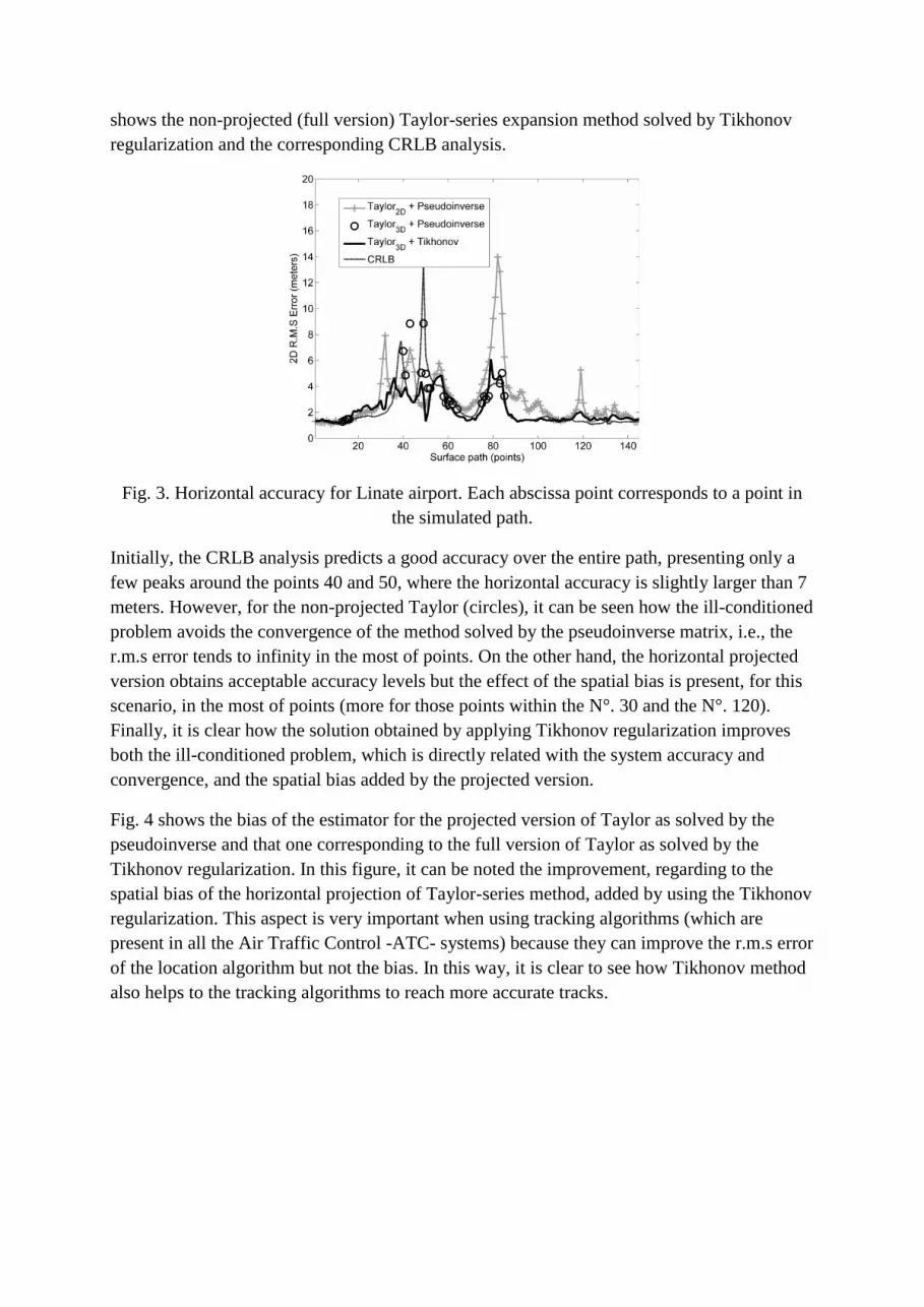
shows the non-projected (full version) Taylor-series expansion method solved by Tikhonov
regularization and the corresponding CRLB analysis.
Fig. 3. Horizontal accuracy for Linate airport. Each abscissa point corresponds to a point in
the simulated path.
Initially, the CRLB analysis predicts a good accuracy over the entire path, presenting only a
few peaks around the points 40 and 50, where the horizontal accuracy is slightly larger than 7
meters. However, for the non-projected Taylor (circles), it can be seen how the ill-conditioned
problem avoids the convergence of the method solved by the pseudoinverse matrix, i.e., the
r.m.s error tends to infinity in the most of points. On the other hand, the horizontal projected
version obtains acceptable accuracy levels but the effect of the spatial bias is present, for this
scenario, in the most of points (more for those points within the N°. 30 and the N°. 120).
Finally, it is clear how the solution obtained by applying Tikhonov regularization improves
both the ill-conditioned problem, which is directly related with the system accuracy and
convergence, and the spatial bias added by the projected version.
Fig. 4 shows the bias of the estimator for the projected version of Taylor as solved by the
pseudoinverse and that one corresponding to the full version of Taylor as solved by the
Tikhonov regularization. In this figure, it can be noted the improvement, regarding to the
spatial bias of the horizontal projection of Taylor-series method, added by using the Tikhonov
regularization. This aspect is very important when using tracking algorithms (which are
present in all the Air Traffic Control -ATC- systems) because they can improve the r.m.s error
of the location algorithm but not the bias. In this way, it is clear to see how Tikhonov method
also helps to the tracking algorithms to reach more accurate tracks.

Fig. 4. Horizontal bias of the estimator for Linate airport. Each abscissa point corresponds to a
point in the simulated path.
Fig. 5 shows the spatial convergence for a specific Monte-Carlo trial. In this figure it can be
observed how the solution by Tikhonov regularization allows the Taylor-series expansion to
ensure the convergence to the true point.
Fig. 5. Spatial convergence for one trial.
Finally, the probability of location, for this simulation, is shown in the first row of Table 1.
Because Linate system is intended only for surface surveillance, we have set the threshold in
(12) as 𝛿=7.5m [2]. From this table, we can observe the location strategy proposed herein
provides the highest probability of location with a value of 99.3 %. The classical solution
(Taylor3D + Pseudoinverse) practically does not allow any location (𝑃𝑜𝐿=14.28 %) whereas,
the projection version of this, provides a high probably of location but, due to the bias
problem, it is not better than that of the strategy proposed herein.
Table 1. Probability of Location for the simulations.
Scenario Starting
point
Taylor3D +
Pseudoinverse
Taylor2D +
Pseudoinverse
Taylor3D +
Tikhonov

Linate system
(𝛿=7.5m) -- 14.28 % 96.93 % 99.3 %
Takeoff line
(𝛿=25m) 85.54 % 81.2 % 66.02 % 95.8 %
B) MLAT System for a Takeoff Line
This system is composed for four stations and it is well analyzed in [6]. The layout of the
simulated scenario is shown in Fig. 6.
Fig. 6. Layout of the MLAT system for a takeoff line.
For this scenario, the starting point for the Taylor-series expansion method has been obtained
by means of the closed form algorithm described in [13]. This algorithm is based on spherical
intersections and it does not need for a starting point but, as it is shown in the results, it is also
affected for the ill-conditioning of the problem due to the system geometry. The horizontal
coordinates of the starting point (x,y) are taken from the closed form algorithm and the
vertical coordinate (z) is simulated as the barometric altitude, i.e., with a bias of 40m
regarding to the real target height. Also for this scenario it has been found that only using one
regularization parameter value (𝜆 = 0.1) is enough to obtain satisfactory results.
The amount of ill-conditioning of this scenario is significantly greater than that of the first
scenario. It is because the number of stations here (four) is much smaller than the first one
(eight). This effect can be noted in the CRLB analysis shown in Fig. 7 since the theoretical
accuracy diverges for points within 0 and 5 km and for those around 20 km. On the other
hand, due to the fact that for this scenario, the target height is increasing with the distance, the
vertical separation of this with the plane of the ground stations considerably affect the
accuracy provided by the horizontal projection of Taylor-series method (crosses) and the
spatial bias added by this is considerably large for points beyond 15 km.

Fig. 7. Horizontal accuracy over the takeoff line.
Due to the ill-conditioning, it can be observed that, for this scenario, the accuracy levels
provided by the full version of Taylor, using the pseudoinverse matrix, diverge far from the
theoretical accuracy values (CRLB) for points within 0-5 km and 15-20 km. On the contrary,
the closed form algorithm presents a more stable accuracy but it is also affected by system
geometry (Dilution of Precision -DOP-). Finally, it is evident the significant improvement, of
the system accuracy, obtained by applying Tikhonov regularization. The accuracy for this
option is stable for the whole of takeoff line and it is not larger than 25 meters. It is worth to
say that this solution is below the CRLB values because also the CRLB is affected by the ill-
conditioning of the problem, specifically that part due to the system geometry.
Fig. 8 shows the bias for the solutions obtained by the closed form algorithm and by the full
version of Taylor-series using both pseudoinverse matrix and Tikhonov regularization.
Firstly, it can be noted that for a few points close to 10 km and 15 km, the bias of the solution
obtained by pseudoinverse is smaller (nor more than 1 m) than that of Tikhonov method. It
can be explained because in the case of well-conditioned problems the pseudoinverse matrix
is the solution with minimum norm [3] and in contrast Tikhonov always adds certain amount
of bias [15]. The important aspect is that, if the correct regularization parameter value is
chosen, this amount of bias can be neglected regarding to the rest of the options to improve
the problem (i.e., the horizontal projection of Taylor-series method). Moreover, due to the ill-
conditioned problem, for the rest of the points, the bias added by pseudoinverse matrix
solution is infinity and for most of points the bias added by the closed form algorithm has
been found greater than that of Tikhonov regularization.

Fig. 8. Horizontal bias of the estimator over the takeoff line.
Fig. 9 shows the spatial convergence for a specific Monte-Carlo trial; in this figure it can be
noted how the regularization of the location problem ensures the convergence also for this
scenario.
Fig. 9. Spatial convergence for one trial over the takeoff line.
Finally, the probability of location, for this simulation, is shown in the second row of Table 1.
Because this system is intended for surface surveillance in a takeoff line (more than 5NM
from the runway), we have set the threshold in (12) as 𝛿=25m [2]. From this table, we can
observe the location strategy proposed herein provides the highest probability of location with
a value of 95.8 %, which is significantly much greater than those of the remaining strategies.
This parameter also evidence the bias problem of the projected version of Taylor, i.e., only
𝑃𝑜𝐿=66.02 %. On the other hand, the starting point, obtained by the closed form algorithm
[13], provides a 𝑃𝑜𝐿=85.54 %, value that is not significantly improved by the application of
the classical strategy (𝑃𝑜𝐿=81.2 %).

V. CONCLUSION
The implementation of Tikhonov regularization to solve the inverse problem of Taylor-series
expansion method, for location in Multilateration systems, has been described and evaluated.
The theoretical aspects of the method with a practical strategy to calculate the regularization
parameter have been described.
For the scenarios simulated herein, significant improvements, for the system accuracy and
convergence, have been found with the implementation of Tikhonov regularization. For both
scenarios, it was found that the regularization of the location problem significantly mitigates
the ill-conditioning due to the system geometry, i.e., those points where the CRLB analysis
predicts poor accuracy levels; to the measurements noise, i.e., those points where the CRLB
predicts good accuracy levels but the solution obtained by the pseudoinverse matrix diverges;
and also due to the quality of the starting point for Taylor-series expansion method.
Moreover, these improvements are also evidenced by the increment of the probability of
location for all the cases evaluated in this work, which, in other words, means to meet the
accuracy values from the regulatory bodies (e.g. those in [2]).
Another important advantage of the strategy proposed herein is that, it does not require
significant economic investments like the hardware based solutions and, at the same time, it
does not introduce the bias problem due to the implementation of projected versions of the
location algorithms.
For both scenarios it was found that a regularization parameter value of 𝜆 = 0.1 was enough
to obtain satisfactory results but, it is worth to say that in the situations where the problem is
better conditioned, it is necessary to use, at least, one or two more values smaller than 𝜆 =
0.1, i.e., the smaller the amount of ill-conditioning the smaller should be 𝜆.
The regularization of the location problem is most useful for those situations where the
vertical separation between the ground stations and the target is quite small or for those
situations with a small number of stations.
ACKNOWLEDGEMENT
Mr. Ivan A. Mantilla-Gaviria has been supported by a FPU scholarship (AP2008-03300) from
the Spanish Ministry of Education. Moreover, the authors are grateful to Thales Italia S.p.A.
(Dr. Ing. R. Scaroni) who supplied the geometry of the Multilateration system in Linate
(Milan, Italy) airport.
REFERENCES
[1] The ATM surveillance strategy for ecac, in: European Air Traffic Management
Programme, Eurocontrol, 2008.
[2] ED-117, MOPS for mode s multilateration systems for use in advanced surface movement
guidance and control systems (a-smgcs), in: EUROCAE (Ed.), EUROCAE, , November 2003.

[3] Golub, G.H.; Loan, C.F.V.: Matrix computations, the Johns Hopkins University Press,
Baltimore, 1996.
[4] Hadamard, J.: Lectures on Cauchy's Problem in Linear Partial Differential Equations, Yale
University Press, New Haven, 1923.
[5] Leonardi, M.; Mathias, A.; Galati, G.: Two efficient localization algorithms for
multilateration. International Journal of Microwave and Wireless Technologies, 1 (2009),
223-229.
[6] Galati, G.; Leonardi, M.; Tosti, M.: Multilateration (local and wide area) as a distributed
sensor system: Lower bounds of accuracy, European Radar Conference, EuRAD, Amsterdam,
30-31 Oct. 2008.
[7] Bertero, M.; Boccacci, P.; Brakenhoff, G.J.; Malfanti, F.; Voort, H.T.M.v.d.: Three-
dimensional image restoration and super-resolution in flourescence confocal microscopy.
Journal of Microscopy, 157 (1990), 3-20.
[8] Harrington, R.F.: Field Computations by Moment Methods, Macmillan, New York, 1993.
[9] Menke, W.: Geophysical data analysis: Discrete Inverse Theory, Academic Press, San
Diego, 1989.
[10] Foy, W.H.: Position-location solution by taylor-series estimation. IEEE Transactions on
Aerospace and Electronic System, AES-12 (March 1976), 187-194.
[11] Torrieri, D.J.: Statistical theory of passive location systems. IEEE Transactions on
Aerospace and Electronic System, AES-20 (March 1984), 183-198.
[12] Perl, E.; Gerry, M.J.: Target localization using tdoa distributed antenna, US
2005/0035897 A1, USA, Feb. 17 2005.
[13] Schau, H.C.; Robinson, A.Z.: Passive source localization employing intersecting
spherical surfaces from time-of-arrival differences. IEEE Transactions on Acoustics, Speech,
And Signal Processing, ASSP-35 (August 1987), 1223-1225.
[14] Ho, K.C.; Chan, Y.T.: Solution and performance analysis of geolocation by tdoa. IEEE
Transactions on Aerospace and Electronic System, 29 (October 1993), 1311-1322.
[15] Tikhonov, A.N.: Solution of incorrectly formulated problems and the regularization
method. Sovieth Math. Dokl., 4 (1963), 1035-1038.
[16] Phillips, D.L.: A technique for the numerical solution of certain integral equations of the
first kind. Journal of the ACM, 9 (1962), 84-97.
[17] Morozov, V.A.: On the solution of functional equations by method of regularization.
Sovieth Math. Dokl., 7 (1966), 414-417.
[18] Gfrerer, H.: An a posteriori parameter choice for ordinary and iterated tikhonov
regularization of ill-posed problems leading to optimal convergences rates. Math. Comp., 49
(1987), 507-522.
[19] Hanke, M.; Raus, T.: A general heuristic for choosing the regularization parameter in ill-
posed problems. SIAM J. Sci. Comput., 17 (1996), 956-972.

[20] Golub, G.H.; Heath, M.T.; Wahba, G.: Generalized cross-validation as a method for
choosing a good ridge parameter. Technometrics, 21 (1979), 215-223.
Bio Data for Authors
Ivan A. Mantilla-Gaviria was born in Bucaramanga, Colombia in 1985. He
received the Degree in Telecommunications Engineer (Cum Laude) from Saint Thomas
University, Bucaramanga, Colombia, in 2006 and the Master of Science degree in
Technologies, System and Communications Network from Polytechnic University of
Valencia (UPV), Valencia, Spain, in 2007. In December 2006 he joined the ITACA (Institute
for the Application of Advanced Information and Communication Technologies) research
institute as PhD student in the Electromagnetism Applied Group, where he has collaborated in
several R & D projects with companies and public administrations in radar applications and,
design and quality control of software. In 2009 he joined Communication Department at UPV
as a researcher with FPU scholarship from Spanish Ministry of Education, where currently he
also teaches navigation systems laboratory. His main research interests are radar topics and
optimization methods.
Mauro Leonardi was born in 1974, in Rome, Laurea cum laude in Electronic
Engineering (May 2000) at Tor Vergata University in Rome. PhD in October 2003, focusing
his work on Target Tracking, Air Traffic Control and Navigation. From January 2004 he is
Assistant Professor at Tor Vergata University in Rome where he teaches “Detection and
Navigation Systems” and “Radar Systems”, his main research activities are focused on: Air
Traffic Control and Advanced Surface Movement Guidance and Control System (A-
SMGCS); Satellite Navigation, Integrity and Signal Analysis. He is author/co-author of over
25 papers, two patents and many technical reports.
Gaspare Galati from 1970 till 1986 was with the company Selenia where he was
involved in radar systems analysis and design. From March, 1986 he is associate professor
(full professor from November, 1994) of Radar Theory and Techniques at the Tor Vergata
University of Rome, where he also teaches Probability, Statistics and Random Processes. He
is senior member of the IEEE, member of the IEE and of the Associazione Elettrotecnica ed

Elettronica Italiana, AEI. Within the AEI he is the chairman of the Remote Sensing,
Navigation and Surveillance Group.
Juan V. Balbastre-Tejedor was born in Mislata, Spain, in August 1969. He
received the Engineering and Ph.D. degrees from the Polytechnic University of Valencia,
Valencia, Spain, in 1993 and 1996, respectively. Since 1993, he has been a member of the
research and teaching staff in the Department of Communications at the Polytechnic
University of Valencia. In 2001, he joined the research staff of the ITACA Research Institute,
Polytechnic University of Valencia. From 1998 to 2006, he was the Academic Vice-Dean at
E.T.S.I. Telecomunicación of Valencia, Valencia. His current research interests include
electromagnetic theory and computational electromagnetic applied to industrial microwave
systems, electromagnetic compatibility, and radar. Currently, he is the Director of the E.T.S.I.
Telecomunicación of Valencia, Valencia.
Elías de los Reyes Davó was born in Albatera, Spain, in 1950. He received the
Engineering degree from the Polytechnic University of Madrid (UPM), Madrid, Spain, in
1974 and the Ph.D. degree from Polytechnic University of Catalunya (UPC), Barcelona,
Spain, in 1978. From 1974 to 1988 he was with the E.T.S.I.T. of the UPC, Barcelona, Spain,
as a full professor. Since 1988 he is a full professor in the Communication Department at the
Polytechnic University of Valencia (UPV), Valencia, Spain, where he has taught
electromagnetic fields and Radar. Currently he is the Director of the Applied
Electromagnetism Group at the ITACA research institute in UPV. He has published several
books on electromagnetism and numerous (more than one hundred) national and international
papers, having received the favourable assessment of his research by the ANECA (National
Quality Assessment Agency) in several six-year assessment exercise periods. His current
research interests include electromagnetic theory, microwave heating and radar applications.
List of figures and tables
Fig. 1. A pictorial view (2D) of TDOA localization.
Fig. 2. Linate airport system layout.
Fig. 3. Horizontal accuracy for Linate airport. Each abscissa point corresponds to a point in
the simulated path.
Fig. 4. Horizontal bias of the estimator for Linate airport. Each abscissa point corresponds to a
point in the simulated path.
Fig. 5. Spatial convergence for one trial.
Fig. 6. Layout of the MLAT system for a takeoff line.

Fig. 7. Horizontal accuracy over the takeoff line.
Fig. 8. Horizontal bias of the estimator over the takeoff line.
Fig. 9. Spatial convergence for one trial over the takeoff line.
Table 1. Probability of Location for the simulations.
This is an author version (draft pre-refereeing)!
The final paper appears in the International Journal of Microwave and Wireless
Technologies published by Cambridge University Press. Copyright Cambridge University
Press.
Please refer to http://dx.doi.org/10.1017/S1759078712000104 for the full paper