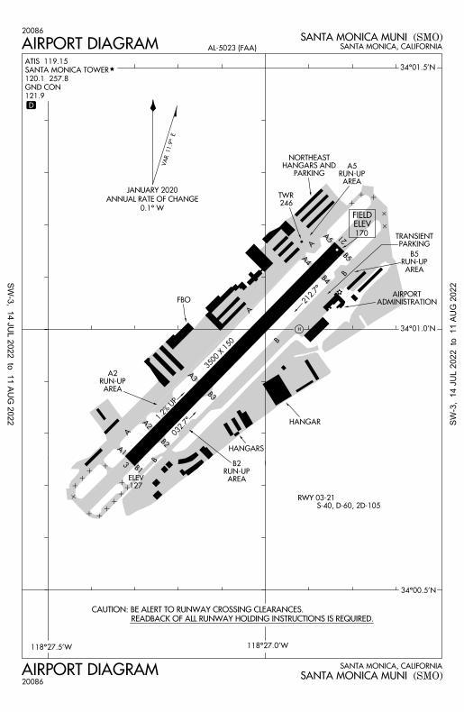
airport diagram airport diagram - flightaware
TRANSCRIPT
1.2% UP
CAUTION: BE ALERT TO RUNWAY CROSSING CLEARANCES.
READBACK OF ALL RUNWAY HOLDING INSTRUCTIONS IS REQUIRED.
321
212.7°
34°01.5'N
118°27.5'W
34°00.5'N
ADMINISTRATIONAIRPORT
HANGAR
FIELDELEV170
AIRPORT DIAGRAM
AIRPORT DIAGRAM SANTA MONICA, CALIFORNIA
SANTA MONICA, CALIFORNIA
(SMO)
(SMO)
SANTA MONICA MUNI
SANTA MONICA MUNI
AL-5023 (FAA)
ATIS 119.15
SANTA MONICA TOWER
120.1 257.8
GND CON
121.9
20086
20086
3500 X 150
B1
B2
B4
A4
A2
A1
A
A
B
B
S-40, D-60, 2D-105RWY 03-21
246TWR
HANGARS
34°01.0'N
118°27.0'W
127ELEV
A3
B3
A5
B5
FBO
PARKINGTRANSIENT
A
B
PARKINGHANGARS AND
NORTHEAST
AREARUN-UP
A5
AREARUN-UP
B5
AREARUN-UP
A2
AREARUN-UP
B2
D
0.1° W
ANNUAL RATE OF CHANGE
JANUARY 2020
H
032.7°
VA
R 11.9° E
SW-3, 14 JU
L 2022 to 11 AUG
2022 SW-3
, 14
JU
L 20
22 t
o 1
1 AU
G 2
022
SA
NT
A M
ON
ICA
, CA
LIF
OR
NIA
(SM
O)
SA
NT
A M
ON
ICA
, CA
LIF
OR
NIA
(SM
O)
SA
NT
A M
ON
ICA
MU
NI
SA
NT
A M
ON
ICA
MU
NI
(CH
OII3
.CH
OII)
(CH
OII3
.CH
OII)
TAKEOFF MINIMUMS
(RN
AV
)
(RN
AV
)
NOTE: Chart not to scale.
N
FL230
TOP ALTITUDE:
MISEN
NNAVY
ANTLP
SLAPP
DARTS
036°
15000
035°
(63)
150000
35°
(51)
15000
043°
(19)
1500
0
072°(52)
15000
035°
(17)
15000
060°
(40)
15000
075°
(12)074°
(11)
15000
066°
(8)028°
(16)
036°
(4)
033°
254°
(26)
(17)
319°
(50)
14000
329°
(15)
057°
(28)
1500
0
680
4000
TREKK
15000
YAAPY
JETHK
FL190
(12)
329°
FL200
BBITE
7500
(40)
15000
YUMMI
HEYJO
CSTRO
7100
290°
7100
8000
135.05 317.5
SOCAL DEP CON
120.1 257.8
SANTA MONICA TOWER
119.15
ATIS
008°
7100
(5)
AL
-50
23
(FA
A)
AERRO
098°(84)
15000
(51)
103°
15000
DECAS 099°(37)
15000
BLH
BLYTHE
COREZ
MDWAY
10300
318°
(12)
SHORS
(40)
317°
14000
307°(2
1)10300
Rwy 21: NA - ATC.
per NM to 680, then 275' per NM to 4300.
Rwy 3: Standard with a minimum climb of 500'
10
SE
P2
0
20
25
4
15000
CH
OII T
HR
EE
DE
PA
RT
UR
E
CH
OII T
HR
EE
DE
PA
RT
UR
E
250K unless otherwise directed by ATC.
CSTRO, COREZ transitions: Maintain at or below
HAILO transition ATC assigned only.
MISEN transition restricted to aircraft landing Las Vegas terminal area.
Turbojet aircraft only.
RADAR required.
DME/DME/IRU or GPS required.
RNAV 1.
NOTE:
NOTE:
NOTE:
NOTE:
NOTE:
NOTE:
NOTE:
7100
CHOII
BLAZN
GUNNR
ARRMY
HAILO
LAS
LAS VEGAS
HEC
HECTOR
FIM
FILLMORE
(NARRATIVE ON FOLLOWING PAGE)
SW-3, 14 JUL 2022 to 11 AUG 2022SW-3, 14 JUL 2022 to 11 AUG 2022
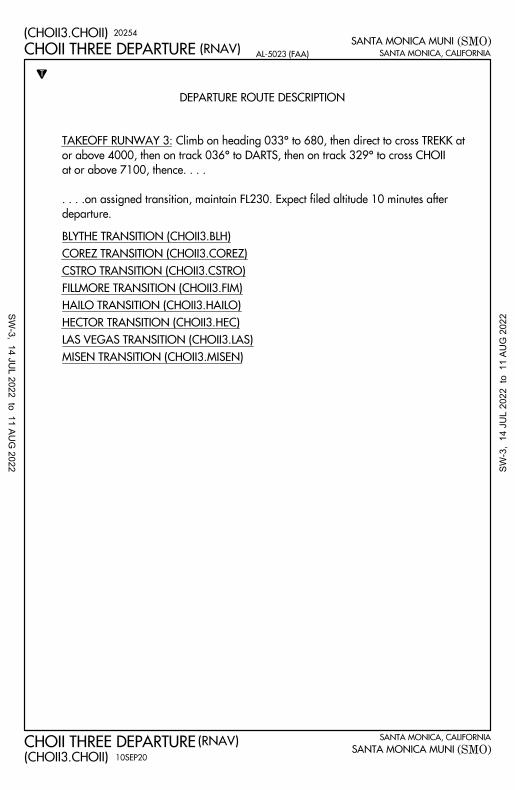
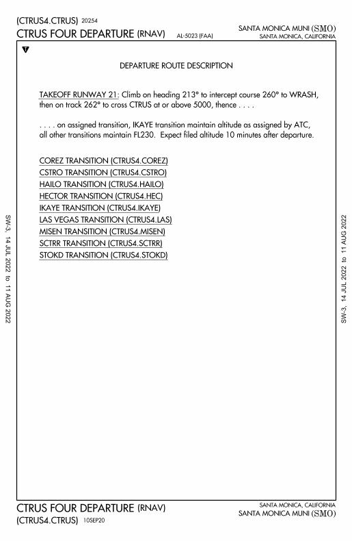
DEPARTURE ROUTE DESCRIPTION
T
SANTA MONICA, CALIFORNIA
(SMO)
SANTA MONICA, CALIFORNIA
(SMO)
SANTA MONICA MUNI
SANTA MONICA MUNI(CHOII3.CHOII)
(CHOII3.CHOII)
(RNAV)
(RNAV)AL-5023 (FAA)
MISEN TRANSITION (CHOII3.MISEN)
LAS VEGAS TRANSITION (CHOII3.LAS)
HECTOR TRANSITION (CHOII3.HEC)
HAILO TRANSITION (CHOII3.HAILO)
FILLMORE TRANSITION (CHOII3.FIM)
CSTRO TRANSITION (CHOII3.CSTRO)
COREZ TRANSITION (CHOII3.COREZ)
BLYTHE TRANSITION (CHOII3.BLH)
10SEP20
20254
CHOII THREE DEPARTURE
CHOII THREE DEPARTURE
departure.
. . . .on assigned transition, maintain FL230. Expect filed altitude 10 minutes after
at or above 7100, thence. . . .
or above 4000, then on track 036° to DARTS, then on track 329° to cross CHOII
TAKEOFF RUNWAY 3: Climb on heading 033° to 680, then direct to cross TREKK at
SW-3, 14 JU
L 2022 to 11 AUG
2022 SW-3
, 14
JU
L 20
22 t
o 1
1 AU
G 2
022
MISEN
NNAVY
ANTLP
036°
15000
035°(63)
15000
035°
(51)15000
043°
(19)
1500
0
072°(52)
15000
035°
(17)15000
060°
(40)
1500
0
075°
(12)
15000
074°
(11)
15000
066°
(8)
028°
(16)
057°
(28)
15000
15000
YAAPY
JETHK
FL190FL200
BBITE
(40)
15000
260° 213°
WRASH
(4)
262°
224°50
00
(9)
350°
5000
(5)
DARRK
12000
250K
DZINE
284°(6)
5000WOPPR
282°
8500
(8)
342°
12000
(10)
12000
FIXIT
IKAYE
284°
5400
(13)
008°
9000
(14)
SEAEM
042°60
00
(15)
TESEA
SCTRR
RIZIN
SPLNT
290°(31)
12000
303°
305°
12000
(32)
STOKD
303°
12000
(87)
311°
(58)
12000
12000
(27)
10 NM
123°
HEYJO
CSTRO
318°
319°
339°
SHORS
MDWAY
COREZ
318°
14000
(12)
317°
14000
(40)
(50)
14000
8000
(18)
10300
(26)
OROSZ
(20)
6000
348°
(CT
RU
S4
.CT
RU
S)
(SM
O)
(RN
AV
)S
AN
TA
MO
NIC
A M
UN
I
SA
NT
A M
ON
ICA
, CA
LIF
OR
NIA
(CT
RU
S4
.CT
RU
S)
(SM
O)
SA
NT
A M
ON
ICA
MU
NI
(RN
AV
)A
L-5
02
3 (F
AA
)S
AN
TA
MO
NIC
A, C
AL
IFO
RN
IA
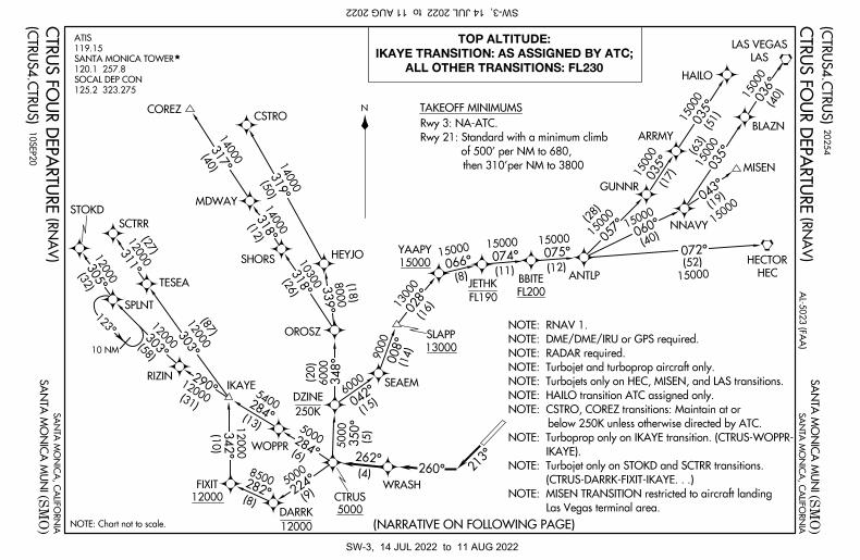
125.2 323.275
SOCAL DEP CON
120.1 257.8
SANTA MONICA TOWER
119.15
ATIS
N
NOTE: Chart not to scale.
ALL OTHER TRANSITIONS: FL230
IKAYE TRANSITION: AS ASSIGNED BY ATC;
TOP ALTITUDE:
13000
SLAPP
13000
TAKEOFF MINIMUMS
(NARRATIVE ON FOLLOWING PAGE)
then 310'per NM to 3800
of 500' per NM to 680,
Rwy 21: Standard with a minimum climb
Rwy 3: NA-ATC. 20
25
4
10
SE
P2
0
Las Vegas terminal area.
NOTE: MISEN TRANSITION restricted to aircraft landing
(CTRUS-DARRK-FIXIT-IKAYE. . .)
NOTE: Turbojet only on STOKD and SCTRR transitions.
IKAYE).
NOTE: Turboprop only on IKAYE transition. (CTRUS-WOPPR-
below 250K unless otherwise directed by ATC.
NOTE: CSTRO, COREZ transitions: Maintain at or
NOTE: HAILO transition ATC assigned only.
NOTE: Turbojets only on HEC, MISEN, and LAS transitions.
NOTE: Turbojet and turboprop aircraft only.
NOTE: RADAR required.
NOTE: DME/DME/IRU or GPS required.
NOTE: RNAV 1.
CT
RU
S F
OU
R D
EP
AR
TU
RE
CT
RU
S F
OU
R D
EP
AR
TU
RE
BLAZN
GUNNR
ARRMY
HAILO
LAS
LAS VEGAS
HEC
HECTOR
5000
CTRUS
SW-3, 14 JUL 2022 to 11 AUG 2022SW-3, 14 JUL 2022 to 11 AUG 2022
(CTRUS4.CTRUS)
(CTRUS4.CTRUS)
(SMO)
(SMO)
SANTA MONICA MUNI (RNAV)
(RNAV)SANTA MONICA MUNI
AL-5023 (FAA) SANTA MONICA, CALIFORNIA
SANTA MONICA, CALIFORNIA
DEPARTURE ROUTE DESCRIPTION
T
STOKD TRANSITION (CTRUS4.STOKD)
SCTRR TRANSITION (CTRUS4.SCTRR)
MISEN TRANSITION (CTRUS4.MISEN)
LAS VEGAS TRANSITION (CTRUS4.LAS)
IKAYE TRANSITION (CTRUS4.IKAYE)
HECTOR TRANSITION (CTRUS4.HEC)
HAILO TRANSITION (CTRUS4.HAILO)
CSTRO TRANSITION (CTRUS4.CSTRO)
COREZ TRANSITION (CTRUS4.COREZ)
10SEP20
20254
CTRUS FOUR DEPARTURE
CTRUS FOUR DEPARTURE
all other transitions maintain FL230. Expect filed altitude 10 minutes after departure.
. . . . on assigned transition, IKAYE transition maintain altitude as assigned by ATC,
then on track 262° to cross CTRUS at or above 5000, thence . . . .
TAKEOFF RUNWAY 21: Climb on heading 213° to intercept course 260° to WRASH,
SW-3, 14 JU
L 2022 to 11 AUG
2022 SW-3
, 14
JU
L 20
22 t
o 1
1 AU
G 2
022
SA
NT
A M
ON
ICA
, CA
LIF
OR
NIA
(SM
O)
SA
NT
A M
ON
ICA
, CA
LIF
OR
NIA
(SM
O)
SA
NT
A M
ON
ICA
MU
NI
SA
NT
A M
ON
ICA
MU
NI
(PE
VE
E6
.PE
VE
E)
(PE
VE
E6
.PE
VE
E)
TAKEOFF MINIMUMS
(RN
AV
)
(RN
AV
)
NOTE: Chart not to scale.
PE
VE
E S
IX D
EP
AR
TU
RE
PE
VE
E S
IX D
EP
AR
TU
RE
125.2 323.275
SOCAL DEP CON
120.1 257.8
SANTA MONICA TOWER
255°
(5)
181°
(6)
130°
(16)
105°9000
126°
(25)
094°(29)
079°(41)
N
(NARRATIVE ON FOLLOWING PAGE)
125°(41)
097°(63)
079°(13)065°
(29)078°(27)
079°(20)
059°
(24)
097°
(9)9000
260°
213°
LVELL
WURMO
TTRUERwy 21:
Rwy 3:
WRASHPEEER
SPRRW
PEVEE
HOLTZ EYEDL HOMER
CLEEE079°(45)
WIILD BLCKD CSTWY
CNERY
TANNN
15000
PNDAH
FL200
TCATE
OTAYY
(21)
NNICE(9)
10000
1500015000
15000
15000 1500015
000
15000
15000
15000
105°
15000
15000
AL
-50
23
(FA
A)
OTAYY and TCATE TRANSITIONS: FL200
CLEEE and CNERY TRANSITIONS: 17000;
TOP ALTITUDE:
DOTSS
15000
NOTE: All aircraft expect RADAR vectors to PEVEE prior to PEEER.
NOTE: Turbojet aircraft only.
NOTE: RADAR required.
NOTE: DME/DME/IRU or GPS required.
NOTE: RNAV 1.
Standard with a minimum climb of 500' per NM to 680.
NA - ATC.
01
FE
B1
8
18
03
2
SW-3, 14 JUL 2022 to 11 AUG 2022SW-3, 14 JUL 2022 to 11 AUG 2022
SANTA MONICA, CALIFORNIA
(SMO)
SANTA MONICA, CALIFORNIA
(SMO)
SANTA MONICA MUNI
SANTA MONICA MUNI
DEPARTURE ROUTE DESCRIPTION
T
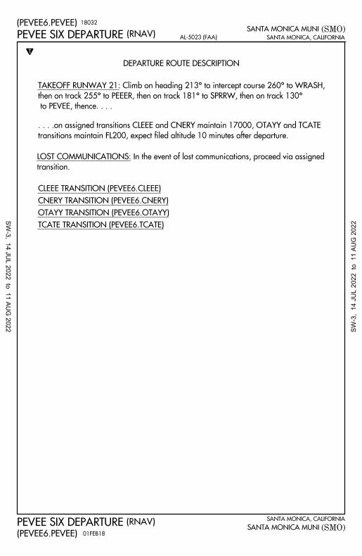
TCATE TRANSITION (PEVEE6.TCATE)
OTAYY TRANSITION (PEVEE6.OTAYY)
CNERY TRANSITION (PEVEE6.CNERY)
CLEEE TRANSITION (PEVEE6.CLEEE)
transition.
LOST COMMUNICATIONS: In the event of lost communications, proceed via assigned
to PEVEE, thence. . . .
then on track 255° to PEEER, then on track 181° to SPRRW, then on track 130°
TAKEOFF RUNWAY 21: Climb on heading 213° to intercept course 260° to WRASH,
(PEVEE6.PEVEE)
(RNAV)PEVEE SIX DEPARTURE AL-5023 (FAA)
(PEVEE6.PEVEE)
(RNAV)PEVEE SIX DEPARTURE
transitions maintain FL200, expect filed altitude 10 minutes after departure.
. . . .on assigned transitions CLEEE and CNERY maintain 17000, OTAYY and TCATE
01FEB18
18032
SW-3, 14 JU
L 2022 to 11 AUG
2022 SW-3
, 14
JU
L 20
22 t
o 1
1 AU
G 2
022
(SM
O3
.CH
OII)
(SM
O3
.CH
OII)
(SM
O)
(SM
O)
(RN
AV
)
(RN
AV
)
AL
-50
23
(FA
A)
SA
NT
A M
ON
ICA
, CA
LIF
OR
NIA
SA
NT
A M
ON
ICA
, CA
LIF
OR
NIA
SA
NT
A M
ON
ICA
MU
NI
SA
NT
A M
ON
ICA
MU
NI
NOTE: Chart not to scale.
TAKEOFF MINIMUMS
N
TDEPARTURE ROUTE DESCRIPTION
125.2 323.275 (Rwy 21)
135.05 317.5 (Rwy 3)
SOCAL DEP CON
120.1 257.8
SANTA MONICA TOWER
WRASH
SEAEM
DARTS
VVERA
SSETH
DAG
DAGGETT
HEC
HECTOR
262°
055°
350°
036°
03
3°
21
3°
260°
042°
680
008°
008°
065°
065°
046°
070°
4000
TREKK
7100
CHOII
329°
5000
CTRUS
DZINE
6000
(5)7100
(7)
7500
11000
(23)
(37)
13000
(26)
1300
0
(28)
13000
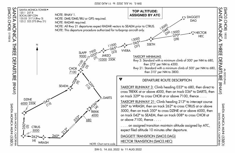
ASSIGNED BY ATC
TOP ALTITUDE:
(15)
(9)
(15)
(4)
(4)
(5)
HECTOR TRANSITION (SMO3.HEC)
DAGGETT TRANSITION (SMO3.DAG)
on track 329° to cross CHOII at or above 7100, thence . . . .
cross TREKK at or above 4000, then on track 036° to DARTS, then
TAKEOFF RUNWAY 3: Climb heading 033° to 680, then direct to
or above 7100, thence . . . .
on track 042° to SEAEM, then on track 008° to cross CHOII at
5000, then on track 350° to cross DZINE at or above 6000, then
260° to WRASH, then on track 262° to cross CTRUS at or above
TAKEOFF RUNWAY 21: Climb heading 213° to intercept course
expect filed altitude 10 minutes after departure.
. . . . on assigned transition maintain altitude assigned by ATC,
250K
9000
SLAPPJARZO
250K10300
NOTE: This departure procedure authorized for turboprop aircraft only.
NOTE: All Rwy 21 departures expect RADAR vectors to SEAEM prior to CTRUS.
NOTE: RADAR required.
NOTE: DME/DME/IRU or GPS required.
NOTE: RNAV 1.S
AN
TA
MO
NIC
A T
HR
EE
DE
PA
RT
UR
E
SA
NT
A M
ON
ICA
TH
RE
E D
EP
AR
TU
RE
01
FE
B1
8
18
03
2
then 310' per NM to 3800.
Rwy 21: Standard with a minimum climb of 500' per NM to 680,
then 275' per NM to 4300.
Rwy 3: Standard with a minimum climb of 500' per NM to 680,
SW-3, 14 JUL 2022 to 11 AUG 2022SW-3, 14 JUL 2022 to 11 AUG 2022
2000
10002000
1000
3000
4000
246
TWR
1.2% UP
211
175
225
P
P
3
21
3500 X 150
CATEGORY B C DA
to SADDE and hold, continue climb-in-hold to 5000.
right turn to 5000 direct CAPOB and on track 283°
MISSED APPROACH: Climb to 600 then climbing
TDZE
Rwy Idg 3500170
APP CRS
213°
WAAS
CH 90339
W21A 170Apt Elev
ELEV TDZE
DA
MDALNAV
LPV DA
RADAR REQUIRED
600 5000 CAPOB
283°
tr
SADDE
4200
DARTS
CAPOB
SADDE
DARTS
(IF)
MOVVE
(FAF)
GP 3.50°
TCH 53
MOVVE
3000
4.6 NM4.2 NM0.9 NM2.4 NM
3000
219°
1440*
*
*LNAV only
(VGSI Angle 3.50/TCH 45).
VGSI and RNAV glidepath not coincident
148°
328°
2908
2038
2025
1870
1387866
649
631
230
2824
2126
M
N 52 12WR AS
M7800
5 NM
L
L
RNAV (GPS) RWY 21
RNAV (GPS) RWY 21
SANTA MONICA, CALIFORNIA
SANTA MONICA, CALIFORNIA
(SMO)
(SMO)
SANTA MONICA MUNI
SANTA MONICA MUNI
AL-5023 (FAA)
34°01'N-118°27'W
453
V459-597 northwest bound and on V459 southeast bound.
Procedure NA for arrivals at DARTS on V186-597 eastbound,
213°
170 170
28282067
2403
2314 4000
VNAV
LNAV/515 (600-1 )685-1
RW21RW21
2.4 NM toRW21
3.3 NM to
MIPTE
RW21
RW21
3.3 NM to
MIPTE
RW21
213° to
219°
213°
(4.6)
3000
119.15
ATIS SOCAL APP CON
128.5 235.975 257.8(CTAF)120.1
SANTA MONICA TOWER GND CON
121.9
UNICOM
122.95
REIL Rwy 21
MIRL Rwy 3-21
38
38
14950 (1000-1 )1
41120-1 950 (1000-2 )1120-21212
440-1 270 (300-1)
Amdt 1B 24MAY18
reduction below 1 SM NA.
5°C (41°F) or above 14°C (58°F). Rwy 21 helicopter visibility
For uncompensated Baro-VNAV systems, LNAV/VNAV NA below
D
1432
1026
2824
2403
469
RNP APCH.
3233
18312
H
(9.5)
283°
T
A
L
SW-3, 14 JU
L 2022 to 11 AUG
2022 SW-3
, 14
JU
L 20
22 t
o 1
1 AU
G 2
022
2000
1000
1000
2000
2000
1000
3000
4000
246
TWR
1.2% UP
211
175
225
M
N 52
EVROM ASM
7700
P
P
(11.1)
113°
3500
051°
(5.9)
2000
Apt Elev
TDZE
Rwy Idg
APP CRS
WAAS
CH
ELEV 170 TDZE
051°
164
164170
L
L
CATEGORY B C DA
3500
460-1
2000
5.9 NM
296 (300-1)
756 (800-1)
920-1756 (800-2 )1
2920-212LP
LP
50339
W03A
3500
0.6
*
*
NATJU
JAASK
WAKER
(IAF)
NATHN
(IF)
THACH
(FAF)
238
MISSED APCH FIX
278°
098°
SESPE
(16.4)
266°
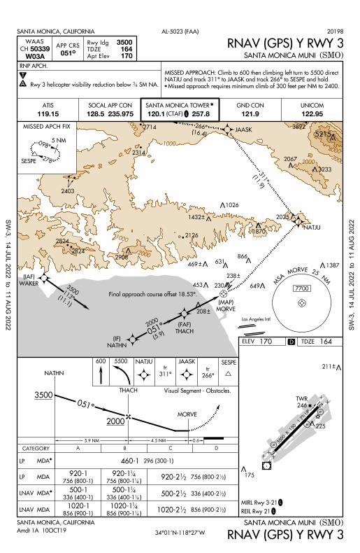
Final approach course offset 18.53°.
MORVE
(MAP)
2908
2067
5215
(11.9)
311°
4.5 NM
Los Angeles Intl
051°
2025
1870
1387
866
649
631
453 230
2403
2314
2126
5 NM
GND CON UNICOM
121.9 122.95119.15
ATIS SOCAL APP CON
128.5 235.975 257.8(CTAF)120.1
SANTA MONICA TOWER
NATHN
THACH
MORVE
600 5500 NATJU JAASK SESPE
SANTA MONICA, CALIFORNIA AL-5023 (FAA)
RNAV (GPS) Y RWY 3SANTA MONICA MUNI(SMO)
SANTA MONICA, CALIFORNIA
34°01'N-118°27'W
SANTA MONICA MUNI
RNAV (GPS) Y RWY 3
(SMO)
MDA
2714
2824
MDA920-114
756 (800-1 )14
311°
tr
266°
tr
Amdt 1A 10OCT19
20198
REIL Rwy 21
MIRL Rwy 3-21
D
3233
1432
1026
469
3892
2824
Rwy 3 helicopter visibility reduction below SM NA.34
T
A
Visual Segment - Obstacles.
LNAV MDA*500-1
336 (400-1)
500-114336 (400-1 )1
4500-212 336 (400-2 )1
2
LNAV MDA1020-1
856 (900-1)
1020-114856 (900-1 )1
41020-212 856 (900-2 )1
2
208
Missed approach requires minimum climb of 300 feet per NM to 2400.
NATJU and track 311° to JAASK and track 266° to SESPE and hold.
MISSED APPROACH: Climb to 600 then climbing left turn to 5500 direct
RNP APCH.
3
21
3500 X 1
50
L
H
SW-3, 14 JU
L 2022 to 11 AUG
2022 SW-3
, 14
JU
L 20
22 t
o 1
1 AU
G 2
022
2000
1000
10002000
1000
3000
246
TWR
1.2% UP
211
175
225
P
P
WAKER
(IAF)
RNSTO
(IF)RGBEE
(FAF)
DARTS
108°
288°5 NM
A
T
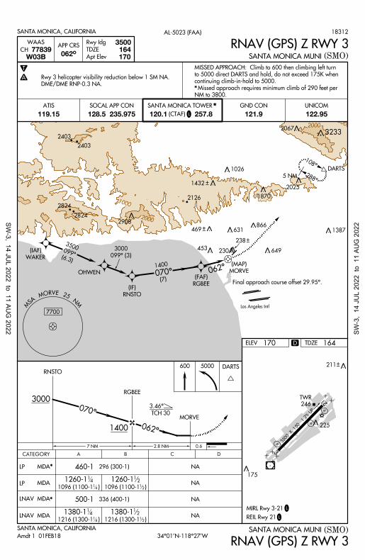
(SMO)SANTA MONICA MUNI
RNAV (GPS) Z RWY 3062°
W03B
WAASAPP CRS
CH 77839Apt Elev
TDZE
Rwy Idg
170164
3500
L
L
SANTA MONICA, CALIFORNIA (SMO)SANTA MONICA MUNI34°01'N-118°27'W
RNAV (GPS) Z RWY 3
ELEV 170 TDZE 164
460-1 296 (300-1)
336 (400-1)500-1
B C DA
NA
1380-1141216 (1300-1 )1
4
1380-112
1216 (1300-1 )12
1260-1141096 (1100-1 )1
4
1260-112
1096 (1100-1 )12
NA
NA
NA
3.46°
TCH 30
DARTS
2.8 NM
070°
5000RNSTO
3000
1400
RGBEE
MORVE
062°
2403
238
SANTA MONICA, CALIFORNIA AL-5023 (FAA)
600
OHWEN MORVE
(MAP)
(6.3)
099°
3500
070°(7)
1400
Los Angeles Intl
M
N 52
EVROM AS
M
7700
7 NM
062°
099° (3)
3000
2908
2067
2025
1870
1387866
649
631
453230
2126
GND CON UNICOM
121.9 122.95119.15
ATIS SOCAL APP CON
128.5 235.975 257.8(CTAF)120.1
SANTA MONICA TOWER
0.6
2824
Final approach course offset 29.95°.
DME/DME RNP-0.3 NA.
Rwy 3 helicopter visibility reduction below 1 SM NA.
NM to 3800.
Missed approach requires minimum climb of 290 feet per
continuing climb-in-hold to 5000.
to 5000 direct DARTS and hold, do not exceed 175K when
MISSED APPROACH: Climb to 600 then climbing left turn
*
LP MDA
LP MDA
*
LNAV MDA
LNAV MDA*
CATEGORY
Amdt 1 01FEB18
18312
REIL Rwy 21
MIRL Rwy 3-21
D
3233
1432
1026
469
2824
2403
3
21
3500 X 1
50
L
H
SW-3, 14 JU
L 2022 to 11 AUG
2022 SW-3
, 14
JU
L 20
22 t
o 1
1 AU
G 2
022
2000
1000
1000
20004000
1000
3000
4000
246
TWR
1.2% UP
211
175
225
P
P
R-250
RADAR
SMO 6.7
BEVEY INT
R-032
R-095
R-126
ELMOO
(IAF)
212°
MN
52 OMS ASM
080°
7800
250°
4100
(3.8)3
200
R-114
RADAR
SMO 3.4
WURUD
(4)
275°
4400
SMO110.8
SANTA MONICA
Chan 45
ELEV
CIRCLING
CIRCLING
SMO R-250
SADDE
Apt Elev
TDZE
Rwy Idg
110.8
Chan 45
N/A
A
T
N/A
L
L
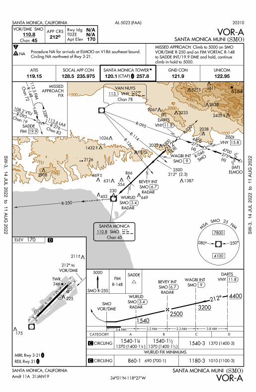
SANTA MONICA, CALIFORNIA
SANTA MONICA, CALIFORNIA
(SMO)SANTA MONICA MUNI
SANTA MONICA MUNI
AL-5023 (FAA)
VOR/DME SMO
212°
RADAR
SMO 6.7
BEVEY INT
VOR/DME
212° to
R-148
FIM
VOR-A
VOR-A34°01'N-118°27'W
NA
5000
RADAR
SMO 3.4
WURUD
1540
VOR/DME
SMO
1180-31010 (1100-3)860-1 690 (700-1)
1540-1 1540-1 14
12
1370 (1400-1 )121370 (1400-1 )1
4
1540-31370 (1400-3)
FIM 19.9
SADDE
148°
328°
Chan 7
2R-1
48
112.5 FIM
Chan 19
R-093
108.2 VTU
Chan 83
R-276
113.6 LAX
FIX
APPROACH
MISSED
VNY113.1
VAN NUYS
Chan 78
554
212°
4400
3200
2500
3.8 NM2.3 NM3.2 NM3.4 NM
VNY 15.8
ZISDI
(6)
275°
4700
212° (2.3)
2500
WURUD FIX MINIMUMS
C
C
20310
(SMO)
APP CRS
climb-in-hold to 5000.
to SADDE INT/19.9 DME and hold, continue
VOR/DME R-250 and on FIM VORTAC R-148
MISSED APPROACH: Climb to 5000 on SMO
CATEGORY B C DA
VNY 11.8
DARTS
(IF)
GND CON UNICOM
121.9 122.95119.15
ATIS SOCAL APP CON
128.5 235.975 257.8(CTAF)120.1
SANTA MONICA TOWER
VNY 11.8
DARTS
SMO 9
WAGBI INT
52153611
2908
2828
2435
2067
2038
2025
1870
1387
866
649
631
453
230
6164
2126
REIL Rwy 21
MIRL Rwy 3-21
D
3233
1432
1026
469
SMO 9
WAGBI INT
170
170
Amdt 11A 31JAN19
Circling NA northwest of Rwy 3-21.
Procedure NA for arrivals at ELMOO on V186 southeast bound.
SMOR-
046
3
21
3500 X 150
L
H
SW-3, 14 JU
L 2022 to 11 AUG
2022 SW-3
, 14
JU
L 20
22 t
o 1
1 AU
G 2
022
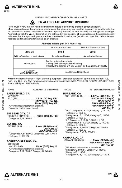
ALTERNATE MINS
22195
M1
SW-3
22195 M1
A A
ALTERNATE MINS A A
NAME ALTERNATE MINIMUMS NAME ALTERNATE MINIMUMS
BAKERSFIELD, CA MEADOWS FLD (BFL).………………...…ILS or LOC Rwy 30R
1
RNAV (GPS) Rwy 12L RNAV (GPS) Rwy 30R
NA when local weather not available. 1NA when control tower closed.
BIG BEAR CITY, CA
BIG BEAR CITY (L35)..………RNAV (GPS) Rwy 26 Categories A, B, 1600-2.
BLYTHE, CA BLYTHE (BLH).………………RNAV (GPS) Rwy 26
1
VOR /DME-A2
VOR/DME Rwy 262
1Categories A, B, 1700-2; Categories C, D, 1700-3
2Category D, 900-2¾.
BORREGO SPRINGS, CA BORREGO VALLEY (L08)……………….RNAV (GPS) Rwy 26 NA when local weather not available. Categories A, B, 1200-2; Category C, 1400-3.
A
INSTRUMENT APPROACH PROCEDURE CHARTS
IFR ALTERNATE AIRPORT MINIMUMS
Pilots must review the IFR Alternate Minimums Notes to determine alternate airport suitability. designation on the approach chart means that pilots may not use that approach as an alternate due to unmonitored facility, absence of weather reporting service, or lack of adequate navigation coverage. Approaches with the designation are not listed in this section. designation on the approach chart indicates that the approach procedure has non-standard minimums (for aircraft other than helicopters) or restrictions (for all users) for its use as an alternate.
Alternate Minima (ref: 14 CFR 91.169)
Note: For alternate airport flight planning purposes, precision approach operations include: ILS, PAR, and GLS, and Non-Precision approach operations include: NDB, VOR, LOC, TACAN, LDA, SDF, ASR, RNAV (GPS) and RNAV (RNP).
BURBANK, CA BOB HOPE (BUR)…………ILS Y or LOC Y Rwy 8
3
ILS Z or LOC Z Rwy 81
RNAV (GPS)-A2
RNAV (GPS) Z Rwy 84
RNAV (RNP) Y Rwy 85
VOR Rwy 84
1LOC, Category B, 900-2; Category C, 1500-3; Category D, 1600-3.
2Categories A, B, 1100-2; Category C, 1500-3; Category D, 1600-3.
3ILS Categories A, B, C, D 900-2½; LOC, Categories A, B, 900-2; Category C, 1500-3; Category D, 1600-3.
4Categories A, B, 900-2; Category C, 1500-3; Category D, 1600-3.
5Categories A, B, C, D, 800-2½.
CAMARILLO, CA
CAMARILLO (CMA).…………RNAV (GPS) Rwy 812
RNAV (GPS) Y Rwy 26
13
VOR Rwy 264
1NA when local weather not available.
2Category C, 800-2½; Category D, 1100-3.
3Category D, 1100-3.
4Categories A, B, 1100-2; Category C, 1100-3.
Precision Approach Non-Precision Approach
Standard 600-2 800-2
Non-Standard or restrictions As indicated below As indicated below
Helicopters For the selected approach: Ceiling: 200’ above published ceiling Visibility: the greater of 1 SM visibility or the published visibility
US Military (USA/USN/USAF)
See Service Regulations
14 JUL 2022 to 11 AU
G 2022 14
JU
L 20
22 t
o 1
1 AU
G 2
022
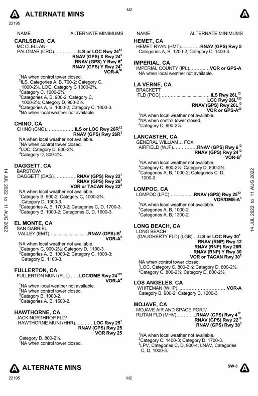
ALTERNATE MINS
22195
M2
SW-3
22195 M2
A A
ALTERNATE MINS A A
NAME ALTERNATE MINIMUMS NAME ALTERNATE MINIMUMS
CARLSBAD, CA MC CLELLAN- PALOMAR (CRQ).……………ILS or LOC Rwy 24
12
RNAV (GPS) X Rwy 243
RNAV (GPS) Y Rwy 64
RNAV (GPS) Y Rwy 243
VOR-A56
1NA when control tower closed.
2ILS, Categories A, B, 700-2; Category C,
1000-2¾. LOC, Category C 1000-2¾. 3Category C, 1000-2¾.
4Categories A, B, 900-2; Category C,
1000-2¾; Category D, 900-2½. 5Categories A, B, 1000-2; Category C, 1000-3.
6NA when local weather not available.
CHINO, CA CHINO (CNO).………………ILS or LOC Rwy 26R
12
RNAV (GPS) Rwy 26R3
NA when local weather not available. 1NA when control tower closed.
2LOC, Category D, 800-2¼.
3Category D, 800-2¼.
DAGGETT, CA BARSTOW- DAGGETT (DAG)……………RNAV (GPS) Rwy 22
1
RNAV (GPS) Rwy 263
VOR or TACAN Rwy 222
NA when local weather not available. 1Category B, 900-2; Category C, 1000-2¾; Category D, 1000-3.
2Categories A, B, 1700-2; Categories C, D, 1700-3.
3Category B, 1000-2; Categories C, D, 1600-3.
EL MONTE, CA SAN GABRIEL VALLEY (EMT)…............................RNAV (GPS)-B
1
VOR-A2
NA when local weather not available. 1Category C, 900-2½; Category D, 1100-3.
2Categories A, B, 1000-2; Category C, 1000-3; Category D, 1100-3.
FULLERTON, CA FULLERTON MUNI (FUL).…...LOC/DME Rwy 24
123
VOR-A4
1NA when local weather not available.
2NA when control tower closed.
3Category B, 1000-2.
4Categories A, B, 1500-2.
HAWTHORNE, CA JACK NORTHROP FLD/ HAWTHORNE MUNI (HHR).…..…….LOC Rwy 25
1
RNAV (GPS) Rwy 25 VOR Rwy 25
Category D, 800-2¼. 1NA when control tower closed.
HEMET, CA HEMET-RYAN (HMT).…………RNAV (GPS) Rwy 5 Categories A, B, 1200-2; Category C, 1400-3.
IMPERIAL, CA IMPERIAL COUNTY (IPL).……….…VOR or GPS-A NA when local weather not available.
LA VERNE, CA BRACKETT FLD (POC).……….......................…..ILS Rwy 26L
12
LOC Rwy 26L123
RNAV (GPS) Rwy 26L13
VOR or GPS-A
23
1NA when local weather not available.
2NA when control tower closed.
3Category C, 800-2¼.
LANCASTER, CA GENERAL WILLIAM J. FOX AIRFIELD (WJF).……………RNAV (GPS) Rwy 6
12
RNAV (GPS) Rwy 2412
VOR-B3
1NA when local weather not available.
2Category C, 800-2¼; Category D, 800-2½.
3Categories A, B, 1000-2; Categories C, D,
1000-3.
LOMPOC, CA LOMPOC (LPC)………..…...RNAV (GPS) Rwy 25
12
VOR/DME-A3
1NA when local weather not available.
2Categories A, B, 1000-2.
3Categories A, B, 1300-2.
LONG BEACH, CA LONG BEACH (DAUGHERTY FLD) (LGB)….ILS or LOC Rwy 30
1
RNAV (RNP) Rwy 12
RNAV (RNP) Rwy 26R RNAV (RNP) Y Rwy 30
VOR or TACAN Rwy 302
NA when control tower closed. 1LOC, Category C, 800-2¼; Category D, 800-2½.
2Category C, 800-2¼; Category D, 800-2½.
LOS ANGELES, CA WHITEMAN (WHP)...…………………………VOR-A Category B, 900-2; Category C, 1200-3.
MOJAVE, CA MOJAVE AIR AND SPACE PORT/ RUTAN FLD (MHV).………....RNAV (GPS) Rwy 4
12
RNAV (GPS) Rwy 2212
RNAV (GPS) Rwy 30
3
1NA when local weather not available.
2Category C, 1400-3; Category D, 1700-3.
3LPV, Categories C, D, 900-4; LNAV, Categories C, D, 1000-3.
14 JUL 2022 to 11 AU
G 2022 14
JU
L 20
22 t
o 1
1 AU
G 2
022
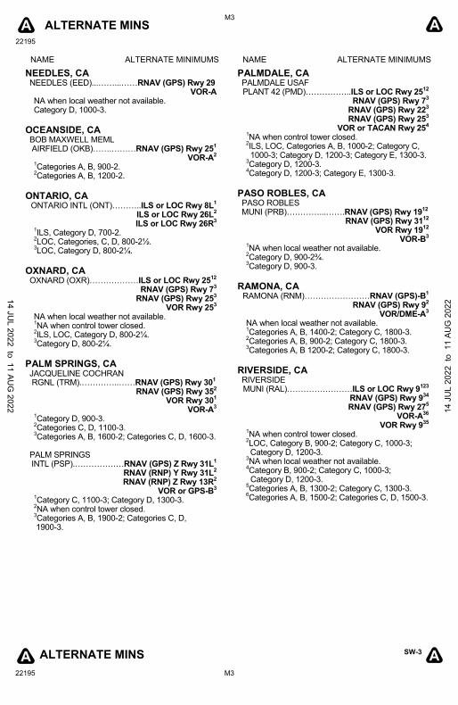
ALTERNATE MINS
22195
M3
SW-3
22195 M3
A A
ALTERNATE MINS A A
NAME ALTERNATE MINIMUMS NAME ALTERNATE MINIMUMS
NEEDLES, CA NEEDLES (EED)...……...……RNAV (GPS) Rwy 29
VOR-A NA when local weather not available. Category D, 1000-3.
OCEANSIDE, CA BOB MAXWELL MEML AIRFIELD (OKB)…….………RNAV (GPS) Rwy 25
1
VOR-A2
1Categories A, B, 900-2.
2Categories A, B, 1200-2.
ONTARIO, CA
ONTARIO INTL (ONT)………..ILS or LOC Rwy 8L1
ILS or LOC Rwy 26L2
ILS or LOC Rwy 26R3
1ILS, Category D, 700-2.
2LOC, Categories, C, D, 800-2½.
3LOC, Category D, 800-2¼.
OXNARD, CA OXNARD (OXR)………………ILS or LOC Rwy 25
12
RNAV (GPS) Rwy 73
RNAV (GPS) Rwy 253
VOR Rwy 253
NA when local weather not available. 1NA when control tower closed.
2ILS, LOC, Category D, 800-2¼.
3Category D, 800-2¼.
PALM SPRINGS, CA JACQUELINE COCHRAN RGNL (TRM).…………..……RNAV (GPS) Rwy 30
1
RNAV (GPS) Rwy 352
VOR Rwy 301
VOR-A3
1Category D, 900-3.
2Categories C, D, 1100-3.
3Categories A, B, 1600-2; Categories C, D, 1600-3.
PALM SPRINGS INTL (PSP).………………RNAV (GPS) Z Rwy 31L
1
RNAV (RNP) Y Rwy 31L2
RNAV (RNP) Z Rwy 13R2
VOR or GPS-B3
1Category C, 1100-3; Category D, 1300-3.
2NA when control tower closed.
3Categories A, B, 1900-2; Categories C, D,
1900-3.
PALMDALE, CA PALMDALE USAF PLANT 42 (PMD)……………..ILS or LOC Rwy 25
12
RNAV (GPS) Rwy 73
RNAV (GPS) Rwy 223
RNAV (GPS) Rwy 253
VOR or TACAN Rwy 254
1NA when control tower closed.
2ILS, LOC, Categories A, B, 1000-2; Category C, 1000-3; Category D, 1200-3; Category E, 1300-3.
3Category D, 1200-3.
4Category D, 1200-3; Category E, 1300-3.
PASO ROBLES, CA PASO ROBLES MUNI (PRB)…………...…….RNAV (GPS) Rwy 19
12
RNAV (GPS) Rwy 3112
VOR Rwy 1912
VOR-B3
1NA when local weather not available.
2Category D, 900-2¾.
3Category D, 900-3.
RAMONA, CA
RAMONA (RNM)……………………RNAV (GPS)-B1
RNAV (GPS) Rwy 92
VOR/DME-A3
NA when local weather not available. 1Categories A, B, 1400-2; Category C, 1800-3.
2Categories A, B, 900-2; Category C, 1800-3.
3Categories A, B 1200-2; Category C, 1800-3.
RIVERSIDE, CA RIVERSIDE MUNI (RAL)……………………ILS or LOC Rwy 9
123
RNAV (GPS) Rwy 934
RNAV (GPS) Rwy 27
5
VOR-A36
VOR Rwy 9
35
1NA when control tower closed.
2LOC, Category B, 900-2; Category C, 1000-3; Category D, 1200-3.
3NA when local weather not available.
4Category B, 900-2; Category C, 1000-3;
Category D, 1200-3. 5Categories A, B, 1300-2; Category C, 1300-3.
6Categories A, B, 1500-2; Categories C, D, 1500-3.
14 JUL 2022 to 11 AU
G 2022 14
JU
L 20
22 t
o 1
1 AU
G 2
022
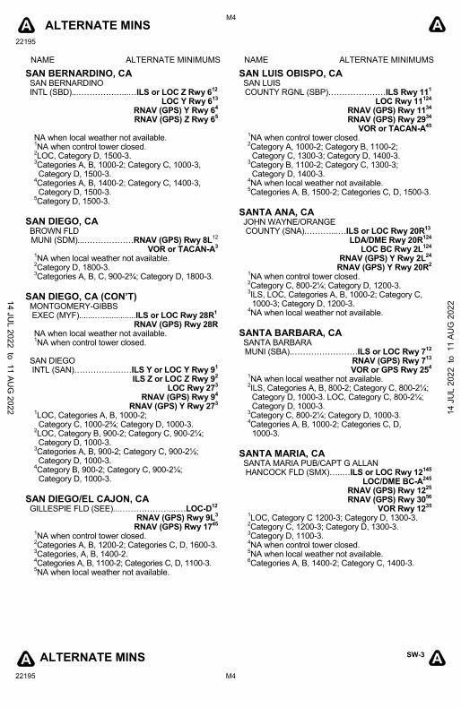
ALTERNATE MINS
22195
M4
SW-3
22195 M4
A A
ALTERNATE MINS A A
NAME ALTERNATE MINIMUMS NAME ALTERNATE MINIMUMS
SAN BERNARDINO, CA SAN BERNARDINO INTL (SBD)...………….…...…ILS or LOC Z Rwy 6
12
LOC Y Rwy 613
RNAV (GPS) Y Rwy 64
RNAV (GPS) Z Rwy 65
NA when local weather not available. 1NA when control tower closed.
2LOC, Category D, 1500-3.
3Categories A, B, 1000-2; Category C, 1000-3, Category D, 1500-3.
4Categories A, B, 1400-2; Category C, 1400-3, Category D, 1500-3.
5Category D, 1500-3.
SAN DIEGO, CA BROWN FLD MUNI (SDM)...………………RNAV (GPS) Rwy 8L
12
VOR or TACAN-A3
1NA when local weather not available.
2Category D, 1800-3.
3Categories A, B, C, 900-2¾; Category D, 1800-3.
SAN DIEGO, CA (CON’T) MONTGOMERY-GIBBS EXEC (MYF).......…...............ILS or LOC Rwy 28R
1
RNAV (GPS) Rwy 28R NA when local weather not available. 1NA when control tower closed.
SAN DIEGO INTL (SAN)…………………ILS Y or LOC Y Rwy 9
1
ILS Z or LOC Z Rwy 92
LOC Rwy 273
RNAV (GPS) Rwy 94
RNAV (GPS) Y Rwy 273
1LOC, Categories A, B, 1000-2;
Category C, 1000-2¾; Category D, 1000-3. 2LOC, Category B, 900-2; Category C, 900-2¼; Category D, 1000-3.
3Categories A, B, 900-2; Category C, 900-2½; Category D, 1000-3.
4Category B, 900-2; Category C, 900-2¼;
Category D, 1000-3.
SAN DIEGO/EL CAJON, CA GILLESPIE FLD (SEE)...………………....…LOC-D
12
RNAV (GPS) Rwy 9L3
RNAV (GPS) Rwy 1745
1NA when control tower closed.
2Categories A, B, 1200-2; Categories C, D, 1600-3.
3Categories, A, B, 1400-2.
4Categories A, B, 1100-2; Categories C, D, 1100-3.
5NA when local weather not available.
SAN LUIS OBISPO, CA SAN LUIS COUNTY RGNL (SBP)…………………ILS Rwy 11
1
LOC Rwy 11124
RNAV (GPS) Rwy 11
34
RNAV (GPS) Rwy 2934
VOR or TACAN-A45
1NA when control tower closed.
2Category A, 1000-2; Category B, 1100-2; Category C, 1300-3; Category D, 1400-3.
3Category B, 1100-2; Category C, 1300-3; Category D, 1400-3.
4NA when local weather not available.
5Categories A, B, 1500-2; Categories C, D, 1500-3.
SANTA ANA, CA JOHN WAYNE/ORANGE COUNTY (SNA).………...…ILS or LOC Rwy 20R
13
LDA/DME Rwy 20R124
LOC BC Rwy 2L124
RNAV (GPS) Y Rwy 2L24
RNAV (GPS) Y Rwy 20R2
1NA when control tower closed.
2Category C, 800-2¼; Category D, 1200-3.
3ILS, LOC, Categories A, B, 1000-2; Category C, 1000-3; Category D, 1200-3.
4NA when local weather not available.
SANTA BARBARA, CA SANTA BARBARA MUNI (SBA).……………………ILS or LOC Rwy 7
12
RNAV (GPS) Rwy 713
VOR or GPS Rwy 25
4
1NA when local weather not available.
2ILS, Categories A, B, 800-2; Category C, 800-2¼; Category D, 1000-3. LOC, Category C, 800-2¼; Category D, 1000-3.
3Category C, 800-2¼; Category D, 1000-3.
4Categories A, B, 1000-2; Categories C, D,
1000-3.
SANTA MARIA, CA SANTA MARIA PUB/CAPT G ALLAN HANCOCK FLD (SMX)…..…ILS or LOC Rwy 12
145
LOC/DME BC-A245
RNAV (GPS) Rwy 1225
RNAV (GPS) Rwy 30
56
VOR Rwy 1235
1LOC, Category C 1200-3; Category D, 1300-3.
2Category C, 1200-3; Category D, 1300-3.
3Category D, 1100-3.
4NA when control tower closed.
5NA when local weather not available.
6Categories A, B, 1400-2; Category C, 1400-3.
14 JUL 2022 to 11 AU
G 2022 14
JU
L 20
22 t
o 1
1 AU
G 2
022
ALTERNATE MINS
22195
M5
SW-3
22195 M5
A A
ALTERNATE MINS A A
NAME ALTERNATE MINIMUMS NAME ALTERNATE MINIMUMS
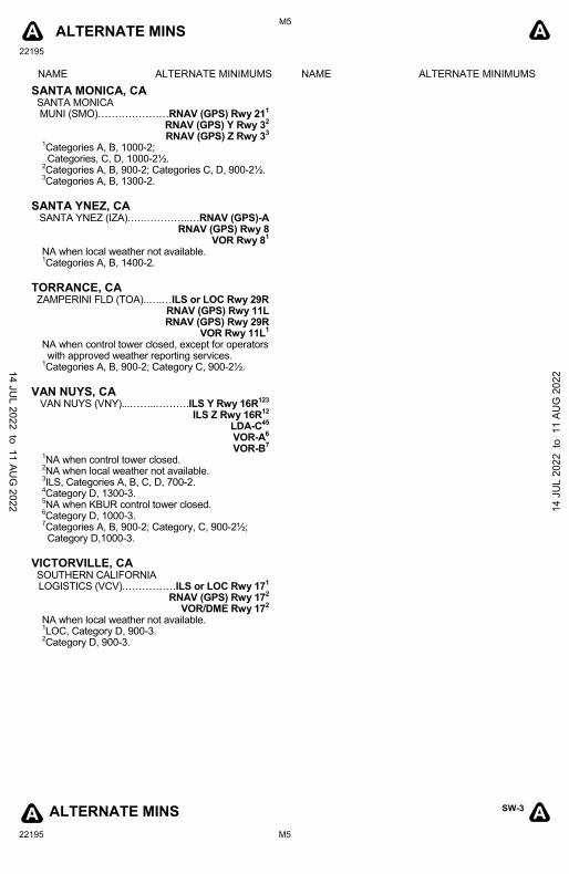
SANTA MONICA, CA SANTA MONICA
MUNI (SMO)…………………RNAV (GPS) Rwy 211
RNAV (GPS) Y Rwy 32
RNAV (GPS) Z Rwy 33
1Categories A, B, 1000-2;
Categories, C, D, 1000-2½. 2Categories A, B, 900-2; Categories C, D, 900-2½.
3Categories A, B, 1300-2.
SANTA YNEZ, CA
SANTA YNEZ (IZA).….…………..…RNAV (GPS)-A RNAV (GPS) Rwy 8
VOR Rwy 81
NA when local weather not available. 1Categories A, B, 1400-2.
TORRANCE, CA ZAMPERINI FLD (TOA)..….…ILS or LOC Rwy 29R
RNAV (GPS) Rwy 11L
RNAV (GPS) Rwy 29R
VOR Rwy 11L1
NA when control tower closed, except for operators with approved weather reporting services.
1Categories A, B, 900-2; Category C, 900-2½.
VAN NUYS, CA
VAN NUYS (VNY)...……..……….ILS Y Rwy 16R123
ILS Z Rwy 16R
12
LDA-C45
VOR-A
6
VOR-B7
1NA when control tower closed.
2NA when local weather not available.
3ILS, Categories A, B, C, D, 700-2.
4Category D, 1300-3.
5NA when KBUR control tower closed.
6Category D, 1000-3.
7Categories A, B, 900-2; Category, C, 900-2½; Category D,1000-3.
VICTORVILLE, CA SOUTHERN CALIFORNIA LOGISTICS (VCV).……………ILS or LOC Rwy 17
1
RNAV (GPS) Rwy 172
VOR/DME Rwy 172
NA when local weather not available. 1LOC, Category D, 900-3.
2Category D, 900-3.
14 JUL 2022 to 11 AU
G 2022 14
JU
L 20
22 t
o 1
1 AU
G 2
022
22195
L1
L1
T T
T T
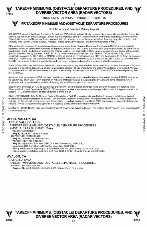
TAKEOFF MINIMUMS, (OBSTACLE) DEPARTURE PROCEDURES, AND DIVERSE VECTOR AREA (RADAR VECTORS)
TAKEOFF MINIMUMS, (OBSTACLE) DEPARTURE PROCEDURES, AND DIVERSE VECTOR AREA (RADAR VECTORS)
SW-3 22195
APPLE VALLEY, CA APPLE VALLEY (APV) TAKEOFF MINIMUMS AND (OBSTACLE) DEPARTURE PROCEDURES AMDT 1A 19JUL18 (18200) (FAA)
TAKEOFF MINIMUMS: Rwy 8, 18, 26, NA - Environmental.
DEPARTURE PROCEDURE: Rwy 36, use EXCON DEPARTURE.
TAKEOFF OBSTACLE NOTES: Rwy 36, vegetation 219’ from DER, 283’ left of centerline, 3069’ MSL. Vegetation 681’ from DER, 415’ right of centerline, 3084’ MSL. Rising terrain, fence beginning 718’ from DER, 403’ left of centerline, up to 3108’ MSL. Rising terrain, vegetation beginning 742’ from DER, 222’ left of centerline, up to 3109’ MSL.
AVALON, CA CATALINA (AVX) TAKEOFF MINIMUMS AND (OBSTACLE) DEPARTURE PROCEDURES
DEPARTURE PROCEDURE: Rwys 4, 22, climb straight ahead to 2300 then proceed on course.
INSTRUMENT APPROACH PROCEDURE CHARTS
IFR TAKEOFF MINIMUMS AND (OBSTACLE) DEPARTURE PROCEDURES
Civil Airports and Selected Military Airports
ALL USERS: Airports that have Departure Procedures (DPs) designed specifically to assist pilots in avoiding obstacles during the climb to the minimum enroute altitude, and/or airports that have civil IFR takeoff minimums other than standard, are listed below. Takeoff Minimums and Departure Procedures apply to all runways unless otherwise specified. An entry may also be listed that contains only Takeoff Obstacle Notes. Altitudes, unless otherwise indicated, are minimum altitudes in MSL.
DPs specifically designed for obstacle avoidance are referred to as Obstacle Departure Procedures (ODPs) and are textually described below, or published separately as a graphic procedure. If the ODP is published as a graphic procedure, its name will be listed below, and it can be found in either this volume (civil), or the applicable military volume, as appropriate. Users will recognize graphic obstacle DPs by the term "(OBSTACLE)" included in the procedure title; e.g., TETON TWO (OBSTACLE). If not specifically assigned an ODP, SID, or RADAR vector as part of an IFR clearance, an ODP may be required to be flown for obstacle clearance, even though not specifically stated in the IFR clearance. When doing so in this manner, ATC should be informed when the ODP being used contains a specified route to be flown, restrictions before turning, and/or altitude restrictions.
Some ODPs, which are established solely for obstacle avoidance, require a climb in visual conditions to cross the airport, a fix, or a NAVAID in a specified direction, at or above a specified altitude. These procedures are called Visual Climb Over Airport (VCOA). To ensure safe and efficient operations, the pilot must verbally request approval from ATC to fly the VCOA when requesting their IFR clearance.
At some locations where an ODP has been established, a diverse vector area (DVA) may be created to allow RADAR vectors to be used in lieu of an ODP. DVA information will state that headings will be as assigned by ATC and climb gradients, when applicable, will be published immediately following the specified departure procedure.
Graphic DPs designed by ATC to standardize traffic flows, ensure aircraft separation and enhance capacity are referred to as "Standard Instrument Departures (SIDs)". SIDs also provide obstacle clearance and are published under the appropriate airport section. ATC clearance must be received prior to flying a SID.
CIVIL USERS NOTE: Title 14 Code of Federal Regulations Part 91 prescribes standard takeoff rules and establishes takeoff minimums for certain operators as follows: (1) For aircraft, other than helicopters, having two engines or less – one statute mile visibility. (2) For aircraft having more than two engines – one-half statute mile visibility. (3) For helicopters – one-half statute mile visibility. These standard minima apply in the absence of any different minima listed below.
MILITARY USERS NOTE: Civil (nonstandard) takeoff minima are published below. For military takeoff minima, refer to appropriate service directives.
T
14 JUL 2022 to 11 AU
G 2022 14
JU
L 20
22 t
o 1
1 AU
G 2
022
22195
L2
L2
T T
T T
TAKEOFF MINIMUMS, (OBSTACLE) DEPARTURE PROCEDURES, AND DIVERSE VECTOR AREA (RADAR VECTORS)
TAKEOFF MINIMUMS, (OBSTACLE) DEPARTURE PROCEDURES, AND DIVERSE VECTOR AREA (RADAR VECTORS)
SW-3 22195
BAKERSFIELD, CA BAKERSFIELD MUNI (L45) TAKEOFF MINIMUMS AND (OBSTACLE) DEPARTURE PROCEDURES AMDT 2 06FEB14 (14037) (FAA)
TAKEOFF MINIMUMS: Rwy 34, 400-1¼ or std. with a min. climb of 555' per NM to 900.
DEPARTURE PROCEDURE: Rwy 16, climbing right turn direct EHF VORTAC, thence...
Rwy 34, climbing left turn direct EHF VORTAC, thence... ... Aircraft departing EHF VORTAC R-180 CW R-360 climb on course, aircraft departing EHF VORTAC R-001 CW R-100
continue climb in EHF VORTAC holding pattern (hold NW, right turns, 144° inbound) to cross EHF VORTAC at or above 5200 then proceed on course, aircraft departing EHF VORTAC R-101 CW R-179 continue climb in EHF VORTAC holding pattern (hold NW, right turns, 144° inbound) to cross EHF VORTAC at or above 4100 then proceed on course.
TAKEOFF OBSTACLE NOTES: Rwy 16, light pole 168’ from DER, 498’ left of centerline, 26’ AGL/400’ MSL. Tree 395’ from DER, 491’ left of centerline, 40’ AGL/400’ MSL. Powerlines beginning 546’ from DER, 608’ right of centerline, 120’ AGL/474’ MSL. Pole 644’ from DER, 474’ left of centerline, 30’ AGL/403’ MSL. Trees beginning 1603’ from DER, 196’ right of centerline, up to 40’ AGL/453’ MSL. Obstruction light on transmission tower 2464’ from DER, 780’ left of centerline, 106’ AGL/477’ MSL. Catenary 2486’ from DER, 484’ left of centerline, 106’ AGL/477’ MSL. Catenary 2529’ from DER, 725’ right of centerline, 111’ AGL/483’ MSL. Obstruction light on transmission tower 2539’ from DER, 214’ right of centerline, 107’ AGL/478’ MSL. Catenary 2540’ from DER, 482’ right of centerline, 111’ AGL/482’ MSL. Rwy 34, trees beginning 604’ from DER, 341’ right of centerline, 40’ AGL/419’ MSL. Tower 5100’ from DER, 1646’ right of centerline, 266’ AGL/656’ MSL. Vehicles on road 764’ from DER, 499’ left of centerline, up to 15’ AGL/399’ MSL. Hanger 372’ from DER, 545’ left of centerline, 20’ AGL/404’ MSL.
MEADOWS FLD (BFL) TAKEOFF MINIMUMS AND (OBSTACLE) DEPARTURE PROCEDURES AMDT 3 26MAY16 (21112) (FAA)
DEPARTURE PROCEDURE: All aircraft, climbing right turn direct EHF VORTAC. Aircraft departing EHF R-180 CW R-350 climb on course. All others continue climb northwest bound via EHF R-324, then climbing left turn to cross EHF VORTAC at or above: EHF R-110 CW R-179 3000; EHF R-351 CW R-109 4000.
TAKEOFF OBSTACLE NOTES: Rwy 12L, trees beginning 2221’ from DER, 684’ left of centerline, up to 72’ AGL/546’ MSL. Ground 146’ from DER, 525’ left of centerline, 479’ MSL. Rwy 12R, tree 2612’ from DER, 1158’ left of centerline, 69’ AGL/533’ MSL. Trees beginning 456’ from DER, 575’ right of centerline, up to 46’ AGL/510’ MSL. Fence 14’ from DER, 215’ right of centerline, 4’ AGL/466’ MSL. Rwy 30R, pole 1248’ from DER, 113’ left of centerline, 31’ AGL/543’ MSL. Transmission tower 3632’ from DER, 1097‘ left of centerline, 94’ AGL/602’ MSL. Poles beginning 2297’ from DER, 925’ right of centerline, up to 36’ AGL/577’ MSL. Pump 529’ from DER, 538’ right of centerline, 5’ AGL/523’ MSL. Building 373’ from DER, 257’ right of centerline, 10’ AGL/524’ MSL. Towers beginning 4350’ from DER, 499’ right of centerline, up to 110’ AGL/650’ MSL. NAVAID 388’ from DER, 266’ right of centerline, 21’ AGL/535’ MSL. Tree 3252’ from DER, 1072’ right of centerline, 101’ AGL/610’ MSL.
BIG BEAR CITY, CA BIG BEAR CITY (L35) TAKEOFF MINIMUMS AND (OBSTACLE) DEPARTURE PROCEDURES ORIG 20APR00 (00111) (FAA)
TAKEOFF MINIMUMS: Rwy 8, 1200-2 or std. with a min. climb of 282' per NM to 8000. Rwy 26, NA.
DEPARTURE PROCEDURE: Use OKACO RNAV DEPARTURE. Rwy 26, NA.
BLYTHE, CA BLYTHE (BLH) TAKEOFF MINIMUMS AND (OBSTACLE) DEPARTURE PROCEDURES AMDT 1A 22AUG13 (13234) (FAA)
TAKEOFF MINIMUMS: Rwy 26, 600-2½ or std. with a min. climb of 348' per NM to 1200.
DEPARTURE PROCEDURE: Rwys 8, 17, 35, turn right. Rwy 26, turn left, climb to 1500 via heading 180° and BLH R-120, then climbing left turn direct BLH VORTAC, MCA 2000.
TAKEOFF OBSTACLE NOTES: Rwy 26, tower 2.4 NM from DER, 991’ left of centerline, 159’ AGL/957’ MSL.
14 JUL 2022 to 11 AU
G 2022 14
JU
L 20
22 t
o 1
1 AU
G 2
022

22195
L3
L3
T T
T T
TAKEOFF MINIMUMS, (OBSTACLE) DEPARTURE PROCEDURES, AND DIVERSE VECTOR AREA (RADAR VECTORS)
TAKEOFF MINIMUMS, (OBSTACLE) DEPARTURE PROCEDURES, AND DIVERSE VECTOR AREA (RADAR VECTORS)
SW-3 22195
BORREGO SPRINGS, CA BORREGO VALLEY (L08) TAKEOFF MINIMUMS AND (OBSTACLE) DEPARTURE PROCEDURES AMDT 2 10APR08 (08101) (FAA)
DEPARTURE PROCEDURE: Use ZUNGU DEPARTURE (RNAV).
BRAWLEY, CA BRAWLEY MUNI (BWC) TAKEOFF MINIMUMS AND (OBSTACLE) DEPARTURE PROCEDURES AMDT 1 30MAR17 (17089) (FAA)
TAKEOFF MINIMUMS: Rwy 26, NA-Obstacles and noise abatement.
DEPARTURE PROCEDURES: Rwy 8, climbing right turn heading 120° to intercept IPL VORTAC R-009 to 3000 to IPL VORTAC, then climb on course.
TAKEOFF OBSTACLE NOTES: Rwy 8, trees, beginning 81’ from DER, 314’ left of centerline, up to -106’ MSL. Trees, beginning 274’ from DER, 441’ right of centerline, up to -124’ MSL. Vehicles on road, beginning 380’ from DER, 348’ right of centerline, up to -116’ MSL. Trees, beginning 457’ from DER, 362’ left of centerline, up to -96’ MSL. Tree 458’ from DER, 406’ left of centerline, -94’ MSL.
BURBANK, CA BOB HOPE (BUR) TAKEOFF MINIMUMS AND (OBSTACLE) DEPARTURE PROCEDURES AMDT 5 28JUL11 (11209) (FAA)
TAKEOFF MINIMUMS: Rwy 8, std. w/min. climb of 410' per NM to 5000. Rwy 15, std. w/min. climb of 335' per NM to 5000. Rwy 26, std. w/min. climb of 325' per NM to 5000. Rwy 33, std. w/min. climb of 550' per NM to 5000' or 600-2¼ w/min. climb of 300' per NM to 5000.
DEPARTURE PROCEDURE: Rwys 8, 15, climbing right turn direct VNY VOR/DME. Rwy 26, climb direct VNY VOR/DME. Rwy 33, Climbing left turn direct VNY VOR/DME. All aircraft continue climb in VNY holding pattern (SE, left turns, 295° inbound) to cross VNY VOR/DME at or above 5100, then westbound on V326 to GINNA or eastbound on V186 to DARTS.
TAKEOFF OBSTACLE NOTES: Rwy 8, multiple trees, poles, and buildings beginning 124' from DER, 42' right of centerline, up to 65' AGL/745' MSL. Multiple trees, buildings and poles beginning 278' from DER, 73' left of centerline, up to 56' AGL/746' MSL. Rwy 15, multiple trees, buildings, poles, and blast fence beginning 50' from DER, 2' right of centerline, up to 65' AGL/762' MSL. Multiple trees, buildings, poles, blast fence beginning 185' from DER, 53' left of centerline, up to 108' AGL/777' MSL. Rwy 26, multiple trees, poles, transmission towers, buildings, and roads, and terrain beginning 26' from DER, 4' right of centerline, up to 145' AGL/731' MSL. Multiple trees, poles, transmission towers, railroad, and buildings beginning 302' from DER, 437' left of centerline, up to 117' AGL/846' MSL. Rwy 33, multiple trees, poles, terrain, buildings, road beginning 33' from DER, 30' right of centerline, up to 100' AGL/1333' MSL. Multiple trees, poles, buildings, antenna, railroad, and blast fence beginning 97' from DER, 11' left of centerline, up to 50' AGL/878' MSL.
DIVERSE VECTOR AREA (RADAR VECTORS) ORIG 26MAY16 (16147) (FAA)
Rwy 8, heading as assigned by ATC; requires minimum climb of 420’ per NM to 2500. Rwy 15, heading as assigned by ATC; requires minimum climb of 340’ per NM to 2100. Rwy 26, heading as assigned by ATC; requires minimum climb of 380’ per NM to 4800. Rwy 33, heading as assigned by ATC; requires minimum climb of 460’ per NM to 4900.
CALIFORNIA CITY, CA CALIFORNIA CITY MUNI (L71) TAKEOFF MINIMUMS AND (OBSTACLE) DEPARTURE PROCEDURES ORIG 17MAR05 (05076) (FAA)
DEPARTURE PROCEDURE: Use CALIFORNIA CITY (RNAV) DEPARTURE.
14 JUL 2022 to 11 AU
G 2022 14
JU
L 20
22 t
o 1
1 AU
G 2
022
22195
L4
L4
T T
T T
TAKEOFF MINIMUMS, (OBSTACLE) DEPARTURE PROCEDURES, AND DIVERSE VECTOR AREA (RADAR VECTORS)
TAKEOFF MINIMUMS, (OBSTACLE) DEPARTURE PROCEDURES, AND DIVERSE VECTOR AREA (RADAR VECTORS)
SW-3 22195
CALIPATRIA, CA CLIFF HATFIELD MEML (CLR) TAKEOFF MINIMUMS AND (OBSTACLE) DEPARTURE PROCEDURES ORIG-A 12OCT17 (21112) (FAA)
DEPARTURE PROCEDURE: Rwy 8, climb runway heading to 400, then climbing right turn to 3000 via heading 200° and IPL R-336 to IPL VORTAC. Rwy 26, climb runway heading to 400, then climbing left turn to 3000 via IPL R-336 to IPL VORTAC.
TAKEOFF OBSTACLE NOTES: Rwy 8, pole 525’ from DER, 140’ right of centerline, 15’ AGL/-166’ MSL. Poles beginning 616’ from DER, 204’ right of centerline, 15’ AGL/-165’ MSL. Building, pole beginning 748’ from DER, 307’ right of centerline, 25’ AGL/-155’ MSL. Transmission line 838’ from DER, 150’ right of centerline, 31’ AGL/-150’ MSL. Rwy 26, pole 190’ from DER, 329’ right of centerline, -152 MSL. Road 223’ from DER, on centerline -170’ MSL. Tree 328’ from DER, 484’ left of centerline, -155’ MSL. Tree 541’ from DER, 634’ right of centerline, -125’ MSL. Pole 1103’ from DER, 582’ right of centerline, -140’ MSL. Antenna 1444’ from DER, 565’ left of centerline, -131’ MSL.
CAMARILLO, CA CAMARILLO (CMA) TAKEOFF MINIMUMS AND (OBSTACLE) DEPARTURE PROCEDURES AMDT 4 10NOV16 (16315) (FAA)
DEPARTURE PROCEDURE: Rwy 8, climbing left turn to 2500 on CMA VOR/DME R-058 thence. . . . Rwy 26, climb to 2500 on CMA VOR/DME R-265 thence... ... Climbing left turn direct CMA VOR/DME before proceeding on course.
CAMP PENDLETON MCAS (MUNN FLD) (KNFG) OCEANSIDE, CA TAKEOFF MINIMUMS AND (OBSTACLE) DEPARTURE PROCEDURES
AMDT 2 30DEC21 (22083) (USN) DEPARTURE PROCEDURE:
Rwys 3, 21, diverse departures NA. TAKEOFF OBSTACLE NOTES:
Rwy 3, palm trees 1900-2350' from DER, 500-1100' right of centerline, max height 210' MSL. Telephone pole 2.4 NM from DER, 3310' right of centerline, 79' AGL/443' MSL. Terrain 1.7 NM from DER, 2945' right of centerline, 456' MSL. Palm tree 981' from DER, 939' right of centerline, 159' MSL. Light pole 3251' from DER, 843' left of centerline, 179' MSL. Light pole 3300' from DER, 880' left of centerline, 182' MSL. Light pole 3347' from DER, 915' left of centerline, 185' MSL. Light pole 3448' from DER, 1226' left of centerline, 195' MSL. Light pole 3473' from DER, 1015' left of centerline, 191' MSL. Light pole 3524' from DER, 1150' left of centerline, 192' MSL. Rwy 21, pylon 2.4 NM from DER, 2362' left of centerline, 108' AGL/516' MSL. Terrain 1.5 NM from DER, 2583' right of centerline, 659' MSL. Palm tree 2868' from DER, 94' left of centerline, 148' MSL. Tree southwest of airfield 1204' from DER, 90' right of centerline, 91' MSL. Tree southwest of airfield 1262' from DER, 594' left of centerline, 105' MSL. Tree southwest of airfield 1267' from DER, 253' left of centerline, 110' MSL. Tree southwest of airfield 841' from DER, 710' left of centerline, 108' MSL.
14 JUL 2022 to 11 AU
G 2022 14
JU
L 20
22 t
o 1
1 AU
G 2
022
22195
L5
L5
T T
T T
TAKEOFF MINIMUMS, (OBSTACLE) DEPARTURE PROCEDURES, AND DIVERSE VECTOR AREA (RADAR VECTORS)
TAKEOFF MINIMUMS, (OBSTACLE) DEPARTURE PROCEDURES, AND DIVERSE VECTOR AREA (RADAR VECTORS)
SW-3 22195
CARLSBAD, CA MCCLELLAN-PALOMAR (CRQ) TAKEOFF MINIMUMS AND (OBSTACLE) DEPARTURE PROCEDURES AMDT 5 21JUL16 (22139) (FAA)
TAKEOFF MINIMUMS: Rwy 6, std. w/min. climb of 255' per NM to 1700 or 2700-3 for VCOA.
DEPARTURE PROCEDURE: Rwy 6, climbing left turn heading 245° to 3000 before proceeding on course. Do not exceed 210K until established on heading 245°. Rwy 24, climb heading 245° to 2400 before proceeding on course.
VCOA: Rwy 6, obtain ATC approval for VCOA when requesting IFR clearance. Climb in visual conditions to cross McClellan-Palomar airport at or above 2900 before proceeding on course.
TAKEOFF OBSTACLE NOTES: Rwy 6, fence beginning 6’ from DER, 453’ left of centerline, up to 1’ AGL/328’ MSL. Obstruction light on blast fence beginning 96’ from DER, 398’ right of centerline, up to 18’ AGL/332’ MSL. Tree 325’ from DER, 508‘ left of centerline, 347’ MSL. Trees beginning 519’ from DER, 504’ left of centerline, up to 379’ MSL. Tree 3682’ from DER, 945’ left of centerline, 424’ MSL. Trees, equipment on building, obstruction light on flagpole beginning 3682’ from DER, 333’ left of centerline, up to 428’ MSL. Trees beginning 4032’ from DER, 489’ left of centerline, up to 439’ MSL. Trees, light poles beginning 4040’ from DER, 318’ right of centerline, up to 445’ MSL. Light poles beginning 4705’ from DER, 485’ right of centerline, up to 30’ AGL/457’ MSL. Trees 4866’ from DER, 988’ left of centerline, 457’ MSL. Trees beginning 4944’ from DER, 431’ right of centerline, up to 465’ MSL. Light poles beginning 4985’ from DER, 536’ right of centerline, up to 42’ AGL/468’ MSL. Tree, light poles beginning 5123’ from DER, 576’ right of centerline, up to 476’ MSL. Trees 5493’ from DER, 753’ right of centerline, 489’ MSL. Trees, light poles beginning 5663’ from DER, 569’ right of centerline, up to 502’ MSL. Trees 6015’ from DER, 896’ right of centerline, 507’ MSL. Tree 1.1 NM from DER, 1131’ right of centerline, 506’ MSL. Rwy 24, terrain beginning 25’ from DER, 287’ right of centerline, up to 339’ MSL. Bush 36’ from DER, 276‘ right of centerline, 340’ MSL. Tree 106’ from DER, 520’ left of centerline, 342’ MSL.
CHINA LAKE NAWS (ARMITAGE FLD) (KNID) RIDGECREST, CA TAKEOFF MINIMUMS AND (OBSTACLE) DEPARTURE PROCEDURES
15JUL21 (21196) (USN) DEPARTURE PROCEDURE: Diverse departures NA, use published departure. TAKEOFF OBSTACLE NOTES:
Rwy 14, pylon 2252’ from DER, 1094’ right of centerline, 49’ AGL/2309’ MSL. Pylon 2519’ from DER, 945’ right of centerline, 49’ AGL/2311’ MSL. Pylon 2681’ from DER, 1182’ left of centerline, 49’ AGL/2289’ MSL. Pylon 2772’ from DER, 807’ right of centerline, 49’ AGL/2312’ MSL. Pylon 2909’ from DER, 1176’ left of centerline, 49’ AGL/2286’ MSL. Pylon 2952’ from DER, 580’ right of centerline, 49’ AGL/2305’ MSL. Pylon 3128’ from DER, 351’ right of centerline, 49’ AGL/2305’ MSL. Pylon 3131’ from DER, 580’ left of centerline, 49’ AGL/2305’ MSL. Pylon 3131’ from DER, 1177’ left of centerline, 49’ AGL/2298’ MSL. Pylon 3132’ from DER, 264’ left of centerline, 49’ AGL/2295’ MSL. Pylon 3133’ from DER, 52’ right of centerline, 49’ AGL/2289’ MSL. Pylon 3133’ from DER, 1022’ left of centerline, 49’ AGL/2288’ MSL. Pylon 3134’ from DER, 876’ left of centerline, 49’ AGL/2287’ MSL.
CHINO, CA CHINO (CNO) TAKEOFF MINIMUMS AND (OBSTACLE) DEPARTURE PROCEDURES AMDT 5 30NOV00 (00335) (FAA)
TAKEOFF MINIMUMS: Rwy 3, std. with a min. climb of 270' per NM to 4800. Rwys 8L/R, std. with a min. climb of 270' per NM to 4800. Rwy 21, Cat A/B std. with a min climb of of 290' per NM to 4800, Cat C/D std. with a min. climb of 400' per NM 4800. Rwys 26L/R, Cat A/B std. with a min. climb of 270' per NM to 4800, Cat C/D std. with a min. climb of 410' per NM to 4800.
DEPARTURE PROCEDURE: Rwys 3, 8L/R, climbing right turn direct PDZ VORTAC. Rwys 21, 26L/R, climbing left turn direct PDZ VORTAC. All aircraft climb in PDZ VORTAC holding pattern (Hold E, right turns, 258° inbound) to the appropriate MEA.
TAKEOFF OBSTACLE NOTES: 108' AGL trees 1200' from DER 3, 600' left of centerline.
14 JUL 2022 to 11 AU
G 2022 14
JU
L 20
22 t
o 1
1 AU
G 2
022
22195
L6
L6
T T
T T
TAKEOFF MINIMUMS, (OBSTACLE) DEPARTURE PROCEDURES, AND DIVERSE VECTOR AREA (RADAR VECTORS)
TAKEOFF MINIMUMS, (OBSTACLE) DEPARTURE PROCEDURES, AND DIVERSE VECTOR AREA (RADAR VECTORS)
SW-3 22195
CHINO, CA (CON’T) CHINO (CNO) (CON’T) DIVERSE VECTOR AREA (RADAR VECTORS) AMDT 1 15OCT15 (15288) (FAA)
Rwy 3, heading as assigned by ATC; requires minimum climb of 250’ per NM to 4300. Rwys 8L, 8R, heading as assigned by ATC; requires minimum climb of 370’ per NM to 4100. Rwy 21, heading as assigned by ATC; requires minimum climb of 320’ per NM to 1800. Rwys 26L, 26R, heading as assigned by ATC; requires minimum climb of 270’ per NM to 2100.
CORONA, CA CORONA MUNI (AJO) TAKEOFF MINIMUMS AND (OBSTACLE) DEPARTURE PROCEDURES AMDT 3 26MAY94 (94146) (FAA)
TAKEOFF MINIMUMS: Rwy 7, 1000-2 or std. with a min. climb of 310' per NM to 1700. Rwy 25, 600-2 or std. with a min. climb of 280' per NM to 1200.
DEPARTURE PROCEDURE: Rwy 7, climbing left turn. Rwy 25, climbing right turn. All aircraft continue climb direct to PDZ VORTAC. Aircraft departing PDZ R-091 CW R-140 and R-231 CW R-280 climb on course. All others continue climb in PDZ VORTAC holding pattern (Hold NE, right turns, 210° inbound) to cross PDZ VORTAC at or above: R-141 CW R-230 4000, R-281 CW R-090 6700.
DAGGETT, CA BARSTOW-DAGGETT (DAG) TAKEOFF MINIMUMS AND (OBSTACLE) DEPARTURE PROCEDURES AMDT 3 29JUL10 (10210) (FAA)
DEPARTURE PROCEDURE: Use DAGGETT DEPARTURE.
DELANO, CA DELANO MUNI (DLO) TAKEOFF MINIMUMS AND (OBSTACLE) DEPARTURE PROCEDURES AMDT 3A 08MAY08 (08129) (FAA)
TAKEOFF MINIMUMS: Rwy 32, 400-1 or std. with a min. climb rate of 390' per NM to 400.
DEPARTURE PROCEDURE: Rwy 14, Climb via heading 140° and EHF VORTAC R-324 to 3000 before proceeding on course. Rwy 32, climb via heading 320° and EHF VORTAC R-324 to 3000 before proceeding on course.
TAKEOFF OBSTACLE NOTES: 65' AGL tree 600' from DER, 500' left of centerline runway 14.
EDWARDS AF AUX NORTH BASE (9L2) EDWARDS, CA TAKEOFF MINIMUMS AND (OBSTACLE) DEPARTURE PROCEDURES
Rwy 6-24, climb on course, cross 15 NM from ARP at or above 4500.
EDWARDS AFB (KEDW) EDWARDS, CA TAKEOFF MINIMUMS AND (OBSTACLE) DEPARTURE PROCEDURES 10OCT19 (19283)
Rwys 5L/R, RADAR required, climb 340’ per NM to 5500, track inbound on EDW R-223 to EDW VORTAC, then out EDW R-043. Climb as instructed, expect RADAR vectors after passing 4500 or climb on course, cross 15 NM from ARP at or above 4500. Rwys 23L/R, RADAR and DME required. CAT A/B/C track outbound EDW R-223. At 12 DME turn right heading 020°, intercept EDW R-247 to EDW VORTAC. Climb as Instructed, expect RADAR vectors after passing 4500 or climb on course, cross 15 NM from ARP at or above 4500. CAT D/E track outbound EDW R-223. At 12 DME turn right, intercept EDW R-247 to EDW VORTAC. Climb as instructed, expect RADAR vectors after passing 4500 or climb on course, cross 15 NM from ARP at or above 4500.
14 JUL 2022 to 11 AU
G 2022 14
JU
L 20
22 t
o 1
1 AU
G 2
022
22195
L7
L7
T T
T T
TAKEOFF MINIMUMS, (OBSTACLE) DEPARTURE PROCEDURES, AND DIVERSE VECTOR AREA (RADAR VECTORS)
TAKEOFF MINIMUMS, (OBSTACLE) DEPARTURE PROCEDURES, AND DIVERSE VECTOR AREA (RADAR VECTORS)
SW-3 22195
EL CENTRO NAF (VRACIU FIELD) (KNJK) EL CENTRO, CA TAKEOFF MINIMUMS AND (OBSTACLE) DEPARTURE PROCEDURES AMDT 1 18JUN20 (20170)
TAKEOFF MINIMUMS: Rwys 8, 12, 26, 30, 2000-3 for climb in visual conditions.
DEPARTURE PROCEDURE: Rwys 8, 12, 26, for climb in visual conditions, cross El Centro airport at or above 1800 before proceeding on course. When executing VCOA, notify ATC prior to departure.
TAKEOFF OBSTACLE NOTES: Rwy 8, road 182’ from DER, 99’ left of cntrln, 10' AGL/-37' MSL. Road 183' from DER, 3' right of cntrln, 10' AGL/-37' MSL. Road 183' from DER, 100' right of cntrln, 10' AGL/-37' MSL. Rwy 12, terrain 0' from DER, 500' left of cntrln, -39’ MSL. Terrain 0' from DER, 500' right of cntrln, -36’ MSL. Fence 199' from DER, 305' left of cntrln, 8' AGL/-34' MSL. Fence 289' from DER, 213' left of cntrln, 8' AGL/-34' MSL. Road 278' from DER, 100' left of cntrln, 10' AGL/-35' MSL. Road 372' from DER, 95' right of cntrln, 10' AGL/-35' MSL. Road 338' from DER, 8' left of cntrln, 10' AGL/-35' MSL. Fence 504' from DER, 3' right of cntrln, 8' AGL/-34' MSL. Pole 153' from DER, 884' right of cntrln, -3' MSL. Pylon 1532' from DER, 884' right of cntrln, 41’ AGL/-3’ MSL. Rwy 26, terrain 0’ from DER, 500’ left of cntrln, -45’ MSL. Rwy 30, electrical box 176’ from DER, 139’ left of cntrln, 4’ AGL/-45’ MSL.
EL MONTE, CA SAN GABRIEL VALLEY (EMT) TAKEOFF MINIMUMS AND (OBSTACLE) DEPARTURE PROCEDURES AMDT 7 13SEP18 (18256) (FAA)
TAKEOFF MINIMUMS: Rwy 1, std. w/min. climb of 290’ per NM to 1800, or 1600-3 for VCOA.
DEPARTURE PROCEDURE: Rwy 1, climb heading 011° to 700 then climbing right turn on heading 128° and on PDZ R-278 to PDZ VORTAC thence... Rwy 19, climb heading 191° to 1500 then climbing left turn on heading 068° and on PDZ R-278 to PDZ VORTAC thence... ...aircraft departing PDZ R-078 CW R-292 climb on course. All others continue climb in PDZ VORTAC holding pattern (hold northeast, right turn, 210° inbound) to cross PDZ VORTAC at or above MEA for route of flight.
VCOA: Rwy 1, obtain ATC approval for VCOA when requesting IFR clearance. Climb in visual conditions to cross San Gabriel Valley airport at or above 1700 then intercept PDZ R-278 to PDZ VORTAC. Aircraft departing PDZ R-078 CW R-292 climb on course. All others continue climb in PDZ VORTAC holding pattern (hold northeast, right turn, 210.00 inbound) to cross PDZ VORTAC at or above MEA for route of flight.
TAKEOFF OBSTACLE NOTES: Rwy 1, sign 18’ from DER, 124’ right of centerline, 300’ MSL. Building 98’ from DER, 269’ left of centerline, 334’ MSL. Building 273’ from DER, 299’ right of centerline, 310’ MSL. Lighting 525’ from DER, 257’ left of centerline, 338’ MSL. Trees beginning 609’ from DER, 277’ left of centerline, up to 364’ MSL. Traverse way 662’ from DER, on centerline, 322’ MSL. Tree 791’ from DER, 205’ right of centerline, 335’ MSL. Lighting 942’ from DER, 221’ right of centerline, 343’ MSL. Lighting 943’ from DER, 446’ right of centerline, 344’ MSL. Pole 1698’ from DER, on centerline, 365’ MSL. Tree 2828’ from DER, 23’ right of centerline, 404’ MSL. Rwy 19, sign 16’ from DER, 130’ left of centerline, 285’ MSL. Trees beginning 74’ from DER, 179’ left of centerline, up to 317’ MSL. Tree, lighting, pole beginning 363’ from DER, 86’ left of centerline, up to 322’ MSL. Tower 1019’ from DER, 692’ left of centerline, 40’ AGL/333’ MSL. Tree 1051’ from DER, 370’ right of centerline, 323’ MSL. Tree 1133’ from DER, 206’ left of centerline, 334’ MSL. Tree 1466’ from DER, 382’ left of centerline, 348’ MSL. Pole 1661’ from DER, 548’ left of centerline, 357’ MSL. Pole 1774’ from DER, 87’ right of centerline, 350’ MSL. Pole 2033’ from DER, 370’ right of centerline, 358’ MSL.
DIVERSE VECTOR AREA (RADAR VECTORS) AMDT 1 27APR17 (17117) (FAA)
Rwys 1, headings as assigned by ATC; requires minimum climb of 290’ per NM to 1300. Rwys 19, headings assigned by ATC.
14 JUL 2022 to 11 AU
G 2022 14
JU
L 20
22 t
o 1
1 AU
G 2
022
22195
L8
L8
T T
T T
TAKEOFF MINIMUMS, (OBSTACLE) DEPARTURE PROCEDURES, AND DIVERSE VECTOR AREA (RADAR VECTORS)
TAKEOFF MINIMUMS, (OBSTACLE) DEPARTURE PROCEDURES, AND DIVERSE VECTOR AREA (RADAR VECTORS)
SW-3 22195
FALLBROOK, CA FALLBROOK COMMUNITY AIRPARK (L18) TAKEOFF MINIMUMS AND (OBSTACLE) DEPARTURE PROCEDURES AMDT 1 10NOV16 (16315) (FAA)
DEPARTURE PROCEDURE: Use FALLBROOK DEPARTURE.
FULLERTON, CA FULLERTON MUNI (FUL) TAKEOFF MINIMUMS AND (OBSTACLE) DEPARTURE PROCEDURES AMDT 5 03MAY12 (12124) (FAA)
TAKEOFF MINIMUMS: Rwy 6, std. w/min. climb of 280' per NM to 600.
DEPARTURE PROCEDURE: Rwy 6, climbing right turn to 2300 direct SLI VORTAC, thence .. .
Rwy 24, climbing left turn to 2300 direct SLI VORTAC, thence ... ... Climb in holding pattern (hold South, left turns, 351° inbound) until at or above MEA for direction of flight before
proceeding course. TAKEOFF OBSTACLE NOTES:
Rwy 6, windsock 58' from DER, 189' right of centerline, 12' AGL/109' MSL. Obstruction light on pole 109' from DER, 116' left of centerline, 23' AGL/118' MSL. Multiple poles beginning 115' from DER, left and right of centerline, up to 40' AGL/198' MSL. Trains 221' from DER, left and right of centerline, up to 23' AGL/144' MSL. Light standard 486' from DER, 133' right of centerline, 20' AGL/123' MSL. Hopper on building 977' from DER, 468' left of centerline, 36' AGL/132' MSL. Obstruction light on building 1002' from DER, 31' right of centerline, 25' AGL/128' MSL. Light pole 1247' from DER, 143' left of centerline, 35' AGL/131' MSL. Tree 1462' from DER, 35' left of centerline, 75' AGL/168' MSL. Obstacle light on silo 1620' from DER, 317' right of centerline, 50' AGL/146' MSL. Building 3206' from DER, 820' right of centerline, 112' AGL/217' MSL. Obstruction light on building 3390' from DER, 913' right of centerline, 112' AGL/217' MSL. Tower 6093' from DER, 1936' left of centerline, 94' AGL/267' MSL. Rwy 24, vehicles on roadway 82' from DER, left and right of centerline, up to 15' AGL/114' MSL. Light standard 85' from DER, 260' right of centerline, 25' AGL/110' MSL. Light standard 217' from DER, 320' left of centerline, 104' AGL/122' MSL. Antenna on building 272' from DER, 227' left of centerline, 31' AGL/116' MSL. Trees beginning 352' from DER, 227' right of centerline, up to 60' AGL/155' MSL. Pole 395' from DER, 279' left of centerline, 35' AGL/123' MSL. Obstruction light on navaid 399' from DER, on centerline, 5' AGL/103' MSL. Poles beginning 1335' from DER, right and left of centerline, up to 25' AGL/129' MSL. Tree 1377' from DER, 159' left of centerline, 50' AGL/147' MSL.
HAWTHORNE, CA JACK NORTHROP FLD/HAWTHORNE MUNI (HHR) TAKEOFF MINIMUMS AND (OBSTACLE) DEPARTURE PROCEDURES AMDT 5 20JUN19 (21168) (FAA)
TAKEOFF MINIMUMS: Rwy 7, 300-1¾ or std. w/min. climb of 365' per NM to 400. Rwy 25, 300-1 or std. w/min. climb of 290' per NM to 300.
DEPARTURE PROCEDURE: Rwy 7, climbing right turn to 3000 heading 220° and the LAX VORTAC R-170 to LIMBO INT. Rwy 25, climbing left turn to 3000 heading 205° and the LAX VORTAC R-170 to LIMBO INT.
TAKEOFF OBSTACLE NOTES: Rwy 7, trees, wall, vehicles on road, fence, lighting, pole, signs, buildings beginning 23’ from DER, 3’ left of centerline, up to 52’ AGL/114’ MSL. Pole 29’ from DER, 395’ right of centerline, 30’ AGL/89’ MSL. Signs, poles, wall, fence, lighting, vehicles on road, tree, building beginning 78’ from DER, on and right of centerline, up to 38’ AGL/94’ MSL. Trees, poles, vehicles on road, buildings, signs beginning 476’ from DER, 39’ left of centerline, up to 136’ MSL. Buildings, pole beginning 759’ from DER, 96’ right of centerline, up to 42’ AGL/102’ MSL. Pole 1465’ from DER, 203’ right of centerline, 38’ AGL/103’ MSL. Poles beginning 1489’ from DER, 20’ right of centerline, up to 41’ AGL/111’ MSL. Trees beginning 2120’ from DER, 110’ left of centerline, up to 63’ AGL/137’ MSL. Trees, poles beginning 2163’ from DER, 84’ left of centerline, up to 66’ AGL/147’ MSL. Buildings beginning 2168’ from DER, 264’ right of centerline, up to 36’ AGL/116’ MSL. Trees, poles beginning 2704’ from DER, 112’ left of centerline, up to 72’ AGL/161’ MSL. Poles, trees beginning 2799’ from DER, 54’ right of centerline, up to 61’ AGL/148’ MSL. Trees, poles beginning 2876’ from DER, 27’ left of centerline, up to 78’ AGL/168’ MSL. Poles, trees beginning 2915’ from DER, 277’ right of centerline, up to 59’ AGL/149’ MSL. Trees, poles beginning 2971’ from DER, 94’ right of centerline, up to 157’ MSL. Poles 3192’ from DER, 172’ right of centerline, 62’ AGL/160’ MSL. Trees beginning 3207’ from DER, 81’ right of centerline, up to 67’ AGL/167’ MSL. CON’T
14 JUL 2022 to 11 AU
G 2022 14
JU
L 20
22 t
o 1
1 AU
G 2
022
22195
L9
L9
T T
T T
TAKEOFF MINIMUMS, (OBSTACLE) DEPARTURE PROCEDURES, AND DIVERSE VECTOR AREA (RADAR VECTORS)
TAKEOFF MINIMUMS, (OBSTACLE) DEPARTURE PROCEDURES, AND DIVERSE VECTOR AREA (RADAR VECTORS)
SW-3 22195
HAWTHORNE, CA (CON’T) JACK NORTHROP FLD/HAWTHORNE MUNI (HHR) (CON’T)
Rwy 7 (CON’T), trees, poles beginning 3304’ from DER, 8’ left of centerline, up to 170’ MSL. Trees, poles beginning 3497’ from DER, 109’ right of centerline, up to 71’ AGL/178’ MSL. Trees, poles, antenna, building beginning 3712’ from DER, 102’ left of centerline, up to 65’ AGL/179’ MSL. Trees, poles beginning 3719’ from DER, 2’ right of centerline, up to 74’ AGL/188’ MSL. Tree 3850’ from DER, 1301’ left of centerline, 41’ AGL/180’ MSL. Trees, poles beginning 3859’ from DER, 23’ left of centerline, up to 51’ AGL/185’ MSL. Trees, poles beginning 4061’ from DER, 28’ left of centerline, up to 203’ MSL. Tree 4074’ from DER, 291’ right of centerline, 69’ AGL/190’ MSL. Tree 4079’ from DER, 411’ right of centerline, 82’ AGL/202’ MSL. Trees, poles beginning 4101’ from DER, 17’ right of centerline, up to 90’ AGL/211’ MSL. Trees, poles beginning 4323’ from DER, 32’ left of centerline, up to 52’ AGL/212’ MSL. Trees, poles, building beginning 4484’ from DER, 3’ left of centerline, up to 66’ AGL/235’ MSL. Pole, tree beginning 4932’ from DER, 31’ left of centerline, up to 46’ AGL/236’ MSL. Building, pole beginning 4949’ from DER, 46’ right of centerline, up to 66’ AGL/214’ MSL. Tree, pole, building beginning 4989’ from DER, 1’ right of centerline, up to 220’ MSL. Tree, pole, building beginning 5058’ from DER, 44’ left of centerline, up to 241’ MSL. Antenna, trees, buildings, sign, fence, tower beginning 5140’ from DER, 93’ left of centerline, up to 55’ AGL/243’ MSL. Trees, poles beginning 5202’ from DER, on and right of centerline, up to 78’ AGL/227’ MSL. Trees, sign beginning 5356’ from DER, 55’ left of centerline, up to 54’ AGL/249’ MSL. Trees, poles beginning 5383’ from DER, 62’ right of centerline, up to 102’ AGL/257’ MSL. Towers, transmission lines, poles, sign, buildings, trees, elevator beginning 5428’ from DER, 35’ left of centerline, up to 139’ AGL/307’ MSL. Tower, tree beginning 1.2 NM from DER, 1711’ left of centerline, up to 115’ AGL/322’ MSL. Building, monument, trees, towers, antenna, transmission line, pole beginning 1.2 NM from DER, 205’ left of centerline, up to 104’ AGL/328’ MSL. Tree 1.3 NM from DER, 16’ right of centerline, 76’ AGL/278’ MSL. Tower 1.4 NM from DER, 824’ right of centerline, 116’ AGL/289’ MSL. Tower 1.4 NM from DER, 317’ right of centerline, 119’ AGL/302’ MSL. Rwy 25, sign 24’ from DER, 100’ left of centerline, 3’ AGL/67’ MSL. Pole, building beginning 51’ from DER, 302’ right of centerline, up to 38’ AGL/105’ MSL. NAVAID 72’ from DER, 1’ left of centerline, 8’ AGL/73’ MSL. Building, poles, fence beginning 112’ from DER, 183’ left of centerline, up to 30’ AGL/95’ MSL. Trees, lighting, fence, vehicles on road, poles, sign, building, antenna beginning 128’ from DER, on and right of centerline, up to 48’ AGL/114’ MSL. Pole, fence, tree, sign beginning 158’ from DER, 5’ left of centerline, up to 38’ AGL/102’ MSL. Pole, vehicles on road, tree, signs beginning 206’ from DER, 38’ left of centerline, up to 39’ AGL/103’ MSL. Tree, vehicles on road, signs, buildings, poles beginning 258’ from DER, 5’ left of centerline, up to 40’ AGL/105’ MSL. Pole, antenna, building, trees beginning 423’ from DER, 39’ left of centerline, up to 41’ AGL/107’ MSL. Tree, antennas, buildings, vehicles on road, poles beginning 449’ from DER, 5’ left of centerline, up to 122’ MSL. Poles, trees, antenna beginning 670’ from DER, 7’ right of centerline, up to 54’ AGL/120’ MSL. Trees, poles beginning 1031’ from DER, 27’ left of centerline, up to 62’ AGL/128’ MSL. Trees, poles beginning 1054’ from DER, 12’ right of centerline, up to 136’ MSL. Trees beginning 2208’ from DER, 32’ right of centerline, up to 78’ AGL/144’ MSL. Trees beginning 2218’ from DER, 41’ left of centerline, up to 65’ AGL/131’ MSL. Tree, building beginning 2222’ from DER, 3’ right of centerline, up to 79’ AGL/145’ MSL. Trees beginning 2229’ from DER, 152’ left of centerline, up to 66’ AGL/132’ MSL. Tree 2239’ from DER, 344’ left of centerline, 67’ AGL/135’ MSL. Trees beginning 2249’ from DER, 11’ left of centerline, up to 80’ AGL/147’ MSL. Buildings, fence, tree beginning 2423’ from DER, 148’ left of centerline, up to 83’ AGL/154’ MSL. Pole, tree beginning 2740’ from DER, 360’ right of centerline, up to 77’ AGL/149’ MSL. Trees beginning 3179’ from DER, 207’ right of centerline, up to 74’ AGL/150’ MSL. Tree 3222’ from DER, 228’ right of centerline, 76’ AGL/153’ MSL. Tank 4537’ from DER, 1313’ left of centerline, 137’ AGL/227’ MSL. Water tower 4539’ from DER, 1321’ left of centerline, 132’ AGL/229’ MSL.
DIVERSE VECTOR AREA (RADAR VECTORS) ORIG 07DEC17 (17341) (FAA)
Rwy 7, heading as assigned by ATC; requires minimum climb of 370’ per NM to 400. Rwy 25, heading as assigned by ATC; requires minimum climb of 290’ per NM to 300.
14 JUL 2022 to 11 AU
G 2022 14
JU
L 20
22 t
o 1
1 AU
G 2
022
22195
L10
L10
T T
T T
TAKEOFF MINIMUMS, (OBSTACLE) DEPARTURE PROCEDURES, AND DIVERSE VECTOR AREA (RADAR VECTORS)
TAKEOFF MINIMUMS, (OBSTACLE) DEPARTURE PROCEDURES, AND DIVERSE VECTOR AREA (RADAR VECTORS)
SW-3 22195
HEMET, CA HEMET-RYAN (HMT) TAKEOFF MINIMUMS AND (OBSTACLE) DEPARTURE PROCEDURES AMDT 3 10NOV16 (16315) (FAA)
TAKEOFF MINIMUMS: Rwy 5, Std. w/min. climb of 440' per NM to 3500, or 1700-3 for climb in visual conditions. Aircraft shall advise ATC prior to executing the VCOA. Rwy 23, std. w/min. climb of 495' per NM to 3000, or 1700-3 for climb in visual conditions.
DEPARTURE PROCEDURE: Rwy 5, climbing left turn direct HDF VOR thence... Rwy 23, climb heading 230° to 3000 then right turn direct HDF VOR thence… …continue climb in HDF holding pattern (hold se, right turn, 315° inbound) to cross HDF VOR at or above MEA/MCA for route of flight.
VCOA: Rwy 5, 23, obtain ATC approval for VCOA when requesting IFR clearance. Climb in visual conditions to cross Hemet-Ryan airport westbound at or above 3100 then proceed direct HDF VOR and continue climb in HDF holding Pattern (hold se, right turn, 315° inbound) to cross HDF VOR at or above MEA/MCA for route of flight.
TAKEOFF OBSTACLE NOTES: Rwy 5, vehicles on roadway, 199’ from DER, crossing centerline, up to 15’ AGL/1534’ MSL. Rwy 23, trees beginning 1.1 NM from DER, 2166’ right of centerline, up to 100’ AGL/1859’ MSL. Trees beginning 1.3 NM from DER, 2249’ right of centerline, up to 100’ AGL/2019’ MSL. Trees beginning 1.5 NM from DER, 1686’ left of centerline, up to 100’ AGL/1808’ MSL.
IMPERIAL, CA IMPERIAL COUNTY (IPL) TAKEOFF MINIMUMS AND (OBSTACLE) DEPARTURE PROCEDURES AMDT 2A 27AUG09 (09239) (FAA)
TAKEOFF MINIMUMS: Rwy 14, 400-2¼ or std. w/ min. climb of 220' per NM to 400, or alternatively, with standard TAKEOFF minimums and a normal 200' per NM climb gradient, TAKEOFF must occur no later than 1800' prior to DER.
DEPARTURE PROCEDURE: Rwys 8, 32, turn right. Rwy 14, climb runway heading. Rwy 26, turn left. All aircraft climb direct IPL VORTAC.
TAKEOFF OBSTACLE NOTES: Rwy 8, multiple VASI beginning 687’ from DER, 31’ right of centerline, up to 5’ AGL/-52’ MSL. Antenna on building 1033’ from DER, 703’ left of centerline, 45’ AGL/ -12’ MSL. Light on pole, 1984' from DER, 386’ left of centerline, 55 ft AGL/-2' MSL. Rwy 14, building 1770’ from DER, 38’ left of centerline, 45’ AGL/-11' MSL. Road 430’ from DER, 291’ left of centerline, 15’ AGL/-41’ MSL. Sign 1733’ from DER, 35’ left of centerline, 45’ AGL/-11’ MSL. Pole 1457’ from DER, 393’ right of centerline, 37’ AGL/-19’ MSL. Rwy 26, multiple obstruction lights on poles beginning 1509’ from DER, 15’ left of centerline, up to 60’ AGL/3’ MSL. Obstruction light on pole 1511’ from DER, 459’ right of centerline, 59’ AGL/2’ MSL. Rwy 32, obstruction light on tank, 823’ from DER, 574’ right of centerline 110’ AGL/53’ MSL. Numerous tanks beginning 3580’ from DER, 296’ right of centerline, up to 109’ AGL/53’ MSL. Tree 373’ from DER, 387’ right of centerline, 80’ AGL/-24’ MSL. Multiple lights beginning 243’ from DER, 361’ right of centerline, up to 28’ AGL/-29’ MSL. Pole 657’ from DER, 370’ left of centerline, 27’ AGL/-30’ MSL. Road 191’ from DER, 237' left of centerline, 13’ AGL/-44' MSL.
14 JUL 2022 to 11 AU
G 2022 14
JU
L 20
22 t
o 1
1 AU
G 2
022
22195
L11
L11
T T
T T
TAKEOFF MINIMUMS, (OBSTACLE) DEPARTURE PROCEDURES, AND DIVERSE VECTOR AREA (RADAR VECTORS)
TAKEOFF MINIMUMS, (OBSTACLE) DEPARTURE PROCEDURES, AND DIVERSE VECTOR AREA (RADAR VECTORS)
SW-3 22195
IMPERIAL BEACH NOLF (REAM FIELD) (KNRS) IMPERIAL BEACH, CA TAKEOFF MINIMUMS AND (OBSTACLE) DEPARTURE PROCEDURES 20AUG15 (15232)
Rwy 8, 9, 26, departures not authorized. Rwy 27, diverse departure not authorized. Departures authorized for military rotorcraft only. Climb to 2000 via
heading 274° to intercept NRS TACAN R-273. Cross NRS 1.5 DME at or above 800. Minimum ATC climb rate of 600’/NM till 800 with takeoff occurring NLT 3038’ prior to DER or cross DER at or above 320.
TAKEOFF OBSTACLE NOTES: Rwy 27, pylon 186’ inward of DER, 552’ right of cntrln, 30’ AGL/43’ MSL. Pylon 79’ inward of DER, 521’ right of cntrln, 30’ AGL/42’ MSL. Pylon 61’ inward of DER, 587’ right of cntrln, 39’ AGL/51’ MSL. Pylon 30’ inward of DER, 704’ right of cntrln, 39’ AGL/50’ MSL. Pylon 2’ from DER, 499’ right of cntrln, 32’ AGL/43’ MSL. Pylon 2’ from DER, 498’ right of cntrln, 32’ AGL/42’ MSL. Light pole 12’ from DER, 502’ right of cntrln, 40’ MSL. Terrain 50’ from DER, 500’ right of cntrln, 11’ MSL. Terrain 63’ from DER, 517’ right of cntrln, 11’ MSL. Fence 96’ from DER, 19’ right of cntrln, 9’ AGL/10’ MSL. Tree 141’ from DER, 540’ right of cntrln, 34’ AGL/44’ MSL. Pylon 228’ from DER, 515’ right of cntrln, 30’ AGL/42’ MSL. Pylon 229’ from DER, 515’ right of cntrln, 30’ AGL/39’ MSL. Pylon 305’ from DER, 802’ right of cntrln, 39’ AGL/48’ MSL. Bldg 2840’ from DER, 979’ left of cntrln, 60’ MSL.
INYOKERN, CA INYOKERN (IYK) TAKEOFF MINIMUMS AND (OBSTACLE) DEPARTURE PROCEDURES ORIG 04SEP03 (03247) (FAA)
TAKEOFF MINIMUMS: Rwys 2, 10, 15, 28, 33, NA.
DEPARTURE PROCEDURE: Rwy 20, use LAKE HUGHES RNAV DEPARTURE.
LA VERNE, CA BRACKETT FLD (POC) TAKEOFF MINIMUMS AND (OBSTACLE) DEPARTURE PROCEDURES AMDT 6 03JAN19 (21112) (FAA)
TAKEOFF MINIMUMS: Rwy 26L, 300-1 or std. w/min. climb of 713’ per NM to 1400. Rwy 26R, 300-1 or std. w/min. climb of 676’ per NM to 1400.
DEPARTURE PROCEDURE: Rwys 8L, 8R, climb heading 079° to 1500 then climbing right turn on heading 215° and POM R-164 to PRADO INT thence... Rwys 26L, 26R, climb heading 259° to 1400 then climbing left turn on heading 130° and POM R-164 to PRADO INT thence...
...continue climb in PRADO holding pattern (hold south, right turn, 344° inbound) to cross PRADO INT at or above MEA for route of flight.
TAKEOFF OBSTACLE NOTES: Rwy 8L, sign 24’ from DER, 98’ left of centerline, 1015’ MSL. Vehicles on road beginning 46’ from DER, 479’ left of centerline, up to 1030’ MSL. Vehicles on road 161’ from DER, 477’ left of centerline, 1031’ MSL. Vehicles on road, sign beginning 187’ from DER, 462’ left of centerline, up to 1032’ MSL. Vehicles on road beginning 327’ from DER, 449’ left of centerline, up to 1037’ MSL. Building, vehicles on road beginning 394’ from DER, 418’ left of centerline, up to 1061’ MSL. Building, tree beginning 561’ from DER, 397’ left of centerline, up to 1062’ MSL. Vehicles on road 602’ from DER, 6’ right of centerline, 1029’ MSL. Building, vehicles on road, pole beginning 683’ from DER, 187’ left of centerline, up to 1069’ MSL. Pole 1210’ from DER, 518’ right of centerline, 1047’ MSL. Transmission line 1299’ from DER, 673’ right of centerline, 55’ AGL/1057’ MSL. Pole beginning 1401’ from DER, 164’ right of centerline, up to 1064’ MSL. Pole 1566’ from DER, 294’ right of centerline, 1065’ MSL. Pole beginning 1719’ from DER, 24’ right of centerline, up to 54’ AGL/1067’ MSL. Pole beginning 1803’ from DER, 148’ left of centerline, up to 72’ AGL/1094’ MSL. Tree, pole beginning 1806’ from DER, 24’ right of centerline, up to 1090’ MSL. Rwy 8R, sign 43’ from DER, 239’ right of centerline, 1016’ MSL. Vehicles on road 118’ from DER, 463’ right of centerline, 1017’ MSL. Vehicles on road 346’ from DER, 7’ right of centerline, 1021’ MSL. Vehicles on road 527’ from DER, 294’ left of centerline, 1029’ MSL. Vehicles on road 715’ from DER, 641’ left of centerline, 1034’ MSL. Pole 900’ from DER, 515’ left of centerline, 32’ AGL/1049’ MSL. Pole beginning 1048’ from DER, 217’ right of centerline, up to 56’ AGL/1052’ MSL. CON’T
14 JUL 2022 to 11 AU
G 2022 14
JU
L 20
22 t
o 1
1 AU
G 2
022
22195
L12
L12
T T
T T
TAKEOFF MINIMUMS, (OBSTACLE) DEPARTURE PROCEDURES, AND DIVERSE VECTOR AREA (RADAR VECTORS)
TAKEOFF MINIMUMS, (OBSTACLE) DEPARTURE PROCEDURES, AND DIVERSE VECTOR AREA (RADAR VECTORS)
SW-3 22195
LA VERNE, CA (CON’T) BRACKETT FLD (POC) (CON’T)
Rwy 8R (CON’T), transmission line 1223’ from DER, 372’ right of centerline, 55’ AGL/1057’ MSL. Pole beginning 1326’ from DER, 131’ left of centerline, up to 1064’ MSL. Pole beginning 1347’ from DER, 74’ right of centerline, up to 1062’ MSL. Pole 1490’ from DER, 5’ left of centerline, 1065’ MSL. Pole beginning 1517’ from DER, 275’ left of centerline, up to 51’ AGL/1067’ MSL. Pole, tree beginning 1727’ from DER, 24’ left of centerline, up to 72’ AGL/1094’ MSL. Trees beginning 1730’ from DER, 669’ right of centerline, up to 1090’ MSL. Pole, transmission line beginning 3447’ from DER, 982’ left of centerline, up to 1100’ MSL. Tree 3586’ from DER, 14’ left of centerline, 1101’ MSL. Tree 4027’ from DER, 403’ left of centerline, 1114’ MSL. Rwy 26L, sign 46’ from DER, 199’ left of centerline, 967’ MSL. Tree 159’ from DER, 477’ left of centerline, 989’ MSL. Tree 191’ from DER, 482’ left of centerline, 1003’ MSL. Vegetation 359’ from DER, 498’ left of centerline, 1010’ MSL. Vegetation, terrain, tree, building beginning 359’ from DER, 225’ left of centerline, up to 1028’ MSL. Trees beginning 561’ from DER, 231’ left of centerline, up to 1037’ MSL. Tree 814’ from DER, 96’ right of centerline, 990’ MSL.
Trees beginning 824’ from DER, 217’ right of centerline, up to 1017’ MSL. Tree 851’ from DER, 271’ right of centerline, 1018’ MSL. Trees beginning 889’ from DER, 66’ right of centerline, up to 1021’ MSL. Trees beginning 998’ from DER, 85’ left of centerline, up to 1041’ MSL. Trees beginning 1027’ from DER, 114’ right of centerline, up to 1022’ MSL. Tree 1100’ from DER, 330’ right of centerline, 1023’ MSL. Trees beginning 1158’ from DER, 0’ right of centerline, up to 1026’ MSL. Trees beginning 1428’ from DER, 20’ left of centerline, up to 1042’ MSL. Trees beginning 1495’ from DER, 51’ right of centerline, up to 1028’ MSL. Tree, building beginning 1767’ from DER, 697’ right of centerline, up to 1033’ MSL. Building, terrain beginning 2358’ from DER, 897’ right of centerline, up to 1131’ MSL. Antenna, tree, vehicles on road, building, terrain, vegetation beginning 2404’ from DER, 482’ right of centerline, up to 1156’ MSL. Tree 2760’ from DER, 1102’ right of centerline, 1197’ MSL. Tree, vehicles on road, terrain, building beginning 2768’ from DER, 483’ right of centerline, up to 1212’ MSL. Tree, vehicles on road, terrain, building beginning 3147’ from DER, 228’ right of centerline, up to 1224’ MSL. Tank, vehicles on road, pole, tree, building, vegetation beginning 3429’ from DER, 323’ right of centerline, up to 50’ AGL/1233’ MSL. Tree 3470’ from DER, 10’ left of centerline, 1065’ MSL. Rwy 26R, building beginning 7’ from DER, 356’ right of centerline, up to 1003’ MSL. Building 72’ from DER, 488’ right of centerline, 1004’ MSL. Building, sign beginning 72’ from DER, 210’ right of centerline, up to 1005’ MSL. Trees beginning 1405’ from DER, 523’ right of centerline, up to 1034’ MSL. Vegetation, terrain beginning 1463’ from DER, 807’ left of centerline, up to 1028’ MSL. Trees beginning 1526’ from DER, 541’ right of centerline, up to 1067’ MSL. Trees beginning 1664’ from DER, 699’ left of centerline, up to 1037’ MSL. Tree, vehicles on road beginning 1887’ from DER, 942’ right of centerline, up to 1068’ MSL. Trees beginning 2102’ from DER, 716’ left of centerline, up to 1041’ MSL. Trees beginning 2233’ from DER, 723’ right of centerline, up to 1100’ MSL. Trees beginning 2485’ from DER, 987’ right of centerline, up to 1109’ MSL. Tree, vehicles on road beginning 2974’ from DER, 791’ right of centerline, up to 1125’ MSL. Tree, vehicles on road beginning 3005’ from DER, 796’ right of centerline, up to 1133’ MSL. Tree, vehicles on road beginning 3256’ from DER, 919’ right of centerline, up to 1251’ MSL. Tree, vehicles on road, building, antenna, terrain, tank, pole, vegetation beginning 3300’ from DER, 22’ right of centerline, up to 1258’ MSL.
LANCASTER, CA GENERAL WM. J. FOX AIRFIELD (WJF) TAKEOFF MINIMUMS AND (OBSTACLE) DEPARTURE PROCEDURES ORIG-A 24SEP09 (09267) (FAA)
DEPARTURE PROCEDURE: Climb southeast bound on R-299 to PMD VORTAC. Depart PMD at published MCA for direction of flight.
TAKEOFF OBSTACLE NOTES: Rwy 6, trees beginning 1170' from DER, 590' right of centerline, up to 44' AGL/2374' MSL.
14 JUL 2022 to 11 AU
G 2022 14
JU
L 20
22 t
o 1
1 AU
G 2
022
22195
L13
L13
T T
T T
TAKEOFF MINIMUMS, (OBSTACLE) DEPARTURE PROCEDURES, AND DIVERSE VECTOR AREA (RADAR VECTORS)
TAKEOFF MINIMUMS, (OBSTACLE) DEPARTURE PROCEDURES, AND DIVERSE VECTOR AREA (RADAR VECTORS)
SW-3 22195
LOMPOC, CA LOMPOC (LPC) TAKEOFF MINIMUMS AND (OBSTACLE) DEPARTURE PROCEDURES AMDT 2B 14JUL22 (22195) (FAA)
TAKEOFF MINIMUMS: Rwy 7, std. w/min. climb of 425’ per NM to 1400, or 1500-3 for climb in visual conditions.
Rwy 25, std. w/min. climb of 250’ per NM to 1600. DEPARTURE PROCEDURE:
Rwy 7, climbing right turn. Rwy 25, turn right heading 130°. All aircraft climb to 6000 on GVO R-278 to GVO VORTAC. Aircraft departing GVO R-120 CW R-020 climb on course, all
others climb in GVO holding pattern (northwest, right turn, 127° inbound) to depart GVO VORTAC at or above MEA for route of flight.
VCOA: Rwy 7, obtain ATC approval for VCOA when requesting IFR clearance, climb in visual conditions to cross Lompoc
airport at or above 1400. TAKEOFF OBSTACLE NOTES:
Rwy 7, building, vehicles on road, trees, transmission lines beginning 274’ from DER, 111’ right of centerline, up to 169’ MSL. Aircraft, vehicles on road beginning 395’ from DER, 114’ left of centerline, up to 139’ MSL. Transmission lines beginning 1997’ from DER, 769’ left of centerline, up to 67’ AGL/149’ MSL.
LONG BEACH, CA LONG BEACH (DAUGHERTY FLD) (LGB) TAKEOFF MINIMUMS AND (OBSTACLE) DEPARTURE PROCEDURES AMDT 6B 10SEP20 (21168) (FAA)
TAKEOFF MINIMUMS: Rwy 26L, std. w/min. climb of 225’ per NM to 2300. Rwy 26R, std. w/min. climb of 230’ per NM to 2300.
DEPARTURE PROCEDURE: Rwys 8L/R, climb on heading 076° to 800, then climbing right turn direct SLI VORTAC then on SLI VORTAC R-210 to PADDR INT. Rwy 12, climb on heading 121° to intercept SLI VORTAC R-210 to PADDR INT. Rwys 26L/R, climb on heading 256° to 800, then climbing left turn on heading 200 and LAX VORTAC R-145 to PADDR INT. Rwy 30, climb on heading 301° to 800, then climbing left turn on heading 200 and LAX VORTAC R-145 to PADDR INT.
TAKEOFF OBSTACLE NOTES: Rwy 8L, vehicles on road 1’ from DER, 272’ left of centerline, 52’ MSL. Pole 10’ from DER, 489’ left of centerline, 27’ AGL/66’ MSL. Building, tree, vehicles on road, and poles beginning 63’ from DER, 15’ left of centerline, up to 41’ AGL/77’ MSL. Vehicles on road 121’ from DER, 278’ right of centerline, 52’ MSL. Buildings and vehicles on road beginning 193’ from DER, 2’ right of centerline, up to 53’ MSL. Buildings, vehicles on road, poles, and trees beginning 440’ from DER, 13’ left of centerline, up to 43’ AGL/79’ MSL. Building and tree beginning 514’ from DER, 13’ right of centerline, up to 67’ MSL. Building, poles, and trees beginning 590’ from DER, 47’ right of centerline, up to 73’ MSL. Tree 716’ from DER, 20’ right of centerline, 34’ AGL/76’ MSL. Trees beginning 769’ from DER, 36’ right of centerline, up to 80’ AGL/116’ MSL. Building and trees beginning 1088’ from DER, 22’ left of centerline, up to 52’ AGL/89’ MSL. Trees beginning 1789’ from DER, 280’ right of centerline, up to 83’ AGL/118’ MSL. Trees beginning 2102’ from DER, 180’ left of centerline, up to 60’ AGL/98’ MSL. Tree 2399’ from DER, 612’ left of centerline, 112’ MSL. Trees beginning 2427’ from DER, 101’ left of centerline, up to 123’ MSL. Trees beginning 2739’ from DER, 711’ right of centerline, up to 121’ MSL. Rwy 8R, wind indicator 715’ from DER, 227’ left of centerline, 21’ AGL/54’ MSL. Tower 746’ from DER, 566’ right of centerline, 26’ AGL/58’ MSL. Building 1038’ from DER, 575’ left of centerline, 39’ AGL/73’ MSL. Buildings beginning 1126’ from DER, 570’ left of centerline, up to 76’ MSL. Buildings beginning 1528’ from DER, 902’ left of centerline, up to 58’ AGL/90’ MSL. Tree 2755’ from DER, 1058’ right of centerline, 93’ AGL/110’ MSL. Buildings beginning 2978’ from DER, 803’ right of centerline, up to 85’ AGL/118’ MSL. Buildings beginning 3038’ from DER, 903’ right of centerline, up to 90’ AGL/120’ MSL. Buildings beginning 3500’ from DER, 1095’ right of centerline, up to 133’ AGL/162’ MSL. Buildings beginning 3651’ from DER, 1203’ right of centerline, up to 145’ AGL/163’ MSL. Rwy 12, vehicles on road beginning 5’ from DER, 432’ right of centerline, up to 39’ MSL. Pole and trees beginning 474’ from DER, 619’ left of centerline, up to 53’ MSL. Tree 678’ from DER, 659’ right of centerline, 60’ MSL. Trees beginning 981’ from DER, 127’ right of centerline, up to 89’ AGL/92’ MSL. General utility, poles, and trees beginning 990’ from DER, 334’ left of centerline, up to 71’ MSL. Trees beginning 1341’ from DER, 361’ left of centerline, up to 50’ AGL/72’ MSL. Tree 2055’ from DER, 890’ left of centerline, 82’ MSL. Trees beginning 2332’ from DER, 470’ left of centerline, up to 81’ AGL/101’ MSL. Tree 2553’ from DER, 762’ left of centerline, 83’ AGL/103’ MSL. Tree 2918’ from DER, 1249’ right of centerline, 99’ MSL.
CON’T
14 JUL 2022 to 11 AU
G 2022 14
JU
L 20
22 t
o 1
1 AU
G 2
022
22195
L14
L14
T T
T T
TAKEOFF MINIMUMS, (OBSTACLE) DEPARTURE PROCEDURES, AND DIVERSE VECTOR AREA (RADAR VECTORS)
TAKEOFF MINIMUMS, (OBSTACLE) DEPARTURE PROCEDURES, AND DIVERSE VECTOR AREA (RADAR VECTORS)
SW-3 22195
LONG BEACH, CA (CON’T) LONG BEACH (DAUGHERTY FLD) (LGB) (CON’T)
Rwy 12 (CON’T), tree 3004’ from DER, 1205’ left of centerline, 109’ MSL. Spire 3095’ from DER, 1181’ right of centerline, 98’ AGL/118’ MSL.
Tree 3394’ from DER, 1063’ left of centerline, 95 ‘ AGL/121’ MSL. Rwy 26L, buildings beginning 110’ from DER, 505’ left of centerline, up to 81’ MSL.
Pole 227’ from DER, 554’ left of centerline, 87’ MSL. Buildings beginning 261’ from DER, 520’ right of centerline, up to 73’ MSL. Trees and poles beginning 482’ from DER, 369’ left of centerline, up to 93’ MSL. Building 722’ from DER, 672’ right of centerline, 122’ MSL. Building and sign beginning 1040’ from DER, 235’ left of centerline, up to 118’ MSL. Building 1112 ‘ from DER, 745’ left of centerline, 123’ MSL. Buildings, poles, stack, tower, and trees beginning 1149’ from DER, 96’ right of centerline, up to 105’ AGL/163’ MSL. Trees, buildings, sign, poles, transmission line, and tower beginning 1161’ from DER, 123’ left of centerline, up to 88’ AGL/153’ MSL. Tree 3909’ from DER, 1450’ left of centerline, 161’ MSL. Pole 4520’ from DER, 1646’ left of centerline, 175’ MSL. Rwy 26R, vehicles on road and pole beginning 9’ from DER, 276’ left of centerline, up to 72’ MSL. Vehicles on road beginning 95’ from DER, 165’ right of centerline, up to 78’ MSL. Vehicles on road 109’ from DER, 467’ left of centerline, 73’ MSL. Vehicles on road 192’ from DER, 374’ left of centerline, 76’ MSL. Vehicles on road beginning 237’ from DER, 289’ left of centerline, up to 77’ MSL. Trees, buildings, vehicles on road, and poles beginning 241’ from DER, 5’ right of centerline, up to 97’ MSL. Poles and vehicles on road beginning 320’ from DER, 195’ left of centerline, up to 34’ AGL/95’ MSL. Poles and vehicles on road beginning 475’ from DER, 15’ left of centerline, up to 96 ‘ MSL. Tree, poles, vehicles on road, and buildings beginning 612’ from DER, 52’ left of centerline, up to 97’ MSL. Trees, buildings, and poles beginning 622’ from DER, on centerline, up to 59’ AGL/122’ MSL. Signs, poles, and trees beginning 1151’ from DER, 7’ left of centerline, up to 77’ AGL/139’ MSL. Trees and poles beginning 1262’ from DER, on centerline, up to 65’ AGL/124’ MSL. Trees and poles beginning 1306’ from DER, 76’ right of centerline, up to 84’ AGL/144’ MSL. Trees beginning 1886’ from DER, 33’ right of centerline, up to 147’ MSL. Trees beginning 2604’ from DER, 303’ right of centerline, up to 78’ AGL/150’ MSL. Trees beginning 2918’ from DER, 7’ right of centerline, up to 82 ‘ AGL/156’ MSL. Trees beginning 3536’ from DER, 69’ left of centerline, up to 73’ AGL/154’ MSL. Building 3955’ from DER, 1343’ right of centerline, 173’ MSL. Building 1.0 NM from DER, 963’ right of centerline, 154’ AGL/243’ MSL. Buildings beginning 1.1 NM from DER, 935’ right of centerline, up to 156’ AGL/248’ MSL. Building 1.2 NM from DER, 651’ right of centerline, 157’ AGL/259’ MSL. Rwy 30, vehicles on road 15’ from DER, 480’ right of centerline, 74’ MSL. Vehicles on road 190’ from DER, 456’ right of centerline, 75’ MSL. Pole and vehicles on road beginning 193’ from DER, on centerline, up to 34’ AGL/93’ MSL. Building 350’ from DER, 554’ left of centerline, 18’ AGL/82’ MSL. Building and vehicles on road beginning 440’ from DER, 25’ left of centerline, up to 21’ AGL/86’ MSL. Pole, building, and vehicles on road beginning 678’ from DER, 17’ left of centerline, up to 22’ AGL/89’ MSL. Tree and poles beginning 878’ from DER, 122’ left of centerline, up to 92’ MSL. Pole 953’ from DER, 564’ right of centerline, 94’ MSL. Poles beginning 983’ from DER, 516’ left of centerline, up to 25’ AGL/93’ MSL. Pole and tree beginning 1009’ from DER, 69’ left of centerline, up to 33’ AGL/101’ MSL. Terrain, tree, poles, and vehicles on road beginning 1024’ from DER, 8’ left of centerline, up to 33’ AGL/102’ MSL. Poles and trees beginning 1057’ from DER, 23’ right of centerline, up to 102’ MSL. Terrain, building, poles, and trees beginning 1207’ from DER, 63’ left of centerline, up to 66’ AGL/133’ MSL. Poles and buildings beginning 1302’ from DER, 52’ right of centerline, up to 35’ AGL/103’ MSL. Poles beginning 1472’ from DER, 294’ right of centerline, up to 36’ AGL/105’ MSL. Trees beginning 1614’ from DER, 103’ right of centerline, up to 44’ AGL/112’ MSL. Tree 1701’ from DER, 363’ right of centerline, 121’ MSL. Trees beginning 1874’ from DER, 196’ right of centerline, up to 57’ AGL/125’ MSL. Trees and poles beginning 2183’ from DER, 169’ left of centerline, up to 134’ MSL. Building 2520’ from DER, 776’ right of centerline, 128’ MSL. Building 2617’ from DER, 802’ right of centerline, 66’ AGL/139’ MSL. Trees beginning 2738’ from DER, 417’ left of centerline, up to 142’ MSL. Poles beginning 2992’ from DER, 311’ right of centerline, up to 72’ AGL/145’ MSL. Tree 3379’ from DER, 839’ right of centerline, 150’ MSL. Tree 3528’ from DER, 1000’ left of centerline, 160’ MSL. Tree 3643’ from DER, 1074’ left of centerline, 166’ MSL. Trees beginning 3769’ from DER, 873’ left of centerline, up to 174’ MSL. Tree 3779’ from DER, 1222’ right of centerline, 158’ MSL.
DIVERSE VECTOR AREA (RADAR VECTORS) AMDT 2 19JUL18 (18200) (FAA)
Rwys 8L/R, 12, 30 heading as assigned by ATC. Rwy 26L, heading as assigned by ATC; requires minimum climb of 330’ per NM to 700. Rwy 26R, heading as assigned by ATC; requires minimum climb of 230’ per NM to 1600.
14 JUL 2022 to 11 AU
G 2022 14
JU
L 20
22 t
o 1
1 AU
G 2
022
22195
L15
L15
T T
T T
TAKEOFF MINIMUMS, (OBSTACLE) DEPARTURE PROCEDURES, AND DIVERSE VECTOR AREA (RADAR VECTORS)
TAKEOFF MINIMUMS, (OBSTACLE) DEPARTURE PROCEDURES, AND DIVERSE VECTOR AREA (RADAR VECTORS)
SW-3 22195
LOS ALAMITOS AAF (KSLI) LOS ALAMITOS,CA TAKEOFF MINIMUMS AND (OBSTACLE) DEPARTURE PROCEDURES ORIG-A 17JUN21 (21168) (USA)
DEPARTURE PROCEDURE: All aircraft, climb direct SLI VORTAC. Aircraft departing SLI VORTAC R-040 CW 345° climb on course. All others
continue climb via the SLI R-171 southbound then climbing right turn direct SLI VORTAC to cross at or above 4600. Rwys 4L/R, climbing right turn. Rwys 22L/R, 300-1 or std. w/min. climb of 230’/NM to 400, climbing left turn. TAKEOFF OBSTACLE NOTES:
Rwy 4R, trees 1062’ from DER, 615’ left of cntrln, 66’ AGL/100’ MSL. Bldg 3548’ from DER, 770’ left of cntrln, 85’ AGL/126’ MSL.
DIVERSE VECTOR AREA (RADAR VECTORS) AMDT 1 20JUN19 (19171) (FAA)
Rwys 4L, 4R, 22L, 22R, heading as assigned by ATC.
LOS ANGELES, CA LOS ANGELES INTL (LAX) TAKEOFF MINIMUMS AND (OBSTACLE) DEPARTURE PROCEDURES AMDT 14 17AUG17 (17229) (FAA)
DEPARTURE PROCEDURE: Rwys 6L/R, 7L/R, climb to 2000 heading 071°, then climbing right turn, thence... Rwys 24L/R, climb to 2000 heading 251°, then climbing left turn, thence... Rwys 25L/R, turbojet climb to 2000 heading 251°, then climbing left turn, thence… non-turbojet climb to 2000 heading 251°, at the SMO R-154 turn left heading 200°, thence… ...climb direct SLI VORTAC, then climb on course.
TAKEOFF OBSTACLE NOTES: Rwy 6L, runway light 7’ from DER, 4’ left of centerline, 1’ AGL/120’ MSL. Vehicles on road beginning 12’ from DER, 170’ left of centerline, up to 131’ MSL. Buildings beginning 1761’ from DER, 920’ left of centerline, up to 92’ AGL/203’ MSL. Rwy 6R, NAVAID 79’ from DER, 321’ left of centerline, 20’ AGL/123’ MSL. NAVAID 83’ from DER, 1’ right of centerline, 19’ AGL/126’ MSL. Pole and light pole beginning 323’ from DER, on centerline, up to 16’ AGL/138’ MSL. Light poles beginning 528’ from DER, 58’ left of centerline, up to 30’ AGL/137’ MSL. Pole 779’ from DER, 1’ right of centerline, 34’ AGL/140’ MSL. Light pole 779’ from DER, on centerline, 35’ AGL/142’ MSL. Pole 793’ from DER, 459’ right of centerline, 39’ AGL/145’ MSL. Approach light and light pole beginning 797’ from DER, 305’ left of centerline, up to 39’ AGL/148’ MSL. Approach lights beginning 1006’ from DER, 697’ left of centerline, up to 42’ AGL/149’ MSL. Tree 1057’ from DER, 400’ left of centerline, 41’ AGL/150’ MSL. Trees beginning 1160’ from DER, 320’ left of centerline, up to 49’ AGL/157’ MSL. Tree 1374’ from DER, 309’ left of centerline, 47’ AGL/159’ MSL. Tree 1385’ from DER, 317’ left of centerline, 50’ AGL/163’ MSL. Tree 1699’ from DER, 101’ right of centerline, 57’ AGL/164’ MSL. Rwy 7L, fences beginning 168’ from DER, 31’ left of centerline, up to 14’ AGL/107’ MSL. Fence and vehicles on road beginning 168’ from DER, on centerline, up to 14’ AGL/107’ MSL. Vehicles on road 182’ from DER, 480’ left of centerline, 109’ MSL. Vehicles on road, fence, tower, railroad, and pole beginning 197’ from DER, 24’ left of centerline, up to 24’ AGL/118’ MSL. Railroad and vehicles on road beginning 309’ from DER, 14’ right of centerline, up to 117’ MSL. Runway light, NAVAID, vehicles on road, and pole beginning 444’ from DER, on centerline, up to 29’ AGL/121’ MSL. Sign 494’ from DER, 478’ left of centerline, 32’ AGL/124’ MSL. Sign and light pole beginning 508’ from DER, 263’ left of centerline, up to 32’ AGL/126’ MSL. Runway light, pole, and building beginning 700’ from DER, 53’ left of centerline, up to 58’ AGL/152’ MSL. Rwy 7R, runway light 10’ from DER, 5’ right of centerline, 2’ AGL/99’ MSL. Runway light 10’ from DER, 5’ left of centerline, 2’ AGL/99’ MSL. Building 792’ from DER, 701’ right of centerline, 37’ AGL/130’ MSL. Tree 1250’ from DER, 746’ right of centerline, 129’ AGL/155’ MSL. Rwy 24L, vehicles on road 1927’ from DER, 1010’ right of centerline, 163’ MSL. Light pole 2163’ from DER, 915’ right of centerline, 32’ AGL/169’ MSL. Rwy 24R, windsock 137’ from DER, 400’ left of centerline, 21’ AGL/128’ MSL. Tower 211’ from DER, 401’ left of centerline, 66’ AGL/151’ MSL. Tower 212’ from DER, 402’ left of centerline, 47’ AGL/154’ MSL. Rwy 25L, vehicles on road 35’ from DER, 422’ left of centerline, 130’ MSL. Pole 2365’ from DER, 766’ left of centerline, 57’ AGL/184’ MSL. Tree and transmission tower beginning 2488’ from DER, 757’ left of centerline, up to 66’ AGL/200’ MSL. Rwy 25R, building 74’ from DER, 364’ left of centerline, 27’ AGL/135’ MSL. Tree 2959’ from DER, 569’ left of centerline, 7’ AGL/189’ MSL. Pole and antenna beginning 3073’ from DER, 212’ left of centerline, up to 30’ AGL/203’ MSL.
DIVERSE VECTOR AREA (RADAR VECTORS) AMDT 6 14SEP17 (17257)
Rwys 6L/R, 7L/R, 24L/R, 25L/R, headings as assigned by ATC.
14 JUL 2022 to 11 AU
G 2022 14
JU
L 20
22 t
o 1
1 AU
G 2
022
22195
L16
L16
T T
T T
TAKEOFF MINIMUMS, (OBSTACLE) DEPARTURE PROCEDURES, AND DIVERSE VECTOR AREA (RADAR VECTORS)
TAKEOFF MINIMUMS, (OBSTACLE) DEPARTURE PROCEDURES, AND DIVERSE VECTOR AREA (RADAR VECTORS)
SW-3 22195
LOS ANGELES, CA (CON’T) WHITEMAN (WHP) TAKEOFF MINIMUMS AND (OBSTACLE) DEPARTURE PROCEDURES AMDT 1 24MAY18 (18144) (FAA)
DEPARTURE PROCEDURE: Use WHITEMAN DEPARTURE.
TAKEOFF OBSTACLE NOTES: Rwy 12, pole beginning 34’ from DER, 276’ right of centerline, up to 20’ AGL/979’ MSL. Building 180’ from DER, 9’ left of centerline, 22’ AGL/978’ MSL. Tower, pole beginning 489’ from DER, 278’ right of centerline, up to 60’ AGL/1012’ MSL. Stack 1 NM from DER, 1131’ left of centerline, 250’ AGL/1183’ MSL. Rwy 30, pole 29’ from DER, 277’ left of centerline, 20’ AGL/1024’ MSL. Pole 152’ from DER, 282’ left of centerline, 20’ AGL/1025’ MSL. Pole 262’ from DER, 282’ left of centerline, 20’ AGL/1027’ MSL. Pole 372’ from DER, 283’ left of centerline, 20’ AGL/1028’ MSL. Pole beginning 482’ from DER, 282’ left of centerline, up to 20’ AGL/1029’ MSL. Pole 703’ from DER, 283’ left of centerline, 20’ AGL/1030’ MSL. Pole 812’ from DER, 283’ left of centerline, 20’ AGL/1031’ MSL. Pole beginning 922’ from DER, 283’ left of centerline, up to 20’ AGL/1032’ MSL. Pole 1141’ from DER, 283’ left of centerline, 20’ AGL/1033’ MSL. Tower 1700’ from DER, 511’ right of centerline, 49’ AGL/1075’ MSL. Tower 3532’ from DER, 1118’ right of centerline, 54’ AGL/1098’ MSL.
MARCH ARB (KRIV) RIVERSIDE, CA TAKEOFF MINIMUMS AND (OBSTACLE) DEPARTURE PROCEDURES AMDT 6 19MAY22 (22139) (USAF)
TAKEOFF MINIMUMS: Rwys 12, 30, NA. Rwy 32, 1200-3, or std. w/min. climb rate of 240’ per NM to 3100. DEPARTURE PROCEDURE:
Rwy 14, climb direct HDF VOR, then climbing right turn on hdg between 155° CW to 181°. Max airspeed 250K. Use caution when departing, rapid rising terrain within 3.5 NM southeast of March ARB.
Rwy 32, climb left turn hdg between 150° to 135° CCW from der. Maximum 250K or 2300-3. For climb in visual conditions obtain ATC approval for VCOA when requesting IFR clearance. Climb in visual
conditions. Within 4.5 NM of March ARB, to cross March ARB at or above 3700 MSL, then climb and maintain 6000 direct HDF VOR, then via HDF R-153 to HDF R-153/PDZ R-130, direct SKYES INT. Do not exceed 250K until passing SKYES. VCOA not available for Cat E aircraft.
TAKEOFF OBSTACLE NOTES: Rwy 14, tree 2248’ from DER, 1000’ right of centerline, 150’ AGL/1630’ MSL. Tree 1920’ from DER, 1000’ right of centerline, 150’ AGL/1630’ MSL. Tree 1789’ from DER, 1000’ right of centerline, 150’ AGL/1630’ MSL. Tree 2278’ from DER, 1002’ left of centerline, 150’ AGL/1622’ MSL. Aircraft 28’ inward of DER, 542’ left of centerline, 65’ AGL/1550’ MSL. Aircraft 31’ inward of DER, 298’ left of centerline, 30’ AGL/1516’ MSL. Rwy 32, aircraft 30' from DER, 526' right of centerline, 65' AGL/1600' MSL. Aircraft 5' from DER, 282' right of centerline, 30' AGL/1565' MSL.
MIRAMAR MCAS (JOE FOSS FLD) (KNKX) SAN DIEGO, CA TAKEOFF MINIMUMS AND (OBSTACLE) DEPARTURE PROCEDURES 13SEP18 (18256)
TAKEOFF MINIMUMS: Rwys 6L/R, 340° through 150° CW-Civil, std w/min climb of 300’/NM to 7600; Military, std w/min climb of 280’/NM to 7600. Rwys 24L/R, 100° through 340° CW-Civil, std w/min climb of 290’/NM to 7600; Military, std w/min climb of 270’/NM to 7600.
TAKEOFF OBSTACLE NOTES: Rwy 6L, building 2321’ from DER, 1084’ left of cntrln, 0’ AGL/539’ MSL. Twr 2322’ from DER, 1083’ left of cntrln, 53’ AGL/538’ MSL. Twr 2366’ from DER, 1083’ left of cntrln, 53’ AGL/538’ MSL. Rwy 24L, terrain 0’ from DER, 500’ left of cntrln, 458’ MSL. Terrain 384’ from DER, 549’ right of cntrln, 459’ MSL. Terrain 50’ from DER, 507’ right of cntrln, 459’ MSL. Landfill 3091’ from DER, 1243’ left of cntrln, 40’ AGL/525’ MSL. Landfill 3312’ from DER, 1197’ left of cntrln, 40’ AGL/525’ MSL. Landfill 3388’ from DER, 1023’ left of cntrln, 40’ AGL/525’ MSL. Landfill 3792’ from DER, 1225’ left of cntrln, 40’ AGL/525’ MSL. Pylon 3978’ from DER, 1295’ left of cntrln, 50’ AGL/498’ MSL. Pylon 4087’ from DER, 1363’ left of cntrln, 50’ AGL/505’ MSL.
14 JUL 2022 to 11 AU
G 2022 14
JU
L 20
22 t
o 1
1 AU
G 2
022
22195
L17
L17
T T
T T
TAKEOFF MINIMUMS, (OBSTACLE) DEPARTURE PROCEDURES, AND DIVERSE VECTOR AREA (RADAR VECTORS)
TAKEOFF MINIMUMS, (OBSTACLE) DEPARTURE PROCEDURES, AND DIVERSE VECTOR AREA (RADAR VECTORS)
SW-3 22195
MOJAVE, CA MOJAVE AIR & SPACE PORT/RUTAN FLD (MHV) TAKEOFF MINIMUMS AND (OBSTACLE) DEPARTURE PROCEDURES AMDT 2A 26JUN14 (22195) (FAA)
TAKEOFF MINIMUMS: Rwys 4, 8, 12, NA-Restricted Airspace. Rwys 22, 26, std. w/min. climb of 415’ per NM to 6800 or 4100-3 for climb in visual conditions.
Rwy 30, std. w/min. climb of 510’ per NM to 5600 or 4100-3 for climb in visual conditions. DEPARTURE PROCEDURE:
Rwy 22, climb to 8000 heading 218° and LHS R-023 to LHS VORTAC. Rwy 26, climbing left turn to 8000 heading 218° and LHS R-023 to LHS VORTAC. Rwy 30, climbing left turn to 8000 heading 200° and LHS R-023 to LHS VORTAC.
VCOA: Rwy 22, obtain ATC approval for climb in visual conditions when requesting IFR clearance. Climb in visual conditions cross Mojave Air & Space Port/Rutan Fld airport southwest bound at or above 6800, then climb to 8000 on LHS R-023 to LHS VORTAC. Rwy 26, obtain ATC approval for climb in visual conditions when requesting IFR clearance. Climb in visual conditions cross Mojave Air & Space Port/Rutan Fld airport at or above 6800, then climb to 8000 on LHS R-023 to LHS VORTAC. Rwy 30, obtain ATC approval for climb in visual conditions when requesting IFR clearance. Climb in visual conditions cross Mojave Air & Space Port/Rutan Fld airport at or above 6800, then climb to 8000 on LHS R-023 to LHS VORTAC.
TAKEOFF OBSTACLE NOTES: Rwy 22, antenna on tower 2260’ from DER, 812’ right of centerline, 60’ AGL/2838’ MSL. Sign 283’ from DER, 466’ right of centerline, 10’ AGL/2788’ MSL. Rwy 26, antenna on tower 1797’ from DER, 615’ left of centerline, 58’ AGL/2838’ MSL. Sign 32’ from DER, 341’ right of centerline, 8’ AGL/2788’ MSL. Tree 258’ from DER, 120’ left of centerline, 8’ AGL/2788’ MSL. Rwy 30, multiple poles beginning 3083’ from DER, 306’ right of centerline, up to 91’ AGL/2892’ MSL. Road and railroad beginning 1241’ from DER, right and left of centerline, up to 44’ AGL/2845’ MSL. Bush 305’ from DER, 457’ right of centerline, 16’ AGL/2817’ MSL.
MURRIETA/TEMECULA, CA FRENCH VALLEY (F70) TAKEOFF MINIMUMS AND (OBSTACLE) DEPARTURE PROCEDURES ORIG 11SEP97 (97254) (FAA)
TAKEOFF MINIMUMS: Rwy 18, NA. Rwy 36, 700-2 or std. with a min. climb of 340' per NM to 2200.
DEPARTURE PROCEDURE: Rwy 36, climb runway heading to 2200, then climbing left turn via HDF R-145 to HDF VOR. Aircraft departing HDF VOR 065° CW 352° climb on course. Aircraft departing northeast bound, climb in HDF holding pattern, (SE, right turns, 315° inbound) to depart HDF VOR at or above: 353° CW 054°, 6800; 055° CW 064°, 5800; before proceeding on course.
NEEDLES, CA NEEDLES (EED) TAKEOFF MINIMUMS AND (OBSTACLE) DEPARTURE PROCEDURES AMDT 1 09JAN14 (14009) (FAA)
TAKEOFF MINIMUMS: Rwy 11, std. w/min. climb of 235’ per NM to 2800, or 2600-3 for climb in visual conditions. Rwy 20, std. w/min. climb of 420’ per NM to 3700, or 2600-3 for climb in visual conditions. Rwy 29, std. w/min. climb of 390’ per NM to 2200, or 2600-3 for climb in visual conditions.
DEPARTURE PROCEDURE: Rwy 2, climb heading 015° to 1700, then climbing right turn direct EED VORTAC, thence . . . Rwys 11, 20, climbing left turn direct EED VORTAC, thence . . . Rwy 29, climbing right turn direct EED VORTAC, thence . . .
. . . Climb in EED holding pattern (hold NW, right turns, 139° inbound) to cross EED VORTAC at or above MEA for route of flight before proceeding on course. Or for climb in visual conditions cross Needles airport at or above 3400 before proceeding on course. When executing VCOA, notify ATC prior to departure.
TAKEOFF OBSTACLE NOTES: Rwy 11, terrain 20’ from DER, 301’ right of centerline, 920’ MSL. Rwy 20, building 73’ from DER, 451’ left of centerline, 21’ AGL/976’ MSL. Windsock 181’ from DER, 409’ left of centerline, 23’ AGL/972’ MSL. Terrain beginning 295’ from DER, 341’ right of centerline up to 1079’ MSL. Rwy 29, terrain 92’ from DER, 328’ left of centerline 1000’ MSL.
14 JUL 2022 to 11 AU
G 2022 14
JU
L 20
22 t
o 1
1 AU
G 2
022
22195
L18
L18
T T
T T
TAKEOFF MINIMUMS, (OBSTACLE) DEPARTURE PROCEDURES, AND DIVERSE VECTOR AREA (RADAR VECTORS)
TAKEOFF MINIMUMS, (OBSTACLE) DEPARTURE PROCEDURES, AND DIVERSE VECTOR AREA (RADAR VECTORS)
SW-3 22195
NORTH ISLAND NAS (HALSEY FIELD) (KNZY) SAN DIEGO, CA TAKEOFF MINIMUMS AND (OBSTACLE) DEPARTURE PROCEDURES
05NOV20 (20310) DEPARTURE PROCEDURE: Rwy 11, diverse departures authorized 131° CW 184°. Std. w/min. climb of 223’ per NM to 500. Make immediate right turn to assigned heading within 1.4 DME of NZY TACAN to avoid over flying the city of Coronado.
Rwy 18, diverse departures authorized 131° CW 177°. Rwy 29, diverse departures not authorized. Use published departure procedure. Rwy 36, departure not authorized. TAKEOFF OBSTACLE NOTES: Rwy 11, numerous trees left and right of Rwy cntrln from 9’ prior to DER to 2018’, 33’ MSL to 95’ MSL. Golf ball fencing 2226’ from DER, 1215’ left of cntrln, 74’ AGL/88’ MSL. Tree 8’ inward of DER, 429’ right of cntrln, 48’ AGL/74’ MSL. Tree 11’ from DER, 525’ right of cntrln, 46’ AGL/73’ MSL. Multiple trees 159’ from DER, 433’ right of cntrln, 43’ AGL/71’ MSL. Tree 78’ from DER, 371’ right of cntrln, 29’ AGL/56’ MSL. Tree 91’ from DER, 460’ right of cntrln, 28’ AGL/55’ MSL. Palm 90’ from DER, 468’ right of cntrln, 27’ AGL/54’ MSL. Rwy 18, top of light pole 1031’ from DER, 626’ right of cntrln, 40’ MSL. Top of light pole 1209’ from DER, 625’ right of cntrln, 41’ MSL. Top of light pole 491’ from DER, 627’ right of cntrln, 39’ MSL. Top of light pole 669’ from DER, 625’ right of cntrln, 38’ MSL. Top of light pole 850’ from DER, 627’ right of cntrln, 40’ MSL. Rwy 29, shipping channel accommodating vessels, starting 2577’ from DER, on cntrln, up to 200’ AGL (206’ MSL with tidal range).
Twin twrs 1.4 NM from DER, 2645’ left of cntrln, 145’ AGL/534’ MSL. Twr 1.5 NM from DER, 1969’ left of cntrln, 479’ MSL. Twr 1.5 NM from DER, 2054’ left of cntrln, 100’ AGL/455’ MSL. Twr 1139’ from DER, 2.1 NM left of cntrln, 120’ AGL/544’ MSL.
OCEANSIDE, CA BOB MAXWELL MEML AIRFIELD (OKB) TAKEOFF MINIMUMS AND (OBSTACLE) DEPARTURE PROCEDURES AMDT 4A 28APR16 (21112) FAA
TAKEOFF MINIMUMS: Rwy 6, 400-1 or std. w/min. climb of 320' per NM to 500. Rwy 24, 300-1 or std. w/min. climb of 670' per NM to 300.
DEPARTURE PROCEDURE: Rwy 6, climbing right turn. Rwy 24, climbing left turn. All aircraft, climb via heading 235° to 1500, then climbing right turn direct OCN VORTAC.
ONTARIO, CA ONTARIO INTL (ONT) TAKEOFF MINIMUMS AND (OBSTACLE) DEPARTURE PROCEDURES AMDT 9A 24MAR22 (22083) (FAA)
TAKEOFF MINIMUMS: Rwys 8L/R std. w/min. climb of 285’ per NM to 3000.
DEPARTURE PROCEDURE: Rwys 8L/R, climb on heading 078° to 2600 then climbing right turn direct PDZ VORTAC thence…
Rwys 26L/R, climb on heading 258° to 2600 then climbing left turn direct PDZ VORTAC thence… …climb in PDZ holding pattern (hold northeast, right turn, 210° inbound) to cross PDZ VORTAC at or above MEA for route
of flight before proceeding on course. TAKEOFF OBSTACLE NOTES:
Rwy 8L, vehicle on road 3’ from DER, 196’ left of centerline, 934’ MSL. Vehicle on road, sign beginning 4’ from DER, 398’ left of centerline, up to 937’ MSL. Sign, terrain beginning 65’ from DER, 195’ left of centerline, up to 2’ AGL/939’ MSL. Building 1606’ from DER, 846’ left of centerline, 975’ MSL. Tree 2035’ from DER, 248’ left of centerline, 41’ AGL/983’ MSL. Tree 2037’ from DER, 303’ left of centerline, 46’ AGL/988’ MSL. Tree 2039’ from DER, 514’ left of centerline, 54’ AGL/999’ MSL. Tree, pole beginning 2039’ from DER, 483’ left of centerline, up to 59’ AGL/1005’ MSL. Rwy 8R, vehicle on road 11’ from DER, 502’ left of centerline, 928’ MSL. Trees beginning 2035’ from DER, 948’ left of centerline, up to 46’ AGL/988’ MSL. Tree 2089’ from DER, 334’ right of centerline, 53’ AGL/979’ MSL. Rwy 26L, vehicle on road 12’ from DER, 392’ right of centerline, 937’ MSL. Sign 87’ from DER, 440’ right of centerline, 4’ AGL/943’ MSL. Tower, terrain beginning 124’ from DER, 339’ right of centerline, up to 46’ AGL/982’ MSL. Pole 754’ from DER, 670’ left of centerline, 964’ MSL. Tree 1049’ from DER, 708’ left of centerline, 985’ MSL. Tree 1986’ from DER, 329’ left of centerline, 986’ MSL.
CON’T
14 JUL 2022 to 11 AU
G 2022 14
JU
L 20
22 t
o 1
1 AU
G 2
022
22195
L19
L19
T T
T T
TAKEOFF MINIMUMS, (OBSTACLE) DEPARTURE PROCEDURES, AND DIVERSE VECTOR AREA (RADAR VECTORS)
TAKEOFF MINIMUMS, (OBSTACLE) DEPARTURE PROCEDURES, AND DIVERSE VECTOR AREA (RADAR VECTORS)
SW-3 22195
ONTARIO, CA (CON’T) ONTARIO INTL (ONT) (CON’T)
Rwy 26R, terrain beginning 34’ from DER, 393’ right of centerline, up to 950’ MSL. Building 193’ from DER, 397’ left of centerline, 950’ MSL. Lighting 223’ from DER, 5’ right of centerline, 7’ AGL/951’ MSL. NAVAID, lighting beginning 368’ from DER, 2’ left of centerline, up to 962’ MSL. NAVAID 380’ from DER, on centerline, 953’ MSL. Pole, vehicle on road beginning 483’ from DER, 265’ left of centerline, up to 973’ MSL. Pole, lighting beginning 579’ from DER, on centerline, up to 978’ MSL. Pole 1144’ from DER, 210’ right of centerline, 981’ MSL. Pole 1243’ from DER, 215’ right of centerline, 986’ MSL. Tree 1671’ from DER, 695’ right of centerline, 996’ MSL. Trees beginning 2881’ from DER, 672’ right of centerline, up to 1030’ MSL.
DIVERSE VECTOR AREA (RADAR VECTORS) AMDT 2 26MAY16 (16147) (FAA)
Rwy 8L, headings as assigned by ATC; requires min. climb of 280’ per NM to 2900. Rwy 8R, headings as assigned by ATC; requires min. climb of 285’ per NM to 2900. Rwys 26L/R, headings as assigned by ATC.
OXNARD, CA OXNARD (OXR) TAKEOFF MINIMUMS AND (OBSTACLE) DEPARTURE PROCEDURES AMDT 6 15JUN00 (00167) (FAA)
TAKEOFF MINIMUMS: Rwy 7, 2100-5 or std. with a min. climb of 290' per NM to 2600.
DEPARTURE PROCEDURE: Rwy 7, climbing left turn. Rwy 25, climb runway heading. All aircraft continue climb to 6000 (or assigned altitude) via CMA R-249 to SQUID INT Aircraft departing SQUID INT 040° CW 300° climb on course. All others continue climb in SQUID holding pattern (hold W, right turns, 069° inbound) to cross SQUID INT at or above 2300.
TAKEOFF OBSTACLE NOTES: Rwy 7, 59' AGL tree 527' from DER, 501' left of centerline.
PALM SPRINGS, CA BERMUDA DUNES (UDD) TAKEOFF MINIMUMS AND (OBSTACLE) DEPARTURE PROCEDURES AMDT 1 15SEP16 (16259) (FAA)
DEPARTURE PROCEDURE: Use BERMUDA DUNES DEPARTURE.
JACQUELINE COCHRAN RGNL (TRM) TAKEOFF MINIMUMS AND (OBSTACLE) DEPARTURE PROCEDURES AMDT 3 15SEP16 (16259) (FAA)
TAKEOFF MINIMUMS: Rwy 12, std. w/min. climb of 364’ per NM to 3400. Rwy 17, std. w/min. climb of 374’ per NM to 3400. Rwy 30, std. w/min. climb of 340’ per NM to 3400. Rwy 35, std. w/min. climb of 402’ per NM to 3400.
DEPARTURE PROCEDURE: Rwy 12, climbing right turn to intercept TRM VORTAC R-136 to MECCA, thence… Rwy 17, climbing left turn heading 100° to intercept TRM VORTAC R-136 to MECCA, thence… Rwys 30, 35, climbing right turn heading 180° to intercept TRM VORTAC R-136 to MECCA, thence… …aircraft departing MECCA on TRM VORTAC R-101 CW R-139, climb on course. All others turn left direct TRM VORTAC and climb in TRM VORTAC holding pattern (hold east, right turns, 289° inbound) until reaching MEA/MCA for route of flight. DME required.
TAKEOFF OBSTACLE NOTES: Rwy 12, tree 52’ from DER, 495’ left of centerline, 14’ AGL/-117’ MSL. Tree 131’ from DER, 455’ right of centerline, 20’ AGL/-111’ MSL. Windsock 195’ from DER, 444’ left of centerline, 22’ AGL/-109’ MSL. Tree 623’ from DER, 403’ right of centerline, 18’ AGL/-113’ MSL. Tree 1427’ from DER, 814’ left of centerline, 60’ AGL/- 71’ MSL. Rwy 17, tree 58’ from DER, 491’ right of centerline, 6’ AGL/-129’ MSL. Tree 82’ from DER, 188’ right of centerline, 34’ AGL/-101’ MSL. Tree 168’ from DER, 432’ left of centerline, 18’ AGL/-117’ MSL. Tree 235’ from DER, 429’ left of centerline, 16’ AGL/-119’ MSL. Rwy 30, bush 11’ from DER, 150’ left of centerline, 4’ AGL/-112’ MSL. Tree 104’ from DER, 496’ right of centerline, 26’ AGL/-112’ MSL. Tree 145’ from DER, 458’ left of centerline, 9’ AGL/-107’ MSL. Tree 258’ from DER, 281’ left of centerline, 19’ AGL/-97’ MSL. Tree 701’ from DER, 278’ right of centerline, 22’ AGL/-94’ MSL.
CON’T
14 JUL 2022 to 11 AU
G 2022 14
JU
L 20
22 t
o 1
1 AU
G 2
022

22195
L20
L20
T T
T T
TAKEOFF MINIMUMS, (OBSTACLE) DEPARTURE PROCEDURES, AND DIVERSE VECTOR AREA (RADAR VECTORS)
TAKEOFF MINIMUMS, (OBSTACLE) DEPARTURE PROCEDURES, AND DIVERSE VECTOR AREA (RADAR VECTORS)
SW-3 22195
PALM SPRINGS, CA (CON’T) JACQUELINE COCHRAN RGNL (TRM) (CON’T)
Rwy 30 (CON’T), tree 896’ from DER, 223’ left of centerline, 26’ AGL/-90 MSL. Rwy 35, windsock 54’ from DER, 190’ right of centerline, 8’ AGL/-107’ MSL.
Tree 102’ from DER, 258’ right of centerline, 19’ AGL/-96’ MSL. Tree 196’ from DER, 295’ right of centerline, 18’ AGL/-97’ MSL.
Tree 318 ‘ from DER, 372’ right of centerline, 31’ AGL/-84’ MSL. Tree 445’ from DER, 418’ left of centerline, 18’ AGL/- 97’ MSL. Tree 464’ from DER, 337’ left of centerline, 14’ AGL/-101’ MSL. Tree 697’ from DER, 265’ right of centerline, 22’ AGL/-93’ MSL. Tree 1778’ from DER, 964’ left of centerline, 93’ AGL/-22’ MSL.
PALM SPRINGS INTL (PSP) TAKEOFF MINIMUMS AND (OBSTACLE) DEPARTURE PROCEDURES AMDT 5A 27JUN13 (13178) (FAA)
TAKEOFF MINIMUMS: Rwy 13L, minimum climb of 440' per NM to 2300' or 5900-3 for climb in visual conditions. Rwy 13R, minimum climb of 422' per NM to 2300' or 5900-3 for climb in visual conditions. Rwy 31L, minimum climb of 386' per NM to 4500' or 5900-3 for climb in visual conditions. Rwy 31R, minimum climb of 405' per NM to 4500' or 5900-3 for climb in visual conditions.
DEPARTURE PROCEDURE: Rwys 13L/R, climbing left turn heading 090° to intercept TRM R-304 to TRM VORTAC or for climb in visual conditions cross Palm Springs Intl airport at or above 6300 then direct PSP VORTAC thence ... Rwy’s 31L/R, climbing right turn direct PSP VORTAC thence ..., or for climb in visual conditions cross Palm Springs Intl airport at or above 6300 then direct PSP VORTAC thence ...
... via PSP R-124 and TRM R-304 to TRM VORTAC. All Rwys if not at MEA/MCA at TRM VORTAC, climb in TRM holding pattern (hold E, right turns, 289° inbound) until reaching MEA/MCA for assigned route of flight. When executing VCOA, notify ATC prior to departure.
TAKEOFF OBSTACLE NOTES: Rwy 13L, trees beginning 299' from DER, 530' left of centerline, up to 66' AGL/465' MSL. HGR 935' from DER, 552' left of centerline, 31' AGL/440' MSL. Rwy 13R, trees beginning 1170' from DER, 239' right of centerline, up to 100' AGL/599' MSL. Poles beginning 815' from DER, 209' right of centerline, up to 44' AGL/433' MSL. Light 843' from DER, 441' right of centerline, 38' AGL/427' MSL. Antenna 1642' from DER, 26' right of centerline, 53' AGL/442' MSL. Rwy 31L, poles beginning 1641' from DER, 125' right of centerline, up to 31' AGL/550' MSL. Towers beginning 2418' from DER, 402' left of centerline, up to 59' AGL/560' MSL. Tree 3016' from DER, 66' right of centerline, 43' AGL/562' MSL. Rwy 31R, multiple trees and bushes beginning 305' from DER, 233' right of centerline, up to 48' AGL/507' MSL. Vent on building 919' from DER, 399' right of centerline, 15' AGL/474' MSL.
DIVERSE VECTOR AREA (RADAR VECTORS) ORIG 12NOV15 (15316) (FAA)
Rwy 13L, heading as assigned by ATC; requires minimum climb of 310’ per NM to 4800. Rwy 13R, heading as assigned by ATC; requires minimum climb of 340’ per NM to 2700. Rwy 31L, heading as assigned by ATC; requires minimum climb of 480’ per NM to 7000. Rwy 31R, heading as assigned by ATC; requires minimum climb of 490’ per NM to 7000.
PALMDALE, CA PALMDALE USAF PLANT 42 (PMD) TAKEOFF MINIMUMS AND (OBSTACLE) DEPARTURE PROCEDURES AMDT 2 03JUN10 (10154) (FAA)
TAKEOFF MINIMUMS: Rwy 22, std. with a min. climb of 300' per NM to 3800 or 1300-3 for climb in visual conditions.
DEPARTURE PROCEDURE: Rwys 4, 7, climbing left turn intercept PMD VORTAC R-298 to cross FISCH INT at or above MEA/MCA for route of flight, if not at MEA/MCA continue climb in FISCH INT holding pattern (hold Southeast, left turns, 298° inbound) to cross FISCH INT at or above 6500 or MCA for route of flight. Rwy 22, climbing right turn intercept PMD VORTAC R-298 to cross FISCH INT at or above MEA/MCA for route of flight, if not at MEA/MCA continue climb in FISCH INT holding pattern (hold Southeast, left turns, 298° inbound) to cross FISCH INT at or above 6500 or MCA for route of flight, or for climb in visual conditions cross Palmdale Rgnl/USAF Plant 42 at or above 3700 then via PMD VORTAC R-298 to cross FISCH INT at or above MEA/MCA for route of flight, if not at MEA/MCA continue climb in FISCH INT holding pattern (hold Southeast, left turns, 298° inbound) to cross FISCH INT at or above 6500 or MCA for route of flight. Rwy 25, climbing right turn intercept PMD VORTAC R-298 to cross FISCH INT at or above MEA/MCA for route, if not at MEA/MCA continue climb in FISCH INT holding pattern (hold Southeast, left turns, 298° inbound) to cross FISCH INT at or above 6500 or MCA for route of flight.
TAKEOFF OBSTACLE NOTES: Rwy 25, tree 2395' from DER 986' left of centerline, 100' AGL/2659' MSL.
14 JUL 2022 to 11 AU
G 2022 14
JU
L 20
22 t
o 1
1 AU
G 2
022
22195
L21
L21
T T
T T
TAKEOFF MINIMUMS, (OBSTACLE) DEPARTURE PROCEDURES, AND DIVERSE VECTOR AREA (RADAR VECTORS)
TAKEOFF MINIMUMS, (OBSTACLE) DEPARTURE PROCEDURES, AND DIVERSE VECTOR AREA (RADAR VECTORS)
SW-3 22195
PASO ROBLES, CA PASO ROBLES MUNI (PRB) TAKEOFF MINIMUMS AND (OBSTACLE) DEPARTURE PROCEDURES AMDT 2A 19MAY22 (22139) (FAA)
DEPARTURE PROCEDURE: Use PASO ROBLES DEPARTURE.
TAKEOFF OBSTACLE NOTES: Rwy 1, lighting 9’ from DER, 115’ right of centerline, 804’ MSL. Lighting 10’ from DER, 113’ left of centerline, 805’ MSL. Tree 301’ from DER, 425’ left of centerline, 812’ MSL. Rwy 13, pole 34’ from DER, 29’ left of centerline, 840’ MSL. Trees, pole beginning 766’ from DER, 395’ left of centerline, up to 900’ MSL. Trees beginning 1656’ from DER, 389’ left of centerline, up to 906’ MSL. Trees beginning 1746’ from DER, 13’ left of centerline, up to 910’ MSL. Tree 1948’ from DER, 1’ right of centerline, 907’ MSL. Trees beginning 2045’ from DER, 56’ left of centerline, up to 911’ MSL. Trees beginning 2256’ from DER, 409’ left of centerline, up to 915’ MSL. Tree 2581’ from DER, 511’ left of centerline, 917’ MSL. Trees beginning 2601’ from DER, 635’ left of centerline, up to 923’ MSL. Tree 3261’ from DER, 856’ left of centerline, 932’ MSL. Tree 3860’ from DER, 952’ left of centerline, 944’ MSL. Tree 3961’ from DER, 784’ left of centerline, 950’ MSL. Rwy 19, pole 10’ from DER, 39’ left of centerline, 815’ MSL. Tree 992’ from DER, 705’ left of centerline, 851’ MSL. Trees beginning 1098’ from DER, 618’ left of centerline, up to 876’ MSL. Rwy 31, wind indicator 78’ from DER, 334’ right of centerline, 823’ MSL.
POINT MUGU NAS (NAVAL BASE VENTURA CO) (KNTD) OXNARD, CA TAKEOFF MINIMUMS AND (OBSTACLE) DEPARTURE PROCEDURES AMDT 1 31DEC20 (20366) (USN)
DEPARTURE PROCEDURE: Rwy 3, diverse departures authorized 220° to 270° CW. Right turns on departure NA. Turn left to assigned hdg within 3 DME of NTD TACAN. Do not exceed 300K until established on assigned hdg.
Rwy 9, diverse departures NA. Rwy 21, diverse departures authorized 140° to 290°. Rwy 27, diverse departures authorized 140° to 290° CW. Right turns on departure NA. Turn left to assigned hdg. Do
not exceed 310K until established on assigned hdg. CAUTION: Mountainous terrain NW thru SE. TAKEOFF OBSTACLE NOTES:
Rwy 3, trees 2921’ from DER, 1197’ left of cntrln, 90’ MSL. Twr 3006’ from DER, 1235’ left of cntrln, 90’ MSL. Rwy 27, DASR antenna 960’ from DER, 983’ right of cntrln, 56’ AGL/66’ MSL. Pole 1318’ from DER, 582’ right of cntrln, 44’ MSL.
RAMONA, CA RAMONA (RNM) TAKEOFF MINIMUMS AND (OBSTACLE) DEPARTURE PROCEDURES AMDT 3A 25JUL13 (13206) (FAA)
TAKEOFF MINIMUMS: Rwy 9, std. w/ min. climb of 500' per NM to 4000, or 3800-3 for climb in visual conditions. Rwy 27, std. w/ min. climb of 332' per NM to 2600, or 3800-3 for climb in visual conditions.
DEPARTURE PROCEDURE: Rwy 9, climb via heading 088° to 4000, then climbing left turn via heading 330° and JLI VORTAC R-263/OCN VORTAC R-083 to ROBNN INT before proceeding on course, or for climb in visual conditions, cross Ramona airport at or above 5000 before proceeding on course. When executing VCOA, notify ATC prior to departure. Rwy 27, climb via heading 268° to 2600, then climbing right turn via PGY VORTAC R-336 to ROBNN INT before proceeding on course, or for climb in visual conditions, cross Ramona airport at or above 5000 before proceeding on course. When executing VCOA, notify ATC prior to departure.
TAKEOFF OBSTACLE NOTES: Rwy 9, sign 23' from DER, 178' left of centerline, 9' AGL/1399' MSL. Tree 94' from DER, 343' right of centerline, 20' AGL/1403' MSL. Trees beginning 2468' from DER, 180' right of centerline, up to 100' AGL/1539' MSL. Trees beginning 2637' from DER, 305' left of centerline, up to 100' AGL/1487' MSL. Rwy 27, tree 657' from DER, 12' left of centerline, 100' AGL/1499' MSL. Trees 1.85 NM from DER, 92' left of centerline, up to 100' AGL/1719' MSL.
14 JUL 2022 to 11 AU
G 2022 14
JU
L 20
22 t
o 1
1 AU
G 2
022
22195
L22
L22
T T
T T
TAKEOFF MINIMUMS, (OBSTACLE) DEPARTURE PROCEDURES, AND DIVERSE VECTOR AREA (RADAR VECTORS)
TAKEOFF MINIMUMS, (OBSTACLE) DEPARTURE PROCEDURES, AND DIVERSE VECTOR AREA (RADAR VECTORS)
SW-3 22195
REDLANDS, CA REDLANDS MUNI (REI) TAKEOFF MINIMUMS AND (OBSTACLE) DEPARTURE PROCEDURES ORIG-B 07OCT21 (21280) (FAA)
TAKEOFF MINIMUMS: Rwy 8, NA-Terrain. Rwy 26, 1700-2 or std. w/min. climb of 300’ per NM to 4000. DEPARTURE PROCEDURE: Rwy 26, climbing left turn direct PDZ VORTAC. Aircraft departing PDZ VORTAC R-091 CW R-140 and R-231 CW R-
280 climb on course. All others continue to PDZ VORTAC holding pattern (hold NE, right turns, 210° inbound) to cross PDZ VORTAC at or above, R-281 CW R-090, 7700 and continue climb on course; R-141 CW R-230, 4900 and continue climb on course.
TAKEOFF OBSTACLE NOTES: Rwy 26, vegetation 16’ from DER, 278’ left of centerline, 1477’ MSL. Tree 1114’ from DER, 229’ left of centerline, 1502’ MSL. Tree 1268’ from DER, 289’ left of centerline, 1506’ MSL.
RIVERSIDE, CA RIVERSIDE MUNI (RAL) TAKEOFF MINIMUMS AND (OBSTACLE) DEPARTURE PROCEDURES AMDT 12 31DEC20 (20366) (FAA)
TAKEOFF MINIMUMS: Rwy 16, NA - Terrain.
DEPARTURE PROCEDURE: Rwys 9, 27, 34, use RIVERSIDE DEPARTURE.
TAKEOFF OBSTACLE NOTES: Rwy 9, terrain 4’ from DER, 497’ left of centerline, 836’ MSL. Fence, vegetation, terrain beginning 77’ from DER, 496’ left of centerline, up to 843’ MSL. Tree 604’ from DER, 590’ right of centerline, 856’ MSL. Trees beginning 989’ from DER, 594’ right of centerline, up to 867’ MSL. Rwy 27, tree 600’ from DER, 548’ right of centerline, 786’ MSL. Pole 609’ from DER, 484’ left of centerline, 40’ AGL/783’ MSL. Pole 758’ from DER, 680’ right of centerline, 41’ AGL/790’ MSL. Tree 1073’ from DER, 650’ left of centerline, 803’ MSL. Rwy 34, building 29’ from DER, 306’ right of centerline, 13’ AGL/800’ MSL. Poles, trees, buildings beginning 62’ from DER, 200’ right of centerline, up to 811’ MSL. Building 62’ from DER, 350’ left of centerline, 35’ AGL/796’ MSL. Pole 300’ from DER, 287’ left of centerline, 38’ AGL/799’ MSL. Tree 543’ from DER, 291’ left of centerline, 814’ MSL. Tree, building beginning 829’ from DER, 420’ right of centerline, up to 854’ MSL. Building 1214’ from DER, 376’ left of centerline, 70’ AGL/832’ MSL. Transmission line, pole beginning 1914’ from DER, 134’ left of centerline, up to 66’ AGL/834’ MSL. Building 1.7 NM from DER, 1237’ right of centerline, 23’ AGL/1369’ MSL.
RIVERSIDE/RUBIDOUX, CA FLABOB (RIR) TAKEOFF MINIMUMS AND (OBSTACLE) DEPARTURE PROCEDURES ORIG 30JUN11 (11181) (FAA)
TAKEOFF MINIMUMS: Rwy 6, std. w/min. climb of 670' per NM to 4000 or 400-2 w/min. climb of 480' per NM to 4000 or 2100-3 for climb in visual conditions. Rwy 24, std. w/min. climb of 630' per NM to 3000 or 800-2¾ w/min. climb of 305' per NM to 4600 or 2100-3 for climb in visual conditions.
DEPARTURE PROCEDURE: Rwy 6, climb via heading 064° to 4000 then right turn direct PDZ VORTAC, or for climb in visual conditions cross Flabob Airport Southwest bound at or above 2700 then via PDZ R-039 to PDZ VORTAC. Rwy 24, climb via heading 244° and PDZ R-031 to PDZ VORTAC, or for climb in visual conditions cross Flabob airport Southwest bound at or above 2700 then via PDZ R-039 to PDZ VORTAC.
All aircraft climb in PDZ VORTAC holding pattern (hold East, right turns, 258° inbound) to cross PDZ VORTAC at or above MEA for direction of flight before proceeding on course.
TAKEOFF OBSTACLE NOTES: Rwy 6, trees beginning 3763' from DER, 1152' right of centerline, up to 40' AGL/1119' MSL. Rwy 24, antenna on tank 6193' from DER, 2057' right of centerline, 38' AGL/1237' MSL. Trees beginning 2494' from DER, 434' right of centerline, up to 40' AGL/1519' MSL. Pole 6261' from DER, 1950' right of centerline, 30' AGL/1230' MSL. Building 1.52 NM from DER, 1154' right of centerline, up to 29' AGL/1369' MSL. Antenna on tank 1.26 NM from DER, 2047' right of centerline, 54' AGL/1254' MSL. Tank 4043' from DER, 794' right of centerline, 66' AGL/961' MSL. Tree 1.79 NM from DER, 434' right of centerline, 58' AGL/1138' MSL.
14 JUL 2022 to 11 AU
G 2022 14
JU
L 20
22 t
o 1
1 AU
G 2
022
22195
L23
L23
T T
T T
TAKEOFF MINIMUMS, (OBSTACLE) DEPARTURE PROCEDURES, AND DIVERSE VECTOR AREA (RADAR VECTORS)
TAKEOFF MINIMUMS, (OBSTACLE) DEPARTURE PROCEDURES, AND DIVERSE VECTOR AREA (RADAR VECTORS)
SW-3 22195
SAN BERNARDINO, CA SAN BERNARDINO INTL (SBD) TAKEOFF MINIMUMS AND (OBSTACLE) DEPARTURE PROCEDURES ORIG 09DEC93 (93343) (FAA)
TAKEOFF MINIMUMS: Rwy 6, CAT A, B 2100-2 or std. with a min. climb of 340' per NM to 3700. CAT C, D 3100-2 or std. with a min. climb of 480' per NM to 4600.
DEPARTURE PROCEDURE: Rwy 6, climbing right turn. Rwy 24, climbing left turn. All aircraft climb direct PDZ VORTAC. Aircraft departing PDZ R-091 CW R-140 and R-231 CW R-280 climb on course. All others continue climb in PDZ holding pattern (Hold NE, right turns, 210° inbound) to cross PDZ VORTAC at or above: R-281 CW R-090, 7700; R-141 CW R-230, 4900.
SAN CLEMENTE ISLAND NALF (FREDERICK SHERMAN FLD) (KNUC) SAN CLEMENTE ISLAND, CA TAKEOFF MINIMUMS AND (OBSTACLE) DEPARTURE PROCEDURES 25APR19 (19115)
DEPARTURE PROCEDURE: Rwy 6, diverse departures authorized 235° to 092° CW. Rwy 24, diverse departures authorized 162° to 055° CW.
TAKEOFF OBSTACLE NOTES: Rwy 6, terrain 958’ from DER, 613’ right of cntrln, 199’ MSL.
SAN DIEGO, CA BROWN FLD MUNI (SDM) TAKEOFF MINIMUMS AND (OBSTACLE) DEPARTURE PROCEDURES AMDT 4 03JUN10 (21168) (FAA)
TAKEOFF MINIMUMS: Rwy 8L, std. w/min. climb of 570' per NM to 3100. Rwys 8R, 26L, NA-ATC.
DEPARTURE PROCEDURE: Rwy 8L, climbing left turn, thence… Rwy 26R, climbing right turn, thence...
...via heading 280° to intercept MZB R-160 to MZB VORTAC. TAKEOFF OBSTACLE NOTES:
Rwy 26R, tree 1284' from DER, 778' left of centerline, 52' AGL/561' MSL.
MONTGOMERY-GIBBS EXEC (MYF) TAKEOFF MINIMUMS AND (OBSTACLE) DEPARTURE PROCEDURES AMDT 4A 08NOV18 (21168) (FAA)
TAKEOFF MINIMUMS: Rwy 5, NA-Environmental.
DEPARTURE PROCEDURE: Rwys 10L/R, climbing right turn. Rwys 28L/R, climbing left turn. All aircraft, climb direct to MZB VORTAC. Aircraft departing MZB VORTAC R-090 CW R-360 climb on course. All others climb in MZB holding pattern (hold west, right turns, 075° inbound) to cross MZB VORTAC at or above 2300.
TAKEOFF OBSTACLE NOTES: Rwy 23, trees beginning 958’ from DER, 549’ left of centerline, up to 456’ MSL. Tree 1070’ from DER, 719’ left of centerline, 458’ MSL. Tree 1093’ from DER, 558’ right of centerline, 62’ AGL/468’ MSL. Tree 1152’ from DER, 532’ left of centerline, 459’ MSL. Trees beginning 1165’ from DER, 531’ left of centerline, up to 473’ MSL. Trees beginning 1255’ from DER, 125’ right of centerline, up to 472’ MSL. Trees, vehicles on road beginning 1560’ from DER, 79’ right of centerline, up to 81’ AGL/483’ MSL. Tree 1824’ from DER, 189’ left of centerline, 87’ AGL/485’ MSL. Tree, pole beginning 1854’ from DER, 131’ right of centerline, up to 86’ AGL/485’ MSL. Trees beginning 1954’ from DER, 22’ right of centerline, up to 95’ AGL/489’ MSL. Trees, antenna beginning 1955’ from DER, 333’ left of centerline, up to 493‘ MSL. Tree 2400’ from DER, 867’ left of centerline, 500’ MSL. Transmission lines, trees beginning 2618’ from DER, 414‘ left of centerline, up to 102’ AGL/529’ MSL. Tree 2703’ from DER, 831’ right of centerline, 491’ MSL. Trees beginning 2732’ from DER, 321’ right of centerline, up to 74’ AGL/495’ MSL. Transmission lines, poles, tree beginning 2786’ from DER, 17’ right of centerline, up to 106’ AGL/535’ MSL. Transmission line, trees beginning 2996’ from DER, 15’ right of centerline, up to 114’ AGL/548’ MSL. Rwy 10L, vegetation 48’ from DER, 495’ right of centerline, 430’ MSL. Vegetation beginning 68’ from DER, 76’ left of centerline, up to 7’ AGL/434’ MSL. Trees beginning 209’ from DER, 493’ left of centerline, up to 8’ AGL/439’ MSL. Tree 826’ from DER, 680’ left of centerline, 478’ MSL. Trees beginning 832’ from DER, 632’ right of centerline, up to 45’ AGL/466’ MSL. Trees beginning 951’ from DER, 671’ left of centerline, up to 479’ MSL. CON’T
14 JUL 2022 to 11 AU
G 2022 14
JU
L 20
22 t
o 1
1 AU
G 2
022
22195
L24
L24
T T
T T
TAKEOFF MINIMUMS, (OBSTACLE) DEPARTURE PROCEDURES, AND DIVERSE VECTOR AREA (RADAR VECTORS)
TAKEOFF MINIMUMS, (OBSTACLE) DEPARTURE PROCEDURES, AND DIVERSE VECTOR AREA (RADAR VECTORS)
SW-3 22195
SAN DIEGO, CA (CON’T) MONTGOMERY-GIBBS EXEC (MYF) (CON’T)
Rwy 10L (CON’T), trees beginning 1063‘ from DER, 578’ right of centerline, up to 55’ AGL/472’ MSL. Trees beginning 1149’ from DER, 492’ right of centerline, up to 77’ AGL/493’ MSL. Trees beginning 1610’ from DER, 677’ left of centerline, up to 69’ AGL/498’ MSL. Trees beginning 1728’ from DER, 664’ left of centerline, up to 501’ MSL. Rwy 10R, lighting 39’ from DER, 69’ left of centerline, 3’ AGL/423’ MSL. Electrical system 40’ from DER, 65’ left of centerline, 6’ AGL/426’ MSL. Building, tree beginning 233’ from DER, 106’ right of centerline, up to 441’ MSL. Tree, vegetation beginning 284’ from DER, 230’ left of centerline, up to 433’ MSL. Tree 1039’ from DER, 719’ right of centerline, 462’ MSL. Tree 1135’ from DER, 670’ right of centerline, 465’ MSL. Tree 1183’ from DER, 805’ right of centerline, 476’ MSL. Trees beginning 1247’ from DER, 582’ right of centerline, up to 479’ MSL. Trees beginning 1536’ from DER, 342’ right of centerline, up to 482’ MSL. Trees beginning 1925’ from DER, 86’ right of centerline, up to 88’ AGL/497’ MSL. Trees beginning 2808’ from DER, 1185’ left of centerline, up to 69’ AGL/498’ MSL. Rwy 28L, sign, vegetation beginning 11’ from DER, 247’ right of centerline, up to 2’ AGL/415’ MSL. Sign beginning 12’ from DER, 125’ left of centerline, up to 2’ AGL/418’ MSL. Vehicles on helicopter ramp 523’ from DER, 523’ left of centerline, up to 429’ MSL. Antenna 788’ from DER, 570’ left of centerline, 450’ MSL. Trees, sign beginning 903’ from DER, 8’ left of centerline, up to 461’ MSL. Trees, pole beginning 954’ from DER, 263’ right of centerline, up to 53‘ AGL/460’ MSL. Trees, building beginning 1265’ from DER, 135’ right of centerline, up to 59’ AGL/470’ MSL. Tree 1349‘ from DER, 546’ left of centerline, 464’ MSL. Tree 1405’ from DER, 496’ right of centerline, 62’ AGL/473’ MSL. Tree 1513’ from DER, 541’ left of centerline, 467’ MSL. Trees, tower beginning 1676’ from DER, 224’ right of centerline, up to 474’ MSL. Tree 2034’ from DER, 236’ right of centerline, 67’ AGL/475’ MSL. Trees beginning 2092’ from DER, 174‘ right of centerline, up to 68’ AGL/477’ MSL. Rwy 28R, sign 11’ from DER, 251’ left of centerline, 2’ AGL/415’ MSL. Pole 594’ from DER, 615’ right of centerline, 449’ MSL. Pole, sign beginning 735’ from DER, 323’ right of centerline, up to 450’ MSL. Trees, poles beginning 862’ from DER, 253’ right of centerline, up to 469’ MSL. Trees beginning 988’ from DER, 215’ left of centerline, up to 33’ AGL/444’ MSL. Tree 1006’ from DER, 507’ left of centerline, 451’ MSL. Poles, trees beginning 1206‘ from DER, 17’ right of centerline, up to 64’ AGL/475’ MSL. Trees beginning 1278’ from DER, 12’ left of centerline, up to 56’ AGL/467’ MSL. Sign, tree, building beginning 1303’ from DER, 26’ right of centerline, up to 62’ AGL/483’ MSL. Sign, trees beginning 1324’ from DER, 12’ right of centerline, up to 68’ AGL/488’ MSL. Trees, tower beginning 1406’ from DER, 2’ left of centerline, up to 62’ AGL/473’ MSL. Trees, pole beginning 1487’ from DER, 319’ right of centerline, up to 71’ AGL/493’ MSL. Tree 2034’ from DER, 263’ left of centerline, 67’ AGL/475’ MSL. Trees beginning 2092’ from DER, 290’ left of centerline, up to 68’ AGL/477’ MSL.
SAN DIEGO INTL (SAN) TAKEOFF MINIMUMS AND (OBSTACLE) DEPARTURE PROCEDURES AMDT 9 10NOV16 (16315) (FAA)
TAKEOFF MINIMUMS: Rwy 9, 400-1¾ w/min. climb of 290' per NM to 900. Rwy 27, 400-2½ or std. w/min. climb of 353' per NM to 500.
DEPARTURE PROCEDURE: Rwy 9, climb heading 095° to 900, then climbing left turn direct MZB VORTAC. Thence ...
Rwy 27, climb heading 275° to 900, then climbing right turn direct MZB VORTAC. Thence ... ...Aircraft departing MZB VORTAC R-180 CW R-360 climb on course. All others climb in MZB VORTAC holding pattern (hold
West, right turn, 075° inbound) to cross MZB VORTAC at or above 2300 before proceeding on course. TAKEOFF OBSTACLE NOTES:
Rwy 9, fence, terrain, beginning 14’ from DER, 67’ left of centerline, up to 14’ AGL/35’ MSL. Pole, building, terrain, fence, beginning 21’ from DER, 8’ right of centerline, up to 35’ AGL/50’ MSL. Sign, terrain, beginning 268’ from DER, 137’ left of centerline, up to 50’ AGL/77’ MSL. Tree, building, beginning 781’ from DER, 265’ right of centerline, up to 91’ MSL. Building, terrain, beginning 877’ from DER, 180’ left of centerline, up to 66’ AGL/106’ MSL. Building 1385’ from DER, 356’ right of centerline, 55’ AGL/95‘ MSL. Electric sys, terrain, beginning 1395’ from DER, 319’ left of centerline, up to 44’ AGL/138’ MSL. Tree, terrain, beginning 1822’ from DER, 561’ left of centerline, up to 196’ MSL. Tree 1857’ from DER, 45’ right of centerline, 45’ AGL/144’ MSL. Tree, terrain, building, beginning 2140’ from DER, 119’ left of centerline, up to 198’ MSL. Building, terrain, beginning 2596’ from DER, 101’ right of centerline, up to 89’ AGL/158’ MSL. Trees, terrain, beginning 2681’ from DER, 190’ left of centerline, up to 215’ MSL. T-l tower, terrain, building, pole, tree, beginning 2948’ from DER, 40’ left of centerline, up to 67‘ AGL/272’ MSL. Tree, terrain, building, beginning 2965’ from DER, 30’ right of centerline, up to 211’ MSL. Building, terrain, beginning 3857’ from DER, 39’ right of centerline, up to 44’ AGL/216’ MSL. Building 4376’ from DER, 1295’ left of centerline, 117’ AGL/364’ MSL. CON’T
14 JUL 2022 to 11 AU
G 2022 14
JU
L 20
22 t
o 1
1 AU
G 2
022
22195
L25
L25
T T
T T
TAKEOFF MINIMUMS, (OBSTACLE) DEPARTURE PROCEDURES, AND DIVERSE VECTOR AREA (RADAR VECTORS)
TAKEOFF MINIMUMS, (OBSTACLE) DEPARTURE PROCEDURES, AND DIVERSE VECTOR AREA (RADAR VECTORS)
SW-3 22195
SAN DIEGO, CA (CON’T) SAN DIEGO INTL (SAN) (CON’T)
Rwy 9 (CON’T), building, terrain, beginning 4410’ from DER, 322’ left of centerline, up to 128’ AGL/389’ MSL. Building, beginning 4433’ from DER, 1207’ right of centerline, up to 165’ AGL/296’ MSL. Ant on ol building 4460’ from DER, 1482’ left of centerline, 403’ MSL. Terrain, Building, tree, pole, beginning 4510’ from DER, 213’ left of centerline, up to 132’ MSL. Tree, building, beginning 5159’ from DER, 325’ right of centerline, up to 113’ AGL/301’ MSL. Building 6023’ from DER, 1934’ right of centerline, 224’ AGL/370’ MSL. Building 1 NM from DER, 1543’ right of centerline, 234’ AGL/372’ MSL. Building, tree, beginning 1 NM from DER, 21’ right of centerline, up to 287’ AGL/401’ MSL. Monument 1.3 NM from DER, 1339’ left of centerline, 53’ AGL/310’ MSL. Pole 1.3 NM from DER, 1721’ left of centerline, 35‘ AGL/306’ MSL. Stack, tree, beginning 1.4 NM from DER, 501’ left of centerline, up to 170’ AGL/374’ MSL. Tree 1.9 NM from DER, 490’ left of centerline, 330’ MSL. Rwy 27, pole 192’ from DER, 347’ right of centerline, 17’ AGL/29’ MSL. NAVAID 284’ from DER, 317‘ left of centerline, 19’ AGL/28’ MSL. Tree 754’ from DER, 156’ right of centerline, 24’ AGL/34‘ MSL. Tree 1021’ from DER, 620’ right of centerline, 71’ MSL. Pole 2515’ from DER, 707’ left of centerline, 103’ AGL/118’ MSL. Tree 2594’ from DER, 353’ right of centerline, 90’ AGL/107’ MSL. Tree 3179’ from DER, 410’ right of centerline, 111’ MSL.
Tree 3494’ from DER, 947’ right of centerline, 169’ MSL. Tower 3675’ from DER, 14’ right of centerline, 60’ AGL/115’ MSL. Tree 4248’ from DER, 403’ left of centerline, 75’ AGL/150’ MSL. Tree 4441’ from DER, 1199’ right of centerline, 111’ AGL/199’ MSL. Trees, beginning 5046’ from DER, 7’ left of centerline, up to 96’ AGL/235’ MSL. Tree, building, beginning 5693’ from DER, 272’ right of centerline, up to 227’ MSL. Tree 6050’ from DER, 1703‘ left of centerline, 256’ MSL. Trees, beginning 1 NM from DER, 532’ left of centerline, up to 65’ AGL/261‘ MSL. Building lt, tree, beginning 1 NM from DER, 257’ right of centerline, up to 40’ AGL/238’ MSL. Tree 1.9 NM from DER, 3367’ left of centerline, 65’ AGL/328’ MSL.
DIVERSE VECTOR AREA (RADAR VECTORS) AMDT 1 20AUG15 (15232) (FAA)
Rwy 27, headings as assigned by ATC; requires minimum climb of 360’ per NM to 800.
SAN DIEGO/EL CAJON, CA GILLESPIE FLD (SEE) TAKEOFF MINIMUMS AND (OBSTACLE) DEPARTURE PROCEDURES AMDT 7 22APR21 (21168) (FAA)
DEPARTURE PROCEDURE: Use MISSION BAY DEPARTURE.
TAKEOFF OBSTACLE NOTES: Rwy 9L, terrain 11’ from DER, 202’ left of centerline, 395’ MSL.
Terrain 189’ from DER, 236’ left of centerline, 398’ MSL. Vehicle on road beginning 604’ from DER, 12’ right of centerline, up to 428’ MSL. Sign, bridge, vehicle on road, pole beginning 739’ from DER, on centerline, up to 42’ AGL/448’ MSL. Building 916’ from DER, 354’ left of centerline, 24’ AGL/448’ MSL. Tree, pole beginning 940’ from DER, 314’ left of centerline, up to 468’ MSL. Tree 1259’ from DER, 676’ right of centerline, 451’ MSL. Tree, pole, building, vehicle on road beginning 1287’ from DER, 4’ right of centerline, up to 480’ MSL. Tree, building, pole beginning 1413’ from DER, 420’ left of centerline, up to 486’ MSL. Tree, poles beginning 1423’ from DER, 176’ left of centerline, up to 499’ MSL. Tree 1630’ from DER, 620’ left of centerline, 519’ MSL. Tree, poles beginning 1634’ from DER, 8’ left of centerline, up to 522’ MSL. Poles beginning 2125’ from DER, 39’ right of centerline, up to 42’ AGL/485’ MSL. Pole 2226’ from DER, 19’ right of centerline, 43’ AGL/488’ MSL. Trees, poles beginning 2333’ from DER, 55’ right of centerline, up to 509’ MSL. Tree, poles, transmission line beginning 2601’ from DER, 1’ left of centerline, up to 530’ MSL. Trees, transmission line, poles, building beginning 2949’ from DER, 88’ left of centerline, up to 566’ MSL. Tree, poles beginning 3042’ from DER, 26’ right of centerline, up to 532’ MSL. Poles beginning 3611’ from DER, 246’ left of centerline, up to 44’ AGL/575’ MSL. Poles, transmission line beginning 3802’ from DER, 119’ left of centerline, up to 43’ AGL/583’ MSL. Poles, transmission line beginning 3920’ from DER, 38’ left of centerline, up to 43’ AGL/589’ MSL. Transmission line, poles beginning 4371’ from DER, 362’ left of centerline, up to 62’ AGL/594’ MSL. Poles beginning 4389’ from DER, 131’ right of centerline, up to 45’ AGL/533’ MSL. Tree, poles beginning 4443’ from DER, 14’ left of centerline, up to 624’ MSL. Pole 4576’ from DER, 53’ right of centerline, 45’ AGL/541’ MSL. Poles beginning 4720’ from DER, 102’ right of centerline, up to 50’ AGL/545’ MSL. Transmission line, pole beginning 5111’ from DER, 246’ right of centerline, up to 55’ AGL/548’ MSL. Poles beginning 5145’ from DER, 340’ left of centerline, up to 39’ AGL/641’ MSL. Tree, poles beginning 5412’ from DER, 5’ left of centerline, up to 654’ MSL. Transmission line 5476’ from DER, 374’ right of centerline, 55’ AGL/552’ MSL. Tree, poles beginning 5712’ from DER, 23’ left of centerline, up to 672’ MSL. CON’T
14 JUL 2022 to 11 AU
G 2022 14
JU
L 20
22 t
o 1
1 AU
G 2
022
22195
L26
L26
T T
T T
TAKEOFF MINIMUMS, (OBSTACLE) DEPARTURE PROCEDURES, AND DIVERSE VECTOR AREA (RADAR VECTORS)
TAKEOFF MINIMUMS, (OBSTACLE) DEPARTURE PROCEDURES, AND DIVERSE VECTOR AREA (RADAR VECTORS)
SW-3 22195
SAN DIEGO/EL CAJON, CA (CON’T) GILLESPIE FLD (SEE) (CON’T)
Rwy 9L (CON’T), trees, poles, transmission line beginning 5782’ from DER, 67’ right of centerline, up to 628’ MSL. Pole 1.1 NM from DER, 2123’ left of centerline, 40’ AGL/1219’ MSL. Tower 1.1 NM from DER, 2086’ left of centerline, 60’ AGL/1236’ MSL. Tower, poles, trees, terrain, fence, vegetation, transmission lines beginning 1.1 NM from DER, 51’ left of centerline, up to 63’ AGL/1242’ MSL. Tree 1.1 NM from DER, 523’ right of centerline, 672’ MSL. Pole 1.1 NM from DER, 2249’ right of centerline, 37’ AGL/689’ MSL. Transmission line 1.2 NM from DER, 1980’ right of centerline, 38’ AGL/771’ MSL. Poles beginning 1.2 NM from DER, 1962’ right of centerline, up to 57’ AGL/774’ MSL. Building, pole beginning 1.2 NM from DER, 517’ right of centerline, up to 29’ AGL/813 ‘ MSL. Trees, poles, transmission lines beginning 1.2 NM from DER, 52’ right of centerline, up to 824’ MSL. Rwy 9R, pole 921’ from DER, 521’ right of centerline, 42’ AGL/432’ MSL. Vehicle on road 1544’ from DER, 404’ left of centerline, 428’ MSL. Transmission line, sign beginning 1669’ from DER, 24’ right of centerline, up to 51’ AGL/452’ MSL. Vehicle on road 1827’ from DER, 409’ left of centerline, 430’ MSL. Building 1855’ from DER, 772’ left of centerline, 24’ AGL/448’ MSL. Trees, poles beginning 1879’ from DER, 732’ left of centerline, up to 468’ MSL. Poles beginning 1960’ from DER, 67’ right of centerline, up to 60’ AGL/455’ MSL. Tower, tree beginning 2042’ from DER, 258’ right of centerline, up to 65’ AGL/459’ MSL. Tree 2226’ from DER, 173’ left of centerline, 480’ MSL. Tree, pole, building beginning 2352’ from DER, 264’ left of centerline, up to 486’ MSL. Tree, pole beginning 2363’ from DER, 594’ left of centerline, up to 499’ MSL. Tree, poles beginning 2490’ from DER, 41’ right of centerline, up to 480’ MSL. Tree 2569’ from DER, 1038’ left of centerline, 519’ MSL. Trees, poles, vehicle on road beginning 2573’ from DER, 92’ left of centerline, up to 522’ MSL. Trees, poles, transmission line beginning 3540’ from DER, 4’ left of centerline, up to 530’ MSL. Tree, pole beginning 3633’ from DER, 82’ right of centerline, up to 505’ MSL. Trees, poles, transmission line beginning 3888’ from DER, 45’ left of centerline, up to 566’ MSL. Poles, transmission line beginning 4572’ from DER, 259’ left of centerline, up to 38’ AGL/567’ MSL. Poles, transmission line beginning 4885’ from DER, 116’ left of centerline, up to 43’ AGL/584’ MSL. Transmission line, poles beginning 5310’ from DER, 288’ left of centerline, up to 62’ AGL/594’ MSL. Tree, poles, transmission line beginning 5382’ from DER, 173’ left of centerline, up to 624’ MSL. Poles beginning 1 NM from DER, 118’ left of centerline, up to 39’ AGL/641’ MSL. Tree, poles, transmission line beginning 1 NM from DER, 44’ left of centerline, up to 654’ MSL. Trees, poles beginning 1 NM from DER, 51’ left of centerline, up to 672’ MSL. Trees, poles, transmission line beginning 1.1 NM from DER, 16’ right of centerline, up to 628’ MSL.
Pole 1.2 NM from DER, 2543’ left of centerline, 40’ AGL/1219’ MSL. Tower 1.2 NM from DER, 2507’ left of centerline, 60’ AGL/1236’ MSL. Tower, trees, poles, terrain, fence, vegetation, transmission lines beginning 1.2 NM from DER, 11’ left of centerline, up to 63’ AGL/1242’ MSL. Tree 1.3 NM from DER, 103’ right of centerline, 672’ MSL. Pole 1.3 NM from DER, 1829’ right of centerline, 37’ AGL/689’ MSL. Transmission line 1.3 NM from DER, 1559’ right of centerline, 38’ AGL/771’ MSL. Poles beginning 1.3 NM from DER, 1541’ right of centerline, up to 57’ AGL/774’ MSL. Building, pole beginning 1.3 NM from DER, 97’ right of centerline, up to 29’ AGL/813’ MSL. Trees, poles, beginning 1.3 NM from DER, 193’ right of centerline, up to 824’ MSL. Rwy 17, fence 14’ from DER, 43’ right of centerline, 9’ AGL/393’ MSL. Pole 36’ from DER, 456’ right of centerline, 40’ AGL/424’ MSL. Poles, building beginning 50’ from DER, 123’ right of centerline, up to 45’ AGL/428’ MSL. Poles, buildings beginning 266’ from DER, 149’ left of centerline, up to 42’ AGL/429’ MSL. Trees, pole, building beginning 390’ from DER, 33’ right of centerline, up to 457’ MSL. Trees, pole, building beginning 970’ from DER, 57’ left of centerline, up to 470’ MSL. Tree, building beginning 1145’ from DER, 377’ right of centerline, up to 473’ MSL. Trees, building, poles beginning 1618’ from DER, 54’ left of centerline, up to 472’ MSL. Pole 1.4 NM from DER, 2367’ right of centerline, 43’ AGL/614’ MSL. Pole 1.5 NM from DER, 2346’ right of centerline, 43’ AGL/658’ MSL. Poles beginning 1.6 NM from DER, 2319’ right of centerline, up to 38’ AGL/746’ MSL. Rwy 27L, tree 1548’ from DER, 765’ right of centerline, 428’ MSL. Trees beginning 2189’ from DER, 700’ right of centerline, up to 453’ MSL. Tree 2943’ from DER, 655’ left of centerline, 441’ MSL. Tree, building beginning 3732’ from DER, 464’ left of centerline, up to 470’ MSL. Tree, pole beginning 5745’ from DER, 827’ left of centerline, up to 572’ MSL. Vegetation 1.4 NM from DER, 1507’ left of centerline, 722’ MSL. Rwy 27R, tree, poles beginning 178’ from DER, 235’ right of centerline, up to 411’ MSL. Vehicle on road 510’ from DER, 412’ left of centerline, 379’ MSL. Trees, poles beginning 525’ from DER, 38’ right of centerline, up to 453’ MSL. Pole 799’ from DER, 83’ left of centerline, 41’ AGL/390’ MSL. Trees, poles beginning 2068’ from DER, 19’ left of centerline, up to 470’ MSL. Tree, tower beginning 4080’ from DER, 978’ left of centerline, 572’ MSL. Vegetation 1.2 NM from DER, 1924’ left of centerline, 722’ MSL. Rwy 35, pole 34’ from DER, 202’ right of centerline, 21’ AGL/388’ MSL. Pole, building beginning 51’ from DER, 248’ right of centerline, up to 29’ AGL/399’ MSL. CON’T
14 JUL 2022 to 11 AU
G 2022 14
JU
L 20
22 t
o 1
1 AU
G 2
022
22195
L27
L27
T T
T T
TAKEOFF MINIMUMS, (OBSTACLE) DEPARTURE PROCEDURES, AND DIVERSE VECTOR AREA (RADAR VECTORS)
TAKEOFF MINIMUMS, (OBSTACLE) DEPARTURE PROCEDURES, AND DIVERSE VECTOR AREA (RADAR VECTORS)
SW-3 22195
SAN DIEGO/EL CAJON, CA (CON’T) GILLESPIE FLD (SEE) (CON’T)
Rwy 35 (CON’T), trees, building, poles beginning 231’ from DER, 29’ right of centerline, up to 447’ MSL. Poles beginning 381’ from DER, 336’ left of centerline, up to 42’ AGL/405’ MSL. Tree 1107’ from DER, 118’ left of centerline, 408’ MSL. Tree 1145’ from DER, 581’ left of centerline, 427’ MSL. Tree 1486’ from DER, 293’ left of centerline, 438’ MSL. Trees beginning 1487’ from DER, 344’ left of centerline, up to 439’ MSL.
DIVERSE VECTOR AREA (RADAR VECTORS) ORIG 16OCT14 (14289) (FAA)
Rwy 27L, heading as assigned by ATC; requires min. climb of 320’ per NM to 1200. Rwy 27R, heading as assigned by ATC; requires min. climb of 420’ per NM to 1200. Rwy 35, heading as assigned by ATC; requires min. climb of 400’ per NM to 1600.
SAN LUIS OBISPO, CA SAN LUIS COUNTY RGNL(SBP) TAKEOFF MINIMUMS AND (OBSTACLE) DEPARTURE PROCEDURES AMDT 8 25FEB21 (21056) (FAA)
TAKEOFF MINIMUMS: Rwys 7, 25, NA - Obstacles.
Rwy 11, std. w/ min. climb of 412’ per NM to 2100 or 2800-3 for VCOA. Rwy 29, std. w/ min. climb of 460’ per NM to 2000 or 2800-3 for VCOA. DEPARTURE PROCEDURE:
Rwy 11, climb on heading 110° to 700, then climbing right turn to intercept MQO VORTAC R-115 to MQO VORTAC and hold, continue climb in MQO holding pattern (hold southeast, left turns, 306° inbound) to cross MQO VORTAC at or above 4000 or MEA for route of flight.
Rwy 29, climb on heading 290° to intercept MQO VORTAC R-050 to MQO VORTAC and hold, continue climb in MQO holding Pattern (hold southeast, left turns, 306° inbound) to cross MQO VORTAC at or above 4000 or MEA for route of flight.
VCOA: Rwys 11, 29, obtain ATC approval for VCOA when requesting IFR clearance. Climb in visual conditions to cross San Luis County Rgnl at or above 2900 before proceeding direct MQO VORTAC.
TAKEOFF OBSTACLE NOTES: Rwy 11, fence 14’ from DER, 492’ left of centerline, 6’ AGL/214’ MSL. Tree 295’ from DER, 565’ left of centerline, 27’ AGL/235’ MSL. Vehicle on road 398’ from DER, 389’ right of centerline, 223’ MSL. Trees beginning 498’ from DER, 383’ left of centerline, up to 34’ AGL/240’ MSL. Rwy 11 , vehicle on road 591’ from DER, 396’ right of centerline, 231’ MSL. Vehicle on road 600’ from DER, 507’ right of centerline, 240’ MSL. Vehicle on road, building beginning 621’ from DER, 269’ right of centerline, up to 247’ MSL.
Tree, terrain beginning 994’ from DER, 596’ right of centerline, up to 10’ AGL/262’ MSL. Tree 1061’ from DER, 751’ right of centerline, 54’ AGL/311’ MSL. Tree 1072’ from DER, 80’ left of centerline, 26’ AGL/242’ MSL. Lighting 1090’ from DER, 22’ left of centerline, 34’ AGL/252’ MSL. Pole, lighting, terrain beginning 1101’ from DER, on centerline, up to 27’ AGL/253’ MSL. Trees, pole, lighting, terrain, building, vehicle on road beginning 1107’ from DER, 2’ right of centerline, up to 56’ AGL/316’ MSL. Terrain 1696’ from DER, 96’ left of centerline, 256’ MSL. Vehicle on road 1795’ from DER, 488’ left of centerline, 258’ MSL. Terrain 1798’ from DER, 99’ left of centerline, 259’ MSL. Terrain beginning 1883’ from DER, 14’ left of centerline, up to 261’ MSL. Vehicle on road 1980’ from DER, 561’ left of centerline, 264’ MSL. Trees, terrain beginning 1989’ from DER, 3’ left of centerline, up to 25’ AGL/284’ MSL. Trees, terrain, buildings, poles, vehicle on road beginning 2099’ from DER, 3’ left of centerline, up to 35’ AGL/290’ MSL. Building, vehicle on road beginning 2245’ from DER, 592’ left of centerline, up to 30’ AGL/291’ MSL. Buildings, vehicle on road beginning 2267’ from DER, 198’ left of centerline, up to 31’ AGL/293’ MSL. Buildings, vehicle on road beginning 2400’ from DER, 54’ left of centerline, up to 44’ AGL/294’ MSL. Rwy 29, trees beginning 69’ from DER, 463’ right of centerline, up to 26’ AGL/176’ MSL. Terrain 2 NM from DER, 2497’ right of centerline, 507’ MSL. Terrain beginning 2 NM from DER, 2498’ right of centerline, up to 514’ MSL. Terrain 2.1 NM from DER, 2713’ right of centerline, 557’ MSL. Fence 2.1 NM from DER, 2691’ right of centerline, 3’ AGL/560’ MSL. Fence 2.1 NM from DER, 2698’ right of centerline, 3’ AGL/561’ MSL. Terrain 2.2 NM from DER, 2704’ right of centerline, 564’ MSL. Fence, terrain beginning 2.2 NM from DER, 2481’ right of centerline, up to 3’ AGL/565’ MSL.
SAN NICOLAS ISLAND NOLF (KNSI) TAKEOFF MINIMUMS AND (OBSTACLE) DEPARTURE PROCEDURES
AMDT 1 03JAN19 (19003) DEPARTURE PROCEDURE:
Rwy 30, diverse departures authorized 301° to 121° CW. TAKEOFF OBSTACLE NOTES:
Rwy 12, terrain 0’ from DER, 500’ right of cntrln, 515’ MSL. Rwy 30, localizer antenna 51’ from DER, 3’ right of cntrln, 8’ AGL/491’ MSL.
14 JUL 2022 to 11 AU
G 2022 14
JU
L 20
22 t
o 1
1 AU
G 2
022
22195
L28
L28
T T
T T
TAKEOFF MINIMUMS, (OBSTACLE) DEPARTURE PROCEDURES, AND DIVERSE VECTOR AREA (RADAR VECTORS)
TAKEOFF MINIMUMS, (OBSTACLE) DEPARTURE PROCEDURES, AND DIVERSE VECTOR AREA (RADAR VECTORS)
SW-3 22195
SANTA ANA, CA JOHN WAYNE/ORANGE COUNTY (SNA) TAKEOFF MINIMUMS AND (OBSTACLE) DEPARTURE PROCEDURES AMDT 6 18SEP14 (21168) (FAA)
DEPARTURE PROCEDURE: Rwys 2L/R, climbing left turn direct SLI VORTAC. Rwys 20L/R, climbing right turn direct SLI VORTAC. All aircraft climb in SLI holding pattern (hold S, left turns, 351° inbound) to cross SLI VORTAC at or above MEA for direction of flight before proceeding on course.
TAKEOFF OBSTACLE NOTES: Rwy 2L, pole and trees beginning 94’ from DER, 490’ left of centerline, up to 26’ AGL/63’ MSL. Navaid 497’ from DER, 625’ right of centerline, 19’ AGL/55’ MSL. Trees beginning 970’ from DER, 608’ left of centerline, up to 90’ AGL/127’ MSL. Rwy 2R, navaid 497’ from DER, 125’ right of centerline, 19’ AGL/55’ MSL. Pole 1104’ from DER, 307’ right of centerline, 33’ AGL/68’ MSL. Building 1681’ from DER, 671’ right of centerline, 49’ AGL/87’ MSL. Tree 1745’ from DER, 309’ right of centerline, 52’ AGL/85’ MSL. Rwy 20R, pole and trees beginning 204’ from DER, 490’ right of centerline, up to 38’ AGL/91’ MSL. Wsk on hangar 536’ from DER, 605’ left of centerline, 40’ AGL/92’ MSL. Poles and trees beginning 808’ from DER, 489’ right of centerline, up to 58’ AGL/108’ MSL. Tree 1574’ from DER, 765’ left of centerline, 60’ AGL/113’ MSL.
DIVERSE VECTOR AREA (RADAR VECTORS) AMDT 1 16OCT14 (14289) (FAA)
Rwys 2L, 2R, headings as assigned by ATC. Rwy 20L, headings as assigned by ATC; requires minimum climb of 260’ per NM to 1300. Rwy 20R, headings as assigned by ATC; requires minimum climb of 270’ per NM to 1300.
SANTA BARBARA, CA SANTA BARBARA MUNI (SBA) TAKEOFF MINIMUMS AND (OBSTACLE) DEPARTURE PROCEDURES AMDT 8A 29MAR18 (18088) (FAA)
TAKEOFF MINIMUMS: Rwys 33L, 33R: NA- ATC. Rwy 7, std. w/ min. climb of 260’ per NM to 1100, or 2800-3 for VCOA.
DEPARTURE PROCEDURE: Rwy 7, climbing right turn heading 170°, thence . . .
Rwy 25, climbing left turn heading 155°, thence . . . Rwys 15L, 15R, climb heading 152°, thence . . .
...on RZS R-185 to GOLET INT, Climb in GOLET INT holding pattern (SE, right turns, 307° inbound), to cross GOLET INT at or above MEA/MCA for route of flight, before proceeding on course.
VCOA: Rwy 7, obtain ATC approval for VCOA when requesting IFR clearance. Climb in visual conditions to cross Santa Barbara Muni airport southbound at or above 2700, thence . . .
...on RZS R-185 to GOLET INT, Climb in GOLET INT holding pattern (SE, right turns, 307° inbound), to cross GOLET INT at or above MEA/MCA for route of flight, before proceeding on course.
TAKEOFF OBSTACLE NOTES: Rwy 7, vehicles on parking lot 88’ from DER, 516’ right of centerline, 25’ MSL. Pole 208’ from DER, 243’ left of centerline, 25’ AGL/36’ MSL. Vehicles on parking lot beginning 255’ from DER, 518’ right of centerline, up to 26’ MSL. Poles and a tree beginning 715’ from DER, 579’ right of centerline, up to 47’ MSL. Trees beginning 1099’ from DER, 631‘ left of centerline, up to 45’ MSL. Tree, building, tank, and a pole beginning 1225’ from DER, 566’ left of centerline, up to 52’ MSL. Poles beginning 1229’ from DER, 569’ right of centerline, up to 53’ MSL. Tree 1474’ from DER, 752’ right of centerline, 57’ MSL. Trees beginning 1606’ from DER, 472’ left of centerline, up to 57’ MSL. Trees beginning 1671’ from DER, 365’ right of centerline, up to 75’ MSL. Trees beginning 1686’ from DER, 234’ left of centerline, up to 65’ MSL. Tree 2628’ from DER, 421’ right of centerline, 79’ MSL. Trees beginning 2829’ from DER, 594’ left of centerline, up to 103’ MSL. Tree 2918’ from DER, 152’ right of centerline, 78’ AGL/91’ MSL. Tree 3525’ from DER, 838’ left of centerline, 111’ MSL. Tree 4902’ from DER, 1793’ left of centerline, 145’ MSL. Rwy 15L, bushes beginning 19’ from DER, 18’ right of centerline, up to 6’ AGL/17’ MSL. Bushes and a sign beginning 26’ from DER, 82’ left of centerline, up to 17’ MSL. Buildings beginning 38’ from DER, 446’ left of centerline, up to 25’ MSL. Trees, vehicles on parking lots, a fence, and vehicle on road beginning 146’ from DER, 345’ left of centerline, up to 18’ AGL/29’ MSL. Vehicle on road beginning 905’ from DER, 640’ left of centerline, up to 44’ MSL. Poles and trees beginning 989’ from DER, 146’ left of centerline, up to 54’ MSL. Sign, overpass, pole, trees, and vehicle on road beginning 1280’ from DER, 345’ right of centerline, up to 94’ MSL.
CON’T
14 JUL 2022 to 11 AU
G 2022 14
JU
L 20
22 t
o 1
1 AU
G 2
022
22195
L29
L29
T T
T T
TAKEOFF MINIMUMS, (OBSTACLE) DEPARTURE PROCEDURES, AND DIVERSE VECTOR AREA (RADAR VECTORS)
TAKEOFF MINIMUMS, (OBSTACLE) DEPARTURE PROCEDURES, AND DIVERSE VECTOR AREA (RADAR VECTORS)
SW-3 22195
SANTA BARBARA, CA (CON’T) SANTA BARBARA MUNI (SBA) (CON’T)
Rwy 15R, bushes beginning 18’ from DER, 33’ right of centerline, up to 8’ AGL/15’ MSL. Bushes and a sign beginning 25’ from DER, 240’ left of centerline, up to 6’ AGL/17’ MSL. Bush 993’ from DER, 758’ right of centerline, 61’ MSL. Trees, fence, pole, sign, building, overpass, and vehicle on road beginning 1099’ from DER, 26’ right of centerline, up to 91’ AGL/145’ MSL. Trees beginning 1355’ from DER, 16’ left of centerline, up to 25’ AGL/55’ MSL. Trees and a bush beginning 1676’ from DER, 728’ right of centerline, up to 97’ AGL/147’ MSL. Rwy 25, NAVAID 2’ from DER, 253’ left of centerline, 13’ MSL. Tree 13’ from DER, 486’ left of centerline, 12’ AGL/21’ MSL. Vehicle on road, 489’ from DER, 593’ right of centerline, 27’ MSL. Trees beginning 1612’ from DER, 799’ left of centerline, up to 65’ MSL. Trees beginning 2299’ from DER, 312’ left of centerline, up to 61’ AGL/88’ MSL. Tree and a pole beginning 2487’ from DER, 128’ right of centerline, up to 100’ MSL. Trees beginning 3141’ from DER, 183’ right of centerline, up to 110’ MSL. Tree 3979’ from DER, 1144’ right of centerline, 117’ MSL.
DIVERSE VECTOR AREA (RADAR VECTORS) AMDT 1 26MAY16 (16147) (FAA)
Rwy 7, heading as assigned by ATC; requires minimum climb of 270’ per NM to 1100. Rwy 15L/R, heading as assigned by ATC. Rwy 25, heading as assigned by ATC; requires minimum climb of 500’ per NM to 4600.
SANTA MARIA, CA SANTA MARIA PUB/CAPT G ALLAN HANCOCK FLD (SMX) TAKEOFF MINIMUMS AND (OBSTACLE) DEPARTURE PROCEDURES AMDT 6 03MAY12 (21112) (FAA)
TAKEOFF MINIMUMS: Rwy 20, NA - Obstacles. Rwy 12, 400-2¼ w/min. climb of 287' per NM to 1500 or std. w/min. climb of 388' per NM to 1200.
DEPARTURE PROCEDURE: Rwy 2, climbing left turn; Rwy 12, climbing left turn (do not exceed 230 KIAS until established northwest bound to GLJ VOR). Rwy 30, climb heading 294°.
All aircraft: climb direct GLJ VOR, then continue climb to airway MEA via GLJ R-300 to intercept MQO R-137 to MQO VORTAC. Cross MQO VORTAC at or above MEA/MCA for assigned route of flight.
TAKEOFF OBSTACLE NOTES: Rwy 2, trees beginning 541' from DER, 153' right of centerline, up to 108' AGL/332' MSL. Tree 1018' from DER, 246' left of centerline, 34' AGL/254' MSL. Rwy 12, trees beginning 988' from DER, 271' right of centerline, up to 83' AGL/402' MSL. Trees beginning 54' from DER, 277' left of centerline, up to 84' AGL/409' MSL.
SANTA MONICA, CA SANTA MONICA MUNI (SMO) TAKEOFF MINIMUMS AND (OBSTACLE) DEPARTURE PROCEDURES AMDT 7 02MAR17 (17061) (FAA)
TAKEOFF MINIMUMS: Use TOPANGA DEPARTURE.
DIVERSE VECTOR AREA (RADAR VECTORS) AMDT 2 01FEB18 (18032) (FAA)
Rwy 3, heading as assigned by ATC; requires min. climb of 320’ per NM to 1100. Rwy 21, heading as assigned by ATC; requires min. climb of 350’ per NM to 3900.
SANTA YNEZ, CA SANTA YNEZ (IZA) TAKEOFF MINIMUMS AND (OBSTACLE) DEPARTURE PROCEDURES AMDT 2 04FEB16 (16035) (FAA)
TAKEOFF MINIMUMS: Rwy 8, 500-2¼ w/min. climb of 251’ per NM to 1700 or std. w/min. climb of 317’ per NM to 1300. Rwy 26, 300-2 or std. w/min. climb of 226’ per NM to 1100.
DEPARTURE PROCEDURE: Rwy 8, climbing left turn heading 260° to 6000, intercept GVO VORTAC R-307 to ORCUT INT/MQO 30.00 DME. Do not exceed 150 KIAS until established on GVO VORTAC R-307. Rwy 26, climb heading 264° to 6000, intercept GVO VORTAC R-307 to ORCUT INT/MQO 30.00 DME.
TAKEOFF OBSTACLE NOTES: Rwy 8, sign 23’ from DER, 81’ left of centerline, 28’ AGL/675’ MSL. Building 384’ from DER, 240’ left of centerline, 7’ AGL/684’ MSL. Tree 973’ from DER, 592’ right of centerline, 57’ AGL/704’ MSL.
CON’T
14 JUL 2022 to 11 AU
G 2022 14
JU
L 20
22 t
o 1
1 AU
G 2
022
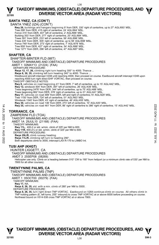
22195
L30
L30
T T
T T
TAKEOFF MINIMUMS, (OBSTACLE) DEPARTURE PROCEDURES, AND DIVERSE VECTOR AREA (RADAR VECTORS)
TAKEOFF MINIMUMS, (OBSTACLE) DEPARTURE PROCEDURES, AND DIVERSE VECTOR AREA (RADAR VECTORS)
SW-3 22195
SANTA YNEZ, CA (CON’T) SANTA YNEZ (IZA) (CON’T)
Rwy 26, buildings and hangars beginning 9’ from DER, 330’ right of centerline, up to 27’ AGL/693’ MSL. Tree 299’ from DER, 415 right of centerline, 24’ AGL/664’ MSL. Fence 315’ from DER, 407’ left of centerline, 2‘ AGL/666’ MSL. Building 353’ from DER, 277’ right of centerline, 20’ AGL/684’ MSL. Trees 391’ from DER, 233‘ left of centerline, 56’ AGL/696’ MSL. Trees 435’ from DER, 305’ right of centerline, up to 58’ AGL/698’ MSL. Fence 749’ from DER, 273’ right of centerline, 7’ AGL/678’ MSL. Tree 859’ from DER, 427’ right of centerline, 54’ AGL/688’ MSL. Tree 1271’ from DER, 296’ left of centerline, 47’ AGL/687’ MSL.
SHAFTER, CA SHAFTER-MINTER FLD (MIT) TAKEOFF MINIMUMS AND (OBSTACLE) DEPARTURE PROCEDURES AMDT 1 02MAY13 (21224) (FAA)
DEPARTURE PROCEDURE: Rwys 12, 17, 26, climbing right turn heading 300° to 4000. Thence ... Rwys 8, 30, 35, climbing left turn heading 240° to 4000. Thence ...
Westbound aircraft intercept V248 until reaching 4000, then proceed on course. Eastbound aircraft intercept V248 upon reaching 4000 turn right direct EHF VORTAC, then proceed on course.
TAKEOFF OBSTACLE NOTES: Rwy 8, vehicles on road beginning 41’ from DER, 7’ left of centerline, up to 15’ AGL/442’ MSL. Rwy 12, windsock 504’ from DER, 397’ left of centerline, 26’ AGL/439’ MSL. Trees beginning 2476’ from DER, 344’ left of centerline, up to 75’ AGL/488’ MSL. Trees beginning 862’ from DER, 378’ right of centerline, up to 31’ AGL/441’ MSL.
Rwy 17, vehicles on road 489’ from DER, left and right of centerline,15’ AGL/429’ MSL. Tree 1150’ from DER, 724’ left of centerline, 51’ AGL/463’ MSL. Windsock 1340’ from DER, 43’ right of centerline, 46’ AGL/455’ MSL. Rwy 30, vehicles on road 146’ from DER, 273’ left of centerline, 10’ AGL/420’ MSL. Rwy 35, vehicles on road 461’ from DER, 86’ right of centerline to 386’ right of centerline, 15’ AGL/442’ MSL.
TORRANCE, CA ZAMPERINI FLD (TOA) TAKEOFF MINIMUMS AND (OBSTACLE) DEPARTURE PROCEDURES AMDT 1A 29JUL10 (21168) (FAA)
TAKEOFF MINIMUMS: Rwy 11L, 400-2 or std. w/min. climb of 325' per NM to 600. Rwy 11R, 400-2½ or std. w/min. climb of 325' per NM to 600.
DEPARTURE PROCEDURE: Rwys 29L/R, climb runway heading. Rwys 11L/R, climbing left turn to heading 290°. Both departures climb to 3000, intercept LAX R-170 to LIMBO Int.
TUSI AHP (KHGT) HUNTER LIGGETT, CA TAKEOFF MINIMUMS AND (OBSTACLE) DEPARTURE PROCEDURES
AMDT 3 25SEP08 (08269) Helicopter use only. Climb on a heading between 010° CW to 190° from heliport (or a minimum climb rate of 530’ per NM to
7800 for all other courses).
TWENTYNINE PALMS, CA TWENTYNINE PALMS (TNP) TAKEOFF MINIMUMS AND (OBSTACLE) DEPARTURE PROCEDURES AMDT 1 05OCT00 (00279) (FAA)
TAKEOFF MINIMUMS: Rwy 17, NA. Rwys 8, 26, 35, std. with a min. climb of 280' per NM to 5500.
DEPARTURE PROCEDURE: Rwys 8, 26, 35, turn right direct TNP VORTAC. Eastbound on V264 continue climb on course. All others climb in TNP holding pattern (E, left turns, 255° inbound) to cross TNP VORTAC at or above 6000 before proceeding on course. Northeast bound on V514-538 cross TNP VORTAC at or above 7900.
14 JUL 2022 to 11 AU
G 2022 14
JU
L 20
22 t
o 1
1 AU
G 2
022
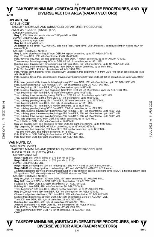
22195
L31
L31
T T
T T
TAKEOFF MINIMUMS, (OBSTACLE) DEPARTURE PROCEDURES, AND DIVERSE VECTOR AREA (RADAR VECTORS)
TAKEOFF MINIMUMS, (OBSTACLE) DEPARTURE PROCEDURES, AND DIVERSE VECTOR AREA (RADAR VECTORS)
SW-3 22195
UPLAND, CA CABLE (CCB) TAKEOFF MINIMUMS AND (OBSTACLE) DEPARTURE PROCEDURES AMDT 3A 19JUL18 (18200) (FAA)
TAKEOFF MINIMUMS: Rwy 6, 300-1⅞ or std. w/min. climb of 332’ per NM to 1900.
DEPARTURE PROCEDURE: Rwy 6, climbing right turn. Rwy 24, climbing left turn. All aircraft climb direct PDZ VORTAC and hold (east, right turns, 258°, inbound), continue climb-in-hold to MEA for route of flight.
TAKEOFF OBSTACLE NOTES: Rwy 6, pole, sign beginning 21’ from DER, 99’ right of centerline, up to 40’ AGL/1464’ MSL. Sign 31’ from DER, 100’ left of centerline, 7’ AGL/1451’ MSL. Pole, traverse way, tree, building beginning 87’ from DER, 7’ right of centerline, up to 41’ AGL/1472’ MSL. Traverse way, fence beginning 94’ from DER, 82’ left of centerline, up to 1461’ MSL. Building, pole, traverse way, fence beginning 106’ from DER, 100’ left of centerline, up to 40’ AGL/1495’ MSL. Tree, building, traverse way beginning 260’ from DER, 6’ right of centerline, up to 1484’ MSL. Pole 351’ from DER, 410’ left of centerline, 40’ AGL/1498’ MSL. Pole, vertical point, building, fence, traverse way, vegetation, tree beginning 411’ from DER, 193’ left of centerline, up to 36’ AGL/1499’ MSL. Pole, building, fence, tree, general utility, traverse way beginning 628’ from DER, 34’ left of centerline, up to 32’ AGL/1500’ MSL. Pole, tree, general utility, tower, building beginning 961’ from DER, 180’ left of centerline, up to 57’ AGL/1532’ MSL. Pole, building beginning 1228’ from DER, 541’ left of centerline, up to 76’ AGL/1545’ MSL. Trees beginning 1271’ from DER, 80’ right of centerline, up to 1498’ MSL. Pole, building, traverse way, tree beginning 1289’ from DER, 29’ left of centerline, up to 75’ AGL/1548’ MSL. Trees beginning 1860’ from DER, 16’ right of centerline, up to 1506’ MSL. Tree, building, traverse way beginning 933’ from DER, 25’ left of centerline, up to 1555’ MSL. Tree, building beginning 2152’ from DER, 67’ left of centerline, up to 1565’ MSL. Tree, building, pole beginning 2241’ from DER, 58’ left of centerline, up to 1573’ MSL. Trees beginning 2485’ from DER, 104’ right of centerline, up to 1511’ MSL. Trees beginning 2787’ from DER, 0’ right of centerline, up to 1524’ MSL. Tree, building, pole beginning 3512’ from DER, 0’ left of centerline, up to 1575’ MSL. Tree, pole, building, traverse way beginning 3782’ from DER, 384’ left of centerline, up to 1593’ MSL. Tree, building, pole, traverse way beginning 4075’ from DER, 668’ left of centerline, up to 1610’ MSL. Tree, building, traverse way, pole beginning 4235’ from DER, 596’ left of centerline, up to 1619’ MSL. Tree, pole beginning 5480’ from DER, 949’ left of centerline, up to 1620’ MSL. Tree 1 NM from DER, 1434’ left of centerline, 1632’ MSL. Rwy 24, traverse way, tree beginning 15’ from DER, 60’ right of centerline, up to 1408’ MSL. Sign beginning 24’ from DER, 97’ left of centerline, up to 13’ AGL/1396’ MSL. Traverse way, tree beginning 313’ from DER, 383’ right of centerline, up to 1412’ MSL. Tree 699’ from DER, 682’ right of centerline, 1416’ MSL. Pole 1296’ from DER, 747’ right of centerline, 47’ AGL/1427’ MSL. Pole 1357’ from DER, 583’ right of centerline, 62’ AGL/1436’ MSL.
VAN NUYS, CA VAN NUYS (VNY) TAKEOFF MINIMUMS AND (OBSTACLE) DEPARTURE PROCEDURES AMDT 6 21JUL16 (16203) (FAA)
TAKEOFF MINIMUMS: Rwys 16L/R, std. w/min. climb of 370' per NM to 7100. Rwys 34L/R, std. w/min. climb of 370' per NM to 7100.
DEPARTURE PROCEDURE: Rwys 16L/R, climbing left turn on heading 053° and VNY R-095 to DARTS INT, thence… Rwys 34L/R, climbing right turn on heading 143° and VNY R-095 to DARTS INT, thence…
...aircraft eastbound on V186 and southeast bound on V459 climb on course, all others climb in DARTS holding pattern (hold W, right turns, 095° inbound) to depart DARTS INT at or above 7100.
TAKEOFF OBSTACLE NOTES: Rwy 16L, light on hangar 713’ from DER, 361’ left of centerline, 27’ AGL/798’ MSL. Rwy 16R, hangar 209’ from DER, 516’ right of centerline, 15’ AGL/755’ MSL. Flagpole 570’ from DER, 549‘ right of centerline, 21’ AGL/761’ MSL. Building 941’ from DER, 599’ left of centerline, 28’ AGL/774’ MSL. Trees beginning 1129’ from DER, left and right of centerline, up to 81’ AGL/821’ MSL. Rwy 34L, blast fence 169’ from DER, 405’ left of centerline, 10’ AGL/812’ MSL. Obstruction light on blast fence, 241’ from DER, 195’ left of centerline, 17’ AGL/819’ MSL. Multiple trees beginning 325’ from DER, 549’ right of centerline, up to 91’ AGL/921’ MSL. Train 305’ from DER, 369’ right of centerline, 23’ AGL/832’ MSL. Building 424’ from DER, 589’ right of centerline, 29’ AGL/831’ MSL. Antenna on building 449’ from DER 462’ left of centerline, 15’ AGL/817’ MSL. Pole 1376’ from DER, 779’ left of centerline, 68’ AGL/870’ MSL. Trees beginning 828’ from DER, 15’ left of centerline, 78’ AGL/907’ MSL.
CON’T
14 JUL 2022 to 11 AU
G 2022 14
JU
L 20
22 t
o 1
1 AU
G 2
022
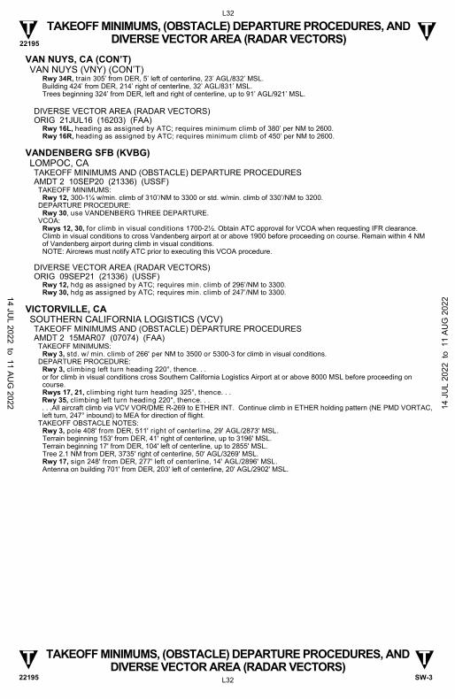
22195
L32
L32
T T
T T
TAKEOFF MINIMUMS, (OBSTACLE) DEPARTURE PROCEDURES, AND DIVERSE VECTOR AREA (RADAR VECTORS)
TAKEOFF MINIMUMS, (OBSTACLE) DEPARTURE PROCEDURES, AND DIVERSE VECTOR AREA (RADAR VECTORS)
SW-3 22195
VAN NUYS, CA (CON’T) VAN NUYS (VNY) (CON’T)
Rwy 34R, train 305’ from DER, 5’ left of centerline, 23’ AGL/832’ MSL. Building 424’ from DER, 214’ right of centerline, 32’ AGL/831’ MSL. Trees beginning 324’ from DER, left and right of centerline, up to 91’ AGL/921’ MSL.
DIVERSE VECTOR AREA (RADAR VECTORS) ORIG 21JUL16 (16203) (FAA)
Rwy 16L, heading as assigned by ATC; requires minimum climb of 380’ per NM to 2600. Rwy 16R, heading as assigned by ATC; requires minimum climb of 450’ per NM to 2600.
VANDENBERG SFB (KVBG) LOMPOC, CA TAKEOFF MINIMUMS AND (OBSTACLE) DEPARTURE PROCEDURES AMDT 2 10SEP20 (21336) (USSF)
TAKEOFF MINIMUMS: Rwy 12, 300-1¼ w/min. climb of 310’/NM to 3300 or std. w/min. climb of 330’/NM to 3200.
DEPARTURE PROCEDURE: Rwy 30, use VANDENBERG THREE DEPARTURE.
VCOA: Rwys 12, 30, for climb in visual conditions 1700-2½. Obtain ATC approval for VCOA when requesting IFR clearance. Climb in visual conditions to cross Vandenberg airport at or above 1900 before proceeding on course. Remain within 4 NM of Vandenberg airport during climb in visual conditions. NOTE: Aircrews must notify ATC prior to executing this VCOA procedure.
DIVERSE VECTOR AREA (RADAR VECTORS) ORIG 09SEP21 (21336) (USSF)
Rwy 12, hdg as assigned by ATC; requires min. climb of 296’/NM to 3300. Rwy 30, hdg as assigned by ATC; requires min. climb of 247’/NM to 3300.
VICTORVILLE, CA SOUTHERN CALIFORNIA LOGISTICS (VCV) TAKEOFF MINIMUMS AND (OBSTACLE) DEPARTURE PROCEDURES AMDT 2 15MAR07 (07074) (FAA)
TAKEOFF MINIMUMS: Rwy 3, std. w/ min. climb of 266' per NM to 3500 or 5300-3 for climb in visual conditions.
DEPARTURE PROCEDURE: Rwy 3, climbing left turn heading 220°, thence. . .
or for climb in visual conditions cross Southern California Logistics Airport at or above 8000 MSL before proceeding on course. Rwys 17, 21, climbing right turn heading 325°, thence. . .
Rwy 35, climbing left turn heading 220°, thence. . . . . .All aircraft climb via VCV VOR/DME R-269 to ETHER INT. Continue climb in ETHER holding pattern (NE PMD VORTAC,
left turn, 247° inbound) to MEA for direction of flight. TAKEOFF OBSTACLE NOTES:
Rwy 3, pole 408' from DER, 511' right of centerline, 29' AGL/2873' MSL. Terrain beginning 153' from DER, 41' right of centerline, up to 3196' MSL. Terrain beginning 17' from DER, 104' left of centerline, up to 2855' MSL. Tree 2.1 NM from DER, 3735' right of centerline, 50' AGL/3269' MSL. Rwy 17, sign 248' from DER, 277' left of centerline, 14' AGL/2896' MSL. Antenna on building 701' from DER, 203' left of centerline, 20' AGL/2902' MSL.
14 JUL 2022 to 11 AU
G 2022 14
JU
L 20
22 t
o 1
1 AU
G 2
022
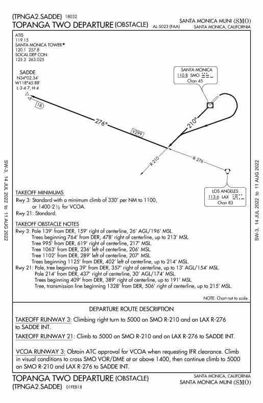
SANTA MONICA, CALIFORNIA
(SMO)
SANTA MONICA, CALIFORNIA
(SMO)
SANTA MONICA MUNI
SANTA MONICA MUNI
DEPARTURE ROUTE DESCRIPTION
(TPNGA2.SADDE)
(TPNGA2.SADDE)
TOPANGA TWO DEPARTURE
TOPANGA TWO DEPARTURE
NOTE: Chart not to scale.
(OBSTACLE)
(OBSTACLE)
125.2 263.025
SOCAL DEP CON
120.1 257.8
SANTA MONICA TOWER
119.15
ATIS
110.8 SMO
Chan 45
SANTA MONICASMO
LAX113.6
LOS ANGELES
Chan 83
210°
TAKEOFF RUNWAY 21: Climb to 5000 on SMO R-210 and on LAX R-276 to SADDE INT.
on SMO R-210 and LAX R-276 to SADDE INT.
in visual conditions to cross SMO VOR/DME at or above 1400, then continue climb to 5000
VCOA RUNWAY 3: Obtain ATC approval for VCOA when requesting IFR clearance. Climb
R-276
276°
SADDE
W118°45.88'
N34°02.34'
L-3-4-7, H-4
18
R-210
AL-5023 (FAA)
V299
18032
01FEB18
TAKEOFF OBSTACLE NOTES
TAKEOFF MINIMUMS
12
Rwy 21: Standard.
or 1400-2 for VCOA.
Rwy 3: Standard with a minimum climb of 330' per NM to 1100,
Tree, transmission line beginning 1328' from DER, 506' right of centerline, up to 215' MSL.
Trees beginning 409' from DER, 389' right of centerline, up to 191' MSL.
Pole 214' from DER, 437' right of centerline, 30' AGL/174' MSL.
Rwy 21: Pole, tree beginning 39' from DER, 357' right of centerline, up to 13' AGL/154' MSL.
Trees beginning 1125' from DER, 402' left of centerline, up to 214' MSL.
Tree 1102' from DER, 289' left of centerline, 207' MSL.
Tree 1063' from DER, 236' left of centerline, 206' MSL.
Tree 995' from DER, 619' right of centerline, 217' MSL.
Trees beginning 764' from DER, 478' right of centerline, up to 213' MSL.
Rwy 3: Pole 139' from DER, 159' right of centerline, 26' AGL/196' MSL.
to SADDE INT.
TAKEOFF RUNWAY 3: Climbing right turn to 5000 on SMO R-210 and on LAX R-276
SW-3, 14 JU
L 2022 to 11 AUG
2022 SW-3
, 14
JU
L 20
22 t
o 1
1 AU
G 2
022
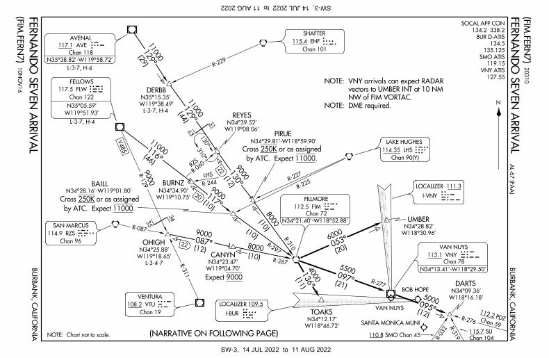
BU
RB
AN
K, C
AL
IFO
RN
IA(NARRATIVE ON FOLLOWING PAGE)NOTE: Chart not to scale.
3635
SANTA MONICA MUNI
R-032
R-319
115.7 SLI
Chan 104110.8 SMO Chan 45
R-276
VAN NUYS
R-277
TOAKS
DARTS
UMBER
R-310
R-297
8000
(10)
(10)
CANYN
R-311
OHIGH 22
N34°28.16'-W119°01.80'
R-129
9000
V485
BURNZ
R-06
0RZS
LHS
R-244
20
R-227
R-225
PIRUEN34°29.81'-W118°59.90'
REYES
22
31
63
R-229
DERBB117.5 FLW
Chan 122
FELLOWS
115.4 EHF
Chan 101
114.9 RZS
Chan 96
108.2 VTU
Chan 19
AVE
FLW
SAN MARCUSRZS
VENTURAVTU LOCALIZER 109.5
I-BURIUR
VNY
FIM
LAKE HUGHESLHSLOCALIZER 111.3
I-VNYIVNY
SHAFTERHF
N
BU
RB
AN
K, C
AL
IFO
RN
IA
E
9000 (12)
11000 (46)
9000(10)
BAILL
R-087
8000(12)(10) R-267
4000 (11)
5500
(21)
5000
(12)
6000
(20)
BOB HOPE
20
31
0
10
NO
V1
6
NOTE: DME required.
NW of FIM VORTAC.
vectors to UMBER INT at 10 NM
NOTE: VNY arrivals can expect RADAR
Chan 59
112.2 PDZ
095°
053°
136°
097° Expect 9000
B130°
117°
9000
087°
129°
129°
116°
310°
W118°46.72'
N34°12.17'
W118°16.18'
N34°09.36'
W118°30.96'
N34°28.82'
W119°04.70'
N34°23.47'
W119°10.75'
N34°34.90'
W119°08.06'
N34°39.52'
(29)
11000
L-3-7, H-4
W119°38.49'
N35°15.35'
L-3-4-7
W119°18.65'
N34°25.88'
130°
(FIM
.FE
RN
7)
(FIM
.FE
RN
7)
(44)
11000W119°51.93'
N35°05.59'
by ATC. Expect 11000.
Cross 250K or as assigned
by ATC. Expect 11000.
Cross 250K or as assigned
FE
RN
AN
DO
SE
VE
N A
RR
IVA
L
FE
RN
AN
DO
SE
VE
N A
RR
IVA
L
AL
-67
(FA
A)
114.35 LHS
Chan 90(Y)
127.55
VNY ATIS
119.15
SMO ATIS
135.125
134.5
BUR D-ATIS
134.2 338.2
SOCAL APP CON
117.1 AVE
Chan 118
AVENAL
113.1 VNY
Chan 78
112.5 FIM
Chan 72
N35°38.82'-W119°58.72'
L-3-7, H-4
L-3-7, H-4
VAN NUYS
N34°13.41'-W118°29.50'
FILLMORE
N34°21.40'-W118°52.88'
SW-3, 14 JUL 2022 to 11 AUG 2022SW-3, 14 JUL 2022 to 11 AUG 2022
BURBANK, CALIFORNIA
BURBANK, CALIFORNIA
ARRIVAL ROUTE DESCRIPTION
. . . .From over FIM VORTAC:
and FIM R-310 to FIM VORTAC. Thence. . . .
AVENAL TRANSITION (AVE.FERN7): From over AVE VOR/DME on AVE R-129
FIM R-310 to FIM VORTAC. Thence. . . .
DERBB TRANSITION (DERBB.FERN7): From over DERBB INT on AVE R-129 and
Expect ILS RWY 8.
LANDING BOB HOPE: Via FIM R-136 to TOAKS INT, then via I-BUR localizer.
localizer. Expect ILS RWY 16R.
LANDING VAN NUYS RWY 16: Via FIM R-053 to UMBER INT, then via I-VNY
localizer. Expect LDA-C; circle to land Rwy 34L.
LANDING VAN NUYS RWY 34: Via FIM R-136 to TOAKS INT, then via I-BUR
17117
10NOV16
(FIM.FERN7)
(FIM.FERN7)
FIM VORTAC. Thence. . . .
OHIGH TRANSITION (OHIGH.FERN7): From over OHIGH INT on FIM R-267 to
FERNANDO SEVEN ARRIVAL
FERNANDO SEVEN ARRIVAL
and FIM R-297 to FIM VORTAC. Thence. . . .
FELLOWS TRANSITION (FLW.FERN7): From over FLW VOR/DME on FLW R-116
then via VNY R-095 to DARTS INT. Expect VOR-A approach.
LANDING SANTA MONICA MUNI: Via FIM R-097 and VNY R-277 to VNY
AL-67 (FAA)
SW-3, 14 JU
L 2022 to 11 AUG
2022 SW-3
, 14
JU
L 20
22 t
o 1
1 AU
G 2
022
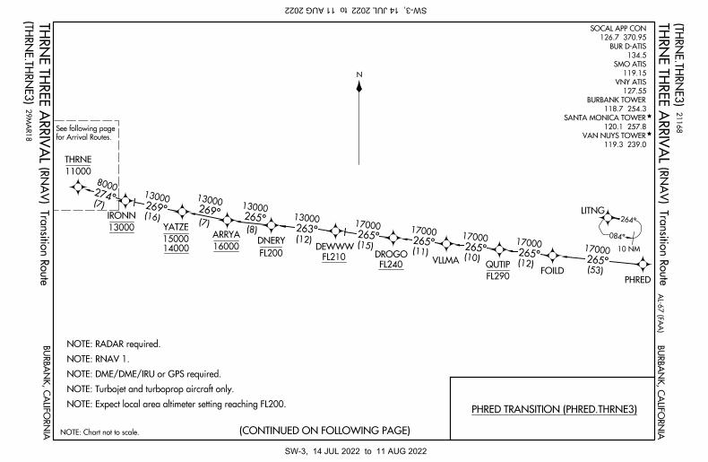
NOTE: Chart not to scale.
N
(TH
RN
E.T
HR
NE
3)
(TH
RN
E.T
HR
NE
3)
AL
-67
(FA
A)
BU
RB
AN
K, C
AL
IFO
RN
IA
BU
RB
AN
K, C
AL
IFO
RN
IA
PHRED TRANSITION (PHRED.THRNE3)NOTE: Expect local area altimeter setting reaching FL200.
NOTE: Turbojet and turboprop aircraft only.
NOTE: DME/DME/IRU or GPS required.
NOTE: RNAV 1.
NOTE: RADAR required.
PHRED
LITNG
FOILD
VLLMAFL240
FL210FL20016000
13000
DROGODEWWW
DNERYARRYA
IRONN
15000
YATZE
14000
11000
THRNE
265° (53)
(12) (10)
(11)
FL290
QUTIP
263° (12)
13000265° (8)
269° (16)
13000274° (7)
8000
(7)
084°
264°
10 NM
13000
13000
265°
17000265°
17000 265°
17000265°
17000
(15)
269°
17000
(CONTINUED ON FOLLOWING PAGE)
for Arrival Routes.
See following page
TH
RN
E T
HR
EE
AR
RIV
AL
TH
RN
E T
HR
EE
AR
RIV
AL(R
NA
V) T
ran
sitio
n R
ou
te
(RN
AV
) Tra
nsitio
n R
ou
te
21
16
8
29
MA
R1
8
119.3 239.0
VAN NUYS TOWER
120.1 257.8
SANTA MONICA TOWER
118.7 254.3
BURBANK TOWER
127.55
VNY ATIS
119.15
SMO ATIS
134.5
BUR D-ATIS
126.7 370.95
SOCAL APP CON
SW-3, 14 JUL 2022 to 11 AUG 2022SW-3, 14 JUL 2022 to 11 AUG 2022
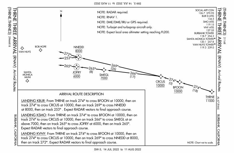
NOTE: Chart not to scale.
N
ARRIVAL ROUTE DESCRIPTION
NOTE: Expect local area altimeter setting reaching FL200.
NOTE: Turbojet and turboprop aircraft only.
NOTE: DME/DME/IRU or GPS required.
NOTE: RNAV 1.
NOTE: RADAR required.
MUNIMONICA SANTA
11000
THRNE
10000
CRCUS
NNEDD
JOFRY
8000
6000SMEGL
7000
272°
253°
265°
(18)
266° (17)
(8)
265°
269° (26)
274°
BOB HOPE
VAN NUYS
(TH
RN
E.T
HR
NE
3)
TH
RN
E T
HR
EE
AR
RIV
AL
AL
-67
(FA
A)
BU
RB
AN
K, C
AL
IFO
RN
IA
(TH
RN
E.T
HR
NE
3)
BU
RB
AN
K, C
AL
IFO
RN
IAT
HR
NE
TH
RE
E A
RR
IVA
L
274°(3)
10000
BFOON
at 8000, then on track 253° . Expect RADAR vectors to final approach course.
track 274° to cross CRCUS at 10000, then on track 269° to cross NNEDD
LANDING KBUR: From THRNE on track 274° to cross BFOON at 10000, then on
21
16
8
29
MA
R1
8
(RN
AV
) Arriv
al R
ou
tes
(RN
AV
) Arriv
al R
ou
tes
Expect RADAR vectors to final approach course.
above 7000, then on track 265° to cross JOFRY at 6000, then on track 265°.
track 274° to cross CRCUS at 10000, then on track 266° to cross SMEGL at or
LANDING KSMO: From THRNE on track 274° to cross BFOON at 10000, then on
then on track 272°. Expect RADAR vectors to final approach course.
track 274° to cross CRCUS at 10000, then on track 269° to cross NNEDD at 8000,
LANDING KVNY: From THRNE on track 274° to cross BFOON at 10000, then on
119.3 239.0
VAN NUYS TOWER
120.1 257.8
SANTA MONICA TOWER
118.7 254.3
BURBANK TOWER
127.55
VNY ATIS
119.15
SMO ATIS
134.5
BUR D-ATIS
126.7 370.95
SOCAL APP CON
SW-3, 14 JUL 2022 to 11 AUG 2022SW-3, 14 JUL 2022 to 11 AUG 2022
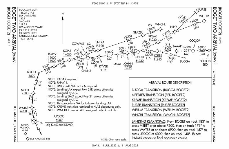
157°
(4)
140°
173°
(3)
183°
(12)
MUNI
MONICA
SANTA
LOS ANGELES INTL
235°
(11)
235°
(10)
7500
7500
243°130
00(12
) 233°
(18)
1300
0
226°
(24)
1300
0
216°
239°
(41)
(46)
1600
016000
13000
244°
(7)
N(R
NA
V)
BO
GE
T T
WO
AR
RIV
AL(R
NA
V)
BO
GE
T T
WO
AR
RIV
AL
BOGET
WNCHL TRANSITION (WNCHL.BOGET2)
WELUM TRANSITION (WELUM.BOGET2)
PURSE TRANSITION (PURSE.BOGET2)
KREME TRANSITION (KREME.BOGET2)
NEEDLES TRANSITION (EED.BOGET2)
BUGGA TRANSITION (BUGGA.BOGET2)
COWWS
GLAZD
NIPIY
PURSE
WELUM
NOTE: Chart not to scale.
14000
KOPLE
FL240
KREME
ARRIVAL ROUTE DESCRIPTION
MEETT7500
WATSS
6900
UPDOC
6000
NOTE: WNCHL transition ATC assigned only-do not file.
NOTE: KREME transition restricted to KLAS departures only.
NOTE: This procedure NA for turbojets landing LAX.
assigned by ATC.
NOTE: Landing SMO expect Rwy 21 unless otherwise
assigned by ATC.
NOTE: Landing LAX expect Rwy 24R unless otherwise
NOTE: DME/DME/IRU or GPS required.
NOTE: RNAV 1.
NOTE: RADAR required.
LO
S A
NG
EL
ES
, CA
LIF
OR
NIA
LO
S A
NG
EL
ES
, CA
LIF
OR
NIA
(BO
GE
T.B
OG
ET
2)
(BO
GE
T.B
OG
ET
2)
RADAR vectors to final approach course.
cross UPDOC at 6000, then on track 140°. Expect
cross WATSS at or above 6900, then on track 157° to
cross MEETT at or above 7500, then on track 173° to
LANDING KLAX/KSMO: From BOGET on track 183° to
WNCHL
8000
20
19
8
19
JU
L1
8
AL
-23
7 (F
AA
)
251°
13000
(12)
CHKNZ
251°
13000
(8)
13000
(30)
BASAL
251°
13000
251°
(8)
FL220
JOHHN
13000
251°
(7)
DYVER
FL190
FL230
DNUTT
256°13000
(16)FL240
JOEES
16000
(21)
259°
TAAAP
269°16000(26) BUGGA
16000
259°(42)
COOOP
16000
260°(25)
EED
NEEDLES
243°130
00(8)
SNTRA
FL190
13000
244°
(58)
ROPEZ
1100013000
Ldg KLAX and KSMO
120.1 257.8
SANTA MONICA TOWER
(S) 120.95 379.1
(N) 133.9 239.3
LOS ANGELES TOWER
119.15
SMO ATIS
133.8
LAX D-ATIS ARR
135.05 317.5
SOCAL APP CON
SW-3, 14 JUL 2022 to 11 AUG 2022SW-3, 14 JUL 2022 to 11 AUG 2022
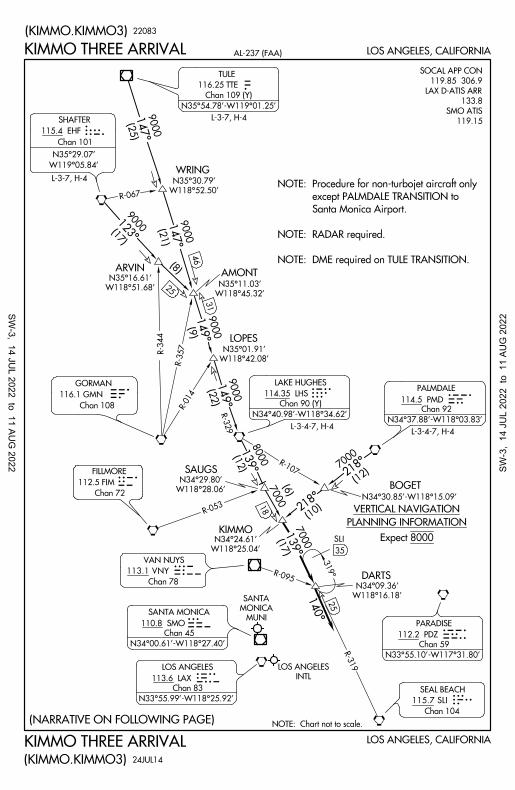
LOS ANGELES, CALIFORNIA
LOS ANGELES, CALIFORNIA
NOTE: Chart not to scale.
KIMMO
DARTS
SAUGS
BOGET
AMONT
LOPES
ARVIN
WRING
R-067
(21)
25
R-3
44
R-014
(22)
R-3
29
R-107
(12)
(10)
(6)
7000
7000
(17)
R-095
R-3
19
25
18R-0
53
116.1 GMN
Chan 108
112.5 FIM
Chan 72
TTE115.4 EHF
Chan 101
SHAFTER
LHS PMD
FILLMOREFIM
GORMANGMN
EHF
31
(9)
KIMMO THREE ARRIVAL
KIMMO THREE ARRIVAL
123°
149°
149°
147°
147°
139°
139°
140°
(KIMMO.KIMMO3)
(KIMMO.KIMMO3)
218°
W118°28.06'
N34°29.80'
(12)
8
000
W118°42.08'
N35°01.91'
218°
W118°25.04'
N34°24.61'
W118°16.18'
N34°09.36'
319°
35
SLI
22083
(8)
(NARRATIVE ON FOLLOWING PAGE)
SLIINTL
LOS ANGELES
PDZ
AX
MOL
S MUNI
MONICA
SANTA
VNY
7000
N34°30.85'-W118°15.09'
PLANNING INFORMATION
VERTICAL NAVIGATION
Expect 8000
9000
W118°45.32'
N35°11.03'
9000
W118°51.68'
N35°16.61'
9000 (1
7)
W119°05.84'
N35°29.07'
W118°52.50'
N35°30.79'
9000
(25)
9000
R-3
57
46 NOTE: DME required on TULE TRANSITION.
NOTE: RADAR required.
Santa Monica Airport.
except PALMDALE TRANSITION to
NOTE: Procedure for non-turbojet aircraft only
24JUL14
AL-237 (FAA)
119.15
SMO ATIS
133.8
LAX D-ATIS ARR
119.85 306.9
SOCAL APP CON
116.25 TTE
Chan 109 (Y)
Chan 92
Chan 104
TULE
N35°54.78'-W119°01.25'
LAKE HUGHES
N34°40.98'-W118°34.62'
PALMDALE
SEAL BEACH
L-3-7, H-4
L-3-7, H-4
L-3-4-7, H-4
115.7 SLI
L-3-4-7, H-4
PARADISE
112.2 PDZ
Chan 59
N33°55.10'-W117°31.80'
113.6 LAX
Chan 83
N33°55.99'-W118°25.92'
110.8 SMO
Chan 45
N34°00.61'-W118°27.40'
LOS ANGELES
SANTA MONICA
113.1 VNY
VAN NUYS
Chan 78
114.5 PMD
N34°37.88'-W118°03.83'
114.35 LHS
Chan 90 (Y)
SW-3, 14 JU
L 2022 to 11 AUG
2022 SW-3
, 14
JU
L 20
22 t
o 1
1 AU
G 2
022
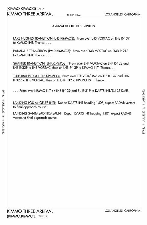
ARRIVAL ROUTE DESCRIPTION
KIMMO THREE ARRIVAL
KIMMO THREE ARRIVAL
(KIMMO.KIMMO3)
(KIMMO.KIMMO3)
LOS ANGELES, CALIFORNIA
LOS ANGELES, CALIFORNIA
17117
. . . .From over KIMMO INT on LHS R-139 and SLI R-319 to DARTS INT/SLI 25 DME.
to final approach course.
LANDING LOS ANGELES INTL: Depart DARTS INT heading 140°, expect RADAR vectors
vectors to final approach course.
LANDING SANTA MONICA MUNI: Depart DARTS INT heading 140°, expect RADAR
R-329 to LHS VORTAC, then on LHS R-139 to KIMMO INT. Thence. . . .
TULE TRANSITION (TTE.KIMMO3): From over TTE VOR/DME on TTE R-147 and LHS
LHS R-329 to LHS VORTAC, then on LHS R-139 to KIMMO INT. Thence. . . .
SHAFTER TRANSITION (EHF.KIMMO3): From over EHF VORTAC on EHF R-123 and
to KIMMO INT. Thence. . . .
PALMDALE TRANSITION (PMD.KIMMO3): From over PMD VORTAC on PMD R-218
to KIMMO INT. Thence. . . .
LAKE HUGHES TRANSITION (LHS.KIMMO3): From over LHS VORTAC on LHS R-139
24JUL14
AL-237 (FAA)
SW-3, 14 JU
L 2022 to 11 AUG
2022 SW-3
, 14
JU
L 20
22 t
o 1
1 AU
G 2
022
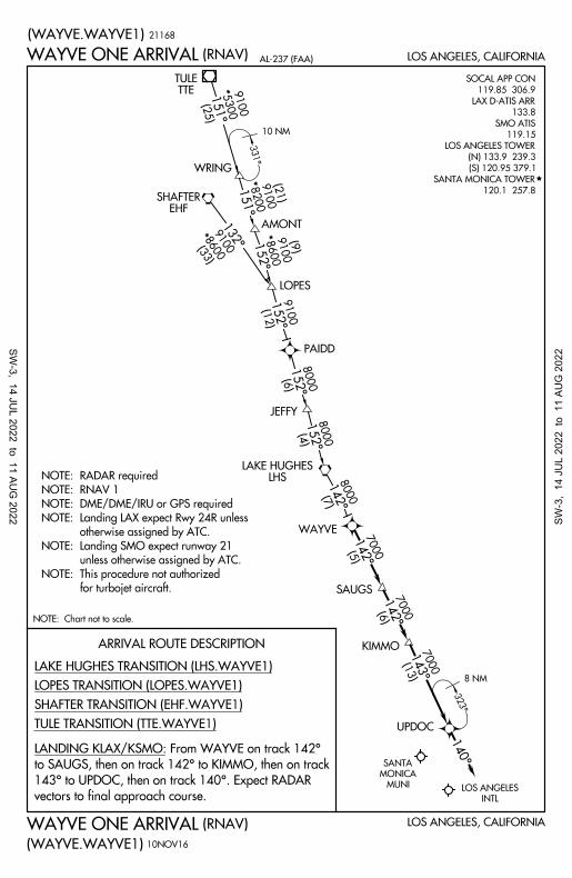
INTL
LOS ANGELESMUNI
MONICA
SANTA
PAIDD
JEFFY
WRING
AMONT
LOPES
WAYVE
SAUGS
KIMMO
UPDOC
140°
8 NM
143°
(13)
7000
142°
(6)
7000
142°
(5)
7000
142°
(7)
8000
152°
(4)
8000
152°
(6)
8000
152°
(12)
9100
(WAYVE.WAYVE1)
WAYVE ONE ARRIVAL(RNAV) LOS ANGELES, CALIFORNIA
WAYVE ONE ARRIVAL
(WAYVE.WAYVE1)
(RNAV) LOS ANGELES, CALIFORNIA
NOTE: Chart not to scale.
152°
8600
9100
(9)
151°
8200
9100
(21)
151°
(25)
5300
9100
*
*
*
132°(3
3)8600
9100
*
331°
323°
10 NM
EHFSHAFTER
LHSLAKE HUGHES
TTETULE
ARRIVAL ROUTE DESCRIPTION
for turbojet aircraft.
NOTE: This procedure not authorized
unless otherwise assigned by ATC.
NOTE: Landing SMO expect runway 21
otherwise assigned by ATC.
NOTE: Landing LAX expect Rwy 24R unless
NOTE: DME/DME/IRU or GPS required
NOTE: RNAV 1
NOTE: RADAR required
21168
10NOV16
TULE TRANSITION (TTE.WAYVE1)
SHAFTER TRANSITION (EHF.WAYVE1)
LOPES TRANSITION (LOPES.WAYVE1)
LAKE HUGHES TRANSITION (LHS.WAYVE1)
vectors to final approach course.
143° to UPDOC, then on track 140°. Expect RADAR
to SAUGS, then on track 142° to KIMMO, then on track
LANDING KLAX/KSMO: From WAYVE on track 142°
AL-237 (FAA)
120.1 257.8
SANTA MONICA TOWER
(S) 120.95 379.1
(N) 133.9 239.3
LOS ANGELES TOWER
119.15
SMO ATIS
133.8
LAX D-ATIS ARR
119.85 306.9
SOCAL APP CON
SW-3, 14 JU
L 2022 to 11 AUG
2022 SW-3
, 14
JU
L 20
22 t
o 1
1 AU
G 2
022
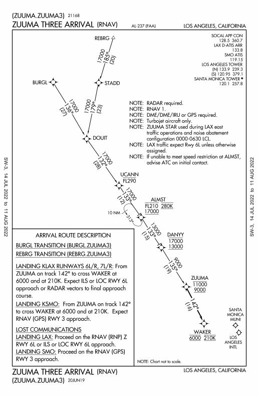
BURGL
DOUIT
REBRG
STADD
185°
179°1
36°
132°
135°
142°
(27)
17000
(20)
17000
(28)
17000
133°
(15)
13000
(19)
9000
(16)
(23)
17000
ZUUMA
11000
9000
DANYY
17000
13000
UCANN
FL290
ALMST
17000
WAKER
6000 210K
MUNI
MONICA
SANTA
INTL
ANGELES
LOS
133°
(12)
17000
313°
10 NM
ARRIVAL ROUTE DESCRIPTION
REBRG TRANSITION (REBRG.ZUUMA3)
BURGL TRANSITION (BURGL.ZUUMA3)
RNAV (GPS) RWY 3 approach.
to cross WAKER at 6000 and at 210K. Expect
LANDING KSMO: From ZUUMA on track 142°
LOS ANGELES, CALIFORNIAAL-237 (FAA)
(ZUUMA.ZUUMA3)
(RNAV)
LOS ANGELES, CALIFORNIA
(ZUUMA.ZUUMA3)
(RNAV)
NOTE: Chart not to scale.
21168
20JUN19
advise ATC on initial contact.
If unable to meet speed restriction at ALMST,NOTE:
assigned.
LAX traffic expect Rwy 6L unless otherwiseNOTE:
configuration 0000-0630 LCL.
traffic operations and noise abatement
ZUUMA STAR used during LAX east NOTE:
Turbojet aircraft only.NOTE:
DME/DME/IRU or GPS required.NOTE:
RNAV 1.NOTE:
RADAR required.NOTE:
ZUUMA THREE ARRIVAL
ZUUMA THREE ARRIVAL
course.
approach or RADAR vectors to final approach
6000 and at 210K. Expect ILS or LOC RWY 6L
ZUUMA on track 142° to cross WAKER at
LANDING KLAX RUNWAYS 6L/R, 7L/R: From
RWY 3 approach.
LANDING SMO: Proceed on the RNAV (GPS)
RWY 6L or ILS or LOC RWY 6L approach.
LANDING LAX: Proceed on the RNAV (RNP) Z
LOST COMMUNICATIONS
SANTA MONICA TOWER
120.1 257.8
(S) 120.95 379.1
(N) 133.9 239.3
LOS ANGELES TOWER
119.15
SMO ATIS
133.8
LAX D-ATIS ARR
128.5 360.7
SOCAL APP CON
SW-3, 14 JU
L 2022 to 11 AUG
2022 SW-3
, 14
JU
L 20
22 t
o 1
1 AU
G 2
022
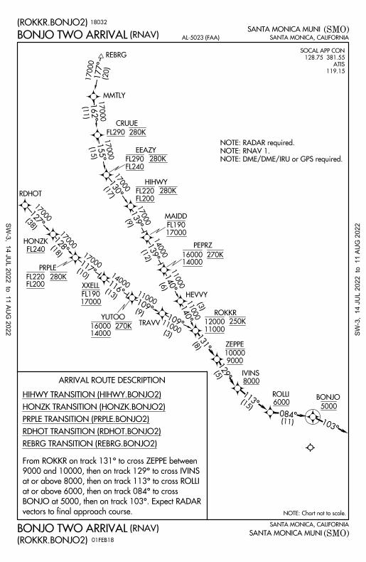
SANTA MONICA, CALIFORNIA
SANTA MONICA, CALIFORNIA
SANTA MONICA MUNI
SANTA MONICA MUNI
NOTE: Chart not to scale.
(ROKKR.BONJO2)
BONJO TWO ARRIVAL(RNAV)
BONJO TWO ARRIVAL(ROKKR.BONJO2)
(RNAV)
AL-5023 (FAA)
(SMO)
(SMO)
ARRIVAL ROUTE DESCRIPTION
119.15
ATIS
128.75 381.55
SOCAL APP CON
FL240
FL290 280K
EEAZY
HEVVY
11000
12000250K
ROKKR
TRAVV
IVINS
8000
ROLLI
6000
177°
162°
155°
130°
139°
103°
084°
131°
129°
113°
109°
127°
117°
116°
109°
RDHOT
MMTLY
REBRG
140°
139°
140°
NOTE: DME/DME/IRU or GPS required.
NOTE: RNAV 1.
NOTE: RADAR required.
REBRG TRANSITION (REBRG.BONJO2)
RDHOT TRANSITION (RDHOT.BONJO2)
PRPLE TRANSITION (PRPLE.BONJO2)
HONZK TRANSITION (HONZK.BONJO2)
HIHWY TRANSITION (HIHWY.BONJO2)
128°
PRPLE
FL200FL220 280K
XXELL
17000
FL190
YUTOO
1400016000270K
CRUUE
FL200
FL220 280K
HIHWY
MAIDD
17000
FL190
PEPRZ
1400016000270K
ZEPPE
9000
10000
(8)
(5)
(15)
BONJO
5000
(11)
FL240
HONZK
18032
01FEB18
(20)
17000
(11)
17000
(15)
17000
(17)
17000
(9)
17000
(12)
14000
(6)
11000
(3)
11000
(3)
11000
(9)
11000
(13)
14000
(10)
17000
(18)
17000
(38)
17000
FL290 280K
vectors to final approach course.
BONJO at 5000, then on track 103°. Expect RADAR
at or above 6000, then on track 084° to cross
at or above 8000, then on track 113° to cross ROLLI
9000 and 10000, then on track 129° to cross IVINS
From ROKKR on track 131° to cross ZEPPE between
SW-3, 14 JU
L 2022 to 11 AUG
2022 SW-3
, 14
JU
L 20
22 t
o 1
1 AU
G 2
022