coastal ecosystems and tsunami protection after the december 2004 indian ocean tsunami
TRANSCRIPT

Coastal Ecosystems and TsunamiProtection after the December 2004 IndianOcean Tsunami
Stephanie E. Chang,a… M.EERI, Beverley J. Adams,b… Jacqueline Alder,c…
Philip R. Berke,d… Ratana Chuenpagdee,e… Shubharoop Ghosh,f…
and Colette Wabnitzc…
An exploratory study was conducted on the role of coastal ecosystems inprotecting communities from the December 2004 Indian Ocean tsunami,focusing on mangrove forests on the Andaman coast of Thailand and how wellvillages were undertaking environmental conservation. Remote sensinganalysis identified predisaster mangrove change and postdisaster structuraldamage and landscape changes. Field data from five sites �20 villages�,gathered via the VIEWS™ data collection system, validated and supplementedthis analysis. Key informants at several of these villages were also interviewed.A preliminary comparison of villages that otherwise faced similar tsunamiexposure suggests that the presence of healthy mangroves did affordsubstantial protection. Village performance in mangrove conservation andmanagement efforts, and thus the presence of healthy forests, is influenced byboth social capital and the design of external aid delivery programs.�DOI: 10.1193/1.2201971�
INTRODUCTION
The December 2004 Indian Ocean tsunami disaster has generated much attention tosuch preparedness measures as early warning systems, the design of tsunami-resistantstructures, and evacuation planning. Yet important lessons can also be learned about an-other, often-overlooked strategy of hazard mitigation—environmental conservation. Canenvironmental conservation provide some degree of protection from natural hazards?How well are communities undertaking such conservation? Did degradation of coastalecosystems before the 2004 tsunami and poor environmental management serve to ex-acerbate communities’ vulnerability?
a� School of Community and Regional Planning, University of British Columbia, 242-1933 West Mall,Vancouver, British Columbia V6T 1Z2, Canada
b� ImageCat Inc., European Operations, 246 Barnett Wood Lane, Ashtead, Surrey, KT21 2BY, UKc� Fisheries Centre, University of British Columbia, 2202 Main Mall, Vancouver, British Columbia V6T 1Z4,Canada
d� Department of City and Regional Planning, and Carolina Environmental Program, University of NorthCarolina, Chapel Hill, NC 27599-3140
e� International Ocean Institute, Dalhousie University, 1226 LeMarchant Street, Halifax, Nova Scotia B3H 3P7,Canada
f�
ImageCat Inc., 400 Oceangate, Suite 1050, Long Beach, CA 90802S863Earthquake Spectra, Volume 22, No. S3, pages S863–S887, June 2006; © 2006, Earthquake Engineering Research Institute

S864 S. E. CHANG, B. J. ADAMS, J. ALDER, P. R. BERKE, R. CHUENPAGDEE, S. GHOSH, AND C.WABNITZ
In addressing such issues, this preliminary study focuses on the case of mangroveson the northern Andaman coast of Thailand �Figure 1�. Mangroves are trees and associ-ated shrubs found in intertidal zones and estuarine margins that have adapted to living inseawater, either continually or during high tides. Found throughout the tropics, man-groves provide many important ecosystem functions, including protecting land from theopen ocean. Characterized by tangled root structures and flexible branches, they bufferwave activity, thereby limiting both coastal erosion and storm damage. Although man-groves can buffer the impact of waves, including tsunamis, they do not necessarily pre-vent loss of life. For example, in the 1998 Papua New Guinea tsunami, the wavessheared mangroves off to a height of 1–2 m, resulting in a number of fatalities andinjuries �Dengler and Preuss 1998�; we have not, however, found evidence of this occur-ring in Thailand in the 2004 tsunami. Many mangrove areas have become degradedworldwide, and habitat conversion of mangroves is widespread. In some countries, morethan 80% of the original mangrove cover has been lost. In many tropical regions, animportant cause of such loss is the aquaculture industry, typically through conversionof mangrove wetlands to shrimp or prawn farms; other causes include clear-cuttingfor charcoal production or coastal development. In the islands of Indonesia, Java alonehad lost 70% of its mangroves by 1991, while Sulawesi had lost 49%, and Sumatra hadlost 36% �www.earthisland.org�. In Thailand, mangroves previously covered some
Figure 1. Study area and sites.

COASTAL ECOSYSTEMS AND TSUNAMI PROTECTION AFTER THE DECEMBER 2004 INDIAN OCEAN TSUNAMIS865
3,680 km2 in 1961, declining to only 2,400 in km2 by 2002. More recently, however,increased awareness in Thailand has led to significant efforts to preserve and restoremangroves �Fast and Menasveta 2003�.
Previous studies provide limited evidence of the effectiveness of mangroves in buff-ering tsunami waves, for example, through engineering experiments or modeling studies�e.g., Harada and Imamura 2003, Hiraishi and Harada 2003� and through descriptivecomparative accounts of coastal impacts of storms in areas with and without mangroves.Observations of mangrove buffering capacity in the 2004 Indian Ocean tsunami havebeen reported anecdotally in initial press accounts and more recently in regional and sci-entific reports �e.g., Dahdouh-Guebas et al. 2005; FAO 2005; Wetlands International2005a, b�. However, because onshore tsunami forces are heavily influenced by numerousfactors, including local bathymetry, topography, coastline orientation, and offshore is-lands �Synolakis 2002�, a more definitive test of the buffering capacity of mangrovesrequires a more systematic analysis.
In this preliminary study, we address the role of mangroves in tsunami protectionfrom both a biophysical perspective and an environmental management one. We use datafrom satellite imagery as well as field observations and interviews. From a biophysicalstandpoint, our primary objective is to gain insight into the extent to which mangrovesbuffered coastal communities from the tsunami, and, in particular, whether predisasterclearing of mangroves may have exacerbated tsunami losses. This requires addressingmany challenges, including identifying those areas that actually underwent predisastermangrove clearing for aquaculture, charcoal, and other purposes; identifying and char-acterizing tsunami damage over a broad area by using remote sensing data; and isolatingthe role of mangrove clearing from other factors �such as wave exposure, bathymetry/slope, and orientation� that are expected to also affect tsunami damage and loss.
From an environmental management perspective, our primary objective is to explorefactors contributing to the protection that mangroves may or may not have provided, spe-cifically �1� to determine the level of community performance �adoption of appropriationrules, adoption of governance rules, and monitoring� in the protection of mangroves; �2�to assess the level of local social capital and the design of external aid delivery programs�bottom-up versus top-down�; and �3� to explore relationships among community per-formance, social capital, and external aid programs.
We integrate both the biophysical and management aspects of the problem by focus-ing our field work on a number of coastal villages in two provinces, Phang Nga andRanong, along the northern Andaman coast of Thailand. In the 2004 tsunami, close to5,000 people lost their lives in Thailand �UNEP 2005�, some 4,300 of them in these twoprovinces �4,163 reported deaths in Phang Nga and 2,043 missing persons� �WetlandsInternational 2005b�. This paper discusses the conceptual framework, methodologicalapproach, and data collection for the study. It begins with the biophysical portion of thestudy, wherein remote sensing analysis is used to identify both predisaster mangroveconditions and postdisaster damage. It then describes the field work that was conductedto gather data to validate and supplement the remote sensing analysis. This is followed
S866 S. E. CHANG, B. J. ADAMS, J. ALDER, P. R. BERKE, R. CHUENPAGDEE, S. GHOSH, AND C.WABNITZ
by discussion of the management portion of the study, which focused on gathering in-terview data in the field. We offer tentative observations based on preliminary analysisof our data.
CONCEPTUAL FRAMEWORK
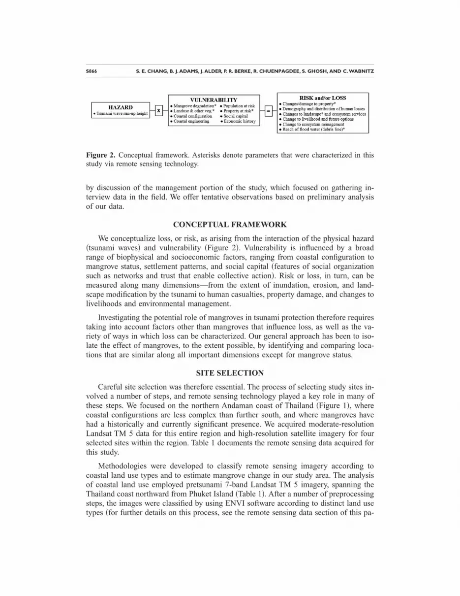
We conceptualize loss, or risk, as arising from the interaction of the physical hazard�tsunami waves� and vulnerability �Figure 2�. Vulnerability is influenced by a broadrange of biophysical and socioeconomic factors, ranging from coastal configuration tomangrove status, settlement patterns, and social capital �features of social organizationsuch as networks and trust that enable collective action�. Risk or loss, in turn, can bemeasured along many dimensions—from the extent of inundation, erosion, and land-scape modification by the tsunami to human casualties, property damage, and changes tolivelihoods and environmental management.
Investigating the potential role of mangroves in tsunami protection therefore requirestaking into account factors other than mangroves that influence loss, as well as the va-riety of ways in which loss can be characterized. Our general approach has been to iso-late the effect of mangroves, to the extent possible, by identifying and comparing loca-tions that are similar along all important dimensions except for mangrove status.
SITE SELECTION
Careful site selection was therefore essential. The process of selecting study sites in-volved a number of steps, and remote sensing technology played a key role in many ofthese steps. We focused on the northern Andaman coast of Thailand �Figure 1�, wherecoastal configurations are less complex than further south, and where mangroves havehad a historically and currently significant presence. We acquired moderate-resolutionLandsat TM 5 data for this entire region and high-resolution satellite imagery for fourselected sites within the region. Table 1 documents the remote sensing data acquired forthis study.
Methodologies were developed to classify remote sensing imagery according tocoastal land use types and to estimate mangrove change in our study area. The analysisof coastal land use employed pretsunami 7-band Landsat TM 5 imagery, spanning theThailand coast northward from Phuket Island �Table 1�. After a number of preprocessingsteps, the images were classified by using ENVI software according to distinct land use
Figure 2. Conceptual framework. Asterisks denote parameters that were characterized in thisstudy via remote sensing technology.
types �for further details on this process, see the remote sensing data section of this pa-

Ta
ata
patialolution Data format
Sc 0 cm Pan-sharpened 3-band color
0 cm Pan-sharpened 3-band color
1 m Pan-sharpened 3-band color
Sc /4 m Registered 1-m Pan and 4-mcolor bands
/4 m Registered 1-m Pan and 4-mcolor bands
/2.4 m Nonregistered 80-cm Pan and2.4-m color bands
a Ib I
CO
AS
TA
LE
CO
SY
ST
EM
SA
ND
TS
UN
AM
IP
RO
TE
CT
ION
AF
TE
RT
HE
DE
CE
MB
ER
2004IN
DIA
NO
CE
AN
TS
UN
AM
IS867
ble 1. Satellite imagery acquired for the study area
Landsat dataField
site ID
High-resolution d
High-resolution satellite/data provider Date of acquisition
Sres
ene 130-53Historic: Landsat 5 3-14-91Before: Landsat 5 4-18-04After: Landsat 5 12-30-04
Site 1 Quickbird/Digitalglobe Before: 3-2-04 6After: 3-28-05
Site 2 Quickbird/Digitalglobe Before: 3-2-04 6After: 3-28-05
Site 3 IKONOS/Space Imaging Before: 2-23-01After: 2-06-05
ene 130-54Historic: Landsat 5 3-14-91Before: Landsat 5 4-18-04After: Landsat 5 12-30-04 Site 4
IKONOS/Space Imaging Before: 6-24-02 1 m
IKONOS/Space Imaging After: 1-1-05 1 m
Quickbird/Digitalglobe After: 1-2-05 80 cm
ncludes sites 1–3ncludes site 4

S868 S. E. CHANG, B. J. ADAMS, J. ALDER, P. R. BERKE, R. CHUENPAGDEE, S. GHOSH, AND C.WABNITZ
per�. An analysis of mangrove change using a historic Landsat TM 5 image acquired inMarch 1991 �courtesy of Thailand’s Geo-informatics and Space Technology Develop-ment Agency, or GISTDA� was also carried out, highlighting �1� areas that historicallywere mangroves and have been converted to urban areas or aquaculture ponds and �2�areas that are now mangrove forests but were not in 1991. The final result was saved inGIS format �Arcview*.bil� and imported to Arcview 3.2 for detailed visual inspectionand integration with other layers.
Once maps of land use classification and mangrove change were generated, thesewere overlaid in ArcView �Figure 3� with the following information:
• High-resolution imagery with minimal cloud coverage available for the area�Quickbird and IKONOS�
• Reports of damage to property and high loss of life obtained from Thai web sites�the red dots/solid dots in grayscale in Figure 3�
• Bathymetry details gleaned from nautical charts purchased from Tides End Ltd.�charts 63440 and 71040—true reproductions of charts produced by the DefenseMapping Agency Hydrographic/Topographic Center and the National Imageryand Mapping Agency, respectively�
• Topographic maps of the two provinces provided by the Coastal DevelopmentCenter at Kasetsart University in Bangkok
Within each site, “location pairs” were then selected. “Location pairs” were identi-fied as communities with similar bathymetric details and coastline exposure but whichwere afforded potentially different protection levels by mangroves—i.e., one village ofthe location pair was behind the mangroves, whereas the other one was in front of themangroves or in an area cleared of mangroves. Moreover, the site selection process alsotook the following information into consideration:
• Reports from NGO teams and others who had gone into the field and carried out
Figure 3. Site selection process, whereby we overlaid maps generated for land use and man-grove change with available high-resolution coverage and local reports of damage and loss oflife. Ranong province is used here as an example.

COASTAL ECOSYSTEMS AND TSUNAMI PROTECTION AFTER THE DECEMBER 2004 INDIAN OCEAN TSUNAMIS869
rapid assessments of landscape changes or level of impact, or who had takennotes about the potential buffering capacity of mangrove forests �FAO 2005,Wetlands International 2005b�
• Tsunami runup heights recorded by two teams of Japanese researchers who vis-ited sites along the northern Andaman coast shortly after the disaster �ResearchGroup 2004�
Initially, we also sought to incorporate NOAA data on modeled tsunami waveheights �PMEL 2005�. However, due to the lack of high-resolution data to capture thecomplex bathymetry along the Andaman coast �Titov 2005�, the near-shore resolution ofthe model was insufficient for our purposes of making locally detailed comparisons.
Once the sites were selected, high-resolution imagery was purchased for each one�Table 1�. During field deployment, the data collection protocol that was developed re-mained adaptive to take into account information provided by local researchers from theCoastal Development Centre and Ranong Coastal Resource Research Station. As a resultof these exchanges, Site A �Figure 1� was added to our original four data collection sites.
REMOTE SENSING DATA
PREDISASTER LAND USE AND MANGROVE CHANGE
From Figure 2, coastal land use and mangrove change are key indicators of the pre-disaster condition. The remote sensing analysis of coastal land use employed pretsunami7-band Landsat TM 5 images spanning the north Andaman coast �Table 1�, which wereprovided courtesy of GISTDA. From a methodological standpoint, a sequence of pre-processing steps was initially performed on the data. Via image processing software, thedata sets were reformatted as a “stacked” image and then registered to a historic MRSIDLandsat Thematic Mapper �TM� composite �UTM, WGS84 zone 47N� obtained fromthe U.S. Geological Survey. Coastal land use was obtained by using maximum likelihoodsupervised classification. A set of input training regions was manually selected withineach image for visually distinct land use classes of interest, comprising �1� mangrove,�2� edge of mangrove and mud flat, �3� aquaculture, �4� urban/rural/sand/cleared land,�5� other vegetation, �6� water, �7� cloud, and �8� shadow. The output classification imagewas subjected to a clumping filter in order to remove rogue outliers falling within oth-erwise homogenous classified regions. The final result was saved in GIS format for de-tailed visual inspection and integration with other layers. A quantitative accuracy assess-ment remains to be conducted.
For the analysis of mangrove change, the land use classification methodology wasrepeated for a historic TM 5 image acquired in March 1991. After classification, theclasses “mangrove” and “edge of mangrove” were combined to yield a “master” man-grove class. The “historic” and “before” classification results were evaluated by using achange detection routine, whose output was a “change” image and statistics for each per-mutation of class change. The changes of interest �mangrove to urban, mangrove toaquaculture, and “other” classes to mangrove� shown in Figure 4 were then converted toa GIS-compatible format for visualization.

S870 S. E. CHANG, B. J. ADAMS, J. ALDER, P. R. BERKE, R. CHUENPAGDEE, S. GHOSH, AND C.WABNITZ
POSTDISASTER DAMAGE
From Figure 2, tsunami inundation extent and building damage are key indicators ofthe postdisaster condition at coastwide and neighborhood scales. Inundation extent wasmapped by using a temporal sequence of “before” and “after” Landsat TM 5 imagery�Table 1�. An inundation detection methodology was devised on the basis of change inthe Normalized Difference Vegetation Index �NDVI� within the near-shore zone. NDVIis a ratio of the near-infrared to red bands and is particularly sensitive to surface scour-ing, whereby vegetation and urban development is replaced by bare earth and debris.Coastal areas depicted in red �in grayscale: medium gray� in Figure 5 show the coastalregions where inundation caused extreme surface scouring and where accompanyingdamage to urban development was severe.
At the per-building level, a temporal sequence comprising high-resolution “before”and “after” satellite imagery was used to detect urban damage within four study sites.The study sites were selected on the basis of the criteria described above, together withthe availability of high-resolution remote sensing coverage. The imagery comprised bothQuickbird and IKONOS data sets, either purchased directly from the vendor or obtainedby the National Science Foundation courtesy of the Clearview license. In terms of time-liness, the “after” data for Site 4 were acquired just one week after the tsunami, and as
Figure 4. Historic mangrove clearance along the Andaman coast of Thailand, obtained fromanalysis of a temporal sequence of Landsat TM 5 images.

COASTAL ECOSYSTEMS AND TSUNAMI PROTECTION AFTER THE DECEMBER 2004 INDIAN OCEAN TSUNAMIS871
Figure 5. Inundation area and debris line, identified as function of change in NDVI between theLandsat TM 5 “before” and “after” images. Coastal areas in red �in grayscale: medium grey�indicate significant scouring as a result of tsunami impact.

S872 S. E. CHANG, B. J. ADAMS, J. ALDER, P. R. BERKE, R. CHUENPAGDEE, S. GHOSH, AND C.WABNITZ
such provide an extremely accurate record of damage prior to cleanup operations. Thefirst available imagery for Sites 1–3 is less timely, being collected 1 to 2 months after-ward. Preprocessing was conducted to prepare the imagery for visually based damageassessment and field deployment within the VIEWS™ field data collection and visual-ization system.
Figure 6 shows an example of the damage map developed for Site 4 through expertinterpretation of high-resolution pretsunami and post-tsunami imagery. Of the 761 struc-tures sampled, 449 �59%� were classified as collapsed, with 312 sustaining less damage.The degree of damage is most extreme bordering the open coast and inlet, where 50–100% of the houses were destroyed. The degree of damage captured by the remote sens-ing coverage rapidly diminishes inland, reaching 0–30% at a distance of approximately500 m from the shorelines. An accuracy assessment conducted for a random sample of369 buildings within Site 4 suggested an overall classification accuracy of 89.5% �seealso Adams et al. 2005a, b�.
Figure 6. Damage map for Ban Nam Khem, developed by using high-resolution Quickbird andIKONOS imagery for an urban area at Site 4. The percentage of collapsed buildings is com-puted within zones at 100-m intervals from the open coast and inlet shores.

COASTAL ECOSYSTEMS AND TSUNAMI PROTECTION AFTER THE DECEMBER 2004 INDIAN OCEAN TSUNAMIS873
FIELD DATA
VIEWS™ SYSTEM
VIEWS™ is a laptop-based portable field data collection and visualization systemused during disaster reconnaissance missions to collect georeferenced data: damage ob-servations, photos, and video footage. The system can be deployed from a moving landvehicle, boat, aircraft, or on foot. Through a real-time GPS feed, the geographic locationof every record is overlaid on “before” and “after” remote sensing images and damagebase maps. Through built-in GIS functionality, the field team members can also use thehigh-resolution satellite scenes to prioritize field survey activities, plan and track theirroute, and pinpoint damaged structures and features of interest. Traditional methods ofpostdisaster damage assessment typically involve walking surveys, whereby damage in-dicators together with the overall damage state are logged on a spreadsheet manually. Interms of efficiency, past deployments have indicated that VIEWS™ significantly in-creases the rate at which survey data are collected �e.g., Adams et al. 2004c�. VIEWS™has previously been used in reconnaissance activities after the 2003 Bam, Iran earth-quake �Adams et al. 2004b�; Hurricane Charley and Hurricane Ivan, which struck theU.S. Gulf Coast in 2004 �Adams et al. 2004a, c�; and the 2004 Niigata ken Chuetsu,Japan, earthquake �Huyck et al. 2005�.
The Indian Ocean event constitutes the first deployment of VIEWS™ and high-resolution satellite imagery for post-tsunami field reconnaissance �Ghosh et al. 2005�.The system was deployed to study Sites 1–4 from 16–25 August 2005, in order to“ground-truth” the preliminary remote sensing results. VIEWS™ was equipped with sat-ellite base layers, including the Landsat land use classification, the mangrove change/loss map, and the Quickbird and IKONOS satellite imagery �Table 1�. The damage sur-vey of impacted areas �Figure 7� was conducted by a three-member team from a movingland vehicle, on foot, or by boat, depending on vehicular access and type of land use�e.g., mangroves�. In general, access to selected study areas did not prove to be a sig-nificant limitation.
Fourteen hours of georeferenced digital video were recorded along the reconnais-sance survey route, which covered about 75 miles. Of this route, 50 miles were coveredfrom a moving land vehicle, 20 miles from a boat, and 5 miles from a walking tour. Alibrary of approximately 550 digital photos was also collected by the team.
DAMAGE OBSERVATIONS
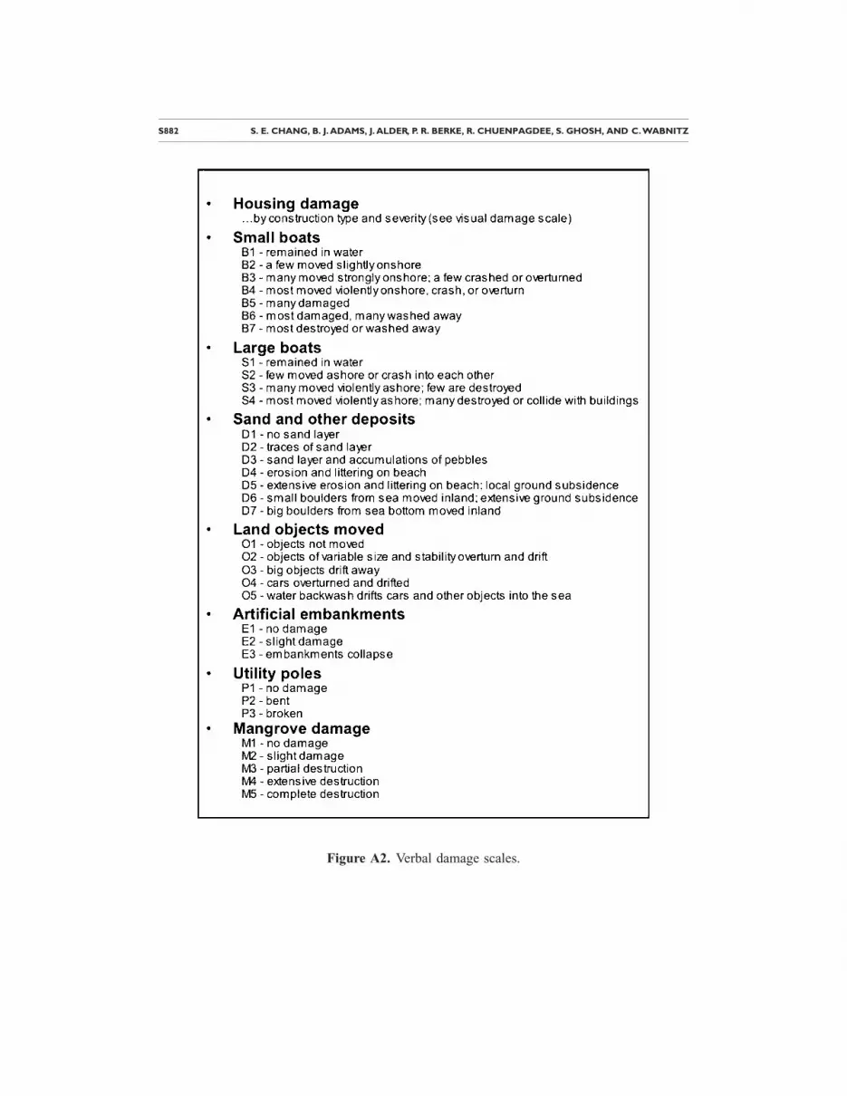
To systematize damage observations in the field, we developed a five-point visualdamage scale for three key building classes that are typical in the study region: tradi-tional wood housing, concrete-frame housing with infill walls, and large reinforced con-crete frame buildings. Each level of damage on the scale was represented by a photo oftsunami damage in this region of Thailand, generally obtained from prior reconnaissancestudies. The visual damage scale for the concrete housing class is reproduced in Appen-dix A. Using this damage observation instrument was advantageous for ensuring dataquality: it facilitated rapid data collection in the field, standardized the damage ratingsbetween observers, and helped the field team communicate with local residents �across

S874 S. E. CHANG, B. J. ADAMS, J. ALDER, P. R. BERKE, R. CHUENPAGDEE, S. GHOSH, AND C.WABNITZ
potential language, literacy, and educational barriers� who were able to corroborate, cor-rect, or elaborate upon the team’s observations. Verbal damage scales were also devel-oped for other types of nonbuilding damage �Appendix A� and also helped to system-atize these observations.
The visual and verbal damage scales were designed to be consistent with previouslypublished tsunami intensity scales such as the 6-level Sieberg-Ambraseys scale �Ambra-seys 1962� and the 12-level intensity scale by Papadopoulos and Imamura �2001�. Thesescales are similar to the more familiar Modified Mercalli Index �MMI� for earthquakeshaking intensity. We were thus able to systematically use our field observations of dam-age to characterize tsunami damage intensity for different villages and different loca-tions within these villages.
Table 2 shows the correlation between village location relative to mangroves and tsu-nami damage intensity for the eight villages we surveyed at Site A. These villages arelocated within a fairly short distance of one another. Damage observations for concretehousing and other structural types, measured according to the scales discussed above,were used to classify each village according to the Papadopoulos and Imamura tsunamiintensity scale, which varies from I �“not felt”� to XII �“completely devastating”�. All ofthe exposed villages suffered severe building destruction, whereas communities estab-lished behind mangrove forests sustained minimal damage. In one village where only aportion of the village was protected by mangroves, that portion suffered little damage,while the exposed portion was devastated.
Figure 7. VIEWS™ interface, showing “before” and “after” high-resolution imagery and partof the GPS route �illustrated by the small circles� followed by the field team in Ban Nam Khem�Site 4�. The photo in the upper right shows an example of the rapid reconstruction that is oc-curring, and the digital video in the lower right shows remaining building damage.

COASTAL ECOSYSTEMS AND TSUNAMI PROTECTION AFTER THE DECEMBER 2004 INDIAN OCEAN TSUNAMIS875
INTERVIEW DATA
Field work on the environmental management portion of the study, which focused ongathering interview data, was conducted over the same period and in many of the samelocations as the previously described field work on the biophysical portion of the study.
CONCEPTUAL FRAMEWORK
We offer two alternative hypotheses premised on the concepts of social capital andinstitutional design of external aid interventions. First, we hypothesized that variation inlocal performance related to civic actions for mangrove conservation is explained solelyby social capital. Social capital is described by Putnam �1995� as “features of social or-ganization such as networks, norms and social trust that facilitate coordination and co-operation for mutual benefit.” The level of social capital affects community performancein multiple societal domains like environmental conservation, economic development,and crime. Two key conditions of social capital are that participation in organizationsmust be voluntary and that efforts to organize are internal to a village. Villages with highsocial capital are better able to restrain individual opportunism and act collectively formutual benefit �Putnam, et al. 1993�—as in the case of mangrove conservation.
Second, we hypothesized that the influence of social capital on village performanceis mediated by the design of external aid programs. The effectiveness of the institutional
Table 2. Tsunami intensity and damage at Site A
Location relativeto mangroves Village
Tsunami damage intensity
V VIII XI
Exposed
Tap Nya ×Ban Talay Nok ×Ban Kluai Nok ×Triam ×
Partly exposed Village 7 ×
Behind mangrovesTa Klang ×North of village 4 ×Pak Triam ×
a Based on the 12-point Papadopoulos and Imamura scale, from which partial defini-tions are abstracted in the three footnotes below.b “V=Strong—many small vessels move strongly onshore, few of them crash into eachother or overturn; traces of sand layer left behind on ground with favorable conditions.”c “VIII=Heavily damaging—most small vessels are damaged, many are washed away,few large vessels are moved ashore or crash into each other; big objects are driftedaway; erosion and littering on beach; extensive flooding; most wooden structures arewashed away or demolished, damage of grade 2 in a few masonry buildings.”d “XI=Devastating—water backwash drifts cars and other objects in the sea; big boul-ders from the sea bottom are moved inland; damage of grade 5 in many masonry build-ings.”

S876 S. E. CHANG, B. J. ADAMS, J. ALDER, P. R. BERKE, R. CHUENPAGDEE, S. GHOSH, AND C.WABNITZ
design of aid delivery programs is expected to be as important as the level of social capi-tal for explaining performance. Aid delivery initiatives are particularly influential duringthe aftermath of disasters. Compared with predisaster conditions, humanitarian aid de-livery organizations are more active and influential in local decision making and actions�Berke and Beatley 1997�. Bottom-up external aid delivery programs facilitate and en-able social capital to be brought to bear across multiple social domains. Top-down aiddelivery denies grassroots-level networks the opportunity to respond to local needs, andit can weaken social networks and increase dependence on outside assistance.
INTERVIEWS
The mangrove ecosystem management phase of the study entailed an evaluation ofsix villages in Ranong province. The villages were in Sites 1, 2, and A �Figure 1� andwere selected on the basis of two criteria: sustained damage to the built environment,and significant mangrove forest ecosystems within or adjacent to village boundaries �Ra-nong is one of the few remaining provinces in Thailand with relatively healthy mangroveforests�. During 16–23 August 2005, semistructured interviews were conducted with 11local “key informants.” We considered such informants to be individuals who are knowl-edgeable and influential about disaster recovery and mangrove management practices inthe six villages.
An interview protocol was adapted from the World Bank’s Social Capital AssessmentTool �SOCAT� �World Bank Group 2004�. The protocol included a limited version ofSOCAT that consisted of two sets of questions. The first set was derived to gauge villageperformance in mangrove protection. The second set aimed to determine the level of so-cial capital in the form of grassroots networks, trust, and reciprocity among local people�Putnam 1995, Putnam et al. 1993� and to examine external aid delivery programs andhow they affected the village’s performance �Berke and Beatley 1997�. To supplementthe interviews, field observations were undertaken to verify the mangrove conditions andthe protection and restoration practices. The protocol is reproduced in Appendix B.
PRELIMINARY FINDINGS
We report two sets of preliminary observations. As indicated in the interview ques-tions in Appendix B, one set involves village performance in mangrove conservation. Asecond set focuses on the level of social capital and design of external aid delivery sys-tems and on how these factors affect performance. We offer preliminary evidence thatanswers the research hypotheses related to how social capital and formal external aidorganizations affect village performance.
Village Performance in Mangrove Conservation
Village performance in mangrove conservation and reforestation efforts variedacross the six villages. The highest-performing village, Tha Yang, adopted appropriationrules that permitted limited tree cutting, provided that wood products were for personaluse and not for commercial purposes. A village committee was organized to ensure com-pliance with the rules and monitor the overall ecological health of the reforested sites. Arobust mangrove replanting program was also established.

COASTAL ECOSYSTEMS AND TSUNAMI PROTECTION AFTER THE DECEMBER 2004 INDIAN OCEAN TSUNAMIS877
The remaining five villages showed considerable variation in performance. Three vil-lages, Had Sai Khao, Had Prapad, and Ao Kuey, had a moderate level of conservationeffort. Interviewees varied in their assessments about the overall performance of com-munity restoration and reforestation efforts. Although these villages adopted replantingactivities, all fell short of adopting a level of initiatives equivalent to Tha Yang. In con-trast, the villages of Had Sai Dam and Tha Chang had a low level of performance inmangrove conservation programs. Interviews revealed that villagers considered man-grove conservation to be the responsibility of the Mangrove Forest Conservation Unit�MFCU� of the Royal Thai Department of Forestry.
Social Capital
Our preliminary findings suggest that four villages have a high level of social capital.Interviews revealed that social capital is present in a variety of forms, including man-grove conservation groups that were established before the tsunami. In these villages,several community groups evolved after the tsunami, particularly fisheries groups—suchas fish cage culture groups and fishing gear groups—and women’s groups to promoteadditional income activities, such as fish sauce making, batik painting, cooking, and sav-ing money. In general, all informants in these villages regarded their villages as havingsatisfactory cooperation. Community leaders were highly respected, and communitymembers were willing to help each other after the tsunami in activities such as retrievinggear and recovering boats. One interviewee mentioned the sharing of fish catches. Col-lective problem-solving and decision-making processes were the norm, and there weregenerally few conflicts. An exception was found in Ao Kuey, where both informants in-dicated inequality concerning aid distribution, which might have caused mistrust andconflicts to arise after the tsunami. Another village, Tha Chang, also had a moderatelevel of social capital, as the villagers exhibited generally less interest in mangrove con-servation and other collective actions.
External Aid Delivery
One village had external aid delivery programs that provided a high level of supportfor multiple disaster recovery domains, three villages had moderate support, and two ex-perienced low support. The village with highly supportive external aid, Tha Yang, re-ceived support for mangrove replanting efforts from a Japanese donor organization�OISCA�, as well as external aid disaster recovery programs that were bottom-up in ori-entation. OISCA, for instance, started the mangrove conservation project and providedseedlings and funding to support the replanting phase. Continued funding was condi-tional, however, based on the interests and commitment shown by community members.This seemed to have initiated a standalone community group specifically established toprotect mangroves.
Three villages had moderate levels of external support, in that all received financialassistance and seedlings from the same external aid organization �OISCA�, but all hadexperience with disaster aid that was top-down. Interviews revealed numerous forms oftop-down aid delivery systems, and many interviewees noted that the type of aid andhelp did not always match the needs—this was due largely to the lack of consultation

S878 S. E. CHANG, B. J. ADAMS, J. ALDER, P. R. BERKE, R. CHUENPAGDEE, S. GHOSH, AND C.WABNITZ
with villagers. The most contentious example was related to the housing reconstructionprogram by the Thai military. The government used its military to build new two-storyhouses, on stilts, which are not suitable for the people and the weather conditions. Forexample, the houses did not seem sturdy enough to withstand the wind, and the style wasnot appropriate for the rain. Other issues raised by several informants concerning exter-nal aid were related to unfair distribution of aid and inequality in treatment. In othercases, there were several organizations operating in the same areas, at times resulting insome conflicts. There was some mention that aid from one agency was withdrawn whenit learned that another agency was in the area. Finally, Had Sai Dam and Tha Changexperienced relatively low levels of external aid; for example, OISCA did not provideaid for replanting, and most other aid delivery programs were top-down.
Influence of Social Capital and External Aid on Village Conservation Performance
While our findings are preliminary, several patterns emerged concerning the influ-ence of social capital and external aid programs on village performance in conservation.Overall, the findings suggest that external aid may be related to conservation perfor-mance, but the relationship may also be interactive with social capital. Three specificobservations can be made. First, social capital is not clearly and consistently related tomangrove conservation performance. While social capital remains high in four of thevillages, there appears to be considerable fluctuation in conservation performance, be-cause villages with high levels of social capital varied in exhibiting low or high levels ofconservation efforts. Second, conservation performance and external aid may have aclose relationship as top-down aid delivery programs have an independent negative in-fluence on performance. In all cases, the level of support from external aid organizationsmatched the level of performance in conservation �i.e., if aid was bottom-up, then per-formance was high, and if aid was top-down, then performance was low�. Third, it couldalso be that when both social capital and external aid are considered jointly, the inter-action may have a strong positive influence on performance. Evidence from our inter-views suggests that, in villages with high levels of social capital, it appears that perfor-mance drops as a result of external disaster recovery aid programs that deny grassroots-level networks the opportunities to respond to local needs. This process may weakensocial capital and suppress local initiatives aimed at mangrove conservation. Althoughexternal aid from OISCA was bottom-up and supported mangrove conservation efforts,the potential influence of this external aid program is reduced when aid for other disasterrecovery domains �notably housing reconstruction� prevents activation of social capital.We think the relationships developed by external aid programs in one domain of disasterrecovery are generalized across multiple domains.
CONCLUSIONS
This study has adopted an interdisciplinary, mixed-methods approach to address therole of coastal ecosystems in tsunami protection. In our case study of mangrove forestsin Thailand, we address the issue from both a biophysical and a management perspec-tive. Toward this end, we have gathered such diverse data as satellite imagery, georefer-enced video imagery, photos, field observations, and key-informant interview responses.

COASTAL ECOSYSTEMS AND TSUNAMI PROTECTION AFTER THE DECEMBER 2004 INDIAN OCEAN TSUNAMIS879
We have also developed and pilot-tested methods for analyzing the data. It should benoted that this is a very specific, exploratory study of linkages between biophysical andmanagement-related variables.
The study to date suggests several preliminary conclusions in terms of methodology.First, remote sensing analysis is a powerful tool for studies of natural disasters. Its utilityis not limited to postdisaster assessment of damage, but extends also to characterizingcertain conditions of predisaster vulnerability �in this case, predisaster changes in thepresence of mangroves�. Second, integrating remote sensing analysis and field observa-tion greatly enhances the research value that either method could have provided alone.For example, satellite imagery can help to systematically identify potential locations forfield study. It can, in the context of portable data collection systems such as VIEWS™,provide invaluable spatially referenced information to researchers in the field. Con-versely, it is crucial to verify, validate, and supplement remote sensing analysis with fielddata. For example, high-resolution satellite images provide a reasonable basis for iden-tifying collapsed buildings but not moderately damaged buildings. Third, gathering bothquantitative/visual data and qualitative data �e.g., from interviews� is also highly benefi-cial. In this case, in order to understand the role of mangroves in protection from naturalhazards, it is important to gain information about both the buffering capacity of man-groves and about factors that influence mangrove conservation or degradation.
Preliminary analysis of our data suggests several findings. First, while they are onlyone of many factors that influenced tsunami damage intensity, mangroves do appear tohave been an effective buffer against tsunami forces. Villages that were behind substan-tial mangrove forests suffered relatively little damage, while otherwise comparable vil-lages that were not so protected were devastated. The extent to which this finding can begeneralized from our study area to other regions remains to be investigated.
Second, we found considerable variation in the performance of local conservationefforts across villages. Performance appears to be influenced by the design of externalaid programs �higher performance levels result from more bottom-up-oriented pro-grams�. However, social capital does not have a consistent influence on performance.Alternatively, social capital does appear to matter when external aid programs arebottom-up-oriented, because they enable and facilitate villages’ application of their so-cial capital. Consequently, to be effective, external aid programs should draw on localsocial capital rather than deny its presence. Staff personnel in external aid organizationsshould view a disaster as providing a window of opportunity to enable and build rela-tionships with local people that allow them to become active participants.
What are the future research needs? In the short run, we will be undertaking sys-tematic analysis of the data collected. This includes �1� conducting accuracy assessmentsaccording to the methodology proposed by Maingi et al. �2002� on land use classifica-tion and conducting damage assessments derived from remote sensing analysis, �2� re-fining the analytical methods, �3� more thoroughly analyzing damage patterns, and �4�more systematically testing the hypothesis that mangroves helped protect villages andreduce tsunami losses. The data analysis also includes coding procedures and contentanalyses of our interview data. We plan to more thoroughly test the relationships among

S880 S. E. CHANG, B. J. ADAMS, J. ALDER, P. R. BERKE, R. CHUENPAGDEE, S. GHOSH, AND C.WABNITZ
village conservation performance, social capital, and external aid. The flexibility of ourcase study methodology allows for other factors to emerge as potential predictors of per-formance.
In the long run, we maintain that priority should be given to disaster research thatemphasizes multiple case research designs, with each case using the same methods andvariables to ensure comparability. Our analysis of local performance in mangrove con-servation uses a few villages as case studies, which are sufficient for a pilot study but toofew for a definitive analysis. Our findings should be viewed with caution, since we arelimited in testing the independent effects of social capital and external aid on perfor-mance. Research suggests an additional number of possible causal factors. Krishna�2002�, for example, outlines a complete and useful discussion of the various competingexplanations of how social capital explains local institutional performance. A largernumber of case studies than examined here would be required for a similar comprehen-sive explanation.
Similarly, multiple cases are important for developing more generalized lessons re-garding the protective capacity of coastal ecosystems. The methods developed for iden-tifying predisaster coastal ecosystem change, characterizing damage patterns, and iso-lating the effect of mangroves can be applied to other regions affected by the tsunami.For example, our study region can be compared with others that experienced muchgreater predisaster loss of mangroves �e.g., some areas of southern India�, are protectedby other types of coastal landscapes �e.g., sand dunes in Sri Lanka�, or were subject tomuch greater tsunami forces �e.g., Indonesia�. The tragic magnitude of the 2004 IndianOcean tsunami affords a unique opportunity for comparative study about hazard mitiga-tion that should not be wasted.
ACKNOWLEDGMENTS
This study was supported primarily by the National Science Foundation �NSF�through its Small Grants for Exploratory Research program under grant number SES-0522963. It was also supported in part by NSF’s Earthquake Engineering Research Cen-ters Program under NSF Award number EEC-9701471 and by the Canada Foundationfor Innovation under project number 201867. J. Alder was supported by the Sea AroundUs Project. Remote sensing imagery was provided courtesy of GISTDA, the U.S Geo-logical Survey, DigitalGlobe, Space Imaging, and the Pacific Disaster Center �PDC�through the ClearView license. The authors thank William Rees at the University of Brit-ish Columbia and Harry Yeh at Oregon State University for technical input, as well asmany researchers and support staff in Thailand for their invaluable assistance in the field,including Professor and Director Kungwan Juntarashote, Dr. Methee Kaewnern, and re-search assistants Montri Mongkala, Ilada Neamthed, and Pisuttipong Suriyakaan at theCoastal Development Centre, Kasetstart University; Mr. Sompoch Nimsantijaroen andothers at the Ranong Coastal Resource Research Station; Kareemy from Ban NamKhem; and Mr. Kittipat Larpchurat at the Mangrove Restoration Centre in Kuraburi. Theseven coauthors contributed equally to this paper.

COASTAL ECOSYSTEMS AND TSUNAMI PROTECTION AFTER THE DECEMBER 2004 INDIAN OCEAN TSUNAMIS881
APPENDIX A: SCALES FOR DAMAGE OBSERVATIONS
Figure A1. Visual damage scale for concrete housing.
S882 S. E. CHANG, B. J. ADAMS, J. ALDER, P. R. BERKE, R. CHUENPAGDEE, S. GHOSH, AND C.WABNITZ
Figure A2. Verbal damage scales.

COASTAL ECOSYSTEMS AND TSUNAMI PROTECTION AFTER THE DECEMBER 2004 INDIAN OCEAN TSUNAMIS883
APPENDIX B: INTERVIEW PROTOCOL FOR SOCIALCAPITAL ASSESSMENT
1 Coastal Mangroves General Information1.1 What is the size of the mangrove forest in your community �hectares�?1.2 Identify all important goods and services of the mangrove forest that benefit
the community.If possible, ask respondent to refer to a map to locate salient features.
Tsunami hazard mitigation �reduces wave runup and velocity�FisheryWood productsWastewater treatmentOther
Ask respondent to comment about the importance of these goods/services.1.3 During the last decade, has there been any change in the integrity �health� of
the mangrove forest? Has the health improved or declined?1.3a If change has occurred, what are the reasons for the change?1.3b Have these changes accelerated since the December 2004 tsunami di-
saster? If yes, why have they accelerated?1.4 Who owns the mangrove forest?
Government �national, regional, local�Private individual or familyPrivate corporationCooperativeThe communityOther
1.5 Are there regulations to protect the mangrove forest?Limit use of coastal hardening structures �levees, seawalls, etc.�Rules for avoidance of development in ecologically sensitive areasResource appropriation rules that limit shrimp, fish, vegetation har-vestingPollution preventionReplanting requirementsCutting mangroves for charcoalOther
1.5a What organizations have management and enforcement responsibili-ties? To what extent are these regulations effective and enforced?
1.6 How can the rules and enforcement be improved?
2 Community-Based Social CapitalThis set of questions is useful in getting respondents to focus on collective actionand solidarity on specific cases in which the community worked collectively to re-solve issues, whether or not the outcomes were positive. The interviewer probes forspecific instances of collective action undertaken since the tsunami disaster. Respon-dents are also probed to focus on an issue tied to coastal mangroves. The cases

S884 S. E. CHANG, B. J. ADAMS, J. ALDER, P. R. BERKE, R. CHUENPAGDEE, S. GHOSH, AND C.WABNITZ
should be representative of the level of collective action in the community. The extentto which a community is able to come together to address issues of common impor-tance is an important indicator of social capital.2.1 People from the same community often get together to address a particular is-
sue that faces the community, fix a problem, improve the quality of life, orsomething similar. Which of the following issues has your community tried toaddress after the tsunami disaster?�Probe: reconstruction of housing that destroyed a wetland or mangrove forest,recovery of a fishery or agriculture industry, loss of tourism, debris removal insensitive ecological areas, pollution, standing water/stagnation�
2.2 Have there been efforts by the community to improve the quality of coastalmangrove forests? Can you describe one instance that is most representative ofhow the community deals with coastal ecosystems in detail? Were there com-munity groups that played an important role? What kinds of responses did youget from the local government? From other organizations? From the rest of thecommunity? What kinds of obstacles did you have to deal with? What was theoutcome of the effort?�Probe for locus of leadership, resources tapped, sources of resistance, whobenefited or suffered from the outcome, the kind of follow-up that occurred asa result of the effort, and the mechanisms employed to ensure sustainability ofthe effort.�
2.3 Has this community ever attempted to make improvements but failed? Why doyou think the attempt failed? What would you have done differently to makethe effort more successful?�Probe for constraints on collective action; identify roles of government, com-munity organizations, and NGOs in influencing outcomes; and discuss the re-lationship between the community, representative organizations, local govern-ment, and other civil society actors.�
3 Community Organizations3.1 What are the groups, organizations, or associations that function in this com-
munity on issues involving the development, use, protection, and restoration ofcoastal mangroves?�Probe: have the respondents list all the organizations, formal and informal,that exist in the community or part of a national or international network. Askwhich organizations have emerged since the tsunami.�
3.2 Which groups play the most active role in helping improve the well-being ofthe coastal mangroves?
3.3 How did these most active groups or organizations get started �government ini-tiated, through government donations, NGO donations, grassroots initiative,etc.�? What year did they get started?
3.4 Of the organizations on the list created from Q 3.1, which ones are most im-portant and accessible to the community? Which ones are less accessible?
3.5 How are the leaders selected �election, appointment, inheritance�? How stable

COASTAL ECOSYSTEMS AND TSUNAMI PROTECTION AFTER THE DECEMBER 2004 INDIAN OCEAN TSUNAMIS885
is the leadership �frequent sudden changes, normal progressive change, ornever changes�? Is the leadership generally harmonious or collective?
3.6 Which organizations from Q 3.1 are effective in working together? How dothey work together �hierarchically, collaboratively�?
3.7 Are there any organizations that work against each other �compete or conflict�?3.8 Some groups may share the same members, and some groups have different
members. Which organizations have the same or similar memberships?3.9 Are there organizations that share resources?
REFERENCES
Adams, B. J., Huyck, C. K., Mio, M. Z., Cho, S., Eguchi, R. T., Womble, A. J., and Mehta, K.,2004a. Streamlining post-disaster data collection and damage assessment, using VIEWS �vi-sualizing impacts of earthquakes with satellites� and VRS �virtual reconnaissance system�,in Proceedings of 2nd International Workshop on Remote Sensing for Post-DisasterResponse, Newport Beach, Calif. http://mceer.buffalo.edu/publications/workshop/05-SP03/203_b_adams_paper.pdf
Adams, B. J., Huyck, C. K., Mio, M., Cho, S., Ghosh, S., Chung, H., Eguchi, R. T., Housh-mand, B., Shinozuka, M., and Mansouri, B., 2004b. The Bam �Iran� earthquake of December26, 2003: Preliminary reconnaissance using remotely sensed data and the VIEWS system.http://mceer.buffalo.edu/research/Bam/bam.pdf
Adams, B. J., Womble, J. A., Mio, M. Z., and Mehta, K., 2004c. Collection of satellite refer-enced building damage information in the aftermath of Hurricane Charley, MCEER QuickResponse Report Series, accessed September 30. http://mceer.buffalo.edu/research/Reconnaissance/Charley8-13-04/04-SP04.pdf
Adams, B. J., Ghosh, S., Wabnitz, C., and Alder, J., 2005a. Post-tsunami urban damage assess-ment in Thailand, using optical satellite imagery and the VIEWS™ field reconnaissance sys-tem, in Proceedings, 250th Anniversary of the 1755 Lisbon Earthquake, Lisbon, Portugal.
Adams, B. J., Wabnitz, C., Ghosh, S., Alder, J., Chuenpagdee, R., Chang., S. E., Berke, P. R.,and Rees, W. E., 2005b. Application of Landsat 5 and high-resolution optical satellite im-agery to investigate urban tsunami damage in Thailand as a function of pre-tsunami envi-ronmental degradation, in Proceedings, Third International Workshop on Remote Sensingfor Disaster Response, Chiba, Japan. http://ares.tu.chiba-u.jp/workshop/Chiba-RS2005/Paper%20Adams.pdf
Ambraseys, N. N., 1962. Data for the investigation of the seismic waves in the eastern Medi-terranean, Bull. Seismol. Soc. Am. 52, 895–913.
Berke, P., and Beatley, T., 1997. After the Hurricane: Linking Recovery to Sustainable Devel-opment in the Caribbean, Johns Hopkins University Press, Baltimore, MD, 232 pp.
Dahdouh-Guebas, F., Jayatissa, L. P., Di Nitto, D., Bosire, J. O., Lo Seen, D., and Koedam, N.,2005. How effective were mangroves as a defence against the recent tsunami? Curr. Biol. 15�12�, R443–R447.
Dengler, L., and Preuss, J., 1998. Mitigation lessons from the July 17, 1998 Papua New Guineatsunami, Pure Appl. Geophys. 160, 2001–2031.

S886 S. E. CHANG, B. J. ADAMS, J. ALDER, P. R. BERKE, R. CHUENPAGDEE, S. GHOSH, AND C.WABNITZ
FAO, 2005. Tsunami mitigation by mangroves and coastal forests, accessed May 27.www.fao.org/forestry/foris/webview/pageview.jsp?pageId=31843&langId=1
Fast, A. W., and Menasveta, P., 2003. Mangrove forest recovery in Thailand, Bull. Pol. Acad.Sci. Chem. 34 �3�, 6–9.
Ghosh, S., Huyck, C. K., Adams, B. J., Eguchi, R. T., Yamazaki, F., and Matsuoka, M., 2005.Preliminary field report: Post-tsunami urban damage survey in Thailand, using the VIEWSreconnaissance system, accessed September 30. http://mceer.buffalo.edu/research/tsunami/page1.asp
Harada, K., and Imamura, F., 2003. Study on the evaluation of tsunami reducing by coastal con-trol forest for actual conditions, Asia and Pacific Coasts 2003, in Proceedings, Second In-ternational Conference, Makuhari, Japan.
Hiraishi, T., and Harada, K., 2003. Greenbelt tsunami prevention in South Pacific region, Re-port of the Port and Airport Research Institute 42 �2�, 1–23.
Huyck, C., Scawthorn, C., Bardet, J.-P., Kayen, R., Kawamata, Y., Olshansky, R., Somerville,P., Mori, J., Rathje, E., Bay, J., Jibson, R., Kelson, K., Pack, R., and Nishi, N., 2005. Pre-liminary observations on the Niigata Ken Chuetsu, Japan, earthquake of October 23, 2004,EERI Newsletter 39 �1�.
Krishna, A., 2002. Active Social Capital: Tracing the Roots of Development and Democracy,Columbia University Press, New York, NY, 192 pp.
Maingi, J. K., Marsh, S. E., Kepner, W. G., and Edmonds, C. M., 2002. An accuracy assessmentof 1992 Landsat-MSS derived land cover for the Upper San Pedro watershed �U. S./Mexico�,�EPA/600/R-02/040�, U.S. Environmental Protection Agency, accessed August 15. http://www.epa.gov/nerlesd1/land-sci/pdf/epa600r02040.pdf
Pacific Marine Environmental Laboratory �PMEL�, National Oceanic and Atmospheric Admin-istration �NOAA�, 2005. Tsunami event—26 December 2004, accessed May 18.www.pmel.noaa.gov/tsunami/indo_1204.html
Papadopoulos, G. A., and Imamura, F., 2001. A proposal for a new tsunami intensity scale, ITS2001 Proceedings, Session 5, Number 5-1.
Putnam, R., Leonardi, R., and Nanetti, R., 1993. Making Democracy Work: Civic Traditions inModern Italy, Princeton University Press, Princeton, NJ, 280 pp.
Putnam, R., 1995. Bowling alone: America’s declining social capital, J. Democracy 6 �1�, 65–78.
Research Group on the December 26, 2004 Earthquake Tsunami Disaster of Indian Ocean,2005. Field survey result of Thailand, accessed May 13. Measured tsunami heights from 2ndfield survey of Thailand, accessed May 13. http://www.drs.dpri.kyoto-u.ac.jp/sumatra/index-e.html
Synolakis, C., 2002. Tsunami and seiche, in Earthquake Engineering Handbook, Chen, W.-F.,and Scawthorn, C. �eds.�, CRC Press, Boca Raton, FL.
Titov, V. V., 2005. Personal communication, July 22.UNEP, 2005. National rapid environmental assessment: Thailand, accessed August 10. http://
www.unep.org/tsunami/reports/TSUNAMI_THAILAND_LAYOUT.pdfWetlands International, 2005a. Natural Mitigation of Natural Disasters, Assessment report to
Ramsar STRP12, accessed June 15. http://www.wetlands.org/tsunami/Wetlands International, 2005b. Rapid country level assessment, accessed September 5. http://
www.wetlands.org/Tsunami/Tsunamidata.htm

COASTAL ECOSYSTEMS AND TSUNAMI PROTECTION AFTER THE DECEMBER 2004 INDIAN OCEAN TSUNAMIS887
World Bank Group, 2004. Social Capital Assessment Tool �SOCAT�: A Toolkit for Understand-ing and Measuring Social Capital and Its Role in Development, World Bank Group, Wash-ington, DC.
�Received 3 October 2005; accepted 12 April 2006�