amendment no. 118 - city of armadale
TRANSCRIPT
◘
TOWN PLANNING SCHEME NO. 4
Rezoning of West Piara Urban Precinct South
AMENDMENT No. 118
Page 2
CONTENTS
A. Form 2A (Regulation 35 (1) B. Scheme Report
C. Final adoption and signatures
Page 3
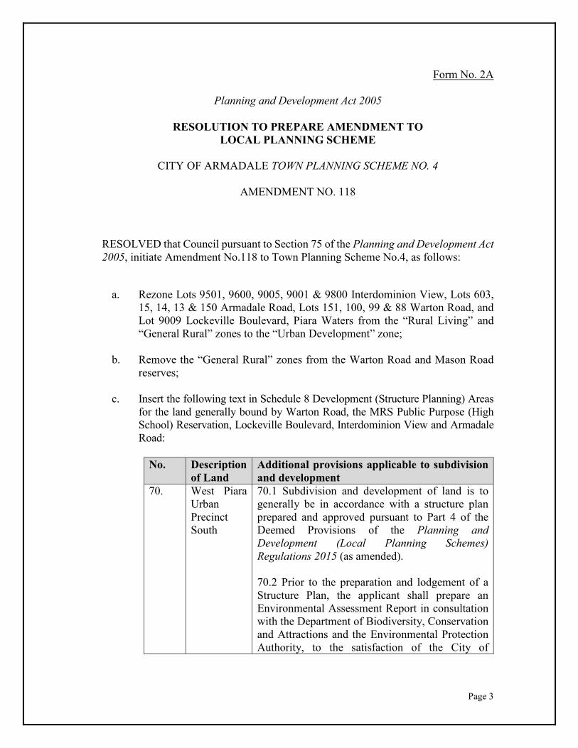
Form No. 2A
Planning and Development Act 2005
RESOLUTION TO PREPARE AMENDMENT TO LOCAL PLANNING SCHEME
CITY OF ARMADALE TOWN PLANNING SCHEME NO. 4
AMENDMENT NO. 118
RESOLVED that Council pursuant to Section 75 of the Planning and Development Act 2005, initiate Amendment No.118 to Town Planning Scheme No.4, as follows:
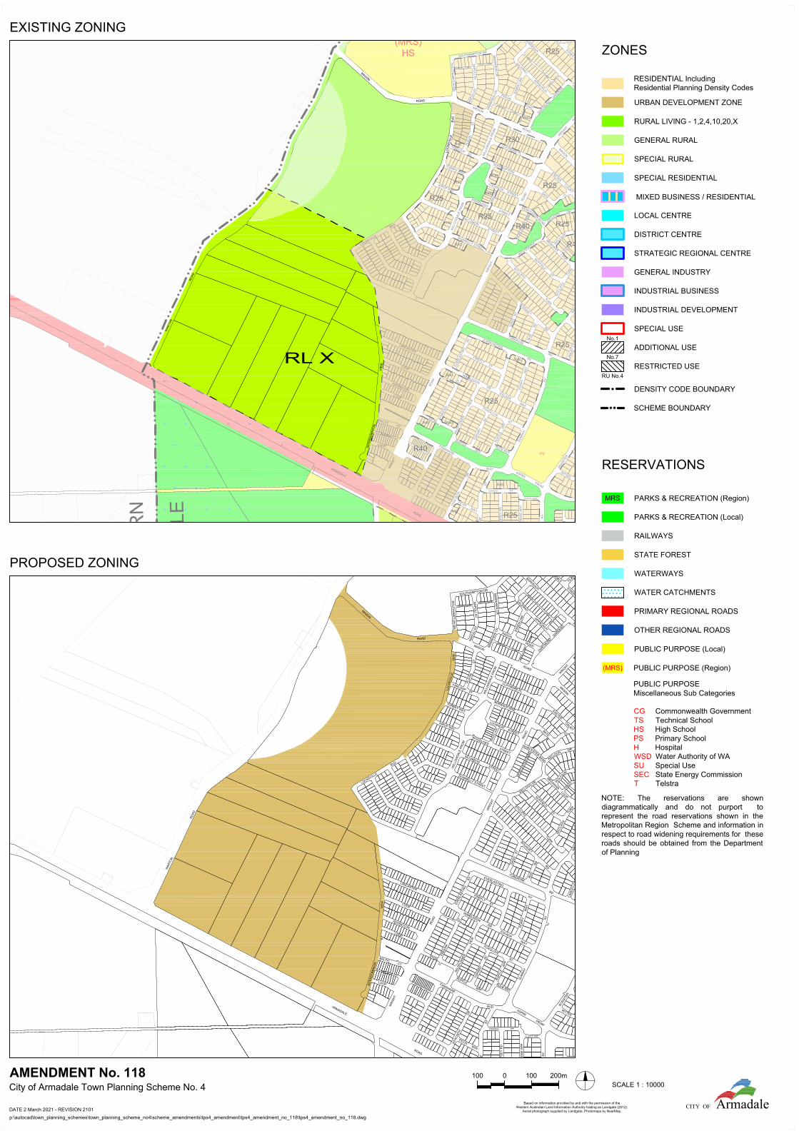
a. Rezone Lots 9501, 9600, 9005, 9001 & 9800 Interdominion View, Lots 603, 15, 14, 13 & 150 Armadale Road, Lots 151, 100, 99 & 88 Warton Road, and Lot 9009 Lockeville Boulevard, Piara Waters from the “Rural Living” and “General Rural” zones to the “Urban Development” zone;
b. Remove the “General Rural” zones from the Warton Road and Mason Road reserves;
c. Insert the following text in Schedule 8 Development (Structure Planning) Areas
for the land generally bound by Warton Road, the MRS Public Purpose (High School) Reservation, Lockeville Boulevard, Interdominion View and Armadale Road:
No. Description of Land
Additional provisions applicable to subdivision and development
70. West Piara Urban Precinct South
70.1 Subdivision and development of land is to generally be in accordance with a structure plan prepared and approved pursuant to Part 4 of the Deemed Provisions of the Planning and Development (Local Planning Schemes) Regulations 2015 (as amended). 70.2 Prior to the preparation and lodgement of a Structure Plan, the applicant shall prepare an Environmental Assessment Report in consultation with the Department of Biodiversity, Conservation and Attractions and the Environmental Protection Authority, to the satisfaction of the City of
Page 4
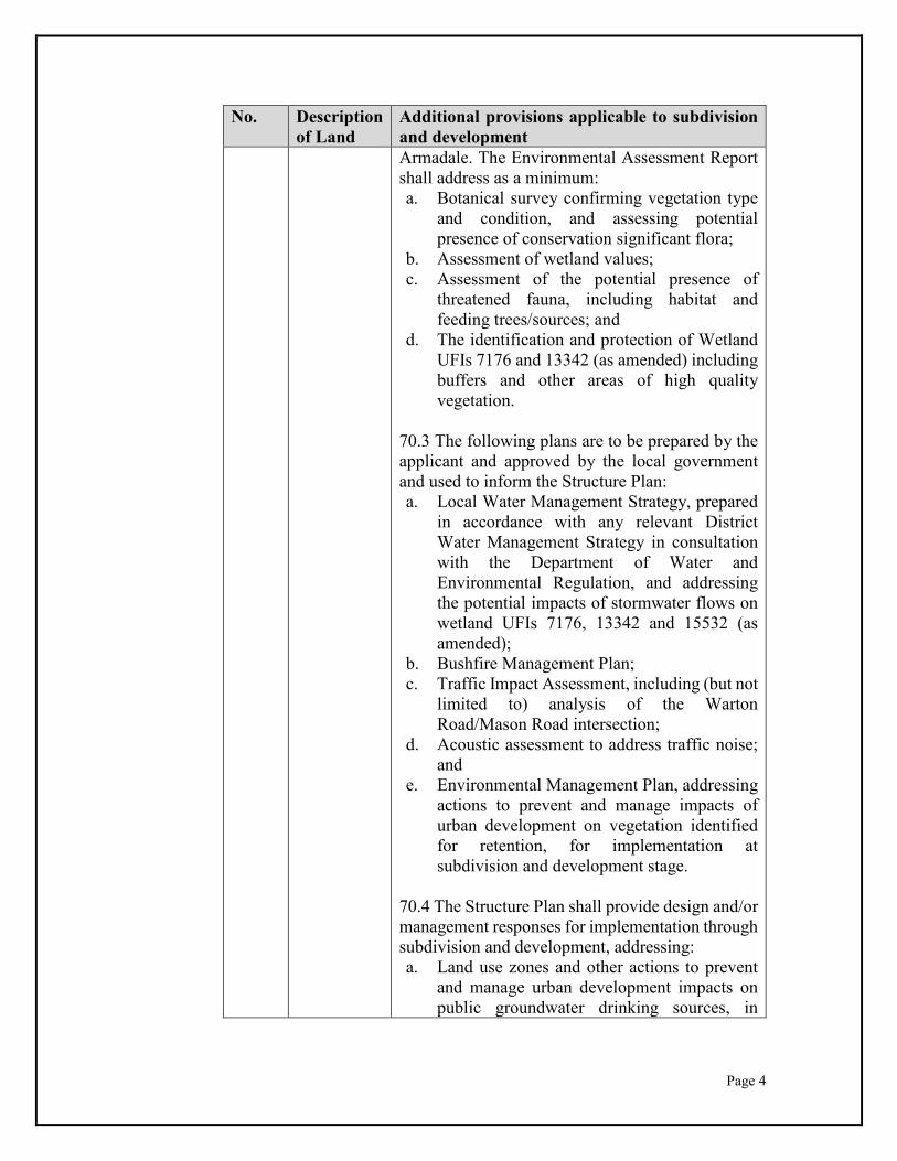
No. Description of Land
Additional provisions applicable to subdivision and development Armadale. The Environmental Assessment Report shall address as a minimum: a. Botanical survey confirming vegetation type
and condition, and assessing potential presence of conservation significant flora;
b. Assessment of wetland values; c. Assessment of the potential presence of
threatened fauna, including habitat and feeding trees/sources; and
d. The identification and protection of Wetland UFIs 7176 and 13342 (as amended) including buffers and other areas of high quality vegetation.
70.3 The following plans are to be prepared by the applicant and approved by the local government and used to inform the Structure Plan: a. Local Water Management Strategy, prepared
in accordance with any relevant District Water Management Strategy in consultation with the Department of Water and Environmental Regulation, and addressing the potential impacts of stormwater flows on wetland UFIs 7176, 13342 and 15532 (as amended);
b. Bushfire Management Plan; c. Traffic Impact Assessment, including (but not
limited to) analysis of the Warton Road/Mason Road intersection;
d. Acoustic assessment to address traffic noise; and
e. Environmental Management Plan, addressing actions to prevent and manage impacts of urban development on vegetation identified for retention, for implementation at subdivision and development stage.
70.4 The Structure Plan shall provide design and/or management responses for implementation through subdivision and development, addressing: a. Land use zones and other actions to prevent
and manage urban development impacts on public groundwater drinking sources, in
Page 5
No. Description of Land
Additional provisions applicable to subdivision and development
accordance with State Planning Policy 2.3 Jandakot Groundwater Protection;
b. Acid sulphate soils; c. Site contamination; d. Safe and efficient road intersections to
Warton Road for traffic distribution and congestion management, on the advice of the City of Armadale;
e. Widening and upgrade of Mason Road, including any modifications to its intersection with Warton Road;
f. Identification of a roundabout-controlled intersection at Mason Road/Southampton Drive/Lockeville Boulevard;
g. Identification and protection of significant landscape trees and features as per Local Planning Policy PLN 2.4 Landscape Feature and Tree Preservation, where possible;
h. Visual impact of noise attenuation measures; i. A pattern of land use and road networks
integrating with abutting areas zoned MRS Urban Deferred.
70.5 Structure Plans shall identify a location for a Department of Education-operated primary school to the satisfaction of the City of Armadale and the Department of Education. 70.6 The provision of public open space shall satisfy the following criteria: a. Provision of unrestricted public open space in
accordance with WAPC policy; b. Identification of the location of an active
senior-sized playing field; c. Protection of significant vegetation and
environmental features; d. Linear public open space connections to the
abutting North Forrestdale Development (Structure Planning) Areas.
d. Include the land generally bound by Warton Road, the MRS Public Purpose (High School) Reservation, Lockeville Boulevard, Interdominion View and Armadale
Page 6
Road within Special Control Area Map 3 with the appropriate ‘Development Area (Structure Plan) Schedule 8’ and ‘No.70’ designations.
e. Modify Special Control Area Map 2 to remove the land generally bound by Warton Road, the MRS Public Purpose (High School) Reservation, Lockeville Boulevard, Interdominion View and Armadale Road from the ‘Priority 2 Groundwater Protection Area’;
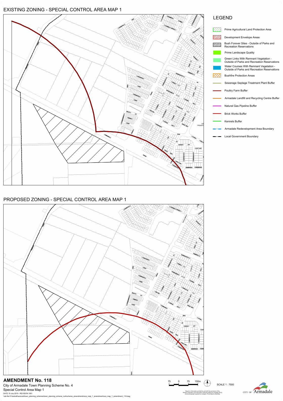
f. Modify Special Control Area Map 1 to remove the Poultry Farm Buffer from Lot 709 Armadale Road, Banjup and modify intersecting Poultry Farm Buffers accordingly; and
g. Amend the Scheme Maps accordingly. The Amendment is standard under the provisions of the Planning and Development (Local Planning Schemes) Regulations 2015 for the following reasons:
a. The Amendment is consistent with a region planning scheme that has been endorsed by the Commission;
b. The Amendment has minimal impact on land in the scheme area that is not the subject of the amendment;
c. The Amendment does not result in any significant environmental, social, economic or governance impacts on land in the scheme area; and
d. The Amendment does not meet the definition of a complex or a basic amendment.
Page 7
Dated this 19th day of April, 2021
J ABBISS
CHIEF EXECUTIVE OFFICER
D18/4/21
Page 8
CITY OF ARMADALE TOWN PLANNING SCHEME NO. 4
AMENDMENT NO. 118
SCHEME REPORT
Contents
1. DETAILS OF PROPOSAL ....................................................................................... 8 2. SUBJECT LAND ...................................................................................................... 9 3. LANDOWNERS ....................................................................................................... 9 4. APPLICANT ............................................................................................................. 9 5. CURRENT ZONING .............................................................................................. 10 6. PROPOSED ZONING ............................................................................................ 10 7. BACKGROUND ..................................................................................................... 10 8. COMMENT ............................................................................................................. 11 9. ANALYSIS ............................................................................................................. 21 10. CONCLUSION ....................................................................................................... 22 1. DETAILS OF PROPOSAL The City has received a request to initiate an amendment to TPS No.4 to rezone the West Piara Urban Precinct South to the Urban Development. Such an Amendment is necessary in order to ensure that TPS No.4 remains consistent with the MRS; this is legislative requirement pursuant to Section 125 (3) of the Planning and Development Act 2005 (Act). This Amendment is also required because the Minister for Planning did not concurrently amend TPS No.4 under Section 126 of the Act. This approach was requested by the City and the Environmental Protection Authority (EPA), so that site constraints and coordination issues (including environmental factors) could be addressed at the town planning scheme amendment phase. The Western Australian Planning Commission (WAPC) agreed with the City and the EPA that a subsequent rezoning Amendment provided the proper process for TPS No.4 Schedule 8 provisions to guide future structure plans and address the environmental and planning issues arising from future land development. The applicant, CLE Town Planning and Design on behalf of the West Piara Landowners Group, requests that TPS No.4 be amended to rezone the West Piara Urban Precinct South from the General Rural zone to the Urban Development zone and include provisions in TPS No.4 Schedule 8 Development (Structure Planning) Areas. The applicant’s justification for the proposal is summarised as follows:
Page 9
(ii) The inclusion of the land in the MRS Urban zone confirms that the area is suitable for urban development;
(iii) The current TPS No.4 General Rural and Rural Living zones are no longer consistent with the strategic planning framework and the MRS;
(iv) Supporting technical reports can be prepared at structure plan stage (post Urban Development rezoning) to demonstrate that relevant site considerations can be addressed through subsequent urban (residential) subdivision and development;
(v) The proposed Schedule 8 Provisions relating to future subdivision and development have been prepared to reflect the environmental issues and planning advice provided by the EPA and the City; and
(vi) Development contribution arrangements (to be paid at subdivision/development for equitable sharing of common infrastructure costs) are currently being progressed by the City (TPS No.4 Amendment No.115) to support the community/infrastructure needs of the ultimate urban development. The applicant supports the extension of DCP No.3 over the West Piara Urban Development Precinct South area.
The City’s review and assessment identified a number of amendments to TPS No.4 required in order to progress a rezoning of the Precinct. The various proposals of this amendment are outlined as follows, with further discussion later in this report: 1. Rezone all MRS Urban zoned land in the West Piara Urban Precinct South to the
TPS No.4 Urban Development and Residential zones; 2. Insert applicable provisions into TPS No.4 Schedule 8 Development (Structure Plan)
Areas to address later structure planning, subdivision and development; 3. Remove a 500m poultry farm buffer identified on Special Control Area Map 1,
arising from a previous poultry farm in the City of Cockburn local government area now operating as a warehouse;
4. Remove the Priority 2 Groundwater Protection Area designation from the West Piara Urban Precinct South on Special Control Area Map 2 to recognise the Department of Water and Environmental Regulation’s reclassification of the public drinking water source through MRS Amendment 1369/57 and 1370/57 processes;
5. Remove the General Rural and Rural Living zones from the Warton Road and Mason Road reserves; and
Amend the TPS No.4 Scheme Maps (including Special Control Area Maps) accordingly.
2. SUBJECT LAND Lot 9501, 9600, 9005 9001 & 9800 Interdominion View, 603, 15, 14, 13 & 150 Armadale Road, and Lots 151, 100, 99 & 88 Warton Road, and Lot 9009 Lockeville Boulevard, Piara Waters. 3. LANDOWNERS Various. 4. APPLICANT
Page 10
CLE Town Planning & Design on behalf of West Piara Landowners Group Pty Ltd 5. CURRENT ZONING MRS : Urban TPS No.4 : General Rural; Rural Living 6. PROPOSED ZONING
Urban Development. 7. BACKGROUND West Piara Urban Precinct The West Piara Urban Precinct South forms part of the broader ‘West Piara Urban Precinct’ the subject of Metropolitan Region Scheme Amendments 1369/57 and 1370/57 approved by the Minister for Planning and gazetted in December 2020. The West Piara Urban Precinct abuts the City’s North Forrestdale Structure Plan Area and its Stage Three (Development Area No. 35) and Stage One (Development Area No.25) Structure Plans. Subdivisional activity in these structure plan areas is at its final stages, and in that regard the West Piara Urban Precinct represents a logical continuation of the development front. The West Piara Urban Precinct South is generally bounded by Warton Road, Mason Road, Lockeville Boulevard, Interdominion View and Armadale Road in Piara Waters. This area has a long history of rural land uses which primarily include rural residential, agistment, rural supplies, and horticultural activities. Western Power’s 132 KV power transmission line network traverses the area on an east-west alignment. The entirety of the land is generally cleared or parkland cleared, however areas of high value remnant native vegetation and wetland vegetation are present. In contrast to the northern part of the West Piara Urban Precinct, the southern portion is more fragmented by historic rural subdivision. Warton Road forms the shared Local Government boundary between the Cities of Armadale (eastern side) and Cockburn (western side). The area west of the present Amendment area is reserved for Parks and Recreation under the Metropolitan Region Scheme (Bush Forever Site 390) and includes remnant bushland, private recreation uses (pistol club) and evidence of previous sand extraction activities. A report proposing the initiation of a Town Planning Scheme No.4 (TPS No.4) Amendment to rezone the West Piara Urban Precinct North is also included on this agenda (Amendment 119). Metropolitan Region Scheme Amendments 1369/57 & 1370/57
Page 11
The Metropolitan Region Scheme (MRS) sets out broad zones and reservations for the Perth Metropolitan Area and is reviewed to reflect present and future regional planning and development needs. Prior to MRS Amendments 1369/57 and 1370/57, the West Piara Urban Precinct was included in the MRS Rural – Water Protection zone. This is a Rural zone intended to control land use over public groundwater areas where contamination avoidance is necessary. Currently, the City’s TPS No.4 implements this MRS zoning by application of the General Rural and Rural Living X zones and application of Special Control Area No.2 – Public Drinking Water Protection Area – Priority 2 Source Protection Area. MRS Amendments 1369/57 and 1370/57 modified the MRS in the following manner: • MRS Amendment 1369/57: Entirety of the West Piara Urban Precinct except Lot
9010 Warton Road (approximately 115ha in area) transferred from the Rural – Water Protection zone to the Urban zone, Urban Deferred zone, Primary Regional Road reservation (portions of lots abutting Armadale Road) and Water Catchment reservation (adjustment only) in response to the proponent’s request.
• MRS Amendment 1370/57 – Lot 9010 Warton Road (approximately 12.84 ha in area) transferred to the Public Purposes - High School reservation, in response to the State Government’s decision to locate a Department of Education-operated High School on this lot.
Council considered the City’s submission on MRS Amendments 1369/57 and 1370/57 at its July 2020 meeting. The submission/report considered the proposed Amendments in the context of regional strategic planning including Perth and Peel @ 3.5Million and the Southern River Forrestdale Brookdale Wungong District Structure Plan. Council resolved to provide qualified support for the amendments. Aspects of Council’s submission relevant to the current stage of the planning process are discussed in the comment section of this report. 8. COMMENT Rezoning of the West Piara Urban Precinct South to the Urban Development zone will ensure that comprehensive planning will be undertaken by way of structure plans. Structure plans provide the mechanism to address:
• Detailed design issues/constraints; • Assign appropriate zones and reservations under the scheme; • Residential density; • Address the transitions between the site and surrounding developments; • Consider environmental management mechanisms; and • Identify land uses and set out public open space locations and road networks.
The associated provisions outlined in TPS No.4 Schedule 8 will ensure that key site considerations are addressed through any structure plan, responding to City of Armadale and state agency (including Environmental Protection Authority) advice.
Page 12
Structure plans provide a degree of flexibility over residential estate layout designs and some measure of independence where landholdings are fragmented. They can also be timed according to individual landowner intentions and respond to overall market conditions. Following structure plan approval, landowners and developers can proceed to obtain approval and implement stages of subdivision and development. At the completion of subdivision within a development area, the City undertakes ‘normalisation’ scheme amendments to apply the TPS No.4 zones and reservations identified in a Structure Plan in place of the Urban Development zone. Development Control Unit (DCU) The proposed Amendment was referred to the City’s internal Development Control Unit. No objections to the rezoning were forwarded, however several matters were raised that are capable of being addressed in the Amendment process or through subsequent stages of structure planning and subdivision. Development Contribution Plan No.3 Development Contribution Plans provide a cost sharing framework for the equitable collection of contributions and the funding of common infrastructure works of benefit to the future community in a development area. In March 2021 Council initiated TPS No.4 Amendment No.115 which, among other proposals, extends the existing Development Contribution Plan No.3 and Infrastructure Cost Schedule presently operating in the North Forrestdale Structure Plan Area (Harrisdale and Piara Waters) over the West Piara Urban Precinct. This amendment will progress through a complex amendment assessment pathway under the Planning and Development (Local Planning Schemes) Regulations 2015. Amendment No.115 proposes that an extended DCP No.3 collect and expend contributions for the partial land acquisition of a senior playing field land (over and above the 10% public open space ceded free of cost in accordance with WAPC Policy) located in the West Piara Urban Precinct South, construction of a community/sporting facility associated with the playing field, acquisition and rehabilitation of West Piara Urban Precinct South wetland areas, extension and construction of the regional dual use path network and upgrades to Mason Road. These proposals are subject to further assessment, advertising for public comment, and decisions by Council, the WAPC and the Minister for Planning. Environmental Features Historical agricultural and extraction activities have disturbed the land in the West Piara Urban Precinct South, with substantial areas cleared for livestock grazing. There are scattered remnant trees, planting of introduced trees and pockets of remnant native vegetation; the majority of this vegetation is considered ‘Degraded’ and ‘Completely Degraded’, however there are pockets of vegetation in ‘Good’ to ‘Very Good’ condition. No MRS ‘Bush Forever’
Page 13
designations apply to vegetation in the area and there are no natural waterways or Conservation Category Wetlands presently identified within the Precinct. Prior to public advertising of MRS Amendment 1369/57, the EPA determined that formal environmental assessment was not required (‘Scheme Not Assessed’) and issued advice which is summarised as follows: • Further updates are required to various environmental surveys prepared by the
proponent; • Environmental attributes should be addressed through subsequent planning processes
(the EPA identified vegetation (southern river complex vegetation), threatened black cockatoo habitat and wetland vegetation, fauna habitat and possible threatened flora); and
• Local planning scheme provisions are required to manage/avoid impacts to environmental values informed by updated surveys. A concurrent TPS No.4 Amendment under Section 126 of the Act is not supported.
At the MRS Amendment 1369/57 advertising stage, it was recognised that Department of Biodiversity, Conservation and Attractions (DBCA) geomorphic wetland mapping identified Multiple Use and Resource Enhancement Wetlands in the MRS Amendment area. One wetland in the south of the Precinct, known as ‘UFI 7176’, contains commonwealth-significant (Threatened Ecological Community) Banksia Woodland, Melaleuca and Kunzea vegetation rated at “very good” to “good” standard. This and other areas of vegetation (in adjoining Wetland UFI 13342) provide potential habitat for threatened black cockatoo species. It was also recognised that the current wetland mapping may reflect lower wetland values than is actually the case (i.e. probability of higher classifications and amended boundaries). When Council considered the City’s submission on the MRS 1369/57 Amendment, it resolved (D46/7/20) to advise the WAPC that it supported the amendment subject to the investigation of additional measures for the protection of wetland UFI 7176 and vegetation (e.g. within UFI 13342) as a MRS ‘Parks and Recreation’ reservation, as well as advising the proponent that the vegetation/wetland should be protected as part of future TPS No.4 Amendment and structure plan processes. The City’s subsequent submission noted that, in summary: • Aerial imagery and environmental reporting indicates a potentially sizeable area
(beyond the existing Wetland UFI 7176 extent) of wetlands and quality vegetation; • Reassessment of wetland values in the area is warranted, and DBCA advice states that
wetland values are likely to match a higher classification (‘Resource Enhancement’ or ‘Conservation Category’);
• The Banksia Woodland Threatened Ecological Community is present. This is a ‘matter of national environmental significance’ under the Commonwealth Environmental Protection and Biodiversity Conservation Act 1999;
• As the environmental values present are regional in nature, protection should be secured through a MRS Parks and Recreation Reservation. Structure plans are not preferred
Page 14
mechanisms to secure regional environmental values because of competing local public open space outcomes.
All MRS Amendment 1369/57 submissions were considered by the WAPC at its meeting held on 23/09/2020 and the City’s officers presented a Deputation supporting Council’s resolution. In response to the uncertainty of wetland classifications and extents, the WAPC resolved to modify MRS Amendment 1369/57 by including all land south of Mason Road (that is, the entire West Piara Urban Precinct South) in the MRS Urban Deferred zone to enable reassessment and confirmation of wetland status. The WAPC also acknowledged that confirmation was required on the mechanisms proposed to protect wetlands and vegetation. The WAPC report and recommendation on the modified amendment was forwarded to the Minister for Planning for approval. The Minister considered the recommendation and resolved that the Amendment be approved as advertised, and not as modified by the WAPC. The WAPC’s report on submissions prepared after the Minister’s decision and Amendment gazettal provides the following rationale:
“The proponent has commenced investigations into the potential reclassification of these wetlands to inform the future design, planning and approvals process. LSP [structure plan] provisions are also proposed to ensure that wetland values are appropriately addressed in the future development design and management such as the local structure planning process (i.e. set aside as local POS/conservation areas). On this basis, it is not considered necessary to include these wetlands in the Urban Deferred zone.”
Neither the WAPC’s resolution nor the Minister’s decision were consistent with Council’s resolution that wetland UFI 7176 and vegetation be reserved for Parks and Recreation in the MRS, although the WAPC modification would have enabled additional consideration, assessment of environmental values and investigation of suitable protection mechanisms. In this context attention is drawn to the following paragraph in the City’s July 2020 report to Council on the West Piara Urban Precinct MRS Amendments:
“While the City’s Local Planning Strategy 2016 and TPS No.4 incorporate various objectives promoting environmental sustainability, the City increasingly observes instances where State environmental agencies propose that Local Government protect and secure state and federal-level environmental assets through the local planning processes. While problematic for various legal and environmental reasons, one common detrimental consequence is that the City is unable to balance recreation, drainage and environmental values in public open spaces. Where State Government Agencies identify national or state-level environmental assets, those assets should be identified and secured prior to local planning processes (Town Planning Scheme Amendment, Structure Planning and Subdivision). If any such assets are identified it is most appropriate to reserve those areas for Parks and Recreation under the MRS.”
By proceeding with the MRS Amendment as advertised, investigations and preservation outcomes have been deferred to the TPS No.4 Amendment and structure plan stages.
Page 15
While structure plans can identify protection of environmentally sensitive land, the impact on public open space provision is difficult to quantify if wetland values and area extents are unconfirmed. Different wetland/vegetation classifications have differing implications on the 10% public open space provision to be ceded at subdivision stage in accordance with WAPC Policy (Liveable Neighbourhoods Guidelines). As reported to Council via Amendment No.115, it is unlikely that the wetland and vegetation will be capable of being fully accommodated within an area of POS to be ceded as part of the developer’s standard 10% public open space provision. At local planning stages, it is also difficult to achieve and balance environmental protection outcomes and community recreation aspirations. A further consideration in future management of environmental values is that landholdings subject to the likely future environmental investigations in the West Piara Urban Precinct South are highly fragmented. This poses public open space/conservation land assembly risks for the City, especially where sites may contain significant environmental values over the entirety (or substantial majority) of their area. The City’s experience in similar situations is that further subdivision/development is impeded and developers are discouraged from pursuing coordinated outcomes. This in turn increases that risk that environmental values degrade over time. Officers have considered various mechanisms to define and retain as much of Wetland UFI 7176, UFI 13342 and surrounding vegetation as possible in the absence of State Government support. Officers have also considered the equity implications, as retention of environmental values only through typical urban residential subdivision and public open space ceding processes may be difficult to resolve (as explained above). This is particularly pertinent for possibly 2-3 lots in the vicinity of Wetland UFI 7176 and UFI 13342 which contain significant environmental values over the full extent of their lot area. To address the above, two mechanisms are proposed: • Amendment No.118 proposes to insert TPS No.4 Schedule 8 Development (Structure
Planning) Areas provisions to require preparation and endorsement of an Environmental Assessment Report prior to preparation and lodgement of a Structure Plan. This plan should provide botanical surveys, assess wetland values, document impacts on threatened fauna, and protect vegetation and Wetland UFI 7176 and UFI 13342 (as amended). A later management plan prepared at structure plan stage will address actions to prevent urban development from negatively affecting environmental values. The proposed TPS No.4 provisions also list public open space location criteria for application at Structure Plan stage, which criteria will include the protection of significant vegetation and environmental features.
• Amendment No.115 (initiated by Council at its March 2021 meeting) proposes the
extension of DCP No.3 which will include a monetary contribution towards the costs of acquisition and/or betterment of the rehabilitated wetland UFI 7176 (as amended) in passive recreation public open space. An early acquisition would minimise the risk of land asset values rising and thereby becoming a burden on the DCP costings.
Page 16
It is intended that the combination of TPS No.4 DCP No.3 provisions and Schedule 8 Development (Structure Planning) Area provisions will implement Council’s earlier resolution on MRS Amendment 1369/57 to retain environmental values in the Wetland UFI 7176 and UFI 13342 locale. The City has been advised that consultants are currently reviewing and updating the various environmental investigations, with the intent of refining and identifying vegetation condition and wetland extents. The applicant’s consultant has advised that the Banksia Woodland vegetation present in the West Piara Urban Precinct South is possibly not of sufficient area or quality to trigger referral to the Commonwealth Department of Agriculture, Water and the Environment under the Commonwealth Environmental Protection and Biodiversity Conservation Act 1999. This will be assessed in future environmental investigations/reporting. Special Control Area – Public Drinking Water Resource Protection Areas State Planning Policy 2.3 Jandakot Groundwater Protection (SPP 2.3) provides specific policy measures to address groundwater supply resources in the Jandakot Groundwater Protection Area. SPP 2.3 aims to ensure that all development over the Jandakot Groundwater Mound will not have a detrimental impact on Perth’s integrated metropolitan public drinking water supply. SPP 2.3 establishes a general presumption against intensive development (residential, special residential, industrial and commercial zones) within the Policy Area. This is enforced by application of ‘Priority 1’ and ‘Priority 2’ protection classifications. However, SPP 2.3 policy measures allows the WAPC to consider variations to the presumption against intensive development (via a ‘Priority 3’ protection classification), including for large cleared/disturbed landholdings, land directly adjacent to already-developed areas and land identified as being appropriate for development through regional or sub-regional strategic planning. Through preparation and approval of the District Water Management Strategy in support of MRS Amendment 1369/57, the Department of Water and Environmental Regulation (DWER) amended the priority level of groundwater sources adjoining the West Piara Urban Precinct from a ‘Priority 2’ water source to a lower ‘Priority 3’ water source. Relevant SPP 2.3 policy measures applicable to this stage of the planning process include: • 6.1 – The protection and enhancement of native vegetation and wetlands for new
development so that groundwater quality is protected and maintained. • 6.2 e) – Land areas changed to Priority 3 after gazettal of SPP 2.3 may be subject to
restrictions/conditions on the type of non-residential land uses allowed. Drainage management and targeted public open space locations should be used to protect existing wellheads.
Page 17
• 6.4 – Local Planning Scheme amendments should reflect DWER’s ‘Water Quality Protection Note 25: Land use compatibility tables for public drinking water source areas’.
The allocation of appropriate land use zones and public open space reserves in future structure plans will be the eventual mechanism relied upon to achieve compliance with the policy measures of SPP 2.3. At this early stage, prior to State Government agency consultation, it would appear that the Residential zone is the only TPS No.4 land use zone capable of satisfying SPP 2.3 and DWER land use permissibility conditions/restrictions. TPS No.4 Schedule 8 Development (Structure Planning) Areas provisions have therefore been prepared to ensure that structure planning responds to SPP 2.3 requirements. The City’s Special Control Area maps also require modification to recognise that the West Piara Urban Precinct South is no longer classified as a Priority 2 protection area. If the TPS No.4 map was retained in its present form, it would have the unintended effect of requiring development approval for all residential development (including single dwellings) in the West Piara Urban Precinct. It is considered superfluous to continue the imposition of special control area triggers for the assessment of applications for development approval following the completion of scheme amendment, structure planning and subdivision processes. SPP 2.3 groundwater protection objectives will need to be demonstrated through structure plan land use zone allocation and technical reporting on nutrient leaching, stormwater conveyance/infiltration, sewer networks and drainage servicing. Recommendations from these investigations will be implemented at later subdivision and development stages. Special Control Area – Areas of Potential Environmental Hazard Impact The City’s TPS No.4 Special Control Area provisions (Clause 5.7) and maps define areas of potential environmental hazard impacts. These highlight potential for diminished environmental quality in proximity to rural and industrial activities that may involve nuisance or adverse emissions, odours, dust, noise or risk, as well as providing a basis for avoidance and minimisation of land use impacts. TPS No.4 Clause 5.7 requires all development, including residential development, to obtain development approval notwithstanding any designation as a Permitted (‘P’) land use. The City is to consider a variety of land use impacts, site characteristics, and amelioration effects when determining applications for development approval. Approximately 19ha of the West Piara Urban Precinct South is within a 500m poultry farm buffer radius measured from Lot 709 (No.342) Armadale Road, Banjup, south of the Warton Road/Armadale Road intersection and located within the City of Cockburn local government area. During pre-initiation amendment assessment, the City of Cockburn advised the City of Armadale that Lot 709 poultry farm operations ceased in 2013 and that existing sheds are
Page 18
currently approved as a ‘Warehouses’. The City of Cockburn’s Environmental Health officers initially recommended that the Special Control Area remain in place as the poultry farm land use is permitted on the site and an offensive trade license (under the Health (Miscellaneous Provisions) Act 1911) remains operative. However Lot 709 is zoned Resource under the City of Cockburn’s Town Planning Scheme No.3 and the provisions of TPS No.3 state that the use ‘Poultry Farm (Housed)’ is a Not Permitted (‘X’) land use in the Resource zone. The City of Cockburn’s Planning officers have since confirmed that any recommencement of poultry farm activities would be assessed as an ‘X’ use and would therefore be incapable of receiving development approval. Continued imposition of a TPS No.4 Special Control Area in the absence of a contributing land use is not supported. Therefore this Amendment proposes to modify the Special Control Area Maps to remove any poultry farm buffer arising from Lot 709. MRS Urban Deferred Zone – Sand Mining Buffer The MRS Urban Deferred zone is used to identify land that is likely to be suitable for future MRS Urban zoning, subject to certain requirements first being met. A portion of the MRS Amendment 1369/57 on Lot 9009 Lockeville Boulevard in the West Piara Urban Precinct South was transferred to the Urban Deferred zone due to its location within a 300m wide sand mining buffer. This sand mining location (Tenements M70/1088 and M70/1142) is a classified extraction site under State Planning Policy 2.4 Basic Raw Materials (SPP 2.4), however it remains subject to a September 2016 determination by the EPA Chairman that a Public Environmental Review (‘PER’) process under the Environmental Protection Act 1986 must be completed. As reported to Council in July 2020, the PER has not progressed and the current situation remains unchanged. The WAPC has advised that it requires completion of extraction activities, justification that those activities will not occur, or the consideration of compatible land use options prior to transferring the land to the MRS Urban zone. The area of the MRS Urban Deferred zone on Lot 9009 not included in this Amendment is of an irregular crescent shape. If in the future the land is transferred to the MRS Urban zone and developed in isolation, there is a risk that subdivision and development will not seamlessly integrate with any development on the adjoining MRS Urban land. This risk is proposed to be addressed by requiring later structure planning to provide a regular-shaped land use pattern and movement network on adjoining land that is within the Urban zone under the MRS. Urban zoned land that integrates with this MRS Urban Deferred area to promote orderly and proper planning at such future time as subdivision and development proceeds. Structure Planning Stage The following plans and supporting strategies are considered applicable and relevant to future structure plans in the West Piara Urban Precinct South, and are recommended to be addressed in TPS No.4 Schedule 8 Development (Structure Plan) Area provisions:
Page 19
2. Local Water Management Strategy: Local Water Management Strategies (LWMS) provide the next level of drainage management guidance from District Water Management Strategies approved at MRS Amendment stage. LWMSs are prepared on the advice of the Department of Water and Environment Regulation (DWER), and the City. The LWMS is to have regard to any groundwater protection requirements associated with the identification of the land as a Priority 3 Public Drinking Water Source Area. The applicant has conducted preliminary consultation on the proposed amendment with DWER (EPA Services Directorate). The applicant has advised the City of DWER’s request that the future LWMS address the impacts of stormwater flow on Wetland UFI 7176 and UFI 13342, as well as a smaller wetland (UFI 15532) outside the area previously identified by Council for further investigation of protection measures. UFI 15532 adjoins a constructed lake that is substantially degraded, however the relevant LWMS provision proposed for TPS No.4 Schedule 8 Development (Structure Planning) Areas lists all three wetlands consistent with DWER’s advice.
3. Bushfire Management Plan: The West Piara Urban Precinct South is identified as a
bushfire prone area on the Department of Fire and Emergency Services’ Map of Bushfire Prone Areas. Under the provisions of the WAPC’s State Planning Policy 3.7 Planning for Bushfire Prone Areas Policy Measure 6.3, structure plan proposals are to be accompanied by assessments of bushfire hazards and demonstrate compliance with bushfire protection criteria contained in the Guidelines for Planning in Bushfire Prone Areas. A Bushfire Management Plan (BMP) is required at structure plan stage and the City expects that future BMPs will adequately address bushfire hazards on land outside an applicant’s control, bushfire hazards arising from retained remnant vegetation, and secondary access requirements through development staging.
4. Acoustic Assessment: Warton Road and Armadale Road (strategic freight and major
traffic routes) are sources of noise impact on the West Piara Urban Precinct South. These require further modelling and analysis in accordance with the provisions of State Planning Policy 5.4 Road and Rail Noise. Notifications on future certificates of title and noise attenuation measures (e.g. noise walls) will be necessary, along with design responses to minimise the visual impacts of any expansive blank walls.
5. Environmental Management Plan: The Environmental Management Plan (EMP)
addresses the advice of the EPA on the MRS Amendment 1369/57 regarding the need for TPS No.4 provisions to address avoidance and management of environmental impacts at the subdivision and development stage on the basis of appropriate surveys. The EMP will especially address vegetation and wetland retention as discussed earlier in this report. The recommended TPS No.4 Schedule 8 Development (Structure Planning) Areas provisions reflect recent provisions gazetted in the City’s TPS No.4 for other Urban Development rezoning amendments.
In addition to the above, the following design and management considerations are applicable and relevant to future structure plans in the West Piara Urban Precinct South. TPS No.4
Page 20
Schedule 8 Development (Structure Planning) Areas provisions are recommended to ensure the following matters are addressed: 1. Acid sulphate soils: Portions of the amendment area are identified as being at high risk
of developing acid sulphate soils. This issue can be addressed at the structure planning stage.
2. Site contamination: One site within the West Piara Urban Precinct South (Lot 88
Warton Road) is listed on the Department of Water and Environmental Regulation’s Contaminated Sites Database (registered under the Contaminated Sites Act 2003) as a site requiring remediation. It is expected that future structure plans and technical studies will outline remediation requirements. In addition, future structure plans must have regard to previous historical land uses on other lots and the possibility of polluting substances being present at above background concentration levels.
3. Movement and transport: The proposed development concept plan prepared at MRS
Amendment stage proposed a number of intersections to Warton Road from the West Piara Urban Precinct. Such intersections are required in order to alleviate pressure on the Warton Road/Mason Road/Jandakot Road roundabout-controlled intersection and provide better traffic distribution between local and arterial road network.
The proposed intersection locations on Warton Road from the West Piara Urban Precinct South can be confirmed at structure plan stage. There are likely to be limited suitable locations due to topography and road reserve crossfall.
In relation to Mason Road, additional widening and upgrades are required to bring the current rural standard reserve to an urban standard to cater for current and future growth in traffic volumes. The City’s Technical Services have identified that Mason Road is to be constructed to a ‘Neighbourhood Connector A’ standard as per Liveable Neighbourhoods (24.4m reserve width). Upgrades may also necessitate works at the Mason Road intersection with Warton Road, and suitable intersection controls (roundabouts) are also required to be identified for the local road network; these improvements are to be addressed in future Traffic Impact Assessments.
4. Significant landscape trees and landscape features: One of the objectives of the City’s
Local Planning Policy PLN 2.4 Landscape Feature and Tree Preservation is to aim for the retention of significant trees and landscape features through the planning framework in order to preserve the character of an area. Subsequent structure plans in the West Piara Urban Precinct shall include design responses to address the provisions of the policy.
5. Future schools: In order to service the future residential population of the West Piara
Urban Precinct South, the Department of Education has advised of its in-principle support for identification of a primary school in a later structure plan. The Department’s submission on MRS Amendment 1369/57 provided design advice that will be incorporated at the structure plan stage.

Page 21
6. Public open space: Possible areas of proposed public open space in the West Piara
Urban Precinct South were identified on a development concept plan prepared to inform MRS Amendment 1369/57. These areas will be further refined at structure plan stage, with the following locational criteria (established by the City at MRS Amendment stage) to be considered for public open space locations:
a. The design and location of proposed public open space areas (including
appropriate dimensions for playing field locations to service the needs of the future residential population);
b. Protection of vegetation and other environmental features; c. Linear public open space connections for recreational and ecological linkages
abutting public open space in the North Forrestdale Structure Plan Area; and d. The provision of sufficient unrestricted public open space (ie. land with full
recreation function) consistent with WAPC policy. The City’s preference for future structure plan/s in the West Piara Urban Precinct South is that one structure plan be prepared. However the degree of fragmentation south of the existing Western Power easement may necessitate some flexibility, whereby Lot 9009 Lockeville Boulevard (approximately 31ha) is the subject of a separate structure plan. In relation to servicing, the City’s previous July 2020 report to Council advised that capacity limitations in the Water Corporation’s reticulated sewerage network mandated the upgrading of the Wright Road and Cloutt Lane Wastewater Pump Stations and interlinking routes. The City reported its concern with this proposal, because these pump stations adjoin existing public open space. Their expansion would result in encroachment on (and loss of) existing parks. Current discussions with potential developers in the West Piara Urban Precinct reveal that alternative options not impacting existing public open space areas are under consideration, which is a preferable outcome. Following preliminary assessments and acceptance by the City, any future structure plan applications will undergo formal public review which allows land owners and the public to raise any issues for consideration before final recommendation by the City and determination by the WAPC. 9. ANALYSIS The Planning and Development Act 2005 provides the head of power for the amendment of Local Planning Schemes and includes procedural provisions regarding referral of amendments to the EPA to determine if environmental assessment under Part IV Division 3 of the Environmental Protection Act 1986 is required (Section 81) and the requirement for public/agency advertising (Section 83). The Planning and Development (Local Planning Schemes) Regulations 2015 provide additional procedural direction on the scheme amendment process. Regulation 34 defines
Page 22
the different categories of scheme amendments and a risk-based assessment model where scheme amendments are categorised as basic, standard or complex. This Amendment is considered to be a ‘Standard Amendment’ under Part 5, Clause 34(i) of the Planning and Development (Local Planning Schemes) Regulations 2015 as it is consistent with the region scheme that applies to the land (Regulation 34 Standard Amendment (c)), has minimal impact on land in the scheme area that is not the subject of the amendment (Regulation 34 Standard Amendment (e)), does not result in any significant environmental, social, economic or governance impacts on land in the scheme area (Regulation 34 Standard Amendment (f)), and does not satisfy the criteria of a basic scheme amendment or a complex scheme amendment (Regulation 34 Standard Amendment (g)). Part 5 Division 3 of the Planning and Development (Local Planning Schemes) Regulations 2015 provides the process for standard amendments. In general terms, upon initiation the amendment will be forwarded to the EPA for environmental assessment. If the scheme amendment does not require environmental assessment, the City is to advertise the amendment for a period of time not less than 42 days and has 60 days after the end of the submission period in which to consider the submissions and make a recommendation for the Minister’s decision. 10. CONCLUSION Amendment No. 118 proposes to bring the West Piara Urban Precinct South area into conformity with the Metropolitan Region Scheme by rezoning the Amendment area to Urban Development zone. Amendment No.118 also proposes additional provisions to TPS No.4 Schedule 8 Development (Structure Planning) Areas to guide responses to environmental and other constraints prior to and during the preparation of future structure plans. Amendment No.118 also addresses modifications to the Public Drinking Water Resource Protection Area Special Control Area Maps, arising from previous decisions by the Western Australian Planning Commission, Minister for Planning and the Department of Water and Environmental Regulation. Following the closure of the advertising period, a further report on the proposed amendment and any submissions received during the advertising period will be presented to Council for its consideration of final adoption and recommendation to the Minister.

Page 23
Planning and Development Act 2005
CITY OF ARMADALE TOWN PLANNING SCHEME NO. 4
AMENDMENT NO. 118 The Armadale City Council under and by virtue of the powers conferred upon it in that behalf by the Planning and Development Act 2005, hereby amends the above Local Planning Scheme by:
> AFTER CONSIDERATION OF SUBMISSIONS COUNCIL RESOLUTION IN FULL TO BE INSERTED HERE. ONLY INCLUDED MAIN PART OF RESOLUTION THAT RELATES TO THE AMENDMENT ITSELF <
COUNCIL ADOPTION
This Standard Amendment was adopted by Resolution D18/4/21 of the Council of the City of Armadale at the Ordinary Meeting of the Council held on the 19th day of April 2021. MAYOR CHIEF EXECUTIVE OFFICER
COUNCIL RECOMMENDATION This Amendment is recommended for support / not to be supported by Resolution D of the City of Armadale at the Ordinary Meeting of the Council held on the day of 202 and the Common Seal of the City of Armadale was hereunto affixed by the authority of a resolution of the Council in the presence of: (seal) MAYOR CHIEF EXECUTIVE OFFICER WAPC RECOMMENDATION FOR APPROVAL
DELEGATED UNDER S.16 OF
THE PD ACT 2005
Date:-
APPROVAL GRANTED
MINISTER FOR PLANNING
Date:-
RL X
CIT
Y O
F C
OC
KBU
RN
CIT
Y O
F A
RM
ADAL
ER30
R40
R30
R25
R25
R40
R40
R40
R30
R30 R40
R40
R25
R25
R25
R40
R40
R40
R40 R25
R40
R40
R40
R25
R40
R25
PS
(MRS)HS
ROAD
WRI
GHT
WRIG
HT
ROAD
ARMADALE
ROAD
MASON
ROAD
GRENOBLE STREET
TILBURG
BERLIN LANE
BERLIN W
AY
DORTMUND GARDENS
MAN
NHEI
N CR PADUA ROAD
BRESCIA LANE
MASON
ROAD
MASON ROAD
EXETER
COURT
BORDEAUX
PARADE
SALERNO
APPROACH
WRI
GHT
RO
AD
TORRIDGE APP
TOR
RID
GE
APP
DEM
PSEY
RD
CLOUTT LANE
ETHR
IDGE
AV
BELL
AS
CC
T
ESSE
N LI
NK
MAN
NH
EIN C
R
DELFT LANE
DELFT LANE
NAPO
LI A
V
NAPO
LI AV
SOU
THAM
PTON
DR
SOUTHAMPTON DR
BELLAS CCT
BLACKFRIARS
WEL
LMAN
WYCLIFFE TURN
FELL LANE
ROSS
ITER
ASPIRI PROM
RITTER
NUFFIELD ST
WYC
LIFF
ETU
RN
KELLOGG DRMEDAWAR LOOP
EGROVE
WAY
WOLFSON
LOGGDR
KEL
BRES
CIA
LANE
BATE CL
WO
RCES
TER
BEND
WORCESTER BEND
FREE
SIA
S
T
FOXGLOVE ST
RUFFLE APP
RUFF
LE
APP
TOPI
ARY
AV
WIMBLEDON DR
BULB WAY
POPP
Y
W
AY
ESCADA WAY
WIL
DFLO
WER
VIE
W
SYON
AV
SUNR
AY
LOC
KEVI
LLE
BVD
EVER
LAST
ING
AV
YARLOOP ST
EVERLASTING AV
ST
PLAV
IN
BORANUP RISE
WIL
LOW
DALE
PRO
M
FANSHAWE
KIRUP WAY
TORBAY WAY
CLAYMORE PL
FIREFLY ST
BVD
ST
TUBEROSE RD
BOUQUET RD
DAIS
Y S
T
BUD
RD
CAM
LEY
CT
LUCKNOW STREETWOODLOES STREET
NANG
A LA
NE
BALTIC CT
ADDINGTON
LOOP
AQUILA
LOOPHY
ACIN
TH
D
R
FICUS WAY
McGIBBON STREET
WIL
LOW
DALE
PRO
M
LOOP
LANCASTER
INTE
RD
OM
INIO
N
VIEW
DONNELLY STREETLOCKEVILLE
BVD
WAR
TON
ROAD
ROAD
WRI
GHT
WRIGHT
R
OAD
ARMADALE
ROAD
MASON
ROAD
GRENOBLE STREET
TILBURGDIEPPE
LANE
BERLIN LANE
BERLIN W
AY
DORTMUND GARDENS
MUNICH LINK
MAN
NHEI
N CR PADUA ROADBRESCIA
LANE
MASON
ROAD
MASON ROAD
EXETER
COURT
BORDEAUX
PARADE
SALERNO
APPROACH
WRI
GHT
RO
AD
TORRIDGE APP
TOR
RID
GE
APP
DEM
PSEY
RD
CLOUTT LANE
ETHR
IDGE AV
ESSE
N LI
NK
MAN
NH
EIN C
R
DELFT LANE
DELFT LANE
NAPO
LI A
V
NAPO
LI AV
SOU
THAM
PTON
DR
SOUTHAMPTON DR
BELLAS CCT
WEL
LMAN
WYCLIFFE TURN
ROSS
ITER
ASPIRI PROM
RITTER
NUFFIELD ST
WYC
LIFF
ETU
RN
KELLOGG DR
MEDAWAR LOOPEGROVE
WAY
WOLFSON
LOGGDR
KEL
BRES
CIA
LANE
BATE CL
WO
RCES
TER
BEND
WORCESTER BEND
FREE
SIA
S
T
FOXGLOVE ST
RUFFLE APP
RUFF
LE
APP
TOPI
ARY
AV
WIMBLEDON DR
BULB WAY
POPP
Y
W
AY
ESCADA WAY
WIL
DFLO
WER
VIE
W
SYON
AV
SUNR
AY
LOC
KEVI
LLE
BVD
EVER
LAST
ING
AV
YARLOOP ST
EVERLASTING AV
ST
PLAV
IN
BORANUP RISE
WIL
LOW
DALE
PRO
M
FANSHAWE
KIRUP WAY
TORBAY WAY
CLAYMORE PL
FIREFLY ST
BVD
ST
TUBEROSE RD
BOUQUET RD
DAIS
Y S
T
BUD
RD
CAM
LEY
CT
LUCKNOW STREETWOODLOES STREET
NANG
A LA
NE
BALTIC CT
ADDINGTON
LOOP
AQUILA
LOOP
HYAC
INTH
DR
FICUS WAY
McGIBBON STREET
WIL
LOW
DALE
PRO
M
LOOP
LANCASTER
INTE
RD
OM
INIO
N
VIEW
DONNELLY STREETLOCKEVILLE
BVD
WAR
TON
ROAD
AMENDMENT No. 118City of Armadale Town Planning Scheme No. 4
DATE 2 March 2021 - REVISION 2101p:\autocad\town_planning_schemes\town_planning_scheme_no4\scheme_amendments\tps4_amendment\tps4_amendment_no_118\tps4_amendment_no_118.dwg
Based on information provided by and with the permission of theWestern Australian Land Information Authority trading as Landgate (2012).
Aerial photograph supplied by Landgate, Photomaps by NearMap.
100 0SCALE 1 : 10000
200m100
ArmadaleCITY OF
ZONES
RESERVATIONS
GENERAL INDUSTRY
LOCAL CENTRE
DISTRICT CENTRE
INDUSTRIAL BUSINESS
PARKS & RECREATION (Region)
PARKS & RECREATION (Local)
RAILWAYS
STATE FOREST
WATERWAYS
WATER CATCHMENTS
OTHER REGIONAL ROADS
PRIMARY REGIONAL ROADS
PUBLIC PURPOSE (Local)
MRS
(MRS)
ADDITIONAL USE
RESTRICTED USE
DENSITY CODE BOUNDARY
No.7
SPECIAL USE
NOTE: The reservations are showndiagrammatically and do not purport torepresent the road reservations shown in theMetropolitan Region Scheme and information inrespect to road widening requirements for theseroads should be obtained from the Departmentof Planning
STRATEGIC REGIONAL CENTRE
SCHEME BOUNDARY
No.1
RU No.4
PUBLIC PURPOSEMiscellaneous Sub Categories
CG Commonwealth GovernmentTS Technical SchoolHS High SchoolPS Primary SchoolH HospitalWSD Water Authority of WASU Special UseSEC State Energy CommissionT Telstra
INDUSTRIAL DEVELOPMENT
MIXED BUSINESS / RESIDENTIAL
RURAL LIVING - 1,2,4,10,20,X
GENERAL RURAL
SPECIAL RESIDENTIAL
URBAN DEVELOPMENT ZONE
RESIDENTIAL IncludingResidential Planning Density Codes
PUBLIC PURPOSE (Region)
EXISTING ZONING
PROPOSED ZONING
SPECIAL RURAL
SUNR
AY
ROAD
WRI
GHT
ARMADALE
ROAD
WRI
GHT
RO
AD
WRI
GHT
RO
AD
ROAD
WRI
GHT
WRI
GHT
ROAD
ROAD
WRI
GHT
TORRIDGE APPTORRIDGE APPTORRIDGE APP
TOR
RID
GE
APP
TOR
RID
GE
APP
TOR
RID
GE
APP
DEM
PSEY
RD
DEM
PSEY
RD
DEM
PSEY
RD
DEMPSEYDEMPSEY RDDEMPSEY RD
PEGUS WAY
PEGUS WAY
PEGUS WAY
DWALL LANE
DWALL LANE
DWALL LANE
TORRIDGETORRIDGE APPTORRIDGE APP
CLOUTT LANECLOUTT LANECLOUTT LANE
ETHR
IDGE
ETHR
IDGE
ST
ETHR
IDGE
ST
ROSS
ITER
AV
ROSS
ITER
AVAV
ROSS
ITER
WYCLIFFE TURN
WYCLIFFE TURN
WYCLIFFE TURN
ASPIRI PROM
ASPIRI PROM
ASPIRI PROM
NUFFIELD ST
NUFFIELD ST
NUFFIELD ST
KELLOGG DR
KELLOGG DR
KELLOGG DR
WO
RCES
TER
BEND
WO
RCES
TER
BEND
WO
RCES
TER
BEND
ROAD
ARMADALE
ROAD
ARMADALE
STER BEND
STER BEND
STER BEND
FREE
SIA
S
T
FOXGLOVE STSYON WAY
RUFFLE APP
RUFF
LE
APP
TOPI
ARY
AV
WIMBLEDON DR
BULB WAY
POPP
Y
W
AY
ESCADA WAY
WIL
DFLO
WER
VIE
W
SYON WAY
SYON
FREE
SIA
ST
FREE
SIA
ST
WIMBLEDON DR
WIMBLEDON DR
WIL
DFLO
WER
V
IEW
WIL
DFLO
WER
V
IEW
FOXGLOVE ST
FOXGLOVE ST
RUFFLE APP
RUFFLE APP
TOPI
ARY
AV
TOPI
ARY
AV
BULB WAY
BULB WAY
RUFF
LE
APP
RUFF
LE
APP
SUNR
AY
SUNR
AYPO
PPY
WAY
POPP
Y
W
AY
ESCADA WAY
ESCADA WAY
EVER
LAST
ING
AV EVERLASTING AV
ESC
ADA
WAY
ESC
ADA
WAY
EVERLASTING AV
EVERLASTING AV
FANSHAWE
FANSHAWE
FANSHAWE
EVER
LAST
ING
AV
EVER
LAST
ING
AV
FIREFLY ST
FIREFLY ST
FIREFLY ST
BVDBVDBVD
HURL
ING
HAM
WAY
SUM
MER
RD
HYAC
INTH
DR
ST
DAHLIA LANE
TUBEROSE RD
TUBEROSE RD
TUBEROSE RD
BOUQUET RD
BOUQUET RD
BOUQUET RD
DAIS
Y
ST
DAIS
Y
S
T
DAIS
Y S
T
BUD
R
D
BUD
RD
BUD
RD
WOODLOES STREET
WOODLOES STREET
WOODLOES STREET
BALTIC CT
BALTIC CT
BALTIC CT
ADDINGTONADDINGTON
ADDINGTON
LOOPLOOP
LOOP
AQUILAAQUILA
AQUILA
LOOPLOOPLOOP
STST
HYAC
INTH
DR
HYAC
INTH
D
R
FICUS WAY
FICUS WAY
FICUS WAY
McGIBBON STREET
McGIBBON STREET
McGIBBON STREET
WIL
LOW
DALE
PRO
M
WIL
LOW
DALE
PRO
M
WIL
LOW
DALE
PRO
M
LOOPLOOP
LOOP
LANCASTERLANCASTER
LANCASTER
INTE
RD
OM
INIO
NIN
TER
DO
MIN
ION
INTE
RD
OM
INIO
N
VIEWVIEW
VIEW
DONNELLY STREET
DONNELLY STREET
DONNELLY STREET
ASPIRIPRIMARY SCHOOL
LOCKEVILLE
LOCKEVILLE
LOCKEVILLE
BVDBVDBVD
WAR
TON
WAR
TON
WAR
TON
ROAD
ROAD
ROAD
SUNR
AY
ROAD
TAYLOR
WRI
GHT
ARMADALE
ROAD
WRI
GHT
RO
AD
WRI
GHT
RO
AD
ROAD
WRI
GHT
TAYLOR
WRI
GHT
ROAD
ROAD
WRI
GHT
TAYLOR
TORRIDGE APPTORRIDGE APPTORRIDGE APP
TOR
RID
GE
APP
TOR
RID
GE
APP
TOR
RID
GE
APP
DEM
PSEY
RD
DEM
PSEY
RD
DEM
PSEY
RD
DEMPSEYDEMPSEY RDDEMPSEY RD
PEGUS WAY
PEGUS WAY
PEGUS WAY
DWALL LANE
DWALL LANE
DWALL LANE
TORRIDGETORRIDGE APPTORRIDGE APP
CLOUTT LANECLOUTT LANECLOUTT LANE
ETHR
IDGE
ETHR
IDGE
ST
ETHR
IDGE
ST
WYCLIFFE TURN
WYCLIFFE TURN
WYCLIFFE TURN
ASPIRI PROM
ASPIRI PROM
ASPIRI PROM
KELLOGG DR
KELLOGG DR
KELLOGG DR
WO
RCES
TER
BEND
WO
RCES
TER
BEND
WO
RCES
TER
BEND
ROAD
ARMADALE
ROAD
ARMADALE
FREE
SIA
S
T
FOXGLOVE STSYON WAY
RUFFLE APP
RUFF
LE
APP
TOPI
ARY
AV
WIMBLEDON DR
BULB WAY
POPP
Y
W
AY
ESCADA WAY
WIL
DFLO
WER
VIE
W
SYON WAY
SYON
FREE
SIA
ST
FREE
SIA
ST
WIMBLEDON DR
WIMBLEDON DR
WIL
DFLO
WER
V
IEW
WIL
DFLO
WER
V
IEW
FOXGLOVE ST
FOXGLOVE ST
RUFFLE APP
RUFFLE APP
TOPI
ARY
AV
TOPI
ARY
AV
BULB WAY
BULB WAY
RUFF
LE
APP
RUFF
LE
APP
SUNR
AY
SUNR
AYPO
PPY
WAY
POPP
Y
W
AY
ESCADA WAY
ESCADA WAY
EVER
LAST
ING
AV EVERLASTING AV
ESC
ADA
WAY
ESC
ADA
WAY
EVERLASTING AV
EVERLASTING AV
FANSHAWE
FANSHAWE
FANSHAWE
EVER
LAST
ING
AV
EVER
LAST
ING
AV
FIREFLY ST
FIREFLY ST
FIREFLY ST
BVDBVDBVD
HURL
ING
HAM
WAY
SUM
MER
RD
HYAC
INTH
DR
ST
DAHLIA LANE
TUBEROSE RD
TUBEROSE RD
TUBEROSE RD
BOUQUET RD
BOUQUET RD
BOUQUET RD
DAIS
Y
ST
DAIS
Y
S
T
DAIS
Y S
T
BUD
R
D
BUD
RD
BUD
RD
BALTIC CT
BALTIC CT
BALTIC CT
ADDINGTONADDINGTON
ADDINGTON
LOOPLOOP
LOOP
AQUILAAQUILA
AQUILA
LOOPLOOPLOOP
STST
HYAC
INTH
DR
HYAC
INTH
D
R
FICUS WAY
FICUS WAY
FICUS WAY
McGIBBON STREET
McGIBBON STREET
McGIBBON STREET
LOOPLOOP
LOOP
LANCASTERLANCASTER
LANCASTER
INTE
RD
OM
INIO
NIN
TER
DO
MIN
ION
INTE
RD
OM
INIO
N
VIEWVIEW
VIEW
DONNELLY STREET
DONNELLY STREET
DONNELLY STREET
PRIMARY SCHOOL
LOCKEVILLE
LOCKEVILLE
LOCKEVILLE
WAR
TON
WAR
TON
WAR
TON
ROAD
ROAD
ROAD
AMENDMENT No. 118City of Armadale Town Planning Scheme No. 4Special Control Area Map 1DATE 19 July 2019 - REVISION 1901\\ab-file-01\dsdraft\autocad\town_planning_schemes\town_planning_scheme_no4\scheme_amendments\sca_map_1_amendment\sca_map_1_amendment_118.dwg
Based on information provided by and with the permission of theWestern Australian Land Information Authority trading as Landgate (2012).
Aerial photograph supplied by Landgate, Photomaps by NearMap.
75 0SCALE 1 : 7500
150m75
ArmadaleCITY OF
LEGEND
Prime Landscape Quality
Prime Agricultural Land Protection Area
EXISTING ZONING - SPECIAL CONTROL AREA MAP 1
PROPOSED ZONING - SPECIAL CONTROL AREA MAP 1
Development Envelope Areas
Bushfire Protection Areas
Sewerage Septage Treatment Plant Buffer
Poultry Farm Buffer
Armadale Landfill and Recycling Centre Buffer
Natural Gas Pipeline Buffer
Brick Works Buffer
Kennels Buffer
Bush Forever Sites - Outside of Parks andRecreation Reservations
Green Links With Remnant Vegetation -Outside of Parks and Recreation ReservationsWater Courses With Remnant Vegetation -Outside of Parks and Recreation Reservations
Armadale Redevelopment Area Boundary
Local Government Boundary

WRI
GHT
WRIGHT
R
OAD
ARMADALE
ROAD
MASON
ROAD
GRENOBLE STREET
COLOGNE
SOUTHAMPTON
TILBURGDIEPPE
LANE
BERLIN LANE
BERLIN W
AY
DORTMUND GARDENS
NICE LANE
MUNICH LINK
GUERIN
MAN
NHEI
N CR PADUA ROAD
BRESCIA LANE
MASON
ROAD
MASON ROAD
EXETER
COURT
KELLOGG
DRIVEPLE
ASANT
ARCHDALE
LOOP
JOLLEY
PARKWAY
WRIGHT
R
OAD
BORDEAUX
PARADE
SALERNO
APPROACH
WRI
GHT
RO
AD
TORRIDGE APP
CLOUTT LANE
ESSE
N LI
NK
MAN
NH
EIN C
R
DELFT LANE
DELFT LANE
NAPO
LI A
V
NAPO
LI AV
SOU
THAM
PTON
DR
SOUTHAMPTON DR
BALLIOL CT
BALLIO
LKEBLE
LANE
CRICK LA
NE
LERO
Y
ORIEL LANE
SACKLER LINK
BLACKFRIARS
WEL
LMAN
AVENUE
LINK
WYCLIFFE TURN
FELL LANE
ROSS
ITER
AV
ASPIRI PROM
ASPIRI
APP
RITTER
MEN
NER
WAY
SCH
ON
ELL
W
AY
BERKSHIRE
CLA
USE
WAY
ALBAVALE
RH
ON
E
WAY
LAM
ING
WAY
WADHAM
MNDR
NUFFIELD ST
WYC
LIFF
ETU
RN
JOWETT LANE
ROTHERY
RO
THER
Y LOO
P
KELLOGG DRMEDAWAR LOOP
LANE
EGROVE
WAY
WOLFSON
LOGGDR
KEL
BRES
CIA
LANE
MED
AWAR
LOO
P
BATE CL
WO
RCES
TER
BEND
FAIRWEATHER
DR
WORCESTER BEND
FREE
SIA
S
T
FOXGLOVE ST
RUFFLE APP
RUFF
LE
APP
TOPI
ARY
AV
WIMBLEDON DR
BULB WAYPO
PPY
WAY
ESCADA WAY
WIL
DFLO
WER
VIE
W
SYON
AV
SUNR
AY
LOC
KEVI
LLE
BVD
EVER
LAST
ING
AV
YARLOOP ST
EVERLASTING AV
ST
PLAV
IN
BORANUP RISE
WIL
LOW
DALE
PRO
M
FANSHAWE
KIRUP WAY
TORBAY WAY
CLAYMORE PL
FIREFLY ST
BVD
ST
TUBEROSE RD
BOUQUET RD
DAIS
Y S
T
BUD
RD
CAM
LEY
CT
LUCKNOW STREETWOODLOES STREET
NANG
A LA
NE
BALTIC CT
ADDINGTON
LOOP
AQUILA
LOOP
HYAC
INTH
DR
FICUS WAY
McGIBBON STREET
WIL
LOW
DALE
PRO
M
LOOP
LANCASTER
INTE
RD
OM
INIO
N
VIEW
DONNELLY STREETLOCKEVILLE
BVD
WAR
TON
ROAD
WRI
GHT
WRIGHT
R
OAD
ARMADALE
ROAD
MASON
ROAD
GRENOBLE STREET
COLOGNE
SOUTHAMPTON
TILBURGDIEPPE
LANE
BERLIN LANE
BERLIN W
AY
DORTMUND GARDENS
NICE LANE
MUNICH LINK
GUERIN
MAN
NHEI
N CR PADUA ROAD
BRESCIA LANE
MASON
ROAD
MASON ROAD
EXETER
COURT
KELLOGG
DRIVEPLE
ASANT
ARCHDALE
LOOP
JOLLEY
PARKWAYWRIG
HT
ROAD
BORDEAUX
PARADE
SALERNO
APPROACH
WRI
GHT
RO
AD
TORRIDGE APP
TOR
RID
GE
APP
CLOUTT LANE
ESSE
N LI
NK
MAN
NH
EIN C
R
DELFT LANE
DELFT LANE
NAPO
LI A
V
NAPO
LI AV
SOU
THAM
PTON
DR
SOUTHAMPTON DR
BALLIOL CT
BALLIO
LKEBLE
LANE
CRICK LA
NE
LERO
Y
ORIEL LANE
SACKLER LINK
BLACKFRIARS
WEL
LMAN
AVENUE
LINK
WYCLIFFE TURN
FELL LANE
ROSS
ITER
AV
ASPIRI PROM
ASPIRI
APP
RITTER
MEN
NER
WAY
SCH
ON
ELL
W
AY
BERKSHIRE
CLA
USE
WAY
ALBAVALE
RH
ON
E
WAY
WADHAM
MNDR
NUFFIELD ST
WYC
LIFF
ETU
RN
JOWETT LANE
ROTHERY
RO
THER
Y LOO
P
KELLOGG DR
MEDAWAR LOOP
LANE
EGROVE
WAY
WOLFSON
LOGGDR
KEL
BRES
CIA
LANE
MED
AWAR
LOO
P
BATE CL
WO
RCES
TER
BEND
FAIRWEATHER
DR
WORCESTER BEND
FREE
SIA
S
T
FOXGLOVE ST
RUFFLE APP
RUFF
LE
APP
TOPI
ARY
AV
WIMBLEDON DR
BULB WAY
POPP
Y
W
AY
ESCADA WAY
WIL
DFLO
WER
VIE
W
SYON
AV
SUNR
AY
LOC
KEVI
LLE
BVD
EVER
LAST
ING
AV
YARLOOP ST
EVERLASTING AV
ST
PLAV
IN
BORANUP RISE
WIL
LOW
DALE
PRO
M
FANSHAWE
KIRUP WAY
TORBAY WAY
CLAYMORE PL
FIREFLY ST
BVD
ST
TUBEROSE RD
BOUQUET RD
DAIS
Y S
T
BUD
RD
CAM
LEY
CT
LUCKNOW STREETWOODLOES STREET
NANG
A LA
NE
BALTIC CT
ADDINGTON
LOOP
AQUILA
LOOP
HYAC
INTH
DR
FICUS WAY
McGIBBON STREET
WIL
LOW
DALE
PRO
M
LOOP
LANCASTER
INTE
RD
OM
INIO
N
VIEW
DONNELLY STREETLOCKEVILLE
BVD
WAR
TON
ROAD
AMENDMENT No. 118City of Armadale Town Planning Scheme No. 4Special Control Area Map 2DATE 17 March 2021 - REVISION 2101\\ab-file-01\dsdraft\autocad\town_planning_schemes\town_planning_scheme_no4\scheme_amendments\sca_map_2_amendment\sca_map_2_amendment_118.dwg
Based on information provided by and with the permission of theWestern Australian Land Information Authority trading as Landgate (2012).
Aerial photograph supplied by Landgate, Photomaps by NearMap.
100 0SCALE 1 : 10000
200m100
ArmadaleCITY OF
LEGEND
Flood Prone Areas - Floodways
EXISTING ZONING - SPECIAL CONTROL AREA MAP 2
PROPOSED ZONING - SPECIAL CONTROL AREA MAP 2
Flood Prone Areas - Flood Fringe
Wetland Protection Areas - GroundwaterEnvironmental Management Areas
Wetland Protection Areas -Environmental Protection PolicySwan Coastal Plain Lakes Areas
Wetland Protection Areas - ConservationCategory Wetlands
Armadale Redevelopment Area Boundary
Catchment Protection Area - Peel HarveyCoastal Plain Catchment
Public Drinking Water Resource ProtectionAreas - Priority 2 Source Protection Area
Public Drinking Water Resource ProtectionAreas - Priority 1 Source Protection Area
Local Government Boundary

35
35
25
25
WRI
GHT
WRIGHT
R
OAD
ARMADALE
ROAD
MASON
ROAD
GRENOBLE STREET
COLOGNE
SOUTHAMPTON
TILBURGDIEPPE
LANE
BERLIN LANE
BERLIN W
AY
DORTMUND GARDENS
NICE LANE
MUNICH LINK
MARSEILLE GARDENS
MAN
NHEI
N CR PADUA ROAD
BRESCIA LANE
MASON
ROAD
MASON ROAD
EXETER
COURT
KELLOGG
BORDEAUX
PARADE
SALERNO
APPROACH
WRI
GHT
RO
ADTORRIDGE APP
CLOUTT LANE
ESSE
N LI
NK
MAN
NH
EIN C
R
DELFT LANE
DELFT LANE
NAPO
LI A
V
NAPO
LI AV
SOU
THAM
PTON
DR
SOUTHAMPTON DR
BALLIOL CT
BALLIO
L
BLACKFRIARS
WEL
LMAN
WYCLIFFE TURN
FELL LANE
ROSS
ITER
AV
ASPIRI PROM
APP
RITTER
BERKSHIRE
WADHAM
NUFFIELD ST
WYC
LIFF
ETU
RN
KELLOGG DRMEDAWAR LOOP
LANE
EGROVE
WAY
WOLFSON
LOGGDR
KEL
BRES
CIA
LANE
MED
AWAR
BATE CL
WO
RCES
TER
BEND
WORCESTER BEND
FREE
SIA
S
T
FOXGLOVE ST
RUFFLE APP
RUFF
LE
APP
TOPI
ARY
AV
WIMBLEDON DR
BULB WAY
POPP
Y
W
AY
ESCADA WAY
WIL
DFLO
WER
VIE
W
SYON
AV
SUNR
AY
LOC
KEVI
LLE
BVD
EVER
LAST
ING
AV
YARLOOP ST
EVERLASTING AV
ST
PLAV
IN
BORANUP RISE
WIL
LOW
DALE
PRO
M
FANSHAWE
KIRUP WAY
TORBAY WAY
CLAYMORE PL
FIREFLY ST
BVD
ST
TUBEROSE RD
BOUQUET RD
DAIS
Y S
T
BUD
RD
CAM
LEY
CT
LUCKNOW STREETWOODLOES STREET
NANG
A LA
NE
BALTIC CT
ADDINGTON
LOOP
AQUILA
LOOP
HYAC
INTH
DR
FICUS WAY
McGIBBON STREET
WIL
LOW
DALE
PRO
M
LOOP
LANCASTER
INTE
RD
OM
INIO
N
VIEW
DONNELLY STREETLOCKEVILLE
BVD
WAR
TON
ROAD
DCA No 3W
RIG
HT
WRIGHT
R
OAD
ARMADALE
ROAD
MASON
ROAD
GRENOBLE STREET
SOUTHAMPTON
TILBURGDIEPPE LANE
BERLIN LANE
BERLIN W
AY
DORTMUND GARDENS
MUNICH LINK
MAN
NHEI
N CR PADUA ROAD
BRESCIA LANE
MASON
ROAD
MASON ROAD
EXETER
COURT
BORDEAUX
PARADE
SALERNO
APPROACH
WRI
GHT
RO
AD
TORRIDGE APP
CLOUTT LANE
ESSE
N LI
NK
MAN
NH
EIN C
R
DELFT LANE
DELFT LANE
NAPO
LI A
V
NAPO
LI AV
SOU
THAM
PTON
DR
SOUTHAMPTON DR
WEL
LMAN
WYCLIFFE TURN
ROSS
ITER
ASPIRI PROM
RITTER
NUFFIELD ST
WYC
LIFF
ETU
RN
KELLOGG DRMEDAWAR LOOP
EGROVE
WAY
WOLFSON
LOGGDR
KEL
BRES
CIA
LANE
BATE CL
WO
RCES
TER
BEND
WORCESTER BEND
FREE
SIA
S
T
FOXGLOVE ST
RUFFLE APP
RUFF
LE
APP
TOPI
ARY
AV
WIMBLEDON DR
BULB WAY
POPP
Y
W
AY
ESCADA WAY
WIL
DFLO
WER
VIE
W
SYON
AV
SUNR
AY
LOC
KEVI
LLE
BVD
EVER
LAST
ING
AV
YARLOOP ST
EVERLASTING AV
ST
PLAV
IN
BORANUP RISE
WIL
LOW
DALE
PRO
M
FANSHAWE
KIRUP WAY
TORBAY WAY
CLAYMORE PL
FIREFLY ST
BVD
ST
TUBEROSE RD
BOUQUET RD
DAIS
Y S
T
BUD
RD
CAM
LEY
CT
LUCKNOW STREETWOODLOES STREET
NANG
A LA
NE
BALTIC CT
ADDINGTON
LOOP
AQUILA
LOOP
HYAC
INTH
DR
FICUS WAY
McGIBBON STREET
WIL
LOW
DALE
PRO
M
LOOP
LANCASTER
INTE
RD
OM
INIO
N
VIEW
DONNELLY STREETLOCKEVILLE
BVD
WAR
TON
ROAD
70
AMENDMENT No. 118City of Armadale Town Planning Scheme No. 4Special Control Area Map 3DATE 15 September 2020 - REVISION 2001\\ab-file-01\dsdraft\autocad\town_planning_schemes\town_planning_scheme_no4\scheme_amendments\sca_map_3_amendment\sca3_amendment_no_118.dwg
Based on information provided by and with the permission of theWestern Australian Land Information Authority trading as Landgate (2012).
Aerial photograph supplied by Landgate, Photomaps by NearMap.
100 0SCALE 1 : 10000
200m100
ArmadaleCITY OF
LEGEND
NOTE: Special Control Area Map 3 also beingamended via TPS No. 4 Amendment No. 115 toextend the Development Contribution AreaNo. 3 over the West Piara Urban Precinct
Environmental Conditions (Schedule 8)
Armadale Redevelopment Area Boundary
Development Area (Structure Plan)(Schedule 8)
EXISTING ZONING - SPECIAL CONTROL AREA MAP 3
PROPOSED ZONING - SPECIAL CONTROL AREA MAP 3
7
DCANo.1
E.C.
Development Contribution Area(Schedule 9A & 9B)
Local Government Boundary