44167-013: flood and riverbank erosion risk management
TRANSCRIPT
Environmental Impact Assessment (Draft) Draft as of 16 May 2014
Bangladesh: Flood and Riverbank Erosion Risk Management Investment Program Prepared by the Bangladesh Water Development Board for the Asian Development Bank. This is an updated version of the draft originally posted in February 2014 and the second draft posted in April 2014, available on http://www.adb.org/projects/44167-013/documents.
CURRENCY EQUIVALENTS (as of 18 February 2014)
Currency unit – taka (Tk) Tk1.00 = $77.62500 $1.00 = Tk0.012882
ABBREVIATIONS
ADB – Asian Development Bank BWDB – Bangladesh Water Development Board DDM – Department of Disaster Management DPP – development project proforma/proposal GOB – Government of Bangladesh MFF – multitranche financing facility NGO – nongovernment organization O&M – operation and maintenance PMO – project management office
GLOSSARY
Char – tentatively emerged islands in rivers Upazila – administrative unit under a district Union – administrative unit under a upazila
NOTES
(i) The fiscal year (FY) of the Government of Bangladesh ends on 30 June. “FY”
before a calendar year denotes the year in which the fiscal year ends, e.g., FY2013 ends on 30 June 2013.
(ii) In this report, “$” refers to US dollars This environmental impact assessment is a document of the borrower. The views expressed herein do not necessarily represent those of ADB's Board of Directors, Management, or staff, and may be preliminary in nature. Your attention is directed to the “terms of use” section of this website. In preparing any country program or strategy, financing any project, or by making any designation of or reference to a particular territory or geographic area in this document, the Asian Development Bank does not intend to make any judgments as to the legal or other status of any territory or area.
Page i
Table of Contents Abbreviations and Acronyms ............................................................................................... x
Glossary ....................................................................................................................................... xii
Executive Summary ............................................................................................................... xiv
1. Introduction ....................................................................................................................... 1
1.1 Overview ................................................................................................................................... 1
1.2 Objectives ................................................................................................................................ 1
1.3 Project area ............................................................................................................................. 1
1.4 EIA Team members .............................................................................................................. 2
1.5 Report Format ........................................................................................................................ 3
2. Policy, Legal and Administrative Framework ....................................................... 4
2.1 Introduction ............................................................................................................................. 4
2.1.1 Environmental Protection Policies and Legislation .................................................... 4
2.1.2 Environmental Conservation Act (1995) and Amendments .................................. 5
2.1.3 Water Policies, Plans,and Legislation ............................................................................. 7
2.1.4 Wildlife, Fisheries, Forestry, and Biodiversity Policies and Legislation ........... 10
2.1.5 Agriculture and Land Use Policies and Legislation .................................................. 12
2.1.6 Environmental Quality Standards .................................................................................. 13
2.2 Project-Relevant International Environmental Agreements In Force In
Bangladesh ............................................................................................................................................ 14
2.2.1 ADB Safeguards: Policy and Guidelines/Guidance Documents......................... 14
3. Approach and Methodology ....................................................................................... 16
3.1 Overall Approach ................................................................................................................. 16
3.2 Methodology .......................................................................................................................... 17
3.2.1 Project design and description ........................................................................................ 17
3.2.2 Baseline data collection and analysis ........................................................................... 17
3.2.3 Scoping .................................................................................................................................... 20
3.2.4 Bounding ................................................................................................................................. 21
3.2.5 Major Field Investigation .................................................................................................. 21
3.2.6 Impact Assessment ............................................................................................................. 21
3.2.7 Impact Evaluation ................................................................................................................ 22
3.2.8 Preparation of Environmental Management and Monitoring Plan ..................... 22
3.2.9 EIA Report Preparation ...................................................................................................... 22
4. Project Description ........................................................................................................ 23
4.1 Introduction ........................................................................................................................... 23
4.2 Project Context: The FRERMIP Programme ............................................................. 23
4.2.1 FRERMIP Background and Objectives .......................................................................... 23
4.2.2 FRERMIP Location and Area ............................................................................................. 24
4.2.3 FRERMIP Implementation Schedule ............................................................................. 24
4.3 Project –Tranche 1 ............................................................................................................. 24
4.3.1 Proposed Interventions ..................................................................................................... 24
4.3.2 Project Implementation Arrangements ....................................................................... 30
4.3.3 Implementation Schedule................................................................................................. 31
Page ii
4.3.4 Tranche 1 Subprojects ....................................................................................................... 31
4.3.5 Associated Facility Analysis .............................................................................................. 32
4.3.6 Labor Requirement, Construction Materials, and Equipment ............................. 33
4.3.7 Camps ...................................................................................................................................... 39
4.3.8 Transportation of Materials .............................................................................................. 39
5. Environmental and Social Baseline ......................................................................... 40
5.1 Physical Environment ........................................................................................................ 40
5.1.1 Climate ..................................................................................................................................... 40
5.1.2 Stratigraphy and Seismicity ............................................................................................ 43
5.1.3 Topography ............................................................................................................................ 43
5.2 Water Resources.................................................................................................................. 43
5.2.1 River System ......................................................................................................................... 43
5.2.2 Surface Water Levels and Quality ................................................................................. 46
5.2.3 Water Resources Functions .............................................................................................. 48
5.3 Land Resources .................................................................................................................... 52
5.3.1 Agro-Ecological Regions .................................................................................................... 52
5.3.2 Land use .................................................................................................................................. 56
5.3.3 Land type ................................................................................................................................ 56
5.3.4 Soil Texture ............................................................................................................................ 56
5.3.5 Available Soil Moisture ....................................................................................................... 57
5.3.6 Drainage Characteristics ................................................................................................... 57
5.4 Agriculture Resources ........................................................................................................ 58
5.4.1 Farming Practices ................................................................................................................ 58
5.4.2 Crop Production Constraints ............................................................................................ 58
5.4.3 Crop Calendar, Crop Pattern andCropping Intensity .............................................. 59
5.4.4 Cropped Area ......................................................................................................................... 60
5.4.5 Crop Production .................................................................................................................... 61
5.4.6 Crop Damage ........................................................................................................................ 62
5.4.7 Agricultural Inputs ............................................................................................................... 62
5.4.8 Minor Irrigation ..................................................................................................................... 62
5.5 Livestock and Poultry......................................................................................................... 63
5.5.1 Livestock and Poultry Health ........................................................................................... 64
5.5.2 Constraints of Livestock and Poultry Rearing ........................................................... 64
5.6 Fisheries .................................................................................................................................. 64
5.6.1 Open Water Fish Habitat ................................................................................................... 65
5.6.2 Fish Production ..................................................................................................................... 67
5.6.3 Fish Migration ........................................................................................................................ 68
5.6.4 Fish Species Suitable for Fish Pass/Friendly Structures in Jamuna
Catchment ............................................................................................................................................... 70
5.6.5 Fish Biodiversity ................................................................................................................... 71
5.6.6 Species of Conservation Significance ........................................................................... 72
5.6.7 Area of Conservation Significance ................................................................................. 72
5.6.8 Fish Marketing and Post-Harvest Facilities ................................................................ 73
5.6.9 Fisher’s Lifestyle ................................................................................................................... 73
Page iii
5.6.10 Fisheries Management ....................................................................................................... 74
5.7 Ecological Resources .......................................................................................................... 74
5.7.1 Bioecological Zones - Introduction ................................................................................ 74
5.7.2 Terrestrial Habitats and Flora ......................................................................................... 76
5.7.3 Seasonal and Perennial Wetland Habitats and Flora .............................................. 77
5.7.4 Terrestrial Fauna .................................................................................................................. 77
5.7.5 Aquatic Ecosystems ............................................................................................................ 78
5.7.6 Other Aquatic Fauna ........................................................................................................... 80
5.7.7 Aquatic Ecosystem Services ............................................................................................ 80
5.7.8 Threats to Aquatic Ecosystems ...................................................................................... 80
5.8 Socioeconomic Condition ................................................................................................. 80
5.8.1 Area and Location ................................................................................................................ 80
5.8.2 Demography .......................................................................................................................... 81
5.8.3 Livelihood ................................................................................................................................ 82
5.8.4 Quality of Life ........................................................................................................................ 84
5.8.5 Education ................................................................................................................................ 87
5.8.6 Electricity ................................................................................................................................ 87
5.8.7 Poverty and Safety Nets ................................................................................................... 88
5.8.8 Natural Disasters ................................................................................................................. 90
5.8.9 Social Safety Nets and Poverty Reduction Measures ............................................. 90
5.8.10 Transportation ....................................................................................................................... 91
5.8.11 Educational Institutions ..................................................................................................... 92
5.8.12 Population Migration ........................................................................................................... 92
5.8.13 Gender and Women ............................................................................................................ 93
5.8.14 Vulnerable Communities ................................................................................................... 94
5.8.15 Common Property Socio-Cultural Places and Resources ...................................... 94
6. Public Consultation and Disclosure ........................................................................ 95
6.1 Disclosure, Consultation, and Participation during Project Preparation ......... 95
6.2 Stakeholder Comments and Concerns ........................................................................ 95
6.2.1 First Round ............................................................................................................................. 95
6.2.2 Second Round ....................................................................................................................... 96
6.3 Summary of Concerns, All Meetings ............................................................................ 97
6.4 Additional Concerns from Specific Meetings ............................................................. 97
6.5 Incorporation of Concerns in Project and Mitigation Designs ............................ 98
6.6 Implementation-Phase Stakeholder Disclosure, Consultation and
Participation........................................................................................................................................... 98
6.7 Grievance Redress Mechanism ...................................................................................... 99
6.8 Reporting and Monitoring ................................................................................................. 99
7. Important Environmental and Social Components ......................................... 100
7.1 Introduction ......................................................................................................................... 100
7.2 Water Resources................................................................................................................ 100
7.2.1 Erosion and Accretion ...................................................................................................... 100
7.2.2 Flooding ................................................................................................................................. 100
7.2.3 Drainage Congestion ........................................................................................................ 100
Page iv
7.2.4 Water Logging ..................................................................................................................... 100
7.2.5 Water Availability and Water Use ................................................................................ 101
7.2.6 Navigation............................................................................................................................. 101
7.2.7 Surface Water Quality ...................................................................................................... 101
7.3 Land Resources .................................................................................................................. 101
7.3.1 Land Type ............................................................................................................................. 101
7.3.2 Sand Carpeting ................................................................................................................... 101
7.3.3 Land Loss .............................................................................................................................. 101
7.4 Agriculture ........................................................................................................................... 102
7.4.1 Cropping pattern and intensity ..................................................................................... 102
7.4.2 Crop production .................................................................................................................. 102
7.4.3 Crop damage ....................................................................................................................... 102
7.4.4 Irrigated Area& Irrigation Water Availability ........................................................... 102
7.5 Fisheries ................................................................................................................................ 102
7.5.1 Fish Habitat .......................................................................................................................... 102
7.5.2 Riverine Fish Habitats ...................................................................................................... 102
7.5.3 Beel and Khal Fish Habitats ........................................................................................... 102
7.5.4 Floodplain Fish Habitat .................................................................................................... 103
7.5.5 Fish Migration ...................................................................................................................... 103
7.5.6 Fish Species Diversity ...................................................................................................... 103
7.5.7 Capture and Culture Fish Production ......................................................................... 103
7.6 Ecological Resources ........................................................................................................ 103
7.6.1 Terrestrial Ecosystem ....................................................................................................... 103
7.6.2 Aquatic Ecosystem ............................................................................................................ 103
7.6.3 Floral Composition and Diversity ................................................................................. 103
7.6.4 Faunal Composition and Diversity ............................................................................... 104
7.7 Socio-Economic Condition.............................................................................................. 104
7.7.1 Land Acquisition ................................................................................................................. 104
7.7.2 Income Generation............................................................................................................ 104
7.7.3 Communications ................................................................................................................. 104
7.7.4 Poverty ................................................................................................................................... 104
8. Impact Assessment and Mitigation Measures .................................................. 105
8.1 Categorization and Quantification............................................................................... 105
8.2 Climate Change .................................................................................................................. 108
8.3 Physical and Water Resources ..................................................................................... 110
8.3.1 Construction Phase ........................................................................................................... 110
8.3.2 Construction Phase ........................................................................................................... 113
8.3.3 Post-Construction Phase ................................................................................................. 115
8.4 Land Resources .................................................................................................................. 119
8.4.1 Pre-Construction Phase ................................................................................................... 119
8.4.2 Construction Phase ........................................................................................................... 123
8.4.3 Post-Construction Phase (Loss of land from erosion) .......................................... 127
8.5 Agriculture Resources ...................................................................................................... 129
8.5.1 Pre-Construction Phase ................................................................................................... 129
Page v
8.5.2 Construction Phase ........................................................................................................... 129
8.5.3 Post-Construction Phase (JRB-1) ................................................................................. 131
8.6 Fisheries Resources .......................................................................................................... 132
8.6.1 Pre-Construction Phase ................................................................................................... 132
8.6.2 Construction Phase ........................................................................................................... 132
8.6.3 Post-Construction Phase ................................................................................................. 140
8.7 Ecological Resources ........................................................................................................ 152
8.7.1 Pre-Construction Phase ................................................................................................... 152
8.7.2 Construction Phase ........................................................................................................... 152
8.7.3 Post-Construction Phase ................................................................................................. 154
8.8 Socio-economic .................................................................................................................. 157
8.8.1 Pre-Construction Phase ................................................................................................... 157
8.8.2 Construction Phase ........................................................................................................... 161
8.8.3 Post-Construction Phase ................................................................................................. 165
8.9 Summary of anticipated environmental Impacts and Mitigation Measures 172
8.9.1 JRB-1 Flood Embankment Potential Impacts .......................................................... 172
8.9.2 JRB-1, JLB-2, and PLB-1 Riverbank Protection Works Potential Impacts .... 176
8.10 Future Mitigation Measures ........................................................................................... 178
9. Analysis of Alternatives .............................................................................................. 180
10. Environmental Management Plan .......................................................................... 181
10.2 Subproject JRB-1............................................................................................................... 182
10.2.1 Pre-Construction Phase ................................................................................................... 182
10.2.2 Construction Phase ........................................................................................................... 187
10.2.3 Post-construction Phase .................................................................................................. 206
10.3 Subproject JLB-2 ............................................................................................................... 217
10.3.1 Pre-Construction Phase ................................................................................................... 217
10.3.2 Construction Phase ........................................................................................................... 221
10.3.3 Post-construction Phase .................................................................................................. 228
10.4 Subproject PLB-1 .............................................................................................................. 232
10.4.1 Pre-Construction Phase ................................................................................................... 232
10.4.2 Construction Phase ........................................................................................................... 236
10.4.3 Post-construction Phase .................................................................................................. 241
10.5 Monitoring Plan .................................................................................................................. 246
10.5.1 Monitoring schedule for Pre-construction Phase .................................................... 246
10.5.2 Monitoring schedule for construction Phase ............................................................ 246
10.5.3 Monitoring schedule for Post-construction Phase .................................................. 248
11. Conclusion and Recommendations ........................................................................ 253
11.1 Conclusion ............................................................................................................................ 253
11.2 Recommendations ............................................................................................................ 254
Annex 1: List of Tables ........................................................................................................ 255
Annex 2: Dolphin Threats .................................................................................................. 268
1.1 Threats ................................................................................................................................... 268
1.2 Threats from Other Human Activities ............................................................................... 268
1.2.1 Use of Dolphin Products ...................................................................................................... 268
Page vi
1.2.2 Fisheries Bycatch .................................................................................................................. 268
1.2.3 Directed Catch ....................................................................................................................... 268
1.2.4 Overexploitation of Fisheries ............................................................................................. 269
1.2.5 Pollution ................................................................................................................................. 269
Annex 3: Public Consultation Meeting, First Round ................................................ 271
Annex 4: Public Consultation Meeting, Second Round .......................................... 303
Annex 5: Standard Construction Contract Environmental Safeguard Clauses 327
Annex 6: Project Implementation Arrangements .................................................... 331
Annex 7: Project Description, Jamuna Right Bank 1............................................. 333
Annex8: Project Description, Jamuna Left Bank 2 ................................................. 341
Annex9: Project Description, Padma Left Bank 1 ................................................... 347
Annex 10: Selection of Subreaches ............................................................................... 352
Annex 11: DOE Approved Terms of Referrence ........................................................ 365
Annex 12: Outline Terms of Reference of Services for Conducting Biodiversity Baseline and Preparing Monitoring Plan; Identifying Location of the Protected Sanctuary and Developing a Sanctuary Establishment Plan .. 368
Annex 13: Photographs ...................................................................................................... 381
Annex 14: Weltland biodiveristy and aquaculture program ....................... 388
Page vii
List of Tables
Table 2.1: Bangladesh Standards for Ambient Air Quality ............................................ 13
Table 2.2: Bangladesh Standards for Noise ........................................................................ 13
Table 2.3: Bangladesh Standards for Sewage Discharge ............................................... 14
Table 4.1: Tranche 1Embankment Rehabilitation ............................................................. 31
Table 4.2: Tranche 1Embankment Construction ............................................................... 32
Table 4.3: Tranche 1Riverbank Protection ........................................................................... 32
Table 4.4: Tranche 1 Drainage Sluices .................................................................................. 32
Table 4.5: Embankment Re-Sectioning Details .................................................................. 34
Table 4.6: New / Retired Embankment Construction Details ....................................... 34
Table 4.8: Drainage Sluice Construction Details ............................................................... 38
Table 5.1: Seasonal Discharge of Jamuna and Padma ................................................... 46
Table 5.2: Mean Discharge ( 1981- 2006) of Jamuna and Padma ............................. 46
Table 5.3: Water levels of Jamuna and Padma .................................................................. 47
Table 5.4: Jamuna and Padma Rivers Mean Water Levels(1991-2009) .................. 47
Table 5.5: Surface Water Quality of Jamuna and Padma .............................................. 47
Table 5.6: Bangladesh Water Quality Standard ................................................................. 48
Table 5.7: Irrigable Areas and Water Consumption ......................................................... 49
Table 5.8: Flood Duration, Padma and Brahmaputra/Jamuna Basins ....................... 50
Table 5.9: Flood Level Frequency Analysis, Jamuna at Bahadurabad ...................... 50
Table 5.10: Flood Level Frequency Analysis, Padma at Mawa ..................................... 50
Table 5.11: Agro-Ecological Zones .......................................................................................... 52
Table 5.12: Soil Characteristics, Karatoya-Bangali Floodplain Region ...................... 54
Table 5.13: Soil Characteristics, Active Brahmaputra-Jamuna Floodplain .............. 54
Table5.14: Soil Characteristics, Young Brahmaputra and Jamuna Floodplain ....... 55
Table5.15: Soil Characteristics, Active Ganges Floodplain Region ............................. 55
Table 5.16: Soil Characteristics, Low Ganges River Floodplain ................................... 56
Table 5.17: Land Use of the Study Area ............................................................................... 56
Table 5.18: Land Types of the Study Area .......................................................................... 56
Table 5.19: Soil Texture, 0-15 cm Depth ............................................................................. 57
Table 5.20: Soil Moisture of the Study area ........................................................................ 57
Table 5.21: Drainage Characteristics of the Study Area ................................................ 57
Table 5.22: Cropping Pattern by Land Type ........................................................................ 60
Table 5.23: Crop Production ...................................................................................................... 61
Table 5.24: Fertilizer and Pesticides ....................................................................................... 63
Table 5.25: Minor Irrigation ....................................................................................................... 63
Table 5.26: Livestock and Poultry ........................................................................................... 64
Table 5.27: Fish Habitat .............................................................................................................. 65
Table 5.28: Fish Production by Habitat ................................................................................. 67
Table 5.29: Seasonality of Fishing Types ............................................................................. 67
Table 5.30: Migratory Fish Species ......................................................................................... 68
Table 5.31: Khal Locations and Connections ...................................................................... 69
Page viii
Table 5.32: Beel Sanctuaries..................................................................................................... 70
Table 5.33: Fish Pass/Fish Friendly Structure: Large Non-Carp Fish Species ....... 70
Table 5.34: Fish Pass/Fish Friendly Structure: Barbs and Catfish .............................. 70
Table 5.35: Fish Pass/Fish Friendly Structure: Other Small Fish Species .............. 71
Table5.36: Fish Species of the Study area .......................................................................... 71
Table 5.37: Fish Species of Conservation Significance ................................................... 72
Table 5.38: Administrative Units of Bangladesh ................................................................ 81
Table 5.39: Demographic Information .................................................................................. 81
Table 5.40: Age Distribution ...................................................................................................... 81
Table 5.41: Primary Occupation ............................................................................................... 82
Table 5.42: Employment ............................................................................................................. 84
Table5.43: Literacy Rates ........................................................................................................... 87
Table 5.44: Landownership ........................................................................................................ 88
Table 5.45: Annual Income and Expenditure Level .......................................................... 90
Table 5.46: Effects of Recent Natural Disasters ................................................................ 90
Table 5.47: Social Safety Net Programs ............................................................................... 90
Table 5.48: NGOs Programs ...................................................................................................... 91
Table5.49: Road Network ........................................................................................................... 91
Table 5.50: Navigation Routes.................................................................................................. 92
Table 5.51: Academic Institutions ........................................................................................... 92
Table 5.52: Labor Migration ....................................................................................................... 92
Table 8.1: JRB-1 Impacts on Land Type ............................................................................. 172
List of Figures
Figure 2.1: Application Procedure For Obtaining Site and Environmental
Clearance ............................................................................................................................................. 8
Figure 3.3-1: Overall approach of the EIA study ............................................................... 16
Figure 4-1: Riverbank Protection, Representative Cross-Section ............................... 25
Figure 4.1: Construction Schedule .......................................................................................... 28
Figure 4.3: Embankment, Representative Cross-Section .............................................. 29
Figure 5.1: Monthly rainfall of the study area .................................................................... 41
Figure 5.2: Monthly temperature of the study area ......................................................... 41
Figure 5.3: Relative humidity of the study area ................................................................ 41
Figure 5.4: Evaporation of the study area ........................................................................... 42
Figure 5.5: Windspeed of the study area ............................................................................. 42
Figure 5.6: Sunshine hours per day ....................................................................................... 43
Figure 5.7: Mean Ground Water Levels, Sirajgang, Manikganj, and Tangail
(1990-2001) ..................................................................................................................................... 48
Figure 5.8: Flooded Area Vs Water Volume (1972-1993) .............................................. 49
Figure 5.9: Crop Calendar .......................................................................................................... 59
Figure 5.10: Fish Marketing Channels ................................................................................... 73
Figure 5.11: Housing Tenancy .................................................................................................. 82
Page ix
Figure 5.12: Employment Status ............................................................................................. 84
Figure 5-1.13: Distibution of Housing Types ....................................................................... 85
Figure 5.14: Drinking Water Sources ..................................................................................... 86
Figure 5.15: Sanitation ................................................................................................................ 86
Figure 5.16: Medical Treatment ............................................................................................... 87
Figure 5.17: Household Access to Electricity ...................................................................... 88
Figure 5.18: Landholding ............................................................................................................ 89
Figure 5.19: Self-Assessed Poverty Status .......................................................................... 89
Figure 5.20: Decision-Making By Women............................................................................. 93
Figure 5.21: School Enrollment ................................................................................................ 94
Figure 8.1: Effect of JRB-1 on Water Levels, 2003 Flood Condition ........................ 173
Figure 8.2: JRB-1 Land Type Areas, Pre-Project ............................................................. 174
Figure 8.3: JRB-1 Land Type Areas, Post-Project ........................................................... 174
List of Pictures Photo 5.1: Boro Seedbed ............................................................................................................ 58
Photo 5.2: Mustard ........................................................................................................................ 58
Photo 5.3: Surfacewater-Irrigated Agricultural Field ....................................................... 63
Photo 5.4: Openwater Fish Habitat ......................................................................................... 65
Photo 5.5: Openwater Fish Habitat ......................................................................................... 65
Photo 5.6: Livelihoods .................................................................................................................. 83
Photo 5.6.1: Jhupri House ......................................................................................................... 83
Photo 5.6.2: Kutcha House ....................................................................................................... 83
Photo 5.6.3: Semi-Pukka House ............................................................................................. 83
Photo 5.6.4: Pukka House ......................................................................................................... 83
List of Maps
Map1.1: Location of Project area ............................................................................................... 2
Map 4.1: Proposed Interventions Color-Coded by Tranche ........................................... 26
Map 4.2: Proposed Tranche 1 Interventions ....................................................................... 27
Map 4.3: JRB-1 Proposed Camp and Infrastructure Locations .................................... 39
Map 5.1: Location of Study area in the Tectonnnnnnic units of Bangladesh ......... 44
Map 5.2: Topography of the Study area ............................................................................... 45
Map 5.3: Agroecological Region of the Study Area .......................................................... 53
Map 5.4: Fish Habitat area in the study area ..................................................................... 66
Map 5.5: Map - Range, South Asian River (Gangetic) Dolphin .................................... 79
Map 6.1: First Round Public Consultation Meeting Locations ....................................... 96
Page x
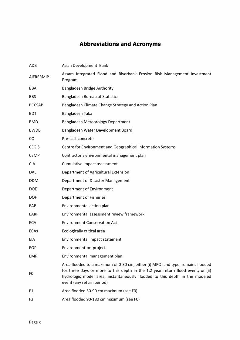
Abbreviations and Acronyms
ADB Asian Development Bank
AIFRERMIP Assam Integrated Flood and Riverbank Erosion Risk Management Investment
Program
BBA Bangladesh Bridge Authority
BBS Bangladesh Bureau of Statistics
BCCSAP Bangladesh Climate Change Strategy and Action Plan
BDT Bangladesh Taka
BMD Bangladesh Meteorology Department
BWDB Bangladesh Water Development Board
CC Pre-cast concrete
CEGIS Centre for Environment and Geographical Information Systems
CEMP Contractor’s environmental management plan
CIA Cumulative impact assessment
DAE Department of Agricultural Extension
DDM Department of Disaster Management
DOE Department of Environment
DOF Department of Fisheries
EAP Environmental action plan
EARF Environmental assessment review framework
ECA Environment Conservation Act
ECAs Ecologically critical area
EIA Environmental impact statement
EOP Environment-on-project
EMP Environmental management plan
F0
Area flooded to a maximum of 0-30 cm, either (i) MPO land type, remains flooded
for three days or more to this depth in the 1:2 year return flood event; or (ii)
hydrologic model area, instantaneously flooded to this depth in the modeled
event (any return period)
F1 Area flooded 30-90 cm maximum (see F0)
F2 Area flooded 90-180 cm maximum (see F0)
Page xi
F3 Area flooded 180-300 cm maximum (see F0)
F4 MPO land type, over 300 cm maximum 3-day flood depth, 1:2 event
FAO Food Agriculture Organization
FAP Flood Action Plan
FRERMIP Flood and Riverbank Erosion Risk Management Investment Program
FW Future-with-project
FWO Future-without-project
GRC Grievance Redress Committee
GPA Guidelines for Project Assessment
IEE Initial environmental examination
IFC International Finance Corporation
ISPMC Institutional Strengthening and Project Management Consultant
IUCN International Union for Conservation of Nature
JMREMP Jamuna Meghna River Erosion Mitigation Project
JVT Joint Verification Team
MFF Multi-tranche financing facility
MPO Master Planning Organization
NGO Non-governmental organization
NWRD National Water Resources Database
PC Public consultation
PMBP Padma Multipurpose Bridge Project
PMO Project Management Office
PPTA Project preparation technical assistance
PWD Public Works Department (denotes survey datum)
RCC Reinforced cast concrete
SRDI Soils Resources Development Institute
UNEP United Nations Environment Programme
WARPO Water Resources Planning Organization
Page xii
Glossary
Bengali terms and place names
Aman Rice planted in Kharif and harvested in Rabi
Aus Rice planted and harvested in Kharif
Beel Seasonal or perennial water body located in low-lying area of the floodplain
Boro Rice planted in Rabi and harvested in Kharif
Brahmaputra,
Jamuna,
Ganges,
Padma
In northwestern Bangladesh, the Brahmaputra changes name to Jamuna at its
confluence with the much smaller Teesta. Further downstream, the Jamuna and
Ganges flow together to create the Padma. Flood and Riverbank Erosion Risk
Management Investment Program (FRERMIP) covers 60 km of the Jamuna, 20 km
of the Ganges, and the entire 100 km of the Padma.
Jhupri With reference to housing, construction of mud walls, earth floor, thatch or CI
sheetroof.
Kutcha With reference to housing, construction of wood, bamboo, and other local
materials
Khal Channel
Kharif Monsoon season; in Bangladesh, generally Mar-Oct
Kum Deep areas of water bodies eg river scours, used by fish as shelter areas
Mauza Jurisdictional unit without administrative offices, upazila subunit
Pukka With reference to housing, construction entirely of concrete, cement, and iron.
Rabi Winter season; in Bangladesh, generally Nov-Feb
Upazila Administrative unit, district subunit
English terms
Flood land
type
classification
Definition 1: The flood land types (F0 to F4) defined by Master Plan Organization
classify agricultural land in terms of the normal flooding characteristics that drive
farmer choice of rice variety for a particular location: by three-day duration flood
depth in the 1:2 year return period flood event.1 Land that remains flooded for
three days or more to a maximum depth of 0-30 cm is classified F0 “flood free.”
Land that floods 30-90 cm is classified F1, 90-180 cm F2, 180-300 cm F3, and over
300 cm F4. Within a given area, the F0-F4 values do not vary from year to year.
They can however change in response to interventions that modify flood hydrology
eg. flood embankments, drainage enhancements.
Definition 2: The land type designators F0-F4 are used by Bangladesh flood
1Master Plan Organization (MPO). 1987. “Agricultural Production System”. Technical Report No. 14.Dhaka.

Page xiii
modellers to refer to the amount of land that floods instantaneously to the
requisite depth interval in a numerical model of a flood event of any return period.
In this formulation (which is conceptually different from and fundamentally
incompatible with MPO’s), the F0-F4 areas vary with return period; and, for the 1:2
year classification, the modeling classification, relative to the MPO values, may be
biased towards deeper flooding given that it uses a less stringent flood duration
criterion (instantaneous rather than three-day).
Revetment Generally, retaining wall or facing of masonry or other material, supporting or
protecting a rampart, wall, embankment, etc. Specifically in this context, erosion-
resistant materials placed directly on a streambank to protect the bank from
erosion.
Page xiv
Executive Summary
Introduction
This report presents the findings of an Environmental Impact Assessment (EIA) carried out under the ADB project preparation technical assistance (PPTA) Main River Flood and Bank Erosion Risk Management Program (PPTA No. 8054 BAN). This EIA assesses the three Subprojects proposed for inclusion in Tranche 1 of ADB the Flood and Riverbank Erosion Risk Management Investment Program (FRERMIP, Project No. 44167-013). FRERMIP is a proposed Asian Development Bank (ADB)-funded multi-tranche financing facility (MFF) 2 with the Bangladesh Water Development Board (BWDB) as the Executing Agency and the Department of Disaster Management (DDM) as Implementing Agency for community-based flood risk management measures.
Program outputs will (i) strengthen the flood and riverbank erosion management system, and (ii) establish, at priority erosion sites, sustainable, integrated non-structural and structural risk management measures. The MFF would provide a loaned amount of approximately US$250 million in three tranches beginning in mid-2014 and concluding in mid-2023. The initial Tranche-1 receives external financing of US$ 75 million for total project cost of US$ 104 million.
Tranche 1 meets criteria for GOB environment category Red, and has been classified ADB environment category A. Environmental safeguards required by GOB and ADB for Tranche 1 are addressed by this EIA. The required environmental safeguards for Tranches 2 and 3 are set forth in a separate Environmental Assessment and Review Framework (EARF) document.
Critical Facts
The Context - FRERMIP
FRERMIP aims to sustain incomes and livelihoods of people living along selected reaches of Jamuna, Ganges, and Padma Rivers by enhancing resilience to flooding and to riverbank erosion through a mix of structural and non-structural measures. After initially protecting critically eroding riverbanks at priority areas, the program plans to move to more systematic riverbank stabilization, potentially leading towards river-reach stabilization during later tranches. The stabilization approach will make use of the currently ongoing consolidation of the river morphology developing towards a more accentuated channel pattern similar to the one observed in the 1970s, before the dramatic widening (from the 1970s to 2000s) took place. In parallel existing, degraded or eroded embankment lines, such as the Brahmaputra Right Embankment will be restored and extended to arrive at reliable flood protection for the large population living on the floodplain along the main rivers. The community-based flood risk management component aims to increase resilience and preparedness of the population for the residucal risk, for example if existing embankments unexpectedly breach.
2 The MFF FRERMIP consists of three individual loans for three individual, however systematically developing phases (called
tranches in ADB’s terminology) of interventions at three priority sites along the lower Jamuna and upper Padma Rivers. The cascading loans are packaged into a Program with a duration of 9 years, while the three tranches (phases) overlap and are scheduled for typically 4-years duration. Each tranche or loan is called Project with interventions at different Sub-project sites.
Page xv
FRERMIP as whole aims to reduce the flood risk at three priority subprojects by providing new and rehabilitated embankments, leaving distributaries open, along selected reaches of the Jamuna and Padma Rivers. To protect these embankments, river banks will be progressively stabilized, starting at critically eroding reaches. Over time, and in conjunction with other government programs this approach may lead to a general river stabilization with less channels potentially having some similarity to the river system before the passing of the sediment wave of the Great Assam
Earthquake. In parallel to this study, Government investigates other river restoration alternatives3.
Siting of physical works for FRERMIP will be planned using an innovative dynamic methodology that responds to evolving river behaviour (“adaptive approach”).
The anticipated benefits are considerable: (i) reduced loss of agricultural and other land to river erosion, (ii) reduced flood damage to agriculture (etc) and (iii) increased agricultural production on less-flooded agricultural land.
The Assessed Project
The assessed Project is the proposed Tranche 1 of the MFF. Tranche 1 consists of three Subprojects: Jamuna Right Bank 1 (JRB-1), Jamuna Left Bank 2 (JLB-2), and Padma Left Bank 1 (PLB-1). JLB-2 and PLB-1 physical works consist of riverbank-erosion protection works along critically eroding areas. JRB-1 consists of very limited riverbank-erosion protection works in support of existing works and the restoration of degraded and eroded flood embankments, specifically a section of the Brahmaputra Right Embankment. Flood embankments will also be rehabilitated behind the JLB-2 and PLB-1 erosion protection works, but not until Tranche 2. These embankments do not meet ADB criteria for “associated facilities” of Tranche 1 and therefore are not included in this EIA analysis.
Significant Findings
JRB-1 Flood Embankment Potential Impacts
JRB-1 includes for a new/restored (10 km section of Brahmaputra Right Embankment destroyed in the mid-1990s) and rehabilitated flood embankments. The embankment will reduce flood depth and duration so as to reduce flood damage to crops and infrastructure, and to induce greater economic investment and productivity in floodplain agriculture and other activities by reducing flood risk.Currently, JRB-1 seasonally flooded land (i.e. within the proposed flood-protected area) consists of 12,000 ha that is flooded to 120-360 cm (F3 land type) and 4,000 ha that is deeply flooded to >360 cm (F4 land type). Of this, JRB-1 will transform about 40 per cent (6,600 ha) to flood-free conditions (F0 land type, 0-30 cm). Another 10 per cent (1900 ha) will be converted to moderately-flooded conditions (F1 and F2 land types, 30-120 cm). These hydrologic changes within the proposed JRB-1 flood-protected area have numerous potential secondary impacts. Intended beneficial impacts are significantly reduced flood damage to agriculture and infrastructure; increased cultivated area and cropping intensity; and the resulting increases in agriculture / aquaculture production.
Several negative impacts may occur without mitigation measures. Floodplain aquatic (wetland) habitats will be degraded or extirpated due to reduced flooded area, depth, and duration (mentioned above); reduced hydrologic connectivity; and physiochemical / water quality changes.
3 The feasibility study of Capital Dredging and Sustainable River Management in Bangladesh currently investigates one
single and and one multiple-channel option for Jamuna and Padma as first step towards the development of a river stabilization plan. The final report is expected in early 2014. Building on the Capital Dredging study and the initial morphological assessment of potential future channel patterns conducted as part of this feasibility study, the FRERMIP will conduct a comprehensive river stabilization plan to identify potential stabilization solutions, to be implemented in an adaptive and phased manner, with minimal impacts on the river and char environment.
Page xvi
This in turn will adversely affect floodplain-dependent openwater fish species migration, population levels, and catch levels, as well as wetland biodiversity, services, and products more generally. These impacts can in turn adversely affect the nutrition, health, and economic status of poor people. The embankment can impede cross-drainage resulting in drainage congestion, adversely affecting agriculture within the protected area, and block the movement of migrating fish.
The assessed status of fish migration in the study area is moderate to poor. The restored embankment forsees regulator rehabilitation and a number of additional regulators, allowing for all-year round flow in internal rivers and khals, such as the Hurashagar including certain limited flooding in places where distributaries branch off the main river. In addition, the more concentrated fish migration route through tributaries and distributaries (Hurashagar/Baral and Karatoya will be left unregulated.
Flood-control-led expansion of high-yielding varieties (HYVs) may increase utilization of ground water and surface water for irrigation, and may increase fertilizer and pesticide usage, that in turn may adversely affect water quality and availability for other uses or at other locations. Newly flood-free lands may have less than optimal residual moisture for winter agriculture, compromising yields or causing high irrigation water consumption and costs in these areas. The sandy subsoil strata have generally high permeability, which reduces the risk of general groundwater depletion. In addition the embankment is left open to the Karatoya River during Tranche-1, which allows for periodic flooding.
Provision of embankment flood protection typically stimulates accelerated investment in the protected area. This project-induced investment has obvious economic benefits but paradoxically it also has less obvious costs: over time, an increasing amount of infrastructure, and potentially an increasing number of lives, come to be located in lower-lying areas compared to the without-project situation. Embankments can greatly reduce but not entirely eliminate the flood risk to such areas, as embankments can fail for various operational, hydrologic, hydraulic, and geotechnical reasons. Best-practice flood damage reduction assessment methodologies take this phenomenon into account, such as planned under the community-based flood risk management component that addresses the residual risk and increases resilience and preparedness.
JRB-1, JLB-2, and PLB-1 Riverbank Protection Works Potential Impacts
The Brahmaputra System (including the braided Brahmaputra in Assam and the Jamuna in Bangladesh as well as the Padma and Lower Meghna) is a dynamic system that is characterized by continuous, unpredictable changes. In addition, the system was strongly influenced by the passing sediment wave triggered by the 1950 Great Assam Earthquake. The river belt has developed from a more stable single or double channel pattern in the late 1960s to a vastly expanded braided belt with numerous main, medium, and minor channels in the early 2000. The reach downstream of Bangabandhu (Jamuna) Bridge still exhibited a largely single channel characteristic in the early 1970s, being 6 km wide. By 2000 the width exceeded 11 km. During this period of expansion densely populated fertile floodplain land converted into mostly low lying sand bars and chars. This process has changed the river environment, characterized by one or two pronounced deep channels to a multitude of shallower channels, many falling dry during the dry season.
More recently the Brahmaputra exhibits much less lateral erosion and slowly turns back to a more stable, natural channel pattern. This development has triggered Government’s initiative to study different options for “river restoration” supporting the natural process of consolidation and regaining some of the lost, densely populated floodplain land.
The environmental consequences of the transformation of the river environment from few deep channels into a vastly expanded, shallow braided belt were not systematically studied. Therefore its
Page xvii
environmental impact is non-quantifiable and in addition it is superimposed by dramatic population growth (from around 70 million to 150 million) with increasingly intensifying land use on the flood plains but also systematic river use, e.g. fishing with floating nets during the dry season.
Riverbank protection works at the three subproject sites has the purpose of protecting the existing floodplain habitat from continuous and systematic erosion. While the protection at the JRB-1 extends existing 10km long protection by 1km, new, several kilometer long riverbank protection at JLB-2 and PLB-1 is designed to protect valuable infrastructure and land from imminent erosion.
Riverbank protection works has numerous primary intended direct beneficial impacts. Along the erosion-protected sections, they reduce the risk that erosion of agricultural land will destroy livelihoods, impoverish vulnerable families, and result in displaces lacking options other than squatting on public lands or migrating to the Dhaka slums. Another intended direct benefit along erosion-protected sections is reduced risk of erosion damage to existing infrastructure (roads, settlements, etc), including flood embankment breaches.
An additional indirect or conditional benefit of erosion protection and channel stabilization works is achieved when such works are located in front of an existing or prospective flood embankment: stabilization of the impacts of that embankment. In particular, erosion protection works secure (decreases risks to) the economic benefits of embankment flood protection, thereby making them available to justify the costs of the erosion protection and embankment physical works construction, rehabilitation, and maintenance. This erosion protection impact is deemed indirect or conditional because its valence and magnitude is entirely dependent on, and can be evaluated only with reference to, the valence and magnitude of the impacts of the associated flood protection embankment.
River changes associated with Tranch 1 riverbank protection work were assessed through a specific morphology study carried out as part of this PPTA. The morphology study concludes that the initial (Tranche-1) riverbank protection works has little impact on the overall morphology of the Jamuna, including the immediate downstream areas. In all cases the work invites deeper channels along the protected bank but with expected little impact on downstream areas.
The morphology study also assessed the relevance of the built protection work on future potential channel options, part of larger-scale river stabilization plans. The non-symetric Jamuna Bridge has substantially changed the lower part of the Jamuna River, creating a large attached char at the right bank from the western bridge abutment to about Enayetpur, and resulted in a single channel in this reach, which is expected to remain stable without riverbank protection at both sides. Downstream, the river exhibits two channels, enclosing a large char. The initial morphological assessment indicates that this currently existing channel pattern is likely the most desirable for the future, meaning that the overall natural river pattern will not be altered by the proposed interventions nor being in conflict with likely future stabilization options, rendering the present work redundant. The same holds true for the situation in the upper Padma River, where the two-channel solution appears to be the best in the long run, also meaning that the existing conditions would not be altered and the riverbank protection would support the currently existing natural river pattern.
First studies on the interaction of riverbank protection works with the environment have been conducted in 2007 and 20114. The JMREMP, 2007 study found that there were more fish species and higher population numbers at protected banks, as opposed to unprotected banks. The size of the fish depends on the size of the voids in the protection, which means that large voids in concrete
4 JMREMP; 2007. Bank Protection and Fisheries at JMREMP two Sub-projects. Dr. Munir Ahmed, Special Report 24, May.
CEGIS, 2011: Final Report on Environment Impact Assessment (EIA) for Use of Sand-filled Geob-Bags Under Water; earlier the JMREMP design include an EIA and obtained environmental clearance from Government before starting the construction of geotextile bag revetments.
Page xviii
blocks tend to attrackt larger fish, specifically carnivores, but fewer numbers, while geobags, having more but smaller voids, attract smaller fish in larger numbers. CEGIS, 2011 identified overall positive impacts of geotextile bag revetements on water resources, fisheries, the algae community, the ecosystem and the socio-economy. Important findings are that there is no change in water quality, the terrestrial habitat is protected, and the scocio-economic conditions are improved for the local population, including employment opportunities during construction, health and sanitation conditions, fishing opportunities, and especially the situation of women. Geotextile bag revetments might change the composition of fish species, alter the habitat of the benthic community, as well as cause local shifting of the migratory routes of the dolphins5 during construction. However, these effects are reversible and the constructed revetments do not impact on the free movement of dolphins and the benthic habitat is quickly restored over geobag revetments. With respect to the overall use of the recommended riverbank protection technology, CEGIS 2011 concludes: “Considering all environmental, social and technical consequences of the geobag use under water, it might be concluded that compared with CC block use alone, geo-bag use under water with CC block used above water is more environmentally sustainable, socially acceptable, technically feasible and economically cost effective if the quality requirements and design requirements are assured and monitored.”
Dolphins utilizing riverine habitats potentially affected by Tranche 1 are part of a trans-boundary (Bangladesh-India) population. Most international migration of Dolphins occurs within peri-border areas as short-range tributary-to-mainstem trips, but longer-range movements of individuals between the Tranche 1 influence area and India cannot be ruled out. Localized stable and deeper channels in front of Tranche-1 protective works are more attractive for dolphins as they provide preferred migration routes. First studies indicate that the proposed riverbank protection increases the amount of small fish, the main food for dolphins. The construction season lies outside of the migration season of the dolphins (during the rising and falling of flood waters) and does not overlap much with the surfacing time of the juvenile and neonate dolphins in the morning and afternoon-evening hours.
Land Acquisition, Resettlement, and Construction Impacts
The land acquisition and resettlement required by the implementation of physical works will be managed through the Resettlement Plan process.
Routine impacts of construction-phase activitieswill be managed through the inclusion of standard environmental safeguard clauses in construction contract bidding packages, Contractor’s Environmental Management Plans (CEMPs) and BWDB construction supervision.
Stakeholder Comments and Concerns
Two rounds of public consultation were undertaken during preparation of this EIA. The first presented the proposed project and EIA terms of reference to stakeholders for their review and suggestions, and the second presentedthe draft EIA results to stakeholders for their comments. Stakeholder concerns are of at most moderate significant, and are resolvable through continued dialogue and accommodation during design and implementation.
Recommended Actions
Overview
5 Dolphins normally chose the thalweg, i.e. the deeper part of the river for migration
Page xix
Mitigation of the aforementioned impacts is complex and challenging. It will not result in all residual impacts being reduced to insignificance, but it will reduce them to levels considered acceptable under the circumstances. To the extent possible, impacts will be mitigated through measures purpose-designed to the impact and setting. Many mitigation measures have been aggressively mainstreamed into the engineering designs, which also incorporate significant impact avoidance features e.g. leaving distributaries open and embankment vegetation and/or afforestation.
Recognizing potential cumulative effects when moving from emergency type riverbank protection
during an initial tranche towards more systematic river stabilization in the priority reaches during
following tranches, the first tranche will incorporate a comprehensive river stabilization study to
develop and assess potential future stabilization options as well as impacts and mitigation measures.
In addition, this study accounts for the potential cumulative and trans-boundary impacts from
potential other programs and projects by covering the whole Brahmaputra System from the
upstream areas at Kurigram in Bangladesh to the Bay of Bengal.
Environmental Management Plan
The Environmental Management Plan (EMP) sets for the mitigation and monitoring to be undertaken. Four mitigation packages address:
Construction-phase impacts. Management will be through the inclusion of standard environmental safeguard clauses in construction contract bidding packages, Contractor’s Environmental Management Plans (CEMPs) and BWDB construction supervision.
Impacts on critical habitats and trans-boundary/internationally migrating/threatened species: The proposed mitigation measures are modelled after the ongoing Wetland Biodiversity Rehabilitation Project of GIZ /Department of Fisheries/BWDB, currently under implementation in areas of Pabna adjacent to the JRB-1 project area..
Impacts on openwater fish biodiversity and production. Measures to mitigate these impacts (i) include openwater fisheries-related measures and (ii) expansion of aquaculture, particularly in areas benefitting from Project-led reductions in flood and erosion risk.
Land acquisition and resettlement impacts. Management measures are documented in Final Report, Annex J1 Resettlement Framework, and Annex J2, Resettlement Plan for Tranche 1.
The EMP will be implemented by the Project Management Unit supported by an Institutional Strengthening and Project Management Consultant (ISPMC) team that will include an environment specialist, as well as an implementing NGO and a separately hired specialist environmental management organization outlinng the establishment of a biodiversity sanctuary in line with gradually increasing river stabilization during the program. Implementation of EMP mitigation and monitoring activities will be scheduled to ensure that each type of safeguards measure is in place and operating effectively by the time each corresponding impact (construction- or implementation-phase) is triggered.
Future Mitiagtion Measures – Preparing for Tranche-2 and 3
While the tranche-1 project consists of limited riverbank protection measures and the
restoration/rehabiliation of an eroded/degraded embankment, future tranches plan to extend these
measures. The limited and isolated riverbank protection measures of Tanche-1 do not change the
existing channel pattern, as established by the morphological study. However, follow-on tranches,
part of the total program, could do so when existing, initial work gets extended over greater length
Page xx
of some ten kilometers. As such, the proposed Tranche-1 combines construction measures with
very limited morphological impact with two extensive studies on (i) potential ways towards larger
river-reach stabilization and (ii) the establishment of a river sanctuary.
Potential alternative river-reach stabilization alternatives, impacts, and mitigation measures will be
assessed during Tranche-1 through several systematic studies. During the first two years of
Tranche-1 a systematic river stabilization study will be conducted. The river stabilization study will
build on the ongoing natural development towards a more consolidated channel pattern.
Alternative solutions will be developed how to support this channel pattern towards a more
systematic stabilization of the lives on the floodplain. Social and environmental consideratiosn will
form an integral part of the study in order to determine the impacts of different stabilization
options, but also collect missing data and broaden the understanding about critical social and
environmental parameters. The study results are alternative solutions for river-reach stabilization
that accounts for the multitude of different drivers, outline least-impact solutions, identify the
optimimal alternative, and design the following tranche work.
Starting from there, the feasibility study for tranche-1, continaing environmental assessment, will be
supplanted by by a specialist sanctuary study that details the requirements for a river sanctuary in
response to negative impacts from river stabilization. The sanctuary study is part of the Tranche-1
design and scheduled for implementation during year-3 and 4. It will specifically address impacts on
critical habitats and trans-boundary/internationally migrating/threatened species, following (i) the
Padma Bridge Project terms of reference for biodiversity baseline studies and monitoring, and a
biodiversity sanctuary; and (ii) India’s recently-promulgated Dolphin conservation action plan, as
well as (iii) assessing migratory bird impacts. It will also attempt to develop measures that enhance
the river biodiversity, specifically providing sheltered aquatic habitats.
The EIA for Tranche-2, part of the feasibility study, continues to aggressively mainstream
environmental aspects into the project design. In addition, the EIA will follow a parallel approach by
building on the river stabiliuzation plan and the sancturary study, to (i) address remaining
uncertainties associated with the database on the impacts of riverbank protection on the river
habitat, while (ii) continuing to reduce the imminent erosion risk to the livelihoods of a large number
of mostly poor people on the floodplain.
Design- and Implementation-Phase Public Consultation
Stakeholder consultation will continue during subproject design and implementation to provide information to stakeholders about the project and to receive their input and concerns.Meetings will include in particular households and persons affected by resettlement (AHs and APs) and other adverse environmental and social impacts. At these meetings, information about designs, impacts, and mitigation and monitoring measures, including specific resettlement entitlements, will be disclosed verbally and in Bangla-language information handouts.
Grievance Redress Mechanism
At each Tranche 1 subproject location, a local Grievance Redress Committee (GRC) will be set up during the design stage and continue in operation through the implementation phase. Each GRC will consist of a BWDB representative, the concerned Union Parishad chairperson(s), and a representative of resettlement-affected persons for subprojects with resettlement. GRCs will resolve grievances within one month of receipt. Aggrieved personsare free to access the country’s legal
Page xxi
system regardless of GRC involvement. In addition, a Joint Verification Team (JVT) is responsible to address complaints related to the land acquisition process.
Reporting and Monitoring
Environmental monitoring reports will be issued for bi-annually disclosure on ADB’s website. The environmental monitoring reports will also be incorporated into the December and July version of the quarterly progress report, which is at the beginning and end of every construction season. Environmental monitoring reports will be prepared by the Project Management Office, under the direction of the nominated environmental officer with the help of the consulting team’s environmental specialist.
Monitoring will be undertaken for timely detection of conditions requiring remedial measures; to provide information on mitigation and institutional strengthening progress; and to assess compliance with required safeguards. Overall implementation progress including EMP implementation will be reviewed during periodic review missions involving ADB, the Implementing Agency, the Executing Agency, and the Implementation Consultant.

Page 1
1. Introduction
1.1 Overview
1. The project area of the Flood and Riverbank Erosion Risk Management Investment Program (FRERMIP)comprises about 2,44,000 ha of which approximately 13 percent are occupied by rivers and a very minor percentage (approximately 0.6 percent) is occupied by other water bodies. The hydrology of the area is dominated by the three major rivers, the Jamuna, the Ganges and the Padma.
2. FRERMIPis an Asian Development Bank (ADB) multi-tranche financing facility (MFF) being prepared in partnership with the Government of Bangladesh (GOB). It aims to sustain incomes and livelihoods of people living along the three main rivers of Bangladesh – the Jamuna, the Ganges, and the Padma – by enhancing resilience to flood and riverbank erosion. Project outputs will (i) strengthen the flood and riverbank erosion management system, and (ii) establish, at priority erosion sites, sustainable, integrated non-structural and structural risk management measures. The MFF would provide a maximum loaned amount of approximately US$250 million over a nine-year period in three tranches of USD60 million, USD100 million, and USD90 million respectively.
3. This report presents the findings of an Environmental Impact Assessment (EIA) of the three Subprojects proposed for inclusion in Tranche 1: Jamuna Right Bank (JRB) 1, Jamuna Left Bank (JLB) 2, and Padma Left Bank (PLB) 1.
4. A companion document, the Environmental Assessment and Review Framework (EARF) sets forth (i) the safeguards procedures to be followed during subsequent MFF tranches, (ii) safeguards-related criteria to be considered in the selection of subprojects for subsequent tranches, and, with regard to Executing Agency safeguards capacity, (iii) an assessment and recommendations for appropriate institutional strengthening.
5. The EIA and EARF were prepared as part of the Tranche 1 feasibility studies under the ADB project preparation technical assistance project Main River Flood and Bank Erosion Risk Management Program(PPTA No. 8054 BAN).
1.2 Objectives
6. The main river flood and bank erosion risk management program (FFERMIP) is the follow-on project of the Jamuna-Meghna River Erosion Mitigation Project (JMREMP). It aims to sustain incomes and livelihoods of people living along the three main rivers of Bangladesh through establishing integrated non-structural and structural risk management measures at priority erosion sites and addressing their sustainability.
1.3 Project area
7. The project area of the proposed investment encompasses the river reach of the Jamuna River from below the Jamuna Bridge and the proposed Ganges Barrage site to Chandpuron the Lower Meghna. The Jamuna and Ganges river courses downstream of these two major river works are somewhat independent of upstream river developments.
8. These upstream areas are expected to be included in the Ganges Barrage project and the World Bank-supported Riverbank Improvement Project (RBIP). The project area covers a total population of 10.5 million in 40 upazilas and 431 unions, with an average population density of nearly 1,600 persons per km² of floodplain land.
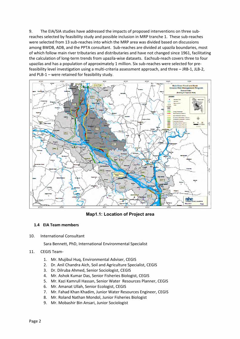
Page 2
9. The EIA/SIA studies have addressed the impacts of proposed interventions on three sub-reaches selected by feasibility study and possible inclusion in MRP tranche 1. These sub-reaches were selected from 13 sub-reaches into which the MRP area was divided based on discussions among BWDB, ADB, and the PPTA consultant. Sub-reaches are divided at upazila boundaries, most of which follow main river tributaries and distributaries and have not changed since 1961, facilitating the calculation of long-term trends from upazila-wise datasets. Eachsub-reach covers three to four upazilas and has a population of approximately 1 million. Six sub-reaches were selected for pre-feasibility level investigation using a multi-criteria assessment approach, and three – JRB-1, JLB-2, and PLB-1 – were retained for feasibility study.
Map1.1: Location of Project area
1.4 EIA Team members
10. International Consultant
Sara Bennett, PhD, International Environmental Specialist
11. CEGIS Team-
1. Mr. Mujibul Huq, Environmental Adviser, CEGIS 2. Dr. Anil Chandra Aich, Soil and Agriculture Specialist, CEGIS 3. Dr. Dilruba Ahmed, Senior Sociologist, CEGIS 4. Mr. Ashok Kumar Das, Senior Fisheries Biologist, CEGIS 5. Mr. Kazi Kamrull Hassan, Senior Water Resources Planner, CEGIS 6. Mr. Amanat Ullah, Senior Ecologist, CEGIS 7. Mr. Fahad Khan Khadim, Junior Water Resources Engineer, CEGIS 8. Mr. Roland Nathan Mondol, Junior Fisheries Biologist 9. Mr. Mobashir Bin Ansari, Junior Sociologist
Page 3
10. Mr. Saifuddin Mahmud, Junior Sociologist 11. Mr. Zahid Hasan Dhali, Junior Agriculturist
1.5 Report Format
12. This EIA report has the following 10 (ten) chapters:
Chapter 1: Background, study area, objectives, scope of work in addition to presenting the list
of the multi-disciplinary EIA study team members.
Chapter 2: The policy, legal and administrative framework.
Chapter 3: Approach and Methodology followed for conducting the EIA study.
Chapter 4: Description of the project including the present status of the infrastructure and the
proposed interventions.
Chapter 5: Environmental and Social baseline condition in respect of meteorology, seismicity,
water resources, land resources, agriculture, livestock, ecological resources and
socio-economic condition.
Chapter 6 Public consultation and disclosure
Chapter 7: Important environmental and social components likely to be impacted by the
proposed rehabilitation plan.
Chapter 8: Assessment of the impacts of the proposed rehabilitation plan on the environmental
and social components pertaining to water resources, land resources, agriculture,
livestock, ecological resources and socio-economic condition.
Chapter 9: Environmental Management Plan
Chapter 10: Conclusion and recommendations.
Page 4
2. Policy, Legal and Administrative Framework
2.1 Introduction
13. This Chapter summarizes the policies, laws, regulations, guidelines, and international environmental agreements to which Bangladesh is a party that are relevant to this environmental assessment, including all environmental safeguards and environmental management guidance relevant to the assessed project.
2.1.1 Environmental Protection Policies and Legislation
a. National Conservation Strategy (1992)
14. National Conservation Strategy (NCS) was drafted in late 1991 and submitted to the Government in early 1992. This was approved in principle. However the final approval of the document is yet to be made by the government.
b. National Environmental Policy (1992)
15. Bangladesh National Environmental Policy of 1992 sets out the basic framework for environmental action, together with a set of broad sectoral action guidelines. The Environment Policy provides the broader framework of sustainable development in the country. It also states that all major undertakings, which will have a bearing on the environment, (including setting up of an industrial establishment) must undertake an Initial Environmental Examination (IEE) and Environmental Impact assessment (EIA) before they initiate the project. The Environment Policy delineates the Department of Environment (DoE) as the approving agency for all such IEE/EIA’s to be undertaken in the country.
c. National Environmental Management Action Plan (NEMAP) (1995)
16. The National Environmental Management Action Plan (NEMAP) is a wide ranging and multi-faceted plan, which builds on and extends the statements set out in the National Environmental Policy. NEMAP was developed to address issues and management requirements for the period 1995 to 2005 and set out the framework within which the recommendations of the National Conservation Strategy are to be implemented.
17. NEMAP has the following broad objectives:
Identification of key environmental issues affecting Bangladesh;
Identification of actions necessary to halt or reduce rate of environmental degradation;
Improvement of the natural and built environment;
Conservation of habitats and biodiversity;
Promotion of sustainable development; and
Improvement in the quality of life of the people.
d. Bangladesh Climate Change Strategy and Action Plan (BCCSAP) 2009
18. The Bangladesh Climate Change Strategy and Action Plan 2009 is built on the following six pillars:
(i) Food security, social protection and health to ensure that the poorest and most vulnerable in society, including women and children, are protected from climate change and that all
Page 5
programs focus on the needs of this group for food security, safe housing, employment and access to basic services including health;
(ii) Comprehensive disaster management to further strengthen the country’s already proven disaster management system to deal with increasingly frequent and severe natural calamities;
(iii) Infrastructure to ensure that existing assets are well maintained and fit-for-purpose and that urgently needed infrastructure is put in place to deal with the likely impact of climate change;
(iv) Research and knowledge management to predict the likely scale and timing of climate change impacts on different sectors of the economy and socio-economic groups, to underpin future investment strategies and to ensure that Bangladesh is networked with the latest global thinking on science and best practices of climate change management;
(v) Mitigation and low carbon development to ensure low carbon development options and implement these as the country’s economy grows over the coming decades and the demand for energy increases; and
(vi) Capacity building and institutional strengthening to enhance the capacity of government ministries and agency, civil society and the private sector to meet the challenges of climate change and mainstream them as part of development action.6
2.1.2 Environmental Conservation Act (1995) and Amendments
ECA ‘95
19. The Bangladesh Environment Conservation Act of 1995 (ECA ’95), with its 2000 and 2002 amendments (see below), is currently the main legislation for environment protection in Bangladesh. The Act addresses environment conservation, environmental standards development and environment pollution control and abatement. It replaced the earlier Environment Pollution Control Ordinance of 1977, now repealed.
20. The main objectives of ECA ’95 are (i) conservation and improvement of the environment; and (ii) control and mitigation of pollution of the environment.
21. The main strategies of ECA ’95 can be summarized as:
Declaration of ecologically critical areas and restriction on the operations and processes, which can or cannot be carried out/initiated in the ecologically critical areas;
Regulations in respect of vehicles emitting smoke harmful for the environment;
Environmental clearance;
Regulation of the industries and other development activities’ discharge permits;
Promulgation of standards for quality of air, water, noise and soil for different areas for different purposes;
Promulgation of a standard limit for discharging and emitting waste; and
Formulation and declaration of environmental guidelines.
22. ECA (1995) requires environmental clearance from DoE of industrial units and projects. Under Section 12 of the Act, “no industrial unit or project shall be established or undertaken without obtaining environmental clearance from the Director General in the manner prescribed by the Rules.” The Act requires project proponents to obtain Environmental Clearance from the Director General (DG) DoE prior to construction.
6Government of Bangladesh. 2008. “Bangladesh Climate Change Strategy and Action Plan.”
http://www.moef.gov.bd/climate_change_strategy2009.pdf
Page 6
23. A schedule attached to the Environment Conservation Rules 1997 categorizes projects as Green, Orange A, Orange B, and Red, and identifies for each category the level of environmental impact assessment required and other clearance application procedures and information.
24. An appeal procedure is available for proponents who fail to obtain clearance. Failure to comply with any part of this Act may result in punishment to a maximum of three years imprisonment or a maximum fine of BDT 300,000 or both. The Department of Environment (DOE) executes the Act under the leadership of the DG.7
ECA Amendment 2000
25. This amendment focuses on (i) ascertaining responsibility for compensation in cases of damage to ecosystems, (ii) increased provision of punitive measures, both fines and imprisonment, and (iii) fixing authority on cognizance of offences.
ECA Amendment 2002
26. This amendment sets forth: (i) restrictions on polluting automobiles; (ii) restrictions on the sale and production of environmentally harmful items like polythene bags; (iii) assistance from law enforcement agencies for environmental actions; (iv) punitive measures; (v) authority for trials of environmental cases.
ECA Amendment 2010
27. This amendment of the Act deals with: (i) declaration of ecologically critical areas (ECAs); (ii) prohibition of harmful work and processes from being begun or continued in such areas; (iii) management systems for ECAs; (iv) restriction of hill cutting and razing; (v) restriction of hazardous waste production, import, collection, transportation, etc; (vi) prohibition of pollution created by ship breaking or cutting; (vii) prohibition of infilling of demarcated wetlands and waterbodies; (viii) determination of responsibility for compensation in cases of ecosystem damage; and (ix) restrictions on various industries and projects in various locations.
Environment Court Act (2010)
28. The Environmental Court Act (2010) provides for the establishment of an environment courts and amends the prevailing act to accelerate punishment of environment-related crime. This act defines: the jurisdiction of the environment court; the penalty for violating the court’s order; the trial procedure in the special magistrate’s court; the appeal and investigation procedures; and it gives the environment court authority to enter, search, and inspect.
Environmental Conservation Rules (1997)
29. These were the first Rules promulgated under the Environmental Conservation Act of 1995. These Rules defined categories of industries and projects and the types of environmental assessments each requires. There have been three amendments to these Rules, in February and August 2002, and in April 2003.
30. Among other things, the Rules set forth (i) National Environmental Quality Standards for ambient air, various types of water, industrial effluent, emission, noise, vehicular exhaust etc.;
7Government of Bangladesh. 1995. “The Bangladesh Environment Conservation Act, Act No. 1 of 1995”
http://www.moef.gov.bd/html/laws/env_law/153-166.pdf
Page 7
(ii) the requirement for and procedures to obtain environmental clearance; and (iii) the requirement for IEE/EIAs for the various categories of industries and projects.8
EIA Guidelines for Industries (1997)
31. The EIA Guidelines for Industries (1997) sets forth lEE and EIA requirements for various industrial sectors and activities.
Environmental Clearance Procedure for Red Category Projects
32. Figure 4.2 shows the application procedure for obtaining site / environmental clearance. To obtain an environmental clearance certificate for category Red projects (the category of the Project documented here), the following documents and materials must be submitted with the application to DoE:
Project feasibility report, where applicable
Environmental impact assessment report
Environmental management plan
No Objection Certificate from relevant local authority (where applicable)
Other necessary information, where applicable
2.1.3 Water Policies, Plans,and Legislation
a) National Water Policy (1999)
33. The National Water Policy, 1999, aims to ensure efficient and equitable management of water resources; proper harnessing and development of surface and ground water; availability of water to all concerned; and institutional capacity building for water resource management. It also addresses issues such as river basin management; water rights and allocation; public and private investment; water supply / sanitation; and water needs for agriculture, industry, fisheries, wildlife, navigation, recreation, environment, preservation of wetlands, etc. It does not address issues like consequences of trans-boundary water disputes and watershed management.
34. Specifically with regard to river flooding and erosion, it states that through its responsible agencies Government will:
(i) Develop early warning and flood-proofing systems; designate flood risk zones; (ii) Take appropriate measures to provide desired levels of protection for life, property,
vital infrastructure, agriculture and wetlands guided by these principles:
(a) Highest priority is providing full flood protection to economical important regions
(eg metropolitan areas, sea and air ports, export processing zones);
(b) A reasonable degree of flood protection will be gradually provided to other critical
areas (district / upazila towns, important commercial centers and historic places);
(c) in other areas (except those protected by existing flood control infrastructure),
people will be motivated to develop flood proofing measures (eg raised platforms
for homesteads, market places, educational institutions, community centers) and
adjust cropping patterns to suit the flood regime;
8Government of Bangladesh. 1997. Environment Conservation Rules, 1997, as Amended 2002 and 2003.
http://www.doe-bd.org/2nd_part/179-226.pdf
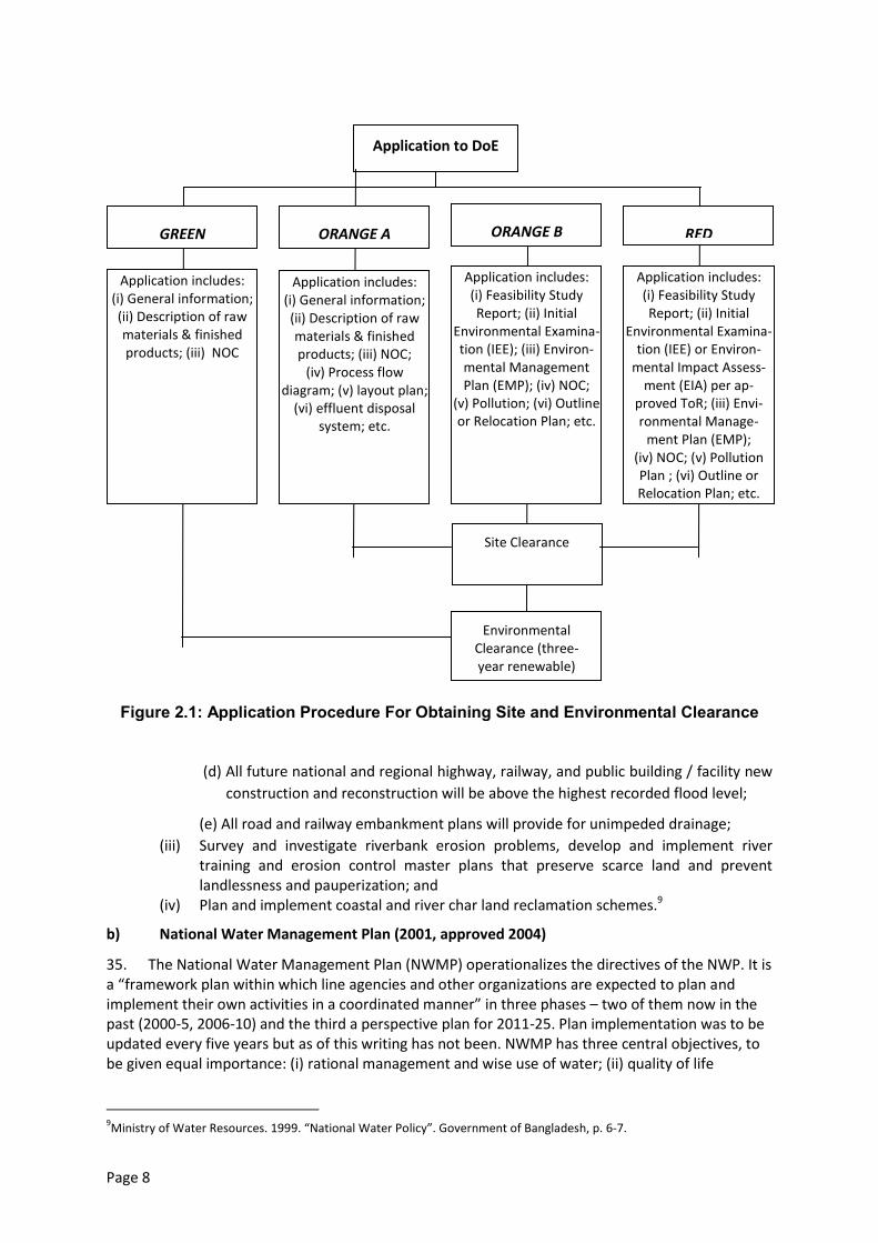
Page 8
Figure 2.1: Application Procedure For Obtaining Site and Environmental Clearance
(d) All future national and regional highway, railway, and public building / facility new
construction and reconstruction will be above the highest recorded flood level;
(e) All road and railway embankment plans will provide for unimpeded drainage;
(iii) Survey and investigate riverbank erosion problems, develop and implement river training and erosion control master plans that preserve scarce land and prevent landlessness and pauperization; and
(iv) Plan and implement coastal and river char land reclamation schemes.9
b) National Water Management Plan (2001, approved 2004)
35. The National Water Management Plan (NWMP) operationalizes the directives of the NWP. It is a “framework plan within which line agencies and other organizations are expected to plan and implement their own activities in a coordinated manner” in three phases – two of them now in the past (2000-5, 2006-10) and the third a perspective plan for 2011-25. Plan implementation was to be updated every five years but as of this writing has not been. NWMP has three central objectives, to be given equal importance: (i) rational management and wise use of water; (ii) quality of life
9Ministry of Water Resources. 1999. “National Water Policy”. Government of Bangladesh, p. 6-7.
Application to DoE
GREEN
Application includes: (i) General information; (ii) Description of raw materials & finished products; (iii) NOC
Application includes: (i) General information; (ii) Description of raw materials & finished products; (iii) NOC;
(iv) Process flow diagram; (v) layout plan;
(vi) effluent disposal system; etc.
Application includes: (i) Feasibility Study Report; (ii) Initial
Environmental Examina-tion (IEE); (iii) Environ-mental Management Plan (EMP); (iv) NOC;
(v) Pollution; (vi) Outline or Relocation Plan; etc.
Application includes: (i) Feasibility Study Report; (ii) Initial
Environmental Examina-tion (IEE) or Environ-
mental Impact Assess-ment (EIA) per ap-
proved ToR; (iii) Envi-ronmental Manage-
ment Plan (EMP); (iv) NOC; (v) Pollution Plan ; (vi) Outline or Relocation Plan; etc.
Site Clearance
Environmental Clearance (three-year renewable)
ORANGE A ORANGE B RED
Page 9
improved by equitable, safe, reliable access to water for production, health, and hygiene; (iii) sufficient, timely, clean water for multi-purpose use and for preservation of aquatic ecosystems. With regard to the main rivers, NWMP articulates the main aims as ensuring comprehensive structural and non-structural development and management for multipurpose use; integrating the needs of all users through comprehensive planning of river systems by the responsible agencies and working towards international river basin planning (p. 9). Several national programmes of main rivers studies and research (p. 17), and twelve main rivers projects (p. 27), are identified.10
c) Guidelines for Environmental Assessment of Water Management (Flood Control, Drainage
and Irrigation) Projects (approved 2003, published 2005)
36. The 2005/2003 guidelines are an update of 1992 guidelines issued by Flood Plan Coordination Organisation (FPCO) to govern assessment of Flood Action Plan (FAP) projects and programmes. The document sets out the framework for environmental assessment of flood control, drainage, and irrigation projects in Bangladesh; it aims both to educate and to guide project planning. It primarily addresses project planning (project identification, pre-feasibility, feasibility), but does include information on the preparation of management recommendations for later project stages (design, construction, operation, monitoring, decommissioning). The guidelines emphasize the need for wider knowledge of measures and procedures such as EIA to prevent future environmental damage, in light of the “widespread and serious environmental damage done in the past by physical interventions affecting the water sector (largely before formal assessment procedures were developed).” The stated purpose is “not to prevent development, but to ensure that it proceeds with due regard for the environment.”11
d) National Policy for Safe Water Supply and Sanitation (1998)
37. The National Drinking Water Supply and Sanitation Policy (1998) goal is accessibility to all of water and sanitation services within the shortest possible time at a price that is affordable to all. The Policy will be achieved through strategies formulated at various levels in consultation with the Ministry of Planning. Policy objectives are (i) to improve the standard of public health and (ii) to ensure an improved environment. Policies for rural and urban areas are presented separately as they differ in institutional aspects, content, and magnitude.
e) National Policy for Arsenic Mitigation (2004)
38. The National Policy for Arsenic Mitigation (2004) provides a guideline for mitigating the effect of arsenic on people and environment in a realistic and sustainable way. It supplements the National Water Policy (1998) and the National Policy for Safe Water Supply and Sanitation (1998) in fulfilling national goals related to poverty alleviation, public health, and food security.
39. The Policy states that access to safe water for drinking and cooking shall be ensured through implementation of alternative water supply options in all arsenic-affected areas. Arsenic mitigation activities under the Policy will focus on public awareness, alternative arsenic safe water supply, diagnoses and management of patients and capacity building. The national arsenic programme is to encourage and promote research and development on the impact of arsenic on water supplies, health, food, and agriculture.12
f) Inland Water Transport Authority Ordinance (1958)
10
Water Resources Planning Organization (WARPO). 2001. “National Water Management Plan”. Ministry of Water
Resources, Government of Bangladesh.http://www.warpo.gov.bd/nwmp.html 11
Water Resources Planning Organization. 2005. “Guidelines for Environmental Assessment of Water Management (Flood Control, Drainage and Irrigation) Projects”. Dhaka, Bangladesh: National Water Management Plan Project, Ministry of Water Resources, Government of the People’s Republic of Bangladesh. 12
Government of Bangladesh. 2004. “National Policy for Arsenic Mitigation”. Department of Public Health Engineering
(DPHE).http://www.dphe.gov.bd/pdf/National-Policy-for-Arsenic-Mitigation-2004.pdf
Page 10
40. This ordinance sets up an authority for the development, maintenance and control of inland water transport and certain inland navigable waterways. The authority is mandated to perform functions including carrying out river conservancy work; river training for navigation purposes and aiding navigation; drawing up dredging program requirements and priorities for efficient navigable waterway maintenance, reviving dead or dying rivers, channels, and canals, and development of new navigation waterways.13
2.1.4 Wildlife, Fisheries, Forestry, and Biodiversity Policies and Legislation
a) Bangladesh Wildlife (Protection and Safety) Act 2012
41. The Act:
Protects 1,307 species of plants and animals, including 32 species of amphibian, 154 species of reptile, 113 species of mammal, 52 species of fish, 32 species of coral, 137 species of mollusk, 22 species of crustacean, 24 species of insect, six species of rodent, 41 species of plant and 13 species of orchid. Of these, eight amphibian, 58 reptile, 41 bird, and 40 mammal species are listed as endangered in the IUCN Red Data Book (2000).
Mandates one to three years imprisonment, a fine of BDT 50,000 to 200,000, or both, for wildlife poaching, capturing, trapping, and trading, and for the purchase ofwild animals, parts of wild animals, trophies, meat or other products without licence.
Mandates two to seven years imprisonment and BDT 100,000 to 1 million fine or both, for killing an elephant or tiger; and 12 years plus BDT 1.5 million for repeat offenders.
Mandates five years imprisonment and BDT 200,000 fine for killing a cheetah, clouded cheetah, gibbon, sambar deer, crocodile, gavial, whale, and dolphin.
Mandates two years imprisonment and BDT 200,000 fine for killing a wild bird or migratory bird.
Empowers the Government to create an eco-park, safari park, botanical garden, or breeding ground on any state-owned forest land, land or water-body.
Mandates two years imprisonment for farming, woodcutting, burning, and construction on such reserves.14
b) Bangladesh Wildlife (Preservation) Order (1973) and Act (1974)
42. The Bangladesh Wildlife Preservation (Amendment) Act 1974 regulates the hunting, killing, capture, trade and export of wild life and wild life products. It designates a list of protected species and game animals. It empowers the Government to declare areas as game reserves, wildlife sanctuaries, and national parks to protect the country’s wildlife and provides the following legal definitions:
Game reserveis defined as an area declared by Government wherein the capture of wild animals is unlawful, to protect wildlife and increase the population of important species;
National parkis defined as an area declared by Government comprising a comparatively large area of outstanding scenic and natural beauty with the primary objective of protection and preservation of scenery, flora, and fauna in their natural state, to which access for public recreation and education, and for scientific research, may be allowed;
13
Government of Bangladesh. 1958. “Inland Water Transport Authority Ordinance.”
http://bdlaws.minlaw.gov.bd/pdf/282___.pdf 14
Government of Bangladesh. 2012. “Wild Life (Protection and Safety) Act 2012 [in Bangla].”
http://www.bforest.gov.bd/images/test/wildlife%20act.pdf
Page 11
Wildlife sanctuaryis defined as an area declared by Government that is closed to hunting, shooting, or trapping of wild animals as an undisturbed breeding ground, primarily for the purpose of protecting all natural resources, including wildlife vegetation, soil, and water.
43. The Act allows Government to relax any or all specified prohibitions for scientific purposes, for aesthetic enjoyment, or betterment of scenery.15
c) Protection and Conservation of Fish Act (1950)
44. This Act provides power to the government to:
Make and apply rules to protect fisheries.
Prohibit or regulate erection and use of fixed engines; and construction of temporary or permanentweirs, dams, bunds, embankments and other structures.
Prohibit the destruction of fish by explosives, guns, and bows in inland or coastal areas.
Prohibit the destruction of fish by poisoning, pollution, or effluents.
Prescribe the seasons during which fishing is allowed.
Prohibit fishing during spawning periods.
Specify officials having authority to detect breaches of this Act.16
d) East-Bengal Protection and Fish Conservation Act (1950) and Amendments
45. The East-Bengal Protection and Fish Conservation Act (1950), as amended by the Protection and Conservation of Fish (Amendment) Ordinance (1982) and the Protection and Conservation of Fish (Amendment) Act (1995), provides for the protection and conservation of fish in inland waters of Bangladesh. These instruments define a relatively non-specific framework that simply provides a means for Government to introduce rules to protect inland waters not in private ownership. Among other things, they sanction rule-making regarding destruction of, or any attempt to destroy, fish by poisoning of water or depletion of fisheries by pollution, industrial effluent, or otherwise.
e) Protection and Conservation of Fish Rules (1985)
46. These Rules are in line with the overall objectives of the Fisheries Act and its amendments. Section 5 of the Rules states that, “No person shall destroy or make any attempt to destroy any fish by explosives, gun, bow and arrow in inland waters or within coastal waters”. Section 6 states, “No person shall destroy or make any attempt to destroy any fish by poisoning of water or the depletion of fisheries by pollution, by trade effluents or otherwise in inland waters.”
f) National Forest Policy (1994)
47. The National Forestry Policy (1994) is a revision of the National Forest Policy (1977) in light of the National Forestry Master Plan. The major targets of the Policy are to conserve existing forest areas; bring approximately 20 per cent of the country’s land area under the afforestation program; and increase reserve forest land by 10 per cent by the year 2015, through coordinated efforts of Government and non-governmental agencies, and active participation of the people.
48. The need of amendments of the existing forestry sector related laws and adoption of new laws for sectoral activities have been recognized as important conditions for achieving the policy
15
Government of Bangladesh. “Bangladesh Wild Life (Preservation) Order (1973).”
http://bdlaws.minlaw.gov.bd/print_sections_all.php?id=452 16
Government of Bangladesh. 1950. “Protection and Conservation of Fish Act, 1950.”
http://bdlaws.minlaw.gov.bd/pdf/233___.pdf
Page 12
goals and objectives. The Forest Policy also recognizes the importance of fulfilling the responsibilities and commitments under international multilateral environmental agreements.
g) Biodiversity Conservation Strategy and Action Plan 2004
49. The Biodiversity Conservation Strategy and Action Plan 2004 (BCSAP) is a wide-ranging multi-faceted plan closely related to the National Environment Policy. BCSAP has the following broad objectives:
Identification of key environmental issues affecting Bangladesh;
Identification of actions necessary to halt or reduce the rate of environmental degradation;
Improvement of the natural and built environment;
Conservation of habitats and biodiversity;
Promotion of sustainable development; and
Improvement in the quality of life of the people.
2.1.5 Agriculture and Land Use Policies and Legislation
a) National Agriculture Policy (1999)
50. The goal of the National Agriculture Policy (1999) is to facilitate and accelerate technological transformation with a view to achieving self-sufficiency in food production and improving the nutritional status of the population. The overall objective of the Policy is to achieve food self-sufficiency through increasing production of all crops including cereals and a dependable food security system for all. It aims to ensure, inter-alia, a sustainable agricultural production system; preservation and development of land productivity; and preservation of crop diversity. The Policy also aims to develop a contingency management system to combat natural disasters. The Policy provides for upazila-level programs to address soil erosion in Madhupur Tract, Barind Tract, and the piedmont area.
b) New Agricultural Extension Policy (1996)
51. The goal of the New Agricultural Extension Policy 1996is to encourage national agricultural extension system agencies and partners to provide efficient and effective services that complement and reinforce each other, to increase the efficiency and productivity of Bangladeshagriculture. To achieve this goal, the Policy includes the following key components: (i) extension support to all categories of farmer; (ii) efficient extension services; (iii) decentralization; (iv) demand-led extension; (v) working with groups of all kinds; (vi) strengthened extension-research linkage; (vii) training of extension personnel; (viii) appropriate extension methodology; (ix) integrated extension support to farmers; (x) coordinated extension activities; and (xi) integrated environmental support.
52. The broad objective of the Policy is to facilitate and accelerate technological transformation with a view to achieving food self-sufficiency and improving the nutritional status of the population. The long-term objective is to ensure sustainable agricultural development maintaining the ecological balance in the natural environment.
53. The National Task Force responsible for preparation of this Policy has also been charged with development of an Implementation Strategy that will establish: (i) clear definitions of the roles for the various extension agencies; (ii) effective mechanisms for collaboration and information exchange among extension agencies and among farmers; (iii) effective mechanisms for the supply, management, and monitoring of resources to support the extension agency activities; (iv) mechanisms to provide extension agents at all levels with skills and training appropriate to their job requirements; (v) effective linkages to support three-way information flow between farmers, extension agents, and research institute staff.
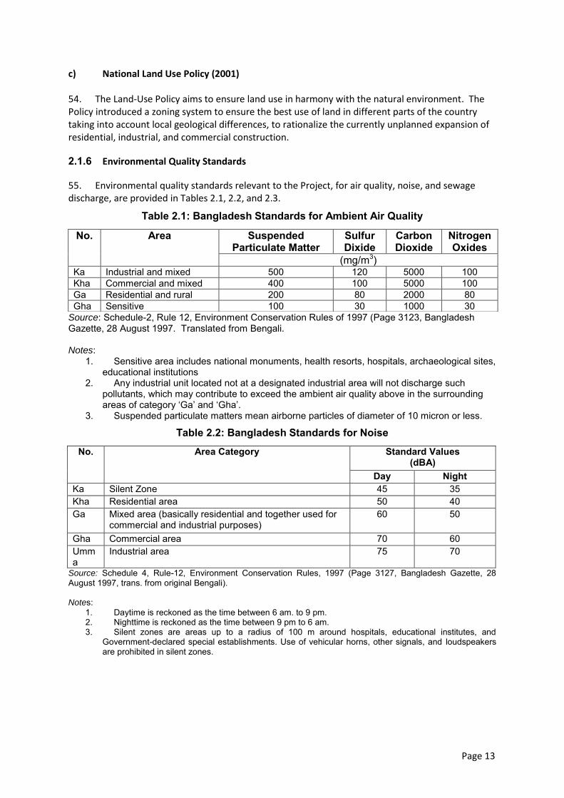
Page 13
c) National Land Use Policy (2001)
54. The Land-Use Policy aims to ensure land use in harmony with the natural environment. The Policy introduced a zoning system to ensure the best use of land in different parts of the country taking into account local geological differences, to rationalize the currently unplanned expansion of residential, industrial, and commercial construction.
2.1.6 Environmental Quality Standards
55. Environmental quality standards relevant to the Project, for air quality, noise, and sewage discharge, are provided in Tables 2.1, 2.2, and 2.3.
Table 2.1: Bangladesh Standards for Ambient Air Quality
Source: Schedule-2, Rule 12, Environment Conservation Rules of 1997 (Page 3123, Bangladesh Gazette, 28 August 1997. Translated from Bengali. Notes:
1. Sensitive area includes national monuments, health resorts, hospitals, archaeological sites, educational institutions
2. Any industrial unit located not at a designated industrial area will not discharge such pollutants, which may contribute to exceed the ambient air quality above in the surrounding areas of category ‘Ga’ and ‘Gha’.
3. Suspended particulate matters mean airborne particles of diameter of 10 micron or less.
Table 2.2: Bangladesh Standards for Noise
No. Area Category Standard Values (dBA)
Day Night Ka Silent Zone 45 35 Kha Residential area 50 40 Ga Mixed area (basically residential and together used for
commercial and industrial purposes) 60 50
Gha Commercial area 70 60 Umma
Industrial area 75 70
Source: Schedule 4, Rule-12, Environment Conservation Rules, 1997 (Page 3127, Bangladesh Gazette, 28 August 1997, trans. from original Bengali). Notes:
1. Daytime is reckoned as the time between 6 am. to 9 pm. 2. Nighttime is reckoned as the time between 9 pm to 6 am. 3. Silent zones are areas up to a radius of 100 m around hospitals, educational institutes, and
Government-declared special establishments. Use of vehicular horns, other signals, and loudspeakers are prohibited in silent zones.
No. Area Suspended Particulate Matter
Sulfur Dixide
Carbon Dioxide
Nitrogen Oxides
(mg/m3) Ka Industrial and mixed 500 120 5000 100 Kha Commercial and mixed 400 100 5000 100 Ga Residential and rural 200 80 2000 80 Gha Sensitive 100 30 1000 30
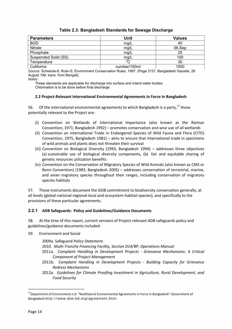
Page 14
Table 2.3: Bangladesh Standards for Sewage Discharge
Source: Schedule-8, RuIe-I3, Environment Conservation Rules, 1997. (Page 3131, Bangladesh Gazette, 28 August 199, trans. from Bengali]. Notes:
These standards are applicable for discharge into surface and inland water bodies. Chlorination is to be done before final discharge.
2.2 Project-Relevant International Environmental Agreements In Force In Bangladesh
56. Of the international environmental agreements to which Bangladesh is a party,17 those potentially relevant to the Project are:
(i) Convention on Wetlands of International Importance (also known as the Ramsar Convention, 1971; Bangladesh 1992) – promotes conservation and wise use of all wetlands
(ii) Convention on International Trade in Endangered Species of Wild Fauna and Flora (CITES Convention, 1975, Bangladesh 1981) – aims to ensure that international trade in specimens of wild animals and plants does not threaten their survival
(iii) Convention on Biological Diversity (1993, Bangladesh 1994) – addresses three objectives (a) sustainable use of biological diversity components, (b) fair and equitable sharing of genetic resources utilization benefits
(iv) Convention on the Conservation of Migratory Species of Wild Animals (also known as CMS or Bonn Convention) (1983; Bangladesh 2005) – addresses conservation of terrestrial, marine, and avian migratory species throughout their ranges, including conservation of migratory species habitats
57. These instruments document the GOB commitment to biodiversity conservation generally, at all levels (global-national-regional-local and ecosystem-habitat-species), and specifically to the provisions of these particular agreements.
2.2.1 ADB Safeguards: Policy and Guidelines/Guidance Documents
58. At the time of this report, current versions of Project-relevant ADB safeguards policy and guidelines/guidance documents included:
59. Environment and Social
2009a. Safeguard Policy Statement. 2010. Multi-Tranche Financing Facility, Section D14/BP, Operations Manual 2011a. Complaint Handling in Development Projects - Grievance Mechanisms: A Critical
Component of Project Management 2011b. Complaint Handling in Development Projects - Building Capacity for Grievance
Redress Mechanisms 2012a. Guidelines for Climate Proofing Investment in Agriculture, Rural Development, and
Food Security
17
Department of Environment.n.d. “Multilateral Environmental Agreements in Force in Bangladesh”.Government of
Bangladesh.http://www.doe-bd.org/agreement.html
Parameters Unit Values BOD mg/L 40 Nitrate mg/L 06-Sep Phosphate mg/L 25 Suspended Solid (SS) mg/L 100 Temperature oC 30 Coliforms number/100ml 1000

Page 15
60. Environment
2003a. Environmental Assessment Guidelines 2012b. Environment Safeguards, A Good Practice Sourcebook―Draft Working Document.
61. Social
2003b. [Policy on] Gender and Development 2006. Gender Checklist: Agriculture 2009b. Project Gender Action Plans, Lessons for Achieving Gender Equality and
Poverty Reduction Results. Briefing Note 2012c. Involuntary Resettlement Safeguards, A Planning and Implementation Good Practice
Sourcebook – Draft Working Document. 2012d. Indigenous Peoples Safeguards, A Planning and Implementation Good Practice
Sourcebook - Draft Working Document. 2012e. Handbook on Poverty and Social Analysis A Working Document.
2012f. Guidelines for Gender Mainstreaming Categories of ADB Projects.
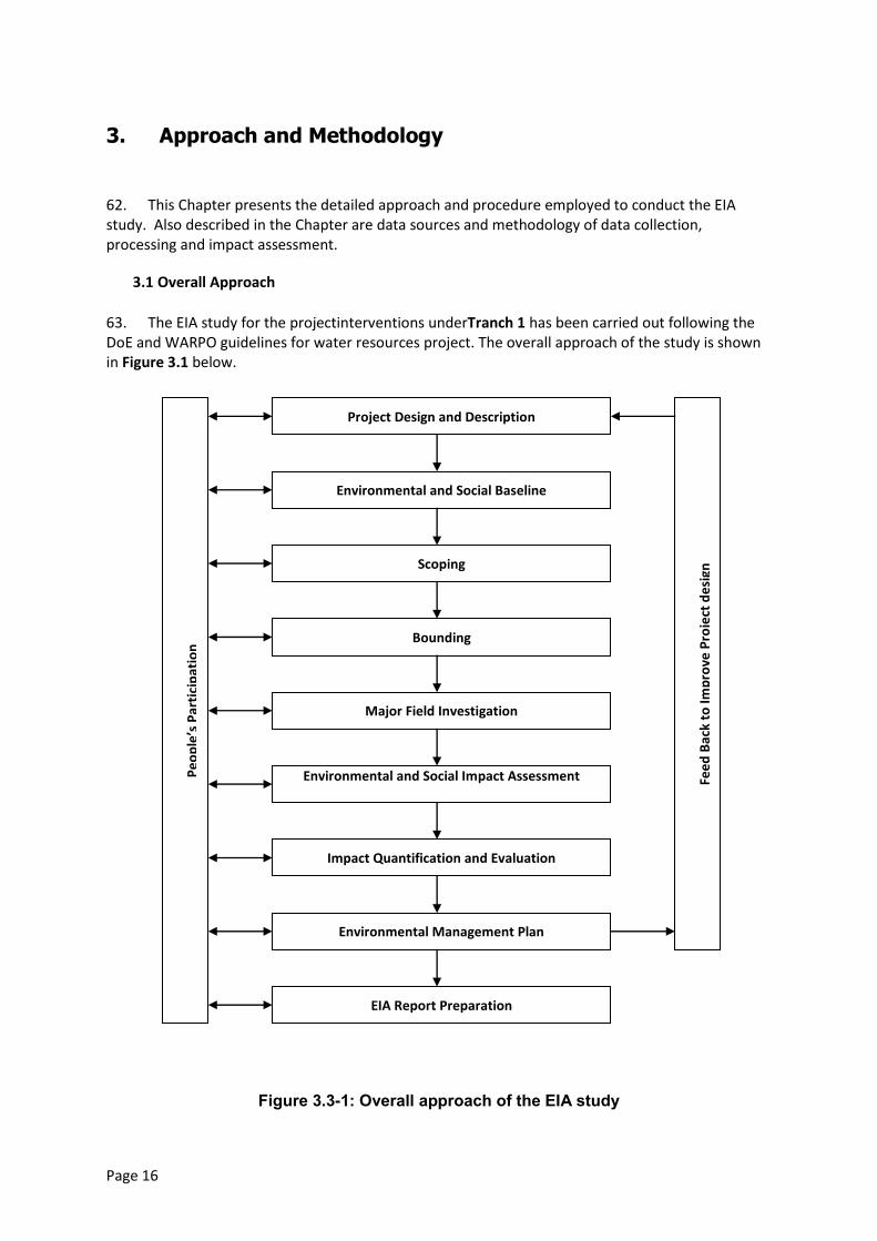
Page 16
3. Approach and Methodology
62. This Chapter presents the detailed approach and procedure employed to conduct the EIA study. Also described in the Chapter are data sources and methodology of data collection, processing and impact assessment.
3.1 Overall Approach
63. The EIA study for the projectinterventions underTranch 1 has been carried out following the DoE and WARPO guidelines for water resources project. The overall approach of the study is shown in Figure 3.1 below.
Figure 3.3-1: Overall approach of the EIA study
Project Design and Description
Environmental and Social Baseline
Scoping
Bounding
Major Field Investigation
Environmental and Social Impact Assessment
Impact Quantification and Evaluation
Environmental Management Plan
EIA Report Preparation
Pe
op
le’s
Par
tici
pat
ion
Fee
d B
ack
to Im
pro
ve P
roje
ct d
esi
gn
Page 17
3.2 Methodology
64. The step-wise detail methodology followed for the EIA study is briefly described below.
3.2.1 Project design and description
65. Interventions proposed for Tranch 1 was the basis of this EIA study. Initial information and specifications of the proposed interventions was obtained from the Main Consultant (MC). This was followed by development of base map using the images and data available with CEGIS in GIS data layers. Thereafter EIA study team met the concerned Executive Engineer of BWDB from whom detailed and specific information was collected and marked in the base map. The EIA study team also observed, to the extent possible, the present condition of the existing infrastructure during the field visit. Opinion of the local people on the performance of the existing infrastructure and their perception about the proposed interventions were also obtained.
3.2.2 Baseline data collection and analysis
66. Baseline data collection was conducted as a pre-requisite for EIA study. The baseline condition of the project area was drawn according to information collected from secondary and primary data sources through literature review, field investigations and consultation with different stakeholders. The baseline condition was established in respect of water resources, land resources, agriculture, livestock, fisheries, ecosystems and socio-economic conditions including identification of problems in respect of the proposed project site and adjoining area.
a) Water resources
67. Water resource data under the heading river hydrology, river morphology, ground water availability, drainage pattern, ground and surface water quality and water use were collected from secondary sources and primary observation by the professional of the multi-disciplinary team members backed up by feedback from the local people during field visit for baseline preparation and impact assessment in this study. Major river systems were identified for hydrological and morphological investigation through historical and current data collection and analysis. Specific areas or points of interest were selected for collecting data on special hydrological and morphological events such as river-khal-beel network, water availability, drainage pattern, water quality (surface and ground water), flash flood, risk of erosion or sedimentation etc.
68. Field visits were made to the study area and primary data on water resources components were collected through discussion with stakeholders. A checklist was used to obtain the information on different resources. Local knowledgeable persons and community representatives were also interviewed. During the field visits, the multidisciplinary EIA team members made professional observations pertaining to their individual areas of expertise. The impact of the project were assessed by analyzing collected data, community knowledge analysis and professional justification of water resource managers. The management plan for water resources components was incorporated to assess impact risk and water resources status using stakeholders’ requirement and experts judgment.
69. The specific data on different events of water resources were gathered and analyzed using the methodology presented in the following table.
Parameter Data Sources Methodology
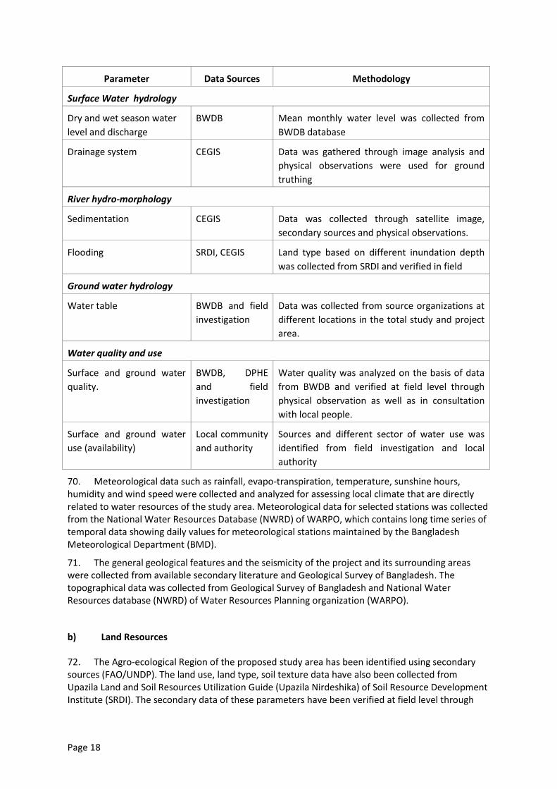
Page 18
Parameter Data Sources Methodology
Surface Water hydrology
Dry and wet season water
level and discharge
BWDB Mean monthly water level was collected from
BWDB database
Drainage system CEGIS Data was gathered through image analysis and
physical observations were used for ground
truthing
River hydro-morphology
Sedimentation CEGIS Data was collected through satellite image,
secondary sources and physical observations.
Flooding SRDI, CEGIS Land type based on different inundation depth
was collected from SRDI and verified in field
Ground water hydrology
Water table BWDB and field
investigation
Data was collected from source organizations at
different locations in the total study and project
area.
Water quality and use
Surface and ground water
quality.
BWDB, DPHE
and field
investigation
Water quality was analyzed on the basis of data
from BWDB and verified at field level through
physical observation as well as in consultation
with local people.
Surface and ground water
use (availability)
Local community
and authority
Sources and different sector of water use was
identified from field investigation and local
authority
70. Meteorological data such as rainfall, evapo-transpiration, temperature, sunshine hours, humidity and wind speed were collected and analyzed for assessing local climate that are directly related to water resources of the study area. Meteorological data for selected stations was collected from the National Water Resources Database (NWRD) of WARPO, which contains long time series of temporal data showing daily values for meteorological stations maintained by the Bangladesh Meteorological Department (BMD).
71. The general geological features and the seismicity of the project and its surrounding areas were collected from available secondary literature and Geological Survey of Bangladesh. The topographical data was collected from Geological Survey of Bangladesh and National Water Resources database (NWRD) of Water Resources Planning organization (WARPO).
b) Land Resources
72. The Agro-ecological Region of the proposed study area has been identified using secondary sources (FAO/UNDP). The land use, land type, soil texture data have also been collected from Upazila Land and Soil Resources Utilization Guide (Upazila Nirdeshika) of Soil Resource Development Institute (SRDI). The secondary data of these parameters have been verified at field level through
Page 19
physical observations as well as in consultation with the local people and officials of the Department of Agriculture Extension (DAE) during field visit.
c) Agriculture Resources
73. Data on agricultural resources included farming practices, crop production, constraints, existing cropping patterns, crop variety, crop yield, crop damage and agricultural inputs were used. Agriculture data were collected from primary sources through extensive field survey by developing questionnaire and in consultation with local people and concerned agricultural officials. Agricultural resources data were also collected from secondary sources from Upazila Agriculture Extension office (DAE). Crop production was determined using the formula: Total crop production = damage free area × normal yield + damaged area × damaged yield. The crop damage (production loss) was calculated using the formula: Crop production loss = Total cropped area ×normal yield-(damaged area ×damaged yield+ damage free area × normal yield). The crop damage data were collected from the field for last three years.
d) Livestock Resources
74. Present status of livestock (Cow/Bullock, Buffalo, Goat and Sheep and poultry (Duck and Chicken) in the study area have been evaluated at field level survey in consultation with the local people through PRA, RRA and KII. Livestock resources data were also collected from secondary sources from Upazila Livestock office.
e) Fisheries Resources
75. Data collection methods: The fisheries data were collected for the EIA study by considering the seasonal variance of dry and wet seasons. Prior to going for data collection, a checklist/ questionnaire were developed. The checklist included all kinds of information which should be looked into in the context of existing and potential structures of the project. A combination of survey techniques was used for data collection. The survey techniques included sampling site selection, data collection, data analysis and reporting. The sequential interpretations of the methodological approach were as follows:
76. Sampling Site Selection: Existing and proposed intervention wise sites were selected for data collection. Sampling sites varied depending on the proposed intervention sites. During site selection concentration was given on the intervened area and non-intervened area to find the difference between them in terms of fisheries impact.
77. Data Collection: Data were collected in multiple ways which can be broadly classified into two classes, for instance, (i) primary data collection and (ii) secondary data collection. Primary data were collected from the fishermen community, fisher households and local key informants and secondary data were collected from Upazila Fisheries Offices during field visits.
78. Habitat Identification: Fish habitat classification was done based on physical existence and were categorized into capture and culture fish habitats. The capture fish habitats included river, khal, floodplain, burrow pit and beel. The culture fish habitats included homestead culture fish pond, commercial fish farm etc.
79. Capture & Culture Fish habitats: Capture fish habitat assessment was done through fishing Effort Survey (FES), Frame Survey (FS), micro scale Catch Assessment Survey (CAS), habitat based species diversity & composition, identification of species of conservation significance, identification of potential fish habitat prescribing to restore for fish conservation, fish migration survey, habitat identification for fish conservation. Culture fish habitat assessment was done through homestead culture fish pond survey and commercial fish farm survey.
Page 20
80. Associated Information: Information on post harvest activities, forward and backward linkages, fisher livelihood information, fisheries management issues, potential fish recruitment, fish infrastructure and fisher vulnerability, etc. were also collected.
81. Secondary Data Collection: Relevant secondary data were collected from the Upazila Fisheries Office (UFO) from their annual report and from various literature/study.
82. Data Analysis and Output: Fish production for individual habitats were obtained through a series of calculation procedures using the collected information of FES, FS, CAS and Habitat area. Aggregating the fish production from all habitat types, total fish production of the study area were estimated basin wise and then holistically. Secondary information that was collected from the UFOs and literatures were blended with primary data in production estimation.
f) Ecology
83. Information on bio-ecological zones and their characteristics has been collected from the publication of International Union for Conservation of Nature (IUCN). The ecological component of the EIA study focused on terrestrial and riverine ecology including flora, birds, reptiles, amphibians, mammals, and migratory birds. The field activities included collecting ecosystem and habitat information, sensitive habitat identification, identifying ecological changes and potential ecological impact. The landuse information on different ecosystem was generated through analysis of the recent satellite image. Field investigation methods included physical observation; transect walk, habitat survey and consultation with local people. Field visits were carried out in delineating the ecological baseline condition. Public consultation was carried out through FGD and Key Informants Interview methods. Inventory of common flora and fauna was developed based on field survey and data base of IUCN.
g) Socio-economic Resources
84. The socio-economic baseline information including the study area, demographic information, occupation and employment, literacy rate, drinking water, sanitation, electricity facilities etc. were collected form secondary sources, i.e. BBS, 2011 and other relevant literatures included data obtained from BWDB. The income expenditure, land ownership pattern, self assessed poverty status, migration, social overhead capitals and quality of life, disasters, conflicts of the study area, information on NGOs, cultural and heritage features of the project area were collected mainly from primary sources through PRA and FGDs and public consultations.
85. The steps taken for collecting socio-economic data were as follows:
a) Data was collected from BBS, 2011 and reviewed relevant literatures from BWDB;
b) Reconnaissance field visit and discussion with BWDB officials and local stakeholders for
primary data collection;
c) PRA /RRA, FGDs, KII for primary data collection
d) Institutional Survey (IS) for primary data collection in district and Upazila level offices which
included DC office, LGED office, Civil Surgeon office, Social Service office etc.
3.2.3 Scoping
86. A scoping process was followed for selecting Important Environmental and Social Components (IESCs) which are likely to be impacted by the proposed interventions under Tranch 1. Scoping was done in two stages. Individual professionals of EIA study team made a preliminary list of the components pertaining to their disciplines, which could be impacted by the project. The second
Page 21
stage included village scoping sessions where stakeholder perceptions were obtained about those environmental and social components. Professional judgment of the EIA team members as well as the stakeholder opinion obtained in the scoping sessions was considered in selecting the IESCs.
3.2.4 Bounding
87. Area likely to be impacted by the project interventions under Tranch 1 was delineated in consultation with the BWDB in addition to feed back received from the local people during baseline consultation.The processed RS tools were used for this purpose but there were some error due to unavailability of high resolution images of the proposed project area in CEGIS archive. The entire area influenced by existing sub-projects and the proposed projects were considered as the potential area to be impacted.
3.2.5 Major Field Investigation
88. The EIA study team members collected intensive data on possible impact of the project after procuring the project plan. Intensive data on the IESCs were collected from the field during major field investigation stage. In this case, information on the IESCs were gathered through a mixed method including RRA, PRA and KII using checklists for water resources, land resources, agriculture, livestock, fisheries, ecosystem and socio-economic components. Intensive consultation with the local people was carried out in each case for securing people’s participation. The multidisciplinary EIA study team members also made professional observations and justification during the field visits. This time the concentration was on the historical status and public responses for the IESCs and the possible condition of the same against the proposed interventions.
3.2.6 Impact Assessment
89. Environmental and social impacts of the proposed interventions in the project on the IESCs have been assessed through several sets of activities. Impacts are caused as a result of interaction of specific project activities with the existing environmental settings. The impacts of proposed interventions were estimated on the basis of difference between the future-without-project (FWOP) condition and the future-with-project (FWIP) condition. The future-without-project (FWOP) conditions were generated through trend analysis and consultation with the local people. This reflected conditions of IESCs in the absence of the proposed interventions. Changes expected to be brought about due to the proposed interventions were assessed to generate the future-with-project (FWIP) condition. Comparison and projection methods were used for impact prediction. This included both positive and negative impacts which were considered in the preparation of the environmental management plan.
90. The sequence of assessment of environmental and social impact was asfollows:
i) Changes in the status of the IESCs pertaining to water resources;
ii) Changes in the status of the IESCs pertaining to land resources, agriculture, livestock and
poultry;
iii) Changes in the status of the IESCs pertaining to fisheries;
iv) Changes in the status of the IESCs pertaining to ecological resources; and
v) Changes in the status of the IESCs pertaining to socio-economic condition.
Page 22
3.2.7 Impact Evaluation
91. At this stage, attempts were made to quantify the impacts of the proposed interventions on the IESCs. But it was not possible to quantify all impacts, especially the impacts on some of the environmental and social components. In those cases, qualitative impacts were assessed and scores were assigned with (+) sign for positive impacts and (-) sign for negative impacts. The magnitude of both positive and negative impacts was indicated in a scale of 1 to 10 on extent, magnitude, reversibility, duration and sustainability considerations.
3.2.8 Preparation of Environmental Management and Monitoring Plan
92. An environmental management plan (EMP) for the proposed project was prepared comprising the mitigation/ enhancement measures with institutional responsibilities, environmental monitoring plan, training and capacity building plan, and reporting and documentation protocols.
3.2.9 EIA Report Preparation
93. At the end of the process, the present report was prepared incorporating all the findings of the EIA study.
Page 23
4. Project Description
4.1 Introduction
94. The Project assessed by this EIA is Tranche 1 of the FRERMIP MFF. Section 4.2 immediately following describes the FRERMIP programme as the Project context and Section 04.3 describes the Project, Tranche 1.
4.2 Project Context: The FRERMIP Programme
4.2.1 FRERMIP Background and Objectives
95. Almost all of Bangladesh is floodplain delta at the confluence of three very large rivers. An integral part of the livelihoods of poor people is coping with water-related disasters – floods, drought, riverbank erosion caused by dynamic river channel shifting, cyclones, and tidal surges. All cause significant hardship.
Thus flood and riverbank erosion risk management can play a significant role in poverty reduction
and economic growth. Riverbank erosionannually affects about 100,000 individuals who lose
homestead, lands, agricultural crops, and displacement. Many erosion displacees relocate to
insecure, marginal environments such as riverine fringe land, char land (river islands), and urban
slums. Flooding, while integral to agriculture in the delta, causes displacement and economic losses,
especially when high flooding occurs (approximately >1:10 return period).
96. FRERMIP aims to modify the flood season hydrology of a very large area of floodplain by providing new and rehabilitated embankments, leaving distributaries open, along selected reaches of the Padma / Jamuna River. To protect these embankments, river banks will be progressively stabilized, starting at critically eroding reaches. Over time, and in conjunction with other government programs this approach may lead to a general river stabilization with less channels potentially having some similarity to the river system before the passing of the sediment wave of the Great Assam Earthquake. In parallel to this study, Government will investigate other river
restoration alternatives18. Siting of physical works for FRERMIP will be planned using an innovative dynamic methodology that responds to evolving river behaviour (“adaptive approach”). The anticipated benefits are considerable: (i) reduced loss of agricultural and other land to river erosion, (ii) reduced flood damage to agriculture (etc), and (iii) increased agricultural production on less-flooded agricultural land. Previous failures in river embankements have been due to erosion of river banks. Therefore, the present approach includes river bank protection followed by embankment construction.
97. FRERMIP will build upon the riverbank protection methods developed in the Jamuna Meghna River Erosion Mitigation Project (JMREMP) to other river reaches. A morphological study will be undertaken in Tranches 2 and 3 to improve prediction of long-term morphological trends. This will support a shift from the currently approach of ad hoc, piecemeal protection of actively eroding damaged sites, to proactive siting of protection at sites expected to erode in the near future.
18
The feasibility study of Capital Dredging and Sustainable River Management in Bangladesh currently investigates one single and and one multiple-channel option for Jamuna and Padma as first step towards the development of a river stabilization plan. The final report is expected in early 2014. Building on the Capital Dredging study and the initial morphological assessment of potential future channel patterns conducted as part of this feasibility study, the FRERMIP will conduct a comprehensive river stabilization plan to identify potential stabilization solutions, to be implemented in an adaptive and phased manner, with minimal impacts on the river and char environment.
Page 24
98. Behind FRERMIP riverbank protection works where river erosion risk – the main cause of embankment failure on the major rivers – has been reduced, FRERMIP will invest in new and rehabilitated embankment works, leaving major distributaries open, to mitigate flood levels during greater return period flood events while still allowing lower levels of beneficial flooding to occur.
99. The structural components of riverbank protection and embankments are accompined by non-structural components. These address institutional issues, on knowledgebase and planning level, and directly assist local communities in the sub-project areas in improving their preparedness to flood and erosion disaster. The latter will be implemented through DDM under a community-based flood risk management program covering around ome million people in the three subproject areas.
4.2.2 FRERMIP Location and Area
100. The FRERMIP area encompasses the Jamuna River reach starting below the Jamuna Bridge and the proposed Ganges Barrage site, down to Chandpuron the Lower Meghna. Downstream of the Jamuna Bridge and the Barrage site, theJamuna and Ganges river courses are somewhat independent of upstream river developments. The FRERMIP area covers 9,300 km³ with a total population of 10.5 million (2011 census) in 40 upazilas and 431 unions, with an average population density of nearly 1,600 persons per km² of floodplain land.
101. Map 1 shows the locations of proposed interventions during Tranches 1, 2, and 3. Red is used for Tranche 1 interventions, orange for Tranche 2, and yellow for Tranche 3. Map 4-2 provides a more detailed map of the proposed Tranche 1 interventions.
4.2.3 FRERMIP Implementation Schedule
102. Figure 4.1 shows the FRERMIP schedule for all three tranches.
4.3 Project –Tranche 1
4.3.1 Proposed Interventions
103. Proposed interventions under Tranche 1 fall into four categories: (i) riverbank protection, (ii) new and rehabilitated road/flood embankments, (iii) drainage sluices and (iv) afforestation.
a) Riverbank Protection
104. Figure 4.2 shows a representative cross-section of riverbank protection works. Construction of riverbank protection typically involves the following activities. Labor sheds are constructed and stocked with construction materials (sand, cement, wood, shuttering materials etc.). Sanitation facilities for work crews are constructed. River bank slopes are developed with earth. Pre-cast concrete (CC) blocks are cast or manufactured. Geo-textile bags are placed onto the slope below water and CC blocks are placed onto the slope above water. Launching aprons are prepared at the toe of the underwater protection and geobags and are dumped, usually in a 15m wide strip in front of the toe. Embankment slopes and crests are turfed as needed.
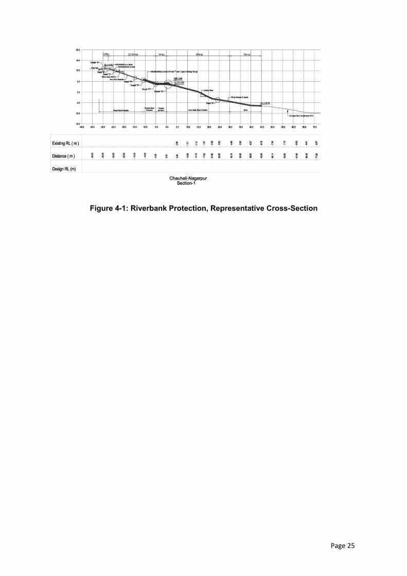
Page 25
Figure 4-1: Riverbank Protection, Representative Cross-Section
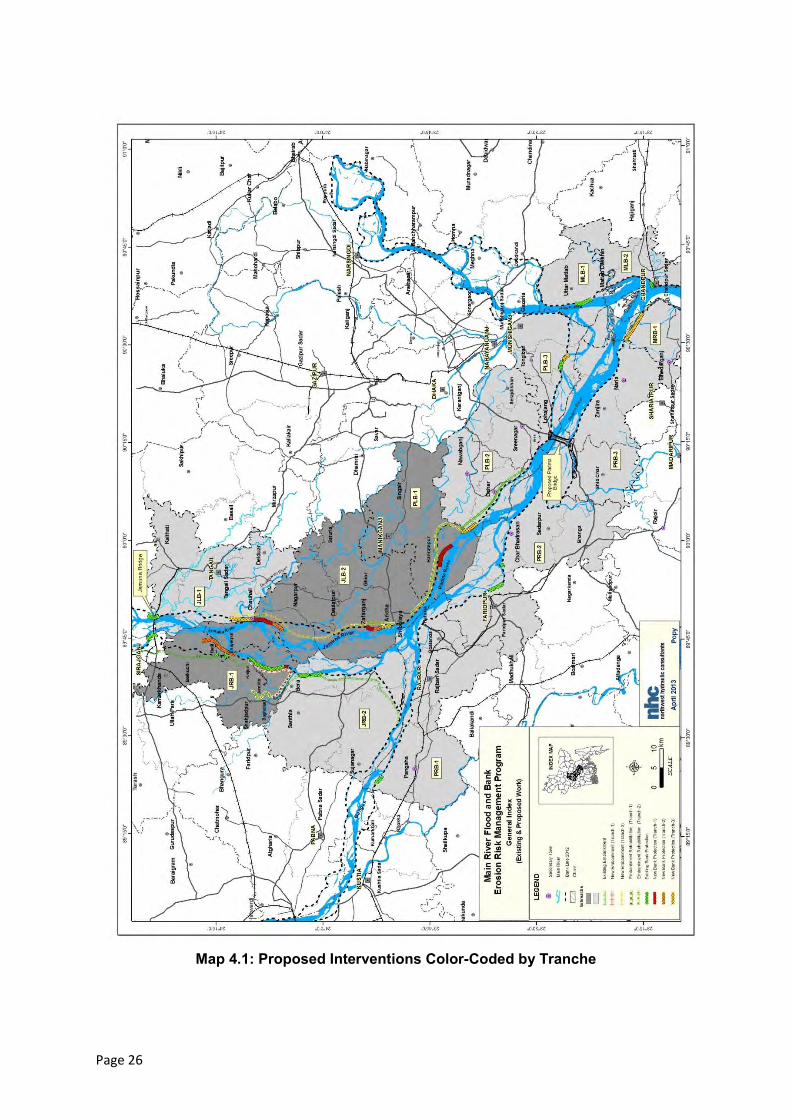
Page 26
Map 4.1: Proposed Interventions Color-Coded by Tranche
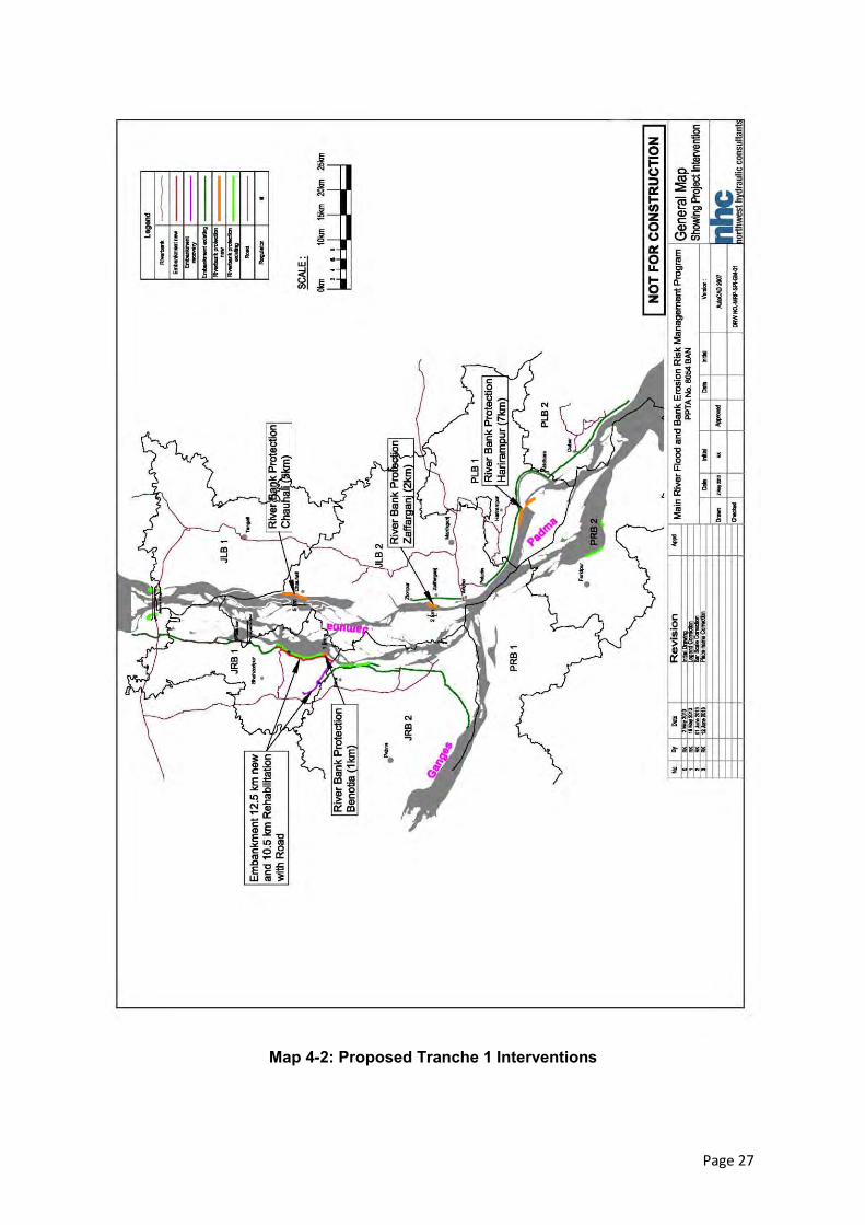
Page 27
Map 4-2: Proposed Tranche 1 Interventions
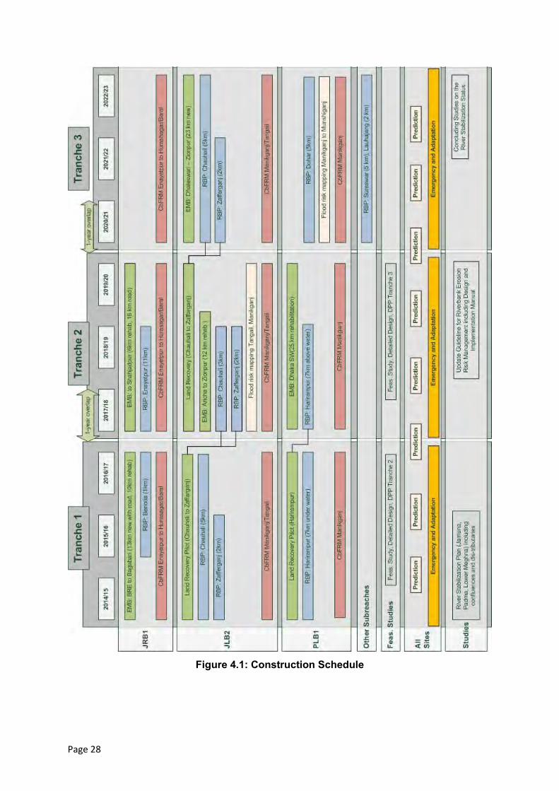
Page 28
Figure 4.1: Construction Schedule
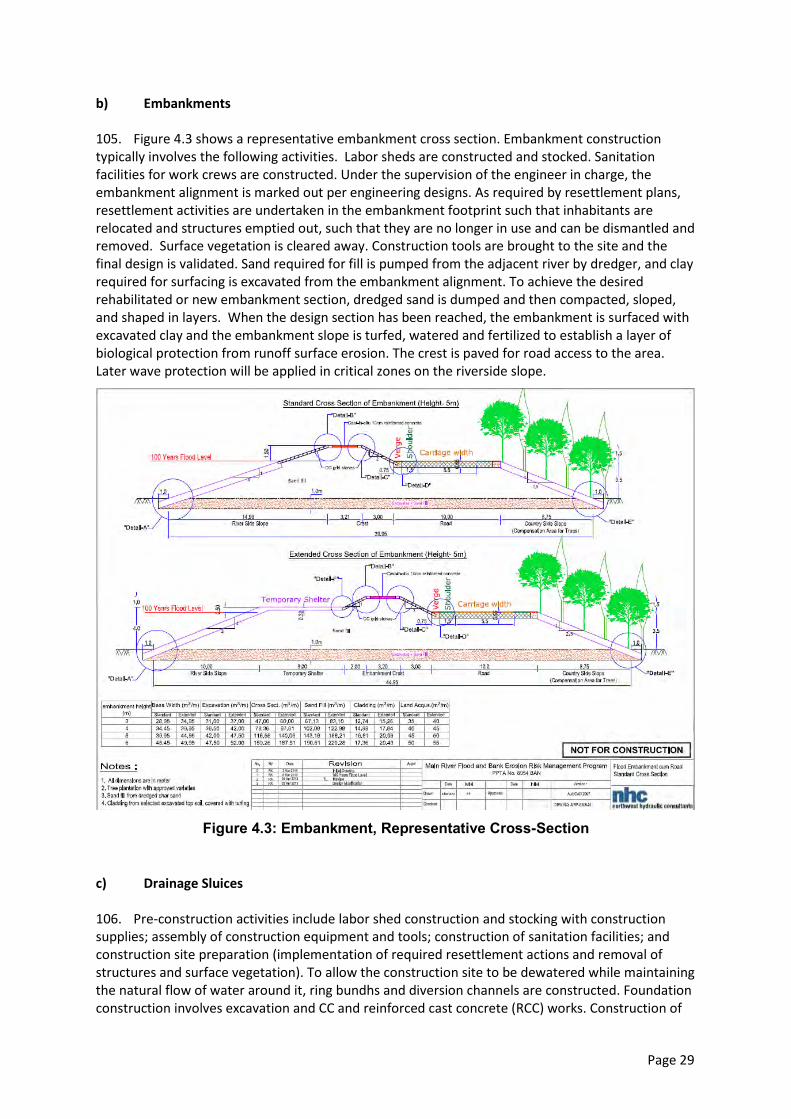
Page 29
b) Embankments
105. Figure 4.3 shows a representative embankment cross section. Embankment construction typically involves the following activities. Labor sheds are constructed and stocked. Sanitation facilities for work crews are constructed. Under the supervision of the engineer in charge, the embankment alignment is marked out per engineering designs. As required by resettlement plans, resettlement activities are undertaken in the embankment footprint such that inhabitants are relocated and structures emptied out, such that they are no longer in use and can be dismantled and removed. Surface vegetation is cleared away. Construction tools are brought to the site and the final design is validated. Sand required for fill is pumped from the adjacent river by dredger, and clay required for surfacing is excavated from the embankment alignment. To achieve the desired rehabilitated or new embankment section, dredged sand is dumped and then compacted, sloped, and shaped in layers. When the design section has been reached, the embankment is surfaced with excavated clay and the embankment slope is turfed, watered and fertilized to establish a layer of biological protection from runoff surface erosion. The crest is paved for road access to the area. Later wave protection will be applied in critical zones on the riverside slope.
Figure 4.3: Embankment, Representative Cross-Section
c) Drainage Sluices
106. Pre-construction activities include labor shed construction and stocking with construction supplies; assembly of construction equipment and tools; construction of sanitation facilities; and construction site preparation (implementation of required resettlement actions and removal of structures and surface vegetation). To allow the construction site to be dewatered while maintaining the natural flow of water around it, ring bundhs and diversion channels are constructed. Foundation construction involves excavation and CC and reinforced cast concrete (RCC) works. Construction of
Page 30
above-ground works involves cutting, bending and binding of rods, and casting and placement of CC blocks. Approach roads are constructed; gates and hoisting devices fitted, and gates painted. Per design, the sluice intake and outfall are constructed and CC blocks or geobags placed upstream and downstream for riverbed and -slope protection.
d) Afforestation
107. Figure 4.3 shows a representative cross section of an afforested embankment. Afforestation and/or vegetation may be conducted on the country-side (land-side) slopes and toe of the embankment, as part of livelihood support for local communities including project affected persons. Species for afforestation and/or vegetation will be selected based on preference of local communities, in due consultation with BWDB and other relevant government agencies, to ensure that the species are suitable for livelihood support, and for protecting embankment surface from erosion by drainage from the crest and the road. Afforestation activities include establishing a temporary nursery to ensure seedling availability and plantation of appropriate species seedlings at species-appropriate intervals.
4.3.2 Project Implementation Arrangements
108. Appendix 5 documents the project implementation arrangements. BWDB is the executing agency, while DDM is the implementing agency for the community-based flood risk management component.As for all development projects, an inter-ministerial steering committee will review and discuss the project in annual meetings. A Panel of Experts will provide guidance related to river morphology, flood risk management, institutional development, regional/local capacity development, and other issues emerging during implementation.
109. A Project Management Office (PMO) integrated into BWDB administration will be set up, headed by a Project Director who will be a senior Superintending Engineer or an Additional Chief Engineer (with powers similar to the zonal Chief Engineer), supported by two Superintending Engineers. The PMO might be converted to proposed office of the Chief Engineer River Management and River Management Wing, once these posts are approved and staffed. The River Management Wing will be responsible for national river management activities such as char reclamation and materials procurement and strategic stockpiling, and for implementing works through existing zonal divisions (whose staff levels will be increased) that already construct embankments and revetments. In addition to the PMO in Dhaka, sub-project management offices (SMO) will be established in the divisional offices located in the project sites areas of Koitola, Tangail, and Manikgonj. In addition to the Project Director and the two superintendent engineers, the PMO will be staffed with four executive engineers, four sub-divisional engineers and one assistant engineer. All PMO staff will work full time on the project. One of the executive engineers will be responsible for environmental management, and will work with consultants to monitor and supervise activities in the project sites. Each SMO will be headed by an executive engineer who will be supported by a sub-divisional engineer, an assistant engineer, and three sub-assistant engineers. In the SMO, the sub-divisional engineer will be responsible for day to day management of environmental concerns.
110. BWDB is responsible for large-scale flood management and river erosion interventions, including the environmental aspects of their planning, assessment, and management, but it has very limited environmental staff in the Chief Planning office and no environmental- unit. Environmental management will be entrusted to executive engineer level PMO staff, supported by consultants. The PMO assures that environmental management will form part of construction contracts and regular monitoring of construction activities will be conducted. In addition future interventions will be studied at multiple levels to minimize negative impacts. A river stabilization study, and land recovery piloting, will assess potential river stabilization alternatives and their impacts, inter alia, on the
Page 31
environment. In addition, successive tranches will be designed through full feasibility studies, complying with ADB safeguard standard.
111. An Institutional Strengthening and Project Management Consultant (ISPMC) will provide consultancy and NGO services to support project implementation in a variety of ways, including the services of a specialist organization to conduct environmental assessment, planning and management to support the PMO in environmental monitoring; and, in Tranches 2 and 3, to assist PMO to design and develop a new Environmental Monitoring and Management Unit.
112. The core components of this work relevant to Tranche 1 design and implementation include:
Institutional support and project management (capacity development in river training, modern embankment construction, river surveying, and data management and evaluation; large-area flood hazard and risk mapping for larger areas; management information system development; construction management of large contracts; construction quality assurance / quality control); preparation of a river stabilization plan during the first two years of Tranche 1 for the Brahmaputra-Jamuna-Padma-Lower Meghna from the Bangladesh-India border to the estuary; and pilot activities to recover “lost” floodplain.
Preparation and supervision by resettlement NGO of Resettlement Plan implementation at the three Tranche 1subprojects, supervised by an independent monitor.
Implementation by a disaster management-experienced NGO of community-based flood risk management.
Provision of specialist and NGO services required to implement Environmental Management Plan mitigation, monitoring, public consultation, and other activities. An environmental specialist will be included in the ISPMC team.
Support to BWDB in the planning and initial staff training of a BWDB environmental monitoring and management unit under FRERMIP.
113. Additional details regarding the financing and potential scope of work of the advisory support are provided in Section 15.3.3, Advisory Support, of the Final Report, Main Volume.
4.3.3 Implementation Schedule
114. The scheduled start and end dates of Tranche 1 are 1 July 2014 and 30 June 2018. Tranche 2 is scheduled to start 1 July 2017 (Figure 4.1).
4.3.4 Tranche 1 Subprojects
115. Tranche 1 consists of three subprojects: Jamuna Right Bank 1 (Details in Annex 7), Jamuna Left Bank 2 (Detaisl in Annex 8) and Padma Right Bank 1 (Details in Annex 9). Table 4.1 through Table 4.4 summarizes key information for Tranche 1 interventions.
Table 4.1: Tranche 1Embankment Rehabilitation (along a tributary)
No. Location Length (km)
Design Crest Width (m)
Design Crest RL
(m +PWD)
Side Slope
1 Verakhola along Hurashagar River
6.5 16.2 (section with different top elevation)
15.6 R/S 1V:3H C/S 1V:2.5H
2 From Hurashagar River to Korotoa bank
4 16.2 (section with different top elevation)
15.6 R/S 1V:3H C/S 1V:2.5H
Source: Final Report, Main Volume, 2013
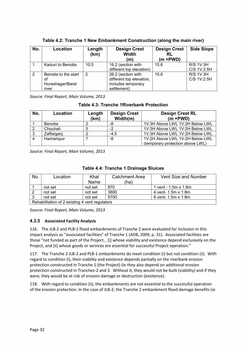
Page 32
Table 4.2: Tranche 1 New Embankment Construction (along the main river)
No. Location Length (km)
Design Crest Width
(m)
Design Crest RL
(m +PWD)
Side Slope
1 Kaizuri to Benotia 10.5 16.2 (section with different top elevation)
15.6 R/S 1V:3H C/S 1V:2.5H
2 Benotia to the start of Hurashagar/Baral river
2 26.2 (section with different top elevation, includes temporary settlement)
15.6 R/S 1V:3H C/S 1V:2.5H
Source: Final Report, Main Volume, 2013
Table 4.3: Tranche 1Riverbank Protection
No. Location Length (km)
Design Crest Width(m)
Design Crest RL (m +PWD)
1 Benotia 2 -8 1V:3H Above LWL 1V:2H Below LWL 2 Chouhali 5 -2 1V:3H Above LWL 1V:2H Below LWL 3 Zaffarganj 2 -4.5 1V:3H Above LWL 1V:2H Below LWL 4 Harirampur 7 -8 1V:2H Above LWL 1V:2H Below LWL
(temporary protection above LWL)
Source: Final Report, Main Volume, 2013
Table 4.4: Tranche 1 Drainage Sluices
No. Location Khal Name
Catchment Area (ha)
Vent Size and Number
1 not set not set 870 1 vent - 1.5m x 1.8m 2 not set not set 3600 4 vent- 1.5m x 1.8m 3 not set not set 5700 6 vent- 1.5m x 1.8m Rehabilitation of 2 existing 4 vent regulators
Source: Final Report, Main Volume, 2013
4.3.5 Associated Facility Analysis
116. The JLB-2 and PLB-1 flood embankments of Tranche 2 were evaluated for inclusion in this impact analysis as “associated facilities” of Tranche 1 (ADB, 2009, p. 31). Associated facilities are those “not funded as part of the Project… [i] whose viability and existence depend exclusively on the Project, and [ii] whose goods or services are essential for successful Project operation.”
117. The Tranche 2 JLB-2 and PLB-1 embankments do meet condition (i) but not condition (ii). With regard to condition (i), their viability and existence depends partially on the riverbank erosion protection constructed in Tranche 1 (the Project) (ie they also depend on additional erosion protection constructed in Tranches-2 and 3. Without it, they would not be built (viability) and if they were, they would be at risk of erosion damage or destruction (existence).
118. With regard to condition (ii), the embankments are not essential to the successful operation of the erosion protection. In the case of JLB-2, the Tranche 2 embankment flood damage benefits (ie
Page 33
the “goods and services” of the flood embankment) do however substantially cross-subsidize the cost of the Tranche 1 JLB-2 erosion protection works.19
4.3.6 Labor Requirement, Construction Materials, and Equipment
119. Table 4.5 to Table 4.8 provide estimates of labor requirements, construction materials, and equipment for embankment re-sectioning, new / retired embankment construction, river bank protection construction, and drainage sluice construction respectively.
19
The economic analysis presented in Sec. 18 of the Final Report, Main Volume (version dated 21 July 2013) includes costs and benefits of all tranches, broken out by subreach. For JLB-2, 66 per cent of the benefits derive from reduced flood damage, while 67 per cent of the costs derive from erosion protection works. For PLB-1, 72 per cent of the benefits derive from reduced erosion, and 77 per cent of the costs derive from the erosion protection.
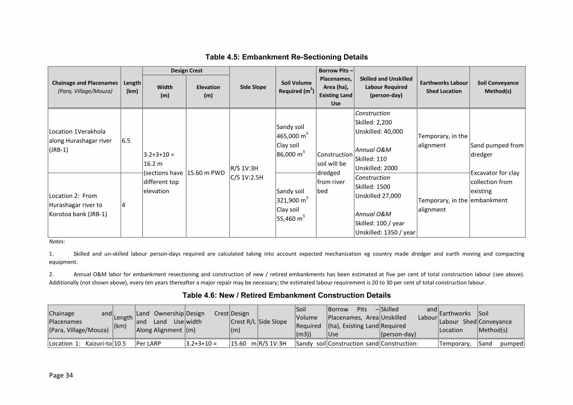
Page 34
Table 4.5: Embankment Re-Sectioning Details
Chainage and Placenames
(Para, Village/Mouza)
Length
(km)
Design Crest
Side Slope Soil Volume
Required (m3)
Borrow Pits –
Placenames,
Area (ha),
Existing Land
Use
Skilled and Unskilled
Labour Required
(person-day)
Earthworks Labour
Shed Location
Soil Conveyance
Method(s) Width
(m)
Elevation
(m)
Location 1Verakhola
along Hurashagar river
(JRB-1)
6.5
3.2+3+10 =
16.2 m
(sections have
different top
elevation
15.60 m PWD R/S 1V:3H
C/S 1V:2.5H
Sandy soil
465,000 m3
Clay soil
86,000 m3 Construction
soil will be
dredged
from river
bed
Construction
Skilled: 2,200
Unskilled: 40,000
Annual O&M
Skilled: 110
Unskilled: 2000
Temporary, in the
alignment Sand pumped from
dredger
Excavator for clay
collection from
existing
embankment Location 2: From
Hurashagar river to
Korotoa bank (JRB-1)
4
Sandy soil
321,900 m3
Clay soil
55,460 m3
Construction
Skilled: 1500
Unskilled 27,000
Annual O&M
Skilled: 100 / year
Unskilled: 1350 / year
Temporary, in the
alignment
Notes:
1. Skilled and un-skilled labour person-days required are calculated taking into account expected mechanization eg country made dredger and earth moving and compacting
equipment.
2. Annual O&M labor for embankment resectioning and construction of new / retired embankments has been estimated at five per cent of total construction labour (see above).
Additionally (not shown above), every ten years thereafter a major repair may be necessary; the estimated labour requirement is 20 to 30 per cent of total construction labour.
Table 4.6: New / Retired Embankment Construction Details
Chainage and Placenames (Para, Village/Mouza)
Length (km)
Land Ownership and Land Use Along Alignment
Design Crest width (m)
Design Crest R/L (m)
Side Slope
Soil Volume Required (m3))
Borrow Pits – Placenames, Area (ha), Existing Land Use
Skilled and Unskilled Labour Required (person-day)
Earthworks Labour Shed Location
Soil Conveyance Method(s)
Location 1: Kaizuri-to 10.5 Per LARP 3.2+3+10 = 15.60 m R/S 1V:3H Sandy soil Construction sand Construction: Temporary, Sand pumped
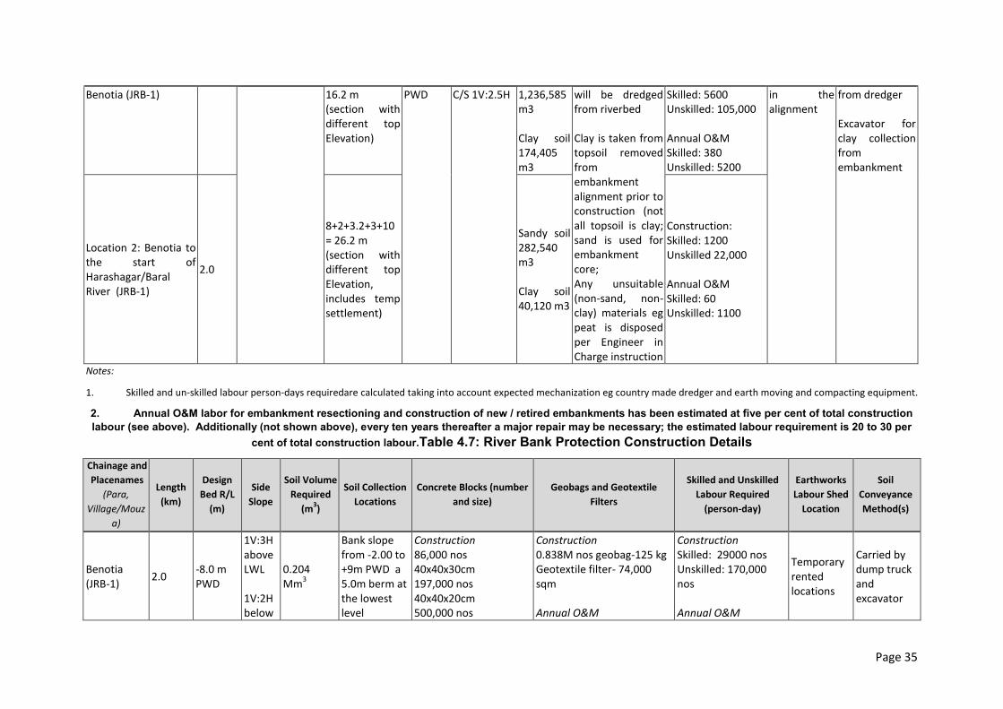
Page 35
Benotia (JRB-1) 16.2 m (section with different top Elevation)
PWD C/S 1V:2.5H 1,236,585 m3 Clay soil 174,405 m3
will be dredged from riverbed Clay is taken from topsoil removed from embankment alignment prior to construction (not all topsoil is clay; sand is used for embankment core; Any unsuitable (non-sand, non-clay) materials eg peat is disposed per Engineer in Charge instruction
Skilled: 5600 Unskilled: 105,000 Annual O&M Skilled: 380 Unskilled: 5200
in the alignment
from dredger Excavator for clay collection from embankment
Location 2: Benotia to the start of Harashagar/Baral River (JRB-1)
2.0
8+2+3.2+3+10 = 26.2 m (section with different top Elevation, includes temp settlement)
Sandy soil 282,540 m3 Clay soil 40,120 m3
Construction: Skilled: 1200 Unskilled 22,000 Annual O&M Skilled: 60 Unskilled: 1100
Notes:
1. Skilled and un-skilled labour person-days requiredare calculated taking into account expected mechanization eg country made dredger and earth moving and compacting equipment.
2. Annual O&M labor for embankment resectioning and construction of new / retired embankments has been estimated at five per cent of total construction
labour (see above). Additionally (not shown above), every ten years thereafter a major repair may be necessary; the estimated labour requirement is 20 to 30 per
cent of total construction labour.Table 4.7: River Bank Protection Construction Details
Chainage and
Placenames
(Para,
Village/Mouz
a)
Length
(km)
Design
Bed R/L
(m)
Side
Slope
Soil Volume
Required
(m3)
Soil Collection
Locations
Concrete Blocks (number
and size)
Geobags and Geotextile
Filters
Skilled and Unskilled
Labour Required
(person-day)
Earthworks
Labour Shed
Location
Soil
Conveyance
Method(s)
Benotia (JRB-1)
2.0 -8.0 m PWD
1V:3H above LWL 1V:2H below
0.204 Mm
3
Bank slope from -2.00 to +9m PWD a 5.0m berm at the lowest level
Construction 86,000 nos 40x40x30cm 197,000 nos 40x40x20cm 500,000 nos
Construction 0.838M nos geobag-125 kg Geotextile filter- 74,000 sqm Annual O&M
Construction Skilled: 29000 nos Unskilled: 170,000 nos Annual O&M
Temporary rented locations
Carried by dump truck and excavator
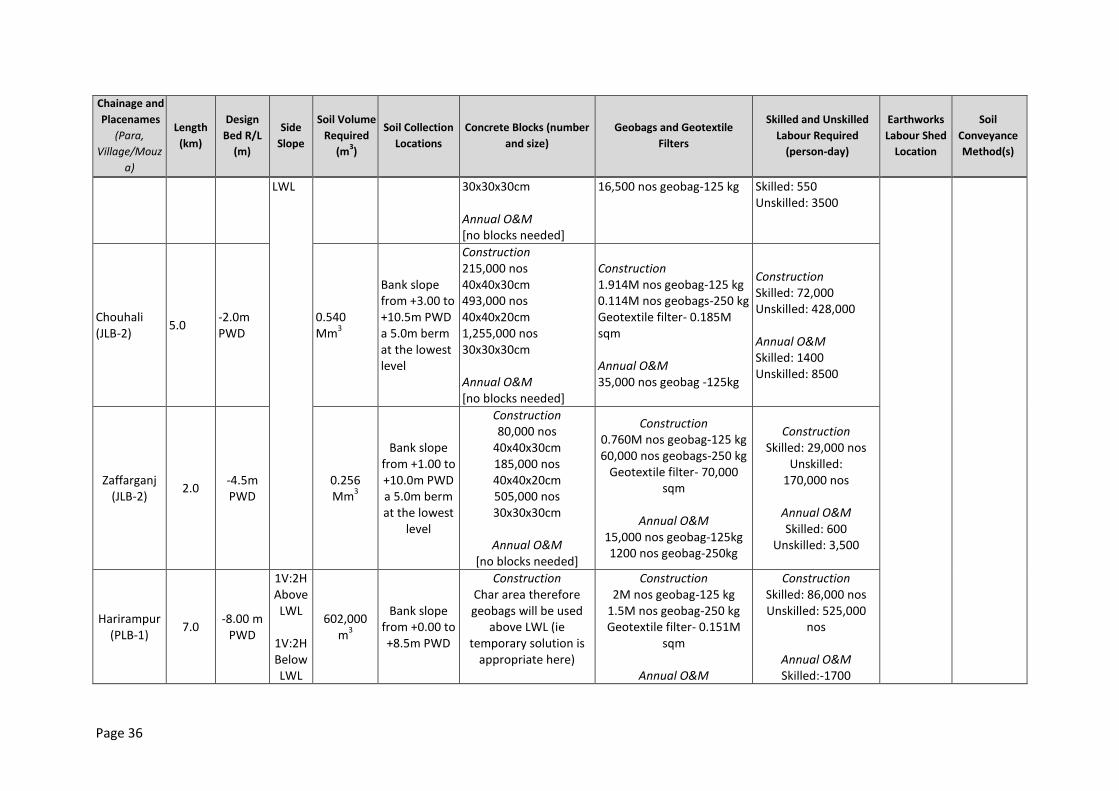
Page 36
Chainage and
Placenames
(Para,
Village/Mouz
a)
Length
(km)
Design
Bed R/L
(m)
Side
Slope
Soil Volume
Required
(m3)
Soil Collection
Locations
Concrete Blocks (number
and size)
Geobags and Geotextile
Filters
Skilled and Unskilled
Labour Required
(person-day)
Earthworks
Labour Shed
Location
Soil
Conveyance
Method(s)
LWL 30x30x30cm Annual O&M [no blocks needed]
16,500 nos geobag-125 kg Skilled: 550 Unskilled: 3500
Chouhali (JLB-2)
5.0 -2.0m PWD
0.540 Mm
3
Bank slope from +3.00 to +10.5m PWD a 5.0m berm at the lowest level
Construction 215,000 nos 40x40x30cm 493,000 nos 40x40x20cm 1,255,000 nos 30x30x30cm Annual O&M [no blocks needed]
Construction 1.914M nos geobag-125 kg 0.114M nos geobags-250 kg Geotextile filter- 0.185M sqm Annual O&M 35,000 nos geobag -125kg
Construction Skilled: 72,000 Unskilled: 428,000 Annual O&M Skilled: 1400 Unskilled: 8500
Zaffarganj (JLB-2)
2.0 -4.5m PWD
0.256 Mm
3
Bank slope from +1.00 to +10.0m PWD a 5.0m berm at the lowest
level
Construction 80,000 nos
40x40x30cm 185,000 nos 40x40x20cm 505,000 nos 30x30x30cm
Annual O&M
[no blocks needed]
Construction 0.760M nos geobag-125 kg 60,000 nos geobags-250 kg
Geotextile filter- 70,000 sqm
Annual O&M
15,000 nos geobag-125kg 1200 nos geobag-250kg
Construction Skilled: 29,000 nos
Unskilled: 170,000 nos
Annual O&M Skilled: 600
Unskilled: 3,500
Harirampur (PLB-1)
7.0 -8.00 m
PWD
1V:2H Above LWL
1V:2H Below LWL
602,000 m
3
Bank slope from +0.00 to +8.5m PWD
Construction Char area therefore geobags will be used
above LWL (ie temporary solution is
appropriate here)
Construction 2M nos geobag-125 kg
1.5M nos geobag-250 kg Geotextile filter- 0.151M
sqm
Annual O&M
Construction Skilled: 86,000 nos Unskilled: 525,000
nos
Annual O&M Skilled:-1700
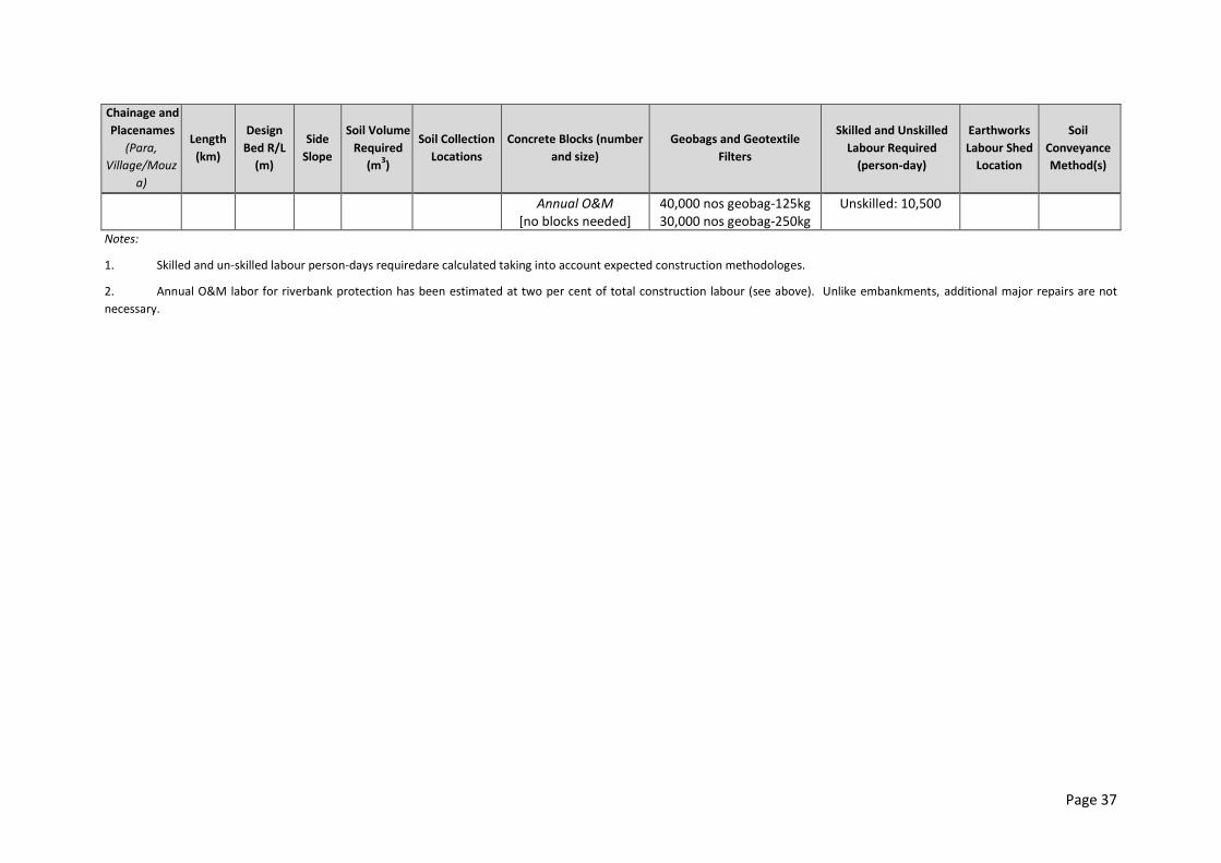
Page 37
Chainage and
Placenames
(Para,
Village/Mouz
a)
Length
(km)
Design
Bed R/L
(m)
Side
Slope
Soil Volume
Required
(m3)
Soil Collection
Locations
Concrete Blocks (number
and size)
Geobags and Geotextile
Filters
Skilled and Unskilled
Labour Required
(person-day)
Earthworks
Labour Shed
Location
Soil
Conveyance
Method(s)
Annual O&M [no blocks needed]
40,000 nos geobag-125kg 30,000 nos geobag-250kg
Unskilled: 10,500
Notes:
1. Skilled and un-skilled labour person-days requiredare calculated taking into account expected construction methodologes.
2. Annual O&M labor for riverbank protection has been estimated at two per cent of total construction labour (see above). Unlike embankments, additional major repairs are not
necessary.
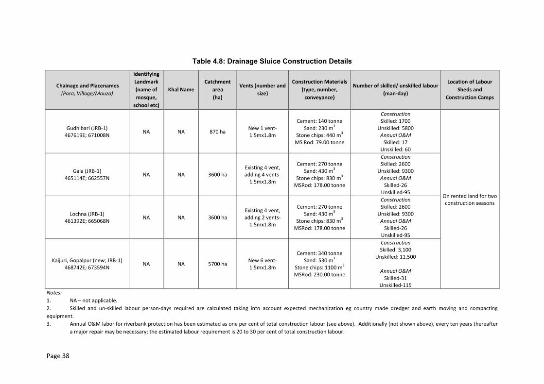
Page 38
Table 4.8: Drainage Sluice Construction Details
Chainage and Placenames
(Para, Village/Mouza)
Identifying
Landmark
(name of
mosque,
school etc)
Khal Name
Catchment
area
(ha)
Vents (number and
size)
Construction Materials
(type, number,
conveyance)
Number of skilled/ unskilled labour
(man-day)
Location of Labour
Sheds and
Construction Camps
Gudhibari (JRB-1) 467619E; 671008N
NA NA 870 ha New 1 vent-1.5mx1.8m
Cement: 140 tonne Sand: 230 m
3
Stone chips: 440 m3
MS Rod: 79.00 tonne
Construction Skilled: 1700
Unskilled: 5800 Annual O&M
Skilled: 17 Unskilled: 60
On rented land for two construction seasons
Gala (JRB-1) 465114E; 662557N
NA NA 3600 ha Existing 4 vent, adding 4 vents-
1.5mx1.8m
Cement: 270 tonne Sand: 430 m
3
Stone chips: 830 m3
MSRod: 178.00 tonne
Construction Skilled: 2600
Unskilled: 9300 Annual O&M
Skilled-26 Unskilled-95
Lochna (JRB-1) 461392E; 665068N
NA NA 3600 ha Existing 4 vent, adding 2 vents-
1.5mx1.8m
Cement: 270 tonne Sand: 430 m
3
Stone chips: 830 m3
MSRod: 178.00 tonne
Construction Skilled: 2600
Unskilled: 9300 Annual O&M
Skilled-26 Unskilled-95
Kaijuri, Gopalpur (new; JRB-1) 468742E; 673594N
NA NA 5700 ha New 6 vent-1.5mx1.8m
Cement: 340 tonne Sand: 530 m
3
Stone chips: 1100 m3
MSRod: 230.00 tonne
Construction Skilled: 3,100
Unskilled: 11,500
Annual O&M Skilled-31
Unskilled-115
Notes:
1. NA – not applicable.
2. Skilled and un-skilled labour person-days required are calculated taking into account expected mechanization eg country made dredger and earth moving and compacting
equipment.
3. Annual O&M labor for riverbank protection has been estimated as one per cent of total construction labour (see above). Additionally (not shown above), every ten years thereafter
a major repair may be necessary; the estimated labour requirement is 20 to 30 per cent of total construction labour.
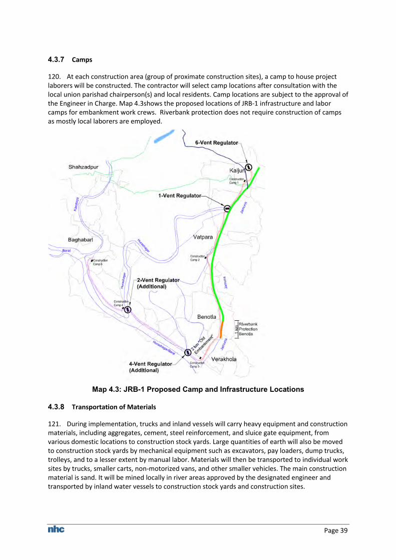
Page 39
4.3.7 Camps
120. At each construction area (group of proximate construction sites), a camp to house project laborers will be constructed. The contractor will select camp locations after consultation with the local union parishad chairperson(s) and local residents. Camp locations are subject to the approval of the Engineer in Charge. Map 4.3shows the proposed locations of JRB-1 infrastructure and labor camps for embankment work crews. Riverbank protection does not require construction of camps as mostly local laborers are employed.
Map 4.3: JRB-1 Proposed Camp and Infrastructure Locations
4.3.8 Transportation of Materials
121. During implementation, trucks and inland vessels will carry heavy equipment and construction materials, including aggregates, cement, steel reinforcement, and sluice gate equipment, from various domestic locations to construction stock yards. Large quantities of earth will also be moved to construction stock yards by mechanical equipment such as excavators, pay loaders, dump trucks, trolleys, and to a lesser extent by manual labor. Materials will then be transported to individual work sites by trucks, smaller carts, non-motorized vans, and other smaller vehicles. The main construction material is sand. It will be mined locally in river areas approved by the designated engineer and transported by inland water vessels to construction stock yards and construction sites.
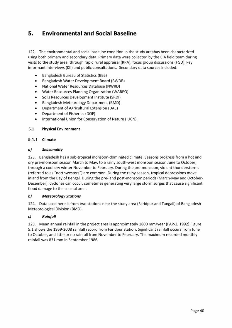
Page 40
5. Environmental and Social Baseline
122. The environmental and social baseline condition in the study areahas been characterized using both primary and secondary data. Primary data were collected by the EIA field team during visits to the study area, through rapid rural appraisal (RRA), focus group discussions (FGD), key informant interviews (KII) and public consultations. Secondary data sources included:
Bangladesh Bureau of Statistics (BBS)
Bangladesh Water Development Board (BWDB)
National Water Resources Database (NWRD)
Water Resources Planning Organization (WARPO)
Soils Resources Development Institute (SRDI)
Bangladesh Meteorology Department (BMD)
Department of Agricultural Extension (DAE)
Department of Fisheries (DOF)
International Union for Conservation of Nature (IUCN).
5.1 Physical Environment
5.1.1 Climate
a) Seasonality
123. Bangladesh has a sub-tropical monsoon-dominated climate. Seasons progress from a hot and dry pre-monsoon season March to May, to a rainy south-west monsoon season June to October, through a cool dry winter November to February. During the pre-monsoon, violent thunderstorms (referred to as “northwesters”) are common. During the rainy season, tropical depressions move inland from the Bay of Bengal. During the pre- and post-monsoon periods (March-May and October-December), cyclones can occur, sometimes generating very large storm surges that cause significant flood damage to the coastal area.
b) Meteorology Stations
124. Data used here is from two stations near the study area (Faridpur and Tangail) of Bangladesh Meteorological Division (BMD).
c) Rainfall
125. Mean annual rainfall in the project area is approximately 1800 mm/year (FAP-3, 1992).Figure 5.1 shows the 1959-2008 rainfall record from Faridpur station. Significant rainfall occurs from June to October, and little or no rainfall from November to February. The maximum recorded monthly rainfall was 831 mm in September 1986.
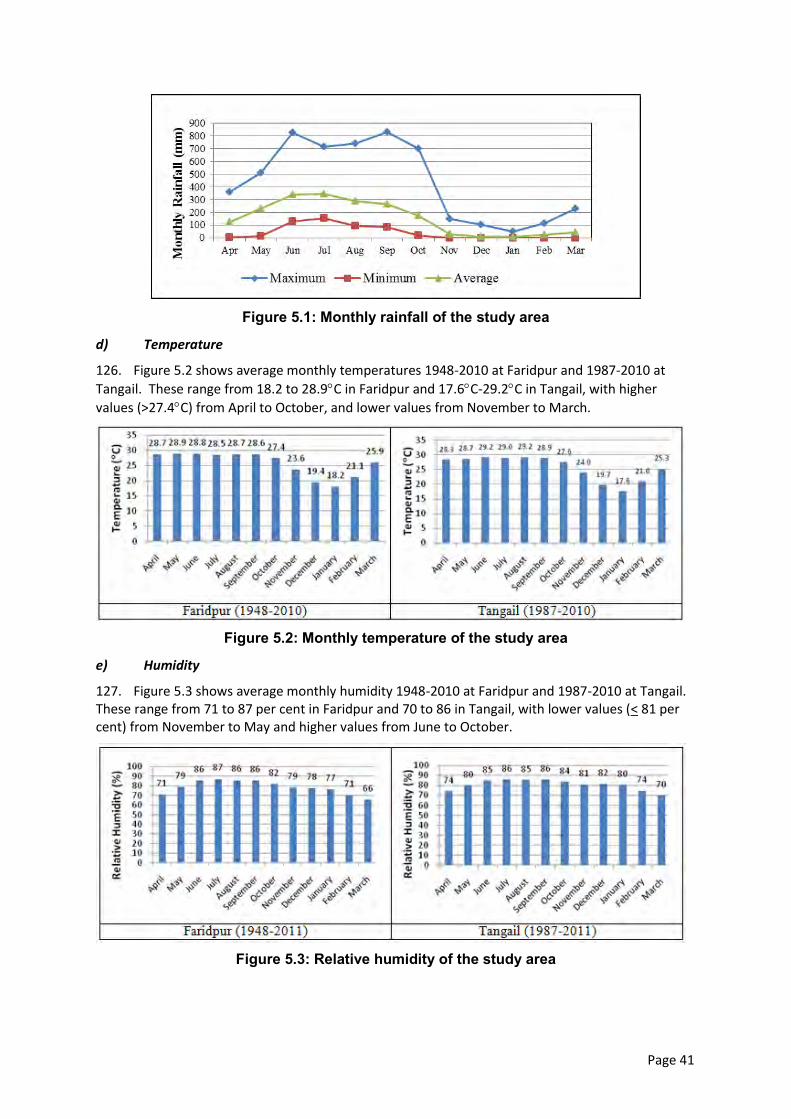
Page 41
Figure 5.1: Monthly rainfall of the study area
d) Temperature
126. Figure 5.2 shows average monthly temperatures 1948-2010 at Faridpur and 1987-2010 at
Tangail. These range from 18.2 to 28.9C in Faridpur and 17.6C-29.2C in Tangail, with higher
values (>27.4C) from April to October, and lower values from November to March.
Figure 5.2: Monthly temperature of the study area
e) Humidity
127. Figure 5.3 shows average monthly humidity 1948-2010 at Faridpur and 1987-2010 at Tangail. These range from 71 to 87 per cent in Faridpur and 70 to 86 in Tangail, with lower values (< 81 per cent) from November to May and higher values from June to October.
Figure 5.3: Relative humidity of the study area
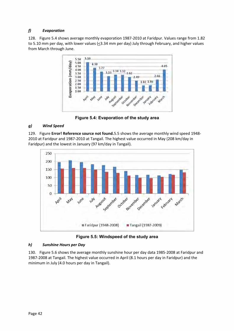
Page 42
f) Evaporation
128. Figure 5.4 shows average monthly evaporation 1987-2010 at Faridpur. Values range from 1.82 to 5.10 mm per day, with lower values (<3.34 mm per day) July through February, and higher values from March through June.
Figure 5.4: Evaporation of the study area
g) Wind Speed
129. Figure Error! Reference source not found.5.5 shows the average monthly wind speed 1948-2010 at Faridpur and 1987-2010 at Tangail. The highest value occurred in May (208 km/day in Faridpur) and the lowest in January (97 km/day in Tangail).
Figure 5.5: Windspeed of the study area
h) Sunshine Hours per Day
130. Figure 5.6 shows the average monthly sunshine hour per day data 1985-2008 at Faridpur and 1987-2008 at Tangail. The highest value occurred in April (8.1 hours per day in Faridpur) and the minimum in July (4.0 hours per day in Tangail).
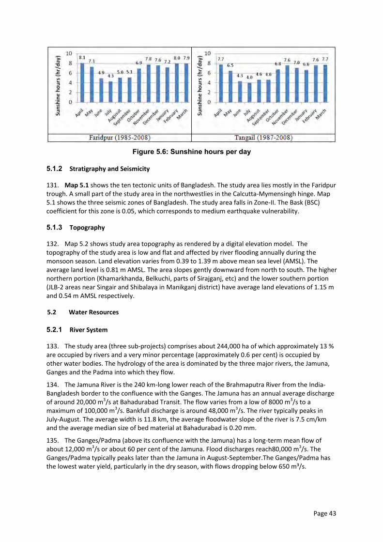
Page 43
Figure 5.6: Sunshine hours per day
5.1.2 Stratigraphy and Seismicity
131. Map 5.1 shows the ten tectonic units of Bangladesh. The study area lies mostly in the Faridpur trough. A small part of the study area in the northwestlies in the Calcutta-Mymensingh hinge. Map 5.1 shows the three seismic zones of Bangladesh. The study area falls in Zone-II. The Bask (BSC) coefficient for this zone is 0.05, which corresponds to medium earthquake vulnerability.
5.1.3 Topography
132. Map 5.2 shows study area topography as rendered by a digital elevation model. The topography of the study area is low and flat and affected by river flooding annually during the monsoon season. Land elevation varies from 0.39 to 1.39 m above mean sea level (AMSL). The average land level is 0.81 m AMSL. The area slopes gently downward from north to south. The higher northern portion (Khamarkhanda, Belkuchi, parts of Sirajganj, etc) and the lower southern portion (JLB-2 areas near Singair and Shibalaya in Manikganj district) have average land elevations of 1.15 m and 0.54 m AMSL respectively.
5.2 Water Resources
5.2.1 River System
133. The study area (three sub-projects) comprises about 244,000 ha of which approximately 13 % are occupied by rivers and a very minor percentage (approximately 0.6 per cent) is occupied by other water bodies. The hydrology of the area is dominated by the three major rivers, the Jamuna, Ganges and the Padma into which they flow.
134. The Jamuna River is the 240 km-long lower reach of the Brahmaputra River from the India-Bangladesh border to the confluence with the Ganges. The Jamuna has an annual average discharge of around 20,000 m3/s at Bahadurabad Transit. The flow varies from a low of 8000 m3/s to a maximum of 100,000 m3/s. Bankfull discharge is around 48,000 m3/s. The river typically peaks in July-August. The average width is 11.8 km, the average floodwater slope of the river is 7.5 cm/km and the average median size of bed material at Bahadurabad is 0.20 mm.
135. The Ganges/Padma (above its confluence with the Jamuna) has a long-term mean flow of about 12,000 m3/s or about 60 per cent of the Jamuna. Flood discharges reach80,000 m3/s. The Ganges/Padma typically peaks later than the Jamuna in August-September.The Ganges/Padma has the lowest water yield, particularly in the dry season, with flows dropping below 650 m³/s.
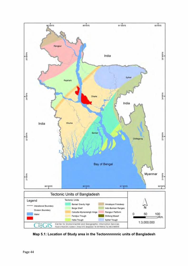
Page 44
Map 5.1: Location of Study area in the Tectonnnnnnic units of Bangladesh
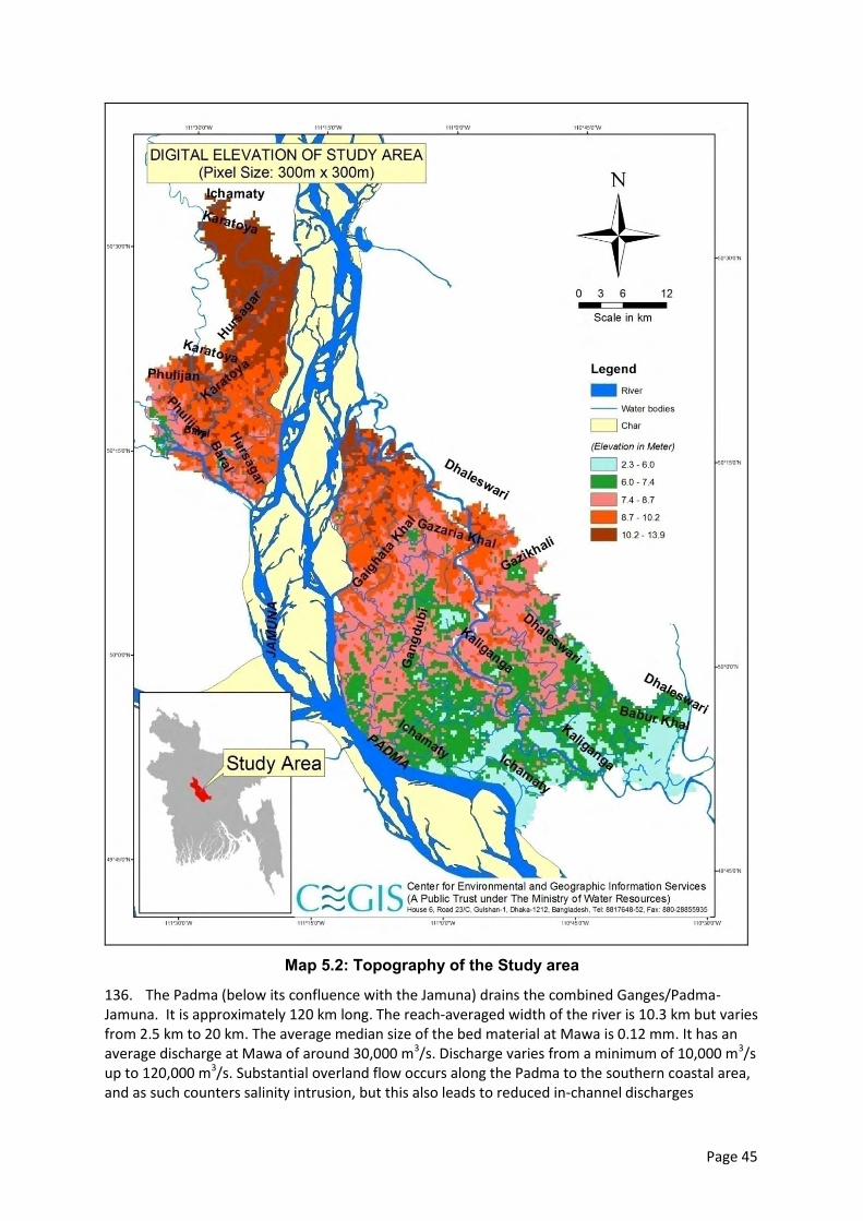
Page 45
Map 5.2: Topography of the Study area
136. The Padma (below its confluence with the Jamuna) drains the combined Ganges/Padma-Jamuna. It is approximately 120 km long. The reach-averaged width of the river is 10.3 km but varies from 2.5 km to 20 km. The average median size of the bed material at Mawa is 0.12 mm. It has an average discharge at Mawa of around 30,000 m3/s. Discharge varies from a minimum of 10,000 m3/s up to 120,000 m3/s. Substantial overland flow occurs along the Padma to the southern coastal area, and as such counters salinity intrusion, but this also leads to reduced in-channel discharges
Page 46
downstream. The Padma is weakly tidal during the dry season. At the downstream end of the project area, the Padma joins the Meghna River near Chandpur.
137. Table 5.1 and Table 5.2 show the seasonal and mean discharge values of the Jamuna and Padma rivers from 1981 to 2006 at two stations, Bahadurabad transit and Baruria transit (BWDB, 2006). The Jamuna maximum is about 50,000 m3/s (July) while the Padma maximum is about 70,000 m3/s (September-October).
Table 5.1: Seasonal Discharge of Jamuna and Padma
Season Jamuna River (Bahadurabad
Transit) Padma River (Baruria
Transit) m3/s
Dry (December-February) 9610 7330 Pre-Monsoon (March-May) 12700 9630 Monsoon (June-September) 35710 43250 Post-Monsoon (October-November) 25500 20660
Table 5.2: Mean Discharge ( 1981- 2006) of Jamuna and Padma
Season Jamuna River (Bahadurabad
Transit) Padma River
(Baruria Transit) m3/s
Dry (December-February) 6080 7650 Pre-Monsoon (March-May) 10360 10920 Monsoon (June-September) 41020 60030 Post-Monsoon (October-November) 20100 29910 Source: BWDB
138. Main river water levels and discharges are not strongly related to local precipitation, since the vast majority of river runoff is generated outside the country. The most severe floods occur when the Jamuna and Ganges Rivers peak together such as in 1988.
139. The tributaries of these major rivers inside the study area are Hurasagar, Dhaleswari, Kaliganga, Baral, Gohala, and Ichamati Rivers. The Ichamati is the only Padma tributary passing through the study area; the other tributaries connect directly to the Jamuna.
140. Some small water bodies (Kadaibadla Beel, Pandaha Beel, Khalsir Beel, Nalai Beel, Bharua Beel, Gharilpur Beel etc.) are found inside the study area. Most are connected to the tributary channels during monsoon.
5.2.2 Surface Water Levels and Quality
141. Surface water data records for water level, water quality, and discharge of the two major rivers were collected from several BWDB stations covering various time intervals. The following sections provide a discussion of surface water characteristics in the study area.
142. Water levels. Secondary data on water levels were collected for the Jamuna and Padma rivers fromthe BWDB stations at Sirajganj and Aricha. The data collected on water levels (2009) are shown below in Table 5.3. The table shows that in monsoon the average surface water levels of Jamuna and Padma riversremain about 11.73m PWD and 7.28m PWD, respectively. In the dry season, the Padma Riverbecomes extremely shallow but the JamunaRiver remains deep enough. Table 5.4 shows the average values of water levels of the two major rivers in different seasons (1991 to 2009).
Page 47
Table 5.3: Water levels of Jamuna and Padma
Season Jamuna River (Sirajganj station)
Padma River (Aricha Station)
m+PWD Dry(December-February) 6.84 2.85 Pre-Monsoon(March-May) 7.75 3.35 Monsoon (June-September) 11.73 7.28 Post-Monsoon (October-November) 5.5 5.80
Source: Bangladesh Water Development Board
Table 5.4: Jamuna and Padma Rivers Mean Water Levels(1991-2009)
Season Jamuna River
(Sirajganj station) Padma River
(Aricha Station) m+PWD Dry (December-February) 7.60 3.23 Pre-Monsoon (March-May) 8.50 3.73 Monsoon (June-September) 12.55 8.19 Post-Monsoon (October-November) 10.32 6.22
Source: Bangladesh Water Development Board
143. Water quality. Sevensurface water quality parameters were collected from two BWDB stations at Bahadurabad and Aricha. The values of the parameters and their standard values set by the DoE are shown in Table 5.5andTable 5.6 respectively.
Table 5.5: Surface Water Quality of Jamuna and Padma
Station Name River Month Temp
(°C) pH DO (mg/l)
TDS (mg/l)
EC (S/cm)
Fe (mg/l)
Cl (mg/l)
Bahadurabad Transit Jamuna
January 29 7.8 8.29 22 66 0.02 11 February 30 7.8 8.29 23 65 0 11 Marh 32 7.8 8.29 21 66 0.02 10 April 28 7.8 8.28 21 64 0.02 10 May 28 7.7 8.26 21 65 0.01 11 June 27 7.6 8.21 21 65 0 11
Aricha Padma
January 28 7.3 8.16 24 69.2 0.2 12 February 30 7.3 8.12 24 69.2 0.2 12 Marh 30 7.3 8.16 25 69.2 0.2 10 April 30 7.3 8.16 23 69.2 0.2 10 May 27 7.3 8.1 22 69.2 0.2 10 June 28 7.3 8.1 23 69.2 0.2 12
Source: Bangladesh Water Development Board
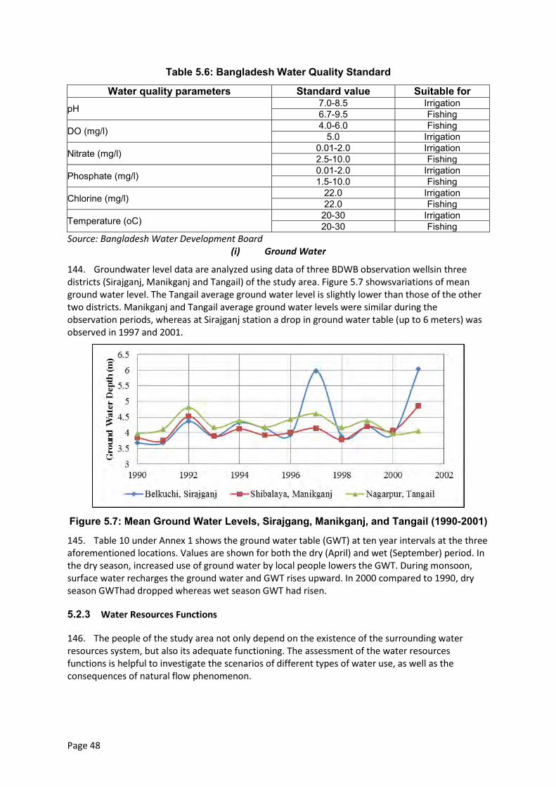
Page 48
Table 5.6: Bangladesh Water Quality Standard
Water quality parameters Standard value Suitable for pH 7.0-8.5 Irrigation
6.7-9.5 Fishing
DO (mg/l) 4.0-6.0 Fishing 5.0 Irrigation
Nitrate (mg/l) 0.01-2.0 Irrigation 2.5-10.0 Fishing
Phosphate (mg/l) 0.01-2.0 Irrigation 1.5-10.0 Fishing
Chlorine (mg/l) 22.0 Irrigation 22.0 Fishing
Temperature (oC) 20-30 Irrigation 20-30 Fishing
Source: Bangladesh Water Development Board (i) Ground Water
144. Groundwater level data are analyzed using data of three BDWB observation wellsin three districts (Sirajganj, Manikganj and Tangail) of the study area. Figure 5.7 showsvariations of mean ground water level. The Tangail average ground water level is slightly lower than those of the other two districts. Manikganj and Tangail average ground water levels were similar during the observation periods, whereas at Sirajganj station a drop in ground water table (up to 6 meters) was observed in 1997 and 2001.
Figure 5.7: Mean Ground Water Levels, Sirajgang, Manikganj, and Tangail (1990-2001)
145. Table 10 under Annex 1 shows the ground water table (GWT) at ten year intervals at the three aforementioned locations. Values are shown for both the dry (April) and wet (September) period. In the dry season, increased use of ground water by local people lowers the GWT. During monsoon, surface water recharges the ground water and GWT rises upward. In 2000 compared to 1990, dry season GWThad dropped whereas wet season GWT had risen.
5.2.3 Water Resources Functions
146. The people of the study area not only depend on the existence of the surrounding water resources system, but also its adequate functioning. The assessment of the water resources functions is helpful to investigate the scenarios of different types of water use, as well as the consequences of natural flow phenomenon.
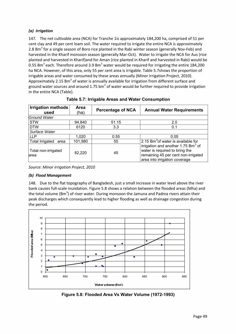
Page 49
(a) Irrigation
147. The net cultivable area (NCA) for Tranche 1is approximately 184,200 ha, comprised of 51 per cent clay and 49 per cent loam soil. The water required to irrigate the entire NCA is approximately 2.8 Bm3 for a single season of Boro rice planted in the Rabi winter season (generally Nov-Feb) and harvested in the Kharif monsoon season (generally Mar-Oct). Water to irrigate the NCA for Aus (rice planted and harvested in Kharif)and for Aman (rice planted in Kharif and harvested in Rabi) would be 0.55 Bm3 each. Therefore around 3.9 Bm3 water would be required for irrigating the entire 184,200 ha NCA. However, of this area, only 55 per cent area is irrigable. Table 5.7shows the proportion of irrigable areas and water consumed by these areas annually (Minor Irrigation Project, 2010). Approximately 2.15 Bm3 of water is annually available for irrigation from different surface and ground water sources and around 1.75 bm3 of water would be further required to provide irrigation in the entire NCA (Table).
Table 5.7: Irrigable Areas and Water Consumption
Irrigation methods used
Area (ha) Percentage of NCA Annual Water Requirements
Ground Water
STW 94,840 51.15 2.0 DTW 6120 3.3 0.1 Surface Water
LLP 1,020 0.55 0.05 Total Irrigated area 101,980 55 2.15 Bm3of water is available for
irrigation and another 1.75 Bm3 of water is required to bring the remaining 45 per cent non-irrigated area into irrigation coverage
Total non-irrigated area 82,220 45
Source: Minor irrigation Project, 2010
(b) Flood Management
148. Due to the flat topography of Bangladesh, just a small increase in water level above the river bank causes full-scale inundation. Figure 5.8 shows a relation between the flooded areas (Mha) and the total volume (Bm3) of river water. During monsoon the Jamuna and Padma rivers attain their peak discharges which consequently lead to higher flooding as well as drainage congestion during the period.
Figure 5.8: Flooded Area Vs Water Volume (1972-1993)
Page 50
149. The occurrence of flood is indicated when the water level of the river exceeds its danger level. The danger level of the Padma at Mawa is 6.0 m PWD and the Jamuna at Bahadurabad is 19.5m PWD. The probability of flood in a year for the Padma is about 60 per cent and for the Jamuna is about 75 per cent. The average duration of flood is about 23 days in the Padma basin and about 14 days in the Jamuna basin. The durations of the floods previously affecting the Padma and Jamuna basins are given inTable 5.8.
Table 5.8: Flood Duration, Padma and Brahmaputra/Jamuna Basins
Padma Basin Brahmaputra/Jamuna Basin Year Flood duration (days) Year Flood duration (days)
1998 65 1998 63 1987 52 1974 44 2003 39 1970 26 1971 35 1984 24 1969 33 1977 22
1995 30 1973, 1980, 2007 21
Source: Flood Shelter Report, IWFM and BRAC
150. Table 5.9 and Table 5.10 show the frequency analyses of the annual maximum water levels of the Jamuna and Padma rivers (Flood Shelter Report, IWFM and BRAC). The tables explain the differences in water levels due to change in return periods. It is seen from the tables that the difference between the highest flood and the 20year flood is about 23 cm at Bahadurabad and 38 cm at Mawa.
Table 5.9: Flood Level Frequency Analysis, Jamuna at Bahadurabad
Probability distribution function
Water level for the specified return period(m PWD) Highest observed floods, m+PWD (year)
5 year 10 year 20 year 50 year 100 year
Normal 20.11 20.29 20.44 20.6 20.72 20.61 (1988) 20.40 (2007) 20.37 (1998)
Log Normal 20.11 20.29 20.45 20.62 20.74 Log Pearson Type III 20.11 20.26 20.38 20.5 20.58 Gumbel 20.06 20.3 20.53 20.83 21.05
Source: Flood Shelter Report, IWFM and BRAC
Table 5.10: Flood Level Frequency Analysis, Padma at Mawa
Probability distribution function
Water level for the specified return period(m PWD) Highest observed floods, m+PWD (year)
5 year 10 year 5 year 10 year
Normal 6.5 6.67 6.81 6.97 7.08 7.14 (1998) 7.07 (1988) 6.84 (2004)
Log Normal 6.49 6.67 6.82 7.0 7.12 Log Pearson Type III 6.5 6.64 6.76 6.88 6.95 Gumbel 6.45 6.68 6.9 7.18 7.39
Source: IWFM and BRAC Flood Shelter Report.
151. The severe land erosion along the river banks and char lands of the study area cause continuous siltation in a number of major tributary rivers (Karatowa, Baleswari, Baral, Hurasagar, Ichamati etc rivers) of the Padma and the Jamuna. This eventually reduces the depths of these rivers and during the dry periods these rivers become extremely shallow. As a result, water logging problems arise during the dry periods at a few locations (Ghashpukuria, Ghashkauliya, Bagutia etc villages under Chauhali and Daulatpur upazilas). The condition of drainage inside the area is poor. In the study area, drainage channels are not well developed. A significant portion of the entire study area suffers from drainage congestion problems during the wet period. As the major tributary
Page 51
channels are becoming shallow because of heavy siltation, such rivers and water bodies do not provide the effective drainage needed during monsoon. Also due to the backwater effects of the two major rivers, drainage congestion problems occur. About 12.5 per cent of the total study area (some areas near JRB1 and PLB1 interventions at Belkuchi, Shahjadpur, Harirampur, Manikganj etc.) undergoes moderate drainage. The drainage of areas near the JLB2 intervention (Nagarpur, Saturia, Shibalaya etc locations) is poor.
(c) Morphology
152. The morphology of the two major rivers adjacent to the study area has enormous impacts on the lives and livelihood of the local people. During the last few decades the lower reach of the Jamuna River changed its plan form from a single threaded meandering river to a complicated braided river. The location of the confluence of the Hurasagar River shifted several kilometers upstream during the last 40 years and became fixed at the present position about two decades back. Channel development and abandonment, movement of bars, islands and bank lines is very common in this river. The Padma, on the other hand is a meandering river and less dynamic.
(d) Erosion
153. Riverbank erosion is the most important natural cause of landlessness and forced resettlement of people in the study area. During 1973 to 2012, erosion and accretion along the Jamuna River was 87,363 ha and 16,479 ha respectively (net erosion was about 70,884 ha). In 2011, net erosion was about 1,999ha of which 250 ha were settlements. The eroded lands also included about 1,867 m of district road, 958 m of upazila road and 3019 m of rural road.
154. During the last four decades (1973 to 2011), erosion and accretion along the Padma River was 41,323 ha and 9,134 ha respectively (the net erosion was about 32,189 ha). The rate of widening of the Padma River was 160 m/year in the 1980s, which increased to 230 m/year in the 1990s. Recently, the rate of widening has reduced to 130 m/year. In 2011, about 679 ha of land were eroded, of which settlements were about 60 ha. On the other hand, 54 m of district road, 22 m of upazila road and 1294 m of rural road were eroded in that year. In the study area, about 360 ha of land were eroded in 2011 which included about 27 ha of settlements, 41m district road, 39m upazila road and 407m rural roads.
(e) Char Formation
155. Char lands refer to mid-channel islands that periodically emerge from the riverbed as a result of accretion (Elahi, Ahmed, and Mafizuddin 1991). The residents of chars and mainland adjacent to main rivers are extremely vulnerable to erosion and flooding as it can destroy their crops and home-steads, render land unproductive, and destroy livestock. In the Jamuna floodplains, about 50 per cent people live in the island and attached chars whereas in the Padma char areas, the number is about 27 per cent (Bangladesh Flood Action Plan, 1993).
156. The study area comprises about 29,000 ha (about 12 per cent of the study area) of chars. About 90 per cent of these areas are used for different purposes (ie agriculture, settlement etc) by the local people. The remaining 10 per cent areas are not used by the local people because of its temporary existence. In the Jamuna River, about 85 per cent reduction in flow takes place during dry period. The mean depth of Jamuna River recorded near the Sirajganj Sadar reduces by approximately 39.5 per cent. About 87 per cent reduction in flow takes place in the Padma River from monsoon to dry period. The average depth of the river reduces by approximately 60 per cent (from 8.19 m during monsoon to 3.23 meters in the dry season). This significant reduction of dry season flow eventually increases the char lands during the dry season.
157. Char lands are formed mainly because of the low flow in the rivers in the dry season. Also the erosion along the sides of the Jamuna and Padma rivers result in the siltation of inside the rivers, which results in the formation of Char lands.
Page 52
5.3 Land Resources
5.3.1 Agro-Ecological Regions
158. Bangladesh has a wide range of environmental conditions. Environmental diversity occurs not only at national and regional levels, it also occurs at upazila and village levels. Besides considerable year to year variability in moisture, the temperature and flood regimes create major problems for planning program on environment and agricultural research, extension and development activities.
159. Thirty agro-ecological regions and 88 sub-regions have been identified by adding successive layers of information on the physical environment which are relevant for land use and assessing agricultural potential (Map 5.3).These layers are: (i) physiography (land forms and parent materials); Soils and their characteristics; (ii) depth and duration of seasonal flooding; (iii) length of the rain-fed kharif and rabi growing periods; Length of the pre-kharif period of unreliable rainfall; (iv) length of the cool winter period and frequency of occurrence of extremely low temperature (below 0.40oC); (v) winter temperature and (vi) frequency of occurrence of extremely high (> 400oC) summer temperature.
160. The study area comprises of the following five agro-ecological regions:
(i) Karatoya-Bangali Floodplain (AEZ-4); (ii) Active Brahmaputra-Jamuna Flood plain (AEZ-7); (iii) Young Brahmaputra and Jamuna Floodplain (AEZ 8); (iv) Active Ganges Floodplain (AEZ-10); and (v) Low Ganges River Floodplain (AEZ-12).
161. The distribution of agro-ecological regions in the study area is presented in Error! Reference source not found.5.11. Characteristics of study area agro-ecological regions are presented below.
Table 5.11: Agro-Ecological Zones
Agro-ecological Region AEZ Area Within Study Area (ha) (per cent)
Active Brahmaputra-Jamuna 43,977 18 Active Ganges Floodplain 7,329 3 Karatoya-Bangali Floodplain 43,977 18 Low Ganges River Floodplain 46,420 19 Young Brahmaputra and Jamuna 102,613 42 Total 244,316 100
Karatoya-Bangali Floodplain Region (AEZ-4)
162. The floodplain apparently comprises of a mixture of Tista and Brahmaputra sediments. Most areas have smooth, broad, floodplain ridges and almost level basins. The soils are grey silt loams and silty clay loams on ridges and grey or dark grey clays in basins. Five general soil types occur in the region of which, Non-calcareous Grey Floodplain and Non-calcareous Dark Floodplain soils predominate. They are moderately acidic throughout. Organic matter content is low in ridge soils and moderate in basins. General fertility is medium. Some physico-chemical properties of soils of Karatoya-Bangali Floodplain Region are presented in Table 5.12.
Page 53
Map 5.3: Agroecological Region of the Study Area
Page 54
Table 5.12: Soil Characteristics, Karatoya-Bangali Floodplain Region
Major land type Soil pH Soil OM Nutrients status
N P K S Ca Mg Zn B Mo
High land (23 per cent) 4.7-7.8 L VL-L L-M L L-M Opt Opt L-M L-M Opt Med highland (44 per cent) 5.4-7.9 L VL-L L-M L L-M Opt Opt L-M L-M Opt Med lowland (14 per cent) 6.2-7.7 L VL-L L-M L L-M Opt Opt L-M L-M Opt Source: BARC Fertilizer Recommendation Guide-2005. Notes: OM=Organic matter; VL=Very low; L=Low; M=Medium; Opt=Optimum; H=High; VH=Very high.
Active Brahmaputra-Jamuna Flood plain Region (AEZ-7)
163. This subunit, which underlies agro-ecological region 7, comprises young, stratified, alluvial land within and adjoining the shifting channels of the Brahmaputra and Jumna Rivers, the Old Brahmaputra River and the Dhaleswari-Kaliganga River. The land formation (char) are liable to change shape each year as river banks are eroded,new alluvium is deposited within and alongside channels and older deposits are buried by layers of new alluvium. The relief varies from smooth to irregular, with differences in elevation of 2-3 meters or more between adjoining ridges and depressions. The depth of flooding varies from shallow to deep on different sites and the maximum depth may vary by a meter or more from year to year. The area is occupied by sandy and silty alluvium rich in minerals with slightly alkaline in reaction. The Brahmaputra sediments are greyer in color than the Ganges sediments. Six general soil types occupy the area of which only Non-calcareous Alluvium predominates. Organic matter content is low and fertility status low to medium. Some physico-chemical properties of soils of Active Brahmaputra-Jamuna Flood plain Region is presented in Table 5.13.
Table 5.13: Soil Characteristics, Active Brahmaputra-Jamuna Floodplain
Major land type Soil pH
Soil OM
Nutrients status
N P K S Ca Mg Zn B Mo
Medium highland (37 per cent) 5.7-8.2 L L L-M L-M L-M L-M L-M L-M L-M M
Medium lowland(20 per cent)
6.0-8.2 L L L-M L-M L-M L-M L-M L-M L-M M
Source: BARC Fertilizer Recommendation Guide-2005. Notes: OM=Organic matter; VL=Very low; L=Low; M=Medium; Opt=Optimum; H=High; VH=Very high.
Young Brahmaputra and Jamuna Floodplain Region (AEZ 8)
164. The region comprises of the area of Brahmaputra sediments. It has a complex relief of broad and narrow ridges, inter-ridge depressions, partially in filled cut-off channels and basins. This area is occupied by permeable silt loam to silty clay loam soils on the ridges and impermeable clays in the basins; neutral to slightly acid in reaction. General Soil Types include predominantly Grey Floodplain soils. Organic matter content is low in ridges and moderate in basins. Soils are deficient in N, P and S but the status of K and Zn is medium. Some physiochemical properties ofsoils of Young Brahmaputra and Jamuna Floodplain are presented inTable 5.14.
Page 55
Table5.14: Soil Characteristics, Young Brahmaputra and Jamuna Floodplain
Major land type Soil pH Soil OM Nutrients status
N P K S Ca Mg Zn B Mo
High land (18 per cent) 5.6-7.5 VL-L VL-L L M L M M L-M L-M M Med highland (42 per cent) 5.4-7.5 VL-L VL-L L M L M M L-M L-M M Med lowland (19 per cent) 5.4-7.5 L L L M L M M L-M L-M M Source: BARC Fertilizer Recommendation Guide-2005. Notes: OM=Organic matter; VL=Very low; L=Low; M=Medium; Opt=Optimum; H=High; VH=Very high
Active Ganges Floodplain Region (AEZ-10)
165. The agro-ecological regions of Active Ganges Floodplain comprises of young, stratified, alluvium land within and adjoining the shifting channels of the Ganges River and its two main distributaries, the Gorai- Madhumati and Arial khan. The alluvial formations (chars) are liable to change shape each year as river bank are eroded, new alluvium are deposited within and along channels and older deposits are buried by layers of new alluvium. The relief varies from smooth to irregular, with 2-3 meters or more difference in elevation between the adjacent ridges and depressions. Seasonal flooding varies from shallow to deep on different sites and may vary in depth by more than a meter between years. The area has complex mixtures of calcareous sandy, silty and clayey alluvium. The general soil types predominately include Calcareous Alluvium and Calcareous Brown Floodplain soils, which are low in organic matter and mildly alkaline in reaction. The fertility status generally is medium. Physiochemical properties of soils of Active Ganges Floodplain Regionare presented inTable 5.15.
Table5.15: Soil Characteristics, Active Ganges Floodplain Region
Major land type Soil pH
Soil OM
Nutrients status N P K S Ca Mg Zn B Mo
High land (12 per cent) 7.1-8.1 L L L-M M L-M H H L M M Med highland (33 per cent) 7.1-8.1 L L L-M M L-M H H L M M
Med lowland (18 per cent) 7.1-8.1 L L L-M M L-M H H L M M Source: BARC Fertilizer Recommendation Guide-2005. Notes: OM=Organic matter; VL=Very low; L=Low; M=Medium; Opt=Optimum; H=High; VH=Very high.
Low Ganges River Floodplain (AEZ-12)
166. This region comprises of the north-eastern, eastern and south-eastern parts of the Ganges Meander Floodplain which are lower lying than the western part. The ridges are mainly shallowly flooded, but basins become moderately deeply or deeply flooded in the rainy season.
167. The soils of the Low Ganges River Floodplains are silt loams and silty clay loams on the ridges and silty clay loams to heavy clays on lower sites.General soil types predominately include Calcareous Dark Grey, Grey and Calcareous Brown Floodplain soils. Organic matter content is low in ridges and moderate in the basins. Soils are calcareous in nature having neutral to slightly alkaline in reaction. General fertility level is medium. Some physiochemical properties of soils of Low Ganges River Floodplainare presented inTable 5.16.
Page 56
Table 5.16: Soil Characteristics, Low Ganges River Floodplain
Major land type Soil pH Soil OM Nutrients status
N P K S Ca Mg Zn B Mo
High land (13 per cent) 6.8-8.2 L VL-L VL-L M-Opt L-M Opt-H Opt-H L-M M-Opt Opt Medium highland (29 per cent) 6.2-8.3 L-M VL-M VL-M M-Opt L-M Opt-H Opt-H L-M M-Opt Opt Medium lowland (31 per cent) 6.0-8.3 L-M L L M-Opt L-M Opt-H Opt-H L-M M-Opt Opt Lowland (14 per cent) 6.0-7.7 M L L M-Opt L-M Opt-H Opt-H L-M M-Opt Opt Source: Fertilizer Recommendation Guide-2005, BARC Notes: OM=Organic matter; VL=Very low; L=Low; M=Medium; Opt=Optimum=High; VH=Very high
5.3.2 Land use
168. The total study area is about 244,316ha of which about 184,200 ha is net cultivable area (NCA). Settlements and water bodies constitute about 11 per cent and 13 per cent respectively of the total area of the project. The settlements and river constitute about 23 per cent and 8 per cent respectively of the total area. Details of land use of the study area are presented in Table 5.17.
Table 5.17: Land Use of the Study Area
Sources: CEGIS estimation from SOLARIS.
5.3.3 Land type
169. Land type classifications are based on depth of inundation on agriculture land during monsoon season due to normal flooding. There are five land type classes: high land (0-30 cm), medium highland (30 - 90 cm), medium lowland, (90 -180 cm), low land (180 - 300 cm), and very lowland (>300 cm). The percentages of land type of high land, medium highland, medium lowland, lowland and very lowland are about 4, 37, 37, 21 and 0.3 respectively of the NCA. Detailed land type is presented in Table 5.18.
Table 5.18: Land Types of the Study Area
Land type Area (ha) Per cent of NCA Highland 8,153 4 Medium Highland 68,045 37 Medium Lowland 68,023 37 Lowland 39,376 21 Very Lowland 605 0.3 Total 184,200 100 Sources: CEGIS estimation from SOLARIS.
5.3.4 Soil Texture
170. Soil texture is the relative proportions of sand, silt and clay. It is very important for agriculture crop production. The percentages of texture of surface soil of the study areas are about 7, 44, 39, 6 and 4 per cent for clay, clay loam, loam, sand, sandy loam respectively of the NCA. Data on soil texture is presented in Table 5.19.
Land use Area (ha) Per cent of total area Total Area 244,316 - NCA 184,200 75 Settlements 27,764 11 Rivers & Water Bodies 32,352 13 Total 244,316 100
Page 57
Table 5.19: Soil Texture, 0-15 cm Depth
Texture Area(ha) Percentage of NCA Clay 13,157 7 Clay Loam 80,193 44 Loam 72,511 39 Sand 11,389 6 Sandy Loam 6,950 4 Total 184,200 100
Sources: CEGIS estimation from SOLARIS.
5.3.5 Available Soil Moisture
171. The available soil moisture is very important for the cultivation of Rabi crops. The high (72.9%) and medium level (26.9%) of available soil moisture has been observed in the study area. The distribution of available soil moisture is presented in Table5.20.
Table 5.20: Soil Moisture of the Study area
Soil Moisture Area Per cent of NCA High 134,373 72.9 Medium 49,485 26.9 Low 342 0.2 Total 184,200 100.0 Source: CEGIS estimation from SOLARIS.
5.3.6 Drainage Characteristics
172. Drainage plays a vital role in the management of soil in the study area. As per the SRDI, the drainage characteristics have been divided into six classes from the agriculture point of view. Detailed drainage characteristics along with area of the project are presented in Table 5.21.
173. Most of the area (83%) of the NCA is under imperfectly drained condition. The rest (17 per cent) is under poorly drained condition. The dominance of imperfectly drained soil of the study area indicates that the removal of water in rainy/ monsoon season is the main constraint for growing dry land crops in the study area.
Table 5.21: Drainage Characteristics of the Study Area
Drainage classes Drainage characteristics Area
(ha) Percent ofNCA
Imperfectly Drained
Water drained from soil badly or slowly. This soil often remains wet in rainy season due to rainfall. In normal situation, water does not stand on land more than 15 days at a stretch. In rainy season, groundwater stands within 1 metre at least for some time.
31,314 17
Poorly Drained
The soil remains under water from 15 days to 7/8 months. Water is drained from the soil slowly. In most cases, the land remains wet/water logged for a considerable period of time after the rainy season.
152,886 83
Total 184,200 100 Source: CEGIS estimation from SOLARIS (NWRD).
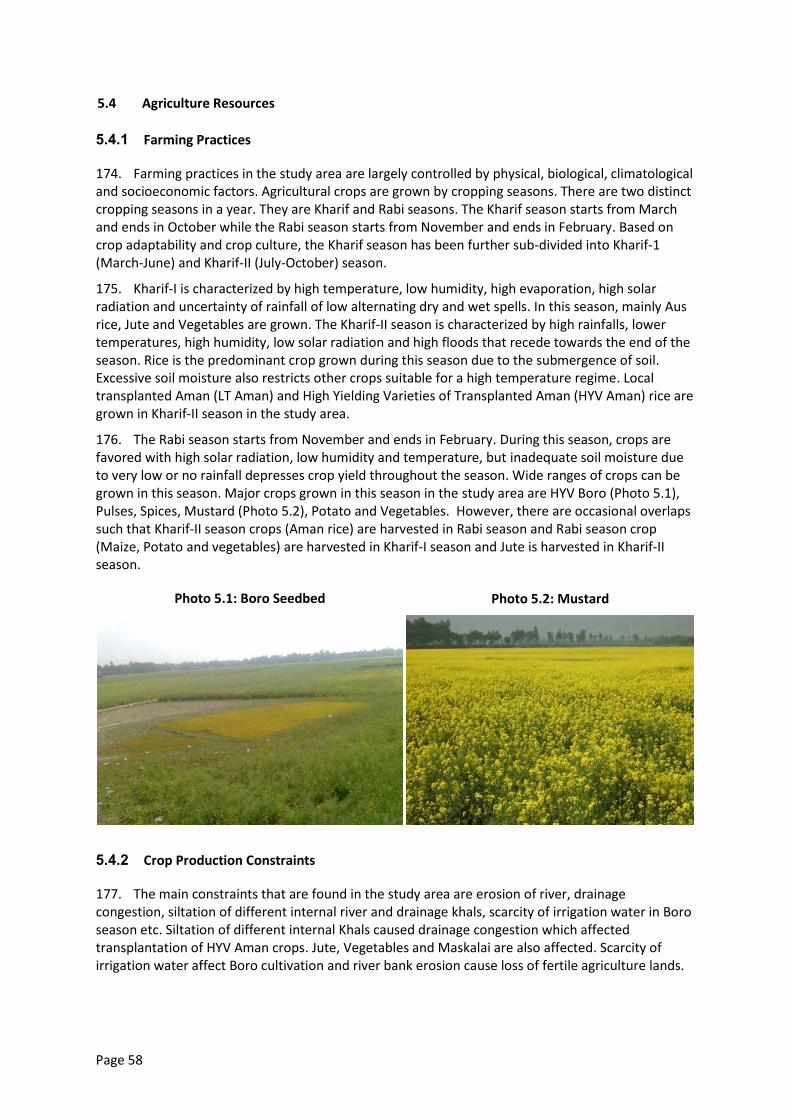
Page 58
5.4 Agriculture Resources
5.4.1 Farming Practices
174. Farming practices in the study area are largely controlled by physical, biological, climatological and socioeconomic factors. Agricultural crops are grown by cropping seasons. There are two distinct cropping seasons in a year. They are Kharif and Rabi seasons. The Kharif season starts from March and ends in October while the Rabi season starts from November and ends in February. Based on crop adaptability and crop culture, the Kharif season has been further sub-divided into Kharif-1 (March-June) and Kharif-II (July-October) season.
175. Kharif-I is characterized by high temperature, low humidity, high evaporation, high solar radiation and uncertainty of rainfall of low alternating dry and wet spells. In this season, mainly Aus rice, Jute and Vegetables are grown. The Kharif-II season is characterized by high rainfalls, lower temperatures, high humidity, low solar radiation and high floods that recede towards the end of the season. Rice is the predominant crop grown during this season due to the submergence of soil. Excessive soil moisture also restricts other crops suitable for a high temperature regime. Local transplanted Aman (LT Aman) and High Yielding Varieties of Transplanted Aman (HYV Aman) rice are grown in Kharif-II season in the study area.
176. The Rabi season starts from November and ends in February. During this season, crops are favored with high solar radiation, low humidity and temperature, but inadequate soil moisture due to very low or no rainfall depresses crop yield throughout the season. Wide ranges of crops can be grown in this season. Major crops grown in this season in the study area are HYV Boro (Photo 5.1), Pulses, Spices, Mustard (Photo 5.2), Potato and Vegetables. However, there are occasional overlaps such that Kharif-II season crops (Aman rice) are harvested in Rabi season and Rabi season crop (Maize, Potato and vegetables) are harvested in Kharif-I season and Jute is harvested in Kharif-II season.
Photo 5.1: Boro Seedbed
Photo 5.2: Mustard
5.4.2 Crop Production Constraints
177. The main constraints that are found in the study area are erosion of river, drainage congestion, siltation of different internal river and drainage khals, scarcity of irrigation water in Boro season etc. Siltation of different internal Khals caused drainage congestion which affected transplantation of HYV Aman crops. Jute, Vegetables and Maskalai are also affected. Scarcity of irrigation water affect Boro cultivation and river bank erosion cause loss of fertile agriculture lands.
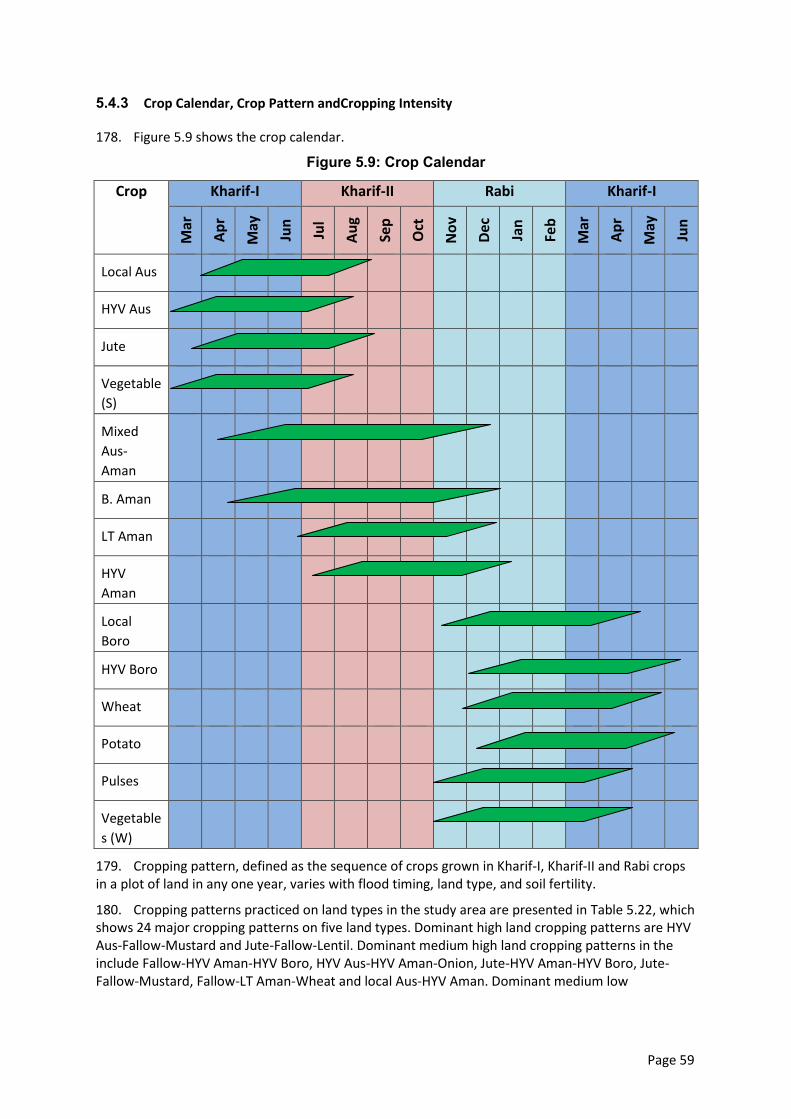
Page 59
5.4.3 Crop Calendar, Crop Pattern andCropping Intensity
178. Figure 5.9 shows the crop calendar.
Figure 5.9: Crop Calendar
Crop Kharif-I Kharif-II Rabi Kharif-I M
ar
Ap
r
May
Jun
Jul
Au
g
Sep
Oct
No
v
Dec
Jan
Feb
Mar
Ap
r
May
Jun
Local Aus
HYV Aus
Jute
Vegetable
(S)
Mixed
Aus-
Aman
B. Aman
LT Aman
HYV
Aman
Local
Boro
HYV Boro
Wheat
Potato
Pulses
Vegetable
s (W)
179. Cropping pattern, defined as the sequence of crops grown in Kharif-I, Kharif-II and Rabi crops in a plot of land in any one year, varies with flood timing, land type, and soil fertility.
180. Cropping patterns practiced on land types in the study area are presented in Table 5.22, which shows 24 major cropping patterns on five land types. Dominant high land cropping patterns are HYV Aus-Fallow-Mustard and Jute-Fallow-Lentil. Dominant medium high land cropping patterns in the include Fallow-HYV Aman-HYV Boro, HYV Aus-HYV Aman-Onion, Jute-HYV Aman-HYV Boro, Jute-Fallow-Mustard, Fallow-LT Aman-Wheat and local Aus-HYV Aman. Dominant medium low
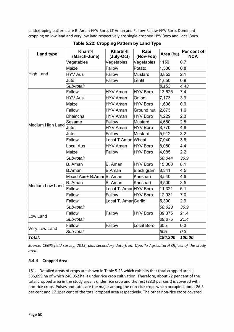
Page 60
landcropping patterns are B. Aman-HYV Boro, LT Aman and Fallow-Fallow-HYV Boro. Dominant cropping on low land and very low land respectively are single-cropped HYV Boro and Local Boro.
Table 5.22: Cropping Pattern by Land Type
Land type Kharif-I (March-June)
Khartif-II (July-Oct)
Rabi (Nov-Feb) Area (ha) Per cent of
NCA
High Land
Vegetables Vegetables Vegetables 1150 0.7 Maize Fallow Potato 1,500 0.8 HYV Aus Fallow Mustard 3,853 2.1 Jute Fallow Lentil 1,650 0.9 Sub-total: 8,153 4.43
Medium High Land
Fallow HYV Aman HYV Boro 13,625 7.4 HYV Aus HYV Aman Onion 7,173 3.9 Maize HYV Aman HYV Boro 1,608 0.9 Fallow HYV Aman Ground nut 2,873 1.6 Dhaincha HYV Aman HYV Boro 4,229 2.3 Sesame Fallow Mustard 4,650 2.5 Jute HYV Aman HYV Boro 8,770 4.8 Jute Fallow Mustard 5,912 3.2 Fallow Local T Aman Wheat 7,040 3.8 Local Aus HYV Aman HYV Boro 8,080 4.4 Maize Fallow HYV Boro 4,085 2.2 Sub-total: 68,044 36.9
Medium Low Land
B. Aman B. Aman HYV Boro 15,000 8.1 B.Aman B.Aman Black gram 8,341 4.5 Mixed Aus+ B.Aman B. Aman Kheshari 8,540 4.6 B. Aman B. Aman Kheshari 6,500 3.5 Fallow Local T. Aman HYV Boro 11,321 6.1 Fallow Fallow HYV Boro 12,931 7.0 Fallow Local T. Aman Garlic 5,390 2.9 Sub-total: 68,023 36.9
Low Land Fallow Fallow HYV Boro 39,375 21.4 Sub-total: 39,375 21.4
Very Low Land Fallow Fallow Local Boro 605 0.3 Sub-total: 605 0.3
Total: 184,200 100.00
Source: CEGIS field survey, 2013, plus secondary data from Upazila Agricultural Offices of the study area.
5.4.4 Cropped Area
181. Detailed areas of crops are shown in Table 5.23 which exhibits that total cropped area is 335,099 ha of which 240,052 ha is under rice crop cultivation. Therefore, about 72 per cent of the total cropped area in the study area is under rice crop and the rest (28.3 per cent) is covered with non-rice crops. Pulses and Jutes are the major among the non-rice crops which occupied about 26.3 per cent and 17.1per cent of the total cropped area respectively. The other non-rice crops covered
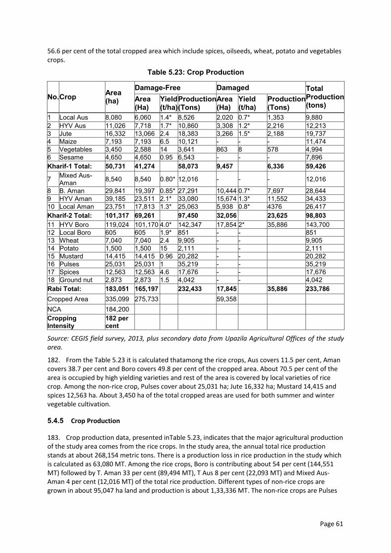
Page 61
56.6 per cent of the total cropped area which include spices, oilseeds, wheat, potato and vegetables crops.
Table 5.23: Crop Production
No. Crop Area (ha)
Damage-Free Damaged Total Production (tons)
Area (Ha)
Yield (t/ha)
Production (Tons)
Area (Ha)
Yield (t/ha)
Production (Tons)
1 Local Aus 8,080 6,060 1.4* 8,526 2,020 0.7* 1,353 9,880 2 HYV Aus 11,026 7,718 1.7* 10,860 3,308 1.2* 2,216 12,213 3 Jute 16,332 13,066 2.4 18,383 3,266 1.5* 2,188 19,737 4 Maize 7,193 7,193 6.5 10,121 - - - 11,474 5 Vegetables 3,450 2,588 14 3,641 863 8 578 4,994 6 Sesame 4,650 4,650 0.95 6,543 - - - 7,896 Kharif-1 Total: 50,731 41,274 58,073 9,457 6,336 59,426
7 Mixed Aus-Aman 8,540 8,540 0.80* 12,016 - - - 12,016
8 B. Aman 29,841 19,397 0.85* 27,291 10,444 0.7* 7,697 28,644 9 HYV Aman 39,185 23,511 2.1* 33,080 15,674 1.3* 11,552 34,433 10 Local Aman 23,751 17,813 1.3* 25,063 5,938 0.8* 4376 26,417 Kharif-2 Total: 101,317 69,261 97,450 32,056 23,625 98,803 11 HYV Boro 119,024 101,170 4.0* 142,347 17,854 2* 35,886 143,700 12 Local Boro 605 605 1.9* 851 - - 851 13 Wheat 7,040 7,040 2.4 9,905 - - 9,905 14 Potato 1,500 1,500 15 2,111 - - 2,111 15 Mustard 14,415 14,415 0.96 20,282 - - 20,282 16 Pulses 25,031 25,031 1 35,219 - - 35,219 17 Spices 12,563 12,563 4.6 17,676 - - 17,676 18 Ground nut 2,873 2,873 1.5 4,042 - - 4,042 Rabi Total: 183,051 165,197 232,433 17,845 35,886 233,786 Cropped Area 335,099 275,733 59,358 NCA 184,200 Cropping Intensity
182 per cent
Source: CEGIS field survey, 2013, plus secondary data from Upazila Agricultural Offices of the study area.
182. From the Table 5.23 it is calculated thatamong the rice crops, Aus covers 11.5 per cent, Aman covers 38.7 per cent and Boro covers 49.8 per cent of the cropped area. About 70.5 per cent of the area is occupied by high yielding varieties and rest of the area is covered by local varieties of rice crop. Among the non-rice crop, Pulses cover about 25,031 ha; Jute 16,332 ha; Mustard 14,415 and spices 12,563 ha. About 3,450 ha of the total cropped areas are used for both summer and winter vegetable cultivation.
5.4.5 Crop Production
183. Crop production data, presented inTable 5.23, indicates that the major agricultural production of the study area comes from the rice crops. In the study area, the annual total rice production stands at about 268,154 metric tons. There is a production loss in rice production in the study which is calculated as 63,080 MT. Among the rice crops, Boro is contributing about 54 per cent (144,551 MT) followed by T. Aman 33 per cent (89,494 MT), T Aus 8 per cent (22,093 MT) and Mixed Aus-Aman 4 per cent (12,016 MT) of the total rice production. Different types of non-rice crops are grown in about 95,047 ha land and production is about 1,33,336 MT. The non-rice crops are Pulses
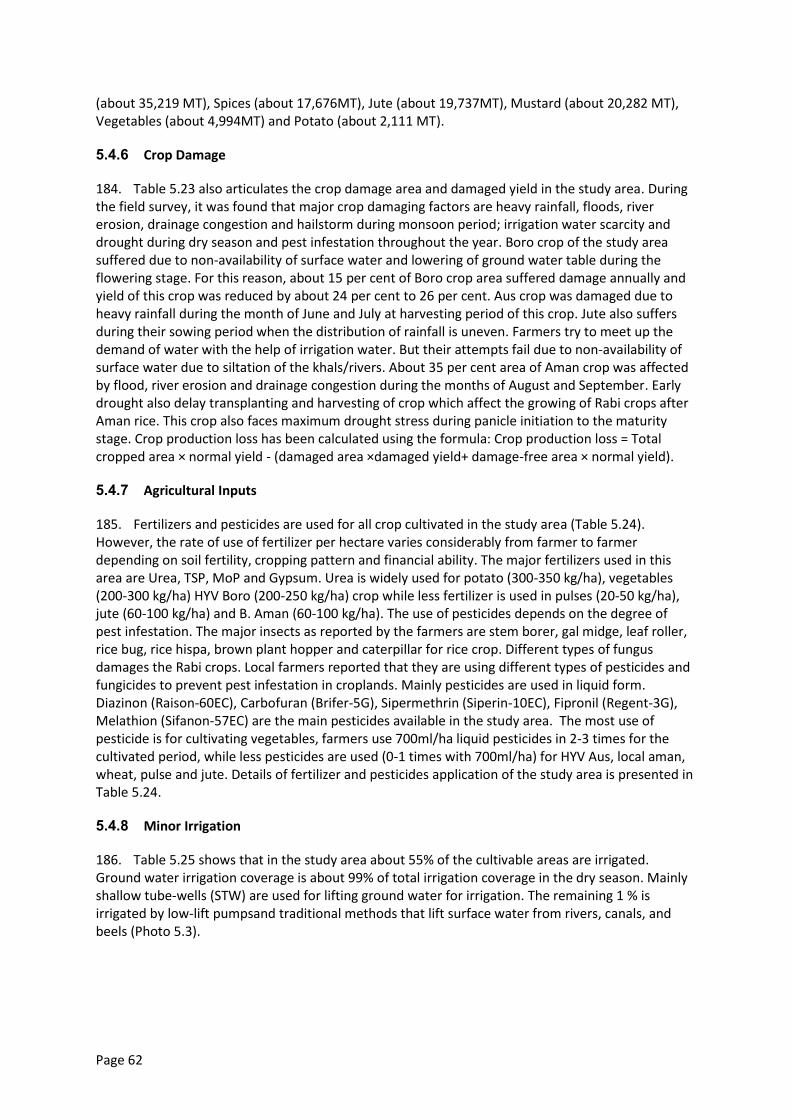
Page 62
(about 35,219 MT), Spices (about 17,676MT), Jute (about 19,737MT), Mustard (about 20,282 MT), Vegetables (about 4,994MT) and Potato (about 2,111 MT).
5.4.6 Crop Damage
184. Table 5.23 also articulates the crop damage area and damaged yield in the study area. During the field survey, it was found that major crop damaging factors are heavy rainfall, floods, river erosion, drainage congestion and hailstorm during monsoon period; irrigation water scarcity and drought during dry season and pest infestation throughout the year. Boro crop of the study area suffered due to non-availability of surface water and lowering of ground water table during the flowering stage. For this reason, about 15 per cent of Boro crop area suffered damage annually and yield of this crop was reduced by about 24 per cent to 26 per cent. Aus crop was damaged due to heavy rainfall during the month of June and July at harvesting period of this crop. Jute also suffers during their sowing period when the distribution of rainfall is uneven. Farmers try to meet up the demand of water with the help of irrigation water. But their attempts fail due to non-availability of surface water due to siltation of the khals/rivers. About 35 per cent area of Aman crop was affected by flood, river erosion and drainage congestion during the months of August and September. Early drought also delay transplanting and harvesting of crop which affect the growing of Rabi crops after Aman rice. This crop also faces maximum drought stress during panicle initiation to the maturity stage. Crop production loss has been calculated using the formula: Crop production loss = Total cropped area × normal yield - (damaged area ×damaged yield+ damage-free area × normal yield).
5.4.7 Agricultural Inputs
185. Fertilizers and pesticides are used for all crop cultivated in the study area (Table 5.24). However, the rate of use of fertilizer per hectare varies considerably from farmer to farmer depending on soil fertility, cropping pattern and financial ability. The major fertilizers used in this area are Urea, TSP, MoP and Gypsum. Urea is widely used for potato (300-350 kg/ha), vegetables (200-300 kg/ha) HYV Boro (200-250 kg/ha) crop while less fertilizer is used in pulses (20-50 kg/ha), jute (60-100 kg/ha) and B. Aman (60-100 kg/ha). The use of pesticides depends on the degree of pest infestation. The major insects as reported by the farmers are stem borer, gal midge, leaf roller, rice bug, rice hispa, brown plant hopper and caterpillar for rice crop. Different types of fungus damages the Rabi crops. Local farmers reported that they are using different types of pesticides and fungicides to prevent pest infestation in croplands. Mainly pesticides are used in liquid form. Diazinon (Raison-60EC), Carbofuran (Brifer-5G), Sipermethrin (Siperin-10EC), Fipronil (Regent-3G), Melathion (Sifanon-57EC) are the main pesticides available in the study area. The most use of pesticide is for cultivating vegetables, farmers use 700ml/ha liquid pesticides in 2-3 times for the cultivated period, while less pesticides are used (0-1 times with 700ml/ha) for HYV Aus, local aman, wheat, pulse and jute. Details of fertilizer and pesticides application of the study area is presented in Table 5.24.
5.4.8 Minor Irrigation
186. Table 5.25 shows that in the study area about 55% of the cultivable areas are irrigated. Ground water irrigation coverage is about 99% of total irrigation coverage in the dry season. Mainly shallow tube-wells (STW) are used for lifting ground water for irrigation. The remaining 1 % is irrigated by low-lift pumpsand traditional methods that lift surface water from rivers, canals, and beels (Photo 5.3).
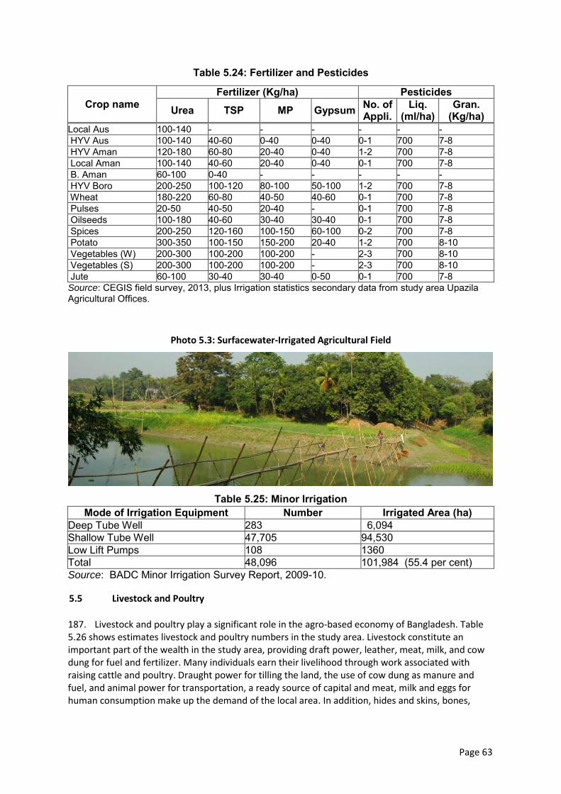
Page 63
Table 5.24: Fertilizer and Pesticides
Crop name Fertilizer (Kg/ha) Pesticides
Urea TSP MP Gypsum No. of Appli.
Liq. (ml/ha)
Gran. (Kg/ha)
Local Aus 100-140 - - - - - - HYV Aus 100-140 40-60 0-40 0-40 0-1 700 7-8 HYV Aman 120-180 60-80 20-40 0-40 1-2 700 7-8 Local Aman 100-140 40-60 20-40 0-40 0-1 700 7-8 B. Aman 60-100 0-40 - - - - - HYV Boro 200-250 100-120 80-100 50-100 1-2 700 7-8 Wheat 180-220 60-80 40-50 40-60 0-1 700 7-8 Pulses 20-50 40-50 20-40 - 0-1 700 7-8 Oilseeds 100-180 40-60 30-40 30-40 0-1 700 7-8 Spices 200-250 120-160 100-150 60-100 0-2 700 7-8 Potato 300-350 100-150 150-200 20-40 1-2 700 8-10 Vegetables (W) 200-300 100-200 100-200 - 2-3 700 8-10 Vegetables (S) 200-300 100-200 100-200 - 2-3 700 8-10 Jute 60-100 30-40 30-40 0-50 0-1 700 7-8 Source: CEGIS field survey, 2013, plus Irrigation statistics secondary data from study area Upazila Agricultural Offices.
Photo 5.3: Surfacewater-Irrigated Agricultural Field
Table 5.25: Minor Irrigation
Mode of Irrigation Equipment Number Irrigated Area (ha) Deep Tube Well 283 6,094 Shallow Tube Well 47,705 94,530 Low Lift Pumps 108 1360 Total 48,096 101,984 (55.4 per cent) Source: BADC Minor Irrigation Survey Report, 2009-10.
5.5 Livestock and Poultry
187. Livestock and poultry play a significant role in the agro-based economy of Bangladesh. Table 5.26 shows estimates livestock and poultry numbers in the study area. Livestock constitute an important part of the wealth in the study area, providing draft power, leather, meat, milk, and cow dung for fuel and fertilizer. Many individuals earn their livelihood through work associated with raising cattle and poultry. Draught power for tilling the land, the use of cow dung as manure and fuel, and animal power for transportation, a ready source of capital and meat, milk and eggs for human consumption make up the demand of the local area. In addition, hides and skins, bones,
Page 64
feathers, etc, help in earning money. Livestock resources also play an important role in the sustenance of landless people.
Table 5.26: Livestock and Poultry
Live stock/Poultry Number of Livestock/Poultry Cattle/cow 974,817 Buffalo 1,563 Goat 290,967 Sheep 89,843 Horse 2,438 Chicken 2,876,480 Duck 524,564 Pigeon 93,580 Source: Upazila Livestock Offices and Census of Agriculture.
5.5.1 Livestock and Poultry Health
188. The health of an animal is a major concern in the study area. Health issues include infection by bacteria, virus, mycoplasma, or parasite. Disease outbreaks cause considerable economic loss in livestock farming. A bacterial or viral disease normally kills an animal, whereas parasites are mainly associated with debility and loss of production. Major bacterial diseases include peste des petits ruminants (PPR), foot and mouth disease (FMD), anthrax, badla (black quarter), diarrohea, pneumonia, and parasitic diseases such as worm infestation. In addition, a number of arthropods, including flies, ticks and mites, have economic importance mainly due to their role in pathogen transmission. Major poultry diseases are duck plague, paralysis, Newcastle, fowl pox and dysentery etc. Infectious disease is most prevalent in the rainy season between Septembers to October months, though most diseases continue at lower levels throughout the year.
5.5.2 Constraints of Livestock and Poultry Rearing
189. Livestock owners face problems due to shrinking and degrading pastures, coupled with fodder shortages due to dried up grazing land, during the December-April period. In Kharif-II season, almost all higher lands remain under crops and lower-lying areas are flooded. Grazing area shortages throughout the year aggravate the livestock feeding problem. Household poultry survives by scavenging and though generally no feed supplements are provided, kitchen waste can be a significant food source. Feed prices in the study area are high.
190. Another constraint of livestock and poultry production in the study area is a lack of veterinary health services, veterinary support services, quality production inputs, veterinary extension services and cooperation between private and public sectors dealing with prevention, diagnosis, treatment, and control of disease. Upazila Livestock Office capacity is limited.
191. Additional factors constraining livestock in the study area include low levels of knowledge of local people, frequent natural hazards, slaughtering of young cattle during religious festivals, and unplanned slaughtering of cattle for meat throughout the year.
5.6 Fisheries
192. Fisheries resources of the study area are diversified with different fresh water fish habitats. Open water fish habitat consists of seasonal and perennial rivers, khals, beels, and floodplain. The major rivers Jamuna and Padma and beelsaccount for most of the fish production in the area. Khalsact as major arteries of fish migration between habitats and playa vital role in maintaining species richness and fisheries productivity. Photo 5.4 and Photo 5.5 show the open water fish habitats of the study area.
Page 65
Photo 5.4: Openwater Fish Habitat
Photo 5.5: Openwater Fish Habitat
193. Fish biodiversity is relatively rich, however, it is decreasing due to indiscriminate fishing, obstruction of migration routes (especially in the dry season), discharge of industrial waste, poor fisheries management, siltation, oil spills, insecticide contamination, and loss of critical habitats to siltation and bank erosion. Indiscriminate fishing practices include capture of brood-fish especially during the over-wintering period and use of current jal to catch juvenile fish (local name jatka), especially hilsa, and dewatering of beels for irrigation or fishing.
194. Aquaculture is also present in the study area. Two types are practiced, traditional and semi-intensive,
5.6.1 Open Water Fish Habitat
195. Habitat Classification.Fish habitats of the study area are classified into river, khal, seasonal beel. The Jamuna and Padma contain water year round. The other water bodies present in the study area are beel, floodplain, fish pond,khaland seasonal beels.
196. Habitat Distribution.Map 5.4shows a map of fish habitats of the study areaupazilas (seven in Manikganj, one in Tangail, and four in Sirajganj districts). Capture fisheries habitats with an area of 92,740 ha include rivers, khals, perennial and seasonal beels and floodplain. Table 5.27 shows the area of fish habitat categories. In the dry season, average river water depth is 4 to 7 m which is adequate for fish habitation. In deep areas(kum), both large and small riverine fishes take shelter when river water levels drop. Deep areasplay a vital role in fish propagation. The major problems in these riverine fish habitats are siltation and erosion.
Table 5.27: Fish Habitat
Sl. No. Habitat Category Habitat Type Area (ha) 1 Capture River 30,783
Khal 312
Beel 1,258
Kol 605
Floodplain 59,782
Sub total: 92,740 2 Culture Fish pond 1,235
Sub total: 1,235
Total: 93,975
Source: CEGIS field Survey, 2013
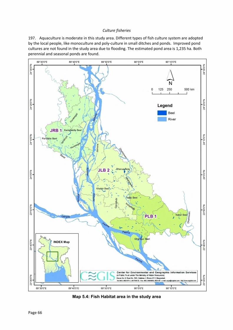
Page 66
Culture fisheries
197. Aquaculture is moderate in this study area. Different types of fish culture system are adopted by the local people, like monoculture and poly-culture in small ditches and ponds. Improved pond cultures are not found in the study area due to flooding. The estimated pond area is 1,235 ha. Both perennial and seasonal ponds are found.
Map 5.4: Fish Habitat area in the study area
Page 67
5.6.2 Fish Production
198. Table 5.28 show fish production for each habitat type. As these illustrate, most fish production is from the capture fishery and rest coming from the culture fishery. Estimated total annual fish production is about 21,659 MT.
Table 5.28: Fish Production by Habitat
Sl. No. Habitat Category Habitat Type Total production (MT) 1 Capture River 4,617
Khal 47
Beel 722
Kol (Semi closed water body) 871
Floodplain 11,956
Sub total: 18,213
2 Culture Fish pond 3,446
Sub total: 3,446
Total: 21,659
Source: Field observation, FRSS 2010-11. Fishing Effort
199. Fisher number. Two types of fishers found in the study area are commercial and subsistence fishers. But no part-time fishers have been recorded. The number of commercial fisher household is 6,983 which constitute 89 per cent of the total fishers. Maximum commercial fishers have been recorded in Daulatpur (22 per cent) and Horirumpur (49 per cent) of Manikganj district. Subsistence fishers have been found as 11 per centof total fishers. Diversified fishing community structure has been found in this study area. In Nagarpur Upazila of Tangail district, hindu community covers about 84 per cent and in some villages like Dhamshar, Madhupur, Ulail, Mulkandi, Daulatpur Sadar, Binodpur, Charakholsi, Boinna, Bishnopur, Shamganj of Daulatpur Upazila of Manikganj district is about 100 per cent. However, about 90 per cent of the fishers come from the Muslim community in total. They usually catch fish in the nearby beels, floodplains, rivers and khals using country boat and dingi boats particularly during wet season.
200. Fishing season.Fishing in floodplain, beel, river and khals starts in May and continue up to November except river. The seasonality of major fishing is furnished in theTable 5.29.
201. Fishing crafts and location.Country fishing boats are widely used to catch the fish in the study area. The fishers catch the fish in Jamuna, Karotoa, Ichamati, Baral, Dhalai, Sonai, Hura-sagar (old part of Jamuna river) and Dhaleshwary rivers round the year. However, fishing in seasonal beel and floodplain are done in monsoon only. The subsistence fishers catch the fish in same water bodies in the study area both in monsoon and dry season.
Table 5.29: Seasonality of Fishing Types
202. Fishing gears.Different types of nets/gears are used for fishing in the study area. These are: (i) currant jal used to catch baim, tengra, punti, baila, etc; (ii) kona jalused to catch rui, catla, baim,
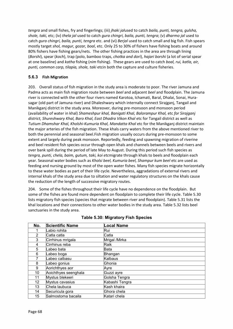
Page 68
tengra and small fishes, fry and fingerlings; (iii) jhaki jalused to catch baila, punti, tengra, gulsha, shole, taki, etc; (iv) thela jal used to catch gura chingri, baila, punti, tengra; (v) dharmo jal used to catch gura chingri, baila, punti, tengra etc. and (vi) Berjal used to catch small and big fish. Fish spears mostly target shol, magur, gozar, boal, etc. Only 25 to 30% of fishers have fishing boats and around 80% fishers have fishing gears/nets. The other fishing practices in the area are through lining (Borshi), spear (koch), trap (polo, bamboo traps, chotka and dori), hajari borshi (a lot of serial spear at one baseline) and katha fishing (nim fishing). These gears are used to catch boal, rui, katla, air, punti, common carp, tilapia, shole, taki etcin both the capture and culture fisheries.
5.6.3 Fish Migration
203. Overall status of fish migration in the study area is moderate to poor. The river Jamuna and Padma acts as main fish migration route between beel and adjacent beel and floodplain. The Jamuna river is connected with the other four rivers named Karotoa, Ichamati, Baral, Dhalai, Sonai, Hura-sagar (old part of Jamuna river) and Dhaleshwary which internally connect Sirajganj, Tangail and Manikganj district in the study area. Moreover, during pre-monsoon and monsoon period (availability of water in khal) Shameshpur khal, Banigati Khal, Balorampur Khal, etc for Sirajganj district, Shureshwary Khal, Baro Khal, East Dhadra Vikon Khal etc for Tangail district as well as Tutium Dhamshar Khal, Kholshi-Kumuria Khal, Mandatta Khal etc for the Manikganj district maintain the major arteries of the fish migration. These khals carry waters from the above mentioned river to both the perennial and seasonal beel.Fish migration usually occurs during pre-monsoon to some extent and largely during peak monsoon. Reportedly, feeding and spawning migration of riverine and beel resident fish species occur through open khals and channels between beels and rivers and over bank spill during the period of late May to August. During this period such fish species as tengra, punti, chela, baim, gutum, taki, koi etcmigrate through khals to beels and floodplain each year. Seasonal water bodies such as Kholsi beel, Kumuria beel, Shampur kum beel etc are used as feeding and nursing ground by most of the open water fishes. Many fish species migrate horizontally to these water bodies as part of their life cycle. Nevertheless, aggradations of external rivers and internal khals of the study area due to siltation and water regulatory structures on the khals cause the reduction of the length of successive migratory routes.
204. Some of the fishes throughout their life cycle have no dependence on the floodplain. But some of the fishes are found more dependent on floodplain to complete their life cycle. Table 5.30 lists migratory fish species (species that migrate between river and floodplain). Table 5.31 lists the khal locations and their connections to other water bodies in the study area. Table 5.32 lists beel sanctuaries in the study area.
Table 5.30: Migratory Fish Species
No. Scientific Name Local Name 1 Labio rohita Rui 2 Catla catla Catla 3 Cirrhinus mrigala Mrigal /Mirka 4 Cirrhinus reba Raik 5 Labeo bata Bata 6 Labeo boga Bhangan 7 Labeo calbasu Kalbaus 8 Labeo gonius Ghonia 9 Aorichthyes aor Ayre
10 Aoichthyes seenghala Guzzi ayre 11 Mystus blekeeri Golsha Tengra 12 Mystus cavasius Kabashi Tengra 13 Chela laubuca Kash khaira 14 Securicula gora Ghora chela 15 Salmostoma bacaila Katari chela
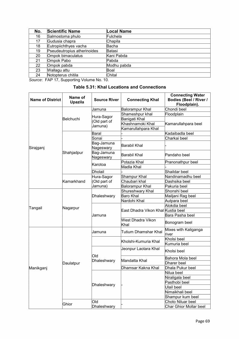
Page 69
No. Scientific Name Local Name 16 Salmostoma phulo Fulchela 17 Gudusia chapra Chapila 18 Eutropiichthyes vacha Bacha 19 Pseudeutropius atherinoides Batasi 20 Ompok bimaculatus Kani Pabda 21 Ompok Pabo Pabda 22 Ompok pabda Modhu pabda 23 Wallagu attu Boal 24 Notopterus chitila Chital
Source: FAP 17, Supporting Volume No. 10.
Table 5.31: Khal Locations and Connections
Name of District Name of Upazila Source River Connecting Khal
Connecting Water Bodies (Beel / River /
Floodplain).
Sirajganj
Belchuchi
Jamuna Balorampur Khal Chondi beel
Hura-Sagor (Old part of Jamuna)
Shameshpur khal Floodplain Banigati Khal
Kamarullahpara beel Khashnamoki Khal Kamarullahpara Khal
Shahjadpur
Baral - Kadaibadla beel Sonai - Charkai beel Bag-Jamuna Nageswary Barabil Khal -
Bag-Jamuna Nageswary Barabil Khal Pandaho beel
Karotoa Potazia Khal Pranonathpur beel Madla Khal -
Dholail - Shaildar beel
Kamarkhand Hura-Sagor (Old part of Jamuna)
Shampur Khal Nandinamadhu beel Chaubari khal Dashsika beel Balorampur Khal Pakuria beel
Tangail Nagarpur
Dhaleshwary Shureshwary Khal Shonshi beel Baro Khal Mailjani Rag beel Nardohi Khal Autpara beel
Jamuna East Dhadra Vikon Khal
Alokdia beel Kustia beel Bara Pasha beel
West Dhadra Vikon Khal Bonogram beel
Manikganj Daulatpur
Jamuna Tutium Dhamshar Khal Mixes with Kaliganga river
Kholshi-Kumuria Khal Kholsi beel Kumuria beel
Old Dhaleshwary
Jeonpur Laotara Khal Kholsi beel
Mandatta Khal Bahora Mola beel Dharer beel
Dhamsar Kakna Khal Dhala Pukur beel
Dhaleshwary -
Nilua beel Niraligala beel Pasthobi beel Ulail beel Nimaikhali beel Shampur kum beel
Ghior Old Dhaleshwary - Choto Niluar beel
Char Ghior Mollar beel
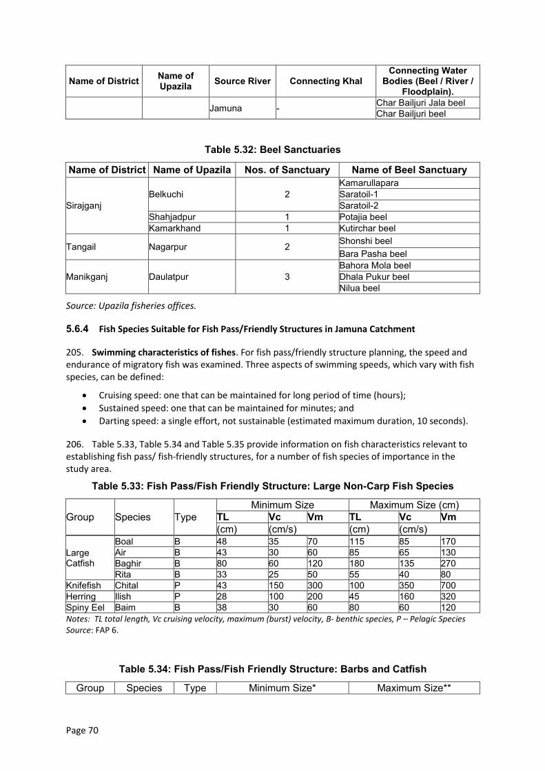
Page 70
Name of District Name of Upazila Source River Connecting Khal
Connecting Water Bodies (Beel / River /
Floodplain).
Jamuna - Char Bailjuri Jala beel Char Bailjuri beel
Table 5.32: Beel Sanctuaries
Name of District Name of Upazila Nos. of Sanctuary Name of Beel Sanctuary
Sirajganj Belkuchi 2
Kamarullapara Saratoil-1 Saratoil-2
Shahjadpur 1 Potajia beel Kamarkhand 1 Kutirchar beel
Tangail Nagarpur 2 Shonshi beel Bara Pasha beel
Manikganj Daulatpur 3 Bahora Mola beel Dhala Pukur beel Nilua beel
Source: Upazila fisheries offices.
5.6.4 Fish Species Suitable for Fish Pass/Friendly Structures in Jamuna Catchment
205. Swimming characteristics of fishes. For fish pass/friendly structure planning, the speed and endurance of migratory fish was examined. Three aspects of swimming speeds, which vary with fish species, can be defined:
Cruising speed: one that can be maintained for long period of time (hours);
Sustained speed: one that can be maintained for minutes; and
Darting speed: a single effort, not sustainable (estimated maximum duration, 10 seconds).
206. Table 5.33, Table 5.34 and Table 5.35 provide information on fish characteristics relevant to establishing fish pass/ fish-friendly structures, for a number of fish species of importance in the study area.
Table 5.33: Fish Pass/Fish Friendly Structure: Large Non-Carp Fish Species
Group Species Type Minimum Size Maximum Size (cm)
TL Vc Vm TL Vc Vm (cm) (cm/s) (cm) (cm/s)
Large Catfish
Boal B 48 35 70 115 85 170 Air B 43 30 60 85 65 130 Baghir B 80 60 120 180 135 270 Rita B 33 25 50 55 40 80
Knifefish Chital P 43 150 300 100 350 700 Herring Ilish P 28 100 200 45 160 320 Spiny Eel Baim B 38 30 60 80 60 120 Notes: TL total length, Vc cruising velocity, maximum (burst) velocity, B- benthic species, P – Pelagic Species Source: FAP 6.
Table 5.34: Fish Pass/Fish Friendly Structure: Barbs and Catfish
Group Species Type Minimum Size* Maximum Size**
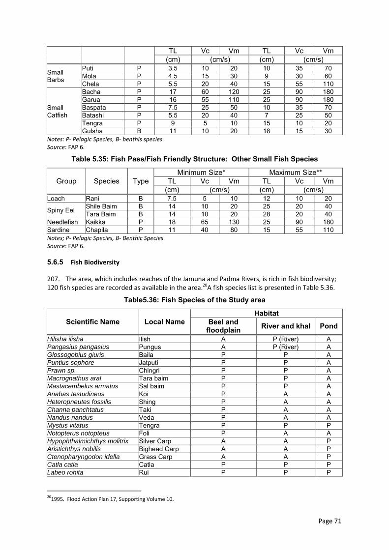
Page 71
TL Vc Vm TL Vc Vm (cm) (cm/s) (cm) (cm/s)
Small Barbs
Puti P 3.5 10 20 10 35 70 Mola P 4.5 15 30 9 30 60 Chela P 5.5 20 40 15 55 110
Small Catfish
Bacha P 17 60 120 25 90 180 Garua P 16 55 110 25 90 180 Baspata P 7.5 25 50 10 35 70 Batashi P 5.5 20 40 7 25 50 Tengra P 9 5 10 15 10 20 Gulsha B 11 10 20 18 15 30
Notes: P- Pelagic Species, B- benthis species Source: FAP 6.
Table 5.35: Fish Pass/Fish Friendly Structure: Other Small Fish Species
Group Species Type Minimum Size* Maximum Size**
TL Vc Vm TL Vc Vm (cm) (cm/s) (cm) (cm/s)
Loach Rani B 7.5 5 10 12 10 20
Spiny Eel Shile Baim B 14 10 20 25 20 40 Tara Baim B 14 10 20 28 20 40
Needlefish Kaikka P 18 65 130 25 90 180 Sardine Chapila P 11 40 80 15 55 110 Notes; P- Pelagic Species, B- Benthic Species Source: FAP 6.
5.6.5 Fish Biodiversity
207. The area, which includes reaches of the Jamuna and Padma Rivers, is rich in fish biodiversity; 120 fish species are recorded as available in the area.20A fish species list is presented in Table 5.36.
Table5.36: Fish Species of the Study area
Scientific Name Local Name Habitat
Beel and floodplain River and khal Pond
Hilisha ilisha Ilish A P (River) A Pangasius pangasius Pungus A P (River) A Glossogobius giuris Baila P P A Puntius sophore Jatputi P P A Prawn sp. Chingri P P A Macrognathus aral Tara baim P P A Mastacembelus armatus Sal baim P P A Anabas testudineus Koi P A A Heteropneutes fossilis Shing P A A Channa panchtatus Taki P A A Nandus nandus Veda P A A Mystus vitatus Tengra P P P Notopterus notopteus Foli P A A Hypophthalmichthys molitrix Silver Carp A A P Aristichthys nobilis Bighead Carp A A P Ctenopharyngodon idella Grass Carp A A P Catla catla Catla P P P Labeo rohita Rui P P P
20
1995. Flood Action Plan 17, Supporting Volume 10.
Page 72
Scientific Name Local Name Habitat
Beel and floodplain River and khal Pond
Labeo bata Bata P P P Cirrhinus mrigela Mrigel P P P Ciprinus carpio Carfu A A P Labeo calbasu Kalibaus P P P Oreochromis mossambicus Tilapia A A P Oreochromis niloticus Nilotica A A P Clarias batrachus Magur P A A Channa striatus Shol P P A Gudusia chapra Chapila P P A Amblypharingodon mola Mola P P A Wallago attu Boal P P A Ompak pabda Pabda P P A Mystus bleekri Gulsha Tengra P P A Aorichthys aor Ayre P P A Lepidosephalus guntia Gutum P P A Macrognathus aculatus Guchi baim P P A Rasbora daniconius Darkina P P A Xenentodon cancila Kakhila P P A Colisa fasciata Khalisa P P A Corica soborna Kaski P P A Puntius gonionotus Thai Sarpunti A A P Notes; P- Pelagic Species, B- Benthic Species. A- absent
208. Fish biodiversity and abundance has been declining. Causes include water quality degradation including non-point source agricultural pollution (agrochemicals and pesticides) and point-source industrial pollution (from garmentfactories and other industries, especially in Sirajganj district). Other causes are obstruction to fish migratory routes, silting in and obstruction of internal khals, silting in of floodplain wetland fish habitats and shrinkage of spawning and feeding grounds.
5.6.6 Species of Conservation Significance
209. Fish species which are locally unavailable for last 10-15 years or have become rare as reported by the local fishers and concerned elderly people are given in the followingTable 5.37.
Table 5.37: Fish Species of Conservation Significance
Scientific name Local name Local Status Rare Unavailable
Puntius sarana Deshi Sarputi √ Ompak pabda Pabda √ Lepidosephalus guntia Gutum √ Notopterus chitila Chital √ Mastacembelus armatus Sal baim √ Labeo bata Bata Source: Upazila fisheries offices.
5.6.7 Area of Conservation Significance
210. The water bodies in the study area are used as feeding and spawning ground of most of the open water fishes. Both perennial and seasonal beel are present in the study area. The deep portion of the beel can be conserved for fisheries propagation in the area. Department of fisheries (DoF) has declared fish sanctuaries in the area. They have made first a boundary around the selected water
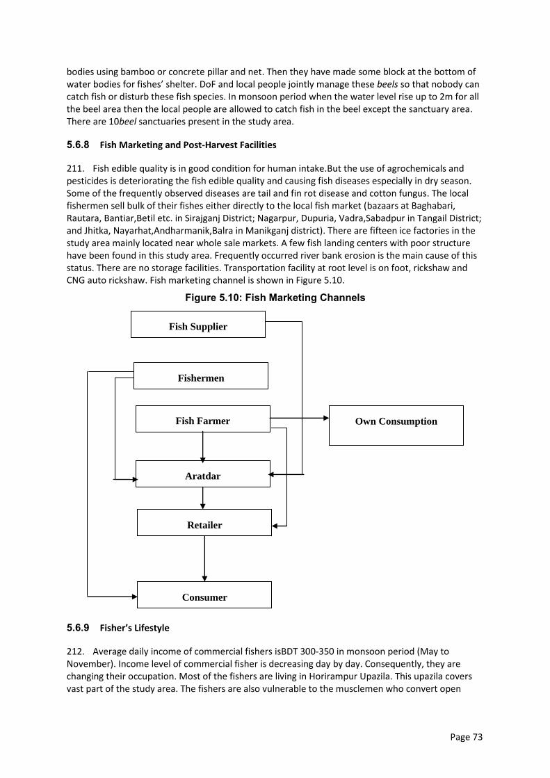
Page 73
bodies using bamboo or concrete pillar and net. Then they have made some block at the bottom of water bodies for fishes’ shelter. DoF and local people jointly manage these beels so that nobody can catch fish or disturb these fish species. In monsoon period when the water level rise up to 2m for all the beel area then the local people are allowed to catch fish in the beel except the sanctuary area. There are 10beel sanctuaries present in the study area.
5.6.8 Fish Marketing and Post-Harvest Facilities
211. Fish edible quality is in good condition for human intake.But the use of agrochemicals and pesticides is deteriorating the fish edible quality and causing fish diseases especially in dry season. Some of the frequently observed diseases are tail and fin rot disease and cotton fungus. The local fishermen sell bulk of their fishes either directly to the local fish market (bazaars at Baghabari, Rautara, Bantiar,Betil etc. in Sirajganj District; Nagarpur, Dupuria, Vadra,Sabadpur in Tangail District; and Jhitka, Nayarhat,Andharmanik,Balra in Manikganj district). There are fifteen ice factories in the study area mainly located near whole sale markets. A few fish landing centers with poor structure have been found in this study area. Frequently occurred river bank erosion is the main cause of this status. There are no storage facilities. Transportation facility at root level is on foot, rickshaw and CNG auto rickshaw. Fish marketing channel is shown in Figure 5.10.
Figure 5.10: Fish Marketing Channels
5.6.9 Fisher’s Lifestyle
212. Average daily income of commercial fishers isBDT 300-350 in monsoon period (May to November). Income level of commercial fisher is decreasing day by day. Consequently, they are changing their occupation. Most of the fishers are living in Horirampur Upazila. This upazila covers vast part of the study area. The fishers are also vulnerable to the musclemen who convert open
Fish Supplier
Own Consumption
Fishermen
Aratdar
Retailer
Consumer
Fish Farmer
Page 74
water fish habitats into culture fishery. Some of the fishers are involved with fish trading, fry trading and some are working as labor in fish farm especially in dry season.
5.6.10 Fisheries Management
213. Fisher based community association has been found in Shahjadpur of Sirajganj, Nagarpur of Tangail and Daulatpur in Manikganj District in the study area. Fishing right on existing fish habitats is limited. Upazila Fisheries office conducts technical training on fish culture for fish farmers and some activities such as awareness meeting, nursery management, linkage development among the fish traders in future. Enforcement of fisheries regulation is also weak.
5.7 Ecological Resources
5.7.1 Bioecological Zones - Introduction
The study area comprises five different bioecological zones of the country (Nishat at el, 2002): (i) Teesta floodplain, (ii) Major rivers, (iii) Brahmaputra–Jamuna floodplain, (iv) Chalan Beeland (v) Ganges floodplain.
(a)Teesta Floodplain
214. The Teesta floodplain bio-ecological zone is spread over Nilphamari, Lalmonirhat, Rangpur, Kurigram, Gaibandha, Bogra and Naogaon district. The Teesta River has occupied and later abandoned several channels during the last few thousand years. These are now occupied by the Mahananda, Punarnava, Atrai, Choto Jamuna, Kortoya and Ghagat Rivers.
215. Prior to clearance for agriculture, this zone was heavily forested, and it is still fairly wooded. Many valuable indigenous timber species are found here: Sal (Shorea robusta), Banyan tree (Ficus bengalensis), and Aswatha (Ficus religiosa). Fruit-bearing indigenous tree species are also found here:Mango (Mangifera indica), Guava (Psidium guajava), Sharifa (Anona squamosa), Tamarind (Tamarindus indica), Jackfruit (Artocarpus heterophyllus), Nut (Terminalia catappa), and Date Palm (Phoenix sylvestris), etc (Bari, 1979).
216. Early records show that tigers, leopards, buffaloes, deer, monkeys, wild boars, etcwere common in this zone until the end of the 19th century, but gradually were extirpated due to loss of habitat. Squirrels, rats, mice, shrews, jackals, foxes, frogs, and toads are still widely distributed in this zone. Commonly-found reptile species include the Bengal monitor (Varanus bengalensis), other lizards, snakes, freshwater tortoises and turtles and different species of poisonous and non-poisonous snakes. Among the bird species, the common peafowl (Pavo cristatus), once common in this zone, has now completely disappeared. Many other birds once common and widely distributed are generally less plentiful now. Most of the common bird species of Bangladesh is still found in this zone (Bari, 1979).
(a) Major Rivers
217. Bangladesh consists mainly of riverine and deltaic deposits of three large and extremely dynamic rivers entering the country: the Brahmaputra, the Ganges and the Meghna rivers. Newly accreted land, if it does not erode quickly, is initially colonized by grass, particularly catkin grass (Saccharum spontaneum, for example). Dense growth of catkin grass can accelerate silt deposition on chars. The Jamuna River yields the highest amount of char lands. Many of the species’ natural distribution, migration and storage primarily continue via these rivers into other wetland ecosystems (GoB-IUCN, 1992). A diverse range of waterfowls are directly or ecologically dependent on these rivers and their associated ecosystems. However, it is quite alarming that with the exception of a few species of turtles, all other river biodiversity is threatened with extinction.
Page 75
(b) Brahmaputra–Jamuna Floodplain
218. The Brahmaputra-Jamuna floodplain comprises the active channel of the Brahmaputra River and the adjoining areas of the young floodplain lands formed since about 1780, when the river shifted to its present course (ie the Jamuna River) to the south of Dewanganj in Jamalpur district. The main river course is strongly braided and consists of several interconnecting channels.This floodplain possesses a unique variety of plants, medicinal herbs, fruit yielding trees, many jungle shrubs, creepers and climbers, flowering trees etc, many of which yield valuable products. Bushes of reeds and canes are also found here. The faunal diversity in this zone is also rich. The most common poisonous snake in this area is the Banded krait (Bungarus fascinatus), which could easily be identified by its broad black and yellow bands. In mammalian species, bats, several species of monkeys, pangolins, and raptorial birds are found.
(c) Chalan Beel
219. Chalan Beel, the center of which is located some 10km north of the JRB-1 area astride the Dhaka-Rajshahi highway in Ullapara upazila, Rajshahi Division, is an extensive low land area at the lower Atrai basin. It consists of a series of beels connected to one another by various channels to form more or less a continuous water body during the rainy season. The beel area expands into a vast water body. The Jamuna remains flooded during the monsoon with dense aquatic vegetation. However it dries up in the winter leaving only patches of water holes in the central part of this zone.
220. Significant species diversity of Chalan Beel is as follows. At present amphibian fauna in the beelinclude seven species of frogs and one species of toad. A total of 34 species of reptiles are found in this zone of which ten are turtles and tortoise, nine are lizards and the remaining 15 include various snake species. Of the turtles and tortoise, the Asiatic Soft-shell Turtle and three-keeled land tortoise are globally threatened. A total of 195 bird species from 51 families are recorded in this zone of which 140 are resident and 55 are migratory. Similarly a total of 27 species of mammals from 12 families are recorded in the beel.Of them, the smooth-coated otter is vulnerable in Bangladesh.
221. The common tree species in this area are Barun Crataeva nurvala, Aswatha Ficus religiosa, Aum Mangifera indica, and Hijol Barringtonia acutangula. The banks of the beels are vegetated with dense stands of Kash Saccharum spontaneum, Paddo Nelumbo nucifera, Nol Arundo donax, Dhol Kalmi Ipomoea fistulosa, Shimul Bombax ceiba and Date palm Phoenix sylvestri).
222. The northern palm squirrel, smooth-coated otter, fishing cat, cotton-pigmy-goose, small buttonquail, purple swamp hen, three-stripe roof turtle, painted roofed turtle, common krait are common wildlife species in this zone.
(d) Ganges Floodplain
223. The Ganges floodplain basically consists of the active floodplains of the Ganges River and the adjoining meandering floodplains. It is mostly situated in the districts of Rajshahi, Pabna, Jessore, Kushtia, Faridpur, Shariatpur and Barisal. The adjoining meander floodplains mainly comprise a smooth landscape of ridges, basins and old channels. A noteworthy aspect here is that the Gangetic alluvium is readily distinguishable from the old Brahmaputra, Jamuna and Meghna sediments by its high lime content. Beside this the relief is locally irregular alongside the present and former river courses, especially in the west, comprising a rapidly alternating series of linear low ridges and depressions. The Ganges and Jamuna channel is constantly shifting within its active floodplain, eroding and depositing large areas of new charlands in each flooding season. But it is less braided than those of the Brahmaputra-Jamuna. Interestingly enough, both plants and animals move and adapt with the pattern of flooding (Brammer, 1996).
224. Significant species diversity of the Ganges Floodplainis as follows. This floodplain is characterised by mixed vegetation. The presence of lot of stagnant water bodies and channels, rivers and tributaries in this zone support a habitat of rich biodiversity to some extent. In the beels and
Page 76
other water bodies, free-floating aquatic vegetation is prominent. The dominant floral types are Panimorich Polygonum orientale, Jhanji Hydrilla verticillata, Helencha Alternanthera philoxeroides, Topapana Pistia strateote), Chechra Schenoplectus articulatus, Shada shapla Nymphaea nouchali, Keshordam Ludwigia adscendense, Kolmi Ipomoea aquatica, Dhol kolmi I. fistulosa, Hijal Barringtonia acutangula, Tentul Tamarindus indica, Biash Salix tetrasperma, etc.Moreover, grasses are abundant in the Ganges Floodplain and begin to grow as soon as the floodwater begins to recede.The Hunuman Langur, Five-Striped Palm Squirrel, Smooth-Coated Otter, Refuse-Tailed Hare, Water Cock, Bank Myna, Asian Paradise Flycatcher, River Tern, Yellow Monitor, Common Vine Snake, Painted-Roofed Turtle, Balloon Frog, etc, occur in this zone.
225. Nearly all the major groups of oriental birds are represented in this zone by one or more species. In addition, a large number of migratory birds are found here during the winter. Besides, different species of freshwater tortoises and turtles are also found in the rivers and ponds, most of which are a popular delicacy among non-Muslims. The amphibian species found in this zone include a few species of toads, frogs and tree frogs.
5.7.2 Terrestrial Habitats and Flora
226. Terrestrial habitats of the study area can be categorized under the following divisions: (i) settlement/ homestead vegetation (ii) cropland vegetation, (iii) river-bank vegetation, (iv) social forest, and (v) roadside vegetation. Species lists of terrestrial flora and cropland vegetation are provided in Annex 1 (Table1 and Table).
227. Settlement/ homestead vegetation. Settlement/ homestead vegetation is a man-made plantation cultivated in the yard adjacent to the house. This type of vegetation has been practiced by community traditionally for financial and mundane needs.The Narikel Cocos nucifera, Aam Mangifera Spp., Supari Areca catechu, Bansh Bambusa Spp), Akashmoni Acacia auricauliformes, Bot Ficus bengalensis etc were observed frequently during the field survey. Chatim and Swarna Lata are present but less common.
228. Cropland vegetation. Cropland vegetation is found on the periphery of cultivated lands as weeds that grow and expand through self-propagation. Dominant weed species are Shyama Ghash, Durba Ghash, Badali ghash, Chawla ghas etc.
229. Riverbank vegetation. Riverbank vegetation consists primarily of small to large trees. The large species are Pitali Trewia nudiflora, Pakur Ficus religiosa, Neem Azadirachta indica, Shimul Tula Bombax ceiba, Kul etc. The small to medium-sized species are Bhat Cleodendrum viscosum, Chon, Dhol Kolmi, Dumur Ficus hispida, Bhadi Lannea coromandelica, Khejur Phoenix sylvestris, etc. Among grasses, Durba and Chawla are common.
230. Social forest. Social forests in this study area are found on small areas of fallow lands, croplandperiphery, and in the vicinity of settlements and graveyards. Social forestry species are Akashmoni(Acacia auricauliformes, Bansh Bambusa Spp., Mehogany Swietenia mahogany etc.
231. Roadside vegetation. Roadside vegetation consists of a variety of floral species, some wild and some planted. Roadside vegetation is planted in some locations with the concept of public-private partnership to protect roads from erosion. The Ghora Neem Melia azadirachta, Pakor Ficus religiosa, Akashmoni Acacia auricauliformes, Sisu Dalbergia sisomo, Pitali Trewia nudiflora, Bamboo Bambusa Spp., Khejur Phoenix sylvestris, Bon Begun Solanu nigrum, Kachu, etc are common. Less common floral species are Dumur Ficus hispida, Debdaru Polyalthia longifolia, Pakor Ficus religiosa, etc.
232. Urban Area. Urban and built up areas have a low density of vegetations. Because of serious disturbance due to urbanization and dense road network with heavy traffic load, the wildlife population and floral condition and distribution are poor. But still some small mammals, reptiles, and birds were sighted during the field survey.

Page 77
5.7.3 Seasonal and Perennial Wetland Habitats and Flora
233. Overview. Wetland habitats of the study area include charland, swamp, and grassland. Annex 1: Table 3 provides a species list of wetland vegetation.
234. Charland.Charland occupies significant part of the study area. The Jamuna and Padma Riversare constantly shifting within their active floodplains, eroding and depositing large areas of new charlands each flood season. New charlands exhibit considerable plant succession such that the char vegetation observed in a given area depends on the time since char formation. At species level, Shon Crotolaria retusa,NolPhragmites karka and Kaisa are the first colonizers, whereas Mutha Cyperus sp, Kolmi Ipomoea sp, Binna Vetiveria zizanioides, Durba Cynodon sp etc, are the second level successor. At the terminal succession, some bushy plant species such as Dholkolmi Ipomoea fistulosa appear.
235. Swamps. Chalan Beel area is favorable for a good growth of wetland trees like Hizal Barringtoniaacutangula and Barun etc.
236. Grassland.Grassland species include Binna Vetiveria zizanioides and Durba Gash Cynodon dactylon.
5.7.4 Terrestrial Fauna
237. Overview. Among the terrestrial fauna, groups of animals present in the area include birds (Annex 1: Table 4), mammals (Annex 1: Table 5), amphibians (Annex 1: Table 6), and reptiles (Annex 1: Table 7).
238. Amphibians. Amphibians are found in terrestrial and aquatic environments. Very common terrestrial species observed during the survey were Indian Common Toad Bufo melanostictus and Indian Bullfrog Hoplobatrachus trigerinus. The rests were Common Tree Frog Polypedates maculates which inhabits in association with human settlement and periphery of the village forest and Balloon Frog Uperodon globulosus habituated both in burrows and forest patches and agricultural land. These are considered rare species within the study area.
239. Reptiles. House Gecko Hemidactylus flaviviridis, Common Garden Lizard Calotes versicolor, Yellow Monitor Veranus flavescens and Banded Krait Bungarus fasciatus, were observed during the field survey. King Cobra Ophiophagus hannah and Indian Cobra Naja naja were reported to be found within the site. Among reptiles Yellow Monitor Veranus flavescens is categorized as endangered (EN) by IUCN-Bangladesh (2000).
240. Terrestrial birds – residents and short-range migrants. Terrestrial birds that occupy or visit terrestrial habitats in the study area are Asian Pied Starling Sturnus contra, Common Myna Acridotheres tristis, Red-Vented Bulbul Pycnonotus cafer, Spotted Dove Streptopelia chinensis, Black Drongo Dicrurus macrocercus, Pompadour Green Pigeon Treron pompadora, Blue Rock Pigeon Columba livia, Oriental Magpie Robin Copsychus saularis and Brahminy Kite Haliastur indus. These were very common throughout the study area. Some rarely seen terrestrial birds were Eurasian Hoopoe Upupa epops and Red-Whiskered Bulbul Pycnonotus jocosus. Only the Eurasian Hoopoe Upupa epops is considered to be nationally uncommon resident bird.
241. Terrestiral birds – long-range migratory species.Bangladesh is on the Central Asian Flyway between the Palaearctic and the Indian subcontinent (Map 5.5). Migratory birds that move along the
Page 78
Central Asian Flyway utilize the Brahmaputra-Jamuna-Padma-Ganges char and other habitats potentially affected by Tranch 1.21
242. Mammals. The situation of mammals in Bangladesh country is saddening, especially that of the large mammals which have gone extinctsince the 1970s due to habitat shortage,foodscarcity and hunting pressures. Mammmal species still present are Field Rat Mus booduga, Jungle Cat Felis chaus, Asiatic Jackal Canis aureus, Common Mongoose Herpestes edwardsi, Malayan Giant Squirrel Ratufa bicolor, Indian Flying Fox Pteropus giganteus and Greater Short-Nosed Fruit Bat(Cynopterus sphinx. The Asiatic Jackal Canis aureus is nationally categorized as Vulnerable(VU) by IUCN-Bangladesh.
5.7.5 Aquatic Ecosystems
243. The hydrological cycle regulates ecosystem function by providing varying water levels and flows that create diverse aquatic habitats to be utilized by aquatic biota. In this area, aquatic ecosystems include a range of riverine, floodplain, and pond habitats that become maximally interconnected in the monsoon season.
244. Wetlands (rivers, khals, ponds, and beels) are classified as seasonal and perennial. Seasonal wetlands usually remain inundated for four to five months. Seasonal wetland occupies the lower croplands and provides refuge and shelter for many aquatic flora and fauna. In addition, wetlands serve as the grazing ground for fish and other aquatic fauna. Perennial wetlands hold water throughout the year.
(a) Aquatic Flora
245. Aquatic floraispresent in both seasonal and perennial water bodies. The submerged species are Fodder Hydrilla verticillata, Vallisnaria spirali, Aponogeton Sp. and Gechu. The free-floating species mentionable here are Kachuripana Eichhornia crassipes, Kutipana Azolla Sp., and Khudipana Lemna perpusilla. Of the rooted floating species, Keshordam Jussicea repens and Shapla Nymphae nouchali are common especially in perennial and seasonal beel.
(b) Aquatic Fauna: South Asian River (Gangetic) Dolphin
246. The South Asian River (Gangetic) Dolphin Platanista gangeticagangetica is native to the Ganges and Brahmaputra rivers in Bangladesh and India (Map 5.5).
247. During January-September 2011, a Dolphin survey was carried out in the Padma, Jamuna, and Hurashagar-Baral Rivers of Pabna district.22 Seventy-four transects (including upstream and downstream) were made over 79 km of river reach by mechanized boats to estimate abundance and habitat use. The dolphin population of the studied area was found to vary from 58 during early monsoon and to 103 during late monsoon. The mean dolphin population was 19.67 (one dolphin per 1.72 km) in the Padma and one per 0.69 km in the Jamuna. Adults accounted for 65 per cent and juveniles for 35 per cent of observed individuals. Dolphin concentrations were found in 22 river locations and found in every count in three scours (Bangla kum): Mohanganj kum of Jamuna-Hurashagar River, Nazirganj ferry ghat kum of Padma River, and Nagarbari kum of Jamuna River. Dolphins were slightly more abundant during the low water Jan-Apr period (one per 1 km) than in the monsoon high water Jun-Jul period (one per 1.06 km). The local community in particular fishers were involved in river dolphin conservation.
21
Ministry of Environment and Forest. 2002. “Country Paper of Bangladesh.” Seventh Meeting of the Conference of Parties of Convention on the Conservation of Migratory Species of Wild Animals. Bonn, Germany: Government of Bangladesh. http://www.cms.int/bodies/COP/cop7/proceedings/pdf/national_reports/national_report_bangladesh.pdf 22
Rashid, S.M.A., Abdul Wahab Akonda, and Bashir Ahmed. 2012. “Occurrences of South Asian River Dolphin (Platanista Gangetica) in the Padma and Jamuna Rivers, Pabna.” In Book of Abstracts, 130. Dhaka: Bangladesh Fisheries Research Forum. http://bfrf.org/bookofabstracts/BFRF%205th%20Fisheries%20Conference%20and%20Research%20Fair%202012%20-%20Book%20of%20Abstracts.pdf.
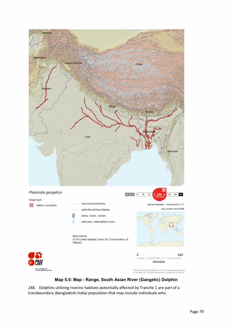
Page 79
Map 5.5: Map - Range, South Asian River (Gangetic) Dolphin
248. Dolphins utilizing riverine habitats potentially affected by Tranche 1 are part of a transboundary (Bangladesh-India) population that may include individuals who
Page 80
migrateinternationally between Bangladesh and India.Most international movement of Dolphins occurs within peri-border areas as short-range tributary-to-mainstem trips, but longer-range migrations of individuals between the Tranche 1 influence area and India cannot be ruled out.
249. South Asian River (Gangetic) Dolphin is on the IUCN Red List as Endangered. It is listed in Appendices I and IIof the Convention on the Conservation of Migratory Species of Wild Animals (CMS). CMS Appendix I listed species are deemed in danger of extinction throughout all or a significant proportion of their range and meriting from CMS Parties (Bangladesh is a signatory) strict protection, conservation or restorationof habitats, mitigation of migration obstacles, and control of other threats to survival. Appendix II listed species have an unfavourable conservation status or would benefit significantly from international co-operation organised by tailored agreements. It is also listed in Appendix I of the Convention on International Trade in Endangered Species (CITES) as a species in which international trade is probihited. Specific Threats to dolphins are summarized in Annex 2.
5.7.6 Other Aquatic Fauna
250. Among amphibians, Skipper Frog (Euphlyctis cyanophlyctis) and Indian Pond Frog (Euphlyctis hexadactylus) are frequently observed. Both species prefer to live in ponds, ditches, stagnant rainwater and paddy-fields. The latter species is categorized as Endangered (EN) by the IUCN-Bangladesh (2000).
251. The aquatic reptiles are frequent in this area. The Red-crowned Roofed Turtle (Batagur kachuga) and Smooth Water-snake (Enhydris enhydris) are present.
252. The diversity of aquatic birdsdepends on the area and quality of aquatic habitat. The aquatic habitat in this area is large and holds water year-round except seasonal water bodies. Thus, aquatic fauna are not dominant compared to terrestrial ecosystem. The Little Egret (Egretta garzetta), Indian Pond Heron (Ardeola grayii), Little Cormorant (Phalacrocorax niger), Pied Kingfisher (Ceryle rudis), White-throated Kingfisher (Halcyon smyrnensis), Asian Open-bill (Anastomus oscitans) and White-breasted Waterhen (Amaurornis phoenicurus) are common throughout the study area. Some of area especially char lands are used as a shelter place for migratory birds.
5.7.7 Aquatic Ecosystem Services
253. The flood plain and wetland ecosystem of the study area play an important role in the purification of water quality of the area, fertilization of the agricultural land, recreation and fodder for livestock and food sources for community. Flood cycle and its associated ecosystem purify the water quality deteriorated by several waste discharging or other ways.
5.7.8 Threats to Aquatic Ecosystems
254. In the study area, river erosion and siltation is occurring every year. Consequently, threats on surrounding aquatic ecosystem and its biodiversity are increasing. Some of the aquatic plant species being rare have become extinct due to erosion and siltation. Due to this process habitat quality is deteriorating day by day. Population of flora and fauna is disrupted.
5.8 Socioeconomic Condition
5.8.1 Area and Location
255. Socio-economic information is presented for the study area upazilas – twelve upazilas of Sirajganj, Tangail and Manikganj districts (Table 5.38).
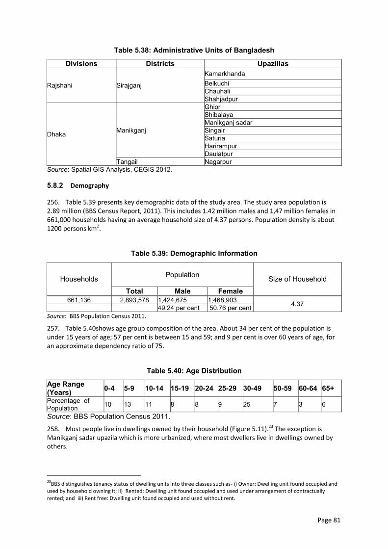
Page 81
Table 5.38: Administrative Units of Bangladesh
Divisions Districts Upazillas
Rajshahi Sirajganj
Kamarkhanda Belkuchi Chauhali Shahjadpur
Dhaka Manikganj
Ghior Shibalaya Manikganj sadar Singair Saturia Harirampur Daulatpur
Tangail Nagarpur Source: Spatial GIS Analysis, CEGIS 2012.
5.8.2 Demography
256. Table 5.39 presents key demographic data of the study area. The study area population is 2.89 million (BBS Census Report, 2011). This includes 1.42 million males and 1,47 million females in 661,000 households having an average household size of 4.37 persons. Population density is about 1200 persons km2.
Table 5.39: Demographic Information
Households Population Size of Household
Total Male Female 661,136 2,893,578 1,424,675 1,468,903 4.37 49.24 per cent 50.76 per cent
Source: BBS Population Census 2011.
257. Table 5.40shows age group composition of the area. About 34 per cent of the population is under 15 years of age; 57 per cent is between 15 and 59; and 9 per cent is over 60 years of age, for an approximate dependency ratio of 75.
Table 5.40: Age Distribution
Age Range (Years) 0-4 5-9 10-14 15-19 20-24 25-29 30-49 50-59 60-64 65+ Percentage of Population 10 13 11 8 8 9 25 7 3 6
Source: BBS Population Census 2011.
258. Most people live in dwellings owned by their household (Figure 5.11).23 The exception is Manikganj sadar upazila which is more urbanized, where most dwellers live in dwellings owned by others.
23
BBS distinguishes tenancy status of dwelling units into three classes such as- i) Owner: Dwelling unit found occupied and used by household owning it; ii) Rented: Dwelling unit found occupied and used under arrangement of contractually rented; and iii) Rent free: Dwelling unit found occupied and used without rent.
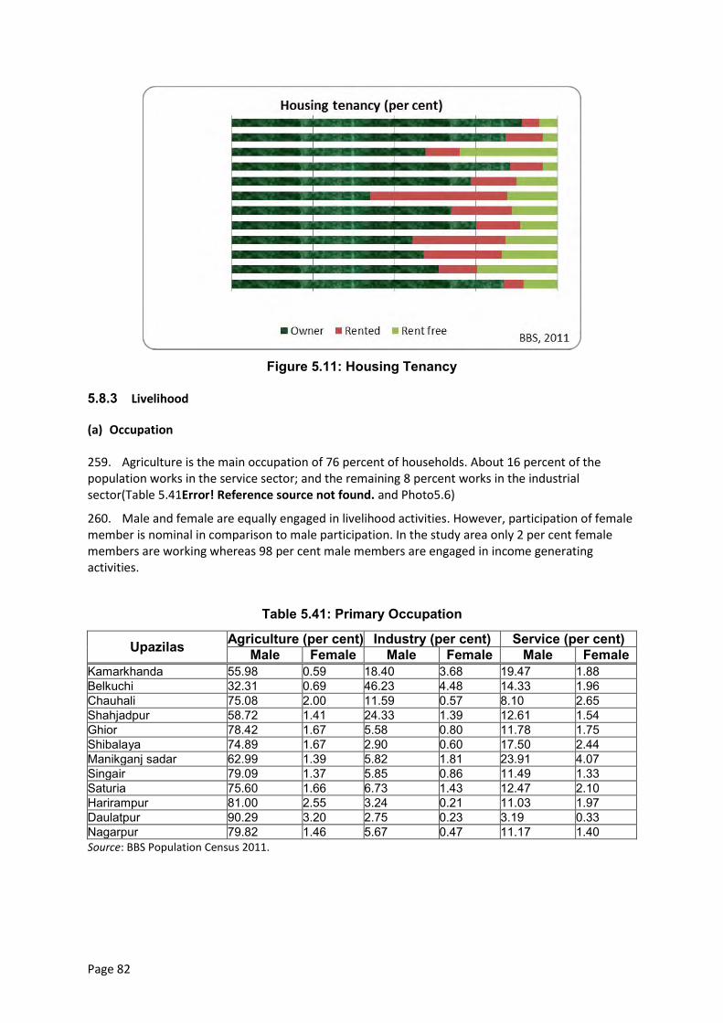
Page 82
Figure 5.11: Housing Tenancy
5.8.3 Livelihood
(a) Occupation
259. Agriculture is the main occupation of 76 percent of households. About 16 percent of the population works in the service sector; and the remaining 8 percent works in the industrial sector(Table 5.41Error! Reference source not found. and Photo5.6)
260. Male and female are equally engaged in livelihood activities. However, participation of female member is nominal in comparison to male participation. In the study area only 2 per cent female members are working whereas 98 per cent male members are engaged in income generating activities.
Table 5.41: Primary Occupation
Upazilas Agriculture (per cent) Industry (per cent) Service (per cent) Male Female Male Female Male Female
Kamarkhanda 55.98 0.59 18.40 3.68 19.47 1.88 Belkuchi 32.31 0.69 46.23 4.48 14.33 1.96 Chauhali 75.08 2.00 11.59 0.57 8.10 2.65 Shahjadpur 58.72 1.41 24.33 1.39 12.61 1.54 Ghior 78.42 1.67 5.58 0.80 11.78 1.75 Shibalaya 74.89 1.67 2.90 0.60 17.50 2.44 Manikganj sadar 62.99 1.39 5.82 1.81 23.91 4.07 Singair 79.09 1.37 5.85 0.86 11.49 1.33 Saturia 75.60 1.66 6.73 1.43 12.47 2.10 Harirampur 81.00 2.55 3.24 0.21 11.03 1.97 Daulatpur 90.29 3.20 2.75 0.23 3.19 0.33 Nagarpur 79.82 1.46 5.67 0.47 11.17 1.40 Source: BBS Population Census 2011.
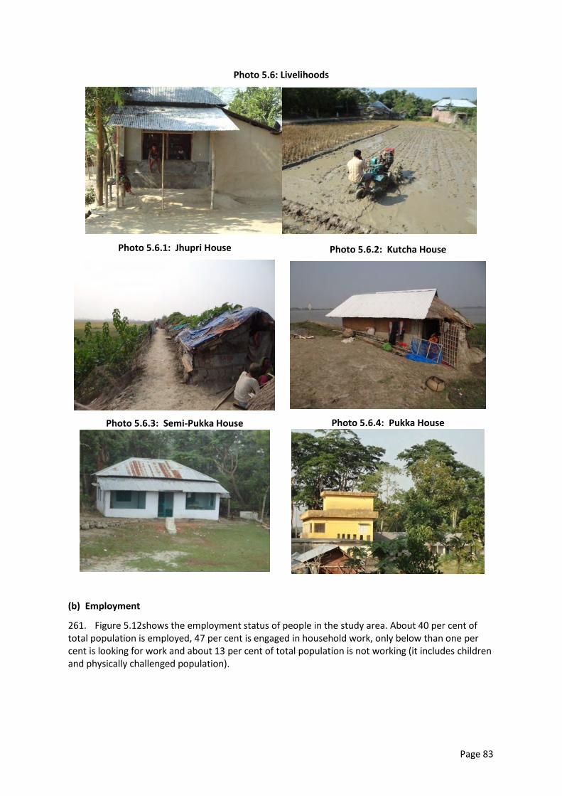
Page 83
Photo 5.6: Livelihoods
Photo 5.6.1: Jhupri House
Photo 5.6.2: Kutcha House
Photo 5.6.3: Semi-Pukka House
Photo 5.6.4: Pukka House
(b) Employment
261. Figure 5.12shows the employment status of people in the study area. About 40 per cent of total population is employed, 47 per cent is engaged in household work, only below than one per cent is looking for work and about 13 per cent of total population is not working (it includes children and physically challenged population).
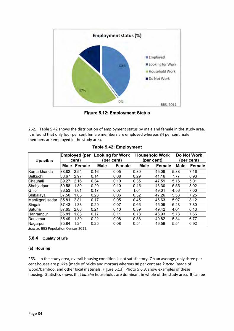
Page 84
Figure 5.12: Employment Status
262. Table 5.42 shows the distribution of employment status by male and female in the study area. It is found that only four per cent female members are employed whereas 34 per cent male members are employed in the study area.
Table 5.42: Employment
Upazilas Employed (per
cent) Looking for Work
(per cent) Household Work
(per cent) Do Not Work
(per cent) Male Female Male Female Male Female Male Female
Kamarkhanda 38.82 2.54 0.16 0.05 0.30 45.09 5.88 7.16 Belkuchi 38.67 2.97 0.14 0.08 0.29 41.16 7.77 8.93 Chauhali 39.27 2.16 0.34 0.10 0.35 47.59 5.16 5.01 Shahjadpur 39.58 1.80 0.20 0.10 0.45 43.30 6.55 8.02 Ghior 36.53 1.61 0.17 0.07 1.04 49.01 4.56 7.00 Shibalaya 37.50 1.85 0.23 0.06 0.52 47.26 5.33 7.25 Manikganj sadar 35.81 2.81 0.17 0.05 0.45 46.63 5.97 8.12 Singair 37.43 1.38 0.29 0.07 0.66 46.09 6.28 7.80 Saturia 37.65 2.06 0.21 0.10 0.39 49.42 4.04 6.13 Harirampur 36.81 1.83 0.17 0.11 0.78 46.93 5.73 7.66 Daulatpur 35.49 1.39 0.22 0.08 0.88 49.82 5.34 6.77 Nagarpur 35.84 1.24 0.25 0.08 0.54 49.59 5.54 6.92 Source: BBS Population Census 2011.
5.8.4 Quality of Life
(a) Housing
263. In the study area, overall housing condition is not satisfactory. On an average, only three per cent houses are pukka (made of bricks and mortar) whereas 88 per cent are kutcha (made of wood/bamboo, and other local materials; Figure 5.13). Photo 5.6.3, show examples of these housing. Statistics shows that kutcha households are dominant in whole of the study area. It can be
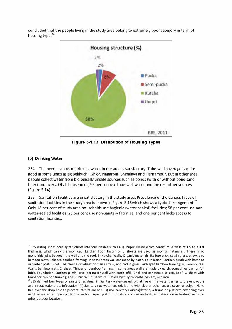
Page 85
concluded that the people living in the study area belong to extremely poor category in term of housing type.24
Figure 5-1.13: Distibution of Housing Types
(b) Drinking Water
264. The overall status of drinking water in the area is satisfactory. Tube-well coverage is quite good in some upazilas eg Belikuchi, Ghior, Nagarpur, Shibalaya and Harirampur. But in other area, people collect water from biologically unsafe sources such as ponds (with or without pond sand filter) and rivers. Of all households, 96 per centuse tube-well water and the rest other sources (Figure 5.14).
265. Sanitation facilities are unsatisfactory in the study area. Prevalence of the various types of sanitation facilities in the study area is shown in Figure 5.15which shows a typical arrangement.25 Only 18 per cent of study area households use hygienic (water-sealed) facilities; 58 per cent use non-water-sealed facilities, 23 per cent use non-sanitary facilities; and one per cent lacks access to sanitation facilities.
24
BBS distinguishes housing structures into four classes such as- i) Jhupri: House which consist mud walls of 1.5 to 3.0 ft thickness, which carry the roof load. Earthen floor, thatch or CI sheets are used as roofing materials. . There is no monolithic joint between the wall and the roof. ii) Kutcha: Walls: Organic materials like jute stick, catkin grass, straw, and bamboo mats. Split are bamboo framing. In some areas wall are made by earth. Foundation: Earthen plinth with bamboo or timber posts. Roof: Thatch-rice or wheat or maize straw, and catkin grass, with split bamboo framing; iii) Semi-pucka: Walls: Bamboo mats, CI sheet, Timber or bamboo framing. In some areas wall are made by earth, sometimes part or full brick. Foundation: Earthen plinth; Brick perimeter wall with earth infill; Brick and concrete also use. Roof: CI sheet with timber or bamboo framing; and iv) Pucka: House which is made by fully concrete, cement, and iron. 25
BBS defined four types of sanitary facilities: (i) Sanitary water-sealed, pit latrine with a water barrier to prevent odors and insect, rodent, etc infestation; (ii) Sanitary not water-sealed, latrine with slab or other secure cover or polyethylene flap over the drop hole to prevent infestation; and (iii) non-sanitary (kutcha):latrine, a frame or platform extending over earth or water; an open pit latrine without squat platform or slab; and (iv) no facilities, defecation in bushes, fields, or other outdoor location.
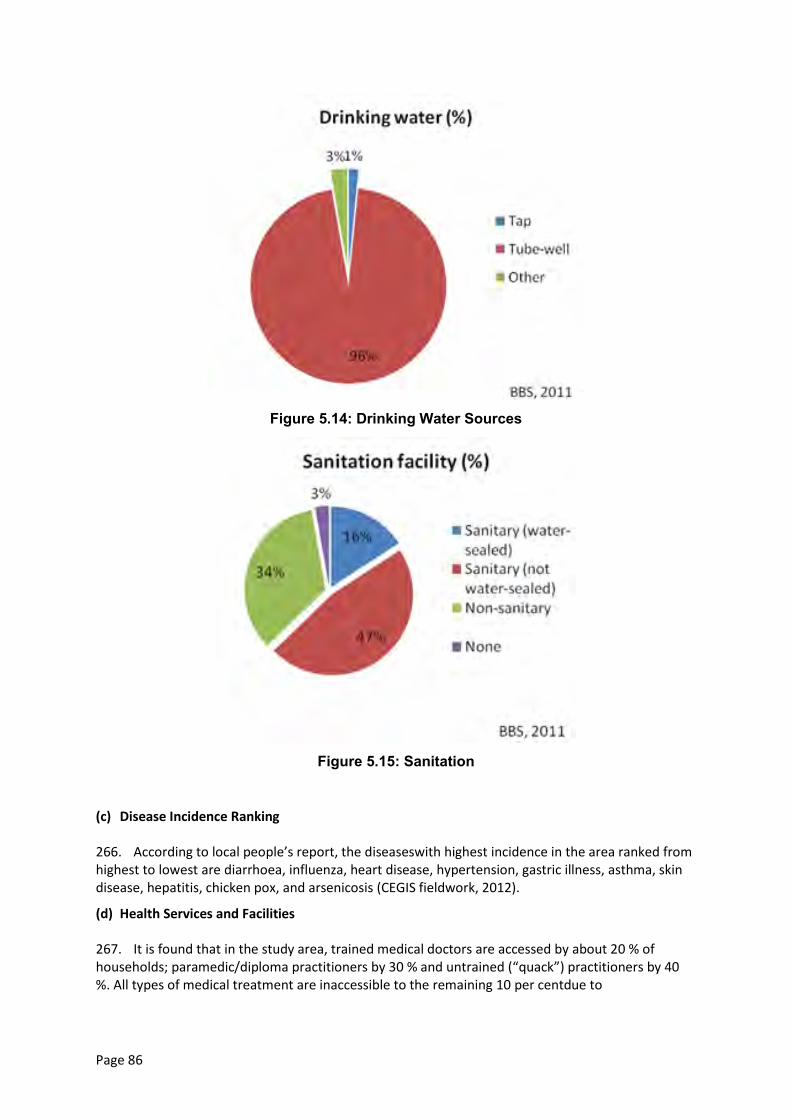
Page 86
Figure 5.14: Drinking Water Sources
Figure 5.15: Sanitation
(c) Disease Incidence Ranking
266. According to local people’s report, the diseaseswith highest incidence in the area ranked from highest to lowest are diarrhoea, influenza, heart disease, hypertension, gastric illness, asthma, skin disease, hepatitis, chicken pox, and arsenicosis (CEGIS fieldwork, 2012).
(d) Health Services and Facilities
267. It is found that in the study area, trained medical doctors are accessed by about 20 % of households; paramedic/diploma practitioners by 30 % and untrained (“quack”) practitioners by 40 %. All types of medical treatment are inaccessible to the remaining 10 per centdue to
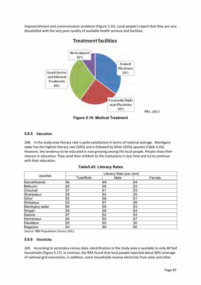
Page 87
impoverishment and communication problems (Figure 5.16). Local people’s report that they are very dissatisfied with the very poor quality of available health services and facilities.
Figure 5.16: Medical Treatment
5.8.5 Education
268. In the study area literacy rate is quite satisfactory in terms of national average. Manikganj sadar has the highest literacy rate (56%) and is followed by Ghior (55%) upazilas (Table 5.43). However, the tendency to be educated is now growing among the local people. People show their interest in education. They send their children to the institutions in due time and try to continue with their education.
Table5.43: Literacy Rates
Upazilas Literacy Rate (per cent) Total/Both Male Female
Kamarkhanda 46 49 44 Belkuchi 46 48 43 Chauhali 37 41 33 Shahjadpur 38 42 35 Ghior 55 58 51 Shibalaya 53 57 49 Manikganj sadar 56 59 53 Singair 46 48 44 Saturia 47 52 43 Harirampur 48 50 47 Daulatpur 35 40 30 Nagarpur 43 46 40 Source: BBS Population Census 2011.
5.8.6 Electricity
269. According to secondary census data, electrification in the study area is available to only 48 %of households (Figure 5.17). In contrast, the RRA found that local people reported about 80% coverage of national grid connection; in addition, some households receive electricity from solar and other
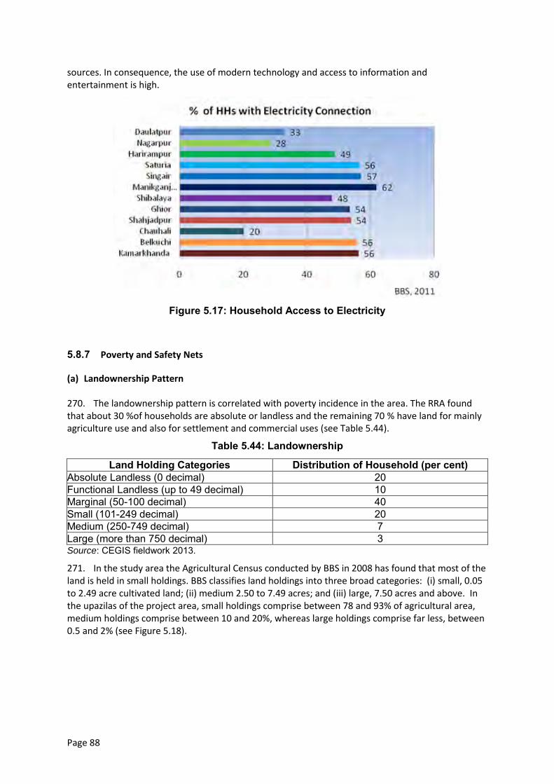
Page 88
sources. In consequence, the use of modern technology and access to information and entertainment is high.
Figure 5.17: Household Access to Electricity
5.8.7 Poverty and Safety Nets
(a) Landownership Pattern
270. The landownership pattern is correlated with poverty incidence in the area. The RRA found that about 30 %of households are absolute or landless and the remaining 70 % have land for mainly agriculture use and also for settlement and commercial uses (see Table 5.44).
Table 5.44: Landownership
Land Holding Categories Distribution of Household (per cent) Absolute Landless (0 decimal) 20 Functional Landless (up to 49 decimal) 10 Marginal (50-100 decimal) 40 Small (101-249 decimal) 20 Medium (250-749 decimal) 7 Large (more than 750 decimal) 3 Source: CEGIS fieldwork 2013.
271. In the study area the Agricultural Census conducted by BBS in 2008 has found that most of the land is held in small holdings. BBS classifies land holdings into three broad categories: (i) small, 0.05 to 2.49 acre cultivated land; (ii) medium 2.50 to 7.49 acres; and (iii) large, 7.50 acres and above. In the upazilas of the project area, small holdings comprise between 78 and 93% of agricultural area, medium holdings comprise between 10 and 20%, whereas large holdings comprise far less, between 0.5 and 2% (see Figure 5.18).
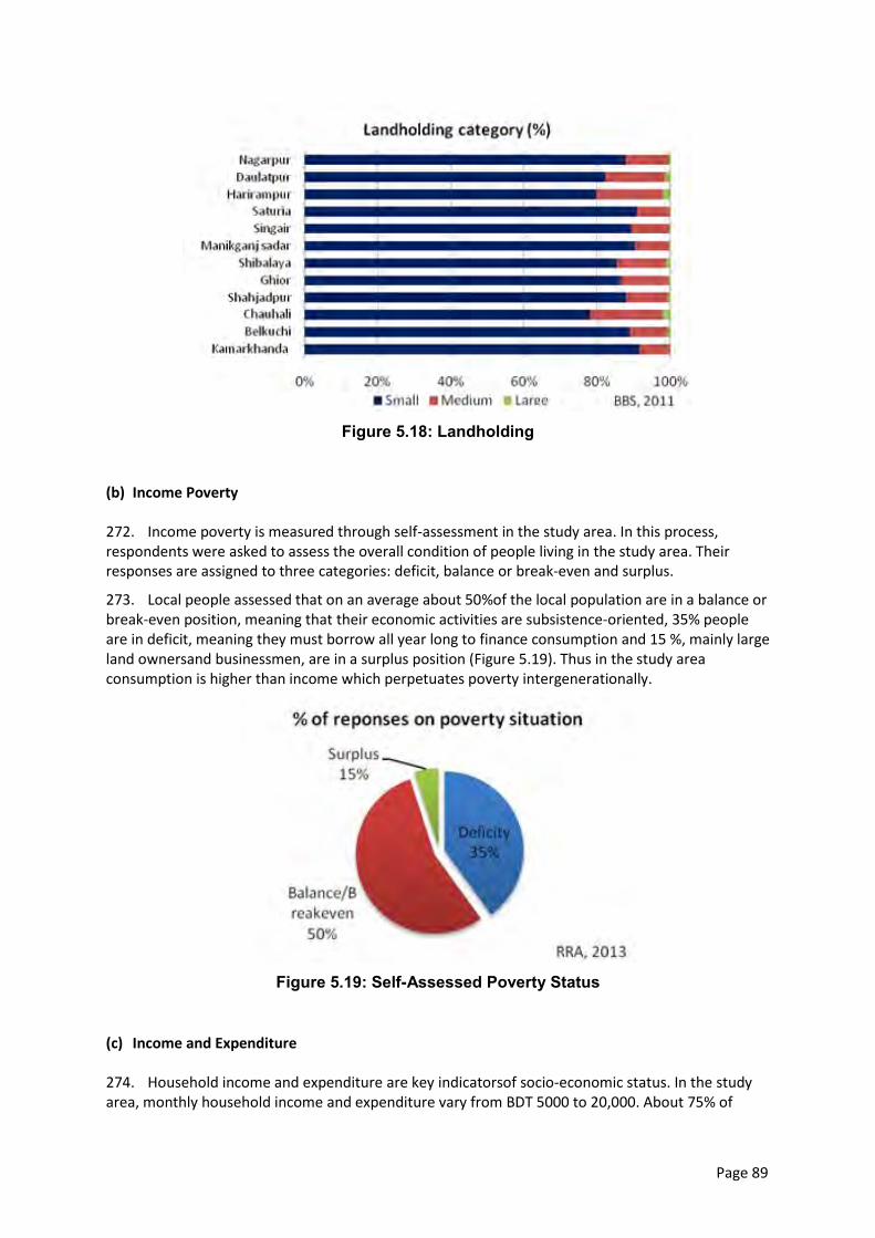
Page 89
Figure 5.18: Landholding
(b) Income Poverty
272. Income poverty is measured through self-assessment in the study area. In this process, respondents were asked to assess the overall condition of people living in the study area. Their responses are assigned to three categories: deficit, balance or break-even and surplus.
273. Local people assessed that on an average about 50%of the local population are in a balance or break-even position, meaning that their economic activities are subsistence-oriented, 35% people are in deficit, meaning they must borrow all year long to finance consumption and 15 %, mainly large land ownersand businessmen, are in a surplus position (Figure 5.19). Thus in the study area consumption is higher than income which perpetuates poverty intergenerationally.
Figure 5.19: Self-Assessed Poverty Status
(c) Income and Expenditure
274. Household income and expenditure are key indicatorsof socio-economic status. In the study area, monthly household income and expenditure vary from BDT 5000 to 20,000. About 75% of
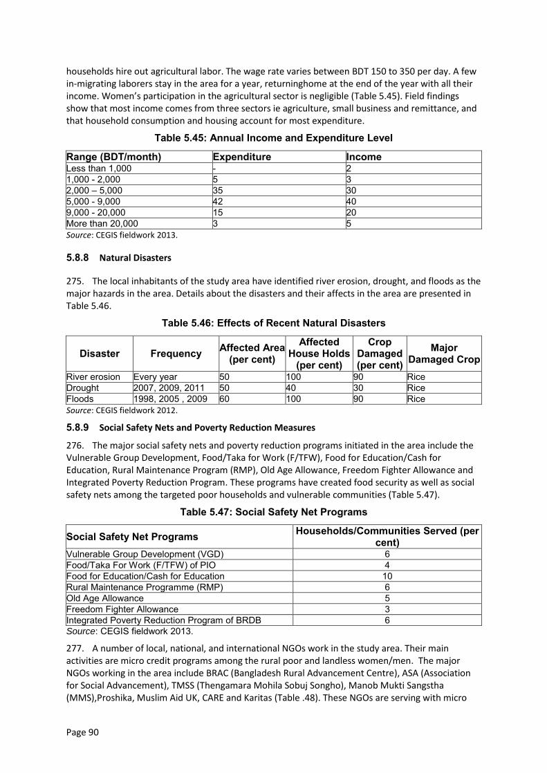
Page 90
households hire out agricultural labor. The wage rate varies between BDT 150 to 350 per day. A few in-migrating laborers stay in the area for a year, returninghome at the end of the year with all their income. Women’s participation in the agricultural sector is negligible (Table 5.45). Field findings show that most income comes from three sectors ie agriculture, small business and remittance, and that household consumption and housing account for most expenditure.
Table 5.45: Annual Income and Expenditure Level
Range (BDT/month) Expenditure Income Less than 1,000 - 2 1,000 - 2,000 5 3 2,000 – 5,000 35 30 5,000 - 9,000 42 40 9,000 - 20,000 15 20 More than 20,000 3 5 Source: CEGIS fieldwork 2013.
5.8.8 Natural Disasters
275. The local inhabitants of the study area have identified river erosion, drought, and floods as the major hazards in the area. Details about the disasters and their affects in the area are presented in Table 5.46.
Table 5.46: Effects of Recent Natural Disasters
Disaster Frequency Affected Area (per cent)
Affected House Holds
(per cent)
Crop Damaged (per cent)
Major Damaged Crop
River erosion Every year 50 100 90 Rice Drought 2007, 2009, 2011 50 40 30 Rice Floods 1998, 2005 , 2009 60 100 90 Rice Source: CEGIS fieldwork 2012.
5.8.9 Social Safety Nets and Poverty Reduction Measures
276. The major social safety nets and poverty reduction programs initiated in the area include the Vulnerable Group Development, Food/Taka for Work (F/TFW), Food for Education/Cash for Education, Rural Maintenance Program (RMP), Old Age Allowance, Freedom Fighter Allowance and Integrated Poverty Reduction Program. These programs have created food security as well as social safety nets among the targeted poor households and vulnerable communities (Table 5.47).
Table 5.47: Social Safety Net Programs
Social Safety Net Programs Households/Communities Served (per cent)
Vulnerable Group Development (VGD) 6 Food/Taka For Work (F/TFW) of PIO 4 Food for Education/Cash for Education 10 Rural Maintenance Programme (RMP) 6 Old Age Allowance 5 Freedom Fighter Allowance 3 Integrated Poverty Reduction Program of BRDB 6 Source: CEGIS fieldwork 2013.
277. A number of local, national, and international NGOs work in the study area. Their main activities are micro credit programs among the rural poor and landless women/men. The major NGOs working in the area include BRAC (Bangladesh Rural Advancement Centre), ASA (Association for Social Advancement), TMSS (Thengamara Mohila Sobuj Songho), Manob Mukti Sangstha (MMS),Proshika, Muslim Aid UK, CARE and Karitas (Table .48). These NGOs are serving with micro
Page 91
credit while BRAC, ASA, and Uttaran are working for non-formal education, Health, human rights, water and sanitation, gender and children development programs. About 40 per cent of households are found to benefit from NGO interventions.
Table 5.48: NGOs Programs
NGO Type of Programs
Credit Education Water and Sanitation Health Human
Rrights Gender Children Disaster
BRAC ✓ ✓ ✓ ✓ ✓ ✓ ✓ - ASA ✓ ✓ - - ✓ ✓ - - TMSS ✓ ✓ ✓ - ✓ - ✓ - Manob Mukti Sangstha ✓ - - - - - - -
CARE ✓ ✓ ✓ - ✓ ✓ - - UK Muslim Aid - ✓ ✓ ✓ ✓ - - ✓
Karitas - - - - - - - ✓ Source: CEGIS fieldwork 2013.
5.8.10 Transportation
(a) Road way
278. Overall about 1011 km of roads exist in the 12 upazilas of the area, of which: 65 km roads are national: 200 km are FRA (connecting road from upazila to district); 253 km are FRB (connecting road from union to upazila); and 493km are R1 (regional road within the districts). Table 5.49presents data on the road network in the study area.
Table5.49: Road Network
Upazilas N FRA FRB R1 Daulatpur - 6 22 33 Ghior 8 13 13 34 Harirampur - 13 27 28 Manikganj Sadar 10 19 28 58 Saturia 3 12 8 52 Shibalaya 18 12 9 56 Singair - 19 41 56 Belkuchi - 25 9 43 Chauhali - 2 23 2 Kamarkhanda 8 22 14 17 Shahjadpur 17 27 22 62 Nagarpur - 30 37 53 Total 65 200 253 493 Source: NWRD database 2013.
(b) Waterways
279. Waterways are the most important means of communication in the area. Navigation routes in the study area include: 390 km of routes less than 25 m wide; 170km of routes25 to 50 m wide; 126 km that are 50 to 100 m wide and 207 km above100 m wide (see Table 5.50). The area has one ferry ghat, two inland river ports, and two pilot stationswithin the study area. Waterwaysare gradually decreasing in size due to siltation.
Page 92
Table 5.50: Navigation Routes
Upazilas Below 25m 25m - 50m 50m - 100m Above 100m Daulatpur 30 9 15 6 Ghior 24 25 15 8 Harirampur 12 37 4 11 Manikganj Sadar 14 8 41 34 Saturia 7 23 11 16 Shibalaya 25 20 0 10 Singair 48 12 29 15 Belkuchi 7 17 0 7 Chauhali 32 5 0 13 Kamarkhanda 22 10 2 4 Shahjadpur 82 3 0 60 Nagarpur 86 1 8 24 Total 390 170 126 207 Source: NWRD database 2013.
5.8.11 Educational Institutions
280. The area has 914 primary and secondary schools, 48 colleges, and 92 madrasas (religious schools; Table 5.51). Some area students go to Rajshahi and Dhaka for secondary education. Educational institutions are mostly concentrated in larger settlements, although primary schools are distributed equally in all unions of the area.
Table 5.51: Academic Institutions
Upazilla School College Madrasha Kamarkhanda 125 7 15 Belkuchi 173 6 11 Chauhali 134 7 23 Shahjadpur 264 15 30 Ghior 102 5 3 Harirampur 98 3 2 Daulatpur 18 5 8 Source: CEGIS fieldwork 2013.
5.8.12 Population Migration
281. Seasonal labor migration is common throughout the study area. Permanent in- and out-migration is negligible.
282. Area residents tend to out-migrate to Dhaka, Tangail, Sylhet and Rajshahi, for better livelihood (60 per cent). These out-migrants are both male and female and from both excluded/impoverished and privileged backgrounds.
283. A significant number of labourer sliving in the area (20 per cent) are in-migrantswho came seeking subsistence wages (Table 5.52). Most of these in-migrants are male, aged 15 to 47 and from socially excluded and economically impoverished backgrounds.
Table 5.52: Labor Migration
Type of Out Migration In Migration
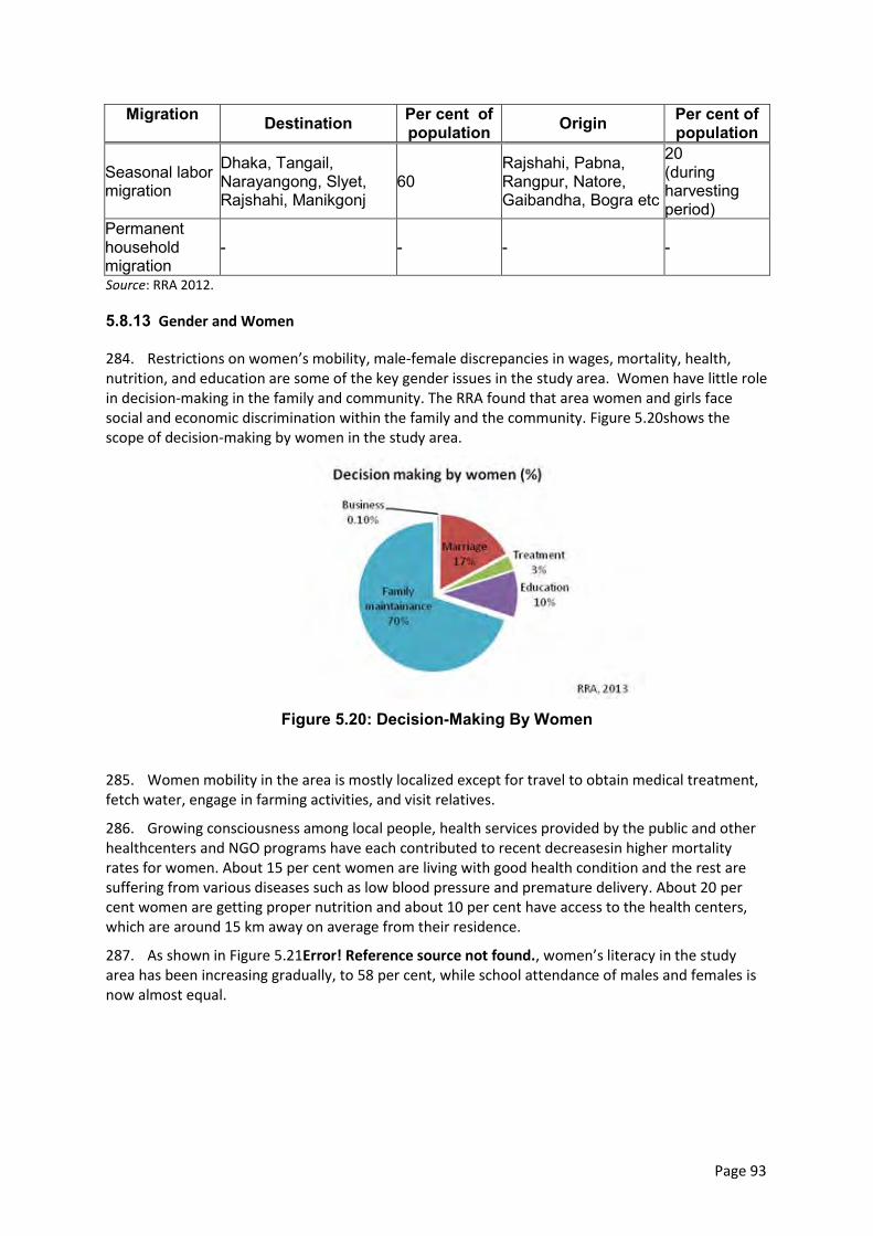
Page 93
Migration Destination Per cent of population Origin Per cent of
population
Seasonal labor migration
Dhaka, Tangail, Narayangong, Slyet, Rajshahi, Manikgonj
60 Rajshahi, Pabna, Rangpur, Natore, Gaibandha, Bogra etc
20 (during harvesting period)
Permanent household migration
- - - -
Source: RRA 2012.
5.8.13 Gender and Women
284. Restrictions on women’s mobility, male-female discrepancies in wages, mortality, health, nutrition, and education are some of the key gender issues in the study area. Women have little role in decision-making in the family and community. The RRA found that area women and girls face social and economic discrimination within the family and the community. Figure 5.20shows the scope of decision-making by women in the study area.
Figure 5.20: Decision-Making By Women
285. Women mobility in the area is mostly localized except for travel to obtain medical treatment, fetch water, engage in farming activities, and visit relatives.
286. Growing consciousness among local people, health services provided by the public and other healthcenters and NGO programs have each contributed to recent decreasesin higher mortality rates for women. About 15 per cent women are living with good health condition and the rest are suffering from various diseases such as low blood pressure and premature delivery. About 20 per cent women are getting proper nutrition and about 10 per cent have access to the health centers, which are around 15 km away on average from their residence.
287. As shown in Figure 5.21Error! Reference source not found., women’s literacy in the study area has been increasing gradually, to 58 per cent, while school attendance of males and females is now almost equal.
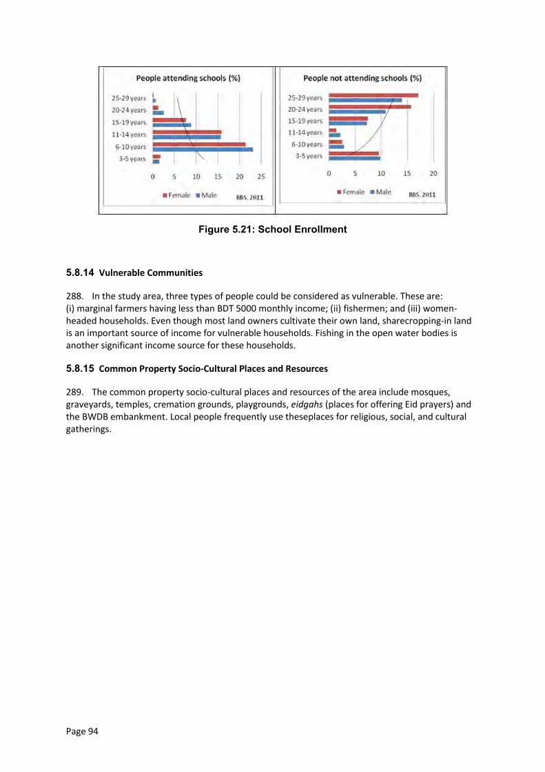
Page 94
Figure 5.21: School Enrollment
5.8.14 Vulnerable Communities
288. In the study area, three types of people could be considered as vulnerable. These are: (i) marginal farmers having less than BDT 5000 monthly income; (ii) fishermen; and (iii) women-headed households. Even though most land owners cultivate their own land, sharecropping-in land is an important source of income for vulnerable households. Fishing in the open water bodies is another significant income source for these households.
5.8.15 Common Property Socio-Cultural Places and Resources
289. The common property socio-cultural places and resources of the area include mosques, graveyards, temples, cremation grounds, playgrounds, eidgahs (places for offering Eid prayers) and the BWDB embankment. Local people frequently use theseplaces for religious, social, and cultural gatherings.
Page 95
6. Public Consultation and Disclosure
6.1 Disclosure, Consultation, and Participation during Project Preparation
290. Two rounds of stakeholder engagement were undertaken during project preparation. A first round of public consultation meetings (PCM) was carried out as part of this study. The objectives of this round of consultation were (i) disclosure of project information to stakeholders, (ii) consultation with the public on issues to include in the assessment, and (iii) participation of stakeholders in the formulating the set of VESCs to be assessed for project impacts.
291. A second round of PCMs was be undertaken when this environmental assessment report became available in draft form, with three objectives: (i) disclosure of the draft report contents, including the proposed GRM and EMP; (ii) consultation with stakeholders on the results of the assessment; and (iii) discussion of stakeholder participation in environmental management activities during construction and implementation.
6.2 Stakeholder Comments and Concerns
6.2.1 First Round
292. During the environmental assessment process a first round of public consultation meetings was held in four locations (Map 6.1) to present the location to stakeholders and document their concerns. The records of this round are presented in Annex 3.
293. The purpose, time, and location of the first-round meetings were disseminated to stakeholders by sending hard-copy letters in Bengali to all relevant upazila-level officials in the meeting catchment. These letters included the request to circulate the information to other stakeholders. Meetings were also publicized to stakeholders during all field work including focus group discussions, with FGD attendees being asked to contact other stakeholders. The means of secondary and tertiary notification was almost exclusively by cell phone voice calls.
294. Judging from meeting attendance, notification appeared to have been effective – now that “everyone” in Bangladesh has access to a cell phone – in reaching a large number and all types of stakeholders. The only stakeholder type noted to be seriously underrepresented in the public meetings was women. This was addressed by having separate women-only focus group discussions about the project and the environmental impacts.
295. There was a high degree of unanimity among stakeholders. Stakeholders, even some who would be resettled by construction, expressed strong support for the project to be implemented as quickly as possible to solve their severe and urgent erosion and flooding problems. No reservations were expressed regarding potential adverse impacts.
296. An issue identified by CEGIS meeting facilitators is that some stakeholders are unhappy that their area (which is suffering from flooding and/or erosion) is notcovered by Tranche 1, and they do not understand why areas other than theirs have been selected for priority intervention. This highlights a potential risk to the dynamic siting approach, which is supposed to determine intervention locations on the basis of morphologic/hydrologic modeling, but may be vulnerable to local stakeholder pressure. Another potential risk is of increased social conflict between protected/unprotected communities or between unprotected communities and project proponents, contractors, laborers, etc. These risks will be addressed through the implementation-phase public consultation program, which can include dissemination of information on how siting decisions are made, and the GRM.
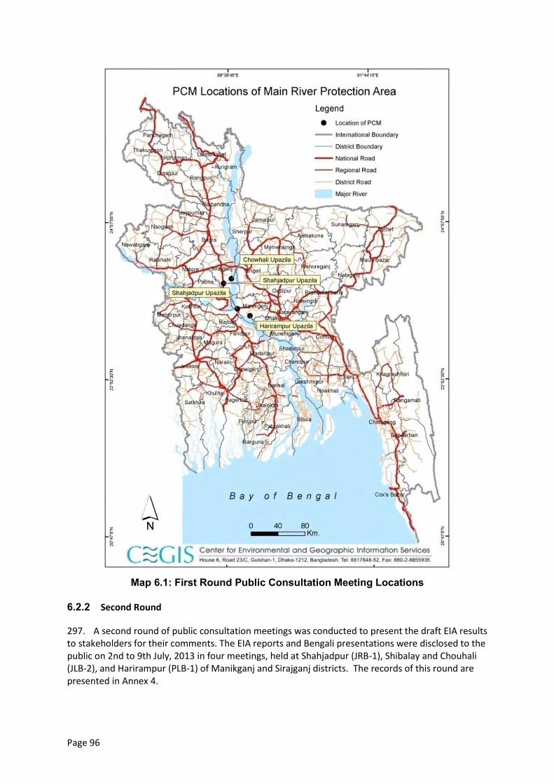
Page 96
Map 6.1: First Round Public Consultation Meeting Locations
6.2.2 Second Round
297. A second round of public consultation meetings was conducted to present the draft EIA results to stakeholders for their comments. The EIA reports and Bengali presentations were disclosed to the public on 2nd to 9th July, 2013 in four meetings, held at Shahjadpur (JRB-1), Shibalay and Chouhali (JLB-2), and Harirampur (PLB-1) of Manikganj and Sirajganj districts. The records of this round are presented in Annex 4.
Page 97
298. The main meeting objectives were to present the findings of the final draft EIA report and receive feedback from local stakeholders who attended the meetings. Stakeholders including persons affected by Tranche 1 expressed their views in favor of the Project and their support for early implementation to protect them from natural flood and erosion disasters. CEGIS consultants shared the Tranche 1 feasibility and EIA process and results first with BWDB officials and Upazila Parishad Chairpersons (UZPC), Upazila Nirbahi Officers (UNOs), and Project Implementation Officers (PIOs) of polder areas. In turn, these individuals assisted in identifying and inviting union-level public representatives and key persons by phone to the consultation meetings.
299. Not surprisingly, given the higher level of information provided to meeting participants about the subprojects and their potential impacts, participants expressed more substantive concerns about the when, where, what and how of subproject interventions.
6.3 Summary of Concerns, All Meetings
300. Conditions identified as important for success of subprojects. (i) Participants emphasized the need to ensure that construction work is of high quality. (ii) Almost all participants stated that erosion will destroy areas currently under attack and subproject designswill have to be changed unless construction of erosion works begins this year (2013). To allow this construction to start in 2013, they requested that contingency funds be arranged now. (iii) Participants are concerned that development projects initiated by the ruling party will lose priority if/when the opposition party is in power. Participants strongly urge a 2013 construction start avoid future problems.
301. Dredging.River dredging has not been included in subprojectdesigns. Participants stated that embankmentswill not control flooding or erosion withoutit, and therefore it should be incorporatedin the project. Some participants suggested capital dredging from Jamuna Bridge to Brahmankanda of Horirampur Upazia under Manikgonj District. Participants also suggested that fisheries habitat could restored through dredging of internal channels in the Tranche 1area.
302. Pollution. Stakeholders were advised that the construction phase would cause temporary air pollution and noise. Almost all stakeholders present consented to accept these impacts during construction.
303. Flood protection plans. Participants expressed concerned about the effectiveness of the subprojects in controlling flooding. They stated that flood protection plans should be developed based on an assessment of water levels. Proposed interventions should be designed to provide protection from the highest monsoon water levels.
6.4 Additional Concerns from Specific Meetings
304. Shibalay, Manikganj (JLB-2 area). The upazila areas most affected by erosion are Zafargonj and Bachamara. Local MP Mr. A.B.M Anwerul Haq stated that over last five years, more than 9000 affluent households of Zafargonj area were forced by erosion to leave the area and now live in difficult circumstances in Dhaka city. Participants recommend that construction should start from November in the dry season. The northern part of Zafargonj Bazar is very much threatened by erosion this year. To protect this area,participants suggested seeking preparatory fundsfrom Asian Development Bank (ABD) and Water Development Board. River bank protection from Kaijuri to Baghabari is also essential this year as these areas are vulnerable. Participants believe permanent protection works are required in the Padma and Jamuna Rivers as temporary erosion protection works are not viable there. A reservoir to hold water for rice cultivation and fish culture should be added to the subproject.
305. Shahjadpur, Sirajganj (JRB-1). Co-ordination among involved departments should be ensured during subproject implementation. Eroding locations should be properly identified and protection
Page 98
works provided there. Participants requested adding construction of a water reservoir to the project, to hold water for rice cultivation and aquaculture, and immediate repair of the existing upazila embankment and revetment.
306. Chouhali, Sirajganj (JLB-2). The area of Chouhali upazila most vulnerable to erosion is the upazila sadar, where 40 to 50 per cent of the area has already eroded away. BWDB has been using sandbags in attempt to control the erosion, but these have been ineffective given the intensity of the erosive attack. Participants stated that sandbag revetments are ineffective in the Jamuna due to its erosion intensity. Most participants stated that capital dredging should be undertaken from the Jamuna Bridge to Aricha. River dredging is required to ensure the survival of any future embankment works.An embankment built in this upazila at a cost of BDT 38 crore was already destroyed by erosion. A flow divider should be incorporated in the project design. Participants expressed frustration that the subproject design does not reflect the concerns and suggestions of local people, even though these have been expressed repeatedly in meetings with the Project Implementation Officer (PIO).
307. Harirampur, Manikganj (PLB-1). The 5 km riverbank protection proposed in this upazila should be extended an additional 2 km up to Dhulsura. Bahadurpur union should be included with the project. Participants were concerned about the successful implementation of the project. They think that projects initiated by the ruling party will have lower priority if and when the opposition is in power. Participants hope the subprojectwill be implemented in 2013, and agreed to make whatever sacrifices would be required to expedite this. Participants stated that the priority should be to protect Harirampur before providing protection to Manikgonj town. Priority work should start as soon as possible. A quality control committee should be struck to ensure quality construction work. Local stakeholders should be involved in regular embankment maintenance.
6.5 Incorporation of Concerns in Project and Mitigation Designs
308. Some concerns relate to known issues that have been and are being attended to (eg quick start of construction, construction quality control); where prevailing funding, capacity, and other constraints obviate technical solutions, this will be communicated to stakeholders during subsequent consultation activities. Other concerns relate to participants’ perceptions of technical issues (eg role of dredging in flood and erosion control and fish habitat restoration; flow divider) that may or may not accord with engineering analyses and understandings. Addressing these concerns first requires a technical assessment of the feasibility of modifying designs per stakeholders’ wishes/suggestions; where feasible, appropriate modifications can be made. Addressing concerns without ready technical solution likely will involve an ongoing conversation between planners/designers and stakeholders, in which information about analytical tools and results in appropriate forms is provided to stakeholders and stakeholders are provided with opportunities to share their local knowledge and observations with planners/designers, especially where it contrasts with technical understandings. Currently detailed designs are underway and public continue to be consulted.
6.6 Implementation-Phase Stakeholder Disclosure, Consultation and Participation
309. Stakeholder engagement will continue during implementation facilitated by an NGO engaged for this purpose. Selected parts of this EIA, specifically related to impacts, mitigation measures and stakeholders’ views, will be translated and made available to the public at different local levels, suitably the locations of the consultation meetings. On a larger scale this EIA will be published on ADB’s webpage as part of the project documents.
Page 99
6.7 Grievance Redress Mechanism
310. At each Tranche 1 subproject location, a local Grievance Redress Committee(GRC) will be set up during the design stage and operate throughout the implementation phase. Each GRC will consist of a BWDB representative (Executive Engineer (Field) or equivalent) as the chair, a BWDB Sub Assistant Engineer as member-secretary, and as members the concerned UnionParishad chairperson(s) and for subprojects with resettlement, a representative of resettlement-affected persons.
311. GRCswill review and resolve grievances within one month of receipt and maintain written records of complaints received, actions taken, and meeting minutes with dated photos. Aggrieved personsare free to access the country’s legal system at any stage regardless of GRC involvement. In addition, a Joint Verification Team (JVT) is responsible to assess complaints related to the land
acquisition process.26but also related to the environment, including the use of natural resources, such as fish associated with sluice gate operation or the use of embankment slopes based on long-term lease agreements27.
6.8 Reporting and Monitoring
312. Environmental monitoring reports will be issued bi-annually disclosure on ADB’s website. The environmental monitoring reports will also be incorporated into the December and July version of the quarterly progress report, which is at the beginning and end of every construction season. Environmental monitoring reports will be prepared by the Project Management Office, under the direction of the nominated environmental officer with the help of the consulting team’s environmental specialist.
313. Monitoring will be undertaken for timely detection of conditions requiring remedial measures; to provide information on mitigation and institutional strengthening progress; and to assess compliance with required safeguards. Overall implementation progress including EMP implementation will be reviewed during periodic review missions involving ADB, the Implementing Agency, the Executing Agency, and the Implementation Consultant.
26
Annex J1, Resettlement Framework, version dated 2 Aug 2013. 27
Long term lease agreements will be worked out after identification of stakeholder groups, associated with community disaster management units and taking into account vulnerable groups (such as hard core poor families, women-headed households) identified during the implementation of the resettlement process.
Page 100
7. Important Environmental and Social Components
7.1 Introduction
314. The environmental and social components likely to be impacted by the project interventions are called important environmental and social components (IESC). IESCs were formulated through a two-stage scoping process. In the first stage, IESCs were identified by the experts of the EIA/SIA team in a multi-disciplinary scoping process. In the second stage, local scoping sessions were held in which local communities reviewed and validated the EIA/SIA team IESCs, and, as needed, identified additional IESCs they believed could be impacted by the proposed interventions.
315. The IESCs for water, land, agriculture, fisheries, ecosystem and socio-economic conditions that were formulated for this study, and their selection rationale, are described below.
7.2 Water Resources
7.2.1 Erosion and Accretion
316. Every year, bank line erosion in the study area grasps huge amount of lands damaging valuable assets and infrastructures. On the other hand, continuous accretion in the rivers reduces the navigability. In the dry period, the shallow rivers are silted up with chars and theavailable surface water can hardly meet the demand of local people. The interventions of will have significant effects in the morphological changes (i.e. erosion and accretion) of the area. The bank revetment works are likely to affect the river erosion/ accretion scenario, whereas the process of guided siltation (proposed in JLB-2 sub-reach) may affect the net accretion inside the Jamuna River. Considering these issues, erosion and accretion have been selected as an IESC.
7.2.2 Flooding
317. The study area is highly vulnerable to regular flooding during monsoon. Due to flat topography and geographic location of the area, small rise in water levels causes full scale inundation. Floods cause immense sufferings to the local people by damaging valuable assets and infrastructures, causing bank erosion, disrupting communication system etc. Interventions such as construction and re-sectioning of embankments are likely to cause significant impacts in the flood occurrence, extent and duration. Therefore, flooding was selected as an IESC.
7.2.3 Drainage Congestion
318. The major internal tributaries of the area are becoming shallow due to continuous siltation and hence do not provide effective drainage needed during monsoon. This leads to drainage congestion problems which eventually cause water logging and inundation in some parts of the area. The proposed bank revetment works and provision of regulators are likely to affect the drainage situation of the water bodies inside the area to some extent. Considering this phenomenon, drainage congestion was selected as another IESC.
7.2.4 Water Logging
319. In the wet season, some parts of the study area suffer from temporary water logging problems. However, there is no permanent water logging condition in the dry period. The construction and re-sectioning of embankments is likely to increase water level which may create
Page 101
water logging on a permanent basis. Provision of regulators is likely to resist the occurrence of water logging, but in places where regulators would not be placed, water logging problems might arise. Moreover, no intervention has been proposed to re-excavate some of the shallow rivers and lakes which might affect the water logging scenario. Considering all these possibilities, water logging was selected as an IESC.
7.2.5 Water Availability and Water Use
320. Availability of water for agricultural and other uses is selected as anIESC. In the dry season, ground water as well as surface water is used to some extent for irrigation and domestic purposes while in the wet season, surface water is used predominantly. The availability of water for different uses therefore is a valued component for the lives and livelihood of local people. The interventions proposed in the study area would affect the local people’s access to surface water and its use on multipurpose.
7.2.6 Navigation
321. Navigation through the major and internal rivers is an important phenomenon in the study area. It is important for the socio economic aspects, ecological balance and the different uses of water. The provision of interventions may affect the navigation status of the rivers. As such, navigation was considered as anIESC.
7.2.7 Surface Water Quality
322. Surface water quality is another IESC for the project. It is important for the environmental sustainability. Better quality of surface water would ensure improved use of water for domestic, irrigation and drinking purposes. The proposed interventions are likely to impact the quality of surface water. The bank revetment works would impact the siltation rates and overall quality of rivers. The construction and re-sectioning of embankments would also affect the quality of surface water during the construction phase.
7.3 Land Resources
7.3.1 Land Type
323. Land type depends on the depth of inundation on cultivated land during the wet season. Area under different land types was selected as an IESC.
7.3.2 Sand Carpeting
324. Sand carpeting or casting on agricultural land takes place through overtopping of embankment during high flood levels in the river. Area of agricultural land affected by sand casting was selected as anIESC.
7.3.3 Land Loss
325. Land loss through river bank erosion is a major problem in the study area. The proposed bank protection is expected to check such loss of agricultural land. Temporary loss of agricultural land is likely to take place during the pre-construction phase if labor sheds are constructed and/or construction materials are stored on agricultural land. Agricultural land may also be lost if dredged spoil/re-excavated soils are disposed on agricultural land. Permanent and temporary loss of agricultural land was selected as IESCs.
Page 102
7.4 Agriculture
7.4.1 Cropping pattern and intensity
326. Changes in area under different land types are expected to bring in changes in cropping patterns. Increase in area under higher land type (F0/F1) would create scope of multiple cropping leading to increased cropping intensity.
7.4.2 Crop production
327. Agricultural crop production is expected to increase through river bank protection and changes in area under different land types. This is expected to be achieved through increased cropping pattern, reduction in crop damage, increased area under high yielding varieties of rice with increased provision of both primary and supplemental irrigation and overall adoption of improved crop management practices.
7.4.3 Crop damage
328. Crops are presently damaged in the study area due to flood, drainage congestion, and drought. Changes in crop damage would be reflected in aerial extent as well as increased yield per hectare contributing to increase in crop production.
7.4.4 Irrigated Area& Irrigation Water Availability
329. Irrigation supports greater and more reliable agricultural productivity. Surface water and ground water are used for irrigation use.
7.5 Fisheries
7.5.1 Fish Habitat
330. Any change of land types due to the proposed interventions might modify the quality and quantity of fish habitat. The project possesses some pockets and floodplain that goes under water in wet season and thus contribute towards the development of fisheries resources. The proposed interventions will modify the fish habitats in the study area. In this context, fish habitat was considered as anIESC in this study.
7.5.2 Riverine Fish Habitats
331. Continues sedimentation of river bed, establishment of different types of structures such as cross fish pata, katha/komor, shrimp gher on the river slope, agriculture practice by building mud bunds, housing and other engineering construction by encroaching the river causes the river habitat unsuitable for fish migration as well as fish production. The proposed interventions may modify the riverine fish habitats in the study area. Considering these aspects, riverine fish habitat was taken as an IESC for this study.
7.5.3 Beel and Khal Fish Habitats
332. Some of the riverine fishes migrate towards the beels through khal for breeding purpose and propagation. Beels are the breeding and feeding grounds of the indigenous species of fishes and play a vital role in stock recruitment. The khals are silted up due to closure, construction of water regulating structures, mud bund etc. Besides these beels are silted up rapidly and the indigenous
Page 103
species of fishes might disappear from the area. The proposed interventions will modify the fish habitats in the study area In this context, beel and khal fish habitats are considered as IESC.
7.5.4 Floodplain Fish Habitat
333. The floodplain fisheries may be impacted due to the construction of embankment of the study area if the connecting khals/ canals are not restored properly.
7.5.5 Fish Migration
334. Fish migration is considered important for maintaining fish bio-diversity and production.
7.5.6 Fish Species Diversity
335. Fish biodiversity is an indicator of aquatic ecosystem health and has implications for income and nutrition of poor people.
7.5.7 Capture and Culture Fish Production
336. Fish production that comes from different open water sources may be reduced due to loss of habitat with reduction in water area. Besides this the unfavorable environment in terms of reduced dissolved oxygen (DO) and pH level and water temperature could also change the fish production. Therefore, capture fish production was considered as an IEC for this study.
7.6 Ecological Resources
7.6.1 Terrestrial Ecosystem
337. Terrestrial ecosystem provides habitat for all the terrestrial plants. Several indicators such as biodiversity, species richness and habitat suitability can be used to assess the physical condition of the ecosystem. Therefore, assessing the population dynamics of local plants and wildlife communities including terrestrial birds can measure the health of terrestrial ecosystem as well as its population. Physical settings of the existing ecosystem may be changed e.g. terrestrial’s communities due to bank protection of river. So the terrestrial ecosystem was considered as one of the IEC.
7.6.2 Aquatic Ecosystem
338. Aquatic ecosystems provide support not only to aquatic inhabitants but also supply the vital ingredients to terrestrial ecosystems. Unlike terrestrial ecosystems, any impact on aquatic system is generally not confined to local area, it also cover the surrounding areas. Change in flow regime of water in the study area will change the habitat suitability for resident plants, aquatic birds and wildlife, niche etc. That is why aquatic ecosystem is considered as an IEC of this project.
7.6.3 Floral Composition and Diversity
339. Composition and floral diversity of khal, beel, homestead and crop field vegetations are sensitive to hydro-morphological condition of its habitats. The impact of the proposed bank protection activities would change the hydro-morphological condition of river and would change the floral composition and diversity both on terrestrial and aquatic in the study area. Hence, the floral composition and diversity was considered anIESC.
Page 104
7.6.4 Faunal Composition and Diversity
340. Developing of bank protection activities might have impacts on faunal composition and diversity both on terrestrial and aquatic faunas. This IEC was selected to identify and evaluate the potential impacts on terrestrial and aquatic fauna for this project.
7.7 Socio-Economic Condition
7.7.1 Land Acquisition
341. Land will have to be acquired for implementation of the bank protection work. So, land acquisition was selected as anIESC for the proposed erosion protection activity.
7.7.2 Income Generation
342. Project interventions could increase employment opportunities in agriculture and fishery sectors as well as in the field of non-agricultural trades. Therefore, income generation was selected as anIESC.
7.7.3 Communications
343. One of the objective of bank protection work is to save embankments from river erosion and the outcome of the project will protect this embankment from erosion and the road over the right embankment which is a major road for communication in that area and will not be affected further because of erosion and will serve the communication purpose of the local people. Therefore, communication was selected as an IESC.
7.7.4 Poverty
344. People can cultivate the agricultural lands by the side of the river and thus the production will be increased. Food securities of the local people will be ensured by producing more crops in the protected agricultural lands. Thus, poverty was selected as anIESC.
Page 105
8. Impact Assessment and Mitigation Measures
8.1 Categorization and Quantification
345. The Important Environmental Components (IECs) for the project have been selected and validated in Chapter 7. Following the analyses of all the secondary information available, major field investigation were conducted in May 2013, by a multidisciplinary team of experts from CEGIS. The information collected from that field visit was analyzed in order to assess and evaluate the impacts of each previously selected IEC. This chapter contains the details on impact assessment and evaluation for the implementation of the project.
346. The impact assessment concentrates on the Tranche-1 project but also prepares for aspects that will be addressed during later tranches, as part of the whole program28. Impacts distinguish between the impacts of restoring the eroded Brahmaputra Right Embankment at the JRB-1 subproject and building riverbank protection at critically eroding locations at all three sub-project sites. This work could provide the foundation for more systematic riverbank stabilization work covering river reaches of several ten kilometers in length. The stabilization of first river reaches can be expected to have larger impacts than the limited riverbank protection planned under Tranche-1. Consequently, tranche-1 incorporates investigations into suitable stabilization solutions, minimizing potential impacts of larger scale river stabilization, and suggesting appropriate mitigation measures for successive tranches. Expected impacts (from literature) and mitigation measueres associated with the 9-year program are summarized at the end of this chapter.
347. An attempt has been made to evaluate the impacts with and without mitigation measures by assigning numerical scores. The scores have been assigned using expert level judgments of the study team. The impacts and mitigation measures distinguish pre-construction, construction, and post construction phases and are detailed for the following five resource categories:
Physical and Water Resources
Land Resources
Agriculture Resources
Fisheries Resources
Ecological Resources
Socio-economic Resources
348. The level of impact has been assessed as follows: Negative Impact (-); Positive Impact (+); No impact (0); Low Impact (1-3); Medium Impact (4-6); High Impact 7-8; Very High Impact (9-10).
28
The program, in ADB’s terminology consists of three individual loans, referred to as Tranche-1, Tranche-2 and Tranche-3. Each tranche is an individual project, with work at different subproject sites, covering the three priority subprojects JRB-1, JLB-2, and PLB-1, but not being limited to them.
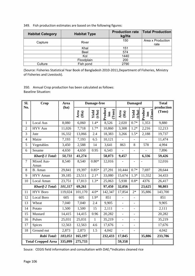
Page 106
349. Fish production estimates are based on the following figures:
Habitat Category Habitat Type Production rate kg/Ha
Total Production
Capture River 150 Area x Production rate
Khal 151
Beel 574
Kol 1440
Floodplain 200 Culture Fish pond 2790
(Source: Fisheries Statistical Year Book of Bangladesh 2010-2011,Department of Fisheries, Ministry of Fisheries and Livestock).
350. Annual Crop production has been calculated as follows: Baseline Situation:
Sl.
No.
Crop Area
(ha)
Damage-free Damaged Total
production
(Tons)
Are
a
(Ha)
Yie
ld
(t/h
a)
Pro
du
ct
ion
(Ton
s)
Are
a
(Ha)
Yie
ld
(t/h
a)
Pro
du
ct
ion
(Ton
s)
1 Local Aus 8,080 6,060 1.4* 8,526 2,020 0.7* 1,353 9,880
2 HYV Aus 11,026 7,718 1.7* 10,860 3,308 1.2* 2,216 12,213
3 Jute 16,332 13,066 2.4 18,383 3,266 1.5* 2,188 19,737
4 Maize 7,193 7,193 6.5 10,121 - - - 11,474
5 Vegetables 3,450 2,588 14 3,641 863 8 578 4,994
6 Sesame 4,650 4,650 0.95 6,543 - - - 7,896
Kharif-1 Total: 50,731 41,274 58,073 9,457 6,336 59,426
7 Mixed Aus-
Aman
8,540 8,540 0.80* 12,016 - - - 12,016
8 B. Aman 29,841 19,397 0.85* 27,291 10,444 0.7* 7,697 28,644
9 HYV Aman 39,185 23,511 2.1* 33,080 15,674 1.3* 11,552 34,433
10 Local Aman 23,751 17,813 1.3* 25,063 5,938 0.8* 4376 26,417
Kharif-2 Total: 101,317 69,261 97,450 32,056 23,625 98,803
11 HYV Boro 119,024 101,170 4.0* 142,347 17,854 2* 35,886 143,700
12 Local Boro 605 605 1.9* 851 - - 851
13 Wheat 7,040 7,040 2.4 9,905 - - 9,905
14 Potato 1,500 1,500 15 2,111 - - 2,111
15 Mustard 14,415 14,415 0.96 20,282 - - 20,282
16 Pulses 25,031 25,031 1 35,219 - - 35,219
17 Spices 12,563 12,563 4.6 17,676 - - 17,676
18 Ground nut 2,873 2,873 1.5 4,042 - - 4,042
Rabi Total: 183,051 165,197 232,433 17,845 35,886 233,786
Total Cropped Area 335,099 275,733 59,358
Souce: CEGIS field information and consultation with DAE;*Indicates cleaned rice
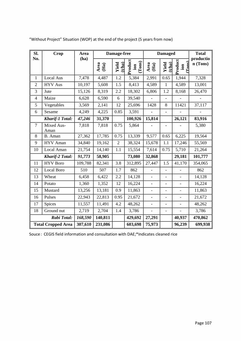
Page 107
“Without Project” Situation (WOP) at the end of the project (5 years from now)
Sl.
No.
Crop Area
(ha)
Damage-free Damaged Total
productio
n (Tons)
Are
a
(Ha)
Yie
ld
(t/h
a)
Pro
du
ct
ion
(To
ns)
Are
a
(Ha)
Yie
ld
(t/h
a)
Pro
du
ct
ion
(To
ns)
1 Local Aus 7,478 4,487 1.2 5,384 2,991 0.65 1,944 7,328
2 HYV Aus 10,197 5,608 1.5 8,413 4,589 1 4,589 13,001
3 Jute 15,126 8,319 2.2 18,302 6,806 1.2 8,168 26,470
4 Maize 6,628 6,590 6 39,540 - - - -
5 Vegetables 3,569 2,141 12 25,696 1428 8 11421 37,117
6 Sesame 4,249 4,225 0.85 3,591 - - - -
Kharif-1 Total: 47,246 31,370 100,926 15,814 26,121 83,916
7 Mixed Aus-
Aman
7,818 7,818 0.75 5,864 - - - 5,380
8 B. Aman 27,362 17,785 0.75 13,339 9,577 0.65 6,225 19,564
9 HYV Aman 34,840 19,162 2 38,324 15,678 1.1 17,246 55,569
10 Local Aman 21,754 14,140 1.1 15,554 7,614 0.75 5,710 21,264
Kharif-2 Total: 91,773 58,905 73,080 32,868 29,181 101,777
11 HYV Boro 109,788 82,341 3.8 312,895 27,447 1.5 41,170 354,065
12 Local Boro 510 507 1.7 862 - - - 862
13 Wheat 6,458 6,422 2.2 14,128 - - - 14,128
14 Potato 1,360 1,352 12 16,224 - - - 16,224
15 Mustard 13,256 13,181 0.9 11,863 - - - 11,863
16 Pulses 22,943 22,813 0.95 21,672 - - - 21,672
17 Spices 11,557 11,491 4.2 48,262 - - - 48,262
18 Ground nut 2,719 2,704 1.4 3,786 - - - 3,786
Rabi Total: 168,590 140,811 429,692 27,291 40,937 470,862
Total Cropped Area 307,610 231,086 603,698 75,973 96,239 699,938
Souce : CEGIS field information and consultation with DAE;*Indicates cleaned rice
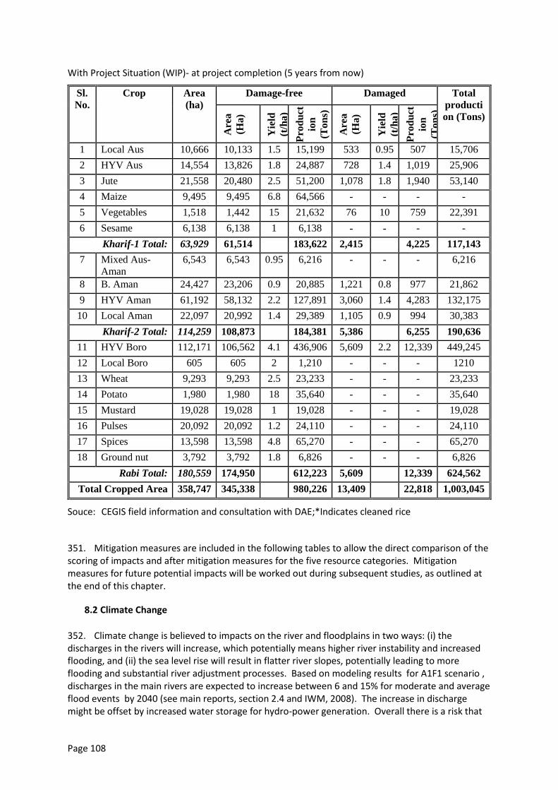
Page 108
With Project Situation (WIP)- at project completion (5 years from now)
Sl.
No.
Crop Area
(ha)
Damage-free Damaged Total
producti
on (Tons)
Are
a
(Ha)
Yie
ld
(t/h
a)
Pro
du
ct
ion
(To
ns)
Are
a
(Ha)
Yie
ld
(t/h
a)
Pro
du
ct
ion
(To
ns)
1 Local Aus 10,666 10,133 1.5 15,199 533 0.95 507 15,706
2 HYV Aus 14,554 13,826 1.8 24,887 728 1.4 1,019 25,906
3 Jute 21,558 20,480 2.5 51,200 1,078 1.8 1,940 53,140
4 Maize 9,495 9,495 6.8 64,566 - - - -
5 Vegetables 1,518 1,442 15 21,632 76 10 759 22,391
6 Sesame 6,138 6,138 1 6,138 - - - -
Kharif-1 Total: 63,929 61,514 183,622 2,415 4,225 117,143
7 Mixed Aus-
Aman
6,543 6,543 0.95 6,216 - - - 6,216
8 B. Aman 24,427 23,206 0.9 20,885 1,221 0.8 977 21,862
9 HYV Aman 61,192 58,132 2.2 127,891 3,060 1.4 4,283 132,175
10 Local Aman 22,097 20,992 1.4 29,389 1,105 0.9 994 30,383
Kharif-2 Total: 114,259 108,873 184,381 5,386 6,255 190,636
11 HYV Boro 112,171 106,562 4.1 436,906 5,609 2.2 12,339 449,245
12 Local Boro 605 605 2 1,210 - - - 1210
13 Wheat 9,293 9,293 2.5 23,233 - - - 23,233
14 Potato 1,980 1,980 18 35,640 - - - 35,640
15 Mustard 19,028 19,028 1 19,028 - - - 19,028
16 Pulses 20,092 20,092 1.2 24,110 - - - 24,110
17 Spices 13,598 13,598 4.8 65,270 - - - 65,270
18 Ground nut 3,792 3,792 1.8 6,826 - - - 6,826
Rabi Total: 180,559 174,950 612,223 5,609 12,339 624,562
Total Cropped Area 358,747 345,338 980,226 13,409 22,818 1,003,045
Souce: CEGIS field information and consultation with DAE;*Indicates cleaned rice
351. Mitigation measures are included in the following tables to allow the direct comparison of the scoring of impacts and after mitigation measures for the five resource categories. Mitigation measures for future potential impacts will be worked out during subsequent studies, as outlined at the end of this chapter.
8.2 Climate Change
352. Climate change is believed to impacts on the river and floodplains in two ways: (i) the discharges in the rivers will increase, which potentially means higher river instability and increased flooding, and (ii) the sea level rise will result in flatter river slopes, potentially leading to more flooding and substantial river adjustment processes. Based on modeling results for A1F1 scenario , discharges in the main rivers are expected to increase between 6 and 15% for moderate and average flood events by 2040 (see main reports, section 2.4 and IWM, 2008). The increase in discharge might be offset by increased water storage for hydro-power generation. Overall there is a risk that
Page 109
inundation depths will increase for the without project scenario. The second potential climate change impact on the sea level is not expected to influence the program area within the design life (30-years). River adjustment processes related to an increase in sea levels work upstream over decades or centuries and do not have a direct impact.
353. The program addresses climate change in several ways: Increases in discharge only result in small increases in water levels in the rivers, first due to the vast expanse of the river system and secondly because alluvial rivers can cope with increased discharges by adusting their bed within a short time (refer for example to the Padma Bridge Study). . Higher flow velocities could potentially lead to increased scouring and deeper channels . The embankments are setback from the river bank. Furthermore, embankment designs (See figure 4.3 for typical cross section) follow best international practice providing road access along the top of the embankment and the opportunity to raise embankments later in response to climate change requirements within the typical construction width applied in Bangladesh. This means that design levels for embankment do not need to be raised (also given the large freeboard). The riverbank protection is built in an adaptive manner which allows adjustments in terms of river depth and location as and when required.
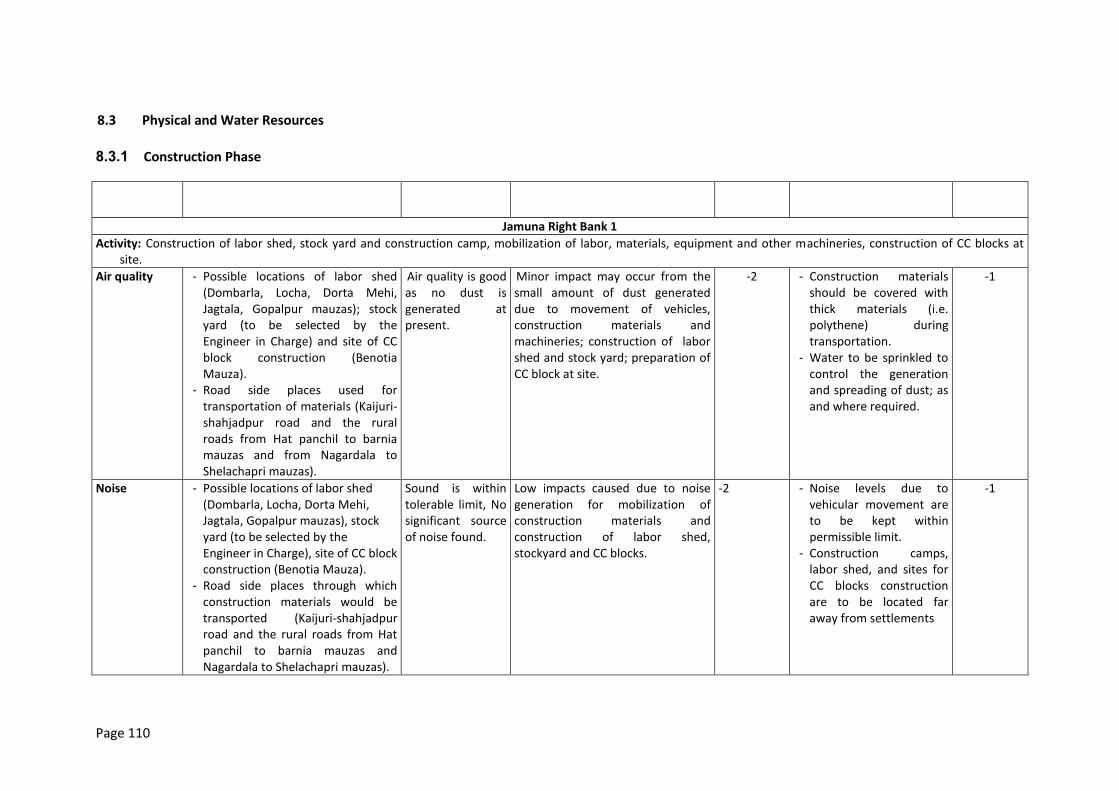
Page 110
8.3 Physical and Water Resources
8.3.1 Construction Phase
IEC Location Baseline
condition Impacts
Magnitude of Impact*
Mitigation Measure Magnitude with EMP*
Jamuna Right Bank 1
Activity: Construction of labor shed, stock yard and construction camp, mobilization of labor, materials, equipment and other machineries, construction of CC blocks at site.
Air quality - Possible locations of labor shed (Dombarla, Locha, Dorta Mehi, Jagtala, Gopalpur mauzas); stock yard (to be selected by the Engineer in Charge) and site of CC block construction (Benotia Mauza).
- Road side places used for transportation of materials (Kaijuri-shahjadpur road and the rural roads from Hat panchil to barnia mauzas and from Nagardala to Shelachapri mauzas).
Air quality is good as no dust is generated at present.
Minor impact may occur from the small amount of dust generated due to movement of vehicles, construction materials and machineries; construction of labor shed and stock yard; preparation of CC block at site.
-2 - Construction materials should be covered with thick materials (i.e. polythene) during transportation.
- Water to be sprinkled to control the generation and spreading of dust; as and where required.
-1
Noise - Possible locations of labor shed (Dombarla, Locha, Dorta Mehi, Jagtala, Gopalpur mauzas), stock yard (to be selected by the Engineer in Charge), site of CC block construction (Benotia Mauza).
- Road side places through which construction materials would be transported (Kaijuri-shahjadpur road and the rural roads from Hat panchil to barnia mauzas and Nagardala to Shelachapri mauzas).
Sound is within tolerable limit, No significant source of noise found.
Low impacts caused due to noise generation for mobilization of construction materials and construction of labor shed, stockyard and CC blocks.
-2 - Noise levels due to vehicular movement are to be kept within permissible limit.
- Construction camps, labor shed, and sites for CC blocks construction are to be located far away from settlements
-1
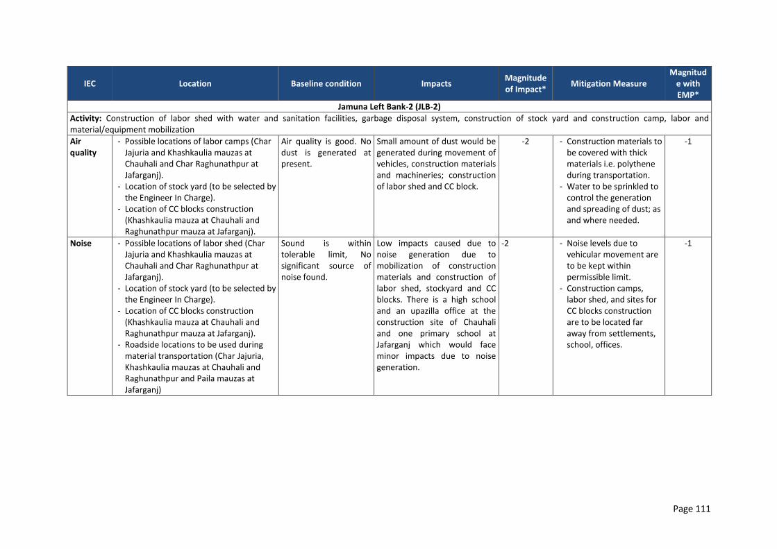
Page 111
IEC Location Baseline condition Impacts Magnitude of Impact*
Mitigation Measure Magnitud
e with EMP*
Jamuna Left Bank-2 (JLB-2)
Activity: Construction of labor shed with water and sanitation facilities, garbage disposal system, construction of stock yard and construction camp, labor and material/equipment mobilization
Air quality
- Possible locations of labor camps (Char Jajuria and Khashkaulia mauzas at Chauhali and Char Raghunathpur at Jafarganj).
- Location of stock yard (to be selected by the Engineer In Charge).
- Location of CC blocks construction (Khashkaulia mauza at Chauhali and Raghunathpur mauza at Jafarganj).
Air quality is good. No dust is generated at present.
Small amount of dust would be generated during movement of vehicles, construction materials and machineries; construction of labor shed and CC block.
-2 - Construction materials to be covered with thick materials i.e. polythene during transportation.
- Water to be sprinkled to control the generation and spreading of dust; as and where needed.
-1
Noise - Possible locations of labor shed (Char Jajuria and Khashkaulia mauzas at Chauhali and Char Raghunathpur at Jafarganj).
- Location of stock yard (to be selected by the Engineer In Charge).
- Location of CC blocks construction (Khashkaulia mauza at Chauhali and Raghunathpur mauza at Jafarganj).
- Roadside locations to be used during material transportation (Char Jajuria, Khashkaulia mauzas at Chauhali and Raghunathpur and Paila mauzas at Jafarganj)
Sound is within tolerable limit, No significant source of noise found.
Low impacts caused due to noise generation due to mobilization of construction materials and construction of labor shed, stockyard and CC blocks. There is a high school and an upazilla office at the construction site of Chauhali and one primary school at Jafarganj which would face minor impacts due to noise generation.
-2 - Noise levels due to vehicular movement are to be kept within permissible limit.
- Construction camps, labor shed, and sites for CC blocks construction are to be located far away from settlements, school, offices.
-1
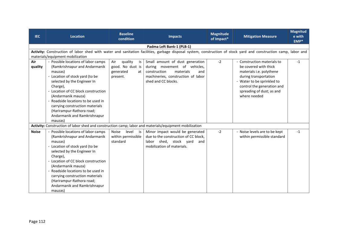
Page 112
IEC Location Baseline
condition Impacts
Magnitude of Impact*
Mitigation Measure Magnitud
e with EMP*
Padma Left Bank-1 (PLB-1)
Activity: Construction of labor shed with water and sanitation facilities, garbage disposal system, construction of stock yard and construction camp, labor and materials/equipment mobilization
Air quality
- Possible locations of labor camps (Ramkrishnapur and Andarmanik mauzas)
- Location of stock yard (to be selected by the Engineer In Charge),
- Location of CC block construction (Andarmanik mauza)
- Roadside locations to be used in carrying construction materials (Harirampur-Rathora road; Andarmanik and Ramkrishnapur mauzas)
Air quality is good. No dust is generated at present.
Small amount of dust generation during movement of vehicles, construction materials and machineries, construction of labor shed and CC blocks.
-2 - Construction materials to be covered with thick materials i.e. polythene during transportation
- Water to be sprinkled to control the generation and spreading of dust; as and where needed
-1
Activity: Construction of labor shed and construction camp; labor and materials/equipment mobilization
Noise - Possible locations of labor camps (Ramkrishnapur and Andarmanik mauzas)
- Location of stock yard (to be selected by the Engineer In Charge),
- Location of CC block construction (Andarmanik mauza)
- Roadside locations to be used in carrying construction materials (Harirampur-Rathora road; Andarmanik and Ramkrishnapur mauzas)
Noise level is within permissible standard
Minor impact would be generated due to the construction of CC block, labor shed, stock yard and mobilization of materials.
-2 - Noise levels are to be kept within permissible standard
-1
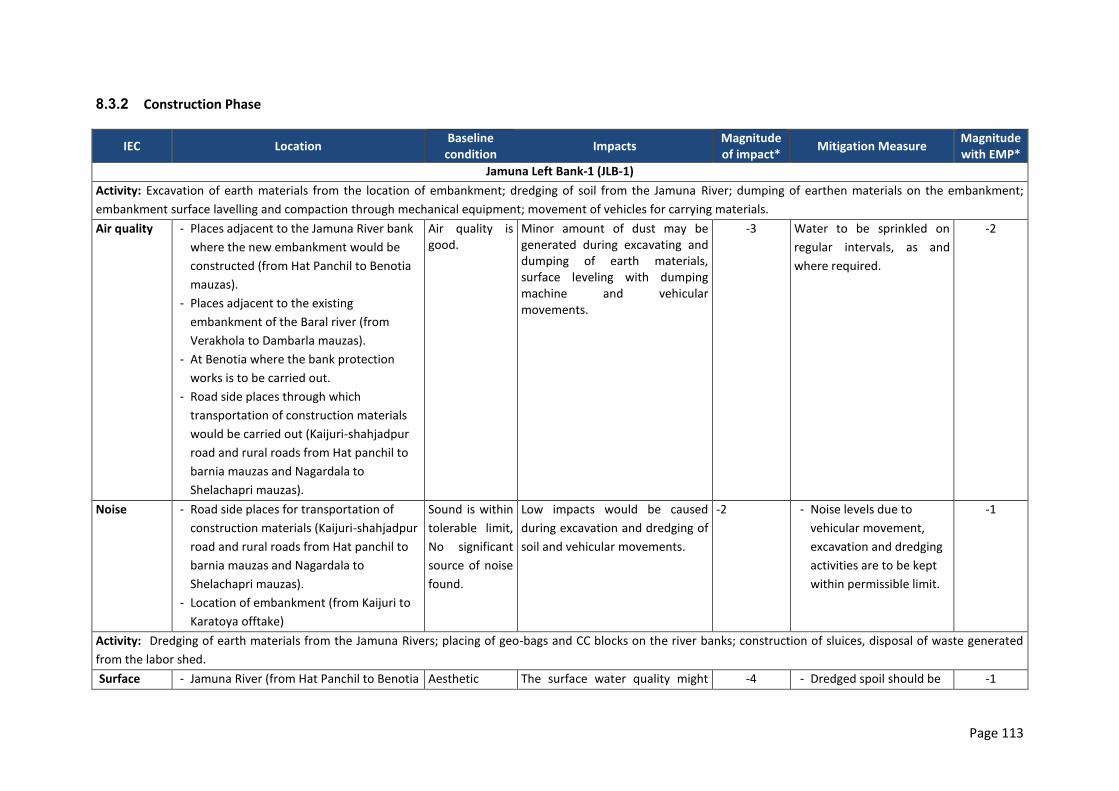
Page 113
8.3.2 Construction Phase
IEC Location Baseline
condition Impacts
Magnitude of impact*
Mitigation Measure Magnitude with EMP*
Jamuna Left Bank-1 (JLB-1)
Activity: Excavation of earth materials from the location of embankment; dredging of soil from the Jamuna River; dumping of earthen materials on the embankment;
embankment surface lavelling and compaction through mechanical equipment; movement of vehicles for carrying materials.
Air quality - Places adjacent to the Jamuna River bank
where the new embankment would be
constructed (from Hat Panchil to Benotia
mauzas).
- Places adjacent to the existing
embankment of the Baral river (from
Verakhola to Dambarla mauzas).
- At Benotia where the bank protection
works is to be carried out.
- Road side places through which
transportation of construction materials
would be carried out (Kaijuri-shahjadpur
road and rural roads from Hat panchil to
barnia mauzas and Nagardala to
Shelachapri mauzas).
Air quality is good.
Minor amount of dust may be generated during excavating and dumping of earth materials, surface leveling with dumping machine and vehicular movements.
-3 Water to be sprinkled on
regular intervals, as and
where required.
-2
Noise - Road side places for transportation of
construction materials (Kaijuri-shahjadpur
road and rural roads from Hat panchil to
barnia mauzas and Nagardala to
Shelachapri mauzas).
- Location of embankment (from Kaijuri to
Karatoya offtake)
Sound is within
tolerable limit,
No significant
source of noise
found.
Low impacts would be caused
during excavation and dredging of
soil and vehicular movements.
-2 - Noise levels due to
vehicular movement,
excavation and dredging
activities are to be kept
within permissible limit.
-1
Activity: Dredging of earth materials from the Jamuna Rivers; placing of geo-bags and CC blocks on the river banks; construction of sluices, disposal of waste generated
from the labor shed.
Surface - Jamuna River (from Hat Panchil to Benotia Aesthetic The surface water quality might -4 - Dredged spoil should be -1
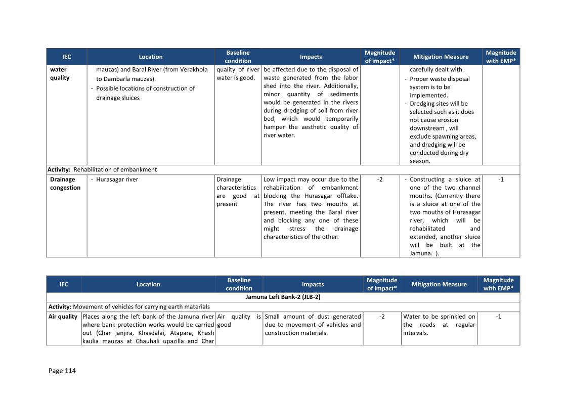
Page 114
IEC Location Baseline
condition Impacts
Magnitude of impact*
Mitigation Measure Magnitude with EMP*
water quality
mauzas) and Baral River (from Verakhola
to Dambarla mauzas).
- Possible locations of construction of
drainage sluices
quality of river water is good.
be affected due to the disposal of waste generated from the labor shed into the river. Additionally, minor quantity of sediments would be generated in the rivers during dredging of soil from river bed, which would temporarily hamper the aesthetic quality of river water.
carefully dealt with.
- Proper waste disposal system is to be implemented.
- Dredging sites will be selected such as it does not cause erosion downstream , will exclude spawning areas, and dredging will be conducted during dry season.
Activity: Rehabilitation of embankment
Drainage congestion
- Hurasagar river Drainage characteristics are good at present
Low impact may occur due to the rehabilitation of embankment blocking the Hurasagar offtake. The river has two mouths at present, meeting the Baral river and blocking any one of these might stress the drainage characteristics of the other.
-2 - Constructing a sluice at one of the two channel mouths. (Currently there is a sluice at one of the two mouths of Hurasagar river, which will be rehabilitated and extended, another sluice will be built at the Jamuna. ).
-1
IEC Location Baseline
condition Impacts
Magnitude of impact*
Mitigation Measure Magnitude with EMP*
Jamuna Left Bank-2 (JLB-2)
Activity: Movement of vehicles for carrying earth materials
Air quality Places along the left bank of the Jamuna river where bank protection works would be carried out (Char janjira, Khasdalai, Atapara, Khash kaulia mauzas at Chauhali upazilla and Char
Air quality is good
Small amount of dust generated due to movement of vehicles and construction materials.
-2 Water to be sprinkled on the roads at regular intervals.
-1
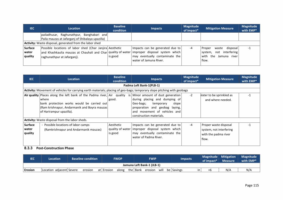
Page 115
IEC Location Baseline
condition Impacts
Magnitude of impact*
Mitigation Measure Magnitude with EMP*
pailadhusar, Raghunathpur, Banghabari and Paila mauzas at Jafarganj of Shibalaya upazilla)
Activity: Waste disposal, generated from the labor shed
Surface water quality
Possible locations of labor shed (Char Janjira
and Khashkaulia mauzas at Chauhali and Char
raghunathpur at Jafarganj).
Aesthetic quality of water is good
Impacts can be generated due to improper disposal system which may eventually contaminate the water of Jamuna River.
-4 Proper waste disposal system, not interfering with the Jamuna river flow.
-1
IEC Location Baseline
condition Impacts
Magnitude of impact*
Mitigation Measure Magnitude with EMP*
Padma Left Bank-1(PLB-1)
Activity: Movement of vehicles for carrying earth materials; placing of geo-bags; temporary slope pitching with geobags
Air quality Places along the left bank of the Padma river, where bank protection works would be carried out (Ram krishnapur, Andarmanik and Boyra mauzas of Harirampur upazilla).
Air quality is good.
Minor amount of dust generation during placing and dumping of Geo-bags; temporary slope preparation and geobag laying, and movement of vehicles and construction materials.
-2 Water to be sprinkled as
and where needed.
-1
Activity: Waste disposal from the labor sheds.
Surface water quality
- Possible locations of labor camps
(Ramkrishnapur and Andarmanik mauzas)
Aesthetic quality of water is good
Impacts can be generated due to improper disposal system which may eventually contaminate the water of Padma River.
-4 Proper waste disposal
system, not interfering
with the padma river
flow.
-1
8.3.3 Post-Construction Phase
IEC Location Baseline condition FWOP FWIP Impacts Magnitude of impact*
Mitigation Measure
Magnitude with EMP*
Jamuna Left Bank-1 (JLB-1)
Erosion Location adjacent Severe erosion at Erosion along the Bank erosion will be Savings in +6 N/A N/A
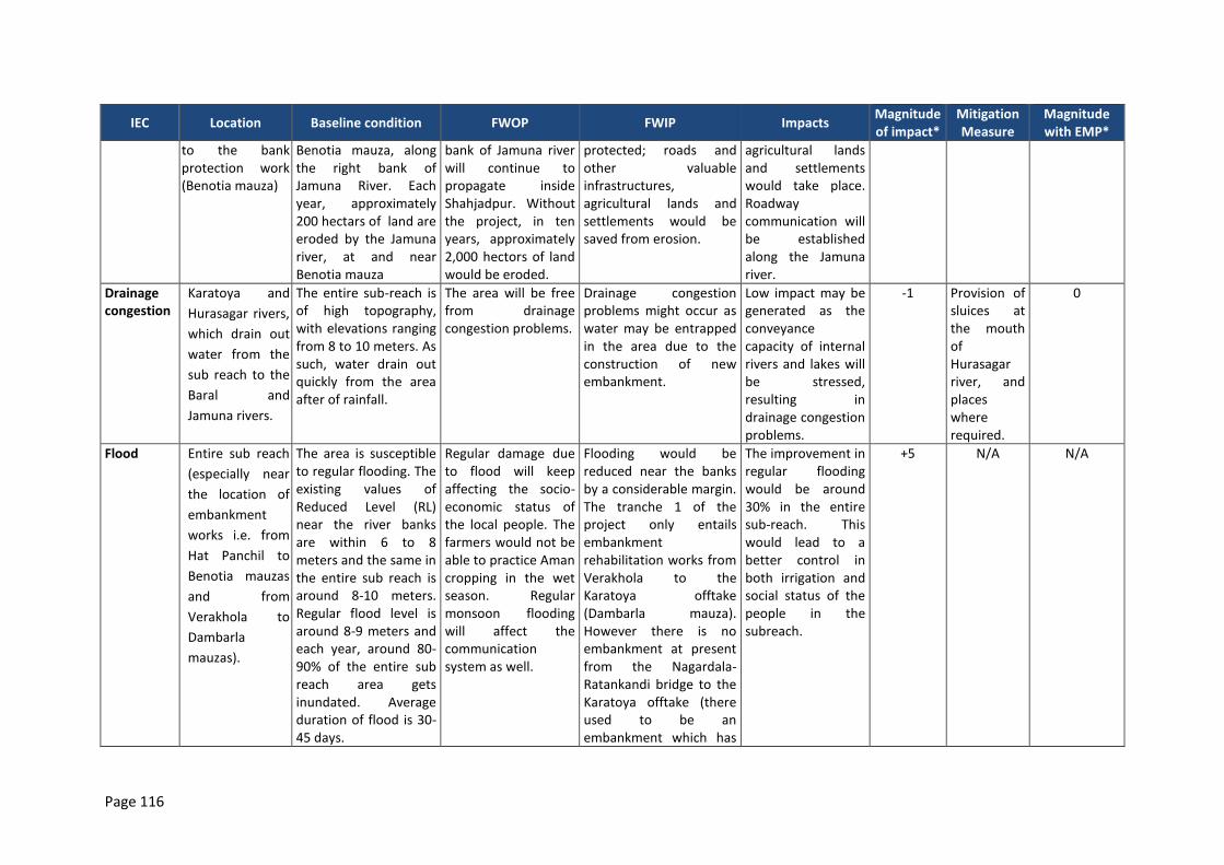
Page 116
IEC Location Baseline condition FWOP FWIP Impacts Magnitude of impact*
Mitigation Measure
Magnitude with EMP*
to the bank protection work (Benotia mauza)
Benotia mauza, along the right bank of Jamuna River. Each year, approximately 200 hectars of land are eroded by the Jamuna river, at and near Benotia mauza
bank of Jamuna river will continue to propagate inside Shahjadpur. Without the project, in ten years, approximately 2,000 hectors of land would be eroded.
protected; roads and other valuable infrastructures, agricultural lands and settlements would be saved from erosion.
agricultural lands and settlements would take place. Roadway communication will be established along the Jamuna river.
Drainage congestion
Karatoya and
Hurasagar rivers,
which drain out
water from the
sub reach to the
Baral and
Jamuna rivers.
The entire sub-reach is of high topography, with elevations ranging from 8 to 10 meters. As such, water drain out quickly from the area after of rainfall.
The area will be free from drainage congestion problems.
Drainage congestion problems might occur as water may be entrapped in the area due to the construction of new embankment.
Low impact may be generated as the conveyance capacity of internal rivers and lakes will be stressed, resulting in drainage congestion problems.
-1 Provision of sluices at the mouth of Hurasagar river, and places where required.
0
Flood Entire sub reach
(especially near
the location of
embankment
works i.e. from
Hat Panchil to
Benotia mauzas
and from
Verakhola to
Dambarla
mauzas).
The area is susceptible to regular flooding. The existing values of Reduced Level (RL) near the river banks are within 6 to 8 meters and the same in the entire sub reach is around 8-10 meters. Regular flood level is around 8-9 meters and each year, around 80-90% of the entire sub reach area gets inundated. Average duration of flood is 30-45 days.
Regular damage due to flood will keep affecting the socio-economic status of the local people. The farmers would not be able to practice Aman cropping in the wet season. Regular monsoon flooding will affect the communication system as well.
Flooding would be reduced near the banks by a considerable margin. The tranche 1 of the project only entails embankment rehabilitation works from Verakhola to the Karatoya offtake (Dambarla mauza). However there is no embankment at present from the Nagardala-Ratankandi bridge to the Karatoya offtake (there used to be an embankment which has
The improvement in regular flooding would be around 30% in the entire sub-reach. This would lead to a better control in both irrigation and social status of the people in the subreach.
+5 N/A N/A
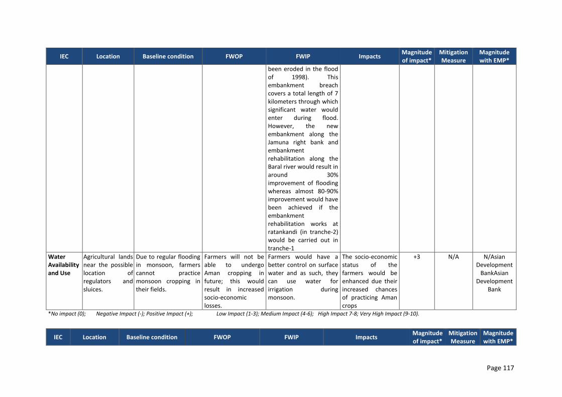
Page 117
IEC Location Baseline condition FWOP FWIP Impacts Magnitude of impact*
Mitigation Measure
Magnitude with EMP*
been eroded in the flood of 1998). This embankment breach covers a total length of 7 kilometers through which significant water would enter during flood. However, the new embankment along the Jamuna right bank and embankment rehabilitation along the Baral river would result in around 30% improvement of flooding whereas almost 80-90% improvement would have been achieved if the embankment rehabilitation works at ratankandi (in tranche-2) would be carried out in tranche-1
Water Availability and Use
Agricultural lands near the possible location of regulators and sluices.
Due to regular flooding in monsoon, farmers cannot practice monsoon cropping in their fields.
Farmers will not be able to undergo Aman cropping in future; this would result in increased socio-economic losses.
Farmers would have a better control on surface water and as such, they can use water for irrigation during monsoon.
The socio-economic status of the farmers would be enhanced due their increased chances of practicing Aman crops
+3 N/A N/Asian Development
BankAsian Development
Bank
*No impact (0); Negative Impact (-); Positive Impact (+); Low Impact (1-3); Medium Impact (4-6); High Impact 7-8; Very High Impact (9-10).
IEC Location Baseline condition FWOP FWIP Impacts Magnitude of impact*
Mitigation Measure
Magnitude with EMP*
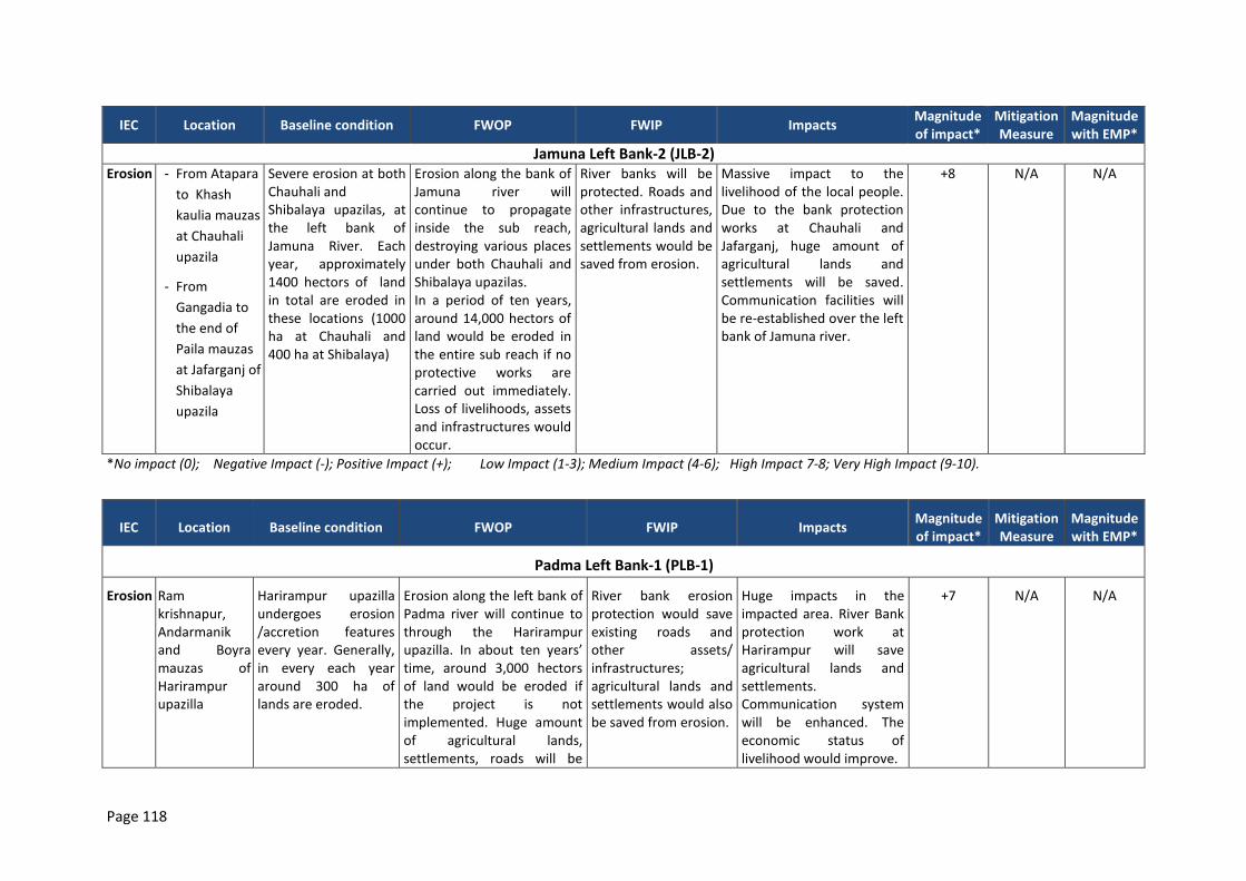
Page 118
IEC Location Baseline condition FWOP FWIP Impacts Magnitude of impact*
Mitigation Measure
Magnitude with EMP*
Jamuna Left Bank-2 (JLB-2) Erosion - From Atapara
to Khash
kaulia mauzas
at Chauhali
upazila
- From
Gangadia to
the end of
Paila mauzas
at Jafarganj of
Shibalaya
upazila
Severe erosion at both Chauhali and Shibalaya upazilas, at the left bank of Jamuna River. Each year, approximately 1400 hectors of land in total are eroded in these locations (1000 ha at Chauhali and 400 ha at Shibalaya)
Erosion along the bank of Jamuna river will continue to propagate inside the sub reach, destroying various places under both Chauhali and Shibalaya upazilas. In a period of ten years, around 14,000 hectors of land would be eroded in the entire sub reach if no protective works are carried out immediately. Loss of livelihoods, assets and infrastructures would occur.
River banks will be protected. Roads and other infrastructures, agricultural lands and settlements would be saved from erosion.
Massive impact to the livelihood of the local people. Due to the bank protection works at Chauhali and Jafarganj, huge amount of agricultural lands and settlements will be saved. Communication facilities will be re-established over the left bank of Jamuna river.
+8 N/A N/A
*No impact (0); Negative Impact (-); Positive Impact (+); Low Impact (1-3); Medium Impact (4-6); High Impact 7-8; Very High Impact (9-10).
IEC Location Baseline condition FWOP FWIP Impacts Magnitude of impact*
Mitigation Measure
Magnitude with EMP*
Padma Left Bank-1 (PLB-1)
Erosion Ram krishnapur, Andarmanik and Boyra mauzas of Harirampur upazilla
Harirampur upazilla undergoes erosion /accretion features every year. Generally, in every each year around 300 ha of lands are eroded.
Erosion along the left bank of Padma river will continue to through the Harirampur upazilla. In about ten years’ time, around 3,000 hectors of land would be eroded if the project is not implemented. Huge amount of agricultural lands, settlements, roads will be
River bank erosion protection would save existing roads and other assets/ infrastructures; agricultural lands and settlements would also be saved from erosion.
Huge impacts in the impacted area. River Bank protection work at Harirampur will save agricultural lands and settlements. Communication system will be enhanced. The economic status of livelihood would improve.
+7 N/A N/A
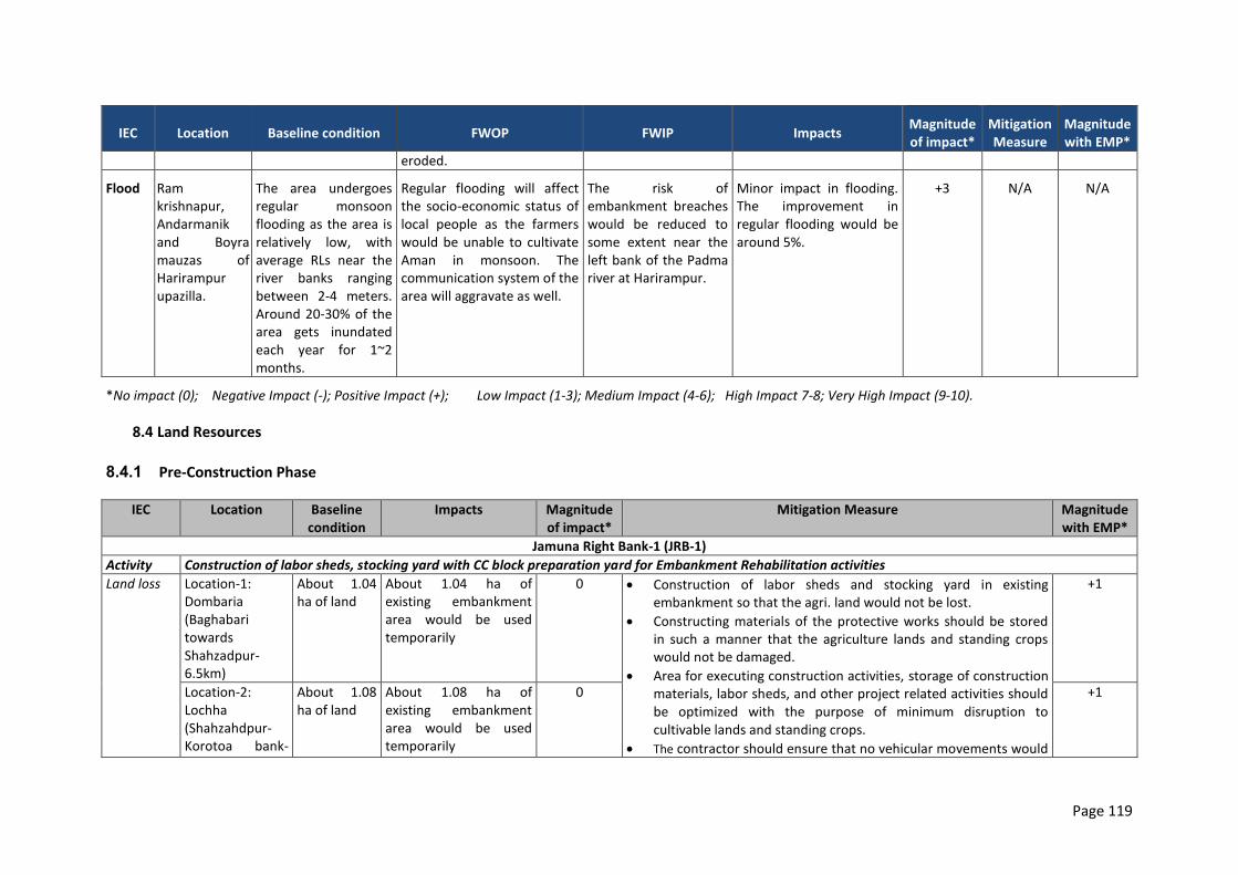
Page 119
IEC Location Baseline condition FWOP FWIP Impacts Magnitude of impact*
Mitigation Measure
Magnitude with EMP*
eroded.
Flood Ram krishnapur, Andarmanik and Boyra mauzas of Harirampur upazilla.
The area undergoes regular monsoon flooding as the area is relatively low, with average RLs near the river banks ranging between 2-4 meters. Around 20-30% of the area gets inundated each year for 1~2 months.
Regular flooding will affect the socio-economic status of local people as the farmers would be unable to cultivate Aman in monsoon. The communication system of the area will aggravate as well.
The risk of embankment breaches would be reduced to some extent near the left bank of the Padma river at Harirampur.
Minor impact in flooding. The improvement in regular flooding would be around 5%.
+3 N/A N/A
*No impact (0); Negative Impact (-); Positive Impact (+); Low Impact (1-3); Medium Impact (4-6); High Impact 7-8; Very High Impact (9-10).
8.4 Land Resources
8.4.1 Pre-Construction Phase
IEC Location Baseline condition
Impacts Magnitude of impact*
Mitigation Measure Magnitude with EMP*
Jamuna Right Bank-1 (JRB-1)
Activity Construction of labor sheds, stocking yard with CC block preparation yard for Embankment Rehabilitation activities
Land loss Location-1: Dombaria (Baghabari towards Shahzadpur-6.5km)
About 1.04 ha of land
About 1.04 ha of existing embankment area would be used temporarily
0 Construction of labor sheds and stocking yard in existing embankment so that the agri. land would not be lost.
Constructing materials of the protective works should be stored in such a manner that the agriculture lands and standing crops would not be damaged.
Area for executing construction activities, storage of construction materials, labor sheds, and other project related activities should be optimized with the purpose of minimum disruption to cultivable lands and standing crops.
The contractor should ensure that no vehicular movements would
+1
Location-2: Lochha (Shahzahdpur-Korotoa bank-
About 1.08 ha of land
About 1.08 ha of existing embankment area would be used temporarily
0 +1
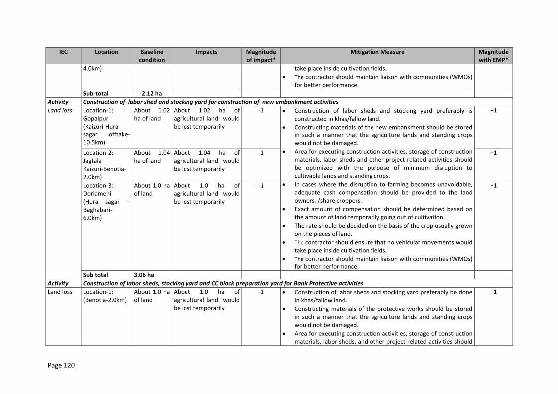
Page 120
IEC Location Baseline condition
Impacts Magnitude of impact*
Mitigation Measure Magnitude with EMP*
4.0km) take place inside cultivation fields.
The contractor should maintain liaison with communities (WMOs) for better performance.
Sub-total 2.12 ha
Activity Construction of labor shed and stocking yard for construction of new embankment activities
Land loss Location-1: Gopalpur (Kaizuri-Hura sagar offtake-10.5km)
About 1.02 ha of land
About 1.02 ha of agricultural land would be lost temporarily
-1 Construction of labor sheds and stocking yard preferably is constructed in khas/fallow land.
Constructing materials of the new embankment should be stored in such a manner that the agriculture lands and standing crops would not be damaged.
Area for executing construction activities, storage of construction materials, labor sheds and other project related activities should be optimized with the purpose of minimum disruption to cultivable lands and standing crops.
In cases where the disruption to farming becomes unavoidable, adequate cash compensation should be provided to the land owners. /share croppers.
Exact amount of compensation should be determined based on the amount of land temporarily going out of cultivation.
The rate should be decided on the basis of the crop usually grown on the pieces of land.
The contractor should ensure that no vehicular movements would take place inside cultivation fields.
The contractor should maintain liaison with communities (WMOs) for better performance.
+1
Location-2: Jagtala Kaizuri-Benotia-2.0km)
About 1.04 ha of land
About 1.04 ha of agricultural land would be lost temporarily
-1 +1
Location-3: Doriamehi (Hura sagar –Baghabari-6.0km)
About 1.0 ha of land
About 1.0 ha of agricultural land would be lost temporarily
-1 +1
Sub total 3.06 ha
Activity Construction of labor sheds, stocking yard and CC block preparation yard for Bank Protective activities
Land loss Location-1: (Benotia-2.0km)
About 1.0 ha of land
About 1.0 ha of agricultural land would be lost temporarily
-1 Construction of labor sheds and stocking yard preferably be done in khas/fallow land.
Constructing materials of the protective works should be stored in such a manner that the agriculture lands and standing crops would not be damaged.
Area for executing construction activities, storage of construction materials, labor sheds, and other project related activities should
+1
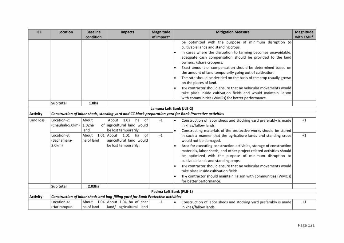
Page 121
IEC Location Baseline condition
Impacts Magnitude of impact*
Mitigation Measure Magnitude with EMP*
be optimized with the purpose of minimum disruption to cultivable lands and standing crops.
In cases where the disruption to farming becomes unavoidable, adequate cash compensation should be provided to the land owners. /share croppers.
Exact amount of compensation should be determined based on the amount of land temporarily going out of cultivation.
The rate should be decided on the basis of the crop usually grown on the pieces of land.
The contractor should ensure that no vehicular movements would take place inside cultivation fields and would maintain liaison with communities (WMOs) for better performance.
Sub total 1.0ha
Jamuna Left Bank (JLB-2)
Activity Construction of labor sheds, stocking yard and CC block preparation yard for Bank Protective activities
Land loss Location-2: (Chauhali-5.0km)
About 1.02ha of land
About 1.02 ha of agricultural land would be lost temporarily.
-1 Construction of labor sheds and stocking yard preferably is made in khas/fallow lands.
Constructing materials of the protective works should be stored in such a manner that the agriculture lands and standing crops would not be damaged.
Area for executing construction activities, storage of construction materials, labor sheds, and other project related activities should be optimized with the purpose of minimum disruption to cultivable lands and standing crops.
The contractor should ensure that no vehicular movements would take place inside cultivation fields.
The contractor should maintain liaison with communities (WMOs) for better performance.
+1
Location-3: (Bachamara-2.0km)
About 1.01 ha of land
About 1.01 ha of agricultural land would be lost temporarily.
-1 +1
Sub total 2.03ha
Padma Left Bank (PLB-1)
Activity Construction of labor sheds and bag-filling yard for Bank Protective activities
Location-4: (Harirampur-
About 1.04 ha of land
About 1.04 ha of char land/ agricultural land
-1 Construction of labor sheds and stocking yard preferably is made in khas/fallow lands.
+1
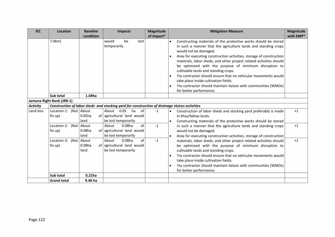
Page 122
IEC Location Baseline condition
Impacts Magnitude of impact*
Mitigation Measure Magnitude with EMP*
7.0km) would be lost temporarily.
Constructing materials of the protective works should be stored in such a manner that the agriculture lands and standing crops would not be damaged.
Area for executing construction activities, storage of construction materials, labor sheds, and other project related activities should be optimized with the purpose of minimum disruption to cultivable lands and standing crops.
The contractor should ensure that no vehicular movements would take place inside cultivation fields.
The contractor should maintain liaison with communities (WMOs) for better performance.
Sub total 1.04ha
Jamuna Right Bank (JRB-1)
Activity Construction of labor sheds and stocking yard for construction of drainage sluices activities
Land loss Location-1: (Not fix up)
About 0.05ha of land
About 0.05 ha of agricultural land would be lost temporarily
-1 Construction of labor sheds and stocking yard preferably is made in khas/fallow lands.
Constructing materials of the protective works should be stored in such a manner that the agriculture lands and standing crops would not be damaged.
Area for executing construction activities, storage of construction materials, labor sheds, and other project related activities should be optimized with the purpose of minimum disruption to cultivable lands and standing crops.
The contractor should ensure that no vehicular movements would take place inside cultivation fields.
The contractor should maintain liaison with communities (WMOs) for better performance.
+1
Location-2: (Not fix up)
About 0.08ha of land
About 0.08ha of agricultural land would be lost temporarily
-1 +1
Location-3: (Not fix up)
About 0.08ha of land
About 0.08ha of agricultural land would be lost temporarily
-1 +1
Sub total 0.21ha
Grand total 9.46 ha
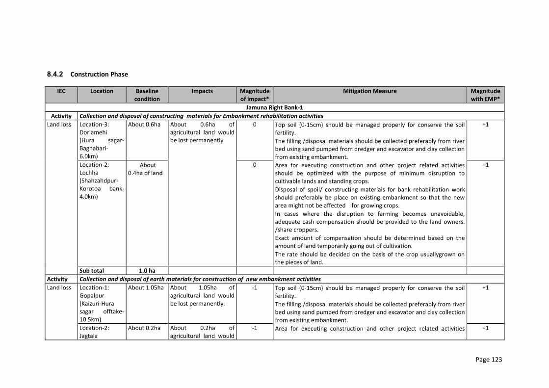
Page 123
8.4.2 Construction Phase
IEC Location Baseline condition
Impacts Magnitude of impact*
Mitigation Measure Magnitude with EMP*
Jamuna Right Bank-1
Activity Collection and disposal of constructing materials for Embankment rehabilitation activities
Land loss Location-3: Doriamehi (Hura sagar- Baghabari-6.0km)
About 0.6ha About 0.6ha of agricultural land would be lost permanently
0
Top soil (0-15cm) should be managed properly for conserve the soil fertility.
The filling /disposal materials should be collected preferably from river bed using sand pumped from dredger and excavator and clay collection from existing embankment.
Area for executing construction and other project related activities should be optimized with the purpose of minimum disruption to cultivable lands and standing crops.
Disposal of spoil/ constructing materials for bank rehabilitation work should preferably be place on existing embankment so that the new area might not be affected for growing crops.
In cases where the disruption to farming becomes unavoidable, adequate cash compensation should be provided to the land owners. /share croppers.
Exact amount of compensation should be determined based on the amount of land temporarily going out of cultivation.
The rate should be decided on the basis of the crop usuallygrown on the pieces of land.
+1
Location-2: Lochha (Shahzahdpur-Korotoa bank-4.0km)
About 0.4ha of land
0 +1
Sub total 1.0 ha
Activity Collection and disposal of earth materials for construction of new embankment activities
Land loss Location-1: Gopalpur (Kaizuri-Hura sagar offtake-10.5km)
About 1.05ha About 1.05ha of agricultural land would be lost permanently.
-1 Top soil (0-15cm) should be managed properly for conserve the soil fertility.
The filling /disposal materials should be collected preferably from river bed using sand pumped from dredger and excavator and clay collection from existing embankment.
Area for executing construction and other project related activities
+1
Location-2: Jagtala
About 0.2ha About 0.2ha of agricultural land would
-1 +1
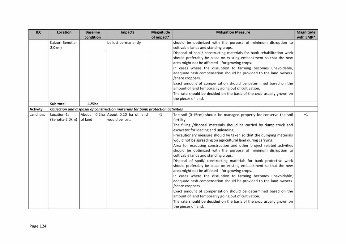
Page 124
IEC Location Baseline condition
Impacts Magnitude of impact*
Mitigation Measure Magnitude with EMP*
Kaizuri-Benotia-2.0km)
be lost permanently should be optimized with the purpose of minimum disruption to cultivable lands and standing crops.
Disposal of spoil/ constructing materials for bank rehabilitation work should preferably be place on existing embankment so that the new area might not be affected for growing crops.
In cases where the disruption to farming becomes unavoidable, adequate cash compensation should be provided to the land owners. /share croppers.
Exact amount of compensation should be determined based on the amount of land temporarily going out of cultivation.
The rate should be decided on the basis of the crop usually grown on the pieces of land.
Sub total 1.25ha
Activity Collection and disposal of construction materials for bank protection activities
Land loss Location-1: (Benotia-2.0km)
About 0.2ha of land
About 0.20 ha of land would be lost.
-1 Top soil (0-15cm) should be managed properly for conserve the soil fertility.
The filling /disposal materials should be carried by dump truck and excavator for loading and unloading.
Precautionary measure should be taken so that the dumping materials would not be spreading on agricultural land during carrying.
Area for executing construction and other project related activities should be optimized with the purpose of minimum disruption to cultivable lands and standing crops.
Disposal of spoil/ constructing materials for bank protective work should preferably be place on existing embankment so that the new area might not be affected for growing crops.
In cases where the disruption to farming becomes unavoidable, adequate cash compensation should be provided to the land owners. /share croppers.
Exact amount of compensation should be determined based on the amount of land temporarily going out of cultivation.
The rate should be decided on the basis of the crop usually grown on the pieces of land.
+1
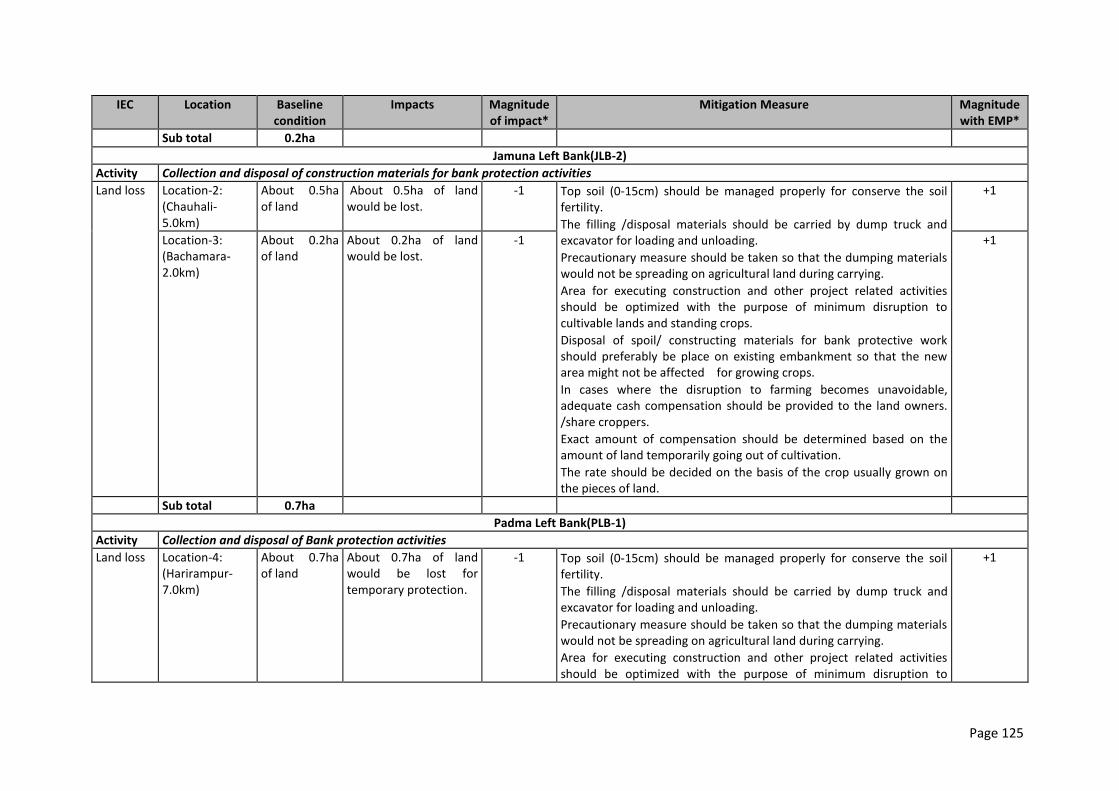
Page 125
IEC Location Baseline condition
Impacts Magnitude of impact*
Mitigation Measure Magnitude with EMP*
Sub total 0.2ha
Jamuna Left Bank(JLB-2)
Activity Collection and disposal of construction materials for bank protection activities
Land loss Location-2: (Chauhali-5.0km)
About 0.5ha of land
About 0.5ha of land would be lost.
-1 Top soil (0-15cm) should be managed properly for conserve the soil fertility.
The filling /disposal materials should be carried by dump truck and excavator for loading and unloading.
Precautionary measure should be taken so that the dumping materials would not be spreading on agricultural land during carrying.
Area for executing construction and other project related activities should be optimized with the purpose of minimum disruption to cultivable lands and standing crops.
Disposal of spoil/ constructing materials for bank protective work should preferably be place on existing embankment so that the new area might not be affected for growing crops.
In cases where the disruption to farming becomes unavoidable, adequate cash compensation should be provided to the land owners. /share croppers.
Exact amount of compensation should be determined based on the amount of land temporarily going out of cultivation.
The rate should be decided on the basis of the crop usually grown on the pieces of land.
+1
Location-3: (Bachamara-2.0km)
About 0.2ha of land
About 0.2ha of land would be lost.
-1 +1
Sub total 0.7ha
Padma Left Bank(PLB-1)
Activity Collection and disposal of Bank protection activities
Land loss Location-4: (Harirampur-7.0km)
About 0.7ha of land
About 0.7ha of land would be lost for temporary protection.
-1 Top soil (0-15cm) should be managed properly for conserve the soil fertility.
The filling /disposal materials should be carried by dump truck and excavator for loading and unloading.
Precautionary measure should be taken so that the dumping materials would not be spreading on agricultural land during carrying.
Area for executing construction and other project related activities should be optimized with the purpose of minimum disruption to
+1
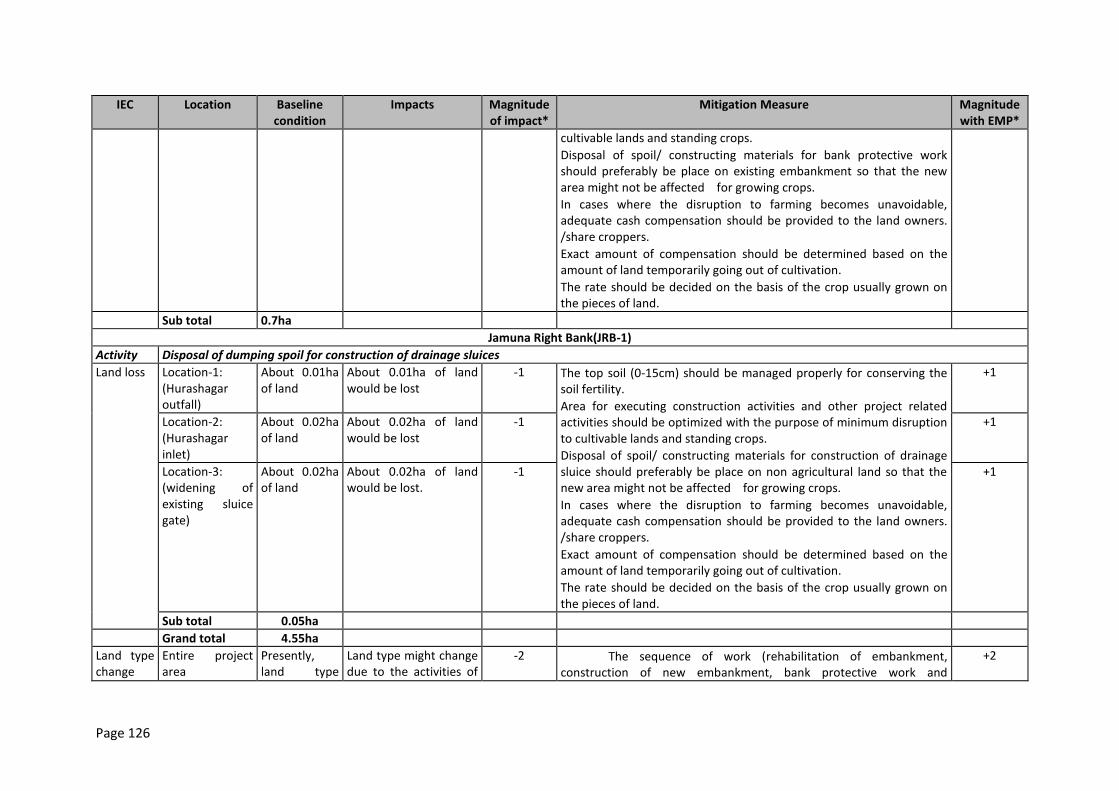
Page 126
IEC Location Baseline condition
Impacts Magnitude of impact*
Mitigation Measure Magnitude with EMP*
cultivable lands and standing crops.
Disposal of spoil/ constructing materials for bank protective work should preferably be place on existing embankment so that the new area might not be affected for growing crops.
In cases where the disruption to farming becomes unavoidable, adequate cash compensation should be provided to the land owners. /share croppers.
Exact amount of compensation should be determined based on the amount of land temporarily going out of cultivation.
The rate should be decided on the basis of the crop usually grown on the pieces of land.
Sub total 0.7ha
Jamuna Right Bank(JRB-1)
Activity Disposal of dumping spoil for construction of drainage sluices
Land loss Location-1: (Hurashagar outfall)
About 0.01ha of land
About 0.01ha of land would be lost
-1 The top soil (0-15cm) should be managed properly for conserving the soil fertility.
Area for executing construction activities and other project related activities should be optimized with the purpose of minimum disruption to cultivable lands and standing crops.
Disposal of spoil/ constructing materials for construction of drainage sluice should preferably be place on non agricultural land so that the new area might not be affected for growing crops.
In cases where the disruption to farming becomes unavoidable, adequate cash compensation should be provided to the land owners. /share croppers.
Exact amount of compensation should be determined based on the amount of land temporarily going out of cultivation.
The rate should be decided on the basis of the crop usually grown on the pieces of land.
+1
Location-2: (Hurashagar inlet)
About 0.02ha of land
About 0.02ha of land would be lost
-1 +1
Location-3: (widening of existing sluice gate)
About 0.02ha of land
About 0.02ha of land would be lost.
-1 +1
Sub total 0.05ha
Grand total 4.55ha
Land type change
Entire project area
Presently, land type
Land type might change due to the activities of
-2 The sequence of work (rehabilitation of embankment, construction of new embankment, bank protective work and
+2
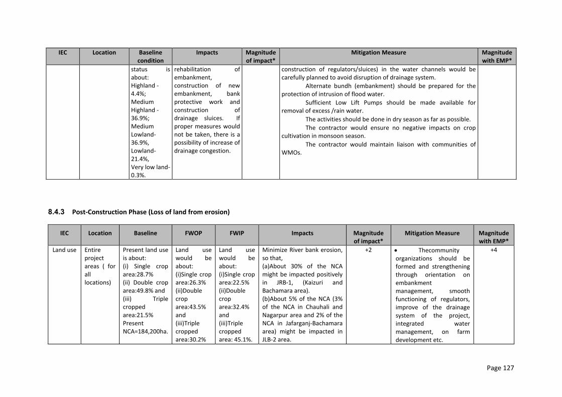
Page 127
IEC Location Baseline condition
Impacts Magnitude of impact*
Mitigation Measure Magnitude with EMP*
status is about:
a. Highland -4.4%;
b. Medium Highland -36.9%;
c. Medium Lowland-36.9%,
d. Lowland-21.4%,
e. Very low land-0.3%.
rehabilitation of embankment, construction of new embankment, bank protective work and construction of drainage sluices. If proper measures would not be taken, there is a possibility of increase of drainage congestion.
construction of regulators/sluices) in the water channels would be carefully planned to avoid disruption of drainage system.
Alternate bundh (embankment) should be prepared for the protection of intrusion of flood water.
Sufficient Low Lift Pumps should be made available for removal of excess /rain water.
The activities should be done in dry season as far as possible.
The contractor would ensure no negative impacts on crop cultivation in monsoon season.
The contractor would maintain liaison with communities of WMOs.
8.4.3 Post-Construction Phase (Loss of land from erosion)
IEC Location Baseline FWOP FWIP Impacts Magnitude of impact*
Mitigation Measure Magnitude with EMP*
Land use Entire project areas ( for all locations)
Present land use is about: (i) Single crop area:28.7% (ii) Double crop area:49.8% and (iii) Triple cropped area:21.5% Present NCA=184,200ha.
Land use would be about: (i)Single crop area:26.3% (ii)Double crop area:43.5% and (iii)Triple cropped area:30.2%
Land use would be about: (i)Single crop area:22.5% (ii)Double crop area:32.4% and (iii)Triple cropped area: 45.1%.
Minimize River bank erosion, so that, (a)About 30% of the NCA might be impacted positively in JRB-1, (Kaizuri and Bachamara area). (b)About 5% of the NCA (3% of the NCA in Chauhali and Nagarpur area and 2% of the NCA in Jafarganj-Bachamara area) might be impacted in JLB-2 area.
+2 Thecommunity organizations should be formed and strengthening through orientation on embankment management, smooth functioning of regulators, improve of the drainage system of the project, integrated water management, on farm development etc.
+4
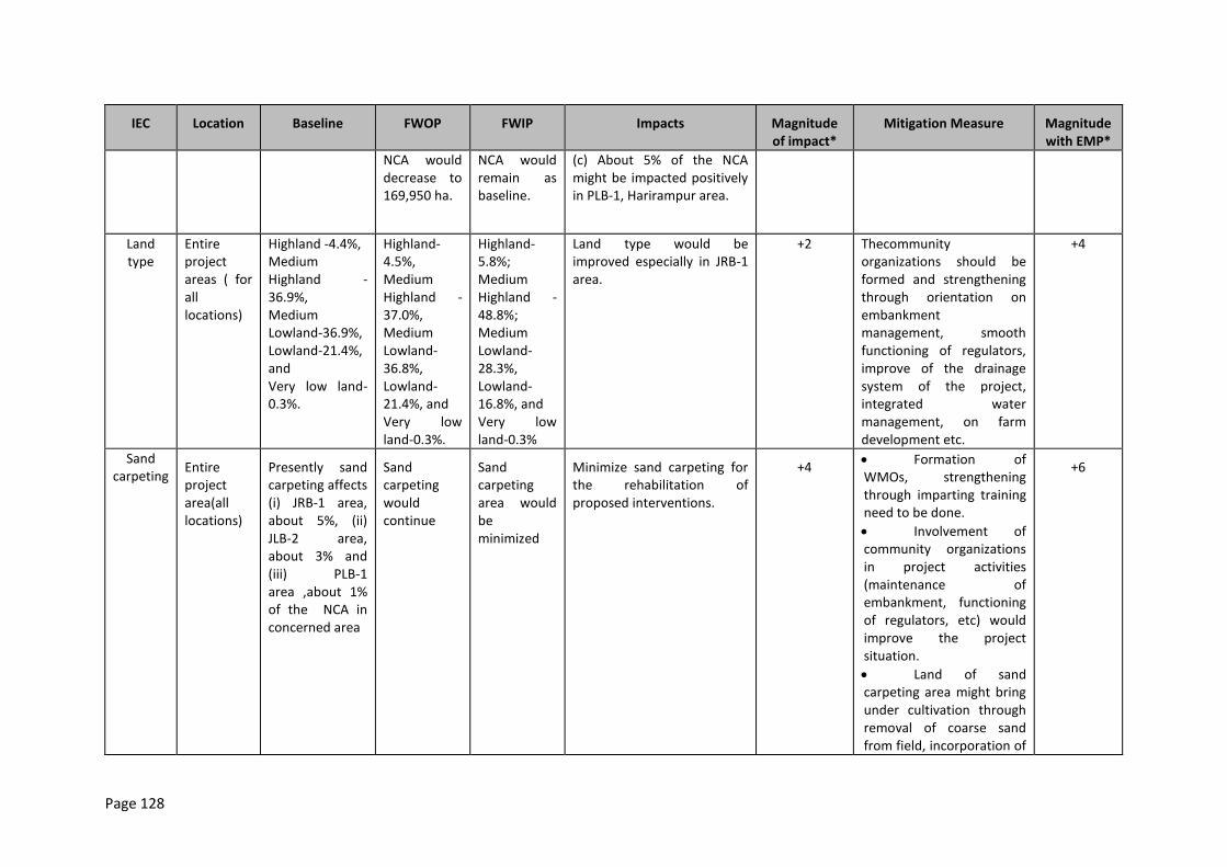
Page 128
IEC Location Baseline FWOP FWIP Impacts Magnitude of impact*
Mitigation Measure Magnitude with EMP*
NCA would decrease to 169,950 ha.
NCA would remain as baseline.
(c) About 5% of the NCA might be impacted positively in PLB-1, Harirampur area.
Land type
Entire project areas ( for all locations)
Highland -4.4%, Medium Highland -36.9%, Medium Lowland-36.9%, Lowland-21.4%, and Very low land-0.3%.
Highland-4.5%, Medium Highland -37.0%, Medium Lowland-36.8%, Lowland-21.4%, and Very low land-0.3%.
Highland-5.8%; Medium Highland -48.8%; Medium Lowland-28.3%, Lowland-16.8%, and Very low land-0.3%
Land type would be improved especially in JRB-1 area.
+2 Thecommunity organizations should be formed and strengthening through orientation on embankment management, smooth functioning of regulators, improve of the drainage system of the project, integrated water management, on farm development etc.
+4
Sand carpeting
Entire project area(all locations)
Presently sand carpeting affects (i) JRB-1 area, about 5%, (ii) JLB-2 area, about 3% and (iii) PLB-1 area ,about 1% of the NCA in concerned area
Sand carpeting would continue
Sand carpeting area would be minimized
Minimize sand carpeting for the rehabilitation of proposed interventions.
+4 Formation of WMOs, strengthening through imparting training need to be done.
Involvement of community organizations in project activities (maintenance of embankment, functioning of regulators, etc) would improve the project situation.
Land of sand carpeting area might bring under cultivation through removal of coarse sand from field, incorporation of
+6
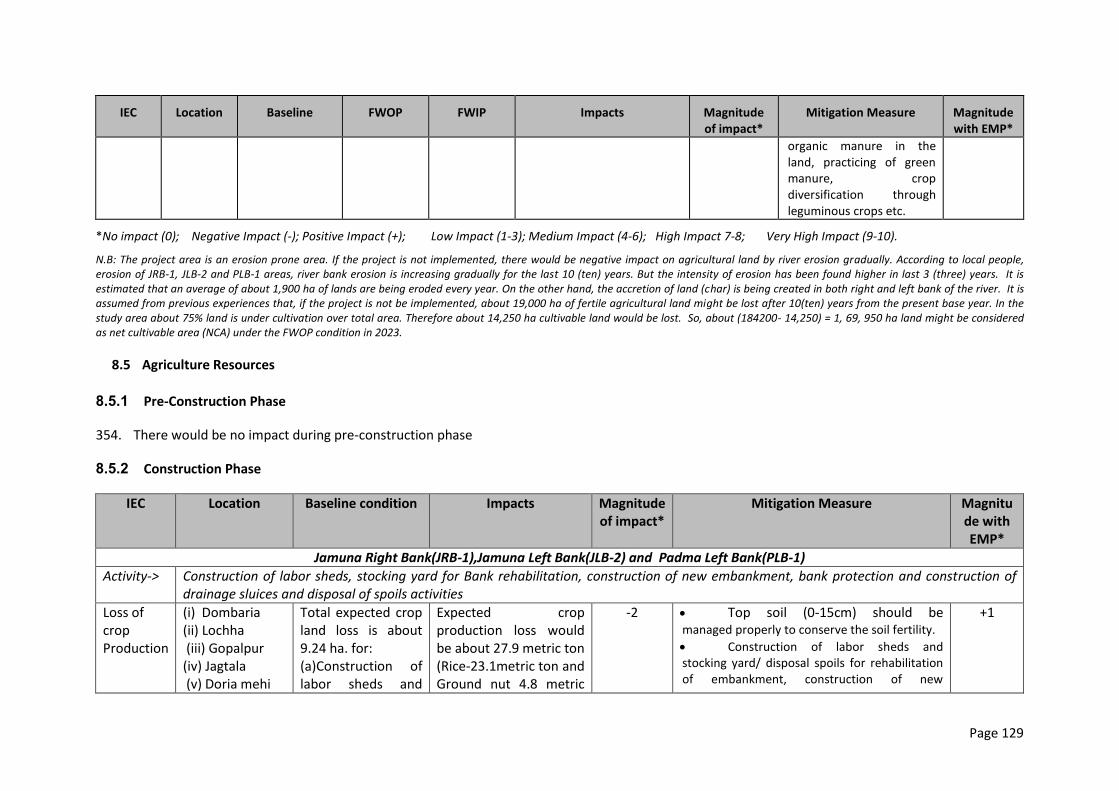
Page 129
IEC Location Baseline FWOP FWIP Impacts Magnitude of impact*
Mitigation Measure Magnitude with EMP*
organic manure in the land, practicing of green manure, crop diversification through leguminous crops etc.
*No impact (0); Negative Impact (-); Positive Impact (+); Low Impact (1-3); Medium Impact (4-6); High Impact 7-8; Very High Impact (9-10).
N.B: The project area is an erosion prone area. If the project is not implemented, there would be negative impact on agricultural land by river erosion gradually. According to local people, erosion of JRB-1, JLB-2 and PLB-1 areas, river bank erosion is increasing gradually for the last 10 (ten) years. But the intensity of erosion has been found higher in last 3 (three) years. It is estimated that an average of about 1,900 ha of lands are being eroded every year. On the other hand, the accretion of land (char) is being created in both right and left bank of the river. It is assumed from previous experiences that, if the project is not be implemented, about 19,000 ha of fertile agricultural land might be lost after 10(ten) years from the present base year. In the study area about 75% land is under cultivation over total area. Therefore about 14,250 ha cultivable land would be lost. So, about (184200- 14,250) = 1, 69, 950 ha land might be considered as net cultivable area (NCA) under the FWOP condition in 2023.
8.5 Agriculture Resources
8.5.1 Pre-Construction Phase
354. There would be no impact during pre-construction phase
8.5.2 Construction Phase
IEC Location Baseline condition Impacts Magnitude of impact*
Mitigation Measure Magnitude with EMP*
Jamuna Right Bank(JRB-1),Jamuna Left Bank(JLB-2) and Padma Left Bank(PLB-1)
Activity-> Construction of labor sheds, stocking yard for Bank rehabilitation, construction of new embankment, bank protection and construction of drainage sluices and disposal of spoils activities
Loss of crop Production
(i) Dombaria (ii) Lochha (iii) Gopalpur (iv) Jagtala (v) Doria mehi
Total expected crop land loss is about 9.24 ha. for: (a)Construction of labor sheds and
Expected crop production loss would be about 27.9 metric ton (Rice-23.1metric ton and Ground nut 4.8 metric
-2 Top soil (0-15cm) should be managed properly to conserve the soil fertility.
Construction of labor sheds and stocking yard/ disposal spoils for rehabilitation of embankment, construction of new
+1
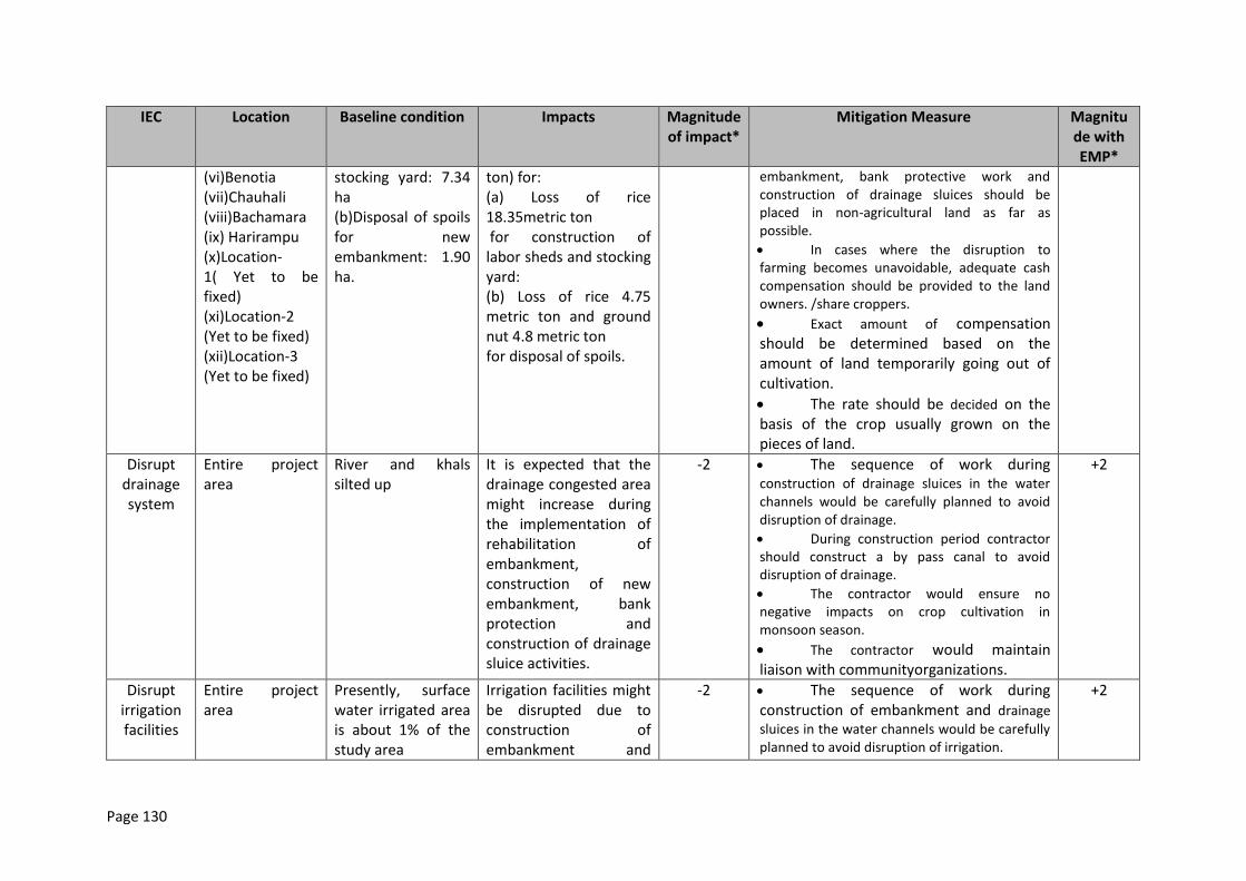
Page 130
IEC Location Baseline condition Impacts Magnitude of impact*
Mitigation Measure Magnitude with EMP*
(vi)Benotia (vii)Chauhali (viii)Bachamara (ix) Harirampu (x)Location-1( Yet to be fixed) (xi)Location-2 (Yet to be fixed) (xii)Location-3 (Yet to be fixed)
stocking yard: 7.34 ha (b)Disposal of spoils for new embankment: 1.90 ha.
ton) for: (a) (a) Loss of rice
18.35metric ton (b) for construction of
labor sheds and stocking yard:
(c) (b) Loss of rice 4.75 metric ton and ground nut 4.8 metric ton
(d) for disposal of spoils. (e) (f)
embankment, bank protective work and construction of drainage sluices should be placed in non-agricultural land as far as possible.
In cases where the disruption to farming becomes unavoidable, adequate cash compensation should be provided to the land owners. /share croppers.
Exact amount of compensation should be determined based on the amount of land temporarily going out of cultivation.
The rate should be decided on the basis of the crop usually grown on the pieces of land.
Disrupt drainage system
Entire project area
River and khals silted up
It is expected that the drainage congested area might increase during the implementation of rehabilitation of embankment, construction of new embankment, bank protection and construction of drainage sluice activities.
-2 The sequence of work during construction of drainage sluices in the water channels would be carefully planned to avoid disruption of drainage.
During construction period contractor should construct a by pass canal to avoid disruption of drainage.
The contractor would ensure no negative impacts on crop cultivation in monsoon season.
The contractor would maintain liaison with communityorganizations.
+2
Disrupt irrigation facilities
Entire project area
Presently, surface water irrigated area is about 1% of the study area
Irrigation facilities might be disrupted due to construction of embankment and
-2 The sequence of work during construction of embankment and drainage
sluices in the water channels would be carefully planned to avoid disruption of irrigation.
+2
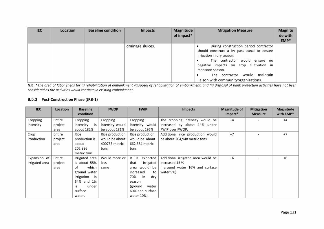
Page 131
IEC Location Baseline condition Impacts Magnitude of impact*
Mitigation Measure Magnitude with EMP*
drainage sluices. During construction period contractor should construct a by pass canal to ensure irrigation in dry season.
The contractor would ensure no negative impacts on crop cultivation in monsoon season.
The contractor would maintain liaison with communityorganizations.
N.B: *The area of labor sheds for (i) rehabilitation of embankment /disposal of rehabilitation of embankment, and (ii) disposal of bank protection activities have not been considered as the activities would continue in existing embankment.
8.5.3 Post-Construction Phase (JRB-1)
IEC Location Baseline condition
FWOP FWIP Impacts Magnitude of impact*
Mitigation Measure
Magnitude with EMP*
Cropping intensity
Entire project area
Cropping intensity is about 182%
Cropping intensity would be about 181%
Cropping intensity would be about 195%
The cropping intensity would be increased by about 14% under FWIP over FWOP.
+4 - +4
Crop Production
Entire project area
Rice production is about 202,886 metric tons
Rice production would be about 400753 metric tons
Rice production would be about 662,584 metric tons
Additional rice production would be about 204,948 metric tons
+7 - +7
Expansion of irrigated area
Entire project area
Irrigated area is about 55% of which ground water irrigation is 54% and 1% is under surface water.
Would more or less same
It is expected that irrigated area would be increased to 70% in dry season (ground water 60% and surface water 10%).
Additional irrigated area would be increased 15 % ( ground water 16% and surface water 9%).
+6 - +6
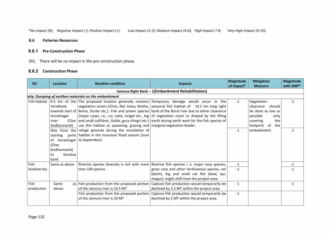
Page 132
*No impact (0); Negative Impact (-); Positive Impact (+); Low Impact (1-3); Medium Impact (4-6); High Impact 7-8; Very High Impact (9-10).
8.6 Fisheries Resources
8.6.1 Pre-Construction Phase
355. There will be no impact in the pre-construction phase.
8.6.2 Construction Phase
IEC Location Baseline condition Impacts Magnitude of impact*
Mitigation Measure
Magnitude with EMP*
Jamuna Right Bank – 1(Embankment Rehabilitation) Activity: Dumping of earthen materials on the embankment
Fish habitat 6.5 km of the Verakhola towards start of Hurashagar river (Char Andharmanik)
The proposed location generally contains vegetation covers (Chon, Nol, Kaisa, Mutha, Binna, Durba etc.). Fish and prawn species (major carps, i.e., rui, catla, mrigel etc., big and small catfishes, Golda, gura chingri etc.) use this habitat as spawning, grazing and refuge grounds during the inundation of habitat in the monsoon flood season (June to September).
Temporary damage would occur in the seasonal fish habitat of 10.5 km long right bank of the Boral river due to either clearance of vegetation cover or draped by the filling earth during earth work for the fish species of marginal vegetation feeder.
-1 Vegetation clearance should be done as low as possible only covering the footprint of the embankment.
-1
4km from the starting point of Hurashagar (Char Andharmanik) to Korotoa bank
-1 -1
Fish biodiversity
Same as above Riverine species diversity is rich with more than 100 species
Riverine fish species i. e. major carp species, grass carp and other herbivorous species, eel (baim), big and small cat fish (boal, ayr, magur), might shift from the project area
-1 -1
-1 -1
Fish production
Same as above
Fish production from the proposed portion of the Jamuna river is 16.5 MT
Capture fish production would temporarily be declined by 3.3 MT within the project area.
-1 -1
Fish production from the proposed portion of the Jamuna river is 10 MT
Capture fish production would temporarily be declined by 2 MT within the project area.
-1
Page 133
IEC Location Baseline condition Impacts Magnitude of impact*
Mitigation Measure
Magnitude with EMP*
Activity: Collection of earth materials from Jamuna Riverl through dredging
Fish habitat Same as above More than 10 deep pools or locally called dor/duars are located at 20-40m far from the right river bank. These areas play an important role for hilsa production. Moreover, other larger fish species, i.e., boal, ayr, baghayr, rui, catla etc. use these habitat particularly during the dry season (December-March)
- Water quality (stream flow, temperature, pH, turbidity, DO, hardness etc.) of that portion of the Boral river will temporarily be changed which would change the behavior of riverine fish species (both the juveniles and adults).
- Feeding habitat for the demersal (boal, ayr) and benthopelagic (baim) fish species would be damaged.
- Deep pools (dor/duars) would temporarily be damaged.
-2 1. Dredging will have to done during the dry season. 2. Proper protective device (silt fence) will have to take to protect the deep pools (dor/duars).
-1
-1 -1
Fish migration
Same as above 1. Lateral migration occurs through flooding water.
2. Larvae and juveniles migrate from the river to the adjacent beels (Kadaibadla beel, Nuar beel, Mathavanga beel, Merpahnir beel, Kumirpecha beel, Moakholar beel etc) for feeding and growth during the dry season (December to March)
Both the Longitudinal (hilsa) and lateral migration for fish will be temporarily disturbed.
-2 Dry season (December-March) is proposed for dredging.
-1
-2 -1
Fish biodiversity
Same as above Riverine species diversity is rich with more than 100 species
Riverine fish species i. e. hilsa, major carp species, eel (baim), big and small cat fish (boal, ayr, magur), etc. might shift from the project area
-5 1. Dredging will have to be done during the dry season. 2. Proper protective device (silt fence) will have to be taken to protect the deep pools (dor/duars).
-3
Fish production
Same as above Fish production from the proposed portion of the Jamuna river is 16.5 MT
Capture fish production would temporarily be declined by 3.3 MT within the project area.
-1 -4
Fish production from the proposed portion of the Jamuna river is 10 MT
Capture fish production would temporarily be declined by 2 MT within the project area.
-1
Page 134
IEC Location Baseline condition Impacts Magnitude of impact*
Mitigation Measure
Magnitude with EMP*
Activity: Construction of sluice gate
Fish Migration
Not fixed up - There is good connectivity between the Baral khal to Hurashagar which flows over the Mohakholar Beel and Kumir pecha Beel.
- The water of Baral khal goes to the Nuar Beel, Mathavanga Beel, Merpahnir Beel, Kossailkar Beel and Gobindapur Beel through the Verakhola khal
Fish migration would be hindered -3 1. Fish friendly structure with suitable water depth, water velocity etc. should be maintained. 2. Gates should be operated with the knowledge of fish migration behavior with suitable season
-1
Fish biodiversity
Fish biodiversity would slightly be reduced, because they can enter the mentioned beel through another migration route.
-2 Same as above -1
Fish production
Production would slightly be lowered -2 Same as above -1
New Embankment Construction
Activity: Collection of earth materials from the location of embankment through excavator, pay loader, head load , dump truck and trolley
Fish habitat 10.5 km of the Jamuna river bank from Hat Pachil Bazar, Kaizuri to Benotia Hat/Bazar
The proposed location generally contains vegetation covers (Chon, Nol, Kaisa, Mutha, Kolmi, Binna, Durba etc.). Fish and prawn species (major carps, i.e., rui, catla, mrigel etc., big and small catfishes, Golda, gura chingri etc.) use this habitat as spawning, grazing and refuge grounds during the inundation of habitat in the monsoon flood season (June to September).
Temporary damage would occur in the seasonal fish habitat due to either clearance of vegetation cover or draped by the filling earth during earth work for the fish species of marginal vegetation feeder.
-1 The area of vegetation clearance should be minimized
-1
2 km from Benotia Hat/Bazar to the start of Baral Khal, Verakola Hat
-1 -1
Page 135
IEC Location Baseline condition Impacts Magnitude of impact*
Mitigation Measure
Magnitude with EMP*
Fish migration
Same as above Fish migration occurs through flooding water during the monsoon flood season (June to September)
Lateral migration for fish will be temporarily disturbed.
-2
Same as above -1
Fish biodiversity
Same as above Riverine species diversity is rich with more than 100 species
Riverine fish species i. e. major carp species, grass carp and other herbivorous species, eel (baim), big and small cat fish (boal, ayr, magur), might shift from the project area
-1 Same as above -1
-1 -1
Fish production
Same as above Fish production from the proposed portion of the Jamuna river is 26.62 MT
Capture fish production would temporarily be declined by 13.3 MT within the project area. In opposite, culture fisheries practice would be increased.
-3 Same as above -1
Fish production from the proposed portion of the Jamuna river is 10 MT
Capture fish production would temporarily be declined by 2 MT within the project area.
-1
Activity: Collection of earth materials from Jamuna river through dredging
Fish habitat Same as above More than 10 deep pools or locally called dor/duars are located at 20-40m far from the right river bank. These areas play an important role for hilsa production. Moreover, other larger fish species, i.e., boal, ayr, baghayr, rui, catla etc. use these habitat particularly during the dry season (December-March)
1. Water quality (stream flow, temperature, pH, turbidity, DO, hardness etc.) of that portion of the Boral river will be temporarily changed which would change the behavior of riverine fish species (both the juveniles and adults).
2. Feeding habitat for the demersal (boal, ayr) and benthopelagic (baim) fish species would be damaged.
3. Deep pools (dor/duars) would temporarily be damaged.
-2 1. Dredging will have to done during the dry season. 2. Proper protective device (silt fence) will have to take to protect the deep pools (dor/duars).
-1
-1 -1
Fish migration
Same as above 1. Lateral migration occurs through flooding water.
2. Larvae and juveniles migrate from the river to the adjacent beels (Kadaibadla beel, Nuar beel, Mathavanga beel, Merpahnir beel, Kumirpecha beel,
Both the Longitudinal (hilsa) and lateral migration for fish will be temporarily disturbed.
-2 Dry season (December-March) is proposed for dredging.
-1
Page 136
IEC Location Baseline condition Impacts Magnitude of impact*
Mitigation Measure
Magnitude with EMP*
Moakholar beel etc) for feeding and growth during the dry season (December to March)
Fish biodiversity
Same as above Riverine species diversity is rich with more than 100 species
Riverine fish species i. e. hilsa, major carp species, eel (baim), big and small cat fish (boal, ayr, magur), etc. might shift from the project area
-5 1. Dredging will have to done during the dry season. 2. Proper protective device will have to be taken to protect the deep pools (dor/duars).
-3
Fish production
Same as above Fish production from the proposed portion of the Jamuna river is 26.62 MT
Capture fish production would temporarily decline by 13.3 MT within the project area. Culture fisheries practice would be increased. Net fish production would increase by 25 MT
+3 Same as above -1
Fish production from the proposed portion of the Jamuna river is 10 MT
Capture fish production would temporarily be declined by 2 MT within the project area. Culture fisheries practice would be slightly increased.
-1 -1
Activity: Construction of sluice gate
Fish Migration
Not fixed up 1. There is goodl connectivity between the Baral khal to Hurashagar which flows over the Mohakholar Beel and Kumir pecha Beel.
2. The water of Baral khal goes to the Nuar Beel, Mathavanga Beel, Merpahnir Beel, Kossailkar Beel and Gobindapur Beel through the Verakhola khal
Fish migration would be hindered -3 1. Fish friendly structure with suitable water depth, water velocity etc. should be maintained. 2. Gates should be operated with the knowledge of fish migration behavior with suitable
-1
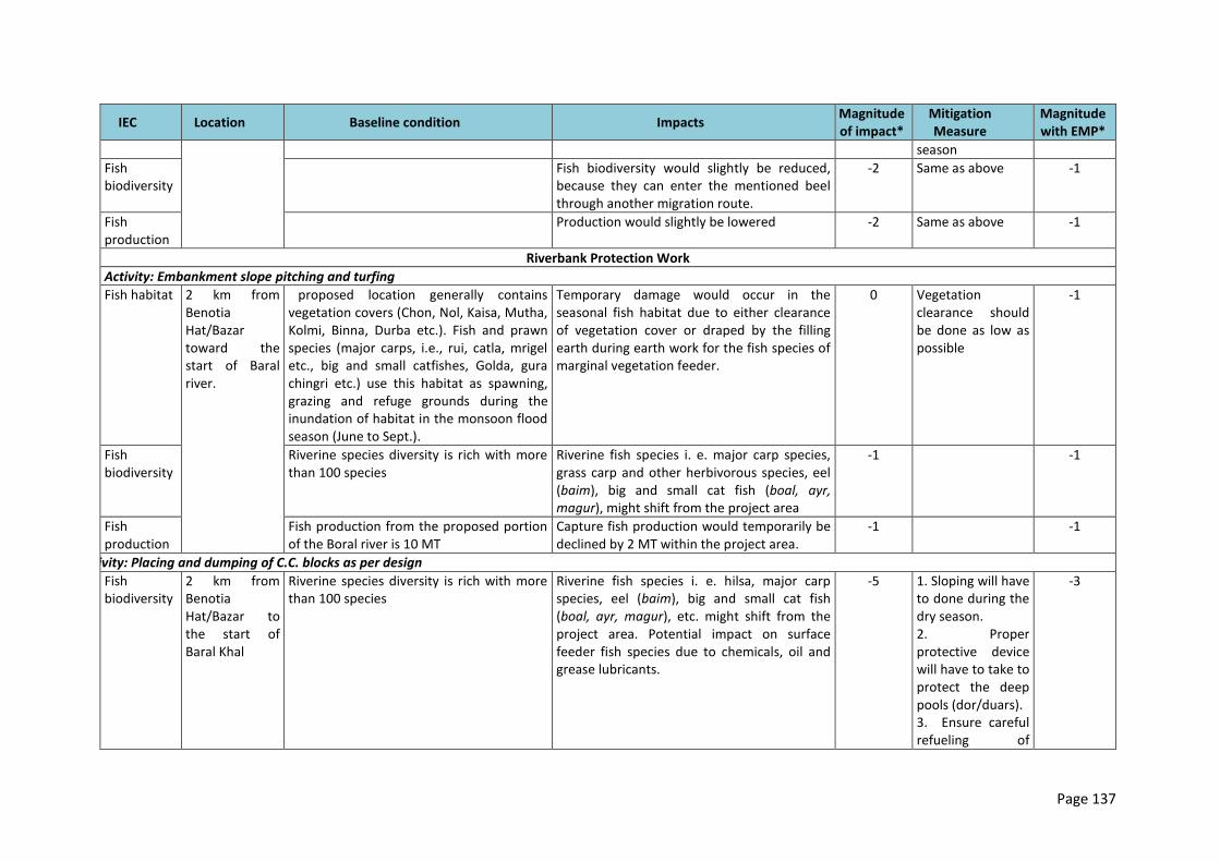
Page 137
IEC Location Baseline condition Impacts Magnitude of impact*
Mitigation Measure
Magnitude with EMP*
season
Fish biodiversity
Fish biodiversity would slightly be reduced, because they can enter the mentioned beel through another migration route.
-2 Same as above -1
Fish production
Production would slightly be lowered -2 Same as above -1
Riverbank Protection Work
Activity: Embankment slope pitching and turfing
Fish habitat 2 km from Benotia Hat/Bazar toward the start of Baral river.
The proposed location generally contains vegetation covers (Chon, Nol, Kaisa, Mutha, Kolmi, Binna, Durba etc.). Fish and prawn species (major carps, i.e., rui, catla, mrigel etc., big and small catfishes, Golda, gura chingri etc.) use this habitat as spawning, grazing and refuge grounds during the inundation of habitat in the monsoon flood season (June to Sept.).
Temporary damage would occur in the seasonal fish habitat due to either clearance of vegetation cover or draped by the filling earth during earth work for the fish species of marginal vegetation feeder.
0 Vegetation clearance should be done as low as possible
-1
Fish biodiversity
Riverine species diversity is rich with more than 100 species
Riverine fish species i. e. major carp species, grass carp and other herbivorous species, eel (baim), big and small cat fish (boal, ayr, magur), might shift from the project area
-1 -1
Fish production
Fish production from the proposed portion of the Boral river is 10 MT
Capture fish production would temporarily be declined by 2 MT within the project area.
-1 -1
Activity: Placing and dumping of C.C. blocks as per design
Fish biodiversity
2 km from Benotia Hat/Bazar to the start of Baral Khal
Riverine species diversity is rich with more than 100 species
Riverine fish species i. e. hilsa, major carp species, eel (baim), big and small cat fish (boal, ayr, magur), etc. might shift from the project area. Potential impact on surface feeder fish species due to chemicals, oil and grease lubricants.
-5 1. Sloping will have to done during the dry season. 2. Proper protective device will have to take to protect the deep pools (dor/duars). 3. Ensure careful refueling of
-3
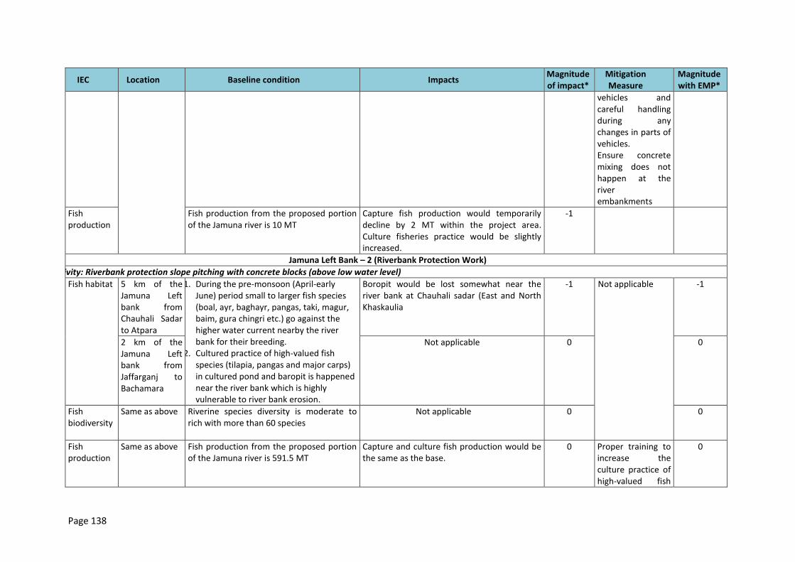
Page 138
IEC Location Baseline condition Impacts Magnitude of impact*
Mitigation Measure
Magnitude with EMP*
vehicles and careful handling during any changes in parts of vehicles. Ensure concrete mixing does not happen at the river embankments
Fish production
Fish production from the proposed portion of the Jamuna river is 10 MT
Capture fish production would temporarily decline by 2 MT within the project area. Culture fisheries practice would be slightly increased.
-1 -1
Jamuna Left Bank – 2 (Riverbank Protection Work)
Activity: Riverbank protection slope pitching with concrete blocks (above low water level)
Fish habitat 5 km of the Jamuna Left bank from Chauhali Sadar to Atpara
1. During the pre-monsoon (April-early June) period small to larger fish species (boal, ayr, baghayr, pangas, taki, magur, baim, gura chingri etc.) go against the higher water current nearby the river bank for their breeding.
2. Cultured practice of high-valued fish species (tilapia, pangas and major carps) in cultured pond and baropit is happened near the river bank which is highly vulnerable to river bank erosion.
Boropit would be lost somewhat near the river bank at Chauhali sadar (East and North Khaskaulia
-1 Not applicable
-1
2 km of the Jamuna Left bank from Jaffarganj to Bachamara
Not applicable 0 0
Fish biodiversity
Same as above Riverine species diversity is moderate to rich with more than 60 species
Not applicable 0 0
Fish production
Same as above Fish production from the proposed portion of the Jamuna river is 591.5 MT
Capture and culture fish production would be the same as the base.
0 Proper training to increase the culture practice of high-valued fish
0
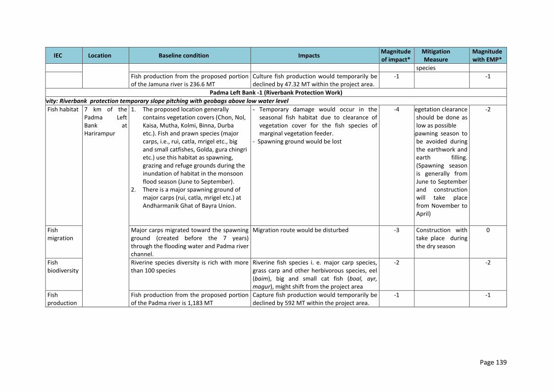
Page 139
IEC Location Baseline condition Impacts Magnitude of impact*
Mitigation Measure
Magnitude with EMP*
species
Fish production from the proposed portion of the Jamuna river is 236.6 MT
Culture fish production would temporarily be declined by 47.32 MT within the project area.
-1 -1
Padma Left Bank -1 (Riverbank Protection Work)
Activity: Riverbank protection temporary slope pitching with geobags above low water level
Fish habitat 7 km of the Padma Left Bank at Harirampur
1. The proposed location generally contains vegetation covers (Chon, Nol, Kaisa, Mutha, Kolmi, Binna, Durba etc.). Fish and prawn species (major carps, i.e., rui, catla, mrigel etc., big and small catfishes, Golda, gura chingri etc.) use this habitat as spawning, grazing and refuge grounds during the inundation of habitat in the monsoon flood season (June to September).
2. There is a major spawning ground of major carps (rui, catla, mrigel etc.) at Andharmanik Ghat of Bayra Union.
- Temporary damage would occur in the seasonal fish habitat due to clearance of vegetation cover for the fish species of marginal vegetation feeder.
- Spawning ground would be lost
-4 1. Vegetation clearance should be done as low as possible
2. Spawning season to be avoided during the earthwork and earth filling. (Spawning season is generally from June to September and construction will take place from November to April)
-2
Fish migration
Major carps migrated toward the spawning ground (created before the 7 years) through the flooding water and Padma river channel.
Migration route would be disturbed -3 Construction with take place during the dry season
0
Fish biodiversity
Riverine species diversity is rich with more than 100 species
Riverine fish species i. e. major carp species, grass carp and other herbivorous species, eel (baim), big and small cat fish (boal, ayr, magur), might shift from the project area
-2 -2
Fish production
Fish production from the proposed portion of the Padma river is 1,183 MT
Capture fish production would temporarily be declined by 592 MT within the project area.
-1 -1
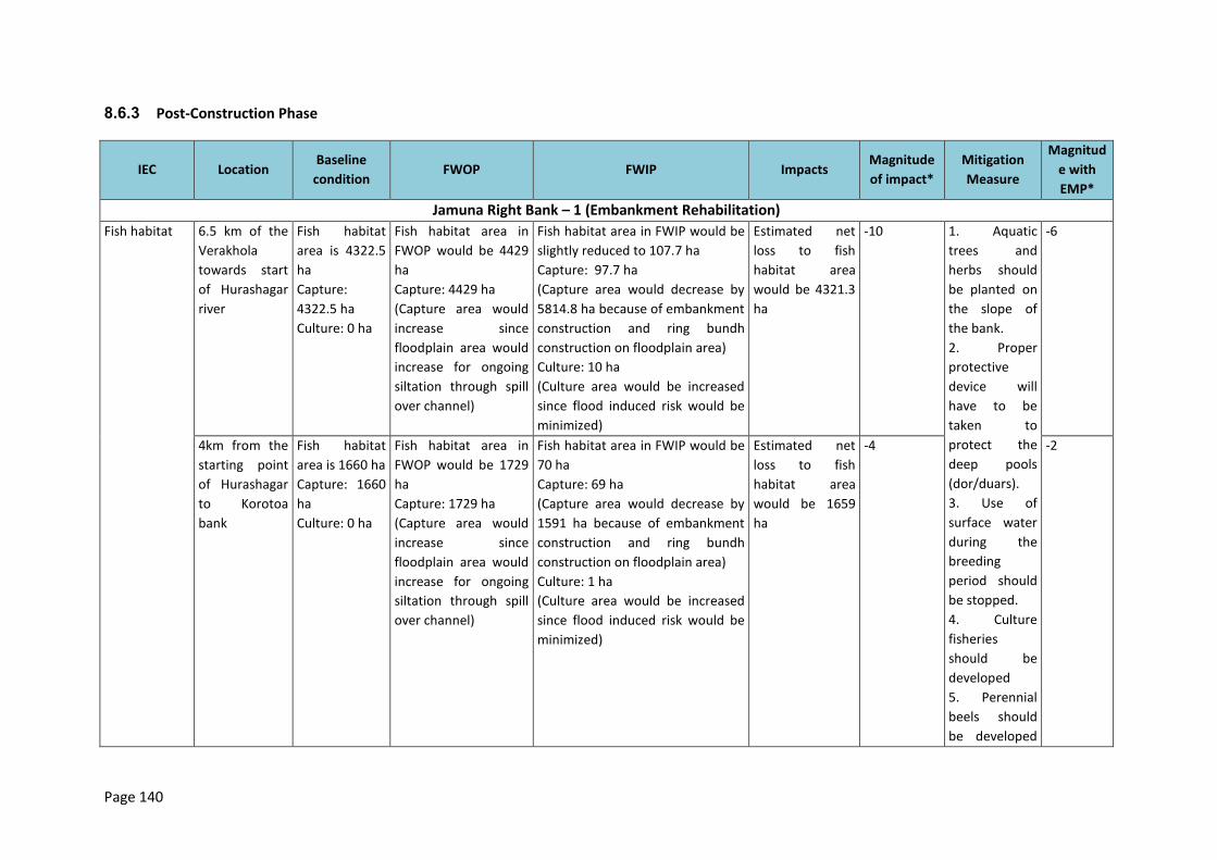
Page 140
8.6.3 Post-Construction Phase
IEC Location Baseline
condition FWOP FWIP Impacts
Magnitude
of impact*
Mitigation
Measure
Magnitud
e with
EMP*
Jamuna Right Bank – 1 (Embankment Rehabilitation)
Fish habitat 6.5 km of the
Verakhola
towards start
of Hurashagar
river
Fish habitat
area is 4322.5
ha
Capture:
4322.5 ha
Culture: 0 ha
Fish habitat area in
FWOP would be 4429
ha
Capture: 4429 ha
(Capture area would
increase since
floodplain area would
increase for ongoing
siltation through spill
over channel)
Fish habitat area in FWIP would be
slightly reduced to 107.7 ha
Capture: 97.7 ha
(Capture area would decrease by
5814.8 ha because of embankment
construction and ring bundh
construction on floodplain area)
Culture: 10 ha
(Culture area would be increased
since flood induced risk would be
minimized)
Estimated net
loss to fish
habitat area
would be 4321.3
ha
-10 1. Aquatic
trees and
herbs should
be planted on
the slope of
the bank.
2. Proper
protective
device will
have to be
taken to
protect the
deep pools
(dor/duars).
3. Use of
surface water
during the
breeding
period should
be stopped.
4. Culture
fisheries
should be
developed
5. Perennial
beels should
be developed
-6
4km from the
starting point
of Hurashagar
to Korotoa
bank
Fish habitat
area is 1660 ha
Capture: 1660
ha
Culture: 0 ha
Fish habitat area in
FWOP would be 1729
ha
Capture: 1729 ha
(Capture area would
increase since
floodplain area would
increase for ongoing
siltation through spill
over channel)
Fish habitat area in FWIP would be
70 ha
Capture: 69 ha
(Capture area would decrease by
1591 ha because of embankment
construction and ring bundh
construction on floodplain area)
Culture: 1 ha
(Culture area would be increased
since flood induced risk would be
minimized)
Estimated net
loss to fish
habitat area
would be 1659
ha
-4 -2
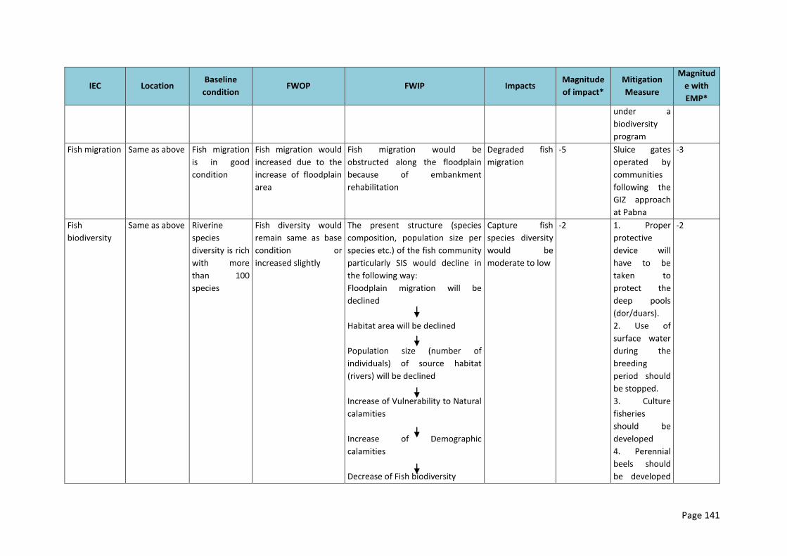
Page 141
IEC Location Baseline
condition FWOP FWIP Impacts
Magnitude
of impact*
Mitigation
Measure
Magnitud
e with
EMP*
under a
biodiversity
program
Fish migration Same as above Fish migration
is in good
condition
Fish migration would
increased due to the
increase of floodplain
area
Fish migration would be
obstructed along the floodplain
because of embankment
rehabilitation
Degraded fish
migration
-5 Sluice gates
operated by
communities
following the
GIZ approach
at Pabna
-3
Fish
biodiversity
Same as above Riverine
species
diversity is rich
with more
than 100
species
Fish diversity would
remain same as base
condition or
increased slightly
The present structure (species
composition, population size per
species etc.) of the fish community
particularly SIS would decline in
the following way:
Floodplain migration will be
declined
Habitat area will be declined
Population size (number of
individuals) of source habitat
(rivers) will be declined
Increase of Vulnerability to Natural
calamities
Increase of Demographic
calamities
Decrease of Fish biodiversity
Capture fish
species diversity
would be
moderate to low
-2 1. Proper
protective
device will
have to be
taken to
protect the
deep pools
(dor/duars).
2. Use of
surface water
during the
breeding
period should
be stopped.
3. Culture
fisheries
should be
developed
4. Perennial
beels should
be developed
-2
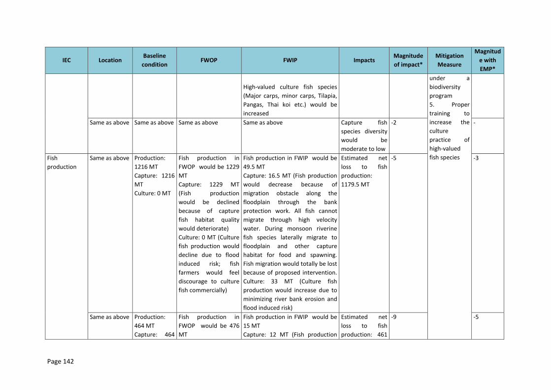
Page 142
IEC Location Baseline
condition FWOP FWIP Impacts
Magnitude
of impact*
Mitigation
Measure
Magnitud
e with
EMP*
High-valued culture fish species
(Major carps, minor carps, Tilapia,
Pangas, Thai koi etc.) would be
increased
under a
biodiversity
program
5. Proper
training to
increase the
culture
practice of
high-valued
fish species
Same as above Same as above Same as above Same as above Capture fish
species diversity
would be
moderate to low
-2 -
Fish
production
Same as above Production:
1216 MT
Capture: 1216
MT
Culture: 0 MT
Fish production in
FWOP would be 1229
MT
Capture: 1229 MT
(Fish production
would be declined
because of capture
fish habitat quality
would deteriorate)
Culture: 0 MT (Culture
fish production would
decline due to flood
induced risk; fish
farmers would feel
discourage to culture
fish commercially)
Fish production in FWIP would be
49.5 MT
Capture: 16.5 MT (Fish production
would decrease because of
migration obstacle along the
floodplain through the bank
protection work. All fish cannot
migrate through high velocity
water. During monsoon riverine
fish species laterally migrate to
floodplain and other capture
habitat for food and spawning.
Fish migration would totally be lost
because of proposed intervention.
Culture: 33 MT (Culture fish
production would increase due to
minimizing river bank erosion and
flood induced risk)
Estimated net
loss to fish
production:
1179.5 MT
-5 -3
Same as above Production:
464 MT
Capture: 464
Fish production in
FWOP would be 476
MT
Fish production in FWIP would be
15 MT
Capture: 12 MT (Fish production
Estimated net
loss to fish
production: 461
-9 -5
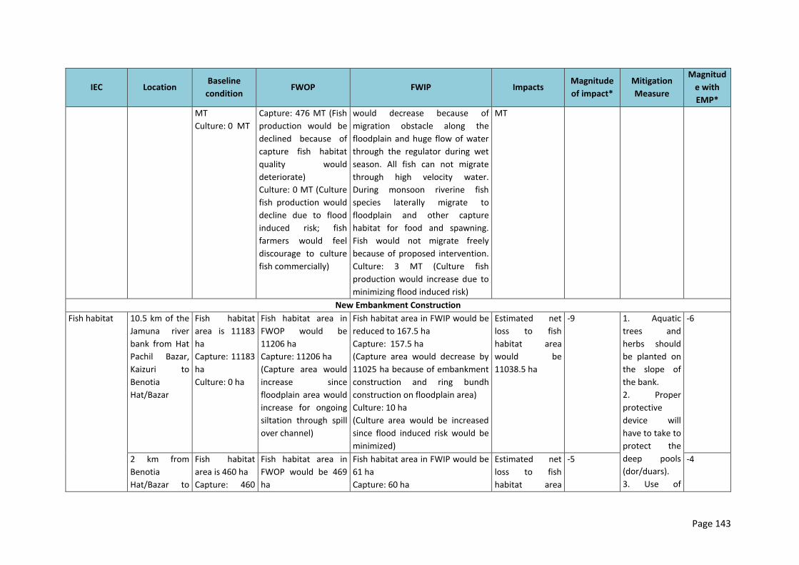
Page 143
IEC Location Baseline
condition FWOP FWIP Impacts
Magnitude
of impact*
Mitigation
Measure
Magnitud
e with
EMP*
MT
Culture: 0 MT
Capture: 476 MT (Fish
production would be
declined because of
capture fish habitat
quality would
deteriorate)
Culture: 0 MT (Culture
fish production would
decline due to flood
induced risk; fish
farmers would feel
discourage to culture
fish commercially)
would decrease because of
migration obstacle along the
floodplain and huge flow of water
through the regulator during wet
season. All fish can not migrate
through high velocity water.
During monsoon riverine fish
species laterally migrate to
floodplain and other capture
habitat for food and spawning.
Fish would not migrate freely
because of proposed intervention.
Culture: 3 MT (Culture fish
production would increase due to
minimizing flood induced risk)
MT
New Embankment Construction
Fish habitat 10.5 km of the
Jamuna river
bank from Hat
Pachil Bazar,
Kaizuri to
Benotia
Hat/Bazar
Fish habitat
area is 11183
ha
Capture: 11183
ha
Culture: 0 ha
Fish habitat area in
FWOP would be
11206 ha
Capture: 11206 ha
(Capture area would
increase since
floodplain area would
increase for ongoing
siltation through spill
over channel)
Fish habitat area in FWIP would be
reduced to 167.5 ha
Capture: 157.5 ha
(Capture area would decrease by
11025 ha because of embankment
construction and ring bundh
construction on floodplain area)
Culture: 10 ha
(Culture area would be increased
since flood induced risk would be
minimized)
Estimated net
loss to fish
habitat area
would be
11038.5 ha
-9 1. Aquatic
trees and
herbs should
be planted on
the slope of
the bank.
2. Proper
protective
device will
have to take to
protect the
deep pools
(dor/duars).
3. Use of
-6
2 km from
Benotia
Hat/Bazar to
Fish habitat
area is 460 ha
Capture: 460
Fish habitat area in
FWOP would be 469
ha
Fish habitat area in FWIP would be
61 ha
Capture: 60 ha
Estimated net
loss to fish
habitat area
-5 -4
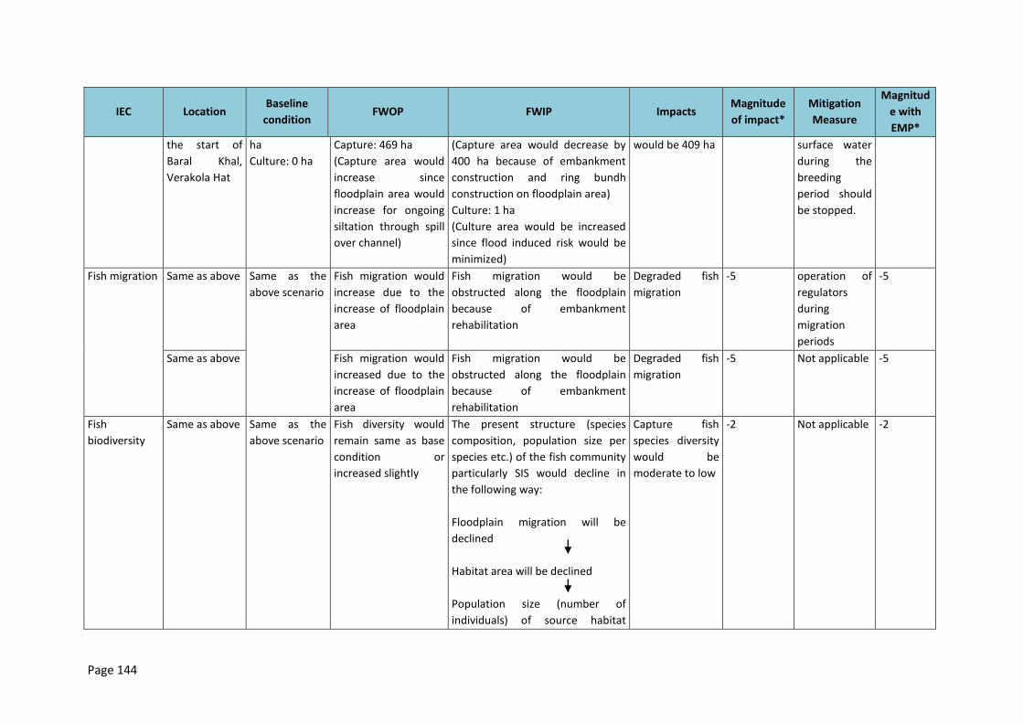
Page 144
IEC Location Baseline
condition FWOP FWIP Impacts
Magnitude
of impact*
Mitigation
Measure
Magnitud
e with
EMP*
the start of
Baral Khal,
Verakola Hat
ha
Culture: 0 ha
Capture: 469 ha
(Capture area would
increase since
floodplain area would
increase for ongoing
siltation through spill
over channel)
(Capture area would decrease by
400 ha because of embankment
construction and ring bundh
construction on floodplain area)
Culture: 1 ha
(Culture area would be increased
since flood induced risk would be
minimized)
would be 409 ha surface water
during the
breeding
period should
be stopped.
Fish migration Same as above Same as the
above scenario
Fish migration would
increase due to the
increase of floodplain
area
Fish migration would be
obstructed along the floodplain
because of embankment
rehabilitation
Degraded fish
migration
-5 operation of
regulators
during
migration
periods
-5
Same as above Fish migration would
increased due to the
increase of floodplain
area
Fish migration would be
obstructed along the floodplain
because of embankment
rehabilitation
Degraded fish
migration
-5 Not applicable -5
Fish
biodiversity
Same as above Same as the
above scenario
Fish diversity would
remain same as base
condition or
increased slightly
The present structure (species
composition, population size per
species etc.) of the fish community
particularly SIS would decline in
the following way:
Floodplain migration will be
declined
Habitat area will be declined
Population size (number of
individuals) of source habitat
Capture fish
species diversity
would be
moderate to low
-2 Not applicable -2
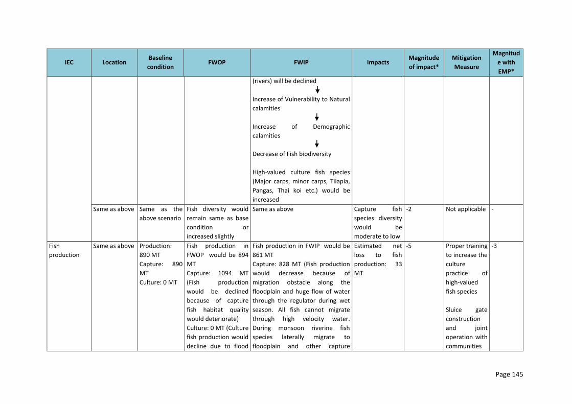
Page 145
IEC Location Baseline
condition FWOP FWIP Impacts
Magnitude
of impact*
Mitigation
Measure
Magnitud
e with
EMP*
(rivers) will be declined
Increase of Vulnerability to Natural
calamities
Increase of Demographic
calamities
Decrease of Fish biodiversity
High-valued culture fish species
(Major carps, minor carps, Tilapia,
Pangas, Thai koi etc.) would be
increased
Same as above Same as the
above scenario
Fish diversity would
remain same as base
condition or
increased slightly
Same as above Capture fish
species diversity
would be
moderate to low
-2 Not applicable -
Fish
production
Same as above Production:
890 MT
Capture: 890
MT
Culture: 0 MT
Fish production in
FWOP would be 894
MT
Capture: 1094 MT
(Fish production
would be declined
because of capture
fish habitat quality
would deteriorate)
Culture: 0 MT (Culture
fish production would
decline due to flood
Fish production in FWIP would be
861 MT
Capture: 828 MT (Fish production
would decrease because of
migration obstacle along the
floodplain and huge flow of water
through the regulator during wet
season. All fish cannot migrate
through high velocity water.
During monsoon riverine fish
species laterally migrate to
floodplain and other capture
Estimated net
loss to fish
production: 33
MT
-5 Proper training
to increase the
culture
practice of
high-valued
fish species
Sluice gate
construction
and joint
operation with
communities
-3
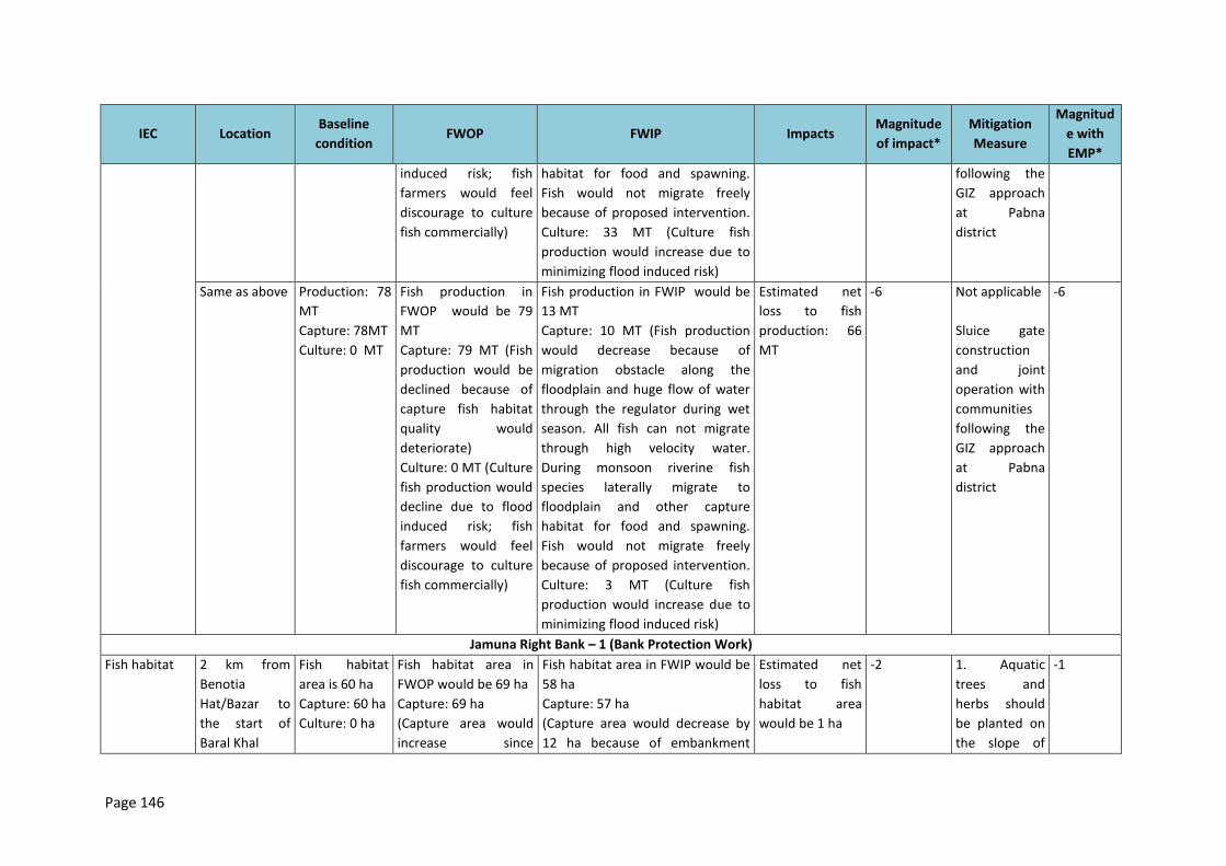
Page 146
IEC Location Baseline
condition FWOP FWIP Impacts
Magnitude
of impact*
Mitigation
Measure
Magnitud
e with
EMP*
induced risk; fish
farmers would feel
discourage to culture
fish commercially)
habitat for food and spawning.
Fish would not migrate freely
because of proposed intervention.
Culture: 33 MT (Culture fish
production would increase due to
minimizing flood induced risk)
following the
GIZ approach
at Pabna
district
Same as above Production: 78
MT
Capture: 78MT
Culture: 0 MT
Fish production in
FWOP would be 79
MT
Capture: 79 MT (Fish
production would be
declined because of
capture fish habitat
quality would
deteriorate)
Culture: 0 MT (Culture
fish production would
decline due to flood
induced risk; fish
farmers would feel
discourage to culture
fish commercially)
Fish production in FWIP would be
13 MT
Capture: 10 MT (Fish production
would decrease because of
migration obstacle along the
floodplain and huge flow of water
through the regulator during wet
season. All fish can not migrate
through high velocity water.
During monsoon riverine fish
species laterally migrate to
floodplain and other capture
habitat for food and spawning.
Fish would not migrate freely
because of proposed intervention.
Culture: 3 MT (Culture fish
production would increase due to
minimizing flood induced risk)
Estimated net
loss to fish
production: 66
MT
-6 Not applicable
Sluice gate
construction
and joint
operation with
communities
following the
GIZ approach
at Pabna
district
-6
Jamuna Right Bank – 1 (Bank Protection Work)
Fish habitat 2 km from
Benotia
Hat/Bazar to
the start of
Baral Khal
Fish habitat
area is 60 ha
Capture: 60 ha
Culture: 0 ha
Fish habitat area in
FWOP would be 69 ha
Capture: 69 ha
(Capture area would
increase since
Fish habitat area in FWIP would be
58 ha
Capture: 57 ha
(Capture area would decrease by
12 ha because of embankment
Estimated net
loss to fish
habitat area
would be 1 ha
-2 1. Aquatic
trees and
herbs should
be planted on
the slope of
-1
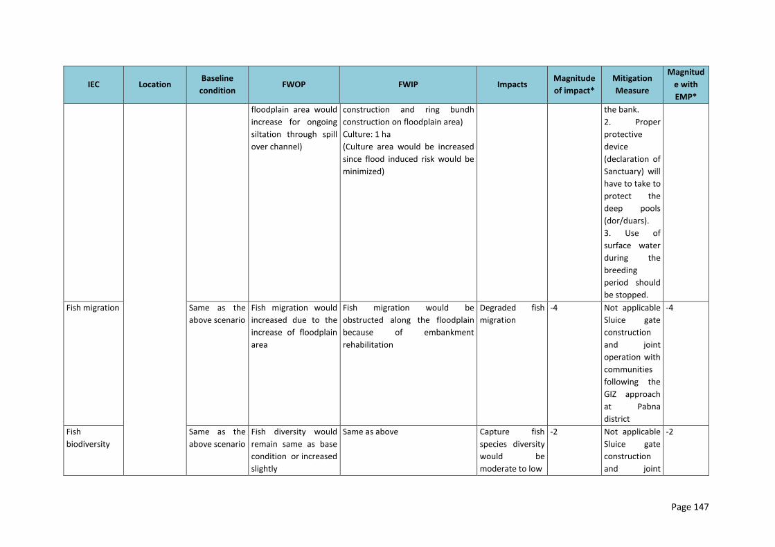
Page 147
IEC Location Baseline
condition FWOP FWIP Impacts
Magnitude
of impact*
Mitigation
Measure
Magnitud
e with
EMP*
floodplain area would
increase for ongoing
siltation through spill
over channel)
construction and ring bundh
construction on floodplain area)
Culture: 1 ha
(Culture area would be increased
since flood induced risk would be
minimized)
the bank.
2. Proper
protective
device
(declaration of
Sanctuary) will
have to take to
protect the
deep pools
(dor/duars).
3. Use of
surface water
during the
breeding
period should
be stopped.
Fish migration Same as the
above scenario
Fish migration would
increased due to the
increase of floodplain
area
Fish migration would be
obstructed along the floodplain
because of embankment
rehabilitation
Degraded fish
migration
-4 Not applicable
Sluice gate
construction
and joint
operation with
communities
following the
GIZ approach
at Pabna
district
-4
Fish
biodiversity
Same as the
above scenario
Fish diversity would
remain same as base
condition or increased
slightly
Same as above Capture fish
species diversity
would be
moderate to low
-2 Not applicable
Sluice gate
construction
and joint
-2
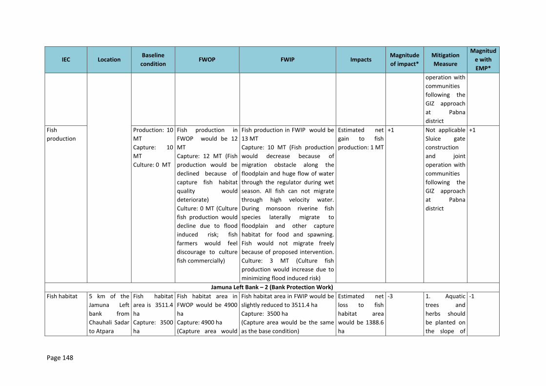
Page 148
IEC Location Baseline
condition FWOP FWIP Impacts
Magnitude
of impact*
Mitigation
Measure
Magnitud
e with
EMP*
operation with
communities
following the
GIZ approach
at Pabna
district
Fish
production
Production: 10
MT
Capture: 10
MT
Culture: 0 MT
Fish production in
FWOP would be 12
MT
Capture: 12 MT (Fish
production would be
declined because of
capture fish habitat
quality would
deteriorate)
Culture: 0 MT (Culture
fish production would
decline due to flood
induced risk; fish
farmers would feel
discourage to culture
fish commercially)
Fish production in FWIP would be
13 MT
Capture: 10 MT (Fish production
would decrease because of
migration obstacle along the
floodplain and huge flow of water
through the regulator during wet
season. All fish can not migrate
through high velocity water.
During monsoon riverine fish
species laterally migrate to
floodplain and other capture
habitat for food and spawning.
Fish would not migrate freely
because of proposed intervention.
Culture: 3 MT (Culture fish
production would increase due to
minimizing flood induced risk)
Estimated net
gain to fish
production: 1 MT
+1 Not applicable
Sluice gate
construction
and joint
operation with
communities
following the
GIZ approach
at Pabna
district
+1
Jamuna Left Bank – 2 (Bank Protection Work)
Fish habitat 5 km of the
Jamuna Left
bank from
Chauhali Sadar
to Atpara
Fish habitat
area is 3511.4
ha
Capture: 3500
ha
Fish habitat area in
FWOP would be 4900
ha
Capture: 4900 ha
(Capture area would
Fish habitat area in FWIP would be
slightly reduced to 3511.4 ha
Capture: 3500 ha
(Capture area would be the same
as the base condition)
Estimated net
loss to fish
habitat area
would be 1388.6
ha
-3 1. Aquatic
trees and
herbs should
be planted on
the slope of
-1
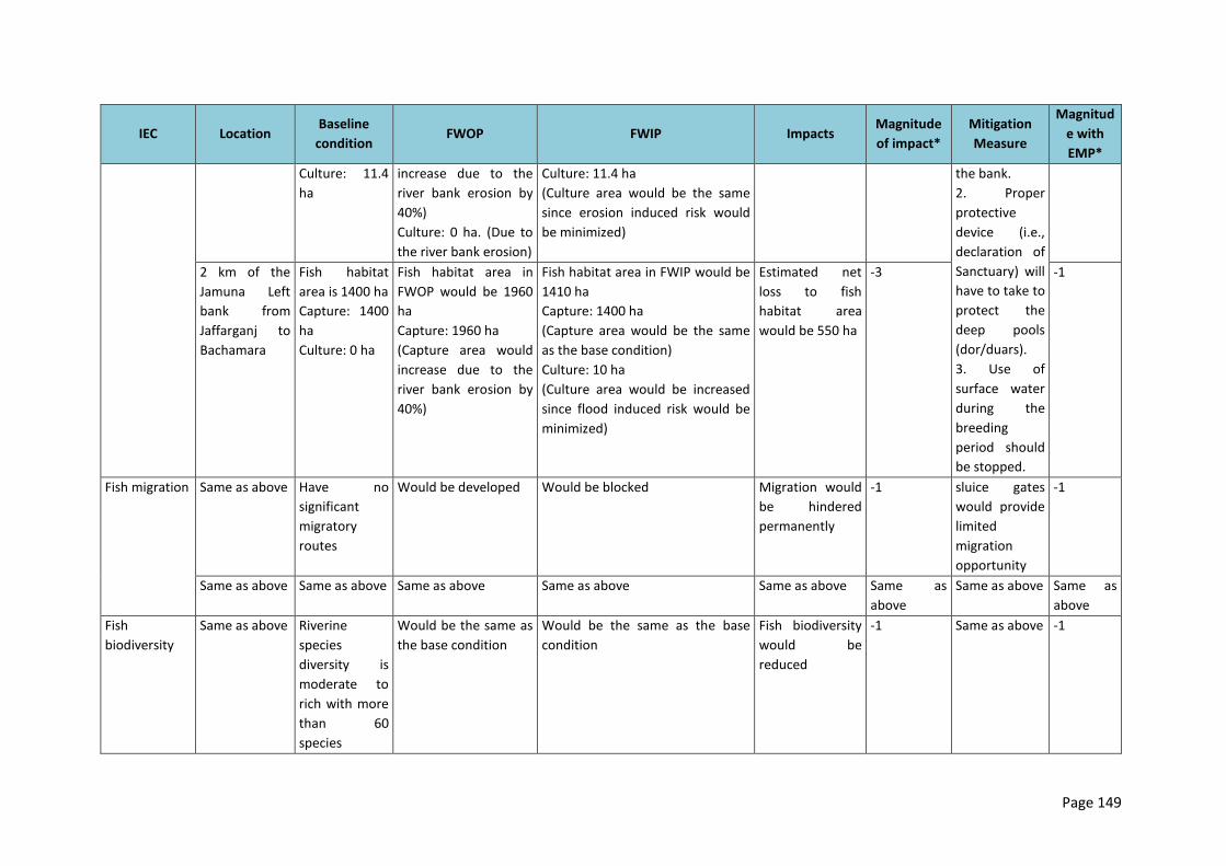
Page 149
IEC Location Baseline
condition FWOP FWIP Impacts
Magnitude
of impact*
Mitigation
Measure
Magnitud
e with
EMP*
Culture: 11.4
ha
increase due to the
river bank erosion by
40%)
Culture: 0 ha. (Due to
the river bank erosion)
Culture: 11.4 ha
(Culture area would be the same
since erosion induced risk would
be minimized)
the bank.
2. Proper
protective
device (i.e.,
declaration of
Sanctuary) will
have to take to
protect the
deep pools
(dor/duars).
3. Use of
surface water
during the
breeding
period should
be stopped.
2 km of the
Jamuna Left
bank from
Jaffarganj to
Bachamara
Fish habitat
area is 1400 ha
Capture: 1400
ha
Culture: 0 ha
Fish habitat area in
FWOP would be 1960
ha
Capture: 1960 ha
(Capture area would
increase due to the
river bank erosion by
40%)
Fish habitat area in FWIP would be
1410 ha
Capture: 1400 ha
(Capture area would be the same
as the base condition)
Culture: 10 ha
(Culture area would be increased
since flood induced risk would be
minimized)
Estimated net
loss to fish
habitat area
would be 550 ha
-3 -1
Fish migration Same as above Have no
significant
migratory
routes
Would be developed Would be blocked Migration would
be hindered
permanently
-1 sluice gates
would provide
limited
migration
opportunity
-1
Same as above Same as above Same as above Same as above Same as above Same as
above
Same as above Same as
above
Fish
biodiversity
Same as above Riverine
species
diversity is
moderate to
rich with more
than 60
species
Would be the same as
the base condition
Would be the same as the base
condition
Fish biodiversity
would be
reduced
-1 Same as above -1
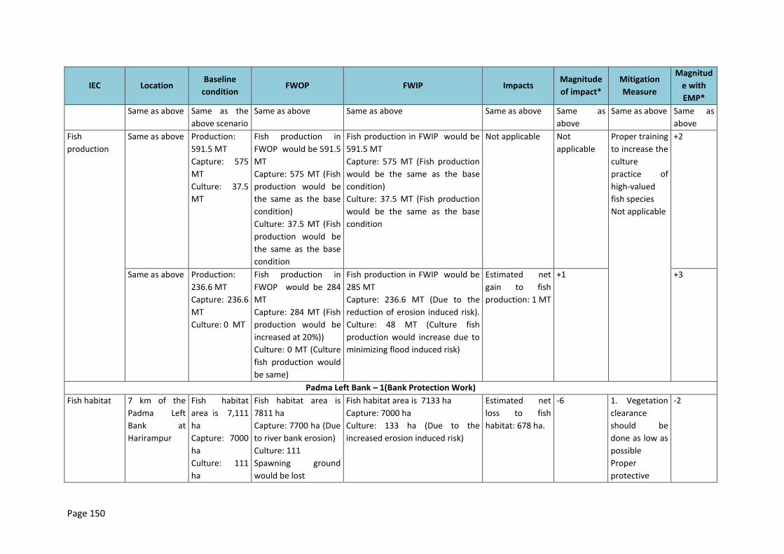
Page 150
IEC Location Baseline
condition FWOP FWIP Impacts
Magnitude
of impact*
Mitigation
Measure
Magnitud
e with
EMP*
Same as above Same as the
above scenario
Same as above Same as above Same as above Same as
above
Same as above Same as
above
Fish
production
Same as above Production:
591.5 MT
Capture: 575
MT
Culture: 37.5
MT
Fish production in
FWOP would be 591.5
MT
Capture: 575 MT (Fish
production would be
the same as the base
condition)
Culture: 37.5 MT (Fish
production would be
the same as the base
condition
Fish production in FWIP would be
591.5 MT
Capture: 575 MT (Fish production
would be the same as the base
condition)
Culture: 37.5 MT (Fish production
would be the same as the base
condition
Not applicable Not
applicable
Proper training
to increase the
culture
practice of
high-valued
fish species
Not applicable
+2
Same as above Production:
236.6 MT
Capture: 236.6
MT
Culture: 0 MT
Fish production in
FWOP would be 284
MT
Capture: 284 MT (Fish
production would be
increased at 20%))
Culture: 0 MT (Culture
fish production would
be same)
Fish production in FWIP would be
285 MT
Capture: 236.6 MT (Due to the
reduction of erosion induced risk).
Culture: 48 MT (Culture fish
production would increase due to
minimizing flood induced risk)
Estimated net
gain to fish
production: 1 MT
+1 +3
Padma Left Bank – 1(Bank Protection Work)
Fish habitat 7 km of the
Padma Left
Bank at
Harirampur
Fish habitat
area is 7,111
ha
Capture: 7000
ha
Culture: 111
ha
Fish habitat area is
7811 ha
Capture: 7700 ha (Due
to river bank erosion)
Culture: 111
Spawning ground
would be lost
Fish habitat area is 7133 ha
Capture: 7000 ha
Culture: 133 ha (Due to the
increased erosion induced risk)
Estimated net
loss to fish
habitat: 678 ha.
-6 1. Vegetation
clearance
should be
done as low as
possible
Proper
protective
-2
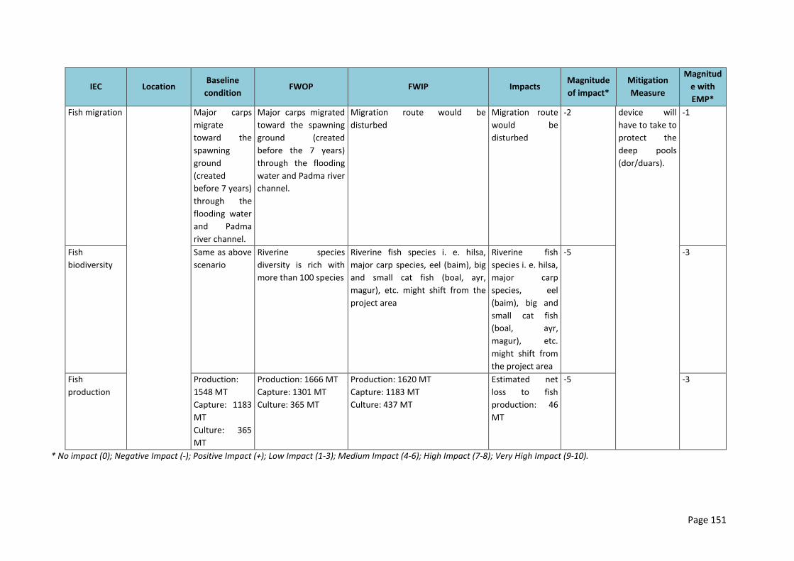
Page 151
IEC Location Baseline
condition FWOP FWIP Impacts
Magnitude
of impact*
Mitigation
Measure
Magnitud
e with
EMP*
Fish migration Major carps
migrate
toward the
spawning
ground
(created
before 7 years)
through the
flooding water
and Padma
river channel.
Major carps migrated
toward the spawning
ground (created
before the 7 years)
through the flooding
water and Padma river
channel.
Migration route would be
disturbed
Migration route
would be
disturbed
-2 device will
have to take to
protect the
deep pools
(dor/duars).
-1
Fish
biodiversity
Same as above
scenario
Riverine species
diversity is rich with
more than 100 species
Riverine fish species i. e. hilsa,
major carp species, eel (baim), big
and small cat fish (boal, ayr,
magur), etc. might shift from the
project area
Riverine fish
species i. e. hilsa,
major carp
species, eel
(baim), big and
small cat fish
(boal, ayr,
magur), etc.
might shift from
the project area
-5 -3
Fish
production
Production:
1548 MT
Capture: 1183
MT
Culture: 365
MT
Production: 1666 MT
Capture: 1301 MT
Culture: 365 MT
Production: 1620 MT
Capture: 1183 MT
Culture: 437 MT
Estimated net
loss to fish
production: 46
MT
-5 -3
* No impact (0); Negative Impact (-); Positive Impact (+); Low Impact (1-3); Medium Impact (4-6); High Impact (7-8); Very High Impact (9-10).

Page 152
8.7 Ecological Resources
8.7.1 Pre-Construction Phase
356. There will be no impact in the pre-construction phase.
8.7.2 Construction Phase
IEC Location Baseline condition Impacts Magnitude of impact*
Mitigation Measure
Magnitude with EMP
Jamuna Right Bank – 1(Embankment Rehabilitation)
Activity: Rehabilitation of embankment
Terrestrial Ecosystem Aquatic ecosystem. Floral composition and diversity. Faunal composition and diversity.
6.5 km of the Verakhola towards start of Hurashagar river (Char Andharmanik). 4km from the starting point of Hurashagar (Char Andharmanik) to Korotoa bank .
Dense vegetations like trees, shrubs and herbs are present besides the River bank. Trees are used as nesting and breeding places. Plantation action should be implemented.
Shrubs and herbs and other vegetation of bank slopes will be damaged. Feeding and resting ground will be damaged completely. After 2-3 year the situation will same as base situation.
- 4
Do not cut the big trees Do not clean the additional area. Do not dump large volume of excavated soil on bottom of the aforesaid trees. Different species of sapling should the planted. Use the area as less as possible.
+2
Construction of New Embankment
Activity: Collection of earth materials and construction of new embankment
Terrestrial Ecosystem Aquatic Ecosystem. Floral composition and diversity
10.5 km of the Jamuna river bank from Hat Pachil Bazar, Kaijuri to Benotia Hat/Bazar 2 km from Benotia Hat/Bazar to the start of
River banks holds dense vegetations like trees, shrubs and herbs etc.
Shrubs and herbs and vegetation of bank slopes will be damaged by excavated soil dumping. Less damage of trees of
-3 Use the area as required. Do not dump large volume of excavated soil on
+2
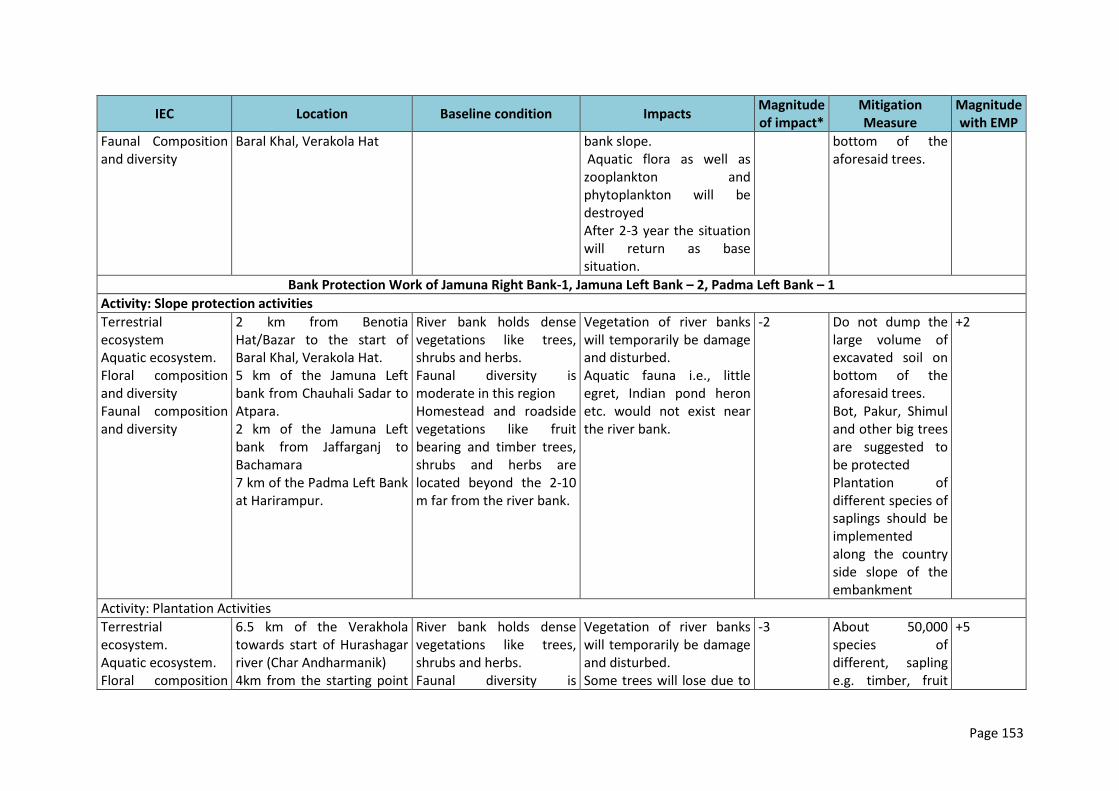
Page 153
IEC Location Baseline condition Impacts Magnitude of impact*
Mitigation Measure
Magnitude with EMP
Faunal Composition and diversity
Baral Khal, Verakola Hat bank slope. Aquatic flora as well as zooplankton and phytoplankton will be destroyed After 2-3 year the situation will return as base situation.
bottom of the aforesaid trees.
Bank Protection Work of Jamuna Right Bank-1, Jamuna Left Bank – 2, Padma Left Bank – 1
Activity: Slope protection activities
Terrestrial ecosystem Aquatic ecosystem. Floral composition and diversity Faunal composition and diversity
2 km from Benotia Hat/Bazar to the start of Baral Khal, Verakola Hat. 5 km of the Jamuna Left bank from Chauhali Sadar to Atpara. 2 km of the Jamuna Left bank from Jaffarganj to Bachamara 7 km of the Padma Left Bank at Harirampur.
River bank holds dense vegetations like trees, shrubs and herbs. Faunal diversity is moderate in this region Homestead and roadside vegetations like fruit bearing and timber trees, shrubs and herbs are located beyond the 2-10 m far from the river bank.
Vegetation of river banks will temporarily be damage and disturbed. Aquatic fauna i.e., little egret, Indian pond heron etc. would not exist near the river bank.
-2 Do not dump the large volume of excavated soil on bottom of the aforesaid trees. Bot, Pakur, Shimul and other big trees are suggested to be protected Plantation of different species of saplings should be implemented along the country side slope of the embankment
+2
Activity: Plantation Activities
Terrestrial ecosystem. Aquatic ecosystem. Floral composition
6.5 km of the Verakhola towards start of Hurashagar river (Char Andharmanik) 4km from the starting point
River bank holds dense vegetations like trees, shrubs and herbs. Faunal diversity is
Vegetation of river banks will temporarily be damage and disturbed. Some trees will lose due to
-3 About 50,000 species of different, sapling e.g. timber, fruit
+5

Page 154
IEC Location Baseline condition Impacts Magnitude of impact*
Mitigation Measure
Magnitude with EMP
and diversity Faunal Composition and diversity
of Hurashagar (Char Andharmanik) to Korotoa river bank. 10.5 km of the Jamuna river bank from Hat Pachil Bazar, Koijuri to Benotia Hat/Bazar 2 km from Benotia Hat/Bazar to the start of Baral Khal, Verakola Hat.
moderate in this region Homestead and roadside vegetations like fruit bearing and timber trees are present
implementation of proposed intervention.
and water tolerance trees should the planted. Cut the trees as less as possible.
*No impact (0); Negative Impact (-); Positive Impact (+); Low Impact (1-3); Medium Impact (4-6); High Impact 7-8; Very High Impact (9-10).
8.7.3 Post-Construction Phase
IEC Location Baseline condition FWOP FWIP Impacts Magnitude
of impact*
Mitigation
Measure
Magnitude
with EMP
Jamuna Right Bank – 1 (Embankment Rehabilitation) Terrestrial
ecosystem
Aquatic
ecosystem.
Floral
composition
and diversity.
Faunal
composition
and diversity
10.5 km from
Verakhola
toward the
Korotoa bank
at Mohakhola
River bank holds
dense vegetations
like trees, shrubs
and herbs.
Faunal diversity is
moderate in this
region
Homestead and
roadside
vegetations like
fruit bearing and
timber trees are
present.
Vulnerable due to
bank erosion and
flooding.
Will be more
vulnerable e.g.
bank mayna due
to flooding and
bank erosion.
Wildlife
population will be
same as baseline
Bank erosion
will be
protected
Vegetation will
be protected
but less in
quantity.
Vegetation will
be improved
and healthy.
Faunal
composition will
improve
Protection of
homestead, roadside
and social forest
habitat will improve
bio-diversity.
Vegetation coverage
of the project area
will improve.
Faunal composition
and diversity would
be improve
simultaneously
+3
Plantation of
different species
of saplings
should be
implemented
+5
Page 155
IEC Location Baseline condition FWOP FWIP Impacts Magnitude
of impact*
Mitigation
Measure
Magnitude
with EMP
simultaneously
Jamuna Right Bank – 1 (Construction of New Embankment)
Terrestrial
ecosystem
Aquatic
ecosystem.
Floral
composition
and diversity.
Faunal
composition
and diversity
12.5 km of the
Jamuna river
bank from Hat
Pachil Bazar,
Kaizuri toward
the Korotoa
bank at
Mohakhola.
Vegetation of
embankment
moderate.
Faunal composition
is moderate to rich.
Vulnerable due to
bank erosion and
flooding.
Will be more
vulnerable e.g.
bank mayna due to
flooding and bank
erosion.
Wildlife population
will be same as
baseline
Habitat
protection from
river erosion and
flood.
Vegetation will
be improved and
healthy.
Faunal
composition will
improve
simultaneously.
Protection of
homestead,
roadside and social
forest habitat that
will improve faunal
diversity.
+2 Plantation of
different species
of saplings
should be
implemented.
+4
Bank Protection Work of Jamuna Right Bank -1, Jamuna Left Bank – 2, Padma Left Bank – 1
Activity: Slope protection activities
Terrestrial
ecosystem
Aquatic
ecosystem.
Floral
composition
and diversity
Faunal
composition
and diversity.
2 km from
Benotia
Hat/Bazar to
the start of
Baral Khal,
Verakola Hat.
5 km of the
Jamuna Left
bank from
Chauhali Sadar
to Atpara.
2 km of the
Jamuna Left
Vegetation of
embankment
moderate.
Faunal composition
is poor to
moderate.
Homestead habitat
moderate.
Roadside
vegetation
moderate, but
vulnerable due to
flood.
Vulnerable due to
bank erosion and
flooding.
Will be more
vulnerable e.g.
bank mayna due to
flooding and bank
erosion.
Wildlife population
will be same as
baseline
Habitat
protection from
river erosion
and flood.
Vegetation will
be improved
and healthy.
Faunal
composition will
improve
simultaneously.
Protection of
homestead, roadside
and social forest
habitat will improve
bio-diversity
+3
Plantation action
should be
implemented
+3
Page 156
IEC Location Baseline condition FWOP FWIP Impacts Magnitude
of impact*
Mitigation
Measure
Magnitude
with EMP
bank from
Jaffarganj to
Bachamara
7 km of the
Padma Left
Bank at
Harirampur
Activity: Plantation Activities (JRB-1)
Terrestrial
ecosystem
Aquatic
ecosystem.
Floral
composition
and diversity.
Faunal
composition
and diversity
6.5 km of the
Verakhola
towards start
of Hurashagar
river (Char
Andharmanik)
4km from the
starting point
of Hurashagar
(Char
Andharmanik)
to Korotoa
bank.
10.5 km of the
Jamuna river
bank from Hat
Pachil Bazar,
Kaijuri to
Benotia
Hat/Bazar
River bank holds
dense vegetations
like trees, shrubs
and herbs.
Faunal diversity is
moderate in this
region
Homestead and
roadside
vegetations like
fruit bearing and
timber trees are
present.
River bank will
erroted and
destroyed the
homestead and
road side
plantation in the
area.
Protection of
river bank will
protect the
trees that will
maintain the
ecological
balance.
Vegetation of river
banks will
temporarily be
damage and
disturbed.
Some trees will lose
due to
implementation of
proposed
intervention.
-3 Plantation of
different species
of saplings
should be
implemented.
+5
Page 157
IEC Location Baseline condition FWOP FWIP Impacts Magnitude
of impact*
Mitigation
Measure
Magnitude
with EMP
2 km from
Benotia
Hat/Bazar to
the start of
Baral Khal,
Verakola Hat.
*No impact (0); Negative Impact (-); Positive Impact (+); Low Impact (1-3);Medium Impact (4-6); High Impact 7-8;Very High Impact (9-10).
8.8 Socio-economic
8.8.1 Pre-Construction Phase
IEC Location Baseline Impacts Magnitude
of impact*
Mitigation Measure Magnitude
with EMP*
Jamuna Right Bank-1(JRB-1)
Activity-> Construction of labor shed with proper water and sanitation facilities, garbage disposal system, construction of stock yard and
construction camp, mobilization of labor, materials, equipment and other machineries; preparing CC blocks at site.
Resettlement 10.5 km of the
Jamuna river bank
from Hat Pachil
Bazar, Kaizuri to
Benotia Hat/Bazar
2 km from Benotia
Hat/Bazar to the
start of Baral Khal,
Verakola Hat
These villages/
mauzas are:
Ratankandi
About more than 2500 HHs are
living near embankment area for
last 20 years and those who are
living on embankment, mostly
they are migrated from outside
of these area.
About 1130 HHs in the
different locations of
project area will be
displaced.
-1 Proper land
compensation, PAPs
should be ensured
for displaced peopled
of project area (refer
to the resettlement
plan)
0
Page 158
IEC Location Baseline Impacts Magnitude
of impact*
Mitigation Measure Magnitude
with EMP*
Selachapri
Dumbaria
Alokdia
Nundao
Gender Issues The whole project
study area i.e.
Ratankandi
Mohakhola
Sontosha
Kashipur
Dholai
Marma
Binotia
Women are mainly engaged in
household level works and their
involvement in outside of the
home is now growing.
Labor mobilization
may create
disturbance for the
local women.
-2 The labor
mobilization activities
should be strictly
followed up by
project authority.
-1
Public Health About 40 percent people tend to
receive health service from
quack and 30 percent from
paramedic/ diploma physicians
and 20 percent from trained
physicians. But it is noteworthy
that about 10 percent do not
receive treatment facility due to
their impoverishment and
communication problems
Because of having
limited access to toilet
and unhygienic
environment, huge
gathering of labors
can create
disturbance to health.
-1 Proper health and
sanitation system
should be ensured
for labors.
0
* No impact (0); Negative Impact (-); Positive Impact (+); Low Impact (1-3); Medium Impact (4-6); High Impact (7-8); Very High Impact (9-10).
IEC Location Baseline Impacts Magnitude of impact*
Mitigation Measure Magnitude with EMP*
Jamuna Left Bank-2 (JLB-2)
Activity-> Construction of labor shed with water and sanitation facilities, garbage disposal system, construction of stock yard and construction camp, labor and material/ equipment mobilization
Resettlement 5 km of the Jamuna About more than 2000 HHs are About 534 HHs in the -2 Proper land -1
Page 159
IEC Location Baseline Impacts Magnitude of impact*
Mitigation Measure Magnitude with EMP*
Jamuna Left Bank-2 (JLB-2)
Left bank from Chauhali Sadar to Atpara 2 km of the Jamuna Left bank from Jaffarganj to Bachamara These villages/ mauzas are: Andharmanik Beda khola Mohakhola Kashipur Ata para Noya Para Dholai Kaulia Marma
living near embankment area for last 20 years and those who are living on embankment, mostly they are migrated from outside of these area.
different locations of project area will be displaced.
compensation, PAPs should be ensured for displaced peopled of project area
Employment Possible locations of labor camps (Char Janjira and Khashkaulia mauzas). Location of stock yard (to be selected by the Engineer In Charge). Location of CC blocks construction (at Khashkaulia mauza).
About 40 percent of total population is employed, 47 percent is engaged in household work, only less than one percent is looking for work and about 13 percent of total population is not working (it includes children and physically challenged population).
A temporary employment opportunity will be created for local labors during labor shed construction.
+1 - 0
Gender Issues The whole study area Women are mainly engage in Labor mobilization -2 The labor mobilization -1
Page 160
IEC Location Baseline Impacts Magnitude of impact*
Mitigation Measure Magnitude with EMP*
Jamuna Left Bank-2 (JLB-2)
i.e. Andharmanik Beda khola Mohakhola Kashipur Ata para Noya Para Dholai Kaulia Marma
household level works and their involvement in outside of the home is now growing.
may create disturbance for the local women.
activities should strictly follow up by project authority.
Public Health About 40 percent people tend to receive health service from quack and 30 percent from paramedic/diploma physicians and 20 percent from trained physicians. But it is noteworthy that about 10 percent cannot receive treatment facility due to their impoverishment and communication problems
Because of having limited access to toilet and unhygienic environment, huge gathering of labors can create disturbance to health.
-1 Proper health and sanitation system should be ensured for labors.
0
* No impact (0); Negative Impact (-); Positive Impact (+); Low Impact (1-3); Medium Impact (4-6); High Impact (7-8); Very High Impact (9-10).
IEC Location Baseline Impacts Magnitude of impact*
Mitigation Measure Magnitude with EMP*
Padma Left Bank-1(PLB-1)
Activity-> Construction of labor shed with water and sanitation facilities, garbage disposal system, construction of stock yard and construction camp, labor and materials/equipment mobilization
Resettlement Possible locations of labor camps (Ramkrishnapur and Andarmanik mauzas) Location of stock yard (to be selected by the Engineer In Charge), Location of CC block construction
About more than 2000 HHs are living near embankment area for last 20 years and those who are living on embankment, mostly they are migrated from outside of these area.
Due to temporary slope protection no displacement will take place but some construction disturbance might take place
-2 Construction disturbance should be minimized
-1
Page 161
IEC Location Baseline Impacts Magnitude of impact*
Mitigation Measure Magnitude with EMP*
Padma Left Bank-1(PLB-1)
(Andarmanik mauza) These villages are: Jaghannathpur Boxor Andharmanik Bholabaj Boyra
Gender Issues
The whole project study area i.e. Jaghannathpur Boxor Andharmanik Bholabaj Boyra
Women are mainly engage in household level works and their involvement in outside of the home is now growing.
Labor mobilization may create disturbance for the local women.
-2 The labor mobilization activities should strictly follow up by project authority.
-1
Public Health About 40 percent people tend to receive health service from quack and 30 percent from paramedic/diploma physicians and 20 percent from trained physicians. But it is noteworthy that about 10 percent cannot receive treatment facility due to their impoverishment and communication problems
Because of having limited access to toilet and unhygienic environment, huge gathering of labors can create disturbance to health.
-1 Proper health and sanitation system should be ensured for labors.
0
* No impact (0); Negative Impact (-); Positive Impact (+); Low Impact (1-3); Medium Impact (4-6); High Impact (7-8); Very High Impact (9-10).
8.8.2 Construction Phase
IEC Location Baseline condition Impacts Magnitude of impact*
Mitigation Measure Magnitude with EMP*
Page 162
IEC Location Baseline condition Impacts Magnitude of impact*
Mitigation Measure Magnitude with EMP*
Jamuna Right Bank-1(JRB-1)
Activity-> Excavation of earth materials from the location of embankment; dredging of soil from the Jamuna and Baral rivers; dumping of earthen materials on the embankment; embankment surface labeling through dumping machine; movement of vehicles for carrying earth materials.
Employment Places adjacent to the Jamuna River bank where the new embankment would be constructed (from Hat Panchil to Benotia mauzas). Places adjacent to the existing embankment of the Baral river (from Verakhola to Dambarla mauzas). At Benotia where the bank protection works is to be carried out.
About 40 percent of total population is employed, 47 percent is engaged in household work, only below than one percent is looking for work and about 13 percent of total population is not working (it includes children and physically challenged population)
A temporary employment may be created for laborer during bailing out activities.
+1 - 0
Income generation
In the study area it is found that most of the income and expenditure are varying from 5,000 Tk. to 20,000 Tk. /month. About 75% of total household hire labor for agricultural production. The wage rate varies between 350 Tk. to 150 Tk. /day.
The additional income source may bring betterment of family happiness in the project area
+1 - 0
Labor migration
Labor would be internally in-migrated from adjacent upazilas/ districts.
People from the project area tend to migrate to Dhaka, Tangail, Sylhet and Rajshahi for better livelihood (60%) while a significant number of labor (20%) migrate to the project area with a view to subsisting the economy.
The in-migrated people may take part in construction work and this will bring opportunities for them also.
+2 - 0
Activity-> Dredging of earth materials from the Jamuna rivers; placing of geo-bags and CC blocks on the river banks; construction of sluices.
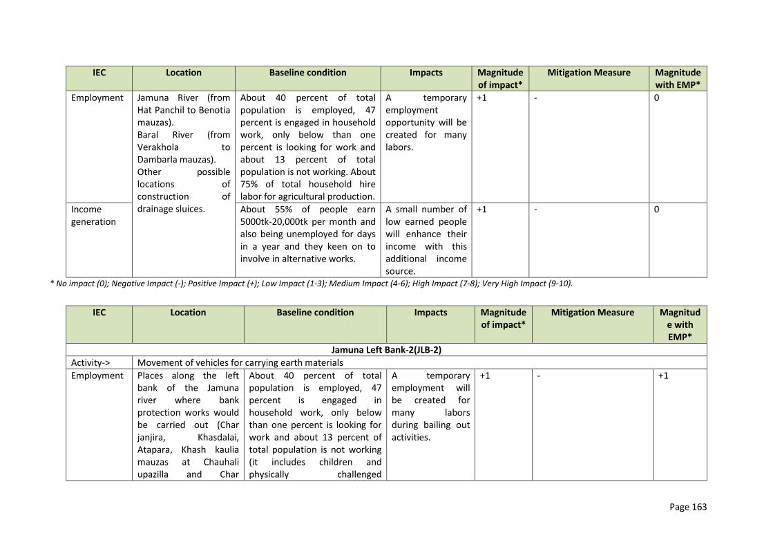
Page 163
IEC Location Baseline condition Impacts Magnitude of impact*
Mitigation Measure Magnitude with EMP*
Employment Jamuna River (from Hat Panchil to Benotia mauzas). Baral River (from Verakhola to Dambarla mauzas). Other possible locations of construction of drainage sluices.
About 40 percent of total population is employed, 47 percent is engaged in household work, only below than one percent is looking for work and about 13 percent of total population is not working. About 75% of total household hire labor for agricultural production.
A temporary employment opportunity will be created for many labors.
+1 - 0
Income generation
About 55% of people earn 5000tk-20,000tk per month and also being unemployed for days in a year and they keen on to involve in alternative works.
A small number of low earned people will enhance their income with this additional income source.
+1 - 0
* No impact (0); Negative Impact (-); Positive Impact (+); Low Impact (1-3); Medium Impact (4-6); High Impact (7-8); Very High Impact (9-10).
IEC Location Baseline condition Impacts Magnitude of impact*
Mitigation Measure Magnitude with EMP*
Jamuna Left Bank-2(JLB-2)
Activity-> Movement of vehicles for carrying earth materials
Employment Places along the left bank of the Jamuna river where bank protection works would be carried out (Char janjira, Khasdalai, Atapara, Khash kaulia mauzas at Chauhali upazilla and Char
About 40 percent of total population is employed, 47 percent is engaged in household work, only below than one percent is looking for work and about 13 percent of total population is not working (it includes children and physically challenged
A temporary employment will be created for many labors during bailing out activities.
+1 - +1
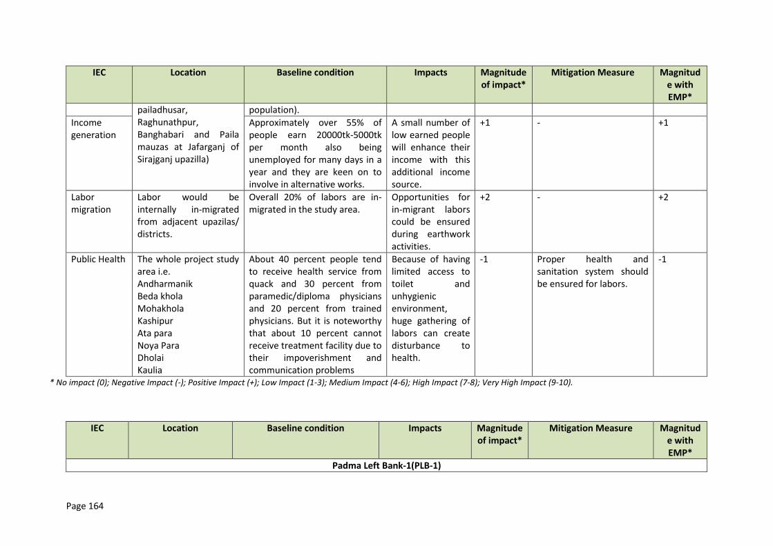
Page 164
IEC Location Baseline condition Impacts Magnitude of impact*
Mitigation Measure Magnitude with EMP*
pailadhusar, Raghunathpur, Banghabari and Paila mauzas at Jafarganj of Sirajganj upazilla)
population).
Income generation
Approximately over 55% of people earn 20000tk-5000tk per month also being unemployed for many days in a year and they are keen on to involve in alternative works.
A small number of low earned people will enhance their income with this additional income source.
+1 - +1
Labor migration
Labor would be internally in-migrated from adjacent upazilas/ districts.
Overall 20% of labors are in-migrated in the study area.
Opportunities for in-migrant labors could be ensured during earthwork activities.
+2 - +2
Public Health The whole project study area i.e. Andharmanik Beda khola Mohakhola Kashipur Ata para Noya Para Dholai Kaulia
About 40 percent people tend to receive health service from quack and 30 percent from paramedic/diploma physicians and 20 percent from trained physicians. But it is noteworthy that about 10 percent cannot receive treatment facility due to their impoverishment and communication problems
Because of having limited access to toilet and unhygienic environment, huge gathering of labors can create disturbance to health.
-1 Proper health and sanitation system should be ensured for labors.
-1
* No impact (0); Negative Impact (-); Positive Impact (+); Low Impact (1-3); Medium Impact (4-6); High Impact (7-8); Very High Impact (9-10).
IEC Location Baseline condition Impacts Magnitude of impact*
Mitigation Measure Magnitude with EMP*
Padma Left Bank-1(PLB-1)
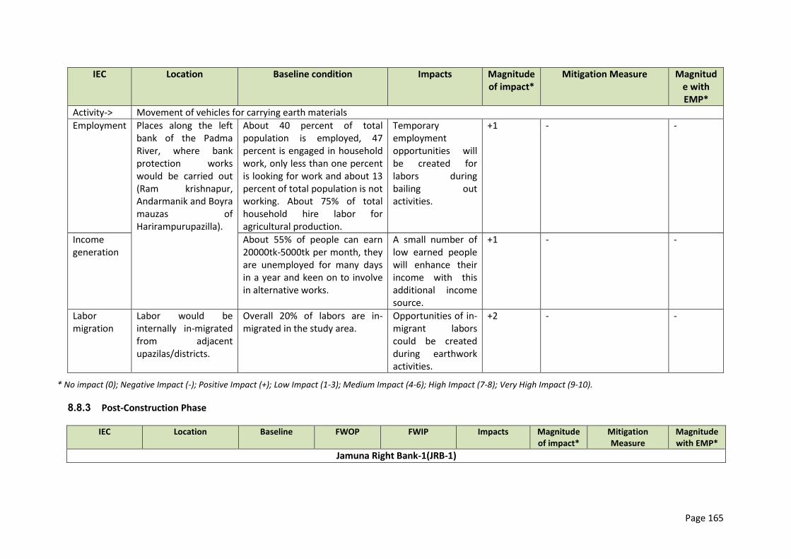
Page 165
IEC Location Baseline condition Impacts Magnitude of impact*
Mitigation Measure Magnitude with EMP*
Activity-> Movement of vehicles for carrying earth materials
Employment Places along the left bank of the Padma River, where bank protection works would be carried out (Ram krishnapur, Andarmanik and Boyra mauzas of Harirampurupazilla).
About 40 percent of total population is employed, 47 percent is engaged in household work, only less than one percent is looking for work and about 13 percent of total population is not working. About 75% of total household hire labor for agricultural production.
Temporary employment opportunities will be created for labors during bailing out activities.
+1 - -
Income generation
About 55% of people can earn 20000tk-5000tk per month, they are unemployed for many days in a year and keen on to involve in alternative works.
A small number of low earned people will enhance their income with this additional income source.
+1 - -
Labor migration
Labor would be internally in-migrated from adjacent upazilas/districts.
Overall 20% of labors are in-migrated in the study area.
Opportunities of in-migrant labors could be created during earthwork activities.
+2 - -
* No impact (0); Negative Impact (-); Positive Impact (+); Low Impact (1-3); Medium Impact (4-6); High Impact (7-8); Very High Impact (9-10).
8.8.3 Post-Construction Phase
IEC Location Baseline FWOP FWIP Impacts Magnitude of impact*
Mitigation Measure
Magnitude with EMP*
Jamuna Right Bank-1(JRB-1)
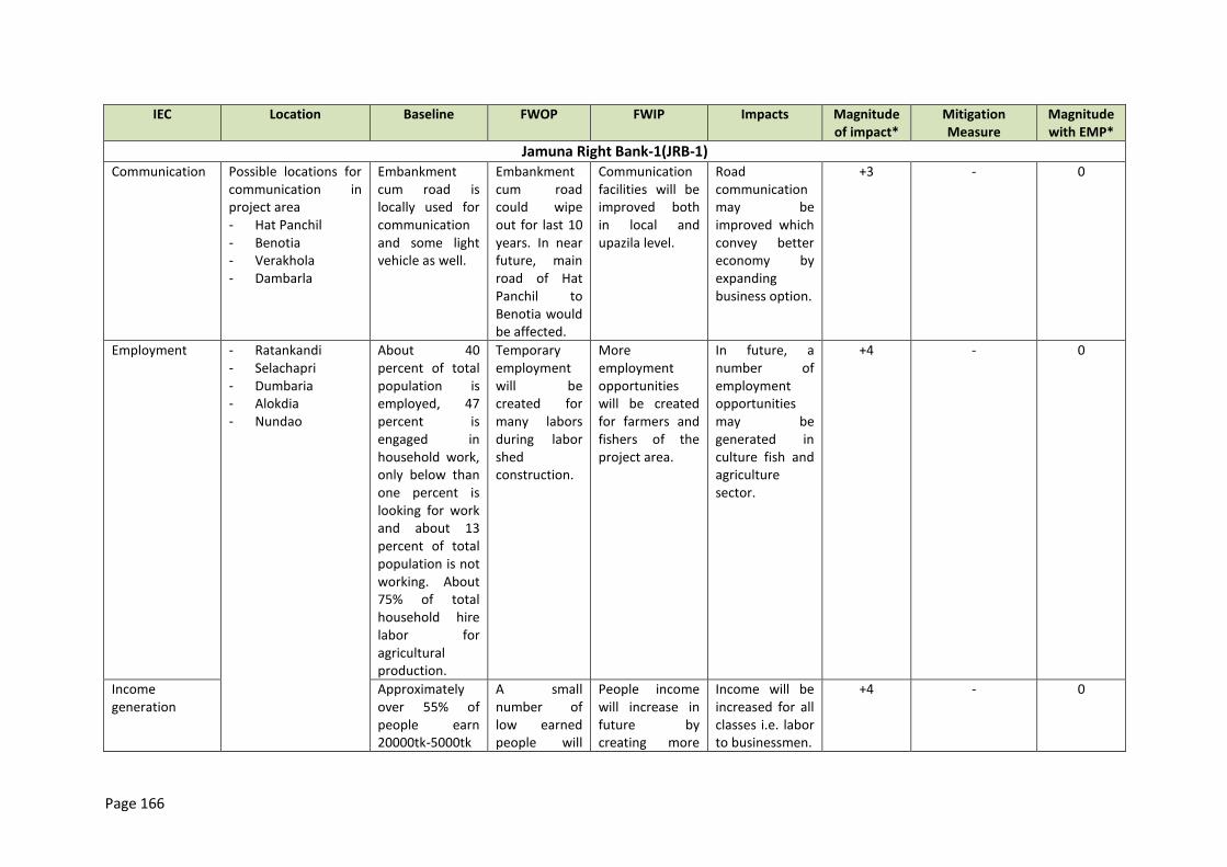
Page 166
IEC Location Baseline FWOP FWIP Impacts Magnitude of impact*
Mitigation Measure
Magnitude with EMP*
Jamuna Right Bank-1(JRB-1) Communication Possible locations for
communication in project area - Hat Panchil - Benotia - Verakhola - Dambarla
Embankment cum road is locally used for communication and some light vehicle as well.
Embankment cum road could wipe out for last 10 years. In near future, main road of Hat Panchil to Benotia would be affected.
Communication facilities will be improved both in local and upazila level.
Road communication may be improved which convey better economy by expanding business option.
+3 - 0
Employment - Ratankandi - Selachapri - Dumbaria - Alokdia - Nundao
About 40 percent of total population is employed, 47 percent is engaged in household work, only below than one percent is looking for work and about 13 percent of total population is not working. About 75% of total household hire labor for agricultural production.
Temporary employment will be created for many labors during labor shed construction.
More employment opportunities will be created for farmers and fishers of the project area.
In future, a number of employment opportunities may be generated in culture fish and agriculture sector.
+4 - 0
Income generation
Approximately over 55% of people earn 20000tk-5000tk
A small number of low earned people will
People income will increase in future by creating more
Income will be increased for all classes i.e. labor to businessmen.
+4 - 0
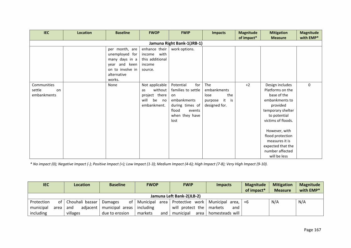
Page 167
IEC Location Baseline FWOP FWIP Impacts Magnitude of impact*
Mitigation Measure
Magnitude with EMP*
Jamuna Right Bank-1(JRB-1) per month, are unemployed for many days in a year and keen on to involve in alternative works.
enhance their income with this additional income source.
work options.
Communities settle on embankments
None Not applicable as without project there will be no embankment.
Potential for families to settle on embankments during times of flood events when they have lost
The embankments lose the purpose it is designed for.
+2 Design includes Platforms on the
base of the embankments to
provided temporary shelter
to potential victims of floods.
However, with
flood protection measures it is
expected that the number affected
will be less
0
* No impact (0); Negative Impact (-); Positive Impact (+); Low Impact (1-3); Medium Impact (4-6); High Impact (7-8); Very High Impact (9-10).
IEC Location Baseline FWOP FWIP Impacts Magnitude of impact*
Mitigation Measure
Magnitude with EMP*
Jamuna Left Bank-2(JLB-2)
Protection of municipal area including
Chouhali bazaar and adjacent villages
Damages of municipal areas due to erosion
Municipal area including markets and
Protective work will protect the municipal area
Municipal area, markets and homesteads will
+6 N/A N/A
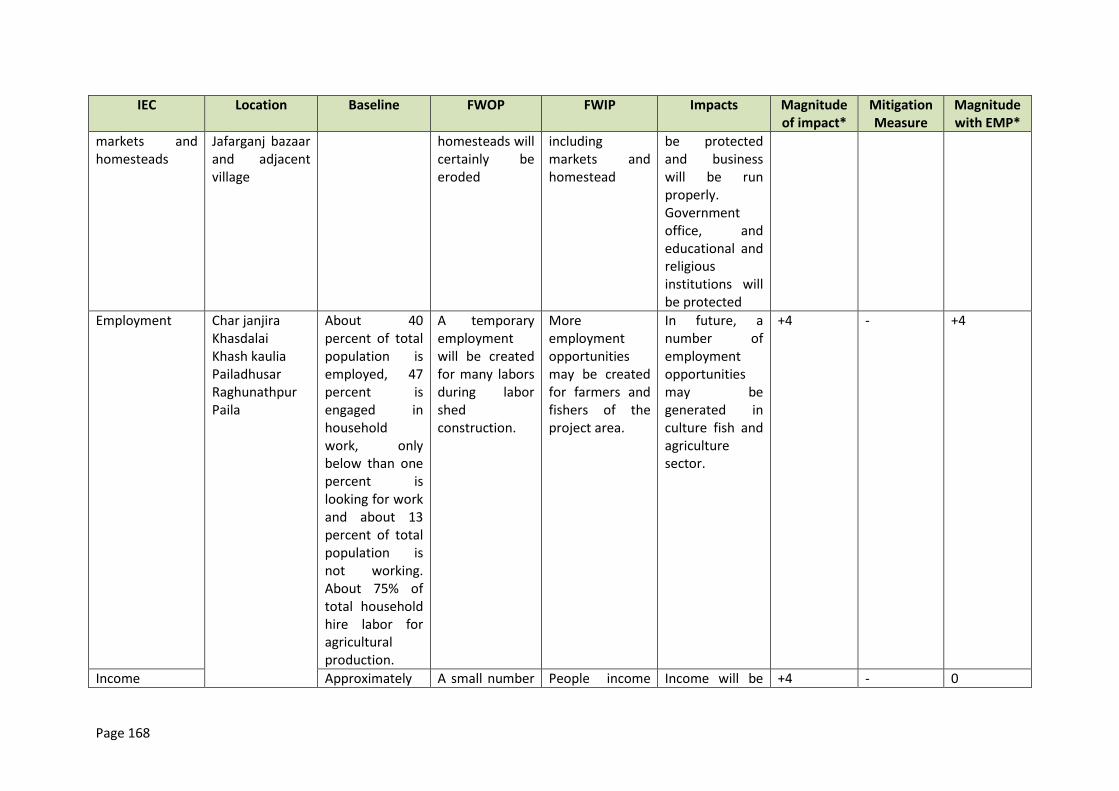
Page 168
IEC Location Baseline FWOP FWIP Impacts Magnitude of impact*
Mitigation Measure
Magnitude with EMP*
markets and homesteads
Jafarganj bazaar and adjacent village
homesteads will certainly be eroded
including markets and homestead
be protected and business will be run properly. Government office, and educational and religious institutions will be protected
Employment Char janjira Khasdalai Khash kaulia Pailadhusar Raghunathpur Paila
About 40 percent of total population is employed, 47 percent is engaged in household work, only below than one percent is looking for work and about 13 percent of total population is not working. About 75% of total household hire labor for agricultural production.
A temporary employment will be created for many labors during labor shed construction.
More employment opportunities may be created for farmers and fishers of the project area.
In future, a number of employment opportunities may be generated in culture fish and agriculture sector.
+4 - +4
Income Approximately A small number People income Income will be +4 - 0
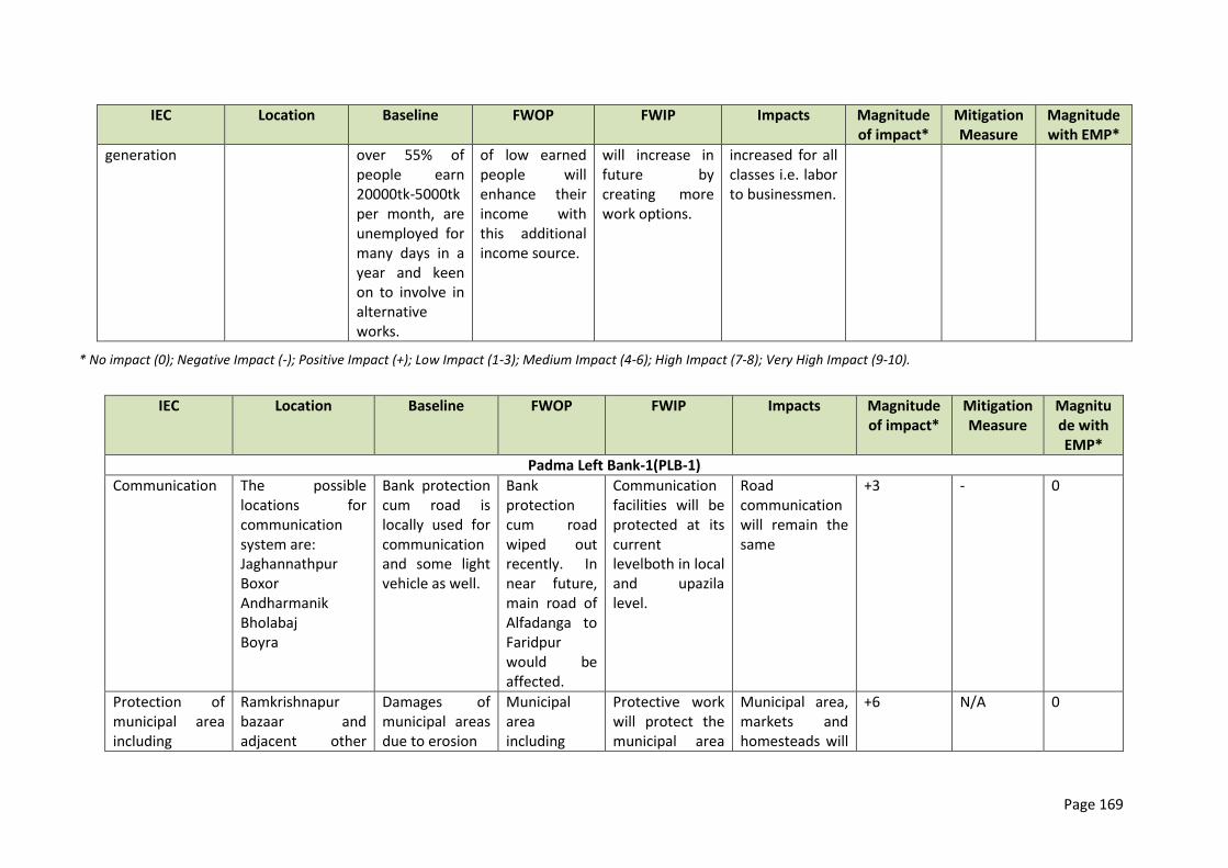
Page 169
IEC Location Baseline FWOP FWIP Impacts Magnitude of impact*
Mitigation Measure
Magnitude with EMP*
generation over 55% of people earn 20000tk-5000tk per month, are unemployed for many days in a year and keen on to involve in alternative works.
of low earned people will enhance their income with this additional income source.
will increase in future by creating more work options.
increased for all classes i.e. labor to businessmen.
* No impact (0); Negative Impact (-); Positive Impact (+); Low Impact (1-3); Medium Impact (4-6); High Impact (7-8); Very High Impact (9-10).
IEC Location Baseline FWOP FWIP Impacts Magnitude of impact*
Mitigation Measure
Magnitude with EMP*
Padma Left Bank-1(PLB-1)
Communication The possible locations for communication system are: Jaghannathpur Boxor Andharmanik Bholabaj Boyra
Bank protection cum road is locally used for communication and some light vehicle as well.
Bank protection cum road wiped out recently. In near future, main road of Alfadanga to Faridpur would be affected.
Communication facilities will be protected at its current levelboth in local and upazila level.
Road communication will remain the same
+3 - 0
Protection of municipal area including
Ramkrishnapur bazaar and adjacent other
Damages of municipal areas due to erosion
Municipal area including
Protective work will protect the municipal area
Municipal area, markets and homesteads will
+6 N/A 0
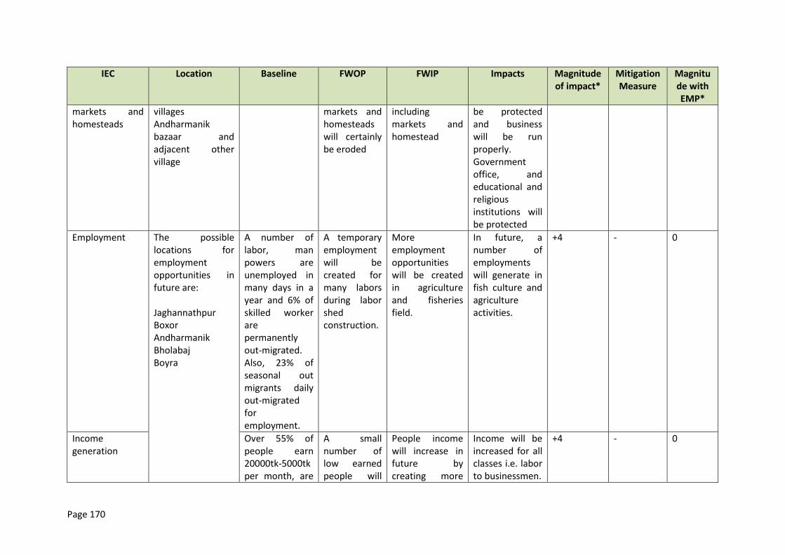
Page 170
IEC Location Baseline FWOP FWIP Impacts Magnitude of impact*
Mitigation Measure
Magnitude with EMP*
markets and homesteads
villages Andharmanik bazaar and adjacent other village
markets and homesteads will certainly be eroded
including markets and homestead
be protected and business will be run properly. Government office, and educational and religious institutions will be protected
Employment The possible locations for employment opportunities in future are: Jaghannathpur Boxor Andharmanik Bholabaj Boyra
A number of labor, man powers are unemployed in many days in a year and 6% of skilled worker are permanently out-migrated. Also, 23% of seasonal out migrants daily out-migrated for employment.
A temporary employment will be created for many labors during labor shed construction.
More employment opportunities will be created in agriculture and fisheries field.
In future, a number of employments will generate in fish culture and agriculture activities.
+4 - 0
Income generation
Over 55% of people earn 20000tk-5000tk per month, are
A small number of low earned people will
People income will increase in future by creating more
Income will be increased for all classes i.e. labor to businessmen.
+4 - 0
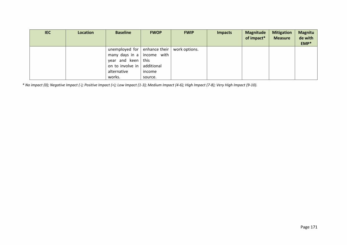
Page 171
IEC Location Baseline FWOP FWIP Impacts Magnitude of impact*
Mitigation Measure
Magnitude with EMP*
unemployed for many days in a year and keen on to involve in alternative works.
enhance their income with this additional income source.
work options.
* No impact (0); Negative Impact (-); Positive Impact (+); Low Impact (1-3); Medium Impact (4-6); High Impact (7-8); Very High Impact (9-10).

Page 172
8.9 Summary of anticipated environmental Impacts and Mitigation Measures
8.9.1 JRB-1 Flood Embankment Potential Impacts
357. The reconstructed Brahmaputra Right Embankment29 along the Jamuna and rehabilitated flood embankment works along the Hurashagar/Baral included in JRB-1 could have adverse impacts on the floodplain water resources. Residual adverse impacts from the JRB-1 embankment are a possibility, and contribute to the rationale for the classification of Tranche 1 as ADB environmental category A.
358. The primary and intended impact of the JRB-1 flood embankments is to reduce flood damage to crops and infrastructure, and to induce greater economic investment and productivity in floodplain agriculture and other activities by reducing flood risk. Figure 8.1 shows the modeled effect of the JRB-1 embankment works on water levels behind the embankment (the difference between with-project and without-project water levels) for 2003 river flood levels which approximate the 1:2 year return period flood.
359. The land type changes induced by the embankment are shown inTable 8.1, Figure 8.2, and Figure 8.3. Currently, JRB-1 seasonally flooded land (ie within the proposed flood-protected area) consists of 12,000 ha that is flooded to 120-360 cm (F3 land type) and 4,000 ha that is deeply flooded to >360 cm (F4 land type). Of this, JRB-1 will transform about 40 per cent (6,600 ha) to flood-free conditions (F0 land type, 0-30 cm). Another 10 per cent (1900 ha) will be converted to moderately-flooded conditions (F1 and F2 land types, 30-120 cm). These hydrologic changes within the proposed JRB-1 flood-protected area have numerous potential secondary impacts. Intended beneficial impacts are significantly reduced flood damage to agriculture and infrastructure; increased cultivated area and cropping intensity and the resulting increases in agriculture / aquaculture production.
Table 8.1: JRB-1 Impacts on Land Type
Pre and Post Project Change (post-pre)
F0 0-30 cm
F1 30-90 cm
F2 90-120 cm
F3 120-360 cm
F4 >360 cm
Total
(ha) Pre 12673 117 2313 12024 3825 30952 Post 19315 1116 3177 5319 2178 31105 Change 6642 999 864 -6705 -1647 153 % change 52% 854% 37% -56% -43% 0%
Notes: Land type areas are taken from the flood modelling of the area enclosed by the embankments, for the
2003 flood event, adjusted to reflect RADARSAT flood extent information. 2003 was chosen to approximate
the average moderate bonna 1:2 flood event.
Source: Tables 5-3 and 5-4, Final Report, Annex D – Flood Modelling (revision 13 dated 21 June).
29
This embankment eroded from 1996 onwards after having protected the Hurashagar Flood Control and Drainage Project. The embankment was not rebuilt and progressive erosion lead to a more than 10km wide gap. Since 2009, the JMREMP project protected 10km of riverbank from erosion allowing the reconstruction of the embankment.
Page 173
Figure 8.1: Effect of JRB-1 on Water Levels, 2003 Flood Condition
Page 174
Figure 8.2: JRB-1 Land Type Areas, Pre-Project
Figure 8.3: JRB-1 Land Type Areas, Post-Project
360. Potential adverse impacts of the hydrologic and land type changes described above are diverse. Floodplain aquatic (wetland) habitats will be degradated or extirpated due to reduced flooded area, depth, and duration (mentioned above); reduced hydrologic connectivity; and physiochemical / water quality changes. This in turn will adversely affect floodplain-dependent
openwater fish species migration, population levels, and catch levels30, as well as wetland biodiversity, services, and products more generally. Wetland products (mostly fish and aquatic plants) in Bangladesh have been documented to be worth as much as US$650/ha.31 This production
30
The project team estimates the loss of 15.3MT in capture fish production (see Chapter 8) 31
Thompson, Paul M. (2008). Conserving and Restoring the Benefits from Bangladesh Wetlands. Presented at the 12th Biennial Conference of the International Association for the Study of Commons - Governing Shared Resources: Connecting
Page 175
will be lost where more deeply-flooded F3-F4 land is converted to F0-F2 higher land types. However, the loss of open water fisheries will be compensated by the increase in culture fisheries, resulting in a net gain in fish production. The embankment can impede cross-drainage (drainage congestion), adversely affecting agriculture within the protected area, and blocking the movement of migrating fish. A number of sluice gates will reduce the risk of drainage congestion and allow some cross movement of fish during the migration season.
361. The loss of floodplain fisheries will be further mitigated through a program enhancing wetland biodiversity and aquaculture (please refer Annex 14). The program will be implemented through a specialist NGO and supervised through the Department of Fishereis (DOF). Vulnerable groups, specifically the poor, project affected people, and women will be given preference in these activities.The overall status of fish migration in the study area is moderate to poor (refer to chapter 5.6.3) while the project design includes a number of additional sluice gates/regulators (refer to table 4.4). Both facts and in addition the positive effect of the existing geobag revetment on small fish somewhat reduce the impact of the embankment construction on migratory fish or carnivorous fish species depending on them. The more concentrated migration route through the Hurashagar/Baral tributary is not blocked.
362. Flood-control-led expansion of high-yielding varieties (HYVs) may increase utilization of ground water and surface water for irrigation and may increase fertilizer and pesticide usage that in turn may adversely affect water quality and availability for other uses or at other locations. Newly flood-free lands may have less than optimal residual moisture for winter agriculture, compromising yields or causing high irrigation water consumption and costs in these areas. Given the close vicinity to the Jamuna on one side and its tributaries Hurashagar/Baral and Karakoya combined with generally permeable, sandy soil sub-strata, there are little risk of depleting the groundwater table significantly. In order to reduce the amount of fertilizer and pesticides integrated crop and pest management measures, part of the program of the Department of Agricultural Extension (DAE) will be encouraged.
363. Provision of embankment flood protection typically stimulates accelerated investment in the protected area. This project-induced investment has obvious economic benefits but paradoxically it also has less obvious costs: over time, an increasing amount of infrastructure and potentially an increasing number of lives, come to be located in lower-lying areas compared to the without-project situation.32 Embankments can greatly reduce but not entirely eliminate the flood risk to such areas, as embankments can fail for various operational, hydrologic, hydraulic, and geotechnical reasons.33
364. Best-practice flood damage reduction assessment methodologies address the residual risk of embankment failures34. The feasibility level designs studied different special risks, such as earthquake, pore over-pressure due to repid draw-down at the end of the flood season, and the risk of seepage. The embankment width and side slopes were designed to withstand the loads to be expected. As such the feasibility level design of the embankments accounts for technical regulations in effect in Bangladesh and common engineering practice world-wide and assures that the embankments do not fail for the design loads. In addition, an extensive community-based flood risk management program addresses the residual risk in developing volunteer groups that support enhanced awareness and preparedness to the flood risk.
Local Experience to Global Challenges, University of Gloucestershire, UK.
http://iasc2008.glos.ac.uk/conference%20papers/papers/T/Thompson_220701.pdf 32
Whipple, William. 1969. “Optimizing Investment in Flood Control and Floodplain Zoning.” Water Resources Research 5 (4) (August): 761–766. doi:10.1029/WR005i004p00761. 33
National Research Council. 2000. Risk Analysis and Uncertainty in Flood Damage Reduction Studies. Washington DC: Committee on Risk-Based Analysis for Flood Damage Reduction, Water Science and Technology Board. National
Academies Press. http://www.nap.edu/catalog.php?record_id=9971, p. 51. 34
Mori, Koichiro, and Charles Perrings. 2012. “Optimal Management of the Flood Risks of Floodplain Development.” Science of The Total Environment 431 (August): 109–121. doi:10.1016/j.scitotenv.2012.04.076.
Page 176
8.9.2 JRB-1, JLB-2, and PLB-1 Riverbank Protection Works Potential Impacts
365. Riverbank protection works at the three subproject sites has the purpose of protecting the existing floodplain habitat from constinuous and systematic erosion. The Jamuna has widened by around 4km from 1973 to 2013 mostly as a consequence of the sediment wave triggered by the Great Assam Earthquake in August 1950. This sediment wave has changed the river environment, characterized by one or two pronounced deep channels to a multitude of shallower channels, many falling dry during the dry season.
366. Specific changes associated with Tranch 1 riverbank protection work were assessed through a specific morphology study carried out as part of this feasibility study. The morphology study concludes that the initial (Tranche-1) riverbank protection works has little impact on the overall morphology of the Jamuna, including the immediate downstream areas and are found to be minor in terms of morphological impact. In all cases the riverbank protection work encourages deeper channels along the protected bank but with expected little impact on downstream areas.
367. The morphology study also assessed future potential channel options to assess if the riverbank protection conflicts with the natural established channel pattern currently observed. The non-symetric Jamuna Bridge has substantially changed the lower part of the river, creating a large attached char at the right bank from the western bridge abutment to about Enayetpur, and resulted in a single channel in this reach, which is expected to remain stable without riverbank protection at both sides. Downstream, the river exhibits two channels, enclosing a large char. The initial morphological assessment indicates that this currently existing channel pattern is likely the most desirable for the future, meaning that the overall natural river pattern will not be altered by the proposed interventions. The same holds true for the situation in the upper Padma River, where the two-channel solution appears to be the best in the long run, also meaning that the existing conditions would not be altered and the riverbank protection would support the currently existing natural river pattern.
368. The consequence of the transformation of the river environment on the habitat was not systematically studied. Not much is know about the impact on the biodiversity of the conversion of a river characterized by few deep channels to a multitude of shallow channels. Furthermore, this development is superimposed by dramatic population growth (from around 70million to 150 million) with increasingly intensifying land use on the flood plains but also systematic fishing in the rivers using floating nets in the main ones. Fish specialists indicate that the total fish population has decreased over time.
369. First attempst have been made to assess the impact of riverbank protection on fish35. The JMREMP, 2007 study found that there were more fish species and higher population numbers at protected banks, as opposed to unprotected banks. The size of the fish depends on the size of the voids in the protection, which means that large voids in concrete blocks tend to attrackt larger fish, specifically carnivores, however in fewer numbers; while geobag revetments attract smaller fish in larger numbers. CEGIS, 2011 identified overall positive impacts of geotextile bag revetements on water resources, fisheries, the algae community, the ecosystem and the socio-economy. Important findings are that there is no change in water quality, the terrestrial habitat is protected, and the scocio-economic conditions are improved for the local population, providing employment opportunities during construction, health and sanitation conditions, fishing opportunities, and especially improving the situation of mostly home-bound women. Geotextile bag revetments might change the composition of fish species, alter the habitat of the bethic community, as well as cause local shifting of the migratory routes of the dolphins36 during construction. However, these effects
35
JMREMP; 2007. Bank Protection and Fisheries at JMREMP two Sub-projects. Dr. Munir Ahmed, Special Report 24, May. CEGIS, 2011: Final Report on Environment Impact Assessment (EIA) for Use of Sand-filled Geob-Bags Under Water 36
Dolphins normally chose the thalweg, i.e. the deeper part of the river for migration
Page 177
are reversible and the constructed revetments do not impact on thefree movement of dolphins and the benthic habitat is quickly restored over geobag revetments.
370. With respect to the overall use of the recommended riverbank protection technology, CEGIS 2011 concludes: Considering all environmental, social and technical consequences of the geobag use under water, it might be concluded that compared with CC block use alone, geo-bag use under water with CC block used above water is more environmentally sustainable, socially acceptable, technically feasible and economically cost effective if the quality requirements and design requirements are assured and monitored.
371. Overall the proposed Tranche-1 riverbank protection of limited length has no siginificant negative impacts on the river but the potential to enhance the biodiversity in places. Locally more stable and deeper channels, as encouraged by riverbank protection, support fish populations. The deeper channels provide a better refugium especially during systematic fishing with floating nets, are more attractive for dolphins which depend on the deeper channels also for migration. The construction season lies outside of the migration season of the dolphins (during the rising and falling of flood waters) and does not overlap much with the surfacing time of the juvenile and neonate dolphins in the morning and afternoon-evening hours. Benthos communities are known to settle on geotextile bags and apart from the disturbance during the dry season construction, when benthos are not active, the inert geobag revetments do not have significant negative impacts on the river. The Program proposes to establish supporting enhancement measures during later tranches by placing navigation buoyage alongside protected riverbanks, which would discourage systematic, wide-scale fishing with floating nets, and to study sanctuary / protected area options.
8.10 Cumulative Impacts
372. Significant cumulative impacts arise (i) if multiple interventions (plus possibly ongoing natural processes) with small impacts affect the same area or system during a particular time period; or (ii) if the (small) instantaneous impacts of one or more interventions persist in a particular area or system over a long period of time (possibly in parallel with ongoing natural processes having similar or related impacts).
373. With regard to (i) above, in the Brahmaputra-Jamuna-Padma channel / floodplain system, there are multiple major riverbank erosion protection, and flood embankment, projects that completed and in the pipeline. These include, in addition to Tranche 1, the completed ADB Jamuna-Meghna River Erosion Management Project; the river engineering and water management works of the Jamuna Bridge Project; the World Bank-funded River Bank Improvement Project (RBIP) that is expected to commence shortly; and), and FRM Tranches 2 and 3. The impacts and influence zones of these projects potentially overlap (cumulate) in space, time, and effects.
374. With regard to (ii) above, river confinement within embankments, and channel stabilization to a fixed channel configuration, both persistently shift water and sediment away from the floodplain. Over longer-term time scales – decades or centuries,– their effects can accumulate.
375. In particular, floodplain land levels may gradually become lower (land subsidence), in areas where the thick delta sediment wedge compacts plus tectonic subsidence proceeds more rapidly than new sediment is deposited at the land surface. Channel bed levels may gradually increase and channels may fill in, in reaches where confined flood waters deposit sediment in-channel, that in unembanked conditions would have been deposited on the floodplain. Eventually, channels can become perched above the floodplain, increasing the risks of flooding, drainage congestion, embankment failure, and, ultimately, channel avulsion.37,38 These adverse impacts can be
37
Goodbred, Steven L, and Steven A Kuehl. 1998. “Floodplain Processes in the Bengal Basin and the Storage of Ganges–Brahmaputra River Sediment: An Accretion Study Using 137Cs and 210Pb Geochronology.” Sedimentary Geology 121 (3-4) (November): 239–258. doi:10.1016/S0037-0738(98)00082-7,.
Page 178
exacerbated if they occur in parallel with climate changes such as increased local or catchment rainfall, or rising sea level for areas where this affects local drainage.
376. Another potential cumulative and intended impact of an ongoing program of riverbank erosion protection works is to control the river widening process. The Brahmaputra-Jamuna-Padma Rivers widened significantly during the period 1950-2000. The cause of this widening is now believed to have been the passage of the 1950 Assam earthquake sediment wave. This sediment wave is thought to have passed, leaving the channel wider than necessary to convey future flows39. The progressive channel narrowing would be achieved as a cumulative impact of multiple river engineering interventions over time that promote land accretion and channel simplification. On the other hand, riverbank protection structures with significant lengths after multiple interventions may triger new erosion on downstream riverbanks. Such downstream impacts by tranche-1 intervention with limited length of bank protections is unlikely to be significant.
377. During Tranche 1 a long term river morphological/stabilization study will be carried out, where impacts of all planned and ongoing projects will be assessed. Environmental assessments to be conducted for Tranches 2 and 3, which will build on the findings of this river morphological/stabilization study, will look at the long-term cumulative impacts of the entire MFF on open water fish species, flood plain aquatic habitats, and wetlands. Regular survey and monitoring of post-construction behaviours of riverbanks and bathymetry around the new bank protection structures are built into the project design. Resuts of surveys and monitoring will also be incorporated in the long-term stabilization study and project design of Tranches 2 and 3. Additional studies to be conducted are listed in paragraph 380.
8.10 Future Mitigation Measures
378. While the tranche-1 project consists of limited riverbank protection measures and the restoration/rehabiliation of an eroded/degraded embankment, future tranches plan to extend these measures. The limited and isolated riverbank protection measures of Tanche-1 do not change the existing channel pattern, as established by the morphololgical study. However, follow on tranches, part of the total program, could do so when existing, initial work gets extended over greater length of some ten kilometers. As such, the proposed Tranche-1 combines construction measures with very limited morphological impact with two extensive studies on (i) potential ways towards larger river-reach stabilization and (ii) the establishment of a river sanctuary.
379. Potential alternative river-reach stabilization alternatives with impacts and mitigation measures will be assessed during Tranche-1 through several systematic studies. During the first two years of Tranche-1 a systematic river stabilization study will be conducted. The river stabilization study will build on the ongoing natural development towards a more consolidated channel pattern. Alternative solutions will be developed how to support this channel pattern towards a more systematic stabilization of the lives on the floodplain. Social and environmental consideratiosn will form an integral part of the study in order to determine the impacts of different stabilization options, but also collect missing data and broaden the understanding about critical social and environmental parameters. The study results are alternative solutions for river-reach stabilization
38
Pickering, Jennifer L. 2013. “Late Quaternary Sedimentary Record of Holocene Channel Avulsions of The Brahmaputra River In The Upper Bengal Delta Plain”. Master thesis, Tennesee USA: Vanderbilt University 39
Sarker, Maminul Haque, and Colin R. Thorne. 2006. “Morphological Response of the Brahmaputra–Padma–Lower Meghna River System to the Assam Earthquake of 1950.” In Braided Rivers, edited by Gregory H. Sambrook Smith, James L. Best, Charlie S. Bristow, and Geoff E. Petts, 289–310. Oxford, UK: Blackwell Publishing Ltd. doi:10.1002/9781444304374.ch14.
Page 179
that accounts for the multitude of different drivers, outline least-impact solutions, identify the optimimal alternative, and design the following tranche work.
380. Starting from there, the feasibility study for tranche-1, continaing environmental assessment, will be supplanted by by a specialist sanctuary study that details the requirements for a river sanctuary in response to negative impacts from river stabilization. The outline ToR and time frame for implementation is provided in Annex 12. The sanctuary study is part of the Tranche-1 design and scheduled for implementation during year-3 and 4. It will specifically address impacts on critical habitats and trans-boundary/internationally migrating/threatened species, following (i) the Padma Bridge Project terms of reference for biodiversity baseline studies and monitoring, and a biodiversity sanctuary; and (ii) India’s recently-promulgated Dolphin conservation action plan, as well as (iii) assessing migratory bird impacts.
381. Building on the outcome (recommended approach) of the river stabilization study, a river sanctuary study is part of the Tranche-1 design, to be conducted in year 3 and 4 by a specialist firm/NGO. This study will plan a river sanctuary that mitigates all identified negative impacts of river stabilization and additionally attempts to enhance the river biodiversity, specifically providing sheltered aquatic habitats. In addition to this study, the program design for Tranche-2 already contains an element of enhancing the aquatic environment along protected banks
382. The environmental assessment for Tranche-2, part of the feasibility study continues the aggressively mainstreamed environmental aspects into the project design. In addition, the EIA will follow a parallel approach to (i) address remaining uncertainties associated with the database on the impacts of riverbank protection on the river habitat including migratory species, while (ii) continuing to reduce the imminent erosion risk to the livelihoods of a large number of mostly poor people on the floodplain.
Page 180
9. Analysis of Alternatives
383. The three sub-reaches selected for FRERMIP physical works– JRB-1, JLB-2, and PLB-1 – were chosen from 13 sub-reaches into which the FRERMIP project area was divided based on discussions among BWDB, ADB, and the PPTA consultant. These 13 were evaluated using a multi-criteria assessment approach taking into consideration three primary criteria (riverbank erosion, flooding, and poverty) and several secondary criteria (related to planning, design, cost-benefit, and safeguards issues) (refer to Annex 10). Of the six sub-reaches scoring highest40, three were screened out due to a lack of active erosion and/or conflicts with other immediately planned interventions.
384. While riverbank protection was placed according to immediate needs especially for growth centers (“something to defend”), embankment construction considered alternatives especially for the areas JLB-2 and PLB-1. BWDB contemplates the establishment of two polders (ring-embankments) covering large parts o JLB-2 and PLB-1 with very long ring embankment lines. These were compared to the solution of an embankment only along the riverbanks of the main rivers, reducing the length of the embankments and as such minimizing the footprint and related land acquisition and resettlement. In addition, open distributaries would allow all-year-round water flow to the area, which specifically enhances the dry season water management41.
40
The highest ranking sites scored between 300 and 370 points, while the lower ranking sites ranged between 200 and 260 points. 41
Annex D of the feasibility study, “River and Charland Morphology and River Engineering” provides more background.
Page 181
10. Environmental Management Plan
385. In the previous chapter, the possible impacts for each selected Important Environmental Component (IEC) have been assessed and evaluated. In addition to that, a number of mitigation measures have been mentioned for the negative impacts only. This chapter depicts a detail elaboration of the Environmental Management Plan (EMP) suggested by the study team. The EMP entails mitigation measures for the negative impacts, enhancement measures for the positive impacts, compensation for the non-mitigated impacts and contingency measures for the accidental events that might occur.
386. The EMP has been organized per site and distinguishing pre-construction, construction, and post-construction phase, to facilitate the monitoring process.
387. Impacts and mitigation measures broadly cover the three topics: (i) construction, (ii) biodiversity and (iii) aquaculture. Most construction related impacts are mitigated by contractors during construction. Issues pertaining to biodiversity and aquaculture, especially related to the construction of the embankment at JRB-1 will be implemented through a specialist NGO, following the principles established by the biodiversity program of GIZ at Pabna, now extended to Sirajganj, and as part of the livelihood program of the resettlement plan. In addition, aquaculature will be supported to compensate for the loss of openwater fisheries on the floodplain after the construction of the embankment at JRB-1. Aquaculture has a strong relevance for the poor and is part of the livelihood component of the resettlement plan, which is a separate compensation mechanism.
388. In addition to mitigating direct impacts of the tranche-1 work, a specialist firm/NGO will be retained to study the establishment of a river sanctuary, in accordance with future (Tranche-2 and Tranche-3) stabilization plans, looking beyond the localized Tranche-1 measures and aiming at identifying and mitigating any impacts from larger scale river-reach stabilization during Tranche-2 and Tranche-3.
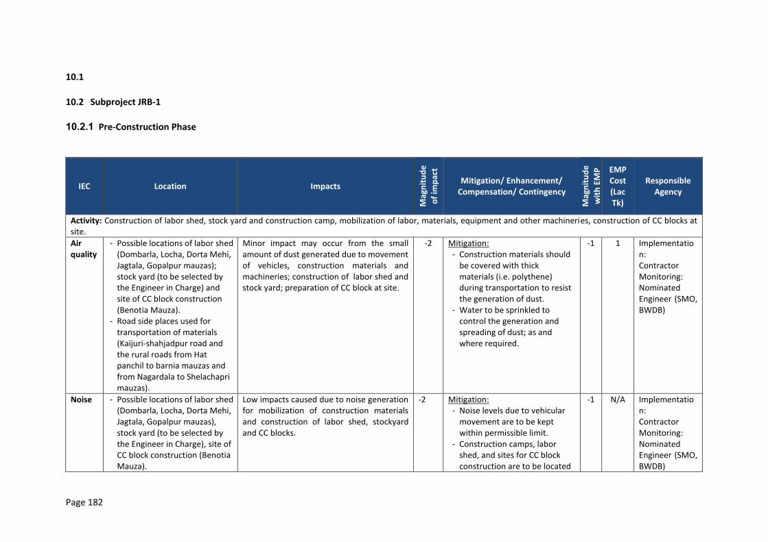
Page 182
10.1
10.2 Subproject JRB-1
10.2.1 Pre-Construction Phase
IEC Location Impacts
Mag
nit
ud
e
of
imp
act
Mitigation/ Enhancement/ Compensation/ Contingency
Mag
nit
ud
e
wit
h E
MP
EMP Cost (Lac Tk)
Responsible Agency
Activity: Construction of labor shed, stock yard and construction camp, mobilization of labor, materials, equipment and other machineries, construction of CC blocks at site.
Air quality
- Possible locations of labor shed (Dombarla, Locha, Dorta Mehi, Jagtala, Gopalpur mauzas); stock yard (to be selected by the Engineer in Charge) and site of CC block construction (Benotia Mauza).
- Road side places used for transportation of materials (Kaijuri-shahjadpur road and the rural roads from Hat panchil to barnia mauzas and from Nagardala to Shelachapri mauzas).
Minor impact may occur from the small amount of dust generated due to movement of vehicles, construction materials and machineries; construction of labor shed and stock yard; preparation of CC block at site.
-2 Mitigation: - Construction materials should
be covered with thick materials (i.e. polythene) during transportation to resist the generation of dust.
- Water to be sprinkled to control the generation and spreading of dust; as and where required.
-1 1 Implementation: Contractor Monitoring: Nominated Engineer (SMO, BWDB)
Noise - Possible locations of labor shed (Dombarla, Locha, Dorta Mehi, Jagtala, Gopalpur mauzas), stock yard (to be selected by the Engineer in Charge), site of CC block construction (Benotia Mauza).
Low impacts caused due to noise generation for mobilization of construction materials and construction of labor shed, stockyard and CC blocks.
-2 Mitigation: - Noise levels due to vehicular
movement are to be kept within permissible limit.
- Construction camps, labor shed, and sites for CC block construction are to be located
-1 N/A Implementation: Contractor Monitoring: Nominated Engineer (SMO, BWDB)
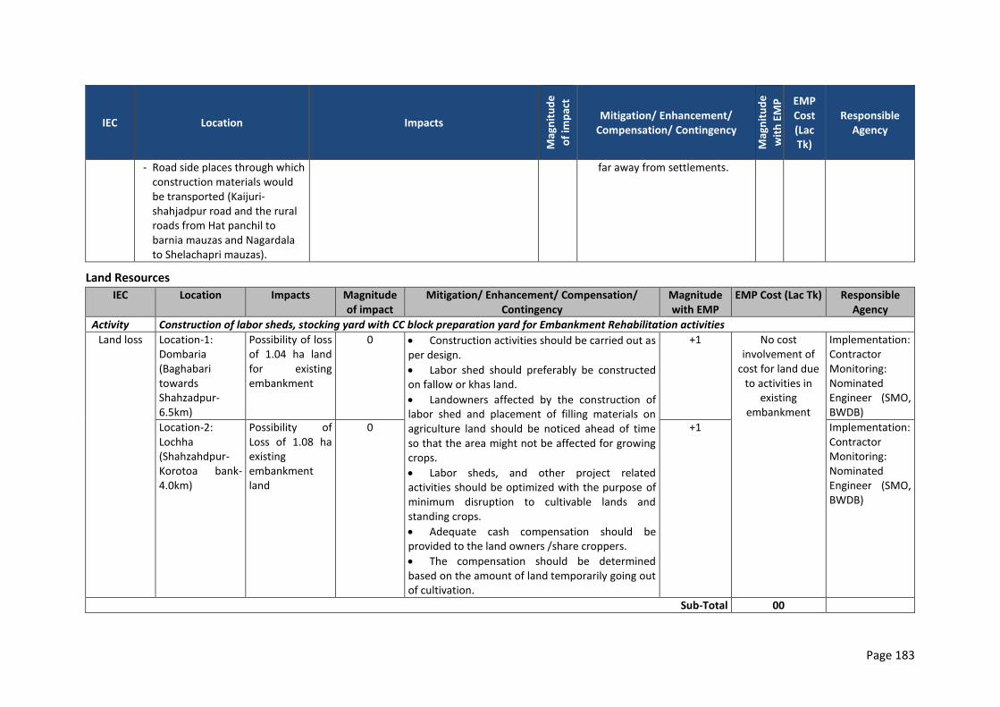
Page 183
IEC Location Impacts
Mag
nit
ud
e
of
imp
act
Mitigation/ Enhancement/ Compensation/ Contingency
Mag
nit
ud
e
wit
h E
MP
EMP Cost (Lac Tk)
Responsible Agency
- Road side places through which construction materials would be transported (Kaijuri-shahjadpur road and the rural roads from Hat panchil to barnia mauzas and Nagardala to Shelachapri mauzas).
far away from settlements.
Land Resources
IEC Location Impacts Magnitude of impact
Mitigation/ Enhancement/ Compensation/ Contingency
Magnitude with EMP
EMP Cost (Lac Tk) Responsible Agency
Activity Construction of labor sheds, stocking yard with CC block preparation yard for Embankment Rehabilitation activities
Land loss Location-1: Dombaria (Baghabari towards Shahzadpur-6.5km)
Possibility of loss of 1.04 ha land for existing embankment
0 Construction activities should be carried out as per design.
Labor shed should preferably be constructed on fallow or khas land.
Landowners affected by the construction of labor shed and placement of filling materials on agriculture land should be noticed ahead of time so that the area might not be affected for growing crops.
Labor sheds, and other project related activities should be optimized with the purpose of minimum disruption to cultivable lands and standing crops.
Adequate cash compensation should be provided to the land owners /share croppers.
The compensation should be determined based on the amount of land temporarily going out of cultivation.
+1 No cost involvement of
cost for land due to activities in
existing embankment
Implementation: Contractor Monitoring: Nominated Engineer (SMO, BWDB)
Location-2: Lochha (Shahzahdpur-Korotoa bank-4.0km)
Possibility of Loss of 1.08 ha existing embankment land
0 +1 Implementation: Contractor Monitoring: Nominated Engineer (SMO, BWDB)
Sub-Total 00
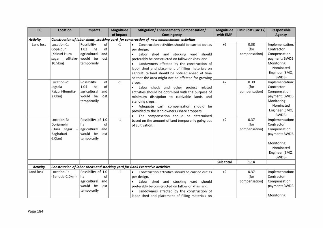
Page 184
IEC Location Impacts Magnitude of impact
Mitigation/ Enhancement/ Compensation/ Contingency
Magnitude with EMP
EMP Cost (Lac Tk) Responsible Agency
Activity Construction of labor sheds, stocking yard for construction of new embankment activities
Land loss Location-1: Gopalpur (Kaizuri-Hura sagar offtake-10.5km)
Possibility of 1.02 ha of agricultural land would be lost temporarily
-1 Construction activities should be carried out as per design.
Labor shed and stocking yard should preferably be constructed on fallow or khas land.
Landowners affected by the construction of labor shed and placement of filling materials on agriculture land should be noticed ahead of time so that the area might not be affected for growing crops.
Labor sheds and other project related activities should be optimized with the purpose of minimum disruption to cultivable lands and standing crops.
Adequate cash compensation should be provided to the land owners /share croppers.
The compensation should be determined based on the amount of land temporarily going out of cultivation.
+2 0.38 (for
compensation)
Implementation: Contractor Compensation payment: BWDB Monitoring:
Nominated Engineer (SMO,
BWDB)
Location-2: Jagtala Kaizuri-Benotia-2.0km)
Possibility of 1.04 ha of agricultural land would be lost temporarily
-1 +2 0.39 (for
compensation)
Implementation: Contractor Compensation payment: BWDB Monitoring:
Nominated Engineer (SMO,
BWDB)
Location-3: Doriamehi (Hura sagar –Baghabari-6.0km)
Possibility of 1.0 ha of agricultural land would be lost temporarily
-1 +2 0.37 (for
compensation)
Implementation: Contractor Compensation payment: BWDB Monitoring:
Nominated Engineer (SMO,
BWDB)
Sub total 1.14
Activity Construction of labor sheds and stocking yard for Bank Protective activities
Land loss Location-1: (Benotia-2.0km)
Possibility of 1.0 ha of agricultural land would be lost temporarily
-1 Construction activities should be carried out as per design.
Labor shed and stocking yard should preferably be constructed on fallow or khas land.
Landowners affected by the construction of labor shed and placement of filling materials on
+2 0.37 (for
compensation)
Implementation: Contractor Compensation payment: BWDB Monitoring:
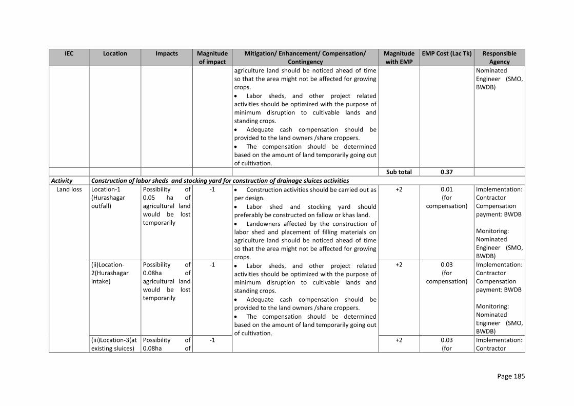
Page 185
IEC Location Impacts Magnitude of impact
Mitigation/ Enhancement/ Compensation/ Contingency
Magnitude with EMP
EMP Cost (Lac Tk) Responsible Agency
agriculture land should be noticed ahead of time so that the area might not be affected for growing crops.
Labor sheds, and other project related activities should be optimized with the purpose of minimum disruption to cultivable lands and standing crops.
Adequate cash compensation should be provided to the land owners /share croppers.
The compensation should be determined based on the amount of land temporarily going out of cultivation.
Nominated Engineer (SMO, BWDB)
Sub total 0.37
Activity Construction of labor sheds and stocking yard for construction of drainage sluices activities
Land loss Location-1 (Hurashagar outfall)
Possibility of 0.05 ha of agricultural land would be lost temporarily
-1 Construction activities should be carried out as per design.
Labor shed and stocking yard should preferably be constructed on fallow or khas land.
Landowners affected by the construction of labor shed and placement of filling materials on agriculture land should be noticed ahead of time so that the area might not be affected for growing crops.
Labor sheds, and other project related activities should be optimized with the purpose of minimum disruption to cultivable lands and standing crops.
Adequate cash compensation should be provided to the land owners /share croppers.
The compensation should be determined based on the amount of land temporarily going out of cultivation.
+2 0.01 (for
compensation)
Implementation: Contractor Compensation payment: BWDB Monitoring: Nominated Engineer (SMO, BWDB)
(ii)Location-2(Hurashagar intake)
Possibility of 0.08ha of agricultural land would be lost temporarily
-1 +2 0.03 (for
compensation)
Implementation: Contractor Compensation payment: BWDB Monitoring: Nominated Engineer (SMO, BWDB)
(iii)Location-3(at existing sluices)
Possibility of 0.08ha of
-1 +2 0.03 (for
Implementation: Contractor
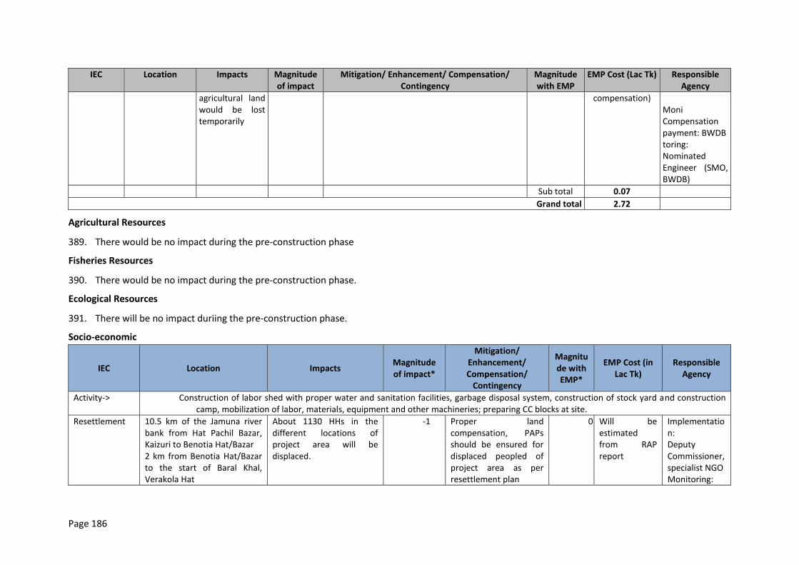
Page 186
IEC Location Impacts Magnitude of impact
Mitigation/ Enhancement/ Compensation/ Contingency
Magnitude with EMP
EMP Cost (Lac Tk) Responsible Agency
agricultural land would be lost temporarily
compensation) Moni Compensation payment: BWDB toring: Nominated Engineer (SMO, BWDB)
Sub total 0.07
Grand total 2.72
Agricultural Resources
389. There would be no impact during the pre-construction phase
Fisheries Resources
390. There would be no impact during the pre-construction phase.
Ecological Resources
391. There will be no impact duriing the pre-construction phase.
Socio-economic
IEC Location Impacts Magnitude of impact*
Mitigation/ Enhancement/ Compensation/
Contingency
Magnitude with EMP*
EMP Cost (in Lac Tk)
Responsible Agency
Activity-> Construction of labor shed with proper water and sanitation facilities, garbage disposal system, construction of stock yard and construction camp, mobilization of labor, materials, equipment and other machineries; preparing CC blocks at site.
Resettlement 10.5 km of the Jamuna river bank from Hat Pachil Bazar, Kaizuri to Benotia Hat/Bazar 2 km from Benotia Hat/Bazar to the start of Baral Khal, Verakola Hat
About 1130 HHs in the different locations of project area will be displaced.
-1 Proper land compensation, PAPs should be ensured for displaced peopled of project area as per resettlement plan
0 Will be estimated from RAP report
Implementation: Deputy Commissioner, specialist NGO Monitoring:
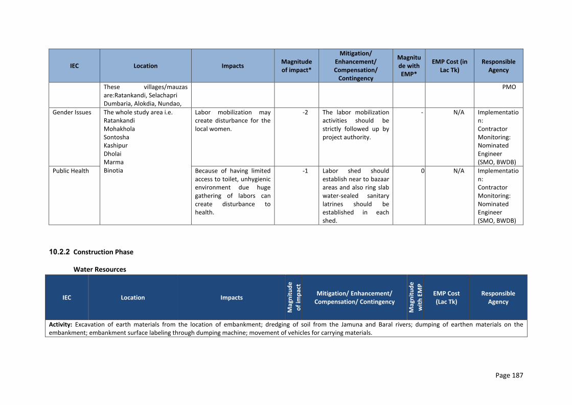
Page 187
IEC Location Impacts Magnitude of impact*
Mitigation/ Enhancement/ Compensation/
Contingency
Magnitude with EMP*
EMP Cost (in Lac Tk)
Responsible Agency
These villages/mauzas are:Ratankandi, Selachapri Dumbaria, Alokdia, Nundao,
PMO
Gender Issues The whole study area i.e. Ratankandi Mohakhola Sontosha Kashipur Dholai Marma Binotia
Labor mobilization may create disturbance for the local women.
-2 The labor mobilization activities should be strictly followed up by project authority.
-1
N/A Implementation: Contractor Monitoring: Nominated Engineer (SMO, BWDB)
Public Health Because of having limited access to toilet, unhygienic environment due huge gathering of labors can create disturbance to health.
-1 Labor shed should establish near to bazaar areas and also ring slab water-sealed sanitary latrines should be established in each shed.
0 N/A Implementation: Contractor Monitoring: Nominated Engineer (SMO, BWDB)
10.2.2 Construction Phase
Water Resources
IEC Location Impacts M
agn
itu
de
of
imp
act
Mitigation/ Enhancement/ Compensation/ Contingency
Mag
nit
ud
e
wit
h E
MP
EMP Cost (Lac Tk)
Responsible Agency
Activity: Excavation of earth materials from the location of embankment; dredging of soil from the Jamuna and Baral rivers; dumping of earthen materials on the embankment; embankment surface labeling through dumping machine; movement of vehicles for carrying materials.
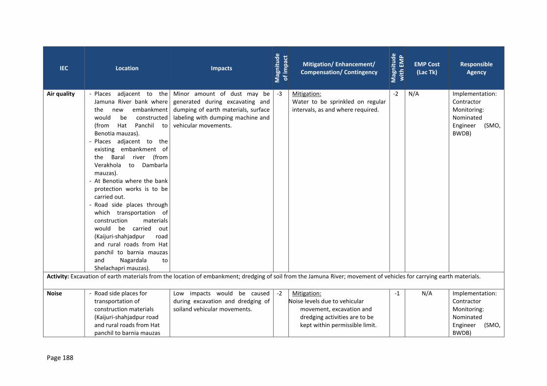
Page 188
IEC Location Impacts
Mag
nit
ud
e
of
imp
act
Mitigation/ Enhancement/ Compensation/ Contingency
Mag
nit
ud
e
wit
h E
MP
EMP Cost (Lac Tk)
Responsible Agency
Air quality - Places adjacent to the Jamuna River bank where the new embankment would be constructed (from Hat Panchil to Benotia mauzas).
- Places adjacent to the existing embankment of the Baral river (from Verakhola to Dambarla mauzas).
- At Benotia where the bank protection works is to be carried out.
- Road side places through which transportation of construction materials would be carried out (Kaijuri-shahjadpur road and rural roads from Hat panchil to barnia mauzas and Nagardala to Shelachapri mauzas).
Minor amount of dust may be generated during excavating and dumping of earth materials, surface labeling with dumping machine and vehicular movements.
-3 Mitigation: Water to be sprinkled on regular intervals, as and where required.
-2 N/A Implementation: Contractor Monitoring: Nominated Engineer (SMO, BWDB)
Activity: Excavation of earth materials from the location of embankment; dredging of soil from the Jamuna River; movement of vehicles for carrying earth materials.
Noise - Road side places for transportation of construction materials (Kaijuri-shahjadpur road and rural roads from Hat panchil to barnia mauzas
Low impacts would be caused during excavation and dredging of soiland vehicular movements.
-2 Mitigation: Noise levels due to vehicular
movement, excavation and dredging activities are to be kept within permissible limit.
-1 N/A Implementation: Contractor Monitoring: Nominated Engineer (SMO, BWDB)
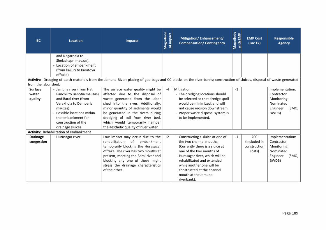
Page 189
IEC Location Impacts
Mag
nit
ud
e
of
imp
act
Mitigation/ Enhancement/ Compensation/ Contingency
Mag
nit
ud
e
wit
h E
MP
EMP Cost (Lac Tk)
Responsible Agency
and Nagardala to Shelachapri mauzas).
- Location of embankment (from Kaijuri to Karatoya offtake)
Activity: Dredging of earth materials from the Jamuna River; placing of geo-bags and CC blocks on the river banks; construction of sluices, disposal of waste generated from the labor shed.
Surface water quality
- Jamuna river (from Hat Panchil to Benotia mauzas) and Baral river (from Verakhola to Dambarla mauzas).
- Possible locations within the embankment for construction of the drainage sluices
The surface water quality might be affected due to the disposal of waste generated from the labor shed into the river. Additionally, minor quantity of sediments would be generated in the rivers during dredging of soil from river bed, which would temporarily hamper the aesthetic quality of river water.
-4 Mitigation: - The dredging locations should
be selected so that dredge spoil would be minimized, and will not cause erosion downstream.
- Proper waste disposal system is to be implemented.
-1 Implementation: Contractor Monitoring: Nominated Engineer (SMO, BWDB)
Activity: Rehabilitation of embankment
Drainage congestion
- Hurasagar river Low impact may occur due to the rehabilitation of embankment temporarily blocking the Hurasagar offtake. The river has two mouths at present, meeting the Baral river and blocking any one of these might stress the drainage characteristics of the other.
-2 - Constructing a sluice at one of the two channel mouths. (Currently there is a sluice at one of the two mouths of Hurasagar river, which will be rehabilitated and extended while another one will be constructed at the channel mouth at the Jamuna riverbank).
-1 200 (included in construction
costs)
Implementation: Contractor Monitoring: Nominated Engineer (SMO, BWDB)
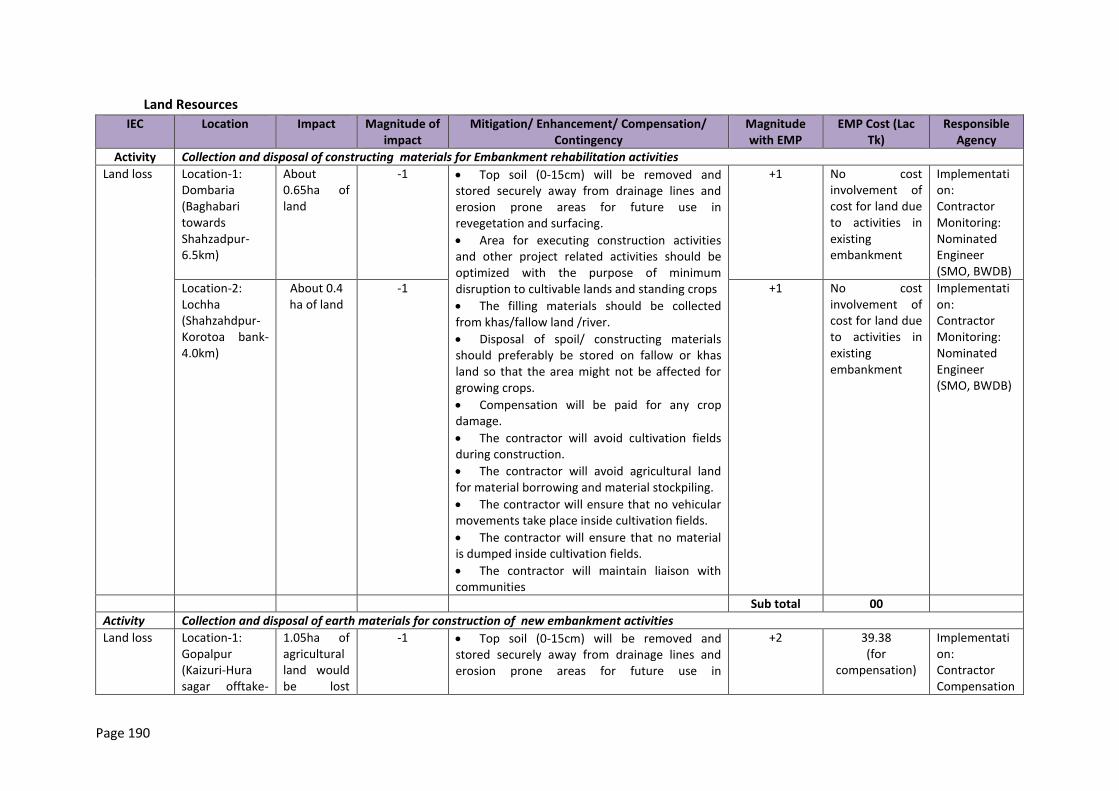
Page 190
Land Resources
IEC Location Impact Magnitude of impact
Mitigation/ Enhancement/ Compensation/ Contingency
Magnitude with EMP
EMP Cost (Lac Tk)
Responsible Agency
Activity Collection and disposal of constructing materials for Embankment rehabilitation activities
Land loss Location-1: Dombaria (Baghabari towards Shahzadpur-6.5km)
About 0.65ha of land
-1 Top soil (0-15cm) will be removed and stored securely away from drainage lines and erosion prone areas for future use in revegetation and surfacing.
Area for executing construction activities and other project related activities should be optimized with the purpose of minimum disruption to cultivable lands and standing crops
The filling materials should be collected from khas/fallow land /river.
Disposal of spoil/ constructing materials should preferably be stored on fallow or khas land so that the area might not be affected for growing crops.
Compensation will be paid for any crop damage.
The contractor will avoid cultivation fields during construction.
The contractor will avoid agricultural land for material borrowing and material stockpiling.
The contractor will ensure that no vehicular movements take place inside cultivation fields.
The contractor will ensure that no material is dumped inside cultivation fields.
The contractor will maintain liaison with communities
+1 No cost involvement of cost for land due to activities in existing embankment
Implementation: Contractor Monitoring: Nominated Engineer (SMO, BWDB)
Location-2: Lochha (Shahzahdpur-Korotoa bank-4.0km)
About 0.4 ha of land
-1 +1 No cost involvement of cost for land due to activities in existing embankment
Implementation: Contractor Monitoring: Nominated Engineer (SMO, BWDB)
Sub total 00
Activity Collection and disposal of earth materials for construction of new embankment activities
Land loss Location-1: Gopalpur (Kaizuri-Hura sagar offtake-
1.05ha of agricultural land would be lost
-1 Top soil (0-15cm) will be removed and stored securely away from drainage lines and erosion prone areas for future use in
+2 39.38 (for
compensation)
Implementation: Contractor Compensation
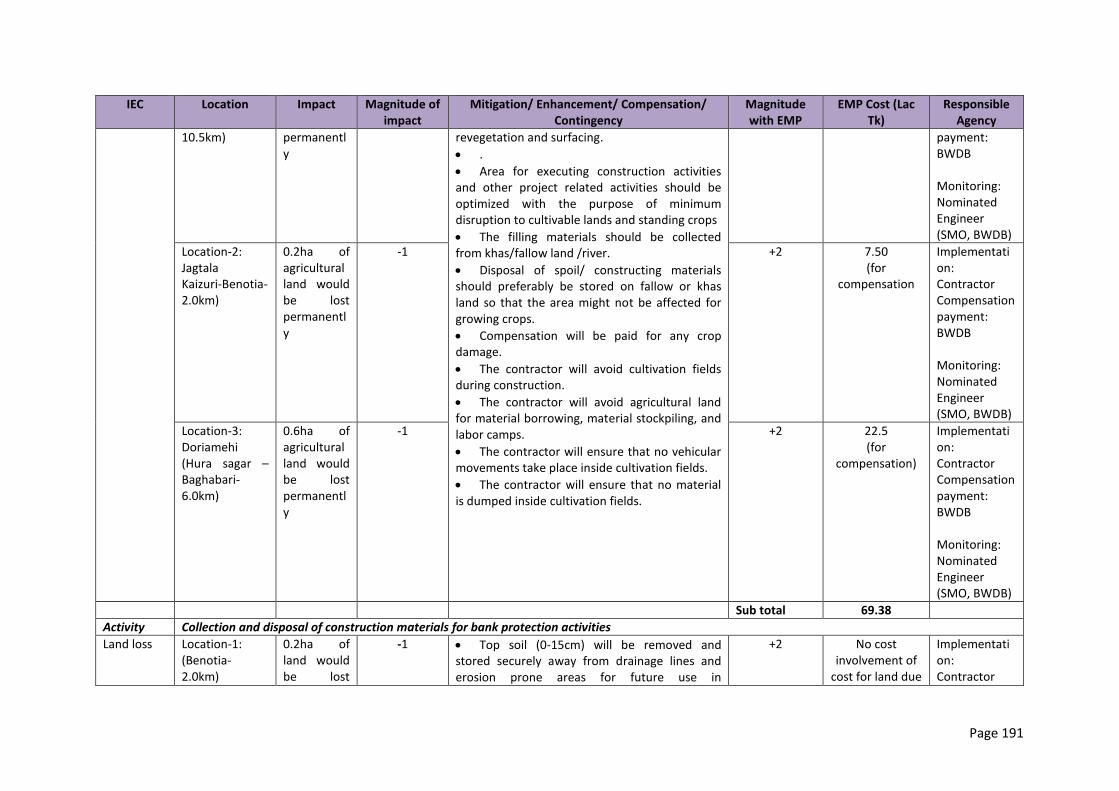
Page 191
IEC Location Impact Magnitude of impact
Mitigation/ Enhancement/ Compensation/ Contingency
Magnitude with EMP
EMP Cost (Lac Tk)
Responsible Agency
10.5km) permanently
revegetation and surfacing.
.
Area for executing construction activities and other project related activities should be optimized with the purpose of minimum disruption to cultivable lands and standing crops
The filling materials should be collected from khas/fallow land /river.
Disposal of spoil/ constructing materials should preferably be stored on fallow or khas land so that the area might not be affected for growing crops.
Compensation will be paid for any crop damage.
The contractor will avoid cultivation fields during construction.
The contractor will avoid agricultural land for material borrowing, material stockpiling, and labor camps.
The contractor will ensure that no vehicular movements take place inside cultivation fields.
The contractor will ensure that no material is dumped inside cultivation fields.
payment: BWDB Monitoring: Nominated Engineer (SMO, BWDB)
Location-2: Jagtala Kaizuri-Benotia-2.0km)
0.2ha of agricultural land would be lost permanently
-1 +2 7.50 (for
compensation
Implementation: Contractor Compensation payment: BWDB Monitoring: Nominated Engineer (SMO, BWDB)
Location-3: Doriamehi (Hura sagar –Baghabari-6.0km)
0.6ha of agricultural land would be lost permanently
-1 +2 22.5 (for
compensation)
Implementation: Contractor Compensation payment: BWDB Monitoring: Nominated Engineer (SMO, BWDB)
Sub total 69.38
Activity Collection and disposal of construction materials for bank protection activities
Land loss Location-1: (Benotia-2.0km)
0.2ha of land would be lost
-1 Top soil (0-15cm) will be removed and stored securely away from drainage lines and erosion prone areas for future use in
+2 No cost involvement of
cost for land due
Implementation: Contractor
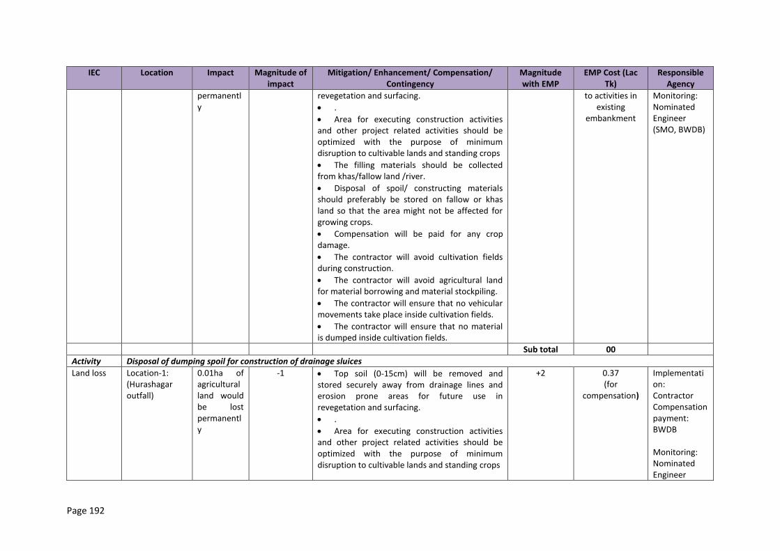
Page 192
IEC Location Impact Magnitude of impact
Mitigation/ Enhancement/ Compensation/ Contingency
Magnitude with EMP
EMP Cost (Lac Tk)
Responsible Agency
permanently
revegetation and surfacing.
.
Area for executing construction activities and other project related activities should be optimized with the purpose of minimum disruption to cultivable lands and standing crops
The filling materials should be collected from khas/fallow land /river.
Disposal of spoil/ constructing materials should preferably be stored on fallow or khas land so that the area might not be affected for growing crops.
Compensation will be paid for any crop damage.
The contractor will avoid cultivation fields during construction.
The contractor will avoid agricultural land for material borrowing and material stockpiling.
The contractor will ensure that no vehicular movements take place inside cultivation fields.
The contractor will ensure that no material is dumped inside cultivation fields.
to activities in existing
embankment
Monitoring: Nominated Engineer (SMO, BWDB)
Sub total 00
Activity Disposal of dumping spoil for construction of drainage sluices
Land loss Location-1: (Hurashagar outfall)
0.01ha of agricultural land would be lost permanently
-1 Top soil (0-15cm) will be removed and stored securely away from drainage lines and erosion prone areas for future use in revegetation and surfacing.
.
Area for executing construction activities and other project related activities should be optimized with the purpose of minimum disruption to cultivable lands and standing crops
+2 0.37 (for
compensation)
Implementation: Contractor Compensation payment: BWDB Monitoring: Nominated Engineer

Page 193
IEC Location Impact Magnitude of impact
Mitigation/ Enhancement/ Compensation/ Contingency
Magnitude with EMP
EMP Cost (Lac Tk)
Responsible Agency
The filling materials for backfill should be collected from khas/fallow land /river.
Disposal of spoil/ constructing materials should preferably be stored on fallow or khas land so that the area might not be affected for growing crops.
Compensation will be paid for any crop damage.
The contractor will avoid cultivation fields during construction.
The contractor will avoid agricultural land for material borrowing and material stockpiling.
The contractor will ensure that no vehicular movements take place inside cultivation fields.
The contractor will ensure that no material is dumped inside cultivation fields.
(SMO, BWDB)
Location-2: (Hurashagar inlet)
0.02ha of agricultural land would be lost permanently
-1 +2 0.75 (for
compensation)
Implementation: Contractor Compensation payment: BWDB Monitoring: Nominated Engineer (SMO, BWDB)
Location-3: (at existing sluice gates)
0.02ha of agricultural land would be lost permanently
-1 +2 0.75 (for
compensation)
Implementation: Contractor Compensation payment: BWDB Monitoring: Nominated Engineer (SMO, BWDB)
Sub total 1.87
Land type change
Entire study area
Drainage congested area would be increased due to rehabilitation of embankment,
-2 The sequence of work during construction of regulators in the water channels would be carefully planned to avoid disruption of drainage system.
The contractor would ensure that there would be no negative impacts on crop cultivation in monsoon season.
The contractor would maintain liaison with community organizations .
+2 Implementation: Contractor Monitoring: Nominated Engineer (SMO, BWDB)
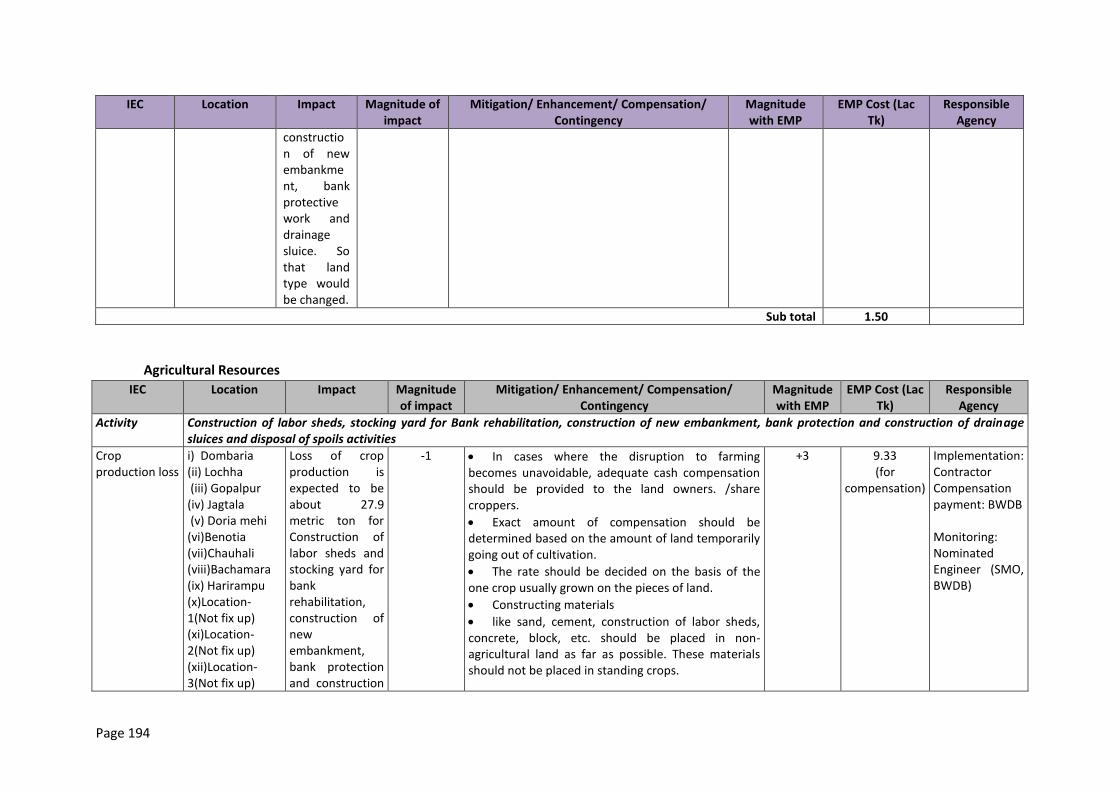
Page 194
IEC Location Impact Magnitude of impact
Mitigation/ Enhancement/ Compensation/ Contingency
Magnitude with EMP
EMP Cost (Lac Tk)
Responsible Agency
construction of new embankment, bank protective work and drainage sluice. So that land type would be changed.
Sub total 1.50
Agricultural Resources
IEC Location Impact Magnitude of impact
Mitigation/ Enhancement/ Compensation/ Contingency
Magnitude with EMP
EMP Cost (Lac Tk)
Responsible Agency
Activity Construction of labor sheds, stocking yard for Bank rehabilitation, construction of new embankment, bank protection and construction of drainage sluices and disposal of spoils activities
Crop production loss
i) Dombaria (ii) Lochha (iii) Gopalpur (iv) Jagtala (v) Doria mehi (vi)Benotia (vii)Chauhali (viii)Bachamara (ix) Harirampu (x)Location-1(Not fix up) (xi)Location-2(Not fix up) (xii)Location-3(Not fix up)
Loss of crop production is expected to be about 27.9 metric ton for Construction of labor sheds and stocking yard for bank rehabilitation, construction of new embankment, bank protection and construction
-1 In cases where the disruption to farming becomes unavoidable, adequate cash compensation should be provided to the land owners. /share croppers.
Exact amount of compensation should be determined based on the amount of land temporarily going out of cultivation.
The rate should be decided on the basis of the one crop usually grown on the pieces of land.
Constructing materials
like sand, cement, construction of labor sheds, concrete, block, etc. should be placed in non-agricultural land as far as possible. These materials should not be placed in standing crops.
+3 9.33 (for
compensation)
Implementation: Contractor Compensation payment: BWDB Monitoring: Nominated Engineer (SMO, BWDB)
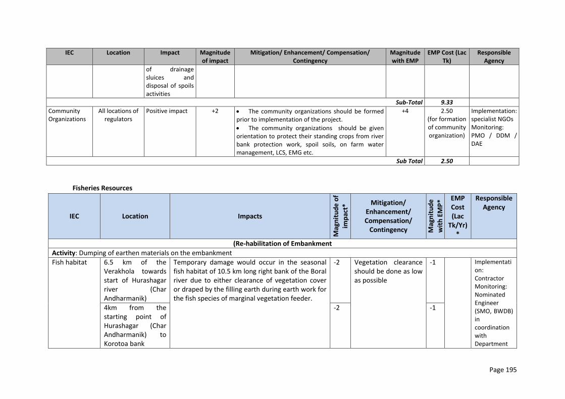
Page 195
IEC Location Impact Magnitude of impact
Mitigation/ Enhancement/ Compensation/ Contingency
Magnitude with EMP
EMP Cost (Lac Tk)
Responsible Agency
of drainage sluices and disposal of spoils activities
Sub-Total 9.33
Community Organizations
All locations of regulators
Positive impact +2 The community organizations should be formed prior to implementation of the project.
The community organizations should be given orientation to protect their standing crops from river bank protection work, spoil soils, on farm water management, LCS, EMG etc.
+4 2.50 (for formation of community organization)
Implementation: specialist NGOs Monitoring: PMO / DDM / DAE
Sub Total 2.50
Fisheries Resources
IEC Location Impacts
Mag
nit
ud
e o
f
imp
act*
Mitigation/ Enhancement/ Compensation/
Contingency Mag
nit
ud
e
wit
h E
MP
* EMP Cost (Lac
Tk/Yr)*
Responsible Agency
(Re-habilitation of Embankment
Activity: Dumping of earthen materials on the embankment
Fish habitat 6.5 km of the Verakhola towards start of Hurashagar river (Char Andharmanik)
Temporary damage would occur in the seasonal fish habitat of 10.5 km long right bank of the Boral river due to either clearance of vegetation cover or draped by the filling earth during earth work for the fish species of marginal vegetation feeder.
-2 Vegetation clearance should be done as low as possible
-1 Implementation: Contractor Monitoring: Nominated Engineer (SMO, BWDB) in coordination with Department
4km from the starting point of Hurashagar (Char Andharmanik) to Korotoa bank
-2 -1
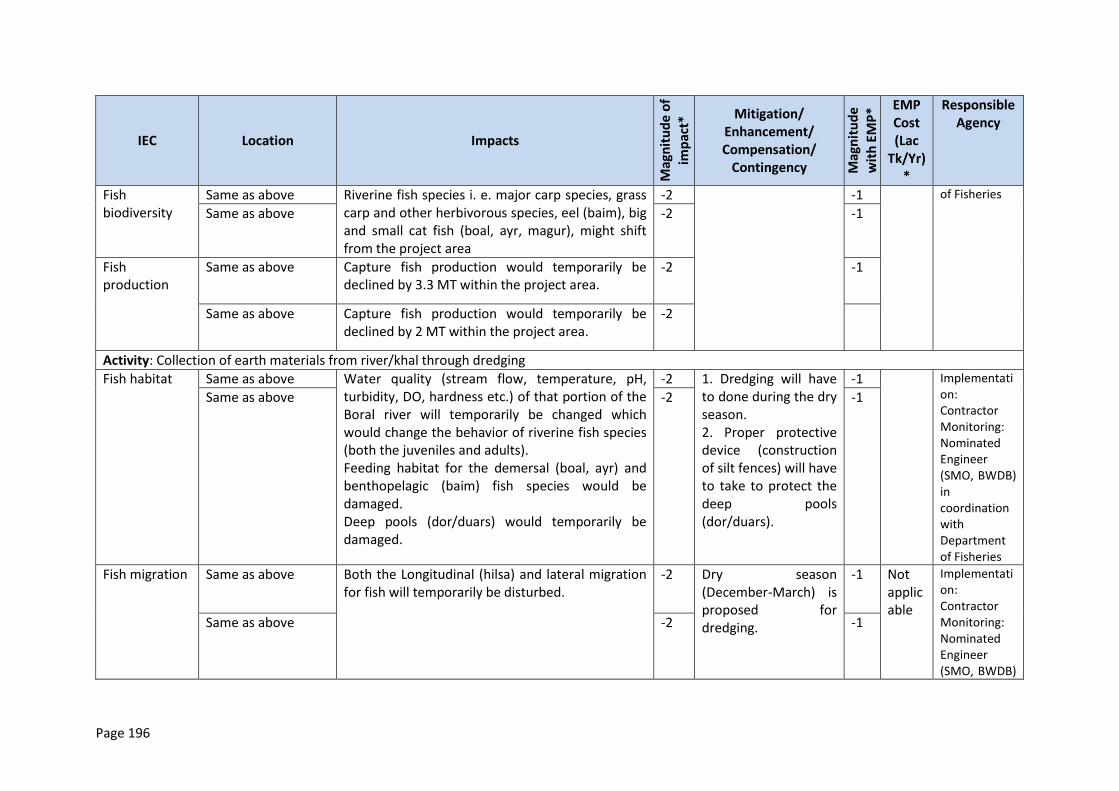
Page 196
IEC Location Impacts
Mag
nit
ud
e o
f
imp
act*
Mitigation/ Enhancement/ Compensation/
Contingency Mag
nit
ud
e
wit
h E
MP
* EMP Cost (Lac
Tk/Yr)*
Responsible Agency
Fish biodiversity
Same as above Riverine fish species i. e. major carp species, grass carp and other herbivorous species, eel (baim), big and small cat fish (boal, ayr, magur), might shift from the project area
-2 -1 of Fisheries
Same as above -2 -1
Fish production
Same as above Capture fish production would temporarily be declined by 3.3 MT within the project area.
-2 -1
Same as above Capture fish production would temporarily be declined by 2 MT within the project area.
-2
Activity: Collection of earth materials from river/khal through dredging
Fish habitat Same as above Water quality (stream flow, temperature, pH, turbidity, DO, hardness etc.) of that portion of the Boral river will temporarily be changed which would change the behavior of riverine fish species (both the juveniles and adults). Feeding habitat for the demersal (boal, ayr) and benthopelagic (baim) fish species would be damaged. Deep pools (dor/duars) would temporarily be damaged.
-2 1. Dredging will have to done during the dry season. 2. Proper protective device (construction of silt fences) will have to take to protect the deep pools (dor/duars).
-1 Implementation: Contractor Monitoring: Nominated Engineer (SMO, BWDB) in coordination with Department of Fisheries
Same as above -2 -1
Fish migration Same as above Both the Longitudinal (hilsa) and lateral migration for fish will temporarily be disturbed.
-2 Dry season (December-March) is proposed for dredging.
-1 Not applicable
Implementation: Contractor Monitoring: Nominated Engineer (SMO, BWDB)
Same as above -2 -1
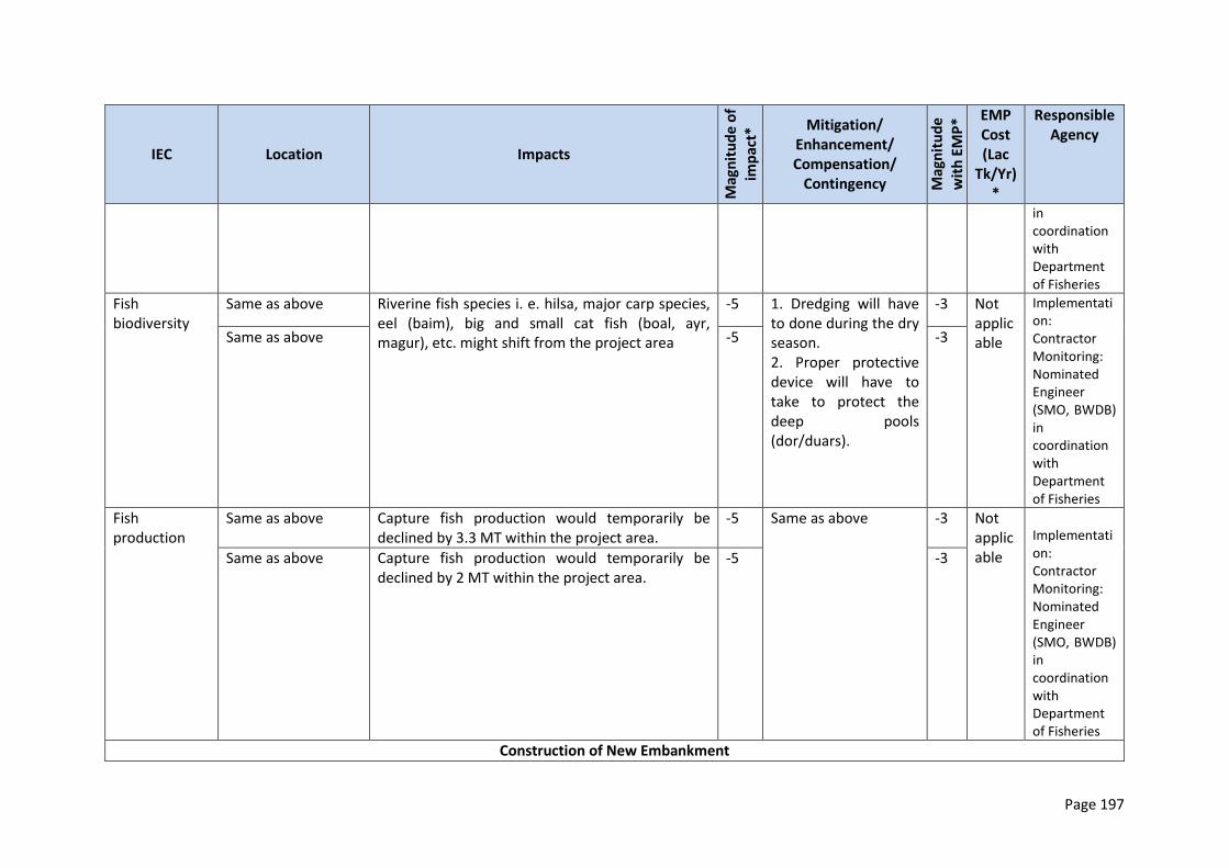
Page 197
IEC Location Impacts
Mag
nit
ud
e o
f
imp
act*
Mitigation/ Enhancement/ Compensation/
Contingency Mag
nit
ud
e
wit
h E
MP
* EMP Cost (Lac
Tk/Yr)*
Responsible Agency
in coordination with Department of Fisheries
Fish biodiversity
Same as above Riverine fish species i. e. hilsa, major carp species, eel (baim), big and small cat fish (boal, ayr, magur), etc. might shift from the project area
-5 1. Dredging will have to done during the dry season. 2. Proper protective device will have to take to protect the deep pools (dor/duars).
-3 Not applicable
Implementation: Contractor Monitoring: Nominated Engineer (SMO, BWDB) in coordination with Department of Fisheries
Same as above -5 -3
Fish production
Same as above Capture fish production would temporarily be declined by 3.3 MT within the project area.
-5 Same as above -3 Not applicable
Implementation: Contractor Monitoring: Nominated Engineer (SMO, BWDB) in coordination with Department of Fisheries
Same as above Capture fish production would temporarily be declined by 2 MT within the project area.
-5 -3
Construction of New Embankment
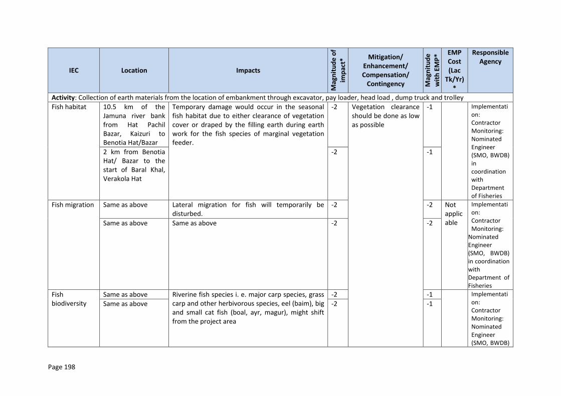
Page 198
IEC Location Impacts
Mag
nit
ud
e o
f
imp
act*
Mitigation/ Enhancement/ Compensation/
Contingency Mag
nit
ud
e
wit
h E
MP
* EMP Cost (Lac
Tk/Yr)*
Responsible Agency
Activity: Collection of earth materials from the location of embankment through excavator, pay loader, head load , dump truck and trolley
Fish habitat 10.5 km of the Jamuna river bank from Hat Pachil Bazar, Kaizuri to Benotia Hat/Bazar
Temporary damage would occur in the seasonal fish habitat due to either clearance of vegetation cover or draped by the filling earth during earth work for the fish species of marginal vegetation feeder.
-2 Vegetation clearance should be done as low as possible
-1 Implementation: Contractor Monitoring: Nominated Engineer (SMO, BWDB) in coordination with Department of Fisheries
2 km from Benotia Hat/ Bazar to the start of Baral Khal, Verakola Hat
-2 -1
Fish migration Same as above Lateral migration for fish will temporarily be disturbed.
-2 -2 Not applicable
Implementation: Contractor Monitoring:
Nominated Engineer (SMO, BWDB) in coordination with Department of Fisheries
Same as above Same as above -2 -2
Fish biodiversity
Same as above Riverine fish species i. e. major carp species, grass carp and other herbivorous species, eel (baim), big and small cat fish (boal, ayr, magur), might shift from the project area
-2 -1 Implementation: Contractor Monitoring: Nominated Engineer (SMO, BWDB)
Same as above -2 -1
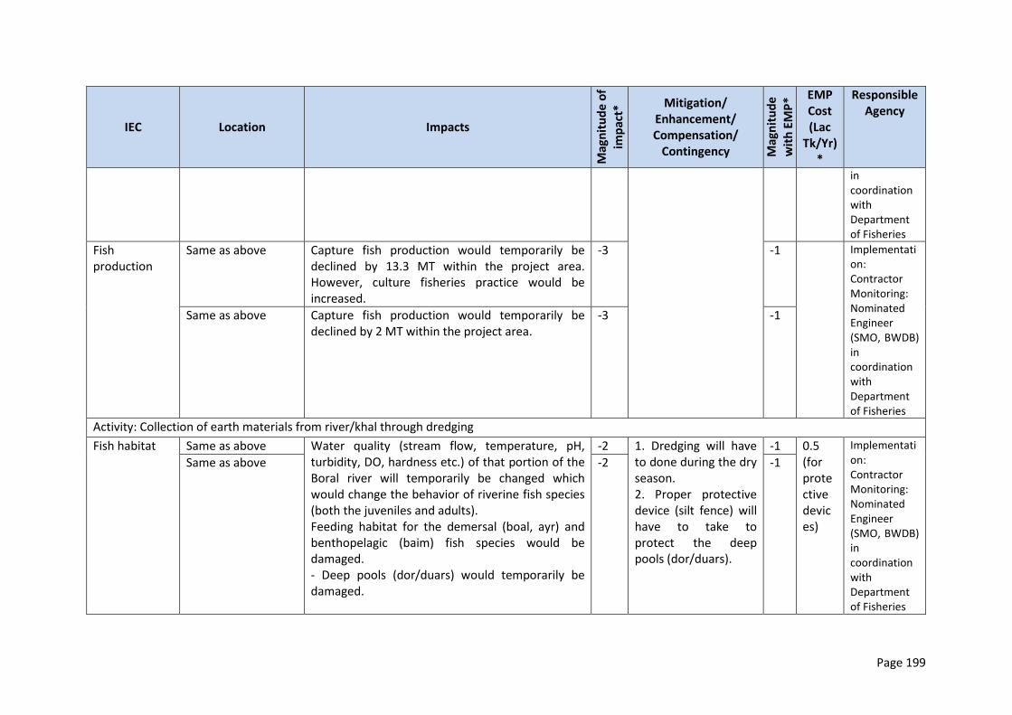
Page 199
IEC Location Impacts
Mag
nit
ud
e o
f
imp
act*
Mitigation/ Enhancement/ Compensation/
Contingency Mag
nit
ud
e
wit
h E
MP
* EMP Cost (Lac
Tk/Yr)*
Responsible Agency
in coordination with Department of Fisheries
Fish production
Same as above Capture fish production would temporarily be declined by 13.3 MT within the project area. However, culture fisheries practice would be increased.
-3 -1 Implementation: Contractor Monitoring: Nominated Engineer (SMO, BWDB) in coordination with Department of Fisheries
Same as above Capture fish production would temporarily be declined by 2 MT within the project area.
-3 -1
Activity: Collection of earth materials from river/khal through dredging
Fish habitat Same as above Water quality (stream flow, temperature, pH, turbidity, DO, hardness etc.) of that portion of the Boral river will temporarily be changed which would change the behavior of riverine fish species (both the juveniles and adults). Feeding habitat for the demersal (boal, ayr) and benthopelagic (baim) fish species would be damaged. - Deep pools (dor/duars) would temporarily be damaged.
-2 1. Dredging will have to done during the dry season. 2. Proper protective device (silt fence) will have to take to protect the deep pools (dor/duars).
-1 0.5 (for protective devices)
Implementation: Contractor Monitoring: Nominated Engineer (SMO, BWDB) in coordination with Department of Fisheries
Same as above -2 -1
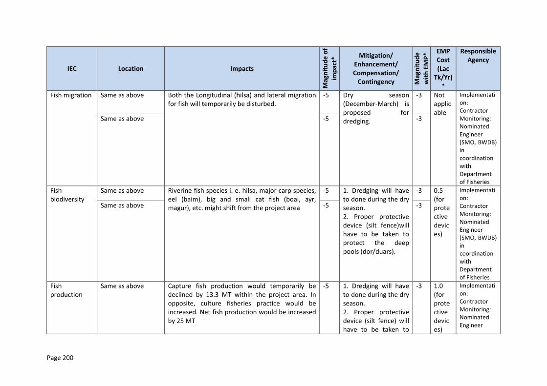
Page 200
IEC Location Impacts
Mag
nit
ud
e o
f
imp
act*
Mitigation/ Enhancement/ Compensation/
Contingency Mag
nit
ud
e
wit
h E
MP
* EMP Cost (Lac
Tk/Yr)*
Responsible Agency
Fish migration Same as above Both the Longitudinal (hilsa) and lateral migration for fish will temporarily be disturbed.
-5 Dry season (December-March) is proposed for dredging.
-3 Not applicable
Implementation: Contractor Monitoring: Nominated Engineer (SMO, BWDB) in coordination with Department of Fisheries
Same as above -5 -3
Fish biodiversity
Same as above Riverine fish species i. e. hilsa, major carp species, eel (baim), big and small cat fish (boal, ayr, magur), etc. might shift from the project area
-5 1. Dredging will have to done during the dry season. 2. Proper protective device (silt fence)will have to be taken to protect the deep pools (dor/duars).
-3 0.5 (for protective devices)
Implementation: Contractor Monitoring: Nominated Engineer (SMO, BWDB) in coordination with Department of Fisheries
Same as above -5 -3
Fish production
Same as above Capture fish production would temporarily be declined by 13.3 MT within the project area. In opposite, culture fisheries practice would be increased. Net fish production would be increased by 25 MT
-5 1. Dredging will have to done during the dry season. 2. Proper protective device (silt fence) will have to be taken to
-3 1.0 (for protective devices)
Implementation: Contractor Monitoring: Nominated Engineer
Page 201
IEC Location Impacts
Mag
nit
ud
e o
f
imp
act*
Mitigation/ Enhancement/ Compensation/
Contingency Mag
nit
ud
e
wit
h E
MP
* EMP Cost (Lac
Tk/Yr)*
Responsible Agency
Same as above Capture fish production would temporarily be declined by 2 MT within the project area. Culture fisheries practice would be slightly increased.
-5 protect the deep pools (dor/duars).
-3 (SMO, BWDB) in coordination with Department of Fisheries
Riverbank Protection Work
Activity: Embankment slope pitching and turfing
Fish habitat 1km from Benotia Hat/Bazar toward the start of Baral river.
Temporary damage would occur in the seasonal fish habitat due to either clearance of vegetation cover or draped by the filling earth during earth work for the fish species of marginal vegetation feeder.
-1 Vegetation clearance should be done as low as possible
-1 Implementation: Contractor Monitoring: Nominated Engineer (SMO, BWDB) in coordination with Department of Fisheries
Fish biodiversity
Riverine fish species i. e. major carp species, grass carp and other herbivorous species, eel (baim), big and small cat fish (boal, ayr, magur), might shift from the project area
-1 -1
Fish production
Capture fish production would temporarily be declined by 2 MT within the project area.
-1 -1
Fish production
Capture fish production would temporarily be declined by 2 MT within the project area. Culture fisheries practice would be slightly increased.
-1
Activity: Placing and dumping of C.C. blocks as per design
Page 202
IEC Location Impacts
Mag
nit
ud
e o
f
imp
act*
Mitigation/ Enhancement/ Compensation/
Contingency Mag
nit
ud
e
wit
h E
MP
* EMP Cost (Lac
Tk/Yr)*
Responsible Agency
Fish biodiversity
1 km from Benotia Hat/Bazar to the start of Baral Khal
Riverine fish species i. e. hilsa, major carp species, eel (baim), big and small cat fish (boal, ayr, magur), etc. might shift from the project area. Potential impact on surface feeder fish species due to oil and grease lubricants
-5 1. Dredging will have to done during the dry season. 2. Proper protective device (silt fence) will have to take to protect the deep pools (dor/duars). 3. . Ensure careful
refueling of vehicles and careful handling during any changes in parts of vehicles. Ensure concrete mixing does not happen at the river embankments
-3 Implementation: Contractor Monitoring: Nominated Engineer (SMO, BWDB) in coordination with Department of Fisheries
Ecological Resources
IEC Location Impacts Magnitude of impact*
Mitigation/Enhancement/Compensation/Contingency
Magnitude with EMP
EMP Cost (Lac Tk.)
Responsible Agency
Embankment Re-habilitation
Activity: Collection of earth materials and construction of embankment
Terrestrial ecosystem Aquatic ecosystem. Floral
6.5 km of the Verakhola towards start of Hurashagar River (Char Andharmanik)
Shrubs and herbs of bank slopes will be damaged by excavated soil dumping. Vegetation damage via
-5
Do not dump large volume of excavated soil on bottom of the existing trees. Observation of national and international days
+3
2.0 (for awareness activities and
Implementation: Contractor Monitoring: Nominated
Page 203
IEC Location Impacts Magnitude of impact*
Mitigation/Enhancement/Compensation/Contingency
Magnitude with EMP
EMP Cost (Lac Tk.)
Responsible Agency
composition and diversity. Faunal composition and diversity
4km from the starting point of Hurashagar (Char Andharmanik) to Korotoa River bank.
dumping a high volume of excavated soil on the river banks
Awareness development activities should be conducted by the committee or nature club to protect the saplings.
purchase of saplings)
Engineer (SMO, BWDB)
Construction of New Embankment
Activity: Collection of earth for construction of embankment
Terrestrial ecosystem Aquatic ecosystem. Floral composition and diversity. Faunal composition and diversity.
10.5 km of the Jamuna river bank from Hat Pachil Bazar, Kaizuri to Benotia Hat/ Bazar 2 km from Benotia Hat/Bazar to the start of Baral Khal, Verakola Hat.
Aquatic flora as well as zooplankton and phytoplankton will destroy. Shrubs and herbs of bank slopes will be damaged.
-3 Do not collect the soil from the fertile land and do not dump the soil.
-1
- Implementation: Contractor Monitoring: Nominated Engineer (SMO, BWDB)
Riverbank Protection Work
Activity: Slope protection
Terrestrial ecosystem Aquatic ecosystem. Floral composition and diversity. Faunal composition and diversity
2 km from Benotia Hat/ Bazar to the start of Baral Khal, Verakola Hat. 5 km of the Jamuna Left bank from Chauhali Sadar to Atpara. 2 km of the Jamuna Left bank from Jaffarganj to Bachamara
Vegetation of river banks and some aquatic flora will reduce. Wildlife population like terrestrial birds and palm squirrels will be disturbed.
-5
Awareness development activities should be conducted by the committee or nature club to protect the saplings.
+7
-
Implementation: specialist NGOs Monitoring: PMO /
Page 204
IEC Location Impacts Magnitude of impact*
Mitigation/Enhancement/Compensation/Contingency
Magnitude with EMP
EMP Cost (Lac Tk.)
Responsible Agency
7 km of the Padma Left Bank at Harirampur
Activity: Plantation at JRB-1
Terrestrial ecosystem Aquatic ecosystem. Floral composition and diversity. Faunal composition and diversity.
6.5 km of the Verakhola towards start of Hurashagar river (Char Andharmanik) 4km from the starting point of Hurashagar (Char Andharmanik) to Korotoa bank. 10.5 km of the Jamuna river bank from Hat Pachil Bazar, Kaijuri to Benotia Hat/Bazar 2 km from Benotia Hat/Bazar to the start of Baral Khal, Verakola Hat.
Vegetation of river bank will damage.
-5
Plantation of 50,000 saplings. (Bot, Pakur, Shimul, Jam, Pitali, Khajur, Tal and water tolerance fruit and timber are suggested for plantation).
Do not dump large volume of excavated soil on bottom of the present trees.
Awareness development on natural resources.
Observation of national and international days.
Nature club or Local committee should be formed to protect the saplings.
Awareness development activities should be conducted by the committee
or nature club.
+5 50.0 (Sapling-25 Tk. Stick-20Tk Fertilizer -15 Plantation-10Tk. Guarding -30tk/year).
Implementation: specialist NGOs Monitoring: PMO
Socio-economic
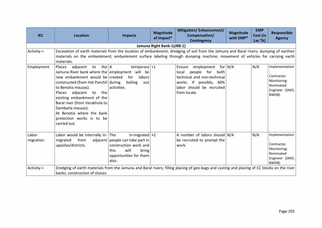
Page 205
IEC Location Impacts Magnitude of impact*
Mitigation/ Enhancement/ Compensation/
Contingency
Magnitude with EMP*
EMP Cost (in Lac Tk)
Responsible Agency
Jamuna Right Bank-1(JRB-1)
Activity-> Excavation of earth materials from the location of embankment; dredging of soil from the Jamuna and Baral rivers; dumping of earthen materials on the embankment; embankment surface labeling through dumping machine; movement of vehicles for carrying earth materials.
Employment Places adjacent to the Jamuna River bank where the new embankment would be constructed (from Hat Panchil to Benotia mauzas). Places adjacent to the existing embankment of the Baral river (from Verakhola to Dambarla mauzas). At Benotia where the bank protection works is to be carried out.
A temporary employment will be created for labors during bailing out activities.
+1 Ensure employment for local people for both technical and non-technical works. If possible, 60% labor should be recruited from locale.
N/A N/A Implementation: Contractor Monitoring: Nominated Engineer (SMO, BWDB)
Labor migration
Labor would be internally in-migrated from adjacent upazilas/districts.
The in-migrated people can take part in construction work and this will bring opportunities for them also.
+2 A number of labors should be recruited to prompt the work.
N/A N/A Implementation: Contractor Monitoring: Nominated Engineer (SMO, BWDB)
Activity-> Dredging of earth materials from the Jamuna and Baral rivers; filling placing of geo-bags and casting and placing of CC blocks on the river banks; construction of sluices.
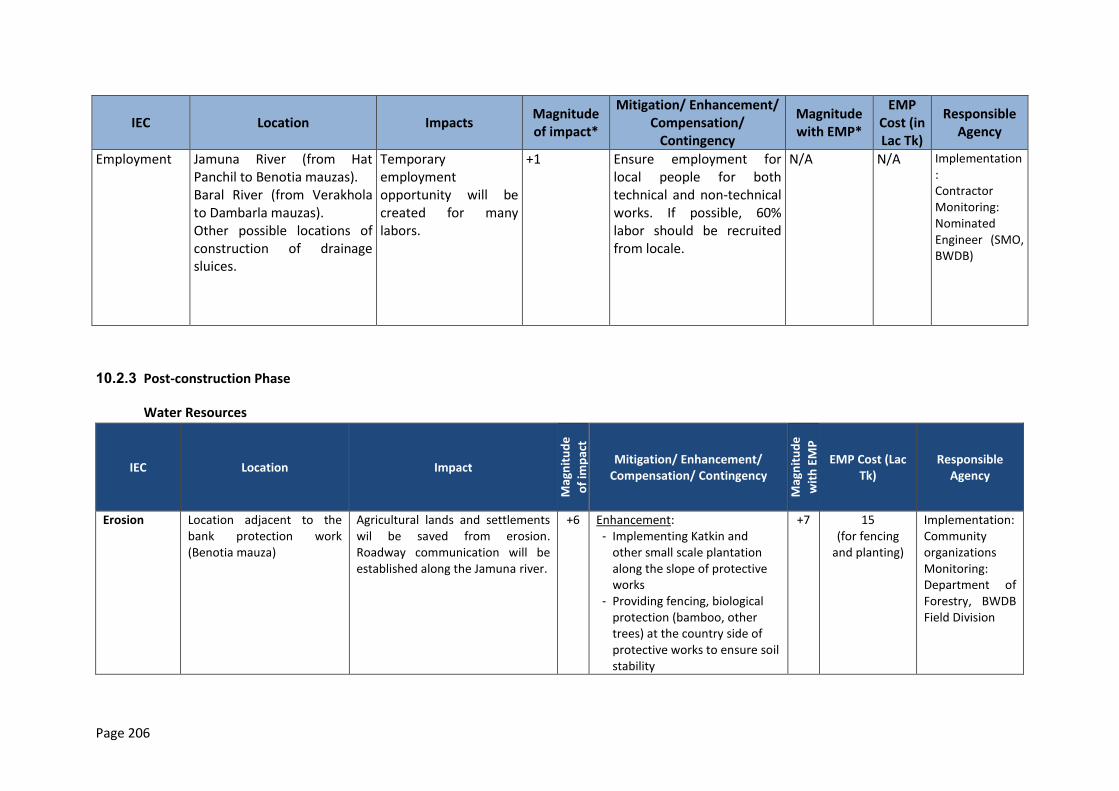
Page 206
IEC Location Impacts Magnitude of impact*
Mitigation/ Enhancement/ Compensation/
Contingency
Magnitude with EMP*
EMP Cost (in Lac Tk)
Responsible Agency
Employment Jamuna River (from Hat Panchil to Benotia mauzas). Baral River (from Verakhola to Dambarla mauzas). Other possible locations of construction of drainage sluices.
Temporary employment opportunity will be created for many labors.
+1 Ensure employment for local people for both technical and non-technical works. If possible, 60% labor should be recruited from locale.
N/A N/A Implementation: Contractor Monitoring: Nominated Engineer (SMO, BWDB)
10.2.3 Post-construction Phase
Water Resources
IEC Location Impact
Mag
nit
ud
e
of
imp
act
Mitigation/ Enhancement/ Compensation/ Contingency
Mag
nit
ud
e
wit
h E
MP
EMP Cost (Lac Tk)
Responsible Agency
Erosion Location adjacent to the bank protection work (Benotia mauza)
Agricultural lands and settlements wil be saved from erosion. Roadway communication will be established along the Jamuna river.
+6 Enhancement: - Implementing Katkin and
other small scale plantation along the slope of protective works
- Providing fencing, biological protection (bamboo, other trees) at the country side of protective works to ensure soil stability
+7 15 (for fencing
and planting)
Implementation: Community organizations Monitoring: Department of Forestry, BWDB Field Division
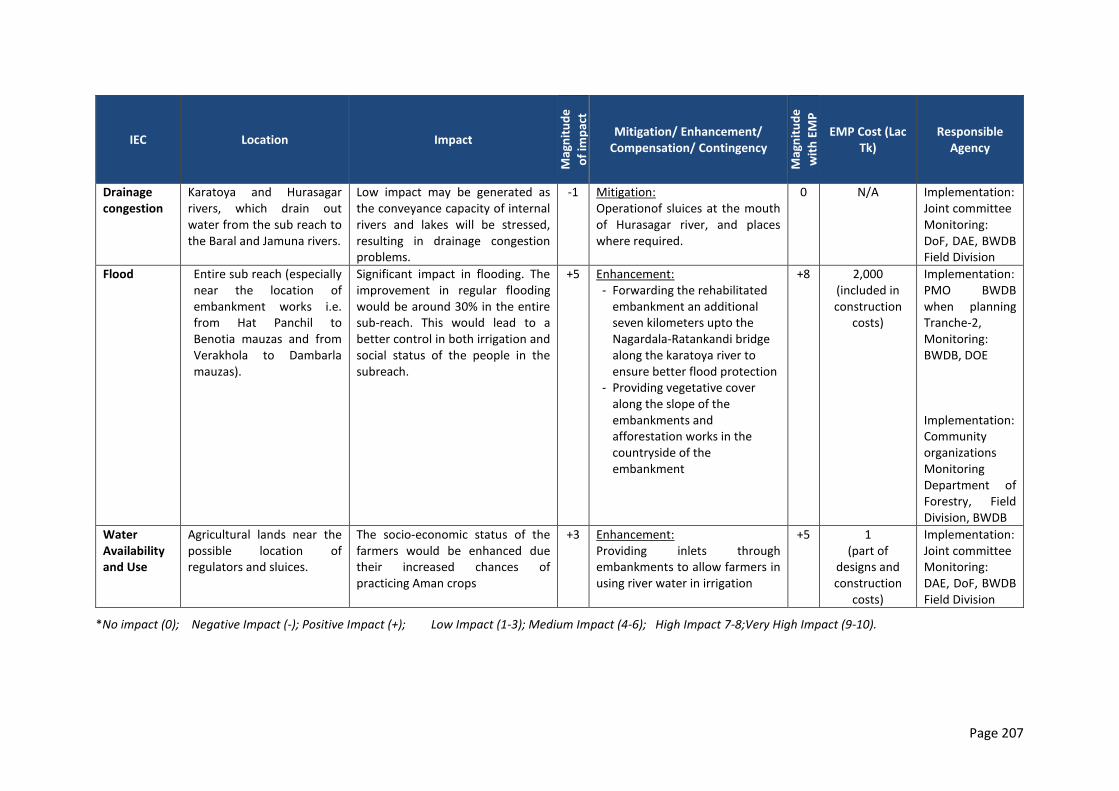
Page 207
IEC Location Impact
Mag
nit
ud
e
of
imp
act
Mitigation/ Enhancement/ Compensation/ Contingency
Mag
nit
ud
e
wit
h E
MP
EMP Cost (Lac Tk)
Responsible Agency
Drainage congestion
Karatoya and Hurasagar rivers, which drain out water from the sub reach to the Baral and Jamuna rivers.
Low impact may be generated as the conveyance capacity of internal rivers and lakes will be stressed, resulting in drainage congestion problems.
-1 Mitigation: Operationof sluices at the mouth of Hurasagar river, and places where required.
0 N/A Implementation: Joint committee Monitoring: DoF, DAE, BWDB Field Division
Flood Entire sub reach (especially near the location of embankment works i.e. from Hat Panchil to Benotia mauzas and from Verakhola to Dambarla mauzas).
Significant impact in flooding. The improvement in regular flooding would be around 30% in the entire sub-reach. This would lead to a better control in both irrigation and social status of the people in the subreach.
+5 Enhancement: - Forwarding the rehabilitated
embankment an additional seven kilometers upto the Nagardala-Ratankandi bridge along the karatoya river to ensure better flood protection
- Providing vegetative cover along the slope of the embankments and afforestation works in the countryside of the embankment
+8 2,000 (included in construction
costs)
Implementation: PMO BWDB when planning Tranche-2, Monitoring: BWDB, DOE Implementation: Community organizations Monitoring Department of Forestry, Field Division, BWDB
Water Availability and Use
Agricultural lands near the possible location of regulators and sluices.
The socio-economic status of the farmers would be enhanced due their increased chances of practicing Aman crops
+3 Enhancement: Providing inlets through embankments to allow farmers in using river water in irrigation
+5 1 (part of
designs and construction
costs)
Implementation: Joint committee Monitoring: DAE, DoF, BWDB Field Division
*No impact (0); Negative Impact (-); Positive Impact (+); Low Impact (1-3); Medium Impact (4-6); High Impact 7-8;Very High Impact (9-10).
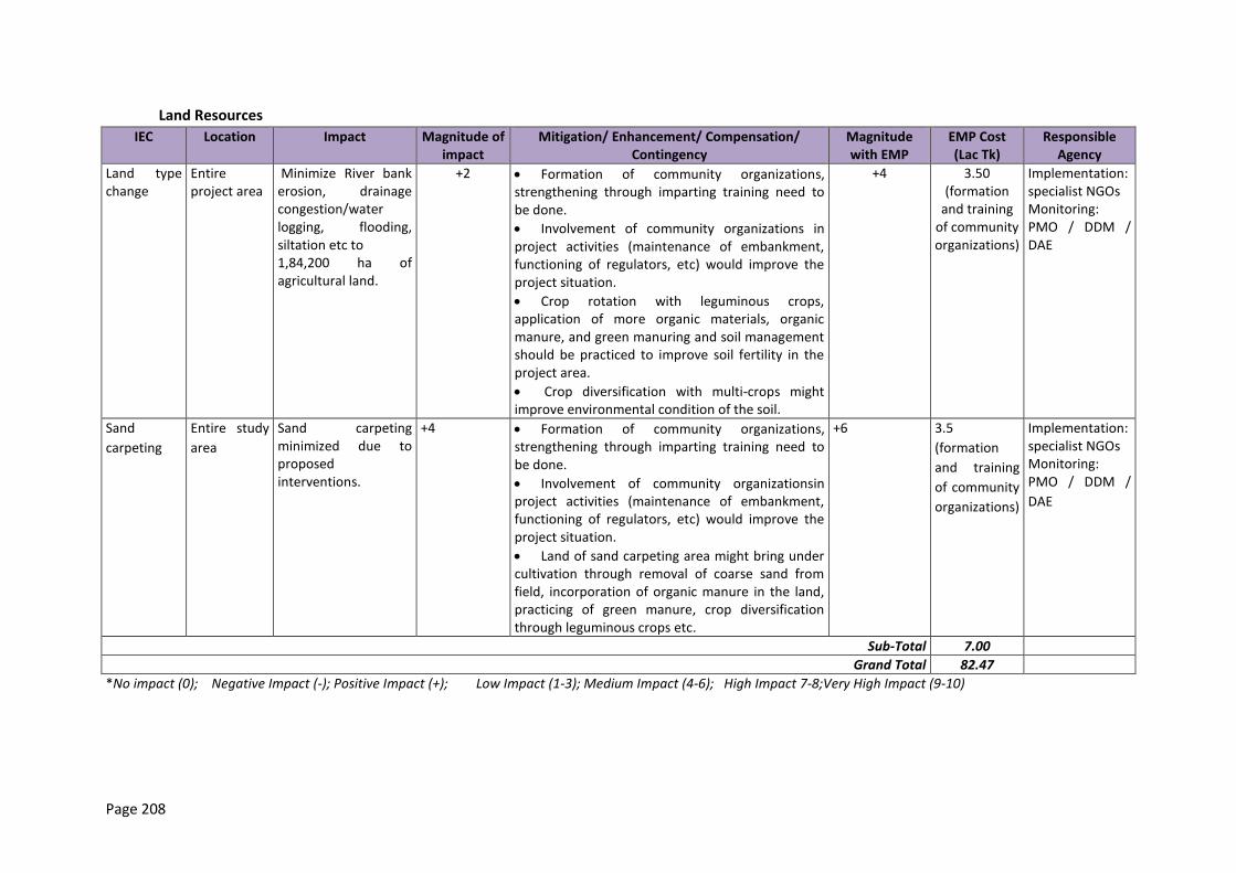
Page 208
Land Resources
IEC Location Impact Magnitude of impact
Mitigation/ Enhancement/ Compensation/ Contingency
Magnitude with EMP
EMP Cost (Lac Tk)
Responsible Agency
Land type change
Entire project area
Minimize River bank erosion, drainage congestion/water logging, flooding, siltation etc to 1,84,200 ha of agricultural land.
+2 Formation of community organizations, strengthening through imparting training need to be done.
Involvement of community organizations in project activities (maintenance of embankment, functioning of regulators, etc) would improve the project situation.
Crop rotation with leguminous crops, application of more organic materials, organic manure, and green manuring and soil management should be practiced to improve soil fertility in the project area.
Crop diversification with multi-crops might improve environmental condition of the soil.
+4 3.50 (formation
and training of community organizations)
Implementation: specialist NGOs Monitoring: PMO / DDM / DAE
Sand
carpeting
Entire study
area
Sand carpeting minimized due to proposed interventions.
+4 Formation of community organizations, strengthening through imparting training need to be done.
Involvement of community organizationsin project activities (maintenance of embankment, functioning of regulators, etc) would improve the project situation.
Land of sand carpeting area might bring under cultivation through removal of coarse sand from field, incorporation of organic manure in the land, practicing of green manure, crop diversification through leguminous crops etc.
+6 3.5
(formation
and training
of community
organizations)
Implementation: specialist NGOs Monitoring: PMO / DDM /
DAE
Sub-Total 7.00
Grand Total 82.47
*No impact (0); Negative Impact (-); Positive Impact (+); Low Impact (1-3); Medium Impact (4-6); High Impact 7-8;Very High Impact (9-10)
Page 209
Agricultural Resources
IEC Location Impact Magnitude of impact
Mitigation/ Enhancement/ Compensation/ Contingency
Magnitude with EMP
EMP Cost (Lac Tk)
Responsible Agency
Crop production
Entire project
area( All locations) Additional rice production would be about 148,065 metric tons
+3 Organic manure should be applied for the increase of soil fertility;
Farmers group should have close contact with DAE for adaptation of various measures of IPM/ICM;
Irrigation should be provided in optimum level with minimum conveyance loss;
Involvement of Community organizationsin project activities would enhance crop production.
+6 Implementation: specialist NGOs Monitoring: PMO / DDM / DAE
Improved irrigation facilities
Entire project area( All locations)
Additional surface water irrigated area would be increased by about 75 ha due to re-excavation of khals.
+3 Farmers expand surface irrigation during rabi and boro season
communityorganizations get training in irrigation management
+4 3.50 (training)
Implementation: Community
organizations Monitoring:
DAE
Fisheries Resources
IEC Location Impacts M
agn
itu
de
o
f im
pac
t*
Mitigation/ Enhancement/ Compensation/ Contingency
Mag
nit
ud
e
wit
h E
MP
*
EMP Cost (Lac Tk/Yr)*
Responsible Agency
Re-habilitation of Embanment
Page 210
IEC Location Impacts
Mag
nit
ud
e
of
imp
act*
Mitigation/ Enhancement/ Compensation/ Contingency
Mag
nit
ud
e
wit
h E
MP
*
EMP Cost (Lac Tk/Yr)*
Responsible Agency
Fish habitat 6.5 km of the Verakhola towards start of Hurashagar river
Estimated net loss to fish habitat area would be 4321.3 ha
-7 1. Aquatic trees and herbs should be planted on the slope of the bank. 2. Proper protective device will have to take to protect the deep pools (dor/duars). 3. Use of surface water during the breeding period should be stopped. 4. Culture fisheries should be developed 5. Perennial beels should be developed under sanctuary program 6. Some flood water from the river should be allowed during normal or low floods (through sluice gates)
-4 0.5 (planting of trees and herbs, development of culture fishery ponds and construction of protective devices)
Implementation: specialist NGOs, community organizations Monitoring: PMO in coordination with Department of Fisheries
4km from the starting point of Hurashagar to Korotoa bank
Estimated net loss to fish habitat area would be 1659 ha
-4 -2
Fish migration
6.5 km of the Verakhola towards start of Hurashagar river
Degraded fish migration -5 Operation of sluice gates -3 Not applicable
Implementation: joint management committees, Monitoring: Department of Fisheries (DoF)
4km from the starting point of Hurashagar to Korotoa bank
Degraded fish migration -5 Operation of sluice gates -3
Fish biodiversity
6.5 km of the Verakhola towards start of Hurashagar
Capture fish species diversity would be moderate to low
-2 1. Proper protective device) will have to take to protect the deep pools (dor/duars).
-2 0.5 (for protective
Implementation: specialist NGOs, community
Page 211
IEC Location Impacts
Mag
nit
ud
e
of
imp
act*
Mitigation/ Enhancement/ Compensation/ Contingency
Mag
nit
ud
e
wit
h E
MP
*
EMP Cost (Lac Tk/Yr)*
Responsible Agency
river 2. Use of surface water during the breeding period should be stopped. 3. Culture fisheries should be developed 4. Perennial beels should be developed under biodiversityprogram 5. Proper training to increase the culture practice of high-valued fish species
devices, development of culture fisheries and training programs)
organizations Monitoring: PMO /
Department of Fisheries (DoF)
4km from the starting point of Hurashagar to Korotoa bank
Capture fish species diversity would be moderate to low
-2 -
Fish production
6.5 km of the Verakhola towards start of Hurashagar river
Estimated net loss to fish production: 1179.5 MT
-7 -5 1 Implementation: specialist NGOs, community organizations Monitoring: PMO /
Department of Fisheries (DoF)
4km from the starting point of Hurashagar to Korotoa bank
Estimated net loss to fish production: 461 MT
-6 -4
Construction of New Embankment
Fish habitat 10.5 km of the Jamuna river bank from Hat Pachil Bazar, Kaizuri to Benotia Hat/Bazar
Estimated net loss to fish habitat area would be 11038.5 ha
-9 1. Aquatic trees and herbs should be planted on the slope of the bank. 2. Proper protective device will have to take to protect the deep pools (dor/duars). 3. Use of surface water during the breeding period should be stopped.
-6 0.5 (for protective devices, and planting of aquatic trees and herbs)
Implementation: specialist NGOs Monitoring: PMO /
Department of Fisheries (DoF) 2 km from Benotia
Hat/Bazar to the start of Baral Khal, Verakola Hat
Estimated net loss to fish habitat area would be 409 ha
-9 -6
Fish migration
10.5 km of the Jamuna river bank from Hat Pachil Bazar, Kaizuri to Benotia Hat/Bazar
Degraded fish migration -5 Operation of sluice gates -5 Not applicable
Implementation: joint management committees, Monitoring:
Page 212
IEC Location Impacts
Mag
nit
ud
e
of
imp
act*
Mitigation/ Enhancement/ Compensation/ Contingency
Mag
nit
ud
e
wit
h E
MP
*
EMP Cost (Lac Tk/Yr)*
Responsible Agency
2 km from Benotia Hat/Bazar to the start of Baral Khal, Verakola Hat
Degraded fish migration -5 -5 Department of Fisheries (DoF)
Fish biodiversity
10.5 km of the Jamuna river bank from Hat Pachil Bazar, Kaizuri to Benotia Hat/Bazar
Capture fish species diversity would be moderate to low
-2 Aquaculture program including reexcavation of khals and borrow pits, developing fish ponds, and operation of sluice gates during the flood season
-2 Implementation: community organizations, joint management committees Monitoring:
Department of Fisheries (DoF)
2 km from Benotia Hat/Bazar to the start of Baral Khal, Verakola Hat
Capture fish species diversity would be moderate to low
-2 -
Fish production
10.5 km of the Jamuna river bank from Hat Pachil Bazar, Kaizuri to Benotia Hat/Bazar
Estimated net loss to fish production: 99 MT
+3 Proper training to increase the culture practice of high-valued fish species
+4 1 (for training)
Implementation: specialist NGOs Monitoring: PMO /
Department of Fisheries (DoF) 2 km from Benotia
Hat/Bazar to the start of Baral Khal, Verakola Hat
Estimated net gain to fish production: 1 MT
+1 Not applicable +1
Riverbank Protection Work
Fish habitat 2 km from Benotia Hat/Bazar to the start of Baral Khal
Estimated net loss to fish habitat area would be 1 ha
-2 1. Aquatic trees and herbs should be planted on the slope of the bank. 2. Proper protective device (i.e., declaration of Sanctuary) will
-2 0.5 (for aquatic plants and protective devices)
Implementation: specialist NGOs, community organizations Monitoring: PMO /
Page 213
IEC Location Impacts
Mag
nit
ud
e
of
imp
act*
Mitigation/ Enhancement/ Compensation/ Contingency
Mag
nit
ud
e
wit
h E
MP
*
EMP Cost (Lac Tk/Yr)*
Responsible Agency
have to take to protect the deep pools (dor/duars). 3. Use of surface water during the breeding period should be stopped.
Department of Fisheries (DoF)
Fish migration
Degraded fish migration -5 Not applicable -5 Not applicable
Not applicable
Fish biodiversity
Capture fish species diversity would be moderate to low
-2 Not applicable - Same as above
Not applicable
Fish production
Estimated net gain to fish production: 1 MT
+1 Not applicable +1 1 Not applicable
Ecological Resources
IEC Location Impacts
Mag
nit
ud
e o
f im
pac
t*
Mitigation/Enhancement/Compensation/Contingency
Mag
nit
ud
e
wit
h E
MP
EMP Cost
(Lac Tk.)
Respons-ible Agency
Embankment Rehabilitation
Terrestrial ecosystem Aquatic ecosystem. Floral composition and
10.5 km from Verakhola toward the Korotoa bank at Mohakhola
Protection of homestead, roadside and social forest habitat. Vegetation coverage of the project area will improve
+3
Do not dump large volume of excavated soil on bottom of the present trees. Observation of national and international days Awareness development activities should be conducted by the committee or nature club to protect the saplings.
+5 -
Implementation: specialist NGOs, community organizations Monitoring: PMO / Department of Forestry
Page 214
IEC Location Impacts
Mag
nit
ud
e o
f im
pac
t*
Mitigation/Enhancement/Compensation/Contingency
Mag
nit
ud
e
wit
h E
MP
EMP Cost
(Lac Tk.)
Respons-ible Agency
diversity. Faunal composition and diversity
Faunal composition and diversity would be deteriorated
Construction of New Embankment
Terrestrial ecosystem Aquatic ecosystem. Floral composition and diversity Faunal composition and diversity
12.5 km of the Jamuna river bank from Hat Pachil Bazar, Kaizuri toward the Korotoa bank at Mohakhola
Protection of homestead, roadside and social forest habitat will improve bio-diversity Vegetation coverage of the project area will improve Faunal composition and diversity would be deteriorated
+2 Observation of national and international days Awareness development activities should be conducted by the committee or nature club to protect the saplings.
+3 Mention above
Implementation: specialist NGOs, community organizations Monitoring: PMO / Department of Forestry
Riverbank Protection Work
Activity- Slope Protection Activities
Page 215
IEC Location Impacts
Mag
nit
ud
e o
f im
pac
t*
Mitigation/Enhancement/Compensation/Contingency
Mag
nit
ud
e
wit
h E
MP
EMP Cost
(Lac Tk.)
Respons-ible Agency
Terrestrial ecosystem Aquatic ecosystem. Floral composition and diversity. Faunal composition and
2 km from Benotia Hat/ Bazar to the start of Baral Khal, Verakola Hat.
Protection of homestead, roadside and social forest habitat will improve bio-diversity Vegetation coverage of the project area will improve Faunal composition and diversity would be deteriorated
+2
Awareness development activities should be conducted by the committee or nature club to protect the planted saplings.
5 - Implementation: specialist NGOs, community organizations Monitoring: PMO / Department of Forestry
*No impact (0); Negative Impact (-); Positive Impact (+); Low Impact (1-3); Medium Impact (4-6); High Impact 7-8; Very High Impact (9-10).
Socio-economic
IEC Location FWOP FWIP Impacts Magnitude of impact*
Mitigation/ Enhancement/ Compensation/
Contingency
Magnitude with EMP*
EMP Cost (in Lac Tk)
Responsible Agency
Jamuna Right Bank-1(JRB-1)
Communication Possible locations for communication in project area Hat Panchil Benotia Verakhola
Embankment cum road wiped out for last 10 years. In near future, main road of
Communication facilities will be improved both in local and upazila level.
Road communication will be improved which convey better economy by
+3 Not applicable N/A N/A Not applicable
Page 216
IEC Location FWOP FWIP Impacts Magnitude of impact*
Mitigation/ Enhancement/ Compensation/
Contingency
Magnitude with EMP*
EMP Cost (in Lac Tk)
Responsible Agency
Dambarla Hat Panchil to Benotia would be affected.
expanding business option.
Employment Ratankandi Selachapri Dumbaria Alokdia Nundao
Temporary employment will be created for many labors during labor shed construction
More employment opportunities will be created for farmers and fishers of the project area.
In future, a number of employments will generate in fish culture and agriculture activities.
+2 Ensure/arrange training from DAE and DOF for local labors.
N/A N/A Implementation: specialist NGOs Monitoring: PMO
Income generation
A small number of low earned people will enhance their income with this additional income source.
People income will increase in future by creating more work options.
Income will be increased for all classes i.e. labor to businessmen.
+4 Implement a livelihood program for vulnerable groups directly affected by the construction
N/A N/A Implementation: specialist NGOs Monitoring: PMO
Page 217
10.3 Subproject JLB-2
10.3.1 Pre-Construction Phase
Water Resources
IEC Location Impacts
Mag
nit
ud
e
of
imp
act
Mitigation/ Enhancement/ Compensation/ Contingency
Mag
nit
ud
e
wit
h E
MP
EMP Cost (Lac Tk)
Responsible Agency
Activity: Construction of labor shed with water and sanitation facilities, garbage disposal system, construction of stock yard and construction camp, labor and material/equipment mobilization
Air quality
- Possible locations of labor camps (Char Jajuria and Khashkaulia mauzas at Chauhali and Char raghunathpur at Jafarganj).
- Location of stock yard (to be selected by the Engineer In Charge).
- Location of CC blocks construction (Khashkaulia mauza at Chauhali and raghunathpur amauza at Jafarganj).
Small amount of dust would be generated during movement of vehicles, construction materials and machineries; construction of labor shed and CC block.
-2 Mitigation: - Construction materials to be
covered with thick materials i.e. polythene during transportation.
- Water to be sprinkled to control the generation and spreading of dust; as and where needed.
-1 N/A Implementation: Contractor Monitoring: Nominated Engineer (SMO, BWDB)
Noise - Possible locations of labor shed (Char Jajuria and Khashkaulia mauzas at Chauhali and Char raghunathpur at Jafarganj).
- Location of stock yard (to be selected by the Engineer In Charge).
Low impacts caused due to noise generation due to mobilization of construction materials and construction of labor shed, stockyard and CC blocks. There is a high school and an upazilla office at the construction site of Chauhali and one primary school at Jafarganj which would face minor impacts due to noise
-2 Mitigation: - Noise levels due to vehicular
movement are to be kept within permissible limit.
- Construction camps, labor shed, and sites for CC blocks construction are to be located
-1 N/A Implementation: Contractor Monitoring: Nominated Engineer (SMO, BWDB)
Page 218
IEC Location Impacts
Mag
nit
ud
e
of
imp
act
Mitigation/ Enhancement/ Compensation/ Contingency
Mag
nit
ud
e
wit
h E
MP
EMP Cost (Lac Tk)
Responsible Agency
- Location of CC blocks construction (Khashkaulia mauza at Chauhali and raghunathpur amauza at Jafarganj).
- Roadside locations to be used during material transportation (Char jajuria, khashkaulia mauzas at Chauhali and raghunathpur and paila mauzas at Jafarganj)
generation. far away from settlements, school, offices.
Land Resources
IEC Location Impacts Magnitude of impact
Mitigation/ Enhancement/ Compensation/ Contingency
Magnitude with EMP
EMP Cost (Lac Tk) Responsible Agency
Activity Construction of labor sheds and stocking yard for Bank Protective activities
Land loss Location-2: (Chauhali-5.0km)
Possibility of 1.02 ha of agricultural land would be lost temporarily
-1 Construction activities should be carried out as per design.
Labor shed and stocking yard should preferably be constructed on fallow or khas land.
Landowners affected by the construction of labor shed and placement of filling materials on agriculture land should be noticed ahead of time so that the area might not be affected for growing crops.
Labor sheds, and other project related activities should be optimized with the purpose of minimum disruption to cultivable lands and standing crops.
+2 0.38 (compensation)
Implementation: Contractor Compensation payment: BWDB Monitoring: Nominated Engineer (SMO, BWDB)
Location-3: (Bachamara-2.0km)
Possibility of 1.01 ha of agricultural land would be lost temporarily
-1 +2 0.37 (compensation)
Implementation: Contractor Compensation payment: BWDB
Page 219
IEC Location Impacts Magnitude of impact
Mitigation/ Enhancement/ Compensation/ Contingency
Magnitude with EMP
EMP Cost (Lac Tk) Responsible Agency
Adequate cash compensation should be provided to the land owners /share croppers.
The compensation should be determined based on the amount of land temporarily going out of cultivation.
Monitoring: Nominated Engineer (SMO, BWDB)
Sub total 0.75
Agricultural Resources
392. There would be no impact during the pre-construction phase
Fisheries Resources
393. There will be no impact during the pre-construction phase.
Ecological Resources
394. There will be no impact duriing the pre-construction phase.
Socio-economic
IEC Location Impacts Magnitude of impact*
Mitigation/ Enhancement/ Compensation/
Contingency
Magnitude with EMP*
EMP Cost (in Lac Tk)
Responsible Agency
Activity-> Construction of labor shed with water and sanitation facilities, garbage disposal system, construction of stock yard and construction camp, labor and material/equipment mobilization
Resettlement 5 km of the Jamuna Left bank from Chauhali Sadar to
About 534 HHs in the different locations of project area will be
-2 Proper land compensation to the PAPs, displaced
0 Will be estimated from RAP
Implementation: Deputy Commissioner,
Page 220
IEC Location Impacts Magnitude of impact*
Mitigation/ Enhancement/ Compensation/
Contingency
Magnitude with EMP*
EMP Cost (in Lac Tk)
Responsible Agency
Atpara 2 km of the Jamuna Left bank from Jaffarganj to Bachamara These villages/mauzas are: Andharmanik Beda khola Mohakhola Kashipur Ata para Noya Para Dholai Kaulia Marma
displaced. peopled of project area should be re-settled.
report specialist NGO Monitoring: PMO
Employment Possible locations of labor camps (Char Janjira and Khashkaulia mauzas). Location of stock yard (to be selected by the Engineer in Charge). Location of CC blocks construction (at Khashkaulia mauza).
A temporary employment opportunity will be created for local labors during labor shed construction.
+1 Recruit at least 60% of labors from locale for construction work.
N/A N/A Implementation: Contractor Monitoring: Nominated Engineer (SMO, BWDB)
Gender Issues The whole study area i.e. Andharmanik
Labor mobilization may create disturbance for the local women.
-2 The labor mobilization activities should strictly follow up by project
-1 N/A Implementation: Contractor Monitoring:
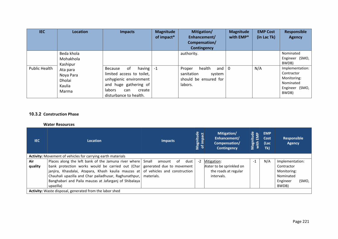
Page 221
IEC Location Impacts Magnitude of impact*
Mitigation/ Enhancement/ Compensation/
Contingency
Magnitude with EMP*
EMP Cost (in Lac Tk)
Responsible Agency
Beda khola Mohakhola Kashipur Ata para Noya Para Dholai Kaulia Marma
authority. Nominated Engineer (SMO, BWDB)
Public Health Because of having limited access to toilet, unhygienic environment and huge gathering of labors can create disturbance to health.
-1 Proper health and sanitation system should be ensured for labors.
0 N/A Implementation: Contractor Monitoring: Nominated Engineer (SMO, BWDB)
10.3.2 Construction Phase
Water Resources
IEC Location Impacts
Mag
nit
ud
e
of
imp
act Mitigation/
Enhancement/ Compensation/
Contingency Mag
nit
ud
e
wit
h E
MP
EMP Cost (Lac Tk)
Responsible Agency
Activity: Movement of vehicles for carrying earth materials
Air quality
Places along the left bank of the Jamuna river where bank protection works would be carried out (Char janjira, Khasdalai, Atapara, Khash kaulia mauzas at Chauhali upazilla and Char pailadhusar, Raghunathpur, Banghabari and Paila mauzas at Jafarganj of Shibalaya upazilla)
Small amount of dust generated due to movement of vehicles and construction materials.
-2 Mitigation: Water to be sprinkled on
the roads at regular intervals.
-1 N/A Implementation: Contractor Monitoring: Nominated Engineer (SMO, BWDB)
Activity: Waste disposal, generated from the labor shed

Page 222
IEC Location Impacts
Mag
nit
ud
e
of
imp
act Mitigation/
Enhancement/ Compensation/
Contingency Mag
nit
ud
e
wit
h E
MP
EMP Cost (Lac Tk)
Responsible Agency
Surface water quality
Possible locations of labor shed (Char Janjira and Khashkaulia mauzas at Chauhali and Char raghunathpur at Jafarganj).
Impacts can be generated due to improper disposal system which may eventually contaminate the water of Jamuna River.
-4 Mitigation: Proper waste disposal system, not interfering with the Jamuna river flow.
-1 N/A Implementation: Contractor Monitoring: Nominated Engineer (SMO, BWDB)
Land Resources
IEC Location Impact Magnitude of impact
Mitigation/ Enhancement/ Compensation/ Contingency
Magnitude with EMP
EMP Cost (Lac Tk)
Responsible Agency
Activity Collection and disposal of construction materials for bank protection activities
Land loss Location-2: (Chauhali-5.0km)
About 0.5ha of land would be lost permanently
-1 Top soil (0-15cm will be removed and stored securely away from drainage lines and erosion prone areas for future use in revegetation and surfacing.
.
Area for executing construction activities and other project related activities should be optimized with the purpose of minimum disruption to cultivable lands and standing crops
The filling materials should be collected from khas/fallow land /river.
Disposal of spoil/ constructing materials should preferably be stored on fallow or khas land so that the area might not be affected for growing crops.
Compensation will be paid for any crop damage.
The contractor will avoid cultivation fields
+2 No cost involvement of cost for land due to activities in existing embankment
Implementation: Contractor Monitoring: Nominated Engineer (SMO, BWDB)
Location-3: (Bachamara-2.0km)
About 0.2ha of land would be lost permanently
-1 +2 Implementation: Contractor Monitoring: Nominated Engineer (SMO, BWDB)
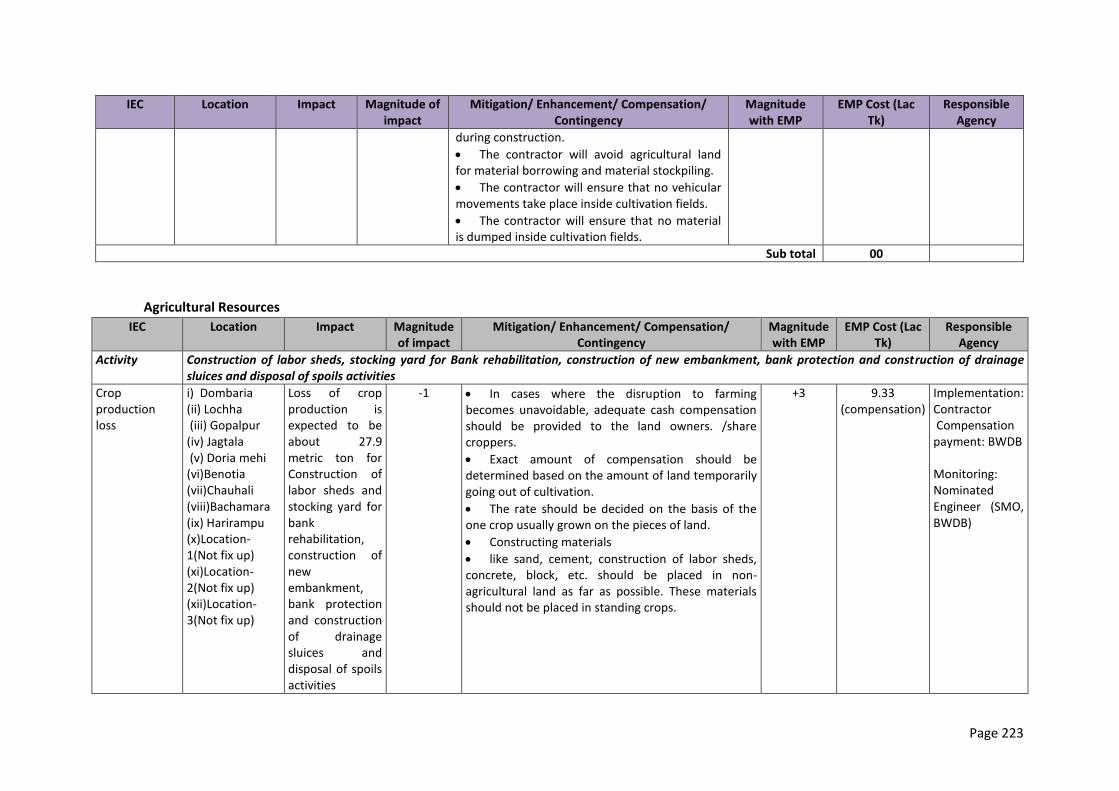
Page 223
IEC Location Impact Magnitude of impact
Mitigation/ Enhancement/ Compensation/ Contingency
Magnitude with EMP
EMP Cost (Lac Tk)
Responsible Agency
during construction.
The contractor will avoid agricultural land for material borrowing and material stockpiling.
The contractor will ensure that no vehicular movements take place inside cultivation fields.
The contractor will ensure that no material is dumped inside cultivation fields.
Sub total 00
Agricultural Resources
IEC Location Impact Magnitude of impact
Mitigation/ Enhancement/ Compensation/ Contingency
Magnitude with EMP
EMP Cost (Lac Tk)
Responsible Agency
Activity Construction of labor sheds, stocking yard for Bank rehabilitation, construction of new embankment, bank protection and construction of drainage sluices and disposal of spoils activities
Crop production loss
i) Dombaria (ii) Lochha (iii) Gopalpur (iv) Jagtala (v) Doria mehi (vi)Benotia (vii)Chauhali (viii)Bachamara (ix) Harirampu (x)Location-1(Not fix up) (xi)Location-2(Not fix up) (xii)Location-3(Not fix up)
Loss of crop production is expected to be about 27.9 metric ton for Construction of labor sheds and stocking yard for bank rehabilitation, construction of new embankment, bank protection and construction of drainage sluices and disposal of spoils activities
-1 In cases where the disruption to farming becomes unavoidable, adequate cash compensation should be provided to the land owners. /share croppers.
Exact amount of compensation should be determined based on the amount of land temporarily going out of cultivation.
The rate should be decided on the basis of the one crop usually grown on the pieces of land.
Constructing materials
like sand, cement, construction of labor sheds, concrete, block, etc. should be placed in non-agricultural land as far as possible. These materials should not be placed in standing crops.
+3 9.33 (compensation)
Implementation: Contractor Compensation payment: BWDB Monitoring: Nominated Engineer (SMO, BWDB)
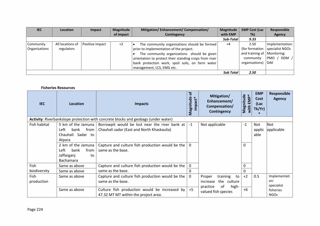
Page 224
IEC Location Impact Magnitude of impact
Mitigation/ Enhancement/ Compensation/ Contingency
Magnitude with EMP
EMP Cost (Lac Tk)
Responsible Agency
Sub-Total 9.33
Community Organizations
All locations of regulators
Positive impact +2 The community organizations should be formed prior to implementation of the project.
The community organizations should be given orientation to protect their standing crops from river bank protection work, spoil soils, on farm water management, LCS, EMG etc.
+4 2.50 (for formation and training of
community organizations)
Implementation: specialist NGOs Monitoring: PMO / DDM / DAE
Sub Total 2.50
Fisheries Resources
IEC Location Impacts
Mag
nit
ud
e o
f
imp
act*
Mitigation/ Enhancement/ Compensation/
Contingency Mag
nit
ud
e
wit
h E
MP
* EMP Cost (Lac
Tk/Yr)*
Responsible Agency
Activity: Riverbankslope protection with concrete blocks and geobags (under water)
Fish habitat 5 km of the Jamuna Left bank from Chauhali Sadar to Atpara
Borrowpit would be lost near the river bank at Chauhali sadar (East and North Khaskaulia)
-1 Not applicable
-1 Not applicable
Not applicable
2 km of the Jamuna Left bank from Jaffarganj to Bachamara
Capture and culture fish production would be the same as the base.
0 0
Fish biodiversity
Same as above Capture and culture fish production would be the same as the base.
0 0
Same as above 0 0
Fish production
Same as above Capture and culture fish production would be the same as the base.
0 Proper training to increase the culture practice of high-valued fish species
+2 0.5 Implementation: specialist fisheries NGOs
Same as above Culture fish production would be increased by 47.32 MT MT within the project area.
+5 +6
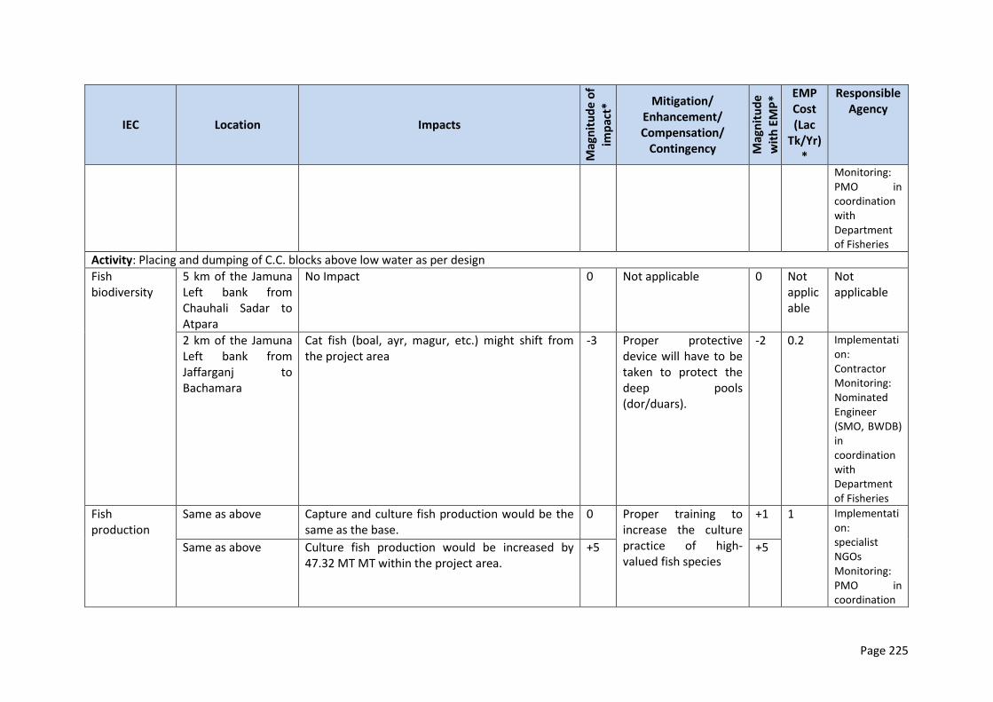
Page 225
IEC Location Impacts
Mag
nit
ud
e o
f
imp
act*
Mitigation/ Enhancement/ Compensation/
Contingency Mag
nit
ud
e
wit
h E
MP
* EMP Cost (Lac
Tk/Yr)*
Responsible Agency
Monitoring: PMO in coordination with Department of Fisheries
Activity: Placing and dumping of C.C. blocks above low water as per design
Fish biodiversity
5 km of the Jamuna Left bank from Chauhali Sadar to Atpara
No Impact 0 Not applicable
0 Not applicable
Not applicable
2 km of the Jamuna Left bank from Jaffarganj to Bachamara
Cat fish (boal, ayr, magur, etc.) might shift from the project area
-3 Proper protective device will have to be taken to protect the deep pools (dor/duars).
-2 0.2 Implementation: Contractor Monitoring: Nominated Engineer (SMO, BWDB) in coordination with Department of Fisheries
Fish production
Same as above Capture and culture fish production would be the same as the base.
0 Proper training to increase the culture practice of high-valued fish species
+1 1 Implementation: specialist NGOs Monitoring: PMO in coordination
Same as above Culture fish production would be increased by 47.32 MT MT within the project area.
+5 +5
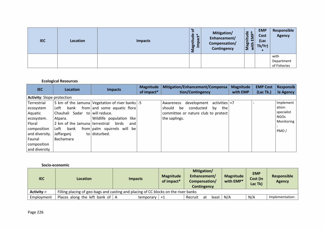
Page 226
IEC Location Impacts
Mag
nit
ud
e o
f
imp
act*
Mitigation/ Enhancement/ Compensation/
Contingency Mag
nit
ud
e
wit
h E
MP
* EMP Cost (Lac
Tk/Yr)*
Responsible Agency
with Department of Fisheries
Ecological Resources
IEC Location Impacts Magnitude of impact*
Mitigation/Enhancement/Compensation/Contingency
Magnitude with EMP
EMP Cost (Lac Tk.)
Responsible Agency
Activity: Slope protection
Terrestrial ecosystem Aquatic ecosystem. Floral composition and diversity. Faunal composition and diversity
5 km of the Jamuna Left bank from Chauhali Sadar to Atpara. 2 km of the Jamuna Left bank from Jaffarganj to Bachamara
Vegetation of river banks and some aquatic flora will reduce. Wildlife population like terrestrial birds and palm squirrels will be disturbed.
-5
Awareness development activities should be conducted by the committee or nature club to protect the saplings.
+7
-
Implementation: specialist NGOs Monitoring: PMO /
Socio-economic
IEC Location Impacts Magnitude of impact*
Mitigation/ Enhancement/ Compensation/
Contingency
Magnitude with EMP*
EMP Cost (in Lac Tk)
Responsible Agency
Activity-> Filling placing of geo-bags and casting and placing of CC blocks on the river banks
Employment Places along the left bank of A temporary +1 Recruit at least N/A N/A Implementation:
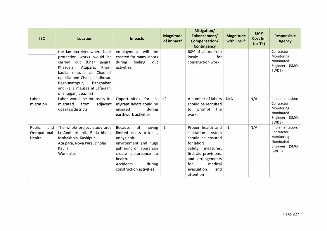
Page 227
IEC Location Impacts Magnitude of impact*
Mitigation/ Enhancement/ Compensation/
Contingency
Magnitude with EMP*
EMP Cost (in Lac Tk)
Responsible Agency
the Jamuna river where bank protection works would be carried out (Char janjira, Khasdalai, Atapara, Khash kaulia mauzas at Chauhali upazilla and Char pailadhusar, Raghunathpur, Banghabari and Paila mauzas at Jafarganj of Sirajganj upazilla)
employment will be created for many labors during bailing out activities.
60% of labors from locale for construction work.
Contractor Monitoring: Nominated Engineer (SMO, BWDB)
Labor migration
Labor would be internally in-migrated from adjacent upazilas/districts.
Opportunities for in-migrant labors could be ensured during earthwork activities.
+2 A number of labors should be recruited to prompt the work.
N/A N/A Implementation: Contractor Monitoring: Nominated Engineer (SMO, BWDB)
Public and Occupational Health
The whole project study area i.e.Andharmanik, Beda khola, Mohakhola, Kashipur Ata para, Noya Para, Dholai Kaulia Work sites
Because of having limited access to toilet, unhygienic environment and huge gathering of labors can create disturbance to health. Accidents during construction activities
-1 Proper health and sanitation system should be ensured for labors. Safety measures, first aid provisions, and arrangements for medical evacuation and attention
-1 N/A Implementation: Contractor Monitoring: Nominated Engineer (SMO, BWDB)
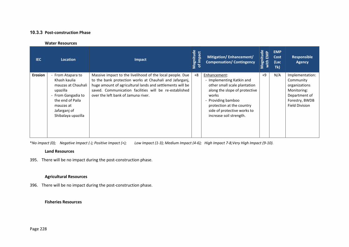
Page 228
10.3.3 Post-construction Phase
Water Resources
IEC Location Impact
Mag
nit
ud
e
of
imp
act
Mitigation/ Enhancement/ Compensation/ Contingency
Mag
nit
ud
e
wit
h E
MP
EMP Cost (Lac Tk)
Responsible Agency
Erosion - From Atapara to Khash kaulia mauzas at Chauhali upazilla
- From Gangadia to the end of Paila mauzas at Jafarganj of Shibalaya upazilla
Massive impact to the livelihood of the local people. Due to the bank protection works at Chauhali and Jafarganj, huge amount of agricultural lands and settlements will be saved. Communication facilities will be re-established over the left bank of Jamuna river.
+8 Enhancement: - Implementing Katkin and
other small scale plantation along the slope of protective works
- Providing bamboo protection at the country side of protective works to increase soil strength.
+9 N/A Implementation: Community organizations Monitoring: Department of Forestry, BWDB Field Division
*No impact (0); Negative Impact (-); Positive Impact (+); Low Impact (1-3); Medium Impact (4-6); High Impact 7-8;Very High Impact (9-10).
Land Resources
395. There will be no impact during the post-construction phase.
Agricultural Resources
396. There will be no impact during the post-construction phase.
Fisheries Resources
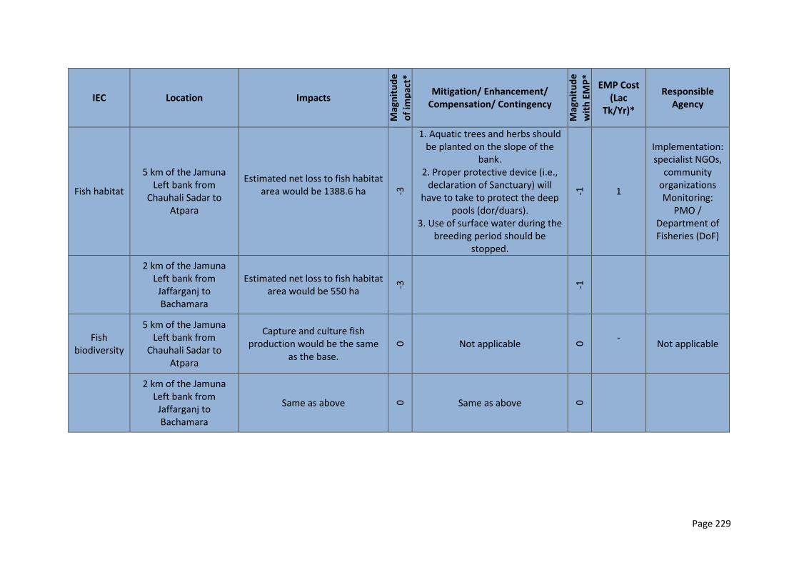
Page 229
IEC Location Impacts
Mag
nit
ud
e
of
imp
act*
Mitigation/ Enhancement/ Compensation/ Contingency
Mag
nit
ud
e
wit
h E
MP
*
EMP Cost (Lac
Tk/Yr)*
Responsible Agency
Fish habitat
5 km of the Jamuna Left bank from
Chauhali Sadar to Atpara
Estimated net loss to fish habitat area would be 1388.6 ha
-3
1. Aquatic trees and herbs should be planted on the slope of the
bank. 2. Proper protective device (i.e.,
declaration of Sanctuary) will have to take to protect the deep
pools (dor/duars). 3. Use of surface water during the
breeding period should be stopped.
-1
1
Implementation: specialist NGOs,
community organizations Monitoring:
PMO / Department of Fisheries (DoF)
2 km of the Jamuna Left bank from
Jaffarganj to Bachamara
Estimated net loss to fish habitat area would be 550 ha
-3
-1
Fish biodiversity
5 km of the Jamuna Left bank from
Chauhali Sadar to Atpara
Capture and culture fish production would be the same
as the base.
0 Not applicable 0
-
Not applicable
2 km of the Jamuna Left bank from
Jaffarganj to Bachamara
Same as above 0 Same as above 0
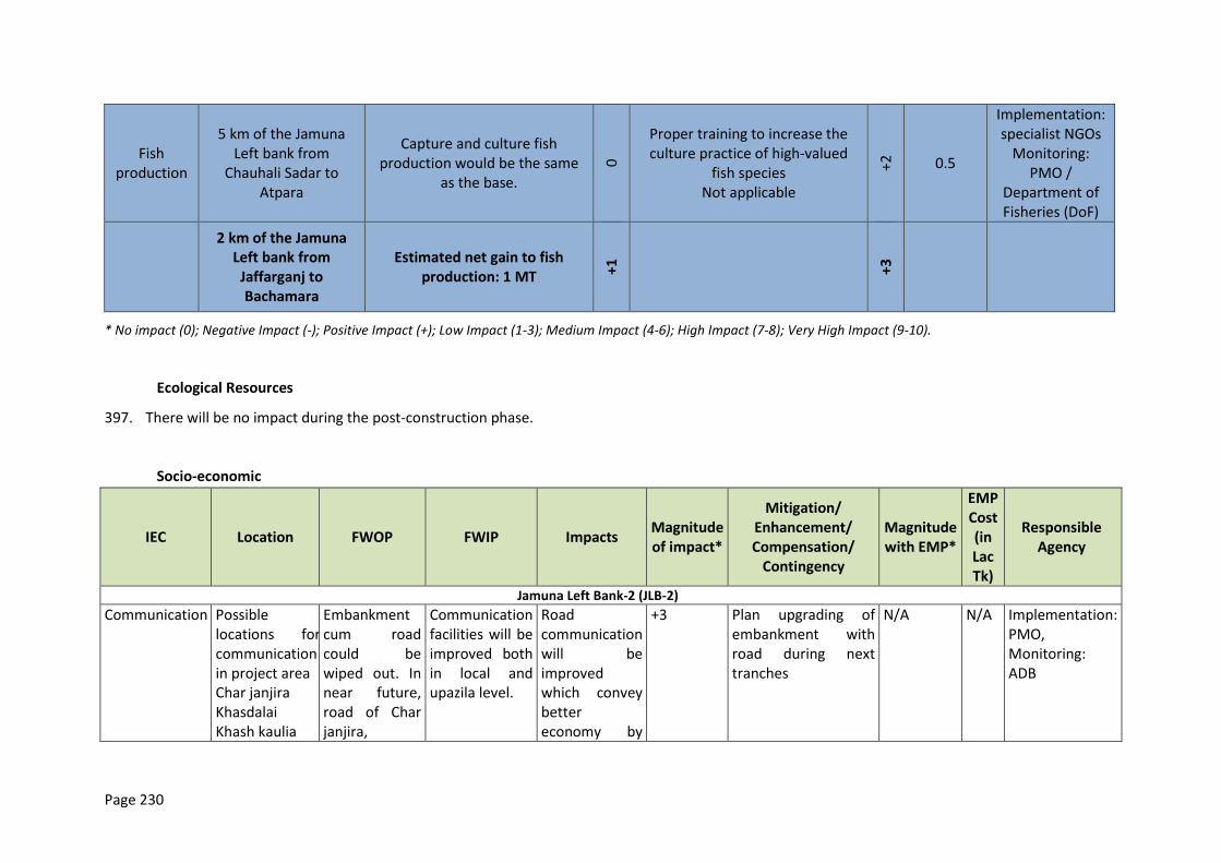
Page 230
Fish production
5 km of the Jamuna Left bank from
Chauhali Sadar to Atpara
Capture and culture fish production would be the same
as the base.
0
Proper training to increase the culture practice of high-valued
fish species Not applicable
+2 0.5
Implementation: specialist NGOs
Monitoring: PMO /
Department of Fisheries (DoF)
2 km of the Jamuna Left bank from
Jaffarganj to Bachamara
Estimated net gain to fish production: 1 MT +
1 +3
* No impact (0); Negative Impact (-); Positive Impact (+); Low Impact (1-3); Medium Impact (4-6); High Impact (7-8); Very High Impact (9-10).
Ecological Resources
397. There will be no impact during the post-construction phase.
Socio-economic
IEC Location FWOP FWIP Impacts Magnitude of impact*
Mitigation/ Enhancement/ Compensation/
Contingency
Magnitude with EMP*
EMP Cost (in Lac Tk)
Responsible Agency
Jamuna Left Bank-2 (JLB-2)
Communication Possible locations for communication in project area Char janjira Khasdalai Khash kaulia
Embankment cum road could be wiped out. In near future, road of Char janjira,
Communication facilities will be improved both in local and upazila level.
Road communication will be improved which convey better economy by
+3 Plan upgrading of embankment with road during next tranches
N/A N/A Implementation: PMO, Monitoring: ADB
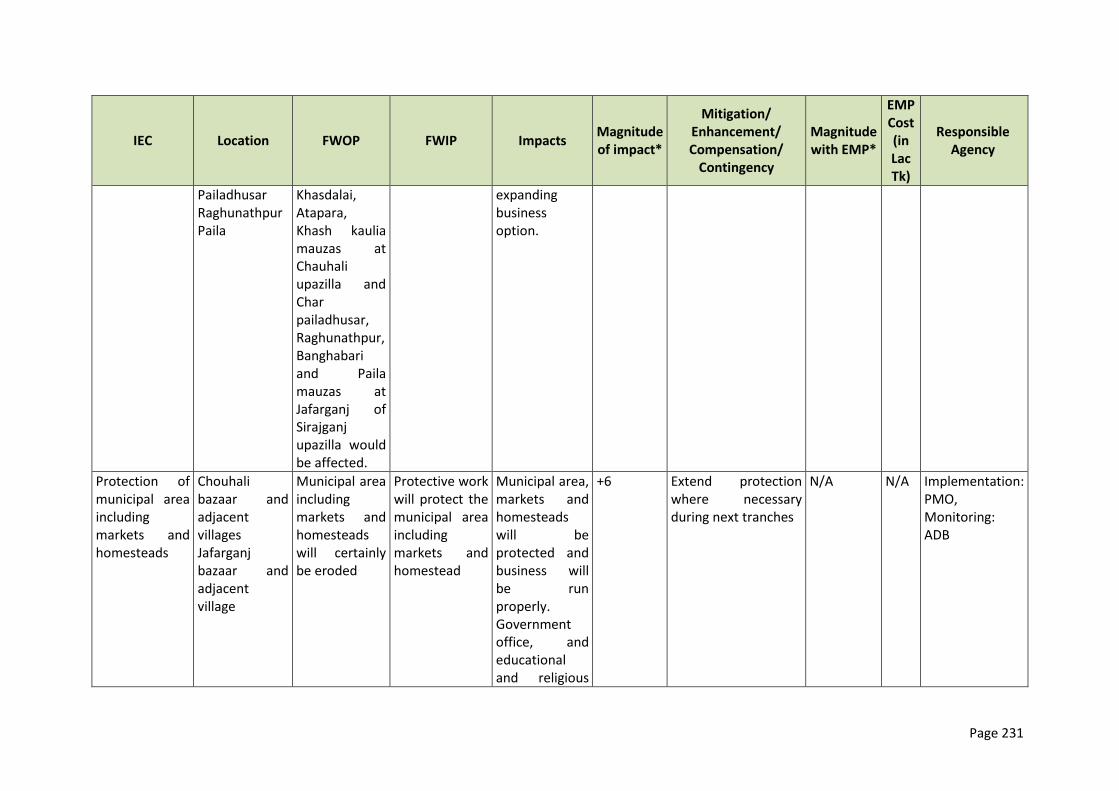
Page 231
IEC Location FWOP FWIP Impacts Magnitude of impact*
Mitigation/ Enhancement/ Compensation/
Contingency
Magnitude with EMP*
EMP Cost (in Lac Tk)
Responsible Agency
Pailadhusar Raghunathpur Paila
Khasdalai, Atapara, Khash kaulia mauzas at Chauhali upazilla and Char pailadhusar, Raghunathpur, Banghabari and Paila mauzas at Jafarganj of Sirajganj upazilla would be affected.
expanding business option.
Protection of municipal area including markets and homesteads
Chouhali bazaar and adjacent villages Jafarganj bazaar and adjacent village
Municipal area including markets and homesteads will certainly be eroded
Protective work will protect the municipal area including markets and homestead
Municipal area, markets and homesteads will be protected and business will be run properly. Government office, and educational and religious
+6 Extend protection where necessary during next tranches
N/A N/A Implementation: PMO, Monitoring: ADB
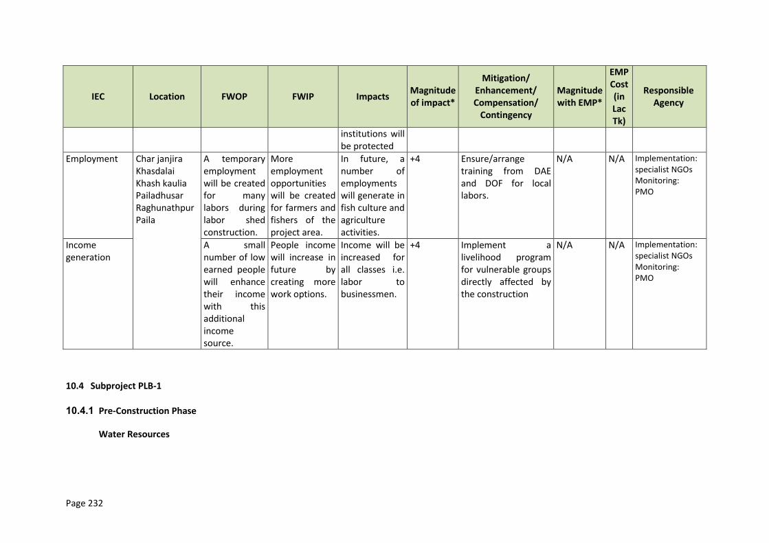
Page 232
IEC Location FWOP FWIP Impacts Magnitude of impact*
Mitigation/ Enhancement/ Compensation/
Contingency
Magnitude with EMP*
EMP Cost (in Lac Tk)
Responsible Agency
institutions will be protected
Employment Char janjira Khasdalai Khash kaulia Pailadhusar Raghunathpur Paila
A temporary employment will be created for many labors during labor shed construction.
More employment opportunities will be created for farmers and fishers of the project area.
In future, a number of employments will generate in fish culture and agriculture activities.
+4 Ensure/arrange training from DAE and DOF for local labors.
N/A N/A Implementation: specialist NGOs Monitoring: PMO
Income generation
A small number of low earned people will enhance their income with this additional income source.
People income will increase in future by creating more work options.
Income will be increased for all classes i.e. labor to businessmen.
+4 Implement a livelihood program for vulnerable groups directly affected by the construction
N/A N/A Implementation: specialist NGOs Monitoring: PMO
10.4 Subproject PLB-1
10.4.1 Pre-Construction Phase
Water Resources
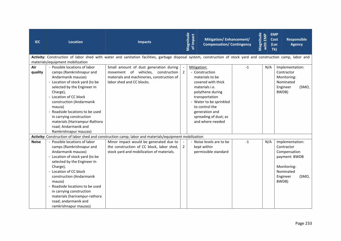
Page 233
IEC Location Impacts
Mag
nit
ud
e
of
imp
act
Mitigation/ Enhancement/ Compensation/ Contingency
Mag
nit
ud
e
wit
h E
MP
EMP Cost (Lac Tk)
Responsible Agency
Activity: Construction of labor shed with water and sanitation facilities, garbage disposal system, construction of stock yard and construction camp, labor and materials/equipment mobilization
Air quality
- Possible locations of labor camps (Ramkrishnapur and Andarmanik mauzas)
- Location of stock yard (to be selected by the Engineer In Charge),
- Location of CC block construction (Andarmanik mauza)
- Roadside locations to be used in carrying construction materials (Harirampur-Rathora road; Andarmanik and Ramkrishnapur mauzas)
Small amount of dust generation during movement of vehicles, construction materials and machineries, construction of labor shed and CC blocks.
-2
Mitigation: - Construction
materials to be covered with thick materials i.e. polythene during transportation
- Water to be sprinkled to control the generation and spreading of dust; as and where needed
-1 N/A Implementation: Contractor Monitoring: Nominated Engineer (SMO, BWDB)
Activity: Construction of labor shed and construction camp; labor and materials/equipment mobilization
Noise - Possible locations of labor camps (Ramkrishnapur and Andarmanik mauzas)
- Location of stock yard (to be selected by the Engineer In Charge),
- Location of CC block construction (Andarmanik mauza)
- Roadside locations to be used in carrying construction materials (harirampur-rathora road; andarmanik and ramkrishnapur mauzas)
Minor impact would be generated due to the construction of CC block, labor shed, stock yard and mobilization of materials.
-2
- Noise levels are to be kept within permissible standard
-1 N/A Implementation: Contractor Compensation payment: BWDB Monitoring: Nominated Engineer (SMO, BWDB)
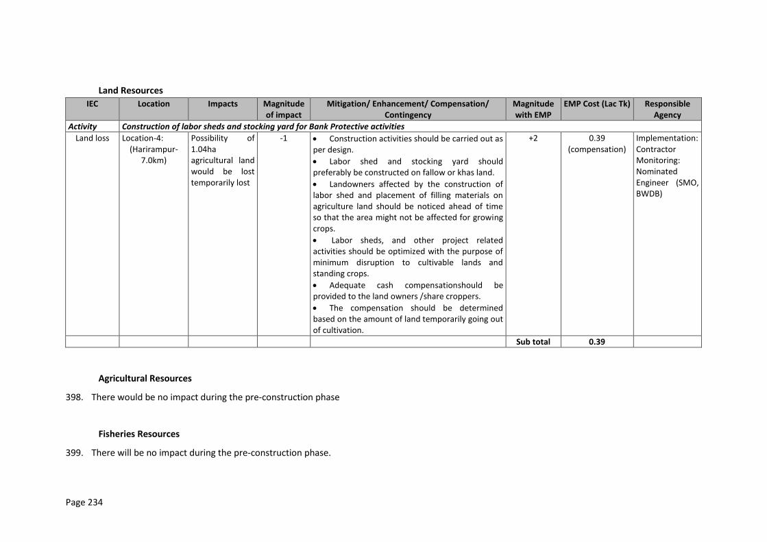
Page 234
Land Resources
IEC Location Impacts Magnitude of impact
Mitigation/ Enhancement/ Compensation/ Contingency
Magnitude with EMP
EMP Cost (Lac Tk) Responsible Agency
Activity Construction of labor sheds and stocking yard for Bank Protective activities
Land loss Location-4: (Harirampur-
7.0km)
Possibility of 1.04ha agricultural land would be lost temporarily lost
-1 Construction activities should be carried out as per design.
Labor shed and stocking yard should preferably be constructed on fallow or khas land.
Landowners affected by the construction of labor shed and placement of filling materials on agriculture land should be noticed ahead of time so that the area might not be affected for growing crops.
Labor sheds, and other project related activities should be optimized with the purpose of minimum disruption to cultivable lands and standing crops.
Adequate cash compensationshould be provided to the land owners /share croppers.
The compensation should be determined based on the amount of land temporarily going out of cultivation.
+2 0.39 (compensation)
Implementation: Contractor Monitoring: Nominated Engineer (SMO, BWDB)
Sub total 0.39
Agricultural Resources
398. There would be no impact during the pre-construction phase
Fisheries Resources
399. There will be no impact during the pre-construction phase.
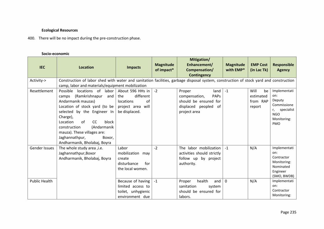
Page 235
Ecological Resources
400. There will be no impact duriing the pre-construction phase.
Socio-economic
IEC Location Impacts Magnitude of impact*
Mitigation/ Enhancement/ Compensation/
Contingency
Magnitude with EMP*
EMP Cost (in Lac Tk)
Responsible Agency
Activity-> Construction of labor shed with water and sanitation facilities, garbage disposal system, construction of stock yard and construction camp, labor and materials/equipment mobilization
Resettlement Possible locations of labor camps (Ramkrishnapur and Andarmanik mauzas) Location of stock yard (to be selected by the Engineer In Charge), Location of CC block construction (Andarmanik mauza). These villages are: Jaghannathpur, Boxor, Andharmanik, Bholabaj, Boyra
About 596 HHs in the different locations of project area will be displaced.
-2 Proper land compensation, PAPs should be ensured for displaced peopled of project area
-1 Will be estimated from RAP report
Implementation: Deputy Commissioner, specialist NGO Monitoring: PMO
Gender Issues The whole study area ,i.e. Jaghannathpur,Boxor Andharmanik, Bholabaj, Boyra
Labor mobilization may create disturbance for the local women.
-2 The labor mobilization activities should strictly follow up by project authority.
-1 N/A Implementation: Contractor Monitoring: Nominated Engineer (SMO, BWDB)
Public Health Because of having limited access to toilet, unhygienic environment due
-1 Proper health and sanitation system should be ensured for labors.
0 N/A Implementation: Contractor Monitoring:
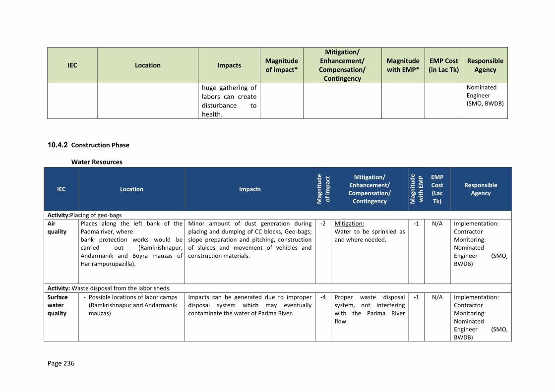
Page 236
IEC Location Impacts Magnitude of impact*
Mitigation/ Enhancement/ Compensation/
Contingency
Magnitude with EMP*
EMP Cost (in Lac Tk)
Responsible Agency
huge gathering of labors can create disturbance to health.
Nominated Engineer (SMO, BWDB)
10.4.2 Construction Phase
Water Resources
IEC Location Impacts
Mag
nit
ud
e
of
imp
act Mitigation/
Enhancement/ Compensation/
Contingency Mag
nit
ud
e
wit
h E
MP
EMP Cost (Lac Tk)
Responsible Agency
Activity:Placing of geo-bags
Air quality
Places along the left bank of the Padma river, where bank protection works would be carried out (Ramkrishnapur, Andarmanik and Boyra mauzas of Harirampurupazilla).
Minor amount of dust generation during placing and dumping of CC blocks, Geo-bags; slope preparation and pitching, construction of sluices and movement of vehicles and construction materials.
-2 Mitigation: Water to be sprinkled as and where needed.
-1 N/A Implementation: Contractor Monitoring: Nominated Engineer (SMO, BWDB)
Activity: Waste disposal from the labor sheds.
Surface water quality
- Possible locations of labor camps (Ramkrishnapur and Andarmanik mauzas)
Impacts can be generated due to improper disposal system which may eventually contaminate the water of Padma River.
-4 Proper waste disposal system, not interfering with the Padma River flow.
-1 N/A Implementation: Contractor Monitoring: Nominated Engineer (SMO, BWDB)
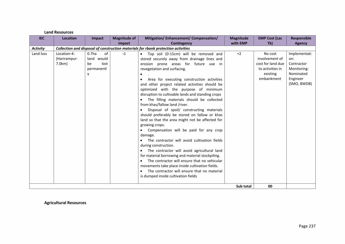
Page 237
Land Resources
IEC Location Impact Magnitude of impact
Mitigation/ Enhancement/ Compensation/ Contingency
Magnitude with EMP
EMP Cost (Lac Tk)
Responsible Agency
Activity Collection and disposal of construction materials for rbank protection activities
Land loss Location-4: (Harirampur-7.0km)
0.7ha of land would be lost permanently
-1 Top soil (0-15cm) will be removed and stored securely away from drainage lines and erosion prone areas for future use in revegetation and surfacing.
.
Area for executing construction activities and other project related activities should be optimized with the purpose of minimum disruption to cultivable lands and standing crops
The filling materials should be collected from khas/fallow land /river.
Disposal of spoil/ constructing materials should preferably be stored on fallow or khas land so that the area might not be affected for growing crops.
Compensation will be paid for any crop damage.
The contractor will avoid cultivation fields during construction.
The contractor will avoid agricultural land for material borrowing and material stockpiling.
The contractor will ensure that no vehicular movements take place inside cultivation fields.
The contractor will ensure that no material is dumped inside cultivation fields
+2 No cost involvement of
cost for land due to activities in
existing embankment
Implementation: Contractor Monitoring: Nominated Engineer (SMO, BWDB)
Sub total 00
Agricultural Resources
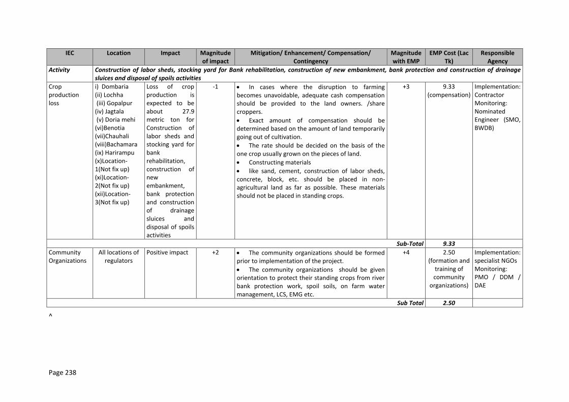
Page 238
IEC Location Impact Magnitude of impact
Mitigation/ Enhancement/ Compensation/ Contingency
Magnitude with EMP
EMP Cost (Lac Tk)
Responsible Agency
Activity Construction of labor sheds, stocking yard for Bank rehabilitation, construction of new embankment, bank protection and construction of drainage sluices and disposal of spoils activities
Crop production loss
i) Dombaria (ii) Lochha (iii) Gopalpur (iv) Jagtala (v) Doria mehi (vi)Benotia (vii)Chauhali (viii)Bachamara (ix) Harirampu (x)Location-1(Not fix up) (xi)Location-2(Not fix up) (xii)Location-3(Not fix up)
Loss of crop production is expected to be about 27.9 metric ton for Construction of labor sheds and stocking yard for bank rehabilitation, construction of new embankment, bank protection and construction of drainage sluices and disposal of spoils activities
-1 In cases where the disruption to farming becomes unavoidable, adequate cash compensation should be provided to the land owners. /share croppers.
Exact amount of compensation should be determined based on the amount of land temporarily going out of cultivation.
The rate should be decided on the basis of the one crop usually grown on the pieces of land.
Constructing materials
like sand, cement, construction of labor sheds, concrete, block, etc. should be placed in non-agricultural land as far as possible. These materials should not be placed in standing crops.
+3 9.33 (compensation)
Implementation: Contractor Monitoring: Nominated Engineer (SMO, BWDB)
Sub-Total 9.33
Community Organizations
All locations of regulators
Positive impact +2 The community organizations should be formed prior to implementation of the project.
The community organizations should be given orientation to protect their standing crops from river bank protection work, spoil soils, on farm water management, LCS, EMG etc.
+4 2.50 (formation and
training of community
organizations)
Implementation: specialist NGOs Monitoring: PMO / DDM / DAE
Sub Total 2.50
^

Page 239
Fisheries Resources
IEC Location Impacts
Mag
nit
ud
e o
f
imp
act*
Mitigation/ Enhancement/ Compensation/
Contingency Mag
nit
ud
e
wit
h E
MP
* EMP Cost (Lac
Tk/Yr)*
Responsible Agency
Fish habitat
7 km of the Padma Left Bank at Harirampur
Temporary damage would occur in the seasonal fish habitat due to either clearance of vegetation cover or draped by the filling earth during earth work for the fish species of marginal vegetation
feeder. Spawning ground would be lost
-6
1. Vegetation clearance should be
done as low as possible
2. There should be nowork on spawning grounds during the spawning season
-2
Implementation:
Contractor Monitoring: Nominated
Engineer (SMO,
BWDB) in coordination
with Department of Fisheries
Fish migration Migration route would be disturbed -6
-2
Fish biodiversity
Riverine fish species i. e. major carp species, grass carp and other herbivorous species, eel (baim), big
and small cat fish (boal, ayr, magur), might shift from the project area
-6
-2
Fish production
Capture fish production would temporarily be declined by 592 MT within the project area.
-1
-1
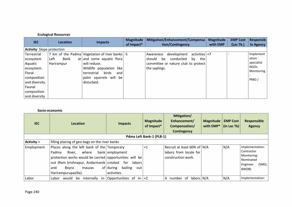
Page 240
Ecological Resources
IEC Location Impacts Magnitude of impact*
Mitigation/Enhancement/Compensation/Contingency
Magnitude with EMP
EMP Cost (Lac Tk.)
Responsible Agency
Activity: Slope protection
Terrestrial ecosystem Aquatic ecosystem. Floral composition and diversity. Faunal composition and diversity
7 km of the Padma Left Bank at Harirampur
Vegetation of river banks and some aquatic flora will reduce. Wildlife population like terrestrial birds and palm squirrels will be disturbed.
-5
Awareness development activities should be conducted by the committee or nature club to protect the saplings.
+7
-
Implementation: specialist NGOs Monitoring: PMO /
Socio-economic
IEC Location Impacts Magnitude
of impact*
Mitigation/
Enhancement/
Compensation/
Contingency
Magnitude
with EMP*
EMP Cost
(in Lac Tk)
Responsible
Agency
Pdma Left Bank-1 (PLB-1)
Activity-> filling placing of geo-bags on the river banks
Employment Places along the left bank of the
Padma River, where bank
protection works would be carried
out (Ram krishnapur, Andarmanik
and Boyra mauzas of
Harirampurupazilla).
Temporary
employment
opportunities will be
created for labors
during bailing out
activities.
+1 Recruit at least 60% of
labors from locale for
construction work.
N/A N/A Implementation: Contractor Monitoring: Nominated
Engineer (SMO,
BWDB)
Labor Labor would be internally in- Opportunities of in- +2 A number of labors N/A N/A Implementation:
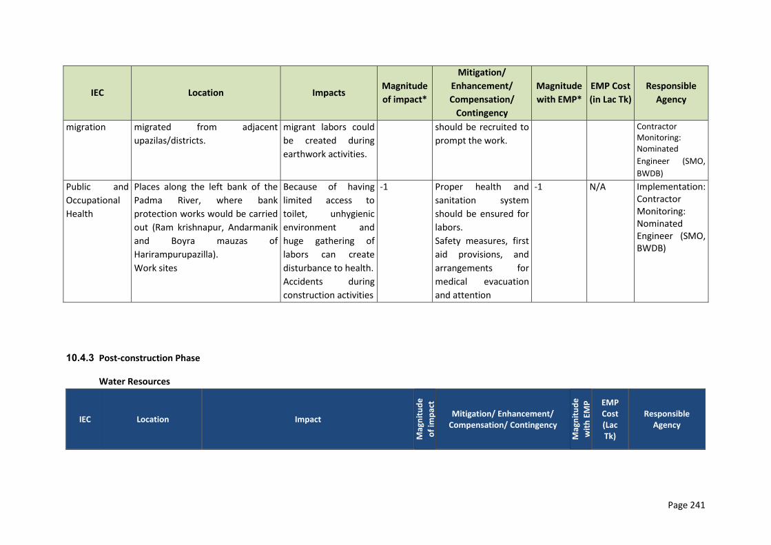
Page 241
IEC Location Impacts Magnitude
of impact*
Mitigation/
Enhancement/
Compensation/
Contingency
Magnitude
with EMP*
EMP Cost
(in Lac Tk)
Responsible
Agency
migration migrated from adjacent
upazilas/districts.
migrant labors could
be created during
earthwork activities.
should be recruited to
prompt the work.
Contractor Monitoring: Nominated
Engineer (SMO,
BWDB)
Public and
Occupational
Health
Places along the left bank of the
Padma River, where bank
protection works would be carried
out (Ram krishnapur, Andarmanik
and Boyra mauzas of
Harirampurupazilla).
Work sites
Because of having
limited access to
toilet, unhygienic
environment and
huge gathering of
labors can create
disturbance to health.
Accidents during
construction activities
-1 Proper health and
sanitation system
should be ensured for
labors.
Safety measures, first
aid provisions, and
arrangements for
medical evacuation
and attention
-1 N/A Implementation: Contractor Monitoring: Nominated Engineer (SMO, BWDB)
10.4.3 Post-construction Phase
Water Resources
IEC Location Impact M
agn
itu
de
of
imp
act
Mitigation/ Enhancement/ Compensation/ Contingency
Mag
nit
ud
e
wit
h E
MP
EMP Cost (Lac Tk)
Responsible Agency
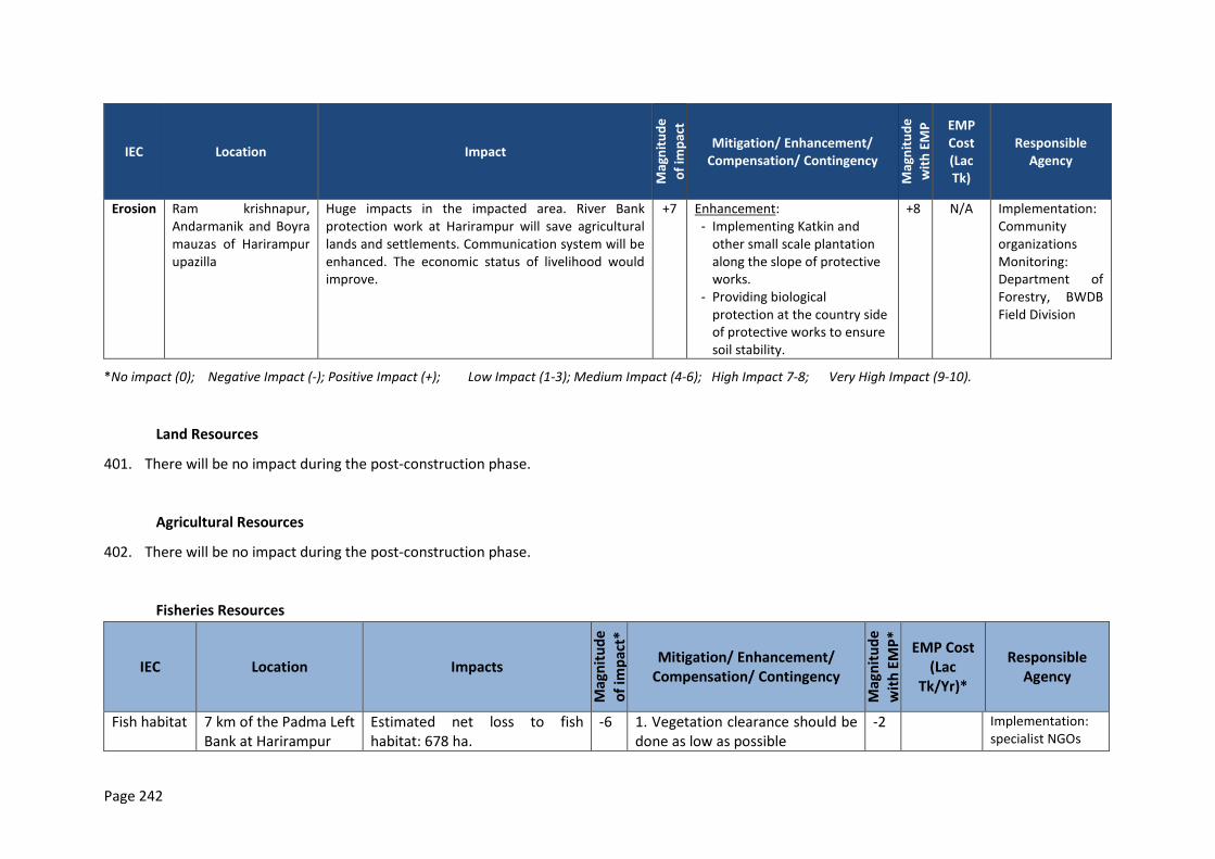
Page 242
IEC Location Impact
Mag
nit
ud
e
of
imp
act
Mitigation/ Enhancement/ Compensation/ Contingency
Mag
nit
ud
e
wit
h E
MP
EMP Cost (Lac Tk)
Responsible Agency
Erosion Ram krishnapur, Andarmanik and Boyra mauzas of Harirampur upazilla
Huge impacts in the impacted area. River Bank protection work at Harirampur will save agricultural lands and settlements. Communication system will be enhanced. The economic status of livelihood would improve.
+7 Enhancement: - Implementing Katkin and
other small scale plantation along the slope of protective works.
- Providing biological protection at the country side of protective works to ensure soil stability.
+8 N/A Implementation: Community organizations Monitoring: Department of Forestry, BWDB Field Division
*No impact (0); Negative Impact (-); Positive Impact (+); Low Impact (1-3); Medium Impact (4-6); High Impact 7-8; Very High Impact (9-10).
Land Resources
401. There will be no impact during the post-construction phase.
Agricultural Resources
402. There will be no impact during the post-construction phase.
Fisheries Resources
IEC Location Impacts
Mag
nit
ud
e
of
imp
act*
Mitigation/ Enhancement/ Compensation/ Contingency
Mag
nit
ud
e
wit
h E
MP
*
EMP Cost (Lac
Tk/Yr)*
Responsible Agency
Fish habitat 7 km of the Padma Left Bank at Harirampur
Estimated net loss to fish habitat: 678 ha.
-6 1. Vegetation clearance should be done as low as possible
-2 Implementation: specialist NGOs
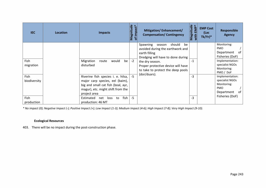
Page 243
IEC Location Impacts
Mag
nit
ud
e
of
imp
act*
Mitigation/ Enhancement/ Compensation/ Contingency
Mag
nit
ud
e
wit
h E
MP
*
EMP Cost (Lac
Tk/Yr)*
Responsible Agency
Spawning season should be avoided during the earthwork and earth filling Dredging will have to done during the dry season. Proper protective device will have to take to protect the deep pools (dor/duars).
Monitoring: PMO /
Department of Fisheries (DoF)
Fish migration
Migration route would be disturbed
-2 -1 Implementation: specialist NGOs Monitoring: PMO / DoF
Fish biodiversity
Riverine fish species i. e. hilsa, major carp species, eel (baim), big and small cat fish (boal, ayr, magur), etc. might shift from the project area
-5 -3 Implementation: specialist NGOs Monitoring: PMO /
Department of Fisheries (DoF) Fish
production Estimated net loss to fish production: 46 MT
-5 -3
* No impact (0); Negative Impact (-); Positive Impact (+); Low Impact (1-3); Medium Impact (4-6); High Impact (7-8); Very High Impact (9-10).
Ecological Resources
403. There will be no impact during the post-construction phase.
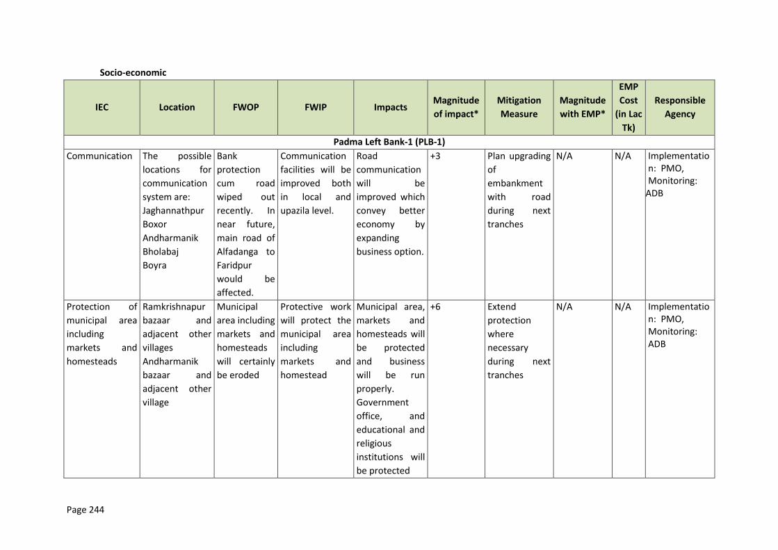
Page 244
Socio-economic
IEC Location FWOP FWIP Impacts Magnitude
of impact*
Mitigation
Measure
Magnitude
with EMP*
EMP
Cost
(in Lac
Tk)
Responsible
Agency
Padma Left Bank-1 (PLB-1)
Communication The possible
locations for
communication
system are:
Jaghannathpur
Boxor
Andharmanik
Bholabaj
Boyra
Bank
protection
cum road
wiped out
recently. In
near future,
main road of
Alfadanga to
Faridpur
would be
affected.
Communication
facilities will be
improved both
in local and
upazila level.
Road
communication
will be
improved which
convey better
economy by
expanding
business option.
+3 Plan upgrading
of
embankment
with road
during next
tranches
N/A N/A Implementation: PMO, Monitoring:
ADB
Protection of
municipal area
including
markets and
homesteads
Ramkrishnapur
bazaar and
adjacent other
villages
Andharmanik
bazaar and
adjacent other
village
Municipal
area including
markets and
homesteads
will certainly
be eroded
Protective work
will protect the
municipal area
including
markets and
homestead
Municipal area,
markets and
homesteads will
be protected
and business
will be run
properly.
Government
office, and
educational and
religious
institutions will
be protected
+6 Extend
protection
where
necessary
during next
tranches
N/A N/A Implementation: PMO, Monitoring: ADB
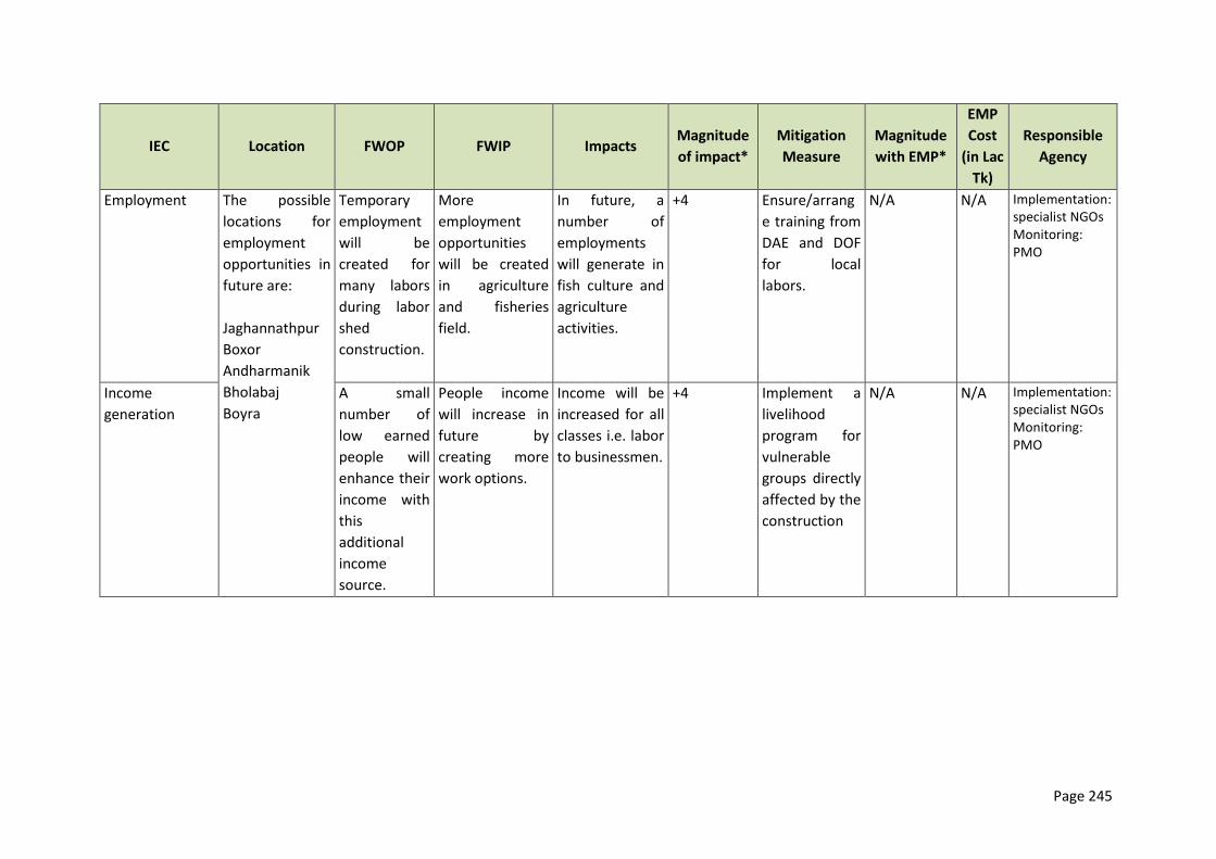
Page 245
IEC Location FWOP FWIP Impacts Magnitude
of impact*
Mitigation
Measure
Magnitude
with EMP*
EMP
Cost
(in Lac
Tk)
Responsible
Agency
Employment The possible
locations for
employment
opportunities in
future are:
Jaghannathpur
Boxor
Andharmanik
Bholabaj
Boyra
Temporary
employment
will be
created for
many labors
during labor
shed
construction.
More
employment
opportunities
will be created
in agriculture
and fisheries
field.
In future, a
number of
employments
will generate in
fish culture and
agriculture
activities.
+4 Ensure/arrang
e training from
DAE and DOF
for local
labors.
N/A N/A Implementation: specialist NGOs Monitoring: PMO
Income
generation
A small
number of
low earned
people will
enhance their
income with
this
additional
income
source.
People income
will increase in
future by
creating more
work options.
Income will be
increased for all
classes i.e. labor
to businessmen.
+4 Implement a
livelihood
program for
vulnerable
groups directly
affected by the
construction
N/A N/A Implementation: specialist NGOs Monitoring: PMO

Page 246
10.5 Monitoring Plan
10.5.1 Monitoring schedule for Pre-construction Phase
404. In this phase, no implementation monitoring plan is needed for checking EMP implementation works. The below provides an non-exhaustive example how the EMP could be monitored, which needs to be expanded to the site specific conditions.
10.5.2 Monitoring schedule for construction Phase
Bangladesh Water Development Board
Integrated Flood and Riverbank Erosion Management
Investment Program
EMP IMPLEMENTATION
Book No. _______________ Monitoring Report No._________
Date:____________________ Time:______________________
Contract:__________________________________________________________________
Contractor:________________________________________________________________
Work Sites (s):_____________________________________________________________
Sample checklist:
A DAILY EHS
CHECKLIST Yes No
Score
Yes=+5
No=-5
A DAILY EHS
CHECKLIST Yes No
Score
Yes=+5
No=-5
1 Correct Disposal of
Construction Solid
Waste
15 Dispensary
working, Doctor
present
2 Correct Disposal of
Liquid Waste
16 Ambulance
Functional
3 Vehicles and
dredger With No
Smoke or Noise
17 No Loss to Flora
or Fauna
(Specially Tree)
4 Vehicles Within
Speed Limit
18 Re-excavation
work
5 No Pollution from
construction site
19 Placement of
dredging spoil
6 No Oil/Diesel Spills
on Land or Water
20 Top-soil
protection
system from
embankment
area
7 No Social Issue
Created
21 Placement of
Top Soil
8 Any Threat Caused 22 Plantation
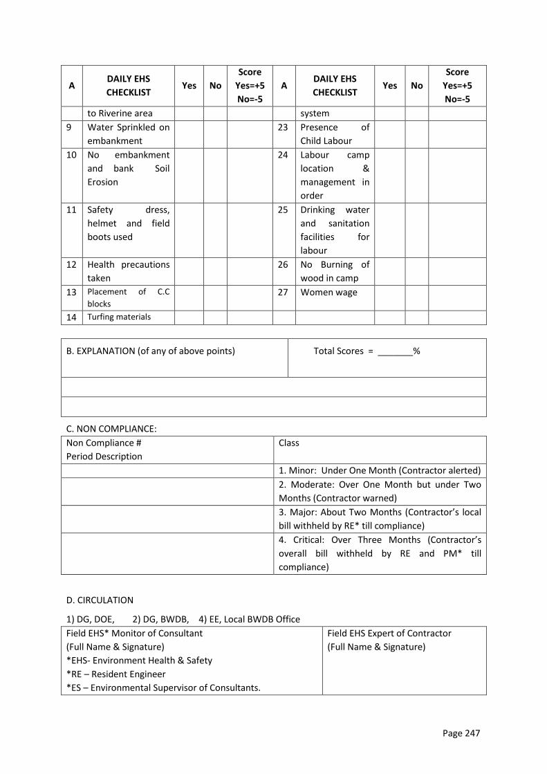
Page 247
A DAILY EHS
CHECKLIST Yes No
Score
Yes=+5
No=-5
A DAILY EHS
CHECKLIST Yes No
Score
Yes=+5
No=-5
to Riverine area system
9 Water Sprinkled on
embankment
23 Presence of
Child Labour
10 No embankment
and bank Soil
Erosion
24 Labour camp
location &
management in
order
11 Safety dress,
helmet and field
boots used
25 Drinking water
and sanitation
facilities for
labour
12 Health precautions
taken
26 No Burning of
wood in camp
13 Placement of C.C
blocks 27 Women wage
14 Turfing materials
B. EXPLANATION (of any of above points) Total Scores = _______%
C. NON COMPLIANCE:
Non Compliance #
Period Description
Class
1. Minor: Under One Month (Contractor alerted)
2. Moderate: Over One Month but under Two
Months (Contractor warned)
3. Major: About Two Months (Contractor’s local
bill withheld by RE* till compliance)
4. Critical: Over Three Months (Contractor’s
overall bill withheld by RE and PM* till
compliance)
D. CIRCULATION
1) DG, DOE, 2) DG, BWDB, 4) EE, Local BWDB Office
Field EHS* Monitor of Consultant
(Full Name & Signature)
*EHS- Environment Health & Safety
*RE – Resident Engineer
*ES – Environmental Supervisor of Consultants.
Field EHS Expert of Contractor
(Full Name & Signature)
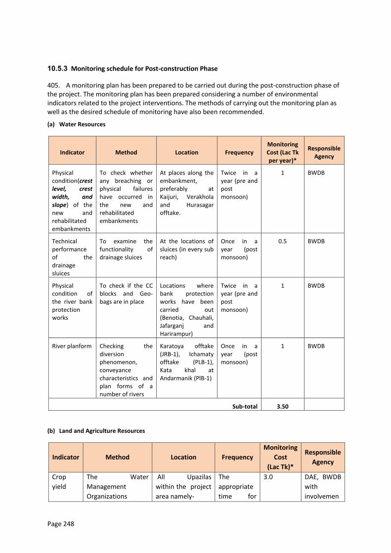
Page 248
10.5.3 Monitoring schedule for Post-construction Phase
405. A monitoring plan has been prepared to be carried out during the post-construction phase of the project. The monitoring plan has been prepared considering a number of environmental indicators related to the project interventions. The methods of carrying out the monitoring plan as well as the desired schedule of monitoring have also been recommended.
(a) Water Resources
Indicator Method Location Frequency Monitoring Cost (Lac Tk per year)*
Responsible Agency
Physical condition(crest level, crest width, and slope) of the new and rehabilitated embankments
To check whether any breaching or physical failures have occurred in the new and rehabilitated embankments
At places along the embankment, preferably at Kaijuri, Verakhola and Hurasagar offtake.
Twice in a year (pre and post monsoon)
1 BWDB
Technical performance of the drainage sluices
To examine the functionality of drainage sluices
At the locations of sluices (in every sub reach)
Once in a year (post monsoon)
0.5 BWDB
Physical condition of the river bank protection works
To check if the CC blocks and Geo-bags are in place
Locations where bank protection works have been carried out (Benotia, Chauhali, Jafarganj and Harirampur)
Twice in a year (pre and post monsoon)
1 BWDB
River planform Checking the diversion phenomenon, conveyance characteristics and plan forms of a number of rivers
Karatoya offtake (JRB-1), Ichamaty offtake (PLB-1), Kata khal at Andarmanik (PlB-1)
Once in a year (post monsoon)
1 BWDB
Sub-total 3.50
(b) Land and Agriculture Resources
Indicator Method Location Frequency
Monitoring
Cost
(Lac Tk)*
Responsible
Agency
Crop
yield
The Water
Management
Organizations
All Upazilas
within the project
area namely-
The
appropriate
time for
3.0 DAE, BWDB
with
involvemen
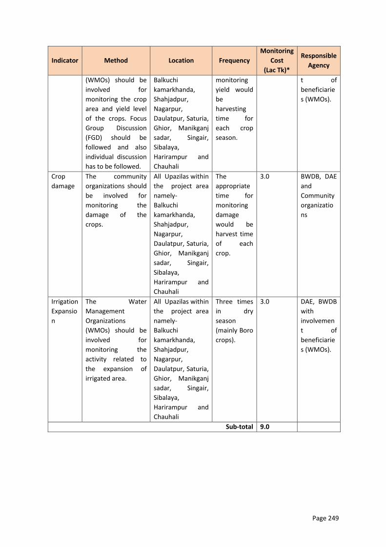
Page 249
Indicator Method Location Frequency
Monitoring
Cost
(Lac Tk)*
Responsible
Agency
(WMOs) should be
involved for
monitoring the crop
area and yield level
of the crops. Focus
Group Discussion
(FGD) should be
followed and also
individual discussion
has to be followed.
Balkuchi
kamarkhanda,
Shahjadpur,
Nagarpur,
Daulatpur, Saturia,
Ghior, Manikganj
sadar, Singair,
Sibalaya,
Harirampur and
Chauhali
monitoring
yield would
be
harvesting
time for
each crop
season.
t of
beneficiarie
s (WMOs).
Crop
damage
The community
organizations should
be involved for
monitoring the
damage of the
crops.
All Upazilas within
the project area
namely-
Balkuchi
kamarkhanda,
Shahjadpur,
Nagarpur,
Daulatpur, Saturia,
Ghior, Manikganj
sadar, Singair,
Sibalaya,
Harirampur and
Chauhali
The
appropriate
time for
monitoring
damage
would be
harvest time
of each
crop.
3.0 BWDB, DAE
and
Community
organizatio
ns
Irrigation
Expansio
n
The Water
Management
Organizations
(WMOs) should be
involved for
monitoring the
activity related to
the expansion of
irrigated area.
All Upazilas within
the project area
namely-
Balkuchi
kamarkhanda,
Shahjadpur,
Nagarpur,
Daulatpur, Saturia,
Ghior, Manikganj
sadar, Singair,
Sibalaya,
Harirampur and
Chauhali
Three times
in dry
season
(mainly Boro
crops).
3.0 DAE, BWDB
with
involvemen
t of
beneficiarie
s (WMOs).
Sub-total 9.0
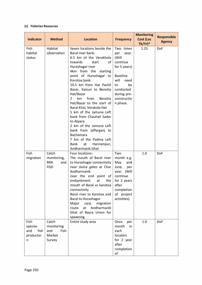
Page 250
(c) Fisheries Resources
Indicator Method Location Frequency Monitoring
Cost (Lac Tk/Yr)*
Responsible Agency
Fish habitat status
Habitat observation
Seven locations beside the Baral river bank: 6.5 km of the Verakhola towards start of Hurashagar river 4km from the starting point of Hurashagar to Korotoa bank 10.5 km from Hat Pachil Bazar, Kaizuri to Benotia Hat/Bazar 2 km from Benotia Hat/Bazar to the start of Baral Khal, Verakola Hat 5 km of the Jamuna Left bank from Chauhali Sadar to Atpara 2 km of the Jamuna Left bank from Jaffarganj to Bachamara 7 km of the Padma Left Bank at Harirampur, Andharmanik Ghat
Two times per year. (Will continue for 5 years) Baseline will need to be conducted during pre-construction phase.
1.25 DoF
Fish migration
Catch monitoring, RRA and FGD
Four locations: The mouth of Baral river to Hurashagar connectivity near sluice gates at Char Andharmanik near the end point of embankment at the mouth of Baral vs karotoa connectivity Baral river to Karotoa and Baral to Hurashagor Major carp migration route at Andharmanik Ghat of Bayra Union for spawning
Two month e.g. May and June, per year. (Will continue for 2 years after completion of project activities).
1.0 DoF
Fish species and fish production
Catch monitoring and Fish Market Survey
Entire study area Once per month in each location for 2 year after completion of
1.0 DoF
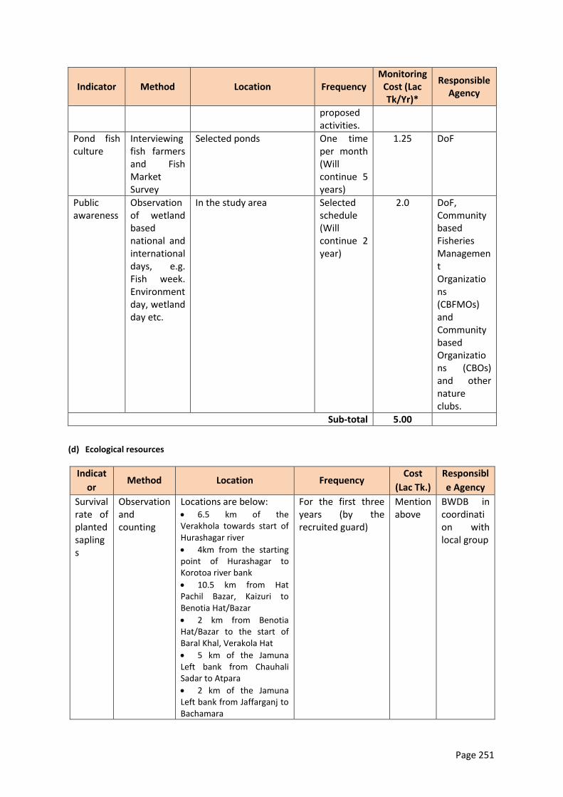
Page 251
Indicator Method Location Frequency Monitoring
Cost (Lac Tk/Yr)*
Responsible Agency
proposed activities.
Pond fish culture
Interviewing fish farmers and Fish Market Survey
Selected ponds One time per month (Will continue 5 years)
1.25 DoF
Public awareness
Observation of wetland based national and international days, e.g. Fish week. Environment day, wetland day etc.
In the study area Selected schedule (Will continue 2 year)
2.0 DoF, Community based Fisheries Management Organizations (CBFMOs) and Community based Organizations (CBOs) and other nature clubs.
Sub-total 5.00
(d) Ecological resources
Indicat
or Method Location Frequency
Cost
(Lac Tk.)
Responsibl
e Agency
Survival rate of planted saplings
Observation and counting
Locations are below: 6.5 km of the Verakhola towards start of Hurashagar river
4km from the starting point of Hurashagar to Korotoa river bank
10.5 km from Hat Pachil Bazar, Kaizuri to Benotia Hat/Bazar
2 km from Benotia Hat/Bazar to the start of Baral Khal, Verakola Hat
5 km of the Jamuna Left bank from Chauhali Sadar to Atpara
2 km of the Jamuna Left bank from Jaffarganj to Bachamara
For the first three years (by the recruited guard)
Mention above
BWDB in coordination with local group
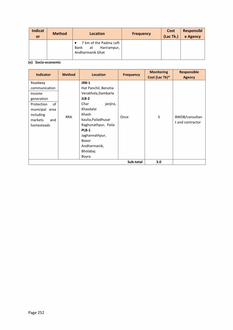
Page 252
Indicat
or Method Location Frequency
Cost
(Lac Tk.)
Responsibl
e Agency
7 km of the Padma Left Bank at Harirampur, Andharmanik Ghat
(e) Socio-economic
Indicator Method Location Frequency Monitoring
Cost (Lac Tk)*
Responsible
Agency
Roadway
communication
RRA
JRB-1
Hat Panchil, Benotia
Verakhola,Dambarla
JLB-2
Char janjira,
Khasdalai
Khash
kaulia,Pailadhusar
Raghunathpur, Paila
PLB-1
Jaghannathpur,
Boxor
Andharmanik,
Bholabaj
Boyra
Once
3
BWDB/consultan
t and contractor
Income
generation
Protection of
municipal area
including
markets and
homesteads
Sub-total 3.0
Page 253
11. Conclusion and Recommendations
11.1 Conclusion
406. The program has a number of inbuilt mechanisms to reduce environmental impacts. Many mitigation measures have been aggressively mainstreamed into program planning and engineering designs. The flexibility of a phased MFF approach supports minimization and mitigation of potential negative impacts in a gradual manner. Works will start in Tranche-1 with protection of critically eroding riverbanks and the reconstruction of the destroyed Brahmaputra Right Embankment, while conducting extensive studies on future impacts of river stabilization and associated embankment works, including piloting new measures. During Tranche-2 first measures for larger scale river stabilization are planned, designed based on the Tranche-1 study outcomes and supported by environmental monitoring and mitigation measures. This approach will be carried forward and adapted in Tranche-3.
407. With respect to flood mitigation and river stabilization, the program considers the following detailed approach:
(i) The program as a whole aims to reduce the flood risk at three priority sub-projects (JRB-1,
JLB-2, and PLB-1) by providing new/rehabilitated embankments in all tranches. The
program intends to mitigate negative impacts at the planning and designlevel, and
through additional compensation measures. Planning and design account for: (a) leaving
key distributariesopen to limited flood flowsto support the continued deposition of
fertile sediments as well as flood season navigation, (b) designing the offtakes of the
distributaries as part of the river stabilization work, in order to improve dry season
flows, (c) providing embankments with sluice gates specifically for local drainage42, and
(d) designing embankments in accordance to international practice to reduce the risk of
failure. Mitigation measures address: (e) loss in floodplain biodiversity, and (f) open
water fisheries. At community-level, flood risk management training will be provided to
the flood affected population in order to raise the awareness to the residual risk after
strengthening the existing flood embankment lines.
(ii) To protect the flood embankments, river banks will be progressively stabilized through
riverbank protection, starting in Tranche-1 at critically eroding reaches on an emergency
basis. Over time, this approach may lead to general river stabilization. To avoid
transforming the geomorphology of the Padma/Jamuna in an unprecedented manner,
for example if a single-channel solution is implemented, as studied in the Capital
Dredging and Sustainable River Management Project, (a) a multi-disciplinary river
stabilization study43 covering the whole Brahmaputra system from the Indian boarder
will be conducted, supported by (b) piloting stabilization measures, focussing on bio-
engineering techniques or “building with nature”; (c)siting of physical works will be
planned over the three tranches using an innovative dynamic methodology that
responds to evolving river behavior. Mitigation of potentially negative impacts of the
42
As it is not possible to locate sluice gates for later tranches, cost have been reflected in the embankment kilometer cost. 43
encompassing potential future river morphologies including the response of the system to man-made impacts on global (e.g. climate change), basin (e.g. sediment wave) and local (e.g stabilization) scale, plus socio-economic and environmental impacts of potential stabilization scenarios on floodplain and char habitants and biodiversity.
Page 254
planned river stabilization will be based on (d) a river sanctuary study covering river- and
floodplain land and conducted in tranche-1 potentially followed by implementation of a
sanctuary in a suitable river reach.
11.2 Recommendations
408. Mitigation of embankment and revetment operation-phase impacts described in chapter 8 – on aquatic habitats including charlands and their biodiversity including fisheries, and on people who depend on them – will be implemented in three work packages:
Aquaculture expansion (from Tranche-1).
Wetland biodiversity mitigation and rehabilitation (from Tranche-1).
Sanctuary (studied under Tranche-1, implemented from Tranche-2).
409. The anticipated environmental impacts of Tranch 1 are expected to be acceptable under the circumstances if the mitigation measures set forth in the EMP under Chapter 9 are implemented.
410. Tranch 1 can proceed without further environmental study. This EIA is the Project environmental assessment report.
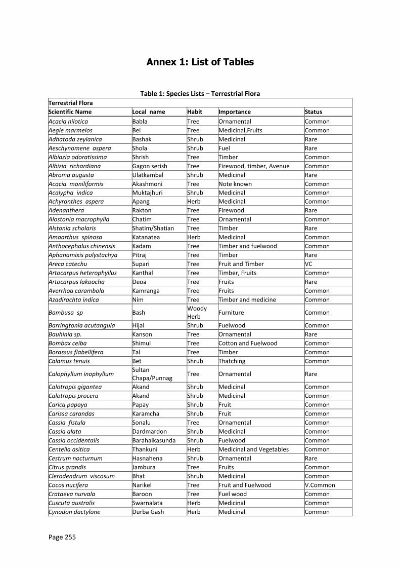
Page 255
Annex 1: List of Tables
Table 1: Species Lists – Terrestrial Flora Terrestrial Flora
Scientific Name Local name Habit Importance Status
Acacia nilotica Babla Tree Ornamental Common
Aegle marmelos Bel Tree Medicinal,Fruits Common
Adhatoda zeylanica Bashak Shrub Medicinal Rare
Aeschynomene aspera Shola Shrub Fuel Rare
Albiazia odoratissima Shrish Tree Timber Common
Albizia richardiana Gagon serish Tree Firewood, timber, Avenue Common
Abroma augusta Ulatkambal Shrub Medicinal Rare
Acacia moniliformis Akashmoni Tree Note known Common
Acalypha indica Muktajhuri Shrub Medicinal Common
Achyranthes aspera Apang Herb Medicinal Common
Adenanthera Rakton Tree Firewood Rare
Alostonia macrophylla Chatim Tree Ornamental Common
Alstonia scholaris Shatim/Shatian Tree Timber Rare
Amaarthus spinosa Katanatea Herb Medicinal Common
Anthocephalus chinensis Kadam Tree Timber and fuelwood Common
Aphanamixis polystachya Pitraj Tree Timber Rare
Areca catechu Supari Tree Fruit and Timber VC
Artocarpus heterophyllus Kanthal Tree Timber, Fruits Common
Artocarpus lakoocha Deoa Tree Fruits Rare
Averrhoa carambola Kamranga Tree Fruits Common
Azadirachta indica Nim Tree Timber and medicine Common
Bambusa sp Bash Woody Herb
Furniture Common
Barringtonia acutangula Hijal Shrub Fuelwood Common
Bauhinia sp. Kanson Tree Ornamental Rare
Bombax ceiba Shimul Tree Cotton and Fuelwood Common
Borassus flabellifera Tal Tree Timber Common
Calamus tenuis Bet Shrub Thatching Common
Calophyllum inophyllum Sultan Chapa/Punnag
Tree Ornamental Rare
Calotropis gigantea Akand Shrub Medicinal Common
Calotropis procera Akand Shrub Medicinal Common
Carica papaya Papay Shrub Fruit Common
Carissa carandas Karamcha Shrub Fruit Common
Cassia fistula Sonalu Tree Ornamental Common
Cassia alata Dardmardon Shrub Medicinal Common
Cassia occidentalis Barahalkasunda Shrub Fuelwood Common
Centella asitica Thankuni Herb Medicinal and Vegetables Common
Cestrum nocturnum Hasnahena Shrub Ornamental Rare
Citrus grandis Jambura Tree Fruits Common
Clerodendrum viscosum Bhat Shrub Medicinal Common
Cocos nucifera Narikel Tree Fruit and Fuelwood V.Common
Crataeva nurvala Baroon Tree Fuel wood Common
Cuscuta australis Swarnalata Herb Medicinal Common
Cynodon dactylone Durba Gash Herb Medicinal Common
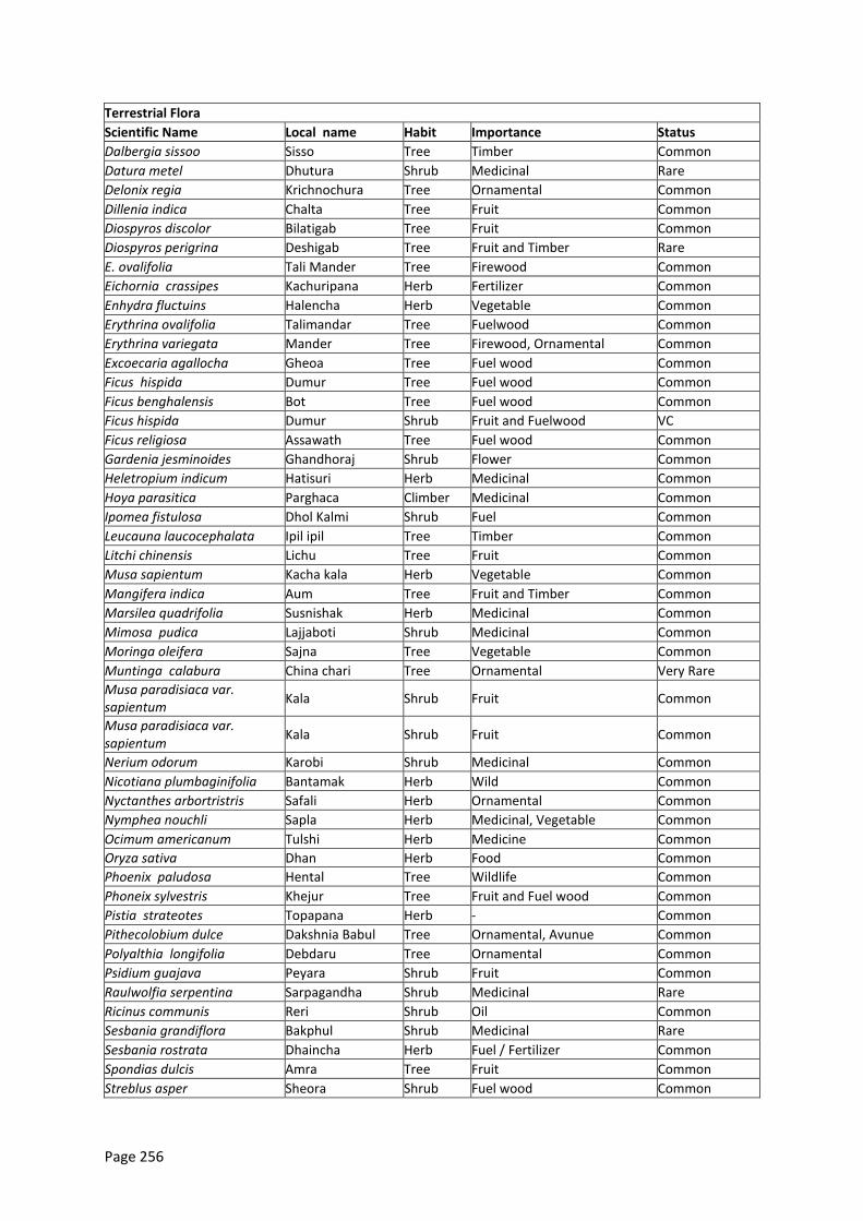
Page 256
Terrestrial Flora
Scientific Name Local name Habit Importance Status
Dalbergia sissoo Sisso Tree Timber Common
Datura metel Dhutura Shrub Medicinal Rare
Delonix regia Krichnochura Tree Ornamental Common
Dillenia indica Chalta Tree Fruit Common
Diospyros discolor Bilatigab Tree Fruit Common
Diospyros perigrina Deshigab Tree Fruit and Timber Rare
E. ovalifolia Tali Mander Tree Firewood Common
Eichornia crassipes Kachuripana Herb Fertilizer Common
Enhydra fluctuins Halencha Herb Vegetable Common
Erythrina ovalifolia Talimandar Tree Fuelwood Common
Erythrina variegata Mander Tree Firewood, Ornamental Common
Excoecaria agallocha Gheoa Tree Fuel wood Common
Ficus hispida Dumur Tree Fuel wood Common
Ficus benghalensis Bot Tree Fuel wood Common
Ficus hispida Dumur Shrub Fruit and Fuelwood VC
Ficus religiosa Assawath Tree Fuel wood Common
Gardenia jesminoides Ghandhoraj Shrub Flower Common
Heletropium indicum Hatisuri Herb Medicinal Common
Hoya parasitica Parghaca Climber Medicinal Common
Ipomea fistulosa Dhol Kalmi Shrub Fuel Common
Leucauna laucocephalata Ipil ipil Tree Timber Common
Litchi chinensis Lichu Tree Fruit Common
Musa sapientum Kacha kala Herb Vegetable Common
Mangifera indica Aum Tree Fruit and Timber Common
Marsilea quadrifolia Susnishak Herb Medicinal Common
Mimosa pudica Lajjaboti Shrub Medicinal Common
Moringa oleifera Sajna Tree Vegetable Common
Muntinga calabura China chari Tree Ornamental Very Rare
Musa paradisiaca var. sapientum
Kala Shrub Fruit Common
Musa paradisiaca var. sapientum
Kala Shrub Fruit Common
Nerium odorum Karobi Shrub Medicinal Common
Nicotiana plumbaginifolia Bantamak Herb Wild Common
Nyctanthes arbortristris Safali Herb Ornamental Common
Nymphea nouchli Sapla Herb Medicinal, Vegetable Common
Ocimum americanum Tulshi Herb Medicine Common
Oryza sativa Dhan Herb Food Common
Phoenix paludosa Hental Tree Wildlife Common
Phoneix sylvestris Khejur Tree Fruit and Fuel wood Common
Pistia strateotes Topapana Herb - Common
Pithecolobium dulce Dakshnia Babul Tree Ornamental, Avunue Common
Polyalthia longifolia Debdaru Tree Ornamental Common
Psidium guajava Peyara Shrub Fruit Common
Raulwolfia serpentina Sarpagandha Shrub Medicinal Rare
Ricinus communis Reri Shrub Oil Common
Sesbania grandiflora Bakphul Shrub Medicinal Rare
Sesbania rostrata Dhaincha Herb Fuel / Fertilizer Common
Spondias dulcis Amra Tree Fruit Common
Streblus asper Sheora Shrub Fuel wood Common
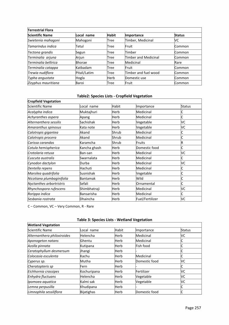
Page 257
Terrestrial Flora
Scientific Name Local name Habit Importance Status
Swietenia mahagoni Mahogoni Tree Timber, Medicinal VC
Tamarindus indica Tetul Tree Fruit Common
Tectona grandis Segun Tree Timber Common
Terminalia arjuna Arjun Tree Timber and Medicinal Common
Terminalia bellirica Bhorae Tree Medicinal Rare
Terminalia catappa Katbadam Tree Fruit Common
Trewia nudiflora Pitali/Latim Tree Timber and fuel wood Common
Typha angustata Hogla Herb Domestic use Common
Zizyphus mauritiana Baroi Tree Fruit Common
Table2: Species Lists - Cropfield Vegetation Cropfield Vegetation
Scientific Name Local name Habit Importance Status
Acalypha indica Muktajhuri Herb Medicinal C
Achyranthes aspera Apang Herb Medicinal C
Alternanthera sessilis Sachishak Herb Vegetable VC
Amaranthus spinosus Kata note Herb Vegetable VC
Calotropis gigantea Akand Shrub Medicinal C
Calotropis procera Akand Shrub Medicinal C
Carissa carandas Karamcha Shrub Fruits R
Cotula hemispherica Kancha ghash Herb Domestic food C
Crotolaria retusa Ban-san Herb Medicinal VC
Cuscuta australis Swarnalata Herb Medicinal C
Cynodon dactylon Durba Herb Medicinal VC
Dentella repens Hachuti Herb Medicinal C
Marsilea quadrifolia Susnishak Herb Vegetable C
Nicotiana plumbaginifolia Bantamak Herb Wild C
Nyctanthes arbortristris Sefali Herb Ornamental C
Rhynchospora rufescens Shimbhatraji Herb Medicinal VC
Rorippa indica Bansarisha Herb Medicinal C
Sesbania rostrata Dhaincha Herb Fuel/Fertilizer VC
C – Common, VC – Very Common, R - Rare
Table 3: Species Lists - Wetland Vegetation Wetland Vegetation
Scientific Name Local name Habit Importance Status
Alternanthera philoxiroides Helencha Herb Medicinal VC
Aponogeton natans Ghentu Herb Medicinal C
Azolla pinnata Kutipana Herb Fish food C
Ceratophyllum desmersum Jhangi Herb - C
Colocasia esculenta Kachu Herb Medicinal C
Cyperus sp. Mutha Herb Domestic food VC
Cheratopteris sp Fern Herb - C
Eichhornia crassipes Kochuripana Herb Fertilizer VC
Enhydra fluctuans Helencha Herb Vegetable VC
Ipomoea aquatica Kalmi sak Herb Vegetable VC
Lemna perpusilla Khudipana Herb - C
Limnophila sessiliflora Bijatighas Herb Domestic food C
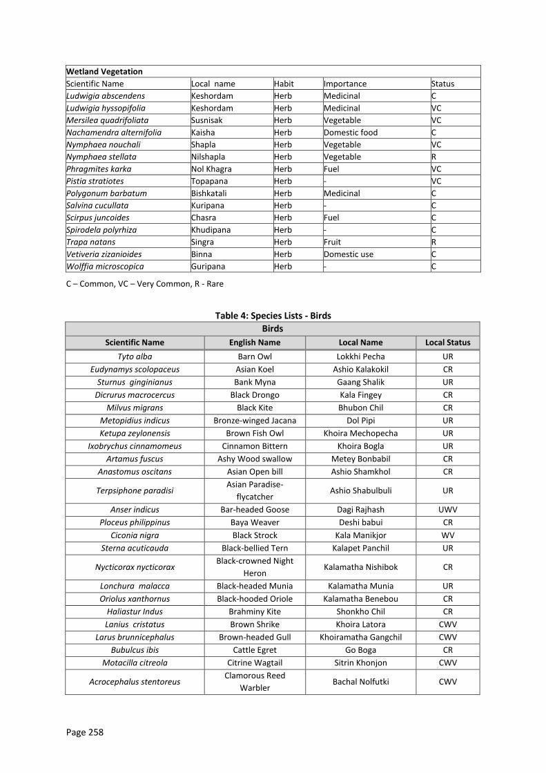
Page 258
Wetland Vegetation
Scientific Name Local name Habit Importance Status
Ludwigia abscendens Keshordam Herb Medicinal C
Ludwigia hyssopifolia Keshordam Herb Medicinal VC
Mersilea quadrifoliata Susnisak Herb Vegetable VC
Nachamendra alternifolia Kaisha Herb Domestic food C
Nymphaea nouchali Shapla Herb Vegetable VC
Nymphaea stellata Nilshapla Herb Vegetable R
Phragmites karka Nol Khagra Herb Fuel VC
Pistia stratiotes Topapana Herb - VC
Polygonum barbatum Bishkatali Herb Medicinal C
Salvina cucullata Kuripana Herb - C
Scirpus juncoides Chasra Herb Fuel C
Spirodela polyrhiza Khudipana Herb - C
Trapa natans Singra Herb Fruit R
Vetiveria zizanioides Binna Herb Domestic use C
Wolffia microscopica Guripana Herb - C
C – Common, VC – Very Common, R - Rare
Table 4: Species Lists - Birds
Birds
Scientific Name English Name Local Name Local Status
Tyto alba Barn Owl Lokkhi Pecha UR
Eudynamys scolopaceus Asian Koel Ashio Kalakokil CR
Sturnus ginginianus Bank Myna Gaang Shalik UR
Dicrurus macrocercus Black Drongo Kala Fingey CR
Milvus migrans Black Kite Bhubon Chil CR
Metopidius indicus Bronze-winged Jacana Dol Pipi UR
Ketupa zeylonensis Brown Fish Owl Khoira Mechopecha UR
Ixobrychus cinnamomeus Cinnamon Bittern Khoira Bogla UR
Artamus fuscus Ashy Wood swallow Metey Bonbabil CR
Anastomus oscitans Asian Open bill Ashio Shamkhol CR
Terpsiphone paradisi Asian Paradise-
flycatcher Ashio Shabulbuli UR
Anser indicus Bar-headed Goose Dagi Rajhash UWV
Ploceus philippinus Baya Weaver Deshi babui CR
Ciconia nigra Black Strock Kala Manikjor WV
Sterna acuticauda Black-bellied Tern Kalapet Panchil UR
Nycticorax nycticorax Black-crowned Night
Heron Kalamatha Nishibok CR
Lonchura malacca Black-headed Munia Kalamatha Munia UR
Oriolus xanthornus Black-hooded Oriole Kalamatha Benebou CR
Haliastur Indus Brahminy Kite Shonkho Chil CR
Lanius cristatus Brown Shrike Khoira Latora CWV
Larus brunnicephalus Brown-headed Gull Khoiramatha Gangchil CWV
Bubulcus ibis Cattle Egret Go Boga CR
Motacilla citreola Citrine Wagtail Sitrin Khonjon CWV
Acrocephalus stentoreus Clamorous Reed
Warbler Bachal Nolfutki CWV
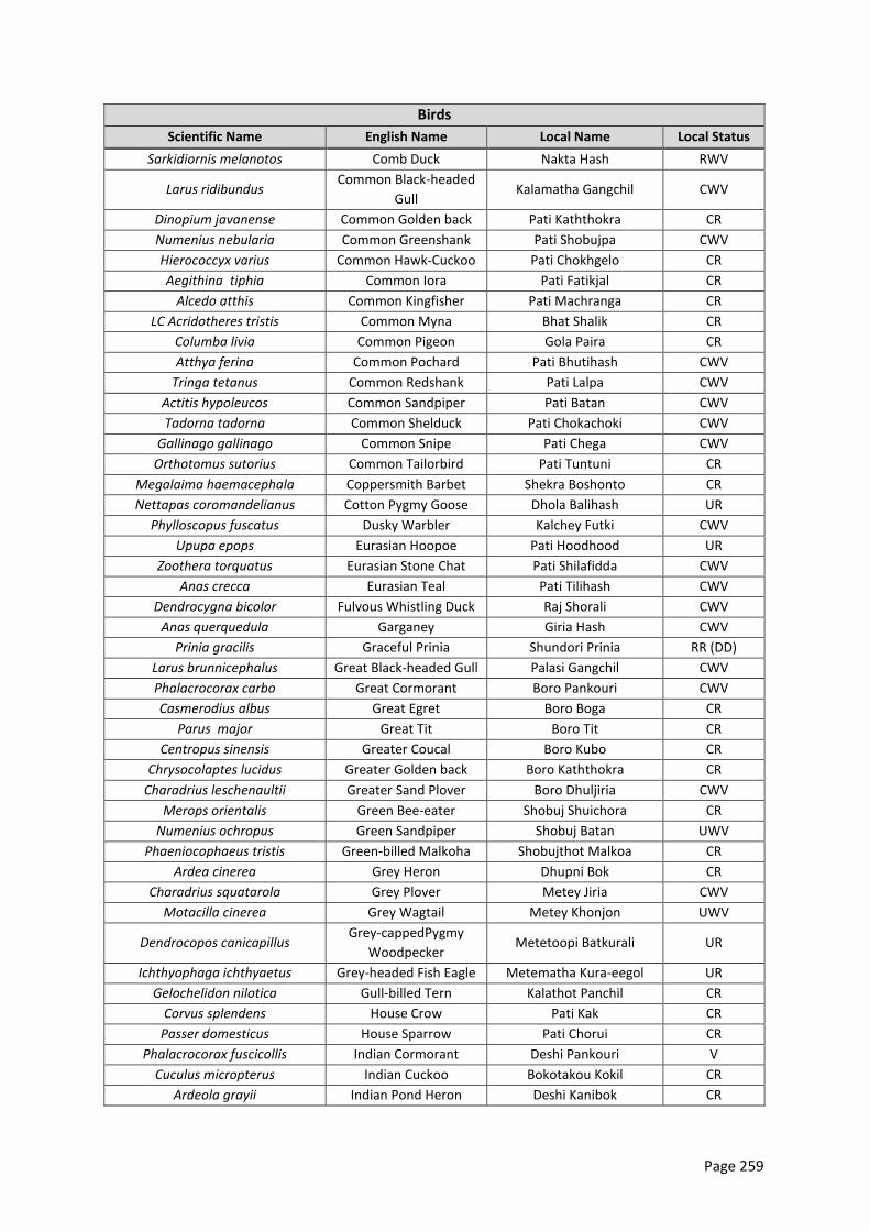
Page 259
Birds
Scientific Name English Name Local Name Local Status
Sarkidiornis melanotos Comb Duck Nakta Hash RWV
Larus ridibundus Common Black-headed
Gull Kalamatha Gangchil CWV
Dinopium javanense Common Golden back Pati Kaththokra CR
Numenius nebularia Common Greenshank Pati Shobujpa CWV
Hierococcyx varius Common Hawk-Cuckoo Pati Chokhgelo CR
Aegithina tiphia Common Iora Pati Fatikjal CR
Alcedo atthis Common Kingfisher Pati Machranga CR
LC Acridotheres tristis Common Myna Bhat Shalik CR
Columba livia Common Pigeon Gola Paira CR
Atthya ferina Common Pochard Pati Bhutihash CWV
Tringa tetanus Common Redshank Pati Lalpa CWV
Actitis hypoleucos Common Sandpiper Pati Batan CWV
Tadorna tadorna Common Shelduck Pati Chokachoki CWV
Gallinago gallinago Common Snipe Pati Chega CWV
Orthotomus sutorius Common Tailorbird Pati Tuntuni CR
Megalaima haemacephala Coppersmith Barbet Shekra Boshonto CR
Nettapas coromandelianus Cotton Pygmy Goose Dhola Balihash UR
Phylloscopus fuscatus Dusky Warbler Kalchey Futki CWV
Upupa epops Eurasian Hoopoe Pati Hoodhood UR
Zoothera torquatus Eurasian Stone Chat Pati Shilafidda CWV
Anas crecca Eurasian Teal Pati Tilihash CWV
Dendrocygna bicolor Fulvous Whistling Duck Raj Shorali CWV
Anas querquedula Garganey Giria Hash CWV
Prinia gracilis Graceful Prinia Shundori Prinia RR (DD)
Larus brunnicephalus Great Black-headed Gull Palasi Gangchil CWV
Phalacrocorax carbo Great Cormorant Boro Pankouri CWV
Casmerodius albus Great Egret Boro Boga CR
Parus major Great Tit Boro Tit CR
Centropus sinensis Greater Coucal Boro Kubo CR
Chrysocolaptes lucidus Greater Golden back Boro Kaththokra CR
Charadrius leschenaultii Greater Sand Plover Boro Dhuljiria CWV
Merops orientalis Green Bee-eater Shobuj Shuichora CR
Numenius ochropus Green Sandpiper Shobuj Batan UWV
Phaeniocophaeus tristis Green-billed Malkoha Shobujthot Malkoa CR
Ardea cinerea Grey Heron Dhupni Bok CR
Charadrius squatarola Grey Plover Metey Jiria CWV
Motacilla cinerea Grey Wagtail Metey Khonjon UWV
Dendrocopos canicapillus Grey-cappedPygmy
Woodpecker Metetoopi Batkurali UR
Ichthyophaga ichthyaetus Grey-headed Fish Eagle Metematha Kura-eegol UR
Gelochelidon nilotica Gull-billed Tern Kalathot Panchil CR
Corvus splendens House Crow Pati Kak CR
Passer domesticus House Sparrow Pati Chorui CR
Phalacrocorax fuscicollis Indian Cormorant Deshi Pankouri V
Cuculus micropterus Indian Cuckoo Bokotakou Kokil CR
Ardeola grayii Indian Pond Heron Deshi Kanibok CR
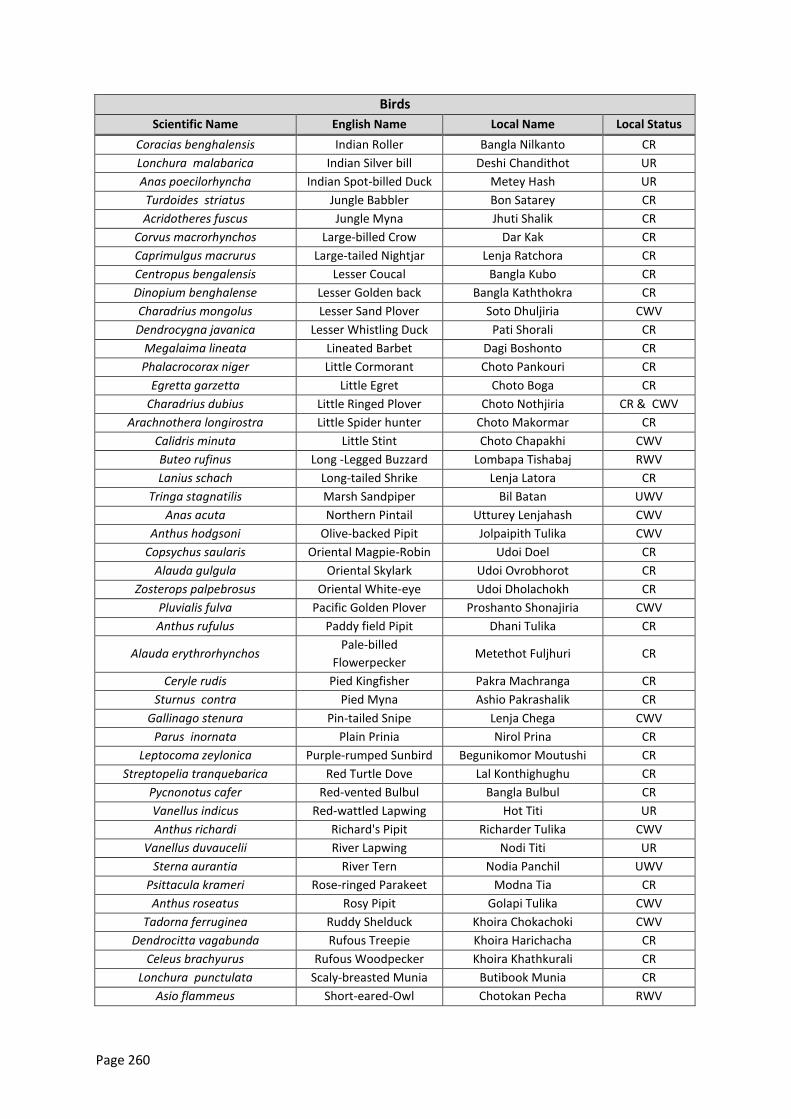
Page 260
Birds
Scientific Name English Name Local Name Local Status
Coracias benghalensis Indian Roller Bangla Nilkanto CR
Lonchura malabarica Indian Silver bill Deshi Chandithot UR
Anas poecilorhyncha Indian Spot-billed Duck Metey Hash UR
Turdoides striatus Jungle Babbler Bon Satarey CR
Acridotheres fuscus Jungle Myna Jhuti Shalik CR
Corvus macrorhynchos Large-billed Crow Dar Kak CR
Caprimulgus macrurus Large-tailed Nightjar Lenja Ratchora CR
Centropus bengalensis Lesser Coucal Bangla Kubo CR
Dinopium benghalense Lesser Golden back Bangla Kaththokra CR
Charadrius mongolus Lesser Sand Plover Soto Dhuljiria CWV
Dendrocygna javanica Lesser Whistling Duck Pati Shorali CR
Megalaima lineata Lineated Barbet Dagi Boshonto CR
Phalacrocorax niger Little Cormorant Choto Pankouri CR
Egretta garzetta Little Egret Choto Boga CR
Charadrius dubius Little Ringed Plover Choto Nothjiria CR & CWV
Arachnothera longirostra Little Spider hunter Choto Makormar CR
Calidris minuta Little Stint Choto Chapakhi CWV
Buteo rufinus Long -Legged Buzzard Lombapa Tishabaj RWV
Lanius schach Long-tailed Shrike Lenja Latora CR
Tringa stagnatilis Marsh Sandpiper Bil Batan UWV
Anas acuta Northern Pintail Utturey Lenjahash CWV
Anthus hodgsoni Olive-backed Pipit Jolpaipith Tulika CWV
Copsychus saularis Oriental Magpie-Robin Udoi Doel CR
Alauda gulgula Oriental Skylark Udoi Ovrobhorot CR
Zosterops palpebrosus Oriental White-eye Udoi Dholachokh CR
Pluvialis fulva Pacific Golden Plover Proshanto Shonajiria CWV
Anthus rufulus Paddy field Pipit Dhani Tulika CR
Alauda erythrorhynchos Pale-billed
Flowerpecker Metethot Fuljhuri CR
Ceryle rudis Pied Kingfisher Pakra Machranga CR
Sturnus contra Pied Myna Ashio Pakrashalik CR
Gallinago stenura Pin-tailed Snipe Lenja Chega CWV
Parus inornata Plain Prinia Nirol Prina CR
Leptocoma zeylonica Purple-rumped Sunbird Begunikomor Moutushi CR
Streptopelia tranquebarica Red Turtle Dove Lal Konthighughu CR
Pycnonotus cafer Red-vented Bulbul Bangla Bulbul CR
Vanellus indicus Red-wattled Lapwing Hot Titi UR
Anthus richardi Richard's Pipit Richarder Tulika CWV
Vanellus duvaucelii River Lapwing Nodi Titi UR
Sterna aurantia River Tern Nodia Panchil UWV
Psittacula krameri Rose-ringed Parakeet Modna Tia CR
Anthus roseatus Rosy Pipit Golapi Tulika CWV
Tadorna ferruginea Ruddy Shelduck Khoira Chokachoki CWV
Dendrocitta vagabunda Rufous Treepie Khoira Harichacha CR
Celeus brachyurus Rufous Woodpecker Khoira Khathkurali CR
Lonchura punctulata Scaly-breasted Munia Butibook Munia CR
Asio flammeus Short-eared-Owl Chotokan Pecha RWV
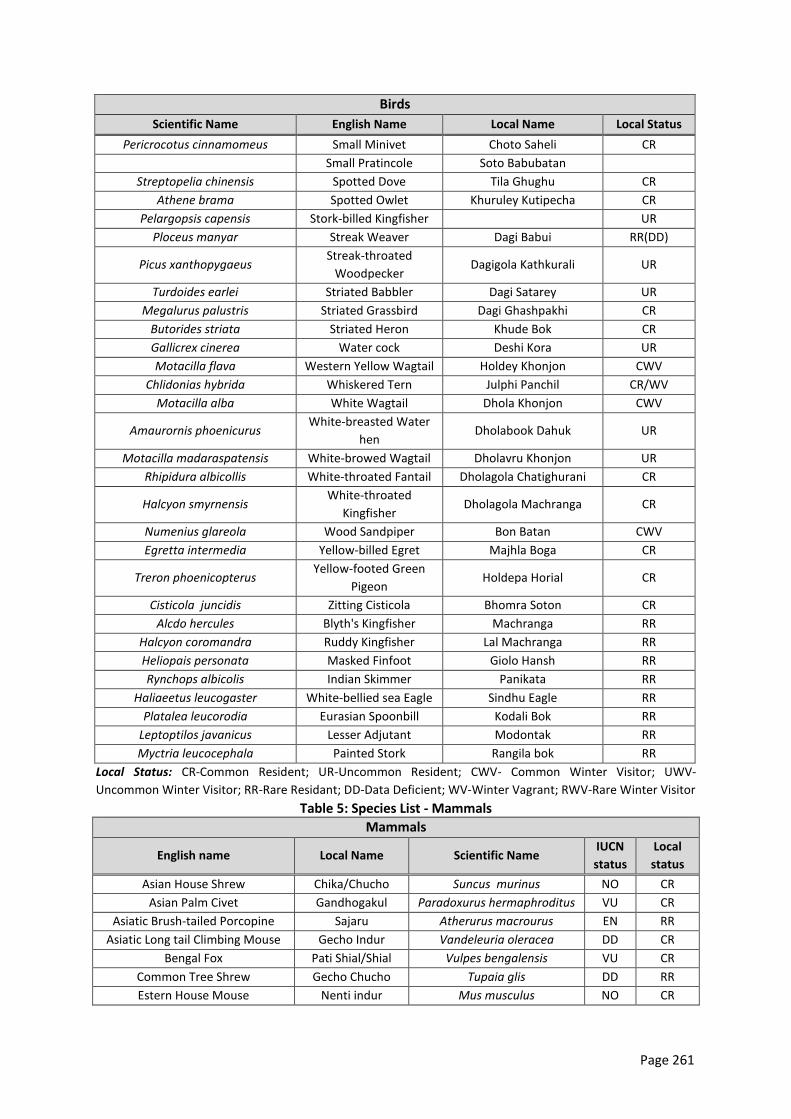
Page 261
Birds
Scientific Name English Name Local Name Local Status
Pericrocotus cinnamomeus Small Minivet Choto Saheli CR
Small Pratincole Soto Babubatan
Streptopelia chinensis Spotted Dove Tila Ghughu CR
Athene brama Spotted Owlet Khuruley Kutipecha CR
Pelargopsis capensis Stork-billed Kingfisher UR
Ploceus manyar Streak Weaver Dagi Babui RR(DD)
Picus xanthopygaeus Streak-throated
Woodpecker Dagigola Kathkurali UR
Turdoides earlei Striated Babbler Dagi Satarey UR
Megalurus palustris Striated Grassbird Dagi Ghashpakhi CR
Butorides striata Striated Heron Khude Bok CR
Gallicrex cinerea Water cock Deshi Kora UR
Motacilla flava Western Yellow Wagtail Holdey Khonjon CWV
Chlidonias hybrida Whiskered Tern Julphi Panchil CR/WV
Motacilla alba White Wagtail Dhola Khonjon CWV
Amaurornis phoenicurus White-breasted Water
hen Dholabook Dahuk UR
Motacilla madaraspatensis White-browed Wagtail Dholavru Khonjon UR
Rhipidura albicollis White-throated Fantail Dholagola Chatighurani CR
Halcyon smyrnensis White-throated
Kingfisher Dholagola Machranga CR
Numenius glareola Wood Sandpiper Bon Batan CWV
Egretta intermedia Yellow-billed Egret Majhla Boga CR
Treron phoenicopterus Yellow-footed Green
Pigeon Holdepa Horial CR
Cisticola juncidis Zitting Cisticola Bhomra Soton CR
Alcdo hercules Blyth's Kingfisher Machranga RR
Halcyon coromandra Ruddy Kingfisher Lal Machranga RR
Heliopais personata Masked Finfoot Giolo Hansh RR
Rynchops albicolis Indian Skimmer Panikata RR
Haliaeetus leucogaster White-bellied sea Eagle Sindhu Eagle RR
Platalea leucorodia Eurasian Spoonbill Kodali Bok RR
Leptoptilos javanicus Lesser Adjutant Modontak RR
Myctria leucocephala Painted Stork Rangila bok RR
Local Status: CR-Common Resident; UR-Uncommon Resident; CWV- Common Winter Visitor; UWV-
Uncommon Winter Visitor; RR-Rare Residant; DD-Data Deficient; WV-Winter Vagrant; RWV-Rare Winter Visitor
Table 5: Species List - Mammals
Mammals
English name Local Name Scientific Name IUCN
status
Local
status
Asian House Shrew Chika/Chucho Suncus murinus NO CR
Asian Palm Civet Gandhogakul Paradoxurus hermaphroditus VU CR
Asiatic Brush-tailed Porcopine Sajaru Atherurus macrourus EN RR
Asiatic Long tail Climbing Mouse Gecho Indur Vandeleuria oleracea DD CR
Bengal Fox Pati Shial/Shial Vulpes bengalensis VU CR
Common Tree Shrew Gecho Chucho Tupaia glis DD RR
Estern House Mouse Nenti indur Mus musculus NO CR
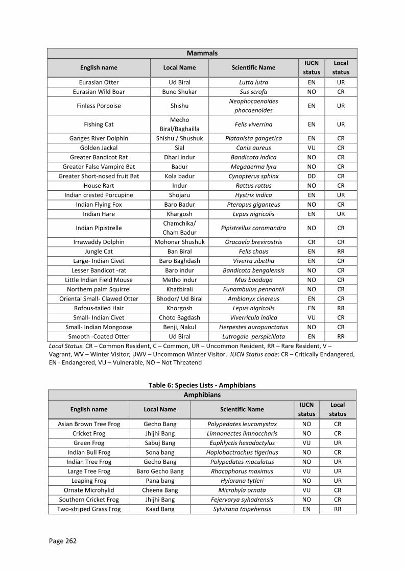
Page 262
Mammals
English name Local Name Scientific Name IUCN
status
Local
status
Eurasian Otter Ud Biral Lutta lutra EN UR
Eurasian Wild Boar Buno Shukar Sus scrofa NO CR
Finless Porpoise Shishu Neophocaenoides
phocaenoides EN UR
Fishing Cat Mecho
Biral/Baghailla Felis viverrina EN UR
Ganges River Dolphin Shishu / Shushuk Platanista gangetica EN CR
Golden Jackal Sial Canis aureus VU CR
Greater Bandicot Rat Dhari indur Bandicota indica NO CR
Greater False Vampire Bat Badur Megaderma lyra NO CR
Greater Short-nosed fruit Bat Kola badur Cynopterus sphinx DD CR
House Rart Indur Rattus rattus NO CR
Indian crested Porcupine Shojaru Hystrix indica EN UR
Indian Flying Fox Baro Badur Pteropus giganteus NO CR
Indian Hare Khargosh Lepus nigricolis EN UR
Indian Pipistrelle Chamchika/
Cham Badur Pipistrellus coromandra NO CR
Irrawaddy Dolphin Mohonar Shushuk Oracaela brevirostris CR CR
Jungle Cat Ban Biral Felis chaus EN RR
Large- Indian Civet Baro Baghdash Viverra zibetha EN CR
Lesser Bandicot -rat Baro indur Bandicota bengalensis NO CR
Little Indian Field Mouse Metho indur Mus booduga NO CR
Northern palm Squirrel Khatbirali Funambulus pennantii NO CR
Oriental Small- Clawed Otter Bhodor/ Ud Biral Amblonyx cinereus EN CR
Rofous-tailed Hair Khorgosh Lepus nigricolis EN RR
Small- Indian Civet Choto Bagdash Viverricula indica VU CR
Small- Indian Mongoose Benji, Nakul Herpestes auropunctatus NO CR
Smooth -Coated Otter Ud Biral Lutrogale perspicillata EN RR
Local Status: CR – Common Resident, C – Common, UR – Uncommon Resident, RR – Rare Resident, V – Vagrant, WV – Winter Visitor; UWV – Uncommon Winter Visitor. IUCN Status code: CR – Critically Endangered, EN - Endangered, VU – Vulnerable, NO – Not Threatend
Table 6: Species Lists - Amphibians
Amphibians
English name Local Name Scientific Name IUCN
status
Local
status
Asian Brown Tree Frog Gecho Bang Polypedates leucomystax NO CR
Cricket Frog Jhijhi Bang Limnonectes limnoccharis NO CR
Green Frog Sabuj Bang Euphlyctis hexadactylus VU UR
Indian Bull Frog Sona bang Hoplobactrachus tigerinus NO CR
Indian Tree Frog Gecho Bang Polypedates maculatus NO UR
Large Tree Frog Baro Gecho Bang Rhacophorus maximus VU UR
Leaping Frog Pana bang Hylarana tytleri NO UR
Ornate Microhylid Cheena Bang Microhyla ornata VU CR
Southern Cricket Frog Jhijhi Bang Fejervarya syhadrensis NO CR
Two-striped Grass Frog Kaad Bang Sylvirana taipehensis EN RR
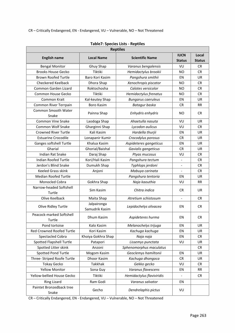
Page 263
CR – Critically Endangered, EN - Endangered, VU – Vulnerable, NO – Not Threatened
Table7: Species Lists - Reptiles
Reptiles
English name Local Name Scientific Name IUCN
Status
Local
Status
Bengal Monitor Ghuy Shap Varanus bengalensis VU CR
Brooks House Gecko Tiktiki Hemidactylus brookii NO CR
Brown Roofed Turtle Baro Kori Kasim Pangshura smithii EN UR
Checkered Keelback Dhora Shap Xenochropis piscator NO CR
Common Garden Lizard Roktochosha Calotes versicolor NO CR
Common House Gecko Tiktiki Hemidactylus frenatus NO CR
Common Krait Kal-keutey Shap Bungarus caeruleus EN UR
Common River Terrpain Boro Kasim Batagur baska CR RR
Common Smooth Water
Snake Painna Shap Enhydris enhydris NO CR
Common Vine Snake Laodoga Shap Ahaetulla nasuta VU UR
Common Wolf Snake Gharginni Shap Lycodon aulicus VU CR
Crowned River Turtle Kali Kasim Hardella thurjii EN UR
Estuarine Crocodile Lonapanir Kumir Crocodylus porosus CR UR
Ganges softshell Turtle Khalua Kasim Aspideteres gangeticus EN UR
Gharial Ghorial/Baishal Gavialis gangeticus CR UR
Indian Rat Snake Daraj Shap Ptyas mucosus VU CR
Indian Roofed Turtle Kori/Hali Kasim Pangshura tectum - CR
Jerdon's Blind Snake Dumukh Shap Typhlops jerdoni - CR
Keeled Grass skink Anjoni Mabuya carinata - CR
Median Roofed Turtle Pangshura tentoria EN UR
Monocled Cobra Gokhra Shap Naja kaouthia VU RR
Narrow-headed Softshell
Turtle Sim Kasim Chitra indica CR UR
Olive Keelback Maita Shap Atretium schistosum - CR
Olive Ridley Turtle Jalpaironga
Samudrik Kasim Lepidochelys olivacea EN CR
Peacock-marked Softshell
Turtle Dhum Kasim Aspideteres hurma EN CR
Pond tortoise Kalo Kasim Melanochelys trijuga EN UR
Red Crowned Roofed Turtle Kori Kasim Kachuga kachuga EN UR
Spectacled Cobra Khoiya Gokhra Shap Naja naja EN CR
Spotted Flapshell Turtle Patapori Lissemys punctata VU UR
Spotted Litter skink Anzoni Sphenomorphus maculatus CR
Spotted Pond Turtle Mogom Kasim Geoclemys hamiltonii EN UR
Three- Striped Roofe Turtle Dhoor Kasim Kachuga dhongoca CR UR
Tokay Gecko Takkhak Gekko gecko VU CR
Yellow Monitor Sona Guy Varanus flavescens EN RR
Yellow-bellied House Gecko Tiktiki Hemidactylus flaviviridis - CR
Ring Lizard Ram Godi Varanus salvator EN
Paintet Bronzedback tree
Snake Gecho Dendrelaphis pictus VU
CR – Critically Endangered, EN - Endangered, VU – Vulnerable, NO – Not Threatened
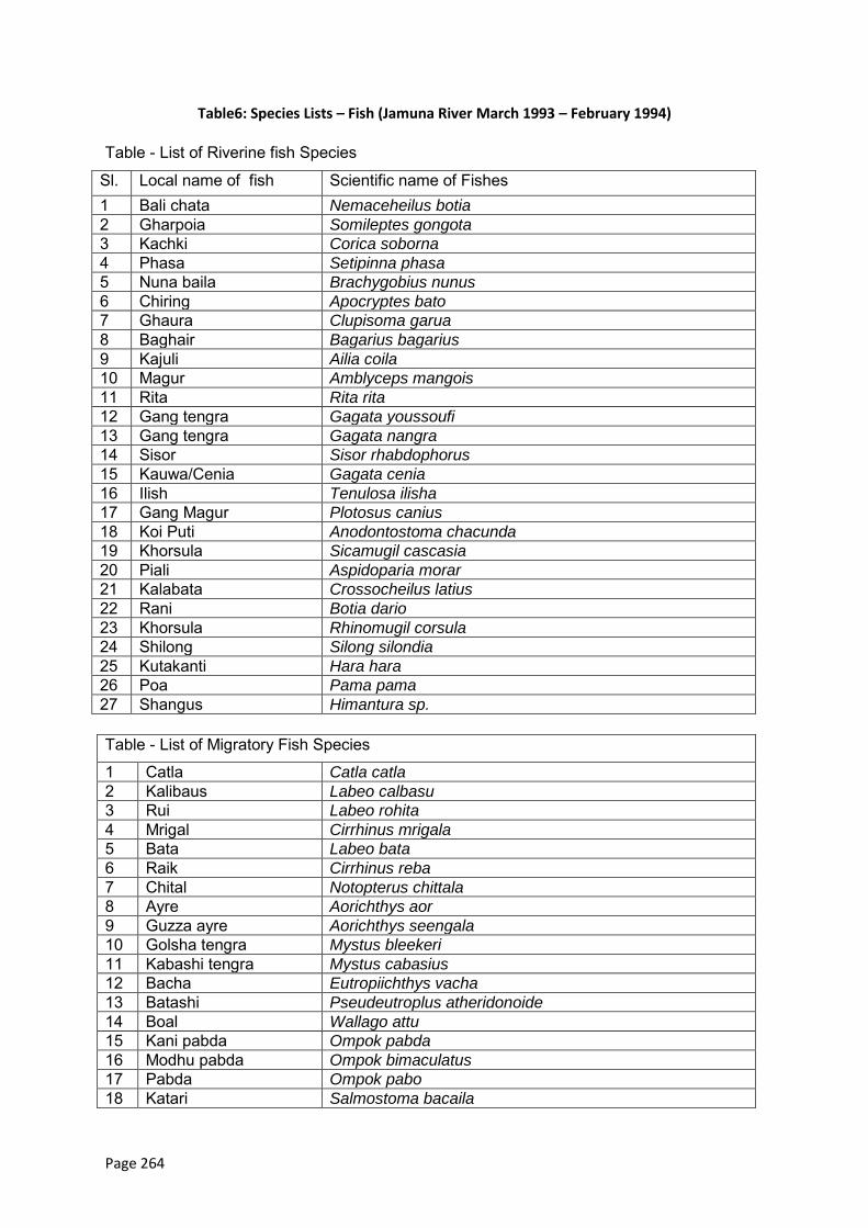
Page 264
Table6: Species Lists – Fish (Jamuna River March 1993 – February 1994)
Table - List of Riverine fish Species
Sl. Local name of fish Scientific name of Fishes 1 Bali chata Nemaceheilus botia
2 Gharpoia Somileptes gongota
3 Kachki Corica soborna
4 Phasa Setipinna phasa
5 Nuna baila Brachygobius nunus
6 Chiring Apocryptes bato
7 Ghaura Clupisoma garua
8 Baghair Bagarius bagarius
9 Kajuli Ailia coila
10 Magur Amblyceps mangois
11 Rita Rita rita
12 Gang tengra Gagata youssoufi
13 Gang tengra Gagata nangra
14 Sisor Sisor rhabdophorus
15 Kauwa/Cenia Gagata cenia
16 Ilish Tenulosa ilisha
17 Gang Magur Plotosus canius
18 Koi Puti Anodontostoma chacunda
19 Khorsula Sicamugil cascasia
20 Piali Aspidoparia morar
21 Kalabata Crossocheilus latius
22 Rani Botia dario
23 Khorsula Rhinomugil corsula
24 Shilong Silong silondia
25 Kutakanti Hara hara
26 Poa Pama pama
27 Shangus Himantura sp.
Table - List of Migratory Fish Species
1 Catla Catla catla
2 Kalibaus Labeo calbasu
3 Rui Labeo rohita
4 Mrigal Cirrhinus mrigala
5 Bata Labeo bata
6 Raik Cirrhinus reba
7 Chital Notopterus chittala
8 Ayre Aorichthys aor
9 Guzza ayre Aorichthys seengala
10 Golsha tengra Mystus bleekeri
11 Kabashi tengra Mystus cabasius
12 Bacha Eutropiichthys vacha
13 Batashi Pseudeutroplus atheridonoide
14 Boal Wallago attu
15 Kani pabda Ompok pabda
16 Modhu pabda Ompok bimaculatus
17 Pabda Ompok pabo
18 Katari Salmostoma bacaila
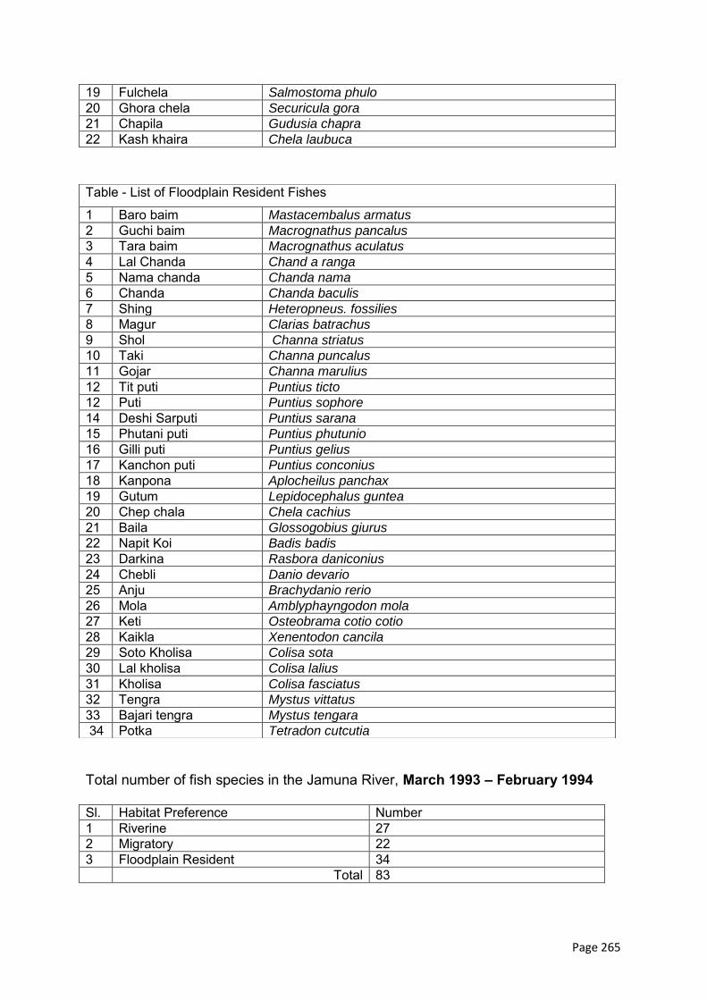
Page 265
19 Fulchela Salmostoma phulo
20 Ghora chela Securicula gora
21 Chapila Gudusia chapra
22 Kash khaira Chela laubuca
Total number of fish species in the Jamuna River, March 1993 – February 1994 Sl. Habitat Preference Number 1 Riverine 27 2 Migratory 22 3 Floodplain Resident 34 Total 83
Table - List of Floodplain Resident Fishes
1 Baro baim Mastacembalus armatus
2 Guchi baim Macrognathus pancalus
3 Tara baim Macrognathus aculatus
4 Lal Chanda Chand a ranga
5 Nama chanda Chanda nama
6 Chanda Chanda baculis
7 Shing Heteropneus. fossilies
8 Magur Clarias batrachus
9 Shol Channa striatus
10 Taki Channa puncalus
11 Gojar Channa marulius
12 Tit puti Puntius ticto
12 Puti Puntius sophore
14 Deshi Sarputi Puntius sarana
15 Phutani puti Puntius phutunio
16 Gilli puti Puntius gelius
17 Kanchon puti Puntius conconius
18 Kanpona Aplocheilus panchax
19 Gutum Lepidocephalus guntea
20 Chep chala Chela cachius
21 Baila Glossogobius giurus
22 Napit Koi Badis badis
23 Darkina Rasbora daniconius
24 Chebli Danio devario
25 Anju Brachydanio rerio
26 Mola Amblyphayngodon mola
27 Keti Osteobrama cotio cotio
28 Kaikla Xenentodon cancila
29 Soto Kholisa Colisa sota
30 Lal kholisa Colisa lalius
31 Kholisa Colisa fasciatus
32 Tengra Mystus vittatus
33 Bajari tengra Mystus tengara
34 Potka Tetradon cutcutia
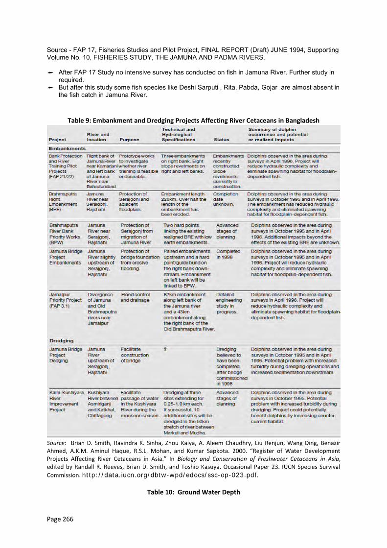
Page 266
Source - FAP 17, Fisheries Studies and Pilot Project, FINAL REPORT (Draft) JUNE 1994, Supporting Volume No. 10, FISHERIES STUDY, THE JAMUNA AND PADMA RIVERS.
After FAP 17 Study no intensive survey has conducted on fish in Jamuna River. Further study in
required. But after this study some fish species like Deshi Sarputi , Rita, Pabda, Gojar are almost absent in
the fish catch in Jamuna River.
Table 9: Embankment and Dredging Projects Affecting River Cetaceans in Bangladesh
Source: Brian D. Smith, Ravindra K. Sinha, Zhou Kaiya, A. Aleem Chaudhry, Liu Renjun, Wang Ding, Benazir Ahmed, A.K.M. Aminul Haque, R.S.L. Mohan, and Kumar Sapkota. 2000. “Register of Water Development Projects Affecting River Cetaceans in Asia.” In Biology and Conservation of Freshwater Cetaceans in Asia, edited by Randall R. Reeves, Brian D. Smith, and Toshio Kasuya. Occasional Paper 23. IUCN Species Survival
Commission. http://data.iucn.org/dbtw-wpd/edocs/ssc-op-023.pdf.
Table 10: Ground Water Depth

Page 267
Well ID Location
Groundwater Depth (m)
1980 1990 2000
April September April September April September
8811001 Shrenagar village, Belkuchithana, Sirajganj 6.78 2.83 4.51 1.70 5.84 1.42
5678012 Uthali village, Shibalayathana, Manikganj 6.31 1.39 5.91 1.89 7.07 0.90
9376032 Bhalkutia village, Nagarpurthana, Tangail 6.46 1.64 5.51 1.94 6.31 1.52
Source: BWDB.
Page 268
Annex 2: Dolphin Threats
1.1 Threats
Dolphins have been very adversely affected by human use of the river systems in the sub-continent.
Entanglement in fishing nets can cause significant damage to local population numbers. Some
individuals are still taken each year and their oil and meat used as a liniment, as an aphrodisiac and
as bait for catfish. Irrigation has lowered water levels throughout the ranges. Poisoning of the water
supply from industrial and agricultural chemicals may have also contributed to population decline.
Perhaps the most significant issue is the building of more than 50 dams along many rivers, causing
the segregation of populations and a narrowed gene pool in which dolphins can breed.
This species is considered to be particularly threatened by overfishing (incidental by-catch, direct
exploitation, resource depletion), and high industrial and agricultural pollutant loads may also have a
severe impact on dolphin immune competence and fertility. The immediate danger for the resident
population of dolphin in the haor basin is the decrease in river depth due to sedimentation.
1.2 Threats from Other Human Activities
1.2.1 Use of Dolphin Products
Dolphin oil is used by people in Bangladesh as a liniment, claimed to be effective for treating
rheumatism, burns, and nervous disorders, and a tonic for treating impotence and asthma. It is
noted that pregnant women sometimes drink the oil in the belief that it will ensure a healthy baby
and that the oil is mixed with banana leaves and fed to cows to fatten them before being taken to
market. Pelletier and described a factory in Chandpur used for processing dolphin oil. Recent survey
recorded that the dolphin oil is used as mosquito repellant. On the bank of river Kushyiara near
Kawadighi Haor, people are using oil of dolphin as mosquito repellant for the cattle and buffalo.
They used to rub the oil over the body of cow and buffalo.
1.2.2 Fisheries Bycatch
Cetaceans worldwide are threatened from incidental mortality in gillnets. According to local
fishermen, incidental catch in monofilament gill nets, called current jals, is their primary source of
dolphin products. It is difficult to determine if the catch of dolphins in nets is deliberate or
accidental, especially since dolphin products are highly valued and nets are often deployed for
multispecies catch (Reeves and others 1993). Although current jals with a stretched mesh size of
below 4.5 cm are prohibited in Bangladesh, their use is increasing throughout the country. We were
told by fishermen that dolphins are sometimes caught in jam jals. These rectangular nets have an 8-
to 10-cm mesh size and are used to catch large broodstock in river duars.
1.2.3 Directed Catch
Local villagers appeared to be unaware that hunting dolphins is prohibited under the laws of
Bangladesh. In villages along the Kalni-Kushiyara river, a small group of fishermen from a Hindu
minority caste in the Bhawol (Sylhet District) come every year during December or January to hunt
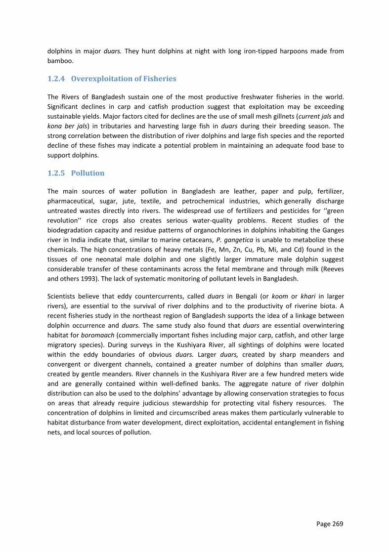
Page 269
dolphins in major duars. They hunt dolphins at night with long iron-tipped harpoons made from
bamboo.
1.2.4 Overexploitation of Fisheries
The Rivers of Bangladesh sustain one of the most productive freshwater fisheries in the world.
Significant declines in carp and catfish production suggest that exploitation may be exceeding
sustainable yields. Major factors cited for declines are the use of small mesh gillnets (current jals and
kona ber jals) in tributaries and harvesting large fish in duars during their breeding season. The
strong correlation between the distribution of river dolphins and large fish species and the reported
decline of these fishes may indicate a potential problem in maintaining an adequate food base to
support dolphins.
1.2.5 Pollution
The main sources of water pollution in Bangladesh are leather, paper and pulp, fertilizer,
pharmaceutical, sugar, jute, textile, and petrochemical industries, which generally discharge
untreated wastes directly into rivers. The widespread use of fertilizers and pesticides for ‘‘green
revolution’’ rice crops also creates serious water-quality problems. Recent studies of the
biodegradation capacity and residue patterns of organochlorines in dolphins inhabiting the Ganges
river in India indicate that, similar to marine cetaceans, P. gangetica is unable to metabolize these
chemicals. The high concentrations of heavy metals (Fe, Mn, Zn, Cu, Pb, Mi, and Cd) found in the
tissues of one neonatal male dolphin and one slightly larger immature male dolphin suggest
considerable transfer of these contaminants across the fetal membrane and through milk (Reeves
and others 1993). The lack of systematic monitoring of pollutant levels in Bangladesh.
Scientists believe that eddy countercurrents, called duars in Bengali (or koom or khari in larger
rivers), are essential to the survival of river dolphins and to the productivity of riverine biota. A
recent fisheries study in the northeast region of Bangladesh supports the idea of a linkage between
dolphin occurrence and duars. The same study also found that duars are essential overwintering
habitat for boromaach (commercially important fishes including major carp, catfish, and other large
migratory species). During surveys in the Kushiyara River, all sightings of dolphins were located
within the eddy boundaries of obvious duars. Larger duars, created by sharp meanders and
convergent or divergent channels, contained a greater number of dolphins than smaller duars,
created by gentle meanders. River channels in the Kushiyara River are a few hundred meters wide
and are generally contained within well-defined banks. The aggregate nature of river dolphin
distribution can also be used to the dolphins’ advantage by allowing conservation strategies to focus
on areas that already require judicious stewardship for protecting vital fishery resources. The
concentration of dolphins in limited and circumscribed areas makes them particularly vulnerable to
habitat disturbance from water development, direct exploitation, accidental entanglement in fishing
nets, and local sources of pollution.
Page 270
Reference:
Biswas, S. P. and R. G. Michael (1992): Fishery characteristics and the present status of fisheries of
the river Brahmaputra. Proc. Seminar on Conservation of River Dolphin in Indian Sub-continent, 18-19
August, New Delhi. (Abst.)
Biswas, S. P. and S. Baruah (2000): Ecology of river dolphin (Platanista gangetica) in the Upper
Brahmaputra. Hydrobiologia, 430: 97 – 111. Choudhury, A. U. (1997): Checklist of the Mammals of
Assam. Gibbons Books, Guwahati. 103 pp.
Mohan, R. S. L., S. C. Dey and S. P. Bairagi (1998): On a residential dolphin population of the Ganges
river dolphin, Platanista gangetica in the Kulsi river (Assam), a tributary of Brahmaputra. Ibid, 95(1):
1 – 7.
Reeves, R. R., S. Leatherwood and R. S. L. Mohan (eds.) (1993): A Future for Asian River Dolphins:
Report from the Seminar on the Conservation of River Dolphins of the Indian Subcontinent, 18-19
August 1992, New Delhi, India.
Whale and Dolphin Conservation Society, Bath, U.K. Reeves, R. R. and S. Leatherwood (1994): Dams
and river dolphins: can they co-exist? Ambio 23: 172-175.
B. D. Smith and T. Kasuya), pp. 54-61. IUCN, Gland, Switzerland. Sinha, R. K. and G. Sharma (2003):
Current status of the Ganges river dolphin, Platanista gangetica in the rivers Kosi and Son, Bihar,
India. J. Bombay nat. Hist. Soc., 100(1): 27-37.
Sinha, R. K., N. K. Das, N. K. Singh, G. Sharma and S. N. Ahsan (1993): Gut content of the Gangetic
dolphin, Platanista gangetica. Invest. Cetacea, 24: 317-321. Smith, B. D. (1993): 1990 status and
conservation of the Ganges River Dolphin (Platanista gangetica) in the Karnali River, Nepal.
Biological Conservation, 66: 159-169.
Smith, B. D., A. K. M., Haque, M. S. Hussain and A. Khan (1998): River dolphins in Bangladesh:
conservation and the effects of water development. Environmental Management, 22: 323 335.
Smith, B. D. and R. R. Reeves (2000): Survey methods for population assessment of Asian river
dolphins. In Biology and Conservation of Freshwater Cetaceans in Asia, Occasional Papers of the
IUCN Species Survival Commission no. 23 (eds. R. R. Reeves, B. D. Smith and T. Kasuya), pp. 97-115.
IUCN, Gland, Switzerland.
Smith, B. D., R. K. Sinha, Z. Kaiya, A. A. Choudhury, L. Renjun, W. Ding, B. Ahmed, A. K. M. A. Haque,
R. S. L. Mohan, K. Sapkota (2000): Register of water development projects affecting river cetaceans
in Asia. In Biology and Conservation of Freshwater Cetaceans in Asia, Occasional Papers of the
Ahmed, A.T.A.,Kabir, S.M.H.,M.,Ahmed,Z. U., Begum, Z.N.T., Hassan, M. A., and Khondker, m.
(eds.).2009. Encyclopedia of Flora and Fauna of Bangladesh, Vol.27 Mammals. Asiatic Society of
Bangladesh, Dhaka.264 p.

Page 271
Annex 3: Public Consultation Meeting, First Round
A. Overview of Meetings
Four first-round meetings were conducted at Chowhali, Harirampur, and Shahjadpur and Shibalaya, attended by 247 participants. Locations, dates, numbers and types of participants, and meeting photos are provided in Tables A8.1 and A8.2, and Photos A8.1 to A8.4.
B. Stakeholder Concerns and Meeting Documentation
Summaries of stakeholder concerns expressed in each meeting are provided in Tables A8.3 to A8.6. Copies of the meeting sign-in sheets and Bengali questionnaire are shown in Photos A8.5 to A8.9.
Table A3.1:
District Upazila Union Meeting venue Meeting date Time
Sirajganj Chauhali Sadar UP conference room 12/03/2013 11 am
Sirajganj Harirampur Sadar UP conference room 26/02/2013 10 am
Manikganj Shahjadpur Sadar UP conference room 27/02/2013 10:30 am
Sirajganj Shibalaya Sadar UP conference room 17/04/2013 02:00 pm
Table A3.2: Public Consultation Meeting Participant Details
Meeting venue Type of Participants No. of
participants
Chauhali Upazila conference room Primary and secondary stakeholders 30
Harirampur Upazila conference room Primary stakeholders 57
Shahjadpur Upazila conference room " 26
Shibalaya Upazila conference room " 44
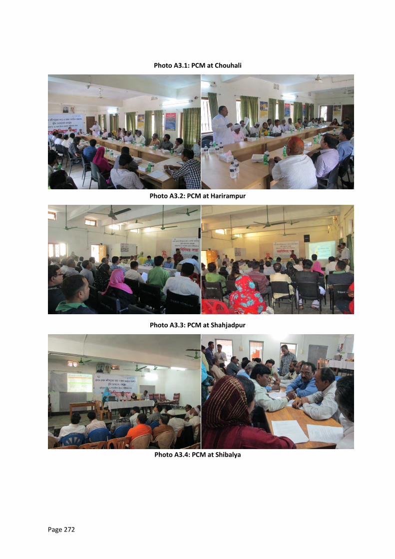
Page 272
Photo A3.1: PCM at Chouhali
Photo A3.2: PCM at Harirampur
Photo A3.3: PCM at Shahjadpur
Photo A3.4: PCM at Shibalya
Page 273
Table A3.3: First-Round Meeting Summary, Chouhali Upazila Complex, Sirajgonj
Project/Subproject: Integrated Flood and Riverbank Erosion Management Investment Program
Meeting date: 12.03.2013
Place: Chouhali Upazila Complex, Sirajgonj
Attending:
Proponents: BWDB, NHC, ADB
Stakeholders:
Primary: farmers, fishermen, local business community as well as the households to be displaced, women groups, and caretakers of community properties.
Secondary: those who may not be directly affected but have interests that could contribute to the study, play a role in implementation at some stage, or affect decision making on Project aspects. In this Project NGOs, concerned government departments, and line agencies are considered.
Reported by:Manju Ara, Jr. Professional, CEGIS
Issues, questions, responses, comments - People’s perception, opinion and attitude
1.1 Main problems due to erosion and flooding: - Flooding and eroding of homesteads - Accommodation problems for livestock - Land erosion in river side areas - Spreading of water-borne diseases and resulting health hazards - Problems in crop cultivation - Students cannot go to the educational institutions - Siltation Problem in the Jamuna River - Communication and transportation problems - Problems in various rural infrastructures (educational institutions, religious institutions etc.) - Reduce employment opportunities for river erosion
1.2 Peoples’ responses to the FRERMIP project: - People are very much positive to the implementation of this projects. Additionally, they
added the following suggestions: - Ensure the use of Geo-bag and CC-Block in protective work - Requirements of embankment
Page 274
- Construction of new embankment along the river bank 1.3 Impacts of the project
- People opined that this project must bring immense socio-economic benefits for them - Save Chowhali upazila complex and different govt. office - Prevent River erosion and protect house hold, livestock etc.
1.4 Impacts on Charlands - Increase density in Muradpur Char for relocation - Erosion of Charlands if construction cross dam or river
Resettlement/ Relocation issues
2.1. Impact of land acquisition on different group of people - Loss of homesteads - Damages of agricultural land - Increases the number of landless of people - loss of market facilities - Some of peoples have no land or not able to purchase land and they take shelter others
home stated 2.2. Relocation of houses and other establishments
- Landless people will be rehabilitated - People will be economically benefited - Price of adjacent land might be increased - Relocation should be ensured through the consultation with local allied persons
2.3. Choice of relocation site, availability of land and its current price
There is availability of land for relocation. The current price of land 1000 0BDT for cultivable land and
30,000 BDT for homesteads land.
People suggested that in compensation process, prices should be fixed by the consultation with the
local people rather than the average price of sub-registered office.
2.4. Present community social services the affected areas and relocated areas
Presently, there is inadequacy of social services both in the affected and relocated area
2.5. Will this situation be improved or deteriorated after relocation?
The present situation must be improved if the concerned authority manage it effectively and
relocate them in desired locations
2.6. Present level of access to market centers and towns/future level of access to market centers and towns after relocation
At present, access level of local people to markets and towns is low. But, it will be improved if the
project is implemented.
2.7. What are the patterns of transport and communication in the affected area/relocated area?
Rickshaw, Nosiman, tempo, boat, CNG, Horse cab, cycle are the main transportation in the affected
and relocated area. But, overall transportation and communication facilities are not good.
2.8. What are the patterns for utilizing cultural and religious facilities? Will it generate conflicts in the host community?
There exists homogeneous religious and cultural scenario both in the affected and relocated area.
Page 275
So, there is no possibility any sort of social conflict.
2.9. What types of conflicts may arise due to relocation/resettlement?
There is no possibility of social conflict. In spite of this, local allied persons should be involved in the
process of relocation the affected people.
Compensation issues
3.1. ADB and GoB policies on involuntary resettlement
Local people do not know the policies on involuntary resettlement of ADB and GoB
3.2. Discussion on entitlements, compensation rates, income restoration, and grievance redress mechanism - Compensation should be given on the basis current price land rather than traditional policy - Ensuring compensated money to the actually affected people
3.3. People’s preference on mode of compensation payment and their previous experience
In case of compensation they prefer money rather land as they feel freedom of choice
3.4. Cut-off date for listing affected properties
Income restoration and generation
4.1. What are the current income generating activities of APs? - Agriculture - Fish culture - Livestock rearing - Small entrepreneurship - Employed - Business Etc.
4.2. Are there possibilities for continuing employment in the project area? Which type of occupation? - It is possible to continue the current occupation in the project area
4.3. What types of income-generating activities are available at relocation sites? and to be generated? - Agriculture - Fish culture/capture - Livestock rearing - Small entrepreneurship - Employed - Business Etc.
4.4. How does relocation of households affect the current market situation (job opportunities, competition, land price and market price situation) - Labour availability will be increased. There is a chance to be more labor than less work - Land price will be increased - Social neighborhood will increased
4.5. How many people can be absorbed?
About 75 to 80 percent people can be absorbed
4.6. Does this require training for skill development and IGA? - Livestock roaring training - Swinging training
Page 276
- Health training - Fish culture training - Agricultural training - Skill development training is highly needed for the local people. In addition, training should
be given on disaster risk reduction 4.7. How many people need to be trained and for what occupation? - About 70% people need to be trained up. Training sectors:
- Fish culture - Farming - Livestock and poultry
Social Development Support
5.1. Name of NGOs prevailing in the relocation site - Proshika, BRAC, ASA, Manob Mukti Sangstha, BDPC Etc.
5.2. Willingness of NGOs to support the APs for savings and income generation programs, providing capital support for income restoration and poverty reduction. - Various NGOs show greater interest to support the affected people through poverty
reduction activities 5.3. Social safeguard and safety nets
- At present the coverage of social safety net is quiet good
Outcome (s)
- All livelihood sectors are affected by erosion and flood - They demanded immediate bank protection - They show willingness to be relocated in purpose of protective work - There is no social conflict regarding relocation - Prior consultation with local allied persons is highly required before starting work - Income and employment will be generated - Compensation should be given in money considering the current market price - Lifestyle of the local people will be improved
Special Attention
- Requirements of new embankment and protect work
Table A8.4: First-Round Meeting Summary, Harirampur Upazila Complex, Manikganj
Project/Subproject:Integrated Flood and Riverbank Erosion Management Investment Program
Meeting date: 26 /02/ 2013
Place: Harirampur Upazila Complex, Manikganj
Attending:
Proponents:
BWDB, NHC, ADB
Stakeholders:
Primary: Farmers, fishers, local business community as well as the households to be displaced, women groups, and caretakers of community properties.
Secondary: Those who may not be directly affected but have interests that could contribute to the study, play a role in implementation at some stage, or affect decision making on Project
Page 277
aspects. In this Project NGOs, concerned government departments, and line agencies are considered.
Reported by: Muhammad Shifuddin Mahmud, Professional, CEGIS
Issues, questions, responses, comments
People’s perception, opinion and attitude
1.1 Main problems due to erosion and flooding: - Flooding and eroding of homesteads - Accommodation problems for livestock - Scarcity of safe drinking water - Sanitation problems - Spreading of water-borne diseases and resulting health hazards - Problems in crop cultivation - Students cannot go to the educational institutions - Problems in movements for population and livestock - Destruction in fishery sector - Communication and transportation problems - Problems in various rural infrastructures (educational institutions, religious institutions etc.)
1.2 Peoples’ responses to the FRERMIP project: - People are very much positive to the implementation of this project. Additionally, they
added the following suggestions: - Ensure the use of Geo-bag in protective work - Repairing of sluice gate at Kantapara - Construction of new embankment at Dhulshura, Boyra and Lesraganj UP
1.3 Impacts of the project - People opined that this project would bring immense socio-economic benefits for them
Resettlement/ Relocation issues
2.1. Impact of land acquisition on different group of people - Loss of homesteads - Damages of agricultural land - Increases the number of landless of people
2.2. Relocation of houses and other establishments - Landless people will be rehabilitated - People will be economically benefited - Price of adjacent land might be increased - Relocation should be ensured through the consultation with local allied persons
2.3. Choice of relocation site, availability of land and its current price - There is availability of land for relocation. The current price of land is 10,000 BDT for
cultivable land and 30,000 BDT for homesteads land. - People suggested that in compensation process, prices should be fixed in consultation with
the local people instead of considering the average price of sub-registered office. 2.4. Present community social services the affected areas and relocated areas
- Presently, there is inadequacy of social services both in the affected and relocated area 2.5. Will this situation be improved or deteriorated after relocation?
- The present situation would improve if the concerned authority manage it effectively and relocate them in desired locations
2.6. Present level of access to market centers and towns/future level of access to market centers and towns after relocation
Page 278
- At present, access level of local people to markets and towns is low. It will be improved if the project is implemented.
2.7. What are the patterns of transport and communication in the affected area/relocated area?
- Rickshaw, Nosiman, tempo are the main transportation in the affected and relocated area. But, overall transportation and communication facilities are not good.
2.8. What are the patterns for utilizing cultural and religious facilities? Will it generate conflicts in the host community?
- There exists homogeneous religious and cultural scenario both in the affected and relocated area. So, there is no possibility of any sort of social conflict.
2.9. What types of conflicts may arise due to relocation/resettlement? - There is no possibility of social conflict. However, local allied persons should be involved in
the process of relocation the affected people.
Compensation issues
3.1. ADB and GoB policies on involuntary resettlement - Local people do not know the policies on involuntary resettlement of ADB and GoB
3.2. Discussion on entitlements, compensation rates, income restoration, and grievance redress mechanism
- Compensation should be given on the basis current price land rather than traditional policy - Ensuring compensated money to the actually affected people
3.3. People’s preference on mode of compensation payment and their previous experience - In case of compensation they prefer money rather than land as they feel freedom of choice
3.4. Cut-off date for listing affected properties
Income restoration and generation
4.1. What are the current income generating activities of APs? - Agriculture - Fish culture/capture - Livestock rearing - Small entrepreneurship - Employed - Business - Etc.
4.2. Are there possibilities for continuing employment in the project area? Which type of occupation?
- It is possible to continue the current occupation in the project area 4.3. What types of income-generating activities are available at relocation sites? and to be
generated? - Agriculture - Fish culture/capture - Livestock rearing - Small entrepreneurship - Employed - Business - Etc.
4.4. How does relocation of households affect the current market situation (job opportunities, competition, land price and market price situation)
- Labour availability will be increased. There is a chance to be more labor than less work - Land price will increase
Page 279
- Social neighbourhood will increase 4.5. How many people can be absorbed?
- About 70 to 75 percent people can be absorbed 4.6. Does this require training for skill development and IGA?
- Skill development training is highly needed for the local people. In addition, training should be given on disaster risk reduction
4.7. How many people need to be trained and for what occupation? - About 70% people need to be trained up
Training sectors:
- Fish culture - Farming - Livestock and poultry
Social Development Support
5.1. Name of NGOs prevailing in the relocation site - Proshika, BRAC, Grammeen Bank, GKT, BARSIC, Bangladesh Red Crescent Society
5.2. Willingness of NGOs to support the APs for savings and income generation programs, providing capital support for income restoration and poverty reduction.
- Various NGOs showed greater interest to support the affected people through poverty reduction activities
5.3. Social safeguard and safety nets - At present the coverage of social safety net is quiet good
Outcome (s)
- All livelihood sectors are affected by erosion and flood - They demanded immediate bank protection - They showed willingness to be relocated in purpose of protective work - There is no social conflict regarding relocation - Prior consultation with local allied persons is highly required before starting work - Income and employment will be generated - Compensation should be given in money considering the current market price - Lifestyle of the local people will be improved
Special Attention
In Dhulshura union 5 schools, 4 mosques, one orphanage, 2 Madrashas and Dhulshura bazaar as well
as crop land, homesteads and roadways may be eroded during the next April-May (Boisakh, Bangla
month), if the government do not take effective initiative immediately to protect this resources.
Table A8.5: First-Round Meeting Summary, Shibalaya Upazila Complex, Manikgonj
Project/Subproject:Integrated Flood and Riverbank Erosion Management Investment Program
Meeting date: 17/04/2013
Place: Shibalaya Upazila Complex, Manikgonj
Attending:
Proponents:
Page 280
BWDB, NHC, ADB
Stakeholders:
Primary: farmers, fishermen, local business community as well as the households to be displaced, women groups, and caretakers of community properties.
Secondary: those who may not be directly affected but have interests that could contribute to the study, play a role in implementation at some stage, or affect decision making on Project aspects. In this Project NGOs, Member of Parliamentarian (MP), concerned government departments, and line agencies are considered.
Reported by: Manju Ara, Jr. Professional, CEGIS
Issues, questions, responses, comments
People’s perception, opinion and attitude
2.1. Main problems due to erosion and flooding: - River erosion is main problem of Shibalaya Upazila. - Flooding and eroding of homesteads, cultivable land, homestead, various institutions such as
educational institutions, social and religious institutions as well as all immovable and material resources are evanescing to Jumana and PadmaRiver.
- Due to river erosion, communication system based on embankment has broken down. People cannot carry their goods as a result carrying cost and sufferings become no bounds. It keeps a negative impact on their economy.
- Land erosion in river side areas - Accommodation problems for livestock - Spreading of water-borne diseases and resulting health hazards - Problems in crop cultivation - Students cannot go to the educational institutions - Communication and transportation problems - Problems in various rural infrastructures (educational institutions, religious institutions etc.) - Losing cultivable land and all resources, they have become unemployed - Reduce employment opportunities for river erosion
2.2. Peoples’ responses to the FRERMIP project: - People are very much positive to the implementation of this project. Additionally, they
added the following suggestions: - Ensure the use of Geo-bag and CC-Block in protective work - Construction of new embankment along the river bank
2.3. Impacts of the project - Both positive and negative impact will be occurring after implementation of the FRERMIP
project intervention. - Positive impact like- agricultural land, crops, homes, hat-bazaar, school, social institutions
will be protected from riverbank erosion. - Negative impact- Agricultural land will reduce due to land acquisition. On the other hands,
houses will be needed to shift or migrate. 2.4. Impacts on char lands
- The char area will be protected from river erosion by implementation of the intervention and positive impact will occur in char area. Char area will sustain, as well as more crops will produce.
Page 281
Resettlement/ Relocation Issues
3.1. Impact of land acquisition on different group of people - Impact will be occurring after Impact of land acquisition of the FRERMIP - Agricultural land will reduce due to land acquisition. - On the other hands, houses will be needed to shift or migrate. - Increases the number of landless of people - loss of market facilities - Some of peoples have no land or not able to purchase land and they take shelter others
home stated 3.2. Relocation of houses and other establishments
- There are severe economical effects on different professional due to migration of homes, school, and various social institution of this area
- Landless people will be rehabilitated - People will be economically benefited - Price of adjacent land might be increased - Relocation should be ensured through the consultation with local allied persons
3.3. Choice of relocation site, availability of land and its current price - There is availability of land for relocation. The local people prefer both side of Utholy-Aricha
highway’s space as rehabilitation. The price of land is almost BDT 50,000. Per decimal for homesteads land.
- People suggested that in compensation process, prices should be fixed by the consultation with the local people rather than the average price of sub-registered office.
3.4. Present community social services the affected areas and relocated areas - There is no opportunity in river erosion area of Hat- Bazar as well as health and
education services where relocation area has better facilities. - Presently, there is inadequacy of social services both in the affected and relocated area.
3.5. Will this situation be improved or deteriorated after relocation? - The present situation must be improved if the concerned authority manage it effectively
and relocate them in desired locations 3.6. Present level of access to market centers and towns/future level of access to market
centers and towns after relocation - At present, access level of local people to markets and towns is low. But, it will be
improved if the project is implemented. 3.7. What are the patterns of transport and communication in the affected area/relocated
area? - The dwellers normally use rickshaw, van, Auto van etc to go to nearest place such as hat,
bazaar in village. On the other hand, in upzilla people use CNG, Auto van, Motor cycle etc. same kind of vehicles will be used. There are street facilities for communication. Overall transportation and communication facilities are not good.
3.8. What are the patterns for utilizing cultural and religious facilities? Will it generate conflicts in the host community? - Simply socio-religious and cultural facilities are equally enjoyed by the local people and
there is no major conflict about it. If it is needed due to project implementation, conflict might not be happened.
3.9. What types of conflicts may arise due to relocation/ resettlement? - There is no possibility of social conflict. In spite of this, local allied persons should be
involved in the process of relocation the affected people.
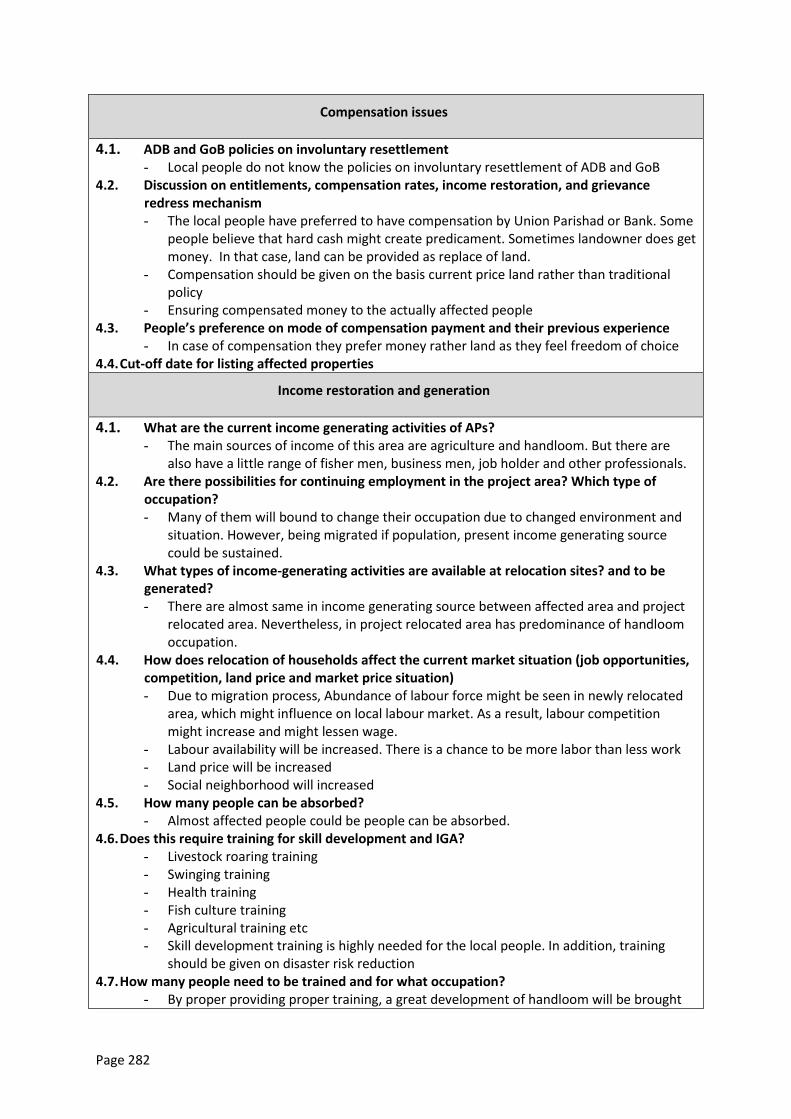
Page 282
Compensation issues
4.1. ADB and GoB policies on involuntary resettlement - Local people do not know the policies on involuntary resettlement of ADB and GoB
4.2. Discussion on entitlements, compensation rates, income restoration, and grievance redress mechanism - The local people have preferred to have compensation by Union Parishad or Bank. Some
people believe that hard cash might create predicament. Sometimes landowner does get money. In that case, land can be provided as replace of land.
- Compensation should be given on the basis current price land rather than traditional policy
- Ensuring compensated money to the actually affected people 4.3. People’s preference on mode of compensation payment and their previous experience
- In case of compensation they prefer money rather land as they feel freedom of choice 4.4. Cut-off date for listing affected properties
Income restoration and generation
4.1. What are the current income generating activities of APs? - The main sources of income of this area are agriculture and handloom. But there are
also have a little range of fisher men, business men, job holder and other professionals. 4.2. Are there possibilities for continuing employment in the project area? Which type of
occupation? - Many of them will bound to change their occupation due to changed environment and
situation. However, being migrated if population, present income generating source could be sustained.
4.3. What types of income-generating activities are available at relocation sites? and to be generated? - There are almost same in income generating source between affected area and project
relocated area. Nevertheless, in project relocated area has predominance of handloom occupation.
4.4. How does relocation of households affect the current market situation (job opportunities, competition, land price and market price situation) - Due to migration process, Abundance of labour force might be seen in newly relocated
area, which might influence on local labour market. As a result, labour competition might increase and might lessen wage.
- Labour availability will be increased. There is a chance to be more labor than less work - Land price will be increased - Social neighborhood will increased
4.5. How many people can be absorbed? - Almost affected people could be people can be absorbed.
4.6. Does this require training for skill development and IGA? - Livestock roaring training - Swinging training - Health training - Fish culture training - Agricultural training etc - Skill development training is highly needed for the local people. In addition, training
should be given on disaster risk reduction 4.7. How many people need to be trained and for what occupation?
- By proper providing proper training, a great development of handloom will be brought
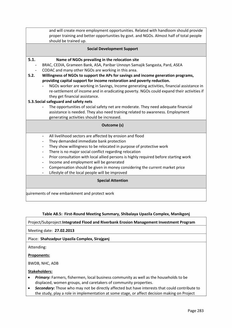
Page 283
and will create more employment opportunities. Related with handloom should provide proper training and better opportunities by govt. and NGOs. Almost half of total people should be trained up.
Social Development Support
5.1. Name of NGOs prevailing in the relocation site - BRAC, CEDIA, Grameen Bank, ASA, Paribar Unnoyn Samajik Sangasta, Pard, ASEA - CODAC and many other NGOs are working in this area.
5.2. Willingness of NGOs to support the APs for savings and income generation programs, providing capital support for income restoration and poverty reduction. - NGOs worker are working in Savings, Income generating activities, financial assistance in
re-settlement of income and in eradicating poverty. NGOs could expand their activities if they get financial assistance.
5.3. Social safeguard and safety nets - The opportunities of social safety net are moderate. They need adequate financial
assistance is needed. They also need training related to awareness. Employment generating activities should be increased.
Outcome (s)
- All livelihood sectors are affected by erosion and flood - They demanded immediate bank protection - They show willingness to be relocated in purpose of protective work - There is no major social conflict regarding relocation - Prior consultation with local allied persons is highly required before starting work - Income and employment will be generated - Compensation should be given in money considering the current market price - Lifestyle of the local people will be improved
Special Attention
Requirements of new embankment and protect work
Table A8.5: First-Round Meeting Summary, Shibalaya Upazila Complex, Manikgonj
Project/Subproject:Integrated Flood and Riverbank Erosion Management Investment Program
Meeting date: 27.02.2013
Place: Shahzadpur Upazila Complex, Sirajganj
Attending:
Proponents:
BWDB, NHC, ADB
Stakeholders:
Primary: Farmers, fishermen, local business community as well as the households to be displaced, women groups, and caretakers of community properties.
Secondary: Those who may not be directly affected but have interests that could contribute to the study, play a role in implementation at some stage, or affect decision making on Project
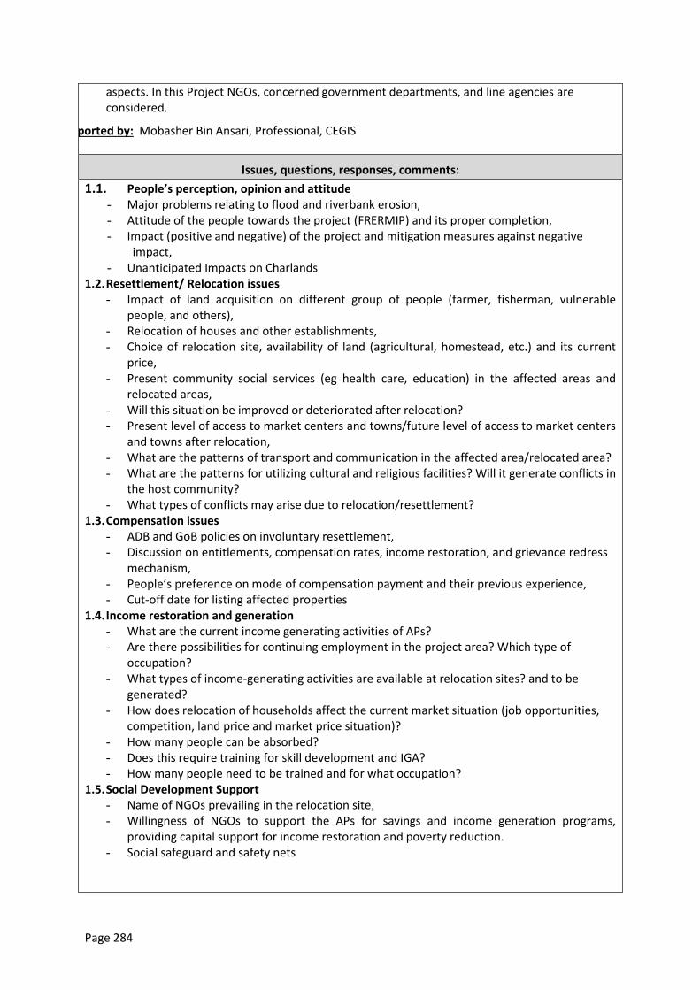
Page 284
aspects. In this Project NGOs, concerned government departments, and line agencies are considered.
Reported by: Mobasher Bin Ansari, Professional, CEGIS
Issues, questions, responses, comments:
1.1. People’s perception, opinion and attitude - Major problems relating to flood and riverbank erosion, - Attitude of the people towards the project (FRERMIP) and its proper completion, - Impact (positive and negative) of the project and mitigation measures against negative
impact, - Unanticipated Impacts on Charlands
1.2. Resettlement/ Relocation issues - Impact of land acquisition on different group of people (farmer, fisherman, vulnerable
people, and others), - Relocation of houses and other establishments, - Choice of relocation site, availability of land (agricultural, homestead, etc.) and its current
price, - Present community social services (eg health care, education) in the affected areas and
relocated areas, - Will this situation be improved or deteriorated after relocation? - Present level of access to market centers and towns/future level of access to market centers
and towns after relocation, - What are the patterns of transport and communication in the affected area/relocated area? - What are the patterns for utilizing cultural and religious facilities? Will it generate conflicts in
the host community? - What types of conflicts may arise due to relocation/resettlement?
1.3. Compensation issues - ADB and GoB policies on involuntary resettlement, - Discussion on entitlements, compensation rates, income restoration, and grievance redress
mechanism, - People’s preference on mode of compensation payment and their previous experience, - Cut-off date for listing affected properties
1.4. Income restoration and generation - What are the current income generating activities of APs? - Are there possibilities for continuing employment in the project area? Which type of
occupation? - What types of income-generating activities are available at relocation sites? and to be
generated? - How does relocation of households affect the current market situation (job opportunities,
competition, land price and market price situation)? - How many people can be absorbed? - Does this require training for skill development and IGA? - How many people need to be trained and for what occupation?
1.5. Social Development Support - Name of NGOs prevailing in the relocation site, - Willingness of NGOs to support the APs for savings and income generation programs,
providing capital support for income restoration and poverty reduction. - Social safeguard and safety nets
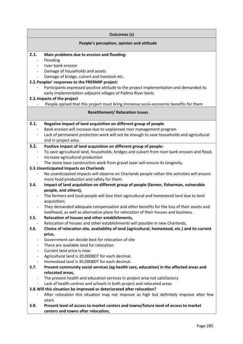
Page 285
Outcomes (s)
People’s perception, opinion and attitude
2.1. Main problems due to erosion and flooding: - Flooding - river bank erosion - Damage of households and assets - Damage of bridge, culvert and livestock etc.
2.2. Peoples’ responses to the FRERMIP project: - Participants expressed positive attitude to the project implementation and demanded its
early implementation adjacent villages of Padma River bank; 2.3. Impacts of the project
- People opined that this project must bring immense socio-economic benefits for them
Resettlement/ Relocation issues
3.1. Negative impact of land acquisition on different group of people - Bank erosion will increase due to unplanned river management program - Lack of permanent protection work will not be enough to save households and agricultural
and in project area.
3.2. Positive impact of land acquisition on different group of people: - To save agricultural land, households, bridges and culvert from river bank erosion and flood. - Increase agricultural production - The stone base construction work from gravel layer will ensure its longevity.
3.3. Unanticipated Impacts on Charlands - No unanticipated impacts will observe on Charlands people rather this activities will ensure
more food production and safety for them. 3.4. Impact of land acquisition on different group of people (farmer, fisherman, vulnerable
people, and others), - The farmers and local people will lose their agricultural and homestead land due to land
acquisition; - They demanded adequate compensation and other benefits for the loss of their assets and
livelihood, as well as alternative place for relocation of their houses and business. 3.5. Relocation of houses and other establishments,
- Relocation of houses and other establishments will possible in new Charlands, 3.6. Choice of relocation site, availability of land (agricultural, homestead, etc.) and its current
price, - Government can decide best for relocation of site - There are available land for relocation - Current land price is now: - Agricultural land is 20,000BDT for each decimal. - Homestead land is 30,000BDT for each decimal.
3.7. Present community social services (eg health care, education) in the affected areas and relocated areas,
- The present health and education services in project area not satisfactory - Lack of health centres and schools in both project and relocated areas
3.8. Will this situation be improved or deteriorated after relocation? - After relocation this situation may not improve as high but definitely improve after few
years 3.9. Present level of access to market centers and towns/future level of access to market
centers and towns after relocation,
Page 286
- At present access to market is not satisfactory. 3.10. What are the patterns of transport and communication in the affected area/relocated
area? - Modes of transportations in the project area are Rickshaw and van. Most of the people
communicate through foot. 3.11. What are the patterns for utilizing cultural and religious facilities? Will it generate conflicts
in the host community? - People of these areas are practicing homogenous cultural practices for 100 of years. No
social conflicts are exists in whole project area 3.12. What types of conflicts may arise due to relocation/resettlement?
- According to local people, no conflicts will happen due to relocation/resettlement. If any will rise, local power holder can solve this problem easily.
Compensation issues, income restoration and generation
4.1. ADB and GoB policies on involuntary resettlement - Local people are totally unknown about ADB and GoB policies on involuntary resettlement
issues. 4.2. Discussion on entitlements, compensation rates, income restoration, and grievance
redress mechanism, - Compensation should be paid to actual people who are affected by land acquisition. - Land compensation should be given on the basis of present land price.
4.3. People’s preference and previous experience on mode of compensation payment - People’s preferences on mode of compensation payment only through money.
4.4. Cut-off date for listing affected properties - N/A
4.8. What are the current income generating activities of APs? - Agricultural farming - Fishing (culture/capture) - Livestock rearing - Small cottage/Handicraft - Employed/service - Small business
4.9. Are there possibilities for continuing employment in the project area? Which type of occupation?
- The mentions above occupations are possible for continuing in the project area. 4.10. What types of income-generating activities are available at relocation sites? And to be
generated? - Agricultural farming - Fishing (culture/capture) - Livestock rearing - Small cottage/Handicraft - Employed/service - Small business
4.11. How does relocation of households affect the current market situation (job opportunities, competition, land price and market price situation)?
- Land price will be increased - Development of agriculture - Development of communication system - Improvement of livestock rearing practice etc.
4.12. How many people can be absorbed? - About 50 percent people can be absorbed
Page 287
4.13. Does this require training for skill development and IGA? - It is highly needed training programs on agriculture farming, livestock rearing and small
cottage for the betterment of local people. 4.14. How many people need to be trained and for what occupation?
- People identified at least 80% of local are needed to trained up on these particular occupation as:
- Improve agricultural farming - Fishing (culture/capture) - Small cottage/handicraft etc.
Social Development Support
5.1. Name of NGOs prevailing in the relocation site - BRAC, Grameen Bank, PPD, Manab Mukti, UNDP, ASA
5.2. Willingness of NGOs to support the APs for savings and income generation programs, providing capital support for income restoration and poverty reduction.
- These NGOs are interested to support the APS for savings and income generation programs, providing capital for income restoration and poverty reduction.
5.3. Social safeguard and safety nets - At present, the social safeguard and safety nets activities in the project area are not good.
Local people argued more initiatives should have taken by government in this regard such as:
- Old allowances - Maternity allowances - Widow allowances etc
Overall Findings
Overall: - The local people desired for quick implementation of this project as they believe that the
communication infrastructure and other facilities of the study area will be improved as well in the aftermath.
- The land owners stated that they want higher prices of land than anticipated but still they agreed that the project would change the socio-economical condition of the area as well as of the country.
- People demanded that the village cross road which run beside the river bank should be made as metalled road for the convenience of local people, contractor and the BWDB.
Specific:
- Participants expressed positive attitude to the project implementation and demanded its early implementation.
- Local people expect employment opportunities during and after project implementation; - People suggested for the development of road communication network which in a sense
would create income generating sources for the villagers; - The compensation should be fixed in conformity with the market value of the land; and - People strongly demanded a plan which will not affect the local development with an excuse
of national development.
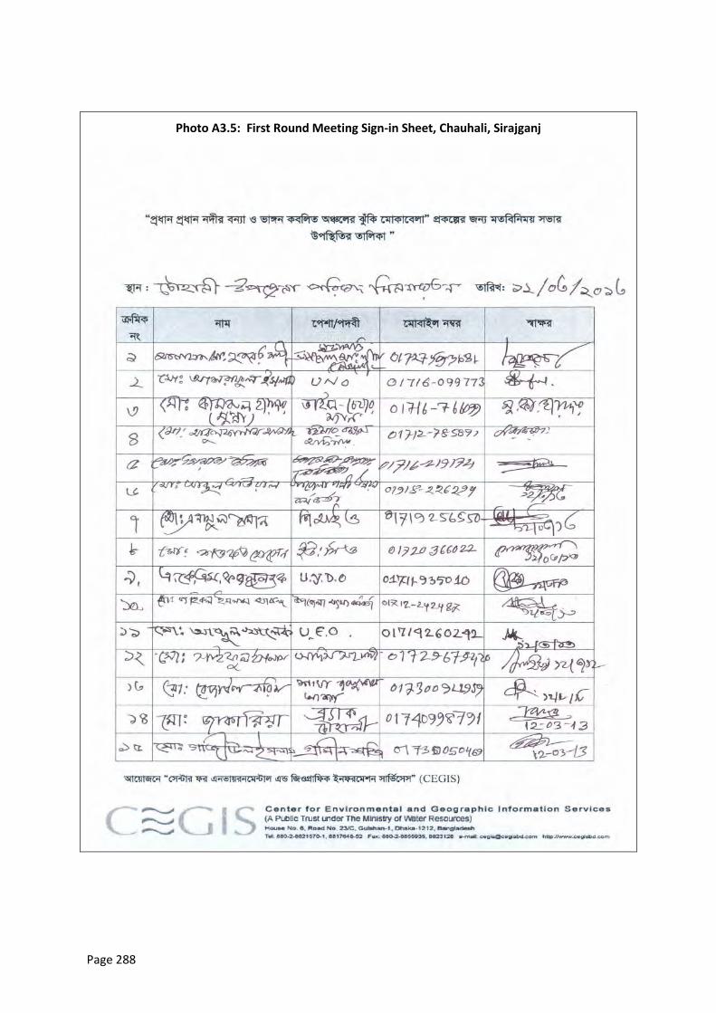
Page 288
Photo A3.5: First Round Meeting Sign-in Sheet, Chauhali, Sirajganj
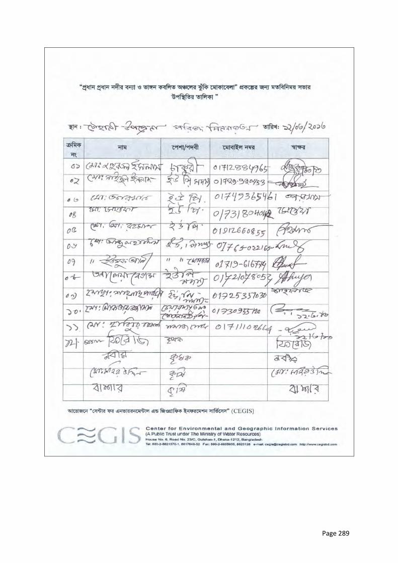
Page 289
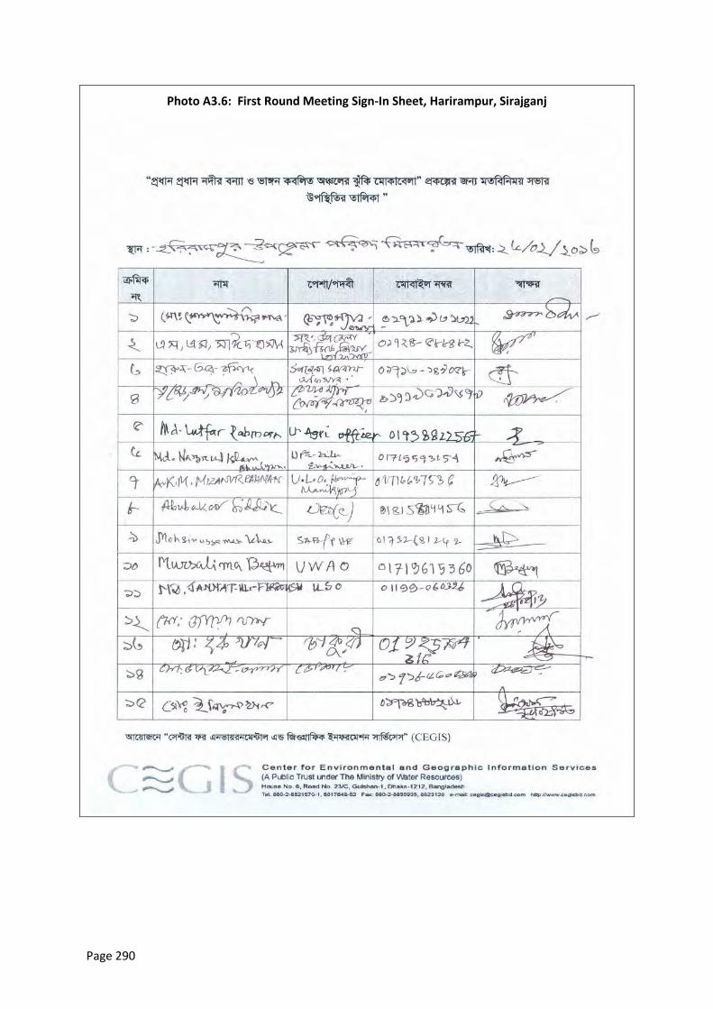
Page 290
Photo A3.6: First Round Meeting Sign-In Sheet, Harirampur, Sirajganj
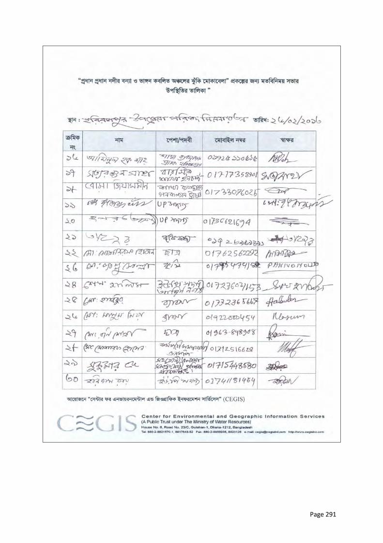
Page 291
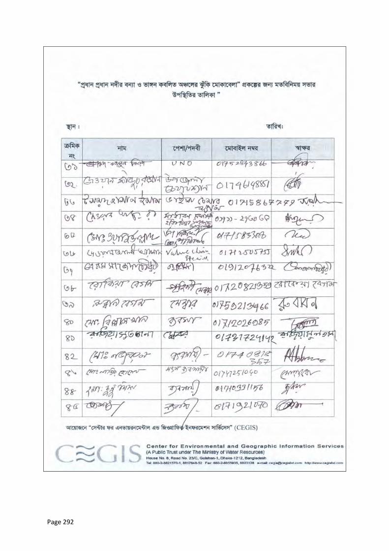
Page 292
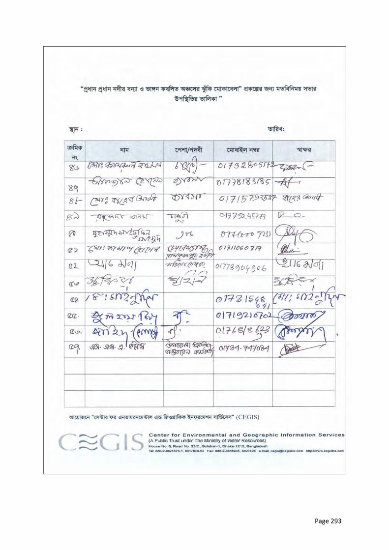
Page 293
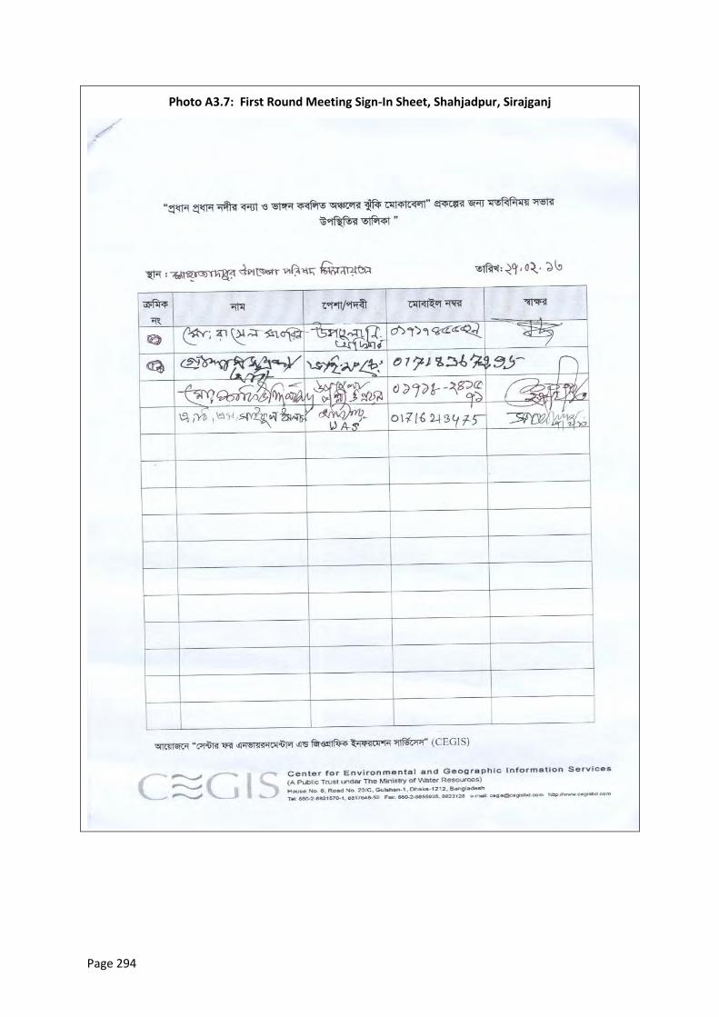
Page 294
Photo A3.7: First Round Meeting Sign-In Sheet, Shahjadpur, Sirajganj
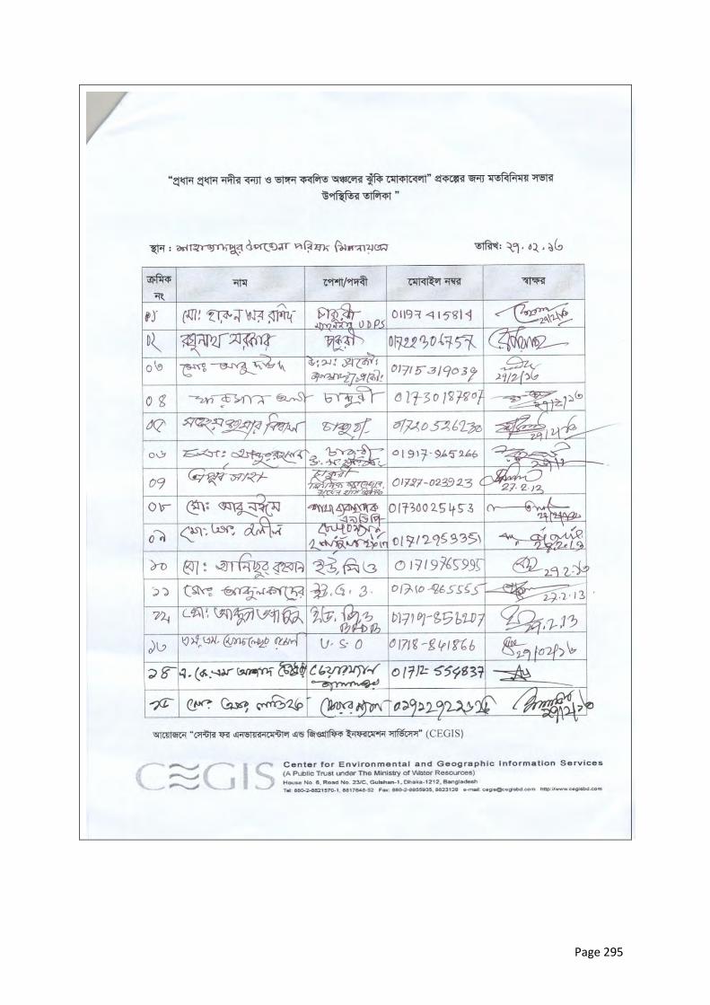
Page 295
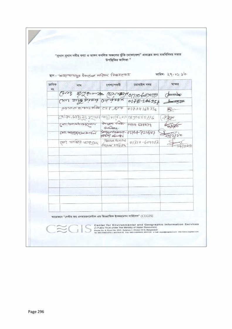
Page 296

Page 297
Photo A3.8: First Round Meeting Sign-In Sheet, Shibalaya, Manikganj
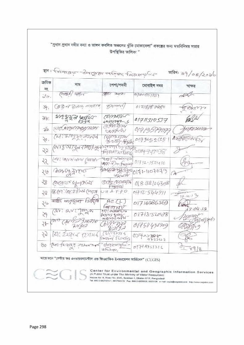
Page 298
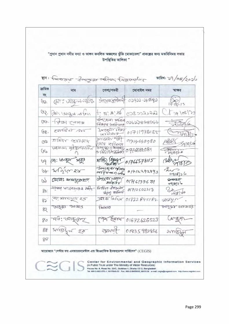
Page 299
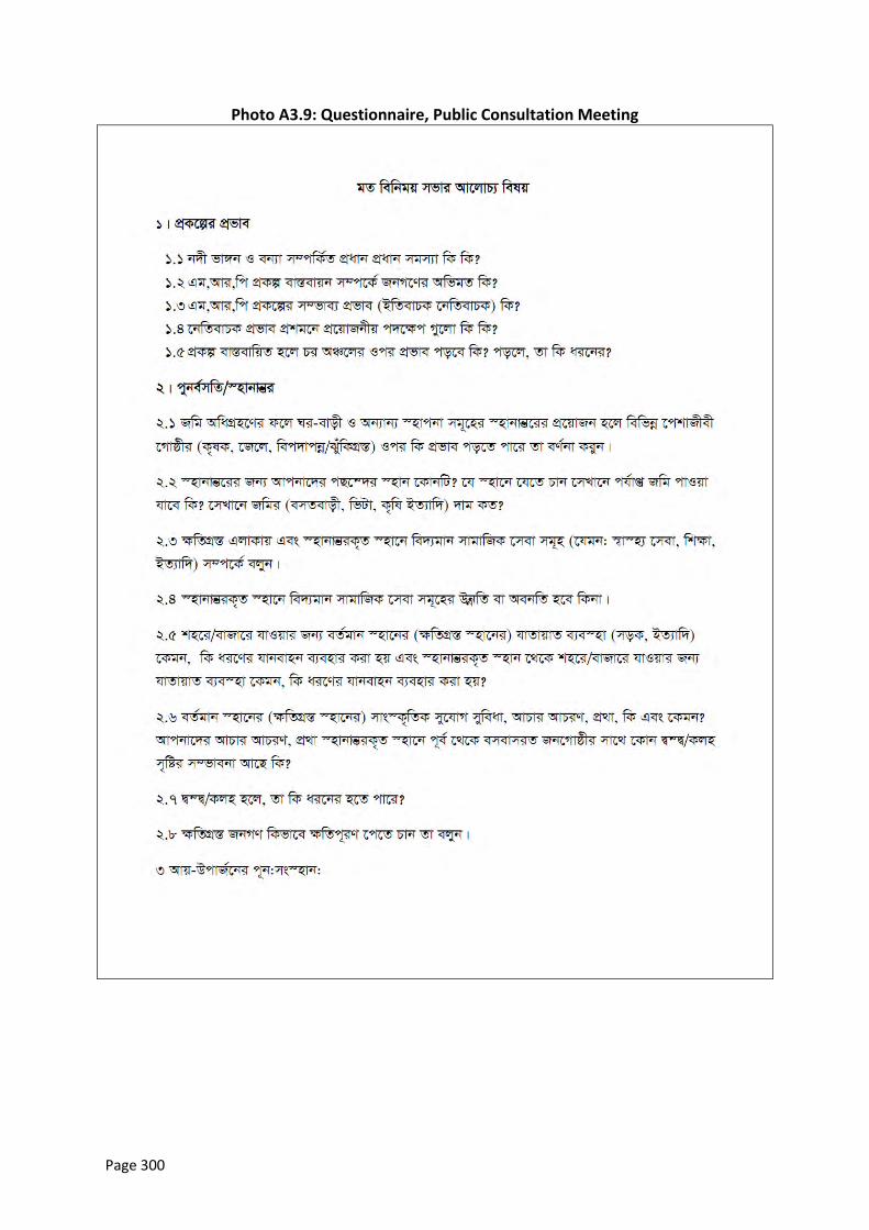
Page 300
Photo A3.9: Questionnaire, Public Consultation Meeting
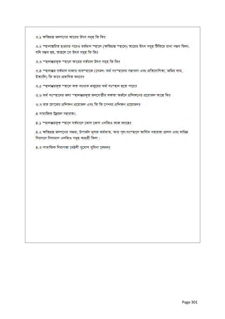
Page 301

Page 302
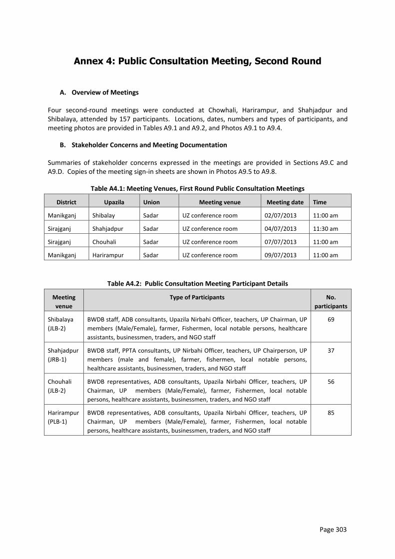
Page 303
Annex 4: Public Consultation Meeting, Second Round
A. Overview of Meetings
Four second-round meetings were conducted at Chowhali, Harirampur, and Shahjadpur and Shibalaya, attended by 157 participants. Locations, dates, numbers and types of participants, and meeting photos are provided in Tables A9.1 and A9.2, and Photos A9.1 to A9.4.
B. Stakeholder Concerns and Meeting Documentation
Summaries of stakeholder concerns expressed in the meetings are provided in Sections A9.C and A9.D. Copies of the meeting sign-in sheets are shown in Photos A9.5 to A9.8.
Table A4.1: Meeting Venues, First Round Public Consultation Meetings
District Upazila Union Meeting venue Meeting date Time
Manikganj Shibalay Sadar UZ conference room 02/07/2013 11:00 am
Sirajganj Shahjadpur Sadar UZ conference room 04/07/2013 11:30 am
Sirajganj Chouhali Sadar UZ conference room 07/07/2013 11:00 am
Manikganj Harirampur Sadar UZ conference room 09/07/2013 11:00 am
Table A4.2: Public Consultation Meeting Participant Details
Meeting
venue
Type of Participants No.
participants
Shibalaya
(JLB-2)
BWDB staff, ADB consultants, Upazila Nirbahi Officer, teachers, UP Chairman, UP
members (Male/Female), farmer, Fishermen, local notable persons, healthcare
assistants, businessmen, traders, and NGO staff
69
Shahjadpur
(JRB-1)
BWDB staff, PPTA consultants, UP Nirbahi Officer, teachers, UP Chairperson, UP
members (male and female), farmer, fishermen, local notable persons,
healthcare assistants, businessmen, traders, and NGO staff
37
Chouhali
(JLB-2)
BWDB representatives, ADB consultants, Upazila Nirbahi Officer, teachers, UP
Chairman, UP members (Male/Female), farmer, Fishermen, local notable
persons, healthcare assistants, businessmen, traders, and NGO staff
56
Harirampur
(PLB-1)
BWDB representatives, ADB consultants, Upazila Nirbahi Officer, teachers, UP
Chairman, UP members (Male/Female), farmer, Fishermen, local notable
persons, healthcare assistants, businessmen, traders, and NGO staff
85
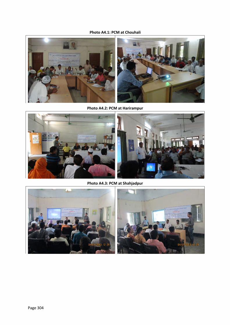
Page 304
Photo A4.1: PCM at Chouhali
Photo A4.2: PCM at Harirampur
Photo A4.3: PCM at Shahjadpur
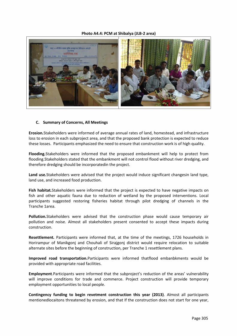
Page 305
Photo A4.4: PCM at Shibalya (JLB-2 area)
C. Summary of Concerns, All Meetings
Erosion.Stakeholders were informed of average annual rates of land, homestead, and infrastructure loss to erosion in each subproject area, and that the proposed bank protection is expected to reduce these losses. Participants emphasized the need to ensure that construction work is of high quality.
Flooding.Stakeholders were informed that the proposed embankment will help to protect from flooding.Stakeholders stated that the embankment will not control flood without river dredging, and therefore dredging should be incorporatedin the project.
Land use.Stakeholders were advised that the project would induce significant changesin land type, land use, and increased food production.
Fish habitat.Stakeholders were informed that the project is expected to have negative impacts on fish and other aquatic fauna due to reduction of wetland by the proposed interventions. Local participants suggested restoring fisheries habitat through pilot dredging of channels in the Tranche 1area.
Pollution.Stakeholders were advised that the construction phase would cause temporary air pollution and noise. Almost all stakeholders present consented to accept these impacts during construction.
Resettlement. Participants were informed that, at the time of the meetings, 1726 households in Horirampur of Manikgonj and Chouhali of Sirajgonj district would require relocation to suitable alternate sites before the beginning of construction, per Tranche 1 resettlement plans.
Improved road transportation.Participants were informed thatflood embanbkments would be provided with appropriate road facilities.
Employment.Participants were informed that the subproject’s reduction of the areas’ vulnerability will improve conditions for trade and commerce. Project construction will provide temporary employment opportunities to local people.
Contingency funding to begin revetment construction this year (2013). Almost all participants mentionedlocaitons threatened by erosion, and that If the construction does not start for one year,
Page 306
erosion will proceed in this areas and the subproject designswill have to be changed. They requested contingency funds to be arranged now so that protection work can begin in 2013.
Addition of dredging to subproject designs.River dredging has not been included in subproject designs. Participants strongly recommended that it be added, as they believe flood and erosion control cannot be achieved in these areas without it. Some participants suggested capital dredging from Jamuna Bridge to Brahmankanda of Horirampur upazia under Manikgonj district.
Successful implementation. Participants are concerned that development projects initiated by the ruling party will lose priority if/when the opposition party is in power. Participants strongly urge a 2013 construction start avoid future problems.
Flood protection plans. Participants expressed concerned about the effectiveness of the subprojects in controlling flooding. They stated that flood protection plansshould be developed based on an assessment of water levels. Proposed interventions should be designed to provide protection from the highest monsoon water levels.
D. Notes of Specific Meetings
Shibalay, Manikganj (JLB-2 area)
The upazila areasmost affected by erosion are Zafargonj and Bachamara. Local MP Mr. A.B.M Anwerul Haq stated that over last five years, more than 9000 affluent households of Zafargonj area were forced by erosion to leave the area and now live in difficult circumstances in Dhaka city.
Participants recommend that construction should start from November in the dry season.
The northern part of Zafargonj Bazar is very much threatened by erosion this year. To protect this area,participants suggested seeking preparatory fundsfrom Asian Development Bank (ABD) and Water Development Board.
The subproject area needs access to contingency fundsfor emergency work.
Participants believe permanent protection works are required in the Padma and Jamuna Rivers as temporary erosion protection works are not viable there.
River dredging is essential to the success of the subproject and should be started in order to prevent erosion and flooding.
River bank protections from Koijuri to Baghabari are essential this year as these areas are vulnerable.
During construction, transparency should be ensured through BWDB monitoring of work quality.
A reservoir to hold water for rice cultivation and fish culture should be added to thesubproject.
Shahjadpur, Sirajganj
Co-ordination among involved departments should be ensured during subproject implementation.
Eroding locations should be properly identified and protection works provided there.
Page 307
Participants requested adding construction of a water reservoir to the project, to hold water for rice cultivation and aquaculture and immediate repair of the existing upazila embankment and revetment.
Participants stated that a flood action plan was needed to improve flood proofing and response given the high flood levels in the subproject area.
Participants favor pilot dredging in area channels to increase fish production and maintain fish habitat.
Chouhali, Sirajganj
The area of Chouhali upazila most vulnerable to erosion is the upazila sadar, where 40 to 50 per cent of the area has already eroded away. BWDB has been using sandbags in attempt to control the erosion, but these have been ineffective given the intensity of the erosive attack. Participants stated that sandbag revetments are ineffective in the Jamuna due to its erosion intensity.
Participants urged BWDB to appeal to ADB to allocate preparatory funds for emergency work. Construction of riverbank protection works should commence in the dry season, otherwise adequate work quality will not be achieved.
Most participants stated that capital dredging should be undertaken from the Jamuna Bridge to Aricha. River dredging is required to ensure the survival of any future embankment works. An embankment built in this upazila at a cost of BDT 38 crore was already destroyed by erosion.
A flow divider should be incorporated in the project design.
Participants expressed frustration that the the subproject design does not reflect the concerns and suggestions of local people, even though these have been expressed repeatedly in meetings with the Project Implementation Officer (PIO).
Harirampur, Manikganj
The 5 km riverbank protection proposed in this upazila should be extended an additional 2 km up to Dhulsura. Bahadurpur union should be included with the project.
Participants were concerned about the successful implementation of the project. They think that projects initiated by the ruling party will have lower priority if and when the opposition is in power. Participants hope the subproject will be implemented in 2013 and agreed to make whatever sacrifices would be required to expedite this.
Participants stated that the priority should be to protect Harirampur before providing protection to Manikgonj town. Priority work should start as soon as possible.
A quality control committee should be struck to ensure quality construction work.
Local stakeholders should be involved in regular embankment maintenance.
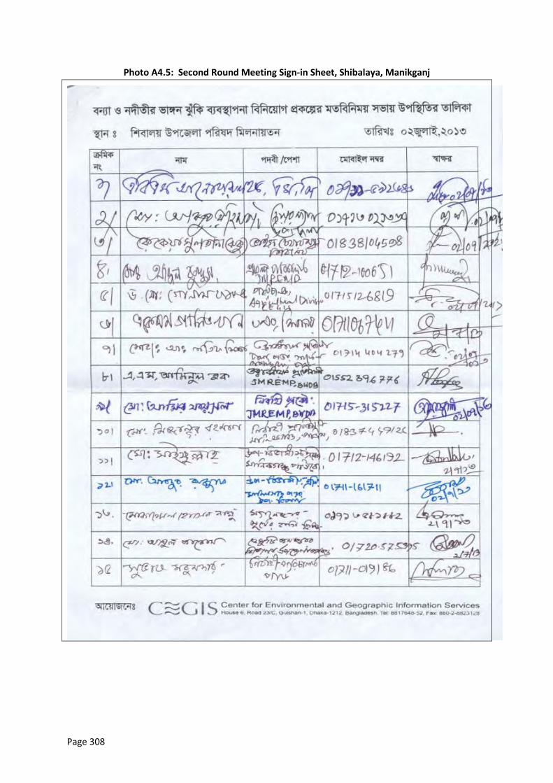
Page 308
Photo A4.5: Second Round Meeting Sign-in Sheet, Shibalaya, Manikganj
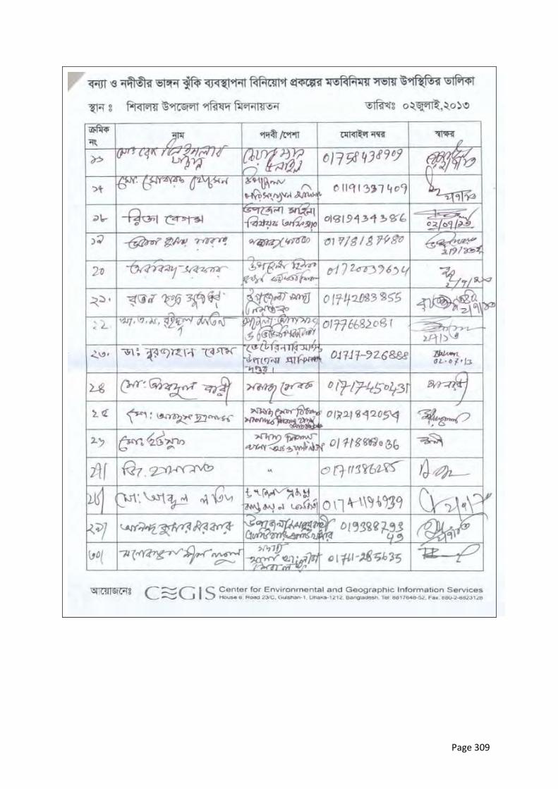
Page 309
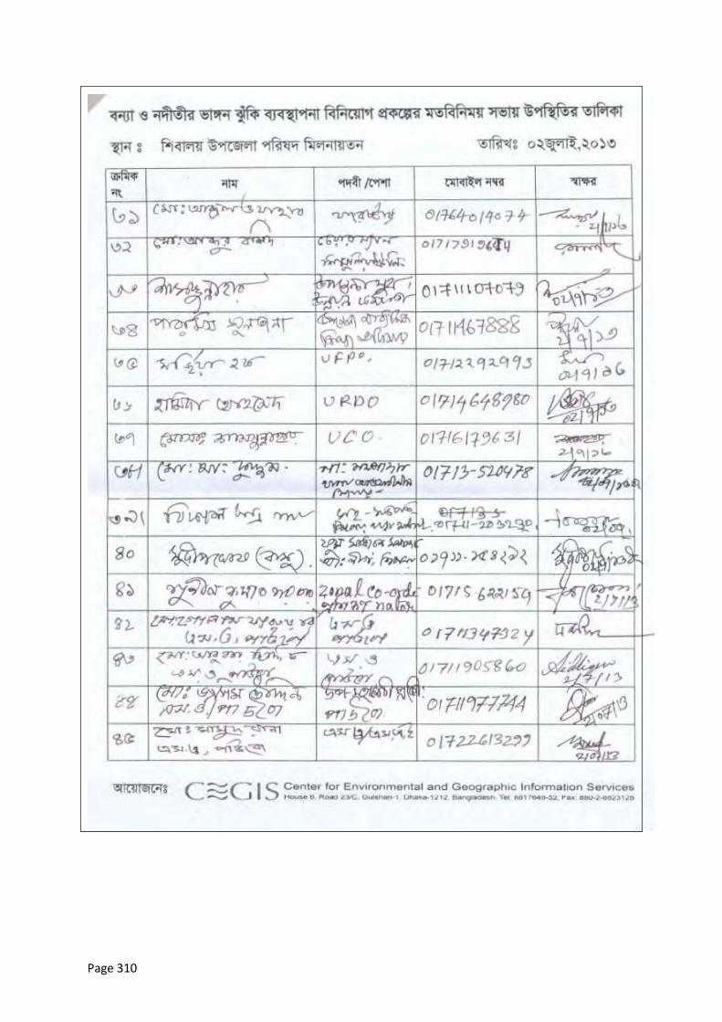
Page 310
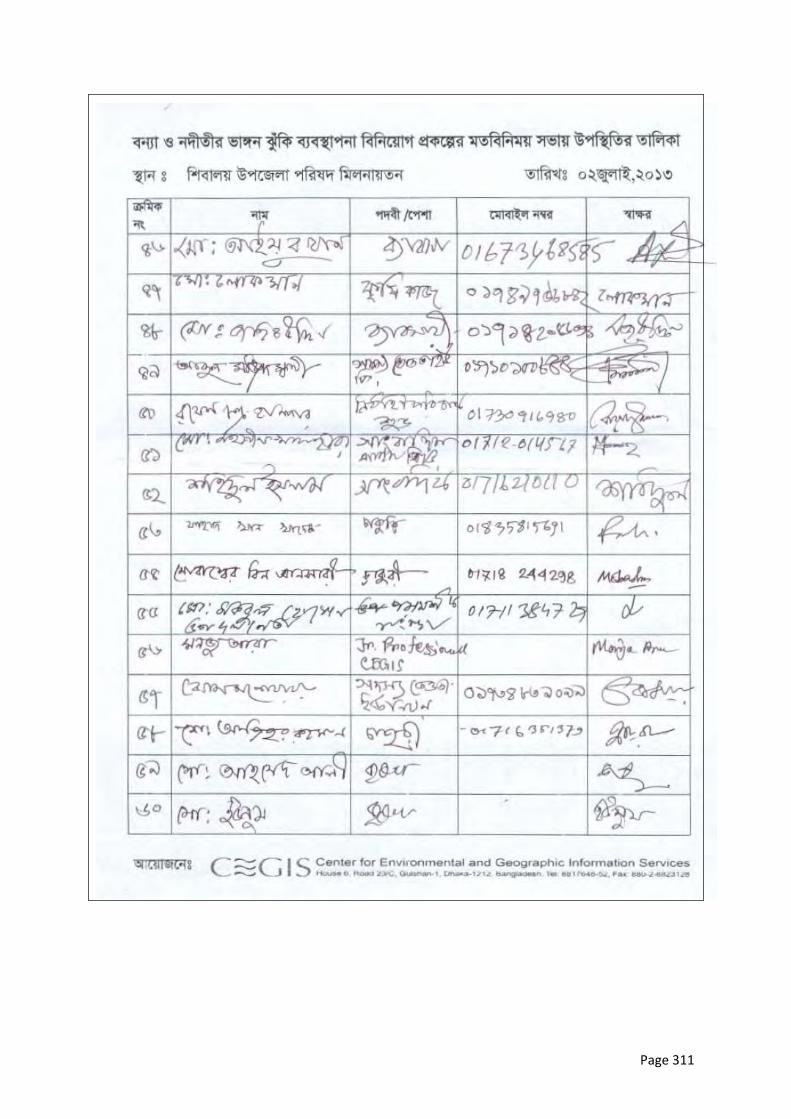
Page 311
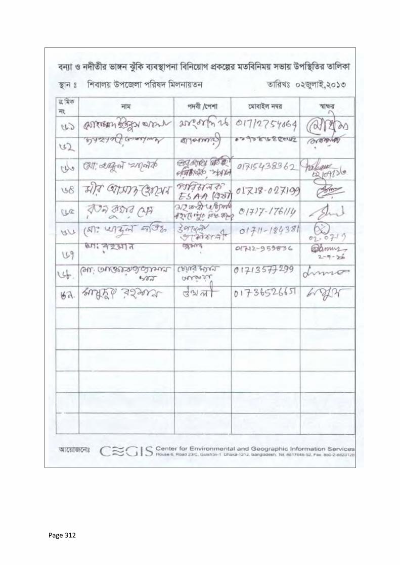
Page 312

Page 313
Photo A4.6: Second Round Meeting Sign-in Sheet, Shahjadpur, Sirajganj
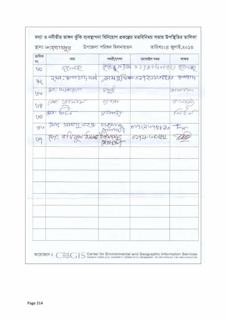
Page 314
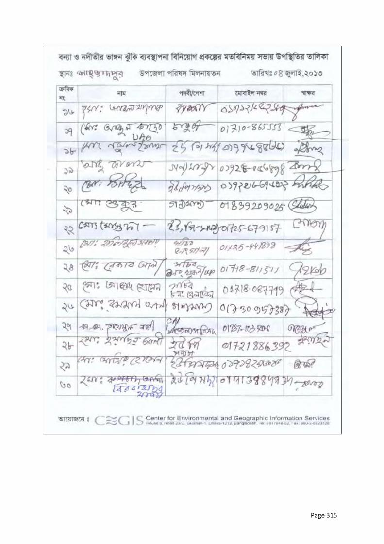
Page 315
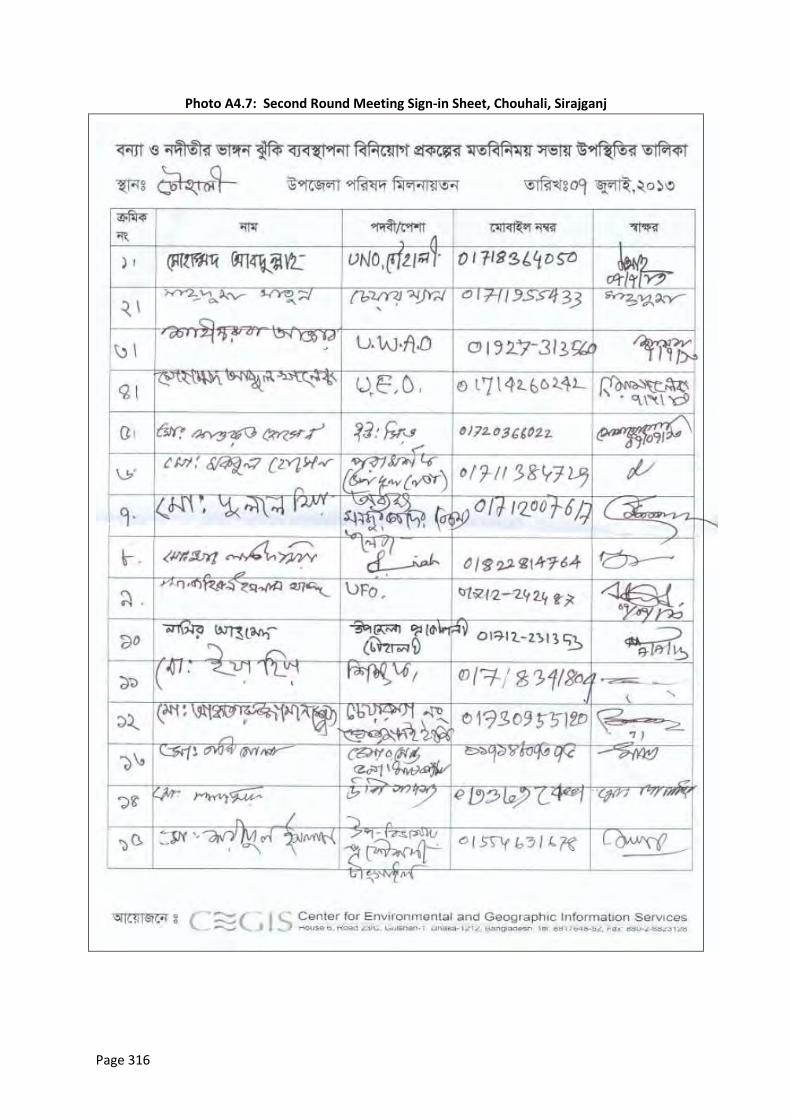
Page 316
Photo A4.7: Second Round Meeting Sign-in Sheet, Chouhali, Sirajganj
Page 317
Page 318
Page 319

Page 320
Photo A4.8: Second Round Meeting Sign-in Sheet, Harirampur, Manikganj
Page 321
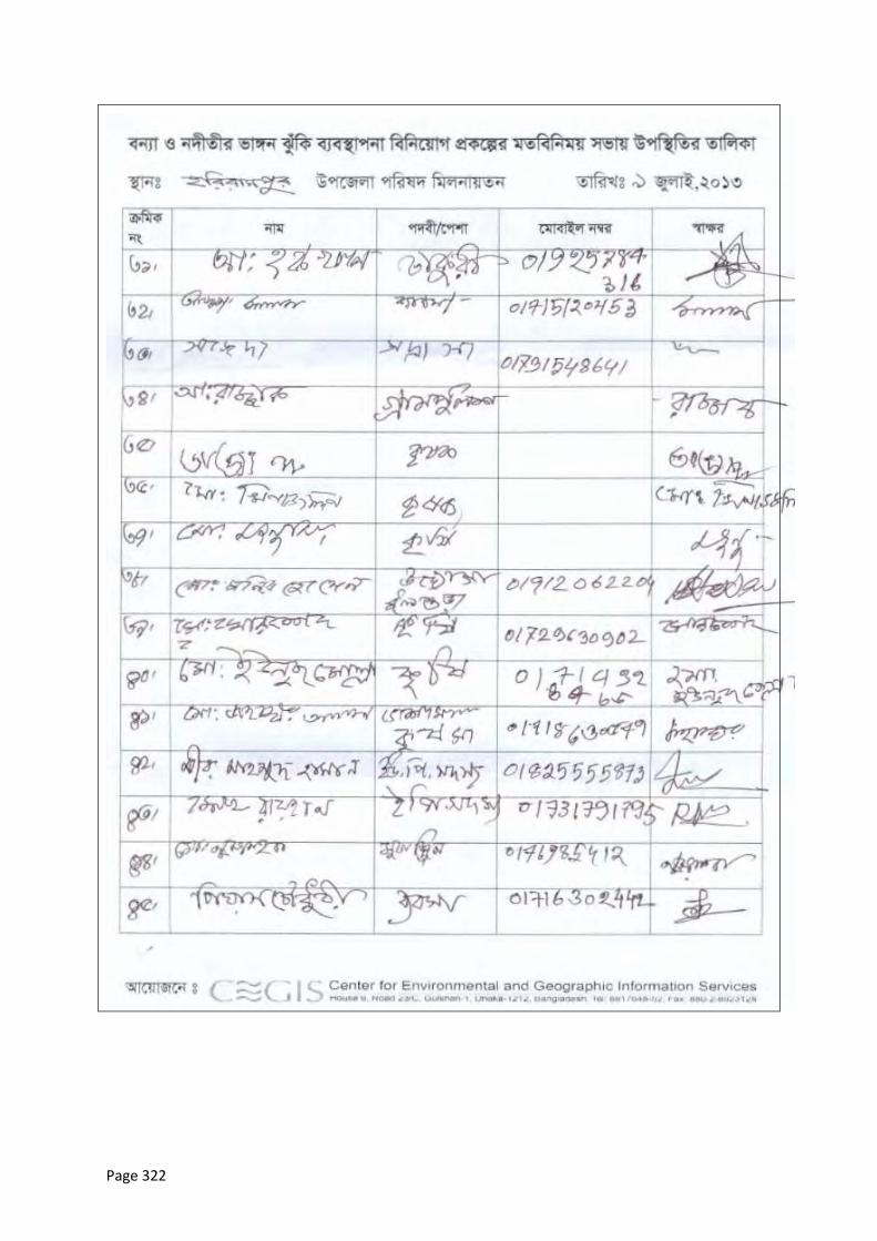
Page 322
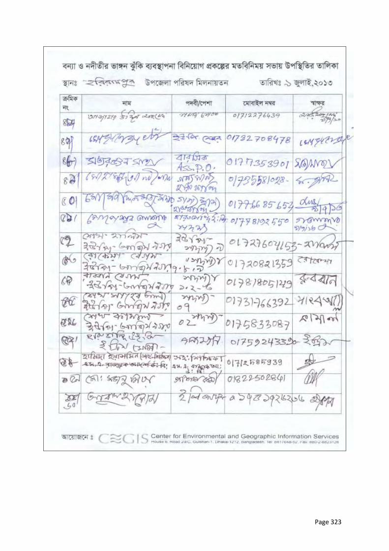
Page 323
Page 324
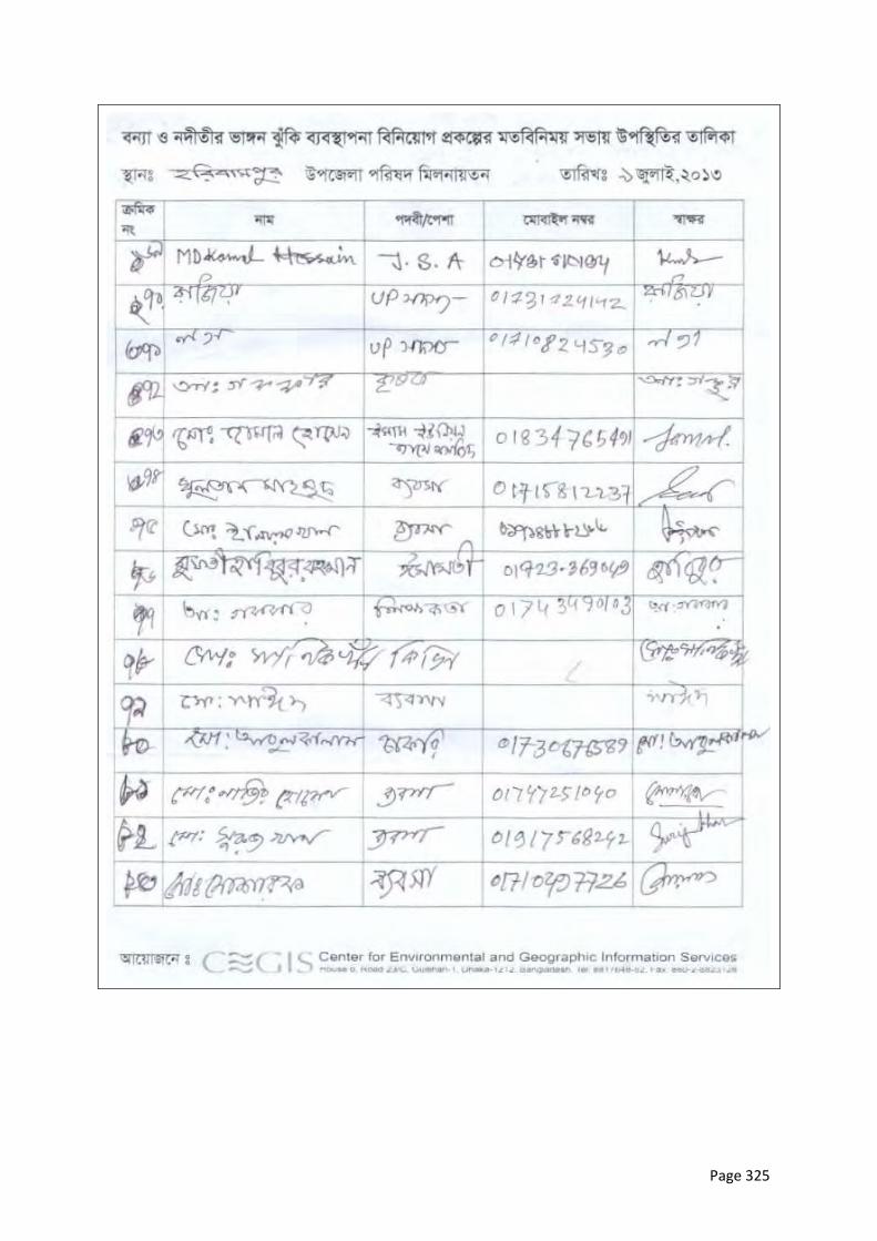
Page 325

Page 326
Page 327
Annex 5: Standard Construction Contract Environmental
Safeguard Clauses
A. Environmental Protection and Control of Pollution
1. General
The Contractor shall observe and comply with all National Laws and Government Regulationspertaining to environmental protection, pollution control, waste management, and biodiversity protection.
In conducting his construction activities, the Contractor shall take all necessary precautions to minimise environmental disturbance to the project area and surroundings and to prevent the escape of polluting substances into streams, water courses, and ground water. The Contractor shall also utilise all necessary practicable methods and devices as are available to prevent and otherwise minimize atmospheric emissions or discharges of air contaminants.
Except where otherwise agreed or provided for by the Employer or expressly stipulated in Particular Specifications or Technical Specifications forming part of the Contract Documents, no separate payment will be made for complying with the provisions of this Clause and attendant sub-clauses; and all costs shall be deemed to be included in the prices for the Contractor’s mobilisation for construction, and the various rates and lump sum items for the works included in the priced Bill of Quantities.
2. Pollution of Water Courses and Streams
The emission of polluting liquids or other waste into drains, water courses or ground water shall not be permitted.
No concrete or cement washings from the works or drainage from the Contractor's concrete batching and mixing areas, asphalt (hot mix) plants or other manufacturing or production facilities shall be allowed to discharge into streams or drains without passing through an adequate system of settling ponds.
Storage of fuels, fuelling and maintenance of plant and vehicles, etc. shall take place only on sites and under conditions that that do not allow spilt fuels to be discharged to water bodies. Fuel storage and fuelling areas shall be equipped with adequate protective measures to confine and retain accidental spillages. No drainage from fuel store and plant maintenance depots shall be allowed to be discharged without passing through an adequate arrangement of oil traps and separators.
Washing of vehicles shall not be permitted in streams but only in specially designated and equipped areas.
Operations in quarries and borrow areas shall be carried out in such a way as to minimize any possible pollution from particulate matter entering the streams.
Adequate sanitary waste control facilities shall be provided in site offices and workers camps, and sewage waste shall be collected regularly and disposed in accordance with relevant environmental legislation.

Page 328
The Contractor shall accordingly be responsible for the installation, operation and maintenance of a comprehensive drainage system to all areas of the Works. The system shall be constructed such that no discharges of oil, cement, silt or other liquid or solid waste matter can enter the streams and water courses at the site; and it shall have all necessary solid waste and sediment traps, settling ponds, oil separators, etc. required to ensure that pollution of streams watercourses and natural bodies of water does not occur. The Contractor shall be responsible for maintaining the system to the satisfaction of the Employer’s Construction Supervisor and all costs of providing the system shall be deemed to be included in the various rates and lump sum items for the works included in the priced Bill of Quantities.
3. Air Pollution
The Contractor shall take all necessary steps to minimize air pollution resulting from his operations.
Except where stipulated in these Specifications for the disposal of natural vegetation and organic materials from clearing operations, the burning of waste materials for disposal, particularly oil and petroleum wastes, rubber, plastics and similar materials will not be permitted.
During the performance of the work required under the Contract or of any operations appurtenant thereto, whether on the Project Site or elsewhere, the Contractor shall take all steps necessary, and shall furnish all labor, equipment, materials and means, required to reduce dust nuisance from the Works, and to prevent dust originating from his operations from damaging crops, orchards, cultivated fields, and dwellings; or causing a nuisance to persons. The Contractor shall be held liable for any damage resulting from dust originating from his operations including on Government roads, rights-of-way or elsewhere.
The emission of dust into the atmosphere shall not be permitted during the manufacture, handling and storage and handling of cement and of concrete aggregates and the Contractor shall use such methods and equipment as are necessary for the prevention, or the collection and disposal, of dust during such operations. All truckloads of loose materials shall be covered during transportation
Concrete batching and mixing areas, asphalt (hot mix) plants, or other manufacturing or production facilities shall be sited at least 500m from the nearest habitation. Emission outlets shall be fitted with pollution control devices in compliance with relevant current Government of Bangladesh emission control legislation.
The cost of spraying water on haul roads, access roads, government roads, aggregate stockpiles, etc.; or of any other methods of reducing the formation of dust; and the cost of furnishing and applying materials to maintain the works areas, adjacent areas, and roads, in a dustless condition, shall be deemed to be included in the various rates and lump sum items for the works included in the priced Bill of Quantities.
4. Noise Pollution
The Contractor shall take all necessary precautions to minimize the amount of noise and vibrations coming from construction activities.
The Contractor shall ensure that all plant and equipment is properly maintained in good operating condition, and that noisy construction activities shall be effectively sound reduced by means of silencers, mufflers, acoustic linings or shields, acoustic sheds or screens or other means, to avoid disturbance to any nearby noise sensitive receivers. All plant and equipment shall comply with relevant Government of Bangladesh legislation covering sound emissions.
Page 329
Quarry operations and blasting shall be undertaken so as to minimize blasting and disturbance during the night and, insofar as possible, noise, vibration and dust. Operation of trucks and heavy vehicles and machinery shall be restricted to the hours of 06:30 to 19:00.
All necessary measures shall be undertaken to protect schools, hospitals and other adjacent noise sensitive receptors, including the use of noise barriers.
5. Damage to Property, Crops, and Vegetation
The Contractor shall limit the movement of his employees and equipment within the project area and on adjacent land, including access routes approved by the Employer’s Construction Supervisor, so as to minimize damage to natural vegetation, crops and property, and shall endeavor to avoid any damage to land.
The Contractor shall strictly ensure employees and equipment do not enter any sensitive environmental areas that are demarcated as “no-entry” zones.
The Contractor shall preserve existing trees, plants and other vegetation that are to remain within or adjacent to the Works and shall use every precaution necessary to prevent damage or injury thereto. Trees or shrubs shall only be felled or removed where such impinge directly on the permanent works or necessary temporary works areas; and where such is approved by the Employer’s Construction Supervisor.
On completion of the Works all areas disturbed by the Contractor’s construction activities shall be restored by the Contractor to their original condition, or as may be acceptable to the Employer.
The Contractor shall be responsible directly to the Employer for any excessive or unnecessary damage to crops or lands arising from his operations, whether within the project area, on lands adjacent thereto, or adjacent to approved access roads: and deductions will be made from the payment due to the Contractor to cover the cost of such excessive or unnecessary damage, as determined by the Employer.
B. Sanitation Facilities and Arsenic Safe Water Supplies
At each construction area, (i) an appropriate number of tubewells will be installed to supply water for construction and safe drinking water to laborers and the construction camps, and (ii) latrines with septic tanks will be provided. Tubewells will be tested for arsenic and marked accordingly (green/red for safe/unsafe).
C. Reporting
The Contractor shall maintain a record of all emissions and spills of liquid, solid and gaseous matter which occur at the site, whether into water courses, streams, on land, or into the air. This record shall be compiled daily and shall include details of date, time and nature of the event, along with details of the remedial and clean-up measures carried out. Copies of these records shall be given to the Employer monthly.
The Contractor shall also maintain a record of any complaints made by any Governmental or Community Organization or by the public, regarding his operations. This record shall contain the date and time of receipt of the complaint, the name and address of the complainant and the action taken to remedy the situation. Copies of these records shall be given to the Employer monthly.
Page 330
D. Environmental Management Plan
The requirements of this clause and attendant sub-clauses on Environmental Protection and Pollution Control notwithstanding; the Contractor shall observe and comply with all relevant environmental protection and mitigation, monitoring and reporting requirements in the Environmental Management Plan (EMP) as stipulated in the Particular Specification. In the event of any conflict between the foregoing sub-clauses and the environmental protection and mitigation measures and pollution control requirements of the EMP, the EMP shall take precedence.
The Contractor shall prepare and submit to the Employer’s Construction Supervisor a Construction Environmental Management and Monitoring Plan (CEMP) demonstrating the manner in which the Contractor will comply with the requirements of the foregoing sub-clauses on Environmental Protection and Pollution Control, the EMP, and any particular environmental mitigation measures as stipulated in the Particular Specifications or Technical Specifications forming part of the Contract Documents.
The CEMP shall be submitted within 15 working days of the Contractor receiving the Notice to Proceedwith the Works, and shall include a waste management plan detailing procedures for waste management for the site covering all solid, liquid and gaseous waste materials and emissions. The waste management plan shall include procedures for the collection and disposal of all waste materials in such a way as to ensure that no damage is caused to the environment. Training shall be provided to workers about the appropriate implementation of the CEMP and waste management plan measures.
Where stipulated in the Particular Specifications or Technical Specifications forming part of the Contract Documents, and provision has been made in the Bill of Quantities; payment for the implementation of the CEMP will be made in accordance with the Unit Rates, Lump Sum or Provisional Sum Items included in the Priced Bill of Quantities.
Page 331
Annex 6: Project Implementation Arrangements
A. Steering and Guidance of Executing and Implementing Agencies
The program is suggested to be implemented under the lead of BWDB (executing agency) with close relationships to DDM (implementing agency). Other associated organizations are WARPO, LGED and BIWTA. The participating organizations require clearly defined procedures of when, where, and how to coordinate their activities. To this end BWDB has a number of Memoranda of Understanding (MoU) in place, which will be suitably updated for the purpose of the program during the first year of the program.
In line with government principles program activities are regularly reviewed and discussed through annual inter-ministerial steering committee meetings. Given the complexities of the program, a Panel of Experts is expected to provide guidance related to key questions:
(i) River morphology, engineering, and stabilization (ii) Flood Risk Management at regional and community level (iii) Institutional and capacity development at regional and community level
B. Integrated Program Management Office (PMO)
The PMO will be integrated into the administrative setup of BWDB and placed at a high level given the importance and relevance of the program. The key features are:
(i) Headed by an Additional Chief Engineer, similar in rank as the zonal Chief Engineers and supported by two Superintending Engineers
(ii) Initially identical and later closely associated with the CE River Management, once the post gets approved. This is a vital element to activate the new river management wing and to institutionalize the broad river stabilization approach.
(iii) Supported by an individual design office, exclusively dealing with river stabilization measures.
(iv) Conducting river management activities of larger national importance, such as procuring materials for works and strategic stockpiling for emergencies, and guiding char reclamation activities
(v) Implementing work through existing zonal division. These divisions already build embankments and riverbank protection, and will be strengthened in terms of staff during the implementation of the works.
Figure A3.1 depicts the program management principles agreed during discussion with the BWDB
management, namely ADG and Chief Planning in early 2013.
C. Advisory Support
The program will be supported by consultants and NGOs at different level. This addresses the program management requirements of ADB and supports BWDB during the current period of staff shortage, specifically of junior staff. An Institutional Strengthening and Project Management Consultant (ISPMC) will provide the main support in a number of different areas. The advisory support scope of work includes the services of a specialist organization to conduct environmental assessment and planning. Additional details regarding the financing and potential scope of work of the advisory support are provided in Section 15 of the Final Report, Main Volume.
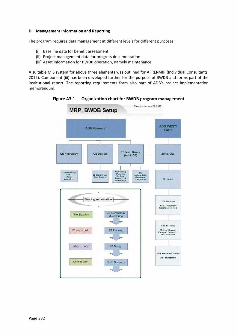
Page 332
D. Management Information and Reporting
The program requires data management at different levels for different purposes:
(i) Baseline data for benefit assessment (ii) Project management data for progress documentation (iii) Asset information for BWDB operation, namely maintenance
A suitable MIS system for above three elements was outlined for AFRERMIP (Individual Consultants, 2012). Component (iii) has been developed further for the purpose of BWDB and forms part of the institutional report. The reporting requirements form also part of ADB’s project implementation memorandum.
Figure A3.1 Organization chart for BWDB program management
Page 333
Annex 7: Project Description, Jamuna Right Bank 144
Project Name ID Upazilas
(Unions) Area River Area Population
Jamuna Right Bank 1 JRB1 3 (24) 582 km² 24 % 1,052,600
Bankline
length
Average Erosion
(1973-2010/2007-
2012)
Flood extent
(1998 / 2007)
Area Boro/Aman Population Density
(total/floodplain)
37 km 1.52 km / 0.13 km 69% / 56% 65% / 37% 1810/2370
A. Situation
The JRB-1 subreach extends from from Jamuna Bridge to Shahjadpur on the right bank of the Jamuna. The Jamuna Bridge guide bunds impose a straight channel downstream of the bridge for about 15 km along the left bank of the braided belt (Sarker et al. 2011). As a consequence, a stable attached char about 15 km long and 5 km wide has formed along the right bank, south of the western guide bund.
This straight channel bifurcates into a western and eastern branch at about Enayetpur. The eastern channel is presently dominant. While the location of this bifurcation appears to be quite stable, discharges vary in the two downstream channels. During the early 2000s, very little dry-season flow occurred along the right bank. Recently most dry season flow has occurred along this bank.
Historically, the western floodplain was protected by the Brahmaputra Right Embankment (BRE) as far as the Hurashagar/Baral River, which is upstream of the Pabna Integrated Rural Development Project (PIRDP). The last 10 km or so of the BRE, from Kaijuri to the Hurashagar/Baral outfall, part of the Hurashagar FCD Project embankment, eroded during the 1990s (Figure A7.1 and Figure A7.2). This erosion brought once-protected areas back to the natural cycle of flooding and erosion, accompanied by substantial deposition of sand along the riverbanks (sand casting). It rendered the Hurashagar FCD project completely inoperational (FAP 2).
Riverbank protection constructed in 2010 and 2011 from Kaijuri to Benotia stabilized the riverbank (Figure A7.3) and as such induced cluster settlements along the derelict BRE. It also stabilized the larger channel pattern and substantially reduced the dredging volume (Figure A7.4) required to maintain navigation access to the important Bagabari Port (see Annex D of January 2013 report).
B. Future Scenarios
During the 2012 dry season the Enayetpur area came under erosional attack. The existing riverbank protection (spur) in this area allowed the the Enayetpur spur to be eroded to the brink of collapse (Figure A7.5; note the absence of toe protection; Figure A7.6). Other infrastructure is at risk from
44
Project descriptions were adapted from Final Report Annex A, 16 July 2013 version.
Page 334
erosion at this location, notably the large Enayetpur hospital complex and the BRE which if breached will allow flooding of the adjacent area. The situation is comparable to that of PIRDP in the early 2000s, when the embankment was at risk of immediate erosion.
Future channel planforms downstream of the bifurcation at Enayetpur can consist of one or two channels. The initial morphological study for the lower Jamuna reach (Annex C, January Pre-Feasibility Report) indicates that the present two-channel system with one large char affords the most pragmatic future river stabilization approach.
C. Existing Works
BWDB has built two RCC spurs at Betil and Enayetpur, which were rehabilitated two times from ADB flood damage repair funds (after the 2004 and 2007 flood), but which are not stable for major river attack as experienced at this moment.
BWDB, under JMREMP, has built 10 km of riverbank protection from Kaijuri towards the Hurashagar River. Some of this work shows local geotechnical failure (slip circles) and is presently (dry season 2013) repaired at cost of 1.5 Crore.
Three LGED small scale projects are situated in this area.
D. Project Concept
This sub-project incorporates three BWDB priority projects: (i) riverbank protection along the right bank of the bifurcating channel from upstream of Enayetpur towards Kaijuri, (ii) riverbank protection upstream of the Hurasagar to close an existing gap, and (iii) reconstruction of the BRE and Hurashagar FCD embankment from Kaijuri to Shahjadpur
The Tranche 1 interventions are:
Embankment reconstruction, of the BRE with road facilities for 12.5 km, and along the Hurashagar/Baral for 9.5 km
1 km of riverbank protection, from the existing protection downstream towards the Hurashagar/Baral
Regulators for water management including rehabilitation of existing structures
Immediate stabilization of the Enayetpur spur.
Tranche 1 will reinstate much of the flood protection afforded by the original BRE. Benefits will include reduction of overall flood levels, and in particular flood reductions in Hurashagar FCD (Figure A4.7 shows flood extent in 1987 when Hurashagar was still functioning vs in 1998 after the BRE breach had compromised it). The BRE reconstruction will complete the road connection along the Jamuna right bank, connecting the densely populated area along the bank with the Jamuna Bridge and with Shahjadpur via Kaijuri.
The Tranche 2 interventions are:
Rehabilitation of the remaining 4 km of embankment from Bagabari to Shazadpur along the Kortoa River, and construction of a road from the Jamuna embankment to Bagabari and Shahjadpur
About 11 km of priority riverbank protection from the upstream bifurcation towards Kaijuri to protect Enayetpur from erosion and flooding and to stabilize the off-take of the western Jamuna channel which is the main access to Bagabari Port.
Page 335
Potentially construction of the upstream riverbank protection will require excavation or dredging through some distance of low-lying charland. Excavated/dredged material created in this process can be used to fill in (create reclaimed land in) the bankline channel between Enayetpur and Betil.
Existing riverbank protection may be adapted to greater river depth as needed.
The Tranche 2 benefits include:
Rendering the Hurashagar FCD project fully operational with full flood benefits.
Provising a road connection to Bagabari (via ferry) and Shahjadpur.
Mitigation of Enayetpur area erosion risks, including the risk to Enayetpur hospital.
Optional work in this area, depending on morphological study, economic feasibility, and availability of funds, includes:
Protection of char head for bifurcation stabilization (depending on morphological confirmation) so as to create an all-year-round navigable channel towards Jamuna Bridge.
Future BRE construction over the attached char from Jamuna Bridge to Enayetpur. This has the potential to reclaim around 50 km² of land. Catkin plantation may be used to accelerate sedimentation and soil fertility.
Construction of an additional 5 km of riverbank protection, and adaptation of the existing 10 km to the greater river depth expected for a more stable channel.
Intervention Elements
List by type Description (Location, dimensions or quantity)
Infrastructure TRANCHE 1
1.RBP 1 km at Benotia
Adaptation and Enayetpur spur stabilization
2. EMB 23 km for reconstruction of BRE and Hurashagar FCD scheme
3. Other 4 new regulators with 11 vents in total (1*1 vent, 1*4 vent, 1*6 vent) and
rehabilitation of 2 existing 4 vent regulators
Infrastructure TRANCHE 2
1.RBP 11 km at Enayetpur for protection and stabilization of the bifurcation
LS adaptation work to greater river depth
2. EMB 4 km along Kortoa river. 13 km of road construction from Jamuna to
Shahzadpur.
3. Other Buoys for navigation and fish protection along revetment work
Intended Benefits (+) and Potential Adverse Impacts (-)
Type
+
-
?
Description
(impacted location, activity or asset; timing, extent or magnitude)
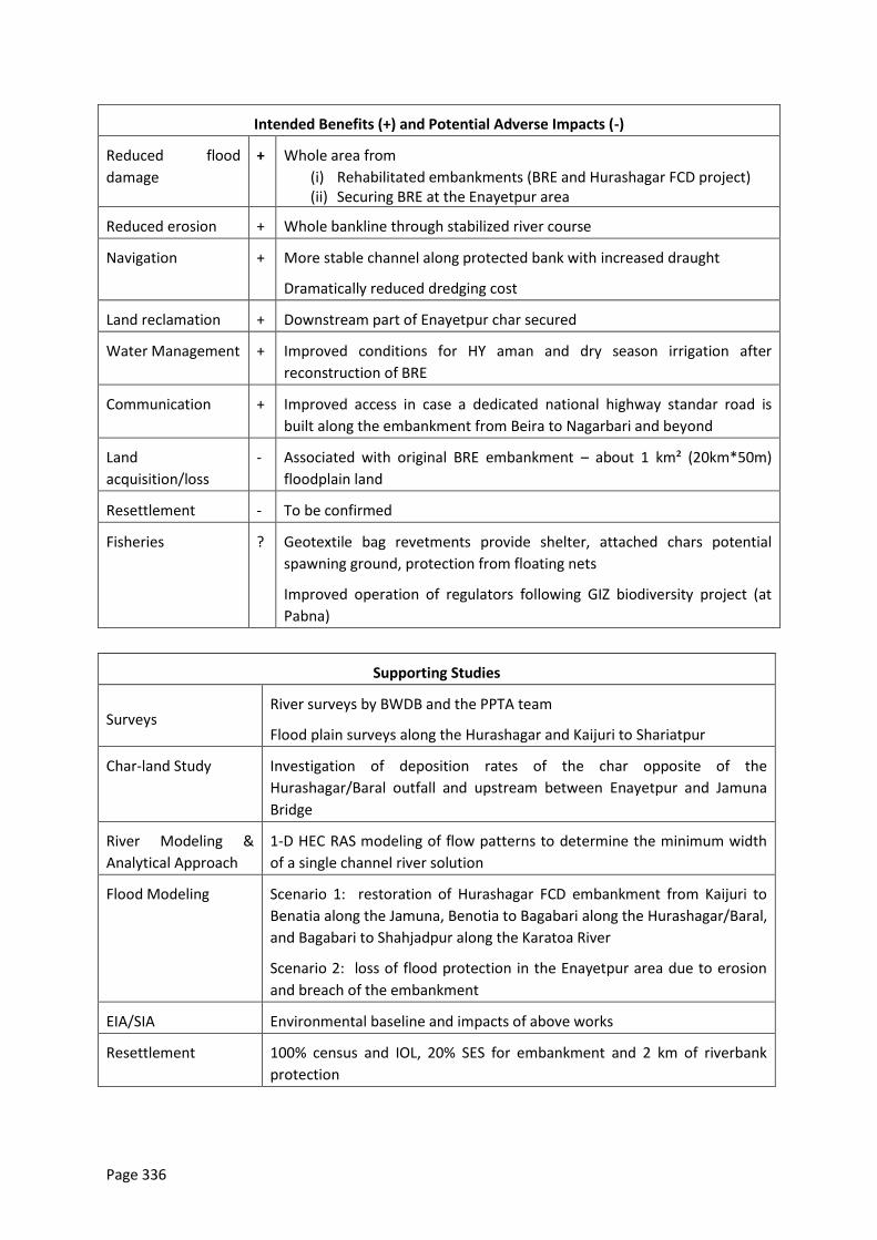
Page 336
Intended Benefits (+) and Potential Adverse Impacts (-)
Reduced flood
damage
+ Whole area from
(i) Rehabilitated embankments (BRE and Hurashagar FCD project) (ii) Securing BRE at the Enayetpur area
Reduced erosion + Whole bankline through stabilized river course
Navigation + More stable channel along protected bank with increased draught
Dramatically reduced dredging cost
Land reclamation + Downstream part of Enayetpur char secured
Water Management + Improved conditions for HY aman and dry season irrigation after
reconstruction of BRE
Communication + Improved access in case a dedicated national highway standar road is
built along the embankment from Beira to Nagarbari and beyond
Land
acquisition/loss
- Associated with original BRE embankment – about 1 km² (20km*50m)
floodplain land
Resettlement - To be confirmed
Fisheries ? Geotextile bag revetments provide shelter, attached chars potential
spawning ground, protection from floating nets
Improved operation of regulators following GIZ biodiversity project (at
Pabna)
Supporting Studies
Surveys River surveys by BWDB and the PPTA team
Flood plain surveys along the Hurashagar and Kaijuri to Shariatpur
Char-land Study Investigation of deposition rates of the char opposite of the
Hurashagar/Baral outfall and upstream between Enayetpur and Jamuna
Bridge
River Modeling &
Analytical Approach
1-D HEC RAS modeling of flow patterns to determine the minimum width
of a single channel river solution
Flood Modeling Scenario 1: restoration of Hurashagar FCD embankment from Kaijuri to
Benatia along the Jamuna, Benotia to Bagabari along the Hurashagar/Baral,
and Bagabari to Shahjadpur along the Karatoa River
Scenario 2: loss of flood protection in the Enayetpur area due to erosion
and breach of the embankment
EIA/SIA Environmental baseline and impacts of above works
Resettlement 100% census and IOL, 20% SES for embankment and 2 km of riverbank
protection
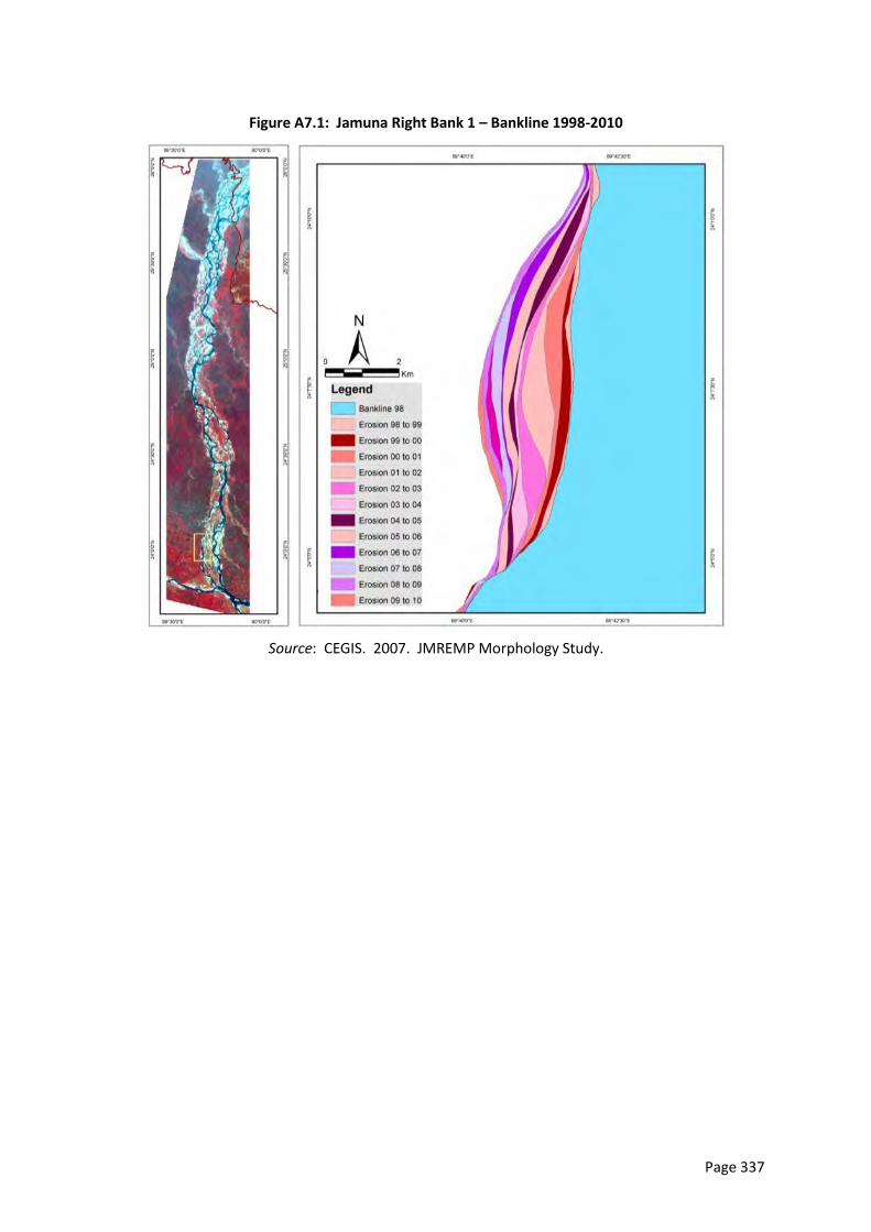
Page 337
Figure A7.1: Jamuna Right Bank 1 – Bankline 1998-2010
Source: CEGIS. 2007. JMREMP Morphology Study.
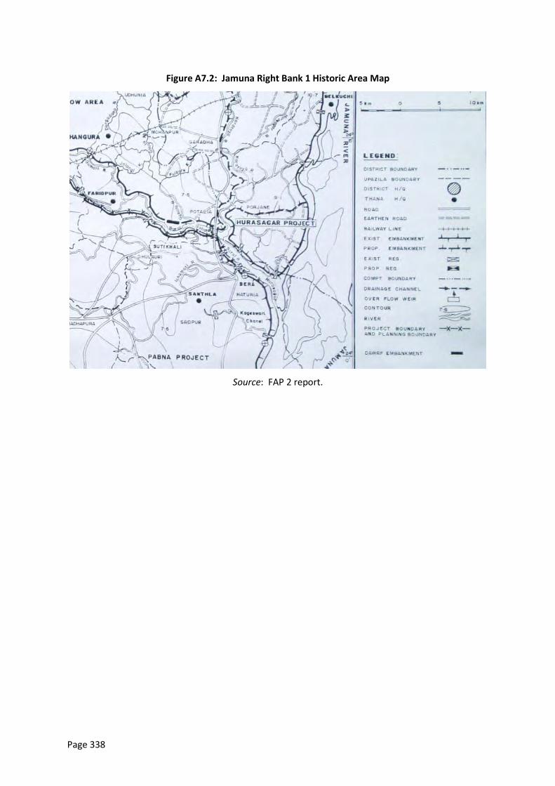
Page 338
Figure A7.2: Jamuna Right Bank 1 Historic Area Map
Source: FAP 2 report.
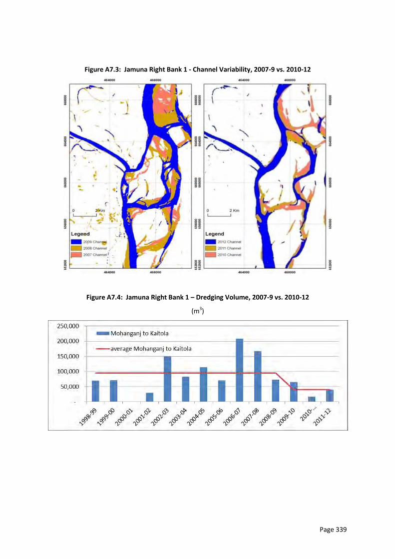
Page 339
Figure A7.3: Jamuna Right Bank 1 - Channel Variability, 2007-9 vs. 2010-12
Figure A7.4: Jamuna Right Bank 1 – Dredging Volume, 2007-9 vs. 2010-12
(m3)
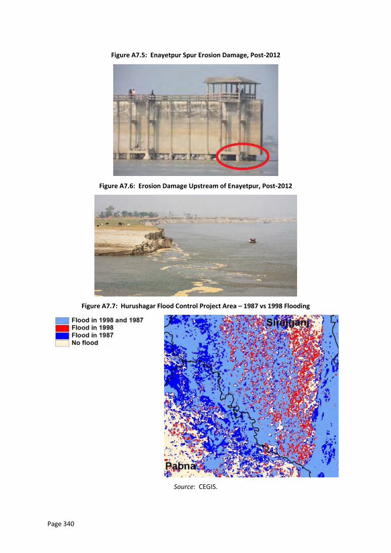
Page 340
Figure A7.5: Enayetpur Spur Erosion Damage, Post-2012
Figure A7.6: Erosion Damage Upstream of Enayetpur, Post-2012
Figure A7.7: Hurushagar Flood Control Project Area – 1987 vs 1998 Flooding
Source: CEGIS.
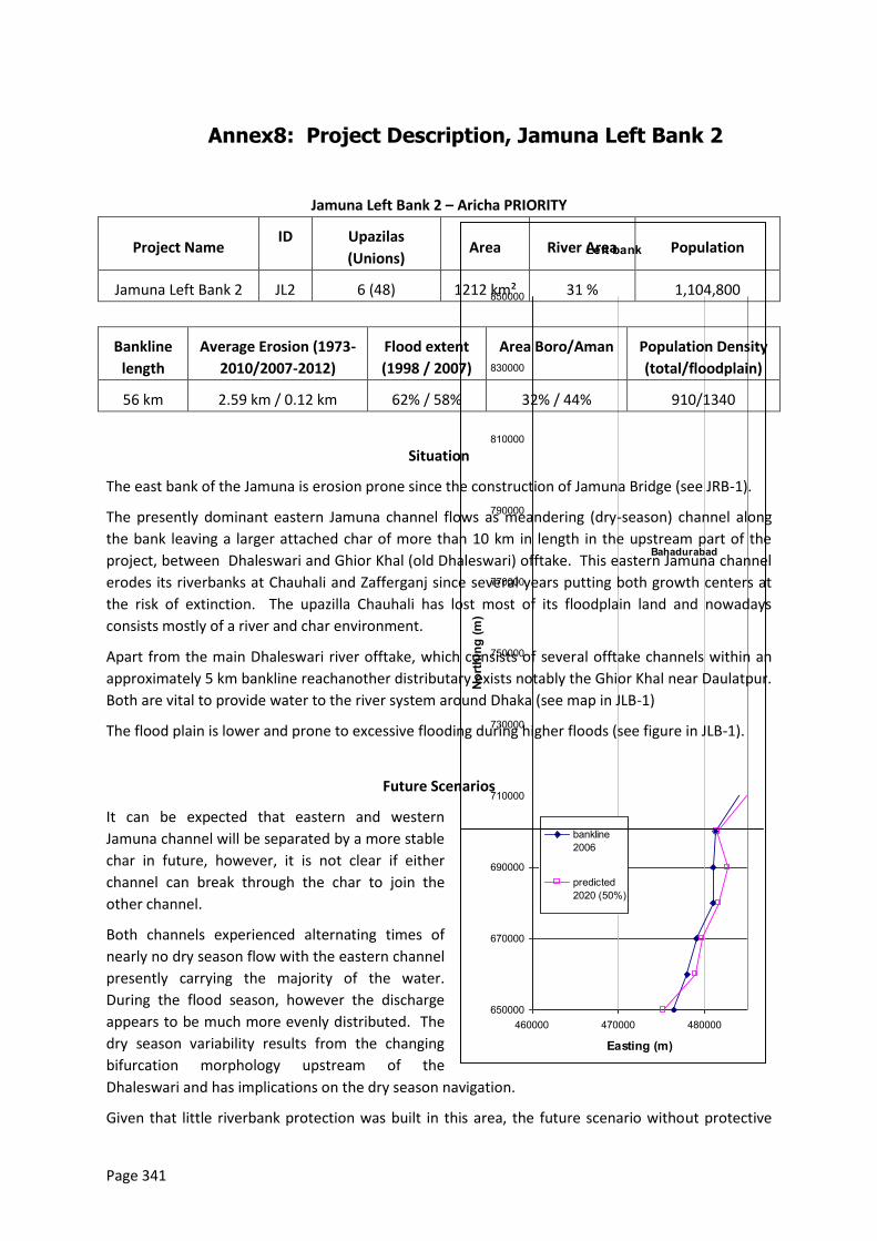
Page 341
Left bank
650000
670000
690000
710000
730000
750000
770000
790000
810000
830000
850000
460000 470000 480000
Easting (m)
North
ing
(m)
bankline2006
predicted2020 (50%)
Bahadurabad
Annex8: Project Description, Jamuna Left Bank 2
Jamuna Left Bank 2 – Aricha PRIORITY
Project Name ID Upazilas
(Unions) Area River Area Population
Jamuna Left Bank 2 JL2 6 (48) 1212 km² 31 % 1,104,800
Bankline
length
Average Erosion (1973-
2010/2007-2012)
Flood extent
(1998 / 2007)
Area Boro/Aman Population Density
(total/floodplain)
56 km 2.59 km / 0.12 km 62% / 58% 32% / 44% 910/1340
Situation
The east bank of the Jamuna is erosion prone since the construction of Jamuna Bridge (see JRB-1).
The presently dominant eastern Jamuna channel flows as meandering (dry-season) channel along
the bank leaving a larger attached char of more than 10 km in length in the upstream part of the
project, between Dhaleswari and Ghior Khal (old Dhaleswari) offtake. This eastern Jamuna channel
erodes its riverbanks at Chauhali and Zafferganj since several years putting both growth centers at
the risk of extinction. The upazilla Chauhali has lost most of its floodplain land and nowadays
consists mostly of a river and char environment.
Apart from the main Dhaleswari river offtake, which consists of several offtake channels within an
approximately 5 km bankline reachanother distributary exists notably the Ghior Khal near Daulatpur.
Both are vital to provide water to the river system around Dhaka (see map in JLB-1)
The flood plain is lower and prone to excessive flooding during higher floods (see figure in JLB-1).
Future Scenarios
It can be expected that eastern and western
Jamuna channel will be separated by a more stable
char in future, however, it is not clear if either
channel can break through the char to join the
other channel.
Both channels experienced alternating times of
nearly no dry season flow with the eastern channel
presently carrying the majority of the water.
During the flood season, however the discharge
appears to be much more evenly distributed. The
dry season variability results from the changing
bifurcation morphology upstream of the
Dhaleswari and has implications on the dry season navigation.
Given that little riverbank protection was built in this area, the future scenario without protective
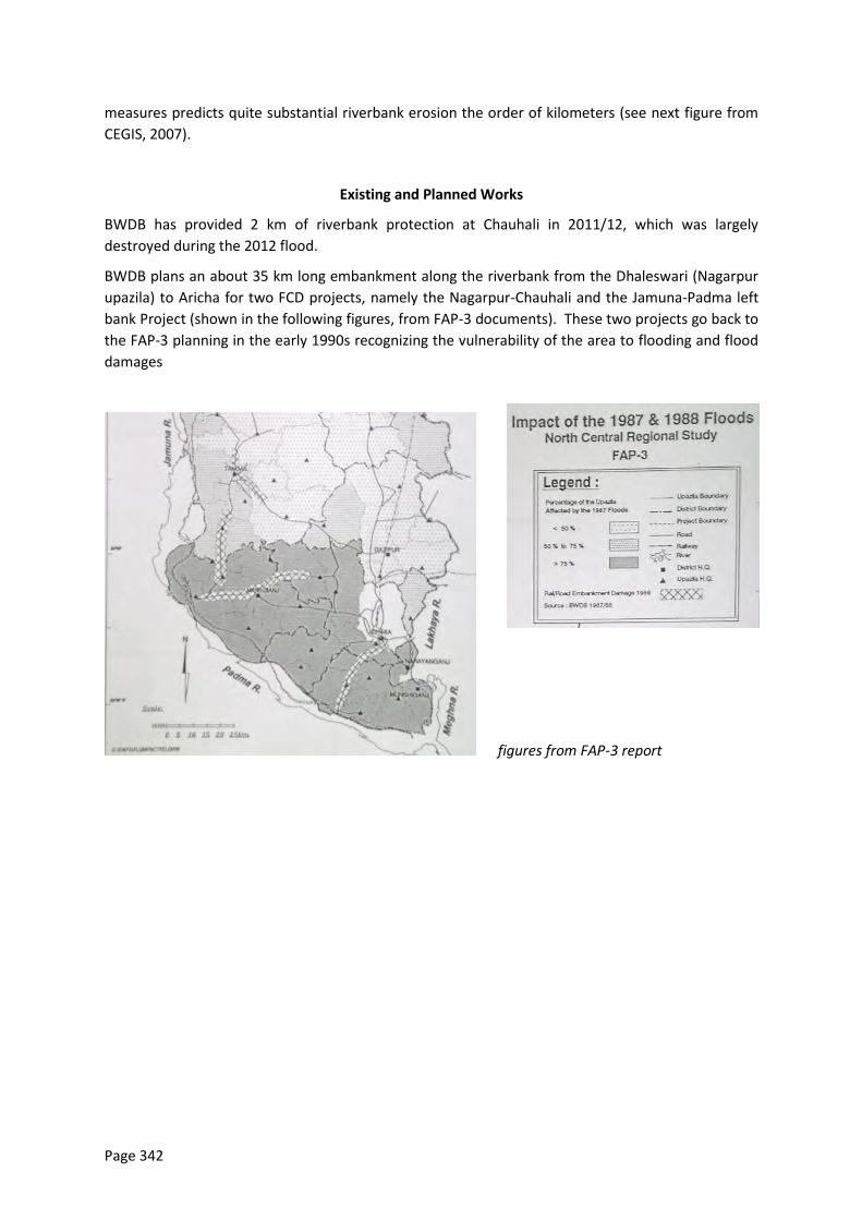
Page 342
measures predicts quite substantial riverbank erosion the order of kilometers (see next figure from
CEGIS, 2007).
Existing and Planned Works
BWDB has provided 2 km of riverbank protection at Chauhali in 2011/12, which was largely
destroyed during the 2012 flood.
BWDB plans an about 35 km long embankment along the riverbank from the Dhaleswari (Nagarpur
upazila) to Aricha for two FCD projects, namely the Nagarpur-Chauhali and the Jamuna-Padma left
bank Project (shown in the following figures, from FAP-3 documents). These two projects go back to
the FAP-3 planning in the early 1990s recognizing the vulnerability of the area to flooding and flood
damages
figures from FAP-3 report
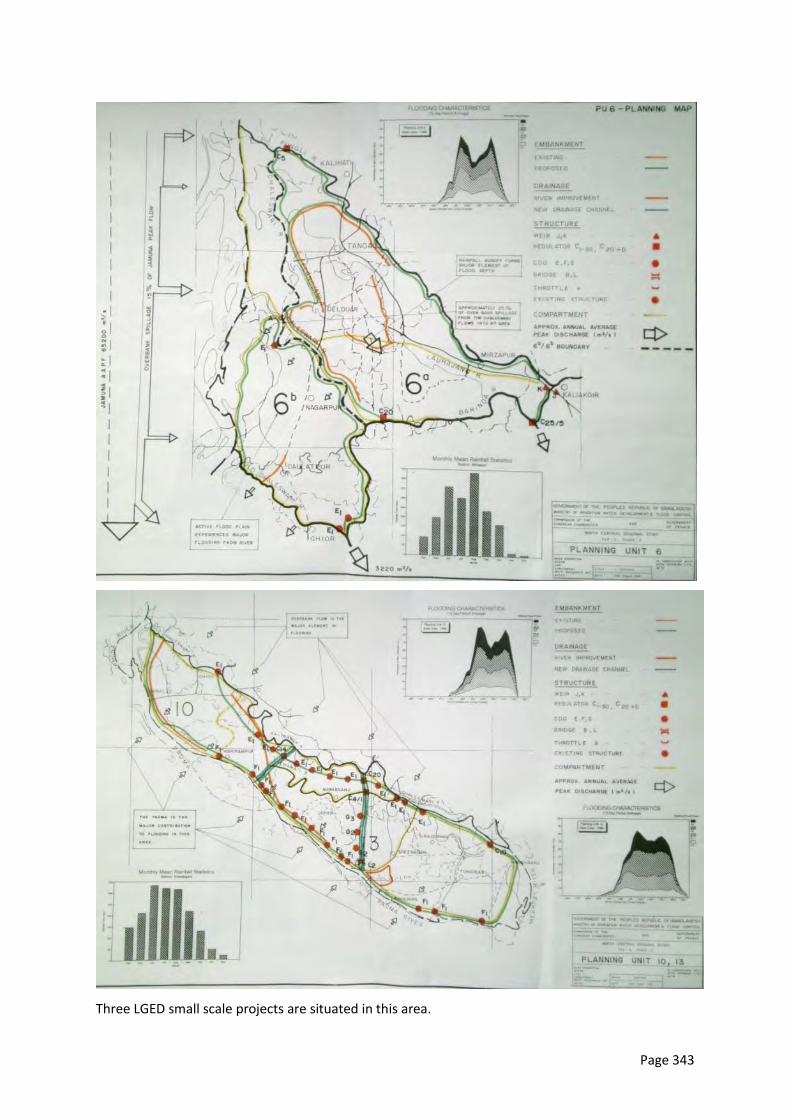
Page 343
Three LGED small scale projects are situated in this area.
Page 344
The areas at Chauhail and Zafferganj were identified by BWDB as priority areas for riverbank
stabilization during the preparatory phase of this FRERMIP PPTA in 2011.
Project Concept
This subproject incorporates three BWDB priority projects: (i) riverbank protection along vulnerable
reaches with a view to work towards river stabilization, (ii) strengthening of the existing 12 km long
embankment from Aricha to Zionpur via Zaffarganj and extension to the Dhaleswari, (iii) provision of
defined Dhaleswari and Ghior Khal offtake for dry and flood season flow including navigation. The
central char is intended to be left unprotected to maintain natural river processes and to not disturb
the established char societies. The project concept depends on further studies during Tranche 1.
Tranche 1
Priority riverbank protection at Chauhali (about 5 km) and Zafferganj (about 2 km) to stabilize critically eroding reaches along the upazilla headquarters
Pilot testing of guided, accelerated charland accretion of a suitable attached char through catkin plantation
Tranche 2
Extension of existing riverbank protection in upstream and downstream direction Chauhali including Dhaleswari offtake (around 3km) with the purpose of stabilizing the attached char in that area Zafferganj area (2 km)
Stabilization of attached char through guided, accelerated siltation (plantation of catkin as piloted in Bhuapur in the 1990s and other measures) with the purpose of reclaiming around 30km² of lost floodplain land
Rehabilitation of 12 km of existing embankment
Tranche 3
Extension of existing riverbank protection in upstream and downstream direction Chauhali including Dhaleswari offtake (around 5km) with the purpose of stabilizing the attached char in that area
Zafferganj area (2 km)
Optional offtake geometry of Dhaleswari likely distinguishing dry season and flood season offtake
Offtake geometry at Ghior Khal
Embankment rehabilitation and link embankment from Dhaleswari to Aricha (total length around 17km)
Local placement of navigation buoys with combined navigation / fish protection purpose
Intervention Elements
List by type Description (Location, dimensions or quantity)
Infrastructure TRANCHE 1
1.RBP Around 7 km initial left bank stabilization: 5km at and 2 km at Zaffarganj
2. Other Pilot test of guided, accelerated charland siltation (catkin and supporting
Page 345
Intervention Elements
measures)
Infrastructure TRANCHE 2
1.RBP Extension of existing protection
Around 3 km at Chauhali,
Around 2 km at Zaffarganj
2. EMB Rehabilitation of 12 km of embankment from Aricha to Zionpur
3. Other Guided accelerated siltation of charland
Placement of buoys along the protected bank
Infrastructure TRANCHE 3
1.RBP Around 5 km at Chauhali,
Around 2 km at Zaffarganj
Adaptation and maintenance
2. EMB offtake geometry for Dhaleswari
offtake geometry for the Ghior Khal
Around 23 km new embankment
3. Other Regulators, Fish passes
Placement of buoys along the protected bank
Intended Benefits (+) and Known Potential Adverse Impacts (-)
Type
+
-
?
Description
(impacted location, activity or asset; timing, extent or magnitude)
Reduced flood
damage
+ Whole area
Reduced erosion + Whole bankline
Navigation + More stable channel along protected bank with increased draught
Land reclamation + 30 km²
Water
Management
+ Improved dry season flow in Dhaleswari for boro irrigation and cleaning
the rivers around Dhaka
Communication + Improved access in case a dedicated national highway standard road is
built along the embankment from Dhaleswari to Aricha and beyond
Land
acquisition/loss
- Associated with embankment – about 2 km² (40km*50m) floodplain
land
Resettlement - To be confirmed

Page 346
Fisheries ? Geotextile bag revetments provide shelter, attached chars potential
spawning ground, protection from floating nets
Improved river fish diversity due to dry season flow in distributaries and
protection from floating nets (buoys)
Supporting Studies
Surveys River surveys by BWDB and the PPTA team
Flood plain surveys along the Hurashagar and Kaijuri to Shariatpur
Char-land Study Investigation of deposition rates of the char opposite of the
Hurashagar/Baral outfall and upstream between Enayetpur and Jamuna
Bridge
River Flow Modeling
& Analytical
Approach
1-D HEC RAS modeling of flow patterns to determine the minimum width
of a single channel river solution
Flood Modeling Scenario 1: restoration of Hurashagar FCD embankment from Kaijuri to
Benatia along the Jamuna, Benotia to Bagabari along the
Hurashagar/Baral, and Bagabari to Shahjadpur along the Karatoa River
Scenario 2: loss of flood protection in the Enayetpur area due to erosion
and breach of the embankment
EIA/SIA Environmental baseline and impacts of above works
Resettlement 100% census and IOL, 20% SES for embankment and 2 km of riverbank
protection
Version change log (latest first)
Change date Version created
by change Changes made + reasons for changes
10 May 2013 5.0 Updated for final report - ko
1 March 2013 4.0 Expanded description – ko
3 Oct 2012 2.0 Full description entered – ko
25 Sep 2012 1.0 Initial version of project description – slb
Page 347
Annex9: Project Description, Padma Left Bank 1
PadmaLeft Bank 1 –Paturia – Harirampur PRIORITY
Project Name ID Upazilas (Unions) Area River Area Population
Padma Left Bank 1 PLB1 3 (35) 682 km² 22% 736,000
Bankline
length
Average Erosion
(1973-2009/2004-
2009)
Flood extent
(1998 / 2007)
Area Boro/Aman Population
Density
(total/floodplain)
25 km 3.35 km / 0.03 km 62% / 46% 18% / 34% 1080/1400
Situation
The Padma starts as single channel after the confluence of Jamuna and Ganges. 10 km downstream
of the confluence it bifurcates into two channels, carrying different percentages of its flow over
time and enclosing an around 25 km long and up to 10 km wide char. Presently the southern
channel is declining.
At the downstream boundary of this subproject reach, about 25 km downstream of the confluence,
a more erosion resistant clay forms the northern (left) bank (marked in figure below). Upstream of
this clay the Padma tends to erode substantial amounts of floodplains through outflanking
channels, which periodically close (see following figure with bankline development). At this
moment a historic, extreme meander loop is filled in and the river is flowing rather straight. The
filled in area is around 30 km² (3000 ha) in size. The historic Dhaka Southwest Project embankment
in this area is eroded and was not rebuild (also refer to JLB-2 maps from FAP 3). The char age map
(1973-2009, Padma Bridge report) indicates that the anabranch between Harirampur and Faridpur
is presently contracting in width with substantial areas along both banks recently silted in.
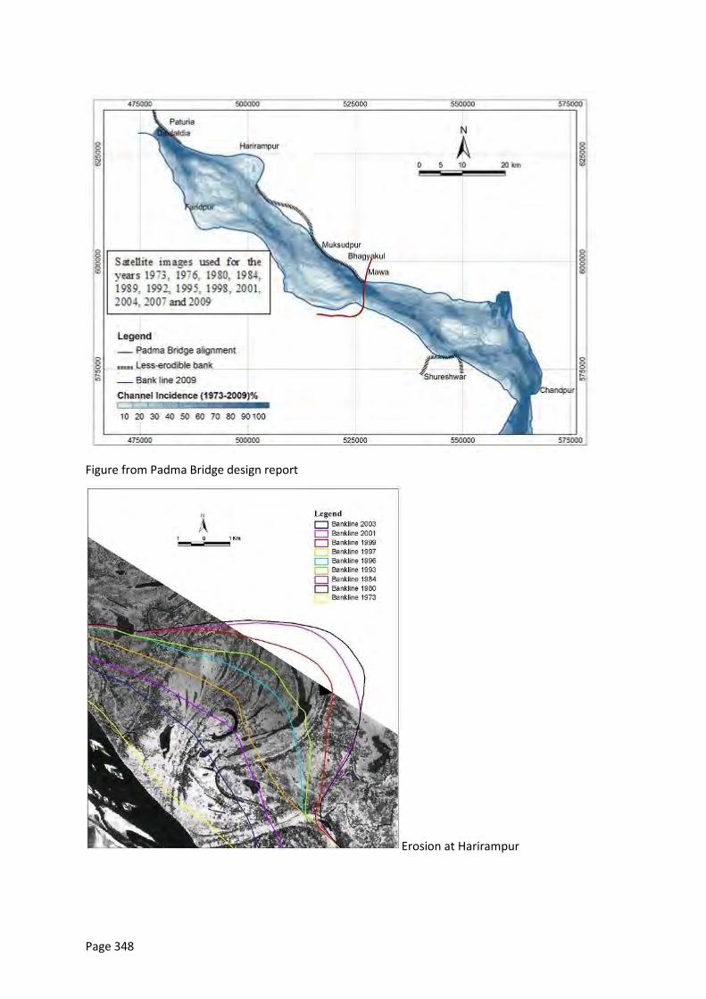
Page 348
Figure from Padma Bridge design report
Erosion at Harirampur
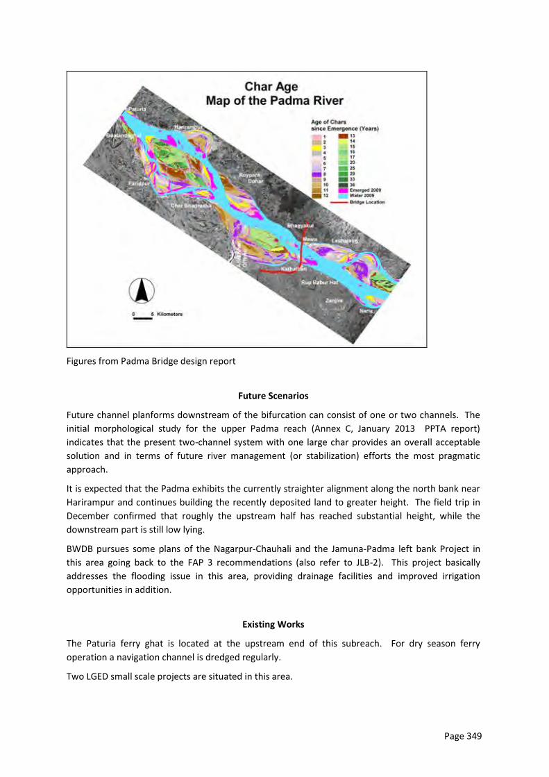
Page 349
Figures from Padma Bridge design report
Future Scenarios
Future channel planforms downstream of the bifurcation can consist of one or two channels. The
initial morphological study for the upper Padma reach (Annex C, January 2013 PPTA report)
indicates that the present two-channel system with one large char provides an overall acceptable
solution and in terms of future river management (or stabilization) efforts the most pragmatic
approach.
It is expected that the Padma exhibits the currently straighter alignment along the north bank near
Harirampur and continues building the recently deposited land to greater height. The field trip in
December confirmed that roughly the upstream half has reached substantial height, while the
downstream part is still low lying.
BWDB pursues some plans of the Nagarpur-Chauhali and the Jamuna-Padma left bank Project in
this area going back to the FAP 3 recommendations (also refer to JLB-2). This project basically
addresses the flooding issue in this area, providing drainage facilities and improved irrigation
opportunities in addition.
Existing Works
The Paturia ferry ghat is located at the upstream end of this subreach. For dry season ferry
operation a navigation channel is dredged regularly.
Two LGED small scale projects are situated in this area.
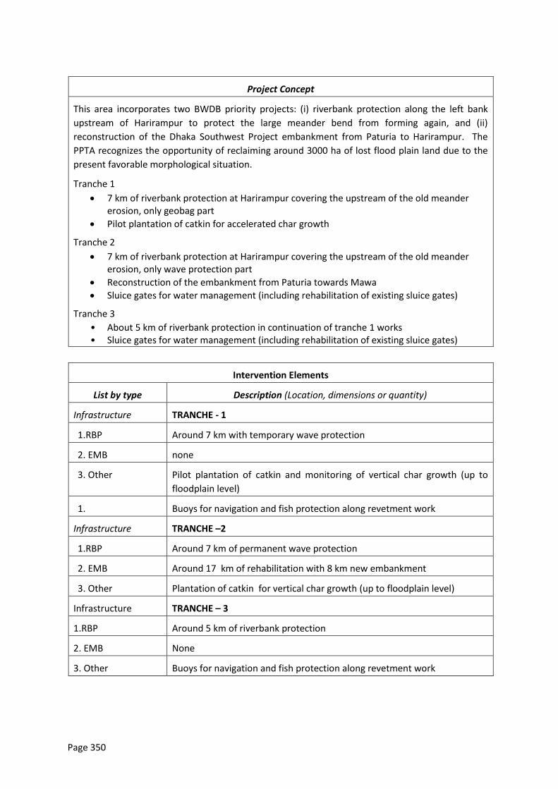
Page 350
Project Concept
This area incorporates two BWDB priority projects: (i) riverbank protection along the left bank
upstream of Harirampur to protect the large meander bend from forming again, and (ii)
reconstruction of the Dhaka Southwest Project embankment from Paturia to Harirampur. The
PPTA recognizes the opportunity of reclaiming around 3000 ha of lost flood plain land due to the
present favorable morphological situation.
Tranche 1
7 km of riverbank protection at Harirampur covering the upstream of the old meander erosion, only geobag part
Pilot plantation of catkin for accelerated char growth
Tranche 2
7 km of riverbank protection at Harirampur covering the upstream of the old meander erosion, only wave protection part
Reconstruction of the embankment from Paturia towards Mawa
Sluice gates for water management (including rehabilitation of existing sluice gates)
Tranche 3
• About 5 km of riverbank protection in continuation of tranche 1 works • Sluice gates for water management (including rehabilitation of existing sluice gates)
Intervention Elements
List by type Description (Location, dimensions or quantity)
Infrastructure TRANCHE - 1
1.RBP Around 7 km with temporary wave protection
2. EMB none
3. Other Pilot plantation of catkin and monitoring of vertical char growth (up to
floodplain level)
1. Buoys for navigation and fish protection along revetment work
Infrastructure TRANCHE –2
1.RBP Around 7 km of permanent wave protection
2. EMB Around 17 km of rehabilitation with 8 km new embankment
3. Other Plantation of catkin for vertical char growth (up to floodplain level)
Infrastructure TRANCHE – 3
1.RBP Around 5 km of riverbank protection
2. EMB None
3. Other Buoys for navigation and fish protection along revetment work
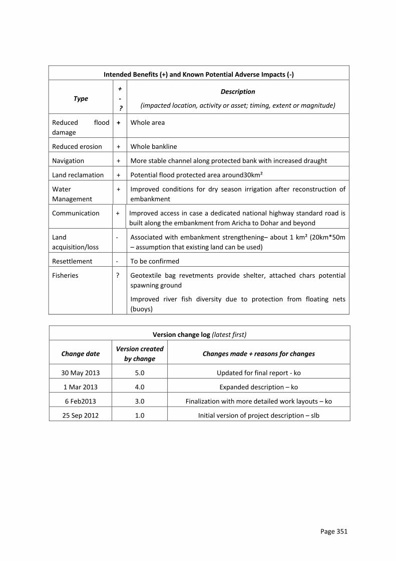
Page 351
Intended Benefits (+) and Known Potential Adverse Impacts (-)
Type
+
-
?
Description
(impacted location, activity or asset; timing, extent or magnitude)
Reduced flood
damage
+ Whole area
Reduced erosion + Whole bankline
Navigation + More stable channel along protected bank with increased draught
Land reclamation + Potential flood protected area around30km²
Water
Management
+ Improved conditions for dry season irrigation after reconstruction of
embankment
Communication + Improved access in case a dedicated national highway standard road is
built along the embankment from Aricha to Dohar and beyond
Land
acquisition/loss
- Associated with embankment strengthening– about 1 km² (20km*50m
– assumption that existing land can be used)
Resettlement - To be confirmed
Fisheries ? Geotextile bag revetments provide shelter, attached chars potential
spawning ground
Improved river fish diversity due to protection from floating nets
(buoys)
Version change log (latest first)
Change date Version created
by change Changes made + reasons for changes
30 May 2013 5.0 Updated for final report - ko
1 Mar 2013 4.0 Expanded description – ko
6 Feb2013 3.0 Finalization with more detailed work layouts – ko
25 Sep 2012 1.0 Initial version of project description – slb
Page 352
Annex 10: Selection of Subreaches
A. Multi-Criteria Assessment (MCA) of Tranche 1 Interventions
1. Approach and Key Criteria
MCA is an appropriate approach when comparing quantitative and qualitative data that are
otherwise incomparable. This is especially true for prefeasibility level assessment, when not
all data are quantified or quantifiable.
In this PPTA, an MCA is used to select the sub-reaches to be brought forward for feasibility
assessment and potential inclusion in Tranche 1. The MCA is the first step to identify three
suitable sub-reaches, to which, in a second step, a simplified economic feasibility analysis
will be applied for confirmation of their suitability. The purpose is to arrive at two or three
sub-reaches to be covered by Tranche 1 subprojects.
We have identified issues and criteria in two categories, means-ends and impacts (Table
0-1). Issues in the means-ends group are vulnerability and planning-engineering aspects,
and relate to the identification of priority sites suitable for MRP interventions. Issues in the
impact group are safeguards and cost-benefit, and relate to acceptability of the potential
impacts of the interventions. Criteria were then identified for each issue, nine criteria in
total, each of which can have up to three sub-criteria. In addition, we assess if the identified
priority interventions conflict with other planned major interventions. An example would
be the Padma Bridge construction, which impacts on two sub-reaches directly and has the
potential to affect four sub-reaches downstream.
Each of the following subsections systematically describes each criterion. In order to be
transparent, we follow the same structure throughout. Starting with a short justification of
the criterion we provide details about how we classify the criterion and how we arrived at
the values used for the classification. The latter is important as we are using primary,
qualitative data, and quantitative data, based on a more general assessment of an overall
situation. Finally, we conclude with detailed tables explaining each sub-criterion. When
there are measured data, this contains ranking and definition of limits, while for qualtitative
assessment detailed descriptions of the considerations leading to the ranking are provided
for each sub-reach.
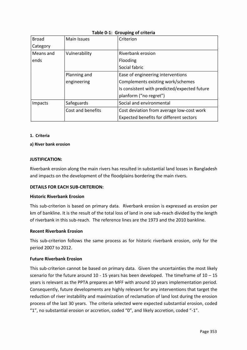
Page 353
Table 0-1: Grouping of criteria
Broad
Category
Main Issues Criterion
Means and
ends
Vulnerability Riverbank erosion
Flooding
Social fabric
Planning and
engineering
Ease of engineering interventions
Complements existing work/schemes
Is consistent with predicted/expected future
planform (“no regret”)
Impacts Safeguards Social and environmental
Cost and benefits Cost deviation from average low-cost work
Expected benefits for different sectors
1. Criteria
a) River bank erosion
JUSTIFICATION:
Riverbank erosion along the main rivers has resulted in substantial land losses in Bangladesh
and impacts on the development of the floodplains bordering the main rivers.
DETAILS FOR EACH SUB-CRITERION:
Historic Riverbank Erosion
This sub-criterion is based on primary data. Riverbank erosion is expressed as erosion per
km of bankline. It is the result of the total loss of land in one sub-reach divided by the length
of riverbank in this sub-reach. The reference lines are the 1973 and the 2010 bankline.
Recent Riverbank Erosion
This sub-criterion follows the same process as for historic riverbank erosion, only for the
period 2007 to 2012.
Future Riverbank Erosion
This sub-criterion cannot be based on primary data. Given the uncertainties the most likely
scenario for the future around 10 - 15 years has been developed. The timeframe of 10 – 15
years is relevant as the PPTA prepares an MFF with around 10 years implementation period.
Consequently, future developments are highly relevant for any interventions that target the
reduction of river instability and maximization of reclamation of land lost during the erosion
process of the last 30 years. The criteria selected were expected substantial erosion, coded
“1”, no substantial erosion or accretion, coded “0”, and likely accretion, coded “-1”.
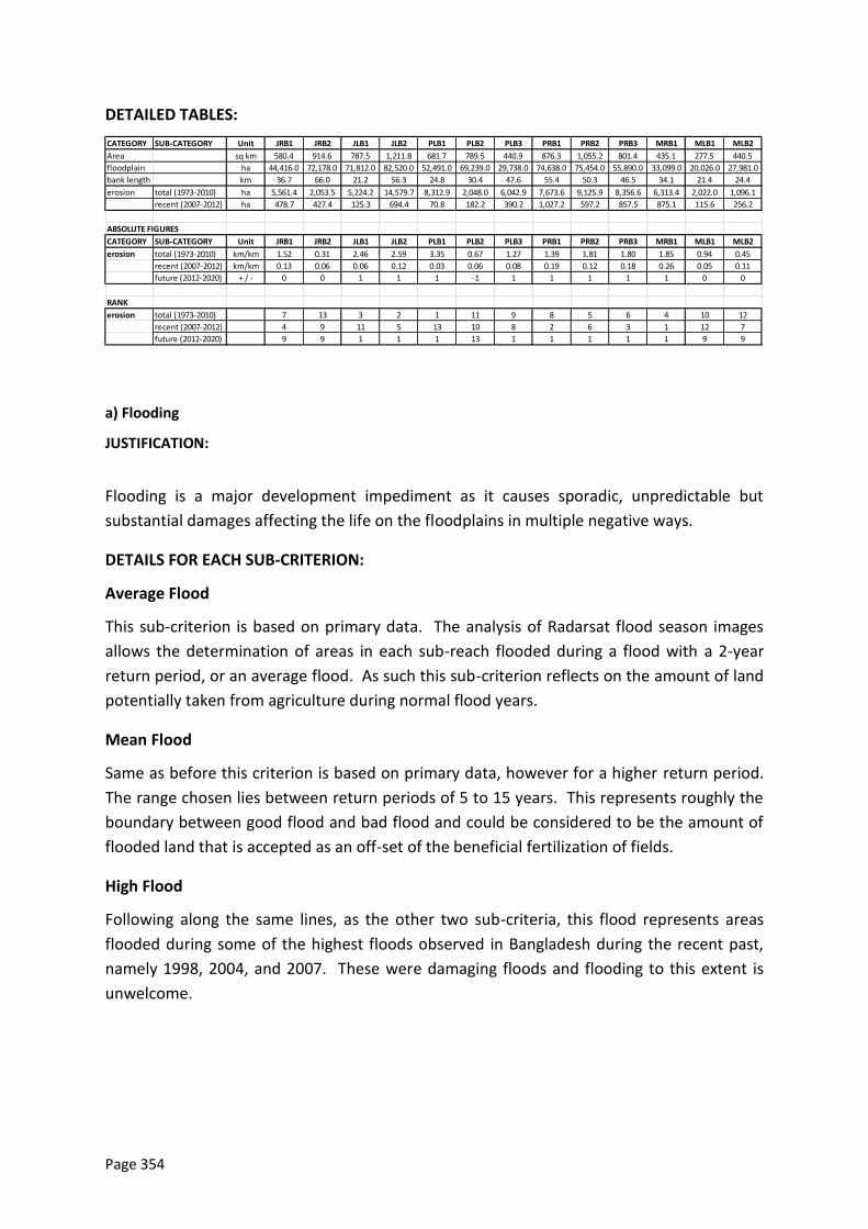
Page 354
DETAILED TABLES:
CATEGORY SUB-CATEGORY Unit JRB1 JRB2 JLB1 JLB2 PLB1 PLB2 PLB3 PRB1 PRB2 PRB3 MRB1 MLB1 MLB2
Area sq km 580.4 914.6 787.5 1,211.8 681.7 789.5 440.9 876.3 1,055.2 801.4 435.1 277.5 440.5
floodplain ha 44,416.0 72,178.0 71,812.0 82,520.0 52,491.0 69,239.0 29,738.0 74,638.0 75,454.0 55,890.0 33,099.0 20,026.0 27,981.0
bank length km 36.7 66.0 21.2 56.3 24.8 30.4 47.6 55.4 50.3 46.5 34.1 21.4 24.4
erosion total (1973-2010) ha 5,561.4 2,053.5 5,224.2 14,579.7 8,312.9 2,048.0 6,042.9 7,673.6 9,125.9 8,356.6 6,313.4 2,022.0 1,096.1
recent (2007-2012) ha 478.7 427.4 125.3 694.4 70.8 182.2 390.2 1,027.2 597.2 857.5 875.1 115.6 256.2
ABSOLUTE FIGURES
CATEGORY SUB-CATEGORY Unit JRB1 JRB2 JLB1 JLB2 PLB1 PLB2 PLB3 PRB1 PRB2 PRB3 MRB1 MLB1 MLB2
erosion total (1973-2010) km/km 1.52 0.31 2.46 2.59 3.35 0.67 1.27 1.39 1.81 1.80 1.85 0.94 0.45
recent (2007-2012) km/km 0.13 0.06 0.06 0.12 0.03 0.06 0.08 0.19 0.12 0.18 0.26 0.05 0.11
future (2012-2020) + / - 0 0 1 1 1 -1 1 1 1 1 1 0 0
RANK
erosion total (1973-2010) 7 13 3 2 1 11 9 8 5 6 4 10 12
recent (2007-2012) 4 9 11 5 13 10 8 2 6 3 1 12 7
future (2012-2020) 9 9 1 1 1 13 1 1 1 1 1 9 9
a) Flooding
JUSTIFICATION:
Flooding is a major development impediment as it causes sporadic, unpredictable but
substantial damages affecting the life on the floodplains in multiple negative ways.
DETAILS FOR EACH SUB-CRITERION:
Average Flood
This sub-criterion is based on primary data. The analysis of Radarsat flood season images
allows the determination of areas in each sub-reach flooded during a flood with a 2-year
return period, or an average flood. As such this sub-criterion reflects on the amount of land
potentially taken from agriculture during normal flood years.
Mean Flood
Same as before this criterion is based on primary data, however for a higher return period.
The range chosen lies between return periods of 5 to 15 years. This represents roughly the
boundary between good flood and bad flood and could be considered to be the amount of
flooded land that is accepted as an off-set of the beneficial fertilization of fields.
High Flood
Following along the same lines, as the other two sub-criteria, this flood represents areas
flooded during some of the highest floods observed in Bangladesh during the recent past,
namely 1998, 2004, and 2007. These were damaging floods and flooding to this extent is
unwelcome.
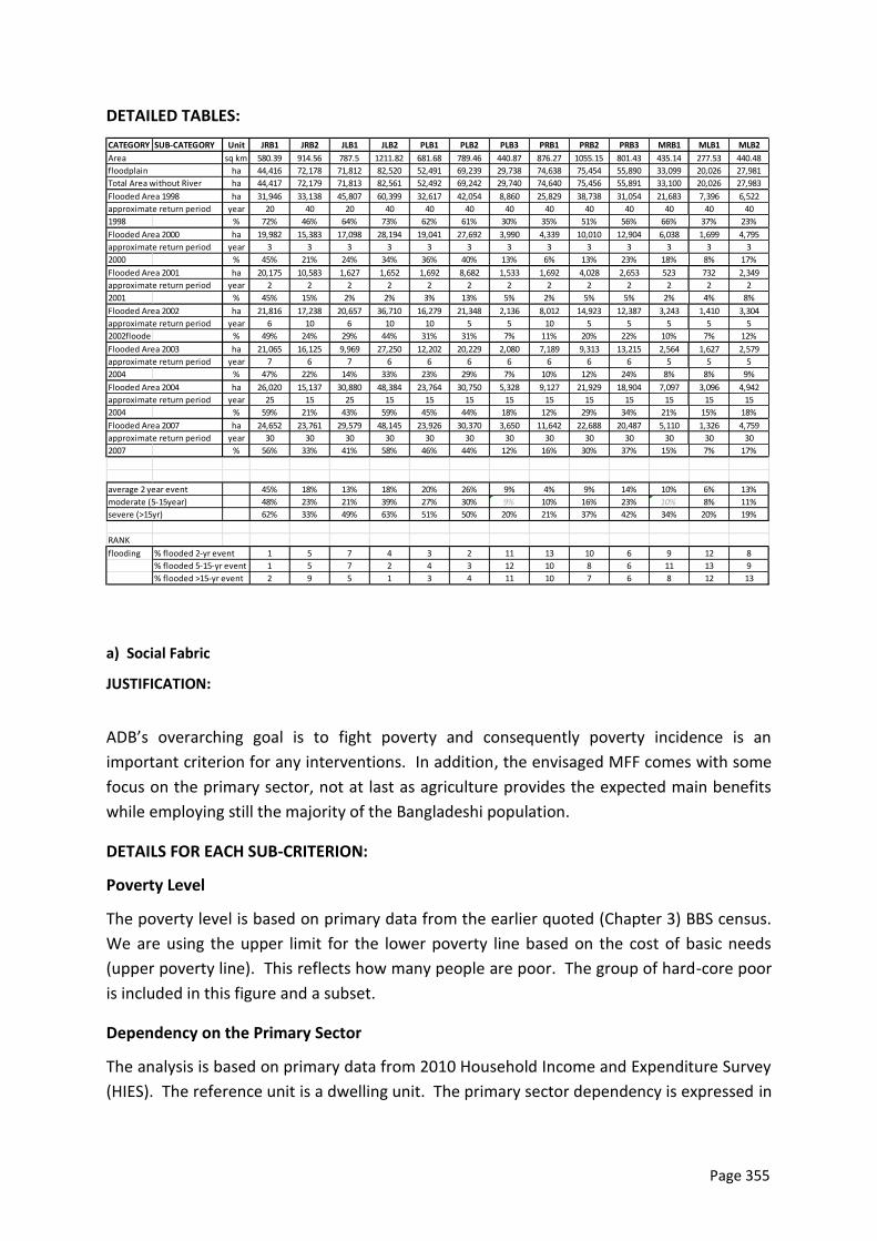
Page 355
DETAILED TABLES:
CATEGORY SUB-CATEGORY Unit JRB1 JRB2 JLB1 JLB2 PLB1 PLB2 PLB3 PRB1 PRB2 PRB3 MRB1 MLB1 MLB2
sq km 580.39 914.56 787.5 1211.82 681.68 789.46 440.87 876.27 1055.15 801.43 435.14 277.53 440.48
ha 44,416 72,178 71,812 82,520 52,491 69,239 29,738 74,638 75,454 55,890 33,099 20,026 27,981
ha 44,417 72,179 71,813 82,561 52,492 69,242 29,740 74,640 75,456 55,891 33,100 20,026 27,983
ha 31,946 33,138 45,807 60,399 32,617 42,054 8,860 25,829 38,738 31,054 21,683 7,396 6,522
year 20 40 20 40 40 40 40 40 40 40 40 40 40
1998
flooded (%
% 72% 46% 64% 73% 62% 61% 30% 35% 51% 56% 66% 37% 23%
ha 19,982 15,383 17,098 28,194 19,041 27,692 3,990 4,339 10,010 12,904 6,038 1,699 4,795
year 3 3 3 3 3 3 3 3 3 3 3 3 3
2000
flooded (%
% 45% 21% 24% 34% 36% 40% 13% 6% 13% 23% 18% 8% 17%
ha 20,175 10,583 1,627 1,652 1,692 8,682 1,533 1,692 4,028 2,653 523 732 2,349
year 2 2 2 2 2 2 2 2 2 2 2 2 2
2001
flooded (%
% 45% 15% 2% 2% 3% 13% 5% 2% 5% 5% 2% 4% 8%
ha 21,816 17,238 20,657 36,710 16,279 21,348 2,136 8,012 14,923 12,387 3,243 1,410 3,304
year 6 10 6 10 10 5 5 10 5 5 5 5 5
2002floode
d (% of
% 49% 24% 29% 44% 31% 31% 7% 11% 20% 22% 10% 7% 12%
ha 21,065 16,125 9,969 27,250 12,202 20,229 2,080 7,189 9,313 13,215 2,564 1,627 2,579
year 7 6 7 6 6 6 6 6 6 6 5 5 5
2004
flooded (%
% 47% 22% 14% 33% 23% 29% 7% 10% 12% 24% 8% 8% 9%
ha 26,020 15,137 30,880 48,384 23,764 30,750 5,328 9,127 21,929 18,904 7,097 3,096 4,942
year 25 15 25 15 15 15 15 15 15 15 15 15 15
2004
flooded (%
% 59% 21% 43% 59% 45% 44% 18% 12% 29% 34% 21% 15% 18%
ha 24,652 23,761 29,579 48,145 23,926 30,370 3,650 11,642 22,688 20,487 5,110 1,326 4,759
year 30 30 30 30 30 30 30 30 30 30 30 30 30
2007
flooded (%
% 56% 33% 41% 58% 46% 44% 12% 16% 30% 37% 15% 7% 17%
average 2 year event 45% 18% 13% 18% 20% 26% 9% 4% 9% 14% 10% 6% 13%
moderate (5-15year) 48% 23% 21% 39% 27% 30% 9% 10% 16% 23% 10% 8% 11%
severe (>15yr) 62% 33% 49% 63% 51% 50% 20% 21% 37% 42% 34% 20% 19%
RANK
flooding % flooded 2-yr event 1 5 7 4 3 2 11 13 10 6 9 12 8
% flooded 5-15-yr event 1 5 7 2 4 3 12 10 8 6 11 13 9
% flooded >15-yr event 2 9 5 1 3 4 11 10 7 6 8 12 13
Flooded Area 2007
approximate return period
approximate return period
Flooded Area 2003
approximate return period
Flooded Area 2004
approximate return period
Flooded Area 2000
approximate return period
Flooded Area 2001
approximate return period
Flooded Area 2002
Area
floodplain
Total Area without River
Flooded Area 1998
approximate return period
a) Social Fabric
JUSTIFICATION:
ADB’s overarching goal is to fight poverty and consequently poverty incidence is an
important criterion for any interventions. In addition, the envisaged MFF comes with some
focus on the primary sector, not at last as agriculture provides the expected main benefits
while employing still the majority of the Bangladeshi population.
DETAILS FOR EACH SUB-CRITERION:
Poverty Level
The poverty level is based on primary data from the earlier quoted (Chapter 3) BBS census.
We are using the upper limit for the lower poverty line based on the cost of basic needs
(upper poverty line). This reflects how many people are poor. The group of hard-core poor
is included in this figure and a subset.
Dependency on the Primary Sector
The analysis is based on primary data from 2010 Household Income and Expenditure Survey
(HIES). The reference unit is a dwelling unit. The primary sector dependency is expressed in
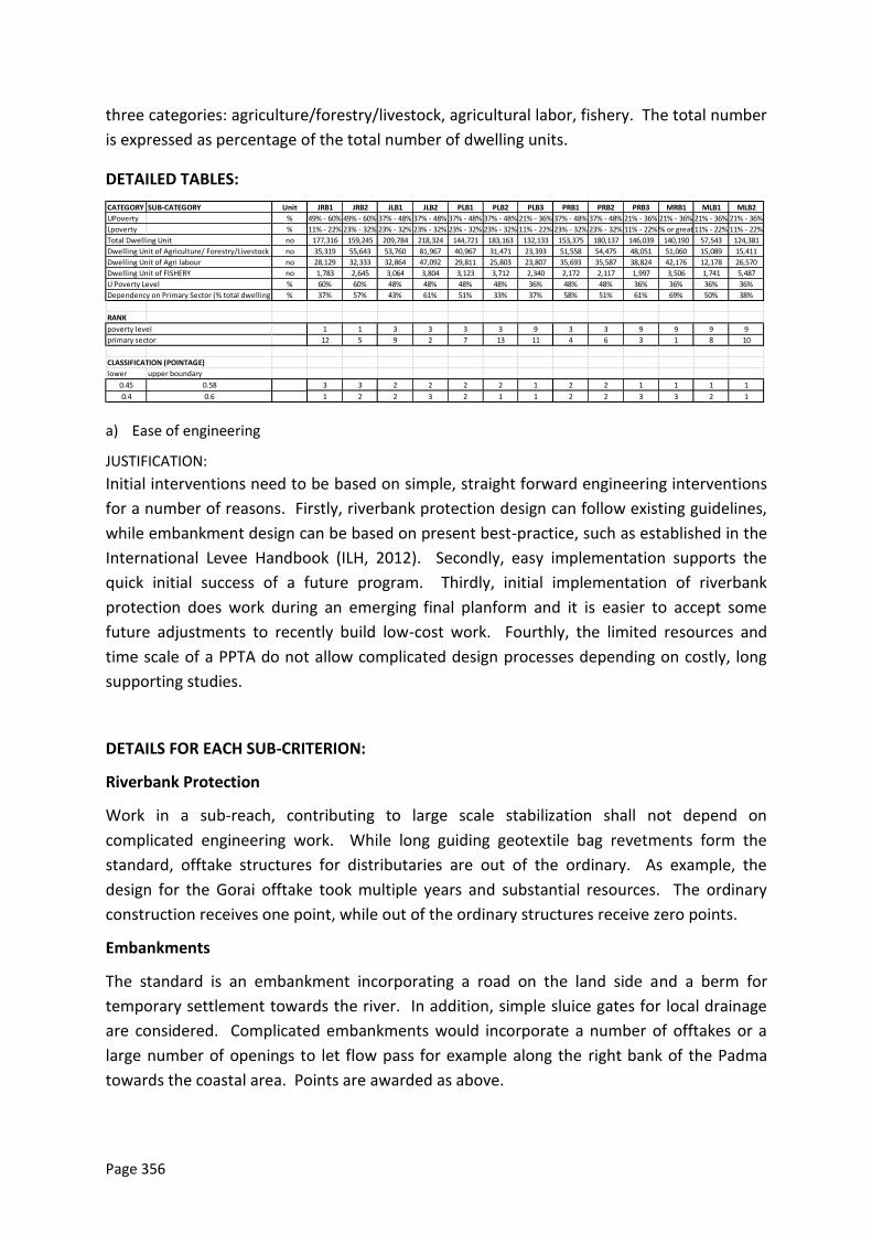
Page 356
three categories: agriculture/forestry/livestock, agricultural labor, fishery. The total number
is expressed as percentage of the total number of dwelling units.
DETAILED TABLES:
CATEGORY SUB-CATEGORY Unit JRB1 JRB2 JLB1 JLB2 PLB1 PLB2 PLB3 PRB1 PRB2 PRB3 MRB1 MLB1 MLB2
UPoverty % 49% - 60% 49% - 60% 37% - 48% 37% - 48% 37% - 48% 37% - 48% 21% - 36% 37% - 48% 37% - 48% 21% - 36% 21% - 36% 21% - 36% 21% - 36%
Lpoverty % 11% - 22% 23% - 32% 23% - 32% 23% - 32% 23% - 32% 23% - 32% 11% - 22% 23% - 32% 23% - 32% 11% - 22%44% or greater11% - 22% 11% - 22%
Total Dwelling Unit no 177,316 159,245 209,784 218,324 144,721 183,163 132,133 153,375 180,137 146,039 140,190 57,543 124,381
Dwelling Unit of Agriculture/ Forestry/Livestock no 35,319 55,643 53,760 81,967 40,967 31,471 23,393 51,558 54,475 48,051 51,060 15,089 15,411
Dwelling Unit of Agri labour no 28,129 32,333 32,864 47,092 29,811 25,803 23,807 35,693 35,587 38,824 42,176 12,178 26,570
Dwelling Unit of FISHERY no 1,783 2,645 3,064 3,804 3,123 3,712 2,340 2,172 2,117 1,997 3,506 1,741 5,487
U Poverty Level % 60% 60% 48% 48% 48% 48% 36% 48% 48% 36% 36% 36% 36%
Dependency on Primary Sector (% total dwelling units)% 37% 57% 43% 61% 51% 33% 37% 58% 51% 61% 69% 50% 38%
RANK
poverty level 1 1 3 3 3 3 9 3 3 9 9 9 9
primary sector 12 5 9 2 7 13 11 4 6 3 1 8 10
CLASSIFICATION (POINTAGE)
lower upper boundary
0.45 0.58 3 3 2 2 2 2 1 2 2 1 1 1 1
0.4 0.6 1 2 2 3 2 1 1 2 2 3 3 2 1
a) Ease of engineering
JUSTIFICATION:
Initial interventions need to be based on simple, straight forward engineering interventions
for a number of reasons. Firstly, riverbank protection design can follow existing guidelines,
while embankment design can be based on present best-practice, such as established in the
International Levee Handbook (ILH, 2012). Secondly, easy implementation supports the
quick initial success of a future program. Thirdly, initial implementation of riverbank
protection does work during an emerging final planform and it is easier to accept some
future adjustments to recently build low-cost work. Fourthly, the limited resources and
time scale of a PPTA do not allow complicated design processes depending on costly, long
supporting studies.
DETAILS FOR EACH SUB-CRITERION:
Riverbank Protection
Work in a sub-reach, contributing to large scale stabilization shall not depend on
complicated engineering work. While long guiding geotextile bag revetments form the
standard, offtake structures for distributaries are out of the ordinary. As example, the
design for the Gorai offtake took multiple years and substantial resources. The ordinary
construction receives one point, while out of the ordinary structures receive zero points.
Embankments
The standard is an embankment incorporating a road on the land side and a berm for
temporary settlement towards the river. In addition, simple sluice gates for local drainage
are considered. Complicated embankments would incorporate a number of offtakes or a
large number of openings to let flow pass for example along the right bank of the Padma
towards the coastal area. Points are awarded as above.
Page 357
Other Difficult Structures
Difficult structures relate mostly to the offtake regulators which requires specific structural
designs. The work associated with a specific intake geometry is considered under riverbank
protection. No additional structures are awarded one point, whereas additional difficult
structures do not get any points.
DETAILED TABLES:
riverbank
protection
embankment other
difficult
structure
riverbank protection embankment other difficult structure
JRB1 y y y normal conditions Kaijuri to Bagabari, potential
u/s char
regulator / fish pass
JRB2 n n y confluence issues reclamation at confluence on
loose char soils
potential additional
regulator / fish pass
JLB1 n n y number of distributary
offtake geometries
number of offtake
geometries
offtake old Dhaleswari and
Dhaleswari
JLB2 y y y largely normal conditions largely normal floodplain offtake old Ichamutti
PLB1 y y n normal conditions normal conditions no
PLB2 n y n erosion resistant area, deep existing road, higher - check no
PLB3 n y n stabilization of confluence normal conditions no
PRB1 n y n Ganges barrage and
confluence
normal conditions no
PRB2 n n y additional measures along
long reclaimed bank,
around Faridpur, rest open
for overland flow to south,
Arial Khan offtake
PRB3 n n y response to Padma Bridge
RTW with higher v
open for overland flow to
south,
regulator / fish pass
MRB1 n y y stabilization of confluence open for overland flow to
south,
regulator / fish pass
MLB1 y y y conducive existing
conditions
normal conditions existing embankment
MLB2 n y y Chandpur protection normal conditions regulator / fish pass
a) Complements existing work
JUSTIFICATION:
Completion of existing work means less efforts and higher potential rewards. This is the
more true in economic terms, as existing work is treated as sunken cost, which do not
reduce the economic feasibility.
Details for each Sub-criterion:
Riverbank Protection
Riverbank Protection of several kilometers in length is considered existing work. This could,
for example, provide the backbone for reconstruction of embankments. In case there is
existing work, one point is awarded, otherwise none.
Embankments
Existing embankments provide potentially higher benefits at lower cost, if riverbank
protection should be required. Consequently, existing embankments are awarded one
point, while the non-existence of embankments receives none.
Page 358
DETAILED TABLES:
riverbank
protection
embankment riverbank protection embankment
JRB1 y y existing work at Kaijuri, 10
km
existing BRE
JRB2 y y existing work at Kaitola, 7 km PIRDP ring embankment is
complete
JLB1 n n no work, offtakes uncertain
due to fund shortage
no embankment
JLB2 n n marginal work at Chauhali no major embankment
PLB1 n y no work Dhaka SW embankment
PLB2 y y natural protection some existing road close to
bankline
PLB3 n n marginal work at Munshiganj no embankment
PRB1 y n existing work at Rajbari no embankment
PRB2 n n existing work at Faridpur
useless if land reclaimed
no embankment
PRB3 y n Padma Bridge 12 km
revetment
no embankment
MRB1 n n no work no embankment
MLB1 y y existing work at Eklashpur,
4.5 km
MDIP ring embankment
complete
MLB2 y n existing work at Chandpur,
about 1.5 km
no embankment
a) “No regret”
JUSTIFICATION:
Any work that does not match with a future planform results in a potential waste of funds.
DETAILS FOR EACH SUB-CRITERION:
The only sub criterion is the assessment if there is a potential wastage as work built during
the next decade (under an MFF program) could risk not match with the future desired
planform.
Page 359
DETAILED TABLES: no regret no regret
JRB1 y existing straight channel and
bifurcation to be maintained
JRB2 y existing western bankline
channel for navigation
JLB1 y existing straight channel and
bifurcation to be maintained
JLB2 y existing eastern bankline
channel dominant
PLB1 y reclamation of land due to
favourable planform
PLB2 n potential char development
alongside Mawa left bank
PLB3 n downstream consequence of
Padma Bridge uncertain
PRB1 n unclear due to confluence
PRB2 n river planform not yet
developed for reclamation
PRB3 n downstream consequence of
Padma Bridge uncertain
MRB1 n not clear with confluence
MLB1 y bankline stable
MLB2 n not clear with confluence
a) Safeguards
JUSTIFICATION:
Safeguards play an important role in the densely populated and highly exploited deltaic
environment. Any major implications could stop interventions as planned. On a somewhat
lower level, complicated interventions could require more time than available for PPTA
preparation and as such also need to be avoided during the initial PPTA.
DETAILS FOR EACH SUB-CRITERION:
Land Acquisition and Resettlement
Land acquisition and resettlement in Bangladesh is complex due to the fractured small
landholdings often with unclear land titles. This problem is unavoidable and required to be
addressed for any construction work. We consider three levels of complexity, also
depending on the extent of the work: low, medium, high, with points in descending order
from 3 to 1. Normal resettlement involves a 50 m wide strip along the bankline and a 50 m
wide strip for embankment construction. If the embankment length is limited to less than
20 km and runs through less populated areas, and if there is only limited riverbank
protection the impact is low. Medium impact relates to longer embankments and/or
riverbank protection. High impact relates to areas that require embankment works and
riverbank protection, both of substantial length.
Environment
There are no environmental sensitive areas in the areas under consideration. Consequently,
environmental aspects focus also on potential effects beyond the boundaries. This is
Page 360
especially true for the southern sub-reaches, with contribute substantial fresh water to the
coastal area and as such restrict salinity intrusion.
DETAILED TABLES:
land acquisition
and resettlement
environment land acquisition and
resettlement
environment
JRB1 m m embankment and limited
riverbank protection
existing embankment, char
implications
JRB2 l l no embankment work, only
limited riverbank protection
low impacts due to largely
existing work
JLB1 h h both required distributary effects
JLB2 h m both required normal impacts
PLB1 m m full embankment but limited
riverbank proteciton
normal impacts
PLB2 l l limited embankment work,
no revetment
limited impacts as no
riverbank protection
PLB3 h m both required normal impacts
PRB1 h m both required normal impacts
PRB2 h h both required flow to south impacted
PRB3 h h both required flow to south impacted
MRB1 h h both required flow to south impacted
MLB1 l l existing work, minimal
impacts
existing work, minimal
impacts
MLB2 h m both required normal impacts
a) Cost
JUSTIFICATION:
Individual tranches have only limited total budgets. This is required for not overloading the
implementing agency but also from budgetary considerations of ADB’s pipeline.
DETAILS FOR EACH SUB-CRITERION:
Riverbank Protection
Addressing two or three sub-areas is potentially more beneficial for achieving the overall
goal than putting all investment of one tranche into one area. For this reason high
investment is less beneficial than lower investment. As such points are given for low,
medium, and high investment in descending order, starting with three points for low.
Embankments
The same holds true for embankments.
DETAILED TABLES:
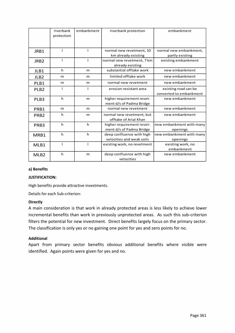
Page 361
riverbank
protection
embankment riverbank protection embankment
JRB1 l l normal new revetment, 10
km already existing
normal new embankment,
partly existing
JRB2 l l normal new revetment, 7 km
already existing
existing embankment
JLB1 h m substantial offtake work new embankment
JLB2 m m limited offtake work new embankment
PLB1 m m normal new revetment new embankment
PLB2 l l erosion resistant area existing road can be
converted to embankment
PLB3 h m higher requirement revet-
ment d/s of Padma Bridge
new embankment
PRB1 m m normal new revetment new embankment
PRB2 h m normal new revetment, but
offtake of Arial Khan
new embankment
PRB3 h h higher requirement revet-
ment d/s of Padma Bridge
new embankment with many
openings
MRB1 h h deep confluence with high
velocities and weak soils
new embankment with many
openings
MLB1 l l existing work, no revetment existing work, no
embankment
MLB2 h m deep confluence with high
velocities
new embankment
a) Benefits
JUSTIFICATION:
High benefits provide attractive investments.
Details for each Sub-criterion:
Directly
A main consideration is that work in already protected areas is less likely to achieve lower
incremental benefits than work in previously unprotected areas. As such this sub-criterion
filters the potential for new investment. Direct benefits largely focus on the primary sector.
The classification is only yes or no gaining one point for yes and zero points for no.
Additional
Apart from primary sector benefits obvious additional benefits where visible were
identified. Again points were given for yes and no.

Page 362
DETAILED TABLES: directly additional directly additional
JRB1 y y restoration of BRE flow along west bank for navigation,
reclamation of charland
JRB2 n n existing scheme existing scheme
JLB1 n y higher area dry season flow due to offtakes
JLB2 y y increased due to reduced flood losses and
incremental agri increases
dry season flow due to offtakes,
additional reclamation of charland
PLB1 y y increased due to reduced flood losses and
incremental agri increases
reclamation of charland
PLB2 y n increased due to reduced flood losses and
incremental agri increases
reclamation likely only after ten years
PLB3 y n increased due to reduced flood losses and
incremental agri increases
none
PRB1 y n increased due to reduced flood losses and
incremental agri increases
none
PRB2 y n improvement of Faridpur flood situation none
PRB3 n n open floodplain, reduced benefits none
MRB1 n n open floodplain, reduced benefits none
MLB1 n n existing scheme existing scheme
MLB2 y n increased due to reduced flood losses and
incremental agri increases
none
1. MCA WEIGHTING AND SCOREBOARD
The MCA combines all above criteria, and applies weighing factors to each criterion. We
applied weighing factors at two levels: (i) primary interest and (ii) evening out of the number
of sub-criteria. Firstly, the three vulnerability criteria (riverbank erosion, flooding, social
fabric) were set to obtain higher marks, in order to allow addressing these more urgent
problems at higher priority. Secondly, we applied weighing factors, so that each group of
sub-criteria (primary interest and others) obtains the same maximum marks. In
combination this means that the vulnerability criteria get a maximum of 90 marks. If there
are three classification groups, for example high, medium, low, the weighing factor applied
was 10 (3 sub-criteria * 3 points * 10 weighing factor = 90), if there are two classification
groups (for example yes - no) the weighing factor is 15 (3 sub-criteria * 2 points * 15
weighing factor = 90). For the second group, the same weighing factors apply, only with the
goal to reach a maximum of 30 points. The result is presented in (Table 0-2 ).
A sensitivity run, setting all criteria equal, confirms the same selection as obtained by above
method. Furthermore, a very similar result was obtained during an initial discussion with
ADB, BWDB and members of the PPTA team in September, however with less refinement
and quantification of sub-criteria.
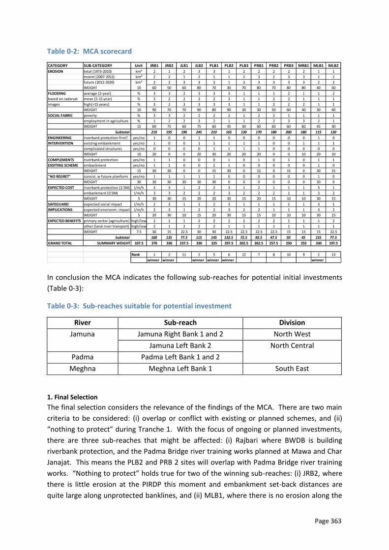
Page 363
Table 0-2: MCA scorecard
CATEGORY SUB-CATEGORY Unit JRB1 JRB2 JLB1 JLB2 PLB1 PLB2 PLB3 PRB1 PRB2 PRB3 MRB1 MLB1 MLB2
EROSION total (1973-2010) km² 2 1 2 3 3 1 2 2 2 2 2 1 1
recent (2007-2012) km² 2 2 1 2 1 1 2 3 2 3 3 1 2
future (2012-2020) km² 2 2 3 3 3 1 3 3 3 3 3 2 2
WEIGHT 10 60 50 60 80 70 30 70 80 70 80 80 40 50
FLOODING average (2-year) % 3 3 2 3 3 3 1 1 1 2 1 1 2
based on radarsat mean (5-15 year) % 3 2 2 3 2 3 1 1 2 2 1 1 1
images high(>15 years) % 3 2 3 3 3 3 1 1 2 2 2 1 1
WEIGHT 10 90 70 70 90 80 90 30 30 50 60 40 30 40
SOCIAL FABRIC poverty % 3 3 2 2 2 2 1 2 2 1 1 1 1
employment in agriculture % 1 2 2 3 2 1 1 2 2 3 3 2 1
WEIGHT 15 60 75 60 75 60 45 30 60 60 60 60 45 30
Subtotal 210 195 190 245 210 165 130 170 180 200 180 115 120
ENGINEERING riverbank protection first? yes/no 1 0 0 1 1 0 0 0 0 0 0 1 0
INTERVENTION existing embankment yes/no 1 0 0 1 1 1 1 1 0 0 1 1 1
complicated structures yes/no 0 0 0 0 1 1 1 1 0 0 0 0 0
WEIGHT 10 20 0 0 20 30 20 20 20 0 0 10 20 10
COMPLEMENTS riverbank protection yes/no 1 1 0 0 0 1 0 1 0 1 0 1 1
EXSITING SCHEME embankment yes/no 1 1 0 0 1 1 0 0 0 0 0 1 0
WEIGHT 15 30 30 0 0 15 30 0 15 0 15 0 30 15
"NO REGRET" consist. w future planform yes/no 1 1 1 1 1 0 0 0 0 0 0 1 0
WEIGHT 30 30 30 30 30 30 0 0 0 0 0 0 30 0
EXPECTED COST riverbank protection (2.5M) l/m/h 3 3 1 2 2 3 1 2 1 1 1 3 1
embankment (0.5M) l/m/h 3 3 2 2 2 3 2 2 2 1 1 3 2
WEIGHT 5 30 30 15 20 20 30 15 20 15 10 10 30 15
SAFEGUARD expected social impact l/m/h 2 3 1 1 2 3 1 1 1 1 1 3 1
IMPLICATIONS expected environm. impact l/m/h 2 3 1 2 2 3 2 2 1 1 1 3 2
WEIGHT 5 20 30 10 15 20 30 15 15 10 10 10 30 15
EXPECTED BENEFITS primary sector (agriculture) high/low 2 1 1 2 2 2 2 2 2 1 1 1 2
other (land-river transport) high/low 2 1 2 2 2 1 1 1 1 1 1 1 1
WEIGHT 7.5 30 15 22.5 30 30 22.5 22.5 22.5 22.5 15 15 15 22.5
Subtotal 160 135 77.5 115 145 132.5 72.5 92.5 47.5 50 45 155 77.5
GRAND TOTAL SUMMARY WEIGHT 107.5 370 330 237.5 330 325 297.5 202.5 262.5 257.5 250 255 330 197.5
Rank 1 2 11 2 5 6 12 7 8 10 9 2 13
winner winner winner winner winner winner
In conclusion the MCA indicates the following sub-reaches for potential initial investments
(Table 0-3):
Table 0-3: Sub-reaches suitable for potential investment
River Sub-reach Division
Jamuna Jamuna Right Bank 1 and 2 North West
Jamuna Left Bank 2 North Central
Padma Padma Left Bank 1 and 2
Meghna Meghna Left Bank 1 South East
1. Final Selection
The final selection considers the relevance of the findings of the MCA. There are two main
criteria to be considered: (i) overlap or conflict with existing or planned schemes, and (ii)
“nothing to protect” during Tranche 1. With the focus of ongoing or planned investments,
there are three sub-reaches that might be affected: (i) Rajbari where BWDB is building
riverbank protection, and the Padma Bridge river training works planned at Mawa and Char
Janajat. This means the PLB2 and PRB 2 sites will overlap with Padma Bridge river training
works. “Nothing to protect” holds true for two of the winning sub-reaches: (i) JRB2, where
there is little erosion at the PIRDP this moment and embankment set-back distances are
quite large along unprotected banklines, and (ii) MLB1, where there is no erosion along the
Page 364
MDIP. Notwithstanding the lack of urgent protection, both sub-reaches should be covered
under contingency measures during the first tranche, as their high ranking indicates the
vulnerability and potentially viable investments. While the JRB2 site will have a clear focus
on riverbank protection in support of an existing embankment line, MLB1 will have a clear
focus on strengthening the flood embankment, which regularly is affected by “boiling” or
seepage indicating a structural weakness.
Considering the relevance of immediate interventions, the most attractive projects are
listed in Table 0-4.
Table 0-4: Winning sub-reaches
River Sub-reach Division
Jamuna JRB1 North West
JLB 2 North Central
Padma PLB 1
Page 365
Annex 11: DOE Approved Terms of Referrence
Page 366
Page 367
Page 368
Annex 12: Outline Terms of Reference of Services for
Conducting Biodiversity Baseline and Preparing Monitoring
Plan; Identifying Location of the Protected Sanctuary and
Developing a Sanctuary Establishment Plan
A. Background
The Flood and Riverbank Erosion Risk Management Investment Program (FRERMIP) aims to sustain
incomes and livelihoods of people living along selected reaches of Jamuna, Ganges, and Padma
Rivers (Figure 1) by enhancing resilience to flooding and to riverbank erosion through a mix of
structural and non-structural measures. FRERMIP will be implemented under a Multi-tranche
Financing Facility (MFF) in three phases or tranches of three to four year duration each with one
year overlap from 2014 until 2023. Tranche 1 of the MFF consisting of three Subprojects: Jamuna
Right Bank 1 (JRB-1), Jamuna Left Bank 2 (JLB-2), and Padma Left Bank 1 (PLB-1).
The program includes structural measures, extensive non-structural activities, and institutional
strengthening. A total of 50 km of riverbank protection, 53 km of embankment rehabilitation, and
36 km of embankment reconstruction or new construction are planned to be implemented through
the Bangladesh Water Development Board (BWDB). In addition, more than one million people living
in flood risk areas along the main rivers are expected to be supported by a community-based flood
risk management program organized through the Department of Disaster Management (DDM).
Institutional strengthening will largely focus on improving the knowledge base and planning tools for
managing critical river reaches, particularly within the planned River Management Wing in BWDB.
After initially protecting critically eroding riverbanks at priority areas, the program plans to move to
more systematic riverbank stabilization, potentially contributing towards future river-reach
stabilization during later tranches. The stabilization approach will make use of the currently ongoing
consolidation of the river morphology developing towards a more accentuated channel pattern
similar to the one observed in the 1970s, before the dramatic widening (from the 1970s to 2000s)
took place. In parallel existing, degraded or eroded embankment lines, such as the Brahmaputra
Right Embankment will be restored and extended to arrive at reliable flood protection for the large
population living on the floodplain along the main rivers. The community-based flood risk
management component aims to increase resilience and preparedness of the population for the
residual risk, for example if existing embankments unexpectedly breach.
The suggested investment program commences during the first Tranche with three priority reaches
(subprojects) along the lower Jamuna and upper Padma Rivers, and later adds downstream areas
including at the confluence of Padma and Upper Meghna Rivers. The riverbank protection approach
builds on and extends technical principles established under the successful Jamuna-Meghna River
Erosion Mitigation Project (JMREMP). Embankment designs follow best international practice
providing access along the top of the embankment and the opportunity to raise embankments later
in response to climate change requirements within the typical construction width applied in
Bangladesh. Tranche-1 JLB-2 and PLB-1 physical works consist of riverbank-erosion protection works
along critically eroding areas only. JRB-1 consists of very limited riverbank-erosion protection works
in support of existing works and the restoration of degraded and eroded flood embankments,
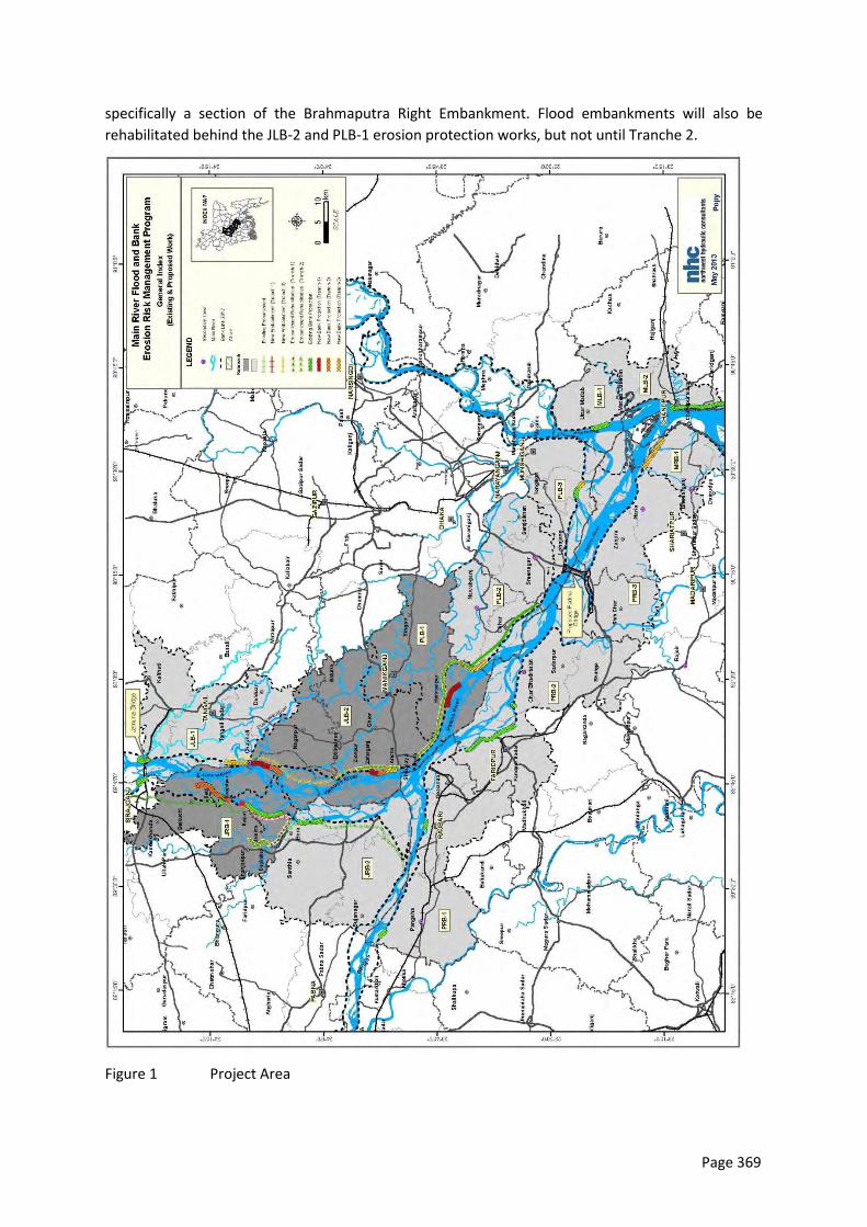
Page 369
specifically a section of the Brahmaputra Right Embankment. Flood embankments will also be
rehabilitated behind the JLB-2 and PLB-1 erosion protection works, but not until Tranche 2.
Figure 1 Project Area
Page 370
In addition to a full EIA the preparatory study prepared an Environmental Assessment and Review
Framework (EARF). The purpose of this EARF is to guide the preparation of future tranches of the
ADB supported Flood and Riverbank Erosion Risk Management Investment Project (FRERMIP),
prepared through Project Preparatory Technical Assistance (PPTA) 8054, Main River Flood and Bank
Erosion Risk Management Program (MRP). Specific guidance is required as the Program intends to
move from localized riverbank protection towards stabilization of first river reaches of the main
rivers in central Bangladesh. This approach includes the restoration and expansion of existing flood
risk mitigation infrastructure (flood embankments), leading to more reliable flood risk mitigation. To
this end existing literature knowledge on issues pertaining to environmental safeguards, such as the
river ecosystem, river floodplain interaction, and specifically fish, need to be expanded, in parallel to
the study of the overall stabilization approach over the following tranches, alternative solutions, and
their impacts. Future environmental assessment has to account for the dynamic river morphology
that experienced dramatic changes over the last 40 years, which are still ongoing.
The anticipated benefits are considerable and include: (i) reduced loss of agricultural and other land
with established infrastructure to prevent river erosion, (ii) reduced destruction of livelihood and
impoverishment of families, (iii) gains in floodplain land from river stabilization, (iv) improved river
navigation and trade, (v) reduced flood damage to agriculture, particularly Aus and Aman cropping,
and (vi) increased agricultural production on less-flooded agricultural land.
While the anticipated program benefits are considerable, the program potentially negatively impacts
both floodplain and river environment. Potential negative impacts may include the transformation of
deeply flooded floodplain into less flooded areas leading to the degradation of floodplain aquatic
(wetland) habitats, reduced hydrological connectivity, and physiochemical / water quality changes,
which may adversely affect floodplain-dependent openwater fish species and wetland biodiversity.
Increased agriculture may increase utilization of water resources for irrigation and increased
fertilizer and pesticide use may impact on water quality. Erosion protection of the program may
alter the river morphology along a river reach beyond the works, change the river appearance (e.g.
the number of channels and islands, water depths, and velocity), and as a consequence change the
river habitat. This may in turn have an impact on the biodiversity locally as well as for migrating or
trans-boundary animal populations.
The program has a number of inbuilt mechanisms to reduce environmental impacts, and mitigation
measures have been aggressively mainstreamed into program planning and engineering designs. The
flexibility of a phased MFF approach supports minimization and mitigation of potential negative
impacts in a gradual manner. Works will start in Tranche-1 with protection of critically eroding
riverbanks and the reconstruction of the destroyed Brahmaputra Right Embankment, while
conducting extensive studies on future impacts of river stabilization and associated embankment
works, including piloting new measures. Specialist studies have been conducted for Tranche-1
interventions on morphology, floodplain hydrology, and environmental aspects. They support that
the Tranche-1 impacts are more limited in nature and can be mitigated. During Tranche-2 first
measures for river stabilization along the priority work reaches are planned and will be designed
based on the Tranche-1 study outcomes and supported by environmental monitoring and mitigation
measures. This approach will be carried forward and adapted in Tranche-3.
The Program includes several additional studies to develop a broader background understanding
and develop an approach that optimizes different key drivers, ranging from morphological trends,

Page 371
future river use for navigation, safeguarding and enhancing the river ecosystem, and reducing social
impacts.
Page 372
Mitigation measures suggested for larger-scale river stabilization include:
(i) Development of stabilization alternatives and impacts through the River Stabilization Study
during year 1 and 2 of Tranche-1
(ii) Establishment of a river sanctuary, building on the River Stabilization Study and an individual
study to outline the sanctuary requirements during year 3 and 4 of Tranche-1,
(iii) Development of EIA studies for each subsequent tranche
(iv) Consideration of protected areas, supported by physical measures, such as navigation
buoyage alongside protected riverbanks disallowing systematic fishing with floating nets.
Figure 2 depicts the system of studies and their interaction with environmental and social safeguards.
In addition, “building-with-nature” measures will be piloted to assess ways closely mimicking or
making use of natural processes to build attached char land faster into floodplain land.
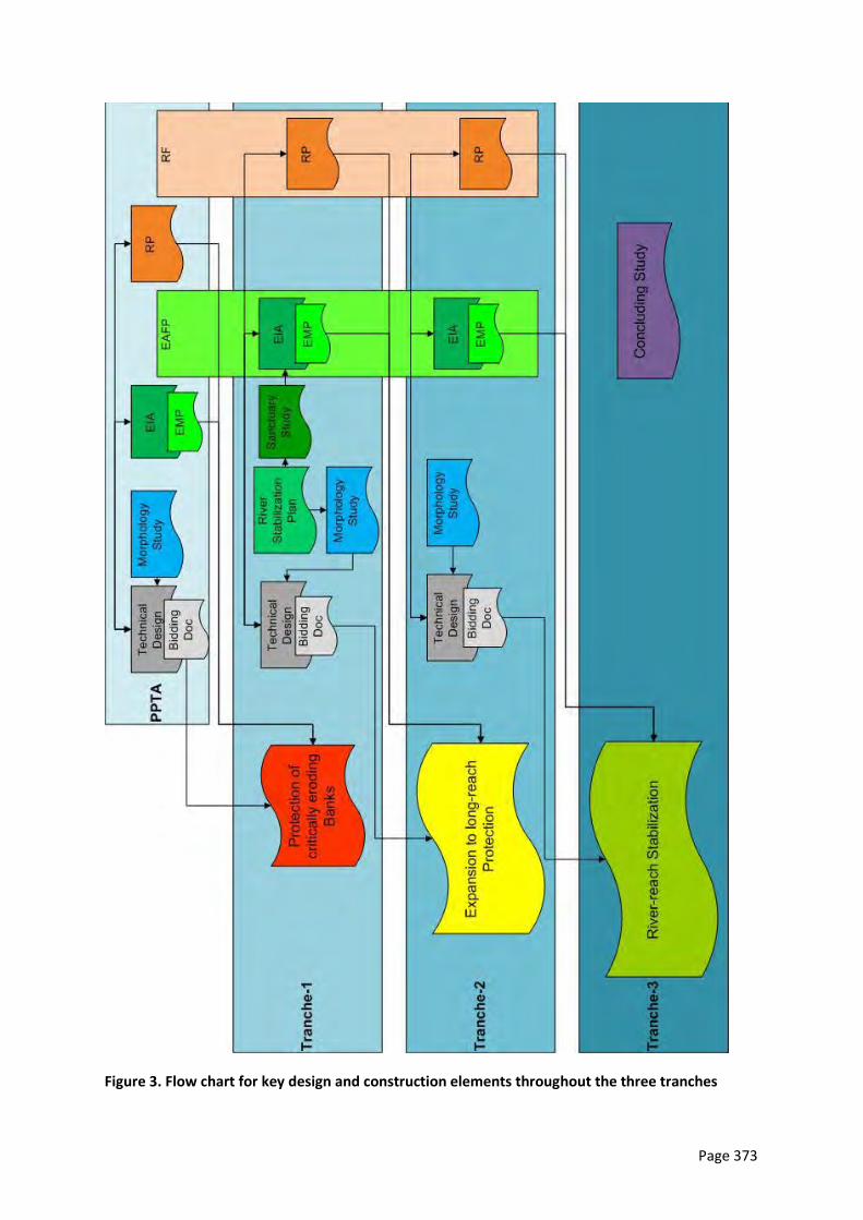
Page 373
Figure 3. Flow chart for key design and construction elements throughout the three tranches
Page 374
B. Objectives
Based on the outcome the River Stabilization Plan environmental measures for potential larger-scale river stabilization need to be investigated and suitable mitigation measures, such as a river sanctuary identified and detailed. This involves:
Identification of monitoring indicators for all the flora and fauna components of the project site during pre-construction, construction and operational stages. Once these indicators are carefully selected, they would be the monitoring indicators/parameters that will be followed throughout the project life. Hence, considerable research and thought must be given to this aspect.
Establish a comprehensive baseline for the biodiversity in project's influence areas.
Develop an interactive biodiversity monitoring plan which covers all species specially critically endangered species, such as Dolphin (Platanista gangetica) and economically important species, such as Hilsa (Tenaulosa ilisha) a national flagship fish during the construction phase.
Identify a suitable location for the sanctuary preferably within project impact area and develop a detailed plan for establishment of a protected sanctuary to compensate for project impacts and contribute to a long term conservation of aquatic and terrestrial habitat.
The outcome of this study which will be undertaken in Tranche 1 will form part of the EIA studies for
future tranche-2 and -3 work.
C. Consulting Services
Consulting services are solicited from Firm/NGO/Research institute’s experienced in setting ecological baseline , biodiversity monitoring , defining conservation status of species and their conservation strategy and restoration, establishment and management of protected Sanctuary area and proven international and national experience to provide necessary technical services for biodiversity monitoring and establishment of Sanctuary. The consulting team will include a mix of experts with experiences in biology of the various species and habitats. The interested Firm/NGO/Research institute should have experience in similar works and preferably working experience in Bangladesh.
Designation of Protected Status: Under the Sanctuary Establishment Plan the Firm/NGO/ Research
institute’s shall prepare all necessary documentation and procedures to be followed and support
BWDB to develop a sanctuary suitable for later obtaining the legal status under the existing laws of
Bangladesh and recognition as "protected ''. The core area of the protected sanctuary may be closed
by legal means to unauthorized human encroachment, fishing, boating, or any other activity that
significantly and adversely affect the habitat. The public may be allowed to enter selected areas
including the buffer zones for guided visits in order to promote eco-tourism. In order to self-sustain
the eco tourism venture a business plan will be drawn up
Sanctuary Establishment Plan should include the detailed Management & Monitoring Plan for the
Sanctuary. The plan should identify the responsible persons/ organizations and present a site-
specific or/ and species- specific management /monitoring plan for the required inputs
D. Scope of Services
The Consultants of the Firm/NGO/Research Institute's shall familiarize with the River Stabilization Plan prepared during the Tranche-1 project, as well as the program preparatory documents (feasibility study 2013) and maintain close coordination with the Environment Unit of PMO. The scope of works is defined into two groups with following outputs.

Page 375
E. Biodiversity Baseline and Biodiversity Monitoring Plan
Biodiversity baseline
Prepare the Biodiversity Baseline which covers all species, specially critically endangered species and economically important species in the project impact areas based on;
Identification of key monitoring indicators
Analysis of the key environmental issues regarding the biodiversity and collect primary data on the aquatic and terrestrial biodiversity in every month through field sampling and observation
Using social instruments for surveying to collect the opinion of the local people and their perception on the possible impacts of the bridge construction activities; special emphasis on Hilsa and Dolphin migration , resident and migratory birds , reeds and wildlife
Observe and record the frequency , abundance, distribution and dislocation of indicator species of wildlife in the impact area of the project
Conduct a study of the ecology and breeding habitats of biology of the migratory birds in the project area;
Monitor the migration pattern and breading of Hilsa fish Tenaulosa ilisha;
Monitor the migration pattern of Dolphin (Platanista gangetica), etc.
Biodiversity Monitoring Plan
Prepare the Biodiversity Monitoring plan of all species which includes specially critically endangered or endangered species including Dolphin (Platanista gangetica) and economically important species including Hilsa (Tenaulosa ilisha) based on;
Review the EAP documents of the Padma Bridge Project and all available literature on the Padma and its Char land ecology are essential for development of the Biodiversity Monitoring Plan and that will assist enable determination of project construction and operation effects on biod iversity and the success of associated mitigation measures
Identify the project associated activities in the project impact area that will have a negative impact on to biodiversity and to recommend remedial measures where necessary for the protection of biodiversity
Public Consultations: Carry out stakeholder 's analysis through public consultation meetings with local l level elites, public representatives, Department of Environment, respective department for wild life conservation , NGOs, representative of major professional groups (fishermen , agriculture farmers, etc.) and char land dwellers at the sites and consider the outcomes in preparing monitoring plan
The Biodiversity Monitoring Plan shall include terrestrial and aquatic species including critically endangered/ endangered species and economically important species with appropriate monitor indicators based on the obtained baseline information during the pre-construction stage for monitoring the biodiversity during the construction stage and in operation stage of the project
Submit a draft Biodiversity Monitoring Plan to BWDB for their review, comment and possible circulation to agency stakeholders and co-financiers
Finalization of the Biodiversity Monitoring Plan according to the comments received
Capacity building for the professionals of Environmental unit, Safeguard and Project relevant personnel through conducting trainings, workshop (national /international) regarding the protection and conservation of the biodiversity in the project area (focus on aquatic and terrestrial endangered species)., operate ion and maintenance of Sanctuary, etc.
Awareness programs should be conducted through conducting meeting, workshop, pamphlet and communication materials on the biodiversity as an integral part to aware the public regarding the protection and conservation of the biodiversity
Page 376
F. Identification of suitable location of the sanctuary and development of a Sanctuary Establishment Plan
A Identify the location of the Sanctuary
Identification of the suitable location for development of the protective Sanctuary though
Field survey
Three-five site (Char lands) will be studied and based on the alternative
Following analysis the suitable location should be finalized .
Public Consultations: Conduct public consultation meetings with charland dwellers, local level elites, public representatives of the Department of Forest, Department of Environment , respective department for wildlife conservation, NGOs , representative of major profess ional groups (fishermen , agriculture farmers, etc.) at the sites and consider outcomes in identify the suitable location of the Sanctuary.
The following criteria should be considered for the site selection;
Location should be in the lower Jamuna downstream of Jamuna Bridge;
Location should be relatively insensitive to river erosion; The Chars with reed lands with submerged areas surrounding the Char are generally suitable for such compensation measure due to their suitability for aquatic and bird habitat as well terrestrial habitats.
Evaluate the location impacts of the protected sanctuary for the construction of main bridge, river training works or other related components at downstream erosion and /or accretion
Proposed location should be raised to a height of I to (maximu m of) 3 m above the monsoon water and should have a number of water bodies or channels.
Conduct consultations with local community and government organizations to agree on the project location
Potential location site will be mapped and zoning on the existing revenue maps to enable BBA to identify land for acquisition purposes.
B Sanctuary Establishment Plan
The Sanctuary Establishment Plan should include detailed design of the Sanctuary as follows
Site location should be reflected on the mouza maps for acquisition purposes.
Demarcate into and design the proposed area as core and buffer zones.
The core zone shall include the char and the river. A critical part of the design process will focus on the establishment of nursing and feeding areas for fish, crustaceans, turtles, cetaceans and dolphins, etc.
Design of observation path(s) and observation hides in the protected area for tourism.
Experience from fish sanctuaries developed in Hakaluki in 2008 by the DOE under 'Coastal and Wetland Biodiversity Management Project' and in Brahmaputra river by Bangladesh Agriculture University may be considered in designing the sanctuary.
Stakeholder's analysis through Public Consultations should be considered at the sites and consider outcomes in planning the establishment of Sanctuary.
Prepare Sanctuary Establishment Plan of the proposed protected area,
including details on design.
Page 377
G. Time Frame
The consulting service for the baseline monitoring and determine the suitable location of a Sanctuary including the development of Sanctuary Establishment Plan is for a total period of twelve ( 18) months. Thereafter the consultant shall provide revisions based on comments by Client and ADB.
H. Reporting Requirements/Deliverables
The Firm/NGO/Research lnstitute's will prepare and submit the following reports and
deliverables during the course of the activities:
Inception Report
Draft Baseline Monitoring Survey Report
Intermittent Progress Report (includes final baseline of biodiversity and identification of Sanctuary location etc.)
Draft report on Biodiversity Monitoring Plan
Final report on Biodiversity Monit oring plan
Report on Protected Sanctuary; identifi ed location , mapping, zoning, plannin g, designing Sanctuary Establishment Plan including Management I Monitoring Plan.
In addition the Firm/NGO/Research Institute's will conduct several Meetings/ Workshops;
meeting on inception report
meet ing on draft baseline monitoring survey report
meeting on draft biodiversity monitoring program and Stakeholders work shops. Under meetings/workshops and public consultation the Finn/NGO/Research lnstitute must also discuss with local communities, NGO's, DOE, respective department for wildlife conservation etc.
I. Sta ffing an d Inputs
The Firm/N GO/R esearch lnstitute's wi ll be employed for a period of 18 month s with
intermittent inputs from the professional team, to synchronize project activities. Expertise
on biodiversity assessment, monitoring and planning for development of the protected
sanctuary are the basic requirement for this consultancy services. The winning
Firm/NGO/Research [nstitute's should apply its staff resources in the field of specialization
and skills as shown below for undertaking the study as mentioned in the ToR.
SN Profession/ Discipline No Man -month
International Professionals
1 Ecologist/Team Leader 1 6
2 Protected Sanctuary Planner 1 4
National Professionals
1 Botanist/Forest Specialist 1 12
2 Protected Sanctuary Planner 1 7
3 Fisheries Specialist 1 6
4 Hydrologist 1 2
5 Wi ld. l ife specialist 1 5
6 Ornithologist 1 5
7 R S/GIS Analyst 1 4
Page 378
8 Civil Engineer 1 2
9 Eco-tourism development specialist 1 2
10 Field Researchers 2 12
J. Qualifications an d Tasks of Staff
Qualifications and task to be performed by the key staff mentioned above are as follows: Position
Qualification Specific expertise relevant to assignment
Intern ation a l Profession al
Ecologiest Team Leader
Minimum Educational Qualification: Master 's degree (PhD is preferable) in Biological sciences or Natural Resource s ManagementMinimumYears of Experience: 15 years
Preferably 10 years international experience as Team Projectt Manager i n similars projects fundedby international development organizations/financiers like WB, ADB, JICA , IDB, UN DP,etc. More than ten (I 0) years international experience in research, planning and implementation of protected areas/sanctuary. Proven record of biodiversity monitoring for large scale project. Demonstrated experience in the preparation of monitoring plan , sanctuary management , eco-tourism etc. Experience in preparing plan for sett ing of biodiversity baseline and monitoring plan of the ecologica l habitat. Experience in aware ness raising activi ties and conducting relevant training program for protection and conservation of terrestrial and aquatic habitat.
Protected Area Specialist
Minimum E ducational Qualification: : Master's degree (Ph.D is preferable) in Natural Resources Management or related field Minimum Years of Experience: 15 years
A t least 8 years experience in s i m i l a r p r o j e c t s funded by international development organizations/financiers like WB, ADB, JICA, IDB, UNDP Proven record of Planning and Designing of Sanctuary. Experience in preparation of monitoring and management plan of sanctuary and management of co-tourism etc.
Position Qualification Specific Expertise and experience relevant to assignment
Nation a l Profession al
Botanist/Forest Specialist
Minimum Educational Qualification: Master 's
At least eight (8) years specific experience in similar field.
Page 379
degree (Ph.D is preferable) in Botany/Forestry Biological sciences, Minimum Years of Experience: I0 years
Experience in similar projects funded by international development organization s/financiers like WB, ADB, JICA, IDB, UNDP, etc. Experi ence in biodiversity baseline survey ( terrestrial and aquatic habitat). Experience in preparation of biodiversity baseline and monitoring plan for protection and conservation of the plant habitat. Experience in managerial experience.
Protected Area Planner
Minimum Educational Qualification: Master 's degree (Ph.D is preferable) in Natura l Resources M anagement or related field, Minimum Years of Experience: 10 years
Al least eight (8) years specific experience in similar fields. Experience in similar projects funded by international development organizations/financiers like WB, ADB, JICA , IDB, UNOP, etc. Experience in working on awareness programs. Experience in working on Plannin g and Designing of Sanctuary is preferable. Experience in awareness raising activities and conducting Training program s.
Fi sheries Specialist
Minimum EducationalQualification : Master's degree in Fisheries/Zoology /M arine Science/Aquatic Resources Development MinimumYears of Experience: 10years
At least 5 years specific experience in similar fields. Exper i ence in similar projects funded by international development organization s/financiers like WB, ADB, JlCA , IDB, UNDP, etc. Experience in fisheries biodiversity baseline survey and its monitoring. Proven record for preparation of monitoring and management plan for fisheries. Experience in working on Hilsa catch assessment. breeding an d migration pattern (migation of Dolphin is preferable).
Position Qualification Specific Expertise and experience in project works relevant to assignment:
Wildlife specialist
Minimum Educational Qualification: Master's degree in Zoology with specialization on wildlife Minimum Years of Experience : 10 years
Five (5) years specific experience in worki g on wildlife and rel ated field. Experience in preparing wi ldlife biodiversity baseline and monitoring.
Ornithologist Minimum Educational Qualification : Master 's
Five (5) years specific experience in working on birdlife and similar fields.
Page 380
degree in Zoology with specialization on birdlife
Experience in working on birds biod ivers ity basel ine and monitoring .
GIS/RS Analyst Minimum Educational Qualification: B.Sc in GlS/RS/Urban and Rural Plannin g/ Geography/ Environmental science
Two (2) years specific experience in GIS mappings and analysis. Experience in mapping and zoning of areas and buffering of the sensitive areas.
Civil Engineer Minimum Educational Qualification : 8.Sc 111 Civil Engineering Minimum Years of Experience: 10 years
Two (2) years specific experience in working on design and construction of the tourism site. Experience in working on green infrastructure designing and construction
Eco-tourism development specialist
Minimum Educational Qualification : Master 's degree in Social Science or other related fields, Minimum Years of Experience: 10 years
Two (2) years specific experience in working on eco tourism development is preferable Expertise on designing and Planning eco- tourism site.
Minimum Educational Qualification: Master's degree in Biological sciences
Two (2) years specific experience in survey works and biodiversity survey is preferable. Experience in field data analysis and reporting,
K. Implementation Arrangements
Consulting firm will directly report to the Project Director, BWDB. The BWDB will cooperate by
supplying the hydro-morphological, meteorological, design, ElA and project feasibility study
reports and other necessary data collected by other consultants of the project. I n d i c a t o r s of
environmental monit oring should be decided in consultations with the P project personnel. The
analysis as well as the writing of the reports would require constant interaction and feedback
from concerned stakeholder's views, interpretation and readjustments which should be maintained.
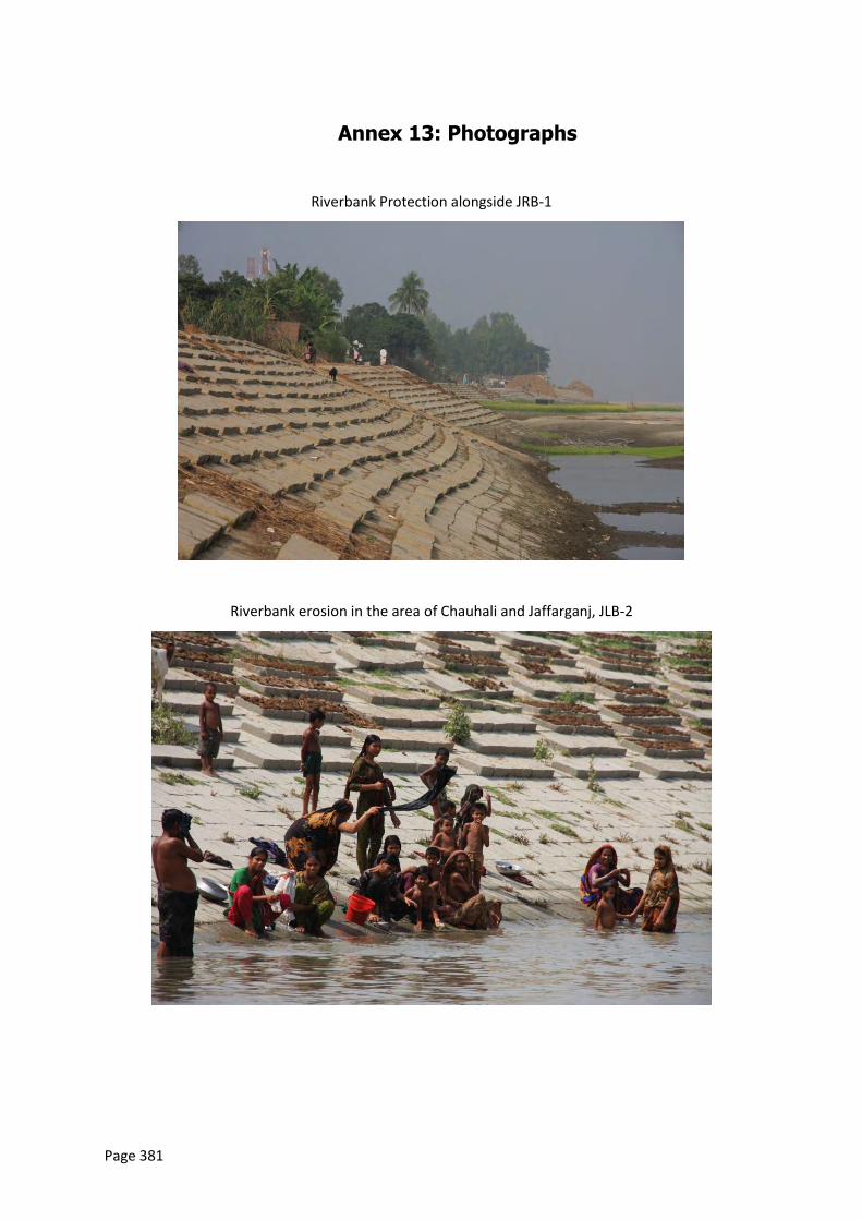
Page 381
Annex 13: Photographs
Riverbank Protection alongside JRB-1
Riverbank erosion in the area of Chauhali and Jaffarganj, JLB-2
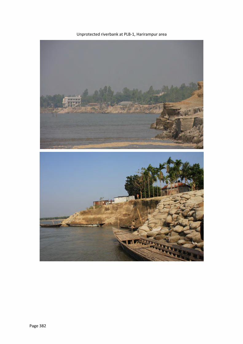
Page 382
Unprotected riverbank at PLB-1, Harirampur area
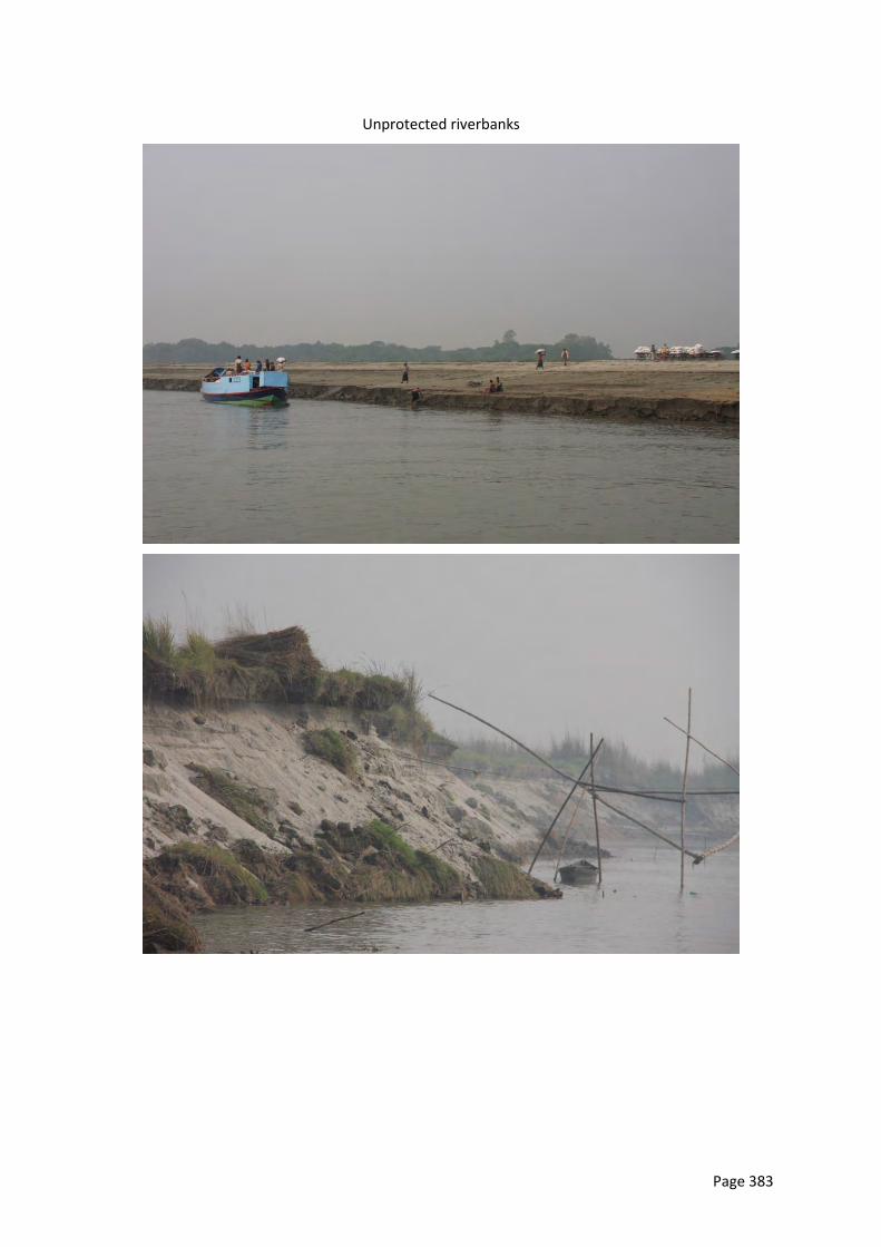
Page 383
Unprotected riverbanks
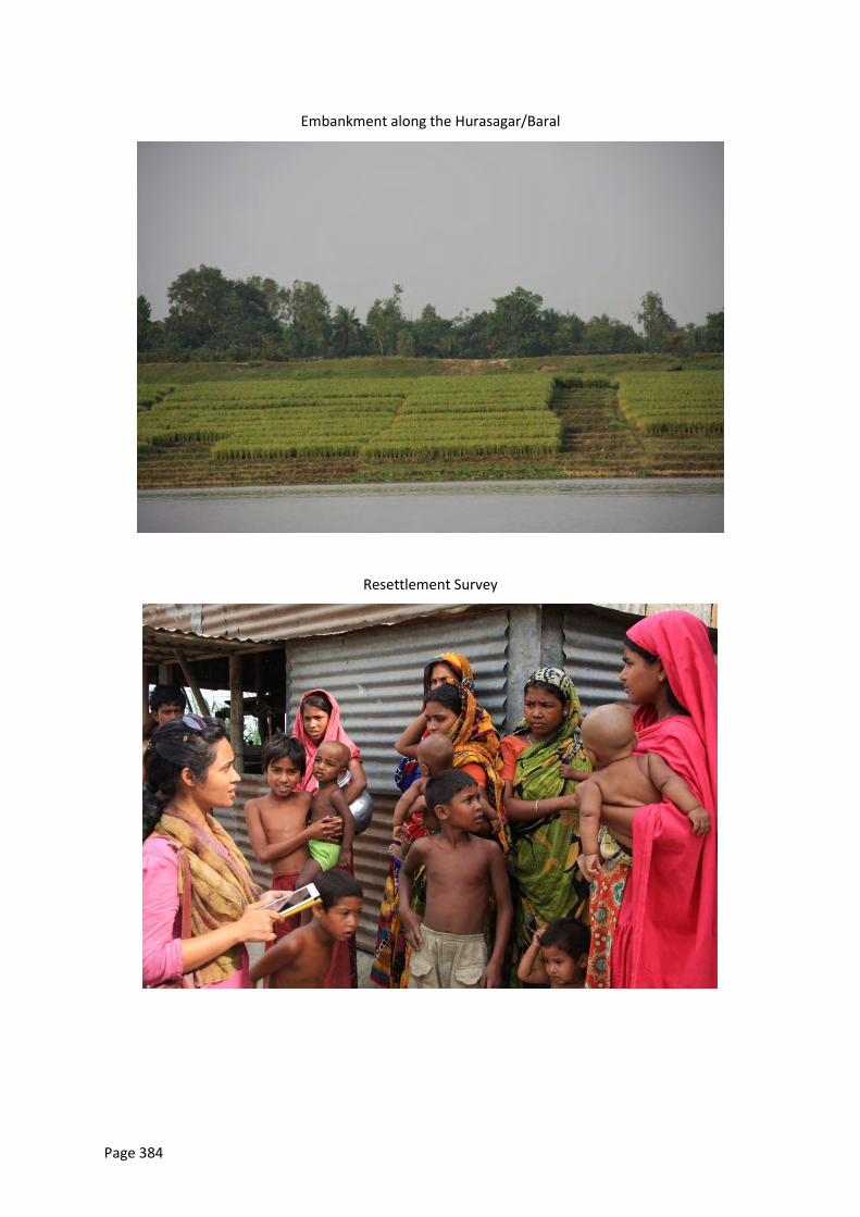
Page 384
Embankment along the Hurasagar/Baral
Resettlement Survey
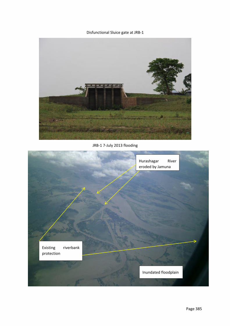
Page 385
Disfunctional Sluice gate at JRB-1
JRB-1 7-July 2013 flooding
Hurashagar River
eroded by Jamuna
Inundated floodplain
Existing riverbank
protection
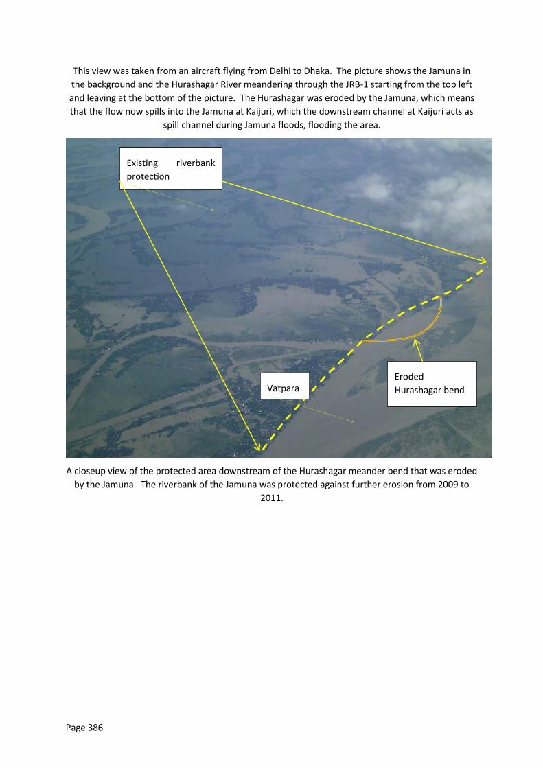
Page 386
This view was taken from an aircraft flying from Delhi to Dhaka. The picture shows the Jamuna in
the background and the Hurashagar River meandering through the JRB-1 starting from the top left
and leaving at the bottom of the picture. The Hurashagar was eroded by the Jamuna, which means
that the flow now spills into the Jamuna at Kaijuri, which the downstream channel at Kaijuri acts as
spill channel during Jamuna floods, flooding the area.
A closeup view of the protected area downstream of the Hurashagar meander bend that was eroded
by the Jamuna. The riverbank of the Jamuna was protected against further erosion from 2009 to
2011.
Existing riverbank
protection
Eroded
Hurashagar bend Vatpara
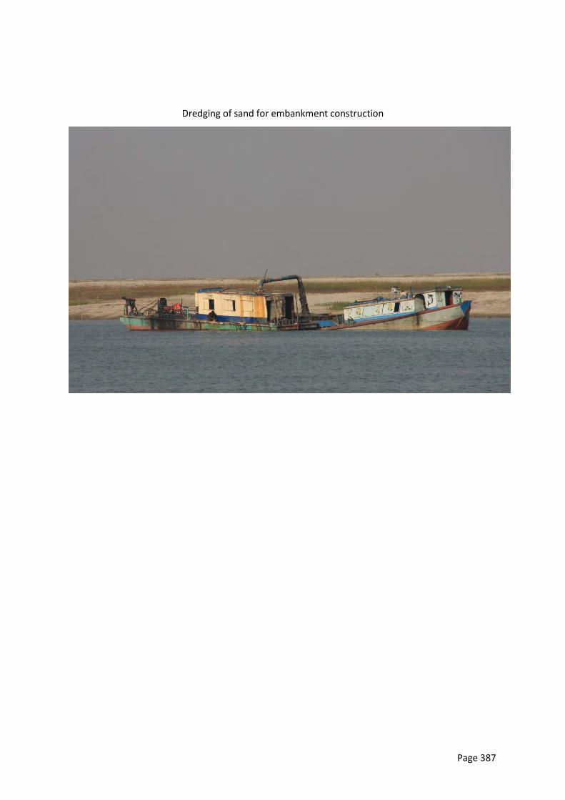
Page 387
Dredging of sand for embankment construction
Page 388
Annex 14: Wetland biodiversity and aquaculture
program
I. Wetland biodiversity and aquaculture program activities
Fish sanctuary can play a vital role to increase the fish diversity and improve the richness of fish species and fish production. Fish sanctuary should be established in coordination with the local DoF (Department of Fisheries) Officials. The criteria for fish sanctuary are given below;
Target of Sanctuary Protection of Riverine fish species to increase the species diversity as well as
incremental production of fishes. Required minimum area for sanctuary About 10% (In dry season water area) of *duar area needs to protected as a fish
sanctuary in river. *(Duar - means the deep area in the river). Buffer zone should be about 10% around the Fish sanctuary.
Sanctuary Materials Sanctuary materials are bamboo, branches of hizol / Shewra trees, rope, water
hyacinth / aquatic vegetation like halencha, flag, Steel or concrete signboard etc. The sanctuary materials should be withdrawn from the river before the monsoon and again set the materials after the monsoon (In the month of September / October).
Sanctuary Establishment period After monsoon (In the month of September / October). Technical support The technical support should be provided by the related Government Officials e.g.
Department of Fisheries especially from the related upazila with consultation with District fisheries Office.
Financial support All financial support should be provided by the related project or by the Government
(establish the sanctuary, protection and maintainace). Management Activities of Fish Sanctuary

Page 389
Management committee should be formed to manage the activities. Committee members (11 to 15 members) should be local fishers, community people
(beneficiaries), students, teacher and local elites, DoF (Department of Fisheries) representatives.
Awareness program should be conducted through local fishers, community, students, teacher and local elites to disseminate of its importance.
Observation of national and international days and discussion, circulation of leaflet, sun cap, Gangy, umbrella, poster, establishment of bill boards in favor of fish sanctuary.
To conduct these activities by the DoF or local or national NGO’s (experienced in fisheries) may be involved to do the activities properly and timely. Also inform the local community/stake holders about wetland resources and its importance in our daily life.
The local beneficiaries’ group should be involved to protect the sanctuary and repair in certain interval.
Monitoring Activities
Monitoring by the DoF Officials or selected NGos with the help of local management committee for protection.
Guarding especially in the night. Conduct the Meeting (Monthly) and reporting to the related authorities (DoF or
NGOs). Monitoring/ observing of fish catch (upstream and downstream within 500 m) by the
fisheries or NGO official in conjunction with the related management committee for observation of fish species and fish production.
Cost of Fish Sanctuary Cost of fish sanctuary means cost of sanctuary materials, repairing, meeting, awareness development, signboard etc. Minimum cost of fish sanctuary for first two years are given below, Area = 50 Decimal Category Sanctuary
materials including labor (Taka)
Flag /steel or CC sign boards etc (taka)
Repairing / maintenance including labor cost for 2nd year (Taka)
Community meeting and awareness (two year ) (Taka)
Total cost ( two year) (Taka)
Sanctuary in the duar area (50 decimal)
Bamboo= 100 nos.X200 tk=20,000/=
Branches of trees =10,000/=
Labor =20 nosX500 tk = 10,000/=
Boat, wire etc =3,000/=
7000/= 10,000/= 5,000/= 65,000/=
Page 390
Taka Sixty Five Thousand only. *(Staff and logistic costs are not included here) II. Terms of References of NGO
Objectives The main objective of the project is increase the fish production and capture habitat through aquaculture extension and management of wetland resources in a sustainable manner.
Scope of Works The program is expected to focus the pond owners as well as fisherman in the project area. . The main program is to: "Capacity development and awareness building for pond owners and resource users, fish farmer and DoF professionals in respect of fish production and resource management ". The program includes: Training for Pond Owner
To develop the capacity of fish culture technique, stocking species. Stocking period, food supply, health monitoring, fishing period, fish marketing, record keeping etc.
Nursery development and management procedure Training for Fisherman To develop the awareness about fish bio-diversity conservation, fish sanctuary, fish
migration process and fish migration obstruction etc. Aware them about negative impacts of over fishing, catch of brood fish and fishing
during breeding season To provide knowledge about the use of fishing gear of Government approved size
and avoid using harmful fishing gears / equipment such as monofilament gill net, low mesh size berjal, mosharijal etc.
Training for Fish Farmer
Training on different culture technique in different water bodies To introduce practical knowledge on adapting natural hazards. Give an outline to understand how their livelihoods might be improve
through fish culture Marketing time and marketing channel Fish transportation procedure to ensure minimum wastage etc
Formation of Community Based Organization (CBOs) or Resource Management Committee (RMC) and trained them
Formation of CBOs or RMC in the project area. Identify and strengthen the activities of CBOs / RMC for sustainable fisheries and
wetland management in the project area.
Page 391
Aware the committee member about fisheries and wetland related rules and regulations.
Importance of habitat conservation and significance of fish diversity. Inform the Importance of natural resources in our daily life.
Skill development for Field level professional (GO, NGO and other concerns)
Develop the skill of wetland and fisheries monitoring techniques /procedures To develop skill on pollution, water quality, contamination and other
environmental and ecological issues, their management and mitigation measures etc.
To introduce fisheries co- management systems. Co-ordination with Government and projects Authorities Prepare a monitoring plan for aquaculture and wetland resources. Prepare annual report.