chapter 18 physical geography of africa: the plateau continent
TRANSCRIPT

CHAPTER 18PHYSICAL
GEOGRAPHY OF AFRICA:
THE PLATEAU CONTINENT

CHAPTER 18 SECTION 1LANDFORMS &
RESOURCES
Vocabulary: Basin, Nile River, Rift Valley, Mount Kilimanjaro, & Escarpment

A VAST PLATEAU•Africa moved very little during continental drift
•Plateaus are Africa’s most prominent physical features
•Several basins lie throughout the plateaus
•The Nile River is the longest river in the world covering more than 4,000 miles (flows north!)
•Source of the Nile River: Lake Victoria, 2nd largest freshwater lake in the world.
•Africa contains waterfalls, rapids, & gorges

DISTINCTIVE AFRICAN LANDFORMS
•As continental plates pulled apart, it formed Rift Valleys in Africa
•Lakes are formed at the bottom of the rift valleys
•Lake Tanganyika is the longest freshwater lake in the world located within the rift valley
•Mount Kilimanjaro is Africa’s highest mountain
•Great Escarpment: marks the edge of the continent’s plateau in Southern Africa•Escarpment: a steep slope with a nearly flat plateau on top
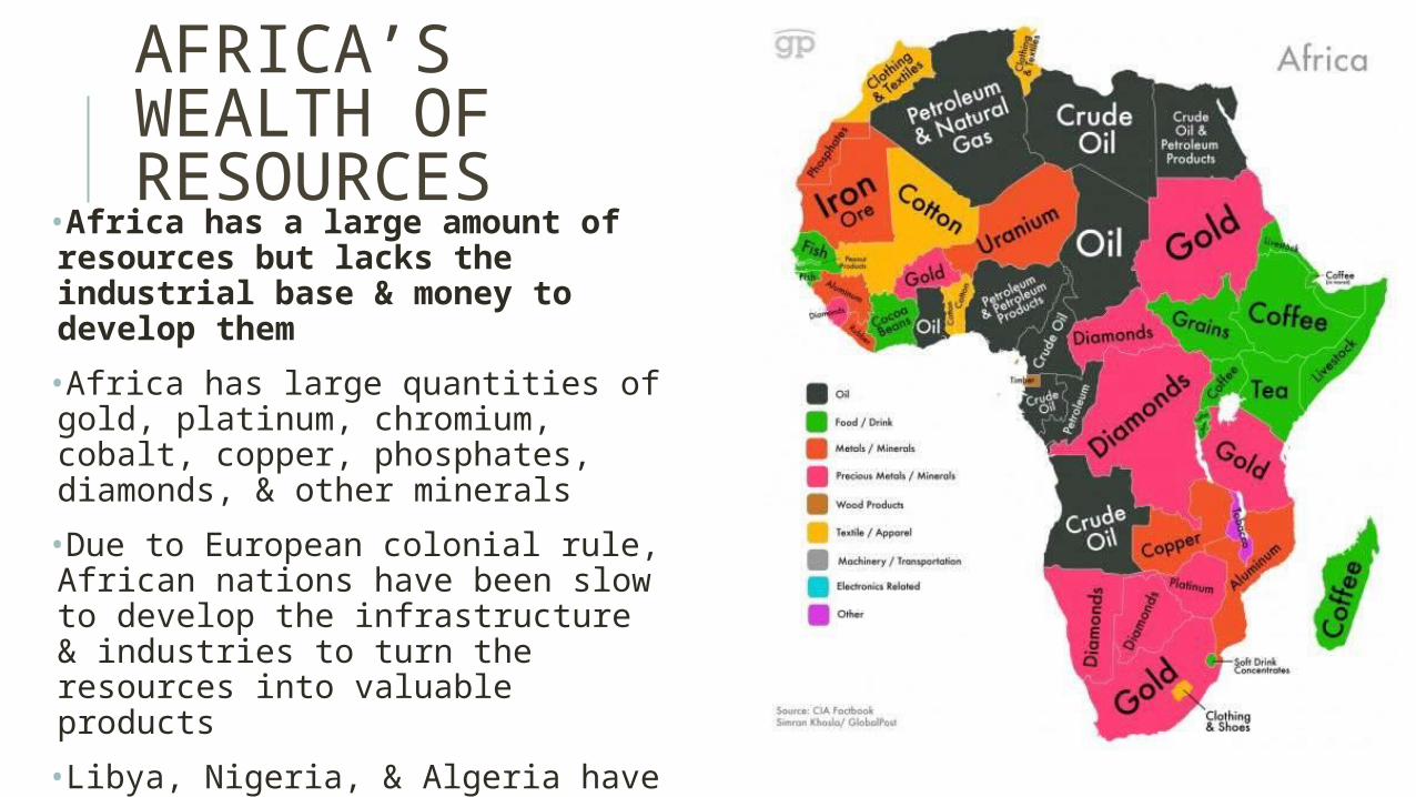
AFRICA’S WEALTH OF RESOURCES
•Africa has a large amount of resources but lacks the industrial base & money to develop them
•Africa has large quantities of gold, platinum, chromium, cobalt, copper, phosphates, diamonds, & other minerals
•Due to European colonial rule, African nations have been slow to develop the infrastructure & industries to turn the resources into valuable products
•Libya, Nigeria, & Algeria have oil reserves
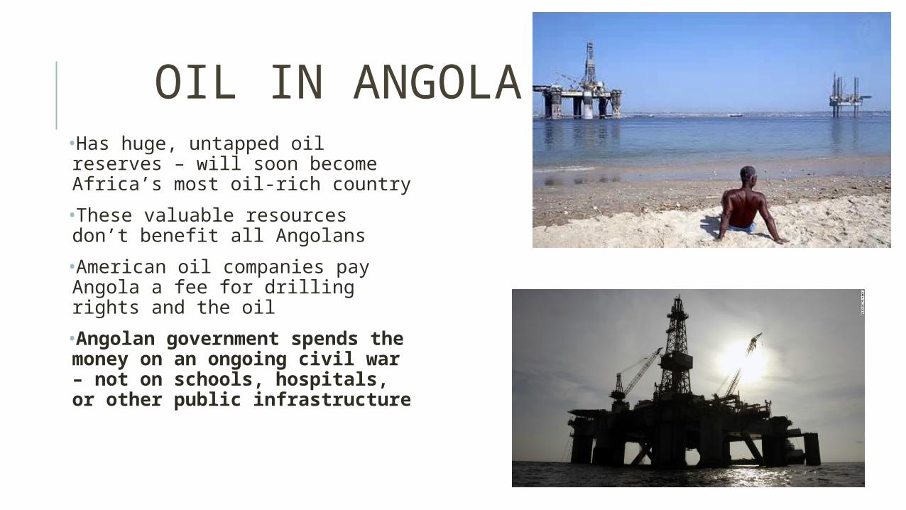
OIL IN ANGOLA•Has huge, untapped oil reserves – will soon become Africa’s most oil-rich country
•These valuable resources don’t benefit all Angolans
•American oil companies pay Angola a fee for drilling rights and the oil
•Angolan government spends the money on an ongoing civil war – not on schools, hospitals, or other public infrastructure

DIVERSITY OF RESOURCES
•Coffee is the most profitable commodity in Africa•They grow 20% of the world’s supply•Lumber is another important commodity in Africa•Other major commodities include sugar, palm oil, & cocoa•66% of Africans earn their living from farming

MAIN IDEAS – SECTION 1
•The Nile River has supported life for thousands of years: irrigates farmlands and provides transportation. •Abundant resources in Africa: gold, platinum, chromium, cobalt, copper, phosphates, diamonds, & other minerals. This great mineral wealth does not equal economic prosperity.•The Angolan government charges a fee for oil drilling rights but uses little of the money for education, public health, etc.
CHAPTER 18 SECTION 2CLIMATE & VEGETATION
Vocabulary: Sahara, Aquifer, Oasis, Serengeti Plain, & Canopy
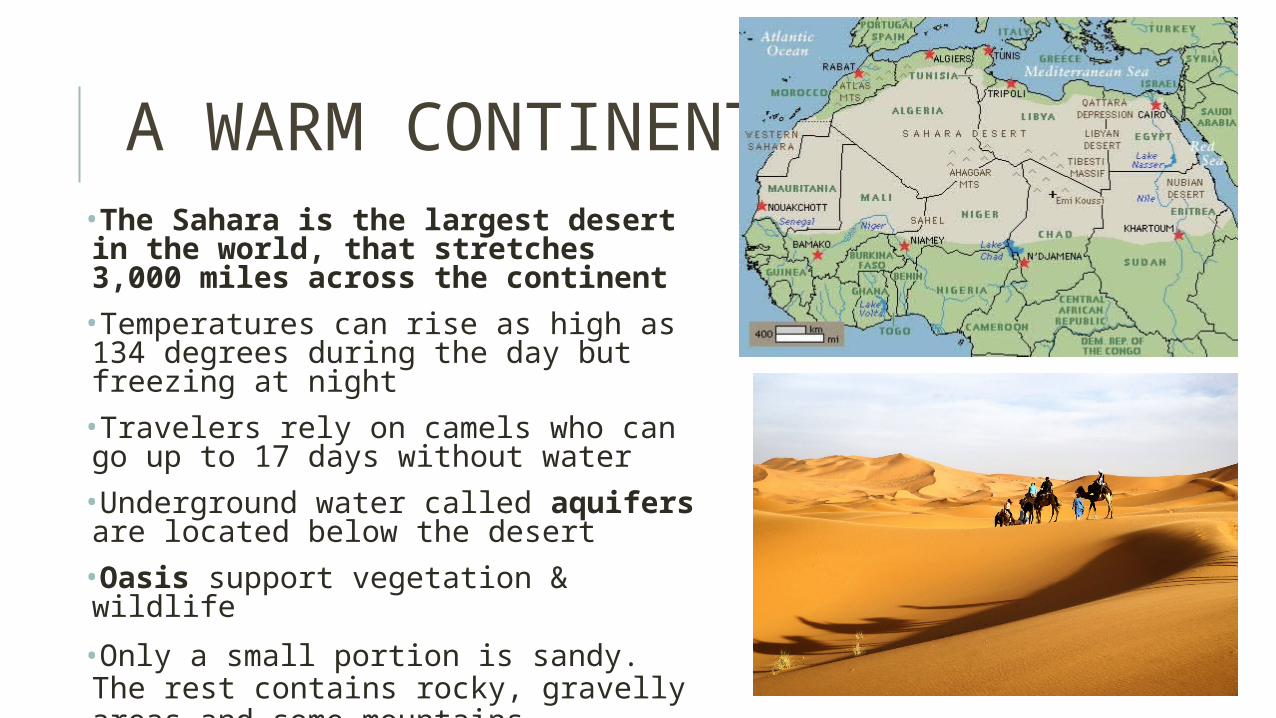
A WARM CONTINENT•The Sahara is the largest desert in the world, that stretches 3,000 miles across the continent
•Temperatures can rise as high as 134 degrees during the day but freezing at night
•Travelers rely on camels who can go up to 17 days without water
•Underground water called aquifers are located below the desert
•Oasis support vegetation & wildlife
•Only a small portion is sandy. The rest contains rocky, gravelly areas and some mountains
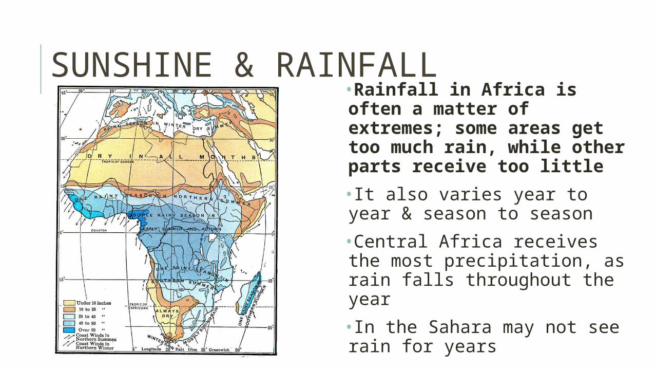
SUNSHINE & RAINFALL•Rainfall in Africa is often a matter of extremes; some areas get too much rain, while other parts receive too little
•It also varies year to year & season to season
•Central Africa receives the most precipitation, as rain falls throughout the year
•In the Sahara may not see rain for years
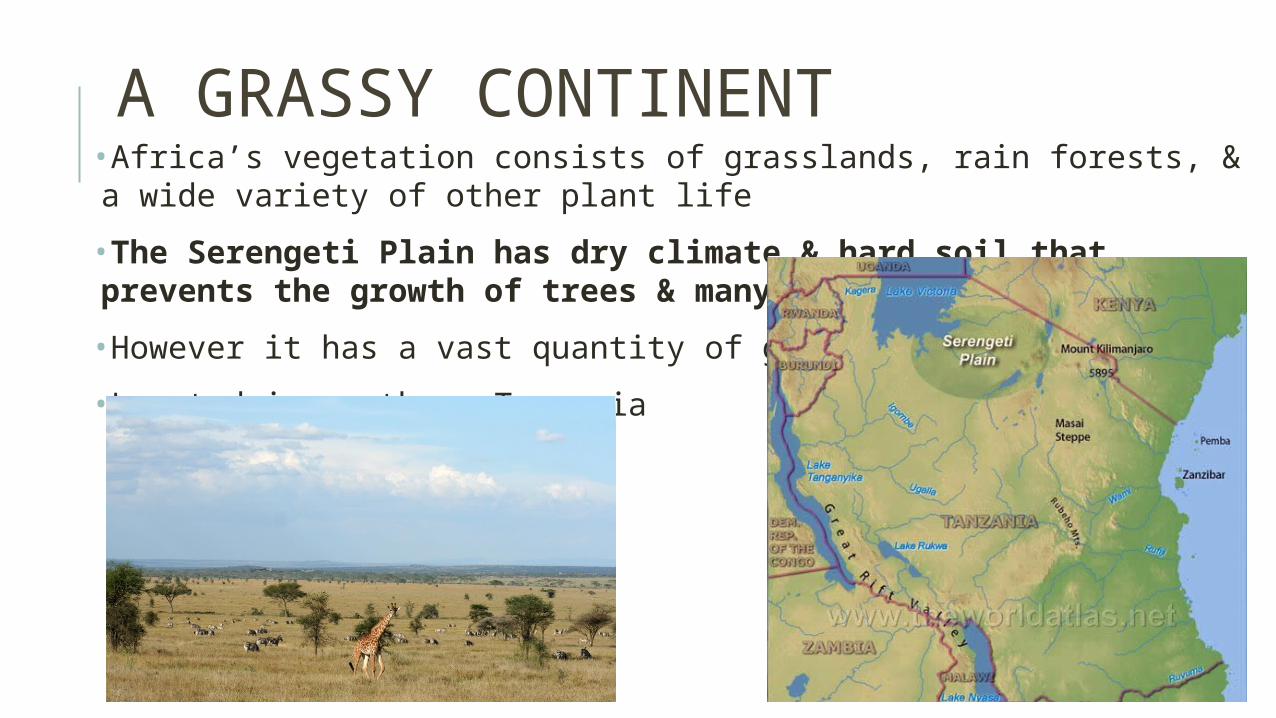
A GRASSY CONTINENT•Africa’s vegetation consists of grasslands, rain forests, & a wide variety of other plant life
•The Serengeti Plain has dry climate & hard soil that prevents the growth of trees & many crops
•However it has a vast quantity of grass
•Located in northern Tanzania

AFRICA’S EXTREMES•The major rain forest of Africa is on the Congo Basin
•The massive number of plants, leaves, & trees block out much of the sunlight
•Most animals in the rain forest live in the canopy (uppermost layer of branches)
•Farmers use slash & burn to clear the land

MAIN IDEAS – SECTION 2
• Physical Geography of the Sahara: only a small portion is sandy. The rest contains rocky, gravelly areas and some mountains
• General Pattern of Rainfall: the closer to the equator, the more rainfall an area receives
• The grasslands of the Serengeti provide wildlife with an abundant food supply

Unit Atlas: begins on page 402
Create a map key!
Map directions:•NEATLY label the bodies of water, countries, and cities. •You DO NOT have to answer the questions!•Add:
→Nile River→Lake Victoria→Mount Kilimanjaro→Serengeti Plain (look at a map online)→Shade the Sahara Desert in one color→Shade the Sahel in another color

CHAPTER 18 SECTION 3HUMAN-ENVIRONMENT
INTERACTION
Vocab: Niger Delta, Sahel, Desertification, Aswan High Dam, & Silt

DESERTIFICATION OF THE SAHEL
Sahel: narrow band of dry grassland that runs along the Sahara
Desertification is an expansion of dry conditions into moist areas that are next to deserts
Human causes of desertification include overgrazing, farming, irrigation, & overpopulations
Desertification is destroying land & is difficult to slow down
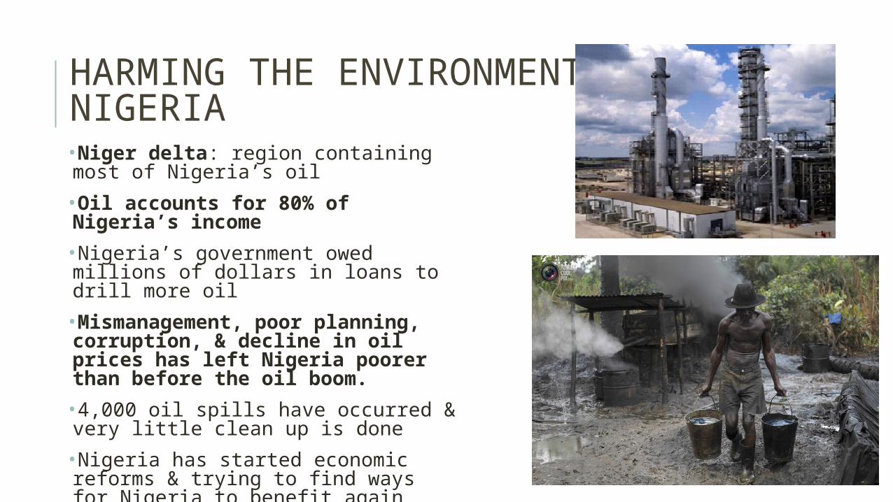
HARMING THE ENVIRONMENT IN NIGERIA•Niger delta: region containing most of Nigeria’s oil
•Oil accounts for 80% of Nigeria’s income
•Nigeria’s government owed millions of dollars in loans to drill more oil
•Mismanagement, poor planning, corruption, & decline in oil prices has left Nigeria poorer than before the oil boom.
•4,000 oil spills have occurred & very little clean up is done
•Nigeria has started economic reforms & trying to find ways for Nigeria to benefit again
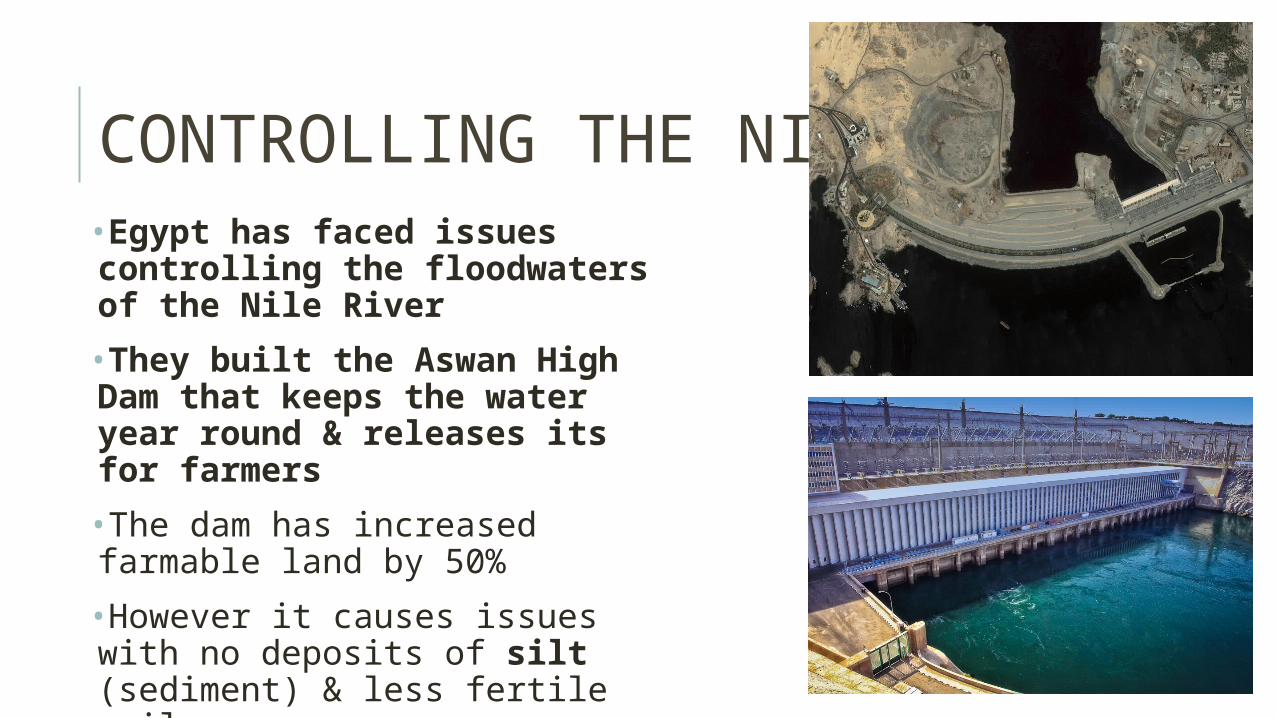
CONTROLLING THE NILE•Egypt has faced issues controlling the floodwaters of the Nile River
•They built the Aswan High Dam that keeps the water year round & releases its for farmers
•The dam has increased farmable land by 50%
•However it causes issues with no deposits of silt (sediment) & less fertile soil

MAIN IDEAS – SECTION 3
• Desertification is affecting people’s lives in the Sahel: they are losing farmland for crops and grasslands for their animals
• Nigerian oil industry: careless extraction of oil has led to massive fires, acid rain, oil spills, soot deposits, and health issues
• Aswan High Dam problems: farmers now have to use artificial fertilizers and field drains, people have to be relocated, and the still waters behind the dam have increased rates of mosquito-born diseases