transboundary flow modeling: the zohor depression of austria and the slovak republic
TRANSCRIPT
Transboundary Flow Modeling: The Zohor Depressionof Austria and the Slovak Republicby Marian Fendek1 and Miriam Fendekova2
AbstractEstimation of available ground water is a basic aspect of ground water management. Mathematical modeling is
one of the methods that can be effectively used to obtain such estimates. A numerical model was used to calculateavailable ground water in the Zohor depression—an aquifer transcending national boundaries between the SlovakRepublic and Austria. The aquifer, formed by Quaternary sediments overlying Neogene sequences, is composed ofvarious clays interbedded with layers of sand, gravel, sandstones, and conglomerates. The AQUA computer modelpackage was used to simulate flow in the aquifer. For model compilation, the following data were used: (1) effectiveprecipitation; (2) surface water levels in surface water gauging profiles; and (3) withdrawal amounts. Hydraulicparameters of the aquifer were estimated based on information from 86 wells located in the area. The model wasverified using data on ground water levels from a monitoring network. The simulation of the aquifer system permittedthe estimation of the available ground water in the study area, showing that an additional 587 L/s can be abstracted.Ground water inflows to the Morava River, which flows through the region, range from 745 to 3100 L/s.
IntroductionThe need for potable water continues to grow because
of the continuously growing demand for water. Aquifersoften do not follow national boundaries but underlie the ter-ritory of two or more countries. Therefore, transboundaryaquifers are of interest not only to scientists and water man-agers but also to politicians, diplomats, and others dealingwith legislation at the international level. Common princi-ples are needed to protect and allocate the water of trans-boundary aquifers. One of the most important legislativemeasures of the European Union, adopted on October 23,2000, is the Water Framework Directive No. 2000/60/EC.This document will play a crucial role in the water manage-ment of the Slovak Republic, mainly in its border regions.
The directive establishes a framework for decisions,which guarantee the protection of water bodies, amongthem ground water, by (1) preventing the deterioration of
ground water quality and quantity and fully protectingaquatic and terrestrial ecosystems by recognizing theirwater needs and (2) helping to sustain development ofground water based on the protection of ground watersource areas and quality.
The directive requires the delineation of watersheddistricts covering the entire Slovak Republic and the anal-ysis of each by (1) describing its basic hydrologic char-acteristics; (2) providing an overview of human impactson surface and ground water; and (3) providing an eco-nomic analysis of water use. In such places, where thewater resource (river basin or aquifer) encompasses morethan one member state, the states sharing the resourcejointly establish an ‘‘international district’’ for the appro-priate watershed or aquifer. On demand, one or more ofthe affected state’s commission will act as an independentconciliator to safeguard the establishment of the inter-national district of appropriate watershed or aquifer.Member states will jointly guarantee that appropriateadministrative actions occur, including the establishmentof appropriate bodies to ensure application of the direc-tive’s rules and regulations in the international district.To handle such a process, existing valid internationalagreements can be used for common administration ofwater resources.
Data on available ground water are included amongthe basic characteristics of a watershed district. One of
1Geological Survey of Slovak Republic, Mlynska dolina1, 817 04 Bratislava, Slovak Republic; (421) 2 59375355; fax (421)2 54771940; [email protected]
2Corresponding author: Department of Hydrogeology, PRIFUK, Pavilon G, Mlynska dolina, 842 15 Bratislava, Slovak Re-public; (421) 2 60296593; fax (421) 2 60296701; [email protected]
Received November 2004, accepted February 2005.Copyright ª 2005 National Ground Water Association.doi: 10.1111/j.1745-6584.2005.00102.x
Vol. 43, No. 5—GROUND WATER—September–October 2005 (pages 717–721) 717
the methods that could be used for estimation of basiccharacteristics is mathematical modeling. Model outputscreate a database for resolving problems concerning trans-boundary aquifers and the availability of ground water.
A mathematical approach was successfully usedby the authors in the framework of the PHARE cross-boundary cooperation program, by working on surface andground water management in the border region betweenAustria and the Slovak Republic (Office for Governmentof the Slovak Republic, European Cases Section, PMUPHARE CBC 2000). This approach was proposed tobecome part of the new methods package used to charac-terize watershed districts. The PHARE program is oneof the three preaccession instruments financed by theEuropean Union to assist the applicant countries of centraland eastern Europe in their preparations for joining theEuropean Union. The abbreviation stands for Poland andHungary Aid Regulation as it was set up in 1989 by theEuropean Council Regulation (European Economic Com-munity) No. 3906/89 and extended in 1990 to someother central and eastern European countries, includingSlovakia (part of the former Czechoslovakia).
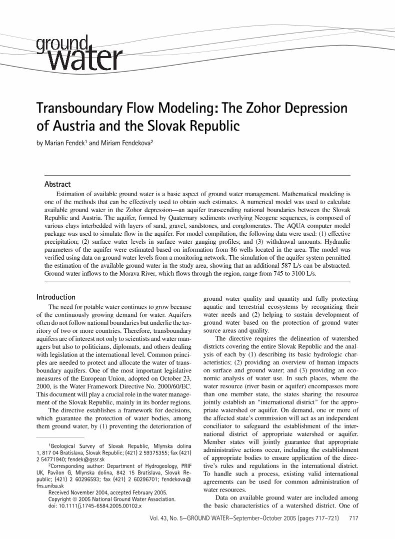
Study Area CharacterizationThe study area—the Zohor-Marchegg depression—is
a part of the Borska lowland stretching from PezinskeKarpaty Mountains and Morava and Myjava rivers in thesouthwestern Slovak Republic and continuing up to theWiener Neustadt in Austria (Figure 1).
Geomorphologic and Climatic ConditionsAccording to the regional geomorphologic division
of Mazur and Luknis (1980), the study area belongs to the
subsystems of the Carpathian Mountains and the Pano-nian depression. In the framework of these subsystems,the area belongs to the subprovinces of the Inner WesternCarpathians, Outer Western Carpathians, and ViennaBasin.
Climatic conditions in the area are influenced by thelocation of the area on the windward side of the MaleKarpaty Mountains; these conditions also depend uponaltitude. Lowlands can be characterized using the datafrom the Malacky climate station, at an altitude of 165 mabove mean sea level (amsl), whereas lower parts of thehillsides are represented by data from the Kuchyna moni-toring station (206 m amsl). Mean annual air temperaturesreach values of 9.3�C at Malacky and 9.1�C at Kuchyna;mean annual precipitation ranges from 583 mm atMalacky to 694 mm at Kuchyna. Mean annual potentialevapotranspiration is 692 mm at Malacky and 668 mm atKuchyna. From the point of view of the water balanceequation, the lowland part is a deficit area where potentialevapotranspiration is higher than precipitation. Valuesaforementioned represent the period 1951 to 1980.
Hydrological ConditionsThe entire watershed covers an area of 26,580 km2;
only 8.6% of its area is situated in the Slovak Republic.The Slovak part of the Morava River watershed is boun-ded by the Biele Karpaty Mountains in the north andby the Male Karpaty Mountains in the east. The water-shed is open to the west and is bounded by the Moravatributaries: the Chvojnica, Myjava, Rudava, and Malinarivers. The riparian part of the Morava River is created bysystem of artificial channels, which influence the surfacewater hydrological regime.
The main stream of the territory is Morava River,which heads in the Czech Republic. It creates the fluvialboundary between the Czech Republic and the SlovakRepublic and in its lowest part, up to its mouth atthe Danube River; it is the boundary between Austria andthe Slovak Republic.
The Slovak part of the watershed has a typical low-land character, with 77% of the watershed situated belowan altitude of 300 m amsl. The watershed’s highest pointis Mt. Cupec (819 m amsl) in the Biele Karpaty Moun-tains and the lowest point is the Morava River mouth atthe Danube River (136 m amsl). The forest cover of theSlovak part of the watershed is ~40%.
Hydrological conditions were recently studied byHlavcova et al. (2000). Integrated observation and dis-charge evaluation began in the Morava River watershedin the 1960s. From data at the Moravsky Jan site, thedriest year was 1933 with the mean annual discharge ofonly 45 m3/s, and the wettest year was 1971 with a meanannual discharge of 259 m3/s. This value was not even ex-ceeded in 1997 when the entire Morava watershed wasstricken with historical floods.
Stream runoff in the Morava watershed is typified byits seasonal character—discharge starts to increase inFebruary and a high-discharge period continues untilMay, reaching its maximum in March. The low-flowperiod is typical for summer to autumn months, witha minimum discharge in October.
Figure 1. Study area location.
718 M. Fendek, M. Fendekova GROUND WATER 43, no. 5: 717–721
Geological and Hydrogeological ConditionsFrom the geological and hydrogeological point of
view, the study area—Zohor-Marchegg depression—is afoothill depression of the Pezinske Karpaty Mountains(southern part of the Male Karpaty Mountains) and formsthe northern part of a large graben with a length of106 km and variable width, from 2 to 12 km, stretchingfrom Wiener Neustadt through Marchfeld in Austria tothe Borska lowland in the Slovak Republic. This exten-sive graben occupies parts of Austria and the SlovakRepublic and internally is divided into three independentdepression units—the Zohor-Marchegg, Pernek, andSolosnica depressions.
The northern Slovakian part of the graben—theZohor-Marchegg depression—stretches southwest-north-east in the foothills of the Pezinske Karpaty Mountainsfrom the Borska lowland up to the villages of PlaveckyMikulas and Laksarska Nova Ves, where it is terminatedby the transverse Laksare fault. In the longitudinal direc-tion in the Pezinske Karpaty Mountains foothills, it isbordered by the Litava fault and from the northwest partof the Borska lowland by the system of Lab-Plavec faults.
Dipping tectonics influenced the development andthickness of the Quaternary sediments of the Zohor-Marchegg depression. According to the results of drilling,the Zohor-Marchegg depression sank ~90 m, the Pernekdepression ~120 m, and the Solosnica depression ~80 m,as far as Quaternary dip-slip faulting is concerned.
Quaternary and Neogene sediments fill the depres-sion. Its characteristic elements are blocks delineated byfaults. Tectonically, it is divided into high and low zonesaccording to the orientation of the main longitudinaltectonic lines. Hydrogeologically important, but lessexpressive, are the transverse tectonic lines. Quaternarydeposits in depressions are locally interconnected withunderlying sandy and gravelly sediments of Neogene ageand are of substantial importance as water-bearing sedi-ments suitable for water supply purposes.
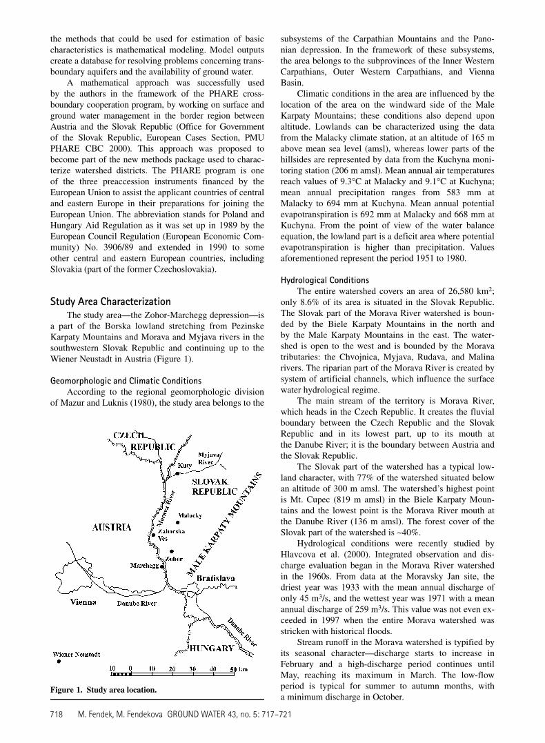
Neogene sediments are represented by various claysinterbedded with layers of sands, gravels, sandstones, andconglomerates. Quaternary sediments are represented bysediments of alluvial fans, by proluvial sediments in thesoutheast, by eolian sands in the west and northwest, andby alternating eolian and proluvial sediments in the cen-tral part of the depression. Quaternary sediments in thesouthernmost part of the Zohor-Marchegg depression par-tially consist of alluvial sediments of the Morava Riverand partially of eolian sands. Faults and the thicknessesof the Quaternary aquifers are shown in Figure 2.
Satisfactory amounts of information on aquifer hy-draulic characteristics (hydraulic conductivity, transmis-sivity, and storativity) are available for the Quaternarysediments. Comprehensive knowledge of the ground waterrecharge and flow direction is available as well.
The total area of the central dipped parts of the threeaforementioned partial depressions (ground water basins)is 172 km2; jointly with the adjacent areas draining intothe partial depressions, the area totals 224 km2. The totalground water resources in the three evaluated basins canproduce 1116 to 1472 L/s. The ground water storage in
the Quaternary sediments is estimated to total 1,461,000 m3
(E.S. Kullman, personal communication, 2000).Ground water quality in the area (as for karst springs)
was recently studied by Flakova et al. (2001) and Flakovaand Zenisova (2001). Ground water in Quaternary andNeogene sediments in the area is of Ca-HCO3 type, slightlymodified in the region surrounding Pernek, Plavecke Podh-radie, and Zahorska Ves villages to Ca-SO4 type as a resultof agricultural and mining activities. Ground water fromMesozoic sediments is of Ca-Mg-HCO3 type with very lowcontents of chloride, sulfate, and nitrate, and no organicmatter. No pollution was identified in ground water sourcesused for water supply in the area in 2002. The amountof total dissolved solids can range from 200 to 600 mg/L,depending on ground water origin and circulation depth.
Methods and Data UsedTo assess the hydrogeology of the Zohor-Marchegg
depression, a two-dimensional mathematical model usingthe AQUA computer program package developed byVatnaskil Consulting Engineers (1994) was implemented.
The computer program uses the Galerkin finite-element method. The basis for the mathematical model isthe solution of the partial differential equation:
a@u
@tþ @
@xi
�eij
@u
@xj
�þ g ¼ 0
where: a = storage coefficient; u = hydraulic head (m); t =time (s); eij = transmissivity (m2/s); and g = Q 1 R, whereQ = pumping or injection rate per unit area (m/s) and R =infiltration per unit area (m/s).
The spatial borders of the modeled territory areshown in Figure 2. The greatest thickness of the aquiferwas found in the axial part of the depression close to theMorava River, where it reaches up to 100 m.
The following data were used for model compilation:
d Effective precipitation for the time period 1989 to 1995 as
calculated by Kullman (E.S. Kullman, personal communi-
cation, 2000). Potential evapotranspiration data were con-
verted into actual evapotranspiration by correlating to
precipitation and change in soil moisture.
d Surface water levels at surface water gauging profiles
No. 5087 Vysoka pri Morave, No. 5125 Devinska Nova
Ves, No. 5110 Zohor-Ondriasov potok, and No. 5100 Lab-
Mociarka. Some missing data were estimated using reg-
ression analysis.
d In selected places, the ground water withdrawals were
defined from the data of the Slovak Hydrometeorological
Institute. The data in m3 per month of the hydrological
year had to be converted to m3/s. The time series of the
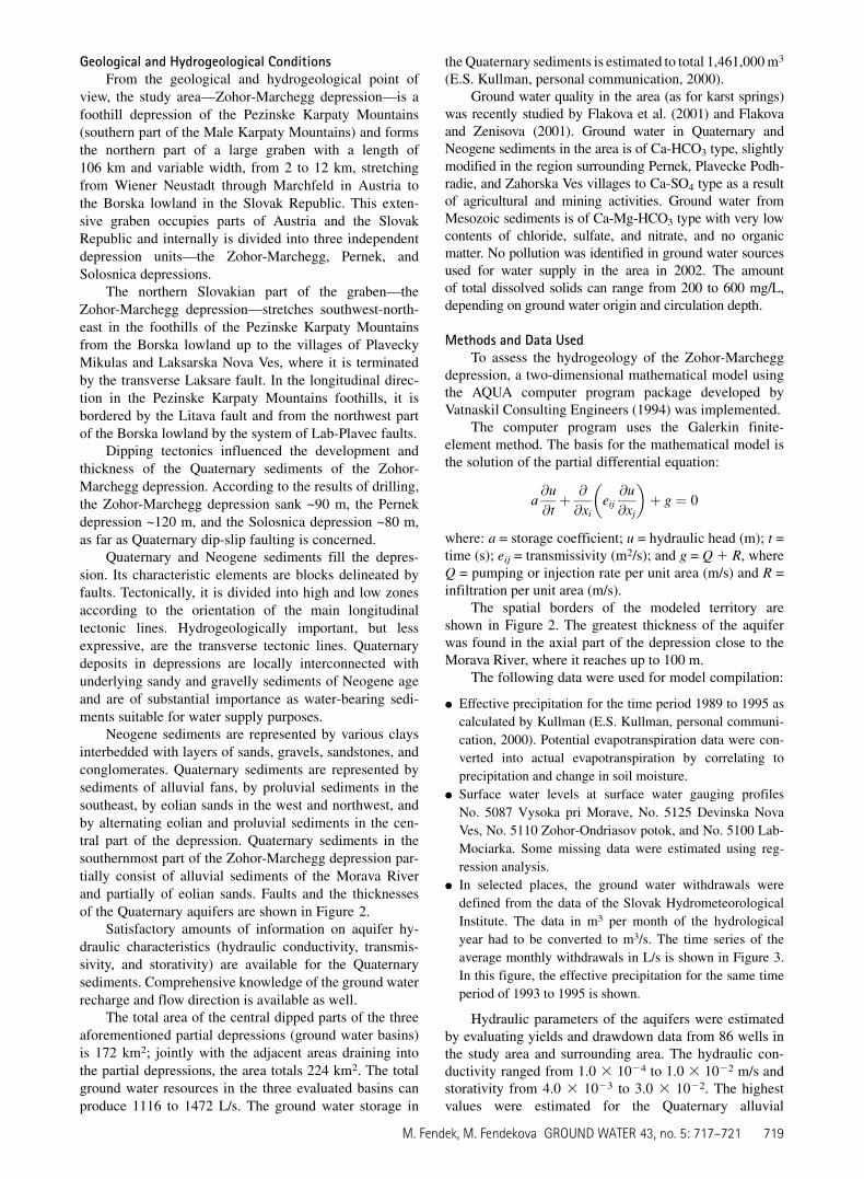
average monthly withdrawals in L/s is shown in Figure 3.
In this figure, the effective precipitation for the same time
period of 1993 to 1995 is shown.
Hydraulic parameters of the aquifers were estimatedby evaluating yields and drawdown data from 86 wells inthe study area and surrounding area. The hydraulic con-ductivity ranged from 1.0 3 1024 to 1.0 3 1022 m/s andstorativity from 4.0 3 1023 to 3.0 3 1022. The highestvalues were estimated for the Quaternary alluvial
M. Fendek, M. Fendekova GROUND WATER 43, no. 5: 717–721 719

sediments of the Morava River and the lowest for sedi-ments in the northern part of the modeled territory—thearea between Lozorno and Plavecky Stvrtok villages.
The boundary condition used was of third order(Cauchy’s boundary condition), and it was defined in pla-ces where monitoring wells of the basic monitoring net-work of the Slovak Hydrometeorological Institute exist.For the model calibration, data of average monthlyground water levels in existing monitoring wells of thebasic monitoring network of the Slovak Hydrometeoro-logical Institute No. 30 Zohor, No. 92 Lab-Juh, No. 93Lab-Juh, and No. 94 Vysoka pri Morave were used.
ResultsThe Morava River is the most important stream of
the area, being the boundary stream of the territory.
Figure 2. Three-dimensional geological map of Quaternary sediments in the Slovak part of Zohor-Marchegg depression(E.S. Kullman, personal communication, 2000).
1440 1620 1800 1980 2160 2340 2520
Time [days]
595
600
605
610
615
620
625
To
tal w
ith
draw
al [L
/s]
0
40
80
120
Effective p
recip
itatio
n [m
m]
Figure 3. Total withdrawals and effective precipitation in1993 to 1995.
720 M. Fendek, M. Fendekova GROUND WATER 43, no. 5: 717–721
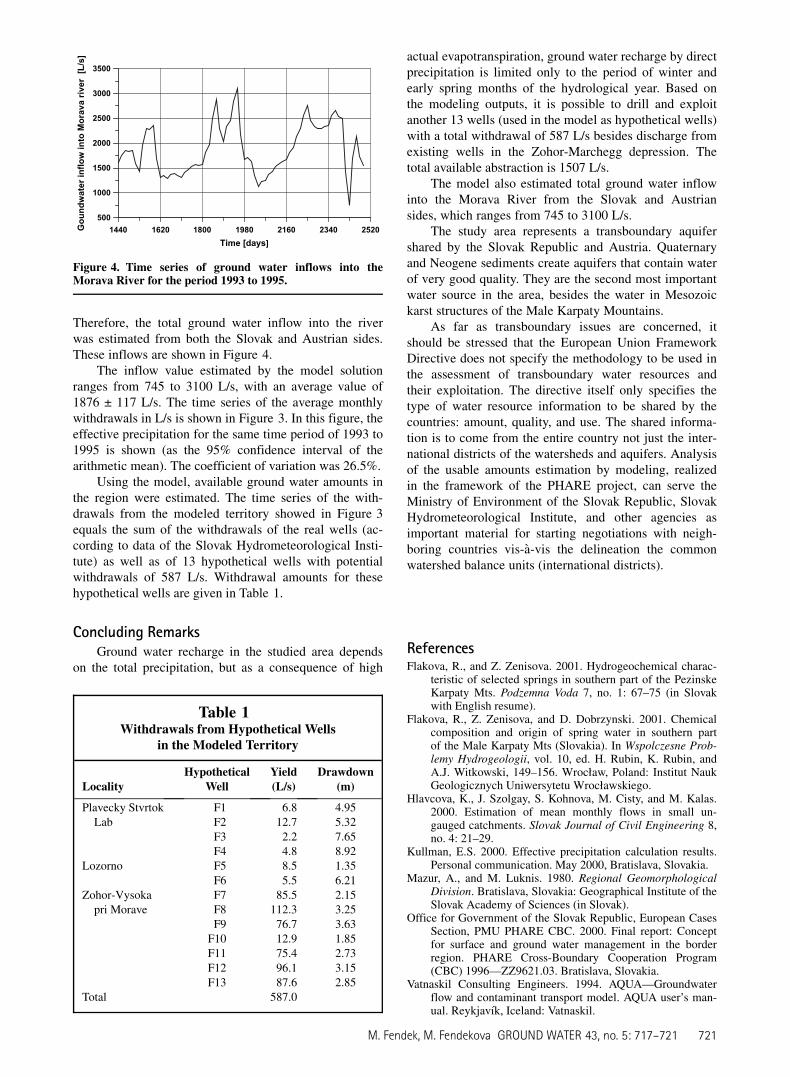
Therefore, the total ground water inflow into the riverwas estimated from both the Slovak and Austrian sides.These inflows are shown in Figure 4.
The inflow value estimated by the model solutionranges from 745 to 3100 L/s, with an average value of1876 ± 117 L/s. The time series of the average monthlywithdrawals in L/s is shown in Figure 3. In this figure, theeffective precipitation for the same time period of 1993 to1995 is shown (as the 95% confidence interval of thearithmetic mean). The coefficient of variation was 26.5%.
Using the model, available ground water amounts inthe region were estimated. The time series of the with-drawals from the modeled territory showed in Figure 3equals the sum of the withdrawals of the real wells (ac-cording to data of the Slovak Hydrometeorological Insti-tute) as well as of 13 hypothetical wells with potentialwithdrawals of 587 L/s. Withdrawal amounts for thesehypothetical wells are given in Table 1.
Concluding RemarksGround water recharge in the studied area depends
on the total precipitation, but as a consequence of high
actual evapotranspiration, ground water recharge by directprecipitation is limited only to the period of winter andearly spring months of the hydrological year. Based onthe modeling outputs, it is possible to drill and exploitanother 13 wells (used in the model as hypothetical wells)with a total withdrawal of 587 L/s besides discharge fromexisting wells in the Zohor-Marchegg depression. Thetotal available abstraction is 1507 L/s.
The model also estimated total ground water inflowinto the Morava River from the Slovak and Austriansides, which ranges from 745 to 3100 L/s.
The study area represents a transboundary aquifershared by the Slovak Republic and Austria. Quaternaryand Neogene sediments create aquifers that contain waterof very good quality. They are the second most importantwater source in the area, besides the water in Mesozoickarst structures of the Male Karpaty Mountains.
As far as transboundary issues are concerned, itshould be stressed that the European Union FrameworkDirective does not specify the methodology to be used inthe assessment of transboundary water resources andtheir exploitation. The directive itself only specifies thetype of water resource information to be shared by thecountries: amount, quality, and use. The shared informa-tion is to come from the entire country not just the inter-national districts of the watersheds and aquifers. Analysisof the usable amounts estimation by modeling, realizedin the framework of the PHARE project, can serve theMinistry of Environment of the Slovak Republic, SlovakHydrometeorological Institute, and other agencies asimportant material for starting negotiations with neigh-boring countries vis-a-vis the delineation the commonwatershed balance units (international districts).
ReferencesFlakova, R., and Z. Zenisova. 2001. Hydrogeochemical charac-
teristic of selected springs in southern part of the PezinskeKarpaty Mts. Podzemna Voda 7, no. 1: 67–75 (in Slovakwith English resume).
Flakova, R., Z. Zenisova, and D. Dobrzynski. 2001. Chemicalcomposition and origin of spring water in southern partof the Male Karpaty Mts (Slovakia). In Wspolczesne Prob-lemy Hydrogeologii, vol. 10, ed. H. Rubin, K. Rubin, andA.J. Witkowski, 149–156. Wroc1aw, Poland: Institut NaukGeologicznych Uniwersytetu Wroc1awskiego.
Hlavcova, K., J. Szolgay, S. Kohnova, M. Cisty, and M. Kalas.2000. Estimation of mean monthly flows in small un-gauged catchments. Slovak Journal of Civil Engineering 8,no. 4: 21–29.
Kullman, E.S. 2000. Effective precipitation calculation results.Personal communication. May 2000, Bratislava, Slovakia.
Mazur, A., and M. Luknis. 1980. Regional GeomorphologicalDivision. Bratislava, Slovakia: Geographical Institute of theSlovak Academy of Sciences (in Slovak).
Office for Government of the Slovak Republic, European CasesSection, PMU PHARE CBC. 2000. Final report: Conceptfor surface and ground water management in the borderregion. PHARE Cross-Boundary Cooperation Program(CBC) 1996—ZZ9621.03. Bratislava, Slovakia.
Vatnaskil Consulting Engineers. 1994. AQUA—Groundwaterflow and contaminant transport model. AQUA user’s man-ual. Reykjavık, Iceland: Vatnaskil.
1440 1620 1800 1980 2160 2340 2520
Time [days]
500
1000
1500
2000
2500
3000
3500
Go
un
dw
ater in
flo
w in
to
M
orava river [L
/s]
Figure 4. Time series of ground water inflows into theMorava River for the period 1993 to 1995.
Table 1Withdrawals from Hypothetical Wells
in the Modeled Territory
LocalityHypothetical
WellYield(L/s)
Drawdown(m)
Plavecky StvrtokLab
F1 6.8 4.95F2 12.7 5.32F3 2.2 7.65F4 4.8 8.92
Lozorno F5 8.5 1.35F6 5.5 6.21
Zohor-Vysokapri Morave
F7 85.5 2.15F8 112.3 3.25F9 76.7 3.63
F10 12.9 1.85F11 75.4 2.73F12 96.1 3.15F13 87.6 2.85
Total 587.0
M. Fendek, M. Fendekova GROUND WATER 43, no. 5: 717–721 721