pinecrest reservoir lake level study … reservoir lake level study report final spring...
TRANSCRIPT

PINECREST RESERVOIR LAKE
LEVEL STUDY REPORT
FINAL
Spring Gap-Stanislaus Hydroelectric Project
(FERC Project No. 2130)
Prepared By:
April 2011
Draft Pinecrest Reservoir Lake Level Study Report i February 2011
Spring Gap-Stanislaus Hydroelectric Project, FERC Project No. 2130 © 2011, Pacific Gas and Electric Company
TABLE OF CONTENTS
Page
EXECUTIVE SUMMARY ...................................................................................................... XII
1.0 INTRODUCTION............................................................................................................. 1
STUDY PURPOSE .......................................................................................................................... 1
CONSULTATION............................................................................................................................ 2
STUDY OBJECTIVES ..................................................................................................................... 2
STUDY AREA ............................................................................................................................... 2
1.1 Recreation Facility #1 – Gas Dock and Slips ............................................................. 5
1.2 Recreation Facility #2 – Boat Ramp and Courtesy Dock ........................................... 5
1.3 Recreation Facility #3 – Designated Buoyed Swim Area ........................................... 7
1.4 Recreation Facility #4 – Mixed Day-Use Area........................................................... 7
1.5 Recreation Facility #5 – ADA-Accessible Fishing Platform ...................................... 7
1.6 Recreation Facility #6 – Overflow Area, South Shore ............................................. 10
1.7 Recreation Facility #7 – Overflow Area, North of Marina ...................................... 10
DESCRIPTION OF EXISTING WATER ELEVATION CONDITIONS .................................................... 10
2.0 METHODOLOGY ......................................................................................................... 13
2.1 ASSESSMENT CRITERIA FOR RECREATION FACILITY #1 – GAS DOCK
AND SLIPS .................................................................................................................................. 19
2.1.1 Criterion #1: Number of Usable Dock Fingers ....................................................... 19
2.1.2 Criterion #2: Pedestrian Access to Boat Slips ......................................................... 19
2.1.3 Criterion #3: Boater Access to the Gas Dock .......................................................... 20
2.1.4 Criterion #4: Site Assessment of Physical Obstructions.......................................... 22
2.2 ASSESSMENT CRITERIA FOR RECREATION FACILITY #2 – BOAT RAMP
AND COURTESY DOCK .......................................................................................................... 22
2.2.1 Criterion #1: Pedestrian Access to the Boat Ramp ................................................. 22
2.2.2 Criterion #2: Pedestrian Access to the Courtesy Dock ........................................... 23
Draft Pinecrest Reservoir Lake Level Study Report ii February 2011
Spring Gap-Stanislaus Hydroelectric Project, FERC Project No. 2130 © 2011, Pacific Gas and Electric Company
2.2.3 Criterion #3: Assessment of Safety and Potential Recreational Use Conflict Issues
23
2.3 ASSESSMENT CRITERIA FOR RECREATION FACILITY #3 – DESIGNATED
BUOYED SWIM AREA............................................................................................................. 23
2.3.1 Criterion #1: Pedestrian Shoreline Access Quality ................................................. 24
2.3.2 Criterion #2: Beach Quality .................................................................................... 29
2.3.3 Criterion #3: Net Usable Beach .............................................................................. 29
2.3.4 Criterion #4: Available Swimming Area.................................................................. 33
2.3.5 Criterion #5: Usable Wading Area .......................................................................... 33
2.3.6 Criterion #6: Potential Swimming Hazards ............................................................ 35
2.4 ASSESSMENT CRITERIA FOR RECREATION FACILITY #4 – MIXED DAY-
USE AREA .................................................................................................................................. 38
2.4.1 Criterion #1: Pedestrian Shoreline Access Quality ................................................. 38
2.4.2 Criterion #2: Beach Quality .................................................................................... 38
2.4.3 Criterion #3: Net Usable Beach .............................................................................. 38
2.4.4 Criterion #4: Usable Wading Area .......................................................................... 39
2.4.5 Criterion #5: Potential Swimming Hazards ............................................................ 39
2.4.6 Criterion #6: Boating Access and Potential Hazards.............................................. 39
2.5 ASSESSMENT CRITERIA FOR RECREATION FACILITY #5 – ADA-
ACCESSIBLE FISHING PLATFORM ................................................................................... 42
2.5.1 Criterion #1: Fishing Opportunities from the Upper Platform ............................... 42
2.5.2 Criterion #2: Fishing Opportunities from the Lower Platform ............................... 42
2.6 ASSESSMENT CRITERIA FOR RECREATION FACILITY #6 – OVERFLOW
AREA, SOUTH SHORE ............................................................................................................ 42
2.6.1 Criterion #1: Pedestrian Shoreline Access Quality ................................................. 43
2.6.2 Criterion #2: Beach Quality .................................................................................... 43
2.6.3 Criterion #3: Net Usable Beach .............................................................................. 43
2.6.4 Criterion #4: Usable Wading Area .......................................................................... 43

Draft Pinecrest Reservoir Lake Level Study Report iii February 2011
Spring Gap-Stanislaus Hydroelectric Project, FERC Project No. 2130 © 2011, Pacific Gas and Electric Company
2.6.5 Criterion #5: Potential Swimming Hazards ............................................................ 43
2.6.6 Criterion #6: Boating Access and Potential Hazards.............................................. 43
2.7 ASSESSMENT CRITERIA FOR RECREATION FACILITY #7 – OVERFLOW
AREA, NORTH OF MARINA .................................................................................................. 43
2.7.1 Criterion #1: Pedestrian Shoreline Access Quality ................................................. 44
2.7.2 Criterion #2: Beach Quality .................................................................................... 44
2.7.3 Criterion #3: Net Usable Beach .............................................................................. 44
2.7.4 Criterion #4: Usable Wading Area .......................................................................... 44
2.7.5 Criterion #5: Potential Swimming Hazards ............................................................ 44
2.7.6 Criterion #6: Boating Access and Potential Hazards.............................................. 45
3.0 RESULTS ........................................................................................................................ 46
3.1 RECREATION FACILITY #1 – GAS DOCK AND SLIPS ....................................... 48
3.1.1 Criterion #1: Number of Usable Dock Fingers ....................................................... 48
3.1.2 Criterion #2: Pedestrian Access to the Boat Slips ................................................... 51
3.1.3 Criterion #3: Boater Access to the Gas Dock .......................................................... 51
3.1.4 Criterion #4: Site Assessment of Physical Obstructions.......................................... 51
3.2 RECREATION FACILITY #2 – BOAT RAMP AND COURTESY DOCK ............ 55
3.2.1 Criterion #1: Pedestrian Access to the Boat Ramp ................................................. 55
3.2.2 Criterion #2: Pedestrian Access to the Courtesy Dock ........................................... 55
3.2.3 Criterion #3: Assessment of Safety and Potential Recreational Use Conflict Issues
55
3.3 RECREATION FACILITY #3 – DESIGNATED BUOYED SWIM AREA ............ 58
3.3.1 Criterion #1: Pedestrian Shoreline Access Quality ................................................. 58
3.3.2 Criterion #2: Beach Quality .................................................................................... 58
3.3.3 Criterion #3: Net Usable Beach .............................................................................. 63
3.3.4 Criterion #4: Available Swimming Area.................................................................. 63
3.3.5 Criterion #5: Usable Wading Area .......................................................................... 67
3.3.6 Criterion #6: Potential Swimming Hazards ............................................................ 67

Draft Pinecrest Reservoir Lake Level Study Report iv February 2011
Spring Gap-Stanislaus Hydroelectric Project, FERC Project No. 2130 © 2011, Pacific Gas and Electric Company
3.4 RECREATION FACILITY #4 – MIXED DAY-USE AREA ..................................... 72
3.4.1 Criterion #1: Pedestrian Shoreline Access Quality ................................................. 72
3.4.2 Criterion #2: Beach Quality .................................................................................... 72
3.4.3 Criterion #3: Net Usable Beach .............................................................................. 72
3.4.4 Criterion #4: Usable Wading Area .......................................................................... 73
3.4.5 Criterion #5: Potential Swimming Hazards ............................................................ 73
3.4.6 Criterion #6: Boating Access and Potential Hazards.............................................. 73
3.5 RECREATION FACILITY #5 – ADA-ACCESSIBLE FISHING PLATFORM ..... 79
3.5.1 Criterion 1: Fishing Opportunities from the Upper Platform ................................. 79
3.5.2 Criterion 2: Fishing Opportunities from the Lower Platform ................................. 79
3.6 RECREATION FACILITY #6 – OVERFLOW AREA, SOUTH SHORE ............... 81
3.6.1 Criterion #1: Pedestrian Shoreline Access Quality ................................................. 81
3.6.2 Criterion #2: Beach Quality .................................................................................... 81
3.6.3 Criterion #3: Net Usable Beach .............................................................................. 81
3.6.4 Criterion #4: Usable Wading Area .......................................................................... 81
3.6.5 Criterion #5: Potential Swimming Hazards ............................................................ 82
3.6.6 Criterion #6: Boating Access and Potential Hazards.............................................. 82
3.7 RECREATION FACILITIES #7 – OVERFLOW AREA, NORTH OF MARINA . 87
3.7.1 Criterion #1: Pedestrian Shoreline Access Quality ................................................. 87
3.7.2 Criterion #2: Beach Quality .................................................................................... 87
3.7.3 Criterion #3: Net Usable Beach .............................................................................. 87
3.7.4 Criterion #4: Usable Wading Area .......................................................................... 88
3.7.5 Criterion #5: Potential Swimming Hazards ............................................................ 88
3.7.6 Criterion #6: Boating Access and Potential Hazards.............................................. 88
4.0 POTENTIAL MITIGATION MEASURES AND PRELIMINARY CONCEPT
DESCRIPTIONS......................................................................................................................... 97
4.1 RECREATION FACILITY #1 – GAS DOCK AND SLIPS ....................................... 97
4.1.1 Criterion #1: Number of Usable Dock Fingers ....................................................... 97

Draft Pinecrest Reservoir Lake Level Study Report v February 2011
Spring Gap-Stanislaus Hydroelectric Project, FERC Project No. 2130 © 2011, Pacific Gas and Electric Company
4.1.2 Criterion #2: Pedestrian Access to the Boat Slips ................................................... 98
4.1.3 Criterion #3: Boater Access to the Gas Dock .......................................................... 98
4.1.4 Criterion #4: Site Assessment of Physical Obstructions.......................................... 98
4.2 RECREATION FACILITY #2 – BOAT RAMP AND COURTESY DOCK ............ 98
4.2.1 Criterion #1: Pedestrian Access to the Boat Ramp ................................................. 98
4.2.2 Criterion #2: Pedestrian Access to the Courtesy Dock ........................................... 98
4.2.3 Criterion #3: Assessment of Safety and Potential Recreational Use Conflict Issues
98
4.3 RECREATION FACILITY #3 – DESIGNATED BUOYED SWIM AREA ............ 98
4.3.1 Criterion #1: Pedestrian Shoreline Access Quality ................................................. 99
4.3.2 Criterion #2: Beach Quality .................................................................................... 99
4.3.3 Criterion #3: Net Usable Beach .............................................................................. 99
4.3.4 Criterion #4: Available Swimming Area.................................................................. 99
4.3.5 Criterion #5: Usable Wading Area ........................................................................ 100
4.3.6 Criterion #6: Potential Swimming Hazards .......................................................... 100
4.4 RECREATION FACILITY #4 – MIXED DAY-USE AREA ................................... 100
4.4.1 Criterion #1: Pedestrian Shoreline Access Quality ............................................... 100
4.4.2 Criterion #2: Beach Quality .................................................................................. 101
4.4.3 Criterion #3: Net Usable Beach ............................................................................ 101
4.4.4 Criterion #4: Usable Wading Area ........................................................................ 101
4.4.5 Criterion #5: Potential Swimming Hazards .......................................................... 101
4.4.6 Criterion #6: Boating Access and Potential Hazards............................................ 101
4.5 RECREATION FACILITY #5 – ADA-ACCESSIBLE FISHING PLATFORM ... 101
4.5.1 Criterion #1: Fishing Opportunities from Upper Platform ................................... 102
4.5.2 Criterion #2: Fishing Opportunities from Lower Platform ................................... 102
4.6 RECREATION FACILITY #6 – OVERFLOW AREA, SOUTH SHORE ............. 102
4.6.1 Criterion #1: Pedestrian Shoreline Access Quality ............................................... 102
4.6.2 Criterion #2: Beach Quality .................................................................................. 102
Draft Pinecrest Reservoir Lake Level Study Report vi February 2011
Spring Gap-Stanislaus Hydroelectric Project, FERC Project No. 2130 © 2011, Pacific Gas and Electric Company
4.6.3 Criterion #3: Net Usable Beach ............................................................................ 103
4.6.4 Criterion #4: Usable Wading Area ........................................................................ 103
4.6.5 Criterion #5: Potential Swimming Hazards .......................................................... 103
4.6.6 Criterion #6: Boating Access and Potential Hazards............................................ 103
4.7 RECREATION FACILITY #7 – OVERFLOW AREA, NORTH OF MARINA ... 103
4.7.1 Criterion #1: Pedestrian Shoreline Access Quality ............................................... 104
4.7.2 Criterion #2: Beach Quality .................................................................................. 104
4.7.3 Criterion #3: Net Usable Beach ............................................................................ 104
4.7.4 Criterion #4: Usable Wading Area ........................................................................ 104
4.7.5 Criterion #5: Potential Swimming Hazards .......................................................... 105
4.7.6 Criterion #6: Boating Access and Potential Hazards............................................ 105
5.0 REFERENCES .............................................................................................................. 106

Draft Pinecrest Reservoir Lake Level Study Report vii February 2011
Spring Gap-Stanislaus Hydroelectric Project, FERC Project No. 2130 © 2011, Pacific Gas and Electric Company
APPENDICES
Appendix A Consultation Documentation
Appendix B Facility Plan and Profile Figures
Appendix C Photo Documentation
Appendix D Field Data Sheets
Appendix E Field Binder
Appendix F Final Pinecrest Reservoir Lake Level Study Plan
TABLES
Table 2-1. Summary of Assessment Factors for Recreation Facilities ...................................18
Table 2-2. Categorization for Criterion #6: Boating Access and Potential Hazards ..............41
Table 3-1. Overview of Results for Recreation Facility #1 – Gas Dock and Slips .................49
Table 3-2. Summary of Boat Access to Gas Dock ..................................................................53
Table 3-3. Distance along Boat Ramp from Top of Water’s Edge .........................................56
Table 3-4. Overview of Results for Recreation Facility #2 – Boat Ramp and Courtesy
Dock .......................................................................................................................57
Table 3-5. Overview of Results for Recreation Facility #3 – Designated Buoyed
Swim Area .............................................................................................................71
Table 3-6. Overview of Results for Recreation Facility #4 – Mixed Day-Use Area ..............78
Table 3-7. Overview of Results for Recreation Facility #5 – ADA-Accessible
Fishing Platform.....................................................................................................80
Table 3-8. Overview of Results for Recreation Facility #6 – Overflow Area, South
Shore ......................................................................................................................86
Table 3-9. Overview of Results for Recreation Facility #7 – Overflow Area, North of
Marina ....................................................................................................................96
FIGURES
Figure 1-1. Pinecrest Reservoir Lake Level Study: Seven Recreational Facilities
Included in the Analysis (shown at a lake level of 5,610 feet) ................................4
Figure 1-2. Facility #1 – Boat Dock and Facility #2 – Boat Ramp and Courtesy Dock ............6
Draft Pinecrest Reservoir Lake Level Study Report viii February 2011
Spring Gap-Stanislaus Hydroelectric Project, FERC Project No. 2130 © 2011, Pacific Gas and Electric Company
Figure 1-3. Facility #3 – Designated Buoyed Swim Area: Transects #3A, #3B, and
#3C (photo taken from the top of each transect)......................................................8
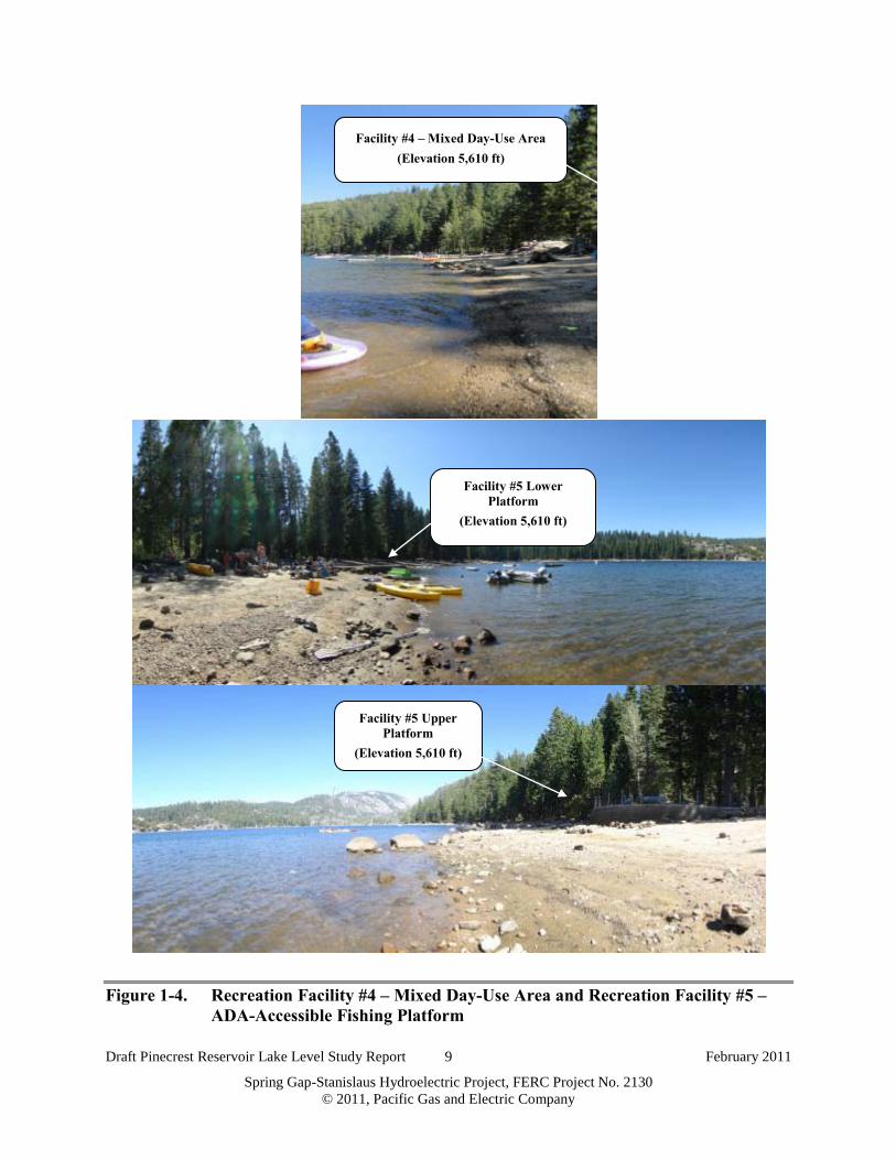
Figure 1-4. Recreation Facility #4 – Mixed Day-Use Area and Recreation Facility #5
– ADA-Accessible Fishing Platform .......................................................................9
Figure 1-5. Facility #6 – Overflow Area, South Shore and Facility #7 – Overflow
Area, North of Marina: Transects #7A and #7B ...................................................12
Figure 2-1. Sample Field Data Sheets (Note: A full set of data sheets is available in
Appendix D.)..........................................................................................................14
Figure 2-2. Plan and Profile Graphic for Recreation Facility #1 – Gas Dock and Slips
(shown at elevation of 5,610 feet) ..........................................................................16
Figure 2-3. Recreation Facility #1: Gas Dock Configuration and Ground Elevations ............21
Figure 2-4. Illustrated Pedestrian Access Quality Scores and Examples of 20-Foot-
Wide Swath along Transect Lines at Varying Lake Level Elevations
(Note: This area was evaluated for both quality of access and beach
quality.) ..................................................................................................................26
Figure 2-5. Examples of Pedestrian Access Quality Rating Scale ...........................................27
Figure 2-6. Example Calculation of “Unimpaired,” “Impaired,” and “Severely
Impaired” for All Criteria Except Potential Swimming and Boating
Hazards ..................................................................................................................28
Figure 2-7. Examples of Beach Quality Rating Scale ..............................................................30
Figure 2-8. Example of Derivation of Net Usable Beach .........................................................32
Figure 2-9. Example Calculation of Available Swimming Area and Usable Wading
Area ........................................................................................................................34
Figure 2-10. Example of Derivation of Number of Submerged Objects ....................................36
Figure 2-11. Example Calculation of “Unimpaired,” “Impaired,” and “Severely
Impaired” for Potential Swimming and Boating Hazards (Submerged
Objects) ..................................................................................................................37
Figure 3-1. Pinecrest Lake Level Elevation: Data Collection Dates with
Corresponding Lake Surface Elevations ................................................................47
Figure 3-2. Transition from 12 Usable Fingers to 11.3 Usable Fingers ...................................50
Figure 3-3. Transition from Direct Deck Access to Boat Ramp and Slips ..............................54

Draft Pinecrest Reservoir Lake Level Study Report ix February 2011
Spring Gap-Stanislaus Hydroelectric Project, FERC Project No. 2130 © 2011, Pacific Gas and Electric Company
Figure 3-4. Pedestrian Shoreline Access Quality and Beach Quality Results for
Transect #3A ..........................................................................................................60
Figure 3-5. Pedestrian Shoreline Access Quality and Beach Quality Results for
Transect #3B ..........................................................................................................61
Figure 3-6. Pedestrian Shoreline Access Quality and Beach Quality Results for
Transect #3C ..........................................................................................................62
Figure 3-7. Net Usable Beach in Transect #3A ........................................................................64
Figure 3-8. Net Usable Beach in Transect #3B ........................................................................64
Figure 3-9. Net Usable Beach in Transect #3C ........................................................................65
Figure 3-10. Available Swimming Area in Transect #3A ..........................................................65
Figure 3-11. Available Swimming Area in Transect #3B ..........................................................66
Figure 3-12. Available Swimming Area in Transect #3C ..........................................................66
Figure 3-13. Usable Wading Area in Transect #3A ...................................................................68
Figure 3-14. Usable Wading Area in Transect #3B ...................................................................68
Figure 3-15. Usable Wading Area in Transect #3C ...................................................................69
Figure 3-16. Potential Swimming Hazards within 6 Feet of Water Surface in Transect
#3A .........................................................................................................................69
Figure 3-17. Potential Swimming Hazards within 6 Feet of Water Surface in Transect
#3B .........................................................................................................................70
Figure 3-18. Potential Swimming Hazards within 6 Feet of Water Surface in Transect
#3C .........................................................................................................................70
Figure 3-19. Pedestrian Shoreline Access Quality and Beach Quality Results for
Recreation Facility #4 ............................................................................................75
Figure 3-20. Net Usable Beach at Recreation Facility #4 ..........................................................76
Figure 3-21. Usable Wading Area at Recreation Facility #4......................................................76
Figure 3-22. Potential Swimming Hazards within 6 Feet of Water Surface at Recreation
Facility #4 ..............................................................................................................77
Figure 3-23. Potential Boating Hazards within 2 Feet of Water Surface at Recreation
Facility #4 ..............................................................................................................77
Figure 3-24. Pedestrian Shoreline Access Quality and Beach Quality Results for
Recreation Facility #6 ............................................................................................83

Draft Pinecrest Reservoir Lake Level Study Report x February 2011
Spring Gap-Stanislaus Hydroelectric Project, FERC Project No. 2130 © 2011, Pacific Gas and Electric Company
Figure 3-25. Net Usable Beach at Recreation Facility #6 ..........................................................84
Figure 3-26. Usable Wading Area at Recreation Facility #6......................................................85
Figure 3-27. Potential Swimming Hazards within 6 Feet of Water Surface at Recreation
Facility #6 ..............................................................................................................85
Figure 3-28. Potential Boating Hazards within 2 Feet of Water Surface at Recreation
Facility #6 ..............................................................................................................85
Figure 3-29. Pedestrian Shoreline Access Quality and Beach Quality Results for
Transect #7A ..........................................................................................................90
Figure 3-30. Pedestrian Shoreline Access Quality and Beach Quality Results for
Transect #7B ..........................................................................................................91
Figure 3-31. Net Usable Beach in Transect #7A ........................................................................92
Figure 3-32. Net Usable Beach in Transect #7B ........................................................................92
Figure 3-33. Usable Wading Area in Transect #7A ...................................................................93
Figure 3-34. Usable Wading Area in Transect #7B ...................................................................93
Figure 3-35. Potential Swimming Hazards within 6 Feet of Water Surface in Transect
#7A .........................................................................................................................94
Figure 3-36. Potential Swimming Hazards within 6 Feet of Water Surface in Transect
#7B .........................................................................................................................94
Figure 3-37. Potential Boating Hazards within 2 Feet of Water Surface in Transect #7A ........95
Figure 3-38. Potential Boating Hazards within 2 Feet of Water Surface in Transect #7B .........95

Draft Pinecrest Reservoir Lake Level Study Report xi February 2011
Spring Gap-Stanislaus Hydroelectric Project, FERC Project No. 2130 © 2011, Pacific Gas and Electric Company
LIST OF ACRONYMS
3D three-dimensional
ADA Americans with Disabilities Act
CDFG California Department of Fish and Game
FERC Federal Energy Regulatory Commission
Forest Service U.S. Department of Agriculture Forest Service
ft foot (feet)
GPS global positioning system
msl mean sea level
PG&E Pacific Gas and Electric Company
the Project Spring Gap-Stanislaus Hydroelectric Project
RSVR Reservoir
State Water Board State Water Resources Control Board
TUD Tuolumne Utilities District

Draft Pinecrest Reservoir Lake Level Study Report xii February 2011
Spring Gap-Stanislaus Hydroelectric Project, FERC Project No. 2130 © 2011, Pacific Gas and Electric Company
E X E C UT I V E SUM M A R Y
This study focuses on the potential usability of recreation facilities at Pinecrest Reservoir at a
range of potential lake levels that might be utilized between the end of spill and Labor Day.
Pinecrest Reservoir is a component of the Pacific Gas and Electric Company’s (PG&E) Spring
Gap-Stanislaus Hydroelectric Project. The reservoir encompasses approximately 300 acres, at a
maximum water surface elevation of approximately 5,617 feet (ft) mean sea level (msl)1.
Pinecrest Reservoir is located off of Highway 108, approximately 25 miles northeast of Sonora,
California on the South Fork of the Stanislaus River. Water stored in Pinecrest Lake is used for
hydroelectric generation by PG&E, is used for local water supply, and is diverted by the
Tuolumne Utilities District (TUD) for water supply.
The purpose of this study is to determine the minimum operating lake level that protects specific
recreational uses at identified facilities located at Pinecrest Reservoir between the end of spill
and Labor Day. Specifically, this study evaluates the potential impairment to recreation usability
for lake elevations from 5,608 to 5,595 ft compared to baseline usability within the elevation
range of 5,617 to 5,610 ft. The effects of these elevations were studied, as they occurred, during
summer and fall 2010.
Pinecrest Reservoir Lake provides for multiple recreational activities (e.g., swimming, boating,
fishing, and picnicking). Based on consultation with the California State Water Resources
Control Board (State Water Board), U.S. Department of Agriculture Forest Service (Forest
Service), and TUD, a total of seven recreation features (facilities) were evaluated under this
study. Although each facility is unique in terms of its location, there was overlap in the types of
activities found at each facility.
During summer and fall 2010, data were collected in the field using agreed upon data collection
protocols. Data were collected at lake level elevations of 5,617–5,610 ft at 2- foot intervals to
establish a baseline. For lake level elevations of 5,608–5,595 ft, the range used to assess
usability of the recreation facilities, data were collected at 1-ft intervals. Recreation usability at
1 All lake level elevations included in this report are at mean sea level (msl).

Draft Pinecrest Reservoir Lake Level Study Report xiii February 2011
Spring Gap-Stanislaus Hydroelectric Project, FERC Project No. 2130 © 2011, Pacific Gas and Electric Company
lake levels in this range were compared to the baseline values in order to determine changes to
recreation usability due to lowered lake levels.
Criteria were developed for each facility to evaluate the recreational uses specific to that facility.
These criteria were evaluated at all elevations studied, and potential impairments to recreation
were estimated.
Overall, as lake level drops, recreation usability at facilities such as docks and boat ramps is not
impaired. However, recreation usability at beach and other day-use facilities becomes impaired
at various lowered lake elevations.
Possible mitigation actions are identified that could maintain recreation usability levels found in
the baseline elevations at lowered elevations.

Draft Pinecrest Reservoir Lake Level Study Report 1 February 2011
Spring Gap-Stanislaus Hydroelectric Project, FERC Project No. 2130 © 2011, Pacific Gas and Electric Company
1.0 I NT R ODUC T I ON
ST UDY PUR POSE
On June 16, 2009, the State Water Board issued to PG&E a revised Section 401 Water Quality
Certification (Revised Certification) for the Spring Gap-Stanislaus Hydroelectric Project (FERC
Project No. 2130). The Revised Certification was subsequently included in a FERC Order
Clarifying Prior Orders issued on January 13, 2010 (130 FERC § 62,036). The Revised
Certification and FERC Order require PG&E to prepare and implement a lake level study plan
for Pinecrest Reservoir in order to determine the minimum operating lake level elevation that
protects specific recreational uses for the period ranging from the end of spill through Labor
Day.
Specifically, the Revised Certification, Condition No. 4 states:
“Within nine months of license issuance the Licensee shall submit a Pinecrest
Reservoir minimum lake-level study plan (Lake-level Study), developed in
consultation with the USFS, DFG, State Water Board staff, and TUD, to the
Deputy Director for modification and approval that will determine the minimum
Pinecrest Reservoir elevation between End of Spill through Labor Day that
protects recreational uses (specifically, Day-Use Area beaches, the marina to just
east of the handicap fishing access, and other areas as directed by the State
Water Board). Licensee shall complete the Lake-level Study as approved by the
Deputy Director by the end of the first full calendar year after license issuance.
The completed study shall be provided to the USFS, DFG, State Water Board
staff, and TUD for review and comment. By March 1 of the year following
completion of the Lake-level Study, the Licensee shall submit to the Deputy
Director for approval the completed study, including any comments received.
Within six months of approval of the Lake-level Study by the Deputy Director,
Licensee may request the State Water Board modify the target elevation of
5,608 ft based on the results of the Lake-level Study, after the State Water Board
provides notice to affected parties.”

Draft Pinecrest Reservoir Lake Level Study Report 2 February 2011
Spring Gap-Stanislaus Hydroelectric Project, FERC Project No. 2130 © 2011, Pacific Gas and Electric Company
The Revised Certification and FERC Order require that a study plan for this work be developed
in consultation with the Forest Service, California Department of Fish and Game (CDFG), State
Water Board, and TUD. Accordingly, PG&E developed and provided a draft study plan to the
agencies and consulted with them on its finalization. The final study plan (PG&E 2010) was
approved by the State Water Board and filed with the FERC on June 8, 2010.
This report was prepared to comply with the lake level study requirements in the Revised
Certification and FERC Order. The following sections summarize the consultation conducted,
study objectives, study area, methodology, analysis, and results of the study.
C ONSUL T A T I ON
Appendix A will provide documentation of consultation addressing comments, and responses to
this report. This documentation will be included after comments are addressed and the report is
finalized.
ST UDY OB J E C T I V E S
The purpose of the Pinecrest Reservoir Lake Level Study is to “determine the minimum
Pinecrest Reservoir elevation between End of Spill through Labor Day that protects recreational
uses (specifically, Day-Use Area beaches, the marina to just east of the handicap fishing access,
and other areas as directed by the State Water Board)” for the recreational uses identified in the
Revised Certification. The objective of the lake level study is to identify potential impairments
resulting from lowered reservoir levels on recreation usability at seven recreation facilities.
Potential mitigation measures are described to offset the potential impairments identified in this
report at lake levels below 5,608 ft.
ST UDY A R E A
The Spring Gap-Stanislaus Hydroelectric Project is composed of Relief, Strawberry, Spring Gap,
and Stanislaus Developments. Pinecrest Reservoir is a component of the Strawberry
Development; its surface area encompasses approximately 300 acres at an elevation of
approximately 5,617 ft. Pinecrest Reservoir is located off of Highway 108, approximately
25 miles northeast of Sonora, California on the South Fork of the Stanislaus River. The study

Draft Pinecrest Reservoir Lake Level Study Report 3 February 2011
Spring Gap-Stanislaus Hydroelectric Project, FERC Project No. 2130 © 2011, Pacific Gas and Electric Company
area, based on consultation with the State Water Board, Forest Service, and TUD, includes seven
recreation facilities located on the southwest shoreline of Pinecrest Reservoir, as follows:
• Recreation Facility #1 – Gas Dock and Slips;
• Recreation Facility #2 – Boat Ramp and Courtesy Dock;
• Recreation Facility #3 – Designated Buoyed Swim Area;
• Recreation Facility #4 – Mixed Day-Use Area (adjacent to the Swim Area);
• Recreation Facility #5 – ADA-Accessible2 Fishing Platform;
• Recreation Facility #6 – Overflow Area, South Shore; and
• Recreation Facility #7 – Overflow Area, North of Marina.
Figure 1-1 identifies the location of the seven recreation facilities evaluated in this study. To
characterize the existing baseline conditions, a general description of the seven recreation
facilities and a description of existing recreational use conditions at these sites are provided.
These descriptions are based on existing recreational use data collected as part of the relicensing
process (PG&E 2002), supplemented by the observations made during the study. In addition, a
general description is provided of conditions and timing of reservoir water elevation drawdown
under existing conditions.
During the “Reservoir Minimum Lake-Level photopoint site identification field visit,” conducted
on July 22nd 2010, representative transects were selected at each facility.
Each facility had a minimum of one transect. Larger facilities such as facilities #3 and #7 used
multiple transects to better represent the larger area.
These transects were used for photo documentation and field observations, which are further
described in section 2.0.
2 The Americans with Disabilities Act (ADA) is a federal antidiscrimination statute designed to ensure equal access
to opportunities and benefits for qualified individuals with disabilities.

Draft Pinecrest Reservoir Lake Level Study Report 4 February 2011
Spring Gap-Stanislaus Hydroelectric Project, FERC Project No. 2130 © 2011, Pacific Gas and Electric Company
Figure 1-1. Pinecrest Reservoir Lake Level Study: Seven Recreational Facilities Included in the Analysis (shown at a lake level of 5,610 feet)
1-1

Draft Pinecrest Reservoir Lake Level Study Report 5 February 2011
Spring Gap-Stanislaus Hydroelectric Project, FERC Project No. 2130 © 2011, Pacific Gas and Electric Company
1.1 R ecr eation F acility #1 – G as Dock and Slips
This facility is located in the northwest section of the studied reservoir recreation area. The
facility is composed of a wooden deck, which connects the shore to a metal ramp and a floating
dock (Figure 1-2). The dock is comprised of 11 fingers, each containing approximately 44 boat
slips for private and rental boats to dock, load/unload supplies, and store boats. Also, the first
finger, located on the south side of the dock, has a gas pump that is available for fueling
motorized boats.
Based on PG&E’s final license application, Exhibit E, the following types of watercraft are used
on Pinecrest: motorized boats, motorized party-boats, non-motorized kayaks, canoes, rowboats,
sailboats and paddle boats (PG&E 2002). Therefore, these types of watercraft are expected to
access the gas dock and slips.
1.2 R ecr eation F acility #2 – B oat R amp and C our tesy Dock
The boat ramp is located just south of the gas dock and slips. The boat ramp was constructed
and is maintained by the Stanislaus National Forest (Figure 1-2). The boat launch has a concrete
ramp and wooden courtesy dock that is located near the marina and day-use area. The length of
the boat ramp provides concrete launch access during the recreation season. As the reservoir
water surface elevation decreases in fall, the ramp becomes unusable in early October. Using the
orthophoto provided by TUD, when the lake elevation drops below 5,585 ft, the concrete ramp
and courtesy dock are no longer in contact with the water.
The boat ramp is used primarily to launch and recover trailered boats. There is also pedestrian
traffic as people access launched boats from the courtesy dock. As such, boating activities were
the only recreation activities observed at this facility.

Draft Pinecrest Reservoir Lake Level Study Report 6 February 2011
Spring Gap-Stanislaus Hydroelectric Project, FERC Project No. 2130 © 2011, Pacific Gas and Electric Company
Figure 1-2. Facility #1 – Boat Dock and Facility #2 – Boat Ramp and Courtesy Dock
Facility #1 – Boat Dock (Elevation 5,610 ft)
Deck Facility #1 – Boat Dock
(Elevation 5,610 ft)
Courtesy Dock Facility #2 – Concrete Boat Ramp
(Elevation 5,610 ft)

Draft Pinecrest Reservoir Lake Level Study Report 7 February 2011
Spring Gap-Stanislaus Hydroelectric Project, FERC Project No. 2130 © 2011, Pacific Gas and Electric Company
1.3 R ecr eation F acility #3 – Designated B uoyed Swim A r ea
This facility is located southeast of the boat ramp (Figure 1-3). The site is comprised of a beach
and swim area. The swim area is delineated with a buoy line. Three transects were selected to
represent the facility (Transects #3A, #3B, and #3C). The transects are located approximately
equidistantly from each other and cover the span of the buoyed swim area. They are located near
the three signed beaches within the designated buoyed swim area.
Currently, placement of the buoy line is not actively managed as the lake level drops. The only
activities allowed within the buoyed area are wading and swimming. Although prohibited,
fishing was observed at this site during the study period. In addition, general “beach” activities
such as sunbathing and picnicking were observed. The beach is comprised primarily of sand,
with rocks and stumps of various sizes.
1.4 R ecr eation F acility #4 – M ixed Day-Use A r ea
This facility is located in the southeastern portion of Pinecrest Lake, directly adjacent to the
buoyed swim area (Figure 1-4). As with the designated buoyed swim area, this facility provides
beach and shoreline access. However, because Facility #4 falls outside of the buoyed area, it
does not provide exclusion from boats or anglers while swimming or wading. Further, within
this area, car-top boats are allowed to hand-launch directly from shore, and anglers can fish at the
shoreline.
Recreation activities observed at this facility include beach activities, wading, swimming,
fishing, and boating.
1.5 R ecr eation F acility #5 – A DA -A ccessible F ishing Platfor m
This facility is located in the southeastern portion of Pinecrest Lake, adjacent to Facility #4
(Figure 1-4). The facility is comprised of two semicircular concrete platforms connected by a
concrete walkway. The platforms are accessible to persons with disabilities and allow anglers to
cast directly into the water and fish at certain lake elevations (PG&E 2002). The recreation
activity observed at this facility was fishing.

Draft Pinecrest Reservoir Lake Level Study Report 8 February 2011
Spring Gap-Stanislaus Hydroelectric Project, FERC Project No. 2130 © 2011, Pacific Gas and Electric Company
Figure 1-3. Facility #3 – Designated Buoyed Swim Area: Transects #3A, #3B, and #3C (photo taken from the top of each transect)
Transect #3A – Designated Buoyed Swim Area
(Elevation 5,610 ft)
Transect #3B – Designated Buoyed Swim Area
(Elevation 5,610 ft)
Transect #3C – Designated Buoyed Swim Area
(Elevation 5,610 ft)
Buoy Line
Draft Pinecrest Reservoir Lake Level Study Report 9 February 2011
Spring Gap-Stanislaus Hydroelectric Project, FERC Project No. 2130 © 2011, Pacific Gas and Electric Company
Figure 1-4. Recreation Facility #4 – Mixed Day-Use Area and Recreation Facility #5 – ADA-Accessible Fishing Platform
Facility #4 – Mixed Day-Use Area (Elevation 5,610 ft)
Facility #5 Upper Platform
(Elevation 5,610 ft)
Facility #5 Lower Platform
(Elevation 5,610 ft)

Draft Pinecrest Reservoir Lake Level Study Report 10 February 2011
Spring Gap-Stanislaus Hydroelectric Project, FERC Project No. 2130 © 2011, Pacific Gas and Electric Company
1.6 R ecr eation F acility #6 – Over flow A r ea, South Shor e
This facility is the easternmost location studied (Figure 1-1). It marks the start of the private
cabins that are located on the eastern shoreline (Figure 1-5). There is no protected picnic area,
but public beach area is available. Recreation activities observed at this facility include
swimming and wading and general beach, fishing, and boat activities.
1.7 R ecr eation F acility #7 – Over flow A r ea, Nor th of M ar ina
This facility is the northernmost facility studied (Figure 1-1). It is located on the west shore,
below the private cabins located on this shore (Figure 1-5). As with Recreation Facility #6, there
is no picnic area; however, public beach area is available for beach activities, swimming and
wading, and fishing and boating activities. This facility also provides access to dock used by the
Tuolumne County Fire Department. The facility was represented by Transects #7A and #7B for
this analysis. Transect #7A is representative of the fire dock while #7B represents the mixed use
area.
DE SC R I PT I ON OF E X I ST I NG W A T E R E L E V A T I ON C ONDI T I ONS
During 2010, Pinecrest Reservoir was maintained at 5,610 ft until Labor Day. The current State
Water Board 401 Certification allows a minimum lake level of 5,608 ft prior to Labor Day, if the
draw-down curve is approved. After this date, the lake level can be drawn down further to
supply water to TUD.
In a normal water year type, the maximum reservoir elevation is achieved from June 22 through
July 23. In wet and dry water years, the maximum reservoir elevation is achieved from July 24
through August 11 and from May 29 through June 31, respectively. Operation of the Project
begins to draw the reservoir down just prior to Labor Day; the total drop in reservoir elevation is
between 71 and 94 feet. As the reservoir lowers, it reaches an elevation of 5,600 ft around
September 6 in normal water years and around September 12 and October 13 in dry and wet
water years, respectively (PG&E 2002.).
Another factor affecting the reservoir level is PG&E’s contract with TUD that gives TUD the
right to store water in Pinecrest Lake dependent on each year’s water production. In summary,
under the terms of the contract, TUD may request PG&E to release water from Pinecrest Lake

Draft Pinecrest Reservoir Lake Level Study Report 11 February 2011
Spring Gap-Stanislaus Hydroelectric Project, FERC Project No. 2130 © 2011, Pacific Gas and Electric Company
into the South Fork Stanislaus River for diversion by TUD at Lyons Reservoir and points
downstream (PG&E 2002).
At full pool, elevation 5,617 ft3, the water line is near the tree line for most facilities. As the
water level drops, additional beach area becomes available and previously submerged objects
become exposed.
3 Elevation 5,617 ft is the elevation at the top of the flashboards (i.e., no water is flowing into the spill channel). The
lake level may exceed 5,617 ft during high spring runoff but will result in water spilling over the flashboards until an
elevation of 5,617 ft is reached.

Draft Pinecrest Reservoir Lake Level Study Report 12 February 2011
Spring Gap-Stanislaus Hydroelectric Project, FERC Project No. 2130 © 2011, Pacific Gas and Electric Company
Figure 1-5. Facility #6 – Overflow Area, South Shore and Facility #7 – Overflow Area, North of Marina: Transects #7A and #7B
Facility #6 – Overflow Area, South Shore (Elevation 5,610 ft)
Transect #7A – Overflow Area, North of Marina
(Elevation 5,610 ft)
Transect #7B – Overflow Area, North of Marina
(Elevation 5,610 ft)

Draft Pinecrest Reservoir Lake Level Study Report 13 February 2011
Spring Gap-Stanislaus Hydroelectric Project, FERC Project No. 2130 © 2011, Pacific Gas and Electric Company
2.0 M E T H ODOL OG Y
Potential effects to the usability of the seven recreation facilities were assessed for lake levels
from 5,608 to 5,595 ft; these effects then were compared to the baseline usability values found in
the range of 5,617 to 5,610 ft. Potential effects were assessed using a combination of photo
documentation, observations collected on field data sheets, and plan and profile figures
developed from three-dimensional (3D) surface modeling. The photo documentation and field
data sheets were completed at each recreation facility for each lake level increment studied.
Based on agreements during agency consultation, facilities were assessed at 2-foot increments in
the baseline range and at 1-foot increments in the assessment range.
Field data were collected in conjunction with the photo surveys so that the observations and
measurements occurred incrementally as the reservoir level decreased. The field data sheets
include the following metrics:
• Distance from the recreation facility to the water and depth of the water;
• Soil characteristics (e.g., is the area passable without going through mud flats?);
• The amount of recreation use occurring (if any) at the recreation feature;
• Distance from shade and trees;
• Time of day, weather, air temperature, and presence of wind.
In addition to the quantitative measures, qualitative observations were made regarding facility
and area usability. Figure 2-1 contains sample field data sheets. The full set of data sheets
completed for this study is available in Appendix D.
A trained field technician completed field data sheets and took photographs specified for each
facility for each target elevation. Upon receipt from the field, all data sheets and photos were
reviewed to ensure both completion and accuracy, and were entered into a database.
Discrepancies or omissions on the data sheets were discussed with the field technician and were
noted on the original data sheet.

Draft Pinecrest Reservoir Lake Level Study Report 14 February 2011
Spring Gap-Stanislaus Hydroelectric Project, FERC Project No. 2130 © 2011, Pacific Gas and Electric Company
Figure 2-1. Sample Field Data Sheets (Note: A full set of data sheets is available in Appendix D.)

Draft Pinecrest Reservoir Lake Level Study Report 15 February 2011
Spring Gap-Stanislaus Hydroelectric Project, FERC Project No. 2130 © 2011, Pacific Gas and Electric Company
After the field data collection was completed, facility-specific criteria were developed to assess
the usability of the site related to lowered lake levels and the uses observed at that site. For
example, the usability of the Gas Dock and Boat Slips (Recreation Facility #1) are directly
impaired if the water is too shallow to allow boat access from the lake to the gas dock for
fueling, or to the boat slips for docking. For this reason, the depth of water at the gas dock, the
number of dock fingers that are accessible (and therefore usable), and potential access
obstructions such as rocks or tree stumps in the immediate vicinity of the dock area were
analyzed at each lake level.
To develop the 3D surface model for Pinecrest Lake, contour lines created from the orthophoto
provided by TUD were imported into AutoCAD Civil 3D, and additional ground surface data
were collected in late October 2010.
The survey located the transect lines and collected ground surface data on hardscape such as
pathways or platforms near facilities. Further, ground surface data for objects such as stumps
and boulders within 10 ft of the transect line was collected. The data was then were imported
into AutoCAD Civil 3D and combined with the existing orthophoto contour lines supplied by
TUD. The result was a 3D surface representation of the recreation facilities at Pinecrest Lake.
This surface was used for the duration of the analysis and provided the ability to determine
distances and elevations, and thus to create plan and profile views for each facility for elevations
5,617 through 5,595 ft.
To locate the transect lines in the field, a Trimble GeoXT global positioning system (GPS) unit
was used to locate the upper point on the transect line. The lower end of the transect was located
using benchmarks that were previously indentified during the July 22, 2010 meeting and
documented in the field binder, developed by Cardno ENTRIX (Appendix E).
Figure 2-2 is an example of the plan and profile graphics developed from the 3D model. See
Appendix B for a full set of plan and profile graphics.

Draft Pinecrest Reservoir Lake Level Study Report 16 February 2011
Spring Gap-Stanislaus Hydroelectric Project, FERC Project No. 2130 © 2011, Pacific Gas and Electric Company
Figure 2-2. Plan and Profile Graphic for Recreation Facility #1 – Gas Dock and Slips (shown at elevation of 5,610 feet)
2-2

Draft Pinecrest Reservoir Lake Level Study Report 17 February 2011
Spring Gap-Stanislaus Hydroelectric Project, FERC Project No. 2130 © 2011 Pacific Gas and Electric Company
Photo documentation and field observations were used to document the number of usable dock
fingers, and a laser range finder was used to measure the length of the gangway leading from the
access ramp to the floating dock. These data were collected to establish changes in the number
of usable dock fingers and the length of the ramp from the deck to the dock. Changes to either of
these attributes could affect the access or usability of the facility.
For Recreation Facility #2 – Boat Ramp and Courtesy Dock, observed uses were primarily
limited to launching boats from trailers. Vehicles back down the ramp until the trailers are
submerged in the lake; boats are then either launched or retrieved and trailered. Once in the
water, boats are accessed by a floating courtesy dock. This dock is located at the waterline and
moves down the boat ramp as the water level in the lake falls. The criteria to assess usability of
this facility included monitoring the placement of the courtesy dock, the length of the concrete
ramp and any changes in slope along the ramp surface.
Recreation Facility #3, the designated buoyed swim area, provides more diverse activities such
as swimming, wading, sunbathing, and picnicking. To allow for these activities, the beach area
must not only be usable but also provide pedestrian access to the water. To assess the usability
of this site, the substrate (e.g., sand) was evaluated near the waterline. Specifically, the
presence/absence of rocks, stumps, and mud can affect both the access and usability of the
facility. Large rocks and mud can prevent users from getting to the water or from having enough
room for standard beach activities (e.g., laying out a towel for sunbathing). Usability of wading
and swimming areas was analyzed for the available area within the buoyed area. Both the depth
available for wading and swimming as well as the condition of the substrate were evaluated to
assess wading/swimming.
Recreation Facilities #4, #6, and #7, the mixed day-use and overflow areas, provide similar uses
as the designated buoyed swim area. However, these facilities are not buoyed and allow boating
and fishing. Boating requires the user to be able to first, hand-launch their boat, and second, not
hit hidden objects while boating. To assess the usability of these facilities and potential impacts
to boating, the numbers of near-shore submerged objects that may strike a boat were evaluated.
Further, the ability for boaters to access the shoreline was evaluated to measure the ability to
hand-launch boats from shore.

Draft Pinecrest Reservoir Lake Level Study Report 18 February 2011
Spring Gap-Stanislaus Hydroelectric Project, FERC Project No. 2130 © 2011 Pacific Gas and Electric Company
Certain facilities may provide ADA access. These include the boat dock, the concrete path in the
designated buoyed swim area and the ADA-accessible fishing platform. Facilities that
maintained ADA access through the entire baseline range (i.e., elevations 5,617 thru 5,610 ft)
were evaluated for impairment due to lowered lake levels. Facilities that become non-accessible
to handicapped individuals within the baseline elevation range are not considered further
impaired by additional elevation drops, as greater decreases in elevation do not result in a
different ADA access status when compared to the baseline values.
Table 2-1 summarizes the key assessment factors considered for each recreation facility. The
specific criteria and assessment methodology for each site is described in the sections that
follow.
Table 2-1. Summary of Assessment Factors for Recreation Facilities
Assessment Factor
Recreation Facility Site
#1 #2 #3 #4 #5 #6 #7
Gas Dock and Slips
Boat Ramp and
Courtesy Dock
Designated Buoyed
Swim Area
Mixed Day-Use
Area
ADA-Accessible
Fishing Platform
Overflow Area, South
Shore
Overflow Area, North of Marina
Accessibility of facility X X X
Accessibility of water/shoreline X X X X
Usability of facility X X X
Usability of water/shoreline area X X X X
Assessment of physical obstructions/submerged hazards
X X X X X X X
Assessment of safety and recreational use conflicts X X X X X X

Draft Pinecrest Reservoir Lake Level Study Report 19 February 2011
Spring Gap-Stanislaus Hydroelectric Project, FERC Project No. 2130 © 2011 Pacific Gas and Electric Company
2.1 A SSE SSM E NT C R I T E R I A F OR R E C R E A T I ON F A C I L I T Y #1 – G A S DOC K A ND SL I PS
The following criteria were evaluated to assess potential impairments on the usability of
Recreation Facility #1:
• Criterion #1: number of usable dock fingers;
• Criterion #2: pedestrian access to boat slips;
• Criterion #3: boater access to the gas dock; and
• Criterion #4: site assessment of physical obstructions for boats
2.1.1 C r iter ion #1: Number of Usable Dock F inger s
To evaluate the first criterion, the field data sheets and 3D surface model were analyzed. First,
the number of boat dock fingers was recorded on field data sheets and verified with photographs
taken in the field at each assessed lake elevation. The dock fingers were evaluated with regard to
access by boat, from the water. The criterion for usable dock fingers was categorized as “usable”
or “unusable”. A dock finger was categorized as “usable” if a boat could safely access the boat
slips from the water without encountering a physical obstruction. The presence of a physical
obstruction, noted from the field data sheet, photographs, or the 3D surface model, resulted in a
dock finger being categorized as “unusable”.
2.1.2 C r iter ion #2: Pedestr ian A ccess to B oat Slips
To evaluate the second criterion, the field data sheets, photographs, and 3D surface model were
analyzed. The criterion for pedestrian access to the boat slips was categorized as “yes” or “no”.
If a pedestrian was able to reach the boat slips from land via the wooden deck and metal ramp
without encountering a physical obstruction or barrier, Criterion #2 was categorized as “yes”.
Otherwise, pedestrian access was categorized as “no”, indicating that a pedestrian could not
access the boat slips without encountering a physical obstruction. The potential physical
obstructions were noted on the field data sheets and photographs. The 3D surface model was
used to evaluate the slope of the metal ramp at various elevations as extreme slopes (e.g., 50
percent grade) may obstruct, or impair pedestrian access.

Draft Pinecrest Reservoir Lake Level Study Report 20 February 2011
Spring Gap-Stanislaus Hydroelectric Project, FERC Project No. 2130 © 2011 Pacific Gas and Electric Company
2.1.3 C r iter ion #3: B oater A ccess to the G as Dock
To evaluate the third criterion, the field data sheets, photographs, and the 3D surface model were
analyzed. Boat access to the gas dock from the water was evaluated. Access to the gas dock was
categorized as “yes” or “no”. Boat access to the gas dock was categorized as “yes” if there were
no physical obstructions noted on the data sheets or photos, and if the depth of water was
sufficient to provide boats access without running aground. The 3D surface model was used to
determine the ground elevation, and the water depths on the east side of the gas dock (where the
gas pump is located). The ground surface elevation along the east side of the dock was
approximately 5,591 ft (Figure 2-3). The presence of physical obstructions or lack of sufficient
water depth resulted in the criterion being categorized as “no.”

Draft Pinecrest Reservoir Lake Level Study Report 21 February 2011
Spring Gap-Stanislaus Hydroelectric Project, FERC Project No. 2130 © 2011 Pacific Gas and Electric Company
Figure 2-3. Recreation Facility #1: Gas Dock Configuration and Ground Elevations
Gas Pump

Draft Pinecrest Reservoir Lake Level Study Report 22 February 2011
Spring Gap-Stanislaus Hydroelectric Project, FERC Project No. 2130 © 2011 Pacific Gas and Electric Company
2.1.4 C r iter ion #4: Site A ssessment of Physical Obstr uctions
The fourth criterion evaluated for Recreation Facility #1, used information gathered on data
sheets completed in the field during the study period to determine the presence of potential
hazards. The criterion was categorized as “yes,” indicating the presence of obstructions, or “no,”
indicating that no obstructions were observed.
2.2 A SSE SSM E NT C R I T E R I A F OR R E C R E A T I ON F A C I L I T Y #2 – B OA T R A M P A ND C OUR T E SY DOC K
The following criteria were evaluated to assess potential impairments on the usability of
Recreation Facility #2:
• Criterion #1: pedestrian access to the boat ramp;
• Criterion #2: pedestrian access to the courtesy dock; and
• Criterion #3: assessment of safety and potential recreational use conflict issues, if any (e.g.,
exposed structures and boating/swimming conflicts).
These three criteria were selected because they are the most critical factors regarding the
usability of this facility. Accessibility of the ramp and courtesy dock is essential to provide
access to the lake for recreational boating, cabins that can only be accessed by boat, and
emergency services.
2.2.1 C r iter ion #1: Pedestr ian A ccess to the B oat R amp
To evaluate the first criterion, two factors were examined. First, the slope of the boat ramp was
determined. Second, the distance from the top of the boat ramp to the water’s edge was
calculated for each elevation in the study. The criterion was categorized as “yes,” indicating that
a pedestrian could access the boat ramp, or “no,” indicating an observation of a potential barrier
or impairment to access. Impairments to access could include abrupt changes in slope, extreme

Draft Pinecrest Reservoir Lake Level Study Report 23 February 2011
Spring Gap-Stanislaus Hydroelectric Project, FERC Project No. 2130 © 2011 Pacific Gas and Electric Company
distances (i.e. greater than 200 ft.4) from the top of the boat ramp to the water, and observed
physical obstructions.
2.2.2 C r iter ion #2: Pedestr ian A ccess to the C our tesy Dock
To assess the accessibility of the courtesy dock, the placement of the dock relative to the
waterline was examined. Field observations noted the placement of the courtesy dock related to
the water, and photo documentation was conducted. The criterion was categorized as “yes,”
indicating that a pedestrian could access the courtesy dock, or “no,” indicating that pedestrian
access to the courtesy dock was impaired. To be accessible, the courtesy dock needed to be
placed in the water so that a boat could be entered with no obstructions on the concrete boat
ramp. Presence of obstructions or lack of contact with the water would make the courtesy dock
inaccessible for pedestrian use.
2.2.3 C r iter ion #3: A ssessment of Safety and Potential R ecr eational Use C onflict I ssues
The field data sheets were used to document and describe the safety and potential recreational
use conflict issues, if any, (e.g., exposed structures and boating/swimming conflicts) at the
various elevations observed. The presence of observed recreational use conflict issues was
categorized as “yes” and was evaluated at each target elevation and recorded on the field data
sheets. Lack of observed recreational use conflict issues was categorized as “no.”
2.3 A SSE SSM E NT C R I T E R I A F OR R E C R E A T I ON F A C I L I T Y #3 – DE SI G NA T E D B UOY E D SW I M A R E A
The following criteria were evaluated to assess potential impairments on the usability of
Transects #3A, #3B, and #3C at Recreation Facility #3:
• Criterion #1: pedestrian shoreline access quality;
• Criterion #2: beach quality;
4 All launching ramps over 200 ft long and less than 60 ft. wide, a 60 ft. minimum diameter turn-around area should
be provided every 200 ft. to minimize car-trailer backing distances (California Department of Boating and
Waterways. 1991).

Draft Pinecrest Reservoir Lake Level Study Report 24 February 2011
Spring Gap-Stanislaus Hydroelectric Project, FERC Project No. 2130 © 2011 Pacific Gas and Electric Company
• Criterion #3: net usable beach;
• Criterion #4: available swimming area;
• Criterion #5: usable wading area; and
• Criterion #6: potential swimming hazards.
One of the most important factors for assessing the usability of a recreation facility is whether
the facility can be accessed; if access is limited, then usability is impaired. As the lake level
lowers throughout summer, varying substrate (e.g., rocks, gravel, sand, and mud) is exposed that
can impair access to the shoreline. At the same time, as newly exposed beach area emerges; its
use can be similarly impaired by the exposed substrate. Because the swim buoys are fixed, each
foot of drop in lake level reduces the available swim area, until it is gone. The wading area,
which has been defined as 0 to 4 ft deep for this analysis, also is potentially impaired by the
substrate, because of the need to wade over rocks or in mud. The last criterion evaluated is
related to underwater obstructions that could impair recreational swimmers. This analysis
looked at submerged objects (rocks and stumps) from 0 to 6 ft deep.
2.3.1 C r iter ion #1: Pedestr ian Shor eline A ccess Quality
Accessibility was based on the condition of the substrate and the presence of obstructions that
could impede access. As a representative sample, the area approximately 10 ft on each side of
the transect line was examined (Figure 2-4). Limited access is indicated by substrate containing
a high density of obstructions, such as boulders and stumps, or the presence of mud to the extent
that it inhibits access. To assess the quality of pedestrian shoreline access, the field photos,
(shoreline left, shoreline right, and substrate) were evaluated at each lake level studied with the
following scale:
Score: 0.1 .25 0.5 .75 1.0 Description: Very Poor Poor Fair Good Excellent
Figure 2-4 contains examples of all access quality scores. Along each transect, a score was given
to the left shoreline (0.1–1) and the right shoreline (0.1–1) at each lake level. These scores were
then averaged to give a value for the entire 20-foot area perpendicular to the transect line. This

Draft Pinecrest Reservoir Lake Level Study Report 25 February 2011
Spring Gap-Stanislaus Hydroelectric Project, FERC Project No. 2130 © 2011 Pacific Gas and Electric Company
representative sample was used to evaluate the accessibility of the buoyed swim area
(Figure 2-5).
The pedestrian access quality scores were entered into a database and grouped by transect and
then elevation. The average score was calculated for baseline elevations (5,617 to 5,610 ft).
Each pedestrian access quality score within the study elevations (i.e., from 5,608 to 5,595 ft) was
compared to the baseline average and designated in one of three categories; unimpaired,
impaired, or severely impaired.
A study elevation was categorized as “unimpaired” if the difference between its score and the
baseline average was less than or equal to 25%. A study elevation was categorized as
“impaired” if the difference between its score and the baseline average was more than 25% and
less than or equal to 75%. A study elevation was categorized as “severely impaired” if the
difference between its score and the baseline average was more than 75%. Figure 2-6 provides a
visual example of these categories. To better visualize the results of the accessibility ratings, the
values for each elevation were plotted in conjunction with the baseline average, the point of
transition from unimpaired to impaired pedestrian access, and the point of transition from
impaired to severely impaired pedestrian access.

Draft Pinecrest Reservoir Lake Level Study Report 26 February 2011
Spring Gap-Stanislaus Hydroelectric Project, FERC Project No. 2130 © 2011, Pacific Gas and Electric Company
Figure 2-4. Illustrated Pedestrian Access Quality Scores and Examples of 20-Foot-Wide Swath along Transect Lines at Varying Lake Level Elevations (Note: This area was evaluated for both quality of access and beach quality.)
5,615 ft
5,605 ft
5,600 ft
5,602 ft
5,595 ft
5,610 ft
2-4

Draft Pinecrest Reservoir Lake Level Study Report 27 February 2011
Spring Gap-Stanislaus Hydroelectric Project, FERC Project No. 2130 © 2011, Pacific Gas and Electric Company
Figure 2-5. Examples of Pedestrian Access Quality Rating Scale
Very Poor Poor
Fair Good Excellent

Draft Pinecrest Reservoir Lake Level Study Report 28 February 2011
Spring Gap-Stanislaus Hydroelectric Project, FERC Project No. 2130 © 2011, Pacific Gas and Electric Company
Figure 2-6. Example Calculation of “Unimpaired,” “Impaired,” and “Severely Impaired” for All Criteria Except Potential Swimming and Boating Hazards
55955600560556105615
Elevation Above MSL [ft]
EXAMPLE CALCULATION
Usable Wading AreaBaseline AverageImpairedSeverely Impaired
BASELINE
UNIMPAIRED
IMPAIRED
SEVERELY IMPAIRED
BASELINE AVERAGE
25% Below Baseline Averge
75% BelowBaseline Average
Data Point

Draft Pinecrest Reservoir Lake Level Study Report 29 February 2011
Spring Gap-Stanislaus Hydroelectric Project, FERC Project No. 2130 © 2011, Pacific Gas and Electric Company
2.3.2 C r iter ion #2: B each Quality
Using a similar method as described above for pedestrian shoreline access quality, the beach
quality was evaluated with a scale representing the range of conditions. Figure 2-7 provides
examples of the beach quality rating scale. The field photos (shoreline left, shoreline right, and
substrate) were evaluated at each lake level of the study using the following scale:
Score: 0.1 .25 0.5 .75 1.0 Description: Very Poor Poor Fair Good Excellent
Beach quality is defined by the condition of the substrate. An unusable substrate contains muddy
areas or large rocks that prevent beach activities. Similar to pedestrian shoreline access quality,
a score was given to both the left and right shoreline areas, and these values were averaged to
produce the overall beach quality score at each lake level. At each elevation, the beach quality
score was categorized as “unimpaired,” “impaired,” or “severely impaired” using the method
described above for pedestrian shoreline access quality. Each beach quality score then was
plotted for comparison to the baseline average.
The plots of both pedestrian access quality and beach quality were presented with the profile of
each transect. This allows for direct comparison of the observed obstructions (e.g., rocks and
stumps) and the resulting low pedestrian access scores and low beach quality scores.
2.3.3 C r iter ion #3: Net Usable B each
As the water level falls, more beach becomes exposed. “Net beach available” combines the
previously available beach area with the newly exposed beach area (the additional beach area
that has become available due to lowered lake levels). However, not all of the beach area will be
of a high quality as beach quality is dependent on the condition of the substrate. To assess the
criterion, a 20-foot-wide area (10 ft on each side along each transect line) was used as a
representative area. This area was scaled by the beach quality scores which are based on the
ratings given the field photographs, described previously. This combination of area available
and quality of the beach provides the beach area that is usable for recreation. For example, a
large area with low-quality beach does not provide the same usable beach area as a similarly

Draft Pinecrest Reservoir Lake Level Study Report 30 February 2011
Spring Gap-Stanislaus Hydroelectric Project, FERC Project No. 2130 © 2011, Pacific Gas and Electric Company
Figure 2-7. Examples of Beach Quality Rating Scale
Very Poor
Poor Fair
Good Excellent

Draft Pinecrest Reservoir Lake Level Study Report 31 February 2011
Spring Gap-Stanislaus Hydroelectric Project, FERC Project No. 2130 © 2011, Pacific Gas and Electric Company
sized area with high-quality beach. The criterion, net usable beach, indicates the total usable
beach area available at a given elevation. Figure 2-8 provides an example calculation from Excel
showing how net usable beach area combines both the area newly exposed with the beach quality
score.
For each elevation, the net usable beach area was compared to the baseline average and was
categorized as “unimpaired,” “impaired,” or “severely impaired” using the same method
described for pedestrian access quality (Figure 2-6). The data then were plotted to help visualize
the comparison to the baseline average.

Draft Pinecrest Reservoir Lake Level Study Report 32 February 2011
Spring Gap-Stanislaus Hydroelectric Project, FERC Project No. 2130 © 2011, Pacific Gas and Electric Company
Elevation Distance Delta Dist Width
Beach Quality Score
Usable Area
Net Usable Beach Area
[feet] [feet] [feet] [feet] [%] [feet2] [feet2]
5,617 10.5 10.5 20 1 210 210
5,615 27 16.5 20 1 330 540
5,613 48 21 20 1 420 960
5,611 85 37 20 0.625 463 1,423
5,610 98 13 20 0.3 78 1,501
5,608 114 16 20 0.175 56 1,557
5,607 134 20 20 0.175 70 1,627
5,606 143 9 20 0.5 90 1,717
5,605 159 16 20 0.25 80 1,797
5,604 174 15 20 0.375 113 1,909
5,603 189 15 20 0.75 225 2,134
5,602 209 20 20 0.5 200 2,334
5,601 222 13 20 0.875 228 2,562
5,600 236 14 20 0.5 140 2,702
5,599 245 9 20 0.875 158 2,859
5,598 255 10 20 0.3 60 2,919
5,597 269 14 20 0.175 49 2,968
5,596 278 9 20 0.625 113 3,081
5,595 296 18 20 0.75 270 3,351 Delta Dist = Difference between “Distance to Water” Calculations (e.g., 27-10.5 = 16.5) * Usable Area = Delta Dist*Width*Beach Quality (e.g. 16*20*0.175 = 56) **Net Usable Beach Area = Adds new usable area with existing area (e.g., 540 = 330 + 210)
Figure 2-8. Example of Derivation of Net Usable Beach

Draft Pinecrest Reservoir Lake Level Study Report 33 February 2011
Spring Gap-Stanislaus Hydroelectric Project, FERC Project No. 2130 © 2011, Pacific Gas and Electric Company
2.3.4 C r iter ion #4: A vailable Swimming A r ea
To quantify the available swimming area, a 20-foot-wide representative area along each transect
line was used. Swimming requires an adequate depth of water, in this study defined as greater
than 4 ft. The length of the area available for swimming was measured from the point where the
water depth reached 4 ft to the buoy line. This length then was multiplied by the representative
width of 20 ft to obtain an index of the available swimming area. Figure 2-9 illustrates how the
available swimming area was calculated.
As with the previous criteria, the baseline average was calculated; and the available swimming
area at each elevation was categorized as “unimpaired,” “impaired,” or “severely impaired”
using the same method described above for pedestrian shoreline access quality. The values for
available swimming area then were plotted for comparison to the baseline average.
2.3.5 C r iter ion #5: Usable W ading A r ea
To quantify the usable wading area, a 20-foot-wide representative width along the transect line
was used. While the available swimming area is directly related to the distance to the buoy line,
the usable wading area is tied to two conditions, depth of water and substrate quality.
For this study a wading depth was defined as any water depth from 0 to 4 ft. Therefore, the
distance was calculated from the water’s edge to a 4-foot depth. As with the calculation for net
usable beach area, the condition of the substrate directly affects the ability to wade. Substrates
with high beach quality scores provide more wading area than similar areas with low beach
quality scores. Therefore, the area calculated to a 4-foot depth of water was scaled by the beach
quality score. This provides a measurement of the usable wading area. Figure 2-9 illustrates
how the usable wading area was calculated.
In general, the distance needed from the water’s edge to reach 4 ft of water spanned two
elevation drops. Thus, the resulting area was scaled by the average of the beach quality score of
the target elevation and the next elevation. This provides a measurement of the usable wading
area to a depth of 4 ft.
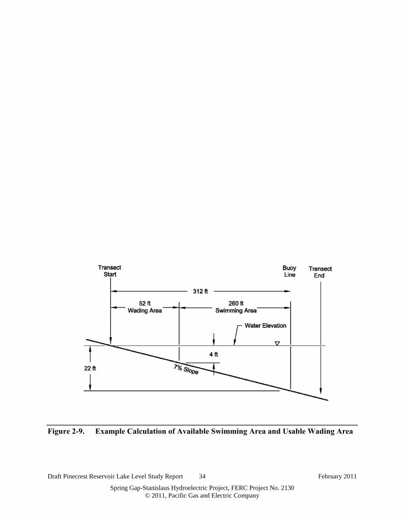
Draft Pinecrest Reservoir Lake Level Study Report 34 February 2011
Spring Gap-Stanislaus Hydroelectric Project, FERC Project No. 2130 © 2011, Pacific Gas and Electric Company
Figure 2-9. Example Calculation of Available Swimming Area and Usable Wading Area

Draft Pinecrest Reservoir Lake Level Study Report 35 February 2011
Spring Gap-Stanislaus Hydroelectric Project, FERC Project No. 2130 © 2011, Pacific Gas and Electric Company
As with previous criteria, the usable wading area was categorized as “unimpaired,” “impaired,”
or “severely impaired” using the methods described above for pedestrian shoreline access
quality.
The usable wading area scores were plotted for all elevations to help visualize the comparison to
the baseline average usable wading area score.
2.3.6 C r iter ion #6: Potential Swimming H azar ds
To evaluate the presence of submerged objects that could be swimming hazards, a 20-foot-wide
area along each transect was used as a representative area within the buoyed swimming area.
The ground surface data collected by the survey party were used to quantify potential swim
hazards. Possible swimming hazards were defined as any object (2-ft-diameter boulder or
larger, or 1-ft-diameter stump or larger) located within 6 ft of the water surface. Objects located
at this depth pose a potential hazard to recreational swimmers. A histogram was created using 1-
ft intervals, which captured the number of objects within each elevation range. To determine the
number of submerged objects within 6 ft of a target elevation, the histogram value for the target
elevation and the five following values were summed providing a count of all objects within 20
ft of the transect line (Figure 2-10). These submerged objects were considered potential hazards
to simmers, and served as the evaluation of Criterion #6.
Elevations were categorized as “unimpaired”, “impaired” and “severely impaired” using the
same method described in section 2.3.1. Figure 2-11 provides an example of these categories.
As with previous criteria, these data were plotted for each transect for comparison to the baseline
average number of submerged objects.

Draft Pinecrest Reservoir Lake Level Study Report 36 February 2011
Spring Gap-Stanislaus Hydroelectric Project, FERC Project No. 2130 © 2011, Pacific Gas and Electric Company
Figure 2-10. Example of Derivation of Number of Submerged Objects
Elevation On Top of
Object
Object Diameter and Description
5,618.60 5’ rock 5,617.91 2.5’stump 5,616.44 3.5’ rock 5,615.37 4’ rock 5,615.00 3.5’ rock 5,614.93 4’ rock 5,613.58 2’ rock 5,612.20 2’ rock 5,611.39 2.5’ rock
… …. 5,608.95 2’ rock 5,608.83 4’ rock 5,608.66 2’ rock 5,608.18 2’ rock 5,607.45 2’ rock 5,606.30 4’ rock 5,605.71 3’ rock 5,605.17 2.5’ rock 5,604.19 2’ rock 5,603.74 2’ rock 5,603.73 2’ rock 5,603.70 2.5’ rock 5,602.78 2’ rock
At elevation 5,608 ft, nine submerged objects are
within 6 ft of the water surface within 10 ft of the
transect line.
A histogram was created and values were
summed for elevations up to 6 ft below the target
elevation.
Bin FrequencyMore 2
5617 15616 25615 15614 15613 15612 35611 45610 55608 15607 15606 25605 1 9 submerged objects for 56085604 35603 15602 35601 15600 3

Draft Pinecrest Reservoir Lake Level Study Report 37 February 2011
Spring Gap-Stanislaus Hydroelectric Project, FERC Project No. 2130 © 2011, Pacific Gas and Electric Company
Figure 2-11. Example Calculation of “Unimpaired,” “Impaired,” and “Severely Impaired” for Potential Swimming and Boating Hazards (Submerged Objects)
55955600560556105615
Elevation Above MSL [ft]
EXAMPLE CALCULATION-SUBMERGED OBJECTS
Submerged ObjectsBaseline AverageImpairedSeverely Impaired
BASELINE
SEVERELY IMPAIRED
IMPAIRED
UNIMPAIRED
75% Above Baseline Average
25% Above Baseline Average
BASELINE AVERAGE

Draft Pinecrest Reservoir Lake Level Study Report 38 February 2011
Spring Gap-Stanislaus Hydroelectric Project, FERC Project No. 2130 © 2011, Pacific Gas and Electric Company
2.4 A SSE SSM E NT C R I T E R I A F OR R E C R E A T I ON F A C I L I T Y #4 – M I X E D DA Y -USE A R E A
The following criteria were evaluated to assess potential impairments on the usability of
Recreation Facility #4:
• Criterion #1: pedestrian shoreline access quality;
• Criterion #2: beach quality;
• Criterion #3: net usable beach;
• Criterion #4: usable wading area;
• Criterion #5: potential swimming hazards; and
• Criterion #6: boating access and potential hazards.
Because the activities observed in the mixed day-use areas were similar to those in the
designated buoyed swim area, the criteria used to evaluate impairments were similar as well,
with two exceptions. First, no buoys exist to delineate a swim area at Recreation Facility #4;
therefore, a loss of swim area cannot be assessed at this facility. However, submerged hazards
may still exist and are evaluated as part of criterion #5. Second, boating is allowed in the near-
shore area; therefore, access and potential hazards related to boating were evaluated in that area.
2.4.1 C r iter ion #1: Pedestr ian Shor eline A ccess Quality
The same method described for Pedestrian Shoreline Access Quality in the designated buoyed
swim area (Recreation Facility #3) was used to evaluate the quality of pedestrian access to the
shoreline at each elevation for Recreation Facility #4.
2.4.2 C r iter ion #2: B each Quality
The same method described for Beach Quality in the designated buoyed swim area (Recreation
Facility #3) was used to evaluate the beach quality at each elevation for Recreation Facility #4.
2.4.3 C r iter ion #3: Net Usable B each
The same method described for Net Usable Beach in the designated buoyed swim area
(Recreation Facility #3) was used to evaluate the net usable beach area at each elevation for
Recreation Facility #4.

Draft Pinecrest Reservoir Lake Level Study Report 39 February 2011
Spring Gap-Stanislaus Hydroelectric Project, FERC Project No. 2130 © 2011, Pacific Gas and Electric Company
2.4.4 C r iter ion #4: Usable W ading A r ea
The same method described for Usable Wading Area in the designated buoyed swim area
(Recreation Facility #3) was used to evaluate the usable wading area at each elevation for
Recreation Facility #4.
2.4.5 C r iter ion #5: Potential Swimming H azar ds
The same method described for Potential Swimming Hazards in the designated buoyed swim
area (Recreation Facility #3) was used to evaluate the number of submerged objects at each
elevation for Recreation Facility #4.
2.4.6 C r iter ion #6: B oating A ccess and Potential H azar ds
To determine boating access and potential hazards, two characteristics were evaluated. First, the
pedestrian shoreline quality access rating was used to quantify the ease with which a boat can be
brought to the waterline and hand-launched from the shore. This was categorized as “impaired”,
“unimpaired” or “severely impaired” using the methods described under pedestrian shoreline
quality access for Recreation Facility #3.
Second, the number of submerged objects within 2 ft of the water surface was calculated. This
depth is a safe estimate of the depth required by typical non-motorized boats expected on
Pinecrest Lake. The methods used to quantify the number of objects within 2 ft of the water
surface are similar to those described under Criterion #6 for Recreation Facility #3 (potential
swimming hazards). The only difference is that the histogram intervals were summed for the
target elevation and the next elevation. This quantifies all objects within 2 ft of the water
surface. Objects located at this depth pose a hazard to non-motorized boats as the boat draft is
not sufficiently satisfied. The values found for the number of potential boating hazards were
categorized as “unimpaired,” “impaired,” or “severely impaired” using the same method
described for Recreation Facility #3. The values for potential hazards then were plotted and
compared to the baseline average,
To evaluate Criterion #6, the values for boating access and potential hazards were combined. If
both boating access and potential hazards were categorized as impaired, or if one score was
categorized as impaired and one score was categorized as severely impaired, Criterion #6 was

Draft Pinecrest Reservoir Lake Level Study Report 40 February 2011
Spring Gap-Stanislaus Hydroelectric Project, FERC Project No. 2130 © 2011, Pacific Gas and Electric Company
categorized as “impaired.” If both boating access and potential hazards were categorized as
severely impaired, Criterion #6 was categorized as “severely impaired.” All other combinations
contained at least one “unimpaired” status (i.e. Pedestrian Access Quality or Potential Boating
Hazards) and so were categorized as “unimpaired” (Table 2-2).

Draft Pinecrest Reservoir Lake Level Study Report 41 February 2011
Spring Gap-Stanislaus Hydroelectric Project, FERC Project No. 2130 © 2011, Pacific Gas and Electric Company
Table 2-2. Categorization for Criterion #6: Boating Access and Potential Hazards
Boating Access
Unimpaired Impaired Severely Impaired Potential
Hazards Unimpaired Unimpaired Unimpaired Unimpaired
Impaired Unimpaired Impaired Impaired Severely Impaired Unimpaired Impaired Severely Impaired
Unimpaired Impaired Severely Impaired

Draft Pinecrest Reservoir Lake Level Study Report 42 February 2011
Spring Gap-Stanislaus Hydroelectric Project, FERC Project No. 2130 © 2011, Pacific Gas and Electric Company
2.5 A SSE SSM E NT C R I T E R I A F OR R E C R E A T I ON F A C I L I T Y #5 – A DA -A C C E SSI B L E F I SH I NG PL A T F OR M
The following criteria were evaluated to assess potential impairments on the usability of
Recreation Facility #5:
• Criterion #1: fishing opportunities from the upper platform; and
• Criterion #2: fishing opportunities from the lower platform.
2.5.1 C r iter ion #1: F ishing Oppor tunities fr om the Upper Platfor m
A fishing platform was categorized as usable for fishing opportunities when the water level was
sufficient to touch at least the base of the platform. If the water was not in contact with the base
of the platform, the platform was categorized as unusable. The platform was categorized as
accessible if it was not inundated or able to be reached from the land by a pedestrian. Both the
field data sheets and the 3D model were analyzed to determine the accessibility and usability of
each platform to water at all elevations. A fishing opportunity was available at the given
platform if it was both accessible and usable.
2.5.2 C r iter ion #2: F ishing Oppor tunities fr om the L ower Platfor m
The same method described for fishing opportunities in the upper fishing platform at Recreation
Facility #5 was used to assess fishing opportunities on the lower platform.
2.6 A SSE SSM E NT C R I T E R I A F OR R E C R E A T I ON F A C I L I T Y #6 – OV E R F L OW A R E A , SOUT H SH OR E
The following criteria were evaluated to assess potential impairments on the usability of
Recreation Facility #6:
• Criterion #1: pedestrian shoreline access quality;
• Criterion #2: beach quality;
• Criterion #3: net usable beach;
• Criterion #4: usable wading area;
• Criterion #5: potential swimming hazards; and
• Criterion #6: boating access and potential hazards.

Draft Pinecrest Reservoir Lake Level Study Report 43 February 2011
Spring Gap-Stanislaus Hydroelectric Project, FERC Project No. 2130 © 2011, Pacific Gas and Electric Company
2.6.1 C r iter ion #1: Pedestr ian Shor eline A ccess Quality
The same method described for Pedestrian Shoreline Access Quality in the designated buoyed
swim area (Recreation Facility #3) was used to evaluate the quality of pedestrian shoreline
access at Recreation Facility #6.
2.6.2 C r iter ion #2: B each Quality
The same method described for Beach Quality in the designated buoyed swim area (Recreation
Facility #3) was used to evaluate beach quality at Recreation Facility #6.
2.6.3 C r iter ion #3: Net Usable B each
The same method described for Net Usable Beach in the designated buoyed swim area
(Recreation Facility #3) was used to evaluate the net usable beach at Recreation Facility #6.
2.6.4 C r iter ion #4: Usable W ading A r ea
The same method described for Usable Wading Area in the designated buoyed swim area
(Recreation Facility #3) was used to evaluate the usable wading area at Recreation Facility #6.
2.6.5 C r iter ion #5: Potential Swimming H azar ds
The same method described for Potential Swimming Hazards in Recreation Facility #4 was used
to evaluate possible swim obstructions at Recreation Facility #6.
2.6.6 C r iter ion #6: B oating A ccess and Potential H azar ds
The same method described for Boating Access and Potential Hazards in Recreation Facility #4
was used to evaluate boating access and potential hazards at Recreation Facility #6.
2.7 A SSE SSM E NT C R I T E R I A F OR R E C R E A T I ON F A C I L I T Y #7 – OV E R F L OW A R E A , NOR T H OF M A R I NA
The following criteria were evaluated to assess potential impairments to Transects #7A and #7B
at Recreation Facility #7:
• Criterion #1: pedestrian shoreline access quality;
• Criterion #2: beach quality;

Draft Pinecrest Reservoir Lake Level Study Report 44 February 2011
Spring Gap-Stanislaus Hydroelectric Project, FERC Project No. 2130 © 2011, Pacific Gas and Electric Company
• Criterion #3: net usable beach;
• Criterion #4: usable wading area;
• Criterion #5: potential swimming hazards; and
• Criterion #6: boating access and potential hazards.
2.7.1 C r iter ion #1: Pedestr ian Shor eline A ccess Quality
The same method described for Pedestrian Shoreline Access Quality in the designated buoyed
swim area (Recreation Facility #3) was used to evaluate the quality of pedestrian access to the
shoreline in Transects #7A and #7B at Recreation Facility #7.
2.7.2 C r iter ion #2: B each Quality
The same method described for Beach Quality in the designated buoyed swim area (Recreation
Facility #3) was used to evaluate the beach quality in Transects #7A and #7B at Recreation
Facility #7.
2.7.3 C r iter ion #3: Net Usable B each
The same method described for Net Usable Beach in the designated buoyed swim area
(Recreation Facility #3) was used to evaluate the net usable beach in Transects #7A and #7B at
Recreation Facility #7.
2.7.4 C r iter ion #4: Usable W ading A r ea
The same method described for Usable Wading Area in the designated buoyed swim area
(Recreation Facility #3) was used to evaluate the usable wading area in Transects #7A and #7B
at Recreation Facility #7.
2.7.5 C r iter ion #5: Potential Swimming H azar ds
The same method described for Potential Swimming Hazards in Recreation Facility #4 was used
to evaluate possible swimming hazards at Transects #7A and #7B at Recreation Facility #7.

Draft Pinecrest Reservoir Lake Level Study Report 45 February 2011
Spring Gap-Stanislaus Hydroelectric Project, FERC Project No. 2130 © 2011, Pacific Gas and Electric Company
2.7.6 C r iter ion #6: B oating A ccess and Potential H azar ds
The same method described for Boating Access and Potential Hazards in Recreation Facility #4
was used to evaluate boating access and potential hazards in Transects #7A and #7B at
Recreation Facility #7.

Draft Pinecrest Reservoir Lake Level Study Report 46 February 2011
Spring Gap-Stanislaus Hydroelectric Project, FERC Project No. 2130 © 2011, Pacific Gas and Electric Company
3.0 R E SUL T S
The field data were collected within 0.25 ft of the target lake surface elevation for all lake
surface elevations studied. Further, the majority of lake surface elevations studied were within
0.1 ft of the target lake surface elevation (See Appendix D). The data were collected starting on
July 22, 2010, and ending on October 19, 2010. As the collection period progressed, the rate at
which the elevation dropped increased around September 11, 2010 (Figure 3-1). This
corresponds with the end of the baseline range and with the additional drawdown of Pinecrest
Reservoir.
This section presents the results for each criterion described in Section 2 by facility.5 Each
criterion is compared to the baseline average, and general descriptions for transitions in
impairment status are discussed. After the results for each criterion for each facility are
presented, the results are shown in tabular form. The tabular results are color coded using the
definitions for unimpaired, impaired, and severely impaired as discussed previously and shown
in Figures 2-6 and 2-11.
Unimpaired Impaired Severely Impaired
5 As stated in the Methodology section, only facilities that maintained ADA access through the
entire baseline were evaluated in terms of ADA accessibility for elevations 5,608–5,595 ft. The
only facility that met these requirements was the ADA-accessible fishing platform. All other
facilities (the deck and boat dock, boat ramp, and concrete pathway) lost ADA access at some
elevation within the baseline range.

Draft Pinecrest Reservoir Lake Level Study Report 47 February 2011
Spring Gap-Stanislaus Hydroelectric Project, FERC Project No. 2130 © 2011, Pacific Gas and Electric Company
6
Figure 3-1. Pinecrest Lake Level Elevation: Data Collection Dates with Corresponding Lake Surface Elevations
6 Elevation 5,617 ft is the elevation at the top of the flashboards (i.e., no water is flowing into the spill channel). The
lake level may exceed 5,617 ft during high spring runoff but will result in water spilling over the flashboards until an
elevation of 5,617 ft is reached.
Elevation 5,610 feet
5595
5600
5605
5610
5615
7/11/2010 7/31/2010 8/20/2010 9/9/2010 9/29/2010 10/19/2010 11/8/2010
LAKEELEVATION
[ft msl]
DATE
Pinecrest Lake: Elevations for Data Collection
Data Point
Elevation 5,617 feet (Full Pool)

Draft Pinecrest Reservoir Lake Level Study Report 48 February 2011
Spring Gap-Stanislaus Hydroelectric Project, FERC Project No. 2130 © 2011, Pacific Gas and Electric Company
3.1 R E C R E A T I ON F A C I L I T Y #1 – G A S DOC K A ND SL I PS
3.1.1 C r iter ion #1: Number of Usable Dock F inger s
All boat dock fingers are usable up to elevation 5,603 ft. When the elevation reaches 5,602 ft, a
portion of one of the fingers is no longer usable and typically is removed from the water,
resulting in a 6% reduction in the number of usable dock fingers. Figure 3-2 shows the finger
dismantled and a portion of it stored next to the access ramp. The remaining, shortened portion
remains usable until elevation 5,599 ft, when the side closest to the shore is no longer accessible,
resulting in an overall reduction of 8% in the number of usable dock fingers. The remaining boat
dock fingers and slips are usable at all elevations studied. As the reduction is not greater than
25%, use of the facility is not considered impaired for study elevations when compared to the
baseline average.
Overall, facility usability is not impaired for this criterion at any study elevation when compared
to the baseline average (See Table 3-1).

Draft Pinecrest Reservoir Lake Level Study Report 49 February 2011
Spring Gap-Stanislaus Hydroelectric Project, FERC Project No. 2130 © 2011, Pacific Gas and Electric Company
Table 3-1. Overview of Results for Recreation Facility #1 – Gas Dock and Slips
Elevation (feet)
Criterion #1 Criterion #2 Criterion #3 Criterion #4
No. Of Usable Fingers Pedestrian Access? Boater Access? Obstructions?
5,617 12 Yes Yes No
5,615 12 Yes Yes No
5,613 12 Yes Yes No
5,611 12 Yes Yes No
5,610 12 Yes Yes No
BASELINE
5,608 12 Yes Yes No
5,607 12 Yes Yes No
5,606 12 Yes Yes No
5,605 12 Yes Yes No
5,604 12 Yes Yes No
5,603 12 Yes Yes No
5,602 11.3 Yes Yes No
5,601 11.3 Yes Yes No
5,600 11.3 Yes Yes No
5,599 11 Yes Yes No
5,598 11 Yes Yes No
5,597 11 Yes Yes No
5,596 11 Yes Yes No
5,595 11 Yes Yes No

Draft Pinecrest Reservoir Lake Level Study Report 50 February 2011
Spring Gap-Stanislaus Hydroelectric Project, FERC Project No. 2130 © 2011, Pacific Gas and Electric Company
Figure 3-2. Transition from 12 Usable Fingers to 11.3 Usable Fingers
Elevation 5,599 ft
Elevation 5,603 ft
Elevation 5,602 ft
Draft Pinecrest Reservoir Lake Level Study Report 51 February 2011
Spring Gap-Stanislaus Hydroelectric Project, FERC Project No. 2130 © 2011, Pacific Gas and Electric Company
3.1.2 C r iter ion #2: Pedestr ian A ccess to the B oat Slips
At higher water elevations, pedestrian access is provided to the boat slips via a metal ramp that
connects to the top of the stationary wooden deck to the floating main dock and dock fingers.
As the lake level drops, the metal ramp becomes steeper. The slope of the ramp was calculated
from the deck to the boat dock for elevations 5,617, 5,615 and 5,613 ft, resulting in slopes of 8,
14, and 21 percent, respectively. Based on this information, the ramp is only ADA accessible at
a lake elevation of 5,617 ft (USDJ, 2010).
At elevation 5,611 ft, the platform holding the metal ramp is lowered and the adjacent stairway
provides access from the wooden deck to the boat dock platform (Figure 3-3). Therefore, access
to the boat slips was available at all elevations studied; however, at the lower elevations (below
elevation 5,611 ft), access is provided by the staircase and ramp rather than by only the metal
ramp.
Overall, usability is not impaired for this criterion at any study elevation when compared to the
baseline average (See Table 3-1).
3.1.3 C r iter ion #3: B oater A ccess to the G as Dock
The depth of the water was assessed for each studied elevation; depth ranged from a high of 26 ft
at elevation 5,617 ft to a low of 4 ft at 5,595 ft. A boat draft of 4 ft was assumed as a maximum
draft necessary for the typical boat that would access the gas dock. This provides a conservative
estimate of the maximum draft needed by a typical boat found on Pinecrest Lake. This depth
was applied to determine the clearance for boats accessing the gas dock. Based on this
assessment, boats can access the gas dock down to the lowest studied elevation of 5,595 ft
(Table 3-2).
Overall, usability is not impaired for this criterion at any study elevation when compared to the
baseline average (See Table 3-1).
3.1.4 C r iter ion #4: Site A ssessment of Physical Obstr uctions
No physical obstructions were found during field observations.

Draft Pinecrest Reservoir Lake Level Study Report 52 February 2011
Spring Gap-Stanislaus Hydroelectric Project, FERC Project No. 2130 © 2011, Pacific Gas and Electric Company
Overall, usability is not impaired for this criterion at any study elevation when compared to the
baseline average (See Table 3-1).

Draft Pinecrest Reservoir Lake Level Study Report 53 February 2011
Spring Gap-Stanislaus Hydroelectric Project, FERC Project No. 2130 © 2011, Pacific Gas and Electric Company
Table 3-2. Summary of Boat Access to Gas Dock
Elevation (feet)
Depth of Water (feet)
Boat Access Draft = 4 feet
5,617 26 Yes
5,615 24 Yes
5,613 22 Yes
5,611 20 Yes
5,610 19 Yes
BASELINE
5,608 17 Yes
5,607 16 Yes
5,606 15 Yes
5,605 14 Yes
5,604 13 Yes
5,603 12 Yes
5,602 11 Yes
5,601 10 Yes
5,600 9 Yes
5,599 8 Yes
5,598 7 Yes
5,597 6 Yes
5,596 5 Yes
5,595 4 Yes

Draft Pinecrest Reservoir Lake Level Study Report 54 February 2011
Spring Gap-Stanislaus Hydroelectric Project, FERC Project No. 2130 © 2011, Pacific Gas and Electric Company
Figure 3-3. Transition from Direct Deck Access to Boat Ramp and Slips
Elevation 5,613 ft
This photograph was taken at elevation 5,611 ft and shows access to the boat dock from the shoreline by use of the staircase.
Elevation 5,611 ft

Draft Pinecrest Reservoir Lake Level Study Report 55 February 2011
Spring Gap-Stanislaus Hydroelectric Project, FERC Project No. 2130 © 2011, Pacific Gas and Electric Company
3.2 R E C R E A T I ON F A C I L I T Y #2 – B OA T R A M P A ND C OUR T E SY DOC K
3.2.1 C r iter ion #1: Pedestr ian A ccess to the B oat R amp
The elevation data collected during the ground survey and field measurements were used to
calculate the overall slope along the length of the transect, giving a slope of 12.6 percent. The
slope can be used to calculate the distance down the ramp from the top to the water’s edge
(Table 3-3).
While the distance down the ramp increases as elevation drops, there is no change in slope or
obstructions that would prevent access to the courtesy dock.
Further, the California Department of Boating and Waterways criteria for boat launching
facilities were used to assess the boat ramp. The guidelines require a minimum depth of 3 ft of
water at the toe of the ramp (California Department of Boating and Waterways 1991). Using the
TUD aerial photo and 3D surface model, the toe of the boat launch ramp is at elevation 5,586 ft.
This indicates that the lowest lake elevation that meets the required 3-ft depth is 5,589 ft.
Therefore, the lowest lake elevation of this study (5,595 ft) more than meets the minimum depth
requirements set by the guidelines.
Overall, usability is not impaired for this criterion at any study elevation when compared to the
baseline average (See Table 3-4 at the end of section 3.2).
3.2.2 C r iter ion #2: Pedestr ian A ccess to the C our tesy Dock
At all lake levels studied, the courtesy dock was located at a sufficient distance from the
waterline to provide access. See Appendix C for photo documentation.
Overall, usability is not impaired for this criterion at any study elevation when compared to the
baseline average (See Table 3-4 at the end of section 3.2).
3.2.3 C r iter ion #3: A ssessment of Safety and Potential R ecr eational Use C onflict I ssues
There were no observed safety or recreation conflicts during the study period. Overall, usability
is not impaired for this criterion at any study elevation when compared to the baseline average
(See Table 3-4 at the end of section 3.2).
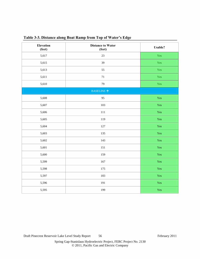
Draft Pinecrest Reservoir Lake Level Study Report 56 February 2011
Spring Gap-Stanislaus Hydroelectric Project, FERC Project No. 2130 © 2011, Pacific Gas and Electric Company
Table 3-3. Distance along Boat Ramp from Top of Water’s Edge
Elevation (feet)
Distance to Water (feet) Usable?
5,617 23 Yes
5,615 39 Yes
5,613 55 Yes
5,611 71 Yes
5,610 79 Yes
BASELINE
5,608 95 Yes
5,607 103 Yes
5,606 111 Yes
5,605 119 Yes
5,604 127 Yes
5,603 135 Yes
5,602 143 Yes
5,601 151 Yes
5,600 159 Yes
5,599 167 Yes
5,598 175 Yes
5,597 183 Yes
5,596 191 Yes
5,595 199 Yes

Draft Pinecrest Reservoir Lake Level Study Report 57 February 2011
Spring Gap-Stanislaus Hydroelectric Project, FERC Project No. 2130 © 2011, Pacific Gas and Electric Company
Table 3-4. Overview of Results for Recreation Facility #2 – Boat Ramp and Courtesy Dock
Elevation (feet)
Criterion #1 Pedestrian Access to
Boat Ramp?
Criterion #2 Pedestrian Access to
Courtesy Dock? Criterion #3
Obstructions?
5,617 Yes Yes No
5,615 Yes Yes No
5,613 Yes Yes No
5,611 Yes Yes No
5,610 Yes Yes No
BASELINE
5,608 Yes Yes No
5,607 Yes Yes No
5,606 Yes Yes No
5,605 Yes Yes No
5,604 Yes Yes No
5,603 Yes Yes No
5,602 Yes Yes No
5,601 Yes Yes No
5,600 Yes Yes No
5,599 Yes Yes No
5,598 Yes Yes No
5,597 Yes Yes No
5,596 Yes Yes No
5,595 Yes Yes No

Draft Pinecrest Reservoir Lake Level Study Report 58 February 2011
Spring Gap-Stanislaus Hydroelectric Project, FERC Project No. 2130 © 2011, Pacific Gas and Electric Company
3.3 R E C R E A T I ON F A C I L I T Y #3 – DE SI G NA T E D B UOY E D SW I M A R E A
3.3.1 C r iter ion #1: Pedestr ian Shor eline A ccess Quality
Using the previously described methods, pedestrian access was evaluated for each transect
within the buoyed swim area. Each transect was evaluated independently, and results were later
compiled to provide an overall evaluation for the entire buoyed swim area.
Figure 3-4 shows Transect #3A. At 5,608 ft, accessibility is impaired but improves until an
elevation of 5,602 ft where it again becomes impaired. Further, as elevations continue to drop,
the accessible shoreline quality follows a downward trend.
Figure 3-5 shows Transect #3B. Access quality drops and becomes impaired for elevations
5,606, 5,602 and 5,598 ft.
Figure 3-6 shows Transect #3C to have no impaired shoreline access beyond the baseline values.
Overall, there is substantial variation between transects in the number of unimpaired and
impaired instances. However, there is only one severely impaired instance, which occurs at an
elevation of 5,597 ft in Transect #3A.
Overall, usability is impaired or severely impaired for this criterion at study elevations 5,608,
5,605, 5,602-5,596 ft, when compared to the baseline average (See Table 3-5 at the end of
section 3.3).
3.3.2 C r iter ion #2: B each Quality
Using the previously described methods, beach quality was evaluated for each transect within the
designated buoyed swim area. Each transect was evaluated independently, and results were later
compiled to provide an overall evaluation for the entire buoyed swim area.
Transect #3A shows a drop in from baseline values at elevations of 5,608, 5,606, and 5,605 ft
(Figure 3-4). The beach quality at lower lake levels continues to fall below elevation 5,604,
reaching severely impaired conditions at elevations 5,600-5,595 ft.

Draft Pinecrest Reservoir Lake Level Study Report 59 February 2011
Spring Gap-Stanislaus Hydroelectric Project, FERC Project No. 2130 © 2011, Pacific Gas and Electric Company
Transect #3B shows a large drop in beach quality, becoming either impaired or severely
impaired at elevations 5,607-5,595 ft. (Figure 3-6).
Transect #3C shows no impaired values for beach quality at any elevation until 5,597 ft
(Figure 3-5).
Similar to accessibility, there is substantial variation between transects in the beach quality of
sites. Overall, usability is impaired or severely impaired for this criterion at all study elevations
when compared to the baseline average (See Table 3-5 at the end of section 3.3).

Draft Pinecrest Reservoir Lake Level Study Report 60 February 2011
Spring Gap-Stanislaus Hydroelectric Project, FERC Project No. 2130 © 2011, Pacific Gas and Electric Company
Figure 3-4. Pedestrian Shoreline Access Quality and Beach Quality Results for Transect #3A
Excellent (1)
Good (0.75)
Fair (0.5)
Poor (0.25)
Very Poor (0.1)
55955600560556105615
Shoreline Access Quality
Elevation Above MSL [ft]Accessible ShorelineBaseline AverageImpairedSeverely Impaired
3A
BASELINE
Excellent (1)
Good (0.75)
Fair (0.5)
Poor (0.25)
Very Poor (0.1)
55955600560556105615
BeachQuality
Elevation Above MSL [ft]Usable Beach AreaBaseline AverageImpairedSeverely Impaired
3A
BASELINE
3-4

Draft Pinecrest Reservoir Lake Level Study Report 61 February 2011
Spring Gap-Stanislaus Hydroelectric Project, FERC Project No. 2130 © 2011, Pacific Gas and Electric Company
Figure 3-5. Pedestrian Shoreline Access Quality and Beach Quality Results for Transect #3B
Excellent (1)
Good (0.75)
Fair (0.5)
Poor (0.25)
Very Poor (0.1)
55955600560556105615
Shoreline Access Quality
Elevation Above MSL [ft]Accessible ShorelineBaseline AverageImpairedSeverely Impaired
3B
BASELINE
Excellent (1)
Good (0.75)
Fair (0.5)
Poor (0.25)
Very Poor (0.1)
55955600560556105615
BeachQuality
Elevation Above MSL [ft]
Usable Beach AreaBaseline AverageImpairedSeverely Impaired
3B
BASELINE
3-5

Draft Pinecrest Reservoir Lake Level Study Report 62 February 2011
Spring Gap-Stanislaus Hydroelectric Project, FERC Project No. 2130 © 2011, Pacific Gas and Electric Company
Figure 3-6. Pedestrian Shoreline Access Quality and Beach Quality Results for Transect #3C
Excellent (1)
Good (0.75)
Fair (0.5)
Poor (0.25)
Very Poor (0.1)
55955600560556105615
Shoreline Access Quality
Elevation Above MSL [ft]Accessible ShorelineBaseline AverageImpairedSeverely Impaired
3C
BASELINE
Excellent (1)
Good (0.75)
Fair (0.5)
Poor (0.25)
Very Poor (0.1)
55955600560556105615
BeachQuality
Elevation Above MSL [ft]Usable Beach AreaBaseline AverageImpairedSeverely Impaired
3C
BASELINE
3-6

Draft Pinecrest Reservoir Lake Level Study Report 63 February 2011
Spring Gap-Stanislaus Hydroelectric Project, FERC Project No. 2130 © 2011, Pacific Gas and Electric Company
3.3.3 C r iter ion #3: Net Usable B each
Net usable beach area quantifies the cumulative amount of exposed usable beach area as the
water elevation falls. The gain in usable beach approaches zero at approximately elevation 5,602
ft in Transect #3A (Figure 3-7).
Transect #3B shows an increase in usable beach area at all elevation levels below baseline.
However, the amount gained becomes reduced at approximately elevation 5,605 ft (Figure 3-8).
Unlike Transects #3A and #3B, there is no reduction in the usable beach area gained as
elevations drop for Transect #3C (Figure 3-9). No elevations below the baseline result in
impaired conditions.
Overall, usability is unimpaired for this criterion at all study elevations when compared to the
baseline average (See Table 3-5 at the end of section 3.3).
3.3.4 C r iter ion #4: A vailable Swimming A r ea
The available swimming area is calculated using the distance from the water to the buoy line,
minus the distance for wading. Because the location of the buoy line does not change, as water
levels decrease, the available swimming area decreases at each elevation (Figures 3-10, 3-11, and
3-12). As the elevation drops to approximately 5,603 ft, there is no water in the designated
buoyed swimming area. This was defined as zero area available for swimming.
Overall, all of the transects show nearly identical relationships for available swimming area.
There are slight differences in the starting distances to the buoy line and in the amount of beach
left exposed by falling water surface elevation. However, the overall relationship is the same for
the entire designated buoyed swimming area; the swimming area becomes impaired at
approximately 5,608 ft and severely impaired at approximately 5,605 ft as compared to the
baseline average.
Overall, usability is impaired or severely impaired for this criterion at all study elevations when
compared to the baseline average (See Table 3-5 at the end of section 3.3).

Draft Pinecrest Reservoir Lake Level Study Report 64 February 2011
Spring Gap-Stanislaus Hydroelectric Project, FERC Project No. 2130 © 2011, Pacific Gas and Electric Company
Figure 3-7. Net Usable Beach in Transect #3A
Figure 3-8. Net Usable Beach in Transect #3B
0
1000
2000
3000
4000
5000
55955600560556105615
Net Usable Beach Area
[sq. ft]
Elevation Above MSL [ft]
Net BeachBaseline AverageImpairedSeverely Impaired
3A
BASELINE
0
1000
2000
3000
4000
5000
55955600560556105615
Net Usable Beach Area
[sq. ft]
Elevation Above MSL [ft]
Net BeachBaseline AverageImpairedSeverely Impaired
3B
BASELINE

Draft Pinecrest Reservoir Lake Level Study Report 65 February 2011
Spring Gap-Stanislaus Hydroelectric Project, FERC Project No. 2130 © 2011, Pacific Gas and Electric Company
Figure 3-9. Net Usable Beach in Transect #3C
Figure 3-10. Available Swimming Area in Transect #3A
0
1000
2000
3000
4000
5000
55955600560556105615
Net Usable Beach Area
[sq. ft]
Elevation Above MSL [ft]
Net BeachBaseline AverageImpairedSeverely Impaired
3C
BASELINE
0
1000
2000
3000
4000
5000
55955600560556105615
Area[sq. ft]
Elevation Above MSL [ft]
Swim AreaBaseline AverageImpairedSeverely Impaired
3A
BASELINE

Draft Pinecrest Reservoir Lake Level Study Report 66 February 2011
Spring Gap-Stanislaus Hydroelectric Project, FERC Project No. 2130 © 2011, Pacific Gas and Electric Company
Figure 3-11. Available Swimming Area in Transect #3B
Figure 3-12. Available Swimming Area in Transect #3C
0
1000
2000
3000
4000
5000
55955600560556105615
Area[sq. ft]
Elevation Above MSL [ft]
Swim AreaBaseline AverageImpairedSeverely Impaired
3B
BASELINE
0
1000
2000
3000
4000
5000
55955600560556105615
Area[sq. ft]
Elevation Above MSL [ft]
Swim AreaBaseline AverageImpairedSeverely Impaired
3C
BASELINE

Draft Pinecrest Reservoir Lake Level Study Report 67 February 2011
Spring Gap-Stanislaus Hydroelectric Project, FERC Project No. 2130 © 2011, Pacific Gas and Electric Company
3.3.5 C r iter ion #5: Usable W ading A r ea
Both Transects #3A and #3B show a drop in the usable wading area as the water elevation drops
(Figures 3-13 and 3-14, respectively). Again, this is due to the trend in beach quality seen in
Figures 3-4 and 3-5.
However, after a slight decline in usable wading area at elevation 5,606 ft, Transect #3C shows
more stable wading area down to elevation 5,601 ft, where it becomes impaired and severely
impaired for elevations 5, 598 ft down to 5,595 ft (Figure 3-15).
Overall, usability is impaired or severely impaired for this criterion at all study elevations when
compared to the baseline average (See Table 3-5 at the end of section 3.3).
3.3.6 C r iter ion #6: Potential Swimming H azar ds
When compared to the baseline average, Transects #3A and #3C show little variation (Figures 3-
16 and 3-18). Becoming impaired at elevations 5,599, 5,598 and 5,608-5,607 for transects #3A
and #3B, respectively.
Transect #3B, however, shows a substantial spike in the number of submerged objects starting at
5,608 ft and continuing to 5,596 ft, these elevations are categorized as either impaired or severely
impaired. (Figure 3-17).
Overall, usability is impaired or severely impaired for this criterion at all study elevations, except
5,595 ft, when compared to the baseline average (See Table 3-5 at the end of section 3.3).

Draft Pinecrest Reservoir Lake Level Study Report 68 February 2011
Spring Gap-Stanislaus Hydroelectric Project, FERC Project No. 2130 © 2011, Pacific Gas and Electric Company
Figure 3-13. Usable Wading Area in Transect #3A
Figure 3-14. Usable Wading Area in Transect #3B
0
200
400
600
800
1000
1200
1400
55955600560556105615
Area[sq. ft.]
Elevation Above MSL [ft]
Usable Wading AreaBaseline AverageImpairedSeverely Impaired
3A
BASELINE
0
200
400
600
800
1000
1200
1400
55955600560556105615
Area[sq. ft.]
Elevation Above MSL [ft]
Usable Wading AreaBaseline AverageImpaired
3B
BASELINE

Draft Pinecrest Reservoir Lake Level Study Report 69 February 2011
Spring Gap-Stanislaus Hydroelectric Project, FERC Project No. 2130 © 2011, Pacific Gas and Electric Company
Figure 3-15. Usable Wading Area in Transect #3C
Figure 3-16. Potential Swimming Hazards within 6 Feet of Water Surface in Transect #3A
0
200
400
600
800
1000
1200
1400
55955600560556105615
Area[sq. ft.]
Elevation Above MSL [ft]
Usable Wading AreaBaseline AverageImpairedSeverely Impaired
3C
BASELINE
0
5
10
15
20
25
30
35
40
45
50
55955600560556105615
No. SubmergedObjects 6 ft.Below Water
Surface
Elevation Above MSL [ft]
Submerged ObjectsBaseline AverageImpairedSeverely Impaired
3A
BASELINE

Draft Pinecrest Reservoir Lake Level Study Report 70 February 2011
Spring Gap-Stanislaus Hydroelectric Project, FERC Project No. 2130 © 2011, Pacific Gas and Electric Company
Figure 3-17. Potential Swimming Hazards within 6 Feet of Water Surface in Transect #3B
Figure 3-18. Potential Swimming Hazards within 6 Feet of Water Surface in Transect #3C
0
5
10
15
20
25
30
35
40
45
50
55955600560556105615
No. SubmergedObjects 6 ft.Below Water
Surface
Elevation Above MSL [ft]
Submerged ObjectsBaseline AverageImpairedSeverely Impaired
3B
BASELINE
0
5
10
15
20
25
30
35
40
45
50
55955600560556105615
No. SubmergedObjects 6 ft.Below Water
Surface
Elevation Above MSL [ft]
Submerged ObjectsBaseline AverageImpairedSeverely Impaired
3C
BASELINE

Draft Pinecrest Reservoir Lake Level Study Report 71 February 2011
Spring Gap-Stanislaus Hydroelectric Project, FERC Project No. 2130 © 2011, Pacific Gas and Electric Company
Table 3-5. Overview of Results for Recreation Facility #3 – Designated Buoyed Swim Area
Elevation (feet)
Criterion #1 Pedestrian Shoreline Access Quality
Criterion #2 Beach Quality
Criterion #3 Net Usable Beach
Criterion #4 Available Swimming Area
Criterion #5 Usable Wading Area
Criterion #6 Potential Swimming Hazards
#3A #3B #3C #3A #3B #3C #3A #3B #3C #3A #3B #3C #3A #3B #3C #3A #3B #3C
5,617 Unimpaired Unimpaired Unimpaired Unimpaired Unimpaired Unimpaired Impaired Impaired Impaired Unimpaired Unimpaired Unimpaired Unimpaired Unimpaired Unimpaired Unimpaired Unimpaired Severely Impaired
5,615 Unimpaired Unimpaired Impaired Unimpaired Unimpaired Impaired Unimpaired Unimpaired Unimpaired Unimpaired Unimpaired Unimpaired Unimpaired Unimpaired Unimpaired Unimpaired Unimpaired Unimpaired
5,613 Unimpaired Unimpaired Unimpaired Unimpaired Unimpaired Unimpaired Unimpaired Unimpaired Unimpaired Unimpaired Unimpaired Unimpaired Unimpaired Unimpaired Unimpaired Unimpaired Unimpaired Unimpaired
5,611 Unimpaired Unimpaired Unimpaired Unimpaired Unimpaired Unimpaired Unimpaired Unimpaired Unimpaired Unimpaired Unimpaired Unimpaired Unimpaired Unimpaired Unimpaired Unimpaired Impaired Unimpaired
5,610 Unimpaired Unimpaired Unimpaired Unimpaired Unimpaired Unimpaired Unimpaired Unimpaired Unimpaired Impaired Impaired Impaired Unimpaired Unimpaired Unimpaired Unimpaired Unimpaired Unimpaired
BASELINE
5,608 Impaired Unimpaired Unimpaired Impaired Unimpaired Unimpaired Unimpaired Unimpaired Unimpaired Impaired Impaired Impaired Unimpaired Impaired Unimpaired Unimpaired Impaired Impaired
5,607 Unimpaired Unimpaired Unimpaired Unimpaired Impaired Unimpaired Unimpaired Unimpaired Unimpaired Impaired Impaired Impaired Impaired Impaired Unimpaired Unimpaired Impaired Impaired
5,606 Unimpaired Unimpaired Unimpaired Impaired Impaired Unimpaired Unimpaired Unimpaired Unimpaired Impaired Impaired Impaired Impaired Impaired Unimpaired Unimpaired Severely Impaired Unimpaired
5,605 Unimpaired Impaired Unimpaired Impaired Impaired Unimpaired Unimpaired Unimpaired Unimpaired Severely Impaired Impaired Severely
Impaired Impaired Impaired Unimpaired Unimpaired Severely Impaired Unimpaired
5,604 Unimpaired Unimpaired Unimpaired Unimpaired Impaired Unimpaired Unimpaired Unimpaired Unimpaired Severely Impaired
Severely Impaired
Severely Impaired Unimpaired Impaired Unimpaired Unimpaired Severely
Impaired Unimpaired
5,603 Unimpaired Unimpaired Unimpaired Impaired Impaired Unimpaired Unimpaired Unimpaired Unimpaired Severely Impaired
Severely Impaired
Severely Impaired Impaired Impaired Unimpaired Unimpaired Severely
Impaired Unimpaired
5,602 Impaired Impaired Unimpaired Impaired Severely Impaired Unimpaired Unimpaired Unimpaired Unimpaired Severely
Impaired Severely Impaired
Severely Impaired Impaired Impaired Unimpaired Unimpaired Severely
Impaired Unimpaired
5,601 Impaired Unimpaired Unimpaired Impaired Impaired Unimpaired Unimpaired Unimpaired Unimpaired Severely Impaired
Severely Impaired
Severely Impaired Impaired Impaired Impaired Unimpaired Severely
Impaired Unimpaired
5,600 Impaired Unimpaired Unimpaired Severely Impaired Impaired Unimpaired Unimpaired Unimpaired Unimpaired Severely
Impaired Severely Impaired
Severely Impaired
Severely Impaired
Severely Impaired Impaired Unimpaired Severely
Impaired Unimpaired
5,599 Impaired Unimpaired Unimpaired Severely Impaired Impaired Unimpaired Unimpaired Unimpaired Unimpaired Severely
Impaired Severely Impaired
Severely Impaired
Severely Impaired
Severely Impaired Impaired Impaired Severely
Impaired Unimpaired
5,598 Impaired Impaired Unimpaired Severely Impaired Impaired Unimpaired Unimpaired Unimpaired Unimpaired Severely
Impaired Severely Impaired
Severely Impaired
Severely Impaired
Severely Impaired
Severely Impaired Impaired Impaired Unimpaired
5,597 Severely Impaired Unimpaired Unimpaired Severely
Impaired Impaired Impaired Unimpaired Unimpaired Unimpaired Severely Impaired
Severely Impaired
Severely Impaired
Severely Impaired
Severely Impaired
Severely Impaired Unimpaired Impaired Unimpaired
5,596 Impaired Unimpaired Unimpaired Severely Impaired
Severely Impaired Unimpaired Unimpaired Unimpaired Unimpaired Severely
Impaired Severely Impaired
Severely Impaired
Severely Impaired
Severely Impaired
Severely Impaired Unimpaired Impaired Unimpaired
5,595 Unimpaired Unimpaired Unimpaired Severely Impaired Impaired Unimpaired Unimpaired Unimpaired Unimpaired Severely
Impaired Severely Impaired
Severely Impaired
Severely Impaired
Severely Impaired
Severely Impaired Unimpaired Unimpaired Unimpaired

Draft Pinecrest Reservoir Lake Level Study Report 72 February 2011
Spring Gap-Stanislaus Hydroelectric Project, FERC Project No. 2130 © 2011, Pacific Gas and Electric Company
3.4 R E C R E A T I ON F A C I L I T Y #4 – M I X E D DA Y -USE A R E A
3.4.1 C r iter ion #1: Pedestr ian Shor eline A ccess Quality
As described for Transects #3A, #3B, and #3C, a 20-ft-wide swath of beach was evaluated for
the quality of pedestrian shoreline access. Defining “impaired” access at levels below 75 percent
and “severely impaired” at levels below 25 percent of the baseline average, no elevations at the
mixed day-use area contain impaired or severely impaired pedestrian shoreline access
(Figure 3-19).
Overall, usability is unimpaired for this criterion at all study elevations, when compared to the
baseline average (See Table 3-6 at the end of section 3.4).
3.4.2 C r iter ion #2: B each Quality
As described for the designated buoyed swim area, a 20-ft-wide swath of beach was evaluated
for beach quality. The beach quality becomes impaired at elevation 5,600 ft (Figure 3-19);
however, the beach area below 5,600 ft rebounds in terms of beach quality, regaining unimpaired
status.
Overall, usability is unimpaired for this criterion at all study elevations, except 5,600 ft, when
compared to the baseline average (See Table 3-6 at the end of section 3.4).
3.4.3 C r iter ion #3: Net Usable B each
At the mixed day-use area, net usable beach area continues to grow at approximately the same
rate found during baseline elevations (Figure 3-20). As there is only one instance of impaired
beach quality at the mixed day-use area, each resulting drop in water elevation provides
approximately the same amount of additional usable beach area.
Overall, usability is unimpaired for this criterion at all study elevations, when compared to the
baseline average (See Table 3-6 at the end of section 3.4).

Draft Pinecrest Reservoir Lake Level Study Report 73 February 2011
Spring Gap-Stanislaus Hydroelectric Project, FERC Project No. 2130 © 2011, Pacific Gas and Electric Company
3.4.4 C r iter ion #4: Usable W ading A r ea
The usable wading area along this facility does not vary when compared to baseline values
(Figure 3-21). As there is only one instance of impaired beach quality at the facility, usable
wading area does not become impaired at any elevation.
Overall, usability is unimpaired for this criterion at all study elevations, when compared to the
baseline average (See Table 3-6 at the end of section 3.4).
3.4.5 C r iter ion #5: Potential Swimming H azar ds
At Recreation Facility #4, the number of submerged objects remains within 25 percent of the
baseline average until an elevation of 5,611 ft (Figure 3-22). For elevations 5,608, 5,606, and
5,600-5,595, the number of submerged objects increases, resulting in impairment or severe
impairment related to swimming hazards (i.e., the potential for swimming hazards worsens
because more submerged objects are located up to 6 ft below the water surface within 10 ft of the
transect line when compared to baseline values).
Overall, usability is impaired or severely impaired for this criterion at study elevations 5,608-
5,606, 5,603 and 5,600-5,595, when compared to the baseline average (See Table 3-6 at the end
of section 3.4).
3.4.6 C r iter ion #6: B oating A ccess and Potential H azar ds
At Recreation Facility #4, boating access is not impaired because the quality of accessible
shoreline does not become impaired as lake elevations drop to elevation 5,595 ft. (Figure 3-19).
The other variable evaluated for boating use considered objects located within 2 ft of the water
surface. These objects pose potential hazards to boats with a draft of 2 ft or greater, the
maximum draft found on typical non-motorized boats. The number of potential boating hazards
becomes impaired at elevations 5,606, 5,599 and 5,598 and severely impaired at elevations
5,604, 5,603, 5,596 and 5,595 ft (Figure 3-23). However, as there are no impairments to boating
access, there are no elevations that contain impairments to both boating access and potential
hazards. This results in usability being categorized as unimpaired for all study elevations.

Draft Pinecrest Reservoir Lake Level Study Report 74 February 2011
Spring Gap-Stanislaus Hydroelectric Project, FERC Project No. 2130 © 2011, Pacific Gas and Electric Company
Overall, usability is unimpaired for this criterion when compared to the baseline average using
the methods described in section 2.4.6 (See Table 3-6 at the end of section 3.4).

Draft Pinecrest Reservoir Lake Level Study Report 75 February 2011
Spring Gap-Stanislaus Hydroelectric Project, FERC Project No. 2130 © 2011, Pacific Gas and Electric Company
Figure 3-19. Pedestrian Shoreline Access Quality and Beach Quality Results for Recreation Facility #4
Excellent (1)
Good (0.75)
Fair (0.5)
Poor (0.25)
Very Poor (0.1)
55955600560556105615
Shoreline Access Quality
Elevation Above MSL [ft]Accessible ShorelineBaseline AverageImpairedSeverely Impaired
4
BASELINE
Excellent (1)
Good (0.75)
Fair (0.5)
Poor (0.25)
Very Poor (0.1)
55955600560556105615
BeachQuality
Elevation Above MSL [ft]Usable Beach AreaBaseline AverageImpairedSeverely Impaired
4
BASELINE
3-19

Draft Pinecrest Reservoir Lake Level Study Report 76 February 2011
Spring Gap-Stanislaus Hydroelectric Project, FERC Project No. 2130 © 2011, Pacific Gas and Electric Company
Figure 3-20. Net Usable Beach at Recreation Facility #4
Figure 3-21. Usable Wading Area at Recreation Facility #4
0
1000
2000
3000
4000
5000
55955600560556105615
Net Usable Beach Area
[sq. ft]
Elevation Above MSL [ft]
Net BeachBaseline AverageImpairedSeverely Impaired
4
BASELINE
0
200
400
600
800
1000
1200
1400
55955600560556105615
Area[sq. ft.]
Elevation Above MSL [ft]Usable Wading AreaBaseline AverageImpairedSeverely Impaired
4
BASELINE

Draft Pinecrest Reservoir Lake Level Study Report 77 February 2011
Spring Gap-Stanislaus Hydroelectric Project, FERC Project No. 2130 © 2011, Pacific Gas and Electric Company
Figure 3-22. Potential Swimming Hazards within 6 Feet of Water Surface at Recreation Facility #4
Figure 3-23. Potential Boating Hazards within 2 Feet of Water Surface at Recreation Facility #4
0
10
20
30
40
50
55955600560556105615
No. SubmergedObjects 6 ft.Below Water
Surface
Elevation Above MSL [ft]
Submerged Objects
Baseline Average
Impaired
Severely Impaired
4
BASELINE
0
5
10
15
20
25
30
55955600560556105615
No. SubmergedObjects 2ft.
Below WaterSurface
Elevation Above MSL [ft]
Submerged Objects
Baseline Average
Series4
Series5
4
BASELINE
Draft Pinecrest Reservoir Lake Level Study Report 78 February 2011
Spring Gap-Stanislaus Hydroelectric Project, FERC Project No. 2130 © 2011, Pacific Gas and Electric Company
Table 3-6. Overview of Results for Recreation Facility #4 – Mixed Day-Use Area
Criterion #1 Criterion #2 Criterion #3 Criterion #4 Criterion #5 Criterion #6
Elevation (feet)
Pedestrian Shoreline Access Quality Beach Quality Net Usable Beach Usable Wading Area
Potential Swimming Hazards
Potential Boating Hazards
Overall Boating*
5,617 Impaired Unimpaired Impaired Unimpaired Unimpaired Severely Impaired Impaired
5,615 Unimpaired Unimpaired Impaired Unimpaired Unimpaired Unimpaired Unimpaired
5,613 Unimpaired Unimpaired Unimpaired Unimpaired Unimpaired Unimpaired Unimpaired
5,611 Unimpaired Unimpaired Unimpaired Unimpaired Impaired Unimpaired Unimpaired
5,610 Unimpaired Unimpaired Unimpaired Unimpaired Unimpaired Impaired Unimpaired
BASELINE
5,608 Unimpaired Unimpaired Unimpaired Unimpaired Impaired Unimpaired Unimpaired
5,607 Unimpaired Unimpaired Unimpaired Unimpaired Impaired Unimpaired Unimpaired
5,606 Unimpaired Unimpaired Unimpaired Unimpaired Impaired Impaired Unimpaired
5,605 Unimpaired Unimpaired Unimpaired Unimpaired Unimpaired Unimpaired Unimpaired
5,604 Unimpaired Unimpaired Unimpaired Unimpaired Unimpaired Severely Impaired Unimpaired
5,603 Unimpaired Unimpaired Unimpaired Unimpaired Impaired Severely Impaired Unimpaired
5,602 Unimpaired Unimpaired Unimpaired Unimpaired Unimpaired Unimpaired Unimpaired
5,601 Unimpaired Unimpaired Unimpaired Unimpaired Unimpaired Unimpaired Unimpaired
5,600 Unimpaired Impaired Unimpaired Unimpaired Severely Impaired Unimpaired Unimpaired
5,599 Unimpaired Unimpaired Unimpaired Unimpaired Severely Impaired Impaired Unimpaired
5,598 Unimpaired Unimpaired Unimpaired Unimpaired Severely Impaired Impaired Unimpaired
5,597 Unimpaired Unimpaired Unimpaired Unimpaired Severely Impaired Unimpaired Unimpaired
5,596 Unimpaired Unimpaired Unimpaired Unimpaired Severely Impaired Severely Impaired Unimpaired
5,595 Unimpaired Unimpaired Unimpaired Unimpaired Severely Impaired Severely Impaired Unimpaired
*Note: Overall Boating combines the categories found in Pedestrian Shoreline Access Quality and Potential Boating Hazards, as described under Criterion #6 for Recreation Facility #4.

Draft Pinecrest Reservoir Lake Level Study Report 79 February 2011
Spring Gap-Stanislaus Hydroelectric Project, FERC Project No. 2130 © 2011, Pacific Gas and Electric Company
3.5 R E C R E A T I ON F A C I L I T Y #5 – A DA -A C C E SSI B L E F I SH I NG PL A T F OR M
The ADA-accessible fishing platform consists of an upper and lower platform. The platforms
were evaluated separately for impairments to recreation usability. The ADA-accessible fishing
platform is the only evaluated infrastructure that maintains ADA access through the baseline.
Overall usability of the facility is affected by lowered lake levels, however the platforms remain
accessible. Therefore, the ADA-accessible fishing platform is the only facility where use for
persons with disabilities (in addition to all other users) would be impaired directly from lowered
lake level compared to baseline conditions.
3.5.1 C r iter ion 1: F ishing Oppor tunities fr om the Upper Platfor m
The upper platform is in contact with the water, and therefore usable, until elevation 5,611 ft. At
this elevation, the base of the platform is exposed and is no longer in direct contact with the
water and becomes unusable. The platform is accessible for all elevations.
Overall, usability is impaired for this criterion at study elevations 5,611-5,595, when compared
to the baseline average (See Table 3-7 at the end of section 3.5).
3.5.2 C r iter ion 2: F ishing Oppor tunities fr om the L ower Platfor m
The lower platform is inundated with water above an elevation of 5,611 ft and therefore is
inaccessible. Below 5,611 ft, the lower platform becomes accessible and remains usable (in
contact with the water) until elevation 5,605 ft, when the platform loses direct contact with the
water surface and becomes unusable. The platform remains accessible for all lower elevations.
Overall, usability is impaired for this criterion at study elevations 5,605-5,595, when compared
to the baseline average (See Table 3-7 at the end of section 3.5).

Draft Pinecrest Reservoir Lake Level Study Report 80 February 2011
Spring Gap-Stanislaus Hydroelectric Project, FERC Project No. 2130 © 2011, Pacific Gas and Electric Company
Table 3-7. Overview of Results for Recreation Facility #5 – ADA-Accessible Fishing Platform
Elevation (feet)
Upper Platform: Accessible?
Lower Platform Accessible?
Upper Platform: Usable?
Lower Platform: Usable?
5,617 Yes No Yes No
5,615 Yes No Yes No
5,613 Yes No Yes No
5,611 Yes Yes No Yes
5,610 Yes Yes No Yes
BASELINE
5,608 Yes Yes No Yes
5,607 Yes Yes No Yes
5,606 Yes Yes No Yes
5,605 Yes Yes No No
5,604 Yes Yes No No
5,603 Yes Yes No No
5,602 Yes Yes No No
5,601 Yes Yes No No
5,600 Yes Yes No No
5,599 Yes Yes No No
5,598 Yes Yes No No
5,597 Yes Yes No No
5,596 Yes Yes No No
5,595 Yes Yes No No

Draft Pinecrest Reservoir Lake Level Study Report 81 February 2011
Spring Gap-Stanislaus Hydroelectric Project, FERC Project No. 2130 © 2011, Pacific Gas and Electric Company
3.6 R E C R E A T I ON F A C I L I T Y #6 – OV E R F L OW A R E A , SOUT H SH OR E
3.6.1 C r iter ion #1: Pedestr ian Shor eline A ccess Quality
There are low scores for the quality of pedestrian shoreline access at elevations 5,608 and
5,607 ft (Figure 3-24). As elevations continue to drop, the number of impediments to access
decline, resulting in an increase in the quality of pedestrian shoreline access and unimpaired use
at all elevations except 5,605 and 5,597 ft which are impaired. However, there is substantial
variation between elevations.
Overall, usability is impaired or severely impaired for this criterion at study elevations 5,608,
5,607, 5,605, and 5,597, when compared to the baseline average (See Table 3-8 at the end of
section 3.6).
3.6.2 C r iter ion #2: B each Quality
Similar to pedestrian shoreline access, beach quality at Recreation Facility #6 shows a decline at
elevations 5,608 and 5,607 ft, becoming severely impaired. Beach quality is impaired at all
subsequent elevations except for 5,603, 5,601, 5,599, 5,996, and 5,595 ft (Figure 3-26).
Overall, usability is impaired or severely impaired for this criterion at study elevations 5,608-
5,604, 5,602, 5,600, 5,598 and 5,597, when compared to the baseline average (See Table 3-8 at
the end of section 3.6).
3.6.3 C r iter ion #3: Net Usable B each
At this facility, the net usable beach available increases overall for the studied elevations. The
rate of increase decreases for elevations 5,610 through 5,605 ft and elevations 5,599 through
5,598 ft (Figure 3-25).
Overall, usability is unimpaired for this criterion at all study elevations when compared to the
baseline average (See Table 3-8 at the end of section 3.6).
3.6.4 C r iter ion #4: Usable W ading A r ea
The usable wading area at Recreation Facility #6 shows unimpaired use at elevations 5,604-
5,599 and 5,596-5,595 ft. (Figure 3-26).
Draft Pinecrest Reservoir Lake Level Study Report 82 February 2011
Spring Gap-Stanislaus Hydroelectric Project, FERC Project No. 2130 © 2011, Pacific Gas and Electric Company
Overall, usability is impaired or severely impaired for this criterion at study elevations 5,608-
5,605, 5,598 and 5,597 ft, when compared to the baseline average (See Table 3-8 at the end of
section 3.6).
3.6.5 C r iter ion #5: Potential Swimming H azar ds
At Recreation Facility #6, potential swimming hazards are categorized as impaired at elevation
5,608 and 5,607 ft. After elevation 5,607 ft, however, the number of submerged objects falls
within 25 percent of the baseline average and remains categorized as unimpaired until elevation
5,598 ft (Figure 3-27).
Overall, usability is impaired for this criterion at study elevations 5,608 and 5,607, when
compared to the baseline average (See Table 3-8 at the end of section 3.6).
3.6.6 C r iter ion #6: B oating A ccess and Potential H azar ds
Impaired shoreline access quality is present at elevation 5,608, 5,607, 5,605 and 5,597 ft, caused
by a greater number of submerged objects, at elevation 5,607 ft (Figures 3-24 and 3-28,
respectively). Both elevations 5,608 and 5,607 ft. also contain impaired or severely impaired
potential boating hazard values. No other elevations contain both impaired access quality and
potential hazards. This results in usability for criterion #6 being categorized as impaired and
severely impaired at elevations 5,608 and 5,607, respectively.
Overall, usability is impaired or severely impaired for this criterion at study elevations 5,608 and
5,607, when compared to the baseline average using the methods described in section 2.6.6 (See
Table 3-8 at the end of section 3.6).

Draft Pinecrest Reservoir Lake Level Study Report 83 February 2011
Spring Gap-Stanislaus Hydroelectric Project, FERC Project No. 2130 © 2011, Pacific Gas and Electric Company
Figure 3-24. Pedestrian Shoreline Access Quality and Beach Quality Results for Recreation Facility #6
Excellent (1)
Good (0.75)
Fair (0.5)
Poor (0.25)
Very Poor (0.1)
55955600560556105615
Shoreline Access Quality
Elevation Above MSL [ft]Accessible ShorelineBaseline AverageImpairedSeverely Impaired
6
BASELINE
Excellent (1)
Good (0.75)
Fair (0.5)
Poor (0.25)
Very Poor (0.1)
55955600560556105615
BeachQuality
Elevation Above MSL [ft]Usable Beach AreaBaseline AverageImpairedSeverely Impaired
6
BASELINE
3-24

Draft Pinecrest Reservoir Lake Level Study Report 84 February 2011
Spring Gap-Stanislaus Hydroelectric Project, FERC Project No. 2130 © 2011, Pacific Gas and Electric Company
Figure 3-25. Net Usable Beach at Recreation Facility #6
0
1000
2000
3000
4000
5000
55955600560556105615
Net Usable Beach Area
[sq. ft]
Elevation Above MSL [ft]
Net Beach
Baseline Average
Impaired
Severely Impaired
6
BASELINE
0
200
400
600
800
1000
1200
1400
55955600560556105615
Area[sq. ft.]
Elevation Above MSL [ft]
Usable Wading Area
Baseline Average
Impaired
Severely Impaired
6
BASELINE

Draft Pinecrest Reservoir Lake Level Study Report 85 February 2011
Spring Gap-Stanislaus Hydroelectric Project, FERC Project No. 2130 © 2011, Pacific Gas and Electric Company
Figure 3-26. Usable Wading Area at Recreation Facility #6
Figure 3-27. Potential Swimming Hazards within 6 Feet of Water Surface at Recreation Facility #6
Figure 3-28. Potential Boating Hazards within 2 Feet of Water Surface at Recreation Facility #6
0
10
20
30
40
50
55955600560556105615
No. SubmergedObjects 6 ft.Below Water
Surface
Elevation Above MSL [ft]
Submerged ObjectsBaseline AverageImpairedSeverely Impaired
6
BASELINE
6
0
5
10
15
20
25
30
55955600560556105615
No. SubmergedObjects 2 ft.Below Water
Surface
Elevation Above MSL [ft]Submerged ObjectsBaseline AverageImpairedSeverely Impaired
6
BASELINE

Draft Pinecrest Reservoir Lake Level Study Report 86 February 2011
Spring Gap-Stanislaus Hydroelectric Project, FERC Project No. 2130 © 2011, Pacific Gas and Electric Company
Table 3-8. Overview of Results for Recreation Facility #6 – Overflow Area, South Shore
Criterion #1 Criterion #2 Criterion #3 Criterion #4 Criterion #5 Criterion #6
Elevation (feet)
Pedestrian Shoreline Access Quality Beach Quality Net Usable Beach Usable Wading Area Potential Swimming
Hazards Potential Boating Hazards Overall Boating*
5,617 Unimpaired Unimpaired Severely Impaired Unimpaired Unimpaired Unimpaired Unimpaired
5,615 Unimpaired Unimpaired Impaired Unimpaired Unimpaired Unimpaired Unimpaired
5,613 Unimpaired Unimpaired Unimpaired Unimpaired Unimpaired Severely Impaired Unimpaired
5,611 Unimpaired Unimpaired Unimpaired Impaired Unimpaired Unimpaired Unimpaired
5,610 Impaired Impaired Unimpaired Impaired Unimpaired Unimpaired Unimpaired
BASELINE
5,608 Impaired Severely Impaired Unimpaired Severely Impaired Impaired Severely Impaired Impaired
5,607 Severely Impaired Severely Impaired Unimpaired Impaired Impaired Severely Impaired severely impaired
5,606 Unimpaired Impaired Unimpaired Impaired Unimpaired Unimpaired Unimpaired
5,605 Impaired Impaired Unimpaired Impaired Unimpaired Unimpaired Unimpaired
5,604 Unimpaired Impaired Unimpaired Unimpaired Unimpaired Impaired Unimpaired
5,603 Unimpaired Unimpaired Unimpaired Unimpaired Unimpaired Unimpaired Unimpaired
5,602 Unimpaired Impaired Unimpaired Unimpaired Unimpaired Unimpaired Unimpaired
5,601 Unimpaired Unimpaired Unimpaired Unimpaired Unimpaired Unimpaired Unimpaired
5,600 Unimpaired Impaired Unimpaired Unimpaired Unimpaired Unimpaired Unimpaired
5,599 Unimpaired Unimpaired Unimpaired Unimpaired Unimpaired Unimpaired Unimpaired
5,598 Unimpaired Impaired Unimpaired Impaired Unimpaired Unimpaired Unimpaired
5,597 Impaired Severely Impaired Unimpaired Impaired Unimpaired Unimpaired Unimpaired
5,596 Unimpaired Unimpaired Unimpaired Unimpaired Unimpaired Unimpaired Unimpaired
5,595 Unimpaired Unimpaired Unimpaired Unimpaired Unimpaired Unimpaired Unimpaired
*Note: Overall Boating combines the categories found in Pedestrian Shoreline Access Quality and Potential Boating Hazards, as described under Criterion #6 for Recreation Facility #4.

Draft Pinecrest Reservoir Lake Level Study Report 87 February 2011
Spring Gap-Stanislaus Hydroelectric Project, FERC Project No. 2130 © 2011, Pacific Gas and Electric Company
3.7 R E C R E A T I ON F A C I L I T I E S #7 – OV E R F L OW A R E A , NOR T H OF M A R I NA
3.7.1 C r iter ion #1: Pedestr ian Shor eline A ccess Quality
Pedestrian shoreline access quality becomes impaired at elevations 5,600, 5,599, and 5,598 ft for
Transect #7A (Figure 3-29). However, the beach area below these elevations improves in terms
of accessible shoreline.
Transect #7B shows more variability than Transect #7A. Pedestrian shoreline access quality
becomes impaired at 5,608 ft. Lower elevations regain high access ratings and unimpaired status
until elevation 5,597 ft (Figure 3-30).
Overall, usability is impaired or severely impaired for this criterion at study elevations 5,608 and
5,600-5,597 when compared to the baseline average (See Table 3-9 at the end of section 3.7).
3.7.2 C r iter ion #2: B each Quality
Along Transect #7A, beach quality becomes impaired at three elevations: 5,599, 5,598, and
5,595 ft (Figure 3-29).
Transect #7B shows much more variability in terms of beach quality (Figure 3-30). Transect
#7B does not have large numbers of consecutive elevations without impaired beach quality; there
are substantial changes in beach quality as elevations drop. Beach quality becomes impaired at
elevations 5,608, 5,607, 5,604, 5,600 and 5,598-5,597 ft.
Overall, usability is impaired or severely impaired for this criterion at study elevations 5,608,
5,607, 5,604, 5,600-5,597 and 5,595 when compared to the baseline average (See Table 3-9 at
the end of section 3.7).
3.7.3 C r iter ion #3: Net Usable B each
Both Transects #7A and #7B show increases in the net usable beach area for all elevations.
Transect #7A maintains a rate of increase comparable to that seen in the baseline values
(Figure 3-31).

Draft Pinecrest Reservoir Lake Level Study Report 88 February 2011
Spring Gap-Stanislaus Hydroelectric Project, FERC Project No. 2130 © 2011, Pacific Gas and Electric Company
Transect #7B also has a positive rate of increase, approximately the same as the rate present
during the baseline (Figure 3-32).
Overall, usability is unimpaired for this criterion at all study elevations when compared to the
baseline average (See Table 3-9 at the end of section 3.7).
3.7.4 C r iter ion #4: Usable W ading A r ea
Along Transect #7A, the usable wading area does not change until elevation 5,600 ft. After this
elevation, the area of usable wading area becomes impaired until elevation 5,597. Usable
wading area is also impaired for elevations 5,596 and 5,595 (Figure 3-33).
Transect #7B is impaired for elevations 5,608, 5,605 and 5,601-5,598 ft. (Figure 3-34).
Overall, usability is impaired for this criterion at study elevations 5,608, 5,605, 5,601-5,598,
5,596 and 5,595 ft when compared to the baseline average (See Table 3-9 at the end of section
3.7).
3.7.5 C r iter ion #5: Potential Swimming H azar ds
The number of submerged objects that pose potential swimming hazards in Transect #7A is
impaired at elevation 5,608 ft (Figure 3-35).
In comparison, Transect #7B contains two elevations where the status is severely impaired
(5,600 and 5,999 ft) and four elevations where the status is impaired, 5,600 and 5,598-5,596
(Figure 3-36).
Overall, usability is impaired or severely impaired for this criterion at study elevations 5,608 and
5,601-5,596 ft. when compared to the baseline average (See Table 3-9 at the end of section 3.7).
3.7.6 C r iter ion #6: B oating A ccess and Potential H azar ds
Along Transects #7A, potential boating hazards are designated as severely impaired at elevations
5,608, 5,607, and 5,604 ft and impaired at elevations 5,603, 5,598 and 5,597 ft (Figure 3-37).
There is a corresponding impairment to pedestrian shoreline access at elevation 5,598 ft,
resulting in an overall impairment to criterion #6 at this elevation.
Draft Pinecrest Reservoir Lake Level Study Report 89 February 2011
Spring Gap-Stanislaus Hydroelectric Project, FERC Project No. 2130 © 2011, Pacific Gas and Electric Company
Potential boating hazards in Transect #7B are categorized as unimpaired within the study
elevation range until the final three elevations studied (5,597–5,595 ft) (Figure 3-38). At these
elevations, the status is severely impaired. There is a corresponding impairment to pedestrian
shoreline access at elevation 5,597, resulting in an overall impairment to criterion #6 at this
elevation.
Based on photo documentation and 3D graphics, the fire dock remains usable at all elevations.
Overall, usability is impaired for this criterion at study elevations 5,598 and 5,597 ft. when
compared to the baseline average (See Table 3-9 at the end of section 3.7).

Draft Pinecrest Reservoir Lake Level Study Report 90 February 2011
Spring Gap-Stanislaus Hydroelectric Project, FERC Project No. 2130 © 2011, Pacific Gas and Electric Company
Figure 3-29. Pedestrian Shoreline Access Quality and Beach Quality Results for Transect #7A
Excellent (1)
Good (0.75)
Fair (0.5)
Poor (0.25)
Very Poor (0.1)
55955600560556105615
Shoreline Access Quality
Elevation Above MSL [ft]Accessible ShorelineBaseline AverageImpairedSeverely Impaired
7A
BASELINE
Excellent (1)
Good (0.75)
Fair (0.5)
Poor (0.25)
Very Poor (0.1)
55955600560556105615
Beach Quality
Elevation Above MSL [ft]Usable Beach AreaBaseline AverageImpairedSeverely Impaired
7A
BASELINE
3-29

Draft Pinecrest Reservoir Lake Level Study Report 91 February 2011
Spring Gap-Stanislaus Hydroelectric Project, FERC Project No. 2130 © 2011, Pacific Gas and Electric Company
Figure 3-30. Pedestrian Shoreline Access Quality and Beach Quality Results for Transect #7B
Excellent (1)
Good (0.75)
Fair (0.5)
Poor (0.25)
Very Poor (0.1)
55955600560556105615
Shoreline Access Quality
Elevation Above MSL [ft]Accessible ShorelineBaseline AverageImpairedSeverely Impaired
7B
BASELINE
Excellent (1)
Good (0.75)
Fair (0.5)
Poor (0.25)
Very Poor (0.1)
55955600560556105615
BeachQuality
Elevation Above MSL [ft]Usable Beach AreaBaseline AverageImpairedSeverely Impaired
7B
BASELINE
3-30

Pinecrest Reservoir Lake Level Study 92 February 2011
Spring Gap-Stanislaus Hydroelectric Project, FERC Project No. 2130 © 2011, Pacific Gas and Electric Company
Figure 3-31. Net Usable Beach in Transect #7A
Figure 3-32. Net Usable Beach in Transect #7B
0
1000
2000
3000
4000
5000
55955600560556105615
Net Usable Beach Area
[sq. ft]
Elevation Above MSL [ft]
Net BeachBaseline AverageImpairedSeverely Impaired
7A
BASELINE
0
1000
2000
3000
4000
5000
55955600560556105615
Net Usable Beach Area
[sq. ft]
Elevation Above MSL [ft]
Net BeachBaseline AverageImpairedSeverely Impaired
7B
BASELINE

Pinecrest Reservoir Lake Level Study 93 February 2011
Spring Gap-Stanislaus Hydroelectric Project, FERC Project No. 2130 © 2011, Pacific Gas and Electric Company
Figure 3-33. Usable Wading Area in Transect #7A
Figure 3-34. Usable Wading Area in Transect #7B
0
200
400
600
800
1000
1200
1400
55955600560556105615
Area[sq. ft.]
Elevation Above MSL [ft]
Usable Wading Area
Baseline Average
Impaired
Severely Impaired
7A
BASELINE
0
200
400
600
800
1000
1200
1400
55955600560556105615
Area[sq. ft.]
Elevation Above MSL [ft]
Usable Wading Area
Baseline Average
Impaired
Severely Impaired
7B
BASELINE

Pinecrest Reservoir Lake Level Study 94 February 2011
Spring Gap-Stanislaus Hydroelectric Project, FERC Project No. 2130 © 2011, Pacific Gas and Electric Company
Figure 3-35. Potential Swimming Hazards within 6 Feet of Water Surface in Transect #7A
Figure 3-36. Potential Swimming Hazards within 6 Feet of Water Surface in Transect #7B
0
10
20
30
40
50
55955600560556105615
No. SubmergedObjects 6 ft.Below Water
Surface
Elevation Above MSL [ft]
Submerged ObjectsBaseline AverageImpairedSeverely Impaired
7A
BASELINE
0
10
20
30
40
50
55955600560556105615
No. SubmergedObjects 6 ft.Below Water
Surface
Elevation Above MSL [ft]
Submerged ObjectsBaseline AverageImpairedSeverely Impaired
7B
BASELINE

Pinecrest Reservoir Lake Level Study 95 February 2011
Spring Gap-Stanislaus Hydroelectric Project, FERC Project No. 2130 © 2011, Pacific Gas and Electric Company
Figure 3-37. Potential Boating Hazards within 2 Feet of Water Surface in Transect #7A
Figure 3-38. Potential Boating Hazards within 2 Feet of Water Surface in Transect #7B
0
5
10
15
20
25
30
55955600560556105615
No. SubmergedObjects 2 ft.Below Water
Surface
Elevation Above MSL [ft]Submerged ObjectsBaseline AverageImpairedSeverely Impaired
7A
BASELINE
0
5
10
15
20
25
30
55955600560556105615
No. SubmergedObjects 2 ft.Below Water
Surface
Elevation Above MSL [ft]Submerged ObjectsBaseline AverageImpairedSeverely Impaired
7B
BASELINE

Draft Pinecrest Reservoir Lake Level Study Report 96 February 2011
Spring Gap-Stanislaus Hydroelectric Project, FERC Project No. 2130 © 2011, Pacific Gas and Electric Company
Table 3-9. Overview of Results for Recreation Facility #7 – Overflow Area, North of Marina
Elevation (feet)
Criterion #1 Pedestrian Shoreline Access
Quality Criterion #2
Beach Quality Criterion #3
Net Usable Beach Criterion #4
Usable Wading Area Criterion #5
Potential Swimming Hazards
Criterion #6
Potential Boating Hazards Overall Boating*
#7A #7B #7A #7B #7A #7B #7A #7B #7A #7B #7A #7B #7A #7B
5,617 Unimpaired Unimpaired Unimpaired Unimpaired Impaired Impaired Unimpaired Unimpaired Unimpaired Unimpaired Unimpaired Unimpaired Unimpaired Unimpaired
5,615 Unimpaired Unimpaired Unimpaired Unimpaired Impaired Impaired Unimpaired Unimpaired Unimpaired Unimpaired Unimpaired Unimpaired Unimpaired Unimpaired
5,613 Unimpaired Unimpaired Unimpaired Unimpaired Unimpaired Unimpaired Unimpaired Unimpaired Unimpaired Unimpaired Unimpaired Unimpaired Unimpaired Unimpaired
5,611 Unimpaired Unimpaired Unimpaired Unimpaired Unimpaired Unimpaired Unimpaired Unimpaired Impaired Impaired Unimpaired Unimpaired Unimpaired Unimpaired
5,610 Unimpaired Unimpaired Unimpaired Unimpaired Unimpaired Unimpaired Unimpaired Impaired Impaired Unimpaired Severely Impaired
Severely Impaired Unimpaired Unimpaired
BASLINE
5,608 Unimpaired Impaired Unimpaired Impaired Unimpaired Unimpaired Unimpaired Impaired Impaired Unimpaired Severely Impaired Unimpaired Unimpaired Unimpaired
5,607 Unimpaired Unimpaired Unimpaired Impaired Unimpaired Unimpaired Unimpaired Unimpaired Unimpaired Unimpaired Severely Impaired Unimpaired Unimpaired Unimpaired
5,606 Unimpaired Unimpaired Unimpaired Unimpaired Unimpaired Unimpaired Unimpaired Unimpaired Unimpaired Unimpaired Unimpaired Unimpaired Unimpaired Unimpaired
5,605 Unimpaired Unimpaired Unimpaired Unimpaired Unimpaired Unimpaired Unimpaired Impaired Unimpaired Unimpaired Unimpaired Unimpaired Unimpaired Unimpaired
5,604 Unimpaired Unimpaired Unimpaired Impaired Unimpaired Unimpaired Unimpaired Unimpaired Unimpaired Unimpaired Severely Impaired Unimpaired Unimpaired Unimpaired
5,603 Unimpaired Unimpaired Unimpaired Unimpaired Unimpaired Unimpaired Unimpaired Unimpaired Unimpaired Unimpaired Impaired Unimpaired Unimpaired Unimpaired
5,602 Unimpaired Unimpaired Unimpaired Unimpaired Unimpaired Unimpaired Unimpaired Unimpaired Unimpaired Unimpaired Unimpaired Unimpaired Unimpaired Unimpaired
5,601 Unimpaired Unimpaired Unimpaired Unimpaired Unimpaired Unimpaired Unimpaired Impaired Unimpaired Impaired Unimpaired Unimpaired Unimpaired Unimpaired
5,600 Impaired Unimpaired Unimpaired Impaired Unimpaired Unimpaired Impaired Impaired Unimpaired Severely Impaired Unimpaired Unimpaired Unimpaired Unimpaired
5,599 Impaired Unimpaired Impaired Unimpaired Unimpaired Unimpaired Impaired Impaired Unimpaired Severely Impaired Unimpaired Unimpaired Unimpaired Unimpaired
5,598 Impaired Unimpaired Impaired Impaired Unimpaired Unimpaired Impaired Impaired Unimpaired Impaired Impaired Unimpaired Impaired Unimpaired
5,597 Unimpaired Impaired Unimpaired Impaired Unimpaired Unimpaired Unimpaired Unimpaired Unimpaired Impaired Impaired Severely Impaired Unimpaired Impaired
5,596 Unimpaired Unimpaired Unimpaired Unimpaired Unimpaired Unimpaired Impaired Unimpaired Unimpaired Impaired Unimpaired Severely Impaired Unimpaired Unimpaired
5,595 Unimpaired Unimpaired Impaired Unimpaired Unimpaired Unimpaired Impaired Unimpaired Unimpaired Unimpaired Unimpaired Severely Impaired Unimpaired Unimpaired
*Note: Overall Boating combines the categories found in Pedestrian Shoreline Access Quality and Potential Boating Hazards, as described under Criterion #6 for Recreation Facility #4.

Draft Pinecrest Reservoir Lake Level Study Report 97 February 2011
Spring Gap-Stanislaus Hydroelectric Project, FERC Project No. 2130 © 2011, Pacific Gas and Electric Company
4.0 POT E NT I A L M I T I G A T I ON M E A SUR E S A ND PR E L I M I NA R Y C ONC E PT DE SC R I PT I ONS
The following section describes potential mitigation measures. Detailed mitigation plans and an
implementation schedule will be developed for those measures selected for implementation;
however, without knowing the scope of potential mitigation, the plans and schedule are not
included as part of this study report.
Potential mitigation measures are presented for criteria that are categorized as impaired or
severely impaired within the study range. For example, if Transect #3C has low beach quality at
elevation 5,607 ft due to large rocks, removing the rocks would raise the beach quality to an
acceptable level. For this study, the acceptable level is within 25 percent of the baseline average.
Two general approaches are possible for mitigation. First, a criterion could be mitigated at all
recreation facilities. For example, impaired pedestrian access could be mitigated at all facilities.
This would require different measures at each facility (e.g., the impaired access to the boat dock
would need to be addressed differently than impaired access to the overflow areas as the barriers
to access are different). Tables 4-1 through 4-7 provide results for the analysis of overarching
criteria and are presented at the end of section 4.
Second, a specific recreation facility could be mitigated. This would entail all impaired criteria
measured at that facility to be addressed to the specified lake elevation.
Potential mitigation measures for each recreation facility and each affected criterion are
discussed in this section.
4.1 R E C R E A T I ON F A C I L I T Y #1 – G A S DOC K A ND SL I PS
The assessment criteria for this facility are unique as the uses observed here are not found at
other facilities. The following criteria were evaluated to assess potential impacts on the usability
of Recreation Facility #1.
4.1.1 C r iter ion #1: Number of Usable Dock F inger s
While the reduction in usability did not meet our definition for impairment, mitigation for the
reduction may include adding an additional dock finger on the water side of the existing facility.

Draft Pinecrest Reservoir Lake Level Study Report 98 February 2011
Spring Gap-Stanislaus Hydroelectric Project, FERC Project No. 2130 © 2011, Pacific Gas and Electric Company
4.1.2 C r iter ion #2: Pedestr ian A ccess to the B oat Slips
No mitigation would be needed for this criterion as it is not impaired when compared to the
baseline elevation values.
4.1.3 C r iter ion #3: B oater A ccess to the G as Dock
No mitigation would be needed for this criterion as it is not impaired due to lowered lake levels.
4.1.4 C r iter ion #4: Site A ssessment of Physical Obstr uctions
No mitigation would be needed for this criterion as it is not impaired due to lowered lake levels.
4.2 R E C R E A T I ON F A C I L I T Y #2 – B OA T R A M P A ND C OUR T E SY DOC K
The assessment criteria for this facility also are unique as no other facility provides the same
uses. The following criteria were evaluated to assess potential impacts on the usability of
Recreation Facility #2.
4.2.1 C r iter ion #1: Pedestr ian A ccess to the B oat R amp
No mitigation would be needed for this criterion as it is not impaired due to lowered lake levels.
4.2.2 C r iter ion #2: Pedestr ian A ccess to the C our tesy Dock
No mitigation would be needed for this criterion as it is not impaired due to lowered lake levels.
4.2.3 C r iter ion #3: A ssessment of Safety and Potential R ecr eational Use C onflict I ssues
No mitigation would be needed for this criterion as it is not impaired due to lowered lake levels.
4.3 R E C R E A T I ON F A C I L I T Y #3 – DE SI G NA T E D B UOY E D SW I M A R E A
As pedestrian access and beach quality are impaired, potential mitigation measures are presented.
Mitigation measures may include changing the substrate and obstructions present at the facility.
The following criteria were evaluated to assess potential impacts on the usability of Recreation
Facility #3.

Draft Pinecrest Reservoir Lake Level Study Report 99 February 2011
Spring Gap-Stanislaus Hydroelectric Project, FERC Project No. 2130 © 2011, Pacific Gas and Electric Company
4.3.1 C r iter ion #1: Pedestr ian Shor eline A ccess Quality
Pedestrian shoreline access quality becomes impaired as lake levels drop below 5,610 ft. This is
due to the presence of rocks, stumps, and mud which becomes exposed as the water recedes.
The following actions are potential mitigation measures for impaired pedestrian shoreline access
at Recreation Facility #3:
• Remove rocks, stumps, and other obstructions within entire buoyed area at a given elevation.
• Import sand to adequately cover the existing obstructions.
• Create unobstructed pathways to the waterline for all elevations. Similar to the first action,
this would require removal of rocks, stumps, and other obstructions but would not cover the
entire buoyed area. Sites would be preselected, and strips of unobstructed beach could be
created at known areas of high use or areas where few obstructions are currently located.
4.3.2 C r iter ion #2: B each Quality
Beach quality is measured by the condition of the substrate. To be usable, a beach must be
composed predominantly of sand. The following actions are potential mitigation measures for
impaired beach quality at Recreation Facility #3:
• Import sand to create a substrate suitable for beach use.
• Move rocks and stumps to allow sand that is present at the beach to be used.
4.3.3 C r iter ion #3: Net Usable B each
No mitigation would be needed for this criterion as it is not impaired at Recreation Facility #3
due to lowered lake levels.
4.3.4 C r iter ion #4: A vailable Swimming A r ea
The designated buoyed swimming area is unique to this facility. Because the buoy line is fixed,
the swimming area is reduced and becomes impaired for elevations below 5,610 ft. The
following actions are potential mitigation measures for impaired available swimming area at
Recreation Facility #3:
Draft Pinecrest Reservoir Lake Level Study Report 100 February 2011
Spring Gap-Stanislaus Hydroelectric Project, FERC Project No. 2130 © 2011, Pacific Gas and Electric Company
• Construct a buoy line that is adjustable. As the water level falls, the buoy line can be
adjusted to maintain the swimming area available within the buoy line.
• Create a fixed buoy line that extends farther into the water than currently exists.
4.3.5 C r iter ion #5: Usable W ading A r ea
Wading area is directly related to the quality of the beach substrate. Thus, to improve the
wading area, the substrate must be improved so that it is composed mostly of sand. The
following actions are potential mitigation measures for impaired usable wading area at
Recreation Facility #3:
• Import sand to create a substrate suitable for beach use.
• Move rocks and stumps to allow sand that is present at the beach to be used.
4.3.6 C r iter ion #6: Potential Swimming H azar ds
Potential swimming hazards are found within 6 ft of the water surface. They include boulders
and stumps that are submerged at higher elevations. The following actions are potential
mitigation measures for potential swimming hazards at Recreation Facility #3:
• Remove rocks, stumps, or obstructions that protrude from the beach surface by 6 inches or
greater.
4.4 R E C R E A T I ON F A C I L I T Y #4 – M I X E D DA Y -USE A R E A
Many uses at the mixed day-use area are similar to those found in the designated buoyed swim
area. For those assessment criteria common to Recreation Facility #3 and Recreation Facility #4
that would be impaired, potential mitigation measures are identical. The following criteria were
evaluated to assess potential impacts on the usability of Recreation Facility #4.
4.4.1 C r iter ion #1: Pedestr ian Shor eline A ccess Quality
No mitigation would be needed for this criterion as it is not impaired at Recreation Facility #4
due to lowered lake levels.

Draft Pinecrest Reservoir Lake Level Study Report 101 February 2011
Spring Gap-Stanislaus Hydroelectric Project, FERC Project No. 2130 © 2011, Pacific Gas and Electric Company
4.4.2 C r iter ion #2: B each Quality
Only one elevation (5,600 ft) would mitigation potentially be needed. The actions described
under Criterion #2 for Recreation Facility #3 could be implemented to mitigate impairment at
this elevation.
4.4.3 C r iter ion #3: Net Usable B each
No mitigation would be needed for this criterion as it is not impaired at Recreation Facility #4
due to lowered lake levels.
4.4.4 C r iter ion #4: Usable W ading A r ea
No mitigation would be needed for this criterion as it is not impaired at Recreation Facility #4
due to lowered lake levels.
4.4.5 C r iter ion #5: Potential Swimming H azar ds
Potential swimming hazards are categorized as impaired and severely impaired for elevations
below 5,610 ft. The actions described under Criterion #6 for Recreation Facility #3 could be
implemented to mitigate potential swimming hazards at Recreation Facility #4.
4.4.6 C r iter ion #6: B oating A ccess and Potential H azar ds
Boating access and potential hazards are affected by both shoreline access and the presence of
submerged objects within 2 ft of the water surface. Boating access is not impaired at Recreation
Facility #4 because the quality of accessible shoreline does not become impaired as lake
elevations drop; no mitigation would be needed.
4.5 R E C R E A T I ON F A C I L I T Y #5 – A DA -A C C E SSI B L E F I SH I NG PL A T F OR M
The ADA-accessible fishing platform provides both ADA-compliant access and fishing use.
Only this facility explicitly provides this function. As such, potential mitigation actions are
unique to the facility. The following criteria were evaluated to assess potential impacts on the
usability of Recreation Facility #5.

Draft Pinecrest Reservoir Lake Level Study Report 102 February 2011
Spring Gap-Stanislaus Hydroelectric Project, FERC Project No. 2130 © 2011, Pacific Gas and Electric Company
4.5.1 C r iter ion #1: F ishing Oppor tunities fr om Upper Platfor m
As the water surface elevation drops, the platform remains accessible; however, it is no longer
usable as it is no longer in direct contact with the water.
4.5.2 C r iter ion #2: F ishing Oppor tunities fr om L ower Platfor m
As the water surface elevation drops, the platform becomes accessible when it is no longer
inundated and remains accessible; however, it is becomes unusable when it is no longer in direct
contact with the water.
The following actions are potential mitigation measures for impaired usability of the upper and
lower fishing platforms at Recreation Facility #5
• Create a third platform that extends to a lower elevation.
4.6 R E C R E A T I ON F A C I L I T Y #6 – OV E R F L OW A R E A , SOUT H SH OR E
Recreation Facility #6 serves the same purpose as Recreation Facility #4. As such, the potential
mitigation measures needed to address impairments of the criteria evaluated are identical to those
described for Recreation Facility #4. The following criteria were evaluated to assess potential
impacts on the usability of Recreation Facility #6.
4.6.1 C r iter ion #1: Pedestr ian Shor eline A ccess Quality
There is a large drop in the quality of pedestrian shoreline access at elevations 5,608 and
5,607 ft. As elevations continue to drop, substantial variation is found between elevations.
The actions described under Criterion #1 for Recreation Facility #3 could be implemented to
mitigate impaired pedestrian shoreline access quality at Recreation Facility #6.
4.6.2 C r iter ion #2: B each Quality
Similar to access, beach quality at Recreation Facility #6 shows a decline at elevations 5,608 and
5,607 ft, becoming severely impaired. Beach quality is impaired at all subsequent lower
elevations except for 5,603, 5,601, 5,599, 5996 and 5,595 ft.

Draft Pinecrest Reservoir Lake Level Study Report 103 February 2011
Spring Gap-Stanislaus Hydroelectric Project, FERC Project No. 2130 © 2011, Pacific Gas and Electric Company
The actions described under Criterion #2 for Recreation Facility #3 could be implemented to
mitigate impaired beach quality at Recreation Facility #6.
4.6.3 C r iter ion #3: Net Usable B each
No mitigation would be needed for this criterion as it would not be impaired at Recreation
Facility #6 due to lowered lake levels.
4.6.4 C r iter ion #4: Usable W ading A r ea
At elevation 5,600 ft, usable wading area begins to decline; it regains unimpaired status by
elevation 5,595 ft.
The actions described under Criterion #5 for Recreation Facility #3 could be implemented to
mitigate impaired usable wading area at Recreation Facility #6.
4.6.5 C r iter ion #5: Potential Swimming H azar ds
Potential swimming hazards at elevation 5,608 are designated as severely impaired. At elevation
5,604 ft, the number of submerged objects falls within 25 percent of the baseline average and
remains unimpaired until elevation 5,598 ft.
The actions described under Criterion #6 for Recreation Facility #3 could be implemented to
mitigate potential swimming hazards at Recreation Facility #6.
4.6.6 C r iter ion #6: B oating A ccess and Potential H azar ds
A greater number of submerged objects are found at elevations 5,608 and 5,607 ft, resulting in
severe impairment; lower shoreline access quality is found at elevations 5,608 and 5,607 ft.
The actions described under Criterion #6 for Recreation Facility #4 could be implemented to
mitigate potential boating access and boating hazards at Recreation Facility #6.
4.7 R E C R E A T I ON F A C I L I T Y #7 – OV E R F L OW A R E A , NOR T H OF M A R I NA
As with Recreation Facility #6, Recreation Facility #7 serves the same purpose as Recreation
Facility #4. Thus, the potential mitigation measures for impaired criteria at Recreation

Draft Pinecrest Reservoir Lake Level Study Report 104 February 2011
Spring Gap-Stanislaus Hydroelectric Project, FERC Project No. 2130 © 2011, Pacific Gas and Electric Company
Facility #4 are identical to those needed for impaired criteria at Recreation Facility #7. The
following criteria were evaluated to assess potential impacts on the usability of Recreation
Facility #7.
4.7.1 C r iter ion #1: Pedestr ian Shor eline A ccess Quality
Pedestrian shoreline access quality becomes impaired at elevations 5,600, 5,599 and 5,598 ft for
Transect #7A; for Transect #7B shoreline access quality becomes impaired at 5,608 ft.
The actions described under Criterion #1 for Recreation Facility #3 could be implemented to
mitigate impaired pedestrian shoreline access quality at Recreation Facility #7.
4.7.2 C r iter ion #2: B each Quality
Beach quality becomes impaired along Transect #7A at elevations 5,599, 5,598, and 5,595 ft.
Transect 7B does not have large numbers of consecutive elevations without impaired beach
quality; instead, there are substantial changes in the quality as elevations drop.
The actions described under Criterion #2 for Recreation Facility #3 could be implemented to
mitigate impaired beach quality at Recreation Facility #7.
4.7.3 C r iter ion #3: Net Usable B each
No mitigation would be needed for this criterion as it is not impaired at Recreation Facility #7
due to lowered lake levels
4.7.4 C r iter ion #4: Usable W ading A r ea
The usable wading area declines at 5,600 ft along Transect #7A. Transect 7B oscillates between
unimpaired and impaired status corresponding to low levels of beach quality found at elevations
5,608 and 5,598 ft.
The actions described under Criterion #5 for Recreation Facility #3 could be implemented to
mitigate impairments of usable wading area at Recreation Facility #7.
Draft Pinecrest Reservoir Lake Level Study Report 105 February 2011
Spring Gap-Stanislaus Hydroelectric Project, FERC Project No. 2130 © 2011, Pacific Gas and Electric Company
4.7.5 C r iter ion #5: Potential Swimming H azar ds
The number of submerged objects in Transect #7A is categorized as impaired at elevation
5,608 ft. Transect #7B contains two elevations where the status is severely impaired and five
elevations where the status is impaired.
The actions described under Criterion #6 for Recreation Facility #3 could be implemented to
mitigate potential swimming hazards at Recreation Facility #7.
4.7.6 C r iter ion #6: B oating A ccess and Potential H azar ds
Severe impairments to potential hazards are found at elevations 5,608 and 5,607 ft in
Transect #7A; there is no impairment to pedestrian shoreline access at this elevation.
Transect #7B remains unimpaired within the study elevation range until the final three elevations
studied, where the status of potential hazards becomes severely impaired.
The actions described under Criterion #6 for Recreation Facility #4 could be implemented to
mitigate potential boating hazards at Recreation Facility #7.

Draft Pinecrest Reservoir Lake Level Study Report 106 February 2011
Spring Gap-Stanislaus Hydroelectric Project, FERC Project No. 2130 © 2011, Pacific Gas and Electric Company
5.0 R E F E R E NC E S
Pacific Gas and Electric Company (PG&E). 2002. Spring Gap-Stanislaus Project. (FERC
Project No. 2130.) Application for New License.
PG&E. 2010. Pinecrest Reservoir Lake Level Study Plan. Spring Gap-Stanislaus Project
(FERC Project No. 2130). April.
California Department of Boating and Waterways. 1991. Layout, Design and Construction
Handbook for Small Craft Boat Launching Facilities
United States Department of Justice (USDJ). September 15, 2010. 2010 ADA Standards for
Accessible Design
Disk #1
A PPE NDI X A
A PPE NDI X B
A PPE NDI X C
A PPE NDI X D
A PPE NDI X E
A PPE NDI X F

Draft Pinecrest Reservoir Lake Level Study Report A-1 February 2011
Spring Gap-Stanislaus Hydroelectric Project, FERC Project No. 2130 © 2011, Pacific Gas and Electric Company
APPENDIX A – CONSULTATION DOCUMENTATION
APPENDIX B – FACILITY PLAN AND PROFILE FIGURES
APPENDIX C – PHOTO DOCUMENTATION
APPENDIX D – FIELD DATA SHEETS
APPENDIX E – FIELD BINDER
APPENDIX F – FINAL PINECREST RESERVOIR LAKE LEVEL STUDY PLAN
