ldwf plaquemines site port sulphur, la 70083 inquiry
TRANSCRIPT

FORM-NULL-TXV
®kcehCoeG htiw tropeR ™paM suidaR RDE ehT
440 Wheelers Farms RoadMilford, CT 06461Toll Free: 800.352.0050www.edrnet.com
LDWF Plaquemines SiteLDWF Plaquemines SitePort Sulphur, LA 70083
Inquiry Number: 3727483.2sSeptember 13, 2013

SECTION PAGE
Executive Summary ES1
Overview Map 2
Detail Map 3
Map Findings Summary 4
Map Findings 7
Orphan Summary 11
Government Records Searched/Data Currency Tracking GR-1
GEOCHECK ADDENDUM
Physical Setting Source Addendum A-1
Physical Setting Source Summary A-2
Physical Setting SSURGO Soil Map A-5
Physical Setting Source Map A-12
Physical Setting Source Map Findings A-14
Physical Setting Source Records Searched A-29
TC3727483.2s Page 1
Thank you for your business.Please contact EDR at 1-800-352-0050
with any questions or comments.
Disclaimer - Copyright and Trademark Notice
This Report contains certain information obtained from a variety of public and other sources reasonably available to Environmental DataResources, Inc. It cannot be concluded from this Report that coverage information for the target and surrounding properties does not exist fromother sources. NO WARRANTY EXPRESSED OR IMPLIED, IS MADE WHATSOEVER IN CONNECTION WITH THIS REPORT. ENVIRONMENTALDATA RESOURCES, INC. SPECIFICALLY DISCLAIMS THE MAKING OF ANY SUCH WARRANTIES, INCLUDING WITHOUT LIMITATION,MERCHANTABILITY OR FITNESS FOR A PARTICULAR USE OR PURPOSE. ALL RISK IS ASSUMED BY THE USER. IN NO EVENT SHALLENVIRONMENTAL DATA RESOURCES, INC. BE LIABLE TO ANYONE, WHETHER ARISING OUT OF ERRORS OR OMISSIONS, NEGLIGENCE,ACCIDENT OR ANY OTHER CAUSE, FOR ANY LOSS OF DAMAGE, INCLUDING, WITHOUT LIMITATION, SPECIAL, INCIDENTAL,CONSEQUENTIAL, OR EXEMPLARY DAMAGES. ANY LIABILITY ON THE PART OF ENVIRONMENTAL DATA RESOURCES, INC. IS STRICTLYLIMITED TO A REFUND OF THE AMOUNT PAID FOR THIS REPORT. Purchaser accepts this Report "AS IS". Any analyses, estimates, ratings,environmental risk levels or risk codes provided in this Report are provided for illustrative purposes only, and are not intended to provide, norshould they be interpreted as providing any facts regarding, or prediction or forecast of, any environmental risk for any property. Only a Phase IEnvironmental Site Assessment performed by an environmental professional can provide information regarding the environmental risk for anyproperty. Additionally, the information provided in this Report is not to be construed as legal advice.
Copyright 2013 by Environmental Data Resources, Inc. All rights reserved. Reproduction in any media or format, in wholeor in part, of any report or map of Environmental Data Resources, Inc., or its affiliates, is prohibited without prior written permission.
EDR and its logos (including Sanborn and Sanborn Map) are trademarks of Environmental Data Resources, Inc. or its affiliates. All othertrademarks used herein are the property of their respective owners.
TABLE OF CONTENTS

EXECUTIVE SUMMARY
TC3727483.2s EXECUTIVE SUMMARY 1
A search of available environmental records was conducted by Environmental Data Resources, Inc (EDR).The report was designed to assist parties seeking to meet the search requirements of EPA’s Standardsand Practices for All Appropriate Inquiries (40 CFR Part 312), the ASTM Standard Practice forEnvironmental Site Assessments (E 1527-05) or custom requirements developed for the evaluation ofenvironmental risk associated with a parcel of real estate.
TARGET PROPERTY INFORMATION
ADDRESS
LDWF PLAQUEMINES SITEPORT SULPHUR, LA 70083
COORDINATES
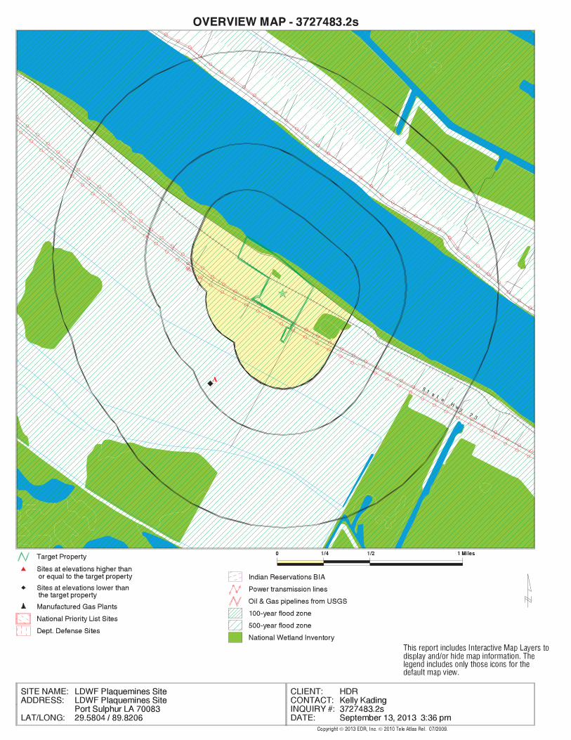
29.5804000 - 29˚ 34’ 49.44’’Latitude (North): 89.8206000 - 89˚ 49’ 14.16’’Longitude (West): Zone 16Universal Tranverse Mercator: 226760.1UTM X (Meters): 3275435.2UTM Y (Meters): 3 ft. above sea levelElevation:
USGS TOPOGRAPHIC MAP ASSOCIATED WITH TARGET PROPERTY
29089-E7 POINTE A LA HACHE, LATarget Property Map:1992Most Recent Revision:
AERIAL PHOTOGRAPHY IN THIS REPORT
2010Photo Year:USDASource:
TARGET PROPERTY SEARCH RESULTS
The target property was not listed in any of the databases searched by EDR.
DATABASES WITH NO MAPPED SITES
No mapped sites were found in EDR’s search of available ("reasonably ascertainable ") governmentrecords either on the target property or within the search radius around the target property for thefollowing databases:
STANDARD ENVIRONMENTAL RECORDS
Federal NPL site list
NPL National Priority List
EXECUTIVE SUMMARY
TC3727483.2s EXECUTIVE SUMMARY 2
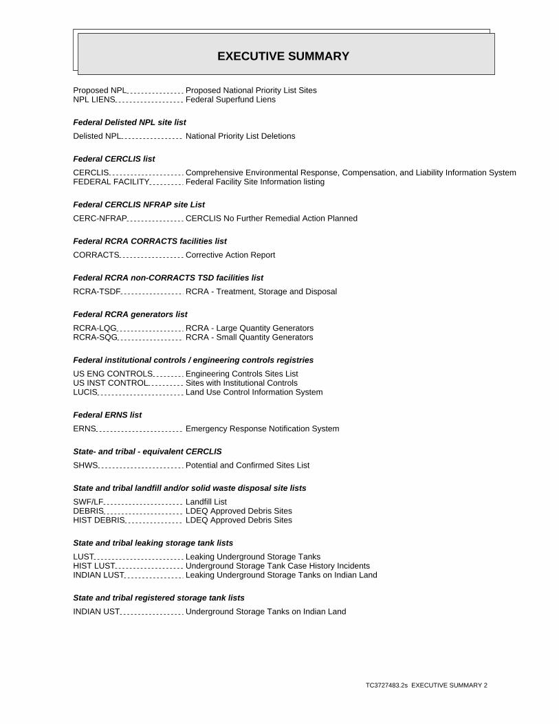
Proposed NPL Proposed National Priority List SitesNPL LIENS Federal Superfund Liens
Federal Delisted NPL site list
Delisted NPL National Priority List Deletions
Federal CERCLIS list
CERCLIS Comprehensive Environmental Response, Compensation, and Liability Information SystemFEDERAL FACILITY Federal Facility Site Information listing
Federal CERCLIS NFRAP site List
CERC-NFRAP CERCLIS No Further Remedial Action Planned
Federal RCRA CORRACTS facilities list
CORRACTS Corrective Action Report
Federal RCRA non-CORRACTS TSD facilities list
RCRA-TSDF RCRA - Treatment, Storage and Disposal
Federal RCRA generators list
RCRA-LQG RCRA - Large Quantity GeneratorsRCRA-SQG RCRA - Small Quantity Generators
Federal institutional controls / engineering controls registries
US ENG CONTROLS Engineering Controls Sites ListUS INST CONTROL Sites with Institutional ControlsLUCIS Land Use Control Information System
Federal ERNS list
ERNS Emergency Response Notification System
State- and tribal - equivalent CERCLIS
SHWS Potential and Confirmed Sites List
State and tribal landfill and/or solid waste disposal site lists
SWF/LF Landfill ListDEBRIS LDEQ Approved Debris SitesHIST DEBRIS LDEQ Approved Debris Sites
State and tribal leaking storage tank lists
LUST Leaking Underground Storage TanksHIST LUST Underground Storage Tank Case History IncidentsINDIAN LUST Leaking Underground Storage Tanks on Indian Land
State and tribal registered storage tank lists
INDIAN UST Underground Storage Tanks on Indian Land

EXECUTIVE SUMMARY
TC3727483.2s EXECUTIVE SUMMARY 3
FEMA UST Underground Storage Tank Listing
State and tribal institutional control / engineering control registries
AUL Conveyance Notice Listing
State and tribal voluntary cleanup sites
VCP Voluntary Remediation Program SitesINDIAN VCP Voluntary Cleanup Priority Listing
State and tribal Brownfields sites
BROWNFIELDS Brownfields Inventory
ADDITIONAL ENVIRONMENTAL RECORDS
Local Brownfield lists
US BROWNFIELDS A Listing of Brownfields Sites
Local Lists of Landfill / Solid Waste Disposal Sites
DEBRIS REGION 9 Torres Martinez Reservation Illegal Dump Site LocationsODI Open Dump InventorySWRCY Recycling DirectoryINDIAN ODI Report on the Status of Open Dumps on Indian Lands
Local Lists of Hazardous waste / Contaminated Sites
US CDL Clandestine Drug LabsDEL SHWS Deleted Potential & Confirmed SitesCDL Clandestine Drug LabUS HIST CDL National Clandestine Laboratory Register
Local Land Records
LIENS 2 CERCLA Lien InformationLIENS Environmental Liens
Records of Emergency Release Reports
HMIRS Hazardous Materials Information Reporting SystemSPILLS Emergency Response Section IncidentsSPILLS 90 SPILLS 90 data from FirstSearch
Other Ascertainable Records
RCRA NonGen / NLR RCRA - Non GeneratorsDOT OPS Incident and Accident DataDOD Department of Defense SitesFUDS Formerly Used Defense SitesCONSENT Superfund (CERCLA) Consent DecreesROD Records Of Decision

EXECUTIVE SUMMARY
TC3727483.2s EXECUTIVE SUMMARY 4
UMTRA Uranium Mill Tailings SitesUS MINES Mines Master Index FileTRIS Toxic Chemical Release Inventory SystemTSCA Toxic Substances Control ActFTTS FIFRA/ TSCA Tracking System - FIFRA (Federal Insecticide, Fungicide, & Rodenticide Act)/TSCA (Toxic Substances Control Act)HIST FTTS FIFRA/TSCA Tracking System Administrative Case ListingSSTS Section 7 Tracking SystemsICIS Integrated Compliance Information SystemPADS PCB Activity Database SystemMLTS Material Licensing Tracking SystemRADINFO Radiation Information DatabaseRAATS RCRA Administrative Action Tracking SystemRMP Risk Management PlansUIC Underground Injection Wells ListingDRYCLEANERS Drycleaner Facility ListingNPDES LPDES Permits DatabaseAIRS Air Permit ListINDIAN RESERV Indian ReservationsSCRD DRYCLEANERS State Coalition for Remediation of Drycleaners ListingREM Division of Remediation Services DatabaseUS AIRS Aerometric Information Retrieval System Facility SubsystemPRP Potentially Responsible Parties2020 COR ACTION 2020 Corrective Action Program ListLEAD SMELTERS Lead Smelter SitesEPA WATCH LIST EPA WATCH LISTUS FIN ASSUR Financial Assurance InformationPCB TRANSFORMER PCB Transformer Registration DatabaseCOAL ASH DOE Steam-Electric Plant Operation DataCOAL ASH EPA Coal Combustion Residues Surface Impoundments ListCOAL ASH Coal Ash Disposal SitesASBESTOS Asbestos Projects ListFinancial Assurance FInancial Assurance Information
EDR HIGH RISK HISTORICAL RECORDS
EDR Exclusive Records
EDR MGP EDR Proprietary Manufactured Gas PlantsEDR US Hist Auto Stat EDR Exclusive Historic Gas StationsEDR US Hist Cleaners EDR Exclusive Historic Dry Cleaners
SURROUNDING SITES: SEARCH RESULTS
Surrounding sites were identified in the following databases.
Elevations have been determined from the USGS Digital Elevation Model and should be evaluated ona relative (not an absolute) basis. Relative elevation information between sites of close proximityshould be field verified. Sites with an elevation equal to or higher than the target property have beendifferentiated below from sites with an elevation lower than the target property.Page numbers and map identification numbers refer to the EDR Radius Map report where detaileddata on individual sites can be reviewed.
Sites listed in bold italics are in multiple databases.
Unmappable (orphan) sites are not considered in the foregoing analysis.

EXECUTIVE SUMMARY
TC3727483.2s EXECUTIVE SUMMARY 5
STANDARD ENVIRONMENTAL RECORDS
Federal RCRA generators list
RCRA-CESQG: RCRAInfo is EPA’s comprehensive information system, providing access to data supportingthe Resource Conservation and Recovery Act (RCRA) of 1976 and the Hazardous and Solid Waste Amendments (HSWA)of 1984. The database includes selective information on sites which generate, transport, store, treat and/ordispose of hazardous waste as defined by the Resource Conservation and Recovery Act (RCRA). Conditionallyexempt small quantity generators (CESQGs) generate less than 100 kg of hazardous waste, or less than 1 kg ofacutely hazardous waste per month.
A review of the RCRA-CESQG list, as provided by EDR, and dated 07/11/2013 has revealed that there is 1 RCRA-CESQG site within approximately 0.5 miles of the target property.
PageMap IDDirection / Distance Address Lower Elevation ____________________ ________ ___________________ _____ _____
CITRUS LANDS OF LA INC HWY 23 S 17 M S BELLE C SW 1/4 - 1/2 (0.445 mi.) A2 9
State and tribal registered storage tank lists
UST: The Underground Storage Tank database contains registered USTs. USTs are regulated underSubtitle I of the Resource Conservation and Recovery Act (RCRA). The data come from the Department ofEnvironmental Quality’s Louisiana Underground Storage Tank Database.
A review of the UST list, as provided by EDR, and dated 07/19/2013 has revealed that there is 1 UST site within approximately 0.5 miles of the target property.
PageMap IDDirection / Distance Address Lower Elevation ____________________ ________ ___________________ _____ _____
CITRUS LANDS OF LA INC HWY23 S 17 MI SO/BELLE SW 1/4 - 1/2 (0.445 mi.) A1 7
ADDITIONAL ENVIRONMENTAL RECORDS
Other Ascertainable Records
FINDS: The Facility Index System contains both facility information and "pointers" to othersources of information that contain more detail. These include: RCRIS; Permit Compliance System (PCS);Aerometric Information Retrieval System (AIRS); FATES (FIFRA [Federal Insecticide Fungicide Rodenticide Act]and TSCA Enforcement System, FTTS [FIFRA/TSCA Tracking System]; CERCLIS; DOCKET (Enforcement Docket used tomanage and track information on civil judicial enforcement cases for all environmental statutes); FederalUnderground Injection Control (FURS); Federal Reporting Data System (FRDS); Surface Impoundments (SIA); TSCAChemicals in Commerce Information System (CICS); PADS; RCRA-J (medical waste transporters/disposers); TRIS;and TSCA. The source of this database is the U.S. EPA/NTIS.
A review of the FINDS list, as provided by EDR, and dated 03/08/2013 has revealed that there is 1 FINDS site within approximately 0.5 miles of the target property.
PageMap IDDirection / Distance Address Lower Elevation ____________________ ________ ___________________ _____ _____
CITRUS LANDS OF LA INC HWY 23 S 17 M S BELLE C SW 1/4 - 1/2 (0.445 mi.) A2 9

EXECUTIVE SUMMARY
TC3727483.2s EXECUTIVE SUMMARY 6
Due to poor or inadequate address information, the following sites were not mapped. Count: 37 records.
Site Name Database(s)____________ ____________
COX BAY COMPRESSOR CO HWS,REMPOINTE A LA HACHE SOUTH BARGE FACI FINDS,NPDES,AIRS,AIRS (AFS)RAM TERMINALS LLC - COAL EXPORT FA AIRSTHE NEW LEARNING CENTER ASBESTOSPLAQUEMINES PARISH GOVERNMENT - PH NPDESHOME OFFICE - CAJUN CONSTRUCTORS I NPDESST CLAIR ESTATES NPDESPHOENIX PK-12 - SATTERFIELD & PONT NPDESUS UNITED BULK TERMINAL LLC NPDESFEMA HURRICANE RESPONSE - DAVANT C NPDESPLAQUEMINES PARISH GOVERNMENT - IR NPDESMYRTLE GROVE MARINA LLC NPDESTENNESSEE GAS PIPELINE CO STN #527 FTTSTENNESSEE GAS PIPELINE CO STN #527 HIST FTTSPLAQUEMINES PARISH GOVERNMENT LIFT SPILLSPLAQUEMINES PARISH GOVERNMENT SPILLSPLAQUEMINES PARISH GOVERNMENT SPILLSPLAQUEMINES PARISH GOVT. SPILLSPLAQUEMINES PARISH AMBULANCE SERVI SPILLSPLAQUEMINES PARISH GOVERNMENT SPILLSJEFFERSON LAKE SULPHUR CO CERCLIS-NFRAPPLAQUEMINES PARISH HOMEPLACE PIT D LFINDUSTRIAL PIPE DEBRISEMPIRE SHIP YARD DEBRISFORT JACKSON PICKUP STATION DEBRISPRO IRON & METALS LLC DEBRISHOMEPLACE PIT DEBRISBRAITHWAITE SITE DEBRISWOODLAWN GOVN’T BUILDING DEBRISDAVANT COMMUNITY PARK DEBRIS SITE DEBRISEMPIRE PIT DEBRISWALKER ROAD FACILITY DEBRISWALKER ROAD 2 DEBRISTONY’S GULF USTTESVICH PROPERTY BROWNFIELDSAMAX/CRI-MET FAC ICISLOUISIANA GAS SERVICE CO DOT OPS
EDR Inc.EDR Inc.EDR Inc.EDR Inc.EDR Inc.EDR Inc.EDR Inc.EDR Inc.EDR Inc.EDR Inc.EDR Inc.EDR Inc.EDR Inc.EDR Inc.EDR Inc.EDR Inc.EDR Inc.EDR Inc.EDR Inc.EDR Inc.EDR Inc.EDR Inc.EDR Inc.EDR Inc.EDR Inc.EDR Inc.EDR Inc.EDR Inc.EDR Inc.EDR Inc.EDR Inc.EDR Inc.EDR Inc.EDR Inc.EDR Inc.EDR Inc.EDR Inc.EDR Inc.EDR Inc.EDR Inc.
0
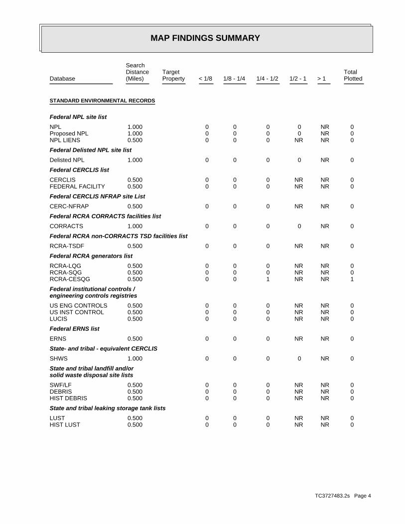
MAP FINDINGS SUMMARY
SearchTargetDistance Total
Database Property(Miles) < 1/8 1/8 - 1/4 1/4 - 1/2 1/2 - 1 > 1 Plotted
STANDARD ENVIRONMENTAL RECORDS
Federal NPL site list
0 NR 0 0 0 0 1.000NPL 0 NR 0 0 0 0 1.000Proposed NPL 0 NR NR 0 0 0 0.500NPL LIENS
Federal Delisted NPL site list
0 NR 0 0 0 0 1.000Delisted NPL
Federal CERCLIS list
0 NR NR 0 0 0 0.500CERCLIS 0 NR NR 0 0 0 0.500FEDERAL FACILITY
Federal CERCLIS NFRAP site List
0 NR NR 0 0 0 0.500CERC-NFRAP
Federal RCRA CORRACTS facilities list
0 NR 0 0 0 0 1.000CORRACTS
Federal RCRA non-CORRACTS TSD facilities list
0 NR NR 0 0 0 0.500RCRA-TSDF
Federal RCRA generators list
0 NR NR 0 0 0 0.500RCRA-LQG 0 NR NR 0 0 0 0.500RCRA-SQG 1 NR NR 1 0 0 0.500RCRA-CESQG
Federal institutional controls /engineering controls registries
0 NR NR 0 0 0 0.500US ENG CONTROLS 0 NR NR 0 0 0 0.500US INST CONTROL 0 NR NR 0 0 0 0.500LUCIS
Federal ERNS list
0 NR NR 0 0 0 0.500ERNS
State- and tribal - equivalent CERCLIS
0 NR 0 0 0 0 1.000SHWS
State and tribal landfill and/orsolid waste disposal site lists
0 NR NR 0 0 0 0.500SWF/LF 0 NR NR 0 0 0 0.500DEBRIS 0 NR NR 0 0 0 0.500HIST DEBRIS
State and tribal leaking storage tank lists
0 NR NR 0 0 0 0.500LUST 0 NR NR 0 0 0 0.500HIST LUST
TC3727483.2s Page 4

MAP FINDINGS SUMMARY
SearchTargetDistance Total
Database Property(Miles) < 1/8 1/8 - 1/4 1/4 - 1/2 1/2 - 1 > 1 Plotted
0 NR NR 0 0 0 0.500INDIAN LUST
State and tribal registered storage tank lists
1 NR NR 1 0 0 0.500UST 0 NR NR 0 0 0 0.500INDIAN UST 0 NR NR 0 0 0 0.500FEMA UST
State and tribal institutionalcontrol / engineering control registries
0 NR NR 0 0 0 0.500AUL
State and tribal voluntary cleanup sites
0 NR NR 0 0 0 0.500VCP 0 NR NR 0 0 0 0.500INDIAN VCP
State and tribal Brownfields sites
0 NR NR 0 0 0 0.500BROWNFIELDS
ADDITIONAL ENVIRONMENTAL RECORDS
Local Brownfield lists
0 NR NR 0 0 0 0.500US BROWNFIELDS
Local Lists of Landfill / SolidWaste Disposal Sites
0 NR NR 0 0 0 0.500DEBRIS REGION 9 0 NR NR 0 0 0 0.500ODI 0 NR NR 0 0 0 0.500SWRCY 0 NR NR 0 0 0 0.500INDIAN ODI
Local Lists of Hazardous waste /Contaminated Sites
0 NR NR 0 0 0 0.500US CDL 0 NR 0 0 0 0 1.000DEL SHWS 0 NR NR 0 0 0 0.500CDL 0 NR NR 0 0 0 0.500US HIST CDL
Local Land Records
0 NR NR 0 0 0 0.500LIENS 2 0 NR NR 0 0 0 0.500LIENS
Records of Emergency Release Reports
0 NR NR 0 0 0 0.500HMIRS 0 NR NR 0 0 0 0.500SPILLS 0 NR NR 0 0 0 0.500SPILLS 90
Other Ascertainable Records
0 NR NR 0 0 0 0.500RCRA NonGen / NLR 0 NR NR 0 0 0 0.500DOT OPS 0 NR 0 0 0 0 1.000DOD
TC3727483.2s Page 5

MAP FINDINGS SUMMARY
SearchTargetDistance Total
Database Property(Miles) < 1/8 1/8 - 1/4 1/4 - 1/2 1/2 - 1 > 1 Plotted
0 NR 0 0 0 0 1.000FUDS 0 NR 0 0 0 0 1.000CONSENT 0 NR 0 0 0 0 1.000ROD 0 NR NR 0 0 0 0.500UMTRA 0 NR NR 0 0 0 0.500US MINES 0 NR NR 0 0 0 0.500TRIS 0 NR NR 0 0 0 0.500TSCA 0 NR NR 0 0 0 0.500FTTS 0 NR NR 0 0 0 0.500HIST FTTS 0 NR NR 0 0 0 0.500SSTS 0 NR NR 0 0 0 0.500ICIS 0 NR NR 0 0 0 0.500PADS 0 NR NR 0 0 0 0.500MLTS 0 NR NR 0 0 0 0.500RADINFO 1 NR NR 1 0 0 0.500FINDS 0 NR NR 0 0 0 0.500RAATS 0 NR NR 0 0 0 0.500RMP 0 NR NR 0 0 0 0.500UIC 0 NR NR 0 0 0 0.500DRYCLEANERS 0 NR NR 0 0 0 0.500NPDES 0 NR NR 0 0 0 0.500AIRS 0 NR 0 0 0 0 1.000INDIAN RESERV 0 NR NR 0 0 0 0.500SCRD DRYCLEANERS 0 NR NR 0 0 0 0.500REM 0 NR NR 0 0 0 0.500US AIRS 0 NR NR 0 0 0 0.500PRP 0 NR NR 0 0 0 0.5002020 COR ACTION 0 NR NR 0 0 0 0.500LEAD SMELTERS 0 NR NR 0 0 0 0.500EPA WATCH LIST 0 NR NR 0 0 0 0.500US FIN ASSUR 0 NR NR 0 0 0 0.500PCB TRANSFORMER 0 NR NR 0 0 0 0.500COAL ASH DOE 0 NR NR 0 0 0 0.500COAL ASH EPA 0 NR NR 0 0 0 0.500COAL ASH 0 NR NR 0 0 0 0.500ASBESTOS 0 NR NR 0 0 0 0.500Financial Assurance
EDR HIGH RISK HISTORICAL RECORDS
EDR Exclusive Records
0 NR 0 0 0 0 1.000EDR MGP 0 NR NR 0 0 0 0.500EDR US Hist Auto Stat 0 NR NR 0 0 0 0.500EDR US Hist Cleaners
NOTES:
TP = Target Property
NR = Not Requested at this Search Distance
Sites may be listed in more than one database
TC3727483.2s Page 6

MAP FINDINGSMap IDDirection
EDR ID NumberDistanceEPA ID NumberDatabase(s)SiteElevation
Not reportedMS Naptha: Not reportedMS Antifreeze: Not reportedMS Additive: Not reportedMS Aviation Fuel JP: Not reportedNew Used Oil Flag: Not reportedHeating Oil Flag: Not reportedKerosene Flag: YesGasohol Flag: Not reportedDiesel Flag: Not reportedGasoline Flag: 1Number Of Compartments: 1000Total Capacity: 01-Jan-1980Install Date: RemovedTank Status: 29569UST Tank Num:
Not reportedPipe Method Description: Not reportedOther Material: Not reportedLiner Covering Excavation Hole: Not reportedMade Of Concrete: Not reportedOutside Lined w/ Polyethylen Jacket: Not reportedDouble Wall As Opposed To Single Wall: Not reportedInterior Line With Some Material: Not reportedFiberglass Or Plastic: Not reportedA Composite Of Different Materials: Not reportedEpoxy Coated Tank: Not reportedCathodically Protected: YesSteel Tank Covered With Asphalt: Not reportedOther Sub: Not reportedUnknown: Not reportedMS Varsol: Not reportedMS Naptha: Not reportedMS Antifreeze: Not reportedMS Additive: Not reportedMS Aviation Fuel JP: Not reportedNew Used Oil Flag: Not reportedHeating Oil Flag: Not reportedKerosene Flag: Not reportedGasohol Flag: YesDiesel Flag: Not reportedGasoline Flag: 1Number Of Compartments: 4000Total Capacity: 01-Jan-1980Install Date: RemovedTank Status: 29568UST Tank Num:
1Subject Item ID: Individual USTSubject Category Code: 12225Master Agency Id: 38011168Facility ID:
UST:
2348 ft. Site 1 of 2 in cluster A0.445 mi.
Relative:Lower
Actual:0 ft.
1/4-1/2 MYRTLE GROVE, LA 70083SW HWY23 S 17 MI SO/BELLE CHASSE N/AA1 USTCITRUS LANDS OF LA INC U003986714
TC3727483.2s Page 7

MAP FINDINGSMap IDDirection
EDR ID NumberDistanceEPA ID NumberDatabase(s)SiteElevation
Not reportedPipe Method Description: Not reportedOther Material: Not reportedLiner Covering Excavation Hole: Not reportedMade Of Concrete: Not reportedOutside Lined w/ Polyethylen Jacket: Not reportedDouble Wall As Opposed To Single Wall: Not reportedInterior Line With Some Material: Not reportedFiberglass Or Plastic: Not reportedA Composite Of Different Materials: Not reportedEpoxy Coated Tank: Not reportedCathodically Protected: YesSteel Tank Covered With Asphalt: Not reportedOther Sub: Not reportedUnknown: Not reportedMS Varsol: Not reportedMS Naptha: Not reportedMS Antifreeze: Not reportedMS Additive: Not reportedMS Aviation Fuel JP: Not reportedNew Used Oil Flag: Not reportedHeating Oil Flag: Not reportedKerosene Flag: YesGasohol Flag: Not reportedDiesel Flag: Not reportedGasoline Flag: 1Number Of Compartments: 1000Total Capacity: 01-Jan-1980Install Date: RemovedTank Status: 29570UST Tank Num:
Not reportedPipe Method Description: Not reportedOther Material: Not reportedLiner Covering Excavation Hole: Not reportedMade Of Concrete: Not reportedOutside Lined w/ Polyethylen Jacket: Not reportedDouble Wall As Opposed To Single Wall: Not reportedInterior Line With Some Material: Not reportedFiberglass Or Plastic: Not reportedA Composite Of Different Materials: Not reportedEpoxy Coated Tank: Not reportedCathodically Protected: YesSteel Tank Covered With Asphalt: Not reportedOther Sub: Not reportedUnknown: Not reportedMS Varsol:
CITRUS LANDS OF LA INC (Continued) U003986714
TC3727483.2s Page 8

MAP FINDINGSMap IDDirection
EDR ID NumberDistanceEPA ID NumberDatabase(s)SiteElevation
NoUsed oil fuel burner: NoFurnace exemption: NoOn-site burner exemption: NoUnderground injection activity: NoTreater, storer or disposer of HW: NoTransporter of hazardous waste: NoRecycler of hazardous waste: NoMixed waste (haz. and radioactive): NoU.S. importer of hazardous waste:
Handler Activities Summary:
Not reportedOwner/Op end date: 01/01/0001Owner/Op start date: OwnerOwner/Operator Type: PrivateLegal status: (000) 000-0000Owner/operator telephone: Not reportedOwner/operator country: UNKNOWN, LA 00000 UNKNOWNOwner/operator address: CITRUS LANDS OF LA INCOwner/operator name:
Owner/Operator Summary:
hazardous waste the cleanup of a spill, into or on any land or water, of acutely any residue or contaminated soil, waste or other debris resulting from time: 1 kg or less of acutely hazardous waste; or 100 kg or less of hazardous waste during any calendar month, and accumulates at any from the cleanup of a spill, into or on any land or water, of acutely of any residue or contaminated soil, waste or other debris resulting land or water, of acutely hazardous waste; or generates 100 kg or less other debris resulting from the cleanup of a spill, into or on any waste; or 100 kg or less of any residue or contaminated soil, waste or month, and accumulates at any time: 1 kg or less of acutely hazardous or generates 1 kg or less of acutely hazardous waste per calendar month, and accumulates 1000 kg or less of hazardous waste at any time; Handler: generates 100 kg or less of hazardous waste per calendarDescription: Conditionally Exempt Small Quantity GeneratorClassification: 06EPA Region: Not reportedContact email: (504) 656-2181Contact telephone: USContact country: BELLE CHASSE, LA 70037 PO BOX 487Contact address: EDWIN J BLAIRContact: BELLE CHASSE, LA 70037 PO BOX 487Mailing address: LAD981592181EPA ID: MYRTLE GROVE, LA 70083 HWY 23 S 17 M S BELLE CHASSEFacility address: CITRUS LANDS OF LA INCFacility name: 09/04/1986Date form received by agency:
RCRA-CESQG:
2348 ft. Site 2 of 2 in cluster A0.445 mi.
Relative:Lower
Actual:0 ft.
1/4-1/2 MYRTLE GROVE, LA SW FINDSHWY 23 S 17 M S BELLE CHASSE LAD981592181A2 RCRA-CESQGCITRUS LANDS OF LA INC 1004708949
TC3727483.2s Page 9

MAP FINDINGSMap IDDirection
EDR ID NumberDistanceEPA ID NumberDatabase(s)SiteElevation
corrective action activities required under RCRA.program staff to track the notification, permit, compliance, andand treat, store, or dispose of hazardous waste. RCRAInfo allows RCRAevents and activities related to facilities that generate, transport,Conservation and Recovery Act (RCRA) program through the tracking ofRCRAInfo is a national information system that supports the Resource Environmental Interest/Information System
110006022222Registry ID:
FINDS:
No violations foundViolation Status:
WHICH WOULD BE CONSIDERED AS IGNITABLE HAZARDOUS WASTE. MATERIAL. LACQUER THINNER IS AN EXAMPLE OF A COMMONLY USED SOLVENT WHICH CAN BE OBTAINED FROM THE MANUFACTURER OR DISTRIBUTOR OF THE FLASH POINT OF A WASTE IS TO REVIEW THE MATERIAL SAFETY DATA SHEET, CLOSED CUP FLASH POINT TESTER. ANOTHER METHOD OF DETERMINING THE LESS THAN 140 DEGREES FAHRENHEIT AS DETERMINED BY A PENSKY-MARTENS IGNITABLE HAZARDOUS WASTES ARE THOSE WASTES WHICH HAVE A FLASHPOINT OFWaste name: D001Waste code:
Hazardous Waste Summary:
NoUsed oil transporter: NoUsed oil transfer facility: NoUsed oil Specification marketer: NoUsed oil fuel marketer to burner: NoUser oil refiner: NoUsed oil processor:
CITRUS LANDS OF LA INC (Continued) 1004708949
TC3727483.2s Page 10

ORPHAN SUMMARY
City EDR ID Site Name Site Address Zip Database(s)
Count: 37 records.
W POINT LAHACHE 1003873415 JEFFERSON LAKE SULPHUR CO LAKE HERMITAGE LA HWY 23 70083 CERCLIS-NFRAPPORT SULPHUR 1008190664 TENNESSEE GAS PIPELINE CO STN #527 EAST SIDE OD HWY 23 70083 HIST FTTSPORT SULPHUR 1008211300 POINTE A LA HACHE SOUTH BARGE FACI 142 BASS RD (HWY 39) 70083 FINDS,NPDES,AIRS,AIRS (AFS)PORT SULPHUR 1009630219 LOUISIANA GAS SERVICE CO ROUTE 1, BOX 804, HIGHWAY 11 70083 DOT OPSPORT SULPHUR 1010010531 TENNESSEE GAS PIPELINE CO STN #527 EAST SIDE OD HWY 23 70083 FTTSBRAITHWAITE 1011546790 AMAX/CRI-MET FAC LA STATE HWY 3137 BRAITHWAI 70040 ICISPORT SULPHUR 1011859982 TESVICH PROPERTY HIGHWAY 23 70083 BROWNFIELDSPORT SULPHUR S105200960 COX BAY COMPRESSOR CO HWY 23 70000 HWS,REMBRAITHWAITE S108331836 ST CLAIR ESTATES HWY 39 70040 NPDESDAVANT S108333183 FEMA HURRICANE RESPONSE - DAVANT C 15535 HWY 15 70040 NPDESIRONTON S108334690 PLAQUEMINES PARISH GOVERNMENT - IR HWY 23 70083 NPDES S108619996 PLAQUEMINES PARISH GOVERNMENT INTERSECTION OF HWY 23 AND THE SPILLS S108619997 PLAQUEMINES PARISH GOVERNMENT HWY 15 - 1000 FEET NORTH OF DA SPILLSPORT SULPHUR S108620316 PLAQUEMINES PARISH GOVERNMENT HWY 234, 500’ SOUTH OF HOLIDAY SPILLSDAVANT S108994714 US UNITED BULK TERMINAL LLC 14537 HWY 15 70040 NPDESPORT SULPHUR S109566535 PLAQUEMINES PARISH AMBULANCE SERVI HWY 23 SPILLS S109566741 PLAQUEMINES PARISH GOVT. SHELL/LIMESTONE ROAD FROM HWY SPILLSPORT SULPHUR S109962520 THE NEW LEARNING CENTER 26892 HWY 23 ASBESTOSCAERNARVON S110445060 HOME OFFICE - CAJUN CONSTRUCTORS I HWY 39 70040 NPDESMYRTLE GROVE S110445184 MYRTLE GROVE MARINA LLC 16208 HWY 23 S 70083 NPDESPORT SULPHUR S110657931 PLAQUEMINES PARISH HOMEPLACE PIT D HWY 23 W OF POWELL LN 70000 LF S110658310 PLAQUEMINES PARISH GOVERNMENT LIFT HWY 15 AT HARLEM RD SPILLSBRAITHWAITE S110701649 PHOENIX PK-12 - SATTERFIELD & PONT 12700 HWY 39 70040 NPDES S111334390 PRO IRON & METALS LLC 11266 HWY 23 DEBRIS S111334614 WALKER ROAD FACILITY WALKER RD OFF HWY 23 DEBRIS S111334645 HOMEPLACE PIT HWY 23 W OF POWELL LN DEBRIS S111334646 EMPIRE PIT OFF HWY 11 (SEE COMMENT) DEBRIS S111334699 WOODLAWN GOVN’T BUILDING HWY 39 DEBRIS S111334811 WALKER ROAD 2 WALKER ROAD (WEST OF HWY 23) DEBRIS S111334846 INDUSTRIAL PIPE 11266 HWY 23 DEBRIS S111334862 BRAITHWAITE SITE HWY 39 (SOUTH OF BRAITHWAITE) DEBRIS S111334868 DAVANT COMMUNITY PARK DEBRIS SITE BETWEEN HWY 15 & HWY 39 DEBRIS S111335292 EMPIRE SHIP YARD HWY 23 AND ROSE MARIE ROAD DEBRIS S111335341 FORT JACKSON PICKUP STATION HWY 23 PAST FT JACKSON ON RIGH DEBRISBRAITHWAITE S111768641 PLAQUEMINES PARISH GOVERNMENT - PH 15337 HWY 15 70040 NPDESIRONTON S112270526 RAM TERMINALS LLC - COAL EXPORT FA 16111 HWY 23 70083 AIRSPORT SULPHUR U001893784 TONY’S GULF HWY 23 70083 UST
TC3727483.2s Page 11

To maintain currency of the following federal and state databases, EDR contacts the appropriate governmental agencyon a monthly or quarterly basis, as required.
Number of Days to Update: Provides confirmation that EDR is reporting records that have been updated within 90 daysfrom the date the government agency made the information available to the public.
STANDARD ENVIRONMENTAL RECORDS
Federal NPL site list
NPL: National Priority ListNational Priorities List (Superfund). The NPL is a subset of CERCLIS and identifies over 1,200 sites for prioritycleanup under the Superfund Program. NPL sites may encompass relatively large areas. As such, EDR provides polygoncoverage for over 1,000 NPL site boundaries produced by EPA’s Environmental Photographic Interpretation Center(EPIC) and regional EPA offices.
Date of Government Version: 04/26/2013Date Data Arrived at EDR: 05/09/2013Date Made Active in Reports: 07/10/2013Number of Days to Update: 62
Source: EPATelephone: N/ALast EDR Contact: 07/12/2013Next Scheduled EDR Contact: 10/21/2013Data Release Frequency: Quarterly
NPL Site Boundaries
Sources:
EPA’s Environmental Photographic Interpretation Center (EPIC)Telephone: 202-564-7333
EPA Region 1 EPA Region 6Telephone 617-918-1143 Telephone: 214-655-6659
EPA Region 3 EPA Region 7Telephone 215-814-5418 Telephone: 913-551-7247
EPA Region 4 EPA Region 8Telephone 404-562-8033 Telephone: 303-312-6774
EPA Region 5 EPA Region 9Telephone 312-886-6686 Telephone: 415-947-4246
EPA Region 10Telephone 206-553-8665
Proposed NPL: Proposed National Priority List SitesA site that has been proposed for listing on the National Priorities List through the issuance of a proposed rulein the Federal Register. EPA then accepts public comments on the site, responds to the comments, and places onthe NPL those sites that continue to meet the requirements for listing.
Date of Government Version: 04/26/2013Date Data Arrived at EDR: 05/09/2013Date Made Active in Reports: 07/10/2013Number of Days to Update: 62
Source: EPATelephone: N/ALast EDR Contact: 07/12/2013Next Scheduled EDR Contact: 10/21/2013Data Release Frequency: Quarterly
NPL LIENS: Federal Superfund LiensFederal Superfund Liens. Under the authority granted the USEPA by CERCLA of 1980, the USEPA has the authorityto file liens against real property in order to recover remedial action expenditures or when the property ownerreceived notification of potential liability. USEPA compiles a listing of filed notices of Superfund Liens.
Date of Government Version: 10/15/1991Date Data Arrived at EDR: 02/02/1994Date Made Active in Reports: 03/30/1994Number of Days to Update: 56
Source: EPATelephone: 202-564-4267Last EDR Contact: 08/15/2011Next Scheduled EDR Contact: 11/28/2011Data Release Frequency: No Update Planned
TC3727483.2s Page GR-1
GOVERNMENT RECORDS SEARCHED / DATA CURRENCY TRACKING
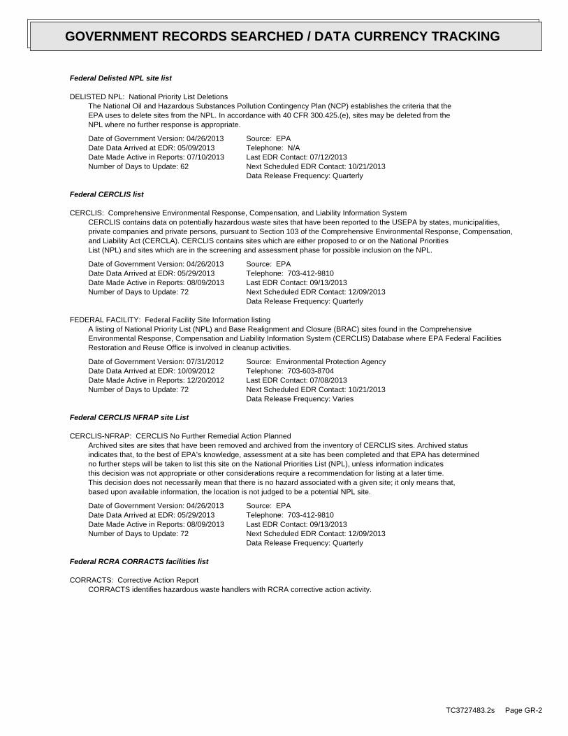
Federal Delisted NPL site list
DELISTED NPL: National Priority List DeletionsThe National Oil and Hazardous Substances Pollution Contingency Plan (NCP) establishes the criteria that theEPA uses to delete sites from the NPL. In accordance with 40 CFR 300.425.(e), sites may be deleted from theNPL where no further response is appropriate.
Date of Government Version: 04/26/2013Date Data Arrived at EDR: 05/09/2013Date Made Active in Reports: 07/10/2013Number of Days to Update: 62
Source: EPATelephone: N/ALast EDR Contact: 07/12/2013Next Scheduled EDR Contact: 10/21/2013Data Release Frequency: Quarterly
Federal CERCLIS list
CERCLIS: Comprehensive Environmental Response, Compensation, and Liability Information SystemCERCLIS contains data on potentially hazardous waste sites that have been reported to the USEPA by states, municipalities,private companies and private persons, pursuant to Section 103 of the Comprehensive Environmental Response, Compensation,and Liability Act (CERCLA). CERCLIS contains sites which are either proposed to or on the National PrioritiesList (NPL) and sites which are in the screening and assessment phase for possible inclusion on the NPL.
Date of Government Version: 04/26/2013Date Data Arrived at EDR: 05/29/2013Date Made Active in Reports: 08/09/2013Number of Days to Update: 72
Source: EPATelephone: 703-412-9810Last EDR Contact: 09/13/2013Next Scheduled EDR Contact: 12/09/2013Data Release Frequency: Quarterly
FEDERAL FACILITY: Federal Facility Site Information listingA listing of National Priority List (NPL) and Base Realignment and Closure (BRAC) sites found in the ComprehensiveEnvironmental Response, Compensation and Liability Information System (CERCLIS) Database where EPA Federal FacilitiesRestoration and Reuse Office is involved in cleanup activities.
Date of Government Version: 07/31/2012Date Data Arrived at EDR: 10/09/2012Date Made Active in Reports: 12/20/2012Number of Days to Update: 72
Source: Environmental Protection AgencyTelephone: 703-603-8704Last EDR Contact: 07/08/2013Next Scheduled EDR Contact: 10/21/2013Data Release Frequency: Varies
Federal CERCLIS NFRAP site List
CERCLIS-NFRAP: CERCLIS No Further Remedial Action PlannedArchived sites are sites that have been removed and archived from the inventory of CERCLIS sites. Archived statusindicates that, to the best of EPA’s knowledge, assessment at a site has been completed and that EPA has determinedno further steps will be taken to list this site on the National Priorities List (NPL), unless information indicatesthis decision was not appropriate or other considerations require a recommendation for listing at a later time.This decision does not necessarily mean that there is no hazard associated with a given site; it only means that,based upon available information, the location is not judged to be a potential NPL site.
Date of Government Version: 04/26/2013Date Data Arrived at EDR: 05/29/2013Date Made Active in Reports: 08/09/2013Number of Days to Update: 72
Source: EPATelephone: 703-412-9810Last EDR Contact: 09/13/2013Next Scheduled EDR Contact: 12/09/2013Data Release Frequency: Quarterly
Federal RCRA CORRACTS facilities list
CORRACTS: Corrective Action ReportCORRACTS identifies hazardous waste handlers with RCRA corrective action activity.
TC3727483.2s Page GR-2
GOVERNMENT RECORDS SEARCHED / DATA CURRENCY TRACKING

Date of Government Version: 07/11/2013Date Data Arrived at EDR: 08/08/2013Date Made Active in Reports: 09/13/2013Number of Days to Update: 36
Source: EPATelephone: 800-424-9346Last EDR Contact: 08/08/2013Next Scheduled EDR Contact: 10/14/2013Data Release Frequency: Quarterly
Federal RCRA non-CORRACTS TSD facilities list
RCRA-TSDF: RCRA - Treatment, Storage and DisposalRCRAInfo is EPA’s comprehensive information system, providing access to data supporting the Resource Conservationand Recovery Act (RCRA) of 1976 and the Hazardous and Solid Waste Amendments (HSWA) of 1984. The databaseincludes selective information on sites which generate, transport, store, treat and/or dispose of hazardous wasteas defined by the Resource Conservation and Recovery Act (RCRA). Transporters are individuals or entities thatmove hazardous waste from the generator offsite to a facility that can recycle, treat, store, or dispose of thewaste. TSDFs treat, store, or dispose of the waste.
Date of Government Version: 07/11/2013Date Data Arrived at EDR: 08/08/2013Date Made Active in Reports: 09/13/2013Number of Days to Update: 36
Source: Environmental Protection AgencyTelephone: 214-665-6444Last EDR Contact: 08/08/2013Next Scheduled EDR Contact: 10/14/2013Data Release Frequency: Quarterly
Federal RCRA generators list
RCRA-LQG: RCRA - Large Quantity GeneratorsRCRAInfo is EPA’s comprehensive information system, providing access to data supporting the Resource Conservationand Recovery Act (RCRA) of 1976 and the Hazardous and Solid Waste Amendments (HSWA) of 1984. The databaseincludes selective information on sites which generate, transport, store, treat and/or dispose of hazardous wasteas defined by the Resource Conservation and Recovery Act (RCRA). Large quantity generators (LQGs) generateover 1,000 kilograms (kg) of hazardous waste, or over 1 kg of acutely hazardous waste per month.
Date of Government Version: 07/11/2013Date Data Arrived at EDR: 08/08/2013Date Made Active in Reports: 09/13/2013Number of Days to Update: 36
Source: Environmental Protection AgencyTelephone: 214-665-6444Last EDR Contact: 08/08/2013Next Scheduled EDR Contact: 10/14/2013Data Release Frequency: Quarterly
RCRA-SQG: RCRA - Small Quantity GeneratorsRCRAInfo is EPA’s comprehensive information system, providing access to data supporting the Resource Conservationand Recovery Act (RCRA) of 1976 and the Hazardous and Solid Waste Amendments (HSWA) of 1984. The databaseincludes selective information on sites which generate, transport, store, treat and/or dispose of hazardous wasteas defined by the Resource Conservation and Recovery Act (RCRA). Small quantity generators (SQGs) generatebetween 100 kg and 1,000 kg of hazardous waste per month.
Date of Government Version: 07/11/2013Date Data Arrived at EDR: 08/08/2013Date Made Active in Reports: 09/13/2013Number of Days to Update: 36
Source: Environmental Protection AgencyTelephone: 214-665-6444Last EDR Contact: 08/08/2013Next Scheduled EDR Contact: 10/14/2013Data Release Frequency: Quarterly
RCRA-CESQG: RCRA - Conditionally Exempt Small Quantity GeneratorsRCRAInfo is EPA’s comprehensive information system, providing access to data supporting the Resource Conservationand Recovery Act (RCRA) of 1976 and the Hazardous and Solid Waste Amendments (HSWA) of 1984. The databaseincludes selective information on sites which generate, transport, store, treat and/or dispose of hazardous wasteas defined by the Resource Conservation and Recovery Act (RCRA). Conditionally exempt small quantity generators(CESQGs) generate less than 100 kg of hazardous waste, or less than 1 kg of acutely hazardous waste per month.
Date of Government Version: 07/11/2013Date Data Arrived at EDR: 08/08/2013Date Made Active in Reports: 09/13/2013Number of Days to Update: 36
Source: Environmental Protection AgencyTelephone: 214-665-6444Last EDR Contact: 08/08/2013Next Scheduled EDR Contact: 10/14/2013Data Release Frequency: Varies
TC3727483.2s Page GR-3
GOVERNMENT RECORDS SEARCHED / DATA CURRENCY TRACKING

Federal institutional controls / engineering controls registries
US ENG CONTROLS: Engineering Controls Sites ListA listing of sites with engineering controls in place. Engineering controls include various forms of caps, buildingfoundations, liners, and treatment methods to create pathway elimination for regulated substances to enter environmentalmedia or effect human health.
Date of Government Version: 03/14/2013Date Data Arrived at EDR: 03/29/2013Date Made Active in Reports: 05/10/2013Number of Days to Update: 42
Source: Environmental Protection AgencyTelephone: 703-603-0695Last EDR Contact: 09/10/2013Next Scheduled EDR Contact: 12/23/2013Data Release Frequency: Varies
US INST CONTROL: Sites with Institutional ControlsA listing of sites with institutional controls in place. Institutional controls include administrative measures,such as groundwater use restrictions, construction restrictions, property use restrictions, and post remediationcare requirements intended to prevent exposure to contaminants remaining on site. Deed restrictions are generallyrequired as part of the institutional controls.
Date of Government Version: 03/14/2013Date Data Arrived at EDR: 03/29/2013Date Made Active in Reports: 05/10/2013Number of Days to Update: 42
Source: Environmental Protection AgencyTelephone: 703-603-0695Last EDR Contact: 09/10/2013Next Scheduled EDR Contact: 12/23/2013Data Release Frequency: Varies
LUCIS: Land Use Control Information SystemLUCIS contains records of land use control information pertaining to the former Navy Base Realignment and Closureproperties.
Date of Government Version: 12/09/2005Date Data Arrived at EDR: 12/11/2006Date Made Active in Reports: 01/11/2007Number of Days to Update: 31
Source: Department of the NavyTelephone: 843-820-7326Last EDR Contact: 08/15/2013Next Scheduled EDR Contact: 09/02/2013Data Release Frequency: Varies
Federal ERNS list
ERNS: Emergency Response Notification SystemEmergency Response Notification System. ERNS records and stores information on reported releases of oil and hazardoussubstances.
Date of Government Version: 12/31/2012Date Data Arrived at EDR: 01/17/2013Date Made Active in Reports: 02/15/2013Number of Days to Update: 29
Source: National Response Center, United States Coast GuardTelephone: 202-267-2180Last EDR Contact: 07/01/2013Next Scheduled EDR Contact: 10/14/2013Data Release Frequency: Annually
State- and tribal - equivalent CERCLIS
SHWS: Potential and Confirmed Sites ListConfirmed status denotes that assessments have been performed and a determination made that (1) hazardous waste(s)or substance(s) are present at the site and (2) these sites are under the jurisdiction of the LDEQ/RSD. Potentialstatus is an indicator that sites are either waiting to be assessed or the assessment is in progress.
Date of Government Version: 07/19/2013Date Data Arrived at EDR: 07/22/2013Date Made Active in Reports: 09/03/2013Number of Days to Update: 43
Source: Department of Environmental QualityTelephone: 225-219-3181Last EDR Contact: 04/19/2013Next Scheduled EDR Contact: 08/05/2013Data Release Frequency: Quarterly
State and tribal landfill and/or solid waste disposal site lists
TC3727483.2s Page GR-4
GOVERNMENT RECORDS SEARCHED / DATA CURRENCY TRACKING

SWF/LF: Landfill ListSolid Waste Facilities/Landfill Sites. SWF/LF type records typically contain an inventory of solid waste disposalfacilities or landfills in a particular state. Depending on the state, these may be active or inactive facilitiesor open dumps that failed to meet RCRA Subtitle D Section 4004 criteria for solid waste landfills or disposalsites.
Date of Government Version: 06/14/2013Date Data Arrived at EDR: 06/17/2013Date Made Active in Reports: 06/27/2013Number of Days to Update: 10
Source: Department of Environmental QualityTelephone: 225-219-3181Last EDR Contact: 06/13/2013Next Scheduled EDR Contact: 09/30/2013Data Release Frequency: Annually
DEBRIS: LDEQ Approved Debris SitesA listing of LDEQ Approved Debris Sites where hurricane debris is dumped.
Date of Government Version: 05/31/2013Date Data Arrived at EDR: 06/04/2013Date Made Active in Reports: 06/27/2013Number of Days to Update: 23
Source: Department of Environmental QualityTelephone: 225-219-3953Last EDR Contact: 09/04/2013Next Scheduled EDR Contact: 12/16/2013Data Release Frequency: Varies
HIST DEBRIS: LDEQ Approved Debris SitesA listing of LDEQ Approved Debris Sites where hurricane debris is dumped.
Date of Government Version: 02/07/2007Date Data Arrived at EDR: 11/14/2008Date Made Active in Reports: 11/21/2008Number of Days to Update: 7
Source: Department of Environmental QualityTelephone: 225-219-3070Last EDR Contact: 03/23/2009Next Scheduled EDR Contact: 06/22/2009Data Release Frequency: No Update Planned
State and tribal leaking storage tank lists
LUST: Leaking Underground Storage TanksLeaking Underground Storage Tank Incident Reports. LUST records contain an inventory of reported leaking undergroundstorage tank incidents. Not all states maintain these records, and the information stored varies by state.
Date of Government Version: 07/19/2013Date Data Arrived at EDR: 07/22/2013Date Made Active in Reports: 09/03/2013Number of Days to Update: 43
Source: Department of Environmental QualityTelephone: 225-219-3181Last EDR Contact: 07/18/2013Next Scheduled EDR Contact: 11/04/2013Data Release Frequency: Varies
HIST LUST: Underground Storage Tank Case History IncidentsThis listing includes detailed information for Leaking Underground Storage Tanks reported through November 1999.It is no longer updated. Current LUST incidents, without detail, can be found in the Leaking Underground StorageTank Database
Date of Government Version: 11/01/1999Date Data Arrived at EDR: 02/16/2000Date Made Active in Reports: 05/01/2000Number of Days to Update: 75
Source: Department of Environmental QualityTelephone: N/ALast EDR Contact: 12/04/2001Next Scheduled EDR Contact: N/AData Release Frequency: No Update Planned
INDIAN LUST R10: Leaking Underground Storage Tanks on Indian LandLUSTs on Indian land in Alaska, Idaho, Oregon and Washington.
Date of Government Version: 02/05/2013Date Data Arrived at EDR: 02/06/2013Date Made Active in Reports: 04/12/2013Number of Days to Update: 65
Source: EPA Region 10Telephone: 206-553-2857Last EDR Contact: 07/24/2013Next Scheduled EDR Contact: 11/11/2013Data Release Frequency: Quarterly
TC3727483.2s Page GR-5
GOVERNMENT RECORDS SEARCHED / DATA CURRENCY TRACKING

INDIAN LUST R9: Leaking Underground Storage Tanks on Indian LandLUSTs on Indian land in Arizona, California, New Mexico and Nevada
Date of Government Version: 03/01/2013Date Data Arrived at EDR: 03/01/2013Date Made Active in Reports: 04/12/2013Number of Days to Update: 42
Source: Environmental Protection AgencyTelephone: 415-972-3372Last EDR Contact: 07/24/2013Next Scheduled EDR Contact: 11/11/2013Data Release Frequency: Quarterly
INDIAN LUST R8: Leaking Underground Storage Tanks on Indian LandLUSTs on Indian land in Colorado, Montana, North Dakota, South Dakota, Utah and Wyoming.
Date of Government Version: 08/27/2012Date Data Arrived at EDR: 08/28/2012Date Made Active in Reports: 10/16/2012Number of Days to Update: 49
Source: EPA Region 8Telephone: 303-312-6271Last EDR Contact: 07/24/2013Next Scheduled EDR Contact: 11/11/2013Data Release Frequency: Quarterly
INDIAN LUST R7: Leaking Underground Storage Tanks on Indian LandLUSTs on Indian land in Iowa, Kansas, and Nebraska
Date of Government Version: 12/31/2012Date Data Arrived at EDR: 02/28/2013Date Made Active in Reports: 04/12/2013Number of Days to Update: 43
Source: EPA Region 7Telephone: 913-551-7003Last EDR Contact: 07/24/2013Next Scheduled EDR Contact: 11/11/2013Data Release Frequency: Varies
INDIAN LUST R4: Leaking Underground Storage Tanks on Indian LandLUSTs on Indian land in Florida, Mississippi and North Carolina.
Date of Government Version: 02/06/2013Date Data Arrived at EDR: 02/08/2013Date Made Active in Reports: 04/12/2013Number of Days to Update: 63
Source: EPA Region 4Telephone: 404-562-8677Last EDR Contact: 07/24/2013Next Scheduled EDR Contact: 11/11/2013Data Release Frequency: Semi-Annually
INDIAN LUST R1: Leaking Underground Storage Tanks on Indian LandA listing of leaking underground storage tank locations on Indian Land.
Date of Government Version: 09/28/2012Date Data Arrived at EDR: 11/01/2012Date Made Active in Reports: 04/12/2013Number of Days to Update: 162
Source: EPA Region 1Telephone: 617-918-1313Last EDR Contact: 08/02/2013Next Scheduled EDR Contact: 11/11/2013Data Release Frequency: Varies
INDIAN LUST R6: Leaking Underground Storage Tanks on Indian LandLUSTs on Indian land in New Mexico and Oklahoma.
Date of Government Version: 09/12/2011Date Data Arrived at EDR: 09/13/2011Date Made Active in Reports: 11/11/2011Number of Days to Update: 59
Source: EPA Region 6Telephone: 214-665-6597Last EDR Contact: 07/24/2013Next Scheduled EDR Contact: 11/11/2013Data Release Frequency: Varies
State and tribal registered storage tank lists
UST: Louisiana Underground Storage Tank DatabaseRegistered Underground Storage Tanks. UST’s are regulated under Subtitle I of the Resource Conservation and RecoveryAct (RCRA) and must be registered with the state department responsible for administering the UST program. Availableinformation varies by state program.
TC3727483.2s Page GR-6
GOVERNMENT RECORDS SEARCHED / DATA CURRENCY TRACKING

Date of Government Version: 07/19/2013Date Data Arrived at EDR: 07/22/2013Date Made Active in Reports: 09/03/2013Number of Days to Update: 43
Source: Department of Environmental QualityTelephone: 225-219-3181Last EDR Contact: 07/18/2013Next Scheduled EDR Contact: 11/04/2013Data Release Frequency: Quarterly
INDIAN UST R5: Underground Storage Tanks on Indian LandThe Indian Underground Storage Tank (UST) database provides information about underground storage tanks on Indianland in EPA Region 5 (Michigan, Minnesota and Wisconsin and Tribal Nations).
Date of Government Version: 08/02/2012Date Data Arrived at EDR: 08/03/2012Date Made Active in Reports: 11/05/2012Number of Days to Update: 94
Source: EPA Region 5Telephone: 312-886-6136Last EDR Contact: 07/24/2013Next Scheduled EDR Contact: 11/11/2013Data Release Frequency: Varies
INDIAN UST R6: Underground Storage Tanks on Indian LandThe Indian Underground Storage Tank (UST) database provides information about underground storage tanks on Indianland in EPA Region 6 (Louisiana, Arkansas, Oklahoma, New Mexico, Texas and 65 Tribes).
Date of Government Version: 05/10/2011Date Data Arrived at EDR: 05/11/2011Date Made Active in Reports: 06/14/2011Number of Days to Update: 34
Source: EPA Region 6Telephone: 214-665-7591Last EDR Contact: 07/24/2013Next Scheduled EDR Contact: 11/11/2013Data Release Frequency: Semi-Annually
INDIAN UST R1: Underground Storage Tanks on Indian LandThe Indian Underground Storage Tank (UST) database provides information about underground storage tanks on Indianland in EPA Region 1 (Connecticut, Maine, Massachusetts, New Hampshire, Rhode Island, Vermont and ten TribalNations).
Date of Government Version: 09/28/2012Date Data Arrived at EDR: 11/07/2012Date Made Active in Reports: 04/12/2013Number of Days to Update: 156
Source: EPA, Region 1Telephone: 617-918-1313Last EDR Contact: 08/02/2013Next Scheduled EDR Contact: 11/11/2013Data Release Frequency: Varies
INDIAN UST R4: Underground Storage Tanks on Indian LandThe Indian Underground Storage Tank (UST) database provides information about underground storage tanks on Indianland in EPA Region 4 (Alabama, Florida, Georgia, Kentucky, Mississippi, North Carolina, South Carolina, Tennesseeand Tribal Nations)
Date of Government Version: 02/06/2013Date Data Arrived at EDR: 02/08/2013Date Made Active in Reports: 04/12/2013Number of Days to Update: 63
Source: EPA Region 4Telephone: 404-562-9424Last EDR Contact: 07/24/2013Next Scheduled EDR Contact: 11/11/2013Data Release Frequency: Semi-Annually
INDIAN UST R10: Underground Storage Tanks on Indian LandThe Indian Underground Storage Tank (UST) database provides information about underground storage tanks on Indianland in EPA Region 10 (Alaska, Idaho, Oregon, Washington, and Tribal Nations).
Date of Government Version: 02/05/2013Date Data Arrived at EDR: 02/06/2013Date Made Active in Reports: 04/12/2013Number of Days to Update: 65
Source: EPA Region 10Telephone: 206-553-2857Last EDR Contact: 07/24/2013Next Scheduled EDR Contact: 11/11/2013Data Release Frequency: Quarterly
INDIAN UST R9: Underground Storage Tanks on Indian LandThe Indian Underground Storage Tank (UST) database provides information about underground storage tanks on Indianland in EPA Region 9 (Arizona, California, Hawaii, Nevada, the Pacific Islands, and Tribal Nations).
TC3727483.2s Page GR-7
GOVERNMENT RECORDS SEARCHED / DATA CURRENCY TRACKING

Date of Government Version: 02/21/2013Date Data Arrived at EDR: 02/26/2013Date Made Active in Reports: 04/12/2013Number of Days to Update: 45
Source: EPA Region 9Telephone: 415-972-3368Last EDR Contact: 07/24/2013Next Scheduled EDR Contact: 11/11/2013Data Release Frequency: Quarterly
INDIAN UST R8: Underground Storage Tanks on Indian LandThe Indian Underground Storage Tank (UST) database provides information about underground storage tanks on Indianland in EPA Region 8 (Colorado, Montana, North Dakota, South Dakota, Utah, Wyoming and 27 Tribal Nations).
Date of Government Version: 08/27/2012Date Data Arrived at EDR: 08/28/2012Date Made Active in Reports: 10/16/2012Number of Days to Update: 49
Source: EPA Region 8Telephone: 303-312-6137Last EDR Contact: 07/24/2013Next Scheduled EDR Contact: 11/11/2013Data Release Frequency: Quarterly
INDIAN UST R7: Underground Storage Tanks on Indian LandThe Indian Underground Storage Tank (UST) database provides information about underground storage tanks on Indianland in EPA Region 7 (Iowa, Kansas, Missouri, Nebraska, and 9 Tribal Nations).
Date of Government Version: 12/31/2012Date Data Arrived at EDR: 02/28/2013Date Made Active in Reports: 04/12/2013Number of Days to Update: 43
Source: EPA Region 7Telephone: 913-551-7003Last EDR Contact: 07/24/2013Next Scheduled EDR Contact: 11/11/2013Data Release Frequency: Varies
FEMA UST: Underground Storage Tank ListingA listing of all FEMA owned underground storage tanks.
Date of Government Version: 01/01/2010Date Data Arrived at EDR: 02/16/2010Date Made Active in Reports: 04/12/2010Number of Days to Update: 55
Source: FEMATelephone: 202-646-5797Last EDR Contact: 07/19/2013Next Scheduled EDR Contact: 10/28/2013Data Release Frequency: Varies
State and tribal institutional control / engineering control registries
AUL: Listing of Institutional and/or Enginnering ControlsA notice of contamination (nature and levels of contaminants) and restriction of property to non-residentialuse are placed in the conveyance records for the property.
Date of Government Version: 10/18/2010Date Data Arrived at EDR: 11/04/2010Date Made Active in Reports: 11/12/2010Number of Days to Update: 8
Source: Department of Environmental QualityTelephone: 225-219-3168Last EDR Contact: 07/15/2013Next Scheduled EDR Contact: 10/28/2013Data Release Frequency: Quarterly
State and tribal voluntary cleanup sites
INDIAN VCP R1: Voluntary Cleanup Priority ListingA listing of voluntary cleanup priority sites located on Indian Land located in Region 1.
Date of Government Version: 09/28/2012Date Data Arrived at EDR: 10/02/2012Date Made Active in Reports: 10/16/2012Number of Days to Update: 14
Source: EPA, Region 1Telephone: 617-918-1102Last EDR Contact: 07/02/2013Next Scheduled EDR Contact: 10/14/2013Data Release Frequency: Varies
INDIAN VCP R7: Voluntary Cleanup Priority LisitngA listing of voluntary cleanup priority sites located on Indian Land located in Region 7.
TC3727483.2s Page GR-8
GOVERNMENT RECORDS SEARCHED / DATA CURRENCY TRACKING

Date of Government Version: 03/20/2008Date Data Arrived at EDR: 04/22/2008Date Made Active in Reports: 05/19/2008Number of Days to Update: 27
Source: EPA, Region 7Telephone: 913-551-7365Last EDR Contact: 04/20/2009Next Scheduled EDR Contact: 07/20/2009Data Release Frequency: Varies
VCP: Voluntary Remediation Program SitesSites that have entered the Department of Environmental Quality’s Voluntary Remediation Program
Date of Government Version: 07/18/2013Date Data Arrived at EDR: 07/22/2013Date Made Active in Reports: 09/04/2013Number of Days to Update: 44
Source: Department of Environmental QualityTelephone: 225-219-3181Last EDR Contact: 07/18/2013Next Scheduled EDR Contact: 11/04/2013Data Release Frequency: Varies
State and tribal Brownfields sites
BROWNFIELDS: Brownfields InventoryBrownfields are abandoned, idled, or underused industrial or commercial real property, the expansion, redevelopmentor reuse of which may be complicated by the presence of or potential presence of a hazardous substance, pollutant,or contaminant.
Date of Government Version: 01/21/2013Date Data Arrived at EDR: 01/22/2013Date Made Active in Reports: 03/08/2013Number of Days to Update: 45
Source: New Orleans Office of Environmental AffairsTelephone: 504-658-4070Last EDR Contact: 05/06/2013Next Scheduled EDR Contact: 11/04/2013Data Release Frequency: Quarterly
ADDITIONAL ENVIRONMENTAL RECORDS
Local Brownfield lists
US BROWNFIELDS: A Listing of Brownfields SitesBrownfields are real property, the expansion, redevelopment, or reuse of which may be complicated by the presenceor potential presence of a hazardous substance, pollutant, or contaminant. Cleaning up and reinvesting in theseproperties takes development pressures off of undeveloped, open land, and both improves and protects the environment.Assessment, Cleanup and Redevelopment Exchange System (ACRES) stores information reported by EPA Brownfieldsgrant recipients on brownfields properties assessed or cleaned up with grant funding as well as information onTargeted Brownfields Assessments performed by EPA Regions. A listing of ACRES Brownfield sites is obtained fromCleanups in My Community. Cleanups in My Community provides information on Brownfields properties for which informationis reported back to EPA, as well as areas served by Brownfields grant programs.
Date of Government Version: 06/24/2013Date Data Arrived at EDR: 06/25/2013Date Made Active in Reports: 08/09/2013Number of Days to Update: 45
Source: Environmental Protection AgencyTelephone: 202-566-2777Last EDR Contact: 08/05/2013Next Scheduled EDR Contact: 10/07/2013Data Release Frequency: Semi-Annually
Local Lists of Landfill / Solid Waste Disposal Sites
DEBRIS REGION 9: Torres Martinez Reservation Illegal Dump Site LocationsA listing of illegal dump sites location on the Torres Martinez Indian Reservation located in eastern RiversideCounty and northern Imperial County, California.
Date of Government Version: 01/12/2009Date Data Arrived at EDR: 05/07/2009Date Made Active in Reports: 09/21/2009Number of Days to Update: 137
Source: EPA, Region 9Telephone: 415-947-4219Last EDR Contact: 07/26/2013Next Scheduled EDR Contact: 11/11/2013Data Release Frequency: No Update Planned
TC3727483.2s Page GR-9
GOVERNMENT RECORDS SEARCHED / DATA CURRENCY TRACKING

ODI: Open Dump InventoryAn open dump is defined as a disposal facility that does not comply with one or more of the Part 257 or Part 258Subtitle D Criteria.
Date of Government Version: 06/30/1985Date Data Arrived at EDR: 08/09/2004Date Made Active in Reports: 09/17/2004Number of Days to Update: 39
Source: Environmental Protection AgencyTelephone: 800-424-9346Last EDR Contact: 06/09/2004Next Scheduled EDR Contact: N/AData Release Frequency: No Update Planned
SWRCY: Recycling DirectoryA listing of recycling facilities.
Date of Government Version: 09/14/2010Date Data Arrived at EDR: 09/21/2010Date Made Active in Reports: 10/12/2010Number of Days to Update: 21
Source: Department of Environmental QualityTelephone: 225-219-3181Last EDR Contact: 06/13/2013Next Scheduled EDR Contact: 09/30/2013Data Release Frequency: Semi-Annually
INDIAN ODI: Report on the Status of Open Dumps on Indian LandsLocation of open dumps on Indian land.
Date of Government Version: 12/31/1998Date Data Arrived at EDR: 12/03/2007Date Made Active in Reports: 01/24/2008Number of Days to Update: 52
Source: Environmental Protection AgencyTelephone: 703-308-8245Last EDR Contact: 07/31/2013Next Scheduled EDR Contact: 11/18/2013Data Release Frequency: Varies
Local Lists of Hazardous waste / Contaminated Sites
US CDL: Clandestine Drug LabsA listing of clandestine drug lab locations. The U.S. Department of Justice ("the Department") provides thisweb site as a public service. It contains addresses of some locations where law enforcement agencies reportedthey found chemicals or other items that indicated the presence of either clandestine drug laboratories or dumpsites.In most cases, the source of the entries is not the Department, and the Department has not verified the entryand does not guarantee its accuracy. Members of the public must verify the accuracy of all entries by, for example,contacting local law enforcement and local health departments.
Date of Government Version: 03/04/2013Date Data Arrived at EDR: 03/12/2013Date Made Active in Reports: 05/10/2013Number of Days to Update: 59
Source: Drug Enforcement AdministrationTelephone: 202-307-1000Last EDR Contact: 09/04/2013Next Scheduled EDR Contact: 12/16/2013Data Release Frequency: Quarterly
DEL SHWS: Deleted Potential & Confirmed SitesA listing of sites removed from the Potential and Confirmed Listing.
Date of Government Version: 07/19/2013Date Data Arrived at EDR: 07/22/2013Date Made Active in Reports: 08/30/2013Number of Days to Update: 39
Source: Department of Environmental QualityTelephone: 225-219-3168Last EDR Contact: 07/18/2013Next Scheduled EDR Contact: 11/04/2013Data Release Frequency: Varies
CDL: Clandestine Drug LabA list of residential real properties that have been reported as potentially contaminated.
Date of Government Version: 05/28/2013Date Data Arrived at EDR: 06/04/2013Date Made Active in Reports: 06/27/2013Number of Days to Update: 23
Source: Department of Environmental QualityTelephone: 225-219-5337Last EDR Contact: 09/04/2013Next Scheduled EDR Contact: 12/16/2013Data Release Frequency: Semi-Annually
TC3727483.2s Page GR-10
GOVERNMENT RECORDS SEARCHED / DATA CURRENCY TRACKING

US HIST CDL: National Clandestine Laboratory RegisterA listing of clandestine drug lab locations. The U.S. Department of Justice ("the Department") provides thisweb site as a public service. It contains addresses of some locations where law enforcement agencies reportedthey found chemicals or other items that indicated the presence of either clandestine drug laboratories or dumpsites.In most cases, the source of the entries is not the Department, and the Department has not verified the entryand does not guarantee its accuracy. Members of the public must verify the accuracy of all entries by, for example,contacting local law enforcement and local health departments.
Date of Government Version: 09/01/2007Date Data Arrived at EDR: 11/19/2008Date Made Active in Reports: 03/30/2009Number of Days to Update: 131
Source: Drug Enforcement AdministrationTelephone: 202-307-1000Last EDR Contact: 03/23/2009Next Scheduled EDR Contact: 06/22/2009Data Release Frequency: No Update Planned
Local Land Records
LIENS 2: CERCLA Lien InformationA Federal CERCLA (’Superfund’) lien can exist by operation of law at any site or property at which EPA has spentSuperfund monies. These monies are spent to investigate and address releases and threatened releases of contamination.CERCLIS provides information as to the identity of these sites and properties.
Date of Government Version: 02/06/2013Date Data Arrived at EDR: 04/25/2013Date Made Active in Reports: 05/10/2013Number of Days to Update: 15
Source: Environmental Protection AgencyTelephone: 202-564-6023Last EDR Contact: 07/24/2013Next Scheduled EDR Contact: 11/11/2013Data Release Frequency: Varies
LIENS: Environmental LiensAn Environmental Lien is a charge, security, or encumbrance upon title to a property to secure the payment ofa cost, damage, debt, obligation, or duty arising out of response actions, cleanup, or other remediation of hazardoussubstances or petroleum products upon a property, including (but not limited to) liens imposed pursuant to CERCLA42 USC ? 9607(1) and similar state or local laws. In other words: a lien placed upon a property’s title dueto an environmental condition.
Date of Government Version: 04/10/2013Date Data Arrived at EDR: 07/22/2013Date Made Active in Reports: 09/03/2013Number of Days to Update: 43
Source: Department of Environmental QualityTelephone: N/ALast EDR Contact: 07/18/2013Next Scheduled EDR Contact: 11/04/2013Data Release Frequency: Varies
Records of Emergency Release Reports
HMIRS: Hazardous Materials Information Reporting SystemHazardous Materials Incident Report System. HMIRS contains hazardous material spill incidents reported to DOT.
Date of Government Version: 12/31/2012Date Data Arrived at EDR: 01/03/2013Date Made Active in Reports: 02/27/2013Number of Days to Update: 55
Source: U.S. Department of TransportationTelephone: 202-366-4555Last EDR Contact: 07/01/2013Next Scheduled EDR Contact: 10/14/2013Data Release Frequency: Annually
SPILLS: Emergency Response Section IncidentsSpills and/or releases, to land, reported to the Emergency Response Section.
Date of Government Version: 05/01/2013Date Data Arrived at EDR: 05/24/2013Date Made Active in Reports: 06/27/2013Number of Days to Update: 34
Source: Department of Environmental QualityTelephone: 225-219-3620Last EDR Contact: 08/15/2013Next Scheduled EDR Contact: 12/02/2013Data Release Frequency: Varies
TC3727483.2s Page GR-11
GOVERNMENT RECORDS SEARCHED / DATA CURRENCY TRACKING

SPILLS 90: SPILLS90 data from FirstSearchSpills 90 includes those spill and release records available exclusively from FirstSearch databases. Typically,they may include chemical, oil and/or hazardous substance spills recorded after 1990. Duplicate records that arealready included in EDR incident and release records are not included in Spills 90.
Date of Government Version: 10/30/2012Date Data Arrived at EDR: 01/03/2013Date Made Active in Reports: 03/07/2013Number of Days to Update: 63
Source: FirstSearchTelephone: N/ALast EDR Contact: 01/03/2013Next Scheduled EDR Contact: N/AData Release Frequency: No Update Planned
Other Ascertainable Records
RCRA NonGen / NLR: RCRA - Non GeneratorsRCRAInfo is EPA’s comprehensive information system, providing access to data supporting the Resource Conservationand Recovery Act (RCRA) of 1976 and the Hazardous and Solid Waste Amendments (HSWA) of 1984. The databaseincludes selective information on sites which generate, transport, store, treat and/or dispose of hazardous wasteas defined by the Resource Conservation and Recovery Act (RCRA). Non-Generators do not presently generate hazardouswaste.
Date of Government Version: 07/11/2013Date Data Arrived at EDR: 08/08/2013Date Made Active in Reports: 09/13/2013Number of Days to Update: 36
Source: Environmental Protection AgencyTelephone: 214-665-6444Last EDR Contact: 08/08/2013Next Scheduled EDR Contact: 10/14/2013Data Release Frequency: Varies
DOT OPS: Incident and Accident DataDepartment of Transporation, Office of Pipeline Safety Incident and Accident data.
Date of Government Version: 07/31/2012Date Data Arrived at EDR: 08/07/2012Date Made Active in Reports: 09/18/2012Number of Days to Update: 42
Source: Department of Transporation, Office of Pipeline SafetyTelephone: 202-366-4595Last EDR Contact: 08/05/2013Next Scheduled EDR Contact: 11/18/2013Data Release Frequency: Varies
DOD: Department of Defense SitesThis data set consists of federally owned or administered lands, administered by the Department of Defense, thathave any area equal to or greater than 640 acres of the United States, Puerto Rico, and the U.S. Virgin Islands.
Date of Government Version: 12/31/2005Date Data Arrived at EDR: 11/10/2006Date Made Active in Reports: 01/11/2007Number of Days to Update: 62
Source: USGSTelephone: 888-275-8747Last EDR Contact: 07/19/2013Next Scheduled EDR Contact: 10/28/2013Data Release Frequency: Semi-Annually
FUDS: Formerly Used Defense SitesThe listing includes locations of Formerly Used Defense Sites properties where the US Army Corps of Engineersis actively working or will take necessary cleanup actions.
Date of Government Version: 12/31/2011Date Data Arrived at EDR: 02/26/2013Date Made Active in Reports: 03/13/2013Number of Days to Update: 15
Source: U.S. Army Corps of EngineersTelephone: 202-528-4285Last EDR Contact: 09/10/2013Next Scheduled EDR Contact: 12/23/2013Data Release Frequency: Varies
CONSENT: Superfund (CERCLA) Consent DecreesMajor legal settlements that establish responsibility and standards for cleanup at NPL (Superfund) sites. Releasedperiodically by United States District Courts after settlement by parties to litigation matters.
TC3727483.2s Page GR-12
GOVERNMENT RECORDS SEARCHED / DATA CURRENCY TRACKING

Date of Government Version: 12/31/2011Date Data Arrived at EDR: 01/15/2013Date Made Active in Reports: 03/13/2013Number of Days to Update: 57
Source: Department of Justice, Consent Decree LibraryTelephone: VariesLast EDR Contact: 06/25/2013Next Scheduled EDR Contact: 10/14/2013Data Release Frequency: Varies
ROD: Records Of DecisionRecord of Decision. ROD documents mandate a permanent remedy at an NPL (Superfund) site containing technicaland health information to aid in the cleanup.
Date of Government Version: 12/18/2012Date Data Arrived at EDR: 03/13/2013Date Made Active in Reports: 04/12/2013Number of Days to Update: 30
Source: EPATelephone: 703-416-0223Last EDR Contact: 09/13/2013Next Scheduled EDR Contact: 12/23/2013Data Release Frequency: Annually
UMTRA: Uranium Mill Tailings SitesUranium ore was mined by private companies for federal government use in national defense programs. When the millsshut down, large piles of the sand-like material (mill tailings) remain after uranium has been extracted fromthe ore. Levels of human exposure to radioactive materials from the piles are low; however, in some cases tailingswere used as construction materials before the potential health hazards of the tailings were recognized.
Date of Government Version: 09/14/2010Date Data Arrived at EDR: 10/07/2011Date Made Active in Reports: 03/01/2012Number of Days to Update: 146
Source: Department of EnergyTelephone: 505-845-0011Last EDR Contact: 05/28/2013Next Scheduled EDR Contact: 09/09/2013Data Release Frequency: Varies
US MINES: Mines Master Index FileContains all mine identification numbers issued for mines active or opened since 1971. The data also includesviolation information.
Date of Government Version: 02/05/2013Date Data Arrived at EDR: 04/18/2013Date Made Active in Reports: 05/10/2013Number of Days to Update: 22
Source: Department of Labor, Mine Safety and Health AdministrationTelephone: 303-231-5959Last EDR Contact: 09/05/2013Next Scheduled EDR Contact: 12/16/2013Data Release Frequency: Semi-Annually
TRIS: Toxic Chemical Release Inventory SystemToxic Release Inventory System. TRIS identifies facilities which release toxic chemicals to the air, water andland in reportable quantities under SARA Title III Section 313.
Date of Government Version: 12/31/2011Date Data Arrived at EDR: 07/31/2013Date Made Active in Reports: 09/13/2013Number of Days to Update: 44
Source: EPATelephone: 202-566-0250Last EDR Contact: 08/30/2013Next Scheduled EDR Contact: 12/09/2013Data Release Frequency: Annually
TSCA: Toxic Substances Control ActToxic Substances Control Act. TSCA identifies manufacturers and importers of chemical substances included on theTSCA Chemical Substance Inventory list. It includes data on the production volume of these substances by plantsite.
Date of Government Version: 12/31/2006Date Data Arrived at EDR: 09/29/2010Date Made Active in Reports: 12/02/2010Number of Days to Update: 64
Source: EPATelephone: 202-260-5521Last EDR Contact: 06/25/2013Next Scheduled EDR Contact: 10/07/2013Data Release Frequency: Every 4 Years
TC3727483.2s Page GR-13
GOVERNMENT RECORDS SEARCHED / DATA CURRENCY TRACKING
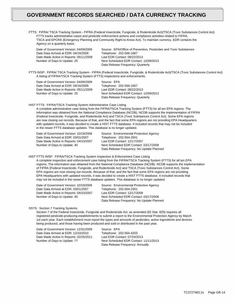
FTTS: FIFRA/ TSCA Tracking System - FIFRA (Federal Insecticide, Fungicide, & Rodenticide Act)/TSCA (Toxic Substances Control Act)FTTS tracks administrative cases and pesticide enforcement actions and compliance activities related to FIFRA,TSCA and EPCRA (Emergency Planning and Community Right-to-Know Act). To maintain currency, EDR contacts theAgency on a quarterly basis.
Date of Government Version: 04/09/2009Date Data Arrived at EDR: 04/16/2009Date Made Active in Reports: 05/11/2009Number of Days to Update: 25
Source: EPA/Office of Prevention, Pesticides and Toxic SubstancesTelephone: 202-566-1667Last EDR Contact: 08/22/2013Next Scheduled EDR Contact: 12/09/2013Data Release Frequency: Quarterly
FTTS INSP: FIFRA/ TSCA Tracking System - FIFRA (Federal Insecticide, Fungicide, & Rodenticide Act)/TSCA (Toxic Substances Control Act)A listing of FIFRA/TSCA Tracking System (FTTS) inspections and enforcements.
Date of Government Version: 04/09/2009Date Data Arrived at EDR: 04/16/2009Date Made Active in Reports: 05/11/2009Number of Days to Update: 25
Source: EPATelephone: 202-566-1667Last EDR Contact: 08/22/2013Next Scheduled EDR Contact: 12/09/2013Data Release Frequency: Quarterly
HIST FTTS: FIFRA/TSCA Tracking System Administrative Case ListingA complete administrative case listing from the FIFRA/TSCA Tracking System (FTTS) for all ten EPA regions. Theinformation was obtained from the National Compliance Database (NCDB). NCDB supports the implementation of FIFRA(Federal Insecticide, Fungicide, and Rodenticide Act) and TSCA (Toxic Substances Control Act). Some EPA regionsare now closing out records. Because of that, and the fact that some EPA regions are not providing EPA Headquarterswith updated records, it was decided to create a HIST FTTS database. It included records that may not be includedin the newer FTTS database updates. This database is no longer updated.
Date of Government Version: 10/19/2006Date Data Arrived at EDR: 03/01/2007Date Made Active in Reports: 04/10/2007Number of Days to Update: 40
Source: Environmental Protection AgencyTelephone: 202-564-2501Last EDR Contact: 12/17/2007Next Scheduled EDR Contact: 03/17/2008Data Release Frequency: No Update Planned
HIST FTTS INSP: FIFRA/TSCA Tracking System Inspection & Enforcement Case ListingA complete inspection and enforcement case listing from the FIFRA/TSCA Tracking System (FTTS) for all ten EPAregions. The information was obtained from the National Compliance Database (NCDB). NCDB supports the implementationof FIFRA (Federal Insecticide, Fungicide, and Rodenticide Act) and TSCA (Toxic Substances Control Act). SomeEPA regions are now closing out records. Because of that, and the fact that some EPA regions are not providingEPA Headquarters with updated records, it was decided to create a HIST FTTS database. It included records thatmay not be included in the newer FTTS database updates. This database is no longer updated.
Date of Government Version: 10/19/2006Date Data Arrived at EDR: 03/01/2007Date Made Active in Reports: 04/10/2007Number of Days to Update: 40
Source: Environmental Protection AgencyTelephone: 202-564-2501Last EDR Contact: 12/17/2008Next Scheduled EDR Contact: 03/17/2008Data Release Frequency: No Update Planned
SSTS: Section 7 Tracking SystemsSection 7 of the Federal Insecticide, Fungicide and Rodenticide Act, as amended (92 Stat. 829) requires allregistered pesticide-producing establishments to submit a report to the Environmental Protection Agency by March1st each year. Each establishment must report the types and amounts of pesticides, active ingredients and devicesbeing produced, and those having been produced and sold or distributed in the past year.
Date of Government Version: 12/31/2009Date Data Arrived at EDR: 12/10/2010Date Made Active in Reports: 02/25/2011Number of Days to Update: 77
Source: EPATelephone: 202-564-4203Last EDR Contact: 07/24/2013Next Scheduled EDR Contact: 11/11/2013Data Release Frequency: Annually
TC3727483.2s Page GR-14
GOVERNMENT RECORDS SEARCHED / DATA CURRENCY TRACKING

ICIS: Integrated Compliance Information SystemThe Integrated Compliance Information System (ICIS) supports the information needs of the national enforcementand compliance program as well as the unique needs of the National Pollutant Discharge Elimination System (NPDES)program.
Date of Government Version: 07/20/2011Date Data Arrived at EDR: 11/10/2011Date Made Active in Reports: 01/10/2012Number of Days to Update: 61
Source: Environmental Protection AgencyTelephone: 202-564-5088Last EDR Contact: 07/01/2013Next Scheduled EDR Contact: 10/28/2013Data Release Frequency: Quarterly
PADS: PCB Activity Database SystemPCB Activity Database. PADS Identifies generators, transporters, commercial storers and/or brokers and disposersof PCB’s who are required to notify the EPA of such activities.
Date of Government Version: 11/01/2012Date Data Arrived at EDR: 01/16/2013Date Made Active in Reports: 05/10/2013Number of Days to Update: 114
Source: EPATelephone: 202-566-0500Last EDR Contact: 07/17/2013Next Scheduled EDR Contact: 10/28/2013Data Release Frequency: Annually
MLTS: Material Licensing Tracking SystemMLTS is maintained by the Nuclear Regulatory Commission and contains a list of approximately 8,100 sites whichpossess or use radioactive materials and which are subject to NRC licensing requirements. To maintain currency,EDR contacts the Agency on a quarterly basis.
Date of Government Version: 03/14/2013Date Data Arrived at EDR: 03/20/2013Date Made Active in Reports: 07/10/2013Number of Days to Update: 112
Source: Nuclear Regulatory CommissionTelephone: 301-415-7169Last EDR Contact: 09/10/2013Next Scheduled EDR Contact: 12/23/2013Data Release Frequency: Quarterly
RADINFO: Radiation Information DatabaseThe Radiation Information Database (RADINFO) contains information about facilities that are regulated by U.S.Environmental Protection Agency (EPA) regulations for radiation and radioactivity.
Date of Government Version: 04/09/2013Date Data Arrived at EDR: 04/11/2013Date Made Active in Reports: 05/10/2013Number of Days to Update: 29
Source: Environmental Protection AgencyTelephone: 202-343-9775Last EDR Contact: 07/12/2013Next Scheduled EDR Contact: 10/21/2013Data Release Frequency: Quarterly
FINDS: Facility Index System/Facility Registry SystemFacility Index System. FINDS contains both facility information and ’pointers’ to other sources that contain moredetail. EDR includes the following FINDS databases in this report: PCS (Permit Compliance System), AIRS (AerometricInformation Retrieval System), DOCKET (Enforcement Docket used to manage and track information on civil judicialenforcement cases for all environmental statutes), FURS (Federal Underground Injection Control), C-DOCKET (CriminalDocket System used to track criminal enforcement actions for all environmental statutes), FFIS (Federal FacilitiesInformation System), STATE (State Environmental Laws and Statutes), and PADS (PCB Activity Data System).
Date of Government Version: 03/08/2013Date Data Arrived at EDR: 03/21/2013Date Made Active in Reports: 07/10/2013Number of Days to Update: 111
Source: EPATelephone: (214) 665-2200Last EDR Contact: 09/11/2013Next Scheduled EDR Contact: 12/23/2013Data Release Frequency: Quarterly
RAATS: RCRA Administrative Action Tracking SystemRCRA Administration Action Tracking System. RAATS contains records based on enforcement actions issued under RCRApertaining to major violators and includes administrative and civil actions brought by the EPA. For administrationactions after September 30, 1995, data entry in the RAATS database was discontinued. EPA will retain a copy ofthe database for historical records. It was necessary to terminate RAATS because a decrease in agency resourcesmade it impossible to continue to update the information contained in the database.
TC3727483.2s Page GR-15
GOVERNMENT RECORDS SEARCHED / DATA CURRENCY TRACKING

Date of Government Version: 04/17/1995Date Data Arrived at EDR: 07/03/1995Date Made Active in Reports: 08/07/1995Number of Days to Update: 35
Source: EPATelephone: 202-564-4104Last EDR Contact: 06/02/2008Next Scheduled EDR Contact: 09/01/2008Data Release Frequency: No Update Planned
RMP: Risk Management PlansWhen Congress passed the Clean Air Act Amendments of 1990, it required EPA to publish regulations and guidancefor chemical accident prevention at facilities using extremely hazardous substances. The Risk Management ProgramRule (RMP Rule) was written to implement Section 112(r) of these amendments. The rule, which built upon existingindustry codes and standards, requires companies of all sizes that use certain flammable and toxic substancesto develop a Risk Management Program, which includes a(n): Hazard assessment that details the potential effectsof an accidental release, an accident history of the last five years, and an evaluation of worst-case and alternativeaccidental releases; Prevention program that includes safety precautions and maintenance, monitoring, and employeetraining measures; and Emergency response program that spells out emergency health care, employee training measuresand procedures for informing the public and response agencies (e.g the fire department) should an accident occur.
Date of Government Version: 05/08/2012Date Data Arrived at EDR: 05/25/2012Date Made Active in Reports: 07/10/2012Number of Days to Update: 46
Source: Environmental Protection AgencyTelephone: 202-564-8600Last EDR Contact: 07/24/2013Next Scheduled EDR Contact: 11/11/2013Data Release Frequency: Varies
BRS: Biennial Reporting SystemThe Biennial Reporting System is a national system administered by the EPA that collects data on the generationand management of hazardous waste. BRS captures detailed data from two groups: Large Quantity Generators (LQG)and Treatment, Storage, and Disposal Facilities.
Date of Government Version: 12/31/2011Date Data Arrived at EDR: 02/26/2013Date Made Active in Reports: 04/19/2013Number of Days to Update: 52
Source: EPA/NTISTelephone: 800-424-9346Last EDR Contact: 08/26/2013Next Scheduled EDR Contact: 12/09/2013Data Release Frequency: Biennially
UIC: Underground Injection Wells ListingA listing of underground injection well locations.
Date of Government Version: 04/15/2013Date Data Arrived at EDR: 04/16/2013Date Made Active in Reports: 04/30/2013Number of Days to Update: 14
Source: Department of fNatural ResourcesTelephone: 225-342-5515Last EDR Contact: 08/26/2013Next Scheduled EDR Contact: 10/14/2013Data Release Frequency: Varies
DRYCLEANERS: Drycleaner Facility ListingA listing of drycleaner facilities.
Date of Government Version: 07/25/2013Date Data Arrived at EDR: 07/26/2013Date Made Active in Reports: 09/03/2013Number of Days to Update: 39
Source: Department of Environmental QualityTelephone: 225-219-3168Last EDR Contact: 04/19/2013Next Scheduled EDR Contact: 11/04/2013Data Release Frequency: Varies
NPDES: LPDES Permits DatabaseA listing of sites with a Louisiana Pollutant Discharge Elimination System (LPDES) program issued permit.
Date of Government Version: 07/29/2013Date Data Arrived at EDR: 07/30/2013Date Made Active in Reports: 09/04/2013Number of Days to Update: 36
Source: Department of Environmental QualityTelephone: 225-219-3181Last EDR Contact: 07/26/2013Next Scheduled EDR Contact: 11/11/2013Data Release Frequency: Varies
TC3727483.2s Page GR-16
GOVERNMENT RECORDS SEARCHED / DATA CURRENCY TRACKING

AIRS: Air Permit ListA listing of facilities with air permits issued by the Air Permits Division
Date of Government Version: 05/30/2013Date Data Arrived at EDR: 06/21/2013Date Made Active in Reports: 08/30/2013Number of Days to Update: 70
Source: Department of Environmental QualityTelephone: 225-219-3417Last EDR Contact: 08/22/2013Next Scheduled EDR Contact: 12/09/2013Data Release Frequency: Varies
INDIAN RESERV: Indian ReservationsThis map layer portrays Indian administered lands of the United States that have any area equal to or greaterthan 640 acres.
Date of Government Version: 12/31/2005Date Data Arrived at EDR: 12/08/2006Date Made Active in Reports: 01/11/2007Number of Days to Update: 34
Source: USGSTelephone: 202-208-3710Last EDR Contact: 07/19/2013Next Scheduled EDR Contact: 10/28/2013Data Release Frequency: Semi-Annually
SCRD DRYCLEANERS: State Coalition for Remediation of Drycleaners ListingThe State Coalition for Remediation of Drycleaners was established in 1998, with support from the U.S. EPA Officeof Superfund Remediation and Technology Innovation. It is comprised of representatives of states with establisheddrycleaner remediation programs. Currently the member states are Alabama, Connecticut, Florida, Illinois, Kansas,Minnesota, Missouri, North Carolina, Oregon, South Carolina, Tennessee, Texas, and Wisconsin.
Date of Government Version: 03/07/2011Date Data Arrived at EDR: 03/09/2011Date Made Active in Reports: 05/02/2011Number of Days to Update: 54
Source: Environmental Protection AgencyTelephone: 615-532-8599Last EDR Contact: 08/01/2013Next Scheduled EDR Contact: 11/04/2013Data Release Frequency: Varies
US AIRS MINOR: Air Facility System DataA listing of minor source facilities.
Date of Government Version: 01/23/2013Date Data Arrived at EDR: 01/30/2013Date Made Active in Reports: 05/10/2013Number of Days to Update: 100
Source: EPATelephone: 202-564-5962Last EDR Contact: 06/25/2013Next Scheduled EDR Contact: 10/14/2013Data Release Frequency: Annually
REM: Division of Remediation Services DatabaseFacilities or sites come to the Underground Storage Tank and Remediation Divison either through self notificationor referral. These sites are designated for remediation via the following regulatory paths: Solid Waste (SW),Hazardous Waste (Haz Waste), Groundwater (Grwater), Inactive & Abandoned Sites (Confirmed or Potential),or Underground Storage Tanks (UST).
Date of Government Version: 07/19/2013Date Data Arrived at EDR: 07/22/2013Date Made Active in Reports: 09/04/2013Number of Days to Update: 44
Source: Department of Environmental QualityTelephone: 225-219-3168Last EDR Contact: 07/18/2013Next Scheduled EDR Contact: 11/04/2013Data Release Frequency: Quarterly
PRP: Potentially Responsible PartiesA listing of verified Potentially Responsible Parties
Date of Government Version: 04/15/2013Date Data Arrived at EDR: 07/03/2013Date Made Active in Reports: 09/13/2013Number of Days to Update: 72
Source: EPATelephone: 202-564-6023Last EDR Contact: 07/03/2013Next Scheduled EDR Contact: 10/14/2013Data Release Frequency: Quarterly
TC3727483.2s Page GR-17
GOVERNMENT RECORDS SEARCHED / DATA CURRENCY TRACKING

FEDLAND: Federal and Indian LandsFederally and Indian administrated lands of the United States. Lands included are administrated by: Army Corpsof Engineers, Bureau of Reclamation, National Wild and Scenic River, National Wildlife Refuge, Public Domain Land,Wilderness, Wilderness Study Area, Wildlife Management Area, Bureau of Indian Affairs, Bureau of Land Management,Department of Justice, Forest Service, Fish and Wildlife Service, National Park Service.
Date of Government Version: 12/31/2005Date Data Arrived at EDR: 02/06/2006Date Made Active in Reports: 01/11/2007Number of Days to Update: 339
Source: U.S. Geological SurveyTelephone: 888-275-8747Last EDR Contact: 07/19/2013Next Scheduled EDR Contact: 10/28/2013Data Release Frequency: N/A
US AIRS (AFS): Aerometric Information Retrieval System Facility Subsystem (AFS)The database is a sub-system of Aerometric Information Retrieval System (AIRS). AFS contains compliance dataon air pollution point sources regulated by the U.S. EPA and/or state and local air regulatory agencies. Thisinformation comes from source reports by various stationary sources of air pollution, such as electric power plants,steel mills, factories, and universities, and provides information about the air pollutants they produce. Action,air program, air program pollutant, and general level plant data. It is used to track emissions and compliancedata from industrial plants.
Date of Government Version: 01/23/2013Date Data Arrived at EDR: 01/30/2013Date Made Active in Reports: 05/10/2013Number of Days to Update: 100
Source: EPATelephone: 202-564-5962Last EDR Contact: 06/25/2013Next Scheduled EDR Contact: 10/14/2013Data Release Frequency: Annually
2020 COR ACTION: 2020 Corrective Action Program ListThe EPA has set ambitious goals for the RCRA Corrective Action program by creating the 2020 Corrective ActionUniverse. This RCRA cleanup baseline includes facilities expected to need corrective action. The 2020 universecontains a wide variety of sites. Some properties are heavily contaminated while others were contaminated buthave since been cleaned up. Still others have not been fully investigated yet, and may require little or no remediation.Inclusion in the 2020 Universe does not necessarily imply failure on the part of a facility to meet its RCRA obligations.
Date of Government Version: 11/11/2011Date Data Arrived at EDR: 05/18/2012Date Made Active in Reports: 05/25/2012Number of Days to Update: 7
Source: Environmental Protection AgencyTelephone: 703-308-4044Last EDR Contact: 08/16/2013Next Scheduled EDR Contact: 11/25/2013Data Release Frequency: Varies
LEAD SMELTER 2: Lead Smelter SitesA list of several hundred sites in the U.S. where secondary lead smelting was done from 1931and 1964. These sitesmay pose a threat to public health through ingestion or inhalation of contaminated soil or dust
Date of Government Version: 04/05/2001Date Data Arrived at EDR: 10/27/2010Date Made Active in Reports: 12/02/2010Number of Days to Update: 36
Source: American Journal of Public HealthTelephone: 703-305-6451Last EDR Contact: 12/02/2009Next Scheduled EDR Contact: N/AData Release Frequency: No Update Planned
LEAD SMELTER 1: Lead Smelter SitesA listing of former lead smelter site locations.
Date of Government Version: 01/29/2013Date Data Arrived at EDR: 02/14/2013Date Made Active in Reports: 02/27/2013Number of Days to Update: 13
Source: Environmental Protection AgencyTelephone: 703-603-8787Last EDR Contact: 07/03/2013Next Scheduled EDR Contact: 10/21/2013Data Release Frequency: Varies
Financial Assurance 2: Financial Assurance Information ListingInformation for solid waste facilities. Financial assurance is intended to ensure that resources are availableto pay for the cost of closure, post-closure care, and corrective measures if the owner or operator of a regulatedfacility is unable or unwilling to pay
TC3727483.2s Page GR-18
GOVERNMENT RECORDS SEARCHED / DATA CURRENCY TRACKING

Date of Government Version: 05/17/2013Date Data Arrived at EDR: 06/14/2013Date Made Active in Reports: 06/27/2013Number of Days to Update: 13
Source: Department of Environmental QualityTelephone: 225-219-3168Last EDR Contact: 07/26/2013Next Scheduled EDR Contact: 11/11/2013Data Release Frequency: Varies
EPA WATCH LIST: EPA WATCH LISTEPA maintains a "Watch List" to facilitate dialogue between EPA, state and local environmental agencies on enforcementmatters relating to facilities with alleged violations identified as either significant or high priority. Beingon the Watch List does not mean that the facility has actually violated the law only that an investigation byEPA or a state or local environmental agency has led those organizations to allege that an unproven violationhas in fact occurred. Being on the Watch List does not represent a higher level of concern regarding the allegedviolations that were detected, but instead indicates cases requiring additional dialogue between EPA, state andlocal agencies - primarily because of the length of time the alleged violation has gone unaddressed or unresolved.
Date of Government Version: 06/30/2013Date Data Arrived at EDR: 08/13/2013Date Made Active in Reports: 09/13/2013Number of Days to Update: 31
Source: Environmental Protection AgencyTelephone: 617-520-3000Last EDR Contact: 08/07/2013Next Scheduled EDR Contact: 11/25/2013Data Release Frequency: Quarterly
US FIN ASSUR: Financial Assurance InformationAll owners and operators of facilities that treat, store, or dispose of hazardous waste are required to provideproof that they will have sufficient funds to pay for the clean up, closure, and post-closure care of their facilities.
Date of Government Version: 03/04/2013Date Data Arrived at EDR: 03/15/2013Date Made Active in Reports: 05/10/2013Number of Days to Update: 56
Source: Environmental Protection AgencyTelephone: 202-566-1917Last EDR Contact: 08/23/2013Next Scheduled EDR Contact: 12/02/2013Data Release Frequency: Quarterly
PCB TRANSFORMER: PCB Transformer Registration DatabaseThe database of PCB transformer registrations that includes all PCB registration submittals.
Date of Government Version: 02/01/2011Date Data Arrived at EDR: 10/19/2011Date Made Active in Reports: 01/10/2012Number of Days to Update: 83
Source: Environmental Protection AgencyTelephone: 202-566-0517Last EDR Contact: 08/02/2013Next Scheduled EDR Contact: 11/11/2013Data Release Frequency: Varies
COAL ASH DOE: Sleam-Electric Plan Operation DataA listing of power plants that store ash in surface ponds.
Date of Government Version: 12/31/2005Date Data Arrived at EDR: 08/07/2009Date Made Active in Reports: 10/22/2009Number of Days to Update: 76
Source: Department of EnergyTelephone: 202-586-8719Last EDR Contact: 07/19/2013Next Scheduled EDR Contact: 10/28/2013Data Release Frequency: Varies
COAL ASH EPA: Coal Combustion Residues Surface Impoundments ListA listing of coal combustion residues surface impoundments with high hazard potential ratings.
Date of Government Version: 08/17/2010Date Data Arrived at EDR: 01/03/2011Date Made Active in Reports: 03/21/2011Number of Days to Update: 77
Source: Environmental Protection AgencyTelephone: N/ALast EDR Contact: 09/13/2013Next Scheduled EDR Contact: 12/23/2013Data Release Frequency: Varies
COAL ASH: Coal Ash Disposal SitesA listing of coal ash impoundments.
TC3727483.2s Page GR-19
GOVERNMENT RECORDS SEARCHED / DATA CURRENCY TRACKING

Date of Government Version: 07/25/2013Date Data Arrived at EDR: 07/26/2013Date Made Active in Reports: 09/03/2013Number of Days to Update: 39
Source: Department of Environmental QualityTelephone: 225-219-3168Last EDR Contact: 07/15/2013Next Scheduled EDR Contact: 10/28/2013Data Release Frequency: Varies
ASBESTOS: Asbestos Projects ListAsbestos demolition and renovation notification projects locations in the state.
Date of Government Version: 12/31/2012Date Data Arrived at EDR: 04/25/2013Date Made Active in Reports: 06/27/2013Number of Days to Update: 63
Source: Department of Environmental QualityTelephone: 225-219-3181Last EDR Contact: 07/22/2013Next Scheduled EDR Contact: 11/04/2013Data Release Frequency: Annually
Financial Assurance 1: FInancial Assurance InformationFinancial assurance is intended to ensure that resources are available to pay for the cost of closure, post-closurecare, and corrective measures if the owner or operator of a regulated facility is unable or unwilling to pay
Date of Government Version: 05/17/2013Date Data Arrived at EDR: 06/14/2013Date Made Active in Reports: 06/27/2013Number of Days to Update: 13
Source: Department of Environmental QualityTelephone: 225-219-3168Last EDR Contact: 07/26/2013Next Scheduled EDR Contact: 11/11/2013Data Release Frequency: Varies
EDR HIGH RISK HISTORICAL RECORDS
EDR Exclusive Records
EDR MGP: EDR Proprietary Manufactured Gas PlantsThe EDR Proprietary Manufactured Gas Plant Database includes records of coal gas plants (manufactured gas plants)compiled by EDR’s researchers. Manufactured gas sites were used in the United States from the 1800’s to 1950’sto produce a gas that could be distributed and used as fuel. These plants used whale oil, rosin, coal, or a mixtureof coal, oil, and water that also produced a significant amount of waste. Many of the byproducts of the gas production,such as coal tar (oily waste containing volatile and non-volatile chemicals), sludges, oils and other compoundsare potentially hazardous to human health and the environment. The byproduct from this process was frequentlydisposed of directly at the plant site and can remain or spread slowly, serving as a continuous source of soiland groundwater contamination.
Date of Government Version: N/ADate Data Arrived at EDR: N/ADate Made Active in Reports: N/ANumber of Days to Update: N/A
Source: EDR, Inc.Telephone: N/ALast EDR Contact: N/ANext Scheduled EDR Contact: N/AData Release Frequency: No Update Planned
EDR US Hist Auto Stat: EDR Exclusive Historic Gas StationsEDR has searched selected national collections of business directories and has collected listings of potentialgas station/filling station/service station sites that were available to EDR researchers. EDR’s review was limitedto those categories of sources that might, in EDR’s opinion, include gas station/filling station/service stationestablishments. The categories reviewed included, but were not limited to gas, gas station, gasoline station,filling station, auto, automobile repair, auto service station, service station, etc. This database falls withina category of information EDR classifies as "High Risk Historical Records", or HRHR. EDR’s HRHR effort presentsunique and sometimes proprietary data about past sites and operations that typically create environmental concerns,but may not show up in current government records searches.
Date of Government Version: N/ADate Data Arrived at EDR: N/ADate Made Active in Reports: N/ANumber of Days to Update: N/A
Source: EDR, Inc.Telephone: N/ALast EDR Contact: N/ANext Scheduled EDR Contact: N/AData Release Frequency: Varies
TC3727483.2s Page GR-20
GOVERNMENT RECORDS SEARCHED / DATA CURRENCY TRACKING

EDR US Hist Cleaners: EDR Exclusive Historic Dry CleanersEDR has searched selected national collections of business directories and has collected listings of potentialdry cleaner sites that were available to EDR researchers. EDR’s review was limited to those categories of sourcesthat might, in EDR’s opinion, include dry cleaning establishments. The categories reviewed included, but werenot limited to dry cleaners, cleaners, laundry, laundromat, cleaning/laundry, wash & dry etc. This database fallswithin a category of information EDR classifies as "High Risk Historical Records", or HRHR. EDR’s HRHR effortpresents unique and sometimes proprietary data about past sites and operations that typically create environmentalconcerns, but may not show up in current government records searches.
Date of Government Version: N/ADate Data Arrived at EDR: N/ADate Made Active in Reports: N/ANumber of Days to Update: N/A
Source: EDR, Inc.Telephone: N/ALast EDR Contact: N/ANext Scheduled EDR Contact: N/AData Release Frequency: Varies
EDR US Hist Cleaners: EDR Proprietary Historic Dry Cleaners - Cole
Date of Government Version: N/ADate Data Arrived at EDR: N/ADate Made Active in Reports: N/ANumber of Days to Update: N/A
Source: N/ATelephone: N/ALast EDR Contact: N/ANext Scheduled EDR Contact: N/AData Release Frequency: Varies
EDR US Hist Auto Stat: EDR Proprietary Historic Gas Stations - Cole
Date of Government Version: N/ADate Data Arrived at EDR: N/ADate Made Active in Reports: N/ANumber of Days to Update: N/A
Source: N/ATelephone: N/ALast EDR Contact: N/ANext Scheduled EDR Contact: N/AData Release Frequency: Varies
OTHER DATABASE(S)
Depending on the geographic area covered by this report, the data provided in these specialty databases may or may not becomplete. For example, the existence of wetlands information data in a specific report does not mean that all wetlands in thearea covered by the report are included. Moreover, the absence of any reported wetlands information does not necessarilymean that wetlands do not exist in the area covered by the report.
CT MANIFEST: Hazardous Waste Manifest DataFacility and manifest data. Manifest is a document that lists and tracks hazardous waste from the generator throughtransporters to a tsd facility.
Date of Government Version: 05/20/2013Date Data Arrived at EDR: 05/21/2013Date Made Active in Reports: 06/27/2013Number of Days to Update: 37
Source: Department of Energy & Environmental ProtectionTelephone: 860-424-3375Last EDR Contact: 08/19/2013Next Scheduled EDR Contact: 12/02/2013Data Release Frequency: Annually
NY MANIFEST: Facility and Manifest DataManifest is a document that lists and tracks hazardous waste from the generator through transporters to a TSDfacility.
Date of Government Version: 08/01/2013Date Data Arrived at EDR: 08/07/2013Date Made Active in Reports: 09/10/2013Number of Days to Update: 34
Source: Department of Environmental ConservationTelephone: 518-402-8651Last EDR Contact: 08/07/2013Next Scheduled EDR Contact: 11/18/2013Data Release Frequency: Annually
TC3727483.2s Page GR-21
GOVERNMENT RECORDS SEARCHED / DATA CURRENCY TRACKING

PA MANIFEST: Manifest InformationHazardous waste manifest information.
Date of Government Version: 12/31/2012Date Data Arrived at EDR: 07/24/2013Date Made Active in Reports: 08/19/2013Number of Days to Update: 26
Source: Department of Environmental ProtectionTelephone: 717-783-8990Last EDR Contact: 07/18/2013Next Scheduled EDR Contact: 11/04/2013Data Release Frequency: Annually
WI MANIFEST: Manifest InformationHazardous waste manifest information.
Date of Government Version: 12/31/2011Date Data Arrived at EDR: 07/19/2012Date Made Active in Reports: 09/27/2012Number of Days to Update: 70
Source: Department of Natural ResourcesTelephone: N/ALast EDR Contact: 07/17/2013Next Scheduled EDR Contact: 09/30/2013Data Release Frequency: Annually
Oil/Gas Pipelines: This data was obtained by EDR from the USGS in 1994. It is referred to by USGS as GeoData Digital Line Graphsfrom 1:100,000-Scale Maps. It was extracted from the transportation category including some oil, but primarilygas pipelines.
Electric Power Transmission Line DataSource: Rextag Strategies Corp.Telephone: (281) 769-2247U.S. Electric Transmission and Power Plants Systems Digital GIS Data
Sensitive Receptors: There are individuals deemed sensitive receptors due to their fragile immune systems and special sensitivityto environmental discharges. These sensitive receptors typically include the elderly, the sick, and children. While the location of allsensitive receptors cannot be determined, EDR indicates those buildings and facilities - schools, daycares, hospitals, medical centers,and nursing homes - where individuals who are sensitive receptors are likely to be located.
AHA Hospitals:Source: American Hospital Association, Inc.Telephone: 312-280-5991The database includes a listing of hospitals based on the American Hospital Association’s annual survey of hospitals.
Medical Centers: Provider of Services ListingSource: Centers for Medicare & Medicaid ServicesTelephone: 410-786-3000A listing of hospitals with Medicare provider number, produced by Centers of Medicare & Medicaid Services,a federal agency within the U.S. Department of Health and Human Services.
Nursing HomesSource: National Institutes of HealthTelephone: 301-594-6248Information on Medicare and Medicaid certified nursing homes in the United States.
Public SchoolsSource: National Center for Education StatisticsTelephone: 202-502-7300The National Center for Education Statistics’ primary database on elementaryand secondary public education in the United States. It is a comprehensive, annual, national statisticaldatabase of all public elementary and secondary schools and school districts, which contains data that arecomparable across all states.
Private SchoolsSource: National Center for Education StatisticsTelephone: 202-502-7300The National Center for Education Statistics’ primary database on private school locations in the United States.
Flood Zone Data: This data, available in select counties across the country, was obtained by EDR in 2003 & 2011 from the FederalEmergency Management Agency (FEMA). Data depicts 100-year and 500-year flood zones as defined by FEMA.
NWI: National Wetlands Inventory. This data, available in select counties across the country, was obtained by EDRin 2002 and 2005 from the U.S. Fish and Wildlife Service.
TC3727483.2s Page GR-22
GOVERNMENT RECORDS SEARCHED / DATA CURRENCY TRACKING

Scanned Digital USGS 7.5’ Topographic Map (DRG)Source: United States Geologic SurveyA digital raster graphic (DRG) is a scanned image of a U.S. Geological Survey topographic map. The map imagesare made by scanning published paper maps on high-resolution scanners. The raster imageis georeferenced and fit to the Universal Transverse Mercator (UTM) projection.
STREET AND ADDRESS INFORMATION
© 2010 Tele Atlas North America, Inc. All rights reserved. This material is proprietary and the subject of copyright protectionand other intellectual property rights owned by or licensed to Tele Atlas North America, Inc. The use of this material is subjectto the terms of a license agreement. You will be held liable for any unauthorized copying or disclosure of this material.
TC3727483.2s Page GR-23
GOVERNMENT RECORDS SEARCHED / DATA CURRENCY TRACKING

TC3727483.2s Page A-1
geologic strata.of the soil, and nearby wells. Groundwater flow velocity is generally impacted by the nature of theGroundwater flow direction may be impacted by surface topography, hydrology, hydrogeology, characteristics
2. Groundwater flow velocity. 1. Groundwater flow direction, and
Assessment of the impact of contaminant migration generally has two principal investigative components:
forming an opinion about the impact of potential contaminant migration.EDR’s GeoCheck Physical Setting Source Addendum is provided to assist the environmental professional in
1992Most Recent Revision:29089-E7 POINTE A LA HACHE, LATarget Property Map:
USGS TOPOGRAPHIC MAP
3 ft. above sea levelElevation:3275435.2UTM Y (Meters): 226760.1UTM X (Meters): Zone 16Universal Tranverse Mercator: 89.8206 - 89˚ 49’ 14.16’’Longitude (West): 29.5804 - 29˚ 34’ 49.44’’Latitude (North):
TARGET PROPERTY COORDINATES
PORT SULPHUR, LA 70083LDWF PLAQUEMINES SITELDWF PLAQUEMINES SITE
TARGET PROPERTY ADDRESS
®GEOCHECK - PHYSICAL SETTING SOURCE ADDENDUM®

TC3727483.2s Page A-2
should be field verified.on a relative (not an absolute) basis. Relative elevation information between sites of close proximitySource: Topography has been determined from the USGS 7.5’ Digital Elevation Model and should be evaluated
SURROUNDING TOPOGRAPHY: ELEVATION PROFILES
Ele
vatio
n (f
t)E
leva
tion
(ft)
TP
TP0 1/2 1 Miles
✩Target Property Elevation: 3 ft.
North South
West East
000000001
33
000000
4
20 0 0 0 0 1 2 2 2 3 4 3
0 0 0 0 0 0 0
General EastGeneral Topographic Gradient:TARGET PROPERTY TOPOGRAPHY
should contamination exist on the target property, what downgradient sites might be impacted.assist the environmental professional in forming an opinion about the impact of nearby contaminated properties or,Surface topography may be indicative of the direction of surficial groundwater flow. This information can be used toTOPOGRAPHIC INFORMATION
collected on nearby properties, and regional groundwater flow information (from deep aquifers).sources of information, such as surface topographic information, hydrologic information, hydrogeologic datausing site-specific well data. If such data is not reasonably ascertainable, it may be necessary to rely on otherGroundwater flow direction for a particular site is best determined by a qualified environmental professionalGROUNDWATER FLOW DIRECTION INFORMATION
®GEOCHECK - PHYSICAL SETTING SOURCE SUMMARY®

TC3727483.2s Page A-3
Not Reported
GENERAL DIRECTIONLOCATIONGROUNDWATER FLOWFROM TPMAP ID
hydrogeologically, and the depth to water table.authorities at select sites and has extracted the date of the report, groundwater flow direction as determinedflow at specific points. EDR has reviewed reports submitted by environmental professionals to regulatoryEDR has developed the AQUIFLOW Information System to provide data on the general direction of groundwater
AQUIFLOW®
Search Radius: 1.000 Mile.
Not found Status:1.25 miles Search Radius:
Site-Specific Hydrogeological Data*:
* ©1996 Site−specific hydrogeological data gathered by CERCLIS Alerts, Inc., Bainbridge Island, WA. All rights reserved. All of the information and opinions presented are those of the cited EPA report(s), which were completed undera Comprehensive Environmental Response Compensation and Liability Information System (CERCLIS) investigation.
contamination exist on the target property, what downgradient sites might be impacted.environmental professional in forming an opinion about the impact of nearby contaminated properties or, shouldof groundwater flow direction in the immediate area. Such hydrogeologic information can be used to assist theHydrogeologic information obtained by installation of wells on a specific site can often be an indicatorHYDROGEOLOGIC INFORMATION
YES - refer to the Overview Map and Detail MapPOINTE A LA HACHE
NATIONAL WETLAND INVENTORYNWI ElectronicData CoverageNWI Quad at Target Property
2201390435B - FEMA Q3 Flood dataAdditional Panels in search area:
2201390430B - FEMA Q3 Flood dataFlood Plain Panel at Target Property:
YES - refer to the Overview Map and Detail MapPLAQUEMINES, LA
FEMA FLOOD ZONEFEMA FloodElectronic DataTarget Property County
and bodies of water).Refer to the Physical Setting Source Map following this summary for hydrologic information (major waterways
contamination exist on the target property, what downgradient sites might be impacted.the environmental professional in forming an opinion about the impact of nearby contaminated properties or, shouldSurface water can act as a hydrologic barrier to groundwater flow. Such hydrologic information can be used to assistHYDROLOGIC INFORMATION
®GEOCHECK - PHYSICAL SETTING SOURCE SUMMARY®

TC3727483.2s Page A-4
Map, USGS Digital Data Series DDS - 11 (1994).of the Conterminous U.S. at 1:2,500,000 Scale - a digital representation of the 1974 P.B. King and H.M. BeikmanGeologic Age and Rock Stratigraphic Unit Source: P.G. Schruben, R.E. Arndt and W.J. Bawiec, Geology
ROCK STRATIGRAPHIC UNIT GEOLOGIC AGE IDENTIFICATION
Stratifed SequenceCategory:CenozoicEra:QuaternarySystem:HoloceneSeries:QhCode: (decoded above as Era, System & Series)
at which contaminant migration may be occurring.Geologic information can be used by the environmental professional in forming an opinion about the relative speedGEOLOGIC INFORMATION IN GENERAL AREA OF TARGET PROPERTY
move more quickly through sandy-gravelly types of soils than silty-clayey types of soils.characteristics data collected on nearby properties and regional soil information. In general, contaminant plumesto rely on other sources of information, including geologic age identification, rock stratigraphic unit and soilusing site specific geologic and soil strata data. If such data are not reasonably ascertainable, it may be necessaryGroundwater flow velocity information for a particular site is best determined by a qualified environmental professionalGROUNDWATER FLOW VELOCITY INFORMATION
®GEOCHECK - PHYSICAL SETTING SOURCE SUMMARY®

EDR Inc.EDR Inc.EDR Inc.EDR Inc.EDR Inc.EDR Inc.EDR Inc.EDR Inc.EDR Inc.EDR Inc.EDR Inc.EDR Inc.EDR Inc.EDR Inc.EDR Inc.EDR Inc.EDR Inc.EDR Inc.EDR Inc.EDR Inc.EDR Inc.EDR Inc.EDR Inc.EDR Inc.EDR Inc.EDR Inc.EDR Inc.EDR Inc.EDR Inc.EDR Inc.EDR Inc.EDR Inc.EDR Inc.EDR Inc.EDR Inc.EDR Inc.EDR Inc.EDR Inc.EDR Inc.EDR Inc.
4
5
4
2
4
4
13
4
4
6
0 1/16 1/8 1/4 Miles
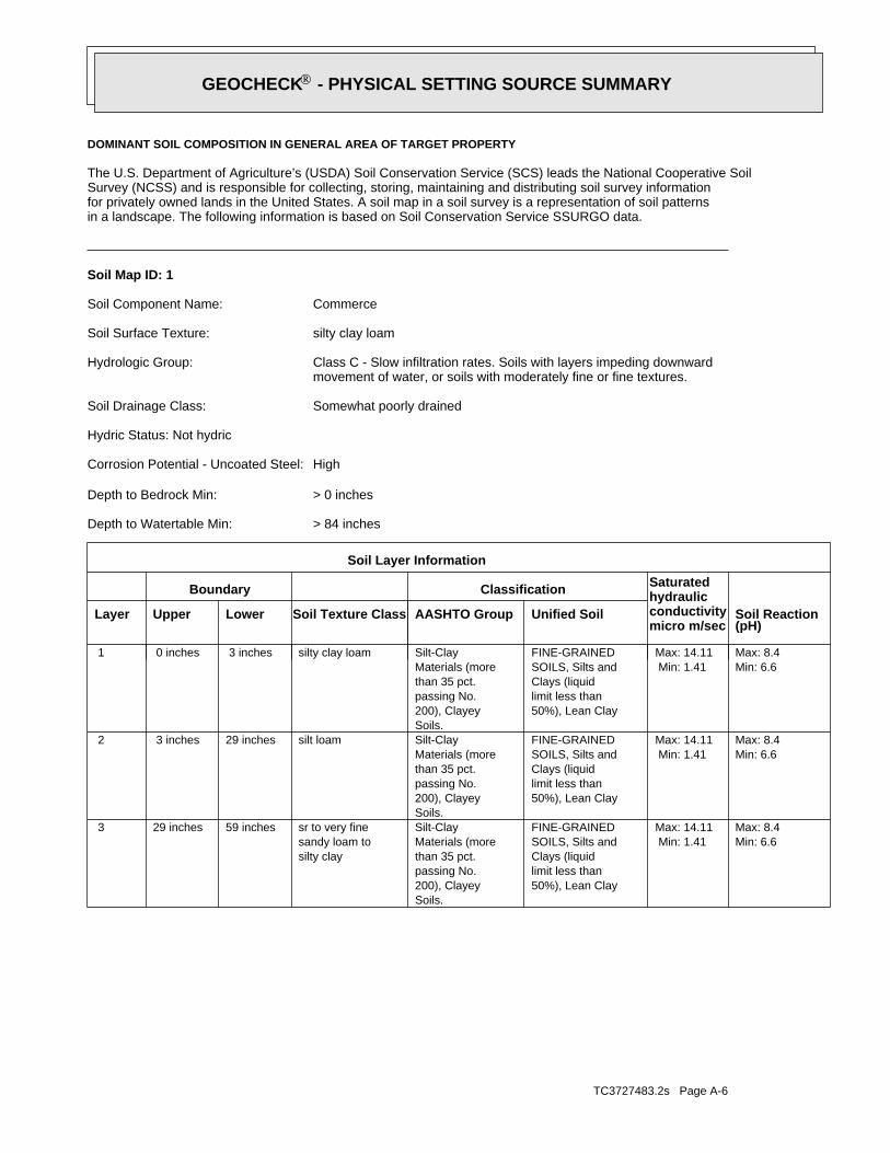
TC3727483.2s Page A-6
Min: 6.6Max: 8.4
Min: 1.41Max: 14.11
50%), Lean Claylimit less thanClays (liquidSOILS, Silts andFINE-GRAINED
Soils.200), Clayeypassing No.than 35 pct.Materials (moreSilt-Clay
silty claysandy loam tosr to very fine59 inches29 inches 3
Min: 6.6Max: 8.4
Min: 1.41Max: 14.11
50%), Lean Claylimit less thanClays (liquidSOILS, Silts andFINE-GRAINED
Soils.200), Clayeypassing No.than 35 pct.Materials (moreSilt-Claysilt loam29 inches 3 inches 2
Min: 6.6Max: 8.4
Min: 1.41Max: 14.11
50%), Lean Claylimit less thanClays (liquidSOILS, Silts andFINE-GRAINED
Soils.200), Clayeypassing No.than 35 pct.Materials (moreSilt-Claysilty clay loam 3 inches 0 inches 1
Soil Layer Information
Boundary Classification Saturatedhydraulicconductivitymicro m/sec
Layer Upper Lower Soil Texture Class AASHTO Group Unified Soil Soil Reaction(pH)
> 84 inchesDepth to Watertable Min:
> 0 inchesDepth to Bedrock Min:
HighCorrosion Potential - Uncoated Steel:
Hydric Status: Not hydric
Somewhat poorly drainedSoil Drainage Class:
movement of water, or soils with moderately fine or fine textures.Class C - Slow infiltration rates. Soils with layers impeding downwardHydrologic Group:
silty clay loamSoil Surface Texture:
CommerceSoil Component Name:
Soil Map ID: 1
in a landscape. The following information is based on Soil Conservation Service SSURGO data.for privately owned lands in the United States. A soil map in a soil survey is a representation of soil patternsSurvey (NCSS) and is responsible for collecting, storing, maintaining and distributing soil survey informationThe U.S. Department of Agriculture’s (USDA) Soil Conservation Service (SCS) leads the National Cooperative Soil
DOMINANT SOIL COMPOSITION IN GENERAL AREA OF TARGET PROPERTY
®GEOCHECK - PHYSICAL SETTING SOURCE SUMMARY®

TC3727483.2s Page A-7
Poorly drainedSoil Drainage Class:
water table, or are shallow to an impervious layer.Class D - Very slow infiltration rates. Soils are clayey, have a highHydrologic Group:
claySoil Surface Texture:
SharkeySoil Component Name:
Soil Map ID: 3
Min: 6.6Max: 8.4
Min: 1.41Max: 14.11
50%), Lean Claylimit less thanClays (liquidSOILS, Silts andFINE-GRAINED
Soils.200), Clayeypassing No.than 35 pct.Materials (moreSilt-Clay
silty claysandy loam tosr to very fine59 inches37 inches 3
Min: 6.6Max: 8.4
Min: 1.41Max: 14.11
50%), Lean Claylimit less thanClays (liquidSOILS, Silts andFINE-GRAINED
Soils.200), Clayeypassing No.than 35 pct.Materials (moreSilt-Claysilt loam37 inches 7 inches 2
Min: 6.6Max: 8.4
Min: 1.41Max: 14.11
50%), Lean Claylimit less thanClays (liquidSOILS, Silts andFINE-GRAINED
Soils.200), Clayeypassing No.than 35 pct.Materials (moreSilt-Claysilt loam 7 inches 0 inches 1
Soil Layer Information
Boundary Classification Saturatedhydraulicconductivitymicro m/sec
Layer Upper Lower Soil Texture Class AASHTO Group Unified Soil Soil Reaction(pH)
> 84 inchesDepth to Watertable Min:
> 0 inchesDepth to Bedrock Min:
HighCorrosion Potential - Uncoated Steel:
Hydric Status: Not hydric
Somewhat poorly drainedSoil Drainage Class:
movement of water, or soils with moderately fine or fine textures.Class C - Slow infiltration rates. Soils with layers impeding downwardHydrologic Group:
silt loamSoil Surface Texture:
CommerceSoil Component Name:
Soil Map ID: 2
®GEOCHECK - PHYSICAL SETTING SOURCE SUMMARY®
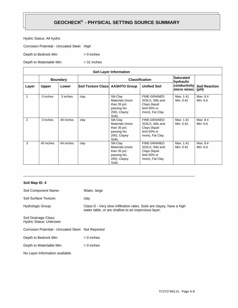
TC3727483.2s Page A-8
No Layer Information available.
> 0 inchesDepth to Watertable Min:
> 0 inchesDepth to Bedrock Min:
Not ReportedCorrosion Potential - Uncoated Steel:
Hydric Status: UnknownSoil Drainage Class:
water table, or are shallow to an impervious layer.Class D - Very slow infiltration rates. Soils are clayey, have a highHydrologic Group:
claySoil Surface Texture:
Water, largeSoil Component Name:
Soil Map ID: 4
Min: 6.6Max: 8.4
Min: 0.42Max: 1.41
more), Fat Clay.limit 50% orClays (liquidSOILS, Silts andFINE-GRAINED
Soils.200), Clayeypassing No.than 35 pct.Materials (moreSilt-Clayclay64 inches40 inches 3
Min: 6.6Max: 8.4
Min: 0.42Max: 1.41
more), Fat Clay.limit 50% orClays (liquidSOILS, Silts andFINE-GRAINED
Soils.200), Clayeypassing No.than 35 pct.Materials (moreSilt-Clayclay40 inches 3 inches 2
Min: 6.6Max: 8.4
Min: 0.42Max: 1.41
more), Fat Clay.limit 50% orClays (liquidSOILS, Silts andFINE-GRAINED
Soils.200), Clayeypassing No.than 35 pct.Materials (moreSilt-Clayclay 3 inches 0 inches 1
Soil Layer Information
Boundary Classification Saturatedhydraulicconductivitymicro m/sec
Layer Upper Lower Soil Texture Class AASHTO Group Unified Soil Soil Reaction(pH)
> 31 inchesDepth to Watertable Min:
> 0 inchesDepth to Bedrock Min:
HighCorrosion Potential - Uncoated Steel:
Hydric Status: All hydric
®GEOCHECK - PHYSICAL SETTING SOURCE SUMMARY®

TC3727483.2s Page A-9
Min: 5.6Max: 8.4
Min: 4.23Max: 14.11
50%), silt.limit less thanClays (liquidSOILS, Silts andFINE-GRAINED50%), Lean Clay.limit less thanClays (liquidSOILS, Silts andFINE-GRAINED
Soils.200), Siltypassing No.than 35 pct.Materials (moreSilt-Claysilt loam59 inches29 inches 3
Min: 5.6Max: 8.4
Min: 4.23Max: 14.11
50%), silt.limit less thanClays (liquidSOILS, Silts andFINE-GRAINED50%), Lean Clay.limit less thanClays (liquidSOILS, Silts andFINE-GRAINED
Soils.200), Siltypassing No.than 35 pct.Materials (moreSilt-Clay
loamvery fine sandy29 inches 7 inches 2
Min: 5.6Max: 8.4
Min: 4.23Max: 14.11
50%), silt.limit less thanClays (liquidSOILS, Silts andFINE-GRAINED50%), Lean Clay.limit less thanClays (liquidSOILS, Silts andFINE-GRAINED
Soils.200), Siltypassing No.than 35 pct.Materials (moreSilt-Claysilt loam 7 inches 0 inches 1
Soil Layer Information
Boundary Classification Saturatedhydraulicconductivitymicro m/sec
Layer Upper Lower Soil Texture Class AASHTO Group Unified Soil Soil Reaction(pH)
> 31 inchesDepth to Watertable Min:
> 0 inchesDepth to Bedrock Min:
HighCorrosion Potential - Uncoated Steel:
Hydric Status: All hydric
Somewhat poorly drainedSoil Drainage Class:
movement of water, or soils with moderately fine or fine textures.Class C - Slow infiltration rates. Soils with layers impeding downwardHydrologic Group:
silt loamSoil Surface Texture:
ConventSoil Component Name:
Soil Map ID: 5
®GEOCHECK - PHYSICAL SETTING SOURCE SUMMARY®
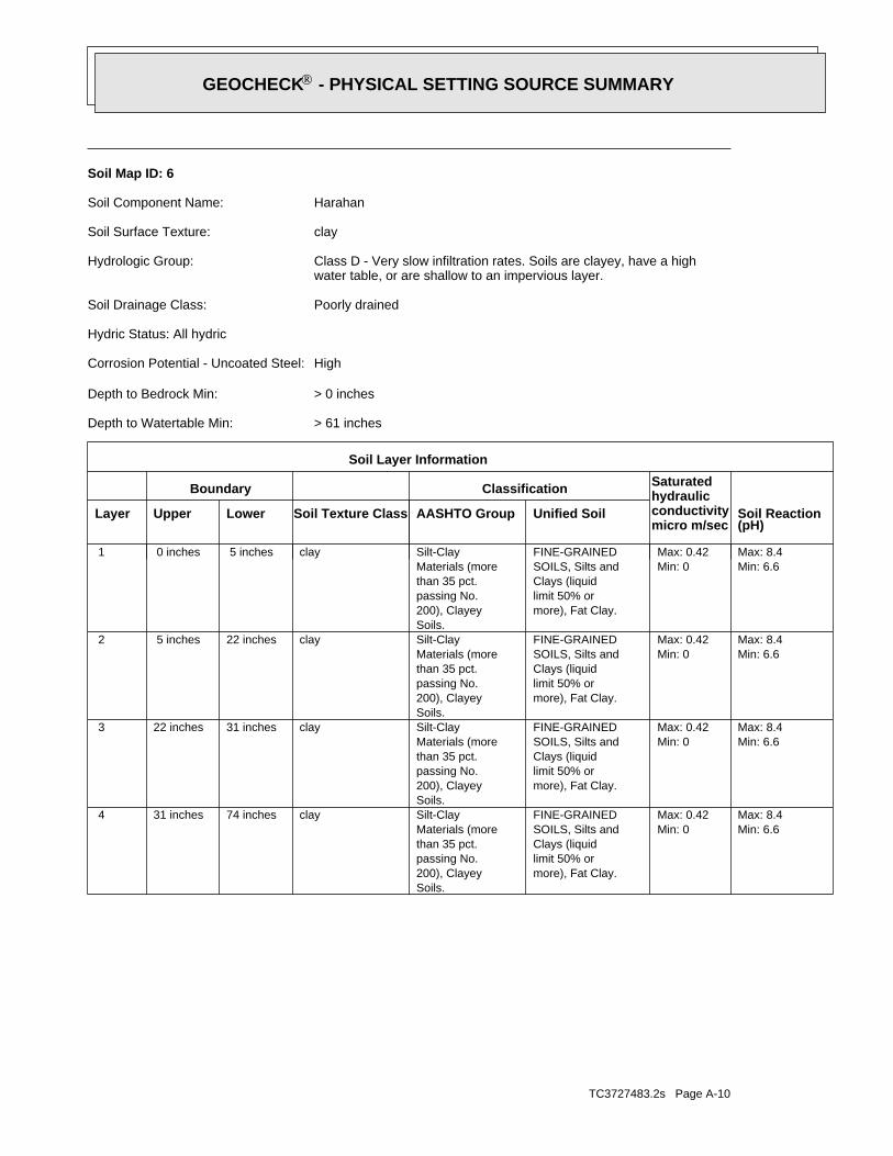
TC3727483.2s Page A-10
Min: 6.6Max: 8.4
Min: 0Max: 0.42
more), Fat Clay.limit 50% orClays (liquidSOILS, Silts andFINE-GRAINED
Soils.200), Clayeypassing No.than 35 pct.Materials (moreSilt-Clayclay74 inches31 inches 4
Min: 6.6Max: 8.4
Min: 0Max: 0.42
more), Fat Clay.limit 50% orClays (liquidSOILS, Silts andFINE-GRAINED
Soils.200), Clayeypassing No.than 35 pct.Materials (moreSilt-Clayclay31 inches22 inches 3
Min: 6.6Max: 8.4
Min: 0Max: 0.42
more), Fat Clay.limit 50% orClays (liquidSOILS, Silts andFINE-GRAINED
Soils.200), Clayeypassing No.than 35 pct.Materials (moreSilt-Clayclay22 inches 5 inches 2
Min: 6.6Max: 8.4
Min: 0Max: 0.42
more), Fat Clay.limit 50% orClays (liquidSOILS, Silts andFINE-GRAINED
Soils.200), Clayeypassing No.than 35 pct.Materials (moreSilt-Clayclay 5 inches 0 inches 1
Soil Layer Information
Boundary Classification Saturatedhydraulicconductivitymicro m/sec
Layer Upper Lower Soil Texture Class AASHTO Group Unified Soil Soil Reaction(pH)
> 61 inchesDepth to Watertable Min:
> 0 inchesDepth to Bedrock Min:
HighCorrosion Potential - Uncoated Steel:
Hydric Status: All hydric
Poorly drainedSoil Drainage Class:
water table, or are shallow to an impervious layer.Class D - Very slow infiltration rates. Soils are clayey, have a highHydrologic Group:
claySoil Surface Texture:
HarahanSoil Component Name:
Soil Map ID: 6
®GEOCHECK - PHYSICAL SETTING SOURCE SUMMARY®

TC3727483.2s Page A-11
1/2 - 1 Mile SSELAOG70000043383 121/2 - 1 Mile NNELAOG70000045616 111/2 - 1 Mile SELAOG70000043608 101/2 - 1 Mile SSELAOG70000043579 91/2 - 1 Mile SELAOG70000043820 81/2 - 1 Mile WSWLAOG70000044129 71/2 - 1 Mile SSELAOG70000043644 61/2 - 1 Mile ESELAOG70000044293 51/4 - 1/2 Mile WNWLAOG70000044686 A41/4 - 1/2 Mile WNWLAOG70000044681 A31/4 - 1/2 Mile SWLAOG70000044111 21/4 - 1/2 Mile ESELAOG70000044328 1
STATE OIL/GAS WELL INFORMATION
LOCATIONFROM TPWELL IDMAP ID
OTHER STATE DATABASE INFORMATION
1/2 - 1 Mile NELADT30000000569 A31/2 - 1 Mile NELADT30000000568 A1
STATE DATABASE WELL INFORMATION
LOCATIONFROM TPWELL IDMAP ID
Note: PWS System location is not always the same as well location.
No PWS System Found
FEDERAL FRDS PUBLIC WATER SUPPLY SYSTEM INFORMATION
LOCATIONFROM TPWELL IDMAP ID
1/2 - 1 Mile NEUSGS40000388015 A41/2 - 1 Mile NEUSGS40000388016 A2
FEDERAL USGS WELL INFORMATION
LOCATIONFROM TPWELL IDMAP ID
1.000State DatabaseNearest PWS within 0.500 milesFederal FRDS PWS1.000Federal USGS
WELL SEARCH DISTANCE INFORMATION
SEARCH DISTANCE (miles)DATABASE
opinion about the impact of contaminant migration on nearby drinking water wells.professional in assessing sources that may impact ground water flow direction, and in forming anEDR Local/Regional Water Agency records provide water well information to assist the environmental
LOCAL / REGIONAL WATER AGENCY RECORDS
®GEOCHECK - PHYSICAL SETTING SOURCE SUMMARY®
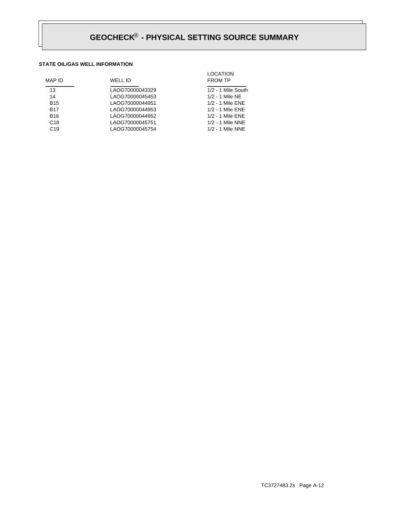
TC3727483.2s Page A-12
1/2 - 1 Mile NNELAOG70000045754 C191/2 - 1 Mile NNELAOG70000045751 C181/2 - 1 Mile ENELAOG70000044952 B161/2 - 1 Mile ENELAOG70000044953 B171/2 - 1 Mile ENELAOG70000044951 B151/2 - 1 Mile NELAOG70000045453 141/2 - 1 Mile SouthLAOG70000043329 13
STATE OIL/GAS WELL INFORMATION
LOCATIONFROM TPWELL IDMAP ID
®GEOCHECK - PHYSICAL SETTING SOURCE SUMMARY®

EDR Inc.EDR Inc.EDR Inc.EDR Inc.EDR Inc.EDR Inc.EDR Inc.EDR Inc.EDR Inc.EDR Inc.EDR Inc.EDR Inc.EDR Inc.EDR Inc.EDR Inc.EDR Inc.EDR Inc.EDR Inc.EDR Inc.EDR Inc.EDR Inc.EDR Inc.EDR Inc.EDR Inc.EDR Inc.EDR Inc.EDR Inc.EDR Inc.EDR Inc.EDR Inc.EDR Inc.EDR Inc.EDR Inc.EDR Inc.EDR Inc.EDR Inc.EDR Inc.EDR Inc.EDR Inc.EDR Inc.
LA

TC3727483.2s Page A-14
Deltaic Deposits of Mississippippi River Valley, OlderFormation type:Coastal lowlands aquifer systemAquifername:
USCountrycode:NGVD29Vert coord refsys:Interpolated from topographic mapVertcollection method:feetVert accmeasure units:
5Vertacc measure val:feetVert measure units:3.00Vert measure val:NAD83Horiz coord refsys:
Interpolated from mapHoriz Collection method:secondsHoriz Acc measure units:1Horiz Acc measure:Not ReportedSourcemap scale:-89.8120109Longitude:29.5891034Latitude:Not ReportedContrib drainagearea units:Not ReportedContrib drainagearea:Not ReportedDrainagearea Units:Not ReportedDrainagearea value:08090203Huc code:
Not ReportedMonloc desc:WellMonloc type:Pl- 10Monloc name:USGS-293520089484301Monloc Identifier:USGS Louisiana Water Science CenterFormal name:USGS-LAOrg. Identifier:
A2NE1/2 - 1 MileHigher
USGS40000388016FED USGS
LADT30000000568Site id:Not ReportedYield:Public SupplyWell use:AbandonedWell subuse:550Well depth:
0Water leve:17STownship:
22State code:Not ReportedSource of :Not ReportedSerial num:013Section:Not ReportedScreen int:Not ReportedScreen dia:14ERange:234DQuad num:Not ReportedPump test:Not ReportedPlugged 1:Not ReportedPlugged by:75Parish num:Not ReportedOwners num:GRAVOLET OYSTEROwners nam:Not ReportedMechanic a:- 10Local well:293520089484301Identifica:0Hole depth:112DDMROGeologic u:3Elevation:Not ReportedElec log:000Drillers 1:UNKNOWNDrillers n:DDrill log:Not ReportedDrawdown:Not ReportedDate regis:Not ReportedDate plugg:07/13/2001Date of ad:Not ReportedDate measu:1947Date compl:QChem analy:METALCasing mat:2Casing dia:Not ReportedBio analys:D QAvailable :Not ReportedAvail info:
29.5888Latitude:-89.8119Longitude:0Oid :
A1NE1/2 - 1 MileHigher
LADT30000000568LA WELLS
Map IDDirectionDistanceElevation EDR ID NumberDatabase
®GEOCHECK - PHYSICAL SETTING SOURCE MAP FINDINGS®

TC3727483.2s Page A-15
Not ReportedSourcemap scale:-89.8117331Longitude:29.5891034Latitude:Not ReportedContrib drainagearea units:Not ReportedContrib drainagearea:Not ReportedDrainagearea Units:Not ReportedDrainagearea value:08090203Huc code:
Not ReportedMonloc desc:WellMonloc type:Pl- 9Monloc name:USGS-293520089484201Monloc Identifier:USGS Louisiana Water Science CenterFormal name:USGS-LAOrg. Identifier:
A4NE1/2 - 1 MileHigher
USGS40000388015FED USGS
LADT30000000569Site id:Not ReportedYield:Public SupplyWell use:AbandonedWell subuse:550Well depth:
0Water leve:17STownship:
22State code:ZSource of :Not ReportedSerial num:013Section:Not ReportedScreen int:Not ReportedScreen dia:14ERange:234DQuad num:Not ReportedPump test:Not ReportedPlugged 1:Not ReportedPlugged by:75Parish num:Not ReportedOwners num:GRAVOLET OYSTEROwners nam:Not ReportedMechanic a:- 9Local well:293520089484201Identifica:0Hole depth:112DDMROGeologic u:3Elevation:Not ReportedElec log:000Drillers 1:UNKNOWNDrillers n:DDrill log:Not ReportedDrawdown:Not ReportedDate regis:Not ReportedDate plugg:07/13/2001Date of ad:09/29/60Date measu:1955Date compl:QChem analy:METALCasing mat:4Casing dia:Not ReportedBio analys:D Q WAvailable :WAvail info:
29.5888Latitude:-89.8116Longitude:0Oid :
A3NE1/2 - 1 MileHigher
LADT30000000569LA WELLS
Ground-water levels, Number of Measurements: 0
Not ReportedWellholedepth units:Not ReportedWellholedepth:ftWelldepth units:550Welldepth:19470101Construction date:
Not ReportedAquifer type:
®GEOCHECK - PHYSICAL SETTING SOURCE MAP FINDINGS®

TC3727483.2s Page A-16
Ground-water levels, Number of Measurements: 0
Not ReportedWellholedepth units:Not ReportedWellholedepth:ftWelldepth units:550Welldepth:19550101Construction date:
Not ReportedAquifer type:Deltaic Deposits of Mississippippi River Valley, OlderFormation type:Coastal lowlands aquifer systemAquifername:
USCountrycode:NGVD29Vert coord refsys:Interpolated from topographic mapVertcollection method:feetVert accmeasure units:
5Vertacc measure val:feetVert measure units:3.00Vert measure val:NAD83Horiz coord refsys:
Interpolated from mapHoriz Collection method:secondsHoriz Acc measure units:1Horiz Acc measure:
®GEOCHECK - PHYSICAL SETTING SOURCE MAP FINDINGS®

TC3727483.2s Page A-17
17Coordina 3:Not ReportedSurface lo:Not ReportedSurface la:
29Latitude d:34Latitude m:34.638Latitude s:89Longitud 1:49Longitude1:26.483Longitude :Not ReportedGround ele:1Coordina 2:3Coordina 1:CON_USERUpdate use:
11/24/2011Update dat:CONVALLCreate use:05/02/1999Create dat:SZone:
333940Lambert y:2479770Lambert x:01/01/1985Received d:1Coordinate:1Wlc line i:197626Well seria:
2SW1/4 - 1/2 Mile
LAOG70000044111OIL_GAS
LAOG70000044328Site id:-89.816668G longx:29.579014G laty:3276369.87748G utmy:808394.509056G utmx:17Coordina 3:
Not ReportedSurface lo:Not ReportedSurface la:29Latitude d:34Latitude m:43.68Latitude s:89Longitud 1:48Longitude1:59.759Longitude :Not ReportedGround ele:1Coordina 2:3Coordina 1:CON_USERUpdate use:
11/24/2011Update dat:CONVALLCreate use:05/02/1999Create dat:SZone:
334884Lambert y:2482117Lambert x:12/01/1976Received d:1Coordinate:1Wlc line i:47388Well seria:
1ESE1/4 - 1/2 Mile
LAOG70000044328OIL_GAS
Map IDDirectionDistance EDR ID NumberDatabase
®GEOCHECK - PHYSICAL SETTING SOURCE MAP FINDINGS®

TC3727483.2s Page A-18
3Coordina 1:CON_USERUpdate use:
11/24/2011Update dat:CONVALLCreate use:05/02/1999Create dat:SZone:
336293Lambert y:2478633Lambert x:12/01/1976Received d:1Coordinate:1Wlc line i:94165Well seria:
A4WNW1/4 - 1/2 Mile
LAOG70000044686OIL_GAS
LAOG70000044681Site id:-89.827469G longx:29.583013G laty:3276784.68743G utmy:807335.474386G utmx:17Coordina 3:
Not ReportedSurface lo:Not ReportedSurface la:29Latitude d:34Latitude m:58.079Latitude s:89Longitud 1:49Longitude1:38.64Longitude :Not ReportedGround ele:1Coordina 2:3Coordina 1:CON_USERUpdate use:
11/24/2011Update dat:CONVALLCreate use:05/02/1999Create dat:SZone:
336293Lambert y:2478665Lambert x:12/01/1976Received d:1Coordinate:1Wlc line i:96582Well seria:
A3WNW1/4 - 1/2 Mile
LAOG70000044681OIL_GAS
LAOG70000044111Site id:-89.82409G longx:29.576503G laty:3276071.76457G utmy:807682.71391G utmx:
®GEOCHECK - PHYSICAL SETTING SOURCE MAP FINDINGS®
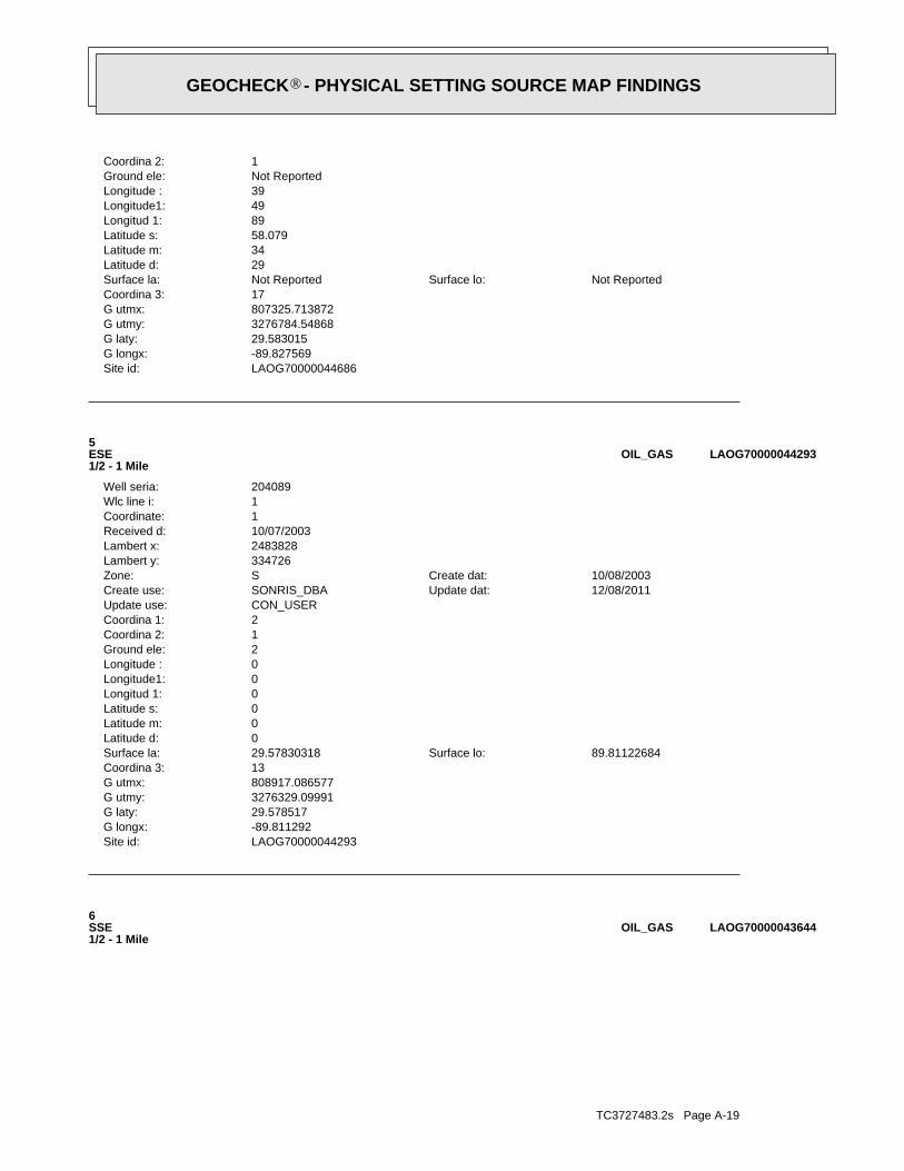
TC3727483.2s Page A-19
6SSE1/2 - 1 Mile
LAOG70000043644OIL_GAS
LAOG70000044293Site id:-89.811292G longx:29.578517G laty:3276329.09991G utmy:808917.086577G utmx:13Coordina 3:
89.81122684Surface lo:29.57830318Surface la:0Latitude d:0Latitude m:0Latitude s:0Longitud 1:0Longitude1:0Longitude :2Ground ele:1Coordina 2:2Coordina 1:CON_USERUpdate use:
12/08/2011Update dat:SONRIS_DBACreate use:10/08/2003Create dat:SZone:
334726Lambert y:2483828Lambert x:10/07/2003Received d:1Coordinate:1Wlc line i:204089Well seria:
5ESE1/2 - 1 Mile
LAOG70000044293OIL_GAS
LAOG70000044686Site id:-89.827569G longx:29.583015G laty:3276784.54868G utmy:807325.713872G utmx:17Coordina 3:
Not ReportedSurface lo:Not ReportedSurface la:29Latitude d:34Latitude m:58.079Latitude s:89Longitud 1:49Longitude1:39Longitude :Not ReportedGround ele:1Coordina 2:
®GEOCHECK - PHYSICAL SETTING SOURCE MAP FINDINGS®
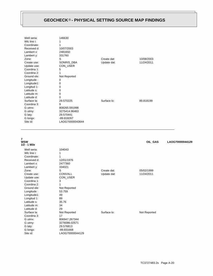
TC3727483.2s Page A-20
LAOG70000044129Site id:-89.831668G longx:29.576813G laty:3276086.02571G utmy:806947.267344G utmx:17Coordina 3:
Not ReportedSurface lo:Not ReportedSurface la:29Latitude d:34Latitude m:35.76Latitude s:89Longitud 1:49Longitude1:53.759Longitude :Not ReportedGround ele:1Coordina 2:3Coordina 1:CON_USERUpdate use:
11/24/2011Update dat:CONVALLCreate use:05/02/1999Create dat:SZone:
334021Lambert y:2477360Lambert x:12/01/1976Received d:1Coordinate:1Wlc line i:104043Well seria:
7WSW1/2 - 1 Mile
LAOG70000044129OIL_GAS
LAOG70000043644Site id:-89.818267G longx:29.570441G laty:3275414.96463G utmy:808265.591998G utmx:9Coordina 3:
89.818199Surface lo:29.570225Surface la:0Latitude d:0Latitude m:0Latitude s:0Longitud 1:0Longitude1:0Longitude :Not ReportedGround ele:1Coordina 2:5Coordina 1:CON_USERUpdate use:
11/24/2011Update dat:SONRIS_DBACreate use:10/08/2003Create dat:SZone:
331760Lambert y:2481650Lambert x:10/07/2003Received d:1Coordinate:1Wlc line i:146630Well seria:
®GEOCHECK - PHYSICAL SETTING SOURCE MAP FINDINGS®
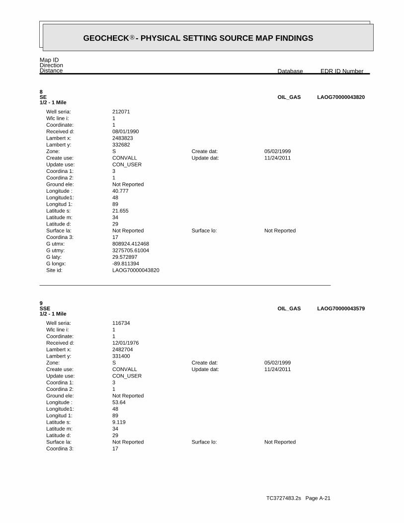
TC3727483.2s Page A-21
17Coordina 3:Not ReportedSurface lo:Not ReportedSurface la:
29Latitude d:34Latitude m:9.119Latitude s:89Longitud 1:48Longitude1:53.64Longitude :Not ReportedGround ele:1Coordina 2:3Coordina 1:CON_USERUpdate use:
11/24/2011Update dat:CONVALLCreate use:05/02/1999Create dat:SZone:
331400Lambert y:2482704Lambert x:12/01/1976Received d:1Coordinate:1Wlc line i:116734Well seria:
9SSE1/2 - 1 Mile
LAOG70000043579OIL_GAS
LAOG70000043820Site id:-89.811394G longx:29.572897G laty:3275705.61004G utmy:808924.412468G utmx:17Coordina 3:
Not ReportedSurface lo:Not ReportedSurface la:29Latitude d:34Latitude m:21.655Latitude s:89Longitud 1:48Longitude1:40.777Longitude :Not ReportedGround ele:1Coordina 2:3Coordina 1:CON_USERUpdate use:
11/24/2011Update dat:CONVALLCreate use:05/02/1999Create dat:SZone:
332682Lambert y:2483823Lambert x:08/01/1990Received d:1Coordinate:1Wlc line i:212071Well seria:
8SE1/2 - 1 Mile
LAOG70000043820OIL_GAS
Map IDDirectionDistance EDR ID NumberDatabase
®GEOCHECK - PHYSICAL SETTING SOURCE MAP FINDINGS®

TC3727483.2s Page A-22
3Coordina 1:CON_USERUpdate use:
11/24/2011Update dat:CONVALLCreate use:05/02/1999Create dat:SZone:
339785Lambert y:2482446Lambert x:10/01/1990Received d:1Coordinate:1Wlc line i:972241Well seria:
11NNE1/2 - 1 Mile
LAOG70000045616OIL_GAS
LAOG70000043608Site id:-89.812015G longx:29.569912G laty:3275372.95176G utmy:808873.303638G utmx:13Coordina 3:
89.81194891Surface lo:29.56969757Surface la:0Latitude d:0Latitude m:0Latitude s:0Longitud 1:0Longitude1:0Longitude :0Ground ele:1Coordina 2:2Coordina 1:CON_USERUpdate use:
11/24/2011Update dat:SONRIS_DBACreate use:10/08/2003Create dat:SZone:
331594Lambert y:2483640Lambert x:10/07/2003Received d:1Coordinate:1Wlc line i:172963Well seria:
10SE1/2 - 1 Mile
LAOG70000043608OIL_GAS
LAOG70000043579Site id:-89.814967G longx:29.569413G laty:3275309.72262G utmy:808588.642833G utmx:
®GEOCHECK - PHYSICAL SETTING SOURCE MAP FINDINGS®

TC3727483.2s Page A-23
13South1/2 - 1 Mile
LAOG70000043329OIL_GAS
LAOG70000043383Site id:-89.81677G longx:29.567115G laty:3275050.15443G utmy:808420.86973G utmx:17Coordina 3:
Not ReportedSurface lo:Not ReportedSurface la:29Latitude d:34Latitude m:.839Latitude s:89Longitud 1:49Longitude1:.119Longitude :Not ReportedGround ele:1Coordina 2:3Coordina 1:CON_USERUpdate use:
11/24/2011Update dat:CONVALLCreate use:05/02/1999Create dat:SZone:
330557Lambert y:2482142Lambert x:12/01/1976Received d:1Coordinate:1Wlc line i:115384Well seria:
12SSE1/2 - 1 Mile
LAOG70000043383OIL_GAS
LAOG70000045616Site id:-89.815429G longx:29.592478G laty:3277866.22057G utmy:808473.624916G utmx:17Coordina 3:
Not ReportedSurface lo:Not ReportedSurface la:29Latitude d:35Latitude m:32.149Latitude s:89Longitud 1:48Longitude1:55.304Longitude :Not ReportedGround ele:1Coordina 2:
®GEOCHECK - PHYSICAL SETTING SOURCE MAP FINDINGS®

TC3727483.2s Page A-24
LAOG70000045453Site id:-89.809269G longx:29.590512G laty:3277664.59154G utmy:809076.591914G utmx:17Coordina 3:
Not ReportedSurface lo:Not ReportedSurface la:29Latitude d:35Latitude m:25.08Latitude s:89Longitud 1:48Longitude1:33.12Longitude :Not ReportedGround ele:1Coordina 2:3Coordina 1:CON_USERUpdate use:
11/24/2011Update dat:CONVALLCreate use:05/02/1999Create dat:SZone:
339096Lambert y:2484413Lambert x:12/01/1976Received d:1Coordinate:1Wlc line i:92567Well seria:
14NE1/2 - 1 Mile
LAOG70000045453OIL_GAS
LAOG70000043329Site id:-89.822292G longx:29.566417G laty:3274958.07486G utmy:807887.672711G utmx:17Coordina 3:
Not ReportedSurface lo:Not ReportedSurface la:29Latitude d:33Latitude m:58.327Latitude s:89Longitud 1:49Longitude1:20.009Longitude :Not ReportedGround ele:1Coordina 2:3Coordina 1:CON_USERUpdate use:
11/24/2011Update dat:CONVALLCreate use:05/02/1999Create dat:SZone:
330280Lambert y:2480390Lambert x:12/01/1984Received d:1Coordinate:1Wlc line i:197551Well seria:
®GEOCHECK - PHYSICAL SETTING SOURCE MAP FINDINGS®

TC3727483.2s Page A-25
17Coordina 3:Not ReportedSurface lo:Not ReportedSurface la:
29Latitude d:35Latitude m:6.719Latitude s:89Longitud 1:48Longitude1:18.719Longitude :Not ReportedGround ele:1Coordina 2:3Coordina 1:CON_USERUpdate use:
11/24/2011Update dat:CONVALLCreate use:05/02/1999Create dat:SZone:
337259Lambert y:2485709Lambert x:09/01/1976Received d:1Coordinate:1Wlc line i:61861Well seria:
B17ENE1/2 - 1 Mile
LAOG70000044953OIL_GAS
LAOG70000044951Site id:-89.805269G longx:29.585413G laty:3277109.88107G utmy:809479.863402G utmx:17Coordina 3:
Not ReportedSurface lo:Not ReportedSurface la:29Latitude d:35Latitude m:6.719Latitude s:89Longitud 1:48Longitude1:18.719Longitude :Not ReportedGround ele:1Coordina 2:3Coordina 1:CON_USERUpdate use:
11/24/2011Update dat:CONVALLCreate use:05/02/1999Create dat:SZone:
337259Lambert y:2485709Lambert x:12/01/1976Received d:1Coordinate:1Wlc line i:61105Well seria:
B15ENE1/2 - 1 Mile
LAOG70000044951OIL_GAS
Map IDDirectionDistance EDR ID NumberDatabase
®GEOCHECK - PHYSICAL SETTING SOURCE MAP FINDINGS®

TC3727483.2s Page A-26
2Coordina 1:CON_USERUpdate use:
11/24/2011Update dat:DEBRAPCreate use:09/15/2006Create dat:SZone:
340191Lambert y:2482892Lambert x:09/15/2006Received d:1Coordinate:1Wlc line i:234162Well seria:
C18NNE1/2 - 1 Mile
LAOG70000045751OIL_GAS
LAOG70000044952Site id:-89.805269G longx:29.585413G laty:3277109.88107G utmy:809479.863402G utmx:17Coordina 3:
Not ReportedSurface lo:Not ReportedSurface la:29Latitude d:35Latitude m:6.72Latitude s:89Longitud 1:48Longitude1:18.719Longitude :Not ReportedGround ele:1Coordina 2:3Coordina 1:CON_USERUpdate use:
11/24/2011Update dat:CONVALLCreate use:05/02/1999Create dat:SZone:
337259Lambert y:2485709Lambert x:12/01/1976Received d:1Coordinate:1Wlc line i:62795Well seria:
B16ENE1/2 - 1 Mile
LAOG70000044952OIL_GAS
LAOG70000044953Site id:-89.805269G longx:29.585413G laty:3277109.88107G utmy:809479.863402G utmx:
®GEOCHECK - PHYSICAL SETTING SOURCE MAP FINDINGS®

TC3727483.2s Page A-27
LAOG70000045754Site id:-89.813889G longx:29.593611G laty:3277995.95447G utmy:808619.408027G utmx:16Coordina 3:
Not ReportedSurface lo:Not ReportedSurface la:29Latitude d:35Latitude m:37Latitude s:89Longitud 1:48Longitude1:50Longitude :Not ReportedGround ele:0Coordina 2:2Coordina 1:OPS$OOCUpdate use:
10/06/2009Update dat:DEBRAPCreate use:09/15/2006Create dat:SZone:
0Lambert y:0Lambert x:09/15/2006Received d:2Coordinate:2Wlc line i:234162Well seria:
C19NNE1/2 - 1 Mile
LAOG70000045754OIL_GAS
LAOG70000045751Site id:-89.814009G longx:29.593578G laty:3277991.99494G utmy:808607.905164G utmx:13Coordina 3:
Not ReportedSurface lo:Not ReportedSurface la:0Latitude d:0Latitude m:0Latitude s:0Longitud 1:0Longitude1:0Longitude :Not ReportedGround ele:1Coordina 2:
®GEOCHECK - PHYSICAL SETTING SOURCE MAP FINDINGS®

TC3727483.2s Page A-28
Not ReportedNot ReportedNot ReportedNot ReportedBasementNot ReportedNot ReportedNot ReportedNot ReportedLiving Area - 2nd Floor0%0%100%0.333 pCi/LLiving Area - 1st Floor
% >20 pCi/L% 4-20 pCi/L% <4 pCi/LAverage ActivityArea
Number of sites tested: 3
Federal Area Radon Information for PLAQUEMINES COUNTY, LA
: Zone 3 indoor average level < 2 pCi/L. : Zone 2 indoor average level >= 2 pCi/L and <= 4 pCi/L. Note: Zone 1 indoor average level > 4 pCi/L.
Federal EPA Radon Zone for PLAQUEMINES County: 3
30.33333PLAQUEMINES
_______________________Total SitesAvg pCi/LParish
Radon Test Results
State Database: LA Radon
AREA RADON INFORMATION
®GEOCHECK - PHYSICAL SETTING SOURCE MAP FINDINGSRADON
®
TOPOGRAPHIC INFORMATION
USGS 7.5’ Digital Elevation Model (DEM)Source: United States Geologic SurveyEDR acquired the USGS 7.5’ Digital Elevation Model in 2002 and updated it in 2006. The 7.5 minute DEM correspondsto the USGS 1:24,000- and 1:25,000-scale topographic quadrangle maps. The DEM provides elevation datawith consistent elevation units and projection.
Scanned Digital USGS 7.5’ Topographic Map (DRG)Source: United States Geologic SurveyA digital raster graphic (DRG) is a scanned image of a U.S. Geological Survey topographic map. The map imagesare made by scanning published paper maps on high-resolution scanners. The raster imageis georeferenced and fit to the Universal Transverse Mercator (UTM) projection.
HYDROLOGIC INFORMATION
Flood Zone Data: This data, available in select counties across the country, was obtained by EDR in 2003 & 2011 from the FederalEmergency Management Agency (FEMA). Data depicts 100-year and 500-year flood zones as defined by FEMA.
NWI: National Wetlands Inventory. This data, available in select counties across the country, was obtained by EDRin 2002 and 2005 from the U.S. Fish and Wildlife Service.
HYDROGEOLOGIC INFORMATION
AQUIFLOW Information SystemR
Source: EDR proprietary database of groundwater flow informationEDR has developed the AQUIFLOW Information System (AIS) to provide data on the general direction of groundwater
flow at specific points. EDR has reviewed reports submitted to regulatory authorities at select sites and hasextracted the date of the report, hydrogeologically determined groundwater flow direction and depth to water tableinformation.
GEOLOGIC INFORMATION
Geologic Age and Rock Stratigraphic UnitSource: P.G. Schruben, R.E. Arndt and W.J. Bawiec, Geology of the Conterminous U.S. at 1:2,500,000 Scale - A digitalrepresentation of the 1974 P.B. King and H.M. Beikman Map, USGS Digital Data Series DDS - 11 (1994).
STATSGO: State Soil Geographic DatabaseSource: Department of Agriculture, Natural Resources Conservation ServicesThe U.S. Department of Agriculture’s (USDA) Natural Resources Conservation Service (NRCS) leads the nationalConservation Soil Survey (NCSS) and is responsible for collecting, storing, maintaining and distributing soilsurvey information for privately owned lands in the United States. A soil map in a soil survey is a representationof soil patterns in a landscape. Soil maps for STATSGO are compiled by generalizing more detailed (SSURGO)soil survey maps.
SSURGO: Soil Survey Geographic DatabaseSource: Department of Agriculture, Natural Resources Conservation Services (NRCS)Telephone: 800-672-5559SSURGO is the most detailed level of mapping done by the Natural Resources Conservation Services, mappingscales generally range from 1:12,000 to 1:63,360. Field mapping methods using national standards are used toconstruct the soil maps in the Soil Survey Geographic (SSURGO) database. SSURGO digitizing duplicates theoriginal soil survey maps. This level of mapping is designed for use by landowners, townships and countynatural resource planning and management.
TC3727483.2s Page A-29
PHYSICAL SETTING SOURCE RECORDS SEARCHED
LOCAL / REGIONAL WATER AGENCY RECORDS
FEDERAL WATER WELLS
PWS: Public Water SystemsSource: EPA/Office of Drinking WaterTelephone: 202-564-3750Public Water System data from the Federal Reporting Data System. A PWS is any water system which provides water to at
least 25 people for at least 60 days annually. PWSs provide water from wells, rivers and other sources.
PWS ENF: Public Water Systems Violation and Enforcement DataSource: EPA/Office of Drinking WaterTelephone: 202-564-3750Violation and Enforcement data for Public Water Systems from the Safe Drinking Water Information System (SDWIS) after
August 1995. Prior to August 1995, the data came from the Federal Reporting Data System (FRDS).
USGS Water Wells: USGS National Water Inventory System (NWIS)This database contains descriptive information on sites where the USGS collects or has collected data on surfacewater and/or groundwater. The groundwater data includes information on wells, springs, and other sources of groundwater.
STATE RECORDS
Louisiana Public Water Supply WellsSource: Office of Public HealthTelephone: 504-568-5101
Water Well Registration Data FileSource: Department of Transportation and DevelopmentTelephone: 225-274-4172
OTHER STATE DATABASE INFORMATION
Oil and Gas Well DatabaseSource: Department of Natural ResourcesTelephone: 225-342-1977Oil and gas well locations in Louisiana.
RADON
State Database: LA RadonSource: Department of Environmenal QualityTelephone: 225-925-1752Radon Levels
Area Radon InformationSource: USGSTelephone: 703-356-4020The National Radon Database has been developed by the U.S. Environmental Protection Agency(USEPA) and is a compilation of the EPA/State Residential Radon Survey and the National Residential Radon Survey.The study covers the years 1986 - 1992. Where necessary data has been supplemented by information collected atprivate sources such as universities and research institutions.
EPA Radon ZonesSource: EPATelephone: 703-356-4020Sections 307 & 309 of IRAA directed EPA to list and identify areas of U.S. with the potential for elevated indoorradon levels.
TC3727483.2s Page A-30
PHYSICAL SETTING SOURCE RECORDS SEARCHED

OTHER
Airport Landing Facilities: Private and public use landing facilitiesSource: Federal Aviation Administration, 800-457-6656
Epicenters: World earthquake epicenters, Richter 5 or greaterSource: Department of Commerce, National Oceanic and Atmospheric Administration
STREET AND ADDRESS INFORMATION
© 2010 Tele Atlas North America, Inc. All rights reserved. This material is proprietary and the subject of copyright protectionand other intellectual property rights owned by or licensed to Tele Atlas North America, Inc. The use of this material is subjectto the terms of a license agreement. You will be held liable for any unauthorized copying or disclosure of this material.
TC3727483.2s Page A-31
PHYSICAL SETTING SOURCE RECORDS SEARCHED

ORPHAN SUMMARY
City EDR ID Site Name Site Address Zip Database(s)
Count: 37 records
W POINT LAHACHE 1003873415 JEFFERSON LAKE SULPHUR CO LAKE HERMITAGE LA HWY 23 70083 CERC-NFRAPPORT SULPHUR 1008190664 TENNESSEE GAS PIPELINE CO STN #527 EAST SIDE OD HWY 23 70083 HIST FTTSPORT SULPHUR 1008211300 POINTE A LA HACHE SOUTH BARGE FACILITY 142 BASS RD (HWY 39) 70000 FINDS, NPDES, AIRS, US AIRSPORT SULPHUR 1009630219 LOUISIANA GAS SERVICE CO ROUTE 1, BOX 804, HIGHWAY 11 70083 DOT OPSPORT SULPHUR 1010010531 TENNESSEE GAS PIPELINE CO STN #527 EAST SIDE OD HWY 23 70083 FTTSBRAITHWAITE 1011546790 AMAX/CRI-MET FAC LA STATE HWY 3137 BRAITHWAITE LA 70040 70040 ICISPORT SULPHUR 1011859982 TESVICH PROPERTY HIGHWAY 23 70083 US BROWNFIELDSPORT SULPHUR S105200960 COX BAY COMPRESSOR CO HWY 23 70000 SHWS, REMBRAITHWAITE S108331836 ST CLAIR ESTATES HWY 39 70040 NPDESDAVANT S108333183 FEMA HURRICANE RESPONSE - DAVANT COMMUNIT 15535 HWY 15 70040 NPDES
CENTER GROUP SITEIRONTON S108334690 PLAQUEMINES PARISH GOVERNMENT - IRONTON HWY 23 70083 NPDES
OXIDATION PONDPLAQUEMINES COUNTY S108619996 PLAQUEMINES PARISH GOVERNMENT INTERSECTION OF HWY 23 AND THE INTRACOASTAL CANAL SPILLSPLAQUEMINES COUNTY S108619997 PLAQUEMINES PARISH GOVERNMENT HWY 15 - 1000 FEET NORTH OF DAVANT COMMUNITY CENTER SPILLSPORT SULPHUR S108620316 PLAQUEMINES PARISH GOVERNMENT HWY 234, 500’ SOUTH OF HOLIDAY DRIVE SPILLSDAVANT S108994714 US UNITED BULK TERMINAL LLC 14537 HWY 15 70040 NPDESPORT SULPHUR S109566535 PLAQUEMINES PARISH AMBULANCE SERVICE HWY 23 SPILLSPLAQUEMINES COUNTY S109566741 PLAQUEMINES PARISH GOVT. SHELL/LIMESTONE ROAD FROM HWY 28 TO LAKE HERMITAGE @ SPILLS
SQUIRREPORT SULPHUR S109962520 THE NEW LEARNING CENTER 26892 HWY 23 ASBESTOSCAERNARVON S110445060 HOME OFFICE - CAJUN CONSTRUCTORS INC HWY 39 70040 NPDESMYRTLE GROVE S110445184 MYRTLE GROVE MARINA LLC 16208 HWY 23 S 70083 NPDESPORT SULPHUR S110657931 PLAQUEMINES PARISH HOMEPLACE PIT DEBRIS HWY 23 W OF POWELL LN 70000 SWF/LF
SITEPLAQUEMINES COUNTY S110658310 PLAQUEMINES PARISH GOVERNMENT LIFT STATION HWY 15 AT HARLEM RD SPILLS
DBRAITHWAITE S110701649 PHOENIX PK-12 - SATTERFIELD & PONTIKES INC 12700 HWY 39 70040 NPDESPLAQUEMINES COUNTY S111334390 PRO IRON & METALS LLC 11266 HWY 23 DEBRISPLAQUEMINES COUNTY S111334614 WALKER ROAD FACILITY WALKER RD OFF HWY 23 DEBRISPLAQUEMINES COUNTY S111334645 HOMEPLACE PIT HWY 23 W OF POWELL LN DEBRISPLAQUEMINES COUNTY S111334646 EMPIRE PIT OFF HWY 11 (SEE COMMENT) DEBRISPLAQUEMINES COUNTY S111334699 WOODLAWN GOVN’T BUILDING HWY 39 DEBRISPLAQUEMINES COUNTY S111334811 WALKER ROAD 2 WALKER ROAD (WEST OF HWY 23) DEBRISPLAQUEMINES COUNTY S111334846 INDUSTRIAL PIPE 11266 HWY 23 DEBRISPLAQUEMINES COUNTY S111334862 BRAITHWAITE SITE HWY 39 (SOUTH OF BRAITHWAITE) DEBRISPLAQUEMINES COUNTY S111334868 DAVANT COMMUNITY PARK DEBRIS SITE BETWEEN HWY 15 & HWY 39 DEBRISPLAQUEMINES COUNTY S111335292 EMPIRE SHIP YARD HWY 23 AND ROSE MARIE ROAD DEBRISPLAQUEMINES COUNTY S111335341 FORT JACKSON PICKUP STATION HWY 23 PAST FT JACKSON ON RIGHT DEBRISBRAITHWAITE S111768641 PLAQUEMINES PARISH GOVERNMENT - PHOENIX 15337 HWY 15 70040 NPDES
STPIRONTON S112270526 RAM TERMINALS LLC - COAL EXPORT FACILITY 16111 HWY 23 70083 AIRS
PROJECT
TC3727483.2s Page 1 of 2

ORPHAN SUMMARY
City EDR ID Site Name Site Address Zip Database(s)
Count: 37 records
PORT SULPHUR U001893784 TONY’S GULF HWY 23 70083 UST
TC3727483.2s Page 2 of 2

DETAILED ORPHAN LISTING
EDR ID NumberEPA ID NumberDatabase(s)Site
W POINT LAHACHE, LA 70083LAKE HERMITAGE LA HWY 23 LAD980622500
CERC-NFRAPJEFFERSON LAKE SULPHUR CO 1003873415
UserFacility Function: TSCALegislation Code: Neutral Scheme, RegionInvestigation Reason: Section 6 PCB Federal ConductedInvestigation Type: YesViolation occurred: GOLDInspector: Not reportedInspection Date: 06Region: 198903231503 1Inspection Number:
HIST FTTS INSP:
PORT SULPHUR, LA 70083EAST SIDE OD HWY 23 N/A
HIST FTTSTENNESSEE GAS PIPELINE CO STN #527 1008190664
05/13/2011Issued Date: 5048367200Facility Phone: 4616Facility Id:
GEN20060001Activity Number: WaterProgram: Gen-LAG33-CoastalPermit Type Description: Permit LAG33A396Title Description: 05/23/2008Issued Date: 5048367200Facility Phone: 4616Facility Id:
NPDES:
Organizations (LA-TEMPO) is an Integrated Management System.Louisiana Tools for Environmental Management and Protection
of the Clean Air Act.redesign to support facility operating permits required under Title Vestimation of total national emissions. AFS is undergoing a majorto comply with regulatory programs and by EPA as an input for theAFS data are utilized by states to prepare State Implementation Plansused to track emissions and compliance data from industrial plants.information concerning airborne pollution in the United States. AFS isAerometric Data (SAROAD). AIRS is the national repository forNational Emission Data System (NEDS), and the Storage and Retrieval ofSubsystem) replaces the former Compliance Data System (CDS), theAFS (Aerometric Information Retrieval System (AIRS) Facility Environmental Interest/Information System
110022400301Registry ID:
FINDS:
US AIRSAIRSPORT SULPHUR, LA 70000
NPDES142 BASS RD (HWY 39) 110022400301FINDSPOINTE A LA HACHE SOUTH BARGE FACILITY 1008211300
ORPHAN DETAIL TC3727483.2s Page 1

DETAILED ORPHAN LISTING
EDR ID NumberEPA ID NumberDatabase(s)Site
MSOG initialTitle Desc: -89.78786Longitude: 29.60341Latitude: SoutheastRegion Code: PER20120001Activity No#: 4616AI No#: Minor Gen Permit-Oil and Gas InitialPermit Type Desc: 2240-00278-02Permit Number:
NExtended Flag: NEffective Flag: 03/27/2013Effective End Date: 03/27/2013Expiration Date: 10/02/2006Issue Date: Metairie, LA 70002Mailing City/State/Zip: 3850 N Causeway Blvd Ste 1900Mailing Address2: Two Lakeway CenterMailing Address: SOGA Permit-Entire FacilityTitle Desc: -89.78786Longitude: 29.60341Latitude: SoutheastRegion Code: PER20060003Activity No#: 4616AI No#: SOGA Permit InitialPermit Type Desc: 2240-00278-01Permit Number:
NExtended Flag: NEffective Flag: 10/01/2006Effective End Date: 10/01/2006Expiration Date: 08/27/1998Issue Date: Metairie, LA 70002Mailing City/State/Zip: 3850 N Causeway Blvd Ste 1900Mailing Address2: Two Lakeway CenterMailing Address: N & S BARGE PFTitle Desc: -89.78786Longitude: 29.60341Latitude: SoutheastRegion Code: PER19980002Activity No#: 4616AI No#: State permit (unspecified)Permit Type Desc: 2240-00278-00Permit Number:
AIRS:
GEN20110002Activity Number: WaterProgram: Gen-LAG33-CoastalPermit Type Description: Modified CoverageTitle Description: 10/03/2011Issued Date: 5048367200Facility Phone: 4616Facility Id:
GEN20110001Activity Number: WaterProgram: Gen-LAG33-CoastalPermit Type Description: Permit ReauthorizationTitle Description:
1008211300POINTE A LA HACHE SOUTH BARGE FACILITY (Continued)
ORPHAN DETAIL TC3727483.2s Page 2

DETAILED ORPHAN LISTING
EDR ID NumberEPA ID NumberDatabase(s)Site
SIP SOURCEAir prog code hist file: 1003Hist compliance date: IN COMPLIANCE - CERTIFICATIONState compliance status:
SIP SOURCEAir prog code hist file: 1001Hist compliance date: IN COMPLIANCE - CERTIFICATIONState compliance status:
Historical Compliance Minor Sources:
Not reportedPenalty amount: Not reportedDate achieved: Not reportedNational action type: Not reportedAir program:
Not reportedPenalty amount: 00000Date achieved: Not reportedNational action type: SIP SOURCEAir program:
Not reportedPenalty amount: 00000Date achieved: Not reportedNational action type: SIP SOURCEAir program:
Compliance and Enforcement Major Issues:
Not reportedCurrent HPV: LOCAL GOVERNMENT ALL OTHER FACILITIES NOT OWNED OR OPERATED BY A FEDERAL, STATE, ORGovt facility: POTENTIAL UNCONTROLLED EMISSIONS < 100 TONS/YEARDefault classification: IN COMPLIANCE - CERTIFICATIONDefault compliance status: Crude Petroleum and Natural Gas ExtractionNAIC code description: 211111North Am. industrial classf: Not reportedSic code desc: 1311Sic code: 106Air quality cntrl region: Not reportedDunn & Bradst #: 06Region code: PLAQUEMINESCounty: PORT SULPHUR, LA 70000 142 BASS RD (HWY 39)Plant address: POINTE A LA HACHE SOUTH BARGE FACILITYPlant name: 110022400301EPA plant ID:
Airs Minor Details:
AIRS (AFS):
YExtended Flag: YEffective Flag: 09/15/2020Effective End Date: 09/15/2020Expiration Date: 03/27/2013Issue Date: Metairie, LA 70002Mailing City/State/Zip: 3850 N Causeway Blvd Ste 1900Mailing Address2: Two Lakeway CenterMailing Address:
1008211300POINTE A LA HACHE SOUTH BARGE FACILITY (Continued)
ORPHAN DETAIL TC3727483.2s Page 3

DETAILED ORPHAN LISTING
EDR ID NumberEPA ID NumberDatabase(s)Site
Not reportedTurnover compliance: Not reportedRepeat violator date: ATTAINMENT AREA FOR GIVEN POLLUTANTDef. attainment/non attnmnt: IN COMPLIANCE - CERTIFICATIONDef. poll. compliance status: CLASS IS UNKNOWNDefault pollutant classification: Not reportedPlant air program pollutant: SIP SOURCEAir program code:
Not reportedTurnover compliance: Not reportedRepeat violator date: ATTAINMENT AREA FOR GIVEN POLLUTANTDef. attainment/non attnmnt: IN COMPLIANCE - CERTIFICATIONDef. poll. compliance status: POTENTIAL UNCONTROLLED EMISSIONS < 100 TONS/YEARDefault pollutant classification: CARBON MONOXIDEPlant air program pollutant: SIP SOURCEAir program code:
Compliance & Violation Data by Minor Sources:
SIP SOURCEAir prog code hist file: 1203Hist compliance date: IN COMPLIANCE - CERTIFICATIONState compliance status:
SIP SOURCEAir prog code hist file: 1201Hist compliance date: IN COMPLIANCE - CERTIFICATIONState compliance status:
SIP SOURCEAir prog code hist file: 1102Hist compliance date: IN COMPLIANCE - CERTIFICATIONState compliance status:
SIP SOURCEAir prog code hist file: 1004Hist compliance date: IN COMPLIANCE - CERTIFICATIONState compliance status:
SIP SOURCEAir prog code hist file: 1002Hist compliance date: IN COMPLIANCE - CERTIFICATIONState compliance status:
SIP SOURCEAir prog code hist file: 1204Hist compliance date: IN COMPLIANCE - CERTIFICATIONState compliance status:
SIP SOURCEAir prog code hist file: 1202Hist compliance date: IN COMPLIANCE - CERTIFICATIONState compliance status:
SIP SOURCEAir prog code hist file: 1104Hist compliance date: IN COMPLIANCE - CERTIFICATIONState compliance status:
SIP SOURCEAir prog code hist file: 1103Hist compliance date: IN COMPLIANCE - CERTIFICATIONState compliance status:
SIP SOURCEAir prog code hist file: 1101Hist compliance date: IN COMPLIANCE - CERTIFICATIONState compliance status:
1008211300POINTE A LA HACHE SOUTH BARGE FACILITY (Continued)
ORPHAN DETAIL TC3727483.2s Page 4

DETAILED ORPHAN LISTING
EDR ID NumberEPA ID NumberDatabase(s)Site
Not reportedTurnover compliance: Not reportedRepeat violator date: ATTAINMENT AREA FOR GIVEN POLLUTANTDef. attainment/non attnmnt: IN COMPLIANCE - CERTIFICATIONDef. poll. compliance status: POTENTIAL UNCONTROLLED EMISSIONS < 100 TONS/YEARDefault pollutant classification: VOLATILE ORGANIC COMPOUNDSPlant air program pollutant: SIP SOURCEAir program code:
Not reportedTurnover compliance: Not reportedRepeat violator date: ATTAINMENT AREA FOR GIVEN POLLUTANTDef. attainment/non attnmnt: IN COMPLIANCE - CERTIFICATIONDef. poll. compliance status: POTENTIAL UNCONTROLLED EMISSIONS < 100 TONS/YEARDefault pollutant classification: TOTAL PARTICULATE MATTERPlant air program pollutant: SIP SOURCEAir program code:
Not reportedTurnover compliance: Not reportedRepeat violator date: ATTAINMENT AREA FOR GIVEN POLLUTANTDef. attainment/non attnmnt: IN COMPLIANCE - CERTIFICATIONDef. poll. compliance status: POTENTIAL UNCONTROLLED EMISSIONS < 100 TONS/YEARDefault pollutant classification: OTHERPlant air program pollutant: SIP SOURCEAir program code:
Not reportedTurnover compliance: Not reportedRepeat violator date: ATTAINMENT AREA FOR GIVEN POLLUTANTDef. attainment/non attnmnt: IN COMPLIANCE - CERTIFICATIONDef. poll. compliance status: POTENTIAL UNCONTROLLED EMISSIONS < 100 TONS/YEARDefault pollutant classification: Not reportedPlant air program pollutant: SIP SOURCEAir program code:
1008211300POINTE A LA HACHE SOUTH BARGE FACILITY (Continued)
0Total injured: 0Total fatalities: 12/24/1988Incident date: 1525Incident time: NoFederal land: 2Class: PLAQUEMINESCounty: PORT SULPHUR, LA 70083 ROUTE 1, BOX 804, HIGHWAY 11Address: LOUISIANA GAS SERVICE COCompany/operator name: 11800Operator ID: NATURAL GAS DISTRIBUTIONEDR type:
Incidents Details:
Not reportedLongitude: Not reportedLatitude: PORT SULPHUR, LA 70083 ROUTE 1, BOX 804, HIGHWAY 11Address: LOUISIANA GAS SERVICE COFacility name: 19890017Report ID:
DOT OPS:
PORT SULPHUR, LA 70083ROUTE 1, BOX 804, HIGHWAY 11 N/A
DOT OPSLOUISIANA GAS SERVICE CO 1009630219
ORPHAN DETAIL TC3727483.2s Page 5

DETAILED ORPHAN LISTING
EDR ID NumberEPA ID NumberDatabase(s)Site
Not reportedDescription of other components: Not reportedCause of construction defect: NullOutside party required: Not reportedOther marking comment: Not reportedMarking type: NullPipeline location marked: Not reportedDate of notification: NullPrior use notification: Not reportedDamage by earth movement: NO DATAPrimary cause of incident: Not reportedYear of cathodic protection: NullCorroded pipeline cathodically protected: Not reportedPipe coating information: Not reportedCause other comment: Not reportedCause of corrosion: Not reportedOther visual description: Not reportedVisual description of corrosion: Not reportedLocation of corrosion: Not reportedReport received date: Not reportedNRC telephonic report ID: Not reportedNRC telephonic report #: Not reportedPreparer phone: Not reportedPreparer name and title: Not reportedLocation other comment: UNDER GROUND OR UNDER WATERLocation of incident: 0Year part was installed: 0Year manufactured: N/APipe manufacturer: N/APipe material specification: 0.119Pipe wall thickness in inches: 1Nominal Pipe Size (diameter) in inches: PVC PIPEMaterial other comment: OTHER PLASTICMaterial involved in incident: Not reportedComponent other comment: BODY OF PIPEComponent that failed: Not reportedSystem other comment: SERVICE LINESystem where incident occurred: OTHERPrimary cause of the incident: 0MAOP established by test: CFR 192.619(a)(3)MAOP by test or 49 CFR,sec. 192.619: 50Max. Allowable Operating Press. (PSIG): 40Estimated pressure at point and time: 19881230Date incident reported to NRC: 55Minutes elasped till area was safe: 0Hours elasped till area was safe: NullOperator thought report was significant: 5000Property damage:
1009630219LOUISIANA GAS SERVICE CO (Continued)
GOLDInspector: 03/23/89Inspection Date: 06Region: 198903231503 1Inspection Number:
FTTS INSP:
PORT SULPHUR, LA 70083EAST SIDE OD HWY 23 N/A
FTTSTENNESSEE GAS PIPELINE CO STN #527 1010010531
ORPHAN DETAIL TC3727483.2s Page 6

DETAILED ORPHAN LISTING
EDR ID NumberEPA ID NumberDatabase(s)Site
UserFacility Function: TSCALegislation Code: Neutral Scheme, RegionInvestigation Reason: Section 6 PCB Federal ConductedInvestigation Type: YesViolation occurred: GOLDInspector: 03/23/89Inspection Date: 06Region: 198903231503 1Inspection Number:
FTTS INSP:
UserFacility Function: TSCALegislation Code: Neutral Scheme, RegionInvestigation Reason: Section 6 PCB Federal ConductedInvestigation Type: YesViolation occurred:
1010010531TENNESSEE GAS PIPELINE CO STN #527 (Continued)
6EPA Region #: PlaqueminesFacility County: Not reportedEnforcement Action Type: BRAITHWAITE, Louisiana 70040 LA STATE HWY 3137 BRAITHWAITE LA 70040Facility Address: AMAX NICKEL INDFacility Name: AMAX NICKEL, INC.Action Name: FRS 110011411784Program ID: 110011411784FRS ID: 06-1986-0313Enforcement Action ID:
6EPA Region #: PlaqueminesFacility County: Not reportedEnforcement Action Type: BRAITHWAITE, Louisiana 70040 LA STATE HWY 3137 BRAITHWAITE LA 70040Facility Address: AMAX METALS RECOVERY, INCFacility Name: AMAX NICKEL, INC.Action Name: NCDB I06#1988120653627 1Program ID: 110011411784FRS ID: 06-1986-0313Enforcement Action ID:
6EPA Region #: PlaqueminesFacility County: Not reportedEnforcement Action Type: BRAITHWAITE, Louisiana 70040 LA STATE HWY 3137 BRAITHWAITE LA 70040Facility Address: AMAX/CRI-MET FACFacility Name: AMAX NICKEL, INC.Action Name: AIRS/AFS 2207500211Program ID: 110011411784FRS ID: 06-1986-0313Enforcement Action ID:
ICIS:
BRAITHWAITE, LA 70040LA STATE HWY 3137 BRAITHWAITE LA 70040 N/A
ICISAMAX/CRI-MET FAC 1011546790
ORPHAN DETAIL TC3727483.2s Page 7

DETAILED ORPHAN LISTING
EDR ID NumberEPA ID NumberDatabase(s)Site
-89.9474Longitude: 29.8682Latitude: Not reportedSIC Code: Not reportedNAIC Code: Not reportedFed Facility: NTribal Indicator: LA STATE HWY 3137Address: AMAX NICKEL INDFacility Name: NCDB I06#1988120653627 1Program ID:
-89.9474Longitude: 29.8682Latitude: Not reportedSIC Code: Not reportedNAIC Code: Not reportedFed Facility: NTribal Indicator: LA STATE HWY 3137Address: AMAX NICKEL INDFacility Name: FRS 110011411784Program ID:
-89.9474Longitude: 29.8682Latitude: Not reportedSIC Code: Not reportedNAIC Code: Not reportedFed Facility: NTribal Indicator: LA STATE HWY 3137Address: AMAX NICKEL INDFacility Name: AIRS/AFS 2207500211Program ID:
1011546790AMAX/CRI-MET FAC (Continued)
Not reportedRedev. funding source: Not reportedRedevelopment funding: US EPA - TBA FundingAssessment funding source: 6500Assessment funding: Not reportedCleanup funding source: Not reportedCleanup funding: Not reportedAcres cleaned up: Not reportedCompleted date: Not reportedStart date: 82581ACRES property ID: World Geodetic System of 1984Datum: Not reportedPoint of reference: Not reportedMap scale: Not reportedHCM label: -89.710872Longitude: 29.499950Latitude: Agricultural land, adjacent to an oil well and a service station.Property Description: 2.6Parcel size: Not reportedProperty #: TESVICH PROPERTYProperty name: TBAGrant type: R6 TBA (STAG Funded)Recipient name:
US BROWNFIELDS:
PORT SULPHUR, LA 70083HIGHWAY 23 N/A
US BROWNFIELDSTESVICH PROPERTY 1011859982
ORPHAN DETAIL TC3727483.2s Page 8

DETAILED ORPHAN LISTING
EDR ID NumberEPA ID NumberDatabase(s)Site
Not reportedVOCs cleaned: Not reportedVOCs found: Not reportedUnknown found: Not reportedSurface water cleaned: Not reportedSoil cleaned up: Not reportedSoil affected: Not reportedSediments cleaned: Not reportedSediments found: Not reportedPetro products cleaned: Not reportedPetro products found: Not reportedPCBs cleaned up: Not reportedPCBs found: Not reportedPAHs cleaned up: Not reportedPAHs found: Not reportedOther contams found description: Not reportedOther contaminants found: Not reportedOther metals cleaned: Not reportedOther metals found: Not reportedOther cleaned up: Not reportedUnknown media affected: Not reportedNo media affected: Not reportedLead cleaned up: Not reportedLead contaminant found: Not reportedGroundwater cleaned: Not reportedGroundwater affected: Not reportedDrinking water cleaned: Not reportedDrinking water affected: Not reportedControled substance cleaned: Not reportedControled substance found: Not reportedAsbestos cleaned: Not reportedAsbestos found: Not reportedAir cleaned: Not reportedAir contaminated: Not reportedState/tribal NFA date: Not reportedState/tribal program ID: Not reportedState/tribal program date: Not reportedIC in place: Not reportedIC in place date: Not reportedIC cat. enforcement permit tools: Not reportedIC cat. gov. controls: Not reportedIC cat. info. devices: Not reportedIC Category proprietary controls: UInstitutional controls required: NoPhoto available: NoVideo available: UnknownCleanup required: NDid owner change: Not reportedCurrent owner: PrivateOwnership entity: n/aCooperative agreement #: 1Accomplishment count: Phase I Environmental AssessmentAccomplishment type: HGrant type: Not reportedCleanup funding entity: Not reportedAssessment funding entity: Not reportedRedevelopment start date: Not reportedRedev. funding entity name:
1011859982TESVICH PROPERTY (Continued)
ORPHAN DETAIL TC3727483.2s Page 9

DETAILED ORPHAN LISTING
EDR ID NumberEPA ID NumberDatabase(s)Site
Not reportedSuperfund Fed. landowner flag: Not reportedGreenspace acreage and type: Not reportedFuture use industrial acreage: Not reportedFuture use commercial acreage: Not reportedFuture use residential acreage: Not reportedFuture use greenspace acreage: Not reportedPast use industrial acreage: Not reportedPast use commercial acreage: Not reportedPast use residential acreage: 2.6Past use greenspace acreage: Not reportedNum. of cleanup and re-dev. jobs: Not reportedCleanup other description:
1011859982TESVICH PROPERTY (Continued)
Not reportedComments: Not reportedRevised Due Date: Not reportedTeam Leader: Not reportedEAC Type: Not reportedTitle Description: REM20010001Activity Description: 04/27/2001TMSP Created: PotentialProgram: Not reportedEvaluated And Closed: 11915AI Num:
REM:
PotentialFacility Status:11915Facility ID:
SHWS:
PORT SULPHUR, LA 70000REMHWY 23 N/A
SHWSCOX BAY COMPRESSOR CO S105200960
GEN20080001Activity Number: WaterProgram: Gen-LAG54-Sanitary Class IIPermit Type Description: Permit-Renewed CovTitle Description: 11/28/2008Issued Date: 5045691364Facility Phone: 119202Facility Id:
GEN20030001Activity Number: WaterProgram: Gen-LAG54-Sanitary Class IIPermit Type Description: LAG541171 PermitTitle Description: 02/26/2004Issued Date: 5045691364Facility Phone: 119202Facility Id:
NPDES:
BRAITHWAITE, LA 70040HWY 39 N/A
NPDESST CLAIR ESTATES S108331836
ORPHAN DETAIL TC3727483.2s Page 10

DETAILED ORPHAN LISTING
EDR ID NumberEPA ID NumberDatabase(s)Site
GEN20050001Activity Number: WaterProgram: Gen-LAR10-ConstructionPermit Type Description: LAR10D313 PermitTitle Description: 12/08/2005Issued Date: 5045935921Facility Phone: 132954Facility Id:
NPDES:
DAVANT, LA 7004015535 HWY 15 N/A
NPDESFEMA HURRICANE RESPONSE - DAVANT COMMUNITY CENTER GROUP SITE S108333183
PER20060001Activity Number: WaterProgram: Indiv-Minor-SanitaryPermit Type Description: LA0067992 PermitTitle Description: 11/28/2006Issued Date: 5044338117Facility Phone: 19328Facility Id:
GEN20110001Activity Number: WaterProgram: Gen-LAG57-Sanitary Class IVPermit Type Description: PermitTitle Description: 10/11/2011Issued Date: 5044338117Facility Phone: 19328Facility Id:
PER19990003Activity Number: WaterProgram: Indiv-Minor-SanitaryPermit Type Description: LA0067792 PermitTitle Description: 10/29/2001Issued Date: 5044338117Facility Phone: 19328Facility Id:
NPDES:
IRONTON, LA 70083HWY 23 N/A
NPDESPLAQUEMINES PARISH GOVERNMENT - IRONTON OXIDATION POND S108334690
s03-1956 Sewer force main damaged - 150 gallons of wastewaterIncident Desc: Plaquemines Parish Government - Belle Chasse STPIncident Source Name: intracoastal Canal Plaquemines Parish Government Intersection of Hwy 23 and theLocation Description: WaterMedia Desc: Pending ReviewIncident Status: 27-May-03Incident Date: 61600Incident Id: Not reportedDate Initiated: 28-May-03Date Rec: Not reportedRegion Code:
SPILLS:
PLAQUEMINES COUNTY, LA INTERSECTION OF HWY 23 AND THE INTRACOASTAL CANAL N/A
SPILLSPLAQUEMINES PARISH GOVERNMENT S108619996
ORPHAN DETAIL TC3727483.2s Page 11

DETAILED ORPHAN LISTING
EDR ID NumberEPA ID NumberDatabase(s)Site
Not reportedOther Substance Desc: Not reportedUnits: Not reportedQuantity: Not reportedParameter: Not reportedComments: Not reportedIncident Type Desc: released. jt
S108619996PLAQUEMINES PARISH GOVERNMENT (Continued)
Not reportedOther Substance Desc: Not reportedUnits: Not reportedQuantity: Not reportedParameter: Not reportedComments: Not reportedIncident Type Desc: go air bound - 1500 gallons of wastewater released. jt s03-1957 lift station suction pipe developed a leak causing pumps toIncident Desc: Plaquemines Parish Government Braithwaite WWTPIncident Source Name: Community Center Plaquemines Parish Government Hwy 15 - 1000 feet North of DavantLocation Description: WaterMedia Desc: Pending ReviewIncident Status: 27-May-03Incident Date: 61601Incident Id: Not reportedDate Initiated: 28-May-03Date Rec: Not reportedRegion Code:
SPILLS:
PLAQUEMINES COUNTY, LA HWY 15 - 1000 FEET NORTH OF DAVANT COMMUNITY CENTER N/A
SPILLSPLAQUEMINES PARISH GOVERNMENT S108619997
Not reportedOther Substance Desc: Not reportedUnits: Not reportedQuantity: SewageParameter: Not reportedComments: Not reportedIncident Type Desc: s03-2601 manhole overflowed due to heavy rainfall and flooding. jtIncident Desc: Plaquemines Parish Government - Port Sulphur WWTPIncident Source Name: Port Sulphur Plaquemines Parish Government Hwy 234, 500’ south of Holiday DriveLocation Description: WaterMedia Desc: ClosedIncident Status: 7-Jul-03Incident Date: 62715Incident Id: Not reportedDate Initiated: 8-Jul-03Date Rec: Not reportedRegion Code:
SPILLS:
PORT SULPHUR, LA HWY 234, 500’ SOUTH OF HOLIDAY DRIVE N/A
SPILLSPLAQUEMINES PARISH GOVERNMENT S108620316
ORPHAN DETAIL TC3727483.2s Page 12

DETAILED ORPHAN LISTING
EDR ID NumberEPA ID NumberDatabase(s)Site
WaterProgram: Indiv-Minor-Industrial-Major ModPermit Type Description: LA0116998 Major ModTitle Description: 06/07/2004Issued Date: 9853337200Facility Phone: 10249Facility Id:
GEN20100002Activity Number: WaterProgram: Gen-LAG53-Sanitary Class IPermit Type Description: Modified Coverage PermitTitle Description: 05/06/2011Issued Date: 9853337200Facility Phone: 10249Facility Id:
PER20100002Activity Number: WaterProgram: Indiv-Minor IndustrialPermit Type Description: Renewal PermitTitle Description: 04/20/2011Issued Date: 9853337200Facility Phone: 10249Facility Id:
GEN20090001Activity Number: WaterProgram: Gen-LAG53-Sanitary Class IPermit Type Description: New Coverage PermitTitle Description: 09/14/2009Issued Date: 9853337200Facility Phone: 10249Facility Id:
PER20040001Activity Number: WaterProgram: Indiv-Minor IndustrialPermit Type Description: LA0070602Title Description: 11/22/2005Issued Date: 9853337200Facility Phone: 10249Facility Id:
PER19970001Activity Number: WaterProgram: Not reportedPermit Type Description: Fiscal Migration: LA0070602Title Description: 11/01/1999Issued Date: 9853337200Facility Phone: 10249Facility Id:
PER20020003Activity Number: WaterProgram: Indiv-Minor IndustrialPermit Type Description: LA0116998 PermitTitle Description: 05/19/2003Issued Date: 9853337200Facility Phone: 10249Facility Id:
NPDES:
DAVANT, LA 7004014537 HWY 15 N/A
NPDESUS UNITED BULK TERMINAL LLC S108994714
ORPHAN DETAIL TC3727483.2s Page 13

DETAILED ORPHAN LISTING
EDR ID NumberEPA ID NumberDatabase(s)Site
PER20090001Activity Number: WaterProgram: Indiv-Minor IndustrialPermit Type Description: Renewal PermitTitle Description: 09/23/2009Issued Date: 9853337200Facility Phone: 10249Facility Id:
PER20030002Activity Number:
S108994714US UNITED BULK TERMINAL LLC (Continued)
Not reportedOther Substance Desc: Not reportedUnits: Not reportedQuantity: Not reportedParameter: Not reportedComments: Not reportedIncident Type Desc: into drain...jd c07-2349 Ambulances are parked over a water drain and are leaking oilIncident Desc: Plaquemines ParishIncident Source Name: Plaquemines Parish Ambulance Service Hwy 23 Port SulphurLocation Description: Water/SoilMedia Desc: ClosedIncident Status: 18-Jul-07Incident Date: 97949Incident Id: Not reportedDate Initiated: 18-Jul-07Date Rec: Not reportedRegion Code:
SPILLS:
PORT SULPHUR, LA HWY 23 N/A
SPILLSPLAQUEMINES PARISH AMBULANCE SERVICE S109566535
Not reportedOther Substance Desc: Not reportedUnits: Not reportedQuantity: Not reportedParameter: Not reportedComments: Not reportedIncident Type Desc: it. creating traffic hazard and nuisance....jd c07-2642 Dust from shell/limestone road heavy when traffic drives onIncident Desc: Plaquemines ParishIncident Source Name: Hermitage @ Squirrel Rd Plaquemines Parish Govt. Shell/limestone road from hwy 28 to LakeLocation Description: AirMedia Desc: ClosedIncident Status: 9-Aug-07Incident Date: 98537Incident Id: Not reportedDate Initiated: 9-Aug-07Date Rec: Not reportedRegion Code:
SPILLS:
PLAQUEMINES COUNTY, LA SHELL/LIMESTONE ROAD FROM HWY 28 TO LAKE HERMITAGE @ SQUIRRE N/A
SPILLSPLAQUEMINES PARISH GOVT. S109566741
ORPHAN DETAIL TC3727483.2s Page 14

DETAILED ORPHAN LISTING
EDR ID NumberEPA ID NumberDatabase(s)Site
River Birch Inc - River Birch LandfillSW Disposal Facility Name: Zimmer-Eschette Services LLCTransporter Name: Asbestos Abatement Contractors IncAsbestos Contractors: 09/25/2009Scheduled End: 09/21/2009Scheduled Start: Not reportedUnit: 20Amount: 166729AI#: 12Qty Rec By Disposal Facility (CY): 12/09/2009Expire Date: 09/10/2009Issue Date: 13687ADVF #: ENTRY AREA, NORTH AND SOUTH ENDS, SMALL AREASSite Location:
ASBESTOS:
PORT SULPHUR, LA 26892 HWY 23 N/A
ASBESTOSTHE NEW LEARNING CENTER S109962520
GEN20100001Activity Number: WaterProgram: Gen-LAR10-ConstructionPermit Type Description: Gen Const. PermitTitle Description: 05/14/2010Issued Date: 2257535857Facility Phone: 170291Facility Id:
NPDES:
CAERNARVON, LA 70040HWY 39 N/A
NPDESHOME OFFICE - CAJUN CONSTRUCTORS INC S110445060
GEN20090001Activity Number: WaterProgram: Gen-LAG53-Sanitary Class IPermit Type Description: PermitTitle Description: 06/25/2010Issued Date: 5046562267Facility Phone: 19857Facility Id:
NPDES:
MYRTLE GROVE, LA 7008316208 HWY 23 S N/A
NPDESMYRTLE GROVE MARINA LLC S110445184
Solid WasteProgram: Not reportedPermit Type Desc: Emergency Debris Site ApprovalTitle Desc: 11/17/2005Issue Date: Not reportedTelephone: 133377Facility Id:
LF:
PORT SULPHUR, LA 70000HWY 23 W OF POWELL LN N/A
SWF/LFPLAQUEMINES PARISH HOMEPLACE PIT DEBRIS SITE S110657931
ORPHAN DETAIL TC3727483.2s Page 15

DETAILED ORPHAN LISTING
EDR ID NumberEPA ID NumberDatabase(s)Site
PER20050001Activity NUmber:
S110657931PLAQUEMINES PARISH HOMEPLACE PIT DEBRIS SITE (Continued)
0Other Substance Desc: 0Units: 0Quantity: 0Parameter: applied and the area was flushed. monitor and float switches. The system has been repaired. HTH was drainage, from lift station D1, due to mechanical failure of the phase Permittee reported an overflow of 200 gal of sewage into localComments: Release/Spill, Facility Water DischargeIncident Type Desc: 0Incident Desc: Plaquemines Parish Government - Phoenix STPIncident Source Name: Plaquemines Parish Government Lift Station D, Hwy 15 at Harlem RdLocation Description: WaterMedia Desc: ClosedIncident Status: 9/13/2010Incident Date: 126333Incident Id: 9/20/2010Date Initiated: 9/13/2010Date Rec: SERegion Code:
SPILLS:
PLAQUEMINES COUNTY, LA HWY 15 AT HARLEM RD N/A
SPILLSPLAQUEMINES PARISH GOVERNMENT LIFT STATION D S110658310
GEN20100002Activity Number: WaterProgram: Gen-LAR10-ConstructionPermit Type Description: Gen Const. PermitTitle Description: 01/28/2011Issued Date: 5046203660Facility Phone: 173677Facility Id:
GEN20100001Activity Number: WaterProgram: Gen-LAR10-ConstructionPermit Type Description: Gen Const. PermitTitle Description: 01/06/2011Issued Date: 5046203660Facility Phone: 173677Facility Id:
NPDES:
BRAITHWAITE, LA 7004012700 HWY 39 N/A
NPDESPHOENIX PK-12 - SATTERFIELD & PONTIKES INC S110701649
ORPHAN DETAIL TC3727483.2s Page 16

DETAILED ORPHAN LISTING
EDR ID NumberEPA ID NumberDatabase(s)Site
Not reportedIssue Date: Not reportedApproval Conditions: Not reportedContact Information: Not reportedShared Same Location: Not reportedUpdated Status: Plaquemines Parish Govn’tResponsible Party: Not reportedApproved Activities: Not reportedPEDS #: Not reportedPreviously Used AI #: 101183AI #: Not reportedRegion: Not reportedLongitude: Not reportedLatitude:
DEBRIS:
PLAQUEMINES COUNTY, LA 11266 HWY 23 N/A
DEBRISPRO IRON & METALS LLC S111334390
Not reportedIssue Date: Not reportedApproval Conditions: Not reportedContact Information: Not reportedShared Same Location: Not reportedUpdated Status: DOTDResponsible Party: Not reportedApproved Activities: Not reportedPEDS #: Not reportedPreviously Used AI #: 133291AI #: Not reportedRegion: Not reportedLongitude: Not reportedLatitude:
DEBRIS:
PLAQUEMINES COUNTY, LA WALKER RD OFF HWY 23 N/A
DEBRISWALKER ROAD FACILITY S111334614
Not reportedIssue Date: Not reportedApproval Conditions: Not reportedContact Information: Not reportedShared Same Location: Not reportedUpdated Status: Plaquemines Parish Govn’tResponsible Party: Not reportedApproved Activities: Not reportedPEDS #: Not reportedPreviously Used AI #: 133377AI #: Not reportedRegion: Not reportedLongitude: Not reportedLatitude:
DEBRIS:
PLAQUEMINES COUNTY, LA HWY 23 W OF POWELL LN N/A
DEBRISHOMEPLACE PIT S111334645
ORPHAN DETAIL TC3727483.2s Page 17

DETAILED ORPHAN LISTING
EDR ID NumberEPA ID NumberDatabase(s)Site
Not reportedIssue Date: Not reportedApproval Conditions: Not reportedContact Information: Not reportedShared Same Location: Not reportedUpdated Status: Plaquemines Parish Govn’tResponsible Party: Not reportedApproved Activities: Not reportedPEDS #: Not reportedPreviously Used AI #: 133378AI #: Not reportedRegion: Not reportedLongitude: Not reportedLatitude:
DEBRIS:
PLAQUEMINES COUNTY, LA OFF HWY 11 (SEE COMMENT) N/A
DEBRISEMPIRE PIT S111334646
Not reportedIssue Date: Not reportedApproval Conditions: Not reportedContact Information: Not reportedShared Same Location: Not reportedUpdated Status: Plaquemines Parish Govn’tResponsible Party: Not reportedApproved Activities: Not reportedPEDS #: Not reportedPreviously Used AI #: 133569AI #: Not reportedRegion: Not reportedLongitude: Not reportedLatitude:
DEBRIS:
PLAQUEMINES COUNTY, LA HWY 39 N/A
DEBRISWOODLAWN GOVN’T BUILDING S111334699
Not reportedIssue Date: Not reportedApproval Conditions: Not reportedContact Information: Not reportedShared Same Location: Not reportedUpdated Status: DOTDResponsible Party: Not reportedApproved Activities: Not reportedPEDS #: Not reportedPreviously Used AI #: 140080AI #: Not reportedRegion: Not reportedLongitude: Not reportedLatitude:
DEBRIS:
PLAQUEMINES COUNTY, LA WALKER ROAD (WEST OF HWY 23) N/A
DEBRISWALKER ROAD 2 S111334811
ORPHAN DETAIL TC3727483.2s Page 18

DETAILED ORPHAN LISTING
EDR ID NumberEPA ID NumberDatabase(s)Site
Not reportedIssue Date: Not reportedApproval Conditions: Not reportedContact Information: Not reportedShared Same Location: Not reportedUpdated Status: Industrial Pipe IncResponsible Party: Not reportedApproved Activities: Not reportedPEDS #: Not reportedPreviously Used AI #: 14689AI #: Not reportedRegion: Not reportedLongitude: Not reportedLatitude:
DEBRIS:
PLAQUEMINES COUNTY, LA 11266 HWY 23 N/A
DEBRISINDUSTRIAL PIPE S111334846
Not reportedIssue Date: Not reportedApproval Conditions: Not reportedContact Information: Not reportedShared Same Location: Not reportedUpdated Status: Plaquemines Parish Govn’tResponsible Party: Not reportedApproved Activities: Not reportedPEDS #: Not reportedPreviously Used AI #: 150921AI #: Not reportedRegion: Not reportedLongitude: Not reportedLatitude:
DEBRIS:
PLAQUEMINES COUNTY, LA HWY 39 (SOUTH OF BRAITHWAITE) N/A
DEBRISBRAITHWAITE SITE S111334862
Not reportedIssue Date: Not reportedApproval Conditions: Not reportedContact Information: Not reportedShared Same Location: Not reportedUpdated Status: DOTDResponsible Party: Not reportedApproved Activities: Not reportedPEDS #: Not reportedPreviously Used AI #: 151005AI #: Not reportedRegion: Not reportedLongitude: Not reportedLatitude:
DEBRIS:
PLAQUEMINES COUNTY, LA BETWEEN HWY 15 & HWY 39 N/A
DEBRISDAVANT COMMUNITY PARK DEBRIS SITE S111334868
ORPHAN DETAIL TC3727483.2s Page 19

DETAILED ORPHAN LISTING
EDR ID NumberEPA ID NumberDatabase(s)Site
Not reportedIssue Date: Not reportedApproval Conditions: Not reportedContact Information: Not reportedShared Same Location: Not reportedUpdated Status: Plaquemines Parish Govn’tResponsible Party: Not reportedApproved Activities: Not reportedPEDS #: Not reportedPreviously Used AI #: 42858AI #: Not reportedRegion: Not reportedLongitude: Not reportedLatitude:
DEBRIS:
PLAQUEMINES COUNTY, LA HWY 23 AND ROSE MARIE ROAD N/A
DEBRISEMPIRE SHIP YARD S111335292
Not reportedIssue Date: Not reportedApproval Conditions: Not reportedContact Information: Not reportedShared Same Location: Not reportedUpdated Status: Plaquemines Parish Govn’tResponsible Party: Not reportedApproved Activities: Not reportedPEDS #: Not reportedPreviously Used AI #: 84815AI #: Not reportedRegion: Not reportedLongitude: Not reportedLatitude:
DEBRIS:
PLAQUEMINES COUNTY, LA HWY 23 PAST FT JACKSON ON RIGHT N/A
DEBRISFORT JACKSON PICKUP STATION S111335341
PER20110001Activity Number: WaterProgram: Indiv-Minor-SanitaryPermit Type Description: PermitTitle Description: 03/23/2012Issued Date: 5042975560Facility Phone: 19327Facility Id:
NPDES:
BRAITHWAITE, LA 7004015337 HWY 15 N/A
NPDESPLAQUEMINES PARISH GOVERNMENT - PHOENIX STP S111768641
ORPHAN DETAIL TC3727483.2s Page 20

DETAILED ORPHAN LISTING
EDR ID NumberEPA ID NumberDatabase(s)Site
YExtended Flag: YEffective Flag: 07/09/2022Effective End Date: 07/09/2022Expiration Date: 07/09/2012Issue Date: Madisonville, KY 42431Mailing City/State/Zip: Not reportedMailing Address2: 407 Brown RdMailing Address: PermitTitle Desc: -89.97678Longitude: 29.66879Latitude: SoutheastRegion Code: PER20120001Activity No#: 181341AI No#: Minor Source/Small Source InitialPermit Type Desc: 2240-00421-00Permit Number:
AIRS:
IRONTON, LA 7008316111 HWY 23 N/A
AIRSRAM TERMINALS LLC - COAL EXPORT FACILITY PROJECT S112270526
Not reportedMade Of Concrete: Not reportedOutside Lined w/ Polyethylen Jacket: Not reportedDouble Wall As Opposed To Single Wall: Not reportedInterior Line With Some Material: Not reportedFiberglass Or Plastic: Not reportedA Composite Of Different Materials: Not reportedEpoxy Coated Tank: Not reportedCathodically Protected: Not reportedSteel Tank Covered With Asphalt: Not reportedOther Sub: Not reportedUnknown: Not reportedMS Varsol: Not reportedMS Naptha: Not reportedMS Antifreeze: Not reportedMS Additive: Not reportedMS Aviation Fuel JP: Not reportedNew Used Oil Flag: Not reportedHeating Oil Flag: Not reportedKerosene Flag: YesGasohol Flag: Not reportedDiesel Flag: Not reportedGasoline Flag: 1Number Of Compartments: 3000Total Capacity: 05-May-1976Install Date: Not reportedTank Status: 7398UST Tank Num:
1Subject Item ID: Individual USTSubject Category Code: 74784Master Agency Id: 38002627Facility ID:
UST:
PORT SULPHUR, LA 70083HWY 23 N/A
USTTONY’S GULF U001893784
ORPHAN DETAIL TC3727483.2s Page 21

DETAILED ORPHAN LISTING
EDR ID NumberEPA ID NumberDatabase(s)Site
Not reportedCathodically Protected: Not reportedSteel Tank Covered With Asphalt: Not reportedOther Sub: Not reportedUnknown: Not reportedMS Varsol: Not reportedMS Naptha: Not reportedMS Antifreeze: Not reportedMS Additive: Not reportedMS Aviation Fuel JP: Not reportedNew Used Oil Flag: Not reportedHeating Oil Flag: Not reportedKerosene Flag: YesGasohol Flag: Not reportedDiesel Flag: Not reportedGasoline Flag: 1Number Of Compartments: 3000Total Capacity: 05-May-1976Install Date: Not reportedTank Status: 7400UST Tank Num:
Not reportedPipe Method Description: Not reportedOther Material: Not reportedLiner Covering Excavation Hole: Not reportedMade Of Concrete: Not reportedOutside Lined w/ Polyethylen Jacket: Not reportedDouble Wall As Opposed To Single Wall: Not reportedInterior Line With Some Material: Not reportedFiberglass Or Plastic: Not reportedA Composite Of Different Materials: Not reportedEpoxy Coated Tank: Not reportedCathodically Protected: Not reportedSteel Tank Covered With Asphalt: Not reportedOther Sub: Not reportedUnknown: Not reportedMS Varsol: Not reportedMS Naptha: Not reportedMS Antifreeze: Not reportedMS Additive: Not reportedMS Aviation Fuel JP: Not reportedNew Used Oil Flag: Not reportedHeating Oil Flag: Not reportedKerosene Flag: YesGasohol Flag: Not reportedDiesel Flag: Not reportedGasoline Flag: 1Number Of Compartments: 3000Total Capacity: 05-May-1976Install Date: Not reportedTank Status: 7399UST Tank Num:
Not reportedPipe Method Description: Not reportedOther Material: Not reportedLiner Covering Excavation Hole:
U001893784TONY’S GULF (Continued)
ORPHAN DETAIL TC3727483.2s Page 22

DETAILED ORPHAN LISTING
EDR ID NumberEPA ID NumberDatabase(s)Site
Not reportedPipe Method Description: Not reportedOther Material: Not reportedLiner Covering Excavation Hole: Not reportedMade Of Concrete: Not reportedOutside Lined w/ Polyethylen Jacket: Not reportedDouble Wall As Opposed To Single Wall: Not reportedInterior Line With Some Material: Not reportedFiberglass Or Plastic: Not reportedA Composite Of Different Materials: Not reportedEpoxy Coated Tank:
U001893784TONY’S GULF (Continued)
ORPHAN DETAIL TC3727483.2s Page 23

FORM-NULL-PVC
tropeR paM suidaR yrammuS RDE
440 Wheelers Farms RoadMilford, CT 06461Toll Free: 800.352.0050www.edrnet.com
LDWF Plaquemines SiteLDWF Plaquemines SitePort Sulphur, LA 70083
Inquiry Number: 3727483.2sSeptember 13, 2013

SECTION PAGE
Executive Summary ES1
Overview Map 2
Detail Map 3
Map Findings Summary 4
Map Findings 7
Orphan Summary 11
Government Records Searched/Data Currency Tracking GR-1
GEOCHECK ADDENDUM
Physical Setting Source Addendum A-1
Physical Setting Source Summary A-2
Physical Setting SSURGO Soil Map A-5
Physical Setting Source Map A-12
Physical Setting Source Map Findings A-14
Physical Setting Source Records Searched A-29
TC3727483.2s Page 1
Thank you for your business.Please contact EDR at 1-800-352-0050
with any questions or comments.
Disclaimer - Copyright and Trademark Notice
This Report contains certain information obtained from a variety of public and other sources reasonably available to Environmental DataResources, Inc. It cannot be concluded from this Report that coverage information for the target and surrounding properties does not exist fromother sources. NO WARRANTY EXPRESSED OR IMPLIED, IS MADE WHATSOEVER IN CONNECTION WITH THIS REPORT. ENVIRONMENTALDATA RESOURCES, INC. SPECIFICALLY DISCLAIMS THE MAKING OF ANY SUCH WARRANTIES, INCLUDING WITHOUT LIMITATION,MERCHANTABILITY OR FITNESS FOR A PARTICULAR USE OR PURPOSE. ALL RISK IS ASSUMED BY THE USER. IN NO EVENT SHALLENVIRONMENTAL DATA RESOURCES, INC. BE LIABLE TO ANYONE, WHETHER ARISING OUT OF ERRORS OR OMISSIONS, NEGLIGENCE,ACCIDENT OR ANY OTHER CAUSE, FOR ANY LOSS OF DAMAGE, INCLUDING, WITHOUT LIMITATION, SPECIAL, INCIDENTAL,CONSEQUENTIAL, OR EXEMPLARY DAMAGES. ANY LIABILITY ON THE PART OF ENVIRONMENTAL DATA RESOURCES, INC. IS STRICTLYLIMITED TO A REFUND OF THE AMOUNT PAID FOR THIS REPORT. Purchaser accepts this Report "AS IS". Any analyses, estimates, ratings,environmental risk levels or risk codes provided in this Report are provided for illustrative purposes only, and are not intended to provide, norshould they be interpreted as providing any facts regarding, or prediction or forecast of, any environmental risk for any property. Only a Phase IEnvironmental Site Assessment performed by an environmental professional can provide information regarding the environmental risk for anyproperty. Additionally, the information provided in this Report is not to be construed as legal advice.
Copyright 2013 by Environmental Data Resources, Inc. All rights reserved. Reproduction in any media or format, in wholeor in part, of any report or map of Environmental Data Resources, Inc., or its affiliates, is prohibited without prior written permission.
EDR and its logos (including Sanborn and Sanborn Map) are trademarks of Environmental Data Resources, Inc. or its affiliates. All othertrademarks used herein are the property of their respective owners.
TABLE OF CONTENTS

EXECUTIVE SUMMARY
TC3727483.2s EXECUTIVE SUMMARY 1
A search of available environmental records was conducted by Environmental Data Resources, Inc (EDR).The report was designed to assist parties seeking to meet the search requirements of EPA’s Standardsand Practices for All Appropriate Inquiries (40 CFR Part 312), the ASTM Standard Practice forEnvironmental Site Assessments (E 1527-05) or custom requirements developed for the evaluation ofenvironmental risk associated with a parcel of real estate.
TARGET PROPERTY INFORMATION
ADDRESS
LDWF PLAQUEMINES SITEPORT SULPHUR, LA 70083
COORDINATES
29.5804000 - 29˚ 34’ 49.44’’Latitude (North): 89.8206000 - 89˚ 49’ 14.16’’Longitude (West): Zone 16Universal Tranverse Mercator: 226760.1UTM X (Meters): 3275435.2UTM Y (Meters): 3 ft. above sea levelElevation:
USGS TOPOGRAPHIC MAP ASSOCIATED WITH TARGET PROPERTY
TP Target Property:USGS 7.5 min quad indexSource:
AERIAL PHOTOGRAPHY IN THIS REPORT
2010Photo Year:USDASource:

3727483.2s Page 2
A2 CITRUS LANDS OF LA I HWY 23 S 17 M S BELL RCRA-CESQG, FINDS Lower 2348, SW
A1 CITRUS LANDS OF LA I HWY23 S 17 MI SO/BEL UST Lower 2348, SW
MAPPED SITES SUMMARY
Target Property Address:LDWF PLAQUEMINES SITEPORT SULPHUR, LA 70083
Click on Map ID to see full detail.
MAP RELATIVE DIST (ft.)ID DATABASE ACRONYMS ELEVATION DIRECTIONSITE NAME ADDRESS

EXECUTIVE SUMMARY
TC3727483.2s EXECUTIVE SUMMARY 3
TARGET PROPERTY SEARCH RESULTS
The target property was not listed in any of the databases searched by EDR.
SURROUNDING SITES: SEARCH RESULTS
Surrounding sites were identified in the following databases.
Elevations have been determined from the USGS Digital Elevation Model and should be evaluated ona relative (not an absolute) basis. Relative elevation information between sites of close proximityshould be field verified. Sites with an elevation equal to or higher than the target property have beendifferentiated below from sites with an elevation lower than the target property.Page numbers and map identification numbers refer to the EDR Radius Map report where detaileddata on individual sites can be reviewed.
Sites listed in bold italics are in multiple databases.
Unmappable (orphan) sites are not considered in the foregoing analysis.
STANDARD ENVIRONMENTAL RECORDS
Federal RCRA generators list
RCRA-CESQG: A review of the RCRA-CESQG list, as provided by EDR, and dated 07/11/2013 has revealedthat there is 1 RCRA-CESQG site within approximately 0.5 miles of the target property.
PageMap IDDirection / Distance Address Lower Elevation ____________________ ________ ___________________ _____ _____
CITRUS LANDS OF LA I HWY 23 S 17 M S BELL SW 1/4 - 1/2 (0.445 mi.) A2 7
State and tribal registered storage tank lists
UST: A review of the UST list, as provided by EDR, and dated 07/19/2013 has revealed that there is 1UST site within approximately 0.5 miles of the target property.
PageMap IDDirection / Distance Address Lower Elevation ____________________ ________ ___________________ _____ _____
CITRUS LANDS OF LA I HWY23 S 17 MI SO/BEL SW 1/4 - 1/2 (0.445 mi.) A1 7
ADDITIONAL ENVIRONMENTAL RECORDS
Other Ascertainable Records
FINDS: A review of the FINDS list, as provided by EDR, and dated 03/08/2013 has revealed that thereis 1 FINDS site within approximately 0.5 miles of the target property.

EXECUTIVE SUMMARY
TC3727483.2s EXECUTIVE SUMMARY 4
PageMap IDDirection / Distance Address Lower Elevation ____________________ ________ ___________________ _____ _____
CITRUS LANDS OF LA I HWY 23 S 17 M S BELL SW 1/4 - 1/2 (0.445 mi.) A2 7

ED
R Inc.
ED
R Inc.
ED
R Inc.
ED
R Inc.
ED
R Inc.
ED
R Inc.
ED
R Inc.
ED
R Inc.
ED
R Inc.
ED
R Inc.
ED
R Inc.
ED
R Inc.
ED
R Inc.
ED
R Inc.
ED
R Inc.
ED
R Inc.
ED
R Inc.
ED
R Inc.
ED
R Inc.
ED
R Inc.
ED
R Inc.
ED
R Inc.
ED
R Inc.
ED
R Inc.
ED
R Inc.
ED
R Inc.
ED
R Inc.
ED
R Inc.
ED
R Inc.
ED
R Inc.
ED
R Inc.
ED
R Inc.
ED
R Inc.
ED
R Inc.
ED
R Inc.
ED
R Inc.
ED
R Inc.
ED
R Inc.
ED
R Inc.
ED
R Inc.
ORPHAN SUMMARY
City EDR ID Site Name Site Address Zip Database(s)
Count: 37 records.
W POINT LAHACHE 1003873415 JEFFERSON LAKE SULPHUR CO LAKE HERMITAGE LA HWY 23 70083 CERCLIS-NFRAPPORT SULPHUR 1008190664 TENNESSEE GAS PIPELINE CO STN #527 EAST SIDE OD HWY 23 70083 HIST FTTSPORT SULPHUR 1008211300 POINTE A LA HACHE SOUTH BARGE FACI 142 BASS RD (HWY 39) 70083 FINDS,NPDES,AIRS,AIRS (AFS)PORT SULPHUR 1009630219 LOUISIANA GAS SERVICE CO ROUTE 1, BOX 804, HIGHWAY 11 70083 DOT OPSPORT SULPHUR 1010010531 TENNESSEE GAS PIPELINE CO STN #527 EAST SIDE OD HWY 23 70083 FTTSBRAITHWAITE 1011546790 AMAX/CRI-MET FAC LA STATE HWY 3137 BRAITHWAI 70040 ICISPORT SULPHUR 1011859982 TESVICH PROPERTY HIGHWAY 23 70083 BROWNFIELDSPORT SULPHUR S105200960 COX BAY COMPRESSOR CO HWY 23 70000 HWS,REMBRAITHWAITE S108331836 ST CLAIR ESTATES HWY 39 70040 NPDESDAVANT S108333183 FEMA HURRICANE RESPONSE - DAVANT C 15535 HWY 15 70040 NPDESIRONTON S108334690 PLAQUEMINES PARISH GOVERNMENT - IR HWY 23 70083 NPDES S108619996 PLAQUEMINES PARISH GOVERNMENT INTERSECTION OF HWY 23 AND THE SPILLS S108619997 PLAQUEMINES PARISH GOVERNMENT HWY 15 - 1000 FEET NORTH OF DA SPILLSPORT SULPHUR S108620316 PLAQUEMINES PARISH GOVERNMENT HWY 234, 500’ SOUTH OF HOLIDAY SPILLSDAVANT S108994714 US UNITED BULK TERMINAL LLC 14537 HWY 15 70040 NPDESPORT SULPHUR S109566535 PLAQUEMINES PARISH AMBULANCE SERVI HWY 23 SPILLS S109566741 PLAQUEMINES PARISH GOVT. SHELL/LIMESTONE ROAD FROM HWY SPILLSPORT SULPHUR S109962520 THE NEW LEARNING CENTER 26892 HWY 23 ASBESTOSCAERNARVON S110445060 HOME OFFICE - CAJUN CONSTRUCTORS I HWY 39 70040 NPDESMYRTLE GROVE S110445184 MYRTLE GROVE MARINA LLC 16208 HWY 23 S 70083 NPDESPORT SULPHUR S110657931 PLAQUEMINES PARISH HOMEPLACE PIT D HWY 23 W OF POWELL LN 70000 LF S110658310 PLAQUEMINES PARISH GOVERNMENT LIFT HWY 15 AT HARLEM RD SPILLSBRAITHWAITE S110701649 PHOENIX PK-12 - SATTERFIELD & PONT 12700 HWY 39 70040 NPDES S111334390 PRO IRON & METALS LLC 11266 HWY 23 DEBRIS S111334614 WALKER ROAD FACILITY WALKER RD OFF HWY 23 DEBRIS S111334645 HOMEPLACE PIT HWY 23 W OF POWELL LN DEBRIS S111334646 EMPIRE PIT OFF HWY 11 (SEE COMMENT) DEBRIS S111334699 WOODLAWN GOVN’T BUILDING HWY 39 DEBRIS S111334811 WALKER ROAD 2 WALKER ROAD (WEST OF HWY 23) DEBRIS S111334846 INDUSTRIAL PIPE 11266 HWY 23 DEBRIS S111334862 BRAITHWAITE SITE HWY 39 (SOUTH OF BRAITHWAITE) DEBRIS S111334868 DAVANT COMMUNITY PARK DEBRIS SITE BETWEEN HWY 15 & HWY 39 DEBRIS S111335292 EMPIRE SHIP YARD HWY 23 AND ROSE MARIE ROAD DEBRIS S111335341 FORT JACKSON PICKUP STATION HWY 23 PAST FT JACKSON ON RIGH DEBRISBRAITHWAITE S111768641 PLAQUEMINES PARISH GOVERNMENT - PH 15337 HWY 15 70040 NPDESIRONTON S112270526 RAM TERMINALS LLC - COAL EXPORT FA 16111 HWY 23 70083 AIRSPORT SULPHUR U001893784 TONY’S GULF HWY 23 70083 UST
TC3727483.2s Page 11

EDR Inc.EDR Inc.EDR Inc.EDR Inc.EDR Inc.EDR Inc.EDR Inc.EDR Inc.EDR Inc.EDR Inc.EDR Inc.EDR Inc.EDR Inc.EDR Inc.EDR Inc.EDR Inc.EDR Inc.EDR Inc.EDR Inc.EDR Inc.EDR Inc.EDR Inc.EDR Inc.EDR Inc.EDR Inc.EDR Inc.EDR Inc.EDR Inc.EDR Inc.EDR Inc.EDR Inc.EDR Inc.EDR Inc.EDR Inc.EDR Inc.EDR Inc.EDR Inc.EDR Inc.EDR Inc.EDR Inc.
0

EDR Inc.EDR Inc.EDR Inc.EDR Inc.EDR Inc.EDR Inc.EDR Inc.EDR Inc.EDR Inc.EDR Inc.EDR Inc.EDR Inc.EDR Inc.EDR Inc.EDR Inc.EDR Inc.EDR Inc.EDR Inc.EDR Inc.EDR Inc.EDR Inc.EDR Inc.EDR Inc.EDR Inc.EDR Inc.EDR Inc.EDR Inc.EDR Inc.EDR Inc.EDR Inc.EDR Inc.EDR Inc.EDR Inc.EDR Inc.EDR Inc.EDR Inc.EDR Inc.EDR Inc.EDR Inc.EDR Inc.
MAP FINDINGS SUMMARY
SearchTargetDistance Total
Database Property(Miles) < 1/8 1/8 - 1/4 1/4 - 1/2 1/2 - 1 > 1 Plotted
STANDARD ENVIRONMENTAL RECORDS
Federal NPL site list
0 NR 0 0 0 0 1.000NPL 0 NR 0 0 0 0 1.000Proposed NPL 0 NR NR 0 0 0 0.500NPL LIENS
Federal Delisted NPL site list
0 NR 0 0 0 0 1.000Delisted NPL
Federal CERCLIS list
0 NR NR 0 0 0 0.500CERCLIS 0 NR NR 0 0 0 0.500FEDERAL FACILITY
Federal CERCLIS NFRAP site List
0 NR NR 0 0 0 0.500CERC-NFRAP
Federal RCRA CORRACTS facilities list
0 NR 0 0 0 0 1.000CORRACTS
Federal RCRA non-CORRACTS TSD facilities list
0 NR NR 0 0 0 0.500RCRA-TSDF
Federal RCRA generators list
0 NR NR 0 0 0 0.500RCRA-LQG 0 NR NR 0 0 0 0.500RCRA-SQG 1 NR NR 1 0 0 0.500RCRA-CESQG
Federal institutional controls /engineering controls registries
0 NR NR 0 0 0 0.500US ENG CONTROLS 0 NR NR 0 0 0 0.500US INST CONTROL 0 NR NR 0 0 0 0.500LUCIS
Federal ERNS list
0 NR NR 0 0 0 0.500ERNS
State- and tribal - equivalent CERCLIS
0 NR 0 0 0 0 1.000SHWS
State and tribal landfill and/orsolid waste disposal site lists
0 NR NR 0 0 0 0.500SWF/LF 0 NR NR 0 0 0 0.500DEBRIS 0 NR NR 0 0 0 0.500HIST DEBRIS
State and tribal leaking storage tank lists
0 NR NR 0 0 0 0.500LUST 0 NR NR 0 0 0 0.500HIST LUST
TC3727483.2s Page 4

MAP FINDINGS SUMMARY
SearchTargetDistance Total
Database Property(Miles) < 1/8 1/8 - 1/4 1/4 - 1/2 1/2 - 1 > 1 Plotted
0 NR NR 0 0 0 0.500INDIAN LUST
State and tribal registered storage tank lists
1 NR NR 1 0 0 0.500UST 0 NR NR 0 0 0 0.500INDIAN UST 0 NR NR 0 0 0 0.500FEMA UST
State and tribal institutionalcontrol / engineering control registries
0 NR NR 0 0 0 0.500AUL
State and tribal voluntary cleanup sites
0 NR NR 0 0 0 0.500VCP 0 NR NR 0 0 0 0.500INDIAN VCP
State and tribal Brownfields sites
0 NR NR 0 0 0 0.500BROWNFIELDS
ADDITIONAL ENVIRONMENTAL RECORDS
Local Brownfield lists
0 NR NR 0 0 0 0.500US BROWNFIELDS
Local Lists of Landfill / SolidWaste Disposal Sites
0 NR NR 0 0 0 0.500DEBRIS REGION 9 0 NR NR 0 0 0 0.500ODI 0 NR NR 0 0 0 0.500SWRCY 0 NR NR 0 0 0 0.500INDIAN ODI
Local Lists of Hazardous waste /Contaminated Sites
0 NR NR 0 0 0 0.500US CDL 0 NR 0 0 0 0 1.000DEL SHWS 0 NR NR 0 0 0 0.500CDL 0 NR NR 0 0 0 0.500US HIST CDL
Local Land Records
0 NR NR 0 0 0 0.500LIENS 2 0 NR NR 0 0 0 0.500LIENS
Records of Emergency Release Reports
0 NR NR 0 0 0 0.500HMIRS 0 NR NR 0 0 0 0.500SPILLS 0 NR NR 0 0 0 0.500SPILLS 90
Other Ascertainable Records
0 NR NR 0 0 0 0.500RCRA NonGen / NLR 0 NR NR 0 0 0 0.500DOT OPS 0 NR 0 0 0 0 1.000DOD
TC3727483.2s Page 5

MAP FINDINGS SUMMARY
SearchTargetDistance Total
Database Property(Miles) < 1/8 1/8 - 1/4 1/4 - 1/2 1/2 - 1 > 1 Plotted
0 NR 0 0 0 0 1.000FUDS 0 NR 0 0 0 0 1.000CONSENT 0 NR 0 0 0 0 1.000ROD 0 NR NR 0 0 0 0.500UMTRA 0 NR NR 0 0 0 0.500US MINES 0 NR NR 0 0 0 0.500TRIS 0 NR NR 0 0 0 0.500TSCA 0 NR NR 0 0 0 0.500FTTS 0 NR NR 0 0 0 0.500HIST FTTS 0 NR NR 0 0 0 0.500SSTS 0 NR NR 0 0 0 0.500ICIS 0 NR NR 0 0 0 0.500PADS 0 NR NR 0 0 0 0.500MLTS 0 NR NR 0 0 0 0.500RADINFO 1 NR NR 1 0 0 0.500FINDS 0 NR NR 0 0 0 0.500RAATS 0 NR NR 0 0 0 0.500RMP 0 NR NR 0 0 0 0.500UIC 0 NR NR 0 0 0 0.500DRYCLEANERS 0 NR NR 0 0 0 0.500NPDES 0 NR NR 0 0 0 0.500AIRS 0 NR 0 0 0 0 1.000INDIAN RESERV 0 NR NR 0 0 0 0.500SCRD DRYCLEANERS 0 NR NR 0 0 0 0.500REM 0 NR NR 0 0 0 0.500US AIRS 0 NR NR 0 0 0 0.500PRP 0 NR NR 0 0 0 0.5002020 COR ACTION 0 NR NR 0 0 0 0.500LEAD SMELTERS 0 NR NR 0 0 0 0.500EPA WATCH LIST 0 NR NR 0 0 0 0.500US FIN ASSUR 0 NR NR 0 0 0 0.500PCB TRANSFORMER 0 NR NR 0 0 0 0.500COAL ASH DOE 0 NR NR 0 0 0 0.500COAL ASH EPA 0 NR NR 0 0 0 0.500COAL ASH 0 NR NR 0 0 0 0.500ASBESTOS 0 NR NR 0 0 0 0.500Financial Assurance
EDR HIGH RISK HISTORICAL RECORDS
EDR Exclusive Records
0 NR 0 0 0 0 1.000EDR MGP 0 NR NR 0 0 0 0.500EDR US Hist Auto Stat 0 NR NR 0 0 0 0.500EDR US Hist Cleaners
NOTES:
TP = Target Property
NR = Not Requested at this Search Distance
Sites may be listed in more than one database
TC3727483.2s Page 6

TC3727483.2s Page 7
A2 RCRA-CESQGCITRUS LANDS OF LA INC 1004708949SW FINDSHWY 23 S 17 M S BELLE CHASSE LAD9815921811/4-1/2 MYRTLE GROVE, LA
Relative:Lower
Click here for full text details
0.445 mi.2348 ft.
RCRA-CESQG EPA Id: LAD981592181
A1 USTCITRUS LANDS OF LA INC U003986714SW HWY23 S 17 MI SO/BELLE CHASSE N/A1/4-1/2 MYRTLE GROVE, LA 70083
Relative:Lower
Click here for full text details
0.445 mi.2348 ft.
UST Facility Id: 38011168 Tank Status: Removed
MAP FINDINGSMap IDDirection
EDR ID NumberDistanceEPA ID NumberDatabase(s)SiteElevation

ED
R Inc.
ED
R Inc.
ED
R Inc.
ED
R Inc.
ED
R Inc.
ED
R Inc.
ED
R Inc.
ED
R Inc.
ED
R Inc.
ED
R Inc.
ED
R Inc.
ED
R Inc.
ED
R Inc.
ED
R Inc.
ED
R Inc.
ED
R Inc.
ED
R Inc.
ED
R Inc.
ED
R Inc.
ED
R Inc.
ED
R Inc.
ED
R Inc.
ED
R Inc.
ED
R Inc.
ED
R Inc.
ED
R Inc.
ED
R Inc.
ED
R Inc.
ED
R Inc.
ED
R Inc.
ED
R Inc.
ED
R Inc.
ED
R Inc.
ED
R Inc.
ED
R Inc.
ED
R Inc.
ED
R Inc.
ED
R Inc.
ED
R Inc.
ED
R Inc.
ED
R Inc.
ED
R Inc.
ED
R Inc.
ED
R Inc.
ED
R Inc.
ED
R Inc.
ED
R Inc.
ED
R Inc.
ED
R Inc.
ED
R Inc.
ED
R Inc.
ED
R Inc.
ED
R Inc.
ED
R Inc.
ED
R Inc.
ED
R Inc.
ED
R Inc.
ED
R Inc.
ED
R Inc.
ED
R Inc.
ED
R Inc.
ED
R Inc.
ED
R Inc.
ED
R Inc.
ED
R Inc.
ED
R Inc.
ED
R Inc.
ED
R Inc.
ED
R Inc.
ED
R Inc.
ED
R Inc.
ED
R Inc.
ED
R Inc.
ED
R Inc.
ED
R Inc.
ED
R Inc.
ED
R Inc.
ED
R Inc.
ED
R Inc.
ED
R Inc.
LA AIRS Air Permit List Department of Environmental Quality 05/30/2013 06/21/2013 08/30/2013LA ASBESTOS Asbestos Projects List Department of Environmental Quality 12/31/2012 04/25/2013 06/27/2013LA AUL Listing of Institutional and/or Enginnering Controls Department of Environmental Quality 10/18/2010 11/04/2010 11/12/2010LA BROWNFIELDS Brownfields Inventory New Orleans Office of Environmental Affairs 01/21/2013 01/22/2013 03/08/2013LA CDL Clandestine Drug Lab Department of Environmental Quality 05/28/2013 06/04/2013 06/27/2013LA COAL ASH Coal Ash Disposal Sites Department of Environmental Quality 07/25/2013 07/26/2013 09/03/2013LA DEBRIS LDEQ Approved Debris Sites Department of Environmental Quality 05/31/2013 06/04/2013 06/27/2013LA DEL SHWS Deleted Potential & Confirmed Sites Department of Environmental Quality 07/19/2013 07/22/2013 08/30/2013LA DRYCLEANERS Drycleaner Facility Listing Department of Environmental Quality 07/25/2013 07/26/2013 09/03/2013LA Financial Assurance 1 FInancial Assurance Information Department of Environmental Quality 05/17/2013 06/14/2013 06/27/2013LA Financial Assurance 2 Financial Assurance Information Listing Department of Environmental Quality 05/17/2013 06/14/2013 06/27/2013LA HIST DEBRIS LDEQ Approved Debris Sites Department of Environmental Quality 02/07/2007 11/14/2008 11/21/2008LA HIST LUST Underground Storage Tank Case History Incidents Department of Environmental Quality 11/01/1999 02/16/2000 05/01/2000LA LIENS Environmental Liens Department of Environmental Quality 04/10/2013 07/22/2013 09/03/2013LA LUST Leaking Underground Storage Tanks Department of Environmental Quality 07/19/2013 07/22/2013 09/03/2013LA NPDES LPDES Permits Database Department of Environmental Quality 07/29/2013 07/30/2013 09/04/2013LA REM Division of Remediation Services Database Department of Environmental Quality 07/19/2013 07/22/2013 09/04/2013LA SHWS Potential and Confirmed Sites List Department of Environmental Quality 07/19/2013 07/22/2013 09/03/2013LA SPILLS Emergency Response Section Incidents Department of Environmental Quality 05/01/2013 05/24/2013 06/27/2013LA SPILLS 90 SPILLS90 data from FirstSearch FirstSearch 10/30/2012 01/03/2013 03/07/2013LA SWF/LF Landfill List Department of Environmental Quality 06/14/2013 06/17/2013 06/27/2013LA SWRCY Recycling Directory Department of Environmental Quality 09/14/2010 09/21/2010 10/12/2010LA UIC Underground Injection Wells Listing Department of fNatural Resources 04/15/2013 04/16/2013 04/30/2013LA UST Louisiana Underground Storage Tank Database Department of Environmental Quality 07/19/2013 07/22/2013 09/03/2013LA VCP Voluntary Remediation Program Sites Department of Environmental Quality 07/18/2013 07/22/2013 09/04/2013US 2020 COR ACTION 2020 Corrective Action Program List Environmental Protection Agency 11/11/2011 05/18/2012 05/25/2012US BRS Biennial Reporting System EPA/NTIS 12/31/2011 02/26/2013 04/19/2013US CERCLIS Comprehensive Environmental Response, Compensation, and Liab EPA 04/26/2013 05/29/2013 08/09/2013US CERCLIS-NFRAP CERCLIS No Further Remedial Action Planned EPA 04/26/2013 05/29/2013 08/09/2013US COAL ASH DOE Sleam-Electric Plan Operation Data Department of Energy 12/31/2005 08/07/2009 10/22/2009US COAL ASH EPA Coal Combustion Residues Surface Impoundments List Environmental Protection Agency 08/17/2010 01/03/2011 03/21/2011US CONSENT Superfund (CERCLA) Consent Decrees Department of Justice, Consent Decree Library 12/31/2011 01/15/2013 03/13/2013US CORRACTS Corrective Action Report EPA 07/11/2013 08/08/2013 09/13/2013US DEBRIS REGION 9 Torres Martinez Reservation Illegal Dump Site Locations EPA, Region 9 01/12/2009 05/07/2009 09/21/2009US DELISTED NPL National Priority List Deletions EPA 04/26/2013 05/09/2013 07/10/2013US DOD Department of Defense Sites USGS 12/31/2005 11/10/2006 01/11/2007US DOT OPS Incident and Accident Data Department of Transporation, Office of Pipeli 07/31/2012 08/07/2012 09/18/2012US EDR MGP EDR Proprietary Manufactured Gas Plants EDR, Inc.US EDR US Hist Auto Stat EDR Exclusive Historic Gas Stations EDR, Inc.US EDR US Hist Auto Stat EDR Proprietary Historic Gas Stations - ColeUS EDR US Hist Cleaners EDR Exclusive Historic Dry Cleaners EDR, Inc.US EDR US Hist Cleaners EDR Proprietary Historic Dry Cleaners - ColeUS EPA WATCH LIST EPA WATCH LIST Environmental Protection Agency 06/30/2013 08/13/2013 09/13/2013US ERNS Emergency Response Notification System National Response Center, United States Coast 12/31/2012 01/17/2013 02/15/2013US FEDERAL FACILITY Federal Facility Site Information listing Environmental Protection Agency 07/31/2012 10/09/2012 12/20/2012US FEDLAND Federal and Indian Lands U.S. Geological Survey 12/31/2005 02/06/2006 01/11/2007US FEMA UST Underground Storage Tank Listing FEMA 01/01/2010 02/16/2010 04/12/2010
TC3727483.2s Page GR-1
GOVERNMENT RECORDS SEARCHED / DATA CURRENCY TRACKING
St Acronym Full Name Government Agency Gov Date Arvl. Date Active Date

US FINDS Facility Index System/Facility Registry System EPA 03/08/2013 03/21/2013 07/10/2013US FTTS FIFRA/ TSCA Tracking System - FIFRA (Federal Insecticide, Fu EPA/Office of Prevention, Pesticides and Toxi 04/09/2009 04/16/2009 05/11/2009US FTTS INSP FIFRA/ TSCA Tracking System - FIFRA (Federal Insecticide, Fu EPA 04/09/2009 04/16/2009 05/11/2009US FUDS Formerly Used Defense Sites U.S. Army Corps of Engineers 12/31/2011 02/26/2013 03/13/2013US HIST FTTS FIFRA/TSCA Tracking System Administrative Case Listing Environmental Protection Agency 10/19/2006 03/01/2007 04/10/2007US HIST FTTS INSP FIFRA/TSCA Tracking System Inspection & Enforcement Case Lis Environmental Protection Agency 10/19/2006 03/01/2007 04/10/2007US HMIRS Hazardous Materials Information Reporting System U.S. Department of Transportation 12/31/2012 01/03/2013 02/27/2013US ICIS Integrated Compliance Information System Environmental Protection Agency 07/20/2011 11/10/2011 01/10/2012US INDIAN LUST R1 Leaking Underground Storage Tanks on Indian Land EPA Region 1 09/28/2012 11/01/2012 04/12/2013US INDIAN LUST R10 Leaking Underground Storage Tanks on Indian Land EPA Region 10 02/05/2013 02/06/2013 04/12/2013US INDIAN LUST R4 Leaking Underground Storage Tanks on Indian Land EPA Region 4 02/06/2013 02/08/2013 04/12/2013US INDIAN LUST R6 Leaking Underground Storage Tanks on Indian Land EPA Region 6 09/12/2011 09/13/2011 11/11/2011US INDIAN LUST R7 Leaking Underground Storage Tanks on Indian Land EPA Region 7 12/31/2012 02/28/2013 04/12/2013US INDIAN LUST R8 Leaking Underground Storage Tanks on Indian Land EPA Region 8 08/27/2012 08/28/2012 10/16/2012US INDIAN LUST R9 Leaking Underground Storage Tanks on Indian Land Environmental Protection Agency 03/01/2013 03/01/2013 04/12/2013US INDIAN ODI Report on the Status of Open Dumps on Indian Lands Environmental Protection Agency 12/31/1998 12/03/2007 01/24/2008US INDIAN RESERV Indian Reservations USGS 12/31/2005 12/08/2006 01/11/2007US INDIAN UST R1 Underground Storage Tanks on Indian Land EPA, Region 1 09/28/2012 11/07/2012 04/12/2013US INDIAN UST R10 Underground Storage Tanks on Indian Land EPA Region 10 02/05/2013 02/06/2013 04/12/2013US INDIAN UST R4 Underground Storage Tanks on Indian Land EPA Region 4 02/06/2013 02/08/2013 04/12/2013US INDIAN UST R5 Underground Storage Tanks on Indian Land EPA Region 5 08/02/2012 08/03/2012 11/05/2012US INDIAN UST R6 Underground Storage Tanks on Indian Land EPA Region 6 05/10/2011 05/11/2011 06/14/2011US INDIAN UST R7 Underground Storage Tanks on Indian Land EPA Region 7 12/31/2012 02/28/2013 04/12/2013US INDIAN UST R8 Underground Storage Tanks on Indian Land EPA Region 8 08/27/2012 08/28/2012 10/16/2012US INDIAN UST R9 Underground Storage Tanks on Indian Land EPA Region 9 02/21/2013 02/26/2013 04/12/2013US INDIAN VCP R1 Voluntary Cleanup Priority Listing EPA, Region 1 09/28/2012 10/02/2012 10/16/2012US INDIAN VCP R7 Voluntary Cleanup Priority Lisitng EPA, Region 7 03/20/2008 04/22/2008 05/19/2008US LEAD SMELTER 1 Lead Smelter Sites Environmental Protection Agency 01/29/2013 02/14/2013 02/27/2013US LEAD SMELTER 2 Lead Smelter Sites American Journal of Public Health 04/05/2001 10/27/2010 12/02/2010US LIENS 2 CERCLA Lien Information Environmental Protection Agency 02/06/2013 04/25/2013 05/10/2013US LUCIS Land Use Control Information System Department of the Navy 12/09/2005 12/11/2006 01/11/2007US MLTS Material Licensing Tracking System Nuclear Regulatory Commission 03/14/2013 03/20/2013 07/10/2013US NPL National Priority List EPA 04/26/2013 05/09/2013 07/10/2013US NPL LIENS Federal Superfund Liens EPA 10/15/1991 02/02/1994 03/30/1994US ODI Open Dump Inventory Environmental Protection Agency 06/30/1985 08/09/2004 09/17/2004US PADS PCB Activity Database System EPA 11/01/2012 01/16/2013 05/10/2013US PCB TRANSFORMER PCB Transformer Registration Database Environmental Protection Agency 02/01/2011 10/19/2011 01/10/2012US PRP Potentially Responsible Parties EPA 04/15/2013 07/03/2013 09/13/2013US Proposed NPL Proposed National Priority List Sites EPA 04/26/2013 05/09/2013 07/10/2013US RAATS RCRA Administrative Action Tracking System EPA 04/17/1995 07/03/1995 08/07/1995US RADINFO Radiation Information Database Environmental Protection Agency 04/09/2013 04/11/2013 05/10/2013US RCRA NonGen / NLR RCRA - Non Generators Environmental Protection Agency 07/11/2013 08/08/2013 09/13/2013US RCRA-CESQG RCRA - Conditionally Exempt Small Quantity Generators Environmental Protection Agency 07/11/2013 08/08/2013 09/13/2013US RCRA-LQG RCRA - Large Quantity Generators Environmental Protection Agency 07/11/2013 08/08/2013 09/13/2013US RCRA-SQG RCRA - Small Quantity Generators Environmental Protection Agency 07/11/2013 08/08/2013 09/13/2013US RCRA-TSDF RCRA - Treatment, Storage and Disposal Environmental Protection Agency 07/11/2013 08/08/2013 09/13/2013US RMP Risk Management Plans Environmental Protection Agency 05/08/2012 05/25/2012 07/10/2012
TC3727483.2s Page GR-2
GOVERNMENT RECORDS SEARCHED / DATA CURRENCY TRACKING
St Acronym Full Name Government Agency Gov Date Arvl. Date Active Date

US ROD Records Of Decision EPA 12/18/2012 03/13/2013 04/12/2013US SCRD DRYCLEANERS State Coalition for Remediation of Drycleaners Listing Environmental Protection Agency 03/07/2011 03/09/2011 05/02/2011US SSTS Section 7 Tracking Systems EPA 12/31/2009 12/10/2010 02/25/2011US TRIS Toxic Chemical Release Inventory System EPA 12/31/2011 07/31/2013 09/13/2013US TSCA Toxic Substances Control Act EPA 12/31/2006 09/29/2010 12/02/2010US UMTRA Uranium Mill Tailings Sites Department of Energy 09/14/2010 10/07/2011 03/01/2012US US AIRS (AFS) Aerometric Information Retrieval System Facility Subsystem ( EPA 01/23/2013 01/30/2013 05/10/2013US US AIRS MINOR Air Facility System Data EPA 01/23/2013 01/30/2013 05/10/2013US US BROWNFIELDS A Listing of Brownfields Sites Environmental Protection Agency 06/24/2013 06/25/2013 08/09/2013US US CDL Clandestine Drug Labs Drug Enforcement Administration 03/04/2013 03/12/2013 05/10/2013US US ENG CONTROLS Engineering Controls Sites List Environmental Protection Agency 03/14/2013 03/29/2013 05/10/2013US US FIN ASSUR Financial Assurance Information Environmental Protection Agency 03/04/2013 03/15/2013 05/10/2013US US HIST CDL National Clandestine Laboratory Register Drug Enforcement Administration 09/01/2007 11/19/2008 03/30/2009US US INST CONTROL Sites with Institutional Controls Environmental Protection Agency 03/14/2013 03/29/2013 05/10/2013US US MINES Mines Master Index File Department of Labor, Mine Safety and Health A 02/05/2013 04/18/2013 05/10/2013
CT CT MANIFEST Hazardous Waste Manifest Data Department of Energy & Environmental Protecti 05/20/2013 05/21/2013 06/27/2013NY NY MANIFEST Facility and Manifest Data Department of Environmental Conservation 08/01/2013 08/07/2013 09/10/2013PA PA MANIFEST Manifest Information Department of Environmental Protection 12/31/2012 07/24/2013 08/19/2013WI WI MANIFEST Manifest Information Department of Natural Resources 12/31/2011 07/19/2012 09/27/2012
US Oil/Gas Pipelines GeoData Digital Line Graphs from 1:100,000-Scale Maps USGSUS Electric Power Lines Electric Power Transmission Line Data Rextag Strategies Corp.
US AHA Hospitals Sensitive Receptor: AHA Hospitals American Hospital Association, Inc.US Medical Centers Sensitive Receptor: Medical Centers Centers for Medicare & Medicaid ServicesUS Nursing Homes Sensitive Receptor: Nursing Homes National Institutes of HealthUS Public Schools Sensitive Receptor: Public Schools National Center for Education StatisticsUS Private Schools Sensitive Receptor: Private Schools National Center for Education Statistics
US Flood Zones 100-year and 500-year flood zones Emergency Management Agency (FEMA)US NWI National Wetlands Inventory U.S. Fish and Wildlife ServiceUS USGS 7.5’ Topographic Map Scanned Digital USGS 7.5’ Topographic Map (DRG) USGS
TC3727483.2s Page GR-3
GOVERNMENT RECORDS SEARCHED / DATA CURRENCY TRACKING
St Acronym Full Name Government Agency Gov Date Arvl. Date Active Date

STREET AND ADDRESS INFORMATION
© 2010 Tele Atlas North America, Inc. All rights reserved. This material is proprietary and the subject of copyright protectionand other intellectual property rights owned by or licensed to Tele Atlas North America, Inc. The use of this material is subjectto the terms of a license agreement. You will be held liable for any unauthorized copying or disclosure of this material.
TC3727483.2s Page GR−4
GOVERNMENT RECORDS SEARCHED / DATA CURRENCY TRACKING
St Acronym Full Name Government Agency Gov Date Arvl. Date Active Date

TC3727483.2s Page A-1
geologic strata.of the soil, and nearby wells. Groundwater flow velocity is generally impacted by the nature of theGroundwater flow direction may be impacted by surface topography, hydrology, hydrogeology, characteristics
2. Groundwater flow velocity. 1. Groundwater flow direction, and
Assessment of the impact of contaminant migration generally has two principal investigative components:
forming an opinion about the impact of potential contaminant migration.EDR’s GeoCheck Physical Setting Source Addendum is provided to assist the environmental professional in
1992Most Recent Revision:29089-E7 POINTE A LA HACHE, LATarget Property Map:
USGS TOPOGRAPHIC MAP
3 ft. above sea levelElevation:3275435.2UTM Y (Meters): 226760.1UTM X (Meters): Zone 16Universal Tranverse Mercator: 89.8206 - 89˚ 49’ 14.16’’Longitude (West): 29.5804 - 29˚ 34’ 49.44’’Latitude (North):
TARGET PROPERTY COORDINATES
PORT SULPHUR, LA 70083LDWF PLAQUEMINES SITELDWF PLAQUEMINES SITE
TARGET PROPERTY ADDRESS
®GEOCHECK - PHYSICAL SETTING SOURCE ADDENDUM®

TC3727483.2s Page A-2
should be field verified.on a relative (not an absolute) basis. Relative elevation information between sites of close proximitySource: Topography has been determined from the USGS 7.5’ Digital Elevation Model and should be evaluated
SURROUNDING TOPOGRAPHY: ELEVATION PROFILES
Ele
vatio
n (f
t)E
leva
tion
(ft)
TP
TP0 1/2 1 Miles
✩Target Property Elevation: 3 ft.
North South
West East
000000001
33
000000
4
20 0 0 0 0 1 2 2 2 3 4 3
0 0 0 0 0 0 0
General EastGeneral Topographic Gradient:TARGET PROPERTY TOPOGRAPHY
should contamination exist on the target property, what downgradient sites might be impacted.assist the environmental professional in forming an opinion about the impact of nearby contaminated properties or,Surface topography may be indicative of the direction of surficial groundwater flow. This information can be used toTOPOGRAPHIC INFORMATION
collected on nearby properties, and regional groundwater flow information (from deep aquifers).sources of information, such as surface topographic information, hydrologic information, hydrogeologic datausing site-specific well data. If such data is not reasonably ascertainable, it may be necessary to rely on otherGroundwater flow direction for a particular site is best determined by a qualified environmental professionalGROUNDWATER FLOW DIRECTION INFORMATION
®GEOCHECK - PHYSICAL SETTING SOURCE SUMMARY®

TC3727483.2s Page A-3
Not Reported
GENERAL DIRECTIONLOCATIONGROUNDWATER FLOWFROM TPMAP ID
hydrogeologically, and the depth to water table.authorities at select sites and has extracted the date of the report, groundwater flow direction as determinedflow at specific points. EDR has reviewed reports submitted by environmental professionals to regulatoryEDR has developed the AQUIFLOW Information System to provide data on the general direction of groundwater
AQUIFLOW®
Search Radius: 1.000 Mile.
Not found Status:1.25 miles Search Radius:
Site-Specific Hydrogeological Data*:
* ©1996 Site−specific hydrogeological data gathered by CERCLIS Alerts, Inc., Bainbridge Island, WA. All rights reserved. All of the information and opinions presented are those of the cited EPA report(s), which were completed undera Comprehensive Environmental Response Compensation and Liability Information System (CERCLIS) investigation.
contamination exist on the target property, what downgradient sites might be impacted.environmental professional in forming an opinion about the impact of nearby contaminated properties or, shouldof groundwater flow direction in the immediate area. Such hydrogeologic information can be used to assist theHydrogeologic information obtained by installation of wells on a specific site can often be an indicatorHYDROGEOLOGIC INFORMATION
YES - refer to the Overview Map and Detail MapPOINTE A LA HACHE
NATIONAL WETLAND INVENTORYNWI ElectronicData CoverageNWI Quad at Target Property
2201390435B - FEMA Q3 Flood dataAdditional Panels in search area:
2201390430B - FEMA Q3 Flood dataFlood Plain Panel at Target Property:
YES - refer to the Overview Map and Detail MapPLAQUEMINES, LA
FEMA FLOOD ZONEFEMA FloodElectronic DataTarget Property County
and bodies of water).Refer to the Physical Setting Source Map following this summary for hydrologic information (major waterways
contamination exist on the target property, what downgradient sites might be impacted.the environmental professional in forming an opinion about the impact of nearby contaminated properties or, shouldSurface water can act as a hydrologic barrier to groundwater flow. Such hydrologic information can be used to assistHYDROLOGIC INFORMATION
®GEOCHECK - PHYSICAL SETTING SOURCE SUMMARY®

TC3727483.2s Page A-4
Map, USGS Digital Data Series DDS - 11 (1994).of the Conterminous U.S. at 1:2,500,000 Scale - a digital representation of the 1974 P.B. King and H.M. BeikmanGeologic Age and Rock Stratigraphic Unit Source: P.G. Schruben, R.E. Arndt and W.J. Bawiec, Geology
ROCK STRATIGRAPHIC UNIT GEOLOGIC AGE IDENTIFICATION
Stratifed SequenceCategory:CenozoicEra:QuaternarySystem:HoloceneSeries:QhCode: (decoded above as Era, System & Series)
at which contaminant migration may be occurring.Geologic information can be used by the environmental professional in forming an opinion about the relative speedGEOLOGIC INFORMATION IN GENERAL AREA OF TARGET PROPERTY
move more quickly through sandy-gravelly types of soils than silty-clayey types of soils.characteristics data collected on nearby properties and regional soil information. In general, contaminant plumesto rely on other sources of information, including geologic age identification, rock stratigraphic unit and soilusing site specific geologic and soil strata data. If such data are not reasonably ascertainable, it may be necessaryGroundwater flow velocity information for a particular site is best determined by a qualified environmental professionalGROUNDWATER FLOW VELOCITY INFORMATION
®GEOCHECK - PHYSICAL SETTING SOURCE SUMMARY®

EDR Inc.EDR Inc.EDR Inc.EDR Inc.EDR Inc.EDR Inc.EDR Inc.EDR Inc.EDR Inc.EDR Inc.EDR Inc.EDR Inc.EDR Inc.EDR Inc.EDR Inc.EDR Inc.EDR Inc.EDR Inc.EDR Inc.EDR Inc.EDR Inc.EDR Inc.EDR Inc.EDR Inc.EDR Inc.EDR Inc.EDR Inc.EDR Inc.EDR Inc.EDR Inc.EDR Inc.EDR Inc.EDR Inc.EDR Inc.EDR Inc.EDR Inc.EDR Inc.EDR Inc.EDR Inc.EDR Inc.
4
5
4
2
4
4
13
4
4
6
0 1/16 1/8 1/4 Miles

TC3727483.2s Page A-6
Min: 6.6Max: 8.4
Min: 1.41Max: 14.11
50%), Lean Claylimit less thanClays (liquidSOILS, Silts andFINE-GRAINED
Soils.200), Clayeypassing No.than 35 pct.Materials (moreSilt-Clay
silty claysandy loam tosr to very fine59 inches29 inches 3
Min: 6.6Max: 8.4
Min: 1.41Max: 14.11
50%), Lean Claylimit less thanClays (liquidSOILS, Silts andFINE-GRAINED
Soils.200), Clayeypassing No.than 35 pct.Materials (moreSilt-Claysilt loam29 inches 3 inches 2
Min: 6.6Max: 8.4
Min: 1.41Max: 14.11
50%), Lean Claylimit less thanClays (liquidSOILS, Silts andFINE-GRAINED
Soils.200), Clayeypassing No.than 35 pct.Materials (moreSilt-Claysilty clay loam 3 inches 0 inches 1
Soil Layer Information
Boundary Classification Saturatedhydraulicconductivitymicro m/sec
Layer Upper Lower Soil Texture Class AASHTO Group Unified Soil Soil Reaction(pH)
> 84 inchesDepth to Watertable Min:
> 0 inchesDepth to Bedrock Min:
HighCorrosion Potential - Uncoated Steel:
Hydric Status: Not hydric
Somewhat poorly drainedSoil Drainage Class:
movement of water, or soils with moderately fine or fine textures.Class C - Slow infiltration rates. Soils with layers impeding downwardHydrologic Group:
silty clay loamSoil Surface Texture:
CommerceSoil Component Name:
Soil Map ID: 1
in a landscape. The following information is based on Soil Conservation Service SSURGO data.for privately owned lands in the United States. A soil map in a soil survey is a representation of soil patternsSurvey (NCSS) and is responsible for collecting, storing, maintaining and distributing soil survey informationThe U.S. Department of Agriculture’s (USDA) Soil Conservation Service (SCS) leads the National Cooperative Soil
DOMINANT SOIL COMPOSITION IN GENERAL AREA OF TARGET PROPERTY
®GEOCHECK - PHYSICAL SETTING SOURCE SUMMARY®

TC3727483.2s Page A-7
Poorly drainedSoil Drainage Class:
water table, or are shallow to an impervious layer.Class D - Very slow infiltration rates. Soils are clayey, have a highHydrologic Group:
claySoil Surface Texture:
SharkeySoil Component Name:
Soil Map ID: 3
Min: 6.6Max: 8.4
Min: 1.41Max: 14.11
50%), Lean Claylimit less thanClays (liquidSOILS, Silts andFINE-GRAINED
Soils.200), Clayeypassing No.than 35 pct.Materials (moreSilt-Clay
silty claysandy loam tosr to very fine59 inches37 inches 3
Min: 6.6Max: 8.4
Min: 1.41Max: 14.11
50%), Lean Claylimit less thanClays (liquidSOILS, Silts andFINE-GRAINED
Soils.200), Clayeypassing No.than 35 pct.Materials (moreSilt-Claysilt loam37 inches 7 inches 2
Min: 6.6Max: 8.4
Min: 1.41Max: 14.11
50%), Lean Claylimit less thanClays (liquidSOILS, Silts andFINE-GRAINED
Soils.200), Clayeypassing No.than 35 pct.Materials (moreSilt-Claysilt loam 7 inches 0 inches 1
Soil Layer Information
Boundary Classification Saturatedhydraulicconductivitymicro m/sec
Layer Upper Lower Soil Texture Class AASHTO Group Unified Soil Soil Reaction(pH)
> 84 inchesDepth to Watertable Min:
> 0 inchesDepth to Bedrock Min:
HighCorrosion Potential - Uncoated Steel:
Hydric Status: Not hydric
Somewhat poorly drainedSoil Drainage Class:
movement of water, or soils with moderately fine or fine textures.Class C - Slow infiltration rates. Soils with layers impeding downwardHydrologic Group:
silt loamSoil Surface Texture:
CommerceSoil Component Name:
Soil Map ID: 2
®GEOCHECK - PHYSICAL SETTING SOURCE SUMMARY®

TC3727483.2s Page A-8
No Layer Information available.
> 0 inchesDepth to Watertable Min:
> 0 inchesDepth to Bedrock Min:
Not ReportedCorrosion Potential - Uncoated Steel:
Hydric Status: UnknownSoil Drainage Class:
water table, or are shallow to an impervious layer.Class D - Very slow infiltration rates. Soils are clayey, have a highHydrologic Group:
claySoil Surface Texture:
Water, largeSoil Component Name:
Soil Map ID: 4
Min: 6.6Max: 8.4
Min: 0.42Max: 1.41
more), Fat Clay.limit 50% orClays (liquidSOILS, Silts andFINE-GRAINED
Soils.200), Clayeypassing No.than 35 pct.Materials (moreSilt-Clayclay64 inches40 inches 3
Min: 6.6Max: 8.4
Min: 0.42Max: 1.41
more), Fat Clay.limit 50% orClays (liquidSOILS, Silts andFINE-GRAINED
Soils.200), Clayeypassing No.than 35 pct.Materials (moreSilt-Clayclay40 inches 3 inches 2
Min: 6.6Max: 8.4
Min: 0.42Max: 1.41
more), Fat Clay.limit 50% orClays (liquidSOILS, Silts andFINE-GRAINED
Soils.200), Clayeypassing No.than 35 pct.Materials (moreSilt-Clayclay 3 inches 0 inches 1
Soil Layer Information
Boundary Classification Saturatedhydraulicconductivitymicro m/sec
Layer Upper Lower Soil Texture Class AASHTO Group Unified Soil Soil Reaction(pH)
> 31 inchesDepth to Watertable Min:
> 0 inchesDepth to Bedrock Min:
HighCorrosion Potential - Uncoated Steel:
Hydric Status: All hydric
®GEOCHECK - PHYSICAL SETTING SOURCE SUMMARY®

TC3727483.2s Page A-9
Min: 5.6Max: 8.4
Min: 4.23Max: 14.11
50%), silt.limit less thanClays (liquidSOILS, Silts andFINE-GRAINED50%), Lean Clay.limit less thanClays (liquidSOILS, Silts andFINE-GRAINED
Soils.200), Siltypassing No.than 35 pct.Materials (moreSilt-Claysilt loam59 inches29 inches 3
Min: 5.6Max: 8.4
Min: 4.23Max: 14.11
50%), silt.limit less thanClays (liquidSOILS, Silts andFINE-GRAINED50%), Lean Clay.limit less thanClays (liquidSOILS, Silts andFINE-GRAINED
Soils.200), Siltypassing No.than 35 pct.Materials (moreSilt-Clay
loamvery fine sandy29 inches 7 inches 2
Min: 5.6Max: 8.4
Min: 4.23Max: 14.11
50%), silt.limit less thanClays (liquidSOILS, Silts andFINE-GRAINED50%), Lean Clay.limit less thanClays (liquidSOILS, Silts andFINE-GRAINED
Soils.200), Siltypassing No.than 35 pct.Materials (moreSilt-Claysilt loam 7 inches 0 inches 1
Soil Layer Information
Boundary Classification Saturatedhydraulicconductivitymicro m/sec
Layer Upper Lower Soil Texture Class AASHTO Group Unified Soil Soil Reaction(pH)
> 31 inchesDepth to Watertable Min:
> 0 inchesDepth to Bedrock Min:
HighCorrosion Potential - Uncoated Steel:
Hydric Status: All hydric
Somewhat poorly drainedSoil Drainage Class:
movement of water, or soils with moderately fine or fine textures.Class C - Slow infiltration rates. Soils with layers impeding downwardHydrologic Group:
silt loamSoil Surface Texture:
ConventSoil Component Name:
Soil Map ID: 5
®GEOCHECK - PHYSICAL SETTING SOURCE SUMMARY®

TC3727483.2s Page A-10
Min: 6.6Max: 8.4
Min: 0Max: 0.42
more), Fat Clay.limit 50% orClays (liquidSOILS, Silts andFINE-GRAINED
Soils.200), Clayeypassing No.than 35 pct.Materials (moreSilt-Clayclay74 inches31 inches 4
Min: 6.6Max: 8.4
Min: 0Max: 0.42
more), Fat Clay.limit 50% orClays (liquidSOILS, Silts andFINE-GRAINED
Soils.200), Clayeypassing No.than 35 pct.Materials (moreSilt-Clayclay31 inches22 inches 3
Min: 6.6Max: 8.4
Min: 0Max: 0.42
more), Fat Clay.limit 50% orClays (liquidSOILS, Silts andFINE-GRAINED
Soils.200), Clayeypassing No.than 35 pct.Materials (moreSilt-Clayclay22 inches 5 inches 2
Min: 6.6Max: 8.4
Min: 0Max: 0.42
more), Fat Clay.limit 50% orClays (liquidSOILS, Silts andFINE-GRAINED
Soils.200), Clayeypassing No.than 35 pct.Materials (moreSilt-Clayclay 5 inches 0 inches 1
Soil Layer Information
Boundary Classification Saturatedhydraulicconductivitymicro m/sec
Layer Upper Lower Soil Texture Class AASHTO Group Unified Soil Soil Reaction(pH)
> 61 inchesDepth to Watertable Min:
> 0 inchesDepth to Bedrock Min:
HighCorrosion Potential - Uncoated Steel:
Hydric Status: All hydric
Poorly drainedSoil Drainage Class:
water table, or are shallow to an impervious layer.Class D - Very slow infiltration rates. Soils are clayey, have a highHydrologic Group:
claySoil Surface Texture:
HarahanSoil Component Name:
Soil Map ID: 6
®GEOCHECK - PHYSICAL SETTING SOURCE SUMMARY®

TC3727483.2s Page A-11
1/2 - 1 Mile SSELAOG70000043383 121/2 - 1 Mile NNELAOG70000045616 111/2 - 1 Mile SELAOG70000043608 101/2 - 1 Mile SSELAOG70000043579 91/2 - 1 Mile SELAOG70000043820 81/2 - 1 Mile WSWLAOG70000044129 71/2 - 1 Mile SSELAOG70000043644 61/2 - 1 Mile ESELAOG70000044293 51/4 - 1/2 Mile WNWLAOG70000044686 A41/4 - 1/2 Mile WNWLAOG70000044681 A31/4 - 1/2 Mile SWLAOG70000044111 21/4 - 1/2 Mile ESELAOG70000044328 1
STATE OIL/GAS WELL INFORMATION
LOCATIONFROM TPWELL IDMAP ID
OTHER STATE DATABASE INFORMATION
1/2 - 1 Mile NELADT30000000569 A31/2 - 1 Mile NELADT30000000568 A1
STATE DATABASE WELL INFORMATION
LOCATIONFROM TPWELL IDMAP ID
Note: PWS System location is not always the same as well location.
No PWS System Found
FEDERAL FRDS PUBLIC WATER SUPPLY SYSTEM INFORMATION
LOCATIONFROM TPWELL IDMAP ID
1/2 - 1 Mile NEUSGS40000388015 A41/2 - 1 Mile NEUSGS40000388016 A2
FEDERAL USGS WELL INFORMATION
LOCATIONFROM TPWELL IDMAP ID
1.000State DatabaseNearest PWS within 0.500 milesFederal FRDS PWS1.000Federal USGS
WELL SEARCH DISTANCE INFORMATION
SEARCH DISTANCE (miles)DATABASE
opinion about the impact of contaminant migration on nearby drinking water wells.professional in assessing sources that may impact ground water flow direction, and in forming anEDR Local/Regional Water Agency records provide water well information to assist the environmental
LOCAL / REGIONAL WATER AGENCY RECORDS
®GEOCHECK - PHYSICAL SETTING SOURCE SUMMARY®

TC3727483.2s Page A-12
1/2 - 1 Mile NNELAOG70000045754 C191/2 - 1 Mile NNELAOG70000045751 C181/2 - 1 Mile ENELAOG70000044952 B161/2 - 1 Mile ENELAOG70000044953 B171/2 - 1 Mile ENELAOG70000044951 B151/2 - 1 Mile NELAOG70000045453 141/2 - 1 Mile SouthLAOG70000043329 13
STATE OIL/GAS WELL INFORMATION
LOCATIONFROM TPWELL IDMAP ID
®GEOCHECK - PHYSICAL SETTING SOURCE SUMMARY®

EDR Inc.EDR Inc.EDR Inc.EDR Inc.EDR Inc.EDR Inc.EDR Inc.EDR Inc.EDR Inc.EDR Inc.EDR Inc.EDR Inc.EDR Inc.EDR Inc.EDR Inc.EDR Inc.EDR Inc.EDR Inc.EDR Inc.EDR Inc.EDR Inc.EDR Inc.EDR Inc.EDR Inc.EDR Inc.EDR Inc.EDR Inc.EDR Inc.EDR Inc.EDR Inc.EDR Inc.EDR Inc.EDR Inc.EDR Inc.EDR Inc.EDR Inc.EDR Inc.EDR Inc.EDR Inc.EDR Inc.
LA

EDR Inc.EDR Inc.EDR Inc.EDR Inc.EDR Inc.EDR Inc.EDR Inc.EDR Inc.EDR Inc.EDR Inc.EDR Inc.EDR Inc.EDR Inc.EDR Inc.EDR Inc.EDR Inc.EDR Inc.EDR Inc.EDR Inc.EDR Inc.EDR Inc.EDR Inc.EDR Inc.EDR Inc.EDR Inc.EDR Inc.EDR Inc.EDR Inc.EDR Inc.EDR Inc.EDR Inc.EDR Inc.EDR Inc.EDR Inc.EDR Inc.EDR Inc.EDR Inc.EDR Inc.EDR Inc.EDR Inc.
GEOCHECK - PHYSICAL SETTING SOURCE MAP FINDINGS®
Map IDDirectionDistanceElevation EDR ID NumberDatabase
1ESE1/4 - 1/2 Mile
LAOG70000044328OIL_GASClick here for full text details
2SW1/4 - 1/2 Mile
LAOG70000044111OIL_GASClick here for full text details
A3WNW1/4 - 1/2 Mile
LAOG70000044681OIL_GASClick here for full text details
A4WNW1/4 - 1/2 Mile
LAOG70000044686OIL_GASClick here for full text details
5ESE1/2 - 1 Mile
LAOG70000044293OIL_GASClick here for full text details
6SSE1/2 - 1 Mile
LAOG70000043644OIL_GASClick here for full text details
7WSW1/2 - 1 Mile
LAOG70000044129OIL_GASClick here for full text details
8SE1/2 - 1 Mile
LAOG70000043820OIL_GASClick here for full text details
9SSE1/2 - 1 Mile
LAOG70000043579OIL_GASClick here for full text details
10SE1/2 - 1 Mile
LAOG70000043608OIL_GASClick here for full text details
Page: 1

®GEOCHECK - PHYSICAL SETTING SOURCE MAP FINDINGS®
Map IDDirectionDistanceElevation EDR ID NumberDatabase
11NNE1/2 - 1 Mile
LAOG70000045616OIL_GASClick here for full text details
12SSE1/2 - 1 Mile
LAOG70000043383OIL_GASClick here for full text details
13South1/2 - 1 Mile
LAOG70000043329OIL_GASClick here for full text details
14NE1/2 - 1 Mile
LAOG70000045453OIL_GASClick here for full text details
B15ENE1/2 - 1 Mile
LAOG70000044951OIL_GASClick here for full text details
B17ENE1/2 - 1 Mile
LAOG70000044953OIL_GASClick here for full text details
B16ENE1/2 - 1 Mile
LAOG70000044952OIL_GASClick here for full text details
C18NNE1/2 - 1 Mile
LAOG70000045751OIL_GASClick here for full text details
C19NNE1/2 - 1 Mile
LAOG70000045754OIL_GASClick here for full text details
A1NE1/2 - 1 MileHigher
LADT30000000568LA WELLSClick here for full text details
Page: 2

®GEOCHECK - PHYSICAL SETTING SOURCE MAP FINDINGS®
Map IDDirectionDistanceElevation EDR ID NumberDatabase
A2NE1/2 - 1 MileHigher
USGS40000388016FED USGSClick here for full text details
A3NE1/2 - 1 MileHigher
LADT30000000569LA WELLSClick here for full text details
A4NE1/2 - 1 MileHigher
USGS40000388015FED USGSClick here for full text details
Page: 3

Not ReportedNot ReportedNot ReportedNot ReportedBasementNot ReportedNot ReportedNot ReportedNot ReportedLiving Area - 2nd Floor0%0%100%0.333 pCi/LLiving Area - 1st Floor
% >20 pCi/L% 4-20 pCi/L% <4 pCi/LAverage ActivityArea
Number of sites tested: 3
Federal Area Radon Information for PLAQUEMINES COUNTY, LA
: Zone 3 indoor average level < 2 pCi/L. : Zone 2 indoor average level >= 2 pCi/L and <= 4 pCi/L. Note: Zone 1 indoor average level > 4 pCi/L.
Federal EPA Radon Zone for PLAQUEMINES County: 3
30.33333PLAQUEMINES
_______________________Total SitesAvg pCi/LParish
Radon Test Results
State Database: LA Radon
AREA RADON INFORMATION
®GEOCHECK - PHYSICAL SETTING SOURCE MAP FINDINGSRADON
®
TC3727483.2s Page 4

EDR Inc.EDR Inc.EDR Inc.EDR Inc.EDR Inc.EDR Inc.EDR Inc.EDR Inc.EDR Inc.EDR Inc.EDR Inc.EDR Inc.EDR Inc.EDR Inc.EDR Inc.EDR Inc.EDR Inc.EDR Inc.EDR Inc.EDR Inc.EDR Inc.EDR Inc.EDR Inc.EDR Inc.EDR Inc.EDR Inc.EDR Inc.EDR Inc.EDR Inc.EDR Inc.EDR Inc.EDR Inc.EDR Inc.EDR Inc.EDR Inc.EDR Inc.EDR Inc.EDR Inc.EDR Inc.EDR Inc.
TOPOGRAPHIC INFORMATION
USGS 7.5’ Digital Elevation Model (DEM)Source: United States Geologic SurveyEDR acquired the USGS 7.5’ Digital Elevation Model in 2002 and updated it in 2006. The 7.5 minute DEM correspondsto the USGS 1:24,000- and 1:25,000-scale topographic quadrangle maps. The DEM provides elevation datawith consistent elevation units and projection.
Scanned Digital USGS 7.5’ Topographic Map (DRG)Source: United States Geologic SurveyA digital raster graphic (DRG) is a scanned image of a U.S. Geological Survey topographic map. The map imagesare made by scanning published paper maps on high-resolution scanners. The raster imageis georeferenced and fit to the Universal Transverse Mercator (UTM) projection.
HYDROLOGIC INFORMATION
Flood Zone Data: This data, available in select counties across the country, was obtained by EDR in 2003 & 2011 from the FederalEmergency Management Agency (FEMA). Data depicts 100-year and 500-year flood zones as defined by FEMA.
NWI: National Wetlands Inventory. This data, available in select counties across the country, was obtained by EDRin 2002 and 2005 from the U.S. Fish and Wildlife Service.
HYDROGEOLOGIC INFORMATION
AQUIFLOW Information SystemR
Source: EDR proprietary database of groundwater flow informationEDR has developed the AQUIFLOW Information System (AIS) to provide data on the general direction of groundwater
flow at specific points. EDR has reviewed reports submitted to regulatory authorities at select sites and hasextracted the date of the report, hydrogeologically determined groundwater flow direction and depth to water tableinformation.
GEOLOGIC INFORMATION
Geologic Age and Rock Stratigraphic UnitSource: P.G. Schruben, R.E. Arndt and W.J. Bawiec, Geology of the Conterminous U.S. at 1:2,500,000 Scale - A digitalrepresentation of the 1974 P.B. King and H.M. Beikman Map, USGS Digital Data Series DDS - 11 (1994).
STATSGO: State Soil Geographic DatabaseSource: Department of Agriculture, Natural Resources Conservation ServicesThe U.S. Department of Agriculture’s (USDA) Natural Resources Conservation Service (NRCS) leads the nationalConservation Soil Survey (NCSS) and is responsible for collecting, storing, maintaining and distributing soilsurvey information for privately owned lands in the United States. A soil map in a soil survey is a representationof soil patterns in a landscape. Soil maps for STATSGO are compiled by generalizing more detailed (SSURGO)soil survey maps.
SSURGO: Soil Survey Geographic DatabaseSource: Department of Agriculture, Natural Resources Conservation Services (NRCS)Telephone: 800-672-5559SSURGO is the most detailed level of mapping done by the Natural Resources Conservation Services, mappingscales generally range from 1:12,000 to 1:63,360. Field mapping methods using national standards are used toconstruct the soil maps in the Soil Survey Geographic (SSURGO) database. SSURGO digitizing duplicates theoriginal soil survey maps. This level of mapping is designed for use by landowners, townships and countynatural resource planning and management.
TC3727483.2s Page A-29
PHYSICAL SETTING SOURCE RECORDS SEARCHED

LOCAL / REGIONAL WATER AGENCY RECORDS
FEDERAL WATER WELLS
PWS: Public Water SystemsSource: EPA/Office of Drinking WaterTelephone: 202-564-3750Public Water System data from the Federal Reporting Data System. A PWS is any water system which provides water to at
least 25 people for at least 60 days annually. PWSs provide water from wells, rivers and other sources.
PWS ENF: Public Water Systems Violation and Enforcement DataSource: EPA/Office of Drinking WaterTelephone: 202-564-3750Violation and Enforcement data for Public Water Systems from the Safe Drinking Water Information System (SDWIS) after
August 1995. Prior to August 1995, the data came from the Federal Reporting Data System (FRDS).
USGS Water Wells: USGS National Water Inventory System (NWIS)This database contains descriptive information on sites where the USGS collects or has collected data on surfacewater and/or groundwater. The groundwater data includes information on wells, springs, and other sources of groundwater.
STATE RECORDS
Louisiana Public Water Supply WellsSource: Office of Public HealthTelephone: 504-568-5101
Water Well Registration Data FileSource: Department of Transportation and DevelopmentTelephone: 225-274-4172
OTHER STATE DATABASE INFORMATION
Oil and Gas Well DatabaseSource: Department of Natural ResourcesTelephone: 225-342-1977Oil and gas well locations in Louisiana.
RADON
State Database: LA RadonSource: Department of Environmenal QualityTelephone: 225-925-1752Radon Levels
Area Radon InformationSource: USGSTelephone: 703-356-4020The National Radon Database has been developed by the U.S. Environmental Protection Agency(USEPA) and is a compilation of the EPA/State Residential Radon Survey and the National Residential Radon Survey.The study covers the years 1986 - 1992. Where necessary data has been supplemented by information collected atprivate sources such as universities and research institutions.
EPA Radon ZonesSource: EPATelephone: 703-356-4020Sections 307 & 309 of IRAA directed EPA to list and identify areas of U.S. with the potential for elevated indoorradon levels.
TC3727483.2s Page A-30
PHYSICAL SETTING SOURCE RECORDS SEARCHED

OTHER
Airport Landing Facilities: Private and public use landing facilitiesSource: Federal Aviation Administration, 800-457-6656
Epicenters: World earthquake epicenters, Richter 5 or greaterSource: Department of Commerce, National Oceanic and Atmospheric Administration
STREET AND ADDRESS INFORMATION
© 2010 Tele Atlas North America, Inc. All rights reserved. This material is proprietary and the subject of copyright protectionand other intellectual property rights owned by or licensed to Tele Atlas North America, Inc. The use of this material is subjectto the terms of a license agreement. You will be held liable for any unauthorized copying or disclosure of this material.
TC3727483.2s Page A-31
PHYSICAL SETTING SOURCE RECORDS SEARCHED

GEOCHECK - PHYSICAL SETTING SOURCE MAP FINDINGS®
Map IDDirectionDistance EDR ID NumberDatabase
12SSE1/2 - 1 Mile
LAOG70000043383OIL_GAS
115384Well seria:1Wlc line i:1Coordinate:12/01/1976Received d:2482142Lambert x:330557Lambert y:
05/02/1999Create dat:SZone:11/24/2011Update dat:CONVALLCreate use:
CON_USERUpdate use:3Coordina 1:1Coordina 2:Not ReportedGround ele:.119Longitude :49Longitude1:89Longitud 1:.839Latitude s:34Latitude m:29Latitude d:
Not ReportedSurface lo:Not ReportedSurface la:17Coordina 3:808420.86973G utmx:3275050.15443G utmy:29.567115G laty:-89.81677G longx:LAOG70000043383Site id:
Page: 1

GEOCHECK - PHYSICAL SETTING SOURCE MAP FINDINGS®
Map IDDirectionDistance EDR ID NumberDatabase
9SSE1/2 - 1 Mile
LAOG70000043579OIL_GAS
116734Well seria:1Wlc line i:1Coordinate:12/01/1976Received d:2482704Lambert x:331400Lambert y:
05/02/1999Create dat:SZone:11/24/2011Update dat:CONVALLCreate use:
CON_USERUpdate use:3Coordina 1:1Coordina 2:Not ReportedGround ele:53.64Longitude :48Longitude1:89Longitud 1:9.119Latitude s:34Latitude m:29Latitude d:
Not ReportedSurface lo:Not ReportedSurface la:17Coordina 3:808588.642833G utmx:3275309.72262G utmy:29.569413G laty:-89.814967G longx:LAOG70000043579Site id:
Page: 1

GEOCHECK - PHYSICAL SETTING SOURCE MAP FINDINGS®
Map IDDirectionDistance EDR ID NumberDatabase
10SE1/2 - 1 Mile
LAOG70000043608OIL_GAS
172963Well seria:1Wlc line i:1Coordinate:10/07/2003Received d:2483640Lambert x:331594Lambert y:
10/08/2003Create dat:SZone:11/24/2011Update dat:SONRIS_DBACreate use:
CON_USERUpdate use:2Coordina 1:1Coordina 2:0Ground ele:0Longitude :0Longitude1:0Longitud 1:0Latitude s:0Latitude m:0Latitude d:
89.81194891Surface lo:29.56969757Surface la:13Coordina 3:808873.303638G utmx:3275372.95176G utmy:29.569912G laty:-89.812015G longx:LAOG70000043608Site id:
Page: 1

GEOCHECK - PHYSICAL SETTING SOURCE MAP FINDINGS®
Map IDDirectionDistance EDR ID NumberDatabase
6SSE1/2 - 1 Mile
LAOG70000043644OIL_GAS
146630Well seria:1Wlc line i:1Coordinate:10/07/2003Received d:2481650Lambert x:331760Lambert y:
10/08/2003Create dat:SZone:11/24/2011Update dat:SONRIS_DBACreate use:
CON_USERUpdate use:5Coordina 1:1Coordina 2:Not ReportedGround ele:0Longitude :0Longitude1:0Longitud 1:0Latitude s:0Latitude m:0Latitude d:
89.818199Surface lo:29.570225Surface la:9Coordina 3:808265.591998G utmx:3275414.96463G utmy:29.570441G laty:-89.818267G longx:LAOG70000043644Site id:
Page: 1

GEOCHECK - PHYSICAL SETTING SOURCE MAP FINDINGS®
Map IDDirectionDistance EDR ID NumberDatabase
8SE1/2 - 1 Mile
LAOG70000043820OIL_GAS
212071Well seria:1Wlc line i:1Coordinate:08/01/1990Received d:2483823Lambert x:332682Lambert y:
05/02/1999Create dat:SZone:11/24/2011Update dat:CONVALLCreate use:
CON_USERUpdate use:3Coordina 1:1Coordina 2:Not ReportedGround ele:40.777Longitude :48Longitude1:89Longitud 1:21.655Latitude s:34Latitude m:29Latitude d:
Not ReportedSurface lo:Not ReportedSurface la:17Coordina 3:808924.412468G utmx:3275705.61004G utmy:29.572897G laty:-89.811394G longx:LAOG70000043820Site id:
Page: 1

GEOCHECK - PHYSICAL SETTING SOURCE MAP FINDINGS®
Map IDDirectionDistance EDR ID NumberDatabase
2SW1/4 - 1/2 Mile
LAOG70000044111OIL_GAS
197626Well seria:1Wlc line i:1Coordinate:01/01/1985Received d:2479770Lambert x:333940Lambert y:
05/02/1999Create dat:SZone:11/24/2011Update dat:CONVALLCreate use:
CON_USERUpdate use:3Coordina 1:1Coordina 2:Not ReportedGround ele:26.483Longitude :49Longitude1:89Longitud 1:34.638Latitude s:34Latitude m:29Latitude d:
Not ReportedSurface lo:Not ReportedSurface la:17Coordina 3:807682.71391G utmx:3276071.76457G utmy:29.576503G laty:-89.82409G longx:LAOG70000044111Site id:
Page: 1

GEOCHECK - PHYSICAL SETTING SOURCE MAP FINDINGS®
Map IDDirectionDistance EDR ID NumberDatabase
7WSW1/2 - 1 Mile
LAOG70000044129OIL_GAS
104043Well seria:1Wlc line i:1Coordinate:12/01/1976Received d:2477360Lambert x:334021Lambert y:
05/02/1999Create dat:SZone:11/24/2011Update dat:CONVALLCreate use:
CON_USERUpdate use:3Coordina 1:1Coordina 2:Not ReportedGround ele:53.759Longitude :49Longitude1:89Longitud 1:35.76Latitude s:34Latitude m:29Latitude d:
Not ReportedSurface lo:Not ReportedSurface la:17Coordina 3:806947.267344G utmx:3276086.02571G utmy:29.576813G laty:-89.831668G longx:LAOG70000044129Site id:
Page: 1

GEOCHECK - PHYSICAL SETTING SOURCE MAP FINDINGS®
Map IDDirectionDistance EDR ID NumberDatabase
5ESE1/2 - 1 Mile
LAOG70000044293OIL_GAS
204089Well seria:1Wlc line i:1Coordinate:10/07/2003Received d:2483828Lambert x:334726Lambert y:
10/08/2003Create dat:SZone:12/08/2011Update dat:SONRIS_DBACreate use:
CON_USERUpdate use:2Coordina 1:1Coordina 2:2Ground ele:0Longitude :0Longitude1:0Longitud 1:0Latitude s:0Latitude m:0Latitude d:
89.81122684Surface lo:29.57830318Surface la:13Coordina 3:808917.086577G utmx:3276329.09991G utmy:29.578517G laty:-89.811292G longx:LAOG70000044293Site id:
Page: 1

GEOCHECK - PHYSICAL SETTING SOURCE MAP FINDINGS®
Map IDDirectionDistance EDR ID NumberDatabase
1ESE1/4 - 1/2 Mile
LAOG70000044328OIL_GAS
47388Well seria:1Wlc line i:1Coordinate:12/01/1976Received d:2482117Lambert x:334884Lambert y:
05/02/1999Create dat:SZone:11/24/2011Update dat:CONVALLCreate use:
CON_USERUpdate use:3Coordina 1:1Coordina 2:Not ReportedGround ele:59.759Longitude :48Longitude1:89Longitud 1:43.68Latitude s:34Latitude m:29Latitude d:
Not ReportedSurface lo:Not ReportedSurface la:17Coordina 3:808394.509056G utmx:3276369.87748G utmy:29.579014G laty:-89.816668G longx:LAOG70000044328Site id:
Page: 1

GEOCHECK - PHYSICAL SETTING SOURCE MAP FINDINGS®
Map IDDirectionDistance EDR ID NumberDatabase
A3WNW1/4 - 1/2 Mile
LAOG70000044681OIL_GAS
96582Well seria:1Wlc line i:1Coordinate:12/01/1976Received d:2478665Lambert x:336293Lambert y:
05/02/1999Create dat:SZone:11/24/2011Update dat:CONVALLCreate use:
CON_USERUpdate use:3Coordina 1:1Coordina 2:Not ReportedGround ele:38.64Longitude :49Longitude1:89Longitud 1:58.079Latitude s:34Latitude m:29Latitude d:
Not ReportedSurface lo:Not ReportedSurface la:17Coordina 3:807335.474386G utmx:3276784.68743G utmy:29.583013G laty:-89.827469G longx:LAOG70000044681Site id:
Page: 1

GEOCHECK - PHYSICAL SETTING SOURCE MAP FINDINGS®
Map IDDirectionDistance EDR ID NumberDatabase
A4WNW1/4 - 1/2 Mile
LAOG70000044686OIL_GAS
94165Well seria:1Wlc line i:1Coordinate:12/01/1976Received d:2478633Lambert x:336293Lambert y:
05/02/1999Create dat:SZone:11/24/2011Update dat:CONVALLCreate use:
CON_USERUpdate use:3Coordina 1:1Coordina 2:Not ReportedGround ele:39Longitude :49Longitude1:89Longitud 1:58.079Latitude s:34Latitude m:29Latitude d:
Not ReportedSurface lo:Not ReportedSurface la:17Coordina 3:807325.713872G utmx:3276784.54868G utmy:29.583015G laty:-89.827569G longx:LAOG70000044686Site id:
Page: 1

GEOCHECK - PHYSICAL SETTING SOURCE MAP FINDINGS®
Map IDDirectionDistance EDR ID NumberDatabase
B15ENE1/2 - 1 Mile
LAOG70000044951OIL_GAS
61105Well seria:1Wlc line i:1Coordinate:12/01/1976Received d:2485709Lambert x:337259Lambert y:
05/02/1999Create dat:SZone:11/24/2011Update dat:CONVALLCreate use:
CON_USERUpdate use:3Coordina 1:1Coordina 2:Not ReportedGround ele:18.719Longitude :48Longitude1:89Longitud 1:6.719Latitude s:35Latitude m:29Latitude d:
Not ReportedSurface lo:Not ReportedSurface la:17Coordina 3:809479.863402G utmx:3277109.88107G utmy:29.585413G laty:-89.805269G longx:LAOG70000044951Site id:
Page: 1

GEOCHECK - PHYSICAL SETTING SOURCE MAP FINDINGS®
Map IDDirectionDistance EDR ID NumberDatabase
B16ENE1/2 - 1 Mile
LAOG70000044952OIL_GAS
62795Well seria:1Wlc line i:1Coordinate:12/01/1976Received d:2485709Lambert x:337259Lambert y:
05/02/1999Create dat:SZone:11/24/2011Update dat:CONVALLCreate use:
CON_USERUpdate use:3Coordina 1:1Coordina 2:Not ReportedGround ele:18.719Longitude :48Longitude1:89Longitud 1:6.72Latitude s:35Latitude m:29Latitude d:
Not ReportedSurface lo:Not ReportedSurface la:17Coordina 3:809479.863402G utmx:3277109.88107G utmy:29.585413G laty:-89.805269G longx:LAOG70000044952Site id:
Page: 1

GEOCHECK - PHYSICAL SETTING SOURCE MAP FINDINGS®
Map IDDirectionDistance EDR ID NumberDatabase
B17ENE1/2 - 1 Mile
LAOG70000044953OIL_GAS
61861Well seria:1Wlc line i:1Coordinate:09/01/1976Received d:2485709Lambert x:337259Lambert y:
05/02/1999Create dat:SZone:11/24/2011Update dat:CONVALLCreate use:
CON_USERUpdate use:3Coordina 1:1Coordina 2:Not ReportedGround ele:18.719Longitude :48Longitude1:89Longitud 1:6.719Latitude s:35Latitude m:29Latitude d:
Not ReportedSurface lo:Not ReportedSurface la:17Coordina 3:809479.863402G utmx:3277109.88107G utmy:29.585413G laty:-89.805269G longx:LAOG70000044953Site id:
Page: 1

GEOCHECK - PHYSICAL SETTING SOURCE MAP FINDINGS®
Map IDDirectionDistance EDR ID NumberDatabase
14NE1/2 - 1 Mile
LAOG70000045453OIL_GAS
92567Well seria:1Wlc line i:1Coordinate:12/01/1976Received d:2484413Lambert x:339096Lambert y:
05/02/1999Create dat:SZone:11/24/2011Update dat:CONVALLCreate use:
CON_USERUpdate use:3Coordina 1:1Coordina 2:Not ReportedGround ele:33.12Longitude :48Longitude1:89Longitud 1:25.08Latitude s:35Latitude m:29Latitude d:
Not ReportedSurface lo:Not ReportedSurface la:17Coordina 3:809076.591914G utmx:3277664.59154G utmy:29.590512G laty:-89.809269G longx:LAOG70000045453Site id:
Page: 1

GEOCHECK - PHYSICAL SETTING SOURCE MAP FINDINGS®
Map IDDirectionDistance EDR ID NumberDatabase
11NNE1/2 - 1 Mile
LAOG70000045616OIL_GAS
972241Well seria:1Wlc line i:1Coordinate:10/01/1990Received d:2482446Lambert x:339785Lambert y:
05/02/1999Create dat:SZone:11/24/2011Update dat:CONVALLCreate use:
CON_USERUpdate use:3Coordina 1:1Coordina 2:Not ReportedGround ele:55.304Longitude :48Longitude1:89Longitud 1:32.149Latitude s:35Latitude m:29Latitude d:
Not ReportedSurface lo:Not ReportedSurface la:17Coordina 3:808473.624916G utmx:3277866.22057G utmy:29.592478G laty:-89.815429G longx:LAOG70000045616Site id:
Page: 1

GEOCHECK - PHYSICAL SETTING SOURCE MAP FINDINGS®
Map IDDirectionDistance EDR ID NumberDatabase
C18NNE1/2 - 1 Mile
LAOG70000045751OIL_GAS
234162Well seria:1Wlc line i:1Coordinate:09/15/2006Received d:2482892Lambert x:340191Lambert y:
09/15/2006Create dat:SZone:11/24/2011Update dat:DEBRAPCreate use:
CON_USERUpdate use:2Coordina 1:1Coordina 2:Not ReportedGround ele:0Longitude :0Longitude1:0Longitud 1:0Latitude s:0Latitude m:0Latitude d:
Not ReportedSurface lo:Not ReportedSurface la:13Coordina 3:808607.905164G utmx:3277991.99494G utmy:29.593578G laty:-89.814009G longx:LAOG70000045751Site id:
Page: 1

GEOCHECK - PHYSICAL SETTING SOURCE MAP FINDINGS®
Map IDDirectionDistance EDR ID NumberDatabase
C19NNE1/2 - 1 Mile
LAOG70000045754OIL_GAS
234162Well seria:2Wlc line i:2Coordinate:09/15/2006Received d:0Lambert x:0Lambert y:
09/15/2006Create dat:SZone:10/06/2009Update dat:DEBRAPCreate use:
OPS$OOCUpdate use:2Coordina 1:0Coordina 2:Not ReportedGround ele:50Longitude :48Longitude1:89Longitud 1:37Latitude s:35Latitude m:29Latitude d:
Not ReportedSurface lo:Not ReportedSurface la:16Coordina 3:808619.408027G utmx:3277995.95447G utmy:29.593611G laty:-89.813889G longx:LAOG70000045754Site id:
Page: 1

GEOCHECK - PHYSICAL SETTING SOURCE MAP FINDINGS®
Map IDDirectionDistanceElevation EDR ID NumberDatabase
A4NE1/2 - 1 MileHigher
USGS40000388015FED USGS
USGS-LAOrg. Identifier:USGS Louisiana Water Science CenterFormal name:USGS-293520089484201Monloc Identifier:Pl- 9Monloc name:WellMonloc type:Not ReportedMonloc desc:
Not ReportedDrainagearea value:08090203Huc code:Not ReportedContrib drainagearea:Not ReportedDrainagearea Units:29.5891034Latitude:Not ReportedContrib drainagearea units:Not ReportedSourcemap scale:-89.8117331Longitude:secondsHoriz Acc measure units:1Horiz Acc measure:
Interpolated from mapHoriz Collection method:3.00Vert measure val:NAD83Horiz coord refsys:5Vertacc measure val:feetVert measure units:
feetVert accmeasure units:Interpolated from topographic mapVertcollection method:
USCountrycode:NGVD29Vert coord refsys:Coastal lowlands aquifer systemAquifername:Deltaic Deposits of Mississippippi River Valley, OlderFormation type:Not ReportedAquifer type:
550Welldepth:19550101Construction date:Not ReportedWellholedepth:ftWelldepth units:
Not ReportedWellholedepth units:Ground-water levels, Number of Measurements: 0
Page: 1

GEOCHECK - PHYSICAL SETTING SOURCE MAP FINDINGS®
Map IDDirectionDistanceElevation EDR ID NumberDatabase
A2NE1/2 - 1 MileHigher
USGS40000388016FED USGS
USGS-LAOrg. Identifier:USGS Louisiana Water Science CenterFormal name:USGS-293520089484301Monloc Identifier:Pl- 10Monloc name:WellMonloc type:Not ReportedMonloc desc:
Not ReportedDrainagearea value:08090203Huc code:Not ReportedContrib drainagearea:Not ReportedDrainagearea Units:29.5891034Latitude:Not ReportedContrib drainagearea units:Not ReportedSourcemap scale:-89.8120109Longitude:secondsHoriz Acc measure units:1Horiz Acc measure:
Interpolated from mapHoriz Collection method:3.00Vert measure val:NAD83Horiz coord refsys:5Vertacc measure val:feetVert measure units:
feetVert accmeasure units:Interpolated from topographic mapVertcollection method:
USCountrycode:NGVD29Vert coord refsys:Coastal lowlands aquifer systemAquifername:Deltaic Deposits of Mississippippi River Valley, OlderFormation type:Not ReportedAquifer type:
550Welldepth:19470101Construction date:Not ReportedWellholedepth:ftWelldepth units:
Not ReportedWellholedepth units:Ground-water levels, Number of Measurements: 0
Page: 1

MAP FINDINGSMap IDDirection
EDR ID NumberDistanceEPA ID NumberDatabase(s)SiteElevation
A2 RCRA-CESQGCITRUS LANDS OF LA INC 1004708949SW FINDSHWY 23 S 17 M S BELLE CHASSE LAD9815921811/4-1/2 MYRTLE GROVE, LA
Relative:Lower
Actual:0 ft.
0.445 mi.2348 ft. Site 2 of 2 in cluster A
RCRA-CESQG: 09/04/1986Date form received by agency: CITRUS LANDS OF LA INCFacility name: HWY 23 S 17 M S BELLE CHASSEFacility address: MYRTLE GROVE, LA 70083 LAD981592181EPA ID: PO BOX 487Mailing address: BELLE CHASSE, LA 70037 EDWIN J BLAIRContact: PO BOX 487Contact address: BELLE CHASSE, LA 70037 USContact country: (504) 656-2181Contact telephone: Not reportedContact email: 06EPA Region: Conditionally Exempt Small Quantity GeneratorClassification: Handler: generates 100 kg or less of hazardous waste per calendarDescription: month, and accumulates 1000 kg or less of hazardous waste at any time; or generates 1 kg or less of acutely hazardous waste per calendar month, and accumulates at any time: 1 kg or less of acutely hazardous waste; or 100 kg or less of any residue or contaminated soil, waste or other debris resulting from the cleanup of a spill, into or on any land or water, of acutely hazardous waste; or generates 100 kg or less of any residue or contaminated soil, waste or other debris resulting from the cleanup of a spill, into or on any land or water, of acutely hazardous waste during any calendar month, and accumulates at any time: 1 kg or less of acutely hazardous waste; or 100 kg or less of any residue or contaminated soil, waste or other debris resulting from the cleanup of a spill, into or on any land or water, of acutely hazardous waste
Owner/Operator Summary: CITRUS LANDS OF LA INCOwner/operator name: UNKNOWNOwner/operator address: UNKNOWN, LA 00000 Not reportedOwner/operator country: (000) 000-0000Owner/operator telephone: PrivateLegal status: OwnerOwner/Operator Type: 01/01/0001Owner/Op start date: Not reportedOwner/Op end date:
Handler Activities Summary: NoU.S. importer of hazardous waste: NoMixed waste (haz. and radioactive): NoRecycler of hazardous waste: NoTransporter of hazardous waste: NoTreater, storer or disposer of HW: NoUnderground injection activity: NoOn-site burner exemption: NoFurnace exemption: NoUsed oil fuel burner:
Page: 1

MAP FINDINGSMap IDDirection
EDR ID NumberDistanceEPA ID NumberDatabase(s)SiteElevation
NoUsed oil processor: NoUser oil refiner: NoUsed oil fuel marketer to burner: NoUsed oil Specification marketer: NoUsed oil transfer facility: NoUsed oil transporter:
Hazardous Waste Summary: D001Waste code: IGNITABLE HAZARDOUS WASTES ARE THOSE WASTES WHICH HAVE A FLASHPOINT OFWaste name: LESS THAN 140 DEGREES FAHRENHEIT AS DETERMINED BY A PENSKY-MARTENS CLOSED CUP FLASH POINT TESTER. ANOTHER METHOD OF DETERMINING THE FLASH POINT OF A WASTE IS TO REVIEW THE MATERIAL SAFETY DATA SHEET, WHICH CAN BE OBTAINED FROM THE MANUFACTURER OR DISTRIBUTOR OF THE MATERIAL. LACQUER THINNER IS AN EXAMPLE OF A COMMONLY USED SOLVENT WHICH WOULD BE CONSIDERED AS IGNITABLE HAZARDOUS WASTE.
No violations foundViolation Status:
FINDS:
110006022222Registry ID:
Environmental Interest/Information SystemRCRAInfo is a national information system that supports the ResourceConservation and Recovery Act (RCRA) program through the tracking ofevents and activities related to facilities that generate, transport,and treat, store, or dispose of hazardous waste. RCRAInfo allows RCRAprogram staff to track the notification, permit, compliance, andcorrective action activities required under RCRA.
Page: 2

MAP FINDINGSMap IDDirection
EDR ID NumberDistanceEPA ID NumberDatabase(s)SiteElevation
A1 USTCITRUS LANDS OF LA INC U003986714SW HWY23 S 17 MI SO/BELLE CHASSE N/A1/4-1/2 MYRTLE GROVE, LA 70083
Relative:Lower
Actual:0 ft.
0.445 mi.2348 ft. Site 1 of 2 in cluster A
UST: 38011168Facility ID: 12225Master Agency Id: Individual USTSubject Category Code: 1Subject Item ID:
29568UST Tank Num: RemovedTank Status: 01-Jan-1980Install Date: 4000Total Capacity: 1Number Of Compartments: Not reportedGasoline Flag: YesDiesel Flag: Not reportedGasohol Flag: Not reportedKerosene Flag: Not reportedHeating Oil Flag: Not reportedNew Used Oil Flag: Not reportedMS Aviation Fuel JP: Not reportedMS Additive: Not reportedMS Antifreeze: Not reportedMS Naptha: Not reportedMS Varsol: Not reportedUnknown: Not reportedOther Sub: YesSteel Tank Covered With Asphalt: Not reportedCathodically Protected: Not reportedEpoxy Coated Tank: Not reportedA Composite Of Different Materials: Not reportedFiberglass Or Plastic: Not reportedInterior Line With Some Material: Not reportedDouble Wall As Opposed To Single Wall: Not reportedOutside Lined w/ Polyethylen Jacket: Not reportedMade Of Concrete: Not reportedLiner Covering Excavation Hole: Not reportedOther Material: Not reportedPipe Method Description:
29569UST Tank Num: RemovedTank Status: 01-Jan-1980Install Date: 1000Total Capacity: 1Number Of Compartments: Not reportedGasoline Flag: Not reportedDiesel Flag: YesGasohol Flag: Not reportedKerosene Flag: Not reportedHeating Oil Flag: Not reportedNew Used Oil Flag: Not reportedMS Aviation Fuel JP: Not reportedMS Additive: Not reportedMS Antifreeze: Not reportedMS Naptha:
Page: 1

MAP FINDINGSMap IDDirection
EDR ID NumberDistanceEPA ID NumberDatabase(s)SiteElevation
Not reportedMS Varsol: Not reportedUnknown: Not reportedOther Sub: YesSteel Tank Covered With Asphalt: Not reportedCathodically Protected: Not reportedEpoxy Coated Tank: Not reportedA Composite Of Different Materials: Not reportedFiberglass Or Plastic: Not reportedInterior Line With Some Material: Not reportedDouble Wall As Opposed To Single Wall: Not reportedOutside Lined w/ Polyethylen Jacket: Not reportedMade Of Concrete: Not reportedLiner Covering Excavation Hole: Not reportedOther Material: Not reportedPipe Method Description:
29570UST Tank Num: RemovedTank Status: 01-Jan-1980Install Date: 1000Total Capacity: 1Number Of Compartments: Not reportedGasoline Flag: Not reportedDiesel Flag: YesGasohol Flag: Not reportedKerosene Flag: Not reportedHeating Oil Flag: Not reportedNew Used Oil Flag: Not reportedMS Aviation Fuel JP: Not reportedMS Additive: Not reportedMS Antifreeze: Not reportedMS Naptha: Not reportedMS Varsol: Not reportedUnknown: Not reportedOther Sub: YesSteel Tank Covered With Asphalt: Not reportedCathodically Protected: Not reportedEpoxy Coated Tank: Not reportedA Composite Of Different Materials: Not reportedFiberglass Or Plastic: Not reportedInterior Line With Some Material: Not reportedDouble Wall As Opposed To Single Wall: Not reportedOutside Lined w/ Polyethylen Jacket: Not reportedMade Of Concrete: Not reportedLiner Covering Excavation Hole: Not reportedOther Material: Not reportedPipe Method Description:
Page: 2

GEOCHECK - PHYSICAL SETTING SOURCE MAP FINDINGS®
Map IDDirectionDistanceElevation EDR ID NumberDatabase
A1NE1/2 - 1 MileHigher
LADT30000000568LA WELLS
0Oid :-89.8119Longitude:29.5888Latitude:
D QAvailable :Not ReportedAvail info:2Casing dia:Not ReportedBio analys:QChem analy:METALCasing mat:Not ReportedDate measu:1947Date compl:Not ReportedDate plugg:07/13/2001Date of ad:Not ReportedDrawdown:Not ReportedDate regis:UNKNOWNDrillers n:DDrill log:Not ReportedElec log:000Drillers 1:112DDMROGeologic u:3Elevation:293520089484301Identifica:0Hole depth:Not ReportedMechanic a:- 10Local well:Not ReportedOwners num:GRAVOLET OYSTEROwners nam:Not ReportedPlugged by:75Parish num:Not ReportedPump test:Not ReportedPlugged 1:14ERange:234DQuad num:Not ReportedScreen int:Not ReportedScreen dia:Not ReportedSerial num:013Section:22State code:Not ReportedSource of :
17STownship:0Water leve:
AbandonedWell subuse:550Well depth:Not ReportedYield:Public SupplyWell use:
LADT30000000568Site id:
Page: 1

GEOCHECK - PHYSICAL SETTING SOURCE MAP FINDINGS®
Map IDDirectionDistanceElevation EDR ID NumberDatabase
A3NE1/2 - 1 MileHigher
LADT30000000569LA WELLS
0Oid :-89.8116Longitude:29.5888Latitude:
D Q WAvailable :WAvail info:4Casing dia:Not ReportedBio analys:QChem analy:METALCasing mat:09/29/60Date measu:1955Date compl:Not ReportedDate plugg:07/13/2001Date of ad:Not ReportedDrawdown:Not ReportedDate regis:UNKNOWNDrillers n:DDrill log:Not ReportedElec log:000Drillers 1:112DDMROGeologic u:3Elevation:293520089484201Identifica:0Hole depth:Not ReportedMechanic a:- 9Local well:Not ReportedOwners num:GRAVOLET OYSTEROwners nam:Not ReportedPlugged by:75Parish num:Not ReportedPump test:Not ReportedPlugged 1:14ERange:234DQuad num:Not ReportedScreen int:Not ReportedScreen dia:Not ReportedSerial num:013Section:22State code:ZSource of :
17STownship:0Water leve:
AbandonedWell subuse:550Well depth:Not ReportedYield:Public SupplyWell use:
LADT30000000569Site id:
Page: 1

GEOCHECK - PHYSICAL SETTING SOURCE MAP FINDINGS®
Map IDDirectionDistance EDR ID NumberDatabase
13South1/2 - 1 Mile
LAOG70000043329OIL_GAS
197551Well seria:1Wlc line i:1Coordinate:12/01/1984Received d:2480390Lambert x:330280Lambert y:
05/02/1999Create dat:SZone:11/24/2011Update dat:CONVALLCreate use:
CON_USERUpdate use:3Coordina 1:1Coordina 2:Not ReportedGround ele:20.009Longitude :49Longitude1:89Longitud 1:58.327Latitude s:33Latitude m:29Latitude d:
Not ReportedSurface lo:Not ReportedSurface la:17Coordina 3:807887.672711G utmx:3274958.07486G utmy:29.566417G laty:-89.822292G longx:LAOG70000043329Site id:
Page: 1