venus, virtual exploration of underwater sites
TRANSCRIPT

The 7th International Symposium on Virtual Reality, Archaeology and Cultural HeritageVAST (2006)M. Ioannides, D. Arnold, F. Niccolucci, K. Mania (Editors)
VENUS, Virtual ExploratioN of Underwater Sites
P. Chapman1 ,G. Conte2 ,P. Drap3 ,P. Gambogi4 and F. Gauch5 ,K. Hanke6 ,L. Long7 ,V. Loureiro8 ,O. Papini9. ,A. Pascoal10 ,J. Richards11 ,D. Roussel12
1 SIMVIS, Simulation and Visualization Research Group, University of Hull, Hull, UK2 ISME Interuniversity Ctr. Integrated Systems for the MarineEnvironment, Ancona, Genova, Pisa, Italy
3 MAP, umr CNRS 694, Ecole d’Architecture de Marseille, France4 SBAT Soprintendanza per i Beni Archaeologici della Toscana, Firenze, Italy
5 COMEX, Compagnie Maritime d’Expertise, Marseille, France6 Institut fuer Grundlagen der Bauingenieurwissenschaften, University of Innsbruck, Innsbruck, Austria
7 DRASSM Département des Recherches Archéologiques Subaquatiques et Sous-marines, Marseille, France8 CNANS Portuguese Institute of Archaeology
9 LSIS umr CNRS 6168. Université de Toulon et du Var, Toulon, France10 IST Instituto Superior Técnico / Institute for Systems and Robotics, Lisbon, Portugal
11 ADS Archaeology Data Service, University of York, UK12 Université d’Evry Val d’Essonne, Laboratoire Informatique, Biologie IntÃl’grative et Systèmes Complexes, fre 2873, Evry, France
AbstractThe VENUS project aims at providing scientific methodologies and technological tools for the virtual explorationof deep underwater archaeology sites. Underwater archaeological sites, for example shipwrecks, offer extraordi-nary opportunities for archaeologists due to factors such as darkness, low temperatures and a low oxygen ratewhich are favourable to preservation. On the other hand, these sites cannot be experienced first hand and today arecontinuously jeopardised by activities such as deep trawling that destroy their surface layer. The VENUS projectwill improve the accessibility of underwater sites by generating thorough and exhaustive 3D records for virtualexploration. The project team plans to survey shipwrecks at various depths and to explore advanced methods andtechniques of data acquisition through autonomous or remotely operated unmanned vehicles with innovative sonarand photogrammetry equipment. Research will also cover aspects suchas data processing and storage, plottingof archaeological artefacts and information system management. This work will result in a series of best practicesand procedures for collecting and storing data. Further, VENUS will develop virtual reality and augmented real-ity tools for the visualisation of and immersive interaction with a digital model of anunderwater site. The modelwill be made accessible online, both as an example of digital preservation and for demonstrating new facilities ofexploration in a safe, cost-effective and pedagogical environment. The virtual underwater site will provide archae-ologists with an improved insight into the data and the general public with simulated dives to the site. The VENUSconsortium, composed of eleven partners, is pooling expertise in various disciplines: archaeology and underwaterexploration, marine robotics and instrumentation, knowledge representation and photogrammetry, virtual realityand digital data preservation.
Categories and Subject Descriptors(according to ACM CCS): I.3.7 [Computer Graphics]: Virtual Reality
1. Project Summary
The VENUS project aims to provide a virtual exploration ofdeep underwater archaeological sites. Virtual exploration ofour underwater environment will permit both experts and thegeneral public to study interesting archaeological sites in asafe, cost-effective and pedagogical environment.Precious underwater archaeological sites, for example ship-
wrecks, are continuously jeopardized by activities such astrawling that destroys the crucial surface layer of the site.The generation of a thorough and exhaustive 3D record ofthese wrecks consequently gains importance daily. Thesesites can never be experienced first hand by the majority ofarchaeologists or the general public: our project will pro-vide a faithful accurate 3D immersive reconstruction of the
c© The Eurographics Association 2006.
VENUS partners / VENUS, Virtual ExploratioN of Underwater Sites
site providing virtual access to all. Our project is composedof five objectives: Initially we will define a series of bestpractices and procedures for collecting and storing data inan efficient, economic and safe way from the underwater ar-chaeological site.Our second objective will be to survey wrecks, (at variousdepths), using AUVs / ROVs (Autonomous Underwater /Remotely Operated Vehicles) and various techniques of dataacquisition (sonar + photogrammetry). We will then providearchaeologists with software tools for signal, data and infor-mation processing and management. The generation of thesetools is our third objective and will allow the extraction ofdigital models and management of confidence levels of thedata collected from objective two.Our fourth objective is to generate virtual reality and aug-mented reality tools for the immersive interaction and visu-alization of the models created in objective three. These toolswill provide archaeologists with an improved insight into thedata and the general public with simulated dives to the site.Finally we will disseminate our results via a dedicated web-site and publications within the field of archaeology, sea ex-ploration, photogrammetry and virtual reality.
2. Project Objective
The VENUS project aims at providing scientific methodolo-gies and technological tools for the virtual exploration ofdeep underwater archaeology sites. This exploration relieson the accurate construction of a virtual submarine environ-ment representing the site. The VENUS project is a pipelineof five steps:
• Data acquisition on the site;• Data processing and storage;• Construction of a virtual model of the site;• Plotting archaeological artefacts and information system
management;• Dissemination of the procedures adopted for data acqui-
sition and processing, as well as software tools and end-results of the project via traditional and internet publica-tion.
This pipeline process will provide a fully functional virtualenvironment for archaeologists and the general public. Eachstep raises interesting research problems and technical chal-lenges.
2.1. Motivations
The studies on ground archaeological sites, as well as ship-wrecks sites, have always aimed at obtaining very accurategraphical representations of reality. As soon as appropri-ate tools became available, there was also a trend towardsobtaining 3D representations on graphic displays. Over re-cent years, the field of archaeology has witnessed increas-ing interest in Virtual and Augmented Realities, or moregenerally Mixed Reality. The technologies available have
paved the way for the presentation (in a realistic manner)of reconstruction assumptions of archaeological sites, eitherfor freely exploring these assumptions in a Virtual Real-ity framework, or by exploring the site itself mixed witha reconstruction assumption within an Augmented Realityframework. [CWSB01] Underwater archaeology is a chal-lenging issue for Mixed Reality since the environment maynot be accessible to man and is often considered hostile. Asa matter of fact, deep wrecks are out of reach for divers,(beyond 60m, traditional air diving is prohibited and divingbeyond that limit requires gas mixtures and significant sur-face facilities). [Bas70].Wreck preservation in the open sea is facilitated due to sev-eral factors such as darkness, low temperature and low oxy-gen rate. However, deep wrecks are now jeopardized byemerging deep trawling that destroys the surface layer of thesites and thus scrambles legibility. Indeed, the twenty yearold assumption that deep wrecks would be protected fromtrawling is not true anymore as trawls can nowadays be de-ployed down to depths of 1000m. Therefore, many of the-ses wrecks are likely to be destroyed even before they canbe studied. More generally, this project is oriented toward
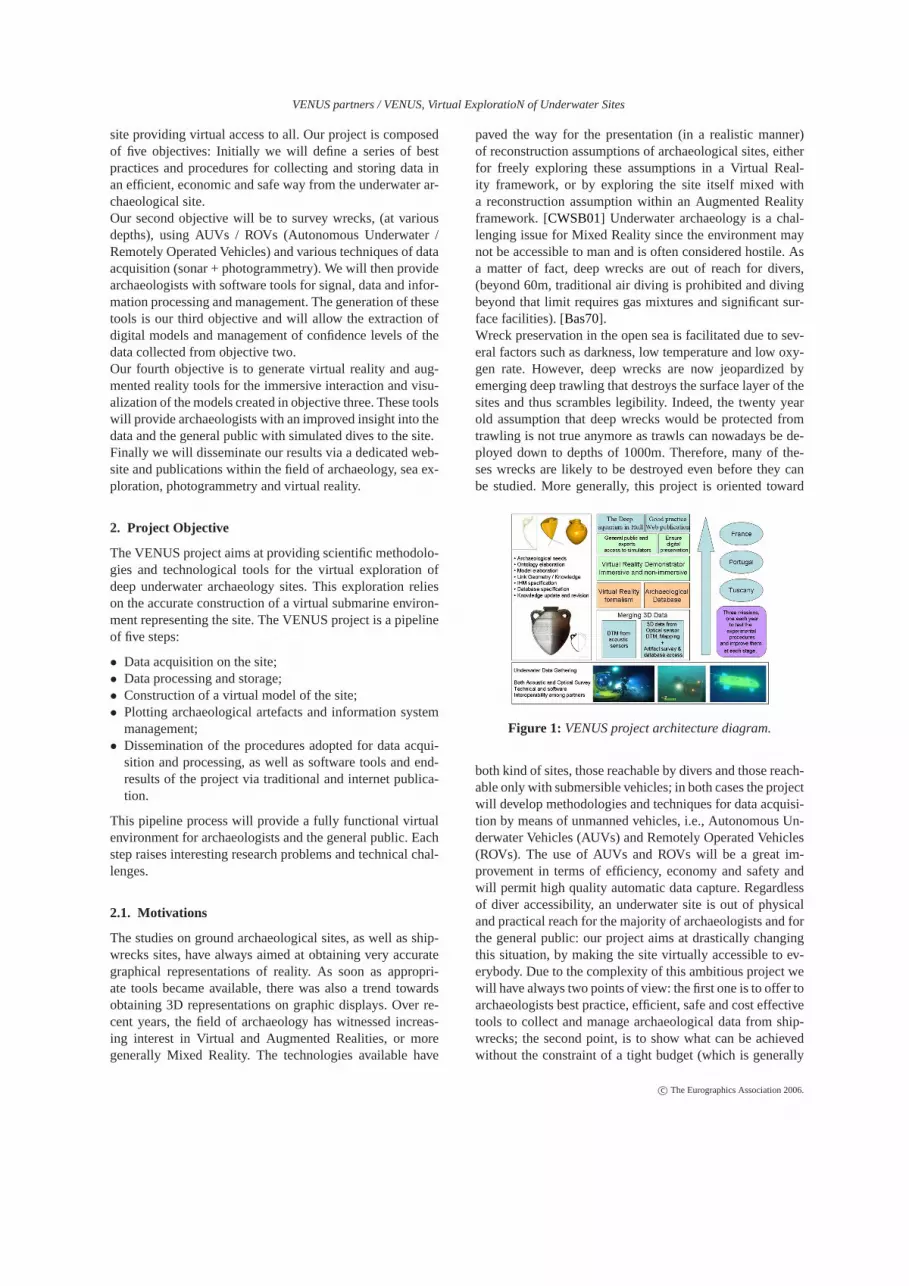
Figure 1: VENUS project architecture diagram.
both kind of sites, those reachable by divers and those reach-able only with submersible vehicles; in both cases the projectwill develop methodologies and techniques for data acquisi-tion by means of unmanned vehicles, i.e., Autonomous Un-derwater Vehicles (AUVs) and Remotely Operated Vehicles(ROVs). The use of AUVs and ROVs will be a great im-provement in terms of efficiency, economy and safety andwill permit high quality automatic data capture. Regardlessof diver accessibility, an underwater site is out of physicaland practical reach for the majority of archaeologists and forthe general public: our project aims at drastically changingthis situation, by making the site virtually accessible to ev-erybody. Due to the complexity of this ambitious project wewill have always two points of view: the first one is to offer toarchaeologists best practice, efficient, safe and cost effectivetools to collect and manage archaeological data from ship-wrecks; the second point, is to show what can be achievedwithout the constraint of a tight budget (which is generally
c© The Eurographics Association 2006.

VENUS partners / VENUS, Virtual ExploratioN of Underwater Sites
Figure 2: ROV and Diver, ISME.
the case in archaeology). The budget has a particularly highinfluence on the technological aspect of this project: espe-cially for underwater data acquisition and virtual reality im-mersion. In this project it is also planned to survey a deepshipwreck in order to apply the entire VENUS platform to ashipwreck in an excellent state of conservation and to showsome possible immersive VR applications. We now presentthe five general objectives of this project and in addition,Objective Six, "Missions in open sea" which represents thethree missions necessary to collect data and test and improvethe methodologies adopted.
2.2. Objective one: Underwater exploration bestpractices and procedures
The first aim is to define a series of procedures and best prac-tices for collecting data in an efficient, economic and safeway on underwater archaeological sites:
• Efficiency is related to the automatic collection of enoughdata, of sufficient good quality to allow for a satisfactoryvirtual reconstruction;
• Economy relates to the possibility of using, with suit-able adaptations, "off-the-shelf" equipment, that archae-ologists can easily get and employ;
• Safety has to do with the reduction of risks and inconve-nience for human beings when operating at great depthsand/or in a hostile environment.
The key technology we propose to exploit in pursuing thisobjective is based on the extensive use of Uninhabited Un-derwater Vehicles (UUVs), both remotely and autonomousvehicles (ROVs/AUVs). UUVs, equipped with acoustic,magnetic and optical sensors of various kinds, are becomingthe tools "par excellence" in underwater archaeology as thetechnology offers ever increasing user-friendly and econom-ical solutions, in particular because they allow the explo-ration and preservation of sites located at prohibitive depthfor divers (see Proceedings of The International Congress
on The Application of Recent Advances in Underwater De-tection and Survey Techniques to Underwater Archaeology,Bodrum, Turkey, 2004; Proceedings of Workshop on In-novative Technologies for Underwater Archaeology, Prato,Italy, 2004 and the references therein). [ABB04] [SP04]However, the potential of an approach that combines un-derwater robotics technology and virtual and augmented re-ality in gathering data and then simulating underwater ar-chaeological sites have not yet been completely explorednor exploited. In particular, data gathering procedures havenot been optimized with respect to post processing. Also,best practices about the combined use of different kinds ofUUVs and sensory systems and devices have not yet beendefined.Measure of success:A thorough and clear defini-
Figure 3: Autonomous Underwater Vehicle (AUV) of IST.
tion of the platforms, sensors, and methodologies that will beused to acquire, process, and display underwater archaeolog-ical data. Namely: i) definition of the platform (AUV, ROV)configurations and equipment that will be used to gather vi-sion and acoustic data and of the interfaces required to en-sure inter-partner systems compatibility, ii) full assessmentof the compatibility of the DTM (digital terrain map) + pho-togrammetric data with 3D Virtual/Augmented reality sys-tems, and iii) development of software for image processingto compensate for refraction errors that arise in the processof acquiring vision data underwater. [PSO05], [SDV∗04].
2.3. Objective Two: Underwater 3D survey mergingoptic and acoustic sensors
The second objective aims at defining practical proceduresfor merging optical and acoustic data, acquired during thesurveying of underwater sites, into a coherent representa-tion. [CWSB02].The project will witness the application of advanced tech-niques for underwater data acquisition and processing to themapping of selected archaeological sites. An AutonomousUnderwater Vehicle (AUV) and a Remotely Operated Vehi-cle (ROV), equipped with acoustic and vision sensors (forsonar mapping + photogrammetry), will be used to acquirerelevant data in an efficient, systematic, and safe manner
c© The Eurographics Association 2006.
VENUS partners / VENUS, Virtual ExploratioN of Underwater Sites
at the sites, including one that is out of reach for divers.[DL05].The need of geo-referencing the gathered data will be con-sidered. Steps will be taken to endow the vehicles with nav-igation systems capable of providing information on theirposition with the accuracy that is required for the applica-tions envisioned. [BT00], [GZ03].Simplified underwater photogrammetric techniques will bedeveloped to allow the use, after appropriate image pro-cessing, of software originally conceived for terrestrial pho-togrammetry. A semi-automatic surface densification tech-nique will be developed in order to automatically generatea large amount of 3D point data based on multiple imagecorrelation and to facilitate the time consuming photogram-metric process during the plotting phase (in the laboratory).A convenient tool for digitalization will be developed, offer-ing to the archaeology community a convenient way to makeaccurate 3D measurements based on the product of the merg-ing operation: a 3D mesh and a set of oriented photographiesin the same reference system. [DDPL05], [DSL03].We plan to make at least three experimental surveys, two inshallow water (on wrecks already studied) with archaeolo-gists and divers and the final one in deep water to enhancethe innovative aspect of this project. These surveys will beperformed by conforming to the data collection guidelinesspecified in objective one.Measure of success:Data gathering by means of robotictools and the integration of acoustic and photogrammetricdata at a sufficiently small scale will make virtual access, ex-ploration and study of underwater archaeological sites pos-sible. Access to these sites are currently beyond reach for thelarge majority of archaeologists and, in many cases, for thegeneral public. The demonstration that i) archaeological sur-veys can be automated by using underwater robots that areeasy to program seamlessly, and ii) sufficient navigationalaccuracy can be achieved so as to meet the precision require-ments compatible with the scale dimensions envisioned, willprovide quantitative indicators of the results obtained and ameasure of success.
2.4. Objective Three: managing and revisingarchaeological knowledge
Objective three aims to provide underwater archaeologistswith software tools for signal, data and information process-ing and management. These tools will allow for the extrac-tion of digital models and management of confidence lev-els of the data collected from objective two. [Ace03] In thelast decade, the tools developed for managing archaeologi-cal data have only focused on the geometric aspects; how-ever, in order to integrate the archaeologist’s knowledge anddesigning tools managing both data and knowledge, an ap-propriate representation of the archaeological knowledge isrequired. [BHLW03].Another important factor is the management of this knowl-edge. We deal with pieces of information of different nature
that also originate from different sources characterized byvarious degrees of confidence. The methods of acquisitiondiffer and provide data of unequal quality. Moreover, mostof the time, the pieces of information are incomplete, un-certain, or inaccurate and have the potential to conflict witheach other and hence may need the definition of fusion op-erations. Different cases arise according to the nature of thedata used for fusion.[JP00] The proposed work for this particular objective startswith a case study of archaeologist knowledge and proceduresin order to define data management systems and a virtualuniverse.We plan to investigate how artificial intelligence methodsand tools could be used to represent the archaeological in-formation and to perform revision and fusion according tothe following points:
• to design and build specific ontology: by analyzing the rel-evance of the objects which can be handled in a particulararchaeological application, independently of the expecteddata; to carefully examine their definition and the kind ofimplicit knowledge it carries; to compare how the data,with their quality depending on the observation process,and the recording process, can fit with the object defini-tion; [SDP03]
• To design which knowledge representation formalismsare suitable to represent semi-structured information, pay-ing attention to the specificity of the archaeological data:3D spatial reference, topological relationships and spatialcorrelations, specific expert knowledge and specific ontol-ogy;
• To select which fusion strategy is best suited to the repre-sentation formalism chosen according to the nature of thesituation, and the availability of relevant data, and theirdegree of quality and reliability. For instance, revision isrelevant if one data set is strongly reliable;
• To assess the tractability of the fusion: How can the natureof the data help in defining tractable classes of problemsfor merging? How should existing general algorithms beadapted for merging? How can heuristics be defined thatstem from the specificity of the nature of data to speed upalgorithms?
• To define reversible fusion operations. This stems fromthe fact that, in general, the existing fusion operations de-veloped in the field of artificial intelligence are not re-versible; this is in contrast with the fact that reversibilityis mandatory when facing real scale applications. [NS97],[BBJ∗05].
Measure of success:The first draft of the "archaeologicalontology" description, in Task 3.2, must be able to encom-pass most of the various features, properties, processes orbehaviours collected during the first months of discussionbetween the computer scientists and the archaeologists ofthe consortium. A "typical" archaeological campaign will besummarized and described at the beginning of the project, asa baseline test bed for the further representation formalisms.
c© The Eurographics Association 2006.
VENUS partners / VENUS, Virtual ExploratioN of Underwater Sites
A confrontation of this baseline to external expert will per-mit to measure its relevance, and therefore, to measure therelevance of the representation formalisms against it.
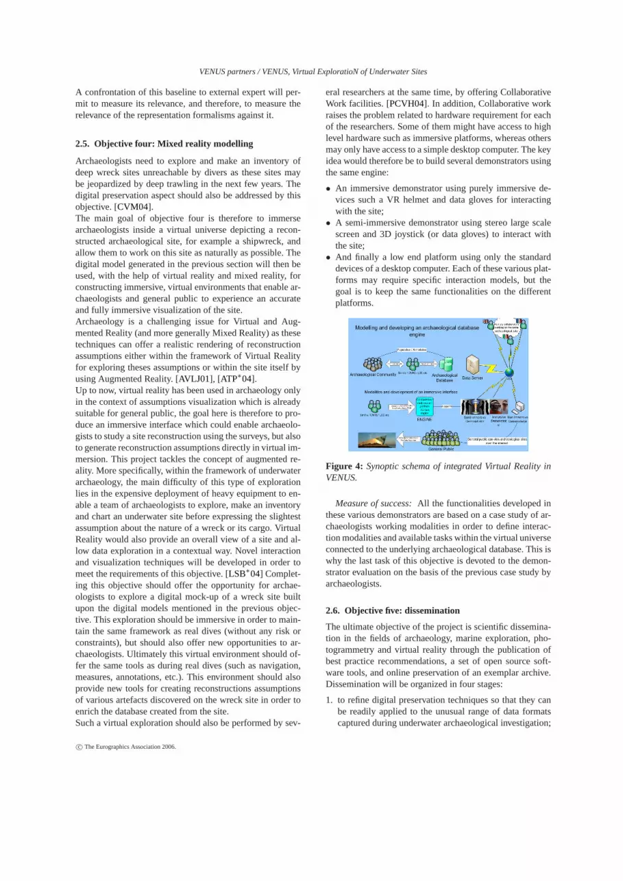
2.5. Objective four: Mixed reality modelling
Archaeologists need to explore and make an inventory ofdeep wreck sites unreachable by divers as these sites maybe jeopardized by deep trawling in the next few years. Thedigital preservation aspect should also be addressed by thisobjective. [CVM04].The main goal of objective four is therefore to immersearchaeologists inside a virtual universe depicting a recon-structed archaeological site, for example a shipwreck, andallow them to work on this site as naturally as possible. Thedigital model generated in the previous section will then beused, with the help of virtual reality and mixed reality, forconstructing immersive, virtual environments that enable ar-chaeologists and general public to experience an accurateand fully immersive visualization of the site.Archaeology is a challenging issue for Virtual and Aug-mented Reality (and more generally Mixed Reality) as thesetechniques can offer a realistic rendering of reconstructionassumptions either within the framework of Virtual Realityfor exploring theses assumptions or within the site itself byusing Augmented Reality. [AVLJ01], [ATP∗04].Up to now, virtual reality has been used in archaeology onlyin the context of assumptions visualization which is alreadysuitable for general public, the goal here is therefore to pro-duce an immersive interface which could enable archaeolo-gists to study a site reconstruction using the surveys, but alsoto generate reconstruction assumptions directly in virtual im-mersion. This project tackles the concept of augmented re-ality. More specifically, within the framework of underwaterarchaeology, the main difficulty of this type of explorationlies in the expensive deployment of heavy equipment to en-able a team of archaeologists to explore, make an inventoryand chart an underwater site before expressing the slightestassumption about the nature of a wreck or its cargo. VirtualReality would also provide an overall view of a site and al-low data exploration in a contextual way. Novel interactionand visualization techniques will be developed in order tomeet the requirements of this objective. [LSB∗04] Complet-ing this objective should offer the opportunity for archae-ologists to explore a digital mock-up of a wreck site builtupon the digital models mentioned in the previous objec-tive. This exploration should be immersive in order to main-tain the same framework as real dives (without any risk orconstraints), but should also offer new opportunities to ar-chaeologists. Ultimately this virtual environment should of-fer the same tools as during real dives (such as navigation,measures, annotations, etc.). This environment should alsoprovide new tools for creating reconstructions assumptionsof various artefacts discovered on the wreck site in order toenrich the database created from the site.Such a virtual exploration should also be performed by sev-
eral researchers at the same time, by offering CollaborativeWork facilities. [PCVH04]. In addition, Collaborative workraises the problem related to hardware requirement for eachof the researchers. Some of them might have access to highlevel hardware such as immersive platforms, whereas othersmay only have access to a simple desktop computer. The keyidea would therefore be to build several demonstrators usingthe same engine:
• An immersive demonstrator using purely immersive de-vices such a VR helmet and data gloves for interactingwith the site;
• A semi-immersive demonstrator using stereo large scalescreen and 3D joystick (or data gloves) to interact withthe site;
• And finally a low end platform using only the standarddevices of a desktop computer. Each of these various plat-forms may require specific interaction models, but thegoal is to keep the same functionalities on the differentplatforms.
Figure 4: Synoptic schema of integrated Virtual Reality inVENUS.
Measure of success:All the functionalities developed inthese various demonstrators are based on a case study of ar-chaeologists working modalities in order to define interac-tion modalities and available tasks within the virtual universeconnected to the underlying archaeological database. This iswhy the last task of this objective is devoted to the demon-strator evaluation on the basis of the previous case study byarchaeologists.
2.6. Objective five: dissemination
The ultimate objective of the project is scientific dissemina-tion in the fields of archaeology, marine exploration, pho-togrammetry and virtual reality through the publication ofbest practice recommendations, a set of open source soft-ware tools, and online preservation of an exemplar archive.Dissemination will be organized in four stages:
1. to refine digital preservation techniques so that they canbe readily applied to the unusual range of data formatscaptured during underwater archaeological investigation;
c© The Eurographics Association 2006.

VENUS partners / VENUS, Virtual ExploratioN of Underwater Sites
2. to ensure that partners within the consortium learn aboutdigital preservation;
3. to promote best practice in digital preservation throughpublication of a short practical guide based on this sharedexperience;
4. to adopt and trial these best practice techniques within theproject.
• The first objective will be achieved through comple-tion of a desk-based study, supported by a number ofdata audits carried out at the start of the project. Theprincipal investigator for this work package will bea digital preservation specialist who will spend timewith active fieldworkers, surveying the techniquesthat they use and establishing the most appropriatemethods for digital preservation associated with thesefile formats. This preservation path, based on an im-plementation of the OAIS reference model for digitalpreservation and the PREMIS metadata model, willprovide a preservation manual for long term curationof digital data;
• The second objective will be met in part through thedata audit process described above whereby the prin-cipal investigator will discuss issues of digital preser-vation informally with project partners, and reportback to them the results of that research. The objectivewill be mainly met through the organization of a two-day project workshop on digital preservation to whichsenior members of each partner organization will beinvited. This workshop will be managed by the Ar-chaeology Data Service and will draw from existingcurricula that the UoY-ADS offer on digital preserva-tion;
• Participants at this workshop will be invited to forman editorial committee and nominate a peer reviewgroup who will assist the principal investigator in thewriting of a short guide to good practice for under-water archaeology. This guide will join the existingguides in the much praised "Guide to Good Practice"Series (http://ads.ahds.ac.uk/project/goodguides/g2gp.html). It will be distributed in print to allpartners and key stakeholders, as well as being madeavailable for free online for all readers;
• By the end of the project, partners will not only haveadapted their tools to ensure digital preservation, butthey will be in a position to apply that best practicein real life situations. An exemplar archive will belodged with the UoY-ADS and preserved into perpe-tuity. This scholarly archive will also be disseminatedonline alongside other research archives maintainedby the UoY-ADS. It will therefore be available for re-use and interrogation by all visitors to the UoY-ADSsite and will stand as a worked example of good prac-tice to demonstrate the project outcomes to the widerprofession.
To avoid duplication of efforts in a rapidly changing fielda "technology watch" will be maintained, in close collabo-ration with the EPOCH 6th Framework Network of Excel-lence. The project team will present reports on its activitiesat appropriate technology and humanities conferences. Fi-nally, the 3D and virtual reality aspects of the project makeit appropriate for wider public dissemination, which will bemost effectively achieved via the Internet.Measure of success.The success of the workshop and sub-sequent Guide to Good Practice will be measurable by theextent to which the standards are endorsed and taken up bythe sub-discipline of underwater archaeology. The numberof Guides sold, and the number of visits to the on-line pub-lication provides one measure of the visibility of the Guide.Previous Guides in the series, such as that for GIS, have soldout and have had to be re-printed. They have been widely andpositively reviewed, and have been adopted by national andinternational standards bodies, and cited in undergraduateand postgraduate reading lists. The successful disseminationof the exemplar archive is also measurable, to same extent,by the number of visits to the site. This will be monitoredby UoY-ADS standardized benchmarks for site visits, andcan be compared against other online resources. The website can be promoted through the UoY-ADS outreach pro-gramme and related publications, and qualitative feedbackcan also be collected.
2.7. The case study: The Mediterranean archaeologicalcontext
If the "first civilizations" were born in the Eastern Mediter-ranean from the Near East, this sea has been empty for mil-lennia before becoming the main stage of shocks, conflictsand discovery of civilizations. From Marathon to Lépante,from Punic Wars to crusades, the Mediterranean space/areais full of historical reappearances and lights coming fromthe dead world. Beyond its current political divisions, it is di-vided into three cultural communities: Christian, Islamic andthe Greek orthodox universe, that is an affiliation more orless linked to Rome, Carthage and Constantinople. One par-ticular period interests us here. In ancient times, by imposingits will and political unification on the Mediterranean world,Rome did not erase the cultural differences but built its inter-nal sea as a gigantic trading crossroad where oils and brinesfrom Spain would cross with corn from Egypt, wines fromAlgeria and Rhodes, slaves from Nubia, ceramics from Gal-lia, marbles from Greece and bronzes from Italy. [ANS04],During the Roman Empire, among all these various prod-ucts coming from the Mediterranean, a great quantity of Por-tuguese amphorae were sailing from Hercules Pillars to theRhine frontiers and carried the famous Lusitanian fish sauce.Today underwater archaeology opens, from the deep past ofthe sea, a direct route to these shipwrecks, complex worksthat testify the wealth and the diversity of exchanges and ofmen. In this project, the methods of excavation, the systemsof data capture and of the data’s visualization and the coop-
c© The Eurographics Association 2006.

VENUS partners / VENUS, Virtual ExploratioN of Underwater Sites
eration of archaeologists and multinational specialists, willenable historical restoration of these trades and to continuethese faraway sailing journeys, brutally interrupted.We plan to make three experimentations in different archaeo-logical contexts and under different sea conditions. The firstone, leaded by MIBAC-SBAT in Tuscany will focuss on avery interesting archaeological site near the Pianosa island,and will be considered as a shallow water (-36m) mission.The wreck site consists of a large area of mixed amphoraeprobably due to more than one wreck superposition. The sec-
Figure 5: A view of the site close to Pianosa, Photo Alessan-dro Parotti, 2000
ond experimentation, in Portugal, concerns two sites: a prob-able Roman period wreck on the southern coast of Portugal(Algarve) where amphorae (Beltan IIb) were recovered byfishermen at a depth of 50m in the ocean; the other one lieson the Portuguese east coast, near Troia (a roman industrialcomplex for processing fish, and wine from the surround-ing area, which used locally produced amphorae). This ship-wreck probably contains amphorae and may be the result ofa geomorphologic process that has buried structures and am-phorae.The third one is an extremely well preserved shipwreck nearMarseille. Discovered in 1999 by COMEX the "Calanque dePort Miou" is probably the most beautiful wreck in the Mar-seilles area nowadays. The site was explored by MCC in the
Figure 6: The "Calanque de Port Miou" photograph fromROV of COMEX.
year of its discovery, in 1999, with heavy logistics provided
by COMEX.The wreck site (which seems to be still intact) presents avery large tumulus of Roman wine amphorae, Dressel 1A.Visible on 22 m length and ten meters broad, it is located ata depth of 120m.
Figure 7: The submarine REMORA 2000 of COMEX dur-ing rhe Grand Ribaud F excavation, 2000. Photo FredericBassemayousse.
3. Conclusion and future work
This paper has described a new project that focuses onthe virtual exploration of underwater sites. Our interna-tional research group has expertise in a wide range of ar-eas including archaeology and underwater exploration, ma-rine robotics and instrumentation, knowledge representationand photogrammetry, virtual reality and digital data preser-vation. Research conducted throughout this project will con-tribute to all these disciplines. This European Communityfunded project began on the 1st July 2006 and will last for36 months. A dedicated project website is available here:http://www.VENUS-project.eu/
4. Acknowledgements
Work partially supported by the European Community un-der project VENUS (Contract IST-034924) of the "Informa-tion Society Technologies (IST) programme of the 6th FPfor RTD".The authors are solely responsible for the content of this pa-per. It does not represent the opinion of the European Com-munity, and the European Community is not responsible forany use that might be made of data appearing therein.
References
[ABB04] A KAL T., BALLARD R. D., BASS G. F.: Theapplication of recent advances in underwater detectionand survey techniques to underwater archaeology. InProc. International Conference(Bodrum, Turkey, May2004).
c© The Eurographics Association 2006.

VENUS partners / VENUS, Virtual ExploratioN of Underwater Sites
[Ace03] ACERES C.: Inference services for descriptionlogics. Description Logic Day(2003).
[ANS04] ANSER: Project anser, anciennes routesmaritimes méditerranéennes european commission.Programme Interreg IIIB Medocc http://www.projet-anser.net/(2004).
[ATP∗04] ALVIK R., TIKKANEN S., PALMA P., GRE-GORY D., LEINO M., JÃUNS H., WESSMAN S., CED-ERLUND C. O., OOSTING R., KRESSEW., MANDERS
M., LÃ IJTH F.: Moss project final report.
[AVLJ01] ACEVEDO D., VOTE E., LAIDLAW D. H.,JOUKOWSKY M. S.: Archaeological data visualizationin vr: Analysis of lamp finds at the great temple of petra,a case study. InIn proceedings of IEEE Visualization(SanDiego, California, 2001).
[Bas70] BASS G. F.: Archaeology under Water, vol. 183.Harmondsworth, 1970.
[BBJ∗05] BENFERHAT S., BENAIM J., JEANSOULIN R.,KELFALLAH M., LAGRUE S., O. PAPINI N. W., WÃIJR-BEL E.: Revising geoinformation : the results of rev!gis”proceedings of the eighth european conference on sym-bolic and quantitative approaches to reasoning with un-certainty. In Lecture Note in Artificial Intelligence(Barcelone, July 2005), nÂr 3771 S. V., (Ed.), EC-SQARU’05, pp. 452–464.
[BHLW03] BAADER F., HLADIK J., LUTZ C., WOLTER
F.: From tableaux to automata for description logics.Fun-damenta Informaticae 57(2003), 1âAT33.
[BT00] BECHAZ C., THOMAS H.: Gib system: the under-water gps solution. InProc. 5th Europ. Conf. UnderwaterAcoustics(Lyon, France, 2000).
[CVM04] CHAPMAN P., VIANT W., MUNOKO M.: Con-structing immersive virtual environments for the visual-ization of underwater archaeological sites. InXXXII Com-puter Applications and Quantitative Methods to Archae-ology Conference(Prato, Italy, April 2004).
[CWSB01] CHAPMAN P., WILLS . D., STEVENS P.,BROOKESG.: Visualization viewpoints: Real-time visu-alization in the offshore industry.IEEE Computer Graph-ics and Applications 21, 4 (2001), 6–10.
[CWSB02] CHAPMAN P., WILLS . D., STEVENS P.,BROOKES G.: Visualizing underwater environments us-ing multi-frequency sonar.IEEE Computer Graphics andApplications ISSN: 0772-1716 19, 5 (2002), 61–65.
[DDPL05] DRAP P., DURAND A., PROVIN R., LONG L.:Integration of multi-source spatial information and xmlinformation system in underwater archaeology. InXXSymposium of CIPA(Torino, Italy, September 26th to Oc-tober 1st 2005), the ICOMOS, on Documentation of Cul-tural Heritage I. C., (Eds.).
[DL05] DRAP P., LONG L.: Photogrammétrie et archéolo-
gie sous-marine profonde. le cas de lâAZépave étrusquegrand ribaud f.Revue XYZ 104-104(2005).
[DSL03] DRAP P., SEINTURIER J., LONG L.: Archae-ological 3d modelling using digital photogrammetry andexpert system. the case study of etruscan amphorae. InThe Sixth International Conference on Computer Graph-ics and Artificial Intelligence(Limoges, France, 2003).
[GZ03] G.CONTE, ZANOLI S.: Rov depth control.Con-trol Eng. Pract. 11(2003).
[JP00] JEANSOULIN R., PAPINI O.: RÃl’vision et in-formation spatiale Âz, dans Le temps, lâAZespace etlâAZÃl’volutif en sciences du traitement de lâAZinforma-tion, c. garbay (eds.) ed. CÃl’padues-Ãl’ditions, 2000,pp. 293–304.
[LSB∗04] LIAROKAPIS F., SYLAIOU S., BASU A.,MOURKOUSSISN., WHITE M., L ISTER P.: An interac-tive visualization interface for virtual museums. InVASTâAZ04. Proceedings of the 2004 conference on Virtual Re-ality and Cultural Hertiage(Belgium, 2004), pp. 47–56.
[NS97] NIEMELA I., SIMONS P.: Smodels: An implemen-tation of the stable model and well-founded semantics fornormal logic programs. InIn Proceedings of the 4th In-ternational Conference on Logic Programming and Non-monotonic Reasoning (LPNMR-97)(1997), p. 420 429.
[PCVH04] PANSIOT J., CHAPMAN P., VIANT W.,HALKON P.: New perspectives on ancient landscapes: Acase study of the foulness valley. InThe 5th InternationalSymposium on Virtual Reality, Archaeology and CulturalHeritage(Belgium, 2004), pp. 251–260.
[PSO05] PASCOAL A., SILVESTRE C., OLIVEIRA P.:Vehicle and mission control of single and multiple au-tonomous marine robots.Advances in Unmanned MarineVehicles Editor: G. Roberts and R. Sutton(2005).
[SDP03] SEINTURIER J., DRAP P., PAPINI O.: Fu-sion rÃl’versible : application Ãa l’informationarchÃl’ologique. InActes des JournÃl’es sur le Raison-nement Non-Monotone (JNMR’03)(Paris, November2003).
[SDV∗04] SEINTURIER J., DRAP P., VINCENT N.,CIBECCHINI F., PAPINI O., GRUSSENMEYERP.: Or-thophoto imaging and gis for seabed visualization and un-derwater archaeology. InProceedings of CAA2004(Prato,Italy, April 2004), Computer Applications and quantita-tive Methods in Archaeology.
[SP04] SILVESTRE C., PASCOAL A.: Control of the in-fante auv using gain-scheduled static output feedback.IFAC Journal of Control Engineering Practice 12(2004),1501–1509.
c© The Eurographics Association 2006.