usaf.pdf - nasa environmental management division
TRANSCRIPT

FINAL
DECEMBER 2009

Acronyms and Abbreviations °F degree Fahrenheit µg/m3 micrograms per cubic meter 129 RQW 129th Rescue Wing ACHP Advisory Council on Historic Preservation ACM asbestos-containing material AFI Air Force Instruction AIRFA American Indian Religious Freedom Act ANG Air National Guard ARC Ames Research Center ASE Aerospace Support Equipment AST aboveground storage tank AT/FP Anti-Terrorism/Force Protection BAAQMD Bay Area Air Quality Management District BASH Bird/Wildlife Aircraft Strike Hazard BGS below ground surface BMP Best Management Practice CAA Clean Air Act CAANG California Air National Guard CAAQS California Ambient Air Quality Standards CARB California Air Resources Board CATM Combat Arms Training Maintenance CATS Combat Arms Training Simulator CDFG California Department of Fish and Game CEQ Council on Environmental Quality CEQA California Environmental Quality Act CERCLA Comprehensive Environmental Response, Compensation, and Liability Act CERFA Community Environmental Response Facilitation Act CFR Code of Federal Regulations CO carbon monoxide CRWQCB California Regional Water Quality
Control Board CSAR Combat Search and Rescue CWA Clean Water Act dBA A-weighted decibel DESC Defense Energy Support Center DoD Department of Defense EA Environmental Assessment EIAP Environmental Impact Analysis Process EIS Environmental Impact Statement EO Executive Order EPCRA Emergency Planning and Community Right-to-Know Act ESA Endangered Species Act FEMA Federal Emergency Management Agency FFCA Federal Facility Compliance Act HAP Hazardous Air Pollutants HVAC Heating, Ventilation, and Air Conditioning IAP Initial Accumulation Point IICEP Interagency and Intergovernmental
Coordination for Environmental Planning IRP Installation Restoration Program LBP lead-based paint LEED Leadership in Energy and Environmental Design LOS Level of Service LQG large quantity generator LUST leaking underground storage tank M&I Maintenance and Inspection
mg/L milligram per liter mg/m3 milligrams per cubic meter mph miles per hour MSA Munitions Storage Area MSC Munitions Storage Complex MEW Middlefield-Ellis-Whisman NAS Naval Air Station NASA National Aeronautics and Space
Administration NAAQS National Ambient Air Quality Standards NAGPRA Native American Graves Protection and
Repatriation Act NEPA National Environmental Policy Act NGB National Guard Bureau NHPA National Historic Preservation Act NO2 nitrogen dioxide NOx nitrogen oxides NPDES National Pollutant Discharge Elimination System NRCS Natural Resources Conservation Service NRHP National Register of Historic Places O3 ozone O&T Operations and Training OWS oil/water separator Pb lead P.L. Public Law PM2.5 particulate matter ≤ 2.5 microns in diameter PM10 particulate matter ≤ 10 microns in diameter POL petroleum, oils, and lubricants POTW Publicly Owned Treatment Works ppm parts per million QD quantity-distance RCRA Resource Conservation and Recovery Act ROD Record of Decision ROI region of influence RWQCB Regional Water Quality Control Board SARA Superfund Amendments and Reauthorization Act SF square feet SIP State Implementation Plan SHPO State Historic Preservation Office(r) SJC San Jose International Airport SO2 sulfur dioxide SWDA Solid Waste Disposal Act SWPPP Stormwater Pollution Prevention Plan TPHd Total Petroleum Hydrocarbons Diesel U.S. United States UFC Unified Facilities Criteria US-101 United States Highway 101 USACE United States Army Corps of Engineers USAF United States Department of the Air Force USC United States Code USCB United States Census Bureau USDA United States Department of Agriculture USEPA U.S. Environmental Protection Agency USFWS U.S. Fish and Wildlife Service USGS United States Geological Survey UST underground storage tank UTA Unit Training Assembly VOC volatile organic compound

FINDING OF NO SIGNIFICANT IMPACT FOR
PROPOSED LONG-TERM PERMIT AND INSTALLATION DEVELOPMENT PLAN FOR THE 129TH RESCUE WING
CALIFORNIA AIR NATIONAL GUARD MOFFETT FIELD, CALIFORNIA
PURPOSE: The Purpose of the Proposed Action is to consolidate the 129th Rescue Wing (129 RQW) facilities to the extent possible, while providing the necessary functional areas required for the 129 RQW mission. The Proposed Action is necessary to reconfigure facilities and property to accommodate the mission of the 129 RQW and to implement Anti-Terrorism/Force Protection (AT/FP) requirements. Furthermore, this action is necessary because the National Aeronautics and Space Administration (NASA) has stated in the NASA Ames Development Plan and associated Programmatic Environmental Impact Statement (EIS) and Record of Decision (ROD) (2002) that it may eventually open up the NASA Research Park (on the west side of the runway) and the Eastside/Airfield (east of the runway) to the public. The Proposed Action will provide the 129 RQW with properly sized and configured facilities, as described in Air National Guard (ANG) Handbook 32-1084, Facility Requirements, which are required to effectively accomplish their mission. The new facilities will enhance the 129 RQW’s ability to maintain a level of wartime readiness necessary to support the mission.
ALTERNATIVE #1 (Preferred Alternative): The 129 RQW currently occupies 7 parcels, 88 facilities and 51 buildings at Moffett Field; the remainder of Moffett Field is in use by NASA and their other tenants. NASA has plans to eventually open the NASA Research Park (on the west side of the runway) and the Eastside/Airfield (east of the runway) to the public, consistent with the NASA Ames Development Plan and associated Programmatic EIS and ROD (2002). This would create an unsecured installation for the 129 RQW, which is not compliant with AT/FP requirements. As a result, the 129 RQW will consolidate their facilities to the extent practicable. In so doing, the 129 RQW will enter into a long-term permit with NASA for the property they currently occupy and an additional parcel they propose to acquire for the construction of a new Munitions Storage Complex (MSC). In addition, the 129 RQW will remedy some of their functional space shortfalls by vacating certain facilities and constructing some new facilities that will meet the authorized square footage requirements per ANG Handbook 32-1084, Facility Requirements, as necessary. California Air National Guard (CAANG) operations in areas to be described as shared use in the proposed permit (e.g., the taxiway near Runway 32R and temporary use areas) would be within the scope of the existing National Environmental Policy Act (NEPA) documentation. These collective actions will allow NASA Ames Research Center (ARC) (as property holder) to promote economical and efficient use of facilities and allow the 129 RQW to carry out their mission more effectively.

2
The Proposed Action is not inconsistent with the goals of other federal agencies. It is consistent with approved state and local plans. The Proposed Action consolidates and reconfigures facilities and operations within the existing footprint without substantially increasing the level of operations as described in the 2002 NASA Ames Development Plan Programmatic EIS and ROD.
ALTERNATIVE #2: Under Alternative #2, all construction and demolition projects proposed for Alternative #1 would be implemented; however, the additional parcel that would be acquired for the new MSC would be sited in a different location on the installation. This alternative would consolidate the CAANG facilities into two non-contiguous parcels.
Alternative #2 is not inconsistent with the goals of other federal agencies. It is consistent with approved state and local plans. Alternative #2 consolidates and reconfigures facilities and operations within the existing footprint without substantially increasing the level of operations as described in the 2002 NASA Ames Development Plan Programmatic EIS and ROD.
ALTERNATIVE #3: Under Alternative #3, all construction and demolition projects described in Alternative #1 would be implemented, with the exception of the pervious parking area proposed for the east side of Macon Road (part of Project #13) and the photovoltaic generation system that is associated with it (Project #14). The 129 RQW would instead use the existing parking garages located in the Moffett Towers development east of Mary Street for additional parking to support Unit Training Assembly (UTA) on the weekends. To facilitate parking off-installation at the Moffett Towers development, a new entrance gate would be installed near the intersection of Mary Street and 11th Avenue. A roadway extension connecting 11th Avenue to Macon Road would also be developed and would be approximately 68 feet wide and 140 feet long (approximately 9,520 square feet [SF] of additional impervious surface). Sidewalks, curbs, and gutters would also be included in this roadway extension.
Alternative #3 is not inconsistent with the goals of other federal agencies. It is consistent with approved state and local plans. Alternative #3 consolidates and reconfigures facilities and operations within the existing footprint without substantially increasing the level of operations as described in the 2002 NASA Ames Development Plan Programmatic EIS and ROD.
ALTERNATIVE #4: Under Alternative #4, all construction and demolition projects described in Alternative #2 would be implemented, with the exception of the pervious parking area proposed for the east side of Macon Road (part of Project #13) and the photovoltaic generation system that is associated with it (Project #14). The 129 RQW would instead use the existing parking garages located in the Moffett Towers development east of Mary Street for additional parking to support UTA on the weekends. To facilitate parking off-installation at the Moffett Towers development, a new entrance gate would be installed near the intersection of Mary Street

3
and 11th Avenue. A roadway extension connecting 11th Avenue to Macon Road would also be developed and would be approximately 68 feet wide and 140 feet long (approximately 9,520 SF of additional impervious surface). Sidewalks, curbs, and gutters would also be included in this roadway extension.
Alternative #4 is not inconsistent with the goals of other federal agencies. It is consistent with approved state and local plans. Alternative #4 consolidates and reconfigures facilities and operations within the existing footprint without substantially increasing the level of operations as described in the 2002 NASA Ames Development Plan Programmatic EIS and ROD.
NO ACTION ALTERNATIVE: Under the No Action Alternative, AT/FP requirements would not be met once NASA opens the NASA Research Park and the eastern portion of Moffett Field to the public, leaving the installation vulnerable to close attack by potential terrorist activity, and resulting in potential threats to mission-critical resources and potentially impairing the 129 RQW’s ability to conduct their mission successfully. Deficiencies could impair the 129 RQW’s ability to successfully conduct their mission and to maintain wartime readiness and training.
The No Action Alternative is not consistent with federal goals in that it does not meet AT/FP standards as identified in Unified Facilities Criteria (UFC) 4-022-01, Security Engineering: Entry Control Facilities/Access Control Points (2005) and UFC 4-010-01, DoD Minimum Antiterrorism Standards for Buildings (2007). The No Action Alternative is consistent with approved state and local plans.
SUMMARY OF FINDINGS
Potential impacts associated with the Proposed Action, in particular, the Preferred Alternative (Alternative #1), have been assessed with regard to the following environmental resource areas:
Earth Resources. Impacts to earth resources from construction, demolition, operations, and maintenance activities are expected to be minor under the Proposed Action. Approximately 9.5 acres of increased impervious surface will result from implementation of Alternative #1. It is expected that implementation of construction Best Management Practices (BMPs) would limit or eliminate soil movement, stabilize runoff, and control sedimentation during surface disturbing activities. These BMPs may include the use of: well-maintained silt fences; minimizing surficial area disturbed; stabilization of cut/fill slopes; minimization of earth-moving activities during wet weather; and use of temporary detention/retention ponds. Following construction, disturbed areas not covered with impervious surfaces will be reestablished with appropriate vegetation and managed to minimize future erosion potential. Given the employment of engineering practices that will minimize potential erosion, impacts to earth resources as a result of the Proposed Action are expected to be minor.
4
In addition to the increased impervious surface that will result from implementation of the Proposed Action, additional surface area could be disturbed at Moffett Field and in the vicinity over the next several years as a result of the additional projects planned for Moffett Field and the surrounding area. However, given the employment of engineering practices that will minimize potential erosion, cumulative impacts to earth resources are expected to be minor.
Water Resources. Impacts to water resources from construction, demolition, operations, and maintenance activities are expected to be minor under the Proposed Action. Approximately 9.5 acres of increased impervious surface will result from implementation of Alternative #1. Construction activities will adhere to National Pollutant Discharge Elimination System (NPDES) requirements including implementation of BMPs. As such, impacts to water resources under the Proposed Action are expected to be minor.
In addition to the increased impervious surface that will result from implementation of the Proposed Action, additional land surface could be disturbed and converted to impervious surface over the next several years as a result of the additional projects planned for Moffett Field and the surrounding area. It is expected that any construction activities will adhere to NPDES requirements including implementation of BMPs. As such, cumulative impacts to water resources are expected to be minor.
Biological Resources. Impacts to biological resources from construction, demolition, operations, and maintenance activities are expected to be minor. In general, construction activities at Moffett Field will primarily occur on sites that are already highly altered by man. These impacts will include the removal of some vegetation and associated wildlife habitat. However, wildlife that uses these areas is generally typical of urban and suburban areas. In addition, following construction, the disturbed areas will be reestablished with native plants to the extent possible. Operations and maintenance of the new facilities is expected to have minor effects on biological resources, as they will be similar to existing operations and maintenance activities. There are no known active Burrowing Owl nests within the footprint of proposed projects under Alternative #1; and measures described in the 2002 NASA Ames Development Plan Final Programmatic EIS and Burrowing Owl Habitat Management Plan will be followed during construction of the proposed projects. Therefore, impacts to owls are not expected. Impacts to threatened, endangered, rare, sensitive, and other protected species as a result of the Proposed Action will be minor.
In addition to the implementation of the Proposed Action, additional land surface could be disturbed as a result of the additional projects planned for Moffett Field and the surrounding area. However, it is expected that cumulative impacts to biological resources are expected to be minor.

5
Air Quality. Impacts to air quality from construction, demolition, operations, and maintenance activities are expected to be minor. In general, combustive and fugitive dust emissions from construction and demolition activities associated with the Proposed Action will contribute localized, short-term elevated air pollutant concentrations, but will not result in any long-term impacts on the air quality of the San Francisco Bay Area Air Basin, nor have any significant adverse impacts on the California State Implementation Plan (SIP). It is expected that impacts to air quality to the Air Basin from the emission increases from proposed activities will be minor.
The proposed activities described in the Environmental Assessment (EA), combined with additional projects planned for Moffett Field and the surrounding area, will contribute localized, short-term, elevated air pollutant concentrations, but will not result in any long-term impacts to the air quality of San Francisco Bay Area Air Basin, nor have any significant adverse impacts on the California SIP.
Land Use/Visual Resources. Impacts to land use and visual resources from construction, demolition, operations, and maintenance activities are expected to be minor. In general, land uses at Moffett Field will not be adversely affected by implementation of the Proposed Action. The location and function of the proposed structures are generally compatible with the surrounding area and will work to consolidate like functions, consolidate CAANG activities into fewer locations, and improve overall utility. Described activities will not adversely affect the viewshed at or near Moffett Field. While the proposed construction activities include some relatively large structures, the size and type of buildings will be similar to other buildings at Moffett Field, as described in the NASA Ames Development Plan Programmatic EIS (2002) and the City of Sunnyvale’s Moffett Park Environmental Impact Review. As the proposed structures will not be incongruent with the surrounding buildings or land uses, impacts to land use and visual resources will be minor as a result of the Proposed Action. In addition, as the proposed structures will not be incongruent with the surrounding buildings or land uses, cumulative impacts to land use and visual resources is expected to be negligible.
Socioeconomics and Environmental Justice. Impacts to socioeconomics and environmental justice from construction, demolition, operations, and maintenance activities are expected to be minor. Expenditures from the activities at the 129 RQW installation as a result of the Proposed Action will generally result in minor beneficial economic impacts to the region by generating ongoing construction-related employment and income in the region of influence (ROI). Impacts will be temporary in nature; however, only accruing economic benefits to the region for the duration of construction activities. No permanent or long-lasting socioeconomic impacts are anticipated as a result of implementation of these activities. Disadvantaged groups within the ROI, including minority and low-income populations, do not represent a disproportionately high segment of the ROI population. Additionally, because no significant direct, indirect, or cumulative adverse impacts are anticipated, impacts to these populations will be minor. There

6
are no known environmental health or safety risks associated with these activities that could disproportionately affect children.
No permanent or long-lasting cumulative socioeconomic impacts are anticipated as a result of implementation of these activities. Because no significant adverse impacts are anticipated, there will be no adverse cumulative impact to minority or low-income populations. There are no known cumulative environmental health or safety risks associated with these activities that may disproportionately affect children.
Cultural Resources. In the event of unanticipated discoveries of cultural resources during construction, demolition, operations, and maintenance, work will halt at that location and the resources will be managed in compliance with federal law and Department of Defense (DoD) regulations. Direct, indirect, or cumulative effects on historic facilities, including the Shenandoah Plaza Historic District that also includes Hangars 2 and 3, or on archaeological resources from the Proposed Action are expected to be minor. Resources will be identified and impacts will be avoided or mitigated following the NASA Ames Development Plan Programmatic Agreement (2002) for redevelopment of the former Naval Air Station (NAS) Moffett Field. In addition, cumulative impacts to cultural resources are not expected as a result of all planned activities at Moffett Field. Compliance with Section 106 of the National Historic Preservation Act (NHPA), including State Historic Preservation Office (SHPO) and Native American consultation to identify any known archaeological resources will be accomplished prior to implementation of any of the actions described under the Proposed Action.
Solid and Hazardous Materials and Waste. Impacts to solid and hazardous materials and waste from construction, demolition, operations, and maintenance activities are expected to be minor. Where feasible, the 129 RQW will divert non-hazardous solid waste from landfills and incinerators through reuse, recycling, or donating, as appropriate. Products containing hazardous materials and petroleum products will be procured and used during the construction, demolition, operations, and maintenance activities associated with the Proposed Action. It is anticipated that the quantity of products containing hazardous materials used during the construction of these facilities will be minimal and their use will be of limited duration. Contractors will be responsible for the management of hazardous materials, which will be handled in accordance with federal, state, and local laws and regulations. Direct, indirect, and cumulative impacts as a result of the Proposed Action are expected to be minor.
Safety. Risk of catastrophic events occurring during construction, demolition, operations, and maintenance activities described under the Proposed Action is considered to be low, and strict adherence to all applicable occupational safety requirements will further minimize the relatively low risk associated with described construction activities. Additionally, facilities will be sited in relation to the proposed Munitions Storage Complex (MSC) in accordance with United States
7
Air Force (USAF) Manual 91-201. Direct, indirect, and cumulative impacts to safety are expected to be minor.
Infrastructure. Impacts to infrastructure from construction, demolition, operations, and maintenance activities are expected to be minor. Construction activities will likely result in some temporary interruption of utility services during construction activities; however, these impacts will be minor and temporary. Energy consumption is expected to remain consistent or possibly decrease slightly compared to energy consumption associated with the current facilities due to incorporation of Leadership in Energy and Environmental Design (LEED) and sustainable development concepts in the new construction. Under the Proposed Action, construction and demolition activities associated with repairs to roadways, as well as parking and driveways, will likely result in moderate short-term adverse impacts to transportation and parking on the 129 RQW installation; however, because of improvements to the installation’s transportation and parking system, the resulting long-term impact will be positive. New facilities and circulation systems under the Proposed Action will further enhance the existing installation transportation networks. In general, direct, indirect, and cumulative impacts to installation infrastructure as a result of the Proposed Action are expected to be positive over the long-term.
PUBLIC INVOLVEMENT: The National Environmental Policy Act (NEPA), 40 Code of Federal Regulations (CFR) 1500-1508, and 32 CFR 989 require public review of the Environmental Assessment (EA) before approval of the Finding of No Significant Impact (FONSI) and implementation of the Proposed Action. A notice of availability for public review was published in the San Jose Mercury News on August 10, 2009. Comments received from agencies and the public have been addressed and incorporated, as appropriate, into the Final EA.

8
FINDING OF NO SIGNIFICANT IMPACT (FONSI): Based on my review of the facts and analysis in this EA, I conclude that Alternative #1 will not have a significant impact on the quality of the human or natural environment or generate significant controversy either by itself or considering cumulative impacts. Accordingly, the requirements of NEPA, the Council on Environmental Quality (CEQ), and 32 Code of Federal Regulations (CFR) 989, et seq. have been fulfilled, and an EIS is not necessary and will not be prepared. This proposed federal action is between two federal agencies and will occur on federal property only. As such, the federal action is exempt from the California Environmental Quality Act (CEQA). Therefore, CEQA analysis is not required or addressed in the EA or this FONSI.
_______________________________ _______________________ David Beck COL USAF Date Executive Secretary Environmental, Safety, and Occupational Health Council

Environmental Assessment for the 129 RQW Proposed Long-Term Permit and Installation Development Plan December 2009 –Final
i
ENVIRONMENTAL ASSESSMENT FOR THE 129 RQW PROPOSED LONG-TERM PERMIT AND INSTALLATION DEVELOPMENT PLAN
TABLE OF CONTENTS
ACRONYMS ................................................................................................... Inside Front Cover
CHAPTER 1 PURPOSE AND NEED FOR THE PROPOSED ACTION ........................... 1-1 1.1 INTRODUCTION ........................................................................................................... 1-1 1.2 PURPOSE AND NEED FOR THE PROPOSED ACTION ....................................................... 1-2 1.3 LOCATION AND DESCRIPTION OF THE 129TH RESCUE WING ....................................... 1-3 1.4 SUMMARY OF KEY ENVIRONMENTAL REQUIREMENTS ............................................... 1-6
1.4.1 National Environmental Policy Act ............................................................... 1-6 1.4.2 Water Resources Regulatory Requirements .................................................. 1-7 1.4.3 Cultural Resources Regulatory Requirements ............................................... 1-7 1.4.4 Clean Air Act ................................................................................................. 1-8 1.4.5 Endangered Species Act ................................................................................ 1-8 1.4.6 Other Environmental Requirements .............................................................. 1-9 1.4.7 Environmental Coordination Requirements .................................................. 1-9
CHAPTER 2 PROPOSED ACTION AND ALTERNATIVES ............................................. 2-1 2.1 INTRODUCTION ........................................................................................................... 2-1 2.2 ALTERNATIVE #1(PREFERRED ALTERNATIVE) ............................................................ 2-2
2.2.1 Real Property Action ...................................................................................... 2-2 2.2.2 Construction Associated with Consolidation of Main Cantonment Area ...... 2-2 2.2.3 Additional Construction ............................................................................... 2-11 2.2.4 Demolition ................................................................................................... 2-13
2.3 ALTERNATIVE #2 ...................................................................................................... 2-16 2.4 ALTERNATIVE #3 ...................................................................................................... 2-18 2.5 ALTERNATIVE #4 ...................................................................................................... 2-18 2.6 NO ACTION ALTERNATIVE ........................................................................................ 2-21
CHAPTER 3 AFFECTED ENVIRONMENT......................................................................... 3-1 3.1 EARTH RESOURCES ..................................................................................................... 3-1
3.1.1 Definition of the Resource ............................................................................. 3-1 3.1.2 Existing Conditions ........................................................................................ 3-2
3.1.2.1 Geology ......................................................................................... 3-2 3.1.2.2 Soils ............................................................................................... 3-2 3.1.2.3 Topography ................................................................................... 3-3
3.2 WATER RESOURCES .................................................................................................... 3-3 3.2.1 Definition of the Resource ............................................................................. 3-3 3.2.2 Existing Conditions ........................................................................................ 3-6
3.2.2.1 Surface Water ................................................................................ 3-6 3.2.2.2 Floodplains .................................................................................... 3-6 3.2.2.3 Groundwater .................................................................................. 3-7
3.3 BIOLOGICAL RESOURCES ............................................................................................ 3-9 3.3.1 Definition of the Resource ............................................................................. 3-9
Environmental Assessment for the 129 RQW Proposed Long-Term Permit and Installation Development Plan December 2009 –Final
ii
3.3.2 Existing Conditions ...................................................................................... 3-10 3.3.2.1 Vegetation ................................................................................... 3-10 3.3.2.2 Wildlife ........................................................................................ 3-10 3.3.2.3 Threatened and Endangered and Special Status Species ............. 3-11 3.3.2.4 Wetlands ...................................................................................... 3-11
3.4 AIR QUALITY ............................................................................................................ 3-15 3.4.1 Definition of the Resource ........................................................................... 3-15
3.4.1.1 Criteria Pollutants ........................................................................ 3-15 3.4.2 Existing Conditions ...................................................................................... 3-17
3.4.2.1 Regulatory Setting ....................................................................... 3-17 3.4.2.2 Climate and Meteorology ............................................................ 3-19 3.4.2.3 Regional and Local Air Pollutant Sources .................................. 3-19 3.4.2.4 Baseline Air Quality .................................................................... 3-20 3.4.2.5 129 RQW Emissions ................................................................... 3-20
3.5 LAND USE AND VISUAL RESOURCES ......................................................................... 3-22 3.5.1 Definition of the Resource ........................................................................... 3-22 3.5.2 Existing Conditions ...................................................................................... 3-22
3.5.2.1 Land Use ...................................................................................... 3-22 3.5.2.2 Visual Resources ......................................................................... 3-25
3.6 SOCIOECONOMICS AND ENVIRONMENTAL JUSTICE ................................................... 3-26 3.6.1 Definition of the Resource ........................................................................... 3-26 3.6.2 Existing Conditions ...................................................................................... 3-27
3.6.2.1 Population and Employment ....................................................... 3-27 3.6.2.2 Environmental Justice ................................................................. 3-29
3.7 CULTURAL RESOURCES ............................................................................................ 3-30 3.7.1 Definition of the Resource ........................................................................... 3-30 3.7.2 Existing Conditions ...................................................................................... 3-31
3.7.2.1 Historical Setting ......................................................................... 3-31 3.7.2.2 Identified Cultural Resources ...................................................... 3-31
3.8 SOLID AND HAZARDOUS MATERIALS AND WASTES .................................................. 3-32 3.8.1 Definition of the Resource ........................................................................... 3-32 3.8.2 Existing Conditions ...................................................................................... 3-34
3.8.2.1 Hazardous Materials and Petroleum Products ............................. 3-34 3.8.2.2 Hazardous and Petroleum Wastes ............................................... 3-34 3.8.2.3 Medical/Biohazardous Waste ...................................................... 3-36 3.8.2.4 Installation Restoration Program Sites ........................................ 3-36 3.8.2.5 Storage Tanks and Pipelines ........................................................ 3-40 3.8.2.6 Oil/Water Separators ................................................................... 3-40 3.8.2.7 Solid Waste .................................................................................. 3-41 3.8.2.8 Asbestos ....................................................................................... 3-41 3.8.2.9 Lead-Based Paint ......................................................................... 3-42
3.9 SAFETY ..................................................................................................................... 3-45 3.9.1 Definition of the Resource ........................................................................... 3-45 3.9.2 Existing Conditions ...................................................................................... 3-46
3.9.2.1 Ground Safety .............................................................................. 3-46 3.9.2.2 Anti-Terrorism/Force Protection ................................................. 3-46

Environmental Assessment for the 129 RQW Proposed Long-Term Permit and Installation Development Plan December 2009 –Final
iii
3.9.2.3 Explosive Safety .......................................................................... 3-47 3.10 INFRASTRUCTURE ..................................................................................................... 3-47
3.10.1 Definition of the Resource ........................................................................... 3-47 3.10.2 Existing Conditions ...................................................................................... 3-48
CHAPTER 4 ENVIRONMENTAL CONSEQUENCES ....................................................... 4-1 4.1 EARTH RESOURCES ..................................................................................................... 4-1
4.1.1 Methodology .................................................................................................. 4-1 4.1.2 Impacts ........................................................................................................... 4-2
4.1.2.1 Alternative #1 ................................................................................ 4-2 4.1.2.2 Alternative #2 ................................................................................ 4-3 4.1.2.3 Alternative #3 ................................................................................ 4-3 4.1.2.4 Alternative #4 ................................................................................ 4-4 4.1.2.5 No Action Alternative ................................................................... 4-4
4.2 WATER RESOURCES .................................................................................................... 4-5 4.2.1 Methodology .................................................................................................. 4-5 4.2.2 Impacts ........................................................................................................... 4-6
4.2.2.1 Alternative #1 ................................................................................ 4-6 4.2.2.2 Alternative #2 ................................................................................ 4-8 4.2.2.3 Alternative #3 ................................................................................ 4-8 4.2.2.4 Alternative #4 ................................................................................ 4-8 4.2.2.5 No Action Alternative ................................................................... 4-9
4.3 BIOLOGICAL RESOURCES ............................................................................................ 4-9 4.3.1 Methodology .................................................................................................. 4-9 4.3.2 Impacts ......................................................................................................... 4-10
4.3.2.1 Alternative #1 .............................................................................. 4-10 4.3.2.2 Alternative #2 .............................................................................. 4-15 4.3.2.3 Alternative #3 .............................................................................. 4-16 4.3.2.4 Alternative #4 .............................................................................. 4-16 4.3.2.5 No Action Alternative ................................................................. 4-18
4.4 AIR QUALITY ............................................................................................................ 4-18 4.4.1 Methodology ................................................................................................ 4-18 4.4.2 Impacts ......................................................................................................... 4-19
4.4.2.1 Alternative #1 .............................................................................. 4-19 4.4.2.2 Alternative #2 .............................................................................. 4-20 4.4.2.3 Alternative #3 .............................................................................. 4-21 4.4.2.4 Alternative #4 .............................................................................. 4-21 4.4.2.5 No Action Alternative ................................................................. 4-22
4.5 LAND USE AND VISUAL RESOURCES ......................................................................... 4-22 4.5.1 Methodology ................................................................................................ 4-22 4.5.2 Impacts ......................................................................................................... 4-22
4.5.2.1 Alternative #1 .............................................................................. 4-22 4.5.2.2 Alternative #2 .............................................................................. 4-23 4.5.2.3 Alternative #3 .............................................................................. 4-23 4.5.2.4 Alternative #4 .............................................................................. 4-24 4.5.2.5 No Action Alternative ................................................................. 4-24
4.6 SOCIOECONOMICS AND ENVIRONMENTAL JUSTICE ................................................... 4-24

Environmental Assessment for the 129 RQW Proposed Long-Term Permit and Installation Development Plan December 2009 –Final
iv
4.6.1 Methodology ................................................................................................ 4-24 4.6.2 Impacts ......................................................................................................... 4-25
4.6.2.1 Alternative #1 .............................................................................. 4-25 4.6.2.2 Alternative #2 .............................................................................. 4-25 4.6.2.3 Alternative #3 .............................................................................. 4-26 4.6.2.4 Alternative #4 .............................................................................. 4-26 4.6.2.5 No Action Alternative ................................................................. 4-26
4.7 CULTURAL RESOURCES ............................................................................................ 4-26 4.7.1 Methodology ................................................................................................ 4-26 4.7.2 Impacts ......................................................................................................... 4-27
4.7.2.1 Alternative #1 .............................................................................. 4-27 4.7.2.2 Alternative #2 .............................................................................. 4-28 4.7.2.3 Alternative #3 .............................................................................. 4-28 4.7.2.4 Alternative #4 .............................................................................. 4-28 4.7.2.5 No Action Alternative ................................................................. 4-29
4.8 SOLID AND HAZARDOUS MATERIALS AND WASTES .................................................. 4-29 4.8.1 Methodology ................................................................................................ 4-29 4.8.2 Impacts ......................................................................................................... 4-30
4.8.2.1 Alternative #1 .............................................................................. 4-30 4.8.2.2 Alternative #2 .............................................................................. 4-34 4.8.2.3 Alternative #3 .............................................................................. 4-34 4.8.2.4 Alternative #4 .............................................................................. 4-35 4.8.2.5 No Action Alternative ................................................................. 4-35
4.9 SAFETY ..................................................................................................................... 4-37 4.9.1 Methodology ................................................................................................ 4-37 4.9.2 Impacts ......................................................................................................... 4-37
4.9.2.1 Alternative #1 .............................................................................. 4-37 4.9.2.2 Alternative #2 .............................................................................. 4-38 4.9.2.3 Alternative #3 .............................................................................. 4-41 4.9.2.4 Alternative #4 .............................................................................. 4-41 4.9.2.5 No Action Alternative ................................................................. 4-43
4.10 INFRASTRUCTURE ..................................................................................................... 4-43 4.10.1 Methodology ................................................................................................ 4-43 4.10.2 Impacts ......................................................................................................... 4-44
4.10.2.1 Alternative #1 .............................................................................. 4-44 4.10.2.2 Alternative #2 .............................................................................. 4-46 4.10.2.3 Alternative #3 .............................................................................. 4-46 4.10.2.4 Alternative #4 .............................................................................. 4-49 4.10.2.5 No Action Alternative ................................................................. 4-49
CHAPTER 5 CUMULATIVE IMPACTS AND IRREVERSIBLE AND IRRETRIEVABLE COMMITMENT OF RESOURCES ............................................... 5-1 5.1 CUMULATIVE IMPACTS ............................................................................................... 5-1
5.1.1 Current and Reasonably Foreseeable Actions in the ROI ............................. 5-1 5.1.2 Analysis of Cumulative Impacts .................................................................... 5-3
5.2 IRREVERSIBLE AND IRRETRIEVABLE COMMITMENT OF RESOURCES ............................ 5-5
CHAPTER 6 SPECIAL OPERATING PROCEDURES AND MITIGATIONS ................ 6-1

Environmental Assessment for the 129 RQW Proposed Long-Term Permit and Installation Development Plan December 2009 –Final
v
CHAPTER 7 PERSONS AND AGENCIES CONTACTED ................................................. 7-1
CHAPTER 8 LIST OF PREPARERS ..................................................................................... 8-1
CHAPTER 9 REFERENCES ................................................................................................... 9-1 APPENDIX A INTERAGENCY AND INTERGOVERNMENTAL COORDINATION FOR ENVIRONMENTAL PLANNING APPENDIX B AIR QUALITY CALCULATIONS

Environmental Assessment for the 129 RQW Proposed Long-Term Permit and Installation Development Plan December 2009 –Final
vi
List of Figures
Figure Page
1.3-1 Regional Location Map, Moffett Field, California .......................................................... 1-4 1.3-2 Moffett Field .................................................................................................................... 1-5 2.2-1 129 RQW Proposed Projects – Alternative #1 ................................................................ 2-5 2.2-2 Proposed Property Transactions at Moffett Field ............................................................ 2-6 2.3-1 129 RQW Proposed Projects – Alternative #2 .............................................................. 2-17 2.4-1 129 RQW Proposed Projects – Alternative #3 .............................................................. 2-19 2.5-1 129 RQW Proposed Projects – Alternative #4 .............................................................. 2-20 3.2-1 Hydrologic Resources Adjacent to the 129 RQW Property at Moffett Field .................. 3-8 3.3-1 Burrowing Owl Burrow Locations and Habitat Areas at Moffett Field ........................ 3-14 3.5-1 Land Use Adjacent to the 129 RQW Property at Moffett Field .................................... 3-24 3.8-1 Groundwater Contamination Plumes and IRP Sites near the 129 RQW Property
Transactions ................................................................................................................... 3-39 4.3-1 Burrowing Owl Burrow Locations and Habitats and 129 RQW Proposed Projects –
Alternatives #1 and #2 ................................................................................................... 4-12 4.3-2 Burrowing Owl Burrow Locations and Habitats and 129 RQW Proposed Projects –
Alternatives #3 and #4 ................................................................................................... 4-17 4.8-1 Groundwater Contamination Plumes and IRP Sites and 129 RQW Proposed
Projects – Alternatives #1 and #2 .................................................................................. 4-32 4.8-2 Groundwater Contamination Plumes and IRP Sites and 129 RQW Proposed
Projects – Alternatives #3 and #4 .................................................................................. 4-36 4.9-1 Alternative #1 MSC and QD Arcs ................................................................................. 4-39 4.9-2 Alternatives #2 and #4 MSC and QD Arcs .................................................................... 4-40 4.9-3 Alternative #3 MSC and QD Arcs ................................................................................. 4-42 4.10-1 Roadways within the Vicinity of the Proposed New Gate and Road Extension –
Alternatives #3 and #4 ................................................................................................... 4-48
List of Tables
Table Page
2.2-1 Proposed Projects ............................................................................................................. 2-3 2.2-2 Photographs of 129 RQW Properties to be Relinquished ................................................ 2-7 2.2-3 Proposed Demolitions .................................................................................................... 2-14 3.3-1 Endangered, Threatened, and Special Status Species Present at Moffett Field ............. 3-12 3.4-1 California and National Ambient Air Quality Standards ............................................... 3-16 3.4-2 Representative Air Quality Data for Moffett Field (2006-2008) .................................. 3-21 3.4-3 Estimated Annual 129 RQW Emissions at Moffett Field (tons/year) ........................... 3-22 3.6-1 Population Growth within the ROIs of Moffett Field .................................................... 3-28 3.6-2 Unemployment Rates within the ROI ............................................................................ 3-28 3.6-3 Minority and Low-Income Population Data for the ROI ............................................... 3-29 3.8-1 129 RQW Hazardous Waste Initial Accumulation Points ............................................. 3-35

Environmental Assessment for the 129 RQW Proposed Long-Term Permit and Installation Development Plan December 2009 –Final
vii
3.8-2 Former and Active IRP Sites On and Near the 129 RQW ............................................. 3-37 3.8-3 Summary of ACM Present in 129 RQW Occupied Facilities ....................................... 3-43 3.8-4 Summary of Lead-based Paint Occurrence at the 129 RQW ........................................ 3-45 3.10-1 Existing Traffic Conditions and Projected Conditions for Intersections in the Vicinity of
Proposed Activities ........................................................................................................ 3-49 4.4-1 Estimated Emissions Resulting from Implementation of Alternative #1 ...................... 4-20

Environmental Assessment for the 129 RQW Proposed Long-Term Permit and Installation Development Plan December 2009 –Final
viii
[This page intentionally left blank.]

Environmental Assessment for the 129 RQW Proposed Long-Term Permit and Installation Development Plan December 2009 –Final
1-1
CHAPTER 1 PURPOSE AND NEED FOR THE PROPOSED ACTION
1.1 INTRODUCTION
The 129th Rescue Wing (129 RQW) of the California Air National Guard (CAANG) is located at Moffett Field in California. The 129 RQW currently provides highly trained and equipped rescue support for federal, state, and community interests; protecting life and property; and preserving peace, order, and public safety. The National Aeronautics and Space Administration (NASA), as the federal agency that would grant a long-term permit to the United States Air Force (USAF) on behalf of the CAANG, is a Cooperating Agency in the preparation of this Environmental Assessment (EA). NASA conducts aeronautical, aerospace, and scientific research and development at NASA Ames.
Moffett Field is a secure federal facility with a secure perimeter and six controlled access points (gates) controlled by NASA and the Army; however, only two of these access points are used on a continuous basis for normal access control (Main Gate and Ellis Gate). NASA has plans to eventually open the NASA Research Park (on the west side of the runway) and the Eastside/Airfield (east of the runway) to the public, consistent with the NASA Ames Development Plan Final Programmatic Environmental Impact Statement (EIS) and Record of Decision (ROD) (2002). However, current NASA security requirements still require that the NASA Ames Research Center (ARC) be fenced with access control. Similarly, the Army is redeveloping Orion Park, where the CAANG medical facility is located. As a result of redevelopment activities described above, as well as the urgent need for the 129 RQW to be compliant with anti-terrorism/force protection (AT/FP) requirements, the 129 RQW proposes to implement several construction and demolition projects, as well as implement real estate transactions, including a long-term permit, in order to provide secure access and consolidate the 129 RQW facilities. In addition, several of the 129 RQW facilities do not meet the authorized square footage requirements per the Air National Guard (ANG) Handbook 32-1084, Facility Requirements. To satisfy space requirements, the following projects are planned:
• Construction of a new main gate and secondary gate
• Addition to Building 653 for a Combat Arms Training Simulator (CATS)/Combat Arms Training Maintenance (CATM) facility
• Construction of a Pararescue Facility
• Relocation of a Communications Tower

Environmental Assessment for the 129 RQW Proposed Long-Term Permit and Installation Development Plan December 2009 –Final
1-2
• Construction of a Vehicle Maintenance Shop and Aerial Port
• Construction of a Jet Engine Inspection and Maintenance Shop
• Construction of an Aerospace Support Equipment (ASE) Complex
• Construction of a new Munitions Storage Complex (MSC)
• Construction of a Squadron Operations Facility
• Construction of several multi-purpose facilities to house functions such as Reserve Forces Training, Physical Fitness, Dining Hall, Storage, etc.
• Construction of a Fuel Cell Maintenance Hangar
• Construction of photovoltaic generation system
• Construction of additional parking
• Security fencing around main cantonment area
• Facility demolitions
• Implementation of a long-term permit in addition to acquisition of an additional parcel for the location of a new MSC
There are no proposed changes in operations conducted by the 129 RQW as a result of proposed construction and permit implementation. Operational activity conducted by the 129 RQW would remain consistent with current operations.
In accordance with the National Environmental Policy Act (NEPA) of 1969 (42 United States Code [USC] 4321-4347), Council on Environmental Quality (CEQ) Regulations for Implementing the Procedural Provisions of NEPA (40 Code of Federal Regulations [CFR] §§ 1500-1508), and 32 CFR 989, et seq., Environmental Impact Analysis Process (EIAP), the National Guard Bureau (NGB) has prepared this Environmental Assessment (EA) that evaluates the potential consequences to the human and natural environment that may result from implementation of these projects.
1.2 PURPOSE AND NEED FOR THE PROPOSED ACTION
The purpose of the Proposed Action is to consolidate the 129 RQW facilities, while providing the necessary functional areas required for the 129 RQW mission. This action is necessary for many reasons, not the least of which is the fact that Department of Defense (DoD) installations must adhere, to the extent practicable, to current Anti-Terrorism/Force Protection (AT/FP)

Environmental Assessment for the 129 RQW Proposed Long-Term Permit and Installation Development Plan December 2009 –Final
1-3
standards as identified in Unified Facilities Criteria (UFC) 4-022-01, Security Engineering: Entry Control Facilities/Access Control Points (2005) and UFC 4-010-01, DoD Minimum Antiterrorism Standards for Buildings (2007). The intent of these standards is to “minimize the possibility of mass casualties in buildings or portions of buildings owned, leased, privatized, or otherwise occupied, managed, or controlled by or for DoD. These standards provide appropriate, implementable, and enforceable measures to establish a level of protection against terrorist attacks for all inhabited DoD buildings where no known threat of terrorist activity currently exists” (DoD 2007). Numerous 129 RQW facilities are currently non-compliant with AT/FP requirements and the Proposed Action would bring them into compliance, where applicable.
Furthermore, this action is necessary because NASA has stated in the NASA Ames Development Plan and associated Programmatic EIS and ROD (2002) that it may eventually open up the NASA Research Park (on the west side of the runway) and the Eastside/Airfield (east of the runway) to the public. Due to the long lead time required for military construction funding, the ANG has taken this contingency into account in developing the Proposed Action and other action alternatives.
In addition to requiring a secure facility, many of the 129 RQW facilities are undersized for their current mission needs, and further do not meet guidelines identified in the ANG Handbook 32-1084, Facility Requirements. Construction of the proposed facilities in conjunction with the necessary demolitions and property transactions would improve overall efficiency of operations at the installation in support of the 129 RQW, while supporting compliance with AT/FP requirements.
1.3 LOCATION AND DESCRIPTION OF THE 129TH RESCUE WING
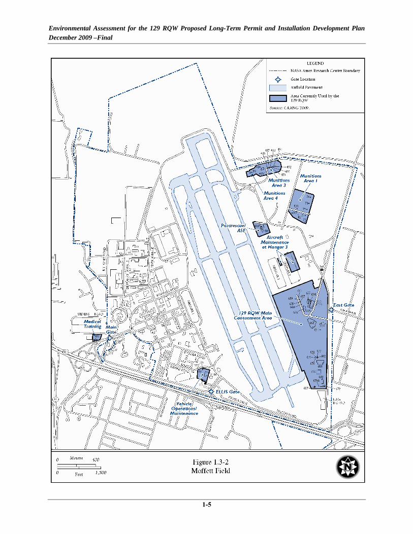
Moffett Field is located at the southern end of San Francisco Bay, 32 miles south of San Francisco and 10 miles north of San Jose (Figure 1.3-1). The approximately 2,000-acre facility, located in Santa Clara County, abuts the City of Sunnyvale to the south and southeast and the City of Mountain View to the west and southwest. The 129 RQW currently occupies seven parcels at Moffett Field, with most operations occurring on five parcels comprising 126 acres on the east side of the installation and two on the west side of the installation (Figure 1.3-2).

Environmental Assessment for the 129 RQW Proposed Long-Term Permit and Installation Development Plan December 2009 –Final
1-4
Figure 1.3-1 Regional Location Map, Moffett Field, California
Environmental Assessment for the 129 RQW Proposed Long-Term Permit and Installation Development Plan December 2009 –Final
1-5
Figure 1.3-2 Moffett Field

Environmental Assessment for the 129 RQW Proposed Long-Term Permit and Installation Development Plan December 2009 –Final
1-6
In April 1955, the 129th Air Resupply Group was activated at Hayward Airport, California. Although the mission remained the same, the unit underwent three name changes and several aircraft conversions between its initial activation and April 1975. In April 1975, the 129th Air Resupply Group received a new mission, designation, and Air Force Command. Shortly afterward, the 129th Air Resupply Group also changed aircraft and its operating base. The 129th Air Resupply Group became the 129th Aerospace Rescue and Recovery Group and in 1984 completed its programmed move to Naval Air Station (NAS) Moffett Field, California, and became a permitted tenant of the Navy. In October 1989, the 129th Aerospace Rescue and Recovery Group was designated as the 129th Air Rescue Group and began converting from the HH-3E “Jolly Green Giant” helicopter to the HH-60G “Pave Hawk” helicopter; the conversion was complete in 1991. In March 1992, the name was shortened to the 129th Rescue Group, and in June 1992 it became the 129 RQW. In 1991, the Base Realignment and Closure Act selected NAS Moffett Field to realign/close. In July 1994, the NAS at Moffett Field was disestablished and the majority of the property was officially transferred to NASA, with NASA ARC being the host organization. Three housing areas were transferred to the USAF, which were later transferred to the Army. Today, the 129 RQW continues to conduct combat search and rescue (CSAR) operations on a global scale.
The overall mission of the 129 RQW is to provide a trained and equipped rescue force able to respond to and sustain their state and federal missions. The 129 RQW’s federal mission is to provide personnel, material, and equipment resources to conduct CSAR operations on a worldwide basis; and to provide manpower, material, and equipment to conduct and complete peacetime search and rescue operations. Their state mission is to furnish trained personnel to respond to state emergencies, such as natural disasters, and to assist civil authorities in the enforcement of the law, and state fire fighting air operations.
1.4 SUMMARY OF KEY ENVIRONMENTAL REQUIREMENTS
1.4.1 National Environmental Policy Act
In accordance with NEPA of 1969 (42 USC 4321-4347), CEQ Regulations for Implementing the Procedural Provisions of NEPA (40 CFR §§ 1500-1508), and the USAF implementing regulation 32 CFR § 989, et seq., Environmental Impact Analysis Process, the NGB has prepared this EA that evaluates the potential consequences to the human and natural environment that may result from implementation of these activities.
NEPA requires federal agencies to take into consideration the potential environmental consequences of proposed actions in their decision-making process. The intent of NEPA is to protect, restore, and enhance the environment through well-informed federal decisions. The CEQ was established under NEPA to implement and oversee federal policy in this process. The
Environmental Assessment for the 129 RQW Proposed Long-Term Permit and Installation Development Plan December 2009 –Final
1-7
CEQ subsequently issued the Regulations for Implementing the Procedural Provisions of NEPA (40 CFR §§ 1500–1508) (CEQ 1978).
The activities addressed within this document constitute a federal action and therefore must be assessed in accordance with NEPA. To comply with NEPA, as well as other pertinent environmental requirements, the decision-making process for the Proposed Action includes the development of this EA to address the environmental issues related to the proposed activities.
1.4.2 Water Resources Regulatory Requirements
The Clean Water Act (CWA) of 1977 (33 USC § 1251 et seq.) regulates pollutant discharges that could affect aquatic life forms or human health and safety. Section 404 of the CWA, and Executive Order (EO) 11990, Protection of Wetlands, regulate development activities in or near streams or wetlands. Section 404 also regulates development in streams and wetlands and requires a permit from the United States Army Corps of Engineers (USACE) for dredging and filling in wetlands. EO 11988, Floodplain Management, requires federal agencies to take action to reduce the risk of flood damage; minimize the impacts of floods on human safety, health, and welfare; and to restore and preserve the natural and beneficial values served by floodplains. Federal agencies are directed to consider the proximity of their actions to or within floodplains.
1.4.3 Cultural Resources Regulatory Requirements
The National Historic Preservation Act (NHPA) of 1966 (16 USC § 470) established the National Register of Historic Places (NRHP) and the Advisory Council on Historic Preservation (ACHP) outlining procedures for the management of cultural resources on federal property. Cultural resources can include archaeological remains, architectural structures, and traditional cultural properties such as ancestral settlements, historic trails, and places where significant historic events occurred. NHPA requires federal agencies to consider potential impacts to cultural resources that are listed, nominated to, or eligible for listing on the NRHP; designated a National Historic Landmark; or valued by modern Native Americans for maintaining their traditional culture. Section 106 of NHPA requires federal agencies to consult with State Historic Preservation Officers (SHPOs) if their undertakings might affect such resources. Protection of Historic and Cultural Properties (36 CFR § 800 [1986]) provided an explicit set of procedures for federal agencies to meet their obligations under the NHPA, which includes inventorying of resources and consultation with SHPO.
The American Indian Religious Freedom Act (AIRFA) (42 USC § 1996) established federal policy to protect and preserve the rights of Native Americans to believe, express, and exercise their traditional religions, including providing access to sacred sites. The Native American Graves Protection and Repatriation Act (NAGPRA) (25 USC §§ 3001–3013) requires

Environmental Assessment for the 129 RQW Proposed Long-Term Permit and Installation Development Plan December 2009 –Final
1-8
consultation with Native American tribes prior to excavation or removal of human remains and certain objects of cultural importance.
The Archaeological Resources Protection Act of 1979 (16 USC §§ 470aa-mm) was created to protect archaeological resources and sites on public and Native American lands in addition to encouraging cooperation and exchange of information between governmental authorities, professionals, and private individuals. The act establishes civil and criminal penalties for destruction and alteration of cultural resources.
1.4.4 Clean Air Act
The Clean Air Act (CAA) (42 USC §§ 7401–7671q, as amended) provided the authority for the United States Environmental Protection Agency (USEPA) to establish nationwide air quality standards to protect public health and welfare. Federal standards, known as the National Ambient Air Quality Standards (NAAQS), were developed for six criteria pollutants: ozone (O3), nitrogen dioxide (NO2), carbon monoxide (CO), sulfur dioxide (SO2), both coarse and fine inhalable particulate matter (less than or equal to 10 microns in diameter [PM10], and particulate matter less than or equal to 2.5 microns in diameter [PM2.5]), and lead (Pb). The Act also requires that each state prepare a State Implementation Plan (SIP) for maintaining and improving air quality and eliminating violations of the NAAQS. In nonattainment and maintenance areas, the CAA requires federal agencies to determine whether their proposed actions conform with the applicable SIP and demonstrate that their actions will not (1) cause or contribute to a new violation of the NAAQS, (2) increase the frequency or severity of any existing violation, or (3) delay timely attainment of any standard, emission reduction, or milestone contained in the SIP. The CAA (Section 112g) also specifies provisions for controlling the release of Hazardous Air Pollutants (HAPs) from industrial activities. In addition, under the Proposed Action CAANG would obtain appropriate permits for other emitters such as emergency generators, boilers, paint-booths, etc.
1.4.5 Endangered Species Act
The Endangered Species Act (ESA) of 1973 (16 USC §§ 1531–1544, as amended) established measures for the protection of plant and animal species that are federally listed as threatened and endangered, and for the conservation of habitats that are critical to the continued existence of those species. Federal agencies must evaluate the effects of their proposed actions through a set of defined procedures, which can include the preparation of a Biological Assessment and can require formal consultation with the United States Fish and Wildlife Service (USFWS) under Section 7 of the Act.

Environmental Assessment for the 129 RQW Proposed Long-Term Permit and Installation Development Plan December 2009 –Final
1-9
1.4.6 Other Environmental Requirements
Other environmental requirements that potentially apply to the implementation of this proposal include guidelines promulgated by EO 12898, Federal Actions to Address Environmental Justice in Minority Populations and Low-Income Populations, to ensure that disproportionately high and adverse human health or environmental effects on citizens in these categories are identified and addressed, as appropriate. Additionally, potential health and safety impacts that could disproportionately affect children are considered under the guidelines established by EO 13045, Protection of Children from Environmental Health Risks and Safety Risks.
1.4.7 Environmental Coordination Requirements
EO 12372, Intergovernmental Review of Federal Programs, requires intergovernmental notifications prior to making any detailed statement of environmental impacts. Through the process of Interagency and Intergovernmental Coordination for Environmental Planning (IICEP), the proponent must notify concerned federal, state, and local agencies and allow them sufficient time to evaluate potential environmental impacts of a proposed action. Comments from these agencies are subsequently incorporated into the EIAP. An IICEP list of relevant federal, state, and local agencies is provided in Appendix A.

Environmental Assessment for the 129 RQW Proposed Long-Term Permit and Installation Development Plan December 2009 –Final
1-10
[This page intentionally left blank.]

Environmental Assessment for the 129 RQW Proposed Long-Term Permit and Installation Development Plan December 2009 –Final
2-1
CHAPTER 2 PROPOSED ACTION AND ALTERNATIVES
2.1 INTRODUCTION
The 129 RQW currently occupies seven parcels, 88 facilities and 51 buildings at Moffett Field (see Figure 1.3-2); the remainder of Moffett Field, under the authority of NASA and the Army, are used by these agencies and their tenants. The 129 RQW proposes to reconfigure and consolidate its facilities to the extent possible and to implement AT/FP requirements, while providing the necessary functional areas required for the 129 RQW mission. The 129 RQW would enter into a long-term permit with NASA for the property they currently occupy, as well as an additional parcel they propose to acquire. There are no proposed changes in operations conducted by the 129 RQW as a result of proposed construction and permit implementation. Operational activity conducted by the 129 RQW would remain consistent with current operations. The Army is redeveloping Orion Park where the existing CAANG medical facility is located. The CAANG would relocate the medical facility to their main cantonment area, vacating Building 685, and return the property to the Army. NASA also has plans to eventually open the NASA Research Park (on the west side of the runway) and the portion of the Eastside/Airfield east of the runway to the public. This would create an unsecure installation for the 129 RQW that is not compliant with AT/FP requirements. However, current NASA security requirements still require that the NASA Ames Campus be fenced and access controlled. The 129 RQW also proposes to remedy some of their functional space shortfalls by constructing some new facilities that would meet the authorized square footage requirements per ANG Handbook 32-1084, Facility Requirements, as necessary. These collective actions would allow NASA ARC as property holder to promote economical and efficient use of facilities and allow the 129 RQW to carry out their mission more effectively.
Construction projects would incorporate Leadership in Energy and Environmental Design (LEED) and sustainable development concepts, so as to achieve optimum resource efficiency, constructability, sustainability, and energy conservation, while minimizing adverse impacts to the built and natural environments through all phases of its life cycle. Incorporation of sustainability practices may result in primary facility costs exceeding DoD costing standards, but the initial investment in higher acquisition cost would be rewarded with lower life cycle costs. These efforts are consistent with the requirements of the Energy Policy Act of 2005 and EO 13423 Strengthening Federal Environmental, Energy, and Transportation Management. Since the proposed construction, demolition, operations, and maintenance activities would occur over time as new federal requirements for sustainability are developed, projects and activities would incorporate these requirements consistent with USAF policy.

Environmental Assessment for the 129 RQW Proposed Long-Term Permit and Installation Development Plan December 2009 –Final
2-2
There are four action alternatives for accomplishing this action presented in the following sections, as well as the No Action alternative.
2.2 ALTERNATIVE #1 (PREFERRED ALTERNATIVE)
Under Alternative #1, the 129 RQW would implement the construction and demolition projects, including the associated operation and maintenance of the facilities and functions, as described in Table 2.2-1, Sections 2.2.2 - 2.2.4, and shown in Figure 2.2-1. In addition, the 129 RQW would acquire, by permit, an additional parcel of land from NASA as shown in Figure 2.2-1 and described in Section 2.2.1, while releasing several other parcels back to NASA and the Army. Upon approval, the 129 RQW would enter into a long-term permit with NASA for the property they propose to occupy.
2.2.1 Real Property Action
To consolidate the main cantonment area into one contiguous parcel and provide an area for the construction of a new MSC (Project 8 described in Section 2.2.2), the 129 RQW is seeking to establish a long-term permit with NASA for the property they currently occupy within the main cantonment area, in addition to acquiring an additional parcel south of the current cantonment area (Figure 2.2-2). CAANG operations in areas to be described as shared use in the proposed permit (e.g., the taxiway near Runway 32R and temporary use areas) would not change under the Proposed Action, and would be within the scope of the existing NEPA documentation. Due to safety buffer requirements (known as quantity-distance [QD] arcs), the proposed MSC and its safety buffer would not fit within the confines of the current cantonment area. The parcel proposed for acquisition by permit is approximately 13.5 acres and consists of an open field that has been previously disturbed. In addition, there would be a 26.3-acre restricted easement (or some other similar real property instrument) surrounding this 13.5-acre parcel consisting of the QD arcs plus an additional 100-foot buffer around the QD arcs.
In addition, Building 685 (Medical Squadron facility) would be transferred to the Army, and Buildings 146 (Vehicle Operations/Maintenance), 574 (Equipment Storage), 992 (Equipment Storage), 684 (ASE), 686 (Pararescue facility), Munitions Storage Areas (MSAs) 1, 3, 4, and Hangar 3 would be returned to NASA (Figure 2.2-2 and Table 2.2-2).
2.2.2 Construction Associated with Consolidation of Main Cantonment Area
The following construction projects would be implemented for the purpose of consolidating all of the CAANG facilities into one main cantonment area.
Proposed MSC Location

Environmental Assessment for the 129 RQW Proposed Long-Term Permit and Installation Development Plan December 2009 –Final
2-3
Table 2.2-1. Proposed Projects (Page 1 of 2)
Project Title1
Total Construction
Footprint (SF)
Total Demolition1
(SF)
New Impervious
Surface (SF)
Estimated Year of
Implementation CONSTRUCTION ASSOCIATED WITH CONSOLIDATION OF MAIN CANTONMENT AREA Project #1 – QMSN 099051 a) Overwatch 100 100 2010 b) Main Roadway 168,822 84,411 2010 c) Security Fence 10,673 linear
feet 0 2010 d) Parking Lot 104,300 104,300 2010 e) Guard House and Vehicle Inspection
Area 300 300 2010 f) Alternate Guard House 100 100 2010
Project #2 – QMSN 092802 CATS/CATM Addition 1,293 1,293 2010 Renovation of Building 653 2010 Project #3 – QMSN 019029 a) Aerospace Pararescue and Recovery 38,200 38,200 2011 b) Survival Equipment Shop 9,450 9,450 2011 c) Life Support 7,130 7,130 2011
Project #4 – QMSN 092803 Communications Tower Relocation 3,500 2011 Project #5 – QMSN 099104 a) Vehicle Maintenance Shop 5,600 5,600 2012 b) Refueler Maintenance Shop 1,500 1,500 2012 c) Vehicle Administration 1,300 1,300 2012 d) Aerial Port 19,700 19,700 2012 e) Vehicle Maintenance and Base
Hazardous Storage Shed 7,800 7,800 2012 Project #6 – QMSN 099105 Jet Engine Inspection and Maintenance Shop 7,000 0 2012 Project #7 – QMSN 099106 ASE Complex 14,600 7,300 2013 Project #8 – QMSN 099107 New MSC 5,500 5,500 2013 Demolition of MSA 1 (Buildings 70-74, 143, 147, and 528) 3,392
Demolition of MSA 3 (Buildings 484-492) 11,449 Demolition of MSA 4 (Building 561) 2,180 OTHER CONSTRUCTION Project #9 – QMSN 099108 a) Squadron Operations 36,700 36,700 2014 b) Administration for Weather Flight 950 950 2014 c) Demolition of Building 654 13,067 2014 d) Demolition of Building 669 26,304 2014
Project #10 – QMSN 099109 a) Reserve Forces Ops Training 21,400 21,400 2014 b) Band 7,000 7,000 2014 c) Audio Visual Center 2,550 2,550 2014
Environmental Assessment for the 129 RQW Proposed Long-Term Permit and Installation Development Plan December 2009 –Final
2-4
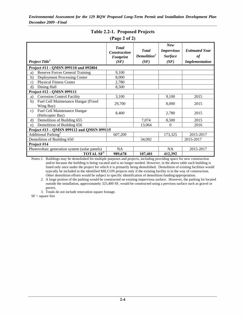
Table 2.2-1. Proposed Projects (Page 2 of 2)
Project Title1
Total Construction
Footprint (SF)
Total Demolition1
(SF)
New Impervious
Surface (SF)
Estimated Year of
Implementation Project #11 - QMSN 099110 and 092804 a) Reserve Forces General Training 9,100 b) Deployment Processing Center 8,000 c) Physical Fitness Center 2,780 d) Dining Hall 8,500
Project #12 - QMSN 099111 a) Corrosion Control Facility 3,100 9,100 2015 b) Fuel Cell Maintenance Hangar (Fixed
Wing Bay) 29,700 8,000 2015 c) Fuel Cell Maintenance Hangar
(Helicopter Bay) 8,400 2,780 2015 d) Demolition of Building 655 7,074 8,500 2015 e) Demolition of Building 656 13,064 0 2016
Project #13 – QMSN 099112 and QMSN 099115 Additional Parking2 607,200 173,325 2015-2017 Demolition of Building 650 34,092 2015-2017 Project #14 Photovoltaic generation system (solar panels) NA NA 2015-2017
TOTAL SF3 989,678 107,401 412,392 Notes: 1. Buildings may be demolished for multiple purposes and projects, including providing space for new construction
and/or because the building is being vacated and is no longer needed. However, in the above table each building is listed only once under the project for which it is primarily being demolished. Demolition of existing facilities would
typically be included in the identified MILCON projects only if the existing facility is in the way of construction. Other demolition efforts would be subject to specific identification of demolition funding/appropriation. 2. A large portion of the parking would be constructed on existing impervious surface. However, the parking lot located outside the installation, approximately 325,400 SF, would be constructed using a pervious surface such as gravel or pavers. 3. Totals do not include renovation square footage.
SF = square feet

Environmental Assessment for the 129 RQW Proposed Long-Term Permit and Installation Development Plan December 2009 –Final
2-5
Figure 2.2-1. 129 RQW Proposed Projects – Alternative #1

Environmental Assessment for the 129 RQW Proposed Long-Term Permit and Installation Development Plan December 2009 –Final
2-6
Figure 2.2-2. Proposed Property Transactions at Moffett Field

Environmental Assessment for the 129 RQW Proposed Long-Term Permit and Installation Development Plan December 2009 –Final
2-7
Table 2.2-2. Photographs of 129 RQW Properties to be Relinquished MSA 3
MSA 1 Building 146 Building 574
Building 684 Building 685 Building 686

Environmental Assessment for the 129 RQW Proposed Long-Term Permit and Installation Development Plan December 2009 –Final
2-8
Project 1: Force Protection Measures
The 129 RQW would require additional force protection measures to create a secure cantonment area separate from the NASA campus, given that in the NASA Ames Development Plan, NASA expressed its intent to create a shared use campus. In order to make the cantonment area compliant with AT/FP requirements, a chain-link security fence eight feet tall with barbed wire would need to be constructed to surround the entire cantonment area. Fences constructed near the east parallel runway (32R) would comply with Federal Aviation Regulation Part 77, Obstructions to Navigation, and established Obstacle Free Zones. In addition, a new entrance would be constructed at the northern end of the cantonment area, as shown in Figure 2.2-2. The new entrance would consist of a guard house, an overwatch, and a parking lot. The entrance would include drop-in or retractable bollards to slow traffic through a serpentine traffic flow. In addition, speed humps would be placed accordingly along the approach to the gate in order to slow traffic. An overwatch area would be located just inside the gate, which would act as final security for unauthorized personnel trying to enter the installation. This facility would have controls to activate an active vehicle barrier system (pop-up barrier), if needed. Construction of a new access road into and within the cantonment area would also be necessary. This road would be approximately 25 feet wide (including shoulders) and 1.5 miles long. Additional security AT/FP concerns are addressed in Project 8, MSC.
Project 2: CATS/CATM Addition
The 129 RQW requires adequate facilities for support of the CATS/CATM functions. The required facility would contain space for classroom instruction, administration, weapons maintenance, weapons cleaning and degreasing, weapons and ammunition storage, and a small arms simulator for handguns, rifles, shotguns, or submachine guns. This function is currently housed in Hangar 3 (Building 47), which is located west of the runway. In order to consolidate the 129 RQW facilities into one main cantonment area, a 4,073 square foot (SF) addition to Building 653 would be constructed to house the CATS/CATM functions. This addition would be collocated with the new fitness facility described under Project 11 below. The CATS/CATM function would occupy 1,293 SF of this facility. In addition, there would be approximately 507 SF of interior renovations to Building 653 to accommodate these new functions.
Project 3: Pararescue Facility, Life Support Maintenance Area, and Survival Equipment Shop
The 129 RQW requires facilities for support of units with an airborne pararescue mission. Pararescue personnel are on a continuous alert status and need the pararescue facility, life support maintenance area, and survival equipment shop in order to efficiently and quickly deploy rescue personnel using a variety of methods. Pararescue functions are currently scattered among

Environmental Assessment for the 129 RQW Proposed Long-Term Permit and Installation Development Plan December 2009 –Final
2-9
three locations in Buildings 656, 686, and Hangar 3. In order to consolidate this function into one facility within the main cantonment area, a new 54,780 SF building would be constructed near the south end of the ramp (refer to Figure 2.2-1). This facility would include areas for classrooms, administration, as well as a survival equipment shop that contains an area for parachute inspection and packing, a room for parachute washing and drying tower, sewing room for repair, and flotation room for inspection, inflation, and repacking of rubberized survival equipment. In addition, this facility would house space for life support systems maintenance, care, storage, and issue of flying clothing and equipment. This new building would be constructed southwest of Building 662 and would be adjacent or attached to the new Squadron Operations building described in Project 9 below.
Project 4: Relocation of Communications Towers
The construction of the new building for the pararescue facility (Project 3) would cause line of sight issues with the current communications towers, which are located adjacent to Building 688. As a result, the communications towers would need to be relocated to the west side of the airfield within NASA’s antenna farm. Measures to deter raptors and other birds would be implemented on the communications tower. The existing concrete pad would remain; however, 3,500 linear feet of conduit would need to be installed from the current location to the antenna farm, running around the end of the airfield and along the right-of-way on Macon Road. The conduit would be buried approximately 3 to 4 feet deep.
Project 5: Vehicle Maintenance shop, Vehicle Administration, and Aerial Port Training
The 129 RQW vehicle maintenance facilities are currently located west of the airfield, outside the CAANG main cantonment area (refer to Figure 1.3-2). Under this project, the 129 RQW would construct a new 28,100 SF facility north of Building 681 within the main cantonment area, in what is currently an open field. A separate 7,800 SF vehicle maintenance storage shed and base hazardous materials and hazardous waste storage facility would be constructed to the east, also within an open field. The larger of the two new facilities would contain space for general repair, painting, welding, testing, cleaning, and other general maintenance functions, as well as space for administrative functions. In addition, this facility would house classrooms for Aerial Port Training. Aerial Port personnel are trained in managing in-transit passenger and cargo movements. No formal facility is currently dedicated to Aerial Port Training; however, these functions are currently located in Building 681.
Communications Towers
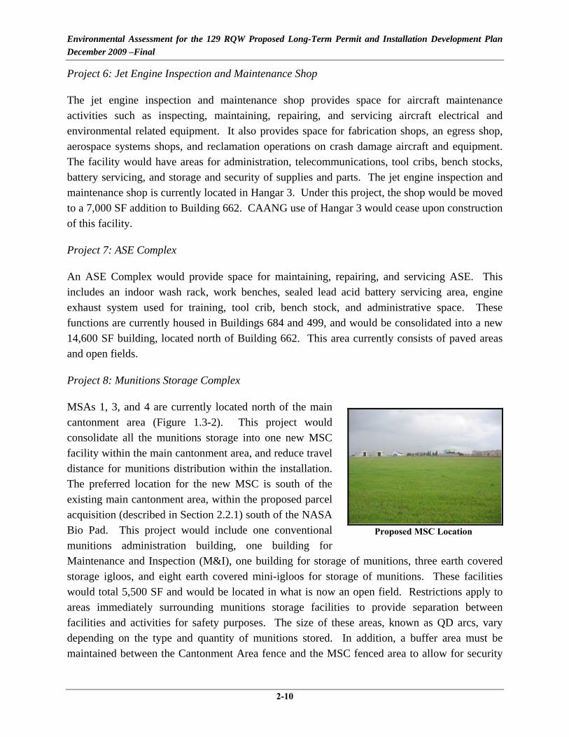
Environmental Assessment for the 129 RQW Proposed Long-Term Permit and Installation Development Plan December 2009 –Final
2-10
Project 6: Jet Engine Inspection and Maintenance Shop
The jet engine inspection and maintenance shop provides space for aircraft maintenance activities such as inspecting, maintaining, repairing, and servicing aircraft electrical and environmental related equipment. It also provides space for fabrication shops, an egress shop, aerospace systems shops, and reclamation operations on crash damage aircraft and equipment. The facility would have areas for administration, telecommunications, tool cribs, bench stocks, battery servicing, and storage and security of supplies and parts. The jet engine inspection and maintenance shop is currently located in Hangar 3. Under this project, the shop would be moved to a 7,000 SF addition to Building 662. CAANG use of Hangar 3 would cease upon construction of this facility.
Project 7: ASE Complex
An ASE Complex would provide space for maintaining, repairing, and servicing ASE. This includes an indoor wash rack, work benches, sealed lead acid battery servicing area, engine exhaust system used for training, tool crib, bench stock, and administrative space. These functions are currently housed in Buildings 684 and 499, and would be consolidated into a new 14,600 SF building, located north of Building 662. This area currently consists of paved areas and open fields.
Project 8: Munitions Storage Complex
MSAs 1, 3, and 4 are currently located north of the main cantonment area (Figure 1.3-2). This project would consolidate all the munitions storage into one new MSC facility within the main cantonment area, and reduce travel distance for munitions distribution within the installation. The preferred location for the new MSC is south of the existing main cantonment area, within the proposed parcel acquisition (described in Section 2.2.1) south of the NASA Bio Pad. This project would include one conventional munitions administration building, one building for Maintenance and Inspection (M&I), one building for storage of munitions, three earth covered storage igloos, and eight earth covered mini-igloos for storage of munitions. These facilities would total 5,500 SF and would be located in what is now an open field. Restrictions apply to areas immediately surrounding munitions storage facilities to provide separation between facilities and activities for safety purposes. The size of these areas, known as QD arcs, vary depending on the type and quantity of munitions stored. In addition, a buffer area must be maintained between the Cantonment Area fence and the MSC fenced area to allow for security
Proposed MSC Location

Environmental Assessment for the 129 RQW Proposed Long-Term Permit and Installation Development Plan December 2009 –Final
2-11
response outside of the MSC area. Security Force Vehicles must be able to be at a minimum of 25 meters away from the MSC security fence, while still within the Cantonment Area fence. MSAs 1, 3, and 4 would be vacated and returned to NASA, and would eventually be demolished. MSAs 3 and 4, which are in an existing NASA owl preserve would be managed for Burrowing Owl mitigation as intended in the NASA Area Development Plan EIS and ROD (2002).
2.2.3 Additional Construction
ANG Handbook 32-1084, Facilities Handbook, provides guidance on standards and requirements for facilities within the ANG. The goal of the facility requirements handbook is to promote economy and efficiency in the use and development of facilities. In addition to consolidating the CAANG facilities into one main cantonment area, the 129 RQW proposes to construct new facilities that would meet with the intentions of the handbook and better facilitate the mission.
Project 9: Squadron Operations Building
The 129 RQW requires facilities for squadron operation functions including administration, scheduling, training, briefing and personal equipment maintenance and storage for aircrews. Currently, squadron operation functions are located within four different buildings (654, 656, 669, and Hangar 3), which impairs efficient operations. The construction of the new Squadron Operations Building would consolidate all of the squadron operations into one building. In addition, this building would house administration functions for the 129 RQW Weather Flight. The new Squadron Operations Building would be a 2-story building, with a footprint of approximately 36,700 SF, located south of Building 662. This new building would be adjacent or attached to the new Pararescue Facility described above in Project 3. Alternative #1 includes vacating Hangar 3 and demolishing Buildings 654, 656, and 669.
Project 10: Reserve Forces O&T, Band, Audio-Visual
The 129 RQW requires facilities for Reserve Forces Operations and Training (O&T), as well as for the Band and audio-visual operations. O&T requires adequate training classrooms to conduct lectures with the aid of computers and “state of the art” audio-visual equipment. The 561st Air Force Band requires proper acoustical space for the operation and administration of the band for rehearsing and performing. The Reserve Forces O&T is currently located in Buildings 680 and 653, while the band is currently located in Building 669. These functions would be relocated to a newly constructed 2-story building, with approximately a 56,650 SF footprint, located in what is now an open field. Within this facility, 30,950 SF would be dedicated to this project. The remaining 25,700 SF would be dedicated to general training, deployment processing, and a new dining hall described in Project 11. Under Alternative #1, buildings 650 and 669 would be demolished and Building 680 would be vacated.

Environmental Assessment for the 129 RQW Proposed Long-Term Permit and Installation Development Plan December 2009 –Final
2-12
Project 11: Dining Hall, Deployment Processing, General Training
Project 11 would include new facilities for a new fitness center, dining hall, administrative offices for deployment processing, and classroom facilities for general training. The fitness center would be located within a 4,073 SF addition to Building 653 and would occupy 2,780 SF of the facility. The dining hall, deployment processing, and general training would comprise 25,700 SF within the new 56,650 SF building described in Project 10.
Project 12: Corrosion Control, Fuel Cell Maintenance Hangar
Currently the 129 RQW does not have a dedicated space for the Corrosion Control function. The purpose of a Corrosion Control facility is to provide for proper maintenance of aircraft and ground support equipment. The Corrosion control facility would include an environmentally controlled area to wash aircraft and equipment and provides hangar space for corrosion treating, repairing, paint-stripping, and repainting. In addition, a fuel cell maintenance hangar and is required in order to provide space for aircraft maintenance of fuel systems (external aircraft fuel tanks) with proper mechanical ventilation, fume sensing and alarm, fire extinguishing systems, and wash down drainage trenches. Under this project, the 129 RQW would build a 41,200 SF hangar for these functions north of Building 662, where existing parking and Buildings 655 and 656 are currently located. Buildings 655, 659, and associated parking would be demolished in order to provide space for this new construction.
Project 13: Additional Parking
Three additional parking areas would be required to support the new buildings that are being constructed, as well as to support the operations currently being housed within existing buildings. These three parking areas to be constructed under this project would total approximately 607,200 SF and would be located partially where Building 650 is currently located and partially within what is now an open field. Building 650 would be demolished in order to provide space for this new construction. Per AT/FP requirements (UFC 4-010-01), within a controlled perimeter, such as the 129 RQW requires, parking cannot occur any closer than 10 meters (25 feet) to any building. Therefore, it is practical to locate a consolidated parking area in one or two large areas rather than creating several smaller parking lots that are limited in size due to this requirement. Constructing fewer but larger parking areas may require
Proposed Corrosion Control Facility
Location

Environmental Assessment for the 129 RQW Proposed Long-Term Permit and Installation Development Plan December 2009 –Final
2-13
slightly more walking from the parking area than before, but consolidation of parking improves overall efficiency of the installation and complies with the guidance for AT/FP.
The 129 RQW requires additional parking to support Unit Training Assembly (UTA) on the weekends. This new parking area would be located over an existing City of Sunnyvale reclaimed water supply easement within Moffett Field boundaries, but outside the 129 RQW main cantonment area, to the east along Macon Road. It would be split into two main covered parking areas, totaling approximately 325,400 SF in size. This parking area would not be paved, but would be constructed using a permeable surface such as gravel or pavers.
Project 14: Photovoltaic Generation System (Solar Panels)
To pursue the intent of EO 13423 to incorporate renewable energy at federal facilities, the additional parking areas outside of the main cantonment area (described in Project 13) would also be primary candidates for the construction of photovoltaic generator systems (solar panels). Solar panels would be constructed on the roofs of the covered parking.
The 129 RQW of the CAANG requires electrical power in order to meet its assigned missions. All operational, administrative, logistical, medical, and support are in need of reliable and cost effective electrical energy to meet current and forecasted demand loads and energy consumption. The 129 RQW is required to meet DoD requirement for the implementation of the use of renewable energy sources wherever economically feasible. Implementation of this system would reduce demand and associated charges in the peak summer months, reduce impact on the power grids, and provide for usage of a renewable energy source. In addition, critical facilities would continue to have power in the event of rolling blackouts or unexpected power outage.
2.2.4 Demolition
As a result of the construction of new facilities for the 129 RQW, existing facilities would be demolished that are obsolete and/or in the footprint of the proposed facilities. All facilities that previously contained hazardous materials would be closed in accordance with County of Santa Clara requirements. Table 2.2-3 describes the buildings and facilities that would be demolished.

Environmental Assessment for the 129 RQW Proposed Long-Term Permit and Installation Development Plan December 2009 –Final
2-14
Table 2.2-3. Proposed Demolitions Building Number Building Description/Purpose Area (SF)
650 Aircraft Maintenance and Medical 34,092 654 Squadron Operations 13,067
655 Base Warehouse Supply and Equipment 7,074
656 Squadron Operations 13,054
669 Multi-use (Storage, band, small fitness center, squadron operations) 26,304
70-74, 143, 147, and 528 MSA 1 3,392
484-492 MSA 3 11,449 561 MSA 4 2,180

Environmental Assessment for the 129 RQW Proposed Long-Term Permit and Installation Development Plan December 2009 –Final
2-15
Building 650 Aircraft Maintenance and Medical Building 654 Squadron Operations
Building 655 Storage (dry/cold) Building 656 Squadron Operations
Building 669 Multi-Use Building (storage, band, MSA 1
small fitness center, squadron operations)
Building 486-492 MSA 3 Building 484 MSA 4

Environmental Assessment for the 129 RQW Proposed Long-Term Permit and Installation Development Plan December 2009 –Final
2-16
2.3 ALTERNATIVE #2
Under Alternative #2, all construction and demolition projects described in Alternative #1 would be implemented, including the MSAs 1, 3, and 4 as authorized and appropriated by Congress. However, the location of Project 8, the MSC, would differ. Rather than being located in the single cantonment area described under Alternative #1, the new MSC would be located on the north side of the main cantonment area, where Hole 14 of the golf course is currently located (Figure 2.3-1). This parcel of land is approximately 11.6 acres in size and would be acquired by permit from NASA in addition to the parcel located south of the cantonment area described in Alternative #1. Additionally, there would be a 28-acre restricted easement (or some other similar real property instrument) surrounding this 11.6-acre parcel consisting of the QD arcs and a 100-foot buffer around the QD arcs that fall outside the parcel. This project would include construction of a 5,500 SF facility, including one conventional munitions building, one building for M&I, one building for storage of munitions, three earth covered storage igloos, and eight earth covered mini-igloos for storage of munitions 1. Security fencing would also be installed around this parcel of land and the MSC. The 13.5-acre parcel located south of the main cantonment area, described in Alternative #1, would still be acquired by permit for future development options.
This alternative would consolidate the CAANG facilities into two non-contiguous parcels, and would require a longer travel distance for munitions shipments than Alternative #1. This alternative would require the CAANG to reconfigure the golf course and reconstruct Hole 14 in an alternate location. Hole 14 would be relocated within one of the existing MSA areas, as approved and appropriated by Congress.
Alternative #2 MSC Location

Environmental Assessment for the 129 RQW Proposed Long-Term Permit and Installation Development Plan December 2009 –Final
2-17
Figure 2.3-1. 129 RQW Proposed Projects – Alternative #2

Environmental Assessment for the 129 RQW Proposed Long-Term Permit and Installation Development Plan December 2009 –Final
2-18
2.4 ALTERNATIVE #3
Under Alternative #3, all construction and demolition projects described under Alternative #1 would be implemented, with the exception of the pervious parking area proposed for the east side of Macon Road (part of Project #13) and the photovoltaic generation system that is associated with it (Project #14). The 129 RQW would instead use the existing parking garages located in the Moffett Towers development east of Mary Street for additional parking to support UTA on the weekends. Currently, approximately 250 CAANG personnel enter the facility on weekdays while approximately 900 people enter the facility during the once-per-month drill weekend. To facilitate parking off-installation at the Moffett Towers development, a new entrance gate would be installed near the intersection of Mary Street and 11th Avenue. As described above, NASA has stated in the NASA Ames Development Plan and associated Programmatic EIS and ROD (2002) that it may eventually open up the NASA Research Park (on the west side of the runway) and the Eastside/Airfield (east of the runway) to the public. Until NASA decides to open up these areas, controlled access at this proposed gate would be required. As 129 RQW personnel frequently need to drop equipment from their POV’s off at their workplace, this entrance would allow for convenient access to the main cantonment area from the Moffett Towers parking garages. A roadway extension connecting 11th Avenue to Macon Road would also be constructed and would be approximately 68 feet wide and 140 feet long (approximately 9,520 square feet [SF] of additional impervious surface). Sidewalks, curbs, and gutters would also be included in this roadway extension. This project is labeled as Project #15 on Figure 2.4-1.
2.5 ALTERNATIVE #4
Under Alternative #4, all construction and demolition projects described in Alternative #2 would be implemented, with the exception of the pervious parking area proposed for the east side of Macon Road (part of Project #13) and the photovoltaic generation system that is associated with it (Project #14). The 129 RQW would instead use the existing parking garages located in the Moffett Towers development east of Mary Street for additional parking to support UTA on the weekends. Currently, approximately 250 CAANG personnel enter the facility on weekdays while approximately 900 people enter the facility during the once-per-month drill weekend. To facilitate parking off-installation at the Moffett Towers development, a new entrance gate would be installed near the intersection of Mary Street and 11th Avenue. As indicated above, NASA has stated in the NASA Ames Development Plan and associated Programmatic EIS and ROD (2002) that it may eventually open up the NASA Research Park (on the west side of the runway) and the Eastside/Airfield (east of the runway) to the public. Until NASA decides to open up these areas, controlled access at this proposed gate would be required. As 129 RQW personnel frequently need to drop equipment from their POV’s off at their workplace, this entrance would allow for convenient access to the main cantonment area from the Moffett Towers parking garages. A roadway extension connecting 11th Avenue to Macon Road would also be constructed and would be approximately 68 feet wide and 140 feet long (approximately 9,520 SF of additional impervious surface). Sidewalks, curbs, and gutters would also be included in this roadway extension. This project is labeled as Project #15 on Figure 2.5-1.

Environmental Assessment for the 129 RQW Proposed Long-Term Permit and Installation Development Plan December 2009 –Final
2-19
Figure 2.4-1. 129 RQW Proposed Projects – Alternative #3

Environmental Assessment for the 129 RQW Proposed Long-Term Permit and Installation Development Plan December 2009 –Final
2-20
Figure 2.5-1. 129 RQW Proposed Projects – Alternative #4

Environmental Assessment for the 129 RQW Proposed Long-Term Permit and Installation Development Plan December 2009 –Final
2-21
2.6 NO ACTION ALTERNATIVE
The CEQ regulation 40 CFR § 1502.14(d) specifically requires analysis of the “No Action” alternative in all NEPA documents. Under the No Action Alternative, the 129 RQW would not implement the actions described above; the 129 RQW would maintain their existing facilities and would not build the new facilities proposed. CAANG would continue to operate without an agreement with NASA, which would not meet current Congressional intent or 1994 Navy direction to tenants to renegotiate use agreements with NASA within 6 months of the Navy transfer of the majority of the former NAS Moffett Field to NASA. Under the No Action Alternative, existing AT/FP deficiencies would remain, and would be exacerbated once NASA opened their campus to the public, leaving the installation vulnerable to close attack by potential terrorist activity, and resulting in potential threats to mission-critical resources and potentially impairing the 129 RQW’s ability to conduct their mission successfully. It is important to note that under the No Action alternative, activities described above would not be implemented; however, any activities that have already been analyzed under separate or even subsequent NEPA could be implemented, as appropriate per the associated decision documents.

Environmental Assessment for the 129 RQW Proposed Long-Term Permit and Installation Development Plan December 2009 –Final
2-22
[This page intentionally left blank.]

Environmental Assessment for the 129 RQW Proposed Long-Term Permit and Installation Development Plan December 2009 –Final
3-1
CHAPTER 3 AFFECTED ENVIRONMENT
This section describes relevant existing environmental conditions for resources potentially affected by the four action alternatives, as well as the No Action Alternative, presented in Chapter 2. In describing the affected environment, a framework for understanding the potential direct, indirect, and cumulative effects of the proposed action and alternatives is provided.
As directed by guidelines contained in NEPA, CEQ regulations, and 32 CFR § 989, et seq., The Environmental Impact Analysis Process, the description of the affected environment focuses only on those resource areas potentially subject to impacts and should be commensurate with the anticipated level of environmental impact.
This EA analyzes potential environmental effects for the following resource areas: earth resources, water resources, biological resources, air quality, land use and visual resources, socioeconomics and environmental justice, cultural resources, solid and hazardous materials and wastes, safety, and infrastructure/transportation. The following subsections contain definitions of each resource, and existing conditions for each resource within the associated region of influence (ROI) for each alternative.
3.1 EARTH RESOURCES
3.1.1 Definition of the Resource
Earth resources include geology, soils, and topography. Geology is the study of the origin, history, and structure of the earth and the materials of which it is made; geological resources of an area typically consist of surface and subsurface materials and their inherent properties. Soil refers to the unconsolidated earthen organic or mineral materials overlying bedrock or other parent material. Soil structure, elasticity, strength, shrink-swell potential, and erodibility all determine the suitability of the ground to support man-made structures and facilities. Relative to development, soils typically are described in terms of their type, slope, physical characteristics, and relative compatibility or limitations with regard to particular construction activities and types of land use. Topography incorporates the physiographic or surface features of an area and is usually described with respect to elevation, slope, aspect, and landforms. Long-term geological, erosional, and depositional processes typically influence the topographic relief of an area.
The ROI for earth resources considered in this EA includes the 129 RQW installation. The geologic description for the project site is general to the Moffett Field including the 129 RQW, while the soils and topographic discussions are site specific, where applicable.

Environmental Assessment for the 129 RQW Proposed Long-Term Permit and Installation Development Plan December 2009 –Final
3-2
3.1.2 Existing Conditions
3.1.2.1 Geology
Moffett Field is located in the Santa Clara Valley within a physiographic area known as the Central California Coastal Valleys, an area consisting of gently sloping valley floors surrounded by high terraces, alluvial fans, and steep uplands. The coastal valleys in this area are considered structural basins and are filled primarily with marine sedimentary rocks. The coarser, more permeable sand and gravel deposits within these basins store relatively large volumes of fresh groundwater, often susceptible to saltwater intrusion and overdraft. The uplands, foothills, and hills in this area are also susceptible to landslides in steep areas where bedrock is weakened by fault movement and/or lack of cementation. The northeast-southeast orientation of the valleys is controlled by lateral movement along a regional set of faults including the Northern San Andreas, Rodgers Creek, Hayward, and Calaveras Fault Zones (United States Department of Agriculture [USDA] 2006).
Moffett Field is located within one of the most seismically active areas in the United States (U.S.). Although no known active faults exist at Moffett Field, the installation is proximate to three active faults: the Hayward-Rodgers Creek Fault located nine miles to the northeast, the Calaveras Fault located 13 miles to the southeast, and the Northern San Andreas Fault located nine miles to the west (NASA 2002). The probability of a large magnitude earthquake within the next 30 years is considered to be particularly high along the Hayward-Rodgers Creek Fault Zones, and has been historically high along the San Andreas Fault Zone (United States Geological Survey [USGS] 2008). Impacts from seismic hazards at this location could include ground shaking, liquefaction, differential settlement, and cracking impacting the structural design, siting, and construction of buildings at the 129 RQW (NASA 2002; State of California 1996).
3.1.2.2 Soils
According to the Natural Resources Conservation Service (NRCS) and the USDA, the dominant soil orders within the Central California Coastal Valleys physiographic area include Alfisols, Entisols, Mollisols, and Vertisols. Soils in this area tend to be very deep, excessively drained to poorly drained, and loamy and clayey (USDA 2006).
A soil mapping unit represents an area that is dominated by one major kind of soil, or an area dominated by several types of soils (a complex). Moffett Field has three distinct soil mapping units:
Sunnyvale silty clay: The majority of the Moffett Field consists of Sunnyvale silty clay to a depth between 11 and 18 inches. The Sunnyvale silty clay is characterized by a black clay to

Environmental Assessment for the 129 RQW Proposed Long-Term Permit and Installation Development Plan December 2009 –Final
3-3
clay loam, fine texture, poor drainage, high fertility, moderate alkalinity, and a strongly calcareous subsoil (NASA 2002; NRCS 1975).
Alviso clay: The northern end of the Eastside/Airfield area consists of Alviso clay to a depth between 6 to 10 inches. Alviso clay soils are typically saline (due to proximity to tidal marsh) and dark gray with calcareous subsoil. These soils typically exhibit low fertility, very poor drainage, very slow runoff, and slow permeability. As the water table in this area is only one to three feet below the surface, this soil type is usually damp (NASA 2002; NRCS 2001).
Kitchen middens: Soils located in the middle of the Eastside/Airfield area are classified as Kitchen middens. This soil is characteristically dark gray, calcareous, or clay loam with materials such as ashes, stones, bones, or mixed-in shell fragments (NASA 2002).
The soil types above exhibit characteristics typical of soils high in clay content that can create structural hazards with regard to the construction of man-made structures and facilities including: (1) malleable and compressible surfaces which lead to soil compression and differential settlement around buildings; (2) high shrink-swell potential with seasonal fluctuations in the water table level that cause stress to concrete slabs and pavement resulting in cracking and heaving; and (3) low permeability of soils causing localized flooding conditions during heavy rains with the potential to corrode untreated pipes (NASA 2002; NRCS 1975, 2001).
3.1.2.3 Topography
Moffett Field is located in the Santa Clara Valley, a relatively flat alluvial plain at the southwestern edge of San Francisco Bay between the Northern San Andreas and Hayward-Rodgers Creek faults. The valley is bordered to the west by the Santa Cruz Mountains and to the east by the Diablo Range (USDA 2006). The site slopes from north to south at a rate of about one percent and changes from an elevation of approximately 40 feet above sea level in the southern portion and at or below sea level in the northern area of the airfield. Subsidence of the valley occurred due to agricultural pumping which ceased in the 1930s. The major topographic features are a series of flood control levees north of Moffett Field that provide marginal protection from tidal flooding of the San Francisco Bay (CAANG 1998a). The USACE is currently conducting a South San Francisco Bay Shoreline Study to evaluate the need for levee improvements (USACE 2009).
3.2 WATER RESOURCES
3.2.1 Definition of the Resource
Water resources analyzed in this EA include both surface and groundwater quantity and quality, and floodplains. Wetlands are discussed in Section 3.3, Biological Resources. Drinking water

Environmental Assessment for the 129 RQW Proposed Long-Term Permit and Installation Development Plan December 2009 –Final
3-4
wells and distribution systems, reclaimed water systems, wastewater facilities, and stormwater infrastructure are discussed in Section 3.11, Infrastructure.
Surface water includes all lakes, ponds, rivers, and streams and is important for a variety of reasons including irrigation, power generation, recreation, flood control, and human health. The nation’s waters are protected under the statutes of the CWA; the goal of which is to restore and maintain the chemical, physical, and biological integrity of the nation’s waters so that they can support “the protection and propagation of fish, shellfish, and wildlife and recreation in and on the water.” Under the CWA Section 402, it is illegal to discharge any point and/or nonpoint pollution sources into any surface water without a National Pollutant Discharge Elimination System (NPDES) permit. The USEPA is charged with administering the NPDES permit program; however, the state of California has legal authority to implement and enforce the provisions of the CWA, while the USEPA retains oversight responsibilities. Pollutants regulated under the CWA include “priority” pollutants, including various toxic pollutants; “conventional” pollutants, such as biochemical oxygen demand measures (determining the rate of uptake of dissolved oxygen by biological organisms), total suspended solids, fecal coliform, oil and grease, and alkaline or acidic pH levels; and “non-conventional” pollutants, including any pollutant not identified as either conventional or priority. CWA Section 404 regulates the discharge of dredged and fill materials into waters of the U.S., including wetlands. Responsibility for administering and enforcing Section 404 is shared by the USACE and USEPA. The USEPA and USACE regard the use of mechanized earth-moving equipment to conduct activities in waters of the U.S. (e.g., land clearing, ditching, channelization, and in-stream mining) as regulated discharge of dredged or fill material under Section 404, unless project-specific evidence shows otherwise. Under CWA Section 401, applicants for a federal license or permit to conduct activities that may result in the discharge of a pollutant into waters of the U.S. must obtain certification from the state in which the discharge would originate, or if appropriate, from the interstate water pollution control agency with jurisdiction over affected water at the point where the discharge would originate. Therefore, all projects that have a federal component and may affect state water quality (including projects that require federal agency approval [such as the issuance of a state 404 permit]) must also comply with the CWA Section 401.
The Coastal Zone Management Act of 1972 (16 USC Section 1451 et seq.), with the California State Coastal Conservancy as the regulatory body, encourages coastal states to develop comprehensive programs to manage coastal resources. It requires federal agency activities to be consistent with the state’s federally approved coastal management program.
Groundwater includes the subsurface hydrologic resources of the physical environment and can be a safe and reliable source of fresh water for the general population, especially those in areas of limited precipitation and is commonly used for potable water consumption, agricultural irrigation, and industrial applications. Groundwater is the part of precipitation that seeps down

Environmental Assessment for the 129 RQW Proposed Long-Term Permit and Installation Development Plan December 2009 –Final
3-5
through the soil until it reaches rock material that is saturated with water. Water in the ground is stored in the spaces between rock particles. Groundwater also plays an important part in the overall hydrologic cycle. Its properties are described in terms of depth to aquifer or potentiometric surface, water quality, and surrounding geologic composition. An aquifer is a formation, group of formations, or part of a formation that contains sufficient saturated, permeable material to yield significant quantities of water to wells and springs. Groundwater in California is regulated under the Federal Safe Drinking Water Act, the California Safe Drinking Water and Toxic Enforcement Act of 1986, and the State Porter-Cologne Act implemented by the State Water Resources Control Board, the State Department of Public Health Division of Drinking Water and Environmental Management, and the San Francisco Bay Regional Water Quality Control Boards (RWQCB). In addition, the Santa Clara Valley Water District Ordinance 90-1 regulates wells and other deep excavations that may affect groundwater resources.
Floodplains are defined by EO 11988, Floodplain Management, as “the lowland and relatively flat areas adjoining inland and coastal waters including flood-prone areas of offshore islands, including at a minimum, the area subject to a one percent or greater chance of flooding in any given year” (that area inundated by a 100-year flood). Floodplains and riparian habitat are biologically unique and highly diverse ecosystems providing a rich diversity of aquatic and terrestrial species, as well as promoting stream bank stability and regulating water temperatures. EO 11988 requires federal agencies to avoid, to the extent possible, the long- and short-term adverse impacts associated with the occupancy and modification of floodplains and to avoid direct or indirect support of floodplain development whenever there is a practicable alternative.
In 1969, the California Legislature enacted the Porter-Cologne Water Quality Control Act to preserve, enhance, and restore the quality of California’s water resources. The Act established the State Water Resources Control Board and nine RWQCBs as the principal state agencies with the responsibility for controlling water quality in California. Under the Act, water quality policy is established, water quality standards are enforced for both surface and ground water, and the discharges of pollutants from point and non-point sources are regulated. In California, the NPDES program is administered by the State Water Resources Control Board and the RWQCBs who issue NPDES permits and enforce regulations within their respective region.
The ROI for water resources in this EA is Moffett Field, and nearby surface waters that receive runoff generated within the project area.

Environmental Assessment for the 129 RQW Proposed Long-Term Permit and Installation Development Plan December 2009 –Final
3-6
3.2.2 Existing Conditions
3.2.2.1 Surface Water
The 129 RQW installation lies within the Santa Clara Basin. This large regional watershed encompasses 840 square miles and drains to the South Bay portion of the San Francisco Bay (Santa Clara Valley Water District 2003). The major hydrologic features surrounding the 129 RQW cantonment area include the San Francisco Bay (and associated saltwater evaporation ponds, stormwater retention ponds, and wetlands) abutting the airfield to the north; Coyote Creek and Guadalupe Slough to the east; and Stevens Creek to the west.
Surface water runoff on the installation is dominated by a series of manmade ditches, storm drains, and drainage swales. No natural surface water features are located within the 129 RQW property; however, stormwater drainage ditches, several small ponds, seasonal marshes, and stormwater retention ponds can be found within Moffett Field (NASA 2009a). In general, there are two separate drainage areas for Moffett Field: the western drainage system encompassing 680 acres and the eastern drainage system encompassing 1,010 acres. Stormwater from the eastern drainage system, including from the 129 RQW cantonment area, airfield runways, and all lands east of the runways, flows north through several storm drain lines and overland flow to the Northern Channel. This water is discharged downstream to the easternmost Lockheed pond through a culvert. This water is then pumped into the Moffett Channel where it is ultimately discharged into the Guadalupe Slough and then to the San Francisco Bay. Stormwater from the western drainage system of Moffett Field, including most of the area west of the runways, discharges through the Settling Basin and Eastern Diked Marsh to the Stormwater Retention Pond (NASA 2002, 2009a).
NASA and its tenants (including the 129 RQW) operate under NPDES permits (including General Permit No. CAS000004 for stormwater discharges from small municipal separate storm sewer systems and No. CAS000001 for industrial activities excluding construction activities) for stormwater runoff at Moffett Field (NASA 2009a).
3.2.2.2 Floodplains
Per Federal Emergency Management Agency (FEMA) Flood Insurance Rate Map Panel No. 0603370045E, Moffett Field is located within an area designated as Zone D, indicating areas of undetermined, but possible, flood hazards (FEMA 1988). Per a NASA floodplain study (NASA 2002, n.d.), the majority of the northern portion of the Moffett Field is located within a 100-year floodplain. While the majority of 129 RQW facilities are located outside of the identified 100-year floodplain, the Pararescue/ASE facility and MSAs 1, 3, and 4 are located within

Environmental Assessment for the 129 RQW Proposed Long-Term Permit and Installation Development Plan December 2009 –Final
3-7
the 100-year floodplain (Figure 3.2-1). Moffett Field is protected from bay flooding by dikes and levees built to control flooding of salt ponds in South San Francisco Bay. Currently, the USACE is conducting a study to determine whether and how to improve the levee system.
3.2.2.3 Groundwater
Moffett Field is located within the Santa Clara Valley groundwater basin, a large, northwest-trending structural trough covering 153,600 acres (240 square miles) which is bordered by the Santa Cruz Mountains on the west and the Diablo Range on the east (Department of Health and Human Services 2009; Santa Clara Valley Water District 2004). Groundwater below Moffett Field is divided into four aquifers, listed in approximate distance from the surface: The A aquifer, which is divided into the Upper A aquifer (0 to 35 feet below ground surface [BGS]) and the lower A aquifer (35 to 55 feet BGS); the B aquifer (55 to 160 feet BGS); the C aquifer (160 to 250 feet BGS); and the Deep aquifer (> 240 BGS) (U.S. Department of the Navy 2009a). Groundwater elevations vary seasonally and with location throughout the 129 RQW cantonment area, but generally range between five and nine feet BGS (CAANG 1998a).
A regional groundwater contamination plume, located within the A and B aquifers, flows beneath Moffett Field towards the San Francisco Bay. There is no contamination in the C aquifer below Moffett Field or Deep aquifers. However, there is contamination in the C aquifer outside of Moffett Field. The regional plume stems from two main sources: 1) migration of groundwater contaminated with chlorinated volatile organic compounds (VOCs) from the USEPA-designated Superfund Site outside Moffett Field across U.S. Highway 101 at sites owned by the Middlefield-Ellis-Whisman (MEW) companies and 2) contamination from solvents, petroleum hydrocarbons, and fuel-related constituents (including benzene, toluene, ethylbenzene, and xylene) stemming from past military operations during the Navy’s administration of the Base. The Navy, NASA, and the MEW companies are jointly conducting remediation and have installed and are operating groundwater remediation systems under USEPA and California RWQCB oversight. The groundwater remediation treatment systems operated by the Navy, NASA, and the MEW companies consists of a total of 18 groundwater extraction wells that pump groundwater to three nearby treatment plants, each individually operated by the Navy, NASA, and the MEW companies (NASA 2005; U.S. Department of the Navy 2009a). The estimated extent of the groundwater plumes beneath Moffett Field is illustrated in Figure 3.8-1 Also depicted in Figure 3.8-1 are the locations of Installation Restoration Program (IRP) sites, all of which is discussed in further detail in Section 3.8, Hazardous Materials and Waste.

Environmental Assessment for the 129 RQW Proposed Long-Term Permit and Installation Development Plan December 2009 –Final
3-8
Figure 3.2-1. Hydrologic Resources Adjacent to the 129 RQW Property at Moffett Field

Environmental Assessment for the 129 RQW Proposed Long-Term Permit and Installation Development Plan December 2009 –Final
3-9
Moffett Field is currently covered under a NPDES General Permit (No. CAG912003) to regulate discharge or reuse of extracted and treated groundwater resulting from the cleanup of groundwater polluted by VOCs (NASA 2009a).
3.3 BIOLOGICAL RESOURCES
3.3.1 Definition of the Resource
Biological resources include living, native, or naturalized plant and animal species and the habitats within which they occur. Plant associations are referred to as vegetation and animal species are referred to as wildlife. Habitat can be defined as the resources and conditions present in an area that produces occupancy of a plant or animal (Hall et al. 1997). Although the existence and preservation of biological resources are intrinsically valuable, these resources also provide aesthetic, recreational, and socioeconomic values to society. This analysis focuses on species or vegetation types that are important to the function of the ecosystem, of special societal importance, or are protected under federal or state law or statute. For purposes of this EA, these resources are divided into four major categories: vegetation; wetlands; wildlife; and special status species.
Vegetation types include all existing terrestrial plant communities as well as their individual component species. The affected environment for vegetation includes only those areas potentially subject to ground disturbance.
Wetlands are considered sensitive habitats and are subject to federal regulatory authority under Section 404 of the CWA and EO 11990, Protection of Wetlands. Jurisdictional wetlands are defined by the USACE as those areas that are inundated or saturated by surface or groundwater at a frequency and duration sufficient to support, and that under normal circumstances do support, a prevalence of vegetation typically adapted for life in saturated soil conditions (U.S. Department of the Army 1987). Areas meeting the federal wetland definition are under the jurisdiction of the USACE. Wetlands generally include swamps, marshes, bogs, and similar areas. Like vegetation, the affected environment for wetlands includes only those areas potentially subject to ground disturbance.
Wildlife includes all fish, amphibian, reptile, bird, and mammal species with the exception of those identified as special status species. Wildlife also includes those bird species protected under the federal Migratory Bird Treaty Act, the Bald and Golden Eagle Protection Act, and other species-specific conservation legal authorities. Assessment of a project’s effect on migratory birds places an emphasis on “species of concern” as defined by EO 13186, Responsibilities of Federal Agencies to Protect Migratory Birds. Additional assessment of potential impacts on migratory birds that are regionally rare occurs under the special status species category.

Environmental Assessment for the 129 RQW Proposed Long-Term Permit and Installation Development Plan December 2009 –Final
3-10
Special status species are defined as those plant and animal species listed as endangered, threatened, and species proposed for listing by the USFWS or California Department of Fish and Game (CDFG). The federal ESA protects federally listed endangered and threatened plant and animal species. Federally identified candidate species (species proposed for listing) are not protected under law; however, these species could become listed and, therefore, protected at any time. Their consideration early in the planning process may avoid future conflicts that could otherwise occur. Additionally, the CDFG protects state-listed plant and animal species through the California ESA and state fish and wildlife and administrative codes.
3.3.2 Existing Conditions
3.3.2.1 Vegetation
Most of the areas associated with CAANG facilities at Moffett Field are actively landscaped or paved, with little natural vegetation or habitat remaining. Due to land practices involved with airfield construction and maintenance, much of the airfield’s native vegetation has been removed and is actively maintained (i.e., mowed or landscaped) to minimize bird/wildlife aircraft strike hazard (BASH) potential. Areas associated with CAANG buildings and facilities consist of landscaped vegetation comprised of ornamental trees, shrubs, and mowed lawns. The only quality natural vegetative communities and wildlife habitat within Moffett Field are located outside the proposed project area, within the Bay View area. This area includes seasonal salt marsh and dense stands of coyote brush (Baccharis piluaris) scrub.
3.3.2.2 Wildlife
Moffett Field is bordered to the south, east, and west by a substantial amount of urban development. Tidal marshes exist to the north and contain the majority of habitat supportive of wildlife. Wildlife species typically found in the vicinity of the CAANG facilities include those that tolerate human activity and development. Common species observed at the installation include pacific tree frog (Hyla regilla), American Coot (Fulica americana), House Finch (Carpodacus mexicanus), Mallard (Anas platyrhynchos), Mourning Dove (Zenaida macroura), Northern Mockingbird (Mimus polyglottos), Botta’s pocket gopher (Thomomys bottae), raccoon (Procyon lotor), red fox (Vulpes vulpes), California ground squirrel (Spermophilus beecheyi), house mouse (Mus musculus), and western harvest mouse (Reithrodontomys megalotus). Due to its proximity to wetlands and open water habitats, the Bay View area supports a variety of migratory waterfowl including the Western Gull (Larus occidentalis), American Coot (Fulica americana), Canada Goose (Branta canadensis), Northern Shoveler (Anas clypeata), Mallard (Anas platyrhynchos), Green-backed Heron (Butorides striatus) and Pied-billed Grebe (Podilymbus podiceps) (NASA 2002).

Environmental Assessment for the 129 RQW Proposed Long-Term Permit and Installation Development Plan December 2009 –Final
3-11
The Don Edwards San Francisco Bay National Wildlife Refuge is approximately one mile northwest of Moffett Field. The refuge hosts over 280 species of shorebirds and waterfowl each year, millions of which stop over during spring and fall migration (USFWS 2009a).
3.3.2.3 Threatened and Endangered and Special Status Species
Four federally listed animals occur within the boundaries of Moffett Field; however, none occur within the project area. In addition, ten species of special concern and/or state listed species have been observed within Moffett Field (Table 3.3-1). The Western Burrowing Owl (Athene cunicularia hypugea), which is listed as a California Species of Concern, has been observed east of the airfield within the CAANG main cantonment area, but none have been observed within the proposed construction footprints. The Burrowing Owl is the only owl that nests underground, using burrows abandoned by other animals, primarily ground squirrels in northern California. Burrowing Owl habitat is typically open, dry, and sparsely vegetated. According to the NASA Ames Development Plan Final Programmatic EIS (NASA 2002), the South San Francisco Bay region supported a population of approximately 94 breeding pairs in 2004 (NASA 2009b). However, according to the CDFG, as of 2008 there are currently 50 breeding pairs (CDFG 2009). Past surveys have observed as many as 61 adults and 25 breeding pairs at Moffett Field (NASA 2002, 2009). However, recent surveys from spring of 2009 found 33 active burrows, 15 of which were active nests, 12 of the 15 nests had chicks, two were failed nests, and one was a nest of indeterminate success (Figure 3.3-1). During the 2009 survey, 74-75 total Burrowing Owls were observed (33-34 adults and 41 chicks). This is an increase of 37 percent from the 2008 survey, which identified 31 adults and 23 chicks (NASA 2009b). In addition, approximately 440 acres of grasslands and 330 acres of wetland areas are used for foraging. In 2002, NASA prepared a Burrowing Owl Habitat Management plan that presents techniques for protecting the owls and their habitat, and establishes several Burrowing Owl nesting habitat preserves comprising 81 acres (NASA 2002) (Figure 3.3-1). Additional areas are considered potential habitat for burrows, however are not considered part of the preserves (Figure 3.3-1). Mitigation measures were developed by NASA to avoid impacts to owls during normal operations and construction (NASA 2002).
3.3.2.4 Wetlands
Wetland delineations have been completed for portions of the Moffett Field, including the Bay View area, the Eastside Airfield area (excluding the golf course), and the area immediately north of the Bay View area (NASA 2002). Approximately 42.4 acres of seasonal jurisdictional wetlands were identified on Moffett Field. Approximately 5.3 acres of wetlands are located in the northwest portion within the Bay View area, while 16.8 acres are located north of the Bay View area. An additional 20.3 acres of wetlands occur on the east side of the airfield (Figure 3.2-1) (NASA 2002). However, no wetlands occur within the project area for proposed construction and demolition at the 129 RQW installation.

Environmental Assessment for the 129 RQW Proposed Long-Term Permit and Installation Development Plan December 2009 –Final
3-12
Table 3.3-1. Endangered, Threatened, and Special Status Species Present at Moffett Field (Page 1 of 2)
Common Name Scientific Name Federal Status
State Status
Description and Location within Moffett Field
Salt Marsh Common Yellowthroat Geothypis trichas sinuosa - SSC
Rare migrant during breeding season (March – July) in freshwater and brackish marshes and adjacent habitat within and north of Bay View area; not present within the project area.
Loggerhead Shrike Larius ludovicianus SSC SSC
Resident and winter visitor in lowland and foothills – observed in Bay View area in upland habitats adjacent to freshwater and brackish marshes; not present within the project area.
White-tailed Kite Elanus leucurus - FP
Year-round resident of low rolling foothills, valley margins, and forages in open grasslands and marsh habitats. Common at Moffett Field, and have been found nesting north of Bay View area; not present within the project area.
Western Burrowing Owl
Athene cunicularia hypugea FFNCC SSC
Habitat is typically open, dry, and sparsely vegetated. Recent surveys from spring of 2009 have found 33 active burrows. 74-75 total Burrowing Owls were observed (33-34 adults and 41 chicks). Some projects are located within habitat preserves, some active nests are located near or within a project area, but not within the footprint.
Northern Harrier Circus cyaneus - FP
Found in coastal salt and freshwater marshes and are common in the Bay View area; not present within the project area.
Golden Eagle Aquila chrysaetos - SSC,
MBTA, BGEPA
Observed in the Bay View area with foraging habitat available in the non-native grasslands and weed-dominated habitats; not present within the project area.
Horned Lark Eremophila alpestris aetia - SSC
Occur in open habitats with little tree coverage and has been observed in the Bay View area; not present within the project area.
American Peregrine Falcon Falco peregrines anatum - E
Foraging habitat present within annual grasslands and weed-dominated area. Uncommon at Moffett Field.

Environmental Assessment for the 129 RQW Proposed Long-Term Permit and Installation Development Plan December 2009 –Final
3-13
Table 3.3-1. Endangered, Threatened, and Special Status Species Present at Moffett Field (Page 2 of 2)
Common Name Scientific Name Federal Status
State Status
Description and Location within Moffett Field
Western pond turtle Clemmys marmorata - SSC
Found in ponds, streams, marshes, and reservoirs; requires upland habitat for breeding. One has been observed in the Marriage Road Ditch in the eastside/airfield area, and several in the Northern channel, north of the eastside/airfield area; has not been observed within the main cantonment area or within the footprints of the proposed project area.
Salt marsh harvest mouse
Reithrodontomys raviventris raviventris E E
Found within coastal salt marsh habitat. Present north of Bay View area; not present within the project area.
California Brown Pelican Pelecanus occidentalis FDP SCD
Found within coastal salt marsh habitat. Present north of Bay View area, not observed breeding; not present within the project area.
California Clapper Rail Rallus longirostris obsoletus E E
Found within coastal salt marsh habitat. Present north of Bay View area; not present within the project area.
California Least Tern Sterna antillarum browni E E
Found within coastal salt marsh habitat. Present north of Bay View area, not observed breeding; not present within the project area.
Western Snowy Plover Charadrius alexandrines nivosus T -
Found within coastal salt marsh habitat. Present north of Bay View area, not observed breeding; not present within the project area.
E= Endangered T= Threatened FP = Fully protected under Section 3511 of the CDFG code. FSNCC = Federal species of national conservation concern. FDP = Federally proposed for delisting SCD = State proposed for delisting MBTA = Protected under the Migratory Bird Treaty Act BGEPA = Protected under the Bald and Golden Eagle Protection Act SSC = California Species of Special Concern Source: NASA 2002

Environmental Assessment for the 129 RQW Proposed Long-Term Permit and Installation Development Plan December 2009 –Final
3-14
Figure 3.3-1. Burrowing Owl Burrow Locations and Habitat Areas at Moffett Field
Environmental Assessment for the 129 RQW Proposed Long-Term Permit and Installation Development Plan December 2009 –Final
3-15
3.4 AIR QUALITY
3.4.1 Definition of the Resource
Air quality is defined as the ambient air concentrations of specific pollutants determined by the USEPA to be of concern to the health and welfare of the general public. There are six of these pollutants, also known as “criteria pollutants,” which include O3, CO, NO2, SO2, PM2.5, PM10, and Pb. USEPA’s overall automotive emission control program has gradually reduced the Pb content of gasoline. This program has essentially eliminated violations of the Pb standard in urban areas except those areas with Pb point sources. There are no existing or proposed Pb point sources within the project footprint; therefore, Pb is not carried forward for detailed air quality analysis.
The national standards, established by the USEPA, are termed the NAAQS. The NAAQS represent maximum acceptable concentrations for pollutants of concern. State standards, established by the California Air Resources Board (CARB), are termed the California Ambient Air Quality Standards (CAAQS). The CAAQS are equal to or more stringent than the NAAQS and include pollutants for which national standards do not exist. Table 3.4-1 presents the applicable NAAQS and CAAQS for the project area.
3.4.1.1 Criteria Pollutants
Ozone: The majority of ground-level O3 (more commonly known as “smog”) is formed as a result of complex photochemical reactions in the atmosphere between VOCs, nitrogen oxides (NOx), and oxygen. VOCs and NOx are considered precursors to the formation of O3, a highly reactive gas that can damage lung tissue and affect respiratory function. While O3 in the lower atmosphere is considered a damaging air pollutant, O3 in the upper atmosphere is beneficial, as it protects the earth from harmful ultraviolet radiation. However, atmospheric processes preclude ground-level O3 from reaching the upper atmosphere (USEPA 2009b).
Carbon Monoxide: CO is a colorless, odorless, poisonous gas produced by the incomplete combustion of fossil fuels. Elevated levels of CO can result in harmful health effects, especially for the young and elderly, and can also contribute to global climate change (USEPA 2009b).
Nitrogen Dioxide: NO2 is a brownish, highly reactive gas produced primarily as a result of the burning of fossil fuels. NO2 can also lead to the formation of O3 in the lower atmosphere. NO2 can cause respiratory ailments, especially in the young and elderly, and can lead to degradations in the health of aquatic and terrestrial ecosystems (USEPA 2009b).

Environmental Assessment for the 129 RQW Proposed Long-Term Permit and Installation Development Plan December 2009 –Final
3-16
Table 3.4-1. California and National Ambient Air Quality Standards
Pollutant Averaging Time California Standards1
NATIONAL STANDARDS2
Primary Secondary
Ozone (O3) 8 Hour 0.070 ppm (137 µg/m3) 0.075 ppm (147 µg/m3) Same as Primary
Standards 1 Hour 0.09 ppm (180 µg/m3) • Carbon Monoxide
(CO) 8 Hour 9.0 ppm (10 mg/m3) 9 ppm (10 mg/m3)
• 1 Hour 20 ppm (23 mg/m3) 35 ppm (40 mg/m3)
Nitrogen Dioxide (NO2)
Annual Arithmetic Mean 0.030 ppm (57 µg/m3) 0.053 ppm (100 µg/m3) Same as Primary
Standard 1 Hour 0.18 ppm (339 µg/m3) •
Sulfur dioxide (SO2)
Annual Arithmetic Mean • 0.030 ppm (80 µg/m3) •
24 Hour 0.04 ppm (105 µg/m3) 0.14 ppm (365 µg/m3) •
3 Hour • • 0.5 ppm (1300 µg/m3)
1 Hour 0.25 ppm (655 µg/m3) • •
Respirable Particulate Matter ≤ 10 Microns in Diameter (PM10)
Annual Arithmetic Mean 20 µg/m3 • Same as Primary
Standards 24 Hour 50 µg/m3 150 µg/m3
Respirable Particulate Matter ≤ 2.5 Microns in Diameter (PM2.5)
Annual Arithmetic Mean 12 µg/m3 15.0 µg/m3 Same as Primary
Standards 24 Hour No Separate Standard 35 µg/m3
Sulfates 24 Hour 25 µg/m3 • •
Lead (Pb)
30 Day Average 1.5 µg/m3 • • Calendar Quarter • 1.5 µg/m3
Same as Primary Standard Rolling 3-Month
Average • 0.15 µg/m3
Hydrogen Sulfide (H2S) 1 Hour 0.03 ppm (42 µg/m3) • •
Vinyl Chloride (chloroethene) 24 Hour 0.01 ppm (26 µg/m3) • •
Visibility Reducing Particles
8 Hour (10 a.m. to 6 p.m.)
Insufficient amount to produce an extinction coefficient of 0.23 per
kilometer due to particles when the
relative humidity is less than 70 percent. Measurement in
accordance with CARB Method V.
• •
Notes: 1. CO, SO2 (1- and 24-hour), NO2, O3, PM10, and visibility reducing particles standards are not to be exceeded. 2. No to be exceeded more than once a year except for annual standards. ppm = parts per million; µg/m3 = micrograms per cubic meter; mg/m3 = milligrams per cubic meter; • = no standard established Sources: CARB 2009a; USEPA 2009a

Environmental Assessment for the 129 RQW Proposed Long-Term Permit and Installation Development Plan December 2009 –Final
3-17
Sulfur Dioxide: SO2 is emitted primarily from the combustion of coal and oil by steel mills, pulp and paper mills, and from non-ferrous smelters. High concentrations of SO2 can aggravate existing respiratory and cardiovascular diseases in asthmatics and others who suffer from emphysema or bronchitis. SO2 also contributes to acid rain, which can in turn lead to the acidification of lakes and streams (USEPA 2009b).
Particulate Matter: PM2.5 is referred to as fine particulates, which are believed to pose significant health risks as they can lodge deeply into the lungs. Studies have linked increased exposure to PM2.5 to respiratory and cardiovascular disease as well as premature death (USEPA 2009b). PM10 is typically comprised of dust, ash, soot, smoke, or liquid droplets emitted into the air. Fires, unpaved roads, construction activities, and natural sources (wind and volcanic eruptions) can contribute to increased PM10 concentrations. PM10 particles can be inhaled into the respiratory system, leading to the possible aggravation of lung diseases. Sources of PM2.5
and PM10 include crushing or grinding operations and dust from paved or unpaved roads (USEPA 2009b).
Lead. Sources of Pb include pipes, fuel, and paint, although the use of Pb in these materials has declined dramatically in recent years. Pb can be inhaled directly or ingested indirectly by consuming Pb-contaminated food, water, or dust. Fetuses and children are most susceptible to Pb poisoning, which can result in heart disease and nervous system damage (USEPA 2009b).
3.4.2 Existing Conditions
3.4.2.1 Regulatory Setting
Under the federal CAA, as amended, states are responsible for enforcing the established air quality regulations. The CARB enforces air pollution regulations and sets guidelines, as contained in the California SIP, to attain and maintain the NAAQS and CAAQS within the state of California. The CAA Amendments of 1990 established new federal nonattainment classifications, new emission control requirements, and new compliance dates for nonattainment areas. The severity of the nonattainment classification drives the associated requirements and compliance dates. The following section provides a summary of the federal, state, and local air quality rules and regulations that apply to the Proposed Action.
Federal Requirements
Section 176(c) of the 1990 CAA Amendments contains the General Conformity Rule (40 CFR 51.850-860 and 40 CFR 93.150-160). The General Conformity Rule requires any federal agency responsible for an action in a nonattainment or maintenance area to determine that the action conforms to the applicable SIP. This means that federally supported or funded activities will not

Environmental Assessment for the 129 RQW Proposed Long-Term Permit and Installation Development Plan December 2009 –Final
3-18
(1) cause or contribute to any new air quality standard violation, (2) increase the frequency or severity of any existing standard violation, or (3) delay the timely attainment of any standard, interim emission reduction, or other milestone. The rule allows for approximately 30 exemptions, assuming that they conform to an applicable SIP. Emissions of attainment pollutants are exempt from conformity analyses. Actions would conform to a SIP if their annual direct and indirect emissions remain less than the applicable de minimis thresholds. Formal conformity determinations are required for any actions that exceed these thresholds. However, if the total emissions of a pollutant from a federal action exceed 10 percent of a nonattainment area’s emissions inventory of that pollutant, the action is considered to be a regionally significant action and it would require a conformity determination. Based on the present attainment status of the San Francisco Bay Area Air Basin (see Section 3.5.3.3), the action alternatives would conform to the most recent USEPA-approved SIP if annual construction emissions do not exceed 100 tons of NOx or VOCs.
State Requirements
The California CAA of 1988, as amended in 1992, outlines a program to attain the CAAQS for O3, NO2, SO2, particulate matter, and CO by the earliest practical date. As shown in Figure 3.4-1, the CAAQS are more stringent than the NAAQS. CARB delegates the authority to regulate stationary source emissions to local air quality management districts. The CARB requires these agencies to develop their own strategies for achieving compliance with the NAAQS and CAAQS, but maintains regulatory authority over these strategies, as well as all mobile source emissions throughout the state.
Local Requirements
The Bay Area Air Quality Management District (BAAQMD) is responsible for regulating stationary sources of air emissions in the San Francisco Bay Area Air Basin. The BAAQMD Rules and Regulations (BAAQMD 2009) establish emission limitations and control requirements for stationary sources, based on their source type and magnitude.
The BAAQMD is responsible for developing and implementing the clean air plan for attainment and maintenance of the ambient air quality standards in the San Francisco Bay Area Air Basin. The Air District is in the process of preparing the 2009 Bay Area Clean Air Plan, which will include the following:
• update the Bay Area 2005 Ozone Strategy in accordance with the requirements of the California CAA to implement “all feasible measures” to reduce O3;
• consider the impacts of O3 control measures on particulate matter, air toxics, and greenhouse gases in a single, integrated plan; and

Environmental Assessment for the 129 RQW Proposed Long-Term Permit and Installation Development Plan December 2009 –Final
3-19
• review progress in improving air quality in recent years; establish emission control measures to be adopted or implemented in the 2009-2012 timeframe.
3.4.2.2 Climate and Meteorology
At an elevation just above sea level and adjacent to the moderating influence of San Francisco Bay and the nearby Pacific Ocean, the climate of Moffett Field is characterized by warm dry summers and cool, moist winters. During the warmer months of the year (normally May through October) the airfield is subject to morning and evening low clouds and fog with primarily sunny conditions occurring during the day. The majority of the annual average of 13.5 inches of rainfall occurs between November and April. The annual average high and low temperatures at Moffett Field are 68 degrees Fahrenheit (°F) and 50°F, respectively. Prevailing winds blow from the north-northwest in the region during daytime hours. Nocturnal winds and land breezes during the colder months of the year blow from the south.
3.4.2.3 Regional and Local Air Pollutant Sources
Moffett Field is located in the San Francisco Bay Area Air Basin, which includes the counties of San Francisco, Santa Clara, San Mateo, Marin, Napa, Contra Costa, and Alameda, along with the southeastern portion of Sonoma County and the southwestern portion of Solano County. As discussed above, the local air quality regulatory agency responsible for the basin is the BAAQMD.
An emission rate represents the mass of a pollutant released into the atmosphere by a given source over a specified period. The BAAQMD periodically updates emissions for the entire San Francisco Bay Area Air Basin for purposes of forecasting future emissions, analyzing emission control measures, and for use in regional air quality modeling. The largest regional sources of air emissions are on-road vehicles. The 2008 Santa Clara County inventory determined that on an average daily basis, on-road vehicles emitted 30 percent of VOCs, 50 percent of NOx, and 62 percent of CO emissions within Santa Clara County (CARB 2009b). Combustion sources produce both primary fine particulate matter and fine particulate precursor pollutants, such as NOx, which react in the atmosphere to produce secondary fine particulates. Coarser particles (PM10 and PM2.5) mainly occur from soil-disturbing activities, such as construction, mining, agriculture, wildfires, and vehicular road dust.
While the Bay Area is generally considered one of the cleanest major metropolitan areas in the country with respect to air quality, the San Francisco Bay Area Air Basin is in “marginal” nonattainment of the federal and state eight-hour ozone standards, and the state PM10 and PM2.5 standards (USEPA 2009c; CARB 2009c). The San Francisco Bay Area Air Basin (including Santa Clara County) is also considered a “moderate” maintenance area for the federal CO

Environmental Assessment for the 129 RQW Proposed Long-Term Permit and Installation Development Plan December 2009 –Final
3-20
standards and is in compliance with all other federal and state air quality standards (USEPA 2009c; CARB 2009c).
3.4.2.4 Baseline Air Quality
The USEPA designates all areas of the U.S. as having air quality better than, equal to (attainment), or worse than (nonattainment) the NAAQS. The criteria for nonattainment designation vary by pollutant. An area is in nonattainment for O3 if O3 concentrations exceed the NAAQS more than three discontinuous times in three years and an area is generally in nonattainment for the other criteria pollutants if concentrations exceed the NAAQS more than once per year. The USEPA designates former nonattainment areas that have attained the NAAQS as maintenance areas. As discussed above, the San Francisco Bay Area Air Basin (including Santa Clara County) is in nonattainment of the federal O3 standard and is a maintenance area for the CO standard (USEPA 2009c). The San Francisco Bay Area Air Basin is in nonattainment of the state O3, PM10, and PM2.5 standards (CARB 2009c). Table 3.4-2 presents representative air quality data for Moffett Field through monitoring data compiled by CARB from nearby monitoring stations between 2006 and 2008.
3.4.2.5 129 RQW Emissions
Emission sources associated with 129 RQW operations include civilian and military personal vehicles, commercial and military vehicles, aircraft engines, tactical support equipment, and small stationary sources. The 2007 Air Emissions Inventory Report for the 129 RQW summarizes estimated emissions from mobile and stationary sources and is the most recent documentation for 129 RQW emissions data (Table 3.4-3).

Environmental Assessment for the 129 RQW Proposed Long-Term Permit and Installation Development Plan December 2009 –Final
3-21
Table 3.4-2. Representative Air Quality Data for Moffett Field (2006-2008)
Air Quality Indicator 2006 2007 2008
Ozone (O3)(1) Peak 8-hour value (ppm) 0.079 0.069 0.076 Days above federal standard (0.075 ppm)(2, 7) 17 0 1 Days above state standard (0.070 ppm)(3) 1 0 2
Carbon monoxide (CO)(4) Peak 8-hour value (ppm) 2.92 2.71 2.48 Days above federal standard (9.0 ppm) 0 0 0 Days above state standard (9.0 ppm) 0 0 0
Particulate matter less than or equal to 10 microns in diameter (PM10)(4)
Peak 24-hour value (µg/m3) 73.2 69.1 57.3
Days above federal standard (150 µg/m3) 0 0 0
Days above state standard (50 µg/m3)(3) 2 3 1
Particulate matter less than or equal to 2.5 microns in diameter (PM2.5)(4) Peak 24-hour value (µg/m3) 64.4 57.5 41.9
Days above federal/state standard (35 µg/m3)(3, 5) 7 9 5
Sulfur Dioxide (SO2)(6) Peak 24-hour value (ppm) 0.007 0.006 0.004 Days above federal standard (0.14 ppm) 0 0 0 Days above state standard (0.04 ppm) 0 0 0
Nitrogen Dioxide (NO2)(4) Peak 1-hour value (ppm) 0.074 0.065 0.080 Days above state standard (0.18 ppm) 0 0 0
Notes: 1. Data from the Sunnyvale-910 Ticonderoga Monitoring Station. 2. The federal O3 standard was revised downward in 2008 from 0.08 to 0.075 ppm. 3. San Francisco Bay Area Air Basin is in nonattainment for the state PM10, PM2.5, and O3 standards. 4. Data from the San Jose-Jackson Street Monitoring Station. 5. The federal PM2.5 standard was revised downward in 2007 from 65 to 35 µg/m3. 6. Data from the San Francisco-Arkansas Street Monitoring Station. 7. The federal eight-hour ozone standard was previously defined as 0.08 ppm (1 significant digit). Measurements
are rounded up or down to determine compliance with the standard; therefore a measurement of 0.084 ppm is rounded to 0.08 ppm. The 8-hour ozone ambient air quality standards are met at an ambient air quality monitoring site when the average of the annual fourth-highest daily maximum 8-hour average ozone concentration is less than or equal to the standard.
ppm = parts per million; µg/m3 = micrograms per cubic meter Source: CARB 2009d

Environmental Assessment for the 129 RQW Proposed Long-Term Permit and Installation Development Plan December 2009 –Final
3-22
Table 3.4-3. Estimated Annual 129 RQW Emissions at Moffett Field (tons/year) Emissions CO NOx SOx VOCs PM10 PM2.5
Stationary Sources 0.14 0.33 0.01 0.73 0.04 0.04 Mobile Sources 14.8 10.7 1.1 2.4 2.6 2.6
Total 19.9 11.0 1.1 3.1 2.7 2.7 Source: CAANG 2007
3.5 LAND USE AND VISUAL RESOURCES
3.5.1 Definition of the Resource
Land use comprises the natural conditions and/or human-modified activities occurring at a particular location. Human-modified land use categories include residential, commercial, industrial, transportation, communications and utilities, agricultural, institutional, recreational, and other developed use areas. Management plans and zoning regulations determine the type and extent of land use allowable in specific areas and are often intended to protect specially designated or environmentally sensitive areas and sensitive noise receptors.
Several siting criteria have been established specific to land development and use at commercial and military airfields. For example, Runway Protection Zones, which address height restrictions, development density, and land use in and around civilian airports, are enforced to reduce the potential for aircraft-related hazards.
Visual resources are defined as the natural and manufactured features that comprise the aesthetic qualities of an area. These features form the overall impressions that an observer receives of an area or its landscape character. Landforms, water surfaces, vegetation, and manufactured features are considered characteristic of an area if they are inherent to the structure and function of a landscape.
3.5.2 Existing Conditions
3.5.2.1 Land Use
Moffett Field is located in an unincorporated portion of Santa Clara County. The airfield is surrounded by the City of Mountain View to the south and west and the City of Sunnyvale to the southeast, east, and north (see Figure 1.3-1). Land uses surrounding Moffett Field include industrial, agricultural, residential, commercial, and public recreation. Land to the north, northeast, and northwest of Moffett Field is mostly open space (primarily wetlands) or recreational. Land to the east, west, and south is generally industrial, with small pockets used for residential or open space/recreational purposes (CAANG 2004). Directly east of Moffett Field is Moffett Park, a business park dominated by high tech industrial, light industrial, light manufacturing, and interspersed commercial uses. An additional 8.7 million SF of this Park is
Environmental Assessment for the 129 RQW Proposed Long-Term Permit and Installation Development Plan December 2009 –Final
3-23
still awaiting development (City of Sunnyvale 2002). Bordering the western boundary are two Army housing areas (Orion Park and Wescoat), and an electrical substation area owned by Pacific Gas and Electric. In 2007, an EA was prepared to address the construction of 270,000 SF of facilities for the Army, including an Armed Forces Reserve Center, and demolition of 346,876 SF of housing and facilities. The project site is located on approximately 30 acres west of the Ames Campus area (U.S. Department of the Army 2007).
The non-industrial areas surrounding Moffett Field include Stevens Creek, Bay trail, a 358-unit mobile home park to the west, and military residential areas at the southwestern corner of Moffett Field (CAANG 1998a; NASA 2002). The Don Edwards San Francisco Bay National Wildlife Refuge is approximately one mile northwest of Moffett Field. The majority of the ground-based noise generated at Moffett Field is confined to the area within which the noise source occurs (i.e., vehicular traffic). With respect to aircraft noise, the 65 A-weighted decibel (dBA) noise contour remains within the boundaries of Moffett Field, thereby minimizing surrounding land use conflicts related to noise (NASA 2002).
Moffett Field encompasses approximately 2,000 acres of land and land uses associated with it include airfield operations and support, administration and training, housing, recreation, medical support, and research and development facilities (CAANG 1998a). This includes portions of the Sunnyvale Municipal Golf course that is located on the southeast portion of Moffett Field. Several public policies, such as California Airport Noise Standards, federal noise standards, and San Francisco Bay Conservation and Development Commission regulations, constrain growth of operations at Moffett Field (NASA 2002).
Moffett Field is divided into several regions. These areas include the CAANG facilities, the Eastside/Airfield area, the NASA Research Park, Ames Campus, the Bay View planning area, and a diked marsh and a stormwater retention pond (Figure 3.5-1). With the exception of the CAANG facilities, the remainder of Moffett Field is in use by NASA and the Army. A description of each area follows.
CAANG Facilities. The majority of the land (120 acres) occupied by the CAANG is located in the eastern section of Moffett Field and consists of three munitions storage areas, an aircraft maintenance apron, and the triangular-shaped area at the southeastern portion of Moffett Field, known as the main cantonment area (Figure 3.5-1). The CAANG main cantonment area is used for installation support and administrative purposes. Open land in this area is either marked as airfield safety zones (the runway is to the west), identified as a Burrowing Owl habitat (see Section 3.3, Biological Resources), used for recreational purposes, or restricted for security purposes. A portion of the open space has been set aside for future development and has been left in its natural form (NASA 2002). The CAANG vehicle operations and maintenance area is located in the southern portion of Moffett Field, and the medical training facility is located in the Army Orion Park Housing Area.

Environmental Assessment for the 129 RQW Proposed Long-Term Permit and Installation Development Plan December 2009 –Final
3-24
Figure 3.5-1. Land Use Adjacent to the 129 RQW Property at Moffett Field

Environmental Assessment for the 129 RQW Proposed Long-Term Permit and Installation Development Plan December 2009 –Final
3-25
Bay View. With a few exceptions, this 95-acre site is currently mostly undeveloped grassland. The Bay View area contains a small number of research facilities. In 2008, NASA entered into a 40 year agreement with Google Inc. that will allow Google to lease 42.2 acres of this land and construct up to one-half million SF of offices and research and development facilities in a campus-style setting. Construction will occur in three phases beginning in 2013 and continue through 2022 (Google 2008).
Eastside/Airfield. The airfield and the lands to the east of it comprise this 952-acre site. This site includes a golf course, Hangars 2 and 3, airfield operations and fueling facilities, and the CAANG munitions storage facilities. Approximately 861,113 SF of the Eastside/Airfield area are occupied by buildings.
NASA Research Park. This 213-acre area is located between the airfield and U.S. Highway 101. Offices, retail and business services, airfield operations, vehicle maintenance, research facilities, and storage are some the land uses associated with NASA Research Park. Some storage space and research facilities at the research park area are used by the Army Reserve, the DoD Commissary, and the CAANG. In addition, this area includes the University Associates development area that will be constructed to include educational space to be shared by a number of universities and educational organizations located where the current vehicle maintenance facility is located.
The Navy Exchange previously used several facilities and is in the process of completing a closure plan for Building 503, the fuel station, on the west side of the airfield. Further, USAF Onizuka Air Force Station located near NASA Ames was the most recent sponsor of the Navy Exchange through an agreement with NASA Ames and itself, however it has been substantially downsized and its functions realigned under a recent Base Realignment and Closure. Approximately 1,614,600 SF of the NASA Research Park area is occupied by buildings. Toward the southeastern section of the research park, the 129 RQW occupies one parcel of land which is used for vehicle operations and maintenance; the 129 RQW medical training facility is located west of this area in Orion Park.
Ames Campus. The Ames Campus occupies 234 acres in the western portion of Moffett Field. Land uses include office, research and development, and storage. Existing buildings in this area occupy approximately 2,884,700 SF (NASA 2002).
3.5.2.2 Visual Resources
Moffett Field is located south of San Francisco Bay. Public facilities, open space and recreational areas, residential areas, and industrial areas surround the area. The most dominant visual features include the dirigible hangar, Hangar 1 on the western edge of the airfield, and two

Environmental Assessment for the 129 RQW Proposed Long-Term Permit and Installation Development Plan December 2009 –Final
3-26
blimp hangars, Hangars 2 and 3, east of the airfield, north of the CAANG’s cantonment area and aircraft maintenance apron. A Composite Maintenance Hangar in the CAANG cantonment area is also a visual component of the area.
The majority of the CAANG facilities are located in a triangular area at the southeastern portion of Moffett Field, in the vicinity of Hangars 2 and 3. The majority of the area surrounding the hangars is paved, while the CAANG area consists both of landscaped areas and land in its natural condition. There are numerous trees in this area and road medians have been landscaped. Land awaiting future development has been left in its natural condition.
The NASA Research Park is located to the west of the runways and includes the Shenandoah Plaza Historic District, within which are several Spanish Colonial Revival buildings, as well as Hangar 1 and Hangars 2 and 3 on the eastern side of the airfield. The southeastern perimeter of the research park contains open areas and a paved area used for the CAANG vehicle maintenance lot. The Ames Campus Area is located north of the NASA Research Park Area, and its most prominent feature consists of the wind tunnel complexes which tower up to 80 feet above ground. The airfield, consisting of two runways, divides up the developed portion of the installation to the west, from the mostly undeveloped northeastern section. The airfield area is mostly paved, though some undeveloped land exists at its southern end. Located at the northwest end of Moffett Field is the Bay View area, which is mostly undeveloped and includes low-growing vegetation.
3.6 SOCIOECONOMICS AND ENVIRONMENTAL JUSTICE
3.6.1 Definition of the Resource
Socioeconomics comprises the basic attributes and resources associated with the human environment, particularly population and economic activity. Economic activity typically encompasses employment, personal income, and economic growth. Impacts on these fundamental socioeconomic components also influence other issues such as housing availability and the provision of public services. To illustrate local baseline conditions, socioeconomic data provided in this section consist primarily of county and city level data for the areas surrounding Moffett Field.
In 1994, EO 12898, Federal Actions to Address Environmental Justice in Minority and Low-Income Populations (Environmental Justice), was issued to focus the attention of federal agencies on human health and environmental conditions in minority and low-income communities. EO 12898 aims to ensure that disproportionately high and adverse human health or environmental effects on these communities are identified and addressed. The environmental

Environmental Assessment for the 129 RQW Proposed Long-Term Permit and Installation Development Plan December 2009 –Final
3-27
justice analysis focuses on the distribution of race and poverty status in areas potentially affected by implementation of the Proposed Action.
For the purpose of this analysis, minority and low-income populations are defined as:
• Minority Populations: All categories of non-white population groups as defined in the U.S. Census, including African American, Hispanic, American Indian and Alaska Native, Asian or Pacific Islander, and other groups.
• Low-Income Populations: Persons living below the poverty level, as defined by the 2000 Census.
Because children may suffer disproportionately from environmental health risks and safety risks, EO 13045, Protection of Children from Environmental Health Risks and Safety Risks, was introduced in 1997 to prioritize the identification and assessment of environmental health risks and safety risks that may affect children, and to ensure that federal agency policy, programs, activities, and standards address environmental risks and safety risks to children. This section identifies the distribution of children and locations where the number of children in the affected area may be proportionately high (e.g., schools, childcare centers).
3.6.2 Existing Conditions
3.6.2.1 Population and Employment
The ROI for socioeconomics in the area of Moffett Field includes the “Moffett Area,” which is defined here as the combined cities of Sunnyvale and Mountain View, as well as Santa Clara County as a whole.
Population. Santa Clara County has experienced steady population growth in recent years as a result of the high-tech industrial boom. Current population data and growth projections for the County are contained in Table 3.6-1. Between 1990 and 2000, the County population grew from 1.5 million to almost 1.7 million, an increase of 12.4 percent or an average of 1.2 percent per year. This increase accounted for more than 24 percent of the population growth in the entire San Francisco Bay Area (9 counties) during this period (U.S. Census Bureau [USCB] 2009a). U.S. Census Bureau estimates yield an estimated County population of 1,731,958 in 2007 (see Table 3.6-1) (USCB 2009a).
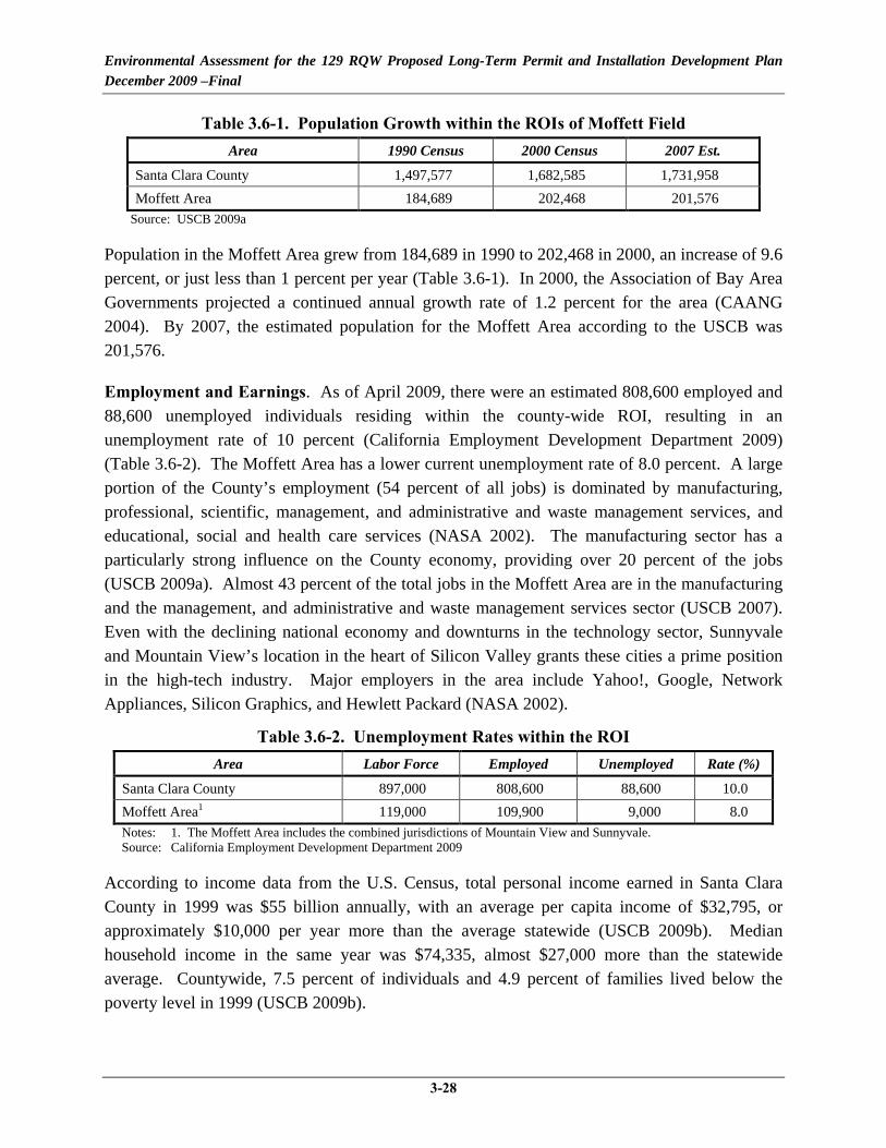
Environmental Assessment for the 129 RQW Proposed Long-Term Permit and Installation Development Plan December 2009 –Final
3-28
Table 3.6-1. Population Growth within the ROIs of Moffett Field Area 1990 Census 2000 Census 2007 Est.
Santa Clara County 1,497,577 1,682,585 1,731,958 Moffett Area 184,689 202,468 201,576
Source: USCB 2009a
Population in the Moffett Area grew from 184,689 in 1990 to 202,468 in 2000, an increase of 9.6 percent, or just less than 1 percent per year (Table 3.6-1). In 2000, the Association of Bay Area Governments projected a continued annual growth rate of 1.2 percent for the area (CAANG 2004). By 2007, the estimated population for the Moffett Area according to the USCB was 201,576.
Employment and Earnings. As of April 2009, there were an estimated 808,600 employed and 88,600 unemployed individuals residing within the county-wide ROI, resulting in an unemployment rate of 10 percent (California Employment Development Department 2009) (Table 3.6-2). The Moffett Area has a lower current unemployment rate of 8.0 percent. A large portion of the County’s employment (54 percent of all jobs) is dominated by manufacturing, professional, scientific, management, and administrative and waste management services, and educational, social and health care services (NASA 2002). The manufacturing sector has a particularly strong influence on the County economy, providing over 20 percent of the jobs (USCB 2009a). Almost 43 percent of the total jobs in the Moffett Area are in the manufacturing and the management, and administrative and waste management services sector (USCB 2007). Even with the declining national economy and downturns in the technology sector, Sunnyvale and Mountain View’s location in the heart of Silicon Valley grants these cities a prime position in the high-tech industry. Major employers in the area include Yahoo!, Google, Network Appliances, Silicon Graphics, and Hewlett Packard (NASA 2002).
Table 3.6-2. Unemployment Rates within the ROI Area Labor Force Employed Unemployed Rate (%)
Santa Clara County 897,000 808,600 88,600 10.0 Moffett Area1 119,000 109,900 9,000 8.0 Notes: 1. The Moffett Area includes the combined jurisdictions of Mountain View and Sunnyvale. Source: California Employment Development Department 2009
According to income data from the U.S. Census, total personal income earned in Santa Clara County in 1999 was $55 billion annually, with an average per capita income of $32,795, or approximately $10,000 per year more than the average statewide (USCB 2009b). Median household income in the same year was $74,335, almost $27,000 more than the statewide average. Countywide, 7.5 percent of individuals and 4.9 percent of families lived below the poverty level in 1999 (USCB 2009b).

Environmental Assessment for the 129 RQW Proposed Long-Term Permit and Installation Development Plan December 2009 –Final
3-29
Schools. In the 2007/2008 school year, 60,293 students were enrolled in 86 public K-12 schools within the Moffett Area. In that same year, Moffett Area schools were allocated a total of $426 million in local, state, and federal funds, or an average of approximately $7,067 in combined funding per student (Education Data Partnership 2009).
Housing. In 2000, the number of housing units in Santa Clara County was 579,329, with a homeowner vacancy rate of 0.5 percent and a rental vacancy rate of 1.8 percent (USCB 2009a). In the Moffett Area, a total of 86,185 housing units were counted in the 2000 Census, with a homeowner vacancy rate of 0.5 percent and a rental vacancy rate of approximately 1.4 percent. The cost of housing in the Moffett Area and vicinity is the second highest in the U.S. The median house or condo value in 2007 was $758,100 in Santa Clara County, $804,400 in Mountain view, and $742,400 in Sunnyvale, California (City-Data 2007). Most employees and Guardsmen commute one to two hours from homes elsewhere, since home ownership is virtually unattainable near Moffett Field (CAANG 2004).
3.6.2.2 Environmental Justice
Approximately 46.2 percent of the total population in Santa Clara County is composed of minorities (i.e., an ethnic, racial, or religious group with a distinctive presence in a community) (Table 3.6-3), compared to 40.5 percent for the state of California (USCB 2009a). Approximately 26 percent of the County’s population, or approximately 55 percent of the total minority population, is of Asian descent. The Moffett Area has a slightly smaller proportion of minorities (43.1 percent) than the County, but still has more than the state average. The percent of the population living below the poverty level within the ROI in 1999 was 5.9 percent in the Moffett Area and 7.5 percent in all of Santa Clara County, compared to 13.9 percent statewide (USCB 2009b). The USCB defines poverty by assessing whether a family’s total income falls below the threshold value set for a family of that size. This threshold value is adjusted annually for inflation (USCB 2009b).
Table 3.6-3. Minority and Low-Income Population Data for the ROI
Geographic Area Total
Population
MINORITIES (2000) LOW-INCOME (1999)
Population Total % Of Total Population
Population Total
% Of Total Population
Moffett Area 202,468 87,185 43.1 11,876 5.9 Santa Clara County 1,682,585 776,925 46.2 124,470 7.5
California 33,871,648 13,701,589 40.5 4,706,130 13.9 Source: USCB 2009a
The 129 RQW installation has no on-base housing and no facilities for children. There are no known facilities on the installation where children may be encountered on a regular basis.

Environmental Assessment for the 129 RQW Proposed Long-Term Permit and Installation Development Plan December 2009 –Final
3-30
3.7 CULTURAL RESOURCES
3.7.1 Definition of the Resource
Cultural resources consist of prehistoric and historic districts, sites, structures, artifacts, or any other physical evidence of human activity considered important to a culture, subculture, or community for scientific, traditional, religious, or other reasons. Cultural resources can be divided into three major categories: archaeological resources (prehistoric and historic), architectural resources, and traditional cultural resources.
Archaeological resources are sites where human activity measurably altered the earth or left deposits of physical remains (e.g., tools, arrowheads, or bottles). “Prehistoric” refers to resources that predate the advent of written records in a region. These resources can range from a scatter composed of a few artifacts to village sites and rock art. “Historic” refers to resources that postdate the advent of written records in a region. Archaeological resources can include campsites, roads, fences, trails, dumps, battlegrounds, mines, and a variety of other features.
Architectural resources include standing buildings, dams, canals, bridges, and other structures of historic or aesthetic significance. Architectural resources generally must be more than 50 years old to be considered for protection under existing cultural resource laws. However, more recent structures, such as Cold War era military buildings, may warrant protection if they have the potential to be historically significant structures. Architectural resources must also possess integrity (i.e., the important historic features must be present and recognizable).
Traditional cultural resources can include archaeological resources, buildings, neighborhoods, prominent topographic features, habitats, plants, animals, and minerals that Native Americans or other groups consider essential for the continuance of traditional cultures.
Only significant cultural resources, known or unknown, warrant consideration with regard to adverse impacts resulting from a proposed action. To be considered significant, archaeological or architectural resources must meet one or more criteria as defined in 36 CFR 60.4 for inclusion in the NRHP.
Several federal laws and regulations have been established to manage cultural resources, including the NHPA (1966), the Archaeological and Historic Preservation Act (1974), AIRFA (1978), the Archaeological Resource Protection Act (1979), and NAGPRA (1990). In addition, coordination with federally recognized Native American tribes must occur in accordance with EO 13084, Consultation and Coordination with Indian Tribal Governments.
On November 27, 1999, the DoD promulgated its Annotated American Indian and Alaska Native Policy, which emphasizes the importance of respecting and consulting with tribal governments

Environmental Assessment for the 129 RQW Proposed Long-Term Permit and Installation Development Plan December 2009 –Final
3-31
on a government-to-government basis. This policy requires an assessment, through consultation, of proposed DoD actions that may have the potential to significantly affect protected tribal resources, tribal rights, and Indian lands before decisions are made by the respective services.
3.7.2 Existing Conditions
3.7.2.1 Historical Setting
The San Francisco Bay Area has been continuously occupied for 4,000 years. Archaeological studies during the 20th century uncovered evidence from a large shellmound (believed to be an archaeological debris and burial site) in the vicinity of Moffett Field, suggesting intensive occupation of the area for several centuries (CAANG 2004). It is estimated that approximately 1,400 Native Americans of the Ohlone Tribe lived on the peninsula in 1770. By 1810, this tribe appears to have disappeared due to disease, low birthrates, and the mission system which introduced a new way of life to the tribe. From about 1834 to 1864, the property that Moffett Field currently occupies, was farmed by Native Americans. This property was formally granted to Lopez Indigo, or Ynigo, a Native American, in 1844 by Manuel Micheltorena, the California governor at that time (NASA 2002).
3.7.2.2 Identified Cultural Resources
Archaeological Resources
There are 20 areas within the perimeter of Moffett Field that have been designated as potential archaeologically-sensitive areas; the largest of these sites is located south of the runway. Two of these sites are located at the southeastern section of Moffett Field, inside the 129 RQW main cantonment area (NASA 2002). However, these sites have been damaged in the last 90 years due to agriculture and development. According to a 1991 report, the boundaries of these sites are unknown and only a small amount of information currently exists about these sites. For instance, the Crittendon Kitchen Midden (i.e., refuse heaps left by prehistoric settlements) and several other archaeological sites that were recorded in a 1909 survey of Moffett Field were not located in a later survey of the area (CAANG 2004).
Architectural Resources
Several surveys of architectural resources have been conducted at Moffett Field. Thirty-four buildings are listed as historic properties by the NRHP. Most architectural resources in the area are located in the Shenandoah Plaza Historic District within NASA Research Park. Notable structures in this area are the Administration Building (Building 17), the Bachelor Officers Quarters (Building 20), and Hangar 1. The Ames Campus Area at the western portion of Moffett Field contains three architectural structures that are eligible for listing on the NRHP: the

Environmental Assessment for the 129 RQW Proposed Long-Term Permit and Installation Development Plan December 2009 –Final
3-32
NASA/ARC Administration Building, the 40-by 80-foot Wind Tunnel, and the Supersonic Wind Tunnel, and one Historic Landmark, the Unitary Plan Wind Tunnel.
Traditional Cultural Resources
No information has come to the attention of NASA, the Army, or the ANG to indicate that Moffett Field is a Native American traditional cultural property. Although not expected, there is potential that subsurface cultural resources could be found during construction activities (CAANG 2004).
3.8 SOLID AND HAZARDOUS MATERIALS AND WASTES
3.8.1 Definition of the Resource
This section describes the affected environment associated with hazardous materials and petroleum products, hazardous and petroleum wastes, IRP sites, and solid waste at the 129 RQW.
The terms “hazardous materials” and “hazardous waste” refer to substances defined as hazardous by the Comprehensive Environmental Response, Compensation, and Liability Act (CERCLA) and the Solid Waste Disposal Act (SWDA), as amended by the Resource Conservation and Recovery Act (RCRA). In general, hazardous materials include substances that, because of their quantity, concentration, or physical, chemical, or infectious characteristics, may present substantial danger to public health or the environment when released into the environment. Hazardous wastes that are regulated under RCRA are defined as any solid, liquid, contained gaseous, or semisolid waste, or any combination of wastes that either exhibit one or more of the hazardous characteristics of ignitability, corrosivity, toxicity, or reactivity, or are listed as a hazardous waste under 40 CFR Part 261, Identification and Listing of Hazardous Waste. The IRP is a USAF program designed to identify, characterize, and remediate environmental contamination from past activities at USAF installations.
Issues associated with hazardous material and waste typically center around waste streams, underground storage tanks (USTs), aboveground storage tanks (ASTs), and the storage, transport, use, and disposal of fuels, lubricants, and other industrial substances. When such materials are improperly used in any way, they can threaten the health and well-being of wildlife species, habitats, and soil and water systems, as well as humans.
The management of hazardous materials and hazardous waste is governed by specific environmental statutes. The key statutes include:
Comprehensive Environmental Response, Compensation and Liability Act of 1980 (42 USC 9601–9675) as amended by the Superfund Amendments and Reauthorization Act

Environmental Assessment for the 129 RQW Proposed Long-Term Permit and Installation Development Plan December 2009 –Final
3-33
(SARA) of 1986. CERCLA/SARA regulates the cleanup of hazardous substance releases in soil and groundwater.
Community Environmental Response Facilitation Act (CERFA) (42 USC 9620). This act amended CERCLA to require that, prior to termination of federal activities on any real property owned by the federal government, agencies must identify real property where hazardous substances were stored, released, or disposed of.
Emergency Planning and Community Right-to-Know Act (EPCRA) of 1986 (42 USC 11001–11050). EPCRA requires emergency planning for areas where hazardous materials are manufactured, handled, or stored and provides citizens and local governments with information regarding potential hazards to their community.
Resource Conservation and Recovery Act (42 USC 6901–6992). RCRA established standards and procedures for handling, storage, treatment, and disposal of hazardous waste.
Federal Facility Compliance Act (FFCA) of 1992 (Public Law [P.L.] 102-426). This act provides for a waiver of sovereign immunity on the part of federal agencies with respect to federal, state, and local requirements relating to RCRA solid and hazardous waste laws and regulations.
Pollution Prevention Act of 1990 (42 USC 13101–13109). This act encourages minimization of pollutants and waste through changes in production processes.
USEPA Regulation on Identification and Listing of Hazardous Waste (40 CFR Part 261). This regulation identifies solid wastes subject to regulation as hazardous and to notification requirements under RCRA.
USEPA Regulation on Standards for the Management of Used Oil (40 CFR Part 279). This regulation delineates requirements for storage, processing, transport, and disposal of oil that has been contaminated by physical or chemical impurities during use.
USEPA Regulation on Designation, Reportable Quantities, and Notification (40 CFR Part 302). This regulation identifies reportable quantities of substances listed in CERCLA and sets forth notification requirements for releases of those substances. It also identifies reportable quantities for hazardous substances designated in the CWA.
The ROI for hazardous materials, hazardous wastes, and petroleum products encompasses areas that could be exposed to an accidental release of hazardous substances from the construction or demolition activities, other specific geographic areas affected by past and current hazardous waste operations, and areas where hazardous materials would be utilized and hazardous wastes

Environmental Assessment for the 129 RQW Proposed Long-Term Permit and Installation Development Plan December 2009 –Final
3-34
generated by the 129 RQW. Therefore, the ROI for this section is defined as the boundary of the 129 RQW main cantonment area, where the proposed activities would occur.
3.8.2 Existing Conditions
This section describes the current management of hazardous materials and petroleum products, hazardous and petroleum wastes, IRP sites, UST sites, ASTs, and solid waste within the ROI.
3.8.2.1 Hazardous Materials and Petroleum Products
Hazardous materials and petroleum products are used throughout the 129 RQW operations conducted at Moffett Field for various functions including aircraft maintenance, ASE maintenance, ground vehicle maintenance, and facilities maintenance. These materials include flammable and combustible liquids, acids, aerosols, batteries, corrosives, solvents, paints, hydraulic fluids, jet propellant fuel (JP-8), gasoline, diesel fuel, lubricants, cutting oils, greases, and some corrosive materials (acids and alkalines).
The governing regulations for spill prevention are contained in the NASA Spill Prevention Plan which describes specific protocols for preventing and responding to releases, accidents, and spills involving oils and hazardous materials. All tenants at Moffett Field are required to follow these procedures.
3.8.2.2 Hazardous and Petroleum Wastes
Hazardous and petroleum wastes have historically been generated throughout the 129 RQW installation during various operations, including fuels testing, maintenance, testing and repair of vehicles, ASE, and aircraft. Primary types of hazardous wastes generated by the 129 RQW include metal scrap, batteries, used fuel, hydraulic fluid, sludge, oil, waste paint, solvents, aerosol, absorbent pads, fuel filters, used rags, fluorescent bulbs, and solvent-contaminated solids. The majority of hazardous waste is generated as a result of aircraft maintenance operations.
A hazardous waste generation point is the location where a waste is initially created or generated through some process. After generation, the hazardous waste must be transferred immediately to an initial accumulation point (IAP), an accumulation site, or a permitted storage area. Waste cannot be accumulated or stored at the generation point unless the area has been designated as an approved IAP. An IAP is an area where waste is initially accumulated under the control of the shop supervisor of the process generating the waste. Once certain parameters are met (as described in 40 CFR 262.34, Standards Applicable to Generators of Hazardous Waste), waste must be moved to a 90-day accumulation site (CAANG 2008a). NASA is responsible for collecting hazardous waste generated at Moffett Field, with the exception of the Army property.

Environmental Assessment for the 129 RQW Proposed Long-Term Permit and Installation Development Plan December 2009 –Final
3-35
The 129 RQW operates 23 IAPs distributed throughout the various industrial shops at the installation (Table 3.8-1). The hazardous wastes generated by the 129 RQW are then turned over to NASA, who operates two 90-day accumulation sites. At the 90-day accumulation sites, the hazardous waste is labeled, manifested, and transported off-site for disposal. With the exception of the Army property, NASA and its tenants collectively (including the 129 RQW) are considered a large quantity generator (LQG) of hazardous waste (i.e., generates more than 1,000 kilograms of hazardous waste per month) and operate under USEPA ID Number CA1800005034 (CAANG 2008a).
Table 3.8-1. 129 RQW Hazardous Waste Initial Accumulation Points
IAP #
Location (Building Number) Facility Description
1 662 Pneudraulics 2 47 Engine/Propulsions Shop 3 662 Phase/Isochronal Dock 4 656 Life Support 5 662 Repair and Reclamation (wheel & tire) 6 662 Corrosion Control 7 662 Non-Destructive Inspection 8 662 Machine Shop 9 662 Sheet Metal Shop
10 662 Flightline 11 146 Vehicle Maintenance 12 146 Vehicle Maintenance/Refueler Bay 13 545 Petroleum, Oils, and Lubricants (POLs) 14 662 Electro-Environmental 15 662 Fuel Cell 16 47 Security Forces/Combat Arms Training and Maintenance 17 650 Avionics 18 650 Weapons 19 680 Communication Flight 20 679 Civil Engineering 21 684 Aerospace Support Equipment (ASE) 22 686 Survival/Parachute Shop 23 47/686 Pararescue
Source: CAANG 2008a
The 129 RQW Hazardous Waste Management Plan provides guidance for facilitating compliance with all federal, state, and local regulations pertaining to hazardous waste. In addition, the Hazardous Waste Management Plan sets forth procedures to control and manage hazardous wastes from the point where they are generated until they are ultimately disposed (CAANG 2008a). In the event of a spill, releases are appropriately contained and reported, and spill logs are maintained by the 129 RQW Environmental Manager (CAANG 2009a).

Environmental Assessment for the 129 RQW Proposed Long-Term Permit and Installation Development Plan December 2009 –Final
3-36
3.8.2.3 Medical/Biohazardous Waste
Medical and biohazardous wastes are generated at the 129 RQW installation for hospital, dental clinic, and pararescue operations (Buildings 47, 685, and 686). Biohazardous waste is collected and disposed of by an independent contractor in accordance with federal, state, and local regulations. There have been no documented cases of contamination associated with medical or biohazardous waste (CAANG 2009a).
3.8.2.4 Installation Restoration Program Sites
The Defense Environmental Restoration Program was established as part of the SARA of 1986 to facilitate cleanup of DoD sites. IRP sites are designated for the cleanup of hazardous substances, DoD-unique substances, and petroleum, oil, and lubricant (POL) contamination. The mission of the IRP is to identify and cleanup contamination resulting from past DoD use and disposal practices for the protection of human health and the environment.
Moffett Field was added to the National Priorities List in July 1987 under the former name NAS Moffett Field. The Navy maintains responsibility for on-going investigation and remediation of all IRP sites at Moffett Field. Under the IRP, the Navy identified several locations with the presence of contamination. To date, 29 contaminated sites have been identified at Moffett Field as sites of hazardous substance releases, including leaks, spills, and/or disposal, and all are under investigation for remediation under the Navy’s IRP (NASA 2002; U.S. Department of the Navy 2009b). These sites were contaminated by wastes from 60 years of military operations. The majority of these sites are along the western edge of the airfield and near Hangar 3, and all sites predate NASA’s administration of the property. There are several IRP sites located near areas occupied by the 129 RQW that are in various stages of investigation and remediation by the Navy (Table 3.8-2 and Figure 3.8-1). Remediation of contaminated sites remains the responsibility of the Navy, even though custody of the installation has been transferred to NASA, including the portions used by the 129 RQW. NASA is responsible for cleanup of contaminated sites associated with NASA activities, none of which are located within the project area. In addition, a regional groundwater contamination plume exists beneath Moffett Field and flows towards the San Francisco Bay (NASA 2009c). This regional plume, known as the Regional MEW Groundwater Plume, originated from south of U.S. Highway 101 on private, industrial property but has now merged with the Navy IRP sites on the western edge of the airfield.

Environmental Assessment for the 129 RQW Proposed Long-Term Permit and Installation Development Plan December 2009 –Final
3-37
Table 3.8-2. Former and Active IRP Sites On and Near the 129 RQW (Page 1 of 2)
IRP Site # Description
Contaminants of Concern Current Status
1 Former Runway Landfill
Municipal wastes, industrial wastes,
petroleum products, solvents, paints, etc.
Landfill has been capped and long-term maintenance and monitoring is in progress.
3 Marriage Road Ditch Detergents, hydraulic fluids, oils, fuels,
solvents, and paint.
No Action Record of Decision. No Further Action Required.
5 Former Navy Fuel Farm (north and
south)
Petroleum contaminated soil and groundwater from former Leaking
USTs (LUSTs).
Site 5 is divided into two areas: Site 5 North (bulk storage area) and Site 5 South (UST site). In 1995, six USTs were removed from this location: two 25,000-gallon concrete tanks, two 50,000-gallon concrete tanks, and two 150,000-gallon steel tanks. The RWQCB has directed the Navy to complete an investigation for petroleum contamination in a gravel channel that extends from the former fuel farm and into the golf course (U.S. Department of the Navy 2009a). The Navy concluded that no further action was required for the channel deposit. The RWQCB however, did not concur and is currently in the process of addressing Site 5 as one unit for remedial action and/or closure. The Navy is also currently developing a sampling plan to carry out additional investigation work for Site 5 South (NASA 2009c). In addition, the Defense Energy Service Center (DESC) is currently assessing releases from the bulk fuel tanks as part of closure activities for these tanks. Therefore, Site 5 is actively being investigated/monitored.
7 Hangars 2 and 3 and surrounding unpaved
areas.
Petroleum contaminated soil and groundwater.
No further action for soils, groundwater is part of IR Site 26 east-side aquifer treatment system.
14 Former LUSTs at Ellis Street Motor
Pool Service Station
Petroleum contaminated soil and groundwater from former LUSTs.
The Ellis Street service station is known as Site 14 South. Two USTs were removed in 1990. Several investigations have been conducted at the site; however, contamination is still present at the site. Additional corrective action is required to reduce the petroleum contamination at Site 14 South, which the Navy is currently assessing (U.S. Department of the Navy 2008a).
15 Former Sumps and Oil/Water Separators
(OWSs)
Oil and fuels. Tank 54 (located on the east side of Hangar 3) was removed in 1993 and the Water Board granted no further action to the Navy for tank 54 (U.S. Department of the Navy 2009c). Sump 130 is located within the 129 RQW main cantonment area and it is now part of the Moffett storm drain system. The Navy received concurrence on its no further action finding from the USEPA on January 8, 2004 for Sump 130 (U.S. Department of the Navy 2009c). Tank 59 is located within the Pararescue/AGE area and has been used by CAANG after Moffett was transferred to NASA. The Navy is not responsible for closure of this tank (U.S. Department of the Navy 2009c). Prior to returning the facility back to NASA, CAANG and NASA will determine whether or not the OWS tank should be closed or remain in place for use by future occupants.

Environmental Assessment for the 129 RQW Proposed Long-Term Permit and Installation Development Plan December 2009 –Final
3-38
Table 3.8-2. Former and Active IRP Sites On and Near the 129 RQW (Page 2 of 2)
IRP Site # Description
Contaminants of Concern Current Status
16 Steam-cleaning Rack System (Sump 60)
VOCs, oils and fuels, metals.
Sump 60 was removed in 1990. The Navy was granted closure for Sump 60 (Site 16) (U.S. Department of the Navy 2009c). USEPA determined in 1993 the soils associated with Sump 60 required no further action; however, groundwater contamination associated with Sump 60 is being remediated by the Navy’s Westside Aquifers Treatment System.
19 Former LUSTs (Tanks 2, 14, 43, and
53)
Fuels and solvents. Groundwater contamination associated with UST 43 (suspected source of solvents) is being addressed by the Eastern Aquifer Treatment System. The Navy received no further action for tanks 2, 14, and 53 from the California Regional Water Quality Control Board [CRWQCB], San Francisco Bay Region (U.S. Department of the Navy 2009c; CRWQCB 2009).
22 Former Golf Course Landfill
Municipal wastes, industrial wastes,
petroleum products, solvents, paints, etc.
Landfill has been capped and long-term maintenance and monitoring is in progress.
23 Golf Course Fill Area Contaminated fill material.
Closed.
24 Petroleum Sites Petroleum Closed. 26 East-Side Aquifer
Treatment System Former LUSTs next to Hangar 3. Petroleum
contaminated groundwater. Solvents.
Monitoring in progress to address groundwater contamination plume. Currently, an in situ remediation pilot study is being conducted at Site 26 to replace the former pump and treat system.
27 Northern Channel Polychlorinated Biphenyls.
The Navy has completed the majority of the remediation required for Site 27. Contaminated soils and sediments were excavated and disposed of at appropriate facilities. Further restoration of a portion of the North Patrol Road Ditch to address elevated selenium levels is planned (U.S. Department of the Navy 2009c). The Navy plans to place a cap over the site.
Sources: NASA 2002, 2005, 2009b; U.S. Department of the Navy 2008a, b, 2009a, b, c; CRWQCB 2009.

Environmental Assessment for the 129 RQW Proposed Long-Term Permit and Installation Development Plan December 2009 –Final
3-39
Figure 3.8-1. Groundwater Contamination Plumes and IRP Sites near the 129 RQW Property Transactions

Environmental Assessment for the 129 RQW Proposed Long-Term Permit and Installation Development Plan December 2009 –Final
3-40
The one active IRP site of concern in the 129 RQW main cantonment area is IRP Site #5. IRP Site #5 exists within the northeastern portion of the current main cantonment area. It is actively being investigated/monitored as part of the Navy’s IRP and Petroleum Program.
In addition to active IRP sites under various stages of investigation or remediation, a former aircraft wash rack was located in an active taxiway area about 95 feet west of the new 129 RQW Hangar (Building 662). The wash rack was taken out of service and a portion of the existing concrete pad was replaced when the new hangar was built in 2002 (U.S. Department of the Navy 2008c). Currently, the entire former wash rack site is paved with concrete; however, an unpaved grassy area is adjacent to the southeastern corner of the former wash rack area. During construction of the new 129 RQW hangar, construction contractors reported fuel odors from soils excavated from the former wash rack site. Soil and groundwater investigations of the site followed and soils and groundwater contamination were detected. However, the draft investigation report for the former wash rack area included the recommendation that the site be closed with no further action. This conclusion was based on several reasons including chemicals and concentrations of chemicals found in the soil and groundwater do not pose an unacceptable risk to current and likely future receptors and that remaining petroleum compounds should continue to attenuate over time (U.S. Department of the Navy 2008c). The Navy submitted a final Investigation Report for Former Aircraft Wash Rack dated February 28, 2009, and in a letter dated April 27, 2009, the California Regional Water Quality Control Board (CRWQCB) concurred with the Navy that no further action is required (U.S. Department of the Navy 2009c; CRWQCB 2009).
3.8.2.5 Storage Tanks and Pipelines
Various storage tanks have previously been used at Moffett to store fuels and to distribute various petroleum products or wastes. There were three former USTs containing fuel oil located within the 129 RQW occupied area. In October 1998, the three USTs (servicing Buildings 680, 681, and 683) and associated piping were decommissioned, removed, and the site restored to original grade conditions (CAANG 1998b).
3.8.2.6 Oil/Water Separators
OWSs are used to separate oils, fuels, sand, and grease from wastewater and to prevent contaminants from entering the sanitary sewer and stormwater drainage systems. There are three OWSs that serve 129 RQW operations. One OWS is located at the wash rack area outside the ASE building (Building 684), one OWS services the new composite maintenance hangar located at Building 662, and one OWS is located near the vehicle maintenance facility (Building 146). These three OWSs are not the Navy’s responsibility since they were used after transfer of Moffett Field (U.S. Department of the Navy 2009c). In addition, a former OWS (sump 60)

Environmental Assessment for the 129 RQW Proposed Long-Term Permit and Installation Development Plan December 2009 –Final
3-41
located near the vehicle maintenance facility (Building 146) was removed on 9 October 1990 and the Navy received a no further action letter for the soil contamination associated with the OWS from the USEPA on 17 December 1993 (U.S. Department of the Navy 2009c). Groundwater contamination associated with this OWS is currently being remediated by the Navy's West-side Aquifers Treatment System at IRP Site 28.
3.8.2.7 Solid Waste
Municipal solid waste management and compliance at USAF installations is established in Air Force Instruction (AFI) 32-7042, Solid and Hazardous Waste Compliance. In general, AFI 32-7042 establishes the requirements for installations to have a solid waste management program to incorporate a solid waste management plan, procedures for handling, storage, collection, and disposal of solid waste, record keeping and reporting, and pollution prevention. Source reduction, resource recovery, and recycling of solid waste are addressed in AFI 32-7080, Pollution Prevention Program.
It is USAF policy to make every effort to divert non-hazardous solid waste from landfills and incinerators through reuse, recycling, composting, or donating, while ensuring integrated non-hazardous solid waste management programs provide an economic benefit. In accordance with AFI 32-7080, the USAF requires its installations to strive to divert/recycle the following items from the waste stream as cost effectively as possible: metals, glass, plastic, used oil, lead acid batteries, and tires. Installations are encouraged to add other commodities to the list of items that are economically feasible to divert/recycle.
As discussed in Section 3.10.2, Solid Waste Management, the 129 RQW generates non-hazardous solid waste in the form of trash, non-hazardous industrial wastes, and construction debris.
3.8.2.8 Asbestos
AFI 32-1052, Facility Asbestos Management (March 22, 1994), establishes requirements and assigns responsibilities to incorporate facility asbestos management principles and practices. Installations must remove asbestos-containing material (ACM) likely to release airborne asbestos fibers that cannot be reliably maintained, repaired, or isolated. All facilities must be monitored closely to ensure ACM does not become airborne. In addition, each installation must develop a written management and operating plan to carry out the objectives of facility asbestos management.
Asbestos has been found in a number of buildings constructed before 1978 when use of asbestos in construction materials was common. An asbestos survey was conducted in February 2005; only a portion of the buildings occupied by the 129 RQW (approximately 50 buildings) were

Environmental Assessment for the 129 RQW Proposed Long-Term Permit and Installation Development Plan December 2009 –Final
3-42
tested for ACM (CAANG 2005). According to the 2005 asbestos survey, ACM is present in many of the existing facilities occupied by the 129 RQW at Moffett Field (Table 3.8-3). Existing asbestos surveys and a Notification of Asbestos Containing Construction Materials at Moffett Field Buildings was completed by the Navy to ensure that the health and welfare of all installation personnel are protected from potentially harmful effects of ACM.
3.8.2.9 Lead-Based Paint
In 1973, the Consumer Products Safety Commission established a maximum lead content in paint of 0.5 percent by weight in a dry film of newly applied paint. In 1978, the Consumer Products Safety Commission lowered the allowable lead level in paint to 0.06 percent.
The most recent USAF policy with regard to lead-based paint (LBP) is described in the USAF memorandum Air Force Policy and Guidance on Lead-Based Paint in Facilities (May 24, 1993). The policy is referenced in USAF Handbook 32-9007, Managing Air Force Real Property (May 1, 1999), and requires USAF installations to identify, evaluate, control, and eliminate existing LBP hazards and past LBP hazards where potential LBP debris may have accumulated in the area surrounding facilities. Priority is given to facilities or portions of facilities frequented by children. All installations must develop and implement a plan for identifying, evaluating, managing, and abating LBP hazards. The guidance emphasizes the use of management policies and LBP abatement as part of the normal facility renovation and upgrade programs when it is cost-effective.
Most of the occupied buildings are painted and the paint appears to be in fair to good condition. A LBP survey was conducted at the 129 RQW in June 2008. In addition, buildings are tested for lead paint prior to demolition or renovation. Since many of the buildings at the 129 RQW installation were constructed prior to 1978, it is likely that a majority of these buildings contain LBP. However, most major facilities that are occupied by internal and external customers have been recently renovated, abated, and repainted.
The following buildings located within the 129 RQW tested positive for LBP, as shown in Table 3.8-4: 47, 146, 484, 650, 653, 656, 659, 661, 669, 680, and 681 (CAANG 2008b).

Environmental Assessment for the 129 RQW Proposed Long-Term Permit and Installation Development Plan December 2009 –Final
3-43
Table 3.8-3. Summary of ACM Present in 129 RQW Occupied Facilities (Page 1 of 2)
Building Year
Constructed Building Description ACM Present
47 1942 Hangar 3 Pipe, sink undercoating, heating, ventilation, and air conditioning (HVAC) insulation, ceiling tile, mastic, and wallboard
146 1952 Vehicle Operations and Maintenance
Pipe, HVAC insulation, tank cover, wallboard, mastic, vibration joint cloth
147 1951 MSA 1 No suspect material found 484 1965 MSA 3 Roofing, floor tile, mastic, transite, HVAC
insulation, deck caulk 485 1965 Traffic Tower House Window caulk
486-492 1965 MSA 3 Roofing, joint seal, gasket seal 528 1951 MSA 1 No suspect material found 545 1982 Petrol Operations Mastic, floor tile, wallboard, ceiling tile 546 2000 Dental Clinic Gasket rope 561 1976 MSA 4 No suspect material found 574 1982 Supply and Equipment Shed No suspect material found 650 1975 Logistics Maintenance Testing revealed all suspect material to be
negative for asbestos 651 1982 Battery Repair and Storage Area Cement wallboard 653 1975 Mission Support Squadron Testing revealed all suspect material to be
negative for asbestos 654 1969 Squadron Operations Insulation 655 1945 Warehouse No suspect material found 656 1971 Squadron Operations Testing revealed all suspect material to be
negative for asbestos 657 1955 Deployment Processing Facility Testing revealed all suspect material to be
negative for asbestos 658 1955 Deployment Processing Facility Window caulk
659, 660 1956 Temporary Munitions Vault Testing revealed all suspect material to be negative for asbestos
662 2002 Hangar Testing revealed all suspect material to be negative for asbestos
669 1943 Band, Storage, Classrooms Cement wallboard, floor tiles, mastic, vibration tape
675 2004 Hazardous Waste Storage No suspect material found 676 2004 Hazardous Waste Storage No suspect material found 677 2004 Hazardous Waste Storage No suspect material found 678 2004 Hazardous Waste Storage No suspect material found 679 1994 Warehouse/Base Civil Engineering No suspect material found 680 1980 Headquarters Transite, floor tile, mastic

Environmental Assessment for the 129 RQW Proposed Long-Term Permit and Installation Development Plan December 2009 –Final
3-44
Table 3.8-3. Summary of ACM Present in 129 RQW Occupied Facilities (Page 2 of 2)
Building Year
Constructed Building Description ACM Present
681 1980 Logistics Supply/Warehouse Transite, exhaust vent tape 682 1980 Hazardous Materials Storage No suspect material found 683 1980 Base Civil Engineering Floor tile, mastic 684 1980 Aerospace Support Equipment (ASE) Floor tile, mastic, linoleum 685 1985 Medical Training Roof material 686 1986 Pararescue Squadron Floor tile, mastic 992 1955 Vehicle Operations Parking Shed Testing revealed all suspect material to be
negative for asbestos Note: Only a portion of the buildings occupied by the 129 RQW have been tested for ACM. Therefore, this list is not comprehensive. Source: CAANG 2005

Environmental Assessment for the 129 RQW Proposed Long-Term Permit and Installation Development Plan December 2009 –Final
3-45
Table 3.8-4. Summary of Lead-based Paint Occurrence at the 129 RQW
Building Year
Constructed Building Description Lead-based Paint Present
47 1942 Hangar 3 Positive 146 1952 Vehicle Operations and Maintenance Positive 484 1965 MSA 3 Positive 545 1982 Petrol Operations Negative 546 2000 Dental Clinic Negative 574 1982 Supply and Equipment Shed Negative 650 1975 Logistics Maintenance Positive 653 1975 Mission Support Squadron Positive 654 1969 Squadron Operations Negative 656 1971 Squadron Operations Positive 658 1955 Deployment Processing Facility Negative 659 1956 Temporary Munitions Vault Positive 660 1956 Temporary Munitions Vault Negative 661 1955 Deployment Processing Facility Positive 662 2002 Hangar Negative 669 1943 Band, Storage, Classrooms Positive 679 1994 Warehouse/Base Civil Engineering Negative 680 1980 Headquarters Positive 681 1980 Logistics Supply/Warehouse Positive 683 1980 Base Civil Engineering Negative 684 1980 Aerospace Support Equipment (ASE) Negative 685 1985 Medical Training Negative 686 1986 Pararescue Squadron Negative 992 1955 Vehicle Operations Parking Shed Negative
Source: CAANG 2008b
3.9 SAFETY
3.9.1 Definition of the Resource
This section addresses ground, explosive, and flight safety associated with activities conducted by the 129 RQW. Ground safety considers issues associated with human activities and operations and maintenance activities that support 129 RQW operations. A specific aspect of ground safety addresses AT/FP considerations. Explosive safety discusses the management and use of ordnance or munitions associated with installation operations and training activities. Flight safety considers aircraft flight risks such as aircraft accidents and BASH. Because there

Environmental Assessment for the 129 RQW Proposed Long-Term Permit and Installation Development Plan December 2009 –Final
3-46
are no changes proposed that could impact flight safety, this discussion is omitted from further discussion.
The ROI for safety includes the 129 RQW and the lands immediately adjacent to the installation.
3.9.2 Existing Conditions
3.9.2.1 Ground Safety
Day-to-day operations and maintenance activities conducted by the 129 RQW are performed in accordance with applicable USAF safety regulations, published USAF Technical Orders, and standards prescribed by the USAF Office of Safety and Health.
NASA has a combined domestic and fire protection water system supplied from the San Francisco Water Department and assumes responsibility of the fire protection function for all of Moffett Field, including the 129 RQW. Building 580, owned and maintained by NASA, houses the fire rescue and support operations which service all of Moffett Field (CAANG 1998a). NASA has a cooperative response agreement with the city fire departments of Santa Clara County and is part of the Santa Clara County Fire Mutual Aid service. In the event of an emergency at Moffett Field (including the 129 RQW), Mountain View Fire Department would be contacted in request for aid. If Mountain View Fire Department was not available, the City of Sunnyvale Fire Department would be contacted (NASA 2002).
3.9.2.2 Anti-Terrorism/Force Protection
As a result of terrorist activities, the DoD and the USAF have developed a series of AT/FP guidelines for military installations: UFC 4-010-01 2007, DoD Minimum Antiterrorism Standards for Buildings; AFI 31-210 1999, The Air Force Antiterrorism/Force Protection [AT/FP] Program; DoD O-2000.12-H 1993, Protection of DoD Personnel and Activities Against Acts of Terrorism and Political Turbulence. These guidelines address a range of considerations that include access to the installation, access to facilities on the installation, facility siting, exterior design, interior infrastructure design, and landscaping. The intent of this siting and design guidance is to improve security, minimize fatalities, protect personnel, and limit damage to facilities in the event of a terrorist attack.
All military facilities at the 129 RQW were constructed before such considerations became a critical concern. Thus, under current conditions, many facilities do not comply with all current AT/FP standards. However, as new construction occurs and as facilities are modified, it is the intention of CAANG to incorporate these standards to the maximum extent practicable.

Environmental Assessment for the 129 RQW Proposed Long-Term Permit and Installation Development Plan December 2009 –Final
3-47
3.9.2.3 Explosive Safety
The 129 RQW stores, maintains, and uses a range of munitions required for performance of their mission. All ordnance is handled and stored in accordance with USAF explosive safety directives (USAF Manual 91-201, Explosive Safety Standards; USAF Policy Directive 91-2, Safety Programs; and DoD 6055.9-Std, Ammunition and Explosives Safety Standards), and all munitions maintenance is carried out by trained, qualified personnel using USAF-approved technical procedures. Restrictions apply to the areas immediately surrounding the munitions storage facilities to provide separation between facilities and activities to minimize serious injury, loss of life, and damage to property. The size of the safety areas, referred to as QD arcs, varies depending on the type and amount of munitions stored.
The DoD defines munitions through a system called the DoD Hazard Classification System. This system consists of nine hazard classes and takes into account the munitions’ blast, fragment, debris, and thermal hazards to establish appropriate QD protection principles and design procedures to achieve personnel protection, protect facilities and equipment, and prevent propagation of explosions. There are several different types of munitions storage including underground storage facilities, earth covered materials, barricades, storage modules, and special structures and corresponding QD arcs with each type of storage, depending on the types and amounts of munitions stored. QD arcs take into account specific public transportation distance and inhabited building distance standards associated with each type of munition. A public transportation distance (PTR) is the distance between any public street, road, or highway (including roads on a military installation) used routinely by the general public and munition, while an inhabited building distance (IBD) is defined as the distance maintained between munition and an inhabited building (DoD 6055.09-STD).
The 129 RQW currently maintains three existing MSAs at Moffett Field, all located in the northeast corner of the installation. QD arcs associated with the MSAs encompass Buildings 70-74, 143, 147, 484, 486-492, 528, and 561. Flammable and combustible materials, such explosives, flares, and paints are stored at the 129 RQW installation.
3.10 INFRASTRUCTURE
3.10.1 Definition of the Resource
Infrastructure refers to the system of public works, such as utilities and transportation that provide the underlying framework for a community. Utilities include such amenities as water, power supply, and waste management. Transportation and circulation refer to roadway and street systems, the movement of vehicles, pedestrian and bicycle traffic, and mass transit. The infrastructure components to be discussed in this section include the transportation network,

Environmental Assessment for the 129 RQW Proposed Long-Term Permit and Installation Development Plan December 2009 –Final
3-48
electricity, natural gas, liquid fuels, sanitary sewer, solid waste, stormwater drainage, and potable water.
The ROI for this resource primarily consists of the 129 RQW installation, with additional information presented for Moffett Field, where relevant.
3.10.2 Existing Conditions
Transportation System. There are three major highways that provide access to Moffett Field (Figure 1.3-1). U.S. Highway 101 (US-101), which is located to the south of the airfield, is a major north-south route through the entire length of California. US-101 is an eight-lane freeway that provides regional access to the project area and has three mixed-flow lanes and one high occupancy vehicle lane in each direction as it traverses Sunnyvale. US-101 carries about 155,000 vehicles daily south of Mathilda Avenue (Caltrans 1999). State Route 85, which ties into US-101 south of Moffett Field, passes by the southwest corner of Moffett Field and extends south and east. Route 85 is a six-lane freeway that extends from US-101 in Mountain View to a southern connection with US-101 in south San Jose. State Route 85 carries about 99,000 vehicles daily north of El Camino Real (Caltrans). State Route 237 runs east-west and intersects with US-101 near the southeast corner of Moffett Field. Route 237 forms the southern border of the Moffett Park area. Route 237 is a four to six lane freeway that provides access between Route 82 (El Camino Real) to the west and Interstate 880 to the east. Route 237 carries about 85,000 vehicles daily east of Mathilda Avenue (Caltrans 1999). The main gate to Moffett Field is located on Moffett Boulevard and provides direct access to US-101 and State Route 85, while the secondary gate is located on Ellis Street and provides direct access to US-101.
The roadway network in the City of Sunnyvale is classified by roadway types in the Land Use and Transportation element of the City of Sunnyvale General Plan (City of Sunnyvale 1997). Classification types include the following:
• State Freeway,
• County Expressway,
• Regionally Significant Roadway,
• Class 1 Arterial,
• Class 2 Arterial,
• Commercial/Industrial Collector,
• and Residential Collector.

Environmental Assessment for the 129 RQW Proposed Long-Term Permit and Installation Development Plan December 2009 –Final
3-49
US-101, State Route 85, and State Route 237 are considered freeways or expressways; Mathilda Avenue is a Class 1 arterial, and streets such as 8th and 11th Avenues are considered commercial/industrial collectors. Though Level of Service (LOS) definitions vary based on the roadway classification, in general, a rating of A is the best rating in terms of traffic congestion and F is the worst rating. Table 3.10-1 presents LOS and other data on roadways in the vicinity of proposed activities.
Table 3.10-1. Existing Traffic Conditions and Projected Conditions for Intersections in the Vicinity of Proposed Activities
Location
EXISTING CONDITIONS PROJECTED CONDITIONS IN 2020 AM PEAK HOUR PM PEAK HOUR AM PEAK HOUR PM PEAK HOUR
LOS Delay1 V/C2 LOS Delay1 V/C2 LOS Delay1 V/C2 LOS Delay1 V/C2 H St. & 11th Ave.
B+ 6 .22 B 8 .07 B 12 .63 B+ 7 .42
H St. & 5th Ave.
C+ 16 .13 C+ 15 .11 B- 14 .40 C 22 .41
H St. & 8th Ave.
A 14 .14 B+ 7 .13 A 4 .51 C 17 .59
H St. & Manila Dr.
B- 14 .36 B 11 .26 C 21 .69 C 21 .60
Mathilda Ave. & 5th Ave.
C+ 17 .20 D+ 26 .30 C 21 .40 D 32 .72
Moffett Park Dr. & US-101 Northbound On-Ramp
A 3 .07 B 10 .18 A 2 .36 B 8 .36
Mathilda Ave. & Moffett Park Dr.
B 12 .61 F 107 .73 E 68 1.19 F 139 1.30
Mathilda Ave. & State Route 237 Westbound Ramps
B 12 .57 C 26 .73 D 39 1.02 C 27 .94
Mathilda Ave. & State Route 237 Eastbound Ramps
B 11 .77 A 9 .58 B 15 .67 B 14 .71
Notes: 1. Delay in seconds 2. V/C = volume to capacity ratio based on traffic counts Source: City of Sunnyvale 2002
Airfield. The airfield at Moffett Field consists of runways, taxiways, aircraft parking aprons, alert areas, and arm/disarm areas. There are two parallel runways, 32R/14L and 32L/14R. 32R/14L is 9,200 feet in length and 32L/14R is 8,125 feet in length. Both runways are 200 feet

Environmental Assessment for the 129 RQW Proposed Long-Term Permit and Installation Development Plan December 2009 –Final
3-50
in width and are separated laterally by 600 feet. Two taxiways, each 50 feet in width, border each runway. The apron used by the 129 RQW is located on the east side of the airfield south of Hangars 2 and 3. An additional apron located north of Hangars 2 and 3 is not currently in use (CAANG 1998a).
Electrical System. Electricity at Moffett Field is currently supplied by United States Department of Energy Western Area Power Administration. If power requirements are exceeded, then additional supply is purchased from Pacific Gas and Electric. A substation located on the Eastside/Airfield currently provides electricity to the 129 RQW and receives power from a single Pacific Gas and Electric 115 kilovolt transmission line. The substation and related equipment are considered to be in good condition (NASA 2002).
Natural Gas System. Natural Gas is currently provided to the 129 RWQ by Pacific Gas and Electric supplied through a 250 millimeter line located at the north end of the airfield (NASA 2002). The natural gas system on the 129 RQW primarily consists of a 4-inch main which extends to Building 656 and a 2-inch line that extends to Building 650. The southern portion of the 129 RQW does not receive gas service (CAANG 1998a). The primary use for natural gas is heating for domestic water and heat in buildings.
Liquid Fuels. Liquid fuels for the 129 RQW consist of primarily JP-8 aircraft fuel. Three 50,000-gallon ASTs are operated by the Defense Energy Support Center (DESC) for storing and dispensing fuel at Moffett Field. Aviation fuel for consumption for 129 RQW operations is approximately 74 thousand gallons per month (CAANG 2009a). The liquid fuels system and property is not included in the proposed permit to the USAF on behalf of the 129 RQW. It is under an existing permit between NASA and DESC.
Sanitary Sewer System. The 129 RQW generates wastewater from sanitary, stormwater, and industrial processes, including vehicle, equipment, and aircraft washing; fuels and aircraft component testing; and vehicle, ASE, and aircraft maintenance. The sanitary sewer infrastructure at Moffett Field includes approximately 90,900 linear feet of collection lines. The discharge of site wastewater is handled by two cities, portions managed by Palo Alto and portions managed by Sunnyvale. Each of the two systems flows to one of two Publicly Owned Treatment Works (POTW) plants, the Palo Alto Regional Water Quality Control Plant (in the City of Palo Alto) or the Sunnyvale Water Pollution Control Plant (Santa Clara County 2007). The sanitary sewer conveyance system between Moffett Field and the two POTW plants are experiencing capacity problems and portions of the conveyance piping would require upgrading (NASA 2002). The treated wastewater from the POTW plants is ultimately discharged to the San Francisco Bay under permits issued by the California RWQCB (CAANG 2008a). In addition, NASA is using reclaimed water from the Sunnyvale POTW to irrigate the golf course.
Environmental Assessment for the 129 RQW Proposed Long-Term Permit and Installation Development Plan December 2009 –Final
3-51
Solid Waste Management. Municipal solid waste at Moffett Field is managed in accordance with the guidelines specified in AFI 32-7042, Waste Management. This AFI incorporates, by reference, the federal standard for solid waste regulations contained within 40 CFR, Subtitle D, Non-hazardous Waste, and other applicable federal regulations, AFIs, and DoD Directives. In general, AFI 32-7042 establishes the requirement for installations to have a solid waste management program that incorporates the following: a solid waste management plan; procedures for handling, storage, collection, and disposal of solid waste; goals for recycling and solid waste and construction and demolition debris diversion; recordkeeping and reporting; and pollution prevention.
The 129 RQW generates solid waste in the form of office trash, non-hazardous industrial wastes, normal municipal waste, and construction debris. These nonhazardous solid wastes are collected in dumpsters located throughout the 129 RQW installation and are picked up by a contractor for disposal off of the installation. There is no disposal of solid waste on the 129 RQW installation. Solid waste collection and disposal are handled by a private contractor and delivered to the Newby Island Landfill in Milpitas. This landfill is expected to reach capacity in 2020 (NASA 2002).
Recycling programs have been implemented at Moffett Field to reduce off-site waste disposal at landfills, in accordance with the 2002 Pollution Prevention Plan. Currently, landscape debris, paper, cardboard, construction and demolition waste, scrap metal, tires, toner cartridges, and computers are all recycled off-site (NASA 2002).
Stormwater Drainage System. Stormwater drainage at the 129 RQW consists of a series of enclosed storm sewers, open channels, catch basins, and inlets. Drainage occurs by overland flow to storm drain inlets connected to a series of underground pipes, or percolates into the groundwater system via subsurface soils. In general, there are two separate drainage areas for Moffett Field. Stormwater from the eastern drainage system (including the 129 RQW, airfield runways, and all lands east of the runways) flows north through several storm drain lines and overland flow to a pump station at Building 191. Building 191 then pumps the stormwater to the Northern Channel. The major conveyance system, in particular Marriage Road Ditch, is prone to flooding. Any increase in runoff would exacerbate the current condition. In addition, auxiliary pumps are used to handle stormwater during heavy rain events. This water is discharged downstream to the easternmost Lockheed pond through a culvert. This water is then pumped into the Moffett Channel where it is ultimately discharged into the Guadalupe Slough and then to the San Francisco Bay. Stormwater from the western drainage system of Moffett Field, including most of the area west of the runways, discharges to the Stormwater Retention Pond (NASA 2002, 2009a). When flow into the pond exceeds the storage capacity in the wet season, water is pumped directly into Stevens Creek (U.S. Department of the Army 2007).

Environmental Assessment for the 129 RQW Proposed Long-Term Permit and Installation Development Plan December 2009 –Final
3-52
NASA and its tenants (including the 129 RQW) operate under NPDES permits (including General Permit No. CAS000004 for stormwater discharges from small municipal separate storm sewer systems and No. CAS000001 for industrial activities excluding construction activities) for stormwater discharge at Moffett Field (NASA 2009a).
Potable Water System. Potable water and fire protection is supplied to Moffett Field from the San Francisco Water Department. Approximately 90 percent of this water comes from the Hetch Hetchy Reservoir in the Sierra Nevada, similar to many other municipalities in the region (personal communication, Kono 2009a). The water supplied from the Hetch Hetchy Reservoir is considered to be some of the nation’s highest quality drinking water (San Francisco Public Utility Commission 2006). The remaining 10 percent is supplied from local reservoirs in the East Bay managed by the San Francisco Public Utilities Commission. NASA does not supply any of their potable water from groundwater sources (NASA 2002).
The drinking water supply for Moffett Field is managed as part of NASA’s permitted community water system (Kono 2009b). NASA owns and operates the entire potable water system at Moffett Field, including the 129 RQW. The overall condition of the system is fair; however, some sections have required repairs in recent years and a large portion of the system has deteriorated to the point that it must be operated under lower pressure to reduce the occurrence of leaks and malfunctions. In addition, pipes are generally undersized and cannot allow adequate flow for fire protection (NASA 2002).

Environmental Assessment for the 129 RQW Proposed Long-Term Permit and Installation Development Plan December 2009 –Final
4-1
CHAPTER 4 ENVIRONMENTAL CONSEQUENCES
The resource analyses presented in this chapter are based on an examination of potential effects that the Proposed Action, alternative action, or No Action Alternative may have on existing environmental conditions. The Proposed Action and alternatives are described in Chapter 2, and the existing environmental conditions are described in Chapter 3. This chapter examines the potential environmental consequences for each of the resource areas in the same sequence as presented in Chapter 3. Within each resource area, the methodology used to evaluate potential impacts is described, followed by the evaluation of those potential impacts as a result of implementation of each of the alternatives using the methodology presented.
4.1 EARTH RESOURCES
4.1.1 Methodology
Protection of unique geologic features, minimization of soil erosion, and the siting of facilities in relation to potential geologic hazards and soil limitations are considered when evaluating impacts to earth resources. If a proposed action were to substantially affect or be substantially affected by any of these features, impacts would be considered significant. Generally, impacts associated with earth resources can be avoided or minimized to a level of insignificance if proper construction techniques, erosion control measures, and structural engineering designs are incorporated into project development.
Analysis of potential impacts to geologic resources typically includes identification and description of resources that could potentially be affected, examination of the potential effects that an action may have on the resource, assessment of the significance of potential impacts, and provision of management measures in the event that potentially significant impacts are identified. Analysis of impacts to soil resources resulting from proposed activities examines the suitability of locations for proposed operations and activities. Impacts to soil resources can result from earth disturbance that would expose soil to wind or water erosion.
Adverse impacts to soils and the associated potential indirect impacts to water resources can be minimized through the implementation of Best Management Practices (BMPs) such as those typically required to be in compliance with the CWA. The NPDES program, administered by the state of California, requires a construction General Permit for surface disturbance of one acre or more. Compliance with this permit involves development and implementation of a Stormwater Pollution Prevention Plan (SWPPP) that includes site-specific management measures.

Environmental Assessment for the 129 RQW Proposed Long-Term Permit and Installation Development Plan December 2009 –Final
4-2
4.1.2 Impacts
4.1.2.1 Alternative #1
Geology
Implementation of the proposed construction and land acquisition activities would not significantly affect the geologic units underlying Moffett Field as no unique geologic features are present. However, earthquakes can generate several different geologic hazards. In addition to ground shaking, other hazards include soil liquefaction, surface fault rupture, flooding, and slope failure. Not only are buildings endangered by these hazards, but water tanks, dams, roads, bridges, railways, airports, and utility corridors carrying electricity, water, sewage, natural gas, petroleum, and telephone service are at risk. Earthquake hazards can occur miles from an earthquake epicenter; this distance depends on the type of hazard and size of the earthquake. Earthquake hazards can be managed to the extent possible by designing structures in accordance with current Uniform Building Code and California Building Code regulations for seismic safety.
Soils
As a result of implementation of Alternative #1, there would be approximately 412,392 SF (9.5 acres) of net new impervious surface and 1,097,079 SF (25 acres) that would be temporarily disturbed as a result of construction and demolition of the proposed facilities. The high clay content of the soils within the ROI could result in localized slow recharge potential and consequently, a high runoff potential. Any potential impacts resulting from erosion or an increase in surface runoff during construction activities would be controlled through the use of standard erosion control measures such as soil compaction, wetting of the soils, sandbags, silt fencing, earthen berms, or temporary sediment basins, in accordance with CWA Section 402. A Notice of Intent would be filed with the state of California RWQCB to obtain coverage under the NPDES construction General Permit before construction would occur. Consequently, impacts from erosion and surface runoff would be minimal. It is likely that grading of existing soils and placement of structural fill for proposed facilities would not substantially alter existing soil conditions at the 129 RQW installation because much of the property has been previously disturbed as a result of prior development.
In addition, according to the California Farmland Mapping and Monitoring Program, overseen by the California Division of Land and Resource Protection, there is no Prime Farmland, Farmland of Statewide Significance, or Unique Farmland on or near Moffett Field. The land surrounding the installation falls under one of two categories, Urban and Built-up Land or Other Land (land not included in any other mapping category; commonly low-density rural

Environmental Assessment for the 129 RQW Proposed Long-Term Permit and Installation Development Plan December 2009 –Final
4-3
developments, brush, timber, wetland, and riparian areas) (California Department of Conservation 2006).
As a result of the high clay content typical of soils within the Santa Clara Valley, new buildings could be exposed to structural hazards from ground subsidence, differential settlement around buildings, cracking and heaving, and flooding during high volume precipitation events, as discussed in Section 3.1.2.2. These construction hazards can be managed to the extent possible by designing structures in accordance with current Uniform Building Code and California Building Code regulations and conducting geotechnical analyses of the proposed sites to determine the structural measures necessary to avoid possible subsidence or settlement. Site specific management measures, like detailed geotechnical investigations, may be required for individual sites, and construction would incorporate the results of those studies into the building design and construction. Therefore, no significant impacts to soils would occur as a result of implementation of this alternative.
Topography
Although ground disturbance would occur at the installation during construction, the majority of construction would occur over previously disturbed surfaces. While proposed construction activities at the installation would require grading, no identifiable topographic features would be affected as a result of development associated with this alternative. Therefore, no significant impacts to topography would occur as a result of implementation of Alternative #1.
4.1.2.2 Alternative #2
Under Alternative #2, all construction and demolition projects described in Alternative #1 would be implemented; however, the location of Project 8, MSC, would differ. The amount of impervious surface and surface disturbance would be the same for Alternative #2 as Alternative #1. Thus, the types of impacts to earth resources as a result of Alternative #2 would occur as described under Alternative #1. In addition, soils testing for contamination and seismic capability (as defined in EO 12941, Seismic Safety of Existing Federally Owned or Leased Buildings) would be conducted prior to construction. Therefore, no significant impacts to geology, soils, or topography would occur as a result of implementation of Alternative #2.
4.1.2.3 Alternative #3
Under Alternative #3, all construction and demolition projects described in Alternative #1 would be implemented, with the exception of the pervious parking area proposed for the east side of Macon Road (part of Project #13) and the photovoltaic generation system that is associated with it (Project #14). The 129 RQW would instead use the existing parking garages located in the Moffett Towers development east of Mary Street for additional parking to support UTA on the

Environmental Assessment for the 129 RQW Proposed Long-Term Permit and Installation Development Plan December 2009 –Final
4-4
weekends. To facilitate parking off-installation at the Moffett Towers development, a new entrance gate would be installed near the intersection of Mary Street and 11th Avenue. A roadway extension connecting 11th Avenue to Macon Road would also be developed and would be approximately 68 feet wide and 140 feet long (approximately 9,520 SF of additional impervious surface). Sidewalks, curbs, and gutters would also be included in this roadway extension. This alternative would result in a reduction of 315,880 SF (7.25 acres) of disturbed surface as compared to Alternative #1, since a portion of Project #13 would be eliminated. The portion of Project #13 that would be eliminated would be the proposed parking area east of Macon Road (approximately 325,400 SF). In addition, soils testing for contamination and seismic capability (as defined in EO 12941, Seismic Safety of Existing Federally Owned or Leased Buildings) would be conducted prior to construction. Therefore, no significant impacts to geology, soils, or topography would occur as a result of implementation of Alternative #3.
4.1.2.4 Alternative #4
Under Alternative #4, all construction and demolition projects described in Alternative #2 would be implemented, with the exception of the pervious parking area proposed for the east side of Macon Road (part of Project #13) and the photovoltaic generation system that is associated with it (Project #14). The 129 RQW would instead use the existing parking garages located in the Moffett Towers development east of Mary Street for additional parking to support UTA on the weekends. To facilitate parking off-installation at the Moffett Towers development, a new entrance gate would be installed near the intersection of Mary Street and 11th Avenue. A roadway extension connecting 11th Avenue to Macon Road would also be developed and would be approximately 68 feet wide and 140 feet long (approximately 9,520 SF of additional impervious surface). Sidewalks, curbs, and gutters would also be included in this roadway extension. The types of impacts to earth resources as a result of Alternative #4 would occur as described under Alternative #2. However, this alternative would result in a reduction of 315,880 SF (7.25 acres) of disturbed surface as compared to Alternative #1, since a portion of Project #13 would be eliminated. The portion of Project #13 that would be eliminated would be the proposed parking area east of Macon Road (approximately 325,400 SF). In addition, soils testing for contamination and seismic capability (as defined in EO 12941, Seismic Safety of Existing Federally Owned or Leased Buildings) would be conducted prior to construction. Therefore, no significant impacts to geology, soils, or topography would occur as a result of implementation of Alternative #4.
4.1.2.5 No Action Alternative
Under the No Action Alternative, the proposed construction and property transfers at Moffett Field would not occur and the 129 RQW would continue to operate out of their existing facilities. Baseline geological, soils, and topographical resources, as described in Section 3.1,

Environmental Assessment for the 129 RQW Proposed Long-Term Permit and Installation Development Plan December 2009 –Final
4-5
would remain unchanged. Therefore, no significant impact to earth resources would occur as a result of implementation of the No Action Alternative.
4.2 WATER RESOURCES
4.2.1 Methodology
Land development changes the physical, chemical, and biological conditions of water resources. When land is developed, the hydrology, or the natural cycle of water, can be altered. Impacts on hydrology can result from land clearing activities, disruption of the soil profile, loss of vegetation, introduction of pollutants, new impervious surfaces, and an increased rate or volume of runoff after major storm events. Without proper management controls, these actions can adversely impact the quality and/or quantity of water resources.
Criteria for evaluating impacts related to water resources associated with the Proposed Action are water availability, water quality, and adherence to applicable regulations. Impacts are measured by the potential to reduce water availability to existing users, endanger public health or safety by creating or worsening health hazards or safety conditions, or violate laws or regulations adopted to protect or manage water resources. An impact to water resources would be significant if it would: (1) reduce water availability to or interfere with the supply of existing users; (2) create or contribute to overdraft of groundwater basins or exceed safe annual yield of water supply sources; (3) adversely affect water quality or endanger public health by creating or worsening adverse health hazard conditions; (4) threaten or damage unique hydrologic characteristics; or (5) violate established laws or regulations that have been adopted to protect or manage water resources of an area. Impacts of flood hazards on proposed actions can be significant if such actions are proposed in areas with high probabilities of flooding; however, these impacts can be mitigated through the use of specific design features to minimize the effects of flooding.
Increases in impervious surfaces act to increase peak discharge volume and speed delivery of water to nearby waterways, which ultimately increases the potential for flooding as well as the transport of pollutants to surface waters. In undeveloped land, rainfall is collected and stored in vegetation, in the soil column, or in topographic depressions. Water is then utilized by plants and respired, or it moves slowly into groundwater and/or eventually to waterbodies where it slowly moves through the hydrologic cycle. Removal of vegetation and/or soil compaction decreases infiltration into the soil column and thereby increases the quantity and timing of runoff. Replacement of vegetation with an impervious surface, such as concrete, eliminates any potential for infiltration and also speeds up delivery of the water to nearby drainage channels. With less storage capacity in the soil column and vegetation, urban streams rise more quickly

Environmental Assessment for the 129 RQW Proposed Long-Term Permit and Installation Development Plan December 2009 –Final
4-6
during storm events and have higher peak discharge rates, both of which increase the potential for flooding downstream and damage to public infrastructure and private property.
The NPDES program is administered by the state of California RWQCBs, while the USEPA is responsible for inspection activities and routine correspondence for regulatory programs with the opportunity to provide compliance assistance for permitted facilities.
4.2.2 Impacts
With regard to water resources, the primary concerns associated with the Proposed Action and its alternatives include changes to surface water drainage, effects on water quality during construction activities, and groundwater recharge.
4.2.2.1 Alternative #1
Surface Water
Under Alternative #1, approximately 1,097,079 SF (25 acres) would be temporarily disturbed as a result of construction and demolition activities that could result in temporary localized increases in runoff and total suspended particulate matter to nearby surface waters. However, it is unlikely that all surface disturbance and construction would occur within the same year. Table 2.2-1 provides projected timelines for the completion of each of these projects. To minimize potential impacts associated with erosion, runoff, and sedimentation, BMPs as described in NASA’s Storm Water Pollution Prevention Plan (NASA 2009a), as well as those specified in the California Stormwater Best Management Practice Handbook for Construction (California Stormwater Quality Association 2003) would be implemented during the construction period. Such BMPs could include the use of well maintained silt fences or straw wattles, minimizing surficial areas disturbed, stabilization of cut/fill slopes, minimization of earth-moving activities during wet weather, and covering of soil stockpiles, as appropriate. Following construction, disturbed areas not covered with impervious surface would be reestablished with appropriate vegetation and native seed mixtures and managed to minimize future erosion potential. A Notice of Intent must be filed with the state of California RWQCB to obtain coverage under the General Permit for Discharges of Stormwater Associated with Construction Activity (99-08-DWQ) prior to implementation of individual projects, in addition to the implementation of a site-specific SWPPP and associated BMPs, for any change in the quality or quantity of wastewater discharge and/or stormwater runoff from construction sites where one or more acres would be disturbed. Construction activity subject to this permit includes clearing, grading, and disturbances to the ground such as stockpiling, or excavation.
Under this alternative, there would be a net increase of approximately 412,392 SF (9.5 acres) of impervious surface area that would occur following construction of new structures, pavements,

Environmental Assessment for the 129 RQW Proposed Long-Term Permit and Installation Development Plan December 2009 –Final
4-7
and building additions. In addition, the large parking area that would be constructed outside the proposed cantonment area, described in Project 13, would be designed using a pervious surface to enhance infiltration and minimize surface runoff. The increase in impervious surface could result in an associated increase in stormwater runoff volume and intensity. Increased runoff and peak discharge volumes as a result of increases to impervious surface can be managed by appropriately designed conveyance structures (such as roadways, channels, and culverts) in accordance with site-specific engineering standards that take into consideration the influence of surface water drainage within, adjacent to, and downstream of the project. In addition, implementing features into the design of the project that manage surface water runoff such as the use of water harvesting and open natural space, retention/detention basins for water recharge or for release of runoff at predetermined times to minimize peak discharges, the use of porous materials to construct driveways and walkways, and directing runoff toward permeable areas, such that discharge exiting each site post-construction would be equal to or less than existing conditions would allow construction to occur as intended without conflicting with any city, county, state, or federal regulations and without adversely affecting adjacent properties and/or the project itself.
Groundwater
The proposed facilities would increase the amount of impervious surface by up to 412,392 SF (9.5 acres), resulting in an increase in the amount of surface water runoff and consequent decrease in groundwater recharge. However, as noted above, any increase in surface water runoff as a result of the proposed construction would be attenuated through the use of permit-related temporary and/or permanent drainage management features such as detention/retention basins and BMPs. The integration of water harvesting and open natural space into the design of the proposed sites such that discharge exiting each site post-construction would be equal to or less than existing conditions further minimizes potential adverse impacts associated with an increase in impervious surface area. The use of these features would also increase groundwater recharge through direct percolation offsetting the loss of pervious surface due to construction. Additionally, the impervious surface area resulting from this alternative would not be one continuous hardened surface. Rather, the impervious surfaces would occupy several smaller areas, rather than one large site which would further minimize localized impacts to ground water recharge.
Floodplains
Proposed construction activities at the installation would not occur within a 100-year floodplain zone. There would be no impacts to floodplains under Alternative #1, as no construction activities would occur within the 100-year floodplain zone.

Environmental Assessment for the 129 RQW Proposed Long-Term Permit and Installation Development Plan December 2009 –Final
4-8
4.2.2.2 Alternative #2
Under Alternative #2, all construction and demolition projects described in Alternative #1 would be implemented; however, the location of Project 8, MSC, would differ. Therefore, impacts to water resources under Alternative #2 would be the same as Alternative #1, with the exception of the impacts related to the parcel acquisition and construction of the MSC.
The proposed construction of the new MSC under Alternative #2 would occur within a 100-year floodplain zone. If it is determined that Alternative #1, as described in Section 4.2.2.1 cannot be implemented, then it has been determined that there is no practicable alternative to locating the MSC within the floodplain, as described under this alternative. As such, a Finding of No Practicable Alternative (FONPA) in accordance with EO 11988, Floodplain Management, will be prepared.
4.2.2.3 Alternative #3
Under Alternative #3, all construction and demolition projects described in Alternative #1 would be implemented, with the exception of the pervious parking area proposed for the east side of Macon Road (part of Project #13) and the photovoltaic generation system that is associated with it (Project #14). The 129 RQW would instead use the existing parking garages located in the Moffett Towers development east of Mary Street for additional parking to support UTA on the weekends. To facilitate parking off-installation at the Moffett Towers development, a new entrance gate would be installed near the intersection of Mary Street and 11th Avenue. A roadway extension connecting 11th Avenue to Macon Road would also be developed and would be approximately 68 feet wide and 140 feet long (approximately 9,520 SF of additional impervious surface). Sidewalks, curbs, and gutters would also be included in this roadway extension. Impacts to water resources would be similar to those described under Alternative #1. However, this alternative would result in a reduction of 315,880 SF (7.25 acres) of disturbed surface as compared to Alternative #1, since a portion of Project #13 would be eliminated. The portion of Project #13 that would be eliminated would be the proposed parking area east of Macon Road (approximately 325,400 SF).
4.2.2.4 Alternative #4
Under Alternative #4, all construction and demolition projects described in Alternative #2 would be implemented, with the exception of the pervious parking area proposed for the east side of Macon Road (part of Project #13) and the photovoltaic generation system that is associated with it (Project #14). The 129 RQW would instead use the existing parking garages located in the Moffett Towers development east of Mary Street for additional parking to support UTA on the weekends. To facilitate parking off-installation at the Moffett Towers development, a new

Environmental Assessment for the 129 RQW Proposed Long-Term Permit and Installation Development Plan December 2009 –Final
4-9
entrance gate would be installed near the intersection of Mary Street and 11th Avenue. A roadway extension connecting 11th Avenue to Macon Road would also be developed and would be approximately 68 feet wide and 140 feet long (approximately 9,520 SF of additional impervious surface). Sidewalks, curbs, and gutters would also be included in this roadway extension. Impacts to water resources would be similar to those described under Alternative #2. However, this alternative would result in a reduction of 315,880 SF (7.25 acres) of disturbed surface as compared to Alternative #1, since a portion of Project #13 would be eliminated. The portion of Project #13 that would be eliminated would be the proposed parking area east of Macon Road (approximately 325,400 SF).
4.2.2.5 No Action Alternative
Under the No Action Alternative, the proposed construction and property acquisition at Moffett Field would not occur and the 129 RQW would continue to operate out of their existing facilities. Baseline water resources, as described in Section 3.2, would remain unchanged. Therefore, no significant impacts to water resources would occur as a result of implementation of the No Action Alternative.
4.3 BIOLOGICAL RESOURCES
4.3.1 Methodology
This section analyzes the potential for impacts to biological resources at Moffett Field as a result of the Proposed Action. Analysis of impacts focuses on whether and how ground-disturbing activities and changes in airfield operations could affect biological resources.
Determination of the significance of potential impacts to biological resources is based on: (1) the importance (i.e., legal, commercial, recreational, ecological, or scientific) of the resource; (2) the proportion of the resource that would be affected relative to its occurrence in the region; (3) the sensitivity of the resource to proposed activities; and (4) the duration of ecological ramifications. Impacts to biological resources would be considered significant if species or habitats of concern were significantly affected over relatively large areas or disturbances result in reductions in the population size or distribution of a special status species, or if laws, codes, or ordinances protecting special status species were violated.

Environmental Assessment for the 129 RQW Proposed Long-Term Permit and Installation Development Plan December 2009 –Final
4-10
4.3.2 Impacts
4.3.2.1 Alternative #1
Vegetation
Construction of facilities associated with Alternative #1 would require vegetation removal in landscaped and previously disturbed areas totaling approximately 412,392 SF (9.5 acres). However, due to the lack of sensitive vegetation at the proposed sites, proposed construction would not be expected to have significant impacts on vegetation at the installation. In addition, the areas disturbed by construction would be reestablished with native plants to the extent possible.
Wildlife
Construction activities associated with Alternative #1 would occur on previously developed lands or disturbed, actively managed areas (i.e., mowed or landscaped), and would result in temporary increases in noise associated with construction equipment. Construction related noise may temporarily displace wildlife from suitable habitat in the immediate vicinity of the project area. However, quality wildlife habitat is limited in areas of proposed construction because of the developed nature of the site. Additionally, wildlife species at Moffett Field are adapted to the existing urban/industrial environment. Impacts on wildlife from operations and maintenance of the new facilities would be minor, as they would be similar to existing operations and maintenance activities. Measures to deter raptors and other birds would be implemented on the communications tower, and USFWS guidelines for communication towers would be adhered to. In addition, the tower would be relocated to the antenna farm on the west side of the airfield, which would improve the overall habitat of the area. Long-term impacts to wildlife populations would not occur and there would be no significant impacts to wildlife as a result of implementation of the construction activities associated with Alternative #1.
Threatened and Endangered and Special Status Species
No significant impacts to special status species would be expected from the construction, demolition, or operation and maintenance of the new facilities associated with Alternative #1. No federally listed or proposed threatened or endangered species are known to reside within the proposed project area. However, several special status raptor species, including two Golden Eagles, Northern Harriers, White-tailed Kites, and American Peregrine Falcons occur at Moffett Field. Construction of the proposed projects could result in a loss of a small portion of raptor foraging habitat, including non-native grasslands and weed-dominated areas. However, the majority of the habitat is low quality. The amount and quality of habitat lost as a result of implementing Alternative #1 would be small compared to the amount of foraging habitat

Environmental Assessment for the 129 RQW Proposed Long-Term Permit and Installation Development Plan December 2009 –Final
4-11
available in the vicinity. This includes higher quality habitat present in the Bay View area and North of Bay View area on Moffett Field.
The western pond turtle has not been observed within the main cantonment area or within the footprints of the proposed projects, however, they have been observed within the Marriage Road Ditch in the eastside/airfield area and in the Northern channel, north of the eastside/airfield area. CAANG would adhere to NASA’s Western Pond Turtle Management Plan and would survey for pond turtles prior to the start of construction. If pond turtles are found within the construction areas, they would be relocated.
The Western Burrowing Owl, which is listed as a California Species of Concern, has been observed within the main cantonment area. Project 8, MSC, would not be located within a designated Burrowing Owl nesting habitat preserve; however, historically owls have nested within this area. With the construction of the new MSC, there would be an opportunity for the Burrowing Owl to nest within the grassy areas around the new buildings, as the grass in these areas would be maintained at a relatively short height. The return of MSCs 1, 3, and 4 back to NASA, as well as their eventual demolition, would also provide opportunity for new habitat for the Burrowing Owl.
Currently, no active burrows with nests are located within footprints of the proposed projects; however, one successful nest and one unknown nest is located near the proposed main gate (Project 1), and one failed nest is located near the proposed Vehicle Maintenance and Base Hazardous Storage Shed (Project 5e). In addition, one satellite burrow that previously had nests is located within the footprint of the proposed pervious parking area east of Macon Road (part of Project #13), and one satellite burrow is located within the footprint of Project 3. Given that these projects would be implemented in phases over several years, it is also possible that new active burrows may be located in the future near the proposed construction areas.
In 2002, NASA prepared a Burrowing Owl Habitat Management plan that presents techniques for protecting the owls and their habitat, and establishes several Burrowing Owl nesting habitat preserves comprising 81 acres (NASA 2002) (Figure 4.3-1). Mitigation and avoidance measures were developed by NASA to avoid impacts to owls during normal operations and construction (NASA 2002). These same measures described in the 2002 NASA Ames Development Plan Final Programmatic EIS and Burrowing Owl Habitat Management Plan would be followed during construction of the proposed projects. Some of these measures are listed below:
1. For construction areas near owl habitat, CAANG would perform as much construction as possible outside of the breeding season, which typically runs from February 1 to August 31.

Environmental Assessment for the 129 RQW Proposed Long-Term Permit and Installation Development Plan December 2009 –Final
4-12
Figure 4.3-1. Burrowing Owl Burrow Locations and Habitats and 129 RQW Proposed Projects – Alternatives #1 and #2

Environmental Assessment for the 129 RQW Proposed Long-Term Permit and Installation Development Plan December 2009 –Final
4-13
2. CAANG would minimize impacts during construction by keeping as far from nesting areas as possible. If possible, CAANG would provide a 160-foot buffer distance between occupied burrows and construction during the non-nesting season and a 250-foot buffer during the nesting season. If these distances could not be met (e.g., development near the NASA Research Park Preserve), CAANG would:
• Work with a qualified owl biologist to determine appropriate distances.
• Ensure that burrows are fenced off from construction areas.
• Provide owls the opportunity to move from their existing burrows by installing artificial burrows further from construction activities. These burrows should be installed prior to construction.
3. CAANG would work with a qualified owl biologist to find routes for construction vehicles, construction staging areas, and other construction-related activities that would not impact owls or their burrows.
4. To avoid or mitigate for long-term impacts of more people near owl habitat, CAANG would:
• Fence off owl habitat areas with attractive fencing and low, native shrubs.
• Design paths around the perimeter of the owl habitat to allow people to see the owls, but not disturb them.
• Not plan paths or traffic patterns through owl habitat.
• Post educational signage to educate people about the Burrowing Owl and to help people understand the sensitive nature of the habitat.
• Prohibit walkers, bikers, and dogs from walking through the habitat.
• Monitor the areas for degradation associated with human use and implement further protective measures as needed.
• Cooperate and coordinate with NASA Ames Environmental Management Division in implementing NASA Ames Feral Cat Management Plan in response to USFWS direction to control predators known to prey on species occurring at Moffett Field that are protected under the ESA and to also prevent predation of Burrowing Owls.

Environmental Assessment for the 129 RQW Proposed Long-Term Permit and Installation Development Plan December 2009 –Final
4-14
5. To avoid road collisions, CAANG would:
• Post 25 mile per hour (mph) speed limit signs along roads next to owl habitat, and 5 mph signs next to active owl nests.
• Route as much traffic as possible along roads away from owl habitats if significant increases in traffic would occur at night.
• Plan new roads or other transportation corridors away from owl habitat and concentrate traffic in already developed areas, whenever possible.
• Develop and implement a program to monitor traffic impacts to Burrowing Owls.
6. If nesting habitat or potential nesting habitat would be affected by development, CAANG would survey all development areas in accordance with the CDFG Staff Report on Burrowing Owl Mitigation prior to construction. If owls are found on site and they would be passively relocated outside the breeding season in accordance with CDFG requirements. If owls must be relocated, at least three artificial burrows per owl pair or single bird would be installed in on-site areas enhanced for owl use if this is deemed appropriate by a qualified wildlife biologist. Burrows may also be installed in owl preserves or existing owl habitat areas, if this is deemed acceptable by a qualified owl biologist.
7. To raise awareness of Burrowing Owl mitigation requirements, CAANG would coordinate with NASA Ames Environmental Management Division to present awareness material to CAANG personnel and contractors. NASA will provide training to all contractors coming onto the 129 RQW, and will provide a flyer briefing temporary contractors regarding the Burrowing Owl.
8. CAANG would coordinate its mowing schedule with NASA in order to be consistent with their Burrowing Owl management.
NASA is continuing to practice adaptive management strategies with regard to Burrowing Owl Management. This includes a Squirrel Management team composed of members from NASA, the Army, athletic teams that utilize NASA property, the USDA, and CAANG. This team annually reviews the action plan in order to take into account current Burrowing Owl management needs. In addition, after discussion with the CDFG and the Santa Clara Valley Audubon Society in 2008, NASA is following the basic approach adopted in the San Jose International Airport (SJC) EIS Burrowing Owl Management Plan that these organizations recommended. The SJC Airport plan includes abatement by maintenance crews of ground squirrels in the safety boxes around the runways and between the runways and to passively

Environmental Assessment for the 129 RQW Proposed Long-Term Permit and Installation Development Plan December 2009 –Final
4-15
relocate Burrowing Owls from these areas and around construction sites. Since CAANG is not proposing a change in the use of the airfield, Alternative #1 would not impact these on-going efforts. In contrast to SJC Airport, NASA does abate ground squirrels in the approach zones because of the high risk associated with Red-tailed Hawks when large and very heavy aircraft approach at low altitude, and the use of single engine T-38’s (flown by astronauts) that are highly vulnerable to bird ingestion. NASA Ames Airfield Operations also participates on the Squirrel Team and actively coordinates with the Ames Environmental Management Division to minimize risk to Burrowing Owls when passive relocation is required for safety reasons. Airfield Operations maintains a contract with USDA for wildlife hazard management on the airfield proper and USDA maintains requisite permits from USFWS. USDA participates in the Ames Environmental Management Division’s Squirrel Team and weekly wildlife management updates to coordinate responses to changing wildlife conditions on the airfield and anticipated flight operations. The Ames Environmental Management Division also participates in the Airfield Operations meetings and the ANG BASH twice yearly meetings.
In addition, NASA is currently updating their 20 year Master Plan, while actively reviewing and incorporating habitat requirements in order to help maintain a stable population. The 129 RQW would continue to coordinate with NASA as these updates occur.
Implementation of these mitigation and avoidance measures by CAANG, and continual coordination with NASA Environmental regarding any updated management strategies, would ensure that potential impacts to the Burrowing Owls would be minimized. With these measures in place, impacts to Burrowing Owls would not be expected to be significant.
Wetlands
Approximately 42.4 acres of seasonal jurisdictional wetlands have been identified on Moffett Field. However, no wetlands occur within the project identified for construction projects associated with this EA. Therefore, construction activities under this alternative would have no impact on wetlands.
4.3.2.2 Alternative #2
Under Alternative #2, all construction and demolition projects described under Alternative #1 would be implemented; however the location of Project 8, MSC, would differ in location. The impacts to biological resources from Alternative #2 would be expected to be similar to those resulting from Alternative #1 since no Burrowing Owl preserves and no active burrows are located within Alternative #2 location. In addition, while existing habitat does occur, historically no burrows have been found in this area. Since the projects would occur over a span of several years, a Burrowing Owl survey would be completed prior to construction of each project. If new burrows are found within or near the project areas, mitigation and avoidance measures as described under Alternative #1 would also be implemented for Alternative #2.

Environmental Assessment for the 129 RQW Proposed Long-Term Permit and Installation Development Plan December 2009 –Final
4-16
4.3.2.3 Alternative #3
Under Alternative #3, all construction and demolition projects described in Alternative #1 would be implemented, with the exception of the pervious parking area proposed for the east side of Macon Road (part of Project #13) and the photovoltaic generation system that is associated with it (Project #14). The 129 RQW would instead use the existing parking garages located in the Moffett Towers development east of Mary Street for additional parking to support UTA on the weekends. To facilitate parking off-installation at the Moffett Towers development, a new entrance gate would be installed near the intersection of Mary Street and 11th Avenue. A roadway extension connecting 11th Avenue to Macon Road would also be developed and would be approximately 68 feet wide and 140 feet long (approximately 9,520 SF of additional impervious surface) (see Figure 4.3-2). In general, impacts to biological resources would be similar to those described in Alternative #1. However, impacts to Burrowing Owls and potential habitat would be less than those described under Alternative #1 and #2, since less potential habitat would be lost east of Macon Road, and the satellite burrow located within this area would not be affected. Since the projects would occur over a span of several years, a Burrowing Owl survey would be completed prior to construction of each project. If new burrows are found within or near the project areas, mitigation and avoidance measures as described under Alternative #1 would also be implemented for Alternative #3.
4.3.2.4 Alternative #4
Under Alternative #4, all construction and demolition projects described in Alternative #2 would be implemented, with the exception of the pervious parking area proposed for the east side of Macon Road (part of Project #13) and the photovoltaic generation system that is associated with it (Project #14). The 129 RQW would instead use the existing parking garages located in the Moffett Towers development east of Mary Street for additional parking to support UTA on the weekends. To facilitate parking off-installation at the Moffett Towers development, a new entrance gate would be installed near the intersection of Mary Street and 11th Avenue. A roadway extension connecting 11th Avenue to Macon Road would also be developed and would be approximately 68 feet wide and 140 feet long (approximately 9,520 SF of additional impervious surface). In general impacts to biological resources would be similar to those described in Alternative #2. However, impacts to Burrowing Owls and potential habitat would be less than those described under Alternative #1 and #2, since less potential habitat would be lost east of Macon Road, and the satellite burrow located within this area would not be affected. Since the projects would occur over a span of several years, a Burrowing Owl survey would be completed prior to construction of each project. If new burrows are found within or near the project areas, mitigation and avoidance measures as described under Alternative #1 would also be implemented for Alternative #4.

Environmental Assessment for the 129 RQW Proposed Long-Term Permit and Installation Development Plan December 2009 –Final
4-17
Figure 4.3-2. Burrowing Owl Burrow Locations and Habitats and 129 RQW Proposed Projects – Alternatives #3 and #4

Environmental Assessment for the 129 RQW Proposed Long-Term Permit and Installation Development Plan December 2009 –Final
4-18
4.3.2.5 No Action Alternative
Under the No Action Alternative, the proposed construction and property acquisition at Moffett Field would not occur and the 129 RQW would continue to operate out of their existing facilities. Baseline biological resources, as described in Section 3.3, would remain unchanged. Therefore, no significant impacts to biological resources would occur as a result of implementation of the No Action Alternative.
4.4 AIR QUALITY
4.4.1 Methodology
Emission thresholds associated with federal CAA conformity requirements are the primary means of assessing the significance of potential air quality impacts associated with implementation of a proposed action under NEPA. A formal conformity determination is required for federal actions occurring in nonattainment or maintenance areas when the total direct and indirect stationary and mobile source emissions of nonattainment pollutants or their precursors exceed de minimis thresholds. In addition, a formal conformity determination is required for actions defined as regionally significant (i.e., if the total emissions from a federal action exceed 10 percent of a nonattainment area’s emission inventory for that pollutant).
Significant air quality impacts would occur if implementation of any of the alternatives would directly or indirectly:
1. expose people and sensitive receptors to localized (as opposed to regional) air pollutant concentrations that violate state or federal ambient air quality standards;
2. cause a net increase in pollutant or pollutant precursor emissions that exceeds relevant emission significance thresholds (such as CAA conformity de minimis levels or the numerical values of major source thresholds for nonattainment pollutants); or
3. conflicts with adopted air quality management plans, policies, or programs.
Criteria to determine the significance of air quality impacts are based on federal, state, and local air pollution standards and regulations. For purposes of this air quality analysis, project emissions within the project area would be considered significant if project emissions exceed the thresholds that trigger a conformity determination under Section 176(c) of the 1990 CAA (100 tons per year of VOC, NOx, or CO).
If emissions exceed a significance threshold described above, further analysis of the emissions and their consequences would be performed to assess whether there was likelihood of a significant impact to air quality. The nature and extent of such analysis would depend on the

Environmental Assessment for the 129 RQW Proposed Long-Term Permit and Installation Development Plan December 2009 –Final
4-19
specific circumstances. The analysis could range from simply a more detailed and precise examination of the likely emitting activities and equipment, to air dispersion modeling analyses. If project emissions were determined to increase ambient pollutant levels from below to above a national or state ambient air quality standard, these emissions would be considered significant.
4.4.2 Impacts
4.4.2.1 Alternative #1
Air quality impacts would occur from the use of heavy equipment during demolition and construction activities, other project-related vehicles, worker commute trips, and demolition debris truck trips. Total emissions resulting from project activities have been estimated using data presented in Chapter 2, general air quality assumptions, and standard emission factors. For the purposes of establishing compliance with conformity requirements, emissions have been estimated by project implementation year (refer to Table 2.2-1). Emissions calculations and assumptions are presented in Appendix B.
Although demolition activities may occur over multiple years, for the purposes of providing “worst-case” estimated emissions, it was assumed that all facility demolition activities would occur within one calendar year (i.e., 2010) with the exception of demolition of the existing MSA facilities, which would occur during the 2013 calendar year (Project 8). Emissions calculations also account for demolition debris transport to a regional landfill. Construction of Project 13, Additional Parking, would also likely occur over multiple years; however, for the purposes of providing “worst-case” estimated emissions, the entire project was assumed to occur within the 2015 proposed implementation year. Since emissions associated with installation of Project 14, Solar Panels, was assumed to be minor or non-existent, no emissions estimates are provided for the 2017 implementation year.
Implementation of Alternative #1 would result in temporary increases in criteria pollutant emissions associated with demolition and construction activities. Annual emissions resulting from proposed activities have been estimated and compared with de minimis thresholds to assess potential air quality impacts (Table 4.4-1).
Vehicle emissions generated by proposed demolition and construction activities would be temporary and short-term; no long-term increases in vehicle emissions would occur under the proposal. Emissions associated with construction and demolition-related vehicles and equipment would be minor, as most vehicles would be driven to and kept at the relevant site until project activities are complete. There would be no long-term increase in mobile or stationary source emissions in the region. In addition, the proposed demolition and construction activities would comply with CAA Section 112g provisions for controlling the release of HAPs through the use of Best Available Control Technologies during demolition and construction activities. Resulting emissions would be expected to be below de minimis levels for conformity. Furthermore,

Environmental Assessment for the 129 RQW Proposed Long-Term Permit and Installation Development Plan December 2009 –Final
4-20
estimated emissions would not be regionally significant, as they would be substantially less than 10 percent of the Air Basin’s estimated emission budgets (refer to Table 4.4-1). Therefore, implementation of Alternative #1 would not trigger a formal conformity determination under Section 176(c) of the CAA and no significant impacts to air quality would occur.
Table 4.4-1. Estimated Emissions Resulting from Implementation of Alternative #1 Project Emissions per Implementation Year
Annual Tons Total POLLUTANT
VOCs1 NOx1 CO2 SOx
PM10 PM2.5
2010 Construction & Demolition Emissions 1.09 12.29 4.78 0.01 4.58 0.52 2011 Construction Emissions 0.41 4.55 1.96 0.00 0.44 0.21 2012 Construction Emissions 0.42 4.73 2.08 0.00 0.45 0.22 2013 Construction and Demolition Emissions 0.77 6.41 2.68 0.00 0.60 0.30 2014 Construction Emissions 0.44 4.91 2.14 0.00 0.68 0.25 2015 Construction Emissions 0.76 8.72 3.51 0.01 4.87 0.81 2016 Construction Emissions 0.23 2.53 1.09 0.00 0.34 0.13
de minimis threshold3 100 100 100 100 100 100 Exceeds de minimis threshold? No No No No No No
Air Basin emissions forecast (2010) 59,532 126,144 506,401 5,256 7,227 57,301 Exceeds 10% of forecast? No No No No No No
Notes: 1. The San Francisco Bay Area Air Basin is in “marginal” nonattainment of the federal O3 standard; VOCs and NOx are precursors to the formation of O3. 2. The San Francisco Bay Area Air Basin is a “moderate” maintenance area for the federal CO standard and is in attainment of all other federal criteria pollutant standards. 3. de minimis thresholds are not applicable to NAAQS attainment areas (i.e., SO2, PM10 and PM2.5) but have been presented for planning purposes only. Sources: USEPA 2009c; CARB 2009e
Fugitive dust (i.e., PM10 and PM2.5) would increase (as a result of surface disturbances associated with construction and demolition activities) and would temporarily impact local air quality. However, fugitive dust generated by proposed construction and demolition activities would be temporary and short-term; no long-term increases in fugitive dust would occur. Additionally, increases in PM10 and PM2.5 and would be moderated through BMPs (i.e., watering exposed soils, soil stockpiling, and soil stabilization), thereby limiting the total quantity of fugitive dust emitted during project implementation. Therefore, no significant impacts to air quality would occur as a result of increases in PM10 and PM2.5 associated with Alternative #1.
4.4.2.2 Alternative #2
The differences between Alternatives #1 and #2 are modest. Under Alternative #2, the same demolition and construction projects described under Alternative #1 would be implemented, with the exception that the location of Project 8, MSC, would differ.

Environmental Assessment for the 129 RQW Proposed Long-Term Permit and Installation Development Plan December 2009 –Final
4-21
Although the location of Project 8 would differ, the general construction footprint, design, equipment mix, and duration would be virtually the same as Alternative #1. Thus, the amount of air emissions generated by demolition and construction activities with implementation of Alternative #2 would be expected to be the same as described under Alternative #1 (refer to Table 4.4-1). Therefore, estimated emissions associated with Alternative #2 would also be below the de minimis levels for conformity, and no significant impacts to air quality would be expected with implementation of Alternative #2.
4.4.2.3 Alternative #3
Under Alternative #3, all construction and demolition projects described in Alternative #1 would be implemented, with the exception of the pervious parking area proposed for the east side of Macon Road (part of Project #13) and the photovoltaic generation system that is associated with it (Project #14). The 129 RQW would instead use the existing parking garages located in the Moffett Towers development east of Mary Street for additional parking to support UTA on the weekends. To facilitate parking off-installation at the Moffett Towers development, a new entrance gate would be installed near the intersection of Mary Street and 11th Avenue. A roadway extension connecting 11th Avenue to Macon Road would also be constructed. The amount of air emissions generated by demolition and construction activities with implementation of Alternative #3 would be expected to be similar to, but slightly less than those listed under Alternative #1 (refer to Table 4.4-1). Therefore, estimated emissions associated with Alternative #3 would also be below the de minimis levels for conformity, and no significant impacts to air quality would be expected with implementation of Alternative #3.
4.4.2.4 Alternative #4
Under Alternative #4, all construction and demolition projects described in Alternative #2 would be implemented, with the exception of the pervious parking area proposed for the east side of Macon Road (part of Project #13) and the photovoltaic generation system that is associated with it (Project #14). The 129 RQW would instead use the existing parking garages located in the Moffett Towers development east of Mary Street for additional parking to support UTA on the weekends. To facilitate parking off-installation at the Moffett Towers development, a new entrance gate would be installed near the intersection of Mary Street and 11th Avenue. A roadway extension connecting 11th Avenue to Macon Road would also be constructed. The amount of air emissions generated by demolition and construction activities with implementation of Alternative #4 would be expected to be similar to, but slightly less than those described under Alternative #1 (refer to Table 4.4-1). Therefore, estimated emissions associated with Alternative #4 would also be below the de minimis levels for conformity, and no significant impacts to air quality would be expected with implementation of Alternative #4.

Environmental Assessment for the 129 RQW Proposed Long-Term Permit and Installation Development Plan December 2009 –Final
4-22
4.4.2.5 No Action Alternative
Under the No Action Alternative, the proposed demolition and construction activities would not occur. Existing air quality conditions (as described in Section 3.4.1) would remain unchanged; therefore, no significant impacts to air quality would occur.
4.5 LAND USE AND VISUAL RESOURCES
4.5.1 Methodology
The significance of potential land use impacts is based on the level of land use sensitivity in areas affected by a Proposed Action. In general, land use impacts would be significant if the action would: (1) be inconsistent or in non-compliance with applicable land use plans or policies, including the General Plans of Santa Clara County or the Cities of Mountain View and Sunnyvale (2) preclude the viability of an existing land use activity within Moffett Field, (3) preclude continued use or occupation of an area, (4) be incompatible with adjacent or vicinity land use to the extent that public health or safety is threatened, or (5) conflict with airfield planning criteria established to ensure the safety and protection of human life and property.
Determination of the significance of impacts on visual resources is based on the level of visual sensitivity in the area. Visual sensitivity is defined as the degree of public interest in a visual resource and the concern over potential adverse changes in the quality of that resource. In general, impacts to visual resources would be considered significant if implementation of an action resulted in a substantial alteration to an existing sensitive visual setting.
4.5.2 Impacts
4.5.2.1 Alternative #1
Proposed renovation and construction activities would be short-term but may cause minor traffic and/or noise disruptions to local residents as well as employees at Moffett Field. However, construction activities would be temporary, would be located within the airfield environment, which is typically dominated by aircraft noise, and would occur during normal business hours (i.e., between 7 a.m. and 5 p.m., Monday through Friday). Furthermore, much of the renovation activities would occur within the 129 RQW main cantonment area. Therefore, impacts on land use would not be significant.
The 129 RQW functions are currently spread out among seven separate parcels at Moffett Field; whereas, under Alternative #1, facilities would be situated on one contiguous parcel adjacent to the airfield. This would greatly streamline the 129 RQW’s efficiency in daily operations. Implementation of this alternative would involve the 129 RQW obtaining a permit for the

Environmental Assessment for the 129 RQW Proposed Long-Term Permit and Installation Development Plan December 2009 –Final
4-23
cantonment area they have historically used, in addition to the 39.8 acres in the southern portion of Moffett Field for the construction of the new MSC and the protective easement. CAANG land uses would consist of similar functions at these locations. All facilities would be designed and sited to be compatible with existing land uses and airfield safety guidelines. Therefore, land use impacts at Moffett Field would not be significant.
Proposed renovation and construction would be visually consistent with existing structures at Moffett Field. The consolidation of like facilities would result in a more visually cohesive installation, which would result in a minor beneficial impact to visual resources. The addition of Project 8, MSC, would add additional structures that are visible from outside the main cantonment area, however, the visual environment of Moffett Field is already characteristic of an airport, and this would not be incongruent with the existing visual nature. Therefore, no significant impacts on local or regional visual resources would occur as a result of implementation of Alternative #1.
4.5.2.2 Alternative #2
Under Alternative #2, all construction and demolition projects described in Alternative #1 would be implemented; however, the location of Project 8, MSC would differ in location. Rather than being located as described under Alternative #1, it would be located north of the 129 RQW main cantonment area, where Hole 14 of the golf course is currently located. This would require the CAANG to reconfigure the golf course and reconstruct Hole 14 in an alternate location, temporarily disrupting operations of the golf course. However, unlike Alternative #1, the MSA would not be visible from outside the installation, decreasing these minor impacts to visual resources. In general, impacts to land use and visual resources as a result of Alternative #2 would be temporary and minor.
4.5.2.3 Alternative #3
Under Alternative #3, all construction and demolition projects described in Alternative #1 would be implemented, with the exception of the pervious parking area proposed for the east side of Macon Road (part of Project #13) and the photovoltaic generation system that is associated with it (Project #14). The 129 RQW would instead use the existing parking garages located in the Moffett Towers development east of Mary Street for additional parking to support UTA on the weekends. To facilitate parking off-installation at the Moffett Towers development, a new entrance gate would be installed near the intersection of Mary Street and 11th Avenue. A roadway extension connecting 11th Avenue to Macon Road would also be developed. Impacts to land use and visual resources would be similar to those described in Alternative #1.

Environmental Assessment for the 129 RQW Proposed Long-Term Permit and Installation Development Plan December 2009 –Final
4-24
4.5.2.4 Alternative #4
Under Alternative #4, all construction and demolition projects described in Alternative #2 would be implemented, with the exception of the pervious parking area proposed for the east side of Macon Road (part of Project #13) and the photovoltaic generation system that is associated with it (Project #14). The 129 RQW would instead use the existing parking garages located in the Moffett Towers development east of Mary Street for additional parking to support UTA on the weekends. To facilitate parking off-installation at the Moffett Towers development, a new entrance gate would be installed near the intersection of Mary Street and 11th Avenue. A roadway extension connecting 11th Avenue to Macon Road would also be developed. Impacts to land use and visual resources would be similar to those described in Alternative #2.
4.5.2.5 No Action Alternative
Under the No Action Alternative, the proposed construction and property acquisition at Moffett Field would not occur and the 129 RQW would continue to operate out of their existing facilities. Baseline land use and visual resources, as described in Section 3.5, would remain unchanged. Therefore, no significant impacts to land use and visual resources would occur as a result of implementation of the No Action Alternative.
4.6 SOCIOECONOMICS AND ENVIRONMENTAL JUSTICE
4.6.1 Methodology
Socioeconomic impacts are assessed in terms of direct effects on the local economy and population and related indirect effects on other socioeconomic resources within the ROI. Socioeconomic impacts would be considered significant if the Proposed Action resulted in a substantial shift in population trends or notably affected regional employment, earnings, or community resources such as schools.
In order to comply with EO 12898, Federal Actions to Address Environmental Justice in Minority and Low-Income Populations, and EO 13045, Protection of Children from Environmental Health Risks and Safety Risks, areas containing relatively high disadvantaged or youth populations are given special consideration regarding potential impacts in order to address the potential for disproportionately high or adverse human health or environmental effects to these communities. Ethnicity and poverty status in the vicinity of the Proposed Action have been examined and compared to city, county, state, and national data to determine if any minority or low-income communities could potentially be disproportionately affected by implementation of the Proposed Action or alternatives.

Environmental Assessment for the 129 RQW Proposed Long-Term Permit and Installation Development Plan December 2009 –Final
4-25
Three criteria must be met for impacts to minority and low-income communities to be considered significant: (1) there must be one or more such populations within the ROI, (2) there must be adverse (or significant) impacts from the Proposed Action; and (3) the environmental justice populations within the ROI must bear a disproportionate burden of those adverse impacts. If any of these criteria are not met, then impacts with respect to environmental justice would not be significant.
4.6.2 Impacts
4.6.2.1 Alternative #1
Economic activity associated with proposed construction and land acquisition activities at Moffett Field, such as employment and materials purchasing, would provide short-term economic benefits to the local economy. However, short-term beneficial impacts resulting from construction payrolls and materials purchased would be negligible on a regional scale. As Alternative #1 would not result in an increase or decrease in CAANG personnel levels, no long-term economic or demographic changes would occur upon implementation of Alternative #1. Therefore, implementation of Alternative #1 would not result in a significant impact to regional or local socioeconomic characteristics.
Under Alternative #1, construction and land acquisition activities would be contained entirely within the boundaries of Moffett Field. Analyses of resource areas have concluded that populations (including minority and low-income populations) outside the boundaries of Moffett Field would not be significantly impacted by implementation of Alternative #1. Therefore, implementation of Alternative #1 would not disproportionately impact minority or low-income populations.
Implementation of Alternative #1 would not result in environmental health risks or safety risks to children. NASA Ames Child Care Center is located near R.T. Jones Road, west of the runway, outside the project area. However, during proposed construction and renovation projects, standard construction site safety precautions (e.g., fencing and patrolling) would be implemented. The existing high-security environment at the installation prohibits access by unauthorized personnel. For these reasons, potential health or safety impacts to children living or playing in the vicinity of the installation would be minimized. Therefore, no significant impacts to children from health risks or safety risks would occur as a result of implementing Alternative #1.
4.6.2.2 Alternative #2
Under Alternative #2, all construction and demolition projects described in Alternative #1 would be implemented; however the location of Project 8, MSC, would differ. The impacts to

Environmental Assessment for the 129 RQW Proposed Long-Term Permit and Installation Development Plan December 2009 –Final
4-26
economic resources from Alternative #2 would be virtually identical to that those resulting from Alternative #1.
4.6.2.3 Alternative #3
Under Alternative #3, all construction and demolition projects described in Alternative #1 would be implemented, with the exception of the pervious parking area proposed for the east side of Macon Road (part of Project #13) and the photovoltaic generation system that is associated with it (Project #14). The 129 RQW would instead use the existing parking garages located in the Moffett Towers development east of Mary Street for additional parking to support UTA on the weekends. To facilitate parking off-installation at the Moffett Towers development, a new entrance gate would be installed near the intersection of Mary Street and 11th Avenue. A roadway extension connecting 11th Avenue to Macon Road would also be developed. Impacts to economic resources would be similar to those described in Alternative #1.
4.6.2.4 Alternative #4
Under Alternative #4, all construction and demolition projects described in Alternative #2 would be implemented, with the exception of the pervious parking area proposed for the east side of Macon Road (part of Project #13) and the photovoltaic generation system that is associated with it (Project #14). The 129 RQW would instead use the existing parking garages located in the Moffett Towers development east of Mary Street for additional parking to support UTA on the weekends. To facilitate parking off-installation at the Moffett Towers development, a new entrance gate would be installed near the intersection of Mary Street and 11th Avenue. A roadway extension connecting 11th Avenue to Macon Road would also be developed. Impacts to economic resources would be similar to those described in Alternative #2.
4.6.2.5 No Action Alternative
Under the No Action Alternative, the proposed construction and property acquisition at Moffett Field would not occur and the 129 RQW would continue to operate out of their existing facilities at Moffett Field. Baseline socioeconomics and environmental justice conditions, as described in Section 3.6, would remain unchanged. Therefore, no significant impacts to environmental justice conditions would occur, nor would children be disproportionately exposed to increased health or safety risks as a result of implementation of the No Action Alternative.
4.7 CULTURAL RESOURCES
4.7.1 Methodology
Cultural resources are subject to review under both federal and state laws and regulations. Section 106 of the NHPA of 1966 empowers the ACHP to comment on federally initiated,

Environmental Assessment for the 129 RQW Proposed Long-Term Permit and Installation Development Plan December 2009 –Final
4-27
licensed, or permitted projects affecting cultural sites listed or eligible for inclusion on the NRHP. Once cultural resources have been identified, significance evaluation is the process by which resources are assessed relative to significance criteria for scientific or historic research, for the general public, and for traditional cultural groups. Only cultural resources determined to be significant (i.e., eligible for the NRHP) are protected under the NHPA.
Analysis of potential impacts on cultural resources considers both direct and indirect impacts. Direct impacts may occur by: (1) physically altering, damaging, or destroying all or part of a resource; (2) altering characteristics of the surrounding environment that contribute to resource significance; (3) introducing visual, audible, or atmospheric elements that are out of character with the property or alter its setting; or (4) neglecting the resource to the extent that it deteriorates or is destroyed. Direct impacts can be assessed by identifying the type and location of the proposed action and by determining the exact locations of cultural resources that could be affected. Indirect impacts primarily result from the effects of project-induced population increases and the resultant need to develop new housing areas, utilities services, and other support functions necessary to accommodate population growth. Subsequent use of these activities and facilities can disturb or destroy cultural resources.
4.7.2 Impacts
4.7.2.1 Alternative #1
There are several buildings listed on the NRHP within Moffett Field; however, none are proposed for demolition or renovation as part of the 129 RQW Master Plan Update (CAANG 2009b). Visual, noise, and air pollution impacts to these historic buildings would be controlled through design, and during construction, demolition, operations, and maintenance in accordance with Programmatic Agreement associated with NASA Ames Development Plan Programmatic EIS and ROD (NASA 2002)
Three projects (Projects 4, 11 and 13) overlap with three potential archaeologically-sensitive areas. However, it is no longer possible to find evidence of any of the sites due to the disturbed nature of the sites resulting from agriculture, fill, and development over the course of the century (NASA 2002; Ashbaugh 2009). Future construction/excavation activities in these areas would follow standard construction procedures, and in the event that archaeological materials are encountered, construction would cease until the materials could be properly evaluated, and mitigation measures developed in accordance with the Programmatic Agreement associated with NASA Ames Development Plan Programmatic EIS and ROD (NASA 2002).
Given these conditions, Alternative #1 would not result in significant direct or indirect effects on historic facilities, including the Shenandoah Plaza Historic District that also includes Hangars 2

Environmental Assessment for the 129 RQW Proposed Long-Term Permit and Installation Development Plan December 2009 –Final
4-28
and 3, or on archaeological resources. Therefore, no significant impacts to cultural resources would occur from implementation of Alternative #1.
4.7.2.2 Alternative #2
Under Alternative #2, all construction and demolition projects described in Alternative #1 would be implemented; however, the location of Project 8, MSC, would differ. The Alternative #2 location for the new MSC does not overlap any known archaeological sites. As a result, the potential for impacts to cultural resources from Alternative #2 would be somewhat less than under Alternative #1, even though there would be no anticipated significant impacts under Alternative #1 either. No significant impacts to cultural resources would occur from implementation of the Alternative #2.
4.7.2.3 Alternative #3
Under Alternative #3, all construction and demolition projects described in Alternative #1 would be implemented, with the exception of the pervious parking area proposed for the east side of Macon Road (part of Project #13) and the photovoltaic generation system that is associated with it (Project #14). The 129 RQW would instead use the existing parking garages located in the Moffett Towers development east of Mary Street for additional parking to support UTA on the weekends. To facilitate parking off-installation at the Moffett Towers development, a new entrance gate would be installed near the intersection of Mary Street and 11th Avenue. A roadway extension connecting 11th Avenue to Macon Road would also be developed and would be approximately 68 feet wide and 140 feet long (approximately 9,520 SF of additional impervious surface). Impacts to cultural resources would be similar to those described in Alternative #1.
4.7.2.4 Alternative #4
Under Alternative #4, all construction and demolition projects described in Alternative #2 would be implemented, with the exception of the pervious parking area proposed for the east side of Macon Road (part of Project #13) and the photovoltaic generation system that is associated with it (Project #14). The 129 RQW would instead use the existing parking garages located in the Moffett Towers development east of Mary Street for additional parking to support UTA on the weekends. To facilitate parking off-installation at the Moffett Towers development, a new entrance gate would be installed near the intersection of Mary Street and 11th Avenue. A roadway extension connecting 11th Avenue to Macon Road would also be developed. Impacts to cultural resources would be similar to those described in Alternative #2.

Environmental Assessment for the 129 RQW Proposed Long-Term Permit and Installation Development Plan December 2009 –Final
4-29
4.7.2.5 No Action Alternative
Under the No Action Alternative, the proposed construction and property acquisition at Moffett Field would not occur and the 129 RQW would continue to operate out of their existing facilities at Moffett field. Baseline conditions for cultural resources, as described in Section 3.7, would remain unchanged. Therefore, no significant impacts to cultural resources would occur as a result of implementation of the No Action Alternative.
4.8 SOLID AND HAZARDOUS MATERIALS AND WASTES
4.8.1 Methodology
This section addresses the potential impacts caused by hazardous materials and waste management practices and the impacts of existing contaminated sites on reuse options. Hazardous materials and petroleum products, hazardous and petroleum wastes, IRP sites, asbestos, LBP, and solid wastes are discussed in this section.
The qualitative and quantitative assessment of impacts from hazardous materials and solid waste management focuses on how and to what degree the alternatives affect hazardous materials usage and management, hazardous waste generation and management, and waste disposal. A substantial increase in the quantity or toxicity of hazardous substances used or generated would be considered potentially significant. Significant impacts could result if a substantial increase in human health risk or environmental exposure was generated at a level that cannot be mitigated to acceptable standards.
Regulatory standards and guidelines have been applied in evaluating the potential impacts that may be caused by hazardous materials and wastes. The following criteria were used to identify potential impacts:
• Generation of 100 kilograms (or more) of hazardous waste or 1 kilogram (or more) of an acutely hazardous waste in a calendar month, resulting in increased regulatory requirements.
• A spill or release of a reportable quantity of a hazardous substance as defined by the USEPA in 40 CFR Part 302.
• Manufacturing, use, or storage of a compound that requires notifying the pertinent regulatory agency according to the EPCRA.
• Exposure of the environment or public to any hazardous material and/or waste through release or disposal practices.
Environmental Assessment for the 129 RQW Proposed Long-Term Permit and Installation Development Plan December 2009 –Final
4-30
Impacts to solid waste are evaluated in terms of decrease in capacity or life span at receiving landfills.
4.8.2 Impacts
4.8.2.1 Alternative #1
Hazardous Materials and Petroleum Products
Under Alternative #1, the quantities of hazardous materials and petroleum substances used throughout the installation would not change substantially over the long term. Construction and demolition activities would cause short-term increases in the quantities of hazardous materials (e.g., paint) and petroleum products (e.g., vehicle fuel) used and stored within the installation. The 129 RQW is responsible for managing these materials in accordance with federal, state, and local regulations to protect their employees from occupational exposure to hazardous materials and to protect the public health of the surrounding community. The operating location would be responsible for the safe storage and handling of hazardous materials used in conjunction with all construction and demolition activities. These materials would be delivered to the installation in compliance with the Hazardous Materials Transportation Act, and the Chemical Transportation Security Plans developed by NASA Ames and CAANG.
The number of operations flown with the MC-130P aircraft and HH-60 helicopters is not expected to change as a result of Alternative #1. Therefore, the amount of maintenance fluids, aircraft lubricants, and jet fuel would be expected to remain the same after implementation of Alternative #1.
Hazardous and Petroleum Wastes
The proposed construction and demolition activities would cause short-term increases in the volume of hazardous and petroleum wastes generated. Wastes generated by the construction and demolition contractors are managed and removed offsite by these contractors and would be handled in accordance with federal, state, and local laws and regulations. In addition, under Alternative #1, Building 662, an IAP, is scheduled for an addition and Buildings 650 and 656, also existing IAP sites, are scheduled for demolition. Further, Buildings 686 and 685 currently generate medical and biohazardous wastes and are scheduled for release. Hazardous waste would be removed under USEPA ID Number CA1800005034 and an authorized representative would sign all manifests to ensure they are correct. The contractor would manage waste on site in accordance with the installation Hazardous Waste Management Plan.
With regard to long-term impacts, the amount of hazardous and petroleum wastes generated would be expected to remain the same after implementation of Alternative #1 because flying operations would not change under Alternative #1.

Environmental Assessment for the 129 RQW Proposed Long-Term Permit and Installation Development Plan December 2009 –Final
4-31
Installation Restoration Program Sites
Project #3, as shown on Figure 4.8-1, with regard to exposure to contaminated soils, one active IRP site, Site 5 South, the former Navy Fuel Farm, is located within the vicinity of Alternative #1 within the Main Campus of the CAANG. However, prior to initiating construction near the existing IRP Site 5, close coordination with U.S. Department of the Navy, NASA, and other appropriate regulatory agencies (e.g., County of Santa Clara Department of Environmental Health, Hazardous Materials Compliance Division, USEPA, and RWQCB) would be necessary in order to establish protective measures for future development and use of the property, without disturbing the Navy remediation and restoration activities. In addition, the existing NASA Bio Pad has been used by the Navy Base Realignment and Closure Program Management Office in the past as a laydown area for on-going environmental remediation work. If the Alternative #1 MSC area is selected, a suitable replacement NASA Bio Pad would be constructed to accommodate future environmental remediation work.
If contaminated media (e.g., soil, groundwater) were encountered during the course of site preparation (e.g., clearing, grading) or site development (e.g., excavation for installation of building footers) for any of the projects under Alternative #1, samples would be collected to determine whether the media are contaminated, and contaminated media would be segregated for offsite disposal or for onsite reuse as appropriate. The CAANG would consult with the Environmental Manager to ensure that none of the proposed activities would expose personnel to unacceptable levels of contaminated soil or groundwater and to establish an appropriate course of action for each proposed construction project to ensure that federal and state agency notification requirements are met and to arrange for agency consultation as necessary should existing IRP sites be affected. During the bidding and scoping processes for each construction project, contractors would be notified of the nature and extent of known contamination so that they can inform their employees in advance of onsite activities and take appropriate precautions to protect health and safety and to prevent the spread of contamination to minimize any potential risk of exposure.
Storage Tanks and Oil Water Separators
With regard to exposure to contaminated soils, no active USTs or ASTs are located within the areas for proposed construction. Two active OWSs that serve the 129 RQW (located at Buildings 684, scheduled for release and 662, scheduled for an addition) are located within areas associated with Alternative #1. Since the proposed repairs/additions to Building 662 and release of Building 684 do not include the removal or disturbance of the OWSs, exposure to contaminated soils is not expected.

Environmental Assessment for the 129 RQW Proposed Long-Term Permit and Installation Development Plan December 2009 –Final
4-32
Figure 4.8-1. Groundwater Contamination Plumes and IRP Sites and 129 RQW Proposed Projects – Alternatives #1 and #2

Environmental Assessment for the 129 RQW Proposed Long-Term Permit and Installation Development Plan December 2009 –Final
4-33
Solid Waste
Alternative #1 would create a temporary increase in the quantities of solid waste from debris generated during demolition and construction. Approximately 3,432 tons would be generated due to demolition activities, while approximately 1,972 tons would be generated during construction. However, the increase would only last through the duration of the construction and demolition projects and would occur intermittently; therefore, these quantities would not generate substantial impacts to Santa Clara County. The contractor would be responsible for arranging transportation and disposal of waste generated during the demolition and construction activities. To assist in the reduction of demolition and construction debris to reduce impacts on current landfill space and in accordance with AFI 32-7042, Waste Management, every practical effort would be made to maximize non-hazardous waste reduction from landfills through reuse, donation, recycling, composting, and mulching or other waste diversion activities. In addition, construction projects would incorporate LEED and sustainable development concepts, so as to achieve optimum resource efficiency, constructability, sustainability, and energy conservation.
Asbestos
Asbestos has been found in a number of buildings constructed before 1978 when use of asbestos in construction materials was common. An asbestos survey was conducted in February 2005; only a portion of the buildings occupied by the 129 RQW (approximately 50 buildings) were tested for ACM (CAANG 2005). According to the 2005 asbestos survey, ACM is present in Buildings 654 and 669 scheduled to be demolished. When required by law or as a precautionary measure, ACM is removed through contract action by specialized firms. Removed ACM is transported offsite by appropriately licensed transporters and disposed in permitted landfill facilities in accordance with applicable federal, state, local, and DoD regulations. Prior to renovation and demolition activities under Alternative #1, surveys would be conducted to determine the presence of ACM. If ACM are found to be present, the CAANG employ appropriately trained and licensed contractors to perform the ACM removal work, and would notify the contractor of the presence of ACM so that appropriate precautions can be taken to protect the health and safety of the workers. ACM would be segregated for disposal and managed in accordance with applicable federal, state, and local regulations. Since no ACM would be used in the construction /finishing of the proposed new facilities and demolition/renovation would likely remove small quantities of ACM from the existing facilities, the proposed projects are expected either to have no impact or slightly reduce the quantity of ACM at the installation

Environmental Assessment for the 129 RQW Proposed Long-Term Permit and Installation Development Plan December 2009 –Final
4-34
Lead-Based Paint
There are several structures and buildings known to contain LBP on the CAANG installation, and the LBP in these areas is managed in-place in accordance with industry guidelines and practices in order to minimize the potential for creation of respirable dust, direct contact with the LBP surfaces, and contamination of the surrounding environment. According to the 2008 LBP survey, LBP is present in Building 653, scheduled to be renovated, and Buildings 650, 656, and 669 scheduled to be demolished under Alternative #1. Additionally, it is possible LBP may be encountered during repair and/or renovation of other buildings as a result of Alternative #1. Therefore, all construction debris with potential LBP would be tested to determine if it qualifies as a RCRA-hazardous waste and then disposed of in accordance with applicable federal, state, and ANG regulations. In those buildings where LBP is found to be present, the CAANG would employ appropriately trained and licensed contractors to perform work involving the LBP and would notify the contractor of the presence of LBP so that appropriate precautions can be taken to protect the health and safety of the workers. Since no LBP would be used in the construction/finishing of the proposed new facilities and renovation would likely remove small quantities of LBP from the existing facilities, Alternative #1 is expected to either have no impact or slightly reduce the quantity of LBP at the installation.
4.8.2.2 Alternative #2
Under Alternative #2, all construction and demolition projects described in Alternative #1 would be implemented; however, the location of Project 8, MSC, would differ. The proposed permit acquisition of the alternative MSC area is classified as a Category 2 Property (Areas where hazardous substances or petroleum products were stored, but no release, disposal, or migration from adjacent areas has occurred). Although the site is currently the location of Golf Course Hole #14, based on interviews and a review of historical aerial photographs when the site was used for Navy operations, it has been presumed that hazardous substances or petroleum products may have been stored on or near the site, but no evidence of previous releases or contamination exists. As with Alternative #1, should any indication of contamination be present during construction activities, work would stop and the Environmental Manager would be contacted for further direction. In addition, soils testing for contamination and seismic capability (as defined in EO 12941, Seismic Safety of Existing Federally Owned or Leased Buildings) would be conducted prior to construction. Impacts associated with implementation of Alternative #2 would not be expected to be significant.
4.8.2.3 Alternative #3
Under Alternative #3, all construction and demolition projects described in Alternative #1 would be implemented, with the exception of the pervious parking area proposed for the east side of
Environmental Assessment for the 129 RQW Proposed Long-Term Permit and Installation Development Plan December 2009 –Final
4-35
Macon Road (part of Project #13) and the photovoltaic generation system that is associated with it (Project #14). The 129 RQW would instead use the existing parking garages located in the Moffett Towers development east of Mary Street for additional parking to support UTA on the weekends. To facilitate parking off-installation at the Moffett Towers development, a new entrance gate would be installed near the intersection of Mary Street and 11th Avenue (Figure 4.8-2). A roadway extension connecting 11th Avenue to Macon Road would also be developed. Impacts to solid and hazardous waste materials would be similar to those described in Alternative #1. As with the other alternatives, should any indication of contamination be present during construction activities, work would stop and the Environmental Manager would be contacted for further direction. In addition, soils testing for contamination and seismic capability (as defined in EO 12941, Seismic Safety of Existing Federally Owned or Leased Buildings) would be conducted prior to construction. Impacts associated with implementation of Alternative #3 would not be expected to be significant.
4.8.2.4 Alternative #4
Under Alternative #4, all construction and demolition projects described in Alternative #2 would be implemented, with the exception of the pervious parking area proposed for the east side of Macon Road (part of Project #13) and the photovoltaic generation system that is associated with it (Project #14). The 129 RQW would instead use the existing parking garages located in the Moffett Towers development east of Mary Street for additional parking to support UTA on the weekends. To facilitate parking off-installation at the Moffett Towers development, a new entrance gate would be installed near the intersection of Mary Street and 11th Avenue. A roadway extension connecting 11th Avenue to Macon Road would also be developed. Impacts to solid and hazardous waste materials would be similar to those described in Alternative #2. As with the other alternatives, should any indication of contamination be present during construction activities, work would stop and the Environmental Manager would be contacted for further direction. In addition, soils testing for contamination and seismic capability (as defined in EO 12941, Seismic Safety of Existing Federally Owned or Leased Buildings) would be conducted prior to construction. Impacts associated with implementation of Alternative #4 would not be expected to be significant.
4.8.2.5 No Action Alternative
Under the No Action Alternative, the proposed construction and property acquisition at Moffett Field would not occur and the 129 RQW would continue to operate out of their existing facilities. Baseline hazardous materials and wastes, as described in Section 3.8, would remain unchanged. Therefore, no significant impacts to hazardous materials and wastes would occur as a result of implementation of the No Action Alternative.

Environmental Assessment for the 129 RQW Proposed Long-Term Permit and Installation Development Plan December 2009 –Final
4-36
Figure 4.8-2. Groundwater Contamination Plumes and IRP Sites and 129 RQW Proposed Projects – Alternatives #3 and #4

Environmental Assessment for the 129 RQW Proposed Long-Term Permit and Installation Development Plan December 2009 –Final
4-37
4.9 SAFETY
4.9.1 Methodology
Impacts to safety would be considered significant if implementation of the Proposed Action would substantially increase risks associated with aircraft mishap potential or flight safety relevant to the public or the environment. In addition, significant impacts would occur if implementation of the Proposed Action would result in incompatible land use with regard to safety criteria such as QD arcs.
4.9.2 Impacts
4.9.2.1 Alternative #1
Providing new and renovated facilities in a more consolidated layout for the 129 RQW that support operational requirements and are properly sited with adequate space and a modernized supporting infrastructure would generally enhance ground and explosive flight safety during required operations, training, maintenance and support procedures, security functions, and other activities conducted by the 129 RQW.
Ground Safety
The installation of new and upgraded fire suppression systems in proposed new buildings to be constructed under Alternative #1 would result in an increase in structures on the installation being in compliance with USAF fire safety regulations. Implementation of Alternative #1 would result in positive impacts to fire safety at the 129 RQW installation.
Proposed projects would bring some of the 129 RQW’s existing facilities into compliance with AT/FP standards, including Project 1, Force Protection Measures, and Project 13, Additional Parking. In addition, all proposed new structures would be in full compliance with AT/FP requirements.
Implementation of Alternative #1 would involve ground activities that may expose workers performing the required site preparation, grading, and building construction to some risk. The Department of Labor Bureau of Labor Statistics maintains data analyzing fatal and non-fatal occupational injuries based on occupation. Due to the varying range of events classified as non-fatal injuries, the considerations described below focus on fatal injuries since they are the most catastrophic. Data are categorized as incidence rates per 100,000 workers employed (on an annual average) in a specific occupation. To assess relative risk associated with this proposal, it was assumed that the industrial classifications of workers involved are in the construction trades. Based on Department of Labor Bureau of Labor Statistics data for calendar year 2007, the probability of a fatal injury was 10.5 per year out of 100,000 employed (Bureau of Labor

Environmental Assessment for the 129 RQW Proposed Long-Term Permit and Installation Development Plan December 2009 –Final
4-38
Statistics 2007). Although DoD guidelines for assessing risk hazards would categorize the hazard category as “catastrophic” (because a fatality would be involved), the expected frequency of the occurrence would be considered “remote” (MIL-STD-882D 2000). Strict adherence to all applicable occupational safety requirements would further minimize the relatively low risk associated with these construction activities. In addition, the installation of photovoltaic panels associated with the installation of a photovoltaic power generation system may cause an increase in glare to pilots with a southern/southeasterly orientation of panels. A siting study for any photovoltaic power generation system installation would be reviewed by the NASA.
Therefore, no significant safety impacts related to proposed renovation and construction would occur.
Explosive Safety
Under Alternative #1, the existing three MSAs (1, 3, and 4) would be returned to NASA in their current condition, and a new consolidated MSA would be constructed within the 129 RQW’s main cantonment area. Alternative #1 would result in a shift in location of established QD arcs associated with the MSAs at the 129 RQW installation (Figure 4.9-1).
All facilities would be sited to be in compliance with the proposed QD arcs and no unauthorized construction would occur within the proposed QD arcs. None of the construction or demolition would be in conflict with the QD arcs. Per USAF Manual 91-201, there would be no public transportation route or inhabited building located within the proposed QD arcs. No explosives would be handled during construction or demolition activities. Therefore, no additional risk would be expected as a result of implementation of Alternative #1. Following construction of the new MSA facility, long-term impacts to safety would be positive as consolidation of the facility and shorter travel distance for munitions shipments would decrease exposure of munitions to the public and CAANG personnel.
4.9.2.2 Alternative #2
Under Alternative #2, all construction and demolition projects described under Alternative #1 would be implemented; however, the location of Project 8, MSC, would differ as shown in Figure 4.9-2. The QD arcs associated with this alternative would be contained within the acquired CAANG parcel to the west, and as with Alternative #1, would extend onto the taxiway and apron to the west. Therefore, no significant impacts to safety would occur as a result of implementation of Alternative #2. However, this alternative would require a longer travel distance for munitions shipments than Alternative #1 and #3. This could result in an increase in exposure to the public during shipments from off-base, as well as transportation to and from aircraft due to the close proximity of the travel routes to the golf course and Hangars 2 and 3, which are currently used by the public.

Environmental Assessment for the 129 RQW Proposed Long-Term Permit and Installation Development Plan December 2009 –Final
4-39
Figure 4.9-1. Alternative #1 MSC and QD Arcs

Environmental Assessment for the 129 RQW Proposed Long-Term Permit and Installation Development Plan December 2009 –Final
4-40
Figure 4.9-2. Alternatives #2 and #4 MSC and QD Arcs

Environmental Assessment for the 129 RQW Proposed Long-Term Permit and Installation Development Plan December 2009 –Final
4-41
4.9.2.3 Alternative #3
Under Alternative #3, all construction and demolition projects described in Alternative #1 would be implemented, with the exception of the pervious parking area proposed for the east side of Macon Road (part of Project #13) and the photovoltaic generation system that is associated with it (Project #14). The 129 RQW would instead use the existing parking garages located in the Moffett Towers development east of Mary Street for additional parking to support UTA on the weekends. To facilitate parking off-installation at the Moffett Towers development, a new entrance gate would be installed near the intersection of Mary Street and 11th Avenue. A roadway extension connecting 11th Avenue to Macon Road would also be developed (see Figure 4.9-3). Impacts to safety would be similar to those described in Alternative #1. Therefore, no additional risk would be expected as a result of implementation of Alternative #3. Following construction of the new MSA facility, long-term impacts to safety would be positive as consolidation of the facility and shorter travel distance for munitions shipments would decrease exposure of munitions to the public and CAANG personnel.
4.9.2.4 Alternative #4
Under Alternative #4, all construction and demolition projects described in Alternative #2 would be implemented, with the exception of the pervious parking area proposed for the east side of Macon Road (part of Project #13) and the photovoltaic generation system that is associated with it (Project #14). The 129 RQW would instead use the existing parking garages located in the Moffett Towers development east of Mary Street for additional parking to support UTA on the weekends. To facilitate parking off-installation at the Moffett Towers development, a new entrance gate would be installed near the intersection of Mary Street and 11th Avenue. A roadway extension connecting 11th Avenue to Macon Road would also be developed. Impacts to safety would be similar to those described in Alternative #2. Therefore, no additional risk would be expected as a result of implementation of Alternative #2. Significant impacts to safety would occur as a result of implementation of Alternative #2. However, this alternative would require a longer travel distance for munitions shipments than Alternative #1 and #3. This could result in an increase in exposure to the public during shipments from off-base, as well as transportation to and from aircraft due to the close proximity of the travel routes to the golf course and Hangars 2 and 3, which are currently used by the public.

Environmental Assessment for the 129 RQW Proposed Long-Term Permit and Installation Development Plan December 2009 –Final
4-42
Figure 4.9-3. Alternative #3 MSC and QD Arcs

Environmental Assessment for the 129 RQW Proposed Long-Term Permit and Installation Development Plan December 2009 –Final
4-43
4.9.2.5 No Action Alternative
Under the No Action Alternative, the proposed construction and property acquisition at Moffett Field would not occur and the 129 RQW would continue to operate out of their existing facilities. Baseline safety conditions, as described in Section 3.9, would remain unchanged. Therefore, no significant impacts to safety would occur as a result of implementation of the No Action Alternative.
4.10 INFRASTRUCTURE
4.10.1 Methodology
Potential impacts to infrastructure elements at the 129 RQW are assessed in terms of effects of the proposed projects on existing service levels, described in Section 3.10.2. Impacts to transportation and utilities are assessed with respect to the potential for disruption or improvement of current circulation patterns and utility systems, deterioration or improvement of existing levels of service, and changes in existing levels of transportation and utility safety. Impacts may arise from physical changes to circulation or utility corridors, construction activity, and introduction of construction-related traffic and utility use. Adverse impacts on roadway capacities would be significant if roads with no history of capacity exceedance had to operate at or above their full design capacity as a result of an action. Transportation effects may arise from changes in traffic circulation, delays due to construction activity, or changes in traffic volumes.
Utility system effects may include disruption, degradation, or improvement of existing levels of service or potential change in demand for energy or water resources that exceeds available capacity. Significant impacts related to water systems would occur if a demand for water service exceeded the existing water supply, there were substantially depleted ground water supplies, and any exceedance of water demand from baseline conditions would interfere with water service to existing off-site land uses. Significant impacts with respect to the sanitary sewer system would occur if a demand for wastewater treatment exceeded existing treatment capacity. Effects on storm drainage would result if storm runoff exceeded capacity of existing receiving bodies, water quality standards were violated, caused substantial soil erosion, interfered with groundwater recharge, or place housing susceptible to flooding.
For this analysis, potential infrastructure impacts associated with implementation of the Proposed Action were evaluated. Potential infrastructure impacts would be related to construction activity and facility operations after completion.

Environmental Assessment for the 129 RQW Proposed Long-Term Permit and Installation Development Plan December 2009 –Final
4-44
4.10.2 Impacts
4.10.2.1 Alternative #1
Under Alternative #1, the 129 RQW would implement construction and demolition projects as described in detail in Section 2.2. Implementation of Alternative #1 would gradually remove and replace aging facilities, consolidate facilities and functions, and improve the installation circulation system.
Transportation System. Construction traffic associated with implementation of Alternative #1 would temporarily result in a minor increase use of the installation’s roadways during construction activities. Demolition and construction equipment would be driven to the areas of the proposed construction and would be kept onsite for the duration of the respective activity. Construction workers would drive daily in their personal vehicles to and from the construction site. Waste resulting from the demolition and materials necessary for construction of the new facilities would be transported using the installation roadways. Demolition and construction would occur in phases and intermittently, thus resulting in minor impacts to circulation patterns or overall traffic.
Construction and demolition activities associated with repairs to roadways, as well as parking and driveways, could result in moderate short-term adverse impacts to transportation and parking on the 129 RQW installation; however, because of improvements to the installation’s transportation and parking system, the resulting long-term impact would be positive.
Airfield. No change is anticipated to the airfield because of the construction or demolition activities planned as part of Alternative #1. Thus, no impact is anticipated to the airfield at the 129 RQW installation due to construction and demolition.
Electrical System/Natural Gas System/Liquid Fuels. The demand for energy (primarily electricity and gasoline/diesel) could increase during the demolition and construction phases of Alternative #1. The energy supply at the installation and in the region is adequate and would not be affected by this temporary, minor increase in demand (NASA 2002).
Any new facilities or additions/repairs associated with Alternative #1 would be implemented with more energy efficient design standards and utility systems. In addition, construction projects would incorporate LEED and sustainable development concepts, so as to achieve optimum resource efficiency, constructability, sustainability, and energy conservation. Therefore, energy consumption would be expected to remain consistent or possibly decrease slightly compared to energy consumption associated with the current facilities.

Environmental Assessment for the 129 RQW Proposed Long-Term Permit and Installation Development Plan December 2009 –Final
4-45
The installation of the photovoltaic power generation system would help the 129 RQW meet their energy demands required to meet their assigned missions. All operations associated with the 129 RQW, including operational, administrative, logistical, medical, and support, are in need of reliable and cost effective electrical energy to meet current and forecasted demand loads and energy consumption. The 129 RQW is required to meet DoD requirements for the implementation of the use of renewable energy sources wherever economically feasible, and such sources would provide a portion of the required electrical power to the installation. Implementation of this project would result in a positive impact to the overall energy demand at Moffett Field.
Sanitary Sewer System. No change is anticipated to the generation of wastewater (excluding stormwater discharges, discussed below under Stormwater Drainage System) because of the construction or demolition activities planned as part of Alternative #1. As there is no increase in personnel associated with Alternative #1, and it is expected that the existing sanitary sewer system is generally adequate to serve the facilities proposed under this alternative (NASA 2002). Thus, no impact is anticipated to the sanitary sewer system at the 129 RQW installation due to proposed construction and demolition.
Solid Waste Management. Off-base contractors completing construction and demolition projects at the 129 RQW would be responsible for disposing of waste generated from these activities. Contractors would be required to comply with federal, state, local and USAF regulations for the collection and disposal of municipal solid waste from the installation. Much of this material can be recycled or reused, or otherwise diverted from landfills. All non-recyclable construction and demolition waste would be collected in a dumpster until removal. Construction and demolition waste contaminated with hazardous waste, ACM, LBP, or other undesirable components would be managed in accordance with AFI 32-7042. Thus, no impact is anticipated to the solid waste management system at the 129 RQW installation due to the proposed construction and demolition.
Stormwater Drainage System. The proposed construction and demolition activities could temporarily affect the quality of stormwater runoff through potential increases in soil erosion. These activities can expose soils and during storm events, stormwater can pick up soil particles, thereby increasing sediment loading of the stormwater runoff. Parking within the pervious parking area east of Macon Road would be incidental, only occurring during special events and Unit Training Assembly (UTA) weekends. Therefore, impacts from any POLs would be negligible. In accordance with the CWA Section 402 NPDES program, BMPs would be implemented during construction and demolition to minimize runoff. A Notice of Intent would be filed with the state of California RWQCB to obtain coverage under the General Permit for Discharges of Stormwater Associated with Construction Activity (99-08-DWQ) prior to implementation of individual projects, in addition to the implementation of a site-specific

Environmental Assessment for the 129 RQW Proposed Long-Term Permit and Installation Development Plan December 2009 –Final
4-46
SWPPP and associated BMPs. Therefore, Alternative #1 would not adversely affect the stormwater drainage system.
There would be an increase of 412,392 SF (9.5 acres) of impervious surface as a result of Alternative #1 which could potentially increase stormwater runoff volume and peak discharge rates. As discussed in further detail in Water Resources, Section 4.2.2, this potential increase in stormwater runoff as a result of the increase in impervious surface would be managed such that discharge exiting each site post-construction would be equal to or less than existing conditions through the use of appropriately designed conveyance structures and BMPs.
In addition, implementing features into the design of the project that manage surface water runoff (such as the use of water harvesting and open natural space, retention/detention basins for water recharge or for release of runoff at predetermined times to minimize peak discharges, the use of porous materials to construct driveways and walkways, and directing runoff toward permeable areas such that discharge exiting each site post-construction would be equal to or less than existing conditions) would allow construction to occur as intended without conflicting with any city, county, state, or federal regulations and without adversely affecting adjacent properties and/or the project itself.
Potable Water System. The demand for potable water used for dust control during the construction and demolition activities of Alternative #1 would increase minimally. However, reclaimed water would be available for dust control. The installation’s potable water supply is adequate as determined by the San Francisco Water Department (NASA 2002) and would not be affected by this minor, temporary increase in demand.
4.10.2.2 Alternative #2
Under Alternative #2, all construction and demolition projects described in Alternative #1 would be implemented; however, the location of Project 8, MSC, would differ. Traffic circulation patterns would be expected to be slightly different under this alternative, given the alternate location of the MSC; however, given the frequency of the trips to and from this complex on a daily basis, the difference in circulation patterns would be expected to be negligible. Therefore, impacts to infrastructure would be expected to be as described under Alternative #1.
4.10.2.3 Alternative #3
Under Alternative #3, all construction and demolition projects described in Alternative #1 would be implemented, with the exception of the pervious parking area proposed for the east side of Macon Road (part of Project #13) and the photovoltaic generation system that is associated with it (Project #14). The 129 RQW would instead use the existing parking garages located in the Moffett Towers development east of Mary Street for additional parking to support UTA on the

Environmental Assessment for the 129 RQW Proposed Long-Term Permit and Installation Development Plan December 2009 –Final
4-47
weekends. To facilitate parking off-installation at the Moffett Towers development, a new entrance gate would be installed near the intersection of Mary Street and 11th Avenue. A roadway extension connecting 11th Avenue to Macon Road would also be developed and would be approximately 68 feet wide and 140 feet long (approximately 9,520 SF of additional impervious surface).
Permanent localized traffic circulation patterns for those roadway segments near the proposed new gate along Mary Street would be expected to change somewhat under this alternative when compared to the other alternatives described above. Short-term construction impacts would be noticeable immediately near the new gate and road extension, perhaps delaying traffic along Mary Street for short periods of time during the construction phase. Long-term impacts were further analyzed below using available data on current traffic and projected conditions.
It is estimated that the only people who would use the proposed new entrance gate would be those who are conducting business on that side of the airfield. This would likely be the CAANG personnel who access Moffett Field from the east, or people using the golf course and are also traveling from the east. Those people accessing this side of the airfield from the west would continue to use either the Main or Ellis gates. People who would use the proposed entrance would likely be driving to Moffett Field from the east on US-101 or Highway 237 and would likely exit at Mathilda Drive and then drive along West Moffett Park Drive towards Mary Street or north on Mathilda Drive to 8th or 11th Avenue towards the new gate (Figure 4.10-1). Approximately 250 CAANG personnel work at Moffett Field Monday through Friday with an increase to 900 personnel on drill weekends. Because NASA’s facilities are on the western side of Moffett Field near two existing gates, few, if any, NASA staff would be expected to use the new gate on the east end and thus these personnel have not been included in this analysis.
The golf course at Moffett Field sees an average of approximately 75 golfers per day Monday through Thursday and 155 per day Friday through Sunday, with fewer golfers during the rainy season in January through March, and more golfers during the peak season in July through September. It is estimated that 75-100 percent of these users would use the new gate (personal communication, Hill 2009). If these golfers, in addition to the 50 percent of the 250 CAANG personnel (125) entering the facility on weekdays, entered Moffett Field through the proposed new gate, the difference in traffic and circulation patterns in the immediate vicinity would be noticeable, but would be expected to be minor. If 50 percent of the 900 people (450) who enter the facility on the once-per-month drill weekend enter through the new gate, the difference in traffic and circulation patterns could be noticeable, moderate, and if this occurred during the weekday commute, it could affect the LOS of some of the roadways in the vicinity during this period. However, overall traffic in the area on the weekend is different than during the work week, with peak loads occurring at different times, and this would likely offset any noticeable increase in traffic during these drill weekends. LOS would not be expected to decline.

Environmental Assessment for the 129 RQW Proposed Long-Term Permit and Installation Development Plan December 2009 –Final
4-48
Figure 4.10-1. Roadways within the Vicinity of the Proposed New Gate and Road Extension – Alternatives #3 and #4

Environmental Assessment for the 129 RQW Proposed Long-Term Permit and Installation Development Plan December 2009 –Final
4-49
A transportation study was completed in 2002 for the development of the Moffett Tower Commercial Park (City of Sunnyvale 2002); an increase in local traffic immediately surrounding the proposed entrance gate would be expected and would contribute cumulatively to transportation impacts from this project. Overall, as a result of the new gate and road extension, long-term impacts could be noticeable and moderate in the immediate vicinity of the new construction west of Mathilda Avenue and north of US-101 and State Route 237. However, the greatest expected change would occur on one weekend per month, and would occur at a time when traffic on these roadway segments is lower than a typical weekday. The LOS along these roadways would not be expected to decline.
4.10.2.4 Alternative #4
Under Alternative #4, all construction and demolition projects described in Alternative #2 would be implemented, with the exception of the pervious parking area proposed for the east side of Macon Road (part of Project #13) and the photovoltaic generation system that is associated with it (Project #14). The 129 RQW would instead use the existing parking garages located in the Moffett Towers development east of Mary Street for additional parking to support UTA on the weekends. To facilitate parking off-installation at the Moffett Towers development, a new entrance gate would be installed near the intersection of Mary Street and 11th Avenue. A roadway extension connecting 11th Avenue to Macon Road would also be developed and would be approximately 68 feet wide and 140 feet long (approximately 9,520 SF of additional impervious surface). Traffic circulation patterns would likely change with this construction as described in Alternative #3. Impacts would be the same as those under Alternative #2, with the exception of the new gate and road extension, which would have the same impacts as those described under Alternative #3.
4.10.2.5 No Action Alternative
Under the No Action Alternative, the proposed construction and property acquisition at Moffett Field would not occur and the 129 RQW would continue to operate out of their existing facilities. Infrastructure, as described in Section 3.10, would remain unchanged. Therefore, no significant impacts to infrastructure at the 129 RQW would occur as a result of implementation of the No Action Alternative.

Environmental Assessment for the 129 RQW Proposed Long-Term Permit and Installation Development Plan December 2009 –Final
4-50
[This page intentionally left blank.]

Environmental Assessment for the 129 RQW Proposed Long-Term Permit and Installation Development Plan December 2009 –Final
5-1
CHAPTER 5 CUMULATIVE IMPACTS AND IRREVERSIBLE AND IRRETRIEVABLE COMMITMENT OF RESOURCES
5.1 CUMULATIVE IMPACTS
Cumulative impacts to environmental resources result from incremental effects of proposed actions when combined with other past, present, and reasonably foreseeable future projects in the ROI. Cumulative impacts can result from individually minor, but collectively substantial actions undertaken over a period of time by various agencies (federal, state, and local) or individuals. In accordance with NEPA, a discussion of cumulative impacts resulting from projects that are proposed, or anticipated over the foreseeable future, is required.
NASA, as the host at Moffett Field, and their tenants update facilities on a continual basis, as necessary. While it is not practical to catalog all minor projects that could occur over the short-term, a list of the major projects in the ROI has been analyzed for the potential to create cumulative environmental impacts. Short- and long-term planning efforts at Moffett Field include the actions described within this EA, as well as several others that are either ongoing or planned over the short-term. Any other improvements at Moffett Field would be subject to separate environmental review as applicable.
5.1.1 Current and Reasonably Foreseeable Actions in the ROI
NASA conducts facility renovations and improvements on an on-going basis. In addition, NASA has leased a portion of its property to the Army and Google Inc. Some of these development projects proposed at Moffett Field are described below. No other projects have been proposed by NASA at Moffett Field at this time.
• NASA Ames Development Plan Final Programmatic EIS and ROD. In 2002, an EIS was prepared to assess the environmental consequences associated with development under the proposed NASA Ames Development Plan. The goal of this plan is intended to bring new research and development uses to the NASA ARC. This includes 5.7 million SF of new use and demolition of 1.3 million SF of existing facilities. NASA has leased portions of its property to other federal agencies and to private entities. For example, the Southern portion known as NASA Research Park includes the University Associates Development area that includes educational space to be shared by a number of universities and educational organizations. A portion of the University project is located over the current 129 RQW vehicle maintenance facility, an area that as part of this plan is proposed to be released back to NASA. Additionally, approximately 7,088 new employees and students will be using the facilities on a daily basis, and 4,909 residents will

Environmental Assessment for the 129 RQW Proposed Long-Term Permit and Installation Development Plan December 2009 –Final
5-2
be living in the proposed 1,930 housing units (NASA 2002). NASA has a current approved 20-year Master Plan (2007) which delineates the described physical and capital plans.
• In 2008, NASA entered into a 40-year agreement with Google Inc. that will allow Google to lease 42.2 acres of this land and construct up to one-half million SF of offices and research and development facilities in a campus-style setting. Construction will occur in three phases beginning in 2013, and continue through 2022 (Google 2008).
• Environmental Assessment of Construction and Operation of an Armed Reserve Forces Center Complex (AFRC) at Moffett Field – In 2007, an EA was prepared to address the construction of 270,000 SF of facilities for the Army, including an AFRC, and demolition of 346,876 SF of housing and facilities. The project site is located on approximately 30 acres of land at the former Orion Park Military Housing Site, west of Ames Campus, and north of the existing CAANG Medical Training Building (U.S. Department of the Army 2007). All of this land is DoD/Army land and is not leased from NASA.
Regional Projects
• Regional projects within the city of Mountain View and Sunnyvale primarily consist of retail, office, warehouse, and apartment housing development (NASA 2002). One such development is the Moffett Park development, including Moffett Towers, located on the eastern border of Moffett Field. This is comprised of a business park dominated by high tech industrial, light industrial, light manufacturing, and interspersed commercial uses. An additional 8.7 million SF of this park is still awaiting development (City of Sunnyvale 2002).
• Construction of a high speed rail line through Mountain View and Sunnyvale, as well as local highway and road improvements along the U.S. Highway 101 corridor are also proposed as future transportation projects for the region (U.S. Department of Transportation 2008).
• The USACE is currently preparing an EIS that addresses proposed improvements and levees described in the South San Francisco Bay Shoreline Study. These projects are proposed for flood damage reduction, ecosystem restoration, and related purposes such as public access for the bay north of Moffett Field (USACE 2009).
• The USFWS is currently preparing an EIS for the South Bay Salt Pond Restoration Project that addresses tidal wetland restoration of 15,100 acres of industrial salt ponds in the bay north of Moffett Field (USFWS 2009b).

Environmental Assessment for the 129 RQW Proposed Long-Term Permit and Installation Development Plan December 2009 –Final
5-3
These planned activities have the potential to generate environmental impacts that could exacerbate impacts associated with the proposal described in this EA unless projects are planned and implemented with consideration for this potential. Each of the actions listed are the subject of separate environmental review, which either has already been conducted, or would be conducted in the future. Each has or will evaluate the existing environment at the time of each proposal.
5.1.2 Analysis of Cumulative Impacts
Cumulative impacts anticipated in association with the actions described within this EA in addition to those actions described above, and continuing operations in areas that would be described as shared use and temporary use, are described in the following paragraphs.
Earth Resources. In addition to the 9.72 acres of increased impervious surface that would result from implementation of the proposal described in this EA, additional surface area could be disturbed at Moffett Field and in the vicinity over the next several years as a result of the projects described above. It is expected that implementation of construction BMPs would be used to limit or eliminate soil movement, stabilize runoff, and control sedimentation. These BMPs would include the use of: well maintained silt fences; minimizing surficial area disturbed; stabilization of cut/fill slopes; minimization of earth-moving activities during wet weather; and use of temporary detention ponds. Following construction, disturbed areas not covered with impervious surfaces would be reestablished with appropriate vegetation and managed to minimize future erosion potential. Given the employment of engineering practices that would minimize potential erosion, cumulative impacts to earth resources are expected to be minor. The city and county would be responsible for management practices required for future development of private and local government undertakings.
Water Resources. In addition to the 9.72 acres of increased impervious surface that would result from implementation of the Proposed Action, additional land surface could be disturbed and converted to impervious surface over the next several years as a result of the projects described in Section 5.1.1. It is expected that any construction activities would adhere to NPDES requirements including implementation of BMPs described above. As such, cumulative impacts to water resources are expected to be less than significant.
Biological Resources. In general, construction activities at Moffett Field and the vicinity would primarily occur on sites that are already highly altered by man. These impacts would include the removal of some vegetation and associated wildlife habitat. However, wildlife that uses these areas is typical of urban and suburban areas. Implementation of mitigation measures and adaptive management techniques with respect to Burrowing Owls would minimize impacts. Cumulative impacts to biological resources would be expected to be minor.

Environmental Assessment for the 129 RQW Proposed Long-Term Permit and Installation Development Plan December 2009 –Final
5-4
Air Quality. In general, combustive and fugitive dust emissions from construction activities associated with the Proposed Action, and those additional actions described in Section 5.1.1, would contribute localized, short-term, elevated air pollutant concentrations, but would not result in any long-term impacts to the air quality of San Francisco Bay Area Air Basin, nor have any significant adverse impacts on the California SIP. It is expected that emission increases from all projected activities would contribute less than significant air quality impacts to the Air Basin.
Land Use/Visual Resources. In general, land uses at Moffett Field would not be adversely affected by the activities described under the Proposed Action or Section 5.1.1. The location and function of the proposed structures are generally compatible with the surrounding area and work to consolidate like functions, consolidate CAANG activities into fewer locations, and improve overall utility. Some of the projects described above include measures to improve operations and capabilities for the installation. Described activities would not adversely affect the viewshed at or near Moffett Field. While the proposed construction activities include some relatively large structures, the size and type of buildings would be similar to other buildings at Moffett Field. As the proposed structures would not be incongruent with the surrounding buildings or land uses, cumulative impacts to land use and visual resources would be expected to be negligible.
Socioeconomics and Environmental Justice. Expenditures from the activities at the 129 RQW installation at Moffett Field and other projects within the ROI described above would generally result in minor beneficial economic impacts to the region by generating ongoing construction-related employment and income in the ROI. Impacts would be temporary in nature; however, only accruing economic benefits to the region for the duration of construction activities. No permanent or long-lasting cumulative socioeconomic impacts are anticipated as a result of implementation of these activities. Because no significant adverse impacts are anticipated, there would be no adverse cumulative impact to minority or low-income populations. There are no known cumulative environmental health or safety risks associated with these activities that may disproportionately affect children.
Cultural Resources. In the event of unanticipated discoveries of cultural resources during construction, work would halt at that specific location and the resources would be managed in compliance with federal law and DoD regulations. Cumulative impacts to cultural resources are not expected as a result of all planned activities at Moffett Field. Compliance with Section 106 of the NHPA, including SHPO and Native American consultation to identify any known archaeological resources would be accomplished prior to implementation of any of the actions described under the Proposed Action or in Section 5.1.1.
Solid and Hazardous Materials and Waste. Products containing hazardous materials and petroleum products would be procured and used during the construction activities described under the Proposed Action as well as those described above in Section 5.1.1. It is anticipated
Environmental Assessment for the 129 RQW Proposed Long-Term Permit and Installation Development Plan December 2009 –Final
5-5
that the quantity of products containing hazardous materials used during the construction of these facilities would be minimal and their use would be of short duration. Contractors would be responsible for the management of hazardous materials, which would be handled in accordance with federal and state regulations. Cumulative impacts as a result of the described activities are expected to be minor.
Safety. Risk of a catastrophic event occurring during construction activities described under the Proposed Action or those activities described in Section 5.1.1 is considered to be low, and strict adherence to all applicable occupational safety requirements would further minimize the relatively low risk associated with described construction activities. Additionally, facilities would be sited in relation to the proposed MSC in accordance with USAF Manual 91-201. Cumulative impacts to safety are expected to be negligible.
Infrastructure. In general, cumulative impacts to installation infrastructure as a result of described activities are expected to be positive over the long-term. Construction activities could result in some temporary interruption of utility services and minor hindrances of transportation and circulation during construction activities; however, these minor impacts would be temporary. Energy consumption would be expected to remain consistent or possibly decrease slightly compared to energy consumption associated with the current facilities due to incorporation of LEED and sustainable development concepts in the new construction. New facilities and circulation systems would further enhance the existing installation transportation networks. Overall, as a result of the new gate and road extension, long-term impacts could be noticeable in the immediate vicinity of the new construction west of Mathilda Avenue and north of US-101 and State Route 237. The LOS along these roadways would not be expected to decline. A transportation study was completed in 2002 for the development of the Moffett Tower Commercial Park (City of Sunnyvale 2002); an increase in local traffic immediately surrounding the proposed development is expected and would contribute cumulatively to transportation impacts from this project.
5.2 IRREVERSIBLE AND IRRETRIEVABLE COMMITMENT OF RESOURCES
NEPA CEQ regulations require environmental analyses to identify any irreversible and irretrievable commitments of resources that would be involved in the Proposed Action should it be implemented (40 CFR Section 1502.16). Irreversible and irretrievable resource commitments are related to the use of nonrenewable resources and the effects the uses of these resources have on future generations. Irreversible effects primarily result from the use or destruction of a specific resource (e.g., energy and minerals) that cannot be replaced within a reasonable time frame. Building construction material such as gravel and gasoline usage for construction equipment would constitute the consumption of non-renewable resources.

Environmental Assessment for the 129 RQW Proposed Long-Term Permit and Installation Development Plan December 2009 –Final
5-6
The Proposed Action would not have irreversible impacts because future options for using these project locations would remain possible. The sites could be used for alternative uses in the future, ranging from natural open space to urban development. No loss of future options would occur as a result of the Proposed Action.
The primary irretrievable impacts of the Proposed Action would involve the use of energy, labor, materials and funds, and the conversion of some lands from an undeveloped condition through the construction of buildings and facilities. Irretrievable impacts would occur as a result of construction, facility operation, and maintenance activities. Direct losses of biological productivity and the use of natural resources from these impacts would be inconsequential.

Environmental Assessment for the 129 RQW Proposed Long-Term Permit and Installation Development Plan December 2009 –Final
6-1
CHAPTER 6 SPECIAL OPERATING PROCEDURES AND MITIGATIONS
Impact evaluations presented in this EA have determined that no significant environmental impacts would be expected to occur as a result of implementation of the Proposed Action at the CAANG installation at Moffett Field. This determination is based upon a thorough review and analysis of existing environmental and human resource information, the application of accepted modeling methodologies, and coordination with knowledgeable personnel from the 129 RQW, the CAANG, and local, state, and federal agencies. However, this determination is based on the following procedures being completed by knowledgeable, responsible personnel from the 129 RQW, working through the appropriate federal, state and local agencies.
• The 129 RQW would coordinate with the USEPA and the state of California and would apply for coverage under the applicable permits for construction, stormwater runoff and erosion and sedimentation control from construction activities. After detailed site plans of the proposed construction have been finalized, the net impervious cover created would be determined and the appropriate permits would be obtained from the USEPA and the state of California. This includes the review of the SWPPP by the CRWQCB who would then send to the CDFG to review. Any concerns by the CDFG will be addressed in the terms and conditions of the permit.
• The Proposed Action is not expected to result in adverse impacts to cultural resources. However, in the event that construction/excavation activities uncovered unexpected archaeological materials in these areas, construction would cease until the materials could be properly evaluated, and the resources would be managed in compliance with federal law and DoD regulations. All activity would take place in accordance with agreements made between the CAANG and the SHPO, in accordance with the Programmatic Agreement associated with the NASA Ames Development Plan Programmatic EIS and ROD. Construction activities would be restricted to designated areas in order to minimize potential disturbance to the remainder of archaeological resources.
• The Proposed Action would require permits for emitters such as mobile sources, generators, boilers, etc.
• As shown on Figure 4.8-1, with regard to exposure to contaminated soils, two active IRP sites, Site 15, Former Sumps and OWSs and Site 5S, the former Navy Fuel Farm, are located within the vicinity of the Proposed Action within the main cantonment area of the CAANG. If contaminated media (e.g., soil, groundwater) are encountered during the course of site preparation (e.g., clearing, grading) or site development (e.g., excavation

Environmental Assessment for the 129 RQW Proposed Long-Term Permit and Installation Development Plan December 2009 –Final
6-2
for installation of building footers) for any of the projects under the Proposed Action, samples would be collected to determine whether the media are contaminated, and contaminated media will be segregated for offsite disposal or for onsite reuse as appropriate. Contractors would be notified during the bidding and scoping processes for each construction project of the nature and extent of known contamination so that they can inform their employees in advance of onsite activities and take appropriate precautions to protect their health and safety and to prevent the spread of contamination.
• Construction BMPs would be employed during construction activities to minimize soil movement, stabilize runoff, and generally control sedimentation. These BMPs would include, but not be limited to: the use of silt fences, covering of soil stockpiles, use of secondary containment for the temporary storage of hazardous liquids, and establishment of buffer areas near intermittent streams, as appropriate.
• Mitigation and avoidance measures developed by NASA in 2002 to avoid impacts to Burrowing Owls, Golden Eagles, salt marsh harvest mouse, and other threatened and endangered species during normal operations and construction in cantonment and shared use areas would be followed during construction of the proposed projects. These measures are further described in Section 4.3.2.1. In addition, CAANG would coordinate with NASA Ames Environmental Management Division in presenting wildlife awareness materials to CAANG personnel and contractors.

Environmental Assessment for the 129 RQW Proposed Long-Term Permit and Installation Development Plan December 2009 –Final
7-1
CHAPTER 7 PERSONS AND AGENCIES CONTACTED
Anderson, Tom. ISSi. NASA Ames Research Center (MS T20-G).
Ashbaugh, Roger. Environmental Specialist (Cultural Resources Management). Environmental Management Division. NASA Ames Research Center (MS 237-14).
Burke, Steve. Protect Our Water (POW).
Caringello, Tony R. (Rocci). Team Lead, Master Planning. Facilities Engineering Division. NASA Ames Research Center (MS 213-1).
Chuck, Donald. Remediation Program Manager. Environmental Management Division. NASA Ames Research Center (MS 237-14).
Clarke, Dr. Ann. Environmental Division Chief. National Aeronautics and Space Administration, Moffett Field.
Coleman, Ruth. California Department of Parks and Recreation.
Croft, Deborah. Environmental Specialist (NEPA Document Manager). Environmental Management Division. NASA Ames Research Center (MS 237-14).
Curtin, Capt Matthew. 129 CEF/DBCE. California Air National Guard.
Dianati, Soheila. Architect. Facilities Engineering Division. NASA Ames Research Center (MS 213-1).
Donaldson, Milford Wayne. Office of Historic Preservation.
Duggan, Kevin C. City of Mountain View.
Dunn, Alan. National Aeronautics and Space Administration, Moffett Field.
Ellis, Major Bryan. 129 CEF/BCE. California Air National Guard.
Elson, John. Santa Clara County Dept of Roads and Airports.
Esser, Jody Hall. Santa Clara County Planning Department.
Griffin, Eileen. Jay Paul Company, Moffett Towers.
Haider, Mejghan. Chief, Business Development. NASA Ames Research Park (MS 204-2).

Environmental Assessment for the 129 RQW Proposed Long-Term Permit and Installation Development Plan December 2009 –Final
7-2
Hightower, T. Mark. Environmental Specialist (Water Program Manager). Environmental Management Division. NASA Ames Research Center (MS 237-14).
Hickox, Winston, H. California Environmental Protection Agency.
Hill, Mike. Moffett Field Golf Course Manager.
Houston, Gary. Department of the Army.
Jordon, Tom. San Joaquin Valley Air Pollution Control District.
Kempton, Will. California Department of Transportation.
Koch, Donald. California Department of Fish and Game.
Kono, Kenneth. Engineer [Water Program Manager (former)]. Environmental Management Division. NASA Ames Research Center (MS 237-14).
Maxwell-Jolly, David. California Department of Health Services.
McCarthy, Richard J. California Seismic Safety Commission.
Paparian, Michael. Pollution Control Financing Department.
Pilas-Treadway, Debbie. Native American Heritage Commission.
Port, Patricia. U.S. Department of the Interior, Office of Environmental Policy and Compliance.
Puma, Shawn. Explosive Safety Officer/OSH Specialist. NASA Ames Research Center, Moffett Field (MS 237-14).
Pumares, Major Robert. 129 MDG/SGPB. California Air National Guard.
Roberts, Terry. State Clearinghouse, Governor’s Office of Planning and Research.
Ray-Hagenau, Christy. ISSI. NASA Ames Research Center (MS-T20-G).
Savay, Al. City of Mountain View Planning Department.
Seymour, Sally. USEPA Region 9, Office of Planning and Public Affairs.
Snyder, Phillip T. Deputy Division Chief Protective Services Division. NASA Ames Research Center (MS 15-1), Moffett Field.
Steffeck, Don. USFWS Pacific Region.
Venter, Keith. Architect (Facilities Historic Preservation Officer). Facilities Engineering Division. NASA Ames Research Center (MS 213-1).
Environmental Assessment for the 129 RQW Proposed Long-Term Permit and Installation Development Plan December 2009 –Final
7-3
Williams, Roy A. Chief, Airport Operations Division. NASA Ames Research Center (MS 158-1).
Winningham, Dan. Hazardous Waste Disposal Manager. National Aeronautics and Space Administration, Moffett Field.
Witthaus, Jack. Transportation Manager, City of Sunnyvale, California.

Environmental Assessment for the 129 RQW Proposed Long-Term Permit and Installation Development Plan December 2009 –Final
7-4
[This page intentionally left blank.]

Environmental Assessment for the 129 RQW Proposed Long-Term Permit and Installation Development Plan December 2009 –Final
8-1
CHAPTER 8 LIST OF PREPARERS Kate L. Bartz, Project Manager, TEC, Inc. M.S., Landscape Architecture and Environmental Planning Years of experience: 23 Christine E. Davis, Project Scientist, TEC, Inc. M.S., Environmental Management Years of experience: 10 Robert L. Dogan, REM NGB/A7AM Project Manager Jason Harshman, GIS Specialist, TEC, Inc. B.A., Geography Years of experience: 5 Keith Pohs, Project Scientist, TEC, Inc. M.S., Earth Science Years of experience: 10 Deirdre Stites, GIS and Graphic Design A.A., Geology Years of experience: 24 Amanda Stevens, Project Scientist, TEC, Inc. M.S., Fire Ecology Years of experience: 7 Vanessa Williford, Project Scientist, TEC, Inc. B.S., Resource and Environmental Studies Years of experience: 6

Environmental Assessment for the 129 RQW Proposed Long-Term Permit and Installation Development Plan December 2009 –Final
8-2
[This page intentionally left blank.]

Environmental Assessment for the 129 RQW Proposed Long-Term Permit and Installation Development Plan December 2009 –Final
9-1
CHAPTER 9 REFERENCES
Anderson, T. 2009. Personal communication via e-mail with Mr. Thomas Anderson, NASA Ames Research Center. April 22.
Ashbaugh, R. 2009. Personal communication with R. Ashbaugh, NASA Ames Research Center. 13 April.
Bay Area Air Quality Management District (BAAQMD). 2009. Rules and Regulations. Accessed on 5 May 2009 at: http://www.baaqmd.gov/dst/regulations/index.htm
California Air National Guard (CAANG). 1998a. Master Plan Short-Range Projects Environmental Assessment, CAANG 129 RQW, Moffett Federal Airfield, California. October.
______. 1998b. Draft Closure Report for Underground Storage Tank Removal. 129th Rescue Wing California Air National Guard, Moffett Federal Airfield, Mountain View, California. November.
______. 2004. Final Environmental Assessment for the Relocation of the California Air National Guard 129th Rescue Wing. May.
______. 2005. Asbestos Management Plan, Moffett Field, Mountain View, CA. Air National Guard, Civil Engineering Technical Services Center, Minot, North Dakota.
______. 2007. 2007 Air Emissions Inventory, 129th Rescue Wing (RQW), Moffett Field Air National Guard Base, California. May 18.
______. 2008a. Hazardous Waste Management Plan. 129 RQW, Moffett Federal Airfield, California. January.
______. 2008b.Lead Sampling Results for 129 RQW Buildings, DOAF. 22 June.
______. 2009a. Personal communication with Major Pumares, Environmental Manager, CAANG 129 RQW, Moffett Federal Airfield, California. March.
______. 2009b. Master Plan for Installation Development 129th Rescue Wing, California Air National Guard, Moffett Field Santa Clara County, California. February 19. Draft.
California Air Resources Board (CARB). 2009a. Ambient Air Quality Standards. Accessed on 5 May 2009 at: http://www.arb.ca.gov/research/aaqs/aaqs2.pdf
______. 2009b. Almanac Emission Projection Data. 2008 Estimated Annual Average Emissions for Santa Clara County. Accessed on 5 May 2009 at: http://www.arb.ca.gov/app/emsinv/emseic1_query.php

Environmental Assessment for the 129 RQW Proposed Long-Term Permit and Installation Development Plan December 2009 –Final
9-2
_____. 2009c. State Nonattainment Designations. Accessed on 5 May 2009 at: http://www.arb.ca.gov/desig/adm/adm.htm
_____. 2009d. Air Quality Data. Accessed on 5 May 2009 at: http://www.arb.ca.gov/adam/cgi-bin/db2www/adamtop4b.d2w/start.
______. 2009e. 2010 Almanac Emission Projection Data, San Francisco Bay Area Air Basin. Accessed on 5 May 2009 at: http://www.arb.ca.gov/app/emsinv/emseic1_query.php
California Department of Conservation. 2006. Santa Clara County Important Farmland Map.
California Department of Fish and Game (CDFG). 2009. Letter from Charles Armor, Region Manager of the Bay Delta Region, Regarding Comments on the Review of the Draft Environmental Assessment for the Proposed Long-term Permit and Installation Development Plan for the 129th Rescue Wing.
California Department of Transportation (Caltrans). 1999. Traffic and Vehicle Data Systems Unit, 1999 All Traffic Volumes on California State Highway System, Route 101, 85 and 237, http://www.dot.ca.gov/hq/traffops/saferesr/trafdata/1999all Accessed November 6, 2009.
California Employment Development Department. 2009. Santa Clara County Labor Market Profile. Accessed on April 3, 2009 at: http://www.labormarketinfo.edd.ca.gov/.
California Regional Water Quality Control Board (CRWQCB). 2009. Personal communication via comments received on the Draft EA. September.
California Stormwater Quality Association. 2003. Stormwater Best Management Practice Handbook for Construction.
City-Data. 2007. City Demographics for Santa Clara County, Mountain View, and Sunnyvale California. Accessed 10 July 2009 at: http://www.city-data.com/
City of Sunnyvale. 1997. City of Sunnyvale General Plan, Land Use and Transportation Element. Accessed November 6, 2009 at: http://sunnyvale.ca.gov/NR/rdonlyres/9F0D3F8C-E20C-4026-83B4-45C0D91F8B2D/0/LUTEPt1.pdf,.
City of Sunnyvale. 2002. Draft Moffett Park Specific Plan Environmental Impact Report. October.
Council on Environmental Quality (CEQ). 1978. Regulations for Implementing the National Environmental Policy Act (NEPA).
Department of Defense (DoD). 2005. Unified Facilities Criteria (UFC) 4-022-01, Security Engineering: Entry Control Facilities/Access Control Points.

Environmental Assessment for the 129 RQW Proposed Long-Term Permit and Installation Development Plan December 2009 –Final
9-3
______. 2007. Unified Facilities Criteria (UFC), DoD Minimum Antiterrorism Standards for Buildings.
Department of Health and Human Services. 2009. DOHHS Agency for Toxic Substances and Disease Registry. Public Health Assessment Moffett Naval Air Station, Mountain View, Santa Clara County, California. Accessed April 2009 at: http://www.atsdr.cdc.gov/HAC/pha/moffett/mof_p1.html
Education Data Partnership. 2009. California District Profiles. Accessed on 6 April 2009 at: http://www.ed-data.k12.ca.us/
Federal Emergency Management Agency (FEMA). 1988. FEMA National Flood Insurance Program Flood Insurance Rate Map, Santa Clara County, California. Community Panel Number 0603370045E, Panel 45 of 850. Map Revised December 16, 1988.
Google. 2008. Press Release. NASA and Google Announce Lease at Ames Research Center. Media Contacts: Andrew Pederson, Google Inc, Mountain View, California and Michael Mewhinney, NASA Ames Research Center, Moffett Field, California.
Hall, L. S., P. R. Krausman, and M. L. Morrison. 1997. The Habitat Concept and a Plea for Standard Terminology. Wildlife Society Bulletin 25:173-182.
Kono, K. 2009a. Personal communication with Mr. Ken Kono, NASA Ames Research Center via e-mail regarding comments on preliminary draft EA. June 18.
______. 2009b. Personal communication with K. Kono, NASA Ames Research Center, Environmental Engineer. March.
MIL-STD-882D. 2000. Department of Defense Standard Practice for System Safety. 10 February.
National Aeronautics and Space Administration (NASA). n.d. GIS data provided to 129 RQW from NASA Ames Research Center.
______. 2002. NASA Ames Development Plan Final Programmatic EIS, NASA Ames Research Center, Moffett Federal Airfield, CA. July.
______. 2004. NASA Stormwater Pollution Prevention Plan, NASA Ames Research Center, Environmental Services Office. August. Updated 2009.
______. 2005. Final Environmental Issues Management Plan, NASA Research Park, Santa Clara County, California. 1 March.
______. 2009a. Storm Water Pollution Prevention Plan, NASA Ames Research Center, Environmental Services Office. March.
______. 2009b. NASA Ames Research Center Burrowing Owl Breeding Season Monitoring, Moffett Field 2009 Summary Report.

Environmental Assessment for the 129 RQW Proposed Long-Term Permit and Installation Development Plan December 2009 –Final
9-4
______. 2009c. Groundwater Contamination Plumes Map at Moffett Federal Airfield and personal communication with D. Chuck, NASA Ames Research Center, Restoration Project Manager. March.
Natural Resources Conservation Service (NRCS). 1975. Official Series Description – Sunnyvale Series. Rev. WCL/LCL/GMK. February. URL: http://www2.ftw.nrcs.usda.gov/osd/dat/S/SUNNYVALE.html
______. 2001. Official Series Description – Alviso Series. Rev. RCH/LCL/ET. March. URL: http://www2.ftw.nrcs.usda.gov/osd/dat/A/ALVISO.html
San Francisco Public Utility Commission. 2006. SFPUC 2006 Water Quality Report. Accessed on 6 April 2009 at: http://sfwater.org/detail.cfm/MC_ID/13/MSC_ID/166/C_ID/3488/ListID/2
Santa Clara County. 2007. Service Review: Local Agency Formation Commission of Santa Clara County. Moffett Chapter 13.0. July.
Santa Clara Valley Water District. 2003. Volume One Unabridged Watershed Characteristics Report, Santa Clara Basin Watershed Management Initiative. Santa Clara Valley Water District and City of San Jose. August.
______. 2004. Santa Clara Valley Groundwater Basin, San Francisco Bay Hydrologic Region, Santa Clara Subbasin. California’s Groundwater Bulletin 118. February 27.
State of California. 1996. Probabilistic Seismic Hazard Assessment for the State of California. State of California Department of Conservation, California Geological Survey Regional Mapping Program, Division of Mines and Geology Open-File Report 96-08. US Department of the Interior and United States Geological Survey Open-File Report 96-706.
United States Army Corps of Engineers (USACE). 2009. South San Francisco Bay Shoreline Study. Accessed on 29 May 2009 at: http://www.southbayshoreline.org/index.html
United States Bureau of Labor Statistics. 2007. Number and Rate of Fatal Occupational Injuries by Industry Sector, 2007. U.S. Department of Labor. Accessed 18 May 2009 at: http://www.bls.gov/iif/oshwc/cfoi/cfch0006.pdf
United States Census Bureau (USCB). 2007. American Fact Finder 2005-2007 American Community Survey 3-Year Estimates. Accessed on 29 May 2009 at: http://factfinder.census.gov/home/saff/main.html?_lang=en
______. 2009a. American Fact Finder 2007 population estimates. Accessed on 5 May 2009 at: http://factfinder.census.gov/home/saff/main.html?_lang=en
______. 2009b. Poverty Thresholds Accessed on 22 June 2009 at: http://www.census.gov/hhes/www/cpstc/apm/povthresh.html

Environmental Assessment for the 129 RQW Proposed Long-Term Permit and Installation Development Plan December 2009 –Final
9-5
United States Department of Agriculture (USDA). 2006. Major Land Resource Regions and Major Land Resource Areas of the United States, the Caribbean, and the Pacific Basin. United States Department of Agriculture and Natural Resources Conservation Service Handbook 296.
United States Department of the Army. 1987. Corps of Engineers Wetlands Delineation Manual. Waterways Experiment Station, Technical Report Y-87-1. Vicksburg, Mississippi. January.
______. 2007. Environmental Assessment for the Construction and Operation of an Armed Forces Reserve Center Complex at Moffett Field, California. September.
United States Department of the Navy. 2008a. Site 14 South Progress Report. Former Naval Air Station Moffett Field, California. BRAC Program Management Office West, San Diego, California. 26 September.
______. 2008b. Moffett Groundwater Update. Julie Crosby-Brooks Remedial Project Manager. May 15.
______. 2008c. Draft Investigation Report for Former Aircraft Wash Rack. Former Naval Air Station Moffett Field, California. Base Realignment and Closure Program Management Office West, San Diego, CA. 10 October.
______. 2009a. Final Site 5 Channel Deposit Investigation Report. Former Naval Air Station Moffett Field, California. Base Realignment and Closure Program Management Office West, San Diego, California. February.
______. 2009b. Department of the Navy, Base Realignment and Closure Office. Former Naval Air Station Moffett Field. Restoration Advisory Board (RAB) Meeting Minutes.
______. 2009c. Personal communication via email with Wilson Doctor, Navy Project Manager, Department of the Navy, Base Realignment and Closure Office. September.
United States Department of Transportation. 2008. Final Bay Area to Central Valley High-Speed Train (HST) Program Environmental Impact Report/Environmental Impact Statement (EIR/EIS). Volume 1: Report. May.
United States Environmental Protection Agency (USEPA). 2009a. National Ambient Air Quality Standards. Accessed on 2 May 2009 at: http://www.epa.gov/air/criteria.html
______. 2009b. Criteria Pollutants. Accessed on 2 May 2009 at: http://www.epa.gov/oar/oaqps/greenbk/o3co.html#Ozone
_____. 2009c. The Green Book Nonattainment Areas for Criteria Pollutants. Accessed on 2 May 2009 at: http://www.epa.gov/air/oaqps/greenbk/index.html

Environmental Assessment for the 129 RQW Proposed Long-Term Permit and Installation Development Plan December 2009 –Final
9-6
United States Fish and Wildlife Service (USFWS). 2009a. Don Edwards San Francisco Bay National Wildlife Refuge Brochure.
______. 2009b. South Bay Salt Pond Restoration Project. Accessed on 29 May 2009 at: http://www.southbayrestoration.org/Project_Description.html
United States Geological Survey (USGS). 2008. Forecasting California’s Earthquakes – What Can We Expect in the Next 30 Years? USGS Fact Sheet 2008-3027. United States Department of the Interior.

Environmental Assessment for the 129 RQW Proposed Long-Term Permit and Installation Development Plan November 2009 – Revised Draft Final
Appendix A
Interagency and Intergovernmental Coordination for Environmental Planning (IICEP)

Environmental Assessment for the 129 RQW Proposed Long-Term Permit and Installation Development Plan December 2009 –Final
[This page intentionally left blank.]

Environmental Assessment for the 129 RQW Proposed Long-Term Permit and Installation Development Plan November 2009 – Revised Draft Final
A-1
IICEP Distribution List California Department of Fish and Game Mr. Donald Koch 1416 Ninth St., 13th Floor Sacramento, CA 95814 California Department of Health Services Mr. David Maxwell-Jolly Director 714/744 P Street Sacramento, CA 95814 California Department of Parks and Recreation Ms. Ruth Coleman Director 1416 9th Street Sacramento, CA 95814 California Department of Transportation Mr. Will Kempton Director 1120 N Street Sacramento, CA 95814 California Environmental Protection Agency Mr. Winston H. Hickox Secretary 1001 I Street Sacramento, CA 95814 California State Clearinghouse Mr. Scott Morgan, Director 1400 Tenth Street Sacramento, CA 95814 California Dept. of Toxic Substances, Headquarters Attn: Director P.O. Box 806 Sacramento, CA 95812-0806
California Seismic Safety Commission Mr. Richard J. McCarthy Executive Director 1755 Creekside Oaks Drive, Suite 100 Sacramento, CA 95833 Cargill Pat D. Mapelli, Manager, Real Property Land Management 7220 Central Avenue Newark, CA 94560 City of Mountain View Mr. Kevin C. Duggan Deputy City Manager P.O. Box 7540 (500 Castro Street) Mountain View, CA 94041 City of Mountain View, Office of City Manager Kevin Woodhouse, Asst. to the City Manager P.O. Box 7540 Mountain View, CA 94039-7540 City of Mountain View Planning Department Mr. Al Savay Deputy Zoning Administrator P.O. Box 7540 (500 Castro Street) Mountain View, CA 94039-7540 City of Mountain View, Shoreline Jack Smith P.O. Box 7540 Mountain View, CA 94043 City of Sunnyvale Scott Russell P.O. Box 3707 Sunnyvale, CA 94087-3707

Environmental Assessment for the 129 RQW Proposed Long-Term Permit and Installation Development Plan December 2009 –Final
A-2
Julia Miller Former Mayor of Sunnyvale 1611 New Brunswick Avenue Sunnyvale, CA 94087 Gary Houston Chief, Environmental Division Building 243 Directorate of Public Works Fort Hunter Liggett, CA 93928 Dept. of Homeland Security (DHS)-FEMA Distribution Center Jeff Anongos, Manager NASA Ames Research Center, B144, #7 Moffett Field, CA 94035 NASA Ames Research Center Environmental Management Division Dr. Ann Clarke Chief Mail Stop N237-14 Moffett Field, CA 94035-1000 Environmental Management Division Ms. Robin Croft NASA Ames Research Center Mail Stop N237-14 Moffett Field, CA 94035-1000 NASA Ames Research Center Mr. Philip Fluegemann Associate Director of Center Operations (Resident Agency Liaison) Mail Stop 200-9 Moffett Field, CA 94035-1000 Navy, BRAC PMO West Attn: John Hill, PE, BRAC PMO West 1455 Frazee Road, Suite 900 San Diego, CA 92108
Office of Historic Preservation Mr. Milford Wayne Donaldson SHPO 1416 9th Street P.O. Box 942896 Sacramento, CA 95814 California Office of Historic Preservation Susan K. Stratton, Ph.D., Sr. State Archaeologist 1416 9th St., Rm. 1442 P.O. Box 942896 Sacramento, CA 95814 Native American Heritage Commission Ms. Debbie Pilas-Treadway 915 Capitol Mall, Room 364 Sacramento, CA 95814 ISSi. NASA Ames Research Center Mr. Thomas H, Anderson Mail Stop T20G Moffett Field, CA 94035-1000 NASA Ames Research Center Mr. Shawn Puma Explosive Safety Officer/OSH Specialist Mail Stop 237-14 Moffett Field, CA 94035-1000 Pollution Control Financing Department Mr. Michael Paparian Executive Director 915 Capitol Mall, Room 466 Sacramento, CA 95814 Protect Our Water (POW) Mr. Steve Burke 3105 Yorkshire Lane Modesto, CA 95350

Environmental Assessment for the 129 RQW Proposed Long-Term Permit and Installation Development Plan December 2009 –Final
A-3
Santa Clara County Dept of Roads & Airports Mr. John Elson Branch Manger 1505 Schellenberger Rd. San Jose, CA 95131 Santa Clara County Planning Department Ms. Jody Hall Esser Planning Director 71 West Hedding Street, 7th Floor San Jose, CA 95110 San Francisco Bay Area Water Emergency Transportation Authority Nina Rannells, Executive Director Pier 9, Suite 111, The Embarcadero San Francisco, CA 94111 Bay Area Air Quality Management District 939 Ellis St. San Francisco, CA 94109 Association of Bay Area Governments, San Francisco Bay Trail Project Laura Thompson, Director 101 Eighth Street Oakland, CA 94607 State Coastal Conservancy, So. San Francisco Bay Salt Pond Restoration Project Steve Ritchie 1330 Broadway, 13th Floor Oakland, CA 94607 City of Sunnyvale, City Manager Gary Luebbers P.O. Box 3707 Sunnyvale, CA 94086 City of Sunnyvale, Public Works Marvin Rose, Director P.O. Box 3707 Sunnyvale, CA 94086
City of Sunnyvale, Community Development Hanson Hom, Director P.O. Box 3707 Sunnyvale, CA 94086 Regional Water Quality Control Board, San Francisco Bay Region Ms. Elizabeth Wells 1515 Clay Street, Suite 1400 Oakland, CA 94612 Santa Clara Valley Water District Director 5750 Almaden Expressway San Jose, CA 95118-3614 U.S. Army Corps of Engineers, San Francisco District CESPN-OR-R 1455 Market Street San Francisco, CA 94103-1398 U.S. Department of the Interior, Office of Environmental Policy and Compliance Ms. Patricia Port Jackson Center One 1111 Jackson Street, Suite 520 Oakland, CA 94607 U.S. EPA Region 9 Ms. Alana Lee, Project Manager 75 Hawthorne St. (SFD-7-3) San Francisco, CA 94105 U.S. EPA Region 9, Office of Planning and Public Affairs Ms. Sally Seymour Director 75 Hawthorne Street, 13th Floor San Francisco, CA 94105

Environmental Assessment for the 129 RQW Proposed Long-Term Permit and Installation Development Plan December 2009 –Final
A-4
Paul Kot, REM Environmental Protection Specialist/DPW Combat Support Training Center (Camp Parks) Department of the Army Bldg. 791, 5th Street ATTN: IMSW-CST-PWE Dublin, CA 94568-5201 Don Edwards San Francisco Bay National Wildlife Refuge Eric Mruz, Refuge Manager 9500 Thornton Ave. Newark, CA 94560
California Dept. of Fish and Game, Central Coast Region Dave Johnston, Environmental Scientist P.O. Box 47 Yountville, CA 94599 U.S. Fish and Wildlife Service Pacific Region Mr. Don Steffeck Ecological Services Division Chief 911 NE 11th Avenue Portland, OR 97232-4181

Environmental Assessment for the 129 RQW Proposed Long-Term Permit and Installation Development Plan December 2009 –Final
A-5

Environmental Assessment for the 129 RQW Proposed Long-Term Permit and Installation Development Plan December 2009 –Final
A-6

Environmental Assessment for the 129 RQW Proposed Long-Term Permit and Installation Development Plan December 2009 –Final
A-7

Environmental Assessment for the 129 RQW Proposed Long-Term Permit and Installation Development Plan December 2009 –Final
A-8

Environmental Assessment for the 129 RQW Proposed Long-Term Permit and Installation Development Plan December 2009 –Final
A-9

Environmental Assessment for the 129 RQW Proposed Long-Term Permit and Installation Development Plan December 2009 –Final
A-10

Environmental Assessment for the 129 RQW Proposed Long-Term Permit and Installation Development Plan December 2009 –Final
A-11
Environmental Assessment for the 129 RQW Proposed Long-Term Permit and Installation Development Plan December 2009 –Final
A-12

Environmental Assessment for the 129 RQW Proposed Long-Term Permit and Installation Development Plan December 2009 –Final
A-13

Environmental Assessment for the 129 RQW Proposed Long-Term Permit and Installation Development Plan December 2009 –Final
A-14

Environmental Assessment for the 129 RQW Proposed Long-Term Permit and Installation Development Plan December 2009 –Final
A-15

Environmental Assessment for the 129 RQW Proposed Long-Term Permit and Installation Development Plan December 2009 –Final
A-16

Environmental Assessment for the 129 RQW Proposed Long-Term Permit and Installation Development Plan December 2009 –Final
A-17

Environmental Assessment for the 129 RQW Proposed Long-Term Permit and Installation Development Plan December 2009 –Final
A-18

Environmental Assessment for the 129 RQW Proposed Long-Term Permit and Installation Development Plan December 2009 –Final
A-19

Environmental Assessment for the 129 RQW Proposed Long-Term Permit and Installation Development Plan December 2009 –Final
A-20

Environmental Assessment for the 129 RQW Proposed Long-Term Permit and Installation Development Plan December 2009 –Final
A-21

Environmental Assessment for the 129 RQW Proposed Long-Term Permit and Installation Development Plan December 2009 –Final
A-22

Environmental Assessment for the 129 RQW Proposed Long-Term Permit and Installation Development Plan December 2009 –Final
A-23

Environmental Assessment for the 129 RQW Proposed Long-Term Permit and Installation Development Plan December 2009 –Final
A-24

Environmental Assessment for the 129 RQW Proposed Long-Term Permit and Installation Development Plan December 2009 –Final
A-25

Environmental Assessment for the 129 RQW Proposed Long-Term Permit and Installation Development Plan December 2009 –Final
A-26

Environmental Assessment for the 129 RQW Proposed Long-Term Permit and Installation Development Plan December 2009 –Final
A-27

Environmental Assessment for the 129 RQW Proposed Long-Term Permit and Installation Development Plan December 2009 –Final
A-28

Environmental Assessment for the 129 RQW Proposed Long-Term Permit and Installation Development Plan December 2009 –Final
A-29

Environmental Assessment for the 129 RQW Proposed Long-Term Permit and Installation Development Plan December 2009 –Final
A-30
Environmental Assessment for the 129 RQW Proposed Long-Term Permit and Installation Development Plan December 2009 –Final
A-31

Environmental Assessment for the 129 RQW Proposed Long-Term Permit and Installation Development Plan December 2009 –Final
A-32

Environmental Assessment for the 129 RQW Proposed Long-Term Permit and Installation Development Plan December 2009 –Final
A-33

Environmental Assessment for the 129 RQW Proposed Long-Term Permit and Installation Development Plan December 2009 –Final
A-34

Environmental Assessment for the 129 RQW Proposed Long-Term Permit and Installation Development Plan December 2009 –Final
A-35
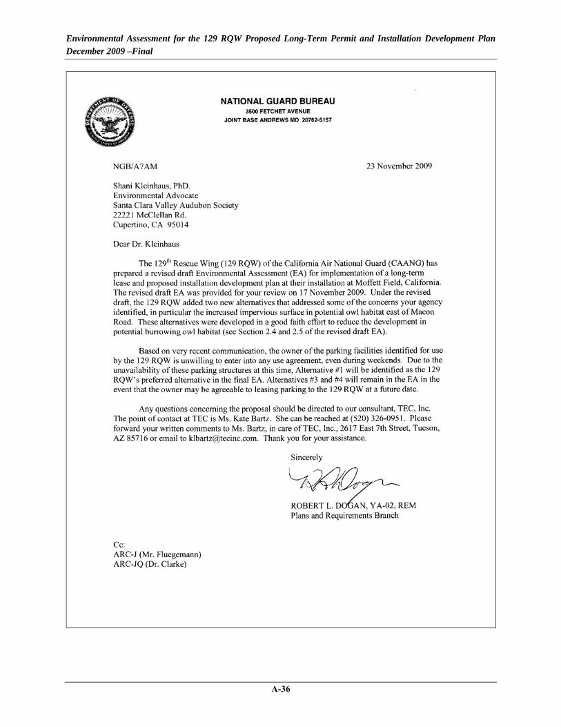
Environmental Assessment for the 129 RQW Proposed Long-Term Permit and Installation Development Plan December 2009 –Final
A-36

Environmental Assessment for the 129 RQW Proposed Long-Term Permit and Installation Development Plan December 2009 –Final
A-37

Environmental Assessment for the 129 RQW Proposed Long-Term Permit and Installation Development Plan December 2009 –Final
A-38

Environmental Assessment for the 129 RQW Proposed Long-Term Permit and Installation Development Plan December 2009 –Final
A-39

Environmental Assessment for the 129 RQW Proposed Long-Term Permit and Installation Development Plan December 2009 –Final
A-40

Environmental Assessment for the 129 RQW Proposed Long-Term Permit and Installation Development Plan December 2009 –Final
Appendix B
Air Quality Calculations

Environmental Assessment for the 129 RQW Proposed Long-Term Permit and Installation Development Plan December 2009 –Final
[This page intentionally left blank.]

Emissions Summary
CO VOC NOX SOX PM10 PM2.5
2010 Construction & Demolition Heavy Equipment 3.89 0.98 11.78 0.01 0.55 0.49 Project Management Trucks 0.23 0.02 0.02 0.00 0.00 0.00 Worker Commute 0.41 0.02 0.03 0.00 0.00 0.00 Demo Truck Trips 0.24 0.07 0.45 0.00 0.00 0.00 Fugitive Dust 4.02 0.02
2010 Subtotal 4.78 1.09 12.29 0.01 4.58 0.522011 Construction Heavy Equipment 1.49 0.38 4.51 0.00 0.21 0.19 Project Management Trucks 0.17 0.02 0.01 0.00 0.00 0.00 Worker Commute 0.30 0.01 0.03 0.00 0.00 0.00 Fugitive Dust 0.22 0.02
2011 Subtotal 1.96 0.41 4.55 0.00 0.44 0.212012 Construction Heavy Equipment 1.55 0.39 4.69 0.00 0.22 0.19 Project Management Trucks 0.19 0.02 0.01 0.00 0.00 0.00 Worker Commute 0.34 0.02 0.03 0.00 0.00 0.00 Fugitive Dust 0.22 0.02
2012 Subtotal 2.08 0.42 4.73 0.00 0.45 0.222013 Construction Heavy Equipment 2.10 0.53 6.34 0.00 0.29 0.26 Project Management Trucks 0.17 0.02 0.01 0.00 0.00 0.00 Worker Commute 0.30 0.01 0.03 0.00 0.00 0.00 Demo Truck Trips 0.11 0.21 0.03 0.00 0.00 0.00 Fugitive Dust 0.30 0.03
2013 Subtotal 2.68 0.77 6.41 0.00 0.60 0.302014 Construction Heavy Equipment 1.61 0.41 4.87 0.00 0.23 0.20 Project Management Trucks 0.19 0.02 0.01 0.00 0.00 0.00 Worker Commute 0.34 0.02 0.03 0.00 0.00 0.00 Fugitive Dust 0.45 0.04
2014 Subtotal 2.14 0.44 4.91 0.00 0.68 0.252015 Construction Heavy Equipment 2.86 0.72 8.67 0.01 0.40 0.36 Project Management Trucks 0.23 0.02 0.02 0.00 0.00 0.00 Worker Commute 0.41 0.02 0.03 0.00 0.00 0.00 Fugitive Dust 4.46 0.45
2015 Subtotal 3.51 0.76 8.72 0.01 4.87 0.812016 Construction Heavy Equipment 0.83 0.21 2.51 0.00 0.12 0.10 Project Management Trucks 0.09 0.01 0.01 0.00 0.00 0.00 Worker Commute 0.17 0.01 0.01 0.00 0.00 0.00 Fugitive Dust 0.22 0.02
2016 Subtotal 1.09 0.23 2.53 0.00 0.34 0.13
Implementation YearEmission (tons/yr)
B-1

[This Page Intentionally Left Blank]
B-2

Heavy Equipment
Emissions By Implementation Year
Equipment FUEL HPLoad
FactorCO VOC NOX SOX PM10
No of Equip
Hrs/DayDays in Service
CO VOC NOX SOX PM10 PM2.5
Dump Truck DIESEL 250 41 0.005953 0.001499 0.018012 1.08E-05 0.000838 2 4 259 0.632 0.159 1.913 0.001 0.089 0.079Roller DIESEL 145 57.5 5.95E-03 1.50E-03 1.80E-02 1.08E-05 8.38E-04 1 4 200 0.199 0.050 0.601 0.000 0.028 0.025Paver DIESEL 160 59 0.005953 0.001499 0.018012 1.08E-05 0.000838 1 6 90 0.152 0.038 0.459 0.000 0.021 0.019Loader DIESEL 170 54 0.005953 0.001499 0.018012 1.08E-05 0.000838 1 6 200 0.328 0.083 0.992 0.001 0.046 0.041Scraper DIESEL 265 66 0.005953 0.001499 0.018012 1.08E-05 0.000838 1 6 200 0.625 0.157 1.890 0.001 0.088 0.078Water Truck DIESEL 250 50 0.005953 0.001499 0.018012 1.08E-05 0.000838 1 8 259 0.771 0.194 2.333 0.001 0.108 0.097
2.71 0.68 8.19 0.00 0.38 0.34Note: It has been conservatively estimated that construction activities would last for 259 days (12 months without weekends and holidays)
Dump Truck DIESEL 250 41 0.005953 0.001499 0.018012 1.08E-05 0.000838 1 4 190 0.232 0.058 0.702 0.000 0.033 0.029Roller DIESEL 145 57.5 5.95E-03 1.50E-03 1.80E-02 1.08E-05 8.38E-04 1 4 60 0.060 0.015 0.180 0.000 0.008 0.007Paver DIESEL 160 59 0.005953 0.001499 0.018012 1.08E-05 0.000838 1 4 60 0.067 0.017 0.204 0.000 0.009 0.008Loader DIESEL 170 54 0.005953 0.001499 0.018012 1.08E-05 0.000838 1 6 190 0.311 0.078 0.942 0.001 0.044 0.039Scraper DIESEL 265 66 0.005953 0.001499 0.018012 1.08E-05 0.000838 1 4 190 0.396 0.100 1.197 0.001 0.056 0.050Water Truck DIESEL 250 50 0.005953 0.001499 0.018012 1.08E-05 0.000838 1 6 190 0.424 0.107 1.283 0.001 0.060 0.053
1.49 0.38 4.51 0.00 0.21 0.19Note: It has been conservatively estimated that construction activities would last for 190 days (9 months without weekends and holidays)
Dump Truck DIESEL 250 41 0.005953 0.001499 0.018012 1.08E-05 0.000838 1 4 212 0.259 0.065 0.783 0.000 0.036 0.032Roller DIESEL 145 57.5 5.95E-03 1.50E-03 1.80E-02 1.08E-05 8.38E-04 1 4 70 0.069 0.017 0.210 0.000 0.010 0.009Paver DIESEL 160 59 0.005953 0.001499 0.018012 1.08E-05 0.000838 1 4 70 0.079 0.020 0.238 0.000 0.011 0.010Loader DIESEL 170 54 0.005953 0.001499 0.018012 1.08E-05 0.000838 1 6 180 0.295 0.074 0.893 0.001 0.042 0.037Scraper DIESEL 265 66 0.005953 0.001499 0.018012 1.08E-05 0.000838 1 4 180 0.375 0.094 1.134 0.001 0.053 0.047Water Truck DIESEL 250 50 0.005953 0.001499 0.018012 1.08E-05 0.000838 1 6 212 0.473 0.119 1.432 0.001 0.067 0.059
1.55 0.39 4.69 0.00 0.22 0.19Note: It has been conservatively estimated that construction activities would last for 212 days (10 months without weekends and holidays)
Dump Truck DIESEL 250 41 0.005953 0.001499 0.018012 1.08E-05 0.000838 3 4 190 0.696 0.175 2.105 0.001 0.098 0.087Roller DIESEL 145 57.5 5.95E-03 1.50E-03 1.80E-02 1.08E-05 8.38E-04 1 4 60 0.060 0.015 0.180 0.000 0.008 0.007Paver DIESEL 160 59 0.005953 0.001499 0.018012 1.08E-05 0.000838 1 4 60 0.067 0.017 0.204 0.000 0.009 0.008Loader DIESEL 170 54 0.005953 0.001499 0.018012 1.08E-05 0.000838 1 6 190 0.311 0.078 0.942 0.001 0.044 0.039Scraper DIESEL 265 66 0.005953 0.001499 0.018012 1.08E-05 0.000838 1 4 190 0.396 0.100 1.197 0.001 0.056 0.050Water Truck DIESEL 250 50 0.005953 0.001499 0.018012 1.08E-05 0.000838 1 8 190 0.565 0.142 1.711 0.001 0.080 0.071
2.10 0.53 6.34 0.00 0.29 0.26Note: It has been conservatively estimated that construction activities would last for 157 days (9 months without weekends and holidays)
Dump Truck DIESEL 250 41 0.005953 0.001499 0.018012 1.08E-05 0.000838 1 4 212 0.259 0.065 0.783 0.000 0.036 0.032Roller DIESEL 145 57.5 5.95E-03 1.50E-03 1.80E-02 1.08E-05 8.38E-04 1 4 80 0.079 0.020 0.240 0.000 0.011 0.010Paver DIESEL 160 59 0.005953 0.001499 0.018012 1.08E-05 0.000838 1 4 80 0.090 0.023 0.272 0.000 0.013 0.011Loader DIESEL 170 54 0.005953 0.001499 0.018012 1.08E-05 0.000838 1 6 190 0.311 0.078 0.942 0.001 0.044 0.039Scraper DIESEL 265 66 0.005953 0.001499 0.018012 1.08E-05 0.000838 1 4 190 0.396 0.100 1.197 0.001 0.056 0.050Water Truck DIESEL 250 50 0.005953 0.001499 0.018012 1.08E-05 0.000838 1 6 212 0.473 0.119 1.432 0.001 0.067 0.059
TOTAL
TOTAL
2014 Construction Emissions (Project 9 - 0.9 acres & Project 10 - 0.7 acres)
TOTAL
Emission Factors (g/hp-hr) Emission (tons total)
TOTAL
2012 Construction Emissions (Project 5 - 0.8 acres & Project 6 - 0.16 acres)
2010 Construction Emissions (Project 1 - 6.5 acres & Project 2 - 0.03 acres)
2011 Construction Emissions (Project 3 - 1.3 acres & Project 4 - NA)
2013 Construction Emissions (Project 7 - 0.17 acres & Project 8 - 0.45 acres)
B-3

Heavy Equipment
1.61 0.41 4.87 0.00 0.23 0.20Note: It has been conservatively estimated that construction activities would last for 212 days (10 months without weekends and holidays)
Dump Truck DIESEL 250 41 0.005953 0.001499 0.018012 1.08E-05 0.000838 1 6 259 0.474 0.119 1.435 0.001 0.067 0.059Roller DIESEL 145 57.5 5.95E-03 1.50E-03 1.80E-02 1.08E-05 8.38E-04 2 6 180 0.536 0.135 1.622 0.001 0.075 0.067Paver DIESEL 160 59 0.005953 0.001499 0.018012 1.08E-05 0.000838 2 6 180 0.607 0.153 1.836 0.001 0.085 0.076Loader DIESEL 170 54 0.005953 0.001499 0.018012 1.08E-05 0.000838 1 6 100 0.164 0.041 0.496 0.000 0.023 0.021Scraper DIESEL 265 66 0.005953 0.001499 0.018012 1.08E-05 0.000838 1 6 100 0.312 0.079 0.945 0.001 0.044 0.039Water Truck DIESEL 250 50 0.005953 0.001499 0.018012 1.08E-05 0.000838 1 8 259 0.771 0.194 2.333 0.001 0.108 0.097
2.86 0.72 8.67 0.01 0.40 0.36Note: It has been conservatively estimated that construction activities would last for 259 days (12 months without weekends and holidays)
Dump Truck DIESEL 250 41 0.005953 0.001499 0.018012 1.08E-05 0.000838 1 4 106 0.129 0.033 0.391 0.000 0.018 0.016Roller DIESEL 145 57.5 5.95E-03 1.50E-03 1.80E-02 1.08E-05 8.38E-04 1 4 60 0.060 0.015 0.180 0.000 0.008 0.007Paver DIESEL 160 59 0.005953 0.001499 0.018012 1.08E-05 0.000838 1 4 60 0.067 0.017 0.204 0.000 0.009 0.008Loader DIESEL 170 54 0.005953 0.001499 0.018012 1.08E-05 0.000838 1 6 90 0.148 0.037 0.446 0.000 0.021 0.018Scraper DIESEL 265 66 0.005953 0.001499 0.018012 1.08E-05 0.000838 1 4 90 0.187 0.047 0.567 0.000 0.026 0.023Water Truck DIESEL 250 50 0.005953 0.001499 0.018012 1.08E-05 0.000838 1 6 106 0.237 0.060 0.716 0.000 0.033 0.030
0.83 0.21 2.51 0.00 0.12 0.10Note: It has been conservatively estimated that construction activities would last for 106 days (5 months without weekends and holidays)
Dump Truck DIESEL 250 41 0.005953 0.001499 0.018012 1.08E-05 0.000838 1 8 127 0.310 0.078 0.938 0.001 0.044 0.039Roller DIESEL 145 57.5 0.005953 0.001499 0.018012 1.08E-05 0.000838 1 6 80 0.119 0.030 0.360 0.000 0.017 0.015Loader DIESEL 170 54 0.005953 0.001499 0.018012 1.08E-05 0.000838 1 6 80 0.131 0.033 0.397 0.000 0.018 0.016Scraper DIESEL 265 66 0.005953 0.001499 0.018012 1.08E-05 0.000838 1 6 80 0.250 0.063 0.756 0.000 0.035 0.031Water Truck DIESEL 250 50 0.005953 0.001499 0.018012 1.08E-05 0.000838 1 8 127 0.378 0.095 1.144 0.001 0.053 0.047
1.19 0.30 3.59 0.00 0.17 0.15Note: It has been conservatively estimated that all demolition activities would last for 1 month per building (6 months total), 127 days without weekends and holidays
Fugitive Dust Emissions
Fugitive Dust (unpaved roads)
Emission Factor,
lbs/VMT k a b MVWSilt
Content Speed
2010 Construction & Demolition Fugitive Dust PM10 7.44E+00 1.5 0.9 0.45 210.00 8.50 10.00PM2.5 7.44E-01 0.15 0.9 0.45 210.00 8.50 10.00
Mileage 90Vehicles 12
Total lbs TonsPM10 8035.6876 4.01784PM2.5 803.5688 0.40178
2011 Construction Fugitive Dust PM10 7.44E+00 1.5 0.9 0.45 210.00 8.50 10.00PM2.5 7.44E-01 0.15 0.9 0.45 210.00 8.50 10.00
Mileage 10
2015 Construction Emissions (Project 11 - 0.5 acres & Project 13 - 13.9 acres)
TOTAL
2010 Facility Demolitions: Bldgs. 650, 654, 655, 656, 669, 687 - 2.15 acres total
2016 Construction Emissions (Project 12 - 1.0 acres)
TOTAL
TOTAL
TOTAL
B-4

Heavy Equipment
Vehicles 6
Total lbs TonsPM10 446.4271 0.22321PM2.5 44.6427 0.02232
2012 Construction Fugitive Dust PM10 7.44E+00 1.5 0.9 0.45 210.00 8.50 10.00PM2.5 7.44E-01 0.15 0.9 0.45 210.00 8.50 10.00
Mileage 10Vehicles 6
Total lbs TonsPM10 446.4271 0.22321PM2.5 44.6427 0.02232
2013 Construction Fugitive Dust PM10 7.44E+00 1.5 0.9 0.45 210.00 8.50 10.00PM2.5 7.44E-01 0.15 0.9 0.45 210.00 8.50 10.00
Mileage 10Vehicles 8
Total lbs TonsPM10 595.2361 0.29762PM2.5 59.5236 0.02976
2014 Construction Fugitive Dust PM10 7.44E+00 1.5 0.9 0.45 210.00 8.50 10.00PM2.5 7.44E-01 0.15 0.9 0.45 210.00 8.50 10.00
Mileage 20Vehicles 6
Total lbs TonsPM10 892.8542 0.44643PM2.5 89.2854 0.04464
2015 Construction Fugitive Dust PM10 7.44E+00 1.5 0.9 0.45 210.00 8.50 10.00PM2.5 7.44E-01 0.15 0.9 0.45 210.00 8.50 10.00
Mileage 150Vehicles 8
Total lbs TonsPM10 8928.5418 4.46427PM2.5 892.8542 0.44643
2016 Construction Fugitive Dust PM10 7.44E+00 1.5 0.9 0.45 210.00 8.50 10.00PM2.5 7.44E-01 0.15 0.9 0.45 210.00 8.50 10.00
Mileage 10Vehicles 6
Total lbs TonsPM10 446.4271 0.22321PM2.5 44.6427 0.02232
B-5

Project Management Truck Trips
No. of Trucks
Speed (mph)
VMT (mi/vehicle-
day)
Running Exhaust (g/mi)
Start-Up (g/start)
Running Exhaust (g/mi)
Start-Up (g/start)
Running Exhaust (g/mi)
Start-Up (g/start)
Hot-Soak (g/trip)
Resting Loss
(g/hr)
Running Evaporative (g/mi)
Diurnal Evaporative (g/hr)
Running Exhaust (g/mi)
Start-Up (g/start)
Running Exhaust (g/mi)
Start-Up (g/start)
Tire Wear (g/mi)
Brake Wear (g/mi) CO NOX VOCs SOX PM10 PM2.5
Project Management Vehicle Light-duty truck, catalyst 4 15 10 4.405 11.792 0.382 0.586 0.152 0.867 0.177 0.026 0.047 0.061 0.007 0.002 0.028 0.015 0.008 0.013 259 0.0772 0.0057 0.0071 0.0001 0.0006 0.0006Crew Cab Trucks Light-duty truck, catalyst 8 15 10 4.405 11.792 0.382 0.586 0.152 0.867 0.177 0.026 0.047 0.061 0.007 0.002 0.028 0.015 0.008 0.013 259 0.1545 0.0114 0.0143 0.0002 0.0012 0.0012
2010 Total 0.2317 0.0171 0.0214 0.0003 0.0018 0.00182011 Construction
Project Management Vehicle Light-duty truck, catalyst 4 15 10 4.405 11.792 0.382 0.586 0.152 0.867 0.177 0.026 0.047 0.061 0.007 0.002 0.028 0.015 0.008 0.013 190 0.0567 0.0042 0.0052 0.0001 0.0004 0.0004Crew Cab Trucks Light-duty truck, catalyst 8 15 10 4.405 11.792 0.382 0.586 0.152 0.867 0.177 0.026 0.047 0.061 0.007 0.002 0.028 0.015 0.008 0.013 190 0.1133 0.0084 0.0105 0.0001 0.0009 0.0009
2011 Total 0.1700 0.0125 0.0157 0.0002 0.0013 0.00132012 Construction
Project Management Vehicle Light-duty truck, catalyst 4 15 10 4.405 11.792 0.382 0.586 0.152 0.867 0.177 0.026 0.047 0.061 0.007 0.002 0.028 0.015 0.008 0.013 212 0.0632 0.0047 0.0058 0.0001 0.0005 0.0005Crew Cab Trucks Light-duty truck, catalyst 8 15 10 4.405 11.792 0.382 0.586 0.152 0.867 0.177 0.026 0.047 0.061 0.007 0.002 0.028 0.015 0.008 0.013 212 0.1264 0.0093 0.0117 0.0001 0.0010 0.0010
2012 Total 0.1897 0.0140 0.0175 0.0002 0.0015 0.00142013 Construction
Project Management Vehicle Light-duty truck, catalyst 4 15 10 4.405 11.792 0.382 0.586 0.152 0.867 0.177 0.026 0.047 0.061 0.007 0.002 0.028 0.015 0.008 0.013 190 0.0567 0.0042 0.0052 0.0001 0.0004 0.0004Crew Cab Trucks Light-duty truck, catalyst 8 15 10 4.405 11.792 0.382 0.586 0.152 0.867 0.177 0.026 0.047 0.061 0.007 0.002 0.028 0.015 0.008 0.013 190 0.1133 0.0084 0.0105 0.0001 0.0009 0.0009
2013 Total 0.1700 0.0125 0.0157 0.0002 0.0013 0.00132014 Construction
Project Management Vehicle Light-duty truck, catalyst 4 15 10 4.405 11.792 0.382 0.586 0.152 0.867 0.177 0.026 0.047 0.061 0.007 0.002 0.028 0.015 0.008 0.013 212 0.0632 0.0047 0.0058 0.0001 0.0005 0.0005Crew Cab Trucks Light-duty truck, catalyst 8 15 10 4.405 11.792 0.382 0.586 0.152 0.867 0.177 0.026 0.047 0.061 0.007 0.002 0.028 0.015 0.008 0.013 212 0.1264 0.0093 0.0117 0.0001 0.0010 0.0010
2014 Total 0.1897 0.0140 0.0175 0.0002 0.0015 0.00142015 Construction
Project Management Vehicle Light-duty truck, catalyst 4 15 10 4.405 11.792 0.382 0.586 0.152 0.867 0.177 0.026 0.047 0.061 0.007 0.002 0.028 0.015 0.008 0.013 259 0.0772 0.0057 0.0071 0.0001 0.0006 0.0006Crew Cab Trucks Light-duty truck, catalyst 8 15 10 4.405 11.792 0.382 0.586 0.152 0.867 0.177 0.026 0.047 0.061 0.007 0.002 0.028 0.015 0.008 0.013 259 0.1545 0.0114 0.0143 0.0002 0.0012 0.0012
2015 Total 0.2317 0.0171 0.0214 0.0003 0.0018 0.00182016 Construction
Project Management Vehicle Light-duty truck, catalyst 4 15 10 4.405 11.792 0.382 0.586 0.152 0.867 0.177 0.026 0.047 0.061 0.007 0.002 0.028 0.015 0.008 0.013 106 0.0316 0.0023 0.0029 0.0000 0.0002 0.0002Crew Cab Trucks Light-duty truck, catalyst 8 15 10 4.405 11.792 0.382 0.586 0.152 0.867 0.177 0.026 0.047 0.061 0.007 0.002 0.028 0.015 0.008 0.013 106 0.0632 0.0047 0.0058 0.0001 0.0005 0.0005
2016 Total 0.0948 0.0070 0.0088 0.0001 0.0007 0.0007
Vehicle Class
CO
2010 Construction & Demolition
Emissions, tons totalVOCs PM10SOx
Days in Service
NOX
B-6

Worker Commute
No. of Workers
Speed (mph)
YMT (mi/vehicle-
day)
Running Exhaust (g/mi)
Start-Up (g/start)
Running Exhaust (g/mi)
Start-Up (g/start)
Running Exhaust (g/mi)
Start-Up (g/start)
Hot-Soak (g/trip)
Resting Loss (g/hr)
Running Evaporative (g/mi)
Diurnal Evaporative (g/hr)
Running Exhaust (g/mi)
Start-Up (g/start)
Running Exhaust (g/mi)
Start-Up (g/start)
Tire Wear (g/mi)
Brake Wear (g/mi) CO NOX VOCs SOX PM10 PM2.5
2010 Light-duty 10 35 40 3.019 11.792 0.27 0.586 0.056 0.867 0.177 0.026 0.047 0.061 0.004 0.002 0.01 0.015 0.008 0.013 259 0.41 0.03 0.02 0.00 0.00 0.00
2011 Light-duty 10 35 40 3.019 11.792 0.27 0.586 0.056 0.867 0.177 0.026 0.047 0.061 0.004 0.002 0.01 0.015 0.008 0.013 190 0.30 0.03 0.01 0.00 0.00 0.00
2012 Light-duty 10 35 40 3.019 11.792 0.27 0.586 0.056 0.867 0.177 0.026 0.047 0.061 0.004 0.002 0.01 0.015 0.008 0.013 212 0.34 0.03 0.02 0.00 0.00 0.00
2013 Light-duty 10 35 40 3.019 11.792 0.27 0.586 0.056 0.867 0.177 0.026 0.047 0.061 0.004 0.002 0.01 0.015 0.008 0.013 190 0.30 0.03 0.01 0.00 0.00 0.00
2014 Light-duty 10 35 40 3.019 11.792 0.27 0.586 0.056 0.867 0.177 0.026 0.047 0.061 0.004 0.002 0.01 0.015 0.008 0.013 212 0.34 0.03 0.02 0.00 0.00 0.00
2015 Light-duty 10 35 40 3.019 11.792 0.27 0.586 0.056 0.867 0.177 0.026 0.047 0.061 0.004 0.002 0.01 0.015 0.008 0.013 259 0.41 0.03 0.02 0.00 0.00 0.00
2016 Light-duty 10 35 40 3.019 11.792 0.27 0.586 0.056 0.867 0.177 0.026 0.047 0.061 0.004 0.002 0.01 0.015 0.008 0.013 106 0.17 0.01 0.01 0.00 0.00 0.00
Construction Year Vehicle Class
CO NOX Emissions, tons totalSOX
Days in Service
VOCs PM10
B-7

Demolition Debris Truck Trips
No. of Vehicles Per Day
Speed (mph)
VMT (mi/vehicle-
day)
Running Exhaust (g/mi)
Running Exhaust (g/mi)
Running Exhaust (g/mi)
Running Exhaust (g/mi)
Running Exhaust (g/mi)
Tire Wear (g/mi)
Brake Wear (g/mi)
Days of Demo CO NOx VOCs SOx PM10 PM2.5
2010 Demolition Heavy-duty truck, diesel 5 15 30 11.383 21.608 3.438 0.025 0.141 0.036 0.028 127 0.24 0.45 0.07 0.00 0.00 0.00
2013 Demolition Heavy-duty truck, diesel 5 15 30 11.383 21.608 3.438 0.025 0.141 0.036 0.028 60 0.11 0.21 0.03 0.00 0.00 0.00
Assumptions:
CO
* Assume 60 days for 2013 demolitions debris disposal
NOX
* Assuming 30 miles round trip per vehicle (distance to Landfill)
* Assume 127 days for 2010 demolitions debris disposal
Emissions, tons per yearVOCs PM10SOx
Demolition Phase Vehicle Class
B-8